Embed Size (px)
Citation preview

AMENDMENT - ML 50944 - METALLIFEROUS MINERALSCoal & MineralStatus:08/28/2017 Approved by David Ure Department:DA Date:
Mansfield, JerryDrafted By: 357ID:
CONTRACT DETAILSLessee: COLUMBUS SILVER (US) CORPORATION
Address: 573 EAST SECOND STREETRENO, NV 89502
Administrator: Mansfield, Jerry County: Juab Total acres: 693.88
Start Date: 08/01/2007 Beneficiary: School
Expiration Date: 07/31/2017
FINANCIAL/REVENUEAnnual Rental is $694.00.Annual Minimum Royalty is $2,082.00.
SUMMARYOn July 31, 2017, this Metalliferous Minerals Lease reached the end of its 10-year lease term. As provided for in Paragraph 3.6of the lease agreement, at the end of each 10-year period, the School and Institutional Trust Lands Administration (“SITLA”), aslessor, shall have the right to readjust the terms and conditions of the lease as may then be determined to be in the best interestof the Trust. As provided by Paragraph 3.6 of the lease agreement, the lease is readjusted under the following terms:
• Annual rental is the greater of $1.00 per acre and fractional part thereof, or $500.00. • Annual minimum royalty is three (3) times the annual rental. • Production royalty is 8% of fissionable and 4% of non-fissionable metalliferous minerals of the gross value of the leasedsubstances sold under an arm's length transaction at the first point of sale. • The term of the lease is extended for an additional 10 years with a new expiration date of July 31, 2027.
TYPE OF RECORD: APPROVAL
State of Utah School and Institutional Trust Lands Administration Page 1 of 1Form 2

AMENDMENT - ML 47679 - PHOSPHATECoal & MineralStatus:08/28/2017 Approved by David Ure Department:DA Date:
Mansfield, JerryDrafted By: 359ID:
CONTRACT DETAILSLessee: UTAH PHOSPHATE COMPANY
Address: C/O NU-WEST INDUSTRIES, INC.ATTN: ARREANA SURRELL3010 CONDA ROADSODA SPRINGS, ID 83276
Administrator: Mansfield, Jerry County: Uintah Total acres: 606.33
Start Date: 08/01/1997 Beneficiary: School
Expiration Date: 07/31/2017
FINANCIAL/REVENUEAnnual Rental is $607.00.Annual Minimum Royalty is $3,642.00.
SUMMARYOn July 31, 2017, this Phosphate Lease reached the end of its 10-year lease term. As provided for in Paragraph 3.6 of the leaseagreement, at the end of each 10-year period, the School and Institutional Trust Lands Administration (“SITLA”), as lessor, shallhave the right to readjust the terms and conditions of the lease as may then be determined to be in the best interest of the Trust.The lease is readjusted under the following terms:
• Annual rental is the greater of $1.00 per acre and fractional part thereof, or $500.00. • Annual minimum royalty is six (6) times the annual rental. • Production royalty is 5% of the gross value of the leased substances sold under an arm's length transaction at the first pointof sale. • The term of the lease is extended for an additional 10 years with a new expiration date of July 31, 2027.
TYPE OF RECORD: APPROVAL
State of Utah School and Institutional Trust Lands Administration Page 1 of 1Form 2

AMENDMENT - ML 51064 - METALLIFEROUS MINERALSCoal & MineralStatus:08/28/2017 Approved by David Ure Department:DA Date:
Mansfield, JerryDrafted By: 364ID:
CONTRACT DETAILSLessee: KENNECOTT EXPLORATION COMPANY
Address: C/O RIO TINTO - LAND DEPARTMENT4700 DAYBREAK PARKWAYSOUTH JORDAN, UT 84009
Administrator: Mansfield, Jerry County: Tooele Total acres: 120.00
Start Date: 09/01/2007 Beneficiary: School
Expiration Date: 08/31/2017
FINANCIAL/REVENUEAnnual Rental is $500.00.Annual Minimum Royalty is $1,500.00.
SUMMARYOn August 31, 2017, this Metalliferous Minerals Lease reached the end of its 10-year lease term. As provided for in Paragraph3.6 of the lease agreement, at the end of each 10-year period, the School and Institutional Trust Lands Administration (“SITLA”),as lessor, shall have the right to readjust the terms and conditions of the lease as may then be determined to be in the bestinterest of the Trust. The lease is readjusted under the following terms:
• Annual rental is the greater of $1.00 per acre and fractional part thereof, or $500.00. • Annual minimum royalty is three (3) times the annual rental. • Production royalty is 8% of fissionable and 4% of non-fissionable metalliferous minerals of the gross value of the leasedsubstances sold under an arm's length transaction at the first point of sale. • The term of the lease is extended for an additional 10 years with a new expiration date of August 31, 2027.
TYPE OF RECORD: APPROVAL
State of Utah School and Institutional Trust Lands Administration Page 1 of 1Form 2

LEASE EXTENSION AGREEMENT - BITUMINOUS SANDS/ASPHALTIC SANDSCoal & MineralStatus:08/28/2017 Approved by David Ure Department:DA Date:
Mansfield, JerryDrafted By: 366ID:
CONTRACT NAME BENE ACRESTYPECOUNTYML 51999 OBA US OIL SANDS (UTAH)
INCSCH GRND BSAS 1,320.00
ML 52000 OBA US OIL SANDS (UTAH)INC
SCH GRND BSAS 1,925.64
ML 52001 OBA US OIL SANDS (UTAH)INC
SCH GRND BSAS 2,517.59
ML 52002 OBA US OIL SANDS (UTAH)INC
SCH GRND BSAS 2,560.00
ML 52003 OBA US OIL SANDS (UTAH)INC
SCH GRND BSAS 2,539.23
ML 52004 OBA US OIL SANDS (UTAH)INC
SCH GRND BSAS 1,260.24
ML 52005 OBA US OIL SANDS (UTAH)INC
SCH GRND BSAS 2,560.00
ML 52006 OBA US OIL SANDS (UTAH)INC
SCH GRND BSAS 1,900.52
ML 52007 OBA US OIL SANDS (UTAH)INC
SCH GRND BSAS 2,480.00
ML 52008 OBA US OIL SANDS (UTAH)INC
SCH GRND BSAS 1,920.00
ML 52009 OBA US OIL SANDS (UTAH)INC
SCH GRND BSAS 1,960.00
ML 52010 OBA US OIL SANDS (UTAH)INC
SCH GRND BSAS 1,227.02
FINANCIAL/REVENUEQuarterly Payment Dispersal: July 1, 2018 Interest DispersalLease # Rental Min. Royalty InterestML 51999 $330.00 $3,300.00 $ 680.63ML 52000 $481.50 $4,815.00 $ 993.09ML 52001 $629.50 $6,295.00 $1,298.34ML 52002 $640.00 $6,400.00 $1,320.00ML 52003 $635.00 $6,350.00 $1,309.69ML 52004 $315.25 $3,152.50 $ 650.20ML 52005 $640.00 $6,400.00 $1,320.00ML 52006 $475.25 $4,752.50 $ 980.20ML 52007 $620.00 $6,200.00 $1,278.75ML 52008 $480.00 $4,800.00 $ 990.00ML 52009 $490.00 $4,900.00 $1,010.63ML 52010 $307.00 $3,070.00 $ 633.19
SUMMARYUS Oil Sands (Utah), Inc. ("USOS") has requested an extension of time to pay annual rental and minimum royalty paymentsotherwise due under the Subject Leases on July 1, 2017, totaling $265,914.00. The School and Institutional Trust LandsAdministration ("SITLA") has agreed to grant the requested extension on the terms and conditions that follow:
1. USOS will pay the outstanding annual rentals and minimum advanced royalties in four equal installments of $66,478.50,with quarterly payments due on or before October 1, 2017, January 1, 2018, April 1, 2018, and July 1, 2018. 2. All outstanding amounts will accrue interest at 7.5% per annum. In addition to the final quarterly payment due July 1,2018, USOS will pay SITLA outstanding accrued interest in the amount of $12,464.72. 3. If USOS fails to make any scheduled quarterly payment, SITLA may elect to terminate the Subject Leases by giving 30days written notice to USOS. If USOS then fails to make the required payment within the 30-day cure period, SITLA may cancel
State of Utah School and Institutional Trust Lands Administration Page 1 of 2Form 3

LEASE EXTENSION AGREEMENT - BITUMINOUS SANDS/ASPHALTIC SANDS (Continued)the Subject Leases without further notice or right to appeal. Late fees prescribed in Utah Administrative Code. R850-5-200 willbe applicable to late payments. 4. Except as amended by this Lease Extension Agreement, the Subject Leases remain in full force and effect.
TYPE OF RECORD: APPROVAL
State of Utah School and Institutional Trust Lands Administration Page 2 of 2Form 3

APPROVAL OF MP 600 - SAND & GRAVELCoal & MineralStatus:08/28/2017 Approved by David Ure Department:DA Date:
Bedingfield, AndrewDrafted By: 73ID:
CONTRACT DETAILSPermittee: CUSTOM ROCK & EXCAVATION LLC
Address: 646 SOUTH MAIN #151CEDAR CITY, UT 84720
Administrator: Bedingfield, Andrew County: Iron Total acres: 40.00
Beneficiary: School
LAND PARCELS (GIS Review of Description: 08/22/2017)T34S, R8W, SLB&M Section 32 NE4NE4NW4NW4, S2NE4NW4, NW4NE4NW4, S2NE4NE4NW4,
NW4NE4NE4NW440.00 acres
BACKGROUNDThe applicant proposes to mine common sand and gravel from the subject lands to support local market needs. The subjectlands contain gravels along the bottom of Dry Canyon located to the south and east of the town of Parowan in Iron County. Thepublic notice process was completed pursuant to R850-23-500, including publication in a newspaper with circulation in IronCounty, notification of adjoining landowners, permittees, and lessees. No competing applications were received.
NARRATIVEThe proposed materials permit was sent to the Resource Development Coordinating Committee ("RDCC"), the Five CountyAssociation of Governments, and the Iron County Commission for review on June 21, 2017. Comments were received by theDivision of Air Quality and Iron County as follows:
Division of Air Quality"The proposed project may require a permit, known as an Approval Order, from the Executive Secretary of the Air QualityBoard, if PM 10 and/or other emissions exceed 5 tons per year (including emissions of heavy equipment, stationary enginesetc.) A permit application, known as a Notice of Intent (NOI), should be submitted to the Executive Secretary at the UtahDivision of Air Quality… If crushers and screens are used, this project may be subject to the federal requirements contained inNew Source Performance Standards Subpart OOOO… The proposed project will be subject to R307-205-5: Fugitive Dust, ofthe Utah Air Quality Rules, due to the fugitive dust that may be generated during soil disturbance for the project. These rulesapply to construction activities that disturb an area greater than ¼ acre in size. A permit known as an Approval Order, is notrequired from the Executive Secretary of the Air Quality Board, but steps need to be taken to minimize fugitive dust, such aswatering and/or chemical stabilization, providing vegetative or synthetic cover or windbreaks..."
Iron County"While Iron County is not opposed to the proposed project and granting of a permit, we would request that SITLA require theapplicant to apply for a conditional use permit (CUP) from the Iron County Building Department. We understand SITLA does nothave to adhere to county requirements for such actions, but applying for a CUP allows discussion to insure any concerns areaddressed."
FINANCIAL/REVENUEThe application fee of $250.00 and the processing fee of $700.00 will be collected from the permittee.
SUMMARYThe Director approved the issuance of MP 600 for a term of five (5) years. The annual rental is $400.00, which represents$10.00 per acre for the permit. The production royalty rate is $0.65 per bank cubic yard for all produced aggregate materials.
TYPE OF RECORD: APPROVAL
State of Utah School and Institutional Trust Lands Administration Page 1 of 1Form 1

ASSIGNMENT APPROVAL - ML 48274 - OIL GAS & HYDROCARBON (SPECIAL)Oil & GasStatus:08/28/2017 Approved by David Ure Department:DA Date:
Hale, AlyDrafted By: 391ID:
CONTRACT DETAILSAdministrator: Adams, Wes County: Carbon Total acres: 40.00
Start Date: 07/01/1999 Beneficiary: LEDA/Monument (PL105) 19.40 ac (48.50%);Management Fee 1.20 ac (3.00%);School 19.40 ac (48.50%)
Expiration Date: 12/31/2999
Royalty Rate: 12.5%
SUMMARYAn operating rights assignment is approved for 100% interest in and to this lease, below the stratigraphic equivalent of 2,707feet in the NW4SW4 of Section 23, T15S, R9E, to Coastal Plains Energy, Inc., 6303 North Portland Ave., Suite 208, OklahomaCity, OK 73112, by Marathon Oil Company. No override reserved.
TYPE OF RECORD: APPROVAL
State of Utah School and Institutional Trust Lands Administration Page 1 of 1Form 2

ASSIGNMENT APPROVAL - ML 48235 AA - OIL GAS & HYDROCARBONOil & GasStatus:08/28/2017 Approved by David Ure Department:DA Date:
Hale, AlyDrafted By: 390ID:
CONTRACT DETAILSAdministrator: Adams, Wes County: Carbon Total acres: 160.00
Start Date: 04/01/1994 Beneficiary: LEDA/Monument (PL105) 77.60 ac (48.50%);Management Fee 4.80 ac (3.00%);School 77.60 ac (48.50%)
Expiration Date: 12/31/2999
Royalty Rate: 12.5%
SUMMARYAn operating rights assignment is approved for 100% interest in and to this lease, below the stratigraphic equivalent of 3,054feet in the NE4 of Section 21, T15S, R9E, to Coastal Plains Energy, Inc., 6303 North Portland Ave., Suite 208, Oklahoma City,OK 73112, by Marathon Oil Company. No override reserved.
TYPE OF RECORD: APPROVAL
State of Utah School and Institutional Trust Lands Administration Page 1 of 1Form 2

ASSIGNMENT APPROVAL - ML 48232 - OIL GAS & HYDROCARBON (SPECIAL)Oil & GasStatus:08/28/2017 Approved by David Ure Department:DA Date:
Hale, AlyDrafted By: 389ID:
CONTRACT DETAILSAdministrator: Adams, Wes County: Carbon Total acres: 840.00
Start Date: 04/01/1993 Beneficiary: LEDA/Monument (PL105) 407.40 ac (48.50%);Management Fee 25.20 ac (3.00%);School 407.40 ac (48.50%)
Expiration Date: 12/31/2999
Royalty Rate: 12.5%
SUMMARYAn operating rights assignment is approved for 100% interest in and to this lease, below the stratigraphic equivalent of 2,707feet in the NE4SW4, S2SW4 and 2,626 feet in the SE4 of Section 23, T15S, R9E, to Coastal Plains Energy, Inc., 6303 NorthPortland Ave., Suite 208, Oklahoma City, OK 73112, by Marathon Oil Company. No override reserved.
TYPE OF RECORD: APPROVAL
State of Utah School and Institutional Trust Lands Administration Page 1 of 1Form 2

ASSIGNMENT APPROVAL - ML 48232 - OIL GAS & HYDROCARBON (SPECIAL)Oil & GasStatus:08/28/2017 Approved by David Ure Department:DA Date:
Hale, AlyDrafted By: 388ID:
CONTRACT DETAILSAdministrator: Adams, Wes County: Carbon Total acres: 840.00
Start Date: 04/01/1993 Beneficiary: LEDA/Monument (PL105) 407.40 ac (48.50%);Management Fee 25.20 ac (3.00%);School 407.40 ac (48.50%)
Expiration Date: 12/31/2999
Royalty Rate: 12.5%
SUMMARYAn operating rights assignment is approved for 100% interest in and to this lease, below the stratigraphic equivalent of 2,842feet in the S2NE4 and 3,002 feet in the SW4 of Section 22, T15S, R9E, to Coastal Plains Energy, Inc., 6303 North PortlandAve., Suite 208, Oklahoma City, OK 73112, by Marathon Oil Company. No override reserved.
TYPE OF RECORD: APPROVAL
State of Utah School and Institutional Trust Lands Administration Page 1 of 1Form 2

ASSIGNMENT APPROVAL - ML 48232 - OIL GAS & HYDROCARBON (SPECIAL)Oil & GasStatus:08/28/2017 Approved by David Ure Department:DA Date:
Hale, AlyDrafted By: 387ID:
CONTRACT DETAILSAdministrator: Adams, Wes County: Carbon Total acres: 840.00
Start Date: 04/01/1993 Beneficiary: LEDA/Monument (PL105) 407.40 ac (48.50%);Management Fee 25.20 ac (3.00%);School 407.40 ac (48.50%)
Expiration Date: 12/31/2999
Royalty Rate: 12.5%
SUMMARYAn operating rights assignment is approved for 100% interest in and to this lease, below the stratigraphic equivalent of 2,875feet in the NW4 and 2,855 feet in the SE4 of Section 22, T15S, R9E, to Coastal Plains Energy, Inc., 6303 North Portland Ave.,Suite 208, Oklahoma City, OK 73112, by Marathon Oil Company. No override reserved.
TYPE OF RECORD: APPROVAL
State of Utah School and Institutional Trust Lands Administration Page 1 of 1Form 2

ASSIGNMENT APPROVAL - ML 48210 - OIL GAS & HYDROCARBON (SPECIAL)Oil & GasStatus:08/28/2017 Approved by David Ure Department:DA Date:
Hale, AlyDrafted By: 386ID:
CONTRACT DETAILSAdministrator: Adams, Wes County: Carbon Total acres: 320.00
Start Date: 01/01/1993 Beneficiary: LEDA/Monument (PL105) 155.20 ac (48.50%);Management Fee 9.60 ac (3.00%);School 155.20 ac (48.50%)
Expiration Date: 12/31/2999
Royalty Rate: 12.5%
SUMMARYAn operating rights assignment is approved for 100% interest in and to this lease, below the stratigraphic equivalent of 2,904feet in the NW4 and 2,842 feet in the NE4 of Section 27, T15S, R9E, to Coastal Plains Energy, Inc., 6303 North Portland Ave.,Suite 208, Oklahoma City, OK 73112, by Marathon Oil Company. No override reserved.
TYPE OF RECORD: APPROVAL
State of Utah School and Institutional Trust Lands Administration Page 1 of 1Form 2

ASSIGNMENT APPROVAL - ML 47977 OBA - OIL GAS & HYDROCARBONOil & GasStatus:08/28/2017 Approved by David Ure Department:DA Date:
Hale, AlyDrafted By: 385ID:
CONTRACT DETAILSAdministrator: Adams, Wes County: Carbon Total acres: 480.00
Start Date: 07/01/1998 Beneficiary: School
Expiration Date: 12/31/2999
Royalty Rate: 16.666667%
SUMMARYAn operating rights assignment is approved for 100% interest in and to this lease, below the stratigraphic equivalent of 3,075feet in the NW4 and 3,002 feet in the NE4 of Section 16, T15S, R9E, to Coastal Plains Energy, Inc., 6303 North Portland Ave.,Suite 208, Oklahoma City, OK 73112, by Marathon Oil Company. No override reserved.
TYPE OF RECORD: APPROVAL
State of Utah School and Institutional Trust Lands Administration Page 1 of 1Form 2

ASSIGNMENT APPROVAL - ML 47977 OBA - OIL GAS & HYDROCARBONOil & GasStatus:08/28/2017 Approved by David Ure Department:DA Date:
Hale, AlyDrafted By: 382ID:
CONTRACT DETAILSAdministrator: Adams, Wes County: Carbon Total acres: 480.00
Start Date: 07/01/1998 Beneficiary: School
Expiration Date: 12/31/2999
Royalty Rate: 16.666667%
SUMMARYAn operating rights assignment is approved for 100% interest in and to this lease, below the stratigraphic equivalent of 3,084feet in the SW4 of Section 16, T15S, R9E, to Coastal Plains Energy, Inc., 6303 North Portland Ave., Suite 208, Oklahoma City,OK 73112, by Marathon Oil Company. No override reserved.
TYPE OF RECORD: APPROVAL
State of Utah School and Institutional Trust Lands Administration Page 1 of 1Form 2

ASSIGNMENT APPROVAL - ML 48274 - OIL GAS & HYDROCARBON (SPECIAL)Oil & GasStatus:08/28/2017 Approved by David Ure Department:DA Date:
Hale, AlyDrafted By: 392ID:
CONTRACT DETAILSAdministrator: Adams, Wes County: Carbon Total acres: 40.00
Start Date: 07/01/1999 Beneficiary: LEDA/Monument (PL105) 19.40 ac (48.50%);Management Fee 1.20 ac (3.00%);School 19.40 ac (48.50%)
Expiration Date: 12/31/2999
Royalty Rate: 12.5%
SUMMARYAn operating rights assignment is approved for 75% interest in and to this lease, from the surface down to the stratigraphicequivalent of 2,707 feet in the NW4SW4 of Section 23, T15S, R9E, to Coastal Plains Energy, Inc., 6303 North Portland Ave.,Suite 208, Oklahoma City, OK 73112, by Marathon Oil Company. No override reserved.
TYPE OF RECORD: APPROVAL
State of Utah School and Institutional Trust Lands Administration Page 1 of 1Form 2

ASSIGNMENT APPROVAL - ML 48235 AA - OIL GAS & HYDROCARBONOil & GasStatus:08/28/2017 Approved by David Ure Department:DA Date:
Hale, AlyDrafted By: 393ID:
CONTRACT DETAILSAdministrator: Adams, Wes County: Carbon Total acres: 160.00
Start Date: 04/01/1994 Beneficiary: LEDA/Monument (PL105) 77.60 ac (48.50%);Management Fee 4.80 ac (3.00%);School 77.60 ac (48.50%)
Expiration Date: 12/31/2999
Royalty Rate: 12.5%
SUMMARYAn operating rights assignment is approved for 75% interest in and to this lease, from the surface down to the stratigraphicequivalent of 3,054 feet in the NE4 of Section 21, T15S, R9E, to Coastal Plains Energy, Inc., 6303 North Portland Ave., Suite208, Oklahoma City, OK 73112, by Marathon Oil Company. No override reserved.
TYPE OF RECORD: APPROVAL
State of Utah School and Institutional Trust Lands Administration Page 1 of 1Form 2

ASSIGNMENT APPROVAL - ML 48232 - OIL GAS & HYDROCARBON (SPECIAL)Oil & GasStatus:08/28/2017 Approved by David Ure Department:DA Date:
Hale, AlyDrafted By: 395ID:
CONTRACT DETAILSAdministrator: Adams, Wes County: Carbon Total acres: 840.00
Start Date: 04/01/1993 Beneficiary: LEDA/Monument (PL105) 407.40 ac (48.50%);Management Fee 25.20 ac (3.00%);School 407.40 ac (48.50%)
Expiration Date: 12/31/2999
Royalty Rate: 12.5%
SUMMARYAn operating rights assignment is approved for 75% interest in and to this lease, from the surface down to the stratigraphicequivalent of 2,707 feet in the NE4SW4, S2SW4 and 2,626 feet in the SE4 of Section 23, T15S, R9E, to Coastal Plains Energy,Inc., 6303 North Portland Ave., Suite 208, Oklahoma City, OK 73112, by Marathon Oil Company. No override reserved.
TYPE OF RECORD: APPROVAL
State of Utah School and Institutional Trust Lands Administration Page 1 of 1Form 2

ASSIGNMENT APPROVAL - ML 48232 - OIL GAS & HYDROCARBON (SPECIAL)Oil & GasStatus:08/28/2017 Approved by David Ure Department:DA Date:
Hale, AlyDrafted By: 396ID:
CONTRACT DETAILSAdministrator: Adams, Wes County: Carbon Total acres: 840.00
Start Date: 04/01/1993 Beneficiary: LEDA/Monument (PL105) 407.40 ac (48.50%);Management Fee 25.20 ac (3.00%);School 407.40 ac (48.50%)
Expiration Date: 12/31/2999
Royalty Rate: 12.5%
SUMMARYAn operating rights assignment is approved for 75% interest in and to this lease, from the surface down to the stratigraphicequivalent of 2,842 feet in the S2NE4 and 3,002 feet in the SW4 of Section 22, T15S, R9E, to Coastal Plains Energy, Inc., 6303North Portland Ave., Suite 208, Oklahoma City, OK 73112, by Marathon Oil Company. No override reserved.
TYPE OF RECORD: APPROVAL
State of Utah School and Institutional Trust Lands Administration Page 1 of 1Form 2

ASSIGNMENT APPROVAL - ML 48232 - OIL GAS & HYDROCARBON (SPECIAL)Oil & GasStatus:08/28/2017 Approved by David Ure Department:DA Date:
Hale, AlyDrafted By: 397ID:
CONTRACT DETAILSAdministrator: Adams, Wes County: Carbon Total acres: 840.00
Start Date: 04/01/1993 Beneficiary: LEDA/Monument (PL105) 407.40 ac (48.50%);Management Fee 25.20 ac (3.00%);School 407.40 ac (48.50%)
Expiration Date: 12/31/2999
Royalty Rate: 12.5%
SUMMARYAn operating rights assignment is approved for 75% interest in and to this lease, from the surface down to the stratigraphicequivalent of 2,875 feet in the NW4 and 2,855 feet in the SE4 of Section 22, T15S, R9E, to Coastal Plains Energy, Inc., 6303North Portland Ave., Suite 208, Oklahoma City, OK 73112, by Marathon Oil Company. No override reserved.
TYPE OF RECORD: APPROVAL
State of Utah School and Institutional Trust Lands Administration Page 1 of 1Form 2

ASSIGNMENT APPROVAL - ML 48210 - OIL GAS & HYDROCARBON (SPECIAL)Oil & GasStatus:08/28/2017 Approved by David Ure Department:DA Date:
Hale, AlyDrafted By: 398ID:
CONTRACT DETAILSAdministrator: Adams, Wes County: Carbon Total acres: 320.00
Start Date: 01/01/1993 Beneficiary: LEDA/Monument (PL105) 155.20 ac (48.50%);Management Fee 9.60 ac (3.00%);School 155.20 ac (48.50%)
Expiration Date: 12/31/2999
Royalty Rate: 12.5%
SUMMARYAn operating rights assignment is approved for 75% interest in and to this lease, from the surface down to the stratigraphicequivalent of 2,904 feet in the NW4 and 2,842 feet in the NE4 of Section 27, T15S, R9E, to Coastal Plains Energy, Inc., 6303North Portland Ave., Suite 208, Oklahoma City, OK 73112, by Marathon Oil Company. No override reserved.
TYPE OF RECORD: APPROVAL
State of Utah School and Institutional Trust Lands Administration Page 1 of 1Form 2

ASSIGNMENT APPROVAL - ML 47978 OBA - OIL GAS & HYDROCARBONOil & GasStatus:08/28/2017 Approved by David Ure Department:DA Date:
Hale, AlyDrafted By: 399ID:
CONTRACT DETAILSAdministrator: Adams, Wes County: Carbon Total acres: 560.00
Start Date: 07/01/1998 Beneficiary: School
Expiration Date: 12/31/2999
Royalty Rate: 16.666667%
SUMMARYAn operating rights assignment is approved for 75% interest in and to this lease to Coastal Plains Energy, Inc., 6303 NorthPortland Ave., Suite 208, Oklahoma City, OK 73112, by Marathon Oil Company. No override reserved.
TYPE OF RECORD: APPROVAL
State of Utah School and Institutional Trust Lands Administration Page 1 of 1Form 2

ASSIGNMENT APPROVAL - ML 47977 OBA - OIL GAS & HYDROCARBONOil & GasStatus:08/28/2017 Approved by David Ure Department:DA Date:
Hale, AlyDrafted By: 400ID:
CONTRACT DETAILSAdministrator: Adams, Wes County: Carbon Total acres: 480.00
Start Date: 07/01/1998 Beneficiary: School
Expiration Date: 12/31/2999
Royalty Rate: 16.666667%
SUMMARYAn operating rights assignment is approved for 75% interest in and to this lease, from the surface down to the stratigraphicequivalent of 3,084 feet in the SW4 of Section 16, T15S, R9E, to Coastal Plains Energy, Inc., 6303 North Portland Ave., Suite208, Oklahoma City, OK 73112, by Marathon Oil Company. No override reserved.
TYPE OF RECORD: APPROVAL
State of Utah School and Institutional Trust Lands Administration Page 1 of 1Form 2

ASSIGNMENT APPROVAL - ML 47977 OBA - OIL GAS & HYDROCARBONOil & GasStatus:08/28/2017 Approved by David Ure Department:DA Date:
Hale, AlyDrafted By: 401ID:
CONTRACT DETAILSAdministrator: Adams, Wes County: Carbon Total acres: 480.00
Start Date: 07/01/1998 Beneficiary: School
Expiration Date: 12/31/2999
Royalty Rate: 16.666667%
SUMMARYAn operating rights assignment is approved for 75% interest in and to this lease, from the surface down to the stratigraphicequivalent of 3,075 feet in the NW4 and 3,002 feet in the NE4 of Section 16, T15S, R9E, to Coastal Plains Energy, Inc., 6303North Portland Ave., Suite 208, Oklahoma City, OK 73112, by Marathon Oil Company. No override reserved.
TYPE OF RECORD: APPROVAL
State of Utah School and Institutional Trust Lands Administration Page 1 of 1Form 2

ASSIGNMENT APPROVAL - ML 47975 OBA - OIL GAS & HYDROCARBONOil & GasStatus:08/28/2017 Approved by David Ure Department:DA Date:
Hale, AlyDrafted By: 402ID:
CONTRACT DETAILSAdministrator: Adams, Wes County: Carbon Total acres: 160.00
Start Date: 01/01/1998 Beneficiary: School
Expiration Date: 12/31/2999
Royalty Rate: 12.5%
SUMMARYAn operating rights assignment is approved for 75% interest in and to this lease, from the surface down to the stratigraphicequivalent of 2,720 feet in the SE4 of Section 16, T15S, R9E, to Coastal Plains Energy, Inc., 6303 North Portland Ave., Suite208, Oklahoma City, OK 73112, by Marathon Oil Company. No override reserved.
TYPE OF RECORD: APPROVAL
State of Utah School and Institutional Trust Lands Administration Page 1 of 1Form 2

ASSIGNMENT APPROVAL - ML 48274 - OIL GAS & HYDROCARBON (SPECIAL)Oil & GasStatus:08/28/2017 Approved by David Ure Department:DA Date:
Hale, AlyDrafted By: 379ID:
CONTRACT DETAILSAdministrator: Adams, Wes County: Carbon Total acres: 40.00
Start Date: 07/01/1999 Beneficiary: LEDA/Monument (PL105) 19.40 ac (48.50%);Management Fee 1.20 ac (3.00%);School 19.40 ac (48.50%)
Expiration Date: 12/31/2999
Royalty Rate: 12.5%
SUMMARYA record title assignment is approved for 100% interest in and to this lease to Coastal Plains Energy, Inc., 6303 North PortlandAve., Suite 208, Oklahoma City, OK 73112 by Marathon Oil Company. No override reserved.
TYPE OF RECORD: APPROVAL
State of Utah School and Institutional Trust Lands Administration Page 1 of 1Form 2

ASSIGNMENT APPROVAL - ML 48235 AA - OIL GAS & HYDROCARBONOil & GasStatus:08/28/2017 Approved by David Ure Department:DA Date:
Hale, AlyDrafted By: 378ID:
CONTRACT DETAILSAdministrator: Adams, Wes County: Carbon Total acres: 160.00
Start Date: 04/01/1994 Beneficiary: LEDA/Monument (PL105) 77.60 ac (48.50%);Management Fee 4.80 ac (3.00%);School 77.60 ac (48.50%)
Expiration Date: 12/31/2999
Royalty Rate: 12.5%
SUMMARYA record title assignment is approved for 100% interest in and to this lease to Coastal Plains Energy, Inc., 6303 North PortlandAve., Suite 208, Oklahoma City, OK 73112 by Marathon Oil Company. No override reserved.
TYPE OF RECORD: APPROVAL
State of Utah School and Institutional Trust Lands Administration Page 1 of 1Form 2

ASSIGNMENT APPROVAL - ML 48232 - OIL GAS & HYDROCARBON (SPECIAL)Oil & GasStatus:08/28/2017 Approved by David Ure Department:DA Date:
Hale, AlyDrafted By: 377ID:
CONTRACT DETAILSAdministrator: Adams, Wes County: Carbon Total acres: 840.00
Start Date: 04/01/1993 Beneficiary: LEDA/Monument (PL105) 407.40 ac (48.50%);Management Fee 25.20 ac (3.00%);School 407.40 ac (48.50%)
Expiration Date: 12/31/2999
Royalty Rate: 12.5%
SUMMARYA record title assignment is approved for 100% interest in and to this lease to Coastal Plains Energy, Inc., 6303 North PortlandAve., Suite 208, Oklahoma City, OK 73112 by Marathon Oil Company. No override reserved.
TYPE OF RECORD: APPROVAL
State of Utah School and Institutional Trust Lands Administration Page 1 of 1Form 2

ASSIGNMENT APPROVAL - ML 48210 - OIL GAS & HYDROCARBON (SPECIAL)Oil & GasStatus:08/28/2017 Approved by David Ure Department:DA Date:
Hale, AlyDrafted By: 376ID:
CONTRACT DETAILSAdministrator: Adams, Wes County: Carbon Total acres: 320.00
Start Date: 01/01/1993 Beneficiary: LEDA/Monument (PL105) 155.20 ac (48.50%);Management Fee 9.60 ac (3.00%);School 155.20 ac (48.50%)
Expiration Date: 12/31/2999
Royalty Rate: 12.5%
SUMMARYA record title assignment is approved for 100% interest in and to this lease to Coastal Plains Energy, Inc., 6303 North PortlandAve., Suite 208, Oklahoma City, OK 73112 by Marathon Oil Company. No override reserved.
TYPE OF RECORD: APPROVAL
State of Utah School and Institutional Trust Lands Administration Page 1 of 1Form 2

ASSIGNMENT APPROVAL - ML 47978 OBA - OIL GAS & HYDROCARBONOil & GasStatus:08/28/2017 Approved by David Ure Department:DA Date:
Hale, AlyDrafted By: 375ID:
CONTRACT DETAILSAdministrator: Adams, Wes County: Carbon Total acres: 560.00
Start Date: 07/01/1998 Beneficiary: School
Expiration Date: 12/31/2999
Royalty Rate: 16.666667%
SUMMARYA record title assignment is approved for 100% interest in and to this lease to Coastal Plains Energy, Inc., 6303 North PortlandAve., Suite 208, Oklahoma City, OK 73112 by Marathon Oil Company. No override reserved.
TYPE OF RECORD: APPROVAL
State of Utah School and Institutional Trust Lands Administration Page 1 of 1Form 2

ASSIGNMENT APPROVAL - ML 47977 OBA - OIL GAS & HYDROCARBONOil & GasStatus:08/28/2017 Approved by David Ure Department:DA Date:
Hale, AlyDrafted By: 374ID:
CONTRACT DETAILSAdministrator: Adams, Wes County: Carbon Total acres: 480.00
Start Date: 07/01/1998 Beneficiary: School
Expiration Date: 12/31/2999
Royalty Rate: 16.666667%
SUMMARYA record title assignment is approved for 100% interest in and to this lease to Coastal Plains Energy, Inc., 6303 North PortlandAve., Suite 208, Oklahoma City, OK 73112 by Marathon Oil Company. No override reserved.
TYPE OF RECORD: APPROVAL
State of Utah School and Institutional Trust Lands Administration Page 1 of 1Form 2
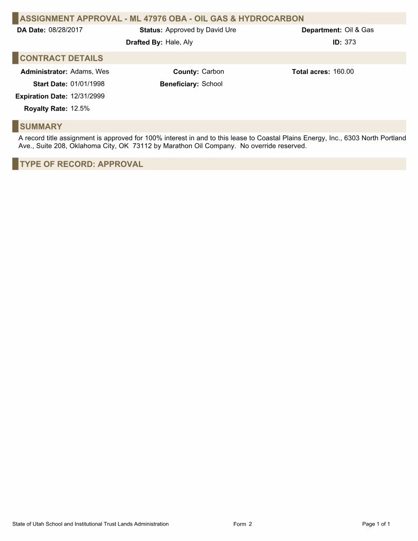
ASSIGNMENT APPROVAL - ML 47976 OBA - OIL GAS & HYDROCARBONOil & GasStatus:08/28/2017 Approved by David Ure Department:DA Date:
Hale, AlyDrafted By: 373ID:
CONTRACT DETAILSAdministrator: Adams, Wes County: Carbon Total acres: 160.00
Start Date: 01/01/1998 Beneficiary: School
Expiration Date: 12/31/2999
Royalty Rate: 12.5%
SUMMARYA record title assignment is approved for 100% interest in and to this lease to Coastal Plains Energy, Inc., 6303 North PortlandAve., Suite 208, Oklahoma City, OK 73112 by Marathon Oil Company. No override reserved.
TYPE OF RECORD: APPROVAL
State of Utah School and Institutional Trust Lands Administration Page 1 of 1Form 2

ASSIGNMENT APPROVAL - ML 47975 OBA - OIL GAS & HYDROCARBONOil & GasStatus:08/28/2017 Approved by David Ure Department:DA Date:
Hale, AlyDrafted By: 372ID:
CONTRACT DETAILSAdministrator: Adams, Wes County: Carbon Total acres: 160.00
Start Date: 01/01/1998 Beneficiary: School
Expiration Date: 12/31/2999
Royalty Rate: 12.5%
SUMMARYA record title assignment is approved for 100% interest in and to this lease to Coastal Plains Energy, Inc., 6303 North PortlandAve., Suite 208, Oklahoma City, OK 73112 by Marathon Oil Company. No override reserved.
TYPE OF RECORD: APPROVAL
State of Utah School and Institutional Trust Lands Administration Page 1 of 1Form 2

BOND / INSURANCE STATEWIDE - RELEASEOil & GasStatus:08/28/2017 Approved by David Ure Department:DA Date:
Alldredge, DavidDrafted By: 345ID:
BOND / INSURANCE DETAILSPrincipal Name: MARATHON OIL COMPANY (OG) Bond Type: Surety Bond
Amount: $80,000.00 Effective Date: 02/09/2000Reference Number: 5922542
Issued By: SAFECO INSURANCE COMPANY OF AMERICA
SUMMARYMarathon Oil Company, ATTN.: Kerri Larson-1874, 5555 San Felipe St., Houston, TX 77056, has requested release of thisstatewide surety bond as they no longer own or operate any oil and gas assets in Utah. Surety is Safeco Insurance Company ofAmerica, 175 Berkeley Street, Boston, MA 02116. The Auditing Group has reviewed this request and has no outstanding auditissues.
TYPE OF RECORD: APPROVAL
State of Utah School and Institutional Trust Lands Administration Page 1 of 1Form 9

APPROVAL OF ML 53561 OBA - OIL GAS & ASSOCIATED HYDROCARBONSOil & GasStatus:08/28/2017 Approved by David Ure Department:DA Date:
Hale, AlyDrafted By: 365ID:
CONTRACT DETAILSLessee: ROBERT L. BAYLESS, PRODUCER LLC
Address: SUITE 2300621 17TH STREETDENVER, CO 802932023
Administrator: Garrison, LaVonne J. County: Uintah Total acres: 240.00
Beneficiary: School
LAND PARCELS (GIS Review of Description: 08/09/2017)T6S, R20E, SLB&M Section 32 W2NE4, E2NW4, W2SW4 240.00 acres
SUMMARYOn August 17, 2017, the Board of Trustees of the School and Institutional Trust Lands Administration ("SITLA") approved thisOther Business Arrangement ("OBA"), ML 53561-OBA, issued to Robert L. Bayless, Producer LLC ("Bayless") with the followingterms and conditions:
1. Primary term of three (3) years, with an effective date of September 1, 2017. 2. Landowner royalty of 17.50%. 3. If no well is commenced during the primary term of the lease, within 30 days prior to lease expiration, Bayless will havethe option to extend the primary term for an additional two (2) years by written request. Should SITLA not receive the extensionrequest timely, Bayless will forfeit the option and the lease will expire by its own terms.
TYPE OF RECORD: APPROVAL
State of Utah School and Institutional Trust Lands Administration Page 1 of 1Form 1

BOARD APPROVAL OF ML 90016 OBA - HOLLIDAY BLOCK - OIL GAS & ASSOCIATEDHYDROCARBONS
Oil & GasStatus:08/28/2017 Approved by David Ure Department:DA Date:
Hale, AlyDrafted By: 411ID:
CONTRACT DETAILSLessee: MORNING GUN EXPLORATION LLC
Address: D&F TOWER, BOX 11601 ARAPAHOE STREETDENVER, CO 80202
Administrator: Garrison, LaVonne J. County: Uintah Total acres: 13,790.52
Beneficiary: LEDA/Rec Exchange (PL111) 1,539.25 ac (11.16%);Management Fee (PL 111) 95.21 ac (0.69%);School 12,156.06 ac (88.15%)
LAND PARCELS (GIS Review of Description: 08/24/2017)T12S, R24E, SLB&M Section 11 S2SE4 80.00 acres
T12S, R24E, SLB&M Section 12 S2S2 160.00 acres
T12S, R24E, SLB&M Section 13 ALL 640.00 acres
T12S, R24E, SLB&M Section 14 E2 320.00 acres
T12S, R24E, SLB&M Section 23 E2 320.00 acres
T12S, R24E, SLB&M Section 24 ALL 640.00 acres
T12S, R24E, SLB&M Section 25 ALL 640.00 acres
T12S, R24E, SLB&M Section 26 E2 320.00 acres
T12S, R24E, SLB&M Section 28 ALL 640.00 acres
T12S, R24E, SLB&M Section 29 ALL 640.00 acres
T12S, R24E, SLB&M Section 32 ALL 640.00 acres
T12S, R24E, SLB&M Section 33 ALL 640.00 acres
T12S, R24E, SLB&M Section 34 W2, W2SE4 400.00 acres
T12S, R24E, SLB&M Section 36 ALL 640.00 acres
T12S, R25E, SLB&M Section 16 ALL 640.00 acres
T12S, R25E, SLB&M Section 17 ALL 640.00 acres
T12S, R25E, SLB&M Section 18 ALL 640.00 acres
T12S, R25E, SLB&M Section 19 ALL 640.00 acres
T12S, R25E, SLB&M Section 20 W2NE4, W2 400.00 acres
T12S, R25E, SLB&M Section 29 ALL 640.00 acres
T12S, R25E, SLB&M Section 30 ALL 640.00 acres
T12S, R25E, SLB&M Section 31 E2 320.00 acres
T12S, R25E, SLB&M Section 31 W2 320.00 acres
T12S, R25E, SLB&M Section 32 ALL 640.00 acres
T12S, R25E, SLB&M Section 7 S2S2 160.00 acres
T12S, R25E, SLB&M Section 8 S2S2 160.00 acres
T13S, R24E, SLB&M Section 2 LOTS 1(14.65), 2(14.35), 3(14.05), 4(13.75), 5(40.00), 6(40.00), 7(40.00),8(40.00), S2N2, S2 [ALL]
696.80 acres
T13S, R24E, SLB&M Section 3 LOTS 1(13.56), 2(13.47), 3(13.39), 4(13.30), 5(40.00), 6(40.00), 7(40.00), 533.72 acres
State of Utah School and Institutional Trust Lands Administration Page 1 of 2Form 1

BOARD APPROVAL OF ML 90016 OBA - HOLLIDAY BLOCK - OIL GAS & ASSOCIATEDHYDROCARBONS
(Continued)
SUMMARYOn August 17, 2017, the Board of Trustees of the School and Institutional Trust Lands Administration ("SITLA") approved anOther Business Arrangement ("OBA") with Morning Gun Exploration ("MGE"), 1601 Arapahoe Street Box 1, Denver, CO 80202,for the Holliday Block in Uintah County. The terms of the OBA are as follows:
1. New three (3) year term leases dated effective September 1, 2017, will be issued to MGE in approximately 640 acreparcels covering 13,790.52 acres in T12S-R24E, T13S-R24E, and T12S-R25E, in Uintah County as depicted in Exhibit A of theHolliday Block OBA Proposal. Leases will be issued at $10.00 per acre or approximately $137,906.00 bonus consideration, and17% landowner royalty. MGE will have an option to extend the leases for an additional two (2) years under the same terms foran additional bonus/rental payment of $6.00 per acre or approximately $82,746.00. 2. MGE must spend $80,000.00 to acquire, shoot and interpret 2D seismic during the first year of the lease and provideSITLA with copies of all seismic data collected. 3. A test well must be commenced on or before September 1, 2020, to test a minimum depth of 2425' or to the stratigraphicequivalent of 100' into the Mesa Verde formation. 4. MGE will log all wells from surface to total depth. 5. MGE has agreed to abide by the terms of the Penstemon Conservation Agreement.
TYPE OF RECORD: APPROVAL
State of Utah School and Institutional Trust Lands Administration Page 2 of 2Form 1

BOARD APPROVAL OF ML 90017 OBA - SEEP RIDGE BLOCK - OIL GAS &ASSOCIATED HYDROCARBONS
Oil & GasStatus:08/28/2017 Approved by David Ure Department:DA Date:
Hale, AlyDrafted By: 412ID:
CONTRACT DETAILSLessee: MORNING GUN EXPLORATION LLC
Address: D&F TOWER, BOX 11601 ARAPAHOE STREETDENVER, CO 80202
Administrator: Garrison, LaVonne J. County: Uintah Total acres: 10,586.66
Beneficiary: LEDA/Rec Exchange (PL111) 3,667.99 ac (34.65%);Management Fee (PL 111) 226.90 ac (2.14%);School 6,691.77 ac (63.21%)
LAND PARCELS (GIS Review of Description: 08/24/2017)T12S, R23E, SLB&M Section 32 W2W2NE4NW4, SE4SW4NE4NW4, W2SE4NW4, SW4SE4SE4NW4,
W2E2NE4SW4, W2NE4SW4, W2W2, SE4SW4, S2S2SW4SE4,SW4SW4SE4SE4
277.50 acres
T13S, R22E, SLB&M Section 12 ALL 640.00 acres
T13S, R22E, SLB&M Section 13 ALL 640.00 acres
T13S, R22E, SLB&M Section 25 NE4, S2 480.00 acres
T13S, R22E, SLB&M Section 35 E2 320.00 acres
T13S, R23E, SLB&M Section 10 NE4NE4SE4SE4 2.50 acres
T13S, R23E, SLB&M Section 11 S2SW4NE4SW4, S2SE4NW4SW4, SW4SW4, W2SE4SW4 70.00 acres
T13S, R23E, SLB&M Section 13 NE4, E2E2NW4, NE4NE4SW4, S2NW4NE4SW4, S2NE4SW4,S2N2NW4SW4, S2NW4SW4, S2SW4, W2SE4
425.00 acres
T13S, R23E, SLB&M Section 14 W2NE4NW4, NW4NW4, NE4SW4NW4, E2NW4SW4NW4,E2SW4SW4NW4, SE4SW4NW4, W2SE4NW4, S2NE4NE4SW4,NW4NE4SW4, S2NE4SW4, E2NW4SW4, E2E2SW4SW4, SE4SW4,S2N2N2SE4, S2N2SE4, S2SE4
355.00 acres
T13S, R23E, SLB&M Section 16 S2S2SW4SW4, NE4SE4SW4SW4, SW4SE4SW4, W2SE4SE4SW4 27.50 acres
T13S, R23E, SLB&M Section 17 NW4NE4NW4NW4, N2NW4NW4NW4, SW4NW4NW4NW4,SE4SE4SE4SE4
12.50 acres
T13S, R23E, SLB&M Section 18 LOTS 1(36.23), 2(36.36), 3(36.50), 5(29.91), N2NE4NE4, N2SW4NE4NE4,W2NE4, E2NW4, NE4SW4, N2SE4SW4, SW4SE4SW4,NW4SE4SE4SW4, SW4NW4NE4SE4, W2SW4NE4SE4, N2NW4SE4,NW4SW4NW4SE4, W2NW4SE4SE4, SW4SE4SE4 [LOTS AKA W2NW4,NW4SW4, PART OF SW4SW4]
441.50 acres
T13S, R23E, SLB&M Section 19 LOTS 1(36.75), 2(36.85), 3(36.95), 4(37.05), W2NE4NE4, W2SE4NE4NE4,NW4NE4, W2NE4SE4NE4, W2SE4NE4, SE4SE4NE4, E2W2, SE4 [LOTSAKA W2W2]
567.60 acres
T13S, R23E, SLB&M Section 20 SW4SW4NW4SW4, W2W2SW4SW4 12.50 acres
T13S, R23E, SLB&M Section 20 E2E2NE4NE4, NE4NE4SE4NE4, NE4NE4SW4SE4, S2NE4SW4SE4,SE4NW4SW4SE4, E2SW4SW4SE4, SE4SW4SE4, SE4SE4
77.50 acres
T13S, R23E, SLB&M Section 21 S2N2SW4NE4, S2SW4NE4, NE4SE4NE4, NE4NW4SE4NE4,S2NW4SE4NE4, S2SE4NE4, W2E2NE4NW4, W2NE4NW4, W2NW4,SE4NW4, NE4SW4, E2NW4SW4, N2NW4NW4SW4, SE4NW4NW4SW4,NE4SW4NW4SW4, S2SW4NW4SW4, S2SW4, SE4
532.50 acres
T13S, R23E, SLB&M Section 22 NE4NE4NE4NE4, S2NE4NE4NE4, S2NW4NE4NE4, S2NE4NE4,S2NE4NW4NE4, S2NW4NE4, S2NE4, NE4SW4NE4NW4,S2SW4NE4NW4, SE4NE4NW4, S2SE4NW4NW4, S2NW4, S2
560.00 acres
T13S, R23E, SLB&M Section 23 ALL 640.00 acres
State of Utah School and Institutional Trust Lands Administration Page 1 of 2Form 1

BOARD APPROVAL OF ML 90017 OBA - SEEP RIDGE BLOCK - OIL GAS &ASSOCIATED HYDROCARBONS
(Continued)
T13S, R23E, SLB&M Section 29 NW4NW4NW4, S2NW4NW4, SW4NW4 70.00 acres
T13S, R23E, SLB&M Section 29 NE4NE4, NE4NW4NE4, NE4NW4NW4NE4, S2NW4NW4NE4,S2NW4NE4, S2NE4, S2NE4NE4NW4, S2NE4NW4, SE4NW4, S2
542.50 acres
T13S, R23E, SLB&M Section 30 LOTS 1(37.12), 2(37.15), 3(37.19), 4(37.22), E2, E2W2 [ALL] 628.68 acres
T13S, R23E, SLB&M Section 31 LOTS 1(37.26), 2(37.28), 3(37.32), 4(37.34), E2, E2W2 [ALL] 629.20 acres
T13S, R23E, SLB&M Section 32 ALL 640.00 acres
T13S, R23E, SLB&M Section 5 LOTS 2(39.02), 3(39.28), 4(39.53), 7(4.72), W2SW4NE4NE4, SW4NE4,W2NW4SE4NE4, SW4SE4NE4, S2NW4, SW4, W2NE4SE4,SW4SE4NE4SE4, W2SE4, W2NE4SE4SE4, W2SE4SE4, SE4SE4SE4[LOTS AKA W2NW4NE4NE4, NW4NE4, N2NW4]
560.05 acres
T13S, R23E, SLB&M Section 6 LOTS 1(39.70), 6(35.52), 7(35.65), S2NE4, E2SW4, SE4 [LOTS AKANE4NE4, W2SW4]
430.87 acres
T13S, R23E, SLB&M Section 7 LOTS 1(35.78), 2(35.88), 3(36.00), 4(36.10), E2, E2W2 [ALL] 623.76 acres
T13S, R23E, SLB&M Section 8 N2NE4, SW4NE4, N2SE4NE4, N2S2SE4NE4, NW4, NW4NE4NE4SW4,N2NW4NE4SW4, N2NE4NW4SW4, W2W2SW4, SW4NE4SW4SW4,W2SE4SW4SW4
370.00 acres
T13S, R23E, SLB&M Section 9 SW4SW4NW4NW4, W2NW4SW4NW4, NW4SW4SW4NW4 10.00 acres
SUMMARYOn August 17, 2017, the Board of Trustees of the School and Institutional Trust Lands Administration ("SITLA") approved anOther Business Arrangement ("OBA") with Morning Gun Exploration ("MGE"), 1601 Arapahoe Street Box 1, Denver, CO 80202,for the Seep Ridge Block in Uintah County. The OBA includes the following terms:
1. New three (3) year term leases dated effective September 1, 2017, will be issued to MGE in approximately 640 acreparcels covering 10,586.66 acres in T12S-R23E, T13S-R22E, T13S-R23E, T14S-R22E and T14S-R23E, in Uintah County asdepicted in Exhibit A of the Seep Ridge Block OBA Proposal. Leases will be issued at $10 per acre or approximately $105,867bonus consideration, and 17% landowner royalty. MGE will have an option to extend the leases for an additional two (2) yearsunder the same terms for an additional bonus/rental payment of $6 per acre or approximately $63,520. 2. MGE must spend $80,000 to acquire, shoot and interpret 2D seismic during the first year of the lease and provide SITLAwith copies of all seismic data collected. 3. A test well must be commenced on or before September 1, 2020, to test a minimum depth of 2425' or to the stratigraphicequivalent of 100' into the Mesa Verde formation. 4. MGE will log all wells from surface to total depth. 5. MGE has agreed to abide by the terms of the Penstemon Conservation Agreement.
TYPE OF RECORD: APPROVAL
State of Utah School and Institutional Trust Lands Administration Page 2 of 2Form 1

ASSIGNMENT APPROVAL - GP 20803 15 - GRAZING (STANDARD)SurfaceStatus:08/28/2017 Approved by David Ure Department:DA Date:
Stewart, SlateDrafted By: 350ID:
CONTRACT DETAILSAdministrator: Stewart, Slate County: Grand; San Juan Total acres: 9,592.54
Start Date: 07/01/2015 Beneficiary: School
Expiration Date: 06/30/2030
AUMs: 334.00
NARRATIVEThis grazing permit will be assigned from Dickie Joe Ladner, 24807 1000 Road, Bedrock, CO 81411 to Curtis Wilcox, P.O. Box104, La Sal, UT 84530. The assignment is for 100% interest (334 AUMs).
The assignment fee in the amount of $3,340.00 (Receipt #RF006455) has been submitted.
SUMMARYThis grazing permit (GP 20803-15) was assigned from Dickie Joe Ladner to Curtis Wilcox.
TYPE OF RECORD: APPROVAL
State of Utah School and Institutional Trust Lands Administration Page 1 of 1Form 2

COLLATERAL ASSIGNMENT - GP 22702 12 - GRAZING (STANDARD)SurfaceStatus:08/28/2017 Approved by David Ure Department:DA Date:
Stewart, SlateDrafted By: 349ID:
CONTRACT DETAILSAdministrator: Stewart, Slate County: Emery; Sevier Total acres: 6,062.28
Start Date: 07/01/2012 Beneficiary: School
Expiration Date: 06/30/2027
AUMs: 322.00
NARRATIVEBrent or Joan Coates, P.O. Box 125, Aurora, UT 84620, as the permittee of record, has requested permission to collaterallyassign their interest (100%) in this grazing permit to Western AgCredit, FLCA, P.O. Box 95850, South Jordan, UT 84095-0850.The collateral assignment fee in the amount of $50.00 has been submitted (Receipt #RF006460).
SUMMARYGP 22702-12 was collaterally assigned to Western AgCredit, FLCA.
TYPE OF RECORD: APPROVAL
State of Utah School and Institutional Trust Lands Administration Page 1 of 1Form 2

COLLATERAL ASSIGNMENT - GP 21939 17 - GRAZING (STANDARD)SurfaceStatus:08/28/2017 Approved by David Ure Department:DA Date:
Stewart, SlateDrafted By: 348ID:
CONTRACT DETAILSAdministrator: Stewart, Slate County: Emery; Sevier Total acres: 6,062.28
Start Date: 07/01/2012 Beneficiary: School
Expiration Date: 06/30/2027
AUMs: 322.00
NARRATIVEWintch & Company Limited, 466 South Main Street, Manti, UT 84642-1649, as the permittee of record, has requestedpermission to collaterally assign its interest (100%) in this grazing permit to Western AgCredit, FLCA, P.O. Box 95850, SouthJordan, UT 84095-0850. The collateral assignment fee in the amount of $50.00 has been submitted (Receipt #RF006459).
SUMMARYGP 21939-17 was collaterally assigned to Western AgCredit, FLCA.
TYPE OF RECORD: APPROVAL
State of Utah School and Institutional Trust Lands Administration Page 1 of 1Form 2

COLLATERAL ASSIGNMENT - GP 20970 12 - GRAZING (STANDARD)SurfaceStatus:08/28/2017 Approved by David Ure Department:DA Date:
Stewart, SlateDrafted By: 346ID:
CONTRACT DETAILSAdministrator: Stewart, Slate County: Beaver Total acres: 14,817.45
Start Date: 07/01/2012 Beneficiary: School
Expiration Date: 06/30/2027
AUMs: 1,085.00
NARRATIVEWintch & Company Limited, 466 South Main Street, Manti, UT 84642-1649, as the permittee of record, has requestedpermission to collaterally assign its interest (100%) in this grazing permit to Western AgCredit, FLCA, P.O. Box 95850, SouthJordan, UT 84095-0850. The collateral assignment fee in the amount of $50.00 has been submitted (Receipt #RF006459).
SUMMARYGP 20970-12 was collaterally assigned to Western AgCredit, FLCA.
TYPE OF RECORD: APPROVAL
State of Utah School and Institutional Trust Lands Administration Page 1 of 1Form 2

COLLATERAL ASSIGNMENT - GP 22303 08 - GRAZING (STANDARD)SurfaceStatus:08/28/2017 Approved by David Ure Department:DA Date:
Stewart, SlateDrafted By: 340ID:
CONTRACT DETAILSAdministrator: Stewart, Slate County: Sevier Total acres: 40.00
Start Date: 07/01/2008 Beneficiary: School
Expiration Date: 06/30/2023
AUMs: 18.00
NARRATIVELoni D. Hammond, P.O. Box 120, Gunnison, UT 84634, as the permittee of record, has requested permission to collaterallyassign his interest (100%) in this grazing permit to Western AgCredit, FLCA, P.O. Box 95850, South Jordan, UT 84095-0850. The collateral assignment fee in the amount of $50.00 has been submitted (Receipt # RF006450).
SUMMARYGP 22303-08 was collaterally assigned to Western AgCredit, FLCA.
TYPE OF RECORD: APPROVAL
State of Utah School and Institutional Trust Lands Administration Page 1 of 1Form 2

CANCELLATION - SULA APPLICATION 1598 - AGRICULTURESurfaceStatus:08/28/2017 Approved by David Ure Department:DA Date:
Fausett, ChrisDrafted By: 343ID:
CONTRACT DETAILSLessee: GREEN RIVER COMPANIES
Address: C/O OAR MANAGEMENT, INC.9911 SOUTH 78TH AVENUEHICKORY HILLS, IL 60457
Administrator: Fausett, Chris County: Grand Total acres: 15,495.07
Beneficiary: School
NARRATIVEOn July 25, 2008, Mr. Tim Vetere, P.O. Box 404, Green River, UT 84525, submitted an application for an agricultural specialuse lease to cultivate alfalfa and other agricultural commodities on the Cisco Block in Grand County. On October 27, 2008, thisapplication was transferred to Green River Companies LLC. Since this application has been dormant since 2008, theapplication will be terminated. A $250.00 application fee, $200.00 advertising charge, $15.00 name change fee, and $11,080.00rental were paid. These payments will be forfeited to the Trust. No refund is required.
SUMMARYThis application has been cancelled due to inactivity.
TYPE OF RECORD: APPROVAL
State of Utah School and Institutional Trust Lands Administration Page 1 of 1Form 2

AMENDMENT TO WATER DISPOSAL PAYMENTS FOR SPECIAL USE LEASES -INDUSTRIAL
SurfaceStatus:08/28/2017 Approved by David Ure Department:DA Date:
Davis, JimDrafted By: 362ID:
CONTRACT NAME BENE ACRESTYPECOUNTYSULA 1474 KERR-MCGEE OIL &
GAS ONSHORE LPSCH UINT IND 24.40
SULA 1475 KERR-MCGEE OIL &GAS ONSHORE LP
SCH UINT IND 21.17
SULA 1611 KERR-MCGEE OIL &GAS ONSHORE LP
SCH UINT IND 1.32
SULA 1612 KERR-MCGEE OIL &GAS ONSHORE LP
SCH UINT IND 1.49
SULA 1613 KERR-MCGEE OIL &GAS ONSHORE LP
SCH UINT IND 1.25
BACKGROUNDSome unclear language in the lease has created confusion about royalty payments due to the School and Institutional TrustLands Administration ("SITLA") from the lessee for water disposal. The confusion centers on the idea that produced water thatcomes from within the associated oil and gas lease, or an oil and gas unit to which that oil and gas lease has been committed,would not owe a royalty to SITLA for disposal on the surface lease. SITLA and the lessee seek to amend the lease language sothat it expresses what the parties had originally intended.
NARRATIVEThe lease is being amended to specify that to dispose of produced water, the lessee does not have to pay a disposal fee if theproduced water originated from the oil and gas lease where the disposal well sits or from within an oil and gas production unitassociated with that oil and gas lease. Outside of those conditions, a $0.15 royalty is due to SITLA for every barrel of disposedwater.
In the amendment, SITLA and the lessee also release each other from potential claims for incorrect payments which may haveoccurred in the past.
The amendment sets reporting and payment due dates. Payments and disposal reports will be due quarterly. Annually, thelessee will report the fraction of disposed water that was required to pay royalty and which was not required to pay royalty basedon the origin of the water.
FINANCIAL/REVENUEFor each lease, the $400.00 amendment fee has been paid by the lessee. No other accounting action is needed.
SUMMARYAMENDMENT to clarify the difference between "compliant" and "non-compliant" produced water and establish the requirementto pay $0.15 royalty on each barrel of non-compliant water. The amendment also sets up a quarterly royalty payment cycle anda yearly reporting cycle where the lessee presents the fraction of compliant vs non-compliant water disposed of in the last 12months. Identical amendments have been made to SULAs: 1474, 1475, 1611, 1612 and 1613.
TYPE OF RECORD: APPROVAL
State of Utah School and Institutional Trust Lands Administration Page 1 of 1Form 3

RENEWAL GRAZING PERMITSurfaceStatus:08/28/2017 Approved by David Ure Department:DA Date:
Campbell, WendyDrafted By: 363ID:
PERMIT NAME BENE ACRESAUMSCOUNTYGP 21824 17 NINE MILE CANYON
TRUSTSCH CARB 7.00 40.00
SUMMARYRenewal has been approved for a period of 15 years, beginning July 1, 2017 and expiring June 30, 2032.
TYPE OF RECORD: APPROVAL
State of Utah School and Institutional Trust Lands Administration Page 1 of 1Form 3

APPROVAL - RIP 715 - RANGE IMPROVEMENTSurfaceStatus:08/28/2017 Approved by David Ure Department:DA Date:
Chamberlain, ScottDrafted By: 358ID:
CONTRACT DETAILSLessee: TRUST LANDS ADMINISTRATION
Address: 2031 S. INDUSTRIAL PARK RDRICHFIELD, UT 84701
Administrator: Chamberlain, Scott County: Uintah Total acres: 772.30
Beneficiary: School
LAND PARCELS (GIS Review of Description: 08/15/2017)T4S, R20E, SLB&M Section 13 W2W2SW4 (WITHIN) 40.00 acres
T4S, R20E, SLB&M Section 14 W2NE4, SE4NE4, E2SE4 (WITHIN) 200.00 acres
T4S, R20E, SLB&M Section 23 S2N2NE4, SE4NE4NW4, NE4SE4NW4, S2SE4 (WITHIN) 140.00 acres
T4S, R20E, SLB&M Section 24 LOT 2, SW4NE4, NW4SE4, S2SW4 (WITHIN) 192.30 acres
T4S, R20E, SLB&M Section 25 NW4NW4 (WITHIN) 40.00 acres
T4S, R20E, SLB&M Section 26 NE4 (WITHIN) 160.00 acres
BACKGROUNDREQUESTED/PROPOSED ACTION:The applicant proposes to treat portions of the Maeser Fire with herbicide to abate cheatgrass. RELEVANT FACTUAL BACKGROUND:The applicant submitted a proposal for this range improvement project on August 15, 2017. The applicant is completing theproject with the assistance of the Utah Division of Wildlife Resources. The project is exempt from review by the Resource Development Coordinating Committee ("RDCC"). The Trust's archaeological staff has determined that herbicide treatments are not an undertaking. A search of Trust records was made to determine the status of the areas involved. Contracts, leases, and permits in the projectareas are: GP 20993-12, ESMT 1997, ESMT 872, ML 52757, ML 52527, ML 53215, ML 53217, ML 90012 OBA. Due to thenature of the project, the mineral leases and easements will not be affected, and the project will benefit the grazing permit.
NARRATIVEEVALUATION OF THE FACTS:This range improvement is in compliance with R850-50-1100(5)(a) and (b). The project does enhance the value of theresources pursuant to R850-50-1100(5)(c).
FINANCIAL/REVENUEThe project cost on trust lands is valued at $12,000.00. Because the applicant is not the permittee of record, the project will notbe eligible for amortization. Note: the life of the project (the benefit) is 3 years.
The Trust has applied to the Watershed Restoration Initiative ("WRI") for assistance in funding the project. Determination ofwhich fires get funded has not yet been completed.
SUMMARYThis range improvement project to treat portions of the Maeser Fire with herbicide to abate cheatgrass was approved.
TYPE OF RECORD: APPROVAL
State of Utah School and Institutional Trust Lands Administration Page 1 of 1Form 1

APPROVAL - RIP 714 - RANGE IMPROVEMENTSurfaceStatus:08/28/2017 Approved by David Ure Department:DA Date:
Chamberlain, ScottDrafted By: 354ID:
CONTRACT DETAILSLessee: UTAH DIVISION OF WILDLIFE RESOURCES
Address: P.O. BOX 146301SALT LAKE CITY, UT 841146301
Administrator: Chamberlain, Scott County: Grand Total acres: 3,300.17
Beneficiary: School
LAND PARCELS (GIS Review of Description: 08/14/2017)T16S, R21E, SLB&M Section 31 E2E2 (WITHIN) 160.00 acres
T16S, R21E, SLB&M Section 32 NW4, N2N2SW4 (WITHIN) 200.00 acres
T17S, R20E, SLB&M Section 24 NE4SE4 (WITHIN) 40.00 acres
T17S, R20E, SLB&M Section 35 SE4, S2NE4, E2SE4NW4 (WITHIN) 260.00 acres
T17S, R20E, SLB&M Section 36 SW4SW4,E2E2NW4, W2NE4 (WITHIN) 160.00 acres
T17S, R21E, SLB&M Section 10 E2SW4 (WITHIN) 80.00 acres
T17S, R21E, SLB&M Section 19 LOTS 3, 6 & 7 (WITHIN) 141.24 acres
T17S, R21E, SLB&M Section 8 E2E2NW4, NE4, NE4SE4 (WITHIN) 240.00 acres
T17S, R21E, SLB&M Section 9 W2NW4, W2NE4, NW4SE4 (WITHIN) 200.00 acres
T18S, R20E, SLB&M Section 1 LOT 4 (WITHIN) 40.04 acres
T18S, R20E, SLB&M Section 11 E2NW4, NW4NE4 (WITHIN) 120.00 acres
T18S, R20E, SLB&M Section 2 LOTS 1-3, S2NE4, W2SE4 (WITHIN) 300.07 acres
T18S, R20E, SLB&M Section 22 S2NE4, NE4NE4, NW4SE4 (WITHIN) 160.00 acres
T18S, R21E, SLB&M Section 16 SW4 (WITHIN) 160.00 acres
T18S, R21E, SLB&M Section 20 SW4SE4 (WITHIN) 40.00 acres
T18S, R21E, SLB&M Section 21 E2NW4,SW4SW4 (WITHIN) 120.00 acres
T18S, R21E, SLB&M Section 28 NW4NW4NW4, SW4SW4SW4 (WITHIN) 20.00 acres
T18S, R21E, SLB&M Section 29 E2, SW4SW4 (WITHIN) 360.00 acres
T18S, R21E, SLB&M Section 30 E2SE4 (WITHIN) 80.00 acres
T18S, R21E, SLB&M Section 32 N2NE4NW4, SW4 (WITHIN) 180.00 acres
T18S, R21E, SLB&M Section 33 NW4NW4NW4 (WITHIN) 10.00 acres
T19S, R21E, SLB&M Section 6 LOTS 4-7, 14 & 15 (WITHIN) 228.82 acres
BACKGROUNDREQUESTED/PROPOSED ACTION:The applicant proposes to apply a herbicide treatment to sagebrush. RELEVANT FACTUAL BACKGROUND:The applicant submitted a proposal for this range improvement project on July 20, 2017. The project is exempt from review by the Resource Development Coordinating Committee ("RDCC"). The Trust's archaeological staff has determined that herbicide application is not an undertaking. A search of Trust records was made to determine the status of the areas involved. Contracts, leases, and permits in the project
State of Utah School and Institutional Trust Lands Administration Page 1 of 2Form 1

APPROVAL - RIP 714 - RANGE IMPROVEMENT (Continued)areas are: GP 21746-07, GP 22541-07, GP 79, GP 78, ML 52377, ML 90006-OBA, ML 9006 B-OBA, ML 52378, ML 52744,ESMT 1910, ROW 2600. Due to the nature of the project the grazing permits will be benefited and the other leases will not beaffected.
NARRATIVEEVALUATION OF THE FACTS:This range improvement is in compliance with R850-50-1100(5)(a) and (b). The project does enhance the value of the resourcespursuant to R850-50-1100(5)(c).
FINANCIAL/REVENUEThe estimated cost/value of the project is $40,240.00, with the full amount being provided by the applicant. Following is a flat-rate amortization schedule using the Natural Resources Conservation Service ("NRCS") schedule for this project, should theSchool and Institutional Trust Lands Administration cancel the grazing permit before these improvements are fully amortized.Only the applicant’s contributions towards the associated project costs will be amortized. If the permittee sells or allows thepermit to expire or to be canceled due to his own actions, then the amortization schedule will be canceled.
PROJECT: Herbicide Treatment of SagebrushPROJECT COST: $40,240.00PROJECT LIFE: 15YEAR COMPLETED: 2017YEARLY AMORTIZED DEDUCTION: $2,682.67YEAR FULLY AMORTIZED: 2032
SUMMARYThis range improvement project to treat sagebrush with herbicide was approved.
TYPE OF RECORD: APPROVAL
State of Utah School and Institutional Trust Lands Administration Page 2 of 2Form 1

APPROVAL OF ROE 6480 - RIGHT OF ENTRYSurfaceStatus:08/28/2017 Approved by David Ure Department:DA Date:
Davis, JimDrafted By: 335ID:
CONTRACT DETAILSLessee: CEDAR MOUNTAIN ENVIRONMENTAL
Address: 2028 E. FT. UNION BLVD., STE 102SALT LAKE CITY, UT 84121
Administrator: Davis, Jim County: Tooele Total acres: 320.00
Beneficiary: School
LAND PARCELS (GIS Review of Description: 08/15/2017)T1N, R11W, SLB&M Section 32 N2 320.00 acres
SUMMARYThe Agency has received an application for the purpose of excavating soil test pits and conducting other site monitoring studies,including: setting up air monitoring stations, groundwater monitoring wells, and taking soil and vegetation samples. This proposed right-of-entry permit will replace ROE 6355, which expires on August 31, 2017, and will authorize ongoing sitemonitoring and investigation of activities on the permitted property. The applicant is in the process of evaluating this area for apotential future special use lease. The requested term of the permit is one (1) year. As this permit will authorize a continuation of an existing use of the property, review by the Resource Development CoordinatingCommittee ("RDCC") was not required. The project area has been previously surveyed for cultural resources by AMEC Earth & Environmental (U-10-EV-0007s). Nosites were located within the project area. The Agency's archaeological staff has evaluated the survey report and has grantedcultural resource clearance for the project. The term of the permit will be one (1) year, beginning September 1, 2017, and expiring on August 31, 2018. The applicant haspaid a rental assessment of $5,600.00, plus a $50.00 application fee and a $50.00 processing fee, totaling $5,700.00.
TYPE OF RECORD: APPROVAL
State of Utah School and Institutional Trust Lands Administration Page 1 of 1Form 1

FIVE-YEAR REVIEW - SULA 1585 - TELECOMMUNICATIONSurfaceStatus:08/28/2017 Approved by David Ure Department:DA Date:
Bagley, GaryDrafted By: 222ID:
CONTRACT DETAILSLessee: FEDERAL AVIATION ADMINISTRATION, AWP
Address: ATTN: CORI CUDDIE1601 LIND AVE. S.W., ANM-53RENTON, WA 98057
Administrator: Bagley, Gary County: Utah Total acres: 10.00
Start Date: 10/01/2012 Beneficiary: School
Expiration Date: 09/30/2032
LAND PARCELS (GIS Review of Description: 07/26/2017)T6S, R1W, SLB&M Section 27 NE4NE4NW4 (FACILITY LOCATED WITHIN) 10.00 acres
BACKGROUNDThe authorized use of the subject parcel is a VORTAC Site, an omni-directional range tactical aircraft control site. This aircraftguidance system serves aircraft in the area and the Salt Lake International Airport. The review date is October 1, 2017.
NARRATIVEDUE DILIGENCE AND PROPER USE:The development allowed by the lease has occurred. It is recommended that the lease be kept in force. PROPER USE:The leased premises are being used in accordance with the lease agreement. ADEQUATE INSURANCE AND BOND COVERAGE:The lessee is a United States Federal Agency and there is no bond requirement in the lease and the lessee is a self-insuringentity.
WATER RIGHTS AND WELLS:There are no Trust-owned water rights associated with this lease. ENVIRONMENTAL COMPLIANCE:The property was inspected and reviewed for environmental compliance in May and August of 2017. The lease inspectionindicated it would be rated as low risk. There is no evidence of underground petroleum storage tanks stored on the leaseproperty. There is an above-ground fuel tank for a back-up generator.
FINANCIAL/REVENUEThe lease agreement provides for periodic increases in the annual base rental amount. Pursuant to the lease agreement, theannual base rental shall be increased from $6,250.00 per year to $7,070.00 per year, effective October 1, 2017. The lease rateis a predetermined rate, previously negotiated and described in the lease agreement.
The existing lease is currently considered the highest and best use of a parcel of this type of land.
A courtesy notice was sent reminding the lessee of this action.
SUMMARYThe annual rental has been increased from $6,250.00 to $7,070.00, effective October 1, 2017. The next five-year review will becompleted by October 1, 2022.
TYPE OF RECORD: APPROVAL
State of Utah School and Institutional Trust Lands Administration Page 1 of 1Form 1

SUBDIVISION LOT SALE - SUBD 10 ADevelopmentStatus:08/28/2017 Approved by David Ure Department:DA Date:
Roe, AlanDrafted By: 351ID:
CONTRACT DETAILSLessee: JACK FISHER CONSTRUCTION OF SOUTHERN UTAH, LLC
Address: 1148 WEST LEGACY CROSSINGBOULEVARDSUITE 400CENTERVILLE, UT 84014
Administrator: Pasley, Kyle County: Washington Total acres: 232.66
Beneficiary: Miners Hospital 74.68 ac (32.10%);School 149.04 ac (64.06%);Utah State University 8.94 ac (3.84%)
Project Code: SUNCR 004 02 000 Project Name: Coral Canyon Black Ridge Lots
Developer: Jack Fisher Subdivision: Highland Park Phase 1 at the Coral Canyon Comm
SUBDIVISION LOCATION (GIS Review of Description: 10/04/2010)T42S, R14W, SLB&M Section 18 HIGHLAND PARK PHASE 1 42.34 acres
T42S, R14W, SLB&M Section 7 HIGHLAND PARK PHASE 1 WITHIN CORAL CANYON 190.32 acres
LOTS SOLDLOT 184 0.17 acres Certificate of Sale: C-26634-10-184 Patent: P-20361-10-184
Beneficiary: School Certificate Date: 08/10/2017 Patent Date: 07/28/2017
Lot Price: $43,830.00 Fees: $0.00
NARRATIVEThis lot is sold pursuant to the terms of DEVL 1075, which provides for the development of the remaining parcels in CoralCanyon, as well as the remaining finished lots in Highland Park. The development lease was approved by the School &Institutional Trust Lands Administration Board of Trustees on May 28, 2015.
The minimum lot price for Lot 184 is $44,000.00. A true up payment will be made when the finished home gets sold to a third-party buyer. The true up payment will bring the total lot price up to the minimum price, or up to 20% of the home price, if this ishigher than the minimum price.
SUMMARYLot 184 has been sold.
TYPE OF RECORD: APPROVAL
State of Utah School and Institutional Trust Lands Administration Page 1 of 1Form 6
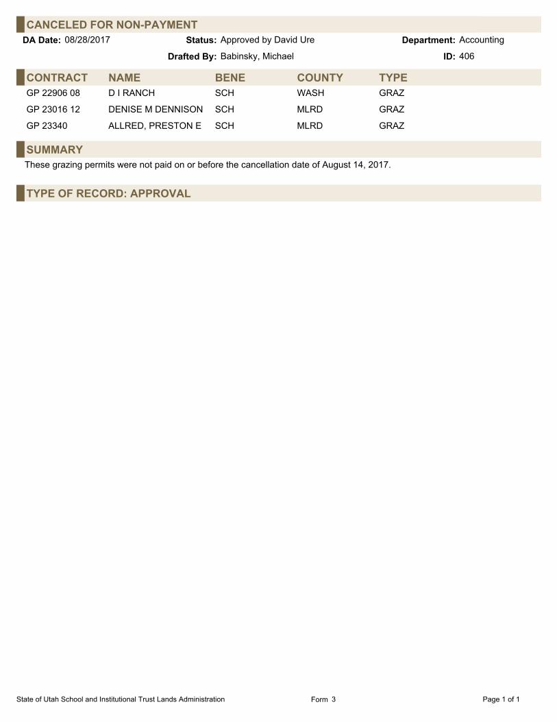
CANCELED FOR NON-PAYMENTAccountingStatus:08/28/2017 Approved by David Ure Department:DA Date:
Babinsky, MichaelDrafted By: 406ID:
CONTRACT NAME BENE TYPECOUNTYGP 22906 08 D I RANCH SCH WASH GRAZ
GP 23016 12 DENISE M DENNISON SCH MLRD GRAZ
GP 23340 ALLRED, PRESTON E SCH MLRD GRAZ
SUMMARYThese grazing permits were not paid on or before the cancellation date of August 14, 2017.
TYPE OF RECORD: APPROVAL
State of Utah School and Institutional Trust Lands Administration Page 1 of 1Form 3

INTEREST RATEAccountingStatus:08/28/2017 Approved by David Ure Department:DA Date:
Babinsky, MichaelDrafted By: 405ID:
FINANCIAL/REVENUEFollowing are the current and past year prime rates:
CURRENT YEAR: 4.25% ONE YEAR AGO: 3.50%
Separately, a late penalty of 6% or $30.00, whichever is greater, shall be charged after failure to pay any financial obligation,excluding royalties as provided in R850-5-300(2), within the time limit under which such payment is due.
Interest on delinquent royalties shall be based on the prime rate of interest at the beginning of each month, plus 4%.
TYPE OF RECORD: APPROVAL
State of Utah School and Institutional Trust Lands Administration Page 1 of 1Form 7

CORRECTION - REFUND - ML 47566 - OIL GAS & ASSOCIATED HYDROCARBONSAccountingStatus:08/28/2017 Approved by David Ure Department:DA Date:
Babinsky, MichaelDrafted By: 408ID:
CONTRACT DETAILSLessee: ANADARKO E&P ONSHORE LLC
Address: SUITE 18001099 18TH STREETDENVER, CO 80202
Administrator: Adams, Wes County: Grand Total acres: 2,539.23
Start Date: 05/01/1997 Beneficiary: School
Expiration Date: 12/31/2999
Royalty Rate: 12.5%
BACKGROUNDA refund was completed for the late fee of $574.01 per the Director's Actions dated June 19, 2017, page 24. The Director'sAction stated that the refund should be sent to Anadarko E&P Onshore LLC. However, Wind River made the payment andshould receive the refund.
FINANCIAL/REVENUEA refund for the late fee payment should be paid to Wind River, 7090 South Union Park Avenue, Suite 430, Midvale, UT 84047-6002.
SUMMARYWind River was refunded the late fee payment of $574.01.
TYPE OF RECORD: APPROVAL
State of Utah School and Institutional Trust Lands Administration Page 1 of 1Form 2

CORRECTION REFUND - ML 48198 - OIL GAS & HYDROCARBON (SPECIAL)AccountingStatus:08/28/2017 Approved by David Ure Department:DA Date:
Babinsky, MichaelDrafted By: 407ID:
CONTRACT DETAILSAssignee: CONOCOPHILLIPS
Address: P.O. BOX 7500BARTLESVILLE, OK 74005
Administrator: Adams, Wes County: Emery Total acres: 2,520.00
Start Date: 05/01/1989 Beneficiary: LEDA/Monument (PL105) 1,222.20 ac (48.50%);Management Fee 75.60 ac (3.00%);School 1,222.20 ac (48.50%)
Expiration Date: 12/31/2999
Royalty Rate: 12.5%
BACKGROUNDA refund was completed for the late fee of $134.40 per the Director's Actions dated June 12, 2017, page 19. Also, a minimumroyalty payment was made but later determined it had already been met. That payment of $2,240.00 should be refunded aswell.
FINANCIAL/REVENUEA refund for the minimum royalty payment of $2,240.00 should be paid to ConocoPhillips Company, ATTN.: Kristie Rimpley510A, 315 S Johnston Ave, Bartlesville, OK 74004.
SUMMARYConocoPhillips was refunded the minimum royalty payment of $2,240.00.
TYPE OF RECORD: APPROVAL
State of Utah School and Institutional Trust Lands Administration Page 1 of 1Form 2