Embed Size (px)
Citation preview

Midterm 2: 45 Possible High Score = 45 Average = 34.4 Approximate Grades A = 38.0 – 45.0 B = 30.5 – 37.5 C = 20.0 – 30.0 NP < 20

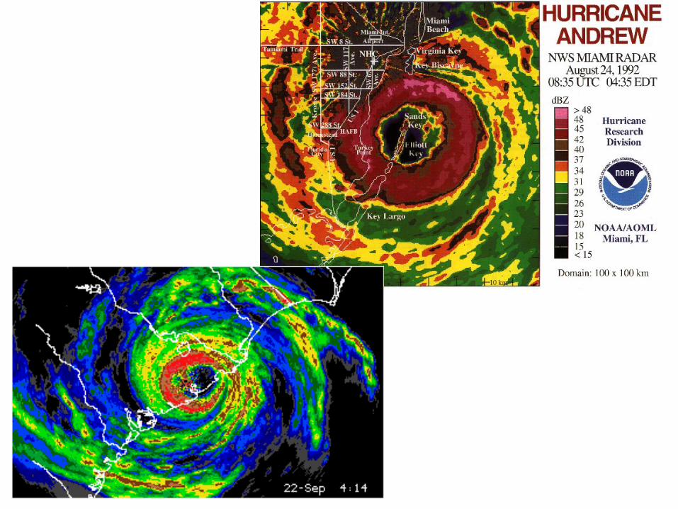
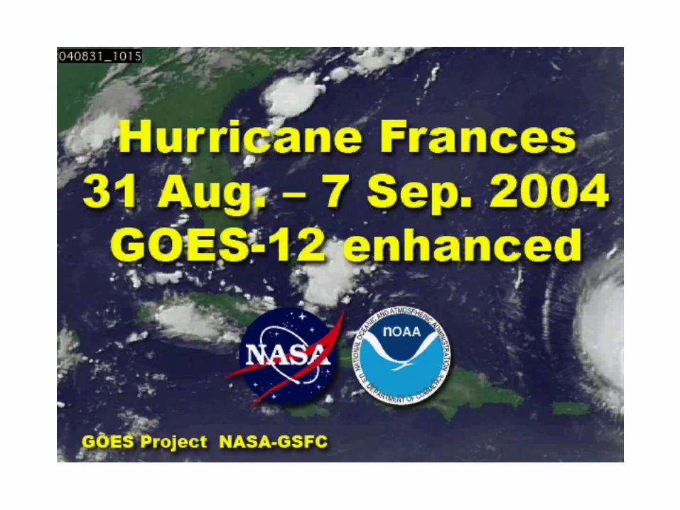
Hurricane Katrina on August 28, 2005

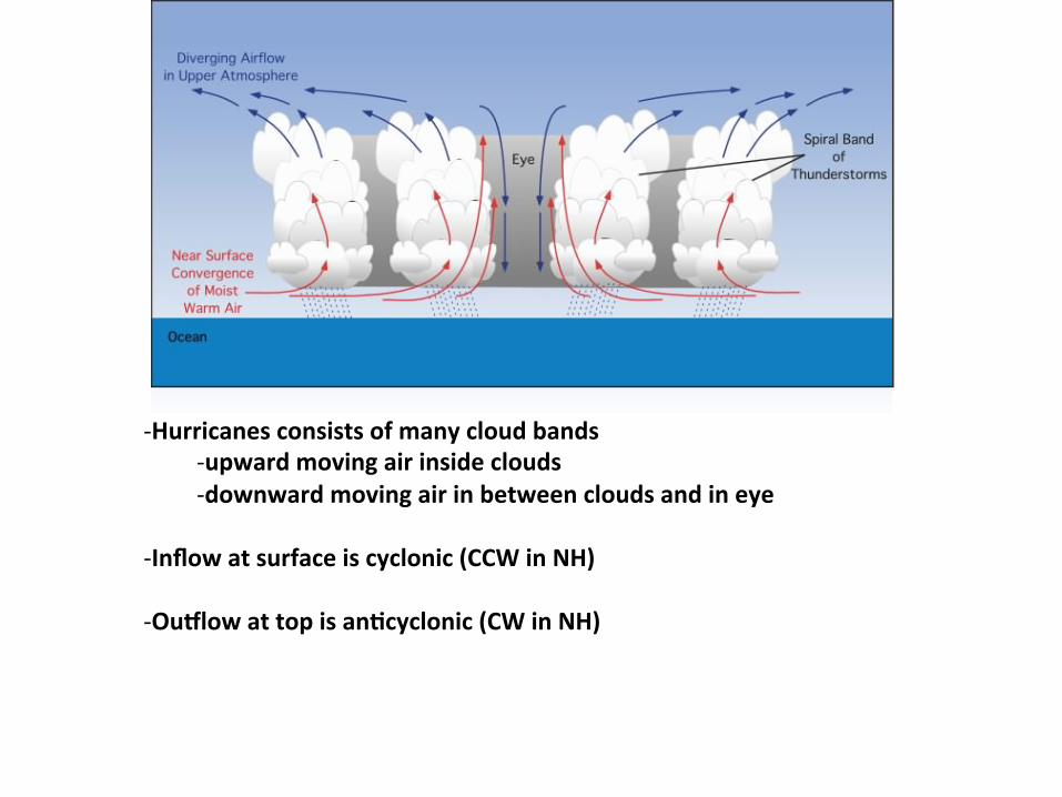
-‐ Hurricanes consists of many cloud bands -‐ upward moving air inside clouds -‐ downward moving air in between clouds and in eye
-‐ Hurricanes consists of many cloud bands -‐ upward moving air inside clouds -‐ downward moving air in between clouds and in eye
-‐ Inflow at surface is cyclonic (CCW in NH) -‐ Ou?low at top is an@cyclonic (CW in NH)

-‐ Hurricanes consists of many cloud bands -‐ upward moving air inside clouds -‐ downward moving air in between clouds and in eye
-‐ Inflow at surface is cyclonic (CCW in NH) -‐ Ou?low at top is an@cyclonic (CW in NH)
-‐ Hurricane is fueled from below (warm moist air) and exhaust is at top.
Hurricane Formation At Surface: Need area of convergence for thunderstorms to develop

Hurricane Formation At Surface: Need area of convergence for thunderstorms to develop (1) Along Intertropical Convergence Zone (ITCZ) - tradewinds converge at surface

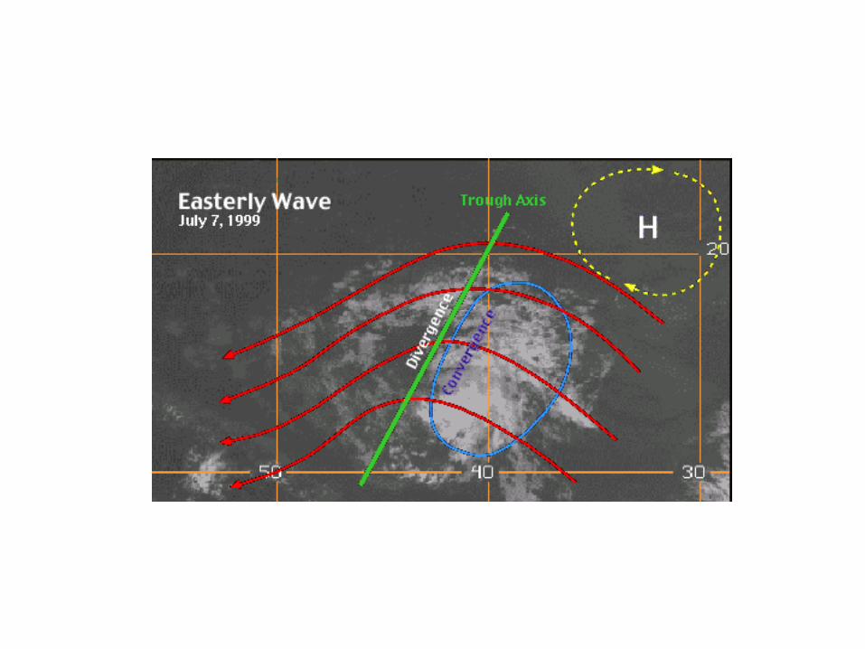
Hurricane Formation At Surface: Need area of convergence for thunderstorms to develop (1) Along Intertropical Convergence Zone (ITCZ) - tradewinds converge at surface (2) Easterly Waves in Tropics - westward moving areas of low pressure - converging surface air on back side of wave

convergence at surface level

(at surface)
(at surface)

Hurricane Formation At Surface: Need area of convergence for thunderstorms to develop (1) Along Intertropical Convergence Zone (ITCZ) - tradewinds converge at surface (2) Easterly Waves in Tropics - westward moving areas of low pressure - converging surface air on back side of wave - often form over Africa and move into tropical Atlantic
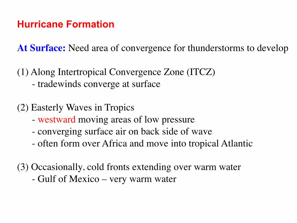
Hurricane Formation At Surface: Need area of convergence for thunderstorms to develop (1) Along Intertropical Convergence Zone (ITCZ) - tradewinds converge at surface (2) Easterly Waves in Tropics - westward moving areas of low pressure - converging surface air on back side of wave - often form over Africa and move into tropical Atlantic (3) Occasionally, cold fronts extending over warm water - Gulf of Mexico – very warm water

Clicker Question Set Frequency to "AD"
warm air in cloud
cool air
cool air
X Air within the cloud is warmer than the air outside at a given altitude. At the points labeled "X" and "Y", would you expect (A) high pressure at X; low pressure at Y's (B) low pressure at X; high pressure at Y's (C) same pressure at all points
Y Y

Hurricane Formation As thunderstorms develop:
1
1. Warm moist air rising 2. Vapor condenses => latent heat released
2
Hurricane Formation As thunderstorms develop:
1
1. Warm moist air rising 2. Vapor condenses => latent heat released 3. In upper part of cloud, air warmer than air outside of cloud 4. High Pressure forms near top of clouds
2
3
HIGH 4

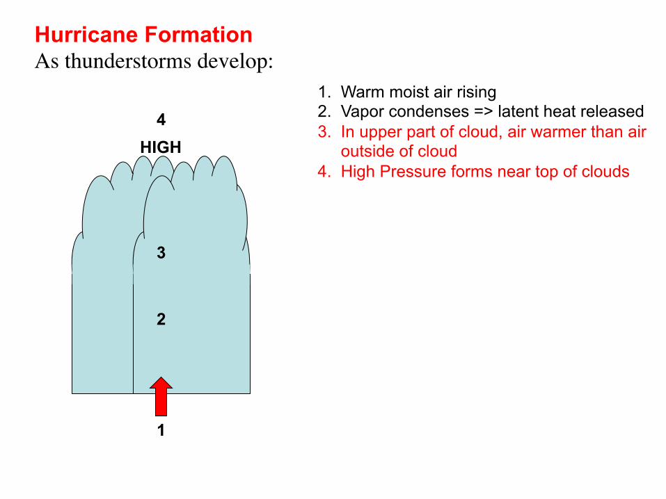
Hurricane Formation As thunderstorms develop:
1
1. Warm moist air rising 2. Vapor condenses => latent heat released 3. In upper part of cloud, air warmer than air outside of cloud 4. High Pressure forms near top of clouds 5. Air aloft flows away from high => divergence aloft 6. Low pressure forms at surface
2
3
HIGH 4 5
LOW 6

Hurricane Formation As thunderstorms develop:
1
1. Warm moist air rising 2. Vapor condenses => latent heat released 3. In upper part of cloud, air warmer than air outside of cloud 4. High Pressure forms near top of clouds 5. Air aloft flows away from high => divergence aloft 6. Low pressure forms at surface 7. Surface air converges towards low Winds increase = more evaporation = more latent heat release = air in cloud gets even warmer POSITIVE FEEDBACK LOOP
2
3
HIGH 4 5
LOW 6
7

Conditions for Hurricane Formation - initial surface convergence - need warm water to provide enough energy (latent heat) SST > 26-27°C (~80°F) - need some Coriolis force for winds to rotate around low Latitude > 5-10° - need little or no vertical wind shear (opposite of severe thunderstorm) Why?

Hurricane Formation
HIGH
LOW
- air inside cloud warmer than outside air ==> creates low pressure at surface and high pressure aloft

Hurricane Formation If Vertical Wind Shear:
HIGH
LOW
Vertical wind shear "tilts" the storm clouds - warm air in clouds and the HIGH pressure aloft no longer above LOW pressure at surface - the low pressure weakens => winds weaken => less latent heat released => storm weakens

Conditions for Hurricane Formation - initial surface convergence - need warm water to provide enough energy (latent heat) SST > 26-27°C (~80°F) - need some Coriolis force for winds to rotate around low Latitude > 5-10° - need little or no vertical wind shear (opposite of severe thunderstorm)

FUEL IN
EXHAUST OUT

FUEL IN
EXHAUST OUT
If exhaust inhibited (strong winds or wind shear aloft) or If fuel reduced (cool ocean water or moves over land) ==> Storm Weakens

FUEL IN
EXHAUST OUT
Main Energy Source: - energy in warm ocean water transferred to air aloft via evaporation at surface and condensation in clouds

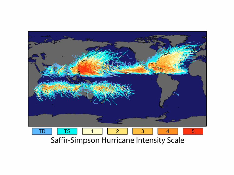
Saffir - Simpson Scale Category Sustained Storm
Wind Speed Surge 1 74-95 mph 4-5 ft 2 96-110 mph 6-8 ft 3 111-130 mph 9-12 ft 4 131-155 mph 13-18 ft 5 155 + mph 18 + ft


Clicker Question Set Frequency to "AD"
Why do we not observe hurricanes off the coast of California? (A) not enough Coriolis force at this latitude (B) too much Coriolis force at this latitude (C) ocean water temperature too cold (D) ocean water temperature too warm

Clicker Question Set Frequency to "AD"
Why do we not observe hurricanes off the coast of California? (A) not enough Coriolis force at this latitude (B) too much Coriolis force at this latitude (C) ocean water temperature too cold (D) ocean water temperature too warm

Clicker Question Set Frequency to "AD"
In general, if the ocean water warms would you expect the average hurricane intensity to: (A) increase (B) decrease (C) stay the same

Clicker Question Set Frequency to "AD"
In general, if the ocean water warms would you expect the average hurricane intensity to: (A) increase (B) decrease (C) stay the same

Expect warmer ocean water in future.... However, still not sure about future hurricanes since upper level winds may change as well


2003 May up to 15Aug
2003 After 15Aug


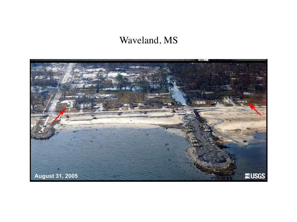
ODen, most hurricane damage is due to flooding, not wind. Rising water level due to: • High waves • Wind pushing water towards coast • Low pressure of storm center (up to 2 feet alone) Combined effects called “Storm Surge”

Dauphin Island, Alabama

Dauphin Island, Alabama

Dauphin Island, Alabama

Waveland, MS
Waveland, MS