Embed Size (px)
Citation preview
National Estate Report - Tasmania
ForewordSummaryChapter 1: IntroductionChapter 2: National Estate cultural valuesChapter 3: National Estate natural valuesChapter 4: National Estate outcomesReferencesGlossaryAbbreviationsTablesRule set used to identify National Estate old-growth forest areasFigure 2.1: Identifying forest places of National Estate social significanceMapsAppendices

Foreword
This National Estate report (Background Report Part H) is one of a series of background reports forming the information base that will be used to prepare the Tasmania-Commonwealth Regional Forest Agreement. It contains information about National Estate values in Tasmania's forests.
In the RFA process, 1996 was devoted largely to the collection and publication of information relating to the social and economic and environmental and heritage values of Tasmania's forests. The results of this process were published in November 1996 as the Public Land Use Commission's Background Reports Parts C and D.
In September 1996 people and groups interested in the management of Tasmania's forests were invited to participate in the RFA integration process. To facilitate this process each interest group has been allocated a Commission-appointed 'mentor'. Participants are putting forward issues and questions that they have identified as needing particular attention as the RFA information is studied by governments.
The next steps involve drawing together the various outcomes of the environment and heritage and social and economic studies and developing options that will satisfy the RFA objectives.
The RFA integration process is being undertaken by a joint Project Team under the direction of the Tasmania-Commonwealth Steering Committee. The Commission's mentors assist the Commission in its role as conduit between the Steering Committee and the interest groups to obtain their views about issues and options.
As the options are developed there will be continuing interaction between the Steering Committee and the interest groups. This will include feedback on the Project Team's analysis of the public contributions. It is expected that this process will continue throughout February 1997 as submissions are considered and options are identified. The RFA options report is to be published in April 1997 and will be available for up to six weeks for public comment and submissions.
Public comment on this National Estate report is invited. Submissions dealing with critical National Estate matters should reach the Public Land Use Commission by the 21 February 1997. They will be forwarded to the Steering Committee for use during the integration process leading to the drafting of the options report. Comprehensive submissions should reach the Commission by 21 March 1997. They will be forwarded to the Steering Committee for use during the development of the Tasmania-Commonwealth Regional Forest Agreement, to be signed in mid-1997.
Bruce Leaver Public Land Use Commissioner

Summary
This report presents the outcomes of the National Estate component of the comprehensive regional assessment of Tasmanian forests. It will contribute to the development of options on which the Tasmania-Commonwealth Regional Forest Agreement will be based. As defined in the Australian Heritage Commission Act 1975, the National Estate consists of
those places, being components of the natural environment of Australia, or the cultural environment of Australia, that have aesthetic, historic, scientific or social significance or other special value for future generations as well as the for the present community.
All of Tasmania formed the study area for the identification and assessment of National Estate values in Tasmanian forests.
Preparation of this report has involved all relevant agencies of the Commonwealth Departments of the Environment, Sport and Territories and Primary Industries and Energy in a joint process with the relevant Tasmanian agencies: the Department of Environment and Land Management, the Office of Aboriginal Affairs, Mineral Resources Tasmania, Private Forests Tasmania and Forestry Tasmania. Many natural and cultural heritage experts and members of the general public have also made contributions.
Areas identified in this report as having potential National Estate value are indicative only. They are not the delineated forest areas that will be listed on the Register of the National Estate. The report documents the values that need to be taken into account in determining National Estate places; the data in the report will form the basis of that determination. The data layers and indicative areas will remain indicative until they have been considered by the Australian Heritage Commission. Areas endorsed by the Australian Heritage Commission will be entered on the interim list of the National Estate; they will then be advertised and subject to the statutory period of three months allowed for public comment. It is anticipated that interim listing of areas identified through this process will occur after the Tasmania-Commonwealth Regional Forest Agreement is signed in mid-1997.
Over 130 areas were identified as indicative National Estate places of historic, social or aesthetic cultural value. The time frame for consultation with and the participation of the Tasmanian Aboriginal community extends beyond that for the comprehensive regional assessment: mechanisms for management of Aboriginal places of National Estate significance continue to be developed. Indicative National Estate areas of natural value are identified in value layers covering natural landscapes, undisturbed catchments, old growth, wilderness, flora, fauna, natural history, and geology, geomorphology and soils. There are many 1000s of indicative natural areas, ranging from small areas through to extensive landscapes identified in this report.
Some of the indicative places and areas identified in this assessment occur in existing National Estate listed places.
The National Estate component of the comprehensive regional assessment has greatly enhanced our knowledge of the occurrence of National Estate values in the forests of Tasmania. Places already on the Register of the National Estate and those on the interim list will be updated in the light of the information gathered during the comprehensive regional assessment.
It is expected that the Tasmania-Commonwealth Regional Forest Agreement will include specifications for a jointly agreed National Estate outcome in terms of both the listing of places and the long-term management of National Estate values in forests.

Chapter 1: Introduction
The National EstateNational Estate assessment
Introduction
There are a number of stages in the development of the Regional Forest Agreement between the Tasmanian and Commonwealth Governments. The first stage, which follows the signing of the Scoping Agreement, is the comprehensive regional assessment. Both Governments, in collaboration with experts, have been involved in a wide range of projects designed to provide the information necessary for the analysis and identification of values and possible options for a regional forest agreement. Subsequent stages will include the integration of environment and heritage and social and economic forest values, the development of the options report, and the drafting of the Regional Forest Agreement. The results of the studies of environment and heritage and social and economic values associated with Tasmania's forests are presented in Background Reports Parts C and D (PLUC 1996a, 1996b).
This report presents the results of the assessment of natural and cultural National Estate values, carried out as part of the comprehensive regional assessment. It identifies areas of potential National Estate value; these are indicative areas only. The attributes documented in this report will be taken into account in delineating National Estate places.
Tasmania and the Commonwealth are considering other matters to ensure that National Estate values in forests are identified and managed on a long-term basis. This includes an examination of current forest management practices through the assessment of ecologically sustainable forest management, the final report on which was published by the Public Land Use Commission as Background Report Part G (PLUC 1996c). Conservation management principles, or guidelines, will also be developed for the range of National Estate values and places, as a basis for future Australian Heritage Commission advice and as a contribution to Tasmanian land management. Development of such guidelines is integral to the development of the Tasmania-Commonwealth Regional Forest Agreement.
1.1 The National Estate
The National Estate is defined in the Australian Heritage Commission Act 1975:
those places, being components of the natural environment of Australia, or the cultural environment of Australia, that have aesthetic, historic, scientific or social significance or other special value for future generations as well as for the present community.
The Australian Heritage Commission's responsibility is to identify the National Estate and, under section 30 of the Act, to advise the Commonwealth Government on the conservation of National Estate places and the potential impact on National Estate values of proposals relating to those places. The Act also requires the establishment of the Register of the National Estate. The Register includes places of importance at a local, regional State or national level. The identification and asessment of places for inclusion on the Register is guided by the National Estate criteria (see Apendix D)
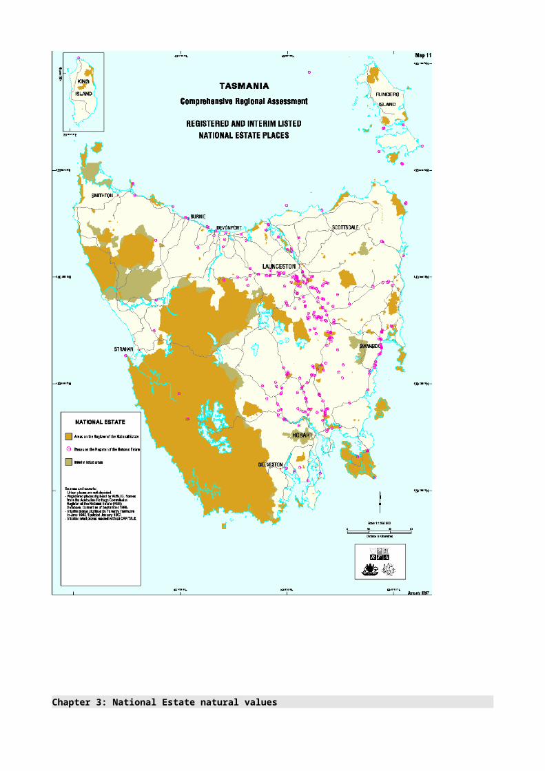
Many areas of forest in Tasmania are already on the Register of the National Estate (see Appendix A and Map 11). They are used for many purposes, among them timber production, mining, tourism and conservation. When making decisions about the use of forests that contain places of National Estate significance-for example, decisions on whether to grant woodchip export licences-the Commonwealth must consider any potential adverse impacts on National Estate values.
In the past, the lack of detailed information about the National Estate values of forests has made it difficult for the Australian Heritage Commission to identify and register places of National Estate significance and to provide the Commonwealth Government with detailed advice about the conservation of those places. The lack of information has also contributed to uncertainty for the forest industry and for State governments about what places will be listed and what advice the Commission will give for the conservation of those places.
The nature of the forest debate has changed dramatically in the last decade, and the need to look at values systematically, rather than place by place, is now acknowledged. There has been a huge increase in the amount of systematic, scientific work being done to determine the impact of forest activities.
The National Estate assessment
The Tasmanian comprehensive regional assessment of National Estate values is the first such assessment to involve all relevant agencies of the Commonwealth Departments of the Environment, Sport and Territories and Primary Industries and Energy in a joint identification and assessment process with the relevant Tasmanian agencies: the Department of Environment and Land Management, the Office of Aboriginal Affairs, Mineral Resources Tasmania, Private Forests Tasmania and Forestry Tasmania. The process is designed to comply with a range of Commonwealth and State statutory obligations in relation to the management of forests. Previous regional assessments-the study of the south-west forest region of Western Australia and the studies of East Gippsland and the Central Highlands of Victoria-have been done by the Australian Heritage Commission in conjunction with State agencies.
The results of this National Estate assessment will contribute to the development of options on which the Tasmania-Commonwealth Regional Forest Agreement will be based.
Areas identified in this report as having potential National Estate value are indicative only. They are not the delineated forest areas that will be listed on the Register of the National Estate. The report documents the values that need to be taken into account in determining National Estate places; the data in the report will form the basis of that determination. The data layers and indicative areas will remain indicative until they have been considered by the Australian Heritage Commission. Places endorsed by the Australian Heritage Commission will be entered on the National Estate interim list; they will then be advertised and be subject to the statutory period of three months allowed for public comment. It is anticipated that interim listing of places identified through this process will occur after the Tasmania-Commonwealth Regional Forest Agreement is signed in mid-1997.
Places already on the Register of the National Estate and those on the interim list will be updated in the context of the information gathered during the comprehensive regional assessment. The Regional Forest Agreement will include specifications for a jointly agreed National Estate outcome.
Appendix B lists the consultancies and other reports that have contributed to this National Estate assessment. Copies of these reports are available for inspection in Hobart and Canberra:
Public Land Use Commission 3rd floor, TGIO Building 144-148 Macquarie Street Hobart
Department of the Environment, Sport and Territories Tobruk House 15 Moore Street Canberra
This report has been prepared by the Tasmania-Commonwealth Regional Forest Agreement Environment and Heritage Technical Committee, which consists of officers of Forestry

Tasmania, the Tasmanian Parks and Wildlife Service and the Commonwealth Department of the Environment, Sport and Territories. Appendix C lists the Committee members. We thank the many officers of the agencies involved and the CRA Project Team for their contributions to the National Estate assessment; these people are also listed in Appendix C.

Chapter 2: National Estate cultural values
Introduction Assessment criteria for cultural values Community consultation
Places of historic value Data sources Data audit and analysis Historic places research Methodology Results
Places of social value Data sources Methodology Results
Places of aesthetic value Data sources Methodology Results
Aboriginal heritage and values Consultation with the Aboriginal community The Aboriginal community workshop Continuing consultation
2.1 Introduction
Cultural places of National Estate significance are places of aesthetic, historic, scientific or social value for past, present or future generations. Documentary and field-based research reveals a wide range of cultural places within or related to the forests of Tasmania. These places are indicative of the rich and diverse history of human interaction with, and response to, those forests.
The National Estate cultural studies component of the comprehensive regional assessment has considered cultural places physically located in forests, places illustrating activities directly related to forests, and forest-related places that are now surrounded by cleared land. These places may vary from extensive mining landscapes, with a range of mining infrastructure, to isolated sawmills, historic tramways built for timber getting, picnic areas and grave sites. The forests also contain aesthetic landscapes that are valued by the community.
The following cultural values were considered:
• places of historic value

• places of social value
• places of aesthetic value.
An appropriate process for identifying and assessing Aboriginal places-'Aboriginal' is the term preferred by the Aboriginal community in Tasmania-of National Estate significance could not be developed and implemented in the time frame of the comprehensive regional assessment. In the case of Aboriginal places, interaction with the Aboriginal community has concentrated on developing an appropriate form of consultation in relation to RFA processes and possible outcomes and the involvement of the Aboriginal community. Tasmania and the Commonwealth are examining other ways of ensuring that Aboriginal places of National Estate significance in forests are identified and managed within the Tasmania-Commonwealth Regional Forest Agreement; this is discussed in Section 2.5.
2.1.1 Assessment criteria for cultural values
In the regional context, assessment of the National Estate involves the sorting of places according to their type or primary characteristics and the development of a comparative assessment of those places to determine their significance. Specific criteria are used to establish significance indicators and National Estate significance; Appendix D lists the criteria for listing on the Register of the National Estate.
The significance indicators vary across the National Estate values and may include the following:
• abundance or commonness
• rarity or threat
• distribution pattern
• condition and integrity
• diversity or richness
• outstanding example
• representative example
• strength of community attachment
• size and/or extent of community demonstrating attachment
• substantiated strong association with a particular group or groups
• longevity of association with a particular group or groups.
The National Estate significance thresholds depend on the extent of current knowledge about a particular type of place. This knowledge embraces factors such as the existence and distribution of a type of place across the landscape, at a local, regional or national level, and the variation within a particular type of place. A regional perspective provides a much more comprehensive knowledge base for assessing places and for the National Estate thresholding process.
Each threshold is set in relation to the significance indicators and is specific to each National Estate value. For instance, to reach the threshold for a particular National Estate value, a place may need to rank highly on three out of five significance indicators. A place may, however, be highly ranked on just one significance indicator and still reach the National Estate threshold.

The point at which the threshold is set depends on the importance or relevance of the significance indicator to the National Estate value.
The relationship between significance indicators and the National Estate threshold is established through consideration of the quantity and quality of available information, through expert opinion and discussion, and through consideration of previous National Estate thresholding and listing decisions.
The National Estate threshold of significance for each value was jointly agreed as the appropriate threshold for the purposes of the comprehensive regional assessment.
A National Estate threshold is not graded: a place will either meet the threshold or not. Places may be significant against more than one National Estate criterion, although a place need only be significant against one criterion to warrant listing on the Register of the National Estate.
2.1.2 Community consultation
Community consultation provides important information for the assessment of places of social significance (National Estate criterion G.1) and aesthetic significance (National Estate criterion E.1)-see Appendix D.
To identify and assess social and aesthetic values it is necessary to collect data directly from the community. This is because the criteria used to assess these values in the landscape specify that places of social or aesthetic value must be of significance to a community or cultural group.
The following can be considered in measuring the strength and depth of the community's attachment to a place:
• the size and extent of the attached community or group;
• the nature of the community, its history and cultural identity;
• the extent to which community members are prepared to allow the place to change;
• the pace of change and whether the change is in harmony with the life of the community;
• the intensity and importance of a community's attachment in political and cultural terms.
2.2 Places of historic value
Historic places relate primarily to the non-indigenous culture of Australia although some may also have Aboriginal values. Among the wide range of historic places associated with forests in Tasmania are mining landscapes with extensive mining infrastructure, isolated sawmills, the remains of massive tree stumps, historic tramways built for timber getting, trappers' and snarers' huts, and grave sites.
The National Estate historic places study identified the range and extent of historic forest places and assessed those places for National Estate significance. The National Estate criteria relevant to historic places are criteria A.3, A.4, B.2, D.2, E.1, F.1, G.1 and H.1 (see Appendix D).
To date, very few historic places related to the forested areas of Tasmania have been identified as having National Estate significance in their own right and been entered on the Register of the National Estate for this reason (see Appendix A). Other areas, listed as natural National Estate places, also have historic values, a few of which have been assessed as significant in their own right, as well as many others that have not been fully documented and whose significance has not been assessed.

2.2.1 Data sources
The following were the main data sources for the historic places assessment:
• the Tasmanian Historical Archaeological Sites Catalogue, managed by the Parks and Wildlife Service;
• the Forestry Tasmania Historic Places Inventory (based on the Parks and Wildlife Service database);
• the Mineral Resources Location and Characterisation System (MIRLOCH) operated by Mineral Resources Tasmania;
• three general regional surveys of forest lands, funded by the National Estate Grants Program and carried out between 1990 and 1992 by Forestry Tasmania (Gaughwin 1991, Parham 1992, Scripps 1990);
• Forestry Tasmania studies of the timber industry, funded by the Tasmanian Forest Research Council (Kostoglou 1991, 1992, 1993, 1994a, 1994b, 1995a, 1995b).
Other data were collected from registers such as the Register of the National Estate and that of the National Trust of Australia (Tasmania).
2.2.2 Data audit and analysis
Stage one of the historic forest places study consisted of a data audit and analysis of documentary information and heritage place registers (Pearson & Champion 1996a). The purpose was to identify the extent and quality of the available information to determine the basis for a comprehensive regional assessment of historic values in forests and to identify and propose strategies to redress any inadequacies, limitations and gaps in the available information within the time frame of the comprehensive regional assessment.
The analysis of existing information revealed that the range of historic forest-related places in Tasmania is not widely known and the nature of the places' significance is generally poorly understood. Twenty-three categories of sites are identified in the draft Tasmanian Heritage Register, which is being developed to support Tasmania's new historic heritage legislation. Fourteen of these categories appear to be directly related to forests. At the beginning of the comprehensive regional assessment, there were no fully documented examples of each type of place represented in Tasmania's forests, although there appeared to be sufficient supporting information available in surveys and reports to complete such a sample.
In general, the data audit and analysis concluded that, although there is good documentary evidence relating to human activity in Tasmania's forests, to date this has been drawn on only selectively for place-based significance assessment and management purposes. Information in site inventories is limited in geographic and thematic extent and has not been integrated into a statewide overview. There are important historical themes and geographic regions that remain poorly studied and for which historic places have not been identified.
2.2.3 Historic places research
The data audit and analysis identified a series of major geographical and thematic gaps in the information about historic places in Tasmanian forests. Four studies were commissioned to address the most important of these gaps:
• a study of blackwood and hardwood timber getting in the north-west of Tasmania (Kostoglou & Pearson 1996);
• a study of mining sites in forests (Pearson & Champion 1996b);

• a study of transportation routes (Pearson & Young 1996);
• documentation of each of the major categories of historic place found in or related to Tasmanian forests (Marshall & Pearson 1996).
Other thematic and geographical gaps considered to be of lower priority were recommended for consideration in a longer term research program. Among the thematic gaps were defence and military sites, manufacturing and processing sites, and sites associated with hydro-electricity generation. Human activities such as snaring and trapping are also a potential thematic gap. Among the geographical gaps identified by the analysis were private forested lands, swamplands of the north-west and forested land on the west coast and the south-west, the upper Derwent Valley, on the fringes of the Central Plateau, and on the north-east and east coasts.
A good understanding of the range of historic places in Tasmanian forests, the extent to which the physical evidence of these places remains in the forests, and the nature of their significance is considered important for both public education and management planning. A study was therefore commissioned to produce a set of well-documented examples of each of the major categories of historic places found in or related to Tasmanian forests (Marshall & Pearson 1996). The study did not document all potentially significant historic forest places but selected those places with sufficient information for documentation to appropriate standards for the purposes of the Register of the National Estate and for the assessment of National Estate significance.
2.2.4 Methodology
The methodology for the historic values component of the comprehensive regional assessment was designed to achieve the best practicable understanding of the range and distribution of historic forest places within the CRA time frame. Extensive historical research, field survey and field verification to identify new places and obtain new data was not possible, although a limited number of places were assessed in the field as part of the data-collection phase. As a consequence, in all historic values studies conducted for the comprehensive regional assessment, the principal factor in identifying places of indicative National Estate significance was the standard of existing documentation, within site inventories and available from supplementary historical documentation.
The following were the main `sieves' for identifying the well-documented examples of each of the major categories of historic forest places:
• the availability of sufficient information
• apparent eligibility for the Register of the National Estate
• remaining physical evidence of significance
• a reflection of the range of places
• a reflection of the range of historical periods
• a reflection of the geographical scope of activity.
Historic place types in Tasmanian forests: a sample
The study by Marshall and Pearson (1996a) documented examples of each of the major categories of historic places found in or related to Tasmanian forests. The categories correspond with those in the Tasmanian Historic Places Inventory. The study identified and documented 46 places that reached the threshold of National Estate significance. Fourteen of these places related to the timber industry and 11 related to the mining industry. Examples were also documented for each of the remaining categories-habitation, settlement,
agricultural/pastoral, recreation, transport, communications and exploration. The documented indicative National Estate places represent a small sample of the many known and unknown historic places (some of which may also have National Estate significance) that are found in or are associated with forests.
Blackwood timber harvesting
The data audit and analysis (Pearson & Champion 1996a) identified two high-priority historic timber-harvesting areas for further research: the blackwood swamps and the pining industry. Nearly all the former pining areas are now in reserves and are not subject to continued production, although the historic remains need an appropriate management system. The blackwood industry was an important component of the State's timber industry and, unlike the pining sites, most of the blackwood timber sites have either been cleared for agriculture or remain as production forests. The blackwood timber-harvesting industry has to date received little research attention and is poorly documented. It used production methods that differed from those used in the better documented eucalypt forest-harvesting places of the north-east and south-east. Blackwood in the Circular Head District, one of the historically important blackwood timber production areas, is commonly found in low-lying areas prone to inundation and could be logged only in the dry summer months. The short logging season resulted in hastily constructed and ephemeral transport systems designed for short-term use and subsequent removal of components for use elsewhere. As a highly valued timber, blackwood was also more carefully logged than the eucaypts and was cut close to the ground to obtain the maximum amount of timber.
Eucalypt-dominated forests in the rest of the State have already been the subject of some field survey and in the north-west were probably subjected to the same forest-harvesting techniques as elsewhere, resulting in a similar range of historic remains.
The study of timber harvesting in the Circular Head district focused on the blackwood forest industry of north-west Tasmania. A range of places associated with both the blackwood swamp and the hardwood timber industry were identified, including sawmills, tramways, and camps occupied by timber cutters (Kostoglou & Pearson 1996). The following significance indicators were used to establish a National Estate threshold for the timber industry sites:
• the degree to which the place can be demonstrated as being seminal, influential, climactic or terminal in the historical development of the blackwood or hardwood timber industry, the region, or a historical period or process;
• the degree to which the place can be demonstrated to be rare or to represent its site type in its intactness or condition better than other places, in a regional/State or national context;
¥ the degree to which the place is associated with events, persons or groups of importance in the history of the locality, region/State, or industry, and the degree to which the association is demonstrated in the place or the effect of the place on events or the history of the persons or groups;
¥ the degree to which these or other attributes have contributed to a strong association with and/or valuing by the community;
¥ the degree to which the place is able to demonstrate its elements of significance better than similar places-this is often associated with the intactness and condition of the fabric or the use or the setting of the place, where these are linked to its significance.
Sixty-three places were identified in the study. Of these, three places were considered to meet the threshold of National Estate significance, 40 places were considered to not meet that threshold, and for the remainder there was insufficient information to allow their values to be assessed.

Mining sites
The mining study (Pearson & Champion 1996b) was designed to fill gaps in the knowledge of mining sites of National Estate significance in Tasmanian forests through a sampling process. The study was based on information available from the Forestry Tasmania Historic Places Inventory, the MIRLOCH database, various Mines Department and forest survey reports, and other documentary sources. A framework of mining history was also developed to ensure that a wide range of sites relevant to all phases and types of mining was selected for documentation and assessment. The role of mining in regional settlement was also considered.
A review of the data sources showed there is a very rich cultural heritage relating to mining in and connected with Tasmanian forests. There is documentary evidence of over 3 000 mines and mining prospects that operated at some time in the State. In many cases the information on the current existence and condition of the historic fabric relating to mining activities is limited and insufficient for significance assessment.
The mining study documented 51 mining sites and identified 10 mining sites or infrastructure sites that were considered to meet the National Estate significance threshold. These places were considered against three main significance indicators:
• significance in terms of production or overall patterns of mining;
• representative of the various phases and themes of Tasmanian mining;
• demonstrating a substantial degree of remaining historic mining features or machinery.
Many other sites appear to have potential to meet the threshold for National Estate significance but could not be adequately documented. The 10 indicative National Estate places identified represent most of the periods of production, for various minerals, that occurred in the forests. The main gap is from the 1960s on. Some mineral production-osmiridium and oil shale-is not represented, mainly because of the lack of well-documented sites with remaining fabric.
Transport routes
The transport routes study (Pearson & Young 1996) identified historic routes of human movement through Tasmania's forests. In general, the existing heritage databases have very limited information on historic routes, despite fragmentary evidence of an abundance of remains throughout the forest. Very few route-specific studies have been carried out and there is a significant lack of knowledge about the remains of evidence of original transport routes and their current condition.
The study concentrated on transport routes that were of sufficient extent and longevity to have had a formative influence on local and regional settlement patterns. The routes generally fell into two categories:
• transport systems passing through the forest en route to another destination;
• transport systems leading into the forest to allow access to a resource being exploited there.
The routes include mining-related and forestry-related routes, walking tracks used by trappers and snarers, and government and company access routes built to encourage development. Such routes often became the initial conduits for regional settlement; many of them later became roads or recreational walking routes and have been extensively rebuilt and modified.
Many other industry-specific transport systems are significant only in an industrial context: as such their heritage value is connected with themes associated with that industry rather than the theme of transport. These routes have been assessed, where possible and appropriate, in

the various other historical studies conducted as part of the comprehensive regional assessment.
Transport routes were considered against three main significance indicators:
• their importance in the development of the State/region or local area;
• whether they are representative of the variety of transport routes through the forests;
• whether there is documentary evidence of the survival of significant fabric or physical remains.
Thirty routes representing the principal themes and geographical spread of transport routes were documented and assessed. Of these, 15 were considered to meet the threshold of National Estate significance: four of these were documented and assessed in the timber industry study (Kostoglou & Pearson 1996) and the sampling study (Marshall & Pearson 1996a). Three routes were assessed as not meeting the threshold for National Estate significance, and for 12 routes there was insufficient information to allow their values to be assessed.
The 30 routes assessed are generally represented only by a fragment of their original formation and features. The fragments are residual parts not modified in subsequent improvements of the route or are parts somehow remaining while other sections have been reclaimed by soil movement and bush regeneration.
2.2.5 Results
The studies identified 70 forest-related historic places in Tasmania that meet the National Estate significance threshold. Appendix E lists these indicative National Estate places; their locations are shown on Map 10. The places are part of a much larger group of historic forest places for which insufficient information was available to allow documentation and assessment for National Estate significance. There remain many more historic places with potential National Estate significance in the forests of Tasmania that remain to be identified, documented and assessed.
2.3 Places of social value
The identification and assessment of Tasmanian forest places with social value was based on National Estate criterion G.1, which recognises places that have a strong or special association with a community for social, cultural or spiritual reasons (see Appendix D).
Many different types of places are important to community groups for many different reasons. Often communities value a particular place very highly because of the way they use the place or the meaning it holds for them. They may be places where memorable events have occurred in the past, or places associated with significant recent events. They can be built features such as a local hall, roadway or track, or they can be naturally occurring features such as a mountain, lake or tree. These places are considered important because they form a part of the community's identity.
The aim of the National Estate social values project was to identify the range and extent of places valued by communities, or of social value, in Tasmanian forests and to assess those places for National Estate significance. Before the comprehensive regional assessment, over 80 forest places having National Estate social significance had been identified in Tasmania. In most instances, however, this value had not been identified or corroborated through community consultation; rather, it had been determined through assessment by cultural and natural environment heritage experts. The information gathered during the CRA process, which enhances understanding of the importance of these places, will be amalgamated with existing information on places already on the Register of the National Estate.
2.3.1 Data sources

The Tasmanian community provided the primary source of data for identifying and assessing places of indicative National Estate social value during the comprehensive regional assessment. Representatives of a broad range of organisations came together in community workshops to identify places important to them and to provide information on why those places were important, their location and their boundaries. Community workshops were held throughout the State, in eight locations. The workshops were designed, organised and run by consultants in collaboration with Commonwealth and State government RFA project officers (Context Pty Ltd, Wise, Lord Ferguson & Becker 1996).
Information obtained through the social values community workshop process was also used as a primary layer of data in the identification and assessment of Tasmanian forest places of aesthetic value (see Section 2.4).
2.3.2 Methodology
The workshop rationale
Identifying the range and extent of forest places valued by the Tasmanian community required a group-based social research method that would draw together a wide range of people willing to share their knowledge, opinions and feelings. From the range of community consultation methodologies available, the workshop method was selected as the most efficient because it could achieve a number of goals:
• involve a large number of people and maximise their input;
• cater for a wide range of community interests and perspectives;
• engage participants in identifying and expressing shared values;
• facilitate comparison between the range of places valued by a community;
• be applied in a consistent manner across the State;
• provide results within the available timeframe.
Selecting workshop locations
The choice of location for the workshops was based on a wide range of demographic, geographic, industry and social information as well as time and budgetary considerations. Factors included the accessibility of workshop locations to major social catchment areas, the distance participants would be required to travel, and the relationship of communities to relevant industries in the area. Eight workshop locations within specific socio-geographic catchment areas were chosen:
• Smithton, for the far north-west;
• Zeehan, for the west coast;
• Huonville, for the Huon Valley area;
• Triabunna, for the south-east;
• Scottsdale, for the north-east;
• Deloraine, for the north-central area;
• New Norfolk, for the south-central area;
• Campbell Town, for representatives of urban communities.
Identifying potential workshop participants
To help identify potential workshop participants having direct experience of their local or regional forest area, numerous agencies and groups were consulted, among them peak conservation and heritage bodies, local government, and State government agencies. This ensured that people representing a broad range of interests and cultural characteristics within each geographic area were invited.
Both urban and non-urban community groups were invited to participate in the workshops, with the focus being communities likely to have a direct experience of forest-related places and those with less opportunity to have their values recognised through other processes (see Appendix F for a list of those invited and Appendix G for a list of those who participated). Written invitations and explanatory material were sent to community groups. Where possible, telephone contact was then made, to further explain the project and encourage participation.
Workshop design and process
Each workshop lasted three to four hours and included a number of group and individual activities designed to encourage participants to reflect on which places were important to them and to discuss their ideas with other participants. The workshops were structured into four phases:
• The first phase involved all participants in discussing the workshop aims and the different types of places that may have social value to communities.
• The second phase involved smaller groups of participants in compiling lists of places of possible social value through discussion and a sharing of ideas.
• In the third phase participants provided detailed information (including a description of the place, its history, location and boundaries, and why it was of social value) by filling in data forms.
• In the fourth phase participants located and marked on 1:100 000-scale map overlays the boundaries of the places they had described, where known.
All workshop participants were sent a summary of their workshop and a list of the places identified. Copies of the full record of the social values project have been deposited in regional centres for community use.
Identifying places of National Estate social significance
Since not all places are equally valued by the community, a sorting process was used to identify those places of indicative National Estate social significance. The first step was to determine the core components of each place's social value. This was done by posing three questions:
• Is the place important to the community as a landmark or local `signature'?
• Is the place important as part of the community identity?
• Is the place important to the community because an attachment to it has developed from long use?
These questions were answered by examining the data forms filled in at the workshops. The places that satisfied one or more of the conditions were further investigated through fieldwork, research and interviews with community members.
To determine whether sufficient information had been collected for each place that had qualified for further assessment against the National Estate social value criterion, a second sort was done using three further questions:
• Is the place associated with an identifiable community?
• Is there sufficient information to determine the boundary of the place and mark it accurately on a map?
• Is sufficient information available to assess the place's significance?
Where sufficient information was available, the National Estate social value of the place was assessed. To determine whether a place met the National Estate significance threshold for social value, three significance indicators were used:
• the strength of community association with the place;
• the length of community association with the place;
• the relative importance of the place to the identified community.
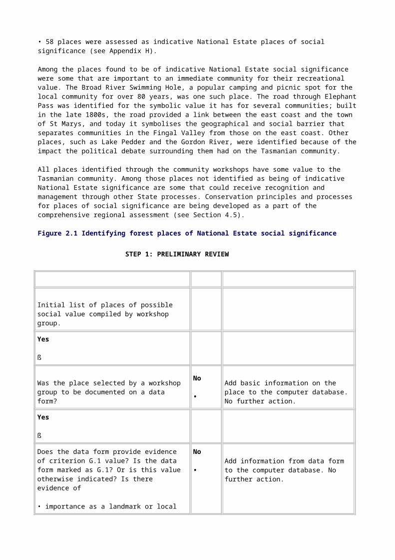
Figure 2.1 illustrates this assessment process.
2.3.3 Results
The social values project collected and analysed a vast amount of data, with the following results:
• 434 different places were identified during the workshops.
• 328 of these places were documented by community workshop participants.
• 226 of these places were clearly identified by the community as having social value.
• 151 places were selected for further research and field validation through a process of sorting and reviewing.
• 58 places were assessed as indicative National Estate places of social significance (see Appendix H).
Among the places found to be of indicative National Estate social significance were some that are important to an immediate community for their recreational value. The Broad River Swimming Hole, a popular camping and picnic spot for the local community for over 80 years, was one such place. The road through Elephant Pass was identified for the symbolic value it has for several communities; built in the late 1800s, the road provided a link between the east coast and the town of St Marys, and today it symbolises the geographical and social barrier that separates communities in the Fingal Valley from those on the east coast. Other places, such as Lake Pedder and the Gordon River, were identified because of the impact the political debate surrounding them had on the Tasmanian community.

All places identified through the community workshops have some value to the Tasmanian community. Among those places not identified as being of indicative National Estate significance are some that could receive recognition and management through other State processes. Conservation principles and processes for places of social significance are being developed as a part of the comprehensive regional assessment (see Section 4.5).
Figure 2.1 Identifying forest places of National Estate social significance
STEP 1: PRELIMINARY REVIEW
Initial list of places of possible social value compiled by workshop group.
Yes
ß
Was the place selected by a workshop group to be documented on a data form?
No
•Add basic information on the place to the computer database. No further action.
Yes
ß
Does the data form provide evidence of criterion G.1 value? Is the data form marked as G.1? Or is this value otherwise indicated? Is there evidence of
• importance as a landmark or local `signature'
• importance as part of a community identity
• importance because attachment has developed from long use?
No
•
Add information from data form to the computer database. No further action.
Yes ß
STEP 2: FIELD RESEARCH AND VALIDATION
Community research and interviews to confirm criterion G.1 value and refine its nature and extent.
No
•If criterion G.1 value not confirmed, no further assessment made.
Yes

ß
STEP 3: COMPLETENESS
Examine whether the data were sufficiently complete to enable an assessment to be made against the criterion.
No
•If data inadequate to assess criterion G.1 value, no further assessment made.
Yes
ß
STEP 4: THRESHOLDS
Assess each remaining place against criterion G.1, considering three factors:
• strength of association
• length of association
• relative importance to identified community.
No
•
Criterion G.1 value below threshold.
Yes
ß
STEP 5: DOCUMENTATION
Places documented to Register of the National Estate listing standard, including boundaries and map, photograph, and statement of significance.
2.4 Places of aesthetic value
The identification and assessment of forest places of aesthetic value were based on National Estate criterion E.1, which recognises places `exhibiting particular aesthetic qualities valued by a community or cultural group' as having heritage significance (see Appendix D). The working definition of `aesthetic value' developed for regional assessments in Victoria was also used:
Aesthetic value is the response derived from the experience of the environment or particular natural and cultural attributes within it. This response can be to either visual or non-visual elements and can embrace emotional response, sense of place, sound, smell and any other factors having a strong impact on human thought, feelings and attitudes.

(Australian Heritage Commission & Department of Conservation and Natural Resources 1994, p. 5)
Before the comprehensive regional assessment, some 80 forest places having National Estate aesthetic significance had been identified in Tasmania. In most instances, however, this value had not been identified or corroborated through community consultation; rather, it had been determined through assessment by natural environment heritage experts. The information gathered during the CRA process, which enhances understanding of the significance of these places, will be amalgamated with existing information and may be used to refine the boundaries of places already on the Register of the National Estate.
2.4.1 Data sources
Four datasets were used to identify and assess places of indicative National Estate aesthetic significance within the Tasmanian forest region. Three of the datasets-social values, key artistic and creative sources, and forest planners-were compiled as part of the CRA process; the other one-scenic quality mapping-had been developed by Forestry Tasmania as part of its Visual Management System (Forestry Commission 1990).
National Estate criterion E.1 stipulates that the aesthetic significance of a place is dependent upon it being valued by a community group. Information on aesthetic values gathered in the social values community workshops was the primary layer of information used for identification and assessment. The key artistic and creative sources and forest planners datasets were used as secondary layers of information to ensure comprehensive documentation of places. These secondary layers also provided a cross-check on the aesthetic values information from the community workshops and an identification of any possible gaps that may have developed as a result of the limitations of the community workshop program. The remaining dataset-scenic quality mapping-were used as a corroborative information layer to aid in the identification of a boundaries of indicative National Estate places of aesthetic significance.
The social values dataset
Eight community workshops were held across Tasmania to collect information for both the social and aesthetic values datasets. Section 2.3.2 describes the workshop process.
The key artistic and creative sources dataset
The information in the key artistic and creative sources dataset was collected by a research consultant (Young 1996). Through an examination of the artistic and creative output of novelists, poets, songwriters, playwrights, musicians, fine artists, photographers and craftspeople in Tasmania from the 1800s until the present, it was possible to identify forest places associated with these works and that may be considered by the community to have aesthetic value.
Information gathered by the consultant was based on the premise that artistic and creative works reflect the ideals of aesthetic quality and promote the popularity of their subjects. This, in turn, is seen to enhance the aesthetic importance of forest places depicted in such works. Artists, authors and craftspeople can therefore provide information about forest places that have been, and continue to be, popular for their aesthetic value.
The consultant identified 491 forest places associated with artists and craftspeople and their artistic output. Seventy-nine of these places were then identified by the consultant as having aesthetic significance. The dataset of the 79 places was subsequently used in the thresholding process to assist in identifying places of indicative National Estate aesthetic significance.
The forest planners dataset
The information for the forest planners dataset was collected by interviewing a number of officers of Forestry Tasmania and the Parks and Wildlife Service who have extensive first-hand knowledge of forest areas (see Appendix I). They were asked to identify forest places they believed to be of aesthetic value, to describe that value, and to mark the areas on 1:100 000-scale maps. In addition to being used as a secondary layer of information to ensure comprehensive documentation of values, the dataset was also used in the later stage of delineating boundaries of indicative National Estate places.
The scenic quality mapping dataset
Scenic quality mapping delineates areas of high, medium and low scenic quality in the landscape. Scenic quality is based on the degree of variety, uniqueness, prominence and naturalness of the landform, vegetation and waterform in each landscape character type (Forestry Commission 1990).
Forestry Tasmania has categorised landscapes in most of Tasmania's State forests according to their degree of scenic quality. The high scenic quality component of the scenic quality mapping dataset was used as a corroborative layer of information to aid in the identification of indicative area boundaries.
2.4.2 Methodology
The methodology for the aesthetic values project was structured to identify the range and distribution of aesthetic values in Tasmanian forests within the CRA time frame. The social values, key artistic and creative sources, and forest planners datasets were combined into a matrix table and cross-referenced. Areas where there was significant overlap in the data layers were then assessed against the threshold.
Areas that had been identified by the community as important for their aesthetic value and that met the threshold for social value (see Section 2.3.2) were considered to meet the threshold for aesthetic value.
Where community representatives at the workshops had identified an area as being of value to them but had not fully documented its aesthetic significance, it was necessary for that area to have been identified in the key artistic and creative sources project and in the forest planners survey for it to meet the threshold for aesthetic value.
In summary, for a place to meet the National Estate threshold for aesthetic value it was required:
• to have been identified at the community workshops as important for its aesthetic value and assessed as significant through the social values study,
and/or
• to have been identified by the community, and
• to have been identified as being of aesthetic significance in the key artistic and creative sources project and in the forest planners survey.
There was insufficient information to complete the National Estate assessment of a number of areas identified by both the key artistic and creative sources study and the forest planners survey as having aesthetic value. Many of these areas are well known locally and nationally through photography and other media but require further community consultation to clearly delineate and assess their value for National Estate purposes. Appendix J lists those areas requiring further investigation.

2.4.3 Results
Fifty-three forest-related areas in Tasmania are considered to meet an appropriate threshold of National Estate aesthetic significance as a result of the studies carried out for the comprehensive regional assessment. In many instances these indicative places were also assessed as having social value. These areas range from the distinctive and varied landscape of Freycinet National Park to the spectacular two-tiered Meander Falls (see Appendix K). Many more aesthetic areas with potential National Estate aesthetic significance in the forests of Tasmania remain to be identified, documented or assessed.
2.5 Aboriginal heritage and values
More than 70 places of Aboriginal value in Tasmania are already on the Register of the National Estate but many large natural areas on the Register contain values that have not yet been assessed, including Aboriginal values. In recent years, places of Aboriginal heritage value have been entered on the Register only if there has been consultation with the relevant Aboriginal community. This decision has been made on the basis that it is not possible to adequately assess National Estate Aboriginal values without the full co-operation of the relevant Aboriginal community
As a result, the identification and assessment of Aboriginal places of National Estate significance for the Tasmanian comprehensive regional assessment needed to be carried out in consultation with the Aboriginal community through a process acceptable to that community. The appropriate level of consultation and participation extends, however, beyond the time frame for the comprehensive regional assessment. Interaction with the Aboriginal community has therefore concentrated on establishing an appropriate form of consultation and mechanisms for the distribution of information about and discussion of the RFA process. It has also included discussion of cultural heritage management matters relevant to Aboriginal places of National Estate significance.
Tasmania and the Commonwealth are considering other processes for ensuring that Aboriginal places of heritage significance in forests are adequately identified and managed. This includes an assessment of the existing heritage management systems by the ecologically sustainable forest management expert advisory group (PLUC 1996c) and continuing consultation with the Aboriginal community.
2.5.1 Consultation with the Aboriginal community
In January 1996 members of the Tasmanian Aboriginal Land Council and representatives from relevant Commonwealth and State land management agencies held preliminary discussions to provide a very broad introduction to the Tasmania-Commonwealth Regional Forest Agreement. In June 1996 a letter was sent to 42 community groups (see Appendix L) to provide further information on the Tasmanian CRA and RFA processes and invite people to further meetings. The meetings were held on 15 August 1996 but few attended.
2.5.2 The Aboriginal community workshop
A workshop was held in Hadspen on 19 and 20 October 1996. It was designed to further inform the Tasmanian Aboriginal community about the CRA and RFA processes and to discuss with members of the community how they would like to participate. It was also designed to identify the full range of heritage matters of concern to the community. Invitations were sent to 42 community groups. Appendix M lists those who attended the workshop.
Many matters of concern to the Aboriginal community were identified; these are listed in Appendix N. Among them were concerns about aspects of cultural heritage relevant to the identification, assessment and management of Aboriginal National Estate values and broader questions about land management and social justice. The nature of these concerns precludes

the separation of specific National Estate matters from the broader heritage concerns: they need to be considered in a holistic way.
2.5.3 Continuing consultation
A report on the results of the Hadspen workshop is to be returned to the Aboriginal community for discussion and comment. The Commonwealth and Tasmania are developing a further program of consultation for 1997. This will ensure the continuing distribution of information about the Regional Forest Agreement and the development and implementation of appropriate mechanisms for managing Aboriginal heritage values in full consultation with that community. The Aboriginal community's involvement in the management of forest values, including the identification, assessment and management of National Estate Aboriginal values, will be taken into account.
Maps
Tasmania Comprehensive Regional Assessment National Estate Values: Indicative Areas
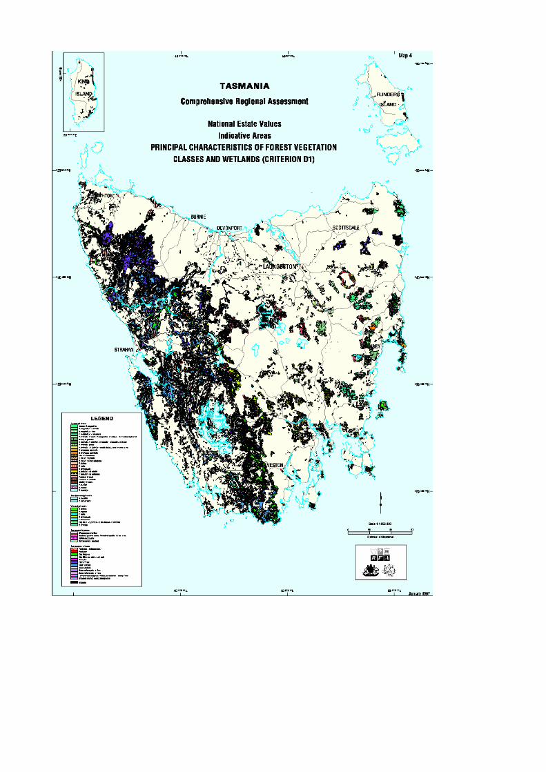
Map 1: Extensive natural values (criterion A.2) Map 2: Old-growth values (criteria A.2 and B.1) Map 3: Geoheritage values (criteria A.1, A.2, A.3, B.1, C.1, C.2, D.1, H.1) Map 4: Principal characteristics of forest vegetation classes and wetlands (criterion D.1)Map 5: Natural history sites (criterion C.1) Map 6: Flora values relating to past processes and diversity (criteria A.1 and A.2) Map 7: Fauna values relating to past processes and diversity (criteria A.1 and A.2) Map 8: Flora values relating to present processes (criterion A.2)

Map 9: Key fauna habitat for rare and threatened species B.1) Map 10: Cultural values (criteria A.3, A.4, B.2, C.2, D.2, F.1, G.1, H.1)Map 11: Registered and interim-listed National Estate places


Chapter 3: National Estate natural values

Introduction Assessment criteria for natural values
Extensive natural values Natural landscapes Undisturbed catchments Old-growth forest Wilderness
Localised natural values Flora Fauna
Other natural values
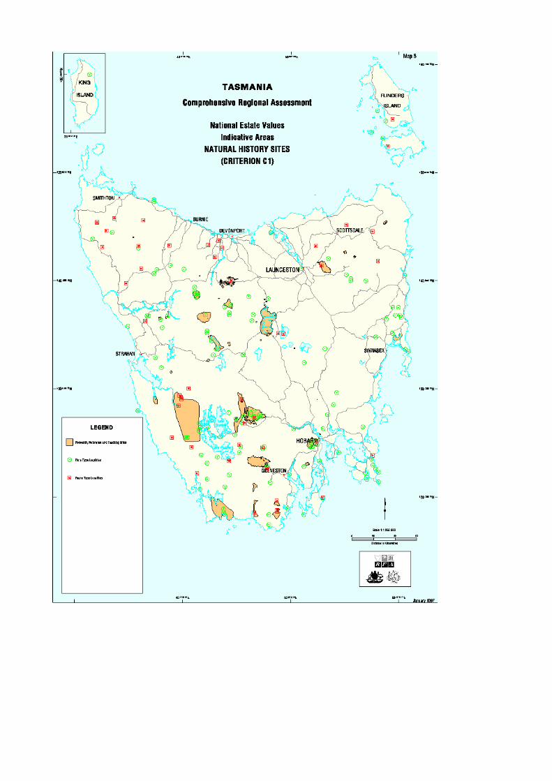
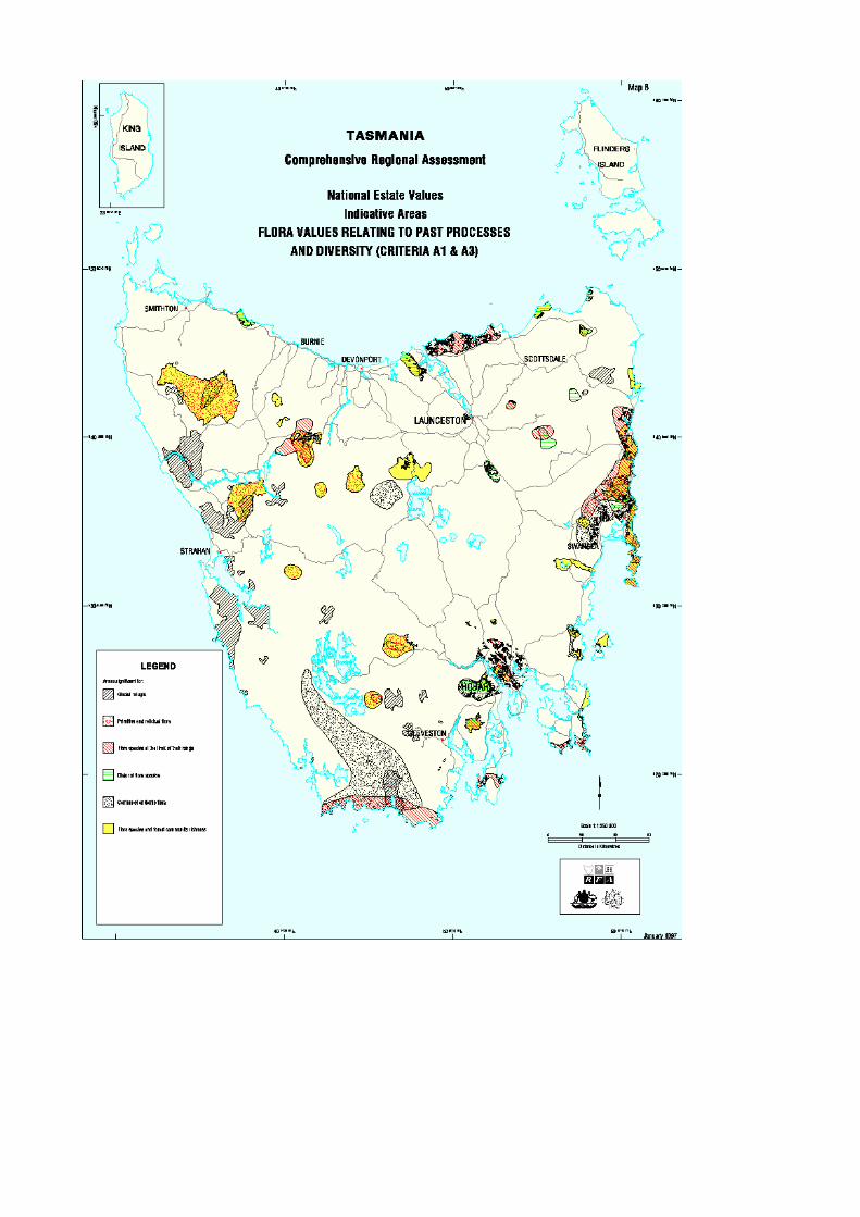
Geological and geomorphological and soil values Natural history sites
3.1 Introduction
This chapter discusses the National Estate natural values assessed in the Tasmanian comprehensive regional assessment. They range from values covering some thousands of hectares to values confined to single small sites. Identification and treatment of natural values follows three broad subdivisions:
• extensive natural values;
• localised biodiversity values;
• other natural values, including those relating to geology, geomorphology and soils.
3.1.1 Assessment criteria for natural values
In the regional context, assessment of the National Estate requires a comparative appraisal of the significance of places having one or more attributes or values. The values are derived from the National Estate criteria, which are reproduced in Appendix D.
Indicators of significance vary across the National Estate natural values; among the most important are
• rarity or threat
• distribution pattern
• conjunction with other values
• condition and integrity
• diversity or richness
• outstanding example.

The development of thresholds for National Estate significance will vary depending on the level of current knowledge about the nature and extent of natural values and their distribution in the landscape at a local, regional or national level. A regional evaluation involves building and interpreting a much more comprehensive knowledge base for assessment of significance than the consideration of a place or places in isolation would allow.
As with National Estate cultural values, a threshold is set in relation to the significance indicators and this threshold is specific to each National Estate value. A place can be compromised in terms of landscape integrity but it may be judged to meet the threshold because it is the only surviving example of a particular value.
The National Estate threshold of significance for each value was jointly agreed as the appropriate threshold for the purposes of the comprehensive regional assessment.
The resultant products are indicative National Estate places. There has been no attempt to overlay indicative places and their attendant values to look at conjunctions of values, nor has there been any attempt to rationalise the boundaries of indicative places in any ecological or topographic sense. Indicative places are not graded in significance: they either reach the threshold or they do not.
All mapped indicative National Estate natural areas have been digitised and are held in ARCINFO format on a GIS platform by Forestry Tasmania in Hobart.
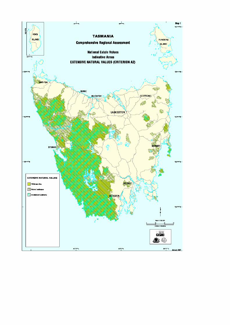
3.2 Extensive natural values
Some natural values of relevance to National Estate criterion A.2- `importance in maintaining existing processes or natural systems at the regional or national scale'-are inclusive values, extending broadly across the landscape rather than being confined to single vegetation types, landforms or localities. The values considered in this aspect of the Tasmanian assessment are natural landscapes, undisturbed catchments, wilderness, and old-growth forest.
Assessment of these values resulted in the identification of places of importance for the maintenance of natural processes (such as hydrological processes) at regional and national scales, and places that are of regional importance for maintaining specific natural systems (such as remnant vegetation).
3.2.1 Natural landscapes
Natural landscapes are large, relatively undisturbed areas with topographic and catchment integrity where natural processes continue largely unmodified by human intervention. The following are natural processes:
• energy flows
• nutrient cycling
• hydrological processes
• ecological processes such as succession
• evolutionary processes such as speciation and extinction.
At a national level, `natural landscapes' are considered rare, and where they do exist they have generally been assessed in previous National Estate studies under criterion B.1-'importance for rare, endangered or uncommon flora, fauna, communities, ecosystems, natural landscapes or phenomena, or as a wilderness'. In Tasmania, however, relatively unmodified landscapes are sufficiently prevalent for this value to be considered under criterion A.2.

Method
Four measures were used to identify areas of potential natural landscape value:
• naturalness (or level of disturbance);
• sub-catchment and topographic integrity;
• size;
• integrity in the landscape.
Naturalness
The assessment of naturalness was primarily based on the biophysical naturalness rating scheme that was developed as part of the Tasmanian comprehensive regional assessment (see PLUC 1996a, vol. I, section 3.4.1). The scheme provides a six-class rating, from a value of 5, representing areas that are unlogged and ungrazed, to a value of 0, representing cleared land-see Table 3.1.
Areas were considered `natural' in two circumstances:
• where the biophysical naturalness rating was 5-unlogged and ungrazed;
• if the area was made up of areas with biophysical naturalness class 5 and the least disturbed part of biophysical naturalness class 4. The area was excluded if it did not have a significant core area of biophysical naturalness class 5.
In order to provide a more refined threshold for naturalness, biophysical naturalness class 4 was divided into two categories: class 4a (least disturbed) and class 4b (most disturbed). Areas of biophysical naturalness class 4a were considered to meet the threshold of naturalness; areas of biophysical naturalness class 4b were considered not to meet the threshold unless included for reasons of boundary rationalisation. Where the timber-harvesting history suggested logging post-1950 and aerial photo-interpretation revealed evidence of disturbance an area was classed 4b.
In the biophysical naturalness rating scheme wildfire is considered a natural process, so areas affected by wildfire were given a biophysical naturalness rating of 5, unless other disturbances resulted in a lower rating. Consideration was also given to factors such as the impact of operational mines, roads and settlements on the ecological processes of the surrounding `natural' areas.
Table 3.1 The biophysical naturalness rating scheme
Class National Wilderness Inventory class description
Class description for Tasmanian CRA
5 Unlogged and ungrazed Unlogged and ungrazed
4 Unlogged and ungrazed for 47 years; excludes clear-felled areas and intensively grazed areas
Selectively logged before 1950 or
where THH records suggest logging post-1950 but the visual disturbance analysis, from the SENCODE, indicates minimal impact, and/or

possible grazing , indicated by rough grazing (PI code) in `naturally grassy areas'
3 Single selective logging or irregular grazing, or both, in preceding 47 years
Lightly-logged post 1950, indicated by
selective logging post-1950 (with PI code of mature eucalypt or regrowth), PI cut-over where the THH is unknown, and/or
likely grazing, indicated by evidence of pasture in `naturally grassy' forest areas or rough grazing on the Central Plateau
2 Light to moderate grazing or repeated selective logging, or both, in preceding 47 years
Heavily selectively logged post-1950, indicated by
selectively logged post-1950 (where the PI and SENCODE suggest high levels of disturbance); eucalypt regeneration with mature eucalypt or other species; or cut-over rainforest; and/or very likely grazing disturbance indicated by evidence of pasture under forest-PI code `v'-on public land (except on the Central Plateau or in `naturally grassy' forest areas)
1 Clear-fell logging operations or intensive grazing, or both
Eucalypt plantation or clear-felled and/or mining disturbance from Mt Lyell and/or evidence of intensive grazing assessed from SENCODE (V) or evidence of pasture-PI code `v'-on non-`naturally grassy forest areas' on private land
0 Cleared land or non-natural land cover
Non-natural land cover Cleared land or significant evidence of grazing from PI code on non-'naturally grassy areas'
Notes: In keeping with the National Wilderness Inventory guidelines, the period since selective logging ceased, which was used to distinguish between values 3 and 4, was selected to reflect regional perspectives. A period of 47 years-post-1950-has been used in this analysis.
THH = timber-harvesting history; SENCODE = senescence code; PI = photo-interpretation.
Source: Derived from Lesslie and Maslen (1995).
In the case of roads and settlements, the thresholding was based on the density of development: a single road, even a major highway, did not necessarily result in the exclusion of an area; a dense road or track network or a group of `shacks' meant, however, that an area was excluded. The assessment was based on the probable impacts on natural ecological processes. Similarly, areas surrounding operating mines with a large impact were excluded. In many cases the presence of an active mine and/or shacks or logged areas resulted in exclusion in the form of an island of disturbance in the natural landscape.
Sub-catchment and topographic integrity
Sub-catchment and topographic integrity were determined from an examination of the biophysical naturalness data, other disturbance data, and sub-catchment boundaries and topographic information. The position of each disturbance within the catchment or landscape and its likely effect on the natural area identified was also taken into account.
With the exception of fragmented areas such as farmland and coupes, rational boundaries were followed, where possible based on topography. Otherwise, the edge of the biophysical naturalness class was followed.
Size and integrity in the landscape
An area frequency histogram showed a number of discontinuities, a significant one occurring at around 3000 hectares. In view of this and a thorough inspection of the smaller polygons in the landscape context (and bearing in mind thresholds used in other National Estate assessments), a threshold of 3000 hectares was applied to determine the significance of areas with natural landscape value.
Twenty-six indicative areas of National Estate significance as natural landscapes were identified, covering a total of 2 541 200 hectares and ranging in size from 3200 hectares at Tasman Head to 2 308 000 hectares for the western Tasmanian natural landscape. Table 3.2 shows indicative natural landscape areas assessed as meeting the threshold for National Estate significance; they are illustrated on Map 1.
Table 3.2 Indicative natural landscape areas assessed as meeting the threshold for National Estate significance
Natural landscape Area (hectares)
Western Tasmania (De Witt, Flat Witch, Ile de Golfe) 2 307 976
Eastern highlands 35 648
Ben Lomond 18 728
Freycinet Peninsula and Schouten Island 16 659
Wellington Range 15 249
Welcome 14 820
Douglas 14 783
Mt William 14 415
Rossarden 9 482
Millers Bluff 9 198

Maria Island 8 451
Rattler Range 7 497
Sandspit 7 265
Bay of Fires 6 672
Maurice 5 869
Little Swanport 5 392
Mt Cameron 5 357
Cape Pillar 4 818
Queen of the Earth 4 740
Asbestos Range 4 442
Table 3.2 (cont'd) Indicative natural landscape areas assessed as meeting the threshold for National Estate significance
Natural landscape Area (hectares)
Mt Roland 4 406
Dip Range 4 315
Snow Hill 4 205
Rocky Cape 4 043
Blue Tier 3 588
Tasman Head 3 219
Total 2 541 237

3.2.2 Undisturbed catchments
`Undisturbed catchments' are catchments where natural hydrological processes remain essentially unmodified and unimpeded.
Method
The assessment of undisturbed catchments was based on an analysis of
river flow impediments and the naturalness of the area within the catchment.
Delineation of catchments
Sub-catchments were identified from the wild rivers database, compiled for the wild rivers assessment that formed part of the comprehensive regional assessment. These sub-catchments were used as the basis of the National Estate analysis. The wild rivers database delineates a separate modelled sub-catchment for each stream segment, as defined on the AUSLIG 1:250 000 scale hydrography theme database. Consequently, the sub-catchments are small and numerous-the smallest is 6.25 hectares and there are more than 10 000 of them.
River flow impediments
The catchment naturalness of flow regime index in the wild rivers database (see PLUC 1996a, vol. II, Appendix X), was used to identify sub-catchments that were potentially undisturbed. All sub-catchments with a catchment naturalness of flow regime index greater than zero-that is, those sub-catchments in which a dam, levee bank, or flow diversion is recorded as present in the sub-catchment or upstream of it-were excluded. The exception to this was where an impediment, such as a small weir, did not control the river flow downstream. In these cases only the immediate sub-catchment and the one downstream of it were considered disturbed.
Polygons meeting the river flow criterion were then assessed in terms of the level of naturalness of the area within the sub-catchment.
Naturalness
Assessment of the naturalness of the area within the sub-catchments was based primarily on the biophysical naturalness rating scheme developed for the Tasmanian comprehensive regional assessment (see PLUC 1996a, vol. I, section 3.4.1). Each sub-catchment was assigned a biophysical naturalness class based on the lowest value in that catchment. Sub-catchments were considered candidate undisturbed catchments if their entire area was classified biophysical naturalness class 5-unlogged and ungrazed.
Sub-catchments assigned to biophysical naturalness class 4 were excluded. If, however, a small area (such as one sub-catchment) of biophysical naturalness class 4 occurred within a much larger area of undisturbed catchment it was not excluded. Further, if a sub-catchment assigned to biophysical naturalness class 5 adjoined an upstream catchment assigned to biophysical naturalness class 4, it was considered undisturbed.
The potential effects of roads, settlements, powerlines, pipelines and operational mines were also considered in the assessment of undisturbed catchments. The National Wilderness Inventory (Lesslie & Maslen 1995) point and line datasets were used to identify these disturbances.
Roads
The presence of high- and medium-grade access roads (for example, the Lyell Highway or Strathgordon Road respectively) resulted in the exclusion of a sub-catchment. The presence of low-grade access roads (such as fire trails) resulted in the exclusion of a sub-catchment only if

the road crossed a river or there was a high density of trails. If a low-grade road was located on the watershed of a sub-catchment that sub-catchment was regarded as undisturbed.
Operational mines
The presence of an operational mine resulted in the exclusion of the immediate sub-catchment. Expert knowledge was relied on to exclude larger areas where the impact was known to be extensive.
Occupied buildings and settlements
The presence of an occupied building or settlement resulted in the exclusion of the immediate sub-catchment. Expert knowledge was relied on to determine the significance of the impact of the dwelling or settlement.
Powerlines and pipelines
The presence of powerlines or pipelines resulted in the exclusion of the sub-catchment.
Establishing thresholds
Sub-catchments that met the criteria for river flow impediments and naturalness were aggregated into larger catchments if they were hydrologically linked. Undisturbed catchments greater than 1000 hectares were deemed to meet the National Estate threshold.
Where a sub-catchment was part of a natural area contiguous with large undisturbed catchments, no size threshold was applied if the entire catchment, from headwaters to the coast, was assessed as undisturbed. If the amalgamated sub-catchment was truncated as a result of disturbance a minimum size threshold of 1000 hectares was applied.
Indicative areas of undisturbed catchments covering a total area of 1 432 200 hectares were identified; they are listed in Table 3.3 and shown on Map 1. All lie within areas determined to have significance for natural landscape value.
Table 3.3 Indicative undisturbed catchment areas assessed as meeting the threshold for National Estate significance
Undisturbed Catchment Areas Area (hectares)
Ben Lomond 4 626
Bird River 1 513
Braddon River 14 106
Cradle 246 464
De Witt 540
Freycinet 6 388
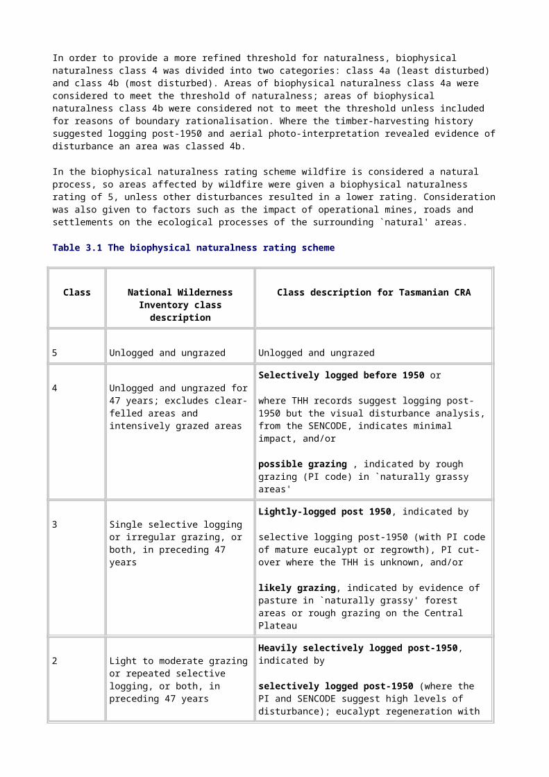
Hartz-Picton 4 276
Heemskirk 3 179
Horton River 1 349
Little Henty River 6 040
Lower Gordon 1 275
Meredith Range 43 078
Mt Field 8 466
Newdegate Creek 1 313
Norfolk Range, Donaldson River 100 117
North Pieman Head 1 341
Sentinel Range 6 657
South Maria 2 532
Southwest 895 776
Strathgordon area 1 147
Upper Florentine-Tyenna 3 448
Upper Henty 1 285
Upper Savage 21 134
Upper Weld 54 353
Violet Rivulet 1 781
Total 1 432 184

3.2.3 Old-growth forest
Although it is now widely recognised that old-growth forests are rare at the national level, large areas of old growth, and particularly those of certain forest communities, have survived in Tasmania. The main focus of the assessment was therefore the importance of old-growth forests for the maintenance of existing natural processes (criterion A.2).
Assessment of old growth under criterion B.1 complements this analysis, with a focus on examples of old growth for particular forest communities that are rare or uncommon at a regional level, either naturally or because they have been affected by European land use.
Old-growth forest was defined for the comprehensive regional assessment as `ecologically mature forest where the effects of disturbances are now negligible' (JANIS 1996, p. 19). A number of values are associated with old growth: primarily, the intrinsic value of the oldest growth-stage of a given vegetation class or community; secondarily, those values associated with those oldest age class-dominated forests. For example, senescing trees are important for providing nesting and roosting sites for large forest birds and arboreal mammals.
Method
Mapped areas of old-growth forest identified through the process outlined in the Public Land Use Commission's information report (PLUC 1996a, Vol. I, Chapter 4) were used as the basis of this analysis. The CRA old-growth assessment was developed using a combination of the following:
• growth-stage data, including the identification of mature, late-mature and over-mature trees;
• disturbance data, including visible disturbance mapped by aerial photo-interpretation, timber-harvesting history, fire, grazing and biophysical naturalness;
• forest community data collected as a part of the comprehensive regional assessment.
Integrity was a key factor in determining the significance of individual stands of old-growth forest. If significance is assigned using the principle of a natural context (based on sub-catchment and topographic integrity), the maintenance of ecological processes, nutrient cycles, energy flows and hydrological processes is assured. Using these natural vegetation units to make decisions about thresholds also ensures that the old-growth study data are used within their accuracy limits. More importantly, this approach maximises the flexibility for the old-growth domain to expand and contract in response to natural disturbance regimes.
Establishing thresholds
High-quality old-growth forest areas were identified by selecting places a low occurrence of unnatural disturbance, a high proportion of senescing trees and a low proportion of visible disturbance or regrowth trees, and that were viable within the landscape (that is, either large old-growth forest patches that are viable regardless of the disturbance in the surrounding landscape or naturally fragmented patches in a largely undisturbed landscape).
All stands of old-growth that have good natural context were considered to meet the threshold; that is, they occur within larger areas of natural vegetation or with adequate sub-catchment and topographic integrity to ensure their long-term survival.
Some of these stands are congruent with areas identified as having natural landscape value. Other stands are not congruent but are of sufficient size to justify their inclusion as stands of good quality and integrity.
Unnatural disturbance was represented by the biophysical naturalness dataset. Places with biophysical naturalness classes 0 to 4 were excluded because they indicate past disturbance. Areas of biophysical naturalness class 5 areas were retained.

High senescence and low visible disturbance were assessed using the eucalypt senescence dataset developed specifically for the CRA old-growth assessment. Places in eucalypt forests with a greater density of old trees and fewer signs of past disturbance, such as younger trees, were identified and retained for further assessment.
Integrity within the landscape was assessed using the undisturbed catchments and natural landscape datasets developed for the National Estate assessment. Old-growth forests within these areas were considered to be of high quality. Old-growth forest patches outside these areas were considered to be viable within the landscape only if they were larger than 1000 hectares.
The forest communities were grouped into three broad categories: dry eucalypt and sub-alpine, wet eucalypt, and non-eucalypt. These categories correspond with those used for the CRA old-growth forest assessment and account for the variations in forest structure between the broad groups.
Box 3.1 shows the rule set used to identify areas of National Estate old-growth forest areas.
The datasets used in the criterion A.2 are described in the Environment and Heritage report (PLUC 1996a, vol. 1, chapter 4). Table 3.4 shows the results of the assessment. Areas of old-growth identified in this assessment are shown on Map 2.
Rule set used to identify National Estate old-growth forest areas
Step 1
Identify the `better quality' old-growth forest from the old-growth CRA project for the following broad categories: dry and sub-alpine eucalypt communities; wet eucalypt communities; and non-eucalypt communities.
Dry and sub-alpine eucalypt communities
Intersect
• old growth (identified for the comprehensive regional assessment)
• biophysical naturalness class 5 (low levels of `unnatural' disturbance)
• SENCODE Ha and Hd (high levels of senescent trees and low levels of regrowth).
Note: SENCODE Hd is included in dry forest communities to account for the open structure of the overstorey and the natural occurrence of higher levels of regrowth trees than in wet forest communities.
Wet eucalypt communities
Intersect
• old growth
• biophysical naturalness class 5
• SENCODE Ha.
Non-eucalypt communities
Intersect

• old growth (CRA)
• biophysical naturalness class 5
Note: only eucalypt communities were given a senescence code.
Step 2
Apply size thresholds (absolute, not per community) to ensure the viability and quality of the forest stand:
• Forest patches occurring in natural landscapes and undisturbed catchments have a lower size threshold to account for communities that are naturally fragmented.
• A size threshold of 1000 hectares was applied to forest patches occurring outside natural landscapes and undisturbed catchments.
All other areas are excluded.
Rare, endangered or uncommon old-growth forests
While old-growth forests of a more extensive nature were dealt with under criterion A.2, consideration was also given to those old-growth forest communities that are rare or uncommon nationally or within Tasmania and common forest communities where the levels of disturbance are such that all remaining old-growth areas are potentially of National Estate significance. National Estate criterion B.1 deals with the importance of rare, endangered or uncommon flora or communities. Two types of rare, endangered or uncommon old-growth forest communities were identified:
• rare and depleted old-growth communities-communities where old growth as a proportion of the forest community is generally less than 10 per cent (derived from the JANIS criteria);
• rare, vulnerable and endangered forest communities-communities where old growth as a proportion of the forest community may be greater than 10 per cent but the community itself is rare, vulnerable or endangered (derived from the JANIS criteria).
Table 3.4 show the communities that were identified using area calculations from the CRA forest maps.
Table 3.4 Identified rare, endangered or uncommon old-growth forest communities
Rare and depleted old-growth communities
Rare, vulnerable and endangered forest communities
Eucalyptus amygdalina inland
Shrubby E. ovata
E. pauciflora on dolerite
E. rodwayi
E. risdonii
E. sieberi on granite
Eucalyptus amygdalina inland
E. amygdalina on sandstone
E. viminalis ± E. globulus coastal shrubby forest
Shrubby E. ovata
E. risdonii

E. sieberi on other substrates
E. viminalis - E. ovata - E. amygdalina - E. obliqua damp sclerophyll forest
E. viminalis grassy
E. viminalis wet
E. brookeriana
E. morrisbyi
E. brookeriana
E. viminalis wet
Notelaea ligustrina and/or Pomaderris apetala closed forest
Callitris rhomboidea
Banksia serrata woodlands
Pencil pine - deciduous beech
Pencil pine
King Billy pine
King Billy pine - deciduous beech
Melaleuca ericifolia coastal swamp forest
Inland E. tenviramis
Grassy E. globulus
Furneaux E. viminalis
King Island E. globulus - E. brookeriana - E. viminalis
Twenty-two rare, endangered or uncommon old-growth forest communities were identified to be assessed for National Estate significance under this criterion. For the majority of these communities, all of the viable forest areas were considered as having significance for the value.
The indicative areas meeting the threshold for this criterion are shown on Map 2.
3.2.4 Wilderness
Areas of high wilderness quality in Tasmania were assessed against National Estate criterion B.1-as rare and endangered aspects of the Australian environment.
Data sources
The high-quality wilderness map prepared for the Tasmanian comprehensive regional assessment was used as the basis of this National Estate wilderness assessment. Methods for deriving wilderness quality and delineating the boundaries of high-quality wilderness areas in Tasmania are described in the environment and heritage report (PLUC 1996a).
Establishing thresholds
Areas were considered to meet the National Estate threshold if the total area was 8000 or more hectares (or slightly less if contiguous with the coast), if the area was not fragmented, if the

majority of the area had a wilderness quality greater than 12, and if a nodal area of wilderness quality equal to or greater than 14 was present. These rules were based on criteria used in the East Gippsland National Estate assessment (Australian Heritage Commission & Department of Natural Resources and Environment 1996).
Results
All areas identified as high-quality wilderness in the Tasmanian comprehensive regional assessment met the above criteria and were therefore considered to meet the threshold for National Estate wilderness value. Sixteen indicative areas of National Estate wilderness value were identified, covering a total area of 1 943 570 hectares-see Table 3.5.
Table 3.5 Indicative National Estate areas of high-quality wilderness
Name of wilderness
area Total area (hectares)
South-west 1 188 460
CradleÐCentral Plateau 376 150
Norfolk Range 92 280
Meredith Range 63 450
Donaldson River 53 340
Savage River 51 590
Henty River 23 950
Mt Field 15 400
Sumac 14 090
Mt Heemskirk 10 870
Ben Lomond 10 300
Douglas-Apsley 10 060
Table 3.5 (cont'd) Indicative National Estate areas of high-quality wilderness
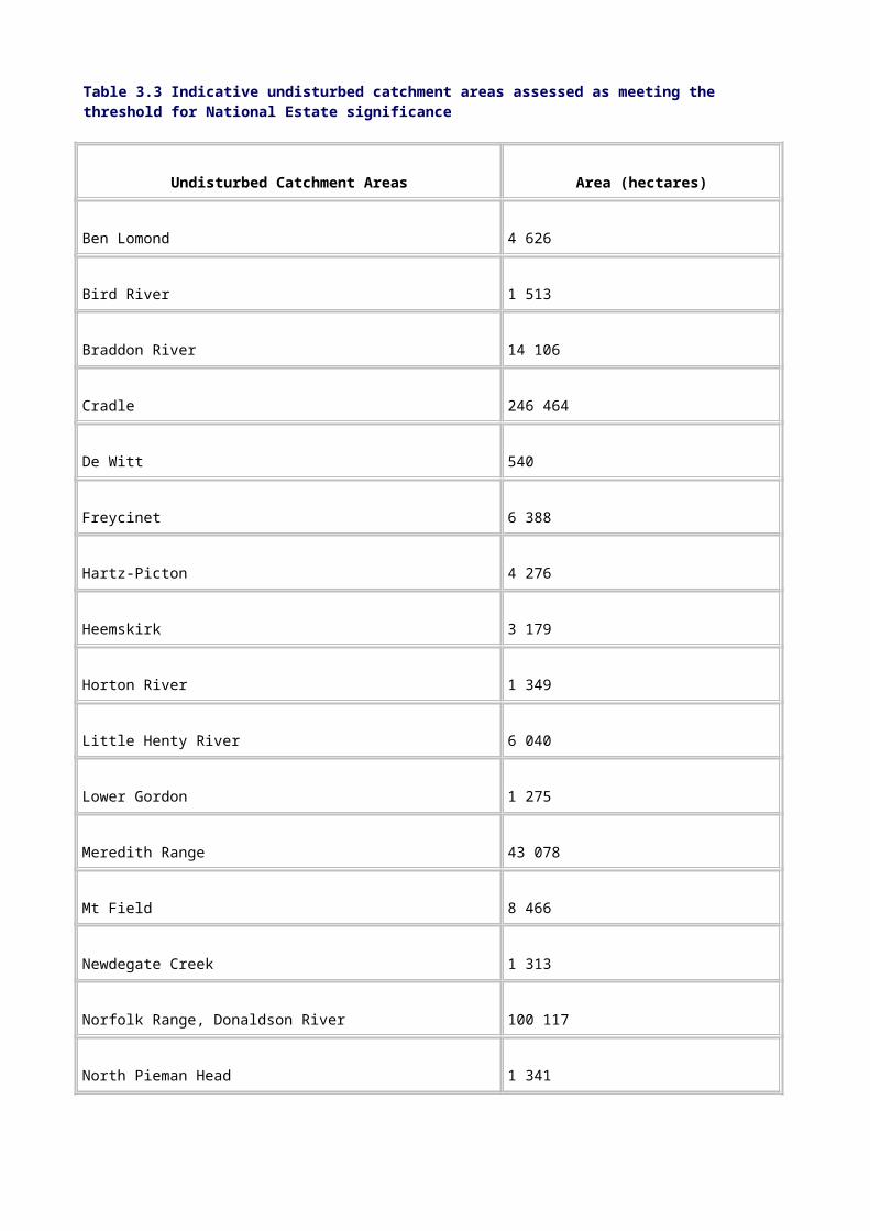
Name of wilderness
area Total area (hectares)
Little Henty 9 060
Freycinet 8 460
Maria Island 8 450
Mt William 7 660
Total 1 943 570
3.3 Localised natural values
3.3.1 Flora
Flora values in Tasmania were assessed against National Estate criteria A.1, A.2, A.3, B.1 and D.1 (see Appendix D).
Datasets for flora assessment
As part of the Tasmanian comprehensive regional assessment, 50 forest community types have been identified and mapped. These mapped units are a refinement of earlier vegetation mapping in the region, as outlined by Kirkpatrick and Brown (1991).
Some forest communities, as defined, contain little floristic variation; for example, Eucalyptus sieberi on granite. Others, such as dry E. obliqua forest, are structurally similar but vary floristically over their range. The environment and heritage describes each community (PLUC 1996a, vol. II, appendix C).
The combination of the forest community mapping with individual species records allowed a high degree of confidence in the use of forest communities as the basis for delineating a series of flora values.
Among the data sources available for the analysis were actual and modeled distributions of endemic forest tree and major shrub species and the biophysical naturalness dataset. All the datasets have limitations:
• Models, irrespective of their level of sophistication, can predict actual distributions only with a certain level of confidence.
• Some endemic species are naturally rare or have distributions that are the result of historical biogeographical events and are hence unpredictable in occurrence.
• Many species' occurrences contributing to the models were not sampled as part of any systematic survey.
• The databases may include species whose taxonomic status is questionable.
• Some species are much better sampled than others.

The following forest community mapping datasets from Tasmanian flora databases were fundamental to the analysis:
• the TASFORHAB database (containing 921 780 individual species records);
• Forestry Tasmania's BOTATLAS database;
• Australian rare and threatened species site data;
• Tasmanian rare and threatened species site data;
• targeted regional survey data.
A large amount of complementary information was also available:
• incidental records from the Tasmanian Herbarium;
• abiotic data-such as altitude, catchment, geology and land systems data;
• the CRA biophysical naturalness data layer;
• the old-growth forest data layer, incorporating age class analysis and types and history of disturbance.
Local experts, members of natural history organisations, and scientists operating in the area were also important sources of information during the assessment. They contributed an integrated knowledge of flora values and the way they are distributed in the landscape. In many cases experts provided advice on levels of significance in the determination of thresholds.
Endemic flora
Endemic plants provide an important insight into the process of evolution of flora and are of direct relevance to National Estate criterion A.1. In some cases, where concentrations of endemic taxa occur, the role of climatic refugia in speciation during periods of climate change becomes apparent. In other cases, endemism is high without any apparent link to refugia: biogeographic determinants such as terrestrial and oceanic climatic influences, soils and localised topographic variation may be the main controlling factors in these cases.
The degree of endemism of flora is pronounced in Tasmania, a consequence of a variety of factors, such as Pleistocene glaciations and deglaciations and periodic isolation when sea-level fluctuations caused the closing of the land bridge across Bass Strait (Kirkpatrick & Brown 1984, Hill & Read 1987). More than 300 higher plant taxa are endemic in the region. Endemism is moderate at the generic level; for example, there are 10 endemic, mostly monotypic, angiosperm genera. Lower levels of endemism are seen in lichens, mosses and ferns (Garrett 1996, Jarman & Kantvilas 1994, Kantvilas 1995).
Method
Because endemic plant species are very widespread in Tasmania, it was decided to develop a threshold for identifying areas where there are concentrations of endemic taxa that have come about as a consequence of a variety of past biogeographic processes (Kirkpatrick & Brown 1984b; Hill & Orchard, in press).
Modeled distribution data were used in conjunction with expert knowledge to identify areas of importance in the region.

To qualify for consideration, an endemic locus needed to contain at least two taxa, the total extent of whose range is 100 kilometres or less.
Establishing thresholds
All areas identified using modeled distribution data and expert knowledge and validated by reference to a species frequency assessment (based on a 10-kilometre grid square count of endemic taxa-Kirkpatrick & Brown 1984a) were considered to meet the threshold for the value, provided they were relatively undisturbed.
At this scale of analysis, it was impossible to determine the localised effects of disturbance on individual species. Instead, those areas that had been subject to major modification-that is areas with a biophysical naturalness rating of 0 were excluded.
Results
Table 3.6 and Map 6 show the indicative areas for the value.
Table 3.6 Indicative areas for endemic flora
Indicative area Example species
South-west Tasmania Epacris stuartii, Geum talbotianum, Lomatia tasmanica, Milligania johnstonii, Sprengelia distichophylla, Senecio papillosus, Winifredia sola
Central east coast Acacia pataczekii, Epacris barbata, Epacris grandis, Eucalyptus barberi, Melaleuca pustulata, Pultenaea selaginoides
Central Highlands Cyathodes nitida, Eucalyptus archeri, Gunnera cordifolia, Oreomyrrhis gunnii, Pimelea pygmaea, Ranunculus concinnus
Mt Wellington Senecio brunonis , Allocasuarina duncanii
Dans Hill Epacris virgata, Pimelea filiformis, Tetratheca gunnii
Tasman Peninsula Epacris marginata, Euphrasia phragmostoma, Euphrasia semipicta
Mt Field (alpine) Schoenus pygmaeus, Euphrasia gibbsiae ssp. pulvinestris
East Risdon Nature Reserve and adjacent areas
Eucalyptus risdonii, Lecidea flindersii, Xanthoparmelia vicaria, Caladenia atkinsonii, Eucalyptus morrisbyi
Mt Anne (north-east ridge) Sagina sp. nov., Oreoporanthera petalifera
Vale of Belvoir Polyblastia australis, Verrucaria inconstans, Verrucaria

tholocarpa
Sumac Menegazzia inactiva, Menegazzia minuta, Parmelia tarkinensis
Biogeographic range (including major disjunctions)
Tasmania's extreme southerly position and the fact that it is an island mean that many plant species are necessarily at the edge of their biogeographic range in the region or have disjunct populations on either side of Bass Strait. Kirkpatrick and Brown (1984b) point out that some apparent edge-of-range phenomena within Tasmania may be a consequence of insufficient time having elapsed for some species to fully occupy their potential range following the last Ice Age.
Disjunct populations are those that have become physically separated, resulting in minimal or no gene flow between them. This separation could be caused by a break in a formerly continuous distribution or by long-distance dispersal (jump dispersal) over a barrier. Often, a disjunction takes the form of a larger parent or core population and a smaller outlier, or outliers, but in some instances the disjunct populations are of about the same size.
Disjunctions and edge-of-range phenomena fall within the scope of National Estate criterion A.1 (see Appendix D).
Method
To determine which taxa best illustrate the biogeographic importance of Tasmania and convey most information about the evolution of Australia's flora as exemplified by this value, a restricted subset of the flora was deemed appropriate for the analysis. This included all Eucalyptus and fern species, species listed under the Commonwealth Endangered Species Protection Act 1993, rare and threatened species listed under the Tasmanian Threatened Species Protection Act 1995 and other priority species (see PLUC 1996a), together with an additional 300 species of forest trees and shrubs.
Actual distribution maps for these taxa were generated and species were considered disjunct if a major population was separated from a minor population by a natural gap of at least 50 kilometres (or five 10-kilometre grid squares).
Establishing thresholds
Limits-of-range species thresholds were based on the number of species at the edge of their range which occurred together. These conjunctions of species were assessed using 10-kilometre grid squares, and were scrutinised by experts. Reference to the biophysical naturalness layer ensured that indicative areas lacking in natural integrity and having high levels of disturbance (a biophysical naturalness rating of 0) were excluded.
For disjunctions, areas composed of grid squares with 14 or more species satisfying the above disjunction rule were considered to meet the threshold of National Estate significance. Parts of the areas where biophysical naturalness was rated as 0 were excluded.
Results
Indicative areas identified for this value are listed in Tables 3.7 and 3.8 and shown on Map 6.
Table 3.7 Indicative areas exhibiting limits of range for flora
Indicative area Type of limit and taxa
Pieman River Northern limit of co-occuring riparian rainforest species (Huon pine, Acradenia franklinii); also Leptospermum riparium and Epacris mucronulata
Black Bluff - Cradle Mountain Northern limit of rainforest and alpine floral elements
Stony Head Southern limit of some mainland species (for example, Pultenaea hibbertioides)
Scamander-Freycinet Northern limit of many east coast species (for example, Eucalyptus pulchella, E. tenuiramis)
Ben Lomond - Mt Barrow Northern limit of eastern alpine endemics
Lower Derwent River Valley Southern limit of dry country mainland species (for example, Hardenbergia violacea)
South Bruny Island limit of some forest and heathy-grassland species (for example, Eucalyptus johnstonii, E. pulchella, Stipa aphylla
Snug Tiers Southern limit of an assemblage of species (for example, Eucalyptus gunnii, Allocasuarina duncanii)
Tasman Peninsula - Cape Raoul Southern limit of species such as Hibbertia hirsuta, Olearia archeri, Helichrysum tenuifolia
Table 3.8 Indicative areas exhibiting major floral disjunctions
Indicative area Indicative area
Asbestos Range Mt Victoria - St Columba Falls
Ben Lomond alpine zone Mt Wellington
Cape Pillar Rocky Cape
Cape Portland Schouten Island
Cataract Gorge Snug Tiers
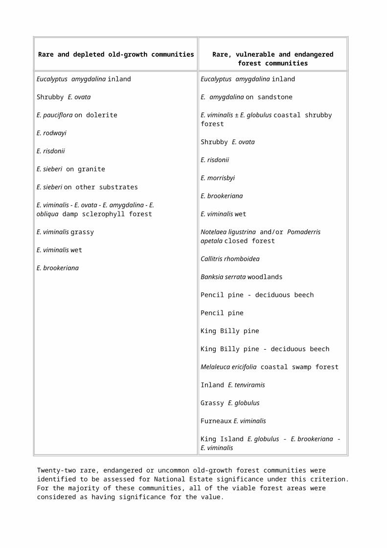
Douglas-Apsley South Coles Bay - The Hazards
Epping Forest Stony Head
Lower Marsh Creek Tasman Peninsula - Cashs Lookout
Mt Barrow Waterhouse
Mt Cameron
Refugia
Refuges, or refugia, are areas where physical and biological attributes combine to provide an environment that is more resilient to climatic variation than surrounding areas. The presence in the landscape of refuges, and the taxa that are largely restricted to them, constitutes an important source of genetic variation. Consequently, these areas are important for maintaining flexibility and adaptability in times of climatic change, as well as providing an insight into the vegetation of a past period. The identification of flora refuge areas had two components: glacial refugia and contemporary refugia. Glacial refugia relate to National Estate criterion A.1; contemporary refugia relate to National Estate criterion A.2.
Glacial refugia
A glacial refuge-dependent forest community is considered to be one that occupies a climatic or topographic refuge retaining elements of the climatic regime of the last Ice Age. Rainforest undoubtedly qualifies as such a community in Tasmania.
The last Ice Age began in the Quaternary Period, around 40 000 years BP; it peaked between 20 000 and 17 000 years BP, continuing to a lesser degree until 10 000 years BP (Boland et al. 1985, Galloway & Kemp 1981, Hope 1992, Kershaw 1992). During this time there was glaciation in the Snowy Mountains and the land bridge between Victoria and Tasmania was re-established.
As well as being colder, the climate was much drier. After about 10 000 BP temperatures and precipitation began to increase, reaching a post-Ice Age peak about 8000 years ago. The climate has since become slightly drier, although the warming effect of the ocean has maintained higher rainfall in sub-coastal areas.
Parts of Tasmania exhibit relatively steep environmental and topographic gradients. This means that slight changes in global climate may produce significant localised effects.
Method
Using a 10-kilometre grid coverage for the region, a modeling technique involving a reconstruction of palaeoclimate in conjunction with fossil pollen evidence was used to assign values to individual grid squares (Kirkpatrick & Fowler 1996). The reconstruction points to a 5° C cooler mean temperature of the warmest month and a rainfall some 45 per cent of present westerly rainfall for the height of the last Ice Age; the equivalent figures for about 11 000 BP are 3° C and 50 per cent.
The model suggests that after the last Ice Age Tasmania changed from a peninsula predominantly covered by alpine vegetation, grassland and grassy woodland to an island predominantly covered by forest. At the height of the last Ice Age, rainforest was probably
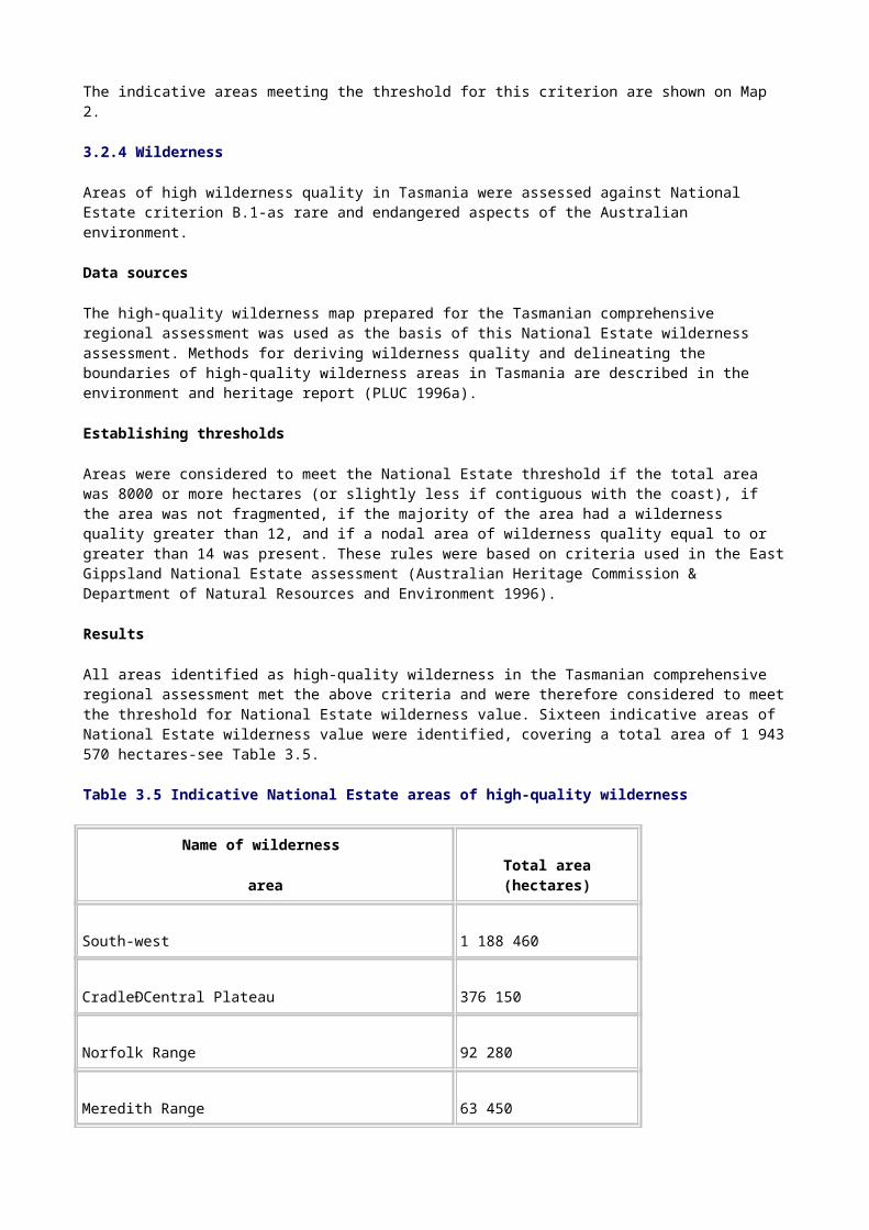
restricted to valleys near the present coast between the Pieman and Huon Rivers, to some deep continental inland western valleys, and to small refugia in the east of the State (probably in deep valleys on the eastern slopes of Blue Tier and around Elephant Pass).
The areas highlighted by application of this methodology were scrutinised by an expert panel and additional areas were suggested for consideration.
Establishing thresholds
Grid squares predicted on the basis of the model to have had rainforest distribution at the height of the last Ice Age were considered to meet the threshold. These are the places most likely to have maintained climatic `envelopes' suitable for the retention of rainforest and its associated taxa at the time of peak aridity. All areas within these grid squares currently supporting rainforest vegetation were considered to meet the threshold of National Estate significance. Indicative glacial refugia found to meet the threshold of National Estate significance:
• Apsley River • Middle Weld Valley
• Blue Tier • Mt St John
• Cape Pillar/Cape Hauy • Murchison River
• Denison River • New River Lagoon
• Douglas-Apsley • Old River
• Elephant Pass • Pieman River mouth
• Esperance • Port Davey
• Franklin River • South of Macquarie Harbour
• Henty River • St Mary's Pass
• Leithbridge Hill • Tasman Peninsula
• Lower Gordon River • Yarlington Tier
• Middle Picton - Huon Valley
Contemporary refugia
Contemporary refugia contain communities that are strongly associated with climatic and topographic factors that confer a degree of protection from endangering processes such as fire and disease. These refugia have two important roles: they provide locations for the

conservation of species and communities and they provide sources for population expansion if limiting conditions abate.
Places qualifying as refuges from frequent fire do so because, although they contain plants sensitive to fire, they are protected in the landscape by climatic, topographic and soil features. It is generally accepted, however, that very few, if any, places have totally escaped the effects of fire in Tasmania and that refugia will have occasionally been burnt under extreme fire conditions. But such events are considered much rarer in these places in comparison with areas that lack the protection afforded by refugia. It is the low frequency of burning that marks these places as significant.
After wildfire, forest communities associated with refugia are usually slower to recover and may take many decades, even centuries, to do so.
Protection from fire is conferred by a number of inter-related mechanisms. In drier areas, fire is normally excluded because of low fuel loads, areas of bare rock, or topographically difficult access for fire (steep rocky gorges, for example). In wetter areas, fire is generally excluded or reduced in intensity because of the high moisture levels of the fuel, which are maintained by a combination of high rainfall (especially in summer) and a number of other moisture-conserving mechanisms inherent in the refuge (such as high humidity due to frequent fog, reduced sunlight on southern or eastern aspects and, in some cases, the closed canopies of the forest community).
High-rainfall montane plateaus, southern and eastern aspects, some gully systems, rocky outcrops, semi-arid areas (such as rain-shadow country) and gorges are well-known fire refuges. Less well known fire refuges are found on islands, on dunes that face the sea and are backed by large areas of open sand, and on peninsulas in lake systems that have shores on the prevailing fire weather direction.
Many Tasmanian endemics are found in cool temperate rainforest and alpine communities and are very sensitive to fire (Barker 1990, Kirkpatrick & Dickinson 1984). In most cases the topography and prevailing climate ensure that niches suitable for their survival are widespread throughout the areas in which they occur (Cullen & Kirkpatrick 1988a, 1988b). A generally drier climate and a more intense or frequent fire regime on the Australian mainland have caused the extinction of some of these species (for example, Phyllocladus aspleniifolius-Enright & Hill 1995), severely limited the distribution of many others (for example, Podocarpus lawrencii, Microstrobos fitzgeraldii, and the recently discovered Wollemi pine-Enright & Hill 1995), or caused wide disjunctions in species' distributions. For these reasons, the approach to defining important refuge sites adopted in the East Gippsland National Estate assessment is generally inappropriate for Tasmania, where species refugia occur widely throughout the landscape.
In Tasmania it is difficult to separate the effects of the current fire regime from that of the pre-European past (Bowman & Brown 1986). Humans have been present in Tasmania for at least 30 000 years (Cosgrove 1989) and, although little is known about the precise effect of Aboriginal burning, it undoubtedly contributed to the current distribution of flora.
Significant areas of Athrotaxis cupressoides, A. selaginoides, and to a lesser extent, Lagarostrobos franklinii, have been destroyed by fires since the arrival of Europeans. The early settlers burned expanses of central and western Tasmania on a very regular basis. Historical reports and mapping of live and dead stands of these species (Brown 1988, Cullen & Kirkpatrick 1988, Peterson 1990, Robertson & Duncan 1991) suggest, however, that the species were already largely restricted to fire-protected localities before the arrival of Europeans. There is little doubt that these species are currently restricted to refugia from fire.
Much the same argument can be made for other fire-sensitive taxa occurring in alpine or rainforest communities. Although found in drier regions, Notelaea forests and members of the genus Callitris were probably similarly affected by human-initiated burning.
Sinkholes and collapse features can also provide refugia for a range of flora and fauna. Very little is known about the importance of these features for flora conservation in Tasmania.

Lincoln and Dalton (1994) and Whinam et al. (1989) found significant bryophyte records in karst sinkholes in the Mole Creek area.
Some Tasmanian fern species can be considered to be found only in refugia. Of importance in this regard are Cyathea cunninghamii and C. marcescens. The former was more widespread in Tasmania in the past (Garrett 1996). The latter is a hybrid between C. cunninghamii and C. australis and occurs only with C. cunninghamii.
The distribution of cryptogams (lower plant species) in Tasmania is far less well understood than that of the higher plants. Limited research confirms the logical view that moist refugia for higher plants provide refugia for bryophyte and lichen species. For example, Kantvilas and Jarman (1993) found that relict rainforest at Yarlington Tier supported cryptogamic flora of considerable biogeographic interest.
Method
The following points were considered in ranking contemporary refugia in terms of significance:
• Different taxa have different life cycles and reach sexual maturity at widely varying rates.
• Taxa show widely differing rates of dispersal through the landscape.
• Plant communities are made up of taxa that have different life cycles and dispersal characteristics.
• A change in the regime of an adverse physical condition (such as fire) will have varying effects from species to species within one community. Such changes are likely to cause changes in community composition.
Factors such as size, species richness, measures of robustness, and distance of disjunction were also taken into account. In addition, some localities supporting refugial communities may be of varying importance for their component species.
Barker (1994) and Barker et al. (1996) have developed a methodology to select sites for protection from Phytophthora cinnamomi for the 44 susceptible species that appear on the State and national lists of rare and threatened plants. A series of landscape and species criteria were used to select and rank sites to determine the best three management areas for each of the 44 species. An expert flora panel assessed all but two of these as meeting the threshold on the basis of likely long-term effectiveness as disease refugia. The areas that do not meet the threshold, Mt William and Waterhouse, are now known to be infected.
Establishing thresholds
Thresholds were established by mapping undisturbed examples of refuge-dependent communities having landscape integrity (for example, within natural landscape areas). Places were delineated on the basis that both the refuge-dependent forest community and the topographic unit on which it occurs (a sub-catchment or gorge, for example) were largely undisturbed by human activity.
Results
Table 3.9 summarises refuge types and places judged to meet the threshold for this value; these indicative areas are illustrated on Map 7. The areas include all known occurrences of remnant rainforest (Neyland 1991), Lagarostrobos franklinii (Peterson 1990), Athrotaxis cupressoides (Cullen & Kirkpatrick 1988), A. selaginoides (Brown 1988), Nothofagus gunnii (Robertson & Duncan 1991) and Callitris oblonga (Harris 1994). Some of the areas identified contain core populations; others contain disjunct populations. The map also shows indicative sinkholes, Cyathea populations and refuges from disease that met the threshold of National Estate significance.

Table 3.9 Indicative areas of flora refugia
Refuge type Nature of refuge Community or species Example sites
Sub-alpine plateaus and mountain peaks
Bogs, rocky sites, including blockstreams and craggy areas, lake and river banks, and islands within these water bodies
Open montane rainforest and alpine communities. Athrotaxis cupressoides, Nothofagus gunnii and other species, including endemic conifers
Central Plateau, mountains of the Central Highlands, Precipitous Bluff, Mt Anne, Frenchmans Cap, West Coast Range, Western Arthurs
Montane to sub-alpine slopes and mountain peaks in central, western and southern Tas.
Cool, wet climatically protected areas
Cool temperate rainforest dominated by Athrotaxis selaginoides or Lagarostrobos franklinii
Great Western Tiers, King Billy Range, Mt Algonkian, slopes of Mt Bobs, Teepookana, Pine Valley
Riverine habitats in western and southern Tas.
Cool, wet, regularly inundated areas
Cool temperate rainforest dominated by Lagarostrobos franklinii
Gordon, Pieman, Davey, and Huon Rivers
Table 3.9 (cont'd) Indicative areas of flora refugia
Refuge type Nature of refuge Community or species Example sites
Moist sites in dissected hills of eastern and northern Tas. and the Bass Strait islands
South-easterly slopes, wet gullies with protection from sun and wind and increased soil moisture from run-off. Occasionally bog sites
Primarily rain forest and wet scrub communities dominated by Nothofagus cunninghamii, Atherosperma moschatum, Notelaea ligustrina and Pomaderris apetala. On occasions Astrotrichion discolor, Phyllocladus aspleniifolius and Elaeocarpos reticulatis.
The Thumbs, Yarlington Tier, Windred Creek, Fergusons Gully, Dazzler Range, Platform Peak, Mt Cameron
Dry sites in dissected hills of eastern and northern Tas.
Dry rocky slopes, gorges and scree slopes
Callitris rhomboidea, Notelaea ligustrina, Callistemon viridiflorus
C. rhomboidea- Sellars Lagoon, outer Furneaux Islands, Taillefer Rocks, Allans Rd
Riparian habitats in eastern and north-eastern Tas.
High soil moisture and closed canopy
Nothofagus cunninghamii, Atherosperma moschatum, Acacia melanoxylon, Pomaderris. apetala,
Callitris oblonga and C.
C. oblongÐ-all upstream populations. Callidendrous rain forestÐForester, Great Musselroe and Brid
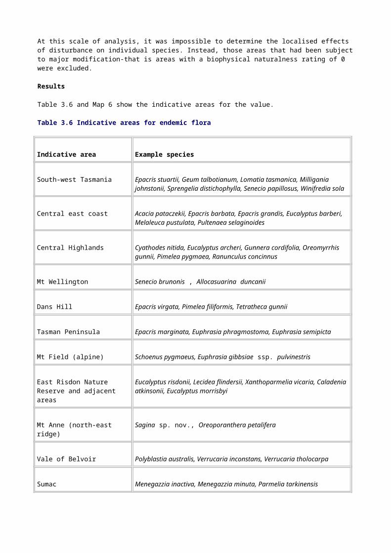
rhomboidea Rivers
Mountain summits on Flinders, Cape Barren and Maria Islands
Cloud forests Atherosperma moschatum, Pomaderris racemosa, P. apetala, Tasmannia lanceolata, Bedfordia arborescens , Cyathea cunninghamii, C. marcescens
Mt Munroe, Mt Strzelecki, Mt Maria
Cool moist mountain plateaus and summits in eastern and south-eastern Tas.
Nothofagus cunninghamii, Atherosperma moschatum, Phyllocladis aspleniifolius and other associated rainforest species
Mt Mangana
Sinkholes and collapse features in karst and coastal sediments
Topographic protection and shading
Rainforest species, bryophytes and lichens. At present poorly understood
Mole Creek area, Cape Hauy
Phytophthora refugia
Various Maria Island, Wielangta Hill, Heazlewood River, Celery Top Islands, Alum Cliffs State Reserve, Southport Bluff, Grey Mountain
Relictual flora
Relictual species are generally regarded as those that exhibit taxonomic remoteness or phylogenetic primitiveness, or both. Examples of the former are the monotypic Proteaceae genera Cenarrhenes, Bellendena and Agastachys. Examples of the latter are Isoetes and Tmesipteris. It should be noted that a strict phylogenetic interpretation of the evolutionary process holds that the term `primitiveness' is more correctly applied to the characters or attributes of a species rather than being an appropriate label for any given species. Relict floral elements relate to National Estate criterion A.1.
Method
Modern descendants of primitive groups and species of Gondwanan affinity are widespread in Tasmania. Many are associated with rainforest, particularly rainforest having coniferous elements. Examples are pteridophytes, members of the Proteaceae, and a number of monotypic genera. Similarly, Tasmania's sub-alpine vegetation is known to harbour large numbers of Ice Age relicts.
Establishing thresholds
Areas having high concentrations of such taxa were considered to have significance for this value. Thresholding involved using the species richness value layer (see Map 8) in conjunction

with the forest community and other vegetation maps to include a subset of areas having rainforest or sub-alpine vegetation only.
Results
The resultant indicative areas are considered to meet the National Estate threshold for the value; they are listed below and shown on Map 6.
• Cradle Mountain-Middlesex Plains
• Frenchman's Cap
• Mt Anne-Lake Judd
• Mt Field
• Mt Read-Dundas
• Pelion Plains
• Sumac - Savage River
• Walls of Jerusalem
Remnant vegetation
Remnant vegetation provides important refuge and recruitment areas for both flora and fauna. The relevant National Estate criterion is A.2, which refers to `importance in maintaining existing processes or natural systems at the regional or national scale'. This analysis focuses on remnant forest patches located within highly modified environments.
Method
The forest community map and biophysical naturalness information provided the basis for this assessment. Remnants were identified by locating small areas of forest completely surrounded by cleared land.
Establishing thresholds
To qualify for inclusion, remnants had to have a minimum area of 20 hectares, a maximum area of 200 hectares, and be completely surrounded by cleared land (biophysical naturalness = 0). They also had to be separated from polygons larger than 200 hectares by at least 100 metres of cleared land.
The biophysical naturalness layer was overlain to provide a context for assessing integrity and non-natural disturbance. The level of fragmentation (from impacts such as roading and logging) and connectivity with undisturbed areas (including other less depleted forest types) was also considered. Small, isolated polygons (less than 20 hectares) were not considered to meet the threshold, although it was recognised that they may be locally important: it was beyond the scope of this analysis to assess in detail these smaller remnants.
Vegetation succession
Places that are important for succession are forest communities that have dynamic examples of succession occurring within them, areas affected by fire (halting primary succession processes), and forest communities recovering from major wildfires. This value is associated with National Estate criterion A.2, which relates to places of importance for the maintenance of existing processes.
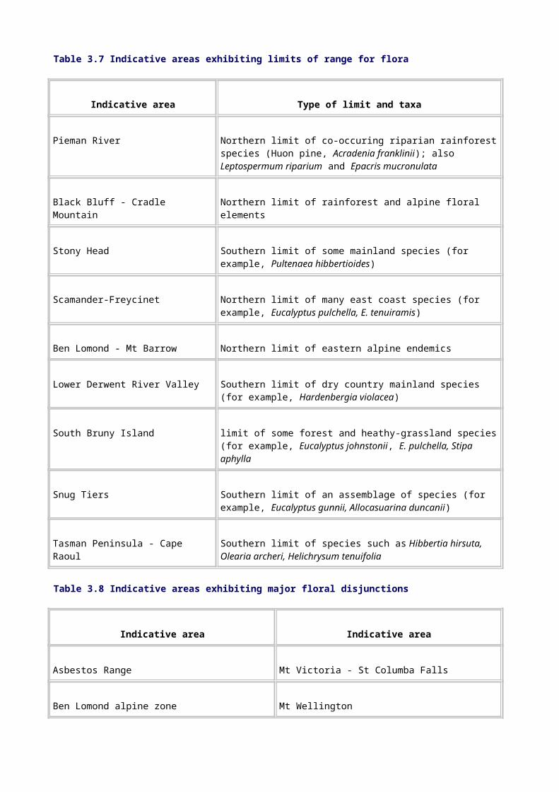
Method
Forest communities considered to exhibit primary and secondary succession were identified from the literature and by experts. Well-documented successional vegetation themes from the literature were identified during the National Estate biodiversity workshop, held on 25 June 1996. The key references in relation to these types are as follows:
• buttongrass/sedgeland - rainforest (Jackson 1968, Bowman & Jackson 1981, Brown & Podger 1982, Busby & Brown 1994, Kirkpatrick 1984, Podger et al. 1989, Ellis 1985)
• blackwood swamps - cool temperate rainforest (Pannell 1992, Jarman et al. 1984, Gibson et al. 1987, Mesibov 1996);
• riparian vegetation (M Askey-Doran, pers. comm.);
• lichens (Kantvilas & Minchin 1989);
• dune systems (Kirkpatrick 1993);
• Callitris (Harris 1989, Harris & Kirkpatrick 1991b);
• Sphagnum-rainforest (Whinam & Kirkpatrick 1995);
• landslide succession (Cullen 1991);
• Allocasuarina-Eucalyptus (Kirkpatrick 1986).
The literature was reviewed and experts suggested additional successional vegetation types, described the processes operating for each type, and drew up a preliminary list of candidate sites, showing the range of successional expressions.
Establishing thresholds
The candidate sites had to meet a number of criteria. Sites demonstrating temporal rather than geographic successional (zonation) sequences were primarily considered. This group was reduced by excluding sites that did not support forest-related vegetation or where succession is initiated by non-natural processes. Three types of sites were chosen: those showing a range of successional states; those recovering from major disturbance; and those held at a disclimax by continuing or frequent disturbance. The sites were reviewed by an expert panel, and a final list of indicative places that met the National Estate threshold was made.
Places were thresholded on the basis of their thematic integrity and condition. They are listed in Table 3.10 and shown on Map 8.
Table 3.10 Indicative flora succession areas, by succession type
Succession type Indicative areas Comments
Buttongrass sedgeland - cool temperate rainforest succession
Melaleuca, Bathurst Harbour
Low-altitude site on infertile (oligotrophic) soils. Mixed forests probably about 250 years old, rainforests not burnt for more than 300 years. Evidence of succession from sedgeland-heath through scrub to forest (Brown & Podger 1982)

Beech Creek, Wayatinah
Tall Eucalyptus regnans forest with older rainforest understorey (J Balmer, pers. comm.)
Mt Read High-altitude site on oligotrophic soils (Peterson, in prep.; M Brown, pers. comm.)
Grassland-rainforest succession
Paradise Plains - Mt Maurice
High-altitude site on fertile soils (Ellis 1985)
Buttongrass-Nothofagus succession
Dove Lake Buttongrass - Melaleuca squamosa moorland passing into a montane rainforest with abundant Nothofagus gunnii, Richea pandanifolia, Athrotaxis selaginoides and some A. cupressoides (S Corbett, pers. comm.)
Blackwood swamp -rainforest succession
Dismal Swamp The least artificially disturbed of the sites surveyed by Pannell (1992); (F Duncan, pers. comm.)
Table 3.10 (cont'd) Indicative flora succession areas, by succession type
Succession type Indicative areas Comments
Callitris succession Bishop and Clerk, Mt Maria, and eastern shelf of Maria Island
Pure Callitris adjacent to pure rainforest, and fire-scrambled Callitris-rainforest-sclerophyllous components. Allocasuarina, Eucalyptus, Callitris, rainforest in pre-fire juxtaposition (Olesen et al., in prep.)
Wingaroo Fire-shadow Callitris shrub surviving in the lee of lagoons (S Harris, pers. comm.)
Paradise Gorge, near Orford
Transition between Eucalyptus and Callitris. Single pulse of regeneration (phasic) due to patchy fire (S. Harris, pers. comm.; JB Kirkpatrick, pers. comm.)
Riparian succession Elizabeth River Pomaderris apetala, Acacia axillaris, Beyeria viscosa, Lomandra longifolia open riparian scrub. Flood disclimax (Askey-Doran 1993)
Lower Gordon River Riparian rainforest with Huon pine dominant (M Brown, pers. comm.; Davies 1983; Jarman et al. 1984)
Coastal forest Rheban Spit Frontal dunes can be divided into sub-zones: a

succession colonising community with dominant Ammophila acting as a sand binder and dune builder, and invasion of species from the beach ridge system. The Spit presents one of the few opportunities in Tasmania to study succession on beach ridges that are being formed (Bowden & Kirkpatrick 1974)
Sphagnum-rainforest succession
Mother Cummings Peak
A good example of rainforest-Sphagnum mire (Whinam et al. 1989)
As above, also lichen succession
Little Fisher River A mosaic of Sphagnum and vascular plants; dominated variously by Gleichenia alpina, Astelia, Abrotanella forsteroides, Sphagnum and herbs. Sphagnum occurring in the middle of rainforest (Whinam & Kirkpatrick 1995)
Allocasuarina-Eucalyptus succession
Queens Domain, Hobart
Kirkpatrick (1986)
Landslip succession Mt Wylly -Kameruka Moraine
Mature/tall Leptospermum nitidum replacing rainforest on relatively old landslip (S Corbett, pers. comm.)
Athrotaxis succession Mt Read M Brown (pers. comm.); S Corbett (pers. comm.)
Precipitous Bluff Fires in 1934 and possibly more recently. Athrotaxis selaginoides regenerating in alpine scrub/heath (M Brown, pers. comm.; S Corbett, pers. comm.)
Richness of flora species
In the context of Australia as a whole, Tasmania, as a region, is not regarded as exceptionally diverse for most floral groups. This pattern is consistent with the usual tropical-temperate diversity shift seen in most parts of the world. On a regional basis, however, some areas are obviously significant in terms of flora species richness. National Estate criterion A.3, which refers to `importance in exhibiting unusual richness or diversity of flora ...', applies.
The assessment for this criterion was divided into two areas of analysis: the richness of flora species and the richness of forest communities. Species-level richness is often referred to as alpha (a), or within-area, diversity and is usually measured as the number of species occurring within an area of a given size (Huston 1994). Forest community richness is effectively a surrogate measure of the rate of change of species: a between-area, or beta (ß) diversity, measure. It is often a good reflection of environmental diversity, where strong gradients produce rapid transitions of different forest communities and their associated species.
Method
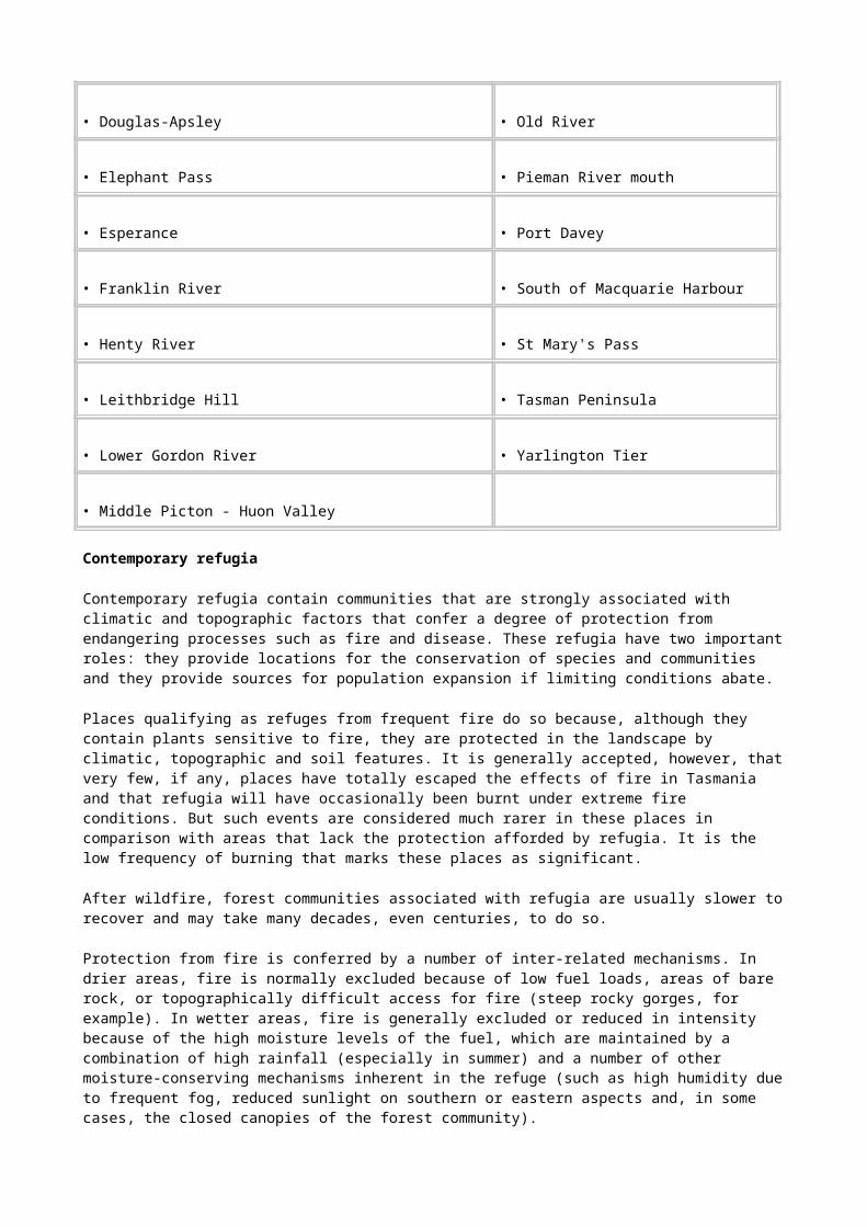
Known occurrences of all flora species in the database were plotted on 10-kilometre grid squares. These grid squares were ranked on the basis of the number of coincident species records.
Establishing thresholds
An expert panel then delineated areas of indicative significance, using the occurrence of 400 or more species as the threshold of significance for the value. This subset represents the upper 10 per cent of grid squares. Indicative areas were checked to ensure that known anomalies caused by sampling bias were taken into account, and the grid- square boundaries were smoothed to create ecologically and topographically coherent units in the landscape.
Results
Table 3.11 shows indicative areas for species-level richness; Map 8 illustrates them.
Table 3.11 Indicative areas for species-level and plant community richness (a and ß diversity)
Indicative area Species richnessCommunity
richness
Asbestos Range Yes Yes
Bay of Fires Yes No
Blueman's Creek Yes No
Cape Bernier Yes Yes
Cataract Gorge Yes No
Cradle Mountain-Middlesex Plains Yes Yes
Elephant Pass-Douglas Apsely-Freycinet Yes Yes
Forestier - Mt MacGregor Yes No
Frenchmans Cap Yes Yes
Kempton Yes No
Maria Island Yes Yes
Table 3.11 (cont'd) Indicative areas for species-level and plant community richness (a and ß diversity)

Indicative area Species richnessCommunity
richness
Mt Anne-Lake Judd Yes Yes
Mt Cameron Yes No
Mt Field Yes Yes
Mt Murchison Yes Yes
Mt Wellington-Meehan Range Yes Yes
Pelion Plains Yes Yes
Prosser River Yes No
Quamby-Drys Bluff Yes Yes
Quoin Mountain Yes Yes
Rocky Cape Yes No
Snug Tiers Yes Yes
Sumac - Savage River Yes No
Tooms Lake area Yes Yes
Walls of Jerusalem Yes No
Waterhouse Protected Area Yes Yes
Richness of plant communities
Significant plant community richness, or high beta diversity, is often seen in places where, because of sharp environmental gradients or marked changes in soils, drainage or other variables, there are unusually diverse conjunctions or rapid transitions of forest community types. This value is also considered under National Estate criterion A.3.
Method

The scientific literature and forest community mapping units in the database were examined by an expert panel, which, using this and other relevant data, delineated indicative areas of significance for this value. Areas considered by the panel as outstanding exemplars and having good landscape integrity were considered to meet the National Estate threshold for the value; these indicative areas are listed in Table 3.11 and shown on Map 8.
Rare, threatened or uncommon plant communities
A number of plant communities have been identified as of naturally rare occurrence or depleted by European land use and/or subject to continuing threatening processes (see Appendix O). All mapped occurrences of these forest types were considered to meet the National Estate threshold, and are shown on Map 4.
Rare, threatened or uncommon species
This value relates to criterion B.1-'importance for rare, endangered or uncommon flora...' The assessment method, using 10-kilometre grid square occurrences for nationally and State-listed species was undertaken with records of rare and threatened taxa in each grid cell being tallied.
With the level of data available, the expert panel could not agree on a threshold and it was decided not to proceed with the generation of this value layer. The panel agreed to defer further consideration pending the refinement of modeling tools and developments in identifying core endangered species habitat during the RFA options-generation process.
Flora communities characteristic of their class
Criterion D.1 refers to `importance in demonstrating the principal characteristics of the range of landscapes, environments or ecosystems, the attributes of which identify them as being characteristic of their class'. Examples of the flora of Tasmania that are characteristic of their class were identified in relation to forest communities only.
Some forest communities are very restricted; for example the Eucalyptus morrisbyi community covers approximately 20 hectares. Others are more widespread and may encompass a variety of identifiable floristic associations across their range; the extensive dry Eucalyptus obliqua forests are an example of this phenomenon.
Method
The process of identifying examples of plant communities demonstrating the principal characteristic of their class involved the following:
• examination of the distribution of forest communities across Tasmania;
• a focus on areas of forest communities in their natural condition and of appropriate size and integrity (context) to ensure maintenance of ecological processes;
• ensuring that regional variation in each community was encompassed through inclusion of each community in each of the IBRA (Interim Bioregionalisation of Australia) regions, unless condition and integrity dictated otherwise;
• validation using expert opinion and information on variation in the full expression of forest community attributes.
Establishing thresholds
The natural landscapes data layer provided the basis for determining condition. Matters relating to the condition and landscape context of forest areas are considered under criterion D.1 are therefore essentially congruent with the rule sets underpinning the derivation of the natural landscapes data layer.

In the past, various analyses have focused on determining minimum size thresholds for vegetation communities with integrity. In the assessment of the south-west forests of Western Australia, a 2000-hectare threshold was considered appropriate for common vegetation communities and a 200-hectare threshold was used for uncommon communities, based on expert knowledge and given the generally acknowledged limitations of the available vegetation data. But the difficulties arising from focusing on arbitrary size thresholds for conservation reserves (including representative samples) have been emphasised repeatedly in the literature-for example, Austin and Miller (1978), Margules and Usher (1981) and Richards et al. (1990). These authors have also stressed the need to examine flora communities in the context of their occurrence within the landscape.
In view of this, no size thresholds were applied in determining places of significance under this criterion in Tasmania. Insufficient time also precluded use of a data-derived analysis as the basis for determining minimum size thresholds for forest community polygons, as was done for the East Gippsland National Estate assessment (Australian Heritage Commission 1995).
The forest community mapping polygons fell into two broad groups, which were dealt with differently in the analysis, as follows:
• forest communities that are rare or of limited extent in Tasmania (see Appendix O for definition). For these forest communities, all polygons (disturbed and undisturbed) were considered to meet the threshold.
• forest communities that are widespread in the landscape. Only areas falling within the natural landscapes value layer-see Section 3.2.1-were initially identified. Where regional variation in a forest community was considered to be significant, a representative area was selected in each IBRA region in which the community occurs. Areas outside the natural landscapes layer were considered only when there were no other options to capture regional variation or where a forest community occurred largely within modified landscapes.
Time constraints did not permit use of the growth-stage dataset as a measure of effective representativeness of age-class distribution. Use of the natural landscapes data layer as a primary thresholding step makes it more likely that the older growth stages are represented in the areas delineated.
Results
Map 4 shows the indicative areas that met the National Estate threshold for the value in each forest community.

Chapter 3: National Estate natural values - continued
3.3.2 Fauna
Datasets for fauna assessment
Tasmania has a long history of fauna survey, although much of this has not been in the form of systematic census. There are more than
50 000 records of birds, mammals, reptiles, frogs, and freshwater fish. Invertebrate survey in Tasmania has probably been of almost comparable intensity, resulting in a large and functional data resource.
The following are the main sources of locality and distributional data used for assessing fauna values:
• the Tasmanian Parks and Wildlife database (TASPAWS). This is the principal terrestrial vertebrate database maintained by the State, containing data on each species as points (accurate to 1, 2 or 5 minutes or 1 degree, giving variable accuracy from several metres to many kilometres). These data are derived from:
- intensive surveys throughout Tasmania, particularly in the Southwest National Park, Cradle-Mountain-Lake St Clair National Park, Douglas-Apsley National Park and the Waterhouse Protected Area
- pre-logging fauna surveys conducted in State forests
- records of sightings by Parks and Wildlife staff, naturalists and accredited observers
- historical records from the natural history literature
- museum vertebrate records
- targeted CRA projects
- modelled distributions of species based on the CORTEX algorithm
• information on extensive and collective values, such as rich or very diverse sites, unusual assemblages and interesting and unusual populations. This is derived from the records of scientists and other specialists and much of it is unpublished;
• the databases of the Tasmanian and Queen Victoria Museums;
• the Australian National Insect Collection;
• expert knowledge.
Endemic fauna
Tasmania has 47 endemic vertebrates, of which 21 are classified as forest-associated. The endemic fauna is primarily characterised by the great diversity of invertebrate groups and their constituent taxa. The state of knowledge of invertebrates in Tasmania is relatively advanced when compared with most other regions in Australia. This has permitted a better assessment of associated National Estate values than has been possible elsewhere.
The non-correctable sampling biases that pervade faunal collection in Tasmania-the recorder effect discussed by Mesibov (1996b) and Prendergast et al. (1993)-put severe constraints on

interpretation using GIS-generated maps of faunal richness. The modeling of species' distributions using environmental strata offers only a partial solution to the lack of systematic and uniform survey, particularly when attempts are made to predict the occurrences of many invertebrate groups that operate at spatial scales and within microclimatic tolerances outside the scope of most modeling paradigms.
Areas of significance for endemic invertebrate fauna were assessed under National Estate criterion A.1, which relates to past processes, including the evolution of biota. Endemic vertebrates are widespread in Tasmania and are found in a variety of habitats. In considering these species, the fauna Advisory Committee determined that no particular areas could be identified as significant for the value.
Method
Sufficient information was available from published and unpublished survey work (for example, Coy et al. 1993, Mesibov 1996b) to allow an expert panel to identify areas having significance for endemic species. Assessment involved consideration of 10-kilometre grid square counts as well as wider knowledge, both published and unpublished. Thresholding was based on expert opinion, informed by relevant datasets. Because our knowledge is still incomplete, additional areas that meet the threshold for this value almost certainly exist.
Results
Table 3.12 and Map 7 shows indicative areas for endemic invertebrate fauna.
Table 3.12 Indicative areas for endemic fauna
Indicative area Significant taxa Reference/authority
Great Lake Benthic invertebrates: Tasniphagus tyleri (Amphipoda), Beddomeia tumida (Hydrobiidae), Uramphisopus pearsoni (Phreatoicidae)
Invertebrate Advisory Committee list, including rare and threatened taxa
Plomleys Island Anoglypta launcestonensis, Tasmanophilus spp., Gasterogramma spp., Lissodesmus spp., Hoplogonus simsoni
Mesibov (1996b)
Table 3.12 (cont'd) Indicative areas for endemic fauna
Indicative area Significant taxa Reference/authority
St Marys Tasmanipatus anopthalmus, T. barretti, Cryptops (Centipeda), Procyliosoma (Myriapoda),
Invertebrate Advisory Committee list; Mesibov (1990)
Cataract Gorge Migas plomleyi, Neopseudogarypus scutellatus, Beddomeia launcestonensis
Invertebrate Advisory Committee list; Ponder et al. (1993)
Karst areas Hickmanoxyomma (Mole Creek); Lomanella troglodytes, Pseudotricula eberhardi (Precipitous Bluff caves); Notoniscus sp. nov. (Kutikina cave); Geodetrechus parallelus (Junee-Florentine caves); Geodetrechus mendumae (Ida Bay caves)
Eberhard et al. (1991)
Species at the limit of their range (including disjunct species)
Disjunct faunal species were defined as those with populations separated by a substantial geographic distance from other populations, such that non-flying taxa are unlikely to interbreed with other populations. These species are often evidence of past distributions or biogeographic events and therefore demonstrate past processes, as required by criterion A.1. Vagrant species were excluded from consideration.
As is the case for flora, the fact that Tasmania is an island and its extreme southerly position in Australia mean that many faunal species are necessarily at the edge of their biogeographic range in the region or have disjunct populations across Bass Strait.
Method
Species were considered for analysis if they fell into one or more of the following categories:
• species whose main strongholds are on the mainland and that encroach into Tasmania (that is, they are at their extreme southerly limit);
• taxa that exhibit marked disjunction within the State;
• species listed under the Endangered Species Protection Act 1992, in Tasmanian rare or threatened species site data lists and others at their biogeographic limits nationally.
• Actual distribution plots for all these taxa were generated.
Establishing thresholds
Thresholds were established by exposing the distribution maps of qualifying taxa to expert scrutiny and identifying places of significant overlap. All such congruencies were examined by the expert fauna panel and a subset considered to meet the threshold of National Estate significance for the value on the basis of high overlap and good integrity was delineated.
Results
Areas considered to meet the threshold of National Estate significance are listed in Table 3.13 and shown on Map 6).
Table 3.13 Indicative areas for fauna with disjunct occurrences and fauna at limit of their range
Indicative area/locality Taxa
North-west extremity (M) Limnodynastes peroni, Arcitalitris bassianus, Galaxias pusilla
North-east extremity (M) Pseudomys novaehollandiae, Hemiphlebia mirabilis,
Cataract Gorge (E-W) Numerous invertebrate species
Tyler's line faunal break Numerous invertebrate species
East Tamar faunal break (E-W) Milvus sphenurus (Aves) invertebrate species
Gould's Country faunal break (E-W) Engaeus spp. and other invertebrates
Sandspit River, Wielangta (D) Undescribed carabid beetle
Mt Cameron West (D) Galaxiella pusilla
Waterhouse Protected Area (D) Limnodynaste peroni, Lerista bougainvilleii
Southwest National Park (D) Keratroides angulosus (Ampipoda)
Gladstone (D) Schayera baiulus (Orthoptera)
Renison Bell (D) Engaeus disjuncta (Crustacea)
Birchs Inlet (D) Pseudotyrannochthonius typhlus
Georgies Hall Cave and Baldock's Cave (D) Various invertebrate species
Note: M = mainland-Tasmania limit of range;
E-W = east-west limit of range;
D = disjunction.
Relictual fauna
The Tasmanian fauna is remarkable for the proportion of phylogenetically significant species found, reflecting the history and present conditions of the region. Australia's long isolation, and Tasmania's distance from the sources of colonists to the north following Australia's collision with South-East Asia, combined with the relatively benign conditions the region has experienced since the Tertiary, have allowed many groups to survive. In historic times
Tasmania's isolation has again to some extent protected the fauna from the ravages of European introductions such as foxes. Thus, although some elements of the fauna show the reduced species diversity expected of an island, this is amply compensated for by the historically interesting taxa.
The significance of the fauna poses problems for an exercise designed to identify species and places of special importance within the regional unit. A recurring theme in the comments of taxonomic experts contacted while compiling this list was that the fauna as a whole has significance. The need to identify special areas is appreciated, but it is important that the remaining species and places are not devalued.
Criterion A.1 is difficult to apply to relictual fauna because of the very high proportion of the fauna that is of Gondwanic origin and the overall primitive nature of much of the Australian fauna. A further problem is the lack of consensus among experts on what constitutes primitive or relictual features. For the purposes of this analysis, taxa were included for any one of three reasons:
• because they were of phylogenetic interest
• because they were relictual species
• because they were endemic to Tasmania at the genus or family level.
`Phylogenetic interest' was interpreted quite broadly to include taxa of uncertain taxonomic position and taxa showing phylogenetically primitive characteristics.
Method
Relictual species can be defined in terms of both space (biogeographical relicts) and time (phylogenetic relicts) and the phenomenon can occur at different scales. Thus the anaspidacean crustaceans, and the Tasmanian devil, may be seen as relictual at a continental or world level, but patterns of distribution are emerging within the State that probably reflect relictual distributions from the Pleistocene glaciations (see, for example, Mesibov 1994, Bonham 1996, Richardson 1996). For the purposes of this analysis the first type of biogeographic relict defines species of interest with widespread distributions in Tasmania and the second type has the potential to identify places of significance where the distributions of such species show common boundaries.
A very high proportion of the Tasmanian fauna is recognised by the scientific community as being biogeographically relictual in the sense of showing Gondwanic affinities.
Establishing thresholds
Endemism at the genus level or above was taken to represent a particular class of phylogenetic importance. After consulting a range of taxonomic experts, 27 taxa were listed as phylogenetically primitive, 19 as of uncertain phylogenetic position, 29 as relictual, and 109 as endemic genera. The actual numbers of taxa are likely to be a profound underestimate of the true numbers. The Opiliones (harvestmen-30), crustaceans (18) and molluscs (17) provided most of the endemic genera. The crustaceans also provide the only endemic family identified in this assessment, the Anaspididae.
Results
Areas containing a high degree of congruency of the above taxa were considered to meet the threshold of National Estate significance for the value. These indicative areas are listed below:
• the Southwest Conservation Area
• Great Lake

• the north-west extremity
• Cataract Gorge
• Goulds Country faunal break
• St Marys-Elephant Pass.
Glacial fauna refugia
`Refuges' or `refugia', are topographic/biogeographic entities that operate at geological or contemporary time scales to provide relatively stable environmental conditions during periods of climate change and glaciation and during periods of environmental or climatic stress (such as wildfire or severe drought). Zoological refugia have not been identified in the literature, and those areas thresholded for flora refuges were also considered to be important for fauna, although this value was not thresholded, because of the lack of data.
Contemporary faunal refugia
For this assessment, fauna refuges were identified by determining which forest communities had the potential to act as refuges for fauna during times of environmental perturbation. For instance, the wetter vegetation classes may provide protection for some fauna during fire or they may provide food for some fauna during drought.
Three broad forest classes were suggested as having the potential to act as fauna refuges: rainforest, old-growth wet forest, and riparian forest.
A number of the areas defined under refugia for flora are considered to capture the requirements of fauna, but this may not be the case for some invertebrate species (G Blake, A Richardson and R Mesibov, pers. comm.). Other aspects of faunal refugia are covered by other comprehensive regional assessment projects; for example, karst fauna.
Undisturbed occurrences of these forest communities were mapped as fauna refuges and are considered to be of National Estate significance under criterion A.2 (see Map 8).
Important fauna habitat areas
Core habitat areas are critical to the continuing viability of the Tasmanian fauna as a whole. National Estate criterion A.2 is of relevance to consideration of this value: `importance in maintaining existing processes or natural systems at the regional or national scale'.
Method
The revised comprehensive regional assessment list of rare and threatened fauna species (see Appendix P) provided the list of fauna whose important habitat was to be determined in this process. Species not on the list were excluded, although it is recognised that many common species display patchy or uneven distribution and areas of important habitat for many species could be identified.
Establishing thresholds
Experts agreed that the critical habitat for each rare and threatened forest related-fauna species met the threshold of National Estate significance for the value. These areas were mapped as far as practicable, acknowledging the limitations of available data. Distribution data for many of the species listed are lacking, with little research having been conducted. Even those species that have been intensively researched do not have complete distribution datasets (for example, Wedge-tailed eagles). Use of partial datasets will have undoubtedly led to some errors in evaluating important sites of species diversity. The results should therefore be interpreted with caution.

Among other areas of possible significance to the Tasmanian fauna are the Great Lake, for its role as an important wetland for birds, fish and invertebrate fauna, and Ramsar sites surrounded by forest. Most of the migratory bird species of international significance visiting Tasmania are associated with coastal sites.
Table 3.14 provides a breakdown of the habitat selection methods used for groups of species with similar habitat requirements. The indicative areas delineated are shown on Map 9.
Table 3.14 Methods for selection of important habitat
Habitat-group Description
Aquatic-hydrobiid snails
These snails are extremely restricted in their distribution: information about the majority of them comes from a single site or a few sites only. Grid references were supplied and distribution identified was by points. Where two or more sites were identified, and on the same water body, the points were joined.
Aquatic - Fish The distribution and important habitat of four of the five fish species were mapped with all known sites included. Water bodies were either completely included (lake systems) or a reasonable stretch of the river or creek was included. The Australian grayling was omitted: it is too difficult to determine which coastal systems to include.
Aquatic-invertebrates excluding snails
Where single site locations were known these were identified by point sources. Multiple sites were joined along the water bodies or included within a polygon.
Terrestrial-invertebrates
Experts identified the important habitats for each species, this information then being plotted and polygons fitted around the sites. Several species of geometrid moths were left off the maps: information was not obtainable within the time constraints of this project. Stag beetle distribution was identified during a CRA-funded study. Important habitat sites were selected from the available data and enclosed in polygons.
Important habitat of the giant velvet worm was identified as four sites within the larger distribution of the species.
Semi-aquatic-invertebrates
The entire known distribution of two species of burrowing crayfish was included as `important', while the third species (the Mt Arthur species) has several sites, where it was seen to be in greatest numbers it was selected and mapped.
Migratory-Birds Breeding and feeding sites for migratory birds, where breeding in Tasmania, were included.
Terrestrial-mammals The more important habitats of the spotted-tailed quoll were identified; sites of particular importance were also determined for the eastern quoll. Other mammal species had sections of their habitats mapped as important, based on expert opinion.

Cave-invertebrates Cave systems containing the listed species were identified, with the entire cave mapped as important habitat. The mapping did not include extrinsic areas that affect the cave system (for example, hillsides and creeks).
Significant wetlands
Wetland areas are also important breeding and feeding resources for many fauna species. Time did not permit an appraisal of the significance of all candidate wetland areas in the State. For the purposes of this assessment, the Tasmanian component of the Directory of Important Wetlands in Australia (Australia Nature Conservation Agency 1996) was considered by the experts consulted to meet the National Estate threshold. A more refined assessment and thresholding of these places for this value and under criterion D.1-principal characteristics of wetland classes-needs to be done. Significant wetlands are shown on Map 4.
Fauna species richness
A systematic method was devised to define areas of high fauna species richness. It was essentially the same as that used for defining areas of high floral species richness (see Section 3.3.1). For the purposes of this analysis, richness is interpreted as synonymous with diversity, although in the strict sense diversity is a measure that reflects both the number of different species and the relative abundance of each species. Measurement of diversity, in the strict sense, is not within the scope of this assessment. No assessment of beta diversity was attempted.
Areas of fauna species richness are considered to be of National Estate significance under criterion A.3, `importance in exhibiting unusual richness or diversity of flora, fauna, landscapes or cultural features'.
Method
Cumulative tallies of database records for all available fauna were compiled-including those listed by Richardson (1996) as being primitive and/or relictual-on 10-kilometre grid squares. These composites yielded total numbers of species for each grid square, and the latter were ranked on the basis of the number of intersections (that is, the number of coincident species distributions).
Establishing thresholds
Areas showing the highest congruence of species were reviewed by an expert panel and considered to meet the threshold if they were also of good landscape integrity. Areas of a biophysical naturalness rating of 0 were also excluded from identified areas. The indicative areas are shown in Table 3.15 and on Map 7.
Table 3.15 Indicative areas for fauna species richness
Indicative area Characteristics Attributions/references
Wielangta Southern wet and dry forest mosaic
Fauna Advisory Committee
Ben Lomond Alpine vegetation, tarns, rainforest, wet/dry eucalypt and inland grassy dry forest in close proximity
Fauna Advisory Committee
Mt Field Alpine vegetation, tarns, rainforest, wet/dry eucalypt and inland Eucalyptus tenuiramis forest in close proximity
Swain & Reed (1983)
Environs of Savage River Pipeline road
Conjunction of numerous invertebrate species
Coy & Greenslade (1993)
Table 3.15 (cont'd) Indicative areas for fauna species richness
Indicative area Characteristics Attributions/references
Weavers Creek Western boundary of a faunal break in the east Tamar region
Mesibov (1996b)
Mt Arthur-Scottsdale Overlap of 6 Engaeus species
Horwitz (in press), Doran (1996)
Blue Tier Numerous invertebrate species
CSIRO Division of Entomology research site
Rare, endangered or uncommon fauna
National Estate criterion B.1 refers to `importance for rare, endangered or uncommon flora, fauna, communities, ecosystems, natural landscapes or phenomena, or as a wilderness'.
For the purposes of this assessment, rare and threatened species were defined as those listed under the Commonwealth Endangered Species Protection Act 1992 and the Tasmanian Threatened Species Protection Act 1995. Appendix P shows the species, their status and the habitat characteristics for each. This assessment was effectively carried out through the identification of important fauna habitat (see Table 3.13).
Principal characteristics of faunal class
Criterion D.1 refers to `importance in demonstrating the principal characteristics of the range of landscapes, environments or ecosystems, the attributes of which identify them as being characteristic of their class'.
Guilds of associated fauna species or reliably recognisable faunal communities remain ill-defined in Tasmania, as elsewhere in Australia. After investigating possible options it was decided that, within the scope of the Tasmanian comprehensive regional assessment, forest communities were the most appropriate and useful surrogate for fauna habitat. This value is therefore dealt with through the relevant flora assessment. The limitations of this approach are

acknowledged. Areas identified in the flora analysis as containing representative forest communities cannot be assumed to contain representative samples of fauna habitat because many species are known to cross plant community boundaries.
3.4 Other natural values
3.4.1 Geological and geomorphological and soil values
The goal of geological and geomorphological values assessment is the identification of geodiversity. This implies the systematic identification of sites representing the diversity of geological, landform and soil features and systems. Recognition of outstanding examples of aspects of geodiversity is also important because these examples are indicators of the potential endpoint of the development of features within their regional context.
Geodiversity is fundamental to the integrity of broader ecological processes. It is also important in contributing to the richness and interest of our environment and in providing opportunities for scientific study of the earth's development.
Some elements of geodiversity are relatively robust in the face of human intervention; others are susceptible to degradation associated with a range of land use practices. An effective approach to geoconservation must include the development and implementation of protective management principles designed specifically to protect the vulnerable elements of geodiversity.
Data sources
Data sources for the assessment of geodiversity values are described in detail by Dixon and Duhig (1996). The main sources were inventories of important geological, geomorphological and soil sites compiled by the Parks and Wildlife Service and Forestry Tasmania (Dixon 1991, 1996; Bradbury 1993, 1994, 1995; Sharples 1994a, 1994b, 1995a, 1996a, 1996b, in press). Additional data with a bedrock geological focus were available from a variety of other sources (for example, Turner 1990, Calver 1996, Eastoe 1979). Some data on stratigraphic type localities was obtained from the Australian Geological Survey Organisation's Register of Australian Stratigraphic Names.
These sources are reconnaissance-level, or `first order', surveys (Sharples 1995b) based primarily on published information. As such, they are biased towards outstanding rather than representative aspects of geodiversity. `Second order' inventories with a regional or thematic emphasis and incorporating appropriate classificatory frameworks (for example, Kiernan 1995) would provide a more objective basis for identifying significant sites but are yet to be prepared for the majority of geoheritage themes in Tasmania.
A number of classes of feature, and features on some land tenures, were poorly represented in the data available for the comprehensive regional assessment:
• Not even basic inventories have been prepared for some land tenures in Tasmania. In particular, private land, which covers some 30 per cent of the State, has not been systematically surveyed for geodiversity values.
• Soils are the most poorly studied aspect of geoconservation in Tasmania. Only limited data were available to assess soil heritage sites.
• The Register of Australian Stratigraphic Names contains a list of all registered type localities, but many of the type localities are not defined and additional work would be required to compile information on all such sites.
• Fossil sites are often important for regional dating and correlation. A systematic search of recent review publications would aid compilation of a comprehensive list of such sites. To date, inventories have tended to note fossil sites only on an ad hoc basis.

• Some landform classes (such as karst and glacial) are relatively well known compared with others (such as fluvial). This is reflected in the knowledge of the distribution of features, typology development, and the number of sites listed in available inventories.
• Existing inventories are biased towards listing relict features, or the form of an active feature, rather than describing the location of the active process that produced and continues to modify the feature. Identification and appropriate management of geo-process sites is an essential component of geoconservation (Houshold 1994).
Method
The assessment of geodiversity values involved the following steps:
• consolidation of existing databases into a single computer-based database and GIS layer;
• comparative review of site significance;
• identification of site attributes relevant to the National Estate criteria;
• development and application of thresholds.
This work was done by State-based project officers who were supervised by a steering committee containing representatives from local land management and research agencies with an interest in geoconservation (see Appendix C).
A further aspect of the methodology is the development of a georegional map of Tasmania. Time constraints meant that it was not possible to fully integrate the georegions in the assessment process, although they will be useful for continuing geoconservation work in Tasmania.
The Tasmanian geoconservation database
An important element of the methodology is the collation and updating of existing information on sites of known geoconservation significance into a single computer-based database, known as the Tasmanian geoconservation database. The design of the new database was largely based on an existing database of geoconservation sites developed by the Parks and Wildlife Service. This database was refined in consultation with local geoconservationists, taking into account a range of potential applications beyond the comprehensive regional assessment. The completed database incorporates fields that accommodate a wide range of site attributes relevant to geodiversity assessment and management. It is described in detail by Dixon and Duhig (1996).
A total of 920 sites were entered on the database, ranging from bedrock point localities, such as the `Bills Creek Eclogite' to extensive terranes such as the `Central Highlands Cainozoic Glacial Area'. Fifty-one per cent of the sites were listed primarily for bedrock geological features; 44 per cent were listed primarily for landform features; and 5 per cent were listed primarily for soil features. These percentages reflect the nature of sites recorded in the source inventories, which do not comprehensively document Tasmania's geodiveristy .
Sites on the database were assigned a sensitivity rating that provides a general indication of land use practices with the potential to damage the geoheritage value(s) of the site. Sensitivity ratings highlight the fact that the geoheritage attributes of a considerable number of sites are potentially susceptible to a range of human-initiated disturbances.
A GIS layer was developed in association with the database. Listed sites are represented by polygons, arcs or points on the GIS layer.
Significance assessment

Sites on the database were assigned a level of significance, as follows:
• local
• regional
• Tasmanian
• Australian
• world.
This hierarchy is consistent with geoconservation practice in Tasmania and elsewhere (Sharples 1993, Rosengren 1994). `Region' is defined here as a major subdivision of the State on the basis of geographic, landform or geological characteristics. `Local' refers to significance at the level of the individual karst area, rock outcrop, or other spatially restricted context.
The level of significance attributed to a site reflects a judgment of the most appropriate context for considering the site's contribution to geodiversity as an `outstanding' or `representative' site. Outstanding sites exemplify an earth process through a feature that is rare, unique, particularly well developed or otherwise of special importance. Representative sites may be either rare or common but must be well-developed or well-exposed examples of particular aspects of geodiversity. A site may be both outstanding and representative at a particular level, as in the case of features that are outstanding because of their rarity, and representative because few other examples exist.
The majority of sites listed on databases held by the Parks and Wildlife Service and Forestry Tasmania had already been assigned significance ratings, in most cases derived from the regional or thematic inventory that identified the site. These significance ratings were temporarily carried over to the consolidated database. Sites listed on the database from other sources were also assigned a preliminary significance rating based on the project officers' knowledge of Tasmania's geodiversity and the significance attributed to any similar sites on the database.
The various classes of feature on the database were then reviewed by earth scientists with local expertise and detailed knowledge of the class of feature under consideration (Dixon & Duhig 1996). The significance ratings and other information were then modified in the light of comments received. Thus, final significance ratings on the database reflect the opinion of at least two (generally more) experts and are the outcome of a comparative review process that was more systematic than hitherto undertaken.
The significance of poorly documented sites and sites of possible representative value for poorly studied classes of feature was not assessed.
National Estate attributes
Eight National Estate criteria are relevant to the assessment of geodiversity values: A.1, A.2, A.3, B.1, C.1, C.2, D.1 and H.1 (see Appendix D).
Sites with the following attributes were assessed against criterion A.1:
• important sedimentary, igneous and metamorphic rock exposures;
• sites clearly demonstrating relationships between geological units;
• sites containing evidence of palaeo-environments (including important fossil localities);
• relict landforms (that is, landforms formed by processes no longer active at the site);

• palaeosols.
Sites with the following attributes were assessed against criterion A.2:
• sites important for maintaining continuing geological, landform or soil processes in essentially undisturbed environments;
• sites providing clear evidence of continuing processes associated with aspects of geodiversity that are distinctive, diagnostic or special.
Sites with the following attributes were assessed against criterion A.3:
• rich or diverse fossil localities;
• sites with a rich array of rock types, structures or textures;
• sites with a diversity of landforms of a particular class;
• sites where different classes of landforms are closely juxtaposed or interrelated (for example, glaciokarst or periglacial-aeolian dunes).
Sites with the following attributes were assessed against criterion B.1:
• rare or unusual geological, landform or soil features;
• rare combinations of geological, landform or soil features;
• features that are unusual or outstanding in some way (biggest, deepest, and so on).
Sites with the following attributes were assessed against criterion C.1:
• research or monitoring sites (past and continuing);
• important teaching sites;
• type sections or localities (fossils or stratigraphic units);
• widely recognised reference sections or exposures for particular geological units or important geological relationships.
Mine sites that contributed significantly to the non-indigenous human history of Australia (including contributions to our understanding of ore environments or past mining practices) were assessed against criterion C.2.
Sites with the following attributes were assessed against criterion D.1:
• representative of specific geological, landform or soil features or processes (that is, exemplifying the characteristics of the class or feature);
• representative of the variety that occurs within a particular class of feature or process.
Sites associated with the work of people who have made important contributions to the understanding of Tasmania's earth history (for example, Charles Gould, Charles Darwin and AN Lewis) were assessed against criterion H.1.
Thresholds
For sites assessed in relation to criteria A.1, A.2, A.3, B.1, C.2, D.1 and H.1, `significant at State level or above', as established by the expert review process already described, was adopted as the threshold. A State level of significance was considered an appropriate threshold because of Tasmania's status as a single region for the purposes of the comprehensive regional assessment.
Where multiple sites of significance at State level or higher exemplify a particular class of feature, an additional threshold of integrity was applied. Significantly degraded sites were considered not to meet the threshold for the particular criterion: a number of sites were excluded on this basis.
All geological type sections and type localities for fossils assessed against criterion C.1 were considered to meet the threshold, provided that the attributes related to the type function of the site retain their integrity and the site could be accurately located. The threshold adopted reflects the important reference function of such sites and is consistent with thresholds applied in assessing biological type localities. Geological exposures clearly displaying important geological features or relationships that are not designated type localities but are important for reference, teaching and research at the regional level at least-for example, the Rosebery (Bastyan Dam) Fault and the Arthur River Togari Typical Section-were regarded as type localities for the purposes of the assessment.
The use of significance ratings as thresholds reflects the nature of the data available (a list of sites already considered significant or otherwise noteworthy) and constraints in terms of the availability of appropriate classification frameworks to characterise Tasmania's geodiversity. The short time available for the assessment precluded thresholding based on the georegions, although such an approach would be potentially useful in assessing sites against criterion D.1 in particular.
Results
A total of 432 indicative areas of National Estate significance were identified (see Appendix Q). Two hundred and fifty areas were identified for their geological values, 200 for their landform values, and 25 for their soil values. Some areas contain multiple values that met the threshold, and many areas satisfy several criteria.
The majority of identified indicative areas are located in western and central Tasmania (see Map 3), reflecting variations in geological complexity across the State and a bias in the data sources towards sites on State forest and reserved tenures. The spatial distribution of karst and glacial sites, which are an important component of the identified geomorphological sites, also contributes to this tendency. Table 3.16 shows a breakdown of areas by type and National Estate criterion.
Forty-three of the indicative areas identified as meeting the threshold of National Estate significance are currently listed or have been nominated for inclusion on the Register of the National Estate. A further 176 sites are located largely within national parks and reserves, a number of which are on the Register of the National Estate. In such cases, the geoheritage values of the sites are not currently noted in the existing nomination or listing of the place (Dixon 1995).
Table 3.16 Indicative geodiversity areas, by type and National Estate criterion
Criterion Geological Geomorphological Soil Total
A.1 170 102 6 278
A.2 1 78 16 95
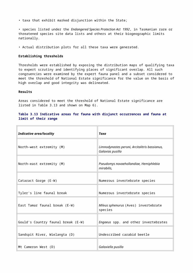
A.3 20 23 0 43
B.1 81 66 14 161
C.1 126 18 1 145
C.2 1 0 0 1
D.1 28 121 11 160
H.1 4 1 0 5
Georegions
Georegions are land units likely to encapsulate distinctive geological, geomorphological and soil phenomena resulting from a combination of system controls at particular points in geological time. The concept of georegions as a tool for dealing with a range of matters pertinent to geodiversity assessment was explored for the first time in the context of the comprehensive regional assessment. In particular, it was anticipated that the use of georegions would provide an appropriate context for assessing site significance and identifying gaps in the representation of Tasmania's geodiversity on the database. The approach is described in detail by Houshold et al. (in prep.).
Time constraints did not allow the georegions to be used systematically during the comprehensive regional assessment. A georegional map of Tasmania was, however, developed and the method was tested in relation to assessing the level of representation of selected classes of feature on the database. The trial results graphically illustrate the non-comprehensive nature of the Tasmanian geodiversity database (Dixon & Duhig 1996). It is envisaged that the georegions will be relevant to various aspects of continuing geoconservation work in Tasmania.
3.4.2 Natural history sites
National Estate criterion C.1 refers to `importance for information contributing to a wider understanding of Australian natural history, by virtue of its use as a research site, teaching site, type locality, reference or benchmark site'.
The assessment against criterion C.1 was broken up into three sub-assessments: type localities for flora species; type localities for fauna species; and places important as research, teaching or benchmark sites. Geological type localities were also assessed, separately, as part of the National Estate geoheritage project (see Section 3.4.1).
Type localities for flora species
The objective of this assessment was to provide a list of known Tasmanian type localities for rare and threatened vascular plants, all lichens and allied (usually lichenicolous) fungi, and as many bryophytes as it was possible to collate in the time available.
Data sources
For vascular plants, data are derived primarily from the Australian Plant Name Index (Chapman 1991) and primary sources such as monographs and Flora of Australia treatments. Species

included are those listed by the Flora Advisory Committee (1994) as rare or threatened in Tasmania.
Lichen data are derived from the latest check-list for Tasmania (Kantvilas 1994) and recent monographs, Flora of Australia accounts, and taxonomic papers.
Bryophyte data were derived from the Register of Type Specimens: Mosses in Australian Herbaria (Ramsay & Seur 1994). Because of the time constraints the bryophyte list is incomplete and contains only a few species. This is particularly so for the hepatics, for which data would need to be obtained from widely scattered sources.
Method
For each species identified in the project, information was gathered on the collector, locality and year of collection. Latitudes and longitudes for the localities were given a precision code according to those used by the Tasmanian Herbarium (see Table 3.16). It should be noted that many localities, especially those for type specimens collected last century, cannot be fixed any more precisely than simply `Tasmania' (precision code 5).
Several Tasmanian species still require lectotypification; that is, a type specimen must be designated from among authentic specimens studied by the author of that species. The specimens may well come from a range of localities, including New South Wales. This particularly applies to some taxa published by Robert Brown in his Prodromus (1810).
Establishing thresholds
All sites identified with a precision code of 3, 4 or 5 were considered not to meet the threshold: their locations could not be pin-pointed with enough accuracy for National Estate identification. Sites with a precision code of 1 or 2 (that is, precise to within a 50-metre or 1-kilometre radius respectively) were considered to meet the threshold unless the type locality was known to be degraded such that the species no longer occurred there (see Table 3.17). As a result, all sites with a biophysical naturalness rating of 0 were excluded. Map 5 shows those indicative places considered to meet the threshold.
Table 3.17 Precision codes used in defining type localities
Precision code
In distance, degrees or minutes
Relative to types of locality
1 Precise to within a 50-m radius (or nearest second)
A six-figure grid reference or GPS reading
2 Falling within a
1-km radius (or nearest minute)
A location able to be pinpointed accurately on a 1:250 000 map; a `spot locality' (such as a hill or mountain summit with a small surface area, a stream, river or road junction, or an accurate distance from one)
3 Falling within a 10-km radius (or nearest 5 minutes)
A location equivalent to a small town, a hill or mountain with a large surface area, a smallish lake, and so on

4 Falling within a 25-km radius (or nearest 10 minutes)
A location equivalent to a large city, a mountain range, a river 10-50 km long, and so on
5 Greater than a
25-km radius (about 30 minutes or over)
A region such as a large national park, an area such as `Northern Tasmania', or all of Tasmania
Source: Tasmanian Herbarium.
Type localities for fauna species
The objective of this assessment was to compile a list of Tasmanian type localities for rare and threatened fauna species, encompassing mammals, birds and invertebrates, but excluding primitive and relictual species.
Data sources
The list of species identified in this project was adapted from publications provided by the Vertebrate Advisory Committee and the Invertebrate Advisory Committee (1994) and updated as part of the Tasmanian comprehensive regional assessment. Exclusions from the list occurred when information was not readily available within the time constraints of the project.
Information on type localities was sought from sources such as the Zoological Catalogue of Australia and Gould’s Birds of Australia . Original source materials were referred to where possible to determine type localities. Undescribed species were not included because published type localities were unavailable.
Method
As for the flora type localities project, information was gathered on the collector, locality and year of collection for each species identified in the project. Similarly, latitudes and longitudes for the localities were given a precision code (see Table 3.16).
Establishing thresholds
As for the flora type localities project, all sites identified with a precision code of 3, 4 or 5 were considered not to meet the threshold: their locations could not be pin-pointed with enough accuracy for National Estate identification. Sites with a precision code of 1 or 2 were considered to meet the threshold unless the type locality was known to be degraded such that the species no longer occurred there. Ninety-three sites were considered before application of an exclusion rule using a biophysical naturalness rating of 0 as the threshold. The indicative places that met the threshold are shown on Map 4.
Research, teaching and benchmark sites
The objective of this assessment was to identify sites of National Estate significance because of their value as research, teaching or benchmark sites.
Data sources
The primary source of data was consultation with experts-leading scientists, academics, researchers and university and high-school teaching staff in the natural sciences area. Where possible, information collected from experts was verified from the literature. Site boundaries were determined from the literature or consultation with experts. Karst site boundaries were

determined from the Karst Atlas of Tasmania (Kiernan 1995). Appendix C lists the experts consulted.
Method
Sites were identified as either research, teaching or benchmark sites according to the criteria shown in Table 3.18.
All sites identified by experts and from the literature were initially listed. Experts were asked individually and then collectively to rank the significance of sites as either very high, high, medium or low.
Some criteria proved difficult to apply. For example, many sites that were suggested were associated with research into logging activities and hence were in disturbed areas or areas of destructive research. In some cases, however, the primary focus of the research was not destructive; in these cases, if the research was rated as of high significance by the experts, the site was included (for example, Maggs Mountain and Old Chum Dam).
Table 3.18 Criteria for identifying research, teaching and benchmark sites
Research sites Teaching sites Benchmark sites
Increases or has potential to increase understanding of Australian natural history. Research must be documented. Field of study, importance of site, and value of information must be demonstrated.
Sites of regional, but not national, significance are excluded.
Areas of destructive research (for example, logging) are excluded.
Teaching has occurred or is occurring.
Site must have special attributes for teaching purposes.
Examples of natural biological processes in progression.
Detailed information must already exist.
Must be undisturbed and be unlikely to be disturbed.
There were also problems with applying the criterion that there should be a demonstrated history of research or teaching at the site. In some cases a number of experts were adamant that particular sites should be included, because they were `likely to become important' in the future. Unless a long history of research could already be demonstrated, such sites were excluded from the project.
Establishing thresholds
Assessment of the National Estate value of sites was based on the factors shown in Table 3.19, and, where possible, feedback from experts.
Table 3.19 Factors used to assess the National Estate significance of research, teaching and benchmark sites
Research and benchmark sites Teaching sites
Originality and significance of research Duration and consistency of teaching
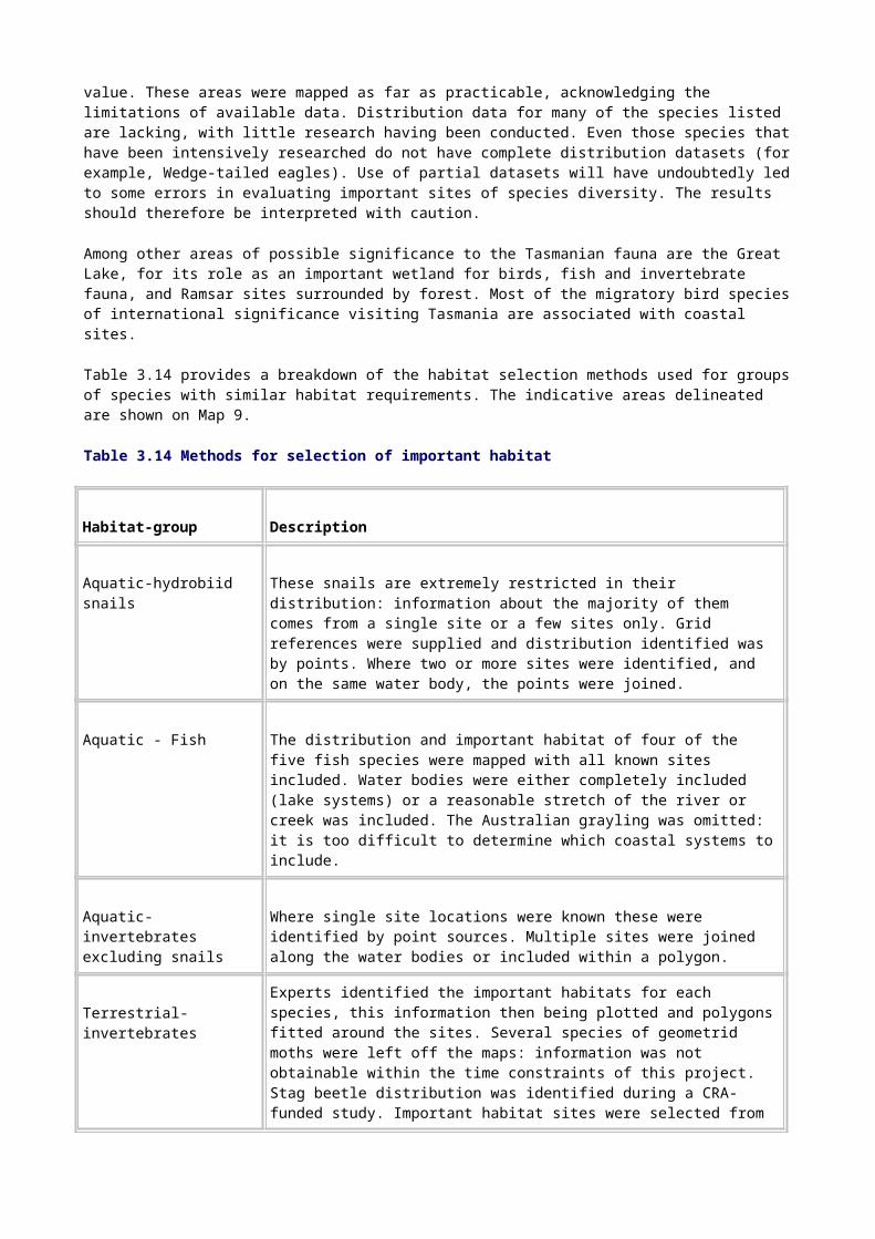
Duration of research
Continuing nature of research or monitoring, or both
Variety of research at the site (number of different research fields)
Publications relating to research at the site
The experts’ opinions about the value of the site
The number of experts who considered the site significant
Interlinking of the site with other research sites (for example, international monitoring networks)
Number of people taught
Level of teaching
Uniqueness of site for the teaching activity
Only sites deemed to be of high or very high significance were considered to meet the threshold. Not all sites could be adequately assessed within the time frame and resources of the project, so some sites of potential significance may have been omitted. Forty-five places were considered to meet the threshold (see Appendix R). These indicative places are shown on Map 5.

Chapter 4: National Estate outcomes
National Estate outcomes: cultural values
Future research: cultural values
National Estate outcomes: natural values
Future research: natural values
Conservation of National Estate values
National Estate outcomes
4.1 National Estate outcomes: cultural values
The National Estate assessment of the cultural values of Tasmania's forests
was designed to achieve the best practicable understanding of the range and distribution of cultural forest places within the time frame of the comprehensive regional assessment. The assessment was based on a study of historic, social and aesthetic values.
Indicative forest places of National Estate historic value were identified through a process of heritage data audit and analysis followed by a program of thematic and geographical studies. The following are among the main outcomes of the assessment of historic values:
• documented examples of all the main types of historic places found in or related to the forests of Tasmania;
• identification of over 70 new indicative National Estate forest places of historic value, including mining places, timber industry sites and transport routes;
• a greater understanding of historic places in the forests of Tasmania and their heritage significance;
• an overview of the current state of knowledge of historic places, regional surveys and documentation of places in heritage registers, which will inform the development of guidelines for future State heritage identification and management strategies.
The indicative National Estate forest places of social and aesthetic value, identified by the Tasmanian community, help to fill one of the major gaps in our understanding of National Estate forest values. The following are among the main outcomes of the assessment of social and aesthetic values:
• identification of over 60 indicative National Estate forest places of particular importance to the Tasmanian community;
• identification of a wide range of places, from small picnic sites to mountainous skylines, that provide the community with a sense of identity and attachment to the forests;
• a greater understanding of which places are valued by the community and why-this will be used to inform the development of conservation strategies for places of social significance to ensure this value is considered in forest management .

4.2 Future research: cultural values
The principal factors in identifying cultural forest places of potential National Estate significance were the standard of existing documentation for individual places and the extent to which new data could be gathered within the time frame of the comprehensive regional assessment. As a result, the National Estate studies of historic, social and aesthetic forest places, have identified and documented only a small portion of the potential National Estate forest places of cultural value.
Many historic places of potential National Estate significance in the forests of Tasmania could not be documented and assessed in the time available. Important historical themes and geographic regions that remain poorly studied were also identified by the assessment. Among the historic gaps are defence and military sites, manufacturing and processing sites, sites associated with hydro-electricity generation, and snaring and trapping sites. Among the
geographical gaps are private forested lands, the swampland forests of the north-west, the forests of the west coast and the south-west, and forested land in the upper Derwent Valley, on the fringes of the Central Plateau, and on the north-east and east coasts.
The community heritage workshops were an invaluable source of information about forest places of social and aesthetic importance to the Tasmanian community. The number of workshops and the scale at which the workshops could be conducted were, however, limited by the time and resources available for the comprehensive regional assessment. There will be many other places of social value to various community groups that were not represented at the workshops. These places can be identified in the future only through a community-based consultation process.
There are a number of potential National Estate places of aesthetic value for which there was insufficient information to make a final assessment. Further community consultation is necessary to clearly delineate and assess those areas that are of particular significance to the Tasmanian community.
The time available for the National Estate assessment did not allow for the detailed research needed to comprehensively assess places in terms of National Estate criterion F.1, relating to technical or creative achievement, or criterion H.1, relating to associations with important people. Further research focusing on these two values would enhance our understanding of some of the places already documented as well as help to identify other forest places of National Estate significance.
Aboriginal places of National Estate significance were not identified as part of the National Estate assessment. As discussed in Section 2.5, Aboriginal places of National Estate value need to be identified and assessed in consultation with the Aboriginal community, through a process acceptable to that community. These consultations will extend beyond the time frame for the comprehensive regional assessment, but the results of the consultations will be taken into account in the development of the Tasmania-Commonwealth Regional Forest Agreement.
4.3 National Estate outcomes: natural values
Assessment of the National Estate natural values of Tasmania's forests and associated areas encompassed a wide spectrum of attributes. Extensive and localised values, covering aspects of the flora and fauna as well as other features of the natural landscape (including geology, geomorphology, soils, wilderness and undisturbed catchments) were all examined. Much of the information used in the study was already present in Tasmania, albeit in some instances in a dispersed form. Collation of the data, together with additional work commissioned as part of the comprehensive regional assessment, provided a sound basis for improving understanding of the nature and disposition of National Estate natural values in Tasmania.
It should be noted that, because of the assessment's heavy on certain critical data layers, such as the forest community and old-growth GIS coverages, delays in the completion of the GIS coverages seriously limited the time available for the assessment. Not all values were able to
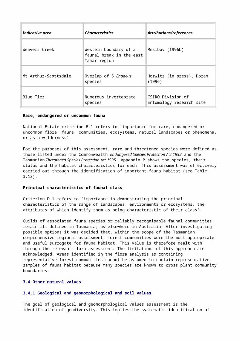
be examined and some not as exhaustively as might be wished. Nevertheless, the results of the assessment do represent a considerable enhancement of our understanding of the natural National Estate in Tasmania.
The following are among the main outcomes of the assessment of natural values:
• identification of many 1000s of indicative National Estate forest places, many of them overlapping and having significance for one or more natural values;
• a greater understanding of the forests of Tasmania and their natural heritage significance;
• a profile of the current state of scientific knowledge and opinion relating to Tasmanian natural places for use as a resource, in particular for the better appreciation and management of places of National Estate importance.
4.4 Future research: natural values
The assessment of natural values was as rigorous as information and time constraints permitted. Inevitably in a study of this scope, there are some values that have been incompletely assessed and some for which no attempt at assessment was possible. It was not possible, for example, to assess key habitat for rare, threatened or uncommon flora.
The steady accumulation of knowledge, particularly improvements in our understanding of the distribution of biota, may well result in refinements in the pattern of National Estate values established in this assessment. Species believed to be rare may prove to be more widespread than currently assessed. The discovery of new species, which is especially probable among the lower plants and invertebrates, may result in revisions of the thresholds for diversity, rarity and other values established in this study. Significant disjunctions, discovered as the result of improved survey, may become apparent. Concepts of critical habitat, including those of endangered species, will change with time as individual taxa are subjected to further research.
During the comprehensive regional assessment, for example, at least four species identified by the Invertebrate Advisory Committee (1994) as rare or threatened have been found to require reassessment. A recent study of the Mt Arthur burrowing crayfish has identified a greater distribution and presence in disturbed habitat, suggesting that a review of the species' conservation status is needed. In contrast, the Burnie burrowing crayfish Engaeus yabbimunna now seems almost definitely confined to a very restricted distribution and requires reassessment, possibly to be upgraded to endangered status. Invalid identifications of the snail Discocharopa vigens have led to the suggestion that the species be removed from the endangered species list (at least for the purposes of National Estate assessment). New information about the distribution of the north-western velvet worm Ooperipatellus "cryptus" has further increased its range.
It is anticipated that flora and fauna modelling, still under development, will prove useful for validating some of the species-based value identifications and for suggesting possible new areas of significance warranting further examination.
With an growing knowledge base, the assessment of broad landscape natural values is, in general terms, likely to be less mutable than some of the site-specific values. Even so, refinements will always be possible. In the old-growth layer, for example, small-scale changes are to be expected because it was not possible to field check all sites.
4.5 Conservation of National Estate values
One of the most important purposes of the Tasmanian RFA process is to provide certainty for both economic and environmental interests. Fundamental to this is ensuring that National Estate values are properly managed now and in the future. Two processes are being used to this end.

One process involves the assessment of ecologically sustainable forest management systems and processes; this has been done by an independent expert advisory group (see PLUC 1996c). The purpose of that assessment was to examine the legislative framework and determine whether suitable mechanisms exist for the conservation of environment and heritage values. All environment and heritage values were examined not just National Estate values.
The second process involves determining whether National Estate values are adequately identified and managed in Tasmania's forests, with three basic aims:
• to assess existing National Estate conservation principles and management regimes and identify any inadequacies or omissions;
• to inform the development of comprehensive and integrated conservation and management principles for National Estate values found to be present in Tasmania's forests;
• to ensure that the principles and management regimes that are developed are compatible with State legislation and, where appropriate, improve on current practices.
The results of these two assessment processes will contribute to the development of the Tasmania-Commonwealth Regional Forest Agreement.

References
Askey-Doran, M 1993, `Riparian Vegetation in the Midlands and eastern Tasmania', Parks and Wildlife Service, Hobart.
Austin, MP & Miller, DJ 1978, `Conservation', in MP Austin, & KD Cocks, (eds), Landuse of the South Coast of New South Wales: a study in acquiring and using information to analyse regional landuse options, CSIRO, Melbourne.
Australian Heritage Commission & Department of Conservation and Land Mangement 1992, National Estate Values in the Southern Forest Region, South-western Australia, vol.1-5, Australian Heritage Commission & CALM, AGPS, Canberra.
Australian Heritage Commission & Department of Natural Resources and Environment 1996, Methods Papers: East Gippsland National Estate assessment, vol.1, Natural Values., Australian Heritage Commission & Department of Conservation and Natural Resources, Canberra.
Australian Heritage Commission and Department of Conservation and Natural Resources 1994, National Estate Values in the Central Highlands of Victoria: draft project report , AGPS, Canberra.
Australian Nature Conservation Agency 1996, A Directory of Important Wetlands in Australia., 2nd edn, ANCA, Canberra.
Bacon, CA 1992, `Management of the Flora of the Mt Read RAP', Department of Mines, Hobart.
Barber, HN 1956, `The Natural History of Natural Selection,' Australian Journal of Science, vol. 18, pp. 148-59.
Barber, HN & Jackson, WD 1957, `Natural Selection in Action in Eucalyptus', Nature, vol. 179, pp. 1267-9.
Barker, MJ 1991, The Effect of Fire on West Coast Lowland Rainforest, Tasmanian National Rainforest Conservation Program report no. 7, Forestry Commission, Hobart.
Barker, P 1994, Phytophthora cinnamomi: the susceptibility and management of selected Tasmania rare species, Forestry Tasmania & Australian Nature Conservation Agency, Hobart.
Barker, P, Wardlaw,TJ & Brown, MJ 1996, `Selection and Design of Phytophthora Management Areas for the Conservation of Threatened Flora in Tasmania', Biological Conservation, vol. 76, pp.187-93.
Barlow, BA 1985, `A Revised Natural Regions Map for Australia', Brunonia, vol. 8, pp. 387-92.
Beadle, NCW 1981, The Vegetation of Australia, Cambridge University Press, Cambridge, UK.
Blackhall, SA 1984, `Moulting Lagoon Proposed Game Reserve: planning for the reservation and management of a wetland of international importance,' Project report, National Parks and Wildlife Service, Hobart.
Boland, DJ, Brooker, MIH, Chippendale, GM, Hall, N, Hyland, BPM, Johnston, RD, Kleinig, DA & Turner, JD 1985, Forest Trees of Australia , 4th edn, Thomas Nelson & CSIRO, Melbourne.
Bowden, AR & Kirkpatrick, JB 1974, `The Vegetation of the Rheban Spit, Tasmania', Papers and Proceedings of the Royal Society of Tasmania, vol. 108, pp. 199-210.

Bowman, DJMS & Brown, MJ 1986, `Bushfires in Tasmania: a botanical approach to anthropological questions', Archaeology in Oceania, vol. 21, pp. 168-71.
Bowman, DMJS & Jackson, WD 1981, `Vegetation Succession in Southwest Tasmania', Search, vol. 12, pp. 358-62.
Bradbury, J 1993, A Preliminary Geoheritage Inventory of the Eastern Tasmania Terrane, Report to Parks and Wildlife Service, Hobart.
Bradbury, J 1994, Significant Earth Heritage Sites on the Lower Gordon River, Report to Parks and Wildlife Service, Hobart.
Bradbury, J 1995, Continuation of Preliminary Inventory of Sites of Geoconservation Significance in Tasmania: central, northern and western Tasmania, Report to Parks and Wildlife Service, Hobart.
Brown, MJ 1988, Distribution and Conservation of King Billy Pine, Forestry Commission, Hobart.
Brown, MJ, Kirkpatrick, JB & Moscal, A 1983, An Atlas of Tasmania's Endemic Flora, Tasmanian Conservation Trust, Hobart.
Brown, MJ and Podger, FD 1982, `Floristics and Fire Regimes of a Vegetation Sequence from Sedgeland-Heath to Rainforest at Bathurst Harbour, Tasmania', Australian Journal of Botany, vol. 30, pp. 659-76.
Brown, PB & Wilson, RI 1981, `A Survey of the Orange-bellied Parrot in Tasmania, Victoria and South Australia', Report for World Wildlife Fund (Australia), National Parks and Wildlife Service, Hobart.
Brown, PB & Wilson, RI 1982, `The orange-bellied parrot', in RH Groves & WDL Ride (eds), Species at Risk: research in Australia, Australian Academy of Science, Canberra, pp. 107-15.
Brown, PB & Wilson, RI 1984, `Orange-bellied Parrot Recovery Plan: management recommendations to the Governments of Tasmania, Victoria and South Australia, Parks and Wildlife Service, Hobart.
Brown, PB, Wilson, RL, Loyn, RH & Murray, N 1985,'The Orange-bellied Parrot-an RAOU conservation statement, Report 14, RAOU, Melbourne.
Brown, R 1810, Prodromus. Florae Novae Hollandia et Insulae Van Diemen. (Englemann, Cramer,J &Weldon &Wesley Ltd, Weinheim, reprinted 1960)
Bryant, SL 1991, The Ground Parrot, Pezoporus wallicus, in Tasmania: distribution, density and conservation status, Wildlife Division scientific report 91/1, Parks and Wildlife Service, Hobart.
Busby, JR & Brown, MJ 1994, ‘Southern Rainforests’, in RH Groves (ed.), Australian Vegetation, 2nd edn, Cambridge University Press, Cambridge, UK.
Calver, CR 1996, `Bedrock Geological National Estate Values of the West Coast Range', Mineral Resources Tasmania, Hobart.
Cameron, DG 1992, `A Portrait of Victorian Rainforests: distribution, diversity and definition', in P Gell & D Mercer (eds), Victoria's Rainforests: perspectives on definition, classification and management, Monash Publications in Geography no. 41, Monash University Press, Melbourne, pp. 117-22.
Carnahan, JA 1990, Natural Vegetation: atlas of Australian resources, 3rd series, Department of National Resources, Division of National Mapping, Canberra.
Chapman, AD (1991) `Australian Plant Name Index', Australian Flora and Fauna Series, nos 12-15
Colhoun, EA & van de Geer, G 1988, `Darwin Crater, the King and Linda Valleys in Cainozoic Vegetation of Tasmania', Paper presented to the 7th International Palynological Congress, 28 August - 3 September, Brisbane.
Comprehensive Regional Assessment East Gippsland 1996, National Estate Report, Commonwealth and Victorian Regional Forest Agreement Steering Committee, Canberra.
Context Pty Ltd, Wise Lord Ferguson & Becker J 1996 `Tasmanian National Estate Social Values Project', Report to Tasmanian RFA Environment and Heritage Technical Committee, Context Pty Ltd & Wise Lord Ferguson & Jane Becker, Melbourne.
Cosgrove, R 1989, `Thirty Thousand Years of Human Colonisation in Tasmania: new Pleistocene dates', Science, vol. 243, pp. 1706-8.
Coy, R, Greenslade, P & Rounsevell, D 1993, A Survey of the Invertebrates in Tasmanian Rainforest, Report no. 9, National Rainforest Conservation Program, Hobart.
Cremer, KW 1965, `How Eucalypt Fruits Release their Seed', Australian Journal of Botany, vol. 13, pp. 11-16.
Cullen, PJ 1987, `Regeneration of Populations of Athrotaxis selaginoides D Don from Tasmania', Journal of Biogeography, vol. 14, pp. 39-51.
Cullen, P 1991, `Regeneration of Athrotaxis selaginoides and other Rainforest Species on Landslide Faces in Tasmania', in MR Banks et al. (eds), Aspects of Tasmanian Botany: a tribute to Winifred Curtis, Royal Society of Tasmania, Hobart, pp. 191-200.
Cullen, PJ & Kirkpatrick, JB 1988a, The Ecology, Distribution and Conservation of Athrotaxis D Don in Tasmania, Tasmanian Conservation Trust, Hobart.
Cullen, PJ & Kirkpatrick, JB 1988b, `The Ecology of Athrotaxis D Don (Taxodiaceae). I: stand structure and regeneration of A. cupressoides' Australian Journal of Botany, vol. 36, pp. 547-60.
Cullen, PJ & Kirkpatrick, JB 1988c, `The Ecology of Athrotaxis D Don (Taxodiaceae). II: the distributions and ecological differentiation of A. cupressoides and A. selaginoides', Australian Journal of Botany, vol. 36, pp. 561-73.
Davies, J 1983, Huon Pine Survey, Wildlife Division technical report no. 83/2, Parks and Wildlife Service, Hobart.
Dixon, G 1991, Earth Resources of the Tasmanian Wilderness World Heritage Area: a preliminary inventory of geological, geomorphological and soil features, Occasional paper no. 25, Department of Parks, Wildlife and Heritage, Hobart.
Dixon, G 1995, Aspects of Geoconservation in Tasmania: a preliminary review of significant earth features, Occasional paper no. 32, Parks and Wildlife Service, Hobart.
Dixon, G 1996, A Reconnaissance Inventory of Sites of Geoconservation Significance on Tasmanian Islands, Report to Parks and Wildlife Service, Tasmania, and Australian Heritage Commission, Canberra.
Dixon, N & Duhig, N 1996, `Compilation and Assessment of Some Places of Geoconservation Significance', Report to Tasmanian RFA Environment and Heritage Technical Committee, November.

Doran, N & Richards, K 1996, `Management Requirements for Rare and Threatened Burrowing Crayfish in Tasmania', Report to Tasmanian RFA Environment and Heritage Technical Committee, November.
Duncan, BD & Isaac, G 1986, Ferns and Allied Plants of Victoria, Tasmania and South Australia. Melbourne University Press, Melbourne.
Dyne, GR 1988, `Report on Fauna Survey (Oligochaeta), Western Tasmanian WHA February, 1988'. Directed wildlife research report, Parks and Wildlife Service, Hobart.
Eastoe, CJ 1979, Geological Monuments in Tasmania, The Geological Society of Tasmania Inc., Hobart.
Eberhard, SM, Richardson, AMM & Swain, R 1991, The Invertebrate Cave Fauna of Tasmania, University of Tasmania, Hobart.
Ellis, RC 1985 `The Relationships among Eucalypt Forest, Grassland and Rainforest in a Highland Area in North-eastern Tasmania, Australian Journal of Ecology, vol.10, pp. 297-314.
Enright NJ & Hill, RS 1995, Ecology of the Southern Conifers, Melbourne University Press, Melbourne.
Flora Advisory Committee 1994, `Native higher plant fauna which are rare or threatened in Tasmania', Species at Risk, Tasmania, 1st edn, Parks and Wildlife Service, Tasmania.
Forestry Commission 1990, A Manual for Forest Landscape Management, Forestry Commission of Tasmania, Hobart.
Forestry Tasmania 1995 An Overview of the Warra Long Term Ecological Research and Monitoring (LTERM) Site, Forestry Tasmania, Hobart.
Fulton, W 1988, Further Collections of Freshwater Fauna from the World Heritage Area, Tasmania, Occasional report no. 88-03, Inland Fisheries Commission, Hobart.
Fulton, W & Richardson, AMM (eds) 1987, The Freshwater Fauna of the World Heritage Area, Tasmania, Directed wildlife research report for Parks and Wildlife Service, Inland Fisheries Commission, Hobart.
Galloway, RW & Kemp, EM 1981, `Late Cainozoic Environments in Australia', in A Keast (ed.), Ecological Biogeography of Australia', vol.I, Part 1, ch. 4, `Development of Environment', Dr W Junk Publishers, The Hague-Boston-London, pp. 51-80.
Garrett, M 1996, The Ferns of Tasmania:: their ecology and distribution, Forest Research Council, Hobart.
Gaughwin, D 1991, `North-East Tasmania: Historic Sites Inventory Project', Forestry Commission of Tasmania, Hobart.
Gibson, N, Williams, K, Marsden-Smedley, J & Brown, MJ 1987, `Regeneration Characteristics of a Swamp Forest in Northwestern Tasmania'. Papers and Proceedings of the Royal Society of Tasmania, vol. 93, pp. 129-51.
Gilbert, JM 1959, `Forest succession in the Florentine Valley, Tasmania', Papers and Proceedings of the Royal Society of Tasmania, vol. 93, pp. 129-151.
Gilbert, JM 1978, Lower Gordon River Scientific Survey: forest types and fire history, Hydro Electric Commission, Hobart.

Green, RH 1930, A Catalogue of Tasmanian Birds, Foot & Playstead, Launceston.
Green, RH 1961, `Birds of Port Davey and the South Coast of Tasmania', Emu vol. 61, pp. 223-36.
Green, RH 1977, `The Vertebrate Fauna of Maggs Mountain, Tasmania', Records of the Queen Victoria Museum , vol. 58, pp. 1-40.
Green, RH 1979, `A Survey of the Vertebrate Fauna of the Sumac Forest and the Dempster Plains, North-west Tasmania', Records of the Queen Victoria Museum, vol. 65, pp. 1-9.
Green, RH 1982, `The Activity and Movement of Fauna in Compartment 2, Maggs Mountain, Tasmania, in the First Five Years of Forest Regeneration', Records of the Queen Victoria Museum, vol. 75, pp. 1-31.
Green, RH 1987, Dipterous Insects Parasitic on Tasmanian Animals: Fam. Chloropidae, Muscidae, Hippoboscidae, Queen Victoria Museum, Launceston.
Green, RH 1989, Birds of Tasmania: an annotated checklist with photographs, Potoroo Publishing, Launceston.
Green, RH 1993, The Fauna of Tasmania: mammals. Potoroo Publishing, Launceston.
Harle, KJ, Kershaw, AP, Macphail, MK, & Neyland, MG 1993, `Palaeoecological Analysis of an Isolated Stand of Nothofagus cunninghamii (Hook.) Oerst. in Eastern Tasmania', Australian Journal of Ecology, vol. 18, part 2, pp. 161-70.
Harris, S 1989, `The Ecological Biogeography of Callitris vent. in Tasmania', MSc thesis, University of Tasmania, Hobart.
Harris S 1994, `Atlas of Callitris in Tasmania', National Parks and Wildlife Service, Hobart.
Harris, S & Kirkpatrick, JB 1991a, `The Distributions, Dynamics and Ecological Differentiation of Callitris Species in Tasmania', Australian Journal of Botany, vol. 39, pp. 187-202.
Harris, S & Kirkpatrick, JB 1991b, `The Phytosociology and Synecology of Tasmanian Vegetation with Callitris', in MR Banks et al. (eds), Aspects of Tasmanian Botany: a tribute to Winifred Curtis, Royal Society of Tasmania, Hobart, pp. 179-89.
Heyligers, PC 1975, `Biological and Ecological Aspects Related to Forestry Operations of the Export Woodchip Industry', Report of the Working Group on the Economic and Environmental Effects of the Export Hardwood Woodchip Industry. Vol. 2: attachments, AGPS, Canberra, pp. 77-119.
Hickey, JE & Felton, KC 1987, `Management of Tasmanian Cool Temperate Rainforest', in FM McKinnell, ER Hopkins & FE Batini, Forest Management in Australia, Proceedings of 12th Conference of the Institute of Foresters of Australia, Institute of Foresters of Australia, Perth.
Hill, RS 1995, Tertiary Fossil Deposits of North-western and North-eastern Tasmania, National Estate Grants Program report no. 9427, University of Tasmania, Hobart.
Hope, GS 1992, `Rainforests in Southeastern Australia: the establishment of the modern boundaries', in P Gell & D Mercer (eds),Victoria's Rainforests: perspectives on definition, classification and management, Monash Publications in Geography no. 41, Monash University, Melbourne, pp. 117-22.
Horwitz, P 1988, `The Distributions of some Subterranean Syncarid Crustaceans in Southern and Western Tasmania', University of Tasmania, Hobart.
Horwitz, P (in press) `Biogeographical Affinities of Macrocrustacean Groups in Northeast Tasmania', Memoirs of Queen Victoria Museum, Launceston.
Houshold, I 1994, `Conservation of Sites Illustrating Geological, Geomorphological and Pedological Processes', Discussion paper, Parks and Wildlife Service, Hobart.
Houshold, I, Sharples, C, Dixon, G & Duhig, N (in prep.) `Georegionalisation-a conceptual and spatial tool for the identification of places of geoconservation significance', in Pattern and Process, Report of a workshop on National Estate assessment of geological and geomorphological values, Australian Heritage Commission, Canberra, 26 July 1996.
Hurburgh, M 1961, Mt Field National Park: notes on some botanical species to be found on the Russell Falls and Falls Creek Tracks, Tasmanian Government Tourism Department & Mt Field National Park Board, Hobart.
Invertebrate Advisory Committee 1994, `Interim List of Native Invertebrates which are Rare or Threatened in Tasmania' 1st edn, Parks and Wildlife Service, Tasmania.
Jackson, WD 1968, `Fire, Air, Water and Earth-an elemental ecology of Tasmania', Proceedings of the Ecological Society of Australia, vol. 3, pp. 9-16.
JANIS 1996, Proposed Nationally Agreed Criteria for the Establishment of a Comprehensive, Adequate and Representative Reserve System for Forests in Australia, Canberra.
Jarman, SJ 1988, `Bryophytes from Weindorfers Forest, Cradle Valley', Report to World Heritage Planning Team, Hobart.
Jarman, SJ & Kantvilas, G 1994, `Lichens and Bryophytes of the Tasmanian World Heritage Area. II: three forest sites at Pelion Plains', Tasforests , September, pp. 103-20.
Jarman, SJ, Brown, MJ & Kantvilas, G 1984, Rainforest in Tasmania, Parks and Wildlife Service, Hobart.
Jarman, SJ, Kantvilas, G & Brown, MJ 1988, A Preliminary Study of Stem Ages in Buttongrass Moorlands, Research report no. 3, Tasmanian Forest Research Council Inc., Hobart.
Kantvilas, G 1988, The Lichens of Weindorfers Forest, Cradle Mountain , Report to Department of Lands, Parks and Wildlife, Hobart.
Kantivilas, G 1994, `A revised checklist of the Tasmanian lichen flora', Muelleria vol. 8, pp 155-75.
Kantlivas, G 1995, `Alpine Lichens of Tasmania's Southwest Wilderness. Lichenologist ,vol. 27, pp. 433-49.
Kantvilas, G & Jarman, SJ 1993, `The Cryptogamic Flora of an Isolated Rainforest Fragment in Tasmania', Botanical Journal of the Linnean Society, vol. 111, pp. 211-28.
Kantvilas, G & Minchin, PR 1989, `An Analysis of Epiphytic Lichen Communities in Tasmanian Cool Temperate Rainforest', Vegetation, vol. 84, pp. 99-112.
Keast, A (ed.) 1981, Ecological Biogeography of Australia, vol. I, part 1, `Development of Environment', Dr W Junk Publishers, The Hague-Boston-London.
Kershaw, P 1992, `The Development and History of Temperate Zone Rainforests in Australia', in P Gell & D Mercer (eds), Victoria's Rainforests: perspectives on definition, classification and management., Monash Publications in Geography no. 41, Monash University, Melbourne, pp. 107-16.

Kiernan, K 1995, An Atlas of Tasmanian Karst, Research report no. 10, Tasmanian Forest Research Council, Hobart.
Kiernan, K (in prep.), `Landform Classification for Geoconservation', in Pattern and Process, Report of a workshop on National Estate assessment of geological and geomorphological values, Australian Heritage Commission, Canberra, 26 July 1996.
Kirkpatrick, JB 1986, `The Viability of Bush in Cities-ten years of change in an urban grassy woodland', Australian Journal of Botany, vol. 34, pp. 691-708.
Kirkpatrick, JB 1993, `Dry Coastal Ecosystems of Southeastern Australia, in E van der Maarel (ed.), Ecosystems of the World , Elsevier,Amsterdam, pp. 273-88.
Kirkpatrick, JB & Bowman, DMJS 1984a, `Altitudinal and Successional Variation in the Vegetation of the Northern Part of the West Coast Range, Tasmania', Australian Journal of Ecology, vol. 9, pp. 81-91.
Kirkpatrick, JB & Brown, MJ 1984a, `The Palaeographic Significance of Local Endemism in Tasmanian Higher Plants', Search, vol. 15 nos.3-4, pp. 112-13.
Kirkpatrick, JB & Brown, MJ 1984b, `A Numerical Analysis of Tasmanian Higher Plant Endemism' Botanical Journal of the Linnean Society, vol. 88, pp. 265-83.
Kirkpatrick, JB & Brown, MJ 1991, Reservation analysis of Tasmanian forests, in Forest and Timber Inquiry Consultancy Series , No. FTC 91/1, Resource Assessment Commission, Canberra.
Kirkpatrick JB & Dickinson, KJM 1984, `1:500 000 Vegetation Map of Tasmania', Forestry Commission, Hobart.
Kirkpatrick JB & Fowler, M 1996, `Refugial Sites for Flora in Tasmania: testing a methodology', National Estate Grants Program report to Australian Heritage Commission, Canberra.
Kirkpatrick, JB & Marks, F 1985, `Observation of Drought Damage to Some Native Plant Species in Eucalypt Forest and Woodland in Hobart, Tasmania', Papers and Proceedings of the Royal Society of Tasmania, vol. 119, pp. 15-21.
Kostoglou, P 1991, `Wielangta State Forest: an archaeological survey of the historic timber industry',Archaeology of the Tasmanian Timber Industry, Report no. 1, Forestry Commission of Tasmania, Hobart.
Kostoglou, P 1992, `Mount Horror State Forest: an archaeological survey of the historic timber industry', Archaeology of the Tasmanian Timber Industry, Report no. 2, Forestry Commission of Tasmania, Hobart.
Kostoglou, P 1993, `Sidling Range State Forest: an archaeological survey of the historic timber industry', Archaeology of the Tasmanian Timber Industry, Report no. 3, Forestry Commission of Tasmania, Hobart.
Kostoglou, P 1994a, `Historic Timber-getting between Cockle Creek and Lune River, Block 1', Archaeology of the Tasmanian Timber Industry, Report no. 4, Forestry Commission of Tasmania, Hobart.
Kostoglou, P 1994b, `Historic Timber-getting between Hastings and Dover, Block 2', Archaeology of the Tasmanian Timber Industry, Report No. 5, Forestry Commission of Tasmania, Hobart.
Kostoglou, P 1995a, `Historic Timber-getting between Glendevie and Franklin, Block 3', Archaeology of the Tasmanian Timber Industry, Report no. 6, Forestry Commission of Tasmania, Hobart.
Kostoglou, P 1995b, `Historic Timber-getting on Bruny Island', Archaeology of the Tasmanian Timber Industry, Report no. 7, Forestry Commission of Tasmania, Hobart.
Kostoglou, P & Pearson, M 1996, `Regional Forest Agreement Cultural Heritage Identification and Assessment: stages 2 and 3. Study 1: historic timber getting Circular Head district of north-western Tasmania', Report to Tasmanian RFA Environment and Heritage Technical Committee, Heritage Management Consultants, Canberra.
Lacey, CJ 1972, Factors Influencing the Occurrence of Cypress Pine Regeneration in New South Wales, Technical paper no. 21, Forestry Commission, Sydney.
Lesslie, R & Maslen, M 1995, National Wilderness Inventory Australia: handbook of procedure, content and usage, 2nd edn, AGPS, Canberra.
Lincoln, M 1994a `Sassafras Ridge Sinkhole Features and their Ecological Communities', Illuminations, vol. 3, p. 33.
Lincoln, M & Dalton P 1994b, `The Ferns and Bryophytes of Sassafras Ridge', Illuminations, vol. 3, pp. 29-32.
Margules, C & Usher, MB 1981, `Criteria Used in Assessing Wildlife Conservation Potential: a review', Biological Conservation, vol. 21, pp. 79-109.
Marshall, D & Pearson, M 1996a, `Regional Forest Agreement Cultural Heritage Identification and Assessment: stages 2 and 3. Study 2: sample of place types in forests', Report to Tasmanian RFA Environment and Heritage Technical Committee, Heritage Management Consultants, Canberra.
Marshall, D & Pearson, M 1996b, `Regional Forest Agreement Cultural Heritage Identification and Assessment: stage 4. Conservation Principles and Advice for Cultural National Estate Values', Report to Tasmanian RFA Environment and Heritage Technical Committee, Heritage Management Consultants, Canberra.
Martin, D 1940, `The Vegetation of Mt Wellington, Tasmania: the plant communities and a census of the plants', Papers and Proceedings of the Royal Society of Tasmania, pp. 97-124.
McNeely, JA, Miller, KR, Reid, WV, Mittermeier, RA & Werner, TB 1990, Conserving the World's Biological Diversity, IUCN, Gland, Switzerland.
Mesibov, R 1990, `Velvet Worms: a special case of invertebrate conservation', Tasforests, vol. 2, pp. 53-5.
Mesibov, R 1992, `Recommended Areas for Protection of Swamp Forest in Northwest Tasmania', Report to Working Group for Forest Conservation, October.
Mesibov, R 1996, `Proposed Listing on the Register of the National Estate: identification and assessment of a natural place, Weavers Creek', Report to Australian Heritage Commission, Canberra.
Mesibov, R 1996a, `Old-growth Assessment: old-growth swamp forest in Circular Head Forest District' in PLUC 1996Environment and Heritage Report, Background Report Part C vol. II, app. W, Public Land Use Commission, Hobart.

Mesibov, R 1996b, `Invertebrate Bioregions in Tasmania', Report to Tasmanian RFA Environment and Heritage Technical Committee, December 1996.
Mitchell, P 1990, The Environmental Conditions of Victorian Streams., Department of Water Resources, Melbourne.
Mittermeier, RA & Werner, TB 1990, `Wealth of Plants and Animals in "megadiversity" countries',Tropicus, vol. 4, no. 1, pp. 1, 4-5.
Moore, NW 1988, `Dragonflies in the World Heritage Area, Tasmania', Directed wildlife research report, Parks and Wildlife Service, Hobart.
Neboiss, A, Jackson, J & Walker, K 1988, `Trichoptera (Caddis-flies) of the World Heritage Area in Tasmania', Directed wildlife research report, Parks and Wildlife Service, Hobart.
Neyland, MG 1991, `Relict Rainforest in Eastern Tasmania', Tasmanian National Rainforest Conservation Project technical report no. 6, Hobart.
Nix, HA 1982, `Environmental Determinants of Biogeography and Evolution in Terra Australis, in WR Barker & PJM Greenslade (eds), Evolution of the Flora and Fauna of Arid Australia, Peacock, Adelaide, pp. 47-66.
Ogden, J & Powell, JA 1979, `A Quantitative Description of the Forest Vegetation on an Altitudinal Gradient in the Mount Field National Park, Tasmania, and a discussion of its history and dynamics', Australian Journal of Ecology, vol. 4, part 3, pp. 293-326.
Olesen, A 1995, Studies on a Forest Boundary on Maria Island, Tasmania, Parks and Wildlife Service, Hobart.
Olesen, A, Harris, S & Allen, K. (in prep.) `The Significance of a Forest Boundary on Maria Island', Parks and Wildlife Service, Hobart.
Packham JM 1991, Myrtle Wilt, Forestry Commission, Hobart.
Pannell, JR 1992, Swamp Forests of Tasmania, Forestry Commission, Hobart.
Parham, D 1992, `South-East Tasmania: historic sites inventory project', Report, Forestry Commission Tasmania, Hobart.
Paton, DM 1980, `Eucalyptus physiology. II: temperature responses', Australian Journal of Botany, vol. 28, pp. 555-6.
Paton, DM 1981, `Eucalyptus physiology. III: `frost resistance', Australian Journal of Botany, vol. 29, pp. 675-88.
Pearson, M & Champion, S 1996a, `Regional Forest Agreement Cultural Data Audit and Analysis', Report to Tasmanian RFA Environment and Heritage Technical Committee, Heritage Management Consultants, Canberra
Pearson, M & Champion, S 1996b, `Regional Forest Agreement Cultural Heritage Identification and Assessment: stages 2 and 3. Study 3: mining sites', Report to Tasmanian RFA Environment and Heritage Technical Committee, Heritage Management Consultants, Canberra.
Pearson, M & Young, D 1996, `Regional Forest Agreement Cultural Heritage Identification and Assessment: stages 2 and 3. Study 4: transportation routes', Report to Tasmanian RFA Environment and Heritage Technical Committee, Heritage Management Consultants, Canberra.
Peterson MJ 1990, Distribution and Conservation of Huon Pine, Forestry Commission, Tasmania.
Pettigrove, V 1987, `The Chironomidae (Diptera) of Tasmania, with Particular Reference to the World Heritage Area', Directed wildlife research report, Parks and Wildlife Service, Hobart.
PLUC 1996a Environment and Heritage Report, Background Report Part C, 4 vols, Public Land Use Commission, Hobart.
PLUC 1996b, Social and Economic Report, Background Report Part D, 3 vols, Public Land Use Commission, Hobart.
PLUC 1996c, Assessment of Ecologically Sustainable Forest Management Systems and Processes: Independent Expert Advisory Group Final Background Report Part G, Public Land Use Commission, Hobart.
Podger, FD, Bird, T & Brown, MJ 1989, `Human Activity, Fire and Change in the Forest at Hogsback Plain, Southern Tasmania', in KJ Frawley & NM Semple (eds), Australia’s Everchanging Forests, Department of Geography and Oceanography, Australian Defence Force Academy, Canberra, pp. 119-40.
Ponder, WF, Clark, GA, Miller, AC & Toluzzi, A 1993, `On a Major Radiation of Freshwater Snails in Tasmania and eastern Victoria: a preliminary overview of the Bedommeia group (Mollusca: Gastropoda-Hydrobiidae), Invertebrate Taxonomy, vol. 7, pp. 501-750.
Potts, BM 1983, `Variation in the Eucalyptus gunnii-archeri complex', PhD thesis, University of Tasmania.
Prendergast, JR, Wood, SN, Lawton, JH & Eversham, BC 1993, `Correcting for Variation in Recording Effort in Analyses of Diversity Hot Spots', Biodiversity Letters , vol. 1, pp. 39-53.
Ramsay, HP &Seur,J 1994, `Register of Type Specimens of Mosses in Australian Herberia', Flora of Supplementary Series no. 2 Australian Biological Resources Study, Canberra.
Ratkowsky, AV, James, PW, Archer, AW, Kantvilas, G & Ratkowsky, DA 1989, `Macrolichens of Mount Wellington, Tasmania', Papers and Proceedings of the Royal Society of Tasmania,, vol. 123, pp. 119-25.
Ratkowsky, DA & Ratkowsky, AV 1976, Changes in the Abundance of the Vascular Plants of the Mt Wellington Range, Tasmania, following a Severe Fire', Papers and Proceedings of the Royal Society of Tasmania, vol. 110, pp. 63-90.
Ratkowsky, DA & Ratkowsky, AV 1977, `Plant Communities of the Mt Wellington Range, Tasmania', Australian Journal of Ecology, vol. 2, pp. 435-45.
Ratkowsky, DA & Ratkowsky, AV 1982a, `The Bryophytes of the Mt Wellington Range, Tasmania', Papers and Proceedings of the Royal Society of Tasmania , vol. 116, pp. 97-115.
Ratkowsky, DA & Ratkowsky, AV 1982b, `Some Noticable Changes in the Vegetation of Mt Wellington Since the 1967 Bushfire', Tasmanian Naturalist, vol. 70, pp. 2-5.
Raven, RJ 1987, `The Spider Fauna of Tasmania's World Heritage Area', Directed wildlife research report, Parks and Wildlife Service, Hobart.
Richards, BN, Bridges, RG, Curtin, RA, Nix, HA, Shepherd, KR & Turner, J 1990, `Biological Conservation of the South-East forests', Report of the Joint Scientific Committee. Canberra.
Richardson, AMM & Swain, R 1988, `Freshwater and Terrestrial Crustacea Collection in 1987-8', Directed wildlife research report, Parks and Wildlife Service, Hobart.

Robertson, DI & Duncan F 1991, Distribution and Conservation of Deciduous Beech, Forestry Commission, Tasmania.
Robson, BJ (1996), `Small Spate Disturbance and the Complexity of Habitat Architecture in Mountain River, Tasmania', Australian Journal of Marine Freshwater Res. vol 47, pp.851-55.
Rosengren, N 1994, `The Newer Volcanic Province of Victoria, Australia: the use of an inventory of scientific significance in the management of scoria and tuff quarrying', in D O'Halloran, C Green, M Harley, M Stanley & J Knill (eds), Geological and Landscape Conservation, Geological Society, London, pp. 105-110.
Savva, M, Potts, BM & Reid, JB 1988, `The Breeding System and Gene Flow in Eucalyptus urnigera', in RB Knox, MB Sing & LF Troiani (eds), Pollination '88, Plant Cell Biology Research Centre, University of Melbourne, pp. 176-82.
Schmidt, ER 1988, `Aboreal Psocoptera from the Tasmanian World Heritage Area', Directed wildlife research report, Parks and Wildlife Service, Hobart.
Schwaner, T, Hutchinson, M & Medlock, K 1987, `Distribution, Systematic Relationships and Genetic Variation in the Herpetofauna of the Western Tasmanian World Heritage Area-a preliminary study with particular emphasis on endemic lizards and frogs', Directed wildlife research report, Parks and Wildlife Service, Hobart.
Scripps, L 1990, `North-West Tasmania: historic sites inventory project', Forestry Commission of Tasmania, Hobart.
Sharples, C 1993, A Methodology for the Identification of Significant Landforms and Geological Sites for Geoconservation Purposes, Forestry Commission, Tasmania.
Sharples, C 1994a, Landforms and Geological Sites of Geoconservation Significance in the Huon Forest District, 2 vols, Report to Forestry Tasmania, Hobart.
Sharples, C 1994b, A Reconnaissance of Landforms and Geological Sites of Geoconservation Significance in the North-east Tasmanian Forest Districts (Eastern Tiers and Bass Forest Districts), 2 vols, Report to Forestry Tasmania, Hobart.
Sharples, C 1995a, A Reconnaissance of Landforms and Geological Sites of Geoconservation Significance in the State forests of Eastern Tasmania (parts of Derwent and Eastern Tiers Forest Districts), 2 vols, Report to Forestry Tasmania, Hobart.
Sharples, C 1995b, `Geoconservation in Forest Management-principles and procedures, Tasforests, vol. 7, pp. 37-50.
Sharples, C 1996a, A Reconnaissance of Landforms and Geological Sites of Geoconservation Significance in the Murchison Forest District, 2 vols, Report to Forestry Tasmania, Hobart.
Sharples, C 1996b, A Reconnaissance of Landforms and Geological Sites of Geoconservation Significance in the Circular Head Forest District, 2 vols, Report to Forestry Tasmania, Hobart.
Sharples, C (in press) A Reconnaissance of Landforms and Geological Sites of Geoconservation Significance in the Mersey Forest District, 2 vols, Report to Forestry Tasmania, Hobart.
Sharples, C (in press) A Reconnaissance of Landforms and Geological Sites of Geoconservation Significance in the West Derwent Forest District, 2 vols, Report to Forestry Tasmania, Hobart.
Smithers, CN 1987, `Pscoptera', Directed wildlife research report, Parks and Wildlife Service, Hobart.

Swain, R & Reed, C I 1983, `Observations on the life history and ecology of Anaspides tasmaniae (Thomson) Syncarida: Anaspidae, Journal of Crustacean Biology, vol. 3, pp. 163-172.
Tait, NN & Briscoe, DA 1987, `Onycophora in Tasmania', Directed wildlife research report, Parks and Wildlife Service, Hobart.
Thackway, R & Cresswell, ID 1995, An Interim Biogeographic Regionalisation for Australia, Australian Nature Conservation Agency, Canberra.
Thomas, DA & Barber, HN 1974a, Studies on Leaf Characteristics of a Cline of Eucalyptus urnigera from Mt Wellington, Tasmania. I: Water repellancy and the freezing of leaves', Australian Journal of Biology, vol. 22, pp. 501-12.
Thomas, DA, & Barber, HN 1974b, `Studies on Leaf Characteristics of a Cline of Eucalyptus urnigera from Mt Wellington, Tasmania. II: Reflection, transmission and absorption of radiation', Australian Jornal of Biology, vol. 22, pp. 701-7.
Thomas, DH 1965, `Physiological Aspects in Natural Selection in the Cline of Eucalyptus urnigera.', PhD thesis, University of Tasmania, Hobart.
Timms, BV 1987, `Microcrustaceans', Directed wildlife research report, Parks and Wildlife Service, Hobart.
Turner, NJ 1990, `Earth Resources Inventory-World Heritage Area', Report 1990/27.37, Division of Mines, Hobart.
Usher, MB 1986, `Wildlife Conservation Evaluation: attributes, criteria and values', in MB Usher (ed.), Wildlife Conservation Evaluation., Chapman & Hall, London.
Walker, KL 1988, `Native Bee (Hymenoptera: Apoidea) Fauna in World Heritage Area', Directed wildlife research report, Parks and Wildlife Service, Hobart.
Watson, GF & Littlejohn, MJ 1988, `Anuran Amphibians', Directed wildlife research report, Parks and Wildlife Service, Hobart.
Whinam, J & Kirkpatrick, JB 1995, `Successional Sequences in two Tasmanian Valley Sphagnum Peatlands', Journal of Vegetation Science, vol. 6, pp. 675-82.
Whinam, J, Eberhard, S, Kirkpatrick JB & Moscal, T 1989, Ecology and Conservation of Tasmanian Sphagnum Peatlands, Tasmanian Conservation Trust Inc., Hobart.
Wiltshire, RJE, Potts, BM & Reid, JB 1991, `A Paedomorphocline in Eucalyptus: natural variation in the E. risdonii/E. tenuiramis complex', Australian Journal of Botany, vol. 39, pp. 545-66.
Wiltshire, RJE, Potts, BM & Reid, JB 1992, `A Paedomorphocline in Eucalyptus. II. Variation in seedling morphology in the E . risdonii/tenuiramis complex', Australian Journal of Botany, vol. 40, pp. 789-805.
Winsor, L 1988, `Terrestrial Flatworms', Directed wildlife research report, Parks and Wildlife Service, Hobart.
Woolward, S, 1983, `The Dynamics of Gully Scrub in Hobart', Honours thesis, Geography Department, University of Tasmania, Hobart.
Young D 1996, `Regional Forest Agreement Aesthetic Values Identification and Assessment. Stage 1: key artistic and creative sources', Report to Tasmanian Environment and Heritage Technical Committee, Jane Lennon and Associates, Queensland.
Glossary
aeolian
related to the effects of moving air, especially wind currents. Sand dunes and lunettes are aeolian landforms.
ARC/INFO
software used to display and analyse spatially represented data.
assemblages
collections of populations of different species that live in the same area.
biodiversity
see biological diversity.
biological diversity
the variety of all life forms: the different plants, animals and micro-organisms, the genes they contain, and the ecosystems they form. Biological diversity is usually considered at three levels: genetic diversity, species diversity, and ecosystem diversity. It is sometimes considered at the level of landscape diversity.
biophysical
a combination of physical features, such as climate, soils, geology and landforms, and biological features, such as flora and fauna.
bioregion
a region defined by a combination of biological, social and geographic criteria rather than geopolitical criteria; generally, a system of related, interconnected ecosystems.
bryophytes
liverworts, mosses and hornworts: green, non-vascular land plants without seeds, numbering at least 18 000 species. They are among the simplest of the terrestrial plants but occupy a variety of habitats and show considerable diversity.
cirque
a hill-flank hollow formed as a result of erosion by the head of a glacier.
comprehensive, adequate and representative reserve system
a reserve system displaying the features of comprehensiveness, adequacy and representativeness.
comprehensiveness-the degree to which the full range of ecological communities and their biological diversity is incorporated in the reserve system.
adequacy-the reserve system's ability to maintain the ecological viability and integrity of populations, species and communities.

representativeness-the extent to which areas selected for inclusion in the reserve system are capable of reflecting the known biological diversity and ecological patterns and processes of the ecological community or ecosystem concerned.
clear-felling
a logging system that results in the felling of all standing trees.
comprehensive regional assessment
a joint Commonwealth-State assessment of all forest values-environmental, heritage, economic and social-leading to the establishment of a comprehensive, adequate and representative reserve system, agreements on forest management, and the signing of a regional forest agreement.
conservation
the protection, maintenance, management, sustainable use, restoration and enhancement of the natural environment.
conservation advice and principles
the Australian Heritage Commission has a statutory obligation to provide advice on the protection of the National Estate. The advice is based on conservation principles that are aimed at protecting and maintaining National Estate places and values. Advice is available for land management agencies and individuals who own places that have been identified as having National Estate value.
context
the position of a feature or area in the landscape relative to the rest of the landscape or topographic features, other vegetation or disturbance. For example, some values such as old-growth forest need to be considered in context; that is, in terms of their relationship to disturbance, other vegetation and the landscape in general.
criteria
used by the Australian Heritage Commission to determine whether places meet the requirements for listing on the Register of the National Estate. The criteria are stipulated in the Australian Heritage Commission Act 1975.
disjunct
populations physically separated from one another; that is, there is no or minimal gene flow between the populations. They are formed over time as a result of the appearance of a barrier in a formerly continuous distribution. Disjunct populations often have features that are distinctive in an evolutionary sense from those of the 'parent' population and in time may become separate species.
disturbance
encompasses a range of factors that affect the condition of natural areas. Disturbance may be natural or human induced. Natural disturbance includes wildfires and rainstorms and is part of natural ecological processes. Human-induced, or 'unnatural', disturbance includes timber harvesting, agricultural clearing, mining and grazing. The factors that are important when considering disturbance are the origin, duration and intensity of the disturbance and its impact on the environment.
disturbance data

records of disturbances such as clearing, grazing, fire or timber harvesting that may affect themes, species or assemblages being assessed.
diversity
a measure of the physical or biological complexity of a system. It refers to a range of features, from artefact scatters to species presence.
ecological vegetation classes
the components of a vegetation classification system, being vegetation communities grouped together according to floristic, structural and ecological characteristics.
ecosystem
a set of normally co-occurring and interacting species associated with a particular setting in the physical environment.
the aggregate of plants, animals and other organisms, and the non-living parts of the environment with which these organisms interact.
a dynamic complex of plant, animal, fungal, and micro-organism communities and the associated non-living environment interacting as an ecological unit.
endemic species
species confined to a specific region or locality.
fluvial
related to the effects of water in terrestrial environments. A valley is a fluvial landform.
forest
in the context of the Tasmania-Commonwealth Regional Forest Agreement, an area, incorporating all living and non-living components, that is dominated by trees having usually a single stem and a mature or potential mature stand height exceeding 8 metres and with existing or potential projective cover of overstorey strata about equal to or greater than 5 per cent.
forest community
a vegetation classification that subdivides a forest type by either structure or understorey floristic composition.
forest type
a vegetation classification defined by the dominant overstorey species.
genetic diversity
the variety of genetic information contained in all individual plants, animals and micro-organisms. It occurs within and between populations of species as well as between species.
geoconservation

the identification and protective management of geological, geomorphological and soil features, assemblages, systems and processes (geodiversity) for their intrinsic, ecological or heritage values.
geodiversity
the natural range (diversity) of geological (bedrock), geomorphological (landform) and soil features, assemblages, systems and processes. Geodiversity includes evidence for the history of the earth (evidence of past life, ecosystems and environments) and a range of processes (biological, hydrological and atmospheric) currently acting on rocks, landforms and soils.
geographic information system
a system displaying spatially represented data; for example, Idrisi for Windows and ARC/INFO.
geoheritage
those components of geodiversity that are important to humans for purposes other than destructive exploitation; things we would wish to retain for present and future generations.
geology
the scientific study of the bedrock composition of the earth, including its origin, structure, composition, history, and past and present processes. Geological features contribute to geodiversity.
geological characteristics
features and structures associated with the formation of the earth's crust as well as major landform units such as mountains.
geomorphology
the scientific study of landforms-the surface morphology of bedrock substrates-and the past and present processes responsible for landform development. Geomorphological features contribute to geodiversity.
georegion
a land unit likely to illustrate distinctive geological, geomorphological and soil phenomena resulting from a combination of system controls at particular points in geological time. The concept has been developed in the context of the Tasmanian comprehensive regional assessment and is described in more detail by Houshold et al. (in prep.).
Gondwanan
refers to those characteristics or features relating to an ancient phase of the earth's development, when the land masses of the Southern Hemisphere were joined together. This agglomeration of the southern continents is termed Gondwana.
graben
a downthrown structure produced by faulting at the earth's crust.
habitat
the place or environment in which an organism naturally occurs.

heritage
encompasses all those things we have inherited from previous generations. Heritage includes places (including National Estate places), things (moveable objects) and folklore (customs, songs and sayings).
Interim Biogeographic Regionalisation of Australia
a bioregional framework delineating natural regions in each State and Territory based on biophysical, environmental and vegetation considerations-for example, climate, soils, landform, vegetation, flora and fauna, and land use-that allow cross-border regionalisation.
interim list
the Australian Heritage Commission enters places on the interim National Estate list by announcing, in the press and in the Commonwealth Government Gazette, its intention to register those places. Once a place is on the interim list, and before it can be entered on the Register of the National Estate, there is a minimum statutory period of three months during which any person can object to the proposal in writing. If objections are received they must be given due consideration by the Commission, but uppermost consideration must be given to the National Estate significance of the place.
karst
environments with distinctive landforms and drainage characteristics resulting from the relatively high solubility of some rock types, notably limestones and dolomites, in natural waters.
lithology
the general characteristics of rock formations, such as composition and texture, and the sequence in which the formations were laid down.
lunette
an aeolian landform; a dune that is crescent shaped when viewed from above.
maintenance
the continuous protective care of the fabric, contents or setting of a place, as distinct from repair. Repair involves restoration or reconstruction.
metadata
information about the content, quality, condition and other characteristics of datasets.
montane
occurring on mountains.
moraine
mound, ridge or other eminence formed of rock fragments deposited at the melting sides or terminus of a glacier.
National Estate

is a collection of places-components of the natural or cultural environment of Australia-that have aesthetic, historic, scientific or social significance or other special value for future generations and for the present community.
National Estate values
the aesthetic, historic, scientific or social values attributed to places by the Australian Heritage Commission.
old-growth forest
the National Forest Policy Statement defined old-growth forest as `forest that is ecologically mature and has been subjected to negligible unnatural disturbance such as logging, roading and clearing'. For the purposes of this assessment, the proposed operational interpretation from JANIS (1996) was used; that is, `old-growth forest is ecologically mature forest where the effects of disturbances are now negligible'.
palaeosol
a fossil soil horizon, commonly buried beneath layers of younger sediment.
periglacial processes
cold-climate processes involving repeated freezing and thawing of water and the action of late-lying snow patches.
phylogenetic
referring to the evolutionary line of descent of an individual taxon or groups of taxa.
PI typing
classification of vegetation cover based on interpretation of photographs.
rare species
species with small world populations that are not at present endangered or vulnerable but are at risk.
recommended areas for protection
areas of forest types being logged that have been set aside as adequate, secure reserves under the terms of the 1986 memorandum of understanding. Many proposed reserves have now been implemented. Remaining unresolved recommended areas for protection are to be resolved through the Public Land Use Commission's inquiry process and incorporated in the Tasmania-Commonwealth Regional Forest Agreement.
recovery plan
a comprehensive plan that details, schedules and costs all actions deemed necessary to support the recovery of a threatened species or ecological community.
refugia, refuges
biological communities or geographic entities that, because of their moderating structural characteristics or physical isolation, or both, provide a sanctuary to which species or groups of species have retreated or have been confined in response to threatening processes, including climatic change.
regional forest agreement
an agreement, between the Commonwealth and a State or Territory government, for the long-term management and use of forests in a particular region. The purpose is to reduce uncertainty, duplication and fragmentation in government decision making by establishing a durable agreement on the management and use of forests.
Register of the National Estate
the national inventory of places of natural, historic and Aboriginal heritage significance that have been rigorously assessed by the Australian Heritage Commission and deemed worth conserving for present and future generations. The Register serves to notify all Australians, and particularly planners and decision makers, of places of National Estate significance.
richness
a measure of the abundance of individual elements within a particular place. For instance, the species richness of an ecological vegetation class is the number of species that occur within that class. The concept is closely related to diversity.
riparian
associated with river banks.
scoping agreement
an agreement, between the Commonwealth and a State or Territory government, that establishes the broad parameters for regional forest agreements.
selective logging
the logging of a selected portion of a stand of timber, usually according to pre-determined criteria relating to the intensity of the logging and the nature of the stand remaining after logging.
species
a group of organisms capable of interbreeding freely with each other.
species diversity
to the variety of living species.
speleothem
a secondary chemical deposit in a cave, such as stalactites and stalagmites; commonly formed of calcite or gypsum.
succession
the change in vegetation composition over time, one community `succeeding' over the other. For example, wet forests in areas such as gullies that are protected from fire and other disturbance may eventually become rainforest. This occurs over a long period, in which rainforest species first colonise the understorey and, as the emergent eucalypts die out, rainforest species become the dominant species in the canopy.
taxon (pl. taxa)
the named classification unit to which individuals or species are assigned.
terrane
an area or region defined by a particular geological structural unit or a particular bedrock or group of bedrock types.
threshold
the level at which a value is considered acceptable for entry on the Register of the National Estate. Thresholds are developed through scientific assessment or expertise and an analysis of data within a regional context.
type specimen (biological/geological)
the original specimen from which a new species (biological or geological) is scientifically described. The type location is the place where the original type specimen was found.
value
refers to the particulars of a place that have worth, merit or significance.
vascular plant
a plant that possesses a vascular system, the conducting tissue that enables the transport of water, minerals and synthesised food materials throughout the plant and provides mechanical support.
vulnerable species or ecosystems
species or ecosystems that are approaching a reduction in range of 70 per cent or are subject to threatening processes that may cause their loss at the bioregional level.
wet sclerophyll forest
open eucalypt forest with tall trees and a relatively complex understorey of ferns, cycads and shrubs. Replaces dry sclerophyll forest in wetter areas with more fertile soils. Generally in areas with annual rainfall greater than 1000 millimetres.
wilderness
land that, together with its plant and animal communities, is in a state that has not been substantially modified by, and is remote from, the influences of European settlement or is capable of being restored to such a state, is of sufficient size to make its maintenance in such a state feasible, and is capable of providing opportunities for solitude and self-reliant recreation.
wilderness quality
a measure of differing levels of human impact on the natural environment, as part of a continuum of remote and natural conditions varying from pristine to urban. Wilderness quality is measured in terms of four variables: remoteness from settlement, remoteness from access, apparent naturalness, and biophysical naturalness.
woodland
a vegetation type dominated by woody vegetation having a mature or potential mature stand height exceeding 5 metres, with an overstorey canopy cover of less than 20 per cent.

Abbreviations
AGPS Australian Government Publishing Service
AHC Australian Heritage Commission
ANCA Australian Nature Conservation Agency
ANZLIC Australia New Zealand Land Information Council
AUSLIG Australian Surveying and Land Information Group
BP before present
CALM Department of Conservation and Land Management
CAR comprehensive, adequate and representative
CNFRI catchment naturalness of flow regime index
GIS geographic information system
GPS global positioning system
IBRA Interim Biogeographic Regionalisation of Australia
JANIS Joint Australian and New Zealand Environment and Conservation Council and Ministerial Council of Forestry, Fisheries and Aquaculture National Forest Policy Statement Implementation Subcommittee
MIRLOCH mineral resources location and characterisation system
NWI National Wilderness Inventory
PI photo-interpretation; photo-interpreted
PLUC Public Land Use Commission
Ramsar Convention on Wetlands of International Importance
RAOU Royal Australasian Ornithologists Union
RFA regional forest agreement
SENCODE senescence code
TASPAWS Tasmanian Parks and Wildlife database
THH timber-harvesting history

Tables
Table 3.1: The biophysical naturalness rating schemeTable 3.2: Indicative natural landscape areas assessed as meeting the threshold for National Estate significanceTable 3.3: Indicative undisturbed catchment areas assessed as meeting the threshold for National Estate significanceTable 3.4: Identified rare, endangered or uncommon old-growth forest communitiesTable 3.5: Indicative National Estate areas of high-quality wildernessTable 3.6: Indicative areas for endemic floraTable 3.7: Indicative areas exhibiting limits of range for floraTable 3.8: Indicative areas exhibiting major floral disjunctionsTable 3.9: Indicative areas of flora refugiaTable 3.10: Indicative flora succession areas, by succession typeTable 3.11: Indicative areas for species-level and plant community richness (a and ß diversity)Table 3.12: Indicative areas for endemic faunaTable 3.13: Indicative areas for fauna with disjunct occurrences and fauna at limit of their rangeTable 3.14: Methods for selection of important habitatTable 3.15: Indicative areas for fauna species richnessTable 3.16: Indicative geodiversity areas, by type and National Estate criterionTable 3.17: Precision codes used in defining type localitiesTable 3.18: Criteria for identifying research, teaching and benchmark sitesTable 3.19: Factors used to assess the National Estate significance of research, teaching and benchmark sites

Appendices
Appendix A: Forest places on the Register of the National Estate
Appendix B: Consultancies commissioned
Appendix C: Contributors
Appendix D: National Estate criteria
Appendix E: Indicative National Estate places of historic value
Appendix F: Organisations invited to participate in social value workshops
Appendix G: Participants in the social value workshops
Appendix H: Indicative National Estate places of social value
Appendix I: Participants in the forest planners survey
Appendix J: Places of aesthetic value requiring further investigation
Appendix K: Indicative National Estate places of aesthetic value
Appendix L: Tasmanian Aboriginal community groups invited to 1996 consultation meetings
Appendix M: Those attending the Hadspen Aboriginal community workshop
Appendix N: Cultural heritage and land mangement matters of concern to the Tasmanian Aboriginal community
Appendix O: Criteria used to review the conservation status of forest communities
Appendix P: Rare and endangered fauna: species considered under criterion B.1
Appendix Q: Indicative National Estate geological, geomorphological and soil sites
Appendix R: Indicative research, teaching and benchmark sites considered to meet the threshold for National Estate criterion C.1
Appendix S: Description of datasets
Appendix S: Description of datasets - continued

Appendix A: Forest places on the Register of the National Estate
Table A.1 Forest places on the Register of the National Estate: registered places and interim - listed places.
Registerrno. File no. Name of place Type Status
11931 6/01/101/0014 Adamsons Falls Area Natural Registered
11387 6/01/004/0229 Albion Heights, Bonnet Hill Area Natural Registered
11470 6/01/005/0007 Alum Cliffs Area Natural Registered
11598 6/04/110/0012 Angel Cliffs, Gordon River Natural Registered
18627 6/04/114/0010 Anthony Road Site Natural Registered
12066 6/02/031/0045 Arthur River Geological Monument
Natural Registered
12093 6/02/036/0002 Asbestos Range National Park Natural Registered
12094 6/02/036/0002 Asbestos Range National Park Extensions
Natural Registered
12410 6/03/032/0003 Baldocks Cave State Reserve Natural Registered
15828 6/04/110/0009 Ballawine Cave Aboriginal Registered
12525 6/03/051/0003 Ben Lomond Conservation Area (part)
Natural Registered
12524 6/03/051/0003 Ben Lomond National Park Natural Registered
12559 6/03/051/0029 Ben Nevis Foothills Natural Registered
10880 6/01/002/0009 Betsey Island Wildlife Sanctuary Natural Registered
11746 6/01/091/0042 Bluemans Creek - Brushy River Area
Natural Registered

15832 6/01/091/0048 Bluestone Bay Area Aboriginal Registered
11572 6/01/080/0044 Bryans Creek Area Aboriginal Registered
11974 6/01/106/0001 Cape Pillar State Reserve Natural Registered
11984 6/01/106/0010 Cape Raoul and Cape Hauy Natural Registered
12412 6/03/032/0005 Central Plateau Conservation Area
Natural Registered
11562 6/01/080/0036 Central Plateau Region Natural Registered
11745 6/01/091/0041 Cherry Tree Hill - Blacks Creek Area
Natural Registered
12600 6/03/052/0033 Clarke Island (part) Natural Registered
13134 6/03/081/0048 Cleveland Lagoons & Surrounds Natural Registered
11980 6/01/106/0006 Coal Mines Historic Site Historic Registered
15332 6/01/005/0017 Coningham Rock Shelter Aboriginal Registered
12061 6/02/031/0040 Copper Creek Area Natural Registered
11928 6/01/101/0013 Cox Bight Area Natural Registered
11930 6/01/101/0013 Cracroft Cave System Natural Registered
12416 6/03/032/0008 Cradle Mt Lake St Clair National Park
Natural Registered
12417 6/03/032/0008 Cradle Mt Lake St Clair National Park Extensions
Natural Registered
12409 6/03/032/0002 Croesus Cave State Reserve Natural Registered
11669 6/01/083/0037 Crown Lagoon Area Aboriginal Registered
12581 6/03/052/0017 Curtis Island Nature Reserve Natural Registered
13229 6/04/110/0004 Darwin Meteorite Crater Natural Registered
12582 6/03/052/0018 Deal Island Wildlife Sanctuary Natural Registered
11920 6/01/101/0005 D'Entrcasteaux Watering Place Historic Site
Historic Registered
11597 6/01/082/0013 Denison Range - Vale of Rasselas - Mt Curly Area
Natural Registered
Table A.1 (cont'd) Forest places on the Register of the National Estate: registered places and interim - listed places.
Registerno. File no. Name of place Type Status
11950 6/01/104/0006 Derwent Cliffs State Reserve
Natural Registered
12408 6/03/032/0001 Devils Gullet State Reserve
Natural Registered
12059 6/02/031/0038 Dismal Swamp Area Natural Registered
11744 6/03/051/0015 Douglas River Area Natural Registered
10884 6/01/002/0011 East Risdon Nature Reserve
Natural Registered
13234 6/04/110/0007 Eldon Range Area Natural Registered
13145 6/03/081/0058 Elizabeth River Natural Registered
11934 6/01/101/0016 Esperance - Adamsons Peaks Area
Natural Registered
13750 6/01/002/0034 Eucalyptus morrisbyi Calverts Hill Site
Natural Registered
11921 6/01/101/0006 Exit Cave State Reserve Natural Registered

(original proposed area)
12103 6/02/037/0001 Ferndene State Reserve Natural Registered
11601 6/01/082/0017 Florentine Valley Caves Aboriginal Registered
11913 6/01/100/0002 Fluted Cape State Reserve Natural Registered
3911 6/03/057/0006 Forester Swamp Site Aboriginal Registered
15902 6/01/007/0012 Forestier Peninsula Fern Gullies
Natural Registered
12610 6/03/053/0005 Four Mile Creek Wildlife Sanctuary
Natural Registered
11599 6/04/110/0013 Franklin River Natural Registered
13226 6/04/110/0001 Frenchmans Cap National Park (former)
Natural Registered
11673 6/01/091/0003 Freycinet National Park Natural Registered
16010 6/03/032/0063 Gog Range Ochre Quarries Aboriginal Registered
13228 6/04/110/0003 Gordon River State Reserve (former)
Natural Registered
14288 6/01/104/0019 Granton Geological Monument
Natural Registered
12672 6/03/056/0005 Great Northern Plain Natural Registered
11567 6/01/080/0040 Great Western Tiers Natural Registered
11563 6/01/080/0037 Gunns Lake Area Natural Registered
11747 6/01/091/0043 Hardings Falls Area Natural Registered
11915 6/01/101/0001 Hartz Mountains National Park
Natural Registered

11917 6/01/101/0003 Hastings Caves State Reserve
Natural Registered
13248 6/04/113/0001 Hellyer Gorge State Reserve
Natural Registered
12508 6/03/050/0002 Holwell Gorge State Reserve
Natural Registered
17843 6/01/007/0014 Hospital Creek Area Natural Registered
11933 6/01/101/0015 Ida Bay State Reserve Natural Registered
17842 6/01/007/0015 Iles Tier Area Natural Registered
11952 6/01/104/0008 Junee Cave State Reserve Natural Registered
12090 6/02/035/0005 Kentford Forest State Reserve
Natural Registered
12414 6/03/032/0007 King Solomon Cave State Reserve
Natural Registered
12415 6/03/032/0007 King Solomon Cave State Reserve Extension
Natural Registered
11600 6/01/082/0016 King William Ranges Natural Registered
12411 6/03/032/0004 Kubla Khan State Reserve Natural Registered
11914 6/01/100/0003 Labillardiere State Reserve
Natural Registered
14597 6/02/031/0048 Lake Chisolm Forest Reserve
Natural Registered
14639 6/01/083/0001 Lake Dulverton Wildlife Sanctuary
Natural Registered
11577 6/01/082/0015 Lake Fergus - Travellers Rest River Area
Natural Interim

Table A.1 (cont'd) Forest places on the Register of the National Estate: registered places and interim - listed places.
Registerno. File no. Name of place Type Status
12084 6/02/034/0004 Lake Lea and Vale of Belvoir
Natural Registered
13061 6/03/081/0010 Lake Sorell Wildlife Sanctuary
Natural Registered
12087 6/02/035/0002 Lavinia Nature Reserve Natural Registered
12124 6/02/038/0007 Leven River Gorge Natural Registered
12787 6/03/071/0003 Liffey Falls State Reserve Natural Registered
11981 6/01/106/0007 Lime Bay Nature Reserve Natural Registered
11574 6/01/080/0046 Little Lake Area Aboriginal Registered
11604 6/01/082/0020 Little Pine River Area Aboriginal Registered
11605 6/01/082/0021 Little River Valley Area Aboriginal Registered
12568 6/03/052/0004 Logan Lagoon Wildlife Sanctuary
Natural Registered
13217 6/03/084/0036 Long Marsh Dam Area Historic Registered
14594 6/01/091/0047 Lower Apsley River Callitris Site
Natural Registered
12561 6/03/051/0031 Lower Marsh Creek Area Natural Registered
13227 6/04/110/0002 Lyell Highway State Reserve (former)
Natural Registered
11952 6/01/104/0008 Junee Cave State Reserve Natural Registered
12413 6/03/032/0006 Marakoopa Cave State Reserve
Natural Registered

16723 6/03/070/0059 Marathon Grassy Woodlands
Natural Registered
14291 6/01/095/0009 Maria Island Marine Region
Natural Registered
11903 6/01/095/0002 Maria Island National Park Natural Registered
12045 6/02/031/0027 Marrawah to Woolnorth Point Coastal Area
Natural Registered
11951 6/01/104/0007 Marriotts Falls State Reserve
Natural Registered
16095 6/01/083/0049 Marshalls Creek Site Aboriginal Registered
12424 6/03/032/0012 Meander Falls Area Natural Registered
11741 6/01/091/0037 Meetus Falls Forest Reserve
Natural Registered
12495 6/03/032/0048 Mole Creek Caves Area Natural Registered
12671 6/03/056/0004 Moorina Hydro-electricity Power Development
Historic Registered
17654 6/01/091/0001 Moulting Lagoon Game Reserve & Coles Bay Road Area
Natural Registered
12937 6/03/072/0002 Mount Barrow Falls State Reserve
Natural Registered
12935 6/03/072/0001 Mount Barrow State Reserve
Natural Registered
11929 6/01/101/0012 Mount Bobs, Bobs Knobs & McPartlans Bluff
Natural Registered
17341 6/03/052/0038 Mount Boyes - Wingaroo Heaths
Natural Registered
18829 6/01/104/0021 Mount Field Invertebrate Natural Registered
Site
11578 6/01/082/0001 Mount Field National Park Natural Registered
11595 6/01/082/0011 Mount Gell/Cheyne Range/Lake Undine Area
Natural Registered
12105 6/02/037/0002 Mount Montgomery State Reserve
Natural Registered
12562 6/03/055/0017 Mount Victoria - Rattler Range Area
Natural Interim
12518 6/03/050/0008 Mount Vulcan - Simmonds Hill Area
Natural Registered
12656 6/03/055/0002 Mount William National Park
Natural Registered
12633 6/03/054/0001 Native Point Nature Reserve
Natural Registered
12062 6/02/031/0041 Norfolk Range Area Natural Registered
11469 6/01/005/0006 North West Bay River Natural Registered
12509 6/03/050/0003 Notley Gorge State Reserve
Natural Registered
Table A.1 (cont'd) Forest places on the Register of the National Estate: registered places and interim - listed places.
Registerno. File no. Name of place Type Status
11461 6/01/005/0001 Oyster Cove Historic Site Aboriginal Registered
13785 6/03/056/0011 Paradise Plains Aboriginal Registered
11927 6/01/101/0010 Picton River Natural Registered
12013 6/02/031/0008 Pieman River State Natural Registered
Reserve
16013 6/03/053/0021 Pipers Head Area Aboriginal Registered
18828 6/01/106/0016 Pirates Road Invertebrate Site
Natural Registered
11973 6/01/105/0004 Port Cygnet - Huon River Geological Monuments
Natural Registered
13233 6/04/110/0006 Prince of Wales Range Natural Registered
18629 6/03/032/0050 Projection Bluff Invertebrate Site
Natural Registered
12496 6/03/032/0049 Quamby Bluff Natural Interim
12503 6/03/032/0056 Quamby Bluff - Jackeys Marsh Area
Natural Interim
11902 6/01/095/0001 Rheban Spit Wildlife Sanctuary (former)
Natural Registered
11893 6/01/093/0061 Richmond Historic Town Historic Registered
14293 6/02/031/0047 Rocky Cape Marine Region Natural Registered
12008 6/02/031/0004 Rocky Cape National Park Natural Registered
12583 6/03/052/0019 Rodondo Island Nature Reserve
Natural Registered
12015 6/02/031/0010 Roger River State Reserve Natural Registered
13218 6/03/084/0037 Ross Historic Town Historic Registered
18620 6/04/113/0004 Savage River Pipeline Road Invertebrate Site
Natural Registered
12063 6/02/031/0042 Savage River Region Natural Registered
16092 6/03/055/0014 Shelley Point Aboriginal Registered
13146 6/03/081/0059 Snow Hill Natural Registered
11478 6/01/005/0013 Snug Tiers Natural Registered
12563 6/03/056/0016 South Esk River Headwaters
Natural Registered
11918 6/01/101/0004 Southwest National Park Natural Registered
11919 6/01/101/0004 South West Tasmania Natural Registered
11916 6/01/101/0002 Southport Lagoon Wildlife Sanctuary
Natural Registered
12657 6/03/055/0003 St Columba Falls State Reserve
Natural Registered
12523 6/03/051/0002 St Marys Pass State Reserve
Natural Registered
12522 6/03/051/0001 St Patricks Head State Reserve
Natural Registered
11502 6/01/080/0001 Steppes State Reserve Historic Registered
11976 6/01/106/0003 Stewarts Bay State Reserve
Natural Registered
12576 6/03/052/0012 Strezlecki National Park Natural Registered
12064 6/02/031/0043 Sumac Rivulet Region Natural Registered
17747 6/02/031/0052 Tarkine Wilderness Area Natural Interim
11975 6/01/106/0002 Tasman Arch State Reserve
Natural Registered
11483 6/01/106/0013 Tasman Peninsula Historic Registered

11482 6/01/007/0001 Tesselated Pavement State Reserve
Natural Registered
13232 6/04/112/0007 The Gordon River Splits Natural Registered
11775 6/01/092/0015 The Sand Hill Site Aboriginal Registered
12012 6/02/031/0007 Three Hummock Island Nature Reserve
Natural Registered
11985 6/01/106/0011 Thumbs Point - Dolomieu Point
Natural Registered
11475 6/01/005/0010 Tinderbox Hills and Mount Louis
Natural Registered
Table A.1 (cont'd) Forest places on the Register of the National Estate: registered places and interim - listed places.
Registerno. File no. Name of place Type Status
13147 6/03/084/0001 Tooms Lake Conservation Area
Natural Interim
12014 6/02/031/0009 Trowutta Caves State Reserve
Natural Registered
11579 6/01/082/0002 Truchanas Nature Reserve Natural Registered
11573 6/01/080/0045 Tumbledown Creek Mouth Area
Aboriginal Registered
13250 6/04/114/0002 Tyndall Range Natural Registered
12077 6/03/032/0060 Walls of Jerusalem Natural Registered
11912 6/01/100/0001 Waterfall Creek State Reserve
Natural Registered
12681 6/03/057/0007 Waterhouse Protected Area
Natural Registered

18140 6/01/002/0039 Waverly Flora Park Natural Registered
10949 6/01/104/0022 Wellington Range Area Natural Interim
18628 6/02/034/0010 Weindorfers Forest Invertebrate Site
Natural Registered
11936 6/01/101/0018 Western Tasmania Natural Interim
11468 6/01/005/0005 Woodbridge Hill Area Natural Registered
11596 6/01/082/0012 Wylds Crag Natural Registered
15830 6/03/084/0046 York Lagoon Quarry Aboriginal Registered
Appendix B: Consultancies commissioned
Context Pty Ltd, Wise Lord Ferguson & Becker J, 1996, `Tasmanian National Estate Social Values Project', Report to the Tasmanian RFA Environment and Heritage Technical Committee, Context Pty Ltd & Wise Lord Ferguson & Jane Becker, Melbourne.
Dixon, G & Duhig, N 1996, `National Estate values (geoconservation). Compilation and assessment of some places of geoconservation significance', Report to the Tasmanian RFA Environment and Heritage Technical Committee, Hobart.
Kostoglou, P & Pearson, M 1996, `Regional Forest Agreement Cultural Heritage Identification and Assessment: stages 2 and 3. Study 1: historic timber getting Circular Head district of north-western Tasmania', Report to the Tasmanian RFA Environment and Heritage Technical Committee, Heritage Management Consultants, Canberra.
Marshall, D & Pearson, M 1996, `Regional Forest Agreement Cultural Heritage Identification and Assessment: stages 2 and 3. Study 2: sample of place types in forests', Report to the Tasmanian RFA Environment and Heritage Technical Committee, Heritage Management Consultants, Canberra.
Pearson, M & Champion, S 1996, `Regional Forest Agreement Cultural Data Audit and Analysis', Report to the Tasmanian RFA Environment and Heritage Technical Committee, Heritage Management Consultants, Canberra.
Pearson, M & Champion, S 1996, `Regional Forest Agreement Cultural Heritage Identification and Assessment: stages 2 and 3. Study 3: mining sites', Report to the Tasmanian RFA Environment and Heritage Technical Committee, Heritage Management Consultants, Canberra.
Pearson, M & Young, D 1996, `Regional Forest Agreement Cultural Heritage Identification and Assessment: stages 2 and 3. Study 4: transportation routes', Report to the Tasmanian RFA Environment and Heritage Technical Committee, Heritage Management Consultants, Canberra.
Young, D 1996, `Regional Forest Agreement Aesthetic Values Identification and Assessment: stage 1. Key Artistic and Creative Sources', Report to the Tasmanian RFA Environment and Heritage Technical Committee, Jane Lennon and Associates.
Appendix C: Contributors
The comprehensive regional assessment has been a very complex task carried out by a large number of individuals and organisations. The Environment and Heritage Technical Committee thanks the following individuals and organisations for their cooperation.
Joint Tasmania-Commonwealth Steering Committee
Brown, Dr Tony Mineral Resources Tasmania
Felton, Ken Forestry Tasmania
Higgs, Dr Marcus Dept of Premier and Cabinet
King, Des Private Forestry Tasmania
Leaver, Bruce Public Land Use Commission
Lee, Michael Dept of Primary Industries and Energy
Pearse, Rod Parks and Wildlife Service, Tasmania
Sakell, Veronica Dept of Premier and Cabinet
Tinney, Anthea Dept of the Prime Minister and Cabinet
Tucker, Mark Environment Australia
Zammit, Dr Charlie Dept of the Prime Minister and Cabinet
Joint Tasmania-Commonwealth Environment and Heritage Technical Committee
Atkinson, David Environment Australia
Blakesley, Andrew (co-chair) Forestry Tasmania
Boekel, Con (co-chair) Environment Australia
Brown, Dr Michael Forestry Tasmania
Cavanagh, Michael Environment Australia
Dyne, Dr Geoff Environment Australia

Harris, Stephen Parks and Wildlife Service, Tasmania
Peters, David Parks and Wildlife Service, Tasmania
Shepherd, Sally Dept of Premier and Cabinet
Stone, Martin Forestry Tasmania
Walkington, Marina Environment Australia
Tasmania-Commonwealth CRA Project Team
Atkinson, David Larmour, Geoff
Blakesley, Andrew Leach, Robyn
Boekel, Con Neyland, Mark
Bryant, Dr Sally Rounds, Mark
Cavanagh, Mike Stannard, Deb
Dyne, Dr Geoff Walkington, Marina
Eberhard, Rolan Watt, Philippa
Genner, Marian Wells, Penny
Harris, Tara
Cultural Heritage Advisory Group
Chetwynd, Bruce Forestry Tasmania
Gaughwin, Denise Forest Practices Board, Tasmania
McGowan, Angie Parks and Wildlife Service, Tasmania
Ranson, Don Parks and Wildlife Service, Tasmania
Walkington, Marina Environment Australia
Watt, Philippa Environment Australia
Wells, Penny Tasmanian CRA Environment and Heritage Project Team
Aboriginal heritage advisors
Brown, Karen Tasmanian Aboriginal Land Council
Collett, Dave Tasmanian Aboriginal Land Council
Everett, Jim Office of Aboriginal Affairs, Tasmania
Gaughwin, Denise Forest Practices Board Tasmania
Gibbins, Rodney Office of Aboriginal Affairs, Tasmania
Hermes, Mike Parks and Wildlife Service, Tasmania
McGowan, Angie Parks and Wildlife Service, Tasmania
McGrath, Vic Environment Australia
Nayutah, Jolanda Environment Australia
Pearse, Rod Parks and Wildlife Service, Tasmania
Ranson, Don Parks and Wildlife Service, Tasmania
Sainty, Rocky Parks and Wildlife Service, Tasmania
Stanton, Steve Tasmanian Aboriginal Land Council
Walkington, Marina Environment Australia
Wells, Penny Tasmanian CRA Environment and Heritage Project Team
Flora Advisory Committee
Harris, Stephen (chair) Parks and Wildlife Service, Tasmania
Brown, Dr Michael Forestry Tasmania

Cameron, Mary Queen Victoria Museum and Art Gallery
Duncan, Fred Forest Practices Board
Gilfedder, Louise Forestry Tasmania
Kantvilas, Dr Gintaras Tasmanian Herbarium
Kirkpatrick, Prof. Jamie University of Tasmania
Invertebrate Advisory Committee
Bryant, Dr Sally (chair) Parks and Wildlife Service, Tasmania
Chilcott, Stuart Inland Fisheries Commission, Tasmania
Kingston, Dr Tim Queen Victoria Museum and Art Gallery
Mesibov, Dr Robert Queen Victoria Museum and Art Gallery
Richardson, Assoc. Prof. Alistair University of Tasmania
Taylor, Dr Robert Forestry Tasmania
Vertebrate Advisory Committee
Bryant, Dr Sally (chair) Parks and Wildlife Service, Tasmania
Chilcott, Stuart Inland Fisheries Commission, Tasmania
Davies, Dr Peter Freshwater Systems
Taylor, Dr Robert Forestry Tasmania
Geoconservation Advisory Group
Banks, Dr Max University of Tasmania
Bradbury, Jason Parks and Wildlife Service, Tasmania
Calver, Dr Clive Mineral Resources Tasmania

Corbett, Dr Keith University of Tasmania
Dixon, Grant Parks and Wildlife Service, Tasmania
Duhig, Nathan Forestry Tasmania
Dyne, Dr Geoff Environment Australia
Eberhard, Rolan Environment Australia
Grant, John Australian Newsprint Mills
Goscombe, Dr Ben Mineral Resources Tasmania
Hannan, David University of Tasmania
Houshold, Ian Parks and Wildlife Service, Tasmania
Jordan, Dr Greg University of Tasmania
Geoconservation Advisory Group (cont'd)
Kiernan, Dr Kevin Forest Practices Board, Tasmania
Pemberton, Mike Parks and Wildlife Service, Tasmania
Pemberton, John Mineral Resources Tasmania
Sharples, Chris Forest Practices Board, Tasmania
Wells, Penny Tasmanian CRA Environment and Heritage Project Team
Tasmanian government officers
Bacon, Carol McGowan, Angie
Boden, David McLoughlin, Peter
Bradbury, Jason Moore, Maria
Corbett, Christine Munks, Dr Sarah

Corbett, Keith Noble, Brett
Davies, Michelle Rainbird, Tony
Davis, Steve Ranson, Don
Dean, Lynne Reed, Colin
Dowl, Gordon Robertson, Troy
Ferns, Laurie Rounsevell, David
Gaughwin, Denise Ruiping, Gao
Giana, Marco Sharp, Melissa
Goodwin, Adrian Smith, Dr Steven
Goulding, Carmel Sulikowski, John
Hickey, John Taylor, David
Jones, Julie Whinam, Dr J
Kendall, Tony Wilkinson, Graham
Ladaniwskyj, Peter Wolfe, Sheryl
Commonwealth government officers
Armstrong, Carolyn Glasco, Don
Balmer, Jayne Greenslade, Dr Penny
Blackwell, Peter Lynch-Asamadu, Jasmyn
Blair, Sandy Mackie, Dr Brendan
Bugg, Adrian Maslen, Mike
Cummings, Bruce Ord, Kate

Other contributors
Barker, Dr Phil Jones, Dr Menna
Barmuta, Dr Leon Jordan, Greg
Blackhall, Stewart Kitchener, Anne
Brereton, Ray McEntee, Anne
Brown, Peter McQuillan, Dr Peter
Carpenter, Ray Michaels, Karyl
Clarke, Arthur Pearce, Vicki
Connell, Dave Potts, Dr Brad
Corbett, Sib Potts, Dr Wendy
Cullen, Phil Reid, Prof. James
Davies, Dr Peter Richards, Karen
Driessen, Mike Stevens, Rick
Garrett, Michael Swain, Dr Roy
Hannan, David Thomas, Dr Ian
Hill, Prof. Robert Vickers, Darcy
Hocking, Gregory Wilkinson, Elizabeth
Hocking, Helen Williams, Kristen
Jackson, Emeritus Prof. William Ziegeler, David
Jarman, Dr Jean
Editor
Chris Pirie

Appendix D: National Estate criteria
Without limiting the generality of subsection (1) of the Australian Heritage Commission Act 1975, a place that is a component of the natural or cultural environment of Australia is to be taken to be a place included in the national estate if it has significance or other special value for future generations as well as for the present community because of:
Criterion A
Its importance in the course, or pattern, of Australia's natural or cultural history
A.1 Importance in the evolution of Australian flora, fauna, landscapes or climate.
A.2 Importance in maintaining existing processes or natural systems at the regional or national scale.
A.3 Importance in exhibiting unusual richness or diversity of flora, fauna, landscapes or cultural features.
A.4 Importance for association with events, developments or cultural phases which have had a significant role in the human occupation and evolution of the nation, State, region or community.
Criterion B
Its possession of uncommon, rare or endangered aspects of Australia's natural or cultural history
B.1 Importance for rare, endangered or uncommon flora, fauna, communities, ecosystems, natural landscapes or phenomena, or as a wilderness.
B.2 Importance in demonstrating a distinctive way of life, custom, process, land-use, function or design no longer practised, in danger of being lost, or of exceptional interest.
Criterion C
Its potential to yield information that will contribute to an understanding of Australia's natural or cultural history
C.1 Importance for information contributing to a wider understanding of Australian natural history, by virtue of its use as a research site, teaching site, type locality, reference or benchmark site.
C.2 Importance for information contributing to a wider understanding of the history of human occupation of Australia.
Criterion D
Its importance in demonstrating the principal characteristics of:
(i) a class of Australia's natural or cultural places; or
(ii) a class of Australia's natural or cultural environments
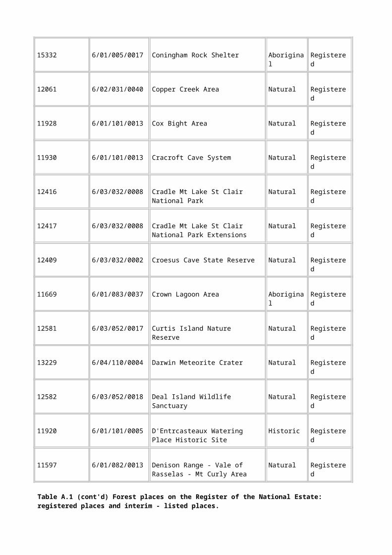
D.1 Importance in demonstrating the principal characteristics of the range of landscapes, environments or ecosystems, the attributes of which identify them as being characteristic of their class.
D.2 Importance in demonstrating the principal characteristics of the range of human activities in the Australian environment (including way of life, custom, process, land-use, function, design or technique).
Criterion E
Its importance in exhibiting particular aesthetic characteristics valued by a community or cultural group
E.1 Importance for a community for aesthetic characteristics held in high esteem or otherwise valued by the community.
Criterion F
Its importance in demonstrating a high degree of creative or technical achievement at a particular period
F.1 Importance for its technical, creative, design or artistic excellence, innovation or achievement.
Criterion G
Its strong or special associations with a particular community or cultural group for social, cultural or spiritual reasons
G.1 Importance as a place highly valued by a community for reasons of religious, spiritual, symbolic, cultural, educational, or social associations.
Criterion H
Its special association with the life or works of a person, or group of persons, of importance in Australia's natural or cultural history
H.1 Importance for close associations with individuals whose activities have been significant within the history of the nation, State or region.

Appendix E: Indicative National Estate places of historic value
Table E.1 Indicative National Estate places of historic value
Place no. Place name National Estate
criteria
H/DM1 Old Pelion Hut and Surrounds A4
H/DM2 Harveys Creek Spur Huts and Landing A4, B2, D2
H/DM3 Teepookana Township Site A4, D2
H/DM4 Pearly Brook Settlement A4, D2
H/DM5 Hampshire Hills Station A4
H/DM6 Hollybank House and Farm B2, D2
H/DM7 Du Cane Hut A4, B2, D2
H/DM8 Borradaile Plain Hut A4, B2, D2
H/DM9 Raglan Range King Billy Pine Forestry Sites A4, B2, D2
H/DM10 Winterbrook (Black Bluff) Sawmill and Tramway A4, B2, D2
H/DM11 Resolution Creek Sawpit A4, B2, D2
H/DM12 McMullens Leithbridge Sawmill A3, A4, D2
H/DM13 McMullens Leithbridge Tramway A3, A4, B2, D2
H/DM15 Leithbridge Log Hauler 1 A3, A4, D2
H/DM16 Leithbridge Log Hauler 2 A3, A4, D2
H/DM17 Lune River Tramway Log Hauler Site A4, D2
H/DM18 Lune River Timber Tramway - Marble Hill Spurline A4, D2
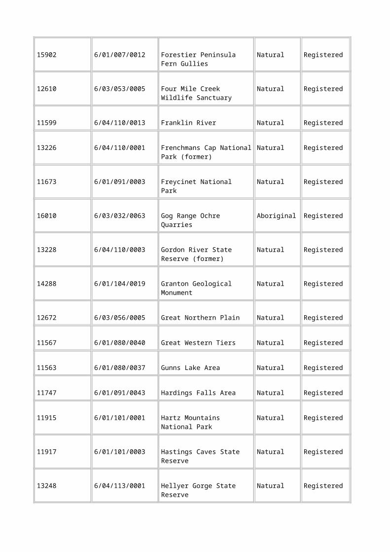
H/DM19 Harveys Creek Spur Log Hauler Site A4, D2
H/DM20 Pearly Brook Sawmill A4, D2
H/DM21 Grubb and Tyson Sawmill A4, D2
H/DM22 Clennetts Big (Lunawanna) Mill A4, B2, D2
H/DM23 Peppers Spot Mill No. 5 A4, B2, D2
H/DM24 Australian Tin Mining Company Puzzle Mine and Mill B2, D2
H/DM25 Lisle Hydraulic Sluicing Site A3, B2, D2
H/DM26 Lisle Alluvial Workings-Potholes Site A3, A4, D2
H/DM27 Lisle Alluvial Workings-Creek Diversions Site A3, A4, D2
H/DM28 Greeta Hydraulic Sluicing Company Water Race D2
H/DM29 Sluicing Site on Slaughter Yard Creek A3, A4, A2
H/DM30 Corinna Hydraulic Gold Mine D2
H/DM31 Mount Bischoff Tin Mining Area A4, B2
H/DM32 Denison Rivulet Coal Mines A4
H/DM33 Volunteer Gold Mine D2
H/DM34 Coal Mines Historic Site A3, A4, B2, C2, F1
H/DM35 Imlay's Southport Whaling Station A4, B2, D2
H/DM36 Kelly and Lucas Bull Bay Whaling Station A4, B2, D2
H/DM37 Lime Kiln A4, B2, D2
H/DM38 Grave Markers A4, B2

H/DM39 Seven Mile Creek Probation Station A4, D2
H/DM40 Paradise Probation Station A4, B2, D2
H/DM41 Sideling Arboretum A4, D2
H/DM44 Corinna Track (South) -Wilson's Road to Corinna A4, D2
H/DM45 Dawson's Road, Quarry Road Section A4, B2, D2
H/DM46 Signal Hill Semaphore Station A4, B2, D2
Table E.1 (cont'd) Indicative National Estate places of historic value
Place no. Place name National Estate
criteria
H/DM47 Moorina Hydro-Electricity Power Development A4, B2, D2
H/DM48 Mount Bischoff Tin Mining Co. Hydro-Electric Power Station
A4, D2
H/DM49 Mount Stronach Cairn A4
H/M9 King River Gold Mine, Lynchford A4, B2, D2
H/M18 Ilfracombe Iron Company A4, B2, D2
H/M19 Tasmanian Charcoal Iron Company Mine A4
H/M20 Asbestos Mine No.1 and No. 2 A4, B2, D2
H/M22 Moon Mine A3, A4, D2
H/M24 Summit Mine A4, D2
H/M25 Australia Mine A4, D2
H/M27 Liberator Mine A4, D2

H/M28 Don Tin Mine A4, D2
H/M38 Panama Goldfield A4, D2
H/T1 Poimena-Weldborough Track A4, B2, D2
H/T2 Three Notch Track A4, B2, D2
H/T6 Higgs Track A4, D2
H/T13 Balfour Track A4, D2
H/T14 North-east Dundas Tramway A4, B2,
H/T15 Kelly Basin Track A4, D2
H/T16 Linda Track A4, D2, H1
H/T17 Innes Track A4, D2
H/T18 Overland Track A4, H1,
H/T26 Kermandie Track A4, B2, D2
H/T27 Tasman Peninsula Tramway A4, B2
H/TG20 Jaeger's South Redpa Sawmill A4, B2, D2
H/TG21 EH Fenton's Salmon River Sawmill A4, D2
H/TG54 Jaeger's Newhaven Sawmill A4, B2, D2
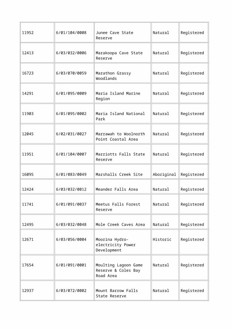
Appendix F: Organisations invited to participate in social value workshops
Organisation Representative
Adventure Tours Green, Rod
Apple & Pear Board Shield, Stephen
Arthur River Canoe Hire Coleman, Jaynee
Association of Central Coast Tourism Operators Green, Phil
Australasian Raptor Association The Secretary
Australian Conservation Foundation Burton, Bob
Australian Newsprint Mills Humphreys, Curly
Australian Paper Compin, D
Binalong Bay Coast Care Brown, Doug
Bird Observers Association of Tasmania Fletcher, Alan
Boat Habour Progress Association Newman, Mark
Bothwell Anglers Association Clark, B
Bothwell Historical Society Ramsay, Mary
Bradshaws Sawmill Bradshaw, N
Break O'Day Council The Mayor
Break O'Day Tours McIntyre, Rob
Bream Creek Landcare Group Kingston, Gary
Brighton Council Dodge, Geoff
Brighton Scout Group Newlands, Shirley

Britton Bros Pty Ltd Britton, Glen
Bruny Island Historical Society Davis, Bev
Burnie City Council The Planning Director
Burnie City Council The Mayor
Central Highlands Council Burke, Lyn
Central Highlands Council Mackey, Stephen
Central Highlands Trail Rides Conway, Natalie
Central West Enterprise Engineering Maskell, Kevin
Circular Head Arts Festival McGuire, Kerrie
Circular Head Camera Club Jaeger, R
Circular Head Chamber of Commerce Flint, Christine
Circular Head Council The General Manager
Circular Head Council The Mayor
Circular Head Enterprise Agency Murphy, Ray
Circular Head Gun Club Collis, John
Circular Head Improvement Program Pettet, Eric
Circular Head Pony Club Hyde, C
Circular Head Tourism Association Owen, Sue
Circular Head Walking Club Britton, Kay
Clarence City Council The Planning Director
Clarence City Council The Mayor
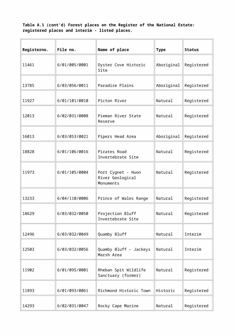
Clarkes Coaches The Secretary
Community-West Coast Development Board Bradshaw, Noeline
Community-West Coast Development Board Crane, Bob
Community-West Coast Development Board Hull, Pat
Community-West Coast Development Board Inglis, Jock
Organisation Representative
Copper Mines of Tasmania Greenwood, Ashley
Copper Mines of Tasmania Talbot, Simon
Country Women's Association Hill, Heather
Country Women's Association Lockett, Barbara
Country Women's Association, Caveside Scott, JE
Country Women's Association, Myalla Nolan, C
Cub Scouts & Adventures Porteus, Brian
Deloraine Aboriginal Cultural Association The Secretary
Deloraine Arst Council McSweeney, Denise
Deloraine Axemens Club Gurr, Geoff
Deloraine District Anglers Atkins, Michael
Deloraine Field Naturalists Nelson, Jim
Deloraine High School Kearon, Julius
Deloraine Historical Society Woods, Geoff
Department of Primary Industry and Fisheries Boucher, Wayne

Department of Tourism Goulding, Carmel
Derwent Valley Council Stuart, Terry
Derwent Valley Council Walker, Caroline
Derwent Valley Environment Group Lomax, Jack
Derwent Valley Horse Riders Association The Secretary
Devonport Tourist Association Webb, Frank
Dorest Council Ranson, Tom
Dorest Council The Mayor
Dorset Waterwatch Eastman, Kim
Dover Cultural Resource Group Wohlgemuth, Martin
Driftwood Hall, Ian
Ellendale Environmental Landcare Group Bromfield, Shaun
Emu Bay Business and Professional Women McMillian, Lindsay
Far Out Tours Cawthorn, Tony
Far Out Tours Cawthorne, Tony
Far Out Tours How, Jill
Federation of Tasmania Bushwalking Young, Ken
Field Nats, NASA Wilson, Jay
Field Naturalists Carter, Julian
Fire Service Waratah Rooks, Ivy
Fire Service Waldron, David
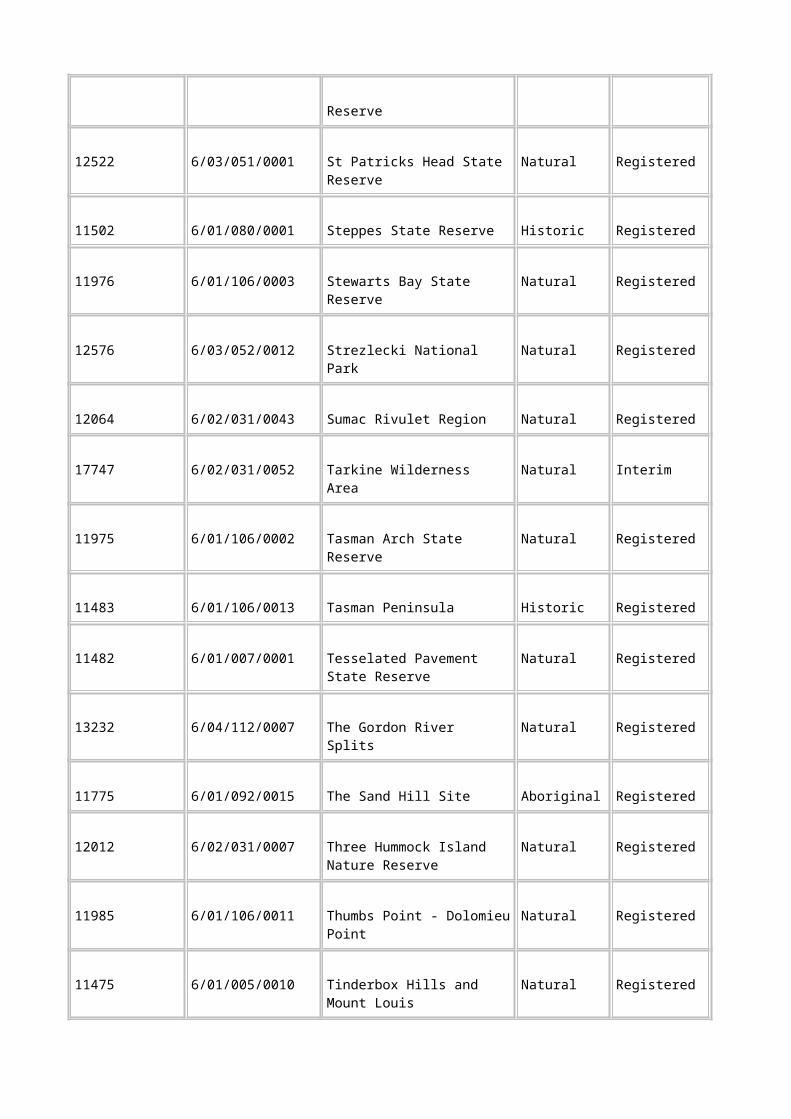
Fly Fishing Association Sutton, Gordon
Forest Practices Unit Gaughwin, Denise
Forest Proctection Society Stag, Rodney
Forest Protection Society Arnold, Cheryl
Forest Protection Society Ashbarry, Alan
Forest Protection Society Boxhall, Geraldine
Forest Protection Society Hall, Karen
Forest Protection Society Kile, Jack
Forest Protection Society Tribolet, Leo
Forest Protection Society Wilkinson, Geoff
Forest Protection Society Mackrell, Wendy
Forest Protection Society/Britton Bros Pty Ltd McMaster, Andrew
Forestry Tasmania Saurins, Les
Forestry Tasmania Blake, Sean
Forestry Tasmania Haywood, Bruce
Organisation Representative
Forestry Tasmania Lutrell, Steve
Forestry Tasmania McCoy, Tom
Forestry Tasmania Miller, Mick
Forestry Tasmania Orr, Simon
Forestry Tasmania Robertson, Islay
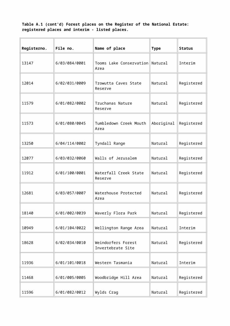
Forestry Tasmania Rowe, Phil
Forestry Tasmania Sargison, Graeme
Forestry Tasmania Smith, Paul
Forestry Tasmania Traill, John
Forestry Tasmania Warren, Brett
Forestry Tasmania Watson, Alan
Four Wheel Drive Tours Busby, Rob
Franklin Manor Worth, Tony & Lane, Beverley
Freshwater Anglers Council of Tasmania Bradshaw, Robert
Gagebrook Neighbourhood House The Coordinator
Geeveston Guides & Scouts Evans, AE
Kentish Council General Manager
Glamorgan Spring Bay Council Reid, Gary
Glamorgan Spring Bay Council Stanley, Ian
Glamorgan Spring Bay Council Mayor Bailey, Bill
Glamorgan/Spring Bay Historical Society Lester, Sue
Glenorchy City Council The Planning Director
Glenorchy City Council The Mayor
Gordon River Cruises Kearney, Rex & Julie
Goulds Country Kenyon, Steve
Grays Hotel McIndoe, Chris

Greening Australia Parsons, Tim
Greening Australia Thompson, Don
Hays Bus Service Hay, Kerry & Mary
Heemskirk Hotel/Motel Williams, Roger
Henty Gold Hoyle, Alan
Hilton Cottage McElwee, Jill
Historical Tours Fielding, Peter
Hobart City Council Noye, Neil
Hobart City Council The Mayor
Hobart Walking Club The Secretary
Huon Protection Group Madigan, Suzie
Huon Tourism Association Cleary, Rob
Huon Tourism Association Patterson, Anthea
Huon Valley Council Bell, Stan
Huon Valley Council Cockerill, Geoff
Huon Valley Council Norris, Gregg
Huon Valley Council Sansom, Ian
Huon Valley Regional Development Board Dillon, Laurie
Huonville Business Community Ferrerica, Paula
Hydro Electric Commission Queenstown Cannell, Chris
Hydro Electric Commission West Coast Godsall, Helga
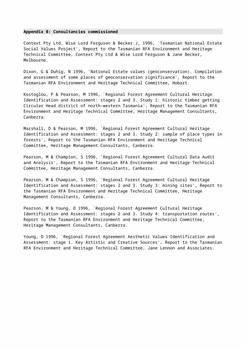
Individual historian Harper, Jock
Kentish Council Lawrence, F
Landcare Bakker, Ruth
Landcare Butler, Julia
Organisation Representative
Landcare Morgan, Helen
Landcare Spring Bay Sparrow, Lyn
Landcare Forest Holland, Joan
Landcare/ Department of Primary Industry and Fisheries Raphael, Graeme
Latrobe Council The General Manager
Launceston City Council Planning Director
Launceston City Council The Mayor
Launceston Environment Centre Williams, Carol
Launceston Walking Club The Secretary
Liffey District Resource Management Group Bye, Glenys
Liffey Valley Association Jordan, Ray
Logger & farmer Bennett, Tony
Macquarie Harbour Historical Society Mc Dermott, Harry
Macquarie Harbour Sailing Club Williams, Meg
Marrawah Share & Care Nicholls
Meander Progress Association Boxhall, Bevan

Meander Valley Council Earley, LJ
Meander Valley Council Fellows, GA
Meander Valley Council Westerway, Mark
Mercey Leven Aboriginal Corp The Secretary
Mole Creek Natural Estate Watch Evans, Lloyd
Mole Creek Progress Association Howe, Don
Morrison Sawmill Morrison, Grant
Morrisons Huon Pine Sawmill Morrison, Randell
Mt Roland Landcare Shub, Trishala
Murray High School Duddy, Colin
Murray High School Gregory, Tim
Murray High School Hill, Kylie
Murray High School Keating, Emma
Neighbourhood Centre Hawes, Nancy
Neighbourhood Centre Jarvis, Judy
New Norfolk Council The General Manager
New Norfolk High School Moyer, Darryl
Non-affiliated Best, Maggie
Non-affiliated Clark, Don
Non-affiliated Dean, Alex
Non-affiliated Dixon, Raoul

Non-affiliated Douglas, Mike
Non-affiliated Duckworth, Peter
Non-affiliated Dunbabin, Tom
Non-affiliated Fazackerly, Paul
Non-affiliated Fitzgerald, Judy
Non-affiliated Fraser, Wren
Non-affiliated Hamilton, John
Non-affiliated Joyce, Ray
Non-affiliated Lawrence, MJ
Non-affiliated Meredith, Sally
Non-affiliated Mitchelmore, Peter
Non-affiliated Muir-Wilson, Toby
Non-affiliated Oates, Rex
Non-affiliated Pacey, Deb
Organisation Representative
Non-affiliated Plumber, Bob
Non-affiliated Potter, DGJ
Non-affiliated Rigozzi, Peter
Non-affiliated Roberts-Thompson, Bronwyn
Non-affiliated Robertson, Bill
Non-affiliated Rushbrook, Elaine

Non-affiliated Shoobridge, Peter
Non-affiliated Storey, Peter
Non-affiliated Strie, Frank
Non-affiliated Tucker, Rex
Non-affiliated Vermey, Hans
Non-affiliated Woods, V
North East Bush Walkers Croll, Michael
North East Field Naturalists Brooker, Louise
North East Tasmanian Field Naturalists Campbell, S
North Forest Products Johns, Terry
North Forest Products MacDonald, Cameron
North Forest Products Worley, Steve
North West Bird Club Hyland, Kevin
North West Field & Game Coulson, Ian
North West Gateway Cox, Jenny
North West Video Camera Club Hawkes, Mary
North West Walking Club Peters, Lynda
Orienteering Tasmania Mr Tony Mount, Tony
Parks & Wildlife Service Batchelor, Barry
Parks & Wildlife Service Breen, Shane
Parks & Wildlife Service Bryce, Mark

Parks & Wildlife Service Hanson, Dave
Parks & Wildlife Service Hunniford, Shane
Parks & Wildlife Service Matusek, Stan
Parks & Wildlife Service Mooney, Peter
Parks & Wildlife Service Sallans, Steve
Parks & Wildlife Services Coles, Geoff
Parks & Wildlife Services Garner, Mike
Parks and Wildlife Service Helleman, Paul
Pasminco EZ Hawes, GW
Pathfinders Orienteering Club Walker, Bob
Peninsula Walkers & Private Forest Shoobridge, Alison
Port Arthur Historical Site Coombs, Craig
President Rural Youth Kinch, Adam
Queenstown Advisory Committee Sarson, Jean
Queenstown Rifle Club Shulze, Anthony
Radfords Woodcraft Boyle, Barbara
Radfords Woodturning Radford, Mr
Regional Development Board Thiele, Jane
Rifle Sporting Club Ward, David
Rockmoor 4WD Park George, Neville
Rosebery Field and Game Association Grundy, M
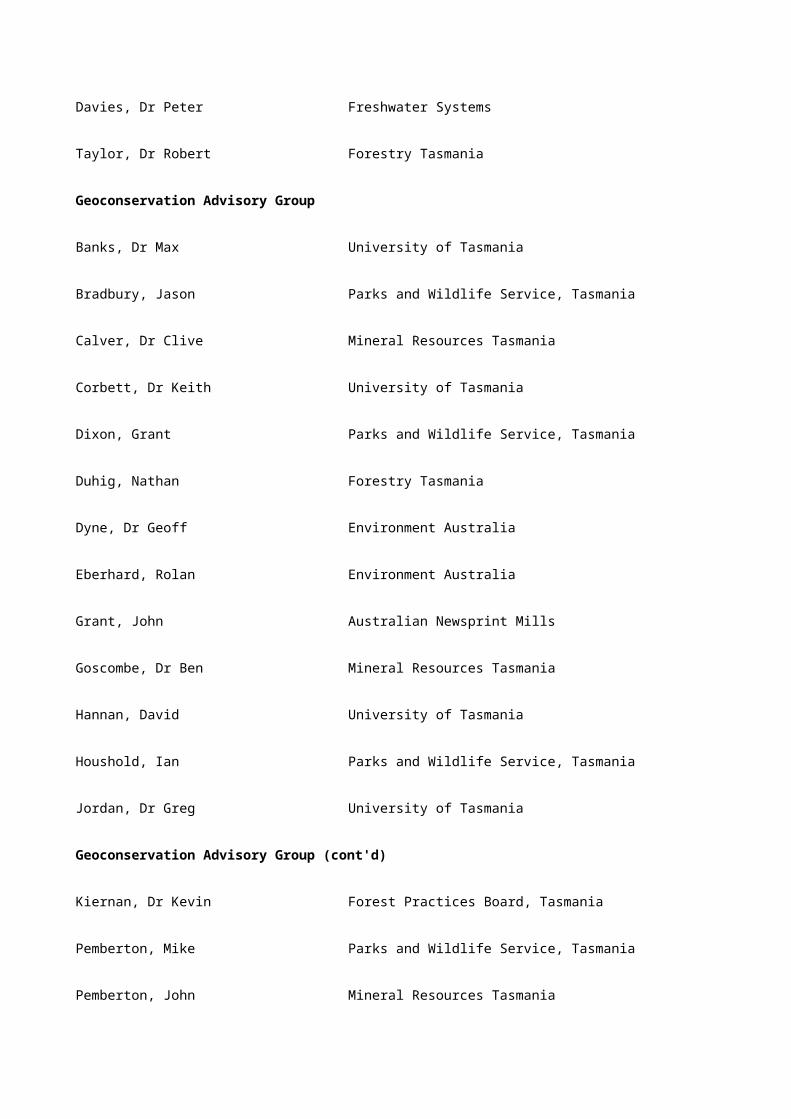
Rosebery Anglers Club Heap, Greg
Rosny Climbing & Adventure Club Wilson, Shaun
Russell Falls Trout Aquaculture Pty Ltd
The Secretary
Organisation Representative
Saltas Williscroft, Garry
Sawmiller Lynchford Bradshaw, Bern
Sawmillers Association Johnston, Neil
Scorpion Adventure Tours Doyle, Tony
Scottsdale High School Van Engen, Ray
Shipwrights Point Wooden Boat School Young, John
Smithton High School Boyle, Keith
Snowy Range Trout Farm Cleary, Rob
South East Forest Protection Group Graham, Bob
South East Tasmanian Aboriginal Corp The Secretary
Southern District Axemans Association The Secretary
Southern Forests Community Groups Inc Direen, Rex
Southern Midlands Council Walker, G
Southport Community Centre Bradley, P
St Helens Hiking Group Burns, Peter
St Helens History Room Chapply, Errol V
St Helens Orienteers Woodbery, Alan

St Helens Tourism Promotion Group Haslim, Brian
Stanley Fire Brigade Jaeger, John
Strahan Senior Citzens Inglis, M
Sustainable Development Avisory Council Strong, Chris
Taranna Historical Society Kingston, Terry
Tarraleah-Bronte Anglers Club Jordan, Barbara
Tasman Council Burgess, Greg
Tasman Council Noye, Neil
Tasmanian Aboriginal Centre The Secretary
Tasmanian Aboriginal Land Council Brown, Karen
Tasmanian Arts Council Grey, Pat
Tasmanian Beekeeper Association Parker, Col
Tasmanian Conservation Trust Graham, Alistair
Tasmanian Craft Fair Bowman, Paul
Tasmanian Environment Centre Pryor, Helen
Tasmanian Farmers and Graziers Association/ Forest Protection Society/Southern Tree Growers Coop.
Larner, Roger
Tasmanian Farmers Federation Rance, George
Tasmanian Fellowship of Australia Writers North West Branch
Lake, Joe
Tasmanian Field & Game Association Nicholson, Guy
Tasmanian Field Naturalists Club Hurd, Don
Tasmanian Historical Association Library Alexander, Alison
Tasmanian Landcare Association Stannus, Garry
Tasmanian Museum Ferguson, Geoffrey
Tasmanian Traditional & Recreational Land Users Cubit, Simon
The Wilderness Society Sully, Amanda
Tourism Council of Australia Holgate, Harry
Triabunna District High School Goodwin, Mathew
Triabunna District High School James, Jason
Triabunna District High School Thornbury, Kate
Triabunna District High School Whittaker, Kirsty
Tullah Horesback Tours Vanderfeen, Vicki
Organisation Representative
Tullah Progress Association Boyle, Rick
Tunbridge Manor Byron, Susanne
Tyena Valley Lodge Morris, Tim
University of Tasmania Jetson, Tim
University of Tasmania Wolf, Virginia
Visitor Information Centre, Wynyard Orchard, Christine
Waratah Wynyard Council Gibson, John
Waratah Wynyard Council Gurnhill Dixon, Cyril
West Coast Aboriginal Corp The Secretary
West Coast Aboriginal Corp The Secretary

West Coast Council Murray Walker, Ald
West Coast Council Vickers, Phil
West North West Tourism Ltd Cox, Jenny
West Tamar Historical Committee Hooper, Richard
White Beach Forestry Clark, Graeme
Wilderness Society Gee, Helen
Winnaleah School Harper, Nick
Women in Agriculture Clark, Virginia
Women in Agriculture Ewington, Maxine
Wyndara Community Information & Resource Centre The Secretary
Wynyard Arts Council Halfacre, Sandra
Wynyard Historical Society Walker, Cal
Wynyard Historical Society Walker, Col
Wynyard Landcare Group Barnard, Peg
Yolla District High Probert, Dave
Youth Hostel Association Delaney, Christine & Lyons, Tom
Zeehan & West Coast Genealogical Society Harvis, C
Zeehan Senior Citizens Kearny, Dawn
Zeehan Youth and Citizen Youth Youd, C

Appendix G: Participants in the social value workshops
Participants in the social value workshops
Organisation Representative Workshop
Forest Protection Society Ashbarry, Alan Campbell Town
Parks and Wildlife Service Batchelor, Barry New Norfolk
Huon Valley Council Bell, Stan Huonville
Logger and farmer Bennett, Tony Huonville
Forestry Tasmania Blake, Sean Scottsdale
Department of Primary Industry and Fisheries
Boucher, Wayne Huonville
Meander Progress Association Boxhall, Bevan Deloraine
Radfords Woodcraft Boyle, Barbara Zeehan
Tullah Progress Association Boyle, Rick Zeehan
Sawmiller Lynchford Bradshaw, Bern Zeehan
Ellendale Enviornmental Landcare Group Bromfield, Shaun New Norfolk
North East Field Naturalists Brooker, Louise Scottsdale
Binalong Bay Coast Care Brown, Doug Scottsdale
Parks and Wildlife Service Bryce, Mark New Norfolk
Central Highlands Council Burke, Lyn New Norfolk
St Helens Hiking Group Burns, Peter Scottsdale
Liffey District Resource Management Group
Bye, Glenys Deloraine
Hydro Electric Commission Queenstown Cannell, Chris Zeehan

St Helens History Room Chapply, Errol Scottsdale
Non-affiliated Clark, Don Triabunna
Snowy Range Trout Farm Cleary, Rob Huonville
North East Bush Walkers Croll, Michael Scottsdale
Bruny Island Historical Society Davis, Bev Huonville
Huon Valley Regional Development Board
Dillon, Laurie Huonville
Southern Forests Community Group Inc. Direen, Rex Huonville
Non-affiliated Duckworth, Peter Scottsdale
Murray High School Duddy, Colin Zeehan
Dorset Waterwatch Eastman, Kim Scottsdale
Mole Creek Natural Estate Watch Evans, Lloyd Deloraine
Tasmania Museum Ferguson, Geoffrey Triabunna
Forest Practices Board Gaughwin, Denise Scottsdale
The Wilderness Society Gee, Helen Campbell Town
Rockmoor 4WD Park George, Neville New Norfolk
Hydro Electric Commission West Coast Godsall, Helga Zeehan
Triabunna District High School Goodwin, Mathew Triabunna
Department of Tourism Goulding, Carmel Campbell Town
Tasmanian Conservation Trust Graham, Alistair Campbell Town
South East Forest Protection Group Graham, Bob Triabunna
Copper Mines of Tasmania Greenwood, Ashley Zeehan

Driftwood Hall, Ian Huonville
Forest Protection Society Hall, Karen Scottsdale
Non-affiliated Hamilton, John Huonville
Winnaleah School Harper, Nick Scottsdale
St Helens Tourism Promotion Group Haslim, Brian Scottsdale
Forestry Tasmania Haywood, Bruce New Norfolk
Organisation Representative Workshop
Murray High School Hill, Kylie Zeehan
Mole Creek Progress Association Howe, Don Deloraine
Australian Newsprint Mills Humphreys, Curly New Norfolk
Triabunna District High School James, Jason Triabunna
North Forest Products Johns, Terry Triabunna
Country Sawmillers Association Johnston, Neil Deloraine
Liffey Valley Association Jordan, Ray Deloraine
Murray High School Keating, Emma Zeehan
Goulds Country Kenyon, Steve Scottsdale
Bream Creek Landcare Group Kingston, Gary Triabunna
Historical Society Kingston, Terry Triabunna
Tasmanian Farmers and Graziers Association/Forest Protection Society /Southern Tree Growers Coop.
Larner, Roger Triabunna
Glamorgan/Spring Bay Historical Society Lester, Sue Triabunna
North Forest Products MacDonald, Cameron Triabunna
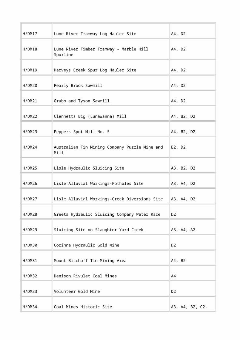
Forest Protection Society Bishoff-Heemskirk
Mackrell, Wendy Zeehan
Parks and Wildlife Service Matusek, Stan Deloraine
Forestry Tasmania McCoy, Tom New Norfolk
Forest Protection Society/Brittons Timber McMaster, Andrew Smithton
Forestry Tasmania Miller, Mick Scottsdale
Conservation interests Meredith, Sally Triabunna
Parks and Wildlife Service Mooney, Peter Campbell Town
Tyenna Valley Lodge Morris, Tim New Norfolk
Orienteering Tasmania Mount, Tony Campbell Town
Hobart City Council Noye, Neil Campbell Town
Forestry Tasmania Orr, Simon Smithton
Tasmania Beekeepers Association Parker, Col Campbell Town
Greening Australia Parsons, Tim New Norfolk
Bothwell Historical Society Raay, Mary New Norfolk
Landcare/Department of Primary Industry and Fisheries
Raphael, Graeme New Norfolk
Forestry Tasmania Rowe, Phil Huonville
Huon Valley Council Sansom, Ian Huonville
Queenstown Advisory Committee Sarson, Jean Zeehan
Private Forest Shoobridge, Peter Triabunna
Peninsula Walkers and Private Forest Shoobridge, Alison Triabunna
Forest Protection Society - Meander Stagg, Rodney Deloraine

Glamorgan/Spring Bay Council Stanley, Ian Triabunna
Tasmanian Landcare Association Stannus, Garry Campbell Town
Sustainable Development Advisory Council
Strong, Chris Scottsdale
Derwent Valley Council Stuart, Terry New Norfolk
The Wilderness Society Sully, Amanda Campbell Town
Copper Mines of Tasmania Talbot, Simon Zeehan
Triabunna District High School Thornbury, Kate Triabunna
Forestry Tasmania Traill, John Huonville
Forest Protection Society Tribolet, Leo New Norfolk
Scottsdale High School Van Engen, Ray Scottsdale
Derwent Valley Council Walker, Caroline New Norfolk
Forestry Tasmania Warren, Brett Triabunna
Organisation Representative Workshop
Forestry Tasmania Watson, Alan Deloraine
Meander Valley Council Westerway, Mark Deloraine
Triabunna District High School Whittaker, Kirsty Triabunna
Field Naturalists, NASA Wilson, Jay Scottsdale
Dover Cultural Resource Group Wohlgemuth, Martin Huonville
Humanities Department, University of Tasmania
Wolf, Virginia Campbell Town
Shipwrights Point Wooden Boat School Young, John Huonville

Appendix H: Indicative National Estate places of social value
Table H.1 Indicative National Estate Places of social value
Place no. Place name Place no. Place name
Del 3/02 Alum Cliffs Sco 5/03 Lilydale Falls
Huo 1/09 Arve Loop Road Del 6/02 Long Hill
Smi 1/06 Big Tree and Dip Falls Tri 2/02 Maria Island
Sco 1/01 Blue Tier Sco 4/01 Mathinna Falls
New 1/25 Broad River Site Del 3/06 Meander Falls and Forest Res.
Huo 1/07 Cape Connella Smi 1/08 Milkshake Hills Forest Res.
Cam 2/21 Cataract Gorge Zee 1/14 Montezuma Falls
Zee 1/11 Corinna Tri 3/05 Mount Arthur (Port Arthur)
Del 3/07 Devils Gullet Zee 3/10 Mount Black
Sco 1/34 Douglas-Apsley National Park Sco 3/01 Mount Cameron
Huo 1/16 Drip Beach Zee 3/18 Mount Murchison
Sco 4/13 Elephant Pass Del 6/01 Mount Roland
Sco 4/02 Evercreech Forest Reserve Sco 3/01 Mount Victoria
Tri 3/04 Fortescue Bay and Forest Reserve
Huo 2/02 Mount Wellington - Wellington Range
Zee 1/22 Franklin River Sco 2/03 Mutual Valley
Tri 1/02 Freycinet Peninsula Huo 1/14 Pines Lookout
Huo 3/01 Hartz Track-Kermandie Falls Huo 2/12 Recherche Bay

and Picnic Area
Huo 3/04 Hastings Caves Tri 2/11 Sandspit River Forest Res.
Smi 1/13 Hellyer Gorge Smi 1/01 Spion Kop -Black River Picnic Area
Sco 5/08 Hollybank Forest Reserve Sco 3/26 Springfield Park
Zee 1/29 Lake Burbury Sco 4/14 St Marys Pass
Smi 1/02 Lake Chisholm Forest Reserve Sco 4/09 Stacks Bluff and The Knuckle
New 3/07 Lake Gordon Sco 4/08 Storys Creek
Tri 1/11a Lake Leake Huo 1/13 Tahune Forest Reserve
Del 3/09 Lake Nameless Hut Tri 2/10 Tasman Bay
Del 3/03 Lake Parangana Del 3/08 Trappers Hut
New 3/27 Lake Pedder Cam 1/04 Western Tiers
Zee 1/30 Lake Rosebery Del 3/04 Wet Cave Reserve
Del 2/01 Liffey Falls Huo 1/12 Woodbridge Hill

Appendix I: Participants in the forest planners survey
Participants in the forest planners survey
Bims, Daryl Parks and Wildlife Service, Tasmania
Bird, Peter Forestry Tasmania
Blake, Seann Forestry Tasmania
Boyden, Mike Forestry Tasmania
Bryce, Mark Parks and Wildlife Service, Tasmania
Bugg, Gerard Parks and Wildlife Service, Tasmania
Cruse, Ken Forestry Tasmania
Deegan, John Parks and Wildlife Service, Tasmania
Frost, Leslie Parks and Wildlife Service, Tasmania
Hamilton, Robert A Forestry Tasmania
Lucas, Ross Forestry Tasmania
Richardson, Gary Forestry Tasmania
Richardson, Nigel Forestry Tasmania
Rowe, Phil Forestry Tasmania
Sawyer, Nick Parks and Wildlife Service, Tasmania
Smith, Mike Forestry Tasmania
Sutton, Ron Parks and Wildlife Service, Tasmania
Tucker, David Forestry Tasmania
Tuson, Dean Forestry Tasmania
Warren, Brett Forestry Tasmania

Williams, Peter Forestry Tasmania

Appendix J: Places of aesthetic value requiring further investigation
Arthur River
Adamsons Peak
Arthur Range
Black Bluff
Cape Raoul
Chauncy Vale
Cloudy Bay Lagoon
Cradle Mountain - St Clair National Park
Du Cane Range
Frenchmans Cap
Gordon River
Hartz Mountain
Huon River
King River
King William Range
Moonlight Ridge
Quamby Bluff
St Pauls Dome
Walls of Jerusalem and Lake St Clair Valley
Appendix K: Indicative National Estate places of aesthetic value
Table K.1 Indicative National Estate places of aesthetic value.

Place name Place name
Alum Cliffs State Reserve Lilydale Falls Reserve
Ben Lomond: eastern slopes and foothills Long Hill, Kimberley Mersey Area
Big Tree Reserve and Dip Falls Maria Island
Blue Tier Mathinna Falls Forest Reserve
Cape Connella, Bay of Islands Meander Falls and Forest Reserve
Cataract Gorge Milkshake Hills Forest Reserve
Corinna Montezuma Falls
Devils Gullet State Reserve Mt Arthur (Port Arthur)
Douglas-Apsley National Park Mt Black
Drip Beach Mt Cameron Range and environs
Elephant Pass Mt Field area
Fortescue Bay and former Fortescue Forest Reserve
Mt Murchison
Franklin River Mt Roland
Freycinet National Park, inc. Friendly Beaches
Mt Victoria and Rattler Range
Great Western Tiers Mt Wellington and Range
Hartz Track, Kermandie Falls and picnic area Pieman River
Hastings Cave Reserve Recherche Bay
Hellyer Gorge Sandspit Forest Reserve

Hollybank Forest Reserve Sideling Range
Huon-Picton River Snowy Range
King River to Teepookana town site St Marys Pass State Reserve
Lake Burbury Stacks Bluff/The Knuckle
Lake Chisholm Forest Reserve Tahune Forest Reserve
Lake Gordon The Pines Lookout, Bruny Island
Lake Pedder Wet Cave Reserve
Lake Rosebery Woodbridge Hill
Liffey Falls State Reserve
Appendix L: Tasmanian Aboriginal community groups invited to 1996 consultation meetings
Tasmanian Aboriginal community groups invited to 1996 consultation meetings
Aboriginal and Torres Strait Islander Commission
Aboriginal Child Youth Support Association Aboriginal Corporation
Aboriginal Childrens Centre
Aboriginal Community School
Aboriginal Elders Council of the Tasmanian Aboriginal Corporation
Aboriginal Health Services (Burnie)
Aboriginal Health Services (Hobart)
Aboriginal Health Services (Launceston)
Aboriginal Land Council of Tasmania
Aboriginal Legal Service (Hobart)
Aboriginal Legal Service (Launceston)
Aboriginal Students Union (North)
Aboriginal Students Union (South)

Australian Education Union: Aboriginal Education Committee
Babel Island Aboriginal Corporation
Cape Barren Island Corporation
Circular Head Aboriginal Corporation
Deloraine Aboriginal and Cultural Association
Flinders Island Aboriginal Association
Great Southern Land Management Aboriginal Corporation
Housing Allocation Committee (North-west)
Housing Allocation Committee (North)
Housing Allocation Committee (South)
Indigenous Tasmanians Aboriginal Corporation
Mersey-Leven Aboriginal Corporation
Moi-La Aboriginal Corporation (Wybalena)
Riawunna (North)
Riawunna (South)
South East Tasmanian Aboriginal Corporation
Sports Aboriginal Corporation
Tasmanian Aboriginal Centre (Burnie)
Tasmanian Aboriginal Centre (Launceston)
Tasmanian Aboriginal Centre (Head Office, Hobart)
Tasmanian Aboriginal Child Care Association
Tasmanian Aboriginal Education Association
Tasmanian Aboriginal Land Council
Tasmanian Native Resources Aboriginal Corporation
Tasmanian Regional Aboriginal Council
Tiagarra (MLAC)
Wayee Radio
West Coast Aboriginal Corporation

Womens Karadi Aboriginal Corporation

Appendix M: Those attending the Hadspen Aboriginal community workshop
Those attending the Hadspen Aboriginal community workshop
Andersen, Clair Department of Vocational Education and Training
Carlos, Carolyn Department of Primary Industries and Energy
Dillon, Rodney South East Tasmania Aboriginal Corporation
Everett, Jim Office of Aboriginal Affairs
Gainer, Kate Department of the Prime Minister and Cabinet
Gaughwin, Denise Forest Practices Board, Tasmania
Gibbins, Rodney Office of Aboriginal Affairs
Hodge, Brenda Aboriginal Student Support and Parent Awareness
Horton, Hank Deloraine Aboriginal Cultural Centre
Horton, Rick Deloraine Aboriginal Cultural Centre
Mansell, Cranston Private individual
Mansell, Darlene Private individual
Nayutah, Jolanda Department of the Environment, Sport and Territories
Noble, Brett Department of Environment and Land Management
Pearse , Rod Department of Environment and Land Management
Williams, Mike Public Land Use Commission
Wood, Darell Forest Practices Board, Tasmania

Appendix N: Cultural heritage and land management matters of concern to the Tasmanian Aboriginal community
Cultural heritage and land management matters of concern to the Tasmanian Aboriginal community, as identified at the 1996 Hadspen community workshop
The following list is from the community workshop draft report produced by the Public Land Use Commission.
• need for governments to recognise prior ownership and Aboriginal management of land;
• need for governments to recognise the historical perspective of forest management by Aboriginal people;
• need to improve the process of consultation;
• problems of land degradation and soil management caused by current forestry operations need to be addressed in the RFA;
• lack of understanding of Aboriginal perspectives and heritage by government land managers;
• lack of confidence in governments adopting Aboriginal perspectives;
• concern that the social importance of Aboriginal perspectives will be dominated by economic considerations;
• lack of Aboriginal Heritage resources for forest management;
• need to improve Aboriginal consultation techniques especially accessibility to information and the form of information;
• role of Aboriginal people in the RFA;
• concern about the ownership and access to Aboriginal information on Aboriginal Heritage;
• need for access to forests for cultural purposes and for forest resources;
• need for a code of practice with the RFA to address Aboriginal heritage issues and Aboriginal involvement in forest management;
• need for flexibility of funding arrangements for Aboriginal participation in the RFA process;
• effective consultation with Aboriginal community requires respected and adequately resourced Aboriginal facilitators to undertake consultation. Consultation must include multiple opportunities for Aboriginal input and information to be sourced from both the Aboriginal groups and individuals;
• there is a problem with the large number of government programs requiring Aboriginal input resulting in consultation overload and fatigue;
• need for whole of government to build a long term relationship with Aboriginal people;
• need for compensation for impact on Aboriginal culture;
• need to develop an Aboriginal cultural process to lead discussions on forest management;

• need to develop strategies to increase Aboriginal involvement in forest decision making, forest management and employment;
• lack of accountability of government to Aboriginal community;
• need for Aboriginal people to discuss the broader range of issues first before discussing specific RFA issues and that this process needs to be properly researched; and
• need for improvement and resourcing of Aboriginal structures available to consult with government.

Appendix O: Criteria used to review the conservation status of forest communities
Table O.1 Criteria used to review the conservation status of forest communities
Conservation Criteria
Rare R1-total range generally less than 10 000 hectares
R2-total area generally less than 1000 hectares
R3-patch sizes generally less than 100 hectares
Vulnerable V1-approaching greater than 70 per cent loss (depletion)
V2-includes forest communities where threatening processes have caused loss or significant decline in species that play a major role within the ecosystem or significant alteration to ecosystem processes
Endangered E1-distribution has contracted to less than 10 per cent of original range
E2-less than 10 per cent of original area remaining
E3-90 per cent of area is in small patches and is subject to threatening processes
Table O.2 Rare and threatened forest communities in Tasmania
Classification Forest community
Rare
R1 Eucalyptus risdonii forest
E. morrisbyi forest
Furneaux E. viminalis forest
R2 Furneaux E. viminalis forest
E. risdonii forest
E. morrisbyi forest
Notelaea ligustrina and/or Pomaderris apetela closed forest

Callitris rhomboidea forest
Banksia serrata woodlands
King Billy pine-deciduous beech forest
Melaleuca ericifolia coastal swamp forest
R3 E. morrisbyi forest
Notelaea ligustrina and/or Pomaderris apetela closed forest
Callitris rhomboidea forest
Banksia serrata woodlands
Ppencil pine forest
Pencil pine-deciduous beech forest
E. risdonii forest
King Island E. globulus-E. brookeriana-E. viminalis forest
Furneaux E. viminalis forest
E. viminalis-E. globulus coastal shrubby forest
Table O.2 (cont'd) Rare and threatened forest communities in Tasmania
Classification Forest community
Vulnerable
V1 E. amygdalina inland forest
E. amygdalina forest on sandstone
E. viminalis-E. globulus coastal shrubby forest

E. brookeriana wet forest
V2 Pencil pine forest
Pencil pine-deciduous beech forest
Grassy E. globulus forest
Inland E. tenuiramis forest
King Billy pine forest
King Billy pine-deciduous beech forest
Endangered
E1 Nil
E2 Shrubby E. ovata forest
E. morrisbyi forest
King Island E. globulus-E. brookeriana-E. viminalis forest
E. viminalis wet forest
Melaleuca ericifolia coastal swamp forest
E3 Furneaux E. viminalis forest
Notelaea ligustrina and/or Pomaderris apetela closed forestBanksia serrata woodlands

Appendix P: Rare and endangered fauna: species considered under criterion B.1
Table P.1 Rare and endangered fauna: species considered under criterion B.1
Species according to dominant habitat Status:
nat./Tas
Forest
dependence Range
Alpine
*Dirce aesidora (pencil pine moth) - / V High Restricted
Rainforest
*Anoglypta launcestonensis (north-east forest snail)
- / V High Localised
*Paralamyctes n. sp. (undescribed centipede) - / R(S) High Localised
Sabatinca n. sp. (undescribed primitive mandibulate moth)
- / R(S) High Restricted
Proditrix n. sp. (undescribed pandanifolia moth) - / R High Localised
Apteropanorpa tasmanica (Tasmanian wingless scorpionfly)
- / R High Localised
Wet eucalypt forest
*Dasyurus maculatus (spotted-tail quoll) V / M High Wide-spread
*Aquila audax fleayi (wedge-tailed eagle) - / V High Wide-spread
*Accipiter novaehollandiae (grey goshawk) - / R(S) High Localised
*Engaeus yabbimunna (Burnie burrowing crayfish) - / V High Restricted
*Engaeus orramakunna (Mt Arthur burrowing crayfish)
- / V High Restricted
Engaeus martigener (Flinders Is. burrowing - / R High Restricted

crayfish)
*Hoplogonus simsoni (Simson's stag beetle) - / V High Localised
*Lissotes menalcas (Mt Mangana stag beetle) - / V High Localised
*Tasmanipatus anophthalmus (blind peripatus) - / E High Restricted
*Ooperipatellus ‘cryptus’ (northwest peripatus) - / R(S) High Restricted
*Migas plomleyi (spider) - / R(S) Medium Restricted
*Miselaoma weldii (Stanley snail) - / V High Restricted
*Roblinella agnewi (snail) - / R(S) High Localised
Helicarion rubicundus (snail) - / R High Restricted
Tasmaphena lamproides (wet forest snail) - / R High Localised
Dry sclerophyll forest
*Dasyurus viverrinus (eastern quoll) V / M High Wide-spread
*Pardalotus quadragintus (forty-spotted pardalote)
E / E High Localised
Table P.1 (cont'd) Rare and endangered fauna: species considered under criterion B.1
Species according to dominant habitat Status:
nat./Tas
Forest
dependence Range
Dry sclerophyll forest (cont'd)
*Lathamus discolor (swift parrot) V / V High Localised
*Antipododia chaostola (Chaostola skipper) - / E High Restricted
*Schayera baiulus (Schayers grasshopper) - / E High Restricted

*Lissotes latidens (broad-toothed stag beetle) - / E High Localised
*Pasmaditta jungermanniae (dry forest snail) - / R(S) High Restricted
*Tasmanipatus barretii (giant velvet worm) - / R(S) High Localised
*Tasmanophilus n. sp. (undescribed centipede) - / R(S) High Restricted
*Cryptops n. sp. (undescribed centipede) - / R(S) High Restricted
Niceteria macrocosma (geometrid moth) - / R High Localised
Neopseudogarypus scutellatus (false scorpion) - / R Medium Restricted
Discocharopa vigens (snail) - / R High Localised
Grasslands and grassy woodlands
*Perameles gunnii (eastern-barred bandicoot) V / M Medium Wide-spread
Bettongia gaimardi (Tasmanian bettong) - / M High Localised
Milvus sphenurus (whistling kite) - / R Medium Localised
*Oreixenica ptunarra (Ptunnara brown butterfly) - / V Medium Localised
*Catadromus lacordairei (carabid beetle) - / R(S) High Restricted
*Lackrana carbo (geometrid moth) - / R(S) High Restricted
*Fraus latistria (moth) - / R(S) Medium Restricted
Cisticola exillis (golden-headed cisticola, Furneaux group)
- / R Low Restricted
Tornatellinops jacksonensis (snail, Furneaux is.) - / R Medium Localised
Letomola barrenese (snail, Bass Strait is.) - / R Medium Localised
Moorland and heathland
*Pseudomys novaehollandiae (New Holland mouse)
- / R(S) Medium Localised
*Neophema chrysogaster (orange-bellied parrot) E / E High Localised
*Engaeus spinicaudatus (Scottsdale burrowing crayfish)
- / V Low Restricted
Oreisplanus munionga larana (Marrawah skipper) - / R No Restricted
Synthemis macrostigma (swamp dragonfly) - / R Low Localised
Freshwater
*Galaxias fontanus (swan galaxias) E / E Low Restricted
*Galaxias johnstoni (Clarence galaxias) E / E Low Restricted
*Prototroctes maraena (Australian grayling) V / V Low Localised
Table P.1 (cont'd) Rare and endangered fauna: species considered under criterion B.1
Species according to dominant habitat Status:
nat./Tas
Forest
dependence Range
Freshwater (cont'd)
*Galaxias tanycephalus (saddled galaxias) V / V Low Restricted
*Astacopsis gouldi (giant freshwater lobster) V / V Low Localised
*Beddomeia krybetes (hydrobiid snail, north-east Tas.)
- / V Low Restricted
*Beddomeia tumida (hydrobiid snail) - / V Low Restricted
*Galaxias pusilla (dwarf galaxias) - / R(S) Low Restricted
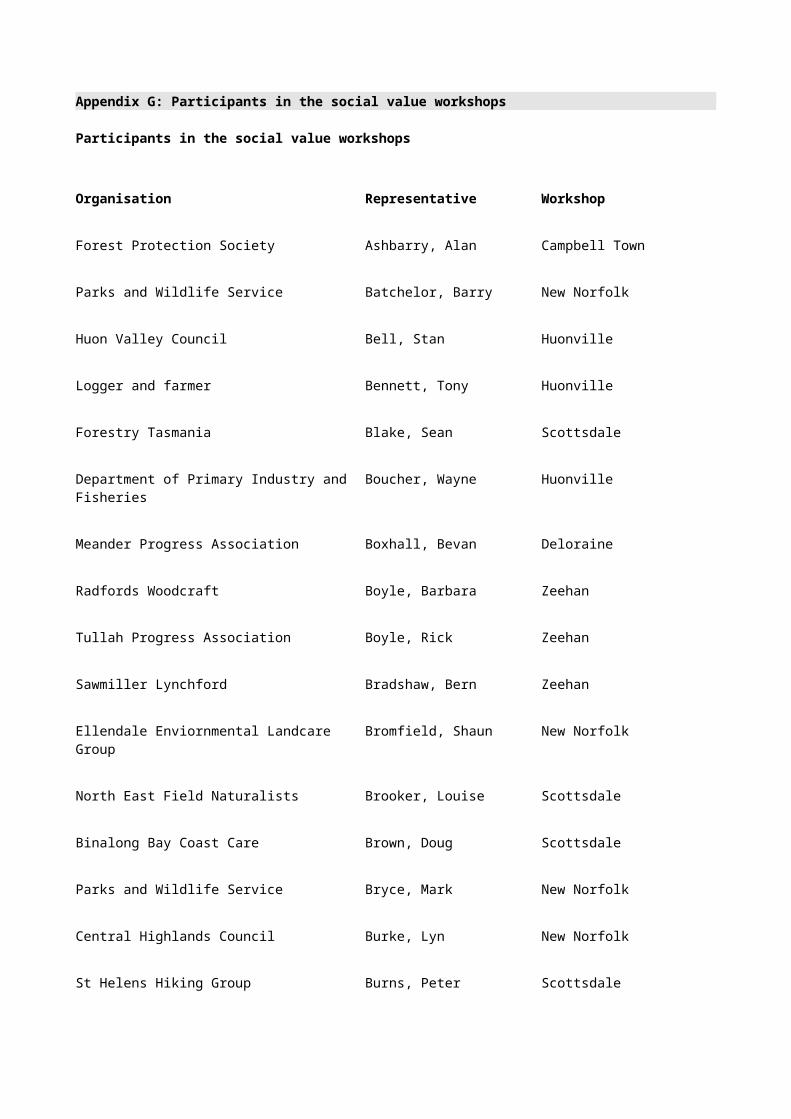
*Phrantela richardsoni (hydrobiid snail) - / R Low Restricted
*Phrantela umbilicata (hydrobiid snail) - / R Low Restricted
*Nanocochlea monticola (hydrobiid snail) - / R Low Restricted
*Nanocochlea parva (hydrobiid snail) - / R Low Restricted
*Nanocochlea pupoidea (hydrobiid snail) - / R Low Restricted
*Neboissoperla n. sp. (stonefly) - / R Low Restricted
*Reikoperla n. sp. (stonefly) - / R Low Restricted
*Kimminsoperla biloba (stonefly) - / R Low Restricted
Taskira mccubbini (caddisfly) - / E
*Taskiropsyche lacustris (caddisfly) - / E
*Diplectrona lyella (caddisfly) - /R(S)
*Ecnomina vega (caddisfly) - /R(S)
*Hydrobiosella armata (caddisfly) - /R(S)
*Hydrobiosella sagitta (caddisfly) - /R(S)
*Hydroptila scamandra (caddisfly) - /R(S)
*Leptocerus souta (caddisfly) - /R(S)
*Oecetis gilva (caddisfly) - /R(S)
*Orphninotrichia maculata (caddisfly) - /R(S)
*Orthotrichia adornata (caddisfly) - /R(S)
*Oxyethira mienica (caddisfly) - /R(S)
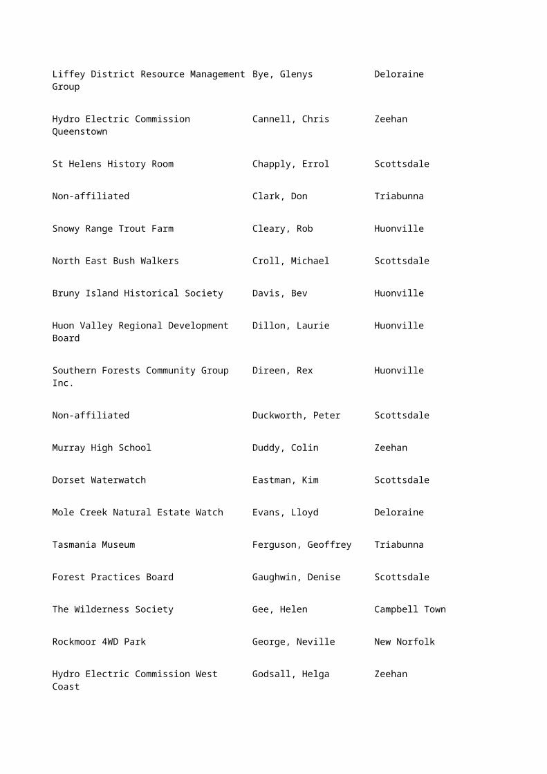
*Ramiheithrus kocinus (caddisfly) - /R(S)
*Stenopsychodes lineata (caddisfly) - /R(S)
*Tasimia dreparia (caddisfly) - /R(S)
Aphilorheithrus luteolus (caddisfly) - / R
Archaeophylax vernalis (caddisfly) - / R
Caloca n.sp. (caddisfly) - / R
Conoesucus n. sp. (caddisfly) - / R
Diplectrona n. sp. (caddisfly) - / R
Ecnomina n. sp. (caddisfly) - / R
Ethochorema ithyphallicum (caddisfly) - / R
Hydobiosella orba (caddisfly) - / R
Nanoplectrus truchanasi (caddisfly) - / R
Oecetis umbra (caddisfly) - / R
Poecilochorema circumvoltum (caddisfly) - / R
Poecilochorema evansi (caddisfly) - / R
Smicrophylax simplex (caddisfly) - / R
Table P.1 (cont'd) Rare and endangered fauna: species considered under criterion B.1
Species according to dominant habitat Status:
nat./Tas
Forest
dependence Range
Freshwater (cont'd)

Taschorema n. sp. (caddisfly) - / R
Tasmanoplegas n. sp. (caddisfly) - / R
Tasmanthrus n. sp. (caddisfly) - / R
Westriplectes pedderensis (caddisfly) - / R
*Beddomeia angulata (hydrobiid snail) - /R(S)
*Beddomeia averni (hydrobiid snail) - /R(S)
*Beddomeia bellii (hydrobiid snail) - /R(S)
*Beddomeia bowryensis (hydrobiid snail) - /R(S)
*Beddomeia briansmithi (hydrobiid snail) - /R(S)
*Beddomeia camensis (hydrobiid snail) - /R(S)
*Beddomeia capensis (hydrobiid snail) - /R(S)
*Beddomeia fallax (hydrobiid snail) - /R(S)
*Beddomeia forthensis (hydrobiid snail) - /R(S)
*Beddomeia franklandensis (hydrobiid snail) - /R(S)
*Beddomeia fromensis (hydrobiid snail) - /R(S)
*Beddomeia fultoni (hydrobiid snail) - /R(S)
*Beddomeia gibba (hydrobiid snail) - /R(S)
*Beddomeia hallae (hydrobiid snail) - /R(S)
*Beddomeia hermansi (hydrobiid snail) - /R(S)
*Beddomeia hulli (hydrobiid snail) - /R(S)

*Beddomeia inflata (hydrobiid snail) - /R(S)
*Beddomeia kershawi (hydrobiid snail) - /R(S)
*Beddomeia kessneri (hydrobiid snail) - /R(S)
*Beddomeia launcestonensis (hydrobiid snail) - /R(S)
*Beddomeia lodderae (hydrobiid snail) - /R(S)
*Beddomeia mesibovi (hydrobiid snail) - /R(S)
*Beddomeia minima (hydrobiid snail) - /R(S)
*Beddomeia petterdi (hydrobiid snail) - /R(S)
*Beddomeia phasianella (hydrobiid snail) - /R(S)
*Beddomeia protuberata (hydrobiid snail) - /R(S)
*Beddomeia ronaldi (hydrobiid snail) - /R(S)
*Beddomeia salmonis (hydrobiid snail) - /R(S)
*Beddomeia tasmanica (hydrobiid snail) - /R(S)
*Beddomeia topsiae (hydrobiid snail) - /R(S)
*Beddomeia trochiformis (hydrobiid snail) - /R(S)
*Beddomeia turnerae (hydrobiid snail) - /R(S)
*Beddomeia waterhouseae (hydrobiid snail) - /R(S)
*Beddomeia wilmotensis (hydrobiid snail) - /R(S)
*Beddomeia wiseae (hydrobiid snail) - /R(S)
*Beddomeia zeehanensis (hydrobiid snail) - /R(S)
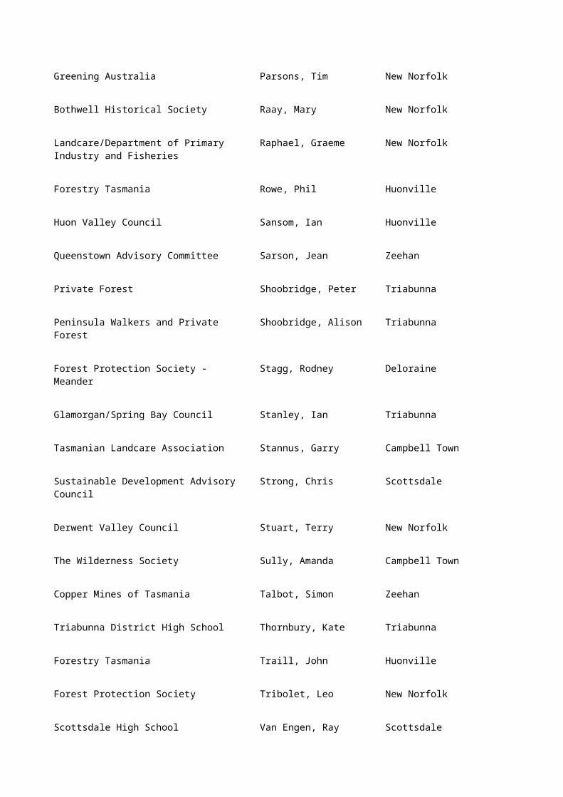
*Phrantela annamurrayae (hydrobiid snail) - /R(S)
*Phrantela conica (hydrobiid snail) - /R(S)
Table P.1 (cont'd) Rare and endangered fauna: species considered under criterion B.1
Species according to dominant habitat Status:
nat./Tas
Forest
dependence Range
Freshwater (cont'd)
*Phrantela marginata (hydrobiid snail) - /R(S)
*Phrantela pupifomis (hydrobiid snail) - /R(S)
Wetlands
*Litoria raniformis (green and gold bell frog) - / V Low Wide-spread
Caves
*Goedetrechus mendumae (cave carabid beetle) - / V Low Restricted
*Goedetrechus parallelus (cave carabid beetle) - / V Low Restricted
*Tasmanotrechus cockerilli (cave beetle) - / V Low Restricted
*Idacarabus troglodytes (cave carabid beetle) - / R(S) Low Restricted
*Idacarabus cordicollis (cave carabid beetle) - / R(S) Low Restricted
Idacarabus longicollis (cave carabid beetle) - / R Low Restricted
*Pseudotyrannochthonius typhlus (false scorpion) - / R(S) Low Restricted
*Olgania excavata (cave spider) - / R(S) Low Restricted
Hickmanoxyomma cavaticum (cave harvestman) - / R(S) Low Restricted

Hickmanoxyomma gibbergunyar (cave harvestman)
- / R(S) Low Restricted
Hickmanoxyomma goedei (cave harvestman) - / R Low Restricted
Hickmanoxyomma clarkei (cave harvestman) - / R Low Restricted
Hickmanoxyomma eberhardi (cave harvestman) - / R Low Restricted
Hickmanoxyomma troglodytes (cave harvestman) - / R Low Restricted
Tupua cavernicola (web spinning cave spider) - / R Low Restricted
*Echinodillo cavaticus (Flinders Island cave slater) - / R(S) Low Restricted
*Styloniscus n. sp. (cave slater) - / R(S) Low Restricted
Notoniscus n.sp. (cave slater) - / R Low Restricted
Pseudotricula eberhardi (freshwater cave snail) - / R Low Restricted
Phrantela kutikina (freshwater cave snail) - / R Low Restricted
*Micropathus kiernani (cave cricket) - / R(S) Low Restricted
*Parvotettix rangaensis (cricket, Furneaux group) - / R(S) Low Restricted
Parvotettix whinrayi (cricket, Kent group) - / R Low Restricted
Tasmanoplectron isolatum (cricket) - / R Low Restricted
Cavernotettix craggiensis (Furneaux Is. cricket) - / R Low Restricted
Cavernotettix flindersensis (Furneaux Is. cricket) - / R Low Restricted
Table P.1 (cont'd) Rare and endangered fauna: species considered under criterion B.1
Endemic species and *subspecies (not already identified)
Status:
nat./Tas
Forest
dependence Range

Mammals
Nyctophilus sherrini (Tasmanian long-eared bat) - / - High Localised
Pseudomys higginsi (long-tailed mouse) - / - Medium Localised
Antechinus minimus (swamp antechinus) - / - Medium Localised
Antechinus swainsonii (dusky antechinus) - / - Medium Localised
Sarcophilus harrisii (Tasmanian devil) - / - Medium Wide-spread
Sminthopsis leucopus (white-footed dunnart) - / - Medium Localised
Isoodon obesulus (southern brown bandicoot) - / - Medium Wide-spread
Pseudocheirus peregrinus (ringtail possum) - / - Medium Wide-spread
Cercartetus nanus (eastern pygmy possum) - / - High Localised
Potorous tridactylus (long-nosed potoroo) - / - High Localised
Macropus giganteus (Forester kangaroo) - / - Medium Localised
Birds
Platycercus caledonicus (green rosella) - / - Medium Wide-spread
Platycercus eximius diemenensis (eastern rosella) - / - Medium Localised
Ninox novaeseelandiae leucopsis (southern boobook)
- / - High Wide-spread
Aegotheles cristatus tasmanicus (Australian owlet nightjar)
- / K High Localised
Tyto novaehollandiae (masked owl) - / K High Wide-

spread
Melanodryas vittata (dusky robin) - / - Medium Wide-spread
Stipiturus malachurus (southern emu wren) - / - Low Localised
Sericornis magnus (scrubtit) - / - High Localised
Acanthiza pusilla archibaldi (King Island thornbill) - / K Medium Restricted
Lichenostomus flavicollis (yellow-throated honeyeater)
- / - Medium Wide-spread
Melithreptus affinis (black-headed honeyeater) - / - Medium Wide-spread
Melithreptus validirostris (strong-billed honeyeater)
- / - Medium Wide-spread
Phylidonyris melanops crassirostris (tawny crowned honeyeater)
- / - Medium Localised
Table P.1 (cont'd) Rare and endangered fauna: species considered under criterion B.1
Endemic species and *subspecies (not already identified)
Status:
nat./Tas
Forest
dependence Range
Reptiles and amphibians
Niveoscincus pretiosus (Tasmanian tree skink) - / - High Wide-spread
Ranidella tasmaniensis (Tasmanian froglet) - / - Medium Wide-spread
Fish
Galaxias auratus (golden galaxias) - / M Medium Localised
Paragalaxias mesotes (Arthurs paragalaxias) - / M Medium Restricted

Migratory species (not already identified)
Neophema chrysostoma (blue-winged parrot) - / - High Localised
Cuculus pallidus (pallid cuckoo) - / - Medium Wide-spread
Cuculus pyrrhophanus prionurus (fan-tailed cuckoo)
- / - Medium Wide-spread
Chrysococcyx basalis (Horsefields bronze cuckoo) - / - Medium Localised
Chrysococcyx lucidus plagosus (shining bronze cuckoo)
- / - Medium Localised
Coracina novaehollandiae (black-faced cuckoo shrike)
- / - Medium Wide-spread
Myiagra cyanoleuca (satin flycatcher) - / - Medium Localised
Rhipidura fuliginosa albiscapa (grey fantail) - / - Medium Wide-spread
Pardalotus striatus (striated pardalote) - / - Medium Wide-spread
Zosterops lateralis lateralis (silvereye) - / - Medium Wide-spread
Artamus cyanopterus cyanopterus (dusky woodswallow)
- / - Medium Wide-spread
Petroica phoenicea (flame robin) - / - Medium Wide-spread
Other sensitive forest species Status:
nat./Tas
Forest
dependence Range
Vertebrates
Pseudomys fuscus (broad-toothed mouse) - / K Low Localised

Nyctophilus geoffroyi (lesser long-eared bat) - / - High Wide-spread
Chalinolobus gouldii (Gould’s wattled bat) - / - High Localised
Table P.1 (cont'd) Rare and endangered fauna: species considered under criterion B.1
Other sensitive forest species Status:
nat./Tas
Forest
dependence Range
Chalinolobus morio (chocolate-wattled bat) - / - High Wide-spread
Falsistrellus tasmaniensis (eastern falsistrellus) - / - High Localised
Vespadelus regulus (southern forest bat) - / - High Widespread
Vespadelus vulturnus (little forest bat) - / - High Wide-spread
Vespadelus darlingtoni (large forest bat) - / - High Wide-spread
Cercartetus lepidus (little pygmy possum) - / M High Wide-spread
Alcedo azurea (azure kingfisher) - / K High Localised
Falco longipennis (Australian hobby) - / K Medium Localised
Falco berigora tasmanica (brown falcon) - / - Medium Wide-spread
Accipiter fasciatus (brown goshawk) - / - High Wide-spread
Accipiter cirrhocephalus (collared sparrowhawk) - / - High Wide-spread
Haliaeetus leucogaster (white-bellied sea eagle) - / - High Localised
Calyptorhynchus funereus xanthanotus (yellow-tailed black cockatoo)
- / - High Localised
Cacatua galerita galerita (sulphur-crested cockatoo)
- / - High Localised

Petroica rodinogaster (pink robin) - / - High Localised
Pezoporus wallicus (ground parrot) - / M Low Localised
Zoothera lunulata (whites thrush) - / - Medium Localised
Stagonopleura bella (beautiful firetail) - / - Medium Wide-spread
Phaps elegans (brush bronzewing) - / - High Wide-spread
Phaps chalcoptera (common bronzewing) - / - High Wide-spread
Tympanocryptis diemensis (mountain dragon) - / K Medium Wide-spread
Pseudemoia pagenstecheri (tussock skink) - / K Low Localised
Pseudomoia rawlinsoni (glossy grass skink) - / K Medium Localised
Limnodynastes peroni (striped marsh frog) - / - Medium Localised
Pseudophryne semimarmorata (southern toadlet) - / - Medium Localised
Table P.1 (cont'd) Rare and endangered fauna: species considered under criterion B.1
Functional groups Status:
nat./Tas
Forest
dependence Range
Hydrobiid snails
Caddisflies
Notes: Status-Tasmania: according to the Threatened Species Protection Act 1995 or proposed updates to the vertebrate and invertebrate (1994) lists. E = endangered,V = vulnerable, R = rare, R(S) = rare suceptible, M = potentially vulnerable and requiring monitoring, K = insufficiently known. Nationally- according to species listing (or proposed listing) on the Commonwealth Endangered Species Protection Act 1992.
Forest Dependence -`High' means important stages of the species life cycle are linked to forest ecosystems; `medium' refers to species that occur in forests and non-forest types; `low' means species not based in forested vegetation types (for example, freshwater).
Range-'restricted' means species occurs in only a few locations in a specific habitat; `localised' means species occurs in a specific habitat type or a few regions but throughout Tasmania;
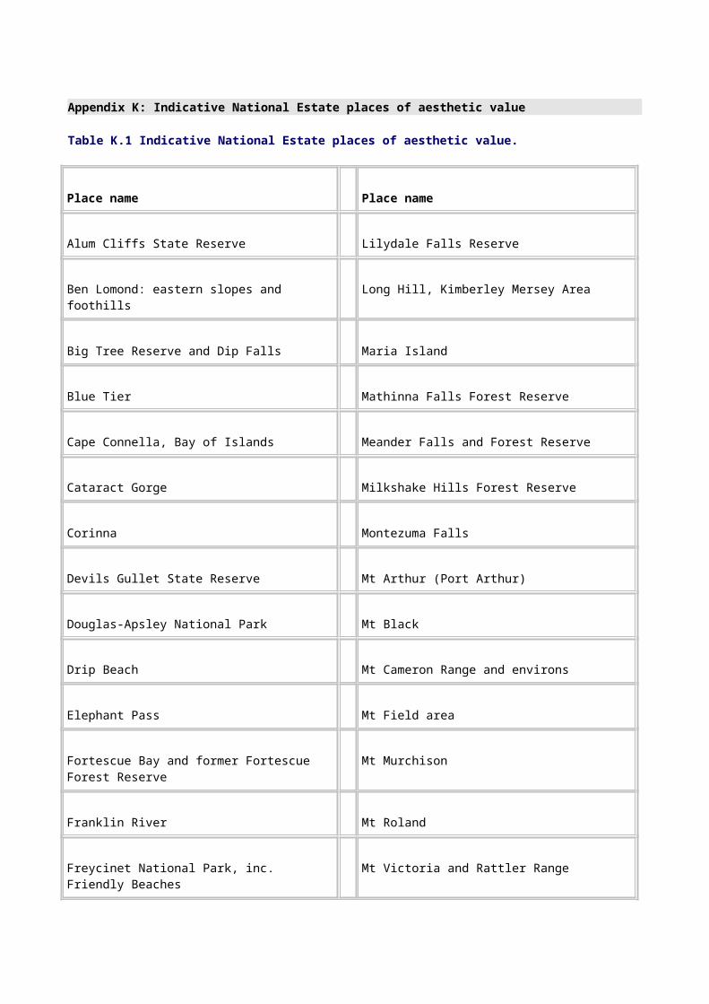
`widespread' means species occurs in a number of broad forest types and areas throughout Tasmania.
* = listed in the Tasmanian Threatened Species Protection Act 1995.

Appendix Q: Indicative National Estate geological, geomorphological and soil sites
Table Q.1 Indicative National Estate geological, geomorphological and soil sites
Site name National Estate criteria
Actaeon Islands Cobble Tombolo A2, D1
Adamsfield - Serpentinite Creek Ultramafics A1, A3, C1, D1
Adamsfield Open Cut Palaeoplacer A1, B1
Adamsfield Workings Mineralogy B1, D1
Adventure Bay Fluvial Sedimentary Structures A1, A3
Albatross Island Raised Sea Tunnel Caves A1, B1, D1
Algonkian Rivulet Karst B1, D1
Anthony River Section of Sticht Range Formation C1
Apsley Volcanic Necks & Buchite A1, B1
Arthur Lineament A1, C1
Arthur River Estuary A2, D1
Arthur River Stromatolite Localities A1
Arthur River Togari Group Typical Section C1
Atkins Range Ironstone A1, B1
Badger Creek Pseudokarst Drainage A2, D1
Badger Head Structures A1
Badger Island Limestone Pavement D1

Bare Rock Cliff, Fingal B1
Barn Bluff - Mt Inglis Late Palaeozoic Glacial Valley A1, B1
Bedlam Walls Scarp A1
Bellingham Formation Type Locality C1
Ben Lomond Terrain A1, C1, D1
Bennetts Point Measurement Site H1
Betts Track 'Cannonball' (Orbicular) Site B1
Bicheno Blowhole A2
Bills Creek Eclogite A1, B1
Birchs Inlet Peats A2, B1
Birchs Inlet Terraces A1
Bird Island Aeolianite & Karst A2, A3, D1
Black Pyramid Volcanics A1, A3
Black River Unconformity A1, C1
Blackman Bay Coastal Landforms A1, A3, D1
Blackmans Bay Dolerite Contact A1, C1
Blinking Billy Point Basaltic Volcanics A1, C1, H1
Blister Cave B1
Bluff River Sandstone Cliffs/Caves Complex A2, A3, D1
Blythe Heads Folding A1

Boco Drift End Moraines A1, C1
Boco Formation Type Site & End Moraines C1
Bogan Gap Group Type Section C1
Boggy Creek Tufa Terraces A2, B1, D1
Bond Bay Schist A1, B1
Borradaile Plains Basalt Mass Movement Feature A1, B1
Braddon River Floodplain & Terraces A1, D1
Breakneck Point Section C1
Bulgobac Formation Type Site-Animal Creek
Table Q.1 (cont'd) Indicative National Estate geological, geomorphological and soil sites
Site Name National Estate criteria
Bulgobac Glaciation End Moraines A1, B1, C1
Bulgobac Siding Moraines A1, C1
Buster Ridge Triassic Rhyolitic Tuff A1, B1
Calcified Forest A1, D1
Cape Frankland Tourmaline Nodules B1
Cape Grim Volcanics A1, A3
Cape Hauy High Coastal Landforms A2, A3
Cape Portland Cretaceous Volcanics A1, B1

Cape Surville Dolerite Feeder Intruding Basement A1, B1, D1
Cape Wickham Precambrian Intrusives A1, B1
Castle Cary Structure Landform A1
Cave Beach Karren & Caves A2, B1
Central Highlands Cainozoic Glacial Area A1, B1
Central Plateau Terrane A1, B1, D1
Cethana Oligocene Plant Fossil Locality A1, A3, D1
Cethana Unconformity A1, C1
Chalice Lake Rock Basin Lake A1, D1
City of Melbourne Bay Foreshore A1, B1, D1
Clytie Cove Sedimentary Structures A1, C1
Coal Bluff Coal H1
Coal Head In Situ Fossil Forest A1, B1, C1
Collingwood River White Schist A1, B1
Collins Bonnet Dolerite Dyke A1
Comstock Sulphide Body & Gossan A1, D1
Conglomerate at Friendly Beaches B1
Cooee Precambrian Dolerite A1, C1
Courland Bay Foliated Granite A1
Cradle Mountain Glacial Features A1, A3, D1

Cube Rock Boulder & Solution Sculpture Features A2
Cumberland Creek Granulite Xenoliths A1, B1
Curtis Island Shearwater-Influenced Lithosols A2, D1
Cuvier Valley Moraine Complex H1
Cynthia Bay Moraines A1, B1, D1
D'Aguilar Range Alluvial Fans A1, D1
Dalrymple Hill Unconformity & Neptunian Dykes A1, D1
Dante Rivulet Glacial Deposits A1, B1, C1
Darwin Crater A1, B1, C1
Darwin Glass Strewn Field B1, C1
De Witt Island Coastal Stream Capture A2, D1
De Witt Island Pseudokarst A2, B1, D1
Deep Bay Permian Section A1, C1
Deep Glen Bay Area Granite Sea Caves A2, D1
Deep Glen Bay Sub-Permian Nonconformity A1
Denison Range Flysch Sequence A1, A3, C1, D1
Denison Range Lower Palaeozoic Terrane A1
Denison Rivulet Volcaniclastic Sediments A1, B1, C1
Dianas Basin Folds A1, B1, C1
Diogenes Creek Mass Movement Feature B1, D1

Dip Falls Basalt Flows A1, A2, D1
Disappearing Tarn Solifluction Colluvium A1
Dismal Swamp Polje B1, D1
Don Heads Basalt & Landforms A1, A2, C1, D1
Table Q.1 (cont'd) Indicative National Estate geological, geomorphological and soil sites
Site Name National Estate criteria
Double Lagoon Ground Moraine A1
Dublin Bog Palynological Site A1, C1
Durham Creek Meander Cave & Speleothems A2, B1
Egg Islands Tidal Delta A2, D1
Egg Lagoon Fossil Site(s) A1, C1
Elderslie Sandstone Landforms A2, D1
Ellinthorp Plains Lunette Systems A1, D1
Elliott Bay Fossil Sea Cliffs A1
Emu River Incised Meanders A2, D1
Eugenana Devonian Cave Deposits A1, C1
Eureka Dolerite Cone Sheet A1, B1, C1
Exit Cave - D'Entrecasteaux Valley Karst Area A1, A2, A3, B1, C1, D1
February Creek Glacial Stratigraphic Site C1

Fingal Tier Porphyritic Glassy Dolerite B1
First Gorge Structure A1
Fish River Alluvial Fan D1
Flat Top & Round Top Islands Geomorphology D1
Florentine Valley Formation Type Site A1, B1, C1
Florentine Valley Gordon Group Fossil Sites A1, C1
Florentine Valley Gordon Group Sections A1, C1
Foochow Beach Parallel Dune System A2, D1
Forestier Peninsula Coastal Landform Assemblage A2, D1
Fossil Bluff A1, C1
Fotheringate Bay Coastal Karst A2, C1, D1
Frederick Henry Bay Beach Alignment A2, D1
Frenchmans Cap-Summit Nivation Cirque A2, D1
Freycinet Palaeosol A1, B1
Freycinet Peninsula Soils A2, D1
Goat Island Conglomerate A1, B1, C1, D1
Golden Ridge Graptolite Fossil Occurrence B1, C1
Gordon Dam Polyphase Folding A1, C1
Gordon Power Station Schists B1
Granite Point Contact Features A1, B1, C1
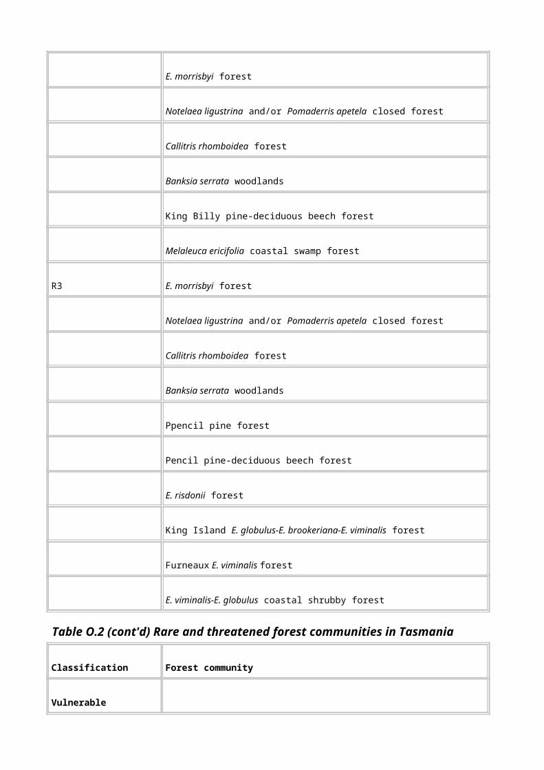
Granton Permian Type Section A1, B1, C1
Great Bay Ferricrete A1, B1, D1
Great Musselroe Bay Spit A2, D1
Great Western Tiers Escarpment A1
Gunns Plains Karst A1
Hamilton Moraine A1, C1
Hasties Eocene Fossil Site A1, B1, C1
Hastings - Upper Creekton Rivulet Karst A2, B1
Hatfield River Oligocene Fossil Site A1
Haulage Unconformity Type Area A1, C1
Hazards Isthmus A2, D1
Hellfire Bluff Cliff & Mass Movement Features A1, D1
Hellyer River Insect Fossil Locality B1, C1
Henty Moraine Glacial Deposits A1, C1
High Yellow Bluff Natural Landslip A2, D1
Hogan Island Springs & Peat A2, B1
Holts Point Hybrid Zone A1, D1
Horseshoe Bend D1
Table Q.1 (cont'd) Indicative National Estate geological, geomorphological and soil sites

Site Name National Estate criteria
Humboldt Divide Stromatolite-Bearing Dolomite A1
Huntsmans Creek Triassic Basalt A1, C1
Husskinson Syncline Strike Ridge A1
Idaho Formation Pliocene Fossil Site A1, B1, C1
Ile des Phoques Sea Caves A3, D1
Iron Blow Opencut & Great Lyell Fault Exposure C1, C2
Iron Monarch Cave B1
John Bulls Rock Unconformity A1, D1
Junee-Florentine Karst A1, A2, A3, B1, C1, D1
K Col Glacial Diffluence Col A1, D1
Kangaroo Island Concentric Beach Ridges B1
Keith/Arthur Rivers Magnesite Karst A1, B1, D1
Killiecrankie Topaz (`Diamond') Locality B1
Knocklofty Fossil Reptile Locality A1, B1, C1
Lagunta Creek Relations A1
Lake Adelaide Glacial Rock Basin Lake A1, D1
Lake Edgar Fault A1, A2, B1
Lake Ellen Palaeozoic Surface A1

Lake Explorer Rock Basin Lake A1, D1
Lake Fidler & Sulphide Pool Meromictic Lakes A2, B1, C1
Lake Lea Lunettes A1, D1
Lake Mackintosh Mud Crack Casts A1, B1
Lake Pedder Dune System A1, B1, D1
Lake Rufus Glacial Trough A1, D1
Lake St Clair Glacial Trough A1, D1
Lake Sydney Glaciokarstic Lake A1, B1
Lake Tahune Glaciokarst Cirque A1, B1
Lake Will Oil Shale B1
Lavinia Point - Cowper Point Dunes A1, A3, D1
Lea River Oligocene Fossil Locality A1, A3, B1, C1
Lees Plains Glacial Valley Profile A1, D1
Lemonthyme Creek Glacials A1, B1, C1
Leven Canyon & Sedimentary Section A2
Lime Bay Volcanic Centre A1
Linda Tertiary Alluvial Deposits A1, B1, C1
Little Beach Porphyrite A1, B1
Little Henty River Raised Last Interglacial Beaches A1
Little Horn Late Palaeozoic Scree B1

Little Rapid River Tertiary Plant Fossil Site A1, C1, D1
Loch Aber Mine Eocene Fossil Site A1
Long Beach Granitic Dykes & Synplutonic Contact A1
Loongana Karst A1
Lost World Boulder Caves A1, B1, D1
Louisa Plains Blanket Bog A2, D1
Lower Franklin Valley Karst A1, A2, D1
Lower Gordon River Levee - Flood Basin System A1, B1, D1
Lower Wattle Grove Permian Section A1, C1
Lune River Area Jurassic Basalts & Gemfield A1, B1
Lune River Plains Karst Hydrology A2, A3, B1, D1
Lynchford Member Type Section C1
Table Q.1 (cont'd) Indicative National Estate geological, geomorphological and soil sites
Site Name National Estate criteria
Lyons River Magnesite Karst A1, B1
Maatsuyker Island Soils A2, B1, D1
Mackintosh Dam Henty Fault Zone Exposure A1, C1
Macquarie Harbour Graben A1, D1
Macquarie Harbour Tertiary Lithological Transition A1
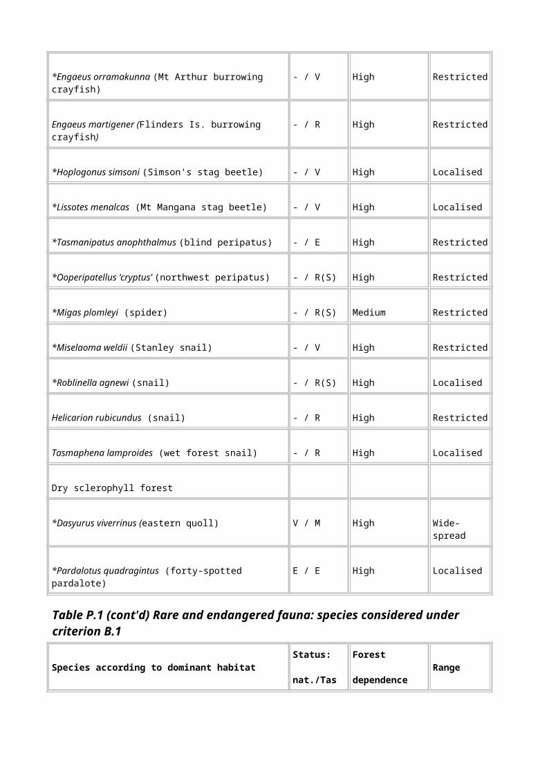
Macquarie Plains Basalt A1
Main Rivulet - Bowry Creek Magnesite Karst A1, B1, D1
Maria Island & (Darlington) Karst A2, B1
Maria Island East Coast Unconformity A1, C1
Marionoak Formation Pleistocene Fossil Site A1, C1
Marriott Hill Fossil Locality A1
Mary Ann Bay Raised Marine Beds A1, C1
Massif Mountain Geomorphology A1, B1
Melaleuca Fossil Flora A1
Mella Spring Mound B1, C1, D1
Meredith Range Joint-Controlled Drainage D1
Mersey River Overflow Channel Glacial Deposits A1, C1
Mickeys Bay `Elephant Skin' Jointing D1
Middle Arm Fossil Site C1, H1
Middle Arm Group Type Section C1
Middle Franklin River Cross-Strike Drainage A1, A2, D1
Middle Gordon River Cross-Strike Drainage A1, A2, D1
Mill Unconformity, Queenstown Mill C1
Misery Hill Late Cambrian Trilobite Site C1
Mole Creek Gordon Group Stratigraphic Sections A1, C1

Mole Creek Karst A1, A2, A3, B1, C1, D1
Monpeelyata Oligocene-Miocene Fossil Locality A1, C1, D1
Montague Caves & Bone Deposits A1
Moonlight Ridge Periglacial Features A1, A2, D1
Moraines A1, B1, C1, D1
Mount Barrow Blockstream A1, D1
Mount Julia Member Type Section C1
Mt Anne (North East Ridge) Glaciokarst A1, A2, B1, D1
Mt Anne Group Type Area C1
Mt Anne Massif Glacial Landforms A1, D1
Mt Anne Precambrian Unconformity A1, C1
Mt Bertha/Savage River Basalt Plateau A2, B1, D1
Mt Cameron Monadnock Granitic Landforms A2, A3, D1
Mt Cripps Karst A1, A2, A3, B1, D1
Mt Elephant Karst B1, D1
Mt Inglis Permian Type Section C1
Mt Jukes Cambrian ?Palaeoregolith A1, B1, D1
Mt Jukes Owen Conglomerate Section A1, A3
Mt La Perouse - Maxwell Ridge Dolerite Contact A1, B1
Mt La Perouse Nivation Site A2, B1

Mt McCutcheon Palaeozoic Unconformity A1
Mt Mismanagement Structured Colluvium Profile A1, D1
Mt Olympus Rock Glaciers A1, D1
Mt Owen Type Section of the Owen Conglomerate C1
Table Q.1 (cont'd) Indicative National Estate geological, geomorphological and soil sites
Site Name National Estate criteria
Mt Punter Block Slide Complex A1, D1
Mt Sedgwick Late Palaeozoic Glacial Features A1, A3, B1
Mt St John - Rosemount Flat Mass Movement Complex A1, D1
Mt Weld Crystal Caves A1, B1
Mt Weld Karst A2, B1
Mt. Bischoff Tin Mines A1, C1
Musselroe Point Granite Contact A1, D1
Myrtle Creek River Capture A1, D1
Narcissus Valley Fluted Moraines A1, D1
National Park Escarpments & Falls D1
National Park Parmeener Supergroup Folds A1
Native Track Tier Wurawina Basal Conformity A1, B1, C1
NE Tasmania Pre-Permian Erosion Suface A1

Nells Bluff Slab Topple A1, B1, D1
Nelson Lagoon Lunette A1, B1, D1
Nelson River Karst A1, A3
New River Beds Type Section C1
Newall Creek Pioneer Beds C1
Newdegate Pass String Bog A2
Newton Dam Spillway Exposures A1, A3, C1
Nicholls Cap A1
North East Arm Structure A1
North Lyell Fault Exposure & Hematite-Barite B1, C1
Nye Bay Mylonite Zone A1
Ocean Beach A2, B1, D1
Old Beach Fossil Locality A1, C1
Old Lymington Jetty Alkaline Dykes A1, B1
Olga Syncline D1
Osmiridium Beach Shear Zone A1
Painted Cliffs B1, D1
Pandani Group Type Area C1
Patersonia Late Palaeozoic Glacial Straie A1, B1
Pedra Branca Cemented Breccia Cones A1
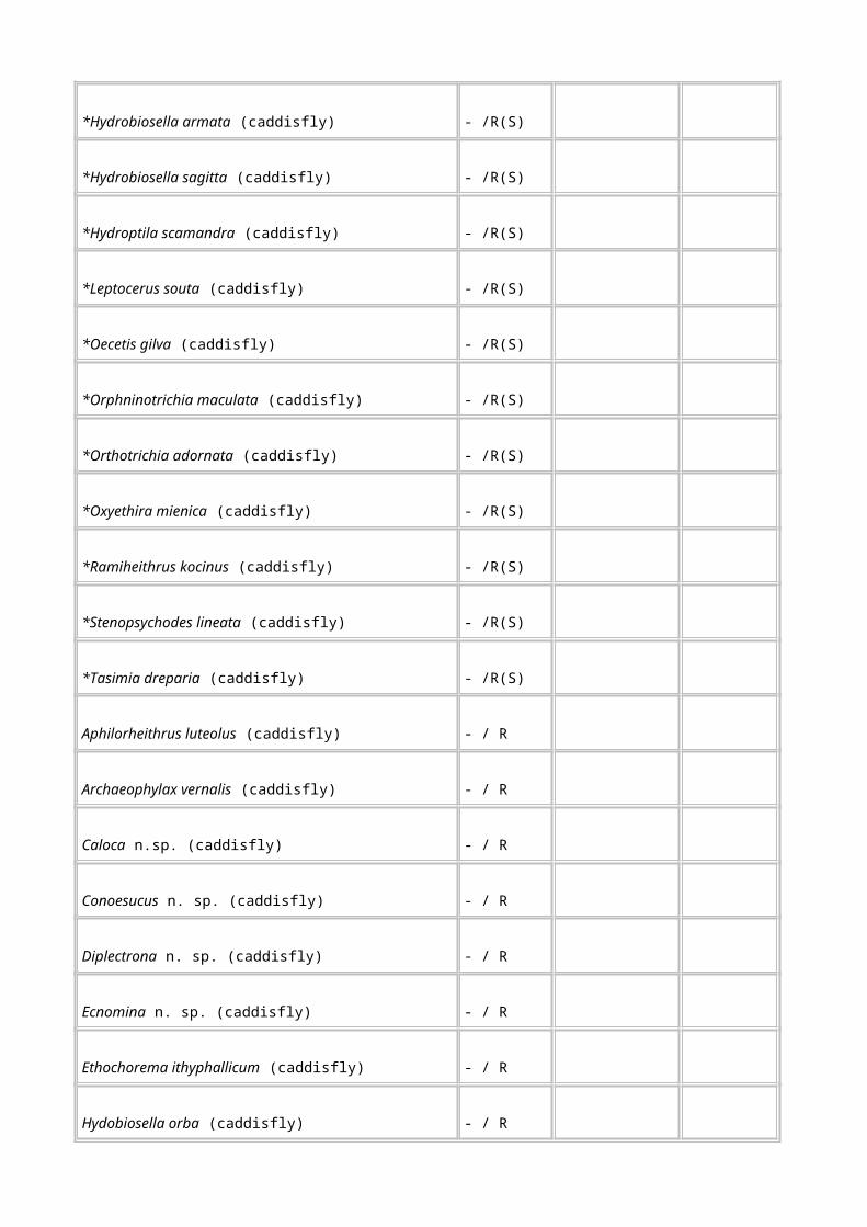
Pedra Branca Mineralogy A2, B1
Penguin Megabreccia A1, B1
Penguin Pillow Lavas A1
Perkins Bay Coastal Depositional Landforms A2, A3, D1
Philosophers Ridge Banded Lavas & Cleavages A1, C1
Piccaninny Point Contact A1, C1
Picton River Ordovician Fossil-Rich Limestones A1, A3, B1
Pieman Head Coastal Landforms & Type Locality A1, A2, C1
Pieman Road Mt Read Volcanics Exposures A1, C1
Pine Lake Glacis A1, D1
Pioneer Oligocene-Miocene Fossil Site A1
Pioneer Ridge Stratigraphy & Structure A1, A3, B1, C1
Planter Beach Coastal Barrier System A2, B1, D1
Plenty Basalts & Sediments A1
Poatina Fossil Crab Site B1, C1
Poatina Group Type Section C1
Poatina Till A1, B1, C1
Poatina Triassic Section A1, C1
Table Q.1 (cont'd) Indicative National Estate geological, geomorphological and soil sites

Site Name National Estate criteria
Point Hibbs Geology & Coastal Karst A1, A2, A3, B1, C1, D1
Poole Peatlands A1, A2
Port Davey - Bathurst Harbour Ria A1, D1
Precipitous Bluff Beds Type Section C1
Precipitous Bluff Dolerite Cliffs A1, D1
Precipitous Bluff Limestone Sequence & Karst A1, A2, A3, D1
Prime Seal Island Karst & Concretions A1, B1
Prince of Wales Range Strike Ridge D1
Prion Beach Beds Type Section C1
Proprietry Peak Types Area A1, C1
Pulbeena Limeworks Quarry A1, C1
Puzzler Gorge A2, D1
Que Drift Type Site C1
Que-Bulgobac Glacial Diversion A1, D1
Ralphs Bay Tidal Flat A2, D1
Rapid River Linear Feature D1
Red Hill Mesa - Tertiary Duricrust Residual A1, D1
Reece Spillway - Whyte Schists A1, C1
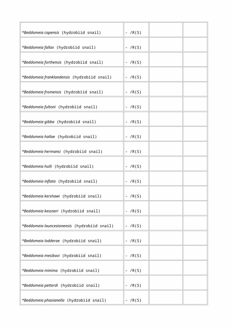
Regatta Point Alkaline Dykes A1, B1
Regatta Point Eocene Fossil Flora Site A1
Regatta Point Pleistocene Fossil Flora Site A1, C1
Reid Rocks Basalt & Mineralogy B1
Remarkable Banks Pleistocene Beach Ridges A1, B1
Remarkable Cave A1, A2, B1, C1
Reward Creek Mineralisation B1
Rheban Beach - Earlham Lagoon A1, A2, C1
Richardsons Beach Levee Study Site C1
Riley Knob LPD Ultramafics D1
Robbins Passage Tidal Channel System A2, D1
Rocky Cape Sea Caves A1
Rocky Cape Type Section & Folds C1
Rodway Valley Blockfield A1, B1, D1
Rosebery (Bastyan Damsite) Fault A1, C1
Rosebery - Hercules Alteration & Mineralisation A1, A3
Sandy Cape Dunes A2
Scarp West of D'Aguilar Range A1, B1
Schouten Island Fault D1
Schouten Island Landslip B1

Scopus Quarry Cambrian Fossil Site A3, C1
Sellars Point Cuspate Foreland & Tombolo A2, D1
Serpentine Hill Ultramafic Complex B1, C1
Seven Mile Beach Spit A3, C1, D1
Sheoak Hill Contact A1, A3
Skyline Tier Graptolite Fossil Occurrence C1
Smelters Quarry Gordon Group Limestone A1, A3
Smithton Basin Plain Karst B1, D1
Sorell - Pocacker Fluvial Landforms A2, D1
South Cape Intrusive Contact A1, A2
South Darwin Peak Granite & Volcaniclastic Conglomerates A1, C1
South Head Contact Migmatite A1
Table Q.1 (cont'd) Indicative National Estate geological, geomorphological and soil sites
Site Name National Estate criteria
Southern West Coast Range Glacial Area A1
Spongolite/Limestone Association A1, B1
St Marys Porphyrite & Catos Creek Dyke A1, B1, C1
St Patricks Head Basaltic Soils A2
Stackeys Bight Arches D1

Steep Island Geomorphology A3, B1
Stephens Bay - Noyhener Beach Dunes A2, D1
Stepped Hills Cuesta D1
Sterile Island Cobble Island A2, D1
Stony Head Bay Folds C1
Stony Head Sandstone Type Locality C1
Strickland Gorge Formation Type Section C1
Stumpys Bay Raised Beach Ridges A1, C1
Styx River Eocene Fossil Site A1
Sulphur Creek Pillow Lava & Folds A1, B1, C1
Sulphur Creek Unconformity A1, C1
Surprise Bay Deep-Water Limestone A1, B1, C1
Table Cape Volcanic Landform A1
Talinah Lagoon End Moraine Complex A1, D1
Tasman Arch - Waterfall Bay Coastal Landforms A2, A3, D1
Tasman Island - Cape Pillar Geomorphology A2, A3, D1
Tessellated Pavement A2, B1, D1
The Boomerang Solifluction Steps A1, A2, B1
The Den Fossiliferous Limestone A1, C1
The Doughboys Contrasting Shore Platforms A2, D1
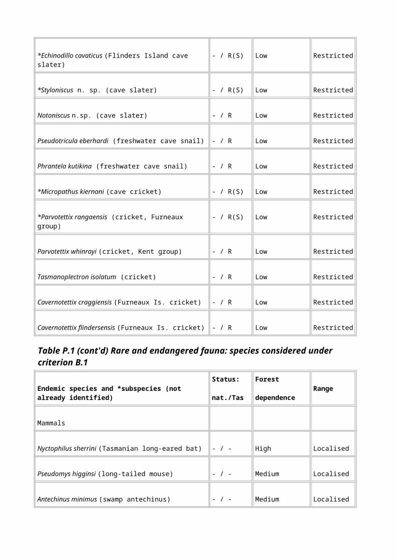
The Fossil Cliffs A1, A3, C1
The Hazards Landforms A2, D1
The Henty Dunes A1, A2, D1
The Neck Tombolo & Dunefield A1, A2, B1, D1
The Nut Volcanic Neck A1, A3, B1
The Two Sisters Soils A2, B1
Tiger Range Group Type Section C1
Tim Shea Unconformity -Tyennan Orogeny Type Site C1
Transect Through Mt Read Volcanics, Mt Jukes Rd A1, A3, C1, D1
Trial Harbour Granite Contact A1, B1
Trial Ridge Cambrian Fossil Locality C1
Trowutta - Sumac Karst A2, B1
Trowutta Arch B1, D1
Trumpeter Islets Porphyroblasts B1
Tuan Gabby Flats A2
Tullochgorom Folds C1
Turquoise Bluff Graptolite Site & Type Locality A1, B1, C1
Tyennan Terrane A1
Tyndall Range Glacial Features A1, A3, C1, D1
Unconformity Ridge, Owen Conglomerate/Sticht Range Formation A1, C1

Unconformity Ridge, Precambrian-Owen Contact A1, B1, C1
Unconformity Ridge, Sticht Range Formation Basal Unconformity A1, C1
Upper Maxwell Valley Alkaline Pans A2, B1, D1
Upper Mersey - King William Range Terrane A1, D1
Table Q.1 (cont'd) Indicative National Estate geological, geomorphological and soil sites
Site Name National Estate criteria
Upper Mersey Valley Last Interglacial Deposit A1, C1
Upper Weld Valley Mixtite - Dolomite Association A1, B1, C1
Vanishing Falls A1, A2, B1
Vansittart Shoal - Pot Boil Tidal Delta A2, D1
Varnished Gum Hill Sticht Range Formation Section C1
Victoria Pass Graptolites C1
Walls of Jerusalem Last Glacial Ice Window A1, D1
Wandle River Ultramafics A1, B1, D1
Wargata Mina (Judds Cavern) Karst System A1, A2, B1, C1
Warners Landing Perched Lake Sediments & Karst B1
Wayatinah Dolerite Soils A2
Weld River Arch A2, B1, D1
Weld River Group Type Area C1

Weld River Precambrian Diopside Dolomite A1, B1
Wellington Range Periglacial Terrain A1, D1
West Arm Group Type Section C1
West Coast Range A1, C1
Western Arthur Range Glaciated Terrain A1, D1
Western Tasmania Blanket Bogs A2, B1
Weymouth Shore Platform A1, A2, A3, B1
White Cliffs Silcrete A1, D1
White Spur Clastic Dykes B1, D1
Wielangta Slump Landform Complex A1, D1
Wilson Bight Schist B1
Wilson River LDH Ultramafic Succession D1
Window Pane Bay High-Altitude Dune B1
Wingaroo Lagoonal Peats B1, D1
Wrights Bay Latest Holocene Deposits A2, C1
Yellow Bluff Upper-Lower Parmeener Supergroup Boundary A1
Yellow Cliffs B1
Zeehan Region Strike Ridge & Valleys A1
Zeehan Smelters Stratigraphic Sections A1, C1
Zeehan Tillite Structures A1

Zig Zag Hill Comstock Formation Type Section A1, B1, C1
Zion Vale Bog A2, B1
Note: Conservation status: 1 = endangered; 2 = threatened; 3 = potential threat; 4 = secure. The sensitivity rating is a numerical scale ranging from 1 (highly sensitive features) to 10 (highly robust features).

Appendix R: Indicative research, teaching and benchmark sites considered to meet the threshold for National Estate criterion C.1
Table Indicative research, teaching and benchmark sites considered to meet the threshold for National Estate criterion C.1
Site name Research (R), teaching (T), benchmark (B)
Reasons for inclusion
Clarence Lagoon
T, R This is a significant site for aquatic research and teaching tertiary field zoology (about 30 students a year).
Primary references: Dr Leon Barmuta, Assoc. Prof. AMM Richardson, Stuart Chilcott, Dr Robert Taylor (pers comm).
Birch’s Inlet R, B This is the site of long-term monitoring of the endangered orange-bellied parrot, along its migratory route to Victoria. Monitoring began about 1985, is done every year, and is continuing. It is also a site for relocation of captive-bred birds, and for testing population rejuvenation techniques (such as providing nesting boxes).
Primary reference: Brown & Wilson (1984)
Cethana, Lea River,
Little Rapid River,
Monpeelyata
R These sites provide the bulk of the Late Eocene - early Miocene macrofossil evidence for Australia as a whole. Other locations of similar age (such as the Latrobe Valley) are quite different in content. The quality of fossil preservation at these sites, the quantity of research that has been performed, and uniqueness of the sites (in the Southern Hemisphere) mean that these sites represent a scientific resource of global significance (Hill 1995).
Primary reference: Hill (1995)
Cradle Valley, Cradle Mountain, Weindorfer's,
Dove Lake
R, B A site of many early biological collections, particularly invertebrates, as a result of the support of Gustaf Weindorfer. Also included in the surveying for the Directed Wildlife Research and Wilderness Ecosystems Baseline Studies conducted by the Parks and Wildlife Service, which were designed to serve as benchmark and reference studies.
References: Coy et al. (1993), Dyne (1988), Fulton & Richardson (1987), Jarman (1988), Moore (1988), Neboiss et al. (1988), Pettigrove (1987), Raven (1987), Richardson & Swain (1988), Schmidt (1988), Schwaner et al. (1987), Smithers (1987), Tait & Briscoe (1987), Timms (1987), Watson & Littlejohn (1988).
Table R.1 (cont'd) Indicative research, teaching and benchmark sites considered to meet the threshold for National Estate criterion C.1
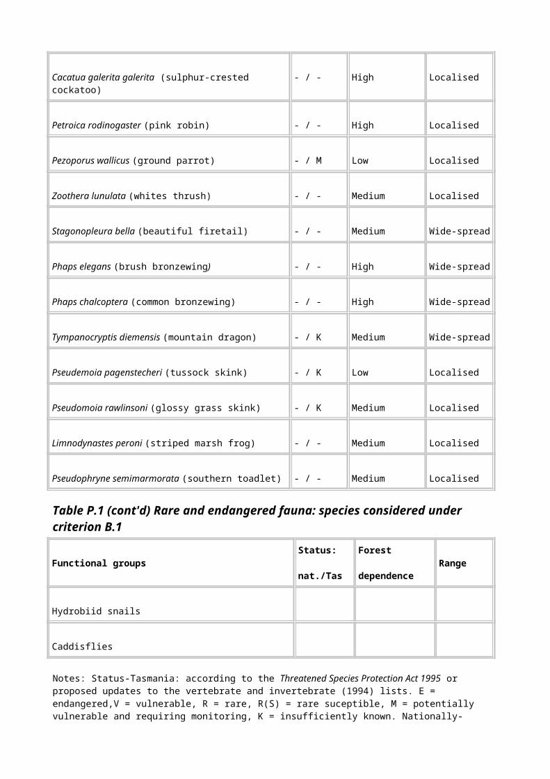
Site name Research (R), teaching (T), benchmark (B)
Reasons for inclusion
Darwin Crater
R, B Very significant in terms of length of time (730 000 years continuous sequences to present) covered by fossil pollen deposits, which have been extensively studied- Jordan (pers. comm.)-and yielded long term information about climatic and vegetation change. It is also a meteorite impact crater and contains human artefacts.
Primary reference: Colhoun & van de Geer (1988)
East Risdon Nature Reserve
R, T, B A site for research and teaching since 1980. Considerable research on evolutionary biology of eucalyptus, and hybrid swarms has been conducted, some with international collaboration. Ongoing PhD research. Currently used for teaching university students (about 40 a year) and honours and PhD projects. The site is also of value to the local community as a park and natural history site.
Primary references: Wiltshire et al. (1991, 1992)
Great Lake R, B Of very high value for research and monitoring particularly for aquatic zoology-S Chilcott (pers. comm.). The area delineated on the map includes the Shannon Lagoon Eucalyptus gunnii site.
Ida Bay Karst Area-Mystery Creek Cave and Exit Cave
R, B `... the Ida Bay Caves have a long history of biological investigation. ... Both caves [Mystery Creek Cave and Exit Cave] have a high degree of biological importance, and the Ida Bay Karst area in general holds the second richest assemblage of cave obligate species presently known in the State...' (Eberhard et al. 1991)
Primary reference: Eberhard et al. (1991)
Judds Cavern R, B `This cave, and others in the Cracroft karst area have a high scientific and cultural value. There is a rich invertebrate fauna, and the caves contain important bone deposits ... including Tasmanian Tiger and several species of Bat bones.' (Eberhard et al. 1991). The area is also important for geomorphological and archaeological studies.
Primary reference: Eberhard et al. (1991)
Lower Gordon River
R, B Extensive biological survey work was conducted in the area prior to Hydro Electric Commission activities (1978). It continues to be an aquatic research site, and there is extensive, and continuing, research and monitoring of bank erosion in the lower reaches.
Primary reference:
Table R.1 (cont'd) Indicative research, teaching and benchmark sites considered to meet the threshold for National Estate criterion C.1

Site name Research (R), teaching (T), benchmark (B)
Reasons for inclusion
Melaleuca,
Bathurst Harbour
R, B Considerable research and monitoring in a number of fields has been conducted in the area; for example ground parrots, orange-bellied parrots, Lomatia tasmanica, amphipods, and successional relationships on low fertility sites. The site is also part of the Directed Wildlife Research and Wilderness Ecosystem Baseline Studies, planned as a baseline study for long-term monitoring of species richness and abundance. It is relatively isolated from the effects of human disturbance and therefore constitutes an excellent benchmark site.
Primary references: Green (1961), Tait & Briscoe (1987), Horwitz (1988), Schmidt (1988), Walker (1988), Watson & Littlejohn (1988), Green (1930), Green (1987), Green (1989), Green (1993), Brown et al.(1980), Brown et al. (1981), Brown et al. (1982), Brown et al. (1985)
Mole Creek Karst
B, R `Kubla Khan Cave has the highest diversity of species recorded from a Tasmanian cave ... consisting of eleven species of troglobites and several genera and species new to science ... Biological monitoring, with a view to identifying important sites and developing a fauna conservation strategy, is warranted.' (Eberhard et al 1991) The area also includes Little Trimmer Cave, where Forestry Tasmania is conducting long-term monitoring of hydrology, water quality and fauna.
Primary reference: Eberhard et al. (1991)
Moulting Lagoon Game Reserve
R, B Long-term monitoring of bird populations occurs at this Ramsar site (internationally recognised wetland).
Primary reference: Blackhall (1984)
Mt Read R, B Studies of Huon pine clonal population provide a continuous climatic record for over 10 000 years and are therefore important for long-term monitoring of climatic change. The age of the Huon pines in this area is in itself of great scientific interest. It is a prominent research site, with a diversity of conifers, Gondwanan flora, relict rainforest, and dwarf conifers.
Primary reference: Bacon (1992)
Table R.1 (cont'd) Indicative research, teaching and benchmark sites considered to meet the threshold for National Estate criterion C.1
Site name Research (R), teaching (T), benchmark (B)
Reasons for inclusion
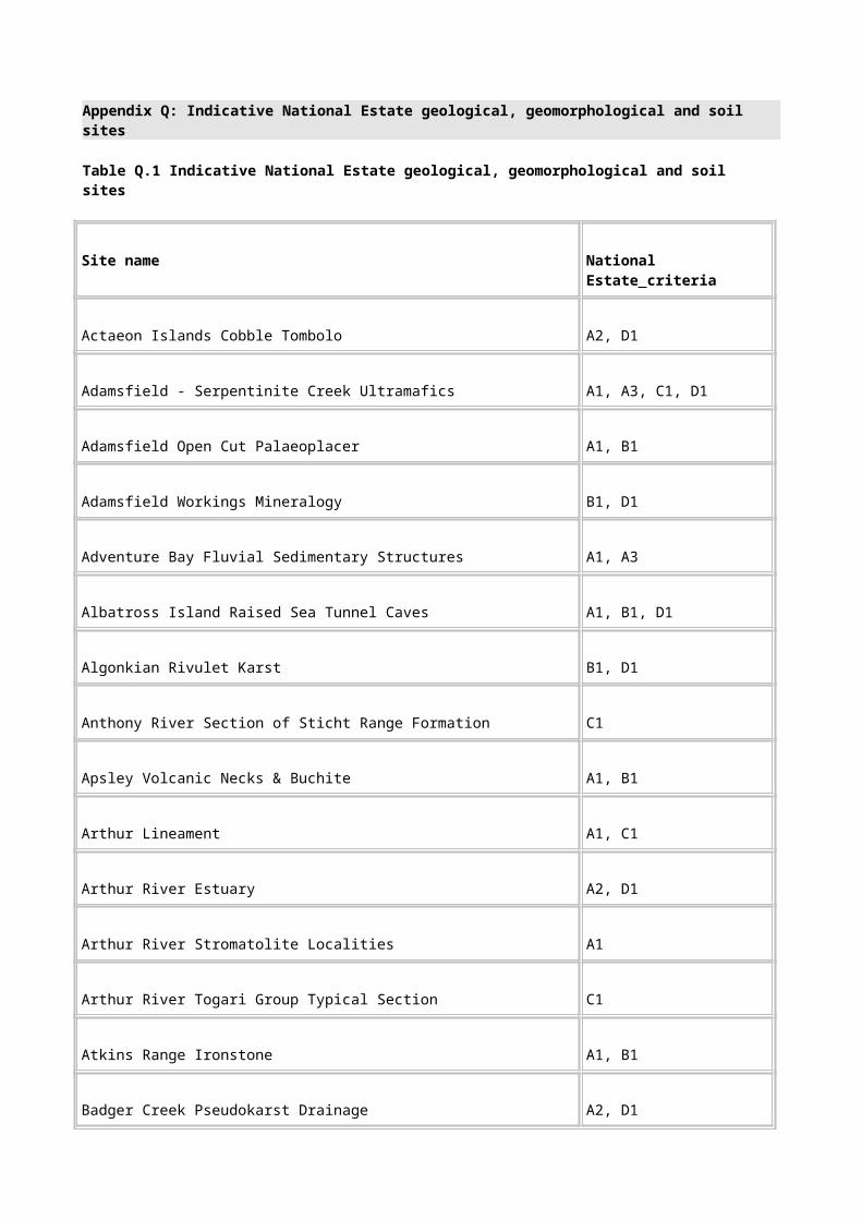
Mt Field National Park
R, T, B The site has been used by various researchers and collectors over a very long period (it was the first and is the most accessible national park in Tasmania). Because it has a long research history it is an important benchmark site. Mt Field has been used for undergraduate teaching since at least the 1960s (over 40-50 students a year) because it contains a great diversity of habitats and vegetation types within a confined and accessible area. This allows examination of the effects of local climatic, geological and altitude factors on vegetation, without the confounding effects of larger scale climatic factors. The Park also has numerous interpretation points, which enhance the public's understanding of Australia’s natural history
Primary references: Hurburgh (1961), Ogden & Powell (DATE?), Coy et al. (1993), Smithers (1987), Fulton (1988), Moore (1988), Schmidt (1988), Winsor (1988)
Mt Maurice-
Paradise Plains
R Site of permanent plots in the Camden Plateau to examine the ecological processes involved in controlling successional relationships in grassland, eucalypt forest and rainforest (the first site in Tasmania where this relationship was studied).
Primary reference: Ellis (1985)
Precipitous Bluff Karst Area
R, B `The caves in this area support the richest assemblage of cave obligate species presently known in temperate zone Australia; at least 15 troglobitic or stygobiontic species have been recorded. In addition, this area has the most highly troglomorphic representatives in several animal groups, including amphipods ... beetles ... molluscs and harvestmen. There is a notable diversity of harvestmen and hydrobiid molluscs' (Eberhard et al. 1991).
Primary reference: Eberhard et al. (1991)
Table R.1 (cont'd) Indicative research, teaching and benchmark sites considered to meet the threshold for National Estate criterion C.1
Site name Research (R), teaching (T), benchmark (B)
Reasons for inclusion
Mt Wellington,
Hobart Domain
R, T, B There was a tremendous amount of early collecting and type specimens in this area, which is therefore important as a benchmark site for long-term monitoring. Various researchers have long-term monitoring plots there; for example, Alistair Richardson has been monitoring invertebrates at Fern Glade Gully for about 25 years. Prominent early scientists such as Darwin, Hooker, Rodway and Curtis collected there. Rodway did important early work on non-vascular flora about 1900 from specimens collected around Mt Wellington. Barber and Jackson did important autoecological studies. The Eucalyptus urnigera cline on Mt Wellington was one of the first identified tree clines in the world-Reid (pers. comm),
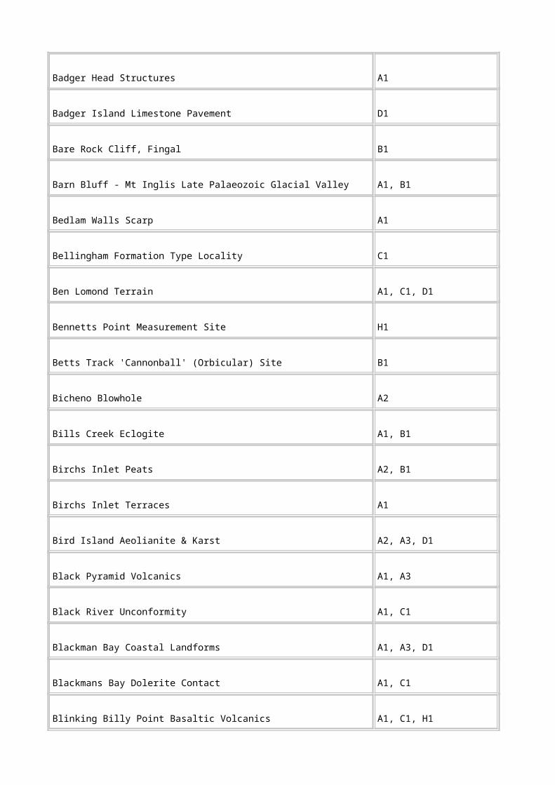
Barber & Jackson (1957). It is an unusually clear example of tree cline. It is a benchmark area for vegetation processes. Martin (1940) conducted vegetation surveys that allowed later comparison with the recovery of vegetation after the devastating 1967 fires (Ratkowsky et al. 1997, 1982b). There is no other site in Australia with such a steep altitudinal gradient (from sea level to >1200 m if the foothills are included) which encompasses such a range of vegetation types - alpine, forests, grassland (Domain) and saltmarshes. This gradient is extremely important for conservation in light of potential climate change (Duncan, pers. comm.). Brown and Kirkpatrick (1990) found that the number of environmental domains is very high, and the level of endemism in the area is very high. There is a long history of research at PhD level and above (from at least 1958) in this area due to the proximity to Hobart and the University. Used for undergraduate teaching, including honours - (currently >60 university students a year. Also used by many school groups and for conference field excursions.
Primary references: Martin (1940); Ratkowsky (1989); Ratkowsky (1976); Ratkowsky (1977); Ratkowsky (1982); Ratkowsky (1982); Barber (1956); Cremer (1965); Paton (1980); Paton (1981); Savva et al. (1988); Thomas & Barber (1974); Thomas & Barber (1974); Thomas (1965); Barber & Jackson (1957); Schwaner et al. (1987); Smithers (1987); Tait & Briscoe (1987)
Table R.1 (cont'd) Indicative research, teaching and benchmark sites considered to meet the threshold for National Estate criterion C.1
Site name Research (R), teaching (T), benchmark (B)
Reasons for inclusion
Pelion -Mt Ossa Area
R, B Under the Directed Wildlife Research and Wilderness Ecosystem Baseline Studies a large amount of research has been done by a large number of specialists. This was planned as a baseline study for long-term monitoring of species richness and abundance.
Primary references: Dyne (1988), Fulton & Richardson (1987)
Snug Tiers R, T This area is used for teaching undergraduate and honours students on a regular basis (about 40 students a year since 1983). It has been used extensively for research from 1982 and is currently being used for research by a number of scientists and honours students. The altitude, geology and topography (cold depressions, drought-prone ridges and sandstone) combine to allow eucalypts that normally occupy different geographic ranges to co-exist. The high-altitude sandstone geology mimics the impoverished soils of the quartzitic west coast of Tasmania, supporting more typically west coast vegetation in places (for example buttongrass plains). The area contains 17 of the 29 Tasmanian eucalypt species, with

outlying populations of a number of (normally) higher altitude or west coast species (for example E. gunnii, E. rubida, E. dalrympleana and E. coccifera). A number of species have (genetically) unusual forms in this area (for example more vigorous E. gunnii, non-glaucous E. urnigera). Because of the atypical combination of species in this area, unusual hybrids swarms occur (for example E. coccifera/pulchella, E. delegatensis/pulchella). Snug Tiers was also a ground parrot study site (Bryant 1991).
Primary reference: Potts (1983)
Table R.1 (cont'd) Indicative research, teaching and benchmark sites considered to meet the threshold for National Estate criterion C.1
Site name Research (R), teaching (T), benchmark (B)
Reasons for inclusion
Warra Long Term Ecological Research and Monitoring Site
R, B This site has been specifically set up to provide an area for long-term research and monitoring in both disturbed (forestry) and undisturbed forests: `Major imperatives in the establishment of the Warra LTERM site have been the perceived need within Australia to form a national network, the creation of the international long term ecological research (LTER) network, and the initiation of a Terrestrial Ecosystem Monitoring Sites (TEMS) database by the Global Terrestrial Observing System (GTOS)... The Warra site has now been registered with GTOS, and will be used to contribute to national and international program on long term ecological research and monitoring. A number of flora and fauna surveys have already been conducted in the area, mainly as pre-logging surveys. Some of these are to be followed by long-term monitoring' (Packham 1995).
Primary reference: Packham (1995)
Yarlington Tier
Nothofagus stand
R, B Relictual Nothofagus stand with a 9000-year pollen history indicating changes in the vegetation. As an east coast outlier of rainforest with a long-term pollen history it constitutes an important benchmark site for monitoring of climate and vegetation changes.
Primary reference: Harle et al. (1993)
Alma Tier (Jimmy’s Marsh) Pensford
Pine Lake
Projection Bluff
Shannon
R, T The Eucalyptus gunnii - E. archeri complex is a very good example of a tree cline, possibly originating from introgression (unusual). This species has been extensively researched since about 1955 and is currently used heavily in fores-tree breeding research. Maintenance of a wide variety of phenotypes (genotypes) is essential to the success of this type of research. A number of sites along the cline are used for undergraduate university teaching (about 20 students a year since 1985). The sites listed represent those that are critical to maintenance of the range of clinal variation in this species.

Lagoon Primary reference: Potts (1983)
Table R.1 (cont'd) Indicative research, teaching and benchmark sites considered to meet the threshold for National Estate criterion C.1
Site name Research (R), teaching (T), benchmark (B)
Reasons for inclusion
Arm River Forest Camp
T The area includes a residential camp catering for tertiary teachers and students, has established education programs, offers access to surrounding World Heritage Areas, and its use has been increasing in the last six years.
Primary reference: Darcy Vickers (pers.comm.).
Eucalyptus morrisbyi stand
(location not identifed on map)
R, T This is a sensitive site. The main value of the stand lies in the extreme rarity and vulnerability of E. morrisbyi. It has been used in a number of studies, has one of the highest levels of self-incompatibility reported for any eucalypt species, and has been also used as a test species to study interspecific hybridisation. It therefore has high scientific research significance.
Primary reference:
Florentine Valley
successional study site;
Junee Karst
R, B From this area Gilbert and Cunningham (Gilbert 1959) synthesised previous observations on successional processes in wet forests, which led to the basis of modern forest management (that is, clear-felling, and so on) (Duncan, pers. comm.). The area also contains karst areas of high scientific value. The
Junee - Floretine Caves contain a diverse fauna, and three caves are type localities. Cashions Creek Cave and Frankcombe Cave are important biological collecting sites (Eberhard et al. 1991).
Primary reference: Gilbert (1959), Eberhard et al. (1991),
Hogsback R, B Research in this area provided some of the first quantitative evidence about ecological boundaries.
Primary reference:.
Lake St Clair R, T, B The site has been used for collecting and surveys for many years. Lake St Clair was sampled by a number of experts as part of the Directed Wildlife Research Surveys, which were planned as a baseline study for long-term monitoring of species richness and abundance.
References: Dyne (1988), Raven (1987), Schwaner et al. (1987), Smithers (1987), Timms (1987), Moore

(1988), Neboiss et al. (1988), Richardson & Swain (1988), Schmidt (1988), Watson & Littlejohn (1988), Winsor (1988)
Table R.1 (cont'd) Indicative research, teaching and benchmark sites considered to be above the threshold for National Estate criterion C.1
Site name Research (R), teaching (T), benchmark (B)
Reasons for inclusion
Mt Arrowsmith
R, T This site is representative of full clinal series in yellow gums (E. johnstonii complex). It is important for understanding the evolution of trees and it is important that a representative site be maintained because genetic techniques are rapidly evolving and increasing in power. Mt Arrowsmith represents the most continuous, intact example of this cline. About 40 field zoology students visit the site each year and there are annual invertebrate collections.
Primary reference Prof. JB Reid; Assoc. Prof. AMM Richardson. (pers.comm.)
Old Chum Dam
R, B This has been a collecting sites for invertebrate zoologists for a sustained period; for example , the Department of Primary Industry holds specimens in its Insect Collection. It is also the focus of more recent collections and studies.
Primary reference: Rob Taylor (pers.comm.)
Weavers Creek
R This site is the best representation of the East Tamar faunal break (an area containing the range boundaries of a number of unrelated species) (R Mesibov, pers. comm.). Faunal breaks are relatively rare in nature and have become even more rare because of habitat fragmentation. This is the narrowest and least-disturbed faunal break so far discovered in Tasmania. Weavers Creek offers particularly good opportunities for studying interspecific interactions which limit species’ ranges (below their ecological tolerances). It is also a naturally well-protected (from disturbance), robust site. The site does not contain a concentration of rare or endemic species: its main value is as a prime site for research in the above fields.
Primary reference: Mesibov (1996).
Table R.1 (cont'd) Indicative research, teaching and benchmark sites considered to be above the threshold for National Estate criterion C.1
Site name Research (R), teaching (T), benchmark (B)
Reasons for inclusion
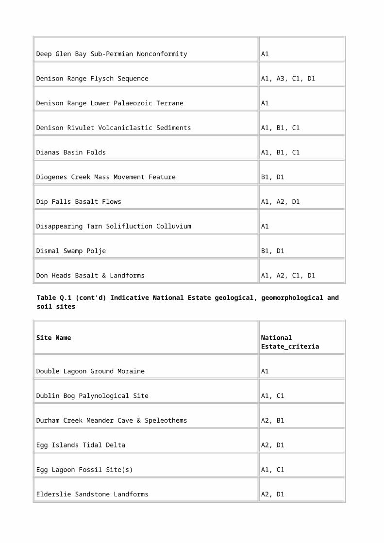
Maggs Mountain
R, B Maggs Mountain has been a major research site for the Queen Victoria Museum (T. Kingston, pers. comm.). Museum researchers have conducted vertebrate fauna surveys very regularly and made specimen collections from 1975 to 1990. For these reasons it constitutes a benchmark site. The area continues to have significance because of the large number of voucher specimens from this area lodged at the Museum (2297 specimens-mammals, birds, reptiles and amphibians). An extensive collection of invertebrates was also made. The collection of mammalian parasites is probably one of the most comprehensive in Australia. Unlike many invertebrate collections, these have been studied in detail by specialists and several new species described based on this material. Once all the material has been identified, the species list from this site will be as comprehensive as for any forest site in Tasmania.
Primary references: Green (1977, 1982)
Mountain River Bridge
R Four years' data on flooding effects on invertebrates in streams have been collected from this site. It is used for Honours teaching and PhD and higher level research. At present there are five people funded by the Australian Research Council working on the site.
Primary reference: Robson (1995).
Appendix S: Description of datasets
S.1 Introduction
The importance of documenting key aspects of data so as to better understand, manage and use the data is being increasingly recognised. This description, or documentation, of data is commonly referred to as `metadata'.
As part of the CRA process, a standard approach has been used to document data consistently. The standard used was developed by the Australia New Zealand Land Information Council (ANZLIC), a group formed to coordinate the collection and transfer of all land and geographic information across all levels of government. All jurisdictions are represented on ANZLIC.
The core metadata outlined in the ANZLIC standard provide basic information about the data, including descriptions of the data, their geographic extent, currency, status, accessibility and quality, and contact information. Two other fields have been identified as important for assessing the suitability of data in the comprehensive regional assessment: a list of attributes and the scale or cell size of the data.
The core metadata provide a useful framework for summarising data across all jurisdictions. They contain the information required to help determine whether data are suitable for a particular assessment and are important in the data-review phase and for data accreditation.
What follows is a summary of the source and derived data used in the national estate assessment of Tasmania. The metadata reported are a subset of the core metadata most useful for documenting data.
S.2 Glossary and list of datasets
The following glossary briefly describes the metadata headings and how they are used.
Dataset
Title
The title is the full name of the data used by the custodial organisation. It is the main identifier of the data for assessment purposes.
Custodian
The custodian is the agency or individual with responsibility for custodianship of a specific set of data. Custodianship involves responsibility for the day-to-day operational management of the data, including data capture, update, maintenance, storage and distribution.
Jurisdiction
`Jurisdiction' refers to the State or Territory for which the custodian of the data is primarily responsible. A custodian can also be responsible for a national data collection. This field is used to help identify the custodian because a number of State and Commonwealth organisations have the same or similar names.
Description
Abstract
The abstract is a narrative summary of the data, describing content, purpose, dates, and so on. This is essential for quickly assessing the content and currency of the data.

Search words
Search words are words a non-expert would probably use for searching. They also describe the data theme and subject matter. This field can be used for searching through large lists of available data and selecting data of interest and relevance to a particular type of assessment.
Attribute list
The attribute list is a summary of attributes of the data, with a brief description of each. The list is critical for determining what information is actually contained within the data.
Geographic extent names
Geographic extent names are standardised, concise descriptions of the geographic extent of the data. This enables a quick geographical assessment of the data.
Data currency
Beginning date and ending date
The beginning and ending dates describe the age of the data. These fields are important for determining the currency of the data.
Data status
Progress
`Progress' means the progress of data development. Whether the data are completed or still in the planning stages may affect the data's use for assessment purposes.
Maintenance and update frequency
The maintenance and update frequency is the frequency of changes or additions to the data after initial completion. The regularity of updating of data can affect their fitness for use.
Format
Stored data format
The stored data format is the format in which the data are stored by the custodian or the agency that distributes the data. The storage affects data accessibility.
Available format type
The available format describes the format in which the data are available to users (that is, the export format). The available format determines the ease of access or conversion into a format compatible with other data being used.
Data quality
Lineage

The lineage is a history of the source data and the processing steps used to produce the data. Information about the events, parameters and source data that were used to construct the data is critical for determining the data's fitness for use. Sufficient information should be given to determine the usefulness and limitations of the data.
Scale
The scale is a ratio of the distance on a map, chart or photograph to the distance on the ground. Scale is generally used if the data were derived by digitising from printed maps or aerial photographs. It reflects the resolution of the data. Larger scale data are preferable if they are of sufficiently high quality.
Cell size
`Cell size' refers to the dimensions of grid cells or pixels. This field is used when describing raster, or gridded, data. The cell size affects the spatial accuracy of the data and any derived products. The smaller the grid cell, the higher the resolution of the data.
Positional accuracy
`Position accuracy' refers to horizontal and vertical assessment of the accuracy of the spatial objects in the data. This field is critical for determining fitness for use.
Attribute accuracy
The attribute accuracy is determined by assessing the reliability of values assigned to features in the data in relation to their true, 'real world', values. This field is critical for determining the fitness of the data for particular purposes.
Logical consistency
The logical consistency field explains how well the logical relationships between items or spatial objects in the data are maintained. Consistency is an important consideration when determining the potential use of data.
Completeness
`Completeness' refers to how complete the data are spatially and in terms of their attributes. This field is useful for determining the fitness for use of all or some of the data.
List of datasets
Centres of Endemism - Flora (ENDCENTRE)
Forest places relating to key artistic and creative sources database
Forest planners aesthetic areas dataset (FPAA)
Forestry Tasmania historic places inventory (FTHPI)
Important wetlands in Tasmania (WETLANDSREP)
Mineral resources location and characterisation system (MIRLOCH)
National Estate social values
Register of the National Estate database

Tasmanian historical archaeological sites catalogue (THASC)
Tasmanian historic places inventory (THPI)
Visual management system (VMS)
Primitive and Relictual Flora of Tasmania (PRIMFLORA)
Primitive and Relictual Fauna of Tasmania (PRIMFAUNA)
Limits of Range - Fauna (FAUNALIM)
Centres of Endemism - Fauna (ENDCENFA)
Disjunct Flora of Tasmania (DISJUNCTFL)
Disjunct Fauna of Tasmania (DISJUNCTFA)
Species Richness - Fauna (RICHNESSFA)
Remnant Vegetation of Tasmania (REMVEG)
Key Fauna Habitat (HABITAT)
Species and Community Richness - Flora (RICHNESS)
Vegetation Succession Sites (SUCCESSION)
Refugia from Present Processes (REFUGIAPRES)
Historic Values (PEARSONCOV, DMARSHCOV, TRACKS)
Old-Growth of National Estate significance
Geoconservation Mapping of Tasmania (CTASGM)
Special Soils Mapping in Buttongrass Areas (BGRASS)
Natural Landscapes of Tasmania (NATLAND)
High Quality Wilderness of Tasmaia (WILDHQ9701)
Undisturbed river catchments of Tasmania (UDCATCH)
Important wetlands in Tasmania (WETLANDSREP)
Principal Characteristics of Forest Vegetation Classes (REPVEG)
Limits of Range - Flora (FLORALIM)
Flora Type Locations (ENDFLORA)
Fauna Type Locations (ENDFAUNA)
Centres of Endemism - Flora (ENDCENTRE)
Social Values (SOCIAL)
Aesthetic Values (SOCAEST)
Tasmanian Reference, Research and Teaching Sites (C1REFCOV)
Rare or Threatened Forest Communities (RARECOMM)
Glacial Refugia Areas of Tasmania (REFUGIAPAST)
Description and documentation of the following datasets is provided in the environment and heritage report (PLUC 1996a, vol.II):
Administration and tenure boundaries (ADMIN)
Botanical surveys database (BOTENTRY)
Climate grids of Tasmania
Construction materials register (CONMAT)
Cultural detail of Tasmania
Digital elevation model
Eucalypt forest senescence (SENCODE)
Forest vegetation communities
Management decision classification (MDC)
Mineral deposits database (MIRLOCH)
National Wilderness Inventory (NWI) database: Tasmania
National Wilderness Inventory (NWI) points: Tasmania
Old-growth forests of Tasmania (OG9610)
Photo-interpreted forest type (PITYPE9609)
Plantation area system (PAS)
Post-aerial photography fires
Pre-1750 forest vegetation reconstruction
Preliminary environmental domains of Tasmania
Provisional coupes (PROVCOUPE)
River flow impediments
Roads updated and classified for the comprehensive regional assessment (CRAROAD)
Simplified photo-interpreted forest type (CPI9605)

Species models
Tenure groups
Timber-harvesting history of Tasmanian forests (THH)
Sub-catchments with river disturbance indices: Tasmania
Wildlife atlas
S.3 The metadata
Centres of endemism - flora (ENDCENTRE)
Dataset
Title: Centres of Endemism - Flora (ENDCENTRE)
Custodian: Forestry Tasmania
Jurisdiction: Tasmania
Description
Abstract: This dataset is a digital polygon coverage of Tasmania (captured at
1: 500 000 scale) detailing the centres of endemism of flora, i.e. areas where concentrations of exclusively Tasmanian flora species are found.
Centres of endemism of flora are coded with a unique number and the relevant National Estate value and criterion.
Search Words: ECOLOGY, ECOLOGY Habitat, FLORA, FLORA Distribution, FLORA Native, HERITAGE, HERITAGE Natural, VEGETATION, VEGETATION Floristic
Attribute List:
CECODE A unique number to identify each centre of endemism polygon.
NEVALUE The National Estate value to which the site relates. All sites in this coverage have National Estate value ‘Centres of Endemism’.
NECRITERIA The National Estate criterion for which the site has been assessed to be above threshold.
All sites in this coverage are classified according to National Estate criterion A1.
Geographic Extent Name: Tasmania
Data Currency
Begin Date: 01 Dec 1996
End Date: 31 Jan 1997
Dataset Status
Progress: Complete
Maintenance & Update Frequency: As required
Format
Stored Data Format: DIGITAL Arc/Info Revision 7.0.4 vector coverage (polygons) stored in a Librarian layer as a 1:500 000 map tile.
Available Formats: DIGITAL Arc/Info export file.
NON DIGITAL Plotted map output is available from a GIS ARCPLOT menu using a HP750 plotter.
Data Quality
Lineage: The dataset was digitised by Forestry Tasmania from 1:500 000 scale paper maps prepared by an expert panel.
Positional Accuracy: The dataset was collected at 1:500 000 scale. The mapped polygon boundaries are indicative areas only and as such their positional accuracy is subjective.
Attribute Accuracy: Attribute accuracy was visually checked at time of data entry.
Logical Consistency: Standard 1:500 000 Forestry Tasmania logical consistency tests were conducted on this dataset, i.e. visual checking of source data, a test of item structures and definitions, a test on the completeness of valid codes and polygons, topological consistency checks to detect flaws in the spatial data (carried out automatically when coverage was built).
Completeness: The coverage is complete for significant centres of endemism for flora in Tasmania.
Contact Information
Organisation: Forestry Tasmania
Position: Tasmanian RFA Environment and Heritage Project Officer
Person: Penny Wells
Address: GPO Box 207B
City: Hobart
State: TASMANIA
Postcode: 7001
Telephone: 02 6233 2614
Facsimile: 02 6233 2744

Electronic Mail Address: [email protected]
Forest places relating to key artistic and creative sources database
Dataset
Title Forest places relating to key artistic and creative sources
Jurisdiction Tasmania
Custodian Australian Heritage Commission/Forestry Tasmania
Description
Abstract The compilation of a list of artists and crafts workers who have or who have had associations with the region's forests was achieved through archival and oral research into Tasmania's arts and crafts, both past and present. This list was organised into a series of databases arranged according to artform. From these databases (fiction, poetry, drama, fine art, craft, photography, film and music), a comprehensive list of forest places associated with artists and crafts workers was constructed (the forest places relating to key artistic and creative sources database).
Search words ART, ARTIST, FORESTS, HERITAGE, HUMAN ENVIRONMENT TOURISM, INSPIRATIONAL, LITERATURE, VISTA, VIEW, WRITER
Attribute list
Fiction writers
Films
Musicians
Fine artists Include painters, print makers and sculptors.
Dramatists
Crafts workers Include wood turners and carvers, furniture designer/makers and paper makers.
Poets
Photographers
Image Tourism Tasmania photographic file.
PC Tasmanian Library postcard collection.

Cal Tasmanian Library calendar collection.
Page Directs the reader to the entry in Appendix 4 (Volume 3 of Young, D 1996, RFA Aesthetic values Identification and Assessment, Stage 1: key artistic and creative sources).
Geographic extent name Tasmania
Data currency
Begin date 01 JUL 1996
End date 01 OCT 1996
Dataset status
Progress Complete
Maintenance and update frequency Complete for Tasmanian RFA
Format
Stored data format DIGITAL Reports
NONDIGITAL Reports
Available format NONDIGITAL Photocopy
Data quality
Lineage 491 forest places were identified from a series of artform databases (fiction, poetry, drama, fine art, craft, photography, film and music) as having associations with artists and /or crafts workers. By excluding (and listing separately) those forest places with only one association with an artist or crafts worker (unless the person in question was internationally-recognised), this list was reduced to 231 places. The names of these remaining forest-places were then entered into a data base, the forest places relating to key artistic and creative sources databases. Under the name of each forest-place in this database were listed the names of the artists and crafts workers associated with it.
By applying a series of significance indicators, a list of places of potential National Estate significance was generated in the Recommended forest places database.
Scale Not applicable
Positional accuracy Not applicable
Attribute accuracy Not applicable
Logical consistency Not applicable
Completeness This database was compiled through a thorough and comprehensive examination of currently available and accessible information.
Contact information

Contact organisation Forestry Tasmania
Contact position Tas RFA Environment and Heritage Project Officer
Contact person Penny Wells
Mailing address GPO Box 207B
Suburb, place or locality Hobart
State or territory Tasmania
Postcode 7001
Telephone 03 6233 2614
Facsimile 03 6233 2744
Electronic mail address [email protected]
Forest planners aesthetic areas dataset (FPAA)
Dataset
Title Forest planners aesthetic areas dataset (FPAA)
Jurisdiction Tasmania
Custodian Forestry Tasmania
Description
Abstract Forest planners aesthetic areas dataset contains information processed by Forestry Tasmania and Tasmanian Parks and Wildlife Service staff regarding the aesthetic quality and attributes of forested areas with which they have extensive first-hand knowledge.
Search words AESTHETICS, FORESTS, LANDSCAPE, SCENIC QUALITY
Attribute list
Name
Regional Office
Contact Number
Name of Place
What is it that makes this place special for you?

AMG Co-ordinates Easting, northing
Map name/number Map name, number, site code
Map scale & date
Using map topography, describe the boundaries of the place
Other comments or additional information Description, condition, use
Attachments Maps showing boundaries, photos, brochures or any additional pieces of information as applicable.
Geographic extent name Tasmania
Data currency
Begin date 01 SEPT 1996
End date 01 OCT 1996
Dataset status
Progress Complete
Maintenance and update frequency Complete for Tasmanian RFA
Format
Stored data format NONDIGITAL Printed material
NONDIGITAL Photography
NONDIGITAL Maps
Available formats Not applicable
Data quality
Lineage The information in this dataset was collected by interviewing the staff of Forestry Tasmania and Tasmanian Parks and Wildlife Service with extensive first-hand knowledge of forest areas. Through the use of a questionnaire, they were asked to identify forest places they believed to be of aesthetic value and to describe the aesthetic attributes. Maps showing boundaries, photos, brochures or any other additional pieces of information were included where appropriate.
Scale 1:100 000

Positional accuracy Areas reported to be of high aesthetic value were hand-drawn on maps. Boundaries were approximated.
Attribute accuracy Not applicable
Logical consistency Not applicable
Completeness Staff of Forestry Tasmania and Tasmanian Parks and Wildlife Service provided information on places of high aesthetic value across the state.
Contact information
Contact organisation Forestry Tasmania
Contact position Tas RFA Environment and Heritage Project Officer
Contact person Penny Wells
Mailing address GPO Box 207B
Suburb, place or locality Hobart
State or territory Tasmania
Postcode 7001
Telephone 03 6233 2614
Facsimile 03 6233 2744
Electronic mail address [email protected]
Forestry Tasmania historic places inventory (FTHPI)
Dataset
Title Forestry Tasmania historic places inventory (FTHPI)
Jurisdiction Tasmania
Custodian Forestry Tasmania and Tasmanian Parks and Wildlife Service
Description
Abstract FTHPI is a paper-based inventory of historic places identified on Forestry Tasmania managed land, as well as on some related crown and private lands. Based on regional and thematic surveys, with data collected largely from field officer oral reports. Digital spot data, current to 1991, is contained within Tasmanian Parks and Wildlife Service's GIS and on Forestry Tasmania's GIS. Forestry Tasmania and Tasmanian Parks and Wildlife Service have agreed that FTHPI material will be part of Tasmanian historical archaeological sites Catalogue (THASC), and will be computerised onto the Tasmanian historic places inventory (THPI).
Search words FORESTS, HERITAGE Historical, HERITAGE Architectural, HUMAN ENVIRONMENT Land use, HUMAN ENVIRONMENT Structure and facilities, HUMAN ENVIRONMENT Utilities
Attribute list

Identification No. (THASC)
Location
Description
Significance
Geographic extent name Tasmania
Data currency
Begin date 01 JAN 1988
End date 01 JAN 1995
Dataset status
Progress Complete
Maintenance and update frequency Complete for Tasmanian RFA
Format
Stored data format NONDIGITAL Printed Material
NONDIGITAL Maps
NONDIGITAL Photography
NONDIGITAL Manual Records System
NONDIGITAL Reports
DIGITAL Maps
Available format DIGITAL ARC/INFO
Data quality
Lineage Since the early 1970s Forestry Tasmania has undertaken a series of regional and forest area studies which provide greater context for assessment than was previously available. At the same time, the number of sites in the inventory has been considerably increased by a study of Mines Department historic records documenting the location of machinery. Documentation of machinery locations are added as site records without any site inspection and often without any other historical information.
FTHPI records have been given THASC numbers and are housed in vertical files ordered by map sheet number. Some support documentation such as field notes, photos and copies of historical documents are housed with the record sheets. Access to the sites by type and location is facilitated by the use of GIS in the regional offices of Forestry Tasmania, which allows THASC information to be viewed on screen in map and report forms, and via a series of 1:100 000 hard copy maps and transparent overlays of THASC sites, generated by GIS.

Scale 1:100 000
Positional accuracy Mostly good, but a percentage which have not been field checked and require verification.
Locations are given to at least 6 figure grid references. Some records have 8 figure grid references.
Attribute accuracy Data is accurate at time of entry to the best knowledge of the people compiling the data.
Logical consistency Data have been identified from field mapping and from published and unpublished sources.
Completeness The duplicates of FTHPI data held in the THASC system in Hobart are not backed up by the additional material filed with the records in Launceston. As THASC data is transferred to THPI, this support data will have to be made available so that the most complete information is incorporated.
Majority of data is oral, with limited historical and field recording information (20%).
Contact information
Contact organisation Forest Practices Unit
Contact position Senior Archaeologist
Contact person Denise Gaughwin
Mailing address PO Box 180 Kings Meadows
Suburb, place or locality Launceston
State or territory Tasmania
Postcode 7249
Telephone 03 6336 5384
Facsimile 03 6336 2633
Electronic mail address [email protected]
Important wetlands in Tasmania (WETLANDSREP)
Dataset
Title: Important wetlands in Tasmania (WETLANDSREP)
Custodian: Forestry Tasmania
Jurisdiction: Tasmania
Description

Abstract: This dataset is a digital polygon and point coverage (captured at 1:500 000 scale) detailing important wetlands of Tasmania which are listed in the Important Wetlands Directory of Australia.
Important wetlands are coded with a unique number, map details, size parameters, and the relevant National Estate values and criteria.
Search Words: HERITAGE, HERITAGE Natural, WATER, WATER Groundwater, WATER Lakes, WATER Wetlands
Attribute List:
NE-CODE A unique number to identify each wetlands polygon
MAPNAME Name of 1:100 000 map
MAPNO Identification number of 1:100 000 map
ACCURACY Accuracy of polygon or point location in metres
PLACE(GAZETEER) Gazetted name of important wetland
PLACE-NAME Local name of wetland
AREA(HA) Area of representative wetland in hectares
GREATEST-DIAM(M) Greatest diameter of wetland in metres
LEAST-DIAM(M) Least diameter of wetland in metres
NEVALUE The National Estate value to which the site relates. All sites in this coverage have National Estate value ‘Representative Wetland Areas’.
NECRITERIA The National Estate criterion for which the site has been assessed to be above threshold.
All sites in this coverage are classified according to National Estate criterion D1.
Geographic Extent Name: Tasmania
Data Currency
Begin Date: 01 Dec 1996
End Date: 31 Jan 1997
Dataset Status
Progress: Complete
Maintenance & Update Frequency: As required
Format
Stored Data Format: DIGITAL Arc/Info Revision 7.0.4 vector coverage (polygons) stored in a Librarian layer as a 1:500 000 map tile.
Available Formats: DIGITAL Arc/Info export file.
NON DIGITAL Plotted map output is available from a GIS ARCPLOT menu using a HP750 plotter
Data Quality
Lineage: The dataset was digitised by Forestry Tasmania from point data derived from the Parks and Wildlife Service Wildlife Atlas.
Positional Accuracy: Varies from a few metres where a Global Positioning System was used for location, up to 1 degree. Each site has an accuracy field. Grid coordinates are cross checked with a distance from a known named place where available.
Attribute Accuracy: Attribute accuracy was visually checked at time of data entry.
Logical Consistency: Standard Forestry Tasmania logical consistency tests were conducted on this dataset, i.e. visual checking of source data, a test of item structures and definitions, a test on the completeness of valid codes and polygons, topological consistency checks to detect flaws in the spatial data (carried out automatically when coverage was built).
Completeness: The coverage is complete for Tasmania including the Bass Strait Islands.
Contact Information
Organisation: Forestry Tasmania
Position: Tasmanian RFA Environment and Heritage Project Officer
Person: Penny Wells
Address: GPO Box 207B
City: Hobart
State: TASMANIA
Postcode: 7001

Telephone: 02 6233 2614
Facsimile: 02 6233 2744
Electronic Mail Address: [email protected]
Mineral resources location and characterisation system (MIRLOCH)
Dataset
Title Mineral resources location and characterisation system (MIRLOCH)
Jurisdiction Tasmania
Custodian Mineral Resources Tasmania
Description
Abstract MIRLOCH is a computerised inventory created by Mineral Resources Tasmania. Contains data on past and present mines, prospects and mineral occurrences throughout Tasmania. This includes data on abandoned and operating mines. Data digitised for GIS use.
Search words FORESTS, GEOSCIENCES Geology, MINERALS Mine sites, MINERALS Mineral deposits, INDUSTRY Mining.
Attribute list
MIRLOCH-Id Unique number for each mineral occurrence location.
Quad Mandatory number field giving the number of the quadrangle in which the mineral deposit occurs, eg, 40 for Alberton.
Refno Unique number for each mine or mineral occurrence. The first two characters indicate the 1: 50 000 scale geological quadrangles, followed by a three-digit serial number. For example 37017 represents deposit 17 in quadrangle 37 (Sheffield). The number for quadrangles 1 to 9 inclusive should be prefixed by 0 (eg, 09001).
Name The name(s) of the mine or mineral occurrence where known. Where the name is unknown, the deposit may be given the Mining Lease number, the name of the watercourse (for alluvial workings), name of the relevant prospector, prospecting association, etc. (if known) or simply be titled `Unnamed'. If a series of significant deposits with the same name exists in a limited area, they may be appended A,B,C etc., or a centroid of the deposits given as a single deposit. Alluvial goldfields and other mineral fields may be denoted in this manner.
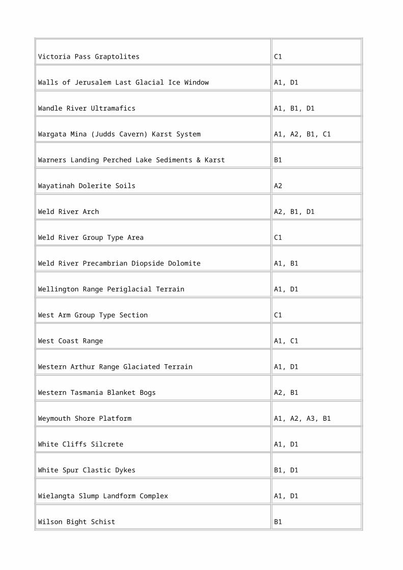
Majorcom The main exploitable commodities in order of importance. Chemical symbols are used for metallic resources where possible (note UR is used for uranium, and some similar exceptions).
Minorcom The minor exploitable commodities in order of importance. The distinction from the main exploitable commodity is somewhat arbitrary, and usage is similar.
AMGE AMG easting
AMGN AMG northing
Accuracy Accuracy of the position of the deposit is indicated by a code, listed in the co-ordinate accuracy authority table MIRLOCH.ACC.
Mapno The 1: 50 000 scale National Map Sheet Index Numbers, eg, 83 124 for Broadmarsh.
Status Code for the present status of a mine (and an indication of whether reserves are known), or whether the deposit is a prospect, mineral occurrence or a mineralised area. A mineralised area may be, for example, an extensive alluvial goldfield, an area of erratic or sub-economic mineralisation, etc.
Size Code for the estimated total in-situ size of the deposit (in tonnes for hard-rock deposits, or in m3 for placer and alluvial deposits).
Host Code for the relevant time/stratigraphic units hosting the deposit. Two host rocks may be defined to cater for discordant deposits that traverse these time/stratigraphic boundaries.
Age Code for the age of the mineralisation. The age of the primary mineralisation is given if the ore has been later remobilised. The age is usually inferred.
Form Code for the overall form of the deposit and/or nature of the mineralisation.
Strike The strike of the deposit, where applicable, in the range 0-359(°T). If unknown or inapplicable, use -1.

Explor Code for the type of exploration which has been undertaken on this deposit. Up to five methods may be entered. Prospecting signifies pits, trenches or shafts. Geological mapping refers to detailed surface and/or underground mapping. Geochemical surveys refer to detailed soil sampling as well as systematic chip sampling of mineralisation and host rocks. Geophysical surveys refers to ground-based techniques related to the deposits. Drilling refers to any drill hole intersecting the deposit.
Ref The best and most recent references available should be listed here, plus relevant comments if space permits.
Geographic extent name Tasmania
Data currency
Begin date 01 JAN 1984
End date Current
Dataset status
Progress In progress
Maintenance and update frequency Continual
Format
Stored data format DIGITAL ARC/INFO
DIGITAL other
Available formats DIGITAL ARC/INFO
DIGITAL ASCII
Data quality
Lineage MIRLOCH consists of 4000 records and is based on mines reports and maps. Does not include processing and infrastructure sites if not on mineral deposit.
The MIRLOCH data is restricted to location and mineral information, with a reference to the Mineral Resources Tasmania record that identified the mine. MIRLOCH could not, therefore, be used in itself to sort out mining sites with heritage potential.
MIRLOCH is limited to the recording of mineral occurrences: that is, where the economic mineral is actually located.
Scale Not known
Positional accuracy Specified in attributes.

Attribute accuracy Data is accurate at time of entry to the best knowledge of the people compiling the data.
Logical consistency Data have been identified from field mapping and from published and unpublished sources.
Completeness MIRLOCH is maintained with new data. Historical data not yet complete, some areas not yet on.
MIRLOCH is based on official Mineral Resources Tasmania records. Mines that were overlooked in the recording process, or were combined in records for larger mineral fields, may not appear in MIRLOCH.
Contact information
Contact organisation Tasmanian Development and Resources
Contact position Mineralogist
Contact person Ralph Bottrill
Mailing address PO Box 56
Suburb, place or locality Rosny Park
State or territory Tasmania
Postcode 7018
Telephone 03 6233 8359
Facsimile 03 6233 8338
Electronic mail address [email protected]
National Estate social values
Dataset
Title National Estate social values (NESV)
Jurisdiction Tasmania
Custodian Australian Heritage Commission/Forestry Tasmania
Description
Abstract The compilation of a list of forest places having social value was achieved through community workshops held around Tasmania. Through the use of data forms, participants identified places important to them. Data was then entered on a computer database.
Search words ASSOCIATIONS AND USE, COMMUNITY, CULTURAL, FORESTS, HERITAGE Architectural, HUMAN ENVIRONMENT Land use, HUMAN ENVIRONMENT Structure and facilities, HUMAN ENVIRONMENT Tourism, HUMAN ENVIRONMENT Utilities, LANDMARK, RECREATION, SOCIAL, SOCIAL VALUE, SPIRITUAL
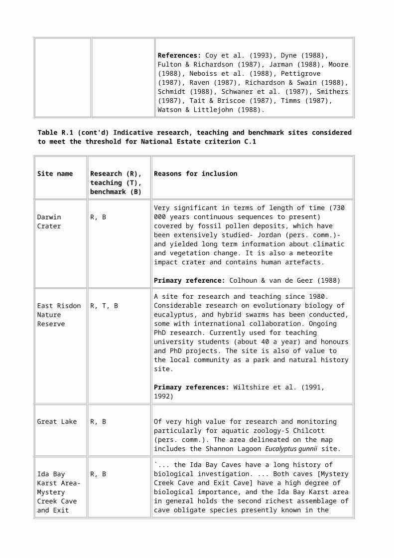
Attribute list
Site no.
Site/place name
Alternate site/place name
Nat.Estate primary class
Nat.Estate primary group
Nat.Estate category
Nat.Estate category code
Forestry Tas site type
Forestry Tas site components
1:100 000 scale map no.
AMG co-ordinates (easting/northing)
Coupe no.
Boundaries of site/place
Size of site/place
Name of locality, block or section
Nearest settlement
Distance from nearest settlement

Direction from nearest settlement
State
Street name
Street number
Suburb/Town
Site, site complex or cultural landscape
Association with higher level site
Site Function
Site date: (Construction/operation)
Commencement date
End date
Accuracy of dating
Land tenure/status
Land manager/owner
Site area subject to mining lease
Existing heritage classification?
Interested parties
Cause of disturbance

Potential disturbance
Physical description
History
Condition summary
Condition description
Integrity
Statement of significance
Recommendations
References
Site data reliability
Date of citation
Name of recorder
Geographic extent name Tasmania
Data currency
Begin date 01 OCT 1996
End date 01 DEC 1996
Dataset status
Progress Complete
Maintenance and update frequency Not planned
Format
Stored data format DIGITAL Database
Data quality

Lineage Community workshops, involving representatives from a broad range of organisations, were held throughout Tasmania.
Identified places were recorded on data forms. Information obtained included a description of each place, its history, location and boundaries and why the place was of social value. Participants also located and marked the boundaries of the places that had been described on 1:100 000 map overlays. This information was then entered on a computer database.
As not all places are equally valued by the community, information obtained was sorted in order to then identify those places of potential National Estate social significance. Only those meeting the threshold for national estate social significance were mapped digitally.
Scale 1:100 000
Positional accuracy Areas reported to be of high social value were hand-drawn on maps. Boundaries were approximated. Often places identified were existing reserves and followed established boundaries.
Attribute accuracy Not applicable
Logical consistency Not applicable
Completeness Complete as a record of the workshops.
Contact information
Contact organisation Forestry Tasmania
Contact position Tas RFA Environment and Heritage Project Officer
Contact person Penny Wells
Mailing address GPO Box 207B
Suburb, place or locality Hobart
State or territory Tasmania
Postcode 7001
Telephone 03 6233 2614
Facsimile 03 6233 2744
Electronic mail address [email protected]
Register of the National Estate database
Dataset
Title Register of the National Estate database (RNE)
Jurisdiction Australia
Custodian Australian Heritage Commission (AHC)
Description

Abstract A record for each place nominated for entry in the Register of the National Estate. Records contain information about the location, significance, status in the registration process, relevant dates, etc.
Search words HERITAGE Aboriginal, HERITAGE Architectural, HERITAGE Historical, HERITAGE National Estate Register, HERITAGE Natural, HERITAGE Wilderness, HUMAN ENVIRONMENT Indigenous communities, HUMAN ENVIRONMENT Land use, HUMAN ENVIRONMENT Recreation, HUMAN ENVIRONMENT Structures and Facilities, HUMAN ENVIRONMENT Tourism, HUMAN ENVIRONMENT Utilities, HUMAN ENVIRONMENT Urban Design, LAND Ownership
Attribute list
Name Place name
File Number
Other names
Database Number
Area Hectares
Net area
Class Highest level of thematic classification ie. Aboriginal, Historic, or Natural. Places are assigned to one or more Classes.
Group As per AHC's Group codes. The Group Level is the second level in the hierarchical classification, below Class and above Category.
Category As per AHC's Group codes. The Group Level is the second level in the hierarchical classification, below Class and above Category.
Theme As per AHC's Principal Australian Historic Themes. Theme is used to denote the historical processes and the pattern of human activity.
Legal Status The status a Place may have under the AHC Act and relevant legal opinions-Indicative Place, Interim List, Registered, Rejected, Removed.
Administrative status The administrative status of a Place, clarifying the Legal Status.

Next step status Represents a basic level of project management of a Place when administrative processes are initiated by nomination, assessment, decision or advice.
Nomination date
Interim list date Date of places that the Commission has gazetted as Places proposed for entry in the Register.
Register date The date a notice of registration has been published. Registration follows interim listing and consideration of any objections.
Construction date Date of construction/establishment; period of use.
Address Number, street, town, State, Post code.
Nearest town Distance and direction from
Conurbation
Local Government Areas
Map sheets
Latitude/Longitude information
Related places Another place that has some relationship to the place, eg a place within a place.
Bibliography
Condition The current state of repair or management of a property.
Integrity The state of authenticity of a Place.
Location/boundary description The boundary of the registered area which may be a single point (eg, for a hitching rail or a hearth site) or an extensive area.

Property information Tenure information
Nominator's statement of significance
Description The description of a Place refers to the essentially factual description of its physical fabric, its processes (historic themes or natural processes), its association with historical figures and associated events or dates.
Official statement of significance Significance is the reason or the basis for considering a Place to be part of the National Estate.
Owner information
Geographic extent name(s) Australia, continental shelf, territorial sea, external Territories
Data currency
Begin date 01 JAN 1977
End date Current
Dataset status
Progress In progress
Maintenance and update frequency Continual
Format
Stored data format DIGITAL Text file
Available formats NONDIGITAL Printouts
Data quality
Lineage Commenced 1977, using data supplied by nominators, and stored on CSIRO Cyber72. Continually upgraded with new records and new data for existing records. Transferred to PICK system 1984. Transferred to current UNIX system 1995.
Scale 1:250 000
Positional accuracy Variable. Locations taken from various scale maps from 1:25 000 to 1:250 000.
Attribute accuracy Not documented.
Logical consistency Each record is internally consistent with respect to locational and descriptive information.

Completeness: All Registered places included. Data on new places continuously added.
Contact Information
Contact organisation Australian Heritage Commission (AHC)
Contact position Director, Register Section
Contact person Robert Bruce
Mailing address GPO Box 1567
Suburb, place or locality Canberra
State or territory ACT
Postcode 2601
Telephone 06 217 2111
Facsimile 06 217 2095
Electronic mail address [email protected]
Tasmanian historical archaeological sites catalogue (THASC)
Dataset
Title Tasmanian historical archaeological sites catalogue (THASC)
Jurisdiction Tasmania
Custodian Tasmanian Parks and Wildlife Service
Description
Abstract THASC is a paper-based inventory of historic places recorded on Tasmanian lands regardless of tenure. Now being converted to the computer-based Tasmanian Historic Places Index (THPI), and data digitised for GIS use.
Search words FORESTS, HERITAGE Historical, HERITAGE Architectural, HUMAN ENVIRONMENT Land use, HUMAN ENVIRONMENT Structure and facilities, HUMAN ENVIRONMENT Utilities
Attribute list
Recorded by Name or number of site recorder.
Field number
Date of visit
Site name Name in current or historic use.

1:100000 map Number
zone 55 AMG grid reference 6 figures
Site type and dating parameters Brief description of site, materials, function, etc.
Locality Distance from nearby landmarks or street address.
Condition/integrity/present or future threats
Owner's name and address
Informant's name and address
Cadastral information: town/county
Parish
Allotment Number or name of original purchaser.
Title number Vol/folio or deed number.
Ownership
Usage Occupied/used, unoccupied/disused, abandoned.
Occupant's name and address
Access Restricted/unrestricted/
none.
Photos National Parks and Wildlife Service photo file numbers.
General description Size and area of site, number and type of any buildings, machinery, etc., the general form and layout of the site, architectural styles, appearance, the way the features relate to each other.

Site features
Feature numbers Each feature number is numbered consecutively, 001-.
Locality Directions for relocating the feature within the site.
Description
Historical context Circumstances of occupation or use of the feature, particularly in relation to other features in the site.
Structural development Original form of the feature and any developments as far as can be determined.
Position (topography) Natural geography of the area surrounding the site
Altitude/aspect
Outlook View (open/restricted, or exposed to wind, etc).
Water Proximity of and ease of access to nearest fresh water.
Geology
Soil
Vegetation
Documentary References to historic written material.
Oral Informants with the references to tape or manuscript.
Pictorial References to historic photographs or drawings.

Plans/maps References to historic plans and maps.
Lands Dept cadastral survey plans Reference number.
Dating Period of use or occupation.
Historical context Circumstances of occupation, development of the site physically and functionally from earliest use to present day. How it related to other sites.
Significance Archaeological significance and potential of the site.
Geographic extent name Tasmania
Data currency
Begin date 01 JAN 1983
End date Current
Dataset status
Progress In progress
Maintenance and update frequency As required
Format
Stored data format NONDIGITAL Printed material
NONDIGITAL Manual records system
NONDIGITAL Reports
NONDIGITAL Maps
DIGITAL Maps
Available formats DIGITAL MIDMIF
Data quality
Lineage THASC consists of 3100 records gathered over the last twenty years and has its origins as a repository of assorted site inspection information gathered by Tasmanian Parks and Wildlife Service officers, Forestry Tasmania and consultant archaeologists. THASC was not intended to be a register based on significance assessment, and as a result few of the records have any formal assessment information.
THASC is organised by 1:100 000 map sheet, with sites being numbered sequentially after the map sheet number. The index of the records is contained in hand-written form in two books,

arranged in map sheet and site number. Additional documentation may be obtained from a separate vertical file containing unpublished reports and copies of research documents, ordered by author and date. Another vertical file contains archaeological project information, and a fourth holds field notes.
Scale 1:100 000
Positional accuracy Mostly good, but a percentage which have not been field checked and require verification.
Locations are given to at least 6 figure grid references. Some records have 8 figure grid references.
Attribute accuracy Data is accurate at time of entry to the best knowledge of the people compiling the data.
Logical consistency Data have been identified from field mapping and from published and unpublished sources.
Completeness Site records range from bare location and site name, through to records of places supported by extensive research and site recording information.
A random sampling of files and support information suggests that the majority of the data is not sufficient to assess most places against criteria such as those required for the Register of the National Estate and the Tasmanian Heritage Register to be established under the Tasmanian Historic Cultural Heritage Act.
The support material is not duplicated in the THASC core record, hence it is necessary to cross reference to the support material to get a total picture of the information held on particular places. While the scope and quality of the support material varies enormously, very substantial information is available for many places.
The records are cross-indexed by theme/place type, so interrogating of these is possible manually. However because some records are incomplete, this cross-referencing is not comprehensive.
Contact information
Contact organisation Tasmanian Parks and Wildlife Service
Contact position Senior Historic Heritage Manager
Contact person Angela McGowan
Mailing address GPO Box 44A
Suburb, place or locality Hobart
State or territory Tasmania
Postcode 7001
Telephone 03 6233 2424
Facsimile 03 6224 0884
Electronic mail address [email protected]

Tasmanian historic places inventory (THPI)
Dataset
Title Tasmanian historic places inventory (THPI)
Jurisdiction Tasmania
Custodian Tasmanian Parks and Wildlife Service
Description
Abstract THPI is a new computerised database developed to become the platform for an expanded version of Tasmanian Historical Archaeological Sites Catalogue (THASC). THASC information is currently being entered into THPI, with the intention that THPI will become the platform for a new state heritage register. THPI will greatly improve the capacity to search for information on historic places in Tasmania.
Search words FORESTS, HERITAGE Historical, HERITAGE Architectural, HUMAN ENVIRONMENT Land use, HUMAN ENVIRONMENT Structure and facilities, HUMAN ENVIRONMENT Utilities
Attribute list
Place common name Commonly applied name of the place.
Field no. Number from a sequence of numbers, eg 1, or 2, or 3 etc.
Place type Place type code.
Name/organisation/ph
Date Date of recording the place.
Place grid reference AMG easting and northing of the location.
Accuracy Exact, probable, approximate or uncertain.
Complexity High, moderate, low, landscape.
Locality/access Where the place is, how to get there and if any restrictions apply.
Dimensions Approximate size of place in metres.

Comment Observations or comments about the place.
Condition Intact/well preserved, fair, ruin/poorly preserved, sub-surface only.
Threats/rating Threats-development, vandalism, visitor erosion, stock, lack of maintenance, erosion, vegetation, not threatened.
Rating-high, moderate, low.
Associated places Number of places that are associated spatially or functionally with other places.
Photos Yes/no
Drawing nos Number of any drawings done to record or locate the place.
Feature common name Commonly applied name of the feature.
Feature grid reference AMG easting and northing.
Present use Present use, not original or historic use.
Evidence for Describes the history of the feature in terms of its construction/formation and its subsequent use.
Interpretation/comments Other comments or interpretative observations.
Geographic extent name Tasmania
Data currency
Begin date 01 JAN 1995
End date Current
Dataset status
Progress In progress
Maintenance and update frequency Continual
Format

Stored data format DIGITAL Database
Available formats DIGITAL MIDMIF
Data quality
Lineage THPI is a computerised upgrade of Tasmanian historic archaeological sites catalogue (THASC), which incorporates Forestry Tasmania historic places inventory data. It is designed as a basis for new heritage legislation as well as ongoing Tasmanian Parks and Wildlife Service management. THPI is still under development, but basic data has been entered for 3 000 places. Covers all land tenures. Uses Australian Heritage Commission and Tas Historic Cultural Heritage Act criteria for assessment and themes for sorting. Few overview studies have been undertaken, based mainly on smaller area studies and development assessments.
THPI has more fields than THASC, including significance assessment fields necessary to comply with the Historic Cultural Heritage Act.
Scale Not applicable.
Positional accuracy All records have 6 figure grid reference or street address.
Attribute accuracy Data is accurate at time of entry to the best knowledge of the people compiling the data.
Logical consistency Data have been identified from field mapping and from published and unpublished sources.
Completeness Completeness of data varies greatly, from name only to full data.
As THPI is a new computerised version of THASC, THPI will inevitably replicate the incomplete nature of THASC until resources allow the integration of the available report data into the new data fields created in the new system.
Contact information
Contact organisation Tasmanian Parks and Wildlife Service
Contact position Senior Historic Heritage Officer
Contact person Angela McGowan
Mailing address PO Box 44A
Suburb, place or locality Hobart
State or territory Tasmania
Postcode 7001
Telephone 03 6233 2424
Facsimile 03 6224 0884
Electronic mail address [email protected]
Visual management system (VMS)

Dataset
Title Visual management system (VMS)
Jurisdiction Tasmania
Custodian Forestry Tasmania
Description
Abstract The visual management system provides a systematic framework for making a map inventory of visual resources in order to direct concern and effort in management of landscape values. Maps available include: Landscape Priority Zones, Seen-area maps, Scenic quality and Landscape Character Types.
Search words LANDSCAPE DESIGN, SCENIC QUALITY, VISUAL MANAGEMENT
Attribute list
Scenic quality class Based on Landscape Character Types, rated; high, moderate, low quality
Sensitivity level Public Sensitivity Levels of travel routes and use areas, rated; high (1), moderate (2), low (3), very low (4)
Seen Area Distance Zone from travel routes and use areas classified; foreground (fg), middleground (mg), background (bg)
Landscape Priority Zones Scenic Quality Classes combined with Seen-area/Sensitivity, rated; A,B,C
Geographic extent name Tasmania
Dataset currency
Begin date 01 JAN 1983
End date 01 JAN 1987
Dataset status
Progress Complete
Maintenance and update frequency Not planned
Format
Stored data format NONDIGITAL Maps
DIGITAL Maps
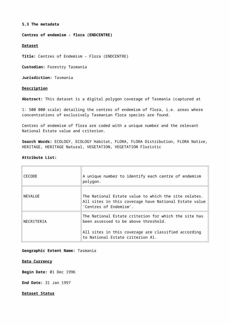
Available formats DIGITAL ARC/INFO
Data quality
Lineage: The Visual Management System was formally adopted by the Forestry Commission in 1983, for State forests.
The system has been progressively applied in Tasmania to most of the forest land controlled by the Forestry Tasmania, including areas of forested Crown land. It has also been applied, at a project level, to privately owned forests. Together these account for 2 400 000 hectares, or around 35% of Tasmania's land area.
The product of the system is mapped Landscape Priority Zones (LPZ). Each of the three levels of zoning (Zones A,B,C) has corresponding landscape management objectives that define the acceptable degree of modification of the natural character of the landscape. The objectives are:
• Zone A-Inevident Alteration-High visual concern (sensitive management or scenic reservation landscape; character must be fully retained).
• Zone B-Apparent Alteration-Moderate visual concern (Management to be visually designed; landscape character must be partially retained).
• Zone C-Dominant Alteration-Low visual concern (landscape character may be modified).
Scale 1:25 000
Positional accuracy Mostly pretty good, but a percentage which have not been field checked and require verification.
Attribute accuracy Data are accurate at time of entry to the best knowledge of the people compiling the data.
Logical consistency Data have been identified from field mapping and from published and unpublished sources.
Completeness Complete for State forest.
Contact information
Contact organisation Forestry Tasmania
Contact position Landscape Planner
Contact person Bruce Chetwynd
Mailing address PO Box 207B
Suburb, place or locality Hobart
State or territory Tasmania
Postcode 7001
Telephone 03 62
Primitive and Relictual Flora of Tasmania (PRIMFLORA)

Dataset
Title: Primitive and Relictual Flora of Tasmania (PRIMFLORA)
Custodian: Forestry Tasmania
Jurisdiction: Tasmania
Description
Abstract: This dataset is a digital polygon coverage of Tasmania (captured at 1:500 000 scale) detailing areas rich in primitive and relictual flora, i.e. flora that exhibit taxonomic remoteness or phylogenetic primitiveness or both.
Primitive and relictual flora polygons are given a unique code, the relevant National Estate values and criteria, and cleared land status.
Search Words: ECOLOGY, ECOLOGY Habitat, FLORA, FLORA Distribution, FLORA Native, HERITAGE, HERITAGE Natural, VEGETATION, VEGETATION Floristic
Attribute List:
PFLCRCODE A code to identify primitive and relictual flora polygons.
PFLNEVALUE The National Estate value to which the site relates. All sites in this coverage have National Estate value ‘Primitive Flora’.
PFLNECRITERIA The National Estate criterion for which the site has been assessed to be above threshold.
All sites in this coverage are classified according to National Estate criterion A1.
PFLBN Cleared land is excluded from each polygon. The coverage is coded as either 0 (not cleared land) or 9 (cleared land).
Geographic Extent Name: Tasmania
Data Currency
Begin Date: 01 Dec 1996
End Date: 31 Jan 1997
Dataset Status
Progress: Complete
Maintenance & Update Frequency: As required
Format

Stored Data Format: DIGITAL Arc/Info Revision 7.0.4 vector coverage (polygons) stored in a Librarian layer as a 1:500 000 map tile.
Available Formats: DIGITAL Arc/Info export file.
NON DIGITAL Plotted map output is available from a GIS ARCPLOT menu using a HP750 plotter.
Data Quality
Lineage: The dataset was digitised by Forestry Tasmania from 1:500 000 scale paper maps prepared by an expert panel.
Positional Accuracy: The dataset was collected at 1:500 000 scale. The mapped polygon boundaries are indicative areas only and as such their positional accuracy is subjective.
Attribute Accuracy: Attribute accuracy was visually checked at time of data entry.
Logical Consistency: Standard Forestry Tasmania logical consistency tests were conducted on this dataset, i.e. visual checking of source data, a test of item structures and definitions, a test on the completeness of valid codes and polygons, topological consistency checks to detect flaws in the spatial data (carried out automatically when coverage was built).
Completeness: The coverage is complete for significant areas of primitive and relictual flora sites in Tasmania and most nearshore islands. Macquarie Island and the Bass Strait islands are excluded from the dataset.
Contact Information
Organisation: Forestry Tasmania
Position: Tasmanian RFA Environment and Heritage Project Officer
Person: Penny Wells
Address: GPO Box 207B
City: Hobart
State: TASMANIA
Postcode: 7001
Telephone: 02 6233 2614
Facsimile: 02 6233 2744
Electronic Mail Address:[email protected]
Primitive and Relictual Fauna of Tasmania (PRIMFAUNA)
Dataset
Title: Primitive and Relictual Fauna of Tasmania (PRIMFAUNA)
Custodian: Forestry Tasmania
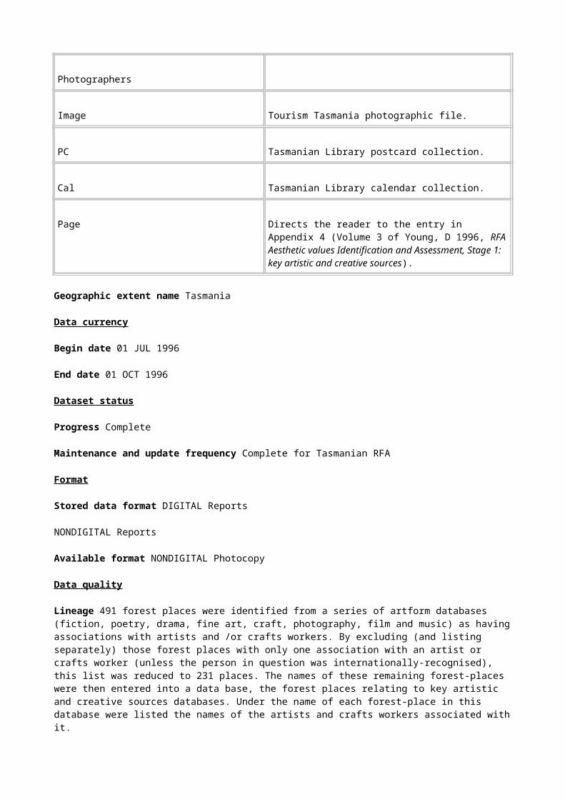
Jurisdiction: Tasmania
Description
Abstract: This dataset is a digital polygon coverage of Tasmania (captured at 1:500 000 scale) detailing primitive and relictual fauna, i.e. fauna that exhibit taxonomic remoteness or phylogenetic primitiveness or both.
Primitive and relictual fauna polygons are given a unique code, the relevant National Estate values and criteria, and cleared land status.
Search Words: ECOLOGY, ECOLOGY Habitat, FAUNA, FAUNA Distribution, FAUNA Native, HERITAGE, HERITAGE Natural
Attribute List:
PFACODE A unique number to identify primitive and relictual fauna polygons.
PFANEVALUE The National Estate value to which the site relates. All sites in this coverage have National Estate value ‘Primitive and Relictual Fauna’.
PFANECRITERIA The National Estate criterion for which the site has been assessed to be above threshold.
All sites in this coverage are classified according to National Estate criterion A1.
PFABN Cleared land is excluded from each polygon. The coverage is coded as either 0 (not cleared land) or 9 (cleared land).
Geographic Extent Name: Tasmania
Data Currency
Begin Date: 01 Dec 1996
End Date: 31 Jan 1997
Dataset Status
Progress: Complete
Maintenance & Update Frequency: As required
Format
Stored Data Format: DIGITAL Arc/Info Revision 7.0.4 vector coverage (polygons) stored in a Librarian layer as a 1:500 000 map tile.
Available Formats: DIGITAL Arc/Info export file.

NON DIGITAL Plotted map output is available from a GIS ARCPLOT menu using a HP750 plotter.
Data Quality
Lineage: The dataset was digitised by Forestry Tasmania from 1:500 000 scale paper maps prepared by an expert panel.
Positional Accuracy: The dataset was collected at 1:500 000 scale. The mapped polygon boundaries are indicative areas only and as such their positional accuracy is subjective.
Attribute Accuracy: Attribute accuracy was visually checked at time of data entry.
Logical Consistency: Standard Forestry Tasmania logical consistency tests were conducted on this dataset, i.e. visual checking of source data, a test of item structures and definitions, a test on the completeness of valid codes and polygons, topological consistency checks to detect flaws in the spatial data (carried out automatically when coverage was built), etc.
Completeness: The coverage is complete for significant areas of primitive and relictual fauna sites in Tasmania and most nearshore islands. Macquarie Island and the Bass Strait islands are excluded from the dataset.
Contact Information
Organisation: Forestry Tasmania
Position: Tasmanian RFA Environment and Heritage Project Officer
Person: Penny Wells
Address: GPO Box 207B
City: Hobart
State: TASMANIA
Postcode: 7001
Telephone: 02 6233 2614
Facsimile: 02 6233 2744
Electronic Mail Address: [email protected]
Limits of Range - Fauna (FAUNALIM)
Dataset
Title: Limits of Range - Fauna (FAUNALIM)
Custodian: Forestry Tasmania
Jurisdiction: Tasmania
Description
Abstract: This dataset is a digital polygon coverage of Tasmania (captured at 1:500 000 scale) detailing places where concentrations of fauna species reach the limits of their natural range.

The limits of range of fauna are coded with a unique number, the relevant National Estate values and criteria, and cleared land status.
Search Words: ECOLOGY, ECOLOGY Habitat, FAUNA, FAUNA Distribution, FAUNA Invertebrates, FAUNA Native, HERITAGE, HERITAGE Natural
Attribute List:
FALFACODE A unique number to identify limits of range of flora polygons.
FALNEVALUE The National Estate value to which the site relates.
All sites in this coverage have National Estate value ‘Limits of Fauna Range’.
FALNECRITERIA The National Estate criterion for which the site has been assessed to be above threshold.
All sites in this coverage are classified according to National Estate criteria A1.
FALBN Cleared land is excluded from each polygon. The coverage is coded as either 0 (not cleared land) or 9 (cleared land).
Geographic Extent Name: Tasmania
Data Currency
Begin Date: 01 Dec 1996
End Date: 31 Jan 1997
Dataset Status
Progress: Complete
Maintenance & Update Frequency: As required
Format
Stored Data Format: DIGITAL Arc/Info Revision 7.0.4 vector coverage (polygons) stored in a Librarian layer as a 1:500 000 map tile.
Available Formats: DIGITAL Arc/Info export file.
NON DIGITAL Plotted map output is available from a GIS ARCPLOT menu using a HP750 plotter.
Data Quality
Lineage: The dataset was digitised by Forestry Tasmania from 1:500 000 scale paper maps prepared by an expert panel.
Positional Accuracy: The dataset was collected at 1:500 000 scale. The mapped polygon boundaries are indicative areas only and as such their positional accuracy is subjective.
Attribute Accuracy: Attribute accuracy was visually checked at time of data entry.
Logical Consistency: Standard Forestry Tasmania logical consistency tests were conducted on this dataset, i.e. visual checking of source data, a test of item structures and definitions, a test on the completeness of valid codes and polygons, topological consistency checks to detect flaws in the spatial data (carried out automatically when coverage was built).
Completeness: The coverage is complete for significant limits of range sites for Tasmania (excluding Macquarie Island and Bass Strait Islands).
Contact Information
Organisation: Forestry Tasmania
Position: Tasmanian RFA Environment and Heritage Project Officer
Person: Penny Wells
Address: GPO Box 207B
City: Hobart
State: TASMANIA
Postcode: 7001
Telephone: 02 6233 2614
Facsimile: 02 6233 2744
Electronic Mail Address: [email protected]
Centres of Endemism - Fauna (ENDCENFA)
Dataset
Title: Centres of Endemism - Fauna (ENDCENFA)
Custodian: Forestry Tasmania
Jurisdiction: Tasmania
Description
Abstract: This dataset is a digital polygon coverage of Tasmania (captured at
1: 500 000 scale) detailing the centres of endemism of fauna, i.e. areas where concentrations of exclusively Tasmanian fauna species are found.
Centres of endemism of fauna are coded with a unique number, the relevant National Estate value and criterion, and cleared land status.
Search Words: ECOLOGY, ECOLOGY Habitat, FAUNA, FAUNA Distribution, FAUNA Native, HERITAGE, HERITAGE Natural
Attribute List:
EFACODE A unique number to identify centre of endemism of fauna polygons.
EFANEVALUE The National Estate value to which the site relates. All sites in this coverage have National Estate value ‘Centres of Fauna Endemism’.
EFANECRITERIA The National Estate criterion for which the site has been assessed to be above threshold.
All sites in this coverage are classified according to National Estate criterion A1.
EFABN Cleared land is excluded from each polygon. The coverage is coded as either 0 (not cleared land) or 9 (cleared land).
Geographic Extent Name: Tasmania
Data Currency
Begin Date: 01 Dec 1996
End Date: 31 Jan 1997
Dataset Status
Progress: Complete
Maintenance & Update Frequency: As required
Format
Stored Data Format: DIGITAL Arc/Info Revision 7.0.4 vector coverage (polygons) stored in a Librarian layer as a 1:500 000 map tile.
Available Formats: DIGITAL Arc/Info export file.
NON DIGITAL Plotted map output is available from a GIS ARCPLOT menu using a HP750 plotter.
Data Quality
Lineage: The dataset was digitised by Forestry Tasmania from 1:500 000 scale paper maps prepared by an expert panel.
Positional Accuracy: The dataset was collected at 1:500 000 scale. The mapped polygon boundaries are indicative areas only and as such their positional accuracy is subjective.
Attribute Accuracy: Attribute accuracy was visually checked at time of data entry.
Logical Consistency: Standard Forestry Tasmania logical consistency tests were conducted on this dataset, i.e. visual checking of source data, a test of item structures and definitions, a test on the completeness of valid codes and polygons, topological consistency checks to detect flaws in the spatial data (carried out automatically when coverage was built), etc.
Completeness: The coverage is complete for significant centres of endemism for flora in Tasmania.
Contact Information
Organisation: Forestry Tasmania
Position: Tasmanian RFA Environment and Heritage Project Officer
Person: Penny Wells
Address: GPO Box 207B
City: Hobart
State: TASMANIA
Postcode: 7001
Telephone: 02 6233 2614
Facsimile: 02 6233 2744
Electronic Mail Address: [email protected]
Disjunct Flora of Tasmania (DISJUNCTFL)
Dataset
Title: Disjunct Flora of Tasmania (DISJUNCTFL)
Custodian: Forestry Tasmania
Jurisdiction: Tasmania
Description
Abstract: This dataset is a digital polygon coverage of Tasmania (captured at 1:500 000 scale) detailing places where concentrations of disjunct flora populations occur, i.e. flora populations which are separated from their normal area of distribution by at least 50 kilometres.
Disjunct flora polygons are given a unique code, the relevant National Estate values and criteria, and cleared land status
Search Words: FLORA, FLORA Distribution, FLORA Native, HERITAGE, HERITAGE Natural, VEGETATION, VEGETATION Floristic
Attribute List:
DFLCODE A unique code to identify each disjunct flora polygon.
DFLNEVALUE The National Estate value to which the site relates.
All sites in this coverage have National Estate value ‘Disjunct flora locations’.

DFLNECRITERIA The National Estate criterion for which the site has been assessed to be above threshold.
All sites in this coverage are classified according to National Estate criterion A1.
DFLBN Cleared land is excluded from each polygon. The coverage is coded as either 0 (not cleared land) or 9 (cleared land).
Geographic Extent Name: Tasmania
Data Currency
Begin Date: 01 Dec 1996
End Date: 31 Jan 1997
Dataset Status
Progress: Complete
Maintenance & Update Frequency: As required
Format
Stored Data Format: DIGITAL Arc/Info Revision 7.0.4 vector coverage (polygons) stored in a Librarian layer as a 1:500 000 map tile.
Available Formats: DIGITAL Arc/Info export file.
NON DIGITAL Plotted map output is available from a GIS ARCPLOT menu using a HP750 plotter.
Data Quality
Lineage: The data source for this cover was the Parks and Wildlife Service’s Wildlife Atlas. Distribution maps of rare, threatened or significant forest flora were plotted on a 10 kilometre x 10 kilometre grid. Disjunct populations were identified and tallied for each grid square. Grid squares with high concentrations of disjunct populations were identified and appropriate boundaries drawn onto 1:500 000 paper maps by an expert panel. Paper maps were digitised by Forestry Tasmania
Positional Accuracy: The dataset was collected at 1:500 000 scale. The mapped polygon boundaries are indicative areas only and as such their positional accuracy is subjective.
Attribute Accuracy: Attribute accuracy was visually checked at time of data entry.
Logical Consistency: Standard 1:500 000 Forestry Tasmania logical consistency tests were conducted on this dataset, i.e. visual checking of source data, a test of item structures and definitions, a test on the completeness of valid codes and polygons, topological consistency checks to detect flaws in the spatial data (carried out automatically when coverage was built).

Completeness: The coverage is complete for significant disjunct flora population sites for Tasmania (excluding Macquarie Island and Bass Strait Islands).
Contact Information
Organisation: Forestry Tasmania
Position: Tasmanian RFA Environment and Heritage Project Officer
Person: Penny Wells
Address: GPO Box 207B
City: Hobart
State: TASMANIA
Postcode: 7001
Telephone: 02 6233 2614
Facsimile: 02 6233 2744
Electronic Mail Address: [email protected]
Disjunct Fauna of Tasmania (DISJUNCTFA)
Dataset
Title: Disjunct Fauna of Tasmania (DISJUNCTFA)
Custodian: Forestry Tasmania
Jurisdiction: Tasmania
Description
Abstract: This dataset is a digital polygon coverage of Tasmania (captured at 1:500 000 scale) detailing disjunct fauna populations, i.e. fauna populations which are separated from their normal area of distribution by at least 50 kilometres.
Disjunct fauna polygons are given a unique code, the relevant National Estate values and criteria, and cleared land status
Search Words: FAUNA, FAUNA Distribution, FAUNA Native, HERITAGE, HERITAGE Natural
Attribute List:
DFACODE A unique number to identify disjunct fauna polygons.

DFANEVALUE The National Estate value to which the site relates. All sites in this coverage have National Estate value ‘Disjunct Fauna Locations’.
DFANECRITERIA The National Estate criterion/criteria for which the site has been assessed to be above threshold.
All sites in this coverage are classified according to National Estate criteria A1.
DFABN Cleared land is excluded from each polygon. The coverage is coded as either 0 (not cleared land) or 9 (cleared land).
Geographic Extent Name: Tasmania
Data Currency
Begin Date: 01 Dec 1996
End Date: 31 Jan 1997
Dataset Status
Progress: Complete
Maintenance & Update Frequency: As required
Format
Stored Data Format: DIGITAL Arc/Info Revision 7.0.4 vector coverage (polygons) stored in a Librarian layer as a 1:500 000 map tile.
Available Formats: DIGITAL Arc/Info export file.
NON DIGITAL Plotted map output is available from a GIS ARCPLOT menu using a HP750 plotter.
Data Quality
Lineage: The dataset was digitised by Forestry Tasmania from 1:500 000 scale paper maps prepared by an expert panel.
Positional Accuracy: The dataset was collected at 1:500 000 scale. The mapped polygon boundaries are indicative areas only and as such their positional accuracy is subjective.
Attribute Accuracy: Attribute accuracy was visually checked at time of data entry.
Logical Consistency: Standard Forestry Tasmania logical consistency tests were conducted on this dataset, i.e. visual checking of source data, a test of item structures and definitions, a test on the completeness of valid codes and polygons, topological consistency checks to detect flaws in the spatial data (carried out automatically when coverage was built).

Completeness: The coverage is complete for significant disjunct fauna population sites on mainland Tasmania and its nearshore islands. Macquarie Island and the Bass Strait islands are excluded from the dataset.
Contact Information
Organisation: Forestry Tasmania
Position: Tasmanian RFA Environment and Heritage Project Officer
Person: Penny Wells
Address: GPO Box 207B
City: Hobart
State: TASMANIA
Postcode: 7001
Telephone: 02 6233 2614
Facsimile: 02 6233 2744
Electronic Mail Address: [email protected]
Species Richness - Fauna (RICHNESSFA)
Dataset
Title: Species Richness - Fauna (RICHNESSFA)
Custodian: Forestry Tasmania
Jurisdiction: Tasmania
Description
Abstract: This dataset is a digital polygon coverage of Tasmania (captured at 1:500 000 scale) detailing sites with a high flora species or community richness.
Species richness and community richness of flora are coded with a unique number, the relevant National Estate values and criteria, and cleared land status.
Search Words: BOUNDARIES, BOUNDARIES Biophysical, BOUNDARIES Management, ECOLOGY, FAUNA, FAUNA Biodiversity, FAUNA Native, HERITAGE, HERITAGE Natural
Attribute List:
RFACODE A unique number to identify species richness of fauna polygons.

RFANEVALUE The National Estate value to which the site relates. All sites in this coverage have National Estate value ‘Fauna Richness’.
RFANECRITERIA The National Estate criterion for which the site has been assessed to be above threshold.
All sites in this coverage are classified according to National Estate criterion A3.
RFABN Cleared land is excluded from each polygon. The coverage is coded as either 0 (not cleared land) or 9 (cleared land).
Geographic Extent Name: Tasmania
Data Currency
Begin Date: 01 Dec 1996
End Date: 31 Jan 1997
Dataset Status
Progress: Complete
Maintenance & Update Frequency: As required
Format
Stored Data Format: DIGITAL Arc/Info Revision 7.0.4 vector coverage (polygons) stored in a Librarian layer as a 1:500 000 map tile.
Available Formats: DIGITAL Arc/Info export file.
NON DIGITAL Plotted map output is available from a GIS ARCPLOT menu using a HP750 plotter.
Data Quality
Lineage: The dataset was digitised by Forestry Tasmania from 1:500 000 scale paper maps prepared by an expert panel.
Positional Accuracy: The dataset was collected at 1:500 000 scale. The mapped polygon boundaries are indicative areas only and as such their positional accuracy is subjective.
Attribute Accuracy: Attribute accuracy was visually checked at time of data entry.
Logical Consistency: Standard Forestry Tasmania logical consistency tests were conducted on this dataset, i.e. visual checking of source data, a test of item structures and definitions, a test on the completeness of valid codes and polygons, topological consistency checks to detect flaws in the spatial data (carried out automatically when coverage was built), etc.
Completeness: The coverage is complete for significant fauna species richness sites on mainland Tasmania and its nearshore islands. Macquarie Island and the Bass Strait islands are excluded from the dataset.
Contact Information

Organisation: Forestry Tasmania
Position: Tasmanian RFA Environment and Heritage Project Officer
Person: Penny Wells
Address: GPO Box 207B
City: Hobart
State: TASMANIA
Postcode: 7001
Telephone: 02 6233 2614
Facsimile: 02 6233 2744
Electronic Mail Address: [email protected]
Appendix S: Description of datasets - continued
Description of datasets continuedRemnant Vegetation of Tasmania (REMVEG)
Dataset
Title: Remnant Vegetation of Tasmania (REMVEG)
Custodian: Forestry Tasmania
Jurisdiction: Tasmania
Description
Abstract: This dataset is a digital polygon coverage of Tasmania (captured at
1: 500 000 scale) detailing the locations of remnant patches of forest vegetation.
Remnant vegetation is coded with a unique number and the relevant National Estate values and criteria.
Search Words: ECOLOGY, ECOLOGY Ecosystem, ECOLOGY Habitat, FLORA, FLORA Native, FORESTS, FORESTS Natural, HERITAGE, HERITAGE Natural, VEGETATION, VEGETATION Conservation, VEGETATION Mapping
Attribute List:
RMVCODE A unique number to identify remnant vegetation polygons.
RMVNEVALUE The National Estate value to which the site relates. All sites in this coverage have National Estate value ‘Remnant Vegetation’.
RMVNECRITERIA The National Estate criterion for which the site has been assessed to be above threshold.
All sites in this coverage are classified according to National Estate criterion A2.
RMVBN Biophysical naturalness rating
Geographic Extent Name: Tasmania
Data Currency
Begin Date: 01 Dec 1996
End Date: 31 Jan 1997

Dataset Status
Progress: Complete
Maintenance & Update Frequency: As required
Format
Stored Data Format: DIGITAL Arc/Info Revision 7.0.4 vector coverage (polygons) stored in a Librarian layer as a 1:500 000 map tile.
Available Formats: DIGITAL Arc/Info export file.
NON DIGITAL Plotted map output is available from a GIS ARCPLOT menu using a HP750 plotter.
Data Quality
Lineage: The data source for this cover was the Forest Vegetation Communities map (PLUC 1996a). All polygons between 20 and 200 hectares in area, totally surrounded by cleared land (biophysical naturalness rating of 0) and separated from larger forest patches by at least 100 metres were selected to form the remnant vegetation cover. Some additional patches were also added to the cover, based on advice from experts.
Positional Accuracy: The original forest vegetation dataset was collected at 1:25 000 scale. The estimated positional accuracy of the mapped polygon boundaries is within 25 metres on the 1:25 000 map.
Attribute Accuracy: Attribute accuracy was visually checked at time of data entry.
Logical Consistency: Standard Forestry Tasmania logical consistency tests were conducted on this dataset, i.e. visual checking of source data, a test of item structures and definitions, a test on the completeness of valid codes and polygons, topological consistency checks to detect flaws in the spatial data (carried out automatically when coverage was built), etc.
Completeness: The coverage is complete for patches of remnant vegetation in Tasmania, including the Bass Strait Islands.
Contact Information
Organisation: Forestry Tasmania
Position: Tasmanian RFA Environment and Heritage Project Officer
Person: Penny Wells
Address: GPO Box 207B
City: Hobart
State: TASMANIA
Postcode: 7001
Telephone: 02 6233 2614
Facsimile: 02 6233 2744
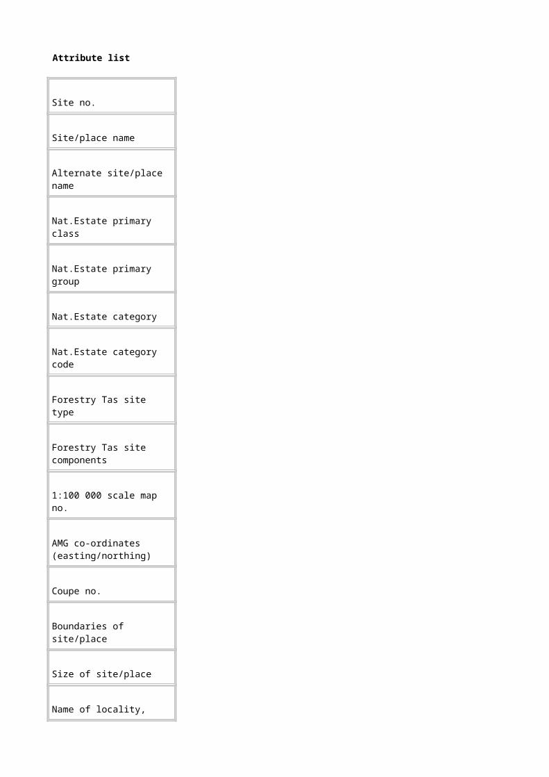
Electronic Mail Address: [email protected]
Key Fauna Habitat (HABITAT)
Dataset
Title: Key Fauna Habitat (HABITAT)
Custodian: Forestry Tasmania
Jurisdiction: Tasmania
Description
Abstract: This dataset is a digital point, arc and polygon coverage of Tasmania (captured at 1:500 000 scale) detailing key fauna habitat for rare and threatened forest fauna.
Key fauna habitat areas are coded with a unique number, the relevant National Estate values and criteria, and cleared land status.
Search Words: BOUNDARIES, BOUNDARIES Biophysical, BOUNDARIES Management, ECOLOGY, ECOLOGY Habitat , FAUNA, FAUNA Native, HERITAGE, HERITAGE Natural
Attribute List:
HABCODE A unique number to identify fauna habitat polygons.
HABNEVALUE The National Estate value to which the site relates. All sites in this coverage have National Estate value ‘Key Fauna Habitat’.
HABNECRITERIA The National Estate criterion for which the site has been assessed to be above threshold.
All sites in this coverage are classified according to National Estate criterion A2.
HABBN Cleared land is excluded from each polygon. The coverage is coded as either 0 (not cleared land) or 9 (cleared land).
Geographic Extent Name: Tasmania
Data Currency

Begin Date: 01 Dec 1996
End Date: 31 Jan 1997
Dataset Status
Progress: Complete
Maintenance & Update Frequency: As required
Format
Stored Data Format: DIGITAL Arc/Info Revision 7.0.4 vector coverage (polygons) stored in a Librarian layer as a 1:500 000 map tile.
Available Formats: DIGITAL Arc/Info export file.
NON DIGITAL Plotted map output is available from a GIS ARCPLOT menu using a HP750 plotter.
Data Quality
Lineage: The dataset was digitised by Forestry Tasmania from 1:100 000 scale paper maps prepared by a project officer from literature sources, specialist knowledge and data from the Parks and Wildlife Service’s Wildlife Atlas.
Positional Accuracy: The estimated positional accuracy of the mapped polygon boundaries is within 100 metres on the 1:100 000 map.
Attribute Accuracy: Attribute accuracy was visually checked at time of data entry.
Logical Consistency: Standard Forestry Tasmania logical consistency tests were conducted on this dataset, i.e. visual checking of source data, a test of item structures and definitions, a test on the completeness of valid codes and polygons, topological consistency checks to detect flaws in the spatial data (carried out automatically when coverage was built).
Completeness: The coverage is complete for mainland Tasmania and its nearshore islands. Macquarie Island and the Bass Strait Islands are excluded from the dataset.
Contact Information
Organisation: Forestry Tasmania
Position: Tasmanian RFA Environment and Heritage Project Officer
Person: Penny Wells
Address: GPO Box 207B
City: Hobart
State: TASMANIA
Postcode: 7001
Telephone: 02 6233 2614
Facsimile: 02 6233 2744
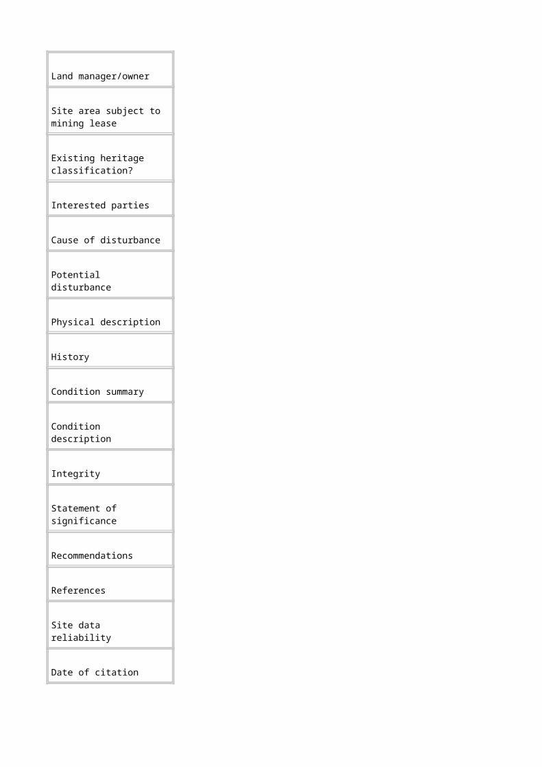
Electronic Mail Address: [email protected]
Species and Community Richness - Flora (RICHNESS)
Dataset
Title: Species and Community Richness - Flora (RICHNESS)
Custodian: Forestry Tasmania
Jurisdiction: Tasmania
Description
Abstract: This dataset is a digital polygon coverage of Tasmania (captured at 1:500 000 scale) detailing sites with a high flora species or community richness.
Species richness and community richness of flora are coded with a unique number, the relevant National Estate values and criteria, and cleared land status.
Search Words: BOUNDARIES, BOUNDARIES Biophysical, BOUNDARIES Management, ECOLOGY, ECOLOGY Community, FLORA, FLORA Biodiversity, FLORA Native, HERITAGE, HERITAGE Natural, VEGETATION, VEGETATION Structural
Attribute List:
RCHCRCODE A unique number to identify flora community richness polygons.
RCHSRCODE A unique number to identify flora species richness polygons.
RCHNEVALUE The National Estate value to which the site relates. All sites in this coverage have National Estate value ‘Flora Richness’.
RCHNECRITERIA The National Estate criterion for which the site has been assessed to be above threshold.
All sites in this coverage are classified according to National Estate criterion A3.
RCHBN Cleared land is excluded from each polygon. The coverage is coded as either 0 (not cleared land) or 9 (cleared land).
Geographic Extent Name: Tasmania
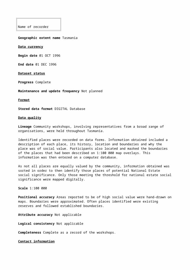
Data Currency
Begin Date: 01 Dec 1996
End Date: 31 Jan 1997
Dataset Status
Progress: Complete
Maintenance & Update Frequency: As required
Format
Stored Data Format: DIGITAL Arc/Info Revision 7.0.4 vector coverage (polygons) stored in a Librarian layer as a 1:500 000 map tile.
Available Formats: DIGITAL Arc/Info export file.
NON DIGITAL Plotted map output is available from a GIS ARCPLOT menu using a HP750 plotter.
Data Quality
Lineage: The data source for this cover was the Parks and Wildlife Service’s Wildlife Atlas. Number of taxa recorded in each 10 kilometre x 10 kilometre grid squares were calculated. Grid squares with high concentrations of taxa were identified and appropriate boundaries drawn onto 1:500 000 paper maps by an expert panel. Paper maps were digitised by Forestry Tasmania.
Positional Accuracy: The dataset was collected at 1:500 000 scale. The mapped polygon boundaries are indicative areas only and as such their positional accuracy is subjective.
Attribute Accuracy: Attribute accuracy was visually checked at time of data entry.
Logical Consistency: Standard Forestry Tasmania logical consistency tests were conducted on this dataset, i.e. visual checking of source data, a test of item structures and definitions, a test on the completeness of valid codes and polygons, topological consistency checks to detect flaws in the spatial data (carried out automatically when coverage was built).
Completeness: The coverage is complete for significant flora species/community richness sites on mainland Tasmania and its nearshore islands. Macquarie Island and the Bass Strait islands are excluded from the dataset.
Contact Information
Organisation: Forestry Tasmania
Position: Tasmanian RFA Environment and Heritage Project Officer
Person: Penny Wells
Address: GPO Box 207B
City: Hobart
State: TASMANIA

Postcode: 7001
Telephone: 02 6233 2614
Facsimile: 02 6233 2744
Electronic Mail Address: [email protected]
Vegetation Succession Sites (SUCCESSION)
Dataset
Title: Vegetation Succession Sites (SUCCESSION)
Custodian: Forestry Tasmania
Jurisdiction: Tasmania
Description
Abstract: This dataset is a digital polygon coverage of Tasmania (captured at 1:100 000 scale) detailing the locations of important plant succession sites, i.e. sites where there is a progressive change in composition of a forest community, brought about by natural processes, towards a stable condition whereby the community is in equilibrium with the existing natural environmental conditions.
Vegetation succession sites are coded with a unique number and the relevant National Estate values and criteria.
Search Words: ECOLOGY, ECOLOGY Habitat, FLORA, FLORA Native, FORESTS, FORESTS Natural, HERITAGE, HERITAGE Natural, VEGETATION, VEGETATION Structural, VEGETATION Mapping
Attribute List:
SUCCODE A unique code to identify each vegetation succession polygon.
SUCNEVALUE The National Estate value to which the site relates. All sites in this coverage have National Estate value ‘Succession Sites’.
SUCNECRITERIA The National Estate criterion for which the site has been assessed to be above threshold.
All sites in this coverage are classified according to National Estate criterion A2.
Geographic Extent Name: Tasmania
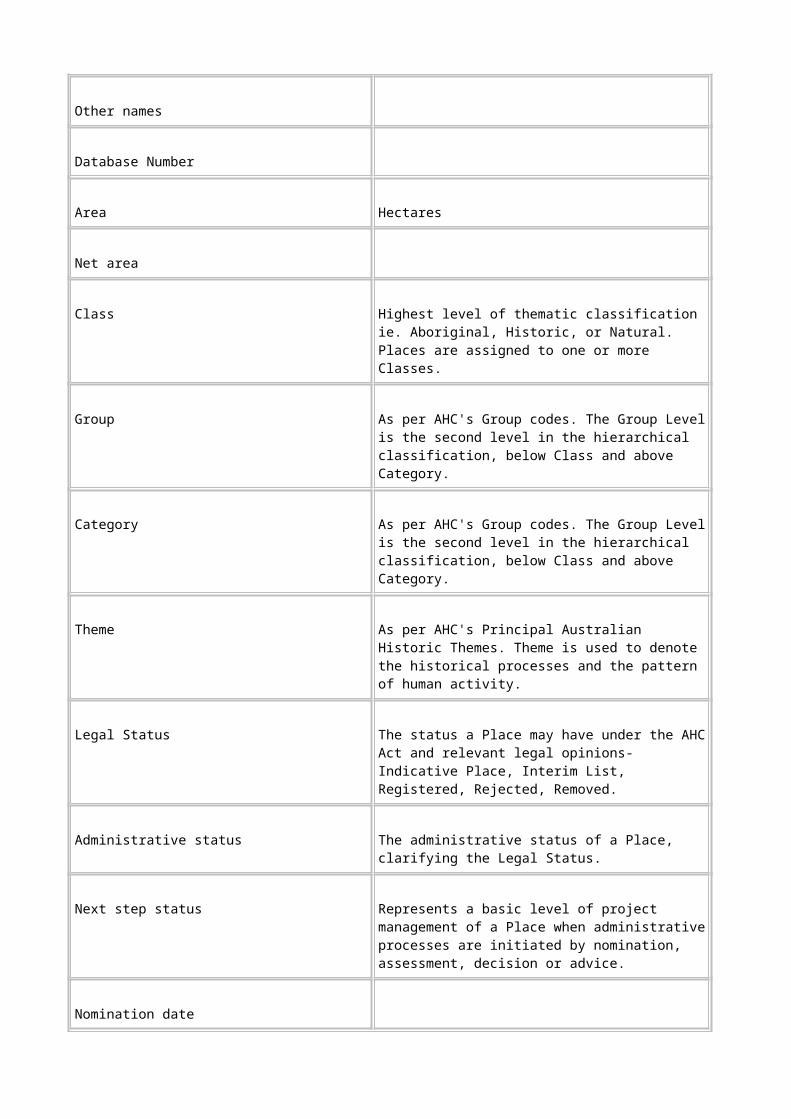
Data Currency
Begin Date: 01 Dec 1996
End Date: 31 Jan 1997
Dataset Status
Progress: Complete
Maintenance & Update Frequency: As required
Format
Stored Data Format: DIGITAL Arc/Info Revision 7.0.4 vector coverage (polygons) stored in a Librarian layer as a 1:500 000 map tile.
Available Formats: DIGITAL Arc/Info export file.
NON DIGITAL Plotted map output is available from a GIS ARCPLOT menu using a HP750 plotter.
Data Quality
Lineage: The dataset was digitised by Forestry Tasmania from 1:100 000 scale paper maps prepared by project officer in consultation with an expert panel.
Positional Accuracy: The dataset was collected at 1:100 000 scale. The mapped polygon boundaries are accurate to within 100 metres.
Attribute Accuracy: Attribute accuracy was visually checked at time of data entry.
Logical Consistency: Standard Forestry Tasmania logical consistency tests were conducted on this dataset, i.e. visual checking of source data, a test of item structures and definitions, a test on the completeness of valid codes and polygons, topological consistency checks to detect flaws in the spatial data (carried out automatically when coverage was built).
Completeness: The coverage is complete for significant succession sites in Tasmania (excluding Macquarie Island and the Bass Strait Islands).
Contact Information
Organisation: Forestry Tasmania
Position: Tasmanian RFA Environment and Heritage Project Officer
Person: Penny Wells
Address: GPO Box 207B
City: Hobart
State: TASMANIA
Postcode: 7001
Telephone: 02 6233 2614

Facsimile: 02 6233 2744
Electronic Mail Address: [email protected]
Refugia from Present Processes (REFUGIAPRES)
Dataset
Title: Refugia from Present Processes (REFUGIAPRES)
Custodian: Forestry Tasmania
Jurisdiction: Tasmania
Description
Abstract: This dataset is a digital polygon coverage of Tasmania (captured at 1:100 000 scale) detailing refugia from present processes including fire and disease.
Refugia from present processes are coded with a unique number and the relevant National Estate values and criteria.
Search Words: BOUNDARIES, BOUNDARIES Biophysical, BOUNDARIES Management, ECOLOGY, ECOLOGY Habitat, FLORA, FLORA Native, FAUNA, FAUNA Native, HERITAGE, HERITAGE Natural
Attribute List:
RPR A unique number to identify refugia polygons.
RPRNEVALUE The National Estate value to which the site relates. All sites in this coverage have National Estate value ‘Refugia Present’.
RPRNECRITERIA The National Estate criterion for which the site has been assessed to be above threshold.
All sites in this coverage are classified according to National Estate criterion A1.
Geographic Extent Name: Tasmania
Data Currency
Begin Date: 01 Dec 1996
End Date: 31 Jan 1997
Dataset Status
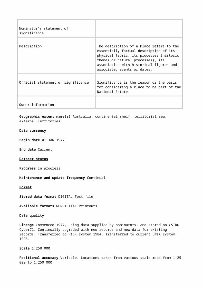
Progress: Complete
Maintenance & Update Frequency: As required
Format
Stored Data Format: DIGITAL Arc/Info Revision 7.0.4 vector coverage (polygons) stored in a Librarian layer as a 1:500 000 map tile.
Available Formats: DIGITAL Arc/Info export file.
NON DIGITAL Plotted map output is available from a GIS ARCPLOT menu using a HP750 plotter.
Data Quality
Lineage: The dataset was compiled from existing maps held by Forestry Tasmania and literature sources. Major themes included dry rainforest, sinkholes, pencil pine mapping, Huon pine mapping, Callitris mapping, Phytophthora management zones, Cyathea locations, relic rainforest, Nothofagus gunnii mapping, King Billy pine mapping.
Positional Accuracy: Source data was collected at various scales ranging from 1:25 000 to 1: 100 000. The estimated positional accuracy of the mapped polygon boundaries is within 100 metres on the 1:100 000 maps.
Attribute Accuracy: Attribute accuracy was visually checked at time of data entry.
Logical Consistency: Standard Forestry Tasmania logical consistency tests were conducted on this dataset, i.e. visual checking of source data, a test of item structures and definitions, a test on the completeness of valid codes and polygons, topological consistency checks to detect flaws in the spatial data (carried out automatically when coverage was built).
Completeness: The coverage is complete Tasmania including the Bass Strait Islands
Contact Information
Organisation: Forestry Tasmania
Position: Tasmanian RFA Environment and Heritage Project Officer
Person: Penny Wells
Address: GPO Box 207B
City: Hobart
State: TASMANIA
Postcode: 7001
Telephone: 02 6233 2614
Facsimile: 02 6233 2744
Electronic Mail Address: [email protected]

Historic Values (PEARSONCOV, DMARSHCOV, TRACKS)
Dataset
Title: Historic Values (PEARSONCOV, DMARSHCOV, TRACKS)
Custodian: Forestry Tasmania
Jurisdiction: Tasmania
Description
Abstract: This dataset is a digital point, arc and polygon coverage of Tasmania detailing places of potential National Estate historic value. It comprises three separate covers:
PEARSONCOV, which details historic mining sites
DMARSHCOV, which is a sample of historic sites across a number of themes , and
TRACKS, which includes examples of historic tracks, transportation routes and timber getting sites.
Places of potential historic value are coded with a unique number and the relevant National Estate values and criteria. At the time of publication of this metadata some of the attribute items had yet to be completely coded.
Search Words: GEOSCIENCES, GEOSCIENCES Geology, HERITAGE, HERITAGE Mapping, INDUSTRY, INDUSTRY Mining, MINERALS
Attribute List:
PSCCODE, DMCCODE or
TKSHISTORYCODE
A unique number to identify places of potential historic value.
PSCNEVALUE,
DMCNEVALUE The National Estate value to which the site relates. All sites in this coverage have National Estate value ‘Historic Mining Sites’.
PSCNECRITERIA,
DMCNECRITERIA The National Estate criteria for which the site has been assessed to be above threshold.
Geographic Extent Name: Tasmania
Data Currency
Begin Date: 01 Dec 1996
End Date: 31 Jan 1997
Dataset Status

Progress: Complete
Maintenance & Update Frequency: As required
Format
Stored Data Format: DIGITAL Arc/Info Revision 7.0.4 vector coverage (polygons) stored in a Librarian layer as a 1:500 000 map tile.
Available Formats: DIGITAL Arc/Info export file.
NON DIGITAL Plotted map output is available from a GIS ARCPLOT menu using a HP750 plotter.
Data Quality
Lineage: The dataset was digitised by Forestry Tasmania from grid references and paper maps at 1:25 000 and 1:100 000, provided by a consultant.
Positional Accuracy: The estimated positional accuracy of the mapped points, lines and polygons varies from within 25 metres to 250 metres depending on the source data.
Attribute Accuracy: Data is accurate at the time of data entry to the best knowledge of the people compiling the data.
Logical Consistency: Standard Forestry Tasmania logical consistency tests were conducted on this dataset, i.e. visual checking of source data, a test of item structures and definitions, a test on the completeness of valid codes and polygons, topological consistency checks to detect flaws in the spatial data (carried out automatically when coverage was built).
Completeness: The coverage is complete Tasmania and its nearshore islands. Macquarie Island and the Bass Strait islands are excluded from the dataset.
Contact Information
Organisation: Forestry Tasmania
Position: Tasmanian RFA Environment and Heritage Project Officer
Person: Penny Wells
Address: GPO Box 207B
City: Hobart
State: TASMANIA
Postcode: 7001
Telephone: 02 6233 2614
Facsimile: 02 6233 2744
Electronic Mail Address: [email protected]
Old-Growth of National Estate significance
Dataset
Title: Old-Growth of National Estate significance (OVTSENNATBN)
Custodian: Forestry Tasmania
Jurisdiction: Tasmania
Description
Abstract: This dataset is a digital polygon coverage of detailing places of potential National Estate significance for oldgrowth forest.
The old-growth polygonsare coded with a unique number and the relevant National Estate values and criteria.
Search Words: FORESTS, FORESTS Mapping, FORESTS Natural Mapping,
Attribute List:
OG Whether or not the forest stand is old-growth, Yes or No
LANDTEN Describes the type of land tenure
VEGCOMM Mapping unit code describing the forest vegetation community, 50 classes.
LANDTYPE Describes the type of land - forest, non-forest, water or land.
NL-CODE Describes whether the polygons are in natural landscapes or not.
1=Yes, 0=No.
BN Describes the biophysical naturalness rating of each polygon.
5= BN5, 0=BN0-4
SENCODE Degree of senescence and levels of disturbance and regrowth stages.
Geographic Extent: Tasmania
Data Currency
Begin Date: 01 Dec 1996
End Date: 31 Jan 1997

Dataset Status
Progress: Complete
Maintenance & Update Frequency: Not planned
Format
Stored Data Format: DIGITAL Arc/Info Revision 7.0.4 vector coverage (polygons) stored in a Librarian layer as a 1:500 000 map tile.
Available Formats: DIGITAL Arc/Info export file.
NON DIGITAL Plotted map output is available from a GIS ARCPLOT menu using a HP750 plotter.
Data Quality
Lineage: This dataset was compiled from the Old-growth forests of Tasmania mapping (PLUC 1996a) by selecting all polygons of rare and depleted oldgrowth forest communities and all polygons of high quality oldgrowth within natural landscapes.
Scale: 1:25 000
Positional Accuracy: The estimated positional accuracy of the mapped polygon boundaries varies from within 40 metres to 250 metres depending on the source data.
Attribute Accuracy: Attribute accuracy of the component data sets was visually checked before the overlaying process.
The methodology was verified by field inspection of test data sets.
Output was checked by personnel with field knowledge.
Logical Consistency: A test of item structures and definitions against a standard library index by inserting coverages into a library using a program called PUTT25.AML.
Completeness: The coverage is complete for the mainland of Tasmania and some offshore islands but not King, Flinders, and Macquarie Islands.
Contact Information
Organisation: Forestry Tasmania
Position: Tasmanian RFA Environment and Heritage Project Officer
Person: Penny Wells
Address: GPO Box 207B
City: Hobart
State: TASMANIA
Postcode: 7001
Telephone: 02 6233 2614

Facsimile: 02 6233 2744
Electronic Mail Address: [email protected]
Geoconservation Mapping of Tasmania (CTASGM)
Dataset
Title: Geoconservation Mapping of Tasmania (CTASGM)
Custodian: Forestry Tasmania
Jurisdiction: Tasmania
Description
Abstract: This dataset is a digital polygon coverage of Tasmania (captured at
1: 100 000 scale) detailing geological, geomorphological, and soil sites of conservation and heritage value.
Geoconservation sites are given a unique code and the relevant National Estate values and criteria. The coverage also has an attached relate file detailing name of site, mapsheet on which site is located, size classification of site, sensitivity of the site to impacts, conservation status, National Estate status, etc .
Search Words: GEOSCIENCES, GEOSCIENCES Conservation, GEOSCIENCES Geology, GEOSCIENCES Geomorphology, HERITAGE, HERITAGE Natural, SOIL, SOIL Conservation
Attribute List:
TGMPOLYID A unique code to identify geoconsevation polygons.
TGMARCID A unique code to identify geoconservation arcs.
TGMPOINTID A unique code to identify geoconservation points.
TMGNEVALUE The National Estate value to which the site relates. All sites in this coverage have National Estate value ‘Geoheritage’.
TMGNECRITERIA The National Estate criteria for which the site has been assessed to be above threshold.
Sites in this coverage are classified according to one or more National

Estate criteria. These are listed in the GEOCON.DAT file (in CRITERIA) attached to this coverage (see below).
P1-P5 The unique code used to identify geoconservation polygons (i.e. same as TGMPOLYID). This item relates to PCODE in the GEOCON.DAT file.
P6 The unique code used to identify geoconservation arcs (i.e. same as TGMARCID). This item relates to PCODE in the GEOCON.DAT file.
P7 The unique code used to identify geoconservation points(i.e. same as TGMPOINTID). This item relates to PCODE in the GEOCON.DAT file.
Additional information with regard to name of site, mapsheet on which site is located, size classification of site, sensitivity of the site to impacts, conservation status, National Estate status, etc is attached to the coverage in the relate file GEOCON.DATThis is also detailed in Dixon and Duhig (1996, appendix I).
Geographic Extent Name: Tasmania
Data Currency
Begin Date: 01 Dec 1996
End Date: 31 Jan 1997
Dataset Status
Progress: Complete
Maintenance & Update Frequency: As required
Format
Stored Data Format: DIGITAL Arc/Info Revision 7.0.4 vector coverage (polygons) stored in a Librarian layer as a 1:500 000 map tile.
Available Formats: DIGITAL Arc/Info export file.
NON DIGITAL Plotted map output is available from a GIS ARCPLOT menu using a HP750 plotter

Data Quality
Lineage: The dataset was compiled from digital information supplied by the Tasmanian Parks and Wildlife Service and information digitised by Forestry Tasmania from various scale paper maps. These maps were prepared by an expert panel from a pre-existing geoconservation inventory.
Positional Accuracy: The dataset was collected at 1:100 000 scale. As such the positional accuracy of the mapped polygon boundaries is estimated to be to within 100 metres.
Attribute Accuracy: Attribute accuracy was visually checked at time of data entry.
Logical Consistency: Standard Forestry Tasmania logical consistency tests were conducted on this dataset, i.e. visual checking of source data, a test of item structures and definitions, a test on the completeness of valid codes and polygons, topological consistency checks to detect flaws in the spatial data (carried out automatically when coverage was built).
Completeness: The coverage is complete for all geoconservation sites above National Estate threshold on mainland Tasmania and all Tasmanian islands except Macquarie Island and those of the Kent, Curtis and Hogan Groups (north-west of Flinders Island).
Contact Information
Organisation: Forestry Practices Board
Position: Senior Geomorphologist
Person: Nathan Duhig
Address: 30 Patrick Street
City: Hobart
State: TASMANIA
Postcode: 7000
Telephone: 02 6233 7716
Facsimile: 02 6233 7954
Electronic Mail Address: [email protected]
Special Soils Mapping in Buttongrass Areas (BGRASS)
Dataset
Title: Special Soils Mapping in Buttongrass Areas (BGRASS)
Custodian: Forestry Tasmania
Jurisdiction: Tasmania
Description

Abstract: This dataset is a digital (1:500 000) polygon coverage of Tasmania detailing the distribution of
- special soils in buttongrass areas
based on the distribution of buttongrass moorlands in Tasmania.
Search Words: FLORA, HERITAGE, HERITAGE Natural, SOIL, SOIL Mapping, SOIL Distribution, VEGETATION, VEGETATION Distribution
Attribute List:
BGSVEGCODE Vegetation code as derived from Kirkpatrick and Dickinson (1984). For this coverage the VEGCODE is either ‘Uncoded’ or ‘Buttongrass Moor’.
BGSNEVALUE The National Estate value to which the site relates. All sites in this coverage have National Estate value ‘Natural Landscape’.
BGSNECRITERIA The National Estate criteria for which the site has been assessed to be above threshold.
Sites in this coverage are variously classified according to National Estate criteria A1, A2, A3, B1, C1, C2, D1, H1.
Geographic Extent Name: Tasmania
Data Currency
Begin Date: 01 Dec 1996
End Date: 31 Jan 1997
Dataset Status
Progress: Complete
Maintenance & Update Frequency: As required
Format
Stored Data Format: DIGITAL Arc/Info Revision 7.0.4 vector coverage (polygons) stored in a Librarian layer as a 1:500 000 map tile.

Available Formats: DIGITAL Arc/Info export file.
NON DIGITAL Plotted map output is available from a GIS ARCPLOT menu using a HP750 plotter
Data Quality
Lineage: The coverage was derived from Forestry Tasmania’s 1:500 000 VEGETATION (Vegetation of Tasmania) digitised by Forestry Tasmania from Kirkpatrick and Dickinson’s (1984) 1:500 000 scale Vegetation of Tasmania mapsheet (note this is an older vegetation cover and not the updated 1996 Vegetation of Tasmania coverage).
Positional Accuracy: The dataset was collected at 1:500 000 scale.
As such the estimated positional accuracy of the mapped polygon boundaries is within 500 metres.
Attribute Accuracy: Attribute accuracy was visually checked at time of data entry.
Logical Consistency: Standard 1:500 000 Forestry Tasmania logical consistency tests were conducted on this dataset, i.e. visual checking of source data, a test of item structures and definitions, a test on the completeness of valid codes and polygons, topological consistency checks to detect flaws in the spatial data (carried out automatically when coverage was built).
Completeness: The coverage is complete for mainland Tasmania and all Tasmanian islands, except Macquarie Island and those of the Kent, Curtis and Hogan Groups.
Contact Information
Organisation: Forest Practices Board
Position: A/Senior Geomorphologist
Person: Nathan Duhig
Address: 30 Patrick St
City: Hobart
State: TASMANIA
Postcode: 7000
Telephone: 02 6233 7716
Facsimile: 02 6233 7954
Electronic Mail Address: [email protected]

Natural Landscapes of Tasmania (NATLAND)
Dataset
Title: Natural Landscapes of Tasmania (NATLAND)
Custodian: Forestry Tasmania
Jurisdiction: Tasmania
Description
Abstract: This dataset is a digital polygon coverage of Tasmania (captured at 1:100 000 scale) detailing significant natural landscapes, i.e. large, relatively undisturbed areas of land with topographic and catchment integrity, where natural processes continue largely unmodified by human intervention.
Natural landscapes are defined by their boundary and area and they are coded with a unique number.
Search Words: BOUNDARIES, BOUNDARIES Management, ECOLOGY Landscape, FORESTS, FORESTS Natural, HERITAGE, HERITAGE Natural, LAND, LAND Conservation, LAND Management
Attribute List:
NTDCODE Code identifying whether land is natural landscape or not (Y-yes, N-no).
NTDNEVALUE The National Estate value to which the site relates. All sites in this coverage have National Estate value ‘Natural Landscape’.
NTDNECRITERIA The National Estate criterion for which the site has been assessed to be above threshold.
All sites in this coverage are classified according to National Estate criterion A2.
Geographic Extent Name: Tasmania
Data Currency
Begin Date: 01 Dec 1996
End Date: 31 Jan 1997
Dataset Status
Progress: Complete

Maintenance & Update Frequency: As required
Format
Stored Data Format: DIGITAL Arc/Info Revision 7.0.4 vector coverage (polygons) stored in a Librarian layer as a 1:500 000 map tile.
Available Formats: DIGITAL Arc/Info export file.
NON DIGITAL Plotted map output is available from a GIS ARCPLOT menu using a HP750 plotter
Data Quality
Lineage: Natural landscapes were delineated by selecting areas with a biophysical naturalness rating of 5. Some areas on BN=4 were also included where disturbance was minimal or to facilitate rational boundary delineation. Boundaries were delineated manually on 1:100 000 plots with boundaries following topographic features as far as possible. Areas less than 3 000 ha were excluded from the final coverage. The dataset was digitised by Forestry Tasmania from 1:100 000 scale paper maps.
Positional Accuracy: Natural landscape information was coded at 1:100 000 scale.
Attribute Accuracy: Attribute accuracy was visually checked at time of data entry.
Logical Consistency: Standard 1:500 000 Forestry Tasmania logical consistency tests were conducted on this dataset, ie visual checking of source data, a test of item structures and definitions, a test on the completeness of valid codes and polygons, topological consistency checks to detect flaws in the spatial data (carried out automatically when coverage was built),
Completeness: The coverage is complete for mainland Tasmania and nearshore islands. Macquarie Island and the Bass Strait islands are excluded from the dataset.
Contact Information
Organisation: Forestry Tasmania
Position: Tasmanian RFA Environment and Heritage Project Officer
Person: Penny Wells
Address: GPO Box 207B
City: Hobart
State: TASMANIA
Postcode: 7001
Telephone: 02 6233 2614
Facsimile: 02 6233 2744
Electronic Mail Address: [email protected]
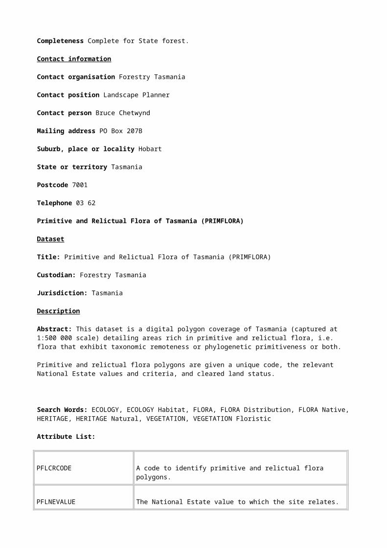
High Quality Wilderness of Tasmaia (WILDHQ9701)
Dataset
Title: High Quality Wilderness of Tasmania (WILDHQ9701)
Custodian: Forestry Tasmania
Jurisdiction: Tasmania
Description
Abstract: This dataset is a digital polygon coverage of Tasmania (captured at 1:500 000) detailing areas of high quality wilderness.
High quality wilderness areas are defined by name and location.
Search Words: BOUNDARIES, BOUNDARIES Management, ECOLOGY, ECOLOGY Landscape, FORESTS, FORESTS Natural, HERITAGE, HERITAGE Natural, HERITAGE World, LAND, LAND Conservation
Attribute List:
WILDHQNAME Name of hiqh quality wilderness area, e.g. Freycinet, Ben Lomond, South West, Cradle-Central Plateau, etc.
WILDHQSTATUS Code for wilderness status (1 or 0)
1 = High quality wilderness
0 = Not high quality wilderness
WHQNEVALUE The National Estate value to which the site relates. All sites in this coverage have National Estate value ‘High quality wilderness".
WHQNECRITERIA The National Estate criterion for which the site has been assessed to be above threshold.
All sites in this coverage are classified according to National Estate criterion A2.
Geographic Extent Name: Tasmania
Data Currency
Begin Date: 01 Dec 1996
End Date: 31 Jan 1997

Dataset Status
Progress: Complete
Maintenance & Update Frequency: As required
Format
Stored Data Format: DIGITAL Arc/Info Revision 7.0.4 vector coverage (polygons) stored in a Librarian layer as a 1:500 000 map tile.
Available Formats: DIGITAL Arc/Info export file.
NON DIGITAL Plotted map output is available from a GIS ARCPLOT menu using a HP750 plotter
Data Quality
Lineage: The coverage was derived from the National Wilderness Inventory database: Tasmania (PLUC 1996a). Rational boundaries were manually drawn on 1:100 000 wilderness quality plots around areas of wilderness quality of 12 or greater. Resulting areas of high quality wilderness were then digitised at Forestry Tasmania.
Positional Accuracy: The coverage was compiled at 1:100 000 scale.
Attribute Accuracy: Attribute accuracy was visually checked at time of data entry.
Logical Consistency: Standard 1:500 000 Forestry Tasmania logical consistency tests were conducted on this dataset, ie visual checking of source data, a test of item structures and definitions, a test on the completeness of valid codes and polygons, topological consistency checks to detect flaws in the spatial data (carried out automatically when coverage was built).
Completeness: The coverage is complete for mainland Tasmania and nearshore islands. Macquarie Island and the Bass Strait islands are excluded from the dataset.
Contact Information
Organisation: Forestry Tasmania
Position: Tasmanian RFA Environment and Heritage Project Manager
Person: Andrew Blakesley
Address: GPO Box 207B
City: Hobart
State: TASMANIA
Postcode: 7001
Telephone: 02 6233 8357
Facsimile: 02 6233 2744

Electronic Mail Address: [email protected]
Undisturbed river catchments of Tasmania (UDCATCH)
Dataset
Title: Undisturbed River Catchments of Tasmania (UDCATCH)
Custodian: Forestry Tasmania
Jurisdiction: Tasmania
Description
Abstract: This dataset is a digital polygon coverage of Tasmania (captured at
1: 250 000 scale) detailing river catchments that have not been disturbed.
River catchments are defined by their boundary, area and disturbance status.
Search Words: BOUNDARIES, BOUNDARIES Management, HERITAGE, HERITAGE Natural, WATER, WATER Rivers, WATER Surface
Attribute List:
UDCSTATUS Code for status of river catchment (1 or 0)
1 = Undisturbed
0 = Disturbed
UDCNEVALUE The National Estate value to which the site relates.
All sites in this coverage have National Estate value ‘Undisturbed Catchment’.
UDCNECRITERIA The National Estate criterion for which the site has been assessed to be above threshold.
All sites in this coverage are classified according to National Estate criterion A2.
Geographic Extent Name: Tasmania
Data Currency
Begin Date: 01 Dec 1996
End Date: 31 Jan 1997
Dataset Status
Progress: Complete
Maintenance & Update Frequency: As required
Access
Stored Data Format: DIGITAL Arc/Info Revision 7.0.4 vector coverage (polygons) stored in a Librarian layer as a 1:500 000 map tile.
Available Formats: DIGITAL Arc/Info export file.
NON DIGITAL Plotted map output is available from a GIS ARCPLOT menu using a HP750 plotter
Data Quality
Lineage: Sub-catchment boundaries were derived from the Centre for Resources and Environmental Studies (CRES) digital sub-catchments database (see PLUC 1996b for more detailed discussion).
Sub-catchments with a biophysical naturalness (BN) class of less than 5 were classified as disturbed and excluded. All sub-catchments with BN=5 were scrutinised for other disturbances such as roads, huts or mines and excluded if such disturbances impacted significantly on the sub-catchment. Remaining sub-catchments were then amalgamated into catchment systems. Catchment systems < 1000 ha were also excluded unless surrounded by other undisturbed catchment systems. All sub-catchments in the CRES sub-catchment database were then coded as 1 (undisturbed) or 0 (disturbed).
Positional Accuracy: DEM used to derive sub-catchments was computed from 1:100 000 scale elevation spot height data and 1:250 000 scale streamlines.
Attribute Accuracy: ‘Undisturbed’ information was coded at 1:250 000 scale.
Logical Consistency: The method was applied consistently across the whole grid.
Completeness: The coverage is complete for mainland Tasmania and nearshore islands. The only Tasmanian island containing an undisturbed catchment is De Witt Island. Macquarie Island and the Bass Strait islands are excluded from the dataset.
Contact Information
Organisation: Forestry Tasmania
Position: Tasmanian RFA Environment and Heritage Project Officer
Person: Penny Wells
Address: GPO Box 207B
City: Hobart
State: TASMANIA

Postcode: 7001
Telephone: 02 6233 2614
Facsimile: 02 6233 2744
Electronic Mail Address: [email protected]
Important wetlands in Tasmania (WETLANDSREP)
Dataset
Title: Important wetlands in Tasmania (WETLANDSREP)
Custodian: Forestry Tasmania
Jurisdiction: Tasmania
Description
Abstract: This dataset is a digital polygon and point coverage (captured at 1:500 000 scale) detailing important wetlands of Tasmania which are listed in the Directory of Important Wetlands in Australia (ANCA 1996).
Important wetlands are coded with a unique number, map details, size parameters, and the relevant National Estate values and criteria.
Search Words: HERITAGE, HERITAGE Natural, WATER, WATER Groundwater, WATER Lakes, WATER Wetlands
Attribute List:
NEÐCODE A unique number to identify each wetlands polygon
MAPNAME Name of 1:100 000 map
MAPNO Identification number of 1:100 000 map
ACCURACY Accuracy of polygon or point location in metres
PLACE(GAZETEER) Gazetted name of important wetland
PLACEÐNAME Local name of wetland

AREA(HA) Area of representative wetland in hectares
GREATESTÐDIAM(M) Greatest diameter of wetland in metres
LEASTÐDIAM(M) Least diameter of wetland in metres
WETNEVALUE The National Estate value to which the site relates. All sites in this coverage have National Estate value ‘Representative Wetland Areas’.
WETNECRITERIA The National Estate criterion for which the site has been assessed to be above threshold.
All sites in this coverage are classified according to National Estate criterion D1.
Geographic Extent Name: Tasmania
Data Currency
Begin Date: 01 Dec 1996
End Date: 31 Jan 1997
Dataset Status
Progress: Complete
Maintenance & Update Frequency: As required
Format
Stored Data Format: DIGITAL Arc/Info Revision 7.0.4 vector coverage (polygons) stored in a Librarian layer as a 1:500 000 map tile.
Available Formats: DIGITAL Arc/Info export file.
NON DIGITAL Plotted map output is available from a GIS ARCPLOT menu using a HP750 plotter
Data Quality

Lineage: The dataset was digitised by Forestry Tasmania from point data derived from the Parks and Wildlife Service Wildlife Atlas.
Positional Accuracy: Varies from a few metres where a Global Positioning System was used for location, up to 1 degree. Each site has an accuracy field. Grid coordinates are cross checked with a distance from a known named place where available.
Attribute Accuracy: Attribute accuracy was visually checked at time of data entry.
Logical Consistency: Standard Forestry Tasmania logical consistency tests were conducted on this dataset, i.e. visual checking of source data, a test of item structures and definitions, a test on the completeness of valid codes and polygons, topological consistency checks to detect flaws in the spatial data (carried out automatically when coverage was built).
Completeness: The coverage is complete for Tasmania including the Bass Strait Islands.
Contact Information
Organisation: Forestry Tasmania
Position: Tasmanian RFA Environment and Heritage Project Officer
Person: Penny Wells
Address: GPO Box 207B
City: Hobart
State: TASMANIA
Postcode: 7001
Telephone: 02 6233 2614
Facsimile: 02 6233 2744
Electronic Mail Address: [email protected]
Principal Characteristics of Forest Vegetation Classes (REPVEG)
Dataset
Title: Principal Characteristics of Forest Vegetation Classes (REPVEG)
Custodian: Forestry Tasmania
Jurisdiction: Tasmania
Description
Abstract: This dataset is a digital polygon coverage of Tasmania (captured at
1: 100 000 scale) detailing forest patches representing the principal characteristics of each forest class.
Forest patches are coded with vegetation community type and the relevant National Estate value and criteria.

Search Words: FORESTS, FORESTS Conservation, FORESTS Natural, FORESTS Management, HERITAGE, HERITAGE Natural, VEGETATION, VEGETATION Conservation, VEGETATION Management
Attribute List:
RPVVEGCOMM Mapping unit code describing the forest vegetation community, 50 classes.
RPVNEVALUE The National Estate value to which the site relates.
All sites in this coverage have National Estate value ‘Representative Communities’.
RPVNECRITERIA The National Estate criterion for which the site has been assessed to be above threshold.
All sites in this coverage are classified according to National Estate criteria D1.
Geographic Extent Name: Tasmania
Data Currency
Begin Date: 01 Dec 1996
End Date: 31 Jan 1997
Dataset Status
Progress: Complete
Maintenance & Update Frequency: As required
Format
Stored Data Format: DIGITAL Arc/Info Revision 7.0.4 vector coverage (polygons) stored in a Librarian layer as a 1:500 000 map tile.
Available Formats: DIGITAL Arc/Info export file.
NON DIGITAL Plotted map output is available from a GIS ARCPLOT menu using a HP750 plotter
Data Quality
Lineage: The source of the data was. the Principal Characteristics of Forest Vegetation Class was derived from the Forest Vegetation Communities map (PLUC 1996a) by selecting all examples of rare, endangered or vulnerable communities and those examples of other vegetation types occurring within natural landscapes.
Positional Accuracy: The original forest vegetation dataset was collected at 1:25 000 scale. The estimated positional accuracy of the mapped polygon boundaries is within 25 metres on the 1:25 000 map.
Attribute Accuracy: Attribute accuracy was visually checked at time of data entry.
Logical Consistency: Standard 1:500 000 Forestry Tasmania logical consistency tests were conducted on this dataset, i.e. visual checking of source data, a test of item structures and definitions, a test on the completeness of valid codes and polygons, topological consistency checks to detect flaws in the spatial data (carried out automatically when coverage was built),
Completeness: The coverage is complete for the forests of Tasmania (including the Bass Strait Islands).
Contact Information
Organisation: Forestry Tasmania
Position: Tasmanian RFA Environment and Heritage Project Officer
Person: Penny Wells
Address: GPO Box 207B
City: Hobart
State: TASMANIA
Postcode: 7001
Telephone: 02 6233 2614
Facsimile: 02 6233 2744
Electronic Mail Address: [email protected]
Limits of Range - Flora (FLORALIM)
Dataset
Title: Limits of Range - Flora (FLORALIM)
Custodian: Forestry Tasmania
Jurisdiction: Tasmania
Description
Abstract: This dataset is a digital polygon coverage of Tasmania (captured at 1:500 000 scale) detailing places where concentrations of flora species reach the limits of their natural range.

The limits of range of flora are coded with a unique number, the relevant National Estate values and criteria, and cleared land status.
Search Words: ECOLOGY, ECOLOGY Habitat, FLORA, FLORA Distribution, FLORA Native, HERITAGE, HERITAGE Natural, VEGETATION, VEGETATION Floristic
Attribute List:
FLLCODE A unique number to identify each polygon.
FLLNEVALUE The National Estate value to which the site relates. All sites in this coverage have National Estate value ‘Flora Limits’.
FLLNECRITERIA The National Estate criterion for which the site has been assessed to be above threshold.
All sites in this coverage are classified according to National Estate criteria A1.
FLLBN Cleared land is excluded from each polygon. The coverage is coded as either 0 (not cleared land) or 9 (cleared land).
Geographic Extent Name: Tasmania
Data Currency
Begin Date: 01 Dec 1996
End Date: 31 Jan 1997
Dataset Status
Progress: Complete
Maintenance & Update Frequency: As required
Format
Stored Data Format: DIGITAL Arc/Info Revision 7.0.4 vector coverage (polygons) stored in a Librarian layer as a 1:500 000 map tile.
Available Formats: DIGITAL Arc/Info export file.
NON DIGITAL Plotted map output is available from a GIS ARCPLOT menu using a HP750 plotter.
Data Quality
Lineage: The dataset was digitised by Forestry Tasmania from 1:500 000 scale paper maps prepared by an expert panel.
Positional Accuracy: The dataset was collected at 1:500 000 scale. The mapped polygon boundaries are indicative areas only and as such their positional accuracy is subjective.
Attribute Accuracy: Attribute accuracy was visually checked at time of data entry.
Logical Consistency: Standard 1:500 000 Forestry Tasmania logical consistency tests were conducted on this dataset, i.e. visual checking of source data, a test of item structures and definitions, a test on the completeness of valid codes and polygons, topological consistency checks to detect flaws in the spatial data (carried out automatically when coverage was built).
Completeness: The coverage is complete for significant limits of range sites for Tasmania (excluding Macquarie Island and Bass Strait Islands).
Contact Information
Organisation: Forestry Tasmania
Position: Tasmanian RFA Environment and Heritage Project Officer
Person: Penny Wells
Address: GPO Box 207B
City: Hobart
State: TASMANIA
Postcode: 7001
Telephone: 02 6233 2614
Facsimile: 02 6233 2744
Electronic Mail Address: [email protected]
Flora Type Locations (ENDFLORA)
Dataset
Title: Flora Type Locations(ENDFLORA)
Custodian: Forestry Tasmania
Jurisdiction: Tasmania
Description
Abstract: This dataset is a digital point coverage of Tasmania detailing type locations for Tasmanian rare and threatened forest flora.
Flora type locations are coded with a unique number, the relevant National Estate values and criteria and cleared land status.

Search Words: FLORA, FLORA Conservation, FLORA Distribution, FLORA Native, HERITAGE, HERITAGE Natural
Attribute List:
EFLCODE A unique number to identify each type locality point.
EFLNEVALUE The National Estate value to which the site relates. All sites in this coverage have National Estate value ‘Natural History’.
EFLNECRITERIA The National Estate criterion for which the site has been assessed to be above threshold.
All sites in this coverage are classified according to National Estate criterion C1.
EFLBN Cleared land is excluded from each polygon. The coverage is coded as either 0 (not cleared land) or 9 (cleared land).
Geographic Extent Name: Tasmania
Data Currency
Begin Date: 01 Dec 1996
End Date: 31 Jan 1997
Dataset Status
Progress: Complete
Maintenance & Update Frequency: As required
Format
Stored Data Format: DIGITAL Arc/Info Revision 7.0.4 vector coverage (points) stored in a Librarian layer as a 1:500 000 map tile.
Available Formats: DIGITAL Arc/Info export file.
NON DIGITAL Plotted map output is available from a GIS ARCPLOT menu using a HP750 plotter
Data Quality
Lineage: The dataset was digitised by Forestry Tasmania from grid references provided by the Tasmanian Herbarium.
Positional Accuracy: Grid references used in the dataset were accurate to within 1 km.
Attribute Accuracy: Attribute accuracy was visually checked at time of data entry.
Logical Consistency: Standard 1:500 000 Forestry Tasmania logical consistency tests were conducted on this dataset, i.e. visual checking of source data, a test of item structures and definitions, a test on the completeness of valid codes and polygons, topological consistency checks to detect flaws in the spatial data (carried out automatically when coverage was built).
Completeness: The coverage is complete for the Tasmanian mainland for rare and threatened forest flora type localities with a positional accuracy of 1 km or less.
Contact Information
Organisation: Forestry Tasmania
Position: Tasmanian RFA Environment and Heritage Project Officer
Person: Penny Wells
Address: GPO Box 207B
City: Hobart
State: TASMANIA
Postcode: 7001
Telephone: 02 6233 2614
Facsimile: 02 6233 2744
Electronic Mail Address: [email protected]
Fauna Type Locations (ENDFAUNA)
Dataset
Title: Fauna Type Locations (ENDFAUNA)
Custodian: Forestry Tasmania
Jurisdiction: Tasmania
Description
Abstract: This dataset is a digital point coverage of Tasmania detailing type locations for Tasmanian rare and threatened forest fauna.
Fauna type locations are coded with a unique number, the relevant National Estate values and criteria and cleared land status.
Search Words: FAUNA, FAUNA Conservation, FAUNA Distribution, FAUNA Native, HERITAGE, HERITAGE Natural
Attribute List:
EFACODE A unique number to identify each type locality point.
EFANEVALUE The National Estate value to which the site relates. All sites in this coverage have National Estate value ‘Natural History’.
EFANECRITERIA The National Estate criterion for which the site has been assessed to be above threshold.
All sites in this coverage are classified according to National Estate criterion C1.
EFABN Cleared land is excluded from each polygon. The coverage is coded as either 0 (not cleared land) or 9 (cleared land).
Geographic Extent Name: Tasmania
Data Currency
Begin Date: 01 Dec 1996
End Date: 31 Jan 1997
Dataset Status
Progress: Complete
Maintenance & Update Frequency: As required
Format
Stored Data Format: DIGITAL Arc/Info Revision 7.0.4 vector coverage (points) stored in a Librarian layer as a 1:500 000 map tile.
Available Formats: DIGITAL Arc/Info export file.
NON DIGITAL Plotted map output is available from a GIS ARCPLOT menu using a HP750 plotter
Data Quality
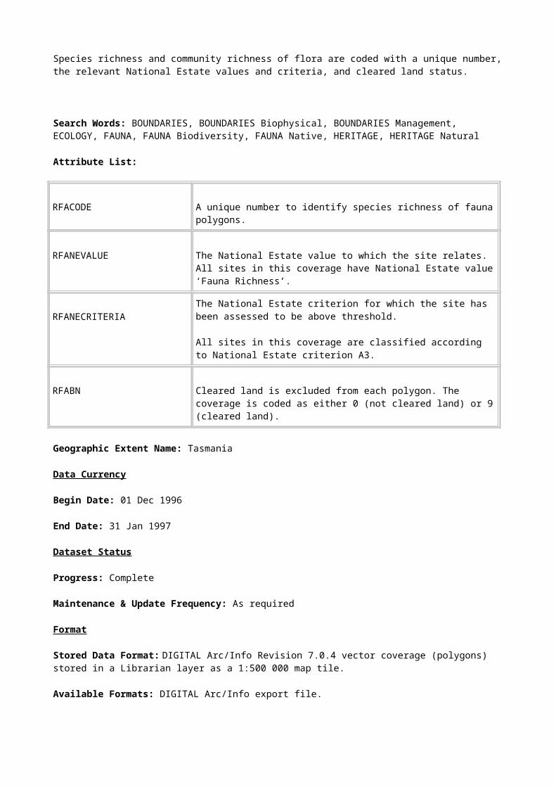
Lineage: The dataset was digitised by Forestry Tasmania from grid references cited in current literature sources.
Positional Accuracy: Grid references used in the dataset were accurate to within 1 km.
Attribute Accuracy: Attribute accuracy was visually checked at time of data entry.
Logical Consistency: Standard 1:500 000 Forestry Tasmania logical consistency tests were conducted on this dataset, i.e. visual checking of source data, a test of item structures and definitions, a test on the completeness of valid codes and points, topological consistency checks to detect flaws in the spatial data (carried out automatically when coverage was built).
Completeness: The coverage is complete for the Tasmanian mainland for rare and threatened forest fauna type localities with a positional accuracy of 1 km or less.
Contact Information
Organisation: Forestry Tasmania
Position: Tasmanian RFA Environment and Heritage Project Officer
Person: Penny Wells
Address: GPO Box 207B
City: Hobart
State: TASMANIA
Postcode: 7001
Telephone: 02 6233 2614
Facsimile: 02 6233 2744
Electronic Mail Address: [email protected]
Centres of Endemism - Flora (ENDCENTRE)
Dataset
Title: Centres of Endemism - Flora (ENDCENTRE)
Custodian: Forestry Tasmania
Jurisdiction: Tasmania
Description
Abstract: This dataset is a digital polygon coverage of Tasmania (captured at
1: 500 000 scale) detailing the centres of endemism of flora, i.e. areas where concentrations of exclusively Tasmanian flora species are found.
Centres of endemism of flora are coded with a unique number, the relevant National Estate value and criterion, and cleared land status.
Search Words: ECOLOGY, ECOLOGY Habitat, FLORA, FLORA Distribution, FLORA Native, HERITAGE, HERITAGE Natural, VEGETATION, VEGETATION Floristic
Attribute List:
ENCCODE A unique number to identify each centre of endemism polygon.
ENCNEVALUE The National Estate value to which the site relates. All sites in this coverage have National Estate value ‘Centres of Endemism’.
ENCNECRITERIA The National Estate criterion for which the site has been assessed to be above threshold.
All sites in this coverage are classified according to National Estate criterion A1.
ENCBN Cleared land is excluded from each polygon. The coverage is coded as either 0 (not cleared land) or 9 (cleared land).
Geographic Extent Name: Tasmania
Data Currency
Begin Date: 01 Dec 1996
End Date: 31 Jan 1997
Dataset Status
Progress: Complete
Maintenance & Update Frequency: As required
Format
Stored Data Format: DIGITAL Arc/Info Revision 7.0.4 vector coverage (polygons) stored in a Librarian layer as a 1:500 000 map tile.
Available Formats: DIGITAL Arc/Info export file.
NON DIGITAL Plotted map output is available from a GIS ARCPLOT menu using a HP750 plotter.
Data Quality
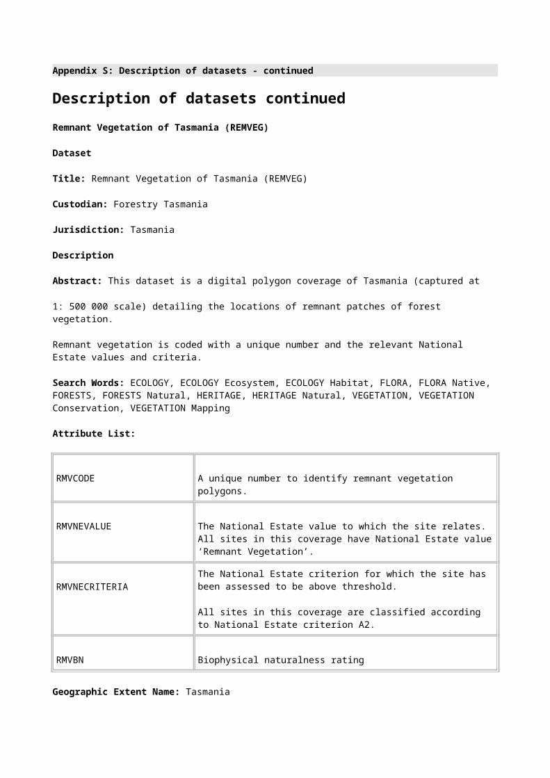
Lineage: The dataset was digitised by Forestry Tasmania from 1:500 000 scale paper maps prepared by an expert panel.
Positional Accuracy: The dataset was collected at 1:500 000 scale. The mapped polygon boundaries are indicative areas only and as such their positional accuracy is subjective.
Attribute Accuracy: Attribute accuracy was visually checked at time of data entry.
Logical Consistency: Standard 1:500 000 Forestry Tasmania logical consistency tests were conducted on this dataset, i.e. visual checking of source data, a test of item structures and definitions, a test on the completeness of valid codes and polygons, topological consistency checks to detect flaws in the spatial data (carried out automatically when coverage was built).
Completeness: The coverage is complete for significant centres of endemism for flora in Tasmania.
Contact Information
Organisation: Forestry Tasmania
Position: Tasmanian RFA Environment and Heritage Project Officer
Person: Penny Wells
Address: GPO Box 207B
City: Hobart
State: TASMANIA
Postcode: 7001
Telephone: 02 6233 2614
Facsimile: 02 6233 2744
Electronic Mail Address: [email protected]
Social Values (SOCIAL)
Dataset
Title: Social Values (SOCIAL)
Custodian: Forestry Tasmania
Jurisdiction: Tasmania
Description
Abstract: This dataset is a digital polygon coverage of Tasmania (captured at 1:100 000 scale) detailing sites of National Estate social significance.
Social value sites are identified by name coded with the relevant National Estate values and criteria.

Search Words: BOUNDARIES, BOUNDARIES Cultural, HERITAGE, HERITAGE Mapping, HERITAGE Natural, HUMAN ENVIRONMENT
Attribute List:
SOCVAL Name social values sites.
SOCNEVALUE The National Estate value to which the site relates. All sites in this coverage have National Estate value ‘Social Values’.
SOCNECRITERIA The National Estate criterion for which the site has been assessed to be above threshold.
All sites in this coverage are classified according to National Estate criteria G1.
Geographic Extent Name: Tasmania
Data Currency
Begin Date: 01 Dec 1996
End Date: 31 Jan 1997
Dataset Status
Progress: Complete
Maintenance & Update Frequency: As required
Format
Stored Data Format: DIGITAL Arc/Info Revision 7.0.4 vector coverage (polygons) stored in a Librarian layer as a 1:500 000 map tile.
Available Formats: DIGITAL Arc/Info export file.
NON DIGITAL Plotted map output is available from a GIS ARCPLOT menu using a HP750 plotter.
Data Quality
Lineage: The dataset was digitised by Forestry Tasmania from 1:100 000 scale paper maps prepared by a consultant from expert workshops and follow-up community consultation .
Positional Accuracy: The dataset was collected at 1:100 000 scale. Polygon boundaries were drawn in consultation with community representatives.
Attribute Accuracy: Attribute accuracy was visually checked at time of data entry.

Logical Consistency: Standard Forestry Tasmania logical consistency tests were conducted on this dataset, i.e. visual checking of source data, a test of item structures and definitions, a test on the completeness of valid codes and polygons, topological consistency checks to detect flaws in the spatial data (carried out automatically when coverage was built), etc.
Completeness: The coverage is complete mainland Tasmania and its nearshore islands. Macquarie Island and the Bass Strait islands are excluded from the dataset.
Contact Information
Organisation: Forestry Tasmania
Position: Tasmanian RFA Environment and Heritage Project Officer
Person: Penny Wells
Address: GPO Box 207B
City: Hobart
State: TASMANIA
Postcode: 7001
Telephone: 02 6233 2614
Facsimile: 02 6233 2744
Electronic Mail Address: [email protected]
Aesthetic Values (SOCAEST)
Dataset
Title: Aesthetic Values (SOCAEST)
Custodian: Forestry Tasmania
Jurisdiction: Tasmania
Description
Abstract: This dataset is a digital polygon coverage of Tasmania (captured at 1:100 000 scale) detailing places of potential National Estate aesthetic significance.
Aesthetic values are coded with a unique number and the relevant National Estate values and criteria.
Search Words: BOUNDARIES, BOUNDARIES Cultural, HERITAGE, HERITAGE Mapping, HERITAGE Natural, HUMAN ENVIRONMENT, LAND, LAND Use

Attribute List:
AESCODE A unique code to identify social aesthetics polygons.
AESNEVALUE The National Estate value to which the site relates. All sites in this coverage have National Estate value ‘Aesthetics’.
AESNECRITERIA The National Estate criterion for which the site has been assessed to be above threshold.
All sites in this coverage are classified according to National Estate criteria E1.
Geographic Extent Name: Tasmania
Data Currency
Begin Date: 01 Dec 1996
End Date: 31 Jan 1997
Dataset Status
Progress: Complete
Maintenance & Update Frequency: As required
Format
Stored Data Format: DIGITAL Arc/Info Revision 7.0.4 vector coverage (polygons) stored in a Librarian layer as a 1:500 000 map tile.
Available Formats: DIGITAL Arc/Info export file.
NON DIGITAL Plotted map output is available from a GIS ARCPLOT menu using a HP750 plotter.
Data Quality
Lineage: The dataset was derived from four data sources :
i) key artistic and creative sources survey,
ii) scenic quality mapping,
iii) forest planners survey, and
iv) social values community workshops
The dataset was digitised by Forestry Tasmania from 1:100 000 scale paper maps.

Positional Accuracy: The dataset was collected at 1:100 000 scale. Polygon boundaries were drawn in consultation with community representatives and expert opinion.
Attribute Accuracy: Attribute accuracy was visually checked at time of data entry.
Logical Consistency: Standard Forestry Tasmania logical consistency tests were conducted on this dataset, i.e. visual checking of source data, a test of item structures and definitions, a test on the completeness of valid codes and polygons, topological consistency checks to detect flaws in the spatial data (carried out automatically when coverage was built), etc.
Completeness: The coverage is complete for mainland Tasmania and its nearshore islands. Macquarie Island and the Bass Strait islands are excluded from the dataset.
Contact Information
Organisation: Forestry Tasmania
Position: Tasmanian RFA Environment and Heritage Project Officer
Person: Penny Wells
Address: GPO Box 207B
City: Hobart
State: TASMANIA
Postcode: 7001
Telephone: 02 6233 2614
Facsimile: 02 6233 2744
Electronic Mail Address: [email protected]
Tasmanian Reference, Research and Teaching Sites (C1REFCOV)
Dataset
Title: Tasmanian Reference, Research and Teaching Sites (C1REFCOV)
Custodian: Forestry Tasmania
Jurisdiction: Tasmania
Description
Abstract: This dataset is a digital polygon coverage of Tasmania (captured at 1:100 000 scale) detailing natural history sites that are used for reference, research and teaching purposes.
Reference, research and teaching sites are defined by boundary, name, the relevant National Estate values and criteria, and cleared land status.

Search Words: BOUNDARIES, BOUNDARIES Research, BOUNDARIES Reference, HERITAGE, HERITAGE Natural
Attribute List:
C1NAMES Name of reference, research or teaching site.
C1NEVALUE The National Estate value to which the site relates. All sites in this coverage have National Estate value ‘Natural History’.
C1NECRITERIA The National Estate criterion for which the site has been assessed to be above threshold.
All sites in this coverage are classified according to National Estate criteria C1.
C1BN Cleared land is excluded from each polygon. The coverage is coded as either 0 (not cleared land) or 9 (cleared land).
Geographic Extent Name: Tasmania
Data Currency
Begin Date: 01 Dec 1996
End Date: 31 Jan 1997
Dataset Status
Progress: Complete
Maintenance & Update Frequency: As required
Format
Stored Data Format: DIGITAL Arc/Info Revision 7.0.4 vector coverage (polygons) stored in a Librarian layer as a 1:500 000 map tile.
Available Formats: DIGITAL Arc/Info export file.
NON DIGITAL Plotted map output is available from a GIS ARCPLOT menu using a HP750 plotter.
Data Quality
Lineage: The dataset was digitised by Forestry Tasmania from 1:100 000 scale paper maps prepared by a project officer in consultation with natural history specialists, literature sources and an expert panel.
Positional Accuracy: The positional accuracy of the mapped polygon boundaries varies from within 25 metres to 500 metres depending on the source data.
Attribute Accuracy: Attribute accuracy was visually checked at time of data entry.
Logical Consistency: Standard 1:500 000 Forestry Tasmania logical consistency tests were conducted on this dataset, i.e. visual checking of source data, a test of item structures and definitions, a test on the completeness of valid codes and polygons, topological consistency checks to detect flaws in the spatial data (carried out automatically when coverage was built).
Completeness: The coverage is complete for mainland Tasmania and its nearshore islands. Macquarie Island and the Bass Strait islands are excluded from the dataset.
Contact Information
Organisation: Forestry Tasmania
Position: Tasmanian RFA Environment and Heritage Project Officer
Person: Penny Wells
Address: GPO Box 207B
City: Hobart
State: TASMANIA
Postcode: 7001
Telephone: 02 6233 2614
Facsimile: 02 6233 2744
Electronic Mail Address: [email protected]
Rare or Threatened Forest Communities (RARECOMM)
Dataset
Title: Rare or Threatened Forest Communities (RARECOMM)
Custodian: Forestry Tasmania
Jurisdiction: Tasmania
Description
Abstract: This dataset is a digital polygon coverage of Tasmania (captured at 1:25 000 scale) detailing rare or threatened forest communities.
Rare/threatened forest communities are coded according to their vegetation community type and the relevant National Estate values and criteria.

Search Words: ECOLOGY, ECOLOGY Community, FLORA, FLORA Native, FORESTS, FORESTS Conservation, FORESTS Management, FORESTS Natural, HERITAGE, HERITAGE Natural, VEGETATION, VEGETATION Structural
Attribute List:
RARVEGCOMM Mapping unit code describing the forest vegetation community,
RARNEVALUE The National Estate value to which the site relates. All sites in this coverage have National Estate value ‘Rare Communities’.
RARNECRITERIA The National Estate criterion for which the site has been assessed to be above threshold.
All sites in this coverage are classified according to National Estate criteria B1.
Geographic Extent Name: Tasmania
Data Currency
Begin Date: 01 Dec 1996
End Date: 31 Jan 1997
Dataset Status
Progress: Complete
Maintenance & Update Frequency: As required
Format
Stored Data Format: DIGITAL Arc/Info Revision 7.0.4 vector coverage (polygons) stored in a Librarian layer as a 1:500 000 map tile.
Available Formats: DIGITAL Arc/Info export file.
NON DIGITAL Plotted map output is available from a GIS ARCPLOT menu using a HP750 plotter.
Data Quality
Lineage: Forest vegetation communities assessed to be rare, vulnerable or endangered in Tasmania were selected from the Forest Vegetation Communities map (PLUC 1996a). to produce this cover.
Positional Accuracy: The original forest vegetation dataset was collected at 1:25 000 scale. The estimated positional accuracy of the mapped polygon boundaries is within 25 metres on the 1:25 000 map.

Attribute Accuracy: Attribute accuracy was visually checked at time of data entry.
Logical Consistency: Standard Forestry Tasmania logical consistency tests were conducted on this dataset, i.e. visual checking of source data, a test of item structures and definitions, a test on the completeness of valid codes and polygons, topological consistency checks to detect flaws in the spatial data (carried out automatically when coverage was built).
Completeness: The coverage is complete for all rare or threatened forest communities in Tasmania, including the Bass Strait Islands.
Contact Information
Organisation: Forestry Tasmania
Position: Tasmanian RFA Environment and Heritage Project Officer
Person: Penny Wells
Address: GPO Box 207B
City: Hobart
State: TASMANIA
Postcode: 7001
Telephone: 02 6233 2614
Facsimile: 02 6233 2744
Electronic Mail Address: [email protected]
Glacial Refugia Areas of Tasmania (REFUGIAPAST)
Dataset
Title: Glacial Refugia Areas of Tasmania (REFUGIAPAST)
Custodian: Forestry Tasmania
Jurisdiction: Tasmania
Description
Abstract: This dataset is a digital polygon coverage of Tasmania (captured at 1:500 000) detailing glacial refugia areas, i.e. areas that have escaped drastic alteration, in contrast to the surrounding area, within a region that has undergone general glaciation. The changes of climate associated with glacial advance and recession affect plant survival, however general climatic change does not affect a large area uniformly. The resultant unaffected areas contain relic colonies of species or communities that are left behind.
Glacial refugia are coded with a unique number and the relevant National Estate values and criteria.

Search Words: BOUNDARIES, BOUNDARIES Biophysical, BOUNDARIES Management, ECOLOGY, ECOLOGY Habitat, FLORA, FLORA Native, HERITAGE, HERITAGE Natural
Attribute List:
RPA2 A unique number to identify each polygon.
RPANEVALUE The National Estate value to which the site relates. All sites in this coverage have National Estate value ‘Refugia from Past Processes’.
RPANECRITERIA The National Estate criterion for which the site has been assessed to be above threshold.
All sites in this coverage are classified according to National Estate criteria A1.
Geographic Extent Name: Tasmania
Data Currency
Begin Date: 01 Dec 1996
End Date: 31 Jan 1997
Dataset Status
Progress: Complete
Maintenance & Update Frequency: As required
Format
Stored Data Format: DIGITAL Arc/Info Revision 7.0.4 vector coverage (polygons) stored in a Librarian layer as a 1:500 000 map tile.
Available Formats: DIGITAL Arc/Info export file.
NON DIGITAL Plotted map output is available from a GIS ARCPLOT menu using a HP750 plotter.
Data Quality
Lineage: Data sources for this cover included the Forest Vegetation Communities map (PLUC 1996a) and Refugial Sites for Flora in Tasmania (Kirkpatrick & Fowler 1996). An expert panel used this information in combination with expert knowledge to manually draw boundaries of significant glacial refugia onto 1:500 000 paper maps, subsequently digitised by Forestry Tasmania at 1:500 000 scale.
Positional Accuracy: The dataset was collected at 1:500 000 scale and as such the positional accuracy of polygon boundaries is within 500m.

Attribute Accuracy: Attribute accuracy was visually checked at time of data entry.
Logical Consistency: Standard Forestry Tasmania logical consistency tests were conducted on this dataset, i.e. visual checking of source data, a test of item structures and definitions, a test on the completeness of valid codes and polygons, topological consistency checks to detect flaws in the spatial data (carried out automatically when coverage was built), etc.
Completeness: The coverage is complete for significant glacial on mainland Tasmania and its nearshore islands. Macquarie Island and the Bass Strait islands are excluded from the dataset.
Contact Information
Organisation: Forestry Tasmania
Position: Tasmanian RFA Environment and Heritage Project Officer
Person: Penny Wells
Address: GPO Box 207B
City: Hobart
State: TASMANIA
Postcode: 7001
Telephone: 02 6233 2614
Facsimile: 02 6233 2744
Electronic Mail Address: [email protected] 33 8187
Facsimile 03 6233 8252
Electronic mail address [email protected]