Embed Size (px)
Citation preview

What are the implications of sea-level rise for a 1.5°C, 2°C and 3°C rise in global mean
temperatures in the Ganges-Brahmaputra-Meghna and other vulnerable deltas?
Sally Brown1, Robert J Nicholls1, Attila N. Lázár1, Duncan D Hornby2, Chris Hill2, Sugata
Hazra3, Kwasi Appeaning Addo4, Anisul Haque5, John Caesar6, Emma L Tompkins7.
1 Faculty of Engineering and the Environment, University of Southampton, Highfield,
Southampton. SO17 1BJ. United Kingdom. ([email protected]; [email protected])
2 GeoData, University of Southampton, Southampton SO17 1BJ, UK.
([email protected]; [email protected])
3 School of Oceanographic Studies, Jadavpur University, Kolkata, India (hazra sugata
4Department of Marine and Fisheries Sciences, University of Ghana. P. O. Box Lg 99,
Legon-Accra. Ghana ([email protected])
5 Institute of Water and Flood Management, Bangladesh University of Engineering and
Technology, Dhaka, Bangladesh ([email protected])
6 Met Office Hadley Centre, FitzRoy Road, Exeter EX1 3PB, United Kingdom
7 Geography and Environment, University of Southampton, Highfield, Southampton. SO17
1BJ. United Kingdom. ([email protected])
Corresponding author: Sally Brown. Telephone: +44(0) 2380 594796. Email:
Key words: sea-level rise; flooding, delta; Ganges-Brahmaputra-Meghna; Volta; Mahanadi
Length of manuscript: 6015 words (excluding abstract) and 8 figures at 300 words
equivalent. Total word equivalent: 8415. Plus supplementary material.
1
1
2
3
4
5
6
7
8
9
10
11
12
13
14
15
16
17
18
19
20
21
22
23
24
25
26
27

Abbreviations:
ΔDIEM Delta Dynamic Integrated Emulator Model
BAU Business-as-usual
GBM Ganges-Brahmaputra-Meghna
GCM Global Climate Model
LS Less sustainable
MS More sustainable
RCM Regional Climate Model
RCP Representative Concentration Pathway
SLR Sea-level rise
SRES Special Report on Emissions Scenarios
2
28
29
30
31
32
33
34
35
36
37
38
39
40
41
42
43
44
45
46
47
48
49
50
51

Abstract
Even if climate change mitigation is successful, sea levels will keep rising. With subsidence,
relative sea-level rise represents a long-term threat to low-lying deltas. A large part of coastal
Bangladesh was analysed using the Delta Dynamic Integrated Emulator Model to determine
changes in flood depth, area and population affected given sea-level rise equivalent to global
mean temperature rises of 1.5°C, 2.0°C and 3.0°C with respect to pre-industrial for three
ensemble members of a modified A1B scenario.
Annual climate variability today (with approximately 1.0°C of warming) is potentially more
important, in terms of coastal impacts, than an additional 0.5°C warming. In coastal
Bangladesh, the average depth of flooding in protected areas is projected to double to
between 0.07m to 0.09m when temperatures are projected at 3.0°C compared with 1.5°C. In
unprotected areas, depth of flooding is projected to increase by approximately 50% to 0.21-
0.27m, whilst the average area inundated increases 2.5 times (from 5% to 13% of the region)
in the same temperature frame. The greatest area of land flooded is projected in the central
and north-east regions. In contrast, lower flood depths, less land area flooded and fewer
people are projected in the poldered west of the region.
Over multi-centennial timescales, climate change mitigation and controlled sedimentation to
maintain relative delta height are key to a delta’s survival. With slow rates of sea-level rise,
adaptation remains possible, but further support is required. Monitoring of sea-level rise and
subsidence in deltas is recommended, together with improved data sets of elevation.
3
52
53
54
55
56
57
58
59
60
61
62
63
64
65
66
67
68
69
70
71
72
73
74
75
76
77
78
79
80

Introduction
The Paris Agreement (United Nations 2015) aims for temperature stabilisation to ‘well below
2°C above pre-industrial levels’ and pursue ‘efforts to limit the temperature increase to
1.5°C’. Climate change mitigation has many benefits, yet for the impacts of sea-level rise
(SLR), this takes time to manifest as there remains a long-term commitment to SLR due to
historical warming (Goodwin et al. submitted; Nicholls et al. submitted; Nicholls and Lowe
2004). Global mean rises of 0.75m to 0.80m (with a probability of greater than 50%) are
projected by 2100 (for a 1.5°C and 2.0°C scenario) with respect to 2000 (Schaeffer et al.
2012).
Presently, there is limited understanding of the impacts of SLR at 1.5°C and 2.0°C in
vulnerable low-lying deltas (e.g. Zaman et al. 2017), whose problems are compounded by
sediment starvation and subsidence, leading to salinisation, flooding and erosion. Deltas are
subject to multiple drivers of change, as society responses to this planned and unplanned
ways. Thus, this paper analyses the implications of temperature and equivalent SLR at 1.5°C,
2.0°C and 3.0°C in the world’s largest delta which is highly populated, the Ganges-
Brahmaputra-Meghna (GBM), plus the wider implications for other deltas. This will be
achieved by: (i) reviewing the setting of the GBM; (ii) describing the modelling methodology
used; (iii) analysing impacts at 1.5°C, 2.0°C and 3.0°C; and (iv) discussing the caveats and
consequences of these findings in the context of other deltas, plus the potential for adaptation.
Setting
The GBM delta is a large delta occupying more than 100,000km2, depending on definition,
and contains the Sundarbans mangrove forest. The impacts of SLR have been analysed for a
18,600km2 sub-region of the delta containing 14 million people (Fig. 1). Largely rural, the
study area is located less than 3m above mean sea level. The dominant land use is agriculture
and there is high reliance on monsoon rainfall conditions to sustain livelihoods. There is
strong tidal influence in the delta (Kausher et al. 1996).
4
81
82
83
84
85
86
87
88
89
90
91
92
93
94
95
96
97
98
99
100
101
102
103
104
105
106
107
108
109

In 1975 the building of the Farakka barrage resulted in an annual decrease in sediment load of
31% (Gupta et al. 2012) and in south-west Bangladesh resulted in decreased river discharge
and increased salinity (Mizra 1988). Separately, from 1989 to 2009, there was erosion along
the seaward side of the Sundarbans in western Bangladesh (Sarwar and Woodroffe 2013),
with erosion and accretion elsewhere along the coastline (Brammer 2014; Sarwar and
Woodroffe 2013; Shearman et al. 2013).
Polders (i.e. low-lying lands surrounded by embankments) are used for agriculture
improvement and water management. 126 were built between 1960 and 1990 to protect
farmers from tidal and saline water inundation and regulate water levels (World Bank 2005).
However, they restricted sediment deposition causing significant land subsidence of up to
20mm/yr within polders (Auerbach et al. 2015), whereas 2.6mm/yr subsidence is recorded
regionally (Brown and Nicholls 2015). Relative SLR (eustatic SLR plus subsidence) is
recorded as 9mm/yr (Charchanga to the south-east of the study region, from 1979 to 2000)
(Holgate et al. 2013; Permanent Service for Mean Sea Level 2017), but is variable due to
natural cycles, plus throughout the region due to subsidence and polders where the latter has a
long-term affect on river discharge and tidal flow (Pethick and Orford 2013). Thus relative
SLR poses a major threat in coastal Bangladesh.
Determining impacts of sea-level rise
Scenarios were generated based on climate change and socio-economic development
conditions, and modelled numerically using the Delta Dynamic Integrated Emulator Model
(ΔDIEM) (Lázár et al. 2018). These are described below, with further details in the
Supplementary Material.
Scenarios
Climate change scenarios
5
110
111
112
113
114
115
116
117
118
119
120
121
122
123
124
125
126
127
128
129
130
131
132
133
134
135
136
137
138

Climate change scenarios for global temperature rises 1.5°C, 2.0°C and 3.0°C were generated
from a modified version of the Special Report on Emissions Scenarios (SRES) A1B scenario
(Caesar et al. 2015). A1B is a medium to high emissions scenario (Nakicenovic and Swart
2000) lying between Representative Concentration Pathways (RCP) 6.0 and 8.5 (Moss et al.
2010). Output from an ensemble of the global climate model (GCM) HadCM3 (Collins et al.
2006) was used to drive regional climate model (RCM) simulations at a 25km spatial
resolution over South Asia using HadRM3P (Massey et al. 2015). Three ensemble members
(out of 17) were selected for detailed analysis: (i) Q0 (a moderate increase in temperature and
precipitation); (ii) Q8 (a warmer but drier future around mid-century, then wetter); and (iii)
Q16 (a larger increase in temperature). These members represented a wide range of possible
futures as explained in Caesar et al. (2015).
Each temperature scenario was referenced by a decadal average time period (with respect to
pre-industrial, i.e. 1850-1900). A single SLR scenario (of 0.24m by 2050 and 0.54m by 2100
with respect to 1986-2005) was applied to each ensemble member (Kay et al. 2015). This
represented a median scenario, and it is recognised there is considerable uncertainty around
these scenarios (as described in Kay et al. 2015), particularly as time progresses. This could
mean that impacts could occur later or earlier than anticipated. Fig 2 shows global mean
temperature, SLR and the reference period (for values, see Supplementary Material). Due to
different model historical forcing factors, there were inconsistencies in defining temperature
change today. For instance, Q16 indicates that 1.5°C was reached in 2011, which is
inconsistent with observations. Additionally, there is a common issue across climate science
regarding defining the pre-industrial baseline (Hawkins et al. 2017). Importantly, if
temperatures rise to 1.5°C quickly (e.g. Q16), sea-level rise will be less when 1.5°C first
occurs compared with a temperature rise which happens over a longer time period (e.g. Q8).
Apart from historic forcing factors, this is also due to the commitment to sea-level rise (for
long-term implications of this, see discussion on ‘Commitment to sea-level rise’). Apart from
SLR, high water levels took account of surges, tides, bathymetry and local river flows (Kay et
al. 2015) and included an additional 2.5mm/yr of subsidence (Brown and Nicholls 2015).
Socio-economic development scenarios
6
139
140
141
142
143
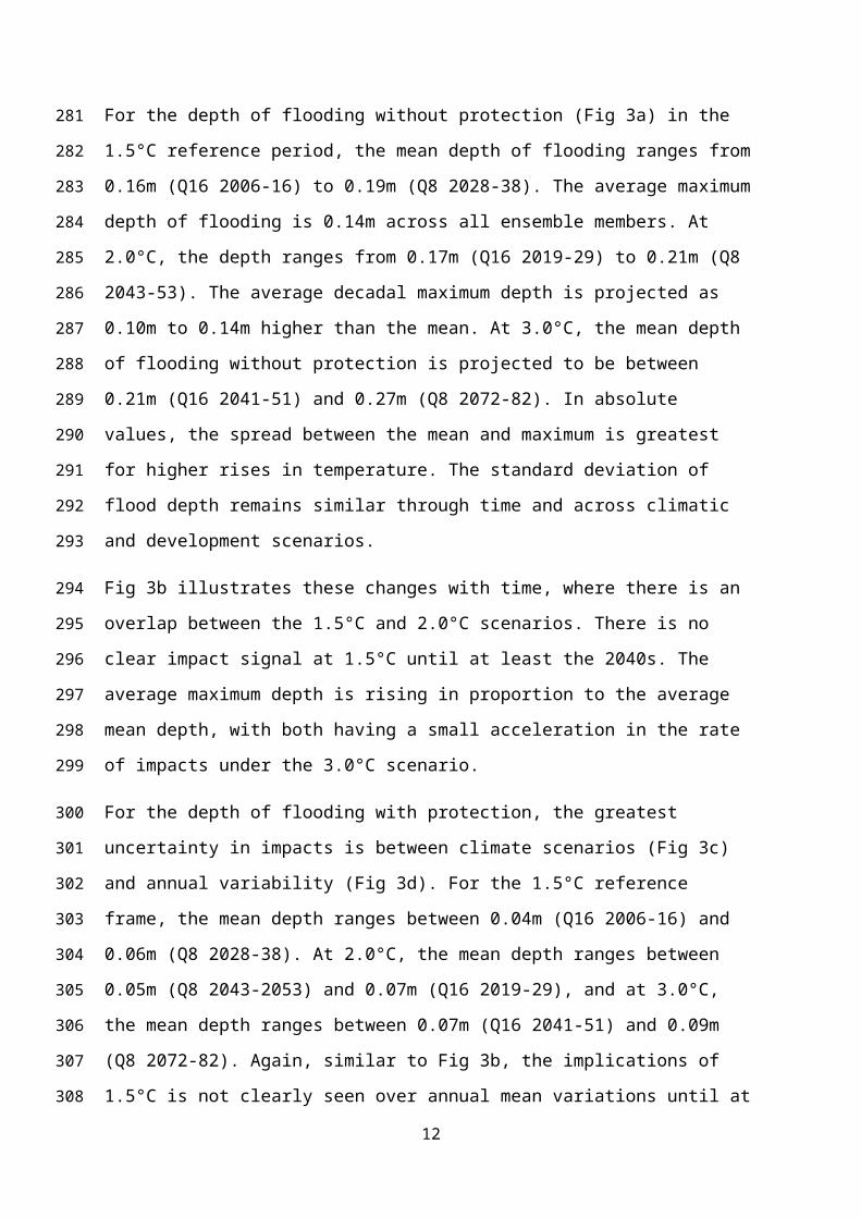
144
145
146
147
148
149
150
151
152
153
154
155
156
157
158
159
160
161
162
163
164
165
166
167
168
169

Socio-economic conditions were adapted from the five Shared Socioeconomic Pathways
(Moss et al. 2010; O’Neill et al. 2014) to form three new scenarios of development: business-
as-usual (BAU) less sustainable (LS) and more sustainable (MS) (for definitions, see
Supplementary Material). In the simulations, polder height was maintained at design height.
Methods
ΔDIEM is a modelling framework designed to analyse linkages between climatic change,
environmental change, livelihoods, well-being and governance. It couples environmental,
social and economic simulations by providing a novel integrated assessment platform for
dynamic delta planning (Lázár et al. 2018; Nicholls et al. 2016).
Impacts were based on the decadal average mean, maximum, minimum and standard
deviation of floods for the study regions and 70 upazilas (i.e. sub-district, mean area
270km2). More than 90% of upazilas experience some daily (tidal) flooding in the model
regardless of reference temperature or ensemble member, reflecting low-lying areas outside
polders. Cyclones were not considered due to modelling complexities, but these would
exacerbate impacts. Three primary impact metrics were analysed:
Depth of flooding in areas which are unprotected from flood waters, i.e. the floodplain;
Depth of flooding in areas which are protected from flood waters;
Area of land inundated.
A further parameter was analysed (average decadal mean only):
Number of people affected by flooding derived as a proportion of the area affected
inundated assuming a uniform population density per upazila.
The model was run for the ensemble members (Q0, Q8 and Q16) and three socio-economic
conditions (BAU, LS and MS), and reported for the 1.5°C, 2.0°C and 3.0°C decadal mean
temperature intervals.
Results
7
170
171
172
173
174
175
176
177
178
179
180
181
182
183
184
185
186
187
188
189
190
191
192
193
194
195
196
197
198

Regional impacts
Impacts are shown in Fig 3. The left hand side illustrates for each reference period where
1.5°C, 2.0°C and 3.0°C is reached under the BAU scenario for the average decadal mean,
mean ± 1 standard deviation, maximum and minimum of depth without protection, depth
with protection and area inundated. The LS and MS scenarios produce similar results except
for Q16 at 2°C and 3°C, so are not shown. Q16 is projected to experience greater flooding
due to more seasonal extremes (a drier dry season and a wetter monsoon season), despite
annual precipitation levels being similar between each ensemble member (see Supplementary
Material). The right hand side illustrates average annual mean, maximum and minimum
depth without protection, depth with protection and area inundated against time, using each
year in the decade where the reference temperature is reached for the BAU, LS and MS
scenarios.
For the depth of flooding without protection (Fig 3a) in the 1.5°C reference period, the mean
depth of flooding ranges from 0.16m (Q16 2006-16) to 0.19m (Q8 2028-38). The average
maximum depth of flooding is 0.14m across all ensemble members. At 2.0°C, the depth
ranges from 0.17m (Q16 2019-29) to 0.21m (Q8 2043-53). The average decadal maximum
depth is projected as 0.10m to 0.14m higher than the mean. At 3.0°C, the mean depth of
flooding without protection is projected to be between 0.21m (Q16 2041-51) and 0.27m (Q8
2072-82). In absolute values, the spread between the mean and maximum is greatest for
higher rises in temperature. The standard deviation of flood depth remains similar through
time and across climatic and development scenarios.
Fig 3b illustrates these changes with time, where there is an overlap between the 1.5°C and
2.0°C scenarios. There is no clear impact signal at 1.5°C until at least the 2040s. The average
maximum depth is rising in proportion to the average mean depth, with both having a small
acceleration in the rate of impacts under the 3.0°C scenario.
For the depth of flooding with protection, the greatest uncertainty in impacts is between
climate scenarios (Fig 3c) and annual variability (Fig 3d). For the 1.5°C reference frame, the
mean depth ranges between 0.04m (Q16 2006-16) and 0.06m (Q8 2028-38). At 2.0°C, the
mean depth ranges between 0.05m (Q8 2043-2053) and 0.07m (Q16 2019-29), and at 3.0°C,
the mean depth ranges between 0.07m (Q16 2041-51) and 0.09m (Q8 2072-82). Again,
similar to Fig 3b, the implications of 1.5°C is not clearly seen over annual mean variations
8
199
200
201
202
203
204
205
206
207
208
209
210
211
212
213
214
215
216
217
218
219
220
221
222
223
224
225
226
227
228
229
230

until at least the 2040s. At 3.0°C, the minimum flood depth increases with respect to the
mean, and flooding is more frequent.
Fig 3e illustrates the mean area inundated from flooding. This ranges from 980km2 (Q16 in
2006-2016) to 1,470km2 (Q8 in 2028-2038) for 1.5°C depending of the model ensemble
member (5%-8% of the region). The mean area inundated ranges from 1,150km2 (Q16 in
2019-2029) to 1,770km2 (Q8 2043-53) for 2.0°C, and indicates an overlap with the 1.5°C
scenario (Fig 3f). For the 3.0°C reference period, the mean area inundated increases to
between 1,620km2 (Q16 in 2041-2051) to 2,490km2 (Q8 in 2072-2082) (9%-13% of the
region).
Spatial impacts
Fig 4, Fig 5 and Fig 6 illustrate mean impacts at upazila level where there is high variability
in flooding for the BAU scenario.
At 1.5°C, the greatest depths of flooding without protection (Fig 4) for each ensemble
member are projected for the north-east upazilas, adjacent to the Meghna Estuary where there
are fewer polders, reflecting higher land elevations. Upazilas in the central region report the
lowest depths, albeit large variations around the mean are projected. At 2.0°C, a similar
pattern emerges, with depths increasing in the southern and western upazilas, despite being
poldered. The greatest increase in flood depths are projected at 3.0°C, especially for the
north-west, south-west upazilas and those north of Khulna. High variability in depths (i.e.
where the decadal variability is >4 time larger than the mean value) is limited to nine
upazilas.
The depth of flooding with protection (Fig 5) is lower across all upazilas compared with
flooding without protection, but there is a greater variability in the maximum projected depth
(particularly Q8). Across all scenarios, flood depth is greatest in the west and south, which is
the opposite finding of flood depth without protection. Hence, model results indicate polders
are effective.
The area inundated by flooding (Fig 6) shows much variability in area across all upazilas.
The largest area of flooding occurs in the south (where the highest flood depth with
9
231
232
233
234
235
236
237
238
239
240
241
242
243
244
245
246
247
248
249
250
251
252
253
254
255
256
257
258
259
260

protection were reported) despite being poldered. The area least flooded is projected away
from the main river systems. Adjacent to the Meghna Estury, the upazilas with the greatest
flooding (in the north-east) have fewer polders than those with less flooding in the south-east.
Relatively, the greatest proportion of flooding per upazila (> 20%) are projected to occur in
the north and centre of the region, including Khulna (see Supplementary Material).
The number of people affected by flooding and the number of people affected by flooding per
square kilometre was analysed (see Supplementary Material). The areas with the lowest
population flooded per upazila and per square kilometre are in the west, south-west and east
of the study region. In the west this reflects low flood depth and area flooded, particularly in
a poldered area (despite a high population density in the region). In the south-west and east
this is because of lower population densities. The greatest number of people projected to be
affected by flooding per upazila and per square kilometre occur around Khulna, which has
partial protection. These trends remain the same regardless of ensemble member or
temperature threshold.
Regional differences in the flood depth (with protection) and inundated areas under the Q16
climate and the 2.0°C and 3.0°C temperature profiles under BAU compared with LS and MS
occur due to extreme flooding in six upazilas. Here, flood depths are projected to be four
times higher under BAU than LS or MS (Fig SM3). These upazilas are spread throughout the
study region, with the exception of south-east area. For population, there are fewer extremes
in regional variations for the LS and MS scenarios compared with BAU (see Supplementary
Material).
Context within the Paris Agreement
In this study, 1.5°C is projected to occur in the decades from 2006-2016 to 2028-38 (with
respect to pre-industrial). Hence sea level is essentially at today’s level, so future impacts will
not be dissimilar to today. This is particularly important given uncertainties in modelling (e.g.
polder height, elevation models, river flows, see Payo et al. 2017). Even if climate change
mitigation is successful, sea levels will keep rising for decades and longer due to the
commitment to SLR (Goodwin et al. submitted; Nicholls et al. submitted; Nicholls and Lowe
2004), and there remain considerable uncertainty in the rate of rise (e.g. Goodwin et al.
accepted). Therefore a progressive increase in flooding can be expected in coastal
Bangladesh unless there is adaptation. Furthermore, changes to high river flows are also
10
261
262
263
264
265
266
267
268
269
270
271
272
273
274
275
276
277
278
279
280
281
282
283
284
285
286
287
288
289
290
291
292

worthy of consideration as there is uncertainty in precipitation and ice melt from glaciers
(Kraaijenbrink et al. 2017; Mohammed et al. 2017), which contributes to flooding in the
study area.
Discernible impacts of 1.5°C are not projected until the 2040s across all impact metrics. The
mean depth of flooding with and without protection is projected to increase by approximately
two fold across the range from a 1.5°C to 3°C reference period. Over the same reference
frame, the area flooded could increase 2.5 fold. Furthermore, local land level change,
reflecting natural and anthropogenic subsidence, may have greater control on flood impacts
than climate-induced SLR itself.
Regionally, without protection, the greatest flood depths and area flooded is projected in the
north-east of the region, whilst the lowest is projected in the west away from the main river.
In terms of people affected by flooding, the upazilas with the higher population density to the
west experience the least number of people affected. Large numbers are projected to be
flooded in the urban areas of Khulna and Barisal. These areas could be targets for adaptation,
and new polders are under consideration for these areas.
Caveats
As demonstrated in Fig 3, natural annual variability is a major source of uncertainty in the
magnitude of flooding. The results presented are internally consistent with each other and
present day observations, although the absolute differences in the model are hard to validate
as the uncertainty surrounding the data is poorly defined (see Supplementary Material).
Uncertainties include:
subsidence (which locally under human influence it could be two or three times the
average value used here of 2.5mm/yr, see Brown and Nicholls 2015);
sea-level rise (particularly high ice melt, which could lead to a sea-level rise of 1.14m in
2100 for an unmitigated climate change scenario, see Goodwin et al. in review);
socio-economic change (population is declining in the study area and Szabo et al (2015)
estimated a population of between 11.4 million to 14.1 million people by 2050 for the
three scenarios compared with a population of 14.1 million people in 2011)
polder design and maintenance (variation of polder height to design height is on average
±0.4m if extreme events are considered, see Supplementary Material)
11
293
294
295
296
297
298
299
300
301
302
303
304
305
306
307
308
309
310
311
312
313
314
315
316
317
318
319
320
321
322
323
added ‘internal’ uncertainties of ΔDIEM (Lázár et al. 2018; Payo et al 2017).
These uncertainties indicate potentially large variations in the timing and magnitude of
flooding. In agreement with previous research (e.g. Lewis et al. 2012), further knowledge and
data is required of the topography, particularly as the area is relatively flat and low-lying.
Furthermore, it is human actions that may affect impacts the greatest, such as maintenance of
poldered areas or human induced subsidence. Additional research is required to better
quantify these affects, including better estimates of land elevation and embankment breaching
(Krien et al. 2017) and appropriate scenarios for the future.
Cyclones have not been considered in this analysis due to their unpredictable nature and the
need for thousands of simulations to provide a full explanation on impacts. They could
potentially cause significant damage, and further research is required to determine impacts or
potential breaching of embankments based on cyclone strength, landfall location, timing and
stage in the tidal cycle. The latter is particularly important as if a cyclone coincides with the
highest tides, impacts are most severe.
Implications of a 1.5°C+ world
Past human changes are significant
Humans have endeavoured to control rivers through the building of dams, barrages and
embankments affecting flow and sediment yield which can adversely affect drainage land
use, livelihoods, socio-ecological systems and flood risk (Roy et al. 2017). This can have a
greater affect than climate change. For instance, Pethick and Orford (2013) and Wilson et al
(2017) found tidal and morphodynamic changes due to polderisation. Auerbach et al. (2015)
found the height difference between natural and polderised land differed by an average of
0.02m for each year a polder was present. This reflects restricted sedimentation and enhanced
subsidence within polders. In contrast, global mean SLR was one tenth of this value. Human
factors will to continue to operate in the coming decades, interacting with any climate change
that occurs.
12
324
325
326
327
328
329
330
331
332
333
334
335
336
337
338
339
340
341
342
343
344
345
346
347
348
349
350
351
352
353

Commitment to sea-level rise
The threat of long-term flooding does not stop even if temperatures are stabilised, threatening
deltas world-wide. Fig 7a illustrates land below the 5m contour line for four deltas (a)
Bangladeshi Ganges-Brahmaputra, b) Indian Bengal (note these two are a wider region that
the sub-section previously described), c) Indian Mahanadi and d) Ghanaian Volta deltas
extracted from Shuttle Radar Topographic Mission dataset (USGS 2017) (for methodology,
see Supplementary Material). These deltas in developing nations were selected as they are
low-lying, containing significant populations vulnerable to SLR. The elevation of each delta
with respect to mean sea level is shown in Fig 7b. For the Bangladesh Ganges-Brahmaputra
delta and the Indian Bengal delta, 53% and 77% of the land is located below the 5m contour
respectively. In the Mahanadi and Volta deltas, 83% and 88% of the deltas are below 5m in
elevation. Although errors in data elevation are expected (see Supplementary Material), it
indicates that all deltas are threatened by long-term SLR and subsidence.
Using multi-centennial stringent climate change mitigation (at 1.5°C) and high emission
scenarios (Goodwin et al. submitted), together with extreme sea levels (Muis et al. 2016), the
area of each delta potential inundated by SLR and a 100-year event is plotted in Fig 8. SLR in
2300 is projected to be between 0.59m and 1.55m (climate change mitigation scenario) and
2.76m and 6.86m (high emission scenario) (for further details, see Supplementary Material).
These unmitigated scenarios are lower than projections of multi-centennial or millennia sea-
level change, such as Clark et al. (2016) who suggest 2m-4m per century. Reinforcing Figure
7b, today a large proportion of each delta is at risk from being flooded. By 2200, 95% of the
Indian Bengal delta is projected to be exposed, and 99% in 2300 (reducing to 83% and 86%
with climate change mitigation respectively). In the Indian Bengal, Mahanadi and Volta
deltas nearly 100% of their deltas will be exposed by 2300, with substantial reductions under
climate change mitigation. Hence, climate change mitigation reduces exposure over multi-
centennial timescales.
Promoting sedimentation in deltas is a good long-term strategy against SLR. In the deltas
presented in Fig 8, sediment reduction and dispersion has been influenced through dams
(Bastia and Equeenuddin 2016; Gupta et al. 2012; Gyau-Boakye 2001) and embankment
building (Auerbach et al. 2015) plus localised beach mining (Appeaning Addo 2015; Mensah
13
354
355
356
357
358
359
360
361
362
363
364
365
366
367
368
369
370
371
372
373
374
375
376
377
378
379
380
381
382
383
384
385

1997). This has improved livelihoods and development, but also enhanced flood and erosion
risk as each delta reports land loss today (Akhand et al. 2017; Armah and Amlalo 1998;
Sarwar and Woodroffe 2013) and growing flood plains (Syvitski et al. 2009). The ability to
raise land with controlled sedimentation to combat SLR and subsidence in populated deltas is
challenging, but deserves more investigation. At centennial timescales, and given the impacts
projected in Fig 7, the strategy of damming may need to be rethought, as witnessed in the
removal of the Marmot Dam, Oregon, United States (Major et al. 2012).
Delta populations have a history of adaptation. For example, surges during cyclones can have
significant effects on livelihoods, but improved warning and disaster risk management in
recent years have reduced risk (Iwasaki 2016). Adaptation in large deltas represents
significant challenges given the geographic scale. Autonomous adaptation (at household or
community levels) to SLR and other environmental change, e.g. sale of assets, switching
livelihoods, or accessing financial support will continue, provided the environment changes
slowly (Duncan et al. 2017). Appropriate adaptation buys time, but will not ultimately solve
the problem of multi-millennia climate-induced SLR without further mitigation. Planned
adaptations in deltas, guided by the government and other national or international
organisations, is already documented, such as flood risk management plans and disaster risk
reducing infrastructure (Tompkins et al. 2017). Planned adaptation at national level could
support autonomous action at local level at a larger geographical scale.
Planning for 1.5°C
For coastal impacts, a 1.5°C world when the temperature is first reached will not be too
dissimilar to conditions seen today. Greater climate stabilisation appears to reduce impacts
slightly in coastal Bangladesh. The benefits of climate change mitigation will have significant
advantages on centennial scale (e.g. by allowing time for humans and natural systems to
respond), particularly if sediment availability does not further decline or is maintained at
present day levels. However, ongoing sea-level rise and subsidence means that whatever the
stabilisation level, a growing requirement to adapt remains extending beyond 2100. A
response will require more focussed and planned adaptation than is current. As an example,
14
386
387
388
389
390
391
392
393
394
395
396
397
398
399
400
401
402
403
404
405
406
407
408
409
410
411
412
413
414
415
416

the Bangladesh Delta Plan 2100 provides an institutional mechanism that has the potential to
address this challenge.
Developing nations will feel the impacts of climate change first, in part due to their
geographic location (e.g. Harrington et al. 2016), but also due to their reliance on the
environment for their livelihoods and the challenges of adaptation. The Paris Agreement fails
to recognise regional differences in climatic parameters. Adaptation funding needs to take
account of these regional differences in the context of sustainable development and ‘different
national circumstances’ (United Nations 2015). Adaptation planning is challenging due to
multiple levels of co-ordination and integration into existing policies and development (e.g.
Stanturf et al. 2011). The greatest threat is the long-term commitment to SLR where
additional adaptation is encouraged both nationally and locally. Monitoring of SLR and
subsidence remains important as it provides evidence of change and informs when to act.
Conclusions
This study has assessed the impacts of SLR at temperatures equivalent to 1.5°C, 2.0°C and
3.0°C in coastal Bangladesh, and the wider implications for other vulnerable deltas. The
immediate effects of a 1.5°C rise in temperature on sea-level may be relatively small, but sea-
level rise will have an important legacy in delta regions. The following conclusions were
drawn:
In the GBM, the effects of a 1.5°C world compared with a 2.0°C world may not be
discernible until at least the 2040s due to annual variability.
Flooding will be more intense and widespread. Comparing a 1.5°C world with a 3.0°C
world, the average decadal mean depth of flooding in protected and unprotected areas
may increase two fold. The average decadal mean area of land inundated is projected to
increase 2.5 times.
Regionally, to the west of the GBM study region, impacts are less despite having higher
population density, as it is further from the main river channel and is poldered. The
upazilas with the greatest projected flood depths are in the north-west near the river
where the land is unprotected. The greatest number of people affected by flooding are
15
417
418
419
420
421
422
423
424
425
426
427
428
429
430
431
432
433
434
435
436
437
438
439
440
441
442
443
444
445
446

projected to be in the major population centres. Thus planned adaptation resources, and
skill building to create adaptive capacity needs to be targeted appropriately.
Climate change mitigation has significant benefits over centennial scales, in reduce both
the rate and magnitude of SLR. Numerous deltas world-wide are under threat from SLR
and sediment starvation. Under a high emissions scenario, and without sufficient
sedimentation or adaptation, nearly all deltaic land in the regions analysed will be
exposed to significant flooding by 2200 unless adaptation occurs. Over multi-centennial
timescales, climate change mitigation to reduce SLR and sedimentation in response to
residual SLR and subsidence is key to deltas’ survival.
Planned adaptation today changes the physical landscape in the delta, and it is in this
context that people will continue to adapt. SLR is likely to make sustainable development
more challenging particularly as assets and people living in risky areas are likely to
increase.
Acknowledgements
This work is carried out under the Deltas, vulnerability and Climate Change: Migration and
Adaptation (DECCMA) project (IDRC 107642) under the Collaborative Adaptation Research
Initiative in Africa and Asia (CARIAA) programme with financial support from the UK
Government's Department for international Development (DFID) and the International
Development Research Centre (IDRC), Canada. The views expressed in this work are those
of the creators and do not necessarily represent those of DFID and IDRC or its Boards of
Governors. For data, see Supplementary Material. Thanks to Susan Kay for advice on the
SLR scenarios. For data availability, see Supplementary Material.
References
Akhand A, Mukhopadhyay A, Chanda A, Mukherjee S, Das A, Das S, Hazra S, Mitra D,
Choudhury SB, Rao KH (2017) Potential CO2 emission due to loss of above ground
biomass from the Indian Sundarban nangroves during the last four decades. J Indian
Soc of Remote Sen 45:147-154. doi:10.1007/s12524-016-0567-4
16
447
448
449
450
451
452
453
454
455
456
457
458
459
460
461
462
463
464
465
466
467
468
469
470
471
472
473
474
475
476

Appeaning Addo K (2015) Monitoring sea level rise-induced hazards along the coast of
Accra in Ghana. Nat Hazards 78:1293-1307. doi:10.1007/s11069-015-1771-1
Armah AK, Amlalo DS (1998) Coastal zone profile of Ghana. In: Gulf of Guinea large
marine ecosystem project. Ministry of Environment, Science and Technology, Accra,
Ghana.
Auerbach LW, Goodbred SL, Mondal DR, Wilson CA, Ahmed KR, Roy K, Steckler MS,
Small C, Gilligan JM, Ackerly BA (2015) Flood risk of natural and embanked
landscapes on the Ganges-Brahmaputra tidal delta plain. Nat Clim Change 5:153-157.
doi:10.1038/nclimate2472
Bastia F, Equeenuddin SM (2016) Spatio-temporal variation of water flow and sediment
discharge in the Mahanadi River, India. Glob Planet Change 144:51-66.
doi:10.1016/j.gloplacha.2016.07.004
Brammer H (2014) Bangladesh’s dynamic coastal regions and sea-level rise. Clim Risk
Management. 1:51-62. doi:10.1016/j.crm.2013.10.001
Brown S, Nicholls RJ (2015) Subsidence and human influences in mega deltas: The case of
the Ganges-Brahmaputra-Meghna. Sci Total Environ 527:362-374.
doi:10.1016/j.scitotenv.2015.04.124
Caesar J, Janes T, Lindsay A, Bhaskaran B (2015) Temperature and precipitation projections
over Bangladesh and the upstream Ganges, Brahmaputra and Meghna systems.
Environ Sci-Processes Impacts. 17:1047-1056. doi:10.1039/c4em00650j
Clark PU, Shakun JD, Marcott SA, Mix, AC, Eby M, Kulp S, Levermann A, Milne GA,
Pfister PL, Santer PD, Schrag DP, Solomon S, Stocker TF, Strauss BH, Weaver AJ,
Winkelmann R, Archer D, Bard E, Goldner A, Lambeck K, Pierrehumbert RT,
Plattner, G.-K. (2016). Consequences of twenty-first-century policy for multi-
millennial climate and sea-level change. Nat Clim Change, 6:360-369.
doi:10.1038/nclimate2923
Collins M, Booth BBB, Harris GR, Murphy JM, Sexton DMH, Webb MJ (2006) Towards
quantifying uncertainty in transient climate change Clim Dyn. 27:127-147.
doi:10.1007/s00382-006-0121-0
17
477
478
479
480
481
482
483
484
485
486
487
488
489
490
491
492
493
494
495
496
497
498
499
500
501
502
503
504
505

Duncan J, Tompkins E, Dash J, Tripathy B (2017) Resilience to hazards: rice farmers in the
Mahanadi Delta. India Ecol Soc. 22:3. doi:10.5751/ES-09559-220403
Goodwin P, Haigh I, Brown S, Nicholls RJ, Matter J (submitted) Climate stabilization targets
to year 2300 part 1: Adaptive Mitigation Pathway scenarios. Earth's Future
Gupta H, Kao S-J, Dai M (2012) The role of mega dams in reducing sediment fluxes: A case
study of large Asian rivers. J Hydrol. 464:447-458. doi:10.1016/j.jhydrol.2012.07.038
Gyau-Boakye P (2001) Environmental impacts of the Akosombo Dam and effects of climate
change on the lake levels. Environ, Dev Sustain. 3:17-29.
doi:10.1023/a:1011402116047
Harrington LJ, Frame DJ, Fischer EM, Hawkins E, Joshi M, Jones CD (2016) Poorest
countries experience earlier anthropogenic emergence of daily temperature extremes.
Environ Res Let. 11:091002 doi:10.1088/1748-9326/11/5/055007
Hawkins E, Ortega P, Suckling E, Schurer A, Hegerl G, Jones P, Joshi M, Osborn TJ,
Masson-Delmotte V, Mignot J, Thorne P, Oldenborgh GJv (2017) Estimating changes
in global temperature since the pre-industrial period. Bull Am Met Soc
doi:10.1175/bams-d-16-0007.1
Holgate SJ, Matthews A, Woodworth PL, Rickards LJ, Tamisiea ME, Bradshaw E, Foden
PR, Gordon KM, Jevrejeva S, Pugh P (2013) New data systems and products at the
Permanent Service for Mean Sea Level. Journal Coast Res. 29:493-504
doi:10.2112/JCOASTRES-D-12-00175.1
Iwasaki S (2016) Linking disaster management to livelihood security against tropical
cyclones: A case study on Odisha state in India. Intern J Disaster Risk Reduct. 19:57-
63. doi:10.1016/j.ijdrr.2016.08.019
Kausher A, Kay RC, Asaduzzaman M, Paul S (1996) Climate change and sea-level rise: The
case of the coast. In: Warrick RA, Ahmad QK (eds) The implications of climate and
sea-level change for Bangladesh. Kluwer Academic Publishers, Dordrecht, pp 355-
406
Kay S, Caesar J, Wolf J, Bricheno L, Nicholls RJ, Islam A, Haque A, Pardaens A, Lowe JA
(2015) Modelling the increased frequency of extreme sea levels in the Ganges-
18
506
507
508
509
510
511
512
513
514
515
516
517
518
519
520
521
522
523
524
525
526
527
528
529
530
531
532
533
534

Brahmaputra-Meghna delta due to sea level rise and other effects of climate change
Environ Sci-Processes Impacts. 17:1311-1322. doi:10.1039/c4em00683f
Kraaijenbrink PDA, Bierkens MFP, Lutz AF, Immerzeel WW (2017) Impact of a global
temperature rise of 1.5 degrees Celsius on Asia’s glaciers. Nature 549:257-260/
doi:10.1038/nature23878
Krien Y, Testut L, Islam AKMS, Bertin X, Durand F, Mayet C, Tazkia AR, Becker M,
Calmant S, Papa F, Ballu V, Shum CK, Khan ZH. (2017) Towards improved storm
surge models in the northern Bay of Bengal. Cont Shelf Res, 135:58-73,
doi:10.1016/j.csr.2017.01.014.
Lázár AN, Payo A, Adams H, Ahmed A, Allan A, Akanda AR, Johnson FA, Barbour EJ,
Biswas S, Caesar J, Chapman A, Clarke D, Fernandes JA, Haque A, Hossain M, Hunt
A, Hutton CW, Kay S, Mukhopadhyay A, Nicholls RJ, Saleh AFM, Salehin M, Szabo
S, Whitehead P (2018) Integrative analysis applying the Delta Dynamic Integrated
Emulator Model in south-west coastal Bangladesh. In: Ecosystem services for well-
being in deltas: Integrated assessment for policy analysis. Palgrave.
Lewis M, Bates P, Horsburgh K, Neal J, Schumann G (2012). A storm surge inundation
model of the Northern Bay of Bengal using publically available data. Q J Royal Met
Soc, 139(671):358-369. doi: 10.1002/qj.2040
Major JJ, O’Connor JE, Podolak CJ, Keith MK, Grant GE, Spicer KR, Pittman S, Bragg HM,
Wallick JR, Tanner DQ, Rhode A, Wilcock PR (2012) Geomorphic response of the
Sandy River, Oregon, to removal of Marmot Dam. Professional Paper 1792. USGS,
Reston, Virginia. https://pubs.usgs.gov/pp/1792/
Massey N, Jones R, Otto FEL, Aina T, Wilson S, Murphy JM, Hassell D, Yamazaki YH,
Allen MR (2015) weather@home—development and validation of a very large
ensemble modelling system for probabilistic event attribution. Q J R Met Soc
141:1528-1545. doi:10.1002/qj.2455
Mensah JV (1997) Causes and effects of coastal sand mining in Ghana. Singapore J Tropical
Geography 18:69-88. doi:10.1111/1467-9493.00005
Mizra M (1998) Diversion of the Ganges Water at Farakka and Its Effects on Salinity in
Bangladesh. Environ Manage 22(5):711-22 doi:10.1007/s002679900
19
535
536
537
538
539
540
541
542
543
544
545
546
547
548
549
550
551
552
553
554
555
556
557
558
559
560
561
562
563
564

Mohammed K., Islam A., Islam G, Alfieri L, Bala SK, Khan MJU (2017) Extreme flows and
water availability of the Brahmaputra River under 1.5 and 2 °C global warming
scenarios. Clim Change 145(1-2):159-175. doi: 10.1007/s10584-017-2073-2
Moss RH, Edmonds JA, Hibbard KA, Manning MR, Rose SK, van Vuuren DP, Carter TR,
Emori S, Kainuma M, Kram T, Meehl GA, Mitchell JFB, Nakicenovic N, Riahi K,
Smith SJ, Stouffer RJ, Thomson AM, Weyant JP, Wilbanks TJ (2010) The next
generation of scenarios for climate change research and assessment. Nature 463:747-
756. doi:10.1038/nature08823
Muis S, Verlaan M, Winsemius HC, Aerts JCJH, Ward PJ (2016) A global reanalysis of
storm surges and extreme sea levels. Nat Commun 7:11969.
doi:10.1038/ncomms11969
Nakicenovic N, Swart R (2000) Special report on emissions scenarios: A special report of
Working Group III of the Intergovernmental Panel on Climate Change. Cambridge
University Press, Cambridge
Nicholls RJ, Brown S, Goodwin P, Wahl T, Haigh ID, Lowe J, Solan M, Godbold JA, Lincke
D, Hinkel J, Wolff C, Merkens J-L (submitted) Stabilisation of global temperature at
1.5°C and 2.0°C: Implications for coastal areas. Phil Trans R Soc A –Math Phys Eng
Sci.
Nicholls RJ, Hutton CW, Lazar AN, Allan A, Adger WN, Adams H, Wolf J, Rahman M,
Salehin M (2016) Integrated assessment of social and environmental sustainability
dynamics in the Ganges-Brahmaputra-Meghna delta, Bangladesh. Estuar Coast Shelf
Sci 183:370-381. doi:10.1016/j.ecss.2016.08.017
Nicholls RJ, Lowe JA (2004) Benefits of mitigation of climate change for coastal areas
Global Environmental Change. Glob Env Change 14:229-244
doi:10.1016/j.gloenvcha.2004.04.005
O’Neill BC, Kriegler E, Riahi K, Ebi KL, Hallegatte S, Carter TR, Mathur R, van Vuuren DP
(2014) A new scenario framework for climate change research: the concept of shared
socioeconomic pathways. Climc Change 122:387-400. doi:10.1007/s10584-013-0905-
2
20
565
566
567
568
569
570
571
572
573
574
575
576
577
578
579
580
581
582
583
584
585
586
587
588
589
590
591
592
593

Payo A, Lázár AN, Clarke D, Nicholls RJ, Bricheno L, Mashfiqus S, Haque A (2017)
Modeling daily soil salinity dynamics in response to agricultural and environmental
changes in coastal Bangladesh. Earth's Future 5:495-514 doi:10.1002/2016EF000530
Permanent Service for Mean Sea Level (2017) Tide gauge data.
http://www.psmsl.org/data/obtaining/ Accessed August 2017
Pethick J, Orford JD (2013) Rapid rise in effective sea-level in southwest Bangladesh: Its
causes and contemporary rates. Global Planet Change 111:237-245
doi:10.1016/j.gloplacha.2013.09.019
Roy K, Gain AK, Mallick B, Vogt J (2017) Social, hydro-ecological and climatic change in
the southwest coastal region of Bangladesh. Reg EnvironChange 17:1895-1906.
doi:10.1007/s10113-017-1158-9
Sarwar MGM, Woodroffe CD (2013) Rates of shoreline change along the coast of
Bangladesh. J Coast Conservation 17:515-526. doi:10.1007/s11852-013-0251-6
Schaeffer M, Hare W, Rahmstorf S, Vermeer M (2012) Long-term sea-level rise implied by
1.5°C and 2°C warming levels. Nature Clim Change 2:867-870. doi:
doi:10.1038/nclimate1584
Shearman P, Bryan J, Walsh JP (2013) Trends in deltaic change over three decades in the
Asia-Pacific region. J Coast Res 29:1169-1183. doi:10.2112/jcoastres-d-12-00120.1
Stanturf JA, Warren ML, Charnley S, Polasky SC, Goodrick SL, Armah F, Nyako YA (2011)
Ghana climate change vulnerability and adaptation assessment. US Aid, United States
http://www.encapafrica.org/documents/biofor/Climate%20Change
%20Assessment_Ghana_%20FINAL.pdf. Accessed August 2017
Syvitski JPM, Kettner AJ, Overeem I, Hutton EWH, Hannon MT, Brakenridge GR, Day J,
Vörösmarty C, Saito Y, Giosan L, Nicholls RJ (2009) Sinking deltas due to human
activities. Nat Geosci 2:681–686. doi:10.1038/ngeo629
Szabo S, Begum D, Ahmad S, Matthews Z, Streatfield PK (2015) Scenarios of population
change in the coastal Ganges Brahmaputra Delta (2011-2051). Asia-Pacific Popul J
30:51-72. doi:10.18356/35479cd3-en
Tompkins EL, Suckall N, Vincent K, Rahman R, Mensah A, Ghosh T, Hazra S (2017)
Observed adaptation in deltas. DECCMA Working Paper, Deltas, Vulnerability and
21
594
595
596
597
598
599
600
601
602
603
604
605
606
607
608
609
610
611
612
613
614
615
616
617
618
619
620
621
622
623
Climate Change: Migration and Adaptation, IDRC Project Number 107642. IDRC,
CARIAA, and DECCMA, Southampton, UK
United Nations (2015) Paris Agreement.
http://unfccc.int/files/essential_background/convention/application/pdf/
english_paris_agreement.pdf. Accessed August 2017
USGS (2017) EarthExplorer https://earthexplorer.usgs.gov/ Accessed August 2017
Wilson C, Goodbred S, Small C, Gilligan J, Sams S, Mallick B, Hale R (2017) Widespread
infilling of tidal channels and navigable waterways in human-modified tidal deltaplain
of southwest Bangladesh. Elem Sci Ant. 5:78 doi:10.1525/elementa.263
World Bank (2005) Project performance assessment report - Coastal Embankment
Rehabilitation Project (CREDIT 2783-BD, Report No.: 31565). World Bank,
Washington
Zaman AM, Molla MK, Pervin IA, Rahman SMM, Haider AS, Ludwig F, Franssen W (2017)
Impacts on river systems under 2°C warming: Bangladesh Case Study. Clim Serv
7:96-114. doi:10.1016/j.cliser.2016.10.002
22
624
625
626
627
628
629
630
631
632
633
634
635
636
637
638
639
640
641
642
643
644
645
646
647
648
649
650

Fig. 1 Region of detailed study in the Ganges-Brahmaputra, Bangladesh
Fig. 2. a) Global mean surface temperature (with respect to pre-industrial) and b) SLR (with
respect to 1986-2005) when 1.5°C, 2.0°C and 3.0°C is reached for the Q0, Q8 and Q16
ensemble members. Each dot represents the mean annual value in the decade that 1.5°C,
2.0°C and 3.0°C is reached. Multiple temperature reference periods even for the present day
due to historical drivers in the model (see main text).
Fig. 3 Left hand side: Impact for each reference period 1.5°C, 2.0°C and 3.0°C is reached
under the business as usual scenario. The less sustainable and more sustainable illustrated
similar results. Average decadal mean, mean ± 1 standard deviation, maximum and minimum
depth shown. (a) Depth of flooding in unprotected upazilas for the study region; (c) Depth of
flooding in protected upazilas for the study region; (e) Area inundated due to flooding in
protected and unprotected upazilas for the study region. Right hand side: Impact against time,
using each year in the decade where the reference temperature is reached for the business as
usual, less sustainable and more sustainable scenarios. The average annual mean, maximum
and minimum depth are shown. (b) Depth of flooding in unprotected upazilas for the study
region; (d) Depth of flooding in protected upazilas for the study region; (f) Area inundated
due to flood in protected and unprotected upazilas for the study region.
Fig. 4 Illustration of the average decadal mean depth of flooding without protection for
across the 70 upazilas. Source base maps: National Water Resources Database.
Fig. 5 Illustration of the average decadal mean depth of flooding with protection across the
70 upazilas. Source base maps: National Water Resources Database.
Fig. 6 Illustration of the average decadal mean area inundated due to flooding without
protection across the 70 upazilas. Source base maps: National Water Resources Database.
23
651
652
653
654
655
656
657
658
659
660
661
662
663
664
665
666
667
668
669
670
671
672
673
674
675
676
677
678
679

Fig. 7 a) Location and elevation of the four vulnerable deltas. b) Hypsometric curve
illustrating the elevation as a percentage of the study area for each delta. The vertical lines
indicates the 5m elevation levels.
Fig. 8 Area exposed to flooding with SLR and a 1-in-100-year extreme sea level over time
for a high emissions and climate change mitigation scenario for a) Bangladesh Ganges-
Brahmaputra b) Indian Bengal Delta c) Mahanadi Delta, India d) Volta Delta, Ghana
24
680
681
682
683
684
685
686


![[XLS] · Web viewAuerbach, Annie Azzità, Emanuele Babbitt, Natalie Balliett, Blue Balzarotti, Chiara BARBER, Malcom BARNARD, Nicholas Barrowcliffe, Mark BARTOLINI, Lucia Behan, Mona](https://img.dokumen.tips/doc/110x75/5bb449e909d3f28c2a8cb5b2/xls-web-viewauerbach-annie-azzita-emanuele-babbitt-natalie-balliett-blue.jpg)