Embed Size (px)
Citation preview

© University of Reading 2006 www.reading.ac.uk
Anchoring of convective storms
Robert Warren

To put your footer here go to View > Header and Footer 2
Contents
• My background
• Introduction & Motivation
• Project aims and
methodologies
• Work so far– Background reading
• Boscastle Flood– Case studies
• 21/07/2010
• Work going forward

To put your footer here go to View > Header and Footer 3
My background
• Weather enthusiast
• Reading Graduate – 4 year MMet degree with a year in Oklahoma
• 2 Met Office summer placements:– 2009: Stratospheric
Sudden Warmings– 2010: Orographically
enhanced rain
• Storm chasing!

To put your footer here go to View > Header and Footer 4
Project motivation
• Flash flooding: one of the greatest natural hazards
• Results from specific combination of meteorological and hydrological conditions
• Precipitation proportional to rain rate, R, and duration, D (Doswell et al. 1996)
• Anchored convective storms:– Large R and relatively large D– Often involve echo training (quasi-stationary convective
systems)– Can cause flash flooding in just a few hours (e.g.
Boscastle)– Difficult to forecast

To put your footer here go to View > Header and Footer 5
Project aims and methodology
• Investigate mechanisms behind anchoring of convective storms in the UK
• Case studies:– Observational data (Met Office analyses, radar, rain
gauges, satellite imagery)– High-resolution UM simulations
• Idealised simulations – isolate mechanisms
• Ensemble model runs – determine predictability
• Automatic detection algorithm – build climatology
• End goal: ‘guidelines’ for forecasters
To put your footer here go to View > Header and Footer 6
Background reading
• High-resolution modelling of convection:– Bryan et al. (2003) – Use of Large Eddy Simulation– Lean et al. (2008) – Comparison of 12 km, 4 km and 1
km UM
• Rainfall verification from high-resolution models:– Roberts and Lean (2008), Roberts (2008) – Fractions Skill
Score
• Banded orographic convection:– Kirhsbaum and Durran (2005a,b), Kirshbaum et al.
(2007)
• Case studies of UK anchored convective storms (Weather):– Burt (2005), Golding et al. (2005) – Boscastle, 16 August
2004– Mayes and Winterton (2008) – Surrey, 13 August 2006

To put your footer here go to View > Header and Footer 7
The Boscastle Flood
• Devastating flooding in coastal settlements of Boscastle and Crackington Haven
• Echo training over high ground just inland of north Cornwall coast
• 200 mm of rain in under 4 hours
• Intense rainfall gradients (50 mm km-1) on SE flank
• Rain rates up to 400 mm hr-1
Rainfall totals from rain gauges (top) and radar (bottom). From Burt (2005).

To put your footer here go to View > Header and Footer 8
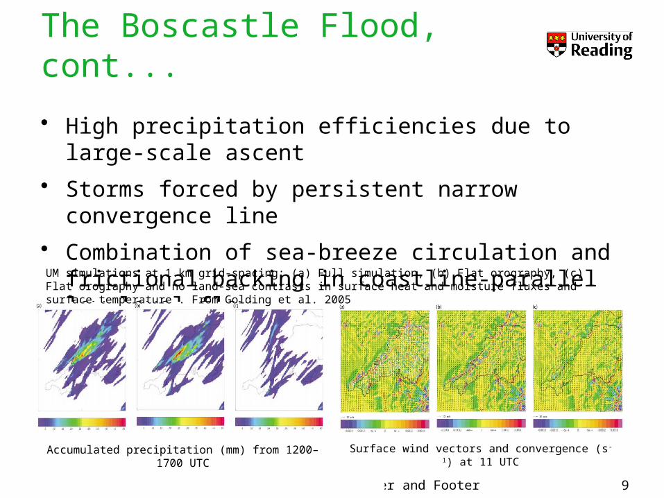
The Boscastle Flood, cont...
1200
16001500
14001300
1700
Rain rates from the Cobbacombe Cross radar in Devon. From Burt (2005).
To put your footer here go to View > Header and Footer 9
The Boscastle Flood, cont...
• High precipitation efficiencies due to large-scale ascent
• Storms forced by persistent narrow convergence line
• Combination of sea-breeze circulation and frictional backing in coastline-parallel low-level flow
Accumulated precipitation (mm) from 1200–1700 UTC
Surface wind vectors and convergence (s-1) at 11 UTC
UM simulations at 1 km grid-spacing: (a) Full simulation, (b) Flat orography, (c) Flat orography and no land-sea contrasts in surface heat and moisture fluxes and surface temperature . From Golding et al. 2005
To put your footer here go to View > Header and Footer 10
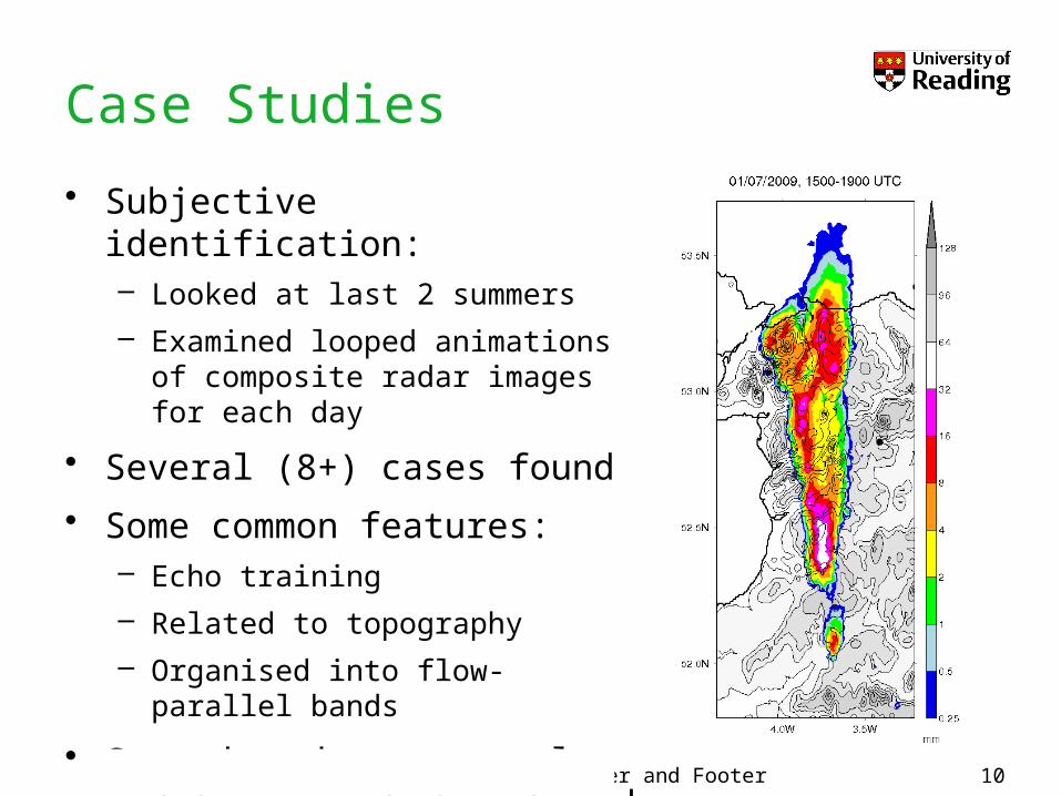
Case Studies
• Subjective identification:– Looked at last 2 summers– Examined looped animations of
composite radar images for each day
• Several (8+) cases found
• Some common features:– Echo training– Related to topography– Organised into flow-parallel
bands
• Some days have several, widely separated anchored storms

To put your footer here go to View > Header and Footer 11
Case 1 – 21/07/2010
• Remarkably similar to Boscastle storm
• Repeated convective development along North Cornwall/Devon coast
• Interesting evolution:– Early initiation (~08
UTC)– Organised into a line– Stationary until ~15
UTC– Sudden inland
propagation after this time, starting from the south

To put your footer here go to View > Header and Footer 12
Case 1 – 21/07/2010, cont...
• Radar maximum: 51.8 mm of rain in 3 hours (12–15 UTC)
• Event was not accurately captured by UKV modelUKV: 13 UTC (t+10h) – 18 UTC (t+15h)

To put your footer here go to View > Header and Footer 13
Case 1 – 21/07/2010, cont...
• NAE model analyses reveal some features of environment:– Ahead of vertically stacked
low– SSW–SW surface flow– Some evidence of
convergence line from surface winds
– Conditionally unstable with capping inversions at 900 and 750 hPa – moist at low levels
– Weak vertical wind shear– Approaching surface trough
may have forced eastward propagation after 1500 UTC
To put your footer here go to View > Header and Footer 14
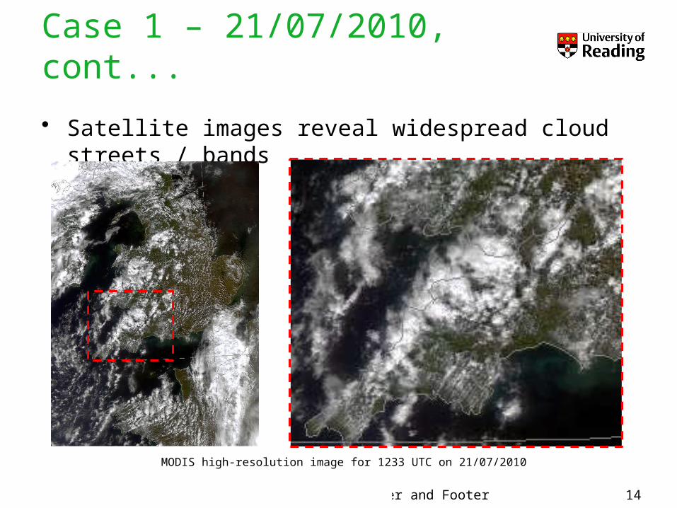
Case 1 – 21/07/2010, cont...
• Satellite images reveal widespread cloud streets / bands
MODIS high-resolution image for 1233 UTC on 21/07/2010

To put your footer here go to View > Header and Footer 15
Case 1 – 21/07/2010, cont...
• Cloud tops up to 20,000ft (-18°C)
• Deep enough to generate heavy rain but shallow enough to allow development of closely-packed storms with weak downdraughts (c.f. Boscastle)
Derived cloud top temperature for 1400 UTC
Derived cloud-top height for1400 UTC

To put your footer here go to View > Header and Footer 16
Work going forward
• Focus on Cornwall case:– Continue examining analysis data– Environment Agency gauge data– Program to calculate CAPE and CIN across domain– High-resolution UM simulations of event
• Identify more cases (climatology?):– Program to automatically detect anchored convective
storms in past radar data

To put your footer here go to View > Header and Footer 17
References• Bryan, G. H., J. C. Wyngaard, and J. M. Fritsh, 2003: Resolution requirements for the simulation of
deep moist convection, Mon. Wea Rev., 131, 2394–2416.
• Burt, S., 2005: Cloudburst upon Hendraburnick Down: The Boscastle storm of 16 August 2004. Weather, 60, 219–227.
• Doswell, C., H. E. Brooks, and R. A. Maddox, 1996: Flash flood forecasting: An ingredients based methodology. Wea. Forecasting, 11, 560–581.
• Golding, B., P. Clark, and B. May, 2005: The Boscastle Flood: Meteorological analysis of the conditions leading to flooding on 16 August 2004. Weather, 60, 230–235.
• Kirshbaum , D. J., and D. R. Durran, 2005a: Observations and modelling of banded orographic convection. J. Atmos. Sci., 62, 1463–1479.
• Kirshbaum, D. J., and D. R. Durran, 2005b: Atmospheric factors governing banded orographic convection. J. Atmos. Sci., 62, 3758–3774.
• Lean, H. W., P. A. Clark, M. Dixon, N. M. Roberts, A. Fitch, R. Forbes, and C. Halliwell, 2008: Characteristics of high-resolution versions of the Met Office Unified Model for forecasting convection over the United Kingdom. Mon. Wea. Rev., 136, 3408–3424.
• Mayes, J., and J. Winterton, 2008: The west Surrey thunderstorm of 13 August 2006. Weather, 63, 50–55.
• Roberts, N. M., 2008: Assessing the spatial and temporal variation in the skill of precipitation forecasts from an NWP model. Meteor. Appl., 15, 163–169.
• Roberts, N. M., and H. W. Lean, 2008: Scale-selective verification of rainfall accumulations from high-resolution forecasts of convective events. Mon. Wea. Rev., 136, 78–97.