Embed Size (px)
Citation preview

SEPTEMBER 2019 IEEE GEOSCIENCE AND REMOTE SENSING MAGAZINE 0274-6638/19©2019IEEE 29
The past few decades have witnessed great progress for un-manned aerial vehicles (UAVs) in civilian fields, especial-
ly in photogrammetry and remote sensing. In contrast with manned aircraft and satellites, UAVs have many promising characteristics—flexibility, efficiency, high spatial/temporal resolution, low cost, easy operation, and so forth—that make them an effective complement to the other two platforms and a cost-effective means for remote sensing.
In light of the popularity and expansion of UAV-based remote sensing (UAV-RS) in the past few years, this article provides a systematic survey of recent advances and future
prospects of UAVs for the remote sensing community. Spe-cifically, we discuss and summarize the main challenges and key technologies of remote sensing data processing based on UAVs. Then, we offer an overview of the wide-spread applications of UAVs in remote sensing. Finally, some prospects for future work are discussed. We hope this will provide remote sensing researchers with an overall pic-ture of recent UAV-RS developments and help guide further research in this area.
COMPARING UAVs WITH SATELLITES/MANNED AIRCRAFTWith the world’s rapid economic and social development in recent years, great changes have been constantly taking place on Earth’s surface. Thus, there is a great demand in the remote sensing community for data on interesting re-gions and to update geospatial information flexibly and quickly [1]–[3].
Digital Object Identifier 10.1109/MGRS.2019.2918840Date of publication: 23 September 2019
Mini-Unmanned Aerial Vehicle-Based Remote SensingTechniques, applications, and prospects
TIAN-ZHU XIANG, GUI-SONG XIA, AND LIANGPEI ZHANG
©ISTOCKPHOTO.COM/ANDREY SUSLOV

IEEE GEOSCIENCE AND REMOTE SENSING MAGAZINE SEPTEMBER 201930
MOTIVATION AND OBJECTIVEEarth observation and geospatial information acquisi-tion are achieved (Figure 1) mainly through the use of satellites (Table 1), manned aviation, and low-altitude re-mote sensing [4]. Remote sensing based on satellites and manned aircraft often has the advantage of large-area or regional remote sensing emergency monitoring with multisensors [5]. However, due to the orbit of satellites, the area needed for planes to take off and land, meteo-rological conditions, and so on, these two methods have some limitations, such as the following.
TIMELINESS OF DATAIn many time-critical remote sensing applications, it is of great importance to quickly acquire data with high
temporal resolution. For instance, in emergency remote sensing, e.g., after earthquakes, floods, or landslides, fast response is paramount [6]. It is necessary to collect re-mote sensing data about a disaster area promptly and fre-quently for dynamic monitoring and analysis of the situ-ation. Another example is precision agriculture, which requires short revisit times to examine in-field variations in crop conditions to guide the application of fertilizer, pesticides, and water [7].
However, although the launch of satellite constellations and the increasing number of operational systems have sig-nificantly decreased satellite sensors’ revisit cycles to one day, as shown in Table 1, it may not be easy to quickly pro-vide responses to abrupt changes and multiple per-day ac-quisitions. Manned aviation platforms, although capable of collecting high-resolution data without the limitation of re-visit periods, suffer from low maneuverability, high launch/flight costs, airspace limitations, and complex logistics. Moreover, the data from these two platforms are often se-verely constrained by weather conditions (e.g., cloud cover, haze, and rain), which affect data availability [8].
SPATIAL RESOLUTIONRemote sensing data with ultrahigh spatial resolution (e.g., centimeter level) play significant roles in some fine-scale remote sensing applications, such as railway monitoring, dam/bridge crack detection, reconstruction, and cultural heritage site restoration [9]. In addition, numerous studies have reported that images with centimeter-level spatial res-olution (up to 5 cm or more) have the potential for study-ing the spatiotemporal dynamics of individual organisms [10], mapping fine-scale vegetation species and their spatial patterns [11], estimating landscape metrics for ecosystems
Satellite Remote Sensing:Height: >150 km
Coverage: 10–1,000 km2
Aerial Remote Sensing:Height: <30 km
Coverage: 10–100 km2
UAV-Based Remote Sensing:Height: <3 kmCoverage: 0.1–100 km2
FIGURE 1. An illustration of satellite, manned aviation, and low-altitude UAV remote sensing platforms.
TABLE 1. EXAMPLES OF OPTICAL SATELLITE REMOTE SENSING.
NAME GSD OF PAN/MS (M)
TEMPORAL RESOLUTION (DAYS) NATION
Planet Labs 0.72–5/- One United States
GF-2 0.8/3.2 Five China
Surperview-1 0.5/2 Four China
Worldview-4 0.31/1.24 One to three United States
GeoEye-1 0.41/1.65 Two to three United States
Pleiades 0.5/2 One France
SPOT-7 1.5/6 One France
KOMPSAT-3A 0.4/1.6 One South Korea
GSD: ground sample distance; PAN: panchromatic image; MS: multispectral image.

SEPTEMBER 2019 IEEE GEOSCIENCE AND REMOTE SENSING MAGAZINE 31
[12], monitoring small coastal erosion changes [13], and so forth. Some examples are shown in Figure 2.
Currently, satellite remote sensing can provide high-spatial-resolution images of up to 0.3 m but is still unable to meet the requirements of the aforementioned applications. Manned avi-ation remote sensing is capable of collecting ultrahigh-spatial-resolution data, but it is restricted by operational complexity, costs, flexibility issues, safety concerns, and cloud cover.
DATA QUALITY AND INFORMATION CONTENTData from satellite and manned aircraft platforms are vul-nerable to cloud and atmospheric conditions, which at-tenuate electromagnetic waves and cause information loss and data degradation. But low-altitude platforms have the advantage of flying closer to ground objects, which sig-nificantly mitigates the effects of clouds and atmosphere. Therefore, low-altitude remote sensing has the advantage of collecting high-quality data with rich information and high definition, which benefits image interpretation. Mean-while, there is no need for atmospheric corrections, as would be the case with traditional platforms [14].
Satellite and manned aircraft platforms also focus main-ly on high-resolution orthophotos, and they are unable to provide high-resolution, multiview façade and occlusion-area images, which play a central role in 3D fine modeling [15]. Moreover, it has been demonstrated that multiview in-formation on ground objects is beneficial in analyzing the anisotropic characteristics of their reflectance and further improving image classification [16].
SMALL-AREA REMOTE SENSINGSatellite and manned aircraft platforms often run on fixed orbits or operate along preset regular paths. However, in many small-area remote sensing applications, e.g., small-town planning, mapping of tiny islands, urban small-area geographic information updates, archeology, agricultural breeding, and infrastructure damage detection, there is a demand for collecting data along irregular planning routes, temporarily modifying a route, or hovering for closer ob-servation. Traditional platforms’ lack of flexibility makes their utilization challenging. The factors of pilot safety and cost also limit the adoption of manned aircraft platforms. In addition, with traditional platforms, it may be difficult to
acquire data in dangerous, difficult-to-access, or harsh envi-ronments, such as polar remote sensing [17] and monitoring of nuclear radiation, volcanoes, and toxic spills [6].
Consequently, to compensate for these deficiencies, re-mote sensing scientists have proposed some low-altitude platforms, such as light aircraft [18], remote-control airborne craft or kites [19], and UAVs [20]. Because of the unique ad-vantages of UAVs, e.g., flexibility, maneuverability, economy, safety, high spatial resolution, and data acquisition on de-mand, they have been recognized as an effective complement to traditional vehicles. In recent years, the boom in UAV tech-nology and advances in the small-size, low-weight, and high-detection-precision sensors equipping these platforms make UAV-RS a popular and increasingly used technique. It is also worth noting that the continuous enhancement of satellite constellations will improve the spatial/temporal resolution and data acquisition cost of spaceborne sensors. Therefore, in the future, it can be predicted that UAVs will replace manned aircraft platforms and become the main means for remote sensing, together with satellite platforms [21].
Considering the rapid evolution of UAV-RS, a comprehen-sive survey on the current status of the technology is essential for gaining a clearer picture of the state of the art and pro-moting further progress. Thus, this article presents a specific review of recent advances in UAV-RS technologies and ap-plications over the past few years. Some prospects for future research are also addressed. We focus on the mini-UAV, which features fewer than 30 kg of maximum takeoff weight [12], [20], because this type of UAV, being more affordable and easier to carry and use than large-size UAVs, is one of the most widely employed types in the remote sensing community.
Some examples of mini-UAVs are shown in Figure 3. A simple rotary-wing UAV-RS system appears in Figure 4. In this system, an eight-rotor craft is equipped with an infra-red camera to acquire thermal radiation data around heat-supply pipelines for detection of heat leakage. Recognizing space limitations, more detailed descriptions of unmanned aircraft and sensors specially designed for UAV platforms can be found in [20] and [22].
PREVIOUS SURVEYSA number of representative surveys concerning UAV-RS have been published in the literature, as summarized in
(a) (b) (c) (d)
FIGURE 2. Examples of ultrahigh-spatial-resolution remote sensing: (a) dam/bridge crack detection, (b) a Buddha reconstruction, (c) pine nematode detection, and (d) crop plant counting.

IEEE GEOSCIENCE AND REMOTE SENSING MAGAZINE SEPTEMBER 201932
Table 2. These include some excellent reviews of the hard-ware development of unmanned aerial systems, e.g., crew-less aircraft and sensors [14], [20], [22], [23], [33]. Less at-tention has been paid to advances in UAV data processing techniques. Some surveys focus on specific aerial remote sensing data processing, such as image matching [27], [29] and dense image matching [28], that are not specifically for UAV data processing. Although the research reviewed in [20] and [23] presents some UAV data processing tech-nologies, e.g., 3D reconstruction and geometric correc-tion, a complete overview of UAV data processing and its recent advances is still lacking. In addition, the recent striking success and potential of deep learning and related methods in UAV data geometric processing have not been well investigated.
Some surveys review specific applications of UAVs in remote sensing, such as in agriculture [14], forestry [23], [24], natural resource management [26], environmental sensing [1], and glaciology [25]. Additionally, [20] and [22] provide comprehensive overviews of UAV-RS ap-plications that also consider advances in remote sensing sensors and regulations. However, recent developments in UAV-RS technology have opened up some new applica-tion possibilities, e.g., intelligent driving, path planning
[35], and understanding pedestrian behavior [34], that have not been reviewed.
CONTRIBUTIONSConsidering the problems discussed previously, it is im-perative to provide a comprehensive survey of UAV-RS, centering on UAV data processing technologies, recent applications, and future directions, all of which are the focus of this roundup. A thorough review and summary of existing work is essential for further progress in UAV-RS, particularly for researchers wishing to enter the field. Ex-tensive work on other issues such as regulations [20], [30], [31] and operational considerations [12], [23], [33], which have been well reviewed in the literature, are not included.
TECHNIQUES FOR DATA PROCESSINGIn this section, the main problems involved in UAV data processing are briefly introduced. Then, we discuss the gen-eral processing framework and key technologies as well as recent improvements and breakthroughs.
MAIN CHALLENGESCompared with satellite and manned aerial remote sens-ing, UAV-RS has great advantages in terms of providing a
(a)
(b)
(c)
(ii) (iii)(i)
(v) (vi)(iv)
FIGURE 3. Some examples of mini-UAVs for remote sensing: (a) fixed-wing UAVs; (b) (i) and (ii) rotary-wing UAVs and (iii) an unmanned helicopter; and (c) (iv) a hybrid UAV, (v) an umbrella UAV, and (vi) a bionic-UAV.

SEPTEMBER 2019 IEEE GEOSCIENCE AND REMOTE SENSING MAGAZINE 33
low-cost solution for collecting data at the spatial, spectral, and temporal scales. However, it also faces some special hurdles because it is significantly different from satellite and manned aerial remote sensing in the areas of plat-forms, flight height, sensors, photographic attitude, and resistance to external effects (e.g., airflow).
◗ Nonmetric camera problem: Because of payload weight limitations, UAV-RS often uses low-weight, small-size, and nonmetric (consumer-grade) cameras, which inevi-tably causes some problems.
• Camera geometry issue: Camera factory parameters are generally inaccurate and often affected by ex-traneous factors (e.g., camera shake). In addition, there is serious lens distortion in consumer-grade cameras, such as radial and tangential deformation. These problems reduce data processing accuracy, es-pecially in spatial resection and object reconstruc-tion [36]. Thus, it is necessary to carefully calibrate cameras before data processing.
• Rolling-shutter issue: Most UAVs are equipped with low-cost rolling-shutter cameras. When the un-manned aircraft flies in rolling-shutter acquisition mode, each row is exposed in turn and thus with a different pose [37], unlike in global-shutter mode. In addition, moving rolling-shutter cameras often pro-duce image distortions [38] (e.g., twisting and slant-ing). These are beyond the conventional geometric
models in 3D vision. Thus, new methods for the use of rolling-shutter cameras are urgently needed.
• Other issues: These include noise, vignetting, blurring, and color unbalancing, which degrade image quality.
◗ Platform instability and vibration effects: The weak wind re-sistance of lightweight, small-size UAVs can lead to unsta-ble sensor positions, which affects data quality [2], [12].
• Data are often acquired with irregular air lines, even curved lines. This results in image overlap inconsis-tency, which may cause image connection failure in aerial triangulation, especially between flight strips. Meanwhile, this also leads to complex and unor-dered image correspondence, making it difficult to determine which pairs of images can be matched.
• Variable sensor attitudes may result in large rotation and tilt variations among images, thus bringing about obvious image affine deformation. In addi-tion, this can result in large nonuniformity of scale and illumination. These issues will be aggravated by complex terrain relief, presenting challenges for im-age matching [39].
◗ Large number of images and high overlap: The small field of view (FOV) of cameras on UAVs and their low acquisi-tion height make it necessary for these aircraft to capture more photographs than conventional platforms to en-sure overlap and coverage. Therefore, on the one hand, it is common that some images cover only homogeneous
GPS/IMUModule
Unmanned AerialPlatform
Ground ControlSystem
Remote SensingSensors
CameraMount
Battery
Flight ControlSystem
FIGURE 4. An example of a rotary-wing UAV-RS data acquisition platform. IMU: inertial measurement unit.

IEEE GEOSCIENCE AND REMOTE SENSING MAGAZINE SEPTEMBER 201934
TABLE 2. RELATED SURVEYS ON UAV-RS IN RECENT YEARS.*
NUMBER SURVEY TITLE REFERENCE YEAR PUBLISHED CONTENT
1 “Overview and Current Status of Remote Sensing Applications Based on Unmanned Aerial Vehicles (UAVs)”
[22] 2015 PERS A broad review of the current status of remote sensing applications based on UAVs
2 “Unmanned Aerial Systems for Photo-grammetry and Remote Sensing: A Review”
[20] 2014 ISPRS JPRS A survey of recent advances in UAVs and their applications in photogrammetry and remote sensing
3 “Hyperspectral Imaging: A Review on UAV-Based Sensors, Data Processing, and Applications for Agriculture and Forestry”
[14] 2017 RS A survey of UAV-based hyperspectral remote sensing for agriculture and forestry
4 “UAS, Sensors, and Data Processing in Agroforestry: A Review Towards Practical Applications”
[23] 2017 IJRS A survey of UAV data processing, applica-tions, and sensors in agroforestry and some recommendations toward UAV platform selection
5 “Forestry Applications of UAVs in Eu-rope: A Review”
[24] 2017 IJRS An overview of UAV applications in forest research in Europe and an introduction to the regulatory framework for UAV operation in the European Union
6 “UAVs as Remote Sensing Platform in Glaciology: Present Applications and Future Prospects”
[25] 2016 RSE A survey of UAV-RS applications in glaciological studies, mainly in polar and alpine applications
7 “Recent Applications of Unmanned Aerial Imagery in Natural Resource Management”
[26] 2014 GISRS A comprehensive review of applications of unmanned aerial imagery for the management of natural resources
8 “Small-Scale Unmanned Aerial Vehicles in Environmental Remote Sensing: Challenges and Opportunities”
[1] 2011 GISRS An introduction to the challenges involved in using small UAVs for environmental remote sensing
9 “Recent Developments in Large-Scale Tie-Point Matching”
[27] 2016 ISPRS JPRS A survey of large-scale tie-point matching in unordered image collection
10 “State of the Art in High Density Image Matching”
[28] 2014 PHOR A review and comparative analysis of four dense image-matching algorithms, including SURE (semiglobal matching), MicMac, PMVS (patch-based multiview stereo), and Photoscan
11 “Development and Status of Image Matching in Photogrammetry”
[29] 2012 PHOR A comprehensive survey of image- matching techniques in photogrammetry over the past 50 years
12 “Review of the Current State of UAV Regulations”
[30] 2017 RS A comprehensive survey of civil UAV regulations on the global scale from the perspectives of past, present, and future development
13 “UAVs: Regulations and Law Enforcement”
[31] 2017 IJRS An introduction to the development of legislation in different countries regard-ing UAVs and their use
14 “Unmanned Aerial Vehicles and Spatial Thinking: Boarding Education With Geotechnology and Drones”
[32] 2017 GRSM A review of the current status of geoscience and remote sensing education involving UAVs
15 “Unmanned Aircraft Systems in Remote Sensing and Scientific Research: Clas-sification and Considerations of Use”
[33] 2012 RS An introduction to UAV platform types and characteristics, some application examples, and current regulations
16 “Mini-Unmanned Aerial Vehicle-Based Remote Sensing: Techniques, Applica-tions, and Prospects”
— 2019 Ours A comprehensive survey of mini-UAV-RS, focusing on techniques, applications, and future development
*This table shows only surveys published in top remote sensing journals. PERS: Photogrammetric Engineering and Remote Sensing; ISPRS JPRS: International Society for Photogrammetry and Remote Sensing Journal of Photogrammetry and Remote Sensing; RS: Remote Sensing; IJRS: International Journal of Remote Sensing; RSE: Remote Sensing of Environment; GISRS: GIScience & Remote Sensing; PHOR: The Photogrammetric Record; GRSM: IEEE Geoscience and Remote Sensing Magazine.

SEPTEMBER 2019 IEEE GEOSCIENCE AND REMOTE SENSING MAGAZINE 35
areas with low texture, resulting in difficulties for fea-ture detection. On the other hand, the great number of images may result in large-scale tie points, which in-creases the difficulty and time for image matching and aerial triangulation. Furthermore, to ensure overlap, images are often acquired with a high degree of over-lap, which may lead to short baselines and small base–height ratios. Thus, this overlap may cause unstable aerial triangulation and low elevation accuracy.
◗ Relief displacement: Because of the low acquisition alti-tudes relative to the variation in topographic relief, UAV image processing is prone to the effects of relief displace-ment [40]. This can generally be removed by orthorecti-fication, if the digital elevation/surface model represents the terrain correctly. It remains challenging to handle scenes with trees or buildings because of the large local displacement and occlusion areas with no data. The ef-fects will also be obvious when mosaicking images with different degrees and directions of relief displacement, such as sudden breaks, blurring, and ghosting.
These issues present great difficulties for traditional photo-grammetric processing approaches designed for well-cali-brated metric cameras and regular photography. Hence, rig-orous and innovative methodologies are required for UAV data processing and have become a center of attention for researchers worldwide.
GENERAL FRAMEWORKA general UAV-RS workflow is shown in Figure 5. To con-duct data acquisition, suitable UAV platforms and sensors are first selected according to the remote sensing tasks. More importantly, all of the hardware needs to be calibrated, in-cluding the cameras and multisensor combinations, to deter-mine the spatial relationship of different sensors and remove the geometric distortions caused by cameras. Then, mission planning is designed based on the topography, weather, and lighting conditions in the study areas. The flight parameters, such as flight path, flying altitude, image waypoints, flight speed, camera length, and exposure time, need to be carefully
delineated to ensure data overlaps, full coverage, and data quality. Afterward, the data are often collected autonomous-ly based on flight planning or by the flexible control of the ground pilot. Data are checked, and a supplementary photo-graph is initiated, if necessary. After data acquisition, a series of actions is performed for data processing and analysis.
To illustrate UAV-RS data processing, we take the exam-ple of the optical camera, one of the most widely applied sensors. The general data processing workflow can be seen in Figure 6. Specifically, the steps are as follows.
◗ Data preprocessing: Images collected from UAV platforms often require preprocessing to ensure their usefulness for further processing, including camera distortion cor-rection, image color adjustment, noise elimination, vi-gnetting, and blur removal [41].
◗ Aerial triangulation: This is also called structure from mo-tion (SfM) in computer vision. It aims to recover the camera pose (position and orientation) per image and 3D structures (i.e., sparse point clouds) from image se-quences, which can also provide a large number of ori-entation control points for image measurement. Data from the GPS and inertial measurement unit (IMU) are often used to initialize the position and orientation of each image. In computer vision, camera poses can be estimated based on image matching, which can also be adopted to generate a large number of tie points and build connection relationships among images. Bundle adjustment (BA) is used to optimize the camera posi-tions and orientations and derive 3D scene structures. To meet the requirements of high-accuracy measure-ment, the use of ground control points (GCPs) may be necessary to improve georeferencing, although this in-volves time-consuming and labor-intensive work.
◗ Digital surface model (DSM) generation and 3D reconstruc-tion: The oriented images are used to derive dense point clouds (or a DSM) by dense image matching. A DSM provides a detailed representation of the terrain surface. Combined with surface reconstruction and texture map-ping, a 3D scene model can be well reconstructed.
(a) (b) (c) (d)
FIGURE 5. The general UAV-RS workflow: (a) selecting appropriate UAV platforms and sensors, (b) UAV flight planning, (c) data collection and check, and (d) data processing and analysis.

IEEE GEOSCIENCE AND REMOTE SENSING MAGAZINE SEPTEMBER 201936
◗ Digital elevation model (DEM) and orthophoto generation: A DEM can describe the surface topography without the effects of raised objects, such as trees and build-ings. It can be generated from either sparse or dense point clouds. The former is accomplished with lower precision but higher efficiency than the latter. After that, each image can be orthorectified to eliminate the geometric distortion and then mosaicked into a seam-less orthonormal mosaic at the desired resolution.
◗ Image interpretation and application: Based on orthopho-tos and 3D models, image interpretation is performed to achieve scene understanding, including image/scene classification, object extraction, and change detection. Furthermore, the interpretation results are used for vari-ous applications, such as thematic mapping, precision agriculture, and disaster monitoring.
Regardless of the platform that acquires remote sensing data (satellite, manned airborne, UAV, and so on), the interpretation methods are similar [14]. Therefore, photogrammetric process-ing is the prominent concern regarding UAV-RS. This area is challenging for traditional processing approaches. Methods specially designed for UAV-RS data processing have been pro-posed to overcome the difficult issues involved. In the follow-ing, the related key technologies are reviewed and summarized.
CAMERA CALIBRATIONUnlike in traditional remote sensing data processing, cam-era calibration is essential for UAV-RS because of the use
of lightweight, nonmetric cameras that have not been de-signed for photogrammetric accuracy [42]. Camera calibra-tion aims to estimate the camera parameters to eliminate the impact of lens distortion on images and extract metric information from 2D renderings [43]. In aerial triangula-tion, camera parameters, including intrinsic parameters (principal-point position and focal length) and lens dis-tortion coefficients (radial and tangential distortion coef-ficients), are often handled by precalibration or on-the-job calibration. The former calibrates cameras before BA, and the latter combines camera calibration parameters as un-knowns into BA for joint optimization and estimation. The combination of the two is also adopted for high-accuracy data processing [44]. On-the-job calibration is often sensi-tive to camera network geometry (e.g., nadir and oblique acquisition) and the distribution and accuracy of ground control [36]. Thus, precalibration is generally an essential component of UAV-RS data processing.
In camera calibration, pinhole cameras are often adjust-ed based on a perspective projection model, while fisheye lenses are based on a spherical model, orthogonal projec-tion, polynomial transform model, and so forth [48]. Meth-ods for camera calibration and distortion correction can be generally classified into two categories: reference object-based calibration and self-calibration. Reference object-based calibration can be performed easily using the pro-jected images of a calibration array, shown in Figure 7. The most rigorous method is based on a laboratory 3D physical
Other Data
Original Images
Preprocessing
Aerial Triangulation
DSM
DEM DOM
3D Reconstruction
Image Interpretation
Ground Control Data
CoastalMonitoring
PrecisionAgriculture
DisasterEmergency
Applications
FIGURE 6. The general workflow of UAV-RS data processing. DOM: digital orthophoto map.

SEPTEMBER 2019 IEEE GEOSCIENCE AND REMOTE SENSING MAGAZINE 37
calibration field, where coded markers are distributed in three dimensions with known accurate positions [49]. This method provides highly precise calibration parameters, but it is high in cost, inconvenient, and unsuitable for frequent recalibration in UAV-RS. An alternative, low-cost solution is based on a 2D calibration pattern, e.g., a checkerboard [45], a completely flat liquid crystal display-based method [46], or an AprilTag-based method [47]. It has been demonstrated that this solution can achieve an accuracy close to that of a 3D physical calibration field. Different patterns are de-signed to improve the accuracy and ease of feature detection and recognition under various conditions.
It is worth noting that reference object-based calibra-tion usually requires preprepared calibration patterns and extra manual operations that make it laborious and time consuming. By contrast, self-calibration, which depends on structural information detected in images without re-quiring special calibration objects, is more flexible and ef-ficient. It has, therefore, become an area of active research in recent years, especially for automatic rectification and calibration of fisheye images.
Among these methods, geometric structures (e.g., con-ics, lines, and plumb lines) are first detected [43], [50], [51]. If given at least three conics on a distorted image, the camera’s intrinsic parameters can be obtained from the de-composition of absolute conics. A fisheye image is gener-ally rectified based on the assumption that a straight line should maintain its line property even after the projection of a fisheye lens. Several approaches have been proposed to extract geometric structures, such as the extended Hough transform [52] and multilabel energy optimization [53]. However, the effects of rectification are often limited by the accuracy of the geometric structure detection.
More recently, deep convolutional neural network (CNN)-based methods have been proposed, which try to learn more representational visual features to rectify the distort-ed image [54]. The work in [55] proposed an end-to-end deep CNN that learns semantic information and low-level appearance features simultaneously to estimate the distor-tion parameters and correct the fisheye image. However, this technique does not consider geometry characteristics, which are strong constraints in rectifying distorted imag-es. To deal with this issue, Xue et al. [56] designed a deep
network to exploit distorted lines as explicit geometry con-straints to recover the distortion parameters of the fisheye camera and rectify the distorted image.
Some fisheye image rectification examples based on self-calibration are shown in Figure 8. The qualitative evaluation of a fisheye data set is reported in Table 3. It can be seen that deep CNN-based methods (e.g., [56]) achieve excellent rectification performance for fisheye images. However, some problems remain to be solved. The encod-ing of other geometries, such as arcs and plumb lines, into CNNs is still a formidable issue. Designing robust geo-metric feature detection methods, especially in the case of noise or low texture, is also an area requiring research. An-other important challenge is to improve self-calibration to achieve an accuracy comparable to reference object-based approaches.
COMBINED FIELD OF VIEWBecause of the low flight altitude and narrow FOV of cam-eras on UAVs, UAV-RS often acquires images with a small ground coverage area, resulting in increased image num-bers, flight lines, flight cost, and data collection time [58]. One solution to these issues is the combined wide-angle camera, which uses multiple synchronized cameras. The images acquired from this multicamera combination sys-tem (i.e., an equivalent large-array camera) are rectified, registered, and mosaicked to generate a larger virtual im-age, which can augment the coverage area [49]. In contrast to narrow cameras, the combined wide-angle method can increase acquisition efficiency and enlarge the base–height ratio. It also benefits the image connection, especially in some windy conditions. Another advantage is obtaining multiview images by oblique acquisition, which can over-come photographic dead areas and sheltered targets. In [59], the combined wide-angle camera is used for photo-grammetric surveying and 3D building reconstruction. Fig-ure 9 shows an example of a four-camera system.
The combined wide-angle camera has been well stud-ied in the UAV-RS community. However, improving its acquisition efficiency for larger-area mapping remains a concern. In this regard, an emerging opportunity is multi-UAV collaboration, which uses fleets of simultaneously deployed, swarming UAVs to achieve a remote sensing
(a) (b) (c) (d)
FIGURE 7. Examples of camera calibration: (a) a 3D physical calibration field, (b) checkerboard calibration [45], (c) the dual liquid crystal display-based method (taken from Zhan [46]), and (d) the AprilTag-based technique [47].

IEEE GEOSCIENCE AND REMOTE SENSING MAGAZINE SEPTEMBER 201938
goal. This approach improves spatial coverage and effi-ciency, overcoming the spatial range limitations of a single platform and thus enhancing reliability because of redun-dancy and allowing simultaneous intervention in sepa-rate places [22], [60]. Each vehicle can transmit either the collected data or the processed results to ground worksta-tions for further processing or decision making. Data can
also be shared among different vehicles to guide optimal collaboration.
For instance, in [61], a fleet of UAVs, equipped with vari-ous sensors (infrared, visual cameras, and fire detectors), co-operated for automatic forest fire detection and localization using a distributed architecture. The heterogeneous sensors increase the complexity of data processing, but they make it possible to exploit the complementarities of vehicles in different locations and flight attitudes and sensors with dif-ferent perception abilities. Collaboration can be performed not only among multiple UAVs but also among UAVs and other remote sensing platforms, e.g., unmanned ground ve-hicles and unmanned marine surface vehicles [62].
Multi-UAV collaboration has become an effective means of collecting accurate and massive information and has re-cently received increased attention. It has been widely used in commercial settings, but there are some reports about ac-cidents in multi-UAV systems. Thus, there is still a long way to go for broad application of these systems in the remote sens-ing community. Some problems, however, are worth an effort to resolve, such as system resilience, complexity and commu-nication among UAVs, navigation and cooperative control in harsh conditions, environmental sensing and collision avoid-ance, detection of anomalies within the fleet, and disruption handling, including environmental obstacles, signal interfer-ence, and attacks [49], [63]. Configuring the number of UAVs and planning flight routes to achieve optimal efficiency and performance are also demanding issues [64], [65].
LOW-ALTITUDE UAV IMAGE MATCHINGImage matching is one of the fundamental technologies in photogrammetry and computer vision and is widely used in image registration, image stitching, and 3D reconstruc-tion [66]–[68]. It is a long-standing and challenging task,
(b)(a)
FIGURE 9. (a) The combined four-camera system in [59]. (b) The overlapping layout of the images projected from the four cameras. (Taken from Lin et al. [59].)
TABLE 3. A QUALITATIVE EVALUATION OF RECTIFICATION ON A FISHEYE IMAGE DATA SET BY XUE ET AL. [56], USING PEAK SIGNAL-TO-NOISE RATIO (PSNR), STRUCTURE SIMILARITY INDEX (SSIM), AND REPROJECTION ERROR (RPE).
METHODS
BUKHARI AND DAILEY [52]
ALEMAN-FLORES ET AL. [57]
RONG ET AL. [54]
XUE ET AL. [56]
PSNR 11.47 13.95 12.52 27.61
SSIM 0.2429 0.3922 0.2972 0.8746
RPE 164.7 125.4 121.6 0.4761
FIGURE 8. Examples of fisheye image rectification. From left to right are the results taken from Bukhari and Dailey [52], Aleman-Flores et al. [57], Rong et al. [54], and Xue et al. [56].

SEPTEMBER 2019 IEEE GEOSCIENCE AND REMOTE SENSING MAGAZINE 39
especially for UAV images, because of the strong geometric deformations (e.g., affine distortion), viewpoint changes, radiation/illumination variances, repetitive or low texture, and occlusion. Some examples of low-altitude UAV im-age matching are shown in Figure 10. Although numerous matching algorithms have been proposed [29] over the last decades, they fail to provide good performance for low-al-titude UAV images.
MULTIVIEW IMAGE MATCHINGMultiview photography can acquire data from the nadir and side-looking directions, especially in UAV-based oblique photogrammetry. However, this special data collection ap-proach makes image matching astonishingly difficult, e.g., vertical and oblique image matching, because of the obvi-ous difference in the appearance of images caused by the wide baseline and large viewpoint changes, especially af-fine deformations [71].
Some attempts have been made to create local descrip-tors invariant to affine distortions, such as the maximally stable extremal region (MSER), Harris/Hessian affine, af-fine scale-invariant feature transformation (ASIFT), and Matching with On-Demand view Synthesis (MODS) [72]. Although these methods can handle images with view-point variances, they either provide a small number of cor-respondences or suffer from excessive time consumption and memory occupancy. Besides, these methods are not designed specifically for UAV cases and may have difficulty in meeting the demand for even distribution of correspon-dences in images with unevenly distributed texture.
There are usually two strategies proposed to handle af-fine deformations in UAV image matching. One is to per-form multiview image matching based on MSER. The local regions are often normalized to circular areas, on which interest points are selected and matched. Considering the small quantity and uneven distribution of matching pairs, some geometric constraints, e.g., a local homography con-straint, can be used to guide the propagative matching [73]. The other is to apply geometric rectification before image matching [39]. If the images collected by UAVs contain rough or precise exterior orientation elements and camera installation parameters, they can be used for geometric rectification of oblique UAV images to relieve perspective deformations. With the conventional descriptor match-ing methods, sufficient and well-distributed tie points are then extracted and matched. The oblique images can also be rectified by coarse initial affine-invariant matching [72]. To achieve reliable feature correspondence, spatial relation-ships and geometrical information can be adapted to guide the matching process and remove outliers, e.g., a local position constraint, cyclic angular ordering constraint, or neighborhood conserving constraint [71].
To obtain matching pairs that are as evenly distributed as possible, divide-and-conquer and tiling strategies are of-ten adopted [39]. Images are split into blocks, and features are extracted and matched from the corresponding blocks.
The number of points in each block can be adaptively deter-mined by information entropy [74], [75].
Although significant progress has been achieved in UAV multiview image matching, there is still plenty of room for improvement. Because of deep CNNs’ powerful ability for feature representation and the huge success in image classi-fication and target detection [76], there has recently been an explosive increase in image matching through deep learn-ing [77]. Deep neural networks are designed to learn a local feature detector, such as temporally invariant learned detec-tors from prealigned images of different times and seasons [78] or covariant local feature detectors, which regard fea-ture detection as a transformation regression problem [79].
In fact, however, only limited progress has been made in deep feature detection because of the lack of large-scale an-notated data and the difficulty of getting a clear definition of keypoints. By contrast, great effort has been made in develop-ing learned descriptors based on CNNs, which have obtained surprising results on some public data sets. Feature descrip-tors are often developed by Siamese or triplet networks with well-designed loss functions, such as hinge loss, SoftPN, joint loss, and global orthogonal regularization [80]. Besides, some geometric information is integrated to facilitate local descriptor learning, e.g., patch similarity and image similarity [81]. In [82], image matching is considered as a classification problem. An attention mechanism is exploited to generate a set of probable matches from which true matches are sepa-rated by a Siamese hybrid CNN model.
(a)
(b)
(c)
FIGURE 10. Illustrations of low-altitude UAV image matching: (a) matching nadir and oblique images (taken from Xiao et al. [69]), (b) matching ground to aerial images (taken from Zhou et al. [70]), and (c) matching a UAV image to georeference images (taken from Zhuo et al. [67]).

IEEE GEOSCIENCE AND REMOTE SENSING MAGAZINE SEPTEMBER 201940
But it is well known that deep learning-based image matching requires large annotated data sets, while existing data sets are often small or lack diversity. The limited data source reduces the generalization ability of deep models, which may cause poor performance compared with hand-crafted descriptors [81]. Although a diverse and large-scale data set (Hpatches) has recently been released, it was not constructed from UAV-RS images.
MATCHING WITH NON-UAV IMAGESUAV images are often coregistered with existing georef-erenced aerial/satellite images to locate GCPs for spatial information generation and UAV geolocalization [83]. To increase the number of keypoints, superpixel boundaries are adopted as feature points, followed by a one-to-many scheme for more matching hypotheses [67]. Geometric con-straints based on pixel distance to correct matches are em-ployed for mismatch removal at repetitive image regions. Considering the illumination variation between UAV and satellite images, illumination-invariant image matching was proposed based on phase correlation to match the on-board UAV image sequences to preinstalled reference satel-lite images for UAV localization and navigation [84].
It is a huge challenge to match UAV images with ground-/street-view images because of the drastic change in view-point and scale, which causes the failure of traditional de-scriptor-based matching. Some approaches have attempted to warp the ground image to the aerial view to improve fea-ture matching [85]. Besides, in [86], the matching problem is considered as a joint regularity optimization problem, where the lattice tile/motif is used as a regularity-based de-scriptor for façades. Three energy terms—edge shape con-text, Lab color features, and Gabor filter responses—are de-signed to construct a matching cost function.
Another promising method is to employ CNNs to learn representations for matching between ground and aerial images. In [87], a cross-view matching network was de-veloped to learn local features and then form global de-scriptors that are invariant to large viewpoint changes for ground-to-aerial geolocalization. In addition, to handle image matching across large-scale differences, which in-clude small-scale features to establish correspondences, Zhou et al. [70] divided the image scale space into multiple scale levels and encoded it into a compact multiscale repre-sentation by bag of features. The matching then restricted the correspondence search of query features within the lim-ited related scale space, thus improving the accuracy and robustness of feature matching under large-scale variations.
CHALLENGES IN UAV IMAGE MATCHINGAlthough tremendous efforts have been devoted to low-altitude image matching, many problems still need to be considered, especially in terms of the following.
◗ With the exception of interest points, geometric structure features that represent more information, e.g., lines, junc-tions, circles, and ellipses, can play a significant role in
multiview image matching, especially in urban scenarios [88]–[90]. Geometric features are often invariant to ra-diometric change and scene variation over time. A small amount of work has been concentrated on line-based image matching [91]. More effort is worth investing to develop image matching based on geometric features.
◗ The deep learning-based approach is promising for UAV image matching. However, the lack of large-scale anno-tation data sets from UAV data hinders the development of novel and more powerful deep models. Moreover, CNNs learning of the detectors and descriptors of struc-ture features for image matching is an issue. Geometric information (e.g., local coplanar), often overlooked in the learning process, can be encoded into deep neural networks to improve their matching performance. With the exception of feature detection and description, geo-metric verification can be encoded into neural networks for outlier rejection [92].
◗ Cross-view image matching has drawn a lot of attention in recent years. It plays an important role in image-based geolocalization and street-to-aerial urban reconstruc-tion. However, large viewpoint/scale differences should be well considered. More powerful deep models and more effective scale-space image encoding approaches are needed.
LOW-ALTITUDE AUTOMATIC AERIAL TRIANGULATIONAerial triangulation, i.e., recovering camera poses and 3D scene structures from 2D images, is a fundamental task in photogrammetry and computer vision. For manned aerial photogrammetry that collects images vertically, automatic aerial triangulation (AAT) has been well studied [93]. As to UAV-based photogrammetry, however, it has been dem-onstrated that the long-established and proven photogram-metric AAT cannot handle UAV blocks [94]. This is because low-altitude UAV-RS breaks the acquisition mode of tra-ditional photogrammetry (discussed in the section “Main Challenges” under “Techniques for Data Processing”) and does not meet the assumptions of conventional AAT [95].
In the last few years, SfM has greatly benefited low-alti-tude UAV AAT [96]. SfM simultaneously estimates the 3D geometry of a scene (structure), the poses of cameras (mo-tion), and possibly the intrinsic calibration parameters of cameras without the need for either camera poses or GCPs to be known prior to scene reconstruction [97]. Some tests that apply SfM software to UAV-based aerial triangulation have demonstrated that SfM can break through the obstacles of irregular UAV blocks for robust low-altitude UAV AAT [20].
STRUCTURE FROM MOTIONSfM is generally divided into three types (incremental, global, and hierarchical), according to the camera pose ini-tialization. A simple comparison of these three paradigms appears in Table 4. To make full use of incremental and global SfM, a hybrid SfM has been proposed that estimates camera rotations in a global way based on an adaptive,

SEPTEMBER 2019 IEEE GEOSCIENCE AND REMOTE SENSING MAGAZINE 41
community-based rotation averaging while estimating camera centers in an incremental manner [98]. To achieve city-scale sparse reconstruction, Zhu et al. [99] grouped cameras, performed local incremental SfM in each clus-ter, and then conducted global averaging among clusters. The hybrid SfM method possesses both robustness from its incremental aspect and efficiency from its global feature. However, repeated BA is still needed in the estimation of camera centers, an area that requires additional research.
Recently, semantic information was integrated into sparse reconstruction [100]. This approach considers the semantic SfM as a maximum-likelihood problem to jointly estimate the semantic information (e.g., object classes) and recover the geometry of the scene (camera pose, objects, and points). However, because of its large memory and computational cost, this method is often limited to small scenes and low res-olution. Semantic information can also be used to constrain feature matching and BA by semantic consistency [101].
IMAGE ORIENTATIONIn SfM, camera poses are often estimated from feature cor-respondences by solving the perspective-n-point problem and then optimizing by BA. Moreover, external orientation sensors can be adopted for camera pose estimation. If UAVs are equipped with high-quality GPS/IMUs, the camera po-sitions and orientations can be directly estimated from the GPS/IMU data without the need of GCPs, namely, through direct sensor orientation or direct georeferencing [102]. Besides, orientation parameters from the GPS/IMU can be used to initialize the camera poses and then integrate them into aerial triangulation for BA, i.e., integrated sensor orientation. However, UAVs are often mounted with low-accuracy navigation sensors because of payload limitations and the high cost of low-weight, highly precise navigation systems. Therefore, GCPs are adopted for precise aerial triangulation (indirect sensor orientation), which is time consuming and laborious.
The existing SfM approaches generally rely heavily on accurate feature matching. Some failure may be caused by low/no texture, stereo ambiguities, and occlusions, which are common in natural scenes. Thus, to break through these lim-itations, deep models have recently been applied for camera pose estimation or localization [103]. In [104], a PoseNet was designed to regress the camera pose from a single image in an end-to-end manner. The traditional SfM was also modeled by learning the monocular depth and ego-motion in a cou-pled way, which could handle dynamic objects by learning an explainability mask [105], [106]. However, the accuracy of these methods is far from that of traditional SfM. Moreover, they are dependent on the data set, and it is difficult for them to provide good generalization. Thus, it would be beneficial to build more diverse data sets and encode more geometric constraints into deep models.
STRUCTURE FROM MOTION FOR ROLLING-SHUTTER CAMERAS Most off-the-shelf cameras are equipped with a rolling shutter because of the low manufacturing cost. However, its row-wise exposure delay produces some problems. In the presence of camera motion, each row is captured in turn and thus with a different pose, which causes severe geometric artifacts in the recorded image (e.g., skew and curvature distortions). This is a considerable problem for classical global-shutter geometric models and results in severe errors in 3D reconstruction. Thus, new methods adapted to rolling-shutter cameras are strongly desired.
Some works have contributed to correcting rolling-shut-ter distortions [107]. One technique is to use interframe correspondences to estimate the camera trajectory and reg-ister frames. The continuity and smoothness of the cam-era motion between video frames can also be combined to improve performance. Another way is to implement correction as an optimization problem based on straight-ness, angle, and length constraints on the detected curves
TABLE 4. A COMPARISON OF THREE SFM PARADIGMS.*
ITEM INCREMENTAL GLOBAL HIERARCHICAL
Match graph initialization
Initialized by selected seed image pairs All images treated equally Atomic models
Camera registration
Perspective-n-Point, 2D–3D correspondences
Rotation and translation averaging 3D–3D fusion
BA Iterative, many times One time BA when merging
Advantages Robust, high accuracy, good completeness of the reconstructed scene
Evenly distributed errors, high efficiency Fewer BA steps
Disadvantages Prone to drifting errors, low efficiency Prone to noisy pairwise matches, relatively low accuracy, low completeness of the reconstructed scene
Model merging, graph partition
Tools Bundler, OpenMVG, VSFM, MVE, ColMap OpenMVG, 1DSfM, DISCO, Theia Research papers
*Tianwei Shen, Jinglu Wang, Tian Fang, and Long Quan, “Tutorial: Large-Scale 3D Reconstruction From Images,” Asian Conference on Computer Vision, 2016. OpenMVG: open multiple view geometry; VSfM: visual SfM; MVE: multiview environment; 1DSfM: 1D SfM; DISCO: discrete-continuous optimization for SfM.
IEEE GEOSCIENCE AND REMOTE SENSING MAGAZINE SEPTEMBER 201942
to estimate the camera motion and thus rectify the rolling-shutter effect. This method is sensitive to feature choice and extraction. Recently, CNNs were adopted to automatically learn the interplay between scene features and the row-wise camera motion and correct the distortions [108]. Large-scale data sets are obviously required. They often train CNNs on synthetic data sets, which may be different from real cases, but this is a promising approach.
In the case of conventional SfM, rolling-shutter effects are modeled [37], [109]. This complex model is shattered into a constellation of simple global-shutter, linear-per-spective feature cameras. The poses (i.e., rotation and trans-lation) of each feature are linearly interpolated according to their vertical position in the image between successive key poses. Usually, a linear interpolation is used for translation and a spherical linear interpolation for rotation. In general, one may insert as many key poses as tracked features.
CHALLENGES IN AERIAL TRIANGULATIONAlthough aerial triangulation/SfM is a long-standing prob-lem, it still faces many hurdles, such as very large-scale and high-efficiency SfM, AAT with arbitrary images, and mul-tisource data AAT (ground/street images and UAV images). Additionally, there is a long way to go with semantic SfM and deep CNNs for camera pose estimation.
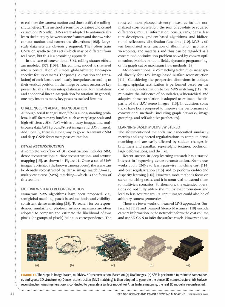
DENSE RECONSTRUCTIONA complete workflow of 3D construction includes SfM, dense reconstruction, surface reconstruction, and texture mapping [15], as shown in Figure 11. Once a set of UAV images is oriented (the known camera poses), the scene can be densely reconstructed by dense image matching—i.e., multiview stereo (MVS) matching—which is the focus of this section.
MULTIVIEW STEREO RECONSTRUCTIONNumerous MVS algorithms have been proposed, e.g., semiglobal matching, patch-based methods, and visibility-consistent dense matching [28]. To search for correspon-dences, similarity or photoconsistency measures are often adopted to compare and estimate the likelihood of two pixels (or groups of pixels) being in correspondence. The
most common photoconsistency measures include nor-malized cross correlation, the sum of absolute or squared differences, mutual information, census, rank, dense fea-ture descriptors, gradient-based algorithms, and bidirec-tional reflectance distribution functions [110]. MVS is of-ten formulated as a function of illumination, geometry, viewpoints, and materials and thus can be regarded as a constrained optimization problem solved by convex opti-mization, Markov random fields, dynamic programming, or the graph-cut or maximum-flow methods [28].
Most conventional MVS matching techniques are adapt-ed directly for UAV image-based surface reconstruction [111]. Considering the perspective distortions in oblique images, epipolar rectification is performed based on the cost of angle deformation before MVS matching [112]. To minimize the influence of boundaries, a hierarchical and adaptive phase correlation is adopted to estimate the dis-parity of the UAV stereo images [113]. In addition, some tricks have been proposed to improve the performance of conventional methods, including graph networks, image grouping, and self-adaptive patches [69].
LEARNING-BASED MULTIVIEW STEREOThe aforementioned methods use handcrafted similarity metrics and engineered regularizations to compute dense matching and are easily affected by sudden changes in brightness and parallax, repeated/no textures, occlusion, large deformations, and the like.
Recent success in deep learning research has attracted interest in improving dense reconstruction. Numerous works apply CNNs to learn pairwise matching cost [114] and cost regularization [115] and to perform end-to-end disparity learning [116]. However, most methods focus on stereo matching tasks, and it is nontrivial to extend them to multiview scenarios. Furthermore, the extended opera-tions do not fully utilize the multiview information and lead to less accurate results. Input images could also be of arbitrary camera geometries.
There are fewer works on learned MVS approaches. Sur-faceNet [117] and Learned Stereo Machines [118] encode camera information in the network to form the cost volume and use 3D CNN to infer the surface voxels. However, these
(a) (b) (c) (d) (e)
FIGURE 11. The steps in image-based, multiview 3D reconstruction. Based on (a) UAV images, (b) SfM is performed to estimate camera pos-es and sparse 3D structure. (c) Dense reconstruction (MVS matching) is then adopted to generate the dense 3D scene structure. (d) Surface reconstruction (mesh generation) is conducted to generate a surface model. (e) After texture mapping, the real 3D model is reconstructed.

SEPTEMBER 2019 IEEE GEOSCIENCE AND REMOTE SENSING MAGAZINE 43
methods are limited by the huge memory consumption of 3D volumes and thus handle only small-scale reconstruc-tions. DeepMVS [119] takes a set of plane-sweep volumes for each neighbor image as input and produces high-qual-ity disparity maps that can handle an arbitrary number of posed images.
MVSNet [120] builds the 3D cost volume on the cam-era frustum instead of on the regular Euclidean space and produces one depth map each time. Thus, this ap-proach makes large-scale reconstruction possible. How-ever, because of the annotated data without the complete ground truth mesh surfaces, the technique may be dete-riorated by occluded pixels. The works in [121] provide comparison experiments and demonstrate that deep learning-based and conventional methods perform at al-most the same level, although deep learning approaches have better potential to achieve good accuracy and re-construction completeness.
CHALLENGES IN DENSE RECONSTRUCTIONAlthough great success has been achieved, some issues that require additional research remain.
◗ Specular object reconstruction: Most MVS algorithms often impose strong Lambertian assumptions on objects or scenes, but there are many specular objects or isotropic reflectance objects in man-made environments. Multiv-iew reconstruction of these glossy surfaces is a challeng-ing problem. One promising method may be to adopt generative adversarial networks for transferring multiple views of objects with specular reflection into diffuse ones [122].
◗ Dynamic scene modeling: Most existing 3D reconstruction methods assume a static, rigid scene. How to reconstruct a dynamic scene is a demanding issue. One possible way is to presegment the scene into different regions that are locally rigid and then apply rigid SfM and MVS to each of them [123].
◗ Multisource 3D data fusion: Few attempts have been made in the fusion of aerial and ground-based 3D point clouds or models [124]. The large differences in camera view-points and scales make it tricky to align the aerial and ground 3D data. Moreover, it is a formidable task to re-construct a single, consistent 3D model that is as large as an entire city with details as small as individual objects.
IMAGE STITCHINGBecause of the small footprint of UAV images, it is es-sential to develop automatic image stitching/mosaicking techniques to combine multiple images with overlapping regions into a single large, seamless composite image with a wide FOV or panorama [125], [126]. Image stitching gener-ally includes geometric correction and image composition. Images acquired from different positions and attitudes are registered on an identical mosaic or reference plane in geometric correction, and then the inconsistencies in geometry and radiation (e.g., color or brightness) among
geometrically corrected images are mitigated or eliminated by image composition.
Some examples of image stitching are shown in Figure 12. According to the different methods for geometric correc-tion, image stitching can be divided into orthorectifica-tion-based stitching and transformation-based stitching, detailed in the following sections. Image composition, in-cluding seamline generation, color correction, and image blending, is generally similar to that used with other re-mote sensing platforms. Recognizing space limitations, we, therefore, refer interested readers to several papers [127]–[129] for a detailed description.
ORTHORECTIFICATION-BASED IMAGE STITCHINGOrthorectification-based image stitching is an essential step for the generation of digital orthophoto maps (DOMs), which are used for photogrammetric recordings and docu-ments and are also the base maps for remote sensing inter-pretation. Images are often orthocorrected based on camera poses and 3D terrain information (e.g., DEMs/DSMs and GCPs) to reduce the geometric deformation and achieve spatial alignment on the same geographical coordinate sys-tem. In [102], DEMs/DSMs are generated from SfM point clouds, which are then transformed into real-world coor-dinates based on direct/indirect/integrated georeferencing.
(a) (b)
(c)
FIGURE 12. Examples of image stitching. (a) and (b) Orthorectifi-cation-based stitching: (a) an inaccurate mosaic map generated by direct georeferencing using the original inaccurate IMU/GPS data; (b) a mosaic map generated based on registration with the refer-ence map in [130]. (c) Transformation-based stitching. An automati-cally constructed urban panorama with 14 wide-baseline images based on the mesh-optimization stitching method proposed in [131]. (a) and (b) are taken from Faraji et al. [130]. (c) is taken from Zhang et al. [131].

IEEE GEOSCIENCE AND REMOTE SENSING MAGAZINE SEPTEMBER 201944
In [132], images are corrected by global transformations derived from the relationships between GCPs and the cor-responding image points. Considering the exterior orienta-tion inaccuracy of the GPS/IMU and the difficulties in ac-quisition of GCPs, another orthorectification technique is based on registration with the aerial/satellite orthorectified map [130]. This approach is more efficient and convenient because it avoids complex aerial triangulation and DEM generation and the laborious acquisition of GCPs. But its mandatory prerequisite is the reference maps.
TRANSFORMATION-BASED IMAGE STITCHINGOrthorectification-based image stitching can rectify geo-metric distortions and provide geographic coordinate in-formation, but it is generally computationally complex and time consuming, which makes it unsuitable for time-criti-cal remote sensing applications [133] such as disaster, emer-gency, and security monitoring. The transformation-based technique, however, provides an effective mosaic method based on transformations calculated from matching corre-spondences between adjacent images [134].
A simple approach is to exploit one global transforma-tion to align images [135]. However, it works well only un-der the assumptions of roughly planar scenes or parallax-free camera motion [66], which may be violated in most UAV-based data acquisition cases. Although advanced im-age composition can mitigate the stitching artifacts gener-ated by these methods, they remain when there are mis-alignments or parallax.
To deal with this problem, spatially varying warping methods have been proposed for image alignment. One is to adopt multiple local transformations to locally align im-ages, including as-projective-as-possible warping [136] and the elastic local alignment model [137]. The other is to con-sider registration as an energy optimization problem, with geometric or radiometric constraints based on the mesh optimization model [131], [138]. Local transformations can also be integrated with mesh models to provide good stitch-ing [139]. Spatially varying warping models can handle moderate parallax and provide satisfactory stitching per-formance, but they often introduce projective distortions, e.g., perspective and structural deformations, because of the nonlinear nature of these transformations. Some methods have been proposed to handle distortions, such as the glob-al similarity prior model [140] and structural constraint model [139], but more effort needs to be invested in stitch-ing images accurately with reduced distortion.
Another approach is seam-guided image stitching [141], which has the potential to handle large parallax. Multiple transformation hypotheses can be estimated from differ-ent groups of feature correspondences. Seam-line quality is then utilized to evaluate the alignment performance of dif-ferent hypotheses and select the optimal transformation. This method adopts a local transformation for global align-ment, so it would become trapped when tackling images with complex multiplane scenes.
CHALLENGES IN IMAGE STITCHINGAlthough numerous stitching methods have been devel-oped, there are open problems, especially in stitching imag-es with efficiency, registration accuracy, and reduced distor-tion. More research should be devoted to high-efficiency/real-time image stitching, large-parallax image stitching, and distortion handling. Additionally, there have recently been some attempts using deep learning in homography es-timation and image dodging [142], [143]. However, there is still much room for improvement. This is a promising and worthwhile direction for research.
MULTISENSOR DATA REGISTRATIONWith the advent of increasingly available sensors, UAV-RS platforms are often equipped with multiple tools (e.g., vis-ible cameras, infrared sensors, or laser scanners) that can either collect a variety of data at a time to achieve multiple tasks or integrate these complementary and redundant data for better understanding of the entire scene. However, the data from multiple sensors often have dramatically differ-ent characteristics, e.g., in resolution, intensity, geometry, and even data dimension, due to different imaging princi-ples. This poses a huge problem for integrating multisensor data for remote sensing applications [144].
Multisensor data registration is a mandatory prerequi-site. The data are then fused for interpretation. Because of space limitations, this section focuses on multisensor data registration. Remote sensing data fusion is not discussed here but can be explored in the surveys in [145] and [146].
MULTIBAND IMAGE REGISTRATIONThe registration of multiband images, e.g., visible and infrared images or visible and synthetic aperture radar images, has caused great concern in recent years. The area-based method commonly adopts intensity statistics information, such as mutual-information and entropy-based measures [147], to handle the large appearance dif-ferences. These techniques have difficulty handling large radiometric distortions because they are mainly based on image intensities. But structure features, such as gradi-ents, edge information, local self-similarities, and phase congruency, are more robust to radiometric changes and are integrated as similarity metrics to improve registration performance [148]. However, these methods are computa-tionally expensive.
Feature-based registration often extracts geometric fea-tures and then matches them based on descriptor match-ing [149], [150]. However, traditional gradient- or intensity-based feature descriptors are not suitable for multimodal image matching because of the large gradient differences. Thus, some structure features, e.g., line segments and edg-es, are described by geometrical relationships, edge his-tograms, or log-Gabor filters [151]. Figure 13 shows some promising results and demonstrates the effectiveness of description based on structure information, but the per-formance is far from satisfactory. Therefore, much room

SEPTEMBER 2019 IEEE GEOSCIENCE AND REMOTE SENSING MAGAZINE 45
for development still exists. Moreover, it is challenging to extract highly repeatable homonymy features from multi-band images because of nonlinear radiometric differences.
REGISTRATION OF LIDAR AND OPTICAL IMAGESRegistration of lidar and optical images is common in UAV-RS. The simple approach is direct georeferencing, but it is difficult to achieve high-accuracy registration because of platform vibration, unknown exposure delay, limita-tions of hardware synchronization and calibration, and the low accuracy of onboard GPS/IMU sensors. There are often three other strategies, as follows.1) The problem can be considered as a multimodal image
registration by transforming lidar data into images, in-cluding grayscale-encoded height and return-pulse in-tensity images (also called reflectance images). Thus, area-based and feature-based multimodal image registration can be used.
2) The problem can be converted to the registration of two point sets, one lidar and the other image-derived. Itera-tive closest point (ICP) algorithms can be used. Salient features are often extracted from two point sets for regis-tration, used as the initialization of the ICP [152].
3) Registration can be performed directly between a lidar point cloud and optical images, often based on line and plane features.
With the first method, area-based techniques are often af-fected by the return-pulse intensity calibration, which de-termines the quality and correctness of the intensity image. In contrast, feature-based methods provide robust registra-tion [153]. Transformation error may also affect registra-tion. In the second strategy, there is a large difference be-tween the two point sets. Lidar provides a set of irregularly distributed points with abundant information along ho-mogeneous areas but poor information along object space discontinuities; the image-derived point set is the opposite. In addition, the accuracy of the image-derived point set and the initialization of the ICP are nontrivial issues. As for the third approach, it can be a daunting task to automatically find conjugate features in both data sets.
CHALLENGES IN DATA REGISTRATIONMultisensor data registration has attracted increasing atten-tion, but there are problems that need to be resolved. Con-sidering the invariance of the semantic information of the targets in multimodal images, the semantic feature or target can be extracted for registration. Few works have been de-voted to considering the complex cases involving scale, ro-tation, and affine issues in multimodal image registration. Moreover, multisensor image registration based on CNNs is a promising research direction.
HIGH-PERFORMANCE DATA PROCESSINGWith large amounts of information, the complexity of pro-cessing algorithms, and the demand for fast response, the time to automatically and efficiently process and deliver
remote sensing products to users has become an overarch-ing concern for UAV-RS. One available approach is to per-form data processing with low-complexity algorithms and few manual interventions, such as image location estima-tion with fewer or no GCPs or direct georeferencing [102]. In the area of deep CNNs, some tricks for lightweight mod-els have been proposed, including removing regions of pro-posal for object detection [154], model compression and ac-celeration by parameter sharing, pruning, low-rank matrix decomposition, and knowledge distillation [155].
Another effective solution is high-performance comput-ing [156], [157], such as parallel computing. Unlike serial
0.3
0.25
0.2
0.15
0.1
0.05
0
0.7
0.6
0.5
0.4
0.3
0.2
0.1
0
Rec
ogni
tion
Rat
eR
ecog
nitio
n R
ate
SIFT EHD PCEHD
(a)
LGHD RIDLG
VIS-IRCVC-Multimodal
10° 60° 110° 160° 210° 260°Rotation
(b)
310°
SIFTEHD
PCEHDLGHD
RIDLG
FIGURE 13. The results of visible and infrared image matching (taken from Chen et al. [151]): (a) the average recognition rate of dif-ferent multimodal image matching methods and (b) the recognition rate of different rotations. These experiments were conducted on the VIS-IR and CVC-Multimodal data sets. The recognition rate is de-fined as the number of correct matches among all of the correspon-dences. The results in (a) demonstrate the effectiveness of methods based on structure information. However, most approaches provide poor performance under rotation issues, as shown in (b). Thus, there is still plenty of room for improvement. EHD: edge histogram descriptor; PCEHD: phase congruency and EHD; LGHD: log-Gabor histogram descriptor; RIDLG: rotation-invariant feature descriptor based on multiorientation and multiscale log-Gabor filters.

IEEE GEOSCIENCE AND REMOTE SENSING MAGAZINE SEPTEMBER 201946
computation for data processing, parallel computing al-lows the simultaneous use of multiple computer resources to accelerate data processing. Some available strategies are as follows.
◗ Hardware accelerators: These include field-programma-ble gate arrays (FPGAs) and graphics processing units (GPUs). GPUs hold great potential for computer-inten-sive, massively parallel computation and have gained much attention in the area of UAV data processing [158], [159]. They can also be used for onboard, real-time processing.
◗ Cluster computers: The processing task is broken down into subtasks and then allocated to different computers. This approach is particularly appropriate for efficient in-formation extraction from very large local data archives.
◗ Cloud computing: This sophisticated, high-performance architecture is used for service-oriented and high-per-formance computing. For instance, cloud computing is employed for processing image data to generate 3D models in distributed architectures [160].
In large-scale UAV-RS data acquisition, it can be a chal-lenge to achieve the best path planning for collecting the optimal and minimum amount of information to meet the
requirements of remote sensing tasks—the issue also be-ing to reduce invalid or redundant data and mitigate the difficulty of extracting information from massive data. Another important concern related to fast computing is the volume, weight, cost, and large energy consumption of high-performance computing architectures, which make onboard processing difficult. The recent literature provides few examples of the use of high-performance computing to implement UAV-RS generic data processing. Thus, more investigation is required in this domain.
A LIST OF OPEN SOURCE DATA AND ALGORITHMSTo provide an easy starting point for researchers attempt-ing to work on UAV-RS photogrammetric processing, we here list some available resources, including tools and some algorithms. In addition, we provide a selected list of open source UAV-RS data sets for evaluating algorithms and training deep learning models. Note that the open source resources listed in the following are not exhaustive.
TOOLS AND ALGORITHMS FOR UAV-BASED REMOTE SENSING DATA PROCESSINGSome proposed open source tools and algorithms that can be used for UAV-RS photogrammetric processing are shown in Tables 5 and 6. The algorithm code can be downloaded from the respective papers. Although all of these examples are offered with open licenses, the corresponding papers must be acknowledged when using the code. The rules on the respective websites apply. Please read the specific terms and conditions carefully. These available tools provide great convenience for the development of algorithms for UAV-RS data processing and make it easy to get started.
OPEN SOURCE REMOTE SENSING DATALarge data sets are in demand to train deep learning mod-els with good generalization, for both fine-tuning models and training networks from scratch. They are also useful for evaluating the performance of various algorithms. Howev-er, few works about open source UAV-RS data sets have been made public in recent years, representing an area for addi-tional research effort. Some of the data sets are as follows.
◗ Fisheye rectification data set [55]: This is a synthesized data set that covers various scenes and distortion parameter settings for the rectification of fisheye images. It contains 2,550 source images, each of which is used to generate 10 samples with various distortion parameter settings.
◗ International Society for Photogrammetry and Remote Sensing (ISPRS)/European Spatial Data Research (EuroSDR) bench-mark for multiplatform photogrammetry [163]: The ISPRS/EuroSDR provides three data sets (i.e., oblique airborne, UAV-based, and terrestrial images) over the two cities of Dortmund, Germany, and Zürich. These data sets are used to assess different algorithms for image orientation and dense matching. Terrestrial laser scans, aerial laser scans, topographic networks, and global navigation satellite sys-tem points were acquired as ground truths to compare 3D
TABLE 6. EXAMPLES OF AVAILABLE ALGORITHMS FOR UAV-RS DATA PROCESSING.
ITEM ALGORITHMS
Camera calibration Extended Hough transform [52], one-parameter division model [57], MLEO [53], CNN based [54]
Image matching TILDE [78], TCD [79], ASJ detector [89], spread-out descriptor [80], CVM-Net [87]
Aerial triangulation PoseNet [104], SfMLearner [105], 1DSfM [161]
Dense reconstruction PMVS [162], MVSNet [120], DeepMVS [119]
Image stitching APAP [136], ELA [137], NISwGSP [140], Planar mosaicking [135]
Multisensor registration LGHD [151], HOPC [148]
TABLE 5. EXAMPLES OF AVAILABLE TOOLS FOR UAV-RS DATA PROCESSING.
ITEM TOOLS
Computer vision OpenCV and VLFeat
UAV data processing OpenDroneMap
SfM library Bundler, VisualSFM, OpenMVG, MVE, Theia, and ColMap
Dense matching MicMac, SURE, and PMVS
Image stitching Image composition editor, Autostitch, and Photoshop
Deep learning frameworks TensorFlow, Torch, Caffe, Theano, and MXNet

SEPTEMBER 2019 IEEE GEOSCIENCE AND REMOTE SENSING MAGAZINE 47
coordinates on checkpoints and evaluate cross sections and residuals on generated point cloud surfaces.
◗ Urban Drone Data Set [101]: This is a collection of UAV images extracted from 10 video sequences used for SfM. About 1 to 2% of the data (about 205 frames) is anno-tated by three semantic classes (vegetation, buildings, and free space) for semantic constraints in 3D recon-struction. The data were acquired by the DJI-Phantom 4 at altitudes between 60 and 100 m over the four Chinese cities of Beijing, Huludao, Zhengzhou, and Cangzhouo.
◗ UAV image mosaicking data set [138]: This data set con-sists of hundreds of images captured by UAVs. The corre-sponding DOMs are generated by a digital photogram-metry grid, which can be used as the gold standard for evaluating mosaicking algorithms.
APPLICATIONSUAV-RS has drawn increasing attention in recent years. It is widely used to quickly acquire high-resolution data in small areas or fly in high-risk or difficult regions to carry out remote sensing tasks. Based on remote sensing prod-ucts, e.g., DOMs, DEMs, and 3D models, UAV-RS is applied for urban planning, engineering monitoring, ecological re-search, and so on. The applications of UAV-RS seem to be unlimited and are continually growing.
Recognizing space limitations, we focus in this section on some potential and novel applications. Some other mature or long-standing use areas, such as precision agriculture [2], coastal and polar monitoring [17], [25], [164], disaster and emergency monitoring [6], and atmospheric monitoring [165], could not be considered here but can be explored in [20], [22], [166], and [167]. In fact, other applications not examined here are still booming and deserve attention.
URBAN PLANNING AND MANAGEMENTIn recent years, UAV-RS applications in urban planning and management have experienced exponential growth, including inspection of infrastructure conditions, monitor-ing of urban environments and transportation, 3D land-scape mapping, and urban planning [3], [168].
3D CITY MODELINGThe camera-based UAV system provides a powerful tool to obtain 3D models of urban scenarios in a noninvasive and low-cost manner. The city components are reconstructed for urban planning, including visualization, measurement, inspection, and illegal building monitoring [169].
In [94], a pilot project was conducted using UAV-RS to build high-resolution, large-scale models in complex urban areas. Specifically, a Falcon octocopter UAV equipped with a Sony camera was employed to acquire images from lower than 150 m and generate 3D models of a campus with an approximately 6- to 8-cm accuracy. Geographic informa-tion system layers and near-infrared channels were also combined to help in the reconstruction of urban terrain and the extraction of streets, buildings, and vegetation.
BUILT ENVIRONMENT MONITORING AND ASSESSMENTUAV-RS provides benefits in the monitoring and assessing of the built environment to maintain and improve living conditions. Regular inspection is necessary to assess infra-structure health and identify any faults at an early stage to ensure that the required maintenance is performed. For instance, one study assessed building damage based on gaps in UAV image-derived 3D point clouds, which were identified by support vector machines (SVMs) and random forests based on the surrounding damage patterns [171]. Another work acquired UAV visible and infrared images to monitor the condition and structural health of bridges, in-cluding bridge deterioration, deck delamination, road sur-face aging, and crack and deformation detection [172]. The inspection helped engineers prioritize critical repair and maintenance needs.
UAV-based infrared remote sensing presents an opportu-nity to inspect and analyze the urban thermal environment, building performance, and heat transfer at a micro scale so as to maintain the energy efficiency of such infrastructure and building stock [170]. An example of scrutinizing the thermal environment in buildings using UAVs is shown in Figure 14. A 3D thermal model of a building is generated for the monitoring and analysis of an edifice’s heat distribution
16 °C
0 °C(a) (b) (c)
FIGURE 14. A depiction of UAV monitoring of the thermal information of buildings [171]: (a) data acquisition for building inspection by UAVs; (b) an infrared image of a building, which reflects thermal information; and (c) a 3D thermal model of a building (taken from Rakha and Gorodetsky [170]).

IEEE GEOSCIENCE AND REMOTE SENSING MAGAZINE SEPTEMBER 201948
and leakage to help with the retrofitting of aging and ener-gy-inefficient building stock and infrastructure.
Urban informal settlements are classified and identi-fied based on very-high-resolution and up-to-date UAV data to support informal settlement upgrading projects [173]. Urban vegetation mapping is performed to identify land cover types and vegetation coverage in urban areas, which is significant for helping planners to take measures for urban ecosystem optimization and climate improve-ment [174].
URBAN TRAFFIC MONITORINGUAVs, like eyes in the sky, provide an overhead point of view for surveillance, especially in traffic monitoring [63], [187], including the detection and tracking of traffic targets, monitoring of crowds, and estimation of traffic density,
capacity, and flow. Traffic monitoring is beneficial for en-suring security, optimizing urban mobility, avoiding traffic jams and congestion, and analyzing and solving environ-mental problems affecting urban areas.
Traffic target detection and tracking are two essential technologies in urban traffic monitoring. However, UAV-based detection and tracking pose a daunting task, owing to object appearance changes caused by different situa-tions, such as occlusion, shape deformation, large pose variation, onboard mechanical vibration, and changes in ambient illumination [181]. Numerous methods have been proposed for UAV-based traffic target detection and track-ing, as shown in Table 7.
Various traffic targets, including cars, pedestrians, roads, and bridges, are detected, localized, and tracked by UAV visible or infrared cameras. An example of vehicle detection and traffic monitoring is presented in Figure 15. In addition to traffic scrutiny, UAV-RS can be used for traffic emergency monitoring and documentation, pedestrian/vehicle crash analysis, and pedestrian/vehicle behavior studies. In [188], camera-equipped UAVs are used to record road traffic data and measure every vehicle’s position and movements from an aerial perspective as a way to analyze naturalistic vehicle trajectories and driving behavior.
ENGINEERING MONITORINGUAVs provide a bird’s-eye view for engineers to use in the planning, building, and maintenance of their projects [3]. With UAVs, construction managers can monitor the en-tire site with better visibility, so they are more informed about project progress. In addition, engineering observa-tion and inspection by UAVs can ensure field staff safety, reduce production risks, and increase on-site productivity
TABLE 7. RESEARCH WORKS ON UAV-BASED TRAFFIC TARGET DETECTION AND TRACKING.
REFERENCE PLATFORMS AIM OF STUDY METHODS
[175] Rotary-wing UAV; red, green, blue (RGB) camera
Detect and track moving objects on roads Optical flow
[176] UAV, gimballed vision sensor Road-bounded vehicles search and tracking Particle filter, point-mass filter
[177] Rotary-wing UAV, RGB camera Car detection and counting SIFT + SVM
[178] Rotary-wing UAV, RGB camera Car detection, including the number, position, and orientation of cars
Similarity measure
[179] UAV, RGB camera Vehicle detection Multiclass classifier
[180] Rotary-wing UAV, GoPro camera Vehicle detection Viola–Jones and HOG + SVM
[181] Rotary-wing UAV, RGB cameras Track container, moving car, and people Optical flow
[182] Rotary-wing UAV, infrared camera Pedestrian detection and tracking Classification, optical flow
[183] Rotary-wing UAV, RGB camera Detect, count, and localize cars Deep CNN
[184] Rotary-wing UAV, RGB camera Visual object tracking (e.g., people and cars) Deep CNN
[185] UAV, visible camera Vehicle detection Deep CNN
[186] Rotary-wing UAV, RGB camera A large data set for object detection and tracking Deep CNN
HOG: histogram of oriented gradient.
(a) (b)
FIGURE 15. An illustration of vehicle detection and traffic monitor-ing by UAVs based on deep learning: vehicle detection in (a) a crossing and (b) a road and park. Orange boxes denote large cars and green boxes small cars.

SEPTEMBER 2019 IEEE GEOSCIENCE AND REMOTE SENSING MAGAZINE 49
when compared with artificial means. Recently, UAV-RS was widely applied in checking oil and gas pipelines, power infrastructure, mine areas, civil engineering sites, engineer-ing deformation, and railways [189].
OIL AND GAS PIPELINE MONITORINGUAVs provide a cost-effective solution for monitoring oil and gas pipelines and their surroundings [190], in con-trast to conventional foot patrols and aerial surveillance by small planes or helicopters, which are time consuming and costly. UAVs are used to map pipeline rights of way, detect leaks and theft, monitor soil movement, and prevent third-party interference [191]. Generally, frequent observa-tion by UAVs helps to identify corrosion and damage along pipelines in a timely fashion so that proactive responses and maintenance can be undertaken. For identification of pipeline leaks, thermal infrared sensors are widely used to detect the temperature differences between the soil and hy-drocarbon fluids. For the detection of gas leaks, gas detec-tion sensors are employed. Although gas may disperse into the atmosphere, especially in windy weather, the leakage location can be estimated by the gas concentration.
POWER INFRASTRUCTURE MONITORINGUAV-RS has also been widely applied to inspect power infra-structure, including power lines, poles, pylons, and power stations, during the planning, construction, and mainte-nance of electric grids [192]. An example of power facilities monitoring is shown in Figure 16. In fact, it is an important but formidable task to distinguish power facilities from their cluttered background and identify their defects [65]. As one of the most important elements of the power infrastructure, power lines are often identified by line-based detection, su-pervised classification, or 3D point cloud-based methods [193]. Other power equipment can also be distinguished, including conductors, insulators (glass/porcelain cap-and-pin and composite insulators), tower bodies, spacers, damp-ers, clamps, arcing horns, and vegetation in corridors. Power facility defects (e.g., mechanical damage and corrosion) and the distance between vegetation/buildings and power lines are often identified using visual inspection, thermography, and ultraviolet cameras [194].
Additionally, nuclear plant radioactivity was assessed by UAVs equipped with radiation sensors, including map-ping the evolving distribution of radiation and analyzing
(a) (b)
(d)
(c)
FIGURE 16. Examples of power facilities monitoring: (a) UAV-based power inspection, (b) a visible image of an insulator, (c) an infrared image of a heating insulator, and (d) laser scanner data of a power line corridor acquired by UAVs. [(a)–(c) used courtesy of Xinqiao Wu; (d) used courtesy of Leena et al. [192]].

IEEE GEOSCIENCE AND REMOTE SENSING MAGAZINE SEPTEMBER 201950
the contributing radionuclide species and the radiologi-cal or chemotoxicity risks [195]. In [196], the influence of power plants on the surrounding environment was gauged, employing UAVs with infrared cameras to map the temperature profile of a coal-burning power plant’s ther-mal effluent.
MINE AREA MONITORINGMine areas are usually large and located in distant mountainous areas, which poses challenges for tradi-tional inspection methods. But UAV-RS offers a prom-ising approach to map, monitor, and assess mine areas and their surroundings.
UAV-RS is often used to monitor mining activities and geomorphic changes in mine areas, providing guidance for mine production and safety. For instance, in [197], UAVs with hyperspectral frame cameras monitored the surface moisture of an area to ensure the environmental safety of peat production. The work in [198] used terrestrial laser scanning and UAV photogrammetry to map side slopes for mine area inventory and change monitoring. Orthophotos and 3D models of the mine areas were generated to assess the detailed structural-geological setting and identify po-tentially unstable zones so as to evaluate safety conditions and plan for proper remediation.
In addition, dust emissions from mine tailings have a large influence on the surrounding environment, and they can be mitigated by monitoring and controlling the tailing moisture. In [199], thermal sensors mounted on UAVs acquired data on iron mine residues to map the spatial and temporal variations in the moisture content of surface tailings. The relationship between the moisture and strength of the ore leftovers was analyzed to help to manage the waste.
ECOLOGICAL AND ENVIRONMENTAL MONITORINGFor ecological and environmental research, most areas are too remote or dangerous to be thoroughly surveyed. Be-sides, most ecological experiments that involve many re-petitive tasks are difficult to conduct because of a lack of the
necessary manpower and time or the high cost of manned aerial survey. But the emergence of UAVs opens new op-portunities and revolutionizes the acquisition of ecologi-cal and environmental data [200]. Moreover, these aerial vehicles make it possible to inspect ecological phenomena at appropriate spatial and temporal resolutions—even indi-vidual organisms and their spatiotemporal dynamics—at close range [12]. Recent years have seen the rapid expan-sion of UAV-RS in ecological and environmental research, monitoring, management, and conservation.
POPULATION ECOLOGYPopulation ecology aims to study, monitor, and manage wild animals and their habitats. It is challenging for ecolo-gists to approach sensitive or aggressive species and access remote areas. UAV-RS makes regular wildlife monitor-ing, management, and protection possible and provides more precise results compared with traditional ground-based surveying [201]. It is often applied to estimate the abundance and distribution of populations, track wildlife behavior, map habitat and range, and perform wildlife conservation, including antipoaching and illegal trade sur-veillance [202] (Table 8).
Most species monitored by UAVs are large terrestrial mammals (e.g., elephants), aquatic mammals (e.g., whales), and birds (e.g., snow geese). However, it should be noted that UAVs may disturb wildlife and thus cause behavioral and physiological responses when flying at low altitude and high speed for close observation. With the increasing use of UAVs, particularly in research on vulnerable or sensitive species, there is a need to balance the potential disturbance to the animals with the benefits obtained from UAV-based observation [210].
NATURAL RESOURCES MONITORINGNatural resources, e.g., forests, grasslands, soil, and water, are in great need of tracking, management, and conserva-tion, which increasingly benefit from UAV-RS [26]. Here, we take forests and grasslands as examples to illustrate UAV-RS applications.
TABLE 8. RESEARCH WORKS ON POPULATION ECOLOGY USING UAV-RS.
ITEM CONTENTS METHODS
Population estimation Wildlife identification, enumeration, and estimation of population status, e.g., number, abundance, and distribution
Manual visual inspection [203], deformable part-based mode [204], threshold and template matching [205], classification [206]
Wildlife tracking Exploring animal behavior (e.g., migratory patterns) and habitats so as to sustain species and prevent their extinction
Long-term target tracking, acoustic biotelemetry, radio collar tracking [207]
Habitat and range mapping Monitoring habitat status, including vegetation distribu-tion and coverage as well as seasonal or environmental changes in habitats
Orthophoto generation, classification [208]
Conservation of wildlife Antipoaching surveillance and wildlife protection, e.g., detecting animals, people/boats engaged in poaching, and illegal activities
Target detection [209]

SEPTEMBER 2019 IEEE GEOSCIENCE AND REMOTE SENSING MAGAZINE 51
◗ Forest monitoring: Forest resources are the most common recipients of UAV applications [24], including forest structure estimation, forest inventory, biomass estima-tion, biodiversity gauging, disease and pest detection, and forest fire monitoring (Table 9). UAV-RS has strong advantages for small-area forest inspection. The contin-ued explosion of forest-monitoring applications relies mainly on flight endurance and the observation capa-bility of the payload.
◗ Grassland and shrubland monitoring: Grassland and shrubland are often located in remote areas with low population density, posing difficulties for assessment, monitoring, and management. Because of its flexibil-ity, high resolution, and low cost, UAV-RS holds great potential for grassland and shrubland inspection. Some
examples are shown in Table 10. UAV-RS is an emerging technology that has gained growing popularity in grass-land monitoring. However, the use of high-standard multi- or hyperspectral sensors, which are beneficial for species classification, remains problematic because of their large weight. In addition, researchers need to be encouraged to explore the optimal spatial resolution for studying different vegetation characteristics.
SPECIES DISTRIBUTION MODELINGIn recent decades, a considerable amount of work has been performed to map species distribution and use this collect-ed information to identify suitable habitats. Species distri-bution modeling is one such work, which derives species’ geographic range based on correlations between known
TABLE 10. RESEARCH WORKS ON UAV-BASED GRASSLAND AND SHRUBLAND MONITORING.
REFERENCE PLATFORMS PAYLOADS AIM OF STUDY
[11] Fixed-wing UAV Canon SD 550 Differentiation of bare ground, shrubs, and herbaceous vegetation in an arid rangeland
[132] Fixed-wing UAV Color video camera, Canon SD 900, Mini MCA6 (multispectral camera system with six cameras)
Rangeland species-level vegetation classification
[221] Octocopter UAV Panasonic GX1 digital camera, hyperspectral camera
Estimation of plant traits of grasslands, monitoring grassland health status
[222] Rotary-wing UAV RGB camera, near-infrared camera, MCA6, and hyperspectral camera
Evaluation of the applicability of four optical cameras for grassland monitoring
[223] Quadcopter UAV GoPro Hero digital camera Estimation of fractional vegetation cover of alpine grassland
[224] Simulation platform AISA + Eagle imaging spectrometer Hyperspectral classification of grassland species at the level of individuals
[225] UAV RGB camera, hyperspectral camera Mapping the conservation status of Calluna-dominated Natura 2000 dwarf shrub habitats
TABLE 9. RESEARCH WORKS ON FOREST MONITORING USING UAV-RS.
ITEM CONTENTS METHODS
Forest structure Forest 3D structural characterization, including digital terrain model, canopy height model, and canopy surface model
3D structures: SfM photogrammetry, LiDAR and profiling radar [211]
Forest inventory Measuring properties of geometry structure and spatial distribution of trees; estimating terrain/ understory height and plot-/tree-level metrics
Plot-level metrics: canopy points or image classification [212], tree-level metrics, canopy height model [213]
Forest biomass Aboveground biomass estimation UAV-based L-band radar [214], vertical information + L-band radar [215]
Forest biodiversity Monitoring forest biodiversity at the spatial and temporal scale
Quantification of canopy spatial structures and gap patterns [216], fallen trees detection and their spatiotemporal variation analysis [217]
Forest health monitoring Monitoring forest health, e.g., identification of disease and insect pest damage
Multi- and hyperspectral remote sensing, dense point clouds [218], [219]
Forest fire monitoring Forest fire monitoring, detection, and fighting Before fires: forest prevention, e.g., create fire risk maps, 3D vegetation maps
During fires: detect active fires, locate fires, predict fire propagation
After fires: detect active embers, map burned areas, assess fire effects [220]

IEEE GEOSCIENCE AND REMOTE SENSING MAGAZINE SEPTEMBER 201952
occurrence records and the environmental conditions at occurrence localities [226]. It has been widely applied in selecting nature reserves, predicting the effects of environ-mental change on species range, and assessing the risk of species invasions [227].
Because of the spatial biases and insufficient sampling of conventional field surveys, UAV-RS has recently become a highly effective technology for supplying species occur-rence data, a result of its ability to quickly and repeatedly ac-quire high-spatial-resolution imagery at low cost [228]. For instance, UAV-RS is used to detect plant and animal species in terrestrial and aquatic ecosystems, estimate their popu-lation and distribution patterns, and identify important habitats (e.g., migratory stopovers and breeding grounds) [204], [207], [209]. Moreover, UAV-RS provides timely and on-demand data acquisition, offering a more dynamic way to understand habitat suitability and species range expan-sion or contraction.
However, UAV-RS may also cause uncertainty and er-rors in species distribution modeling. These errors come mainly from data acquisition and processing algorithms, such as those involved with species classification. Thus, strict data acquisition and high-precision data processing and analysis are necessary.
ENVIRONMENTAL MONITORING AND CONSERVATIONUAVs are used to track environmental processes and changes at the spatial and temporal scales, which is chal-lenging for conventional remote sensing platforms [1], e.g., mudflat evolution and morphological dynamics [229]. Furthermore, environmental pollution monitoring greatly benefits from UAV-RS. In [230], UAVs equipped with mul-tispectral sensors were employed to map the trophic state of
reservoirs and investigate water pollution for water quality observation. Soil erosion, degradation, and pollution are also monitored based on UAV digital terrain models and orthophotos. For instance, soil copper contamination was detected based on hydrological models using a multirotor UAV, and copper accumulation points were estimated at plot scales based on microrill network modeling and wet-land prediction indexes [231].
ARCHEOLOGY AND CULTURAL HERITAGE SITESThe fields of archeology and cultural heritage preservation are promising areas for UAV-RS [233]. UAVs are generally used to conduct photogrammetric surveys and mapping, documen-tation, and preservation of archaeological sites [234]. In addi-tion, the technology is used for archaeological detection and discovery. In archeology, buried features may produce small changes or anomalies in surface conditions, which can be de-tected and measured based on UAVs with spectroradiometer, digital, or thermal cameras [235].
In the area of cultural heritage sustainment, UAVs are often employed to produce high-quality 3D recordings and presentations for documentation, inspection, con-servation, restoration, and museum exhibitions [236]. Multiple platforms, e.g., terrestrial laser scanners, ultra-light aerial platforms, UAVs, and terrestrial photogram-metry, are often integrated to acquire multiview data for 3D reconstruction and visualization of cultural relics. In Figure 17, a camera-equipped UAV is integrated with a terrestrial laser scanner to facilitate complete data acqui-sition at a historical site, where building façades are cap-tured by the terrestrial laser scanner and building roofs by UAV photogrammetry [232].
Heritage restoration is usually based on precision 3D data. In [237], a virtual restoration approach was proposed for an ancient plank road. The UAV and a terrestrial laser scanner were used to collect detailed 3D data on existing plank roads, which were processed to determine the forms of plank roads and restore each component, with detailed sizes based on mechanical analysis. The virtual restora-tion model was then generated by adding components and background scene into the 3D plank road model.
HUMAN AND SOCIAL UNDERSTANDINGThe UAV-RS aerial view makes it a potential solution for helping to describe, model, predict, and understand human behavior and social interactions. In [34], UAVs were used to collect videos of various targets, e.g., pedestrians, bicy-clists, cars, and buses, to understand pedestrian trajectories and their interplay with the physical space as well as with the targets that populate such spaces. This could provide a great contribution to pedestrian tracking, target trajectory prediction, and the understanding of human activity [238].
In [188], researchers used a camera-equipped UAV to re-cord naturalistic vehicle trajectories and the naturalistic be-havior of road users, which was intended for scenario-based safety validation of highly automated vehicles. The data can
(a)
(b)
FIGURE 17. A 3D digitalization for cultural heritage site recording and conservation (taken from Xu et al. [232]): (a) a dense point cloud of the Gutian conference monument and (b) a photorealistic 3D model of the monument.

SEPTEMBER 2019 IEEE GEOSCIENCE AND REMOTE SENSING MAGAZINE 53
also be used to contribute to driver models and road user prediction models. Additionally, UAV-RS is beneficial for crowd risk analysis and crowd safety, especially in sports, religious, and cultural mass gatherings [239], [240]. UAV-RS flexibly provides high-resolution, real-time, on-the-spot data for people detection, crowd density estimation, and crowd behavior analysis so officials can effectively respond to potential risk situations. Figure 18 shows some examples. There have been only a few recent studies using UAV-RS to investigate human and social situations. However, with the popularity of UAVs and their availability to everyone, we can expect a great expansion of research in this area.
PROSPECTSThanks to the progress in UAV platforms and small-size re-mote sensing sensors as well as the improvement of UAV regulations and the opening of the UAV market, UAV-RS is gaining increasing popularity in the remote sensing com-munity. However, many thorny issues that require addi-tional investigation remain.
◗ UAV platforms: Because of their light weight and small size, UAVs often suffer from some inherent defects, in-cluding platform instability, limited payload capacity, and short flight endurance, that pose challenges for ac-quiring reliable remote sensing data and high-precision data processing.
◗ Remote sensing sensors: Weight and energy consump-tion are the main limitations for remote sensing sen-sors. Thus, it is difficult to use highly precise navigation systems, high-standard multi-/hyperspectral cameras, lidar, radar, and even massively parallel platforms for onboard processing in small UAVs.
◗ UAV policy and regulations: This is one of the major fac-tors impeding the use of UAVs in the remote sensing community [30], [31], [33]. Restrictions on airspace use prevent researchers from testing all of the possibilities. Indeed, UAVs used in civil applications have been de-veloping faster than the corresponding legislation. Ad-aptations to the relevant legislation will be necessary in the future. Undoubtedly, effective UAV regulations will facilitate the wider use of UAVs among remote sensing researchers.
◗ Data processing: Some challenges have been examined in each of the previous sections on the key technolo-gies. Some other issues, such as robust, high-efficiency automation and intelligence for data processing, merit more research effort. Also, how to handle massive mul-tisource/heterogeneous remote sensing data is worth investigating.Current research trends and future insights are dis-
cussed in the following.
PLATFORMSThe continued trend of increasingly miniaturized UAV-RS components promises an era of tailored systems for on-demand remote sensing at extraordinary levels of sensor
precision and navigational accuracy [33]. Gains are expect-ed in the following areas.
◗ Long flight endurance: Research is ongoing to improve battery technology, including a power-tethered UAV [241], solar-powered UAV [242], and beamed laser-pow-ered UAV [243]. Laser power beaming would enable un-limited flight endurance and in-flight recharging. Thus, such UAVs could fly day and night for weeks or possibly months without landing.
◗ Lightweight, small-size, and high-precision remote sensing sensors: Although there is ongoing progress in this di-rection, these accessories have not yet been sufficiently miniaturized [244]. Continuing advances in the min-iaturization of remote sensing sensors and positioning hardware are placing increasingly powerful monitoring and mapping equipment on ever-smaller UAV platforms. Additional miniaturized sensors will be developed for UAV-RS, such as methane detectors and atmospheric sensors. This also makes multisensor integration easy to implement, strengthening the Earth-observation per-formance of UAV-RS.
◗ Safe, reliable, and stable UAV remote sensing systems: Be-cause of their light weight and small size, UAV-RS plat-forms often suffer from instability when there is airflow. Thus, developing stable unmanned aircraft deserves more research attention [245]. Video stabilization could be integrated into data acquisition systems [246]. Fur-thermore, safe operation has become a global concern. Obstacle avoidance is often achieved based on ultra-sound sensors or depth cameras, which operate at short distances. Deep learning-based vision may be a good support. Dynamic vision sensors, e.g., event cameras, are another promising solution. In addition, safe land-ing has been largely unaddressed. Deep networks that learn to estimate depth and safe landing areas for UAVs can be used [247].
◗ Autonomous navigation and intelligent UAVs: Although UAVs can fly autonomously, operational problems re-main in challenging environments, such as indoor fire scenes, where GPS may fail. And the presence of a pilot is still required—due mainly to the lack of de-vice intelligence. This issue could be solved by artificial intelligence, which is able to provide autonomous deci-sion support and reaction to events, including awareness
(a) (b)
FIGURE 18. Examples of (a) pedestrian trajectory prediction [34] and (b) crowd monitoring (taken from Al-Sheary and Almagbile [239]).

IEEE GEOSCIENCE AND REMOTE SENSING MAGAZINE SEPTEMBER 201954
of the law [23]. For instance, deep learning can be used to learn to control UAVs and teach them to fly in com-plex environments [248], [249]. We envision that UAV-RS will be capable of automating the entire process, from taking off to processing the data to executing pro-active maneuvers. To this end, more issues need to be considered, including intelligent perception of the en-vironment, precision control, indoor/outdoor seamless navigation, and positioning [250], [251].
DATA PROCESSINGThe current level of data processing can satisfy most UAV applications among remote sensing investigators. However, problems remain regarding the need to facilitate data pro-cessing more automatically, efficiently, and intelligently, thus improving UAV-RS’s Earth-observation performance.
◗ Aerial view and path planning: One crucial and formida-ble issue is how to perform view and path planning to ensure complete and accurate coverage of the surveyed area with minimum flight time. UAV-RS often acquires data either under manual control or using predesigned flight paths, with the camera setting in a fixed direc-tion, e.g., vertical or oblique. Consequently, it is diffi-cult to perform complete and dense coverage, especially in urban environments. One promising solution is to take the initial scene reconstruction from the nadir ac-quisition as a reference to continuously optimize the view and position [252]. An example of aerial view and path planning is shown in Figure 19.
◗ Robust data processing: It is expected that UAV-RS will be able to process remote sensing data of different sources, qualities, resolutions, scales, distortions, and so on, which is an imperative but challenging issue. For instance, the technology should be adept at han-dling images that are water covered, cloud sheltered, or of arbitrary attitude; photography loopholes; and multisource images (close-range, low-altitude, and oblique images or infrared and visible images) for aeri-al triangulation. Progress on these issues is anticipated in the near future.
◗ Real-time/onboard data processing: Real-time or onboard data processing plays a significant role in UAV-RS,
especially in time-critical remote sensing [253]. With the wave of sensor miniaturization, it is expected that FPGAs and GPUs will be designed to be light in weight, low in energy consumption, and adaptable to miniatur-ized UAVs for onboard processing. In addition, the col-lected data should be processed based on high-perfor-mance computing, such as cloud computing.
◗ Deep learning for UAV-RS: Great success has been achieved in image classification and target detection [254]–[257]. However, there is a great deal of room for deep learn-ing applied in UAV-RS 3D geometric vision, especially in image matching and pose estimation. Some critical issues that should be investigated include the lack of a large-scale annotation data set, weakly supervised learn-ing for limited annotated data, and transfer learning for off-the-shelf deep models.
◗ 3D semantic computing: There is a trend toward learning to estimate 3D geometry and semantics jointly. More geometric priors should be introduced to capture the complex semantic and geometric dependencies of the 3D world. Another issue is the high memory consump-tion resulting from the need to store indicator variables for every semantic label and transition, an issue that should be researched [258].
◗ Information mining from UAV-RS big data: Data collected from UAV flights can reach hundreds of megabytes per hectare of surveyed area. Moreover, UAVs can form a remote sensing network to provide fast, cloudless, cen-timeter-level, and hour-level data collection and accu-rate service on the Internet. This will inevitably generate massive amounts of remote sensing data. Knowledge mining from massive and heterogeneous remote sens-ing data is a great challenge. Deep learning and cloud computing shed light on this issue. Also, optimizing data acquisition to ensure complete and accurate cover-age with minimum data volume and redundancy is cru-cial for reducing the difficulty of information mining.
APPLICATIONSWith advances in UAV platforms and remote sensing sen-sors, there is a potential for wider applications. Attention may shift from monitoring Earth environments to human and social understanding, such as individual/group behav-ior analysis and infectious disease mapping [259]. UAV-RS also holds potential for the autonomous driving communi-ty. UAVs are employed to extend the perception capabilities of a vehicle by using a small quadrotor to autonomously locate and observe regions not visible to the vehicle and detect potentially unsafe obstacles, such as pedestrians or other cars [35]. More applications are on the way.
CONCLUSIONSCompared to conventional platforms (e.g., manned aircraft and satellites), UAV-RS presents several advantages: flex-ibility, maneuverability, efficiency, high spatial/temporal resolution, low altitude, and low cost, among others.
FIGURE 19. An illustration of aerial path planning in urban building scenes (taken from Smith et al. [252]).

SEPTEMBER 2019 IEEE GEOSCIENCE AND REMOTE SENSING MAGAZINE 55
In this article, we systematically reviewed the current sta-tus of UAVs in the remote sensing community, including UAV-based data processing, applications, current trends, and future prospects. Some conclusions can be drawn from this survey.
◗ The inspiring advances in UAV platforms and minia-turized sensors have allowed UAV-RS to meet critical spatial, spectral, and temporal resolution requirements, offering a powerful supplement to other remote sens-ing platforms. UAV-RS has many advantages in accom-modating the ever-increasing demand for small-area, timely, and fine surveying and mapping.
◗ Because of the characteristics of UAV platforms, many specialized data processing technologies have been de-signed for UAV-RS. Technologically speaking, UAV-RS is mature enough to support the development of ge-neric geoinformation products and services. With recent progress in artificial intelligence (e.g., deep learning) and robotics, UAV-RS will likely experience a tremen-dous technological leap toward automatic, efficient, and intelligent services.
◗ Many current versions of UAV-RS data processing soft-ware are commercially available, and developments in UAV-RS technology are continuing apace, all of which will promote the growth of related applications.
Challenges still exist and hinder UAV-RS progress. Much additional research is required, which is being performed with the advantage of low entrance barriers. The rapid ad-vancement of UAV-RS seems to be unstoppable, and more new technologies and applications in the area will surely appear in coming years.
ACKNOWLEDGMENTSThis work was supported in part by the National Natu-ral Science Foundation of China under grants 61771350, 61871299, and 41820104006 and in part by the Out-standing Youth Project of Hubei Province under contract 2017CFA037.
AUTHOR INFORMATIONTian-Zhu Xiang ([email protected]) received his B.S. and M.S. degrees in photogrammetry and remote sensing from Wuhan University, China, in 2012 and 2015, respec-tively. He is currently working toward his Ph.D. degree at the State Key Laboratory of Information Engineering in Surveying, Mapping, and Remote Sensing, Wuhan Univer-sity. His research interests include low-level computer vi-sion and computational photography.
Gui-Song Xia ([email protected]) received his Ph.D. degree in image processing and computer vision from the Centre National de la Recherche Scientifique (CNRS) Laboratoire Traitement et Communication de l’Information, Télécom ParisTech, France, in 2011. From 2011 to 2012, he was a postdoctoral researcher with the Centre de Recherche en Mathématiques de la Decision, CNRS, Paris-Dauphine University. He is currently work-
ing as a full professor in computer vision and photogram-metry at Wuhan University, China. He was also a visiting scholar with Département de Mathématiques et Applica-tions, École Normale Supérieure, Paris, for two months in 2018. His research interests include mathematical model-ing of images and videos, structure from motion, percep-tual grouping, and remote sensing imaging. He serves on the editorial boards of Pattern Recognition, Signal Processing: Image Communications, and EURASIP Journal on Image and Video Processing. He is a Senior Member of the IEEE.
Liangpei Zhang ([email protected]) received his B.S. degree in physics from Hunan Normal University, Chang-sha, China, in 1982; his M.S. degree in optics from the Xi’an Institute of Optics and Precision Mechanics, Chinese Academy of Sciences, in 1988; and his Ph.D. degree in pho-togrammetry and remote sensing from Wuhan University, China, in 1998. He is currently the head of the Remote Sensing Division, State Key Laboratory of Information En-gineering in Surveying, Mapping, and Remote Sensing, Wuhan University. He is also a Chang-Jiang Scholar chair professor, appointed by the Ministry of Education of China. He has more than 500 research papers and five books to his credit and holds 15 patents. He currently serves as an as-sociate editor of IEEE Transactions on Geoscience and Remote Sensing. He is a Fellow of the IEEE.
REFERENCES[1] J. H. Perry and R. J. Ryan, “Small-scale unmanned aerial vehi-
cles in environmental remote sensing: Challenges and oppor-tunities,” GISci. Remote Sens, vol. 48, no. 1, pp. 99–111, 2011.
[2] C. Zhang and M. K. John, “The application of small unmanned aerial systems for precision agriculture: A review,” Precision Ag-ric., vol. 13, no. 6, pp. 693–712, 2012.
[3] P. Liu et al., “A review of rotorcraft unmanned aerial vehicle (UAV) developments and applications in civil engineering,” Smart Struct. Syst., vol. 13, no. 6, pp. 1065–1094, 2014.
[4] C. Toth and G. Józków, “Remote sensing platforms and sensors: A survey,” ISPRS J. Photogrammetry Remote Sens., vol. 115, pp. 22–36, May 2016.
[5] J. A. Benediktsson, J. Chanussot, and W. M. Moon, “Very high-resolution remote sensing: Challenges and opportunities,” Proc. IEEE, vol. 100, no. 6, pp. 1907–1910, 2012.
[6] C. Gomez and H. Purdie, “UAV-based photogrammetry and geocomputing for hazards and disaster risk monitoring: A re-view,” Geoenviron. Disasters, vol. 3, no. 1, pp. 1–11, 2016.
[7] E. R. Hunt and S. I. Rondon, “Detection of potato beetle dam-age using remote sensing from small unmanned aircraft sys-tems,” J. Appl. Remote Sens., vol. 11, no. 2, pp. 026013-1–026013-10, 2017. doi: 10.1117/1.JRS.11.026013.
[8] D. J. Mulla, “Twenty five years of remote sensing in precision agriculture: Key advances and remaining knowledge gaps,” Bio-syst. Eng., vol. 114, no. 4, pp. 358–371, 2013.
[9] T. Louiset, A. Pamart, E. Gattet, T. Raharijaona, L. De Luca, and F. Ruffier, “A shape-adjusted tridimensional reconstruc-tion of cultural heritage artifacts using a miniature quadrotor,” Remote Sens., vol. 8, no. 10, p. 858, 2016. doi: 10.3390/rs8100858.

IEEE GEOSCIENCE AND REMOTE SENSING MAGAZINE SEPTEMBER 201956
[10] A. Matese et al., “Intercomparison of UAV, aircraft and satel-lite remote sensing platforms for precision viticulture,” Remote Sens., vol. 7, no. 3, pp. 2971–2990, 2015.
[11] A. S. Laliberte and A. Rango, “Texture and scale in object-based analysis of subdecimeter resolution unmanned aerial vehicle (UAV) imagery,” IEEE Trans. Geosci. Remote Sens., vol. 47, no. 3, pp. 761–770, 2009.
[12] K. Anderson and K. J. Gaston, “Lightweight unmanned aerial vehicles will revolutionize spatial ecology,” Front. Ecol. Environ., vol. 11, no. 3, pp. 138–146, 2013.
[13] V. Prahalad, C. Sharples, J. Kirkpatrick, and R. Mount, “Is wind-wave fetch exposure related to soft shoreline change in swell-sheltered situations with low terrestrial sediment input?” J. Coast. Conserv., vol. 19, no. 1, pp. 23–33, 2015.
[14] T. Adão et al., “Hyperspectral imaging: A review on UAV-based sensors, data processing and applications for agricul-ture and forestry,” Remote Sens., vol. 9, no. 11, p. 1110, 2017. doi: 10.3390/rs9111110.
[15] F. Nex and F. Remondino, “UAV for 3D mapping applications: A review,” Appl. Geomatics, vol. 6, no. 1, pp. 1–15, 2014.
[16] T. Liu and A. Abd-Elrahman, “An object-based image analy-sis method for enhancing classification of land covers using fully convolutional networks and multi-view images of small unmanned aerial system,” Remote Sens., vol. 10, no. 3, p. 457, 2018. doi: 10.3390/rs10030457.
[17] D. Leary, “Drones on ice: An assessment of the legal implica-tions of the use of unmanned aerial vehicles in scientific re-search and by the tourist industry in Antarctica,” Polar Rec., vol. 53, no. 4, pp. 343–357, 2017.
[18] R. W. Graham, “Small format aerial surveys from light and micro light aircraft,” Photogrammetric Rec., vol. 12, no. 71, pp. 561–573, 1988.
[19] G. J. J. Verhoeven, J. Loenders, F. Vermeulen, and R. Docter, “Helikite aerial photography: A versatile means of unmanned, radio controlled, low-altitude aerial archaeology,” Archaeol. Prospection, vol. 16, no. 2, pp. 125–138, 2009.
[20] I. Colomina and P. Molina, “Unmanned aerial systems for pho-togrammetry and remote sensing: A review,” ISPRS J. Photogram-metry Remote Sens., vol. 92, pp. 79–97, June 2014.
[21] X. Liao, C. Zhou, F. Su, H. Lu, H. Yue, and J. Gou, “The mass innovation era of UAV remote sensing,” J. Geo-inform. Sci., vol. 18, no. 11, pp. 1439–1447, 2016.
[22] G. Pajares, “Overview and current status of remote sensing applications based on unmanned aerial vehicles (UAVs),” Photogrammetric Eng. Remote Sens., vol. 81, no. 4, pp. 281–330, 2015.
[23] L. Pádua et al., “UAS, sensors, and data processing in agrofor-estry: A review towards practical applications,” Int. J. Remote Sens., vol. 38, no. 8-10, pp. 2349–2391, 2017.
[24] C. Torresan et al., “Forestry applications of UAVs in Europe: A review,” Int. J. Remote Sens., vol. 38, no. 8-10, pp. 2427–2447, 2017.
[25] A. Bhardwaj, L. Sam, Akanksha, F. Javier Martin-Torres, and R. Kumar, “UAVs as remote sensing platform in glaciology: Pres-ent applications and future prospects,” Remote Sens. Environ., vol. 175, pp. 196–204, Mar. 2016.
[26] M. Shahbazi, J. Théau, and P. Ménard, “Recent applications of unmanned aerial imagery in natural resource management,” GISci. Remote Sens., vol. 51, no. 4, pp. 339–365, 2014.
[27] W. Hartmann, M. Havlena, and K. Schindler, “Recent develop-ments in large-scale tie-point matching,” ISPRS J. Photogramme-try Remote Sens., vol. 115, pp. 47–62, May 2016.
[28] F. Remondino, M. G. Spera, E. Nocerino, F. Menna, and F. Nex, “State of the art in high density image matching,” Photogram-metric Rec., vol. 29, no. 146, pp. 144–166, 2014.
[29] A. Gruen, “Development and status of image matching in photo-grammetry,” Photogrammetric Rec., vol. 27, no. 137, pp. 36–57, 2012.
[30] C. Stöcker, R. Bennett, F. Nex, M. Gerke, and J. Zevenbergen, “Review of the current state of UAV regulations,” Remote Sens., vol. 9, no. 5, p. 459, 2017. doi: 10.3390/rs9050459.
[31] A. P. Cracknell, “UAVs: Regulations and law enforcement,” Int. J. Remote Sens., vol. 38, no. 8-10, pp. 3054–3067, 2017.
[32] A. Fombuena, “Unmanned aerial vehicles and spatial think-ing: Boarding education with geotechnology and drones,” IEEE Geosci. Remote Sens. Mag., vol. 5, no. 3, pp. 8–18, 2017.
[33] A. C. Watts, V. G. Ambrosia, and E. A. Hinkley, “Unmanned aircraft systems in remote sensing and scientific research: Clas-sification and considerations of use,” Remote Sens., vol. 4, no. 6, pp. 1671–1692, 2012.
[34] A. Robicquet, A. Sadeghian, A. Alahi, and S. Savarese, “Learn-ing social etiquette: Human trajectory understanding in crowd-ed scenes,” in Proc. European Conf. Computer Vision, 2016, pp. 549–565.
[35] A. Wallar, B. Araki, R. Chang, J. Alonso-Mora, and D. Rus, “Re-mote sensing for autonomous vehicles using a small unmanned aerial vehicle,” in Proc. Field Service Robotics, 2018, pp. 591–604.
[36] S. Harwin, A. Lucieer, and J. Osborn, “The impact of the cali-bration method on the accuracy of point clouds derived using unmanned aerial vehicle multi-view stereopsis,” Remote Sens., vol. 7, no. 9, pp. 11,933–11,953, 2015.
[37] B. Klingner, D. Martin, and J. Roseborough, “Street view mo-tion-from-structure-from-motion,” in Proc. Int. Conf. Computer Vision, Sydney, New South Wales, Australia, 2013, pp. 953–960.
[38] L. Deng, Z. Mao, X. Li, Z. Hu, F. Duan, and Y. Yan, “UAV-based multispectral remote sensing for precision agriculture: A com-parison between different cameras,” ISPRS J. Photogrammetry Remote Sens., vol. 146, pp. 124–136, Dec. 2018.
[39] S. Jiang and W. Jiang, “On-board GNSS/IMU assisted feature extraction and matching for oblique UAV images,” Remote Sens., vol. 9, no. 8, p. 813, 2017. doi: 10.3390/rs9080813.
[40] W. Ken and H. H. Chris, “Remote sensing of the environment with small unmanned aircraft systems (UASs), Part 1: A review of progress and challenges,” J. Unmanned Veh. Syst., vol. 2, no. 3, pp. 69–85, 2014.
[41] J. Lei, S. Zhang, L. Luo, J. Xiao, and H. Wang, “Super-resolution enhancement of UAV images based on fractional calculus and POCS,” Geo-spatial Inform. Sci., vol. 21, no. 1, pp. 56–66, 2018.
[42] H. Aasen, A. Burkart, A. Bolten, and G. Bareth, “Generating 3D hyperspectral information with lightweight UAV snapshot cameras for vegetation monitoring: From camera calibration to quality assurance,” ISPRS J. Photogrammetry Remote Sens., vol. 108, pp. 245–259, 2015.

SEPTEMBER 2019 IEEE GEOSCIENCE AND REMOTE SENSING MAGAZINE 57
[43] G. Wang, Q. M. J. Wu, and W. Zhang, “Kruppa equation based camera calibration from homography induced by remote plane,” Pattern Recogn. Lett., vol. 29, no. 16, pp. 2137–2144, 2008.
[44] C. Strecha, W. von Hansen, L. V. Gool, P. Fua, and U. Thoennes-sen, “On benchmarking camera calibration and multi-view stereo for high resolution imagery,” in Proc. IEEE Computer Vision Pat-tern Recognition Conf., Anchorage, AK, 2008, pp. 1–8. doi: 10.1109/CVPR.2008.4587706.
[45] Z. Zhang, “A flexible new technique for camera calibration,” IEEE Trans. Pattern Anal. Mach. Intell., vol. 22, no. 11, pp. 1330–1334, 2000.
[46] Z. Zhan, “Camera calibration based on liquid crystal display (LCD),” ISPRS Int. Archives Photogrammetry Remote Sens. Spatial Inform. Sci., vol. 37, no. 1, pp. 15–20, 2008.
[47] A. Richardson, J. Strom, and E. Olson, “AprilCal: Assisted and repeatable camera calibration,” in Proc. IEEE/RSJ Int. Conf. Intel-ligent Robots and Systems, Tokyo, 2013, pp. 1814–1821.
[48] J. Kannala and S. S. Brandt, “A generic camera model and cali-bration method for conventional, wide-angle, and fish-eye lenses,” IEEE Trans. Pattern Anal. Mach. Intell., vol. 28, no. 8, pp. 1335–1340, 2006.
[49] A. M. G. Tommaselli, M. Galo, M. V. A. de Moraes, J. Marcato, C. R. T. Caldeira, and R. F. Lopes, “Generating virtual images from oblique frames,” Remote Sens., vol. 5, no. 4, pp. 1875–1893, 2013.
[50] C. Hughes, P. Denny, M. Glavin, and E. Jones, “Equidistant fish-eye calibration and rectification by vanishing point extrac-tion,” IEEE Trans. Pattern Anal. Mach. Intell., vol. 32, no. 12, pp. 2289–2296, 2010.
[51] H. Babapour, M. Mokhtarzade, and M. J. V. Zoej, “A novel post-calibration method for digital cameras using image linear fea-tures,” Int. J. Remote Sens., vol. 38, no. 8-10, pp. 2698–2716, 2017.
[52] F. Bukhari and M. N. Dailey, “Automatic radial distortion esti-mation from a single image,” J. Math. Imaging Vision, vol. 45, no. 1, pp. 31–45, 2013.
[53] M. Zhang, J. Yao, M. Xia, K. Li, Y. Zhang, and Y. Liu., “Line based multi-label energy optimization for fisheye image rectification and calibration,” in Proc. IEEE Computer Vision and Pattern Rec-ognition Conf., 2015, pp. 4137–4145.
[54] J. Rong, S. Huang, Z. Shang, and X. Ying, “Radial lens distortion correction using convolutional neural networks trained with synthesized images,” in Proc. Asian Conf. Computer Vision, 2016, pp. 35–49.
[55] X. Yin, X. Wang, J. Yu, M. Zhang, P. Fua, and D. Tao., “FishEy-eRecNet: A multi-context collaborative deep network for fish-eye image rectification,” in Proc. European Conf. Computer Vision, 2018, pp. 475–490. doi: 10.1007/978-3-030-01249-6_29.
[56] Z.-C. Xue, N. Xue, G.-S. Xia, and W. Shen, “Learning to calibrate straight lines for fisheye image rectification,” in Proc. IEEE Com-puter Vision and Pattern Recognition Conf., 2019, pp. 1643–1651.
[57] M. Aleman-Flores, L. Alvarez, L. Gomez, and D. Santana-Ce-dres, “Automatic lens distortion correction using one-parame-ter division models,” Image Process. On Line, vol. 4, pp. 327–343, 2014. doi: 10.5201/ipol.2014.106.
[58] D. Wierzbicki, “Multi-camera imaging system for UAV photo-grammetry,” Sensors, vol. 18, no. 8, p. 2433, 2018. doi: 10.3390/s18082433.
[59] Z. Lin, G. Su, and F. Xie, “UAV borne low altitude photogram-metry system,” ISPRS Int. Archives Photogrammetry Remote Sens. Spatial Inform. Sci., vol. 39, no. B1, pp. 415–423, 2012.
[60] Z.-J. Wang and W. Li, “A solution to cooperative area coverage surveillance for a swarm of MAVs,” Int. J. Adv. Robot. Syst., vol. 10, no. 12, pp. 398–406, 2013.
[61] L. Merino, F. Caballero, J. R. Martínez-De-Dios, I. Maza, and A. Ollero, “An unmanned aircraft system for automatic forest fire monitoring and measurement,” J. Intell. Robot. Syst., vol. 65, no. 1, pp. 533–548, 2012.
[62] Y. Lin, J. Hyyppa, T. Rosnell, A. Jaakkola, and E. Honkavaara, “Development of a UAV-MMS-Collaborative aerial-to-ground remote sensing system: A preparatory field validation,” IEEE J. Sel. Topics Appl. Earth Observ. in Remote Sens., vol. 6, no. 4, pp. 1893–1898, 2013.
[63] E. N. Barmpounakis, E. I. Vlahogianni, and J. C. Golias, “Un-manned aerial aircraft systems for transportation engineering: Current practice and future challenges,” Int. J. Transport. Sci. Technol., vol. 5, no. 3, pp. 111–122, 2016.
[64] J. R. Riehl, G. E. Collins, and J. P. Hespanha, “Cooperative search by UAV teams: A model predictive approach using dy-namic graphs,” IEEE Trans. Aerosp. Electron. Syst., vol. 47, no. 4, pp. 2637–2656, 2009.
[65] G. J. Lim, S. Kim, J. Cho, Y. Gong, and A. Khodaei, “Multi-UAV pre-positioning and routing for power network damage assess-ment,” IEEE Trans. Smart Grid, vol. 9, no. 4, pp. 3643–3651, 2018.
[66] Y. H. Zhang, X. Jin, and Z. J. Wang, “A new modified panoramic UAV image stitching model based on the GA-SIFT and adaptive threshold method,” Memetic Comput., vol. 9, no. 3, pp. 231–244, 2017.
[67] X. Zhuo, T. Koch, F. Kurz, F. Fraundorfer, and P. Reinartz, “Au-tomatic UAV image geo-registration by matching UAV images to georeferenced image data,” Remote Sens., vol. 9, no. 4, p. 376, 2017. doi: 10.3390/rs9040376.
[68] S. Jiang and W. Jiang, Hierarchical motion consistency con-straint for efficient geometrical verif ication in UAV im-age matching. 2018. [Online]. Available: https://arxiv.org/abs/1801.04096
[69] X. Xiao et al., “Multi-view stereo matching based on self-adap-tive patch and image grouping for multiple unmanned aerial vehicle imagery,” Remote Sens., vol. 8, no. 2, p. 89, 2016. doi: 10.3390/rs8020089.
[70] L. Zhou, S. Zhu, T. Shen, J. Wang, T. Fang, and L. Quan, “Pro-gressive large scale-invariant image matching in scale space,” in Proc. Int. Conf. Computer Vision, 2017, pp. 2381–2390.
[71] H. Hu, Q. Zhu, Z. Du, Y. Zhang, and Y. Ding, “Reliable spa-tial relationship constrained feature point matching of oblique aerial images,” Photogrammetric Eng. Remote Sens., vol. 81, no. 1, pp. 49–58, 2015.
[72] C. Wang et al., “Unmanned aerial vehicle oblique image registra-tion using an ASIFT-based matching method,” J. Appl. Remote Sens., vol. 12, no. 2, pp. 025002, 2018. doi: 10.1117/1.JRS.12.025002.
[73] M. Yu, H. Yang, K. Deng, and K. Yuan, “Registrating oblique images by integrating affine and scale-invariant features,” Int. J. Remote Sens., vol. 39, no. 10, pp. 3386–3405, 2018.

IEEE GEOSCIENCE AND REMOTE SENSING MAGAZINE SEPTEMBER 201958
[74] Y. Sun, L. Zhao, S. Huang, L. Yan, and G. Dissanayake, “L2-SIFT: SIFT feature extraction and matching for large images in large-scale aerial photogrammetry,” ISPRS J. Photogrammetry Remote Sens., vol. 91, pp. 1–16, May 2014.
[75] M. Ai, Q. Hu, J. Li, M. Wang, H. Yuan, and S. Wang, “A robust photogrammetric processing method of low-altitude UAV im-ages,” Remote Sens., vol. 7, no. 3, pp. 2302–2333, 2015.
[76] L. Zhang, L. Zhang, and B. Du, “Deep learning for remote sens-ing data: A technical tutorial on the state of the art,” IEEE Geosci. Remote Sens. Mag., vol. 4, no. 2, pp. 22–40, 2016.
[77] V. Balntas, K. Lenc, A. Vedaldi, and K. Mikolajczyk, “HPatch: A benchmark and evaluation of handcrafted and learned local descriptors,” in Proc. IEEE Computer Vision and Pattern Recogni-tion Conf., Honolulu, HI, 2017, pp. 3852–3861. doi: 10.1109/CVPR.2017.410.
[78] Y. Verdie, K. M. Yi, P. Fua, and V. Lepetit, “TILDE: A tempo-rally invariant learned detector,” in Proc. IEEE Computer Vision and Pattern Recognition Conf., Boston, 2015, pp. 5279–5288. doi: 10.1109/CVPR.2015.7299165.
[79] X. Zhang, F. X. Yu, S. Karaman, and S.-F. Chang, “Learning dis-criminative and transformation covariant local feature detec-tors,” in Proc. IEEE Computer Vision and Pattern Recognition Conf., Honolulu, HI, 2017, pp. 6818–6826.
[80] X. Zhang, F. X. Yu, S. Kumar, and S.-F. Chang, “Learning spread-out local feature descriptors,” in Proc. Int. Conf. Computer Vision, Venice, Italy, 2017, pp. 4595–4603.
[81] Z. Luo et al., “GeoDesc: Learning local descriptors by integrat-ing geometry constraints,” in Proc. European Conf. Computer Vi-sion, 2018, pp. 170–185.
[82] H. Altwaijry, E. Trulls, J. Hays, P. Fua, and S. Belongie, “Learn-ing to match aerial images with deep attentive architectures,” in Proc. IEEE Computer Vision and Pattern Recognition Conf., Seattle, WA, 2016, pp. 3539–3547.
[83] S. Castillo-Carrión and J. E. Guerrero-Ginel, “Autonomous 3D metric reconstruction from uncalibrated aerial images captured from UAVs,” Int. J. Remote Sens., vol. 38, no. 8-10, pp. 3027–3053, 2017.
[84] X. Wan, J. Liu, H. Yan, and G. L. K. Morgan, “Illumination-invariant image matching for autonomous UAV localisation based on optical sensing,” ISPRS J. Photogrammetry Remote Sens., vol. 119, pp. 198–213, Sept. 2016.
[85] S. Qi, C. Wu, B. Curless, Y. Furukawa, C. Hernandez, and S. M. Seitz, “Accurate geo-registration by ground-to-aerial image matching,” in Proc. Int. Conf. 3D Vision, Tokyo, 2014, pp. 525–532.
[86] M. Wolff, R. T. Collins, and Y. Liu, “Regularity-driven building facade matching between aerial and street views,” in Proc. IEEE Computer Vision and Pattern Recognition Conf., Seattle, WA, 2016, pp. 1591–1600.
[87] S. Hu, M. Feng, R. M. H. Nguyen, and G. H. Lee, “CVM-Net: Cross-view matching network for image-based ground-to-aer-ial geo-localization,” in Proc. IEEE Computer Vision and Pattern Recognition Conf., 2018, pp. 7258–7267.
[88] G.-S. Xia, J. Delon, and Y. Gousseau, “Accurate junction detec-tion and characterization in natural images,” Int. J. Comput. Vi-sion, vol. 106, no. 1, pp. 31–56, 2014.
[89] N. Xue, G.-S. Xia, X. Bai, L. Zhang, and W. Shen, “Anisotropic-scale junction detection and matching for indoor images,” IEEE Trans. Image Process., vol. 27, no. 1, pp. 78–91, 2018.
[90] N. Xue, S. Bai, F.-D. Wang, G.-S. Xia, T. Wu, and L. Zhang, “Learning attraction field representation for robust line seg-ment detection,” in Proc. IEEE Computer Vision and Pattern Rec-ognition Conf., Long Beach, CA, 2019.
[91] C. Zhao and A. A. Goshtasby, “Registration of multitemporal aerial optical images using line features,” ISPRS J. Photogram-metry Remote Sens., vol. 117, pp. 149–160, July 2016.
[92] K. M. Yi, E. Trulls, Y. Ono, V. Lepetit, M. Salzmann, and P. Fua, “Learning to find good correspondences,” in Proc. IEEE Comput-er Vision and Pattern Recognition Conf., 2018, pp. 2666–2674. doi: 10.1109/cvpr.2018.00282.
[93] W. Förstner and B. P. Wrobel, Photogrammetric Computer Vi-sion: Statistics, Geometry, Orientation, and Reconstruction. Berlin: Springer-Verlag, 2016.
[94] R. Qin, A. Grün, and X. Huang, “UAV project: Building a reali-ty-based 3D model,” Coordinates, vol. 9, pp. 18–26, Jan. 2013.
[95] Y. Zhang, J. Xiong, and L. Hao, “Photogrammetric processing of low-altitude images acquired by unpiloted aerial vehicles,” Photogrammetric Rec., vol. 26, no. 134, pp. 190–211, 2011.
[96] M. J. Westoby, J. Brasington, N. F. Glasser, M. J. Hambrey, and J. M. Reynolds, “Structure-from-motion photogrammetry: A low-cost, effective tool for geoscience applications,” Geomorphology, vol. 179, pp. 300–314, Dec. 2012.
[97] O. Özyesil, V. Vladislav, B. Ronen, and S. Amit, “A survey of struc-ture from motion,” Acta Numerica, vol. 26, pp. 305–364, May 2017.
[98] H. Cui, X. Gao, S. Shen, and Z. Hu, “HSfM: Hybrid structure-from-motion,” in Proc. IEEE Computer Vision and Pattern Recog-nition Conf., Honolulu, HI, 2017, pp. 1212–1221. doi: 10.1109/CVPR.2017.257.
[99] S. Zhu et al., Parallel structure from motion from local incre-ment to global averaging. 2017. [Online]. Available: https://arxiv.org/abs/1702.08601
[100] S. Y. Bao, M. Bagra, Y. Chao, and S. Savarese, “Semantic struc-ture from motion with points, regions, and objects,” in Proc. IEEE Computer Vision and Pattern Recognition Conf., Providence, RI, 2012, pp. 2703–2710.
[101] Y. Chen, Y. Wang, P. Lu, Y. Chen, and G. Wang, “Large-scale structure from motion with semantic constraints of aerial im-ages,” in Proc. Chinese Conf. Pattern Recognition and Computer Vi-sion, 2018, pp. 347–359.
[102] D. Turner, A. Lucieer, and L. Wallace, “Direct georeferencing of ultrahigh-resolution UAV imagery,” IEEE Trans. Geosci. Remote Sens., vol. 52, no. 5, pp. 2738–2745, 2014.
[103] Z. Yin and J. Shi, “GeoNet: Unsupervised learning of dense depth, optical flow and camera pose,” in Proc. IEEE Computer Vision and Pattern Recognition Conf., 2018, pp. 1983–1992.
[104] A. Kendall, M. Grimes, and R. Cipolla, “PoseNet: A con-volutional network for real-time 6-DOF camera relocaliza-tion,” in Proc. Int. Conf. Computer Vision, Santiago, Chile, 2015, pp. 2938–2946.
[105] T. Zhou, M. Brown, N. Snavely, and D. G. Lowe, “Unsupervised learning of depth and ego-motion from video,” in Proc. IEEE

SEPTEMBER 2019 IEEE GEOSCIENCE AND REMOTE SENSING MAGAZINE 59
Computer Vision and Pattern Recognition Conf., 2017, pp. 5667–5675. doi: 10.1109/CVPR.2017.700.
[106] S. Vijayanarasimhan, S. Ricco, C. Schmid, R. Sukthankar, and K. Fragkiadaki, SfM-Net: Learning of structure and motion from video. Computing Research Repository. 2017. [Online]. Available: https://arxiv.org/abs/1704.07804
[107] V. Rengarajan, A. N. Rajagopalan, and R. Aravind, “From bows to arrows: Rolling shutter rectification of urban scenes,” in Proc. IEEE Computer Vision and Pattern Recognition Conf., Las Vegas, NV, 2016, pp. 2773–2781.
[108] V. Rengarajan, Y. Balaji, and A. N. Rajagopalan, “Unrolling the shutter: CNN to correct motion distortions,” in Proc. IEEE Com-puter Vision and Pattern Recognition Conf., Honolulu, HI, 2017, pp. 2345–2353.
[109] S. Im, H. Ha, G. Choe, H. Jeon, K. Joo, and I. S. Kweon, “High quality structure from small motion for rolling shutter camer-as,” in Proc. Int. Conf. Computer Vision, Santiago, Chile, 2015, pp. 837–845.
[110] Y. Furukawa and H. Carlos, “Multi-view stereo: A tutorial,” Found. Trends Comput. Graph. Vision, vol. 9, no. 1-2, pp. 1–148, 2015. doi: 10.1561/0600000052.
[111] S. Harwin and A. Lucieer, “Assessing the accuracy of georefer-enced point clouds produced via multi-view stereopsis from un-manned aerial vehicle (UAV) imagery,” Remote Sens., vol. 4, no. 6, pp. 1573–1599, 2012.
[112] J. Liu, B. Guo, W. Jiang, W. Gong, and X. Xiao, “Epipolar rec-tification with minimum perspective distortion for oblique images,” Sensors, vol. 16, no. 11, p. 1870, 2016. doi: 10.3390/s16111870.
[113] J. Li, Y. Liu, S. Du, P. Wu, and Z. Xu, “Hierarchical and adap-tive phase correlation for precise disparity estimation of UAV images,” IEEE Trans. Geosci. Remote Sens., vol. 54, no. 12, pp. 7092–7104, 2016.
[114] J. Zbontar and Y. LeCun, “Stereo matching by training a con-volutional neural network to compare image patches,” J. Mach. Learning Res., vol. 17, no. 65, pp. 1–32, 2016.
[115] A. Seki and M. Pollefeys, “SGM-Nets: Semi-global matching with neural networks,” in Proc. IEEE Computer Vision and Pattern Recognition Conf., 2017, pp. 6640–6649.
[116] A. Kendall, H. Martirosyan, S. Dasgupta, and P. Henry, “End-to-end learning of geometry and context for deep stereo regression,” in Proc. Int. Conf. Computer Vision, 2017, pp. 66–75.
[117] M. Ji, J. Gall, H. Zheng, Y. Liu, and L. Fang, “SurfaceNet: An end-to-end 3D neural network for multiview stereopsis,” in Proc. Int. Conf. Computer Vision, 2017, pp. 2326–2334.
[118] A. Kar, C. Häne, and J. Malik, “Learning a multi-view stereo ma-chine,” in Proc. Neural Information Processing Systems Conf., 2017, pp. 364–375.
[119] P.-H. Huang, K. Matzen, J. Kopf, N. Ahuja, and J.-B. Huang, “DeepMVS: Learning multi-view stereopsis,” in Proc. IEEE Com-puter Vision and Pattern Recognition Conf., 2018, pp. 2821–2830.
[120] Y. Yao, Z. Luo, S. Li, T. Fang, and L. Quan, “MVSNet: Depth inference for unstructured multi-view stereo,” in Proc. European Conf. Computer Vision, 2018, pp. 785–801. doi: 10.1007/978-3-030-01237-3_47.
[121] J. Liu, S. Ji, C. Zhang, and Z. Qin, “Evaluation of deep learn-ing based stereo matching methods: From ground to aerial images,” ISPRS Int. Archives Photogrammetry Remote Sens. Spatial Inform. Sci., vol. 42, no. 2, pp. 593–597, 2018.
[122] S. Wu et al., “Specular-to-diffuse translation for multi-view re-construction,” in Proc. European Conf. Computer Vision, 2018, pp. 193–211.
[123] S. Kumar, Y. Dai, and H. Li, “Monocular dense 3D reconstruc-tion of a complex dynamic scene from two perspective frames,” in Proc. Int. Conf. Computer Vision, Venice, Italy, 2017, pp. 4649–4657.
[124] X. Gao, L. Hu, H. Cui, S. Shen, and H. Zhanyi, “Accurate and ef-ficient ground-to-aerial model alignment,” Pattern Recogn., vol. 76, no. 4, pp. 288–302, 2018.
[125] T. Xiang, G.-S. Xia, and L. Zhang, “Image stitching with per-spective-preserving warping,” ISPRS Int. Archives Photogramme-try Remote Sens. Spatial Inform. Sci., vol. 3, no. 3, pp. 287–294, 2016.
[126] T.-Z. Xiang, G.-S. Xia, L. Zhang, and N. Huang, “Locally warp-ing-based image stitching by imposing line constraints,” in Proc. Int. Conf. Pattern Recognition, Cancun, Mexico, 2016, pp. 4178–4183.
[127] X. Li, N. Hui, H. Shen, Y. Fu, and L. Zhang, “A robust mosaick-ing procedure for high spatial resolution remote sensing imag-es,” ISPRS J. Photogrammetry Remote Sens., vol. 109, pp. 108–125, Nov. 2015.
[128] J. Tian, X. Li, F. Duan, J. Wang, and Y. Ou, “An efficient seam elimination method for UAV images based on Wallis dodging and Gaussian distance weight enhancement,” Sensors, vol. 16, no. 5, p. 662, 2016. doi: 10.3390/s16050662.
[129] M. Song, Z. Ji, S. Huang, and J. Fu, “Mosaicking UAV orthoim-ages using bounded Voronoi diagrams and watersheds,” Int. J. Remote Sens., vol. 39, no. 15–16, pp. 4960–4979, 2018. doi: 10.1080/01431161.2017.1350309.
[130] M. R. Faraji, X. Qi, and A. Jensen, “Computer vision-based orthorectification and georeferencing of aerial image sets,” J. Appl. Remote Sens., vol. 10, no. 3, p. 036027, 2016. doi: 10.1117/1.JRS.10.036027.
[131] G. Zhang, Y. He, W. Chen, J. Jia, and H. Bao, “Multi-viewpoint panorama construction with wide-baseline images,” IEEE Trans. Image Process., vol. 25, no. 7, pp. 3099–3111, 2016.
[132] S. L. Andrea, A. G. Mark, M. S. Caitriana, and R. Albert, “Mul-tispectral remote sensing from unmanned aircraft: Image processing workflows and applications for rangeland environ-ments,” Remote Sens., vol. 3, no. 12, pp. 2529–2551, 2011.
[133] S. Bang, H. Kim, and H. Kim, “UAV-based automatic generation of high-resolution panorama at a construction site with a focus on preprocessing for image stitching,” Automation Construction, vol. 84, pp. 70–80, Dec. 2017.
[134] H. Yu, J. Wang, Y. Bai, W. Yang, and G.-S. Xia, “Analysis of large-scale UAV images using a multi-scale hierarchical rep-resentation,” Geo-spatial Inform. Sci., vol. 21, no. 1, pp. 33–44, 2018.
[135] M. Xia, J. Yao, R. Xie, L. Li, and W. Zhang, “Globally consistent alignment for planar mosaicking via topology analysis,” Pattern Recogn., vol. 66, pp. 239–252, June 2017.
IEEE GEOSCIENCE AND REMOTE SENSING MAGAZINE SEPTEMBER 201960
[136] J. Zaragoza, T.-J. Chin, M. S. Brown, and D. Suter, “As-projec-tive-as-possible image stitching with moving DLT,” IEEE Trans. Pattern Anal. Mach. Intell., vol. 36, no. 7, pp. 1285–1298, 2014.
[137] J. Li, Z. Wang, S. Lai, Y. Zhai, and M. Zhang, “Parallax-tolerant image stitching based on robust elastic warping,” IEEE Trans. Multimedia, vol. 20, no. 7, pp. 1672–1687, 2018.
[138] Y. Xu, J. Ou, H. He, X. Zhang, and J. Mills, “Mosaicking of un-manned aerial vehicle imagery in the absence of camera poses,” Remote Sens., vol. 8, no. 3, p. 204, 2016. doi: 10.3390/rs8030204.
[139] T.-Z. Xiang, G.-S. Xia, X. Bai, and L. Zhang, “Image stitching by line-guided local warping with global similarity constraint,” Pattern Recogn., vol. 83, pp. 481–497, Nov. 2018.
[140] Y.-S. Chen and Y.-Y. Chuang, “Natural image stitching with the global similarity prior,” in Proc. European Conf. Computer Vision, Amsterdam, The Netherlands, 2016, pp. 186–201.
[141] K. Lin, N. Jiang, L.-F. Cheong, M. Do, and J. Lu, “SEAGULL: Seam-guided local alignment for parallax-tolerant image stitch-ing,” in Proc. European Conf. Computer Vision, Amsterdam, The Netherlands, 2016, pp. 370–385.
[142] J. Guo, Z. Pan, B. Lei, and C. Ding, “Automatic color correction for multisource remote sensing images with Wasserstein CNN,” Remote Sens., vol. 9, no. 5, pp. 483, 2017.
[143] T. Nguyen, S. W. Chen, S. S. Shivakumar, C. J. Taylor, and V. Kumar, “Unsupervised deep homography: A fast and robust homography estimation model,” IEEE Robot. Autom. Lett., vol. 3, no. 3, pp. 2346–2353, 2018.
[144] M. Nagai, T. Chen, R. Shibasaki, H. Kumagai, and A. Ahmed, “UAV-borne 3-D mapping system by multisensor integration,” IEEE Trans. Geosci. Remote Sens., vol. 47, no. 3, pp. 701–708, 2009.
[145] M. Schmitt and X. X. Zhu, “Data fusion and remote sensing: An ever-growing relationship,” IEEE Geosci. Remote Sens. Mag., vol. 4, no. 4, pp. 6–23, 2016.
[146] T. Xiang, L. Yan, and R. Gao, “A fusion algorithm for infrared and visible images based on adaptive dual-channel unit-linking PCNN in NSCT domain,” Infrared Phys. Technol., vol. 69, pp. 53–61, Mar. 2015.
[147] Y. S. Kim, J. H. Lee, and J. B. Ra, “Multi-sensor image registra-tion based on intensity and edge orientation information,” Pat-tern Recogn., vol. 41, no. 11, pp. 3356–3365, 2008.
[148] Y. Ye, J. Shan, L. Bruzzone, and L. Shen, “Robust registration of multimodal remote sensing images based on structural similar-ity,” IEEE Trans. Geosci. Remote Sens., vol. 55, no. 5, pp. 2941–2958, 2017.
[149] J. Han, E. J. Pauwels, and D. Z. Paul, “Visible and infrared im-age registration in man-made environments employing hybrid visual features,” Pattern Recogn. Lett., vol. 34, no. 1, pp. 42–51, 2013.
[150] S. Yahyanejad and B. Rinner, “A fast and mobile system for reg-istration of low-altitude visual and thermal aerial images us-ing multiple small-scale UAVs,” ISPRS J. Photogrammetry Remote Sens., vol. 104, pp. 189–202, June 2015.
[151] H. Chen, N. Xue, Y. Zhang, Q. Lu, and G.-S. Xia, “Robust vis-ible-infrared image matching by exploiting dominant edge orientations,” Pattern Recogn. Lett., 2019, to be published. doi: 10.1016/j.patrec.2018.10.036.
[152] B. Yang and C. Chen, “Automatic registration of UAV-borne se-quent images and LiDAR data,” ISPRS J. Photogrammetry Remote Sens., vol. 101, pp. 262–274, Mar. 2015.
[153] S. Liu et al., “A linear feature-based approach for the registra-tion of unmanned aerial vehicle remotely-sensed images and airborne LiDAR data,” Remote Sens., vol. 8, no. 2, p. 82, 2016. doi: 10.3390/rs8020082.
[154] N. Tijtgat, W. V. Ranst, B. Volckaert, T. Goedeme, and F. D. Turck, “Embedded real-time object detection for a UAV warn-ing system,” in Proc. Int. Conf. Computer Vision Workshop, Venice, Italy, 2017, pp. 2110–2118.
[155] Y. Cheng, D. Wang, P. Zhou, and T. Zhang, A survey of model compression and acceleration for deep neural networks. 2017. [Online]. Available: https://arxiv.org/abs/1710.09282
[156] C. A. Lee, S. D. Gasster, A. Plaza, C. Chang, and B. Huang, “Re-cent developments in high performance computing for remote sensing: A review,” IEEE J. Sel. Topics Appl. Earth Observ. in Re-mote Sens., vol. 4, no. 3, pp. 508–527, 2011.
[157] P. Ghamisi et al., “Advances in hyperspectral image and signal processing: A comprehensive overview of the state of the art,” IEEE Geosci. Remote Sens. Mag., vol. 5, no. 4, pp. 37–78, 2017.
[158] Z. Hong, X. Tong, W. Cao, S. Jiang, P. Chen, and S. Liu, “Rapid three-dimensional detection approach for building damage due to earthquakes by the use of parallel processing of unmanned aerial vehicle imagery,” J. Appl. Remote Sens., vol. 9, no. 1, pp. 1–18, 2015.
[159] L. Chen, Y. Ma, P. Liu, J. Wei, W. Jie, and J. He, “A review of par-allel computing for large-scale remote sensing image mosaick-ing,” Cluster Computing, vol. 18, no. 2, pp. 517–529, 2015.
[160] R. Zhang et al., “Distributed very large Scale bundle adjustment by global camera consensus,” IEEE Int. Conf. Computer Vision, Venice, Italy, 2017, pp. 29–38. doi: 10.1109/ICCV.2017.13.
[161] W. Kyle and S. Noah, “Robust global translations with 1DSFM,” in Proc. European Conf. Computer Vision, vol. 8691, 2014, pp. 61–75.
[162] Y. Furukawa and J. Ponce, “Accurate, dense, and robust multi-view stereopsis,” IEEE Trans. Pattern Anal. Mach. Intell., vol. 32, no. 8, pp. 1362–1376, 2010.
[163] F. Nex, M. Gerke, F. Remondino, P. H-J, M. Bäumker, and A. Zurhorst, “ISPRS benchmark for multi-platform photogram-metry,” ISPRS Ann. Photogrammetry Remote Sens. Spatial Inform. Sci., vol. II, no. 3/W4, 2015, pp. 135–142.
[164] J. A. Gonçalves and R. Henriques, “UAV photogrammetry for topographic monitoring of coastal areas,” ISPRS J. Photogram-metry Remote Sens., vol. 104, pp. 101–111, June 2015.
[165] J. Elston, B. Argrow, M. Stachura, D. Weibel, D. Lawrence, and D. Pope, “Overview of small fixed-wing unmanned aircraft for meteorological sampling,” J. Atmos. Ocean. Technol, vol. 32, no. 1, pp. 97–115, 2015.
[166] H. Shakhatreh et al., Unmanned aerial vehicles: A survey on civil applications and key research challenges. Computing Research Repository. [Online]. Available: https://arxiv.org/abs/1805.00881, 2018.
[167] A. V. Parshin, V. A. Morozov, A. V. Blinov, A. N. Kosterev, and A. E. Budyak, “Low-altitude geophysical magnetic prospecting based on multirotor UAV as a promising replacement for tradi-tional ground survey,” Geo-spatial Inform. Sci., vol. 21, no. 1, pp. 67–74, 2018.

SEPTEMBER 2019 IEEE GEOSCIENCE AND REMOTE SENSING MAGAZINE 61
[168] Y. Ham, K. K. Han, J. J. Lin, and M. Golparvar-Fard, “Visual moni-toring of civil infrastructure systems via camera-equipped un-manned aerial vehicles (UAVs): A review of related works,” Vis. Eng., vol. 4, no. 1, pp. 1–8, 2016. doi: 10.1186/s40327-015-0029-z.
[169] F. Biljecki, J. Stoter, H. Ledoux, S. Zlatanova, and A. Çöltekin, “Applications of 3D city models: State of the art review,” ISPRS Int. J. Geo-Inform., vol. 4, no. 4, pp. 2842–2889, 2015.
[170] T. Rakha and A. Gorodetsky, “Review of unmanned aerial sys-tem (UAS) applications in the built environment: Towards au-tomated building inspection procedures using drones,” Automa-tion Construction, vol. 93, pp. 252–264, Sept. 2018.
[171] A. Vetrivel, M. Gerke, N. Kerle, and G. Vosselman, “Identifica-tion of damage in buildings based on gaps in 3D point clouds from very high resolution oblique airborne images,” ISPRS J. Photogrammetry Remote Sens., vol. 105, pp. 61–78, July 2015.
[172] A. Ellenberg, A. Kontsos, F. Moon, and I. Bartoli, “Bridge deck delamination identification from unmanned aerial vehicle in-frared imagery,” Automation Construction, vol. 72, pp. 155–165, Dec. 2016.
[173] C. M. Gevaert, C. Persello, R. Sliuzas, and G. Vosselman, “Infor-mal settlement classification using point-cloud and image-based features from UAV data,” ISPRS J. Photogrammetry Remote Sens., vol. 125, pp. 225–236, Mar. 2017.
[174] Q. Feng, J. Liu, and J. Gong, “UAV remote sensing for urban vegetation mapping using random forest and texture analysis,” Remote Sens., vol. 7, no. 1, pp. 1074–1094, 2015.
[175] R. R.-C. Gonzalo, T. Stephen, D. C. Jaime, B. Antonio, and M. Bruce, “A real-time method to detect and track moving objects (DATMO) from unmanned aerial vehicles (UAVs) using a single camera,” Remote Sens., vol. 4, no. 12, pp. 1090–1111, 2012.
[176] S. Per, O. Umut, T. O. R. David, and G. Fredrik, “Road target search and tracking with gimballed vision sensor on an un-manned aerial vehicle,” Remote Sens., vol. 4, no. 7, pp. 2076–2111, 2012.
[177] T. Moranduzzo and F. Melgani, “Automatic car counting meth-od for unmanned aerial vehicle images,” IEEE Trans. Geosci. Re-mote Sens., vol. 52, no. 3, pp. 1635–1647, 2014.
[178] M. Thomas and M. Farid, “Detecting cars in UAV images with a catalog-based approach,” IEEE Trans. Geosci. Remote Sens., vol. 52, no. 10, pp. 6356–6367, 2014.
[179] K. Liu and G. Mattyus, “Fast multiclass vehicle detection on aerial images,” IEEE Geosci. Remote Sens. Lett., vol. 12, no. 9, pp. 1938–1942, 2015.
[180] Y. Xu, G. Yu, Y. Wang, X. Wu, and Y. Ma, “A hybrid vehicle detection method based on Viola-Jones and HOG + SVM from UAV images,” Sensors, vol. 16, no. 8, p. 1325, 2016. doi: 10.3390/s16081325.
[181] C. Fu, R. Duan, D. Kircali, and E. Kayacan, “Onboard robust vi-sual tracking for UAVs using a reliable global-local object mod-el,” Sensors, vol. 16, no. 9, p. 406, 2016. doi:10.3390/s16091406.
[182] Y. Ma, X. Wu, G. Yu, Y. Xu, and Y. Wang, “Pedestrian detec-tion and tracking from low-resolution unmanned aerial vehicle thermal imagery,” Sensors, vol. 16, no. 4, pp. 446, 2016. doi: 10.3390/s16040446.
[183] M.-R. Hsieh, Y.-L. Lin, and W. H. Hsu, “Drone-based object counting by spatially regularized regional proposal networks,” in Proc. Int. Conf. Computer Vision, 2017, pp. 4145–4153.
[184] S. Li and D.-Y. Yeung, “Visual object tracking for unmanned aerial vehicles: A benchmark and new motion models,” in Proc. Association for the Advancement of Artificial Intelligence (AAAI) Conference on Artificial Intelligence, 2017, pp. 4140–4146.
[185] M. Y. Yang, W. Liao, X. Li, and B. Rosenhahn, Vehicle detection in aerial images. Computing Research Repository. 2018. [On-line]. Available: https://arxiv.org/abs/1801.07339
[186] D. Du et al., “The unmanned aerial vehicle benchmark: Object detection and tracking,” in Proc. European Conf. Computer Vision, 2018, pp. 375–391.
[187] J. Leitloff, D. Rosenbaum, F. Kurz, O. Meynberg, and P. Re-inartz, “An operational system for estimating road traffic in-formation from aerial images,” Remote Sens., vol. 6, no. 11, pp. 11,315–11,341, 2014.
[188] R. Krajewski, J. Bock, L. Kloeker, and L. Eckstein, “The highD dataset: A drone dataset of naturalistic vehicle trajectories on German highways for validation of highly automated driv-ing systems,” in Proc. IEEE 21st Int. Conf. Intelligent Transpor-tation Systems (ITSC), 2018, pp. 2118–2125. doi: 10.1109/ITSC.2018.8569552.
[189] S. Siebert and J. Teizer, “Mobile 3D mapping for surveying work projects using an unmanned aerial vehicle (UAV) system,” Au-tomation Construction, vol. 41, pp. 1–14, May 2014.
[190] T. E. Barchyn, C. H. Hugenholtz, S. Myshak, and J. Bauer, “A UAV-based system for detecting natural gas leaks,” J. Unmanned Veh. Syst., vol. 6, no. 1, pp. 18–30, 2018.
[191] C. Gomez and D. R. Green, “Small unmanned airborne systems to support oil and gas pipeline monitoring and mapping,” Arab. J. Geosci., vol. 10, no. 9, pp. 1–17, 2017.
[192] M. Leena et al., ”Remote sensing methods for power line cor-ridor surveys,” ISPRS J. Photogrammetry Remote Sens., vol. 119, no. 9, pp. 10–31, 2016.
[193] L. Zhu and H. Juha, “Fully-automated power line extraction from airborne laser scanning point clouds in forest areas,” Re-mote Sens., vol. 6, no. 11, pp. 11,267–11,282, 2014.
[194] K. Jaka, P. Franjo, and L. Bostjan, “A survey of mobile robots for distribution power line inspection,” IEEE Trans. Power Del., vol. 25, no. 1, pp. 485–493, 2010.
[195] P. Martin, J. Moore, J. Fardoulis, O. Payton, and T. Scott, “Radio-logical assessment on interest areas on the Sellafield nuclear site via unmanned aerial vehicle,” Remote Sens., vol. 8, no. 11, p. 913, 2016. doi: 10.3390/rs8110913.
[196] A. DeMario et al., “Water plume temperature measurements by an unmanned aerial system (UAS),” Sensors, vol. 17, no. 2, p. 306, 2017. doi: 10.3390/s17020306.
[197] H. Eija et al., “Remote sensing of 3-D geometry and surface moisture of a peat production area using hyperspectral frame cameras in visible to short-wave infrared spectral ranges on-board a small unmanned airborne vehicle (UAV),” IEEE Trans. Geosci. Remote Sens., vol. 54, no. 9, pp. 5440–5454, 2016.
[198] X. Tong et al., “Integration of UAV-based photogrammetry and terrestrial laser scanning for the three-dimensional mapping and monitoring of open-pit mine areas,” Remote Sens., vol. 7, no. 6, pp. 6635–6662, 2015.
[199] B. Zwissler, T. Oommen, S. Vitton, and E. A. Seagren, “Thermal remote sensing for moisture content monitoring of mine

IEEE GEOSCIENCE AND REMOTE SENSING MAGAZINE SEPTEMBER 201962
tailings: Laboratory study,” Environ. Eng. Geosci., vol. 23, no. 3, pp. 1078–7275, 2017.
[200] P. K. Lian and A. W. Serge, “Dawn of drone ecology: Low-cost autonomous aerial vehicles for conservation,” Trop. Conserv. Sci., vol. 5, no. 2, pp. 121–132, 2012.
[201] J. C. Hodgson, S. M. Baylis, R. Mott, A. Herrod, and R. H. Clarke, “Precision wildlife monitoring using unmanned aerial vehicles,” Sci. Rep., vol. 6, no. 1, pp. 1–7, 2016. doi: 10.1038/srep22574.
[202] L. Julie, L. Jonathan, S. Jean, L. Philippe, and V. Cédric, “Are unmanned aircraft systems (UASs) the future of wildlife moni-toring? A review of accomplishments and challenges,” Mammal Rev., vol. 45, no. 4, pp. 239–252, 2015.
[203] A. Hodgson, N. Kelly, and D. Peel, “Unmanned aerial vehicles (UAVs) for surveying marine fauna: A dugong case study,” PLoS One, vol. 8, no. 11, p. e79556, 2013. doi: 10.1371/journal.pone.0079556.
[204] C. V. G. Jan, R. V. Camiel, M. Pascal, E. Kitso, P. K. Lian, and W. Serge, “Nature conservation drones for automatic localization and counting of animals,” in Proc. European Conf. Computer Vi-sion Workshop, Zurich, 2014, pp. 255–270.
[205] L. Gonzalez, G. Montes, E. Puig, S. Johnson, K. Mengersen, and K. Gaston, “Unmanned aerial vehicles (UAVs) and artificial intelligence revolutionizing wildlife monitoring and conserva-tion,” Sensors, vol. 16, no. 1, p. 97, 2016. doi: 10.3390/s16010097.
[206] A. C. Seymour, J. Dale, M. Hammill, P. N. Halpin, and D. W. John-ston, “Automated detection and enumeration of marine wildlife using unmanned aircraft systems (UAS) and thermal imagery,” Sci. Rep., vol. 7, no. 3, p. 45127, 2017. doi: 10.1038/srep45127.
[207] F. Korner, R. Speck, A. H. Göktogan, and S. Sukkarieh, “Autono-mous airborne wildlife tracking using radio signal strength,” in IEEE/RSJ Int. Conf. Intelligent Robots and Systems, Taipei, Taiwan, 2010, pp. 107–112.
[208] K. F. Flynn and S. C. Chapra, “Remote sensing of submerged aquatic vegetation in a shallow non-turbid river using an unmanned aerial vehicle,” Remote Sens., vol. 6, no. 12, pp. 12,815–12,836, 2014.
[209] M.-P. Margarita, S. Roel, L. D. van Essen, J. J. Negro, and T. Sassen, “Remotely piloted aircraft systems as a rhinoceros anti-poaching tool in Africa,” PLoS One, vol. 9, no. 1, p. e83873, 2014. doi: 10.1371/journal.pone.0083873.
[210] K. S. Christie, S. L. Gilbert, C. L. Brown, M. Hatfield, and L. Hanson, “Unmanned aircraft systems in wildlife research: Cur-rent and future applications of a transformative technology,” Front. Ecol. Environ., vol. 14, no. 5, pp. 241–251, 2016.
[211] Y. Chen et al., “UAV-borne profiling radar for forest research,” Remote Sens., vol. 9, no. 1, p. 58, 2017. doi: 10.3390/rs9010058.
[212] L. Wallace, A. Lucieer, and C. S. Watson, “Evaluating tree detec-tion and segmentation routines on very high resolution UAV LiDAR data,” IEEE Trans. Geosci. Remote Sens., vol. 52, no. 12, pp. 7619–7628, 2014.
[213] L. Wallace, R. Musk, and A. Lucieer, “An assessment of the re-peatability of automatic forest inventory metrics derived from UAV-borne laser scanning data,” IEEE Trans. Geosci. Remote Sens., vol. 52, no. 11, pp. 7160–7169, 2014.
[214] Z. Zhang et al., “Biomass retrieval from l-band polarimetric UAVSAR backscatter and PRISM stereo imagery,” Remote Sens. Environ., vol. 194, pp. 331–346, June 2017.
[215] S. Saatchi, M. Marlier, R. L. Chazdon, D. B. Clark, and A. E. Russell, “Impact of spatial variability of tropical forest structure on radar estimation of aboveground biomass,” Remote Sens. En-viron., vol. 115, no. 11, pp. 2836–2849, 2011.
[216] S. Getzin, R. Nuske, and K. Wiegand, “Using unmanned aerial vehicles (UAV) to quantify spatial gap patterns in forests,” Re-mote Sens., vol. 6, no. 8, pp. 6988–7004, 2014.
[217] F. L. Bunnell and I. Houde, “Down wood and biodiversity-implications to forest practices,” Environ. Rev., vol. 18, pp. 397–421, Nov. 2010.
[218] N. Roope et al., “Using UAV-based photogrammetry and hyper-spectral imaging for mapping bark beetle damage at tree-level,” Remote Sens., vol. 7, no. 12, pp. 15,467–15,493, 2015.
[219] O. Brovkina, E. Cienciala, P. Surový, and P. Janata, “Unmanned aerial vehicles (UAV) for assessment of qualitative classifica-tion of Norway spruce in temperate forest stands,” Geo-spatial Inform. Sci., vol. 21, no. 1, pp. 12–20, 2018.
[220] C. Yuan, Y. Zhang, and Z. Liu, “A survey on technologies for automatic forest fire monitoring, detection and fighting using UAVs and remote sensing techniques,” Canad. J. Forest Res., vol. 45, no. 7, pp. 783–792, 2015.
[221] A. Capolupo, L. Kooistra, C. Berendonk, L. Boccia, and J. Suomalainen, “Estimating plant traits of grasslands from UAV-acquired hyperspectral images: A comparison of statistical ap-proaches,” ISPRS Int. J. Geo-Inform., vol. 4, no. 4, pp. 2792–2820, 2015.
[222] S. K. V. Bueren, A. Burkart, A. Hueni, U. Rascher, M. P. Tuohy, and I. J. Yule, “Deploying four optical UAV-based sensors over grassland: Challenges and limitations,” Biogeosciences, vol. 12, no. 1, pp. 163–175, 2015.
[223] J. Chen, S. Yi, Y. Qin, and X. Wang, “Improving estimates of fractional vegetation cover based on UAV in alpine grassland on the Qinghai-Tibetan plateau,” Int. J. Remote Sens., vol. 37, no. 8, pp. 1922–1936, 2016.
[224] J. Lopatin, F. E. Fassnacht, T. Kattenborn, and S. Schmidtlein, “Mapping plant species in mixed grassland communities using close range imaging spectroscopy,” Remote Sens. Environ., vol. 201, pp. 12– 23, Nov. 2017.
[225] J. Schmidt et al., “Adapting a Natura 2000 field guideline for a re-mote sensing-based assessment of heathland conservation status,” Int. J. Appl. Earth Obs. Geoinform., vol. 60, pp. 61–71, Aug. 2017.
[226] V. Gomes, S. IJff, R. N, I. Amaral, and, et al. “Species distribution modelling: Contrasting presence-only models with plot abun-dance data,” Sci. Rep., vol. 8, no. 1, p. 1003, 2018. doi: 10.1038/s41598-017-18927-1.
[227] J. Müllerová, J. Bruna, T. Bartaloš, P. Dvorák, M. Vítková, and P. Pyšek, “Timing is important: Unmanned aircraft vs. satellite imagery in plant invasion monitoring,” Frontiers Plant Sci., vol. 8, no. 5, p. 887, 2017. doi: 10.3389/fpls.2017.00887
[228] K. S. He et al., “Will remote sensing shape the next generation of species distribution models?” Remote Sens. Ecol. Conserv., vol. 1, no. 1, pp. 4–18, 2015.
[229] M. Jaud et al., “Potential of UAVs for monitoring mudflat mor-phodynamics (application to the Seine estuary, France),” IS-PRS Int. J. Geo-Inform., vol. 5, no. 4, p. 50, 2016. doi: 10.3390/ijgi5040050.

SEPTEMBER 2019 IEEE GEOSCIENCE AND REMOTE SENSING MAGAZINE 63
[230] T.-C. Su and H.-T. Chou, “Application of multispectral sensors carried on unmanned aerial vehicle (UAV) to trophic state map-ping of small reservoirs: A case study of Tain-pu reservoir in Kin-men, Taiwan,” Remote Sens., vol. 7, no. 8, pp. 10,078–10,097, 2015.
[231] A. Capolupo, S. Pindozzi, C. Okello, N. Fiorentino, and L. Boc-cia, “Photogrammetry for environmental monitoring: The use of drones and hydrological models for detection of soil contaminat-ed by copper,” Sci. Total Environ., vol. 514, pp. 298–306, May 2015.
[232] Z. Xu, L. Wu, Y. Shen, F. Li, Q. Wang, and R. Wang, “Tridimen-sional reconstruction applied to cultural heritage with the use of camera-equipped UAV and terrestrial laser scanner,” Remote Sens., vol. 6, no. 11, pp. 10,413–10,434, 2014.
[233] J. Fernández-Hernandez, D. González-Aguilera, P. Rodríguez-Gonzálvez, and J. Mancera-Taboada, “Image-based modelling from unmanned aerial vehicle (UAV) photogrammetry: An ef-fective, low-cost tool for archaeological applications,” Archae-ometry, vol. 57, no. 1, pp. 128–145, 2015.
[234] M.-C. Francisco-Javier, D. N. G. María, E. M. D. L. Jose, and G.-F. Alfonso, “An analysis of the influence of flight parameters in the generation of unmanned aerial vehicle (UAV) orthomosaicks to sur-vey archaeological areas,” Sensors, vol. 16, no. 11, p. 1838, 2016. doi: 10.3390/s16111838.
[235] A. Y.-M. Lin, A. Novo, S. Har-Noy, N. D. Ricklin, and K. Stama-tiou, “Combining GeoEye-1 satellite remote sensing, UAV aerial imaging, and geophysical surveys in anomaly detection applied to archaeology,” IEEE J. Sel. Topics Appl. Earth Observ. in Remote Sens., vol. 4, no. 4, pp. 870–876, 2011.
[236] A. T.-M. Jose, S. Marcello, R.-G. Pablo, H.-L. David, and G.-A. Di-ego, “A multi-data source and multi-sensor approach for the 3D reconstruction and web visualization of a complex archaelogical site: The case study of Tolmo de Minateda,” Remote Sens., vol. 8, no. 7, p. 550, 2016. doi: 10.3390/rs8070550.
[237] S. Chen, Q. Hu, S. Wang, and H. Yang, “A virtual restoration ap-proach for ancient plank road using mechanical analysis with precision 3D data of heritage site,” Remote Sens., vol. 8, no. 10, p. 828, 2016. doi: 10.3390/rs8100828.
[238] M. Barekatain et al., “Okutama-action: An aerial view video da-taset for concurrent human action detection,” in Proc. IEEE Com-puter Vision and Pattern Recognition Workshop, 2017, pp. 28–35.
[239] A. Al-Sheary and A. Almagbile, “Crowd monitoring system using unmanned aerial vehicle (UAV),” J. Civil Eng. Architecture, vol. 11, no. 11, pp. 1014–1024, 2017. doi: 10.17265/1934-7359/2017.11.004
[240] D. Kang, Z. Ma, and A. B. Chan, “Beyond counting: Compari-sons of density maps for crowd analysis tasks-counting, detec-tion, and tracking,” IEEE Trans. Circuits Syst. Video Technol., vol. 29, no. 5, pp. 1408–1422, May 2019.
[241] S. Sindhuja et al., “Low-altitude, high-resolution aerial imaging systems for row and field crop phenotyping: A review,” Eur. J. Agron, vol. 70, pp. 112–123, Oct. 2015.
[242] Y. Sun, D. Xu, D. W. K. Ng, L. Dai, and R. Schober, “Resource allocation for solar powered UAV communication systems,” in Proc. IEEE Int. Workshop Signal Processing Advances Wireless Com-munications, 2018, pp. 1–5.
[243] J. Ouyang, Y. Che, J. Xu, and K. Wu, “Throughput maximiza-tion for laser-powered UAV wireless communication systems,” in Proc. IEEE Int. Conf. Communications Workshops, 2018, pp. 1–6.
[244] X. Deng, J. Chen, H. Li, P. Han, and W. Yang, “Log-cumulants of the finite mixture model and their application to statistical analysis of fully polarimetric UAVSAR data,” Geo-spatial Inform. Sci., vol. 21, no. 1, pp. 45–55, 2018.
[245] Y. Yang, Z. Lin, and F. Liu, “Stable imaging and accuracy issues of low-altitude unmanned aerial vehicle photogrammetry sys-tems,” Remote Sens., vol. 8, no. 4, pp. 316, Apr. 2016.
[246] A. E. R. Shabayek, C. Demonceaux, O. Morel, and D. Fofi, “Vi-sion based UAV attitude estimation: Progress and insights,” J. Intell. Robot. Syst., vol. 65, no. 1-4, pp. 295–308, 2012.
[247] A. E. Marcu, D. Costea, V. Licaret, M. Pirvu, E. Slusanschi, and M. Leordeanu, “SafeUAV: Learning to estimate depth and safe landing areas for UAVs from synthetic data,” in Proc. Int. Work-shop Computer Vision UAVs, 2018, pp. 43–58. doi: 10.1007/978-3-030-11012-3_4.
[248] A. Giusti et al., “A machine learning approach to visual percep-tion of forest trails for mobile robots,” IEEE Robot. Autom. Lett., vol. 1, no. 2, pp. 661–667, 2016.
[249] M. Müller, V. Casser, N. Smith, D. Michels, and B. Ghanem, “Teach-ing UAVs to race: End-to-end regression of agile controls in simula-tion,” in Proc. Int. Workshop Computer Vision UAVs, 2018, pp. 11–29. doi: 10.1007/978-3-030-11012-3_2.
[250] Y. Lu, Z. Xue, G.-S. Xia, and L. Zhang, “A survey on vision-based UAV navigation,” Geo-spatial Inform. Sci., vol. 21, no. 1, pp. 21–32, 2018.
[251] J. Li-Chee-Ming and C. Armenakis, “UAV navigation system us-ing line-based sensor pose estimation,” Geo-spatial Inform. Sci., vol. 21, no. 1, pp. 2–11, 2018.
[252] N. Smith, N. Moehrle, M. Goesele, and W. Heidrich, “Aerial path planning for urban scene reconstruction: A continuous optimization method and benchmark,” ACM Trans. Graphics, vol. 37, no. 6, 2018. doi: 10.1145/3272127.3275010.
[253] G. A. Kumar, A. K. Patil, R. Patil, S. S. Park, and Y. H. Chai, “A LiDAR and IMU integrated indoor navigation system for UAVs and its application in real-time pipeline classification,” Sensors, vol. 17, no. 6, p. 1268, 2017. doi: 10.3390/s17061268
[254] X.-X. Zhu et al., “Deep learning in remote sensing: A compre-hensive review and list of resources,” IEEE Geosci. Remote Sens. Mag., vol. 5, no. 4, pp. 8–36, 2017.
[255] Y. Lyu, G. Vosselman, G.-S. Xia, A. Yilmaz, and M. Yang, The UAVid dataset for video semantic segmentation. Computing Research Repository. 2018. [Online]. Available: https://arxiv .org/abs/1810.10438
[256] G.-S. Xia et al., “DOTA: A large-scale dataset for object detec-tion in aerial images,” in Proc. IEEE Computer Vision and Pattern Recognition Conf., Salt Lake City, UT, 2018, pp. 3974–3983.
[257] J. Ding, N. Xue, Y. Long, G.-S. Xia, and Q. Lu, “Learning RoI transformer for detecting oriented objects in aerial images,” in Proc. IEEE Computer Vision and Pattern Recognition Conf., Long Beach, CA, 2019, pp. 2849–2858.
[258] I. Cherabier, C. Häne, M. R. Oswald, and M. Pollefeys, “Multi-label semantic 3D reconstruction using voxel blocks,” in Proc. Int. Conf. 3D Vision, Stanford, CA, 2016, pp. 601–610.
[259] K. M. Fornace, C. J. Drakeley, T. William, F. Espino, and J. Cox, “Map-ping infectious disease landscapes: Unmanned aerial vehicles and epidemiology,” Trends Parasitol., vol. 30, no. 11, pp. 514–519, 2014.
GRS