Embed Size (px)
Citation preview
NPS Form 10-900 (Rev. 10-90)
United States Department of the Interior National Park Service
NATION.AL REGISTER OF HISTORIC PLACES REGISTRATION FORM
Ol'v1B No.1 024-00 18
This form is for use in nominating or requesting determinations for individual properties and districts. See instructions in How to Complete the National Register of Historic Places Registration Form (National Register Bulletin 16A). Complete each item by marking "x" in the appropriate box or by entering the information requested. If any item does not apply to the property being documented, enter "N/ A"for "not applicable." For functions, architectural classification, materials, and areas of significance, enter only categories and subcategories from the instructions. Place additional entries and narrative items on continuation sheets (NPS Form 10-900a). Use a typewriter, word processor, or computer, to complete all items. . .
1. Name of Property
other names/site number ~I A'--____________ ----,,---____________________ ~-----------
2. Location
street & number_Dam - Hwy SR 1247; p'ovverhouse - 1277 Farley Branch Road'------' _______ .notforpublication_N/A __ _
city or town _Robbinsville ___________________________ vicinity _X _____ _
state ___ North Carolina'--____ code __ NC_ county _Graham. ____ code_075 ____ zip code_28771_
3. StatelFederal Agency Certification
As the designated authority under the National HistoricPreservationAct of 1986, as amended, Ihereby certify that this _ X_ nomination __ request for determination of eligibility meets the documentation standardsfor registering properties in the National Register of Historic Places and meets the procedural and professional requirements set forth in 36 CFR Part 60. In my opinion, the property _X_ meets __ does not meet the National Register Criteria. I recommend that this property be considered significant _ nationally _ statewide _X_locally. (_ See continuation sheet for additio comments.)
Date
of Cultural Resources State or Federal agency and bureau
In my opinion, the property __ meets __ . does not meet the National Register criteria. L See continuation sheet for additional comments.)
Signature of commenting or other official
State or Federal agency and bureau
4. National Park Service Certification
I, hereby certify that this property is: __ entered in the National Register
See continuation sheet. __ determined eligible for the
National Register See continuation sheet.
__ determined not eligible for the National Register
Date
__ removed from the National Register _______________________ _
__ other (explain): _______________ _
Signature of Keeper Date of Action

Santeetlah Hydroelectric Development
5. Classification
Ownership of Property (Checl< as many boxes as apply) Category of Property (Check only one box)
_X_ private _ public-local _ public-State _ public-Federal
Number of Resources within Property (Do not include previously listed resources in the count).
Contributing _4_ _0 _ _ 4_ _0_ _8_
Noncontributing _4 __ buildings _O __ sites _0 __ structures _0 __ objects _4 __ Total
Number of contributing resources previously listed in the National Register _N/A_
_ buiJding(s) _X_ district
site structure
_object
Name of related multiple property listing (Enter "N/A" if property is not part of a mUltiple property listing.)
_Historic Resources of the Tapoco Hydroelectric Project_
6. Function or Use
Historic Functions (Enter categories from instructions) _INDUSTRY/PROCESSING _Energy facility ______ _
Current Functions (Enter categories from instructions) _INDUSTRYIPROCESSING _Energy Facility _______ _
7. Description
Architectural Classification (Enter categories from instructions)
_LATE 19TH & EARLY 20TH CENTURY REVIVALS/Classical Revival ____ _
Materials (Enter categories from instructions)
foundation roof walls other
_CONCRETE _____ __ _ METALIAluminum _____ _ _BRlCK ___________ _
Narrative Description (Describe the historic and current condition of the property on one or more continuation sheets.)
Graham County, North Carolina

Santeetlah Hydroelectric Development
8. Statement of Significance
Applicable National Register Criteria (Mark "x" in one or more boxes for the criteria qualifying the property for National Register listing)
B
D
Property is associated with events that have made a significant contribution to the broad patterns of our history.
Property is associated with the lives of persons significant in our past.
Property embodies the distinctive characteristics of a type, period, or method of construction or represents the work of a master, or possesses high artistic values, or represents a signiiicant and distinguishable entity whose components lack individual distinction.
Property has yielded, or is likely to yield information important in prehistory or history.
Criteria Considerations (Mark "X" in all the boxes that apply.)
A
B
C
D
E
F
G
owned by a religious institution or used for religiolls purposes.
removed from its original location.
a birthplace or a grave.
a cemetery.
a reconstructed building, object, or structure.
a commemorative property.
less than 50 years of age or achieved significance within the past 50 years.
Narrative Statement of Significance (Explain the significance of the property on one or more continuation sheets.)
9. Major Bibliographical References
Graham County, North Carolina
Areas of Significance (Enter categories from instructions). _ENGINEERING _______ _ _ ARCHITECTURE ____________ _ _lVIILITARY ____________ _ _INDUSTRY _______________ _
Period of Significance 1928 - 1953 __________ _
Significant Dates 1928 ___________ _
Significant Person (Complete if Criterion B is marked above) _N/A ____________ __
Cultural Affiliation _N/A ____________ _
Architect/Builder BUILDER: Power & Engineering Group of_ _Alcoa, Pittsburgh, PA ______________ _
(Cite the books, articles, and other sources used in preparing this form on one or more continuation sheets.)
Previous documentation on file (NPS) _ preliminary determination of individual listing (36 CFR 67) has been
requested. _ previously listed in the National Register _ previously determined eligible by the National Register _ designated a National Historic Landmark _ recorded by Historic American Buildings Survey # _ recorded by Historic American Engineering Record # ____ _
Primary Location of Additional Data _X_ State Historic Preservation Office _ Other State agency _ Federal agency _ Local government _ University
Other
Name of repository: _North Carolina Division of Archives and History

Santeetlah Hydroelectric Development Graham County, North Carolina
10. Geographical Data
Acreage of Property _397 acres_
UTM References (Place additional UTM references on a continuation sheet)
Zone Easting Northing Zone Easting Northing
A 17239725 3926245 B 17239915 3926335
C 172392453921525 D 172388353918525
_X_ See continuation sheet.
Verbal Boundary Description (Describe the boundaries of the property on a continuation sheet.)
Boundary Justification (Explain why the boundaries were selected on a continuation sheet.)
11. Form Prepared By
namdtitl~hilipTho~ason/TeresaDouglass~~~~~~~~~~~~~~~~~~~~~~~~
orgal1izatiol1_Tho~ason and Associates_~ __________ date_October 14,2003_
street & number_P.O. Box 121225~ _________ telephone_(615) 385-4960~ __ ~
city or tOwl1_Nashville __________________ state _ TN~~_ zip code _37212 __ _
Additional Documentation
Submit the following items with the completed form:
Continuation Sheets
Maps A USGS map (7.5 or 15 minute series) indicating the property's location.
A sl<etch map for historic districts and properties having large acreage or numerous resources.
Photographs
Representative blacl< and white photographs of the property.
Additional items (Check with the SHPO or FPO for any additional items)
Property Owner
(Complete this item at the request of the SHPO or FPO.)
name _Nonnan Pierson/Alcoa Power Generating Inc., Tapoco Division"_~~~~~~
street & number_300 North Hall Road_~~~~~~~~_ telephone_865-977-3321 __
city or town_Alcoa _____________ state_TN __ zip code _37701-2516_

NPS Form 10-900-a (8-86)
United States National Park Service
of the Interior
NATIONAL REGISTER OF HISTORIC PLACES CONTINUATION SHEET
Section 7 Page _1_
SUMMARY DESCRIPTION
OMB No. 1024-0018
Santeetlah Hydroelectric Development Graham County, North Carolina
The Santeetlah Hydroelectric Development is located in the mountainous region of western North Carolina in Graham County on the Cheoah and Little Tennessee Rivers approximately five miles upstream from the Cheoah Dam. Construction began on the Santeetlah Development in 1926 and was completed in 1928. The development diverts additional water to Cheoah Lake, which is five miles tothe north of the dam, via a pipeline and tunnel and provides storage to improve the operation ofTapoco's Cheoah facilitiy located downstream. The Santeetlah Hydroelectric Development includes the dam, powerhouse, steel pipeline and tunnels, surge tank and surge tank building, and four ancillary support buildings. The dam is located at the base of Cheoah River and Santeetlah Lake. The pipeline and tumIe1 run approximately five miles north to the location ofthe powerhouse, which is located on the south bank ofCheoah Lake/Little Tennessee River approximately three and a half miles west of Fontana Lake.
INDIVIDUAL PROPERTY DESCRIPTIONS
CS = Contributing Structure CB = Contributing Building NCS = Non-contributing Structure NCB = Non-contributing Building
Dam, 1928 (CS) The Santeetlah Dam is a combination gravity and arched dam that is 212 feet in height and 1,054 feet in length. It confines the Santeetlah Lake, which has a full pool area of approximately 2,881 acres and an elevation of 1940.9 feet. Its drainage area is 176 square miles. The Santeetlah Dam was among the first structures to use water-cement ratio and vibratory tampers to control concrete quality. The central section of the dam was originally constructed as a non-overflow arch with a span of 366.25 feet. The top of the arch reached eight feet above normal high water levels to prevent spilling of floodwaters.
The dam has two spillways, and each spillway was originally designed with four Tainter gates with a capacity of 50,000 c.f.s. At the time ofthe dam's construction, this capacity was well above any recorded flood on the Cheoah River. As subsequent floods of record proportions took place, the dam was revised accordingly. In 1938, the arch crest of the dam was lowered five feet to allow for the overflow of water. In addition, one Tainter gate on each side of the dam was removed and a concrete buttress put in its place. I On top of the dam is an added steel railing constructed ca. 1998.
Gatehouse, 1928 (CB) On top ofthe dam is the gatehouse which controls the flow of the water into the pipeline. The gatehouse is one-story above the dam level and of poured concrete construction. The gatehouse has an entrance on the south facade with original two-light and single-panel steel doors. Windows are original ten-light steel hinged design. The gatehouse has a flat roof with a steel balustrade. On the west facade of the gatehouse is an original four-light and single panel steel door.
Pipeline/Tunnel, 1928 (CS) Water travels from the Santeetlah reservoir through an intake in the dam and passes through a five-mile steel pipeline to the powerhouse. This pipeline is both above- and below-ground, and extends through various mountains and ridges via five separate tunnels and six elevated pipelines. The above-ground sections of the pipeline are 11 feet in diameter, and rest on steel support beams and concrete abutments. The
I Aluminum Company of America (Alcoa), Alabama Power Company, Tennessee Valley Authority, and the United States Army Corps of Engineers, "Alcoa's Hydroelectric Developments in the Smoky Mountains." Pamphlet prepared in conjunction with the Sixth International Congress on Large Dams, New York City, 1958.

NPS Form 10-900-a (8-86)
United States Department of the Interior National Park Service
NATIONAL REGISTER OF HISTORIC PLACES CONTINUATION SHEET
Section 7 Page
OMB No. 1024-0018
Santeetlah Hydroelectric Development Graham County, North Carolina
tunnel sections are concrete lined over the rock, and are horseshoe shaped with a diameter of 11 feet. A five-mile tunnel and pipeline were constructed for water from the associated reservoir to travel to the powerhouse, which has a 45,000 KW capacity.2
Surge Tank & Surge Tank Building, 1928 (CS/NCB) The pipeline terminates at a steel surge tank on a hill 550 feet above the Little Tennessee River. The surge tank is a Johnson differential tank with a height of 165 feet. Near the base ofthe surge tank is an original poured concrete surge tank building which houses mechanical equipment controlling the tank's water flow into the penstocks. This building is of poured concrete with corrugated steel walls. The building has a roof of rolled asphalt, fixed six-light windows, and an original five-panelwood door. On top of the building is a ca. 1990 concrete block equipment building with a gable roofwith asphalt shingles and a solid steel door. Due to the construction of this rooftop building, the surge tank building no longer retains integrity of its original design and is considered non-contributing to the character of the district.
Penstocks, 1928 (CS) Below the surge tank building, two 947-foot long steel penstocks extend down the slope to the powerhouse and turbines. 3
Powerhouse, 1928 (CB) The Santeetlah Powerhouse sits on the south bank of the Little Tennessee River approximately five miles upstream from the Cheoah Dam. The powerhouse was designed in the Classical Revival style, and has a poured concrete foundation, and walls of concrete and Flemish bond brick. Within the powerhouse are two vertical Francis turbines and generators. The two units have a total capacity of 45 MW, and the total station hydraulic capacity is 950 cfs. The main (N) facade of the powerhouse has three window bays, which are original thirty-five-light steel design and twenty-five-light steel design. The first floor windows have inset six-light hinged panels. The window bays are divided by brick pilasters with cast concrete Doric capitals. Above the second story windows are cast concrete jack arches with keystones. Above the second story level is a terra cotta belt course. Below the roofline is a terra cotta cornice with dentils. At the roofline ofthe building is terra cotta coping. The building has a flat roof with a central monitor roof with steel clerestory windows.
The east and west facades each have two window bays divided by brick pilasters with Doric capitals. The east facade ofthe powerhouse has an equipment entrance with a ca. 1990 aluminum rollup door. Within this door is an inset solid steel pedestrian door. The east facade has an attached concrete deck and steel railing. On this deck is an original freestanding steel light fixture. The west facade is similar to the east facade except it has both an equipment entrance and a ca. 1970 steel pedestrian door. The south facade of the powerhouse has a onestory, poured concrete wing, which contains the switchboard and other mechanical equipment. Beneath this wingare the two penstocks. The south facade also has two equipment entrances with ca. 1995 rollup aluminum doors.
The interior of the Santeetlah Powerhouse has a tile floor, exposed brick walls, and a steel truss and poured concrete ceiling. The powerhouse has two turbines manufactured by the S. Morgan Smith Co. with an AC generator manufactured by General Electric. At the ceiling of the powerhouse is an overhead crane which is used to service or replace the mechanical equipment.
Garage, ca. 1960 (NCB) To the west ofthe powerhouse is a steel garage and shop of corrugated aluminum. This building was constructed ca. 1960 and has a poured concrete floor, and an exterior of corrugated aluminum. On the south facade, the wall is of concrete block.
Storage Building, 1928 (CB) To the east ofthe powerhouse is an original, one-story brick storage building. The building has a poured concrete foundation, a shed roof
2Charles C. Carr, Alcoa: An American Enterprise (New York: Rinehart & Company, Inc., 1952),95-96, 106.
3"Alcoa's Hydroelectric Developments in the Smoky Mountains," 14.

NPS Form 10-900-a (8-86)
United States National Park Service
NATIONAL REGISTER OF HISTORIC PLACES CONTINUATION SHEET
Section _7_ Page _3_
OMB No. 1024-0018
Santeetlah Hydroelectric Development Graham County, North Carolina
of rolled roofmg material, and an exterior of six-course common bond brick. On the main (N) facade is an entrance with original paired steel doors. Windows are ca. 1970 one-over-one aluminum sash.
Storage Building, 1995 (NCB) East of the dam is a ca. 1995 metal storage building
Storage Building, ca. 2000 (NCB) To the west of the powerhouse is a small concrete block storage building added ca. 2000. This building has walls of concrete block and a shed roof of rolled asphalt roofing material.
NPS Form 10-900-a (8-86)
United States Department of the Interior National Park Service
NATIONAL REGISTER OF HISTORIC PLACES CONTINUATION SHEET
STATEMENT OF SIGNIFICANCE
SUMMARY STATEMENT
OMB No, 1024-0018
Santeetlah Hydroelectric Development Graham County, North Carolina
The Santeetlah Hydroelectric Development meets National Register criteria A and C for its historical, architectural, and engineering significance. Under National Register criterion A, the Santeetlah development includes properties significant in the industrial development of Tennessee. By the mid-20th century, Alcoa emerged as one of the leading manufacturers in the state, and the development ofthe Alcoa facility in Blount County made this region an industrial center. Alcoa employed thousands of workers in its aluminum plants, and its hydroelectric facilities made this production possible. Under criterion A, the Santeetlah Hydroelectric Development is also significant for its role in military history. During World War II, the increased reliance on air power to fight the axis powers required enormous amounts of aluminum for aircraft production and other war materials. The power supplied by the Santeetlah facility was integral with this significant role played by Alcoa.
The Santeetlah Hydroelectric Development is also significant under criterion C for its engineering and architectural design. The Santeetlah Powerhouse is a notable example of a Classical Revival style industrial building. The Santeetlah Dam is notable for its engineering significance. The dam was among the first structures in the country to use water-cement ratio and vibratory tampers to control concrete quality.
The primary buildings and structures that comprise the Santeetlah Hydroelectric Development are also notable for the retention of their historic and architectural character. The dam retains a high degree of its original design along with ancillary structures such as a gatehouse and surge tank. The powerhouse similarly retains integrity with original windows, decorative detailing, and interior floor plan and layout.
In addition to the primary buildings and structures, the Santeetlah Hydroelectric Developmentmaintains its sense of time and place as a planned and integrated early- to mid-century hydroelectric complex. The mountainous landscape looks much as it did when the facility was completed, and there is no substantial residential or conunercial development in the vicinity of the dam and powerhouse, or along the reservoir shorelines. The intact hydroelectric facility retains a high degree of its historic character and reflects the industrial growth of a major American industry. The facility's period of significance is 1919-1953 and reflects the initial operation of the facility, its role in the region's industrial development, the production of military products during World War II, and the introduction of electricity to the region. The Santeetlah Hydroelectric Development meets the registration requirements set forth in the Multiple Property Documentation Form "Historic Resources of the Tapoco Hydroelectric Project."
HISTORICAL BACKGROUND
The Santeetlah Hydroelectric Development is part of the Tapoco Hydroelectric Project of western North Carolina and eastern Tennessee. Tapoco is a division of Alcoa Power Generating Inc. (APGI). APGI is a subsidiary of Alcoa Inc., which is one of the foremost aluminum manufacturers. A pioneer in modern aluminum production, the company is rooted in the late 19th century scientific efforts and discoveries of Charles Martin Hall, who formed the Pittsburgh Reduction Company in 1888. The company experienced rapid success and growth in the late 19th and early 20th centuries as markets for aluminum increased dramatically. The metal was used for a variety of products including kitchen utensils, medical and surgical instruments, foils, bottle caps, military implements, wire baskets and brushes, automobiles, and eventually airplanes. In 1907, the company changed its name to the Aluminum Company of America, or Alcoa, to reflect its role as the industry leader.
The process of making aluminum required extraordinary amounts of electrical power, and so the company sought out the least expensive methods for its production. The search for inexpensive electricity led the company to hydroelectric power and it became actively engaged in seeking its own hydroelectric sites and building and managing its own power plants. In 1909, Alcoa began to focus on the Little Tennessee River and its tributaries in the Great Smoky Mountain region of Tennessee and North Carolina for sites on which to build hydroelectric facilities. In May of 1910, company executive 1. W. Rickey examined the area around Chilhowee, Tennessee. The gorge

NPS Form 10-900-a (8-86)
United States 11I" ... .,.' .. ,h,,"'''''''.11- of the Interior National Park Service
NATIONAL REGISTER OF HISTORIC PLACES CONTINUATION SHEET
Section 8 Page _5_
OMB No. 1024-0018
Santeetlah Hydroelectric Development Graham County, North Carolina
through the Smoky-Unaka Mountains made by the Little Tennessee River proved to have a large number of favorable dam sites, and the company pursued the location for construction of hydroelectric systems.4
In 1913, Alcoa selected a site north of Maryville, Tennessee, on which to establish an aluminum reduction and fabricating plant. The company purchased 664 acres, and construction of the plant and temporary worker housing began in the fall of 1913. Operations began at the new plant, the largest of its kind in the country, on March 6, 1914.5 The Tennessee Electric Power Company provided the plant with power initially while Alcoa scouted for sites on which to build its own electrical facilities. Alcoa engineers designed a dam system along the Little Tennessee River and its tributaries that eventually consisted offour hydroelectric projects: Cheoah, Santeetlah, Calderwood, and Chilhowee. The falling water from the dams flows through the penstocks and into the turbines to create electricity. The power then traveled from the powerhouses to the reduction works at Alcoa, Tennessee. Alcoa later formed a subsidiary division of the company to manage its hydroelectric facilities. Named Tapoco, the division reflected the name of the original power company of the region, the Tallassee Power Company.6
The general layout of Alcoa's Little Tennessee dam system was finalized in late 1915. The Cheoah facility was the first to be completed in 1919. In the late 1920s, demand for aluminum increased, and Alcoa's interest in producing power along the Little Tennessee was renewed. The company's second development to be completed along the Little Tennessee watershed was the Santeetlah facility, located approximately five miles upstream from the Cheoah Dam. Construction began on the Santeetlah Hydroelectric Development in early 1926. A new procedure used during the construction was the use of vibrators to work the concrete into platforms. Manufacturers worked with engineers to develop vibrating equipment specifically for dam use, and the machinery became standard use in future dams. The Santeetlah facility opened in June 1928. The development diverts additional water to Cheoah and provides storage to improve the operation ofthe Cheoah facility. The combination gravity and arched dam was built with a central concrete arch with a span of366.25 feet. The top of the arch reached eight feet above normal high water levels to prevent spilling of floodwaters. A five-mile tunnel and pipeline were constructed for water from the associated reservoir to travel to the powerhouse, which has a 45,000 KW capacity. 7
The two Santeetlah spillways were originally designed with four Tainter gates each with a capacity of 50,000 c.f.s. At the time ofthe dam's construction, this capacity was well above any recorded flood on the Cheoah River. As subsequent floods of record propOliions took place, the dam was revised accordingly. In 1938 the arch crest of the dam was lowered five feet to allow for the overflow of water. In addition, one Tainter gate on each side of the dam was removed and a concrete buttress put in its place. 8
To house the laborers working on the Cheoah and Santeetlah facilities, Alcoa erected a construction camp near the Cheoah worksite in 1916. Known as Tapoco, the village contained twenty-three five- and six-room houses for permanent workers and their families. Italso included an elementary and high school, a church, swimming pool, and playground. After the Santeetlah facility was completed in 1928,
4"History Power Developments on Little Tennessee River, 1909-1947," n.p., copy on file at Alcoa archives.
5Charles C. Carr, Alcoa: An American Enterprise (New York: Rinehart & Co., Inc., 1952), 94.
61. Elmer Housley, "Brief History of Tapoco and The Great Smoky Country" (Tapoco, NC: Tapoco Lodge, 1957),1.
7 Carr, 95-96, 106; "History Power Developments on Little Tennessee River."
8Tapoco, Inc., "Tapoco's Hydroelectric Developments in the Smoky Mountains," 11-12.

NPS Form 10-900-a (8-86)
."' ... ,"' .. " ...... "' ..... of the Interior United States National Park Service
NATIONAL REGISTER OF HISTORIC PLACES CONTINUATION SHEET
Section 8 Page _6_
OMB No. 1024-0018
Santeetlah Hydroelectric Development Graham County, North Carolina
most of the work camp was demolished. None of the early buildings associated with the camp remain extant.9
The presence of Alcoa's Tapoco Hydroelectric facilities played a significantrole in the region's industrial development. Although no direct studies have been done on the correlation between hydroelectric power development in Tennessee and the rise of industry in the early 20th century, evidence suggests that the rise of hydroelectric facilities greatly impacted the region's growing manufacturing developments. Overall, industry throughout the state increased approximately 45 percent between 1904 and 1909, and surged again in the 1920s. The number of wage earners in manufacturing increased 179 percent from 1899 to 1929. 10
In addition to manufacturing, the Santeetlah Hydroelectric Development was also important in the United States World War II efforts. As one ofthe major suppliers of aluminum during World War II, Alcoa played a major role in America's victory over the axis powers. In the late 1930s in reaction to the mounting developments in Europe, Alcoa increased its production capacity in hard alloy sheet, forgings, and extrusions. After the invasion of Poland, demand for smelting capacity increased. The United States Military Aircraft Program fueled the need for sheet metal, and in October of 1940, the company began construction of a large sheet mill at Alcoa. This mill was designed to have a monthly capacity of five-million pounds. When it was completed, this facility, known as the North Plant, was one ofthe largest industrial buildings ever constructed in the mid-20th century.
Overall, wartime needs increased aluminum production in America by 500 percent, and aluminum was used for submarines, Quonset Huts, and other products. Aluminum'smost significant use was in aircraft production. The possibilities of the defensive and offensive capabilities of air power was limited during World War I. However, with the outbreak of hostilities in 1939, air power played a dominant role in the victory of the Allies. Aircraft carriers quickly became the most important surface ships on the ocean surpassing battleships. Attack aircraft launched from carriers led to major victories for America and its allies. The air campaign of the US Army Air Force and the Royal Air Force greatly disrupted Germany's industrial production, and diverted valuable resources away from offensive weapons to air defense. These achievements were gained above all by the "Allies' enormous industrial capacity which was the foundation of their air power.,,11 By the beginning of 1945, Allied aircraft outnumbered their opponents by at least five to one.
The Santeetlah Hydroelectric Development generated electricity to power Alcoa's plants during wartime. As the primary producer of aluminum sheet metal, Alcoa played a major role in the manufacture of aircraft and other wartime products necessary for the victory of the allies in World War II.
Alcoa continued to lead the aluminum industry in the post World War II years as it developed new uses for aluminum. Today, Alcoa continues to be a leader in the aluminum industry and operates numerous concerns nationwide. The Santeetlah Hydroelectric development remains an integral part of Alcoa's hydroelectric developments in Tennessee and North Carolina, and continues to fuel its major regional plants and work in conjunction with the Tennessee Valley Authority. Alcoa continues to be America's largest manufacturer of aluminum, and its operations in Blount County, Tennessee, employ over 2,000 workers.
Additional information is located in the accompanying Multiple Property Documentation Form, "Historic and Archaeological Resources of the Tapoco Hydroelectric Project."
9Ibid., 11.
IORobert E.Corlew, Tennessee: A Short History, 2d ed., (Knoxville: University of Tennessee Press, 1981), 517.
III.C.B. Dear, ed. The Oxford Companion to World War II, (New York, Oxford University Press, 1995), 22.

NPS Form 10-900-a (8-86)
United States National Park Service
of the Interior
NATIONAL REGISTER OF HISTORIC PLACES CONTINUATION SHEET
Section 9 Page _7_
BIBLIOGRAPHY
OMB No. 1024-0018
Santeetlah Hydroelectric Development Graham County, North Carolina
Aluminum Company of America (Alcoa), Alabama Power Company, Tennessee Valley Authority, and the United States Army Corps of Engineers. "Alcoa's Hydroelectric Developments in the Smoky Mountains." Pamphlet prepared in conjunction with the Sixth International Congress on Large Dams, New York City, 1958.
Bishir, Catherine W., Michael T. Southern, and Jennifer F. Martin. A Guide to the Historic Architecture of Western North Carolina Chapel Hill: The University of North Carolina Press, 1999.
Carr, Charles C. Alcoa: An American Entelprise. New York: Rinehart & Co., Inc., 1952.
Corlew, Robert E. Tennessee: A Short Hist01)" 2d ed. Knoxville: University of Tennessee Press, 1981.
Dear, I.C.B., ed. The Oxford Companion to World War II. New York: Oxford University Press, 1995.
DuBoff, Richard B. "The Introduction of Electric Power in American Manufacturing." Economic History Review, New Series Vol. 20, No.3 (December 1967): 509-518.
Hay, Duncan. Hydroelectric Development in the United States, 1880-1940. vol. 1. Washington: Edison Electric Institute, 1991.
Hollingsworth, Mary. Architecture of the 20th Century. London: Grange Books, 1995.
Housley, J. Elmer. "Brief History of Tapoco and The Great Smoky Country." Tapoco, NC: Tapoco Lodge, 1957.
Jackson, Donald C. Great American Bridges and Dams. Washington: Preservation Press, 1988.
Rushmore, David B. and Eric A. Lof. Hydro-Electric Power Stations. London: John Wiley & Sons, Inc., 1923.
Saville, Thorndike. The Water-Power Situation in North Carolina. Chapel Hill: Circular No.2, North Carolina Geological and Economic Survey, Water Resources Division, 32d Report, North Carolina Department of Labor and Printing, 1922.
____ . The Power Situation in North Carolina. Chapel Hill: Circular No.1 0, North Carolina Geological and Economic Survey, Water Resources Division, 32d Report, North Carolina Department of Labor and Printing, 1924.
Smith, George David. From Monopoly to Competition: The Transformations of Alcoa, 1888-1986. New York: Cambridge University Press, 1986.
United States Department of Energy. Hydroelectric Power: Turning Water's Mechanical Energy into Electricity. Golden, CO: National Renewable Energy Laboratory, 1998.

NPS Form 10-900-a (8-86)
United States National Park Service
of the Interior
NATIONAL REGISTER OF HISTORIC PLACES CONTINUATION SHEET
Section 10 Page _8_
UTM REFERENCES
Zone Easting Northing Zone Easting Northing
E 17 2385053918525 F 17 2391453921545
VERBAL BOUNDARY DESCRIPTION
OMB No. 1024-0018
Santeetlah Hydroelectric Development Graham County, North Carolina
The boundary for the Santeetlah Hydroelectric Development is shown as the dashed line on the accompanying Santeetlah Pipeline/Penstock Maps which are drawn at a scale of 1 " = 600' (Map # TP 527,528,529). The boundary includes approximately 397 acres which encompasses the dam, penstock tunnel and pipeline, powerhouse, and associated buildings and structures. The property is bounded on the east by the FERC project boundary line. The property is bounded on the south by an imaginary line which is approximately 100' south of the south face of the Santeetlah Dam. The western boundary also follows the FERC boundary line to a point 2,100 feet south of the Santeetlah powerhouse. Here, the boundary continues north along an imaginary line, which continues to follow the pipeline and tunnel. The northern boundary of the property is an imaginary line which is approximately 20' north of the northern face of the Santeetlah powerhouse.
VERBAL BOUNDARY JUSTIFICATION
The boundary of the Santeetlah Hydroelectric Development is drawn to include all buildings and structures historically associated with the development. This includes the dam, pipeline and tunnel, penstock building, powerhouse, and associated buildings and structures. No other properties are known to be historically associated with the development.

NPS Form 10-900-a (8-86)
United States National Pari{ Service
of the Interior
NATIONAL REGISTER OF HISTORIC PLACES CONTINUATION SHEET
OMB No, 1024-0018
Santeetlah Hydroelectric Development Graham County, North Carolina
Santeetlah Hydroelectric Development Graham County, North Carolina Photos by: Thomason and Associates Date: September-December, 2001 Location of Negatives: North Carolina Division of Archives and History
Photo No.1 of 14: Santeetlah Dam, view to the south. Photo No.2 of 14: Santeetlah Powerhouse and Penstocks, view to the southeast. Photo No.3 of 14: Santeetlah Dam, view to the east. Photo No.4 of 14: Santeetlah Dam, view to the northeast. Photo No.5 of 14: Santeetlah Dam Gatehouse, view to the northeast. Photo No.6 of 14: Santeetlah Dam Gatehouse, view to the nOlihwest. Photo No.7 of 14: Santeetlah Pipeline over US 129, view to the southwest. Photo No.8 of 14: Santeetlah Pipeline over State Route 1247, view to the west. Photo No.9 of 14: Santeetlah Dam Surge Tank, view to the northeast. Photo No. 10 of 14: Santeetlah Dam Surge Tank Building, view to the northeast. Photo No. 11 of 14: Santeetlah Powerhouse, east facade, view to the west. Photo No. 12 of 14: Santeetlah Powerhouse, interior view. Photo No. 13 of 14: Storage Building, 1928, east and nOlih facades, view to the southwest. Photo No. 14 of 14: Storage Building, 1995, view to the southwest.

NPS FORM 1D-90D-A (8-66)
Section number Figures Page
I .
10
OMS Approval No. 1024-0018
Santeetlah Hydroelectric Development Graham County, North Carolina
Figure No.1. Santeetlah Dam, plan and elevation.

NPS FORM 10-900-A (8-86)
Section number Figures Page 11
OMBApproval No. 1024-0018
Santeetlah Hydroelectric Development Graham County, North Carolina
Figure No.2. Santeetlah Powerhouse, cross section.

NPS FORM 10-QOO-A (8-86)
Section number Maps Page ----
OMB Approval No. 1024-0018
Santeetlah Hydroelectric Development Graham County, North Carolina
Map No, 1. Location of the Santeetlah Hydroelectric Development.

!liPS FORM 10-900-A (8-88)
Section number Maps Page
Storage Building -2000
(NC)
_ \A1?
{§,r;
--- \':>?.':>
~ \,:>,:>'"
~ ~~ ~{>,'"
~
~::: 1675
\----1'1 i 00
--1125
-17
50
__ 177
5
SJ
13 ----
0'" ,'\
OMf;! Approval No. 1024-0018
Santeetlah Hydroelectric Development Graham County, North Carolina
//./
///
\ \ I
NPS FORM 10-900-A (8-86)
Section number Maps Page
, \ \ \
14 ---
OMB Approval No. 1024-0016
Santeetlah Hydroelectric Development Graham County, North Carolina
\ {
\ I \
~ \
\ \
\ \ J }
! I
(I { \ ' '-, \ -- --"
'\ "-( r
\ )
/,-. \
I \ \
\ \ \
,v I I \ \~
\ \ , \ \ J
'" ) I " "- / (
'- -"""
'" I '-. "'" /
--., -
')
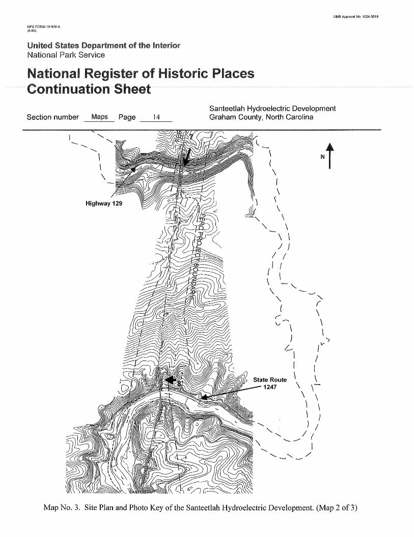
Map No.3. Site Plan and Photo Key of the Santeetlah Hydroelectric Development. (Map 2 of3)

NPS FORM 1O-S00-A (8-86)
Section number Maps Page 15 ---
OMS Approval No. 1024·0018
Santeetlah Hydroelectric Development Graham County, North Carolina
f
______ '900_
SANTEETLAH LAKE
SAi'ITEETLAH LAKE
Map No.4. Site Plan and Photo Key of the Santeetlah Hydroelectric Development. (Map 3 of3)


![NATIONAL, REGISTER OF ]HISTORIC PLACES FO](https://img.dokumen.tips/doc/110x75/6286bac27b07094c4c4f923d/national-register-of-historic-places-fo.jpg)