Embed Size (px)
Citation preview
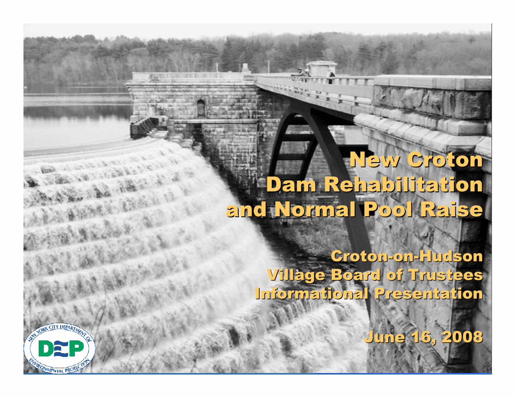
��������������������
�� � �������������� � ������������
������� �������� ����������� �������� ����
��������������������������
��������������������������������������������������
����� ����������������������� ������������������
����� !�"##$����� !�"##$

Page 2
���%������������ ��������������������%������������ �����������������
� Describe the Overall Project
� Discuss Environmental Issues and Concerns
� Project Schedule and Public Participation

Page 3
&���������&���������'' ������������������������

Page 4
���%����������(�)����%����������(�)�
� Extend the Useful Life of the Dam for 50 to 100 Years� Modify Spillway
• Expand Capacity to Convey Extreme Storm Events� Needed to meet NYSDEC Dam Safety Guidelines for safely
passing 100% Probable Maximum Flood (PMF)
• Increase Maximum Storage Capacity of Reservoir� Normal Pool Raise - adding spillway crest height of 4 feet
� Rehabilitate Water Conveyance Facilities• Dam Safety and Conservation Releases
� Preservation and Recreational Use• Preserve Historic Dam and Associated Structures• Relocation of boat storage areas
� Improve Access Roads and Slope Stabilization at Arcady Road

Page 5
�� � �������������� � ������������
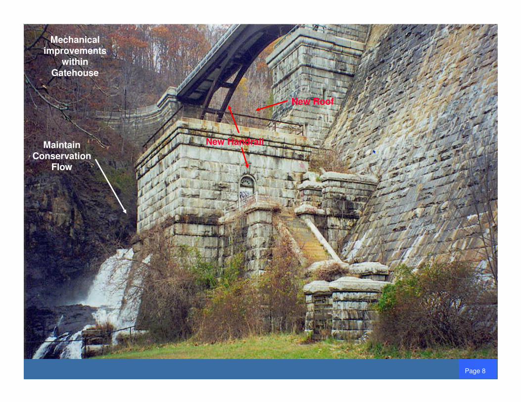
� Reconstruct Dam Crest (Roadway and Drainage)
� Rehabilitate Upper and Lower Gate Chamber
� Electrical and Supporting Site Improvements

Page 6
�� ����������&����� �������* ��+�� ����������&����� �������* ��+
Masonry Cleaning and
Repair
Improved Drainage
Repair Dam Crest

Page 7
,%�����-� �%����,%�����-� �%����
Seepage through Weir
Protect Lower Chord and North Abutment Against
500-Yr Flood
Seepage through
Weir
Page 8
New Handrail
New Roof
Maintain Conservation
Flow
Mechanical improvements
within Gatehouse

Page 9
���������� ����.������������� ����.��� �������,)������� �������,)�������'' �/������0��� �� �1���� �/������0��� �� �1����
Source: NYS Regulations sub-Part 672-3: Croton System Reservoirs
5.5 mgd11.0 mgd5.5 mgd11.0 mgd5.5 mgd16.5 mgdBelow Normal
5.5 mgd11.0 mgd5.5 mgd75 mgd5.5 mgd75 mgdNormal
5.5 mgd16.5 mgd5.5 mgd75 mgd5.5 mgd75 mgdAbove Normal
July 1 to March 31
April 1 to June 30
July 1 to March 31
April 1 to June 30
July 1 to March 31
April 1 to June 30
Stream Flow ConditionBelow Normal
Stream Flow ConditionNormal
Stream Flow ConditionAbove NormalReservoir
Storage Condition

Page 10
0����-����������� �%���0����-����������� �%���0����-����������� �%���0����-����������� �%���0����-����������� �%���0����-����������� �%���0����-����������� �%���0����-����������� �%���

Page 11
�� Spillway ChannelSpillway Channel•• Deepening of Channel to Pass Full PMF (for Dam Deepening of Channel to Pass Full PMF (for Dam
Safety)Safety)•• Would Require Excavation & Stabilization with Rock Would Require Excavation & Stabilization with Rock
Bolts and Anchoring of WeirBolts and Anchoring of Weir
�� Spillway WeirSpillway Weir•• Increase Storage Capacity by Raising Normal Pool Increase Storage Capacity by Raising Normal Pool
ElevationElevation
,%�����-�0�����)�����,%�����-�0�����)�����

Page 12
1������-������-1������-������-
Outflow (cfs)Flood Event
235,000Probable Maximum Flood (PMF)*
170,000Existing Spillway Capacity
45,400Storm of Record (1955)
* The PMF is the worst possible combination of meteorological and hydrological conditions that can occur
Spillway being rehabilitated to pass the Full PMF

Page 13
����� ��������� ����
Raise Normal Pool four feet to Elevation 199.6 feet Raise Normal Pool four feet to Elevation 199.6 feet by increasing the height of the Spillway Weirby increasing the height of the Spillway Weir
Requires Additional Modifications to Spillway Weir by eitherRequires Additional Modifications to Spillway Weir by eitherChanging the Crest Shape and/or Lengthening the WeirChanging the Crest Shape and/or Lengthening the Weir
Increased Capability to Deliver Water during DroughtIncreased Capability to Deliver Water during Drought
Page 14
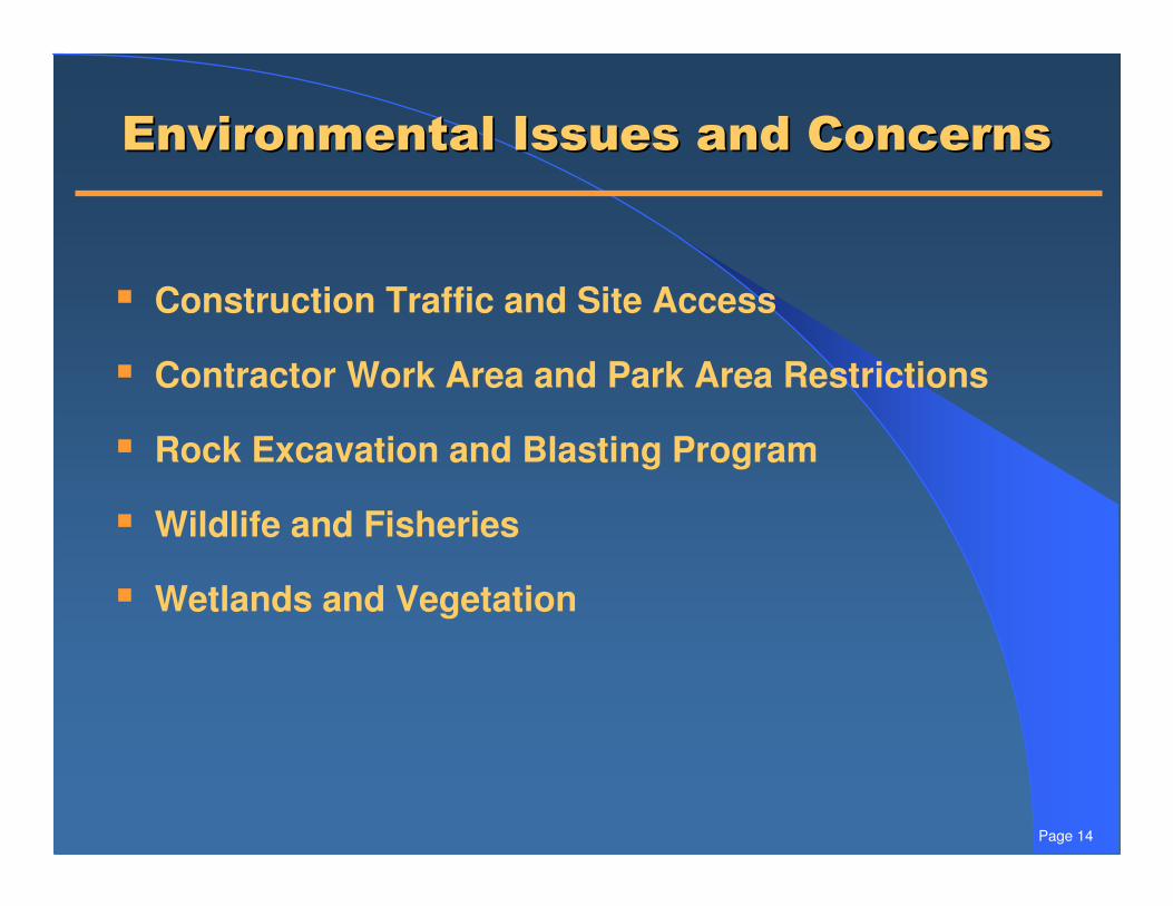
2.���� �����������������)���2.���� �����������������)���
� Construction Traffic and Site Access
� Contractor Work Area and Park Area Restrictions
� Rock Excavation and Blasting Program
� Wildlife and Fisheries
� Wetlands and Vegetation

Page 15
3�-����������������������� ����3�-����������������������� ����
� The Reservoir falls within the Towns of Cortlandt, Yorktown, Somers, New Castle, and Bedford; the dam and spillway structures are located in Cortlandt
� New Croton Dam (and site of Old Croton Dam) is listed on both the National and New York State Register of Historic Places
� Estimated inundation area in the Town of Cortlandt is approximately 20 acres of the approximate 230 acres that NYCDEP owns contiguous to the Reservoir
� Approximately 85% of inundation area in Cortlandt is forested; Westchester County tree density estimates could put the loss of trees, within Cortlandt, at 2,500 to 3,500
Page 16
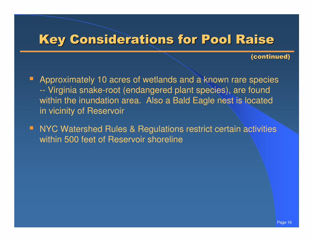
3�-����������������������� ����3�-����������������������� ����
� Approximately 10 acres of wetlands and a known rare species -- Virginia snake-root (endangered plant species), are found within the inundation area. Also a Bald Eagle nest is located in vicinity of Reservoir
� NYC Watershed Rules & Regulations restrict certain activities within 500 feet of Reservoir shoreline
4)������54)������5

Page 17
����� ��������������-��������� ��������������-����
11.926.998.630.3116.244.5All Towns
1.41.44.35.315.44.7Bedford
1.51.818.44.620.27.2Somers
0.70.25.00.55.22.6New Castle
7.818.653.310.255.923.7Yorktown
0.54.917.59.719.56.2Cortlandt
Moderate Slopes
(slopes 8-15%)(acres)
Steep Slopes(slopes �15%)
(acres)Wooded(acres)
Wetlands(acres)
Area(acres)
LinearShoreline
(Miles)
Estimates of Potential Inundation

Page 18
������)����6))���� ����������)����6))���� ����
���,������6�������,������6����
Image courtesy of Google Earth
Potential Construction Access Road
Potential Laydown
Area
Main Road
To Rt. 129
Posted Bridge
To Rt. 129
Potential Construction Access Road
(Unpaved)
Page 19
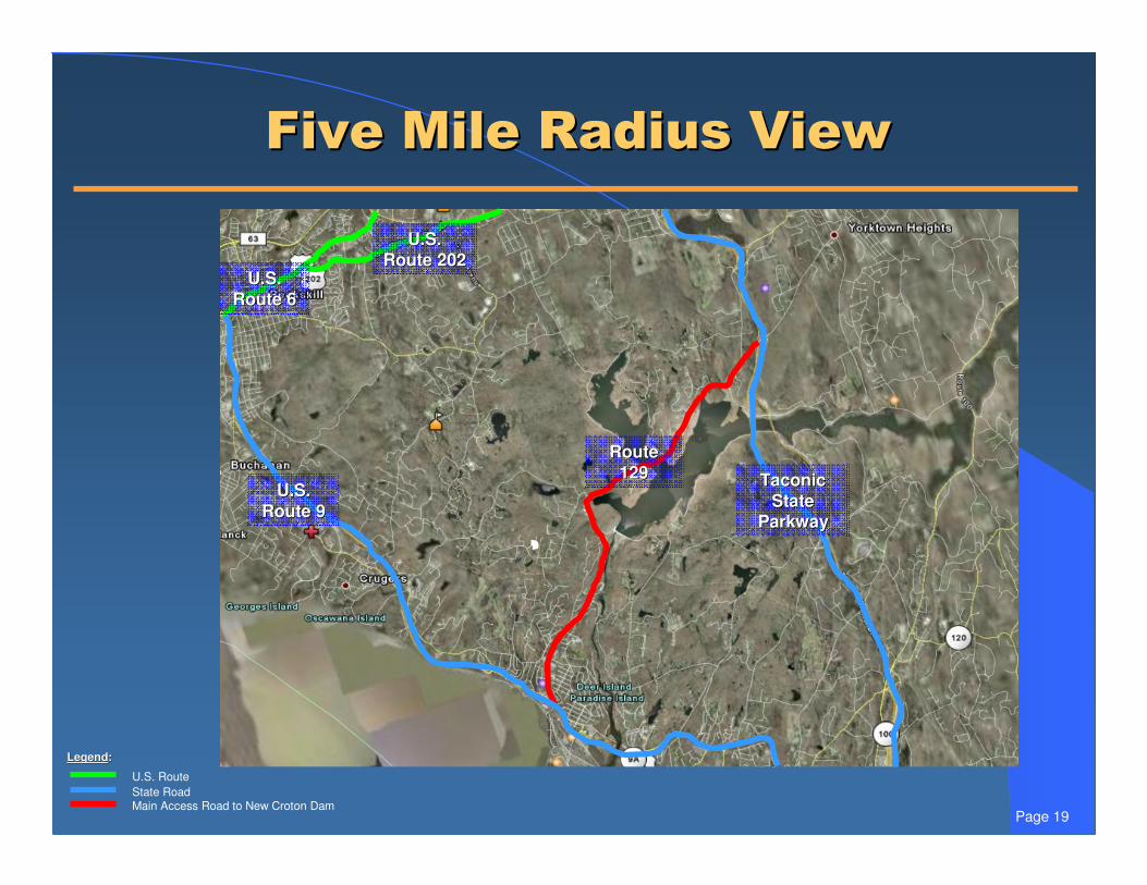
1�.��0���� ����������1�.��0���� ����������
LegendLegend::
U.S. RouteState RoadMain Access Road to New Croton Dam
U.S. U.S. Route 6Route 6
U.S. U.S. Route 202Route 202
Route Route 129129 Taconic Taconic
State State ParkwayParkway
U.S. U.S. Route 9Route 9

Page 20Rt. 9 Exit @ Municipal Pl.
Municipal Pl. @ Riverside Dr. Municipal Pl. @ Maple St.
Maple St.@ Olcott Ave.
Maple St.@ Old Post Rd.
Private Residence/High School
Rte 129 @ Quaker Bridge Rd.
Rte. 129 @ Croton Dam Pl.
Private Residence
Rte 129 @ Croton Dam Rd./Batten Rd.
Private Residence
Park
Private Residence
Quaker Ridge Rd. @ Croton Dam Rd.
Quaker Ridge Rd. @ Teatown Rd.
������)����������0�������������)����������0�������
��������
2000 ft
500 m
Legend:
Automatic Traffic Recorder
Turning Movement Count
Noise Level Meter

Page 21
��������0��������,��������������������0��������,������������
������������������������������������������������
Legend:
Automatic Traffic Recorder
Turning Movement Count
Noise Level Meter
Route 9 Exit @ Municipal Pl.
Municipal Pl. @ Riverside Ave.Municipal Pl. @ Maple St.
Maple St. @ Olcott Ave.
Private Residence/High School
Maple St. @ Old Post Rd.
��������
500 ft
200 m

Page 22
�����)� �)�����������)� �)������
� Coordinate with County to minimize disruption to Croton Gorge Park
� There are 36 boat storage areas located along the reservoir perimeter containing approximately 1,400 permitted boats in total
� Conservation releases would continue during construction period

Page 23
&.���������(�)��,)������&.���������(�)��,)������
� Late July – Distribute DSOW to public
� July through September – Comment period and public meetings on DSOW
� Late September – Issue Final Scope of Work (FSOW)
� First quarter of 2009 – Certify and Issue Draft EIS

Page 24
&.���������(�)��,)������&.���������(�)��,)������
� Second quarter of 2009 – Comment period and public hearings on Draft EIS
� Fourth quarter of 2009 – Issue Final EIS
� Spring 2011 – Commence Construction
4)������54)������5

7�������87�������8