Embed Size (px)
Citation preview

0MB No. 1024-OQ!8NPS Form 10.900.3 P?
United States Department of the InteriorNational Park Service , For NPS use only
National Register of Historic Places received
Inventory-Nomination Form .. dateentered
See instructions in How to Complete National Register FormsType all entries-complete applicable sections
1. Nameifistoric l4anton-Hunt-Farnum Farm
Farmand/orcommon Pardon Hunt Farm, Hunt-Farnum
2. Location .
street & number Putnam Pike . N *h not for pufflication
city, town Glocester N A_vicinity_of
state Rhode Island code 44 county Providence code 007
3. ClassificationCategory Ownership Status
district public 2L occupiedJL, buildings private unoccupied
structure both ._ work in progresssite Public Acquisition Accessibleobject in process ..._.. yes: restricted
being considered yes: unrestrictedno
Present Use- agriculture museum
commercial parkeducational X_ private residenceentertainment . religious
scientific. industrial ... transportation.. military .
4. Owner of Property .
name Henry_Garrity_and Helen_Garrity
street&number Putnam Pike
city, town Gloces ter NrA, vicinity of state Rhode Island
5. Location of Legal Descriptioncourthouse, registry of deeds, etc. Town Clerk, Town I-fall
street & number Putnam Pike
city. town Glocester state Rhode Island
6. Representation in Existing Surveystitle See Continuation Sheet 1 *has this property been_determined_eligible? yes £.. no
date federal state county local
depositary for survey records -
city, town state
NPS Form 10.900-s . 0MB No. 1074-0016
3821 En,. 10-31-64
United.States Department of the Interior -
National Park Service
National Register of Historic PlacesInventory-Nomination Form
Continuation sheet 1 Item number 6
A Report on Historical and Cultural Resources Withihthe ProposedHighway Study Cotridor for the Reconsttutttofl of IJ.S: .Roflte 44. . .fromRoute 1-295 to Chepachet.
March 1978 State
Rhode Island Historical Preservation CommissionProvidence, Rhode Island
Historical and Architectural Resources of Glocester, Rhodelslana--A Preliminay Report
July 1980 State
Rhode Island Historical Preservation Commission
Page 2
Providence, Rhode Island

7. Description -
Condition Check one Check one -. -
excellent . deteriorated unaltered ‘ original site- .- good ....ruins altered - moved date..... -
_X fair unexposed
Describe the present and original if known physical appearance
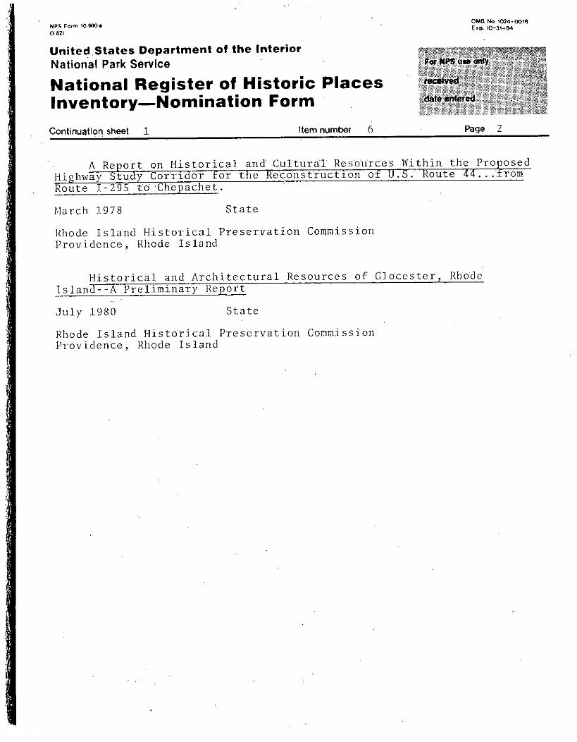
The Manton-Hunt-Farnum Farm, a tract of just under twenty-one acres,centers on a typical 2½-story, flank-gable--roof, claphoarded timber-frameFederal dwelling with a five-bay facade, a central entrance, and a brickcenter chimney. The house stands on the north side of putnam Pike -facingsouth, set on a terraced lot with -a stone retaining wall across the front.Behind the house are two shingled barns, a corn crib, a privy, and two henhouses. The grounds are ddlineated with stone walls that separate theproperty into functional areas and bound it from adjoining properties..
The house is a very well preserved and maintained example of lateeighteenth-century domestic architecture. The white-painted exterior wallsare sheathed with c1apboards and trimmed with narrow boards at the cornersand cornice line. The most prominent feature is the main entranceway, cornpri sing fluted pilasters topped by a cushion-frieze entablature and a pediment with modillion cornices. The original door has been replaced with anearly twentieth-century door containing a single large light of glass fillingmost of its top half. There is another entranceat the Tear of .the eastside, probably added in the early twentieth century, since it has a dooridentical to the front entranceway. The windows have heavy mortised andpegged frames with narrow cap boards nailed across the top as a protectionfrom the weather. Most of the double-hung sash have six-over-six lights,but there are some twelve-over-twelve sash on the rear elevation. Thesecond-story windows are set close to the eaves so the cornice moldingbreaks out around their tops. At the rear is a two-story gabled dl withone-story, shed-roof additions on the north and west sides. The dl hasan entrance in the east side.
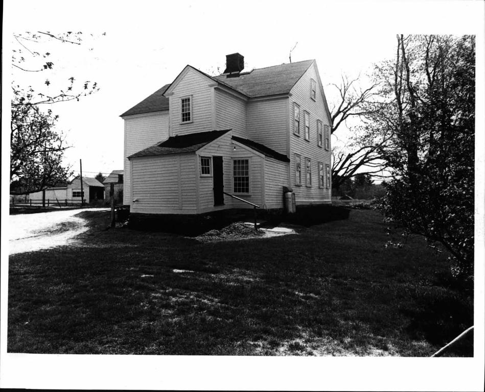
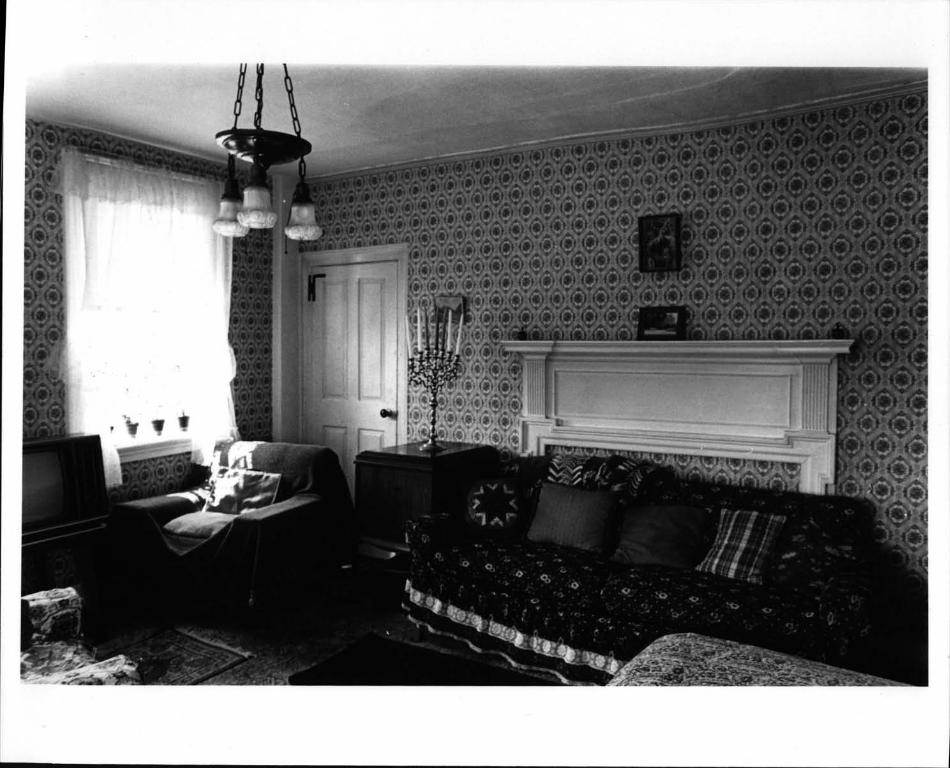
On the interior, the house follows the standard center-chimney,fh’eroom plan, slightly niodified since the house was originally constructed.The small front entrance hall contains a tight triple-run, closed-stringstaircase with winders in the corners. The two runs perpendicular to thefront wall consists of only a single step each, creating a narrow wellabout one Foot across. The strings are heavily molded in a manner reminiscent of colonial workmanship, hut the newels have small - scale acorn dropswith attefuated proportions and relatively flat modeling which are more inkeeping with aesthetic preferences of the Federal era. The back wall alongthe staircase is slightly bowed toward the center chimney.
The rooms to the left. west and right east oF the entrance hail,011CC used as a parlor and a dining room, respectively,. are now used as abedroom and a sitting room. Each room has a fireplace, now covered over,with a one-story Federal style mantel. The mantels are composed ofshouldered-architrave fire box surrounds, brdad flat-hoard entahiaturesw.i th pairs of fluted impost blocks., and mantel, she] Fs . Each entahlatureband has thin moldings applied to it in a rectangular outline to create a
See Continuation Sheet #2

- NPS Foni i0.900.* OWl No 1074-0018
3-8?t E.p. 10-31-34
United States Department of the InteriorNational Park Service
National Register of Historic PlacesInventory-Nomination FormContinuation sheet 2 Item number 7
single "panel." The mantel in the dining room/sitting room is slightlymore elaborate; its mantel shelf breaks forward over the imposts,while the mantel shelf in the parlor/bedroom has a straight front. Thenorth wall of the former dining room contains a recessed china closet,which is a later addition that protrudes’ into the room behind. Thepresent interior wall on the south side of this room was added to screenthe original wall, which became crooked when the house’s planking beganto buckle, -
The center rear room was originally and is still used as a kitchen.It contains a large cooking fireplace with an oven and a wood box tothe right side, behind a paneled door. The firebox itself is now coveredby a panel.- The narrow mantel shelf, with a wide molding underneath, isunusually high, about six feet above floor level. A late nineteenth-century, cast-iron, wood-fired range remainsin place, installed infront of the fireplace. . -
The northwest corner room is now divided into a bathroom and apantry, and the northeast corner room is divided into a bedroom and ahallway connecting to the side entrance.
In the back north wall of the kitchen, a door with heart cutoutsin the top panels opens into the rear dl. The two-story sectionimmediately adjacent to the house contains a back entrance hail, a backstaircase with a stair to the cellar under it, and the entrance to astorage room in the one-story addition on the west side of the eli. The
one-story addition on the north side contains the farmhouse’s well.Although water is now pumped through plumbing, a bucket hoist thatoperates with a counterweighted drum mechanismis still in place overthe well. -
The second floor of the house follows the same five-room plan as thefirst floor. It was apparently originally a separate flat, for there isa cooking fireplace, with an oven and wood box on the right side, inthe back center room over the first -floor kitchen. The second-floorkitchen also has a cast-iron wood-burning range, indicating continuoususe of the second floor as a separate- apartment. The southwest andsoutheast chambers each have fireplaces now clesed up with one-storyFederal mantels. They are nearly identical to those on the first floor,with shouldered-architrave firehox surrounds, broad flat-board entablatures, and fluted impost blocks. They differ in having double instead offsingle "panels" in the entablature section. There is also a cupboardover the fireplace in the southwest room. The present residents nowoccupy only the first floor, and the entire second story is used forstorage.
Page 2
See Continuation Sheet #3

- NPS Form 10-900... -
- OMfl No.1024-0016
3-821 t.p. 103154
United States Department of the InteriorNational Park Service -
National Register--of HistoricPlacesInventory-Nomination FormContinuation sheet 3 Item number 7
Interior finish throughout the house is simple and has been changedvery little since the early twentieth century. The cased posts of thetimber framing are visible in several rooms. Walls are plastered andcovered with wallpaper. Door and window openings are surrounded bysimple flat-board architrave trim with moldings ‘applied at the outeredges. The four--panel doors have a variety of hardware. Some havetheir original H- or H-L hinges and wrought-iron thumb latches; othersare rehung on butt hinges and have box latches or plain doorknobs without latches. The floor boards areoriginal except in the first-floorkitchen, where they have beenreplaced due to excessive wear. Electricceiling fixtures date from the early twentieth century and are apparentlythe ones put in when the house was first wired. -
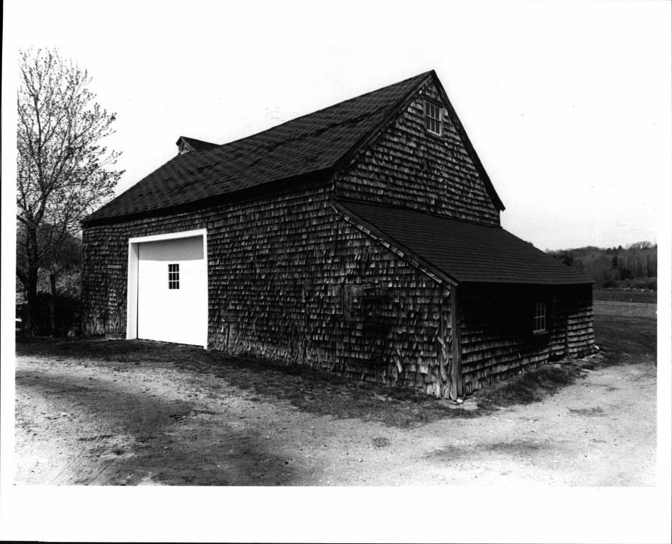
- Outside, a large shingled barn stands behind the house, behind acircular driveway. It comprises two gable-roofed, perpendicularwingsattached corner to corner, with lower shed-roof additions on the outerend of each wing. Now used to store hay, this barn was once also usedfor horses and cow, and there is a stone-walled pen on its west side.
East and slightly south of the large barn is a smaller gable-roofed,shingle-clad barn with shed-roof additions on the north and east. Partoff the structure was origi nally used as a slaughter house, and the re -
mainder as a blacksmith shop. The barn is now used as a garage andstorage area. -
A vertical-board, gable-roof corn crib is sited northwest of thehouse. It is now in dilapidated condition. A gable-roof privy- standsnorth of the corn crib. West of the crib and privy is an apple orchardbounded by stone walls. Two shed-roof hen houses are located in theorchard. North of the orchard and the ‘large barn is a ‘field surroundedby a stone wall, with wooded land beyond extending to the limit of thei roper t y. - -
Page 3 -

NPS Form i0-900-3-821
United States Department of the InteriorNational Park Service
National Register of Historic PlacesInventory-Nomination Form
Continuation sheet 4
____ _____ ______
Item number
I [-Ti-pçut VlPoeA_ by Stort yjo_Il.
rB
7
OWl No. 1024-0018t,p. 10.31-84
44
MANTON-LIUNT- FARNUM FARMGlocester, Rhode Island
Site PlanSketch -- Not drawn-to scale
Page 4
-----a
C
Ro4 ftooseso ?Ri’P1
* I
$I
- I
O?a4R-c
Hi
Mv-H
-kVYJSE
Rhode Island Historical Preservation Commission 1985

- e*I’S n-rn ID 11003-2
United States Department of the InteriorNational Park Service
National Register of Historic PlacesInventory-Nomination Form
Continuation sheet S Item number 7
OWl No 1024.’w1IflI .p 10-31-84
‘-‘‘r Y!tP ‘<-1;
-2- I - H-
date Intcred - --
Page
/
MANTON- HUNT- FARNUM FARMGlocester, Rhode Island
First FlOor Plan of FarmhouseSketch - - Not drawn to scale
-PttuPJ& T-t.c*
noW
P111a
t PILL
Lfl1
now
I‘-a
Rhode Island Historical Preservation Commission 1985

8. Significance
Period Areas of Significance-Check and justify below- prehistoric planning landscape archltectur e__ religion-- 1400-1499 - archeology-historic conservation - law - science- 1500-1599 -..L agriculture economics - literature - sculpture
1600-1699 -iL architecture education military - social/...X. 1700-i 799 -. art - engineering - music humanitarian-a’.- 1flP9-1.?...X 1900-
- commerce. communications
exploration/settlement- industry -
philosophy- politics/government
theater- transportation
.- ‘
- Invention othr specify-
Specifië dates ca 1793 - Builder/Architect N.A.
Statement of Significance in one paragraph
The Manton-Hunt-Farnun Farm is significant as a surviving farm complexin an area that is becoming increasingly subject to suburban development.Taken together, its farmhouse, outbuildings, fields, orchard, woodland,and stone walls are important as a reflection of historical patterns ofuse and growth: ‘The farm is especially notable as a handsomeand well-preserved example of late eighteenth-century domestic architecture embodying features of the Federal style. The house is remarkable both forthe amount of original fabric that remains intact and for the slightchanges that illustrate how it has been adapted throughtime. The houseand its surroundings constitute an artifact of material culture which,with further study, -could yield interesting information on everyday farmlife and the changes it underwent from the eighteenth through the twentiethcenturies.
Development of this property began in -1793, when Daniel Manton gavehis son Olney Manton five acres which were part of a twenty-acre lot on thenortherly side of Putnam Pike. The farmhouse was constructed before 1798,when Daniel gave his son the remaining portion of the twenty-acre lot
.where the now dwelling house of Olney Manton now stands..." and anadditional 156 acres on the southerly side of the road.
After changing hands a few times, the Nanton-farm came into the possession of Nancy Hunt and her husband Pardon in .1815. The Hunts sold theproperty to Cyrus Farnum in 1847. Cyrus Farnum 1809-1893 was a farmer anda major property owner in this part of Glocester and was active in politics,serving as a representative and a senator in the state legislature. Hepreviously owned the nearby property known as the Cutler Farm, which hasalso been singled out for nomination to the National Register. CyrusFarnum began the practice of calling this the Pardon Hunt Farm. He addedmore land and subsequently divided the farm among a few of his ions in the1850s. A sixty-six-acre parcel north of the road, including the Mantonfarmhouse on a twenty-one-acre lot, was cbnveyed to Cyrus’s Sons Harris S.and Charles W. Farnum. At various times, title to the property was heldjointly by both brothers and by each individually. Harris S. Farnum 1833-1911 lived here for a number of years. Charles W. Farnum 1837-1904 spentmuch of his youth away from Glocester before settling down as a farmer inhis home town, - lie served, as Town Clerk from 187S to 1901, and resided inthe town center, Chepachet. It is unclear when, if ever, Charles lived inthe former Manton farmhouse.
See Continuation Sheet #4

- Nps mm 10-900-a - 0MB Mo 1074-COIR
13821 En,- 10-31-B4
United States Department of the InteriorNational Park Service -
National Register of Historic PlacesInventory-Nomination FormContinuation sheet 6 item number 8
In 1868 Charles W. Farnum sold the Manton-Hunt-Farnum Farm to JohnA. Farnum, whose relationship to the grantor’s family is unknown. JohnFarnum mortgaged the property several times to Charles’s wife Mary S.Farnum, and finally conveyed title to her in 1894. In 1905 Mary Farnumsold the farmhOuse and twenty acres to Swan F. Garr-ity, father of thepresent owners.
The Manton-Hunt-Farnum Farm, still in limited agricultural use forgrowing hay, is illustrative of a way-of life that has become increasinglyrare in Rhode Island. Among the farms that do survive, this property isnoteworthy for its lack of extensive modernization. The house still isnot equipped with central heating, and though plumbing and electricityhave been-installed, these improvements have been made in a manner thatincreases the historical interest of the property. Most changes to thehouse have been additive, leaving earlier features in place. For example,plumbing and electricity have been put in, but the well and its bucket hoistremain and so do the original earlier twentieth-century electric fixtures.The side entrance hall and bathroom on the first floor have been inserted
- within the layout of the original floor plan. The installation of a moderngas range in the kitchen has been made without destroying the cookingfireplace or removing the cast-iron wood stove. These factors make theManton-Hunt-Farnum Farm an important cultural resource with much to tellabout rural agricultural life in Rhode Island. -
Page 2

MPS Form 10-900-a - 0MB Mo. 1024-0016
3-82 E.P- 10-31-64
United States Department of the Interior -., . - - - - -,
National Park Service . - pawèsuaon4’ - -
National Register of Historic Places - -
Inventory-Nomination Form -
Conhi!?.Ipn sheet - Item number .10 Page 2
The area designated in the nomination encompassesthe chief survivingarchitectural and landscape features of the Manton-Hunt-Farnum farm complex.Its boundary reflects current ownership patterns, but there is’also historical evidence that this parcel constitutes the core around which thefarm grew. From a twenty- to twenty-one-acre parcel on the north side ofPutnam Pike, the Manton-Hunt-Farnum Farm expanded toencompass land onboth sides of the road. The Hunt family burying ground on the south sideof the highway remains today as an indication of the link between the twotracts. - The land south of the road was set off as a separate farmsteadin the l8SOs,- with its own Greek Revival-style dwelling and a barn.
Though both farms were at first owned bythe same family, the Farnums,they developed independently. The- southern farm has not retained its historic integrity. The property has been divided, the barn has been demolishedwithin the past seven years, and the house is in dilapidated condition.For these reasons, land south of Putnam Pike that was once part of theManton-Hunt-Farnum Farm is excluded from this nomination.
The parcel nominated, which is probably coextensive with the originalfarmhouse lot of the 1790s, includes all surviving buildings that obviouslyrelate to the operation of the fai’m, together with surrounding acreagewhose differentiation as yard, orchard, field, and woodland provides anenvironmental context that illustrates the historic usage of this agri
- cultural property.. - -

- 9. Major Bibliographical References
Water Nel?iker, l-iistorical and Architectural Resources
10. G eographical DataAcreage of nominated property -
Quadrangle name Ceorgiaville
UT M References
1
A11i F 121 82 1512101
Zone EastingIi 614 1 i° INorthing -
___
1218121716101 l46I41I32 101Easting Northing
DR lI 1218121412101 1416144191201
LH!__I LI I
12. S-tate Historic Preservation Officer CertificationThe evaluate d significance of th is property within the state is: -
national state - local
As the designated State Historic Preservation OfUcer for the National Historic Preservation Act of 1966 Public Law 89-665, I hereby nominate this property for inclusion in the National Register and certify that it has been evaluatedaccording to the criteria and procedures set forth by the National Park Service.
State Historic Preservation Officer signature
title - . date
For NPS useonly .- -
I hereby certify that this property is included in the National Register -
dateKeeper of the National Register
Attest: - dateChief of Registration - . -
Rhode Island- -A Preliminary Report Providence: 1980 , p. 42.
1
of Gldcester,
20.86 acres
Quadrangle scale 1 : 24 , 000
C Ili9I 12 I8i216J210l 1416!41112810i
EIjIIlIIIfllll.IlII
ci ItI 1111111 III
BR 1Zone
F I 1 I I i I i. i___l
Verbal boundary description and justification -
The nominated property is coextensive with lot 15 in Assessor’s PUtt7, as defined in the tax assessor’s records of the town of G1.ocester.
-- . - -See_Co-nttn.u.ati-on-S-h-eet-#-5List all states and counties for properties overlapping state or county boundaries
state code county cede -
state code - - county - code
11. Form Prepared By - - -
name/title Robert 0. Jones, Senior Historic Preservation Planner
organization R.I. Historical Preservation Comm. date June, 1985
sfteet&number 150 Benefit Street telephone 401-277-2678
cityortown Providence state Rhode Island 02903

I

MANTON-HUNT- FARN1JM FARMGlocester, Rhode Island
Photographer: Robert 0. JonesApril 1985Negative flied at: Rhode Is land Historical
Preservation Commission150 Benefit StreetProvidence, RI 02903
Exterior view of farmhouse and surroundingsfacing northwesterly
Photo #1
L.
*,
0’,0

MANTON-HUNT- FARNUM FARMGlocester, Rhode Island
Photographer: Robert 0. JonesApril 1985Negative filed at: Rhode Island Historical
Preservation Commission150 Benefit StreetProvidence, RI 02903
Exterior view of farmhouse facing southeasterly
Photo#2

MANTON-L1UNT- FARNUM FARMGlocester, Rhode Island
Photographer: Robert 0. JonesApril 1985Negative filed at: Rhode Island Historical
Preservation Commission150 Benefit StreetProvidence, RI 02903
Detail of front staircase, facing northwesterly
Photo #3

MANTON-HUNT- FARNUM FARMGlocester, Rhode Island
Photographer: Robert 0. JonesApril 1985Negative filed at: Rhode Is land Flistorical
Preservation Commission150 Benefit StreetProvidence, RI 02903
Interior view of first-floor parlor,facing southwesterly
Photo #4


I - ------- -- -----*- **-
___ _________________________
MANTON-HUNT- FARNUM FARMGlocester, Rhode Island
Photographer: Robert 0. JonesApril 1985Negative filed at: Rhode Island Historical
Preservation Commission150 Benefit StreetProvidence, RI 02903
Interior view of rear ell, showing the welland hoist, facing northerly
Photo #6.

0
C

MANTON-IITJNT- FARNUM FARMGlocester, Rhode Island
Photographer: Robert 0. JonesApril 1985Negative filed at: Rhode Island Historical
Preservation Commission150 Benefit StreetProvidence, RI 02903
Interor view of southwest chamber,facing easterly
Photo #7
* r
:.

MANTON-IIUNT- FARNUM FARMGlocester, Rhode Island
Photographer: Robert 0. JonesApril 1985Negative filed at: Rhode Island Historical
Preservation Commission150 Benefit StreetProvidence, RI 02903
Exterior view of barn #1, facing northwesterly
Photo#8

A 19 282520B 19 282760C 19 28261 19 282480
*‘ M
1* ‘-‘ ‘‘
i7O
* *
46419604641320‘1641 284641920
*
0,-
I
* ‘ * 442
S’ T R,
.:-
*
* * rOak
* Island
‘9
N npc!, It’, nd p:} ,hcc1 v IF flenHH
I ‘‘‘‘ Ii Ii’, ii ir’. 1’’.i * *f 1
rJtI’’r1, I/ ‘rf, ,irIErrr 1,ittJrrIii f ‘‘vl r ii I1 f’ ‘I,j
tr’f nu]r -fr’ r’’. vI riIV
HijjI’Iir in ‘ l’’’wri
lOrD mct’- Jrii." Jr r’,p Ji r,iinr grid Jrr5
z’rie 19 h’’’ in ANr i’s
I0
Absalona* Hilt
"1
A0
‘41
F
Hunt/Farnum FarnGlocester, Rhode Island
WI r rLu!"
FT
-‘, ‘*r ‘--‘ r*-1 -*--- --*-.. .***f **


MANTON-HUNT- FARNUM FARMGlocester, Rhode Island
Photographer: Robert 0. JonesApril 1985Negative filed at: Rhode Island Historical
Preservation Commission150 Benefit StreetProvidence, RI 02903
Interior view of first-floor kitchen,facing southwesterly
Photo #5