Embed Size (px)
Citation preview

www.flightech.es

1
Flightech Systems Europe, S.A. (Flightech)
The corporate purpose of Flightech, incorporated in December 2006, consists of the
technological research and development of remotely piloted aerial vehicles, as well as the design,
manufacture and sale of these for any civilian use, whether in the security, scientific,
environmental, meteorological or research field.
Its technical team is comprised of personnel with vast experience in the aeronautical
sector, having developed prototypes from jet propulsion aircraft through seaplanes, as well as
airborne electronic systems.
Flightech RPA’s and mobile units.
For the past 5 years Flightech has been developing the FT-ALTEA, the first RPA with an
Experimental Airworthiness Certificate with registration EC-008, issued by AESA (State Aviation
Safety Agency).
AERONÁUTICOS, Magazine of the Official Association of Aeronautical Engineers.
“Flightech Systems was the first company to obtain airworthiness certification by
means of an unprecedented solution: A high-technology UAV, project FT-Altea,
developed, among other purposes, for extinguishing forest fires.”
The success of the project was made possible thanks to several agreements for
collaboration with enterprises and organizations of the sector that have allowed us to manufacture
the first fleet of RPA’s with Airworthiness Certificates, among which the following are worthy of
note:
• Aernnova: is a company of aerostructures that assumes the integral management of large
aircraft sections. It participates in the design and manufacture of parts and structures for
Airbus, like the new Airbus A380, and also for Boeing, as in the case of the Boeing 747-LFC. It
works for Flightech in the manufacture of FT-ALTEA aircraft fuselages, guaranteeing the most
rigorous quality controls and the most advanced techniques with composite materials applied
in aeronautics.

2
• The State Aviation Safety Agency (AESA) and the Directorate General of Civil Aviation (DGAC) have been working on the development of legislation for UAS since 2006, when Flightech
presented the FT-ALTEA file for its certification.
• Uría & Menéndez: Represents Flightech, particularly before the aeronautical authorities. It is
one of the most prestigious law firms in Europe and its knowledge management system is
recognized as one of the 10 best of Europe. Its international recognitions include: the European
Law firm of the Year” in the British Legal Awards 2010, “Best Law Firm in Spain”, and the
Chambers Europe Awards 2010. Uría Menéndez.
• Deloitte: Has audited Flightech since the start of the company.
• INTA: National Institute of Aerospace Technology, with an extensive Test Laboratory to qualify
systems. Flightech makes use of the Laboratories to obtain, among others, EMC qualifications
(Electromagnetic compatibility trials); qualification of environmental conditions such as
moisture, temperature, dust, etc.
• Embention: Company devoted to the development of systems for forest fire extinguishment.
One of the main missions of Flightech in the civilian sector is to provide solutions for the
growing problem of deforestation caused by fires, with relevant impact within the national fire
protection program since it will furnish the only RPAS with airworthiness certificates to perform
these tasks.
Part of the F-T ALTEA RPA fleet

3
FT-ALTEA
The Flightech RPA is a high technology aircraft whose components were designed and
developed especially for observation and surveillance. The aircraft was designed in its entirety by
Flightech.
The FT-ALTEA is a vehicle with a wingspan of 6 meters and a maximum take off weight
(MTOW) of 80 kg. It has a high wing and H-tail configuration and a propeller engine. Takeoff and
landing are performed from the ground without any additional launch system. The vehicle is
equipped with a control and communications system operated from the ground.
FT-ALTEA fleet and mobile unit
The main features of the FT-ALTEA are:
• Automatic takeoff, flight operations and landing.
• Autonomy in excess of 4 flight hours.
• Latest generation, light and efficient composite materials, such as carbon fiber.
• Sensors/actuators adapted to client needs.
• High immunity against adverse atmospheric conditions.
• Autonomous Navigation System by waypoints modifiable in real time.
• Communications systems of high reliability, encryption and range.
• High quality video recording systems.
• Thermal camera.
• Certified anti-collision lights.
• Mode S Transponder.
• Connection with the closest control tower for air traffic control.
• Autonomous emergency parachute system and redundant activation system.

4
Control Station (GCS)
The control station (GCS) of the FT-ALTEA is comprised of a set of equipment and systems
that assume mission planning and control tasks (flight control, payload control), information
distribution or dissemination to external or end users, communications with the assigned control
tower.
Control station (GCS)
The ground station includes communications systems and data links necessary to access
the platform and airborne systems. These controls are necessary, at minimum, to define and
supervise the mission. The GCS is composed of the hardware and human means that direct and
control the mission from the base station. It may be located on land, at sea or in the air and may be
a fixed site or mobile unit.
The functions that it performs are the following:
• Mission planning. The mission is comprised basically of the definition of the flight plan to be
followed and the actions that should be executed.
• Communication with the RPA. To transmit the orders and receive telemetry, with speed,
altitude and position data, directional and omnidirectional antennas are used with redundant
radio modems.
• Payload. The payload is composed of electro-optical vision and infrared or thermal vision, and
may also include temperature, moisture, CO2 sensors, hyperspectral cameras and other
sensors. The sensors and airborne systems may collect a large quantity of information and send
it to the station in real time.
The mission is executed by the autonomous flight control system. It should be considered that,
although the UAV flies autonomously, it is always possible to take control from the control station
(GCS).

5
FT-ALTEA landing.
In the ground station data entries, aerodynamic modules and the basic maneuvering
parameters such as landing, reconnaissance operations are controlled…
The information is encrypted and transmitted to ground control.
All information collected by the FT-ALTEA during a mission is recorded in the ground
station and may furthermore be received at any other point the client wishes. For data
transmission Flightech utilizes the most innovative digital technologies.
In addressing a mission it is
important to consider the return route necessary so that, at all
times, during the flight, the
aircraft knows how to return to
the base if the mission is aborted.
Data transmission from the FT-ALTEA to
the control station (GCS).

6
The Flightech surveillance and detection system
Remote piloted aircraft offer a unique opportunity: to establish a constant flight system,
capable of real time “surveillance” of any geographical area or industrial installation. The Flightech
UAS system is based on very lightweight aircraft, capable of landing and taking off in highly reduced
spaces and with great operability.
The RPA system developed by Flightech is based on four pillars:
1. A network of unmanned aircraft.
2. An aerial imaging system with a great capacity for observation.
3. An efficient and instantaneous system for the transmission of images to a ground unit and
via internet to any other point.
4. A land-based image analysis system to facilitate decision-making if any incident is
identified.
Flightech has the latest technology in the field of high resolution thermal and electro-optical
cameras, using a dual viewing system to guarantee detection.
The image capturing system allows:
• Remote camera control.
• HD (high definition) image recording.
• Geo-pointing with the cameras.
• Right/left – upward/downward movement with the joystick.
• Image stabilization by inertial system.
• Creation of automatic flight patterns.
• Payload up to 12 Kg. totally adapted to the client.
• Daytime/nighttime surveillance support.
• 30-micron thermal camera.
• Human activity detection up to 1,800 meters.
The FT ALTEA components were designed and developed especially for observation and surveillance.

CERTIFICATE OF REGISTRATION AND AIRWORTHINESS

CERTIFICADO DE MATRÍCULACertificate of Registration
Ministerio de Fomento / Ministry of Public Works Agencia Estatal de Seguridad Aérea / State Aviation Safety AgencyDirección de Seguridad de Aeronaves / Aircraft Safety Directorate
ESPAÑA / SPAIN
Número registro Register number
Fecha de matriculación / Registration date Marcas de nacionalidad y matrículaNationality and Registration Marks EC- LYG
Fabricante, Marca, tipo-modelo Manufacture and Manufacture's designation of aircraft
Número de Serie / Serial number
Se certifica que la aeronave arriba indicada ha sido inscrita en el Registro de Matrícula de Aeronaves del Reino de España de conformidad con el Convenio de Aviación Civil Internacional del 7 de diciembre de 1944, Ley 48/1960 de 21 de julio sobre Navegación Aérea y el Reglamento del Registro. / It is hereby certified that the above described aircraft has been duly entered on the Spanish Civil Aircraft Register in accordance with the Convention on International Civil Aviation dated 7 December 1944, the Spanish Aviation Legislation in force (Law 48/1960 of 21 July) and the regulations which govern the Spanish Civil Aircraft Register.
9367
21/01/2014
FLIGHTECH SYSTEMS EUROPE
FLIGHTECH ALTEA-EKO
1
Propietario: FLIGHTECH SYSTEMS EUROPE, S.A.
Aerodromo de Casarrubios del Monte (Toledo)
Madrid, 21 de enero de 2014
Firmado Electronicamente por / Electronically Signed byEl Director de Seguridad de Aeronaves / Director, Aircraft Safety P.D.F. (Resolución de fecha, 8 de octubre de 2013)/By delegation (Decision 8th October 2013)
C/ JOSEFA VALCARCEL, 8 - 3º28027 MADRID - ESPAÑA
Owner
Identificador electrónico / Document ID: AESAURMACERT0001576E6C9DA Permite la comprobación de este documento, en la dirección / Allows to check this document on:https://www.seguridadaerea.gob.es > Sede Electrónica (Oficina virtual) > Comprobación documental
Domicilio/Address
Fecha de expedición / Date of issue
ESTE CERTIFICADO DEBE LLEVARSE A BORDO DE LA AERONAVE This certificate must be carried onboard the aircraft
Estacionamiento Habitual:Habitual Base
El Jefe Sustituto del Registro / Deputy-Chief of Aircraft RegisterLoreto Serrano de Pablo Díez


OPERATING PROFIT OF FT-ALTEA

Annex | 1
ANNEX
FT-ALTEA Applications
The applications of the RPAS are several. A network of RPA’s may be deployed to monitor
the borders or large infrastructures such as power lines or nuclear power stations. The
information is sent to surveillance posts and/or control centers from where the images of the
target tracked are received in real time. The position of the target is represented on a digital
map.
Changing the path of the RPA is as easy as using the mouse to “click” on the point of the
map around which aircraft orbit is desired. Pre-programmed flight paths make it possible to
continuously and efficiently sweep one same area.
They are highly efficient for environmental surveillance. They are able to measure the
location, surface area and displacement of oil spills at sea. In fires, biological or nuclear
disasters they are able to closely observe the location of the catastrophe without endangering
human lives. They are ideal for seeking and locating shipwrecks…
Service Image Description
CARTOGRAPHY
Orthophoto
Making orthophoto maps of
municipalities, urban centers,
natural parks and agricultural
and forest lands.
Altimetry
Making high resolution models
of ground elevations. Height
calculation of ground elements.

Annex | 2
Management
of crops,
nurseries and
plantations
Control and monitoring of the
condition of the crops by
multispectral images.
Evaluation
and
comparison
of biophysical
parameters
Derivation of biophysical
parameters using multispectral
images and their temporal
variability on the basis of the
phonological evolution of the
crops.
Control of
irrigation
efficiency
Irrigation efficiency manifests
itself by positive correlation
with the normalized vegetation
index defined with multispectral
images from RPA’s. The
observations may be
programmed on the basis of the
irrigation policies implemented.
FORESTRY
Evolution and
monitoring of
forests
Monitoring the condition of
woodland areas by means of
multispectral images.
Measurement
and evolution
of tree
density and
height
Quantification of the density,
distribution and volume of
different tree species by means
of series of multispectral
images and stereoscopic
techniques.
AGRICULTURE

Annex | 3
Evaluation
and
comparison
of biophysical
parameters
Derivation of biophysical
parameters using multispectral
images and their variation on
the basis of the phonological
evolution of each type.
Identification
of species in
large wooded
areas
Forest classification using
multispectral images and their
temporal variation on the basis
of the seasonal evolution of
each type.
Plague
monitoring
and
evaluation
Plague identification and the
study of their extension and
evolution by means of
multispectral images and their
temporal variation.
Fires
Monitoring of drought
conditions in forests. Support to
the coordination of
extinguishment tasks. Control
of the evolution of fires in real
time from the ground. Efficient
calculation of the perimeter
and the extension and degree
of calcination of the burned
forest.
VITIVINICULTURE
Monitoring of
vineyards
Detailed monitoring of vineyards, vine to
vine, using multispectral images and
their variation throughout the entire
phenological cycle.

Annex | 4
Support to
precision
viticulture
By means of a series of multispectral
images: Quantification of the effect, vine
to vine, of the application of irrigation,
phytosanitary products, etc., and the
optimization of these resources. Precise
determination of harvest time on the
basis of the degree of grape bunch
ripeness.
Damage
quantification
Precise quantification of vineyards
affected by meteorological and extreme
climate incidents (hail, frost, wind,
drought, etc.) or by plagues and
contamination.
GEOLOGY
Cartography
Capture of multispectral images for the
preparation of centimeter resolution
geological, sedimentological,
mineralogical and geophysical maps.
Mining
Control and monitoring of mines and
their environmental impact: soil
movements, arid soil production,
metallic residue, decanting basins, etc.
Geological
risks:
landslides,
flooding, etc.
By multispectral images, determination
and a centimeter scale of areas with
associated geological risks: landslides,
flooding, etc.

Annex | 5
Geological
risks:
avalanches
Characterization of areas with
avalanche risks using multispectral
images to determine the moisture of
the snow, thermal cameras to
determine its temperature and
stereoscopic techniques to determine
thicknesses.
HYDROLOGY
Basin control
Analysis of the status of basin
occupation, risk of flooding and
basin estimation using a series of
multispectral images and
stereoscopic techniques.
Quantification
of the condition
of reservoirs
Quantification and monitoring
of basins and reservoir reserves
using visible and multispectral
images with stereoscopic
techniques.
Quantification
of water
reserves
Analysis of high mountain water
reserves and estimation of
melting flows using a series of
multispectral images.

Annex | 6
ENVIRONMENT
Light pollution
Parameterization of the light
pollution index to prepare light
pollution maps and monitor the
efficiency of eco-energy
measures. To do so a high-
definition digital video is
utilized. The multispectral
analysis of these images allows
the classification and statistics
of the various sources of light.
Determination of temperature
and pressure
Condition of
the atmosphere
tropospheric profiles and the
quantification of the
concentration of aerosols and
gases by means of specific
detectors: ozone, steam, CO2,
etc. Solar radiation and albedo
measurements. Detection of
leaks of toxic gases and smoke.
Pollution and
toxic spills in
the aquatic and
land
environments
By means of multispectral
images, control and monitoring
of industrial accidents with
toxic spills in aquatic and land
environments. With the use of
various spectral bands it is
possible to record the presence
of given contaminants on the
surface.
Waste
Management
Independent control of
industrial waste deposit and
storage and their treatment.
The multispectral images allow
the quantitative control of the
environmental impact of
dangerous materials and those
that are difficult to recycle.
Annex | 7
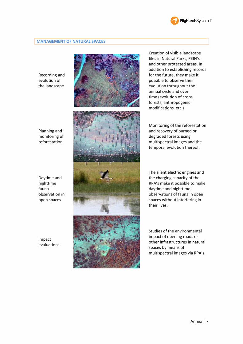
MANAGEMENT OF NATURAL SPACES
Recording and
evolution of
the landscape
Creation of visible landscape
files in Natural Parks, PEIN’s
and other protected areas. In
addition to establishing records
for the future, they make it
possible to observe their
evolution throughout the
annual cycle and over
time (evolution of crops,
forests, anthropogenic
modifications, etc.)
Planning and
monitoring of
reforestation
Monitoring of the reforestation
and recovery of burned or
degraded forests using
multispectral images and the
temporal evolution thereof.
Daytime and
nighttime
fauna
observation in
open spaces
The silent electric engines and
the charging capacity of the
RPA’s make it possible to make
daytime and nighttime
observations of fauna in open
spaces without interfering in
their lives.
Impact
evaluations
Studies of the environmental
impact of opening roads or
other infrastructures in natural
spaces by means of
multispectral images via RPA’s.

Annex | 8
PUBLIC WORKS
Impact
evaluation
Analysis of the visual impact of
infrastructures on large
extensions of land by visible
spectrum images captured by
low-flying RPA’s.
Control of civil
works
Monitoring of the
implementation of civil works
that affect large extensions
(roadways, channels, reservoirs,
high-voltage lines, wind parks,
etc.) using centimeter scale
aerial images.
URBAN DEVELOPMENT
Urban
management
and planning
Observation and monitoring of
constructions. High resolution
photographic record from
various perspectives or by video
of urban areas associated with
planning projects.
Control of
illegal urban
development
By means of multispectral and
visible airborne images in RPA’s,
it is possible to detect illegal
constructions in rural, forest
and other areas of difficult
access.

Annex | 9
Management
of green areas
Monitoring of the condition of
green areas and
characterization of their
interactions with adjacent
urban areas by means of a
series of multispectral and
visible images.
TRAFFIC MOBILITY
Monitoring of
roadway
mobility
Monitoring traffic status. It is an
efficient and value added
alterative to the helicopter,
eliminating risks to the
personnel who broadcast traffic
conditions and making it
possible to digitally record the
daily status of traffic, in
addition to being much more
economic and sustainable (non-
contaminating).
CIVIL PROTECTION
Function
integration and
centralizations
The coordination of functions
that extend in space and are
concentrated in time may
constitute a critical task in large
events. The control and
saturation of accesses by foot
and by car, the monitoring of
the flow of people, the location
of parking areas and any
incident may be coordinated
and transmitted easily to users
with the help of RPA’s.
Cultural
demonstrations
in open spaces
and urban
centers
Monitoring of people in real
time. Control of incidents in the
urban environment.

Annex | 10
Rescue team
support
Victim detection in areas of
geological risks: avalanches,
earthquakes, floods, landslides.
Development of nocturnal
detection systems for persons
as well as for daily rescue
support. Detection of persons
and elements with radio
beacons.
CULTURE
Cultural
Heritage
Management
Characterization of the state of
preservation of cultural
heritage elements and the
control of their changes by
means of high resolution
photographic records from
RPA’s.
Archeology
Support to archeological digs
and prospecting. The high
resolution and multispectral
photography of sites improves
documentation and may furnish
information to interpret
vegetation responses to
structures beneath the surface.
SECURITY
Image service.
Description
high resolution
surveillance
During daytime and nighttime
services, detection of persons
and objects on land and at sea,
monitoring of mobile objects
without the possibility of
detection and flying over and
recording infrastructures and
various situations.

UAV ALTEA TECHNICAL SPECIFICATIONS

SIZES AND DIMENSIONS
WINGSPAN 6.151m
LENGTH 3.207m
FUSELAGE HEIGHT 0.413m
FUSELEGE WIDTH 0.400m
WING AREA 3.6m2
WEIGHT 80Kg
TECHNICAL SPECS
MAX. FLIGHT TIME 4h
MAX. HEIGHT 5000m
OPERATION SYSTEM
RADAR DETECTION YES
TRANSMISSION IMAGES
OPTICAL &MULTI
HYPER SPECTRAL SENSORS
DATA ENCRYPTION YES
FUEL 95-98 UNLOADED
PAYLOAD 12Kg
RANGE IMAGES TRANSMISION 100Km
INFRARED
NIGHTVISION
THERMAL
OTHERS INCLUDED IN PRICE
WARRANTY 5 Years
TRAINING FOR PILOTS Yes
REAL TIME AND DVD QUALITY
OPTIONAL
CAMARAS
16/03/2015 Flightech Sales Dpt

Flightech Systems. Sales Dpt. 1/3
Details of Clarifications sought-Technical parameters on Drone manufactured by Flightech-Madrid
(Spain)
1. Number of models of UAVs with their individual sizes and dimensions.
One model certified and with registration marks: Flightech Altea-Eko. These are the sizes and
dimensions (section 1.3.2 of the Technical Description Document “TDD”):
Wingspan: 6.151 m
Length: 3.207 m
Maximum height: 1.054 m
Fuselage height: 0.413 m
Fuselage width: 0.400 m
Wing area 3.6 m2
2. Max flight time from take off to landing.
Four hours (1.3.9 TDD).
3. Area that can be covered in a single flight.
There are different possibilities depending upon the quality of the images and the terrain shape. We
outline two examples:
Example 1: High resolution image. An aircraft flying at cruising speed 120 km/h observing 500
m wide with the camera can monitor 60 km2/h. It makes 240 km2 per 4 hours flight.
Example 2: Low resolution image (greater observed area). If we increase the flying height and
slightly the cruise speed, we would have not full resolution video image, but it might be valid
for some surveillance uses. A plane flying at 135 km/h and watching 2,000 m wide with the
camera can monitor 270 km2/h. It makes 1,080 km2 per 4 hours flight.
4. Max height at which the UAV can fly.
1,521 m currently due to legal issues (1.3.8 TDD). However that limit can be raised easily.
5. Radar detection - Yes / No
The aircraft is able to be detected by primary or secondary radar.
6. Mode of transmission of images and information.
The images and information are transmitted by radio using two links (1.3.18 TDD):
Command and control link:
Frequency: 902 - 928 MHz
Maximum output power: 1W (+30 dBm)
Range: 50 km line of sight, 0 dB gain antenna.

Flightech Systems. Sales Dpt. 2/3
Channel separation: 230 kHz
The command and control link is tripled.
Payload link:
Frequency: 2,4000 - 2.4835 GHz ISM band.
7. Facilities at ground station for receiving the info / images
The ground station integrates telemetry and remote control of the aircraft monitoring screens,
joystick control, antennas and work area for the operators of the aircraft (1.3.1 TDD).
8. Suitable for what types of applications.
The applications are shown and explained in the Flightech presentation (pages 7 to 16).
9. Comparable to which international model of another manufacturer.
Luna (EMT Penzberg, Germany)
Hermes 90 (Elbit Systems, Israel)
Sky Spirit (Lockheed Martin, USA)
10. Requirement of utilities for operation of the UAVs.
Electricity is recommended. However, our ground control unit has two generators.
11. Type of fuel used and details of payload.
Fuel: 95-98 unleaded octane oil mixed 2-3% (1.3.5 TDD).
Payload: it depends upon the mission of the aircraft. Its maximum weight is 12 kg (1.3.22 TDD).
Some examples may be seen in pages 6 to 10 of the TDD.
12. Modality of data collection thru on board capsule or real time down links.
Both modalities (board memory and real time down link) are possible at same time.
13. Whether down link data is encrypted. If yes encryption details in terms of bits used.
The encryption is optional. We normally use it. Our current encryption uses a AES 128 bits.
However, other encryptions are possible.
14. Confirm operating in free freq band. Otherwise we need to take permission from competent
authorities.
The frequencies that Flightech operates in Spain are shown in point 6 before (1.3.18 TDD). However
the radio modem can be adapted to operate in different frequencies.

Flightech Systems. Sales Dpt. 3/3
15. Confirm Take off and landing is independent of the platform.
The aircraft does not need any launch or recovery systems. It automatically takes off and lands in a
soil runway (1.3.20 TDD).
16. What are international standards followed for production of flight platform.
The international airworthiness standards prescribed by the Spanish civil aviation authority and
followed were STANAG 4703 Light UAV Systems Airworthiness Requirements (USAR - LIGHT ) for
North Atlantic Treaty Organization (NATO ) Military UAV Systems Draft Edition 1 March 2011,
adapted to the spectrum and limitations defined in the technical description (1.2 TDD).
17. Please confirm whether these drones are being used for any military application.
They have not been used yet for military applications. However some of the potential clients are
involved in military applications.
18. Modality of its return to base in event of guidance failure.
There are different possibilities in case of guidance failure. One of them is the continuation of the
flight and then returning to base. Other is the return to base. Finally, the aircraft has a parachute for
safe flight completion (1.3.21 TDD). The possibility chosen must be programmed before the flight.
19. Modality of after sale service during warranty period and beyond.
Flightech assumes a 5 year total warranty including components and maintenance.