Embed Size (px)
Citation preview

., Form 3160-5 , (August 2007) V / •
UNITED STATES DEPARTMENT OF THE INTERIOR BUREAU OF LAND MANAGEMENT
SUNDRY NOTICES AND, REPORTS ON WELLS Do not use this form for proposals to drill or to re-enter an
abandoned well. Use form 3160-3 (APD) for such proposals.
FORM APPROVED OMB NO. 1004-0135 Expires: July 31, 2010
5. Lease Serial No. NMNM57274-
6. If Indian, Allottee or Tribe Name'
7. If Unit or CA/Agreernent, Name and/or No. SUBMITIN TRIPLICATE - Other instructions on reverse side.
8. Well Name and No. — " HARACZ AMO FEDERAL 10H
l . Type of Well ' [ ,
g | Oil Well r j Gas Well Q Other
2. Name ot Operator r T ^ — ^ Contact: NAOMI G SAIZ r ~ —
YATES PETROLEUM CORPORATIONE-Mail: [email protected] 5. API Well N o . — ~
30-015-40963-00-X1 3b. Phone No. (include area code) Ph: 575-748-42-11
10. Field and Pool, or Exploratory lUJ^ESiaNATED
3a. Address 105 SOUTH FOURTH STREET ARTESIA, NM 88210
4. Location ol Well (Footage, Sec, 7'., R., M.. or Survey Description)
Sec 24 T24S R31E NENE 200FNL 660FEL
I 1'. County or Parish, 'a/d State
EDDY COUNTY, NM
12. CHECK APPROPRIATE BOX(ES) TO INDICATE NATURE OF NOTICE, REPORT„OR.OTHER DATA
TYPE OF SUBMISSION TYPE OF ACTION '
., gj Notice of Intent t ̂
r j Subsequent Report'
J-J Final Abandonment Notice
• Acidize
J-J Alter Casing u
• Casing Repair
pj Change Plans
r j Convert to Injection
r j Deepen
* pj Fracture Treat '•
• pj'New Construction
J-J Plug and Abandon
• Plug Back
Q Production (Start/Resume)
r j Reclamation 4
r j Recomplete
| - j Temporarily Abandon
r j Water Disposal
• Water Shut-Off
Q We'll Integrity
ra Other Change to.Original A PD
If the proposal is to deepen directionally or recomplete horizontally, give subsurface locations and measured and true vertical depths of all pertinent markers and zones. Attach the Bond under which the work will be performed pr provide the Bond No. on file with BLM/BIA: Required subsequent reports shall be filed within 30 days following completion of the involved operations. If the operation results in a multiple completion or recompletion in a new interval, a Form 3160-4 shall be filed once testing has been completed. Final Abandonment Notices shall be filed only after all requirements, including reclamation, have been completed, and the operator has determined that the site is ready for final inspection.) •
Yates Petroleum Corporation respectfully requests to make the following changes to our approved APD as per attached paperwork.
pRECEIVED~~| APR 1 5 2014
OCD ARTESIA
• Accepted for-record NMOCD -0
SEE ATTACHED FOR CONDITIONS OF APPROVAL _ /
14. I hereby certify that the foregoing is true and correct. Electronic Submission #241146 verifiejd
For YATES PETROLEUM CORP Committed to AFMSS for.processing by CHRIS
Name(Priiited/Typed) NAOMI G SAIZ
bythe BLM Well Information System DRATION, sent to the Carlsbad OPHER WALLS on 04/04/2014 (14CRW0219SE)
Title WELL PLANNING TECH
Signature (Electronic Submission) Date ,04/04/2014-
THIS SPACE FOR FEDERAL OR STATE OFFICE JSE ^ 3 J ^ \ j V t U
Approved By
Conditions of approval, if any, are attached. Approval of this notice does not warrant or certify that the applicant holds legal or equitable title to those rights in the subject lease which would entitle the applicant to conduct operations thereon.
Title
Office
i Date
,E( Chris \Na»s MftMAflCMFNT
Title 18 U.S.C. Section 1001 and Title 43 U.S.C. Section 1212, make it a crime for any person knowingly and willfully to foakeb<y&Ty^$htil^ United! States any false, fictitious or fraudulent statements or representations as to any matter within its jurisdiction. I CtArjj-bpftD_rJ-=t^
BLM REVISED ** BLM REVISED ** BLM REVISED ** BLM REVISED ** BLM REVISED **

riaracz AMO Federal #10H
Yates Petroleum Corporation respectfully.requests to make the following changes to the approved APD:
i*eefHthe<hTJt<e"rru^ the wellhead. The "w^'WdtrtdiiloertTrT^^ of a flexj certificaJiorLand-specs^re attache&T
Contingency Intermediate Cement Design:
We would like to request that the cement design approved in APD be our primary cement
design and what follows will be if hole conditions warrant:
DV/Packer-Stage tool wil l be placed at approx. 2500'-3000' (cement volumes wil l be adjusted
pe r too lp lacemen t )
Stage I: Lead w/440sx 35/65 PozC (YLD 2 WT 12.5, 11 gal/sk) tail w/200sx Class C (YLD 1.34 WT 14.8, 6.23 . gal/sk) 10Q% excess TOC=2800' ' „ i , . . .
Stage II: Lead,w/735sx 35/65 PozC'(YLD 2 WT 12.5, 11 gal/sk) tail w/210sx Class C (YLD 1.34 WT 14.8, , 6.23 gal/sk) 100% excess TOC=0'
Production: .
Well will be drilled to approx. 15279' MD (105.99' TVD) which will be 100' past the 330! hardline..The BHL, casing weight and grade will remain the same. Production cement volumes will be adjusted accordingly to include the extra 100' of lateral. The directional plan and WM are attached.

Yates Petroleum Project: Eddy, NWI (NAD-83) Site: Haracz "Amo" Federal
We'll: #10H Wellbore: OH
Plan: Plan #2 (#1 OH/OH)
§• 8400-Q
' 111
J i l l
i i
ULL!
rjnT
TTiT
i t
WELL DETAILS: #10H
Ground Elevat ion: : 3575.0 RKB Elevat ion: RKB @ 3596.5usft (Nomac 22 KB=21.5')
Rig Name: Nomac 22 KB=21.5'
Nor th ing 440509.80
Surface Hole Locat ion East ing
729457.00 32° Lat i t tude
12' 34.471 N Long i tude
103° 43' 30.325 W
Azimuths to Grid North True North: -0.32°
Magnetic North: 6.99°
Magnetic Field Strength: 48313.7snT
Dip Angle: 60.08° Date: 3/20/2014
Model: IGRF2010
West(-)/East(+) (200 usft/ in)
0 -600 -400 -200 0 200 400 600 800 1000 1200 1600 -1400 -1200 -1000
Section Details
MD Inc Az i TVD + N/-S +E/-W Dleg TFace VSect 1 0.0 0.00 0.00 0.0 0.0 0.0 0.00 0.00 0.0 2 10156.6 0.00 0.00 10156.6 0.0 0.0 0.00 0.00 0.0 3 10910.4 90.46 179.65 10634.0 -481.3 2.9 12.00 179.65 481.3 4 15179.2 90.46 179.65 10600.0 -4749.8 28.7 0.00 0.00 4749.9 5 15279.2 90.46 179.65 10599.2 -4849.8 29.3 .0.00 0.00 4849.9
-500
u=
West(-)/East(+) (50 usft/ in)
-350 -300 -250 -200 -150 -100 -50 0 50 100 150 200 350 400 450
t: p i -
Build at.iy/10imito.30:46'.INC@:
fm-
a: fee.
m
B r
jgsl
sssAri
iinas
IS
m
W O K F b h ' C
33 HI laraiirfe:
Ms
H ?
s i s
m m
! S E 5
fists
m
.100 2 o a-'
•150i£
•200 g
c
•250
•300
Proposed; KOP: 10156.6' MD. 10156.6' TVD n r T - T X D - . ; . ^ - . Build at-j12V1C 3fl to 90.46"TIP>
1200 1600 2000 2400 2600 3200 3600 4000 4400 4S00
S I B
s i s
3 § 3!
m S 5
i n
ggE0C:J.p9ipJ4- MDSIOSM'.OVTVD;
S I S ;
a?
as
S i
81
a
51=
m
3Cross 3301 Ha rdline:M
mm
S8HI
lzissiA;
TD 115279.2':MD;
50
HE
mm
m
m m A* ~ T
'Mi
sin
4> art tmei
~ 3 1=3 !=
3 1
Lease
an
.east
; OHJPI*! wj};
1!
• ~ nPBl 1 ;(Haraczj
srclrfi f
;T4H
r5i
ir*:
lf-jt-eder
•2200^; Z
-5200
PROJECT DETAILS: Eddy, NM {NAD-83) Geodetic System: US State Plane 1983
Datum: North American Datum 1983 El l ipsoid: GRS 1980
Zone: New Mexico Eastern Zone System Datum: Mean Sea Level
Local North: Grid
Vertical Section at 179.65° (200 usft/in)
Crescent Directional Drill ing 7715 West Industrial Ave. Midland, Tx 79706
Phone: 432-618-1135
Plan: Plan #2 (M0H/OH) Created By: Adrian Castro Date: 17:59, March 20 2014

1< f -
Yates Petroleum Eddy, NM (NAD-83) Haracz "Amo" Federal #10H
OH
Plan: Plan #2
Standard Plannii 20 March, 2014
A • *
' t i
, "t "« 'I «• "\ 'A 1
r 1 - {
r, ' 1 •
" n I 1
1. „
'"tl i
f M
{
•fi. <
* r ""8. ,
j * . '
J V
sh i - 'r
* 1 - r i ^

Planning Report
—Xi *~> Database:;v*v
Company: ir '-
Project j Site to f i I iWell ' >r-»t , • .: ' Wellbore: • >* De ign j
II •J{ HoustoniR5000i Database..
I yates Petroleum
"•j Eddy NM (NAD 83)
• ••ai Haracz'vAmor'Bederali' ••
* | 'LocaliCo-ordinateiReforence:",;
l TVD Reference ' i . i rMD Reference
r'NorthiReference:
#10H
1 Plan #2
aurvey<CalculationiMethod:. ,"l
< Well #1 OH
RKB @ 3596 5u ft (Nomac 2*2 KB=21 5,) <*
RKB @ 3596 5u ft (Nomac 22 K8=21 5 )t iJ
Grid
:MinimuirnGurvature.i.i,. -..«,-. • * •' f t l i ;.
*" / Eddy NM (NAD 83) . « .
Map System:
Geo Datum:
Map Zone:
US State Plane 1983 North American Datum 1983
New Mexico Eastern Zone
System Datum: Mean Sea Level
JSitei ';,»8 t Vf t , r : ' . ; f S f lJHaracz »A n r c ^ K p £ & £ t e , . . 3 ? i r ' * - . V . " ^ ' i - i ' - v , T , - ;< : .<- - t - : - J .V«->
^X''j^.^rs'X"- r.v •v-'.'A*..'-i-*?..'^^
Site Posi t ion: North ing: 440,509.80 usft Lat i tude: , 32° 12' 34.471 N
From: Map - East ing: 729,457.00 usft Longi tude: 103° 43'30:325 W
Posit ion Uncertainty: OOusft Slot Radius: 13-3/16" Grid Convergence: 0.32 °
l , ^ : . . ! U « f ( - ! ( , - » , — . , - ^ ..— . d l . . ^
. . • J 1 - i,"'*'" ^ W . ^ ^ • * . ^ . , . W . . ^ J j . , ^ l < p . , . ^ i " . r , ^ ' '
Well Posit ion +N/ :S 0.0 usft North ing: 440,509.80 usft Lat i tude: 32° 12' 34.471 N
' u +E/-W 0.0 usft East ing: u ' 729,457.00 usft Longi tude: >. 103° 43' 30.325 W
Posit ion Uncertainty ' 0.0'usft Wellhead Elevation: 0.0 usft Ground Level: 3.575.0 usft
t,JLJCraa.,frJ 'AA/ellbore , Jt-"—^-iiiitf--,.,.
L O H "SI , 1 - -
T - r - j JT ^ T ™ ^ T Sample Date
cp-Magnetics'': , ModehName;
* >. • =• " i ",
' '^Declination i
( ) Dip Angle ' ( iFieldiStrength'.
, ' n T»' IGRF2010 3/20/2014 7.32 60.08 48,314
Design,;'':.'" .'.,>'.'», s Plan '#2K '. • , •-•ivv: 'H.>'•,. '
^ J ^ , . : ' J . ft> ^^,!',,^:.^.'?..',. KM,;-' '•''<'",r'^M, ^"--'f <".-Mi*s .-«" ' ' »>'4<, »l • ' 1 ' •"
Aud i t Notes:
Version: 1 Phase: PLAN Tie On Depth: 0.0
>VerticaliSection:i « • . ' V, ' '..'-• - •. r i ' .'
f if
Depth From (TVD)
„ a (usft)*) I "+N/5 ' * r 4
(usft)
l f +E/'W5. ' • . ' ' (usft)
'Direction >
i (°) ', ' l f t
4' i,' ' l '1 ' I ' .<f " t ' 'V
0.0 0.0 0.0 179.65
Plan'Sectlons.
• Measured
Depth
(u ft) Inclination!.
n ;jj.'Azimuthf.'" ,
Vertical
Depth
(u ft) + N / S
(u ft)
+ E / W (u ft)
•>' Dogleg! "
Rate
("71 OOu ft) it f
Bui ld 4 Rate
«(,°/.1 OOusft)',
! • r "
Turn
Rate
(°/100u ft) TFO
n t
>,
\ i
Target f
u.u U.UU 0.00. 0.0 0.0 0.0 U.UU U.UU U.UU U.UU
10,156.6 0.00 0.00 10,156.6 0.0 0.0 0.00 0.00 0.00 0.00
10,910.4 90.46 179.65 10,634.0 -481.3 2.9 •12.00 12.00 0.00 . , 179.65
15,179.2 90.46 179.65 10,600.0 -4,749.8 28.7 0.00 0.00 0.00 • 0:00 PBHL (Haracz "Amo"
15,279.2 90.46 179.65 10,599.2 -4,849.8 29.3 0.00 0.00 0.00 0.00
3/20/2014 5:44:09PM ̂ Page 2 COMPASS 5000.1 Build 70

Planning Report
Database: . Houston.R5.000 Database ',• i tLocal 'Co-ordinate Reference: .« \ WellfMOrV
"• ,-' .' 1
. 1 Company: . * ".!• Yates Petroleum , TyDjReference: " •,.
'' •' -' ' .1 ,RKB @ 3596,5usft (Nomac-22'-KB.=2-1..'5!)' •••j
Project:- \ ,• • ' j Eddy, NM'(NAD?83) ilVID,Reference:,, i ••. 'i. > '>;•'"'l 'i RKB @ 3596.5usft,;(Hbmac 22'KB=2T,5:)',. \ 11 Site: ' ' ;•' J. Haracz'''Arnb'''Federal •' l iNotthftefererice:-"."
; '. ' .'• j . Grid •• • ' 'I .«,.•• .' • ' ' "• t» ••
• • • Well : : . _ ; •"IVLOH!' i • . . . . . . .
, Suryey'C alculatidnlNU s t K o t i y ; - ^ ; . j Min imum Curvature,. "'. ,-', .
•' i •; :'* .: ' :. Wellbore: • • V . ( . ( .j O H ' ; „ .
" • ̂ • ( . * ' ' ''• ii'.f. :'•••
s t K o t i y ; - ^ ; .
'.{•'•'' r * ' , ^
Design: , ? : - • i ; :j.'Plan,*t2 ; . ; • ' „ . . . •: K^'^u:*!, 'K^i" ;V'!;5:'",;,i" '"'?, — • . : - i j u L
;•' .ipr..- 7:1? cr-rr ^.:--*;-^.±i 'V' "y
I'PlahnedlSurvey ,:, • »„ 4 "V-.*." '•%', i> :tS.'*r" ''. ^ ' " „ " * - r ' - r ; * T- -w-.^r 'W-,-;-.-
. I
''"*:' '•'' V " . . • j M e a s u ' r e d i " 'Vertical :• :• '• _ s ; , i ' : ' J Vertical .• 1 : Dogleg. ..; ' \ ~ ' Bui ld v . ^iTu/n, >; t', -i -
'• Depth Incl inat ion '..r\ M z i m uthv;.'-. . ' Depth :,: +N;-S • "V: 'MEIW' f ' .Section ; «Rate" .': .'. Rate,'..; • '-' Rate, ' ',
. '(usft): (•"•)*• / ( u s f t ) . . :(usft) : { : (usft) ,;'; ((usft) " , (WlOOusftji • oo'usft) ^ / l b 0 u s r t ) ; > '-'.'
0.0 0.00 0.00 0.0 ' 0.0 0.0 0.0 0.00 0.00 0.00
• 100.0 0.00 0.00 100.0 0.0 0.0 0.0 0.00 0.00 0.00
200.0 0.00 0.00 200.0 o.o • 0.0 0.0 0.00 0.00 0.00
300.0 0.00 0.00 300.0 0.0 0.0 0.0 0.00 0.00 • 0.00
400.0 0.00 . 0.00 400.0 .0.0 0.0 0.0 0.00 0.00 0.00
500.0 0.00 0.00 500.0 0.0 0.0 0.0 0.00 0.00 o.oo. 600.0 0.00 0.00 600.0 0.0 0.0 0.0 0.00 o.bo 0.00
700.0 0.00 0.00 700.0 0.0 0.0 0.0 0.00 0 . 0 0 f - 0.00
800.0 \ 0.00 0.00 800.0 0.0 0.0 0.0 0.00 '0.00 0.00
900.0 0.00 0.00 900.0 0.0 ' 0.0 0.0 0,00 0.00 0.00
* 1,000.0 0.00, '*0.00 1,000.0 i 0.0 1 0.0 0.0 i 0.00 0.00 o.oo. 1,100.0 0.00 0.00 1,100.0 0.0 •0.0 0.0 0.00 0.00 ' o.bo 1,200.0 0.00 0.00 1,200.0 0.0 0.0 . 0.0 0.00 0.00 0.00
1,300.0 0.00 0.00 1,300.0 0.0 0.0 0.0 0.00 0.00 0.00
1,400.0 0.00 0.00 1,400.0 0.0 • 0.0 0.0 0.00 0.00 0.00
1,500.0 0.00 0.00 1,500.0 0.0 0.0 . 0.0 0.00 0.00 0.00-
1,600.0 0.00 0.00 1,600.0 0.0 0.0 0.0 0.00 0.00 0.00
1,700.0 0.00 0.00 1,700.0 0.0 0.0 0.0 0.00 0.00 0.00
1,800.0 0.00 • 0.00 1,800.0 • 0.0 0.0 0.0 0.00 • 0.00 • 0.00
1,900.0 0.00 0.00 1,900.0 0.0 0.0 0.0 0.00 0.00 0.00
2,000.0 0.00 0.00 2,000.0 0.0 0.0 0.0 0.00 0.00 0.00
2,100.0 0.00 0.00 2,100.0 0.0 0.0 0.0 0.00 0.00 0.00
2,200.0 0.00 0.00 2,200.0 0.0 0.0 0.0 0.00 0.00 0.00
2,300.0 0.00 0.00 2,300.0 0.0 o.o 0.0 0.00 0.00 0.00
2,400.0 0.00 0.00 2,400:0 0.0 0.0 0.0 0.00 0.00 0.00
2,500.0 0.00 0.00 2,500.0 0.0 0.0 0.0 0.00 0.00 0.00
2,600.0 0.00 0.00 2,600.0 0.0 0.0 0.0 0.00 0.00 0.00
2,700.0 0.00 , 0.00 2,700.0 0.0 0.0 0.0 .0,00 0.00 o.oo' 2,800.0 0.00 0.00 2,800.0 0.0 0.0 0.0 0.00 0.00 0.00,
2,900.0 0.00 0.00 2,900.0 0.0 0.0 0.0 0.00 0.00 0.00
3,000,0 0.00 0.00 3,000.0 o.o- 0.0 0.0 0.00 0.00 0.00
3,100.0 0.00 0.00 3,100.0 0.0 0.0 0.0 0.00 0.00 0.00
3,200.0 0.00 0.00 3,200.0 0.0 0.0 0.0 0.00 0.00 ' 0.00
3,300.0 0.00 0.00 3,300.0 0.0 0.0 0.0 0.00 0.00 0.00
3,400.0 0.00 0.00 3,400.0 0.0 0.0 0.0 0.00 0.00 0.00
3,500.0 0.00 0.00 3,500.0 0.0 0.0 o.o' 0.00 0.00 0.00
3,600.0 0.00 0.00 3,600.0 0.0 0.0 0.0 0.00 0.00 0.00 • 3,700.0 0.00 0.00 3,700.0 • 0.0 • 6.0 0.0- 0.00 0.00 0.00
3,800.0 0.00 0.00 3,800.0 0.0 0.0 0.0 0.00 0.00 0.00
3,900.0 0.00 0.00 3,900.0 0.0 0.0 0.0 0.00 0.00 0.00
'4,000.0 0.00 0.00 4,000.0 0.0 0.0 0.0 0.00 0.00 0.00
4,100.0 0.00 0.00 4,100.0 0.0 0.0 • 0.0 0.00 0.00 0.00
4,200.0 0.00 0.00 4,200.0 0.0 o.o. 0.0 0.00 0.00 ' 0.00
4,300.0 0.00 0.00 4,300.0 0.0 0.0 0.0' 0.00 0.00 0.00
4,400.0 o.oo • 0.00 4,400.0 ' 0.0 0.0 0.0 0.00 0,00 ' • 0.00
4,500.0 0.00 • 0.00 4,500.0 0.0 0.0 0.0 0.00 0.00 0.00 .
• 4,600.0 0.00 0.00 4,600.0 0.0 0.0 • 0.0 0.00 0.00 ' 0.00
4,700.0 0.00 0.00 4,700.0 0.0 0.0 0.0 0.00 0.00 0.00
4,800.0 0.00 0.00 4,800.0 0.0 o.o' 0.0 0.00 0.00 . 0.00
4,900.0 0.00 0.00 4,900.0 0.0 0.0 0.0 0.00 0.00 0.00
5,000.0 0.00 0.00 5,000.0 0.0 . 0.0 0.0 . 0.00 0.00 0.00
5,100.0 0.00 0.00 . 5,100.0 ' 0.0 0.0 0.0 0.00 0.00 0.00
5,200,0 0.00 0.00 5,200.0 0.0 0.0 0.0 0.00 0.00 0.00
5_.300.0_ 0.00 0.00 5,300.0 0.0 0.0 0.0 o.bo 0.00 0.00 1
3/20/2014 5:44:09PM Page 3 COMPASS 5000.1 Build 70
Planning Report
Database: Company: Rroject: Site:... „-, Wi)ll:**U Wellbore:,' Design:'
i Houston RSO.OO'Database. ("Yates Petroleum ; Eddy. NM (NAD;63) ;
'i'Haracz "Atrip? Federal' * .' #10H '
.' OH ' "'.V. • Rlan'#2. \ ~t\
) ILpcaljCo-ordihate Reference:
j;ilVDfRefere.nce: '.MD^Reference: I North Reference: , ^ > ' ' .Suwey'Calculation'iyiethocI: .*•
Well #.1 OH . . . " ' • RKB @ 3596.5usft (Nomac 22 KB=21.5') RkB'@'3596:5usft (Nomac;22 KB=21.5',) ' Grid. . . • , . ) *• •'. ; .Minimum Gurvature '• i - '. •' ' '
., ' -I r . j j v ^ i . . . .
Vertical;
Planned Survey :•"
. . , . „ : ; : .'Measured?.
'''^C.V^Vi'us^T. •tjlhcllnation ination"- . •A'ziniti'tli^ '"; '^pepthZ,-,^y; .""•jiNif-'S,.:,'•'• ;+E
,. / •'Vertical1: tf^-A '.Do'gleg1^^;? JB.uild' ' '.•'•J? rfTur'n,'^, +E/-W ' "(Sectlon_ ; ; ' 'y [ ' ' ' iRa te? - ; / ^ ' ' * ' ' ' ^ (usft) ,\((iisft)' .^^^fl(f(iloqu|ft^;Sp/100u'sftj.;. : „;;(°M0p.usft)*
5,400.0 0.00 0.00 5,400.0 0.0 0.0 0.0 0.00 0.00 0.00
5,500.0 0.00 0.00 5,500.0 0.0 0.0 0.0 o.oo • 0.00 0.00 5,600.0 o.bo 0.00 5,600.0 0.0 0.0 0.0 0.00 0.00 0.00 5,700.0 0.00 0.00 5,700.0 0.0 0.0 0.0 0.00 0,00 0.00 5,800.0 0.00 '0 .00 5,800.0 0.0 • 0.0 0.0 0.00 0.00 0.00 5,900.0 0.00 0.00 5,900.0 • 0.0 0.0 0.0 0.00 0.00 0.00
6,000.0 0.00 0.00 6,000.0 0.0 0.0 0.0 0:00 0.00 0.00 6,100.0 0.00 0.00 6,100.0 0.0 0.0 0.0 0.00 0.00 0.00 6,200.0 0.00 0.00 6,200.0 0.0 0.0 0.0 0.00 0.00 0.00 6,300.0 0.00 0.00 6,300.0 0.0 0.0 0.0 0.00 0.00 0.00 6,400.0 0.00 •„ oi'oo 6,400.0 0.0 0.0 0.0 * 0.00 " 0.00 0.00
6,500.0 0.00 0.00 • 6,500.0 0.0 0.0 0.0 0.00 0.00 0.00 6,600.0 0.00 • 0.00 6,600.0 0.0 0.0 0.0 0.00 0.00 0.00 6,700.0 0.00 0.00 6,700.0 • 0.0 0.0 0.0 0.00 0.00 0.00 6,800.0 0.00 0.00 6,800.0 0.0 0.0 0.0 0.00 0,00 0.00 6,900.0 0.00 0.00 6,900.0 0.0 0.0 0.0 0.00 0.00 0.00
7,000.0 0.00 0.00 7,000.0 0.0 0.0 0.0 0.00 o.oo • 0.00 7,100.0 0.00 0.00 7,100.0 0.0 0.0 0.0 0.00 . 0.00 0.00 7,200.0 0.00 0.00 7,200.0 0.0 0.0 0.0 0.00 0.00 0.00 7,300.0 0.00 0.00 7,300.0 0.0 0.0 0.0 0.00 0.00 0.00 7,400.0 0.00 0.00 7,400.0 0.0 0.0 0.0 0.00 0.00 0.00
7,500.0 0.00 0.00 7,500.0 0.0 0.0 0.0 0.00 0.00 0.00 7,600.0 0.00 0.00 7,600.0 0.0 0.0 0.0 0.00 0.00 0.00 7,700.0 , . 0.00 0.00 7,700.0 0.0 0.0 0.0 0.00 0.00 0.00 7,800.0 0.00 0.00 7,800.0 0.0 0.0 0.0 0.00 0.00 0.00 7,900.0 0.00 0.00 7,900.0 0.0 0.0 0.0 ' 0.00 0.00 0.00
8,000.0 0.00 0.00 8,000.0 0.0 0.0 0.0 0.00 0.00 0.00 8,100.0 ' 0.00 0.00 8,100.0 0.0 0.0 0.0 0.00 0.00 0.00 8,200.0 o'oo 0.00 8,200.0 0.0 0.0 0.0 0.00 0.00 0.00 8,300.0 0.00 . 0.00 8,300.0 0.0 0.0 0.0 0.00 0.00 0.00 8,400.0 0.00 0.00 8,400.0 0.0 0.0 0.0 0.00 0.00 0.00
8,500.0 0.00 0.00 8,500.0 0.0 0.0 0.0 0.00 0.00 0.00 8,600.0 0.00 0.00 8,600.0 0.0 0.0 0.0 0.00 ' 0.00 0.00 8,700.0 0.00 0.00 8,700.0 0.0 0.0 0.0 0.00 0.00 0.00 8,800.0 0.00 0.00 8,800.0 0.0 0.0 0.0 0.00 0.00 0.00 8,900.0 0.00 0.00 8,900.0 0.0 0.0 0.0 0.00 0.00 0.00
9,000.0 0.00 0.00 9,000.0 0,0 0.0 0.0 0.00 0.00 0.00 9,100.0 0.00 0.00 9,100.0 0.0 0.0 0.0 0.00 0.00 0.00 9,200.0 0.00 0.00 9,200.0 0.0 0.0 0.0 0.00 0,00 0.00 9,300.0 0.00 0.00 9,300.0 0.0 0.0 0.0 0.00 0.00 0.00 9,400.0 o'.oo 0.00 9,400.0 0.0 0.0 0.0 0.00 0.00 0.00
9,500.0 0.00 0.00 9,500.0 0.0 0.0 0.0 0.00 0.00 0.00 9,600.0 0.00 0.00 9,600.0 . 0.0 0.0 0.0 o.oo 0.00 0.00 9,700.0 0.00 0.00 9,700.0 • 0.0 0.0 0.0 0.00 0.00 • 0.00 9,800.0 0.00 0.00 9,800.0 0.0 0.0 0.0 0.00 0.00 0.00 9,900.0 0.00 0.00 '9,900.0 0.0 0.0 0.0 0.00 0.00 0.00
10,000.0 ; 0.00 0.00 10,000.0 0.0 0.0 0.0 0.00 0.00 0.00 10,100.0 0.00 0.00 10,100.6 0.0 0.0 0.0 0.00 0.00 0.00 10,156.6 0.00
f\ 4 p £r'e •1 nun1 An
0.00 10,156.6 D . ' i : i^j 4 o 6 , i i n n ' i
0.0 . 0.0 0.0 0.00 0.00 0.00
Proposed KOP: -10,175.0
0156J>_JV1D; 10 2.21 *
1 56.6 - XyU,'-
~ 179.65
, D U Hd-at/i 2;//I oor
" " l0*175'6 '
to 90.4b.; INC V S , " :
' -0.4
:65°-AZ ' 0.0 0.4 12.00 • 12.00 0.00
10,200.0 5.21 179.65 10,199.9 -2.0 0.0 2.0 12.00 12.00 ' 0.00
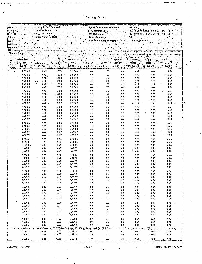
10,225.0 8.21 179.65 10,224.8 -4.9 _0_0 -UL. 1?:29 _12,00 . 0.00 J 3/20/2014 5:44:09PM Page 4 COMPASS 5000.1 Build 70

Planning Report
Database:' Company: '• Project:^ ;i > -Site:;.'',
W.0}.):''0:H Welibbre:| :ii [Design;:',!''.?''/1':
Houston R5000 Database Yates Petroleum
I Eddy, NM (NAD-83) ' '.
Haracz "Amp'
,#10H ' ' ; '
OH' ' : ...
,P;ari #2 .'..• '
Federal
i'llocaliCd^ordinaUiReference: i TAjpjReference:,'"*''' •' > » ' ' !,MDjReference:\( ' , , - > • • • ;
• j ,N6rthiRe'fe'reri^ ' [.Surye'yiCajculatio'n i'.
iuryeyiCaiculatidnfe
f . j . RKB @ 3'596.5usft('N6rnae,22 KB=21 ,;5')( \ ' RKB,@:3596.5usft(Nomac;22KB=
Grid '. . ',;; i . . , ; , ; , ' / •';' Minimum Gurvature'
'IRIanhed Suwey'f ^;": '• \ \ ,-T'.T'rTcr.'-ir-
.Mdasured , Depth '•'
°;:'i(usftj; \ Inclination
. (">
'} •« • ? Y'Vertical Azimuth * Depth
• n r -.'(usft).' ',*N/-'S-'(usft)
, +E/-W (usft)
Vertical (Section1
" (u's'ft)
'Dogleg
oousft)
I., Build ; Rate ; : ' •
(?/1 OOusft)
•V 'Turn'-' , ^ -Rate;.' r/IOOusft)*
10,250.0 11.21 179.65 10,249.4 -9.1 0.1 9.1 12.00 12.00 0.00 10,275.0 14.21 179.65 10,273.8 -14.6 0.1 14.6 12.00 12.00 0.00 10,300.0 ' 17.21 179.65 10,297.9 -21.4 0.1 21.4 12.00 • 12.00 0.00 10,325.0 20.21 179.65 10,321.5 -29.4 0.2 29.4 12.00 12.00 . 0.00
10,350.0 23.21 179.65 10,344.8 -38.6 0.2 38.6 12.00 12.00 0.00 10,375.0 26.21 179.65 - 10,367.5 -49.1 0.3 49.1 12.00 12.00 ' 0.00 10,400.0 29.21 179.65 10,389.6 -60.7 0.4 60.7 12.00 12.00' 0.00 10,425.0 32.21 179.65 10,411.1, • -73.5 0.4 73.5 12.00 12.00 0.00 10,450.0 35.21 179.65 10,431.9 '• -87.3 0.5 . 87.3 12.00 12.00 0.00
10,475.0 38.21 179.65 10,451.9 -102.3 0.6 102.3"^ 12.00 12.00 0.00 u 10,500.0 • 41.21 .„ 179.65 10,471.2 -118.3. * 0.7 118.3 12.00 12.00 0.00
10,525.0 44.21 179.65 10,489.5 -135.2 0.8 135.2 12.00 12.00. 0.00 10,550.0 47.21 179.65 10,507.0 -153.1 0.9 153.1 12.00 12.00 0.00 10,575.0 50.21 179.65 10,523.5 -171.9 1.0 ' 171.9 12.00 12,00 0.00
10,600.0 53.21 179.65 10,539.0 -191.5 1.2 191.5 12.00 12.00 0.00 10,625.0 56.21 179.65 10,553.4 -211.9 1.3 211.9 12.00 12.00 0.00 10,650.0 59.21 179.65 10,566.8 -233.0 1.4 233.0 12.00 12.00 0.00 10,675.0 62.21 179.65 10,579.0 -254.8 1.5 254.8 12.00 , 12.00 0.00 , 10,700.0 65.21 179.65 10,590.1 -277.2 1.7 277.3 12.00 12.00 0.00
10,725.0 68.21 179.65 10,599.9 -300.2 1.8 300.2 12.00 12.00 0.00 10,750.0 71.21 179.65 10,608.6 r323,7 2.0 323.7 12.00 12.00 0.00 10,775.0 74.21 179.65 J 10,616.0 -347.5 . 2.1 347.5 12.00 12.00 0.00 10,800.0 77.21 179.65 10,622.2 -371.7 , 2.2 371.7 12.00 12.00 0.00 10,825.0 80.21 179.65 10,627.1 -396.3 2.4 396.3 12.00 12.00 0.00
10,850.0 83.21 179.65 10,630.7 -421.0 2.5 421.0 12.00 12.00 0.00 10,875.0 86.21 179.65 10,633.0 -445.9 2.7 445.9 12.00 12.00 0.00 10,900.0 89.21 179.65 10,634.0 -470,9 2.8 470.9 12.00 12.00 0.00 10,910.4 90.46 179.65 10,634.0 -481.3 2.9 481.3 12.00 12.00 0.00
EOC: i0910!4' MD,j1jp_S34':0! TVD; 90 48f.'_!' VS* .;• ' ,11,000.0 90.46 179.65 10,633.3 -570.9 '3T4" o'.cb ' " o'bo 6.60
11,100.0 90.46 179.65 10,632.5 -670.8 4.1 670.9 0.00 0.00 0.00 11,200.0 90.46 179.65 10,631.7 -770.8 4.7 770.9 0.06 0.00 • 0.00 11,300.0 90.46 179.65 10,630.9 -870.8 5.3 870.9 0.00 0.00 0.00 11,400.0 , 90.46 179.65 10,630.1 , -970.8 5.9 . 970.8 0.00 0.00 0.00 11,500.0 90.46 179.65 10,629.3 -1,070.8 , 6.5 1,070.8 0.00 0.00 0.60
11,600.0 90.46 179.65 10,628.5 -1,170.8 7-1 , 1,170.8 ' 0.00 0.00 0.00 11,700.0 ' 90.46 179.65 10,627.8 -1,270.8 7.7 1,270.8 0.00 0.00 0.00 11,800.0 90.'46 179.65 10,627.0 -1,370.8 8.3 1,370.8 0.00 0.00 0.00 11,900,0 90.46 179.65 10,626.2 ' -1,470.8 8.9 1,470.8 0.00 0.00 0.00 12,000,0 90.46 179.65 10,625.4 -1,570.8 9.5 1,570.8 0.00 0.00 ' 0.00
12,100.0 90,46 179.65 10,624.6 -1,670.8 10.1 1,670.8 0.00 0.00 1 0.00 12,200.0 90.46 179.65 10,623.8 -1,770.8 10.7 1,770.8 0.00 0.00 0.00 12,300.0 90.46 179.65 10,623.0 -1,870.8 ,11.3 ' 1,870.8 0.00 0.00 0.00 12,400.0 90.46 179.65 10,622.2 -1,970.8 11.9 1,970.8 0.00 • 0.00 0.00 12,500.0 90.46 179.65 10,621.4 -2,070.8 12.5 2,070.8 0.06 0.00 0.00
12,600.0 90.46 179.65 10,620.6 -2,170.8 13.1 2,170.8 0.00 0.00 0.00 12,700,0 90,46 179.65 10,619.8 -2,270.8 13.7 2,270,8 0,00 0.00 0.00 12,800.0 90.46 179.65 10,619.0 -2,370.8 14.3 2,370.8 0,00 0.00 0.00 12,900.0 90.46 179.65 , 10,618.2 -2,470.8 14.9 2,470.8 0.00 0.00 0.00 13,000.0 90.46 179.65 10,617.4 -2,570.8 15.5 2,570.8 0.00 0.00 0.00
13,100.0 90.46 179.65 10,616.6 -2,670.7 16.1 2,670.8 0.00 0.00 0.00 13,200.0 90.46 179.65 10,615.8 -2,770.7 16.7 2,770.8 0.00 0.00 0.00 13,300.0 90.46 179.65 10,615.0 ' -2,870.7 17.3 2,870.8 0.00 0.00 0.00 13,400.0 90.46 179.65 10,614.2 -2,970.7 18.0 2,970.8 0.00 0.00 0.00
3/20/2014 5:44:09PM Page 5 COMPASS 5000.1 Build 70

Planning Report
Databa e < Company Project Site
Well Wellbore
Design * <
Houston R5000<Data_base" YatesiPetroleum ..'* • Eddy NM (NAD 83) iHaracz''Amov«Federal: #10H OH v
Plan #2
, ! ;LocaliGoTordinate Reference:i, irVDrReference
r A r ^ MD Reference
! iNorthiReference:..,v. •*»/•> tJSurvey.Calculation'Method." -
WelH#10H
iRKB;@.3596,;5usft"(Nbniac 22 K3=2'-.5') RKBi@ 3596 5u ft (Nomac 22 KB 21 5) Grid MtnimumtGunvature.-• • ••••< -„: .'•:•-; -
f t ; |
^ ~ ;—r-f " J j r . - T ' e — - r ' , ' ^ . . . : - : ' ' L~r .T i *
jRlanned:Survey •, ,«!*, I 1 Sr
Measured (Depth." ' Inclination 'Azimuth:"
Vertical .- Dopth
iy*.' ' (tl ft) . ...v. (u ft)
13,500.0 90.46 17965 10,613.4
13,600.0 90.46 179.65 10,612.6 13,700.0 • 90.46 ' 179.65 ' 10,611.8 13,800.0' 90.46 179.65 10,611.0 13,900.0 90.46 179.65 10,610.2 14,000.0 90.46 179.65 10,609.4
14,100.0 90.46 179.65 10,608.6 14,200.0 90.46 179.55 10,607.8
' 14,300.0 90.46 • 179.65 10,607.0 14,400.0 90.46 179.65 10,606.2 1*4,500.0 90.46 .179.65 " 10,605.4
14,600.0 90.46 179.65 10,604.6 14,700.0 90.46 179.65 10,603.8 14,800.0 90.46 179.65 10,603.0 14,900.0 90.46 179.65 10,602.2 15,000.0 90.46 179.65 10,601.4
15,100.0 90.46 1.79.65 10,600.6 15,179.2 90.46 179.65 10,600.0
+N/rS (u ft)
+E/W (u ft)
-Vertical! Section.. (u ft)
(Dogleg Rate
C/100u ft) - . ,v <::: J •• «U ••.
/Build • Rate'
Turn ,'Rate '
"MM
°/100u ft) (°/100u ft) t
-3,070.7
-3,170.7 -3,270.7 -3,370.7 -3,470.7 -3,570.7
-3,670.7 -3,770.7 -3,870.7 -3,970.7 -4,070.7
-4,170.7 -4,270.7 -4,370.7 -4,470.7 -4,570,7
18.6
19.2 19.8 20.4 '21.0 21.6
22.2 22.8 23.4 24.0 24.6'
25.2 25.8 26.4 27.0 27.6
3,070.8
3,170.8 3,270.8 3,370.8 3,470.8 3,570.8
3,670.8 3,770.8 3,870.8 3,970.8 4,070.8
4,170.7 4,270.7 4,370.7 4,470.7 4'570.7
0.00 0.00 0.00
0.00 0.00 0.00 0.00 0.00 0.00 0.00 0.00 0.00 0.00 0.00 o;oo 0.00 0.00 ' ' 0.00
0.00 0.00 0.00 0.00 0.00 0.00 0.00 0.00 . 0.00 0.00 0.00 0.00 0.00 '• 0.00 0.00
0.00 0.00 1 0.00 0.00 0.00 0.00 0.00 0.00 0.00 0.00 0.00 .0.00 0.00 0.00 0.00
0.00 0.00 0.00 0.00 0.00 0.00
? 'Cross 330'Hard1itW'i517^ : V ; ' *15,200.0 90.46~ ~" "179.65 76,:
15.279.2 90.46 179.65 10.599.2 10,599.?*
TD 15273.2 MD VHbiy\ TVD £
0.00 ' 0.00 0.00
^DesigniTargots*. • J T?« m — " r^..-.--'af- J-x-.— • " v ^
1 h "Or
TargetiName, 1 »•»,«. .-
hrtfmi target
Shape. . . . i ,
Dip Angle
n • . -, i i . .• -.',.
Dip Dir.
«(") 1
TVD
(u ft)
+N/ S
(u ft)
+E /W
(u ft) " r l f i ' . ' y r r l ' i ' • " 1 TI »
,''5»I'"'.*̂ '!v;"§ Northing
(u ft) ~ r t , ,, , " - , " t ' ' l " - 1 . " , : ; . , „ i .
^''5'S%¥? Ea ting (u ft)
f--. „ - t, „
P.'Q ,:. v- . ,>0,,'>' • „y
Lati tude ,
1 1
Longitude ,
PBHL (Haracz "Amo" Fe 0.00 - plan hits target center - Point
• -o.oo 10,600.0 -4,749.8 28.7 435,759.98 729,485.70 32° 11'47.467 N 103° 43' 30.304 W
Plan Annotations / Tr-r-r^"^ ' ' j^ K ' ' J ̂ i^uV^ T**, . - I
Mea ured
Depth
(u ft)
Vertical
Depth
(u ft) *
Local Coordinate
+N/S f +E /W 4
(u ft) J (u ft)
10.156.6 10.156.6 0.0 0.0 10,156.6 10,156.6 0.0 0.0
10,910.4 10,634.0. -481.3 2:9
. 15,179.2 • 10,600.0 -4,749.8 28.7
15,279.2 10,599.2 -4,849.8 29.3
5r'||;.;i.:'
Comment
Proposed KOP: 10156.6' MD. 101 Build at 127100ft to'90.46° INC @ EOC: 10910.4' MD, 10634.0' TVD Cross 330' Hardline: 15179.2' MD, TD: 15279.2' MD, 10599.2' TVD
56.6' TVD ) 179.65" AZ , 90.46° INC, 179.65° AZ, 481.3'VS 10600.0'TVD
3/20/2014 5:44:09PM Page 6 COMPASS.5000.1 Build 70

Conditions of Approval
Contingency DV tool at 2500-3000'
1. The minimum required fi l l of cement behind the 9-5/8 inch intermediate casing is:
a. First stage to DV tool:
^ Cement to circulate. If cement does not circulate, contact the appropriate BLM office before proceeding with second stage cement job. Operator should have plans as to how they will achieve circulation on the next stage.
b. Second stage above DV tool:
^ Cement to surface. If cement does not circulate, contact the appropriate BLM office.