Embed Size (px)
Citation preview


(i)
CONTENTS
Sl. No. Description Page Nos.
ENVIRONMENTAL SCREENING AND PRELIMINARY ENVIRONMENTAL ASSESSMENT
EXECUTIVE SUMMARY Es-i to Es-xii
1. INTRODUCTION 1-1 to 1-4
1.1 General 1-1
1.2 Background 1-1
1.3 Project Road 1-1
1.4 Objectives of the Study 1-2
1.5 Scope of the Study 1-3
1.6 Structure of the Report 1-3 to 1-4
2. PROJECT DESCRIPTION 2-1 to 2-13
2.1 General 2-1
2.2 Need and Objective 2-1
2.3 Location 2-1
2.4 Project Intervention 2-3
2.5 Construction Materials 2-6
2.6 Salient Features 2-9
2.6.1 Road Condition 2-9
2.6.2 Carriageway 2.6.3 Hydrological Investigations
2-10 2-10
2.6.3 Pavement 2-11
2.6.4 Utilities 2-11
2.6.5 Summary of Salient Features of Project Road 2-11
2.7 Legal Framework 2-12 to 2-13
3. DESCRIPTION OF THE ENVIRONMENT 3-1 to 3-22
3.1 Introduction 3-1
3.2 Physical Settings 3-1
3.2.1 Site and Situation 3-1
3.2.2 Physiography 3-1
3.2.3 Geology 3-2
3.2.4 Seismology 3-3
3.2.5 Soil 3-3
3.2.6 Land Use Pattern 3-3

(ii)
Sl. No. Description Page Nos.
3.3 Climate 3-4
3.3.1 Temperature 3-4
3.3.2 Wind 3-4
3.3.3 Rainfall 3-5
3.3.4 Relative Humidity 3-7
3.3.5 Cloud Cover 3-7
3.3.6 Natural Disaster/ Hazard 3-7
3.4 Water Resources 3-8
3.4.1 Surface Water 3-9
3.4.2 Ground Water 3-10
3.4.3 Cross Drainage Structure 3-12
3.4.4 Water Quality 3-12
3.4.5 Inundation 3-14
3.5 Air Quality 3-15
3.6 Noise 3-16
3.7 Ecological Resources 3-16
3.7.1 Flora 3-16
3.7.2 Fauna 3-18
3.8 Socio-Economic/ Cultural Environment 3-18
3.8.1 Population 3-19
3.8.2 Settlement and Properties 3-19
3.9 Road Safety 3-21
3.10 General Economic Environment 3-21
3.11 Mineral Resources 3-21 to 3-22
Annexures 3.1 to 3.11 A-1 to A-38
4. ANTICIPATED ENVIRONMENTAL IMPACTS AND MITIGATION MEASURES
4-1 to 4-16
4.1 Introduction 4-1
4.2 Impacts on Physical Environment 4-1
4.2.1 Impact on Topography 4-1
4.2.2 Impact on Geology 4-1
4.2.3 Impact on Meteorology 4-2
4.2.4 Impact on soil 4-2
4.3 Impact on Land Use Pattern 4-4

(iii)
Sl. No. Description Page Nos.
4.4 Impact on Water Environment 4-4
4.4.1 Impact on Surface water quality 4-4
4.4.2 Impact on Ground Water 4-6
4.5 Impacts on Air Environment 4-6
4.6 Impact on Noise Environment 4-7
4.7 Impact on Ecological Resources 4-10
4.7.1 Flora 4-10
4.7.2 Fauna 4-10
4.8 Impact on Cultural Environment 4-10
4.9 Impact on Socio - Economic Environment 4-10
4.10 Visual and Aesthetic Impact 4-11
4.11 Impact on Public Health and Road Safety 4-11
4.12 Impact on Human Use Values 4.13 Impact Mitigation Matrix
4-12 4-12 to 4-16
5. ANALYSIS OF ALTERNATIVES 5-1 to 5-2
5.1 General 5-1
5.2 “With” and “Without” Project Scenario 5-1
5.3 Analysis of Alternatives 5-1 to 5-2
6. ENVIRONMENTAL MONITORING PROGRAMME 6-1 to 6-14
6.1 Monitoring Program Objectives 6-1
6.2 Environmental Reporting System 6-8
6.3 Environmental Cost 6-9 to 6-14
Annexures 6.1 to 6.3 A-1 to A-7
7. ADDITIONAL STUDIES 7-1 to 7-8
7.1 Public Consultation 7-1
7.1.1 Objectives 7-1
7.1.2 Levels of Consultation 7-2
7.2 Findings of Public Consultation and Interview Surveys 7-4
7.3 Consultation with Project Authorities 7-6
7.3.1 List of officials Consulted on Environmental Issues 7-7 to 7-8
7.4 Continued Consultations and Participation 7-8

(iv)
Sl. No. Description Page Nos.
8. PROJECT BENEFITS 8-1 to 8-2
8.1 General 8-1
8.2 Direct Benefits 8-1
8.2.1 Economic Development 8-1
8.2.2 Employment Opportunity 8-1
8.2.3 Reductions in Accidents, Morbidity and Mortality 8-1
8.2.4 Reductions in Operating Cost 8-1
8.2.5 Environmental Benefits 8-2
8.3 Indirect Benefits 8-2
9. ENVIRONMENTAL MANAGEMENT PLAN 9-1 to 9-32
9.1 Introduction 9-1
9.2 Design Phase 9-1
9.3 Construction Phase 9-2
9.3.1 Land Environment 9-2
9.3.2 Air Quality and Noise 9-2
9.3.3 Water Resources 9-3
9.3.4 Flora 9-4
9.3.5 Fauna 9-4
9.3.6 Safety 9-5
9.4 Operation Phase 9-7
9.5 Issues Considered in Road Construction 9-7
9.5.1 Road Service Facilities 9-8
9.5.2 Workers’ Camps 9-8
9.6 Environment Management Plan Matrix 9-8
9.7 Environmental Enhancements 9-29
9.8 Environmental Budget 9-29 to 9-32
Annexures 9.1 to 9.6 A-1 to A-25

Feasibility for Six Laning of Ahmedabad-Vadodara Section of NH-8 to be Executed as BOT (Toll) Project on DBFO Pattern Under NHDP Phase-V
Draft Environmental Impact Assessment Report Es - i
EXECUTIVE SUMMARY
0.1 INTRODUCTION National Highways Authority of India (NHAI) has been entrusted with the implementation of NHDP Phase-V which involves six laning of 6500 km of National Highways comprising 5700 km Golden Quadrilateral and 800 km of other National Highways. The Ahmedabad-Vadodara road corridor is a part of Delhi-Mumbai leg of Golden Quadrilateral corridor. This section of NH-8 from Ahmedabad to Vadodara in the State of Gujarat is proposed to be taken up for six laning under NHDP Phase-V. The project is proposed to be implemented under Public Private Partnership (PPP) mode and executed as Design, Build, Finance and Operate (DBFO) contracts.
0.2 PROJECT ROAD The project road is part of NH-8 passing through Gujarat State and starts from Ahmedabad (km 6.400) and ends near Vadodara town at the junction of Ahmedabad-Vadodara Expressway and NH-8 (km 108.700). The project road passes through the districts of Ahmedabad, Kheda, Anand and Vadodara in Gujarat State.
This section of exiting NH-8 is parallel to the Ahmedabad-Vadodara Expressway. Four laning of some sections of this National Highway was carried out in the past in phases, according to the priority, traffic level and availability of funds. Therefore it has different configuration of cross sections. The existing road has four lane divided carriageway in an aggregate length of 33.80 km length (including approaches to junctions), four lane carriageway without median in an aggregate length 8.6 km and two lane carriageway in 60.0 km length.
A two lane major bridge over river Vartak along with its approaches (km 33.430 to km 42.180) which forms Kheda Bypass constructed on BOT basis is also a part of the project road. Fig. Es 1 shows the map depicting the location of project road.
0.3 PROJECT INTERVENTION
The proposed improvement will aim at improving riding quality and journey speed and reducing traffic congestion on the highway. The options of concentric widening and left or right side widening have been considered for the improvement project so as to utilize the existing right-of-way (ROW) as far as possible and to save the religious / community properties along the road. The carriageway width of this section of NH-8 for major portion of length is of two lane standard with paved shoulders on both sides and the balance length is of four lane standard. There is no median or divider in some section of the four lane carriageway. Otherwise, the four lane section has either divider or median in the balance length. Summary of salient features of the road has been summarized in Table Es 1.

Feasibility for Six Laning of Ahmedabad-Vadodara Section of NH-8 to be Executed as BOT (Toll) Project on DBFO Pattern Under NHDP Phase-V
Draft Environmental Impact Assessment Report Es - ii
Fig. Es 1: Index Map
Table Es 1: Summary of Salient Features of Project Road
S. No. Features Details
1. Existing Chainage Project road starts from km 6.4 of existing NH-8 from Ahmedabad Bypass and ends at km 108.700 of NH-8 near Vadodara town at the junction of Ahmedabad- Vadodara Expressway
2. Length (Km) 102.300 Km.
3. Improvement Six laning of existing NH-8 Section between Ahmedabad and Vadodara
4. Village/Towns. Narol, Aslali, Jetalpur, Kheda, Nadidad and Anand are the major settlements.
5. Rivers Meshow, Vatrak, Mahi and Mini
6. Existing Bridges 4 Major Bridges and 12Minor Bridges
7. Culverts Existing 170 Nos.
8. Trees on ROW Total: 39,590 No. ( including 5,007 Nos. on Kheda Bypass)

Feasibility for Six Laning of Ahmedabad-Vadodara Section of NH-8 to be Executed as BOT (Toll) Project on DBFO Pattern Under NHDP Phase-V
Draft Environmental Impact Assessment Report Es - iii
0.4 ENVIRONMENTAL IMPACT ASSESSMENT OF THE PROJECT
The Environmental Impact assessment comprised of collection of environmental baseline conditions in the project area, identification of potential negative environmental impacts and their feasible remedial measures (including avoidance, mitigation and enhancements) and Environmental Management Plan
0.5 THE STUDY METHODOLOGY
The Environmental impact assessment in this project has an approach in which potential environmental impacts have been examined at successive levels of detail and specificity at each step in the process. Following is the methodology used:
• Collection and review of the documents and legal policies.
• Defining scope of work and project influenced study area as per the MoEF EIA guidelines for Highway project.
• Collection of secondary data.
• Generation of primary data - field surveys, public consultation, strip planning, tree counting.
• Documentation of secondary & primary data and defining the Environment.
• Analysis of alternatives.
• Assessment of potential impacts followed by identifying possible mitigation measures.
• Preparation of Environmental Management Plan (EMP)
0.6 POLICY, LEGAL AND ADMINISTRATIVE FRAMEWORK
Review of the existing legislation, institutions and policies relevant to the Environmental Impact Assessment at the National and State levels has been done and clearance requirements for the project at various stages of the project have been identified.
Environmental Clearance
As per the EIA Notification of 14th September 2006, all new National Highway projects and expansion of national highway projects greater than 30 km and involving additional right of way greater than 20 m involving land acquisition and passing through more than one state will be categorised as Category A project and will require Environmental Clearance from MoEF. All state highway projects and expansion of national/state highway projects greater than 30 km and involving additional right of way greater than 20 m involving land acquisition will be categorised as Category B project and will require Environmental Clearance from the State Impact Assessment Authority. The proposed project is a modification/up-gradation of existing 2/4 lanes to 6 lanes. The available ROW is generally 45m and at some locations it is more. The proposed ROW is 60m in most of stretches however; the proposed ROW is more than 100 m at all junctions (because of junction improvements). Thus the proposed project road falls under ‘Category A’ as per EIA Notification 2006 and subsequent amendments and thus requires prior Environmental Clearance from Ministry of Environment and Forests. Tree felling permission would be required to be taken for cutting of trees that are existing within the proposed ROW. Also permission will be required to be taken from State Forest Department for land diversion of notified protected forest area.

Feasibility for Six Laning of Ahmedabad-Vadodara Section of NH-8 to be Executed as BOT (Toll) Project on DBFO Pattern Under NHDP Phase-V
Draft Environmental Impact Assessment Report Es - iv
The requirement of obtaining the clearances from authorities at the state level for the project is indicated in Table Es 2.
Table Es 2: Clearance Requirement for the Present Project
S. No. Activity Statutory Authority Relevant Statute
1. Permission for sand mining from river bed
Department of mining, Govt. of Gujarat. The Collector of the district will grant short-term mining lease.
Gujarat Minor Minerals Rules, 1966
2. Setting of hot mix plants, crushers and batching plants
Gujarat Pollution Control Board
Air (Prevention and Control of Pollution) Act, 1981 and the Noise Pollution (Regulation and Control) Rules, 2000
3. Establishment of workers camp, equipment and storage yards
Gujarat Pollution Control Board
Environment Protection Act, 1986 and Manufacturing, Storage and Import of Hazardous Chemicals Rules, 1989
4. Storage, handling and transport of hazardous materials
Gujarat Pollution Control Board
Hazardous Waste (Management and handling) Rules, 1989 and Manufacturing, Storage and Import of Hazardous chemical Rules, 1989
5. Waste water discharge from labour camps
Gujarat Pollution Control Board
Water (Prevention and Control of Pollution) Act, 1974
6. Disposal of bituminous wastes
Local Civil Body to identify solid waste disposal sites
Hazardous Waste (Management and Handling) Rules, 1989
7. Opening up new quarries
Department of Commerce and Industries, Govt. of Gujarat
Mines and Minerals (Regulation and development) Act, 1957 as amended in 1972
8. Tree felling and removal from non-forest areas
District Level Committee constituted by the State Govt. and chaired by the District Collector
Procedural Guidelines developed by the Department of Environment, under the orders of the Hon’ble High Court; Tree removal will be guided as per state government rules.
0.7 DESCRIPTION OF ENVIRONMENT
As defined in the scope of works, baseline data on various physical, biological and social aspects has been collected, analyzed and compiled in order to get the picture of the existing environment condition in the project area.

Feasibility for Six Laning of Ahmedabad-Vadodara Section of NH-8 to be Executed as BOT (Toll) Project on DBFO Pattern Under NHDP Phase-V
Draft Environmental Impact Assessment Report Es - v
0.8 PHYSICAL RESOURCES
Topography
The project road passes through plain terrain. It can be observed that altitude in the project area varies from 150m to 300m. Major stretches of the project road lie in the western alluvial plains.
Geology
The project road passes through Holocene sediments represented by “Flood plain deposits” lithological unit of Katpur formation1
Ahmedabad
.
The project area comprises of a thick cover of alluvium with few sporadic outcrops of deccan traps and limestone. The area is almost flat covered by brown sand and clayey soil.
Soil Type
The soil in different stretches of project road (passing through Ahmedabad, Kheda, Anand and Vadodara districts) is as follows:
2
Kheda
: Fine loamy and mixed soil with slight to moderate salinity. 3
Vadodara
: Very deep, well drained, calcareous, fine to coarse, loamy soil on gently sloping dissected flood plain, level flood plain and alluvial plain.
4
• Waterway for bridges: 50 Years
: Fine-loamy, mixed calcareous soil.
Surface Water
The major surface water bodies intersecting the project highway include Meshow, Vatrak River, Mahi River and Mini River at chainage Km 30.800, Km 35.200, Km 92.400 and Km 97.700 respectively. Also the project road crosses canals at many locations. The water quality parameters measured in the past at Vatrak and Mahi river sections along the project road showed values within permissible limits except for Coliforms. It is observed that Mahi River is minimally polluted and Coliform concentrations in River Vatrak indicate sewage pollution of the river.
The proposed project area comes under Sub zone 3(a) for Mahi and Sabarmati Basin. Determination of Design Discharges has been done in line with the IRC codal stipulations. The Return Period Flood adopted in design is as follows.
• HFL for Bridges: 50 Years • Scour for foundation design: 50 Year Flood multiplied by suitable factor • Design of Roadside Drains/Culverts: 25 Years (both for rural and urban areas)
Ground Water
Water quality along the project road is good as reported by the local communities. Water from ground water resources is suitable both for drinking and irrigation purposes. Ground water quality monitoring results are indicative that there is no cause for concern. The
1 Source: District Resource Map, Ahmedabad and Gandhinagar Districts, Kheda District and Vadodara
District published by Geological Survey of India, 2002 2 Source: District Resource Map, Ahmedabad and Gandhinagar Districts published by Geological
Survey of India, 2002 3 Source: District Resource Map, Kheda District published by Geological Survey of India, 2002 4 Source: District Resource Map, Vadodara District published by Geological Survey of India, 2002
Feasibility for Six Laning of Ahmedabad-Vadodara Section of NH-8 to be Executed as BOT (Toll) Project on DBFO Pattern Under NHDP Phase-V
Draft Environmental Impact Assessment Report Es - vi
ground water quality is good as reported by the local residents and the same is confirmed by the analytical tests carried out on some groundwater sources along the project area in the past.
It was observed that all the monitored parameters in the past are within the permissible limits specified for drinking water except for Total Dissolved Solids (TDS) at Dashrath Village in Vadodara District indicating presence of dissolved minerals in groundwater in the region. As per Central Ground Water Board reports the net annual groundwater availability for the state of Gujarat is 15.02 BCM (Billion Cubic Meters) , annual groundwater draft is 11.49 BCM and the stage of groundwater recharge is 76%. The alluvial plains in the project area provide better conditions for the recharge of groundwater. Climate
The climate of this region is characterized by a hot summer and dryness in the non rainy seasons. Climate in a year may be divided into four seasons. The cold season from December to February is followed by the hot season from March to May. The south west monsoon season is from June to September while the months of October and November form post monsoon season.
Temperature
The period from March to May experiences continuous increase in temperature. May is generally the hottest month. The weather is intensely hot in summer. With the onset of monsoon by about mid-June there is appreciable drop in day temperature but nights are as warm as nights during summer . With the withdrawal of the monsoon by about the end of September, there is slight increase in the day temperatures and secondary maximum in day temperature is reached during October. However the nights become progressively cooler. From November, both day and night temperatures begin to decrease rapidly. January is generally the coldest month.
Humidity
During south-west monsoon season the humidity is generally high. Rest of the year the air is comparatively drier. The driest part of the year is summer season when the relative humidity in the afternoons is less than 25%.
Cloud Cover
During south-west monsoon season, the skies are generally cloudy or overcast. Rest of the year, the skies is mostly clear or lightly clouded.
Wind
Winds are generally light and moderate in summer. They become stronger when westerly to south-westerly winds prevail during the south-west monsoon season. In October winds are from west and north east. In November and December winds are mainly from north–east direction. In January and February winds are again from west and north-east directions. In the summer season the winds are pre-dominantly from south-west and north-west direction.
Natural Disaster Hazard
Gujarat state is highly prone to multi hazards due to its geographical positioning, close proximity to sea, arid and semi arid nature, presence of big rivers and presence of large number of chemical industries. According to seismologists, 23% of area in Gujarat lies in seismic zone V with a probable intensity of 6 to 9 on Richter scale. Almost 75% of the

Feasibility for Six Laning of Ahmedabad-Vadodara Section of NH-8 to be Executed as BOT (Toll) Project on DBFO Pattern Under NHDP Phase-V
Draft Environmental Impact Assessment Report Es - vii
remaining area lies in seismic zone III and IV showing moderate to high damage risks of earthquake. The state has the longest coastline (1600 km) in India and it falls in the region of tropical cyclones generated in the Arabian Sea and most of project road area is in flood zone.
Gujarat is also one of the fastest growing states of India with a rapid spurt in growth of chemical industries. Gujarat has a very high level of exposure to chemical hazard risks. The area from Mehsana to Vapi is heavily industrialized and popularly known as Golden Corridor (from economic point of view). Besides, there is also a possibility that the natural hazards and chemical hazards will collide, aggravating the human and economic impact.
Land Use Pattern
The land use pattern of the project area is mainly agricultural land followed by settlements, industrial and commercial areas.
Air Quality
Ambient air quality of the study area is good as reported by the local people. The air quality parameters (PM2.5, PM10, SO2
Noise Level
and NOx ) measured in the past at various locations along the project road showed values within permissible limit.
Noise is not a major problem in the study area except at market places and congested areas of major towns and the monitored data were within permissible limits.
0.9 ECOLOGICAL RESOURCES
The project area passes through vegetation cover of uniformly distributed trees along the road. Tree inventorisation within the proposed ROW revealed that there are about 39,590 trees (including 5,007 Nos. on Kheda Bypass) comprising of Azadirachta Indica (Neem), Acacia Nilotica (Desi Bawal), Prosopis Juliflora (Gando bawal), Eucalyptus Globulus (Nilgiri), Mangifera Indica (Mango), Phyllanthus emblica (Amla), Syzygium cumini (Jamun), Cassia Fistula (Amaltas) which are likely to be affected due to the widening activity. Some of the trees along the existing chainages are mature with good girth size.
Protected Forest/ Reserved Forest
The entire stretch of trees along the project road is classified as protected forest as per Gujarat Government Gazette dated July 5, 1973. Reportedly, the plantation was carried out by Social Forestry Division of the Forest Department in phases. There is no reserved forest within 10 km distance on either side in the entire stretch of the project highway.
Wildlife and Bio-diversity
Project road does not pass through any National Park/Wild Life Sanctuary. Domesticated animals constitute the major proportion of faunal density in the area surrounding the project highway. No endangered species has been reported in the area. No endangered species of avian fauna has been recorded in the influence zone of the proposed project. No wildlife has been found during the field visit. Some of the common species of fauna in the project area includes Monkey, Nilgai, Jackal, Wild Cat etc.
0.10 SOCIO CULTURAL ENVIRONMENT
The project highway traverses through 48 number of villages/ settlements and is often dotted with religious and cultural properties, which though not of archaeological significance are nevertheless, very significant to the community. Cultural properties along the project highway were identified and documented based on site surveys. Agriculture

Feasibility for Six Laning of Ahmedabad-Vadodara Section of NH-8 to be Executed as BOT (Toll) Project on DBFO Pattern Under NHDP Phase-V
Draft Environmental Impact Assessment Report Es - viii
continues to be the primary occupation of the majority of people along the project road. The main crops grown in the area are rice, jowar, bajra, wheat and maize.
Archaeological and Cultural Sites
There are Archeological Sites located within 15 Km from the project road. However the impacts due to the project road on these are insignificant.
Industries
Many industrial units are located along the project road with the prominent ones being cold storage units, auto-parts related and transport companies. A total of about 140 industrial units are located along the project road.
0.11 PUBLIC CONSULTATION
Community consultations were held with Project Affected Persons (PAPs), other stakeholders and the general public to determine their views about the proposed road and incorporate their suggestions while finalizing the alignment. Village level consultations were held at the villages of Bareja, Jetalpur, Kheda Chowkdi, Dabhan, Aslali, Dumaral, Dashrath and Padamala. The people were generally in favour of construction of the road, as it would reduce traffic congestion, increase safety and improve socio-economic status of the area. On the basis of community consultations following recommendations have been made:
• Compensatory plantation of trees; as per state forest department for each tree removed in accordance with state guidelines.
• Adoption of stringent control measures for air and noise pollution during construction and operation particularly near settlements and junctions.
• Provision of adequate cross drainage structures.
• Prevention of deterioration in surface water quality through sediment control and adoption of a protocol for material handling & storage.
• Safety measures at work site through traffic management and provision of personal protective equipment for work force.
• Protecting sensitive receptors like schools and hospitals close to ROW from high noise level.
• Impacting minimum number of cultural properties like temples/shrines coming close to ROW.
• Employment of local labour during construction stage. • Provision of pedestrian/cattle underpasses at needed locations
0.12 ANALYSIS OF ALTERNATIVES
An analysis of “With” and “Without” Project scenario reveals that the positive impacts outnumber the negative impacts due to the proposed development. The negative impacts are envisaged only during the construction period which will be limited, time-bound and restricted to construction stage only. Further mitigation measures will be adopted to limit the impacts during the construction phase.
The proposed expansion will aid in infrastructure development and will act as a catalyst to boost the economic progress. It was revealed during discussions with various stakeholders that after the operation of the expressway between Ahmedabad and Vadodara, the traffic has reduced considerably on NH 8 and this has affected the economic growth. The commercial activities along the project road have witnessed decline in sales and this has also affected some small handicraft units whose business thrived solely on commuters plying on the highway. With the proposed expansion which

Feasibility for Six Laning of Ahmedabad-Vadodara Section of NH-8 to be Executed as BOT (Toll) Project on DBFO Pattern Under NHDP Phase-V
Draft Environmental Impact Assessment Report Es - ix
will ensure smooth traffic, it is envisaged that commercial establishments will revive their business and this will inturn boost the economic development.
0.13 IMPACT ON ENVIRONMENTAL RESOURCE Impacts on environmental parameters and proposed mitigation measures are detailed in the matrix at Table Es 3.
Table Es 3: Summary Impact Mitigation Matrix
Subject Potential Impact Mitigation Measures Physical Environment
Topography Impacts very low, but permanent.
No mitigation measure is required.
Geology Impacts low level through removal of stones aggregate and sand from identified quarries.
No mitigation measure is required.
Soils • Physical & chemical contamination of soil.
• Compaction and structural damage.
• Soil erosion.
• Dumping of construction waste at approved locations protected by berms.
• Reuse of construction waste. • Storage of construction
material in accordance with the IRC norms.
• Avoiding work during periods of heavy rainfall.
• Rehabilitation of borrow area for productive use.
• Conservation of topsoil for reuse in planting pits and rehabilitation of borrow areas, sodding /grass turfing and implementation of soil erosion control plan.
• Provision of silt fencing and sedimentation traps
Climate
Temperature/Rainfall/Humidity
Low spatially restricted short-term impact.
• No mitigation measure is required.
Land
Loss of Productivity • Land will be diverted for this project including agricultural land affecting productivity at the micro-level. Impact significant at micro level and insignificant at macro-level.
• Payment of compensation for loss of lands under agriculture.
Induced Development • Insignificant change in • Civil authorities to plan and

Feasibility for Six Laning of Ahmedabad-Vadodara Section of NH-8 to be Executed as BOT (Toll) Project on DBFO Pattern Under NHDP Phase-V
Draft Environmental Impact Assessment Report Es - x
Subject Potential Impact Mitigation Measures the land use pattern guide any induced
development using the prevailing regulatory framework.
Water Environment Surface water • 3 rivers and 19 ponds
will be impacted due to the project.
• Degradation of some water quality parameters like pH, COD, BOD, TDS, Turbidity etc.
• No impact on availability.
• Use of sediment traps, silt fencing sodding grass turfing, etc. for minimization of soil movement, use of cofferdams for construction of abutments and bridge pier. Cofferdams to be made of such material that cannot be brought into suspension by flowing waters.
• Minimization of disturbance of stream substrate to only that necessary for placing abutments or piling.
• Tarpaulins or other catchment devices will be slung under the bridge to prevent entry of debris, wastes and toxic items into the stream
• Provision of adequate cross drainage structures.
• Implementation of a protocol for storage of topsoil construction waste away from water sources.
• Location of onsite refueling station away from water resource.
• Use of oil/water separators to extract floating.
• Avoidance of lead-based paints in painting components of the bridge
• Monitoring of water quality during construction and operation.
Ground water quality • 3 wells, 4 borewells and 4 hand pumps are located along the existing road within the 50 m from the central line on either side of the road.
• Not very significant
• Out of these water sources a few numbers will be impacted due to eccentric and concentric widening of the road.
• Relocation of impacted ground water facility in consultation with

Feasibility for Six Laning of Ahmedabad-Vadodara Section of NH-8 to be Executed as BOT (Toll) Project on DBFO Pattern Under NHDP Phase-V
Draft Environmental Impact Assessment Report Es - xi
Subject Potential Impact Mitigation Measures impact on quality and no impact on availability.
communities. • Provision of separate water
facilities for construction camp.
• Provision of rainwater harvesting structures every 500 m along project road in Vadodara(15 Km stretch) and Ahmedabad (16 km stretch) Districts.
Environment Air • Increased gaseous
pollution along with fugitive dust emissions.
• Asphalt plant, Crusher, Batching Plant, will be sited 1000 m in down wind direction from nearest settlements.
• Vehicles and construction equipments to be maintained properly; to maintain PUC certificate.
• Transportation and delivery construction materials & waste properly covered to avoid spills & dispersion.
• Construction of wind breaking walls near stone crusher units will avoid dust laden air travelling to built-up areas and sensitive locations.
Noise • Construction phase impact low to moderate spatially restricted and reversible.
• During operation phase beneficial impact in the initial phase and persistence of such beneficial impact will depend on the future traffic volume & quality of maintenance of road.
• Construction plant & machinery to be located 1 Km away from settlements.
• Displacement of people and demolition of structures will be avoided to the extent possible.
• Construction vehicles and equipments fixed or mobile to be equipped and maintained with effective muffler system.
• Proper Traffic management near sensitive receptors.
• Putting up “ no horn” signage near sensitive receptors.
• Provision of earplugs to workers.
• Noisy construction to be restricted during the hours between 7 am and 7 pm.

Feasibility for Six Laning of Ahmedabad-Vadodara Section of NH-8 to be Executed as BOT (Toll) Project on DBFO Pattern Under NHDP Phase-V
Draft Environmental Impact Assessment Report Es - xii
Subject Potential Impact Mitigation Measures • Provision of sound screens
near sensitive receptors during construction phase.
• Provision of noise barriers near sensitive receptors during operation phase.
Ecology Flora There are about 39,590
trees (including 5,007 Nos. on Kheda Bypass).
• Compensatory plantation, along roadside; two trees be planted for each trees removed as per State Government guideline.
Fauna The project road passes through Protected forest area along the entire stretch but no endangered /rare species was reported during the field visit.
• No mitigation measures required. Construction workers will be made aware about the provision of the Wild life (Protection) Act 1972 as forest areas come within the area of indirect influences in some stretches.
Socio Environment Socio Environment
• Displacement of people.
• Demolition of Structures.
• Acquisition of agricultural land.
• Influx of construction workers.
• Resettlement of people as per provisions of RAP.
• Displacement of people and demolition of structures will be minimized to the extent possible.
• Compensation for loss of structures - private, community and public will be provided.
• Compensation for loss of land under agriculture will be provided.
• Ensure employment of local labour in unskilled and semi skilled sector.
• Setting up migrant workers camp at least 1 Km away from settlements.
Archeological Monuments / Historical structure.
• There are archeological monument present in immediate COI
• No mitigation measure required.
Religious Structures/cultural property
• There are a total of 116 religious structures along the ROW out of which a few may get impacted.
• May avoid such condition by relocation of impacted structure in consultation with the community.
• Through eccentric and concentric widening

Feasibility for Six Laning of Ahmedabad-Vadodara Section of NH-8 to be Executed as BOT (Toll) Project on DBFO Pattern Under NHDP Phase-V
Draft Environmental Impact Assessment Report Es - xiii
Subject Potential Impact Mitigation Measures
Public Health and Road Safety
Public health and road safety • Psychological impacts of project affected people.
• Migration of worker may lead to sanitation problem creating congenial condition for disease vectors.
• Discomfort arising of air and noise pollution.
• Hazard of accidents.
• Continued consultation with PAPs and the competent authority for speedier settlements of appropriate compensation package and resettlement.
• Ensure sanitary measures at construction camp to prevent water borne diseases and vector borne diseases.
• Provide appropriate personal protective equipments like earplugs, gloves gumboots, and masks to the work force.
• Safe traffic management at construction area.
0.14 ENVIRONMENTAL MONITORING AND MANAGEMENT PLAN
Environmental Monitoring and management Plan ensures that the environmental mitigation measures and enhancement programme are properly implemented and the responsibility for implementation is clearly demarcated. Monitoring of environmental quality during construction and during operation reflects the success of implementation of the mitigation measures. Monitoring will be conducted by the project authority with the help of an independent monitoring laboratory approved by MOEF/CPCB Monitoring parameters, locations and frequency for air, water, noise quality testing have been suggested. Monitoring of survival rate of plantations also has been suggested.
An environmental budget for Rs. 9, 23, 47,500 (Rupees Nine Crores Twenty Three Lacs Forty Seven Thousand and Five Hundred Only) has been drawn up. This provides for compensatory plantation, enhancement of sites, and cost of monitoring. This amount has been integrated into the budget
0.15 CONCLUSIONS
The proposed expansion will aid in infrastructure development and will act as a catalyst to boost the economic progress of the state. It was revealed during discussions with various stakeholders that after the operation of the expressway NE-1 between Ahmedabad and Vadodara, the traffic has reduced considerably on NH 8 and this has affected the economic growth in the region. Commercial activities along the project road have witnessed decline in sales and this has also affected some small handicraft units whose business thrived solely on commuters plying on the highway. With the proposed expansion which will ensure smooth traffic, it is envisaged that commercial establishments will revive their business and this will in turn boost economic development.
With best management practices and a proper environmental management & monitoring plan in place during construction and operation stages, the proposed project is not expected to cause any adverse effects on the surrounding environment.
• • •

Feasibility for Six Laning of Ahmedabad-Vadodara Section of NH-8 to be Executed as BOT (Toll) Project on DBFO Pattern Under NHDP Phase-V
Draft Environmental Impact Assessment Report 1 - 1
1. INTRODUCTION
1.1 GENERAL
Gujarat is accelerating towards the process of urbanisation and modernisation due to the fast growing economy of the State. Besides being a major manufacturer of pharmaceuticals, dyes, chemicals and textile, Gujarat also has huge resources of petroleum deposits with it and is a major producer of petrochemicals as well. Gujarat caters to a vast hinterland, which constitutes 35% of India’s exports. In today’s scenario, Gujarat has made up plans to become one of the major players in the global IT sector too. Growing industrialization of the State and increasing needs of the people for better quality of life has put tremendous pressure on the existing infrastructure in the State. Hence, there is a need to balance the process of urbanisation with the proper development of urban infrastructure in an integrated manner.
Data available from Statistical Abstract of Gujarat State, 2008 shows that the total road length in Gujarat in the year 2006 was 74038 km (this included 71183 km of surfaced roads and 2855 km of un-surfaced roads). The road length per 100 sq. km. in year 2006 was 38 km.
The development of road and highways provides a major impetus to development. Improved and efficient road facilities help in the development of the hinterland. It is also a fact that well developed and properly maintained roads reduces the overall accident rate, air pollution, noise pollution, travel time, fuel consumption and at the same time provides a quick and safe access to the markets.
1.2 BACKGROUND
NHDP Phase-V is for six laning of 6500 km of National Highways comprising 5700 km of Golden Quadrilateral and 800 km of other National Highways. National Highways Authority of India (NHAI) has been entrusted with the implementation of inter-alia, NHDP Phase-V. The Ahmedabad-Vadodara road corridor is a part of Delhi-Mumbai leg of Golden Quadrilateral corridor. This section of NH-8 from Ahmedabad to Vadodara in the State of Gujarat has been proposed to be taken up for six laning under NHDP Phase-V. This project has been proposed to be implemented under Public Private Partnership (PPP) mode and is to be executed as Design, Build, Finance and Operate (DBFO) contracts.
In pursuance of the above, NHAI as the employer and the executing agency has commissioned the services of Intercontinental Consultants and Technocrats (ICT) Pvt. Ltd, New Delhi, India for carrying out the consultancy services for Feasibility for Six Laning of Ahmedabad-Vadodara Section of existing NH-8 to be executed as BOT (Toll) Project on DBFO Pattern under NHDP Phase-V.
This report pertains to environmental aspects of consultancy relating to feasibility study for the six laning of existing NH-8 starting from Ahmedabad (km 6.4) and terminating at Vadodara end of Ahmedabad-Vadodara Expressway (km 108.00).
This section describes the details of the project background with criteria adopted for the selection of corridors for the improvement. Objectives and the details of process of the Environmental Assessment (EA) adopted are also discussed in this section of the report. A summary of the other section of this report is also presented in this section.
1.3 PROJECT ROAD
The project road is a section of existing NH-8 and starts from Ahmedabad (km 6.4) and terminates at Vadodara end of Ahmedabad-Vadodara Expressway (km 108.00). The project road passes through the districts of Ahmedabad, Kheda, Anand and Vadodara in Gujarat State.

Introduction
Draft Environmental Impact Assessment Report 1 - 2
The project road section is shown in Fig. 1.1.
This section of existing NH-8 is parallel to the Ahmedabad-Vadodara Expressway. Four laning of some sections of this National Highway was carried out in the past in phases, according to the priority, traffic level and availability of funds. Therefore it has different configuration of cross sections. The existing road has four lane divided carriageway in an aggregate length of 33.80 km length (including approaches to junctions), four lane carriageway without median in an aggregate length 8.6 km and two lane carriageway in 60.0 km length.
A two lane major bridge over river Vartak along with its approaches (km 33.430 to km 42.180) which forms Kheda Bypass constructed on BOT basis is also a part of the project road. User fee is being collected on Ahmedabad-Vadodara section of existing NH-8 and also at the above mentioned Vatrak bridge.
Fig 1.1: Index Map
1.4 OBJECTIVES OF THE STUDY
The major objective of the environmental screening study is:
• To provide a picture of the existing environmental condition along the project road based on available secondary information supported by field studies/ survey conducted by environmental specialists.
• To make preliminary assessment of the likely environmental impacts on the environment due to the physical intervention through this project.
• To recommend the environmental management measures to reduce adverse impacts, if any.

Feasibility for Six Laning of Ahmedabad-Vadodara Section of NH-8 to be Executed as BOT (Toll) Project on DBFO Pattern Under NHDP Phase-V
Draft Environmental Impact Assessment Report 1 - 3
• To determine the scope of further detailed environmental assessment, where required. 1.5 SCOPE OF THE STUDY
The summary of the scope of work related to Environmental Impact Assessment and EMP is:
• Collection of information on existing environmental scenario from secondary sources (such as Central and State Government Departments, NGO’s and local Industries) and identification of data gaps to be filled from primary surveys.
• Environmental surveys concerning land use, air quality, water quality, noise levels, effluent (if any), wildlife and tree species at selected locations within the ROW.
• Identification of all micro-level environmental issues and all regionally or nationally recognized environmental resources & features (like stretches of road side trees, environmental and common property resources such as forest, large water bodies, heritage complexes and major cultural properties) within the project’s influence area.
• Stakeholder assessment and consultation with all communities likely to be affected, NGOs, selected government agencies and other stakeholders.
• Selection of sites for the generation of the primary data with respect to Air, Water, effluent and Noise quality if required.
• Identification of the Valued Environmental Components (VECs) in the project influence area.
• Tabulation of environmental attributes and identification of impacts likely to occur due to the project.
• Preliminary analysis of impacts and management measures, especially on the identified VECs.
• Preparation of an Environmental Impact Assessment (EIA) and Environmental Management Plan (EMP) report.
1.6 STRUCTURE OF THE REPORT
The Environmental Impact Assessment and Environmental Management Plan report is structured as follows:
The report is divided into 9 chapters as follows:
Chapter 1: This chapter gives an overview of the project.
Chapter 2: This chapter gives Project Description and describes the details of project road from an environmental perspective with salient features such as ROW, roadway improvements proposed, road condition, carriageway, cross drainage structures, utilities etc.
Chapter 3: This chapter gives a Description of the Environment and gives details of the components of the biophysical and natural environment such as physiography, geology, seismology, soil type, landuse, climate, hazard to natural disasters, water resources – surface and groundwater, air quality, noise levels and ecological resources. It also covers the socio-economic/cultural environment along the project road and its area of influence. The data presented in the chapter is collected from primary and secondary sources.
Chapter 4: This chapter provides details of Anticipated Environmental Impacts and Mitigation Measures for the adverse impacts identified in earlier section. Positive and suitable actions have been determined, not only to avoid adverse impacts, but also to capitalize on opportunities and to correct environmental degradation or improve environmental conditions. In view of the presence of sensitive receptors along the

Introduction
Draft Environmental Impact Assessment Report 1 - 4
proposed alignment, appropriate mitigation measures have been specified where adverse impacts could not be avoided. Enhancement measures including roadside plantation and enhancement for the roadside amenities and for cultural properties identified along the alignment have been identified for the sensitive receptors and community resources along the highway. Details are provided in the Environmental Management Plan.
Chapter 5: Analysis of Alternatives has been done to minimize the environmental impacts by considering different alternatives to determine the extent of mainstreaming of the environmental components.
Chapter 6: Environmental Monitoring Programme has been proposed for each environmental condition indicator at different project preparation stages. The monitoring plan will detail out monitoring parameters, frequency and methods to be used for monitoring. The monitoring will help in keeping check on various parameters so that necessary mitigative / remedial measures can be taken in case of alarming situation.
Chapter 7: This chapter provides project related Additional Studies significant for the environmental assessment. The involvement of the various stakeholders ensured that the affected population and other stakeholders are informed, consulted and allowed to participate at various stages of project preparation. Initial Public consultation has been carried out for the same.
Chapter 8: This chapter describes Project Benefits from proposed project and includes local benefits and the wider regional or national level benefits.
Chapter 9 This Environmental Management Plan chapter comprises a set of measures to be taken during different stages like the design, construction and operation to eliminate, offset or reduce adverse environmental impacts to acceptable levels
Chapter 1 : Introduction
aspects of the construction and operation phases related to environment
Chapter 2 : Project Description
Chapter 3 : Description of the Environment
Chapter 4 : Anticipated Environmental Impact and Mitigation Measures
Chapter 5 : Analysis of Alternatives
Chapter 6 : Environmental Monitoring Programme
Chapter 7 : Additional Studies
Chapter 8 : Project Benefits
Chapter 9 : Environmental Management Plan
• • •

Feasibility for Six Laning of Ahmedabad-Vadodara Section of NH-8 to be Executed as BOT (Toll) Project on DBFO Pattern Under NHDP Phase-V
Draft Environmental Impact Assessment Report 2 - 1
2. PROJECT DESCRIPTION
2.1 GENERAL
During the last fifty years, rapid development has taken place with increase in volume of traffic. The existing roads are not able to cope with the increased traffic and there is a need to widen/upgrade the road.
2.2 NEED AND OBJECTIVE
Improvement of surface connectivity helps to improve the economic and social welfare of any group or social community. Improved road connectivity reduces travel time and lowers the cost of vehicle use. Thus it plays an important role in the sustainable and continual development of the state especially the specific districts. A capacity analysis for project road section has been carried out to define the level of service offered by road under the prevailing roadway and traffic conditions. Due to presence of large number of industrial and commercial activities in this part of the state, the traffic intensity on this section of NH-8 is very high. Therefore, in order to meet the challenges faced by the existing road, suitable options for improvements have been proposed.
2.3 LOCATION
Ahmedabad-Vadodara section of existing NH-8 connects two important industrial cities of Gujarat State. These two cities are also connected by Ahmedabad – Vadodara Expressway (NE1). The project road starts from km 6.4 of existing NH-8 from Ahmedabad Bypass and ends at km 108.7 of NH-8 near Vadodara town at the junction of Ahmedabad- Vadodara Expressway. The project road passes through four districts viz Ahmedabad, Kheda, Anand and Vadodara in Gujarat State. Fig 2.1 and Fig 2.2 show the starting and terminating point of the project road.
Fig 2.1: Start Point, Narol Chowkdi, Ahmedabad Fig 2.2: End Point, Junction with
Ahmedabad-Vadodara Expressway
This corridor carries highest volume of road traffic and is also a part of Delhi- Mumbai road corridor which is a part of Golden Quadrilateral of National Highway Development Project (NHDP) Phase I. Ahmedabad Vadodara Expressway was considered as a part of Golden Quadrilateral of NHDP Phase I. Now six laning of existing NH-8 Section between Ahmedabad and Vadodara has been proposed to be taken up under NHDP Phase V.
This section of exiting NH-8 is parallel to the Ahmedabad-Vadodara Expressway. Four laning of some sections of this National Highway was carried out in the past in phases, according to the priority, traffic level and availability of funds. Therefore it has different configuration of cross sections. The existing road has four lane divided carriageway in an aggregate length of 33.80 km length (including approaches to junctions), four lane carriageway without median in an aggregate length 8.6 km and two lane carriageway in 60.0 km length.
The project road under consideration is being maintained by National Highways Authority of India (NHAI) except for the Section from km 33.430 to km 42.180 which comprises the major Bridge over river Vatrak and its approaches. This Bridge over river

Feasibility for Six Laning of Ahmedabad-Vadodara Section of NH-8 to be Executed as BOT (Toll) Project on DBFO Pattern Under NHDP Phase-V
Draft Environmental Impact Assessment Report 2 - 2
Vatrak and its approaches were constructed through BOT before this section was entrusted to NHAI. The concession period was completed in December, 2009.
The entire length of road is passing through plain terrain. The land use by the side of the NH includes agriculture activities, residential use, commercial purpose and industrial activities. The existing ROW generally varies from 45.0m to 80.0m.
The project road traverses through many settlements. Settlements details have been given in Table 2.1. Fig. 2.3 shows the location of project road on Gujarat state map.
Fig 2.3: Location Map
Table 2.1: List of Settlements along the Project Road
S. No. Chainage (km) District Name of Village 1. 6.400 Ahmedabad Narol 2. 8.000 Ahmedabad Lambha 3. 14.000 Ahmedabad Aslali 4. 16.000 Ahmedabad Jetalpur 5. 21.000 Ahmedabad Bareja 6. 25.000 Kheda Kanera 7. 26.000 Kheda Goblej 8. 28.000 Kheda Betdilat 9. 32.000 Kheda Dumri Timbar Lat
10. 33.000 Kheda Vadala 11. 35.000 Kheda Hariyala

Feasibility for Six Laning of Ahmedabad-Vadodara Section of NH-8 to be Executed as BOT (Toll) Project on DBFO Pattern Under NHDP Phase-V
Draft Environmental Impact Assessment Report 2 - 3
S. No. Chainage (km) District Name of Village 12. 37.000 Kheda Kheda 13. 39.000 Kheda Ratanpur 14. 41.000 Kheda Radha wadeja 15. 44.000 Kheda Sanada 16. 46.000 Kheda Palana 17. 48.000 Kheda Degam 18. 51.000 Kheda Davda 19. 53.000 Kheda Dabhan 20. 54.000 Kheda Pij 21. 55.000 Kheda Vakhatpura 22. 56.000 Kheda Dumaral 23. 57.000 Kheda Nadiyad 24. 57.000 Kheda Piplag 25. 60.000 Kheda Narsanda 26. 61.000 Kheda Uttar Sanda 27. 62.000 Anand Bhalej 28. 66.000 Anand Rawlapura 29. 68.000 Anand Boriyabi 30. 69.000 Anand Chaklasi 31. 73.000 Anand Samarkha 32. 74.200 Anand Gamdi 33. 77.000 Anand Vaghasi 34. 78.000 Anand Chikhodra 35. 79.000 Anand Gopalpura 36. 80.000 Anand Bedava 37. 81.100 Anand Mogar 38. 83.100 Anand Vadod 39. 87.000 Anand Adas 40. 89.000 Anand Vasad 41. 93.000 Vadodara Fajalpur 42. 94.000 Vadodara Poicha 43. 96.000 Vadodara Raikha 44. 97.000 Vadodara Sakhandra 45. 99.000 Vadodara Padamla 46. 101.000 Vadodara Ranoly 47. 102.000 Vadodara Dhashrat 48. 108.000 Vadodara Dumad
2.4 PROJECT INTERVENTION
The proposed improvement will aim to improve riding quality and journey speed and to reduce the traffic congestion on the highway. The options of concentric widening and left or right side widening will be considered for the improvement project so as to utilize the

Feasibility for Six Laning of Ahmedabad-Vadodara Section of NH-8 to be Executed as BOT (Toll) Project on DBFO Pattern Under NHDP Phase-V
Draft Environmental Impact Assessment Report 2 - 4
existing right-of-way (ROW) as far as possible and minimize acquisition of additional land.
The carriageway width of this section of NH8 for major portion of length is of two lane standard with paved shoulders on both sides and the balance length is of four lane standard. There is no median or divider in some section of the four lane carriageway. Otherwise, the four lane section has either divider or median in the balance length.
Bypasses
There is an existing bypass at Kheda. No additional bypass has been proposed.
Road alignment and general land use view along the Kheda bypass is shown in Fig 2.4 and Fig 2.5.
Fig 2.4: Road Alignment along Kheda Bypass Fig 2.5: Landuse along Kheda Bypass
Road Intersections
The start point of the project section is from Ahmedabad bypass and is a rotary junction. The terminal point is the junction with Ahmedabad Vadodara Expressway. There are also numbers of road junctions between the start and end point of this section of National Highway. All these junctions are at grade. The list of such road junctions is provided in Table 2.2. Though many of the junctions have been properly designed and constructed, all these have to be reviewed and properly designed for the future traffic as well as keeping in view of the guidelines given in the Ministry’s Manual of Specifications and Standards for 6 laning of National Highways through Public Private Partnership (Manual).
Table 2.2: Major Junctions
S. No. Location (km) Type of Junction 1. 6/400 Rotary, Beginning Point on Ahmedabad Bypass 2. 12/0 Rotary, Junction with Sardar Patel Ring Road 3. 13 T-junction , Dandi Route is bifurcated 4. 14/500 T-junction, Road to Ahmedabad City 5. 16/200 T-junction Local Road 6. 19/800 Connecting roads on both sides ONGC and Vareja 7. 23/400 Connecting local roads on both sides 8. 26/100 T-junction local road 9. 34/0 Connecting road on both sides
10. 36/400 Connecting roads on both sides Matar and Kheda 11 46/0 T-junction Connecting to Palana 12. 48/0 Connecting local roads on both sides 13. 52/0 T-junction Dabhan Chowk 14. 54/500 Connecting road on both sides Pij

Feasibility for Six Laning of Ahmedabad-Vadodara Section of NH-8 to be Executed as BOT (Toll) Project on DBFO Pattern Under NHDP Phase-V
Draft Environmental Impact Assessment Report 2 - 5
S. No. Location (km) Type of Junction 15. 58/0 Connecting roads on both sides Piplag 16. 62/200 Connecting roads on both sides Vadtal 17. 65/200 Uttarsanda T junction 18. 65/800 Connecting roads on both sides Anand and Chaklasi 19. 68/100 Local roads on both sides 20. 73/0 Connecting roads on both sides Anand and Samarkha 21. 76/500 Connecting roads on both sides Anand and Chikhodara. 22. 85/950 T-junction connecting Adas 23. 88/900 T-junction connecting Dakor 24. 89/600 Connecting roads on both sides to Vasad Town 25. 93 T-junction Local road 26. 94/500 Connecting roads on both sides 27. 98/400 Local road on one side 28. 98/800 Local road on one side 29. 100/00 Local roads on both sides 30. 101/400 T-junction connecting Ranoli 31. 102 T-junction Local road 32. 102/300 T-junction Local road 33. 102/600 T-junction Local road 34. 104/300 T-junction connecting to Vadodara city 35. 107//0 T-junction connecting to Chhani 36. 108/0 Terminal point. Junction with AV Expressway and NH-8
Right-of- Way
Available ROW details are furnished in Table 2.3. General view is shown in Fig 2.6 & 2.7.
Table 2.3: Details of R.O.W
S. No. Section (Km) Width of R.O.W.
L.H.S. (m) R.H.S. (M) Total (m) 1. 6.400 to 91.500 22.50 22.50 45 2. 91.500 to 92.100 51.50 28.50 80 3. 92.100 to 94.800 16.50 28.50 45 4. 94.800 to 104.400 24.50 28.50 53 5. 104.400 to 109.600 24.00 36.00 60

Feasibility for Six Laning of Ahmedabad-Vadodara Section of NH-8 to be Executed as BOT (Toll) Project on DBFO Pattern Under NHDP Phase-V
Draft Environmental Impact Assessment Report 2 - 6
Fig 2.6: Existing ROW Fig 2.7: Existing ROW
Bridges/ Structures
The total length of the project stretch of Ahmedabad-Vadodara Section of NH-8 from km 6.400 upto expressway junction (km 108.70) is 102.3 km. There are about 21 bridges / structures existing in the project stretch as per details given below.
Major bridges : 4 nos.
Minor bridges : 12 nos.
ROBs : 3 nos.
Flyovers : Nil
Underpasses : 1 no.
Foot bridge : 1 no.
Total : 21 nos.
All existing bridges are high level bridges having 2-lane / 4-lane facility in different 4-lane or 2-lane stretches of the project road. One ROB is of 4-lane and two ROBs are of 2-lanes. Further details on proposed flyovers, underpasses and ROBs have been provided in Annexure 2.6. Photograph of major bridges is shown in Fig 2.8 and Fig 2.9.
Fig 2.8: Major Bridge on Vatrak River Fig 2.9: Major Bridge on Mahi River
2.5 CONSTRUCTION MATERIALS
The major construction material required for the project is soil, sand, aggregates, bitumen, steel and cement. Soil required for the project will be procured from local borrows areas, which are located mainly in agricultural fields where topsoil has to be removed and will be stored separately.
2.5.1 Survey and Investigation of Borrow Materials for Construction
The materials commonly used in highway construction comprise of the following broad items:
1) Borrow materials like soil and gravel
2) Quarry materials like hard stone metal (aggregates) and sand (fine aggregates)

Feasibility for Six Laning of Ahmedabad-Vadodara Section of NH-8 to be Executed as BOT (Toll) Project on DBFO Pattern Under NHDP Phase-V
Draft Environmental Impact Assessment Report 2 - 7
3) Manufactured materials like cement, steel, and bitumen
4) Other construction materials like water fly ash, etc.
It is a prime task to identify the potential source of these materials near the project site so as to economize the cost of construction besides early completion of the project.
2.5.2 Borrow Area Soil
Extensive survey was conducted to locate the potential source of borrow area soil required for the construction of embankment and sub grade. More emphasis was made to identify such locations in the vicinity of the project road alignment within economical haulage on both sides of the project road. Fifteen (15) locations of borrow areas are identified on both sides along the project road. The locations, lead, owner and quantity of borrow soil are given in Annexure 2.1. The distance of these borrow areas from the project road location varies from 0.5 km to 7.0 km as shown in the borrow area’s Lead diagram placed in Annexure 2.1. Generally soil samples were collected from 1.5m to 3.0 m depth of the pit dug at the centre of the borrow area. The quantity of each sample was approximately 75 kg. Total approximate quantity that can be extracted from the identified borrow areas has been estimated as 6.74 million cum.
Following laboratory tests were conducted on samples of borrow area soil
• Soil Classification
• Sieve Analysis
• Atterberg’s Limit
• Proctor Compaction Tests
• 4-days soaked CBR at Single energy level
• Direct Shear Test
• Permeability Test
2.5.3 Stone Metal
Three (3) stone quarries were identified as the potential source of coarse aggregates required for road construction, the lead distance from the project vicinity is found in the range from 45.0 KM to 85.0 Km. The location detail of the quarry is given in Annexure 2.2. One sample was collected from each of these identified sources and broken into 10 mm, 20 mm, 40 mm and larger than 40mm sizes by using sieves. The following laboratory tests were conducted on the prepared samples.
•Sieve Analysis
•Specific Gravity
•Water Absorption
•Flakiness and Elongation Index
•Aggregate Impact Value
•Soundness test
2.5.4 Sand
During material survey, a total of three (3) sources were identified as potential source for sand, the lead distance from the project vicinity is found in the range from 0.5km to 6.0km. The location detail of the source are given in Annexure 2.3. One representative

Feasibility for Six Laning of Ahmedabad-Vadodara Section of NH-8 to be Executed as BOT (Toll) Project on DBFO Pattern Under NHDP Phase-V
Draft Environmental Impact Assessment Report 2 - 8
sample from each of the sources was collected and the following tests were conducted in the laboratory.
• Sieve Analysis
• Specific Gravity and Water Absorption
• Fineness Modulus
2.5.5 Water
Water samples were collected from twelve (12) sources from hand pumps and nearby river and canal sources within the project-influence area. The depth of the bore wells are noted in Annexure 2.4. The following tests were conducted on the water samples in the laboratory.
• pH Value
• Acidity
• Alkalinity
• Chlorides CL
• Sulphates SO4
• Organic and inorganic impurities
• Suspended Matter
2.5.6 Cement
Ordinary Portland cement of Grade 43 and 53 manufactured by various manufacturers are locally available. Cement shall be conforming to IS: 8112 and / or IS: 12269. During material survey, 11 factories were identified nearby the project area. List of factories are shown in Table 2.4

Feasibility for Six Laning of Ahmedabad-Vadodara Section of NH-8 to be Executed as BOT (Toll) Project on DBFO Pattern Under NHDP Phase-V
Draft Environmental Impact Assessment Report 2 - 9
Table 2.4: List of Cement Factories available near the project road
Sl. No Name of the Factory Name of
the City
Lead Distance (Km)
From Ahmedabad
From Vadodara
1 Shree Digvijay Cement Company Ltd. Sikka 335 395
2 Saurashtra Cement Ltd. Ranavav 390 490
3 Gujarat Sidhee Cement Ltd. Veraval 410 505
4 HMP Cements Ltd. Porbandar 407 500
5 UltraTech Cement Ltd. Pipavav 300 315
6 UltraTech Cement Ltd. Jafrabad 327 345
7 UltraTech Cement Ltd. Magdalla 280 170
8 Ambuja Cements Ltd. Kodinar 454 550
9 Ambuja Cements Ltd. Kodinar 454 550
10 Ambuja Cements Ltd. Magdalla 280 170
11 Sanghi Indus. Ltd. Abdasa 533 635
2.5.7 Fly Ash
No source from where fly ash can be obtained was found within the reasonable lead distance.
2.5.8 Bitumen
Three sources are identified for bitumen, one is IOCL, Koyali located at Vadodara, RPL, Jamnagar located at 310 km from Ahmedabad and the other is HPCL, Mumbai in Maharashtra State located at 400 km from Vadodara.
2.5.9 Other Manufactured materials Other manufactured materials like steel are required for the construction work. The Consultant had conducted reconnaissance survey for availability of these materials. Since the total requirement of these materials of this project road in comparison to the total production in the country is not significant, the procurement of these materials will not pose any problem.
2.6 SALIENT FEATURES
2.6.1 Road Condition
The existing road has four lane divided carriageway in an aggregate length of 33.80 km length (including approaches to junctions), four lane carriageway without median in an aggregate length 8.6 km and two lane carriageway in 60.0 km length.
The section under the consideration is being maintained by National Highways Authority of India (NHAI) except for the Section from km 33.430 to km 42.180 which comprises the major Bridge over river Vatrak and its approaches. This Bridge over river Vatrak and its approaches were constructed through BOT before this section was entrusted to NHAI. The concession period will be over in December, 2009.

Feasibility for Six Laning of Ahmedabad-Vadodara Section of NH-8 to be Executed as BOT (Toll) Project on DBFO Pattern Under NHDP Phase-V
Draft Environmental Impact Assessment Report 2 - 10
2.6.2. Carriageway
This road has been developed in past in phases according to the priority and availability of fund. The carriageway width of this section of NH8 for major portion of length is of two lane standard with paved shoulders on both sides and the balance length is of four lane standard. There is no median or divider in some section of the four lane carriageway. Otherwise, the four lane section has either divider or median in the balance length. The details of sections indicating different carriageway configurations is given in Table 2.4.
Table 2.4: Configuration of Carriageway
S. No. Section Configuration 1. km 6/4-km 20/0 4 Lane with Median 2. km 20/0-km 22/0 4 Lane without Median 3. km 22/0-km 33/4 2 Lane with paved shoulders 4. km 33/4-km 41/0 Two separate 2 Lane carriageways 5. km 41/0-km 43/0 4 lane 6. km 43/0- km 50 2 Lane with paved shoulders 7. km 50- km 51 4 lane with divider 8. km 51-km 89 2 Lane with paved shoulders 9. km 89- km 92 4 Lane road without median
10. km 92- km 108 4 Lane with Median
Service roads have also been provided on both sides of the National Highway in isolated stretches. These are located in densely populated areas. Recently, the work of strengthening of the existing pavement has been completed. The condition of the pavement in general is fair to good. The embankment in km 28 and km 29 which is about 1m to 1.5m high have been protected by stone pitching on both sides. This appears due to deficiency in the provision of cross drainage facilities.
Fig 2.10: Four Lane Carriageway with Median Fig 2.11: Two Lane Carriageway with
Paved Shoulders
2.6.3 Hydrological Investigations
Four major rivers namely Meshow, Vatrak, Mahi and Meni are crossing Ahmedabad-Vadodara Section of NH-8. The proposed project area comes under Sub zone 3(a) for Mahi and Sabarmati Basin. Detailed hydrological investigations done in order to propose adequate design of drainage structures has been enclosed in Annexure 2.5.

Feasibility for Six Laning of Ahmedabad-Vadodara Section of NH-8 to be Executed as BOT (Toll) Project on DBFO Pattern Under NHDP Phase-V
Draft Environmental Impact Assessment Report 2 - 11
2.6.4 Pavement
General condition of the pavement is observed to be good in all stretches of the road.
2.6.5 Utilities
There are some utility services like hand pumps, water supply lines, drainage structures, electric poles, high tension electric line, railway line and optical fiber cables within the ROW which will need to be relocated during the widening of the highway.
Hand Pumps and Wells
Four numbers of hand pump and three wells are located along the project road. Photograph of roadside hand pump and well is shown in Fig. 2.12 and Fig.2.13 respectively. List of hand pumps present along the road has been listed in Annexure 3.3 in chapter 3.
Fig 2.12: Hand Pump along the Project Road Fig 2.13: Well along the Project Road
2.6.6 Summary of Salient Features of Project Road The project road falls in four districts namely Ahmedabad, Kheda, Anand and Vadodara of Gujarat State. The entire length of road is passing through plain terrain. The land use by the side of the road includes agriculture activities, residential use, commercial purpose and industrial activities. The existing R.O.W. generally varies from 45.0m to 60.0m. The establishments on both sides of the NH in general are outside the available R.O.W. However, some encroachments were noticed in isolated locations of this section of the road. There are trees on both sides of this road except for the portion near Ahmedabad and Vadodara cities and in-habitat areas. The road runs on embankment generally at a height of 1 to 2 meter except in the portion of approaches to bridges and culverts. Summary of salient features of the road has given in Table 2.5.
Table 2.5: Summary of Salient Features of Project Road
S. No. Features Details
1. Existing Chainage Project road starts from km 6.4 of existing NH-8 from Ahmedabad Bypass and ends at km 108.700 of NH-8 near Vadodara town at the junction of Ahmedabad- Vadodara Expressway
2. Length (Km) 102.300 Km.
3. Improvement Six laning of existing NH-8 Section between Ahmedabad and Vadodara
4. Village/Towns. Narol, Aslali, Jetalpur, Kheda, Nadidad and Anand are the major settlements.

Feasibility for Six Laning of Ahmedabad-Vadodara Section of NH-8 to be Executed as BOT (Toll) Project on DBFO Pattern Under NHDP Phase-V
Draft Environmental Impact Assessment Report 2 - 12
S. No. Features Details
5. Rivers Meshow, Vatrak, Mahi and Mini
6. Existing Bridges 4 Major Bridges and 12 Minor Bridges
7. Culverts Existing 170 Nos.
8. Trees on ROW Total: 39,590 No. ( including 5,007 Nos. on Kheda Bypass)
2.7 LEGAL FRAMEWORK Review of the existing legislation, institutions and policies relevant to the Environmental
Impact Assessment at the National and State levels has been done and clearance requirements for the project at various stages of the project have been identified. Environmental Clearance As per the EIA Notification of 14th September 2006, all new National Highway projects and expansion of national highway projects greater than 30 km and involving additional right of way greater than 20 m involving land acquisition and passing through more than one state will be categorised as Category A project and will require Environmental Clearance from MoEF. All state highway projects and expansion of national/state highway projects greater than 30 km and involving additional right of way greater than 20 m involving land acquisition will be categorised as Category B project and will require Environmental Clearance from the State Impact Assessment Authority. The proposed project is a modification/up-gradation of existing 2/4 lanes to 6 lanes. The available ROW is generally 45m and at some locations it is more. The proposed ROW is 60m in most of stretches however; the proposed ROW is more than 100 m at all junctions (because of junction improvements). Thus the proposed project road falls under ‘Category A’ as per EIA Notification 2006 and subsequent amendments and thus requires prior Environmental Clearance from Ministry of Environment and Forests. Tree felling permission would be required to be taken for cutting of trees that are existing within the proposed ROW. Also permission will be required to be taken from State Forest Department for land diversion of notified protected forest area
The requirement of obtaining the other clearances from authorities at the state level for the project are indicated in Table 2.6.
Table 2.6: Clearance Requirement for the Present Project
S.No. Activity Statutory Authority Relevant Statute
1 Permission for sand mining from river bed
Department of mining, Govt. of Gujarat. The Collector of the district will grant short-term mining lease.
Gujarat Minor Minerals Rules, 1966
2 Setting of hot mix plants, crushers and batching plants
Gujarat Pollution Control Board
Air (Prevention and Control of Pollution) Act, 1981 and the Noise Pollution (Regulation and Control) Rules, 2000
3 Establishment of workers camp, equipment and storage yards
Gujarat Pollution Control Board
Environment Protection Act, 1986 and Manufacturing, Storage and Import of Hazardous Chemicals Rules, 1989

Feasibility for Six Laning of Ahmedabad-Vadodara Section of NH-8 to be Executed as BOT (Toll) Project on DBFO Pattern Under NHDP Phase-V
Draft Environmental Impact Assessment Report 2 - 13
S.No. Activity Statutory Authority Relevant Statute
4 Storage, handling and transport of hazardous materials
Gujarat Pollution Control Board
Hazardous Waste (Management and handling) Rules, 1989 and Manufacturing, storage and Import of Hazardous chemical Rules, 1989
5 Waste water discharge from labour camps
Gujarat Pollution Control Board
Water (Prevention and Control of Pollution) Act, 1974
6 Disposal of bituminous wastes
Local Civil Body to identify solid waste disposal sites
Hazardous Waste (Management and Handling) Rules, 1989
7 Opening up new quarries
Department of Commerce and Industries, Govt. of Gujarat
Mines and Minerals (Regulation and development) Act, 1957 as amended in 1972
8 Tree felling and removal from non-forest areas
District Level Committee constituted by the State Govt. and chaired by the District Collector
Procedural Guidelines developed by the Department of Environment and Forests, under the orders of the Hon’ble High Court; Tree removal will be guided as per state government rules.
• • •
Name NumberB.A-1 11.000 R/S Tamoda Village 6.3 Govt. Land 12 242812
B.A-2 16.000 R/S Nad Village 4.0 Govt. Land 15 242812
B.A-3 19.800 R/S Bareja 3.7 Pvt. Land 10 404687
B.A-4 29.200 L/S Samadra 4.0 Govt. Land 40 809374
B.A-5 35.500 L/S Kheda 1.8 Govt. Land 6 121406
B.A-6 44.400 R/S Sandhana 1.0 Pvt. Land 15 212461
B.A-7 51.000 L/S Bilothara 7.0 Govt. Land 50 1011718
B.A-8 57.000 R/S Dumrol 3.0 Pvt. Land 10 141640
B.A-9 65.000 R/S Kanjari 5.0 Pvt. Land 20 404687
B.A-10 73.500 R/S Gamdi 1.5 Pvt. Land 15 212461
B.A-11 73.500 R/S Gamdi 2.0 Pvt. Land 10 141640
B.A-12 81.500 L/S Mogar 1.0 Govt. Land 10 202344
B.A-13 88.800 L/S Rajpura 4.5 Govt. Land 40 1294998
B.A-14 98.000 R/S Sokhadra 0.5 Govt. Land 30 971249
B.A-15 98.000 L/S Sakadra 0.5 Govt. Land 10 323750
6.74
Firoj
Sarpanch
Sarpanch
Sarpanch
Total Quantity in Millions
Mosil bai
Sarpanch
Sarpanch
Gudmonth Bai
Sarpanch
Sarpanch
Safimiya
Sarpanch
Jignesh Patel
Kiran Vyas
Mosil bai
Annexure 2.1: Details of Potential Borrow Areas for Ahmedabad - Vadodara Section of NH-8
S.No Chainage Side Location / Village Name
Lead (km)(km) Type of Land Contact Person Area
(Acres)
Approx. Quantity
(m3)

Annexure 2.1: Lead Chart for Borrow Area ( Ahmedabad - Vadodara -NH 8)
AHMEDABAD VADODARA4Borrow Area No:
Area: 40 AcresVillage: SamadraType: Clayey Silty SoilSource: Govt Land
5Borrow Area No:
.8 K
m
4.0
Km
5Borrow Area No: Area: 6 AcresVillage: KhedaType: Silty SoilSource: Govt. Land
OAD
6.40
0
7.00
0
8.00
0
9.00
0
10.0
00
11.0
00
12.0
00
13.0
00
14.0
00
15.0
00
16.0
00
17.0
00
18.0
00
19.8
00
20.0
00
21.0
00
22.0
00
23.0
00
24.0
00
25.0
00
26.0
00
27.0
00
28.0
00
29.2
00
30.0
00
31.0
00
32.0
00
33.0
00
34.0
00
35.5
00
36.0
00
37.0
00
38.0
00
39.0
00
40.0
00
41.0
00
1
TAR
TO
F PR
OJE
CT
RO
6.3
Km 4.0
Km 3.
7 K
m
2Borrow Area No: Area: 15 Acres
3Borrow Area No: Area: 10 AcresVillage: BarejaType: Silty SoilSource: Pvt Land
ST
1Borrow Area No: Area: 12 AcresVillage: TamodaType: Silty SandSource: Govt Land
Village: Nad VillageType: Silty SandSource: Govt Land

7Borrow Area No: Area: 50 AcresVillage: BilotaraType: Silty Soil
AHMEDABAD VADODARA
7.0
Km
Type: Silty SoilSource: Govt. Land
41.0
00
42.0
00
43.0
00
44.4
00
45.0
00
46.0
00
47.0
00
48.0
00
49.0
00
50.0
00
51.0
00
52.0
00
53.0
00
54.0
00
55.0
00
56.0
00
57.0
00
58.0
00
59.0
00
60.0
00
61.0
00
62.0
00
63.0
00
64.0
00
65.0
00
66.0
00
67.0
00
68.0
00
69.0
00
70.0
00
71.0
00
72.0
00
73.5
00
74.5
00
75.5
00
76.5
00
m1.
0 K
m
1.5
Km
3.0
Km
5.0
Km
6Borrow Area No: Area: 15 AcresVillage: SandhanaType: Clayey SiltySandSource: Pvt. Land
8Borrow Area No:
10Borrow Area No: Area: 15 AcresVillage: GamdiType: Silty Soil
11Borrow Area No: Area: 10 AcresVillage: Gamdi
2.0
Km
8Borrow Area No: Area: 10 AcresVillage: DumrolType: Silty SoilSource: Pvt. Land 9Borrow Area No:
Area: 20 AcresVillage: KanjariType: Silty SoilSource: Pvt. Land
Source: Pvt. LandVillage: GamdiType: Silty SandSource: Pvt. Land

13Borrow Area No: AHMEDABAD VADODARA
12Borrow Area No: Area: 10 AcresVillage: MogarType: Silty SoilSource: Pvt. Land
3o o ea oArea:40 AcresVillage: RajpuraType: Silty SoilSource: Govt. Land 15Borrow Area No:
Area: 10 AcresVillage: SakardaType: Clayey Silty SoilSource: Govt. Land
6.00
0
7.00
0
8.00
0
9.00
0
0.00
0
1.50
0
2.00
0
3.00
0
4.00
0
5.00
0
6.00
0
7.00
0
8.80
0
9.00
0
0.00
0
1.00
0
2.00
0
3.00
0
4.00
0
5.00
0
6.00
0
7.00
0
8.00
0
9.00
0
0.00
0
1.00
0
2.00
0
3.00
0
4.00
0
5.00
0
6.00
0
7.00
0
8.00
0
1.0K
m
4.5
Km
0.5
Km
Source: Govt. Land
ECT
RO
AD
76 77 78 79 80 81 82 83 84 85 86 87 88 89 90 91 92 93 94 95 96 97 98 99 10 10 10 10 10 10 10 10 10
0.5
Km
14Borrow Area No: Area: 30 Acres
END
OF
PRO
JE
Area: 30 AcresVillage: SokhardaType: Clayey SoilSource: Govt. Land
6.40
0
9.40
0
12.4
00
15.4
00
18.4
00
21.4
00
24.4
00
27.4
00
30.4
00
33.4
00
36.4
00
39.4
00
35.5
00
39.0
00
42.0
00
45.0
00
48.0
00
51.8
00
54.0
00
57.0
00
60.0
00
63.0
00
66.0
00
69.0
00
72.0
00
75.0
00
78.0
00
81.0
00
84.0
00
87.0
00
90.0
00
93.0
00
96.0
00
99.0
00
102.
000
105.
000
108.
000
ANNEXURE 2.2 - Lead Chart for Stone Quarry ( Ahmedabad - Vadodara Section of NH-8 )
45.0
Km
3Quarry No: Area: 5 AcresVillage: Savili Contact Name: YadunandanEnterpraises
1Quarry No: Area: 10 AcresVillage: BadagavContact Name: Vanraj Quarry Works
85.0
Km
2Quarry No:Area: 15 AcresVillage: TimbaContact Name: DharatiQuarry Works
AHMEDABAD VADODARA
80.0
Km

10 mm
4.75 mm
2.36 mm
1.18 mm
600 mic
300 mic
150 mic
75 mic
1 Sabarmati River Sand
6+000 L/S 6.0 100 94.42 82.5 69.31 45.50 16.91 4.11 2.4 2.73 2 2.90 II
2 Kheda River 35+500 R/S 0.5 100 100 100 100 100 96.41 22.45 10.4 2.79 3.58 0.81 Finer than Zone III
3 Mahi Sagar River Sand
92+000 L/S 1.0 100 90.4 79.3 70.6 54.1 27.0 4.3 1.8 2.64 2.4 2.74 II
Zone
Annexure 2.3 - Test Results of Sand Samples for Ahmedabad - Vadodara Section of NH-8
S. No. Description Chainage (km) Side Lead
(km)
Sieve Analysis % Passing by Weight Specific Gravity
Water Absorption
(%)
Fineness Modulus

1 9+500 R/S Boring Depth 100 ft 8.50 1149.64 288.05 2.00 62.80 196.0 2380.0 160.0
2 20+400 R/S Bore Depth 12 ft 8.00 779.75 370.35 1.00 17.20 151.0 1551.0 145.0
3 29+200 R/S Bore Water 70Ft (Tubewell) 8.50 51.98 411.50 0.50 31.00 168.0 1820.0 150.0
4 35+000 Kheda River (Vatrak River) 7.50 92.00 123.45 1.00 7.80 152.0 1390.0 130.0
5 39+200 R/S Supply Water Gram Panchayat 8.00 72.00 370.35 1.00 34.00 167.0 1592.0 145.0
6 50+200 R/S bore Water 120 Ft 8.00 171.94 329.20 0.10 28.80 161.0 1499.0 148.0
7 58+000 R/S Narmeda Canal 7.50 32.00 123.45 0.60 9.20 145.0 1389.0 120.0
8 70+000 L/S Boring Sample 80 Ft 8.00 45.00 329.20 0.50 22.00 178.0 1590.0 180.0
9 60+000 L/S Depth 70 Ft Hand Pump 8.00 724.77 1123.39 3.70 32.30 149.0 1692.0 189.0
10 80+000 L/s Boring Water 200 Ft 8.00 80.00 205.75 0.60 24.00 148.0 1621.0 180.0
11 84+000 R/S Boring Water 200 Ft 8.00 56.00 288.05 1.10 23.00 139.0 1521.0 166.0
12 92+000 Mahi Sagar River 8.00 51.00 246.90 0.50 12.80 140.0 1550.0 171.0
6.0 Min 500 mg/l (Max) 500mg/l (Max) Max 2.0 ml/l Max 10.0 ml/l 200 mg/l 3000mg/l 2000mg/l
(Max)
6.0 Min500mg/l for
RCC or 2000 mg/l for OC
400 mg/l 5.0 ml 25.0 ml 200 mg/l 3000 mg/l 2000mg/l (Max)
Acidityml(IS-
3025,Part-22)
Sl. No.
Annexure 2.4 - Test Results of Water Samples for Ahmeabad - Vadodara Section of NH-8
Location of Source Suspended Matter
Parameters
Specified Limits as per MOSRT&H
Specification as per IS:456:2000/Permissible Limits
pH Chloridemg/l
Organic Matter
mg/l
Inorganic Matter
mg/l
Sulphatemg/l
Alkalinityml(IS-
3025,Part-23)
47

Annexure 2.5
Final Feasibility Report (Volume I : Main Report) 5 - 1
Annexure 2.5
(Abstract from Volume I Main Report) Hydrology Design
5.5 HYDROLOGY DESIGN
5.5.1 Compilation of Data and Formulation of Design Approach
The Design Approach has been formulated through careful examination of data collected from site, desk study of the imageries from Km 6.4 to Km 108 of NH-8 and topographic survey of the study area.
For NE-1, primary importance has been given to the Final Report for Study of Hydrological Features of Ahmedabad-Vadodara Expressway (NE-1), as carried out by WAPCOS after the devastating Flood of 2005. Additional requirements in particular stretches as felt during site visit and as desired by the project authorities have been studied. All chainage referred in this report are existing chainage.
Rivers in General
Four major rivers namely Meshow, Vatrak, Mahi and Meni are crossing Ahmedabad-Vadodara Section of NH-8. Existing bridges over these rivers have lengths more than 60 m whereas the other 7 bridges over drainage channels are having length less than 60 m. The only river which crosses the project road within the study area and which directly empties into the Gulf of Khambhat is River Mahi. The Gulf of Khambhat is shallow and full of sandbanks and shoals. The effect of tidal fluctuation in the Arabian Sea becomes alarming in the gulf owing to its relatively narrow expanse and shallow depth The sea mouth is about 95.83 Km away from the point where Mahi crosses NH-8 at Vasad. However, River Mahi does not experience tidal fluctuations because of the presence of manmade barrier constructed (downstream of NH-8 crossing) to prevent ingress of saline sea water into the inland stretch of the river. Such barrier, however, creates a constant pool of water in river Mahi reducing its area effective for conveyance of flood discharge.
Rivers Meshow & Vatrak (tributaries of River Sabarmati) and River Meni (tributary of River Mahi) also do not experience the tidal fluctuations. The discharging capacity of River Meni is to a large extent affected by the flood level at its confluence with Mahi due to the following reasons. The confluence of Meni with Mahi is located 2.25 Km downstream of Singhrot Dam constructed across Mahi. The flood release from the dam prevents River Meni from emptying easily through the outfall at its confluence with River Mahi. Imagery shows huge sedimentation downstream of Singhrot Dam that reduces the carrying capacity of Mahi at the confluence point with Meni. This seems to be the reason for frequent overtopping of Meni Bridge over Vadodara-Singhrot Road.
The existing bridge on NH-8 over Goblej Tank Feeder incidentally aligns across a bend. The river hits the upstream left bank at the bridge abutment and dislodges the stone protection works. The river should, therefore, be trained and channelised through the widened portion of the bridge.
Major Rivers namely Dharwar, Meshow and Sheddi cross NE-1 but merges with Khadi and Vatrak respectively before crossing new (bypass) NH-8. The river crossings on NE-1 are on the upstream side of those on NH-8. Same hydro-meteorologically homogeneous subzones are

Annexure 2.5
Final Feasibility Report (Volume I : Main Report) 5 - 2
applicable for NE-1. However, no study and analysis have been carried out to check adequacy of the waterways for the existing bridges, as it was not a part of this study.
Hydro-Meteorologically Homogenous Sub zones
For estimation of Design Flood, The Central Water Commission has divided the whole Geographical Territory of India into 26 distinct hydro-meteorologically homogenous Sub zones. The proposed project area comes under Sub zone 3(a) for Mahi and Sabarmati Basin.
Design Rainfall
The Design Rainfall (24 Hr. maximum) for the study area has been judiciously selected from the following:
a) The 25 Year / 50 Year / 100 Year Isopluvial Maps of the Sub zones concerned b) The recorded and published daily maximum rainfalls of relevant districts of Gujarat. The following table reflects the Return Periods and corresponding maximum 24-Hr Rainfall adopted for design of the major bridges of the study area.
Sl. No.
Proposed bridge over river
Approximate Km of crossing
100-Year / 24-Hr rainfall (mm)
50-Year / 24-Hr rainfall (mm)
1 Meni 97.7 360 290
2 Mahi 92.4 309-380 255-350
3 Vatrak 35.1 345 305
4 Kalia Behera 30.8 374 335
5 Goblej Tank Feeder
25.9 353 308
The 25 Year 24-Hr rainfall value has been used for design of roadside drains and culverts. The daily maximum value of design rainfall has been taken as 270 mm.
Basin Parameters and area-weighted average Rainfall
The watersheds of the rivers at the proposed crossing points have been delineated with the help of ArcGIS 9.2 Software. The watershed area, total and centroidal stream lengths, segmental stream length and corresponding falls have been determined with the help of GIS Software. The superimposition of delineated catchment areas over the digitized Isopluvial Maps (50 Year / 100 Year-24 Hr) has also been done with the help of this software to determine the area-weighted design Rainfall for the watershed.
For Mahi Watershed, the total area is far in excess of 2500 Sq.Km. As such, the watershed areas have been subdivided into 12 sub basins, each having area around 2500 Sq.Km, as CWC limits for best results, the application of SUH Method to catchment areas preferably up to 2500 Sq.Km. and maximum up to 5000 Sq.Km.
For small watersheds which could not be delineated with the help of Digital Elevation Model, toposheets of the concerned areas have been studied to estimate the catchment areas, stream lengths, and falls.

Annexure 2.5
Final Feasibility Report (Volume I : Main Report) 5 - 3
Estimation of Design Flood
Determination of Design Discharges has been done in line with the stipulations of IRC-5:1998. Estimation of Design Flood for catchment areas more than 25 Sq. Km and less than 2500 Sq. Km has been done by 1-hour Synthetic Unit Hydrograph Method as explained in CWC Flood Estimation Reports. In a very few cases, SUH Method has been applied for catchments over 2500 Sq.Km (but less than 5000 Sq.Km). Whenever the catchment area is more than 5000 Sq.Km, the watershed has been split into sub-basins having area less than 2500 Sq.Km and contributions from sub basins, adjusted for Lag, have been added up to arrive at the discharge from the whole watershed.
For catchments below 25 Sq. Km, Rational Formula, as given in IRC SP 13:2004 has been followed. Empirical Methods (Catchment Area Methods), without any assigned return period, have been used as a check for the adopted Design Flood.
Slope Area Method demands accurate information regarding HFL at the particular crossing point. Despite serious efforts during site visit, reliable information regarding Highest Flood Levels (at proposed crossing point) of memorable past could not be collected for all the bridges. Moreover, discharge computed by Slope-Area Method could not be assigned any Return Period, unless annual series of HFLs are available. The approach, therefore, relies less upon the Slope Area Method for determination of Design Flood.
No information on discharge is available for the rivers in the study area as CWC has no hydrological Observation Station for measurement of discharges. The only Hydrological Observation Station of CWC in the study area, situated at old bridge site of River Vatrak is a gauge station only and does not record discharges.
Design Return Period
For Waterway
IRC-5: 1998 recommends determination of Waterway on the basis of 50 Years return flood.. The new bridges shall generally be on the downstream of the existing bridges.
For HFL
HFL has been determined on the basis of stipulations of IRC-5:1998. Information collected from local enquiry, as available, has also been given due importance to while adopting the design HFL.
For scour
The stipulations of IRC-5:1998 and IRC-78: 2000 has been adopted for estimating the scour depth. Foundation shall be designed on the basis of Q50 multiplied by suitable factor.

Annexure 2.5
Final Feasibility Report (Volume I : Main Report) 5 - 4
The following table summarizes the return period to be adopted for design:
Sl. No. Design Parameter Adopted Return Period Flood
1. Waterway for bridges 50 Years
2. HFL for Bridges 50 Years
3. Scour for foundation design 50 Year Flood multiplied by suitable factor
4. Design of Roadside Drains/Culverts 25 Years (both for rural and urban areas)
Design Afflux
Maximum afflux under the bridges, as estimated from Orifice Formula (IRC SP-13: 2004) shall be considered as 300 mm.
The headwater elevation of culverts shall be determined on the basis of acceptable head up of water upstream of the culvert point.
Vertical Clearance
The minimum vertical clearances for bridges and slab culverts shall be provided on the basis of stipulations of IRC 5: 1998.
For culverts, maximum headwater elevation has been assumed to be at the crown of box structure. The H/W ratio adopted for design has a maximum value of 1.
Design Velocity through Bridges / culverts
Information regarding measured flood velocities was collected from three GD Stations of CWC (Ambika at Gadat, Purna at Mahuwa and Kim at Motinaroli). Though these stations are not situated within the study area, the information gathered has been used as guidance for the study area. The maximum velocities, as measured by float were in the range of 3.5 m/sec to 4.1 m/sec. A maximum design velocity of 3.5 m/sec under the bridges seems to be acceptable and shall be adopted in design.
For culverts, a minimum velocity of 0.9 m/s shall be adopted as a self-cleansing velocity.
Determination of Linear Waterway of bridges
IRC-5:1998 and IRC-SP: 13-2004 stipulate methods for determining the linear waterway for alluvial streams, Quasi-Alluvial streams and streams with rigid boundaries. For Alluvial streams, Lacey’s Regime equation (W = 4.8*(Q) ^0.5) provides a guideline for fixing the linear waterway for a bridge. The only decision variable used in this equation is the design discharge. For Quasi-Alluvial streams and streams with rigid boundaries, anticipated flow boundaries (bed and bank) are required to be taken into consideration. For streams crossing the proposed alignment, the Lacey’s regime condition does not seem to be applicable, as it appears from the type and nature of river boundaries of the study area.
A comparative study on existing bridges on NH-8 has been done, Lacey’s Regime Widths with actual widths of waterway provided. The table shows that the extent of fluming varies widely
Annexure 2.5
Final Feasibility Report (Volume I : Main Report) 5 - 5
between 1.61 and 0.27. For bridges over Rivers Mahi, Meni and Vatrak crossing NH-8, the fluming ratios vary between 0.27 and 0.87.
CWC Flood Estimation Report for Sub zone 3(a) provides a guideline for fixation of Linear Waterway for bridges in this Sub zone. The formula relates the Linear Waterway with the cube root of discharge unlike Lacey’s formula, which relates Linear Waterway with the square root of design discharge. The Report suggests not using Lacey’s equation of regime width for determination of Linear Waterway for bridges in the Mahi and Sabarmati Sub zone 3(a).
The Linear Waterway for the bridges has, therefore, been derived on the basis of anticipated flow hydraulics under bridges (Weir-Orifice Formula) as detailed in IRC SP: 13-2004. It has been assumed, for keeping afflux within limit, that the downstream depth shall be more than 80% of the upstream depth. The Drowned Orifice Formula has, therefore, been used to pass the design discharge through a chosen set of trial opening widths (linear waterways). The corresponding affluxes and velocities under the bridges has been checked against permissible affluxes and velocity under the bridges. An optimum linear waterway (net effective waterway perpendicular to flow direction) has been recommended for adoption from a set of trial values. The gross waterway (length of bridge between the abutments) has been fixed with due consideration of angle of crossing, span arrangement and end contractions.
For local nallahs for which catchment areas could not be reasonably found, linear waterways have been determined by assigning prime importance to the existing cross sections of the nallahs (channel conveyance capacity) near proposed crossing points.
Canal Crossings
Information regarding Hydraulic details of canals has been received from Nadiad Irrigation Division and Anand Irrigation Division, Govt. of Gujarat. This information along with information collected from local enquiry has, therefore, been used for the hydraulic design of bridges over the canals. For bridges over canals, bridges in the widened portions shall be provided with adequate vertical clearances as stipulated in IRC: 5:1998. For the existing bridges, reconstruction of bridge superstructure has been recommended for bridges having nil or negative vertical clearances.
The stretch of NH-8 under study is crossing some minor canals. The existing structures at the crossings are either Hume Pipe / Slab Culverts with FSL of Canals below Finished Road Level or Canal Siphons having FSL of canals above Finished Level of NH-8. The approach for designing structures over these minor canals is considered as follows:
a) HPC Culverts have been recommended for replacement / retention on the basis of their hydraulic capacities / performances and as per the guideline provided in the Manual of Specifications and Standards for Six Laning of National Highways through Public Private Partnership of The Ministry of Shipping, Road Transport & Highways, Government of India.
b) All canal siphons have been recommended for replacement with minor bridges / culverts with requisite heights, on case to case basis, permitting open channel flow.
Officers of the Irrigation Department who visited the sites along with the consultant team also agree to this option.
Design Scour Depth

Annexure 2.5
Final Feasibility Report (Volume I : Main Report) 5 - 6
For determination of the scour depth, Lacey’s regime equations as stipulated in IRC-5:1998 and IRC-78: 2000 have been used for all the bridges having sandy bank and beds. It has been observed that Lacey’s equations generally give conservative values for scour depth. Although Flood estimation Report for Sub zone 3(a) suggests not to use Lacey’s Regime Equation for fixing linear waterway for the bridges, it recommends Lacey’s scour formula to be used for estimating the scour depth, as given in IRC-78: 2000.
Upstream and downstream protections / cut off walls shall be provided for culverts to take care of scour and undermining.
Retention / Replacement of Bridges
Design Approach for Bridges over drainage channels
As per WAPCOS Report, 2005 flood has a Return Period of 70 Years whereas the bridges on the project road have been designed / checked with a 50-Year Flood discharge. Hydraulic adequacy of the existing bridges has, therefore, been assessed primarily on the basis of their performances during 2005 flood which has been a flood of rare occurrence. However, hydraulic adequacy of the existing bridges has also been checked on the basis of the survey cross sections taken at, upstream and downstream of the crossing. Existing bridges which have passed the 2005 flood discharge without objectionable scour and negative vertical clearance are recommended for retention. For bridges proposed at new locations, bridges have been hydraulically designed on the basis of analytical calculations only.
For widening of existing bridges, additional carriageway (new bridge) have been recommended generally on the downstream side in such a way that the effect of new bridge does not affect the performance of the old ones. In certain unavoidable circumstances, however, additional carriageway has been provided on the upstream side in case the existing situation demands so. Additional carriageway on the upstream side has been provided in such a way that the performance of the old bridge does not get adversely affected.
Existing structure at Km 46.85 is a 7 x 1.2 m dia. Hume Pipe Culvert. This structure seems to be unacceptable as it shows considerable upstream and downstream erosion jeopardizing the safety of the highway embankment. This pipe culvert has been recommended for replacement with a single span 15 m bridge.
The bridge at Km 67.45 shows severe erosion of bed, upstream and downstream of the bridge point. Local query reveals that flood water overtopped the bridge deck by 600 mm during 2005 monsoon This Bridge has been recommended for replacement with a single span 15 m bridge with requisite height of superstructure.
Design Approach for bridges over Canals
Performance of the existing bridges over canals has been assessed on the basis of upstream / downstream erosion at the bridge points and vertical clearances available. Information received from local enquiry has been checked on 19.07.2009 when the canals at Km 53.03 (Matar Branch), Km 58.5 (Cambay Branch), Km 70.2 (Petlad Branch Canal) and Km 82.2 (Main Canal at Mogar) were running full. The existing Bridge over canal at Km 53.03 had no vertical clearance whereas bridges over canals at Km 58.5 and Km 70.2 had vertical clearances of 0.3 m each. Canals having no vertical clearance at the bridge point has been recommended for raise as no vertical clearance

Annexure 2.5
Final Feasibility Report (Volume I : Main Report) 5 - 7
means unwarranted loss of energy head leading to loss of command on the downstream side of the bridges.
5.6 METHODOLOGY FOR DESIGN OF BRIDGES
Hydrological and Hydraulic Design of bridges / culverts require
• Hydrological analyses for estimation of Peak Design Flood • Hydraulic calculation for determination of corresponding HFL under unobstructed condition • Hydraulic calculation for fixing linear waterway, afflux, flow velocity through bridge
opening and estimation of scour depth All chainage referred in this report are existing chainage.
5.7 STUDY OF ROAD DRAINAGE AND PRELIMINARY DESIGN OF CULVERTS
5.7.1 General
The construction of a highway embankment unavoidably obstructs the natural overland flow and flow through the drainage channels. Suitable bridge / culvert openings are therefore proposed across natural drainage channels with a view to pass the discharges with minimal disturbances caused to the natural flow regime. In addition to these bridges / culverts, localized drainage arrangements consisting of longitudinal drains and additional culverts are required to be provided to divert the overland flow (which would otherwise meet the natural stream at some downstream point) intercepted by the highway embankment, into the nearest natural drainage channel. Moreover, these local drainage arrangements are designed to carry the runoff from the surface of the proposed highway too. In a widening project, issues relating to existing drainage condition of the upstream area vis-à-vis existing drainage openings, actual extent and probable threats of toe erosion of the existing embankment, gully erosion along slopes of high embankments vis-à-vis existing shoulder drains and chute drains, instances of overtopping of embankment, capacity of the existing roadside drains to carry additional discharge from the widened carriageway vis-à-vis requirement of new drains etc. are taken into consideration. These issues require an in-depth study of ground realities like availability of acquired land, feasibility of additional acquisition etc. for design of the drainage facilities.
As such, development of a drainage system on micro area basis and integration of the same with the overall natural drainage network shall ensure effective drainage of the whole area abutting the proposed embankment and the embankment as well. Comparison of the comprehensive drainage plan with the available effective drainage infrastructure brings out the additional drainage facilities to be provided for the widened highway section along the whole stretch under study.
In developing the localized drainage systems, the issues, which have been addressed, are as follows:
(a) Identification of local depressions / channels crossings the proposed alignment and naturally attracting overland flow towards them
(b) Assessment of flow direction at those localized areas (c) Identification of local ridges - natural or manmade canals etc. (d) Distances between local depressions and nearest local ridges and corresponding land slope
Annexure 2.5
Final Feasibility Report (Volume I : Main Report) 5 - 8
(e) Identification of natural storage areas like ponds, lakes which may act as local receiving body in absence of natural drainage channels.
(f) Nearest human habitation / property, places of worship, places of strategic importance etc. and possibility of further development within the design period.
(g) Permissible head up of water upstream of proposed embankment assessed on the basis of type, nature and elevation of upstream area.
(h) Height of proposed embankment All chainage referred in this report are existing chainage.
5.7.2 Components of Road Drainage System and Design Methodology
The road drainage system consists of the following:
Drainage of Embankment
It is mandatory to design a system to carry runoff from top of embankment safely into the carrier channel. The system shall ensure safe disposal of surface runoff without erosion of earthen shoulder / slope / embankment toe.
The basic design principles followed for avoiding accumulation of water on the road surface are:
(a) Provision of suitable longitudinal slope (b) Provision of suitable cross slope (both-sides or unidirectional as applicable for the road
stretch under consideration i.e. straight, curved, super elevated etc. (c) Provision of GSB layer extending up to embankment slope for all sections and provision of
horizontal cut-off in waterlogged areas depending on the duration and extent of water logging.
(d) Provision of shoulder drain (along the edge of shoulder in high embankments) which will empty into chute drains
(e) Provision of Median drains for sections with depressed medians, if any and where medians wider than 5m
(f) Provision of pipe drains to carry accumulated water from catch pits on medians up to the carrier channels / chutes.
(g) Provision of chute drains with energy dissipation arrangement in high embankments to safely discharge runoff from embankment top into toe channels.
(h) Provision of turf with native vegetation / stone pitching / geo-textile for protecting embankment slope from formation of gullies by rain wash.
Roadside Toe Drains
Roadside toe drains have been provided to receive discharge from embankment surface and ROW of the embankment and carry it safely to the nearest outfall point ensuring safety to the embankment toe, which is the area most vulnerable to erosion / failure.
Roadside drains shall generally be provided on both sides of the embankment to safely carry the discharge from the embankment without jeopardizing the safety of the toe. For limited stretches, particularly near the approaches to rivers where the existing ground slope is steep enough to carry the upstream discharge up to the rivers, roadside drains might be discontinued. Otherwise, these drains shall be carried on both sides of the widened embankment.

Annexure 2.5
Final Feasibility Report (Volume I : Main Report) 5 - 9
The alignment of the drains shall depend on the topography of the area and the type of drain selected. For stretches, where the natural ground slope is towards the embankment toe, the drain shall be provided at the toe point and lined suitably. For stretches, where the ground slope is away from the embankment toe, the drains may be provided at the edge of ROW and these drains may not be lined. IRC: SP-42: 1994 permits construction of unlined drains beyond a point where an imaginary line drawn from the shoulder edge at a slope of 4(H): 1(V) intersects the natural ground. However, maintenance of unlined drains is difficult. The existing ditches of the area have taken irregular shape and in some places have become roadside pools. Unlined Drains are, therefore, not considered for recommendation.
The shape and size of the roadside drains shall be decided on the basis of length of embankment being served by the drain up to the nearest outfall point.
For stretches passing through urban areas, rectangular covered drains have been recommended for safety reasons.
For rural areas, the drains shall be open and trapezoidal with 1:1 side slope. As the topography in general is quite flat, optimization of the length of drain, bed width and depth of flow shall be necessary to reduce the top width of the drain (land width required for construction of drain). To reduce the length of drain up to nearest outfall and consequently the section, intermediate balancing culverts shall be provided at suitable locations. These drains may also terminate at local roadside ponds, if feasible. The minimum bed width and depth of flow at starting section shall be 500 mm and 300 mm respectively. The sections shall be gradually increased in terms of bed width and depth of flow up to the outfall point.
The section shall be designed to ensure a non-silting / non-scouring velocity in drains.
Culverts
Pipe, Box and Slab Culverts are presently in place in the study area as cross drainage structures to pass discharges from the upstream side of embankment to the downstream side. Some culverts are passing drainage discharges whereas some are being used to pass canal supplies. For culverts passing drainage discharges, some have defined channel whereas some are of balancing type. The study area presently has 88 Pipe culverts, 22 Box culverts and 32 slab culverts passing flood discharges and 23 Pipe Culverts (13 siphons) and 5 Slab Culverts passing canal discharges. As such total number of existing culverts in the project road comes to 170. Most of the pipe culverts are of 900 mm or less in diameter. Hydraulic efficiencies of these culverts have been drastically reduced owing to excessive sedimentation, and pipes of such small diameter are not amenable to easy cleaning. At least in 4 places viz. at Km 46.85, Km 52.2, Km 68.85 and at Km 71.65 road embankment is under threat of erosion due to absence of effective hydraulic structure. The stretch between Km 50 and Km 57 suffers heavily due to upstream accumulation of water. The town of Nadiad also gets affected due to such unwarranted accumulation of water. Replacement of choked pipe culverts and provision of additional bridge / culverts have been recommended for this stretch. In addition, some additional culverts have been recommended for stretches where water logging during monsoon are regularly experienced.
Approach and Methodology for Design of Culverts

Annexure 2.5
Final Feasibility Report (Volume I : Main Report) 5 - 10
The 24 Hour maximum rainfall of 25 Year return Period has been taken as the design rainfall. For agricultural areas, group of culverts has been designed to dispose of design run off in 24 hours allowing 24 hours of submergence as per IS: 8835-1978 stipulation for vegetables growing areas.
For town areas, however, culverts have been designed to pass peak runoff without any allowance for submergence. Minor bridges and culverts from Km 50 to Km 58 have been designed on the basis of peak discharges.
For determination of waterway, the stipulations of CWC Flood Estimation Report for Subzone 3(a), has been used as a guideline. Actual waterway has been recommended on the basis of channel conveyance, extent of erosion at site etc.
No calculation of design discharge shall be required for culverts carrying canal supplies. The Design Discharge and the Full Supply Levels of the canals have been collected from the concerned offices of the Irrigation Department, Government of Gujarat, for finally fixing the height of structure above the canals.
For balancing culverts, the culverts have been designed on the basis of length of roadside drains emptying into the culverts. Most of the culverts of the study area are of balancing type. Locations of additional culverts have been preliminarily selected on the basis of study of Google imagery, in absence of toe level information. The locations of these additional culverts have been modified, wherever necessary, on the basis of survey data.
The hydraulic calculations for culverts have been done with the help of Hydra flow extension of AutoCAD Civil 3D Software. The headwater elevation of the culverts have been taken at a maximum level of crown of pipe / box cell to ensure permissible head up of water upstream of the structure.
Retention / Replacement of Culverts
The retention criteria for a culvert have been primarily fixed on the basis of the conveyance capacity of the culvert in its present condition vis a vis design discharge. The extent of choking of any culvert and the possibility of economic clearance of the same has been duly considered before taking the decision. Guidelines regarding retention or replacement, as stipulated in the Manual of Specifications and Standards for Six Laning of National Highways through Public Private Partnership published by the Ministry of Shipping, Road Transport & Highways, Government of India has been followed to the applicable extent. Other criteria considered are as follows:
• Hazards of replacement
• Type of discharge (drainage or canal supply) passing through the culvert
• Ease of routine maintenance
All pipes having diameter less than 900mm has been recommended for replacement.
Pipe culverts of 900mm / 1200mm dia. with more than 10% of depth choked, has been recommended for replacement as choking of pipe diameter (depth) to the extent of more than

Annexure 2.5
Final Feasibility Report (Volume I : Main Report) 5 - 11
10% reduces the effective discharging capacity of the culverts to less than 71% of the maximum discharging capacity.
Replacement Option
The replacement option (shape and minimum size to be used as a replacement) has been recommended after due consideration of the condition (in terms of siltation) of the existing culvert structures and ease of maintenance in the long run. For the project road, 50% of the 1200 mm dia pipe culverts carrying drainage discharges are choked. 1200mm dia pipe has not, therefore, been considered as a replacement option, although Ministry’s Guidelines stipulate 1200mm as the minimum size of replacement option.
A pipe culvert brings with it some inherent problems like more number of joints (weak points) leading to higher risk of leakages and hazards for the earthen embankment and pavement. Box / Slab culverts have been preferred as a replacement option to pipe culverts due to the general shortcomings (number of joints inviting weak points, difficulty in maintenance etc.) of a pipe culvert structure. Minimum size of box culverts recommended is 2m X 1.5m for ease of maintenance.
5.8 RECOMMENDATION
5.8.1 General
For NH-8, recommendation for extension / modification or replacement of the existing hydraulic structures was made primarily on the basis of hydraulic performances of these structures, as assessed during the reconnaissance survey of the site, preliminary hydrological and hydraulic design and the provisions stipulated in Manual of Specifications and Standards for Six Laning of National Highways through Public Private Partnership published by the Ministry of Shipping, road Transport & Highways, Government of India. Hydrological and Hydraulic analyses of the structures were refined / modified with the help of survey data available from topographical survey of the project road.
For NE-1, no analyses have been made for the bridges over rivers / nallahs.
For improvement of the existing drainage system, recommendations of WAPCOS for specified reaches (namely Km 32 to Km 41, Km 42 to 48, Km 57 to Km 58 and Km 76 to Km 77.2) were reviewed and final recommendations have been made on the basis of recorded instance (2005 flood) of embankment overtopping and slope protection, adequacy of existing roadside drains, necessity of additional outfall channels etc. However, the design has been done to cater for 25 Year Flood and not to cater for a flood of 2005 magnitude.
5.8.2 Recommendations for Bridges
Bridges over Rivers / Nallahs
Linear Waterways, heights of bridges and span arrangements have been recommended on the basis of information collected from reconnaissance survey of project road and data collected from topographical survey. Bridge at Km 67.45 have been recommended for replacement with a 15 m single span bridge with requisite height of superstructure as the existing bridge point has undergone severe upstream, bed and downstream erosion apart from overtopping at bridge point, indicating inadequacy of existing waterway.

Annexure 2.5
Final Feasibility Report (Volume I : Main Report) 5 - 12
3 new bridges are proposed (Km 46.85, Km 52.2 and Km 71.65) over drains. As stated earlier, the 7-pipe culvert at Km 46.85 has been recommended for replacement with a bridge. The 1X0.9 m pipe culvert (buried) at Km 52.2 is grossly inadequate to pass discharges from Nadiad town and has been recommended to be replaced with a 14m bridge. The 3X0.9 m pipe culvert at Km 71.65 is inadequate and has been recommended to be replaced with a bridge of 12m. New structures have generally been recommended on the downstream side of the existing ones.
Bridges over Canals
5 new bridges have been proposed over canal siphons at Km 49.45, Km 52.8, Km 53.7, Km 79.6 and Km 88.25. Balance 8 siphons at Km 21.7, Km 40.7, Km 41.8, Km 52, Km 53.3, Km 55.8, Km 73.15 and at Km 74.2 have been recommended to be replaced with slab culverts spanning 6m, 4m, 3m, 4m, 6m, 6m, 6m, and 5m respectively. The siphons at these locations shall be dismantled and canal water shall be allowed to pass as open channel flow under the new bridges. This approach shall ensure no additional loss of energy head (leading to loss of command area) at these crossing points.
5.8.3 Recommendation for Culverts
Ahmedabad-Vadodara Section of NH-8
Based on the information collected from reconnaissance survey, visit to site with project authorities and preliminary calculations, hydraulic performance of existing structures has been analyzed, and the following recommendations have been made.
The 7-pipe culvert structure at Km 46.85 has also been recommended for replacement with a 15 m single span bridge, as the structure appears to be structurally and hydraulically inadequate for a National Highway Crossing.
• Pipe Culverts in general Decision to retain / replace the existing pipe culverts have been taken on the basis of their conveyance capacity either individually or in group vis a vis the design discharge. Recommendation for new or wider opening has been made for locations where existing openings are grossly inadequate.
All pipe culverts having pipes of less than 900 mm diameter have been recommended for replacement.
The pipe culverts having size 900 mm / 1200 mm and silted to the extent of more than 10% of their depth have been recommended for replacement as these culverts have lost their hydraulic efficiency to the extent of more than 30%. Routine maintenance of these structures is also not feasible below a 6Lane wide road.
• Canal Siphons There are 13 canal siphons crossing the project road. The maximum height of Full Supply Level is about 1.05 m (for the siphon at Km 79.6, Chikodra Distributaries) over the Finished Road Level of NH-8. Five (5) of these canal siphons have been recommended for replacement with new bridges of spans varying between 7m and 12m whereas balance 8 have been recommended for replacement with slab culverts spanning between 3m and 6m.

Annexure 2.5
Final Feasibility Report (Volume I : Main Report) 5 - 13
Slab culverts in general
The slab culverts of the study area seem to have performed better than the pipe culverts. Depending on the inlet and outlet condition of these culverts and based on preliminary design, these culverts have been recommended for extension or replacement by wider spans.
Twenty Five (25) additional culverts (including box section) have been recommended for the project road.
Recommendation for the Project Road between Km 41 and Km 58 (Nadiad)
The project road between Km 51 and Km 58 acts as a peripheral ridge running from North-West to South-East of the town of Nadiad which suffers from drainage congestion. The Matar Branch Canal also provides similar barrier for the runoff from Nadiad, before it reaches the project road. Apart from these two ridges, other ridges compartmentalizing the town are Cambay Branch Canal (South), Old NH-8 (parallel to new one), SH-3, SH-59, SH-12 and other road and canal networks.
Preliminary plan has been made to evacuate runoff from each compartment sharing boundary with the project road. The internal drainage system of the town of Nadiad has not been studied.
The stretch between Km 41 and Km 51 of the project road was studied to explore the possibility of improving the drainage situation of Nadiad city area by evacuating runoff from Nadiad city through additional culverts in this stretch. The topography between Km 41 and Km 51 does not permit evacuation of storm water from Nadiad in general. However, provision of additional balancing culverts in this stretch is likely to improve the drainage condition of the adjoining area. Four (4) additional culverts at Km 40.96, Km 43.35, Km 48.36 and Km 49.92 have been recommended in this stretch.
A study of the existing main cross drainage structures evacuating Nadiad city through old NH-8, Railway embankments and local roads was carried out to compare waterways provided for the crossings of these drains with the Railway lines, Old NH-8 and other roads with those provided on NH-8. The following table compares the crossing details. The proposed effective waterways provided for the crossings with NH-8 are more than that are exist on the Railway Lines, old NH-8 or other local road.
SI. No
Name of Drain
Crossing with Type of Structure
Size of Structure
Proposed Structure for NH-8 crossing
Type of Structure
Size of Structure
1 Nadiad- Davan Jarol Kans
Nadiad- Bhadran Meter Gauge Rail Line
Box 1x3.6x3
Minor Bridge
Single Span 15 m
2 Narsunda-Vadtal Kans
Old NH 8 Box 1x1.2x1.2 Slab
Culvert 3m
HPC 1-1.2 m
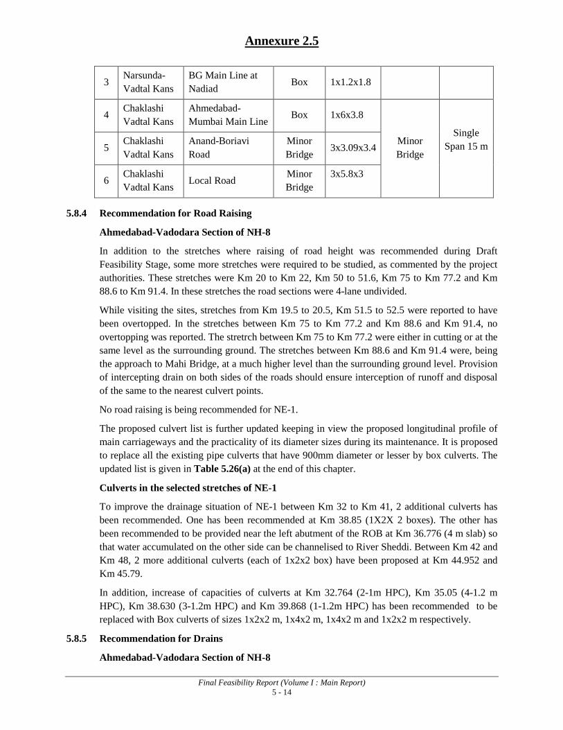
Annexure 2.5
Final Feasibility Report (Volume I : Main Report) 5 - 14
3 Narsunda-Vadtal Kans
BG Main Line at Nadiad Box 1x1.2x1.8
4 Chaklashi Vadtal Kans
Ahmedabad- Mumbai Main Line
Box 1x6x3.8
Minor Bridge
Single Span 15 m
5
Chaklashi Vadtal Kans
Anand-Boriavi Road
Minor Bridge
3x3.09x3.4
6 Chaklashi Vadtal Kans Local Road
Minor Bridge
3x5.8x3
5.8.4 Recommendation for Road Raising
Ahmedabad-Vadodara Section of NH-8
In addition to the stretches where raising of road height was recommended during Draft Feasibility Stage, some more stretches were required to be studied, as commented by the project authorities. These stretches were Km 20 to Km 22, Km 50 to 51.6, Km 75 to Km 77.2 and Km 88.6 to Km 91.4. In these stretches the road sections were 4-lane undivided.
While visiting the sites, stretches from Km 19.5 to 20.5, Km 51.5 to 52.5 were reported to have been overtopped. In the stretches between Km 75 to Km 77.2 and Km 88.6 and Km 91.4, no overtopping was reported. The stretrch between Km 75 to Km 77.2 were either in cutting or at the same level as the surrounding ground. The stretches between Km 88.6 and Km 91.4 were, being the approach to Mahi Bridge, at a much higher level than the surrounding ground level. Provision of intercepting drain on both sides of the roads should ensure interception of runoff and disposal of the same to the nearest culvert points.
No road raising is being recommended for NE-1.
The proposed culvert list is further updated keeping in view the proposed longitudinal profile of main carriageways and the practicality of its diameter sizes during its maintenance. It is proposed to replace all the existing pipe culverts that have 900mm diameter or lesser by box culverts. The updated list is given in Table 5.26(a) at the end of this chapter.
Culverts in the selected stretches of NE-1
To improve the drainage situation of NE-1 between Km 32 to Km 41, 2 additional culverts has been recommended. One has been recommended at Km 38.85 (1X2X 2 boxes). The other has been recommended to be provided near the left abutment of the ROB at Km 36.776 (4 m slab) so that water accumulated on the other side can be channelised to River Sheddi. Between Km 42 and Km 48, 2 more additional culverts (each of 1x2x2 box) have been proposed at Km 44.952 and Km 45.79.
In addition, increase of capacities of culverts at Km 32.764 (2-1m HPC), Km 35.05 (4-1.2 m HPC), Km 38.630 (3-1.2m HPC) and Km 39.868 (1-1.2m HPC) has been recommended to be replaced with Box culverts of sizes 1x2x2 m, 1x4x2 m, 1x4x2 m and 1x2x2 m respectively.
5.8.5 Recommendation for Drains
Ahmedabad-Vadodara Section of NH-8

Annexure 2.5
Final Feasibility Report (Volume I : Main Report) 5 - 15
Shoulder Drains / Chute Drains
Shoulder Drains have been recommended for the stretches where the height of embankment is in excess of 6m. Chute drains shall generally be provided at 100 m c/c, which shall be reduced to 30 m near approaches to bridges where the longitudinal slope is steeper.
Typical cross sections of the proposed road embankment provide other details of these drain section.
Roadside toe drains
Covered rectangular drains having maximum bed width of 1.2m and maximum depth of flow of 0.84m with 0.15m of freeboard has been recommended for urban areas.
Lined trapezoidal drain (side slope 1:1) having maximum bed width of 1m and maximum depth of flow of 0.83m with 0.15m freeboard have been recommended for rural areas.
Typical cross sections of the proposed road embankment provide details of these drain section.
Selected Stretches of NE-1
To carry storm water to the nearest outfall points, following provisions of longitudinal drains (trapezoidal section) have been proposed:
• Between Km 32.224 and Km 36.109 (both side)
• Between Km 38.63 and Km 38.868 (both side)
• Between Km 34.32 (box culvert) and Km 38.2 (Sheddi)
• Between Km 38.2 and Km 39.75 (Right Hand Side)
• Between Km 39.75 and Km 40.808 (Right Hand Side)
• Between Km 37.193 and Km 39.58 (both side)
• Between Km 76.7 and Km 77.118 (both side)
For slope protection of high embankments, provision of chute drains at an interval of 30 m has been provided for the stretch between Km 57 and Km 58.
5.9 BRIDGES / STRUCTURES
5.9.1 New Proposed Bridges / Structures
At present there are no flyovers and other structures except one underpass and one foot bridge on the project stretch. However, as per site requirement / traffic needs and keeping in view the guidelines given in Manual of Standards and Specifications for 6-laning of National Highways published by MOSRT&H, the new bridges / structures have been proposed as indicated in Table 5.27.
Table 5.27: New Proposed Bridges / Structures
S. No. Type of Structures Nos.
1. Proposed new bridges on Canal / Nala 7
2. Proposed bridges on oil pipe line crossing 2

Annexure 2.5
Final Feasibility Report (Volume I : Main Report) 5 - 16
3. Flyovers / Interchanges 15
4. ROBs 1
5. Vehicular Underpasses 9
6. Pedestrian Underpasses 14
Total 48
5.9.2 New Proposed Canal / Nala Bridges
There are a number of pipe culverts and siphon crossings on the project road which are hydraulically deficient. These are proposed to be replaced by new high level bridges as per details given in Table 5.28.
Table 5.28: New Proposed Canal Bridges
S. N
o.
Nam
e of
Bri
dge
Des
ign
Cha
inag
e (K
m.)
Span
Arr
ange
men
t E
xp. J
oint
to E
xp.
Join
t (m
)
Tot
al L
engt
h (F
/F
of D
irt W
all)
(m)
Typ
e of
Su
pers
truc
ture
Typ
e of
Su
bstr
uctu
re
Typ
e of
Fo
unda
tion
Dec
k C
onfig
urat
ion
1. Drain 47+910 1 x 17.05 17.10 RCC T-
beam and slab
RCC wall type abutment
Open 6-lane (2 x 12.0m)
2.
Canal Syphon
(410 50+610
skew)
1 x 11.687 (along skew)
11.714 RCC Solid Slab
RCC wall type abutment
Open 6-lane (2 x 13.5m)
3. Drain 53+320 1 x 17.05 17.10 RCC T-
beam and slab
RCC wall type abutment
Open
6-lane bridge (2 x 12m) and service
road bridges on
LHS & RHS
4. Canal
Syphon 53+930 1 x 8.82 8.84
RCC Solid Slab
RCC wall type abutment
Open
6-lane bridge
(2 x 13.5m) and service
road bridges for

Annexure 2.5
Final Feasibility Report (Volume I : Main Report) 5 - 17
S. N
o.
Nam
e of
Bri
dge
Des
ign
Cha
inag
e (K
m.)
Span
Arr
ange
men
t E
xp. J
oint
to E
xp.
Join
t (m
)
Tot
al L
engt
h (F
/F
of D
irt W
all)
(m)
Typ
e of
Su
pers
truc
ture
Typ
e of
Su
bstr
uctu
re
Typ
e of
Fo
unda
tion
Dec
k C
onfig
urat
ion
main carriagewa
y
5. Drain (210 72+675
skew)
1 x 15.05 (along skew)
15.104 RCC T-
beam and slab
RCC wall type abutment
Open
6-lane bridge
(2 x 12.0m) and service road bridge on LHS &
RHS
6.
Canal Syphon
(100 80+685 skew)
1 x 14.267 (along skew)
14.318 RCC T-
beam and slab
RCC wall type abutment
Open
6-lane bridge
(2 x 12.0m)
7.
Canal Syphon
(100 89+362 skew)
1 x 9.971 (along skew)
9.991 RCC Solid Slab
RCC wall type abutment
Open
6-lane bridge
(2 x 13.5m)
5.9.3 New Proposed Bridges on oil pipe line crossing
There are two locations at which the oil pipe line is crossing the project road. At these crossings new bridges are proposed to be provided as per details given in Table 5.29.
Table 5.29: New Proposed Bridges at Oil Pipe line crossing
S. N
o.
Nam
e of
Bri
dge
Des
ign
Cha
inag
e (K
m.)
Span
Arr
ange
men
t E
xp. J
oint
to E
xp.
Join
t (m
)
Tot
al L
engt
h (F
/F
of D
irt W
all)
(m)
Typ
e of
Su
pers
truc
ture
Typ
e of
Su
bstr
uctu
re
Typ
e of
Fo
unda
tion
Dec
k C
onfig
urat
ion
1 Oil pipe line 20+570 1 x 19.35 19.4 RCC T beam
and slab RCC wall
type Open
6-lane bridge (2 x 12m) for
service road on LHS & RHS
2 Oil pipe line 39+538 1 x 19.35 19.4 RCC T beam
and slab RCC wall
type Open 6-lane bridge (2 x 12m)

Annexure 2.6
Final Feasibility Report (Volume I : Main Report) 5 - 1
(Abstract from Volume I Main Report) Proposed Structures
5.9.4 New Proposed Flyovers / Interchanges
A number of roads including National Highway, State Highway, Major district roads are crossing the existing alignment of project stretch. At present there is at grade junction at these locations where flyover/interchanges have been proposed as per details given in Table 5.30.
Table 5.30: Details of Proposed Flyovers / Interchanges
S. N
o.
Nam
e of
St
ruct
ure
Des
ign
Cha
inag
e (K
m.)
Span
A
rran
gem
ent
Exp
. Joi
nt to
E
xp. J
oint
(m)
Tot
al L
engt
h (F
/F o
f Dir
t W
all)
Typ
e of
Su
pers
truc
ture
Typ
e of
Su
bstr
uctu
re
Typ
e of
Fo
unda
tion
Rem
arks
1. Flyover at
Naroal Junction 6+380 4 x 3 x 25
+ 60 360.05
PSC Box Girder/
PSC Girder and Slab
RCC wall Type Pile
6-lane configuration (2 x 12.0m)
2. Flyover at Vatua
Chowk 7+380 1 x 26.000 26.05
PSC Voided
Slab
RCC wall Type
Pile 6-lane
configuration (2 x 12.0m)
3.
Intersection at Sardar Patel Ring Road Junction
11+320 1 x 46.000
+ 2 x 20.000
86.05
PSC Box Girder/ RCC
Voided Slab
RCC wall Type
Pile 6-lane
configuration (2 x 12.0m)
4. Flyover on cross
road 34+020 1 x 35.000 35.05 PSC Box
Girder RCC wall
Type Pile 6-lane
configuration (2 x 12.0m)
5. Flyover on
Kedha Bypass 42.600 1 x 35.000 35.05 PSC Box
Girder RCC wall
Type Pile 6-lane
configuration (2 x 12.0m)
6. Flyover at starting of
Nadiad Bypass 52+700 1 x 35.000 35.05 PSC Box
Girder RCC wall
Type Pile
6-lane configuration (2 x 12.0m)
7. Flyover at
Petlad / Nadiad Road
58+715 1 x 35.000 35.05 PSC Box
Girder RCC wall
Type Pile
6-lane configuration (2 x 12.0m)
8. Flyover on
Chaklosi Anand road
66+924 1 x 26.000 26.05 PSC
Voided Slab
RCC wall Type Pile
6-lane configuration (2 x 12.0m)
9.
Flyover at Samarkha
Chowk (NH-83)
74+371 1 x 35.000 35.05 PSC Box
Girder RCC wall
Type Pile
6-lane configuration (2 x 12.0m)
10. Flyover at
Chikhodara chowk
77+540 1 x 26.000 26.05 PSC
Voided Slab
RCC wall Type
Pile 6-lane
configuration (2 x 12.0m)
11. Flyover at 90+745 1 x 26.000 26.05 PSC RCC wall Pile 6-lane

Annexure 2.6
Final Feasibility Report (Volume I : Main Report) 5 - 2
S. N
o.
Nam
e of
St
ruct
ure
Des
ign
Cha
inag
e (K
m.)
Span
A
rran
gem
ent
Exp
. Joi
nt to
E
xp. J
oint
(m)
Tot
al L
engt
h (F
/F o
f Dir
t W
all)
Typ
e of
Su
pers
truc
ture
Typ
e of
Su
bstr
uctu
re
Typ
e of
Fo
unda
tion
Rem
arks
Rajkot Vasad Road
Voided Slab
Type configuration (2 x 12.0m)
12. Flyover at IOC Refinery Road
102+590 1 x 46.000
+ 2 x 20.000
86.05
PSC Box Girder/ RCC
Voided Slab
RCC wall Type
Pile 6-lane
configuration (2 x 12.0m)
13. Flyover at
GSFC Chowk Road
105+540 1 x 35.000 35.05 PSC Box Girder
RCC wall Type Pile
6-lane configuration (2 x 12.0m)
14. Interchange at Baroda NEI
Junction. 108+802 1 x 26.000 26.05
PSC Voided
Slab
RCC wall Type Pile
6-lane configuration (2 x 12.0m)
15. Interchange at Baroda NEI
Junction 109+562 1 x 26.000 26.05
PSC Voided
Slab
RCC wall Type
Pile 6-lane
configuration (2 x 12.0m)
5.9.5 New Proposed ROB
There are already three Rail Over Bridges at Km. 64.500, Km. 75.000 & Km. 105.000. A narrow gauge railway line is crossing the project road at Km. 54.865 which connects Nadiad Railway Station to Pij Railway Station where there is a level crossing at present. A new ROB is proposed at this location. The details of proposed ROB are given in Table 5.31.

Annexure 2.6
Final Feasibility Report (Volume I : Main Report) 5 - 3
Table 5.31: Details of Proposed ROB
S. N
o.
RO
B/R
UB
Exi
stin
g C
haia
nge
(Km
.)
Des
ign
Cha
inag
e (K
m.)
Nam
e of
cro
ssin
g
Exi
stin
g st
ruct
ure
Prop
osed
Str
uctu
ral
conf
igur
atio
n
Prop
osed
Str
uctu
re
type
Prop
osed
span
ar
rang
emen
t (m
)
Tot
al le
ngth
of t
he
stru
ctur
e (m
)
Tot
al w
idth
of t
he
stru
ctur
e (m
)
Rem
arks
1
New ROB at Nadiad-Bhadran
Railway line
54.95 54.865 Level
crossing Level
crossing New 8-lane
ROB PSC girder and Slab
2x34.2 +34.7 103.105 2 x 17
New 8-Lane ROB over level crossing
2
ROB 267 C/2E 65/1
(LHS)
64.50 65.545 ROB Railway Crossing
Existing 2-Lane ROB
retained
Existing Steel girder and RCC
slab
1 x 22 (existing)
22.05 (existing)
11.40 (existing
)
Existing ROB to be retained after repairs
64.50 65.545 - Railway Crossing
Additional 2-lane bridge
RCC T beam and
slab 1 x 22.0 22.05 8.5
Additional 2-Lane ROB for main carriageway on LHS
ROB 267 C/2E 65/1
(LHS) 64.50 65.551
Railway Crossin
g ROB
New 3-lane ROB
RCC T beam and
slab 1 x 22.0 22.05 12
New 3-Lane ROB for main carriageway on RHS
3. ROB at 75/2
(LHS)
75.00 75.425 ROB Railway Crossing
Existing 2-Lane ROB
retained
Existing RCC T-
beam and slab
1 x 9.80 (skew)
(Existing)
9.82 (skew)
(Existing)
11.23 (Existing
)
Existing ROB being retained

Annexure 2.6
Final Feasibility Report (Volume I : Main Report) 5 - 4
S. N
o.
RO
B/R
UB
Exi
stin
g C
haia
nge
(Km
.)
Des
ign
Cha
inag
e (K
m.)
Nam
e of
cro
ssin
g
Exi
stin
g st
ruct
ure
Prop
osed
Str
uctu
ral
conf
igur
atio
n
Prop
osed
Str
uctu
re
type
Prop
osed
span
ar
rang
emen
t (m
)
Tot
al le
ngth
of t
he
stru
ctur
e (m
)
Tot
al w
idth
of t
he
stru
ctur
e (m
)
Rem
arks
Railway Crossing
Additional 2-lane ROB
RCC T beam and RCC Slab
1 x 13.5 (Skew)
13.55
10.0
Additional 2-Lane ROB catering for 1 Lane of Main Carriageway & 1 Lane of service road on LHS
ROB at 75/2 (RHS) 75.00 75.425 ROB
Railway Crossing
New 4-lane ROB on
RHS
RCC T beam and
slab +
RCC T beam and
slab
1 x 13.5 (Skew)
1 x 13.5 (Skew)
13.55
13.55 17.0
New 2-Lane ROB for Main carriageway on RHS New 2-Lane ROB for service road on RHS
4. ROB at 105/2
(LHS) 105.0 106.475 ROB
Railway Crossing
Existing ROB
retained
Existing / RCC Beam and slab/
RCC solid slab
9.50+14+23.20+9.50 (skew)
(Existing)
56.20 (skew)
(Existing)
10.10 Existing ROB being retained
ROB at 105/2 (LHS)
105.0 106.475 ROB Railway Crossing
Additional 2-lane ROB
RCC T beam and RCC slab
23.143 + 22.848+9.85
6 (Skew) 55.381 10.0 Additional
2-Lane ROB on LHS

Annexure 2.6
Final Feasibility Report (Volume I : Main Report) 5 - 5
S. N
o.
RO
B/R
UB
Exi
stin
g C
haia
nge
(Km
.)
Des
ign
Cha
inag
e (K
m.)
Nam
e of
cro
ssin
g
Exi
stin
g st
ruct
ure
Prop
osed
Str
uctu
ral
conf
igur
atio
n
Prop
osed
Str
uctu
re
type
Prop
osed
span
ar
rang
emen
t (m
)
Tot
al le
ngth
of t
he
stru
ctur
e (m
)
Tot
al w
idth
of t
he
stru
ctur
e (m
)
Rem
arks
ROB at 105/2
(RHS) 105.0 106.475
ROB
Railway Crossing
Existing ROB
retained
Existing ROB with
Steel/ RCC Girder
& slab
14 + 23 (skew)
Existing ROB span
37.20 (skew)
Existing ROB length
11.60 Existing
ROB width
Existing ROB being retained
Additional 2-lane ROB
RCC T beam and
slab
13.787 + 22.848 (Skew)
36.684 10.0 Additional 2-Lane ROB on RHS
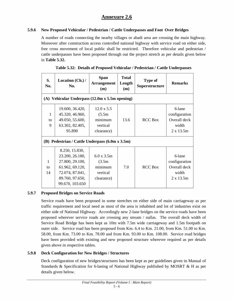
Annexure 2.6
Final Feasibility Report (Volume I : Main Report) 5 - 6
5.9.6 New Proposed Vehicular / Pedestrian / Cattle Underpasses and Foot Over Bridges
A number of roads connecting the nearby villages or abadi area are crossing the main highway. Moreover after construction access controlled national highway with service road on either side, free cross movement of local public shall be restricted. Therefore vehicular and pedestrian / cattle underpasses have been proposed through out the project stretch as per details given below in Table 5.32.
Table 5.32: Details of Proposed Vehicular / Pedestrian / Cattle Underpasses
S. No.
Location (Ch.) / No.
Span Arrangement
(m)
Total Length
(m)
Type of Superstructure
Remarks
(A) Vehicular Underpass (12.0m x 5.5m opening)
1 to 9
19.600, 36.420, 45.320, 46.960, 49.050, 55.600, 63.302, 82.405,
95.890
12.0 x 5.5 (5.5m
minimum vertical
clearance)
13.6 RCC Box
6-lane configuration Overall deck
width 2 x 13.5m
(B) Pedestrian / Cattle Underpass (6.0m x 3.5m)
1 to 14
8.250, 15.830, 23.200, 26.180, 27.800, 29.100, 61.962, 69.120, 72.074, 87.041, 89.760, 97.650, 99.670, 103.650
6.0 x 3.5m (3.5m
minimum vertical
clearance)
7.0 RCC Box
6-lane configuration Overall deck
width 2 x 13.5m
5.9.7 Proposed Bridges on Service Roads
Service roads have been proposed in some stretches on either side of main carriageway as per traffic requirement and local need as most of the area is inhabited and lot of industries exist on either side of National Highway. Accordingly new 2-lane bridges on the service roads have been proposed wherever service roads are crossing any stream / nallas. The overall deck width of Service Road Bridge has been kept as 10m with 7.5m wide carriageway and 1.5m footpath on outer side. Service road has been proposed from Km. 6.4 to Km. 21.00, from Km. 51.00 to Km. 58.00, from Km. 73.00 to Km. 78.00 and from Km. 93.00 to Km. 108.00. Service road bridges have been provided with existing and new proposed structure wherever required as per details given above in respective tables.
5.9.8 Deck Configuration for New Bridges / Structures
Deck configuration of new bridges/structures has been kept as per guidelines given in Manual of Standards & Specification for 6-laning of National Highway published by MOSRT & H as per details given below.
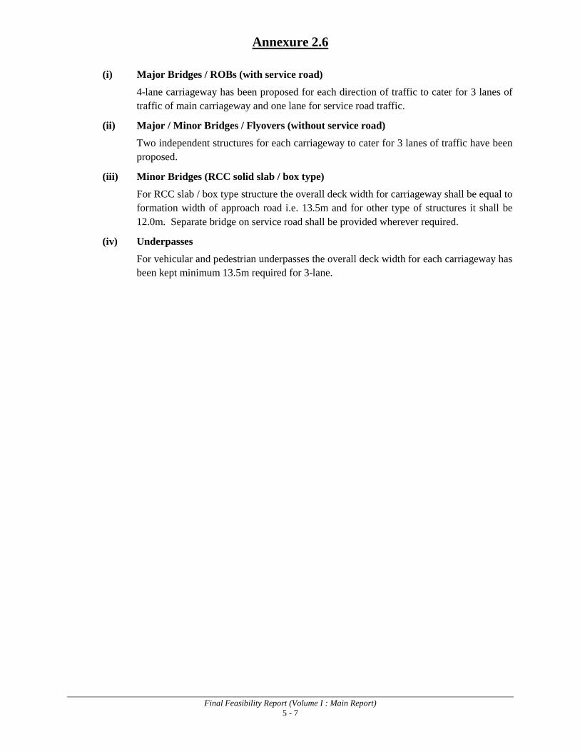
Annexure 2.6
Final Feasibility Report (Volume I : Main Report) 5 - 7
(i) Major Bridges / ROBs (with service road)
4-lane carriageway has been proposed for each direction of traffic to cater for 3 lanes of traffic of main carriageway and one lane for service road traffic.
(ii) Major / Minor Bridges / Flyovers (without service road)
Two independent structures for each carriageway to cater for 3 lanes of traffic have been proposed.
(iii) Minor Bridges (RCC solid slab / box type)
For RCC slab / box type structure the overall deck width for carriageway shall be equal to formation width of approach road i.e. 13.5m and for other type of structures it shall be 12.0m. Separate bridge on service road shall be provided wherever required.
(iv) Underpasses
For vehicular and pedestrian underpasses the overall deck width for each carriageway has been kept minimum 13.5m required for 3-lane.

Feasibility for Six Laning of Ahmedabad-Vadodara Section of NH-8 to be Executed as BOT (Toll) Project on DBFO Pattern Under NHDP Phase-V
Draft Environmental Impact Assessment Report 3 - 1
3. DESCRIPTION OF THE ENVIRONMENT
3.1 INTRODUCTION
As a precursor for the prediction of various types of environment impacts likely to arise due to implementation of this project, it is essential to establish the baseline environment status of the Physical, Biological and Socio-cultural environmental components along the project road and Project Influence Area. Details of these environmental components are necessary for decision making in design, implementation and operation phase of any developmental project. This chapter assesses the nature, type and dimensions of the study area and describes the relevant physical, biological, social and environmental components along the project corridor. All necessary information required for Environmental Screening study has been collected through field surveys conducted by environmental team, secondary data sources and community consultations.
3.2 PHYSICAL SETTINGS
3.2.1 Site and Situation
The project road starts from km 6.4 of existing NH-8 at Ahmedabad Bypass and ends at km 108.7 of NH-8 near Vadodara town at the junction of Ahmedabad- Vadodara Expressway. The project road passes through the plain topography covering the four districts viz Ahmedabad, Kheda, Anand and Vadodara.
3.2.2 Physiography
The project road passes through plain terrain. Map showing project road on physical map of Gujarat state is shown in Fig. 3.1. It can be observed that physical altitude in the project area varies from 150 to 300m.
Fig 3.1: Physical Map of Gujarat
Project Road

Feasibility for Six Laning of Ahmedabad-Vadodara Section of NH-8 to be Executed as BOT (Toll) Project on DBFO Pattern Under NHDP Phase-V
Draft Environmental Impact Assessment Report 3 - 2
The physiograpic map of Gujarat is shown in Fig.3.2. Most of the project area falls in the Western Alluvial plains.
Fig. 3.2 Physiographic Map of Gujarat
3.2.3 Geology
The project road passes through Holocene sediments represented by “Flood plain deposits” lithological unit of Katpur formation1
Age
.
The project area is comprised of a cover of thick alluvium with few sporadic outcrops of deccan traps and limestone. The area is almost flat covered by brown sand and clayey soil. The succession of the rock type in the area is as follows:
Formation Lithology Holocene Alluvium Soil, Alluvium and Brown Sand Post Miocene Jambusar Coarse grained sand with clay
Bharuch Greyish Brown clay Jhagadia Greenish grey claystone with minor coal
Miocene Kand Claystone with sand Babaguru Claystone and shale with minor sand stone Tarkeshwar Shale with sand
Unconformity Oligocene Tarapur shale Shale with sandstone in lower portion Upper Eocene Kalol Grey shale with silty sandstone, siltstone and
minor coal bed Unconformity Lower Cambay shale Dark grey carbonaceous shale with changes to
trap, Conglomerate towards margins Unconformity
1 Source: District Resource Map, Ahmedabad and Gandhinagar Districts, Kheda District and Vadodara District
published by Geological Survey of India, 2002

Feasibility for Six Laning of Ahmedabad-Vadodara Section of NH-8 to be Executed as BOT (Toll) Project on DBFO Pattern Under NHDP Phase-V
Draft Environmental Impact Assessment Report 3 - 3
Lower Eocene to intertappean bed deccan trap, Upper (Creataceous)
3.2.4 Seismology The entire stretch of the project highway traverses through seismic zone III (Moderate Damage Risk Zone) as defined by IRC 6:1966, seismic zoning classification system, i.e., a zone of relative stability. The horizontal Seismic coefficient for zone III is 0.04 measured on a scale from I to V zones where zone I is most stable and zone V is considered to be least stable. The earthquake hazard risk zonation map for Gujarat and the location of project road is provided in Fig. 3.3.
3.2.5 Soil The soil in different stretches of project road (passing through Ahmedabad, Kheda, Anand and Vadodara districts) is as follows: Ahmedabad2
Kheda: Fine loamy and mixed soil with slight to moderate salinity
3
Vadodara
: Very deep, well drained, calcareous, fine to coarse, loamy soil on gently sloping dissected flood plain, level flood plain and alluvial plain
4: Fine-loamy, mixed calcareous soil
Fig. 3.3: Earthquake Hazard Risk Zonation Map for Gujarat
3.2.6 Land Use Pattern
The land use pattern of the project area is mainly agricultural land followed by settlements, industrial and commercial areas. Land use details of various districts through which the project road passes is presented in Table 3.1.
2 Source: District Resource Map, Ahmedabad and Gandhinagar Districts published by Geological Survey of India,
2002 3 Source: District Resource Map, Kheda District published by Geological Survey of India, 2002 4 Source: District Resource Map, Vadodara District published by Geological Survey of India, 2002
Project Road
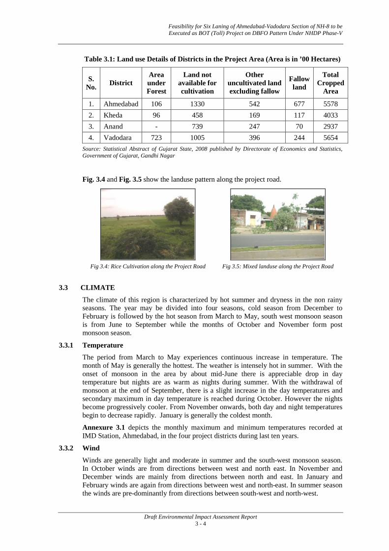
Feasibility for Six Laning of Ahmedabad-Vadodara Section of NH-8 to be Executed as BOT (Toll) Project on DBFO Pattern Under NHDP Phase-V
Draft Environmental Impact Assessment Report 3 - 4
Table 3.1: Land use Details of Districts in the Project Area (Area is in ’00 Hectares)
S. No. District
Area under Forest
Land not available for cultivation
Other uncultivated land excluding fallow
Fallow land
Total Cropped
Area
1. Ahmedabad 106 1330 542 677 5578 2. Kheda 96 458 169 117 4033 3. Anand - 739 247 70 2937 4. Vadodara 723 1005 396 244 5654
Source: Statistical Abstract of Gujarat State, 2008 published by Directorate of Economics and Statistics, Government of Gujarat, Gandhi Nagar
Fig. 3.4 and Fig. 3.5 show the landuse pattern along the project road.
Fig 3.4: Rice Cultivation along the Project Road Fig 3.5: Mixed landuse along the Project Road
3.3 CLIMATE
The climate of this region is characterized by hot summer and dryness in the non rainy seasons. The year may be divided into four seasons, cold season from December to February is followed by the hot season from March to May, south west monsoon season is from June to September while the months of October and November form post monsoon season.
3.3.1 Temperature
The period from March to May experiences continuous increase in temperature. The month of May is generally the hottest. The weather is intensely hot in summer. With the onset of monsoon in the area by about mid-June there is appreciable drop in day temperature but nights are as warm as nights during summer. With the withdrawal of monsoon at the end of September, there is a slight increase in the day temperatures and secondary maximum in day temperature is reached during October. However the nights become progressively cooler. From November onwards, both day and night temperatures begin to decrease rapidly. January is generally the coldest month.
Annexure 3.1 depicts the monthly maximum and minimum temperatures recorded at IMD Station, Ahmedabad, in the four project districts during last ten years.
3.3.2 Wind
Winds are generally light and moderate in summer and the south-west monsoon season. In October winds are from directions between west and north east. In November and December winds are mainly from directions between north and east. In January and February winds are again from directions between west and north-east. In summer season the winds are pre-dominantly from directions between south-west and north-west.

Feasibility for Six Laning of Ahmedabad-Vadodara Section of NH-8 to be Executed as BOT (Toll) Project on DBFO Pattern Under NHDP Phase-V
Draft Environmental Impact Assessment Report 3 - 5
3.3.3 Rainfall
District wise monthly average rainfall in the project area for the year 2007 is presented in Table 3.2. The data shows that the districts receive an average rainfall above 800 mm during the monsoon season.
Table 3.2: District-wise Monthly Average Rainfall in the Project Area
District Rainfall in mm
June July August September Total
Ahmedabad 99 362 294 109 864
Kheda 58 501 383 172 1114
Anand 79 384 269 144 876
Vadodara 123 534 256 270 1183
Source: Statistical Abstract of Gujarat State, 2008 published by Directorate of Economics and Statistics, Government of Gujarat, Gandhinagar Monthly average Rainfall data for four districts during the period 1998-2002 is presented in Fig. 3.6. It is observed that majority of rainfall is received during the months of June through September.
Fig. 3.6: Monthly Average Rainfall in Project Districts
Ahmedabad District

Feasibility for Six Laning of Ahmedabad-Vadodara Section of NH-8 to be Executed as BOT (Toll) Project on DBFO Pattern Under NHDP Phase-V
Draft Environmental Impact Assessment Report 3 - 6
Kheda District
Anand District
Vadodara District
Source: India Water Portal

Feasibility for Six Laning of Ahmedabad-Vadodara Section of NH-8 to be Executed as BOT (Toll) Project on DBFO Pattern Under NHDP Phase-V
Draft Environmental Impact Assessment Report 3 - 7
3.3.4 Relative Humidity
Relative humidity during the south-west monsoon season is generally high. Rest of the year the air is comparatively drier. The driest part of the year is the summer season when relative humidity in the afternoons is less than 25%.
3.3.5 Cloud Cover
During the south-west monsoon season, the skies are generally clouded or overcast. In the rest of the year, the skies are mostly clear or lightly clouded.
3.3.6 Natural Disaster/ Hazard
Gujarat state is highly prone to multi hazards due to its geographical positioning, close proximity to sea, arid and semi arid nature of the region, presence of big river basins, presence of large number of chemical industries etc.. According to seismologists, 23% of the area in Gujarat lies in seismic zone V with probable intensity on Richter scale 6-9 and almost 75% of area lies in seismic zone III and IV. The state has the longest coastline (1600 km) in India and falls in the region of tropical cyclones generated in the Arabian Sea. The state covers 20% (64000 Sq Km.) of country’s total geographical area under arid zone and eight districts of Gujarat state including entire region of Kachchh district comes under this category.
Gujarat is also one of the fastest growing states of India especially in chemical industries. Gujarat has a very high level of exposure to chemical hazard risks. The area from Mehsana to Vapi is heavily industrialized and is popularly known as Golden Corridor (from economic point of view). Besides, there is also a possibility that the natural hazards and chemical hazards will collide, aggravating the human and economic impact.
Some of the most devastating disasters, which have stuck the state in previous decades, include Morbi flood of 1978, the epidemic in Surat of 1994, the Kandla cyclone of 1998, the flood, which swept across Ahmedabad, Baroda, Surat and Mehsana in 2000 and the killer quake of January 2001.
The entire stretch of the project highway traverses through seismic zone III (moderate damage risk zone) and falls in flood zone.
Table 3.3: List of Vulnerable Districts in Gujarat
S. No. Districts Wind and cyclone Floods Earthquake Area affected
1. Ahmedabad Medium FLZ Medium Partially
2. Bharuch Medium FLZ Medium Partially
3. Kachchh Very high FLZ Very high Partially
4. Kheda Medium FLZ Medium Partially
5. Surat Medium FLZ Medium Partially
6. Vadodara Medium FLZ Medium Partially
7. Valsad Medium FLZ Medium Partially Source: National Institute of Disaster Management FLZ – Flood Zone

Feasibility for Six Laning of Ahmedabad-Vadodara Section of NH-8 to be Executed as BOT (Toll) Project on DBFO Pattern Under NHDP Phase-V
Draft Environmental Impact Assessment Report 3 - 8
Fig 3.7: Multi Hazards Zone in Gujarat
3.4 WATER RESOURCES
Road development projects often significantly alter the hydrological setting of an area and add to the siltation and pollution levels of the water resources, generally when new highway is developed in the region. As this project involves widening and strengthening of an existing highway, significant impact is not envisaged.
Surface Water Hydrology
The river basins of Mahi, Tapi and Narmada are the important drainage basins of Gujarat draining into the gulf of Khambhat. The details of the different river basins and their drainages are given in Fig. 3.8.
Project Road

Feasibility for Six Laning of Ahmedabad-Vadodara Section of NH-8 to be Executed as BOT (Toll) Project on DBFO Pattern Under NHDP Phase-V
Draft Environmental Impact Assessment Report 3 - 9
Source: Gujarat Ecology Commission
Fig. 3.8 Drainage Map of Gujarat
The proposed project area comes under Sub zone 3(a) of Mahi and Sabarmati River Basin. The details of micro drainage, flood passages and other information on flood periodicity are considered and accordingly water ways and surface drainage provisions are made in the project.
3.4.1 Surface Water
Along the project stretch, a number of water sources are found. These can be broadly classified in two categories:
• Flowing water resources viz. River and canals
• Stagnant water resources viz. Ponds and water logged area
Flowing Water Resources
The project highway falls largely in the region of alluvial plains. The major surface water bodies intersecting the project highway include Vatrak River, Mahi River and Mini River at chainage Km 35.3, Km 92.4 and Km 97.7 respectively. Fig 3.9 and Fig 3.10 show photographs of Vatrak and Mahi rivers located along the ROW.
The project road crosses 15 canals. List of canals intersecting the project road is provided in Annexure 3.2.

Feasibility for Six Laning of Ahmedabad-Vadodara Section of NH-8 to be Executed as BOT (Toll) Project on DBFO Pattern Under NHDP Phase-V
Draft Environmental Impact Assessment Report 3 - 10
Fig 3.9: Vatak River at Chainage 35.3 km Fig 3.10: Mahi River at Chainage 93.0 km
Stagnant Water Resources There are 19 stagnant water resources (Ponds) located along the project stretch. The list of ponds along the ROW is given in Annexure 3.3. Fig 3.11 and Fig 3.12 shows photographs of ponds located along the ROW.
Fig 3.11: Pond at Aslali Village, Chainage 12.4 km Fig 3.12: Pond at Dabhan Village, Ch. 53.5 km
3.4.2 Ground Water Groundwater Hydrology As per Central Ground Water Board reports, the net annual groundwater availability for the state of Gujarat is 15.02 BCM (Billion Cubic Meters), annual groundwater draft is 11.49 BCM and the stage of groundwater development is 76%. The alluvial plains in the project area provide better conditions for the storage of groundwater. The junction between the eastern hilly areas and the well-demarcated alluvial plains is the principal site for recharge of groundwater. Depth to groundwater table for pre monsoon and post monsoon for the project area given in Fig. 3.13 and Fig. 3.14. This shows that the depth to groundwater table in Anand and Kheda districts varies between 10 to 20 mbgl and in Vadodara and Ahmedabad districts its more than 20 mbgl

Feasibility for Six Laning of Ahmedabad-Vadodara Section of NH-8 to be Executed as BOT (Toll) Project on DBFO Pattern Under NHDP Phase-V
Draft Environmental Impact Assessment Report 3 - 11
Fig. 3.13 Pre-Monsoon Depth to Groundater Table in Gujarat
Source: Central Ground Water Board
Fig. 3.14 Post-Monsoon Depth to Groundater Table in Gujarat

Feasibility for Six Laning of Ahmedabad-Vadodara Section of NH-8 to be Executed as BOT (Toll) Project on DBFO Pattern Under NHDP Phase-V
Draft Environmental Impact Assessment Report 3 - 12
Surveys were conducted along the NH-8 to identify the number of water resources present in the project area. Ground water resource is used for drinking and irrigation purposes by digging wells, tube wells or installing hand pumps.There are 11 groundwater structures are located within PROW. The details of ground water resources along the project road are given in Annexure 3.4. Fig 3.15 and Fig 3.16 show a hand pump and a well along the project road.
Fig 3.15: Hand Pump along Project Road, Ch.13.5 km Fig 3.16: Well along Project Road, Ch. 32.3 km
3.4.3 Cross Drainage Structure
The cross drainage structures located along the project road are 4 major bridges, 12 minor bridges and 170 culverts. Bridge over river Vatrak and Mahi is shown in Fig 3.17 and Fig 3.18 respectively.
Fig 3.17: Bridge over Vatrak River Fig 3.18: Bridge over Mahi River
3.4.4 Water Quality Groundwater has been found to be an important source for catering to the local needs of water consumption for various purposes, mainly domestic. Therefore, any deterioration in the quality of groundwater owing to the developmental activities will pose threat to the concerned population and attention needs to be paid towards maintaining the quality of water using all possible tools such as monitoring with spontaneous remedial suggestions, if required. Water quality along the road is in deteriorated in some places as reported by the local communities. Data available from secondary sources on ground water quality in the project area is presented in Table 3.4.
Table 3.4: Groundwater Quality Data
S. No.
Parameters Tested (mg/l) Units Permissible
Limit
Monitoring Locations
Bavala Vill. Dist.
Ahmedabad
Pali Vill. Dist.
Kheda
Lambhvel Vill. Dist.
Anand
Dashrath Vill. Dist. Vadodara
1. pH - 6.5-8.5 7.79 7.64 7.71 7.4
2. Total Dissolved Solids
mg/l 2000 1526 1942 1190 3080

Feasibility for Six Laning of Ahmedabad-Vadodara Section of NH-8 to be Executed as BOT (Toll) Project on DBFO Pattern Under NHDP Phase-V
Draft Environmental Impact Assessment Report 3 - 13
S. No.
Parameters Tested (mg/l) Units Permissible
Limit
Monitoring Locations
Bavala Vill. Dist.
Ahmedabad
Pali Vill. Dist.
Kheda
Lambhvel Vill. Dist.
Anand
Dashrath Vill. Dist. Vadodara
3. Dissolved Oxygen mg/l - 7.6 7 7.2 2
4. COD mg/l - 5.0 10 7 3
5. NO2 mg/l - N (Nitrite) - 0.02 Nil 0.02 Nil
6. NO3 mg/l - N (Nitrate) 100 0.14 1.58 2.49 1.47
7. Fluorides mg/l 1.5 0.61 0.72 0.58 0.87
8. NH3 mg/l - N - - 0.29 - 0.3
9. Total Coliform MPN/l00 ml 10 <2 7 4 <3
10. Faecal Coliform MPN/l00 ml 10 <2 4 <3 <3
Source: Global Environmental Monitoring System Project Report, 2007-08
It can be observed that all the monitored parameters are within the permissible limits specified for drinking water except for Total Dissolved Solids at Dashrath Village, Vadodara District indicating presence of soil minerals dissolved in groundwater in the region. Groundwater quality map of Gujarat is provided in Fig 3.19. It is observed that project road traverses areas having nitrate content in excess of 4.5 ppm.
Fig 3.19: Groundwater Quality Map of Gujarat
Rivers and canals are important in local context and data collected from secondary sources on water quality of Vatrak and Mahi rivers in the project area is presented in Table 3.5. which shows that all the parameters are within permissible limit except contamination from Faecal and total Coliform.
Project Road

Feasibility for Six Laning of Ahmedabad-Vadodara Section of NH-8 to be Executed as BOT (Toll) Project on DBFO Pattern Under NHDP Phase-V
Draft Environmental Impact Assessment Report 3 - 14
Table 3.5: Surface Water Quality Data
S. No. Parameters Tested (mg/l) Units Vatrak
River Mahi River
1. pH - 7.98 8.32 2. Total Dissolved Solids mg/l 320 772 3. Dissolved Oxygen mg/l 6.2 12.9 4. BOD mg/l 3.0 3.0 5. COD mg/l 26 13 6. NH3 mg/l - N 3.36 0.23 7. TKN mg/l 5.04 3.36 8. NO2 mg/l - N 0.07 Nil 9. NO3 mg/l - N 0.21 0.09
10. Total Coliform MPN/l00 ml 1500 <3 11. Faecal Coliform MPN/l00 ml 400 <3
Source: Global Environmental Monitoring System Project Report, 2007-08
Status of pollution of rivers in the project stretch is shown in Fig 3.20. It is observed that Mahi river is minimally polluted. Coliform concentrations in River Vatrak indicate sewage pollution of the river.
Fig 3.20: Status of Pollution in Major Rivers of Gujarat
3.4.5 Inundation
The project highway is prone to water logging and local flooding in some stretches. Map showing flood zones in Gujarat is presented in Fig 3.21. It can be observed that project highway passes through flood zone. Discussions with officials of Gujarat State Disaster
Project Road
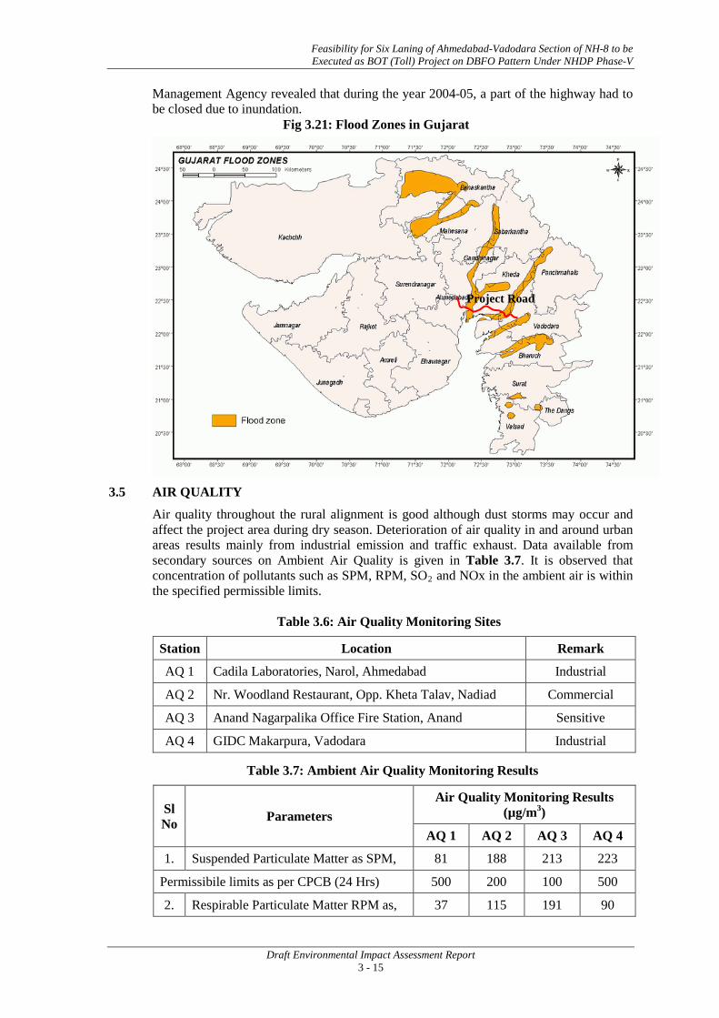
Feasibility for Six Laning of Ahmedabad-Vadodara Section of NH-8 to be Executed as BOT (Toll) Project on DBFO Pattern Under NHDP Phase-V
Draft Environmental Impact Assessment Report 3 - 15
Management Agency revealed that during the year 2004-05, a part of the highway had to be closed due to inundation.
Fig 3.21: Flood Zones in Gujarat
3.5 AIR QUALITY
Air quality throughout the rural alignment is good although dust storms may occur and affect the project area during dry season. Deterioration of air quality in and around urban areas results mainly from industrial emission and traffic exhaust. Data available from secondary sources on Ambient Air Quality is given in Table 3.7. It is observed that concentration of pollutants such as SPM, RPM, SO2
and NOx in the ambient air is within the specified permissible limits.
Table 3.6: Air Quality Monitoring Sites
Station Location Remark
AQ 1 Cadila Laboratories, Narol, Ahmedabad Industrial
AQ 2 Nr. Woodland Restaurant, Opp. Kheta Talav, Nadiad Commercial
AQ 3 Anand Nagarpalika Office Fire Station, Anand Sensitive
AQ 4 GIDC Makarpura, Vadodara Industrial
Table 3.7: Ambient Air Quality Monitoring Results
Sl No Parameters
Air Quality Monitoring Results (µg/m3)
AQ 1 AQ 2 AQ 3 AQ 4
1. Suspended Particulate Matter as SPM, 81 188 213 223
Permissibile limits as per CPCB (24 Hrs) 500 200 100 500
2. Respirable Particulate Matter RPM as, 37 115 191 90
Project Road

Feasibility for Six Laning of Ahmedabad-Vadodara Section of NH-8 to be Executed as BOT (Toll) Project on DBFO Pattern Under NHDP Phase-V
Draft Environmental Impact Assessment Report 3 - 16
Permissibile limits as per CPCB(24 Hrs) 150 100 75 150
3. Sulphur Di-Oxide As SO2, 5 1.44 - 23.1
Permissibile limits as per CPCB(24 Hrs) 80 80 80 80
4. Oxides of Nitrogen as Nox , 13 13.18 5.21 22.8
Permissibile limits as per CPCB(24 Hrs) 80 80 80 80 Source: Global Environmental Monitoring System Project Report, 2007-08
3.6 NOISE
Noise is not a major issue in the project corridor, except in congested settlements due to high anthropogenic activity and heavy traffic movement.
3.7 ECOLOGICAL RESOURCES
3.7.1 Flora
The forest areas of Gujarat are unevenly distributed. The major concentration of forests is found all along the eastern border of the state and the hilly portion of Saurashtra. The forests are found mainly in the districts of Dangs, Valsad, Surat and Junagadh. List of flora in the project area is given in Annexure 3.5. Fig 3.22 shows the Forest cover map of Gujarat State, which shows that the project area does not have any dense, open or any other forest.
Fig 3.22: Forest cover map of Gujarat State
The district wise forest cover present in the project area is given in Table 3.8.
Project Road

Feasibility for Six Laning of Ahmedabad-Vadodara Section of NH-8 to be Executed as BOT (Toll) Project on DBFO Pattern Under NHDP Phase-V
Draft Environmental Impact Assessment Report 3 - 17
Table 3.8: District-wise Forest Cover of Project Area (in km2
District
)
Reserved Forest
Protected Forest
Un-classed Forest
Total Forest Area
% of forest area to total geographical area of the District
Ahmedabad 48.79 0.00 56.94 105.73 1.31
Kheda 62.75 0.00 12.32 75.07 1.78
Anand 0.00 0.00 0.00 0.00 0.00
Vadodara 674.55 5.70 38.54 718.79 9.52 Source: Statistical Abstract of Gujarat State, 2008 published by Directorate of Economics and Statistics, Government of Gujarat, Gandhinagar
Forest type
On the basis of forest classification by Champion and Seth 1968, following four forest types, out of 16 major types found in the country are found in Gujarat:
• Type 3B, Moist Deciduous Forest: These forests occur in the regions having an annual rainfall of over 1200 mm and are found in the Southern most part of the state in the districts of Surat, Valsad and Dangs. These forests form the main source of commercial timber in the state. Teak, Haldu, Sisam, Khair, Katas, Manvel etc. are the main species of these forests.
• Type 5A, Tropical Dry Deciduous Forest: These forests thrive in the region having the rainfall between 600 mm to 1200 mm. These forests are found in the central part of the state in the districts of Bharuch, Vadodara, Panchmahals, Sabarkantha and parts of Saurashtra in the districts of Amreli, Junagadh and Jamnagar.
• Type 6B, Northern Tropical Thorn Forest: These types of forests occur in the region with less than 600 mm rainfall. These forests are found are found in district Banaskantha, Rajkot, and parts of Bhavnagar, Junagadh, and Kutch. These forests contain spare and stunted growth of species like Acacia and thorn bushes etc.
• Type 4B, Littoral and Swamp Forest: Mangrove forests are found in the coastal creeks in the state in the districts of Kutch, Jamnagar and Junagadh. The main species found in these forests is Avicenia sp. Out of 207 subtypes of forests, recorded by Champion and Seth, 31 subtypes, (14.7%) have been identified in the state.
Trees within Immediate COI
There are large numbers of trees / plants of various species coming within and outside the ROW. Detailed tree inventory within the proposed ROW revealed that there are about 39,590 No. of trees (including 5,007 Nos. on Kheda Bypass) comprising of Azadirachta Indica (Neem), Acacia Nilotica (Desi Bawal), Prosopis Juliflora (Gando bawal), Eucalyptus Globulus (Nilgiri), Mangifera Indica (Mango), Phyllanthus emblica (Amla), Syzygium cumini (Jamun), Cassia Fistula (Amaltas) which are likely to be affected due to the widening activity. Some of the trees along these existing chainages are mature with good girth size. Tree inventory list is provided as Annexure 3.6. Fig 3.23 and Fig 3.24 show photographs of the roadside plantations.

Feasibility for Six Laning of Ahmedabad-Vadodara Section of NH-8 to be Executed as BOT (Toll) Project on DBFO Pattern Under NHDP Phase-V
Draft Environmental Impact Assessment Report 3 - 18
Fig 3.23: Road side Plantations Fig 3.24: Road side Plantations
Protected Forest/ Reserved Forest
The entire stretch along the project road is notified as protected forest as per Gujarat Government Gazette dated July 5, 1973. Reportedly, the plantation was carried out by Social Forestry Division of the Forest Department in phases. There is no reserve forest within 10 km from both the sides of the project highway in the entire stretches.
3.7.2 Fauna
Project road does not pass through any National Park/Wild Life Sanctuary. Domesticated animals constitute the major proportion of faunal density in the area surrounding the project highway. No endangered species has been reported in the area. No endangered species of avian fauna has been recorded in the influence zone of the proposed project. No wildlife has been found during the field visit. Some of the common species of fauna in the project area includes Monkey, Nilgai, Jackal, Wild Cat etc. Some of common species are listed in Annexure 3.7.
3.8 SOCIO-ECONOMIC/ CULTURAL ENVIRONMENT
The project highway traverses through a number of settlements and is dotted with religious and cultural properties, which though not of archaeological significance are nevertheless, very significant to the community. Cultural properties along the project highway were identified and documented based on site surveys. Agriculture continues to be the primary occupation of the large majority of its people. The main crops grown in the area are rice, jowar, bajra, wheat and maize. District wise details of area under different crops in the project area for the year 2003-04 is provided in Table 3.9.
Table 3.9: Area under Different Crops in Various Districts of the Project Area
S. No. District
Area Under Different Crops (in ‘000 Hectares)
Rice Jowar Bajra Wheat Maize Gram Other Pulses
1. Ahmedabad 82 - 35 99 @ 10 8
2. Kheda 102 1 83 47 28 1 16
3. Anand 70 @ 53 46 @ 5 3
4. Vadodara 58 26 18 19 60 2 103
@ - Below ‘000 Hectares
Source: Statistical Abstract of Gujarat State, 2008 published by Directorate of Economics and Statistics, Government of Gujarat, Gandhinagar

Feasibility for Six Laning of Ahmedabad-Vadodara Section of NH-8 to be Executed as BOT (Toll) Project on DBFO Pattern Under NHDP Phase-V
Draft Environmental Impact Assessment Report 3 - 19
Nurseries were observed along the project road, mainly on the stretch from Anand to Vadodara. Fig 3.25 shows a photograph of the nursery along the project road. List of nurseries along the project road is provided in Annexure 3.8.
3.8.1 Population
The project road passes through four districts in Gujarat namely Ahmedabad, Kheda, Anand and Vadodara. Total population in the districts is presented in Table 3.10.
Table 3.10: District wise population in the Project Districts
Name of District
Population as per 2001 Census Total Male Female SC ST
Ahmedabad 58,16,519 30,74,556 27,41,963 6,20,765 58,035
Kheda 20,24,216 10,52,823 9,71,393 1,06,111 32,394 Anand 18,56,872 9,72,000 8,84,872 98,485 22,835 Vadodara 36,41,802 18,97,368 17,44,434 2,04,285 9,67,393
Source: Census of India, 2001
3.8.2 Settlement and Properties
The project road passes through 48 settlements. List of settlements is provided in Table 2.1 in Chapter 2.
Religious Structure
There are 116 religious structures present along the existing road. List of religious structure along the project stretch is given in Annexure 3.9. Fig 3.26 and Fig 3.27 show photographs of the temples along the project road.
Fig 3.26: Temple along Project Road, Ch. 7.6 km Fig 3.27: Temple along Project Road, Ch. 20.6 km
Educational Institutes
There are 9 numbers of educational institutions are located within and outside the ROW, they includes schools and colleges. A list of educational institutes along the project road is given in Annexure 3.10 and photographic view of some educational institutes is shown in Fig 3.28 and Fig 3.29.
Fig 3.25: Nursery along the Project Road

Feasibility for Six Laning of Ahmedabad-Vadodara Section of NH-8 to be Executed as BOT (Toll) Project on DBFO Pattern Under NHDP Phase-V
Draft Environmental Impact Assessment Report 3 - 20
Fig 3.28: Primary School at Jetalpur Village
along Project Road Fig 3.29: Primary School at Malarpura Village
along Project Road
Archaeological and Cultural Sites
There are some Archeological Sites located within 15 Km from the project road. However the impacts due to the project road on these are insignificant.
Industries
Many industrial units are located along the project road and the prominent ones being cold storage units, auto-parts related and transport companies. List of industries coming in the project corridor is given in Annexure 3.11. Fig 3.30 and Fig 3.31 shows photographs of some industries along the project road.
Fig 3.30: Industry along Project Road,
Ch. 104.0 km Fig 3.31: Industry along Project Road,
Ch. 96.0 km
Medical Amenities
The details of medical amenities along the project road is provided in Table 3.11.
Table 3.11: List of Medical Amenities along the Project Road
S. No. Name of Medical Center Chainage (Km.) Side
1. Bareja Eye Hospital 19.800 Left
2. Nutan Ayurvedic Center 65.100 Right
3. Sankara Eye Hospital 82.700 Right
Fig 3.32 and Fig 3.33 shows photographs of medical amenities along the project road.

Feasibility for Six Laning of Ahmedabad-Vadodara Section of NH-8 to be Executed as BOT (Toll) Project on DBFO Pattern Under NHDP Phase-V
Draft Environmental Impact Assessment Report 3 - 21
Fig 3.32: Hospital along Project Road,
Chainage 82.7 km Fig 3.33: Hospital along Project Road,
Chainage 65.1km
The survey of human health’s problem along the roadside suggests that inhabitants in the settlements mostly complain about gastro-intestinal problems. In all the four districts viz Ahmedabad, Kheda, Anand and Vadodara the source of drinking water was observed to be groundwater which was reported to have high levels of Total Dissolved Solids. The residents reported occurrence of gallstones and kidney stones.
3.9 ROAD SAFETY
Human safety is an important issue along the road as road is used by pedestrians, cyclists, animals, herdsmen as well as bullock carts, scooters, cars, buses, vehicles carrying hazardous industrial goods and trucks. These combinations create hazardous conditions for all the road users. Poor pavement structure and lack of warning/informatory signs and incidental parking especially in urban stretches seem to be the reasons for accidents on the road. The number of serious accidents is correlated with the total number of accidents involving heavy vehicles. In 2007, around 34,000 road accidents were registered by Gujarat police. On an average, 93 road accidents occur in Gujarat everyday, killing 17 and injuring about 98 people.
3.10 GENERAL ECONOMIC ENVIRONMENT
The economy of Gujarat is one of the most prosperous state economies. The economy of Gujarat is highly industrialized-the direct fallout of the state's hostile agricultural conditions. The yield from agriculture in Gujarat is distressingly poor-which is due to poor soils, inadequate rainfall, frequent droughts and floods, inadequate drainage and underdeveloped irrigation facilities. The principal revenue generation from agriculture comes from cotton-a cash crop. The agricultural economy of Gujarat is dependent upon the seasonal cotton yields. Gujarat ranks high in the manufacturing sector. The industrial economy of Gujarat has crossed several economic milestones. During the period from 1960 to 1990, Gujarat positioned itself as a leader in a variety of industrial sectors including textiles, engineering, chemicals, petrochemicals, drugs and pharmaceuticals, cement and ceramics among others.
3.11 MINERAL RESOURCES
Mineral resources available in various districts though which the project road traverses is described as follows:
Ahmedabad5
5 Source: District Resource Map, Ahmedabad and Gandhinagar Districts published by Geological Survey
of India, 2002
: Among the mineral resources only construction material and oil and gas are present in the district. Basalt and limestone in Dhandhuk taluk of Ahmedabad district and sand from the river bed of the Sabarrmati river are used for construction material. Oil and gas fields are located around Vavol, Indroda, Bavla, Kuha, Sanand, Ahmedabad and Sertha areas.

Feasibility for Six Laning of Ahmedabad-Vadodara Section of NH-8 to be Executed as BOT (Toll) Project on DBFO Pattern Under NHDP Phase-V
Draft Environmental Impact Assessment Report 3 - 22
Kheda and Anand6
Vadodara
: The main mineral deposits in the district are bauxite, bentonitic clay, limestone, deccan traps and petroleum. Bauxite in the form of narrow belts capping the deccan traps is found south of Kapadvanj and north of Dakor. Bentonitic clay and yellow calcareous clay of Milocene age are found below the alluvium cover and in the river sections near Mirjapur and Muhammadpura. Deccan Trap is quarried extensively as building material near Kapadvanj and Thasra. Limestone of Lameta bed is found near Vadasinor, Khandivav and Rahioli. Petroleum is found west of Khmabhat northwest of Mahemdavad and west of Kheda.
7
6 Source: District Resource Map, Kheda District published by Geological Survey of India, 2002 7 Source: District Resource Map, Vadodara published by Geological Survey of India, 2002
: Base metal (Pb and Zn) mineralization occurs in quartz veins and phylite at Khandia where reserves of 0.2 mt containing 4.5% Pb and Zn have been estimated. Graphite occurrences have been reported from Kundal and Muthai areas. Limestone is excavated in the southwest of Kawant and west of Dodigam. Marble occurs at Motipur. Oil and gas reserves have been reported from Vadodara and dabka areas. Talc is reported from (west of) Rangpur.
• • •

Annexure 3.1
A - 1
Table 1: Monthly Maximum Temperature (o
Year
C) in Ahmedabad District
Jan Feb March April May June July Aug Sept Oct Nov Dec
1980 28.26 30.93 35.13 37.06 40.88 35.93 33.35 32.05 33.87 36.67 33.73 29.35
1981 28.85 30.74 35.46 38.96 40.14 38.14 33.29 31.44 33.63 35.71 30.48 28.91
1982 28.57 29.86 33.68 37.83 38.15 37.49 33.85 32.05 33.77 36.74 32.55 29.69
1983 27.4 28.74 33.69 36.8 39.81 37.44 33.45 31.77 33.61 34.21 30.45 28.07
1984 26.48 27.96 35.64 39.15 40.22 37.05 32.65 30.59 32.28 34.71 31.75 28.44
1985 27.19 29.81 36.16 38.13 39.86 37.17 33.11 31.3 33.58 34.36 32.88 30.12
1986 28.65 30.41 35.02 38.52 39.95 36.6 33.28 31.16 33.65 36.04 33.53 28.41
1987 29.45 31.4 35.51 38.41 39.7 37.93 35 34.04 35.51 37.93 34.86 30.6
1988 30.13 32.26 34.86 39.22 40.52 37.82 32.69 32.09 34 35.47 32.48 30.08
1989 27.26 30.12 34.41 38.21 40.1 36.34 32.67 31.29 33.65 35.71 33.96 29.5
1990 30.11 30.71 33.55 37.88 39.89 37.23 32.87 31.24 32.27 35.03 33.04 29.52
1991 27.43 30.25 35.16 38.25 39.99 38.3 33.12 31.59 32.85 34.76 32.99 29.23
1992 28.37 28.48 34.47 36.79 39.87 38.2 33.65 31.79 32.29 34.99 32.41 30.35
1993 29.06 31.46 34.38 38 40.21 38.09 33.17 33.15 33.64 36.28 33.84 30.65
1994 29.61 29.94 36.48 37.9 40.19 36.51 31.63 32.15 33.02 35.05 32.87 28.85
1995 27.44 30.53 33.81 37.58 40.29 38.82 33.87 32.66 33.87 36.88 32.45 30.02
1996 28.66 31.44 36.84 38.2 39.94 37.43 33.33 31.31 32.72 35.09 32.03 29.69
1997 27.77 29.84 35.34 36.79 38.81 36.55 33.14 31.55 33.16 34.8 33.75 28.86
1998 28.27 29.96 34.36 39.02 40.9 37.82 33.13 32.63 33.11 37.21 32.24 28.88
1999 27.48 31.49 34.9 38.58 39.2 36.31 32.99 31.78 33.84 34.76 32.69 29.05
2000 28.86 29.16 34.19 38.92 39.09 37.36 32.5 32.27 33.64 36.49 33.47 30.13
2001 27.99 30.12 35.03 38.19 39.68 35.13 31.72 31.8 34.25 36.38 33.2 29.81
2002 27.88 30.28 35.61 38.96 40.58 37.24 33.48 31.5 33.16 36.81 33.21 30.36
(Source: India Meteorological Department, Ahmedabad, Gujarat)

Annexure 3.1
A - 2
Table 2: Monthly Minimum Temperature (o
Year
C) in Ahmedabad District
Jan Feb March April May June July Aug Sept Oct Nov Dec
1980 11.96 14.38 18.79 21.63 26.71 25.74 25.75 24.87 24.36 22.71 18.47 13.55
1981 12.5 14.2 19.07 23.55 25.97 27.78 25.35 24.26 24.13 21.6 15.23 13.11
1982 12.24 13.44 17.31 22.41 23.98 27.03 26.25 24.87 24.1 22.84 17.6 13.87
1983 11.03 12.2 16.79 20.86 25.63 26.81 25.78 24.57 24.12 20.27 15.2 12.24
1984 10.18 11.4 19.23 23.75 26.05 26.71 24.96 23.39 22.79 20.65 16.51 13.51
1985 10.92 12.88 19.75 22.72 25.68 26.93 25.5 24.36 24.07 21.15 17.64 14.32
1986 12.33 13.85 18.61 23.09 25.77 26.25 25.71 23.98 24.16 22.16 18.31 12.62
1987 12.35 14.84 19.11 23.18 25.75 27.59 27.43 26.87 26.32 24.04 18.99 14.77
1988 13.81 15.72 18.63 23.95 26.35 27.47 25.1 24.91 24.49 21.51 17.22 14.3
1989 10.96 13.57 17.85 22.53 25.93 25.99 25.07 24.07 24.16 21.76 18.94 13.7
1990 13.79 14.2 17.13 22.84 25.72 26.89 25.4 24.06 23.3 21.07 17.8 13.7
1991 11.13 13.7 18.77 22.83 25.81 27.96 25.52 24.38 23.36 20.84 17.73 13.42
1992 12.04 11.94 18.08 21.38 25.7 27.86 26.08 24.59 22.79 21.04 17.15 14.53
1993 12.74 14.91 17.99 22.58 26.04 27.75 25.59 25.98 24.13 22.38 18.6 14.85
1994 13.28 13.38 20.09 22.46 26.02 26.17 24.03 24.97 23.53 21.15 17.6 13.03
1995 11.14 13.99 17.42 22.18 26.11 28.46 26.27 25.48 24.37 22.93 17.19 14.22
1996 12.34 14.9 20.46 22.79 25.77 27.07 25.76 24.1 23.21 21.16 16.77 13.87
1997 11.46 13.28 18.93 21.38 24.64 26.19 25.53 24.37 23.65 20.91 18.5 13.08
1998 11.98 13.42 17.97 23.6 26.73 27.48 25.53 25.45 23.6 23.29 16.97 13.08
1999 11.18 14.95 18.52 23.16 24.99 25.97 25.4 24.58 24.33 20.86 17.44 13.23
2000 12.53 12.61 17.8 23.49 24.91 27.01 24.93 25.1 24.13 22.54 18.23 14.3
2001 11.68 13.58 18.63 22.76 25.48 24.79 24.15 24.6 24.75 22.45 17.94 14.03
2002 11.55 13.74 19.19 23.54 26.41 26.9 25.9 24.32 23.65 22.89 17.95 14.56
(Source: India Meteorological Department, Ahmedabad, Gujarat)

Annexure 3.1
A - 3
Table 3: Monthly Maximum Temperature (o
Year
C) in Kheda District
Jan Feb March April May June July Aug Sept Oct Nov Dec
1980 28.89 31.62 36.02 37.94 41.84 36.41 33.66 32.44 34.31 37.08 34.11 29.72
1981 29.04 31.39 36.13 40.12 41.19 38.98 33.48 31.81 34.15 36.08 30.85 29.27
1982 29.1 30.33 34.36 38.7 38.96 37.97 34.16 32.28 34.17 36.93 32.86 30.21
1983 27.91 29.33 34.49 37.64 40.79 38.06 33.77 32.19 33.95 34.34 30.49 28.41
1984 27.07 28.45 36.36 40.01 41.13 37.66 32.94 30.89 32.5 34.96 32.02 28.86
1985 27.81 30.3 37 39.12 40.91 37.86 33.56 31.73 33.95 34.35 33.01 30.75
1986 29.28 31.18 35.75 39.48 40.65 37.32 33.26 31.43 34.23 36.28 33.91 28.9
1987 30.03 32.05 36.32 39.36 40.43 38.54 35.24 34.2 35.69 37.94 35.02 30.91
1988 30.64 33.05 35.76 40.38 41.46 38.53 33.02 32.47 34.5 35.66 32.79 30.49
1989 27.96 31.03 35.25 39.1 40.96 36.96 33.17 31.56 34.1 36.11 34.33 29.9
1990 30.75 31.38 34.3 38.99 40.65 37.64 32.94 31.64 32.73 35.49 33.38 30.1
1991 27.88 31.09 35.96 39.15 40.96 38.83 33.41 32.03 33.42 35.02 33.29 29.61
1992 28.93 28.96 35.44 37.94 40.7 38.99 34.19 32.1 32.58 35.41 32.74 30.67
1993 29.62 31.93 35.04 38.99 41.15 38.78 33.39 33.3 33.94 36.74 34.11 30.94
1994 30.26 30.43 36.96 38.8 41.15 36.98 31.89 32.55 33.37 35.32 33.09 29.42
1995 27.82 31.18 34.68 38.57 41.08 39.67 34.19 33.01 34.3 37.3 32.9 30.6
1996 29.41 32.16 37.73 39.11 40.89 38.21 33.72 31.73 33.13 35.31 32.59 30.1
1997 28.35 30.48 36.12 37.61 39.61 37.08 33.38 31.89 33.52 35.14 34.37 29.65
1998 28.87 30.66 35.09 40.01 41.96 38.67 33.39 33.09 33.61 37.7 32.65 29.29
1999 28.01 32.23 35.7 39.69 40.04 36.88 33.29 32.19 34.2 35.07 32.83 29.3
2000 29.43 29.71 34.92 40.39 39.7 37.91 32.69 32.99 34.12 36.93 33.89 30.66
2001 28.49 31.19 35.78 39.06 40.38 35.58 31.89 32.11 34.77 36.68 33.44 30.21
2002 28.2 30.98 36.21 39.89 41.44 37.8 33.8 31.86 33.62 37.16 33.56 30.93
(Source: India Meteorological Department, Ahmedabad, Gujarat)

Annexure 3.1
A - 4
Table 4: Monthly Minimum Temperature (o
Year
C) in Kheda District
Jan Feb March April May June July Aug Sept Oct Nov Dec
1980 12.38 14.78 19.38 22.28 27.38 25.92 25.96 25.22 24.84 22.87 18.5 13.64
1981 12.53 14.55 19.45 24.46 26.76 28.29 25.54 24.57 24.69 21.65 15.24 13.19
1982 12.59 13.61 17.67 23.05 24.51 27.28 26.47 25.04 24.41 22.75 17.54 14.1
1983 11.2 12.49 17.46 21.77 26.33 27.27 25.98 24.94 24.49 20.16 14.89 12.3
1984 10.56 11.57 19.68 24.35 26.68 26.95 25.15 23.67 23.04 20.59 16.41 13.72
1985 11.3 13.12 20.31 23.46 26.48 27.17 25.82 24.6 24.49 20.77 17.4 14.69
1986 12.76 14.34 19.07 23.83 26.22 26.63 25.56 24.22 24.76 22.1 18.3 12.84
1987 12.67 15.21 19.63 23.91 26.32 27.83 27.55 26.98 26.42 23.84 18.79 14.82
1988 14.13 16.17 19.12 24.68 27.03 27.83 25.28 25.25 25.06 21.48 17.18 14.42
1989 11.44 14.19 18.34 23.24 26.53 26.27 25.34 24.3 24.64 21.93 18.92 13.84
1990 14.24 14.54 17.75 23.58 26.22 26.93 25.35 24.35 23.66 21.28 17.78 14.01
1991 11.37 14.21 19.28 23.5 26.53 28.14 25.72 24.82 23.96 20.84 17.68 13.55
1992 12.42 12.08 18.75 22.29 26.26 28.28 26.5 24.89 23.11 21.23 17.13 14.61
1993 13.11 15.04 18.36 23.34 26.72 28.09 25.69 26.06 24.48 22.56 18.5 14.85
1994 13.74 13.54 20.27 23.15 26.72 26.29 24.2 25.33 23.9 21.14 17.48 13.36
1995 11.31 14.34 18 22.91 26.65 28.97 26.49 25.8 24.84 23.12 17.29 14.52
1996 12.9 15.32 21.01 23.46 26.46 27.52 26.03 24.44 23.67 21.13 16.99 14.02
1997 11.84 13.64 19.4 21.96 25.18 26.39 25.69 24.67 24.06 20.96 18.76 13.59
1998 12.36 13.82 18.41 24.36 27.53 27.98 25.69 25.87 24.14 23.52 17.04 13.23
1999 11.5 15.4 19.02 24.04 25.59 26.19 25.55 24.94 24.73 20.89 17.23 13.19
2000 12.92 12.88 18.23 24.74 25.27 27.21 25 25.77 24.65 22.75 18.29 14.6
2001 11.97 14.35 19.09 23.41 25.92 24.89 24.19 24.89 25.31 22.5 17.83 14.1
2002 11.69 14.14 19.52 24.24 27.01 27.11 26.1 24.61 24.15 22.98 17.95 14.85
(Source: India Meteorological Department, Ahmedabad, Gujarat)

Annexure 3.1
A - 5
Table 5: Monthly Maximum Temperature (o
Year
C) in Anand District
Jan Feb March April May June July Aug Sept Oct Nov Dec
1980 28.89 31.62 36.02 37.94 41.84 36.41 33.66 32.44 34.31 37.08 34.11 29.72
1981 29.04 31.39 36.13 40.12 41.19 38.98 33.48 31.81 34.15 36.08 30.85 29.27
1982 29.1 30.33 34.36 38.7 38.96 37.97 34.16 32.28 34.17 36.93 32.86 30.21
1983 27.91 29.33 34.49 37.64 40.79 38.06 33.77 32.19 33.95 34.34 30.49 28.41
1984 27.07 28.45 36.36 40.01 41.13 37.66 32.94 30.89 32.5 34.96 32.02 28.86
1985 27.81 30.3 37 39.12 40.91 37.86 33.56 31.73 33.95 34.35 33.01 30.75
1986 29.28 31.18 35.75 39.48 40.65 37.32 33.26 31.43 34.23 36.28 33.91 28.9
1987 30.03 32.05 36.32 39.36 40.43 38.54 35.24 34.2 35.69 37.94 35.02 30.91
1988 30.64 33.05 35.76 40.38 41.46 38.53 33.02 32.47 34.5 35.66 32.79 30.49
1989 27.96 31.03 35.25 39.1 40.96 36.96 33.17 31.56 34.1 36.11 34.33 29.9
1990 30.75 31.38 34.3 38.99 40.65 37.64 32.94 31.64 32.73 35.49 33.38 30.1
1991 27.88 31.09 35.96 39.15 40.96 38.83 33.41 32.03 33.42 35.02 33.29 29.61
1992 28.93 28.96 35.44 37.94 40.7 38.99 34.19 32.1 32.58 35.41 32.74 30.67
1993 29.62 31.93 35.04 38.99 41.15 38.78 33.39 33.3 33.94 36.74 34.11 30.94
1994 30.26 30.43 36.96 38.8 41.15 36.98 31.89 32.55 33.37 35.32 33.09 29.42
1995 27.82 31.18 34.68 38.57 41.08 39.67 34.19 33.01 34.3 37.3 32.9 30.6
1996 29.41 32.16 37.73 39.11 40.89 38.21 33.72 31.73 33.13 35.31 32.59 30.1
1997 28.35 30.48 36.12 37.61 39.61 37.08 33.38 31.89 33.52 35.14 34.37 29.65
1998 28.87 30.66 35.09 40.01 41.96 38.67 33.39 33.09 33.61 37.7 32.65 29.29
1999 28.01 32.23 35.7 39.69 40.04 36.88 33.29 32.19 34.2 35.07 32.83 29.3
2000 29.43 29.71 34.92 40.39 39.7 37.91 32.69 32.99 34.12 36.93 33.89 30.66
2001 28.49 31.19 35.78 39.06 40.38 35.58 31.89 32.11 34.77 36.68 33.44 30.21
2002 28.2 30.98 36.21 39.89 41.44 37.8 33.8 31.86 33.62 37.16 33.56 30.93
(Source: India Meteorological Department, Ahmedabad, Gujarat)

Annexure 3.1
A - 6
Table 6: Monthly Minimum Temperature (o
Year
C) in Anand District
Jan Feb March April May June July Aug Sept Oct Nov Dec
1980 12.38 14.78 19.38 22.28 27.38 25.92 25.96 25.22 24.84 22.87 18.5 13.64
1981 12.53 14.55 19.45 24.46 26.76 28.29 25.54 24.57 24.69 21.65 15.24 13.19
1982 12.59 13.61 17.67 23.05 24.51 27.28 26.47 25.04 24.41 22.75 17.54 14.1
1983 11.2 12.49 17.46 21.77 26.33 27.27 25.98 24.94 24.49 20.16 14.89 12.3
1984 10.56 11.57 19.68 24.35 26.68 26.95 25.15 23.67 23.04 20.59 16.41 13.72
1985 11.3 13.12 20.31 23.46 26.48 27.17 25.82 24.6 24.49 20.77 17.4 14.69
1986 12.76 14.34 19.07 23.83 26.22 26.63 25.56 24.22 24.76 22.1 18.3 12.84
1987 12.67 15.21 19.63 23.91 26.32 27.83 27.55 26.98 26.42 23.84 18.79 14.82
1988 14.13 16.17 19.12 24.68 27.03 27.83 25.28 25.25 25.06 21.48 17.18 14.42
1989 11.44 14.19 18.34 23.24 26.53 26.27 25.34 24.3 24.64 21.93 18.92 13.84
1990 14.24 14.54 17.75 23.58 26.22 26.93 25.35 24.35 23.66 21.28 17.78 14.01
1991 11.37 14.21 19.28 23.5 26.53 28.14 25.72 24.82 23.96 20.84 17.68 13.55
1992 12.42 12.08 18.75 22.29 26.26 28.28 26.5 24.89 23.11 21.23 17.13 14.61
1993 13.11 15.04 18.36 23.34 26.72 28.09 25.69 26.06 24.48 22.56 18.5 14.85
1994 13.74 13.54 20.27 23.15 26.72 26.29 24.2 25.33 23.9 21.14 17.48 13.36
1995 11.31 14.34 18 22.91 26.65 28.97 26.49 25.8 24.84 23.12 17.29 14.52
1996 12.9 15.32 21.01 23.46 26.46 27.52 26.03 24.44 23.67 21.13 16.99 14.02
1997 11.84 13.64 19.4 21.96 25.18 26.39 25.69 24.67 24.06 20.96 18.76 13.59
1998 12.36 13.82 18.41 24.36 27.53 27.98 25.69 25.87 24.14 23.52 17.04 13.23
1999 11.5 15.4 19.02 24.04 25.59 26.19 25.55 24.94 24.73 20.89 17.23 13.19
2000 12.92 12.88 18.23 24.74 25.27 27.21 25 25.77 24.65 22.75 18.29 14.6
2001 11.97 14.35 19.09 23.41 25.92 24.89 24.19 24.89 25.31 22.5 17.83 14.1
2002 11.69 14.14 19.52 24.24 27.01 27.11 26.1 24.61 24.15 22.98 17.95 14.85
(Source: India Meteorological Department, Ahmedabad, Gujarat)

Annexure 3.1
A - 7
Table 7: Monthly Maximum Temperature (o
Year
C) in Vadodara District
Jan Feb March April May June July Aug Sept Oct Nov Dec
1980 30.07 32.38 36.09 38.3 40.04 34.65 32.45 31.56 33.7 36.66 34.51 30.54
1981 29.61 32.35 36.18 39.16 39.37 37.39 32.31 31.01 33.26 35.87 31.56 30.15
1982 30.2 31.19 34.53 37.86 37.67 36.67 33.27 31.49 33.43 36.64 33.39 31.37
1983 29.07 30.2 34.74 36.87 39.06 36.73 33 31.61 33.29 34.27 31.24 29.57
1984 28.37 29.71 36.72 39.2 39.55 36.12 32.17 30.36 32.08 34.98 32.54 30.21
1985 29.1 31.3 37.24 38.49 39.31 36.3 32.72 31.05 33.31 33.97 33.21 31.54
1986 30.31 31.92 35.92 38.85 38.99 36 32.28 30.76 33.57 35.95 34.15 29.8
1987 30.93 32.81 36.48 38.74 38.81 36.92 34.18 32.95 34.7 37.17 35.01 31.49
1988 31.6 33.59 35.83 39.62 39.85 36.82 32.2 31.8 33.84 35.26 33.14 31.1
1989 29.2 31.95 35.29 38.2 39.39 35.44 32.38 30.9 33.47 35.82 34.7 30.8
1990 31.82 32.21 34.49 38.37 38.81 35.82 31.97 31.08 32.28 35.46 33.84 31.14
1991 28.97 32 35.98 38.47 39.5 37.06 32.42 31.3 32.87 35.17 33.73 30.42
1992 30.07 30.25 35.77 37.54 38.95 37.49 33.44 31.41 32.24 35.19 33.37 31.39
1993 30.57 32.56 35.29 38.08 39.58 37.12 32.51 32.31 33.03 36.35 34.32 31.5
1994 31.14 31.2 36.71 38.09 39.55 35.45 31.19 31.53 32.4 35.34 33.52 30.3
1995 28.68 31.99 35.05 38.2 39.44 38.31 33.19 32.27 33.64 36.86 33.33 31.41
1996 30.55 33.04 37.72 38.54 39.22 36.96 32.91 31.11 32.82 35.11 33.18 31
1997 29.41 31.24 36.32 36.97 38.03 35.54 32.41 31.22 32.97 35.19 35.14 30.91
1998 30.06 31.56 35.43 39.41 40.4 37.23 32.47 32.36 33.13 37.13 33.48 30.46
1999 29.22 33.06 36.15 39.23 38.57 35.39 32.32 31.46 33.31 34.98 33.2 30.3
2000 30.52 30.66 35.13 39.85 37.98 36.19 31.71 32.22 33.41 36.67 34.43 31.72
2001 29.77 32.28 35.85 38.41 38.61 34.26 31.03 31.33 34.02 36.2 33.83 31.3
2002 29.11 32.01 36.32 39.35 39.67 36.11 32.91 31 32.94 36.8 34.06 31.97
(Source: India Meteorological Department, Ahmedabad, Gujarat)

Annexure 3.1
A - 8
Table 8: Monthly Minimum Temperature (o
Year
C) in Vadodara District
Jan Feb March April May June July Aug Sept Oct Nov Dec
1980 13.33 15.3 19.43 23.1 27.04 24.96 25.2 24.77 24.65 23 19.05 14.33
1981 12.96 15.28 19.53 23.99 26.38 27.55 24.86 24.22 24.21 21.99 16.08 13.93
1982 13.47 14.13 17.87 22.69 24.67 26.83 26.02 24.69 24.11 22.98 17.96 15.14
1983 12.32 13.13 17.74 21.52 26.06 26.83 25.66 24.81 24.24 20.62 15.79 13.35
1984 11.61 12.61 20.1 24.04 26.55 26.3 24.92 23.57 23.03 21.12 17.09 14.62
1985 12.46 14.05 20.61 23.29 26.31 26.46 25.47 24.35 24.26 20.85 17.76 15.32
1986 13.58 14.85 19.3 23.64 25.97 26.15 25.03 23.97 24.5 22.3 18.7 13.59
1987 13.47 15.71 19.86 23.68 26.11 27.1 26.94 26.15 25.8 23.62 19.06 15.26
1988 14.87 16.52 19.21 24.48 26.85 26.97 24.96 25.01 24.84 21.6 17.69 14.89
1989 12.46 14.84 18.56 22.85 26.37 25.59 25.02 24.11 24.46 22.16 19.27 14.58
1990 15.08 15.14 17.97 23.35 25.82 25.98 24.7 24.28 23.55 21.8 18.38 14.92
1991 12.23 14.93 19.36 23.27 26.5 27.25 25.17 24.51 23.85 21.5 18.27 14.21
1992 13.33 13.15 19.14 22.36 25.92 27.68 26.2 24.61 23.2 21.53 17.91 15.19
1993 13.83 15.46 18.63 22.88 26.58 27.3 25.26 25.51 24.01 22.69 18.86 15.28
1994 14.4 14.13 20.1 22.88 26.55 25.61 23.92 24.73 23.36 21.69 18.06 14.1
1995 11.91 14.88 18.42 23 26.41 28.49 25.95 25.48 24.62 23.21 17.87 15.2
1996 13.82 15.96 21.1 23.34 26.23 27.11 25.67 24.31 23.77 21.46 17.72 14.79
1997 12.68 14.14 19.66 21.8 25.03 25.7 25.16 24.42 23.96 21.53 19.69 14.7
1998 13.33 14.49 18.8 24.21 27.38 27.42 25.22 25.57 24.12 23.47 18.03 14.25
1999 12.46 15.99 19.53 24.03 25.57 25.51 25.08 24.65 24.26 21.32 17.75 14.08
2000 13.78 13.59 18.5 24.68 24.95 26.38 24.44 25.43 24.4 23.02 18.97 15.51
2001 13.04 15.21 19.23 23.24 25.6 24.42 23.78 24.53 24.97 22.55 18.38 15.08
2002 12.38 14.94 19.67 24.14 26.68 26.3 25.67 24.2 23.9 23.14 18.6 15.76
(Source: India Meteorological Department, Ahmedabad, Gujarat)

Annexure 3.2
A - 9
LIST OF CANALS INTERSECTING THE PROJECT ROAD
S. No. Chainage (km.) District Name of Village
1. 26.000 Kheda Goblej
2. 29.300 Kheda Betdilat
3. 46.780 Kheda Palana
4. 49.600 Kheda Degam
5. 52.800 Kheda Davda
6. 53.050 Kheda Dabhan
7. 53.700 Kheda Dabhan
8. 55.200 Kheda Vakhatpura
9. 55.400 Kheda Vakhatpura
10. 58.400 Kheda Piplag
11. 67.000 Anand Boriyabi
12. 68.800 Anand Chaklasi
13. 70.000 Anand Samarkha
14. 81.900 Anand Mogar
15. 88.200 Anand Adas

Annexure 3.3
A - 10
LIST OF PONDS ALONG THE PROJECT ROAD
S.No. Chainage (km) Village District Side
Distance for Center
line (m)
Approx. Size Condition
1. 7.900 Narol Ahmedabad Left 28 40x20 Wet
2. 10.450 Lambha Ahmedabad Left 23 150x100 Wet
3. 12.400 Aslali Ahmedabad Right 40 V.big Wet
4. 15.700 Jetalpur Ahmedabad Right - V.big Wet
5. 43.400 Ratanpur Kheda Left 20 25x30 Wet
6. 52.100 Davda Kheda Right 12 15x32 Wet
7. 53.550 Dabhan Kheda Right 8 45x30 Wet
8. 53.550 Dabhan Kheda Left 8 20x10 Wet
9. 57.300 Nadiyad Kheda Left 10 90x30 Wet
10. 57.350 Piplag Kheda Right 24 35x24 Wet
11. 58.400 Narsanda Kheda Left 12 22x20 Wet
12. 61.400 Uttar Sanda Anand Right 8 60x80 Wet
13. 64.300 Bhalej Anand Left 28 35x30 Wet
14. 68.800 Boriyabi Anand Right 19 32x26 Wet
15. 73.300 Samarkha Anand Left 10 16x30 Wet
16. 84.100 Vadod Anand Left 18 10x12 Wet
17. 98.200 Sakhandra Vadodara Left 36 28x35 Wet
18. 98.800 Padmala Vadodara Right 24 40x40 Wet
19. 100.800 Ranoli Vadodara Left 20 20x20 Wet

Annexure 3.4
A - 11
LIST OF GROUND WATER RESOURCES ALONG PROJECT ROAD
S. No. Resource Chainage, Km Side District Village
1. Bore Well 8.500 Right Ahmedabad Lambha 2. Bore Well 13.150 Left Ahmedabad Aslali 3. Hand Pump 13.550 Left Ahmadabad Aslali 4. Well 14.000 Left Ahmedabad Aslali 5. Tube Well 25.500 Right Kheda Kanera 6. Hand Pump 26.200 Left Kheda Goblej 7. Hand Pump 28.100 Left Kheda Betdilat 8. Well 32.300 Left Kheda Vadala 9. Well 66.200 Left Anand Bhalej
10. Bore Well 69.000 Right Anand Chaklasi 11. Hand Pump 70.000 Right Annand Chaklasi

Annexure 3.5
A- 12
LIST OF FLORA IN THE PROJECT AREA
Common Name Botanical Name Al Cassia auriculata
Amla Emblica officinalis Amli Tamarindus indicus Asotri Bauhinia racemosa Aval Cassia auriculata Babul Acacia arabica
Baheda Terminalia belerica Beo Pterocarpus marsupium
Bondara Lagerstroemia parviflora Bor Zizyphus mauritiana
Bordi Zizyphus jujuba Charoli Buchanania lanzan Garmala Cassia fistula Ghatbor Zizyphus xylopyra Gorad Acacia senegal
Goradio Acacia senegal Haladwan Adina cordifolia Indrajav Wrighatia tinctoria
Jheribaval Acacia farnesiana Kado Holarrhena antidysenterica Kakad Garuga pinnata
Kalamb Mitragyna parviflora Karanj Holoptelea integrifolia Kerdo Capparis deciduas Khair Acacia catechu
Khakharo Butea frondosa Khakhra Butea monosperma Limbda Melia azadirchta Limbdo Azadirachta indica Mahuda Madhuka indica Palpal Acacia senegal Patrali Dalbergia paniculata Pipal Ficus religiosa
Ratobaval Acacia jacquenmonti Sadad Terminalia tomentosa Sag Tectona grandis
Sarero Streblus asper Shivan Gmelina arborea Sisam Dalbergia latifolia Tad Phoenix sylvestris
Talbaval Acacia farnesiana Teak Tectona grandis Timru Diosphyros melanoxylon Timru Diospyros Montana Umbh Sacconetaluma tomentosum Umro Ficus giomerata Vad Ficus bengalensis
Velantro Dichrostachys cinera

Annexure 3.6
A - 13
TREE INVENTORY DETAILS WITHIN PROPOSED ROW
Table 1: Summary of Trees Per km within Proposed ROW
Chainage (Km) Left Median Right From To 6.4 7 16 1 18 7 8 16 2 62 8 9 9 0 31 9 10 18 0 32
10 11 33 0 16 11 12 77 0 115 12 13 106 5 157 13 14 158 3 189 14 15 128 10 352 15 16 328 0 121 16 17 99 5 115 17 18 254 25 225 18 19 191 36 213 19 20 28 28 44 20 21 19 0 39 21 22 109 0 38 22 23 46 0 149 23 24 116 0 222 24 25 76 0 66 25 26 30 0 64 26 27 58 0 139 27 28 57 0 124 28 29 70 0 457 29 30 44 0 206 30 31 43 0 127 31 32 174 0 121 32 33 398 0 318 33 34 250 0 304 34 35 101 0 249 35 36 75 0 99 36 37 130 0 163 37 38 244 0 305 38 39 185 0 134 39 40 236 0 179 40 41 222 0 276 41 42 159 0 185 42 43 141 0 211 43 44 78 0 254 44 45 41 0 99 45 46 121 0 107 46 47 180 0 201 47 48 165 0 180 48 49 179 0 403 49 50 120 0 222 50 51 42 0 94 51 52 58 0 121

Annexure 3.6
A - 14
Chainage (Km) Left Median Right From To 52 53 91 0 128 53 54 168 0 105 54 55 206 0 173 55 56 115 0 169 56 57 146 0 145 57 58 122 0 216 58 59 193 0 113 59 60 169 0 291 60 61 142 0 138 61 62 126 0 184 62 63 230 0 257 63 64 238 0 690 64 65 216 0 456 65 66 201 0 265 66 67 172 0 310 67 68 172 0 413 68 69 248 0 177 69 70 294 0 426 70 71 170 0 299 71 72 199 0 303 72 73 146 0 179 73 74 50 0 38 74 75 87 0 115 75 76 116 0 155 76 77 121 0 213 77 78 174 0 201 78 79 146 0 222 79 80 291 0 336 80 81 188 0 308 81 82 169 0 266 82 83 124 0 398 83 84 214 0 286 84 85 91 0 390 85 86 212 0 350 86 87 423 0 215 87 88 216 0 287 88 89 177 0 150 89 90 175 0 93 90 91 511 0 148 91 92 247 0 145 92 93 239 4 107 93 94 505 16 312 94 95 270 41 221 95 96 201 53 233 96 97 195 17 96 97 98 46 14 89 98 99 117 3 77 99 100 99 11 101
100 101 62 20 45 101 102 52 14 94

Annexure 3.6
A - 15
Chainage (Km) Left Median Right From To 102 103 76 11 47 103 104 37 29 77 104 105 52 4 28 105 106 30 10 16 106 107 104 27 149 107 108 36 40 118
Total 15045 429 19109 Grand Total 34583
Table 2: Detailed Inventory of Trees within Proposed ROW
Chainage (Km) Left Median Right From To 6.4 6.6 6 - 5 6.6 6.8 4 - 3 6.8 7 6 1 10 7 7.2 1 - 2
7.2 7.4 3 - 6 7.4 7.6 5 1 14 7.6 7.8 2 1 4 7.8 8 5 - 36 8 8.2 1 - 8
8.2 8.4 7 - 3 8.4 8.6 1 - 2 8.6 8.8 - - 8 8.8 9 - - 10 9 9.2 12 - 4
9.2 9.4 4 - 7 9.4 9.6 - - 15 9.6 9.8 2 - 4 9.8 10 - - 2 10 10.2 14 - 12
10.2 10.4 - - 2 10.4 10.6 4 - - 10.6 10.8 10 - - 10.8 11 5 - 2 11 11.2 7 - 35
11.2 11.4 21 - 17 11.4 11.6 4 - 18 11.6 11.8 10 - 23 11.8 12 35 - 22 12 12.2 10 - 28
12.2 12.4 41 - 45 12.4 12.6 29 - 30 12.6 12.8 6 3 36 12.8 13 20 2 18 13 13.2 9 - 18
13.2 13.4 16 - 70 13.4 13.6 25 - 12
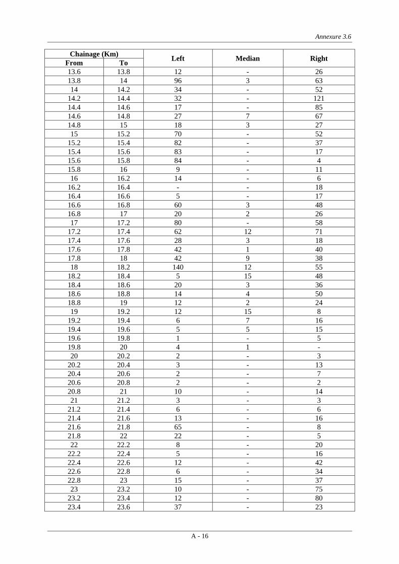
Annexure 3.6
A - 16
Chainage (Km) Left Median Right From To 13.6 13.8 12 - 26 13.8 14 96 3 63 14 14.2 34 - 52
14.2 14.4 32 - 121 14.4 14.6 17 - 85 14.6 14.8 27 7 67 14.8 15 18 3 27 15 15.2 70 - 52
15.2 15.4 82 - 37 15.4 15.6 83 - 17 15.6 15.8 84 - 4 15.8 16 9 - 11 16 16.2 14 - 6
16.2 16.4 - - 18 16.4 16.6 5 - 17 16.6 16.8 60 3 48 16.8 17 20 2 26 17 17.2 80 - 58
17.2 17.4 62 12 71 17.4 17.6 28 3 18 17.6 17.8 42 1 40 17.8 18 42 9 38 18 18.2 140 12 55
18.2 18.4 5 15 48 18.4 18.6 20 3 36 18.6 18.8 14 4 50 18.8 19 12 2 24 19 19.2 12 15 8
19.2 19.4 6 7 16 19.4 19.6 5 5 15 19.6 19.8 1 - 5 19.8 20 4 1 - 20 20.2 2 - 3
20.2 20.4 3 - 13 20.4 20.6 2 - 7 20.6 20.8 2 - 2 20.8 21 10 - 14 21 21.2 3 - 3
21.2 21.4 6 - 6 21.4 21.6 13 - 16 21.6 21.8 65 - 8 21.8 22 22 - 5 22 22.2 8 - 20
22.2 22.4 5 - 16 22.4 22.6 12 - 42 22.6 22.8 6 - 34 22.8 23 15 - 37 23 23.2 10 - 75
23.2 23.4 12 - 80 23.4 23.6 37 - 23

Annexure 3.6
A - 17
Chainage (Km) Left Median Right From To 23.6 23.8 34 - 17 23.8 24 23 - 27 24 24.2 5 - 18
24.2 24.4 17 - 10 24.4 24.6 27 - 14 24.6 24.8 16 - 9 24.8 25 11 - 15 25 25.2 6 - 15
25.2 25.4 2 - 3 25.4 25.6 17 - 25 25.6 25.8 4 - 17 25.8 26 1 - 4 26 26.2 9 - 38
26.2 26.4 5 - 24 26.4 26.6 16 - 29 26.6 26.8 19 - 20 26.8 27 9 - 28 27 27.2 9 - 13
27.2 27.4 15 - 18 27.4 27.6 11 - 20 27.6 27.8 6 - 40 27.8 28 16 - 33 28 28.2 24 - 29
28.2 28.4 18 - 65 28.4 28.6 10 - 68 28.6 28.8 7 - 75 28.8 29 11 - 220 29 29.2 5 - 97
29.2 29.4 5 - 54 29.4 29.6 13 - 30 29.6 29.8 14 - 15 29.8 30 7 - 10 30 30.2 1 - 13
30.2 30.4 6 - 6 30.4 30.6 14 - 46 30.6 30.8 - - 5 30.8 31 22 - 57 31 31.2 33 - 30
31.2 31.4 22 - 15 31.4 31.6 40 - 10 31.6 31.8 24 - 14 31.8 32 55 - 52 32 32.2 155 - 68
32.2 32.4 60 - 76 32.4 32.6 83 - 85 32.6 32.8 38 - 53 32.8 33 62 - 36 33 33.2 63 - 54
33.2 33.4 63 - 91 33.4 33.6 16 - 38

Annexure 3.6
A - 18
Chainage (Km) Left Median Right From To 33.6 33.8 45 - 46 33.8 34 63 - 75 34 34.2 30 - 7
34.2 34.4 10 - 17 34.4 34.6 32 - 18 34.6 34.8 9 - 13 34.8 35 20 - 194 35 35.2 22 - 75
35.2 35.4 21 - - 35.4 35.6 - - 8 35.6 35.8 28 - 1 35.8 36 4 - 15 36 36.2 8 - 30
36.2 36.4 39 - 65 36.4 36.6 28 - 29 36.6 36.8 31 - 18 36.8 37 24 - 21 37 37.2 39 - 35
37.2 37.4 40 - 60 37.4 37.6 42 - 72 37.6 37.8 51 - 86 37.8 38 72 - 52 38 38.2 41 - 18
38.2 38.4 20 - 45 38.4 38.6 17 - 3 38.6 38.8 2 - 10 38.8 39 105 - 58 39 39.2 40 - 48
39.2 39.4 40 - 41 39.4 39.6 28 - 32 39.6 39.8 38 - 15 39.8 40 90 - 43 40 40.2 77 - 76
40.2 40.4 54 - 53 40.4 40.6 18 - 41 40.6 40.8 24 - 46 40.8 41 49 - 60 41 41.2 25 - 48
41.2 41.4 33 - 18 41.4 41.6 36 - 55 41.6 41.8 60 - 12 41.8 42 5 - 52 42 42.2 14 - 65
42.2 42.4 46 - 30 42.4 42.6 21 - 23 42.6 42.8 20 - 28 42.8 43 40 - 65 43 43.2 20 - 65
43.2 43.4 20 - 49 43.4 43.6 - - 45

Annexure 3.6
A - 19
Chainage (Km) Left Median Right From To 43.6 43.8 14 - 35 43.8 44 24 - 60 44 44.2 10 - 40
44.2 44.4 17 - 20 44.4 44.6 3 - 9 44.6 44.8 1 - 16 44.8 45 10 - 14 45 45.2 4 - 7
45.2 45.4 14 - 17 45.4 45.6 5 - 26 45.6 45.8 25 - 23 45.8 46 73 - 34 46 46.2 24 - 38
46.2 46.4 12 - 62 46.4 46.6 24 - 55 46.6 46.8 66 - 34 46.8 47 54 - 12 47 47.2 17 - 12
47.2 47.4 45 - 16 47.4 47.6 41 - 45 47.6 47.8 30 - 92 47.8 48 32 - 15 48 48.2 40 - 162
48.2 48.4 35 - 78 48.4 48.6 65 - 44 48.6 48.8 21 - 56 48.8 49 18 - 63 49 49.2 22 - 79
49.2 49.4 8 - 19 49.4 49.6 8 - 41 49.6 49.8 54 - 45 49.8 50 28 - 38 50 50.2 8 - 42
50.2 50.4 25 - 9 50.4 50.6 3 - 12 50.6 50.8 2 - 20 50.8 51 4 - 11 51 51.2 8 - 29
51.2 51.4 8 - 18 51.4 51.6 8 - 1 51.6 51.8 4 - 27 51.8 52 30 - 46 52 52.2 28 - 18
52.2 52.4 7 - 49 52.4 52.6 15 - 18 52.6 52.8 9 - 24 52.8 53 32 - 19 53 53.2 24 - 7
53.2 53.4 12 - 14 53.4 53.6 38 - 14
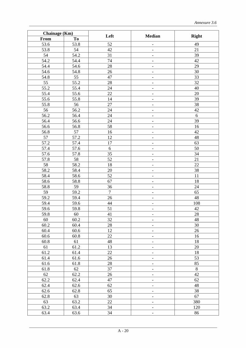
Annexure 3.6
A - 20
Chainage (Km) Left Median Right From To 53.6 53.8 52 - 49 53.8 54 42 - 21 54 54.2 31 - 39
54.2 54.4 74 - 42 54.4 54.6 28 - 29 54.6 54.8 26 - 30 54.8 55 47 - 33 55 55.2 28 - 32
55.2 55.4 24 - 40 55.4 55.6 22 - 20 55.6 55.8 14 - 39 55.8 56 27 - 38 56 56.2 24 - 42
56.2 56.4 24 - 6 56.4 56.6 24 - 39 56.6 56.8 58 - 16 56.8 57 16 - 42 57 57.2 12 - 48
57.2 57.4 17 - 63 57.4 57.6 6 - 50 57.6 57.8 35 - 34 57.8 58 52 - 21 58 58.2 18 - 22
58.2 58.4 20 - 38 58.4 58.6 52 - 11 58.6 58.8 67 - 18 58.8 59 36 - 24 59 59.2 7 - 65
59.2 59.4 26 - 48 59.4 59.6 44 - 108 59.6 59.8 51 - 42 59.8 60 41 - 28 60 60.2 32 - 48
60.2 60.4 28 - 30 60.4 60.6 12 - 26 60.6 60.8 22 - 16 60.8 61 48 - 18 61 61.2 13 - 20
61.2 61.4 22 - 18 61.4 61.6 26 - 53 61.6 61.8 28 - 85 61.8 62 37 - 8 62 62.2 26 - 42
62.2 62.4 47 - 62 62.4 62.6 62 - 48 62.6 62.8 65 - 38 62.8 63 30 - 67 63 63.2 22 - 380
63.2 63.4 34 - 120 63.4 63.6 34 - 86
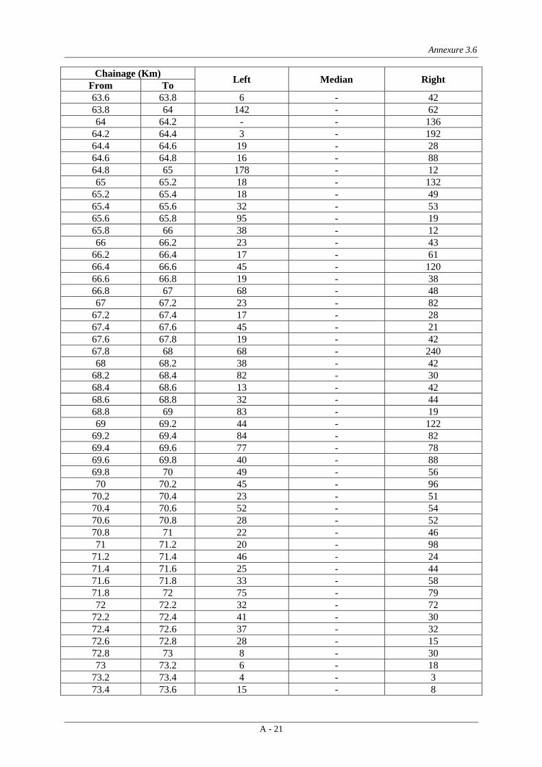
Annexure 3.6
A - 21
Chainage (Km) Left Median Right From To 63.6 63.8 6 - 42 63.8 64 142 - 62 64 64.2 - - 136
64.2 64.4 3 - 192 64.4 64.6 19 - 28 64.6 64.8 16 - 88 64.8 65 178 - 12 65 65.2 18 - 132
65.2 65.4 18 - 49 65.4 65.6 32 - 53 65.6 65.8 95 - 19 65.8 66 38 - 12 66 66.2 23 - 43
66.2 66.4 17 - 61 66.4 66.6 45 - 120 66.6 66.8 19 - 38 66.8 67 68 - 48 67 67.2 23 - 82
67.2 67.4 17 - 28 67.4 67.6 45 - 21 67.6 67.8 19 - 42 67.8 68 68 - 240 68 68.2 38 - 42
68.2 68.4 82 - 30 68.4 68.6 13 - 42 68.6 68.8 32 - 44 68.8 69 83 - 19 69 69.2 44 - 122
69.2 69.4 84 - 82 69.4 69.6 77 - 78 69.6 69.8 40 - 88 69.8 70 49 - 56 70 70.2 45 - 96
70.2 70.4 23 - 51 70.4 70.6 52 - 54 70.6 70.8 28 - 52 70.8 71 22 - 46 71 71.2 20 - 98
71.2 71.4 46 - 24 71.4 71.6 25 - 44 71.6 71.8 33 - 58 71.8 72 75 - 79 72 72.2 32 - 72
72.2 72.4 41 - 30 72.4 72.6 37 - 32 72.6 72.8 28 - 15 72.8 73 8 - 30 73 73.2 6 - 18
73.2 73.4 4 - 3 73.4 73.6 15 - 8

Annexure 3.6
A - 22
Chainage (Km) Left Median Right From To 73.6 73.8 13 - 6 73.8 74 12 - 3 74 74.2 5 - 28
74.2 74.4 37 - 35 74.4 74.6 6 - 16 74.6 74.8 28 - 12 74.8 75 11 - 24 75 75.2 14 - 19
75.2 75.4 16 - 22 75.4 75.6 20 - 30 75.6 75.8 38 - 46 75.8 76 28 - 38 76 76.2 12 - 46
76.2 76.4 26 - 80 76.4 76.6 27 - 22 76.6 76.8 11 - 30 76.8 77 45 - 35 77 77.2 22 - 46
77.2 77.4 18 - 45 77.4 77.6 62 - 42 77.6 77.8 17 - 46 77.8 78 55 - 22 78 78.2 18 - 38
78.2 78.4 25 - 38 78.4 78.6 22 - 36 78.6 78.8 28 - 68 78.8 79 53 - 42 79 79.2 26 - 45
79.2 79.4 68 - 81 79.4 79.6 140 - 85 79.6 79.8 20 - 38 79.8 80 37 - 87 80 80.2 47 - 125
80.2 80.4 19 - 55 80.4 80.6 29 - 28 80.6 80.8 38 - 45 80.8 81 55 - 55 81 81.2 9 - 140
81.2 81.4 27 - 28 81.4 81.6 62 - 40 81.6 81.8 50 - 32 81.8 82 21 - 26 82 82.2 35 - 36
82.2 82.4 37 - 65 82.4 82.6 9 - 140 82.6 82.8 14 - 92 82.8 83 29 - 65 83 83.2 20 - 32
83.2 83.4 61 - 50 83.4 83.6 52 - 68

Annexure 3.6
A - 23
Chainage (Km) Left Median Right From To 83.6 83.8 9 - 66 83.8 84 72 - 70 84 84.2 16 - 46
84.2 84.4 6 - 45 84.4 84.6 37 - 55 84.6 84.8 15 - 130 84.8 85 17 - 114 85 85.2 37 - 115
85.2 85.4 48 - 96 85.4 85.6 42 - 55 85.6 85.8 44 - 51 85.8 86 41 - 33 86 86.2 18 - 98
86.2 86.4 162 - 30 86.4 86.6 130 - 22 86.6 86.8 21 - 12 86.8 87 92 - 53 87 87.2 15 - 42
87.2 87.4 12 - 120 87.4 87.6 72 - 20 87.6 87.8 35 - 57 87.8 88 82 - 48 88 88.2 42 - 52
88.2 88.4 61 - 24 88.4 88.6 46 - 22 88.6 88.8 16 - 24 88.8 89 12 - 28 89 89.2 26 - 32
89.2 89.4 29 - 15 89.4 89.6 23 - - 89.6 89.8 61 - 18 89.8 90 36 - 28 90 90.2 150 - 56
90.2 90.4 240 - 16 90.4 90.6 52 - 42 90.6 90.8 14 - 26 90.8 91 55 - 8 91 91.2 36 - 11
91.2 91.4 24 - 48 91.4 91.6 28 - 42 91.6 91.8 29 - 26 91.8 92 130 - 18 92 92.2 122 - 65
92.2 92.4 - - - 92.4 92.6 - - - 92.6 92.8 53 - - 92.8 93 64 4 42 93 93.2 92 - 121
93.2 93.4 110 - 18 93.4 93.6 120 - 66

Annexure 3.6
A - 24
Chainage (Km) Left Median Right From To 93.6 93.8 128 8 55 93.8 94 55 8 52 94 94.2 45 12 55
94.2 94.4 45 7 62 94.4 94.6 82 5 35 94.6 94.8 58 3 27 94.8 95 40 14 42 95 95.2 27 12 45
95.2 95.4 42 19 62 95.4 95.6 55 5 52 95.6 95.8 35 13 33 95.8 96 42 4 41 96 96.2 126 9 42
96.2 96.4 49 4 26 96.4 96.6 10 2 8 96.6 96.8 5 2 8 96.8 97 5 - 12 97 97.2 11 5 39
97.2 97.4 16 3 12 97.4 97.6 1 3 8 97.6 97.8 6 2 10 97.8 98 12 1 20 98 98.2 11 1 -
98.2 98.4 9 1 12 98.4 98.6 22 - 15 98.6 98.8 32 1 24 98.8 99 43 - 26 99 99.2 79 4 15
99.2 99.4 6 4 40 99.4 99.6 2 - 38 99.6 99.8 3 2 5 99.8 100 9 1 3 100 100.2 2 2 17
100.2 100.4 3 2 4 100.4 100.6 14 4 21 100.6 100.8 20 6 3 100.8 101 23 6 - 101 101.2 24 4 19
101.2 101.4 8 5 9 101.4 101.6 12 2 18 101.6 101.8 6 1 32 101.8 102 2 2 16 102 102.2 40 5 22
102.2 102.4 11 1 18 102.4 102.6 13 3 5 102.6 102.8 - - 1 102.8 103 12 2 1 103 103.2 11 3 18
103.2 103.4 6 5 14 103.4 103.6 14 3 10

Annexure 3.6
A - 25
Chainage (Km) Left Median Right From To 103.6 103.8 3 2 17 103.8 104 3 16 18 104 104.2 20 2 16
104.2 104.4 - 1 9 104.4 104.6 12 0 - 104.6 104.8 15 0 2 104.8 105 5 1 1 105 105.2 - 1 -
105.2 105.4 5 1 - 105.4 105.6 - 1 - 105.6 105.8 15 2 4 105.8 106 10 5 12 106 106.2 25 6 13
106.2 106.4 5 7 30 106.4 106.6 17 1 26 106.6 106.8 27 5 48 106.8 107 30 8 32 107 107.2 11 12 50
107.2 107.4 24 8 22 107.4 107.6 - 18 30 107.6 107.8 1 2 16 107.8 108 0 0 0
Total 15045 429 19109
Table 3: Detailed Inventory of Trees on Kheda Bypass within Proposed ROW
Chainage (Km) Left Right From To 33.6 33.8 66 65 33.8 34 38 35 34 34.2 24 55
34.2 34.4 18 35 34.4 34.6 12 24 34.6 34.8 27 102 34.8 35 14 90 35 35.2 0 84
35.2 35.4 55 55 35.4 35.6 52 60 35.6 35.8 22 65 35.8 36 0 11 36 36.2 0 8
36.2 36.4 0 0 36.4 36.6 0 0 36.6 36.8 10 4 36.8 37 4 3 37 37.2 22 0
37.2 37.4 12 146 37.4 37.6 17 141 37.6 37.8 24 280
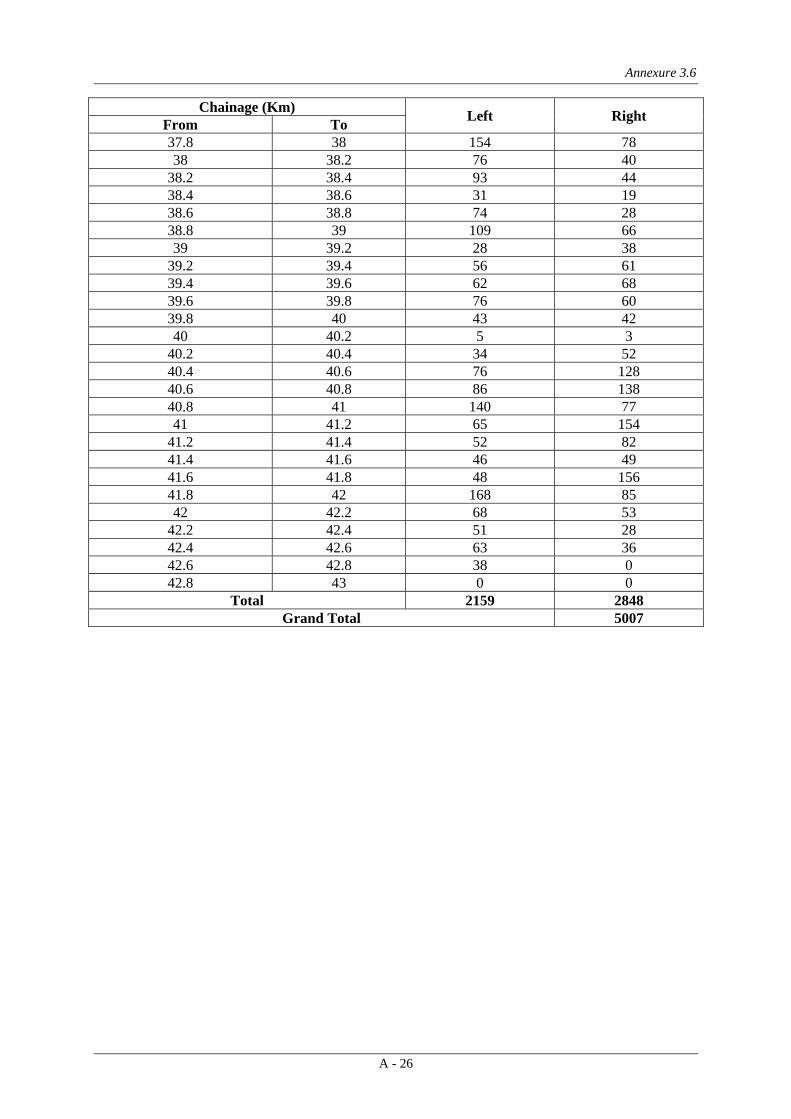
Annexure 3.6
A - 26
Chainage (Km) Left Right From To 37.8 38 154 78 38 38.2 76 40
38.2 38.4 93 44 38.4 38.6 31 19 38.6 38.8 74 28 38.8 39 109 66 39 39.2 28 38
39.2 39.4 56 61 39.4 39.6 62 68 39.6 39.8 76 60 39.8 40 43 42 40 40.2 5 3
40.2 40.4 34 52 40.4 40.6 76 128 40.6 40.8 86 138 40.8 41 140 77 41 41.2 65 154
41.2 41.4 52 82 41.4 41.6 46 49 41.6 41.8 48 156 41.8 42 168 85 42 42.2 68 53
42.2 42.4 51 28 42.4 42.6 63 36 42.6 42.8 38 0 42.8 43 0 0
Total 2159 2848 Grand Total 5007

Annexure 3.7
A - 27
LIST OF FAUNA IN THE PROJECT AREA
Common Name Scientific Name Fauna
Common Langur Presbestis entellus Common Mongoose Herpestes edwardsi Common Palm Civet Paradoxurus hermaphrohditus
Desert hare Leptus dayanus Flying Fox Pteropus giganteus
Grey Musk Shrew Suncus murinus Indian Fox Vulpes bengalensis
Indian Gerbille Tatera indica Indian Porcupine Hystrix indica
Indian Tree Shrew Anathana ellioti Indian Wild Boar Sus scrofa
Jackal Canis aureus Longtailed Tree Mouse Vandelura oleracea
Nilgai Boselphus tragocamelus Pale Hedgedog Paraechinus micropus
Pangolin Manis crassicauda Ratel Melivora capenies
Sambar Cervus Unicolor Small Indian Civet Vivericula indica
Smooth Indian Otter Lutrogale perspicillata Striped Hyaena Hyaena Hyaena Striped squirrel Funambulus pennanti
Avi-Fauna Black Ibis Pseudibis papillosa
Blacknecked Grebe P.caspicus Blue Rock Pigeon Columba livia
Cattle Egret Bubulcus ibis Cinnereous Vultureq Aegypius monachus
Comb Duck Sarkidornis melanots Common Indian Nightjar Caprimulgus asiaticus
Common Pochard Anas ferrina Common Quail Coturnix coturnix Common Teal Anas crecca
Coot Fulica altra Cormorant Phalacroccrax carbo Cotton teal Nettapus coromandelianus
Demoiselle Crane Antcropoides virgo Dusky Horned Owl B.coromandus
Fantail Snipe Capella gallinago Flamingo Phoenicopetrus reseus
Glossy Ibis Plegadis falcinellus Great Crested Grebe P.cristatus

Annexure 3.7
A - 28
Common Name Scientific Name Great Horned Owl Bubo bubo
Green Pigeon Treron phoenicoptera Grey Heron Ardea cinerea
Grey Patridge Francolinus pondicerianus Grey Pelican P. philippensis
Houbara Chlamydotis undulate Indian Ring Dove Streptopelia decaocto Indian Sandgrouse Pterocles exustus
Indian Skimmer Rynchops albicollis Koel Eudynamys scolopacea
Large Egret Egretta alba Large Indian Parakeet P.eupatria
Lesser Flamingo Phoeniconais minor Lesser Floriken Sypheotides indica
Lesser Whistling Teal Dendrocygna javanica Little Brown Dove S.senegalensis
Little Grebe Podiceps ruficollis Little Green Heron Bautorides striatus Mottled Wood Owl Strix ocellata
Night Heron Nycticorax nycticorax Open billed Stork Anastomus oscitans
Painted Sandgrouse Pterocles indicus Painted Snipe Rostratula benghalensis Painted Stork Ibis leucocephalus
Peafowl Pavo cristatus Pied Crested Cuckoo Clamator jacobinus
Pink Flamingo Phoenicopterus roseus Red Turtle Dove S.tranquebarica
Redwattled Lapwing Vanellus indicus Rose ringed Parakeet Psittacula krameri
Rosy Pelican Pelicanus onocrotalus Sarus Crane Grus antigone
Shikra Accipiter badius Shorteared Owl Asio flammeus
Shovellor Anas cylpeata Snake bird Anhinga rufa
Spotbill duck Anas poecilorhynchos Spotted Dove S.chinensis Stone Curlew Burhinus oedicnemus
White breasted waterhen Amaurornis phoenicurus White Ibis Threskiorsis melenocephala
White Pelican Pelecanus onocrotalus White Stork Ciconia ciconia
White Vulture Neophron percnopterus White-necked Stork Ciconia episcopus

Annexure 3.8
A - 29
LIST OF NURSERIES ALONG THE PROJECT ROAD
S. No. Chainage, Km Side Name of Nursery/Farmhouse Type 1. 11.100 Left Puja Farm Farmhouse 2. 29.000 Right Nabar Farm Farmhouse
3. 58.000 Right J.C.Park farm and Nursery Nursery 4. 58.000 Right Ambika Farm and Nursery Nursery 5. 60.000 Left Radhe Krishana Nursery Nursery 6. 61.000 Right Radhe Krishna Farm Nursery
7. 64.900 Left Sammati Nursery Nursery 8. 66.000 Right Shivam Farm Nursery 9. 67.000 Right Forest Farm Nursery 10. 75.500 Right Vrindavan Nursery Nursery
11. 75.500 Right Priya farm Nursery 12. 77.300 Left Nandan Van Nursery Nursery 13. 78.100 Left Ekta Nursery Nursery 14. 78.200 Left Anupam Nursery Nursery
15. 78.300 Left Farm House Farmhouse 16. 79.100 Right Sriram Nursery Nursery 17. 79.100 Right Rani Dveep Nursery Nursery 18. 79.900 Left Jai Mahalakshami Nursery Nursery
19. 80.000 Left Sri Mahadev Nursery Nursery 20. 82.000 Left Shainath Nursery Nursery 21. 82.100 Right Narendra farm and Nursery Nursery 22. 82.100 Right Aakash Nursery Nursery 23. 83.000 Left Surendra Nursery Nursery
24. 83.000 Left Sri Krishna Nursery Nursery 25. 83.000 Left Jalaram Nursery Nursery 26. 83.100 Right Harikrishna Nursery Nursery 27. 83.900 Left Sri Hari Nursery Nursery
28. 84.000 Left Shri Hari Nursery Nursery 29. 84.100 Right Nursery Nursery 30. 84.100 Right Shri Krishna Nursery Nursery 31. 86.000 Left Nursery Nursery
32. 86.000 Left Pushpam Rose Nursery Nursery 33. 86.450 Left Raja Farm Farmhouse 34. 86.500 Right Lav Kush Nursery Nursery 35. 88.000 Left Srinath Nursery Nursery

Annexure 3.8
A - 30
S. No. Chainage, Km Side Name of Nursery/Farmhouse Type 36. 88.000 Left Sri Nursery Nursery 37. 93.000 Left Ambey Farm Nursery Nursery 38. 93.800 Right Gurukripa Nursery Nursery 39. 94.100 Left Chamunda Roses Nursery Nursery
40. 94.200 Left Roses Nursery Nursery 41. 95.600 Left Suraj Nursery Nursery 42. 95.600 Left Roses Nursery Nursery 43. 95.800 Left Pushpam Rose Nursery Nursery
44. 95.800 Left Chamunda Roses Nursery Nursery 45. 95.900 Right Keshav Nursery Nursery 46. 95.950 Left Bhagyoday Nursery Nursery 47. 95.950 Left Vadoda Roses Nursery Nursery
48. 96.900 Right Roses Nursery Nursery 49. 97.100 Right Harekrishana Nursery Nursery 50. 100.000 Right Jaganath Nursery Nursery

Annexure 3.9
A - 31
LIST OF RELIGIOUS STRUCTURES ALONG THE PROJECT ROAD
Sl. No. Type of Religious Structures Existing Chainage (Km.) Side 1. Shrine 6.400 Right 2. Hanuman Temple 6.500 Right 3. Temple 7.400 Right 4. Temple 7.450 Right 5. Jain Temple 7.600 Left 6. Shrine 7.600 Right 7. Shrine 7.700 Lefteft 8. Temple 9.000 Right 9. Temple 9.500 Right 10. Shrikrishna Temple 9.750 Right 11. Shrine 9.900 Right 12. Shrine 10.250 Left 13. Temple 10.730 Left 14. Shrine 11.100 Right 15. Shrine 11.400 Left 16. Shrine 11.750 Right 17. Shrine 12.000 Left 18. Shrine 12.200 Left 19. Temple 12.650 Left 20. Temple 12.800 Right 21. Temple 12.850 Left 22. Temple 13.000 Left 23. Shrine 13.100 Left 24. Shrine 13.120 Left 25. Temple 13.900 Left 26. Temple 13.900 Right 27. Temple 15.850 Right 28. Swaminarayan Temple 15.900 Left 29. Temple 16.000 Right 30. Temple 16.200 Right 31. Shrine 16.700 Left 32. Swaminarayan Temple 16.850 Left 33. Mataji Temple 18.900 Left 34. Shrine 19.150 Left 35. Sri Ram Temple 19.500 Left 36. Baba Sitaram Temple 19.600 Left 37. Temple 20.600 Right 38. Temple 20.600 Right 39. Temple 25.250 Left

Annexure 3.9
A - 32
Sl. No. Type of Religious Structures Existing Chainage (Km.) Side 40. Shrine 25.300 Right 41. Chila 36.400 Right 42. Temple 36.750 Right 43. Shrine 36.900 44. Shrine 39.900 Left 45. Madarsa 40.200 Right 46. Temple 40.400 Left 47. Sitaramji Temple 41.300 Left 48. Temple 41.700 Left 49. Hanuman Temple 42.400 Left 50. Sai Temple 43.000 Right 51. Swaminarayan Asram 44.300 Right 52. Shrine 44.900 Left 53. Idgaah 45.500 Right 54. Ganesh Ji Shrine 47.700 Left 55. Jai Matadi Temple 49.300 Left 56. Temple Gate 49.800 Right 57. Hanuman Temple 50.600 Left 58. Catholic Church 51.700 Right 59. Mahadev Temple 52.000 Right 60. Temple 55.500 Left 61. Temple 57.200 Left 62. Temple 58.500 Left 63. Mukti Dham 59.700 Right 64. Shrine 59.800 Right 65. Shrine 60.300 Left 66. Shrine 60.500 Left 67. Jain Temple 61.700 Right 68. Jalatam Temple 61.800 Right 69. Shrine 62.800 Left 70. Shatya Narayan Temple 63.700 Right 71. Shrine 66.600 Left 72. Shrine 66.800 Right 73. Shrine 67.300 Left 74. Swaminarayan Temple 69.200 Right 75. Shrine 70.900 Left 76. Temple 72.000 Left 77. Temple 74.600 Right 78. Temple 76.100 Left 79. Mailadi Mataji Temple 78.300 Right

Annexure 3.9
A - 33
Sl. No. Type of Religious Structures Existing Chainage (Km.) Side 80. Shiva Temple 79.200 Left 81. Small temple 82.000 Right 82. Chanchai Mata Temple 82.200 Right 83. Temple 83.400 Right 84. Small temple 83.700 Right 85. Shrine 83.880 Left 86. Shrine 83.900 Left 87. Shrine 84.100 Right 88. Shrine 84.600 Left 89. Lav Kush Temple 85.800 Left 90. Shrine 86.700 Right 91. Shrine 86.800 Left 92. Shrine 87.100 Right 93. Temple 87.100 Left 94. Yatry Shed 87.100 Left 95. Shrine 88.700 Left 96. Hanuman Temple 90.000 Right 97. Swaminarayan Temple 90.100 Right 98. Small temple 90.500 Left 99. Temple 92.150 Left
100. Shrine 92.200 Left 101. Ramdev Pir Temple 93.000 Right 102. Temple 93.900 Right 103. Ghadiyali Baba Dargaah 95.000 Left 104. Shrine 95.800 Left 105. Rajeshwari Temple 97.000 Right 106. Jugni Maa Temple 98.000 Right 107. Omkar Jain Tirth 98.100 Right 108. Small temple 98.900 Left 109. Temple 99.200 Left 110. Temple 99.500 Right 111. Temple 99.750 Left 112. Temple 100.800 Right 113. Hanuman Temple 101.000 Left 114. Shrine 102.200 Right 115. Temple 103.200 Left 116. Temple 103.200 Right

Annexure 3.10
A - 34
LIST OF EDUCATIONAL INSTITUTES ALONG THE PROJECT ROAD
Sl. No. Name of Educational Institute Existing Chainage (Km) Side
1 Narayan Shastry School 15.000 Left
2 MP Mandya School 16.500 Left
3 Boundary Wall of R.H. Patel Institute 27.000 Left
4 Sardar Patel School 58.800 Left
5 Ankur Vidyalaya 101.100 Right
6 Kumar Primary School 44.3 Left
7 Primary School 45.3 Left
8 Brijbhumi International School 80.65 Left
9 High School 103.75 Left

Annexure 3.11
A - 35
LIST OF INDUSTRIES ALONG PROJECT ROAD
S. No. Chainage (km) Side Name of Industry Area of Work 1 6.900 Right Uma Transport Transport 2 7.000 Right Sardar Patel Estate Estate 3 7.000 Right J.P Traders Traders 4 8.000 Left Star Auto Mobiles Garage 5 10.000 Right Mandip Steel Eng. Steel 6 10.500 Left Unique Motors Hardware 7 10.700 Left Aman Transport Transport 8 11.000 Right Maa Kali Estate Estate 9 11.200 Left Microw Make Pvt. Ltd. Hardware
10 11.500 Left Mahindra Motors Show Rooms Show Room 11 11.700 Left Janta Rajani Transport Transport 12 12.000 Left Tata Motors Sales and Service 13 12.000 Right Sakti Tractors Tractors 14 13.000 Left King Roadways Transport 15 14.000 Right Sri Raaj Transport Transport 16 14.500 Left Ashok Leyland Part Hardware 17 14.700 Left M. Chandulal Godown Godown 18 16.000 Left Sai Rice Mill Rice Mill 19 16.000 Left Sonalika Tractors Tractors 20 16.000 Right Baldev Estate Estate 21 16.000 Right Asian Paint Paint 22 17.000 Left Gurunanak Works Motor Repairing 23 17.000 Left Ideal Workers Motor Repairing 24 17.000 Left Roma Motors Motor Repairing 25 18.000 Left VRL Logistic Logistic 26 18.000 Left Surendra and Company Transport 27 18.000 Left Agricultural Company Agriculture 28 18.000 Right Cargo Motors Motors 29 19.000 Left M.M.Transport Transport 30 19.000 Right Harsidhi Engineering Engineering 31 19.000 Right Dayal Estate Estate 32 19.000 Right Sri Ram Transport Transport 33 21.000 Left Shakti Body Builder Body Builders 34 25.800 Left Textile Park Textile 35 26.000 Left Shri Sai Body Builder Body Builders 36 29.000 Right Cocacola Industries Cocacola 37 29.100 Left Chemical Private Ltd. Chemical 38 30.800 Left Durga Industries Industries

Annexure 3.11
A - 36
S. No. Chainage (km) Side Name of Industry Area of Work 39 32.000 Left Mark Pharma Pharmaceutical 40 45.000 Right Chintamani Auto Auto 41 45.000 Right Nilkanth Show Mile Wooden Work 42 46.000 Right Jalaram Rice Mill Rice Mill 43 47.000 Left Gujarat Poultry Farm Poultry 44 50.500 Left Rajesh Body Builders Body Builders 45 50.600 Left Swaraj Traicture Tractors 46 50.800 Left Hariom Motor Body Body Builders 47 50.800 Left Asian Food Restorent 48 51.000 Right Sanyog Tractors Tractors 49 51.000 Right Sriji Traders Traders 50 51.000 Right Nadiyad Transport Transport 51 51.200 Left Rameshwar Timber Mart Timber 52 55.000 Right Lohar Industries Industries 53 55.400 Left Brand Motors Motors 54 55.400 Left V. B. Motors Ltd. Auto 55 56.000 Left Shivam Marbles Marble 56 56.000 Left Shakti Motors Motors 57 56.000 Right Lakshami Snacks Snack 58 57.000 Left Orisen Motors Motors 59 58.000 Left Oasis Garden Park 60 58.000 Left B.R. Tobacco Company Tobacco 61 58.000 Right Rajvi tractors Tractors 62 58.000 Right Charotar Industries Industries 63 59.000 Left Krishna Tractors Tractors 64 60.000 Left M.K. Picke Others 65 65.000 Right Yagnik Estate Estate 66 65.000 Right Nutan Tobacco Tobacco 67 65.100 Left Sri Jay Auto Limited Maruti Cell 68 65.700 Left Varun Cold Storage Cold Store 69 65.800 Left Sri Krishna Cold Storage Cold Store 70 65.900 Left GP Tiles Tiles 71 66.000 Left Sriji Cement Pipe Fitting 72 66.000 Right Ghanshyam Hydro Hydro 73 66.000 Right Shivam Cement Cement 74 66.000 Right Akshar Spone Pipe Cement Pipe 75 67.000 Right Omya Cold Storage Cold Store 76 67.000 Right Raghukul Cold Storage Cold Store 77 67.000 Right Subh Lakshami Cold Storage Cold Store

Annexure 3.11
A - 37
S. No. Chainage (km) Side Name of Industry Area of Work 78 67.000 Right Vagheswari Cement Cement 79 67.300 Left Srinath Cement Factories Pipe Fitting 80 68.000 Left Vimal Cement Factories Cement 81 68.000 Right Sudarsan Cold Storage Cold Store 82 70.200 Left Ravi Cold Storage Cold Store 83 70.200 Left Sonal Cold Stores Cold Store 84 70.200 Left Ply Industries Ply 85 71.600 Left Anant Transport Transport 86 72.000 Left Patel Transport Transport 87 73.000 Right Sahara Motors Motors 88 75.000 Right Patel Godown Godown 89 75.800 Left Tata Motors Sales and Service 90 77.000 Left Ambuja Marbles Marble 91 77.500 Right Sriraj Motors Motors 92 77.500 Right Chirag Tiles Tiles 93 77.500 Right Tafe Tractors Tractors 94 77.500 Right Somnath Tiles Tiles 95 77.600 Left Eicher Motors Motors 96 77.700 Left Vipin Cold Stores Cold Store 97 78.500 Right Krishna Tiles Tiles 98 78.500 Right Modi State Timber 99 78.500 Right Chikhodra Tractors Tractors 100 81.000 Left India Lime Works Lime Works 101 82.000 Left Lakshami Cold Stores Cold Store 102 82.100 Right Kamal Cold Storage Cold Store 103 83.100 Right JSL Industries Industries 104 86.300 Left J.K Fertilizer Fertilizer 105 86.500 Right Tridev Cement Cement 106 89.000 Left Nawarang Factory Company 107 89.000 Left GITCO Company 108 89.800 Right Sri Ram Cement Cement 109 93.000 Left Puncham Farm Pipe Fitting 110 93.800 Right Omya Eerth Movers JCB 111 95.900 Left Prachi Chemicals Chemical 112 95.900 Right Charbhuja Bairal Plastic Drum 113 95.900 Right Chiraj Trading Traders 114 96.000 Left Jain Immigration Immigration 115 96.000 Left Adarsh Body repaiyer Body Builders 116 96.000 Left Kishan Agro Food Food

Annexure 3.11
A - 38
S. No. Chainage (km) Side Name of Industry Area of Work 117 96.000 Right Manikchand Gutka Factory 118 96.100 Right Ganaraj Cold Storage Cold Store 119 96.300 Left Shaktiraaj Cold Store Cold Store 120 97.000 Left Swambay Chemicals Chemical 121 97.000 Left Vijay Trans Company 122 97.100 Right Ishan Company 123 97.100 Right Jyoti Timber Timber 124 100.000 Right Burger Paint Industries Industries 125 101.000 Left Lukshami Lime and Chemicals Chemical 126 101.000 Left Lucy Electric Electric 127 102.000 Left IPOL Lubricant Lubricant 128 102.000 Left Arihant Transport 129 102.000 Left Eicher Auto 130 102.000 Right Gupta Engineering Engineering 131 102.000 Right L&T Ltd L&T Ltd 132 103.000 Right Fertilizer Fertilizer 133 103.000 Right SICGIL SICGIL 134 104.000 Left Swaraj Tractor Tractors 135 104.000 Right Mahindra Motors Motors 136 104.000 Right GSFC GSFC 137 104.200 Left Neel Engineering Body Builders 138 104.300 Left Associated Road Carrier Crain 139 105.000 Left Park Park 140 108.000 Right Nilkanth Agriculture Agriculture

Feasibility for Six Laning of Ahmedabad-Vadodara Section of NH-8 to be Executed as BOT (Toll) Project on DBFO Pattern Under NHDP Phase-V
Draft Environmental Impact Assessment Report 4 - 1
4. ANTICIPATED ENVIRONMENTAL IMPACTS AND MITIGATION MEASURES
4.1 INTRODUCTION
The identification of potential impacts is based on field inspection of existing road with due consideration to direct, indirect, cumulative and secondary impacts and relates to the following:
• Tree removal and replacement tree planting;
• Land acquisition and potential realignments;
• Eviction from habitation and work places;
• Protection from sacred groves, gravesites and temples;
• Effective restoration of borrow areas and quarries;
• Noise and air quality;
• Maintaining drainage including waterways areas and preventing siltation;
• Waste management, particularly from construction camps;
• Flora and fauna;
• Protection of forests and natural reserves;
• Cultural heritage;
• Road safety;
• Accommodation of non-motorized transport;
• Additional use of road surface;
• Potential spread of disease;
• Asphalt plants and equipments;
• Bypasses;
• Resettlement and rehabilitation;
• Contractual enhancement;
• Institution buildings.
4.2 IMPACTS ON PHYSICAL ENVIRONMENT
4.2.1 Impact on Topography
Impact on the topography of the project area at macro level is not significant.
4.2.2 Impact on Geology
Construction Phase
Impact of the proposed activity on the geological resources will occur from the extraction of materials primarily from identified quarries. As stones and sand will be collected from riverbed, exhaustion of materials through extraction for this project will tend to get replenished by flow of boulders & deposits of sand during the succeeding monsoon. Hence, the impact on geology of the region is insignificant.
Feasibility for Six Laning of Ahmedabad-Vadodara Section of NH-8 to be Executed as BOT (Toll) Project on DBFO Pattern Under NHDP Phase-V
Draft Environmental Impact Assessment Report 4 - 2
4.2.3 Impact on Meteorology
There will be temporary impact on the micrometeorology of the immediate project corridor because of removal of roadside trees. Loss of agricultural lands along the corridor will also cause such micro-meteorological changes but this will not cause any discomfort, as populations are generally located away from the corridor of impact. With the provision of compensatory plantation along the project corridor over much larger areas, there will be beneficial impacts on the micrometeorology of the project corridor.
Impact on Temperature
Construction Phase
• During construction phase an increase in temperature along the road at micro level is anticipated due to tree cutting, machine operations and paved surface.
• Transportation of construction material will increase heavy vehicle traffic movement on the road during construction phase, which may lead to minor increases in levels of temperature.
• Localized increase in temperature at construction camps due to machineries used for construction.
• There might be a short term and localized increase in temperature due to slow moving highway traffic along limited passage to the traffic in stretches where construction will be in progress.
Operation Phase
During operational phase the temperature of the project road will normalize, as traffic will be speedier on improved and wider road surfaces. Such impacts will be very low, short term and reversible. Therefore, no mitigation measure is required.
Rainfall
There will neither be any micro nor macro level change in the rainfall pattern keeping in view the magnitude of operations.
Humidity
Construction Phase
The humidity along the project road may be influenced only during the period of dust suppression through sprinkling of water.
This will be low, spatially confined within a very narrow corridor, short term and reversible. Hence no mitigation measures are necessary.
4.2.4 Impact on soil
Development activities have been always associated with loss of productive soil and soil contamination; both physical and chemical. Problems on physical degradation include erosion, compaction and structural damage resulting from construction activities and borrowing and quarrying. Similarly chemical problems results from waste disposal activities, discharge and spillage of liquid effluent and atmospheric emissions.
4.2.4.1 Pre construction phase
• Site preparation may involve demolition of building, clearing of brushwood, tree removal, temporary rerouting of utilities, topsoil stripping and diversion or re-channeling of waterways. This brings risks of erosion to the exposed ground or stored topsoil.

Feasibility for Six Laning of Ahmedabad-Vadodara Section of NH-8 to be Executed as BOT (Toll) Project on DBFO Pattern Under NHDP Phase-V
Draft Environmental Impact Assessment Report 4 - 3
• Setting up of workers camp along the project road may lead to loss of productive soils and impact the soil productivity especially at micro level.
• Removal of vegetation that exists as Protected Forest along the sides of the existing road will significantly increase the effect of soil erosion.
Mitigation Measures Adequate drainage facilities throughout the length of the highway as well as avenue plantation along widened road will mitigate soil erosion and soil pollution.
4.2.4.2 Construction Phase The activities as detailed below at the construction zones, construction labor camps, construction plant sites and other auxiliary facilities required for the construction may lead to contamination of soil:
• Scarified bitumen waste.
• Maintenance of machinery and operation of diesel generator sets.
• Oil spill from the operation of the mechanical work shops, diesel pumps, and diesel storage, transportation and transfer, parking places and diesel generator sets.
• Operation of the emulsion sprayer and laying of hot mix.
• Operation of construction camps and residential facilities for supervisory staff.
• Storage and stock yards of bitumen and emulsion.
• Excess production of hot mix and rejected materials.
• There may be temporary loss of production during construction stage if workers camps, stockyards and borrow areas are established on agricultural land. Use of some other lands for haul loads and traffic detours may cause minimal and temporary impact on productivity of the project corridor.
• The project road does not have elevated sections of embankment. However on approaches to the bridges the embankments will be higher by 1.5 to 2.5 m above ground level. During construction phase if proper drainage is not ensured, soil erosion process may set in.
• Movement of machineries, vehicles during construction phase especially haul roads will add up to soil pollution.
Mitigation measures • Work during rainy season in periods of heavy rainfall will be avoided to reduce soil
erosion.
• Construction waste will be reused in the construction activities for making sub-grades and raising embankments. The stripped bitumen will be milled and be used especially for preparation of sub-grades.
• Solid waste generated from the workers camps would be dumped in locally identified sites. The liquid discharge from the workers camp will be disposed to the existing drainage system in order to prevent soil pollution.
• Storage of construction material will be done in accordance with the IRC norms.
• Slope embankments will be provided with the grass turf and run off from the roads will be safely disposed off to the existing drainage system to prevent any possibility of soil erosion.
• Vegetal cover that will come up gradually with time through compensatory plantation will hold the soil firmly through their root system and also cut down on quantum of

Feasibility for Six Laning of Ahmedabad-Vadodara Section of NH-8 to be Executed as BOT (Toll) Project on DBFO Pattern Under NHDP Phase-V
Draft Environmental Impact Assessment Report 4 - 4
precipitation reaching the ground through canopy interception and evaporation through canopy foliage.
• Local borrow areas can be landscaped and developed for a variety of recreational and economic uses in consultation with communities.
4.2.4.3 Operation stage During this stage, there is a possibility of soil contamination by spill from accidents or leakage from vehicles carrying hazardous chemicals. The probability of the incidents is low and such impacts will depend to a great extent on how such situations are handled on ground. There will be no adverse impact on soil during the operation phase. The lands along the project corridor may be benefited due to less dust dispersion because of larger paved surfaces meaning thereby the crops on lands growing the project period will have enhanced photosynthetic activity. Similarly roadside plantations coming up in strips along the corridor will look healthier and aesthetically more pleasing as their green canopies will be spared of layers of dust deposition.
4.3 IMPACT ON LAND USE PATTERN
Induced Development The improvement of the project road is expected to cause some changes in the land use. There may be some change in the land use pattern of the project area such as establishment of some small business enterprises especially along the project road. Any undesirable induced development has to be controlled by competent civil authorities within the prevailing regulatory framework.
4.4 IMPACT ON WATER ENVIRONMENT Water sources and quality, including surface and ground water, is likely to be impacted due to activities such as setting up workers’ camp near water sources, transportation and storage of construction material such as heap of sand without cover.
4.4.1 Impact on Surface water quality These surface water bodies may be impacted in terms of degradation in water quality and increase in sediment load. The project road crosses three rivers namely Vatrak, Mahi and Mini, few canals and ponds. There are two ponds along the project road which are used by residents for washing and other uses other than for drinking. Due care will be taken to avoid any impact on these ponds due to the proposed widening activity. Pre Construction Phase Surface water bodies may be impacted in terms of degradation in water quality and increase in sediment load. Due to tree felling, soils around the water bodies and surface drainage channels will be exposed during the pre construction stage.
• The short-term increase in runoff laden with sediment may also occur due to the removal of trees, vegetative cover and compaction of the surrounding soil
• The suspended sediments and the associated pollutants may get washed into these water sources leading to habitat quality changes for fish and aquatic life because of increased turbidity.
Construction Phase • The water quality of these surface water bodies may degrade due to spillage of
construction materials, spoils or inflow of silt because of soil erosion along the bank/embankments of water courses during construction stages.
• Storage of materials and construction wastes may also add to such sediment load.

Feasibility for Six Laning of Ahmedabad-Vadodara Section of NH-8 to be Executed as BOT (Toll) Project on DBFO Pattern Under NHDP Phase-V
Draft Environmental Impact Assessment Report 4 - 5
Water pollution from the construction activities may be attributed to:
• Storage and stockyards for bitumen and emulsion.
• Oil spill from the operation of the mechanical workshop, diesel pumps, diesel storage, transportation and transfer.
• Soil disturbance during the foundation work of bridges and culverts such as piling and excavation for open / well foundation.
• Operation of construction camps.
• Water flow from scarified bitumen material.
• Operation of emulsion sprayer and laying of hot mix.
Operation Phase It is envisaged that there is possibility of positive impacts, during operation phase, due to the proposed widening of existing road. The extent of vehicles going on to the berms causing dust would be reduced because of larger paved surfaces meaning thereby reduced dust settlements on water courses. Impacts on surface water quality during pre-construction will be low, spatially restricted and very short term. Such impacts during the construction phase will be moderate particularly in areas of bridge construction but short term and reversible. As the proposed project involves widening of 161 culverts and building of 25 new culverts designed as per local micro-drainage patterns, it is envisaged that erosion of soil will be minimized during operation stage.
Mitigation Measures
• Restriction of work on program on construction of culverts during the dry seasons.
• Use of silt fencing, sediment traps etc for minimization of soil movement.
• Minimization of disturbance of stream substrate to only that necessary for placing abutments or piling.
• Construction of cofferdam with materials that cannot be brought into suspension by flowing waters.
• Provision of cover of tarpaulins or other material under the bridge deck to prevent debris, wastes and toxic compounds from entering the stream.
• Avoidance of lead-based paints in painting bridge components.
• Use of oil/ water separators to extract floating oils.
• Channeling run-off with high level of suspended solids into sedimentation ponds.
• Proper storage of contaminated liquids and disposal after treatment to bring such liquids within prescribed permissible limits.
• Turfing with grass or planting with tress of all exposed areas as soon as possible to reduce erosion risks.
• On site fueling area of vehicles and equipments will be selected away from water bodies and would be protected by a berm to prevent run-off from leaving the area.
• Adoption of a well-conceived construction material handling protocol e.g. storage away from water sources and provision of retention areas to contain accidental spills of such toxic and hazardous material.
• Provision of adequate number of cross-drainage structures for efficient cross-drainage and prevention of water stagnation along the sides.

Feasibility for Six Laning of Ahmedabad-Vadodara Section of NH-8 to be Executed as BOT (Toll) Project on DBFO Pattern Under NHDP Phase-V
Draft Environmental Impact Assessment Report 4 - 6
• Avoidance of contamination of the water body and drainage channels from fuel and lubricants, through proper maintenance of vehicle and equipments only at designated places.
• Modification of embankment slopes to prevent entry of contaminated water into watercourses.
4.4.2 Impact on Ground Water Four hand pumps, three wells and four borewells are present along the existing road. The water will be extracted from ground for construction activity and for domestic use in labour camp. Such consumption from identified sources will not come in conflict with the requirement of the local communities. Mitigation Measures • Concentric, left and right side widening will save most of these water sources.
• Relocation of hand pumps and wells will be done with the community consultation.
• Construction of rainwater harvesting structures at every 500 m distance on alternate sides of the project road in Vadodara ( Km 93 to Km 108; 15 Km stretch)and Ahmedabad ( km 6.4 to Km 21.9; 16 Km stretch) districts as the depth to groundwater level is more than 20 mbgl in these regions and they may fall under exploited areas with reference to groundwater availability.
4.5 IMPACTS ON AIR ENVIRONMENT
The perception of the people about the air quality is generally good but the people living in congested settlements have complaints about the quality of air particularly on particulates. Air quality is not likely to be impacted and such impacts in all probability will be of minor nature. Pre Construction Stage The pre-construction stage is characterized by activities like site clearance, tree cover removal, shifting of utilities, transportation of men and material, establishment of construction camps, stockyards, installation of plants and equipments. All these activities lead to generation of dust especially when such activities are undertaken during the dry season. Such impacts will be short-term, location specific and reversible. Construction Stage The most important pollutant during this phase will be suspended particulate matter along with gaseous pollutants like dioxides of nitrogen, sulphur, and carbon monoxide. Such deterioration of air quality can be assigned to:
• Fugitive dust emission from construction activities like excavation, back-filling and concreting.
• Hauling and dumping of earth & construction spoils and vehicular movement along unpaved roads or temporary diversions.
• Gaseous emission from construction equipment and vehicular traffic.
• Emissions from asphalt and hot-mix plants.
• Such impacts will be low to moderate and spatially restricted along the immediate corridor of impact.
Operation Stage Air quality is likely to improve in the initial years after commissioning because of saving of fuels in the vehicular traffic riding on smooth and improved roads with much less

Feasibility for Six Laning of Ahmedabad-Vadodara Section of NH-8 to be Executed as BOT (Toll) Project on DBFO Pattern Under NHDP Phase-V
Draft Environmental Impact Assessment Report 4 - 7
interruption. Dust dispersion also will be substantially reduced. But such beneficial impacts may be negated in future years through increased volume of traffic and inadequate road maintenance. It is also possible in future –not a very distant one that there may be reduction in the pollutant load of transportation because of improvement in fuel quality, design improvement of engines and availability of mix of environment friendly fuels. Mitigation Measures • The asphalt plants, crushers and the batching plants will be sited at least 1000 m in
the downwind direction from the nearest settlement.
• All precautions to reduce the level of dust emissions from the hot mix plants, crushers and batching plants will be taken up. The hot mix plant will be fitted with dust extraction units. Construction of wind breaking walls near stone crusher units will avoid dust laden air travelling to built-up areas and sensitive locations.
• All vehicles, equipment and machinery used for construction will be regularly maintained to ensure that the pollution emission levels conform to the SPCB norms. Regular monitoring of Suspended Particulate Matter at crusher sites, during the construction, will be conducted.
• Water will be sprayed on the lime/cement and earth mixing sites, asphalt mixing site and temporary service and access roads. After compacting the earthwork, water will be sprayed on regularly to prevent generation of dust.
• To avoid dust emissions likely to result from the spills of construction materials and borrow materials, the vehicles delivering material will be covered.
• Proper traffic management plan at construction and operation stages will reduce the congestion of traffic and hence reduces concentration of air pollutants
4.6 IMPACT ON NOISE ENVIRONMENT
Noise quality is not likely to be impacted due to the project. The impact will mainly be on the sensitive receptors such as hospitals and schools. The magnitude of the impact during the construction period will depend upon the specific types of equipment to be used, the construction methods employed and the scheduling of the work. Impacts can be estimated, however, based on the types of construction work anticipated, the types of equipment required and their associated range of noise levels. The construction activities will include the excavation for foundations and grading of the sites and the construction of structures and facilities including the internal parking areas. Table 4.1 and Table 4.2 provide representative construction noise levels associated with the proposed activities.
Table 4.1: Typical Noise Levels Associated with Highway Construction
S. No. Activity Noise Level in dBA
1. Grading and Clearing 84
2. Excavation 89
3. Foundation 88
4. Erection 79
5. Finishing 84 Source: U.S. Environmental Protection Agency, 1971
Pre Construction Stage
The noise level will not be impacted appreciably at this stage. The noise levels may increase due to pre construction activities like establishment of worker’s camps,
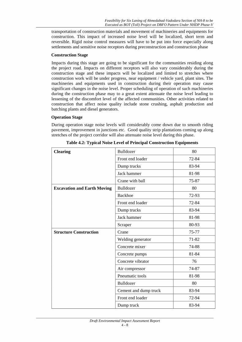
Feasibility for Six Laning of Ahmedabad-Vadodara Section of NH-8 to be Executed as BOT (Toll) Project on DBFO Pattern Under NHDP Phase-V
Draft Environmental Impact Assessment Report 4 - 8
transportation of construction materials and movement of machineries and equipments for construction. This impact of increased noise level will be localized, short term and reversible. Rigid noise control measures will have to be put into force especially along settlements and sensitive noise receptors during preconstruction and construction phase
Construction Stage
Impacts during this stage are going to be significant for the communities residing along the project road. Impacts on different receptors will also vary considerably during the construction stage and these impacts will be localized and limited to stretches where construction work will be under progress, near equipment / vehicle yard, plant sites. The machineries and equipments used in construction during their operation may cause significant changes in the noise level. Proper scheduling of operation of such machineries during the construction phase may to a great extent attenuate the noise level leading to lessening of the discomfort level of the affected communities. Other activities related to construction that affect noise quality include stone crushing, asphalt production and batching plants and diesel generators.
Operation Stage
During operation stage noise levels will considerably come down due to smooth riding pavement, improvement in junctions etc. Good quality strip plantations coming up along stretches of the project corridor will also attenuate noise level during this phase.
Table 4.2: Typical Noise Level of Principal Construction Equipments
Clearing Bulldozer 80 Front end loader 72-84 Dump trucks 83-94 Jack hammer 81-98 Crane with ball 75-87
Excavation and Earth Moving Bulldozer 80 Backhoe 72-93 Front end loader 72-84 Dump trucks 83-94 Jack hammer 81-98 Scraper 80-93
Structure Construction Crane 75-77 Welding generator 71-82 Concrete mixer 74-88 Concrete pumps 81-84 Concrete vibrator 76 Air compressor 74-87 Pneumatic tools 81-98 Bulldozer 80 Cement and dump truck 83-94 Front end loader 72-94 Dump truck 83-94

Feasibility for Six Laning of Ahmedabad-Vadodara Section of NH-8 to be Executed as BOT (Toll) Project on DBFO Pattern Under NHDP Phase-V
Draft Environmental Impact Assessment Report 4 - 9
Paver 86-88
Grading and Compacting Grader 80-93 Roller 73-75
Paving Paver 86-88 Truck 83-94 Tamper 74-77
Landscaping and Clean-Up Bulldozer 80 Backhoe 72-93 Truck 83-94 Front end loader 72-84 Dump truck 83-94 Paver 86-88
Mitigation Measures The noise impacts during the construction phase will be mitigated by confining construction activities to normal working hours and employing noise controlled construction equipment. Measures to mitigate noise impacts during the construction phase may include the following provisions: Source Controls i.e., requirements that all exhaust system will be maintained in good working order; properly designed engine enclosures, intake silencers will be employed and regular equipment maintenance will be undertaken. Proper traffic management plan at construction and operation stages will reduce the congestion of traffic and hence the noise will be reduced. Site Controls i.e., requirements that stationary equipment will be placed as far away from sensitive receptors as possible (i.e., aggregate crushers, operators, etc.); disposal sites and haul routes will be selected to minimize objectionable noise impacts; and shielding mechanisms will be employed where possible. Time and activity constraints i.e., operations will be scheduled to coincide with periods when people would least likely be affected; work hours and work days will be limited to less noise sensitive times. Community Awareness i.e., public notification of construction operations will incorporate noise considerations; methods to handle complaints will be specified.
• Construction plant and machinery to be located at least 1000m away from the settlements.
• To schedule noisy construction operations and their duration in such a way to avoid nighttime activities. Noisy construction near settlements to be restricted during the hours of 7 am and 7 pm.
• Enforcement of adherence to guidelines by the contractor to CPCB guidelines.
• “No horn” sign boards will be put near all sensitive receptors like schools, hospitals, etc.
• Provision of appropriate signages and signals for slowing down near sensitive receptors will help reduce noise.
• Proper maintenance of vehicles plants and equipments will also help in reduction of noise levels.

Feasibility for Six Laning of Ahmedabad-Vadodara Section of NH-8 to be Executed as BOT (Toll) Project on DBFO Pattern Under NHDP Phase-V
Draft Environmental Impact Assessment Report 4 - 10
• Provision of noise barriers near sensitive receptors during operation phase.
4.7 IMPACT ON ECOLOGICAL RESOURCES 4.7.1 Flora
Pre Construction Stage Some trees and ground vegetation will be impacted during establishment of construction, workers camps, and stockyards for material storage and construction machinery and equipment camps. Such impacts will be localized, temporary and reversible. Construction Stage The impact will be significant at this stage, as the tree cover within the proposed ROW will be removed in phases as the road upgradation work progresses. Also there is a possibility of usage of trees as fuel wood in the construction camps. Operation Stage There will be only beneficial impact during this stage. With the removal of causative factors, the ground vegetation will reappear in areas not sealed off during the upgradation process. Strip plantations will be raised along the stretch of the road and this will cover a much larger area .The composition of such plantations will also be designed in such a manner so as to make the benefits available to the communities that will be lost during the process of execution of the project. Mitigation Measures
• During construction, proper care will be exercised to avoid additional loss/cutting of trees.
• Compensatory plantation along the roadside: the compensatory plantation will be decided in consultation with the state forest department.
• It will be ensured that fuel requirement of construction camps is met by the Contractor through alternate sources such as LPG/kerosene oil.
4.7.2 Fauna
The existing road stretch does not fragment any wildlife habitat. No wild animal movement corridor comes along the project road.
Mitigation Measures
• Construction camp laborers will be under instruction to notify any injury /casualty to wild animals to the nearest forest office.
4.8 IMPACT ON CULTURAL ENVIRONMENT
There are 116 numbers of religious structures located along the existing road. Alignment is proposed to save most of these religious/ cultural properties. However few religious structures are likely to be impacted by widening.
Mitigation Measures
A geometric adjustment will be done while finalizing the alignment to minimize the loss to most of these religious structures in general. Those temple which are likely to be affected by widening the road, will be relocated to other places after mutual consultation with local communities.
4.9 IMPACT ON SOCIO - ECONOMIC ENVIRONMENT
The widening / upgradation of the project road will have a general beneficial impact on socio- economic front both locally and regionally through improved connectivity of the

Feasibility for Six Laning of Ahmedabad-Vadodara Section of NH-8 to be Executed as BOT (Toll) Project on DBFO Pattern Under NHDP Phase-V
Draft Environmental Impact Assessment Report 4 - 11
project area with markets located in the stretch and adjoining areas. But there will be also some adverse impacts resulting from:
(i) Resettlement of People
(ii) Relocation of community structures
(iii) Acquisition of land and structures
(iv) Influx of Construction Workers
(v) Economic Impacts
The impact of the road improvement on the socio-economic environment will be significantly beneficial, as it is likely to stimulate the economic growth of the area. Reduced transportation costs and availability of high-class transportation facilities for raw materials and products will be the most important advantage of the improved road.
Mitigation Measure
• Provision of alternate space for local activities earlier taking place within ROW such as road side stalls, customer parking, pickup areas for public transport services etc.
• Service area provision adjacent to the project road and encouraging local community to make use of new opportunities.
• Provision of enhancements for various amenities and religious structures along the alignment.
• The labors will be restrained from using the local resources that are held in common by the local/ indigenous people.
• Payment of appropriate compensation for acquisition of private land and properties as per relevant State Govt. laws
4.10 VISUAL AND AESTHETIC IMPACT Pre-Construction and Construction Stage During the pre-construction and construction stage, the visual and aesthetics in the project area will get affected due to site preparation activities, operation of construction equipments and removal of trees along the ROW. Operation Stage There visual and aesthetics in the project area will get enhanced in the operation stage due to planned plantations along both sides of the road, landscaping along the embankments, improvement of road cross-sections, development of bus-bays, foot-paths, medians and proper drainage system.
4.11 IMPACT ON PUBLIC HEALTH AND ROAD SAFETY Construction Stage Communities inhabiting the corridor of impact will obviously bear the brunt of discomforts arising out of increasing pollution load during the construction stage. Similarly the labors involved in the project activity may also pass through environmental health and sanitation issues. Also both groups will be having concern for safety measures. The impacts can be classified as:
• Psychological impacts of project affected people.
• Migration of workers and establishments of construction camps, which may lead to problems of sanitation. This might also lead to transmission of communicable diseases.

Feasibility for Six Laning of Ahmedabad-Vadodara Section of NH-8 to be Executed as BOT (Toll) Project on DBFO Pattern Under NHDP Phase-V
Draft Environmental Impact Assessment Report 4 - 12
• Discomforts arising out of air and noise pollution. Operation Stage The operation stage will obviously envisage both negative and positive impacts. 1. Positive impacts will arise from increased width of pavement on road way, more
effective cross and longitudinal drainage and increasing safety measures at areas of urbanization.
2. The negative impact will ensue from larger traffic volumes exposing commuters and users of the road to hazards of accidents.
Mitigation Measures • Construction workers will be fully trained and will be provided appropriate protective
equipment viz. helmets, gumboots, earplugs, and gloves.
• During construction, regular training will be given to construction worker in safety measures at work place as well as environmental protection measures.
• Provisions of heath care facilities at construction camps will be made available and training will be imparted to reduce transmission of diseases i.e. HIV/AIDS.
• Avoid water stagnation, casual water from empty containers, old tyres etc. as these provide breeding areas for disease vectors.
• Organizing safe construction work particularly in and around minor and major settlements along the project road through proper traffic management.
• Installation of proper road safety system through signage, barricades, crash barriers, edge posts / parapets to enhance safety of the vehicular traffic on the stretch of the road.
• Designation of areas for cross over by pedestrians, school children and cattle.
• Improved crossing and alternate access routes by use of signage-improved intersections, underpasses and service roads.
• Improvements of sharp curves and turns to avoid accident. 4.12 IMPACT ON HUMAN USE VALUES Induced Development
The improvement of the project road is expected to cause some changes in the land use. In this project, most of the area is agricultural field, which may be diverted for development and other usage. However, the status of such change will be determined by the demands arising out improved connectivity and the response of the farming and business communities of the region to meet such demands. The impact of the road improvement on the socio-economic environment will be significantly beneficial, as it is likely to stimulate the economic growth of the area. Reduced transportation costs and availability of high-class transportation facilities for raw materials and products will be the most important advantage of the improved road. Such induced development is not likely to lead to socio-cultural problems. To have planned development, the local development authorities, have to step in and use the regulatory framework to channelize such induced developments.
4.13 IMPACT MITIGATION MATRIX Summary of impacts on environment and their respective mitigation measures has been provided in Table 4.3.

Feasibility for Six Laning of Ahmedabad-Vadodara Section of NH-8 to be Executed as BOT (Toll) Project on DBFO Pattern Under NHDP Phase-V
Draft Environmental Impact Assessment Report 4 - 13
Table 4.3: Summary Impact Mitigation Matrix
Subject Potential Impact Mitigation Measures Physical Environment
Topography Impacts very low, but permanent. No mitigation measure is required.
Geology Impacts low level through removal of stones aggregate and sand from identified quarries.
No mitigation measure is required.
Soils • Physical & chemical contamination of soil.
• Compaction and structural damage.
• Soil erosion.
• Dumping of construction waste at approved locations protected by berms.
• Reuse of construction waste. • Storage of construction material
in accordance with the IRC norms.
• Avoiding work during periods of heavy rainfall.
• Rehabilitation of borrow area for productive use.
• Conservation of topsoil for reuse in planting pits and rehabilitation of borrow areas, sodding /grass turfing and implementation of soil erosion control plan.
• Provision of silt fencing and sedimentation traps
Climate Temperature/Rainfall/Humidity
Low spatially restricted short-term impact.
• No mitigation measure is required.
Land Loss of Productivity
• Land will be diverted for this project including agricultural land affecting productivity at the micro-level. Impact significant at micro level and insignificant at macro-level.
• Payment of compensation for loss of lands under agriculture.
Induced Development
• Insignificant change in the land use pattern
• Civil authorities to plan and guide any induced development using the prevailing regulatory framework.
Water Environment Surface water • 3 rivers and 19 ponds are
impacted due to project. • Degradation of some water
quality parameters like pH, COD, BOD, TDS, Turbidity etc.
• Use of sediment traps, silt fencing sodding grass turfing, etc. for minimization of soil movement, use of cofferdams for construction of abutments and bridge pier. Cofferdams to be made of such
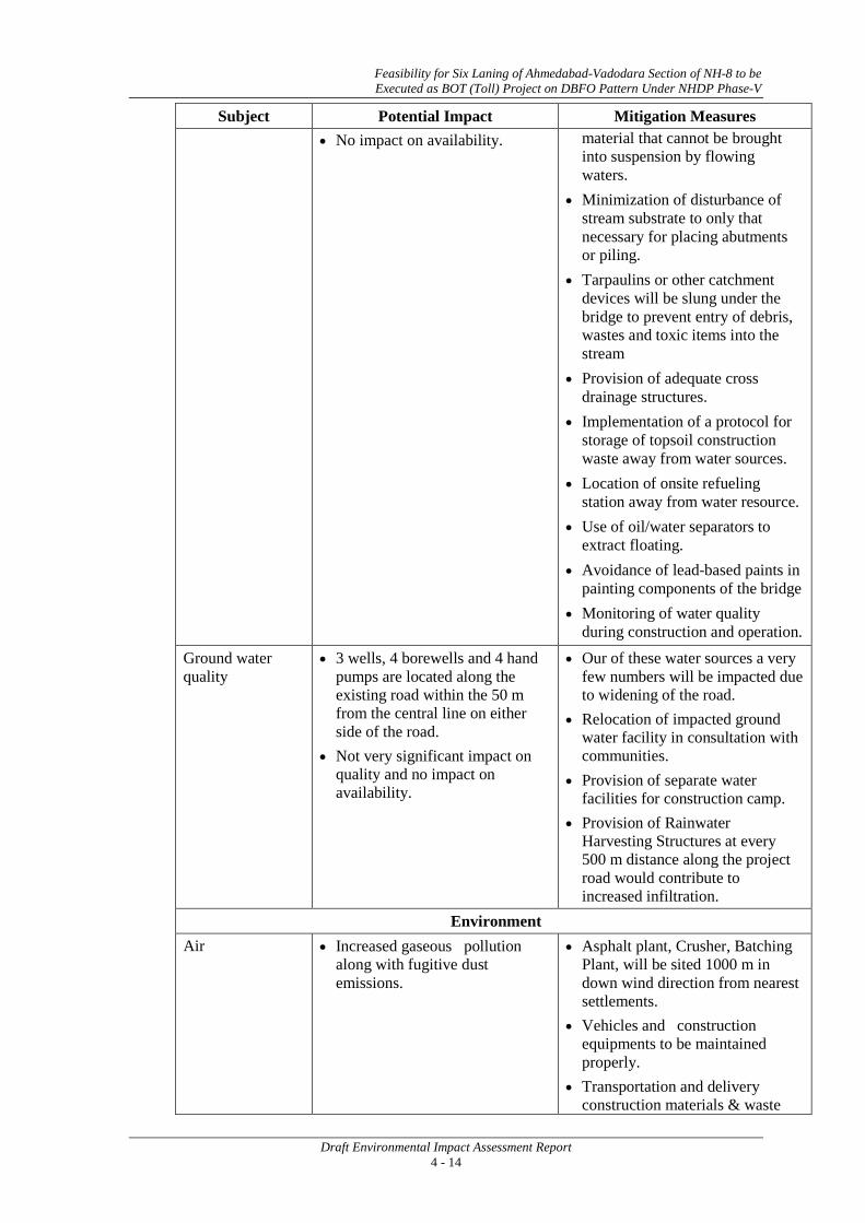
Feasibility for Six Laning of Ahmedabad-Vadodara Section of NH-8 to be Executed as BOT (Toll) Project on DBFO Pattern Under NHDP Phase-V
Draft Environmental Impact Assessment Report 4 - 14
Subject Potential Impact Mitigation Measures • No impact on availability. material that cannot be brought
into suspension by flowing waters.
• Minimization of disturbance of stream substrate to only that necessary for placing abutments or piling.
• Tarpaulins or other catchment devices will be slung under the bridge to prevent entry of debris, wastes and toxic items into the stream
• Provision of adequate cross drainage structures.
• Implementation of a protocol for storage of topsoil construction waste away from water sources.
• Location of onsite refueling station away from water resource.
• Use of oil/water separators to extract floating.
• Avoidance of lead-based paints in painting components of the bridge
• Monitoring of water quality during construction and operation.
Ground water quality
• 3 wells, 4 borewells and 4 hand pumps are located along the existing road within the 50 m from the central line on either side of the road.
• Not very significant impact on quality and no impact on availability.
• Our of these water sources a very few numbers will be impacted due to widening of the road.
• Relocation of impacted ground water facility in consultation with communities.
• Provision of separate water facilities for construction camp.
• Provision of Rainwater Harvesting Structures at every 500 m distance along the project road would contribute to increased infiltration.
Environment Air • Increased gaseous pollution
along with fugitive dust emissions.
• Asphalt plant, Crusher, Batching Plant, will be sited 1000 m in down wind direction from nearest settlements.
• Vehicles and construction equipments to be maintained properly.
• Transportation and delivery construction materials & waste

Feasibility for Six Laning of Ahmedabad-Vadodara Section of NH-8 to be Executed as BOT (Toll) Project on DBFO Pattern Under NHDP Phase-V
Draft Environmental Impact Assessment Report 4 - 15
Subject Potential Impact Mitigation Measures properly covered to avoid spills & dispersion.
• Construction of wind breaking walls near stone crusher units will avoid dust laden air travelling to built-up areas and sensitive locations.
Proper traffic management plan at construction and operation stages will reduce the congestion of traffic and hence reduces concentration of air pollutants.
Noise • Construction phase impact low to moderate spatially restricted and reversible.
• During operation phase beneficial impact in the initial phase and persistence of such beneficial impact will depend on the future traffic volume & quality of maintenance of road.
• Construction plant & machinery to be located 1 Km away from settlements.
• Displacement of people and demolition of structures will be avoided to the extent possible.
• Construction vehicles and equipments fixed or mobile to be equipped and maintained with effective muffler system.
• Proper Traffic management near sensitive receptors.
• Putting up “ no horn” signage near sensitive receptors.
• Provision of earplugs to workers. • Noisy construction to be restricted
during the hours by 7 am- 7 pm. • Provision of sound screens near
sensitive receptors during construction phase.
• Provision of noise barriers near sensitive receptors during operation phase.
Ecology
Flora There are about 39,590 no. of trees (including 5,007 Nos. on Kheda Bypass).
• Compensatory plantation, along roadside; number be planted for each trees removed as per State Government guideline.
Fauna The project road passes through Protected forest area along the entire stretch but no endangered /rare species was reported during the field visit.
• No mitigation measures required. Construction workers will be made aware about the provision of the Wild life (Protection) Act 1972 as forest areas come within the area of indirect influences in

Feasibility for Six Laning of Ahmedabad-Vadodara Section of NH-8 to be Executed as BOT (Toll) Project on DBFO Pattern Under NHDP Phase-V
Draft Environmental Impact Assessment Report 4 - 16
Subject Potential Impact Mitigation Measures some stretches.
Socio Environment Socio Environment
• Displacement of people. • Demolition of Structures. • Acquisition of agricultural land. • Influx of construction workers.
• Resettlement of people as per provisions of RAP.
• Displacement of people and demolition of structures will be minimized to the extent possible.
• Compensation for loss of structures - private, community and public will be provided.
• Compensation for loss of land under agriculture will be provided.
• Ensure employment of local labour in unskilled and semi skilled sector.
• Setting up migrant workers camp at least 1 Km away from settlements.
Archeological Monuments/ Historical structure.
• There are some Archeological Site located within 15 Km from the project road. However the impacts due to the project road on these are insignificant.
• No mitigation measure suggested.
Religious Structures/cultural property
• There are a total of 116 religious structures along the ROW out of which a few may get impacted.
• May avoid such condition by relocation of impacted structure in consultation with the community.
• Eccentric and Concentric widening proposed to avoid most of the structures
Public Health and Road Safety Public health and road safety
• Psychological impacts of project affected people.
• Migration of worker may lead to sanitation problem creating congenial condition for disease vectors.
• Discomfort arising of air and noise pollution.
• Hazards of accident.
• Continued consultation with PAPs and the competent authority for speedier settlements of appropriate compensation package and resettlement.
• Ensure sanitary measures at construction camp to prevent water borne disease and vector borne disease.
• Provide appropriate personal protective equipments like earplugs, gloves gumboot, and mask to the work force.
• Safe traffic management at construction area.
• • •

Feasibility for Six Laning of Ahmedabad-Vadodara Section of NH-8 to be Executed as BOT (Toll) Project on DBFO Pattern Under NHDP Phase-V
Draft Environmental Impact Assessment Report 5 - 1
5. ANALYSIS OF ALTERNATIVES
5.1 GENERAL
The analysis of alternatives has been carried out ‘with project’ and ‘without project’ scenarios in terms of potential environmental impacts. The existing road passes through 48 villages/settlements, and existing ROW is in between 45m to 80 m against 60 m proposed ROW, which is not sufficient ROW to be widened into 6-lane facility in some stretches. There is an existing bypass at Kheda. No additional bypass is proposed.
5.2 “WITH” AND “WITHOUT” PROJECT SCENARIO
The existing NH-8 occupies a strategic position and is meant not only for the development of surrounding area but also for the smooth movement of traffic and linking it with other part of the country. Keeping in view, the site conditions and the scope of development of the area, the ‘With’ and ‘without’ project scenarios have been compared as shown in Table 5.1.
By looking at the table it can be concluded that “With” project scenario, with positive/beneficial impacts will greatly enhance social & economic development of the region and improve the environment, when compared to the “Without” project scenario, which will further deteriorate the existing environment and quality of life. Hence the “With” project scenario with some reversible impacts is an acceptable option rather than the “Without” project scenario. The implementation of the project therefore will definitely be advantageous to improve the environmental quality of the sub-region besides to achieve an all round development of the economy and progress of the region.
There is little increase in the pollution levels during construction. Dust and particulate matter during construction will affect the air quality on a short-term basis. However, an important benefit which is not represented in this assessment will be major reduction in the SPM levels from vehicles using a surfaced road (with project scenario) in the built condition, compared to a continued use of dusty unsurfaced/tracks (without project scenarios).
It will provide mitigation not only for air, noise, and vegetative cover; wildlife and soil erosion but will also provide other appropriate mitigative measures such as roadside plantation, arboriculture & landscaping, compensatory afforestation and negative impact on environment.
5.3 ANALYSIS OF ALTERNATIVES
An analysis of “With” and “Without” Project scenario reveals that the positive impacts outnumber the negative impacts due to the proposed development. The negative impacts are envisaged only during the pre-construction and construction stages which will be limited and time-bound. Further mitigation measures will be adopted to limit the impacts during the construction phase.
The proposed expansion will aid in infrastructure development and will act as a catalyst to boost the economic progress. It was revealed during discussions with various stakeholders that after the operation of the expressway between Ahmedabad and Vadodara, the traffic has reduced considerable on NH 8 and this has affected the economic growth. The commercial activities along the project road have witnessed decline in sales and this has also affected some small handicraft units whose business thrived solely on commuters plying on the highway. With the proposed expansion which will ensure smooth traffic, it is envisaged that commercial establishments will revive their business and this will in turn boost the economic development.

Analysis of Alternatives
Draft Environmental Impact Assessment Report 5 - 2
Table 5.1 “WITH” AND “WITHOUT” PROJECT SCENARIO
With Project Without Project
+ve Impacts -ve Impacts +ve Impacts -ve Impacts
• With the improvement of road surface, the traffic congestion due to obstructed movement of vehicles will be minimized and thus wastage of fuel emissions from the vehicles will be reduced.
• Reduction in air pollution
• Enhancement/Protection of Community property e.g. Places of worship & meeting
• Increase property value of the area due to better accessibility.
• Improvement in ecology through compensatory afforestation (Compensatory afforestation proposed in 1:2 ratio)
• The dust clouds associated with vehicles movement on tracks/earth roads will also be eliminated.
• Providing better level of service in terms of improved riding quality and smooth traffic flow.
• Reduction in accident rate and transportation costs.
• Increased access to markets, enhancement of trade and commerce.
• Access to new employment opportunities.
• Employment to local workers during the execution of the project.
• Better access to health care centers and other social services.
• Improved quality of life.
• Strengthening of local economies and local industries.
• Increase in groundwater recharge due to proposed rain water harvesting structures.
• Minor changes in land use pattern.
• Loss of some properties and livelihood.
• Removal of vegetative cover along the road.
• Increase in air pollution due to vehicular traffic.
• Short term increase in dust due to earth work during construction at micro-level.
• Increase in noise pollution during the construction phase.
• Alignment transverses through 3 rivers and 19 ponds, water quality could be impacted during the construction period.
• Some road side utilities and public amenities will be impacted due to widening.
Nil • Increase in travel time.
• Increase in fuel consumptions.
• Increase in dust pollution & vehicular emission.
• Increase in accident rate.
• Overall economy of the State will be affected.
• Further deterioration of the project road.
• Increased vehicle operation cost.
• Reduced employment/ economic opportunities.
• Arrest of possible significant enhancement and economic development of the region.
• Land degradation, dust pollution and damage to agricultural land, contamination in water bodies due to vehicles traveling along multiple tracks on the open ground.
***

Feasibility for Six Laning of Ahmedabad-Vadodara Section of NH-8 to be Executed as BOT (Toll) Project on DBFO Pattern Under NHDP Phase-V
Draft Environmental Impact Assessment Report 6 - 1
6. ENVIRONMENTAL MONITORING PROGRAMME
6.1 MONITORING PROGRAM OBJECTIVES
Monitoring program has the underlying objective to ensure that the intended environmental mitigations are realized and result in desired benefits to the target population causing minimal deterioration to the environmental parameters. The broad objectives are:
• To evaluate the performance of mitigation measures proposed.
• To evaluate the adequacy of Environmental Assessment.
• To suggest ongoing improvements based on the monitoring and to devise fresh monitoring.
• To enhance environmental quality through proper implementation of suggested mitigation measures.
• To meet the requirements of the existing environmental regulatory framework and community obligations.
Performance Indicators
The significant physical, biological and social components affected at critical locations serve as wider/overall Performance Indicators. However, the following specific environmental parameters can be quantitatively measured and compared over a period of time and are, therefore, selected as specific Performance Indicators (PIs) for monitoring because of their regulatory importance and the availability of standardized procedures and relevant expertise.
• Air Quality with respect to PM10, PM2.5 CO, NOx and SO2
• Water Quality with reference to DO, BOD, Oil and grease, COD, Suspended Solids, Turbidity and Alkalinity at the bridge crossing points on river at selected points.
at selected location.
• Noise levels at sensitive receptors (schools, hospitals, community/religious places).
• Survival rates of trees planted as compensatory plantation to compensate for lost forestlands and compensatory plantation raised for removal of roadside trees.
Ambient Air Quality (AAQ) Monitoring
Ambient air quality parameters recommended for monitoring road development projects are Respirable Particulate Matter (PM10 & PM2.5), Carbon Monoxide (CO), Oxides of Nitrogen (NOx) and Sulphur Dioxide (SO2). These are to be monitored right from the commencement of construction activity at selected locations of plants and machinery, crushers on sites, excavation works etc. Data should be generated once in a season excluding monsoon at the monitoring locations in accordance with the National Ambient Air Quality Standards formulated by MoEF in Nov.2009 (Annexure 6.1).
Water Quality Monitoring
The physical and chemical parameters recommended for analysis of water quality relevant to road development projects are pH, total solids, total dissolved solids, total suspended solids, oil and grease, COD, Chloride, Lead, Zinc and Cadmium. The location, duration and the pollution parameters to be monitored and the responsible institutional arrangements are given in the Environmental Monitoring Plan. The monitoring of the water quality is to be carried out at locations identified along the project road during construction and operation phase. The Indian Standard Specifications – IS10500: 1991is given in Annexure 6.2.

Feasibility for Six Laning of Ahmedabad-Vadodara Section of NH-8 to be Executed as BOT (Toll) Project on DBFO Pattern Under NHDP Phase-V
Draft Environmental Impact Assessment Report 6 - 2
Noise Level Monitoring
The measurements for monitoring noise levels would be carried out at sensitive receptors and construction sites along the project roads. The Ambient Noise Standards formulated by Central Pollution Control Board (CPCB) in 1989. The CPCB standards are given in Annexure 6.3. Sound pressure levels would be monitored on twenty-four hour basis. Noise should be recorded at “A” weighted frequency using a “slow time response mode” of the measuring instrument.
Success of Re-vegetation
The project involves widening and improvement, hence these will require felling of about 39,590 trees. Such lost vegetation will be required to be replaced by compensatory plantation. As per policy of the State Government, double the trees have to be planted for each tree removed. These compensatory plantations will have to be monitored by the implementing agency with the help of the Forest Department. Such monitoring will be conducted through random samples. Such sampling should cover at least 5% of the area planted up.
Monitoring Plan
The monitoring plan covering various performance indicators, frequency and institutional arrangements of the project in the construction and operation stages, is summarized in Table 6.1.

Feasibility for Six Laning of Ahmedabad-Vadodara Section of NH-8 to be Executed as BOT (Toll) Project on DBFO Pattern Under NHDP Phase-V
Draft Environmental Impact Assessment Report 6 - 3
Table 6.1: Environment Monitoring Plan E
nvir
onm
ent c
ompo
nent
Proj
ect S
tage
REGULAR MONITORING PARAMETERS INSTITUTIONAL RESPONSIBILITIES
Para
met
ers
Stan
dard
s
Loc
atio
n
Freq
uenc
y
Dur
atio
n
Act
ion
plan
in c
ase
crite
ria
exce
eds
Impl
emen
tatio
n
Res
pons
ibili
ties
Air C
onst
ruct
ion
stag
e
PM10, PM2.5, SO2, NOx, CO etc. as per MOEF Notification
16.11.2009
Annexure 6.1 Wherever the contractor
decides to locate the Hot mix
plant.
Once in a season excluding the monsoon for 3
years.
Continuous 24 hours/ or for 1 full working
day.
Check and modify control devices like bag filter/cyclones of
hot mix plant.
Contractor through
approved monitoring
agency.
Contractor, SC, PIU.
PM10, PM2.5, SO2, NOx, CO etc. as per MOEF Notification
16.11.2009
Annexure 6.1 Along the project road at
locations of baseline
monitoring in consultation
with SC.
Once in a season excluding the monsoon for 3
years.
Continuous 24 hours/ or for 1 full working
day.
Check and modify control devices like bag filter/cyclones of
hot mix plant.
Contractor through
approved monitoring
agency.
Contractor, SC, PIU.
Ope
ratio
n st
age PM10, PM2.5, SO2,
NOx, CO etc. as per MOEF Notification
16.11.2009
Annexure 6.1 Along the project road at
locations of baseline
monitoring in consultation
with SC.
Thrice in a year (winter, summer
and post monsoon
seasons) for 5 years.
Continuous 24 hours/ or for 1 full working
day.
- Contractor through
approved monitoring
agency.
Contractor, SC, PIU.

Feasibility for Six Laning of Ahmedabad-Vadodara Section of NH-8 to be Executed as BOT (Toll) Project on DBFO Pattern Under NHDP Phase-V
Draft Environmental Impact Assessment Report 6 - 4
Env
iron
men
t com
pone
nt
Proj
ect S
tage
REGULAR MONITORING PARAMETERS INSTITUTIONAL RESPONSIBILITIES
Para
met
ers
Stan
dard
s
Loc
atio
n
Freq
uenc
y
Dur
atio
n
Act
ion
plan
in c
ase
crite
ria
exce
eds
Impl
emen
tatio
n
Res
pons
ibili
ties
Sur
face
Wat
er Q
ualit
y
Con
stru
ctio
n st
age
Parameters given in Indian Standards of Drinking Water: IS
10500:1991
Water quality standards by
CPCB (Annexure 6.2)
At identified locations
Once in a season excluding the monsoon for 3
years
Grab Sample Check and modify petrol
interceptors, Silt fencing devices.
Contractor through
approved monitoring
agency
Contractor, SC, PIU.
Ope
ratio
n st
age Parameters given in
Indian Standards of Drinking Water: IS
10500:1991
Surface Water quality stand. by
CPCB (Annexure 6.2)
At identified locations
Once in a season excluding the monsoon for 5
years
Grab Sample Check and modify petrol
interceptors, Silt fencing devices.
Contractor through
approved monitoring
agency
Contractor, SC, PIU.
Gro
und
Wat
er Q
ualit
y
Con
stru
ctio
n st
age
Parameters given in Indian Standards of Drinking Water: IS
10500:1991
Ground Water quality standards
by CPCB
At identified locations
Once in a season excluding the monsoon for 3
years
Grab Sample Check and modify petrol
interceptors, Silt fencing devices.
Contractor through
approved monitoring
agency
Contractor, SC, PIU.
Ope
ratio
n st
age Parameters given in
Indian Standards of Drinking Water: IS
10500:1991
Ground Water quality standards
by CPCB
At identified locations
Once in a season excluding the monsoon for 5
years
Grab Sample Check and modify petrol
interceptors, Silt fencing devices.
Contractor through
approved monitoring
agency
Contractor, SC, PIU.

Feasibility for Six Laning of Ahmedabad-Vadodara Section of NH-8 to be Executed as BOT (Toll) Project on DBFO Pattern Under NHDP Phase-V
Draft Environmental Impact Assessment Report 6 - 5
Env
iron
men
t com
pone
nt
Proj
ect S
tage
REGULAR MONITORING PARAMETERS INSTITUTIONAL RESPONSIBILITIES
Para
met
ers
Stan
dard
s
Loc
atio
n
Freq
uenc
y
Dur
atio
n
Act
ion
plan
in c
ase
crite
ria
exce
eds
Impl
emen
tatio
n
Res
pons
ibili
ties
Noi
se le
vels
Con
stru
ctio
n st
age Leq dB(A) (Day &
Night), Average and Peak values
Noise standards by CPCB
(Annexure 6.3)
At equipment yards and
locations as identified by SC
Once in a season excluding the monsoon for 3
years
Readings to be taken at 60
seconds interval for every hour
and then Leq are to be obtained
for Day time and Night time
Check and modify
equipment and devices used to protect noise
level.
Contractor through
approved monitoring
agency
Contractor, SC, PIU.
Operation stage
Leq dB(A) (Day & Night), Average and
Peak values
Noise standards by CPCB
(Annexure 6.3)
Locations as identified by SC
Once in a season excluding the monsoon for 5
years
Readings to be taken at 60
seconds interval for every hour
and then Leq are to be obtained
for Day time and Night time
- Contractor through
approved monitoring
agency
Contractor, SC, PIU.
Soil
C
onst
ruct
ion
stag
e
Physical Parameters: Texture, Grain Size Distribution, Gravel,
Sand, Silt, Clay; Chemical Parameters: pH (10%w/v slurry),
Conductivity, Calcium, Magnesium, Sodium,
CPCB
Near construction
sites and along the road as
identified by the SC
Once in a season excluding the monsoon for 3
years
- - Contractor through an approved
monitoring agency
Contractor, SC, PIU.

Feasibility for Six Laning of Ahmedabad-Vadodara Section of NH-8 to be Executed as BOT (Toll) Project on DBFO Pattern Under NHDP Phase-V
Draft Environmental Impact Assessment Report 6 - 6
Env
iron
men
t com
pone
nt
Proj
ect S
tage
REGULAR MONITORING PARAMETERS INSTITUTIONAL RESPONSIBILITIES
Para
met
ers
Stan
dard
s
Loc
atio
n
Freq
uenc
y
Dur
atio
n
Act
ion
plan
in c
ase
crite
ria
exce
eds
Impl
emen
tatio
n
Res
pons
ibili
ties
Potassium, Sodium Absorption Ratio, Total Nitrogen, Phosphorous,
Organic matter
Ope
ratio
n St
age
Physical Parameters: Texture, Grain Size Distribution, Gravel,
Sand, Silt, Clay; Chemical Parameters: pH (10%w/v slurry),
Conductivity, Calcium, Magnesium, Sodium, Potassium, Sodium
Absorption Ratio, Total Nitrogen, Phosphorous,
Organic matter
CPCB Along the road as identified by
the SC
Once in a season excluding the monsoon for 5
years
- - Contractor, SC, PIU.
Soil
Eros
ion
Con
stru
ctio
n st
age
Turbidity in Storm water
Silt load in ponds
As specified by the engineer
Water quality standards
At the drains, ponds and rivers
near construction site
Pre-monsoon and post-monsoon
seasons for 3 years
Inspection and modification of silt fencing/ any leakage of drains to these surface
water bodies
Contractor under advice of SC
Contractor, SC, PIU.
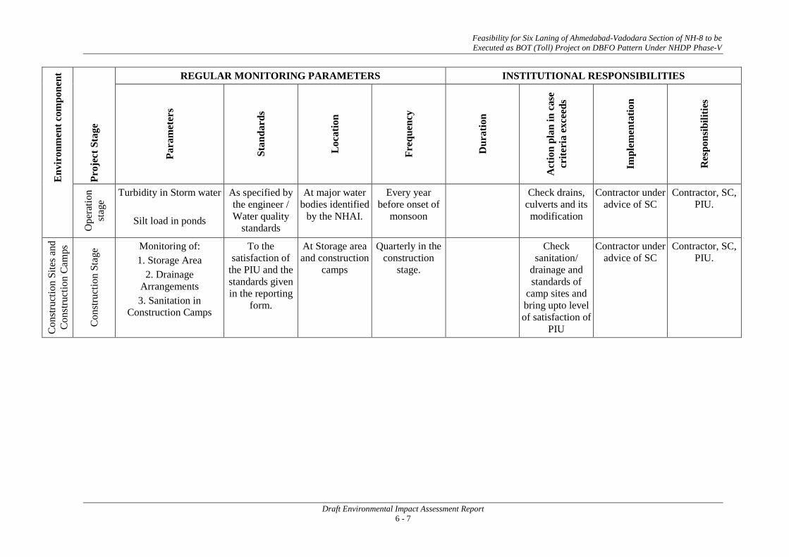
Feasibility for Six Laning of Ahmedabad-Vadodara Section of NH-8 to be Executed as BOT (Toll) Project on DBFO Pattern Under NHDP Phase-V
Draft Environmental Impact Assessment Report 6 - 7
Env
iron
men
t com
pone
nt
Proj
ect S
tage
REGULAR MONITORING PARAMETERS INSTITUTIONAL RESPONSIBILITIES
Para
met
ers
Stan
dard
s
Loc
atio
n
Freq
uenc
y
Dur
atio
n
Act
ion
plan
in c
ase
crite
ria
exce
eds
Impl
emen
tatio
n
Res
pons
ibili
ties
Ope
ratio
n st
age
Turbidity in Storm water
Silt load in ponds
As specified by the engineer / Water quality
standards
At major water bodies identified
by the NHAI.
Every year before onset of
monsoon
Check drains, culverts and its modification
Contractor under advice of SC
Contractor, SC, PIU.
Con
stru
ctio
n Si
tes a
nd
Con
stru
ctio
n Ca
mps
Con
stru
ctio
n St
age Monitoring of:
1. Storage Area 2. Drainage
Arrangements 3. Sanitation in
Construction Camps
To the satisfaction of
the PIU and the standards given in the reporting
form.
At Storage area and construction
camps
Quarterly in the construction
stage.
Check sanitation/
drainage and standards of
camp sites and bring upto level of satisfaction of
PIU
Contractor under advice of SC
Contractor, SC, PIU.

Feasibility for Six Laning of Ahmedabad-Vadodara Section of NH-8 to be Executed as BOT (Toll) Project on DBFO Pattern Under NHDP Phase-V
Draft Environmental Impact Assessment Report 6 - 8
6.2 ENVIRONMENTAL REPORTING SYSTEM
Monitoring and Evaluation are critical activities in implementation of all projects. Monitoring involves periodic checking to ascertain whether activities are going according to the plans. It provides the necessary feedback for project management to keep the program on schedule. By contrast evaluation is essentially a summing up at the end of the project to assess whether those activities actually achieved as was intended.
The reporting system will operate linearly with the contractor who is at the lowest rung of the implementation system reporting to the Supervision Consultant, who in turn shall report to the PIU. All reporting by the contractor and Supervision Consultant shall be on a quarterly basis. The PIU shall be responsible for preparing targets for each of the identified EMP activities.
The compliance monitoring and the progress reports on environmental components may be clubbed together and submitted to the PIU quarterly during the implementation period. The operation stage monitoring reports may be annual or biennial provided the Project Environmental Completion Report shows that the implementation was satisfactory. Otherwise, the operation stage monitoring reports will have to be prepared as specified in the said Project Environmental Completion Report.
Responsibilities for overseeing will rest with the Supervision Consultant’s staff reporting to the PIU. Capacity to quantitatively monitor relevant ecological parameters would be an advantage but monitoring will primarily involve ensuring that actions taken are in accordance with contract and specification clauses, and specified mitigation measures as per the EMP.
During the implementation period, a compliance report may include description of the items of EMP, which were not complied with by any of the responsible agencies. It would also report to the management about actions taken to enforce compliance. It may however, be noted that certain items of the EMP might not be possibly complied with for a variety of reasons. The intention of the compliance report is not to suppress these issues but to bring out the circumstances and reasons for which compliance was not possible (such as jurisdictional issues). This would help in reinforcing the implementation of the EMP.
Photographic records will also be established to provide useful environmental monitoring tools. A full record will be kept as part of normal contract monitoring. Reporting and Monitoring Systems for various stages of construction and related activities have been proposed to ensure timely and effective implementation of the EMP.
The reporting system has been prepared for each of the stage of road construction namely:
• Pre construction stage
• Construction Stage
• Operation Stage
This reporting shall be done through:
• Reporting by the Contractor to the SC
• Reporting by SC to PIU
The stage-wise reporting system is detailed out in the following Table 6.2.
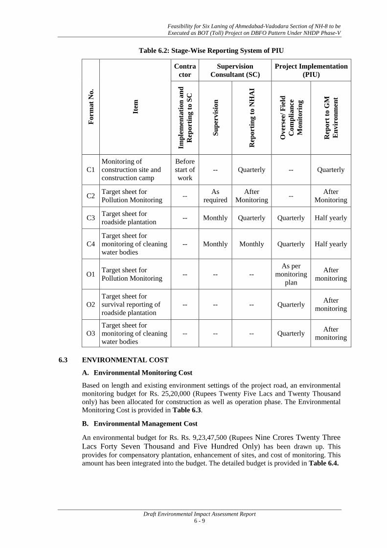
Feasibility for Six Laning of Ahmedabad-Vadodara Section of NH-8 to be Executed as BOT (Toll) Project on DBFO Pattern Under NHDP Phase-V
Draft Environmental Impact Assessment Report 6 - 9
Table 6.2: Stage-Wise Reporting System of PIU
Form
at N
o.
Item
Contractor
Supervision Consultant (SC)
Project Implementation (PIU)
Impl
emen
tatio
n an
d R
epor
ting
to S
C
Supe
rvis
ion
Rep
ortin
g to
NH
AI
Ove
rsee
/ Fie
ld
Com
plia
nce
Mon
itori
ng
Rep
ort t
o G
M
Env
iron
men
t
C1 Monitoring of construction site and construction camp
Before start of work
-- Quarterly -- Quarterly
C2 Target sheet for Pollution Monitoring -- As
required After
Monitoring -- After Monitoring
C3 Target sheet for roadside plantation -- Monthly Quarterly Quarterly Half yearly
C4 Target sheet for monitoring of cleaning water bodies
-- Monthly Monthly Quarterly Half yearly
O1 Target sheet for Pollution Monitoring -- -- --
As per monitoring
plan
After monitoring
O2 Target sheet for survival reporting of roadside plantation
-- -- -- Quarterly After monitoring
O3 Target sheet for monitoring of cleaning water bodies
-- -- -- Quarterly After monitoring
6.3 ENVIRONMENTAL COST
A. Environmental Monitoring Cost
Based on length and existing environment settings of the project road, an environmental monitoring budget for Rs. 25,20,000 (Rupees Twenty Five Lacs and Twenty Thousand only) has been allocated for construction as well as operation phase. The Environmental Monitoring Cost is provided in Table 6.3.
B. Environmental Management Cost
An environmental budget for Rs. Rs. 9,23,47,500 (Rupees Nine Crores Twenty Three Lacs Forty Seven Thousand and Five Hundred Only) has been drawn up. This provides for compensatory plantation, enhancement of sites, and cost of monitoring. This amount has been integrated into the budget. The detailed budget is provided in Table 6.4.

Feasibility for Six Laning of Ahmedabad-Vadodara Section of NH-8 to be Executed as BOT (Toll) Project on DBFO Pattern Under NHDP Phase-V
Draft Environmental Impact Assessment Report 6 - 10
Table 6.3: Environmental Monitoring Cost
Component Stage Item Unit Cost (Rs.) Quantity Total Cost
(INR)
Monitoring Costs
Air
Construction
Monitoring near all hot mix plant locations approved by the Engineer 7,000
At 4 locations three seasons in a year excluding monsoon for 3 years. (36 Samples)
252000.00
Monitoring at construction sites in construction period 7,000 At 4 locations three seasons in a year excluding monsoon for 3 years. (36 samples)
252000.00
Operation Ambient Air Quality Monitoring (locations as decided by the supervision consultant) 7,000
At 4 locations three seasons in a year for 5years excluding monsoon (total 60samples)
420000
Water Quality
Construction
Surface Water Quality
5,000 At 2 locations three seasons in a year excluding monsoon for 3 years (18 samples)
180000.00
Ground Water Quality
5,000 At 2 locations three seasons in a year excluding monsoon for 3 years (18 Samples)
90000.00
Operations
Surface Water Quality (locations as decided by SC) 5000 At 4 locations three season in a year excluding the monsoon season for 5 years (total 60 sample)
300000
Ground Water Quality (Locations as decided by SC) 5000 At 2 locations three seasons in a year excluding the monsoon season for 5 years (total 30 sample)
150000
Noise Construction At equipment yards 2,000 At 6 locations three seasons in a year excluding the monsoon season for 3 years (54 Samples)
108000.00

Feasibility for Six Laning of Ahmedabad-Vadodara Section of NH-8 to be Executed as BOT (Toll) Project on DBFO Pattern Under NHDP Phase-V
Draft Environmental Impact Assessment Report 6 - 11
Component Stage Item Unit Cost (Rs.) Quantity Total Cost
(INR)
As directed by SC 2,000 At 6 locations three seasons in a year excluding the monsoon season for 3 years (54 Samples)
108000.00
Operation As directed by SC 2,000 At 6 locations three seasons in a year for 5 years (90Samples)
180000
Soil Construction At productive agricultural lands abutting traffic detours
and traffic diversions, to be identified by the Engineer 15,000 At 2 locations two seasons in a year for 3 years (12 samples) 180000.00
Operation At accident/spill locations involving bulk transport carrying hazardous material 15,000 At 2 location two seasons in a year
for 5 years (20 Samples)
300000
Total Monitoring Cost 25,20,000

Feasibility for Six Laning of Ahmedabad-Vadodara Section of NH-8 to be Executed as BOT (Toll) Project on DBFO Pattern Under NHDP Phase-V
Draft Environmental Impact Assessment Report 6 - 12
Table 6.4: Environmental Budget
Components Stage Item Unit Unit Cost (Rs.) Quantity Total Cost (INR)
(A) MITIGATION COST
Air Construction Dust Suppression with sprinkling of water, covers of the vehicles transporting construction material No. - -
Covered in Engineering Cost
Water Construction Oil interceptor at parking of construction vehicle No. 20000 10 2,00,000
Silt fencing No. 30000 15 4,50,000
Construction Rainwater Harvesting Structures in Vadodara (total15 Km stretch) and Ahmedabad (total16 Km stretch) Districts
No. 50000 62 3100000
Flora Construction
Compensatory Afforestation at 1:2 (only for trees falls within ROW) No. 500 39590*2=79180
39590000
Median plantations Km - - Covered in Engineering cost.
Operation Maintenance of tree plantations for 5 years No 100 79180* 5 39590000
Safety Constructions
Demarcating borrow areas clearly using fencing if needed M - - Covered in
Engineering cost.
Miscellaneous informatory signs and others L.S. - - Covered in Engineering cost
Soil erosion control Measure Constructions Slope stabilization, turfing, silt fencing etc -- -- -- Covered in
engineering cost
TOTAL MITIGATION COST (A)
82930000

Feasibility for Six Laning of Ahmedabad-Vadodara Section of NH-8 to be Executed as BOT (Toll) Project on DBFO Pattern Under NHDP Phase-V
Draft Environmental Impact Assessment Report 6 - 13
Components Stage Item Unit Unit Cost (Rs.) Quantity Total Cost (INR)
(B) MONITORING COST (for details please refer to chapter 6)
TOTAL MONITORING COST (B) 2520000
(C) ENHANCEMENT COST Enhancement Sites 1 Enhancement of water bodies No. 200000 2 4,00,000
2 Enhancement of Religious Structures No. 100000 10 10,00,000
3 Corporate Social Responsibility Cost 11,00,000
Sub-Total C: Enhancement 25,00,000
(D) TRAINING ENVIRONMENTAL AWARNESS DURING CONSTRUCTION STAGE Villages 25,000 4 1,00,000
Sub Total A: Mitigation Costs
82930000
Sub Total B: Monitoring Cost
2520000
Sub Total C: Enhancement Cost
2500000
Sub Total D: Training Cost 1,00,000
TOTAL
87950000

Feasibility for Six Laning of Ahmedabad-Vadodara Section of NH-8 to be Executed as BOT (Toll) Project on DBFO Pattern Under NHDP Phase-V
Draft Environmental Impact Assessment Report 6 - 14
Components Stage Item Unit Unit Cost (Rs.) Quantity Total Cost (INR)
Contingency @ 5%
4397500
TOTAL BUDGETED COSTS
92347500
Rupees Nine Crores Twenty Three Lacs Forty Seven Thousand and Five Hundred Only
• • •

Annexure 6.1
A - 1
NATIONAL AMBIENT AIR QUALITY STANDARDS
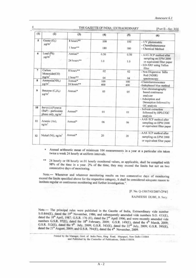
Annexure 6.1
A - 2
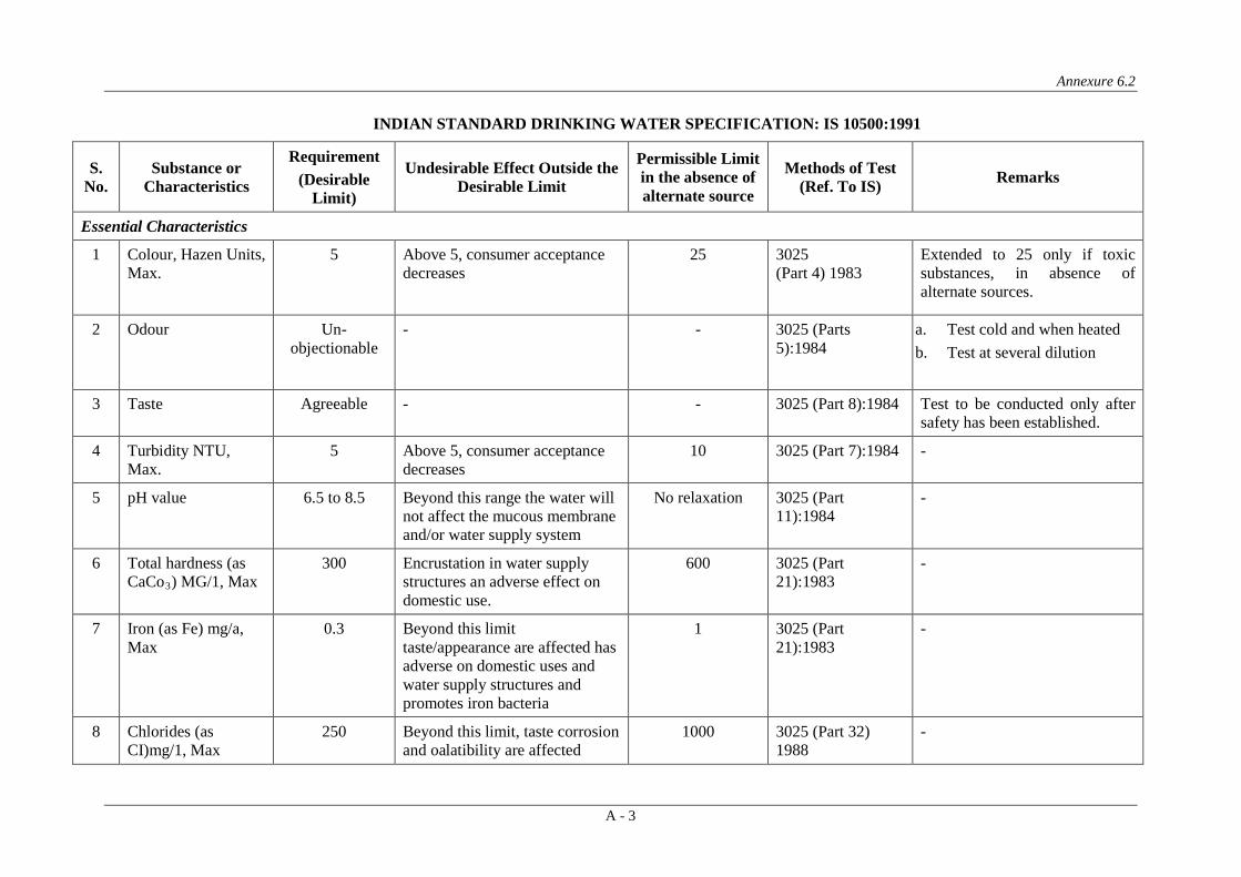
Annexure 6.2
A - 3
INDIAN STANDARD DRINKING WATER SPECIFICATION: IS 10500:1991
S. No.
Substance or Characteristics
Requirement (Desirable
Limit)
Undesirable Effect Outside the Desirable Limit
Permissible Limit in the absence of alternate source
Methods of Test (Ref. To IS) Remarks
Essential Characteristics
1 Colour, Hazen Units, Max.
5 Above 5, consumer acceptance decreases
25 3025 (Part 4) 1983
Extended to 25 only if toxic substances, in absence of alternate sources.
2 Odour Un- objectionable
- - 3025 (Parts 5):1984
a. Test cold and when heated b. Test at several dilution
3 Taste Agreeable - - 3025 (Part 8):1984 Test to be conducted only after safety has been established.
4 Turbidity NTU, Max.
5 Above 5, consumer acceptance decreases
10 3025 (Part 7):1984 -
5 pH value 6.5 to 8.5 Beyond this range the water will not affect the mucous membrane and/or water supply system
No relaxation 3025 (Part 11):1984
-
6 Total hardness (as CaCo3
300 ) MG/1, Max
Encrustation in water supply structures an adverse effect on domestic use.
600 3025 (Part 21):1983
-
7 Iron (as Fe) mg/a, Max
0.3 Beyond this limit taste/appearance are affected has adverse on domestic uses and water supply structures and promotes iron bacteria
1 3025 (Part 21):1983
-
8 Chlorides (as CI)mg/1, Max
250 Beyond this limit, taste corrosion and oalatibility are affected
1000 3025 (Part 32) 1988
-
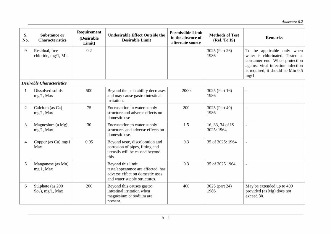
Annexure 6.2
A - 4
S. No.
Substance or Characteristics
Requirement (Desirable
Limit)
Undesirable Effect Outside the Desirable Limit
Permissible Limit in the absence of alternate source
Methods of Test (Ref. To IS) Remarks
9 Residual, free chloride, mg/1, Min
0.2 3025 (Part 26) 1986
To be applicable only when water is chlorinated. Tested at consumer end. When protection against viral infection infection is required, it should be Min 0.5 mg/1.
Desirable Characteristics
1 Dissolved solids mg/1, Max
500 Beyond the palatability decreases and may cause gastro intestinal irritation.
2000 3025 (Part 16) 1986
-
2 Calcium (as Ca) mg/1, Max
75 Encrustation in water supply structure and adverse effects on domestic use
200 3025 (Part 40) 1986
-
3 Magnesium (a Mg) mg/1, Max
30 Encrustation to water supply structures and adverse effects on domestic use.
1.5 16, 33, 34 of IS 3025: 1964
-
4 Copper (as Cu) mg/1 Max
0.05 Beyond taste, discoloration and corrosion of pipes, fitting and utensils will be caused beyond this.
0.3 35 of 3025: 1964 -
5 Manganese (as Mn) mg.1, Max
Beyond this limit taste/appearance are affected, has adverse effect on domestic uses and water supply structures.
0.3 35 of 3025 1964 -
6 Sulphate (as 200 So2
200 ), mg/1, Max
Beyond this causes gastro intestinal irritation when magnesium or sodium are present.
400 3025 (part 24) 1986
May be extended up to 400 provided (as Mg) does not exceed 30.
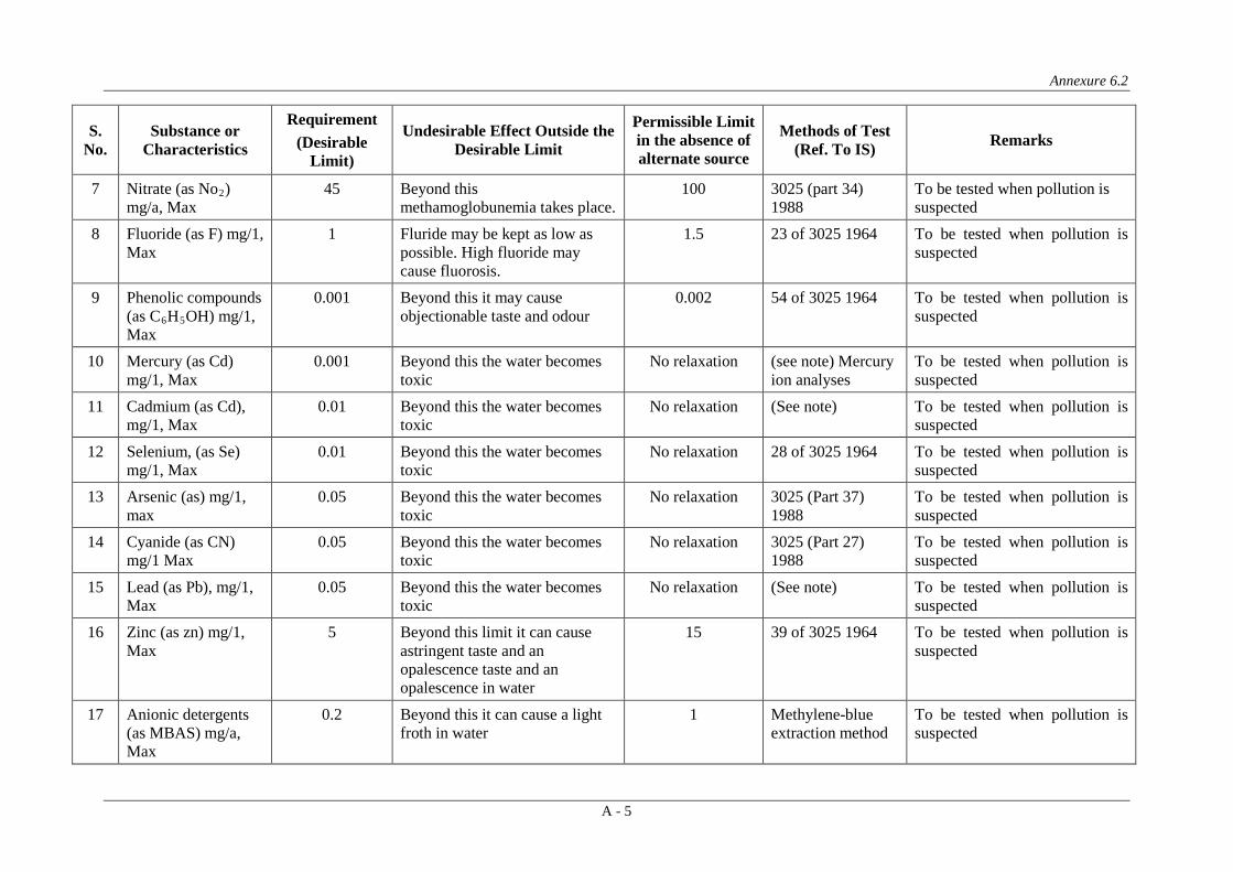
Annexure 6.2
A - 5
S. No.
Substance or Characteristics
Requirement (Desirable
Limit)
Undesirable Effect Outside the Desirable Limit
Permissible Limit in the absence of alternate source
Methods of Test (Ref. To IS) Remarks
7 Nitrate (as No2 45 ) mg/a, Max
Beyond this methamoglobunemia takes place.
100 3025 (part 34) 1988
To be tested when pollution is suspected
8 Fluoride (as F) mg/1, Max
1 Fluride may be kept as low as possible. High fluoride may cause fluorosis.
1.5 23 of 3025 1964 To be tested when pollution is suspected
9 Phenolic compounds (as C6H5
0.001 OH) mg/1,
Max
Beyond this it may cause objectionable taste and odour
0.002 54 of 3025 1964 To be tested when pollution is suspected
10 Mercury (as Cd) mg/1, Max
0.001 Beyond this the water becomes toxic
No relaxation (see note) Mercury ion analyses
To be tested when pollution is suspected
11 Cadmium (as Cd), mg/1, Max
0.01 Beyond this the water becomes toxic
No relaxation (See note) To be tested when pollution is suspected
12 Selenium, (as Se) mg/1, Max
0.01 Beyond this the water becomes toxic
No relaxation 28 of 3025 1964 To be tested when pollution is suspected
13 Arsenic (as) mg/1, max
0.05 Beyond this the water becomes toxic
No relaxation 3025 (Part 37) 1988
To be tested when pollution is suspected
14 Cyanide (as CN) mg/1 Max
0.05 Beyond this the water becomes toxic
No relaxation 3025 (Part 27) 1988
To be tested when pollution is suspected
15 Lead (as Pb), mg/1, Max
0.05 Beyond this the water becomes toxic
No relaxation (See note) To be tested when pollution is suspected
16 Zinc (as zn) mg/1, Max
5 Beyond this limit it can cause astringent taste and an opalescence taste and an opalescence in water
15 39 of 3025 1964 To be tested when pollution is suspected
17 Anionic detergents (as MBAS) mg/a, Max
0.2 Beyond this it can cause a light froth in water
1 Methylene-blue extraction method
To be tested when pollution is suspected

Annexure 6.2
A - 6
S. No.
Substance or Characteristics
Requirement (Desirable
Limit)
Undesirable Effect Outside the Desirable Limit
Permissible Limit in the absence of alternate source
Methods of Test (Ref. To IS) Remarks
18 Chromium (as Cr6 0.05 + mg1, Max)
May be carcinogenic above this limit
No relaxation 38 of 3025: 1964 To be tested when pollution is suspected
19 Polynuclear aromatic hydra carbons (as PAH) g/1, Max
- May be carcinogenic above this limit
- - -
20 Mineral oil mg/1, Max
0.01 Beyond this limit undesirable taste and odour after chlorination take place.
0.03 Gas Chromatographic emtho
-
21 Pesticides mg/1, Max
Absent Toxic 0.001 - -
22 Radioactive materials
58 3025:01964
-
23 a) Alpha emitters bq/1, Max
- - 0.1 - -
24 Beta emitters pci/1, Max
- - 1 - -
25 Aluminuium (as Al) mg/1, Max
200 Beyond this limit taste becomes unpleasant
600 13 of 3025: 1964 -
26 Aluminuium (as Al) mg/1, Max
0.03 Cumulate effect is reported to cause dementia
0.2 31 of 3025: 1964 -
27 Boron mg/1, Max 1 - 5 29 of 3029: 1964 - Source: Indian Standard Drinking Water Specification-IS 10500, 1991

Annexure 6.3
A - 7
AMBIENT NOISE STANDARDS
Area code Category of Area
Limit in dB (A) Leq Day Time Night Time
A Industrial area 75 70 B Commercial area 65 55 C Residential area 55 45 D Silence zone 50 40
Note-1 Day time is reckoned in between 6 a. m and 9 p.m.
Note-1 Night time is reckoned in between 9 p.m. and 6 a.m.
Note-1 Silence zone is defined as areas upto 100 metres around such premises as hospitals, educational institutions and courts. The silence zones are to be declared by the Competent Authority.
Note-1 Mixed categories of areas should be declared as ''one of the four above mentioned categories by the Competent Authority and the corresponding standard shall apply.

Feasibility for Six Laning of Ahmedabad-Vadodara Section of NH-8 to be Executed as BOT (Toll) Project on DBFO Pattern Under NHDP Phase-V
Draft Environmental Impact Assessment Report 7 - 1
7. ADDITIONAL STUDIES
7.1 PUBLIC CONSULTATION Public participation and community consultation has been taken up as an integral part of social and environmental assessment process of the project. Consultation was used as a tool to inform and educate stakeholders about the proposed action both before and after the development decisions were made. It assisted in identification of the problems associated with the project as well as the needs of the population likely to be impacted. This participatory process helped in reducing the public resistance to change and enabled the participation of the local people in the decision making process. The involvement of the various stakeholders ensured that the affected population and other stakeholders are informed, consulted and allowed to participate at various stages of project preparation. Initial Public consultation has been carried out in this Project with the objectives of minimising probable adverse impacts of the project through alternate design solutions (alignment and cross-sectional) and to achieve speedy implementation of the project through bringing awareness amongst the community on the benefits of the project. The public consultation has been taken up as an integral part of social and environmental assessment process for this project. Several meetings were organized at various locations, promoting public understanding of the processes and mechanisms through which developmental problems and needs are investigated and solved. To ensure the peoples’ participation in the planning phase of this project and treating public consultation and participation as a continuous process, numerous events were attempted at this stage of project preparation. Aiming at promotion of public understanding and fruitful solutions of developmental problems such as local needs of road users and problem and prospect of resettlement, various sections of community people and other stakeholders were consulted through individual Consultations.The option of alternative design was also discussed to meet their local transport needs and to achieve speedy implementation of the project with peoples’ involvement and support. Necessary information was already gathered during the time of Environmental Survey.
7.1.1 OBJECTIVES Community consultations in the project were undertaken with objectives, which may be grouped into: • Information sharing. • Appraisal and assessment of the community needs. • Assessment of the environmental issues in the region, and • Development of specific design solutions and enhancement measures. These objectives are discussed below:
7.1.1.1 Information Sharing • To promote public awareness about the proposed project especially amongst the
potentially impacted communities/individuals. • To educate the individuals/interested groups about the proposed course of action; • To solicit the views of affected communities/individuals on environmental
components and the significance of impacts; • To serve as an important tool for collecting information about natural and the human
environments, much of which would never be accessible through more traditional approaches of data collection;
• To ensure lessening of public resistance to modify the proposed activity, by involving them in the decision making process; and

Feasibility for Six Laning of Ahmedabad-Vadodara Section of NH-8 to be Executed as BOT (Toll) Project on DBFO Pattern Under NHDP Phase-V
Draft Environmental Impact Assessment Report 7 - 2
• To achieve the basis for an Environment Management Plan for the project, with the incorporation of felt needs views and preferences of the people likely to be impacted.
7.1.1.2 Appraisal & Assessment • To inform Project Affected Communities about the provision of EMP, and to settle
their felt need with mutual consent and to assist them during relocation of community property, if any
• Deduce information from the people about the local environmental issues and their dependence upon them.
• Collect peoples’ perceptions about the project and how the negative effects of the project should be mitigated.
7.1.1.3 Devising Specific Solutions • To solicit the views of affected communities/individuals on environmental and social
problems. • Receive suggestions from the affected communities with regard to the preferences
and options about the project in general and avoidance measures, mitigation/compensation measures, and benefits being provided, in particular.
• To ensure lessening of public resistance to change by providing them a platform in the decision making process.
Thus, constructive participation by the affected population can influence not only environmental impact of the project corridor, but also the costs, success and duration of the main investment project itself. The possibility of active participation by affected communities.
7.1.2 LEVELS OF CONSULTATION The consultation process established for the project has employed a range of formal and informal consultative tools including in depth interviews with key informants, on-site consultation and meetings. The enactment of the participation and consultations with the stakeholders was done at various levels throughout the project preparation stage. The Public Consultation was carried out at various stages of project preparation.
7.1.2.1 Local/Village Level Consultations These consultations were held in rural, suburban and urban areas along the corridor of impact of the project road to inform people about the purpose and preliminary design of the project. Such consultations provided a means to get the opinion of the people and their issues of concern. Village/local level consultations were held at selected locations to understand the implication of the project impacts on various groups, especially those with a distinct degree of vulnerability. The location and date of public consultations are given in Table 7.1. The consultation sessions are proposed to be continued during the implementation and monitoring stages of the project. Fig. 7.1 and Fig. 7.2 give a view of Public consultation.
Fig. 7.1: Public Consultation at Jetalpur Village Fig 7.2: Public Consultation at Kheda Chowkdi

Feasibility for Six Laning of Ahmedabad-Vadodara Section of NH-8 to be Executed as BOT (Toll) Project on DBFO Pattern Under NHDP Phase-V
Draft Environmental Impact Assessment Report 7 - 3
Table 7.1: Details of Public Consultations
Location No. Date Locations Time 1. 13/08/2009 Bareja (at Km 21.00) 3:00 PM 2. 16/08/2009 Jetalpur (at Km 16.00) 11:00 AM 3. 16/08/2009 Kheda Chowkdi (at Km 37.00) 1:00 PM 4. 16/08/2009 Dabhan (at Km 53.00) 2:00 PM 5. 19/08/2009 Aslali (at Km 14.00) 11.00 AM 6. 21/08/2009 Dumaral (at Km 56.00) 12.30 PM 7. 28/08/2009 Dashrath (at Km 102.00) 10.30 AM 8. 28/08/2009 Padamala (at Km 99.2) 11.30 AM
A wide range of people including local people, private groups, community people, Panchayat members and leaders were consulted. The main points of discussions with various agencies were concentrated on environmental awareness, afforestation, and shifting of religious structures associated with project. People’s perceptions about environment were also recorded.
Public Consultation at Jetalpur Village
Date: 16/08/09, Time: 11 am
About the Village: Jetalpur village abuts the NH8 and has a population of about 10,000 with around 2000 households. Agriculture is the main occupation of the residents. The village gets its supply of water through a borewell provided by the Village Panchayat. About 70% of the households have access to toilet facilities. The village has one primary school and one higher secondary school. For pursuing higher education, the children go to Ahmedabad. The village also has a government hospital with basic facilities for treatment.
Impact of the Proposed Project on the Village: Since the village abuts the NH 8, some of the structures would come within the proposed ROW thereby requiring Resettlement and Rehabilitation. The children of primary school are required to cross the road as school is on other side and with six laning of the road, the traffic would increase and this could increase the accident rate and be a risk for the school children. There are three temples in the village and one of the temple could fall within the proposed ROW, the residents were however adamant and expressed their desire that the temple be not relocated.
Environmental Issues: As reported by the residents, the ground water is available at a depth of about 400 ft and has high TDS. Residents complain of acidity, gastro intestinal disorders and kidney stones. There is a pond in the village but the same is not used for drinking purposes. Reportedly, no industrial effluents are observed to be contaminating the pond water.
Small rice mills within the village release smoke and this constitutes the source of air pollution. Exhaust from vehicles on NH 8 is another source of pollution mainly for households located along the main road. Noise pollution is caused mainly by vehicles plying on the road and it was observed that the residents use cotton to protect the ears from noise pollution. The other environmental issue reported was existence of open drains. At the time of rains, the settlement gets flooded.
Suggestions given by Residents: Residents expressed their view that road widening should be avoided in the area of settlements. The traffic has already reduced after operation of the National Expressway between Ahmedabad and Vadodara. The other option is to provide an over-bridge in the area of settlement or else a bypass could be provided.

Feasibility for Six Laning of Ahmedabad-Vadodara Section of NH-8 to be Executed as BOT (Toll) Project on DBFO Pattern Under NHDP Phase-V
Draft Environmental Impact Assessment Report 7 - 4
Public Consultation at Kheda Chowkdi
Date: 16/08/09, Time: 1 pm
About the Location: Kheda Chowki is the commercial area that abuts the NH8 in Kheda town. There are about 36-40 shops along the road. There is an existing Kheda bypass which was constructed some years back.
Impact of the Proposed Project: The shop-keepers were of the view that their business has been hampered due to operation of the Kheda bypass and the Express Highway. They were of the view that six laning of the road would result in better business prospects for them due to increased inflow of traffic. There are few residential structures abutting the main road and which would fall within the proposed ROW. Requisite resettlement and rehabilitation package should be provided for affected families.
Environmental Issues: As reported by the residents, the ground water is available at a depth of about 400-500 ft and has high TDS. Residents complain of acidity, gastro intestinal disorders and kidney stones. The major environmental issue faced by the nearby residents and the shops abutting the highway is flooding. Reportedly, the area gets flooded at the time of rains and it causes lot of damage to shops. Kheda is located in the vicinity of Vatrak river and the river is the main cause of flooding in the settlements.
Suggestions given by Residents: Residents expressed their view that service road should be provided which would minimize the incidence of accidents. The handicraft business has suffered after the expressway came into operation and the residents are hopeful that with six-laning of the highway, the business would thrive again.
7.1.2.2 Interview Survey
In order to access the existing environment and likely impacts on PAPs, an interview survey has been carried out. Numbers of people along the project, who are likely to be affected due to the present activity, have been interviewed. A common approach was to interview a representative sample of affected people and ask a predefined set of questions, with a response recoded in a standard form. Precaution has been exercised during the survey to ensure that the sample interviewed is truly representative of the affected groups and the questions are worded so as not to generate a biased response. Fig. 7.3 & Fig. 7.4 shows photographs of interview surveys carried out with representative people to discuss various environmental issues.
Fig 7.3: Interview Survey at Dabhan Village Fig 7.4: Interview Survey at Bareja Village
7.2 FINDINGS OF PUBLIC CONSULTATION AND INTERVIEW SURVEYS
Table 7.2 gives the people’s perception about environment based on public consulation and interview surveys carried out in villages along the project road.

Feasibility for Six Laning of Ahmedabad-Vadodara Section of NH-8 to be Executed as BOT (Toll) Project on DBFO Pattern Under NHDP Phase-V
Draft Environmental Impact Assessment Report 7 - 5
Table 7.2: Peoples’ Perception about Environment
S. No.
Environmental Issue Discussed Response Received Suggestions given
by Participants Findings of the
Public Consultation
1. Air quality of the area
Residents were of the view that air quality is not an issue in the area as the settlement area is located away from industrial units and air pollution due to vehicular traffic is also not a cause of concern. Small rice mills within the village release smoke and this constitutes the source of air pollution.
None Air quality is not an issue of concern in the project area. With the proposed expansion there will be no impact on the air quality in the area as majority of the settlements are located away from the main road.
2. Water quality As reported by the residents, drinking water is made available through groundwater source. The ground water is available at a depth of about 400-500 ft and has high TDS. Residents complain of acidity, gastro intestinal disorders and kidney stones.
Water quality of surface water bodies i.e ponds, rivers and canals is satisfactory. The surface water sources are used mainly for bathing and washing purposes.
None Groundwater has high TDS thereby resulting in gastro-intestinal disorders. Piped water supply to the villages could be provided as an alternative to ground water supply for drinking purposes.
3. Noise level of the area
Noise pollution is caused mainly by vehicles plying on the road and it was observed that the residents use cotton to protect the ears from noise pollution.
None Noise pollution is prevalent in settlements abutting the highway.

Feasibility for Six Laning of Ahmedabad-Vadodara Section of NH-8 to be Executed as BOT (Toll) Project on DBFO Pattern Under NHDP Phase-V
Draft Environmental Impact Assessment Report 7 - 6
S. No.
Environmental Issue Discussed Response Received Suggestions given
by Participants Findings of the
Public Consultation
4. Drainage The major environmental issue faced by the nearby residents and the shops abutting the highway is flooding. Reportedly, the area gets flooded at the time of rains and it causes lot of damage.
Road construction activities should ensure that slope of road is not such that it results in flooding in the settlements.
There is no proper drainage system along the roadside which results in water logging during rainy season. During improvement and widening this should be taken care of through provision of longitudinal and cross drainage structures.
5. Removal of large number of trees
Road widening activities result in removal of large number of well developed trees.
These should be adequately compensated with the right mix of species in consultation with the affected communities and forest department
Compensatory afforestation should be carried out to make up for the loss incurred due to felling of trees for the proposed widening activity.
Source: Primary survey, ICT, Pvt Ltd.
7.3 CONSULTATION WITH PROJECT AUTHORITIES
Consultation was also carried out with various authorities with the objective of identifying the problems associated with the project as well as the needs of the population likely to be impacted. Table 7.3 presents the findings of the consultation carried out with various project authorities.
Table 7.3: Findings of Consultation with Project Authorities
S. No.
Project Authority Issues Discussed Findings
1. Forest Department • Status of roadside trees.
• Procedure of getting Forest clearance for felling roadside trees.
• Compensatory plantation requirement.
• Whether the project area falls in migratory bird route and has occurrence of rare and endangered species.
The entire stretch of project road has protected forest. The plantation was carried out by Social Forestry division of the Forest department. Compensatory afforestation would have to be done in double the area from where tree cutting would be carried out.
There is no wild life sanctuary or national park within 10 km radius of the project road and no occurrence of rare or endangered species has been reported.

Feasibility for Six Laning of Ahmedabad-Vadodara Section of NH-8 to be Executed as BOT (Toll) Project on DBFO Pattern Under NHDP Phase-V
Draft Environmental Impact Assessment Report 7 - 7
S. No.
Project Authority Issues Discussed Findings
2. Agriculture Department
• Acquisition of agricultural land
Compensation would have to be paid as per applicable norms for acquisition of agricultural lands.
3. State Disaster Management Authority
• Vulnerability of various natural hazards in the project area i.e earthquake, flood, cyclones etc.
The project area lies in flood zone. Earthquake has also been experienced in the project area but the roads were not impacted.
4. State Pollution Control Board
• Key environmental issues of concern in the project area.
There are various industrial units along the project road but these do not have any direct impact on the air and water environment in the settlements located along the road.
7.3.1 LIST OF OFFICIALS CONSULTED ON ENVIRONMENTAL ISSUES
Table 7.4 gives the list of government officials who were consulted on issues relating to environment.
Table 7.4: List of Officials Consulted
S. No. Name Designation and Department
1. Mr. K.G. Panchal Office Superintendent, Social Forestry Division, Forest Department, Vadodara
2. Mr. H.D. Brahmbhatt Assistant Conservator of Forest, Social Forestry Division, Forest Department, Vadodara
3. Mr. H.K. Thakkar Office Assistant, Social Forestry Division, Forest Department, Vadodara
4. Mr. D.I. Thakkar Assistant Conservator of Forest, Forest Department, Nadiad
5. Mr. N.D. Pandey Range Forest Officer, Forest Department, Nadiad
6. Mr. Rohan Jain Sector Manager, Gujarat State Disaster Management Agency, Gandhinagar
7. Mr. Vishal Arora Sector Manager, Gujarat State Disaster Management Agency, Gandhinagar
8. Mr. N.M. Joshi Director (Projects), Gujarat Ecology Commission, Gandhinagar
9. Mr. Ankur Patel Manager (Projects), Gujarat Ecology Commission, Gandhinagar
10. Mr. Amitabh De Geologist, Geological Survey of India, Gandhinagar

Feasibility for Six Laning of Ahmedabad-Vadodara Section of NH-8 to be Executed as BOT (Toll) Project on DBFO Pattern Under NHDP Phase-V
Draft Environmental Impact Assessment Report 7 - 8
S. No. Name Designation and Department
11. Mr. C.M. Patel Joint Director, Agriculture Department, Gandhinagar
12. Mr. N.A. Saha Deputy Engineer, Gujarat Pollution Control Board, Vadodara
13. Mr. A.A Dolti Regional Officer, Gujarat Pollution Control Board, Vadodara
14. Mr. R.B. Trivedi Deputy Engineer, Gujarat Pollution Control Board, Vadodara
15. Mr. K.C. Mistry Regional Officer, Gujarat Pollution Control Board, Ahmedabad
16. Mr. Chirag Bhimani Deputy Environmental Engineer, Gujarat Pollution Control Board, Ahmedabad
17. Mr. N.H. Dhabani Environmental Engineer, Gujarat Pollution Control Board, Gandhi Nagar
18. Mr. Pramod Singh Personal Assistant, Superintendent Archaeological Survey of India -Vadodara Circle
19. Mr. J.S Patel Director, SESCOM (NGO)
20. Mr. D.T. Joshi Geohydrologist, Regional Water Data Center Ahmedabad
7.4 CONTINUED CONSULTATIONS AND PARTICIPATION
In order that the consultations continue till the implementation of the project, to redress the environmental issues likely to surface during construction and operational phases, a constant communication will be established with the affected communities and the road users. To achieve this, Contractors in consultation with the Supervision Consultant under the guidance of National Highway Authority of India will organize periodic meetings with the communities before the start of work, during and before the completion of work to inform them about the Construction Activities, Traffic Management Plan, Siting of Labour Camps etc. and to invite their Suggestions / Grievances. The Officers of NHAI will be available to appraise the local communities as and when required for other project related consultations.
• • •

Feasibility for Six Laning of Ahmedabad-Vadodara Section of NH-8 to be Executed as BOT (Toll) Project on DBFO Pattern Under NHDP Phase-V
Draft Environmental Impact Assessment Report 8 - 1
8. PROJECT BENEFITS
8.1 GENERAL
Highway projects promote access to markets, materials and opportunities by facilitating movement of persons and goods and improve earning and thereby level of living. This in turn enhances the demand for transport. This two-way interactions works through a host of inter-sectoral forward and backward linkages effects and dynamic externalities tends to relocate industries, services and labors thus help the shape the economic geography of the region.
The road widening projects play a significant role in changing the socio-economic condition of the people in the region through dynamic externalities that such development often generates.
The benefit of proposed widening of NH –8 may also be seen from a different angle, viz., the local benefit and the wider regional or national level benefit. The entire regional and national economy lying beyond this neighborhood should also be benefitted from the development such effect may be called the regional or national level benefits.
The benefits may broadly be categorized as direct or indirect benefits.
8.2 DIRECT BENEFITS
8.2.1 Economic Development
Highways Development program can contribute to economic development by encouraging the attraction of businesses to areas having good access and by improving the travel efficiencies of existing businesses and to start a new avenues.
8.2.2 Employment Opportunity
Highway development project serves as an important employment generator and provides employment opportunity during construction period.
8.2.3 Reductions in Accidents, Morbidity and Mortality
Development of highway projects, especially 4/6 lanes divided carriageway reduce the number of accidents through the following developments.
• Improved crossing and alternatives access routes by use of signage, junctions, & alternate arrangement for local traffic circulation.
• Installation of proper road safety system through signage, barricades, crash barriers, edge posts / parapets will add to be safety of the vehicular traffic on the stretch of the road.
• Sharp turns and curves of the roads will be realigned to improve public safety in operational stage.
• Proper lighting/ illumination will be provided to avoid accidents during night as well as adverse climatologically conditions.
• Reduces loss of life by avoiding head to head direct collision and also reduces damages to vehicles etc.
8.2.4 Reductions in Operating Cost
Vehicle operating cost (VOC) will be reduced when a road is improved. Fuel consumption, wear and tear of tyres, suspension will be benefited when a geometric design is improved and the road surface is made more even. The savings are perceived by the road user in the form of lower expenditure, VOC consist of the following components:

Feasibility for Six Laning of Ahmedabad-Vadodara Section of NH-8 to be Executed as BOT (Toll) Project on DBFO Pattern Under NHDP Phase-V
Draft Environmental Impact Assessment Report 8 - 2
• Fuel Consumption
• Lubricating oil consumption
• Spare part consumption
• Tyre consumption
• Vehicle depreciation
8.2.5 Environmental Benefits
The environmental benefits include reduced emissions and reduced noise levels.
8.3 INDIRECT BENEFITS
In addition to direct impacts, a number of indirect benefits can be attributed to highways project. Lowering transportation cost for users and improving access to goods and services enables new and increased economic and social activity. Over time individuals, households and firms adjust to take the advantage of those benefits, leading to several indirect impacts. These indirect impacts include changes in Landuse and development, changes in decision to locate houses and business in areas where houses and land are less expensive or more desirable, and changes in warehouse and delivery procedure for businesses in order to take advantage of improved speed and reliability in the transportation system. These impacts then lead to increased property values, increased productivity, employment and economic growth.
The indirect benefit of proposed widening would work through the dynamic developmental externalities generated through the forward and backward linkages. There will be change in Landuse pattern in the areas that have greater connectivity due the highway, since there will be a change in the patterns of settlement, agricultural land use and location of industries, trading and other services and non-farm unorganized sector activities. All the above would reflect in the changes in the pattern of economic activities, income generation, price evolution, employment condition and ground rent prevailing in the region. A new Landuse pattern may in turn induce greater accessibility to job market, health and educational facilities and attract investment for development of feeder roads, power distribution networks, telecommunication facilities and other modes of connectivity among other, leading to a greater access to of the local people to markets and infrastructure facilities.
• • •
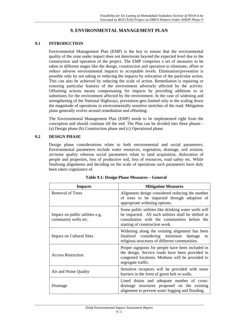
Feasibility for Six Laning of Ahmedabad-Vadodara Section of NH-8 to be Executed as BOT (Toll) Project on DBFO Pattern Under NHDP Phase-V
Draft Environmental Impact Assessment Report 9 -1
9. ENVIRONMENTAL MANAGEMENT PLAN
9.1 INTRODUCTION
Environmental Management Plan (EMP) is the key to ensure that the environmental quality of the zone under impact does not deteriorate beyond the expected level due to the construction and operation of the project. The EMP comprises a set of measures to be taken in different stages like the design, construction and operation to eliminate, offset or reduce adverse environmental impacts to acceptable levels. Elimination/prevention is possible only by not taking or reducing the impacts by relocation of the particular action. This can also be achieved by reducing the scale of action. Remediation is repairing or restoring particular features of the environment adversely affected by the activity. Offsetting actions means compensating for impacts by providing additions to or substitutes for the environment affected by the environment. In the case of widening and strengthening of the National Highways, prevention gets limited only to the scaling down the magnitude of operations in environmentally sensitive stretches of the road. Mitigation plans generally evolve around remediation and offsetting.
The Environmental Management Plan (EMP)
9.2 DESIGN PHASE
needs to be implemented right from the conception and should continue till the end. The Plan can be divided into three phases - (a) Design phase (b) Construction phase and (c) Operational phase.
Table 9.1: Design Phase Measures – General
Design phase considerations relate to both environmental and social parameters. Environmental parameters include water resources, vegetation, drainage, soil erosion, air/noise quality whereas social parameters relate to land acquisition, dislocation of people and properties, loss of productive soil, loss of resources, road safety etc. While finalising alignments and deciding on the scale of operations such parameters have duly been taken cognizance of.
Impacts Mitigation Measures Removal of Trees Alignment design considered reducing the number
of trees to be impacted through adoption of appropriate widening options.
Impact on public utilities e.g. community wells etc.
Some public utilities like drinking water wells will be impacted. All such utilities shall be shifted in consultation with the communities before the starting of construction work.
Impact on Cultural Sites Widening along the existing alignment has been finalized considering minimum damage to religious structures of different communities.
Access Restriction Proper signposts for people have been included in the design. Service roads have been provided in congested locations. Medians will be provided to segregate traffic.
Air and Noise Quality Sensitive receptors will be provided with noise barriers in the form of green belt or walls.
Drainage Lined drains and adequate number of cross-drainage structures proposed on the existing alignment to prevent water logging and flooding.

Feasibility for Six Laning of Ahmedabad-Vadodara Section of NH-8 to be Executed as BOT (Toll) Project on DBFO Pattern Under NHDP Phase-V
Draft Environmental Impact Assessment Report 9 -2
9.3 CONSTRUCTION PHASE
9.3.1 Land Environment
Table 9.2: Mitigation Measures for Land Environment
The impact of road construction starts with land environment. General mitigation measures are suggested below in Table 9.2.
Impacts Mitigation Measures
Soil Erosion Proper planning for slope stabilization, topsoil storage, plantation and turfing on slopes.
Loss of topsoil Arable lands will be avoided for earth borrowing. If needed, topsoil will be separated and stockpiled after excavation for reuse in restoration of borrow pits.
Borrowing of fill materials
Excavation from pre-selected locations. After excavation, the borrow pits will be dressed to match with the surround. In specific cases borrow pits can be excavated in consultation with local people to use those pits as water harvesting points or surface storages for pisci-culture. Some borrow-pits could be enhanced as rural recreation sites in consultation with communities.
Disposal of Construction waste Controlled and organized dumping of construction waste. Only pre-selected locations conforming to local environmental regulations will be used.
Disposal of human waste by construction workers.
Specific landfill sites will be identified to manage solid waste generated from habitation of construction workers.
9.3.2 Air Quality and Noise
Construction activities at different phases can generate significant air quality problems. So air quality and noise will be one of the major environmental issues. Mitigation measures would be taken to reduce the impact as presented below in Table 9.3.
Table 9.3: General Measures for Air & Noise Pollution Control
Impact Measures
Generation of Dust
Water will be sprayed during construction phase, in earth handling sites, asphalt mixing sites and other excavation areas for suppression of dust. Dust emission from piles of excavated material would also be controlled by spraying water on the piles. Special care would be taken when working near schools and medical facilities.
Dust emission is a high-risk problem in the stone crushing activities. Workers are exposed to high level of dust pollution. It will be responsibility of the project proponent to ensure that stone crushers supplying materials for this project implement air pollution control and workers are provided with masks. Stone crushing units should meet the requirements under Environment (Protection) Rules, 1986.

Feasibility for Six Laning of Ahmedabad-Vadodara Section of NH-8 to be Executed as BOT (Toll) Project on DBFO Pattern Under NHDP Phase-V
Draft Environmental Impact Assessment Report 9 -3
Impact Measures
Gaseous Pollution
Vehicles and machineries will be regularly maintained to conform to the emission standards stipulated under Environment (Protection), Rules 1986. All the vehicle used for project including construction and Official use should be checked for Pollution Under Control and should be updated as per the prescribed format. Asphalt mixing sites should be located at least 500 m away from residential areas. Workers working in asphalt mixing and subsequent application of asphalt mix on road surface are exposed to high level of carcinogenic emission. These workers should be provided with masks and other personal protective equipments (PPE). It will be responsibility of the supervising officers that the workers use the masks.
Noise
Noise levels of machineries used shall conform to relevant standards prescribed in Environment (Protection) Rules, 1986. Workers shall not be exposed to noise level more than permitted for industrial premises, i.e. 90 dBA (Leq) for 8 hours. Workers exposed to high noise level should be provided with earplugs and other Personal Protective Equipments (PPE). Construction work generating noise pollution near the sensitive locations such as, health facilities and residential areas should be stopped during night hours. Noise attenuation measures e.g. planting of trees, noise attenuation structures to be erected as required.
9.3.3 Water Resources
The project work will have some impact on water environment along the roadside and also the requirement of water for construction activities may have some impact on local water resources. Mitigation measures would be taken to reduce the impact as presented below in Table 9.4.
Table 9.4: General Measures for Protection of Water Resources
Impacts Mitigation Measures
Siltation into water bodies
Cofferdams or similar measures will be implemented during construction on River waters/ other water bodies. Steep and erodible slopes will be vegetated to prevent erosion that causes siltation. No solid waste will be dumped near the water bodies or rivers.
Flooding due to siltation of drainage channel
Excavated earth, and other construction materials would be stored at safe distance to prevent washing out of such materials.
Water use for construction
Water sources would be selected away from the existing settlement and near the existing water resources locations, so that local availability is not affected. Local water bodies, tube wells and wells will not be used. Borehole by contractors will be done with permission from State/Central Ground Water Board. River water will also be used for construction purposes. Rainwater harvesting structures shall be established all along the project corridor on every 500 m distance.

Feasibility for Six Laning of Ahmedabad-Vadodara Section of NH-8 to be Executed as BOT (Toll) Project on DBFO Pattern Under NHDP Phase-V
Draft Environmental Impact Assessment Report 9 -4
Impacts Mitigation Measures
Contamination from wastes
All practical measures will be taken to prevent any uncontrolled effluent discharge from construction workers camps and storages to water sources. The campsites will be provided with proper drainage and will be connected to local disposal system.
Contamination from fuel and wastes
Vehicle maintenance will be carried out in a confined area, away from water sources, and it will be ensured that used oil or lubricants are not disposed to watercourses.
Sanitation and Water use in Construction Camps
Construction camp will be organized in a planned manner. Workers shall be provided proper sanitation facilities including toilets. Camps will have water supply facilities like tube wells or from other sources so that local water sources are not affected.
9.3.4 Flora
Major mitigation measures to be taken up are given in Table 9.5.
Table 9.5: Mitigation Measures for Tree Loss
Impacts Mitigation Measures
Loss of Trees
Trees will be removed only in phases depending on the requirement of the construction. As per the guidelines of the State Govt. the number of trees planted will be two times of the trees removed for the tree loss. Plantation will be raised in the form of strip and block plantations depending on the availability of lands within the project corridor. The compensatory plantation plan shall be drawn up in consultation with the State Forest Department. Species-mix of such plantations will be decided in consultation with the communities. Some flowering and fruit trees good for attracting birds will also be used in such plantations.
9.3.5 Fauna
The local terrestrial and aquatic fauna are likely to be impacted due to construction activities. Mitigation measures for birds will be planting of more fruit and flowering trees, which will improve the roadside habitat. The primary productivity may be impacted locally during the construction stage. Such impact will be short term and reversible. Table 9.6 shows the mitigation measures to be adopted during construction.
Table 9.6: Mitigation Measures for Fauna
Impacts Mitigation Measures
Loss of habitat for avifauna
Compensatory Plantation programme will be taken up. Species–mix will provide for flowering and fruit trees. Sediment flow will be kept at minimum level through a mix of management measures during construction near water bodies or construction of bridges in water environment.
Impact on Wildlife
The local wild fauna include snakes, frogs, rodents etc. The construction camps have to be located away from this site and awareness development camps will be organized with the local stakeholders to ensure that there is no illegal hunting of birds or unauthorized fishing in water bodies.

Feasibility for Six Laning of Ahmedabad-Vadodara Section of NH-8 to be Executed as BOT (Toll) Project on DBFO Pattern Under NHDP Phase-V
Draft Environmental Impact Assessment Report 9 -5
9.3.6 Safety
Safety at different stages of construction is an important issue both for local people as well as for the construction workers.
Table 9.7: Safety Measures
Impacts Mitigation measures
Information to Public Signs will be posted on road before commencement of construction informing public and travelers about the work program and safety provisions.
Restriction to Access
Safe and convenient passage for vehicles, pedestrians and livestock to and from the side roads and property across the road would be arranged during construction work through a proper traffic management plan for sections where work will be in progress.
Occupational Safety for Construction Workers
Contractor would arrange all safety measures for workers as per Factories Act and first aid kit would be provided at all construction sites etc.
Occupational Safety for Asphalt plant workers and Crusher plant.
All workers employed on mixing asphalted material, cement, lime mortars, concrete etc., will be provided with protective footwear and protective goggles. For crusher workers, masks should be provided. The contractor will provide appropriate personal protective equipment to construction workers depending on the nature of work and the worksite. First aid kit should be provided at all construction sites.
Explosive use, if any
The Contractor shall at all times organize dissemination of information in advance and obtain such permission as is required from all Government Authorities, public bodies as necessary under the regulatory framework in force.
Storage Site
Storage of construction related materials, like machineries, materials etc. will not be stored near any water body, school, health facilities and residential areas. The discarded materials from the storage site will be kept in a specific place at the storage site and disposed according to environmental laws and regulations. Especially, two relevant rules – Manufacture, Storage and Import of Hazardous Chemicals Rules and Hazardous Waste (Management and Handling) Rules – should be always considered. For storage of explosives, Explosives Act should be followed. Storage site should have proper signs for safety.
Workers’ Camp
Construction workers are not treated well in the country. Unless the workers are provided proper amenities in the construction site, they cannot be sensitized to the environmental issues of road construction. In accordance with Environment (Protection) Act, for any environmental pollution from the workers’ camp, the responsibility would lie with the project authority and they may be proceeded against for imposition of penalty. Mitigation measures for workers camp are suggested in Table 9.8.

Feasibility for Six Laning of Ahmedabad-Vadodara Section of NH-8 to be Executed as BOT (Toll) Project on DBFO Pattern Under NHDP Phase-V
Draft Environmental Impact Assessment Report 9 -6
Table 9.8: Mitigation Measures for Workers’ Camps
Issue Measures
Location Workers’ camps will be located away from water bodies, schools, and residential areas.
Construction Camp will be constructed with proper accommodation facilities, should look aesthetically good, as this will be a roadside feature during construction period.
Water Contractor will arrange for potable water supply for the workers so that local water resources are not disturbed. Bore well for the camp will be suitable for this region.
Sanitation Workers’ camp will be provided with proper sanitation facilities, toilets with septic tank and soak pits.
Waste Management Wastewater from domestic uses and solid wastes will be disposed off without violating environmental norms. The measures will be site specific.
Other amenities First aid kit should be provided at Workers Camps as required under Factories Act.
Some important legal provisions related to stone quarries, noise levels of machineries and vehicle standards are given in Table 9.9.
Table 9.9: Limits under Environment (Protection) Rules, 1986
Source Regulations
Stone Crusher
1. Implementation of following pollution control measures: a) Dust containment cum suppression system for the equipment. b) Construction of wind breaking walls. c) Construction of metalled roads within the premises. d) Regular cleaning and wetting of the ground within the premises e) Growing of a green belt within the periphery
2. Quantitative standard for SPM: The SPM contribution value at a distance of 50 meters from a controlled isolated as well as from a unit located in a cluster should be less than 600 µg/m3. The measurements are to be conducted at least twice a month for all the 12 months a year.
Vehicles
Petrol driven: 4 wheelers: Idling CO not to exceed 3 percent by volume. 3 & 2 Wheelers: Idling CO not to exceed 5.5 percent by volume Diesel driven: Smoke Density At full load and 70% maximum speed: 3.2 Light Absorption Co-eff At free acceleration: 2.3 Light Absorption Co-eff
General Emission Particulate matters: 150 mg/Nm3
Automobiles
2 and 3 wheeler: 80 dB (A) Passenger car : 82 dB(A) Passenger or commercial vehicles upto 5T: 85 dB(A) Passenger or commercial vehicles 5-12 T: 89 dB(A) Passenger or commercial vehicles 5-12 T: 91 dB(A)
Machineries Compactors, Front loaders, Concrete mixtures, Cranes, Vibrators, Saws: 75 dB(A)

Feasibility for Six Laning of Ahmedabad-Vadodara Section of NH-8 to be Executed as BOT (Toll) Project on DBFO Pattern Under NHDP Phase-V
Draft Environmental Impact Assessment Report 9 -7
9.4 OPERATION PHASE
Environmental issues change during operation phase and its mitigation plan also has to be spread over a longer period of time. Operation phase environmental aspects relate to vehicular emission in particular. The mitigation measures for different environmental aspects are given in Table 9. 10.
Table 9.10: Operation Phase Mitigation Measures
Impacts Mitigation Measures
Dust Bad maintenance of road gives rise to dust pollution. Road maintenance standards shall be prescribed to keep dust dislocation and dispersion at acceptable level.
Gaseous Pollution
All vehicles should be checked for “Pollution Under Control” certificates and occasional spot testing of emission from vehicles will be carried out with the assistance of the local administration. Bringing in of stringent pollution norms and improvement of fuel quality in future years will help in reduced gaseous pollution.
Noise
Noise level for different automobiles has been prescribed in Environment (Protection) Rules, 1986. Signs will be posted to restrict blowing of horns at sensitive locations. With the establishment of strip plantations along the project corridor, the noise level will get attenuated along the project corridor.
Surface runoff Surface runoff from the road will not be disposed directly in the water bodies used by people for bathing etc. This will also not be disposed directly in to any watercourse with good water quality.
Wild Life
In absence of any designated conservation area in the project corridor, there are hardly any chances of loss of wildlife through collisions with the speeding traffic. However, there will be some loss through casualties of local wild fauna like the snakes, frogs, rodents etc. There will be proper signages to make the moving traffic aware of this.
Flora Tree plantations will be monitored for a period of three years after planting. All casualties in the first year of creation will require to be beaten up during the next year.
Safety Safety signs should be kept always clean and updated. Safety signposts, edge markers installed will require proper upkeep.
Public amenities Bus Stops/ Bus shelters will require periodic maintenance to keep them usable throughout the project cycle and these will be required to be kept free from defacement and damages.
9.5 ISSUES CONSIDERED IN ROAD CONSTRUCTION
Other issues considers additional provisions, which can be included in the execution of highway widening project to enhance better road service facilities, public amenities, safety provisions and environmental quality. It also suggests improvement of aesthetic qualities of the project corridor. Following are the issues to be addressed during road construction:

Feasibility for Six Laning of Ahmedabad-Vadodara Section of NH-8 to be Executed as BOT (Toll) Project on DBFO Pattern Under NHDP Phase-V
Draft Environmental Impact Assessment Report 9 -8
9.5.1 Road Service Facilities
Road Medians: Road medians will be planted with flowering and foliage shrubs of medium height. This will also protect the drivers from the glares of headlights of vehicles coming from opposite direction. The bypass will have a wider road median.
Roadside Plantation: Trees removed will be compensated through planting double the number of trees cut. Such plantations will be raised primarily along the project corridor as strip plantations as per plans drawn up in consultation with the Department of Forests. Some block plantations will also be raised in lands identified by the Forest Department. Foreshore plantation along the embankments of water bodies in the project corridor will also be explored to enhance aesthetic qualities of such water bodies.
9.5.2 Workers’ Camps
The workers’ camps by the roadside are often an eyesore. One of the important tasks of environmental enhancement will be to build model workers’ camps, which then can be replicated in all road construction projects. The workers’ camps will be clean, the camp houses will be properly painted, the housing area nicely separated from the surroundings. Some gardening activities may add to the aesthetics of such camps. Proper signages should be put up to notify such model campsites.
9.6 ENVIRONMENT MANAGEMENT PLAN MATRIX
The Environmental Management Plan is meant for mitigation/management /avoidance of the negative impacts and the enhancement of the various environmental components along the project road. For each mitigation measure to be taken its location, timeframe, implementation and overseeing/supervising responsibilities are listed in the EMP matrix. The measure adopted and /or to be adopted during the different stages of the project have been detailed in Table 9.11.

Feasibility for Six Laning of Ahmedabad-Vadodara Section of NH-8 to be Executed as BOT (Toll) Project on DBFO Pattern Under NHDP Phase-V
Draft Environmental Impact Assessment Report 9 -9
Table 9.11: Environmental Management Plan Matrix
S. No. Environmental Aspect/Issue Management Measures
Responsibility
Execution / Civil Work
Supervision/ Monitoring
PRE-CONSTRUCTION STAGE Pre-Construction Activities by Project Implementation Unit
P.1 Preservation of Trees
• The project road involves removal of trees to be cut in different stretches of the road. • Tree cutting is to proceed only after all the legal requirements including obtaining of In-
principle and Formal Clearances from the Forest Dept./DoEF/Collector are completed and subsequently a written order is issued to the Contractor.
• Particular species declared as ‘protected’ by the State’s Forest Dept. in the private land will be felled only after due clearance from the Forest Dept. is obtained.
• In the event of design changes, additional assessments including the possibility to save trees shall be made.
• Stacking, transport and storage of the wood will be done as per the relevant norms. • Systematic corridor level documentation for the trees cut and those saved will be
maintained by the PIU.
PIU, Forest Department, Contractor
Supervision Consultants
and PIU
P.2 Relocation of
Common Property Resources
Refer Chapters of the Social Screening Report for the relocation of Common Property Resources.
PIU, Concerned Agencies, Contractor
PIU
P.3 Relocation of
affected Cultural and Religious
Properties
Refer Chapters of the Social Screening Report for the relocation of Common Property Resources.
PIU, Contractor PIU
Pre-construction activities by the Contractor/Environmental Expert of Supervision Consultants (SC) P.4 Field Verification and Modification of the Contract Documents
P.4.1 Joint Field • SC and the Contractor will carry out joint field verification to ascertain the possibility of Contractor/ PIU

Feasibility for Six Laning of Ahmedabad-Vadodara Section of NH-8 to be Executed as BOT (Toll) Project on DBFO Pattern Under NHDP Phase-V
Draft Environmental Impact Assessment Report 9 -10
S. No. Environmental Aspect/Issue Management Measures
Responsibility
Execution / Civil Work
Supervision/ Monitoring
Verification saving trees, environmental and community resources. • The verification exercise should assess the need for additional protection measures or
changes in design/scale/nature of protection measures including the efficacy of enhancement measures suggested in the EMP. Proper documentation and justifications/reasons shall be maintained in all such cases where deviation from the original EMP is proposed.
SC
P.4.2
Assessment of Impacts due to
Changes/Revisions/Additions in the
Project Work
SC will assess impacts and revise/modify the EMP and other required sections of the project document/s in the event of changes/revisions (including addition or deletion) in the project’s scope of work.
Contractor/ SC PIU
P.4.3 Crushers, hot-mix
plants and Batching Plants Location
• Hot mix plants and batching plants will be sited sufficiently away from settlements and agricultural operations or any commercial establishments. Such plants will be located at least 500 m away from the nearest village/settlement preferably in the downwind direction.
• The Contractor shall submit a detailed lay-out plan for all such sites and approval of SC/PIU shall be necessary prior to their establishment.
• Arrangements to control dust pollution through provision of windscreens, sprinklers, and dust encapsulation will have to be provided at all such sites.
• Specifications of crushers, hot mix plants and batching plants will comply with the requirements of the relevant current emission control legislations and Consent/NOC for all such plants shall be submitted to the SC and PIU.
• The Contractor shall not initiate plant/s operation till the required legal clearances are obtained and submitted.
Contractor/ SC PIU
P.4.4 Other Construction
Vehicles, Equipment and
Machinery
• All vehicles, equipment and machinery to be procured for construction will conform to the relevant Bureau of India Standard (BIS) norms. The discharge standards promulgated under the Environment Protection Act, 1986 will be strictly adhered to.
• Noise limits for construction equipments to be procured such as compactors, rollers, front loaders concrete mixers, cranes (moveable), vibrators and saws will not exceed 75 dB (A), measured at one meter from the edge of the equipment in free field, as specified in the
Contractor/ SC PIU

Feasibility for Six Laning of Ahmedabad-Vadodara Section of NH-8 to be Executed as BOT (Toll) Project on DBFO Pattern Under NHDP Phase-V
Draft Environmental Impact Assessment Report 9 -11
S. No. Environmental Aspect/Issue Management Measures
Responsibility
Execution / Civil Work
Supervision/ Monitoring
Environment (Protection) Rules, 1986. • The Contractor shall maintain a record of PUC for all vehicles and machinery used during
the contract period. P.5 Identification and Selection of Material Sources
P.5.1 Borrow Areas
• The Contractor will not start borrowing earth from selected borrow areas until the formal agreement is signed between land owner and contractor and a copy is submitted to the SC and the PIU.
• Planning of haul roads for accessing borrow materials will be undertaken during this stage. The haul roads shall be routed to avoid agricultural areas as far as possible (in case such a land is disturbed, the Contractor will rehabilitate it as per Borrow Area Rehabilitation Guidelines Annexure 9.2) and will use the existing village roads wherever available.
• In addition to testing for the quality of borrow materials by the SC, they will be required to inspect every borrow area location prior to approval (follow criteria for evaluation of borrow areas).
Contractor/ SC PIU
P.5.2 Quarry
• In case the contractor decides to use quarries other than recommended by DPR consultants, then it will be selected based on the suitability of the materials.
• The contractor will procure necessary permission for procurement of materials from Mining Department, District Administration and State Pollution Control Board and shall submit a copy of the approval and the rehabilitation plan to the PIU and the SC.
• Contractor will also work out haul road network and report to and SC will inspect and in turn report to PIU before approval.
Contractor SC and PIU
P.5.3 Arrangement for Construction Water
• Contractor is not allowed to use any community water resources. • To avoid disruption/disturbance to other water users, the contractor will extract water from
fixed locations and consult the SC before finalizing the locations. • The Contractor will provide a list of locations and type of sources from where water for
construction will be used. • The contractor will not be allowed to pump from any irrigation canal and surface water
Contractor SC and PIU
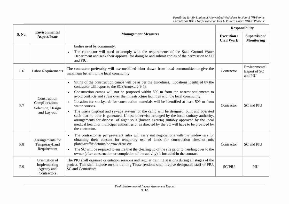
Feasibility for Six Laning of Ahmedabad-Vadodara Section of NH-8 to be Executed as BOT (Toll) Project on DBFO Pattern Under NHDP Phase-V
Draft Environmental Impact Assessment Report 9 -12
S. No. Environmental Aspect/Issue Management Measures
Responsibility
Execution / Civil Work
Supervision/ Monitoring
bodies used by community. • The contractor will need to comply with the requirements of the State Ground Water
Department and seek their approval for doing so and submit copies of the permission to SC and PIU.
P.6 Labor Requirements The contractor preferably will use unskilled labor drawn from local communities to give the maximum benefit to the local community. Contractor
Environmental Expert of SC and PIU
P.7
Construction CampLocations – Selection, Design
and Lay-out
• Siting of the construction camps will be as per the guidelines. Locations identified by the contractor will report to the SC (Annexure-9.4).
• Construction camps will not be proposed within 500 m from the nearest settlements to avoid conflicts and stress over the infrastructure facilities with the local community.
• Location for stockyards for construction materials will be identified at least 500 m from water courses.
• The waste disposal and sewage system for the camp will be designed, built and operated such that no odor is generated. Unless otherwise arranged by the local sanitary authority, arrangements for disposal of night soils (human excreta) suitably approved by the local medical health or municipal authorities or as directed by the SC will have to be provided by the contractor.
Contractor SC and PIU
P.8 Arrangements for TemporaryLand
Requirement
• The contractor as per prevalent rules will carry out negotiations with the landowners for obtaining their consent for temporary use of lands for construction sites/hot mix plants/traffic detours/borrow areas etc.
• The SC will be required to ensure that the clearing up of the site prior to handing over to the owner (after construction or completion of the activity) is included in the contract.
Contractor SC and PIU
P.9 Orientation of Implementing Agency and Contractors
The PIU shall organize orientation sessions and regular training sessions during all stages of the project. This shall include on-site training These sessions shall involve designated staff of PIU, SC and Contractors. SC/PIU PIU

Feasibility for Six Laning of Ahmedabad-Vadodara Section of NH-8 to be Executed as BOT (Toll) Project on DBFO Pattern Under NHDP Phase-V
Draft Environmental Impact Assessment Report 9 -13
S. No. Environmental Aspect/Issue Management Measures
Responsibility
Execution / Civil Work
Supervision/ Monitoring
CONSTRUCTION STAGE
Activities to be Carried Out by the Contractor C.1 Site Clearance
C.1.1 Clearing and Grubbing
• Vegetation will be removed from the construction zone before commencement of construction. All works will be carried out such that the damage or disruption to flora other than those identified for cutting is minimum.
• Only ground cover/shrubs that impinge directly on the permanent works or necessary temporary works will be removed with prior approval of the SC.
• The contractor, under any circumstances will not cut or damage trees. Trees identified under the project will be cut only after receiving clearance from the Forest Dept. and after the receipt of PIU’s written permission in this regard (Refer Annexure 9.5).
Contractor SC, PIU
C.1.2
Generation of Debris from dismantling structures and road surface
• Debris generated due to the dismantling of the existing road will be suitably reused in the proposed construction, subject to the suitability of the materials and approval of the Resident Engineer and Environmental Expert of SC as follows:
• The sub grade of the existing pavement shall be used as embankment fill material. • The existing base and sub-base material shall be recycled as sub-base of the haul road or
access roads • The existing bitumen surface may be utilized for the paving of cross roads, access roads and
paving works in construction sites and campus, temporary traffic diversions, haulage routes etc.
• The contractor will suitably dispose off unutilized debris materials either through filling up of borrow areas located in wasteland or at pre-designated disposal locations, subject to the approval of SC (Refer Annexure 9.1).
• Bituminous waste shall stored at designated landfill site and no material shall be disposed off at private or public land.
Contractor SC, PIU

Feasibility for Six Laning of Ahmedabad-Vadodara Section of NH-8 to be Executed as BOT (Toll) Project on DBFO Pattern Under NHDP Phase-V
Draft Environmental Impact Assessment Report 9 -14
S. No. Environmental Aspect/Issue Management Measures
Responsibility
Execution / Civil Work
Supervision/ Monitoring
• At locations identified for disposal of residual bituminous wastes, the disposal will be carried out over a 60 mm thick layer of rammed clay so as to eliminate the possibility of leaching of wastes into the ground water. The contractor will ensure that the surface area of such disposal pits is covered with a layer of soil.
• All arrangements for transportation during construction including provision, maintenance, dismantling and clearing debris, will be considered incidental to the work and will be planned and implemented by the contractor as approved and directed by the SC.
• The pre-designed disposal locations will be a part of Comprehensive Solid Waste Management Plan to be prepared by Contractor in consultation and with approval of SC.
• Debris generated from pile driving or other construction activities shall be disposed such that it does not flow into the surface water bodies or form mud puddles in the area.
• The contractor shall identify dumping sites. The identified locations will be reported to the SC. These locations will be checked on site and accordingly approved by the SC prior to any disposal of waste materials.
C.1.3 Other Construction Wastes Disposal
• The pre-identified disposal locations will be a part of Comprehensive Waste Disposal Solid Waste Management Plan to be prepared by the Contractor in consultation and with approval of SC. Location of disposal sites will be finalized prior to completion of the earthworks on any particular section of the road.
• The SC will approve these disposal sites after conducting a joint inspection on the site with the Contractor.
• Contractor will ensure that any spoils of material unsuitable for embankment fill will not be disposed off near any water course, agricultural land, and natural habitat like grass lands or pastures. Such spoils from excavation can be used to reclaim borrow pits and low-lying areas located in barren lands along the project corridors (is so desired by the owner/community).
• Non-bituminous wastes may be dumped in borrow pits (preferably located in barren lands) covered with a layer of the soil. No new disposal site shall be created as part of the project, except with prior approval of the SC.
• All waste materials will be completely disposed and the site will be fully cleaned and
Contractor SC, PIU

Feasibility for Six Laning of Ahmedabad-Vadodara Section of NH-8 to be Executed as BOT (Toll) Project on DBFO Pattern Under NHDP Phase-V
Draft Environmental Impact Assessment Report 9 -15
S. No. Environmental Aspect/Issue Management Measures
Responsibility
Execution / Civil Work
Supervision/ Monitoring
certified by Environmental Expert of SC before handing over. • The contractor at its cost shall resolve any claim, arising out of waste disposal or any non-
compliance that may arise on account of lack of action on his part.
C.1.4 Stripping, stocking and preservation of
top soil
• The topsoil from all areas of cutting and all areas to be permanently covered will be stripped to a specified depth of 150 mm and stored in stockpiles. A portion of the temporarily acquired area and/or Right of Way will be earmarked for storing topsoil. The locations for stock piling will be pre-identified in consultation and with approval of SC. The following precautionary measures will be taken to preserve them till they are used: (a) Stockpile will be designed such that the slope does not exceed 1:2 (vertical to horizontal), and height of the pile is restricted to 2 m. To retain soil and to allow percolation of water, silt fencing will protect the edges of the pile. (b) Stockpiles will not be surcharged or otherwise loaded and multiple handling will be kept to a minimum to ensure that no compaction will occur. The stockpiles shall be covered with gunny bags or vegetation. (c) It will be ensured by the contractor that the topsoil will not be unnecessarily trafficked either before stripping or when in stockpiles.
• Such stockpiled topsoil will be utilized for -covering all disturbed areas including borrow areas (not those in barren areas) top dressing of the road embankment and fill slopes filling up of tree pits, in the agricultural fields of farmers, acquired temporarily.
• Residual topsoil, if there is any will be utilized for the plantation at median and side of the main carriageway.
Contractor SC, PIU
C.1.5 Accessibility
• The contractor will provide safe and convenient passage for vehicles, pedestrians and livestock to and from roadsides and property accesses connecting the project road, providing temporary connecting road.
• The contractor will also ensure that the existing accesses will not be undertaken without providing adequate provisions and to the prior satisfaction of Environmental Expert of SC.
Contractor SC, PIU

Feasibility for Six Laning of Ahmedabad-Vadodara Section of NH-8 to be Executed as BOT (Toll) Project on DBFO Pattern Under NHDP Phase-V
Draft Environmental Impact Assessment Report 9 -16
S. No. Environmental Aspect/Issue Management Measures
Responsibility
Execution / Civil Work
Supervision/ Monitoring
C.1.6 Planning for Traffic
Diversions and Detours
• Temporary diversions will be constructed with the approval of the Resident Engineer and Environmental Expert of SC.
• Detailed Traffic Control Plans will be prepared and submitted to the SC for approval, five days prior to commencement of works on any section of road. The traffic control plans shall contain details of temporary diversions, traffic safety arrangements for construction under traffic (Annexure 9.3), details of traffic arrangement after cessation of work each day, safety measures undertaken for transport of hazardous materials and arrangement of flagmen.
• The Contractor will provide specific measures for safety of pedestrians and workers at night as a part of traffic control plans. The Contractor will ensure that the diversion/detour is always maintained in running condition, particularly during the monsoon to avoid disruption to traffic flow.
• The contractor will also inform local community of changes to traffic routes, conditions and pedestrian access arrangements with assistance from SC and PIU. The temporary traffic detours will be kept free of dust by sprinkling of water three times a day and as required under specific conditions (depending on weather conditions, construction in the settlement areas and volume of traffic).
Contractor SC, PIU
C.2 Procurement of Construction Material
C.2.1 Earth from Borrow
Areas for Construction
• No borrow area will be opened without permission of the SC. The location, shape and size of the designated borrow areas will be as approved by the SC and in accordance to the IRC recommended practice for borrow pits for road embankments (IRC 10: 1961). The borrowing operations will be carried out as specified in the guidelines (Annexure-9.4) for sitting and operation of borrow areas.
• The unpaved surfaces used for the haulage of borrow materials, if passing through the settlement areas or habitations; will be maintained dust free by the contractor. Sprinkling of water will be carried out twice a day to control dust along such roads during their period of use.
Contractor SC, PIU
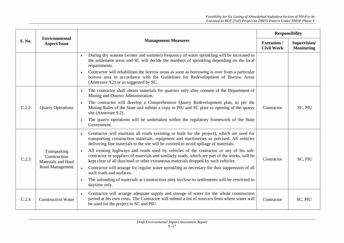
Feasibility for Six Laning of Ahmedabad-Vadodara Section of NH-8 to be Executed as BOT (Toll) Project on DBFO Pattern Under NHDP Phase-V
Draft Environmental Impact Assessment Report 9 -17
S. No. Environmental Aspect/Issue Management Measures
Responsibility
Execution / Civil Work
Supervision/ Monitoring
• During dry seasons (winter and summer) frequency of water sprinkling will be increased in the settlement areas and SC will decide the numbers of sprinkling depending on the local requirements.
• Contractor will rehabilitate the borrow areas as soon as borrowing is over from a particular borrow area in accordance with the Guidelines for Redevelopment of Borrow Areas (Annexure 9.2) or as suggested by SC.
C.2.2 Quarry Operations
• The contractor shall obtain materials for quarries only after consent of the Department of Mining and District Administration.
• The contractor will develop a Comprehensive Quarry Redevelopment plan, as per the Mining Rules of the State and submit a copy to PIU and SC prior to opening of the quarry site (Annexure 9.2).
• The quarry operations will be undertaken within the regulatory framework of the State Government.
Contractor SC, PIU
C.2.3 Transporting Construction
Materials and Haul Road Management
• Contractor will maintain all roads (existing or built for the project), which are used for transporting construction materials, equipment and machineries as précised. All vehicles delivering fine materials to the site will be covered to avoid spillage of materials.
• All existing highways and roads used by vehicles of the contractor or any of his sub-contractor or suppliers of materials and similarly roads, which are part of the works, will be kept clear of all dust/mud or other extraneous materials dropped by such vehicles.
• Contractor will arrange for regular water sprinkling as necessary for dust suppression of all such roads and surfaces.
• The unloading of materials at construction sites in/close to settlements will be restricted to daytime only.
Contractor SC, PIU
C.2.4 Construction Water • Contractor will arrange adequate supply and storage of water for the whole construction
period at his own costs. The Contractor will submit a list of source/s from where water will be used for the project to SC and PIU.
Contractor SC, PIU

Feasibility for Six Laning of Ahmedabad-Vadodara Section of NH-8 to be Executed as BOT (Toll) Project on DBFO Pattern Under NHDP Phase-V
Draft Environmental Impact Assessment Report 9 -18
S. No. Environmental Aspect/Issue Management Measures
Responsibility
Execution / Civil Work
Supervision/ Monitoring
• The contractor will source the requirement of water preferentially from ground water but with prior permission from the Ground Water Board. A copy of the permission will be submitted to SC and PIU prior to initiation of construction.
• The contractor will take all precaution to minimize the wastage of water in the construction process/ operation.
C.3 Construction Work
C.3.1 River Training and Disruption to Other
Users of Water
• While working across or close to any perennial water bodies, contractor will not obstruct/ prevent the flow of water.
• Construction over and close to the non-perennial streams shall be undertaken in the dry season. If construction work is expected to disrupt users of community water bodies, notice shall be served well in advance to the affected community.
• The contractor will serve notice to the down stream users well in advance wherever excavation/drilling will take place in the water bodies. Contractor will ensure that the slopes are not steeper than 1:2 (vertical: horizontal) otherwise proper slope protection measures will be taken as approved by the SC.
• The contractor will take prior approval of the River Authority or Irrigation Department or SC for any such activity. The PIU will ensure that contractor has served the notice to the downstream users of water well in advance.
Contractor SC, PIU
C.3.2 Drainage and Flood Control
• Contractor will ensure that no construction materials like earth, stone, ash or appendage disposed off so as not to block the flow of water of any water course and cross drainage channels.
• Contractor will take all necessary measures to prevent the blockage of water flow. In addition to the design requirements, the contractor will take all required measures as directed by the SC to prevent temporary or permanent flooding of the site or any adjacent area.
Contractor SC, PIU

Feasibility for Six Laning of Ahmedabad-Vadodara Section of NH-8 to be Executed as BOT (Toll) Project on DBFO Pattern Under NHDP Phase-V
Draft Environmental Impact Assessment Report 9 -19
S. No. Environmental Aspect/Issue Management Measures
Responsibility
Execution / Civil Work
Supervision/ Monitoring
C.3.3 Siltation of Water
Bodies and Degradation of Water Quality
• The Contractor will not excavate beds of any stream/canals/ any other water body for borrowing earth for embankment construction.
• Contractor will construct silt fencing at the base of the embankment construction for the entire perimeter of any water body (including wells) adjacent to the RoW and around the stockpiles at the construction sites close to water bodies. The fencing will be provided prior to commencement of earthwork and continue till the stabilization of the embankment slopes, on the particular sub-section of the road.
• The contractor will also put up sedimentation cum grease traps at the outer mouth of the drains located in truck lay byes and bus bays which are ultimately entering into any surface water bodies / water channels with a fall exceeding 1.5 m.
• Contractor will ensure that construction materials containing fine particles are stored in an enclosure such that sediment-laden water does not drain into nearby water course.
Contractor SC, PIU
C.3.4 Slope Protection
and Control of Soil Erosion
• The contractor will take slope protection measures as per (IRC guideline) design, or as directed by the SC to control soil erosion and sedimentation through use of dykes, sedimentation chambers, basins, fibber mats, mulches, grasses, slope, drains and other devices.
• All temporary sedimentation, pollution control works and maintenance thereof will be deemed as incidental to the earth work or other items of work and as such as no separate payment will be made for them.
• Contractor will ensure the following aspects: • During construction activities on road embankment, the side slopes of all cut and fill areas
will be graded and covered with stone pitching, grass and shrub as per design specifications. • Turfing works will be taken up as soon as possible provided the season is favorable for the
establishment of grass sods. Other measures of slope stabilization will include mulching netting and seeding of batters and drains immediately on completion of earthworks.
• In borrow pits, the depth shall be so regulated that the sides of the excavation will have a slope not steeper than 1 vertical to 2 horizontal, from the edge of the final section of the bank.
• Along sections abutting water bodies, stone pitching as per design specification will protect slopes.
Contractor SC, PIU

Feasibility for Six Laning of Ahmedabad-Vadodara Section of NH-8 to be Executed as BOT (Toll) Project on DBFO Pattern Under NHDP Phase-V
Draft Environmental Impact Assessment Report 9 -20
S. No. Environmental Aspect/Issue Management Measures
Responsibility
Execution / Civil Work
Supervision/ Monitoring
C.4 Pollution C.4.1 Water Pollution
C.4.1.1 Water Pollution
from Construction Wastes
• The Contractor will take all precautionary measures to prevent the wastewater generated during construction from entering into streams, water bodies or the irrigation system. Contractor will avoid construction works close to the streams or water bodies during monsoon.
• All waste arising from the project is to be disposed off in the manner that is acceptable to the State Pollution Control Board or as directed by the SC.
• The SC will certify that all liquid wastes disposed off from the sites meet the discharge standards.
Contractor SC, PIU
C.4.1.2 Water Pollution from Fuel and
Lubricants
• The contractor will ensure that all construction vehicle parking location, fuel/lubricants storage sites, vehicle, machinery and equipment maintenance and refueling sites will be located at least 500 m from rivers and irrigation canal/ponds.
• All location and lay-out plans of such sites will be submitted by the Contractor prior to their establishment and will be approved by the SC and PIU.
• Contractor will ensure that all vehicle/machinery and equipment operation, maintenance and refueling will be carried out in such a fashion that spillage of fuels and lubricants does not contaminate the ground. Oil interceptors will be provided for vehicle parking, wash down and refueling areas as per the design provided.
• In all, fuel storage and refueling areas, if located on agricultural land or areas supporting vegetation, the top soil will be stripped, stockpiled and returned after cessation of such storage.
• Contractor will arrange for collection, storing and disposal of oily wastes to the pre-identified disposal sites (list to be submitted to SC and PIU) and approved by SC. All spills and collected petroleum products will be disposed off in accordance with MoEF and state PCB guidelines.
• SC will certify that all arrangements comply with the guidelines of PCB/MoEF or any other relevant laws.
Contractor SC, PIU

Feasibility for Six Laning of Ahmedabad-Vadodara Section of NH-8 to be Executed as BOT (Toll) Project on DBFO Pattern Under NHDP Phase-V
Draft Environmental Impact Assessment Report 9 -21
S. No. Environmental Aspect/Issue Management Measures
Responsibility
Execution / Civil Work
Supervision/ Monitoring
C.4.2 Air Pollution
C.4.2.1 Dust Pollution
• The contractor should take every precaution to reduce the level of dust from crushers/hot mix plants, construction sites involving earthwork by sprinkling of water, encapsulation of dust source and by erection of screen/barriers.
• All the plants will be sited at least 500m in the downwind direction from the nearest human settlement.
• The contractor should provide necessary certificates to confirm that all crushers used in construction conform to relevant dust emission control legislation.
• The suspended particulate matter value at a distance of 40 m from a unit located in a cluster should be less than 500 g/m3. The pollution monitoring is to be conducted as per the monitoring plan.
• Alternatively, only crushers licensed by the PCB shall be used. The Contractor in such a case shall submit required certificates and consents.
• Dust screening vegetation will be planted on the edge of the RoW for all existing roadside crushers. Hot mix plant will be fitted with dust extraction units.
Contractor SC, PIU
C.4.2.2
Emission from Construction
Vehicles, Equipment and
Machineries
• Contractor will ensure that all vehicles, equipment and machinery used for construction are regularly maintained and confirm that pollution emission levels comply with the relevant requirements of PCB.
• The Contractor will submit PUC certificates for all vehicles/ equipment/machinery used for the project. Monitoring results will also be submitted to SC and PIU as per the monitoring plan.
Contractor SC, PIU
C.4.3 Noise Pollution
C.4.3.1 Noise Pollution:
Noise from Vehicles, Plants and
Equipments
The Contractor will confirm to the following: • All plants and equipment used in construction (including crushing plant) shall strictly
conform to the MoEF/CPCB noise standards. • All vehicles and equipment used in construction will be fitted with exhaust silencers.
Contractor SC, PIU

Feasibility for Six Laning of Ahmedabad-Vadodara Section of NH-8 to be Executed as BOT (Toll) Project on DBFO Pattern Under NHDP Phase-V
Draft Environmental Impact Assessment Report 9 -22
S. No. Environmental Aspect/Issue Management Measures
Responsibility
Execution / Civil Work
Supervision/ Monitoring
• Servicing of all construction vehicles and machinery will be done regularly and during routine servicing operations, the effectiveness of exhaust silencers will be checked and if found defective will be replaced.
• Limits for construction equipment used in the project such as compactors, rollers, front loaders, concrete mixers, cranes (moveable), vibrators and saws shall not exceed 75 dB (A) (measured at one meter from the edge of equipment in the free field), as specified in the Environment (Protection) rules, 1986.
• Maintenance of vehicles, equipment and machinery shall be regular and up to the satisfaction of the SC to keep noise levels at the minimum.
• At the construction sites within 250 m of the nearest habitation, noisy construction work such as crushing, concrete mixing, batching will be stopped during the night time between 9.00 pm to 6.00 am.
• No noisy construction activities will be permitted around educational institutes/health centers (silence zones) up to a distance of 100 m from the sensitive receptors
• Monitoring shall be carried out at the construction sites as per the monitoring schedule and results will be submitted to SC and PIU. SC will be required to inspect regularly to ensure the compliance of EMP.
• Noise barrier shall be established at sensitive locations such as hospitals, educational institution etc.
C.5 Safety
C.5.1 Personal Safety
Measures for Labour
Contractor will provide: • Protective footwear and protective goggles to all workers employed on mixing asphalt
materials, cement, lime mortars, concrete etc. • Protective eye-shields to workers who are engaged in welding works • Protective goggles and clothing to workers engaged in Factories Act, 1948 stone breaking
activities and workers will be seated at sufficiently safe intervals
Contractor SC, PIU

Feasibility for Six Laning of Ahmedabad-Vadodara Section of NH-8 to be Executed as BOT (Toll) Project on DBFO Pattern Under NHDP Phase-V
Draft Environmental Impact Assessment Report 9 -23
S. No. Environmental Aspect/Issue Management Measures
Responsibility
Execution / Civil Work
Supervision/ Monitoring
• Earplugs to workers exposed to loud noise, and workers working in crushing, compaction, or concrete mixing operation (Annexure 9.6).
• Adequate safety measures for workers during handling of materials at site are taken up. • The contractor will comply with all regulations regarding safe scaffolding, ladders, working
platforms, gangway, stairwells, excavations, trenches and safe means of entry and egress. • The contractor will comply with all the precautions as required for ensuring the safety of
the workmen as per the International Labor Organization (ILO) Convention No. 62 as far as those are applicable to this contract.
• The contractor will make sure that during the construction work all relevant provisions of the Factories Act, 1948 and the Building and other Construction Workers (regulation of Employment and Conditions of Services) Act, 1996 are adhered to.
• The contractor will not employ any person below the age of 14 years for any work and no woman will be employed on the work of painting with products containing lead in any form.
• The contractor will also ensure that no paint containing lead or lead products is used except in the form of paste or readymade paint.
• Contractor will provide facemasks for use to the workers when paint is applied in the form of spray or a surface having lead paint dry is rubbed and scrapped.
• The Contractor will mark ‘hard hat’ and ‘no smoking’ and other ‘high risk’ areas and enforce non-compliance of use of PPE with zero tolerance. These will be reflected in the Construction Safety Plan to be prepared by the Contractor during mobilization and will be approved by SC and PIU.
C.5.2 Traffic and Safety
• The contractor will take all necessary measures for the safety of traffic during construction and provide, erect and maintain such barricades, including signs, markings, flags, lights and flagmen as proposed in the Traffic Control Plan/Drawings and as required by the SC for the information and protection of traffic approaching or passing through the section of any existing cross roads.
Contractor SC, PIU

Feasibility for Six Laning of Ahmedabad-Vadodara Section of NH-8 to be Executed as BOT (Toll) Project on DBFO Pattern Under NHDP Phase-V
Draft Environmental Impact Assessment Report 9 -24
S. No. Environmental Aspect/Issue Management Measures
Responsibility
Execution / Civil Work
Supervision/ Monitoring
• The contractor will ensure that all signs, barricades, pavement markings are provided as per the MoRTH specifications. Before taking up of construction on any section of the existing lanes of the highway, a Traffic Control Plan will be devised and implemented to the satisfaction of SC.
C.5.3 Risk from Electrical Equipment(s)
The Contractor will take all required precautions to prevent danger from electrical equipment and ensure that -
• No material will be so stacked or placed as to cause danger or inconvenience to any person or the public.
• All necessary fencing and lights will be provided to protect the public in construction zones. • All machines to be used in the construction will conform to the relevant Indian Standards
(IS) codes, will be free from patent defect, will be kept in good working order, will be regularly inspected and properly maintained as per IS provision and to the satisfaction of the SC.
Contractor SC, PIU
C.5.4 Risk Force Measure
• The contractor will take all reasonable precautions to prevent danger to the workers and public from fire, flood etc. resulting due to construction activities.
• The contractor will make required arrangements so that in case of any mishap all necessary steps can be taken for prompt first aid treatment. Construction Safety Plan prepared by the Contractor will identify necessary actions in the event of an emergency.
Contractor SC, PIU
C.5.5 First Aid
The contractor will arrange for - • A readily available first aid unit including an adequate supply of sterilized dressing
materials and appliances as per the Factories Rules in every work zone. • Availability of suitable transport at all times to take injured or sick person(s) to the nearest
hospital.
Contractor SC, PIU
C.5.6 Informatory Signs and Hoardings
The contractor will provide, erect and maintain informatory/safety signs, hoardings written in English, Hindi and local language, wherever required or as suggested by the SC. Contractor SC, PIU

Feasibility for Six Laning of Ahmedabad-Vadodara Section of NH-8 to be Executed as BOT (Toll) Project on DBFO Pattern Under NHDP Phase-V
Draft Environmental Impact Assessment Report 9 -25
S. No. Environmental Aspect/Issue Management Measures
Responsibility
Execution / Civil Work
Supervision/ Monitoring
C.6 Flora and Fauna: Plantation/Preservation/ Conservation Measures
C.6.1 Road side Plantation Strategy
• Double the number of trees felled would be planted, in the form of strip and block plantations depending on the availability of lands. Foliage and flowering shrubs will be planted on the median. Plans for compensatory plantation will be drawn up in consultation with the State Forest Department. Species composition and pattern of planting will be decided in consultation with the communities and Social Forestry wing of the Forest Department.
• Minimum 75 percent survival rate of the saplings will be acceptable otherwise the contractor will replace all casualties at his own cost to ensure this survival percentage. The contractor will maintain the plantation till they handover the project site.
• The SC will undertake regular inspection of the survival rate of the plants and compliance of tree plantation guidelines.
Contractor SC, PIU
C.6.2 Flora and Fauna
• The contractor will take reasonable precaution to prevent his workmen or any other persons from removing and damaging any flora (plant/vegetation) and fauna (animal).
• If any carcass of any wild animal/ wetland bird is found near the construction site at any point of time, the contractor will immediately upon discovery thereof acquaint the SC and carry out the SC's instructions for dealing with the same.
• The SC will report to the near by forest office (range office or divisional office) and will take appropriate steps/ measures, if required in consultation with the forest officials.
Contractor SC, PIU
C.7 Labor CampManagement
C.7.1 Accommodation
• Contractor will follow all relevant provisions of the Factories Act, 1948 and the Building and the other Construction Workers (Regulation of Employment and Conditions of Service) Act, 1996 for construction and maintenance of labour camp.
• The location, layout and basic facility provision of each labour camp will be submitted to SC and PIU prior to their construction.
• The construction will commence only upon the written approval of the SC. • The contractor will maintain necessary living accommodation and ancillary facilities in
functional and hygienic manner and as approved by the SC.
Contractor SC, PIU

Feasibility for Six Laning of Ahmedabad-Vadodara Section of NH-8 to be Executed as BOT (Toll) Project on DBFO Pattern Under NHDP Phase-V
Draft Environmental Impact Assessment Report 9 -26
S. No. Environmental Aspect/Issue Management Measures
Responsibility
Execution / Civil Work
Supervision/ Monitoring
C.7.2 Potable Water
• The Contractor will construct and maintain all labour accommodation in such a fashion that uncontaminated water is available for drinking, cooking and washing.
• The Contractor will also provide potable water facilities within the precincts of every workplace in an accessible place, as per standards set by the Building and other Construction Workers (Regulation of Employment and Conditions of Service) Act, 1996.
• The contractor will also guarantee the following: a) Supply of sufficient quantity of potable water (as per IS) in every workplace/labor camp site at suitable and easily accessible places and regular maintenance of such facilities. b) If any water storage tank is provided that will be kept such that the bottom of the tank at least 1mt. from the surrounding ground level. c) If water is drawn from any existing well, which is within 30mt. proximity of any toilet, drain or other source of pollution, the well will be disinfected before water is used for drinking. d) All such wells will be entirely covered and provided with a trap door, which will be dust proof and waterproof. e) A reliable pump will be fitted to each covered well. The trap door will be kept locked and opened only for cleaning or inspection, which will be done at least once in a month. f) Testing of water will be done every month as per parameters prescribed in IS 10500:1991.
• SC will be required to inspect the labour camp once in a week to ensure the compliance of the EMP.
Contractor SC, PIU
C.7.3 Sanitation and Sewage System
The contractor will ensure that • The sewage system for the camp are designed, built and operated in such a fashion that no
health hazards occurs and no pollution to the air, ground water or adjacent water courses take place
• Separate toilets/bathrooms, wherever required, screened from those from men (marked in vernacular) are to be provided for women
Contractor SC, PIU

Feasibility for Six Laning of Ahmedabad-Vadodara Section of NH-8 to be Executed as BOT (Toll) Project on DBFO Pattern Under NHDP Phase-V
Draft Environmental Impact Assessment Report 9 -27
S. No. Environmental Aspect/Issue Management Measures
Responsibility
Execution / Civil Work
Supervision/ Monitoring
• Adequate water supply is to be provided in all toilets and urinals • All toilets in workplaces are with dry-earth system (receptacles) which are to be cleaned
and kept in a strict sanitary condition • Night soil is to be disposed off by putting layer of it at the bottom of a permanent tank
prepared for the purpose and covered with 15 cm. layer of waste or refuse and then covered with a layer of earth for a fortnight.
C.7.4 Waste Disposal
• The contractor will provide garbage bins in the camps and ensure that these are regularly emptied and disposed off in a hygienic manner as per the Comprehensive Solid Waste Management Plan approved by the SC (Annexure 9.1).
• Unless otherwise arranged by local sanitary authority, arrangements for disposal of night soils (human excreta) suitably approved by the local medical health or municipal authorities or as directed by Environmental Expert of SC will have to be provided by the contractor.
C.8 Contractor’s Demobilization
C.8.1 Clean-up
Operations, Restoration and Rehabilitation
• Contractor will prepare site restoration plans, which will be approved by the SC. The clean-up and restoration operations are to be implemented by the contractor prior to demobilization. The contractor will clear all temporary structures; dispose all garbage, night soils and POL waste as per Comprehensive Waste Management Plan and as approved by SC.
• All disposal pits or trenches will be filled in and effectively sealed off. Residual topsoil, if any will be distributed on adjoining/ proximate barren land or areas identified by the SC in a layer of thickness of 75 mm-l50 mm.
• All construction zones including river-beds, culverts, road-side areas, camps, hot mix plant sites, crushers, batching plant sites and any other area used/affected by the project will be left clean and tidy, at the contractor's expense, to the entire satisfaction of SC.
Contractor SC, PIU

Feasibility for Six Laning of Ahmedabad-Vadodara Section of NH-8 to be Executed as BOT (Toll) Project on DBFO Pattern Under NHDP Phase-V
Draft Environmental Impact Assessment Report 9 -28
S. No. Environmental Aspect/Issue Management Measures
Responsibility
Execution / Civil Work
Supervision/ Monitoring
OPERATION STAGE Activities to be Carried Out by the PIU
O.1 Monitoring Operation
Performance
• The PIU will monitor the operational performance of the various mitigation/ enhancement measures carried out as a part of the project.
• The indicators selected for monitoring include the survival rate of trees; utility of enhancement provision for relocated structures; status of rehabilitation of borrow areas; and utility of noise barriers.
PIU/Contractor PIU
O.2 Maintenance of Drainage
• The contractor will ensure that all drains (side drains, median drain and all cross drainages) are periodically cleared especially before monsoon season to facilitate the quick passage of rainwater and avoid flooding.
• The contractor will ensure that all the sediment and oil and grease traps set up at the water bodies are cleared once in every three months.
PIU/Contractor PIU
O.3 Pollution Monitoring
• The periodic monitoring of the ambient air quality, noise level, water (both ground and surface water) quality, soil pollution/contamination in the selected locations as suggested in pollution monitoring plan will be responsibility of the Contractor and the PIU
• The Contractor will appoint PCB approved pollution monitoring agency for this purpose.
Contractor/Pollution
Monitoring Agency
PIU
O.3.1 Atmospheric Pollution
• Ambient air concentrations of various pollutants shall be monitored as envisaged in the pollution-monitoring plan.
• Road-side tree plantation will be maintained.
Contractor/Pollution
Monitoring Agency
PIU
O.3.2 Noise Pollution
• Noise pollution will be monitored as per monitoring plan at different zones. Noise control programs are to be enforced strictly.
• Monitoring the effectiveness of the pollution attenuation barriers, if there is any, will be taken up thrice in the operation period.
Contractor/Pollution
Monitoring Agency
PIU
O.4. Soil Erosion and
Monitoring of Borrow Areas
• Visual monitoring and inspection of soil erosion at borrow areas, quarries (if closed and rehabilitated), embankments and other places expected to be affected, will be carried out once in every three months as suggested in monitoring plan.
Contractor/PIU PIU

Feasibility for Six Laning of Ahmedabad-Vadodara Section of NH-8 to be Executed as BOT (Toll) Project on DBFO Pattern Under NHDP Phase-V
Draft Environmental Impact Assessment Report 9 -29
9.7 ENVIRONMENTAL ENHANCEMENTS
Additional positive actions are encouraged to be taken up as part of the EA process apart from the remedial /mitigation measures that are being proposed to address the negative impacts due to the project. These positive actions are in addition to several other enhancements that occur inherently because of the very nature of the project such as improved drainage, pedestrian facilities, overtopping and flooding etc. as these improvements are in-built in the Highway design, as part of good engineering practices.These positive actions aim towards health and community development aspects in the project area.
Environmental Enhancements specifically refer to these positive actionsto be taken up during the implementation of the project for the benefit of the road users and the communities living close to project road alignment. The enhancements have been carried out with the following objectives:
• To enhance the appeal and environmental quality of the project road to the users.
• To enhance visual quality along the highway.
• To add to the tree cover along the project road.
• To enhance some sites along the water bodies.
• To enhance some borrow pits for use as rural recreation sites.
9.8 ENVIRONMENTAL BUDGET
An environmental budget for Rs. 9,23,47,500 (Rupees Nine Crores Twenty Three Lacs Forty Seven Thousand and Five Hundred Only)has been drawn up. This provides for compensatory plantation, enhancement of sites, and cost of monitoring. This amount has been integrated into the budget. The detailed budget is provided in Table 9.12.

Feasibility for Six Laning of Ahmedabad-Vadodara Section of NH-8 to be Executed as BOT (Toll) Project on DBFO Pattern Under NHDP Phase-V
Draft Environmental Impact Assessment Report 9 -30
Table 9.12: Environmental Budget
Components Stage Item Unit Unit Cost (Rs.) Quantity Total Cost (INR)
(A) MITIGATION COST
Air Construction Dust Suppression with sprinkling of water, covers of the vehicles transporting construction material No. - -
Covered in Engineering Cost
Water Construction Oil interceptor at parking of construction vehicle No. 20000 10 2,00,000
Silt fencing No. 30000 15 4,50,000
Construction Rainwater Harvesting Structures in Vadodara (total15 Km stretch) and Ahmedabad (total16 Km stretch) Districts
No. 50000 62 3100000
Flora Construction
Compensatory Afforestation at 1:2 (only for trees falls within ROW) No. 500 39590*2=79180
39590000
Median plantations Km - - Covered in Engineering cost.
Operation Maintenance of tree plantations for 5 years No 100 79180* 5 39590000
Safety Constructions
Demarcating borrow areas clearly using fencing if needed M - - Covered in
Engineering cost.
Miscellaneous informatory signs and others L.S. - - Covered in Engineering cost
Soil erosion control Measure Constructions Slope stabilization, turfing, silt fencing etc -- -- -- Covered in
engineering cost
TOTAL MITIGATION COST (A)
82930000

Feasibility for Six Laning of Ahmedabad-Vadodara Section of NH-8 to be Executed as BOT (Toll) Project on DBFO Pattern Under NHDP Phase-V
Draft Environmental Impact Assessment Report 9 -31
Components Stage Item Unit Unit Cost (Rs.) Quantity Total Cost (INR)
(B) MONITORING COST (for details please refer to chapter 6)
TOTAL MONITORING COST (B) 2520000
(C) ENHANCEMENT COST Enhancement Sites 1 Enhancement of water bodies No. 200000 2 4,00,000
2 Enhancement of Religious Structures No. 100000 10 10,00,000
3 Corporate Social Responsibility Cost 11,00,000
Sub-Total C: Enhancement 25,00,000
(D) TRAINING ENVIRONMENTAL AWARNESS DURING CONSTRUCTION STAGE Villages 25,000 4 1,00,000
Sub Total A: Mitigation Costs
82930000
Sub Total B: Monitoring Cost
2520000
Sub Total C: Enhancement Cost
2500000 Sub Total D: Training Cost 1,00,000
TOTAL

Feasibility for Six Laning of Ahmedabad-Vadodara Section of NH-8 to be Executed as BOT (Toll) Project on DBFO Pattern Under NHDP Phase-V
Draft Environmental Impact Assessment Report 9 -32
Components Stage Item Unit Unit Cost (Rs.) Quantity Total Cost (INR)
87950000
Contingency @ 5%
4397500
TOTAL BUDGETED COSTS
92347500
Rupees Nine Crores Twenty Three Lacs Forty Seven Thousand and Five Hundred Only
•••

Annexure 9.1
A - 1
GUIDELINES FOR DUMPING OF DEBRIS / WASTE MATERIAL The contractor shall take the following precautions while disposing off the waste material:
• During the site clearance and disposal of debris, the contractor will take full care to ensure that public or private properties are not damaged/affected and that the traffic is not interrupted.
• Contractor will dispose off debris only at the places identified by the Engineer-in-Charge.
• Contractor can also dispose off the debris for the improvements in public utilities after the proper consent of villagers and approval of PIU/ Engineer-in-Charge of works.
• In the event of any spoil or debris from the sites being deposited on any adjacent land, the contractor will immediately remove all such spoil debris and restore the affected area to its original state to the satisfaction of the Engineer-in-Charge.
• The contractor will at all times ensure that the existing water bodies and drains within and adjacent to the site are kept safe and free from any debris.
• Contractor will utilize effective water sprays during the delivery and handling of materials when dust is likely to be created and to dampen stored materials during dry and windy weather.
• Materials having the potential to produce dust will not be loaded to a level higher than the side and tail boards and will be covered with a tarpaulin in good condition.
• Any diversion required for traffic during disposal of debris shall be provided with traffic control signals and barriers after the discussion with local people and with the permission of Engineer-in-Charge.
• During the debris disposal, contractor will take care of surrounding features and avoid any damage to it.
• While disposing debris / waste material, the contractor will take into account the wind direction and location of settlements to ensure against any dust problems.

Annexure 9.2
A - 2
GUILDELINES FOR BORROW AND QUARRY AREA MANAGEMENT
Borrow areas will be finalized either form the list of locations recommended by DPR consultants or new areas identified by contractor. The finalization of locations identified DPR consultant depends upon the formal agreement between landowners and contractor. Agreement is not reached between the contractor and landowners for the identified borrow areas sites. In such cases arrangement for locating the source of supply of material for embankment and sub-grade as well as compliance to environment requirements in respect of excavation and borrow areas as stipulated from time to time by the Ministry of Environment and Forests, Government of India, and local bodies, as applicable shall be the sole responsibility of the contractor.
The contractor in addition to the established practices, rules and regulation will also consider following criteria before finalizing the locations.
• The borrow area will not be located in agriculture field unless unavoidable i.e. barren land is not available.
• The borrow pits will not be located along the roads.
• The loss of productive and agriculture soil would be minimum.
• The loss of vegetation would be minimum.
• Sufficient quality of soil is available.
• The Contractor will ensure that suitable earth is available.
The Contractor shall obtain representative samples from each of the identified borrow areas and have these tested at the site laboratory following a testing programme approved by the Engineer. It shall be ensured that the sub-grade material when compacted to the density requirements as in Table-1 shall yield the design CBR value of the sub-grade.
Table-1: Compaction Requirements for Embankment and Sub-grade
Sl No. Type of Work/Material
Relative compaction as percentage of max. laboratory
dry density as per IS:2720 (Part 8)
1 Sub-grade and earthen shoulders Not less than 97
2 Embankment Not less than 95
3 Expensive Clays a) Sub-grade and 500mm portion just below
the sub-grade Not allowed
b) Remaining portion of embankment Not less than 90
The Contractor shall submit the following to the Engineer for approval at least 7 working days before commencement of compaction: • The values of maximum dry density and optimum moisture content obtained in accordance
with IS: 2720 (Part-7) or (Part-8), as the case may be, appropriate for each of the fill materials he intends to use.
• A graph of density plotted against moisture content from which, each of the values in (i) above of maximum dry density and optimum moisture content were determined.
• The Dry density-moisture content – CBR relationships for light, intermediate and heavy compactive efforts (light corresponding to IS: 2720 (Part-7), heavy corresponding to IS: 2720 (Part-8) and intermediate in-between the two) for each of the fill material be intends to use in the sub-grade.

Annexure 9.2
A - 3
After identification of borrow areas based on guidelines. Contractor will fill reporting format and submit the same for approval to the “Engineer”. After receiving the approval, contractor will begin operations keeping in mind the following; • Haulage of material to embankments or other areas of fill shall proceed only when sufficient
spreading and compaction plants is operating at the place of deposition. • No excavated acceptable material other than surplus to requirements of the Contract shall be
removed from the site. Should be contractor be permitted to remove acceptable material from the site to suit his operational procedure, then be shall make good any consequent deficit of material arising there from.
• Where the excavation reveals a combination of acceptable and un-acceptable materials, the Contractor shall, unless otherwise agreed by the Engineer, carry out the excavation in such a manner that the acceptable materials are excavated separately for use in the permanent works without contamination by the un-acceptable materials. The acceptable material shall be stockpiled separately.
• The Contractor shall ensure that he does not adversely affect the stability of excavation or fills by the methods of stockpiling materials, use of plants are siting of temporary buildings or structures.
Borrow Areas located in Agricultural Lands • The preservation of topsoil will be carried out in stockpile. • A 15 cm topsoil will be stripped off from the borrow pit and this will be stored in stockpiles
in a designated area for height not exceeding 2m and side slopes not steeper than 1:2 (Vertical: Horizontal).
• Borrowing of earth will be carried out up to a depth of 1.5m from the existing ground level. • Borrowing of earth will not be done continuously through out the stretch. • Ridges of not less than 8m widths will be left at intervals not exceeding 300m. • Small drains will be cut through the ridges, if necessary, to facilitate drainage. • The slope of the edges will be maintained not steeper than 1:4 (vertical: Horizontal). Borrow Areas located in Agricultural land where un-avoidable • The preservation of topsoil will be carried out in stockpile. • A 15 cm topsoil will be stripped off from the borrow pit and this will be stored in stockpiles
in a designated area for height not exceeding 2m and side slopes not steeper than 1:2 (Vertical: Horizontal).
• The depth of borrow pits will not be more than 30 cm after stripping the 15 cm topsoil aside. Borrow Areas located in Elevated Lands • The preservation of topsoil will be carried out in stockpile. • A 15 cm topsoil will be stripped off from the borrow pit and this will be stored in stockpiles
in a designated area for height not exceeding 2m and side slopes not steeper than 1:2 (Vertical: Horizontal).
• At location where private owners desire their fields to be leveled, the borrowing shall be done to a depth of not more than 1.5m or up to the level of surrounding fields
Borrow Areas near River side • The preservation of topsoil will be carried out in stockpile. • A 15 cm topsoil will be stripped off from the borrow pit and this will be stored in stockpiles
in a designated area for height not exceeding 2m and side slopes not steeper than 1:2 (Vertical: Horizontal).

Annexure 9.2
A - 4
• Borrow area near to any surface water body will be at least at a distance of 15m from the toe of the bank or high flood level, whichever is maximum.
Borrow Areas near Settlements
• The preservation of topsoil will be carried out in stockpile.
• A 15 cm topsoil will be stripped off from the borrow pit and this will be stored in stockpiles in a designated area for height not exceeding 2m and side slopes not steeper than 1:2 (Vertical: Horizontal).
• Borrow pit location will be located at least 0.75 km from villages and settlements. If un-avoidable, the pit will not be dug for more than 30 cm and drains will be cut to facilitate drainage.
• Borrow pits located in such location will be re-developed immediately after borrowing is completed. If spoils are dumped, that will be covered with a layer of stockpiled topsoil in accordance with compliance requirements with respect MOEF/OPCB guidelines.
Borrow Pits along the Road
• The preservation of topsoil will be carried out in stockpile.
• A 15 cm topsoil will be stripped off from the borrow pit and this will be stored in stockpiles in a designated area for height not exceeding 2m and side slopes not steeper than 1:2 (Vertical: Horizontal).
• Borrow pits along the road shall be discouraged.
• It permitted by the Engineer; these shall not be dug continuously.
• Ridges of not less than 8m widths should be left at intervals not exceeding 300m.
• Small drains shall be cut through the ridges of facilitate drainage.
• The depth of the pits shall be so regulated that there bottom does not cut an imaginary line having a slope of 1 vertical to 4 horizontal projected from the edge of the final section of bank, the maximum depth of any case being limited to 1.5m.
• Also, no pit shall be dug within the offset width from the toe of the embankment required as per the consideration of stability with a minimum width of 10m.
Re-development Borrow Areas
The objective of the rehabilitation programme is to return the borrow pit sites to a safe and secure area, which the general public should be able to safely enter and enjoy. Securing borrow pits in a stable condition is fundamental requirement of the rehabilitation process. This could be achieved by filling the borrow pit floor to approximately the access road level.
Re-development plan will be prepared by the Contractor before the start of work inline with the owners will require and to the satisfaction of owner.
The Borrow Areas will be rehabilitated as per following;
• Borrow pits will be backfilled with rejected construction wastes and will be given a vegetative cover. If this is not possible, then excavation sloped will be smoothed and depression will be filled in such a way that it looks more or less like the original round surface.
• Borrow areas might be used for aquaculture in case landowner wants such development. In that case, such borrow area will be photographed after their post use restoration and Environment Expert of Supervision Consultant will certify the post use redevelopment.
The Contractor will keep record of photographs of various stages i.e., before using materials from the location (pre-project), for the period borrowing activities (construction Phase) and after rehabilitation (post development), to ascertain the pre and post borrowing status of the area.

Annexure 9.2
A - 5
GUIDELINES FOR QUARRY MANAGEMENT
The Contractor will finalize the locations from the list given by DPR Consultant’s for procuring materials. The Contractor shall establish a new quarry only with the prior consent of the PIU only in cases when: (i) Lead from existing quarries is uneconomical and (ii) Alternative material sources are not available. The Contractor shall prepare a Redevelopment Plan for the quarry site and get it approved by the PIU.
The construction schedule and operations plans to be submitted to the PIU prior to commencement of work shall contain a detailed work plan for procuring materials that includes procurement, transportation and storage of quarry materials.
Operation & redevelopment plan (if a new quarry is opened)
• Photograph of the quarry site prior to commencement • The quarry boundaries as well as location of the materials deposits, working equipments,
stockpiling, access roads and final shape of the pit. • Drainage and erosion control measures at site. • Safety Measures during quarry operation. • Design for redevelopment of exhaust site. Option-A: Revegetating the quarry to merge with surrounding landscape: This is done by conserving and reapplying the topsoil for the vegetative growth. Option-B: Developing exhausted quarries as water bodies: The pit shall be reshaped and developed into pond, for harvesting rainwater. This option shall only be considered where the location of quarry is at the lowest point, i.e. surrounding areas/natural drainage slopes towards it.
Construction Stage
Development of site: To minimize the adverse impact during excavation of material following measures are need to be undertaken:
i) Adequate drainage system shall be provided to prevent the flooding of the excavated area
ii) At the stockpiling locations, the Contractor shall construct sediment barriers to prevent the erosion of excavated material due to runoff
iii) Construction of offices, laboratory, workshop and rest places shall be done in the up-wind of the plant to minimize the adverse impact due to dust and noise.
iv) The access road to the plant shall be constructed taking into consideration location of units and also slope of the ground to regulate the vehicle movement within the plant.
v) Incase of storage of blasting material, all precautions shall be taken as per The Explosive Rules, 1983.
Quarry operations including safety:
i) Overburden shall be removed and disposed inline with Guidelines of Disposal Management
ii) During excavation, slopes shall be flatter than 20 degrees to prevent their sliding. Incases where quarry strata are good and where chances of sliding are less this restriction can be ignored.

Annexure 9.2
A - 6
iii) Incase of blasting, procedure and safety measures shall be taken as per The Explosive Rules, 1983
iv) The contractor shall ensure that all workers related safety measures shall be done as per guidelines for Workers and Safety attached as Annexure-8
v) The Contractor shall ensure maintenance of crushers regularly as per manufacturer’s recommendation.
Topsoil will be excavated and preserved during transportation of the material measures shall be taken to minimize the generation of dust and prevent accidents.
The PIU and the Technical Examiner shall review the quarry site for the management measures during quarry operation, including the compliance to pollution norms.
Post Construction Stage
The Contractor shall restore all haul roads constructed for transporting the material from the quarries to construction site to their original state.
The PIU and the Technical Examiner shall be entrusted the responsibility of reviewing the quarry site for the progress of implementation of Redevelopment Plan. These shall include the following two cases;
• Redevelopment of quarries opened by the Contractor for the project
• Redevelopment of existing quarries operated by other agencies
In the first case, the Contractor shall be responsible for the Redevelopment Plan prior to completion after five years, during the defect liability period. The PIU shall be responsible for reviewing this case of redevelopment prior to the issuing the defect liability certificate.
In the second case, the redevelopment of exhaust quarry shall be the responsibility of the agency providing the permit to ensure the implementation of Redevelopment Plan.

Annexure 9.3
A - 7
CONSTRUCTION METHODOLOGY AND SAFETY REQUIREMENTS
The contractor shall be deemed to have acquainted himself with the requirements of all the current statutes, ordinances by laws, rules, regulation or their instruments having the force of law in India including without limitation those relating to protection of the environment, health and safety, importation of labour, demolition of houses, protection of environment and procurement, transportation, storage and use of explosives, etc. MOST specification clauses 105, 201, 306, 307, 308 will be strictly followed by the contractors during civil work.
1. Site Requirements
1. The contractor will not carry out any work on the site other than that necessary for the completion of the contract.
2. The contractor will provide and maintain barriers fencing and lighting around the site and where necessary for the safety, security and convenience of the public including traffic on road and as otherwise needed to suit his working methods and timings.
3. The contractor will provide and maintain all necessary temporary buildings including, office sheds, stores, storage areas, explosive magazines and water storage tanks without limitation.
4. Contractor will be responsible for the provision and maintenance of all site services necessary for the execution of the works including provision of electricity, water, and site communication facilities.
5. Contractor will maintain the site in safe, clean, tidy and sanitary condition. Contractor will also be responsible for cleaning all general rubbish and waste from whatever source generated during execution of the works.
2. Health and Safety
1. Near towns, villages and all frequented places, trenches and foundation pits shall be securely fenced provided with proper caution signs and marked with lights at night to avoid accidents. This contractor shall take adequate protective measures to see that the excavation operations do not affect or damage adjoining structures. For safety precautions, guidance may be taken from IS: 3764.
2. The contractor shall not use or generate any materials in the works, which are hazardous to the health of persons, animals or vegetation. Where it is necessary to use some substances, which can cause injury to the health of workers, the contractor shall provide protective clothing or appliances to his workers.
3. The contractor will take all measures necessary to safeguard the health, safety and welfare of all persons entitled to be on site and will ensure that works are carried out in a safe and efficient manner.
4. The contractor will provide, and ensure the utilization of appropriate safety equipment for all workmen and staff employed directly or indirectly by the contractor. Such safety equipment will include but not be limited to the safety helmets, goggles and other eye protectors, hearing protectors, safety harnesses, safety equipment for working over water, rescue equipment, fire extinguishers and first-aid equipment. The personnel working at vulnerable locations at site will wear safety helmets and strong footwear.
5. The contractor will provide an adequate number of latrines and other sanitary arrangements at areas of the site where work is in progress and ensure that they are regularly cleaned and maintained in a hygienic condition.

Annexure 9.3
A - 8
3. Protection of Environment
1. The contractor will take all necessary measures and precautions and ensure that the execution of the works and all associated operations on site or offsite are carried out in conformity with statutory and regulatory environmental requirements including those prescribed in EMP.
2. The contractor will take all measures and precautions to avoid any nuisance or disturbance to inhabitants arising from the execution of works.
3. All liquid waste products arising on the sites will be collected and disposed of at a location on or off the sites and in a manner that will not cause either nuisance or pollution (after the permission from the environmental unit PIU/SE).
4. The contractor will at all times ensure that all existing water bodies and drains within and adjacent to the site are kept safe and free from any contamination.
5. The contractor will submit details of his temporary drainage work system (including all surface channels, sediment traps, washing basins and discharge pits) to the PIU/SE for approval prior to commencing work on its construction.
6. The contractor will arrange all the equipment in good condition to minimize dust, gaseous or other air-borne emissions and carry out the works in such a manner as to minimize adverse impact on air.
7. Any vehicle with an open load-carrying area used for transporting potentially dust-producing material will have properly fitted side and tailboards. Materials having the potential to produce dust will not be loaded to a level higher than the side and tail boards and will be covered with a clean tarpaulin in good condition.
8. The contractor will take all necessary measures to ensure that the operation of all mechanical equipment and condition processes on and off the site will not cause any unnecessary or excessive noise, taking into account applicable environmental requirements.
9. The contractor will take necessary measures to maintain all plant and equipment in good condition.
10. Where the execution of the works requires temporary closure of road to traffic, the contractor will provide and maintain temporary traffic diversions subject to the approval of the PIU.
11. Where the execution of the works requires single-lane operation on public road the contractor will provide and maintain all necessary barriers, warning signs and traffic control signals to the satisfaction of the PIU/SE.
12. Wherever traffic diversions, warning signs, traffic control signals, barriers and the like are required, the contractor will install them to the satisfaction of PIU/SE prior to commencing the work, in that area.
13. Contractor will install asphalt plants and other machineries away from the populated areas as per laid down regulations.
14. Permit for fell trees will be obtained from the concerned authority before the execution of the any work.
15. Trees and plants going to be uprooted will be compensated @ 1:2 (as per the EIA & MP) and maintained up to 2 years.

Annexure 9.3
A - 9
4. Traffic Safety and Control
1. The color, configuration, size and location of all traffic signs for MSRP shall be in accordance with the code of practice for road sign, IRC: 67. In the absence of any detail or for any missing details, the signs shall be provided as directed by the Supervising Engineer.
2. The signs shall be either reflectorised or non-reflectorised as directed by the Supervising Engineer. When they are of reflectorised type, they shall be off retro-reflectorised type and made of encapsulated lens type reflective sheeting vide Clause 801.3 fixed over aluminum sheeting as per these specification.
3. In generally, cautionary and mandatory signs shall be fabricated through process of screen-printing.
4. The Contractor shall take all necessary measures for the safety of traffic during construction and provide, erect and maintain such barricades, including signs, marking, flags, lights and flagmen as may be required by the Engineer for the information and protection of traffic approaching or passing through the section of the State highway under improvement. Before taking up any construction, an agreed phased programme for the diversion of traffic or closer of traffic on the state highway shall be drawn up in consultation with the SE.
5. At the points where traffic is to deviate from its normal path (whether on temporary diversion or part width of the carriageway) the lane width path for traffic shall be clearly marked with the aid of pavement markings, painted drums or a similar device to the directions of the SE. At night, the passage shall be delineated with lanterns or other suitable light source.
6. One-way traffic operation shall be established whenever the traffic is to be passed over part of the carriageway inadequate for two-lane traffic. This shall be done with the help of temporary traffic signals or flagmen kept positioned on opposite sides during all hours. For regulation of traffic, the flagmen shall be equipped with red and green flags and lanterns / lights.
7. On both sides, suitable regulatory / warnings signs as approved by the SE shall be installed for the guidance of road users. On each approach, at least two signs shall be put up, one close to the point where transition of carriageway begins and the other 120 m away. The signs shall be of design and of reflectory type, if so directed by the SE.
8. Plates and support sections for the sign ports shall conform to IS: 226 and IS: 2062 or any other relevant IS specification. Aluminium sheets used for signboard shall be of smooth, hard and corrosion resistant aluminium alloy conforming to IS: 736 – material designation 24345 or 1900.
9. Ordinary paints used for marking shall conform to grade I as per IS: 164.
5. Maintenance of Diversions and Traffic Control Devices
Signs, lights, barriers and other traffic control devices, as well as the riding surface of diversion shall be maintained in a satisfactory condition till such time they are required as directed by the supervision engineer. The temporary traveled way shall be kept free of dust by frequent applications of water, if necessary.

Annexure 9.4
A - 10
GUIDELINES FOR SITING & LAYOUT OF CONSTRUCTION CAMP
A SITING
The contractor based on the following guidelines shall identify the location of the construction site. The construction site shall be located:
• The construction camps will be located at least 500 m away from habitations at identified sites. The living accommodation and ancillary facilities for labour shall be erected and maintained to standards and scales approved by the resident engineer.
• On non agricultural lands, as far as possible
• Not within 1000m of either side of locations (Wild life Sanctuary/Ecologically sensitive areas)
• All sites used for camps must be adequately drained.
• The camps must be located such that the drainage from and through the camps will not endanger any domestic or public water supply.
• All sites must be graded, ditched and rendered free from depressions such that water may get stagnant and become a nuisance.
B LAYOUT
A conceptual layout of a typical construction site has been presented in Figure 3.1. The Contractor during the progress of work will provide, erect and maintain necessary (temporary) living accommodation and ancillary facilities for labour to standards and scales approved by the engineer. All temporary accommodation must be constructed and maintained in such a fashion that uncontaminated water is available for drinking, cooking and washing. Safe drinking water should be provided to the dwellers of the construction camps. Adequate washing and bathing places shall be provided, and kept in clean and drained condition. Construction camps are to be sited away from vulnerable people and adequate health care is to be provided for the work force.
Sanitation Facilities: Construction camps shall be provided sanitary latrines and urinals. Sewerage drains should be provided for the flow of used water outside the camp. Drains and ditches should be treated with bleaching powder on a regular basis. The sewage system for the camp must be properly designed, built and operated so that no health hazard occurs and no pollution to the air, ground or adjacent watercourses takes place. Compliance with the relevant legislation must be strictly adhered to. Garbage bins must be provided in the camp and regularly emptied and the garbage disposed off in a hygienic manner
Shelter at Workplace: At every workplace, there shall be provided free of cost, four suitable shelters, two for meals and two others for rest, separately for use of men and women labourers. The height of shelter shall not be less than 3m from floor level to lowest part of the roof. Sheds shall be kept clean and the space provided shall be on the basis of at least 0.5m2
First aid facilities: At every workplace, a readily available first-aid unit including an adequate supply of sterilized dressing materials and appliances will be provided. Workplaces remote and far away from regular hospitals will have indoor health units with one bed for every 250 workers. Suitable transport will be provided to facilitate taking injured and ill persons to the nearest hospital. At every workplace an ambulance room containing the prescribed equipment and nursing staff will be provided.
per head.
Canteen Facilities: A cooked food canteen on a moderate scale shall be provided for the benefit of workers wherever it is considered necessary. The contractor shall conform generally to sanitary requirements of local medical, health and municipal authorities and at all times adopt such precautions as may be necessary to prevent soil pollution of the site.
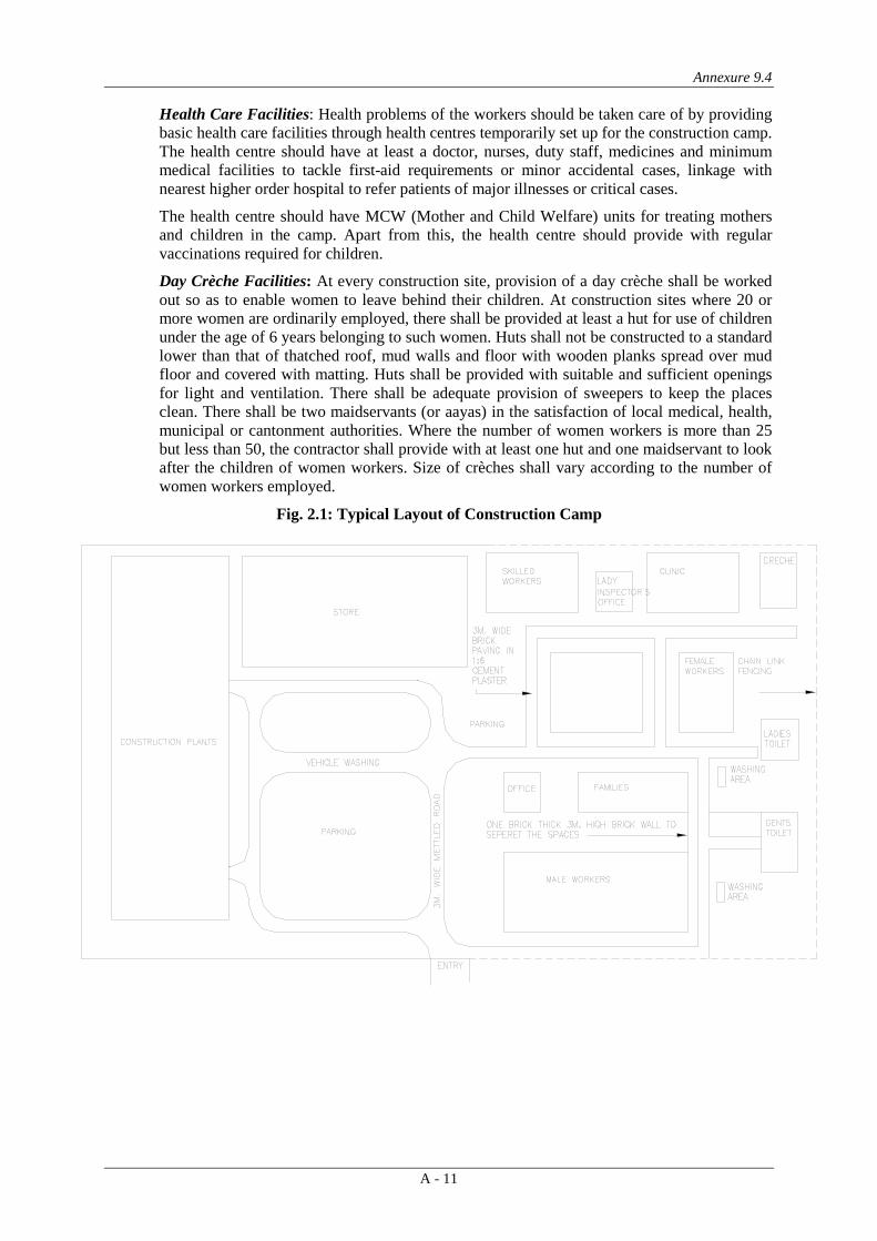
Annexure 9.4
A - 11
Health Care Facilities: Health problems of the workers should be taken care of by providing basic health care facilities through health centres temporarily set up for the construction camp. The health centre should have at least a doctor, nurses, duty staff, medicines and minimum medical facilities to tackle first-aid requirements or minor accidental cases, linkage with nearest higher order hospital to refer patients of major illnesses or critical cases.
The health centre should have MCW (Mother and Child Welfare) units for treating mothers and children in the camp. Apart from this, the health centre should provide with regular vaccinations required for children.
Day Crèche Facilities: At every construction site, provision of a day crèche shall be worked out so as to enable women to leave behind their children. At construction sites where 20 or more women are ordinarily employed, there shall be provided at least a hut for use of children under the age of 6 years belonging to such women. Huts shall not be constructed to a standard lower than that of thatched roof, mud walls and floor with wooden planks spread over mud floor and covered with matting. Huts shall be provided with suitable and sufficient openings for light and ventilation. There shall be adequate provision of sweepers to keep the places clean. There shall be two maidservants (or aayas) in the satisfaction of local medical, health, municipal or cantonment authorities. Where the number of women workers is more than 25 but less than 50, the contractor shall provide with at least one hut and one maidservant to look after the children of women workers. Size of crèches shall vary according to the number of women workers employed.
Fig. 2.1: Typical Layout of Construction Camp

Annexure 9.5
A - 12
GUIDELINES FOR SITE CLEARANCE
1. VEGETATION CLEARANCE
Vegetation clearance shall comprise uprooting of vegetation, grass, brushwood, shrubs, stumps, trees and saplings of girth upto 30 cm. measured at a height of one meter above the ground level. Where only clearance of grass is involved it shall be measured and paid for separately. The procedure/ steps involved for uprooting, skating and felling trees are described below.
1.1 Uprooting of Vegetation
• The roots of trees and saplings shall be removed to a depth of 60 cm. Below ground level or 30 cm. below formation level or 15 cm below sub grade level, whichever is lower.
• All holes or hollows formed due to removal of roots shall be filled up with earth rammed and leveled.
• Trees, shrubs, poles, fences, signs, monuments, pipe lines, cables etc. within or adjacent to the area, which are not required to be disturbed during vegetation clearance shall be properly protected by the contractor at his own cost.
Staking and Disposal
• All useful materials obtained from clearing and grubbing operation shall be staked in the manner as directed by the Engineer.
• Trunks and branches of trees shall be cleared of limbs and tops stacked properly at the places indicated by the Engineer- in – charge. These materials shall be the property of the Government.
• All unserviceable materials are disposed off in such a manner that there is no livelihood of getting mixed up with the materials meant for construction.
Felling Trees
• Marking of tress: Trees, above 30 cm girth (measured at a height of one meter above ground level) to be cut, shall be approved by the Engineer-in-charge and then marked at the site.
• Felling of trees: Felling of trees shall include taking out roots up to 60 cm. below ground level or 30 cm. below formation level or 15 cm. below sub-grade level, whichever is lower.
• Filling: All excavations below general ground level arising out of removal of trees, stumps etc. shall be filled with suitable material in 20 cm. layers and compacted thoroughly so that the surface at these points conform to the surrounding area.
• Sizing: The trunks and branches of trees shall be cleared of limbs and tops and cut into suitable pieces as directed by the Engineer-in-charge.
• Staking: The serviceable materials shall be staked in the manner as directed by the Environmental specialist of Supervision Consultants/Engineer-in-charge.
• Disposal: The material, which cannot be used or auctioned shall be removed from the area and disposed off as per the directions of the Engineer-in-charge. Unsuitable waste materials should not get mixed with construction material during disposal.

Annexure 9.6
A - 13
GUIDELINES FOR WORKERS SAFETY IN COMMON OPERATION AND DURING CONSTRUCTIONS
House Keeping Practices
1. Maintain washrooms and canteens clean
2. Keep all walkways clear and unobstructed at all times
3. Ensure that spillages of oil and greasy
4. Stack raw materials and finished products clear of walkways or inside roads
5. Do not leave tools on the floor or in any location where they can be easily dislodged
6. Keep windows and light fitting clean
7. Maintain the workplace floors dry and in a non-slippery condition
8. Provide and maintain proper drainage system to prevent water ponding
9. Use metal bins for oily and greasy rags and store all flammable materials in appropriate bins, racks or cabinets. Ensure that the meal bins for storing oily and grease rags should be covered with lids.
10. Ensure that protruding nails in boards or walls are moved or bent over so that they do not constitute a hazard to people
11. Make sure that hazardous/dangerous chemicals are kept in the goods stores with the appropriate labeling, display of the material-safety-data-sheet (MSDS) and other precautionary measures
12. Display ‘no smoking’ signs in areas with high fire risks, e.g. paint stores, wood working area and others
Safe layout in the construction plant, camp and quarry areas
1. Arrange border to perimeter fencing
2. Ensure good visibility and safe access at site entrances
3. Provide adequate warning signs at the entrance and exit where necessary
4. Provide adequate space/area for loading and unloading, storage of materials, plant and machinery
5. Display emergency procedure and statutory notices at conspicuous location
6. Consider welfare facilities required
7. Provide areas for dumping garbage and other waste materials, and also arrange for their regular clearance.
8. Arrange storage, transport and use of fuel, other flammable materials and explosives in line with the license requirements to be obtained from appropriate authorities
9. Plan emergency assembly points, fire escape routes and locate fire-fighting equipment
10. Provide access roads and plant movement areas within the site.
11. Ensure the availability of first aid facilities and display notices at the various works to show the location of these facilities
12. Provide proper drainage and sewage & drainage facilities

Annexure 9.6
A - 14
Tree Felling
Use hard hats during tree felling
Ensure tools such as the axes are in good condition
Determine proper foot and body position when using the axe. Do not cut above your head
Wear appropriate foot protection
Carry a first aid kit to the site
Determine possible hazards in the area, e.g. electrical or telephone or other utility lines
Prior to felling, determine the safest direction for the fall
Determine the proper hinge size before directing the tree fall.
Noise Hazards and its control
1. Note that indications of noise levels are:
• You have to shout to be heard;
• Your hearing is dulled just after work;
• You get head noises or ringing in the ears after work;
• You have difficulty hearing people while others are talking
2. Use sound level meters to measure. If the sound level exceeds 85 dB(A), then preventive measures should be taken
3. Make personnel aware of noisy areas by using suitable warning signs and insisting that ear protectors should necessarily be worn.
4. Reduce noise at source by improved maintenance, replacing noisy machines, screening with noise absorbing material, making changes to the process/equipment, controlling machine speeds, ensuring that two noise-generating machines are not running at the same time, using cutting oils and hydraulic breakers.
5. Appoint a competent person to carryout a detailed noise assessment of the site, designate ear protection zone, and give instructions on the necessary precautionary measures to be observed by site personnel, including the use of suitable type of ear protections.
6. Wear and maintain ear muffs and ear plugs as required
7. In construction or repair work, noise should be kept to a low-level bearing in mind the disturbance to local residents.
Road Works
1. The use of signage is most important to caution the road users of possible unsafe conditions due to the road works.
2. Use the appropriate signage devices as required by the site conditions/situation. The devices include regulatory signs, delineators, barricades, cones, pavement markings, lanterns and traffic control lights.
3. In using signs, make sure that they are (i) simple, easy-to-understand and convey only one message, (ii) luminescent and with reflective properties, and )iii) broad, prominent and of appropriate size.

Annexure 9.6
A - 15
4. In using barricades, make sure that you keep traffic away from work areas and you guide the drivers to keep along a safe, alternative path.
5. Ensure that proper personal protective equipment (PPE) is provided to all the workers.
6. Cover existing road signs and install new ones at appropriate locations taking into account the distances that would be required and reaction times.
7. Plan layout and traffic management so that hazard are not created.
8. Deploy flagmen, who control traffic at the work areas. The flag should be 600mm x 600mm fastened to a 1m length staff.
9. Flagmen should wear reflective safety vests along with hard hats
10. If required, use wireless devices for flagmen to co-ordinate from either ends of the road, where works are being carried out.
Electrical hazards in construction areas
1. Treat all wires as live wires
2. Never touch dangling wires, but report them to your manager
3. Unless you are a qualified electrician, do not attempt electrical repairs
4. Never use electrical equipment if you hands are wet or you are standing in water
5. If electrical equipment is sparking or smoking, turn the power off and report the condition to your supervisor
6. Never use electrical wires that have physical damage
7. Never allow equipment or traffic to run over electrical wires.
Use and Storage of Gas/LPG
1. Store filled gas/LPG cylinder in the open area, i.e. outside of the building
2. Transport, store, use and secure cylinders in upright position
3. Ensure proper ventilation at the ground level in locations where gas/LPG is in use
4. Avoid physical damage to the cylinders
5. Never weld or cut on or near the cylinders
6. Store empty cylinders secured and upright
7. Make sure that the cylinder is closed immediately after use
8. Investigate immediately if there is the smell of LPG or gas
9. Never use destenched gas/LPG on site.
10. Make sure that there is no other unrelated fire in the vicinity of the cylinder
Operation of Excavators
1. Ensure that excavators are operated by authorized persons who have been adequately trained.
2. Prevent unauthorized movement or use of the excavators
3. Check regularly and maintain the machine thoroughly

Annexure 9.6
A - 16
4. Ensure that all relevant information, including those related to instruction, training, supervision and safe system of work are provided to the operators.
5. Ensure that the operation and maintenance manuals, manufacturer’s specifications, inspection and maintenance log books are provided for the use of the mechanics, service engineers or other safety personnel during periodic maintenance, inspection and examination.
6. During tipping or running alongside the trenches, excavators must be provided with stop blocks.
7. Excavators must be rested on firm ground during operation
8. Avoid operating the machine too close to an overhang, deep ditch or hope and be alter to potential carving edges, falling rocks and slides, rough terrain and obstacles.
9. Locate and identify underground services by checking with all utility companies before excavations.
10. Ensure that all excavations are supervised by experienced and competent persons.
11. When reversing or in caste the operator’s view is restricted, adequate supervision and signaling should be provided.
12. Ensure that the type and capacity of the excavator are properly chosen for the intended purposes and site conditions. Never use a machine for any purposes other than it is designed for.
13. Check and report for excessive wear and any breakage of the bucket, blade, edge, tooth and other working tools of the excavator.
14. Check that all linkages/hinges are properly lubricated and ensure that the linkage pins are secured. Never use improper linkage pins.
15. Never dismount or mount a moving machine
16. Work only with adequate ventilation and lighting
17. Ensure that the protective front screen of the driving cabin is fixed in position during excavations to avoid eye injury to the operator.
18. Ensure switch-off of the unattended vehicle.
Operation of trucks and dumpers
1. Ensure that only trained, authorized and licensed drivers operate the vehicles
2. Enlist the help of another worker before reversing the vehicle
3. Switch-off the engine of an unattended vehicle
4. Lower the tipping bodies when the machine is unattended, but if it is necessary to leave them in the raised position they should be blocked to prevent their fall.
5. Wear safety boots or shoes to avoid injuries during loading and unloading.
6. Carryout periodic servicing to the manufacturer’s requirements. All records of maintenance and repairs should be in writing or kept on site.
7. Keep the vehicle tidy and the cabin free from tools and material, which might obstruct the controls.
8. Keep to speed limits.

Annexure 9.6
A - 17
9. No passenger should be carried on a dumper except the driver
10. Never drive the vehicle across a slope
11. Provide stop blocks when the vehicle is tipping into or running alongside excavations
12. Do not overload the vehicle.
13. Carry only well secured loads
14. Park only on level ground, in neutral with the parking brake applied
15. Never mount of dismount from a moving vehicle
Gas Welding
1. Use the following personal protective equipment during welding
• Face or hand shield fitted with filters
• Goggles, particularly when chipping slag
• Gloves long enough to protect wrists and forearms against heats, sparks, molten metal and radiation
• High-top boots to prevent sparks from entering footwear.
2. Screen of the work area with sturdy opaque or translucent materials because glare can cause eye injury.
3. Key for opening the acetylene cylinder valve must be one the valve stem while the cylinder is in use so that the cylinder valve may be immediately shut-off in an emergency.
4. Ventilate the workplace using air blowers and exhaust fans to remove poisonous fumes and gases that are given off during welding
5. Take precautions against flying sparks and hot slag where welding is beign done near flammable materials and check the area before leaving.
6. Do not weld material degreased with solvents until completely dry.
7. Do not use gas cylinders for supporting work or as rollers
8. Do not use oil grease on oxygen cylinder fittings
9. Do not use cylinders with damaged valves.
10. Do not use too much force if valves are stuck.
11. Replace valve caps after use
12. Search for leaks in equipment by using a solution of soapy water.
13. Shut the cylinder valve if acetylene from a cylinder catches fire at the valve or regulator due to leakage at a connection.
14. Treat all gas cylinders as “full” unless you are sure otherwise.
15. Never attempt to transfer acetylene from one cylinder to another or attempt to refill an acetylene cylinder.
16. Place portable fire extinguishers near the welding area
17. Secure all cylinders against accidental displacement.

Annexure 9.6
A - 18
18. Always lift gas cylinders. Do not slide them along the ground or drop them from trucks.
19. Keep gas cylinders in vertical position both in storage and when in use
20. Keep the work place dry, secure, free from combustible materials and obstruction.
21. Store the acetylene and oxygen cylinders separately, and in a proper store.
22. Keep the gas cylinders from source of heat, flammable materials, corrosive chemicals and fumes.
Manual Handling and Lifting
1. Use mechanical equipment in lace of manual handling as far as possible.
2. Assess the manpower required to handle or life the load safety and arrange the manpower accordingly.
3. In handling hazardous materials, the workers shall be informed of the hazards and safety precautions.
4. All relevant persons shall be trained in the proper methods of lifting and carrying.
5. Where team work is required, select the persons whose ages and physical builds are compatible for teaming up. Coordinate the actions of the team members by giving necessary instructions.
6. Always lighten or suitably shape the load for manual handling as far as possible Keep a look out for splinters, sharp edges, loose banding and nails.
7. Clear path or obstruction and tripping hazards.
8. Stack and secure goods safety on trucks, otherwise they fall off and injure passers-by.
9. Use personal protective equipment such as gloves, safety shoes, etc.
10. Adopt the following procedure when you lift a load:
11. Stand close to the object. Have a firm footing with feet spread on either side of the road.
12. Bend the knees and keep your back as straight as you can
13. Grasp object firmly. Be sure grip will not slip
14. Breath in and throw the shoulder back wards.
15. Straighten the legs, continuing to keep the back as straight as you can.
16. Hold object firmly close to the body
17. Always lift smoothly. Avoid jerky motions. Turn with feet instead of twisting the back.
Handling chemicals and hazardous substances
1. Always substitute hazardous chemicals with harmless or less hazardous ones wherever possible.
2. Enclose the process using chemicals or provide other engineering controls such as local exhaust ventilation, a fume cupboard or a safety cabinet.
3. Exercise great care in the storage and use of chemicals because they may be explosive, poisonous, corrosive or combustible.
4. Separate different chemicals physically

Annexure 9.6
A - 19
5. Store chemicals classified as dangerous goods in a properly constructed and approved goods store. Keep proper records of all chemicals and hazardous substances delivered, stored and used on site.
6. Consider unknown substances and liquids as dangerous until proven otherwise.
7. All containers should be clearly labeled to indicate contents. Never use a wrongly labeled container for chemicals.
8. Prohibit smoking in the vicinity of dangerous chemicals
9. Ensure that you are wearing the correct personal protective equipment before you handle chemicals
10. Maintain the Material Safety Data Sheet of all chemicals for reference on safety precautions to be taken and the use of suitable PPE.
11. When opening containers, hold a rag over the cap or lid, as some volatile liquids tend to spurt up when released.
12. Wash before you eat and do not eat at the work place.
13. If the skin is splashed with a chemical, rinse it immediately with plenty of clean water. Eye should be flushed thoroughly with water followed by immediate medical attention.
14. Eye fountain, emergency shower and breathing apparatus should be available in the vicinity of the workplace.
15. Safety instructions for handling emergency situations should be displayed prominently at both the storage and use locations.
First Aid
1. Provide first aid boxes at every site
2. Ensure that training on the use of the first aid box is provided to a handful of staff working in the site.
3. Display the list of persons who are trained on providing first aid.
4. Ensure that every first aid box is marked plainly “First Aid” in English and local language.
5. The responsible person or first aider should replenish the contents of the first aid box as necessary.
Personal protective Equipment
General
1. Consider the provision of personal protective equipment only after all measures for removing or controlling safety hazards have been provided reasonably impractical.
2. Ensure that sufficient personal protective equipment are provided and that they are readily available for every person who may need to use them.
3. The management should ensure that all persons make full and proper use of the personal protective equipment provided.
4. Provide instruction and training in the proper use and care of any specific protective equipment where necessary
5. Do not willfully misuse, interfere with or ill-treat any protective clothing and equipment provided.

Annexure 9.6
A - 20
6. Ensure that the personal protective equipment are in good condition. Report immediately any damage to the management for replacement. Always keep the personal protective equipment as clean as possible.
Eye protection
7. Issue eye protection equipment where there is a foreseeable risk of eye injury
8. Ensure an adequate supply of goggles/shields is available.
9. Keep the goggles clean and make sure they are good fit.
10. Do not watch welding operations unless your eyes are protected from the damaging effect of flash.
Head Protection
11. No person shall enter a construction site unless he is wearing a suitable safety helmet
12. Wear a safety helmet:
• When there is the risk of being hit by falling objects
• While on or near a construction site
• During adverse weather conditions
• When in any area designated as a “hard hat” area.
13. Provide identification labels to all helmets in some way to prevent random exchange among wearers, with one helmet exclusive to each person.
14. Inspect helmets for cracks of sign of impact or rough treatment before each usage. Destroy, remove and replace all worn, defective or damaged helmets.
Hearing Protection
15. Provide ear plugs or ear muffs as required. Use re-usable ear plugs when the reduction required (15-25 dBA) is not excessive. Use ear muffs where a large attenuation of upto 40 dBA is demanded.
16. Do not use dry cotton wool for hearing protection because it cannot provide any.
17. Provide disposable ear plugs for infrequent visitors and ensure that they are never re-used.
18. Provide re-usable ear plugs for those who need to work continuously for a long period in a high noise area.
19. Use ear muffs with replaceable ear cushions because they deteriorate with age or may be damaged in use.
20. Avoid wearing spectacles with ear muffs.
21. Use soap and water or the recommended solvent for cleaning ear muffs.
22. Provide ear muffs for those who may need to get in and out of a high noise area frequently.
Respiratory Protective Equipment
23. Wear suitable respirable for protection when there is a potential for small particles entering the lungs, e.g. emptying of cement bags.
24. Ensure that he explanators can provide adequate protection.

Annexure 9.6
A - 21
25. Provide training to all persons using the respirators for their correct fitting, use, limitations and symptoms of exposure.
26. Clean and inspect all respirators before and after use.
27. Store respirators properly when not in use.
Safety Footwear
28. Wear suitable footwear for work
29. Use safety footwear on site or in other dangerous areas
30. Wear suitable safety shoes or ankle boots when working anywhere where there is high risk of foot injuries from slippery or uneven ground, sharp objects, falling objects, etc.
31. All safety footwear, including safety shoes, ankle boots and rubber boots, should be fitted with steel toecaps.
32. Avoid wearing flip flops, high heeled shoes, slippers, light sport shoes in situations where there is a risk of foot injury.
33. Keep shoe lace knots tight.
Hand Protection
34. Wear suitable gloves for selected activities such as welding & cutting and manual handling of materials & equipment.
35. Do not wear gloves where there is a risk of them becoming entangled in moving parts of machinery
36. wash hands properly with disinfectant soap and clean water before drinking, eating or smoking. Wash hands immediately after each operation on site when the situation warrants.
Fire Prevention, Fighting and Equipment
Before fire breaks cut
1. Store flammable material in proper areas having adequate fire protection systems.
2. Display sufficient warning signs.
3. Train selected personnel to use these fire extinguishers
4. Inspect fire extinguishers regularly and replace as necessary
5. Fire escape route should be kept clear at all times and clearly indicated.
6. Know the escape route and assembly point.
7. Display escape route maps prominently on each floor
8. Carryout fire drill regularly. Designate fire officers
9. Install fire alarm wherever required and test regularly.
10. Provide sufficient exit signs at prominent locations for directing people to the escape staircases and routes.
When fire breaks out.
11. Alert all persons

Annexure 9.6
A - 22
12. Put off the fire with appropriate fire extinguishers only when you are sure that you are safe to do so.
13. Escape if you are in danger through the fire escape route to assembly point
14. Fire officers to carryout head count at the assembly point.
Incident and accident investigations
1. Carryout the investigation as quickly as possible.
2. Conduct interviews with as many witnesses as necessary
3. Do not rely on any one sole source of evidence
4. Use the following tools:
Checklists for obtaining basic and typical information for accidents
• Notebook
• Tape records
• Camera
• Measuring tape
• Special equipment for the parituclar investigation
5. Obtain answers to the following questions:
• When did the accident occur?
• Where did it occur?
• Who was injured and what was damaged?
• What caused the accident?
• Why did it occur?
• How could it have been prevented?
• How can a recurrence be prevented?
6. Prepare a short but sufficient investigation report that contains the following:
• A summary of what had happened
• A summary of events prior to the accident
• Information gathered during the investigation
• Details of witnesses
• Information on injury or loss sustained
• Conclusions and possible causes of the accident
• Recommendations to prevent recurrence
• Supporting materials (photos, diagrams, etc.)

Annexure 9.6
A - 23
GUIDELINES FOR WORKERS SAFETY DURING CONSTRUCTION Sl
No. Stage and Nature of Construction Hazard Safety measures expected to be taken by the Contractors
and Site Engineers 1 Excavation in soft loose & slushy soil above
2.00 m depth sliding of earth or collapsing of sides.
The Excavation beyond 1.5 m to 2.00 m to be done in steps of minimum 500 mm offsets as shown in Clause 2.18.2(b) and also planking and strutting should be done as in Clause 2.19.1.
2 Excavation in slippery area (water logged) – The labour may fall or machinery on site may slip.
Try to dewater the area and spread minimum 150 mm thick sand layer to avoid slipping
3 Excavation in Rock where chiselling is involved – The fall of hammer may injure the hand, small rock pieces may injure the eyes and legs.
For hammer work, only experienced and skilled labour should be employed. Chisel should not be allowed to be held by hand, while hammering but chisel holding clamp should be provided. The labour should be provided with goggles and leg cover to protect eyes and legs, from injuries due to small rock pieces.
4 Excavation in Rock where blasting is involved - Careless handling may lead to injury to main worker or a passer by.
The work of blasting should be entrusted to only experienced persons. Provide sufficient length of fuse to give ample margin of time from the time of lighting to the time of explosion. A danger zone at least 180m diameter is to be flagged off 10 minutes before actual firing. All workmen should be sent away from danger zone except the firing man, who should be provided with a whistle.
5 Excavation for drain across road or manhole adjacent to a road – chances of a passer by falling into the excavated portion
The area should be well barricaded & a red lamp provided at night. A watchman should be deputed to prevent any move-ment of persons, or vehicles.
6 During Excavation or some times even while concreting – Snake bites or Scorpion stings –
In places where the movement of snakes are more the con-tractor should provide the labour with gum boots, gloves etc. and also make snake antidotes available on site. A particular care that has to be taken on such site is to always keep a vehicle available on site to rush the patient to a doctor. This applies to snake stinged patients as well.
7 Centring (form-work) and scaffolding –Form-work collapse while concreting or just before concreting especially when wooden ballies are used.
Many a times ballies joined together give way due to weak joint. Hence the use of joined ballies should be restricted. Only 2 joined ballies out of 8 ballies should be allowed. In case of double staging for a Slab at a height, utmost care should be taken to see that the top balli rests on the bottom balli. A particular care that should be taken during each concreting operating of slabs and beams is that, one carpenter and two helpers with spare ballies, nails etc. should be deputed below the slab/beam that is being concreted to watch any disturbance in the supports of the form-work below during concreting and in case of any doubt the concreting should be stopped immediately and the form work strengthened. Never allow bricks below a balli to make up the required height. This is most dangerous.
8 Form-work for beams and slabs: The bottom of beam collapses and many a times brings down the slab as well, injuring the labour and supervision staff.
This case is noticed when slender ballies are used without bracing. In fact, no concreting should be allowed without bracing at 300 mm above ground, and at mid way, in normal beams & slabs. The bracings should be for the support of beams as well as slabs.
9 Form-work for sides of a slab–The labour just rests his foot on the plank and looses balance and falls resulting a fatal accident.
This is noticed when the carpenter fixes the side shuttering of a slab with a plank just tied by binding wire to the steel reinforcements and by wooden pieces nailed in wall and plank. This is so weak a portion that with little pressure the plank gives way. Hence side shuttering should be done with a direct balli support from ground or floor, and the practice of tying planks with binding wire to the steel reinforcement should be totally avoided. A temporary railing along the periphery of slab will guard the life of labour and supervision staff.
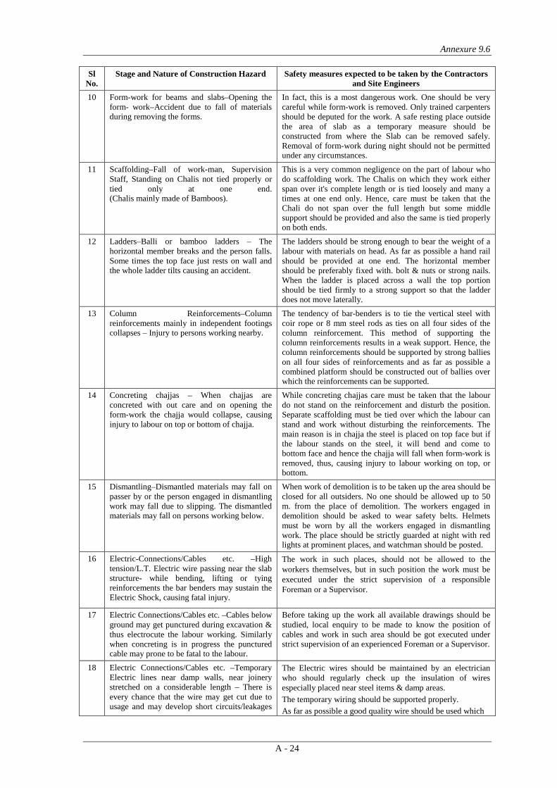
Annexure 9.6
A - 24
Sl No.
Stage and Nature of Construction Hazard Safety measures expected to be taken by the Contractors and Site Engineers
10 Form-work for beams and slabs–Opening the form- work–Accident due to fall of materials during removing the forms.
In fact, this is a most dangerous work. One should be very careful while form-work is removed. Only trained carpenters should be deputed for the work. A safe resting place outside the area of slab as a temporary measure should be constructed from where the Slab can be removed safely. Removal of form-work during night should not be permitted under any circumstances.
11 Scaffolding–Fall of work-man, Supervision Staff, Standing on Chalis not tied properly or tied only at one end. (Chalis mainly made of Bamboos).
This is a very common negligence on the part of labour who do scaffolding work. The Chalis on which they work either span over it's complete length or is tied loosely and many a times at one end only. Hence, care must be taken that the Chali do not span over the full length but some middle support should be provided and also the same is tied properly on both ends.
12 Ladders–Balli or bamboo ladders – The horizontal member breaks and the person falls. Some times the top face just rests on wall and the whole ladder tilts causing an accident.
The ladders should be strong enough to bear the weight of a labour with materials on head. As far as possible a hand rail should be provided at one end. The horizontal member should be preferably fixed with. bolt & nuts or strong nails. When the ladder is placed across a wall the top portion should be tied firmly to a strong support so that the ladder does not move laterally.
13 Column Reinforcements–Column reinforcements mainly in independent footings collapses – Injury to persons working nearby.
The tendency of bar-benders is to tie the vertical steel with coir rope or 8 mm steel rods as ties on all four sides of the column reinforcement. This method of supporting the column reinforcements results in a weak support. Hence, the column reinforcements should be supported by strong ballies on all four sides of reinforcements and as far as possible a combined platform should be constructed out of ballies over which the reinforcements can be supported.
14 Concreting chajjas – When chajjas are concreted with out care and on opening the form-work the chajja would collapse, causing injury to labour on top or bottom of chajja.
While concreting chajjas care must be taken that the labour do not stand on the reinforcement and disturb the position. Separate scaffolding must be tied over which the labour can stand and work without disturbing the reinforcements. The main reason is in chajja the steel is placed on top face but if the labour stands on the steel, it will bend and come to bottom face and hence the chajja will fall when form-work is removed, thus, causing injury to labour working on top, or bottom.
15 Dismantling–Dismantled materials may fall on passer by or the person engaged in dismantling work may fall due to slipping. The dismantled materials may fall on persons working below.
When work of demolition is to be taken up the area should be closed for all outsiders. No one should be allowed up to 50 m. from the place of demolition. The workers engaged in demolition should be asked to wear safety belts. Helmets must be worn by all the workers engaged in dismantling work. The place should be strictly guarded at night with red lights at prominent places, and watchman should be posted.
16 Electric-Connections/Cables etc. –High tension/L.T. Electric wire passing near the slab structure- while bending, lifting or tying reinforcements the bar benders may sustain the Electric Shock, causing fatal injury.
The work in such places, should not be allowed to the workers themselves, but in such position the work must be executed under the strict supervision of a responsible Foreman or a Supervisor.
17 Electric Connections/Cables etc. –Cables below ground may get punctured during excavation & thus electrocute the labour working. Similarly when concreting is in progress the punctured cable may prone to be fatal to the labour.
Before taking up the work all available drawings should be studied, local enquiry to be made to know the position of cables and work in such area should be got executed under strict supervision of an experienced Foreman or a Supervisor.
18 Electric Connections/Cables etc. –Temporary Electric lines near damp walls, near joinery stretched on a considerable length – There is every chance that the wire may get cut due to usage and may develop short circuits/leakages
The Electric wires should be maintained by an electrician who should regularly check up the insulation of wires especially placed near steel items & damp areas. The temporary wiring should be supported properly. As far as possible a good quality wire should be used which

Annexure 9.6
A - 25
Sl No.
Stage and Nature of Construction Hazard Safety measures expected to be taken by the Contractors and Site Engineers
etc. and may electrocute the person touching the wire accidentally.
may not get damaged easily.
19 Electric and gas welding work – Drilling, polishing work – Done by temporary cables used on a number of works – Due to the fact that the wires are old & when they come in contact with water even in the process of curing the surrounding area may get affected due to leakage in the electric current thus causing damage to the workers & supervision staff.
All wiring works to be inspected by experienced electrician. All wires to be properly insulated and fixed at height on temporary poles. No welding work should be permitted near damp area. The welders to be provided with welder's goggles & gloves. As far as possible machine in good condition should be used.
20 Construction Machinery & Lifts – Concrete Mixers – Safety precautions. A mixer with hopper tried to be operated by an helper could not release brake in time thus causing injury to the person near hopper- some times fatal one.
The Mixers with hopper should be operated by an experienced mixer operator and such mixers should not be allowed to be handled by a helper or a labour.
21 Construction Machinery & Lifts - Lifts - Safety precautions.
(1) The lift pit if left unguarded the children of workers may fall in the pit resulting in fatal accident
(1) A brick protection wall of minimum 1.00 m height should be constructed around the Lift Pit, thus, preventing the children going near the pit. A special care should be taken to see that the children are not allowed to come near the machinery.
(2) The manually operated brakes of the lift failed or the communication between the labour at the top and the liftman failed and thus, the lift was not controlled and resulted in fatal accident.
(2) The condition of the lift must be maintained properly. The lift operator should be well trained. The labour receiving the bucket at top should be smart and active enough to convey the message of stopping & releasing the lift-to-lift operator properly.
22 Water Storage Tank for general use & curing - chances of children of workers falling in the tank with fatal accident.
The water tanks constructed on site should be protected by at least 1.00 m high walls on four sides, so that the children do not fall.
23 Misuse of lift by labour and some times supervision staff The lifts that are meant for lifting materials used by labour to go to upper floors – The labour thus traveling many a times get injured.
No person should be allowed to go to upper floors by lifts that are mainly meant for conveying the building materials. Fatal accidents have taken place due to above action of workers.
24 Site Cleaning–Cleaning top floors of buildings – Upper portion of any structure – Throwing waste materials broken concrete pieces, brick bats, sand etc. straightway from top to ground injuring person below or even a passerby.
This dangerous practice should not be allowed at all. The materials should be brought to the ground with the help of lift or the use of rope over pully with a bucket, thus bringing down materials safely.
25 Bar bending work-Helpers of bar benders to follow short cut method, throw surplus steel pieces from top floors to ground and may cause fatal injuries.
This is a very bad practice. The helpers should bring the rods to ground with the help of lift or rope & pulley.