Embed Size (px)
Citation preview
RESEARCH ARTICLE
Where and How Are Roads EndangeringMammals in Southeast Asia’s Forests?Gopalasamy Reuben Clements1,2,3,4,5,6*, Antony J. Lynam7, David Gaveau8, WeiLim Yap9, Stanislav Lhota10, Miriam Goosem1, Susan Laurance1, William F.Laurance1
1. Centre for Tropical Environmental and Sustainability Science and College of Marine and EnvironmentalSciences, James Cook University, Cairns, Queensland, Australia, 2. Kenyir Research Institute, UniversitiMalaysia Terengganu, Kuala Terengganu, Malaysia, 3. Panthera, New York, New York, United States ofAmerica, 4. Rimba, 4 Jalan1/9D, Selangor, Malaysia, 5. School of Geography, University of NottinghamMalaysia Campus, Selangor, Malaysia, 6. School of Science, Monash University, Selangor, Malaysia, 7.Center for Global Conservation, Wildlife Conservation Society, New York, New York, United States ofAmerica, 8. Center for International Forestry Research, Bogor, Indonesia, 9. World Wide Fund for Nature-Malaysia, Jalan PJS 5/28, Petaling Jaya, Selangor, Malaysia, 10. Department of Husbandry and Ethology,Czech University of Life Sciences, Prague, Czech Republic
*mailto:[email protected]
Abstract
Habitat destruction and overhunting are two major drivers of mammal population
declines and extinctions in tropical forests. The construction of roads can be a
catalyst for these two threats. In Southeast Asia, the impacts of roads on mammals
have not been well-documented at a regional scale. Before evidence-based
conservation strategies can be developed to minimize the threat of roads to
endangered mammals within this region, we first need to locate where and how
roads are contributing to the conversion of their habitats and illegal hunting in each
country. We interviewed 36 experts involved in mammal research from seven
Southeast Asian countries to identify roads that are contributing the most, in their
opinion, to habitat conversion and illegal hunting. Our experts highlighted 16
existing and eight planned roads - these potentially threaten 21% of the 117
endangered terrestrial mammals in those countries. Apart from gathering qualitative
evidence from the literature to assess their claims, we demonstrate how species-
distribution models, satellite imagery and animal-sign surveys can be used to
provide quantitative evidence of roads causing impacts by (1) cutting through
habitats where endangered mammals are likely to occur, (2) intensifying forest
conversion, and (3) contributing to illegal hunting and wildlife trade. To our
knowledge, ours is the first study to identify specific roads threatening endangered
mammals in Southeast Asia. Further through highlighting the impacts of roads, we
propose 10 measures to limit road impacts in the region.
OPEN ACCESS
Citation: Clements GR, Lynam AJ, Gaveau D, YapWL, Lhota S, et al. (2014) Where and How AreRoads Endangering Mammals in Southeast Asia’sForests? PLoS ONE 9(12): e115376. doi:10.1371/journal.pone.0115376
Editor: Lalit Kumar, University of New England,Australia
Received: August 8, 2014
Accepted: November 15, 2014
Published: December 18, 2014
Copyright: � 2014 Clements et al. This is anopen-access article distributed under the terms ofthe Creative Commons Attribution License, whichpermits unrestricted use, distribution, and repro-duction in any medium, provided the original authorand source are credited.
Data Availability: The authors confirm that all dataunderlying the findings are fully available withoutrestriction. All data are available at Figshare: http://dx.doi.org/10.6084/m9.figshare.1248936.
Funding: GRC received funding support from theUnited States Fish and Wildlife Service Rhino andTiger Conservation Fund (96200-0-G279), RuffordSmall Grant for Nature Conservation (8320-1),Universiti Malaya Research Grant (RG359-12HNE), Cleveland Metroparks Zoo and ClevelandZoological Society Asian Seed Grant, IDEA WILD,James Cook University Graduate ResearchScheme and James Cook University PostgraduateResearch Scholarship. GRC and WFL alsoreceived support from the Australian ResearchCouncil. The funders had no role in study design,data collection and analysis, decision to publish, orpreparation of the manuscript.
Competing Interests: The authors have declaredthat no competing interests exist.
PLOS ONE | DOI:10.1371/journal.pone.0115376 December 18, 2014 1 / 25
Introduction
Habitat loss and overhunting are two major drivers of biodiversity declines,
particularly for terrestrial mammals in tropical forests [1–3]. The expansion of
roads can be a precursor to both of these threats [4–6]. Roads are proliferating
across the planet at unprecedented rates and are increasingly seen as a severe
environmental challenge [7–10]. Road development particularly jeopardizes
conservation initiatives in developing countries, where increasing road densities
are linked with economic growth and habitat degradation [11]. Between 2005 and
2010, the percentage of total roads that are paved in the developing countries of
East Asia soared from 16% to 51% [12].
Roads have a number of direct, negative impacts on mammals. They can
impede animal movements (thereby decreasing access to habitats and preventing
gene flow; [13]), result in roadkills [14], [15], cause behavioural avoidance of
traffic [16], [17] and roadside habitats [18] and promote elevated hunting
pressure [19]. Over time, roads can also increase the susceptibility of mammal
habitats to human colonization and exploitation [20], [21]. A review of 79
empirical studies demonstrated that roads have a net negative effect on animal
abundance and species richness, particularly for large-bodied mammals [22]. In
fact, population densities of sensitive mammal species can decline up to 5 km
from linear infrastructure such as roads [23]. When the knock-on effects of
habitat loss and fragmentation are considered, these distances become much
greater.
Research conducted on the impacts of roads on mammals, and biodiversity in
general, appears to have a geographic bias. The majority of such studies have been
conducted outside of the tropics ($76% of 244 published studies; [24]). In the
tropics, negative impacts of roads on mammals have been documented in South
America [25], Central Africa [19], [26] and Australia [27]. In Southeast Asia,
where deforestation rates are the highest of the major tropical regions [28], studies
explicitly investigating the impacts of roads on mammals are surprisingly scarce.
Out of 533 road-related biodiversity studies identified in a keyword search in the
BIOSIS Previews database (S1 Method), only one explicitly investigated the
impacts of roads on mammals in Southeast Asia [29].
In Southeast Asia, between 21–48% of all native mammal species are predicted
to be extinct by 2100 [30]. Major extinction drivers include forest conversion for
agriculture and exotic-tree plantations [31], [32] and market-driven hunting for
bush meat, valuable body parts and traditional medicine [33], [34]. Because roads
strongly influence all these threats, knowledge about where and how roads are
affecting endangered mammals in Southeast Asia is urgently needed to develop
evidence-based mitigation measures. If such measures are to be successfully
implemented, conservation practitioners must identify which roads are most
likely to promote forest conversion, hunting and trade in the region. Where
possible, empirical evidence of road impacts on endangered species should also be
obtained, in order to develop appropriate mitigation measures.
Roads Threatening Endangered Mammals in Southeast Asia
PLOS ONE | DOI:10.1371/journal.pone.0115376 December 18, 2014 2 / 25

Here, we present three lines of evidence concerning where and how roads are
impacting endangered mammals and their habitats in Southeast Asia. First, we
asked experts to identify roads that currently or potentially threaten endangered
species through forest conversion and illegal hunting. Second, we gathered
evidence from peer-reviewed articles and grey literature to assess the threats from
each road and the presence of endangered species around them. Third, we
developed detailed case studies based on species distribution models, satellite
imagery and animal sign surveys to illustrate how roads (1) cut through habitats
where endangered mammals are likely to occur, (2) have led to intensified forest
conversion, and (3) contribute to illegal hunting and the wildlife trade. Based on
these case findings, we highlight key lessons regarding road proliferation and
propose strategies to minimise their negative impacts on endangered mammals in
Southeast Asia.
Materials and Methods
Ethics statement
This study was conducted as part of GRC’s Ph.D. thesis that received a human
research ethics approval from the James Cook University Human Research Ethics
Committee (No. H3655, The impacts of roads on large mammals and indigenous
people in Southeast Asia, 31 Mar 2010 – 21 Feb 2012; category 1). This approval
permitted interviews consisting of questions to obtain information on perceptions
of roads and resource harvesting patterns along roads. Our questionnaire to
experts explicitly guaranteed anonymity and completion of the online
questionnaire itself implied consent. The questionnaire contains no identifying
information linking it to the respondents.
Where are roads threatening endangered mammal habitats?
Field workers may provide the best available information about roads threatening
endangered mammals in the region. As expert interviews can be used to gain
insight into contemporary biodiversity threats such as roads [35], we emailed brief
questionnaires to experts in mammal research and/or conservation from relevant
scientific institutes and universities, environmental NGOs and wildlife depart-
ments in the following countries and sub-regions: Cambodia, Lao PDR, Indonesia
(Irian Jaya, Java, Sulawesi, Sumatra, Kalimantan), Malaysia (Peninsular Malaysia,
Malaysian Borneo), Myanmar, Philippines, Thailand and Vietnam. At least one
expert from each country and sub-region was contacted. To maximise response
rates, each expert opinion was limited to a maximum of three roads believed to
contribute to forest conversion and illegal hunting/trade. We requested road
names and threatened mammal habitats. Several experts who did not respond in
writing were subsequently interviewed by telephone. To minimize observer and
organisation bias, only roads named by at least two respondents with different
affiliations were highlighted. However these criteria were relaxed in Myanmar
Roads Threatening Endangered Mammals in Southeast Asia
PLOS ONE | DOI:10.1371/journal.pone.0115376 December 18, 2014 3 / 25
where there is a paucity of relevant experts working in the country. Respondents
also identified proposed roads in their country. Proposed roads were included
without bias reduction because potential roads may be insufficiently publicised for
corroboration by different experts. Compiled information was returned to
country experts for final verification. Lastly, we assessed expert claims of roads
affecting endangered mammals with information from peer-reviewed articles and
grey literature.
We acknowledge two caveats here. First, the list of roads identified by experts is
not exhaustive for Southeast Asia, especially when respondents were limited in
number – there could certainly be more important roads than were captured by
our interviews. Second, the list of roads for each country does not necessarily
represent the most threatening roads in terms of impact on endangered mammals,
but are merely prominent examples based on the experience of experts working in
each country.
How are roads threatening endangered mammal habitats?
Do roads bisect habitats where endangered mammals are likely to still occur?
Expert claims of roads cutting through habitats where endangered mammals are
likely to still occur should ideally be supported by empirical evidence. If data on
the presence of species around roads are available, species-distribution models can
be constructed to illustrate highly suitable habitats around the road and decide
whether a planned road would cut through these important habitats.
Using Maximum Entropy (MaxEnt) models, we modelled presence-only data
on the endangered Asian Tapir (Tapirus indicus) in Peninsular Malaysia for three
roads identified by experts (S1 Table) to assess whether they pass through
important habitats for this species. MaxEnt models examine the probability of
occurrence in presence-only data as a function of environmental variables by
randomly selecting background pixels as pseudo-absences [36]. When the three
roads were laid over a MaxEnt-predicted distribution map for the Asian Tapir (see
[37] for method), overlap with suitable tapir habitats was quantified (logistic
values $0.5 indicate suitable habitats [38]).
Predictions by MaxEnt models, however, have certain weaknesses. They do not
account for imperfect detections [39], and the indices are not directly related to
probability of occurrence, a more informative measure of the importance of
habitat [40].
When resources are available for a more in-depth quantification of important
mammal habitats, detection/non-detection data obtained from surveys conducted
under an occupancy framework [41] can be used to generate occupancy maps or
habitat-use-intensity maps that account for imperfect detections. We obtained
such data from camera-trapping surveys to generate habitat-use-intensity maps
for the same species, the endangered Asian Tapir (S2 Method). The data were
collected from two forest blocks (lower and upper) on either side of State Road
156, a road identified by one of the experts in Peninsular Malaysia (see [42] for
Roads Threatening Endangered Mammals in Southeast Asia
PLOS ONE | DOI:10.1371/journal.pone.0115376 December 18, 2014 4 / 25

survey methods). Subsequently, we calculated the mean habitat-use estimates of
the Asian Tapir affected by the path of the road.
Does forest conversion intensify following road construction?
Freely available satellite images are useful for detecting changes in forest cover
along roads. Landsat satellite imagery is ideal for this purpose because it is
regularly acquired, has global coverage, medium spatial resolution (30–80 m) and
large historical archives [43]. Although Landsat 7 images have issues with missing
data, methods are available to ensure Landsat composites are comparable over
considerable temporal scales [44]. From individual Landsat satellite images, false-
colour composites can be created to differentiate roads from vegetation and bare
or built-up areas. As an example, we created a composite for one road identified
by experts in Cambodia, Provincial Road 76, which bisects the Snuol Wildlife
Sanctuary, a protected area managed by the Cambodian Ministry of Environment
(12˚ 5’26.98"N; 106 39’40.83"E). We chose this road due to the availability of
actual observations on the ground by our coauthor AL.
When satellite imagery of a road is available over a period of time, further
analysis can provide more detailed information on its impact on surrounding
forests. Once the images are classified, an intensity analysis [45] can be performed
(S3 Method) to examine before and after road construction: (1) the intensity of
gains and losses in gross primary forest, forest mosaics and bare or built-up areas
changes; (2) whether there are differences in annual rates of change in overall land
categories; (3) whether primary forests were avoided or targeted by transitions to
bare or built-up areas; and (4) whether forest conversion occurred close to or
further from the road.
To obtain data for the intensity analysis, we classified land cover using
georeferenced and orthorectified cloud-free Landsat 4, 5 (TM) and Landsat 7
(ETM+) images at 30-m resolution for the same road bisecting Snuol Wildlife
Sanctuary. Analyses were run at three time intervals: when the road (1) was absent
(1990), (2) was recently completed (2001), and (3) had existed for some time
(2009). Using both the original satellite data and Google Earth images as auxiliary
references, and information on forest types, classified data were manually defined
and merged into 5 land-cover categories: 1) primary forest; 2) mosaic (i.e.,
secondary forest/regrowth/scrub); 3) bare or built-up areas; 4) other (i.e.,
riparian/swamps); and 5) water bodies.
To examine whether transitions of primary forest and mosaic to bare or built-
up areas occurred close to or further from the road, we created kernel density
plots. Kernel density plots were preferred over histograms for examining the
distribution of the continuous variable ‘‘distance from road’’, because kernel
estimates converge more quickly to true underlying densities [46]. Land-cover
classification was carried out using ENVI 4.8 (ITT, Boulder), cross-tabulation
matrices were created in IDRISI Selva (Clark Labs, Worcester) and GIS analyses
were performed in ArcMap 10.0 (ESRI, Redlands).
Roads Threatening Endangered Mammals in Southeast Asia
PLOS ONE | DOI:10.1371/journal.pone.0115376 December 18, 2014 5 / 25
Do roads contribute to illegal hunting and wildlife trade?
When collected in a systematic manner, signs of camps and snares targeting
mammals can be used to provide empirical evidence of roads contributing to
illegal hunting. If mammals that are targeted by poachers are common near roads,
we expect hunting signs to increase with increasing proximity to the road. Access
for poachers is easier close to the road and it is more convenient to transfer
hunted animal products to vehicles. We surveyed for illegal hunting signs in the
same forest blocks mentioned earlier on either side of State Road 156 in
Peninsular Malaysia (S1 Table). Three temporal replicates of sign surveys were
carried out on foot during the dry season (May - Oct 2011). Surveys in each cell
covered three habitat types (animal trail, ridge or old logging road) where
detection probability of both large mammals and hunting signs are likely to be
high. Among the three temporal replicates, route overlaps were minimised to
achieve spatial independence and greater coverage within each cell. Kernel density
plots were used to ascertain the distribution of hunting signs in relation to the
road from 131 notionally independent survey routes.
Roads have also been implicated in the illegal trade of mammals and other
wildlife [47], [48]. Myanmar has been recognised as a major illegal source of
animal parts to consumer and re-export markets in China and Thailand [49–53].
Identifying trading routes is the first step to help suppress illegal trade, which is
now a key priority for recovering the country’s depleted tiger population [54–56].
With help from the Wildlife Conservation Society (WCS) Myanmar programme,
we mapped indicative trading routes in the country, mainly using information
from hunting and market surveys, interviews with villagers, police and township
officials, and field survey data. Indicative trade routes were defined as the roads
linking places where wildlife was reported to be sourced from forest areas, with
places they were reported to be traded, usually markets in regional towns, and
border areas. As the road network in Myanmar’s rural areas has essentially been
unchanged in the last 50 years, options for trafficking wildlife are limited to the
main roads along which all vehicular traffic moves.
Results and Discussion
Location of roads threatening endangered mammal habitats
Local mammal experts identified 16 roads as locations threatening endangered
mammal habitat. These roads occur in 10 of the 13 sub-regions in seven SE Asian
countries (S1 Table). A total of 25 endangered mammal species (International
Union for the Conservation of Nature categories EN and CR) have been reported
to occur in the vicinity of roads identified by our experts – this is around 21% of
the total number (117) of endangered terrestrial mammal species known to occur
in the represented countries (S1 Table). In view of their potential threats, 8
proposed road construction or upgrading projects were also identified (S2 Table).
Roads Threatening Endangered Mammals in Southeast Asia
PLOS ONE | DOI:10.1371/journal.pone.0115376 December 18, 2014 6 / 25
Evidence of roads threatening endangered mammal habitats
Roads have cut through habitats where endangered mammals are likely to occur
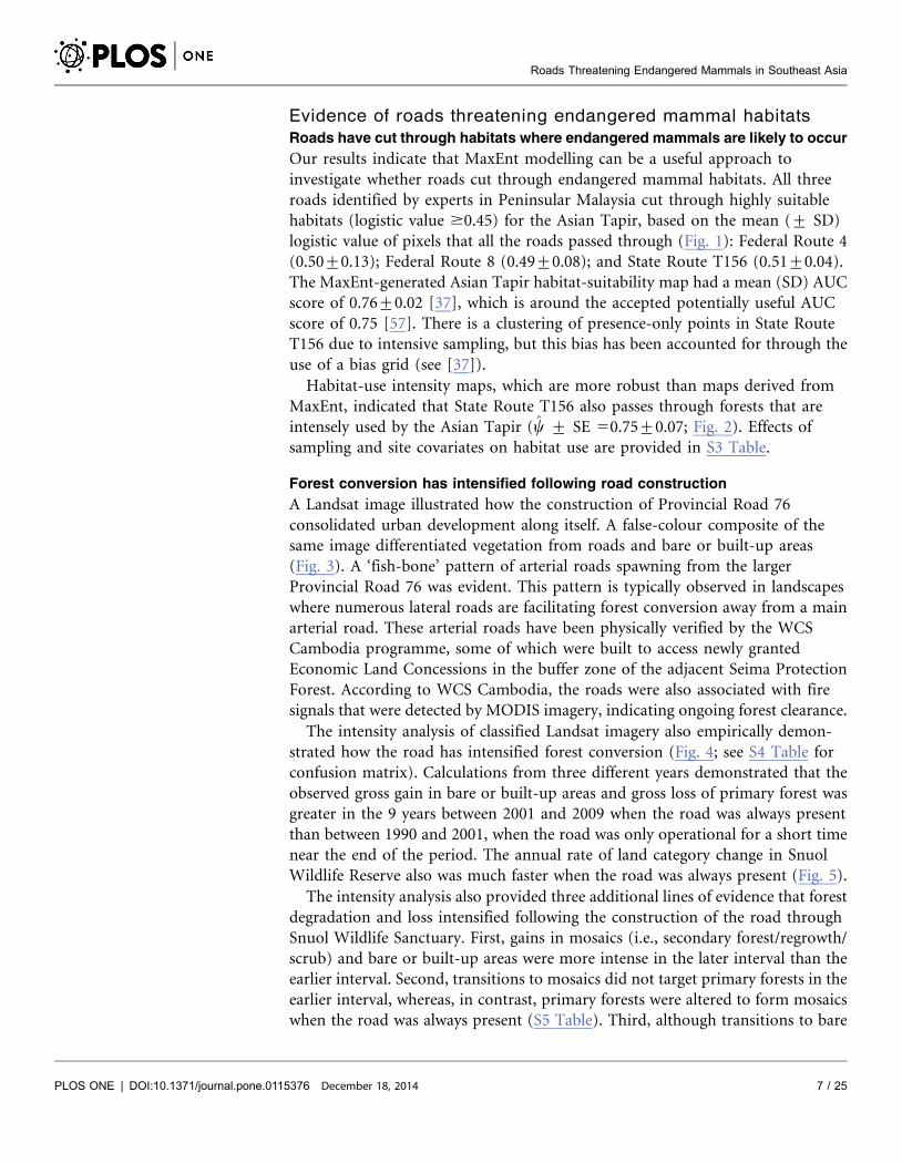
Our results indicate that MaxEnt modelling can be a useful approach to
investigate whether roads cut through endangered mammal habitats. All three
roads identified by experts in Peninsular Malaysia cut through highly suitable
habitats (logistic value $0.45) for the Asian Tapir, based on the mean (¡ SD)
logistic value of pixels that all the roads passed through (Fig. 1): Federal Route 4
(0.50¡0.13); Federal Route 8 (0.49¡0.08); and State Route T156 (0.51¡0.04).
The MaxEnt-generated Asian Tapir habitat-suitability map had a mean (SD) AUC
score of 0.76¡0.02 [37], which is around the accepted potentially useful AUC
score of 0.75 [57]. There is a clustering of presence-only points in State Route
T156 due to intensive sampling, but this bias has been accounted for through the
use of a bias grid (see [37]).
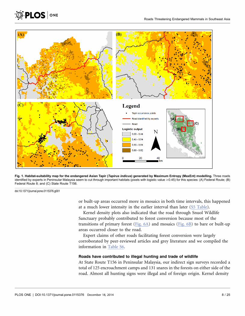
Habitat-use intensity maps, which are more robust than maps derived from
MaxEnt, indicated that State Route T156 also passes through forests that are
intensely used by the Asian Tapir (y ¡ SE 50.75¡0.07; Fig. 2). Effects of
sampling and site covariates on habitat use are provided in S3 Table.
Forest conversion has intensified following road construction
A Landsat image illustrated how the construction of Provincial Road 76
consolidated urban development along itself. A false-colour composite of the
same image differentiated vegetation from roads and bare or built-up areas
(Fig. 3). A ‘fish-bone’ pattern of arterial roads spawning from the larger
Provincial Road 76 was evident. This pattern is typically observed in landscapes
where numerous lateral roads are facilitating forest conversion away from a main
arterial road. These arterial roads have been physically verified by the WCS
Cambodia programme, some of which were built to access newly granted
Economic Land Concessions in the buffer zone of the adjacent Seima Protection
Forest. According to WCS Cambodia, the roads were also associated with fire
signals that were detected by MODIS imagery, indicating ongoing forest clearance.
The intensity analysis of classified Landsat imagery also empirically demon-
strated how the road has intensified forest conversion (Fig. 4; see S4 Table for
confusion matrix). Calculations from three different years demonstrated that the
observed gross gain in bare or built-up areas and gross loss of primary forest was
greater in the 9 years between 2001 and 2009 when the road was always present
than between 1990 and 2001, when the road was only operational for a short time
near the end of the period. The annual rate of land category change in Snuol
Wildlife Reserve also was much faster when the road was always present (Fig. 5).
The intensity analysis also provided three additional lines of evidence that forest
degradation and loss intensified following the construction of the road through
Snuol Wildlife Sanctuary. First, gains in mosaics (i.e., secondary forest/regrowth/
scrub) and bare or built-up areas were more intense in the later interval than the
earlier interval. Second, transitions to mosaics did not target primary forests in the
earlier interval, whereas, in contrast, primary forests were altered to form mosaics
when the road was always present (S5 Table). Third, although transitions to bare
Roads Threatening Endangered Mammals in Southeast Asia
PLOS ONE | DOI:10.1371/journal.pone.0115376 December 18, 2014 7 / 25
or built-up areas occurred more in mosaics in both time intervals, this happened
at a much lower intensity in the earlier interval than later (S5 Table).
Kernel density plots also indicated that the road through Snuol Wildlife
Sanctuary probably contributed to forest conversion because most of the
transitions of primary forest (Fig. 6A) and mosaics (Fig. 6B) to bare or built-up
areas occurred closer to the road.
Expert claims of other roads facilitating forest conversion were largely
corroborated by peer-reviewed articles and grey literature and we compiled the
information in Table S6.
Roads have contributed to illegal hunting and trade of wildlife
At State Route T156 in Peninsular Malaysia, our indirect sign surveys recorded a
total of 125 encroachment camps and 131 snares in the forests on either side of the
road. Almost all hunting signs were illegal and of foreign origin. Kernel density
Fig. 1. Habitat-suitability map for the endangered Asian Tapir (Tapirus indicus) generated by Maximum Entropy (MaxEnt) modelling. Three roadsidentified by experts in Peninsular Malaysia seem to cut through important habitats (pixels with logistic value $0.45) for this species: (A) Federal Route; (B)Federal Route 8; and (C) State Route T156.
doi:10.1371/journal.pone.0115376.g001
Roads Threatening Endangered Mammals in Southeast Asia
PLOS ONE | DOI:10.1371/journal.pone.0115376 December 18, 2014 8 / 25
plots revealed that detections of camps (Fig. 7A) and snares (Fig. 7B) were higher
nearer to the road than further from it. In total, we recorded at least 43 access
trails leading from the road into the forest.
In Myanmar, information from the WCS Myanmar programme indicated that
road networks are facilitating illegal trade of mammals at a national level.
Specifically, routes from sources to trade centres, and trade centres to borders,
were identified (Fig. 8). At the Thai-Myanmar border, parts of at least 187 bears
and 1158 felids were recorded between 1999 and 2006 at border markets such as
Three Pagoda Pass and Tachilek ([52], [58]; Fig. 8). Improved road links across
the border and upgraded highways, such as those connecting Mandalay, Lashio
and Muse cities (Fig. 8), appear to have increased access for traders to lucrative
border markets in China [51].
Expert claims of other roads facilitating illegal hunting and trade were largely
corroborated by peer-reviewed articles and grey literature and we compiled the
information in S7 Table.
Fig. 2. Habitat-use intensity map for the endangered Asian Tapir (Tapirus indicus). Habitats that are intensely used by this species appear to bebisected by State Route T156 in the State of Terengganu, Peninsular Malaysia.
doi:10.1371/journal.pone.0115376.g002
Roads Threatening Endangered Mammals in Southeast Asia
PLOS ONE | DOI:10.1371/journal.pone.0115376 December 18, 2014 9 / 25

Lessons learnt from road proliferation in Southeast Asia
To our knowledge, this is the first study to identify roads that are likely to threaten
endangered mammals and their habitats in Southeast Asia. Most of the specific
roads identified by experts bisect or are adjacent to national parks and to a lesser
extent, production forest reserves. Below, we summarize some general lessons
from road proliferation in this region.
Drivers of road construction
Roads in this region are not always built to benefit rural society, as is often
claimed. While the expansion of road infrastructure has alleviated poverty in
many countries [59], surveys in Lao PDR revealed that the poorest rural residents
ranked the value of roads or access to markets as only 8th out of 12 potential
measures to improve their income levels [60]. Their income levels are typically too
low to afford the supplies that roads bring into their areas [61].
Fig. 3. A false-colour composite of a Landsat 5 image over part of Snuol Wildlife Reserve, Cambodia. This technique reveals a ‘fish-bone’ pattern ofarterial roads spawning from the larger Provincial Road 76 bisecting the wildlife reserve. Landsat Scene Path/Row: 127/52. Acquisition date: 09/12/2009.
doi:10.1371/journal.pone.0115376.g003
Roads Threatening Endangered Mammals in Southeast Asia
PLOS ONE | DOI:10.1371/journal.pone.0115376 December 18, 2014 10 / 25

Road development projects are sometimes initiated with hidden agendas. In
Lao PDR, almost two-thirds of timber supplies over the last five years have come
from clearances associated with development projects that include road
construction [62]. In Sumatra, the Governor of Aceh pushed for more proposed
roads through the Leuser ecosystem under the expanded Ladia Galaska road
scheme. The roads probably benefited local communities to some extent,
especially by decreasing transportation time of timber and agricultural
commodities and to free enclaved villages from isolation [4]. However, critics
argue that financial benefits would only be reaped by security forces and local
elites from illicit business opportunities [63], rather than roads providing a net
benefit to local communities [64], [65].
Fig. 4. Land cover change of Snuol Wildlife Reserve. Cambodia. Landsat images were obtained for three time points: when the road was (1) absent(1990), (2) recently completed (2001), and (3) had existed for some time (2009). Inputs for land cover classification included the first three layers of aTasseled-cap transformation (Kauth & Thomas 1976) and spectral bands 1–5 and 7. Data layers were processed using an unsupervised classification(ISODATA) algorithm with a maximum class of 200, and 50 maximum iterations with a convergence threshold of 0.95. Accuracy analysis was onlyconducted for the classified image from 2010 using the original Landsat 5 image and a Landsat 7 image from a comparable time period. The overallaccuracy of the 2010 image was relatively high at 84.8%. The confusion matrix is provided in Table S4. Landsat Scene Path/Row: 127/52. Acquisition datesfor Landsat 4, 5 (TM) and Landsat 7 (ETM+) images: 27/01/1990; 15/04/2001; and 09/12/2009.
doi:10.1371/journal.pone.0115376.g004
Roads Threatening Endangered Mammals in Southeast Asia
PLOS ONE | DOI:10.1371/journal.pone.0115376 December 18, 2014 11 / 25

Socio-political factors also pose a serious challenge for opposition to roads on
environmental grounds. For example, the Ladia Galaska road scheme is largely
supported by the Achenese people, not only because it would greatly improve
intra-provincial transport efficiency (especially for agricultural commodities such
as palm oil; [4]), but also because they would be less reliant on roads going
through neighbouring provinces (M. Linkie, personal communication).
Fig. 5. Time intensity analysis of land category change in Snuol Wildlife Reserve, Cambodia. Bars showintensity of annual area of change within each time interval: 1) 1990–2001 (road mostly absent) and; 2) 2001–2009 (road always present).
doi:10.1371/journal.pone.0115376.g005
Fig. 6. Kernel density plots of transitions of (A) primary forest and (B) secondary forest mosaics tobare or built-up areas in relation to distance from Provincial Road 76 bisecting the Snuol WildlifeReserve, Cambodia.
doi:10.1371/journal.pone.0115376.g006
Roads Threatening Endangered Mammals in Southeast Asia
PLOS ONE | DOI:10.1371/journal.pone.0115376 December 18, 2014 12 / 25

Ultimately, government financial capacities may determine whether a road
threatens biodiversity. In Vietnam, the Ho Chi Minh Highway is now regarded as
the ‘single largest long-term threat to biodiversity’ in the country [66]. Before its
construction, an option of diverting it around Vietnam’s oldest national park was
rejected by the government to avoid costs of $20 million to resettle 900
households [67]. Under rare circumstances, an economic crisis might even help
abate the impacts of roads on biodiversity. During the financial crisis in 1998, for
example, the Indonesian government cut back on funds for the construction and
maintenance of major highways, causing delays of up to seven years in some road
projects in Kalimantan [68].
Road impacts vary
Logging road network density can influence the degree to which logging impacts
biodiversity. For example, the impacts of logging on biodiversity in parts of
Southeast Asia has generally been more severe than that in the Amazon, where
selective logging typically occurs at a low intensity and roads are usually less dense
[25]; but see [69]). In Borneo, satellite images revealed 271,819 km of large
(.15 m wide) logging roads were built between 1973 and 2010 [70]. While many
logging roads experience forest re-growth after logging, logging activities have
usually resulted in forest conversion throughout most of Borneo, especially in
Kalimantan [71]. By increasing forest access and creating much dry, flammable
slash, logging activities and roads also appear to have increased forest fires; 76% of
258 fire-prone zones in Kalimantan contained logging roads [72].
Fig. 7. Kernel density plots of detections of (A) encroachment camps and (B) snares in relation todistance from State Route T156 cutting through forests in the State of Terengganu, PeninsularMalaysia.
doi:10.1371/journal.pone.0115376.g007
Roads Threatening Endangered Mammals in Southeast Asia
PLOS ONE | DOI:10.1371/journal.pone.0115376 December 18, 2014 13 / 25

Fig. 8. Map of road networks in Myanmar functioning as conduits for the illegal wildlife trade to border towns (circles) in neighbouring countries.
doi:10.1371/journal.pone.0115376.g008
Roads Threatening Endangered Mammals in Southeast Asia
PLOS ONE | DOI:10.1371/journal.pone.0115376 December 18, 2014 14 / 25
Roads have also been known to contribute to forest conversion at a distance. In
East Kalimantan, to escape detection from police and forestry officials, people
migrated away from the Balikpapan-Samarinda Road into the Bukit Soeharto
Recreation Forest to illegally clear land for pepper plantations [73].
In rare instances, road development may even be used as a wildlife conservation
strategy. In Vietnam, the widening of a road near Cat Tien National Park was
deemed an appropriate measure to discourage elephant movement to areas where
they could potentially be killed in human-dominated landscapes [74].
10 ways to mitigate impacts from road development
We suggest 10 measures to minimise the negative impacts of road development in
and around endangered mammal habitats in the region.
(1) Maintain and improve forest connectivity on either side of existing roads
The integration of green infrastructure options (e.g., underpasses, overpasses,
road signs and culverts) into proposed road designs, along with incorporating
measures to evaluate their efficiency of use may be beneficial for the movement of
mammals through fragmented habitats [75–78]. In Cambodia, the preservation of
forests on both sides of Provincial Road 48 and 76 was highlighted as a key
strategy [79] to ensure the dispersal of arboreal species such as the Yellow-cheeked
Crested Gibbon (Nomascus gabriellae).
(2) Increase enforcement effort along existing roads through endangered
species habitats
Our study has indicated locations along trade routes in Myanmar where
additional law enforcement effort is urgently required (Figure 8). Elsewhere in the
region, the need to increase enforcement efforts along roads to deter illegal
hunting has already been recognized in some countries. Along Federal Route 4 in
Peninsular Malaysia (S1 Table; Fig. 1), government enforcement agencies stepped
up enforcement efforts after World Wide Fund for Nature (WWF)-Malaysia
patrols detected large number of snares along roadside forests (A. Zafir, pers.
comm.). In Lao PDR, staff of protected areas blame roads in general for increased
hunting by locals, foreigners and road construction crews [61]. As such, road
check points along Route 1C, which bisects the Nam Et-Phou Louey National
Biodiversity Conservation Area, have been recommended by the Wildlife
Conservation Society (WCS) as a vital measure to curb tiger poaching and the
illicit trade in ungulate prey species from core tiger conservation areas [80]. A
provincial forest law enforcement strategy also identified closing illegal roads as a
required action for reducing forest encroachment and illegal timber extraction
[81].
(3) Minimise threats from logging roads via sustainable forest management
regimes
Closing logging roads after cessation of logging can help restrict access to poachers
and illegal loggers [82–85]. Forestry departments should prioritise the closure of
Roads Threatening Endangered Mammals in Southeast Asia
PLOS ONE | DOI:10.1371/journal.pone.0115376 December 18, 2014 15 / 25
logging roads that contribute to the transport of illegally harvested timber. This is
especially important at the Malaysian-Indonesian boundary on Borneo where, on
satellite images, 137 cross-border logging road intrusions have been detected [86].
When new logging roads are constructed through previously undisturbed
mammal habitats, greater law enforcement must be afforded for newly accessible
resources [62], together with publicised policies and measures that deter poaching
[76].
(4) Resolve land rights and tenure prior to road construction
One of the key drivers of habitat loss is the absence of land and resource tenure
along roads. This has resulted in an uncontrolled influx of locals seeking to clear
and claim land along roads [87]. To minimise illegal settlements along roads
bordering important biodiversity areas, relevant government agencies should
complete the allocation of lands for villages and protected areas prior to road
construction.
(5) Increase engagement with road development agencies in conservation
planning
Agencies responsible for road development are rarely included as main project
partners in species conservation plans (e.g., [88, 89]). Because roads can be the
precursor of forest conversion and hunting, road-relevant stakeholders should be
included in the early stages of conservation planning. Plans should include
scientifically-sound guidelines of where roads can be constructed or upgraded to
maximize agricultural benefits and minimize biodiversity loss [10]. In Sumatra,
timely discussions with villagers and local government officials prevented a road
from cutting through Bukit Barisan Selatan National Park [90]. In the long run,
such engagements can facilitate greater transparency and improved lines of
communication between protected area managers and road authorities. Such
communication gaps are common in countries such as Lao PDR, where heads of
protected areas are rarely consulted before nearby roads are constructed [61]. It is
unsurprising that state government infrastructure projects are one of the key
drivers of deforestation in northern Lao PDR [91].
(6) Integrate road planning across relevant government agencies
Ad hoc planning with little or no cross-sectoral communication between
governmental departments is often the root of environmental problems associated
with roads. Encouragingly, in Lao PDR, an Environment Unit has been created
within the Department of Roads to ensure environmental concerns are considered
in road construction programmes [62]. In Malaysia, the Department of Wildlife
and National Parks laudably worked together with the Public Works Department
to incorporate underpasses along a new highway to facilitate mammal migration
in important wildlife corridors [92]. However, multi-agency road planning must
take place at appropriate government levels. For instance, conservation and
development plans in Lao PDR should be developed at provincial rather than
Roads Threatening Endangered Mammals in Southeast Asia
PLOS ONE | DOI:10.1371/journal.pone.0115376 December 18, 2014 16 / 25

local levels as most threats to protected areas, especially road construction, are
likely to originate from the former [62], [81].
(7) Conduct projections of economic and biodiversity loss prior to road
development
Predictions of how road development will result in biodiversity and economic loss
may help guide decision-making involving road planning. In Sumatra, the
government plans to expand the Ladia Galaska road scheme, an all-weather road
network in Aceh. However, it is feared that this road development will further
reduce and fragment mammal populations [93], especially two of the three largest
remaining Orangutan populations [94]. Indeed, a study projected that the total
economic value of the Leuser ecosystem under selective use would be greater than
a 30-year deforestation scenario [65], which would certainly be realized under an
expanded Ladia Galaska road scheme cutting through the protected area.
Predictive models have also shown that forest areas near roads in Aceh are highly
vulnerable to deforestation, with areas at high risk of deforestation (p.0.8)
predicted to increase by 40% (Fig. 9). In fact, Orangutan habitat is predicted to
further decline by 16% (1,137 km2) in 2030, resulting in the loss of an estimated
1,384 individuals (or 25% of the current global population; [4]).
(8) Explore compensation schemes that can minimise the need for, or impact of
proposed roads
Inter-governmental REDD (Reduced Emissions from Deforestation and
Degradation) projects, such as the recent Norway-Indonesia pact [95], may have
prevented the construction of new logging roads through peat swamps and
natural forests. Another possible strategy is the implementation of carbon-deposit
and refund systems by financial lending institutions [96]. Under this mechanism,
a road developer is obliged to buy credits equal to the net carbon emissions
expected from deforestation along an existing or proposed road. These credits
then serve as deposits over fixed periods. At the end of each period, the road
developer is allowed to sell credits equal to the difference between expected and
actual deforestation – this means the developer would redeem all deposits on all
the forest maintained intact and retire remaining credits to cover deforestation
that actually occurred. According to Reid [96], one advantage for the developer is
that there is a conservation incentive beyond the construction phase to avoid all
deforestation because forest conversion, as we have shown, can intensify after a
road is built. If the developer has taken steps to minimise deforestation along the
road, the developer will financially benefit once market prices for carbon have
risen. However, if the present value of carbon does not increase considerably, the
uptake of this scheme will remain slow due to the high uncertainty of reaping
attractive financial gains. Further, a conflict in the underlying principle of this
REDD scheme needs to be resolved because increasing amounts of carbon will be
emitted in the long run from vehicles using the road.
Ultimately, financing governments should conduct due-diligence studies prior
to a road project overseas. In Lao PDR, for example, it was unlikely that the
Roads Threatening Endangered Mammals in Southeast Asia
PLOS ONE | DOI:10.1371/journal.pone.0115376 December 18, 2014 17 / 25

Australian Government was aware of the potential environmental consequences
from the rehabilitation project along Route 9 [97]. If a road must be built, offset
mechanisms should be explored such as Payment for Ecosystem Services (PES). In
Lao PDR, the economic value of an area in Nakai-Nam Theun Protected Area that
was inundated by a hydro-electric dam project was offset by a contribution of
US$31.5 million to create a management authority [76]. However, the
effectiveness of these funds has come under intense scrutiny from both
conservation and development agencies (AJ Lynam pers. obs.).
(9) Audit environmental and social impact assessments
Regional and global impact assessments that consider biological, social and
economic trade-offs should be conducted for major roads and highways.
Similarly, smaller roads at local scales should not be spared from assessments even
if funds are constrained [62]. Unfortunately, impact assessments for forest
clearance projects are not mandatory, and are mostly weak in Southeast Asia [76],
while negative impacts of road construction highlighted in impact assessments
rarely deter projects from going ahead. For example, most of the proposed roads
in the Ladia Galaska scheme have not undergone Environmental Impact
Assessments (EIAs), and those that did flouted regulations nonetheless [64]. In
Lao PDR, the upgrade of Route 3 proceeded even after warnings from consultants
about the negative impacts of the road construction [98].
Fig. 9. Probability map of deforestation (A) without further Ladia Galaska road extension, and (B) with road extension. Source: [4].
doi:10.1371/journal.pone.0115376.g009
Roads Threatening Endangered Mammals in Southeast Asia
PLOS ONE | DOI:10.1371/journal.pone.0115376 December 18, 2014 18 / 25

(10) Raise public awareness of environmental impacts of road projects
In Kalimantan, roadside campaigns to raise awareness of fire prevention and
suppression [99] indirectly helped to prevent further loss of fire-prone mammal
habitats. In Peninsular Malaysia, increasing media attention given to the poaching
issues along Federal Route 4 [100], [101] helped galvanise more support from
enforcement agencies [102]. In Sumatra, media campaigns by NGOs convinced
donor agencies such as the World Bank to discontinue financial assistance to the
Indonesian state budget to prevent misuse of funds in road expansion projects
such as the Ladia Galaska road scheme [103]. However, heightened awareness may
not always reap immediate dividends. Banks continue to finance road projects in
the Greater Mekong sub-region even though their own evaluation reports
acknowledge that transnational roads contribute to human and wildlife trafficking
[104].
Conclusions
With the help of experts, we now know where several existing and planned roads
are endangering mammals in Southeast Asia. However, greater effort should be
expended to empirically elucidate the impacts of other potential roads using our
recommended techniques. Implementing our suggestions for mitigation can help
reduce the impacts of the roads highlighted by our experts. However, the
implementation of these strategies can sometimes yield mixed results (S1 Box).
Nevertheless, there are examples where roads have been rerouted in regions such
as Kalimantan and Sumatra [90], [105]. This precedent gives us optimism that the
impacts of roads on endangered mammals elsewhere in Southeast Asia can be
ameliorated with sufficient awareness and political will.
Supporting Information
S1 Table. Summary of 16 existing roads contributing to forest conversion of
mammal habitats and hunting of endangered mammals according to 36
experts from seven countries in Southeast Asia (number of experts who
responded/number of experts contacted).
doi:10.1371/journal.pone.0115376.s001 (DOCX)
S2 Table. Summary of 8 planned road construction or improvement projects
that can potentially contribute to forest conversion of mammal habitats and
hunting of endangered mammals according to experts from five Southeast
Asian countries.
doi:10.1371/journal.pone.0115376.s002 (DOCX)
S3 Table. Logistic regression models examining the effect of four site covariates
on the endangered Asian Tapir (Tapirus indicus) habitat use (y), and three
sampling covariates affecting its detection probability (p), based on camera-
Roads Threatening Endangered Mammals in Southeast Asia
PLOS ONE | DOI:10.1371/journal.pone.0115376 December 18, 2014 19 / 25

trap data from forests along State Road 156, a road identified by one of the
experts in Peninsular Malaysia.
doi:10.1371/journal.pone.0115376.s003 (DOCX)
S4 Table. Confusion matrix used in accuracy analysis of 2010 classified image
from Snuol Wildlife Reserve, Cambodia.
doi:10.1371/journal.pone.0115376.s004 (DOCX)
S5 Table. Summary statistics for transition of land categories to mosaic of
secondary forests from 1990–2001 and 2001–2009, and transition of categories
to bare or built-up areas in 1990–2001and 2001–2009 in Snuol Wildlife
Reserve, Cambodia. Each row respectively gives: a) land category name, b) area of
transition in terms of cell counts, c) intensity of transition per gross gain, d)
uniform distribution of transitions across the area possible for that change, given
the empirical gross gain for mosaic or bare or built-up areas, e) hypothesized
uniform annual transition, f) annual number of pixels of hypothesized error, g)
commission or omission intensity in t map and h) hypothesized error as percent
of t map.
doi:10.1371/journal.pone.0115376.s005 (DOCX)
S6 Table. Supporting evidence from peer-reviewed articles and grey literature
corroborating expert claims that roads contribute to forest conversion of
habitats where endangered mammals occur in Southeast Asia.
doi:10.1371/journal.pone.0115376.s006 (DOCX)
S7 Table. Supporting evidence from peer-reviewed articles and grey literature
corroborating expert claims that roads contribute to illegal hunting and trade
of wildlife in Southeast Asia.
doi:10.1371/journal.pone.0115376.s007 (DOCX)
S1 Method. Hierarchically-nested combinations of relevant keywords and
wildcards used to search for road-specific biodiversity studies in Southeast
Asia in the BIOSIS Previews database between 1985 and 2011.
doi:10.1371/journal.pone.0115376.s008 (DOCX)
S2 Method. Method used to generate habitat-use-intensity maps for the Asian
Tapir (Tapirus indicus) from forests on either side of State Road 156, a road
identified by one of the experts in Peninsular Malaysia.
doi:10.1371/journal.pone.0115376.s009 (DOCX)
S3 Method. Method for intensity analysis used to investigate whether forest
conversion intensified following road construction in Snuol Wildlife Reserve,
Cambodia.
doi:10.1371/journal.pone.0115376.s010 (DOCX)
S1 Box. Case study of real-world challenges faced during the implementation
of recommended road impact mitigation measures in Kalimantan, Indonesia.
doi:10.1371/journal.pone.0115376.s011 (DOCX)
Roads Threatening Endangered Mammals in Southeast Asia
PLOS ONE | DOI:10.1371/journal.pone.0115376 December 18, 2014 20 / 25

Acknowledgments
We are most grateful to the interviewees who responded to our questionnaires.
We thank Stephen Blake for his constructive review of our manuscript. GRC is
grateful to the Economic Planning Unit (Permit no. 3072) and the Department of
Wildlife and National Parks for permits to conduct research in Malaysia.
Author ContributionsConceived and designed the experiments: GRC. Analyzed the data: GRC AJL
WLY. Wrote the paper: GRC AJL DG MG S. Laurance S. Lhota WFL.
References
1. Brooks TM, Mittermeier RA, Mittermeier CG, da Fonseca GAB, Rylands AB, et al. (2000) Habitatloss and extinction in the hotspots of biodiversity. Conserv Biol 16: 909–923.
2. Linkie M, Martyr DJ, Holden J, Yanuar A, Hartana AT, et al. (2003) Habitat destruction and poachingthreaten the Sumatran tiger in Kerenci Seblat National Park, Sumatra. Oryx 37: 41–48.
3. Chapron G, Miquelle DG, Lambert A, Goodrich JM, Legendre S, et al. (2008) The impact on tigers ofpoaching versus prey depletion. J Appl Ecol 45: 1667–1674.
4. Gaveau DLA, Wich S, Epting J, Juhn D, Kanninen M, et al. (2009) The future of forests andOrangutans (Pongo abelii) in Sumatra: predicting impacts of oil palm plantations, road construction, andmechanisms for reducing carbon emissions from deforestation. Environ Res Lett 4: 034013.
5. Suarez E, Morales M, Cueva R, Utreras Bucheli V, Zapata-Rios G, et al. (2009) Oil industry, wild meattrade and roads: Indirect effects of oil extraction activities in a protected area in north-eastern Ecuador.Anim Conserv 12: 364–373.
6. Peh KS-H, Soh MCK, Sodhi NS, Laurance WF, Ong DJ, et al. (2011) Up in the clouds: Is sustainableuse of tropical montane cloud forests possible in Malaysia? BioScience 61: 27–38.
7. Laurance WF, Cochrane MA, Bergen S, Fearnside PM, Delamonica P, et al. (2001) The future of theBrazilian Amazon. Science 291: 438–439.
8. Blake S, Strindberg S, Boudjan P, Makombo C, Bila-Isia I, et al. (2007) Forest elephant crisis in theCongo Basin. PLOS Biology 5: e111.
9. Laurance WF, Balmford A (2013) A global map for road building. Nature 495: 308–309.
10. Laurance WF, Clements GR, Sloan SP, O9Connell CO, Mueller NP, et al. (2014). A global strategy forroad building. Nature 513: 229–232.
11. Wilkie D, Shaw E, Rotberg F, Morelli G, Auzel P (2000) Roads, development, and conservation in theCongo Basin. Conserv Biol 14: 1614–1622.
12. World Bank (2013) Data: Roads, Paved (% of total road). Available: http://data.worldbank.org/indicator/IS.ROD.PAVE.ZS. Accessed 2014 Aug 3.
13. Lesbarreres D, Fahrig L (2012) Measures to reduce population fragmentation by roads: What hasworked and how do we know? Trends Ecol Evol 27: 374–380.
14. Goosem MW (1997) Internal fragmentation: the effects of roads, highways and powerline clearings onmovements and mortality of rainforest vertebrates. In Laurance WF, Bierregaard ROJr, editors. Tropicalforest remnants: Ecology, management and conservation of fragmented communities. Chicago:University of Chicago Press. pp.241–255.
15. Colon CP (2002) Ranging behaviour and activity of the Malay civet (Viverra tangalunga) in a logged andan unlogged forest in Danum Valley, East Malaysia, J Zool 257: 473–485.
16. Gubbi S, Poornesha HC, Madhusudan MD (2012) Impact of vehicular traffic on the use of highwayedges by large mammals in a South Indian wildlife reserve, Curr Sci 102: 1047–1051.
Roads Threatening Endangered Mammals in Southeast Asia
PLOS ONE | DOI:10.1371/journal.pone.0115376 December 18, 2014 21 / 25
17. Vidya TNC, Thuppil V (2010) Immediate behavioural responses of humans and Asian elephants incontext of road traffic in southern India. Biol Conserv 143: 1891–1900.
18. Roger E, Laffan SW, Ramp D (2011) Road impacts a tipping point for wildlife populations in threatenedlandscapes. Popuk Ecol 53: 215–227.
19. Blake S, Deem SL, Strindberg S, Maisels F, Momont L, et al. (2008) Roadless wilderness areadetermines forest elephant movements in the Congo Basin. PLoS ONE 3: e3546.
20. Laurance WF, Goosem M, Laurance SGW (2009) Impacts of roads and linear clearings on tropicalforests. Trends Ecol Evol 24: 659–669.
21. Vanthomme H, Kolowski J, Korte L, Alonso A (2013) Distribution of a community of mammals inrelation to roads and other human disturbances in Gabon, central Africa. Conserv Biol 27: 281–291.
22. Fahrig L, Rytwinski T (2009) Effects of roads on animal abundance: an empirical review and synthesis.Ecol Soc 14: 21.
23. Benıtez-Lopez A, Alkemade R, Verweij PA (2010) The impacts of roads and other infrastructure onmammal and bird populations: a meta-analysis. Biol Conserv 143: 1307–1316.
24. Taylor BD, Goldingay RL (2010) Roads and wildlife: impacts, mitigation and implications for wildlifemanagement in Australia. Wildlife Research 37: 320–331.
25. Nepstad D, Carvalho G, Barros AC, Alencar A, Capobianco JP, et al. (2001) Road paving, fire regimefeedbacks, and the future of Amazon forests. Forest Ecol Manag 154: 395–407.
26. Laurance WF, Croes BM, Tchignoumba L, Lahm SA, Alfonso A, et al. (2006) Impacts of roads andhunting on Central African rainforest mammals, Conserv Biol 20: 1251–1261.
27. Goosem M (2001) Effects of tropical rainforest roads on small mammals: Inhibition of crossingmovements. Wildlife Res 28: 351–364.
28. Sodhi NS, Koh LP, Brook BW, Ng PKL (2004) Southeast Asian biodiversity: The impending disaster.Trends Ecol Evol 19: 654–660.
29. Austin SC, Tewes ME, Grassman Jr. LI, Silvy NJ (2007) Road ecology of the leopard cat Prionailurusbengalensis in Khao Yai National Park, Thailand. Acta Zool Sinica 53: 373–377.
30. Brook BW, Sodhi NS, Ng PKL (2003) Catastrophic extinctions follow deforestation in Singapore.Nature 424: 420–423.
31. Koh LP, Wilcove D (2008) Is oil palm agriculture really destroying tropical biodiversity? Conserv Lett 1:60–64.
32. Aziz SA, Laurance W, Clements R (2010) Forests reserved for rubber? Front Ecol Environ 8: 178.
33. Bennett EL, Robinson JG (2008) Hunting of wildlife in tropical forests: Implications for biodiversity andforest peoples. Washington DC: World Bank. 42 p.
34. Bennett EL (2011) Another inconvenient truth: The failure of enforcement systems to save charismaticspecies. Oryx 45: 476–479.
35. Laurance WF, Useche DC, Rendeiro J, Kalka M, Bradshaw C, et al. (2012) Averting biodiversitycollapse in tropical protected areas. Nature 489: 290–294.
36. Phillips SJ, Anderson RP, Schapire RE (2006) Maximum entropy modelling of species geographicdistributions. Ecol Model 190: 231–259.
37. Clements GR, Rayan DM, Aziz SA, Kawanishi K, Traeholt C, et al. (2012) Predicting the distribution ofthe Asian tapir (Tapirus indicus) in Peninsular Malaysia using maximum entropy modelling. Integr Zool 7:402–409.
38. Elith J, Phillips SJ, Hastie T, Dudık M, Chee YE, et al. (2011) A statistical explanation of MaxEnt forecologists. Divers Distrib 17: 43–57.
39. Karanth K, Nichols JD, Hines JE, Karanth KU, Christensen NL (2009) Patterns and determinants ofmammal species occurrence in India. J Appl Ecol 46: 1189–1200.
40. Royle JA, Chandler RB, Yakulic C, Nichols JD (2012) Likelihood analyses of species occurrenceprobability from presence-only data for modeling species distributions. Method Ecol Evol 3: 545–552.
Roads Threatening Endangered Mammals in Southeast Asia
PLOS ONE | DOI:10.1371/journal.pone.0115376 December 18, 2014 22 / 25
41. MacKenzie DI, Nichols JD, Royle JA, Pollock KH, Bailey LL, et al. (2006) Occupancy estimation andmodeling: Inferring patterns and dynamics of species occurrence. New York: Academic Press. 324 p.
42. Clements GR (2013) The environmental and social impacts of roads in Southeast Asia. Ph.D. Thesis,James Cook University. Available: http://researchonline.jcu.edu.au/31888/. Accessed 2014 Aug 3.
43. Wulder MA, White JC, Masek JG, Dwyer J, Roy DP (2011) Continuity of Landsat observations: Shortterm considerations. Remote Sens Environ 115: 747–751.
44. Wijedasa L, Michelakis DG, Sloan S, Clements GR (2012) Overcoming limitations with Landsatimagery for mapping of peat swamp forests in Sundaland. Remote Sens 4: 2595–2618.
45. Aldwaik SZ, Pontius Jr. RG (2012) Intensity analysis to unify measurements of size and stationarity ofland use changes by interval, category and transition. Landscape Urban Plan 106: 103–114.
46. Scott DW (1979) On optimal and data-based histograms. Biometrika 66: 605–610.
47. Long B, Hoang M (2007) Recent records of and notes on the conservation of small carnivores in QuangNam province, Central Vietnam. Small Carniv Conserv 34 &35: 39–46.
48. Shepherd CR, Compton J, Warne S (2007) Transport Infrastructure and Wildlife Trade Conduits in theGMS: Regulating Illegal and Unsustainable Wildlife Trade. Available: http://www.traffic.org/non-traffic/bci-paper.pdf. Accessed 2014 Aug 3.
49. Martin EB, Redford T (2000) Wildlife for sale. Biologist 47: 27–30.
50. World Bank (2005) Going, going, gone: The illegal trade in wildlife in East and Southeast Asia.Washington DC: Environment and Social Development Department, East Asia and Pacific Region. 32 p.
51. Shepherd C, Nijman V (2007) The trade in bear parts from Myanmar: An illustration of theineffectiveness of enforcement of international wildlife trade regulations. Biodivers Conserv 17: 35–42.
52. Shepherd C, Nijman V (2008) The wild cat trade in Myanmar. Petaling Jaya: TRAFFIC Southeast Asia.16 p.
53. Oswell A (2010) The big cat trade in Myanmar and Thailand. Bangkok: TRAFFIC Southeast Asia. 32 p.
54. Lynam AJ, Rabinowitz A, Khaing ST (1999) Tiger traces. Wildlife Conserv 102: 36–41.
55. Lynam AJ (2003) A national tiger action plan for the Union of Myanmar. New York: Myanmar ForestDepartment and the Wildlife Conservation Society. 58 p.
56. Lynam AJ, Saw TK, Khin MZ (2006) Developing a national tiger action plan for the Union of Myanmar.Environ Manag 37: 30–39.
57. Phillips SJ, Dudık M (2008) Modeling of species distributions with MaxEnt: new extensions and acomprehensive evaluation. Ecography 31: 161–175.
58. Zaw M (2005) Open borders, demand keep wildlife trade going. Inter Press Service News Agency.Available: http://www.ipsnews.net/2005/05/burma-china-open-borders-demand-keep-wildlife-trade-going. Accessed 2014 Aug 3.
59. Jones S (2006) Infrastructure challenges in East and South Asia. IDS Bull-I Dev Stud 37: 29–44.
60. Government of Laos (2000) An overview of quantitative and participatory poverty studies. Vientiane:State Planning Committee, Government of Laos.
61. Robichaud R, Marsh CW, Southammakoth S, Khounthikoummane S (2001) Review of the nationalprotected area system for Lao PDR. Vientiane: Lao-Swedish Forestry Programme. Department ofForestry, IUCN-The World Conservation Union. 112 p.
62. International Centre for Environmental Management (2003) Lao PDR national report on protectedareas and development. Available: http://www.mekong-protected-areas.org/lao_pdr/n_report.htm.Accessed 2014 Aug 3.
63. Singleton I, Wich S, Husson S, Stephens S, Atmoko SU, et al., editors (2004) Orangutan populationand habitat viability assessment: final report. Apple Valley: IUCN/SSC Conservation Breeding SpecialistGroup. 235 p.
64. Robertson Y (2002) Briefing Document on Road Network through the Leuser Ecosystem. Available:http://www-3.unipv.it/webbio/api/leuser.htm. Accessed 2014 Aug 3.
Roads Threatening Endangered Mammals in Southeast Asia
PLOS ONE | DOI:10.1371/journal.pone.0115376 December 18, 2014 23 / 25

65. van Beukering PJH, Cesar HSJ, Janssen MA (2003) Economic valuation of the Leuser National Parkon Sumatra, Indonesia. Ecol Econ 44: 43–62.
66. Gray DD (2006) Ho Chi Minh Trail Vietnam, from Soldier’s Road to Tourist Highway. Associated Press.Available: http://usatoday30.usatoday.com/travel/destinations/2005-07-18-ho-chi-minh_x.htm. Accessed2014 Aug 3.
67. Reuters (2001) Vietnam’s New Highway may Cut through Reserve. Reuters Newswire. Available: http://www.iol.co.za/scitech/technology/vietnam-s-new-highway-may-cut-through-reserve-1.76017#.U95qOvmSw2I. Accessed 2014 Aug 3.
68. Sunderlin WD (2002) Effects of crisis and political change, 1997-1999. In Colfer CJP, Resosudarmo IAP,editors. Which way forward? People, forests, and policymaking in Indonesia. Resources for the Future.Washington DC: Center for International Forestry Research (CIFOR) and Institute of Southeast AsianStudies (ISEAS). pp.246–276.
69. Redford KH (1992) The empty forest. BioScience 42: 412–422.
70. Gaveau DLA, Sloan S, Molidena E, Yaen H, Sheil D, et al. (2014) Four decades of forest persistence,clearance and logging on Borneo. PLoS ONE 9: e101654.
71. Carlson KM, Curran LM, Asner GP, Pittman AM, Trigg SN, et al. (2012) Carbon emissions from forestconversion by Kalimantan oil palm plantations. Nature Climate Change 3: 283–287.
72. Siegert F, Ruecker G, Hinrichs A, Hoffmann AA (2001) Increased damage from fires in logged forestsduring droughts caused by El Nino. Nature 414: 437–440.
73. Vayda AP, Sahur A (1996) Bugis settlers in East Kalimantan’s Kutai National Park, their past andpresent and some possibilities for their future. Jakarta: Center for International Forestry ResearchSpecial Publication. 54 p.
74. Varma S, Dang NX, Thanh TV, Sukumar R (2008) The elephants Elephas maximus of Cat TienNational Park, Vietnam: status and conservation of a vanishing population. Oryx 42: 92–99.
75. Goosem M, Izumi Y, Turton S (2001) Efforts to restore habitat connectivity for an upland tropicalrainforest fauna: a trial of underpasses below roads. Ecol Manag Restor 2: 196–202.
76. Quintero J, Roca R, Morgan AJ, Mathur A (2010) Smart Green Infrastructure in Tiger RangeCountries: A Multi-level Approach. Available: http://www.globaltigerinitiative.org/download/GTI-Smart-Green-Infrastructure-Technical-Paper.pdf. Accessed 2014 Aug 3.
77. Weston N, Goosem M, Marsh H, Cohen M, Wilson R (2011) Using canopy bridges to link habitat forarboreal mammals: successful trials in the Wet Tropics of Queensland. Australian Mammalogy 33: 93–105.
78. van der Grift EA, van der Ree R, Fahrig L, Findlay S, Houlahan J, et al. (2013) Evaluating theeffectiveness of road mitigation measures. Biodivers Conserv 22: 425–448.
79. Channa P, Gray T (2009) The status and habitat of yellow-cheeked crested gibbon Nomascus gabriellaein Phnom Prich Wildlife Sanctuary, Mondulkiri. Phnom Penh: WWF Greater Mekong-Cambodia CountryProgramme. 24 p.
80. Johnson A, Vongkhamheng C, Venevongphet, Saythongdum T, Hedemark M (2006) Status of tiger,prey and human-tiger conflict in the Nam Et-Phou Louey National Protected Area, Lao PDR. In McNeelyJA, McCarthy TM, Smith A, Olsvig-Whittaker L, Wikramanayake EL, editors. Conservation Biology inAsia. Kathmandu: Society for Conservation Biology Asia Section and Resources Himalaya. pp.232–235.
81. Lynam AJ, Moore C (2013) A law enforcement action plan for reducing deforestation and forestdegradation in Houaphan Province. Vientiane: Wildlife Conservation Society.
82. Laurance WF (2001) Tropical logging and human invasions. Conserv Biol 15: 4–5.
83. Meijaard E, Sheil D, Iskandar D, Rosenbaum B, Lammertink M, et al. (2004) How to make wildlifeconservation more compatible with production forestry: A case study from Kalimantan. Kota Kinabalu:Bornean Biodiversity and Ecosystems Conservation Programme.
84. Linkie M, Haidir IA, Nugronho A, Dinata Y (2008) Conserving tigers Panthera tigris in selectivelylogged Sumatra forests. Biol Conserv 141: 2410–2415.
85. Meijaard E, Sheil D (2008) The persistence and conservation of Borneo’s mammals in lowland rainforests managed for timber: Observations, overviews and opportunities. Ecol Res 23: 21–34.
Roads Threatening Endangered Mammals in Southeast Asia
PLOS ONE | DOI:10.1371/journal.pone.0115376 December 18, 2014 24 / 25
86. Obidzinski K, Andrianto A, Wijaya C (2007) Cross-border timber trade in Indonesia: critical oroverstated problem? Forest governance lessons from Kalimantan. Int For Rev 9: 526–535.
87. Asian Development Bank (2005) Greater Mekong subregion biodiversity conservation initiative:Strategic framework and technical Assessment 2005-2014. Bangkok: Asian Development Bank. 221 p.
88. Department of Wildlife and National Parks (2008) National tiger action plan for Malaysia. KualaLumpur: Department of Wildlife and National Parks. 75 p.
89. Ministry of Forestry (2007) Strategy and action plan for Sumatran Tiger (Panthera tigris sumatrae)conservation 2007-2017. Jakarta: Department of Forestry. 178 p.
90. Wildlife Conservation Society (1999) Survey, assessment and conservation of the Sumatran tiger(Panthera tigris sumatrae) in Bukit Barisan National Park. Bogor: Wildlife Conservation Society-Indonesia.
91. Travers H, Moore C, Johnson A (2011) Investigation of the drivers of deforestation and forestdegradation in Nam Et Phou Louey National Protected Area, Lao PDR. Vientiane: Wildlife ConservationSociety Lao PDR Program.
92. Clements GR, Yap WL, Henry P (2012) Towards safer passages: The Kenyir wildlife corridor project.Malay Natural 65: 56–59.
93. Caldecott J, Miles L, editors 2005), World atlas of great apes and their conservation. Berkeley: Universityof California Press. 456 p.
94. Wich SA, Meijaard E, Marshall AJ, Husson S, Ancrenaz M, et al. (2008) Distribution and conservationof the orang-utan (Pongo spp.) on Borneo and Sumatra: how many remain? Oryx 42: 329–339.
95. Clements GR, Sayer J, Boedhihartono AK, Venter O, Lovejoy T, et al. (2010) Cautious optimism overNorway-Indonesia REDD pact. Conserv Biol 24: 1437–1438.
96. Reid J (2013) Financial mechanisms for environmental compliance in infrastructure projects.Conservation Strategy Fund, Discussion paper no. 5.
97. Asian Development Bank (2010) HIV prevention and infrastructure: Mitigating risk in the Great Mekongsubregion. Available: http://www.hivpolicy.org/Library/HPP001506.pdf. Accessed 03 Aug 2014.
98. Marris G, Hedemark M, Johnson A, Vongkhamheng C (2002) Environmental Baseline Study of theRoute 3 Upgrade through the Nam Ha protected area. Available: http://www.directoryofngos.org/project_publications/ADB%20Rt3%20baseline.pdf. Accessed 2014 Aug 3.
99. Solichin S (2002) Fire threat from analysis in West Kutai District of East Kalimantan, Indonesia. DiplomaThesis. University of Freiburg.
100. New Straits Times (2009) Trapped Tiger Saved, but More Patrols Needed. Available: http://bigcatrescue.blogspot.com/2009/10/tiger-rescue-points-to-urgent-need-for.html. Accessed 2014 Aug 3.
101. New Straits Times (2011) Strong Case for Lower Belum and Temengor Conservation. Available: https://www.mns.my/article.php?aid51552. Accessed 2014 Aug 3.
102. TRAFFIC (2001) New Documentary Sheds Light on Poaching Crisis in Belum-Temengor. Available:http://www.traffic.org/home/2011/7/29/new-documentary-sheds-light-on-poaching-crisis-in-belum-teme.html. Accessed 2014 Aug 3.
103. Down to Earth (2002) Aceh Pushes Leuser Road Plan. Available: http://www.downtoearth-indonesia.org/story/aceh-pushes-leuser-road-plan. Accessed 2014 Aug 3.
104. Asian Development Bank (2008) Lao People’s Democratic Republic and Socialist Republic of Vietnam:Greater Mekong subregion: east-west corridor project, Performance Evaluation Report. Available: http://www.adb.org/sites/default/files/projdocs/2008/41353-REG-TAR.pdf. Accessed 2014 Aug 3.
105. Jepson P, Momberg F, van Noord H (2002) A review of the efficacy of the protected area system ofEast Kalimantan province, Indonesia. Nature Area J 22: 28–42.
Roads Threatening Endangered Mammals in Southeast Asia
PLOS ONE | DOI:10.1371/journal.pone.0115376 December 18, 2014 25 / 25


