Embed Size (px)
Citation preview

sydney METRO
Sydney Metro – Western Sydney Airport
Revised Aboriginal Cultural Heritage Assessment Report
April 2021
Sydney Metro - Western Sydney Airport Revised Aboriginal Cultural Heritage Assessment Report
Sydney Metro – Western Sydney Airport Revised Aboriginal Cultural Heritage Assessment Report
April 2021
Client: Sydney Metro ABN: 12354063515
Prepared by M2A Level 25, 680 George Street, Sydney NSW 2000 ABN: 60 549 956 366
Sydney Metro - Western Sydney Airport Revised Aboriginal Cultural Heritage Assessment Report
Contents Glossary and terms and abbreviations i Executive Summary iv 1. Introduction 1
1.1 Project context and overview 1 1.2 Key project features 1
1.2.1 Off-airport project components 2 1.2.2 On-airport project components 2
1.3 Project construction 4 1.4 Purpose of this technical paper 6
1.4.1 Assessment objectives 6 1.4.2 Secretary’s environmental assessment requirements 6 1.4.3 Assessment guidelines 7 1.4.4 Structure of report 7
1.5 Study area and construction footprint 8 1.6 Project team 9
2. Legislative and policy context 10 2.1 Off-airport legislative and policy context 10
2.1.1 Commonwealth legislation and policy 10 2.1.2 State legislation and policy 12
2.2 On-airport legislative and policy context 14 2.2.1 Commonwealth legislation and policy 14
3. Methodology 16 3.1 Overview 16 3.2 Aboriginal Cultural Heritage Assessment Report 17 3.3 Background research 18 3.4 Archaeological field investigations 18 3.5 Social/cultural values assessment for the ACHAR 20 3.6 Direct and indirect impact assessment for the ACHAR 20 3.7 Post-ACHAR further survey and targeted test excavation 20 3.8 Aboriginal Archaeological Report 20 3.9 Social/cultural values assessment for the Revised ACHAR 20
4. Aboriginal community consultation 23 4.1 Stage 1 notification and registration 23
4.1.1 Consultation with regulatory agencies 23 4.1.2 Public notification 23 4.1.3 Invitations for expressions of interest 24 4.1.4 Notification of Registered Aboriginal Parties 24
4.2 Stage 2 presentation of information about the project 24 4.3 Stage 3 gathering information about cultural significance 24
4.3.1 Registration of interest 24 4.3.2 Draft assessment methodology 24 4.3.3 Archaeological field investigations 25
4.4 Stage 4 RAP review of draft ACHAR 25 5. Existing environment 27
5.1 Landscape context 27 5.1.1 Physical setting 27 5.1.2 Topography 27 5.1.3 Hydrology 27 5.1.4 Surface geology 28 5.1.5 Soil and geomorphology 28 5.1.6 Flora and fauna 29 5.1.7 Historical land use 31 5.1.8 Land disturbance 37
5.2 Archaeological context 38 5.2.1 Off-airport archaeological background 38 5.2.2 On-airport archaeological background 48
Sydney Metro - Western Sydney Airport Revised Aboriginal Cultural Heritage Assessment Report
5.3 Regional context 50 5.4 Local context 52
5.4.1 Off-airport local context 52 5.4.2 On-airport local context 57
5.5 Ethnographic context 59 5.5.1 The Darug language and people 59 5.5.2 Post-contact history 59
6. Archaeological field investigations 64 6.1 Aims and objectives 64 6.2 Field investigation strategy 64 6.3 Field team and methods 64 6.4 Investigation results 64
7. Cultural heritage values and statement of significance 67 7.1 Overview 67 7.2 Principles of assessment 67 7.3 Scientific values 68
7.3.1 Rarity and representativeness 69 7.3.2 Identification process 69 7.3.3 Identified scientific values 70 7.3.4 Assessment of scientific significance 77
7.4 Cultural values 82 7.5 Historic values 82 7.6 Aesthetic values 82 7.7 Consolidated statement of significance 82
8. Assessment of potential impacts 84 8.1 Overview 84 8.2 Archaeological sensitivity 84 8.3 Cultural values 84 8.4 Potential off-airport impacts 84
8.4.1 Potential impacts to identified values 84 8.5 Potential on-airport impacts 90
8.5.1 Potential impacts to identified values 90 8.6 Summary 92
9. Cumulative impact assessment 93 9.1 Western Sydney International 93 9.2 Future M12 Motorway 93 9.3 The Northern Road upgrade 93 9.4 Cumulative impacts 94
10. Proposed management and mitigation measures 95 10.1 Approach to management and mitigation 95 10.2 Performance outcomes 95 10.3 Proposed mitigation measures 95
11. References 98
Appendix A Consultation log
Appendix B Agency responses
Appendix C Newspaper advertisements
Appendix D Expression of Interest (EOI) letter
Appendix E EES and LALC notification
Sydney Metro - Western Sydney Airport Revised Aboriginal Cultural Heritage Assessment Report
Appendix F Draft assessment methodology
Appendix G RAP responses to draft assessment methodology
Appendix H RAP responses to draft ACHAR
Appendix I Regional archaeological context
Appendix J AHIMS Search Results
Appendix K Previous and current AHIPs
Appendix L Ethnographic context
List of figures Figure 1-1 Figure 1-2 Figure 3-1
Project alignment and key features Construction footprint overview Aboriginal archaeological assessment, reporting and management process flowchart
3 5
17 Figure 5-1
Figure 5-2
Figure 5-3
Figure 5-4
Figure 5-5 Figure 7-1
Excerpt from Dixon’s Map of the Colony of NSW, 1837 (source: SLNSW/IE3742276). Approximate location of the project shown in red. Labels indicating holdings of Governor King and Colonel O’Connell are shown to the north of the project Excerpt from Map of the County of Cumberland, NSW 1894 (HLRV/1562201.jp2). Approximate location of the St Marys Station and northern portions of the construction footprint shown in red Excerpt from Map of the County of Cumberland, NSW 1894 (HLRV/1562201.jp2). Approximate location of the middle portion of the construction footprint shown in red Excerpt from Map of the County of Cumberland, NSW 1894 (HLRV/1562201.jp2). Approximate location of the southern portion of the construction footprint shown in red AHIMS sites, transects and test pits Identified sites and AHIMS sites
31
32
33
33 60 78
List of tables Table E-1 Table E-2
Table 1-1 Table 5-1
AHIMS sites within the on-airport construction footprint Off-airport AHIMS sites and mitigation measures (including sites within the construction footprint and those outside its bounds but within 100 metres) Secretary’s Environmental Assessment Requirements Development of land holdings within the construction footprint as depicted in
vi
vii 6
Table 5-2 Table 5-3 Table 5-4 Table 5-5
parish maps Disturbance rating scheme Previous off-airport Aboriginal archaeological investigations Previous on-airport Aboriginal archaeological investigations AHIMS search results
34 38 38 48 53
Table 5-6 Table 5-7
Table 5-8
AHIMS sites within the off-airport construction footprint AHIMS sites within 200 metres of the off-airport construction footprint (excluding destroyed sites) AHIMS sites within the on-airport construction footprint
54
54 57
Table 5-9 AHIMS sites within 200 metres of the on-airport construction footprint 57
Sydney Metro - Western Sydney Airport Revised Aboriginal Cultural Heritage Assessment Report
Table 7-1 Values relevant to determining cultural significance, as defined by The Burra Charter (1999) 68
Table 7-2 Aboriginal archaeological sites within the off-airport construction footprint 70 Table 7-3 Scientific significance assessment for identified Aboriginal sites within the off-
airport construction footprint 71 Table 8-1 Potential off-airport direct impacts summary 85 Table 10-1 Performance outcomes for the project in relation to Aboriginal heritage 95 Table 10-2 Mitigation measures 95
Sydney Metro - Western Sydney Airport Revised Aboriginal Cultural Heritage Assessment Report
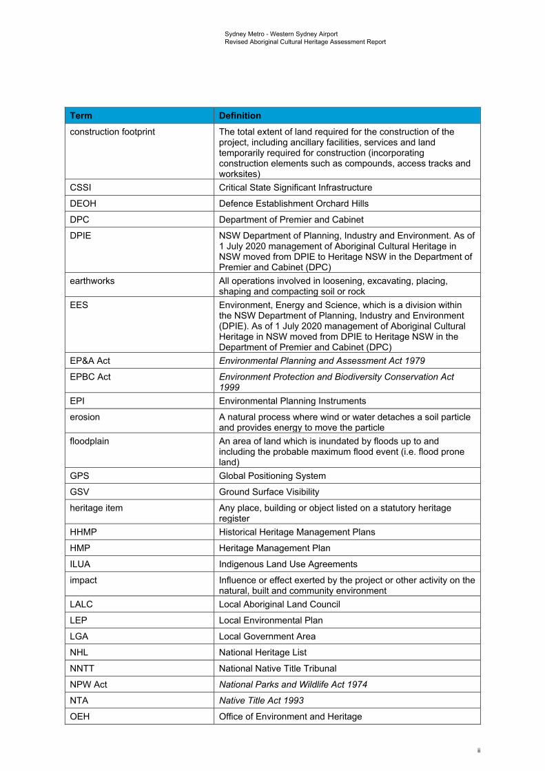
Glossary and terms and abbreviations Term Definition AAR Aboriginal Archaeological Report
Aboriginal archaeological sensitivity
Area retains potential for the presence of surface and/or subsurface Aboriginal archaeological deposits. Areas of Aboriginal archaeological sensitivity, when compared to areas of low potential, would be expected to have higher artefact counts, densities and assemblage richness values expected. Archaeological features such as knapping floors and hearths are also more likely to occur in these areas. The integrity of deposit(s) will be dependent on the nature of localised land disturbance activities and geomorphic phenomena.
Aboriginal cultural heritage The tangible (objects) and intangible (dreaming stories, song lines and places) cultural practices and traditions associated with past and present day Aboriginal communities
Aboriginal object Any deposit, object or material evidence (not being a handicraft made for sale), including Aboriginal remains, relating to the Aboriginal habitation of NSW
Aboriginal place Any place declared to be an Aboriginal place under Section 94 of the National Parks and Wildlife Act 1974 (NSW)
ACHAR Aboriginal Cultural Heritage Assessment Report
ACHMP Aboriginal Cultural Heritage Management Plan
AEPR Airports (Environment Protection) Regulations 1997
AHD Australian Height Datum
AHIMS Aboriginal Heritage Information Management System - a register of New South Wales (NSW) Aboriginal heritage information maintained by Environment, Energy and Science (EES), which is a group within the NSW Department of Planning, Industry and Environment
AHIP Aboriginal Heritage Impact Permit
ASIR Aboriginal Site Impact Recording
ATSIHP Act Aboriginal and Torres Strait Islander Heritage Protection Act 1984
BNI Blacktown Native Institution
BP Before Present is a term used by archaeologists and geologists referring to dates obtained by radiocarbon dating. The “present” in this case is not the present day, which is constantly changing and therefore is unable to be used as a consistent point from which to measure. Instead the year 1950 was chosen to be used as the “present” for this term
CBD Central Business District
CEMF Construction Environmental Management Framework
CEMP Construction Environmental Management Plan
CHL Commonwealth Heritage List
CMA Catchment Management Authorities
CMP Conservation Management Plan
i
Sydney Metro - Western Sydney Airport Revised Aboriginal Cultural Heritage Assessment Report
Term Definition construction footprint The total extent of land required for the construction of the
project, including ancillary facilities, services and land temporarily required for construction (incorporating construction elements such as compounds, access tracks and worksites)
CSSI Critical State Significant Infrastructure
DEOH Defence Establishment Orchard Hills
DPC Department of Premier and Cabinet
DPIE NSW Department of Planning, Industry and Environment. As of 1 July 2020 management of Aboriginal Cultural Heritage in NSW moved from DPIE to Heritage NSW in the Department of Premier and Cabinet (DPC)
earthworks All operations involved in loosening, excavating, placing, shaping and compacting soil or rock
EES Environment, Energy and Science, which is a division within the NSW Department of Planning, Industry and Environment (DPIE). As of 1 July 2020 management of Aboriginal Cultural Heritage in NSW moved from DPIE to Heritage NSW in the Department of Premier and Cabinet (DPC)
EP&A Act Environmental Planning and Assessment Act 1979
EPBC Act Environment Protection and Biodiversity Conservation Act 1999
EPI Environmental Planning Instruments
erosion A natural process where wind or water detaches a soil particle and provides energy to move the particle
floodplain An area of land which is inundated by floods up to and including the probable maximum flood event (i.e. flood prone land)
GPS Global Positioning System
GSV Ground Surface Visibility
heritage item Any place, building or object listed on a statutory heritage register
HHMP Historical Heritage Management Plans
HMP Heritage Management Plan
ILUA Indigenous Land Use Agreements
impact Influence or effect exerted by the project or other activity on the natural, built and community environment
LALC Local Aboriginal Land Council
LEP Local Environmental Plan
LGA Local Government Area
NHL National Heritage List
NNTT National Native Title Tribunal
NPW Act National Parks and Wildlife Act 1974
NTA Native Title Act 1993
OEH Office of Environment and Heritage
ii
Sydney Metro - Western Sydney Airport Revised Aboriginal Cultural Heritage Assessment Report
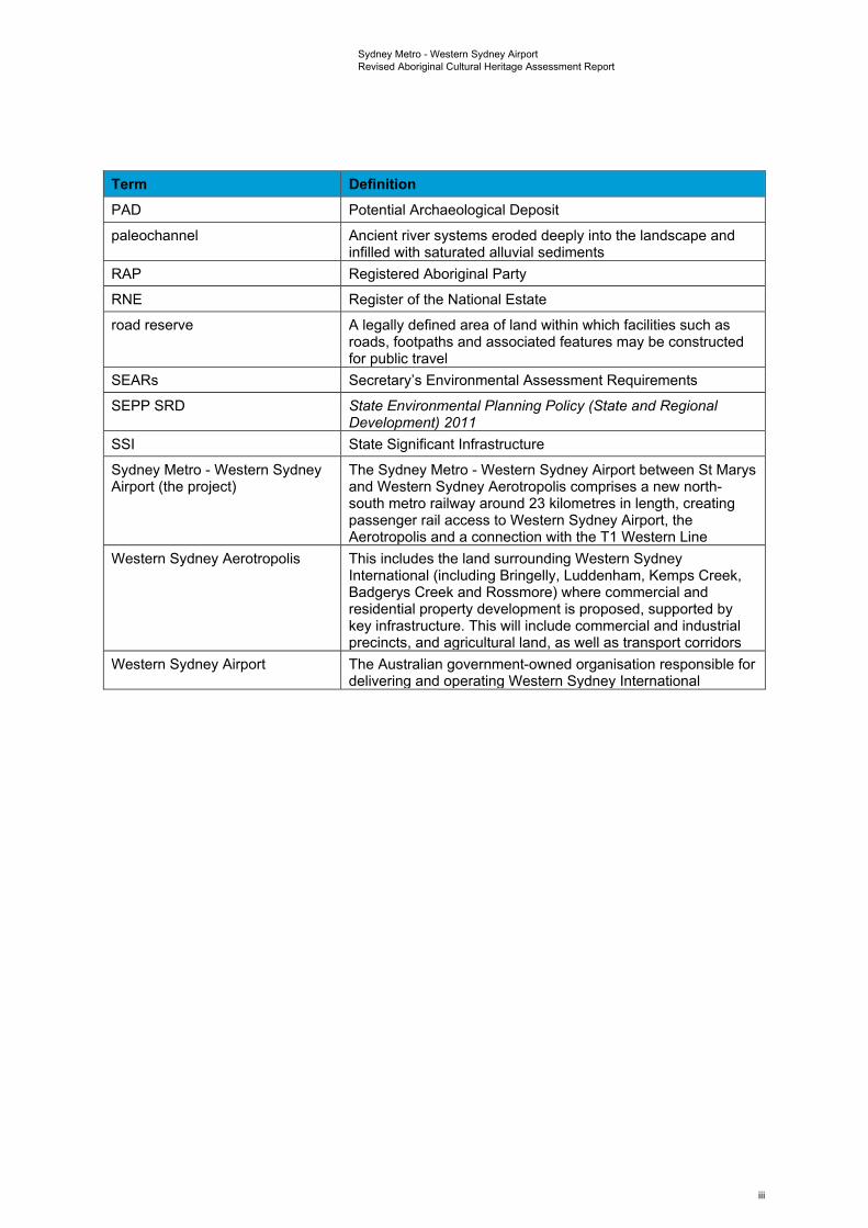
Term Definition PAD Potential Archaeological Deposit
paleochannel Ancient river systems eroded deeply into the landscape and infilled with saturated alluvial sediments
RAP Registered Aboriginal Party
RNE Register of the National Estate
road reserve A legally defined area of land within which facilities such as roads, footpaths and associated features may be constructed for public travel
SEARs Secretary’s Environmental Assessment Requirements
SEPP SRD State Environmental Planning Policy (State and Regional Development) 2011
SSI State Significant Infrastructure
Sydney Metro - Western Sydney Airport (the project)
The Sydney Metro - Western Sydney Airport between St Marys and Western Sydney Aerotropolis comprises a new north-south metro railway around 23 kilometres in length, creating passenger rail access to Western Sydney Airport, the Aerotropolis and a connection with the T1 Western Line
Western Sydney Aerotropolis This includes the land surrounding Western Sydney International (including Bringelly, Luddenham, Kemps Creek, Badgerys Creek and Rossmore) where commercial and residential property development is proposed, supported by key infrastructure. This will include commercial and industrial precincts, and agricultural land, as well as transport corridors
Western Sydney Airport The Australian government-owned organisation responsible for delivering and operating Western Sydney International
iii
Sydney Metro - Western Sydney Airport Revised Aboriginal Cultural Heritage Assessment Report
Executive Summary Project background The Greater Sydney Region Plan (Greater Sydney Commission, 2018a) sets the vision and strategy for Greater Sydney to become a global metropolis of three unique and connected cities; the Eastern Harbour City, the Central River City and the Western Parkland City. The Western Parkland City incorporates the future Western Sydney International (Nancy-Bird Walton) Airport (hereafter referred to as Western Sydney International) and Western Sydney Aerotropolis (hereafter referred to as the Aerotropolis).
Sydney Metro – Western Sydney Airport (the project) is identified in the Greater Sydney Region Plan as a key element to delivering an integrated transport system for the Western Parkland City. The project would be located within the Penrith and Liverpool Local Government Areas (LGAs) and would involve the construction and operation of a new metro railway line around 23 kilometres in length between the T1 Western Line at St Marys in the north and the Aerotropolis in the south (the area to be called Bradfield). This would include a section of the alignment which passes through and provides access to Western Sydney International.
The project is characterised into components that are located outside Western Sydney International (off-airport) and components that are located within Western Sydney International (on-airport), to align with differing planning approval pathways under State and Commonwealth legislation.
An Aboriginal cultural heritage assessment for the project is provided in this technical paper. The assessment was undertaken in accordance with relevant statutory guidelines including Heritage NSW’s Guide to Investigating, Assessing and Reporting on Aboriginal Cultural Heritage in NSW (OEH, 2011), Code of Practice for Archaeological Investigation of Aboriginal Objects in New South Wales (DECCW, 2010b) and Aboriginal Cultural Heritage Consultation Requirements for Proponents (DECCW, 2010a).
The study area for the project (Figure 1-2) was defined as a 58 kilometre by nine kilometre area, which was the subject of Aboriginal Heritage Information Management System (AHIMS) searches to gain sub-regional Aboriginal site distribution data. The primary focus in relation to assessing potential impacts to identified Aboriginal cultural heritage values as a result of the project was on the construction footprint within the study area; which covers the total extent of land required for the construction of the project, including ancillary facilities and services and land temporarily required for construction (elements such as compounds and access tracks). A buffer of 200 metres surrounding the construction footprint has also been considered in relation to impacts, as there is a regular 200 metre error for centroid coordinates in the AHIMS register due to legacy data issues with changing datum use over time. Areas proposed for power line routes and surface areas above subsurface tunnels were also considered with special consideration given to the risk of impacts from ground movement or vibration.
Consultation and archaeological investigation
Aboriginal community consultation was undertaken as per the requirements of Heritage NSW’s Aboriginal Cultural Heritage Consultation Requirements for Proponents (DECCW, 2010a). Following newspaper advertisements and letters requesting registration, a total of 68 Aboriginal individuals and organisations registered for consultation on this project. Consultation with these Registered Aboriginal Parties (RAPs) was undertaken via letter, email and phone. All RAPs were consulted regarding the social or cultural values of the study.
Searches of the AHIMS database for the study area resulted in the identification of a total of 360 Aboriginal sites, 328 of which were valid, 30 of which had been destroyed and two of which had been subject to further investigation and found to not have been of Aboriginal origin (reclassified as Not a Site). Of these, a total of 10 sites were found to have centroids registered within the bounds of the construction footprint (eight on-airport and two off-airport). Of the two located in the off-airport area, one was identified as having been destroyed (45-4-4420) under the conditions of Aboriginal Heritage Impact Permit (AHIP) C0000637 for upgrades to Kent Road and Gipps Street at Claremont Meadows, granted 5 November 2014. The other was a valid artefact scatter site 45-5-2640 located in the Aerotropolis Core construction footprint. A further two artefact scatter sites with associated PAD were
iv
Sydney Metro - Western Sydney Airport Revised Aboriginal Cultural Heritage Assessment Report
identified as having PAD curtilages that partially extended into the off-airport construction footprint (45-5-5298 and 45-5-5297).
Accessible sections of the construction footprint were initially surveyed over four non-consecutive days in February, March, April and June 2020 (Thursday 27 February, Wednesday 4 March, Tuesday 28 April 2020 and Friday 12 June 2020). At this stage of the project, access was only available for limited sections of the construction footprint, due to private property access and COVID-19 constraints. In all instances, survey was conducted by a combined field team of one archaeologist and a representative from the relevant Local Aboriginal Land Council (LALC) (i.e. Gandangara and Deerubbin LALCs).
Two new sites, consisting of one isolated artefact and one artefact scatter, were identified during these early investigation works. These were recorded as WSI-IA1-20 and WSI-AS1-20 respectively. Both sites were located within the bounds of Western Sydney International, but outside the bounds of the on-airport construction footprint. The location for previously recorded artefact scatter site 45-5-2640 was inspected but no surface expression of artefacts was identified, most likely due to high levels of vegetation obscuring the ground during the survey.
Further access was provided to some properties within the construction footprint between October 2020 and February 2021. During this time these areas were subject to survey, with test excavations also undertaken in several areas of Aboriginal archaeological sensitivity therein. Participants from various RAP groups were in attendance for the fieldwork, including representatives from A1 Indigenous Services, Arugung Aboriginal Cultural Heritage Site Assessments, Corroboree Aboriginal Corporation, Cubbitch Barta, Darug Custodian Aboriginal Corporation, Deerubbin Local Aboriginal Land Council, DNC, Gandangara Local Aboriginal Land Council, Gunyuu, Kamilaroi Yankuntjatjara Working Group, Murra Bidgee Mullangari Aboriginal Corporation, Tocomwall, Wailwan Aboriginal Group and Walbunja.
Three surface sites, consisting exclusively of artefact scatters, were identified as a result of additional survey works within the study area. They were designated as SMWSA-AS1, SMWSA-AS5 and SMWSA-AS6. Two of these sites (SMWSA-AS1 and SMWSA-AS5) are located wholly outside the construction footprint (although SMWSA-AS1 is in a surface area above proposed subsurface tunnels). Site SMWSA-AS6 is located wholly inside of the construction footprint, in the off-airport construction corridor (southern).
Areas of subsurface Aboriginal archaeological potential within the construction footprint were determined based on the presence of surface sites, consultation with RAPs and identification of sensitive landforms (including areas of low disturbance in close proximity to water sources). Excluding severely disturbed examples, landform elements adjacent to Blaxland Creek, Cosgroves Creek and Badgerys Creek as well as several of their tributaries, were assessed as retaining potential for the presence of subsurface Aboriginal archaeological deposits.
Due to generally low levels of visibility across identified areas of sensitivity within the construction boundary, systematic test excavations were undertaken in these areas. Test pits measuring 50 centimetres by 50 centimetres were excavated, across each area, with test pits spaced at 50 metre intervals. Between October 2020 and February 2021 a total of 196 test pits were excavated across identified areas of Aboriginal archaeological sensitivity. Of these, 22 test pits (11.2 per cent) were found to contain Aboriginal objects, with densities ranging from one to five objects per 0.25 metres squared. Collectively, a total of 42 lithic items were identified which satisfied the technical criteria for identification as artefacts.
Feedback from the RAP representatives during the fieldwork indicated that the waterways that traverse the construction footprint, and the project alignment more broadly, have cultural significance as pathways and focal resource areas for Aboriginal people in the past. Known sites are culturally significant on the grounds that they are a tangible link to ancestors and a physical presence in the landscape denoting the long-term Aboriginal use and occupation of this area. These values may be preserved in a number of ways, through the avoidance and protection of sites as the primary response, or through mitigation measures such as surface collection and salvage where impacts cannot be avoided, with site specific mitigation measures to be developed with RAPs.
v
Sydney Metro - Western Sydney Airport Revised Aboriginal Cultural Heritage Assessment Report
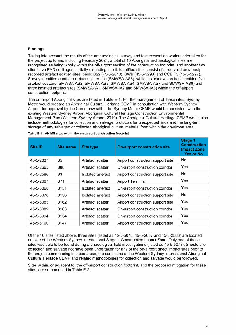
Findings Taking into account the results of the archaeological survey and test excavation works undertaken for the project up to and including February 2021, a total of 10 Aboriginal archaeological sites are recognised as being wholly within the off-airport section of the construction footprint, and another two sites have PAD curtilages partially extending into it. Identified sites consist of three valid previously recorded artefact scatter sites, being B22 (45-5-2640), BWB (45-5-5298) and CCE T3 (45-5-5297). Survey identified another artefact scatter site (SMWSA-AS6), while test excavation has identified five artefact scatters (SMWSA-AS2, SMWSA-AS3, SMWSA-AS4, SMWSA-AS7 and SMWSA-AS8) and three isolated artefact sites (SMWSA-IA1, SMWSA-IA2 and SMWSA-IA3) within the off-airport construction footprint.
The on-airport Aboriginal sites are listed in Table E-1. For the management of these sites, Sydney Metro would prepare an Aboriginal Cultural Heritage CEMP in consultation with Western Sydney Airport, for approval by the Commonwealth. The Sydney Metro CEMP would be consistent with the existing Western Sydney Airport Aboriginal Cultural Heritage Construction Environmental Management Plan (Western Sydney Airport, 2019). The Aboriginal Cultural Heritage CEMP would also include methodologies for collection and salvage, protocols for unexpected finds and the long-term storage of any salvaged or collected Aboriginal cultural material from within the on-airport area. Table E-1 AHIMS sites within the on-airport construction footprint
Site ID Site name Site type On-airport construction site Stage 1 Construction Impact Zone – Yes or No
45-5-2637 B5 Artefact scatter Airport construction support site No
45-5-2665 B88 Artefact scatter On-airport construction corridor Yes
45-5-2586 B3 Isolated artefact Airport construction support site No
45-5-2687 B71 Artefact scatter Airport Terminal Yes
45-5-5068 B131 Isolated artefact On-airport construction corridor Yes
45-5-5078 B136 Isolated artefact Airport construction support site No
45-5-5085 B162 Artefact scatter Airport construction support site Yes
45-5-5089 B163 Artefact scatter On-airport construction corridor Yes
45-5-5094 B154 Artefact scatter On-airport construction corridor Yes
45-5-5100 B147 Artefact scatter Airport construction support site Yes
Of the 10 sites listed above, three sites (listed as 45-5-5078, 45-5-2637 and 45-5-2586) are located outside of the Western Sydney International Stage 1 Construction Impact Zone. Only one of these sites was able to be found during archaeological field investigations (listed as 45-5-5078). Should site collection and salvage not have been undertaken for any of the on-airport direct impact sites prior to the project commencing in those areas, the conditions of the Western Sydney International Aboriginal Cultural Heritage CEMP and related methodologies for collection and salvage would be followed.
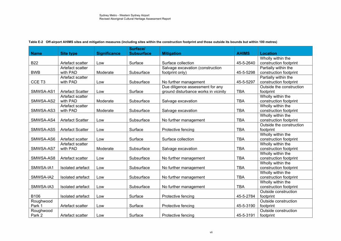
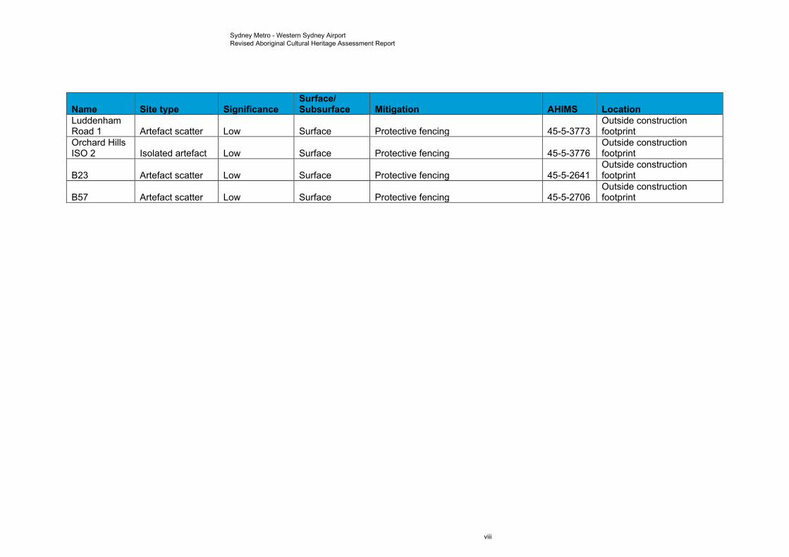
Sites within, or adjacent to, the off-airport construction footprint, and the proposed mitigation for these sites, are summarised in Table E-2.
vi
Sydney Metro - Western Sydney Airport Revised Aboriginal Cultural Heritage Assessment Report
Table E-2 Off-airport AHIMS sites and mitigation measures (including sites within the construction footprint and those outside its bounds but within 100 metres)
Name Site type Significance Surface/Subsurface Mitigation AHIMS Location
B22 Artefact scatter Low Surface Surface collection 45-5-2640 Wholly within the construction footprint
BWB Artefact scatter with PAD Moderate Subsurface
Salvage excavation (construction footprint only) 45-5-5298
Partially within the construction footprint
CCE T3 Artefact scatter with PAD Low Subsurface No further management 45-5-5297
Partially within the construction footprint
SMWSA-AS1 Artefact Scatter Low Surface Due diligence assessment for any ground disturbance works in vicinity TBA
Outside the construction footprint
SMWSA-AS2 Artefact scatter with PAD Moderate Subsurface Salvage excavation TBA
Wholly within the construction footprint
SMWSA-AS3 Artefact scatter with PAD Moderate Subsurface Salvage excavation TBA
Wholly within the construction footprint
SMWSA-AS4 Artefact Scatter Low Subsurface No further management TBA Wholly within the construction footprint
SMWSA-AS5 Artefact Scatter Low Surface Protective fencing TBA Outside the construction footprint
SMWSA-AS6 Artefact scatter Low Surface Surface collection TBA Wholly within the construction footprint
SMWSA-AS7 Artefact scatter with PAD Moderate Subsurface Salvage excavation TBA
Wholly within the construction footprint
SMWSA-AS8 Artefact scatter Low Subsurface No further management TBA Wholly within the construction footprint
SMWSA-IA1 Isolated artefact Low Subsurface No further management TBA Wholly within the construction footprint
SMWSA-IA2 Isolated artefact Low Subsurface No further management TBA Wholly within the construction footprint
SMWSA-IA3 Isolated artefact Low Subsurface No further management TBA Wholly within the construction footprint
B106 Isolated artefact Low Surface Protective fencing 45-5-2784 Outside construction footprint
Roughwood Park 1 Artefact scatter Low Surface Protective fencing 45-5-3190
Outside construction footprint
Roughwood Park 2 Artefact scatter Low Surface Protective fencing 45-5-3191
Outside construction footprint
vii
Sydney Metro - Western Sydney Airport Revised Aboriginal Cultural Heritage Assessment Report
Name Site type Significance Surface/Subsurface Mitigation AHIMS Location
Luddenham Road 1 Artefact scatter Low Surface Protective fencing 45-5-3773
Outside construction footprint
Orchard Hills ISO 2 Isolated artefact Low Surface Protective fencing 45-5-3776
Outside construction footprint
B23 Artefact scatter Low Surface Protective fencing 45-5-2641 Outside construction footprint
B57 Artefact scatter Low Surface Protective fencing 45-5-2706 Outside construction footprint
viii
Sydney Metro - Western Sydney Airport Revised Aboriginal Cultural Heritage Assessment Report
Conclusions and recommendations Proposed ground disturbance activities within the off-airport construction footprint are anticipated to impact all of the 12 Aboriginal archaeological sites identified within it, with a total loss of value for the 10 sites wholly within the construction corridor, and partial impacts to those two with PAD curtilages partially extending into it. There are also further areas of subsurface Aboriginal archaeological sensitivity that have not yet been subject to survey or test excavation due to landholder access limitations on the project to date.
Where it is not possible to avoid impacts to archaeological and cultural sites or features, mitigation measures have been developed for the project in consultation with RAPs (refer to Chapter 10). Further, for the off-airport section of the construction footprint an Aboriginal Cultural Heritage Management Plan (ACHMP) has been prepared. The ACHMP also includes methodologies for further investigations, collection and salvage, protocols for unexpected finds and the long-term storage of any salvaged or collected Aboriginal cultural material.
ix
Sydney Metro - Western Sydney Airport Revised Aboriginal Cultural Heritage Assessment Report
1. Introduction
1.1 Project context and overview The Greater Sydney Region Plan (Greater Sydney Commission, 2018a) sets the vision and strategy for Greater Sydney to become a global metropolis of three unique and connected cities; the Eastern Harbour City, the Central River City and the Western Parkland City. The Western Parkland City incorporates the future Western Sydney International (Nancy-Bird Walton) Airport (hereafter referred to as Western Sydney International) and Western Sydney Aerotropolis (hereafter referred to as the Aerotropolis).
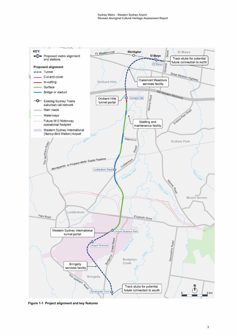
Sydney Metro – Western Sydney Airport (the project) (see Figure 1-1) is identified in the Greater Sydney Region Plan as a key element to delivering an integrated transport system for the Western Parkland City. The project would be located within the Penrith and Liverpool Local Government Areas (LGAs) and would involve the construction and operation of a new metro railway line around 23 kilometres in length between the T1 Western Line at St Marys in the north and the Aerotropolis in the south (the area to be called Bradfield). This would include a section of the alignment which passes through and provides access to Western Sydney International.
The project is characterised into components that are located outside Western Sydney International (off-airport) and components that are located within Western Sydney International (on-airport), to align with their different planning approval pathways required under State and Commonwealth legislation.
1.2 Key project features Key operational features of the project are shown on Figure 1-1 and would include:
• around 4.3 kilometres of twin rail tunnels (generally located side by side) between St Marys (the northern extent of the project) and Orchard Hills
• a cut-and-cover tunnel around 350 metres long (including tunnel portal), transitioning to an in-cutting rail alignment south of the M4 Western Motorway at Orchard Hills
• around 10 kilometres of rail alignment between Orchard Hills and Western Sydney International, consisting of a combination of viaduct and surface rail alignment
• around two kilometres of surface rail alignment within Western Sydney International
• around 3.3 kilometres of twin rail tunnels (including tunnel portal) within Western Sydney International
• around three kilometres of twin rail tunnels between Western Sydney International and the Aerotropolis Core (the area to be called Bradfield)
• six new metro stations:
- four off-airport stations:
St Marys (providing interchange with the T1 Western Line)
Orchard Hills
Luddenham Road
Aerotropolis Core
- two on-airport stations:
Airport Business Park
Airport Terminal
• grade separation of the track alignment at key locations including:
- where the alignment interfaces with existing infrastructure such as the Great Western Highway, M4 Western Motorway, Lansdowne Road, Patons Lane, the Warragamba to
1
Sydney Metro - Western Sydney Airport Revised Aboriginal Cultural Heritage Assessment Report
Prospect Water Supply Pipelines, Luddenham Road, the future M12 Motorway, Elizabeth Drive, Derwent Road and Badgerys Creek Road
- crossings of Blaxland Creek, Cosgroves Creek, Badgerys Creek and other small waterways to provide flood immunity for the project
• modifications to the existing Sydney Trains station and suburban rail network at St Marys (where required) to support interchange and customer transfer between the new metro station and the T1 Western Line
• a stabling and maintenance facility and operational control centre located to the south of Blaxland Creek and east of the proposed metro track
• new pedestrian, cycle, park-and-ride and kiss-and-ride facilities, public transport interchange infrastructure, road infrastructure and landscaping as part of the station precincts.
The project would also include:
• turnback track arrangements (turnbacks) at St Marys and Aerotropolis Core to allow trains to turn back and run in the opposite direction
• additional track stubs to the east of St Marys Station and south of the Aerotropolis Core Station to allow for potential future extension of the line to the north and south respectively without impacting future metro operations
• an integrated tunnel ventilation system including services facilities at Claremont Meadows and at Bringelly
• all operational systems and infrastructure such as crossovers, rail sidings, signalling, communications, overhead wiring, power supply, lighting, fencing, security and access tracks/paths
• retaining walls at required locations along the alignment
• environmental protection measures such as noise barriers (if required), on-site water detention, water quality treatment basins and other drainage works.
1.2.1 Off-airport project components The off-airport components of the project would include the track alignment and associated operational systems and infrastructure north and south of Western Sydney International, four metro stations, the stabling and maintenance facility, two service facilities and a tunnel portal.
The key project features and the design development process are described in more detail in Appendix B of the Submissions Report.
1.2.2 On-airport project components The on-airport components of the project would include the track alignment and associated operational systems and infrastructure within Western Sydney International, two metro stations and a tunnel portal.
2
• @ • Proposed metro alignment and stations
Proposed alignment
Tunnel
Cut.and-cover
ln--cutting
Surface
Bridge or viaduct
~ Existing Sydney Trains suburban rail network
Main roads
-- Waterways
Future M12 Motorway operatiol\8I footprint
Western Sydney International (Nancy-Bird Walton) Airport
11 wost.em Line
Orchard Hills
Orchard Hills tunnel portal
Western Sydney International tunnel portal 1--,-,..,.,~
'----------~ .... " ,@" &
( ,' (Airport Tennioai'J i I <)
.. :~.:::.· \\,/ .,,, , ,, ·u, Bringetly ,. ,. ..
.,,, 1l \
'\, ? , \ 1 Aero1to11* ecre l ~
Wcrrlngton l1 St Marys Ii r----,----,---,--, St Mary, .,
~ Track stubs for potential .. --,, /
,.,.....,_-I future connection to north IS<M..,..I ~ , , I I I I I I I I I
Claremont MeadO\vs services facility
G> l0rct1am H111r.l 1 J
Stabling and maintenance facility
Badgerys Creek
Track stubs for potential future connection to south
--.._
----✓ Erskine Park
f Mount Vernon
J .:
I 0
t-- -Ill
(!) o11w-== --r:::::;awlli2km
Sydney Metro - Western Sydney Airport Revised Aboriginal Cultural Heritage Assessment Report
Figure 1-1 Project alignment and key features
3
Sydney Metro - Western Sydney Airport Revised Aboriginal Cultural Heritage Assessment Report
1.3 Project construction Construction of the project would involve:
• enabling works
• main construction works, including:
- tunnelling and associated works
- corridor and associated works
- stations and associated works
- ancillary facilities and associated works
- construction of ancillary infrastructure including the stabling and maintenance facility
• rail systems fitout
• finishing works and testing and commissioning.
These activities are described in more detail in Appendix B of the Submissions Report.
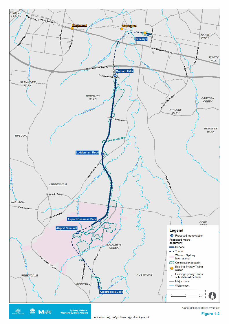
The construction footprint for the project is shown on Figure 1-2.
Main construction works for the project are expected to commence in 2021, subject to planning approval, and take around five years to complete. An overview of the construction program is provided in Appendix B of the Submissions Report.
4
Sydney Metro - Western Sydney Airport Revised Aboriginal Cultural Heritage Assessment Report
1.4 Purpose of this technical paper 1.4.1 Assessment objectives The purpose of this assessment is to identify known and potential Aboriginal heritage constraints within the study area and provide appropriate management advice. The overarching objectives of this Aboriginal Cultural Heritage Assessment Report (ACHAR) are as follows:
• to identify the Aboriginal cultural heritage values of the construction footprint by way of background research, archaeological field investigation and consultation with RAPs regarding both archaeological and cultural heritage values
• to assess the potential impact of the project on the identified Aboriginal cultural heritage values
to provide an appropriate management strategy to avoid or minimise potential harm to any identified Aboriginal cultural heritage values
• compile an ACHAR that will assist DPIE in its assessment of the project.
1.4.2 Secretary’s environmental assessment requirements The Secretary’s Environmental Assessment Requirements (SEARs) issued by the Department of Planning, Industry and Environment (DPIE) relating to Aboriginal heritage and where these requirements are addressed in this technical paper, are outlined respectively in Table 1-1. As of 1 July 2020 management of Aboriginal Cultural Heritage in NSW moved from DPIE to Heritage NSW in the Department of Premier and Cabinet (DPC).
The purpose of the SEARs in relation to Aboriginal heritage is to provide specific requirements by which the design, construction and operation of the project avoids or minimises impacts, to the greatest extent possible, on the cultural and environmental heritage and Aboriginal objects and places. It also provides recommendations so that, to the greatest extent possible, the long-term protection, conservation and management of the heritage significance of items of environmental heritage and Aboriginal objects and places is achieved. Table 1-1 Secretary’s Environmental Assessment Requirements
SEARs requirement Where addressed in this report
Identify direct and/or indirect impacts (including cumulative impacts) to the heritage significance of:
(a) Aboriginal places, objects and cultural heritage values, as defined under the National Parks and Wildlife Act 1974 and in accordance with the principles and methods of assessment identified in the current guidelines;
(b) environmental heritage, as defined under the Heritage Act 1977; and
(c) items listed on the State, National and World Heritage lists; (d) heritage items and conservation areas identified in
environmental planning instruments applicable to the project area;
(e) heritage items in Section 170 Heritage and Conservation Register;
(f) potential heritage items and archaeological potential.
Where impacts to State or locally significant heritage items orhistorical archaeology are identified, the assessment must include:
(g) relevant commitments made in Section 8.5.3 of the Scoping Report;
(h) consistency of the project against conservation policies of any relevant conservation management plan;
(i) identification of archaeological potential and significance; and
This technical paper provides details on known Aboriginal sites and areas of archaeological sensitivity to be avoided and/or mitigated. Findings of known sites are summarised in Section 5.4 and mitigation provided in Chapter 10. It also provides details on the ongoing consultation undertaken with RAPs and knowledge holders in Chapter 4.
Historic heritage has been assessed in Technical paper 4 of the Environmental Impact
6
Sydney Metro - Western Sydney Airport Revised Aboriginal Cultural Heritage Assessment Report
SEARs requirement Where addressed in this report
(j) be undertaken by a suitably qualified heritage consultant(s) and/or historical archaeologist (note: where archaeological excavations are proposed the relevant consultant must meet the NSW Heritage Council’s Excavation Director criteria);
(k) consideration of alternatives and options to avoid or minimise heritage impacts. The assessment must contain sufficient detail to enable an understanding of why the preferred alternative to and option(s) are recommended.
Where impacts to Aboriginal places, objects and cultural heritage values are identified, the assessment must include the preparation of
Statement – Non-Aboriginal heritage
This report is the required ACHAR.
an Aboriginal Cultural Heritage Assessment Report (ACHAR) and relevant commitments in Section 8.6.3 of the Scoping Report.
Where archaeological investigations of Aboriginal objects are proposed these must be conducted by a suitably qualified archaeologist, in accordance with section 1.6 of the Code of Practice for Archaeological Investigation of Aboriginal Objects in NSW (DECCW 2010).
Where impacts to Aboriginal objects and/or places are proposed, consultation must be undertaken with Aboriginal people in accordance with the current guidelines.
Archaeological investigations were led by suitably qualified archaeologist Dr Darran Jordan, in accordance with the Code of Practice (see Section 1.6).
Consultation is documented in Chapter 4.
The Commonwealth Minister for the Environment has advised that the on-airport components of the project will be assessed based on the provision of preliminary documentation. Further information was requested to guide the assessment of the on-airport components of the project.
1.4.3 Assessment guidelines This assessment has been undertaken in accordance with and with reference to the following current Heritage NSW guideline documents:
• Guide to Investigating, Assessing and Reporting on Aboriginal Cultural Heritage in NSW (OEH, 2011)
• Aboriginal Cultural Heritage Consultation Requirements for Proponents (DECCW, 2010a)
• Code of Practice for Archaeological Investigation of Aboriginal Objects in New South Wales (DECCW, 2010b)
• NSW Skeletal Remains: Guidelines for Management of Human Remains (Heritage Office, 1998)
• Aboriginal site recording form
• Aboriginal site impact recording form
• Aboriginal Heritage Information Management System site registration form
• Care agreement application form
• Designing with Country (Government Architect New South Wales, 2020b).
1.4.4 Structure of report This report is structured under the following headings:
1 Introduction – provides an overview and background context on the project
2 Legislative and policy context – lists the heritage specific legislation that is of relevance to the assessment
3 Methodology – discusses the methodology adopted for this heritage assessment
4 Aboriginal community consultation – outlines the consultation undertaken to date with RAPs
7
Sydney Metro - Western Sydney Airport Revised Aboriginal Cultural Heritage Assessment Report
5 Existing environment – provides a summary of the environment of the project based on background research
6 Archaeological field investigations – presents the findings of the limited targeted archaeological surveys undertaken to date
7 Cultural heritage values and statement of significance – outlines the identified values and heritage significance of sites identified within the study area
8 Assessment of impacts – lists the areas of archaeological potential, and the potential impacts of the project on Aboriginal heritage
9 Cumulative impact assessment – outlines the cumulative impacts of the project with other projects on Aboriginal heritage
10 Management and mitigation measures – provides an overview of the management and mitigation approach for the project, outlines the performance outcomes for the project, and provides measures to manage existing sites and areas of potential, as well as mitigation measures for when site destruction cannot be avoided
11 References – provides a full list of the references used to inform this technical paper.
1.5 Study area and construction footprint The size of the study area was defined by the AHIMS searches undertaken for this assessment. The three combined searches covered an approximate area of 58 kilometres by nine kilometres, centred on the construction footprint. References to the study area refer to this area covered by the AHIMS searches, which includes the construction footprint as well as the permanent power supply alignment that is proposed between the southern end of the stabling and maintenance facility construction area and an existing Endeavour Energy substation at Erskine Park (the Mamre Zone Substation) and the temporary power supply alignments that are proposed from Claremont Meadows and Kemps Creek.
While the primary impacts of this project would be direct impacts to known sites and areas of archaeological sensitivity within the bounds of the construction footprint, the larger study area provides context for those sites and areas in the surrounding region. It also allows for considerations of the project within a broader landscape. The risk for accidental and indirect impacts to sites outside the bounds of, but in close proximity to, the construction footprint have been considered as part of this assessment for sites within 200 metres of the construction footprint. The reason for a 200 metre buffer is that the most common form of coordinate inaccuracy in the AHIMS register is due to the incorrect datum being applied to a site coordinate, which results in a variance of approximately 200 metres. Including a buffer of this size will capture any sites with such coordinate errors, as well as sites whose registered centroids are outside the construction footprint, but are large enough to extend across the boundary. The potential for indirect impacts to occur, such as visual and related to vibration/settlement, have also been considered. The primary risk with regard to indirect impacts is that any subsidence in areas above tunnelling activity could impact upon either known sites or areas of archaeological sensitivity.
The construction footprint is defined by the boundary shown on Figure 1-2.
The construction footprint crosses through multiple land holdings within the Penrith and Liverpool Local Government Areas (LGAs), including existing road reserves and various parcels of private land. It also passes through three areas of Commonwealth land, being Defence Establishment Orchard Hills (DEOH), the Royal Australian Air Force Telecommunications Unit at Bringelly and Western Sydney International.
For ease of reference in this assessment, the off-airport area has been divided up into the following construction areas:
• St Marys
• Claremont Meadows services facility
• Orchard Hills
• Stabling and maintenance facility
8
Sydney Metro - Western Sydney Airport Revised Aboriginal Cultural Heritage Assessment Report
• Off-airport construction corridor
• Luddenham Road
• Bringelly services facility
• Aerotropolis Core.
For ease of reference in this assessment, the on-airport area has been divided up into the following construction areas:
On-airport (within the Stage 1 construction impact zone)
• On-airport construction corridor
• Airport Business Park
• Western Sydney International tunnel portal
• Airport terminal
• Airport construction support site
On-airport (outside the Stage 1 construction impact zone)
• Airport construction support site.
1.6 Project team The primary author of this report is Dr Darran Jordan (Principal Archaeologist), who has a PhD in archaeology from the University of Sydney and has been working as a heritage specialist for over 15 years. Report inputs and fieldwork activity were also undertaken by Dr Andrew McLaren (Principal Aboriginal Heritage Specialist), who has a doctorate in archaeology from Cambridge University and has been working as a heritage specialist for over 12 years, and Julia Atkinson (Professional Archaeologist) who has a degree in Museum Studies from Macquarie University and has worked as a heritage specialist for over two years. The report was subject to a technical review by Dr Andrew McLaren.
9
Sydney Metro - Western Sydney Airport Revised Aboriginal Cultural Heritage Assessment Report
2. Legislative and policy context This section describes the legislative and policy context specific to this assessment.
2.1 Off-airport legislative and policy context 2.1.1 Commonwealth legislation and policy Environment Protection and Biodiversity Conservation Act 1999 The Commonwealth Environment Protection and Biodiversity Conservation Act 1999 (EPBC Act) took effect on 16 July 2000. Under Part 9 of the EPBC Act, any action that is likely to have a significant impact on a matter of national environmental significance may only progress with approval of the Commonwealth Minister for the Environment. An action is defined as a project, development, undertaking, activity, series of activities, or alteration. An action will also require approval if:
• it is undertaken on Commonwealth land and will have or is likely to have a significant impact
• it is undertaken outside Commonwealth land and will have or is likely to have a significant impact on the environment on Commonwealth land
• it is undertaken by the Commonwealth and will have or is likely to have a significant impact.
The EPBC Act defines ‘environment’ as incorporating both natural and cultural environments and therefore includes Aboriginal heritage items. Under the EPBC Act, protected heritage items are listed on the National Heritage List (NHL) (items of significance to the nation) or the Commonwealth Heritage List (CHL) (items belonging to the Commonwealth or its agencies). These two lists replaced the Register of the National Estate (RNE). Statutory references to the RNE in the EPBC Act were removed on 19 February 2012. However, the RNE remains an archive of over 13,000 heritage places throughout Australia.
The EPBC Act requires that listed items on the CHL be managed by a specific Heritage Management Plan (HMP). Parts of the off-airport construction footprint cross through Commonwealth land, including DEOH, and the Royal Australian Air Force Telecommunications Unit, Bringelly. DEOH is managed through the Defence Establishment Orchard Hills Heritage Management Plan (HMP) (GML Heritage Pty Ltd, 2013). The Royal Australian Air Force Telecommunications Unit, Bringelly is managed by a Conservation Management Plan (CMP) (Godden Mackay Logan Pty Ltd, 1995).
On 14 July 2020 it was decided that the proposed action is a controlled action and the project will require assessment and approval under the EPBC Act before it can proceed. This decision was made under section 75 and section 87 of the EPBC Act.
Searches of the National Heritage List, Commonwealth Heritage List and RNE were undertaken in April 2019 and March 2020. These searches did not identify any listings relevant to the off-airport construction footprint.
Aboriginal community consultation for the project has been undertaken in accordance with Heritage NSW’s Consultation Requirements, which require a process of consultation broadly consistent with that suggested by the relevant EPBC Act guidelines.
Orchard Hills Defence Area, NSW: Heritage Management Plan A portion of the construction footprint falls within the bounds of DEOH, being Commonwealth land. The Defence Establishment Orchard Hills HMP (GML Heritage Pty Ltd, 2013) sets out procedures to follow to ensure that ongoing operational, maintenance and development activities at DEOH proceed in compliance with the EPBC Act, with a responsibility to conserve and manage the identified Commonwealth heritage values of the site. The HMP:
“identifies and assesses the natural, Indigenous and historic Commonwealth Heritage values of the place as a whole;
“updates previous heritage management plans for DEOH, by including results of a new survey of Indigenous heritage and natural heritage values, a revision of previously identified historic heritage values, including historical archaeology;
10
Sydney Metro - Western Sydney Airport Revised Aboriginal Cultural Heritage Assessment Report
“provides a revised Summary Statement of Significance for the DEOH that incorporates natural, Indigenous and historic heritage values;
“identifies the attributes and components of DEOH that are intrinsic to its Commonwealth Heritage values;
“provides a ranking of heritage significance and assesses the heritage sites in regard to their sensitivity or ‘tolerance for change’ to help guide future management of the DEOH;
“provides an assessment of the constraints, risks and opportunities arising from the heritage values;
“explains the heritage management objectives and guidelines for the conservation and monitoring of the Commonwealth Heritage values at DEOH; and
“provides an Interpretation Strategy to support the transmittal of the Commonwealth Heritage values of DEOH” (GML Heritage Pty Ltd, 2013).
The DEOH is subject to the provisions of the EPBC Act, which require that places with Commonwealth Heritage values be managed according to the policies of a management plan prepared specifically for that place. These requirements are set out in Schedule 7A of the Environment Protection and Biodiversity Conservation Regulations 2000 (EPBC Regulations) and are met by the HMP.
Conservation Management Plan for Bringelly Radio Receiving Station Complex, TelstraCorporation, Mobile Satellite and Radio Services, Badgerys Creek Road, Bringelly NSW A portion of the construction footprint falls within the bounds of the former Royal Australian Air Force Telecommunications Unit at Bringelly, being Commonwealth land. The Royal Australian Air Force Telecommunications Unit at Bringelly is managed by a CMP authored by GML in 1995. The CMP covers management of historical values associated with the post-WWII Bringelly Radio Receiving Station Complex and associated staff housing and water tank structures (Godden Mackay Logan Pty Ltd, 1995). These are discussed in detail in Technical paper 4 – Non-Aboriginal heritage, which notes that the water tank and receiving station were both demolished in 2008, the staff housing was demolished between 1996 and 2002, with the semi-circular driveway that the staff housing was concentrated around still present with remnant drainage culverts.
Aboriginal heritage is not specifically covered by this CMP, which focusses on the historical heritage components of the complex.
As it is on Commonwealth land, the former Royal Australian Air Force Telecommunications Unit at Bringelly is subject to the provisions of the EPBC Act, which requires that places with Commonwealth Heritage values be managed by the policies of a management plan prepared specifically for that place. These requirements are set out in Schedule 7A of the EPBC Regulations and are met by the CMP. Aboriginal community consultation for the project has been undertaken in accordance with Heritage NSW’s Consultation Requirements, which require a process of consultation broadly consistent with that suggested by relevant EPBC Act guidelines Ask First (Australian Heritage Commission, 2002) and Engage Early (Australian Government (Department of the Environment), 2016). Both been referred to and utilised during consultation for this assessment. The consultation process undertaken to date is summarised in Chapter 4.
Aboriginal and Torres Strait Islander Heritage Protection Act 1984 The Aboriginal and Torres Strait Islander Heritage Protection Act 1984 (the ATSIHP Act) provides for the preservation and protection of places, areas and objects of particular significance to Aboriginal Australians. The stated purpose of the ATSIHP Act is the “preservation and protection from injury or desecration of areas and objects in Australia and in Australian waters, being areas and objects that are of particular significance to Aboriginals in accordance with Aboriginal tradition” (Part I, Section 4).
Under the Act, ‘Aboriginal tradition’ is defined as “the body of traditions, observances, customs and beliefs of Aboriginals generally or of a particular community or group of Aboriginals, and includes any such traditions, observances, customs or beliefs relating to particular persons, areas, objects or relationships” (Part I, Section 3). A ‘significant Aboriginal area’ is an area of land or water in Australia that is of “particular significance to Aboriginals in accordance with Aboriginal tradition” (Part I,
11
Sydney Metro - Western Sydney Airport Revised Aboriginal Cultural Heritage Assessment Report
Section 3). A ‘significant Aboriginal object’, on the other hand, refers to an object (including Aboriginal remains) of like significance.
For the purposes of the ATSIHP Act, an area or object is considered to have been injured or desecrated if:
a. in the case of an area:
i. it is used or treated in a manner inconsistent with Aboriginal tradition
ii. the use or significance of the area in accordance with Aboriginal tradition is adversely affected
iii. passage through, or over, or entry upon, the area by any person occurs in a manner inconsistent with Aboriginal tradition
b. in the case of an object:
i. it is used or treated in a manner inconsistent with Aboriginal tradition.
The ATSIHP Act can override State and Territory laws in situations where a State or Territory has approved an activity, but the Commonwealth Minister prevents the activity from occurring by making a declaration to protect an area or object. However, the Minister can only make a decision after receiving a legally valid application under the ATSIHP Act and, in the case of long-term protection, after considering a report on the matter. Before making a declaration to protect an area or object in a State or Territory, the Commonwealth Minister must consult the appropriate minister of that State or Territory (Part 2, Section 13).
No declarations relevant to the study area have been made under the ATSIHP Act.
Native Title Act 1993 The Native Title Act 1993 (NTA) provides for the recognition and protection of native title for Aboriginal peoples and Torres Strait Islanders. The NTA recognises native title for land over which native title has not been extinguished and where persons able to establish native title are able to prove continuous use, occupation or other classes of behaviour and actions consistent with a traditional cultural possession of those lands. It also makes provision for Indigenous Land Use Agreements (ILUA) to be formed as well as a framework for notification of Native Title Stakeholders for certain future acts on land where Native Title has not been extinguished.
Searches of the National Native Title Register, Register of Native Title Claims and Register of Indigenous Land Use Agreements were undertaken in May 2020 for the Penrith and Liverpool LGAs. These searches returned no relevant native title claims, determinations or land use agreements.
2.1.2 State legislation and policy Environmental Planning and Assessment Act 1979 Division 5.2, Section 5.12 of the Environmental Planning and Assessment Act 1979 (EP&A Act) stipulates that a development may be declared State Significant Infrastructure (SSI) if it is declared to be such by a State environmental planning policy such as State Environmental Planning Policy (State and Regional Development) 2011 (SEPP SRD).
Under Clause 14(1) of SEPP SRD, a development is declared to be State Significant Infrastructure if:
a. the development on the land concerned is, by the operation of a State environmental planning policy, permissible without development consent under Part 4 of the Act
b. the development is specified in Schedule 3 of the SEPP SRD.
Pursuant to Division 5.2, Subdivision 4, Section 5.23(1)(d) of the EP&A Act, AHIPs are not required for a SSI authorised by a development consent.
Impacts to Aboriginal heritage values associated with approved SSI projects are typically managed under ACHMPs. ACHMPs are statutorily binding once approved.
12
Sydney Metro - Western Sydney Airport Revised Aboriginal Cultural Heritage Assessment Report
National Parks and Wildlife Act 1974 The National Parks and Wildlife Act 1974 (NPW Act), administered by Heritage NSW, is the primary legislation for the protection of Aboriginal cultural heritage in NSW. The NPW Act gives the
Secretary of the Department of the Premier and Cabinet (DPC)responsibility for the proper care, preservation and protection of ‘Aboriginal objects’ and ‘Aboriginal places’, defined under the Act as follows:
• an Aboriginal object is any deposit, object or material evidence (that is not a handicraft made for sale) relating to Aboriginal habitation of NSW, before or during the occupation of that area by persons of non-Aboriginal extraction (and includes Aboriginal remains)
• an Aboriginal place is a place declared so by the Minister administering the NPW Act because the place is or was of special significance to Aboriginal culture. It may or may not contain Aboriginal objects.
Part 6 of the NPW Act provides specific protection for Aboriginal objects and places by making it an offence to harm them and includes a ‘strict liability offence’ for such harm. A ‘strict liability offence’ does not require someone to know that it is an Aboriginal object or place they are causing harm to in order to be prosecuted. Defences against the ‘strict liability offence’ in the NPW Act include the carrying out of certain ‘Low Impact Activities’, prescribed in Clause 80B of the National Parks and Wildlife Amendment Regulation 2010 (NPW Regulation), and the demonstration of due diligence.
An Aboriginal Heritage Impact Permit (AHIP) issued under Section 90 of the NPW Act is required if impacts to Aboriginal objects and/or places cannot be avoided. An AHIP is a defence to a prosecution for harming Aboriginal objects and places if the harm was authorised by the AHIP and the conditions of that AHIP were not contravened. Consultation with Aboriginal communities is required when an application for an AHIP is considered and is an integral part of the process. AHIPs may be issued in relation to a specified Aboriginal object, Aboriginal place, land, activity or person or specified types or classes of Aboriginal objects, Aboriginal places, land, activities or persons. Section 89A of the NPW Act requires notification of the location of Aboriginal sites within a reasonable time, with penalties for non-notification.
A Critical State Significant Infrastructure (CSSI) declaration has been granted for the project. Investigation works including field survey, test excavation works, preparation of an ACHMP and preparation of an Aboriginal Archaeological Report (AAR), have been undertaken. Survey and test excavation works were undertaken in accordance with the Code of Practice for Archaeological Investigation of Aboriginal Objects in NSW. Approved CSSI projects are exempt from the need to obtain an AHIP under Section 90 of the NPW Act. Instead, Aboriginal heritage associated with the project is to be managed in accordance with the ACHMP once approved. The proposed approach for the project is shown in the process flowchart on Figure 3-1. The ACHMP captures management actions including conservation, protection, mitigation and authorised harm where appropriate. If impacts are proposed to Aboriginal sites prior to the approval of the ACHMP, those impacts can only occur under an AHIP.
Therefore, avoidance and protection are required or an AHIP must be granted prior to any impacts occurring to a registered AHIMS site until the ACHMP is approved. If needed, permission should be sought from AHIP holders for existing areas covered by previously granted AHIPs. Areas that have not yet been subject to survey or test excavation within the off-airport construction footprint will require further investigation. The areas subject to further investigation and the works yet to be undertaken are to be outlined in the ACHMP.
The existing Aboriginal Cultural Heritage CEMP for Western Sydney International contain protocols for the removal and protection of all known sites within Western Sydney International. Sydney Metro would prepare a CEMP for the on-airport rail works outside Stage 1, consistent with the existing Aboriginal Cultural Heritage CEMP for Western Sydney International, for approval by the Commonwealth. It would be consistent with the Western Sydney International CEMPs and Survey and Salvage Plan. This would also include methodologies for collection and salvage, protocols for unexpected finds and the long-term storage of any salvaged or collected Aboriginal cultural material from within the on-airport area.
13
Sydney Metro - Western Sydney Airport Revised Aboriginal Cultural Heritage Assessment Report
Penrith Local Environmental Plan (LEP) 2010 and Liverpool LEP 2008 The project crosses the Penrith and Liverpool LGAs. The relevant Environmental Planning Instruments (EPIs) for these LGAs are the Penrith LEP 2010 and the Liverpool LEP 2008. Part 5.10 of each LEP provides specific provisions for the protection of heritage items and relics within the relevant LGA.
Schedule 5 of the Penrith LEP 2010 and the Liverpool LEP 2008 provide lists of heritage items within each LGA. No Aboriginal sites are listed within the study area on Schedule 5 of the LEPs. It should be noted that approved CSSI and SSI projects are exempt from the provisions of LEPs.
2.2 On-airport legislative and policy context 2.2.1 Commonwealth legislation and policy Airports Act 1996 The Airports Act 1996 (Airports Act) sets out the framework for the regulation and management of activities within the bounds of the airport site that have the potential to cause environmental harm (including harm to heritage). The Airports Act and regulations covers offences related to environmental harm, environmental management standards, monitoring and the requirement to respond to incidents such as unexpected finds. The Airports Act contains a planning framework under which each airport is required to prepare a master plan for approval by the Commonwealth Infrastructure Minister. For Western Sydney International, a transitional planning instrument, the Airport Plan for Western Sydney (the Airport Plan) has been determined under the Airports Act to guide development on the site. A variation to the Airport Plan will be sought for this project.
The Airport Plan includes conditions for the preparation and approval of a Construction Plan and a number of Construction Environmental Management Plans (CEMPs) prior to commencement of main construction works. Initial versions of those plans have been prepared and approved and main construction work on the airport commenced in September 2018. Specific measures to prevent, control or reduce the environmental impact associated with the airport, including impacts on Aboriginal heritage values, are included within these CEMPs.
Airports (Environment Protection) Regulations 1997 The Airports (Environment Protection) Regulations 1997 (AEPRs) regulations cover an airport’s responsibility to take all reasonable and practicable steps to ensure sites of Indigenous significance located within the bounds of the airport site are not harmed. They also state that the airport has a duty to give notice of unexpected Aboriginal heritage finds.
Western Sydney Airport Aboriginal Cultural Heritage Construction Environmental ManagementPlan A portion of the construction footprint falls within the bounds of Western Sydney International, which is currently being developed. The Aboriginal cultural heritage values of Western Sydney International Airport are managed by a CEMP. The CEMP, authored by Western Sydney Airport in 2019, was produced to “satisfy the requirements of the Aboriginal Cultural Heritage CEMP set out in the Conditions for the Stage 1 Development of Western Sydney International Airport detailed in Section 3.10.2 of the Airport Plan determined in December 2016 (the Airport Plan). Specifically, Section 3.10.2 Condition 11 (1) of the Airport Plan requires that an Aboriginal Cultural Heritage CEMP be approved under the Airport Plan prior to the commencement of Main Construction Works” (Western Sydney Airport, 2019).
The Aboriginal Cultural Heritage CEMP states that a possible culturally modified tree (45-5-2630 -B40) and a grinding groove site (45-5-5057 - B120) will both be conserved within an Environmental Conservation Zone and note that both have already been fenced for their protection. Both of these sites are outside the bounds of the construction footprint of the project. Surface and subsurface salvage was also proposed in the CEMP for surface artefact sites. Sites located within the portion of the construction footprint that intersects with the Western Sydney International Stage 1 construction impact zone consist of 45-5-2665 (B88 - artefact scatter), 45-5-2687 (B71 - artefact scatter), 45-5-5068 (B131 - isolated artefact), 45-5-5085 (B162 - artefact scatter), 45-5-5089 (B163 - artefact scatter), 45-5-5094 (B154 - artefact scatter) and 45-5-5100 (B147 - artefact scatter). Sites located
14
Sydney Metro - Western Sydney Airport Revised Aboriginal Cultural Heritage Assessment Report
within the portion of the construction footprint that intersects with the Western Sydney International on-airport, outside of Stage 1 construction impact zone consist of 45-5-2586, 45-5-2637 and 45-5-5078.
The existing Aboriginal Cultural Heritage CEMP for Western Sydney International contains protocols for the management of all known Aboriginal sites within Western Sydney International. Sydney Metro would prepare CEMPs for the on-airport rail works, consistent with the existing CEMPs for Western Sydney International, for approval by the Commonwealth. This would include the related methodologies for collection and salvage of sites that remain within the construction footprint where required, unexpected finds, as well as outlining nominated sites for protection. The CEMPs would also align with the Survey and Salvage Plan for Western Sydney International.
Should any unexpected Aboriginal archaeological finds occur during construction, as per section 8.3 of the Western Sydney International Aboriginal Cultural Heritage CEMP, Sydney Metro must stop work in the immediate area, and the Western Sydney International Environment Manager be notified, as well as the Airport Environment Officer and Infrastructure Department. The procedures outlined in the Western Sydney International CEMP following notification must then be followed as appropriate to the nature of the find. This required would be included in the CEMPs for the on-airport rail works.
15
Sydney Metro - Western Sydney Airport Revised Aboriginal Cultural Heritage Assessment Report
3. Methodology
3.1 Overview This assessment has been undertaken in accordance with the SEARs and the Heritage NSW documents Guide to Investigating, Assessing and Reporting on Aboriginal Cultural Heritage in NSW (OEH, 2011), Aboriginal Cultural Heritage Consultation Requirements for Proponents (DECCW, 2010a) and Code of Practice for Archaeological Investigation of Aboriginal Objects in New South Wales (DECCW, 2010b). As such, its key requirements have been to:
• conduct a search of the AHIMS database
• review the landscape context of the study area, with specific consideration to its implications for past Aboriginal land use
• review relevant archaeological and ethnohistoric information for the study area and its environs
• prepare a predictive model for the Aboriginal archaeological record of the study area
• undertake archaeological field investigations aimed at identifying surface and subsurface Aboriginal objects / sites within the study area
• identify, notify and register Aboriginal people who hold cultural knowledge relevant to determining the cultural significance of Aboriginal objects and/or places in the construction footprint and surrounding area
• provide RAPs with information about the scope of the project and Aboriginal heritage assessment process
• facilitate a process whereby RAPs can:
- contribute culturally appropriate information to the assessment methodology
- provide information that will enable the cultural significance of Aboriginal objects and/or places within the construction footprint to be determined
- have input into the development of cultural heritage management options
• prepare and finalise an ACHAR with input from RAPs.
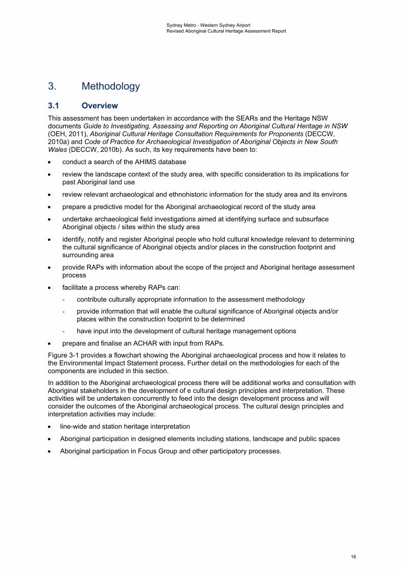
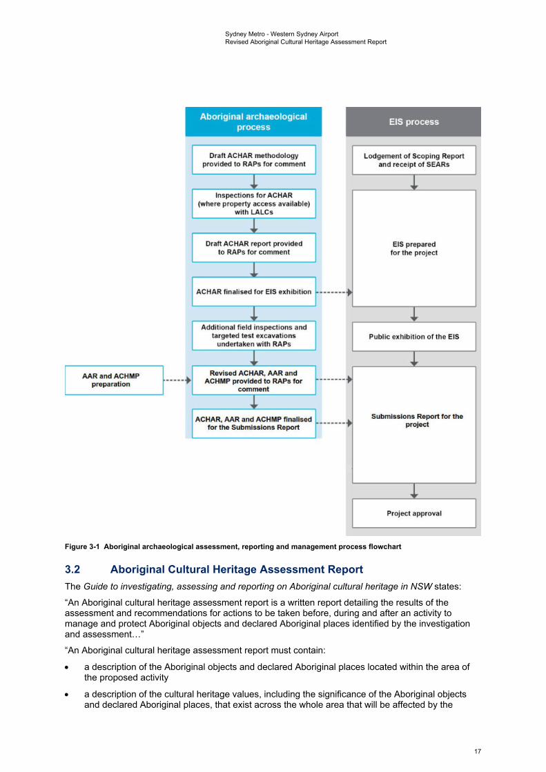
Figure 3-1 provides a flowchart showing the Aboriginal archaeological process and how it relates to the Environmental Impact Statement process. Further detail on the methodologies for each of the components are included in this section.
In addition to the Aboriginal archaeological process there will be additional works and consultation with Aboriginal stakeholders in the development of e cultural design principles and interpretation. These activities will be undertaken concurrently to feed into the design development process and will consider the outcomes of the Aboriginal archaeological process. The cultural design principles and interpretation activities may include:
• line-wide and station heritage interpretation
• Aboriginal participation in designed elements including stations, landscape and public spaces
• Aboriginal participation in Focus Group and other participatory processes.
16
and ACHMP preparation
Aboriginal archaeological process
Draft A,CHAR methodology provided to RAPs for comment
J.. Inspections for AC HAR
(where property access available) with LALCs
J.. Draft AC HAR report provided
to RAPs for comment
1 ACHAR finalised for EIS exhibition
J.. Additional field inspections and
targeted test excavations undertaken with RAPs
,l. Revised ACHAR, AAR and
ACHMP [Provided to RAPS for comment
J.. ACHAR, AAR and ACHMP finalised
for the Submissions Report
EIS process
Lodgement of Scoping Report and receipt of SEARs
,l.
EIS prepared for the project
• ,l.
Public exhibition of the EIS
J.. ~
~ Submissions Report for the
project
,l. Proj ect approval
Sydney Metro - Western Sydney Airport Revised Aboriginal Cultural Heritage Assessment Report
Figure 3-1 Aboriginal archaeological assessment, reporting and management process flowchart
3.2 Aboriginal Cultural Heritage Assessment Report The Guide to investigating, assessing and reporting on Aboriginal cultural heritage in NSW states:
“An Aboriginal cultural heritage assessment report is a written report detailing the results of the assessment and recommendations for actions to be taken before, during and after an activity to manage and protect Aboriginal objects and declared Aboriginal places identified by the investigation and assessment…”
“An Aboriginal cultural heritage assessment report must contain:
• a description of the Aboriginal objects and declared Aboriginal places located within the area of the proposed activity
• a description of the cultural heritage values, including the significance of the Aboriginal objects and declared Aboriginal places, that exist across the whole area that will be affected by the
17
Sydney Metro - Western Sydney Airport Revised Aboriginal Cultural Heritage Assessment Report
proposed activity and the significance of these values for the Aboriginal people who have a cultural association with the land
• how the requirements for consultation with Aboriginal people have been met (as specified in clause 80C of the NPW Regulation)
• the views of those Aboriginal people regarding the likely impact of the proposed activity on their cultural heritage (if any submissions have been received as a part of the consultation requirements, the report must include a copy of each submission and your response)
• actual or likely harm posed to the Aboriginal objects or declared Aboriginal places from the proposed activity, with reference to the cultural heritage values identified
• any practical measures that may be taken to protect and conserve those Aboriginal objects or declared Aboriginal places and
• any practical measures that may be taken to avoid or mitigate any actual or likely harm, alternatives to harm or, if this is not possible, to manage (minimise) harm” (NSW Office of Environment & Heritage, 2011:iii & 15).
3.3 Background research The following tasks were undertaken for the background research component of the assessment:
• searches of the AHIMS database
• a review of associated site cards and reports to clarify site contents, extents and statuses
• a review of the landscape context of the study area, with a particular emphasis on its implications for the nature and distribution of Aboriginal archaeological materials
• a review of relevant archaeological and ethnohistoric information for the study area and environs
• preparation of a predictive model for the Aboriginal archaeological record of the study area.
3.4 Archaeological field investigations 3.4.1 Archaeological survey Aims and objectives The overarching aims of the archaeological survey was to identify and record any existing surface evidence of past Aboriginal occupation within the construction footprint. As part of the process the following were key considerations:
• to ground truth all AHIMS registered Aboriginal sites within and immediately adjacent to the construction footprint
• to sample all accessible landform elements within the construction footprint
• to identify areas that, irrespective of the presence or absence of surface artefacts, are likely to contain artefact bearing subsurface deposits (i.e. areas of Aboriginal archaeological sensitivity to provide data that will assist with the development of an appropriate management strategy for the known and potential Aboriginal archaeological values of the study area. This data will include comparing maximum settlement estimates (as presented in the Environmental Impact Statement (Chapter 15)) in relation to recorded sites identified in surface contexts above the tunnelling alignment, as well as areas of archaeological potential along its extent, to guide the archaeological program in relation to impact risks from vibration and subsidence.
18
Sydney Metro - Western Sydney Airport Revised Aboriginal Cultural Heritage Assessment Report
Archaeological survey strategy In developing an appropriate survey methodology for the current assessment, consideration was given to several factors, including:
• property access and COVID-19 restrictions, with numerous land parcels unavailable for access
• the presence of areas of severely disturbed terrain within the study area, all of which were assessed pre-survey as having negligible potential for the presence of Aboriginal archaeological materials
• generally poor ground surface visibility conditions due to vegetation cover
• a desire to sample all accessible landform elements within the off-airport construction footprint.
Ultimately, in consideration of the above, it was decided that all accessible and non-severely disturbed portions of the off-airport construction footprint would be comprehensively sampled, with a particular focus on areas of enhanced archaeological visibility.
3.4.2 Field team and methods The initial archaeological surveys for the project were undertaken over four non-consecutive days between February and June 2020 (Thursday 27 February, Wednesday 4 March, Tuesday 28 April and Friday 12 June 2020). The field team for the inspections consisted of archaeologists Dr Darran Jordan and Dr Andrew McLaren and representatives from Gandangara Local Aboriginal Land Council (LALC) and Deerubbin LALC. Access was only available to some sections of the construction footprint at this stage of the project.
Once additional areas became available between October 2020 and February 2021, survey was undertaken with AECOM archaeologists Dr Darran Jordan, Dr Andrew McLaren, Geordie Oakes, Luke Wolfe and Julia Atkinson. RAP representatives participated from A1 Indigenous Services, Arugung Aboriginal Cultural Heritage Site Assessments, Corroboree Aboriginal Corporation, Cubbitch Barta, Darug Custodian Aboriginal Corporation, Deerubbin Local Aboriginal Land Council, DNC, Gandangara Local Aboriginal Land Council, Gunyuu, Kamilaroi Yankuntjatjara Working Group, Murra Bidgee Mullangari Aboriginal Corporation, Tocomwall, Wailwan Aboriginal Group and Walbunja.
The strategy of the surveys was to space participants at regular intervals across the construction footprint and to walk transects across the area. All surveys were conducted on foot. As per the survey strategy, all accessible and non-severely disturbed portions of the construction footprint were sampled, with particular attention paid to ground surfaces with higher visibility. All mature trees encountered during the inspection were inspected for cultural scarring. Outcropping sandstone bedrock exposures, where intercepted, were inspected for grinding grooves. The location of each transect completed during the inspection, including start and end points, was recorded using a handheld differential GPS unit, with associated transect data (e.g. levels of visibility and exposure) entered directly into the same unit upon the completion of each transect.
All survey was conducted on foot. As per the survey strategy, all accessible and non-severely disturbed portions of the construction footprint were sampled, with particular attention paid to ground surfaces with higher visibility. All mature trees encountered during survey were inspected for cultural scarring. Outcropping sandstone bedrock exposures, where intercepted, were inspected for grinding grooves. The location of each transect completed during the inspection, including start and end points, was recorded using a handheld differential GPS unit, with associated transect data (e.g. levels of visibility and exposure) entered directly into the same unit upon the completion of each transect.
When any Aboriginal archaeological sites were identified they were recorded to the standard required by the Code of Practice for Archaeological Investigation of Aboriginal Objects in NSW. All sites were comprehensively photographed following artefact recording.
Artefacts collected during test excavation were subject to macroscopic attribute analysis in an off-site location, with the number of attributes recorded per specimen differing by technological type. It is proposed that the management of any artefact assemblage collected during the archaeological program be decided upon in consultation with and be endorsed by the RAPs. If the stone artefacts recovered during test excavation are reburied within the study area in a non-impact area, that reburial will be undertaken in accordance with Requirement 26 of the Code of Practice. Other options for
19
Sydney Metro - Western Sydney Airport Revised Aboriginal Cultural Heritage Assessment Report
artefact management may include a designated Keeping Place or inclusion in an interpretative display or displays.
3.5 Social/cultural values assessment for the ACHAR Aboriginal community consultation for the assessment was undertaken in accordance with the Aboriginal Cultural Heritage Consultation Requirements for Proponents 2010 (DECCW, 2010a). RAP representatives are in the best position to provide information on the Aboriginal social/cultural heritage values of the study area. During the assessment process, consultation with RAPs regarding the cultural heritage values of the study area was carried out. This included:
• a request for any comments regarding the Aboriginal cultural heritage values of the study area
• discussion of cultural heritage values during fieldwork
• provision of the draft ACHAR, Revised ACHAR, AAR and ACHMP to all RAPs for their review and comment.
The following sections provide detail on further work that will be undertaken, if required, following the recommendations of the ACHAR. Further explanation on how cultural heritage values have been considered are included in Section 3.9.
3.6 Direct and indirect impact assessment for the ACHAR This assessment considers both direct impacts and indirect impacts. Direct impacts are defined as impacts that would have a physical impact on the site, resulting in damage, which could be either partial or total destruction. Direct impacts have been considered both in relation to known and potential Aboriginal archaeological sites and features.
Indirect impacts are those that do not directly impact on the physical site itself but do have an impact on its cultural heritage significance. Indirect impacts for this assessment are likely to be caused by factors such as subsidence and vibration as a result of tunnelling. Surface areas above where tunnelling would occur have been subject to a separate assessment on the likelihood of subsidence occurring and known sites have been mapped in relation to these areas. Potential indirect impacts have also been considered for sites within a 200 metre buffer area outside the construction footprint.
3.7 Post-ACHAR further survey and targeted test excavation Further work will be required following the submission of this Revised ACHAR. Due to access limitations some of the off-airport construction footprint as well as above ground areas over temporary/permanent power supply routes have not yet been subject to field investigations. Further archaeological survey and test excavation will be undertaken in areas of identified Aboriginal archaeological sensitivity. Further works are to be managed under the ACHMP, once it is approved.
3.8 Aboriginal Archaeological Report As per the requirements of the Code of Practice for Archaeological Investigation of Aboriginal Objects in New South Wales (DECCW, 2010b) an Aboriginal Archaeological Report (AAR) has been produced to report the findings of the fieldwork program up to December 2020. The AAR is a technical report that includes the archaeological findings of the survey and test excavation as well as proposed future works.
3.9 Social/cultural values assessment for the Revised ACHAR Ongoing Aboriginal community consultation for the assessment will be undertaken in accordance with the Aboriginal Cultural Heritage Consultation Requirements for Proponents 2010 (DECCW, 2010a). This will continue as the project progresses, with further work to be managed under the ACHMP once it has been approved.
20
Sydney Metro - Western Sydney Airport Revised Aboriginal Cultural Heritage Assessment Report
For the purposes of the assessments undertaken for this project, Aboriginal cultural values have been defined as values of significance to Aboriginal people resulting from traditions, observances, lore, customs, beliefs and history. These values, which can comprise physical (tangible) or non-physical (intangible) elements, are evidence of the legacy of Aboriginal people stretching from the ancestors of the past right through to present day.
Cultural values may be attached to physical makers in the landscape, such as objects used for practical purpose or ceremony, such as stone tools, art sites, ceremonial areas or burial grounds. As Aboriginal history stretches through to the present day these values can also be attached to historical or even contemporary structures, such as mission buildings, houses, community areas and cemeteries as well as landscapes and landforms. All of these varied elements combine to form part of the broader cultural landscape (Department of Environment, 2010).
Aboriginal cultural values are critical to the connection and sense of belonging that Aboriginal people have with the landscape and each other. These values are not only confined to physical sites but also include memories, stories, ceremonies, language, ‘ways of doing things’, passing on knowledge and looking after cultural traditions and places. It is in this way that Aboriginal cultural values provide continuity and context, forging a tangible link between the past and the present. Community and individual identity, connection and a sense of belonging to Country are all essential parts of Aboriginal cultural values. For this reason, features should not be assessed in isolation but rather understanding should be sought into how they contribute to the wider landscape, seeking an understanding of connections holistically (Department of Environment, 2010).
An Aboriginal cultural landscape is generally defined in heritage documentation as: “a place or area valued by an Aboriginal group (or groups) as a result of their long and complex relationship with that land. It can embody their traditional knowledge of spirits, places, land uses, and ecology. Material remains of the association may be prominent, but will often be minimal or absent” (Buggey, 1999). The purpose of consultation on this project is to seek an understanding of the connectivity between all parts of a linked cultural landscape through consultation with Aboriginal people to contextualise the present landscape as the product of long-term and complex relationships between people and the environment (DECCW 2010). Sydney Metro’s approach will also be informed by the Designing with Country (Government Architect New South Wales, 2020b) discussion paper and the draft Connecting with Country (Government Architect New South Wales, 2020a) framework, which proposes the development of a stronger presence for Aboriginal culture in the NSW planning system. This requires the development of a broader cultural design framework to support better strategic planning and place-making, recognising that “for tens of thousands of years” Aboriginal people “have managed, cultivated and cared for the landscape where our towns and cities were established and continue to grow” (Government Architect New South Wales, 2020b).
Through this process there will be opportunities for collaborative approaches and to incorporate information about the cultural and community values into the design and interpretation of the design of the project. Areas of cultural importance identified by Aboriginal people, such as creeks and landforms, may be managed for their cultural values that are separate from the archaeological values of discrete sites scattered throughout the landscape (i.e. cultural values are not necessarily tied to discrete pockets of Aboriginal artefacts and instead represent formed attachments to larger landscape features). Contemporary community values and attachments which form part of the cultural values of the place will therefore be identified and recorded through the consultation process and used to inform the project as it develops.
Whereas scientific significance is determined by a hierarchy of values, cultural significance resists definition in this way. Assessing the cultural significance of a place or object requires defining the reason why a place is culturally important, but cultural values are often intentionally excluded from a sliding scale to characterise sites. One common response to requests to define cultural significance is to state that all Aboriginal sites have high cultural significance, as each artefact, place or structure, from a single flake to a stone arrangement to a mission building, provides a tangible link to the ancestors of the past, just as it connects the community of the present. The process of understanding which places are culturally significant and why, can therefore be an emotional experience. The importance of knowledge holders sharing the reasons for a place’s importance is so that values can be appropriately managed and protected. This is so that changes in the landscape as a part of the project do not damage, diminish or remove the reasons for a place’s cultural importance. This information can only be shared if it is culturally appropriate to do so.
21
Sydney Metro - Western Sydney Airport Revised Aboriginal Cultural Heritage Assessment Report
Only Aboriginal people are able to define, describe and determine cultural values. The purpose of the ongoing consultation throughout this project is to capture any relevant cultural information that can be shared. Some types of information that will continue to be sought through consultation as the project progresses are:
• knowledge of the plants and animals that have contributed to the continuing existence of Aboriginal peoples in the region over many thousands of years, and how they are valued in today’s community
• known sites within the landscape and how these material remains connect to people and other places in the landscape through tradition and story
• following reference to historical records with observations on Aboriginal people, lifestyles, wars, massacres, social and cultural events, population census, social interactions and language, to seek a complementary understanding of these through the shared memories of the contemporary Aboriginal community
• shared stories of how traditional cultural practise and values are experienced by the contemporary Aboriginal community.
As noted in OEH’s Aboriginal Cultural Heritage Consultation Requirements for Proponents 2010 (DECCW, 2010a), some information obtained from Aboriginal knowledge holders may be sensitive or have restricted public access. Sydney Metro, in consultation with relevant knowledge holders, will develop appropriate protocols for sensitive or restricted information (as required).
22
Sydney Metro - Western Sydney Airport Revised Aboriginal Cultural Heritage Assessment Report
4. Aboriginal community consultation
4.1 Stage 1 notification and registration 4.1.1 Consultation with regulatory agencies Letters and emails were sent on 15 May 2019 to the following agencies requesting contact details for groups relevant to the intended study:
• Office of Environment and Heritage (OEH) (now Heritage NSW in the DPC)
• Deerubbin LALC
• Gandangara LALC
• Tharawal LALC
• Office of the Registrar
• Native Title Services Corporation Limited (NTSCorp Ltd)
• Penrith City Council, Liverpool City Council
• Camden Council
• Greater Sydney Local Land Services (formerly Catchment Management Authorities (CMA)).
The names that were provided by these agencies were then invited to register their interest in the project. The consultation log is included in Appendix A and the agency responses are included in Appendix B.
Searches were also undertaken of the National Native Title Tribunal (NNTT) register through the NNTT website on 26 September 2019 for a list of registered native title claimants, native title holders and registered Indigenous Land Use Agreements. Searches were made of the LGAs for Penrith City Council and Liverpool City Council.
One claim was present in the Liverpool City Council search for the South Coast People, but it was located approximately 20 kilometres to the southeast of the construction footprint. A search of the National Native Title Register for the same three LGAs had no results. A search of Applications and Determinations identified one dismissed application and two discontinued applications in the Penrith City Council area.
The aforementioned claim for the South Coast People was an active application in the Liverpool City Council area, along with two dismissed, three discontinued and two rejected applications. Based on the data available on the NNTT registers, there are no active registrations, claims or applications intersecting with either the construction footprint or the wider study area.
As is discussed in further detail in Chapter 9, there are other projects currently being planned and/or delivered in the same region as this project. Each of these other projects is also currently undergoing community consultation with RAPs. Where documents are available a literature review has been undertaken of currently available reports from across the region, as well as site cards for relevant previously recorded sites, to identify any previously recorded cultural values. To manage the risk of inconsistency or of cultural features being reported by RAPs to one project but not another, the literature review and consultation will continue. RAP engagement for this project will also be undertaken with an awareness that participants may be involved in multiple projects. Questions of cultural values will request regional understandings of landscape features, sites and places to contextualise the cultural values relating to the construction footprint with those identified and potentially impacted by other projects across the region (see also Chapter 9).
4.1.2 Public notification The Aboriginal Stakeholder Consultation newspaper advertisement was published in the Liverpool Leader on 22 May 2019, the Penrith Press on 23 May 2019 and the Western Weekender on 17 May 2019.
23
Sydney Metro - Western Sydney Airport Revised Aboriginal Cultural Heritage Assessment Report
The advertisement gave a brief summary of the project and described the construction footprint, requesting that interested Aboriginal persons or organisations should register their interest. The advertisements are included in Appendix C.
4.1.3 Invitations for expressions of interest A letter inviting registration was sent, either by email or post, to all potential registrants (as identified by agency responses) on 30 August 2019.
Correspondence relating to RAP consultation is included in full in Appendices D to H.
4.1.4 Notification of Registered Aboriginal Parties RAP registration on the project was kept open for a prolonged period to ensure a comprehensive response and the best possible resource for gathering information on the cultural values of the study area. Notification of the names of RAPs that registered for the project along with a copy of the notification were sent to Deerubbin LALC, Gandangara LALC and EES (formerly OEH) on 21 May 2020. As per the request of two of the registrants (Colin Gale and Corroboree Aboriginal Corporation) details were not included in these notifications.
4.2 Stage 2 presentation of information about the project Initial information about the project was provided to the RAPs by email and letter on 17 September 2019. Further to that initial presentation, discussion has been held by phone and email as well as during fieldwork with RAPs as part of the ongoing consultation for the project. Project information conveyed during ongoing consultation included reference to the changing construction footprint as designs were refined and the delays and limitations for undertaking field investigations due to land access permissions and the restrictions of the COVID-19 pandemic, which occurred during this assessment.
4.3 Stage 3 gathering information about cultural significance 4.3.1 Registration of interest A total of 68 registrations were received for consultation on the project. These were received verbally by phone, by email and by letter.
4.3.2 Draft assessment methodology The draft methodology for survey and test excavation was provided to the RAPs for comment by email and letter on 17 September 2019. Responses received from RAPs predominantly agreed with the proposed methodology without changes. The representative from Cubbitch Barta responded by letter and agreed to the approach of survey and test excavation but stated: "I do not agree that any test excavations that will be required for this project be dry sieved. All material should be wet sieved only, with a minimum of 3 millimetre sieve". The methodology was consequently updated so that sieving through a 3 millimetre mesh would be utilised when possible and appropriate during the testing program. Although access issues made wet sieving impractical for testing, soil conditions were found to enable successful dry sieving as this stage.,
Individual registrant Colin Gale stated he did not agree with the predictive model of highest density artefact scatters being located predominantly in close proximity to water courses, stating: "coastal streams have very shallow sloping banks that extend well beyond the 25-30 metres range and have fast flowing streams at times," stating that in relation to a survey he had participated in the Mungerie Park area: "I personally identified three areas that resulted in thousands of artefacts... these sites were more than 300 metres from Caddies Creek". Survey was proposed to be undertaken across all accessible sections of the construction footprint and test pits were expanded to be able to test the veracity of the predictive model as per Colin Gale’s comments.
Other comments received raised the issue that some RAPs did not agree with other RAPs being involved in the project, stating that acceptance and support would not be given for individuals or organisations not recognised as from Country. These are indicative of larger issues relating to groups and individuals within the wider Aboriginal community. The project team remain sensitive to these concerns and have responded appropriately during the consultation process. As per the legislative
24
Sydney Metro - Western Sydney Airport Revised Aboriginal Cultural Heritage Assessment Report
requirements, all 68 RAPs registered for the project will be consulted in an ongoing capacity throughout the design and construction the project. Other groups including relevant stakeholders and Aboriginal knowledge holders may also be consulted as part of the larger project to undertake collaborative approaches and to incorporate information about the cultural and community values into the design and interpretation of the design of the project.
4.3.3 Archaeological field investigations The methodology that was provided to the RAPs for comment by email and letter on 17 September 2019 outlined archaeological field investigations proposed to be undertaken to ground-truth previously recorded sites and areas of archaeological and cultural potential within the study area, to undertake survey and test excavation. Surface investigations were accordingly carried out on the land where access was available, initially with representatives participating from Deerubbin LALC and Gandangara LALC in February, March, April and June 2020.
Further access was provided to some of the properties within the construction footprint between October 2020 and February 2021. During this time these areas were subject to survey and test excavation. Participants from various RAP groups were in attendance for the fieldwork, including representatives from A1 Indigenous Services, Arugung Aboriginal Cultural Heritage Site Assessments, Corroboree Aboriginal Corporation, Cubbitch Barta, Darug Custodian Aboriginal Corporation, Deerubbin Local Aboriginal Land Council, DNC, Gandangara Local Aboriginal Land Council, Gunyuu, Kamilaroi Yankuntjatjara Working Group, Murra Bidgee Mullangari Aboriginal Corporation, Tocomwall, Wailwan Aboriginal Group and Walbunja. The results of these works are included in this Revised ACHAR and provided in further detail in the corresponding AAR.
4.4 Stage 4 RAP review of draft ACHAR A draft ACHAR was provided to RAPs for comment on 24 July 2020, including all details of fieldwork and consultation undertaken to that date. Comments on cultural heritage values received during the feedback process for this draft ACHAR included the following:
• the entire area would have once been occupied and inhabited by Aboriginal people in the past, and is still culturally significant to the Aboriginal community of today
• In the past Aboriginal people in this area walked the land, participated in ceremonies and dance, had camp sites and used fire for cooking in the hot coals, undertook burials in soft ground, marked trees to indicate culturally significant areas, fished in waterways and used them as a source of drinking water. The waterways that traverse the construction footprint (Blaxland Creek, Cosgroves Creek and Badgerys Creek and their tributaries) hold cultural significance, used in the past for their abundant natural resources and as natural landform boundary markers
• there are some cultural sites, as yet unregistered on AHIMS, known by the Aboriginal community to occur in the area surrounding the construction footprint. Those identified during consultation include a Canoe Tree located next to the M4 on the bank of South Creek, estimated to be 1 km east of the Orchard Hills construction site, a possible burial site located at the junction of Blaxland Creek and South Creek, estimated to be 530 m to the east of the Orchard Hills construction site, and a culturally modified tree located at the intersection of South Creek and Luddenham Road, estimated to be located 270 m to the east of the Warragamba Pipeline section of the Off-airport construction corridor. No cultural sites have been identified within the construction footprint during consultation or survey
• the potential cumulative impacts of this project are seen by the Aboriginal community to add further to the overall impacts caused by an increasing amount development in the region, including the Aerotropolis and other development projects in this area. The accumulation of these developments is seen by RAPs to be removing/destroying the remnant Aboriginal sites and associated cultural values across the larger area
• further investigations (survey and test excavation) are supported as necessary to occur prior to impacts from the project. RAP feedback supports the draft ACHAR, its recommendations for further investigation and the proposed methodology to undertake survey and testing.
25
Sydney Metro - Western Sydney Airport Revised Aboriginal Cultural Heritage Assessment Report
This Revised ACHAR was produced to include the results of fieldwork and consultation up to February 2021. The draft of the Revised ACHAR was provided to RAPs for comment on 17 February 2021. Ultimately, a total of 13 responses were received, although one of these was relevant for 42 RAPs operating under the Murrin Administrative Services.
Twelve RAP respondents indicated that they supported the ACHAR, with no changes required. The thirteenth respondent provided comments on the document but did not directly address this point.
Two RAP responses also raised the issue of who legitimate knowledge holders were and who should be consulted with and involved in ongoing fieldwork for the project. The mitigation measures presented in Section 10.3 of the ACHAR include commitments to ongoing consultation with the RAPs for future fieldwork investigations (mitigation measures AH1 and AH2).
A further point was raised noting that culturally appropriate art and language should be used on any interpretative signage. Mitigation measure OAH1 for the project (refer to Section 10.3) includes a commitment to ongoing consultation with Aboriginal knowledge holders during the development of a heritage interpretation strategy.
Responses also restated what had already been expressed in previous consultation and documented in the existing text of the Revised ACHAR, that Aboriginal sites within the construction footprint are of significance to Aboriginal people, as is the larger connected cultural landscape that contains them.
26
Sydney Metro - Western Sydney Airport Revised Aboriginal Cultural Heritage Assessment Report
5. Existing environment The following section details the existing environment of the study area, which has relevance to the nature, the distribution and survival of Aboriginal archaeological materials across it. Specific, detailed discussion of the on-airport and off-airport areas, as well as the construction areas making up each of those parts of the construction footprint, is included in the details on local context in Section 5.4.
5.1 Landscape context The nature and distribution of Aboriginal archaeological sites is closely linked to the environments in which they occur. Environmental variables such as topography, geology, hydrology and vegetation will have played a critical role in influencing how Aboriginal people moved within and utilised their respective Country. Amongst other things, these variables affected the availability of suitable campsites, drinking water, plant and animal resources and raw materials for the production of stone and organic implements. Accordingly, any attempt to predict or interpret the character and distribution of Aboriginal sites in a given landscape must take such environmental factors into account. At the same time, an assessment of historic land use activities and geomorphic processes, both contemporary and historic, allows predictions to be made concerning the survival, visibility and integrity of any existing Aboriginal archaeological materials.
5.1.1 Physical setting The project is located approximately 40 kilometres west of the Sydney Central Business District (CBD), between the suburbs of St Marys and Bringelly and within the Penrith and Liverpool LGAs. The project comprises a predominately linear stretch of land, aligned roughly north to south, approximately 23 kilometres in length. The total construction footprint (approximately 439 hectares (ha)), encompasses a small complex at the existing St Marys Station and a larger, mostly continuous portion located between the Great Western Highway and the intersection of Badgerys Creek Road with The Northern Road, just south of Western Sydney International.
Portions of the study area (particularly at its northern extent) have been more heavily developed for residential and commercial purposes. Roadways run through the study area, connecting the various parts of the landscape. Extant connections of the deeper past are present in the form of waterways that cross the study area in multiple places. Although the waterways are indicative of the landscape of the past it is important to note that due to meandering, over time the routes may have changed with the present alignments not necessarily reflecting one consistent route throughout the history of this area. Similarly, increased erosion caused by clearing and development is likely to have channelised the waterways, which may have been shallower and broader or consisted of chains of ponds in the past.
5.1.2 Topography The topography of the construction footprint is typical of Bannerman and Hazelton’s (1990) Cumberland Lowlands physiographic region and can be broadly characterised as flat to undulating, with floodplains, ridges and flat topped terraces dissected by the drainage depressions of larger watercourses and their tributaries. Landforms within the construction footprint are dominated by undulating slopes and crests, with higher and steeper terrain rising gradually in the south. Elevations within the construction footprint average at approximately 57 metres Australian Height Datum (AHD) but range from low-lying alluvial flats of 26 metres AHD surrounding the Badgerys Creek and Blaxland Creek stream channels, to moderately inclined mid and upper slopes further from larger watercourses. The highest point within the construction footprint consists of a crest in the far southwest, with an elevation of 94 metres AHD.
5.1.3 Hydrology The project is located within the South Creek catchment – defined by a network of tributaries that originate in the higher terrain south of Catherine Field and combine into larger and more permanent waterways as they drain north towards Windsor. South Creek is a dominant feature of the catchment and is located as a perennial fourth order stream between 200 metres and two kilometres east of the project for the majority of the alignment. Tributaries of South Creek cross through the project at multiple points. These include various ephemeral streams throughout the construction footprint such
27
Sydney Metro - Western Sydney Airport Revised Aboriginal Cultural Heritage Assessment Report
as Cosgroves Creek and the higher order perennial streams of Badgerys Creek in the south and Blaxland Creek in the north, at a point just southwest of its confluence with South Creek.
Historic land use practices such as damming, vegetation clearance and flood-mitigating construction across the construction footprint have affected natural stream flows. As such, modern stream alignments may not fully represent the locations and extents of waterways that existed during periods of Aboriginal occupation. However, the Quaternary surface geology underlying the major streams and floodplains within the construction footprint suggests South Creek and its larger tributaries have not substantially deviated from their current alignments since at least the Pleistocene era.
The implications of this hydrology are that sections of the construction footprint would have contained sufficient freshwater to support the year-round and/or repeated activities of past Aboriginal groups, while other portions further from reliable streams may have only been utilised infrequently, or opportunistically. As such, there is potential for higher densities of archaeological material associated with the sections of the construction footprint in close proximity to South Creek, Badgerys Creek and Blaxland Creek. As noted above, Colin Gale has noted that in his experience Aboriginal sites are not necessarily tied to waterways and can occur in any landform. For this reason, sensitivity has been assessed across multiple landforms for the study area, taking into consideration not only proximity to water, but also the presence of other previously recorded sites, past disturbance and any other cultural features shared during consultation.
5.1.4 Surface geology Reference to the 1:100,000 Geological Series Sheet for Penrith (9030) (Clark & Jones, 1991) indicates that the surface geology of the construction footprint comprises a mixture of Middle Triassic Bringelly Shale (Rwb) and Quaternary Alluvium (Qal), with a small section of Tertiary St Marys Formation (Ts) located to the far north.
Bringelly Shale is strongly associated with the presence of undulating hills in the region and mantles most of the construction footprint, closely corresponding with the observed topography. Bringelly Shale, deposited in a swampy alluvial plain, is the uppermost formation of the Wianamatta Group and consists of shale, carbonaceous claystone, laminate, fine to medium-grained lithic sandstone, rare coal and tuff (Clark & Jones, 1991).
Quaternary Alluvium (Qal), characterised by quartz and lithic “fluvial” sand, silt and clay, extends in roughly southwest to northeast running bands across sections of the construction footprint that cross major streams (Clark & Jones, 1991). Quaternary Alluvium is closely associated with perennial waterways and floodplains within the region of the project and is of potential Aboriginal archaeological significance as a primary source of raw stone materials. Exposed silcrete boulders have been observed along the eastern bank of South Creek in the vicinity of the construction footprint to the north of Elizabeth Drive (AAJV, 2019:109).
St Marys Formation (Ts) extends into the far eastern side of the existing St Marys Station portion of the construction footprint and is characterised by laterised sand and clay with ferricrete bands containing silcrete, sandstone and shale boulders (Clark & Jones, 1991). This formation has been investigated at the nearby Plumpton Ridge (approximately seven kilometres northeast of the construction footprint) and found to contain quarry sites, with extensive evidence of silcrete extraction and preparation (Kelleher Nightingale Consulting Pty Ltd, 2009; National Heritage Studies Pty Ltd, 1990).
5.1.5 Soil and geomorphology Soils within the construction footprint have been mapped by Bannerman and Hazelton (2011) as belonging to two distinct soil landscapes: Residual Blacktown (REbt) and Alluvial South Creek (ALsc) (Bannerman & Hazelton, 2011).
Blacktown soils are associated with the slopes and underlying Bringelly Shale and occur across most of the construction footprint. They have been characterised by Bannerman and Hazelton (2011) as shallow to moderately deep, hardsetting mottled texture contrast soils, with red and brown podzolic soils on crests, which grade into yellow podzolic soils on lower slopes and in drainage lines. Blacktown subsoils are moderately to highly erodible where organic matter is low; however, topsoils vary between low and moderately erodible, as fine sand and silt contents are balanced by the presence of moderate
28
Sydney Metro - Western Sydney Airport Revised Aboriginal Cultural Heritage Assessment Report
levels of dense organic matter. Consequently, the majority of the construction footprint has moderate potential for containing archaeological material; however, in situ material is unlikely due to erosion.
South Creek soils follow the underlying Quaternary geology across the floodplains and flats of the construction footprint. They have been characterised by Bannerman and Hazelton (2011) as deeply layered sediments over bedrock or relict soils. Where soil deposition has occurred, structured clays or loams are immediately adjacent to drainage lines, with red and yellow podzolic soils on terraces, in addition to small areas of structured grey clays, leached clay and yellow solodic soils. The soils are subject to seasonal waterlogging and have permanently high water tables. The dynamic nature of the soil landscape can encourage both high levels of erosion and deposition. As such, artefacts may be buried at depth, or removed from their original contexts. The acidity of both soil types is of potential import archaeologically, as organic materials are vulnerable to decomposition in soils of high pH (Matthiesen, 2004). If skeletal remains or shells were present at the site in the past, it is unlikely that they would survive in the archaeological record today.
As in other parts of the Cumberland Plain, existing archaeological, environmental and historic reference materials suggest that a range of geomorphic processes are likely to have affected the Aboriginal archaeological record of the study area. Potentially significant phenomena from an archaeological perspective include bioturbation, erosion and alluvial/colluvial aggradation. Possible effects of these processes include:
• increased archaeological site visibility in eroded areas
• reduced archaeological site visibility in areas of sediment deposition
• horizontal and vertical translocation of artefacts
• stratigraphic mixing
• truncation of archaeological deposits
• creation of thicker and potentially stratified archaeological deposits in floodplain and slope base contexts.
5.1.6 Flora and fauna Contemporary flora and fauna have both been assessed separately in the Biodiversity technical paper for the project (as presented in the Revised Biodiversity Development Assessment Report (Appendix G of Submissions Report)). The results of that study found that there are currently five plant community types within the study area, being:
• Broad-leaved Ironbark - Grey Box - Melaleuca decora grassy open forest on clay/gravel soils of the Cumberland Plain, Sydney Basin Bioregion
• Forest Red Gum - Rough-barked Apple Grassy Woodland on Alluvial Flats of the Cumberland Plain, Sydney Basin Bioregion
• Grey Box - Forest Red Gum Grassy Woodland on Flats of the Cumberland Plain, Sydney Basin Bioregion
• Phragmites australis and Typha orientalis Coastal Freshwater Wetlands of the Sydney Basin Bioregion
• Swamp Oak Open Forest on River flats of the Cumberland Plain and Hunter valley.
Five threatened ecological communities were also identified in the study area, being:
• Cumberland Plain Woodland in the Sydney Basin Bioregion
• River-Flat Eucalypt Forest on Coastal Floodplains of the New South Wales North Coast, Sydney Basin and South East Corner Bioregions
• Shale Gravel Transition Forest in the Sydney Basin Bioregion
• Swamp Oak Floodplain Forest of the New South Wales North Coast, Sydney Basin and South East Corner Bioregions
29
Sydney Metro - Western Sydney Airport Revised Aboriginal Cultural Heritage Assessment Report
• Freshwater Wetlands on Coastal Floodplains of the New South Wales North Coast, Sydney Basin and South East Corner Bioregions.
The technical paper also predicted fauna species likely to occur based on vegetation surrogates and landscape features, with a range of amphibians, reptiles, mammals and birds listed as likely to occur within the study area.
It is important to note that while the current flora and fauna species may be indicative of likely past conditions, they are not necessarily representative of the same resources that would have been available to Aboriginal people in this area in the past (not discounting that they may still have cultural significance for contemporary communities as examples of cultural resources). Native vegetation within the construction footprint has been heavily modified as a result of historic land clearance activities, with the majority cleared historically for grazing and/or cropping. With reference to Tozer’s (2003) survey of native vegetation across the Cumberland Plain, the available evidence suggests that the construction footprint is likely to once have contained more widespread Shale Plains Woodland vegetation communities, with Alluvial Woodland along waterways and Shale Hills Woodland in the higher terrain to the south.
Shale Plains Woodland is the most widely distributed community on the Cumberland Plain (Tozer, 2003: 36). It is typically dominated by Grey Box (Eucalyptus moluccana) and Forest Red Gum (E. tereticornis), with Narrow-leafed Ironbark (E. crebra), Thin-leafed Stringybark (E. eugenioides) and Spotted Gum (Corymbia maculata) also occurring, though less frequently. A shrub stratum dominated by Blackthorn (Bursaria spinosa) is usually also present. Common ground stratum species for this vegetation community include Kidney Weed (Dichondra repens), Threeawn Speargrass (Aristida vagans), Weeping Grass (Microlaena stipoides), Kangaroo Grass (Themeda australis), Brunoniella (Brunoniella australis), Tender Tick-trefoil (Desmodium varians), Thin Leaf Stink Weed (Opercularia diphylla), Blue Bell (Wahlenbergia gracilis) and Shorthair Plumegrass (Dichelachnemicrantha).
Alluvial Woodland is most often dominated by Cabbage Gum (E. amplifolia) and Swamp Oak (Casuarina glauca) with Apple Box (Angophora floribunda) occurring less frequently (EcoLogical Australia, 2011; Tozer, 2003:32). A shrub stratum is usually evident though is often sparse and dominated by Blackthorn (Bursaria spinosa). A dense ground cover of grasses such as Basket-grass (Oplismenus aemulus), Weeping grass (Microlaena stipoides), Bordered Panic (Entolasia marginata) and Forest Hedgehog Grass (Echinopogon ovatus) is also typical as is the presence of herb species such as Forest Nightshade (Solanum prinophyllum), Whiteroot (Pratia purpurascens) and Native Wandering Jew (Commelina cyanea). Alluvial Plain Woodland is typically associated with minor watercourses draining soils derived from Wianamatta Group shales.
Shale Hills Woodland is similar to Shale Plains Woodland; however, it is predominately found at higher elevations and on steeper slopes in more rugged terrain (Tozer, 2003:35). The community is dominated by Grey Box (E. moluccana) and Forest Red Gum (E. tereticornis), with fewer instances of Narrow-leafed Ironbark (E. crebra). A small tree stratum of Hickory Wattle (Acacia implexa) and other Eucalyptus species is common. Shrub stratums consist of Sweet Bursaria (Bursaria spinosa), with rarer instances of Sickle-leafed Wattle (A. falcata), Coffee Bush (Breynia oblongifolia), Australian Indigo (Indigofera australia) and Sticky Hop Bush (Dodonaea viscosa cuneata). Ground cover varies, with dense grass and herb cover in areas of open canopy, but sparse groundcover where shrub canopies are closed.
As was noted in the Revised Biodiversity Development Assessment Report (Appendix G of Submissions Report), recorded vegetation communities within the construction footprint and surrounding the project provided suitable habitat for a range of fauna types including amphibians, reptiles, mammals (both terrestrial and arboreal) and birds. Local watercourses supported a diverse range of aquatic fauna (Sydney Metro, 2020). Faunal resources that are known or are likely to have been exploited by Aboriginal people occupying the southern extent of the Cumberland Plain, which incorporates the current construction footprint, include freshwater fish, eels, shellfish, molluscs, crustacea, snakes, fruit bats, lizards, bandicoots, possums, gliders, kangaroos, wallabies, birds, insects and grubs (Attenbrow, 2010: 69-76).
30
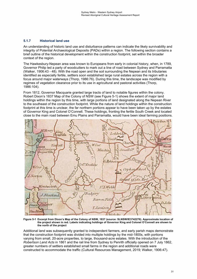
~'"""' rt. .Jll,o.d.111
.f!'J.I. ,,...
•;,.,,.,.,,lid. ,~
r.J,mai,
Sydney Metro - Western Sydney Airport Revised Aboriginal Cultural Heritage Assessment Report
5.1.7 Historical land use An understanding of historic land use and disturbance patterns can indicate the likely survivability and integrity of Potential Archaeological Deposits (PADs) within a region. The following section contains a brief outline of the historical development within the construction footprint, set within the broader context of the region.
The Hawkesbury-Nepean area was known to Europeans from early in colonial history, when, in 1789, Governor Philip led a party of woodcutters to mark out a line of road between Sydney and Parramatta (Walker, 1906:43 - 48). With the road open and the soil surrounding the Nepean and its tributaries identified as especially fertile, settlers soon established large rural estates across the region with a focus around major waterways (Thorp, 1986:76). During this time, the landscape was modified by regimes of vegetation clearance prior to its use in agricultural and pastoral activities (Thorp, 1986:104).
From 1812, Governor Macquarie granted large tracts of land to notable figures within the colony. Robert Dixon’s 1837 Map of the Colony of NSW (see Figure 5-1) shows the extent of major land holdings within the region by this time, with large portions of land designated along the Nepean River to the southeast of the construction footprint. While the nature of land holdings within the construction footprint at this time is unclear, the far northern portions appear to have been taken up by the estates of Governor King and Colonel O’Connell. These holdings, fronting the fertile South Creek and located close to the main road between Emu Plains and Parramatta, would have been ideal farming positions.
Figure 5-1 Excerpt from Dixon’s Map of the Colony of NSW, 1837 (source: SLNSW/IE3742276). Approximate location ofthe project shown in red. Labels indicating holdings of Governor King and Colonel O’Connell are shown to the north of the project
Additional land was subsequently granted to independent farmers, and early parish maps demonstrate that the construction footprint was divided into multiple holdings by the mid-1800s, with portions varying from small, 20-acre properties, to large, thousand-acre estates. With the introduction of the Robertson Land Acts in 1861 and the rail line from Sydney to Penrith officially opened on 7 July 1862, greater numbers of settlers established small farms in the region and additional roads were constructed to accommodate the traffic (Cultural Resources Management, 2019; Walker, 1906:47).
31
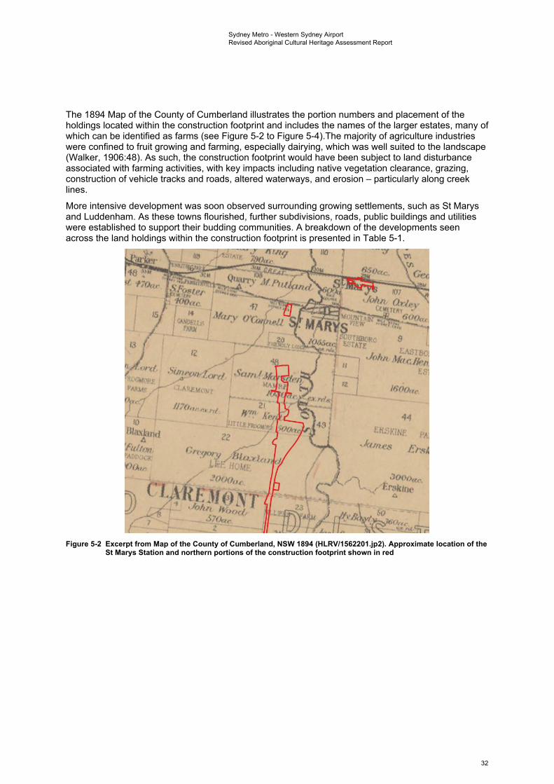
. j,
.!O()(J,,~.
It@ •~ IYooc1,, dEE/di'.L~JL:..:..:~ .,;,.;....~_
Sydney Metro - Western Sydney Airport Revised Aboriginal Cultural Heritage Assessment Report
The 1894 Map of the County of Cumberland illustrates the portion numbers and placement of the holdings located within the construction footprint and includes the names of the larger estates, many of which can be identified as farms (see Figure 5-2 to Figure 5-4).The majority of agriculture industries were confined to fruit growing and farming, especially dairying, which was well suited to the landscape (Walker, 1906:48). As such, the construction footprint would have been subject to land disturbance associated with farming activities, with key impacts including native vegetation clearance, grazing, construction of vehicle tracks and roads, altered waterways, and erosion – particularly along creek lines.
More intensive development was soon observed surrounding growing settlements, such as St Marys and Luddenham. As these towns flourished, further subdivisions, roads, public buildings and utilities were established to support their budding communities. A breakdown of the developments seen across the land holdings within the construction footprint is presented in Table 5-1.
Figure 5-2 Excerpt from Map of the County of Cumberland, NSW 1894 (HLRV/1562201.jp2). Approximate location of the St Marys Station and northern portions of the construction footprint shown in red
32
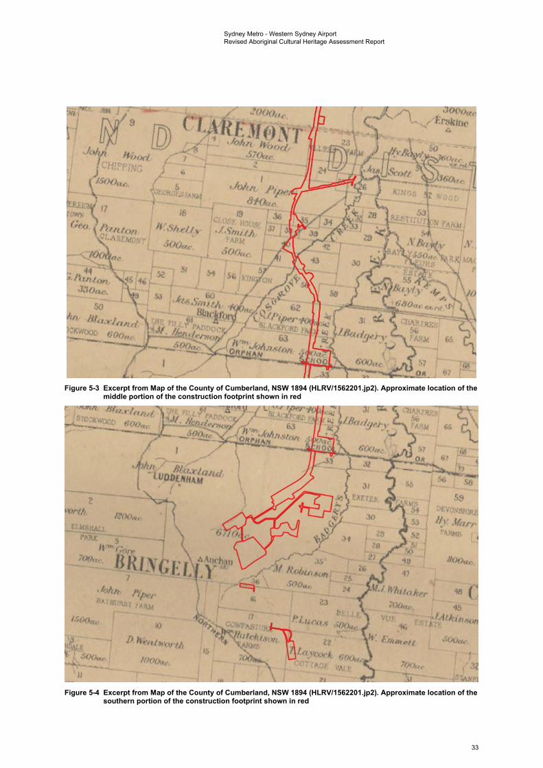
~ h4,ar1. C'H(Op Nr;
~
]
D
58 :Jt:vo.-. ttre
H•• ,fl<1rr -~
Sydney Metro - Western Sydney Airport Revised Aboriginal Cultural Heritage Assessment Report
Figure 5-3 Excerpt from Map of the County of Cumberland, NSW 1894 (HLRV/1562201.jp2). Approximate location of the middle portion of the construction footprint shown in red
Figure 5-4 Excerpt from Map of the County of Cumberland, NSW 1894 (HLRV/1562201.jp2). Approximate location of the southern portion of the construction footprint shown in red
33
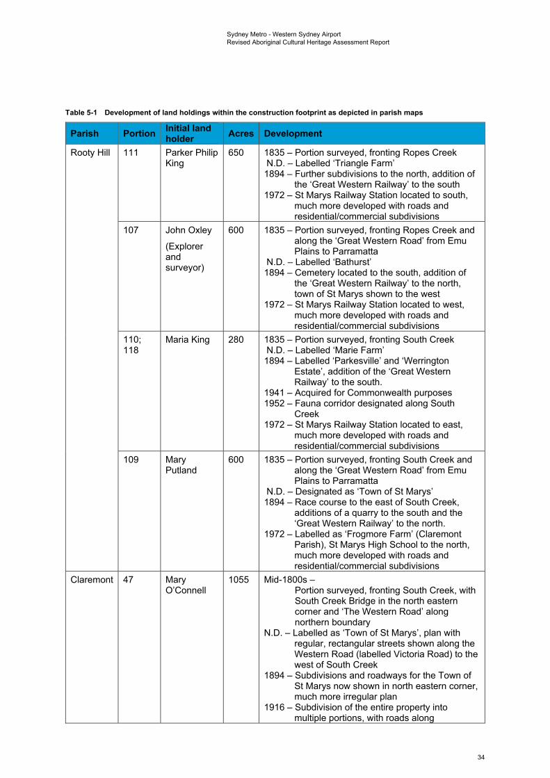
Sydney Metro - Western Sydney Airport Revised Aboriginal Cultural Heritage Assessment Report
Table 5-1 Development of land holdings within the construction footprint as depicted in parish maps
Parish Portion Initial land holder Acres Development
Rooty Hill 111 Parker Philip King
650 1835 – Portion surveyed, fronting Ropes Creek N.D. – Labelled ‘Triangle Farm’ 1894 – Further subdivisions to the north, addition of
the ‘Great Western Railway’ to the south 1972 – St Marys Railway Station located to south,
much more developed with roads and residential/commercial subdivisions
107 John Oxley
(Explorer and surveyor)
600 1835 – Portion surveyed, fronting Ropes Creek and along the ‘Great Western Road’ from Emu Plains to Parramatta
N.D. – Labelled ‘Bathurst’ 1894 – Cemetery located to the south, addition of
the ‘Great Western Railway’ to the north, town of St Marys shown to the west
1972 – St Marys Railway Station located to west, much more developed with roads and residential/commercial subdivisions
110; Maria King 280 1835 – Portion surveyed, fronting South Creek 118 N.D. – Labelled ‘Marie Farm’
1894 – Labelled ‘Parkesville’ and ‘Werrington Estate’, addition of the ‘Great Western Railway’ to the south.
1941 – Acquired for Commonwealth purposes 1952 – Fauna corridor designated along South
Creek 1972 – St Marys Railway Station located to east,
much more developed with roads and residential/commercial subdivisions
109 Mary Putland
600 1835 – Portion surveyed, fronting South Creek and along the ‘Great Western Road’ from Emu Plains to Parramatta
N.D. – Designated as ‘Town of St Marys’ 1894 – Race course to the east of South Creek,
additions of a quarry to the south and the ‘Great Western Railway’ to the north.
1972 – Labelled as ‘Frogmore Farm’ (Claremont Parish), St Marys High School to the north, much more developed with roads and residential/commercial subdivisions
Claremont 47 Mary O’Connell
1055 Mid-1800s – Portion surveyed, fronting South Creek, with South Creek Bridge in the north eastern corner and ‘The Western Road’ along northern boundary
N.D. – Labelled as ‘Town of St Marys’, plan with regular, rectangular streets shown along the Western Road (labelled Victoria Road) to the west of South Creek
1894 – Subdivisions and roadways for the Town of St Marys now shown in north eastern corner, much more irregular plan
1916 – Subdivision of the entire property into multiple portions, with roads along
34
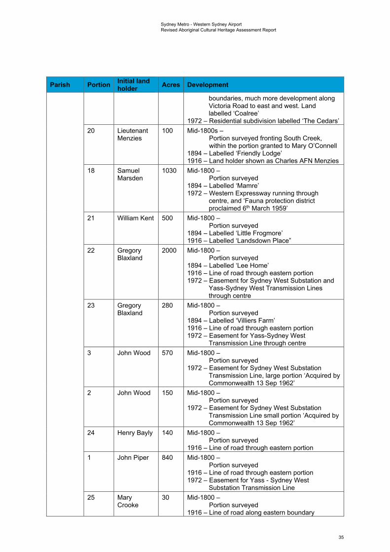
Sydney Metro - Western Sydney Airport Revised Aboriginal Cultural Heritage Assessment Report
Parish Portion Initial land holder Acres Development
boundaries, much more development along Victoria Road to east and west. Land labelled ‘Coalree’
1972 – Residential subdivision labelled ‘The Cedars’ 20 Lieutenant
Menzies 100 Mid-1800s –
Portion surveyed fronting South Creek, within the portion granted to Mary O’Connell
1894 – Labelled ‘Friendly Lodge’ 1916 – Land holder shown as Charles AFN Menzies
18 Samuel Marsden
1030 Mid-1800 – Portion surveyed
1894 – Labelled ‘Mamre’ 1972 – Western Expressway running through
centre, and ‘Fauna protection district proclaimed 6th March 1959’
21 William Kent 500 Mid-1800 – Portion surveyed
1894 – Labelled ‘Little Frogmore’ 1916 – Labelled ‘Landsdown Place”
22 Gregory Blaxland
2000 Mid-1800 – Portion surveyed
1894 – Labelled ‘Lee Home’ 1916 – Line of road through eastern portion 1972 – Easement for Sydney West Substation and
Yass-Sydney West Transmission Lines through centre
23 Gregory Blaxland
280 Mid-1800 – Portion surveyed
1894 – Labelled ‘Villiers Farm’ 1916 – Line of road through eastern portion 1972 – Easement for Yass-Sydney West
Transmission Line through centre 3 John Wood 570 Mid-1800 –
Portion surveyed 1972 – Easement for Sydney West Substation
Transmission Line, large portion ‘Acquired by Commonwealth 13 Sep 1962’
2 John Wood 150 Mid-1800 – Portion surveyed
1972 – Easement for Sydney West Substation Transmission Line small portion ‘Acquired by Commonwealth 13 Sep 1962’
24 Henry Bayly 140 Mid-1800 – Portion surveyed
1916 – Line of road through eastern portion 1 John Piper 840 Mid-1800 –
Portion surveyed 1916 – Line of road through eastern portion 1972 – Easement for Yass - Sydney West
Substation Transmission Line 25 Mary
Crooke 30 Mid-1800 –
Portion surveyed 1916 – Line of road along eastern boundary
35

Sydney Metro - Western Sydney Airport Revised Aboriginal Cultural Heritage Assessment Report
Parish Portion Initial land holder Acres Development
26 William Cosgrove
60 Mid-1800 – Portion surveyed, likely owned land earlier as Cosgroves Creek likely named after the family
1916 – Labelled ‘Cosgrove Farm’, many other holdings in district, line of road though western boundary
36 James Beckett
60 Mid-1800 – Portion surveyed
35 Daniel Wellings
50 Mid-1800 – Portion surveyed
1916 – Line of road through eastern portion 38 William
Sherries 70 Mid-1800 –
Portion surveyed 1916 – Line of road through eastern portion
39 Corn Regan 60 Mid-1800 – Portion surveyed
1916 – Land holder Cornelius Regan, line of road through north western corner
40 Peter Workman
100 Mid-1800 – Portion surveyed
1916 – Line of road through central portion 41 Andrew
Nash 80 Mid-1800 –
Portion surveyed 1916 – Line of road through central portion
43 Philip Hogan 120 Mid-1800 – Portion surveyed
58 Thomas Nicholls
200 Mid-1800 – Portion surveyed
1916 – Labelled ‘Ham Farm” 1972 – Southern portion “vested in the
commonwealth council for scientific and industrial research 1936”
59 Samuel Laycock
100 Mid-1800 – Portion surveyed
1972 – Labelled “vested in the commonwealth council for scientific and industrial research 1936”
62 John Piper 400 Mid-1800 – Portion surveyed 1894 – Labelled ‘Blackford Farm’ 1972 – Labelled “vested in the commonwealth
council for scientific and industrial research 1936”
63 William Johnson
500 Mid-1800 – Portion surveyed
1894 – Road shown south labelled ‘Orphan School or Mulgoa Road’
1972 – Western portion “vested in the commonwealth council for scientific and industrial research 1936”, Elizabeth Drive to south
36
Sydney Metro - Western Sydney Airport Revised Aboriginal Cultural Heritage Assessment Report
Parish Portion Initial land holder Acres Development
Bringelly 1 John Blaxland
6710 Mid-1800 – Portion surveyed, (possibly granted 1813)
1894 – Labelled ‘Luddenham’ N.D. – Subdivision plans for “Luddenham Estate” –
Eastern Division, small portion in west resumed for water supply for the Village of Luddenham, line of road ‘Northern Road from Camden to Richmond’ along western boundary
1953 – Multiple streets and regular shaped lots, Badgerys Creek Public School, road to north Elizabeth Drive (previously Orphan School Road and Mulgoa Road). Divisions to the south much larger than along Elizabeth Drive
39 Hugh Derline
100 Mid-1800 – Portion surveyed within John Blaxland’s
property 35 William
White 20 Mid-1800 –
Portion surveyed N.D. – Portion size changed to 40 acres
7 John Piper 1500 Mid-1800 – Portion surveyed
1894 – Labelled ‘Bathurst Farm’ 16 Edward
Wright 350 Mid-1800 –
Portion surveyed N.D. – Changed to Edmund Wright 1953 – Subdivided into regular lots with roads
17 William Hutchinson
700 Mid-1800 – Portion surveyed
N.D. – Labelled ‘Cowpasture Farms’, line of road ‘Northern Road from Camden to Richmond’ through southwest corner and post office to south
1953 – Subdivided into regular farm lots with roads 23 Penelope
Lucas 500 Mid-1800 –
Portion surveyed N.D. – Portion boundary redrawn as smaller to the
south 1953 – “Acquired for Commonwealth purposes
20.10.49’ 22 Thomas
Laycock 600 Mid-1800 –
Portion surveyed N.D. – Portion boundary redrawn as larger to the
north, labelled ‘Cottage Vale’
5.1.8 Land disturbance The implications of this land use history includes the disturbance of any pre-existing Aboriginal sites and deposits through both direct and indirect means, resulting in a loss of archaeological integrity. The construction footprint was extensively cleared of vegetation during the early pastoral settlement, with widespread ground disturbance likely associated with the cultivation of crops and smaller areas of impact associated with the construction of residential buildings. However, overall disturbance is minimal in the central and southern portions of the construction footprint in comparison with the existing St Marys Station and northern portions of the construction footprint, which have been subject to higher impact activities through large scale residential, commercial, road and rail development. The
37
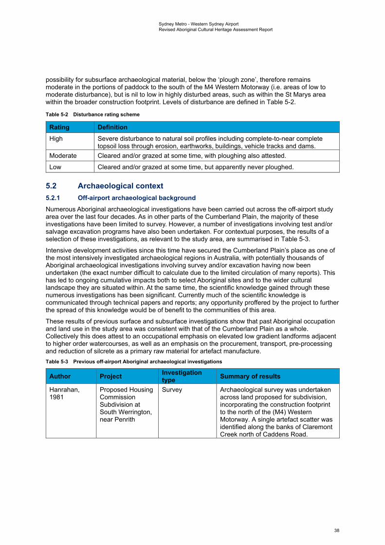
Sydney Metro - Western Sydney Airport Revised Aboriginal Cultural Heritage Assessment Report
possibility for subsurface archaeological material, below the ‘plough zone’, therefore remains moderate in the portions of paddock to the south of the M4 Western Motorway (i.e. areas of low to moderate disturbance), but is nil to low in highly disturbed areas, such as within the St Marys area within the broader construction footprint. Levels of disturbance are defined in Table 5-2.
Table 5-2 Disturbance rating scheme
Rating Definition High Severe disturbance to natural soil profiles including complete-to-near complete
topsoil loss through erosion, earthworks, buildings, vehicle tracks and dams. Moderate Cleared and/or grazed at some time, with ploughing also attested.
Low Cleared and/or grazed at some time, but apparently never ploughed.
5.2 Archaeological context 5.2.1 Off-airport archaeological background Numerous Aboriginal archaeological investigations have been carried out across the off-airport study area over the last four decades. As in other parts of the Cumberland Plain, the majority of these investigations have been limited to survey. However, a number of investigations involving test and/or salvage excavation programs have also been undertaken. For contextual purposes, the results of a selection of these investigations, as relevant to the study area, are summarised in Table 5-3.
Intensive development activities since this time have secured the Cumberland Plain’s place as one of the most intensively investigated archaeological regions in Australia, with potentially thousands of Aboriginal archaeological investigations involving survey and/or excavation having now been undertaken (the exact number difficult to calculate due to the limited circulation of many reports). This has led to ongoing cumulative impacts both to select Aboriginal sites and to the wider cultural landscape they are situated within. At the same time, the scientific knowledge gained through these numerous investigations has been significant. Currently much of the scientific knowledge is communicated through technical papers and reports; any opportunity proffered by the project to further the spread of this knowledge would be of benefit to the communities of this area.
These results of previous surface and subsurface investigations show that past Aboriginal occupation and land use in the study area was consistent with that of the Cumberland Plain as a whole. Collectively this does attest to an occupational emphasis on elevated low gradient landforms adjacent to higher order watercourses, as well as an emphasis on the procurement, transport, pre-processing and reduction of silcrete as a primary raw material for artefact manufacture. Table 5-3 Previous off-airport Aboriginal archaeological investigations
Author Project Investigation type Summary of results
Hanrahan, 1981
Proposed Housing Commission Subdivision at South Werrington, near Penrith
Survey Archaeological survey was undertaken across land proposed for subdivision, incorporating the construction footprint to the north of the (M4) Western Motorway. A single artefact scatter was identified along the banks of Claremont Creek north of Caddens Road.
38
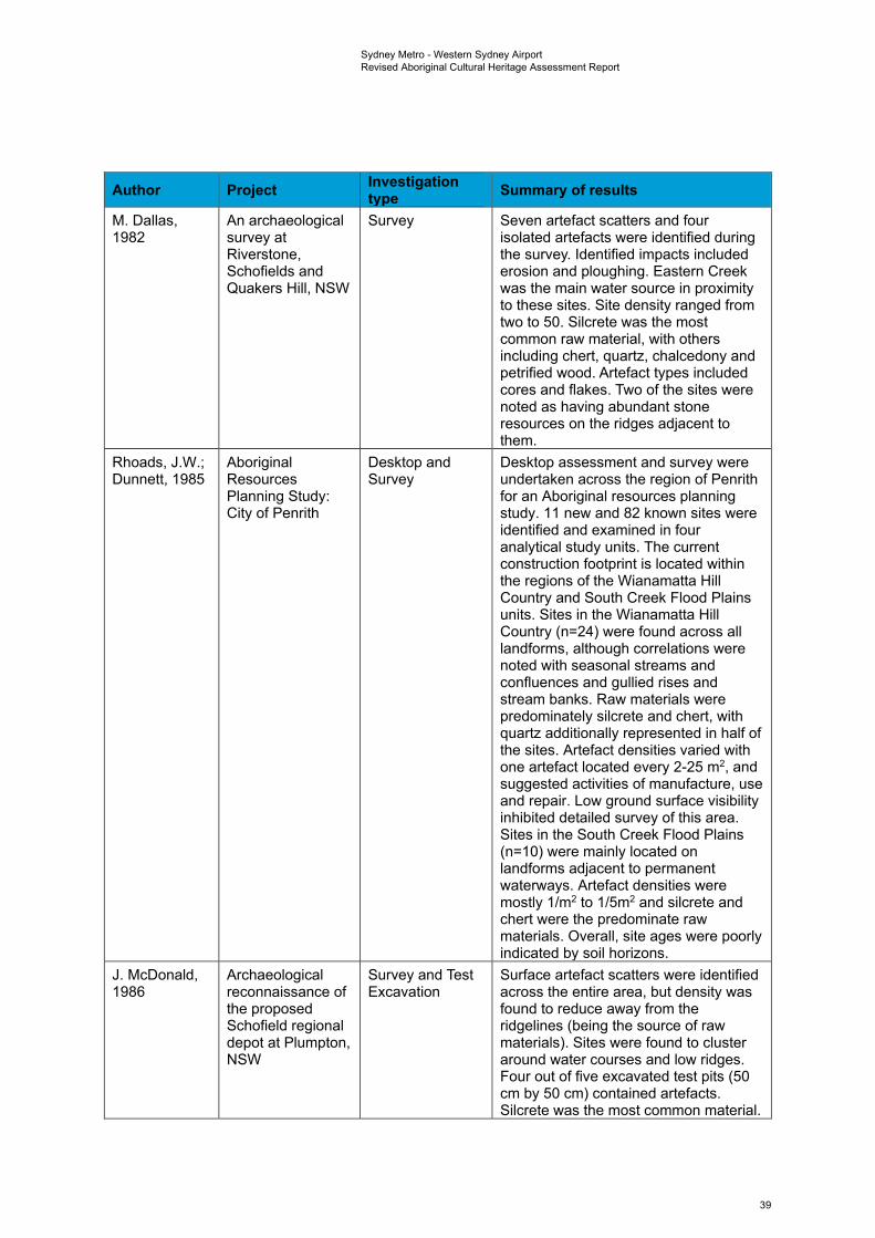
Sydney Metro - Western Sydney Airport Revised Aboriginal Cultural Heritage Assessment Report
Author Project Investigation type Summary of results
M. Dallas, An archaeological Survey Seven artefact scatters and four 1982 survey at
Riverstone, Schofields and Quakers Hill, NSW
isolated artefacts were identified during the survey. Identified impacts included erosion and ploughing. Eastern Creek was the main water source in proximity to these sites. Site density ranged from two to 50. Silcrete was the most common raw material, with others including chert, quartz, chalcedony and petrified wood. Artefact types included cores and flakes. Two of the sites were noted as having abundant stone resources on the ridges adjacent to them.
Rhoads, J.W.; Aboriginal Desktop and Desktop assessment and survey were Dunnett, 1985 Resources
Planning Study: City of Penrith
Survey undertaken across the region of Penrith for an Aboriginal resources planning study. 11 new and 82 known sites were identified and examined in four analytical study units. The current construction footprint is located within the regions of the Wianamatta Hill Country and South Creek Flood Plains units. Sites in the Wianamatta Hill Country (n=24) were found across all landforms, although correlations were noted with seasonal streams and confluences and gullied rises and stream banks. Raw materials were predominately silcrete and chert, with quartz additionally represented in half of the sites. Artefact densities varied with one artefact located every 2-25 m2, and suggested activities of manufacture, use and repair. Low ground surface visibility inhibited detailed survey of this area. Sites in the South Creek Flood Plains (n=10) were mainly located on landforms adjacent to permanent waterways. Artefact densities were mostly 1/m2 to 1/5m2 and silcrete and chert were the predominate raw materials. Overall, site ages were poorly indicated by soil horizons.
J. McDonald, Archaeological Survey and Test Surface artefact scatters were identified 1986 reconnaissance of
the proposed Schofield regional depot at Plumpton, NSW
Excavation across the entire area, but density was found to reduce away from the ridgelines (being the source of raw materials). Sites were found to cluster around water courses and low ridges. Four out of five excavated test pits (50 cm by 50 cm) contained artefacts. Silcrete was the most common material.
39
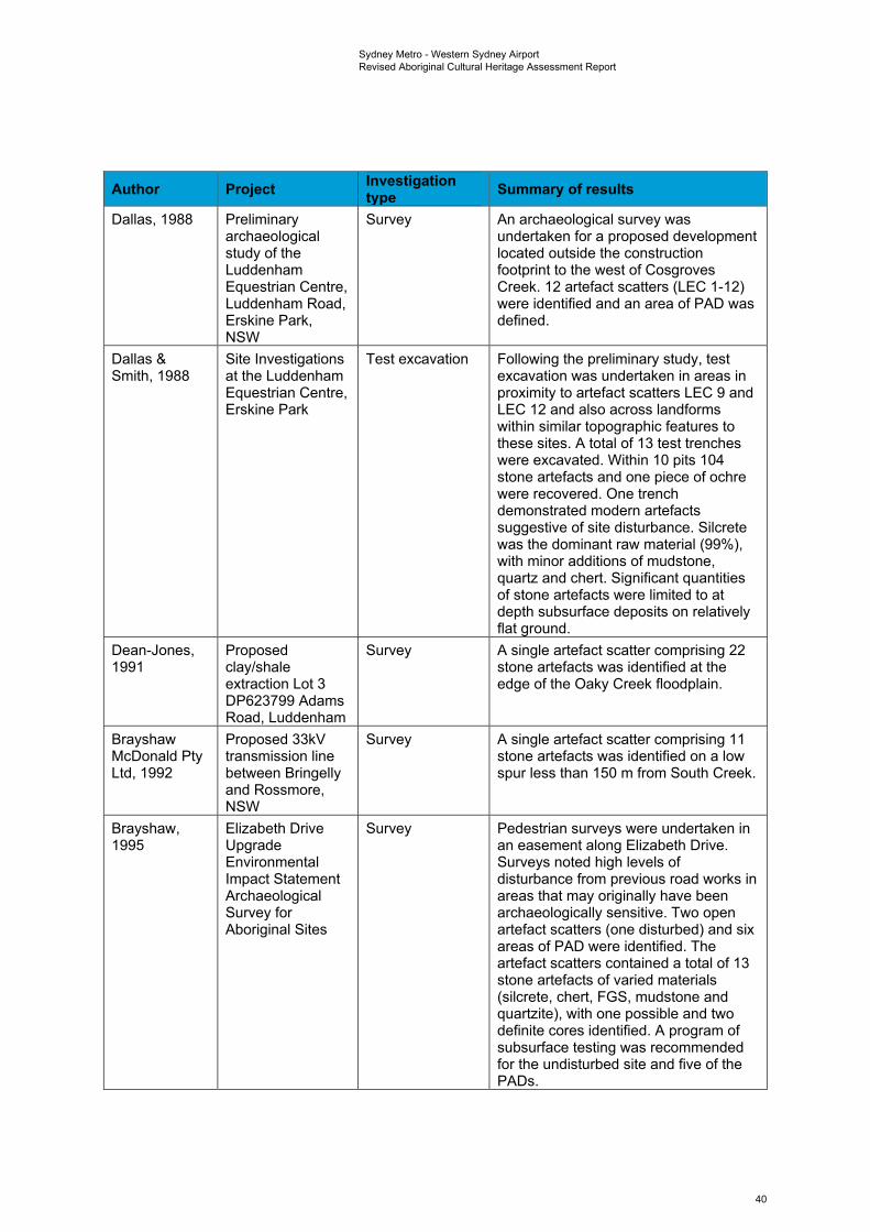
Sydney Metro - Western Sydney Airport Revised Aboriginal Cultural Heritage Assessment Report
Author Project Investigation type Summary of results
Dallas, 1988 Preliminary archaeological study of the Luddenham Equestrian Centre, Luddenham Road, Erskine Park, NSW
Survey An archaeological survey was undertaken for a proposed development located outside the construction footprint to the west of Cosgroves Creek. 12 artefact scatters (LEC 1-12) were identified and an area of PAD was defined.
Dallas & Site Investigations Test excavation Following the preliminary study, test Smith, 1988 at the Luddenham
Equestrian Centre, Erskine Park
excavation was undertaken in areas in proximity to artefact scatters LEC 9 and LEC 12 and also across landforms within similar topographic features to these sites. A total of 13 test trenches were excavated. Within 10 pits 104 stone artefacts and one piece of ochre were recovered. One trench demonstrated modern artefacts suggestive of site disturbance. Silcrete was the dominant raw material (99%), with minor additions of mudstone, quartz and chert. Significant quantities of stone artefacts were limited to at depth subsurface deposits on relatively flat ground.
Dean-Jones, Proposed Survey A single artefact scatter comprising 22 1991 clay/shale
extraction Lot 3 DP623799 Adams Road, Luddenham
stone artefacts was identified at the edge of the Oaky Creek floodplain.
Brayshaw Proposed 33kV Survey A single artefact scatter comprising 11 McDonald Pty transmission line stone artefacts was identified on a low Ltd, 1992 between Bringelly
and Rossmore, NSW
spur less than 150 m from South Creek.
Brayshaw, Elizabeth Drive Survey Pedestrian surveys were undertaken in 1995 Upgrade
Environmental Impact Statement Archaeological Survey for Aboriginal Sites
an easement along Elizabeth Drive. Surveys noted high levels of disturbance from previous road works in areas that may originally have been archaeologically sensitive. Two open artefact scatters (one disturbed) and six areas of PAD were identified. The artefact scatters contained a total of 13 stone artefacts of varied materials (silcrete, chert, FGS, mudstone and quartzite), with one possible and two definite cores identified. A program of subsurface testing was recommended for the undisturbed site and five of the PADs.
40
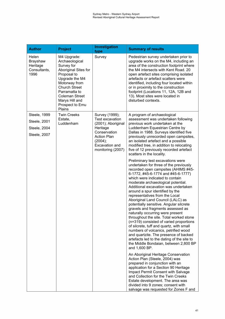
Sydney Metro - Western Sydney Airport Revised Aboriginal Cultural Heritage Assessment Report
Author Project Investigation type Summary of results
Helen M4 Upgrade: Survey Pedestrian survey undertaken prior to Brayshaw Archaeological upgrade works on the M4, including an Heritage Survey for area of the construction footprint where Consultants, Aboriginal Sites for the M4 intersects with Kent Road. 20 1996 Proposal to
Upgrade the M4 Motorway from Church Street Parramatta to Coleman Street Marys Hill and Prospect to Emu Plains
open artefact sites comprising isolated artefacts or artefact scatters were identified, including four located within or in proximity to the construction footprint (Locations 11, 12A, 12B and 13). Most sites were located in disturbed contexts.
Steele, 1999 Twin Creeks Survey (1999); A program of archaeological
Steele, 2001 Estate, Luddenham
Test excavation (2001); Aboriginal
assessment was undertaken following previous work undertaken at the
Steele, 2004 Heritage Luddenham Equestrian Centre by
Steele, 2007 Conservation Action Plan (2004); Excavation and monitoring (2007)
Dallas in 1988. Surveys identified five previously unrecorded open campsites, an isolated artefact and a possible modified tree, in addition to relocating five of 12 previously recorded artefact scatters in the locality.
Preliminary test excavations were undertaken for three of the previously recorded open campsites (AHIMS #45-6-1772, #45-6-1774 and #45-6-1777) which were indicated to contain moderate archaeological potential. Additional excavation was undertaken around a spur identified by the representatives from the Local Aboriginal Land Council (LALC) as potentially sensitive. Angular silcrete gravels and fragments assessed as naturally occurring were present throughout the site. Total worked stone (n=319) consisted of varied proportions of silcrete, tuff and quartz, with small numbers of volcanics, petrified wood and quartzite. The presence of backed artefacts led to the dating of the site to the Middle Bondaian, between 2,800 BP and 1,600 BP.
An Aboriginal Heritage Conservation Action Plan (Steele, 2004) was prepared in conjunction with an application for a Section 90 Heritage Impact Permit Consent with Salvage and Collection for the Twin Creeks Estate development. The area was divided into 9 zones; consent with salvage was requested for Zones F and
41
Sydney Metro - Western Sydney Airport Revised Aboriginal Cultural Heritage Assessment Report
Author Project Investigation type Summary of results
G, while consent with collection was requested for Zones B, C, D, E and H.
Archaeological excavation and monitoring (Steele, 2007) were undertaken at the Twin Creeks Estate in accordance with the approved Conservation Action Plan and S90 Consent (#2056). Site LEC 12 (AHIMS #45-6-177) was assessed and stabilised; site LEC 10 (AHIMS #45-6-1779) was excavated for salvage; and site TCE 1 (AHIMS #45-5-2991) was collected following its identification during the period of development monitoring. Excavations for LEC 10 recovered 120 artefacts over 16 test trenches, with 57 complete flakes.
Jo McDonald Archaeological Survey Five artefact scatters and three isolated Cultural Survey for artefacts were identified. Salvage works Heritage Aboriginal Sites: were recommended prior to Management Proposed Light development proceeding. Pty Ltd, 2000 Industrial
Subdivision, "Austral Site", Mamre Road, Erskine Park, NSW
Jo McDonald Survey for Survey Pedestrian surveys were undertaken for Cultural Aboriginal Sites a 25.5 hectares section of Nolans Heritage 1503 Elizabeth Quarry proposed for redevelopment. Management Drive, Kemps One section of PAD was identified on a Pty Ltd, 2001 Creek ridgeline in proximity to Kemps Creek
and South Creek, with an associated quartz flake located on the surface. Clearing prior to the survey was suggested to have impacted the surface of the site, potentially having destroyed previous artefacts. Despite this, intact subsurface deposits were considered possible.
URS Australia Gipps Street Survey An archaeological survey was Pty Ltd, 2001 Landfill Site,
Claremont Meadows
undertaken of Gipps Street Lane, located within the construction footprint. No Aboriginal sites were identified. Observations concluded that the site had been subject to high levels of past disturbance.
42

Sydney Metro - Western Sydney Airport Revised Aboriginal Cultural Heritage Assessment Report
Author Project Investigation type Summary of results
Appleton, The Archaeological Survey Two isolated artefacts and an area of 2002 Investigation of Lot
2, DP 120673 The Site of a Proposed New Clay and Shale Extraction Area - Old Wallgrove Road Horsley Park, West of Sydney NSW
PAD were identified during survey at this location.
Environmental Land Solutions Survey; Test Archaeological survey was undertaken Resources Development, excavation and for a portion of land located outside the Management Claremont salvage. construction footprint, between the M4 Australia Pty Meadows and Fowler Street. Nine sites were Ltd, 2003 identified, comprising four artefact
scatters, four isolated artefacts and a possible scarred tree. A Section 90
Environmental consent to destroy was recommended Resources for disturbed sites in the north of the Management study area, while testing followed by a Australia Pty Section 90 consent was recommended Ltd, 2006a for site OAD1.
Subsequent test excavations and salvage were undertaken for site OAD1 (AHIMS #45-5-3013), which was determined to form part of AHIMS #45-5-2898. Approximately 2,000 artefacts were recovered, with evidence of complex activity zones including knapping floors and potential associations with heat shatters and campsites. Site distribution within the area was correlated with the crest at the 30 m contour overlooking South Creek.
Environmental Lots 8, 9, 10 Survey Survey was undertaken for a proposed Resources DP27107 and Lot development located outside the Management 19 DP239091 construction footprint, to the north west Australia Pty Claremont of Kent Road. Six Aboriginal sites were Ltd, 2006b Meadows identified in areas of exposure across
the site and subsurface potential was predicted for the flat floodplain.
Jo McDonald Austral Land Salvage Salvage excavations were undertaken Cultural Mamre Rd, with 298 m2 excavated and 8,867 Heritage Erskine Park: artefacts retrieved from subsurface Management Archaeological deposits. Artefact density was found to Pty Ltd, 2008b Salvage
Excavations be tied to stream order. Use of silcrete as a raw material diminished as the distance from silcrete sources increased. Backed blades were present as was evidence of bipolar flaking.
43
Sydney Metro - Western Sydney Airport Revised Aboriginal Cultural Heritage Assessment Report
Author Project Investigation type Summary of results
Jo McDonald Lot 2 DP771697, Survey Pedestrian survey undertaken for a Cultural Claremont development area located within the Heritage Meadows construction footprint to the immediate Management south of the (A44) Great Western Pty Ltd, 2008a Highway. One isolated find (GS01
consisting of a silcrete flake) was identified in the road corridor of Gipps Street at the edge of an eroding bank associated with a drainage line.
Biosis Rosehill Recycled Survey No sites were identified during survey, Research Pty Water Scheme although it was noted that one artefact Ltd, 2008 Preliminary
Cultural Heritage Assessment
scatter and one PAD were both located in close proximity. An area of sensitivity was demarcated.
Environmental Lots 8, 9, 10 Test excavation Test excavations were undertaken for Resources DP27107 and Lot and salvage three sites identified in the 2006 Management 19 DP239091 assessment (CMSW3, CMSW4 and Australia Pty Claremont CMSW5), while test excavation and Ltd, 2010 Meadows salvage were undertaken for site
CMSW1. A total of 773 artefacts were recovered and included flaked stone and flaked glass, suggesting site occupation in the contact period.
Archaeological Aboriginal Survey An assessment was undertaken for and Heritage Archaeological proposed upgrade works at Gipps Management Survey Street and Kent Road from the M4 Solutions Pty Report: Motorway to the Great Western Ltd, 2012 Werrington Arterial
Road (M4 Motorway – Great Western Highway), Claremont Meadows, NSW
Highway, near Claremont Meadows. A total of seven Aboriginal sites were identified within the study area, with a further three in close proximity, outside the study area boundary. Five of the sites had been previously recorded; five sites were new recordings. The sites included seven isolated artefacts and three artefact scatters (one identified as having an associated area of PAD). Site #45-5-2898 was verified as being outside the study area, as the AHIMS coordinates had erroneously identified it as within. Site avoidance was recommended with an AHIP stated as needed if sites could not be avoided.
Kelleher Werrington Arterial Desktop A report was compiled to support the Nightingale Road M4 AHIP application for the proposed Consulting Pty Motorway to Great upgrades at Kent Road and Gipps Ltd, 2012 Western Highway
Cultural Heritage Assessment Report
Street between the M4 Motorway and the Great Western Highway, as part of the Werrington Arterial Road project near Claremont Meadows. Of the 10 sites identified (seven isolated artefacts and three artefact scatters), seven were to be destroyed, two were to be protected and preserved, and one was to be partially destroyed. An AHIP
44
Sydney Metro - Western Sydney Airport Revised Aboriginal Cultural Heritage Assessment Report
Author Project Investigation type Summary of results
(C0000636) was subsequently issued for the impact.
Kelleher Sydney Science Survey Archaeological surveys were Nightingale Park Development, undertaken across a 448 hectares Consulting Pty Luddenham parcel of land proposed for rezoning Ltd, 2013b and development. This included a
section within the construction footprint to the north of Luddenham Road. Five archaeological sites (including one previously recorded site) and three areas of PAD were identified. An AHIP was recommended for the development.
Kelleher M4 Managed Survey and 33 Aboriginal sites were shown to be Nightingale Motorway from cultural heritage located within the M4MM corridor, Consulting Pty Lapstone (Western assessment including previously recorded sites Ltd, 2013a End) to Strathfield
(Eastern End) (Brayshaw and Haglund 1996) and two new artefact scatters. High levels of disturbance were observed during
Kelleher surveys. Nightingale Consulting Pty Ltd, 2016a
AHIP C0002113, AHIMS Permit ID 4001 was subsequently issued for the recommended salvage excavation, community collection and destruction of Aboriginal objects throughout the development.
Biosis Mamre West Survey and test Survey recorded a single artefact Research Pty Precinct, Orchard excavation scatter comprising 11 stone artefacts. Ltd, 2016 Hills
Salvage
Test excavation across four areas of identified sensitivity identified a total of 78 artefacts. Subsequent salvage excavations recovered 43 artefacts from 39 excavation units, with an overall density of 1.1/m2.
Kelleher The Northern Survey Pedestrian surveys were undertaken Nightingale Road Upgrade across a four kilometre stretch of land Consulting Pty Stage 3 Jamison proposed for development. Four artefact Ltd, 2016b Road, Penrith to scatters and two isolated artefacts were
Glenmore Parkway identified, most of these on the crests and slopes of a north-south running ridgeline. Five of the sites showed evidence of high disturbance from infrastructure and erosion, with low archaeological potential. One site (TNR AFT 32) exhibited evidence of in situ material and moderate archaeological potential. The assessment of site TNR ART 32 prompted the adjustment of RMS’s concept design to ensure it was avoided. Two sites were assessed as potentially impacted by the proposed works and an AHIP was recommended. AHIP C0002492, AHIMS Permit ID 4078 was subsequently issued for these impacts. Three additional sites were
45
Sydney Metro - Western Sydney Airport Revised Aboriginal Cultural Heritage Assessment Report
Author Project Investigation type Summary of results
identified as within the boundary of a separate AHIP application (KNC 2016a, AHIP C0002113) that was already in progress at the time of the assessment.
Kelleher Sydney Science Test excavation The study area, located on Luddenham Nightingale Park Development Road, Luddenham, was to be Consulting Pty Luddenham, NSW developed as Sydney Science Park, a Ltd, 2018 Aboriginal
Archaeological Assessment Test Excavation Report
place to install leading science-based businesses, tertiary institutions, research and development providers. A total of 15 artefacts were recovered from across 24 test pits at RPS LTPAS01. Materials were predominantly silcrete (n=11) whilst artefacts of silicified tuff (n=3) and quartzite (n=1) were also found. Further to this a total of two artefacts were recovered from the five test pits excavated at SSP 1, 29 artefacts were recovered from the 22 test pits excavated at SSP 2, a total of 36 artefacts were recovered from the 15 test pits excavated at SSP 3, 42 artefacts were recovered from the 26 test pits excavated at SSP PAD 1, six artefacts were recovered from the 12 test squares excavated at SSP PAD 2 and 76 artefacts were recovered from the 47 test squares excavated at SSP PAD 3 and 76 artefacts were recovered from the 47 test squares excavated at SSP PAD 3.
Kelleher Sydney Science Desktop Following test excavations this report Nightingale Park Development, was compiled to support an all of area Consulting Pty Luddenham, NSW AHIP application. Ltd, 2018b Cultural Heritage
Assessment Report
Streat & Aboriginal Test Test excavation 30 test trenches were excavated across Pavinich, 2018 Excavation Report
Lot 2 Section 4 DP 2954 111-1141 Elizabeth Drive, Cecil Park
the study area of a proposed subdivision, located to the east of the construction footprint. Intact soil profiles were present in some areas; however, no Aboriginal archaeological material was identified.
Roads and M12 Motorway Survey and test Field surveys and test excavations Maritime concept design excavation conducted along the proposed M12 Services, 2019 and Environmental
Impact Statement ACHAR
Motorway identified nine stone artefact sites and 17 areas of PAD, all grouped around major creek lines. PADs were subsequently excavated in linear transects extending away from identified creek lines. A total of 1,509 Aboriginal artefacts were recovered from 16 of the 17 PADs, comprising 1,404 flaked artefacts, in addition to hammer stones,
46
Sydney Metro - Western Sydney Airport Revised Aboriginal Cultural Heritage Assessment Report
Author Project Investigation type Summary of results
stone fragments and an ochre pencil. Across the sites, subsurface extents suggested that subsurface material was extensive across the site and continued into the surrounding landscape.
The construction footprint crosses into PAD M12-BWB, defined as an area of creek flats immediately north of Elizabeth Drive and extending at least 520 m along an east-west axis from Badgerys Creek. M12-BWB contained a total of 72 artefacts across 13 test pits. Artefact densities were generally low; however, one pit recorded 24 artefacts. Artefact distributions demonstrated that artefacts were located throughout the soil profile but occurred consistently in topsoils up to 360 m from creek. The site was assessed to be of low-moderate significance, with the exception of high social significance.
Overall, 19 sites were to be impacted by the project, including the partial impact (1.7 ha) of BWB. Mitigation measure such as salvage and protective fencing were recommended.
Baker University of Survey Pedestrian field surveys were Archaeology Sydney lands at conducted to assess archaeological Pty Ltd, 2019 Badgerys Creek
ACHAR sensitivity across parcels of farmland, including the section of the construction footprint to the north of Elizabeth Drive. A total of 29 previously unrecorded sites were identified (UoS 1 – 29), all of which consisted of stone artefact sites ranging from densities of one to 100 artefacts. Two low density artefact sites, (UOS 06 and UOS 27) were located within the current construction footprint. There are also zoned areas for conservation value, with the construction footprint passing through areas zoned as low archaeological value, with the exception of the section within the vicinity of Badgerys Creek associated with site BWB, assessed as moderate
Based on the summary provided in the table above, past assessments undertaken across the wider region including the construction footprint have identified the presence of Aboriginal artefacts in both surface and subsurface contexts. Artefact sites have predominantly been identified in proximity to water sources, although other landforms may contain sites if they have not been subject to high levels of past disturbance. Although artefact sites are the most common across the area other site types have been identified in the region, including culturally modified trees. There are both known AHIMS sites and areas of archaeological sensitivity that are likely to contain intact subsurface deposits
47
Sydney Metro - Western Sydney Airport Revised Aboriginal Cultural Heritage Assessment Report
present within the bounds of the construction footprint. This is discussed further in Section 5.4 and Chapter 6.
5.2.2 On-airport archaeological background Extensive archaeological investigation has been undertaken and is currently ongoing within the bounds of Western Sydney International. Survey and test excavation were undertaken in 2015 and salvage works are currently underway as development works continue. The results of the 2015 investigation (see Table 5-4) identified sites and artefact assemblages consistent with those evident in the wider region (as discussed in Section 5.2.1 in relation to the off-airport area). Table 5-4 Previous on-airport Aboriginal archaeological investigations
Author Project Investigation type Summary of results
Haglund, 1978 Major airport needs of Sydney study; survey of Aboriginal sites and relics, second Sydney airport site options
Survey Pedestrian surveys were undertaken over multiple sites selected as potential locations of a second airport, with the aim of identifying Aboriginal archaeological constraints. A number of sites were identified, including three north of Elizabeth Drive (AHIMS sites #45-5-0213, 45-5-0214 and 45-5-0215). No sites were identified within the construction footprint.
Lance & Second Sydney Survey Comprehensive survey undertaken over Hughes, 1984 Airport Aboriginal
Archaeological Study: Badgerys Creek/Wilton
sample areas within Badgerys Creek to assess Aboriginal archaeological sensitivity. Results indicated poor surface visibility adjacent to creeks and on hillslopes due to vegetation growth. One artefact scatter (AHIMS site #45-5-0517) was identified in a ploughed field adjacent to Badgerys Creek.
Navin Officer Proposal for Second Survey Archaeological surveys were undertaken Heritage Sydney Airport at for alternative airport locations at Consultants Pty Badgerys Creek or Badgerys Creek and Holsworthy Military Ltd, 1997 Holsworthy Military
Area Training Area. 111 Aboriginal sites were recorded across the Badgerys Creek study area, including one previously recorded site (#45-5-0517). These predominately consisted of stone artefact sites; however, 8 scarred trees and one area of PAD were also recorded. Sites were generally low density, with the exception of higher densities in valley floor and fluvial corridor landforms. Most sites were assessed to be in disturbed contexts. Badgerys Creek was assessed as a lesser impact due to the presence of highly sensitive rockshelters at the Holsworthy site. Recommendations included a more detailed survey of impacted areas, subsurface testing and salvage.
48
Sydney Metro - Western Sydney Airport Revised Aboriginal Cultural Heritage Assessment Report
Author Project Investigation type Summary of results
Artefact The Northern Road Survey A total of new 32 sites were recorded, Heritage, 2012 Upgrade including 11 stone artefact sites, two
scarred trees and 1 PAD. Sites were located across varied landforms. Four previously recorded sites were assessed as destroyed.
AMBS, 2014 Environmental survey of Commonwealth Land at Badgerys Creek: Aboriginal Heritage
Desktop and survey
A desktop review and archaeological survey were undertaken for Commonwealth owned land at Badgerys Creek. 21 previously recorded sites were inspected to determine their condition. Only seven sites were relocated, consisting of five stone artefact sites and two possible scarred trees.
Results concluded that the area contained greater subsurface potential than assessed within the 1997 report (Navin Officer 1997).
Navin Officer Western Sydney Field survey An archaeological assessment was Heritage Airport Aboriginal and test undertaken for Stage 1 of the proposed Consultants Pty Cultural Heritage excavation 1,700 hectares Western Sydney Airport Ltd, 2015 Assessment at Badgerys Creek. Desktop review
revealed a total of 51 previously recorded sites within the study area.
38 test pit locations were initially proposed for testing; however, only 11 of these were excavated following field survey of the locations. Each location comprised a total of 10-14 x 5m2 test pits.
Following field surveys of excavation sites and test excavation, a total of 23 new Aboriginal sites were recorded, comprising of nine surface sites, 13 subsurface sites and one site with both surface and subsurface expressions of artefacts.
Due to the nature of impact proposed for the construction of the airport, the sensitivity of the study area for Aboriginal sites, the cumulative impact of development across the Cumberland Plain and strong opposition from Aboriginal stakeholders, the preparation of a conservation management plan was recommended.
49
Sydney Metro - Western Sydney Airport Revised Aboriginal Cultural Heritage Assessment Report
Author Project Investigation type Summary of results
Department of Infrastructure and Regional Development, 2016
Western Sydney International -Environmental Impact Statement
Survey and test excavation
Survey and test excavation were carried out at both the Stage 1 area and areas outside of the Stage 1 area of Western Sydney International in May 2015. In addition to previously recorded sites, a total of 23 new sites were identified, comprising 14 subsurface artefact deposits (identified during test excavation), nine open artefact sites (determined by the surface expression of artefacts) and one grinding groove site. A total of 39 sites (all open artefact sites) were identified within impact areas for the development.
Navin Officer Western Sydney Desktop An Aboriginal Cultural Heritage Heritage Airport - Enabling Management Plan (ACHMP) was Consultants Pty Activities, Aboriginal prepared for Aboriginal archaeological Ltd, 2017 Cultural Heritage
Management Plan survey and salvage works undertaken prior to the Western Sydney Airport initial enabling works.
Upon completion of the ACHMP and subsequent survey and salvage works in 2018, an updated inventory was prepared of all surface and subsurface sites known across the site (n=127).
WSA Co, 2018 Western Sydney Airport Aboriginal Cultural Heritage Construction Environmental Management Plan
Desktop An Aboriginal Cultural Heritage CEMP was prepared for further works required at the Western Sydney Airport. The CEMP undertook a risk assessment for potential impacts of the works on Aboriginal cultural heritage and detailed mitigation measures for reducing this impact. The CEMP indicated that the previous inventory of Aboriginal archaeological sites across the site would be updated with additional finds following targeted and selective survey and salvage programs.
5.3 Regional context A detailed examination of the regional context of Sydney and the Cumberland Plain, with relevant details on occupation chronology and site distribution, is included in this report in Appendix I -Regional archaeological context.
Aboriginal site distribution on the Cumberland Plain has been linked to a variety of environmental factors, with distance to water, stream order, landform and geology (including proximity to known stone sources) variously highlighted as important influences. White and McDonald’s (2010) analysis both supports and negates various aspects of the postulated relationships between these factors and Aboriginal site patterning on the Cumberland Plain. Key findings can be summarised as follows:
• artefact distributions do not, as implied by the models of Kohen (1986) and Smith (1989), form bounded ‘sites’ but rather ‘landscapes’
50
Sydney Metro - Western Sydney Airport Revised Aboriginal Cultural Heritage Assessment Report
• artefact distribution does, as variably expressed by AMBS (2000), Kohen (1986), Jo McDonald CHM (1997b, 2005) and Smith (1989), appear to vary with proximity to water, albeit to different extents based on stream order
• artefact density does, as suggested by Jo McDonald CHM (1997b, 2005), appear to vary significantly with stream order
• artefact density does, as suggested by Jo McDonald CHM (1997b, 2005), appear to vary significantly with landform
• Aboriginal archaeological sites on the Cumberland Plain cannot, as proposed by Jo McDonald CHM (2005), be adequately characterized on the basis of surface evidence alone. Most areas, regardless of surface indications, contain subsurface archaeological deposit(s)
• the orientation of open land surfaces appears to have influenced the selection of artefact discard locations in the lower portions of valleys, with generally higher densities on lower slopes facing north and north-east
• distance from known silcrete sources does not, on present evidence at least, appear to have influenced intensity of artefact discard (cf. Dallas & Witter 1983)
• trends in artefact density and distribution indicate long-term, large scale patterns. Short term models of settlement organization are insufficient to account for these artefact distributions
• social and/or symbolic factors may have influenced site selection along with the distributions of economic and other resources.
More recently, AHMS (2015), employing a comparable analytical methodology to White and McDonald (2010), undertook an analysis of lithic artefact distribution across sixteen northwestern Cumberland Plain landscapes subject to dispersed testing and/or targeted open area salvage excavations. The dataset for this analysis, which sought, in common with White and McDonald’s (2010) study, to identify patterns in artefact discard1 comprised 2,988 artefacts from 345 dispersed test pits (1 m2) along multiple pipeline corridors. In common with White and McDonald (2010: 32-33), AHMS found that artefact distribution within their sampled landscapes varied significantly in relation to both stream order and landform, with mean artefact densities highest in third order landscapes (16.7 artefacts/m2) and on terraces (16.9 artefacts/m2). Interestingly, however, the mean artefact density for third order landscapes in AHMS’s (2015) dataset (i.e. 16.7 artefacts/m2) was found to exceed that for fourth order landscapes in the RHDA dataset (13.9 artefacts/m2). The mean artefact density for creek flats in AHMS’s dataset (7.8 artefacts/m2) was likewise found to exceed its counterpart in the RHDA dataset (3.8 artefacts/m2), suggesting that creek flats in AHMS’s sampled landscapes may have been more favoured for occupation than those in the RHDA or, alternatively, that creek flats in the RHDA had been subject to more intensive flood-erosion activity (resulting in a greater loss of artefacts).
In keeping with White and McDonald’s (2010:34) results, AHMS found that in second order landscapes, artefact density was highest within 50 metres of water. Distance to water in fourth order landscapes was not assessed by AHMS. However, in a comparable finding to White and McDonald’s (2010:34, Table 9) fourth order dataset, AHMS found that in third order landscapes, artefact density was highest between 51 and 100 metres from water. Consideration of first and third order landscapes in combination likewise showed that mean artefact density was highest between 51 and 100 metres of water, suggesting, in combination with the above, that landform elements located at a slightly greater distance to creeks (and particularly larger creeks) were favoured for sustained/repeated occupation2. While limited to lower slopes, AHMS’s analysis of artefact distribution in relation to slope aspect revealed both similarities and differences with the RHDA dataset, with southeast-facing lower slopes in AHMS’s sampled landscapes exhibiting the highest mean artefact density (as opposed to north/northeast-facing slopes in the RHDA dataset), followed by northeast-facing lower slopes. Finally, AHMS’s analysis of artefact distribution in relation to distance to known silcrete sources produced an entirely different result to White and McDonald’s (2010:35, Table 12) analysis of the same relationship, with the latter revealing a pattern of increasing artefact density with increasing distance from known
1 And, by extension, past Aboriginal land use preferences. 2 For the RHDA, White and McDonald (2010:33) attributed a comparable finding to factors such as allowing animals to drink and catching a cool breeze.
51
Sydney Metro - Western Sydney Airport Revised Aboriginal Cultural Heritage Assessment Report
sources. In the AHMS dataset, artefact density was highest within two to three kilometres of known silcrete sources. However, outside of this finding, no clear patterning was evident, suggesting, in line with White and McDonald’s (2010) findings, that distance to known silcrete sources likely had little influence over artefact discard rates.
Key observations to be drawn from a review of the existing environment and the existing archaeological models for Cumberland Plain archaeology are as follows:
• the construction footprint contains a range of landforms, varying from alluvial flats and gently inclined slopes, to ridges and flat-topped terraces. The distribution and density of archaeological material associated with past Aboriginal peoples moving through this varied landscape are likely to have been influenced by the suitability of landforms for campsites. Areas considered to have the highest archaeological sensitivity are predominantly undisturbed terraces and flats, especially when elevated and well-drained
• prior to European occupation, the permanency of potable water sources is likely to have played an important role influencing the nature and duration of Aboriginal activity in their vicinity. More permanent watercourses (e.g. South Creek, Badgerys Creek and Blaxland Creek) are likely to have attracted more intensive or longer-term occupation activity; while lower order streams may have attracted short term or single activity occupation
• the availability of raw lithic material (e.g. silcrete boulders observed in South Creek) is also likely to have influenced the nature of activities at the site and may be correlated with higher artefact densities and evidence of tool manufacture
• archaeological deposits may have been preserved at depth in alluvial contexts
• original native vegetation has been cleared from the construction footprint as a result of European land use practices, including farming and grazing. As old growth trees with the potential for cultural modification have been removed during the past clearance activities, it is unlikely that scarred or carved trees will be present within the construction footprint, with the possible exception of the small sections of riparian corridors
• the construction footprint has been subject to a range of historic and recent land use impacts including: native vegetation clearance, pastoral activities (e.g. grazing, fencing and dam excavation), the construction of residential and commercial structures, as well as scientific and industrial facilities with their associated subsurface infrastructure services. Key archaeological implications of these activities include the destruction, in areas of grossly modified terrain, of pre-existing sites and deposit(s); the disturbance of pre-existing sites and deposit(s) through both direct and indirect (e.g. erosion) means, resulting in a loss of archaeological integrity, the removal of culturally modified trees and an increase, in areas affected by erosion, of archaeological site visibility.
5.4 Local context 5.4.1 Off-airport local context AHIMS database The AHIMS database, administered by Heritage NSW, contains records of all Aboriginal objects reported to the Director General in accordance with Section 89A of the NPW Act. It also contains information about Aboriginal places, which have been declared by the Minister to have special significance with respect to Aboriginal culture. Previously recorded Aboriginal objects and declared Aboriginal places are known as ‘Aboriginal sites’.
Three searches of the AHIMS database were undertaken on 1 April 2019 (Search IDs 411399, 411404 and 411419). This was undertaken over three search areas as the AHIMS register only provides search results for areas with less than 120 sites contained within them. Each of these searches was updated on 13 March 2020 and again on 6 May 2020. A fourth search was undertaken on 22 May 2020 (Search ID 507243). These searches covered an approximate area of 58 kilometres by nine kilometres, centred on the project, as well as sites in the immediately surrounding region.
52
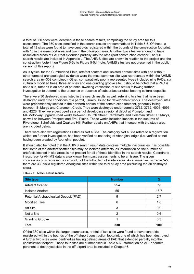
Sydney Metro - Western Sydney Airport Revised Aboriginal Cultural Heritage Assessment Report
A total of 360 sites were identified in these search results, comprising the study area for this assessment. The 360 sites identified in the search results are summarised in Table 5-5. Of these, a total of 12 sites were found to have centroids registered within the bounds of the construction footprint, with 10 in the on-airport area and two in the off-airport area. A further two sites were found to have associated areas of PAD that extended partially into the off-airport construction corridor. The full search results are included in Appendix J. The AHIMS sites are shown in relation to the project and the construction footprint on Figure 5-5a to Figure 5-5d (note: AHIMS sites are not presented in the public version of this report).
As is typical for the Cumberland Plain, artefact scatters and isolated artefact sites with and without other forms of archaeological evidence were the most common site type represented within the AHIMS search area (n=309 combined). Other, comparatively poorly represented types included nine PADs, six culturally modified trees, three art sites and one grinding groove site. It should be noted that a PAD is not a site, rather it is an area of potential awaiting verification of site status following further investigation to determine the presence or absence of subsurface artefact bearing cultural deposits.
There were 30 destroyed sites listed in the search results as well, referring to sites that have been destroyed under the conditions of a permit, usually issued for development works. The destroyed sites were predominantly located in the northern portion of the construction footprint, generally falling between St Marys and Claremont Creek. They were destroyed under permits 3762, 3752, 4001, 4096 and 4228. They were destroyed as a part of developing a regional depot at Plumpton and M4 Motorway upgrade road works between Church Street, Parramatta and Coleman Street, St Marys, as well as between Prospect and Emu Plains. These works included impacts in the suburbs of Riverstone, Schofields and Quakers Hill. Further details on AHIPs that intersect with the study area are included below.
There were also two registrations listed as Not a Site. The category Not a Site refers to a registration which, on further investigation, has been verified as not being of Aboriginal origin (i.e. verified as not having been created by Aboriginal people).
It should also be noted that the AHIMS search result data contains multiple inaccuracies. It is possible that some of the artefact scatter sites may be isolated artefacts, as information on the number of artefacts located in site areas is not present for all of those identified in the search results. Coordinate inaccuracy for AHIMS data is also known from past assessments to be an issue. The given coordinates only represent a centroid, not the full extent of a site’s area. As summarised in Table 5-5, there are 330 valid registered Aboriginal sites within the total study area (excluding the 30 destroyed sites). Table 5-5 AHIMS search results
Site type Number % Artefact Scatter 254 77
Isolated Artefact 55 16.7
Potential Archaeological Deposit (PAD) 9 2.7
Modified Tree 6 1.8
Art Site 3 0.9
Not a Site 2 0.6
Grinding Groove 1 0.3
Total 330 100
Of the 330 sites within the larger search area, a total of two sites were found to have centroids registered within the bounds of the off-airport construction footprint, one of which has been destroyed. A further two sites were identified as having defined areas of PAD that extended partially into the construction footprint. These four sites are summarised in Table 5-6. Information on AHIP permits pertinent to destroyed sites in the off-airport area is included in Chapter 6.
53
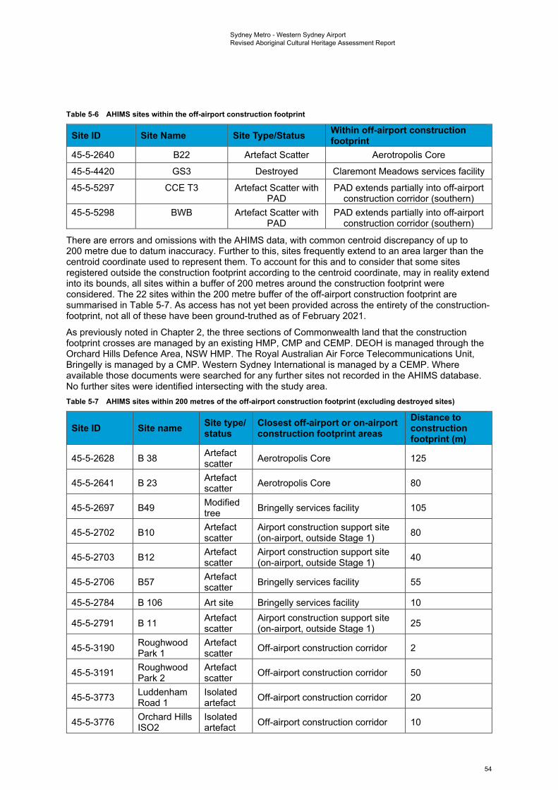
Sydney Metro - Western Sydney Airport Revised Aboriginal Cultural Heritage Assessment Report
Table 5-6 AHIMS sites within the off-airport construction footprint
Site ID Site Name Site Type/Status Within off-airport construction footprint
45-5-2640 B22 Artefact Scatter Aerotropolis Core
45-5-4420 GS3 Destroyed Claremont Meadows services facility
45-5-5297 CCE T3 Artefact Scatter with PAD
PAD extends partially into off-airport construction corridor (southern)
45-5-5298 BWB Artefact Scatter with PAD
PAD extends partially into off-airport construction corridor (southern)
There are errors and omissions with the AHIMS data, with common centroid discrepancy of up to 200 metre due to datum inaccuracy. Further to this, sites frequently extend to an area larger than the centroid coordinate used to represent them. To account for this and to consider that some sites registered outside the construction footprint according to the centroid coordinate, may in reality extend into its bounds, all sites within a buffer of 200 metres around the construction footprint were considered. The 22 sites within the 200 metre buffer of the off-airport construction footprint are summarised in Table 5-7. As access has not yet been provided across the entirety of the construction-footprint, not all of these have been ground-truthed as of February 2021.
As previously noted in Chapter 2, the three sections of Commonwealth land that the construction footprint crosses are managed by an existing HMP, CMP and CEMP. DEOH is managed through the Orchard Hills Defence Area, NSW HMP. The Royal Australian Air Force Telecommunications Unit, Bringelly is managed by a CMP. Western Sydney International is managed by a CEMP. Where available those documents were searched for any further sites not recorded in the AHIMS database. No further sites were identified intersecting with the study area. Table 5-7 AHIMS sites within 200 metres of the off-airport construction footprint (excluding destroyed sites)
Site ID Site name Site type/ status
Closest off-airport or on-airportconstruction footprint areas
Distance to construction footprint (m)
45-5-2628 B 38 Artefact scatter Aerotropolis Core 125
45-5-2641 B 23 Artefact scatter Aerotropolis Core 80
45-5-2697 B49 Modified tree Bringelly services facility 105
45-5-2702 B10 Artefact scatter
Airport construction support site (on-airport, outside Stage 1) 80
45-5-2703 B12 Artefact scatter
Airport construction support site (on-airport, outside Stage 1) 40
45-5-2706 B57 Artefact scatter Bringelly services facility 55
45-5-2784 B 106 Art site Bringelly services facility 10
45-5-2791 B 11 Artefact scatter
Airport construction support site (on-airport, outside Stage 1) 25
45-5-3190 Roughwood Park 1
Artefact scatter Off-airport construction corridor 2
45-5-3191 Roughwood Park 2
Artefact scatter Off-airport construction corridor 50
45-5-3773 Luddenham Road 1
Isolated artefact Off-airport construction corridor 20
45-5-3776 Orchard Hills ISO2
Isolated artefact Off-airport construction corridor 10
54
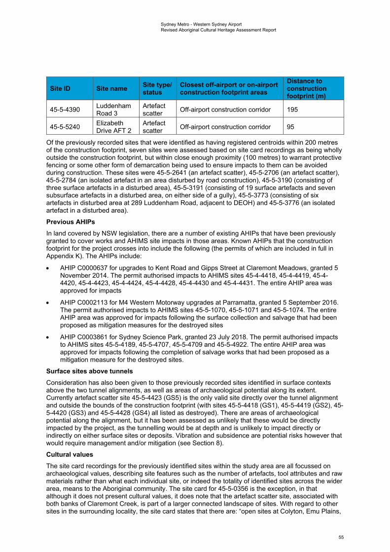
Sydney Metro - Western Sydney Airport Revised Aboriginal Cultural Heritage Assessment Report
Site ID Site name Site type/ status
Closest off-airport or on-airportconstruction footprint areas
Distance to construction footprint (m)
45-5-4390 Luddenham Road 3
Artefact scatter Off-airport construction corridor 195
45-5-5240 Elizabeth Drive AFT 2
Artefact scatter Off-airport construction corridor 95
Of the previously recorded sites that were identified as having registered centroids within 200 metres of the construction footprint, seven sites were assessed based on site card recordings as being wholly outside the construction footprint, but within close enough proximity (100 metres) to warrant protective fencing or some other form of demarcation being used to ensure impacts to them can be avoided during construction. These sites were 45-5-2641 (an artefact scatter), 45-5-2706 (an artefact scatter), 45-5-2784 (an isolated artefact in an area disturbed by road construction), 45-5-3190 (consisting of three surface artefacts in a disturbed area), 45-5-3191 (consisting of 19 surface artefacts and seven subsurface artefacts in a disturbed area, on either side of a gully), 45-5-3773 (consisting of six artefacts in disturbed area at 289 Luddenham Road, adjacent to DEOH) and 45-5-3776 (an isolated artefact in a disturbed area).
Previous AHIPs In land covered by NSW legislation, there are a number of existing AHIPs that have been previously granted to cover works and AHIMS site impacts in those areas. Known AHIPs that the construction footprint for the project crosses into include the following (the permits of which are included in full in Appendix K). The AHIPs include:
• AHIP C0000637 for upgrades to Kent Road and Gipps Street at Claremont Meadows, granted 5 November 2014. The permit authorised impacts to AHIMS sites 45-4-4418, 45-4-4419, 45-4-4420, 45-4-4423, 45-4-4424, 45-4-4428, 45-4-4430 and 45-4-4431. The entire AHIP area was approved for impacts
• AHIP C0002113 for M4 Western Motorway upgrades at Parramatta, granted 5 September 2016. The permit authorised impacts to AHIMS sites 45-5-1070, 45-5-1071 and 45-5-1074. The entire AHIP area was approved for impacts following the surface collection and salvage that had been proposed as mitigation measures for the destroyed sites
• AHIP C0003861 for Sydney Science Park, granted 23 July 2018. The permit authorised impacts to AHIMS sites 45-5-4189, 45-5-4707, 45-5-4709 and 45-5-4922. The entire AHIP area was approved for impacts following the completion of salvage works that had been proposed as a mitigation measure for the destroyed sites.
Surface sites above tunnels Consideration has also been given to those previously recorded sites identified in surface contexts above the two tunnel alignments, as well as areas of archaeological potential along its extent. Currently artefact scatter site 45-5-4423 (GS5) is the only valid site directly over the tunnel alignment and outside the bounds of the construction footprint (with sites 45-5-4418 (GS1), 45-5-4419 (GS2), 45-5-4420 (GS3) and 45-5-4428 (GS4) all listed as destroyed). There are areas of archaeological potential along the alignment, but it has been assessed as unlikely that these would be directly impacted by the project, as the tunnelling would be at depth and is unlikely to impact directly or indirectly on either surface sites or deposits. Vibration and subsidence are potential risks however that would require management and/or mitigation (see Section 8).
Cultural values The site card recordings for the previously identified sites within the study area are all focussed on archaeological values, describing site features such as the number of artefacts, tool attributes and raw materials rather than what each individual site, or indeed the totality of identified sites across the wider area, means to the Aboriginal community. The site card for 45-5-0356 is the exception, in that although it does not present cultural values, it does note that the artefact scatter site, associated with both banks of Claremont Creek, is part of a larger connected landscape of sites. With regard to other sites in the surrounding locality, the site card states that there are: “open sites at Colyton, Emu Plains,
55
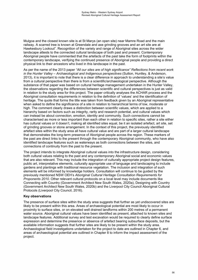
Sydney Metro - Western Sydney Airport Revised Aboriginal Cultural Heritage Assessment Report
Mulgoa and the closest known site is at St Marys (an open site) near Mamre Road and the main railway. A scarred tree is known at Greendale and axe grinding grooves and an art site are at Hawkesbury Lookout”. Recognition of the variety and range of Aboriginal sites across the wider landscape attests to the connected cultural landscape of both past and present. Contemporary Aboriginal people have commented that the artefacts of the past take the form of footprints within the contemporary landscape, verifying the continued presence of Aboriginal people and providing a direct physical link to their ancestors who lived in this landscape in the past.
As per the name of the 2013 paper “All our sites are of high significance” Reflections from recent work in the Hunter Valley – Archaeological and Indigenous perspectives (Sutton, Huntley, & Anderson, 2013), it is important to note that there is a clear difference in approach to understanding a site’s value from a cultural perspective than there is from a scientific/archaeological perspective. Although the substance of that paper was based on cultural heritage management undertaken in the Hunter Valley, the observations regarding the differences between scientific and cultural perspectives is just as valid in relation to the study area for this project. The paper critically analyses the ACHAR process and the Aboriginal consultation requirements in relation to the definition of ‘values’ and the identification of heritage. The quote that forms the title was taken from feedback given by an Aboriginal representative when asked to define the significance of a site in relation to hierarchical terms of low, moderate or high. The comment clearly draws a distinction between scientific values, which are applied to a hierarchy based on factors such as integrity, rarity and research potential, and cultural values which can instead be about connection, emotion, identity and community. Such connections cannot be characterised as more or less important than each other in relation to specific sites, rather a site either has cultural values or it doesn’t, making all identified sites equal, be it an isolated artefact, art site, set of grinding grooves or stone arrangement. In the context of this project, the previously identified artefact sites within the study area all have cultural value and are part of a larger cultural landscape that demonstrates the long-term presence of Aboriginal people across the region. These markers of the past are direct links to the present through the contemporary Aboriginal community, who have also identified landscape features such as waterways as both connections between the sites, and connections of continuity from the past to the present.
The project intends to integrate Aboriginal cultural values into the infrastructure design, considering both cultural values relating to the past and any contemporary Aboriginal social and economic values that are also relevant. This may include the integration of culturally appropriate project design features, public art, interpretative elements, culturally appropriate use of language and landscaping to include gardens and plantings with traditional resource vegetation. The inclusion and integration of such elements will be informed by knowledge holders. Consultation will continue to be guided by the previously mentioned NSW OEH’s Aboriginal Cultural Heritage Consultation Requirements for Proponents 2010. Other relevant cultural protocols on a local level may include documents like Connecting with Country (Government Architect New South Wales, 2020a), Designing with Country (Government Architect New South Wales, 2020b) and the Liverpool City Council Aboriginal Cultural Protocols (Liverpool City Council, 2016).
Key observations The presence of surface sites within the study area suggests that further as yet undiscovered sites are likely to be present within this area. Areas of archaeological potential are most likely to occur in proximity to surface sites, or on elevated well drained landforms within 200 metres of a permanent water source. Aboriginal cultural values have been identified as present, attached to known sites and landscape features. Additional survey and test excavation would be required to clearly define surface expression and determine the presence or absence of artefact bearing subsurface deposits, but the available information suggests that further sites are likely to be present within the study area. Archaeological field investigations undertaken for the project to date are outlined in Chapter 6, and areas of archaeological potential are outlined in Chapter 8 to inform the impact assessment of the project.
56
Sydney Metro - Western Sydney Airport Revised Aboriginal Cultural Heritage Assessment Report
5.4.2 On-airport local context AHIMS database Of the 330 sites within the larger search area, a total of 10 sites were found to have centroids registered within the bounds of the on-airport section of the construction footprint. These sites are summarised in Table 5-8. Table 5-8 AHIMS sites within the on-airport construction footprint
Site ID Site name Site type Within on-airport segment Stage 1
(Y/N) 45-5-2637 B5 Artefact scatter Airport construction support site N
45-5-2665 B88 Artefact scatter On-airport construction corridor Y 45-5-2586 B3 Isolated artefact Airport construction support site N
45-5-2687 B71 Artefact scatter Airport terminal Y
45-5-5068 B131 Isolated artefact On-airport construction corridor Y
45-5-5078 B136 Isolated artefact Airport construction support site N
45-5-5085 B162 Artefact scatter Airport construction support site Y
45-5-5089 B163 Artefact scatter On-airport construction corridor Y 45-5-5094 B154 Artefact scatter On-airport construction corridor Y
45-5-5100 B147 Artefact scatter Airport construction support site Y
Of the 10 sites listed above, three sites (listed as 45-5-5078, 45-5-2637 and 45-5-2586) are located outside of the Western Sydney International Stage 1 Construction Impact Zone. Only one of these sites was able to be found during archaeological field investigations (listed as 45-5-5078). Should site collection and salvage not have been undertaken for any of the on-airport direct impact sites prior to the project commencing in those areas, the conditions of the Western Sydney International Aboriginal Cultural Heritage CEMP and related methodologies for collection and salvage would be followed.
As was previously noted, there are errors and omissions with the AHIMS data, with common centroid discrepancy of up to 200 metres due to datum inaccuracy. Further to this, sites frequently extend to an area larger than the centroid coordinate used to represent them. To account for this and to consider that some sites registered outside the construction footprint according to the centroid coordinate, may in reality extend into its bounds, all sites within a buffer of 200 metres around the construction footprint were considered. These sites within the buffer for the on-airport area are summarised in Table 5-9. Table 5-9 AHIMS sites within 200 metres of the on-airport construction footprint
Site ID Site name Site type Closest off-airport or on-airport
construction sites Distance to
construction footprint (m)
45-5-2586 B3 Isolated artefact
Airport construction support site (on-airport, outside Stage 1) 75
45-5-2623 B 68 Artefact scatter
Airport construction support site (on-airport, outside Stage 1) 40
45-5-2630 B 40 Modified tree Airport construction support site (on-airport, outside Stage 1) 160
45-5-2632 B 44 Artefact scatter On-airport construction corridor (Stage 1) 185
45-5-2658 B67 Artefact scatter
Airport construction support site (on-airport, outside Stage 1) 160
45-5-2659 B66 Artefact scatter
Airport construction support site (on-airport, outside Stage 1) 10
57
Sydney Metro - Western Sydney Airport Revised Aboriginal Cultural Heritage Assessment Report
Site ID Site name Site type Closest off-airport or on-airport
construction sites Distance to
construction footprint (m)
45-5-2673 B101 Artefact scatter Airport construction support site (Stage 1) 185
45-5-2680 B78 Artefact scatter Airport terminal (Stage 1) 95
45-5-2681 B77 Artefact scatter Airport terminal (Stage 1) 120
45-5-2682 B75 Artefact scatter
Airport construction support site (on-airport, outside Stage 1) 55
45-5-2683 B76 Artefact scatter
Airport construction support site (on-airport, outside Stage 1) 105
45-5-2690 B59 Artefact scatter
Airport construction support site (on-airport, outside Stage 1) 150
45-5-2705 B15 Artefact scatter Airport construction support site (Stage 1) 130
45-5-2763 B87 Artefact scatter On-airport construction corridor (Stage 1) 120
45-5-2770 B70 Artefact scatter Airport construction support site (Stage 1) 180
45-5-2788 B 112 Artefact scatter Airport construction support site (Stage 1) 140
45-5-2813 B104 Artefact scatter Airport construction support site (Stage 1) 120
45-5-2814 B103 Artefact scatter
Airport construction support site (on-airport, outside Stage 1) 80
45-5-5022 B113 Isolated artefact Airport construction support site (Stage 1) 140
45-5-5055 B118 Isolated artefact
Airport construction support site (on-airport, outside Stage 1) 90
45-5-5057 B120 Grinding groove
Airport construction support site (on-airport, outside Stage 1) 135
45-5-5067 B130 Isolated artefact
Airport construction support site (on-airport, outside Stage 1) 70
45-5-5082 B159 Artefact scatter Airport terminal (Stage 1) 60
45-5-5083 B160 Artefact scatter
Airport construction support site (on-airport, outside Stage 1) 120
45-5-5085 B162 Artefact scatter Airport construction support site (Stage 1) 155
45-5-5086 B164 Artefact scatter On-airport construction corridor (Stage 1) 30
45-5-5087 B165 Artefact scatter Off-airport construction corridor 70
45-5-5090 B158 Artefact scatter
Airport construction support site (on-airport, outside Stage 1) 70
45-5-5096 B152 Artefact scatter Off-airport construction corridor 165
45-5-5097 B151 Artefact scatter Off-airport construction corridor 40
58
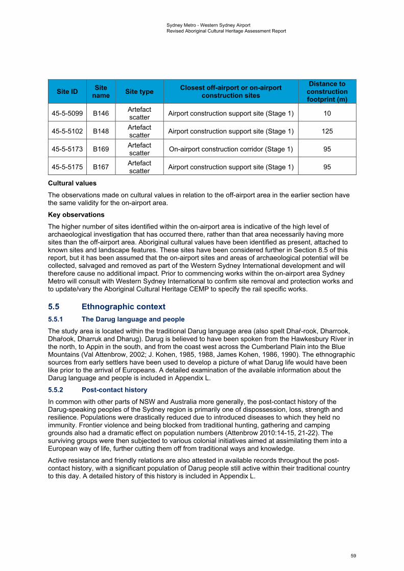
Sydney Metro - Western Sydney Airport Revised Aboriginal Cultural Heritage Assessment Report
Site ID Site name Site type Closest off-airport or on-airport
construction sites Distance to
construction footprint (m)
45-5-5099 B146 Artefact scatter Airport construction support site (Stage 1) 10
45-5-5102 B148 Artefact scatter Airport construction support site (Stage 1) 125
45-5-5173 B169 Artefact scatter On-airport construction corridor (Stage 1) 95
45-5-5175 B167 Artefact scatter Airport construction support site (Stage 1) 95
Cultural values The observations made on cultural values in relation to the off-airport area in the earlier section have the same validity for the on-airport area.
Key observations The higher number of sites identified within the on-airport area is indicative of the high level of archaeological investigation that has occurred there, rather than that area necessarily having more sites than the off-airport area. Aboriginal cultural values have been identified as present, attached to known sites and landscape features. These sites have been considered further in Section 8.5 of this report, but it has been assumed that the on-airport sites and areas of archaeological potential will be collected, salvaged and removed as part of the Western Sydney International development and will therefore cause no additional impact. Prior to commencing works within the on-airport area Sydney Metro will consult with Western Sydney International to confirm site removal and protection works and to update/vary the Aboriginal Cultural Heritage CEMP to specify the rail specific works.
5.5 Ethnographic context 5.5.1 The Darug language and people The study area is located within the traditional Darug language area (also spelt Dhaŕ-rook, Dharrook, Dhaŕook, Dharruk and Dharug). Darug is believed to have been spoken from the Hawkesbury River in the north, to Appin in the south, and from the coast west across the Cumberland Plain into the Blue Mountains (Val Attenbrow, 2002; J. Kohen, 1985, 1988, James Kohen, 1986, 1990). The ethnographic sources from early settlers have been used to develop a picture of what Darug life would have been like prior to the arrival of Europeans. A detailed examination of the available information about the Darug language and people is included in Appendix L.
5.5.2 Post-contact history In common with other parts of NSW and Australia more generally, the post-contact history of the Darug-speaking peoples of the Sydney region is primarily one of dispossession, loss, strength and resilience. Populations were drastically reduced due to introduced diseases to which they held no immunity. Frontier violence and being blocked from traditional hunting, gathering and camping grounds also had a dramatic effect on population numbers (Attenbrow 2010:14-15, 21-22). The surviving groups were then subjected to various colonial initiatives aimed at assimilating them into a European way of life, further cutting them off from traditional ways and knowledge.
Active resistance and friendly relations are also attested in available records throughout the post-contact history, with a significant population of Darug people still active within their traditional country to this day. A detailed history of this history is included in Appendix L.
59
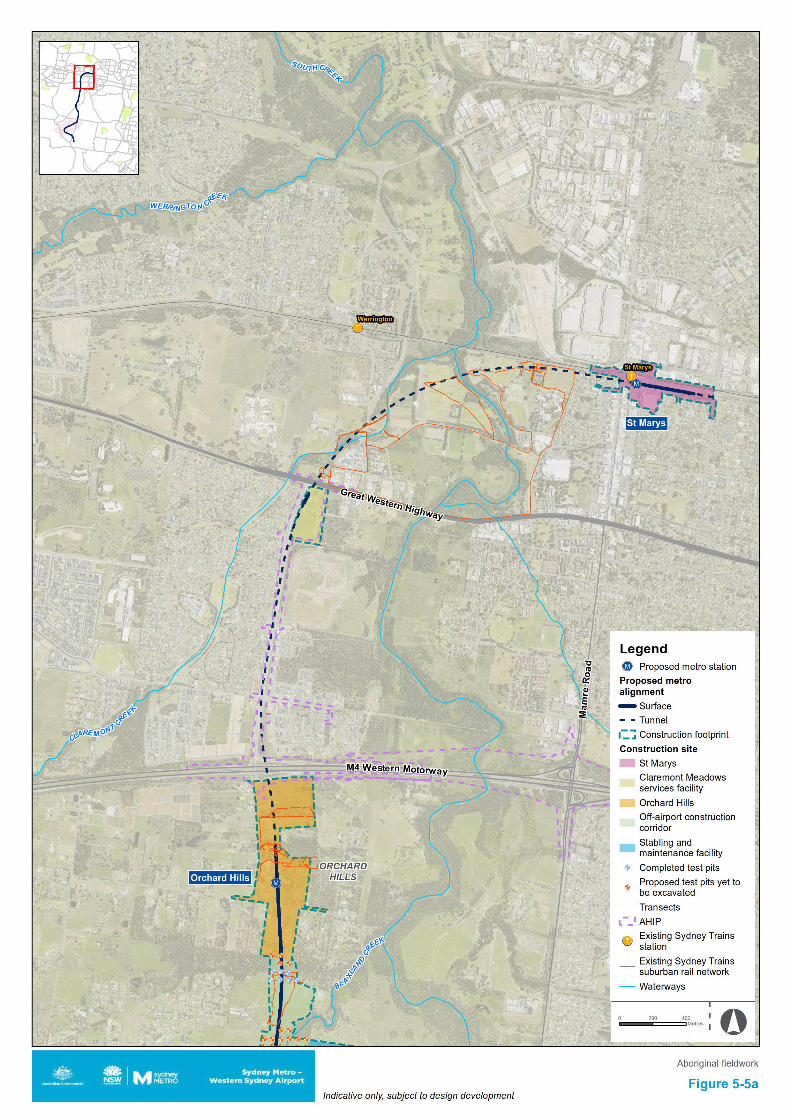
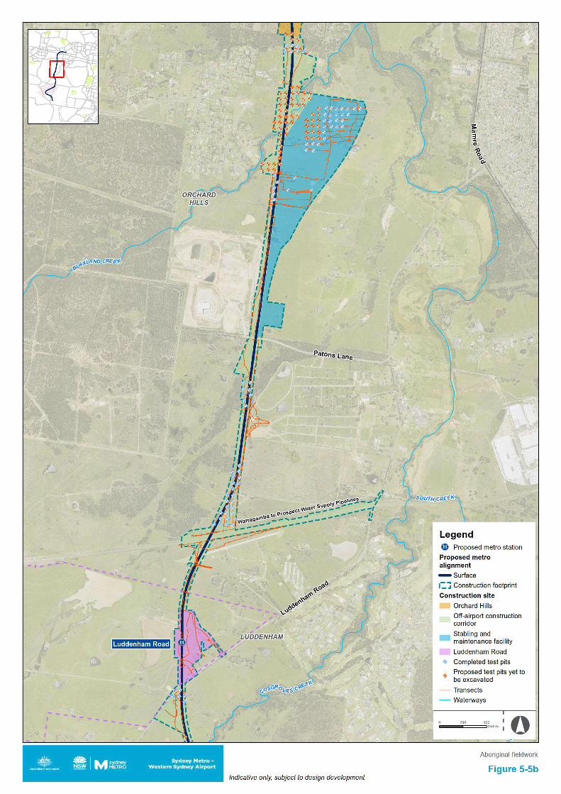
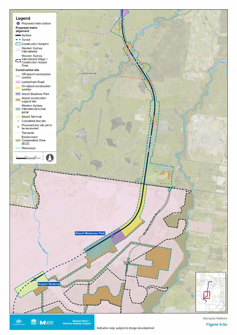
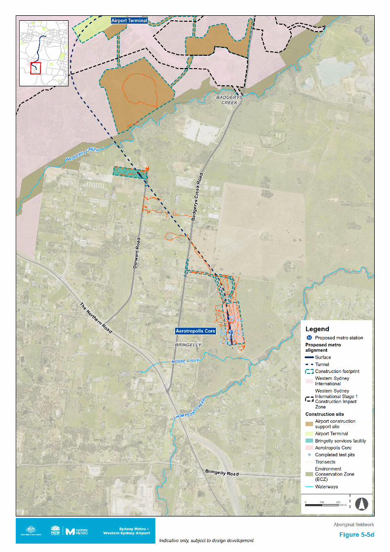
Sydney Metro - Western Sydney Airport Revised Aboriginal Cultural Heritage Assessment Report
6. Archaeological field investigations
6.1 Aims and objectives The aims of the field investigation were to identify and ground-truth previously recorded archaeological sites and to identify and map areas of archaeological and cultural sensitivity. The investigations also provided an opportunity to talk to community members about the cultural values of the landscape and issues of importance to them in the context of the project. Field investigations were undertaken on those land parcels within the construction footprint that could be accessed. These field investigations were undertaken with the participation of RAP representatives. Only limited areas were able to be accessed for field investigations at this time (see Figure 3-1).
6.2 Field investigation strategy A full description of the methodology employed for these surveys has been presented in Chapter 3. The transects walked for these field investigations are shown on Figure 5-5a to d, as are the excavated test pits (blue dots) and the proposed test pits not yet excavated due to access limitations (orange dots).
6.3 Field team and methods The field team for the initial surveys consisted of archaeologists Dr Darran Jordan and Dr Andrew McLaren. RAP representatives attended from Gandangara LALC and Deerubbin LALC. Surveys of accessible sections of the construction footprint were undertaken over four days on Thursday 27 February, Wednesday 4 March, Tuesday 28 April and Friday 12 June 2020.
Once further access was granted to undertake survey and test excavation between October 2020 and February 2021 the field team consisted of archaeologists Dr Darran Jordan, Dr Andrew McLaren, Geordie Oakes, Luke Wolfe and Julia Atkinson. RAP representatives were in attendance from A1 Indigenous Services, Arugung Aboriginal Cultural Heritage Site Assessments, Corroboree Aboriginal Corporation, Cubbitch Barta, Darug Custodian Aboriginal Corporation, Deerubbin Local Aboriginal Land Council, DNC, Gandangara Local Aboriginal Land Council, Gunyuu, Kamilaroi Yankuntjatjara Working Group, Murra Bidgee Mullangari Aboriginal Corporation, Tocomwall, Wailwan Aboriginal Group and Walbunja.
6.4 Investigation results Off-airport Limited site investigations were undertaken where land parcel access was available. The transects for each of the investigations are shown on Figure 5-5a to Figure 5-5d.
On Thursday 27 February 2020, a survey was undertaken of the Aerotropolis Core construction footprint in the off-airport area. The one valid site that was identified in the desktop assessment as being present within the bounds of the construction footprint (artefact scatter site 45-5-2640 (B22)) was targeted for survey. Although the coordinate was located and the location identified, no surface expression of artefacts was visible at this site during the survey. It was concluded that this was likely the result of low ground surface visibility due to high levels of grass and weeds currently established at this location. It is likely the site is still valid, with extant artefacts under the grass and/or in subsurface deposits.
On Wednesday 4 March 2020, three areas were inspected in the off-airport area, the first being to the immediate north of Patons Lane. The second was to the immediate south of the Luddenham Road construction footprint within the off-airport construction corridor. The third was to the immediate north of the Aerotropolis Core construction footprint, outside the bounds of the construction footprint. No previously recorded AHIMS sites were present within the three areas subject to investigation. The centroids for existing sites closest to the transects for these surveys were between 70 metres and 100 metres away. No new sites were identified during the investigations of these areas and no specific areas of archaeological sensitivity were identified at these locations.
64
Sydney Metro - Western Sydney Airport Revised Aboriginal Cultural Heritage Assessment Report
On Tuesday 28 April 2020, a survey was undertaken within the DEOH area. No previously recorded AHIMS sites were present within the area being investigated. The centroid for one site (45-5-3773) was located immediately adjacent to the transect, but it was outside the construction footprint on the opposite side of an impassable fence-line. No new sites were identified during the investigation of this area. It was noted that an unnamed creek that is a tributary of South Creek bisected this investigation area, with areas either side of it appearing to retain intact deposits. These areas have archaeological potential and would require test excavation to be able to discern if any artefact bearing deposits were present in this area, an approach that was also recommended by the attending Deerubbin LALC representative (see Chapter 10).
On Friday 12 June 2020, a survey was undertaken of the stabling and maintenance facility construction footprint. Thick ground vegetation was present across the area obscuring ground surface visibility. No new sites were identified in surface expressions during this survey. The area was predominantly cleared with little mature vegetation extant in the area. Where trees were present, they were checked for signs of cultural modification, but none were identified. It was noted that much of the north eastern portion of the area was low lying floodplain likely to be water logged at times if inundated. Although the landform was predominantly flat there were some slightly elevated areas which were more likely to have been used for habitation and activity by Aboriginal people in the past. The presence of spring filled dams in the area attests to the availability of resources likely to have been present in the past. Further testing was deemed appropriate to occur in this area to determine the presence or absence of subsurface archaeological deposits.
Between October 2020 and February 2021 multiple parcels of land were surveyed and were subject to test excavation, with the dates of fieldwork being 13, 14, 22, 28 and 30 October, 2, 3, 4, 5, 6, 9, 10, 11, 12, 13 and 30 November, 4, 16, 17, 18, 21 and 22 December, and 9 and 10 February 2021. The transects are shown on Figure 5-5a to Figure 5-5d, as are the completed test pits (as blue dots) and the proposed test pits that were not able to be excavated due to lack of access to those areas (as orange dots).
Feedback from the RAP representatives during the investigations stated that the waterways that crossed the construction footprint have cultural significance as pathways and resource areas for Aboriginal people in the past, including Blaxland Creek, Cosgroves Creek and Badgerys Creek as well as their tributaries. The presence of known sites, areas of potential and waterways linking a connected cultural landscape all attest to the cultural values of the area, elements that may be appropriate to feed into the design and interpretation opportunities for the project. Ground surface visibility was found to be low across much of the surveyed areas due to vegetation cover, with three surface sites identified during survey, one above a tunnel area (being six artefacts in a disturbed context), one outside the construction footprint (consisting of 18 artefacts along a vehicle track) and one within the construction footprint (consisting of three artefacts in a disturbed surface context) (see Figure 7-1 and Section 7.3.3 (note: AHIMS sites and Aboriginal archaeological sites are not presented in the public version of this report)). The location of previously recorded site 45-5-2640 (B22) was also inspected. This artefact scatter site was recorded in 1996 and described as an artefact scatter in a disturbed area adjacent to buildings and bunkers comprised of three flakes and one pebble. During the survey of this area the four previously recorded surface artefacts were not able to be located, likely due to vegetation cover obscuring ground surface visibility in this area.
Taking into account the results of all archaeological survey and test excavation works undertaken for the project up to and including February 2021, a total of 10 Aboriginal archaeological sites are recognised as being wholly within the off-airport section of the construction footprint, with two sites that have PAD curtilages partially extending into it. Identified sites consist of three valid previously recorded artefact scatter sites, being B22 (45-5-2640) BWB (45-5-5298) and CCE T3 (45-5-5297). Survey identified another artefact scatter site (SMWSA-AS6), while test excavation has identified five artefact scatters (SMWSA-AS2, SMWSA-AS3, SMWSA-AS4, SMWSA-AS7 and SMWSA-AS8) and three isolated artefact sites (SMWSA-IA1, SMWSA-IA2 and SMWSA-IA3) within the off-airport construction footprint. These sites are described in more detail in the AAR (Appendix J of the Submissions Report).
65
Sydney Metro - Western Sydney Airport Revised Aboriginal Cultural Heritage Assessment Report
On-airport On Thursday 27 February 2020, a survey was undertaken on Western Sydney International outside the Stage 1 construction impact zone. As this survey was at an early stage of the project, the covered areas were both within and outside of the project’s on-airport construction footprint. The coordinates of 11 previously recorded AHIMS sites located in accessible land parcels were inspected for ground-truthing, but only two of these previously recorded sites were able to be found, being:
• 45-5-5078, this site is listed as an isolated artefact but three surface artefacts were identified during the survey. This site is within the construction footprint in the Airport construction support site and outside the Western Sydney International Stage 1 construction impact zone
• 45-5-2699, this site is listed as an artefact scatter, but only a single artefact was able to be identified during the survey, located on the lower flank of the dam wall. This site is outside the project’s construction footprint and outside the Western Sydney International Stage 1 construction impact zone.
In addition to this, two new sites were identified during the survey, being one isolated artefact and one artefact scatter. These sites were recorded as WSI-IA1-20 and WSI-AS1-20. Both sites were identified outside the project’s construction footprint and outside the Western Sydney International Stage 1 construction impact zone.
WSI-AS1-20 consists of a scatter of three artefacts in an area of rabbit/fox burrowing within the Western Sydney International on-airport, outside Stage 1 construction impact zone. The artefacts, consisting of a complete silicified tuff flake, a proximal silcrete flake and a silicified tuff angular shatter fragment, have been exposed through burrowing. Topographically, the site is located on a gently inclined spur crest approximately 85 metres southwest of an unnamed second order drainage line which feeds into a farm dam around 200 metres to the east. A large ant nest is also present. Surrounding vegetation consists of woodland regrowth.
WSI-IA1-20 comprises a complete silicified tuff flake on the eastern edge of a north-south trending light vehicle track in the Western Sydney International on-airport, outside Stage 1 area. The site is located at the eastern end of a partially vegetated spur crest bordered to the north and south by unnamed first order drainage depressions. The flake measures 26.6 (l) x 34.4 (w) x 14.1 (th) mm, exhibits 1-50% dorsal cortex and has a single conchoidal striking platform. Ground surface visibility on the track itself is good but very poor outside of it due to grass growth.
66
Sydney Metro - Western Sydney Airport Revised Aboriginal Cultural Heritage Assessment Report
7. Cultural heritage values and statement of significance
7.1 Overview The design process has aimed to avoid Aboriginal impacts, with the construction footprint avoiding AHIMS sites wherever possible. The use of subsurface tunnelling for a large proportion of the project would successfully avoid many known sites and minimise the impacts to areas of both Aboriginal cultural significance and archaeological potential.
Off-airport, all but one artefact scatter site (45-5-2640 (B22)) located within the Aerotropolis Core construction footprint, has been avoided. There are further valid sites within the on-airport construction footprint, but it is assumed all sites approved for removal within Western Sydney International will be removed prior to the project commencing construction in those areas (i.e. for the purposes of assessment it is assumed that this project would not affect any item that has not already been impacted/destroyed by Western Sydney International construction activities).
Due to limited access to private property this assessment has been based on a combination of desktop and limited field investigation. No new sites were identified within the bounds of the construction footprint during the field investigations undertaken thus far (although two new sites, WSI-IA1-20 and WSI-AS1-20, were identified outside the bounds of the construction footprint). RAP consultation has identified that waterways are a culturally significant landform and that sites are important tangible markers in the landscape attesting to the long-term presence of Aboriginal people in this area, the extant material also providing a direct link between contemporary Aboriginal communities and their ancestors. Areas of archaeological sensitivity are present (see Section 8.2) and require further testing and investigation (see Chapter 10). Previously recorded AHIMS sites are the primary focus for identified cultural values.
This section first outlines the principles by which a cultural heritage values assessment is undertaken, then contains details of the identified cultural heritage values of the study area.
7.2 Principles of assessment Heritage sites hold value for different communities in a variety of different ways. All sites are not equally significant in terms of archaeological/scientific values and thus not equally worthy of conservation and management (Pearson & Sullivan, 1995: 17). One of the primary responsibilities of cultural heritage practitioners, therefore, is to determine which sites are worthy of preservation and management (and why) and, conversely, which are not (and why) (Smith & Burke, 2007: 227). This process is known as the assessment of cultural significance and, as highlighted by Pearson and Sullivan (1995: 127), incorporates two interrelated and interdependent components. The first involves identifying, through documentary, physical or oral evidence, the elements that make a heritage site significant, as well as the type(s) of significance it manifests. The second involves determining the degree of value that the site holds for society (i.e. its cultural significance) (Pearson & Sullivan, 1995: 126). As has previously been noted, cultural values are either present or not, and RAPs will not draw a hierarchical distinction between sites and features. All known sites have been identified as having cultural values. Other values associated with the scientific/archaeological components of a site are generally determined through assessment guidelines.
In Australia, the primary guide to the assessment of heritage significance is the Australian ICOMOS Charter for Places of Cultural Significance (1999), informally known as The Burra Charter, which defines cultural significance as the “aesthetic, historic, scientific, social or spiritual value for past, present or future generations” of a site or place (ICOMOS, 1999: 2). Under the Burra Charter model, the cultural significance of a heritage site or place is assessed in terms of its aesthetic, historic, scientific and social values, none of which are mutually exclusive (see Table 7-1). Establishing cultural significance under the Burra Charter model involves assessing all information relevant to an understanding of the site and its fabric (i.e. its physical make-up) (ICOMOS, 1999: 12). The assessment of cultural significance and the preparation of a statement of cultural significance are critical prerequisites to making decisions about the management of any heritage site or place (ICOMOS, 1999: 11).
67
Sydney Metro - Western Sydney Airport Revised Aboriginal Cultural Heritage Assessment Report
With respect to Aboriginal sites and places, it is possible to identify two major streams in the overall significance assessment process: the assessment of scientific value(s) by archaeologists and the assessment of social (or cultural) value(s) by Aboriginal people. Scientific value refers to the importance of a place in terms of its rarity, representativeness and the extent to which it may contribute further information (i.e. its research potential) (OEH 2011: 9). Social or cultural value, meanwhile, refers to the spiritual, traditional, historic and contemporary associations and attachments a place or area has for Aboriginal people and can only be identified through consultation with Aboriginal people (OEH, 2011: 8). Social or cultural value therefore is not limited to specific sites or objects or physical expressions of place. Table 7-1 Values relevant to determining cultural significance, as defined by The Burra Charter (1999)
Value Definition Aesthetic “Aesthetic value includes aspects of sensory perception for which criteria can and
should be stated. Such criteria may include consideration of the form, scale, colour, texture and material of the fabric; the smells and sounds associated with the place and its use” (ICOMOS, 1999: 12).
Historic “Historic value encompasses the history of aesthetics, science and society...[a] place may have historic value because it has influenced, or has been influenced by, an historic figure, event, phase or activity. It may have historic value as the site of an important event” (ICOMOS, 1999: 12).
Scientific “The scientific or research value of a place will depend on the importance of the data involved, on its rarity, quality or representativeness, and on the degree to which the place may contribute further substantial information” (ICOMOS, 1999:12).
Social “Social value embraces the qualities for which a place has become a focus of spiritual, political, national or other cultural sentiment to a majority or minority group” (ICOMOS, 1999: 12).
7.3 Scientific values The scientific (or archaeological) significance of Aboriginal archaeological sites relates primarily to their potential for providing information about past Aboriginal culture and is commonly assessed on the basis of their research potential, representativeness and rarity. Other criteria, such as aesthetic value and education potential, may also be relevant.
Research potential can be defined as the potential of an archaeological site to address what Bowdler (1981:129) has referred to as “timely and specific research questions”. These questions may relate to any number of issues concerning past human lifeways and environments and, as suggested by Bowdler’s quote, will inevitably reflect current trends or problems in academic research (Burke & Smith, 2004:249). For their part, Bowdler and Bickford (1984:23-4) suggest that the research potential of an archaeological site can be determined by answering the following series of questions:
1. Can the site contribute knowledge which no other resource can?
2. Can the site contribute knowledge which no other such site can?
3. Is this knowledge relevant to general questions about human history or other substantiative subjects?
Several criteria can be used to assess the research potential of an archaeological site. Particularly important in the context of Aboriginal archaeology are the intactness or integrity of the site in question, its complexity and its potential for archaeological deposit (NPWS, 1997: 7). The connectedness of the site to other sites or natural landscape features may also be relevant.
Integrity refers to the extent to which a site has been disturbed by natural and/or anthropogenic phenomena and includes both the state of preservation of particular remains (e.g. animal bones, plant remains) and, where applicable, stratigraphic integrity. Assessments of archaeological integrity are predicated on the notion that undisturbed or minimally disturbed sites are likely to yield higher quality archaeological and/or environmental data than those whose integrity has been significantly compromised by natural and/or anthropogenic phenomena. Establishing levels of preservation or
68
Sydney Metro - Western Sydney Airport Revised Aboriginal Cultural Heritage Assessment Report
integrity in the context of a surface survey is difficult. Nonetheless, useful rating schemes are available for ‘open’ sites (Coutts & Witter, 1977: 34) and scarred trees (Long, 2003).
The complexity of a site refers primarily to the nature or character of the artefactual materials or features that constitute it but also includes site structure (e.g. the physical size of the site, spatial patterning in observed cultural materials). In the case of open artefact sites, for example, the principal criteria used to assess complexity are the site’s size (i.e. number of artefacts and/or spatial extent), the presence, range and frequency of artefact and raw material types, and the presence of features such as hearths.
Potential for archaeological deposit refers to the potential of a site to contain subsurface archaeological evidence which may, through controlled excavation and analysis, assist in answering questions that are of contemporary archaeological interest. Assessing subsurface potential in the absence of subsurface investigation is difficult. Nonetheless, consideration of a range of factors, including the integrity of the site, the complexity of extant surface evidence, the nature of the local geomorphology (as established through surface observations and documentary research) and the results of previous archaeological excavations in the area, will help inform assessment of this criterion.
Connectedness concerns the relationship between archaeological sites within a given area and may be expressed through a combination of factors such as site location, type and contents. It may, for example, be possible to establish a connection between a stone quarry and hatchet head found nearby. Demonstrating connectedness archaeologically, however, is far from straightforward, especially when dealing with surface evidence alone. Ultimately, this difficulty rests with the need to demonstrate contemporaneity between sites that may have been created hundreds, if not thousands, of years apart. As Shiner (2008: 13) has observed, “much of the surface archaeological record documents the accumulation of materials from multiple behavioural episodes occurring over long periods of discontinuous time”. Contemporaneity, then, needs to be demonstrated not assumed.
7.3.1 Rarity and representativeness Rarity and representativeness are related concepts. Rarity refers to the relative uniqueness of a site within its local and regional context. The scientific significance of a site is usually higher if it is unique or rare within either context; conversely, it is usually considered to be of lower scientific significance if it is common in a local or regional context. The concept of representativeness, meanwhile, refers to the question of whether or not a site is “a good example of its type, illustrating clearly the attributes of its significance” (Burke & Smith, 2004: 247). Representativeness is an important criterion as one of the primary goals of cultural heritage management is to preserve for future generations a representative sample of all archaeological site types in their full range of environmental contexts.
In common with rarity, assessments of representativeness within a region are dependent on the state of current knowledge concerning the number and type of archaeological sites present within that region3. This is a critical point, for as suggested by Kuskie (2000) and others (e.g. Bowdler, 1981; Godwin, 2011; Pearson & Sullivan, 1995), the absence across most of Australia of regional-scale quantitative data for Aboriginal sites and places represents a major constraint in assessments of representativeness and rarity. As Bowdler (1981) stressed almost 40 years ago, detailed regional-scale assessments of the Aboriginal archaeological record of Australia are required to address this issue.
7.3.2 Identification process The investigations undertaken for this assessment have identified one valid AHIMS site wholly within the bounds of the off-airport construction footprint, with a further two sites that have PAD curtilages partially extending into it. Identified sites consist of three valid previously recorded artefact scatter sites, being B22 (45-5-2640), BWB (45-5-5298) and CCE T3 (45-5-5297). Site 45-5-2640 (B22) is an artefact scatter located at the Aerotropolis Core construction footprint. It was not able to be relocated during the survey but is likely to still be extent and obscured by vegetation. Other values across the study area reside in the sites outside the bounds of the construction footprint, the presence of which suggest further as yet unidentified sites are likely to be present within the construction footprint. This is
3 There is, of course, a temporal fluidity to this criterion (i.e. as knowledge of the Aboriginal archaeology of a region increases, assessed levels of representativeness may change, a point of equal relevance to rarity).
69
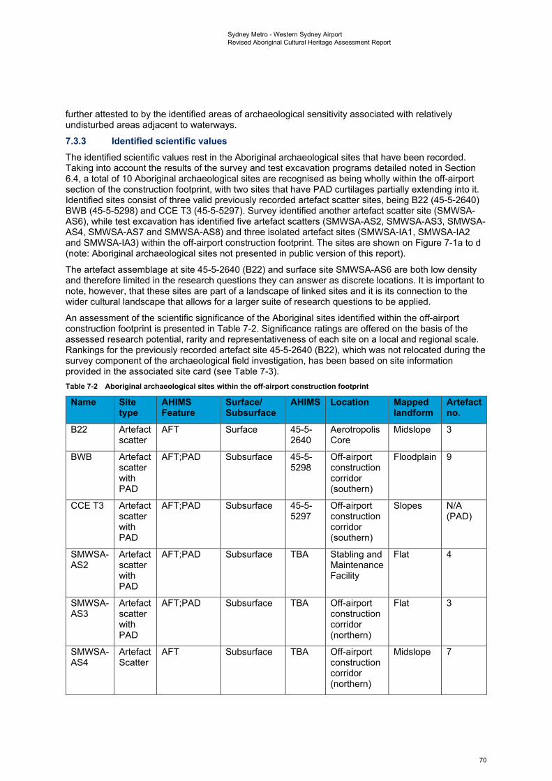
Sydney Metro - Western Sydney Airport Revised Aboriginal Cultural Heritage Assessment Report
further attested to by the identified areas of archaeological sensitivity associated with relatively undisturbed areas adjacent to waterways.
7.3.3 Identified scientific values The identified scientific values rest in the Aboriginal archaeological sites that have been recorded. Taking into account the results of the survey and test excavation programs detailed noted in Section 6.4, a total of 10 Aboriginal archaeological sites are recognised as being wholly within the off-airport section of the construction footprint, with two sites that have PAD curtilages partially extending into it. Identified sites consist of three valid previously recorded artefact scatter sites, being B22 (45-5-2640) BWB (45-5-5298) and CCE T3 (45-5-5297). Survey identified another artefact scatter site (SMWSA-AS6), while test excavation has identified five artefact scatters (SMWSA-AS2, SMWSA-AS3, SMWSA-AS4, SMWSA-AS7 and SMWSA-AS8) and three isolated artefact sites (SMWSA-IA1, SMWSA-IA2 and SMWSA-IA3) within the off-airport construction footprint. The sites are shown on Figure 7-1a to d (note: Aboriginal archaeological sites not presented in public version of this report).
The artefact assemblage at site 45-5-2640 (B22) and surface site SMWSA-AS6 are both low density and therefore limited in the research questions they can answer as discrete locations. It is important to note, however, that these sites are part of a landscape of linked sites and it is its connection to the wider cultural landscape that allows for a larger suite of research questions to be applied.
An assessment of the scientific significance of the Aboriginal sites identified within the off-airport construction footprint is presented in Table 7-2. Significance ratings are offered on the basis of the assessed research potential, rarity and representativeness of each site on a local and regional scale. Rankings for the previously recorded artefact site 45-5-2640 (B22), which was not relocated during the survey component of the archaeological field investigation, has been based on site information provided in the associated site card (see Table 7-3). Table 7-2 Aboriginal archaeological sites within the off-airport construction footprint
Name Site type
AHIMS Feature
Surface/Subsurface
AHIMS Location Mapped landform
Artefact no.
B22 Artefact scatter
AFT Surface 45-5-2640
Aerotropolis Core
Midslope 3
BWB Artefact scatter with PAD
AFT;PAD Subsurface 45-5-5298
Off-airport construction corridor (southern)
Floodplain 9
CCE T3 Artefact scatter with PAD
AFT;PAD Subsurface 45-5-5297
Off-airport construction corridor (southern)
Slopes N/A (PAD)
SMWSA-AS2
Artefact scatter with PAD
AFT;PAD Subsurface TBA Stabling and Maintenance Facility
Flat 4
SMWSA-AS3
Artefact scatter with PAD
AFT;PAD Subsurface TBA Off-airport construction corridor (northern)
Flat 3
SMWSA-AS4
Artefact Scatter
AFT Subsurface TBA Off-airport construction corridor (northern)
Midslope 7
70
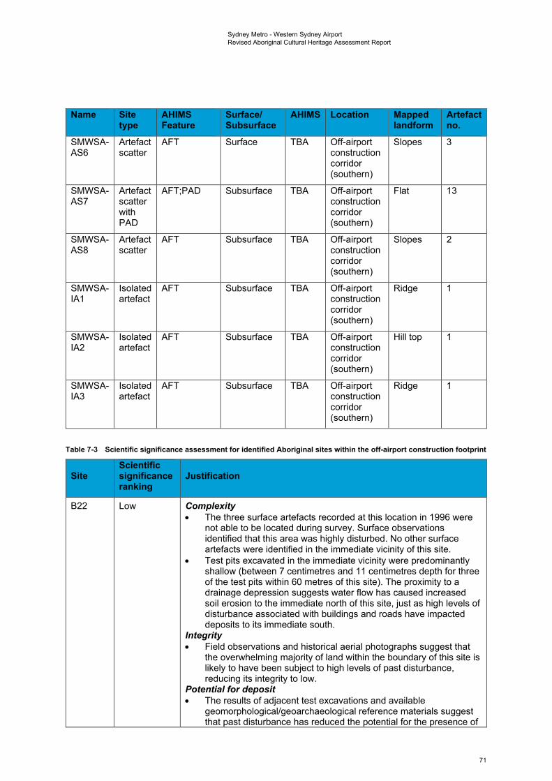
Sydney Metro - Western Sydney Airport Revised Aboriginal Cultural Heritage Assessment Report
Name Site AHIMS Surface/ AHIMS Location Mapped Artefact type Feature Subsurface landform no.
SMWSA- Artefact AFT Surface TBA Off-airport Slopes 3 AS6 scatter construction
corridor (southern)
SMWSA- Artefact AFT;PAD Subsurface TBA Off-airport Flat 13 AS7 scatter construction
with corridor PAD (southern)
SMWSA- Artefact AFT Subsurface TBA Off-airport Slopes 2 AS8 scatter construction
corridor (southern)
SMWSA- Isolated AFT Subsurface TBA Off-airport Ridge 1 IA1 artefact construction
corridor (southern)
SMWSA- Isolated AFT Subsurface TBA Off-airport Hill top 1 IA2 artefact construction
corridor (southern)
SMWSA- Isolated AFT Subsurface TBA Off-airport Ridge 1 IA3 artefact construction
corridor (southern)
Table 7-3 Scientific significance assessment for identified Aboriginal sites within the off-airport construction footprint
Site Scientific significance ranking
Justification
B22 Low Complexity • The three surface artefacts recorded at this location in 1996 were
not able to be located during survey. Surface observations identified that this area was highly disturbed. No other surface artefacts were identified in the immediate vicinity of this site.
• Test pits excavated in the immediate vicinity were predominantly shallow (between 7 centimetres and 11 centimetres depth for three of the test pits within 60 metres of this site). The proximity to a drainage depression suggests water flow has caused increased soil erosion to the immediate north of this site, just as high levels of disturbance associated with buildings and roads have impacted deposits to its immediate south.
Integrity • Field observations and historical aerial photographs suggest that
the overwhelming majority of land within the boundary of this site is likely to have been subject to high levels of past disturbance, reducing its integrity to low.
Potential for deposit • The results of adjacent test excavations and available
geomorphological/geoarchaeological reference materials suggest that past disturbance has reduced the potential for the presence of
71
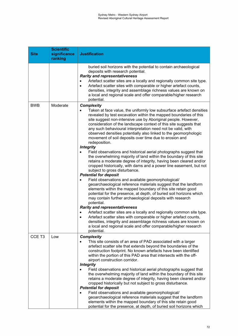
Sydney Metro - Western Sydney Airport Revised Aboriginal Cultural Heritage Assessment Report
Site Scientific significance ranking
Justification
buried soil horizons with the potential to contain archaeological deposits with research potential.
Rarity and representativeness • Artefact scatter sites are a locally and regionally common site type. • Artefact scatter sites with comparable or higher artefact counts,
densities, integrity and assemblage richness values are known on a local and regional scale and offer comparable/higher research potential.
BWB Moderate Complexity • Taken at face value, the uniformly low subsurface artefact densities
revealed by test excavation within the mapped boundaries of this site suggest non-intensive use by Aboriginal people. However, consideration of the landscape context of this site suggests that any such behavioural interpretation need not be valid, with observed densities potentially also linked to the geomorphologic movement of soil deposits over time due to erosion and redeposition.
Integrity • Field observations and historical aerial photographs suggest that
the overwhelming majority of land within the boundary of this site retains a moderate degree of integrity, having been cleared and/or cropped historically, with dams and a power line easement, but not subject to gross disturbance.
Potential for deposit • Field observations and available geomorphological/
geoarchaeological reference materials suggest that the landform elements within the mapped boundary of this site retain good potential for the presence, at depth, of buried soil horizons which may contain further archaeological deposits with research potential.
Rarity and representativeness • Artefact scatter sites are a locally and regionally common site type. • Artefact scatter sites with comparable or higher artefact counts,
densities, integrity and assemblage richness values are known on a local and regional scale and offer comparable/higher research potential.
CCE T3 Low Complexity • This site consists of an area of PAD associated with a larger
artefact scatter site that extends beyond the boundaries of the construction footprint. No known artefacts have been identified within the portion of this PAD area that intersects with the off-airport construction corridor.
Integrity • Field observations and historical aerial photographs suggest that
the overwhelming majority of land within the boundary of this site retains a moderate degree of integrity, having been cleared and/or cropped historically but not subject to gross disturbance.
Potential for deposit • Field observations and available geomorphological/
geoarchaeological reference materials suggest that the landform elements within the mapped boundary of this site retain good potential for the presence, at depth, of buried soil horizons which
72
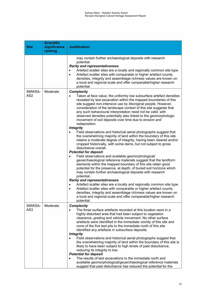
Sydney Metro - Western Sydney Airport Revised Aboriginal Cultural Heritage Assessment Report
Site Scientific significance ranking
Justification
may contain further archaeological deposits with research potential.
Rarity and representativeness • Artefact scatter sites are a locally and regionally common site type. • Artefact scatter sites with comparable or higher artefact counts,
densities, integrity and assemblage richness values are known on a local and regional scale and offer comparable/higher research potential.
SMWSA-AS2
Moderate Complexity • Taken at face value, the uniformly low subsurface artefact densities
revealed by test excavation within the mapped boundaries of this site suggest non-intensive use by Aboriginal people. However, consideration of the landscape context of this site suggests that any such behavioural interpretation need not be valid, with observed densities potentially also linked to the geomorphologic movement of soil deposits over time due to erosion and redeposition.
Integrity • Field observations and historical aerial photographs suggest that
the overwhelming majority of land within the boundary of this site retains a moderate degree of integrity, having been cleared and/or cropped historically, with some dams, but not subject to gross disturbance overall.
Potential for deposit • Field observations and available geomorphological/
geoarchaeological reference materials suggest that the landform elements within the mapped boundary of this site retain good potential for the presence, at depth, of buried soil horizons which may contain further archaeological deposits with research potential.
Rarity and representativeness • Artefact scatter sites are a locally and regionally common site type. • Artefact scatter sites with comparable or higher artefact counts,
densities, integrity and assemblage richness values are known on a local and regional scale and offer comparable/higher research potential.
SMWSA-AS3
Moderate Complexity • The three surface artefacts recorded at this location were in a
highly disturbed area that had been subject to vegetation clearance, grading and vehicle movement. No other surface artefacts were identified in the immediate vicinity of this site and none of the five test pits to the immediate north of this site identified any artefacts in subsurface deposits.
Integrity • Field observations and historical aerial photographs suggest that
the overwhelming majority of land within the boundary of this site is likely to have been subject to high levels of past disturbance, reducing its integrity to low.
Potential for deposit • The results of test excavations to the immediate north and
available geomorphological/geoarchaeological reference materials suggest that past disturbance has reduced the potential for the
73
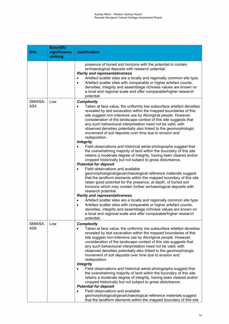
Sydney Metro - Western Sydney Airport Revised Aboriginal Cultural Heritage Assessment Report
Site Scientific significance ranking
Justification
presence of buried soil horizons with the potential to contain archaeological deposits with research potential.
Rarity and representativeness • Artefact scatter sites are a locally and regionally common site type. • Artefact scatter sites with comparable or higher artefact counts,
densities, integrity and assemblage richness values are known on a local and regional scale and offer comparable/higher research potential.
SMWSA-AS4
Low Complexity • Taken at face value, the uniformly low subsurface artefact densities
revealed by test excavation within the mapped boundaries of this site suggest non-intensive use by Aboriginal people. However, consideration of the landscape context of this site suggests that any such behavioural interpretation need not be valid, with observed densities potentially also linked to the geomorphologic movement of soil deposits over time due to erosion and redeposition.
Integrity • Field observations and historical aerial photographs suggest that
the overwhelming majority of land within the boundary of this site retains a moderate degree of integrity, having been cleared and/or cropped historically but not subject to gross disturbance.
Potential for deposit • Field observations and available
geomorphological/geoarchaeological reference materials suggest that the landform elements within the mapped boundary of this site retain good potential for the presence, at depth, of buried soil horizons which may contain further archaeological deposits with research potential.
Rarity and representativeness • Artefact scatter sites are a locally and regionally common site type. • Artefact scatter sites with comparable or higher artefact counts,
densities, integrity and assemblage richness values are known on a local and regional scale and offer comparable/higher research potential.
SMWSA-AS6
Low Complexity • Taken at face value, the uniformly low subsurface artefact densities
revealed by test excavation within the mapped boundaries of this site suggest non-intensive use by Aboriginal people. However, consideration of the landscape context of this site suggests that any such behavioural interpretation need not be valid, with observed densities potentially also linked to the geomorphologic movement of soil deposits over time due to erosion and redeposition.
Integrity • Field observations and historical aerial photographs suggest that
the overwhelming majority of land within the boundary of this site retains a moderate degree of integrity, having been cleared and/or cropped historically but not subject to gross disturbance.
Potential for deposit • Field observations and available
geomorphological/geoarchaeological reference materials suggest that the landform elements within the mapped boundary of this site
74
Sydney Metro - Western Sydney Airport Revised Aboriginal Cultural Heritage Assessment Report
Site Scientific significance ranking
Justification
retain good potential for the presence, at depth, of buried soil horizons which may contain further archaeological deposits with research potential.
Rarity and representativeness • Artefact scatter sites are a locally and regionally common site type. • Artefact scatter sites with comparable or higher artefact counts,
densities, integrity and assemblage richness values are known on a local and regional scale and offer comparable/higher research potential.
SMWSA-AS7
Moderate Complexity • Taken at face value, the uniformly low subsurface artefact densities
revealed by test excavation within the mapped boundaries of this site suggest non-intensive use by Aboriginal people. However, consideration of the landscape context of this site suggests that any such behavioural interpretation need not be valid, with observed densities potentially also linked to the geomorphologic movement of soil deposits over time due to erosion and redeposition.
Integrity • Field observations and historical aerial photographs suggest that
the overwhelming majority of land within the boundary of this site retains a moderate degree of integrity, having been cleared and/or cropped historically but not subject to gross disturbance.
Potential for deposit • Field observations and available
geomorphological/geoarchaeological reference materials suggest that the landform elements within the mapped boundary of this site retain good potential for the presence, at depth, of buried soil horizons which may contain further archaeological deposits with research potential.
Rarity and representativeness • Artefact scatter sites are a locally and regionally common site type. • Artefact scatter sites with comparable or higher artefact counts,
densities, integrity and assemblage richness values are known on a local and regional scale and offer comparable/higher research potential.
SMWSA-AS8
Moderate Complexity • Taken at face value, the uniformly low subsurface artefact densities
revealed by test excavation within the mapped boundaries of this site suggest non-intensive use by Aboriginal people. However, consideration of the landscape context of this site suggests that any such behavioural interpretation need not be valid, with observed densities potentially also linked to the geomorphologic movement of soil deposits over time due to erosion and redeposition.
Integrity • Field observations and historical aerial photographs suggest that
the overwhelming majority of land within the boundary of this site retains a moderate degree of integrity, having been cleared and/or cropped historically but not subject to gross disturbance.
Potential for deposit • Field observations and available
geomorphological/geoarchaeological reference materials suggest
75
Sydney Metro - Western Sydney Airport Revised Aboriginal Cultural Heritage Assessment Report
Site Scientific significance ranking
Justification
that the landform elements within the mapped boundary of this site retain good potential for the presence, at depth, of buried soil horizons which may contain further archaeological deposits with research potential.
Rarity and representativeness • Artefact scatter sites are a locally and regionally common site type. • Artefact scatter sites with comparable or higher artefact counts,
densities, integrity and assemblage richness values are known on a local and regional scale and offer comparable/higher research potential.
SMWSA-IA1
Low Complexity • Single artefact recovered from test pit. Integrity • Field observations and available
geomorphological/geoarchaeological reference materials suggest that the landform elements within the mapped boundary of this site retain good potential for the presence, at depth, of buried soil horizons which may contain further archaeological deposits with research potential.
Potential for deposit • The results of test excavation suggest that untested land in the
broader area surrounding this site retains moderate subsurface archaeological potential, but the test pits in the immediate area surrounding this site did not yield further artefacts.
Rarity and representativeness • Artefact scatter sites are a locally and regionally common site type. • Artefact scatter sites with comparable or higher artefact counts,
densities, integrity and assemblage richness values are known on a local and regional scale and offer comparable/higher research potential.
SMWSA-IA2
Low Complexity • Single artefact recovered from test pit. Integrity • Field observations and available
geomorphological/geoarchaeological reference materials suggest that the landform elements within the mapped boundary of this site retain good potential for the presence, at depth, of buried soil horizons which may contain further archaeological deposits with research potential.
Potential for deposit • The results of test excavation suggest that untested land in the
broader area surrounding this site retains moderate subsurface archaeological potential, but the test pits in the immediate area surrounding this site did not yield further artefacts.
Rarity and representativeness • Artefact scatter sites are a locally and regionally common site type. • Artefact scatter sites with comparable or higher artefact counts,
densities, integrity and assemblage richness values are known on a local and regional scale and offer comparable/higher research potential.
76
Sydney Metro - Western Sydney Airport Revised Aboriginal Cultural Heritage Assessment Report
Site Scientific significance ranking
Justification
SMWSA-IA3
Low Complexity • Single artefact recovered from test pit. Integrity • Field observations and available
geomorphological/geoarchaeological reference materials suggest that the landform elements within the mapped boundary of this site retain good potential for the presence, at depth, of buried soil horizons which may contain further archaeological deposits with research potential.
Potential for deposit • The results of test excavation suggest that untested land in the
broader area surrounding this site retains moderate subsurface archaeological potential, but the test pits in the immediate area surrounding this site did not yield further artefacts.
Rarity and representativeness • Artefact scatter sites are a locally and regionally common site type. • Artefact scatter sites with comparable or higher artefact counts,
densities, integrity and assemblage richness values are known on a local and regional scale and offer comparable/higher research potential.
7.3.4 Assessment of scientific significance As shown in Table 7-3, the scientific significance for the isolated artefact and artefact scatter sites within the construction footprint ranges from low to moderate.
77
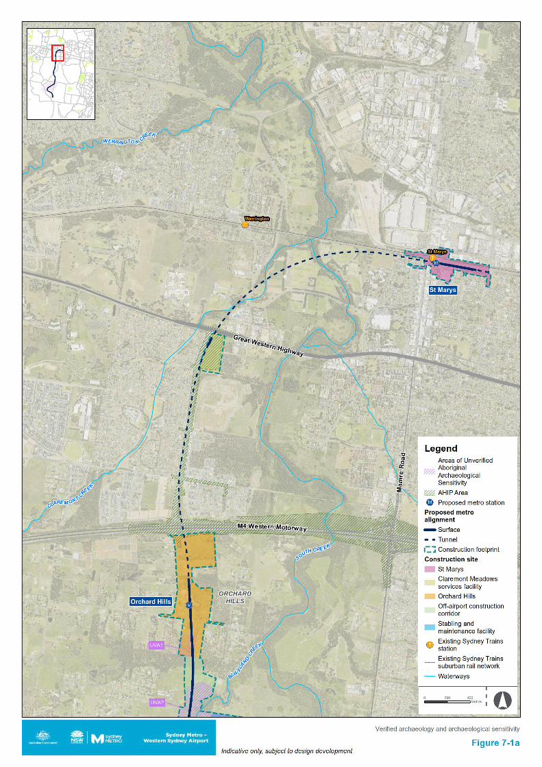

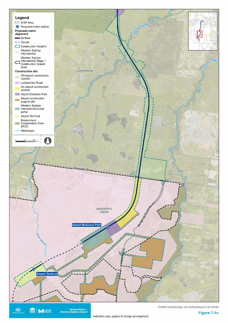
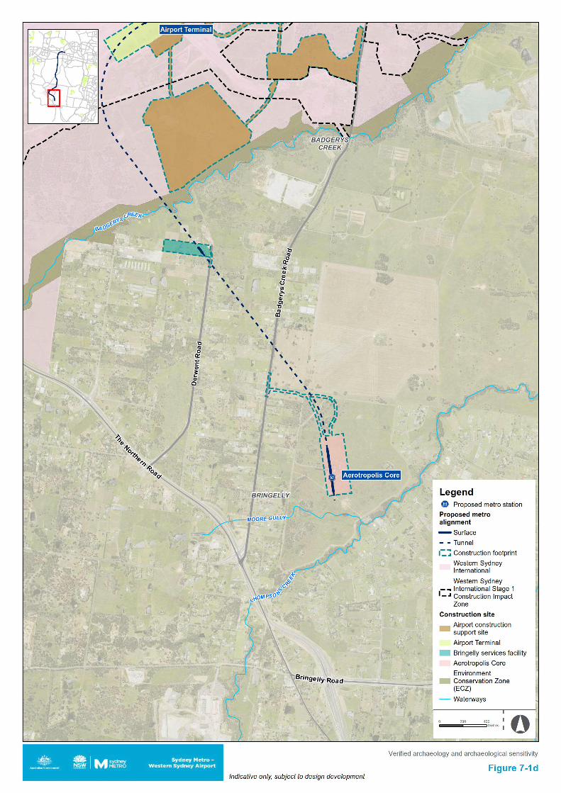
Sydney Metro - Western Sydney Airport Revised Aboriginal Cultural Heritage Assessment Report
7.4 Cultural values RAP consultation has indicated that all archaeological sites are considered to be of high cultural value to the Aboriginal community as they provide a tangible link to ancestors and are a physical marker in the landscape attesting to the long-term presence of Aboriginal people in this area. Cultural values identified thus far rest in the identified sites, potential sites and landscape features such as waterways. Scientific studies agree that artefact distributions do not, as implied by the models of Kohen (1986) and Smith (1989), form bounded ‘sites’ but rather ‘landscapes’.
Further research and collaboration with the community is required to determine what other cultural values may be attached to the study area including contemporary community values.
7.5 Historic values No specific historic values have been identified for the identified Aboriginal sites.
7.6 Aesthetic values No specific aesthetic values have been identified for the 12 artefact sites within the off-airport construction footprint. Some aesthetic values may be associated with waterways that cross the landscape, which have been identified as having cultural value due to the association of these being past pathways and resource areas for Aboriginal people. The topography, hydrology and landforms of the study area have been identified during consultation as significant to contemporary Aboriginal communities because they are consistent features that link the wider cultural landscape, a landscape made up of sites and areas that were used by Aboriginal people in the past. Like a palimpsest, these features bleed through from the past into the contemporary landscape as points of continuity that link the contemporary Aboriginal community to the lives and activities of their ancestors. The identified features of the cultural landscape are both links to the past and signs in the present that attest to the ongoing presence of Aboriginal people in this area.
7.7 Consolidated statement of significance The study area lies within a broader cultural landscape that holds significant traditional and contemporary cultural values for the Aboriginal people of the region. Within this broader cultural landscape there are a range of specific locations and pathways that are known to the contemporary Aboriginal community. Blaxland Creek, South Creek tributary, Cosgroves Creek, Badgerys Creek, Moore Gully, Thompsons Creek and other unnamed waterways were noted during consultation to be past pathways and resource areas for Aboriginal people of the area.
These cultural places are linked to other locations and pathways in the surrounding landscape that hold significance and cultural value for the Aboriginal people of the region. This significance and cultural value of the broader cultural landscape is a result of the intersection of traditional usage, cultural knowledge, historical connection and contemporary cultural understandings. The cultural landscape is linked by Aboriginal sites, which have previously been recorded across the entire study area. The sites act as footprints in the landscape for Aboriginal people, attesting to past uses and linking the ancestors of the past to the present community. The currently known Aboriginal sites present within the off-airport construction footprint consist of isolated artefacts and artefact scatters (some with associated PAD), being B22 (45-5-2640), BWB (45-5-5298), CCE T3 (45-5-5297), SMWSA-AS6, SMWSA-AS2, SMWSA-AS3, SMWSA-AS4, SMWSA-AS7, SMWSA-AS8, SMWSA-IA1, SMWSA-IA2 and SMWSA-IA3.
All Aboriginal archaeological sites within the study area are of scientific significance, being a finite scientific resource and representing our primary source of evidence regarding past Aboriginal land use within the study area. However, open artefact sites (i.e. isolated artefacts and artefact scatters) in disturbed contexts are generally considered to have low to moderate scientific significance. This site type is the primary occurrence across the study area.
82
Sydney Metro - Western Sydney Airport Revised Aboriginal Cultural Heritage Assessment Report
Site 45-5-2640 (B22) consists of a surface scatter of artefacts. It was identified and recorded by Navin Officer Heritage Consultants Pty Ltd in 2000. Site SMWSA-AS3 also consists of a surface scatter of artefacts, identified during survey for this project. All other currently known sites within the off-airport construction footprint are either isolated artefacts or artefact scatters identified in subsurface contexts during archaeological test excavation. These Aboriginal archaeological sites have associated cultural values and are of importance to the local Aboriginal community, both as individual sites and in how each one connects to the broader landscape of sites across the region. These sites have limited scientific/research value on their own, but in combination with areas of potential that have not yet been subject to survey and testing, may contain further surface artefacts and artefact bearing deposits, which could provide evidence of the broader tool manufacture and raw material use across the wider landscape through the linked cultural landscape of this region.
83
Sydney Metro - Western Sydney Airport Revised Aboriginal Cultural Heritage Assessment Report
8. Assessment of potential impacts
8.1 Overview This section has considered the potential direct and indirect impacts to Aboriginal heritage as a result of the project. Direct and indirect impacts are defined in Section 3.6.
Impacts as a result of the project have considered both known and potential Aboriginal archaeological sites and features. This consideration has also extended to sites with registered centroids located within the 200 metre buffer around the construction footprint.
8.2 Archaeological sensitivity To inform the desktop predictions, aid in the effectiveness of the field investigations and inform the impact assessment, areas of archaeological sensitivity (i.e. areas considered likely to contain artefact bearing subsurface deposits) were mapped across the construction footprint.
These areas were informed by landform (low gradient areas in close proximity to water courses), previously identified sites (surface expression taken to be an indication of further artefacts below the ground surface where soil deposits were present) and low levels of past disturbance. Where all these attributes connected within the construction footprint it was considered and mapped to be an area of archaeological sensitivity. Some of these areas were further informed by ground-truthing during the surveys as well as test excavation undertaken with RAP participants, which informed revised mapping.
Areas of archaeological sensitivity that have not already been subject to survey and test excavation will require further investigation. The untested areas of sensitivity and proposed test pits not yet excavated are shown in Figure 5-5a to Figure 5-5d and have been used to inform the impact assessment in Section 8.3 and 8.4. Areas that are above the proposed tunnel alignment have been assessed for known sites and areas of archaeological sensitivity. Survey of these areas identified one additional artefact scatter site (SMWSA-AS1) that was previously unrecorded. No site types with a high risk of being impacted by vibration and/or subsidence (e.g. rockshelters or grinding grooves with a risk of cracking/collapse) were identified in the above tunnel areas in the background research or survey. It is unlikely that any surface sites and/or cultural values would be impacted in the above tunnel areas by vibration or subsidence based on the results of research and survey. Should other ground disturbance impacts be proposed in the above tunnel areas, they should be subject to due diligence specific to the ground impacts and location for those proposed works.
8.3 Cultural values Consultation undertaken to date has identified that cultural values are present within the study area. The currently known examples of this reside predominantly in two features, the known Aboriginal sites which are spread across the area, being interpreted as physical markers attesting to the long-term presence of Aboriginal people in this region and footprints of the ancestors, and the waterways which connect the larger features of the landscape and the sites across it, interpreted as pathways of the past extruding into the present. The project would impact known sites and may impact as yet unidentified sites in areas that have not yet been subject to survey or test excavation, damaging the cultural values at these discrete site locations. The project would also cross waterways, having an effect on these physical locations and thus by association the cultural values that are attached to them.
8.4 Potential off-airport impacts 8.4.1 Potential impacts to identified values Potential direct and indirect impacts as a result of the project are discussed below. Management and mitigations measures as a result of these potential impacts are outlined in Chapter 10.
Potential direct impacts Potential direct impacts within each construction site are outlined in Table 8-1.
84
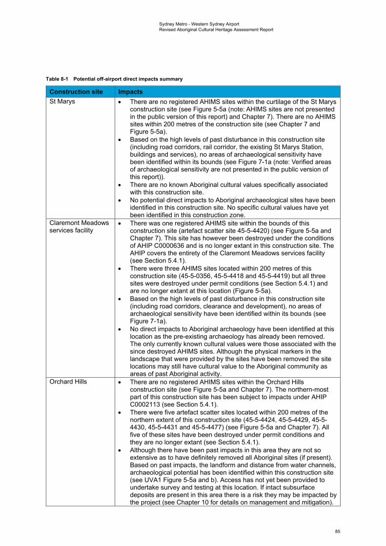
Sydney Metro - Western Sydney Airport Revised Aboriginal Cultural Heritage Assessment Report
Table 8-1 Potential off-airport direct impacts summary
Construction site Impacts St Marys • There are no registered AHIMS sites within the curtilage of the St Marys
construction site (see Figure 5-5a (note: AHIMS sites are not presented in the public version of this report) and Chapter 7). There are no AHIMS sites within 200 metres of the construction site (see Chapter 7 and Figure 5-5a).
• Based on the high levels of past disturbance in this construction site (including road corridors, rail corridor, the existing St Marys Station, buildings and services), no areas of archaeological sensitivity have been identified within its bounds (see Figure 7-1a (note: Verified areas of archaeological sensitivity are not presented in the public version of this report)).
• There are no known Aboriginal cultural values specifically associated with this construction site.
• No potential direct impacts to Aboriginal archaeological sites have been identified in this construction site. No specific cultural values have yet been identified in this construction zone.
Claremont Meadows services facility
• There was one registered AHIMS site within the bounds of this construction site (artefact scatter site 45-5-4420) (see Figure 5-5a and Chapter 7). This site has however been destroyed under the conditions of AHIP C0000636 and is no longer extant in this construction site. The AHIP covers the entirety of the Claremont Meadows services facility (see Section 5.4.1).
• There were three AHIMS sites located within 200 metres of this construction site (45-5-0356, 45-5-4418 and 45-5-4419) but all three sites were destroyed under permit conditions (see Section 5.4.1) and are no longer extant at this location (Figure 5-5a).
• Based on the high levels of past disturbance in this construction site (including road corridors, clearance and development), no areas of archaeological sensitivity have been identified within its bounds (see Figure 7-1a).
• No direct impacts to Aboriginal archaeology have been identified at this location as the pre-existing archaeology has already been removed. The only currently known cultural values were those associated with the since destroyed AHIMS sites. Although the physical markers in the landscape that were provided by the sites have been removed the site locations may still have cultural value to the Aboriginal community as areas of past Aboriginal activity.
Orchard Hills • There are no registered AHIMS sites within the Orchard Hills construction site (see Figure 5-5a and Chapter 7). The northern-most part of this construction site has been subject to impacts under AHIP C0002113 (see Section 5.4.1).
• There were five artefact scatter sites located within 200 metres of the northern extent of this construction site (45-5-4424, 45-5-4429, 45-5-4430, 45-5-4431 and 45-5-4477) (see Figure 5-5a and Chapter 7). All five of these sites have been destroyed under permit conditions and they are no longer extant (see Section 5.4.1).
• Although there have been past impacts in this area they are not so extensive as to have definitely removed all Aboriginal sites (if present). Based on past impacts, the landform and distance from water channels, archaeological potential has been identified within this construction site (see UVA1 Figure 5-5a and b). Access has not yet been provided to undertake survey and testing at this location. If intact subsurface deposits are present in this area there is a risk they may be impacted by the project (see Chapter 10 for details on management and mitigation).
85
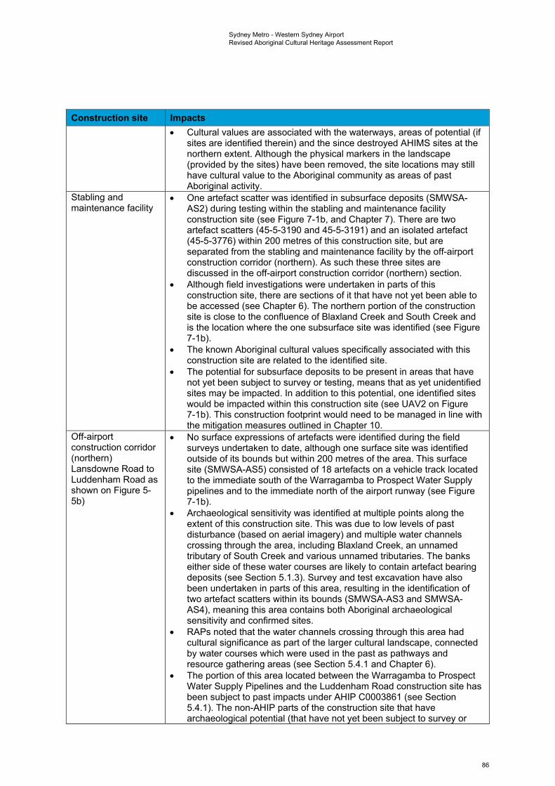
Sydney Metro - Western Sydney Airport Revised Aboriginal Cultural Heritage Assessment Report
Construction site Impacts • Cultural values are associated with the waterways, areas of potential (if
sites are identified therein) and the since destroyed AHIMS sites at the northern extent. Although the physical markers in the landscape (provided by the sites) have been removed, the site locations may still have cultural value to the Aboriginal community as areas of past Aboriginal activity.
Stabling and maintenance facility
• One artefact scatter was identified in subsurface deposits (SMWSA-AS2) during testing within the stabling and maintenance facility construction site (see Figure 7-1b, and Chapter 7). There are two artefact scatters (45-5-3190 and 45-5-3191) and an isolated artefact (45-5-3776) within 200 metres of this construction site, but are separated from the stabling and maintenance facility by the off-airport construction corridor (northern). As such these three sites are discussed in the off-airport construction corridor (northern) section.
• Although field investigations were undertaken in parts of this construction site, there are sections of it that have not yet been able to be accessed (see Chapter 6). The northern portion of the construction site is close to the confluence of Blaxland Creek and South Creek and is the location where the one subsurface site was identified (see Figure 7-1b).
• The known Aboriginal cultural values specifically associated with this construction site are related to the identified site.
• The potential for subsurface deposits to be present in areas that have not yet been subject to survey or testing, means that as yet unidentified sites may be impacted. In addition to this potential, one identified sites would be impacted within this construction site (see UAV2 on Figure 7-1b). This construction footprint would need to be managed in line with the mitigation measures outlined in Chapter 10.
Off-airport construction corridor (northern) Lansdowne Road to Luddenham Road as shown on Figure 5-5b)
• No surface expressions of artefacts were identified during the field surveys undertaken to date, although one surface site was identified outside of its bounds but within 200 metres of the area. This surface site (SMWSA-AS5) consisted of 18 artefacts on a vehicle track located to the immediate south of the Warragamba to Prospect Water Supply pipelines and to the immediate north of the airport runway (see Figure 7-1b).
• Archaeological sensitivity was identified at multiple points along the extent of this construction site. This was due to low levels of past disturbance (based on aerial imagery) and multiple water channels crossing through the area, including Blaxland Creek, an unnamed tributary of South Creek and various unnamed tributaries. The banks either side of these water courses are likely to contain artefact bearing deposits (see Section 5.1.3). Survey and test excavation have also been undertaken in parts of this area, resulting in the identification of two artefact scatters within its bounds (SMWSA-AS3 and SMWSA-AS4), meaning this area contains both Aboriginal archaeological sensitivity and confirmed sites.
• RAPs noted that the water channels crossing through this area had cultural significance as part of the larger cultural landscape, connected by water courses which were used in the past as pathways and resource gathering areas (see Section 5.4.1 and Chapter 6).
• The portion of this area located between the Warragamba to Prospect Water Supply Pipelines and the Luddenham Road construction site has been subject to past impacts under AHIP C0003861 (see Section 5.4.1). The non-AHIP parts of the construction site that have archaeological potential (that have not yet been subject to survey or
86
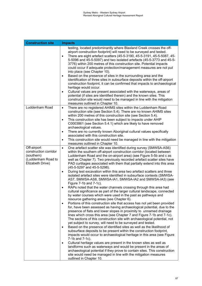
Sydney Metro - Western Sydney Airport Revised Aboriginal Cultural Heritage Assessment Report
Construction site Impacts testing, located predominantly where Blaxland Creek crosses the off-airport construction footprint) will need to be surveyed and tested.
• There are eight artefact scatters (45-5-3190, 45-5-3191, 45-5-5087, 45-5-5096 and 45-5-5097) and two isolated artefacts (45-5-3773 and 45-5-3776) within 200 metres of this construction site. Potential impacts could occur if adequate protection/management measures are not put into place (see Chapter 10).
• Based on the presence of sites in the surrounding area and the identification of three sites in subsurface deposits within the off-airport construction footprint, it can be confirmed that impacts to archaeological heritage would occur.
• Cultural values are present associated with the waterways, areas of potential (if sites are identified therein) and the known sites. This construction site would need to be managed in line with the mitigation measures outlined in Chapter 10.
Luddenham Road • There are no registered AHIMS sites within the Luddenham Road construction site (see Section 5.4). There are no known AHIMS sites within 200 metres of this construction site (see Section 5.4).
• This construction site has been subject to impacts under AHIP C0003861 (see Section 5.4.1) which are likely to have removed archaeological values.
• There are no currently known Aboriginal cultural values specifically associated with this construction site.
• This construction site would need be managed in line with the mitigation measures outlined in Chapter 10.
Off-airport construction corridor (southern) (Luddenham Road to Elizabeth Drive)
• One artefact scatter site was identified during survey (SMWSA-AS6) within the southern off-airport construction corridor (located between Luddenham Road and the on-airport area) (see Figure 5-5b and c as well as Chapter 7). Two previously recorded artefact scatter sites have PAD curtilages associated with them that partially extend into this area (45-5-5297 and 45-5-5298).
• During test excavation within this area two artefact scatters and three isolated artefact sites were identified in subsurface contexts (SMWSA-AS7, SMWSA-AS8, SMWSA-IA1, SMWSA-IA2 and SMWSA-IA3) (see Figure 7-1b and 7-1c).
• RAPs noted that the water channels crossing through this area had cultural significance as part of the larger cultural landscape, connected by water courses which were used in the past as pathways and resource gathering areas (see Chapter 6).
• Portions of this construction site that access has not yet been provided for, have been assessed as having archaeological potential, due to the presence of flats and lower slopes in proximity to unnamed drainage lines which cross this area (see Chapter 7 and Figure 7-1b and 7-1c). The sections of this construction site with archaeological potential, not yet subject to survey, will need to be surveyed and tested.
• Based on the presence of identified sites as well as the likelihood of subsurface deposits to be present within the construction footprint, impacts would occur to archaeological heritage in this area (see Figure 7-1b and 7-1c).
• Cultural heritage values are present in the known sites as well as landforms such as waterways and would be present in the areas of archaeological potential if they prove to contain sites. This construction site would need be managed in line with the mitigation measures outlined in Chapter 10.
87
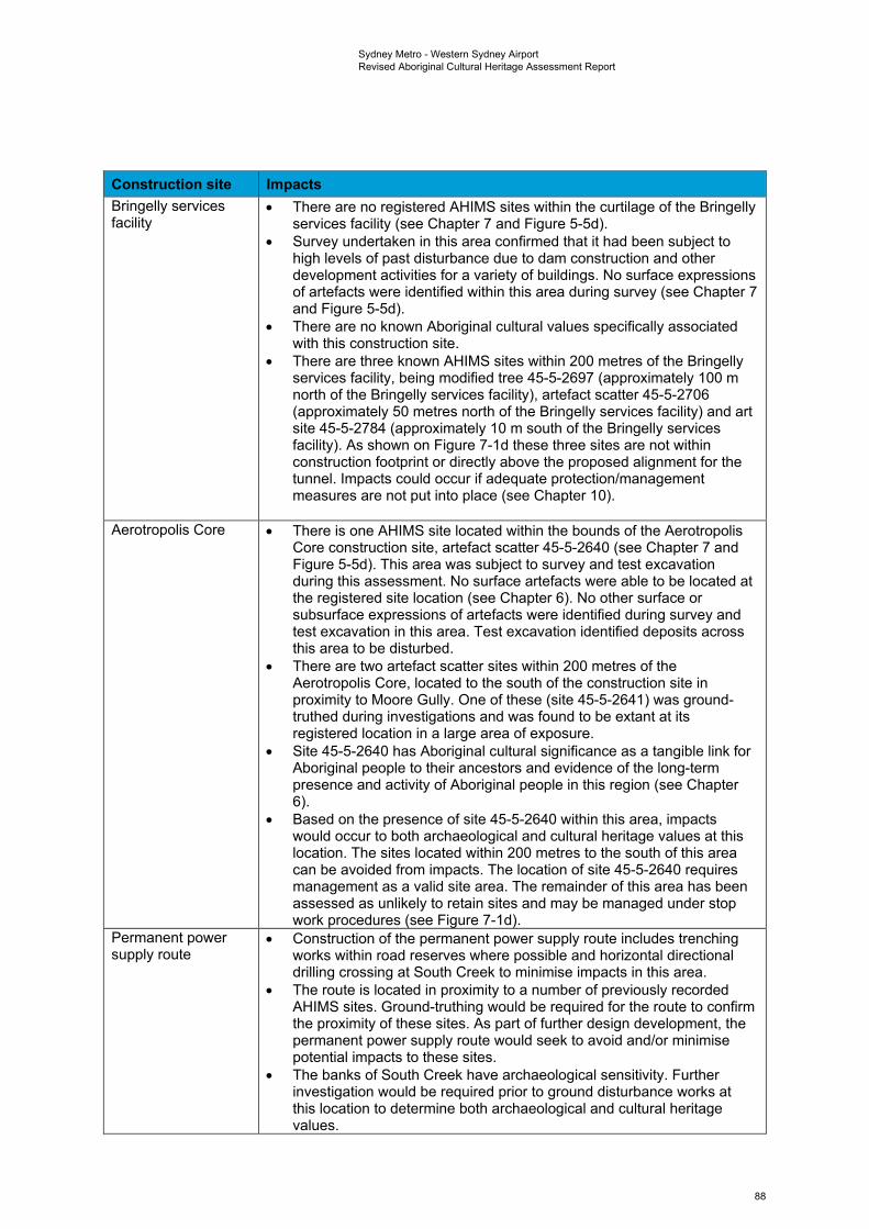
Sydney Metro - Western Sydney Airport Revised Aboriginal Cultural Heritage Assessment Report
Construction site Impacts Bringelly services facility
• There are no registered AHIMS sites within the curtilage of the Bringelly services facility (see Chapter 7 and Figure 5-5d).
• Survey undertaken in this area confirmed that it had been subject to high levels of past disturbance due to dam construction and other development activities for a variety of buildings. No surface expressions of artefacts were identified within this area during survey (see Chapter 7 and Figure 5-5d).
• There are no known Aboriginal cultural values specifically associated with this construction site.
• There are three known AHIMS sites within 200 metres of the Bringelly services facility, being modified tree 45-5-2697 (approximately 100 m north of the Bringelly services facility), artefact scatter 45-5-2706 (approximately 50 metres north of the Bringelly services facility) and art site 45-5-2784 (approximately 10 m south of the Bringelly services facility). As shown on Figure 7-1d these three sites are not within construction footprint or directly above the proposed alignment for the tunnel. Impacts could occur if adequate protection/management measures are not put into place (see Chapter 10).
Aerotropolis Core • There is one AHIMS site located within the bounds of the Aerotropolis Core construction site, artefact scatter 45-5-2640 (see Chapter 7 and Figure 5-5d). This area was subject to survey and test excavation during this assessment. No surface artefacts were able to be located at the registered site location (see Chapter 6). No other surface or subsurface expressions of artefacts were identified during survey and test excavation in this area. Test excavation identified deposits across this area to be disturbed.
• There are two artefact scatter sites within 200 metres of the Aerotropolis Core, located to the south of the construction site in proximity to Moore Gully. One of these (site 45-5-2641) was ground-truthed during investigations and was found to be extant at its registered location in a large area of exposure.
• Site 45-5-2640 has Aboriginal cultural significance as a tangible link for Aboriginal people to their ancestors and evidence of the long-term presence and activity of Aboriginal people in this region (see Chapter 6).
• Based on the presence of site 45-5-2640 within this area, impacts would occur to both archaeological and cultural heritage values at this location. The sites located within 200 metres to the south of this area can be avoided from impacts. The location of site 45-5-2640 requires management as a valid site area. The remainder of this area has been assessed as unlikely to retain sites and may be managed under stop work procedures (see Figure 7-1d).
Permanent power supply route
• Construction of the permanent power supply route includes trenching works within road reserves where possible and horizontal directional drilling crossing at South Creek to minimise impacts in this area.
• The route is located in proximity to a number of previously recorded AHIMS sites. Ground-truthing would be required for the route to confirm the proximity of these sites. As part of further design development, the permanent power supply route would seek to avoid and/or minimise potential impacts to these sites.
• The banks of South Creek have archaeological sensitivity. Further investigation would be required prior to ground disturbance works at this location to determine both archaeological and cultural heritage values.
88
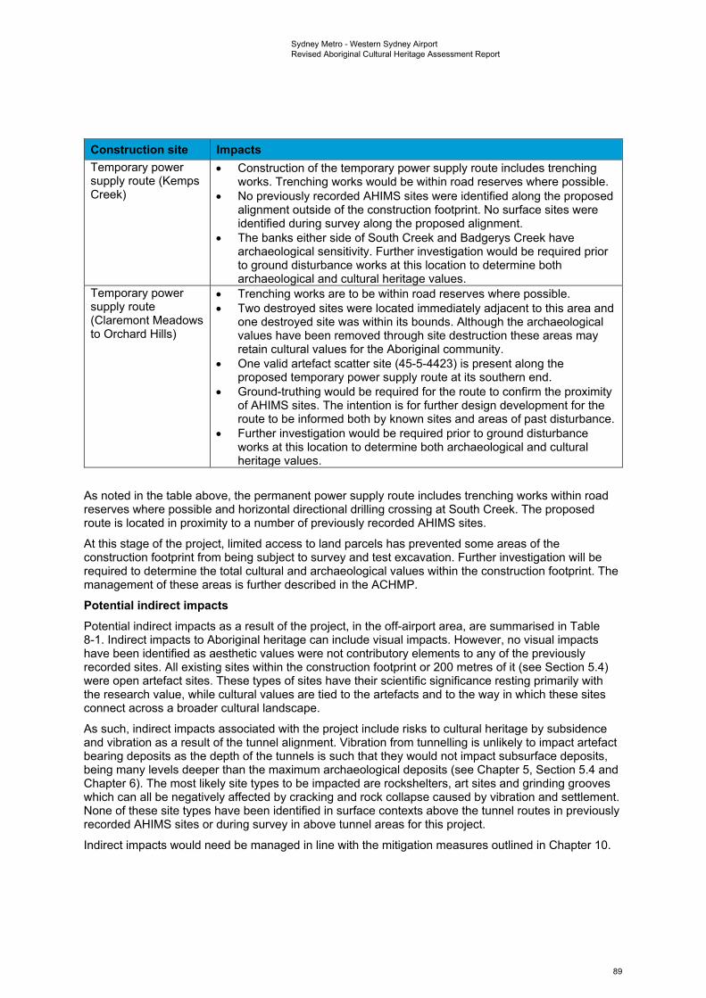
Sydney Metro - Western Sydney Airport Revised Aboriginal Cultural Heritage Assessment Report
Construction site Impacts Temporary power supply route (Kemps Creek)
• Construction of the temporary power supply route includes trenching works. Trenching works would be within road reserves where possible.
• No previously recorded AHIMS sites were identified along the proposed alignment outside of the construction footprint. No surface sites were identified during survey along the proposed alignment.
• The banks either side of South Creek and Badgerys Creek have archaeological sensitivity. Further investigation would be required prior to ground disturbance works at this location to determine both archaeological and cultural heritage values.
Temporary power • Trenching works are to be within road reserves where possible. supply route • Two destroyed sites were located immediately adjacent to this area and (Claremont Meadows one destroyed site was within its bounds. Although the archaeological to Orchard Hills) values have been removed through site destruction these areas may
retain cultural values for the Aboriginal community. • One valid artefact scatter site (45-5-4423) is present along the
proposed temporary power supply route at its southern end. • Ground-truthing would be required for the route to confirm the proximity
of AHIMS sites. The intention is for further design development for the route to be informed both by known sites and areas of past disturbance.
• Further investigation would be required prior to ground disturbance works at this location to determine both archaeological and cultural heritage values.
As noted in the table above, the permanent power supply route includes trenching works within road reserves where possible and horizontal directional drilling crossing at South Creek. The proposed route is located in proximity to a number of previously recorded AHIMS sites.
At this stage of the project, limited access to land parcels has prevented some areas of the construction footprint from being subject to survey and test excavation. Further investigation will be required to determine the total cultural and archaeological values within the construction footprint. The management of these areas is further described in the ACHMP.
Potential indirect impacts Potential indirect impacts as a result of the project, in the off-airport area, are summarised in Table 8-1. Indirect impacts to Aboriginal heritage can include visual impacts. However, no visual impacts have been identified as aesthetic values were not contributory elements to any of the previously recorded sites. All existing sites within the construction footprint or 200 metres of it (see Section 5.4) were open artefact sites. These types of sites have their scientific significance resting primarily with the research value, while cultural values are tied to the artefacts and to the way in which these sites connect across a broader cultural landscape.
As such, indirect impacts associated with the project include risks to cultural heritage by subsidence and vibration as a result of the tunnel alignment. Vibration from tunnelling is unlikely to impact artefact bearing deposits as the depth of the tunnels is such that they would not impact subsurface deposits, being many levels deeper than the maximum archaeological deposits (see Chapter 5, Section 5.4 and Chapter 6). The most likely site types to be impacted are rockshelters, art sites and grinding grooves which can all be negatively affected by cracking and rock collapse caused by vibration and settlement. None of these site types have been identified in surface contexts above the tunnel routes in previously recorded AHIMS sites or during survey in above tunnel areas for this project.
Indirect impacts would need be managed in line with the mitigation measures outlined in Chapter 10.
89
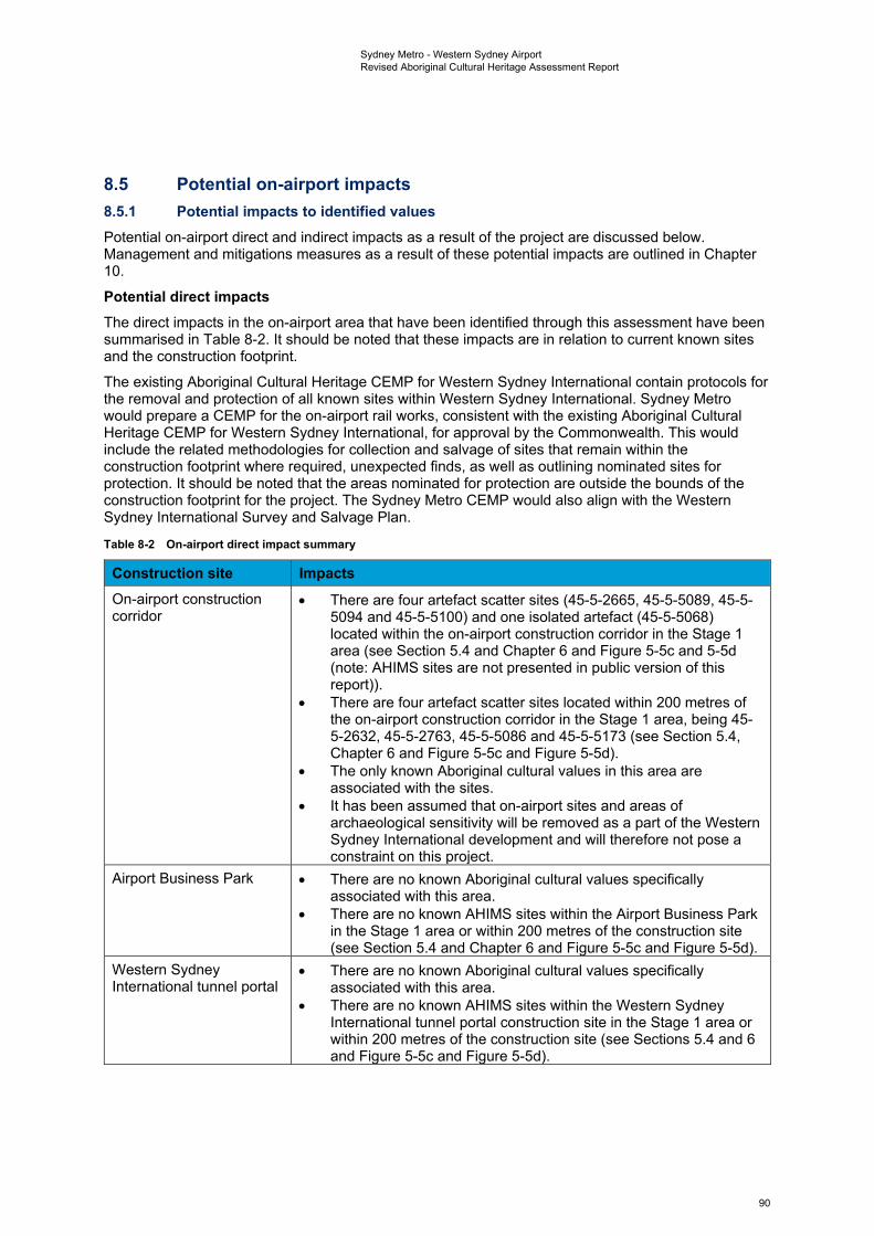
Sydney Metro - Western Sydney Airport Revised Aboriginal Cultural Heritage Assessment Report
8.5 Potential on-airport impacts 8.5.1 Potential impacts to identified values Potential on-airport direct and indirect impacts as a result of the project are discussed below. Management and mitigations measures as a result of these potential impacts are outlined in Chapter 10.
Potential direct impacts The direct impacts in the on-airport area that have been identified through this assessment have been summarised in Table 8-2. It should be noted that these impacts are in relation to current known sites and the construction footprint.
The existing Aboriginal Cultural Heritage CEMP for Western Sydney International contain protocols for the removal and protection of all known sites within Western Sydney International. Sydney Metro would prepare a CEMP for the on-airport rail works, consistent with the existing Aboriginal Cultural Heritage CEMP for Western Sydney International, for approval by the Commonwealth. This would include the related methodologies for collection and salvage of sites that remain within the construction footprint where required, unexpected finds, as well as outlining nominated sites for protection. It should be noted that the areas nominated for protection are outside the bounds of the construction footprint for the project. The Sydney Metro CEMP would also align with the Western Sydney International Survey and Salvage Plan.
Table 8-2 On-airport direct impact summary
Construction site Impacts On-airport construction corridor
•
•
•
•
There are four artefact scatter sites (45-5-2665, 45-5-5089, 45-5-5094 and 45-5-5100) and one isolated artefact (45-5-5068) located within the on-airport construction corridor in the Stage 1 area (see Section 5.4 and Chapter 6 and Figure 5-5c and 5-5d (note: AHIMS sites are not presented in public version of this report)). There are four artefact scatter sites located within 200 metres of the on-airport construction corridor in the Stage 1 area, being 45-5-2632, 45-5-2763, 45-5-5086 and 45-5-5173 (see Section 5.4, Chapter 6 and Figure 5-5c and Figure 5-5d). The only known Aboriginal cultural values in this area are associated with the sites. It has been assumed that on-airport sites and areas of archaeological sensitivity will be removed as a part of the Western Sydney International development and will therefore not pose a constraint on this project.
Airport Business Park •
•
There are no known Aboriginal cultural values specifically associated with this area. There are no known AHIMS sites within the Airport Business Park in the Stage 1 area or within 200 metres of the construction site (see Section 5.4 and Chapter 6 and Figure 5-5c and Figure 5-5d).
Western Sydney International tunnel portal
•
•
There are no known Aboriginal cultural values specifically associated with this area. There are no known AHIMS sites within the Western Sydney International tunnel portal construction site in the Stage 1 area or within 200 metres of the construction site (see Sections 5.4 and 6 and Figure 5-5c and Figure 5-5d).
90
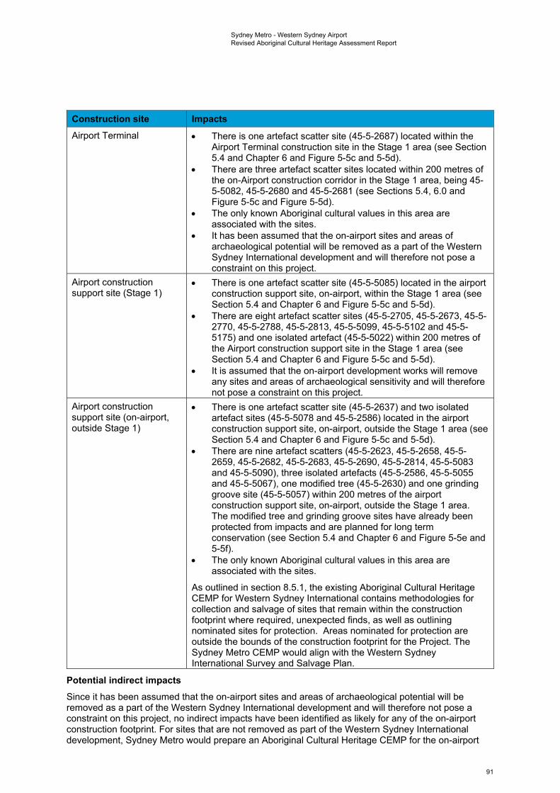
Sydney Metro - Western Sydney Airport Revised Aboriginal Cultural Heritage Assessment Report
Construction site Impacts Airport Terminal • There is one artefact scatter site (45-5-2687) located within the
Airport Terminal construction site in the Stage 1 area (see Section 5.4 and Chapter 6 and Figure 5-5c and 5-5d).
• There are three artefact scatter sites located within 200 metres of the on-Airport construction corridor in the Stage 1 area, being 45-5-5082, 45-5-2680 and 45-5-2681 (see Sections 5.4, 6.0 and Figure 5-5c and Figure 5-5d).
• The only known Aboriginal cultural values in this area are associated with the sites.
• It has been assumed that the on-airport sites and areas of archaeological potential will be removed as a part of the Western Sydney International development and will therefore not pose a constraint on this project.
Airport construction support site (Stage 1)
• There is one artefact scatter site (45-5-5085) located in the airport construction support site, on-airport, within the Stage 1 area (see Section 5.4 and Chapter 6 and Figure 5-5c and 5-5d).
• There are eight artefact scatter sites (45-5-2705, 45-5-2673, 45-5-2770, 45-5-2788, 45-5-2813, 45-5-5099, 45-5-5102 and 45-5-5175) and one isolated artefact (45-5-5022) within 200 metres of the Airport construction support site in the Stage 1 area (see Section 5.4 and Chapter 6 and Figure 5-5c and 5-5d).
• It is assumed that the on-airport development works will remove any sites and areas of archaeological sensitivity and will therefore not pose a constraint on this project.
Airport construction support site (on-airport, outside Stage 1)
• There is one artefact scatter site (45-5-2637) and two isolated artefact sites (45-5-5078 and 45-5-2586) located in the airport construction support site, on-airport, outside the Stage 1 area (see Section 5.4 and Chapter 6 and Figure 5-5c and 5-5d).
• There are nine artefact scatters (45-5-2623, 45-5-2658, 45-5-2659, 45-5-2682, 45-5-2683, 45-5-2690, 45-5-2814, 45-5-5083 and 45-5-5090), three isolated artefacts (45-5-2586, 45-5-5055 and 45-5-5067), one modified tree (45-5-2630) and one grinding groove site (45-5-5057) within 200 metres of the airport construction support site, on-airport, outside the Stage 1 area. The modified tree and grinding groove sites have already been protected from impacts and are planned for long term conservation (see Section 5.4 and Chapter 6 and Figure 5-5e and 5-5f).
• The only known Aboriginal cultural values in this area are associated with the sites.
As outlined in section 8.5.1, the existing Aboriginal Cultural Heritage CEMP for Western Sydney International contains methodologies for collection and salvage of sites that remain within the construction footprint where required, unexpected finds, as well as outlining nominated sites for protection. Areas nominated for protection are outside the bounds of the construction footprint for the Project. The Sydney Metro CEMP would align with the Western Sydney International Survey and Salvage Plan.
Potential indirect impacts Since it has been assumed that the on-airport sites and areas of archaeological potential will be removed as a part of the Western Sydney International development and will therefore not pose a constraint on this project, no indirect impacts have been identified as likely for any of the on-airport construction footprint. For sites that are not removed as part of the Western Sydney International development, Sydney Metro would prepare an Aboriginal Cultural Heritage CEMP for the on-airport
91
Sydney Metro - Western Sydney Airport Revised Aboriginal Cultural Heritage Assessment Report
works in consultation with Western Sydney Airport, for approval by the Commonwealth. The Sydney Metro CEMP would be consistent with the existing Western Sydney Airport Aboriginal Cultural Heritage Construction Environmental Management Plan (Western Sydney Airport, 2019).
8.6 Summary Existing data has identified there are 10 sites within the on-airport area. Taking into account the results of all archaeological survey and test excavation works undertaken for the project up to and including February 2021, a total of 10 Aboriginal archaeological sites are recognised as being wholly within the off-airport section of the construction footprint, with an additional two sites that have PAD curtilages partially extending into it. Identified sites consist of three valid previously recorded artefact scatter sites, being B22 (45-5-2640) BWB (45-5-5298) and CCE T3 (45-5-5297). Survey identified another artefact scatter site (SMWSA-AS6), while test excavation has identified five artefact scatters (SMWSA-AS2, SMWSA-AS3, SMWSA-AS4, SMWSA-AS7 and SMWSA-AS8) and three isolated artefact sites (SMWSA-IA1, SMWSA-IA2 and SMWSA-IA3) within the off-airport construction footprint.
Proposed ground disturbance activities within the construction footprint are anticipated to impact all of the 12 Aboriginal archaeological sites identified within it, with a total loss of value for the 10 sites wholly within the off-airport construction corridor, and partial impacts to those two with PAD curtilages partially extending into it. There are also further areas of subsurface Aboriginal archaeological sensitivity that have not yet been subject to survey or test excavation due to landholder access limitations on the project to date.
All other sites in proximity to but outside the construction footprint are proposed to be avoided and protected. As the eight on-airport sites will be removed as a part of Western Sydney International they would not pose a constraint on the project. With regard to known sites, therefore, the project is increasing the number of impacted sites by 10 in the off-airport portion of the project, with partial impacts to a further two sites. The impacted sites are all artefact scatter and isolated artefact sites, with many similar sites represented of these types across the wider region (i.e. no rarity value by site type). It is also likely that the project would impact upon a number of unidentified sites within its curtilage in both surface and subsurface contexts. All sites have cultural heritage values associated with them.
There remain areas of sensitivity that have not yet been surveyed and proposed test pits that have not yet been excavated due to access restrictions. As a result, further investigation will be required to determine the total cultural and archaeological values within the construction footprint, to be specified in the ACHMP (Appendix I of the Submissions Report).
92
Sydney Metro - Western Sydney Airport Revised Aboriginal Cultural Heritage Assessment Report
9. Cumulative impact assessment For the purposes of this assessment, cumulative impacts are impacts that, when considered together, have different and/or greater impacts than a single impact on its own. Cumulative impacts result from the successive, incremental and/or combined effects of multiple projects occurring across a shared geographical area. While the project has been assessed in this document in relation to impacts to Aboriginal heritage, so is the surrounding region being impacted by other development projects, including Western Sydney International, Elizabeth Drive road upgrades, M12 Motorway and The Northern Road Upgrade. The Elizabeth Drive project is in its early stages (Transport for NSW, 2020) and due to the lack of availability of further information it is not possible to accurately gauge the cumulative impacts that the Elizabeth Drive road upgrade works may contribute. Consideration of the total impact represented by the other projects is summarised below.
9.1 Western Sydney International The currently available data has identified a total of 115 Aboriginal sites within the bounds of Western Sydney International, consisting of 88 artefact scatters, 24 isolated artefacts, two modified trees and one grinding groove site. The Western Sydney Airport Aboriginal Cultural Heritage CEMP notes that salvage (including surface collection and archaeological excavation) will occur across the site, but does not specify at which locations. Two of the 115 sites within the Western Sydney International curtilage have been specified as being conserved and protected, being a possible culturally modified tree site (45-5-2630 - B40) and a grinding groove site (45-5-5057 - B120). Areas of sensitivity crossing into its bounds include Oaky Creek and various unnamed drainage lines and tributaries. The south-eastern side of the curtilage is bordered by Badgerys Creek, but sections of this are to be preserved within an Environmental Conservation Zone (Western Sydney Airport, 2019). The project does not propose to impact any sites not previously approved for impact by the airport construction works. Therefore, cumulative impacts within the on-airport area would not result from the project in combination with the development of Western Sydney International according to the available data, but the combination of both would have a cumulative impact on the Aboriginal cultural values and archaeology of the wider region.
9.2 Future M12 Motorway The revised construction footprint of the M12 Motorway project covers an area of approximately 429 hectares (Jacobs, 2020) and encompasses areas of archaeological sensitivity associated with several major Cumberland Plain creek systems including Ropes Creek, Kemps Creek, South Creek, Badgerys Creek and Cosgroves Creek. The new motorway is being delivered between the M7 Motorway at Cecil Hills and The Northern Road at Luddenham. The timing of opening of the M12 Motorway is subject to planning approval and the completion of detailed design. However, the project is expected to open prior to the opening of Western Sydney International in 2026.
Nineteen Aboriginal archaeological sites are expected to be impacted by the construction of the M12 Motorway, with a complete loss of value reported for eight sites and a partial loss of value reported for the remaining 11 sites (Roads and Maritime, 2019; TfNSW, 2020). Data provided in the M12 Motorway ACHAR indicates that the impacted portions of these sites represent around 17 per cent of the motorway’s revised construction footprint (Roads and Maritime Services, 2019:93-94, Table 11-1). Of the nineteen sites identified within this area, two - artefact scatters CCE T3 (45-5-5297) and BWB (45-5-5298) - extend into the project’s construction footprint and would be subject to additional impacts. Ultimately, these additional impacts would result in a partial loss of value for both sites, with sections of both remaining undisturbed subsequent to the completion of both the M12 Motorway and the project.
9.3 The Northern Road upgrade The Northern Road is proposed for upgrades along a 35-kilometre section between Mersey Road, Bringelly and Glenmore Parkway in Glenmore Park. The Northern Road upgrades are being delivered in stages, with some stages completed and the final stages having started construction in 2019. A total of 28 Aboriginal archaeological sites have been identified as being directly impacted by the proposed upgrade works for The Northern Road. Of the total 28 impacted sites, 20 of them were proposed for
93
Sydney Metro - Western Sydney Airport Revised Aboriginal Cultural Heritage Assessment Report
salvage (Roads and Maritime Services, 2019:96). The proposed works for the Northern Road upgrade are outside the bounds of the construction footprint, generally to the south and south-west of the Aerotropolis Core. The sites that will be impacted by the Northern Road upgrade are additional to those impacted within the construction footprint, increasing the cumulative impact of the wider region.
9.4 Cumulative impacts The available evidence of other projects in the surrounding region is that the finite resource of Aboriginal sites is diminishing rapidly as the impacts of multiple developments have an overall cumulative impact on the Aboriginal cultural record of this area. The currently available data has identified seven artefact scatters and three isolated artefact sites subject to destruction within the off-airport portion of the project, with two additional artefact scatter sites to be partially destroyed. Additionally 10 sites would be impacted within the on-airport area. All other sites in proximity to but outside the construction footprint are proposed to be avoided and protected. It has been assumed that the 10 on-airport sites will be removed as a part of Western Sydney International and would therefore not pose a constraint on this project. With regard to known sites, therefore, the project is increasing the number of impacted sites by 22 (two being partial impacts), all open artefact sites, being a common site type represented across the wider region (i.e. no rarity value by site type). In addition to the known sites, impact is likely to occur upon a number of unidentified sites in both surface and subsurface contexts in those areas that have not yet been subject to survey or test excavation. Consultation with RAPs to date has identified cultural values associated with identified sites and waterways, with representative Colin Gale also stating that the location of sites is not necessarily restricted to water resource areas alone.
The principles of an ecologically sustainable development follow the precautionary principle, which states that full scientific certainty about the threat of harm should never be used as a reason for not taking measures to prevent harm from occurring. The principle of inter-generational equity holds that the present generation should make every effort to ensure the health, diversity and productivity of the environment – which includes cultural heritage – is available for the benefit of future generations (NSW Office of Environment & Heritage, 2011). As the cumulative impacts have been identified as impacting on the finite resource of Aboriginal sites in this region, management and mitigation measures are required to protect this resource for the future.
94
Sydney Metro - Western Sydney Airport Revised Aboriginal Cultural Heritage Assessment Report
10. Proposed management and mitigation measures
10.1 Approach to management and mitigation This chapter describes the environmental management approach for the project for Aboriginal heritage during construction and operation.
A Construction Environmental Management Framework (CEMF) (Appendix E of the Submissions Report) describes the approach to environmental management, monitoring and reporting during construction. Specifically, it lists the requirements to be addressed by the construction contractor in developing the CEMPs, sub-plans, and other supporting documentation for each specific environmental aspect.
This chapter includes a compilation of the performance outcomes as well as mitigation measures, including those that are included in the ACHMP (refer to Appendix I of the Submissions Report).
10.2 Performance outcomes Performance outcomes have been developed consistent with the requirements of the SEARs for the project. The performance outcomes for the project are summarised below in Table 10-1 and identify measurable, performance-based standards for environmental management. Table 10-1 Performance outcomes for the project in relation to Aboriginal heritage
SEARS desired performance outcome Project performance outcome Timing The design, construction and operation of the project facilitates, to the greatest extent possible, the long term protection, conservation and management of the heritage significance of Aboriginal objects and places.
The design, construction and operation of the project avoids or minimises impacts, to the greatest extent possible, on the heritage significance of Aboriginal objects and places.
The heritage significance of Aboriginal objects and places are protected, conserved and/or managed in order to ensure the project does not diminish the story and cultural understanding associated with the objects and places of Aboriginal people in New South Wales.
Construction
Impacts on areas of archaeological sensitivity and significance are avoided or minimised, where practical.
Construction
The design of the project Operation incorporates Aboriginal heritage interpretation and Aboriginal cultural design principles in consultation with Aboriginal knowledge holders.
10.3 Proposed mitigation measures The Aboriginal heritage mitigation measures for the project are provided in Table 10-2. Table 10-2 Mitigation measures
Ref Mitigation measure Applicable location (s) Construction AH1 Aboriginal stakeholder consultation would continue to be
carried out in accordance with the Aboriginal Cultural Heritage Consultation Requirements for Proponents 2010 (NSW Office of Environment and Heritage, 2010). Registered Aboriginal Parties would be provided with opportunities to participate in
Off-airport
95
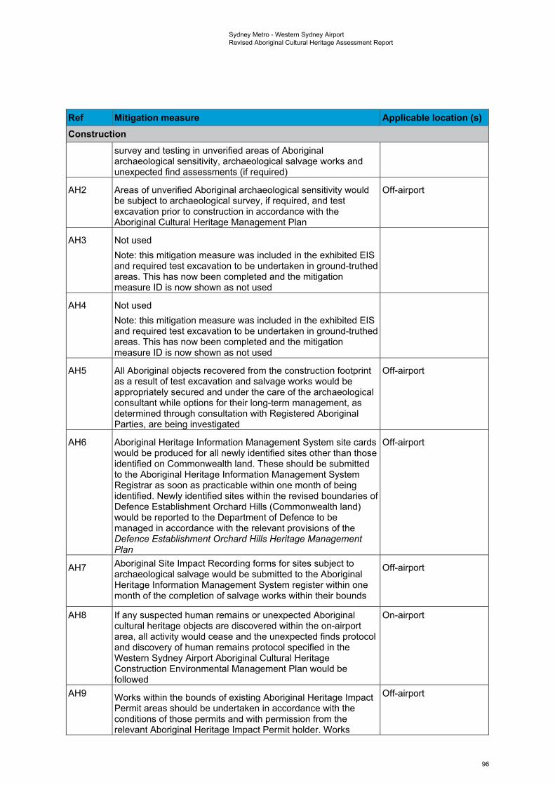
Sydney Metro - Western Sydney Airport Revised Aboriginal Cultural Heritage Assessment Report
Ref Mitigation measure Applicable location (s) Construction
survey and testing in unverified areas of Aboriginal archaeological sensitivity, archaeological salvage works and unexpected find assessments (if required)
AH2 Areas of unverified Aboriginal archaeological sensitivity would be subject to archaeological survey, if required, and test excavation prior to construction in accordance with the Aboriginal Cultural Heritage Management Plan
Off-airport
AH3 Not used Note: this mitigation measure was included in the exhibited EIS and required test excavation to be undertaken in ground-truthed areas. This has now been completed and the mitigation measure ID is now shown as not used
AH4 Not used Note: this mitigation measure was included in the exhibited EIS and required test excavation to be undertaken in ground-truthed areas. This has now been completed and the mitigation measure ID is now shown as not used
AH5 All Aboriginal objects recovered from the construction footprint as a result of test excavation and salvage works would be appropriately secured and under the care of the archaeological consultant while options for their long-term management, as determined through consultation with Registered Aboriginal Parties, are being investigated
Off-airport
AH6 Aboriginal Heritage Information Management System site cards would be produced for all newly identified sites other than those identified on Commonwealth land. These should be submitted to the Aboriginal Heritage Information Management System Registrar as soon as practicable within one month of being identified. Newly identified sites within the revised boundaries of Defence Establishment Orchard Hills (Commonwealth land) would be reported to the Department of Defence to be managed in accordance with the relevant provisions of the Defence Establishment Orchard Hills Heritage Management Plan
Off-airport
AH7 Aboriginal Site Impact Recording forms for sites subject to archaeological salvage would be submitted to the Aboriginal Heritage Information Management System register within one month of the completion of salvage works within their bounds
Off-airport
AH8 If any suspected human remains or unexpected Aboriginal cultural heritage objects are discovered within the on-airport area, all activity would cease and the unexpected finds protocol and discovery of human remains protocol specified in the Western Sydney Airport Aboriginal Cultural Heritage Construction Environmental Management Plan would be followed
On-airport
AH9 Works within the bounds of existing Aboriginal Heritage Impact Permit areas should be undertaken in accordance with the conditions of those permits and with permission from the relevant Aboriginal Heritage Impact Permit holder. Works
Off-airport
96
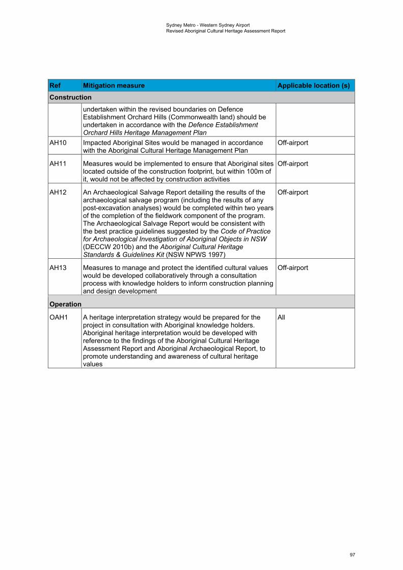
Sydney Metro - Western Sydney Airport Revised Aboriginal Cultural Heritage Assessment Report
Ref Mitigation measure Applicable location (s) Construction
undertaken within the revised boundaries on Defence Establishment Orchard Hills (Commonwealth land) should be undertaken in accordance with the Defence Establishment Orchard Hills Heritage Management Plan
AH10 Impacted Aboriginal Sites would be managed in accordance with the Aboriginal Cultural Heritage Management Plan
Off-airport
AH11 Measures would be implemented to ensure that Aboriginal sites located outside of the construction footprint, but within 100m of it, would not be affected by construction activities
Off-airport
AH12 An Archaeological Salvage Report detailing the results of the archaeological salvage program (including the results of any post-excavation analyses) would be completed within two years of the completion of the fieldwork component of the program. The Archaeological Salvage Report would be consistent with the best practice guidelines suggested by the Code of Practice for Archaeological Investigation of Aboriginal Objects in NSW (DECCW 2010b) and the Aboriginal Cultural Heritage Standards & Guidelines Kit (NSW NPWS 1997)
Off-airport
AH13 Measures to manage and protect the identified cultural values would be developed collaboratively through a consultation process with knowledge holders to inform construction planning and design development
Off-airport
Operation
OAH1 A heritage interpretation strategy would be prepared for the project in consultation with Aboriginal knowledge holders. Aboriginal heritage interpretation would be developed with reference to the findings of the Aboriginal Cultural Heritage Assessment Report and Aboriginal Archaeological Report, to promote understanding and awareness of cultural heritage values
All
97
Sydney Metro - Western Sydney Airport Revised Aboriginal Cultural Heritage Assessment Report
11. ReferencesAECOM Australia Pty Ltd. (2015). Archaeological Salvage of Open Artefact Site MPIP5 (45-5-3726)(Vol. 5). Unpublished report for Winten (No. 26) Pty Ltd.
Allen, J., & O’Connell, J. F. (1995). Transitions: Pleistocene to Holocene in Australia and Papua NewGuinea. Antiquity, 69(265), ix-862.
AMBS. (2014). Environmental Survey of Commonwealth Land at Badgerys Creek: Aboriginal Heritage.
Appleton, J. (2002). The Archaeological Investigation of Lot 2, DP 120673 The Site of a ProposedNew Clay and Shale Extraction Area - Old Wallgrove Road Horsley Park, West of Sydney NSW.
Archaeological & Heritage Management Solutions Pty Ltd. (2013). Fernadell Precinct, Pitt Town,NSW: Aboriginal Heritage Impact Permit #1129099 Excavation Report. Unpublished report forJohnson Property Group Pty Ltd.
Archaeological & Heritage Management Solutions Pty Ltd. (2015). Water Related Infrastructure for theNorth West Growth Centre (NWGC) First and Second Release Precincts: Aboriginal ArchaeologicalExcavation Report. Unpublished report for Lend Lease/Sydney Water.
Archaeological and Heritage Management Solutions Pty Ltd. (2012). Aboriginal Archaeological Survey Report: Werrington Arterial Road (M4 Motorway - Great Western Highway), Claremont Meadows, NSW.
Artefact Heritage. (2012). The Northernn Road Upgrade from the The Old Northern Road, Narellan, toMersey Road, Bringelly - Aboriginal Archaeological Survey Report. Unpublished report for Roads andMaritime Services.
Attenbrow, V. (2002). Sydney’s Aboriginal Past: investigating the archaeological and historical records.Sydney: University of New South Wales Press Ltd.
Attenbrow, V. (2010). Sydney’s Aboriginal Past: Investigating the Archaeological and HistoricalRecords. Sydney: University of New South Wales Press.
Attenbrow, V. (2012a). Archaeological Evidence of Aboriginal Life in Sydney. Retrieved fromDictionary of Sydney website:http://dictionaryofsydney.org/entry/archaeological_evidence_of_aboriginal_life_in_sydney
Attenbrow, V. (2012b). The Aboriginal Prehistory and Archaeology of Royal National Park andEnvirons : A Review. Proceedings of the Linnean Society of New South Wales, 134, 39–64.
Attenbrow, V., Graham, I., Kononenko, N., Corkill, T., Byrnes, J., Barron, L., & Grave, P. (2012).Crossing the Great Divide: A Ground-Edge Hatchet-Head from Vaucluse, Sydney. Archaeology inOceania, 47, 47–52.
Attenbrow, V., Robertson, G., & Hiscock, P. (2009). The Changing Abundance of Backed Artefacts inSouth-Eastern Australia: A Response to Holocene Climate Change. Journal of ArchaeologicalScience, 36, 2765–2770.
Austral Archaeology Pty Ltd. (2005). Blacktown Native Institute, Plumpton, NSW: Aboriginal CulturalSalvage Excavation. Unpublished report for Abigroup Leighton Joint Venture.
Austral Archaeology Pty Ltd. (2007). Archaeological Salvage Excavations: 95-101 George Street,Parramatta, NSW. Unpublished report for Cultural Resources Management on behalf of LeightonProperties.
Austral Archaeology Pty Ltd. (2011). Windsor Museum, NSW: Aboriginal Archaeological and CulturalSalvage Excavation AHIP #2119. Unpublished report for Hawkesbury City Council.
Australian Government (Department of the Environment). (2016). Engage Early: Guidance forProponents on Best Practice Indigenous Engagement for Environmental Assessments under theEnvironmental Protection and Biodiversity Conservation Act 1999 (EPBC Act). Retrieved fromCommonwealth of Australia website:http://www.environment.gov.au/system/files/resources/3201a986-88e8-40f3-8c15-6e659ed04006/files/engage-early-indigenous-engagement-guidelines.pdf
98
Sydney Metro - Western Sydney Airport Revised Aboriginal Cultural Heritage Assessment Report
Australian Heritage Commission. (2002). Ask First: a guide to respecting Indigenous heritage places and values. Retrieved from http://www.environment.gov.au/heritage/ahc/publications/commission/books/pubs/ask-first.pdf
Australian Museum Business Services. (2000). Mungerie Park Town Centre: Archaeological Salvage Excavations near Kellyville, Cumberland Plain, NSW.
Australian Museum Business Services. (2002). Western Sydney Orbital (WSO) Plumpton Ridge Archaeological Test Excavations. Sydney: Unpublished report for Roads and Traffic Authority.
Baker Archaeology Pty Ltd. (2019). Aboriginal Cultural Heritage Assessment Report University of Sydney lands at Badgerys Creek, NSW DRAFT.
Baker, N. (1996). Archaeological Test Excavations at Plumpton Ridge, Proposed Sydney Orbital Road Route EIS. Unpublished report for Robynne Mills and Sinclair Knight Pty Ltd.
Balek, C. L. (2002). Buried Artifacts in Stable Upland Sites and the Role of Bioturbation: A Review. Geoarchaeology, 17(1), 41–51.
Bannerman, S. M., & Hazelton, P. A. (1990). Soil Landscapes of the Penrith 1:100 000 Sheet. Sydney: Soil Conservation Service of NSW.
Bannerman, S. M., & Hazelton, P. A. (2011). Soil Landscapes of the Penrith 1:100 000 Sheet. Sydney: Soil Conservation Service of NSW.
Barham, T. (2005). A Preliminary Geoarchaeological Assessment of the Archaeological Potential of the Area Mapped as Quaternary Alluvium on the Eastern Margins of Ropes Creek Based on Observations of Geotechnical Test Pits. Unpublished report for Marys Dallas Consulting Archaeologists.
Barham, T. (2007). Eastern Creek Geoarchaeological Model and Strategy Assessment, Interpretation and Strategic Conservation of the Archaeological Resource. Unpublished report for Hyder Consulting.
Barns, S., & Mar, P. (2018). Waves of People.
Barrallier, F. (1802). Journal of the Expedition into the Interior of New South Wales. Melbourne: Marsh Walsh Publishing.
Barry, F. (2005). It’s Not Set in Stone: A Landscape Approach to Archaeology in the Cumberland Plain: Investigations from the Western Sydney Orbital (WSO/Westlink M7). Sydney University.
Beaton, J. M. (1985). Evidence for a Coastal Occupation Time-Lag at Princess Charlotte Bay (North Queensland) and Implications for Coastal Colonization and Population Growth Theories for Aboriginal Australia. Archaeology in Oceania, 20, 1–20.
Bickford, A. (1981). The Archaeological Investigation of the Native Institution, Blacktown, NSW. Unpublished report for Lyle Marshall & Associates.
Bickford, A., & Sullivan, S. (1984). Assessing the research significance of historic sites. In S. Sullivan & S. Bowdler (Eds.), Site survey and significance assessment in Australian Archaeology (1st ed., pp. 19–26). Canberra: Australian Institute of Aboriginal Affairs.
Binns, R. A., & McBryde, I. (1972). A Petrological Analysis of Ground-Edge Artefacts from Northern New South Wales. Canberra: Australian Institute of Aboriginal Studies.
Biosis Research Pty Ltd. (2008). Rosehill Recycled Water Scheme: Aboriginal Archaeological and Cultural Heritage Assessment. Unpublished report for Jemena Management Pty Ltd.
Biosis Research Pty Ltd. (2010). Western Sydney Recycled Water Initiative Replacement Flows Project Aboriginal archaeological testing and salvage results. Unpublished report for McConnel Dowell.
Biosis Research Pty Ltd. (2016). Mamre West Precinct, Orchard Hills: Archaeological Report.
Bowdler, S. (1981). Unconsidered Trifles? Cultural Resource Management, Environmental Impact Statements and Archaeological Research in New South Wales. Australian Archaeology, 12.
Bowler, J., Jones, R., Allen, H., & Thorne, A. (1970). Pleistocene Human Remains From Australia: A
99
Sydney Metro - Western Sydney Airport Revised Aboriginal Cultural Heritage Assessment Report
Living Site and Human Cremation from Lake Mungo, Western New South Wales. World Archaeology, 2, 29–60.
Bradley, W. (1792). A Voyage to New South Wales. The Journal of Lieutenant William Bradley RN of HMS Sirius 1786-1792. Unpublished manuscript [Republished 1961 by The Trustees of the Public Library of NSW in assoc. with Ure Smith].
Brayshaw, H. (1995). Elizabeth Drive Upgrade Environmental Impact Statement Archaeological Survey for Aboriginal Sites. Unpublished report to the NSW Roads & Traffic Authority.
Brayshaw McDonald Pty Ltd. (1992). Archaeological Survey of the Proposed 33kV Transmission Line Between Bringelly and Rossmore, NSW. Unpublished report for EDAW Australia.
Brook, J., & Kohen, J. (1991). The Parramatta Native Institution and the Black Town: A History. Sydney: New South Wales University Press.
Brumm, A., & Moore, M. W. (2005). Symbolic Revolutions and the Australian Archaeological Record. Cambridge Archaeological Journal, 15(02), 157–175.
Buggey, S. (1999). An approach to Aboriginal cultural landscapes. Historic Sites and Monuments Board of Canada, Ottawa.
Burke, H., & Smith, C. (2004). The Archaeologist’s Field Handbook. Sydney: Allen & Unwin.
Clark, N. R., & Jones, D. C. (1991). Penrith 1:100,000 Geological Sheet 9030 (1st editio). Sydney: Geological Survey of New South Wales.
Collins, D. (1798). An Account of the English Colony in New South Wales. Vol. 1. (B. H. Fletcher, Ed.). London: T. Cadell Jun. & W. Davies [Republished 1975 by AH & AW Reed in assoc. with the Royal Australian Historical Society, Sydney].
Collins, D. (1802). An Account of the English Colony in New South Wales. Vol. 2. (J. Collier, Ed.). London: T. Cadell Jun. & W. Davies [Reproduced 1971 by the Libraries Board of South Australia. Australiana Facsimile Editions No. 76] Sydney].
Corkill, T. (1999). Here and There: Links Between Stone Sources and Aboriginal Archaeological Sites in Sydney, Australia. Unpublished M.Phil thesis, University of Sydney.
Corkill, T. (2005). Sourcing Stone from the Sydney Region: A Hatchet Job. Australian Archaeology, 60, 41–50.
Coutts, P. J. F., & Witter, D. C. (1977). Summer Field Programme of the Victoria Archaeological Survey. Australian Archaeology, 6.
Cowan, F. L. (1999). Making Sense of Flake Scatters: Lithic technological Strategies and Mobility. American Antiquity, 64(4), 593–607.
Craib, J. ., Bonhomme, T., Mangold, G. R., & Williams, S. S. (1999). Archaeological Salvage Excavations at Site RS1 (45-5-982), Regentville, Western Sydney: Final Report. Unpublished report for TransGrid.
Dallas, M. (1982). An Archaeological Survey at Riverstone, Schofields and Quakers Hill, N.S.W. Unpublished report for Land Commission of NSW.
Dallas, M. (1988). Preliminary archaeological study of the Luddenham Equestrian Centre, Luddenham Road, Erskine Park, NSW.
Dallas, M., & Smith, L. (1988). Appendix C: Site Investigations at the Luddenham Equestrian Centre, Erskine Park, NSW. Report to the Signature Corporation Australia Limited.
Dallas, M., & Witter, D. C. (1983). Investigation of an Aboriginal Open Site at Plumpton, NSW. Unpublished report for Land Commission of NSW.
Dawes, W. (1790a). Grammatical Forms of the Language of N.S. Wales, in the Neighbourhood of Sydney. Unpublished manuscript [Original in the Library of the School of Oriental & African Studies, London. Marsden Collection Ms 41645 (a). Microfilm in the ML of the SLNSW].
Dawes, W. (1790b). Vocabularly of the Language of N.S. Wales, in the Neighbourhood of Sydney,
100
Sydney Metro - Western Sydney Airport Revised Aboriginal Cultural Heritage Assessment Report
Native and English. Unpublished manuscript [Original in the Library of the School of Oriental & African Studies, London. Marsden Collection Ms 41645 (b). Microfilm in the ML of the SLNSW].
Dean-Jones, P. (1991). Proposed Clay/Shale Extraction, Lot 3 DP 623799, Adams Road, Luddenham Archaeological Survey.
Dean-Jones, P., & Mitchell, P. B. (1993). Hunter Valley Aboriginal Sites Assessment Project. Environmental Modelling for Archaeological Site Potential in the Central Lowlands of the Hunter Valley. Unpublished report for NSW National Parks and Wildlife Service.
Department of Environment, C. C. and W. N. (2010). FACT SHEET 2 What is an Aboriginal cultural landscape? Department of Environment, Climate Changeand Water NSW.
Department of Infrastructure and Regional Development. (2016). Western Sydney Airport -Environmental Impact Statement.
Douglas, P., & McDonald, J. (1993). Archaeological Investigation of RH/CD5, PAD17 (RH/CD10) and PAD 18 (RH/CD6) at Rouse Hill, NSW: Test Excavation Report. Unpublished report for Rouse Hill (Stage 1) Pty Ltd.
Eco Logical Australia. (2011). Box Hill Precinct Planning Study - Biodiversity Assessment. Unpublished report for NSW Department of Planning.
Environmental Resources Management Australia Pty Ltd. (2003). Aboriginal and Historic Heritage Assessment - Claremont Meadows. Unpublished report for Land Solutions.
Environmental Resources Management Australia Pty Ltd. (2006a). Aboriginal Archaeological Salvage Excavation Report of Aboriginal Site OAD1 at Claremont Meadows. Unpublished report for Landcom.
Environmental Resources Management Australia Pty Ltd. (2006b). Lots 8, 10, 11 (DP27107) & Lot 19 (DP239091), Caddens Road, Claremont Meadows, Heritage Assessment. Unpublished report for Landcom.
Environmental Resources Management Australia Pty Ltd. (2010). Claremont Meadows South West 1, Section 90 Excavation, Aboriginal Heritage Excavation Report. Unpublished report for Investa Property Group.
Fanning, P. C., & Holdaway, S. J. (2004). Artifact Visibility at Open Sites in Western New South Wales, Australia. Journal of Field Archaeology, 29, 255–271.
Fanning, P. C., Holdaway, S. J., Rhodes, E. J., & Bryant, T. G. (2009). The Surface Archaeological Record in Arid Australia: Geomorphic Controls on Preservation, Exposure, and Visibility. Geoarchaeology, 24(2), 121–146.
Flynn, M. (1994). People and Place: Aspects of Parramatta Riverside History in the Early Colonial Period. Unpublished report for Parramatta City Council.
Flynn, M. (1995a). Parramatta & the Aboriginal People of the Sydney Region Part 1: 1788-1810. Unpublished report for Parramatta City Council.
Flynn, M. (1995b). Place of Eels: Parramatta and the Aboriginal Clans of the Sydney Region: 1788-1845. Unpublished report for Parramatta City Council.
GML Heritage Pty Ltd. (2010). Colebee and Nurragingy Land Grant. Retrieved from http://www.environment.nsw.gov.au/heritageapp/ViewHeritageItemDetails.aspx?ID=5056189
GML Heritage Pty Ltd. (2012). East Leppington Aboriginal Archaeological Technical Report. Unpublished report for Stockland Development.
GML Heritage Pty Ltd. (2013). Defence Establishment Orchard Hills, NSW: Heritage Management Plan.
GML Heritage Pty Ltd. (2016). East Leppington Open Area Archaeological Excavation Report. Unpublished report for Stockland Development Pty Ltd.
Godden Mackay Logan Pty Ltd. (1995). Conservation Plan for Bringelly Radio Receiving Station Complex, Telstra Corporation, Mobile Satellite and Radio Services, Badgery’s Creek Rd, Bringelly NSW.
101
Sydney Metro - Western Sydney Airport Revised Aboriginal Cultural Heritage Assessment Report
Godwin, L. (2011). The Application of Assessment of Cumulative Impacts in Cultural Heritage Management: A Critique. Australian Archaeology, 73(73), 88–91.
Gould, R. (1969). Puntutjarpa Rockshelter: A Reply to Messrs Glover and Lampert. Archaeology and Physical Anthropology in Oceania, 4, 229–237.
Government Architect New South Wales. (2020a). Connecting with Country.
Government Architect New South Wales. (2020b). Designing with Country.
Grave, P., Attenbrow, V., Sutherland, L., Pogson, R., & Forster, N. (2012). Non-Destructive PXRF of Mafic Stone Tools. Journal of Archaeological Science, 39(6), 1674–1686. https://doi.org/10.1016/j.jas.2011.11.011
Haglund, L. (1978). Major Airport Needs of Sydney Study: Survey of Aboriginal Sites and Relics. Unpublished report to MANS Committee.
Hanrahan, J. (1981). Report on Proposed Subdivision at South Werrington, Near Penrith. Unpublished report for the Housing Commission of NSW.
Helen Brayshaw Heritage Consultants. (1996). M4 Upgrade, Archaeological Survey for Aboriginal Sites for Proposal to Upgrade the M4 Motorway from Church Street Parramatta to Coleman Street, Marys Hill and Prospect to Emu Plains. Unpublished report for SWR Constructors Pty Ltd.
Hiscock, P. (1993a). Bondian Technology in the Hunter Valley, New South Wales. Archaeology in Oceania, 28, 65–76.
Hiscock, P. (1993b). The Distribution of Points Within Nauwalabila 1. The Beagle, (10), 173–178.
Hiscock, P. (1994). Technological Responses to Risk in Holocene Australia. Journal of World Prehistory, 8(3), 267–292.
Hiscock, P. (2002). Pattern and Context in the Holocene Proliferation of Backed Artefacts in Australia. In R. Elston & S. Kuhn (Eds.), Thinking Small: Global Perspectives on Microlithization (pp. 163–177). Archaeological Papers of the American Anthropological Association.
Hiscock, P. (2006). Blunt and to the Point: Changing Technological Strategies in Holocene Australia. In I. Lilley (Ed.), Archaeology of Oceania: Australia and the Pacific Islands (pp. 69–95). Oxford: Blackwell.
Hiscock, P. (2008). Archaeology of Ancient Australia. London: Routledge.
Hiscock, P., & Attenbrow, V. (1998). Early Holocene Backed Artefacts From Australia. Archaeology in Oceania, 33(2), 49–63.
Hiscock, P., & Attenbrow, V. (2004). A Revised Sequence of Backed Artefact Production at Capertee 3. Archaeology in Oceania, 39(2), 49–63.
Hofman, J. L. (1986). Vertical Movement of Artifacts in Alluvial and Stratified Deposits. Current Anthropology, 27(2), 163–171.
Horton, D. R. (1996). Aboriginal Australia. Canberra, ACT: Aboriginal Studies Press.
Hunter, J. (1793). An Historical Journal of the Transactions at Port Jackson and Norfolk Island, ...Including the Journals of Governors Phillip and King, and of Lieut. Ball; and the Voyages from the First Sailing of the Sirius in 1787 to the Return of that Ship’s Company to. London: J.Stockdale [Republished 1968 Australiana Facsimile Editions No.148, Libraries Board of South Australia, Adelaide].
ICOMOS (Australia). (2013). The Burra Charter: The Australia ICOMOS Charter for Places of Cultural Significance. Retrieved from Australia ICOMOS website: http://australia.icomos.org/wp-content/uploads/The-Burra-Charter-2013-Adopted-31.10.2013.pdf
Irish, P. (2017). Hidden in Plain View: The Aboriginal People of Coastal Sydney. Sydney: NewSouth Publishing.
Jacobs. (2020). M12 Motorway Amendment Report – Appendix E Aboriginal heritage supplementary technical memorandum.
102
Sydney Metro - Western Sydney Airport Revised Aboriginal Cultural Heritage Assessment Report
JAJV. (2019). M12 Motorway Concept Design and Environmental Impact Assessment - Archaeological Assessment Report DRAFT.
Jo McDonald Cultural Heritage Management Pty Ltd. (1997a). Archaeological Salvage of Site RMI at Richmond, NSW: Test and Salvage Excavation Report. Unpublished report for Restifa & Partners.
Jo McDonald Cultural Heritage Management Pty Ltd. (1997b). Interim Heritage Management Report: ADI Site St Marys. Volume 1 - Test Excavation Report. Unpublished report for Lend lease - ADI Joint Venture.
Jo McDonald Cultural Heritage Management Pty Ltd. (2000). Archaeological Survey For Aboriginal Sites : Proposed Light Industrial Subdivision, “Austral Site”, Mamre Road, Erskine Park, NSW.
Jo McDonald Cultural Heritage Management Pty Ltd. (2001a). Salvage Excavations of Six Sites along Caddies, Second Ponds, Smalls and Cattai Creeks in the Rouse Hill Development Area, NSW. Unpublished report for Rouse Hill Infrastructure Consortium.
Jo McDonald Cultural Heritage Management Pty Ltd. (2001b). Survey for Aboriginal Sites, 1503 Elizabeth Drive, Kemps Creek, NSW, October 2001.
Jo McDonald Cultural Heritage Management Pty Ltd. (2002a). Archaeological Excavations at Balfour Drive, Kellyville, NSW (Site RH/SC5). Archaeological Salvage Programme Prior to Residential Development. Unpublished report for Mepstead & Associates on behalf of Bake Investments Pty Ltd and Cardno BLH Pty Ltd.
Jo McDonald Cultural Heritage Management Pty Ltd. (2002b). Archaeological Excavations at Windsor Road, Kellyville, NSW (Site RH/CD12: NPWS #45-5-962). Unpublished report for Australand Holdings Pty Ltd.
Jo McDonald Cultural Heritage Management Pty Ltd. (2003). Archaeological Salvage Excavations at the proposed Xavier College: Site ADI 47+48 (NPWS #45-5-1048), Ninth Avenue, Llandilo, NSW. Unpublished report for PMDL on behalf of the Catholic Education Office, Diocese of Parramatta, NSW.
Jo McDonald Cultural Heritage Management Pty Ltd. (2005a). Archaeological Salvage Excavation of Eight Archaeological Landscapes in the Second Ponds Creek Valley, Rouse Hill Development Area, NSW. Unpublished report for Rouse Hill Infrastructure Pty Ltd and Landcom.
Jo McDonald Cultural Heritage Management Pty Ltd. (2005b). Archaeological Salvage Excavation of Site CG1 (NPWS #45-5-2648), at the Corner of Charles & George Streets, Parramatta, NSW. Unpublished report for Meriton Apartments Pty Ltd.
Jo McDonald Cultural Heritage Management Pty Ltd. (2005c). Archaeological Salvage Excavation of Site RTA-G1, 109-113 George Street, Parramatta, NSW. Sydney: Unpublished report for Landcom.
Jo McDonald Cultural Heritage Management Pty Ltd. (2006a). Archaeological Salvage Excavation at the St Marys Project Eastern Precinct: Site ADI:EPI (NPWS #45-5-2994). Unpublished report for Lend Lease.
Jo McDonald Cultural Heritage Management Pty Ltd. (2006b). Archaeological Salvage Excavation of Site CG3: 101a-105 George Street, Parramatta, NSW. Unpublished report for Rahi Developments Ltd.
Jo McDonald Cultural Heritage Management Pty Ltd. (2006c). Archaeological Salvage Excavation of the Colebee Release Area, Schofields, NSW: Volume 1. Unpublished report for Medallist Gold Holdings Pty Ltd.
Jo McDonald Cultural Heritage Management Pty Ltd. (2007). Salvage Excavation of Four Archaeological Sites in the Caddies Creek Precinct, Rouse Hill Regional Centre, NSW. Unpublished report for Lend Lease GPT (Rouse Hill) Pty Ltd.
Jo McDonald Cultural Heritage Management Pty Ltd. (2008a). Archaeological Salvage at ADI-FF22: The ADI Eastern Precinct Fauna Fence, St Marys. Unpublished report for Delfin Lend Lease.
Jo McDonald Cultural Heritage Management Pty Ltd. (2008b). Assessment of Aboriginal Heritage, Lot 2, DP 771679 Gipps Street, Claremont Meadows.
Jo McDonald Cultural Heritage Management Pty Ltd. (2008c). Austral Land Mamre Rd, Erskine Park: Archaeological Salvage Excavations. Unpublished report for Macquarie Goodman.
103
Sydney Metro - Western Sydney Airport Revised Aboriginal Cultural Heritage Assessment Report
Jo McDonald Cultural Heritage Management Pty Ltd. (2009a). Archaeological Subsurface Investigations at the Cadden’s Release. Unpublished report for Landcom.
Jo McDonald Cultural Heritage Management Pty Ltd. (2009b). Archaeological Subsurface Investigations at WP3 and WP4 - Western Precinct St Mary’s Development Site,. Unpublished report for Marylands Development Company.
Jo McDonald Cultural Heritage Management Pty Ltd. (2010). Archaeological Assessment of the Proposed Sewer and Water Mains Associated with the Marsden Park Industrial Precinct, Stage I. Unpublished report for APP.
Johnson, D. L. (1989). Subsurface Stone Lines, Stone Zones, Artifact-Manuport Layers, and Biomantles Produced by Bioturbation via Pocket Gophers (Thomomys Bottae). American Antiquity, 54(2), 370–389.
Johnson, D. L., Domier, J. E. J., & Johnson, D. N. (2005). Reflections on the Nature of Soil and Its Biomantle. Annals of the Association of American Geographers, 95(1), 11–31.
Jones, R., & White, N. (1988). Point Blank: Stone Tool Manufacture at the Ngilipitji Quarry, Arnhem Land 1981. In B. Meehan & R. Jones (Eds.), Archaeology with Ethnography: An Australian Perspective (pp. 51–87). Canberra: Department of Prehistory, Research School of Pacific Studies, Australian National University.
Kelleher Nightingale Consulting Pty Ltd. (2009). Marsden Park Industrial Precinct: Aboriginal Heritage Assessment. Unpublished report to NSW Department of Planning.
Kelleher Nightingale Consulting Pty Ltd. (2012). Werrington Arterial Road M4 Motorway to Great Western Highway Cultural Heritage Assessment Report. Unpublished report for Roads and Maritime Services.
Kelleher Nightingale Consulting Pty Ltd. (2013a). M4 Managed Motorway from Lapstone (Western End) to Strathfield (Eastern End). Review of Environmental Factos: Aboriginal Archaeological Survey Report.
Kelleher Nightingale Consulting Pty Ltd. (2013b). Sydney Science Park Planning Proposal: Aboriginal Heritage Assessment. Report to APP Corporation Pty Ltd.
Kelleher Nightingale Consulting Pty Ltd. (2016a). M4 Managed Motorway, from Lapstone (Western End) to Church Street, Parramatta (Eastern End). Review of Environmental Factors: Cultural Heritage Assessment Report.
Kelleher Nightingale Consulting Pty Ltd. (2016b). The Northern Road Upgrade Stage 3 Jamison Road, Penrith to Glenmore Parkway, Glenmore Park Aboriginal Cultural Heritage Assessment Report. Unpublished report for Roads and Maritime Services.
Kelleher Nightingale Consulting Pty Ltd. (2018a). Sydney Science Development Luddenham, NSW Aboriginal Archaeological Assessment Test Excavation Report.
Kelleher Nightingale Consulting Pty Ltd. (2018b). Sydney Science Park Development Luddenham, NSW Cultural Heritage Assessment Report.
Koettig, M., & Hughes, P. J. (1995). Test Excavations at RS1 Regentville near Penrith on the Cumberland Plain. Unpublished report for Pacific Power.
Kohen, J. (1985). Aborigines in the West: Prehistory to Present. Armidale: Western Sydney Project.
Kohen, J. (1986). Prehistoric settlement in the Western Cumberland Plain: Resources, Environment and Technology. Macquarie University.
Kohen, J. (1986). Prehistoric Settlement in the Western Cumberland Plain: Resources, Environment and Technology. Macquarie University, Sydney.
Kohen, J. (1988). The Dharug of the Western Cumberland Plain: Ethnography and Demography. In B. Meehan & R. Jones (Eds.), Archaeology with Ethnography: An Australian Perspective (pp. 238–250). Canberra: Department of Prehistory, Research School of Pacific Studies, Australian National University.
104
Sydney Metro - Western Sydney Airport Revised Aboriginal Cultural Heritage Assessment Report
Kohen, J. (1990). A Dictionary of the Dharug Language: the Inland Dialect. Blacktown: Blacktown and District Historical Society.
Kohen, J. (1993). Darug and their Neighbours: The Traditional Aboriginal Owners of the Sydney Region. Sydney: Darug Link in association with Blacktown and District Historical Society.
Kohen, J. (1995). Aboriginal Environmental Impacts. Sydney: UNSW Press.
Kohen, J., Knight, A., & Smith, K. V. (1999). Uninvited Guests: An Aboriginal Perspective on Government House and Parramatta Park. Sydney: National Trust of Australia.
Kohen, J., & Lampert, R. (1987). Hunters and Fishers in the Sydney Region. In D. J. Mulvaney & J. P. White (Eds.), Australians to 1788 (1st ed., pp. 343–365). Sydney: Fairfax, Syme & Weldon Associates.
Kohen, J., Stockton, E., & Williams, M. (1984). Shaws Creek KII Rockshelter: A Prehistoric Occupation Site in the Blue Mountains Piedmont, Eastern New South Wales. Archaeology in Oceania, 19(2), 57– 73.
Kuskie, P. J. (2000). An Aboriginal Assessment of the Proposed Mount Arthur North Coal Mine, Near Muswellbrook, Hunter Valley, New South Wales. In HLA-Envirosciences Pty. Ltd. (Ed.), Environmental Impact Statement and Statement of Environmental Effects, Proposed Jerrys Plains Coal Terminal, Rail Spur and Associated Infrastructure. Canberra: Report prepared by South Eastern Archaeology to Umwelt (Australia) Pty. Ltd.
Lachlan, M. (1818). Diary: 10 April 1816 - 1 July 1818. ML Ref: A773 [Microfilm Reel CY301].
Lance, A., & Hughes, P. J. (1984). Second Sydney Airport Aboriginal Archaeological Study: Badgerys Creek/Wilton. Unpublished report to Kinhill Stearns pty Ltd.
Lawton, B. A., & Officer, I. (2016). CENSUS 2016 TOPIC PAPER Indigenous population of Greater Western Sydney. (02).
Liverpool City Council. (2016). Liverpool City Council Aboriginal Cultural Protocols.
Long, A. (2003). Scarred Trees: An Identification and Recording Manual. Prepared for Aboriginal Affairs Victoria.
Lourandos, H. (1983). Intensification. A Late Pleistocene-Holocene Archaeological Sequence from Southwestern Victoria. Archaeology in Oceania, 18, 81–94.
Lourandos, H. (1997). Continent of Hunter-Gatherers. New Perspectives in Australian Prehistory. Cambridge: Cambridge University Press.
Lourandos, H., & Ross, A. (1994). The Great “Intensification Debate”: Its History and Place in Australian Archaeology. Australian Archaeology, 39, 54–63.
Lydon, E. C. J. (2005). Men in Black: the Blacktown Native Institution and the Origins of the Stolen Generation. In J. Lydon & T. Ireland (Eds.), Object Lessons: Archaeology and Heritage in Australia (pp. 201–224). Melbourne: Australian Scholarly Publishing.
Sydney Metro. (2020). Sydney Metro Greater West Technical paper 3: Biodiversity Development Assessment Report.
Matthews, R. H. (1903). The Dharruk Language. Journal of the Royal Society of New South Wales, 35, 155–160.
Matthiesen, H. (2004). In Situ Measurement of Soil pH. Elsevier, 31(10), 1373–1381. Retrieved from https://doi.org/10.1016/j.jas.2004.03.005
McBryde, I. (1973). Stone Arrangements and a Quartzite Quarry at Brewarrina. Mankind, 9, 118–121.
McBryde, I. (1984). Kulin Greenstone Quarries: The Social Contexts of Production and Distribution for the Mt William site. World Archaeology, 16(2), 267–285.
McCarthy, F. D. (1948). The Lapstone Creek Excavation: Two Culture Periods Revealed in Eastern New South Wales. Records of the Australian Museum, 22(1), 1–34.
McCarthy, F. D. (1964). The Archaeology of the Capertee Valley, New South Wales. Records of the Australian Museum, 26(6), 197–264.
105
Sydney Metro - Western Sydney Airport Revised Aboriginal Cultural Heritage Assessment Report
McCarthy, F. D. (1967). Australian Aboriginal Stone Implements (2nd Ed.). Sydney: The Australian Museum Trust.
McDonald, J. (1986). Preliminary Archaeological Reconnaissance of the Proposed Schofields Regional Depot, Plumpton, N.S.W. Unpublished report for the Metropolitan Waste Disposal Authority.
McDonald, J. (1993). Excavation of Two Sites on Eastern Creek (PB1 and PB2), Doonside. Unpublished report for Blacktown City Council.
McDonald, J. (2008). Dreamtime Superhighway: Sydney Basin Rock Art and Prehistoric Information Exchange. Canberra: Australian National University Press.
McDonald, J., Mitchell, P., & Rich, E. (1996). A Further Investigation of Site RS1 (#45-5-892) at Regentville, Mulgoa Creek, Western Sydney, NSW. Unpublished report for Pacific Power.
McDonald, J., & Rich, E. (1994). The Discovery of a Heat Treatment Pit on the Cumberland Plain, Western Sydney. Australian Archaeology, (38), 46–47.
Mitchell, P. (2010). Geomorphology and soils in relation to archaeological investigations on the Cranebrook Terrace, Penrith lakes, NSW.
Mitchell, P. B. (2009). Soil Materials and Landscape Disturbance on the Southwestern Sector of the ADI Site at St Marys in Relation to Aboriginal Archaeological Investigations. Unpublished report for Jo McDonald CHM.
Moore, M. W. (2000). Technology of Hunter Valley microlith assemblages, New South Wales. Australian Archaeology, 51, 28–39.
Moore, M. W. (2013). Simple Stone Flaking in Australasia: Patterns and Implications. Quaternary International, 285, 140–149.
Mulvaney, D. J., & Kamminga, J. (1999). The Prehistory of Australia. Crows Nest: Allen & Unwin Pty Ltd.
Nanson, G. C., Young, R. W., & Stockton, E. (1987). Chronology and Palaeoenvironment of the Cranebrook Terrace (near Sydney) Containing Artefacts More than 40,000 Years Old. Archaeology in Oceania, 22, 72–78.
National Heritage Studies Pty Ltd. (1990). Report on Test Excavations at Schofields, N.S.W. A Report to R.W. Corkery and Co.
Navin Officer Heritage Consultants Pty Ltd. (1997). Technical Paper No. 11 Aboriginal Cultural Heritage.
Navin Officer Heritage Consultants Pty Ltd. (2007). Replacement Flows Project: Cultural Heritage Impact Assessment.
Navin Officer Heritage Consultants Pty Ltd. (2015). Western Sydney Airport - Aboriginal Cultural Heritage Assessment. Unpublished report for GHD.
Navin Officer Heritage Consultants Pty Ltd. (2017). Initial Survey and Salvage Plan Western Sydney Airport - Enabling Activities Aboriginal Cultural Heritage Management Plan.
NSW Department of Environment Climate Change & Water. (2010a). Aboriginal Cultural Heritage Consultation Requirements for Proponents. In National Parks. Department of Environment, Climate Change and Water.
NSW Department of Environment Climate Change & Water. (2010b). Aboriginal Cultural Heritage Consultation Requirements for Proponents. Department of Environment, Climate Change and Water.
NSW Department of Environment Climate Change & Water. (2010c). Code of Practice for Archaeological Investigation of Aboriginal Objects in New South Wales. Department of Environment, Climate Change and Water.
NSW Office of Environment & Heritage. (2011). Guide to Investigating, Assessing and Reporting on Aboriginal Cultural Heritage in NSW. Office of Environment and Heritage.
Parry, N. (2005). “Lock, Maria (1805–1878)”, Australian Dictionary of Biography. Retrieved from
106
Sydney Metro - Western Sydney Airport Revised Aboriginal Cultural Heritage Assessment Report
National Centre of Biography website: http://adb.anu.edu.au/biography/lock-maria-13050
Paton, T. R., Humphreys, G. S., & Mitchell, P. B. (1995). Soils: A New Global View. London: UCL Press.
Peacock, E., & Fant, D. W. (2002). Biomantle Formation and Artifact Translocation in Upland Sand Soils: An Example from the Holly Springs National Forest, North-Central Mississippi, U.S.A. Geoarchaeology, 17(1), 91–114.
Pearson, M., & Sullivan, S. (1995). Looking After Heritage Places: The Basics of Heritage Planning for Managers, Landowners and Administrators. Carlton: Melbourne University Press.
Peterson, N. (1976). Tribes and Boundaries in Australia (N. Peterson, Ed.). Canberra: Australian Institute of Aboriginal and Torres Strait Islander Studies.
Phillip, A. (1789). The Voyage of Governor Phillip to Botany Bay: with Contributions from Other Officers of the First Fleet and Observations on Affairs of the Time by Lord Auckland. London: Debrett [Republished 1970 by Angus & Robertson in assoc. with Royal Australian Historical Society].
Phillip, A. (1791). Extracts of Letters from Arthur Phillip, Esq. Governor of New South Wales to Lord Sydney. London: Debrett [Reprinted 1963 Australiana Facsimile Editions No 15, Public Library of South Australia, Adelaide].
Przywolnik, K. (2007). The Western Sydney Regional Aboriginal Heritage Study. Unpublished report to DECCW.
Rhoads, J.W.; Dunnett, G. (1985). Aboriginal Resources Planning Study: City of Penrith. Unpublished report prepared for the National Parks and Wildlife Service of New South Wales.
Roads and Maritime Services. (2019a). M12 Motorway Aboriginal Cultural Heritage Assessment Report. Retrieved from https://majorprojects.planningportal.nsw.gov.au/prweb/PRRestService/mp/01/getContent?AttachRef=S SI-9364%2120191004T003628.449 GMT
Roads and Maritime Services. (2019b). M12 Motorway Environmental Impact Statement - Appendix I Aboriginal Cultural Heritage Assessment. Unpublished report.
Ross, A. (1976). Inter-Tribal Contacts: What the First Fleet Saw. University of Sydney.
Ross, A. (1988). Tribal and Linguistic Boundaries in Sydney at the Time of First British Settlement: A Reassessment of the Evidence. In G. Aplin (Ed.), A Difficult Infant: Sydney Before Macquarie (pp. 42– 53). Sydney: University of New South Wales Press.
Shiner, J. (2008). Place as Occupational Histories: An Investigation of the Deflated Surface Archaeological Record of Pine Point and Langwell Stations, Western New South Wales, Australia (BAR Intern). Oxford: Archaeopress.
Smith, C., & Burke, H. (2007). Digging It Up Down Under: A Practical Guide to Doing Archaeology in Australia. New York: Springer.
Smith, L. (1988). Aboriginal Site Planning Study in the Sydney Basin Stage 1: The Cumberland Plain -Interim Report: Site Survey and Site Analysis on the Northern Cumberland Plain. Sydney: Unpublished report for NSW National Parks and Wildlife Service.
Steele, D. (1999). Archaeological Survey Report for land between Luddenham & Mamre Roads, Luddenham, NSW. Unpublished report prepared for Camelot Grange Pty Ltd.
Steele, D. (2001). Preliminary Archaeological Test Excavation Project within Land Between Luddenham and Mamre Roads. Unpublished report for Camelot Grange Pty Ltd.
Steele, D. (2004). Aboriginal Heritage Conservation Action Plan. Application for a Section 90 Heritage Impact Permit (Consent with Salvage & Collection). Twin Creeks Estate, Luddenham Road, Luddenham, NSW. Unpublished report for Luddenham Management Pty Ltd.
Steele, D. (2007). Aboriginal Archaeological Excavation & Monitoring Report: Twin Creeks Estate, Luddenham Road. Unpublished report for Luddenham Management Pty Ltd.
Stein, J. K. (1983). Earthworm Activity: A Source of Potential Disturbance of Archaeological
107
Sydney Metro - Western Sydney Airport Revised Aboriginal Cultural Heritage Assessment Report
Sediments. American Antiquity, 48(2), 277–289.
Streat, B., & Pavinich, Y. (2018). Aboriginal Test Excavation Report Lot 2 Section 4 DP 2954 111-1141 Elizabeth Drive, Cecil Park, NSW (Fairfield LGA).
Sutton, M., Huntley, J., & Anderson, B. (2013). “All our sites are of high significance” Reflections from recent work in the Hunter Valley - Archaeological and Indigenous perspectives. Journal of Australian Association of Consulting Archaeologists, 1, 1–15.
Tench, W. (1793). Sydney’s First Four Years, being a Reprint of A Narrative of the Expedition to Botany Bay and A Complete Account of the Settlement at Port Jackson. In L. F. Fitzhardinge (Ed.), 1788. London: Debrett & G.Nichol [Reprinted 1961 by Angus and Roberston in assoc. with Royal Australian Historical Society].
Thorp, W. (1986). The Penrith Heritage Study – The Historical Archaeology Component.
Tozer, M. (2003). The Native Vegetation of the Cumberland Plain , Western Sydney: Systematic Classification and Field Identification of Communities. Cunninghamia, 8(1), 1–75.
Troy, J. (1994). The Sydney Language. Canberra: J.Troy.
URS Australia Pty Ltd. (2001). Gipps Street Landfill Rehabilitation Proposal: Environmental Impact Statement, Werrington, NSW.
Walker, F. (1906). Penrith and district: some items of Early Australian history. Journal and Proceedings of the Royal Australian Historical Society, 2, 43–48.
Western Sydney Airport. (2019). Western Sydney Airport Aboriginal Cultural Heritage Construction Environmental Management Plan.
White, B., & McDonald, J. (2010). Lithic Artefact Distribution in the Rouse Hill Development Area, Cumberland Plain, New South Wales. Australian Archaeology, (70), 29–38.
White, E. (1997). Knapping Floors in the Central Hunter Lowlands, NSW. Unpublished manuscript.
White, J. (1790). Journal of a Voyage to New South Wales. Piccadilly, London: J. Debrett [Republished in 1962 by Angus & Robertson in assoc. with the Royal Australian Historical Society, Sydney].
Williams, A. N., Atkinson, F., Lau, M., & Toms, P. S. (2014). A Glacial Cryptic Refuge in South-East Australia: Human Occupation and Mobility from 36,000 years ago in the Sydney Basin, New South Wales. Journal of Quaternary Science, 29(8), 735–748.
Williams, A. N., Mitchell, P., Wright, R., & Toms, P. (2012). A Terminal Pleistocene Open Site on the Hawkesbury River, Pitt Town NSW. Australian Archaeology, 85–97.
Worgan, G. B. (1788). Journal of a First Fleet Surgeon. Sydney: Republished 1978 by The Library Council of New South Wales in assoc. with the Library of Australian History [The William Dixson Foundation Publication No. 16].
WSA Co. (2018). Western Sydney Airport Construction Environmental Management Plan Aboriginal Cultural Heritage Construction Environmnetal Management Plan.
108
Sydney Metro Western Sydney AirportRevised Aboriginal Cultural Heritage Assessment Report
109
-
Appendix A Consultation log
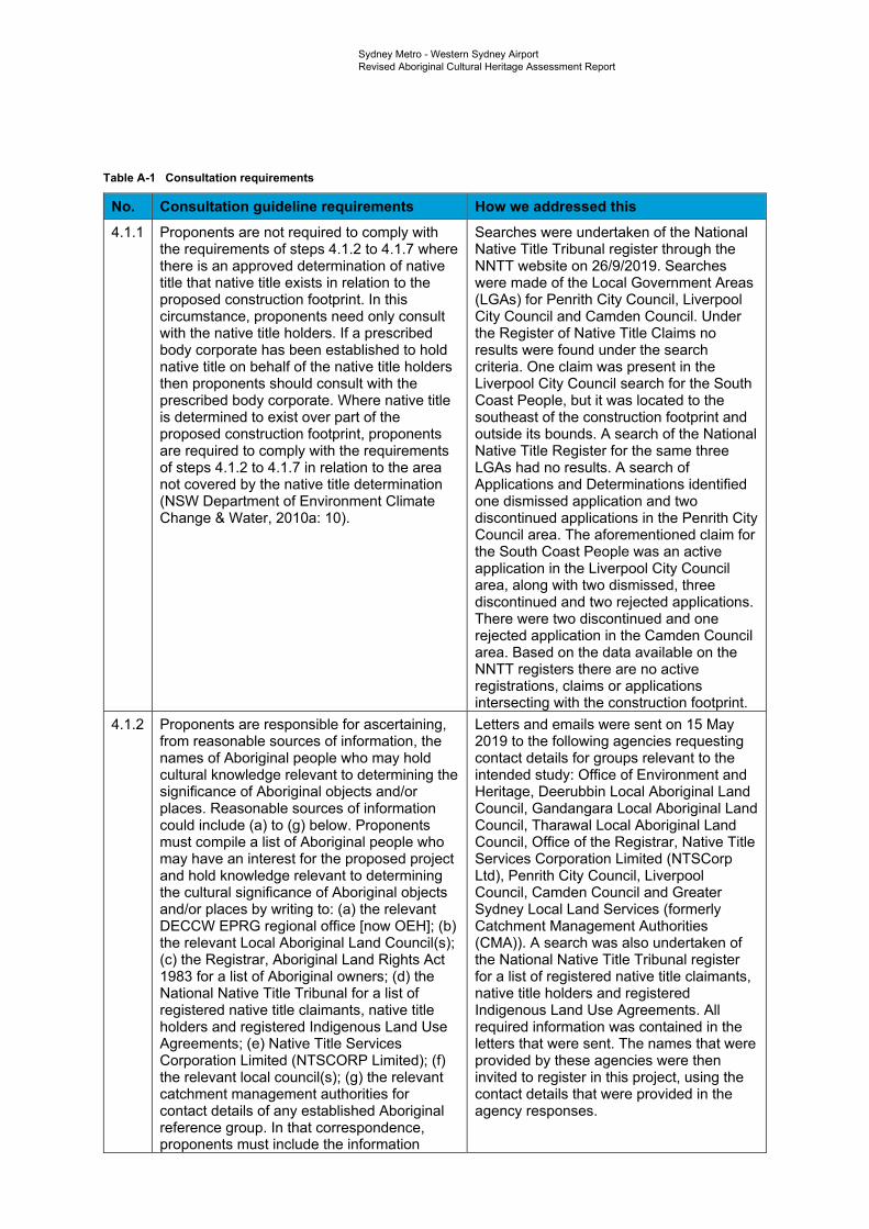
Sydney Metro - Western Sydney Airport Revised Aboriginal Cultural Heritage Assessment Report
Table A-1 Consultation requirements
No. Consultation guideline requirements How we addressed this 4.1.1 Proponents are not required to comply with
the requirements of steps 4.1.2 to 4.1.7 where there is an approved determination of native title that native title exists in relation to the proposed construction footprint. In this circumstance, proponents need only consult with the native title holders. If a prescribed body corporate has been established to hold native title on behalf of the native title holders then proponents should consult with the prescribed body corporate. Where native title is determined to exist over part of the proposed construction footprint, proponents are required to comply with the requirements of steps 4.1.2 to 4.1.7 in relation to the area not covered by the native title determination (NSW Department of Environment Climate Change & Water, 2010a: 10).
Searches were undertaken of the National Native Title Tribunal register through the NNTT website on 26/9/2019. Searches were made of the Local Government Areas (LGAs) for Penrith City Council, Liverpool City Council and Camden Council. Under the Register of Native Title Claims no results were found under the search criteria. One claim was present in the Liverpool City Council search for the South Coast People, but it was located to the southeast of the construction footprint and outside its bounds. A search of the National Native Title Register for the same three LGAs had no results. A search of Applications and Determinations identified one dismissed application and two discontinued applications in the Penrith City Council area. The aforementioned claim for the South Coast People was an active application in the Liverpool City Council area, along with two dismissed, three discontinued and two rejected applications. There were two discontinued and one rejected application in the Camden Council area. Based on the data available on the NNTT registers there are no active registrations, claims or applications intersecting with the construction footprint.
4.1.2 Proponents are responsible for ascertaining, from reasonable sources of information, the names of Aboriginal people who may hold cultural knowledge relevant to determining the significance of Aboriginal objects and/or places. Reasonable sources of information could include (a) to (g) below. Proponents must compile a list of Aboriginal people who may have an interest for the proposed project and hold knowledge relevant to determining the cultural significance of Aboriginal objects and/or places by writing to: (a) the relevant DECCW EPRG regional office [now OEH]; (b) the relevant Local Aboriginal Land Council(s); (c) the Registrar, Aboriginal Land Rights Act 1983 for a list of Aboriginal owners; (d) the National Native Title Tribunal for a list of registered native title claimants, native title holders and registered Indigenous Land Use Agreements; (e) Native Title Services Corporation Limited (NTSCORP Limited); (f) the relevant local council(s); (g) the relevant catchment management authorities for contact details of any established Aboriginal reference group. In that correspondence, proponents must include the information
Letters and emails were sent on 15 May 2019 to the following agencies requesting contact details for groups relevant to the intended study: Office of Environment and Heritage, Deerubbin Local Aboriginal Land Council, Gandangara Local Aboriginal Land Council, Tharawal Local Aboriginal Land Council, Office of the Registrar, Native Title Services Corporation Limited (NTSCorp Ltd), Penrith City Council, Liverpool Council, Camden Council and Greater Sydney Local Land Services (formerly Catchment Management Authorities (CMA)). A search was also undertaken of the National Native Title Tribunal register for a list of registered native title claimants, native title holders and registered Indigenous Land Use Agreements. All required information was contained in the letters that were sent. The names that were provided by these agencies were then invited to register in this project, using the contact details that were provided in the agency responses.
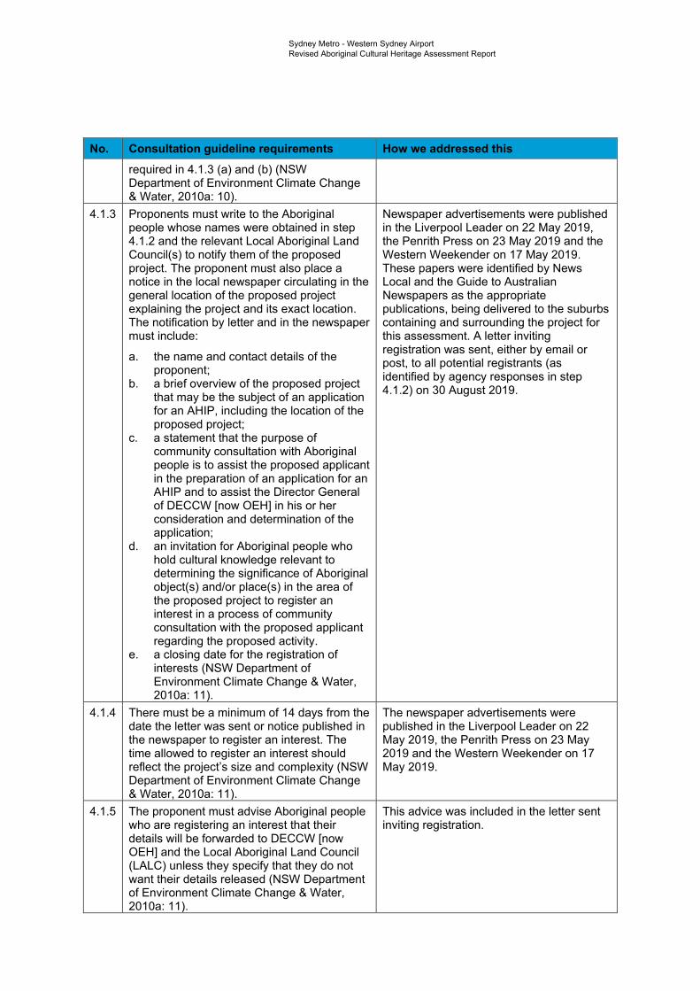
Sydney Metro - Western Sydney Airport Revised Aboriginal Cultural Heritage Assessment Report
No. Consultation guideline requirements How we addressed this required in 4.1.3 (a) and (b) (NSW Department of Environment Climate Change & Water, 2010a: 10).
4.1.3 Proponents must write to the Aboriginal people whose names were obtained in step 4.1.2 and the relevant Local Aboriginal Land Council(s) to notify them of the proposed project. The proponent must also place a notice in the local newspaper circulating in the general location of the proposed project explaining the project and its exact location. The notification by letter and in the newspaper must include:
a. the name and contact details of the proponent;
b. a brief overview of the proposed project that may be the subject of an application
Newspaper advertisements were published in the Liverpool Leader on 22 May 2019, the Penrith Press on 23 May 2019 and the Western Weekender on 17 May 2019. These papers were identified by News Local and the Guide to Australian Newspapers as the appropriate publications, being delivered to the suburbs containing and surrounding the project for this assessment. A letter inviting registration was sent, either by email or post, to all potential registrants (as identified by agency responses in step 4.1.2) on 30 August 2019.
for an AHIP, including the location of the proposed project;
c. a statement that the purpose of community consultation with Aboriginal people is to assist the proposed applicant in the preparation of an application for an AHIP and to assist the Director General of DECCW [now OEH] in his or her consideration and determination of the application;
d. an invitation for Aboriginal people who hold cultural knowledge relevant to determining the significance of Aboriginal object(s) and/or place(s) in the area of the proposed project to register an interest in a process of community consultation with the proposed applicant regarding the proposed activity.
e. a closing date for the registration of interests (NSW Department of Environment Climate Change & Water, 2010a: 11).
4.1.4 There must be a minimum of 14 days from the date the letter was sent or notice published in the newspaper to register an interest. The time allowed to register an interest should reflect the project’s size and complexity (NSW Department of Environment Climate Change & Water, 2010a: 11).
The newspaper advertisements were published in the Liverpool Leader on 22 May 2019, the Penrith Press on 23 May 2019 and the Western Weekender on 17 May 2019.
4.1.5 The proponent must advise Aboriginal people who are registering an interest that their details will be forwarded to DECCW [now OEH] and the Local Aboriginal Land Council (LALC) unless they specify that they do not want their details released (NSW Department of Environment Climate Change & Water, 2010a: 11).
This advice was included in the letter sent inviting registration.
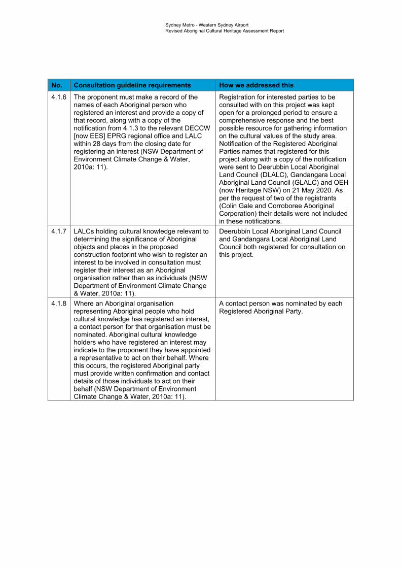
Sydney Metro - Western Sydney Airport Revised Aboriginal Cultural Heritage Assessment Report
No. Consultation guideline requirements How we addressed this 4.1.6 The proponent must make a record of the
names of each Aboriginal person who registered an interest and provide a copy of that record, along with a copy of the notification from 4.1.3 to the relevant DECCW [now EES] EPRG regional office and LALC within 28 days from the closing date for registering an interest (NSW Department of Environment Climate Change & Water, 2010a: 11).
Registration for interested parties to be consulted with on this project was kept open for a prolonged period to ensure a comprehensive response and the best possible resource for gathering information on the cultural values of the study area. Notification of the Registered Aboriginal Parties names that registered for this project along with a copy of the notification were sent to Deerubbin Local Aboriginal Land Council (DLALC), Gandangara Local Aboriginal Land Council (GLALC) and OEH (now Heritage NSW) on 21 May 2020. As per the request of two of the registrants (Colin Gale and Corroboree Aboriginal Corporation) their details were not included in these notifications.
4.1.7 LALCs holding cultural knowledge relevant to determining the significance of Aboriginal objects and places in the proposed construction footprint who wish to register an interest to be involved in consultation must register their interest as an Aboriginal organisation rather than as individuals (NSW Department of Environment Climate Change & Water, 2010a: 11).
Deerubbin Local Aboriginal Land Council and Gandangara Local Aboriginal Land Council both registered for consultation on this project.
4.1.8 Where an Aboriginal organisation representing Aboriginal people who hold cultural knowledge has registered an interest, a contact person for that organisation must be nominated. Aboriginal cultural knowledge holders who have registered an interest may indicate to the proponent they have appointed a representative to act on their behalf. Where this occurs, the registered Aboriginal party must provide written confirmation and contact details of those individuals to act on their behalf (NSW Department of Environment Climate Change & Water, 2010a: 11).
A contact person was nominated by each Registered Aboriginal Party.
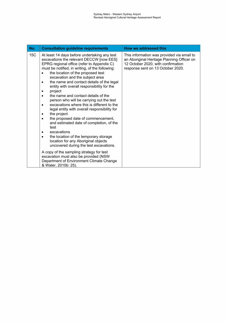
Sydney Metro - Western Sydney Airport Revised Aboriginal Cultural Heritage Assessment Report
No. Consultation guideline requirements How we addressed this 15C At least 14 days before undertaking any test
excavations the relevant DECCW [now EES] EPRG regional office (refer to Appendix C) must be notified, in writing, of the following: • the location of the proposed test
excavation and the subject area • the name and contact details of the legal
entity with overall responsibility for the • project • the name and contact details of the
person who will be carrying out the test • excavations where this is different to the
legal entity with overall responsibility for • the project • the proposed date of commencement,
and estimated date of completion, of the test
• excavations • the location of the temporary storage
location for any Aboriginal objects uncovered during the test excavations.
A copy of the sampling strategy for test excavation must also be provided (NSW Department of Environment Climate Change & Water, 2010b: 25).
This information was provided via email to an Aboriginal Heritage Planning Officer on 12 October 2020, with confirmation response sent on 13 October 2020.
Sydney Metro Western Sydney AirportRevised Aboriginal Cultural Heritage Assessment Report
2
-
Appendix B Agency responses
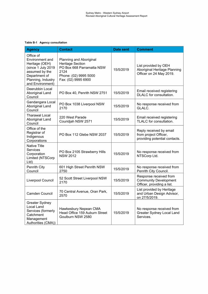
Sydney Metro - Western Sydney Airport Revised Aboriginal Cultural Heritage Assessment Report
Table B-1 Agency consultation
Agency Contact Date sent Comment Office of Environment and Heritage (OEH) (since 1 July 2019 assumed by the Department of Planning, Industry and Environment)
Planning and Aboriginal Heritage Section PO Box 668 Parramatta NSW 2124 Phone: (02) 9995 5000 Fax: (02) 9995 6900
15/5/2019 List provided by OEH Aboriginal Heritage Planning Officer on 24 May 2019.
Deerubbin Local Aboriginal Land Council
PO Box 40, Penrith NSW 2751 15/5/2019 Email received registering DLALC for consultation.
Gandangara Local Aboriginal Land Council
PO Box 1038 Liverpool NSW 2170 15/5/2019 No response received from
GLALC.
Tharawal Local Aboriginal Land Council
220 West Parade Couridjah NSW 2571 15/5/2019 Email received registering
TLALC for consultation.
Office of the Registrar of Indigenous Corporations
PO Box 112 Glebe NSW 2037 15/5/2019 Reply received by email from project Officer, providing potential contacts.
Native Title Services Corporation Limited (NTSCorp Ltd)
PO Box 2105 Strawberry Hills NSW 2012 15/5/2019 No response received from
NTSCorp Ltd.
Penrith City Council
601 High Street Penrith NSW 2750 15/5/2019 No response received from
Penrith City Council.
Liverpool Council 52 Scott Street Liverpool NSW 2170 15/5/2019
Response received from Community Development Officer, providing a list.
Camden Council 70 Central Avenue, Oran Park, 2570 15/5/2019
List provided by Heritage and Urban Design Advisor, on 27/5/2019.
Greater Sydney Local Land Services (formerly Catchment Management Authorities (CMA))
Hawkesbury Nepean CMA Head Office 159 Auburn Street Goulburn NSW 2580
15/5/2019 No response received from Greater Sydney Local Land Services.
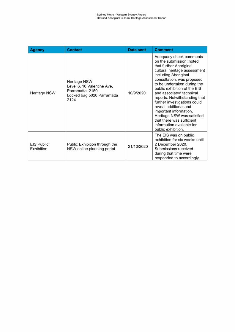
Sydney Metro - Western Sydney Airport Revised Aboriginal Cultural Heritage Assessment Report
Agency Contact Date sent Comment
Heritage NSW
Heritage NSW Level 6, 10 Valentine Ave, Parramatta 2150 Locked bag 5020 Parramatta 2124
10/9/2020
Adequacy check comments on the submission: noted that further Aboriginal cultural heritage assessment including Aboriginal consultation, was proposed to be undertaken during the public exhibition of the EIS and associated technical reports. Notwithstanding that further investigations could reveal additional and important information, Heritage NSW was satisfied that there was sufficient information available for public exhibition.
EIS Public Exhibition
Public Exhibition through the NSW online planning portal 21/10/2020
The EIS was on public exhibition for six weeks until 2 December 2020. Submissions received during that time were responded to accordingly.

Sydney Metro Western Sydney AirportTechnical Paper 5: Aboriginal heritage
3
-
Appendix C Newspaper
advertisements
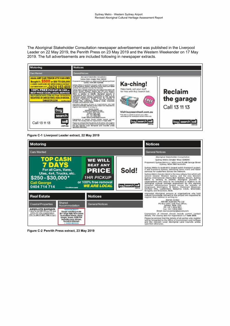
Motoril'll9 Nertie~
#._(r ,,.... -~ ,r@!k &Ail.All¥ CAA TRUCK UTE VAN 41f11D lo119htfr, $ OO orisoto~oo
s,,:!Ny ' bGnalll;o',.._'l't~Nl Pn211ffiHIC~liNtrac.'- IJli.l..-.. lLliill:l~~-'N'
~ - Pi~J£m ND'tn. ~ 111,111 l;/,!11\'~l!P ~~ WIii~-· 1"""-P wil!im l.11 .!.1Bil'IIM1 qat' ,_,~, ~
lnrubm~
Motoring
Car:.Waintw
TOP CASH 7DAYS
WE WILL BEAT ANY
Forallcars , Vans , PRICE Utas, 4x4, Trucks, atc .
$250 ~ $3,Q,,OQO"' 1 HR PICKUP Call George or 10,0% free removal 0404 714 714 .,--~- WE'ARSLOCAL
Real Estate --------------------
Stiured Accommooanon
Notices
..
Ka-ching! koke L'.M!ri<. soli l'O<Jr stuff
Reclai1m the ga1r'age
h:>r f,.,. '°'Ith BL/J' S""1Cll SQ.I.
Call 131113 Viail b11yH1ari:.1uell.,c0m.liu .,.....,.. .. ~o:lo:ol:!ftll' ... 1 ... ....-,.,.,.,
.-.tllirfjllr. !W!lr.fltef~~"'
Sold!
Notices
General No1Jce5
ii l~r-ii)ifl;"al !fi:'lki=ilvi l!li;-J Cnns.i.;ui.,.,.,
'S:,~.1 Ml!t ro 'Grl!mr 'A~t rsr1'3\'1'·1
~m s,·~r~::th~{~~~~k't~~I~ CAllf~ Stnu,,
~-~if'tr~~~ tfJ~;;']il=:;:l~inm~ ~J~:J~! s:•m•lc~ tor CIZ1I:!1111e1"!,; ~D'lJs:~ the nl!tvliork. $:t·rt~ P.-«m CM,1U;tr 'wt1t.1 i:. ~ht=i ~ f.l lt,.,.w lini:i •.11.h!IT'I r.-,i :Ci .,_1"',.-1(: ~11:itl W l\'lil@~i1 !\-,11 ~ ill l.fhFi ffli?'.'tl W+i:Ci~fll S.dr,cy lrn, r>:.,Jono.J (N.,ncy,Elrd 'll•~~lrprllt. 5),:lnll)' t.kf:ro 1~ ~l',;lijng ta ilfMi.tH'!/ Al:!~1; par:1.00r. f'i'
~~~~-lu~~,~1: ·r:~:e·b:.s~~nt ~~ ~Ji~~~ ~r~n~Krt ii1fr-t15 ~IJ 1r,£o f r:.t'JI I\C'2' :;i~ II:" w= (I ~
~~~~ r~~-~- ~ieJ~ ~= ~~n~~ i8i"n~lrll ly ,l ill1 '1n!i..'-om!il'A, tiS. ,\'~
fn11!re5b!rll Abur·ld~ 1,1~r5'.lm a- ;.arg51bs.!Jam v.fflO tdi:I cuitini know~ ra!o>,mt 1D tnl> p-o.lott are roquo,tod ;,,,et:ji • t!'" lh~r iil ll't1"'8' - i11 •·1n(ii1iJ l (c
D.e.rnulhlr~n ,>.Eao'I AI.Jslral lo 1'1)- Ltll
FO Elo~~o.,i~tf~Ofn= µi,~2ffi~ I
-~ ·t,t]J l~Oll) l Em,1ll i dillT n,tartlillli.lUCOOffl:.C~
~il~~~ t.~i~1~ ·(J~i~::1::\i~ ~"June ~!IHG\ Plirosc be .adM:scd ttiai:nw.i clct ;,, ie,r illl ~ r."hlo n::g lst
~ i¥!ur~•="'J~1~~~nE.'l"[;{?"'~1!1= ~~"t.!'iftll(I ml1 •'~F!.
Sydney Metro - Western Sydney Airport Revised Aboriginal Cultural Heritage Assessment Report
The Aboriginal Stakeholder Consultation newspaper advertisement was published in the Liverpool Leader on 22 May 2019, the Penrith Press on 23 May 2019 and the Western Weekender on 17 May 2019. The full advertisements are included following in newspaper extracts.
Figure C-1 Liverpool Leader extract, 22 May 2019
Figure C-2 Penrith Press extract, 23 May 2019
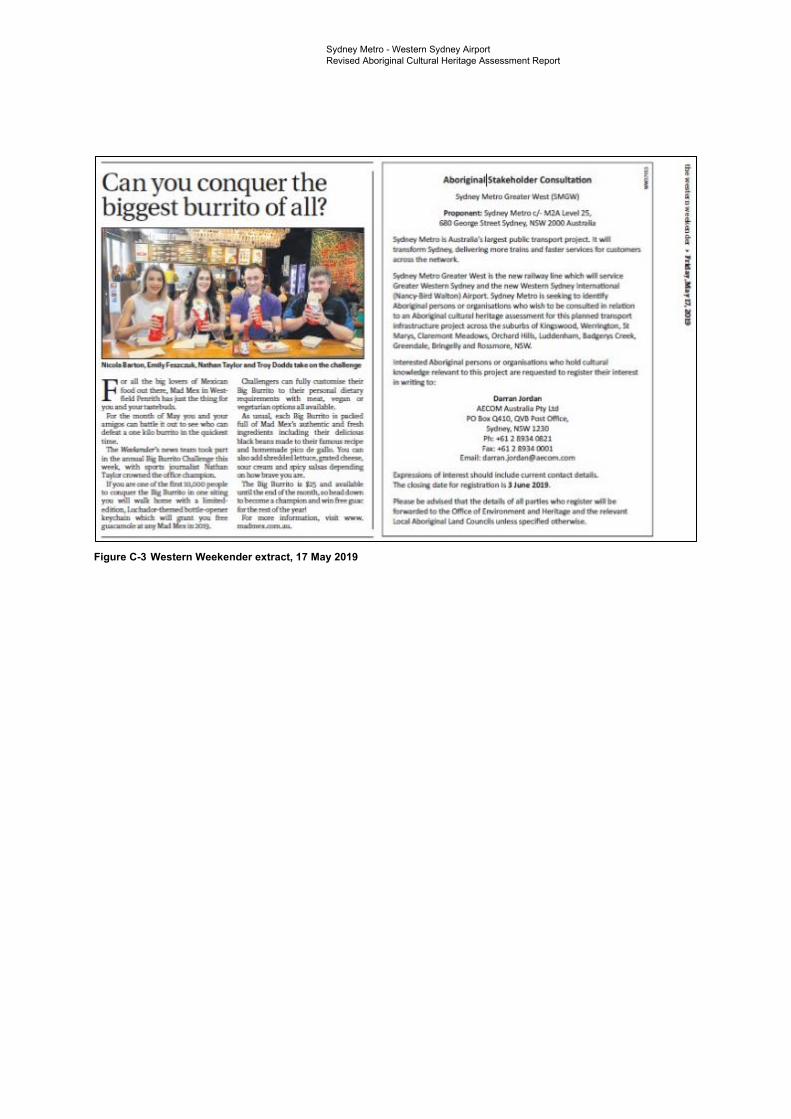
l,ld
PO - QUO. OV1I...,.. Ol!I JO
1
[nl~
Sydney Metro - Western Sydney Airport Revised Aboriginal Cultural Heritage Assessment Report
Figure C-3 Western Weekender extract, 17 May 2019
Sydney Metro Western Sydney AirportTechnical Paper 5: Aboriginal heritage
4
-
Appendix D Expression of Interest
(EOI) letter
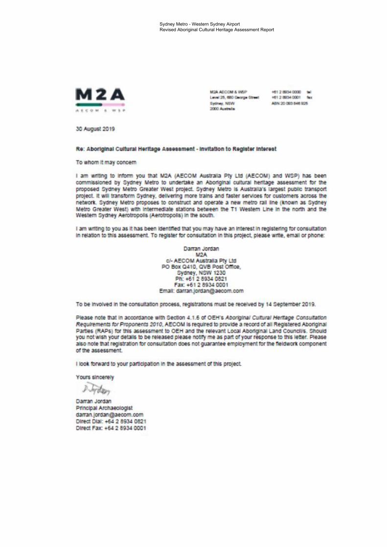
oct,, tr.WOCIOO WI .. ,, .,.000, .. ~ » a .... u
JD~" 2!l 19
Ro: AbOflgloal CulluJal ttorttago -•••-•t • lnvltibon to Rt91ol• lnlfioal
To whom a. mily concern
I iifll Wl'.:hg IO ln1blm '"" .not M2A 1-',ECOM A/Jitr.ni Ply UXI (AECOM) ono WS9) biO .....,, canmlSSJOM<I Dy S)UMJ l.lf1J1> lo undOrUI! an AbOngtn.tl CIJUnl l'IOrff>gf _...,5'1Mftt Dr tne -0 Sydney llt:Jo Gllitef We,I proJecl. Sy-Ocey Me.ro Ii A-·· large<t pullllC !Janopo!t Pffll!CL tt v.11 transtorm Sytlrt;!y. <lelh'trtn.g men uan, 3tl(I taster uruces ro, cust0mm acn:1" thf ne:irorL Sydney !letro propooe, lo oon.uuct inCI operall! • new metro rail lne (l110iWn •• ~y Mftn) Qtfa)!r Wffl) 'dh 111!1!ffflfldlJlf 5tU!iOM l>f-~!e'I: d'lf T1 W~:tm U,f In Inf norih and th! We<tem Sycr>ey Aa1>ln>pOU (Aerotropollo) In tne 60Ulh.
I ar, ,mia,g 10 yoo •• It n .. t>een tie•~ 111a1 you may nave an 111_:em, tn reg1s,enng II>!' conslltaUon In raattoa ~ tta ~cant To regJ:s.tH n. oonwJWkJn In tnts protect. pie.au •me. emaa or poone:
0..TIOJMlan M2A
cl- AECOM AU51Jal a Ply UO PO eoi 0410. ova Po5I or-.ce.
Syaney, HSW 1230 ?b: +61 2 &'JJ< 0811 Fax: +6 1 2 893' DOOi
Emiiil: aomu,JO<OanO,-oom
To be tnvotvco In Ille •-DO<l Pr0CK5. rogi.ttilllClm muil OE <ec:EmO Dy 14 Se~:anbef 2Dl i,
pi,-no:, ll'lill In acoons.ince "1111 SectlOII •• , .6 Cf OEM", A00l1Jlnil CUtl/fi/ HcJUge ca,..,_ R•q-~ois rr,, Propcn,rm 2010. AECOM IS l!ql.lnd ID pmto• a lfCoal Oil all R~.,.., AD<rlglnal Pilltiei (AAP51 ro, 1111, ........,ifll to OEH and tne rflrrnnt Local ,,_gn .. Land CoundU• . SllOulCI you not'Mill youroetaili ?D be ce.1easeo p«eaH no:tryme a, pan o,your reiJ)Ol'lieU> uu te:er. Plea.w a o not• N it~ tw ..,,,...,..,,.,, ooes nor guaraoa• ffflPIO)'IMftt 11>1' Inf lll!ldwOII componf"ll o1 me as&c55rnent.
11001t llf'\f'n to your p,JJ11dpa:OO Ill me [email protected] m i:nJ, p~ecL
Your, &1ncerery
,1,4, Oarrao Jar4a1 PllllClpal -<J95t ~a.ecom.com Olt!a Dial: +64 2 8934 0821 DIR<I Fax: +6' 2 6934 0001
Sydney Metro - Western Sydney Airport Revised Aboriginal Cultural Heritage Assessment Report
Sydney Metro Western Sydney AirportRevised Aboriginal Cultural Heritage Assessment Report
-
Appendix E EES and LALC
notification

Sydney Metro - Western Sydney Airport Revised Aboriginal Cultural Heritage Assessment Report
Appendix E EES and LALC notification
This appendix has been removed for the public version of this report.
Sydney Metro Western Sydney AirportTechnical Paper 5: Aboriginal heritage
6
-
Appendix F Draft assessment
methodology

Sydney Metro - Western Sydney Airport Revised Aboriginal Cultural Heritage Assessment Report
Please note: changes have occurred to the project terminology and refinements have been made to the project data since the assessment methodology was authored. References to Sydney Metro Greater West in the document are to what is now called Sydney Metro Western Sydney Airport. The total art sites in the AHIMS search results has been reduced by one and artefact scatter sites increased by one due to an incorrect site classification identified in the extensive search results. As the draft assessment methodology is included here to show the document that was provided to RAPs it has not been altered.
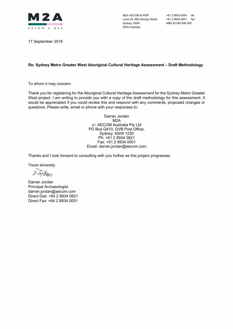
M2A AECOM & WSP Level 25, 680 George Street Sydney, NSW 2000 Australia
+61 2 8934 0000 tel +61 2 8934 0001 fax ABN 20 093 846 925
17 September 2019 Re: Sydney Metro Greater West Aboriginal Cultural Heritage Assessment – Draft Methodology To whom it may concern Thank you for registering for the Aboriginal Cultural Heritage Assessment for the Sydney Metro Greater West project. I am writing to provide you with a copy of the draft methodology for this assessment. It would be appreciated if you could review this and respond with any comments, proposed changes or questions. Please write, email or phone with your responses to:
Darran Jordan M2A
c/- AECOM Australia Pty Ltd PO Box Q410, QVB Post Office,
Sydney, NSW 1230 Ph: +61 2 8934 0821 Fax: +61 2 8934 0001
Email: [email protected] Thanks and I look forward to consulting with you further as this project progresses. Yours sincerely
Darran Jordan Principal Archaeologist [email protected] Direct Dial: +64 2 8934 0821 Direct Fax: +64 2 8934 0001
Draft Assessment Methodology – Sydney Metro Greater West Aboriginal Cultural Heritage Assessment 1.0 Introduction
Sydney Metro is Australia’s largest public transport project. It will transform Sydney, delivering more trains and faster services for customers across the network. Sydney Metro proposes to construct and operate a new metro rail line (known as Sydney Metro Greater West) with intermediate stations between the T1 Western Line in the north and the Western Sydney Aerotropolis (Aerotropolis) in the south (the Project). M2A (a joint venture between AECOM Australia Pty Ltd (AECOM) and WSP) has been commissioned by Sydney Metro to undertake an Aboriginal cultural heritage assessment for the proposed Sydney Metro Greater West project in accordance with relevant statutory guidelines including the NSW Office of Environment and Heritage’s Guide to Investigating, Assessing and Reporting on Aboriginal Cultural Heritage in NSW (OEH, 2011), Code of Practice for Archaeological Investigation of Aboriginal Objects in New South Wales (DECCW, 2010b) and Aboriginal Cultural Heritage Consultation Requirements for Proponents (DECCW, 2010a). This draft assessment methodology provides background information on the proposal and details M2A’s proposed approach to the current assessment. It is being provided to all Registered Aboriginal Parties (RAPs) in accordance with Sections 4.3.1 and 4.3.2 of OEH’s Aboriginal Cultural Heritage Consultation Requirements for Proponents (DECCW, 2010a). A brief review of existing archaeological data for the Project area is also provided to give context to M2A’s proposed assessment methodology.
2.0 The Project area
The current Project area is defined as approximately 1km either side of the area within which the Project will fall (Figure 1). The topography of the investigation area is relatively flat between St Marys and Werrington, with higher ground towards Claremont Meadows. Elevations are generally flat towards Orchard Hills, with slightly lower lying areas occurring along Blaxland Creek. Through Orchard Hills, Badgerys Creek and Bringelly, the valley and floodplain of South Creek and its tributaries dominate the gently undulating topography. The Project area will be further refined as detailed design is progressed and potential options are chosen.
3.0 Assessment Objectives
The purpose of this assessment is to identify known and potential Aboriginal heritage constraints within the Project area and appropriate management advice. The overarching objectives of the current Aboriginal Cultural Heritage Assessment (ACHA) are as follows:
To identify the Aboriginal cultural heritage values of the Project area by way of background research, archaeological field investigation and consultation with RAPs;
To assess the potential impact of the proposed development on any identified Aboriginal cultural heritage values within the Project area (if relevant); and
To provide an appropriate management strategy to avoid or minimise potential harm to any identified Aboriginal cultural heritage values within the Project area.
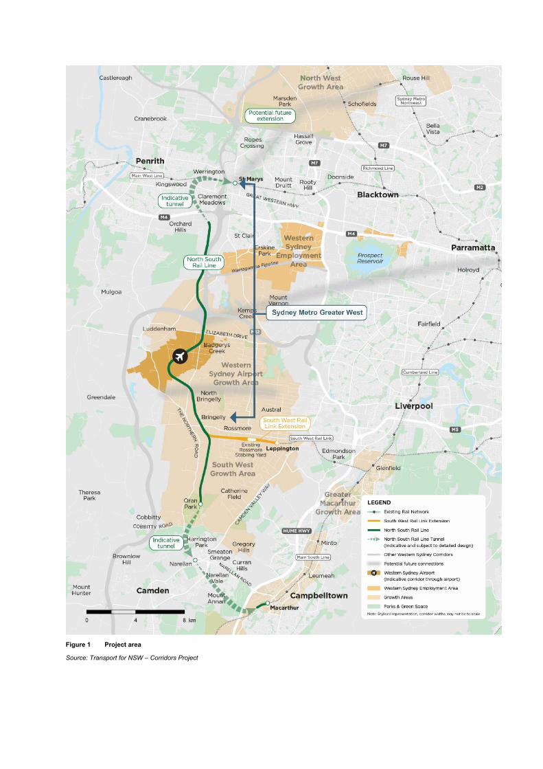
Figure 1 Project area
Source: Transport for NSW – Corridors Project
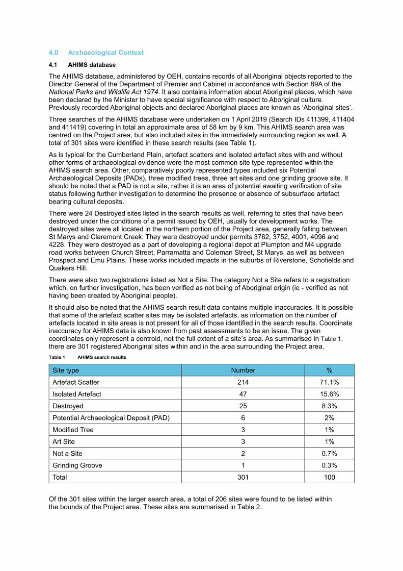
4.0 Archaeological Context
4.1 AHIMS database
The AHIMS database, administered by OEH, contains records of all Aboriginal objects reported to the Director General of the Department of Premier and Cabinet in accordance with Section 89A of the National Parks and Wildlife Act 1974. It also contains information about Aboriginal places, which have been declared by the Minister to have special significance with respect to Aboriginal culture. Previously recorded Aboriginal objects and declared Aboriginal places are known as ‘Aboriginal sites’.
Three searches of the AHIMS database were undertaken on 1 April 2019 (Search IDs 411399, 411404 and 411419) covering in total an approximate area of 58 km by 9 km. This AHIMS search area was centred on the Project area, but also included sites in the immediately surrounding region as well. A total of 301 sites were identified in these search results (see Table 1).
As is typical for the Cumberland Plain, artefact scatters and isolated artefact sites with and without other forms of archaeological evidence were the most common site type represented within the AHIMS search area. Other, comparatively poorly represented types included six Potential Archaeological Deposits (PADs), three modified trees, three art sites and one grinding groove site. It should be noted that a PAD is not a site, rather it is an area of potential awaiting verification of site status following further investigation to determine the presence or absence of subsurface artefact bearing cultural deposits.
There were 24 Destroyed sites listed in the search results as well, referring to sites that have been destroyed under the conditions of a permit issued by OEH, usually for development works. The destroyed sites were all located in the northern portion of the Project area, generally falling between St Marys and Claremont Creek. They were destroyed under permits 3762, 3752, 4001, 4096 and 4228. They were destroyed as a part of developing a regional depot at Plumpton and M4 upgrade road works between Church Street, Parramatta and Coleman Street, St Marys, as well as between Prospect and Emu Plains. These works included impacts in the suburbs of Riverstone, Schofields and Quakers Hill.
There were also two registrations listed as Not a Site. The category Not a Site refers to a registration which, on further investigation, has been verified as not being of Aboriginal origin (ie - verified as not having been created by Aboriginal people).
It should also be noted that the AHIMS search result data contains multiple inaccuracies. It is possible that some of the artefact scatter sites may be isolated artefacts, as information on the number of artefacts located in site areas is not present for all of those identified in the search results. Coordinate inaccuracy for AHIMS data is also known from past assessments to be an issue. The given coordinates only represent a centroid, not the full extent of a site’s area. As summarised in Table 1, there are 301 registered Aboriginal sites within and in the area surrounding the Project area. Table 1 AHIMS search results
Site type Number %
Artefact Scatter 214 71.1%
Isolated Artefact 47 15.6%
Destroyed 25 8.3%
Potential Archaeological Deposit (PAD) 6 2%
Modified Tree 3 1%
Art Site 3 1%
Not a Site 2 0.7%
Grinding Groove 1 0.3%
Total 301 100
Of the 301 sites within the larger search area, a total of 206 sites were found to be listed within the bounds of the Project area. These sites are summarised in Table 2.
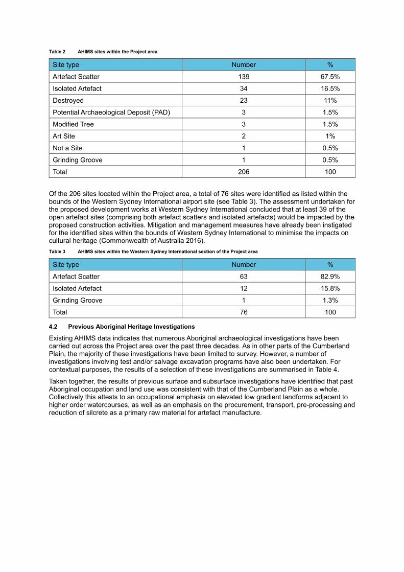
Table 2 AHIMS sites within the Project area
Site type Number %
Artefact Scatter 139 67.5%
Isolated Artefact 34 16.5%
Destroyed 23 11%
Potential Archaeological Deposit (PAD) 3 1.5%
Modified Tree 3 1.5%
Art Site 2 1%
Not a Site 1 0.5%
Grinding Groove 1 0.5%
Total 206 100
Of the 206 sites located within the Project area, a total of 76 sites were identified as listed within the bounds of the Western Sydney International airport site (see Table 3). The assessment undertaken for the proposed development works at Western Sydney International concluded that at least 39 of the open artefact sites (comprising both artefact scatters and isolated artefacts) would be impacted by the proposed construction activities. Mitigation and management measures have already been instigated for the identified sites within the bounds of Western Sydney International to minimise the impacts on cultural heritage (Commonwealth of Australia 2016). Table 3 AHIMS sites within the Western Sydney International section of the Project area
Site type Number %
Artefact Scatter 63 82.9%
Isolated Artefact 12 15.8%
Grinding Groove 1 1.3%
Total 76 100
4.2 Previous Aboriginal Heritage Investigations
Existing AHIMS data indicates that numerous Aboriginal archaeological investigations have been carried out across the Project area over the past three decades. As in other parts of the Cumberland Plain, the majority of these investigations have been limited to survey. However, a number of investigations involving test and/or salvage excavation programs have also been undertaken. For contextual purposes, the results of a selection of these investigations are summarised in Table 4.
Taken together, the results of previous surface and subsurface investigations have identified that past Aboriginal occupation and land use was consistent with that of the Cumberland Plain as a whole. Collectively this attests to an occupational emphasis on elevated low gradient landforms adjacent to higher order watercourses, as well as an emphasis on the procurement, transport, pre-processing and reduction of silcrete as a primary raw material for artefact manufacture.
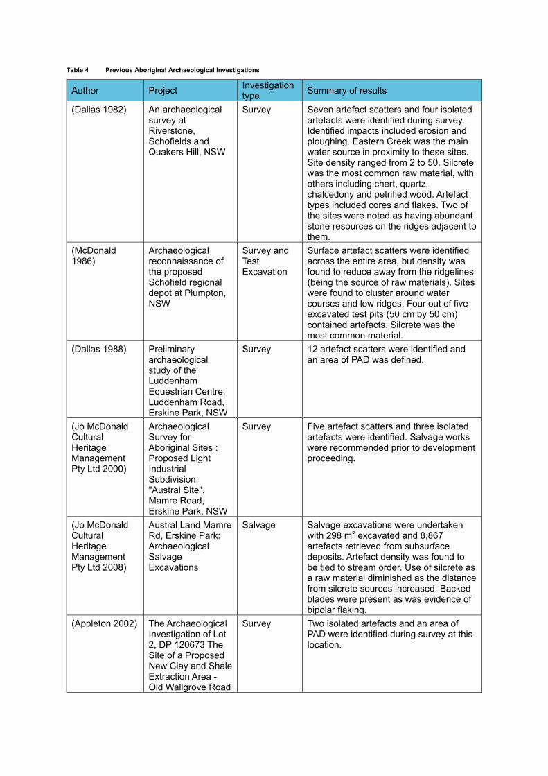
Table 4 Previous Aboriginal Archaeological Investigations
Author Project Investigation type Summary of results
(Dallas 1982) An archaeological survey at Riverstone, Schofields and Quakers Hill, NSW
Survey Seven artefact scatters and four isolated artefacts were identified during survey. Identified impacts included erosion and ploughing. Eastern Creek was the main water source in proximity to these sites. Site density ranged from 2 to 50. Silcrete was the most common raw material, with others including chert, quartz, chalcedony and petrified wood. Artefact types included cores and flakes. Two of the sites were noted as having abundant stone resources on the ridges adjacent to them.
(McDonald 1986)
Archaeological reconnaissance of the proposed Schofield regional depot at Plumpton, NSW
Survey and Test Excavation
Surface artefact scatters were identified across the entire area, but density was found to reduce away from the ridgelines (being the source of raw materials). Sites were found to cluster around water courses and low ridges. Four out of five excavated test pits (50 cm by 50 cm) contained artefacts. Silcrete was the most common material.
(Dallas 1988) Preliminary archaeological study of the Luddenham Equestrian Centre, Luddenham Road, Erskine Park, NSW
Survey 12 artefact scatters were identified and an area of PAD was defined.
(Jo McDonald Cultural Heritage Management Pty Ltd 2000)
Archaeological Survey for Aboriginal Sites : Proposed Light Industrial Subdivision, "Austral Site", Mamre Road, Erskine Park, NSW
Survey Five artefact scatters and three isolated artefacts were identified. Salvage works were recommended prior to development proceeding.
(Jo McDonald Cultural Heritage Management Pty Ltd 2008)
Austral Land Mamre Rd, Erskine Park: Archaeological Salvage Excavations
Salvage Salvage excavations were undertaken with 298 m2 excavated and 8,867 artefacts retrieved from subsurface deposits. Artefact density was found to be tied to stream order. Use of silcrete as a raw material diminished as the distance from silcrete sources increased. Backed blades were present as was evidence of bipolar flaking.
(Appleton 2002) The Archaeological Investigation of Lot 2, DP 120673 The Site of a Proposed New Clay and Shale Extraction Area - Old Wallgrove Road
Survey Two isolated artefacts and an area of PAD were identified during survey at this location.
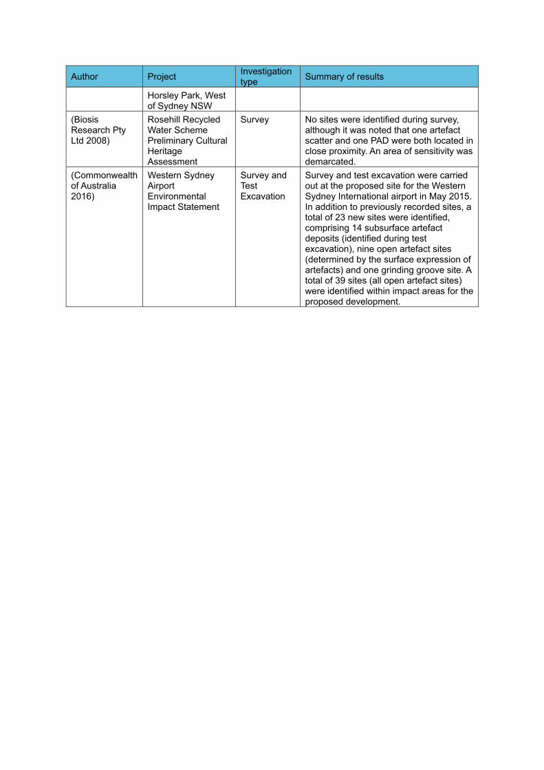
Author Project Investigation type Summary of results
Horsley Park, West of Sydney NSW
(Biosis Research Pty Ltd 2008)
Rosehill Recycled Water Scheme Preliminary Cultural Heritage Assessment
Survey No sites were identified during survey, although it was noted that one artefact scatter and one PAD were both located in close proximity. An area of sensitivity was demarcated.
(Commonwealth of Australia 2016)
Western Sydney Airport Environmental Impact Statement
Survey and Test Excavation
Survey and test excavation were carried out at the proposed site for the Western Sydney International airport in May 2015. In addition to previously recorded sites, a total of 23 new sites were identified, comprising 14 subsurface artefact deposits (identified during test excavation), nine open artefact sites (determined by the surface expression of artefacts) and one grinding groove site. A total of 39 sites (all open artefact sites) were identified within impact areas for the proposed development.
5.0 Draft Methodology
5.1 Overview
The approach that M2A intends to adopt for undertaking the assessment includes the following key components:
1. Background research;
2. Survey and consultation with RAPs to identify known sites and areas of archaeological and cultural potential within the Project area;
3. Preparation of an ACHAR to present the results of the survey and consultation, with recommendations for further investigation, if required.
If the recommendations of the ACHAR identify that further works are required, those works would consist of:
4. Additional survey, with RAPs, targeting high sensitivity areas proposed for impacts;
5. A program of archaeological test excavation, with RAPs, of areas of high archaeological sensitivity proposed for impacts;
6. Consultation with RAPs regarding the cultural values of the Project area; and
7. Preparation of an Aboriginal Archaeological Report (AAR) and an updated ACHAR for the Project area detailing the results of the above with appropriate management/mitigation measures for any identified Aboriginal heritage values.
The proposed methodologies for each of these components are detailed in the sections below.
5.2 Background Research
The following tasks will be undertaken for the background research component of the assessment:
1. Searches of OEH’s AHIMS database;
2. A review of associated site cards and reports to clarify site contents, extents and statuses;
3. A review of the landscape context of the Project area, with a particular emphasis on its implications for the nature and distribution of Aboriginal archaeological materials;
4. A review of relevant archaeological and ethnohistoric information for the Project area and environs; and
5. Preparation of a predictive model for the Aboriginal archaeological record of the Project area.
5.3 Survey
An initial survey is proposed of the Project area with RAP representatives to identify and map known sites and areas of archaeological and cultural sensitivity.
If any Aboriginal archaeological sites are identified during the survey they will be recorded to the standard required by the Code of Practice for Archaeological Investigation of Aboriginal Objects in NSW. All sites will be comprehensively photographed following artefact recording.
5.4 Preparation of ACHAR
An ACHAR will be produced for the EIS. This will contain the results of the background research, survey and consultation to date. It will provide recommendations for further works, if required, in relation to both known and potential Aboriginal cultural heritage within the Project area.
5.5 Social/Cultural Values Assessment for the ACHAR
Aboriginal community consultation for the assessment will be undertaken in accordance with OEH’s Aboriginal Cultural Heritage Consultation Requirements for Proponents 2010 (DECCW, 2010a). RAP representatives are in the best position to provide information on the Aboriginal social/cultural heritage values of the Project area. During the assessment process, M2A will consult with RAPs regarding the cultural heritage values of the Project area. This will include as a minimum:
- A request for any comments regarding the Aboriginal cultural heritage values of the Project area;
- Discussion of cultural heritage values during fieldwork; and
- Provision of a draft ACHAR to all RAPs for their review and comment.
The following sections provide detail on the further work that will be undertaken, if required.
5.6 Further Survey
If the recommendations of the ACHAR identify that further works are required, an archaeological survey would be undertaken, targeting areas of high sensitivity proposed for impacts. Survey would be undertaken by a combined field team of archaeologists and an appropriate number of RAP field representatives, and would involve survey of the identified portions of the Project area.
5.7 Test Excavation
The recommendations of the ACHAR for the EIS will determine whether further works are required. Further works, if required, may also include test excavation. A program of archaeological test excavation determines the presence or absence of subsurface archaeological deposits. If test excavation is required it would be undertaken by a combined field team of archaeologists and an appropriate number of rostered RAP field representatives.
Archaeological subsurface investigations for the Project will be undertaken in accordance with OEH’s Code of Practice for Archaeological Investigation of Aboriginal Objects. Where subsurface investigations are required, test pits will be excavated to culturally sterile horizons. Excavated sediment will be dry-sieved through 5 mm wire-mesh sieves. Any Aboriginal objects recovered during sieving will be bagged by square and spit. Representative profiles in each excavation unit will be drawn and photographed. Test pit stratigraphy will be recorded on pro forma test pit recording sheets using standard sedimentological terms and criteria (after McDonald & Isbell, 2009). All test pits will be backfilled after excavation.
All flaked stone artefacts recovered during subsurface investigations will be subject to macroscopic attribute analysis in an off-site location, with the number of attributes recorded per specimen differing by technological type. It is proposed that, subject to RAP endorsement, all stone artefacts recovered during test excavation will ultimately be reburied within the Project area in a non-impact area. Reburial will be undertaken in accordance with Requirement 26 of the Code of Practice.
5.8 Social/Cultural Values Assessment for the updated ACHAR
Ongoing Aboriginal community consultation for the assessment will be undertaken in accordance with OEH’s Aboriginal Cultural Heritage Consultation Requirements for Proponents 2010 (DECCW, 2010a). This will continue through the period of additional work, if required, with all RAPS to be provided with a copy of the draft AAR and updated ACHAR for review and comment. Any comments made within the submission period prior to finalisation of the report will be incorporated into it.
5.9 Updated Aboriginal Cultural Heritage Assessment (ACHAR) and Aboriginal Archaeological Report (AAR)
Following additional survey and test excavation works, if required, an AAR and updated ACHAR will be produced, detailing the results of the archaeological field investigation and cultural assessment.
The draft AAR and ACHAR will assess the importance of Aboriginal cultural heritage values within the Project area. In addition, the draft reports will assess the potential impact of the proposed development on identified Aboriginal cultural heritage values and identify appropriate mitigation and management strategies to avoid or minimise potential harm to such values.
The reports will be prepared in accordance with the following statutory guidelines issued by the New South Wales (NSW) Office of Environment and Heritage (OEH):
Guide to Investigating, Assessing and Reporting on Aboriginal Cultural Heritage in NSW (OEH, 2011); and
Code of Practice for Archaeological Investigation of Aboriginal Objects in New South Wales (DECCW, 2010b).
6.0 References Cited
Appleton, J. 2002. The Archaeological Investigation of Lot 2, DP 120673 The Site of a Proposed New Clay and Shale Extraction Area - Old Wallgrove Road Horsley Park, West of Sydney NSW.
Biosis Research Pty Ltd. 2008. Rosehill Recycled Water Scheme: Aboriginal Archaeological and Cultural Heritage Assessment. Unpublished report for Jemena Management Pty Ltd.
Commonwealth of Australia. 2016. Western Sydney Airport Environmental Impact Statement.
Dallas, M. 1982. An Archaeological Survey at Riverstone, Schofields and Quakers Hill, N.S.W.
Dallas, M. 1988. Preliminary archaeological study of the Luddenham Equestrian Centre, Luddenham Road, Erskine Park, NSW.
Jo McDonald Cultural Heritage Management Pty Ltd. 2000. Archaeological Survey For Aboriginal Sites : Proposed Light Industrial Subdivision, ‘Austral Site’, Mamre Road, Erskine Park, NSW.
Jo McDonald Cultural Heritage Management Pty Ltd. 2008. Austral Land Mamre Rd, Erskine Park: Archaeological Salvage Excavations. Unpublished report for Macquarie Goodman.
McDonald, J. 1986. Preliminary Archaeological Reconnaissance of the Proposed Schofields Regional Depot, Plumpton, N.S.W. Unpublished report for the Metropolitan Waste Disposal Authority.
McDonald, R.C., & Isbell, R.F. 2009. Soil Profile. In Australian Soil and Land Survey Field Handbook, 147–200. Collingwood: CSIRO Publishing
NSW Department of Environment Climate Change & Water. 2010a. Aboriginal Cultural Heritage Consultation Requirements for Proponents. Department of Environment, Climate Change and Water.
NSW Department of Environment Climate Change & Water. 2010b. Code of Practice for Archaeological Investigation of Aboriginal Objects in New South Wales. Department of Environment, Climate Change and Water.
NSW Office of Environment & Heritage. 2011. Guide to Investigating, Assessing and Reporting on Aboriginal Cultural Heritage in NSW. Office of Environment and Heritage.
Sydney Metro Western Sydney AirportTechnical Paper 5: Aboriginal heritage
7
-
Appendix G RAP responses to draft
assessment methodology
Sydney Metro - Western Sydney Airport Revised Aboriginal Cultural Heritage Assessment Report
Appendix G RAP responses to draft assessment methodology
This appendix has been removed for the public version of this report.
Sydney Metro Western Sydney AirportTechnical Paper 5: Aboriginal heritage
8
-
Appendix H RAP responses to draft
ACHAR

Sydney Metro - Western Sydney Airport Revised Aboriginal Cultural Heritage Assessment Report
Appendix H RAP responses to draft ACHAR
This appendix has been removed for the public version of this report.
Sydney Metro Western Sydney AirportTechnical Paper 5: Aboriginal heritage
9
-
Appendix I Regional archaeological
context
Sydney Metro - Western Sydney Airport Revised Aboriginal Cultural Heritage Assessment Report
The Sydney Region Available archaeological data indicate that Aboriginal people have occupied the Sydney region4 for at least 36,000 years (Williams et al., 2014). Late Pleistocene/early Holocene occupation of the region is evidenced by radiometric dates from both coastal and hinterland sites (see Attenbrow, 2010:18, Table 3.1). Excavated material culture assemblages from these periods have been interpreted as evidence of relatively small populations of Aboriginal people employing settlement patterns of high residential and low logistical mobility (Attenbrow 2010:152-154; McDonald, 2008: 39; Williams et al., 2014). Late Pleistocene/early Holocene chipped stone assemblages attest to a preference for silicified tuff sourced from secondary geological sources such as the Hawkesbury-Nepean River gravels (McDonald, 2008; Williams et al., 2014). However, they also indicate the exploitation of other raw material types such as silcrete, quartzite, petrified wood and quartz. Direct freehand percussion appears to have been the dominant reduction technique employed by Late Pleistocene/early Holocene Aboriginals knappers, with bipolar flaking comparatively poorly represented in available assemblages. Retouched ‘tools’ include unifacially-flaked pebble implements, dentated saws, burins and a variety of scrapers, with unmodified utilised flakes also well represented (Kohen et al., 1984; Williams et al., 2014). Stone tools such as these will have been complemented by a range of organic implements such as wooden digging sticks, spears and boomerangs. However, these do not survive archaeologically (Attenbrow, 2010:154).
Compared with the late Pleistocene/early Holocene, archaeological evidence for mid-to-late Holocene Aboriginal occupation of the Sydney Region abounds (for recent syntheses see Attenbrow 2010; McDonald 2008). In keeping with broader Australian developments (e.g. Allen and O’Connell, 1995; Beaton, 1985; Brumm and Moore, 2005; Attenbrow et al., 2009; Lourandos, 1983, 1997; Lourandos and Ross, 1994), the social and economic systems of Aboriginal groups living in the region during this period appear to have become increasingly complex. Available archaeological data, for example, suggest a significant increase in site establishment and population densities over time, as well as a concomitant growth in the size and complexity of social aggregation (but see Attenbrow (2012) and Hiscock (2008) for cautionary notes on the interpretive significance of radiometric date graphs). Growing economic specialisation is indicated by the emergence and/or proliferation of complex fishing and stoneworking technologies, with the latter linked variously to increased foraging risk associated with greater climatic variability as well as other variables such as redefinition of social space, reduction of resources and increased logistical pre-equipping (Attenbrow et al. 2009; McDonald, 2008: 40). Complex, long-distance exchange networks are also attested archaeologically (e.g. Attenbrow et al., 2012; Grave et al., 2012) as are important developments in artistic activities (McDonald, 2008). Higher levels of stylistic heterogeneity in pigment and engraved art across the region, for example, have been linked to increasing territoriality (McDonald, 2008: 42).
With some modification, McCarthy’s (1967) Eastern Regional Sequence (ERS) of stone artefact assemblages remains the dominant chronological framework for Aboriginal occupation of the region. Based on appreciable changes in the composition of chipped stone artefact assemblages over time, the ERS hypothesises a three phase sequence of ‘Capertian’ (earliest), ‘Bondaian’ and ‘Eloueran’ (most recent) assemblages and was developed on the basis of McCarthy’s (1948, 1964) pioneering analyses of stratified flaked stone assemblages from Lapstone Creek rockshelter, on the lower slopes of the Blue Mountains eastern escarpment, and Capertee 3 rockshelter in the Capertee Valley north of Lithgow (see Table I-1). At present, the most widely cited characterisation of the ERS in the Sydney region is that of a four-phase sequence beginning with the Pre-Bondaian (McCarthy’s Capertian) and moving successively through the Early, Middle and Late phases of the Bondaian, the last of which equates to McCarthy’s (1967) Eloueran phase. The tripartite division of the Bondaian is based principally on the presence/absence and relative abundance of backed artefacts (Attenbrow, 2010: 101). However, other factors, such as changes in the abundance of bipolar artefacts and different stone materials, as well as the presence/absence of edge-ground hatchet-heads are also relevant.
4 Following Attenbrow (2012a), the land bounded by the coast on the east, by the Hawkesbury-Nepean River in the north and west, and by a line running east-west through Picton and Stanwell Park in the south.
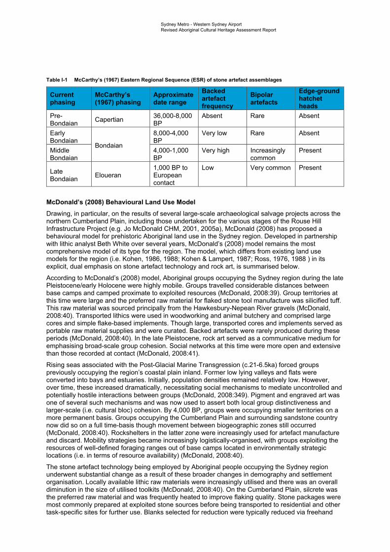
Sydney Metro - Western Sydney Airport Revised Aboriginal Cultural Heritage Assessment Report
Table I-1 McCarthy’s (1967) Eastern Regional Sequence (ESR) of stone artefact assemblages
Current phasing
McCarthy’s (1967) phasing
Approximatedate range
Backed artefact frequency
Bipolar artefacts
Edge-ground hatchet heads
Pre-Bondaian Capertian 36,000-8,000
BP Absent Rare Absent
Early Bondaian
8,000-4,000 BP
Very low Rare Absent
Middle Bondaian
Bondaian 4,000-1,000 BP
Very high Increasingly common
Present
Late Bondaian Eloueran
1,000 BP to European contact
Low Very common Present
McDonald’s (2008) Behavioural Land Use Model Drawing, in particular, on the results of several large-scale archaeological salvage projects across the northern Cumberland Plain, including those undertaken for the various stages of the Rouse Hill Infrastructure Project (e.g. Jo McDonald CHM, 2001, 2005a), McDonald (2008) has proposed a behavioural model for prehistoric Aboriginal land use in the Sydney region. Developed in partnership with lithic analyst Beth White over several years, McDonald’s (2008) model remains the most comprehensive model of its type for the region. The model, which differs from existing land use models for the region (i.e. Kohen, 1986, 1988; Kohen & Lampert, 1987; Ross, 1976, 1988 ) in its explicit, dual emphasis on stone artefact technology and rock art, is summarised below.
According to McDonald’s (2008) model, Aboriginal groups occupying the Sydney region during the late Pleistocene/early Holocene were highly mobile. Groups travelled considerable distances between base camps and camped proximate to exploited resources (McDonald, 2008:39). Group territories at this time were large and the preferred raw material for flaked stone tool manufacture was silicified tuff. This raw material was sourced principally from the Hawkesbury-Nepean River gravels (McDonald, 2008:40). Transported lithics were used in woodworking and animal butchery and comprised large cores and simple flake-based implements. Though large, transported cores and implements served as portable raw material supplies and were curated. Backed artefacts were rarely produced during these periods (McDonald, 2008:40). In the late Pleistocene, rock art served as a communicative medium for emphasising broad-scale group cohesion. Social networks at this time were more open and extensive than those recorded at contact (McDonald, 2008:41).
Rising seas associated with the Post-Glacial Marine Transgression (c.21-6.5ka) forced groups previously occupying the region’s coastal plain inland. Former low lying valleys and flats were converted into bays and estuaries. Initially, population densities remained relatively low. However, over time, these increased dramatically, necessitating social mechanisms to mediate uncontrolled and potentially hostile interactions between groups (McDonald, 2008:349). Pigment and engraved art was one of several such mechanisms and was now used to assert both local group distinctiveness and larger-scale (i.e. cultural bloc) cohesion. By 4,000 BP, groups were occupying smaller territories on a more permanent basis. Groups occupying the Cumberland Plain and surrounding sandstone country now did so on a full time-basis though movement between biogeographic zones still occurred (McDonald, 2008:40). Rockshelters in the latter zone were increasingly used for artefact manufacture and discard. Mobility strategies became increasingly logistically-organised, with groups exploiting the resources of well-defined foraging ranges out of base camps located in environmentally strategic locations (i.e. in terms of resource availability) (McDonald, 2008:40).
The stone artefact technology being employed by Aboriginal people occupying the Sydney region underwent substantial change as a result of these broader changes in demography and settlement organisation. Locally available lithic raw materials were increasingly utilised and there was an overall diminution in the size of utilised toolkits (McDonald, 2008:40). On the Cumberland Plain, silcrete was the preferred raw material and was frequently heated to improve flaking quality. Stone packages were most commonly prepared at exploited stone sources before being transported to residential and other task-specific sites for further use. Blanks selected for reduction were typically reduced via freehand
Sydney Metro - Western Sydney Airport Revised Aboriginal Cultural Heritage Assessment Report
percussion, with bipolar reduction sometimes also utilised. Various core reduction methods were employed, with asymmetric alternating flaking frequently used. During the Middle Bondaian period (c.4,000 to 1,000 years Before Present (BP)), backed artefacts were manufactured in large numbers across numerous sites, with ‘industrial’ scale production occurring at some sites. These tools were utilised in range of craft and subsistence activities including bone-working, wood-working, plant processing and animal butchery.
During the Late Bondaian period (c.1,000 years to European contact), there was a reduced emphasis on the occupation of rockshelters, with open camp site locations now foci for habitation. This shift away from rockshelters was a response to the increased spatial requirements of larger social groups associated with a dual social system (McDonald, 2008:349). During times of seasonal abundance, groups lived in large, semi-permanent open ‘villages’. However, in times of resource stress, these larger groups dispersed into smaller family or gender-based hunting/fishing groups who reverted to exploiting their traditional foraging ranges. An increased emphasis on bipolar flaking during this period was linked to an even more intensive use of locally available stone. In coastal areas, backed artefacts all but ceased to be produced. Edge-ground hatchets were widely made and used across the region. As in earlier periods, rock art during the Late Bondaian continued to function as an important communicative medium for the assertion of both local group identity and broader culture area cohesion (McDonald 2008:350).
The Cumberland Plain Concentrated archaeological investigation of the Aboriginal archaeological record of Sydney’s Cumberland Plain can be traced to the early-to-mid 1980s, a period marked by a rapid growth in residential and other forms of development across the Plain. Intensive development activities since this time have secured the Cumberland Plain’s place as one of the most intensively investigated archaeological regions in Australia, with potentially thousands of Aboriginal archaeological investigations involving survey and/or excavation having now been undertaken (the exact number difficult to calculate due to the limited circulation of many reports). The majority of these investigations were undertaken as part of larger environmental impact assessments associated with residential development and affiliated infrastructure projects. Unsurprisingly, these investigations have varied significantly in scale and scope, ranging from targeted small-scale surveys to complex, multi-phase survey and excavation projects over large areas. Nonetheless, together they have revealed a rich and diverse record of past Aboriginal occupation, with thousands of Aboriginal archaeological sites now registered in the AHIMS database.
Open artefact sites: distribution, contents and definition Surface and subsurface distributions of stone artefacts, variously referred to as open artefact sites, open sites and open camp sites are the most common and widely distributed form of Aboriginal archaeological site on the Cumberland Plain (see Attenbrow, 2010: Plate 12; Przywolnik, 2007: 46, Table 4.2). Other site types, such as modified trees, quarries, grinding grooves and rockshelters with deposit and/or art or PAD, have also been identified but are comparatively rare. Accordingly, open artefact sites remain the most intensively investigated component of the Aboriginal archaeological record of the Cumberland Plain, with site distribution and the technology of associated flaked stone artefact assemblages, in particular, comprising key research topics (e.g. AMBS, 2000; Craib et al., 1999; Jo McDonald CHM, 2001, 2003, 2005a, 2006a, 2006b, 2006c, 2007, 2009a, 2009b; Kohen, 1986; White & McDonald, 2010).
Existing archaeological survey data for the Cumberland Plain indicate a strong trend for the presence of open artefact sites along watercourses, specifically, on creek banks and ‘flats’ (i.e. flood/drainage plains), terraces and bordering lower slopes. Although this distribution pattern can be attributed in part to geomorphic dynamics and archaeological sampling bias, with extensive fluvial erosion activity along watercourses resulting in higher levels of surface visibility and, by extension, concentrated survey effort, an occupational emphasis on watercourses is supported by the results of numerous subsurface investigations (e.g. AMBS, 2000; Craib et al., 1999; GML, 2012, 2016; Jo McDonald CHM, 2001, 2003, 2005a, 2006a, 2006b, 2007, 2009a, 2009b). Collectively, these investigations have demonstrated that assemblage size and complexity tend to vary significantly in relation to stream order
Sydney Metro - Western Sydney Airport Revised Aboriginal Cultural Heritage Assessment Report
and landform, with larger, more complex5 assemblages concentrated on elevated, low gradient landform elements adjacent to higher order watercourses. Artefact distributions associated with major creek lines and confluences tend to consist of localised high density artefact concentrations set within lower density artefact scatters across the broader landscape. Outside of these contexts, surface and subsurface artefact distributions have typically been found to be sparse and discontinuous and are often referred to as ‘background scatter’, being “artefactual material which is insufficient in number or in association with other material to suggest focussed activity in a particular location” (Douglas and McDonald, 1993).
Flaked stone artefacts dominate archaeological assemblages from recorded open artefact sites on the Cumberland Plain, with heat shattered rock also well represented. Items such as complete and broken grindstones, hammerstones and edge-ground hatchet heads have also been recorded though comparatively infrequently. With the notable exception of ‘knapping floors’6, a relatively common component of the Aboriginal archaeological record of the Cumberland Plain, associated archaeological features (e.g. hearths, ground ovens and heat treatment pits) have proven elusive (but see AHMS, 2013; GML, 2016; McDonald and Rich, 1994; Jo McDonald CHM, 2009a for examples). Investigated knapping floors across the Plain have varied considerably in size and complexity, with the largest and most complex examples identified through excavation as opposed to surface survey (e.g. Jo McDonald CHM, 2001, 2005a, 2006b, 2007). Backed artefacts (i.e. Bondi points, geometric microliths and elouera) are a common feature of knapping floors and most of these features were likely specifically associated with their production. In common with regions such as the Hunter Valley (e.g. Hiscock, 1993; Moore, 2000), available evidence supports the suggestion that backed artefact manufacture on the Cumberland Plain was a highly structured or systematic activity.
Although relevant to a variety of site types, geomorphic processes such as soil erosion and colluvial/fluvial aggradation are of particular relevance to the identification and definition of open artefact sites. As in other archaeological contexts (e.g. Dean-Jones & Mitchell, 1993), the visibility of open artefact sites across Sydney’s Cumberland Plain can, for the most part, be attributed to such processes, which have variously exposed or obscured them. Critically, surface artefacts invariably represent only a fraction of the total number of artefacts present within recorded surface open artefact sites across the Plain, with a typical surface to subsurface artefact ratio of 1:25 proposed (Jo McDonald CHM, 2005b: 35). Artefact exposure, unsurprisingly, is highest on erosional surfaces and lowest on depositional ones. At the same time, in many areas, surface artefacts have been shown through dispersed testing programs to form part of more-or-less continuous subsurface distributions of artefacts, albeit with highly variable artefact densities linked to environmental variables such as distance to water, stream order and landform (e.g. White & McDonald, 2010). The presence or absence of surface artefacts on the Cumberland Plain, therefore, is not a reliable indicator of Aboriginal archaeological sensitivity.
Flaked stone artefact technology Virtually indestructible, flaked stone artefacts are a ubiquitous element of the Aboriginal archaeological record of the Cumberland Plain and have assumed a prominent position in archaeological reconstructions of past Aboriginal land use across the region. To date thousands of surface-collected and excavated flaked stone assemblages from across the Cumberland Plain have been analysed, with individual assemblage sizes, research questions, aims, analytical methodologies and terminological schemes varying significantly between researchers and projects. Studies to date have ranged from basic descriptive accounts of assemblage composition in typological terms to detailed reconstructions of past stone reduction and quarrying behaviours through rigorous technological analyses. Particularly informative analyses in the context of the Cumberland Plain include those conducted by Jo McDonald CHM (2001, 2003, 2005a, 2006a, 2006b, 2006c, 2007, 2009a, 2009b) as part of archaeological salvage projects associated with development activities within the Rouse Hill Development Area (RHDA), the former Australian Defence Industries site at St Marys and the Colebee Release Area. Technological analyses of stone artefact assemblages recovered from fluvial sand bodies adjacent to the Parramatta (Jo McDonald CHM, 2005b, 2005c, 2006b) and Hawkesbury Rivers (AHMS 2013;
5 Those containing a wider variety of raw materials and technological types and/or higher mean artefact densities and features such as knapping floors.6 Following White (1997:8), knapping floors can be defined as activity areas “where primacy was given the systematic reduction of stone, with or without additional activities being carried out”.
Sydney Metro - Western Sydney Airport Revised Aboriginal Cultural Heritage Assessment Report
Williams et al. 2012) have likewise proven highly informative, particularly with respect to the documentation of diachronic changes in raw material use and stone artefact technologies.
Available technological and typological data for surface collected and excavated flaked stone artefact assemblages from the Cumberland Plain suggest that the majority of these assemblages belong to what is known as the ‘Australian small-tool tradition’, a term coined by Gould (1969) to describe what was then thought to be the first appearance, in the mid-Holocene7, of a new suite of flaked stone tool forms in the Aboriginal archaeological record of Australia, including backed artefacts, adzes and points (both unifacially and bifacially flaked). Complex, hierarchically-organised reduction sequences associated with the production of these tools contrast markedly with the simple sequences of earlier periods (Moore, 2011). Tools of the Australian small-tool tradition, it has been suggested, formed part of a portable, standardised and multifunctional tool kit aimed specifically at risk reduction (Hiscock, 1994, 2002, 2006). Stone artefact assemblages from late Pleistocene and early Holocene contexts, in contrast, are described by archaeologists as belonging to the ‘Australian core tool and scraper tradition’, a term first used by Bowler et al. (1970) to describe the Pleistocene assemblages recovered from Lake Mungo in western NSW. Bowler et al. (1970) saw the main components of these assemblages - core tools, steep-edged scrapers and flat scrapers - as characteristic of early Australian Aboriginal assemblages and as being of a distinctly different character to those associated with the proceeding small-tool tradition. In southeastern Australia, including the Cumberland Plain, the Australian ‘small-tool’ and ‘core tool and scraper’ traditions are most commonly described in terms of McCarthy’s (1967) ERS, with ‘Capertian’ assemblages assigned to the latter tradition and ‘Bondaian’ assemblages to the former.
Flaked stone artefact assemblages from excavated and surface collected/recorded open artefact sites on the Cumberland Plain attest to the exploitation of a diverse range of lithic raw materials (Corkill, 1999, 2005). However, two rock types - silcrete and silicified tuff (also known as indurated mudstone) -dominate the region’s existing stone artefact record. Other, less commonly exploited raw materials represented in excavated and surface collected/recorded assemblages include quartz, quartzite, petrified wood, chert and various fine-grained volcanics. Alongside silcrete and silicified tuff, these materials occur variously in a number of geological formations and units across the Cumberland Plain (for a detailed review see Corkill 1999). Oft-cited sources include the Tertiary St Marys (Ts) and Rickabys Creek Gravel (Tr) formations, as well as the various unconsolidated Pleistocene units that line as terraces the present day and abandoned channels of the Nepean-Hawkesbury River (e.g. the Cranebrook Formation (Qpc)). Holocene gravel banks along the same river system have likewise been identified as a potentially significant raw material source.
In common with the Sydney region as a whole (Attenbrow, 2010:120-121), various excavated assemblages from the body and peripheries of the Cumberland Plain (e.g. Jo McDonald CHM, 2001a, 2005a; Williams et al., 2012, 2014) attest to a shift, over time, in the relative significance of particular raw materials for flaked stone artefact manufacture, principally silcrete and silicified tuff but also quartz. An ‘early’ (i.e. Pre-Bondaian) emphasis on the procurement and reduction of silicified tuff, for example, appears to have given way to a ‘later’ (i.e. Bondaian) emphasis on silcrete. Quartz use, meanwhile, appears to have peaked in the late Holocene. For the Cumberland Plain, these changes have been linked, in particular, to broader changes in settlement organisation, with a decline in levels of residential mobility over time prompting more intensive use of locally available stone (Jo McDonald CHM, 2005a).
In the northwestern portion of the Cumberland Plain, the Tertiary St Marys Formation has been singled out as a particularly important source of silcrete for flaked stone artefact manufacture. Mapped at various localities across the Mulgoa Creek, South Creek and Eastern Creek catchments, the best known and most intensively investigated outcrops of this formation occur on Plumpton Ridge, a low but locally prominent ridgeline separating the floodplains of Eastern Creek and Bells Creek between the suburbs of Plumpton and Riverstone. The subject of numerous archaeological investigations since the early 1980s (e.g. Australian Museum Business Services, 2002; Baker, 1996; Barry, 2005; McDonald, 1986), Jo McDonald CHM’s (2006c) large-scale archaeological salvage works across what is now Stonecutters Ridge Golf Club unequivocally identified Plumpton Ridge as a major Aboriginal
7 More recent research into the chronology of backed artefacts and points in Australia (e.g. Hiscock & Attenbrow 1998, 2004; Hiscock 1993b) has demonstrated a long history of production and use for these implement types, with both types now known to have been produced, albeit in small numbers, in the early Holocene and likely in the late Pleistocene as well.
Sydney Metro - Western Sydney Airport Revised Aboriginal Cultural Heritage Assessment Report
quarry site. At the same time, they highlighted a number of important trends in relation to the procurement and reduction of silcrete obtained from this source. Trends in the relative frequencies of raw material types, artefact types and the size of silcrete artefacts in local excavated assemblages, for example, were attributed to a process of ‘distance-decay’ (Jo McDonald CHM’s 2006c: 61).
Procurement evidence at documented Aboriginal quarry sites across the Cumberland Plain, including Plumpton Ridge, has to date consisted of varying surface and/or subsurface densities of flaked stone artefacts in direct spatial association with naturally occurring Tertiary gravel deposits (silcrete dominant). Topographic indicators of ‘open cut’ mining activities, such as localised circular/semi-circular depressions or trenches (cf. Binns & McBryde, 1972; Jones & White, 1988; McBryde, 1973, 1984), have yet to be identified, though this is unsurprising given the nature of the lithic deposits being quarried. Alongside those from the ADI:EPI and ADI-FF2 quarry sites within the former Australian Defence Industries site (Jo McDonald CHM, 2006a, 2008a), excavated flaked stone artefact assemblages from the SA25 and SA26 sample areas on the upper eastern flank of Plumpton Ridge, detailed in Jo McDonald CHM, 2006c, have provided a robust technological ‘signature’ for Aboriginal quarry sites on the Cumberland Plain. Amongst other activities, such as limited tool production/discard and later stage core reduction, stone procurement/reduction activities at exploited stone sources appear to have included ‘primary’ or early stage clast reduction as well as deliberate heat treatment and fracturing (Jo McDonald CHM, 2006c).
Backed artefacts dominate the retouched components of the majority of dated and undated Bondaian assemblages from the Plain and, as such, the technology of their manufacture has received considerable analytical and interpretive attention. Studies by Jo McDonald CHM (2001, 2003, 2005a, 2006a, 2006b, 2007, 2009a, 2009b), in particular, have demonstrated that backed artefact manufacture on the Cumberland Plain was a highly structured or systematic activity involving a complex system of raw material procurement, transportation, preparation and reduction. Differences in the technological character of recovered cores across the region attest to a significant degree of variability in the methods used by Aboriginal knappers to produce flakes for backed artefact manufacture. However, certain techniques (e.g. asymmetric alternating flaking and Hiscock’s (1993) ‘tranchet technique’) are particularly well represented. Evidence for the deliberate heat treatment of silcrete blanks, both as part of systematic backed artefact manufacture activities and other reduction activities, is abundant and widespread, with excavated and surface collected assemblages attesting to the use of heat at various points in the reduction process. As in other contexts (e.g. Hiscock 1993), the thermal alteration of Cumberland Plain silcrete appears to have significantly improved the flaking quality of the stone, increasing the lustre and smoothness of fracture surfaces.
Chronology of occupation In common with the Sydney region as a whole, evidence for late Pleistocene/early Holocene (i.e. Pre-Bondaian/Early Bondaian) Aboriginal occupation of the Cumberland Plain is sparse, with confirmed or potential evidence from these periods obtained from only a limited (<20) number of sites/landscapes. Well documented examples include Rouse Hill sites RH/CC2 (Jo McDonald CHM, 2001), RH/SC5 (Jo McDonald CHM, 2002b), RH/CD12 (Jo McDonald CHM, 2002a) and RHCD7 (Jo McDonald CHM, 2007); Richmond site RMI (Jo McDonald CHM, 1997a); PT12 near Pitt Town (Williams et al., 2012, 2014); Jamisons Creek, Emu Plains (Kohen et al., 1984); Power Street Bridge 2, Doonside (McDonald, 1993), Regentville RS1, Regentville (Koettig & Hughes, 1995; McDonald et al., 1996), the Parramatta CBD (AHMS 2013; Austral Archaeology, 2007; Jo McDonald CHM, 2005b, 2005c, 2006b) and the Windsor Museum site (Austral Archaeology, 2011; Williams et al. 2012; Williams et al. 2014). Claims of a c.40 ka year old date for five ‘flaked pebbles’ recovered from a gravel pit associated with the Cranebrook Terrace near Penrith (Nanson et al. 1987) have been widely questioned, (P. Mitchell, 2010; Derek John Mulvaney & Kamminga, 1999; Williams et al., 2012) with legitimate concerns raised over the artefactual status of these pebbles, their provenance and association with available dates (but see Williams et al. 2017 for the results of more recent work at Cranebrook Terrace). For most sites, late Pleistocene/early Holocene occupation has been inferred on the basis of the technological and typological characteristics of recovered flaked stone artefact assemblages as opposed to radiometric dates.
At present, the oldest securely dated archaeological site on the Cumberland Plain is the PT12 site at Pitt Town, with compliance-based archaeological excavations across a source-bordering dune at this site, which overlooks the Hawkesbury River, producing a suite of Optically-Stimulated Luminescence (OSL) dates suggestive of Aboriginal occupation from at least 36,000 years ago (and potentially
Sydney Metro - Western Sydney Airport Revised Aboriginal Cultural Heritage Assessment Report
earlier) (Williams et al. 2012, 2014). Closer to the coast, Late Pleistocene/early Holocene occupation of a sandy fluvial terrace adjacent to the Parramatta River (i.e. the Parramatta Sand Sheet) has been by proposed by Jo McDonald CHM (2005b, 2005c, 2006b) and seems likely on the basis of available radiometric dates and assemblage characteristics.
In stark contrast to the late Pleistocene/early Holocene, evidence for mid-to-late Holocene (i.e. Middle to Late Bondaian) Aboriginal occupation of the Cumberland Plain abounds, with numerous excavated sites producing assemblages that can be confidently assigned to these periods on the basis of radiometric dates and/or their typological/technological profiles. Available radiometric dates indicate a steady increase in the number of sites occupied over the course of the Holocene, with a peak in the 2nd millennium BP (see, for example, Przywolnik 2007: 53, Fig. 4.6). Taken at face value, this data suggests a progressive increase in the Aboriginal population of the Cumberland Plain over the course of the Holocene. However, following Hiscock (2008: 230-233), it seems likely that the directional population growth suggested by such data is, to a certain extent at least, a product of differential site preservation, with younger sites better preserved than older ones. Other factors, such as the burial of older sites through sediment deposition and bias in the location of archaeological surveys and excavations, may also be relevant.
Critical to any discussion concerning the antiquity of Aboriginal occupation across the Cumberland Plain are the well-documented difficulties surrounding the dating of open artefact sites with active ‘biomantles’ (sensu Paton et al. 1995; see Dean-Jones & Mitchell, 1993; Balek 2002; Hofman 1986; Johnson et al. 2005; Johnson 1989; Paton et al. 1995; Peacock & Fant 2002; Stein 1983). On the Cumberland Plain, the term biomantle is typically used as a collective descriptor for the ‘A’ soil horizons of the Plain’s dominant texture contrast or duplex soil profiles8, which tend to be relatively thin (<30 cm) and exhibit extensive evidence of bioturbation in the form of roots, open/infilled burrows, live insects and/or earthworms and stone lines9. However, it is noted that the uppermost portions of underlying ‘B’ soil horizons can also exhibit such evidence and form part of the biomantle (e.g. AECOM, 2015a). As highlighted by Dean-Jones & Mitchell (1993) and others (e.g. Balek, 2002; Johnson, 1989), excavated finds assemblages from archaeological sites with active biomantles are subject to a range of interpretive constraints, with intact depositional stratigraphy unlikely to be preserved and inset archaeological features (e.g. hearths and heat treatment pits) representing the only reliable means of dating (with any specificity) intercepted archaeological events (Mitchell, 2009: 4). Any stone artefacts discarded at the surface in landscapes with active biomantles are likely, over time, to have been incorporated into the soil profile through bioturbation, with depth of artefact burial ultimately corresponding to the base of major biological activity (i.e. the base of the biomantle). Where biomantles remain relatively undisturbed, horizontal patterns of artefact discard may be preserved. However, in heavily disturbed contexts, the preservation of such patterning is unlikely (Mitchell 2009: 4).
For archaeologists working on the Cumberland Plain, the analytical and interpretive constraints posed by intensive bioturbation have, in combination with a real paucity of dateable features, led to a reliance on the dating of excavated archaeological finds through relative means, specifically, through consideration of the typological and technological composition of associated flaked stone artefact assemblages and reference to a modified version of McCarthy’s (1967) ESR, the broad temporal parameters of which are now well established. While offering a useful chronological framework within which to assess diachronic changes in stone artefact technologies and raw material use, the largely undated and palimpsest character of the Cumberland Plain’s lithic record represents a significant analytical and interpretive obstacle for period-specific reconstructions of Aboriginal mobility regimes (cf. Cowan, 1999). Well dated assemblages from sites retaining stratified deposit(s) are rare, with the most comprehensively dated sequences to date coming from deep fluvial sand bodies adjacent to the Hawkesbury and Parramatta Rivers (i.e. AHMS, 2013; Jo McDonald CHM, 2005c; Williams et al., 2012, 2014). While the preservation and dating potential offered by such bodies has been amply demonstrated, the same cannot be said of alluvial valley fill sequences outside of these major river valley contexts, with comparatively little research directed towards investigating the age, genesis or
8 These profiles are characterised by loamy topsoils and silty clay to clay subsoils, with boundaries between these two units typically clear to abrupt. Clayey subsoils have formed by in situ weathering of the parent material, while topsoils are derived from a combination of in situ weathering and the deposition of colluvially and/or fluvially transported materials. 9 Stone lines, where present, typically occur at the interface between the A and B horizons.
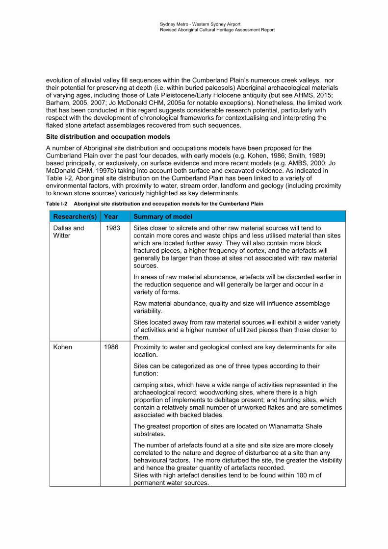
Sydney Metro - Western Sydney Airport Revised Aboriginal Cultural Heritage Assessment Report
evolution of alluvial valley fill sequences within the Cumberland Plain’s numerous creek valleys, nor their potential for preserving at depth (i.e. within buried paleosols) Aboriginal archaeological materials of varying ages, including those of Late Pleistocene/Early Holocene antiquity (but see AHMS, 2015; Barham, 2005, 2007; Jo McDonald CHM, 2005a for notable exceptions). Nonetheless, the limited work that has been conducted in this regard suggests considerable research potential, particularly with respect with the development of chronological frameworks for contextualising and interpreting the flaked stone artefact assemblages recovered from such sequences.
Site distribution and occupation models A number of Aboriginal site distribution and occupations models have been proposed for the Cumberland Plain over the past four decades, with early models (e.g. Kohen, 1986; Smith, 1989) based principally, or exclusively, on surface evidence and more recent models (e.g. AMBS, 2000; Jo McDonald CHM, 1997b) taking into account both surface and excavated evidence. As indicated in Table I-2, Aboriginal site distribution on the Cumberland Plain has been linked to a variety of environmental factors, with proximity to water, stream order, landform and geology (including proximity to known stone sources) variously highlighted as key determinants. Table I-2 Aboriginal site distribution and occupation models for the Cumberland Plain
Researcher(s) Year Summary of model Dallas and 1983 Sites closer to silcrete and other raw material sources will tend to Witter contain more cores and waste chips and less utilised material than sites
which are located further away. They will also contain more block fractured pieces, a higher frequency of cortex, and the artefacts will generally be larger than those at sites not associated with raw material sources.
In areas of raw material abundance, artefacts will be discarded earlier in the reduction sequence and will generally be larger and occur in a variety of forms.
Raw material abundance, quality and size will influence assemblage variability.
Sites located away from raw material sources will exhibit a wider variety of activities and a higher number of utilized pieces than those closer to them.
Kohen 1986 Proximity to water and geological context are key determinants for site location.
Sites can be categorized as one of three types according to their function:
camping sites, which have a wide range of activities represented in the archaeological record; woodworking sites, where there is a high proportion of implements to debitage present; and hunting sites, which contain a relatively small number of unworked flakes and are sometimes associated with backed blades.
The greatest proportion of sites are located on Wianamatta Shale substrates.
The number of artefacts found at a site and site size are more closely correlated to the nature and degree of disturbance at a site than any behavioural factors. The more disturbed the site, the greater the visibility and hence the greater quantity of artefacts recorded. Sites with high artefact densities tend to be found within 100 m of permanent water sources.
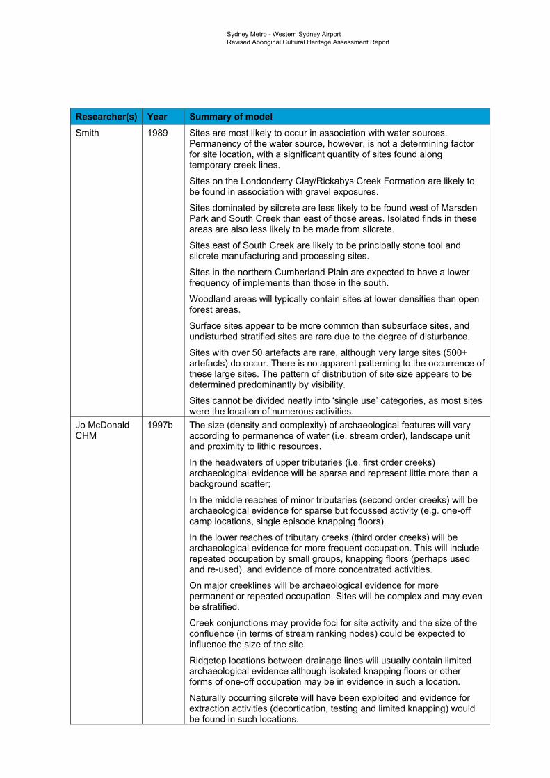
Sydney Metro - Western Sydney Airport Revised Aboriginal Cultural Heritage Assessment Report
Researcher(s) Year Summary of model Smith 1989 Sites are most likely to occur in association with water sources.
Permanency of the water source, however, is not a determining factor for site location, with a significant quantity of sites found along temporary creek lines.
Sites on the Londonderry Clay/Rickabys Creek Formation are likely to be found in association with gravel exposures.
Sites dominated by silcrete are less likely to be found west of Marsden Park and South Creek than east of those areas. Isolated finds in these areas are also less likely to be made from silcrete.
Sites east of South Creek are likely to be principally stone tool and silcrete manufacturing and processing sites.
Sites in the northern Cumberland Plain are expected to have a lower frequency of implements than those in the south.
Woodland areas will typically contain sites at lower densities than open forest areas.
Surface sites appear to be more common than subsurface sites, and undisturbed stratified sites are rare due to the degree of disturbance.
Sites with over 50 artefacts are rare, although very large sites (500+ artefacts) do occur. There is no apparent patterning to the occurrence of these large sites. The pattern of distribution of site size appears to be determined predominantly by visibility.
Sites cannot be divided neatly into ‘single use’ categories, as most sites were the location of numerous activities.
Jo McDonald 1997b The size (density and complexity) of archaeological features will vary CHM according to permanence of water (i.e. stream order), landscape unit
and proximity to lithic resources.
In the headwaters of upper tributaries (i.e. first order creeks) archaeological evidence will be sparse and represent little more than a background scatter;
In the middle reaches of minor tributaries (second order creeks) will be archaeological evidence for sparse but focussed activity (e.g. one-off camp locations, single episode knapping floors).
In the lower reaches of tributary creeks (third order creeks) will be archaeological evidence for more frequent occupation. This will include repeated occupation by small groups, knapping floors (perhaps used and re-used), and evidence of more concentrated activities.
On major creeklines will be archaeological evidence for more permanent or repeated occupation. Sites will be complex and may even be stratified.
Creek conjunctions may provide foci for site activity and the size of the confluence (in terms of stream ranking nodes) could be expected to influence the size of the site.
Ridgetop locations between drainage lines will usually contain limited archaeological evidence although isolated knapping floors or other forms of one-off occupation may be in evidence in such a location.
Naturally occurring silcrete will have been exploited and evidence for extraction activities (decortication, testing and limited knapping) would be found in such locations.
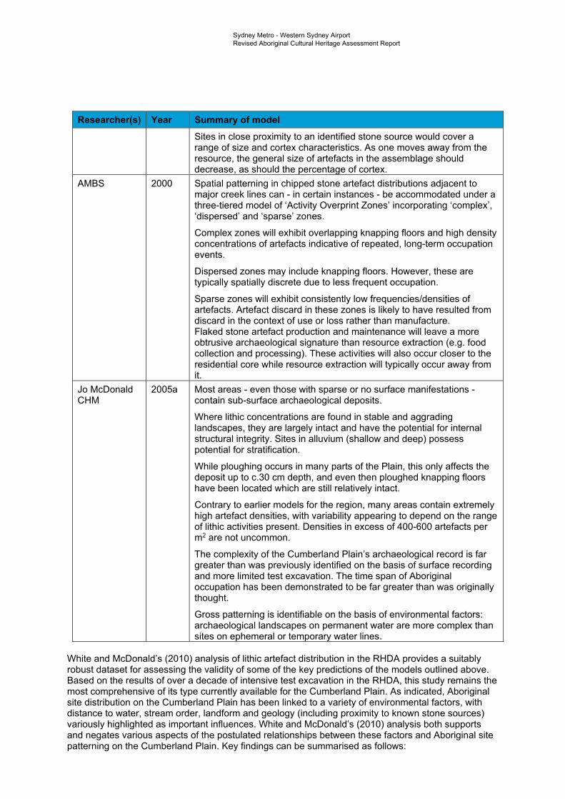
Sydney Metro - Western Sydney Airport Revised Aboriginal Cultural Heritage Assessment Report
Researcher(s) Year Summary of model Sites in close proximity to an identified stone source would cover a range of size and cortex characteristics. As one moves away from the resource, the general size of artefacts in the assemblage should decrease, as should the percentage of cortex.
AMBS 2000 Spatial patterning in chipped stone artefact distributions adjacent to major creek lines can - in certain instances - be accommodated under a three-tiered model of ‘Activity Overprint Zones’ incorporating ‘complex’, ‘dispersed’ and ‘sparse’ zones.
Complex zones will exhibit overlapping knapping floors and high density concentrations of artefacts indicative of repeated, long-term occupation events.
Dispersed zones may include knapping floors. However, these are typically spatially discrete due to less frequent occupation.
Sparse zones will exhibit consistently low frequencies/densities of artefacts. Artefact discard in these zones is likely to have resulted from discard in the context of use or loss rather than manufacture. Flaked stone artefact production and maintenance will leave a more obtrusive archaeological signature than resource extraction (e.g. food collection and processing). These activities will also occur closer to the residential core while resource extraction will typically occur away from it.
Jo McDonald 2005a Most areas - even those with sparse or no surface manifestations -CHM contain sub-surface archaeological deposits.
Where lithic concentrations are found in stable and aggrading landscapes, they are largely intact and have the potential for internal structural integrity. Sites in alluvium (shallow and deep) possess potential for stratification.
While ploughing occurs in many parts of the Plain, this only affects the deposit up to c.30 cm depth, and even then ploughed knapping floors have been located which are still relatively intact.
Contrary to earlier models for the region, many areas contain extremely high artefact densities, with variability appearing to depend on the range of lithic activities present. Densities in excess of 400-600 artefacts per m2 are not uncommon.
The complexity of the Cumberland Plain’s archaeological record is far greater than was previously identified on the basis of surface recording and more limited test excavation. The time span of Aboriginal occupation has been demonstrated to be far greater than was originally thought.
Gross patterning is identifiable on the basis of environmental factors: archaeological landscapes on permanent water are more complex than sites on ephemeral or temporary water lines.
White and McDonald’s (2010) analysis of lithic artefact distribution in the RHDA provides a suitably robust dataset for assessing the validity of some of the key predictions of the models outlined above. Based on the results of over a decade of intensive test excavation in the RHDA, this study remains the most comprehensive of its type currently available for the Cumberland Plain. As indicated, Aboriginal site distribution on the Cumberland Plain has been linked to a variety of environmental factors, with distance to water, stream order, landform and geology (including proximity to known stone sources) variously highlighted as important influences. White and McDonald’s (2010) analysis both supports and negates various aspects of the postulated relationships between these factors and Aboriginal site patterning on the Cumberland Plain. Key findings can be summarised as follows:
Sydney Metro - Western Sydney Airport Revised Aboriginal Cultural Heritage Assessment Report
• Artefact distributions do not, as implied by the models of Kohen (1986) and Smith (1989), form bounded ‘sites’ but rather ‘landscapes’
• Artefact distribution does, as variably expressed by AMBS (2000), Kohen (1986), Jo McDonald CHM (1997b, 2005) and Smith (1989), appear to vary with proximity to water, albeit to different extents based on stream order
• Artefact density does, as suggested by Jo McDonald CHM (1997b, 2005), appear to vary significantly with stream order
• Artefact density does, as suggested by Jo McDonald CHM (1997b, 2005), appear to vary significantly with landform
• Aboriginal archaeological sites on the Cumberland Plain cannot, as proposed by Jo McDonald CHM (2005), be adequately characterized on the basis of surface evidence alone. Most areas, regardless of surface indications, contain subsurface archaeological deposit(s)
• The orientation of open land surfaces appears to have influenced the selection of artefact discard locations in the lower portions of valleys, with generally higher densities on lower slopes facing north and north-east
• Distance from known silcrete sources does not, on present evidence at least, appear to have influenced intensity of artefact discard (cf. Dallas & Witter 1983)
• Trends in artefact density and distribution indicate long-term, large scale patterns. Short term models of settlement organization are insufficient to account for these artefact distributions
• Social and/or symbolic factors may have influenced site selection along with the distributions of economic and other resources.
More recently, AHMS (2015), employing a comparable analytical methodology to White and McDonald (2010), undertook an analysis of lithic artefact distribution across sixteen northwestern Cumberland Plain landscapes subject to dispersed testing and/or targeted open area salvage excavations. The dataset for this analysis, which sought, in common with White and McDonald’s (2010) study, to identify patterns in artefact discard10 comprised 2,988 artefacts from 345 dispersed test pits (1 m2) along multiple pipeline corridors. In common with White and McDonald (2010: 32-33), AHMS found that artefact distribution within their sampled landscapes varied significantly in relation to both stream order and landform, with mean artefact densities highest in 3rd order landscapes (16.7 artefacts/m2) and on terraces (16.9 artefacts/m2). Interestingly, however, the mean artefact density for 3rd order landscapes in AHMS’s (2015) dataset (i.e. 16.7 artefacts/m2) was found to exceed that for 4th order landscapes in the RHDA dataset (13.9 artefacts/m2). The mean artefact density for creek flats in AHMS’s dataset (7.8 artefacts/m2) was likewise found to exceed its counterpart in the RHDA dataset (3.8 artefacts/m2), suggesting that creek flats in AHMS’s sampled landscapes may have been more favoured for occupation than those in the RHDA or, alternatively, that creek flats in the RHDA had been subject to more intensive flood-erosion activity (resulting in a greater loss of artefacts).
In keeping with White and McDonald’s (2010:34) results, AHMS found that in 2nd order landscapes, artefact density was highest within 50 m of water. Distance to water in 4th order landscapes was not assessed by AHMS. However, in a comparable finding to White and McDonald’s (2010:34, Table 9) 4th
order dataset, AHMS found that in 3rd order landscapes, artefact density was highest between 51 and 100 m from water. Consideration of 1st and 3rd order landscapes in combination likewise showed that mean artefact density was highest between 51 and 100 m of water, suggesting, in combination with the above, that landform elements located at a slightly greater distance to creeks (and particularly larger creeks) were favoured for sustained/repeated occupation11. While limited to lower slopes, AHMS’s analysis of artefact distribution in relation to slope aspect revealed both similarities and differences with the RHDA dataset, with southeast-facing lower slopes in AHMS’s sampled landscapes exhibiting the highest mean artefact density (as opposed to north/northeast-facing slopes in the RHDA dataset), followed by northeast-facing lower slopes. Finally, AHMS’s analysis of artefact distribution in relation to distance to known silcrete sources produced an entirely different result to
10 And, by extension, past Aboriginal land use preferences. 11 For the RHDA, White and McDonald (2010:33) attributed a comparable finding to factors such as allowing animals to drink and catching a cool breeze.

Sydney Metro - Western Sydney Airport Revised Aboriginal Cultural Heritage Assessment Report
White and McDonald’s (2010:35, Table 12) analysis of the same relationship, with the latter revealing a pattern of increasing artefact density with increasing distance from known sources. In AHMS’s dataset, artefact density was highest within two to three kilometres of known silcrete sources. However, outside of this finding, no clear patterning was evident, suggesting, in line with White and McDonald’s (2010) findings, that distance to known silcrete sources likely had little influence over artefact discard rates.

Sydney Metro Western Sydney AirportRevised Aboriginal Cultural Heritage Assessment Report
-
Appendix J AHIMS search results

Sydney Metro - Western Sydney Airport Revised Aboriginal Cultural Heritage Assessment Report
Appendix J AHIMS search results
This appendix has been removed for the public version of this report.
Sydney Metro Western Sydney AirportRevised Aboriginal Cultural Heritage Assessment Report
-
Appendix K Previous and current
AHIPs

Sydney Metro - Western Sydney Airport Revised Aboriginal Cultural Heritage Assessment Report
Appendix K Previous and current AHIPs
This appendix has been removed for the public version of this report.
Sydney Metro Western Sydney AirportRevised Aboriginal Cultural Heritage Assessment Report
-
Appendix L Ethnographic context
Sydney Metro - Western Sydney Airport Revised Aboriginal Cultural Heritage Assessment Report
Introduction As in other parts of NSW and Australia more broadly, non-Aboriginal people occupying the Sydney region began to document Aboriginal culture from first contact, with explorers, missionaries, settlers and the like recording their observations of Aboriginal people and/or their material culture in letters, journals and official reports. Many of these accounts are overtly Eurocentric in tone and the content and veracity of some is, at best, questionable. Nonetheless, taken together, they form an important source of information on Aboriginal lifeways at the time of British colonisation and can, in conjunction with available archaeological data, be used to generate working predictive models of prehistoric Aboriginal land use.
Key sources, both primary and secondary, for the languages and lifeways of the Aboriginal people occupying the Sydney region at and following British colonisation include: Attenbrow (2010); Barrallier (1802 [1975]); Bradley (1792 [1961]); Brook & Kohen (1991); Collins (1798 [1975], 1802 [1971]; Dawes (1790a, 1790b); Flynn (1994, 1995a, 1995b); Hunter (1793 [1968]); Irish (2017); Kohen (1985, 1986, 1988, 1993); Kohen and Lampert (1987); Kohen et al. (1999); Matthews (1903); McDonald (2008); Phillip (1789 [1970], 1791[1963]); Tench (1793 [1979]); Troy (1994); White (1790 [1962]) and Worgan (1788). While a detailed review of these sources is beyond the scope of this report, salient information is summarised in the sections below.
The Darug language and people The Map of Indigenous Australia (Horton, 1996) indicates that the study area falls wholly within the traditional Darug (also spelt Dhaŕ-rook, Dharrook, Dhaŕook, Dharruk and Dharug) language area. Darug is believed to have been spoken from the Hawkesbury River in the north, to Appin in the south, and from the coast west across the Cumberland Plain into the Blue Mountains (Figure L-1). Early sources (e.g. Collins 1798 [1975]; 1802 [1971]; Tench 1793 [1961]; Dawes 1790a, 1790b; Phillip in Hunter 1793 [1961]) and more recent linguistic research (e.g. Troy 1994) indicate that two distinct dialects of Darug were spoken at the time of European contact, a coastal dialect, spoken on the Sydney peninsula and the country to the north of Port Jackson, and a hinterland dialect, spoken on the Cumberland Plain from Appin in the south to the Hawkesbury River in the north (Attenbrow 2010: 34). This linguistic division is thought to correspond to a broader economic division between ‘coastal’ and ‘hinterland’ Darug-speaking peoples, with the accounts of several early observers (e.g. Bradley 1792 [1961]; Collins 1798 [1975], 1802 [1971]; Phillip 1788 in Attenbrow 2010:63; Tench 1793 [1979]) suggestive of a ‘coastal’, marine-oriented subsistence economy12 and contrasting ‘inland’ economy focused on the exploitation of land mammals, plant foods and freshwater faunal resources. Notably, early sources (e.g. Barrallier 1802 [1975]; Collins 1798 [1975]; Tench 1793 [1961]) suggest that there was little contact between coastal and hinterland groups.
Some idea of population size for the coastal Darug at contact is provided by Attenbrow (2010), who suggests that the area around Port Jackson likely supported a minimum population density of 0.75 persons/one square kilometre (i.e. 1 person/1.3 square kilometres). Attenbrow’s estimate is based Governor Phillip’s own estimate of the Aboriginal population of this area, made in 1788. Phillip, reporting to Lord Sydney on 15 May 1788, estimated a total population of not “less than one thousand five hundred” (Phillip 1788 in Attenbrow, 2010: 17). Attenbrow (2010:17), citing Hunter (1793 [1968]:62), notes that “population densities for the hinterland (west of Parramatta) were initially assessed by the colonists as being less than those along the coast” but urges interpretive caution given the deleterious effects of 1789 smallpox epidemic, which “had killed many people living to the west of Rose Hill before Phillip’s 1791 expedition crossed the Cumberland Plain to the Hawkesbury-Nepean River”. More recently, Kohen (1995) has estimated a minimum overall density of around 0.5 persons per square kilometre for the hinterland zone.
In common with other regions of NSW (e.g. Attenbrow, 2010) and Australia more broadly (Peterson, 1976), available historical records suggest that the primary units of social organisation amongst the Darug were the clan and band. Kohen and Lampert (1987) equate the term ‘clan’ with ‘band’. However, Attenbrow (2010) draws a distinction between the two, with clans comprising local descent
12 Note that available archaeological evidence suggests that the historically documented seafood bias in the diets of coastal Darug speaking peoples has been overemphasised, with excavated bone assemblages from coastal rockshelter sites (e.g. Balmoral Beach, Angophora Reserve) attesting to the importance of terrestrial and avian fauna in coastal diets.
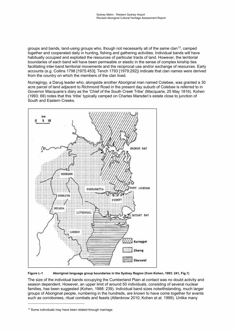
.... + i • ...
• '"'"'l! 't I ii' PI t • 'llt!i! '"-
...... " .. !i .... ~ ••
•1 111 , ..
Y llA.'r
ri1g1ai
f Ufl
r&WI
Sydney Metro - Western Sydney Airport Revised Aboriginal Cultural Heritage Assessment Report
groups and bands, land-using groups who, though not necessarily all of the same clan13, camped together and cooperated daily in hunting, fishing and gathering activities. Individual bands will have habitually occupied and exploited the resources of particular tracts of land. However, the territorial boundaries of each band will have been permeable or elastic in the sense of complex kinship ties facilitating inter-band territorial movements and the reciprocal use and/or exchange of resources. Early accounts (e.g. Collins 1798 [1975:453]; Tench 1793 [1979:292]) indicate that clan names were derived from the country on which the members of the clan lived.
Nurragingy, a Darug leader who, alongside another Aboriginal man named Colebee, was granted a 30 acre parcel of land adjacent to Richmond Road in the present day suburb of Colebee is referred to in Governor Macquarie’s diary as the ‘Chief of the South Creek Tribe’ (Macquarie, 25 May 1816). Kohen (1993: 68) notes that this ‘tribe’ typically camped on Charles Marsden’s estate close to junction of South and Eastern Creeks.
Figure L-1 Aboriginal language group boundaries in the Sydney Region (from Kohen, 1993: 241, Fig.1)
The size of the individual bands occupying the Cumberland Plain at contact was no doubt activity and season dependent. However, an upper limit of around 50 individuals, consisting of several nuclear families, has been suggested (Kohen, 1988: 239). Individual band sizes notwithstanding, much larger groups of Aboriginal people, numbering in the hundreds, are known to have come together for events such as corroborees, ritual combats and feasts (Attenbrow 2010; Kohen et al. 1999). Unlike many
13 Some individuals may have been related through marriage.
Sydney Metro - Western Sydney Airport Revised Aboriginal Cultural Heritage Assessment Report
Australian Aboriginal groups, social organisation amongst the Darug did not comprise a class system based on moieties or sections but rather was based on clan membership attained through patrilineal descent (Attenbrow, 2010: 57; Kohen, 1993: 35). Totemic affiliations were inherited from a person’s father and, along with clan membership, were the basis upon which marriages were arranged and initiations carried out.
Available historical records indicate that a wide range of marine and freshwater fauna were exploited by Darug-speaking peoples for food and other resources (for a detailed discussion see Attenbrow, 2010:62-84). Along the coast, an emphasis on the exploitation of marine resources, principally fish and shellfish, is attested in the writings of several early observers (e.g. Bradley, 1792 [1969: 133]; Collins, 1798 [1975:456, 461, 495]; Phillip 1788 in Attenbrow, 2010:63; Tench, 1793:125, 195 [1979]:233, 287). Further inland, historical records suggest an emphasis on the hunting of land mammals (e.g. Barrallier, 1802 [1975:2 n4]; Collins 1798 [1975:456]; Tench 1793:121 [1979:230]), with kangaroos, wallabies, possums, gliders, fruit bats (i.e. flying foxes), dingos, koalas and wombats variously reported as having been either hunted and/or eaten (Attenbrow, 2010:71). Possums, in particular, appear to have been major food source in the hinterland, with a number of early observers remarking on the tree climbing skills of the ‘woods people’ and detailing procurement techniques (e.g, Hunter, 1793 [1968]; Tench, 1793 [1979]; Collins, 1798 [1975]; Barrallier, 1802 [1975]). Freshwater fish, shellfish and eels, as well as platypus, are also known to have been exploited by hinterland groups (e.g. Barrallier, 1802 [1975:2]; Collins, 1798 [1975:461-63], 1802 [1971:321-22]; Phillip in Hunter, 1793 [1968:523]; Tench, 1793 [1979:230]), as are various types of birds.
Compared with their faunal counterparts, the plant food resources of coastal and hinterland Darug-speaking peoples are poorly represented in the writings of early colonial observers. Nonetheless, available descriptions do suggest that plants formed a regular part of the diets of groups in both areas (see Attenbrow, 2010:77-8). Along the coast, a “vegetable catalogue” consisting of “a few berries, the yam and fern root, the flowers of the different Banksia, and at times some honey” is reported by Collins (1798 [1975:462-63]). Further inland, along the Hawkesbury-Nepean River, yams appear to have been particularly important food item (see, for example, Hunter 1793 [1968:153]).
A wide range of hunting and gathering ‘gear’ was employed by Darug speaking peoples, with distinctive repertoires for men and women (McDonald, 2008: 24). Men’s gear included several different forms of spears (variously barbed), spear throwers, clubs, ‘swords’, boomerangs, shields and hafted stone hatchets known as mogo. Women’s toolkits, in contrast, included fishing hooks, lines and sinkers, digging sticks and various containers (shell and wood). Net bags made from plaited wood fibre appear to have been used both men and women (see Attenbrow, 2010: 91). Bark canoes were also widely used (Attenbrow, 2010:87).
Two principal forms of shelter appear to have been utilised by Darug speaking peoples at the time of European contact: rockshelters and small huts built from sheets of bark, branches and bushes. In keeping with the linguistic division of the Darug language into coastal and hinterland dialects, differences in the nature of huts built along the coast and in the hinterland are attested in early colonial writings, with the former reportedly larger and “formed of pieces of bark from several trees put together in the form of an oven with an entrance, and large enough to hold six or eight people” (Collins 1798 [1975: 460]). Unlike those living along the coast, Darug-speaking peoples occupying the Cumberland Plain appear to have relied heavily on bark huts (Hunter 1793 [1968]:60-61). Regarding settlement duration, as Attenbrow (2010:54) has observed, “there is little direct historical evidence for the length of time people stayed at any one campsite (be it a rockshelter or bark hut), how often they moved, or what motivated them to move to another campsite”. Kohen and Lampert (1987), for their part, have argued that “some bands probably lived at one campsite for months of each year and regularly returned to it”. However, this argument is not universally accepted (e.g. Attenbrow, 2010:55; McDonald, 2008).
Evidence for ceremonial or ritual behaviour amongst Darug-speaking peoples can be found in the writings of a number early observers, with documented ‘ceremonial’ activities including corroborees, male initiation ceremonies, ritual combats and various burial, body adornment and personal decoration practices (Attenbrow 2010:126-42). While available colonial records provide only scant information on the belief systems of Darug-speaking peoples, reference to the 19th century writings of people such as L.E Threlkeld, A.W Howitt, R.H Matthews, W. Ridley and W.J Enright, suggests that spiritual authority amongst Darug clans was likely vested in a number of ancestral beings, with Baiame or Daramulan -the supreme creative being - a central figure (Attenbrow 2010:127).
Sydney Metro - Western Sydney Airport Revised Aboriginal Cultural Heritage Assessment Report
Post-contact history In common with other parts of NSW and Australia more generally, the post-contact history of the Darug-speaking peoples of the Sydney region is primarily one of dispossession and loss, with groups alienated from their traditional hunting, gathering and camping grounds, populations decimated by a combination of introduced diseases14 and frontier violence (Attenbrow 2010:14-15, 21-22) and surviving groups subject to various colonial initiatives aimed at assimilating them into an ostensibly superior European way of life. The post contact history also demonstrates survival and resilience with the western Sydney Aboriginal population now exceeding 41,887 according to a 2016 census (Lawton & Officer, 2016), representing a large and active regional Aboriginal population in NSW.
While the Darug clans of the Cumberland Plain were undoubtedly observing them, most of the early colonial expeditions away from the coast - including Governor Phillip's Expedition to Belle Vue (Prospect Hill) in April 1788 - did not encounter any Aboriginal people. Traces of their presence, however, including huts, camp fires, burning trees and partially-eaten food, were encountered “at every step” (Tench 1791 [1979:154]; see also Phillip 1789 [1970:55]). That Aboriginal people were clearly occupying the “inland” came as a surprise to the exploring colonists, as the prevailing opinion at the time was that this area was uninhabited or, at best, had a very low Aboriginal population density. Once made, initial contacts between Aboriginal people and the exploring colonists appear to have been friendly in nature, “with exchange of gifts and a general atmosphere of co-operation” (Kohen, 1985).
Establishment of the settlement at Rose Hill (Parramatta) in November 1788 did not, at least initially, result in the loss of the goodwill that characterised the region’s earliest Aboriginal-European contacts (such as the Wangal, recorded as occupying from Rose Hill down the south side of the Parramatta River (Barns & Mar, 2018:19)), with Collins 1798 [1975:137], for example, reporting the existence at Parramatta of a barter system in which local Aboriginal people (including Bolloderree (Ballederry)) and resident military officers exchanged fish for small amounts of bread and salt beef. Relations, however, appear to have soured quickly, with the aforementioned barter system at Parramatta ending abruptly in mid-1791 as a result of the unprovoked destruction of Bolloderree’s canoe, an act that led to the retaliatory spearing (by Bolloderree) of a settler at ‘The Flats’ (near Kissing Point) and his subsequent banishment from Parramatta by Governor Phillip.
Together with the growth of Parramatta township itself, the early (1791) establishment of “out-settlements” at Prospect and Toongabbie, and subsequent establishment of farms along the Hawkesbury River, restricted Aboriginal peoples’ access to their traditional lands and food resources and precipitated what Kohen (1993) has referred to as the “First Australian War”. Along the Hawkesbury River, the widespread destruction15 of traditional yam beds, which provided a dietary staple for inland Darug clans, has been identified as a significant contributing factor to the particularly violent conflict that characterised Aboriginal-settler relations in this part of the Sydney region from the mid-1790s to early-1800s (Kohen 1993:63). Here, as in other parts of the Sydney region, loss of access to traditional hunting and gathering grounds was one of a number of sources of Aboriginal settler-conflict, with unprovoked murders, the kidnapping and rape of Aboriginal women and unfair work conditions on farms also contributing to poor relations and/or directly resulting in armed conflict (Kohen, 1993:62-67).
While numerous acts of Aboriginal resistance to the spread of European settlement across the Sydney region can be identified in available historical records, the guerrilla war waged by Pemulwuy, a Bidjigal man from the George’s River area, is undoubtedly the best known. Between 1791 and his death in 1802, Pemulwuy, who first came to the attention of Europeans in December 1790 when he speared Governor Phillip’s gamekeeper McIntire, is believed to have organised numerous raids on settler farms around present-day Parramatta, Toongabbie, Prospect and Ryde, and to have speared many travellers around Botany Bay and the Georges River (Flynn, 1995b:135). In March 1797, Pemulwuy was involved in an armed confrontation on the streets of Parramatta, which resulted in him being severely wounded and taken to Parramatta hospital, where he was chained by his ankle. Despite his wounds and ankle chain, Pemulwuy managed to escape from hospital and was soon after observed at
14 As highlighted by Attenbrow (2010:21-22), a major initial cause of depopulation amongst the Darug was the April 1789 smallpox epidemic, which “hit the local [Aboriginal] population horrific effect” and is estimated to have killed “well over half” of Sydney’s Aboriginal population (Attenbrow 2010:21). 15 i.e. as a result of vegetation clearance and the planting of crops.

Sydney Metro - Western Sydney Airport Revised Aboriginal Cultural Heritage Assessment Report
the mouth of the Georges River “…having perfectly recovered from his wounds” (Collins, 1798 [1975:70]. Widely known and respected in his community due to his various acts of resistance and evasion, many Aboriginal people believed Pemulwuy to be invincible. Nonetheless, on 2 June 1802, while still at large, Pemulwuy was shot dead and decapitated, his head subsequently preserved in spirits and sent to England. After his death, Governor King acknowledged Pemulwuy as “an active, daring leader of his people” and “brave and independent character” (King to Hobart, 30 October 1802; King to Banks 5 June 1802). Pemulwuy’s resistance activities in the greater Parramatta area were continued by his son Tedbury, who was arrested in 1805 and 1809 for robberies and was shot (non-fatally) by Edward Luttrell at Parramatta in February 1810 (Flynn, 1995b:63).
Aboriginal-European relations across the Cumberland Plain are reported to have “entered a new phase” from 1816 onward, with the massacre of 14 Aboriginal men, women and children at Appin in April of that year, undertaken as part of a government sanctioned ‘punitive expedition’, all but putting an end to regional hostilities (Kohen, 1993:68). With populations decimated by introduced diseases and frontier violence, and many clans alienated from their traditional country, Aboriginal people increasingly turned to Europeans to meet their basic needs (Kohen, 1993:68). While traditional practises continued in many areas, many survivors began to congregate on the estates of Europeans sympathetic to their plight, with the ‘Mulgoa Tribe’, for example, congregating on the estate of William Cox in the Mulgoa Valley, and the ‘South Creek Tribe’ typically residing on Charles Marsden’s estate close to the junction of South and Eastern Creeks.
Governmental initiatives to ‘civilise’ the Cumberland Plain’s remaining Aboriginal population can also be traced to this period, with Governor Macquarie, the fifth and last autocratic Governor of New South Wales (1810-1821), pursuing a policy of assimilation aimed at encouraging Aboriginal people “to become regular Settlers” and conciliating “them as much as possible to our Government and Manners” (Macquarie 1816 in Brook & Kohen, 1991:44; Macquarie 1811 in Kohen et al., 1999:78). Macquarie’s key initiatives to this end were the Parramatta Native Institution, established in December 1814, and the annual Native “Conference” or “Feast”, with the latter serving the “dual purpose of “conciliating the Aboriginal people of the settled areas and encouraging them to give up their children for placement in the Institution” (Flynn, 1995b:90). Held annually16 until 1833, when judged ineffective by then Governor, Sir Richard Bourke, the Native Feasts were also “designed to facilitate the imposition of administrative structures on the surviving clans” (Flynn, 1995b:96), namely, the division of attendees into their respective “tribes” and the election, amongst each “tribe”, of a “chief” that could be held responsible for the behaviour of the members of his group and act as a “conduit for any grievances they had” (Flynn, 1995b:96). Post-1833, it was Governor Bourke17 who initiated the distribution of blankets through local magistrates, with the resulting “Returns of Natives”, taken between 1834 and 1843, providing “a kind of Aboriginal census for these years” (Flynn, 1995b:107) and confirming the presence of several hundred Aboriginal people within the Sydney region into the 1840s.
Established in the context of a series of frontier skirmishes in mid-1814, the Parramatta Native Institution, which was in operation from 1814 to 1822, functioned as a school for teaching Aboriginal children reading, writing, arithmetic and Christian religion, as well as manual labour and agriculture (boys only) and needlework, knitting and spinning (girls only) (Brook & Kohen, 1991). Fluctuating pupil numbers over the life of the institution have been attributed to a range of factors, with many Aboriginal children, for example, running away from the school to re-join their families (Brook & Kohen, 1991:70; Kohen et al., 1999:83). In 1823, the Native Institution was moved by Governor Brisbane to a parcel of land adjoining what was then known as the ‘Black Town’, a community of Aboriginal people living on and around Governor Macquarie’s 30 acre land grant to Colebee and Nurragingy.
While continuing immigration to the area has shaped the community and broader society up to the present day, the continuing presence of Aboriginal people has been a constant factor. “Our ancestors’ voices are echoed in our own as we still live in these changed, but beautiful places,” Aunty Edna Watson commented when interviewed as part of the Waves of People historical study, which situated Aboriginal people within the diverse multicultural area of contemporary Parramatta, a sentiment equally pertinent to all of the Cumberland Plain (Barns & Mar, 2018:12). In the contemporary society of this area there are numerous Aboriginal people active in a variety of cultural interactions, from Local Aboriginal Land Council interaction with Aboriginal communities, participation in site identification,
16 No feast was held in 1815 due to drought. 17 Bourke was in office from 1831-37.
Sydney Metro - Western Sydney Airport Revised Aboriginal Cultural Heritage Assessment Report
protection and management, the production of art and cultural events and many other dynamic ways that continue to be a vibrant part of the modern world. The connections from extant sites as evidence of past Aboriginal activity in the landscape through to the integral activities of contemporary communities reinforces the resilience of Aboriginal people and the adage that this always wasand always will be Aboriginal land.
The Blacktown Native Institution The Blacktown Native Institution (BNI) was a colonial initiative aimed at assimilating Sydney’s Aboriginal population into an ostensibly British way of life. The subject of numerous investigations since the early 1980s, both archaeological and historical in nature (e.g. Austral Archaeology, 2005; Bickford, 1981; Biosis, 2010; Brook & Kohen, 1991; GML, 2010; Lydon, 2005; Jo McDonald CHM, 2010; Navin Officer, 2007), the BNI was a successor to The Native Institution established by Governor Macquarie at Parramatta in 1814in the context of increasingly violent conflict between settlers and Aboriginal people across the Sydney region. As with its predecessor, the BNI functioned as both a school and agricultural farm, with enrolled pupils instructed on Christianity, reading, writing, arithmetic and, dependent on sex, agriculture (boys only) and needlework (girls only). Today, the Institution site comprises a more-or-less vacant block of land. However, at the height of its operation, the Institution featured a schoolhouse, which doubled as a residence, a kitchen, a coach house, stables, gardens and a stockyard (Figure L-2). Drinking water was obtained on-site from Bells Creek, then known as Gidley Chain of Ponds. Subsequent to its closure in 1829 as a result of rising costs and difficulties surrounding both the acquisition and retention of students, the Institution reserve and its associated buildings were bought and sold several times, with prominent colonial figure Sydney Burdekin a notable owner between 1877 and his death in 1899. Changes in ownership notwithstanding, land in the vicinity of the BNI is known to have remained a focal area for Aboriginal activity/occupation throughout the 19th century.
Formal archaeological investigations within the BNI site include those undertaken by Bickford (1981), Austral Archaeology (2005) and Biosis (2010). Bickford’s (1981) early investigation, carried out as part of a larger study of contact period sites on the Cumberland Plain, involved a combination of documentary research and archaeological survey. A notable archaeological outcome of Bickford’s investigation was the identification of a contact period artefact scatter on the north-western side of Bells Creek. This comprised a low-density scatter of stone artefacts, early-to-mid 19th century pottery and pieces of convict brick spread “over a wide area” (Bickford 1981:15). Bickford (1981) argued that the contents and location of this site were consistent with available historical records for the Institute, which indicate that Aboriginal adults, presumably parents and/or relatives of pupils, were living in the vicinity of the schoolhouse. A scarred tree was also identified further along Bells Creek, northwest of the contact site. Structural evidence in the area of the schoolhouse was limited to sandstone footings belonging to ‘Lloydhurst’, the country residence of post-BNI owner Sydney Burkedin.
More recent archaeological investigations within the BNI site have included sub-surface testing. In 2005, Austral Archaeology undertook a cultural monitoring and salvage excavation program in southernmost portion of the BNI site in response to the widening of an existing drain under Rooty Hill Road North for the Westlink M7 project (Austral Archaeology, 2005). As part of this program, six trenches covering a total area of 30 m2 were opened. Extant soil profiles were found to be highly disturbed, with modern rubbish encountered in lower spits. No Aboriginal stone artefacts were recovered during excavation. However, large quantities of non-artefactual silcrete were retrieved. In common with Austral Archaeology’s findings, Biosis’ (2010) program of test excavation in the northern end of the BNI site, which included 35 shovel test pits (5.6 m2 in total), found extant soil profiles to be disturbed. Excavated finds consisted of one Aboriginal artefact and 71 pieces of modern and historical material, with historical artefacts consisting predominantly of bottle fragments of late 19th to early 20th
century date.
The Blacktown Native Institution site was handed back to the Darug people in October 2018 in recognition of its historical and cultural significance. The Blacktown Native Institution has been recognised as being of State heritage significance because of its combination of historic, social and archaeological values, described as follows in its SHR listing:
The Blacktown Native Institution played a key role in the history of colonial assimilation policies and race relations. The site is notable for the range of associations it possesses with prominent colonial figures including: Governor Macquarie, Governor Brisbane, Samuel Marsden, William
Sydney Metro - Western Sydney Airport Revised Aboriginal Cultural Heritage Assessment Report
Walker and Sydney Burdekin. The Blacktown Native Institution site is valued by the contemporary Aboriginal community and the wider Australian community as a landmark in the history of cross-cultural engagement in Australia. For Aboriginal people in particular, it represents a key historical site symbolising dispossession and child removal. The site is also important to the Sydney Maori community as an early tangible link with colonial history of trans-Tasman cultural relations and with the history of children removed by missionaries. The Blacktown Native Institution is a rare site reflecting early 19th century missionary activity. The site has the potential to reveal evidence that may not be available from other sources about the lives of the children who lived at the school and the customs and management of the earliest Aboriginal school in the colony. The site also has the potential to contain archaeological evidence relating to later phases of land use, including the period the property was owned by Sydney Burdekin. In addition, the site may contain evidence of Aboriginal camps which may provide information about how Aboriginal people, accustomed to a traditional way of life, responded to the changes prompted by colonisation (NSW SHR 2013).
Colebee and Nurragingy Land Grant The Colebee and Nurragingy Land Grant, located directly northeast of the BNI site on the eastern side of Richmond Road, was a 30 acre (12 ha) parcel of land jointly granted to Darug men Nurragingy (Creek Jemmy) and Colebee by Governor Macquarie in 1816. Colebee and Nurragingy were awarded the grant by Governor Macquarie in recognition of their involvement as guides in a series of punitive military expeditions to capture or kill Aboriginal people involved in disputes with white settlers around Appin, Cowpastures, Windsor, Parramatta and along the banks of the Hawkesbury-Nepean River. These expeditions were Governor Macquarie’s response to increasing violence between settlers and Aboriginal people over limited resources. Governor Macquarie also presented Nurragingy with a “brass gorget” or breast plate inscribed with his name and the title ‘Chief of the South Creek Tribe’ (Lachlan, 1818). Although the land grant was verbally granted to both men, as attested in Macquarie’s own journal (Lachlan, 1818), the grant was registered in Colebee’s name only (Brook & Kohen 1991:38-39). Colebee is reported to have stayed only briefly on the grant whereas Nurragingy and his wife Mary appear to have lived there more-or-less permanently until around 1827 (Brook & Kohen, 1991:40). Cited reasons for the selection of the grant by Colebee and Nurragingy include the site’s proximity to Plumpton Ridge, a major Aboriginal quarry site, the presence of a semi-reliable supply of drinking water in the form of Bells Creek, and the fact that the area formed part of the traditional land of Nurragingy’s clan (Brook & Kohen, 1991: 45; GML, 2010).
During Nurragingy and Colebee’s tenure, land within the grant was utilised for growing crops and rearing livestock. A bark and log hut with a chimney, built by ex-convict Sylvanus Williams in 1819 under Governor Macquarie’s commission, served as Nurragingy and his wife’s residence. A subsequent improvement to the property comprised it’s fencing, at government expense, in 1823 (Brook & Kohen, 1991: 41). Following the death of Nurragingy and Colebee, the property is known to have passed to Colebee’s younger sister, Maria Locke (1843). Maria was a student at the Parramatta Native Institution from 1815 and her marriage to ex-convict Robert Locke in 1824 was the first such officially sanctioned union. The Locke family continued to live on the land until approximately 1917 (Parry, 2005). Today the land consists predominantly of undeveloped rural land (GML, 2010).
To date, no archaeological excavations have been undertaken within the boundaries of the Colebee and Nurragingy Land Grant site, with previous field assessments limited to surface survey. Excavations undertaken in the vicinity include those carried out by Austral Archaeology (2005) and Biosis (2010) within the BNI site and Biosis’ (2010) program of test excavation within the boundaries of a previously identified area of PAD (WSPAD3) to the south of the grant site. Excavations within WSPAD3 resulted in the recovery of 32 silcrete artefacts from a total of 74 shovel probes, with large quantities of naturally-occurring silcrete also recovered.
As with the BNI site, the Colebee and Nurragingy Land Grant has been recognised as being of State heritage significance, described as follows in its SHR listing:
The Colebee/Nurragingy Land Grant is a site of state heritage significance because of its combination of historical, social and cultural values. The site was the first land grant ever given to Aboriginal people in Australia. The land grant is associated with two significant Aboriginal figures from the early colonial period-Nurragingy and Colebee-to whom the land was jointly granted in 1816. The location of the land grant is significant because it was an Aboriginal

Sydney Metro - Western Sydney Airport Revised Aboriginal Cultural Heritage Assessment Report
choice, being on land belonging to Nurragingy's clan. The land grant is valued by the contemporary Aboriginal community and the wider Australian community as a landmark in the history of cross-cultural engagement in Australia. For Aboriginal people, in particular, it represents a key historical site symbolising Aboriginal resilience and enduring links to the land (NSW SHR, 2013).
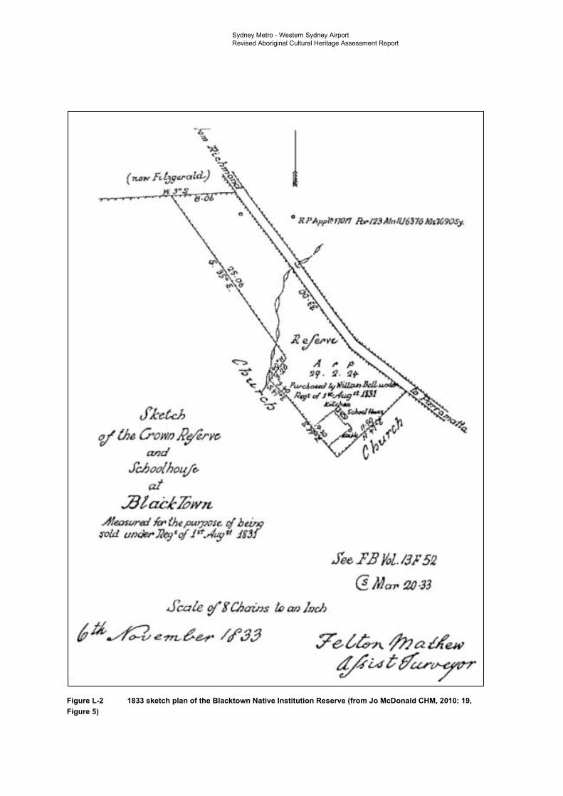
•· -· ----,--·.
11 , li' PAppr 17Uf'l .lbrM.JAlr,.llJ63~ M _'/Jfi9€JSy.
~ A~· .::· 'Pf/ • ,fJ • .
,- ~~a
~ .
'·
fee .J' .i J(al.l3J" 5!2
(l Ma11 !J0 -33
SCQle ~ !Chains !IJ an /1JdJ
6.ti ~ · m-hr /tf'.1.3 .7e~ ,f;;auf'_, . t[,4 iA ~ t/ar';J"'"
Sydney Metro - Western Sydney Airport Revised Aboriginal Cultural Heritage Assessment Report
Figure L-2 1833 sketch plan of the Blacktown Native Institution Reserve (from Jo McDonald CHM, 2010: 19, Figure 5)

Sydney Metro – Western Sydney Airport Aboriginal Archaeological Report
Apr
il 2021
Sydney Metro - Western Sydney Airport Aboriginal Archaeological Report
Sydney Metro – Western Sydney Airport Aboriginal Archaeological Report
April 2021
Client: Sydney Metro ABN: 12354063515
Prepared by M2A Level 25, 680 George Street, Sydney NSW 2000 ABN: 60 549 956 366
Sydney Metro - Western Sydney Airport Aboriginal Archaeological Report
Contents Glossary terms and abbreviations i Executive summary iv 1. Introduction 1
1.1 The proponent 2 1.2 Description of the project 2
1.2.1 Off-airport project components 3 1.2.2 On-airport project components 3 1.2.3 Project construction 6
1.3 The study area and construction footprint 6 1.4 Objectives of AAR 9 1.5 Report structure summary 9 1.6 Project team 9
2. Environmental context 10 2.1 Landscape context 10 2.2 Physical setting 10 2.3 Topography 10 2.4 Hydrology 10 2.5 Surface geology 11 2.6 Soil and geomorphology 11 2.7 Flora and fauna 12 2.8 Historical land use 14 2.9 Land disturbance 21 2.10 Key observations 21
3. Archaeological context 22 3.1 Regional archaeological context 22
3.1.1 The Sydney region 22 3.1.2 The Cumberland Plain 24 3.1.3 Open artefact sites: distribution, contents and definition 24 3.1.4 Flaked stone artefact technology 25 3.1.5 Chronology of occupation 27 3.1.6 Site distribution and occupation models 29
3.2 Local archaeological context 33 3.2.1 Off-airport local context 33 3.2.2 On-airport local context 52
3.3 Predictions 57 4. Archaeological survey 59
4.1 Aims and objectives 59 4.2 Survey strategy 59 4.3 Field team and methods 59
4.3.1 Site definition 60 4.3.2 Silcrete artefact identification 61 4.3.3 Stone artefact recording 61 4.3.4 Survey methodology 63
4.4 Survey results 68 4.4.1 Preliminary investigation results 68 4.4.2 Survey coverage and effective coverage 75 4.4.3 Discussion 75
5. Archaeological test excavation 77 5.1 Purpose, sampling strategy and methods 77 5.2 Testing results 77 5.3 Lithics 79 5.3 Analysis and discussion of results 81
6. Scientific significance assessment 82 6.1 Assessing values and significance 82 6.2 Scientific values (archaeological significance) 83
Sydney Metro - Western Sydney Airport Aboriginal Archaeological Report
6.3 Identified scientific values 84 7. Impact assessment 92
7.1 Summary of proposed impacts 92 7.2 Impacts to identified Aboriginal sites 93
7.2.1 Off-airport 93 7.2.2 Potential on-airport impacts 98
7.3 Summary 100 8. Cumulative impact assessment 101
8.1.1 Western Sydney International 101 8.1.2 Future M12 Motorway 101 8.1.3 The Northern Road Upgrade 101 8.1.4 Cumulative impacts 102
9. Recommendations 103 9.1 Approach to management and mitigation 103
10. References 104 Appendix A
Plates Appendix B
AHIMS search results Appendix C
AHIMS site card summaries Appendix D
Previous and current AHIPs Appendix E
Test pit descriptions
List of plates
Plate 1 Artefact at site WSI-AS1-20 73 Plate 2 Artefact at site WSI-IA1-20 73 Plate 3 View across site WSI-AS1-20 74 Plate 4 View across site WSI-IA1-20 74
List of figures
Figure 1-1 Project alignment and key features 4 Figure 1-2 Aboriginal archaeological assessment, reporting and management process
flowchart 5 Figure 1-3 Construction footprint overview 8 Figure 2-1 Excerpt from Dixon’s Map of the Colony of NSW, 1837 (source:
SLNSW/IE3742276). Approximate location of the project shown in red. Labels indicating holdings of Governor King and Colonel O’Connell are shown to the north of the project 14
Figure 2-2 Excerpt from Map of the County of Cumberland, NSW 1894 (HLRV/1562201.jp2). Approximate location of the St Marys Station and northern portions of the construction footprint shown in red 15
Figure 2-3 Excerpt from Map of the County of Cumberland, NSW 1894 (HLRV/1562201.jp2). Approximate location of the middle portion of the construction footprint shown in red 16
Figure 2-4 Excerpt from Map of the County of Cumberland, NSW 1894 (HLRV/1562201.jp2). Approximate location of the southern portion of the construction footprint shown in red 16
Figure 3-1 Construction footprint AHIMS sites and identified Aboriginal archaeological sensitivity 35
Figure 4-1 Transects and tests pits 64
Sydney Metro - Western Sydney Airport Aboriginal Archaeological Report
List of tables
Table 2-1 Development of land holdings within the construction footprint as depicted in parish maps 17
Table 3-1 McCarthy’s (1967) Eastern Regional Sequence (ESR) of stone artefact assemblages 23
Table 3-2 Aboriginal site distribution and occupation models for the Cumberland Plain 29 Table 3-3 AHIMS search results 39 Table 3-4 AHIMS sites within the off-airport construction footprint 39 Table 3-5 AHIMS sites within 200 metres of the off-airport construction footprint 40 Table 3-6 AHIMS sites requiring protective fencing 41 Table 3-7 Previous Aboriginal archaeological investigations 42 Table 3-8 AHIMS sites within the on-airport construction footprint 52 Table 3-9 AHIMS sites within 200 metres of the on-airport construction footprint 53 Table 3-10 Previous Aboriginal archaeological investigations 54 Table 4-1 Stone artefact attributes 61 Table 4-2 SMWSA-AS1 artefacts 68 Table 4-3 SMWSA-AS2 artefacts 70 Table 4-4 SMWSA-AS3 artefacts 71 Table 4-5 Ground Surface Visibility (GSV) Rating Scheme 75 Table 4-6 Ground Integrity (GI) Rating Scheme 75 Table 4-7 Archaeological Sensitivity Rating Scheme 75 Table 5-1 Lithics identified during test excavation 79 Table 6-1 Values relevant to determining cultural significance, as defined by The Burra
Charter (1999) 82 Table 6-2 Aboriginal archaeological sites within the off-airport construction footprint (CF) 85 Table 6-3 Scientific significance assessment for identified Aboriginal sites within the off-
airport construction footprint 86 Table 7-1 Impact Risk Rating Scheme 92 Table 7-2 Potential off-airport direct impacts summary 93 Table 7-3 On-airport direct impact summary 98
Sydney Metro - Western Sydney Airport Aboriginal Archaeological Report
i
Glossary terms and abbreviations Term Definition AAR Aboriginal Archaeological Report
Aboriginal archaeological sensitivity
Area retains potential for the presence of surface and/or subsurface Aboriginal archaeological deposits. Areas of Aboriginal archaeological sensitivity, when compared to areas of low potential, would be expected to have higher artefact counts, densities and assemblage richness values expected. Archaeological features such as knapping floors and hearths are also more likely to occur in these areas. The integrity of deposit(s) will be dependent on the nature of localised land disturbance activities and geomorphic phenomena.
Aboriginal cultural heritage The tangible (objects) and intangible (dreaming stories, song lines and places) cultural practices and traditions associated with past and present-day Aboriginal communities
Aboriginal object Any deposit, object or material evidence (not being a handicraft made for sale), including Aboriginal remains, relating to the Aboriginal habitation of NSW
Aboriginal place Any place declared to be an Aboriginal place under Section 94 of the National Parks and Wildlife Act 1974 (NSW)
ACHAR Aboriginal Cultural Heritage Assessment Report
ACHMP Aboriginal Cultural Heritage Management Plan
AEPR Airports (Environment Protection) Regulations 1997
AHD Australian Height Datum
AHIMS Aboriginal Heritage Information Management System - a register of New South Wales (NSW) Aboriginal heritage information maintained by Environment, Energy and Science (EES), which is a group within the NSW Department of Planning, Industry and Environment
AHIP Aboriginal Heritage Impact Permit
ASIR Aboriginal Site Impact Recording
ATSIHP Act Aboriginal and Torres Strait Islander Heritage Protection Act 1984
BP Before Present is a term used by archaeologists and geologists referring to dates obtained by radiocarbon dating. The “present” in this case is not the present day, which is constantly changing and therefore is unable to be used as a consistent point from which to measure. Instead the year 1950 was chosen to be used as the “present” for this term
CBD Central Business District
CEMF Construction Environmental Management Framework
CEMP Construction Environmental Management Plan
CHL Commonwealth Heritage List
CMA Catchment Management Authorities
CMP Conservation Management Plan

Sydney Metro - Western Sydney Airport Aboriginal Archaeological Report
ii
Term Definition construction footprint The total extent of land required for the construction of the
project, including ancillary facilities, services and land temporarily required for construction (incorporating construction elements such as compounds, access tracks and worksites)
CSSI Critical State Significant Infrastructure
DEOH Defence Establishment Orchard Hills
DPC Department of Premier and Cabinet
DPIE NSW Department of Planning, Industry and Environment. As of 1 July 2020 management of Aboriginal Cultural Heritage in NSW moved from DPIE to Heritage NSW in the Department of Premier and Cabinet (DPC)
earthworks All operations involved in loosening, excavating, placing, shaping and compacting soil or rock
EES Environment, Energy and Science, which is a division within the NSW Department of Planning, Industry and Environment (DPIE). As of 1 July 2020 management of Aboriginal Cultural Heritage in NSW moved from DPIE to Heritage NSW in the Department of Premier and Cabinet (DPC)
EP&A Act Environmental Planning and Assessment Act 1979
EPBC Act Environment Protection and Biodiversity Conservation Act 1999
EPI Environmental Planning Instruments
erosion A natural process where wind or water detaches a soil particle and provides energy to move the particle
floodplain An area of land which is inundated by floods up to and including the probable maximum flood event (i.e. flood prone land)
GPS Global Positioning System
GSV Ground Surface Visibility
heritage item Any place, building or object listed on a statutory heritage register
HHMP Historical Heritage Management Plans
HMP Heritage Management Plan
ILUA Indigenous Land Use Agreements
impact Influence or effect exerted by the project or other activity on the natural, built and community environment
LALC Local Aboriginal Land Council
LEP Local Environmental Plan
LGA Local Government Area
MLD Maximum linear dimension
NHL National Heritage List
NNTT National Native Title Tribunal
NPW Act National Parks and Wildlife Act 1974
NTA Native Title Act 1993
Sydney Metro - Western Sydney Airport Aboriginal Archaeological Report
iii
Term Definition OEH Office of Environment and Heritage
PAD Potential Archaeological Deposit
paleochannel Ancient river systems eroded deeply into the landscape and infilled with saturated alluvial sediments
RAP Registered Aboriginal Party
RNE Register of the National Estate
road reserve A legally defined area of land within which facilities such as roads, footpaths and associated features may be constructed for public travel
SEARs Secretary’s Environmental Assessment Requirements
SEPP SRD State Environmental Planning Policy (State and Regional Development) 2011
SSI State Significant Infrastructure
Sydney Metro - Western Sydney Airport (the project)
The Sydney Metro - Western Sydney Airport between St Marys and Western Sydney Aerotropolis comprises a new north-south metro railway around 23 kilometres in length, creating passenger rail access to Western Sydney Airport, the Aerotropolis and a connection with the T1 Western Line
Western Sydney Aerotropolis This includes the land surrounding Western Sydney International (including Bringelly, Luddenham, Kemps Creek, Badgerys Creek and Rossmore) where commercial and residential property development is proposed, supported by key infrastructure. This will include commercial and industrial precincts, and agricultural land, as well as transport corridors
Western Sydney Airport The Australian government-owned organisation responsible for delivering and operating Western Sydney International
Sydney Metro - Western Sydney Airport Aboriginal Archaeological Report
iv
Executive summary The Greater Sydney Region Plan (Greater Sydney Commission, 2018a) sets the vision and strategy for Greater Sydney to become a global metropolis of three unique and connected cities; the Eastern Harbour City, the Central River City and the Western Parkland City. The Western Parkland City incorporates the future Western Sydney International (Nancy-Bird Walton) Airport (hereafter referred to as Western Sydney International) and Western Sydney Aerotropolis (hereafter referred to as the Aerotropolis).
Sydney Metro – Western Sydney Airport (the project) is identified in the Greater Sydney Region Plan as a key element to delivering an integrated transport system for the Western Parkland City. The project would be located within the Penrith and Liverpool Local Government Areas (LGAs) and would involve the construction and operation of a new metro railway line around 23 kilometres in length between the T1 Western Line at St Marys in the north and the Aerotropolis in the south (the area to be called Bradfield). This would include a section of the alignment which passes through and provides access to Western Sydney International.
The project is characterised into components that are located outside Western Sydney International (off-airport) and components that are located within Western Sydney International (on-airport), to align with their different planning approval pathways required under State and Commonwealth legislation.
The project has been declared as a Critical State Significant Infrastructure (CSSI) project. In October 2020, M2A (a joint venture between WSP and AECOM Australia Pty Ltd) prepared an Aboriginal Cultural Heritage Assessment Report (ACHAR) for inclusion within the Environmental Impact Statement. The ACHAR reported the results of initial archaeological survey works undertaken for the project. Due to limited property access and COVID-19 related restrictions, a full program of archaeological survey and test excavation had been unable to occur prior to exhibition of the ACHAR and Environmental Impact Statement. Mitigation measures outlined in the ACHAR, therefore, included requirements for further survey, testing and Aboriginal community consultation as access to land parcels became available, with the intention that a revised ACHAR would be prepared and attached to the Submissions Report for the Project.
This Aboriginal Archaeological Report (AAR) also forms an appendix to the Submissions Report for the project. This document has been compiled in accordance with Requirement 11 of Heritage NSW’s Code of Practice for Archaeological Investigation of Aboriginal Objects in New South Wales (DECCW, 2010b) (Code of Practice). It is intended that this report be read in conjunction with the revised ACHAR. The purpose of this document is to provide details of the survey and text excavation undertaken to date and the results of these works in relation to identified sites and areas of Aboriginal archaeological potential.
The study area for the project was defined as a 58 kilometre by nine kilometre area, which was the subject of a series of Aboriginal Heritage Information Management System (AHIMS) searches to determine the presence/absence of previously recorded Aboriginal sites and to gain sub-regional Aboriginal site distribution data. The primary focus in relation to assessing likely direct impacts was on the construction footprint within the study area; which covers the total extent of land required for the construction of the project, including ancillary facilities and services and land temporarily required for construction (incorporating construction elements such as compounds, access tracks and construction footprint). A buffer of 200 metres surrounding the construction footprint has also been considered in relation to impacts, as there is a regular 200 metre error for centroid coordinates in the AHIMS register due to legacy data issues with changing datum use over time. Areas proposed for power line routes and surface areas above subsurface tunnels were also considered, with consideration given to the risk of impacts from ground movement or vibration in the above tunnel areas.
Searches of the AHIMS database for the study area resulted in the identification of a total of 360 Aboriginal sites, out of which 328 were valid, 30 had previously been destroyed and further investigation had identified that two were not of Aboriginal origin (reclassified Not a Site). Of the valid sites, a total of 10 were found to have centroids registered within the bounds of the construction footprint (eight on-airport and two off-airport) and a further two were found to have associated areas of Potential Archaeological Deposit (PAD) that extended partially into the off-airport construction footprint. Of the two with centroids located within the off-airport area, one was identified as having
Sydney Metro - Western Sydney Airport Aboriginal Archaeological Report
v
been destroyed under the conditions of an Aboriginal Heritage Impact Permit (AHIP). The other was a valid artefact scatter site (45-5-2640) located in the Aerotropolis Core construction footprint.
Surveys of accessible sections of the construction footprint were initially undertaken over four non-consecutive days in February, March, April and June 2020 (Thursday 27 February, Wednesday 4 March, Tuesday 28 April 2020 and Friday 12 June 2020). At this stage of the project, access was only available for limited sections of the construction footprint, due to private property access restrictions and COVID-19 constraints. In all instances, surveys were conducted by a combined field team of one M2A archaeologist and a representative from the relevant Local Aboriginal Land Council (LALC), being either Gandangara LALC and Deerubbin LALC.
Two new sites were identified during these initial field surveys, consisting of one isolated artefact and one artefact scatter. These were recorded as WSI-IA1-20 and WSI-AS1-20 respectively. Both sites were located outside the bounds of the construction footprint within the bounds of Western Sydney International. The location for previously recorded artefact scatter site 45-5-2640 was inspected at this time, but no surface expression of artefacts was identified, most likely due to high levels of vegetation obscuring the ground during the inspection.
Further access was provided to some of the properties within the off-airport construction footprint between October 2020 and February 2021. During this time these areas were subject to survey, with test excavations also undertaken in several areas of identified Aboriginal archaeological sensitivity. Participants from various RAP groups were in attendance for the fieldwork, including representatives from A1 Indigenous Services, Arugung Aboriginal Cultural Heritage Site Assessments, Corroboree Aboriginal Corporation, Cubbitch Barta, Darug Custodian Aboriginal Corporation, Deerubbin Local Aboriginal Land Council, DNC, Gandangara Local Aboriginal Land Council, Gunyuu, Kamilaroi Yankuntjatjara Working Group, Murra Bidgee Mullangari Aboriginal Corporation, Tocomwall, Wailwan Aboriginal Group and Walbunja.
Three surface sites, consisting exclusively of artefact scatters, were identified as a result of additional survey works within the study area. They were designated as SMWSA-AS1, SMWSA-AS5 and SMWSA-AS6. Two of these sites (SMWSA-AS1 and SMWSA-AS5) are located wholly outside the construction footprint (although SMWSA-AS1 is in a surface area above proposed subsurface tunnels). Site SMWSA-AS6 is located wholly inside of the construction footprint, in the off-airport construction corridor (southern).
Areas of subsurface Aboriginal archaeological potential within the construction footprint were determined based on the presence of surface sites, consultation with RAPs and identification of sensitive landforms (including areas of low disturbance in close proximity to water sources). Landform elements adjacent to Blaxland Creek, Cosgroves Creek and Badgerys Creek as well as several of their tributaries, were assessed as retaining potential for the presence of subsurface Aboriginal archaeologically deposits where they had not been subject to gross levels of past disturbance.
Due to generally low levels of visibility across identified areas of sensitivity within the construction boundary, systematic test excavations were undertaken in these areas. Test pits measuring 50 centimetres by 50 centimetres were excavated, across each area, with test pits spaced at 50 metre intervals. Between October 2020 and February 2021 a total of 196 test pits were excavated across identified areas of Aboriginal archaeological sensitivity. Of these, 22 test pits (11.2 per cent) were found to contain Aboriginal objects, with densities ranging from one to five objects per 0.25 metres squared. Collectively, a total of 42 lithic items were identified which satisfied the technical criteria for identification as artefacts.
Taking into account the results of all archaeological survey and test excavation works undertaken for the project up to and including February 2021, a total of 10 Aboriginal archaeological sites are recognised as being wholly within the off-airport section of the construction footprint, with two sites that have Potential Archaeological Deposits (PAD) curtilages partially extending into it. Identified sites consist of three valid previously recorded artefact scatter sites, being B22 (45-5-2640) BWB (45-5-5298) and CCE T3 (45-5-5297). Survey identified another artefact scatter site (SMWSA-AS6), while test excavation has identified five artefact scatters (SMWSA-AS2, SMWSA-AS3, SMWSA-AS4, SMWSA-AS7 and SMWSA-AS8) and three isolated artefact sites (SMWSA-IA1, SMWSA-IA2 and SMWSA-IA3) within the off-airport construction footprint.
Sydney Metro - Western Sydney Airport Aboriginal Archaeological Report
vi
An assessment of the scientific significance of all newly and previously recorded Aboriginal sites within the off-airport portion of the construction footprint has been carried out, with significance ratings offered on the basis of the assessed research potential, rarity and representativeness of each site on a local and regional scale. Of the 12 sites wholly or partially within the off-airport construction footprint, a total of eight sites have been assessed as having low scientific significance and four as having moderate scientific significance. No sites of high scientific significance have been identified within the off-airport construction footprint.
Proposed ground disturbance activities within the construction footprint are anticipated to impact all of the 12 Aboriginal archaeological sites identified within it, with a total loss of value for the 10 sites wholly within the off-airport construction corridor, and partial impacts to those two with PAD curtilages partially extending into it. There are also further areas of subsurface Aboriginal archaeological sensitivity that have not yet been subject to survey or test excavation due to landholder access limitations on the project to date.
Mitigation measures have been developed to manage potential impacts to the known and potential Aboriginal cultural heritage values of the study area. These mitigation measures are contained in full in the Revised ACHAR.
Sydney Metro - Western Sydney Airport Aboriginal Archaeological Report
1
1. Introduction The Greater Sydney Region Plan (Greater Sydney Commission, 2018a) sets the vision and strategy for Greater Sydney to become a global metropolis of three unique and connected cities; the Eastern Harbour City, the Central River City and the Western Parkland City. The Western Parkland City incorporates the future Western Sydney International (Nancy-Bird Walton) Airport (hereafter referred to as Western Sydney International) and Western Sydney Aerotropolis (hereafter referred to as the Aerotropolis).
Sydney Metro – Western Sydney Airport (the project) (see Figure 1-1) is identified in the Greater Sydney Region Plan as a key element to delivering an integrated transport system for the Western Parkland City. The project would be located within the Penrith and Liverpool Local Government Areas (LGAs) and would involve the construction and operation of a new metro railway line around 23 kilometres in length between the T1 Western Line at St Marys in the north and the Aerotropolis in the south (the area to be called Bradfield). This would include a section of the alignment which passes through and provides access to Western Sydney International.
The project is characterised into components that are located outside Western Sydney International (off-airport) and components that are located within Western Sydney International (on-airport), to align with their different planning approval pathways required under State and Commonwealth legislation.
The project has been declared as a Critical State Significant Infrastructure (CSSI) project. In October 2020, M2A (a joint venture between WSP and AECOM Australia Pty Ltd) prepared an Aboriginal Cultural Heritage Assessment Report (ACHAR) for inclusion within the Environmental Impact Statement (Sydney Metro, 2020). The ACHAR reported the results of initial archaeological survey works undertaken for the project. Due to limited property access and COVID-19 related restrictions, a full program of archaeological survey and testing had been unable to occur prior to exhibition of the ACHAR and Environmental Impact Statement. Mitigation measures outlined in the ACHAR, therefore, included requirements for further survey, testing and Aboriginal community consultation as access to land parcels became available, with the intention that a Revised ACHAR would be prepared and attached to the Submissions Report for the Project.
This Aboriginal Archaeological Report (AAR) has been compiled in accordance with Requirement 11 of Heritage NSW’s Code of Practice for Archaeological Investigation of Aboriginal Objects in New South Wales (DECCW, 2010b) (Code of Practice). It is intended that this report be read in conjunction with the Revised ACHAR. The purpose of this document is to provide details of the survey and text excavation undertaken to date and the results of these works in relation to identified sites and areas of Aboriginal archaeological potential. This document also updates and refines the known data and defined areas of Aboriginal archaeological sensitivity within the off-airport construction footprint, beyond what was possible for the earlier ACHAR prepared at the time of exhibition for the Environmental Impact Statement. Further consultation and fieldwork undertaken since then has enabled the development of further knowledge and has been taken into consideration in this report as well as the Revised ACHAR. Recommendations and mitigation measures have also been updated accordingly.
This report documents all archaeological field investigations undertaken for the project up to and including February 2021. An accompanying review of relevant environmental, archaeological and ethnohistorical information for the study area provides a framework for presenting and discussing the results of the archaeological fieldwork undertaken to date. Appropriate management measures have been developed as a result of the assessment results, which have defined the potential impacts of the proposed development on both known and potential Aboriginal archaeological resources and are included in full in the associated Revised ACHAR.
The draft of this AAR was provided to RAPs for comment on 17 February 2021. Ultimately, a total of 13 responses were received, although one of these was relevant for 42 RAPs operating under the Murrin Administrative Services. Twelve RAP respondents indicated that they supported the AAR, with no changes required. The thirteenth respondent provided comments on the documents but did not directly address this point. The responses received from the RAPs are summarised and provided in full in Appendix H of the Revised ACHAR.
Sydney Metro - Western Sydney Airport Aboriginal Archaeological Report
2
1.1 The proponent The proponent for this investigation is Sydney Metro, a registered Australian company (ABN: 12 354 063 515) based in Sydney, NSW.
1.2 Description of the project Key operational features of the project are shown on Figure 1-1 and would include:
• around 4.3 kilometres of twin rail tunnels (generally located side by side) between St Marys (the northern extent of the project) and Orchard Hills
• a cut-and-cover tunnel around 350 metres long (including tunnel portal), transitioning to an in-cutting rail alignment south of the M4 Western Motorway at Orchard Hills
• around 10 kilometres of rail alignment between Orchard Hills and Western Sydney International, consisting of a combination of viaduct and surface rail alignment
• around two kilometres of surface rail alignment within Western Sydney International
• around 3.3 kilometres of twin rail tunnels (including tunnel portal) within Western Sydney International
• around three kilometres of twin rail tunnels between Western Sydney International and the Aerotropolis Core (the area to be called Bradfield)
• six new metro stations:
- four off-airport stations:
St Marys (providing interchange with the T1 Western Line)
Orchard Hills
Luddenham Road
Aerotropolis Core
- two on-airport stations:
Airport Business Park
Airport Terminal
• grade separation of the track alignment at key locations including:
- where the alignment interfaces with existing infrastructure such as the Great Western Highway, M4 Western Motorway, Lansdowne Road, Patons Lane, the Warragamba to Prospect Water Supply Pipelines, Luddenham Road, the future M12 Motorway, Elizabeth Drive, Derwent Road and Badgerys Creek Road
- crossings of Blaxland Creek, Cosgroves Creek, Badgerys Creek and other small waterways to provide flood immunity for the project
• modifications to the existing Sydney Trains station and suburban rail network at St Marys (where required) to support interchange and customer transfer between the new metro station and the T1 Western Line
• a stabling and maintenance facility and operational control centre located to the south of Blaxland Creek and east of the proposed metro track
• new pedestrian, cycle, park-and-ride and kiss-and-ride facilities, public transport interchange infrastructure, road infrastructure and landscaping as part of the station precincts.
The project would also include:
• turnback track arrangements (turnbacks) at St Marys and Aerotropolis Core to allow trains to turn back and run in the opposite direction
Sydney Metro - Western Sydney Airport Aboriginal Archaeological Report
3
• additional track stubs to the east of St Marys Station and south of the Aerotropolis Core Station to allow for potential future extension of the line to the north and south respectively without impacting future metro operations
• an integrated tunnel ventilation system including services facilities at Claremont Meadows and at Bringelly
• all operational systems and infrastructure such as crossovers, rail sidings, signalling, communications, overhead wiring, power supply, lighting, fencing, security and access tracks/paths
• retaining walls at required locations along the alignment
• environmental protection measures such as noise barriers (if required), on-site water detention, water quality treatment basins and other drainage works.
1.2.1 Off-airport project components The off-airport components of the project would include the track alignment and associated operational systems and infrastructure north and south of Western Sydney International, four metro stations, the stabling and maintenance facility, two service facilities and a tunnel portal.
The key project features and the design development process are described in more detail in Appendix B of the Submissions Report.
1.2.2 On-airport project components The on-airport components of the project would include the track alignment and associated operational systems and infrastructure within Western Sydney International, two metro stations and a tunnel portal.
.
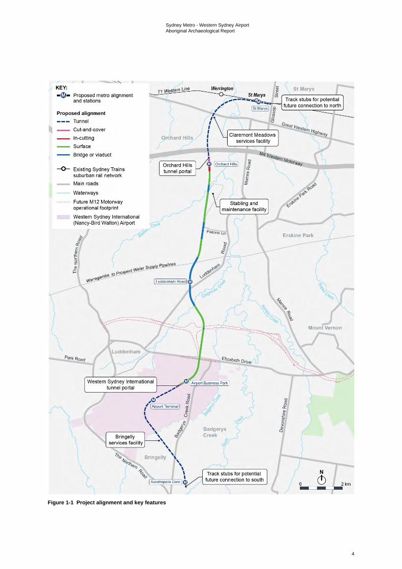
Sydney Metro - Western Sydney Airport Aboriginal Archaeological Report
4
Figure 1-1 Project alignment and key features
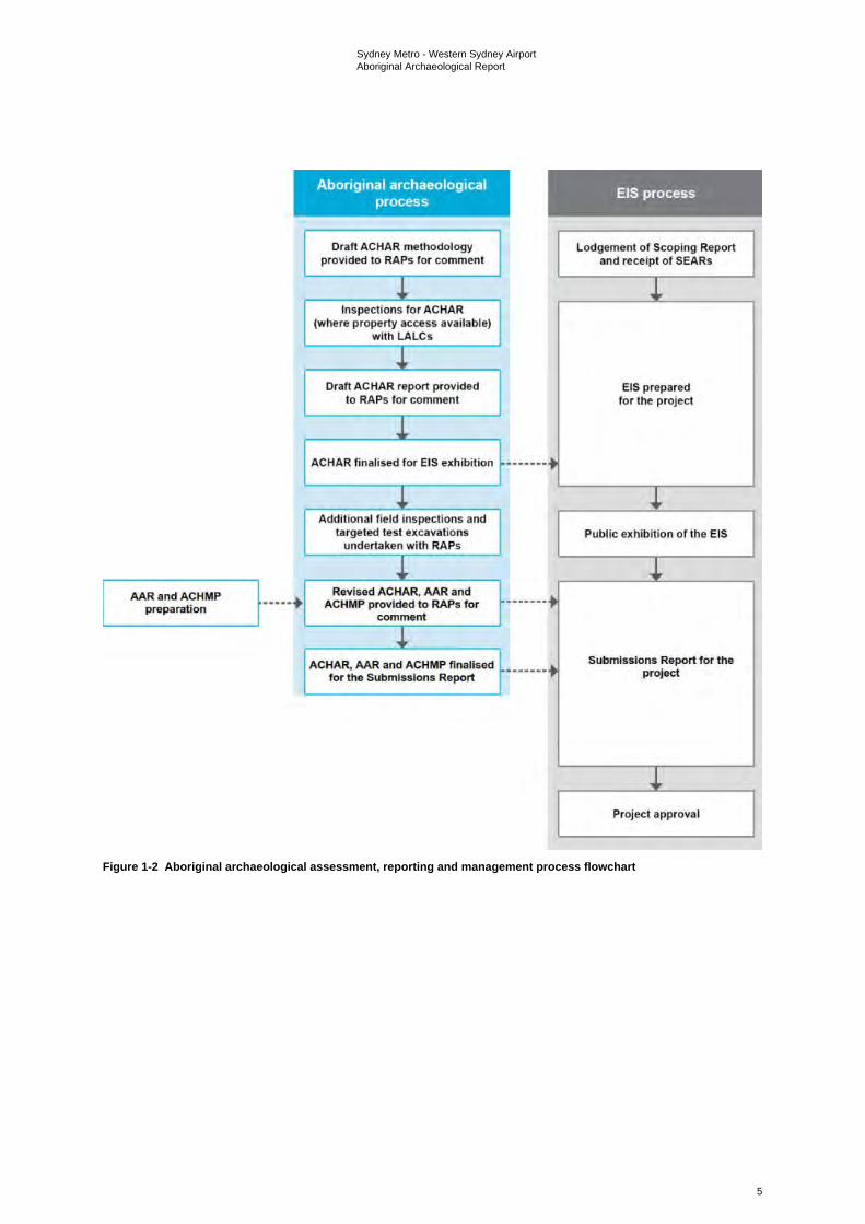
Sydney Metro - Western Sydney Airport Aboriginal Archaeological Report
5
Figure 1-2 Aboriginal archaeological assessment, reporting and management process flowchart
Sydney Metro - Western Sydney Airport Aboriginal Archaeological Report
6
1.2.3 Project construction Construction of the project would involve:
• enabling works
• main construction works, including:
- tunnelling and associated works
- corridor and associated works
- stations and associated works
- ancillary facilities and associated works
- construction of ancillary infrastructure including the stabling and maintenance facility
• rail systems fitout
• finishing works and testing and commissioning.
These activities are described in more detail in Appendix B of the Submissions Report.
The construction footprint for the project is shown on Figure 1-3.
Main construction works for the project are expected to commence in 2021, subject to planning approval, and take around five years to complete. An overview of the construction program is provided in Appendix B of the Submissions Report.
1.3 The study area and construction footprint Details of the wider assessment undertaken for this project are included in the Revised ACHAR. As the technical report referring specifically to the archaeological investigations, this AAR contains details of the research undertaken to investigate previously recorded AHIMS in relation to the study area and construction footprint.
The size of the study area was defined by the AHIMS searches undertaken for this assessment. The three combined searches covered an approximate area of 58 kilometres by nine kilometres, centred on the construction footprint. References to the study area refer this area covered by the AHIMS searches, which includes the construction footprint as well as the permanent power supply alignment that is proposed between the southern end of the stabling and maintenance facility construction area and an existing Endeavour Energy substation at Erskine Park (the Mamre Zone Substation) and the temporary power supply alignments that are proposed from Claremont Meadows and Kemps Creek.
While the primary impacts of this project would be direct impacts to known sites and areas of archaeological sensitivity within the bounds of the construction footprint, the larger study area provides context for those sites and areas in the surrounding region. It also allows for considerations of the project within a broader landscape. The risks for accidental and indirect impacts to sites outside the bounds of, but in close proximity to, the construction footprint were considered as part of the assessment for sites within 200 metres of the construction footprint. The reason for a 200 metre buffer is that the most common form of coordinate inaccuracy in the AHIMS register is due to the incorrect datum being applied to a site coordinate, which results in a variance of approximately 200 metres. Including a buffer of this size will capture any sites with such coordinate errors, as well as sites whose registered centroids are outside the construction footprint but are large enough to extend across the boundary. The potential for indirect impacts to occur, such as visual and related to vibration/settlement, have also been considered. The primary risk with regard to indirect impacts is that any subsidence in areas above tunnelling activity could impact upon either known sites or areas of archaeological sensitivity.
The construction footprint is defined by the boundary shown on Figure 1-3. The construction footprint crosses through multiple land holdings within the Penrith and Liverpool Local Government Areas (LGAs), including existing road reserves and various parcels of private land. It also passes through three areas of Commonwealth land, being Defence Establishment Orchard Hills (DEOH), the Royal Australian Air Force Telecommunications Unit at Bringelly and Western Sydney International.
Sydney Metro - Western Sydney Airport Aboriginal Archaeological Report
7
For ease of reference in this assessment, the off-airport area has been divided up into the following construction areas:
• St Marys
• Claremont Meadows services facility
• Orchard Hills
• Stabling and maintenance facility
• Off-airport construction corridor
• Luddenham Road
• Bringelly services facility
• Aerotropolis Core.
For ease of reference in this assessment, the on-airport area has been divided up into the following construction areas:
On-airport (within the Stage 1 construction impact zone)
• On-airport construction corridor
• Airport Business Park
• Western Sydney International tunnel portal
• Airport terminal
• Airport construction support site
On-airport (outside the Stage 1 construction impact zone)
• Airport construction support site.

Sydney Metro - Western Sydney Airport Aboriginal Archaeological Report
9
1.4 Objectives of AAR This AAR is technical report prepared as a result of undertaking archaeological investigations, as per the Code of Practice for Archaeological Investigation of Aboriginal Objects in NSW (NSW Department of Environment Climate Change & Water, 2010). While the Revised ACHAR is a written report documenting the process of investigation, consultation and assessment, the AAR is written to provide in detail the archaeological investigations and the technical results of the survey and test excavation investigations. The purpose of this document is to provide details of the survey and text excavation undertaken to date and the results of these works in relation to identified sites and areas of Aboriginal archaeological potential.
Please note there is some repetition of content between the Revised ACHAR and AAR. This is to meet the format and content requirements of each as stand-alone reports.
1.5 Report structure summary This report is structured under the following headings:
1 Introduction – this section, has provided an overview and background context on the project, including the legislative and statutory controls of relevance to the assessment
2 Environmental Context – provides a description the existing environment of the study area and its associated archaeological implications, including a basic summary of the landscape and its implications for Aboriginal sites
3 Archaeological Context – provides a summary of the regional and local archaeological context of the project
4 Archaeological survey – presents the findings of the preliminary field inspections and subsequent archaeological surveys undertaken for the project
5 Archaeological test excavation – presents the findings of the archaeological test excavation program
6 Scientific significance assessment – outlines the identified scientific values and heritage significance of sites identified within the off-airport construction footprint
7 Impact assessment – lists the areas of archaeological potential, and the potential impacts of the project on Aboriginal heritage, including a cumulative impact assessment
8 Cumulative Impact Assessment – outlines the cumulative impact of development across the broader region on known and potential Aboriginal sites and values
9 Recommendations – provides an overview of the management and mitigation approach for the project
10 References – provides a full list of the references used to inform this technical paper.
1.6 Project team The primary author of this report is Dr Darran Jordan (Principal Archaeologist), who has a PhD in archaeology from the University of Sydney and has been working as a heritage specialist for over 15 years. Report inputs and fieldwork activity were also undertaken by Dr Andrew McLaren (Principal Archaeologist), Geordie Oakes (Principal Archaeologist), Luke Wolfe (Senior Archaeologist) and Julia Atkinson (Professional Archaeologist).
Sydney Metro - Western Sydney Airport Aboriginal Archaeological Report
10
2. Environmental context
2.1 Landscape context The nature and distribution of Aboriginal archaeological sites is closely linked to the environments in which they occur. Environmental variables such as topography, geology, hydrology and vegetation will have played a critical role in influencing how Aboriginal people moved within and utilised their respective Country. Amongst other things, these variables affected the availability of suitable campsites, drinking water, plant and animal resources and raw materials for the production of stone and organic implements. Accordingly, any attempt to predict or interpret the character and distribution of Aboriginal sites in a given landscape must take such environmental factors into account. At the same time, an assessment of historic land use activities and geomorphic processes, both contemporary and historic, allows predictions to be made concerning the survival, visibility and integrity of any existing Aboriginal archaeological materials.
2.2 Physical setting The project is located approximately 40 kilometres west of the Sydney Central Business District (CBD), between the suburbs of St Marys and Bringelly and within the Penrith and Liverpool LGAs. The project comprises a predominately linear stretch of land, aligned roughly north to south, approximately 23 kilometres in length. The total construction footprint (approximately 439 hectares (ha)), encompasses a small complex at the existing St Marys Station and a larger, mostly continuous portion located between the Great Western Highway and the intersection of Badgerys Creek Road with the Northern Road, just south of Western Sydney International.
Most of the study area is flat to gently undulating land, with floodplains, gentle slopes and rises. A large portion of the area has been cleared for past pastoral activities and is dominated by pasture grasslands. Portions of the study area (particularly at its northern extent) have been more heavily developed for residential and commercial purposes. Roadways run through the study area, connecting the various parts of the landscape. Extant connections of the deeper past are present in the form of waterways that cross the study area in multiple places. Although the waterways are indicative of the landscape of the past it is important to note that due to meandering, over time the routes may have changed with the present alignments not necessarily reflecting one consistent route throughout the history of this area. Similarly, increased erosion caused by clearing and development is likely to have channelised the waterways, which may have been shallower and broader or consisted of chains of ponds in the past.
2.3 Topography The topography of the construction footprint is typical of Bannerman and Hazelton’s (1990) Cumberland Lowlands physiographic region and can be broadly characterised as flat to undulating, with floodplains, ridges and flat topped terraces dissected by the drainage depressions of larger watercourses and their tributaries. Landforms within the construction footprint are dominated by undulating slopes and crests, with higher and steeper terrain rising gradually in the south. Elevations within the construction footprint average at approximately 57 metres Australian Height Datum (AHD) but range from low-lying alluvial flats of 26 metres AHD surrounding the Badgerys Creek and Blaxland Creek stream channels, to moderately inclined mid and upper slopes further from larger watercourses. The highest point within the construction footprint consists of a crest in the far southwest, with an elevation of 94 metres AHD.
2.4 Hydrology The project is located within the South Creek catchment – defined by a network of tributaries that originate in the higher terrain south of Catherine Field and combine into larger and more permanent waterways as they drain north towards Windsor. South Creek is a dominant feature of the catchment and is located as a perennial fourth order stream between 200 metres and two kilometres east of the project for the majority of the alignment. Tributaries of South Creek cross through the project at multiple points. These include various ephemeral streams throughout the construction footprint such
Sydney Metro - Western Sydney Airport Aboriginal Archaeological Report
11
as Cosgroves Creek and the higher order perennial streams of Badgerys Creek in the south and Blaxland Creek in the north, at a point just southwest of its confluence with South Creek.
Historic land use practices such as damming, vegetation clearance and flood-mitigating construction across the construction footprint have affected natural stream flows. As such, modern stream alignments may not fully represent the locations and extents of waterways that existed during periods of Aboriginal occupation. However, the Quaternary surface geology underlying the major streams and floodplains within the construction footprint suggests South Creek and its larger tributaries have not substantially deviated from their current alignments since at least the Pleistocene era.
The implications of this hydrology are that sections of the construction footprint would have contained sufficient freshwater to support the year-round and/or repeated activities of past Aboriginal groups, while other portions further from reliable streams may have only been utilised infrequently, or opportunistically. As such, there is potential for higher densities of archaeological material associated with the sections of the construction footprint in close proximity to South Creek, Badgerys Creek and Blaxland Creek. Sensitivity has been assessed across multiple landforms for the study area, taking into consideration not only proximity to water, but also the presence of other previously recorded sites, past disturbance and any other cultural features shared during consultation.
2.5 Surface geology Reference to the 1:100,000 Geological Series Sheet for Penrith (9030) (Clark & Jones, 1991) indicates that the surface geology of the construction footprint comprises a mixture of Middle Triassic Bringelly Shale (Rwb) and Quaternary Alluvium (Qal), with a small section of Tertiary St Marys Formation (Ts) located to the far north.
Bringelly Shale is strongly associated with the presence of undulating hills in the region and mantles most of the construction footprint, closely corresponding with the observed topography. Bringelly Shale, deposited in a swampy alluvial plain, is the uppermost formation of the Wianamatta Group and consists of shale, carbonaceous claystone, laminate, fine to medium-grained lithic sandstone, rare coal and tuff (Clark & Jones, 1991).
Quaternary Alluvium (Qal), characterised by quartz and lithic “fluvial” sand, silt and clay, extends in roughly southwest to northeast running bands across sections of the construction footprint that cross major streams (Clark & Jones, 1991). Quaternary Alluvium is closely associated with perennial waterways and floodplains within the region of the project and is of potential Aboriginal archaeological significance as a primary source of raw stone materials. Exposed silcrete boulders have been observed along the eastern bank of South Creek in the vicinity of the construction footprint to the north of Elizabeth Drive (AAJV, 2019:109).
St Marys Formation (Ts) extends into the far eastern side of the existing St Marys Station portion of the construction footprint and is characterised by laterised sand and clay with ferricrete bands containing silcrete, sandstone and shale boulders (Clark & Jones, 1991). This formation has been investigated at the nearby Plumpton Ridge (approximately seven kilometres northeast of the construction footprint) and found to contain quarry sites, with extensive evidence of silcrete extraction and preparation (Kelleher Nightingale Consulting Pty Ltd, 2009; National Heritage Studies Pty Ltd, 1990).
2.6 Soil and geomorphology Soils within the construction footprint have been mapped by Bannerman and Hazelton (2011) as belonging to two distinct soil landscapes: Residual Blacktown (REbt) and Alluvial South Creek (ALsc) (Bannerman & Hazelton, 2011).
Blacktown soils are associated with the slopes and underlying Bringelly Shale and occur across most of the construction footprint. They have been characterised by Bannerman and Hazelton (2011) as shallow to moderately deep, hardsetting mottled texture contrast soils, with red and brown podzolic soils on crests, which grade into yellow podzolic soils on lower slopes and in drainage lines. Blacktown subsoils are moderately to highly erodible where organic matter is low; however, topsoils vary between low and moderately erodible, as fine sand and silt contents are balanced by the presence of moderate
Sydney Metro - Western Sydney Airport Aboriginal Archaeological Report
12
levels of dense organic matter. Consequently, the majority of the construction footprint has moderate potential for containing archaeological material; however, in situ material is unlikely due to erosion.
South Creek soils follow the underlying Quaternary geology across the floodplains and flats of the construction footprint. They have been characterised by Bannerman and Hazelton (2011) as deeply layered sediments over bedrock or relict soils. Where soil deposition has occurred, structured clays or loams are immediately adjacent to drainage lines, with red and yellow podzolic soils on terraces, in addition to small areas of structured grey clays, leached clay and yellow solodic soils. The soils are subject to seasonal waterlogging and have permanently high water tables. The dynamic nature of the soil landscape can encourage both high levels of erosion and deposition. As such, artefacts may be buried at depth, or removed from their original contexts. The acidity of both soil types is of potential import archaeologically, as organic materials are vulnerable to decomposition in soils of high pH (Matthiesen, 2004). If skeletal remains or shells were present at the site in the past, it is unlikely that they would survive in the archaeological record today.
As in other parts of the Cumberland Plain, existing archaeological, environmental and historic reference materials suggest that a range of geomorphic processes are likely to have affected the Aboriginal archaeological record of the site. Potentially significant phenomena from an archaeological perspective include bioturbation, erosion and alluvial/colluvial aggradation. Possible effects of these processes include:
• increased archaeological site visibility in eroded areas
• reduced archaeological site visibility in areas of sediment deposition
• horizontal and vertical translocation of artefacts
• stratigraphic mixing
• truncation of archaeological deposits
• creation of thicker and potentially stratified archaeological deposits in floodplain and slope base contexts.
2.7 Flora and fauna Contemporary flora and fauna have both been assessed separately in the Revised Biodiversity Development Assessment Report (Appendix G of the Submissions Report). The results of that study found that there are currently five plant community types within the study area, being:
• Broad-leaved Ironbark - Grey Box - Melaleuca decora grassy open forest on clay/gravel soils of the Cumberland Plain, Sydney Basin Bioregion
• Forest Red Gum - Rough-barked Apple Grassy Woodland on Alluvial Flats of the Cumberland Plain, Sydney Basin Bioregion
• Grey Box - Forest Red Gum Grassy Woodland on Flats of the Cumberland Plain, Sydney Basin Bioregion
• Phragmites australis and Typha orientalis Coastal Freshwater Wetlands of the Sydney Basin Bioregion
• Swamp Oak Open Forest on River flats of the Cumberland Plain and Hunter Valley.
Five threatened ecological communities were also identified in the study area, being:
• Cumberland Plain Woodland in the Sydney Basin Bioregion
• River-Flat Eucalypt Forest on Coastal Floodplains of the New South Wales North Coast, Sydney Basin and South East Corner Bioregions
• Shale Gravel Transition Forest in the Sydney Basin Bioregion
• Swamp Oak Floodplain Forest of the New South Wales North Coast, Sydney Basin and South East Corner Bioregions
Sydney Metro - Western Sydney Airport Aboriginal Archaeological Report
13
• Freshwater Wetlands on Coastal Floodplains of the New South Wales North Coast, Sydney Basin and South East Corner Bioregions.
The report also predicted fauna species likely to occur based on vegetation surrogates and landscape features, with a range of amphibians, reptiles, mammals and birds listed as likely to occur within the study area.
It is important to note that while the current flora and fauna species may be indicative of likely past conditions, they are not necessarily representative of the same resources that would have been available to Aboriginal people in this area in the past (not discounting that they may still have cultural significance for contemporary communities as examples of cultural resources). Native vegetation within the construction footprint has been heavily modified as a result of historic land clearance activities, with the majority cleared historically for grazing and/or cropping. With reference to Tozer’s (2003) survey of native vegetation across the Cumberland Plain, the available evidence suggests that the construction footprint is likely to once have contained more widespread Shale Plains Woodland vegetation communities, with Alluvial Woodland along waterways and Shale Hills Woodland in the higher terrain to the south.
Shale Plains Woodland is the most widely distributed community on the Cumberland Plain (Tozer, 2003: 36). It is typically dominated by Grey Box (Eucalyptus moluccana) and Forest Red Gum (E. tereticornis), with Narrow-leafed Ironbark (E. crebra), Thin-leafed Stringybark (E. eugenioides) and Spotted Gum (Corymbia maculata) also occurring, though less frequently. A shrub stratum dominated by Blackthorn (Bursaria spinosa) is usually also present. Common ground stratum species for this vegetation community include Kidney Weed (Dichondra repens), Threeawn Speargrass (Aristida vagans), Weeping Grass (Microlaena stipoides), Kangaroo Grass (Themeda australis), Brunoniella (Brunoniella australis), Tender Tick-trefoil (Desmodium varians), Thin Leaf Stink Weed (Opercularia diphylla), Blue Bell (Wahlenbergia gracilis) and Shorthair Plumegrass (Dichelachnemicrantha).
Alluvial Woodland is most often dominated by Cabbage Gum (E. amplifolia) and Swamp Oak (Casuarina glauca) with Apple Box (Angophora floribunda) occurring less frequently (EcoLogical Australia, 2011; Tozer, 2003:32). A shrub stratum is usually evident though is often sparse and dominated by Blackthorn (Bursaria spinosa). A dense ground cover of grasses such as Basket-grass (Oplismenus aemulus), Weeping grass (Microlaena stipoides), Bordered Panic (Entolasia marginata) and Forest Hedgehog Grass (Echinopogon ovatus) is also typical as is the presence of herb species such as Forest Nightshade (Solanum prinophyllum), Whiteroot (Pratia purpurascens) and Native Wandering Jew (Commelina cyanea). Alluvial Plain Woodland is typically associated with minor watercourses draining soils derived from Wianamatta Group shales.
Shale Hills Woodland is similar to Shale Plains Woodland; however, it is predominately found at higher elevations and on steeper slopes in more rugged terrain (Tozer, 2003:35). The community is dominated by Grey Box (E. moluccana) and Forest Red Gum (E. tereticornis), with fewer instances of Narrow-leafed Ironbark (E. crebra). A small tree stratum of Hickory Wattle (Acacia implexa) and other Eucalyptus species is common. Shrub stratums consist of Sweet Bursaria (Bursaria spinosa), with rarer instances of Sickle-leafed Wattle (A. falcata), Coffee Bush (Breynia oblongifolia), Australian Indigo (Indigofera australia) and Sticky Hop Bush (Dodonaea viscosa cuneata). Ground cover varies, with dense grass and herb cover in areas of open canopy, but sparse groundcover where shrub canopies are closed.
As was noted in the Revised Biodiversity Development Assessment Report, recorded vegetation communities within the construction footprint and surrounding the project provided suitable habitat for a range of fauna types including amphibians, reptiles, mammals (both terrestrial and arboreal) and birds. Local watercourses supported a diverse range of aquatic fauna (Sydney Metro, 2020). Faunal resources that are known or are likely to have been exploited by Aboriginal people occupying the southern extent of the Cumberland Plain, which incorporates the current construction footprint, include freshwater fish, eels, shellfish, molluscs, crustacea, snakes, fruit bats, lizards, bandicoots, possums, gliders, kangaroos, wallabies, birds, insects and grubs (Attenbrow, 2010: 69-76).
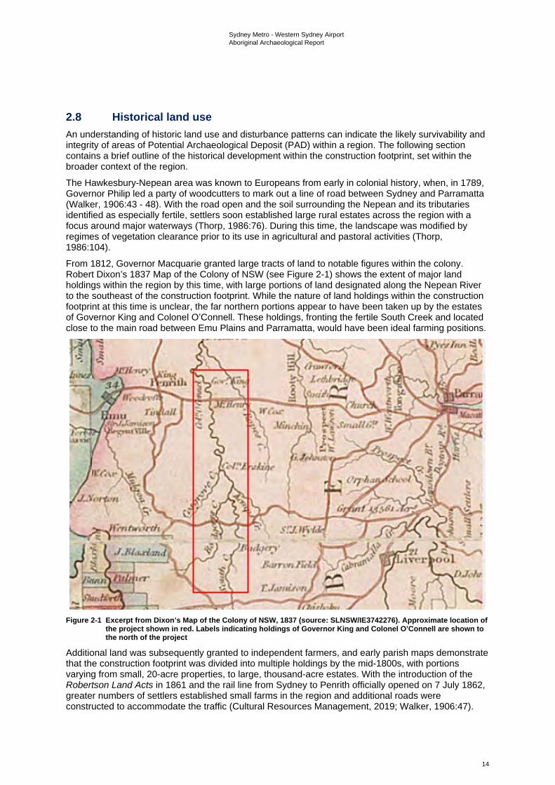
Sydney Metro - Western Sydney Airport Aboriginal Archaeological Report
14
2.8 Historical land use An understanding of historic land use and disturbance patterns can indicate the likely survivability and integrity of areas of Potential Archaeological Deposit (PAD) within a region. The following section contains a brief outline of the historical development within the construction footprint, set within the broader context of the region.
The Hawkesbury-Nepean area was known to Europeans from early in colonial history, when, in 1789, Governor Philip led a party of woodcutters to mark out a line of road between Sydney and Parramatta (Walker, 1906:43 - 48). With the road open and the soil surrounding the Nepean and its tributaries identified as especially fertile, settlers soon established large rural estates across the region with a focus around major waterways (Thorp, 1986:76). During this time, the landscape was modified by regimes of vegetation clearance prior to its use in agricultural and pastoral activities (Thorp, 1986:104).
From 1812, Governor Macquarie granted large tracts of land to notable figures within the colony. Robert Dixon’s 1837 Map of the Colony of NSW (see Figure 2-1) shows the extent of major land holdings within the region by this time, with large portions of land designated along the Nepean River to the southeast of the construction footprint. While the nature of land holdings within the construction footprint at this time is unclear, the far northern portions appear to have been taken up by the estates of Governor King and Colonel O’Connell. These holdings, fronting the fertile South Creek and located close to the main road between Emu Plains and Parramatta, would have been ideal farming positions.
Figure 2-1 Excerpt from Dixon’s Map of the Colony of NSW, 1837 (source: SLNSW/IE3742276). Approximate location of
the project shown in red. Labels indicating holdings of Governor King and Colonel O’Connell are shown to the north of the project
Additional land was subsequently granted to independent farmers, and early parish maps demonstrate that the construction footprint was divided into multiple holdings by the mid-1800s, with portions varying from small, 20-acre properties, to large, thousand-acre estates. With the introduction of the Robertson Land Acts in 1861 and the rail line from Sydney to Penrith officially opened on 7 July 1862, greater numbers of settlers established small farms in the region and additional roads were constructed to accommodate the traffic (Cultural Resources Management, 2019; Walker, 1906:47).
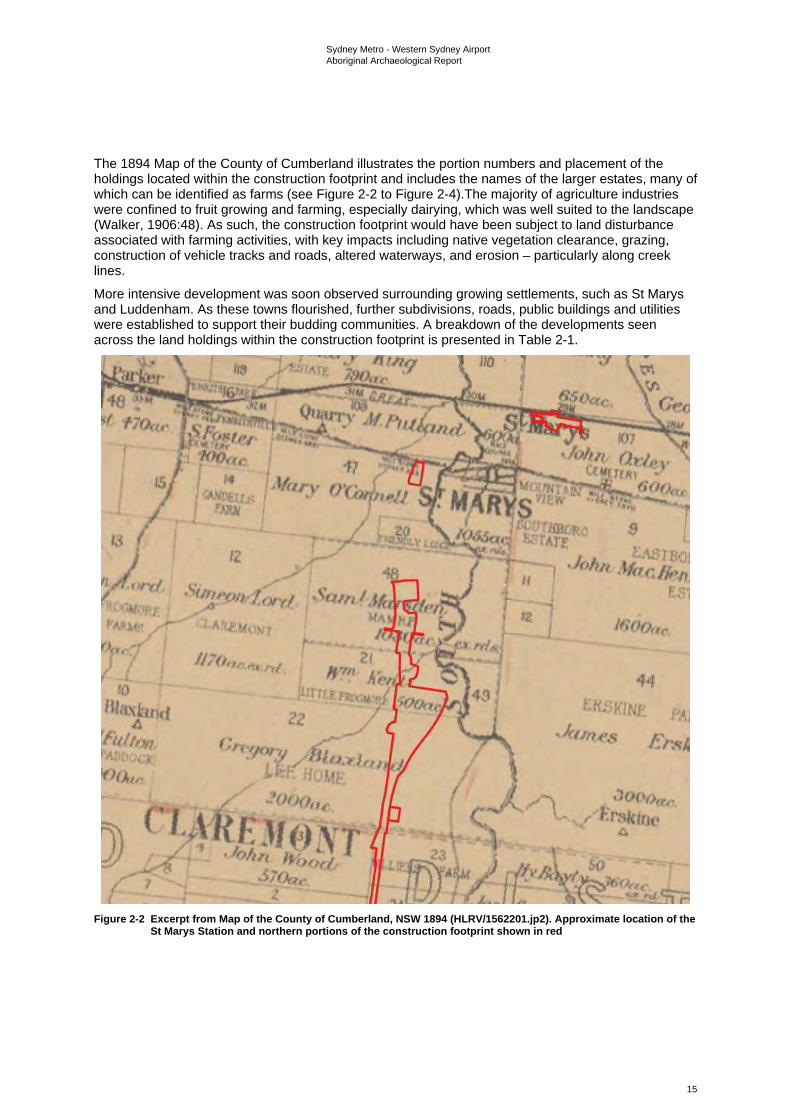
Sydney Metro - Western Sydney Airport Aboriginal Archaeological Report
15
The 1894 Map of the County of Cumberland illustrates the portion numbers and placement of the holdings located within the construction footprint and includes the names of the larger estates, many of which can be identified as farms (see Figure 2-2 to Figure 2-4).The majority of agriculture industries were confined to fruit growing and farming, especially dairying, which was well suited to the landscape (Walker, 1906:48). As such, the construction footprint would have been subject to land disturbance associated with farming activities, with key impacts including native vegetation clearance, grazing, construction of vehicle tracks and roads, altered waterways, and erosion – particularly along creek lines.
More intensive development was soon observed surrounding growing settlements, such as St Marys and Luddenham. As these towns flourished, further subdivisions, roads, public buildings and utilities were established to support their budding communities. A breakdown of the developments seen across the land holdings within the construction footprint is presented in Table 2-1.
Figure 2-2 Excerpt from Map of the County of Cumberland, NSW 1894 (HLRV/1562201.jp2). Approximate location of the
St Marys Station and northern portions of the construction footprint shown in red
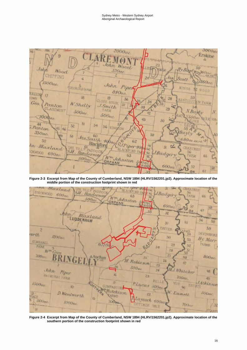
Sydney Metro - Western Sydney Airport Aboriginal Archaeological Report
16
Figure 2-3 Excerpt from Map of the County of Cumberland, NSW 1894 (HLRV/1562201.jp2). Approximate location of the
middle portion of the construction footprint shown in red
Figure 2-4 Excerpt from Map of the County of Cumberland, NSW 1894 (HLRV/1562201.jp2). Approximate location of the
southern portion of the construction footprint shown in red
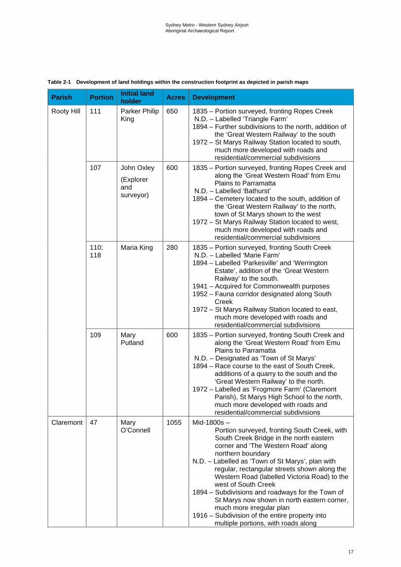
Sydney Metro - Western Sydney Airport Aboriginal Archaeological Report
17
Table 2-1 Development of land holdings within the construction footprint as depicted in parish maps
Parish Portion Initial land holder Acres Development
Rooty Hill 111 Parker Philip King
650 1835 – Portion surveyed, fronting Ropes Creek N.D. – Labelled ‘Triangle Farm’ 1894 – Further subdivisions to the north, addition of
the ‘Great Western Railway’ to the south 1972 – St Marys Railway Station located to south,
much more developed with roads and residential/commercial subdivisions
107 John Oxley
(Explorer and surveyor)
600 1835 – Portion surveyed, fronting Ropes Creek and along the ‘Great Western Road’ from Emu Plains to Parramatta
N.D. – Labelled ‘Bathurst’ 1894 – Cemetery located to the south, addition of
the ‘Great Western Railway’ to the north, town of St Marys shown to the west
1972 – St Marys Railway Station located to west, much more developed with roads and residential/commercial subdivisions
110; 118
Maria King 280 1835 – Portion surveyed, fronting South Creek N.D. – Labelled ‘Marie Farm’ 1894 – Labelled ‘Parkesville’ and ‘Werrington
Estate’, addition of the ‘Great Western Railway’ to the south.
1941 – Acquired for Commonwealth purposes 1952 – Fauna corridor designated along South
Creek 1972 – St Marys Railway Station located to east,
much more developed with roads and residential/commercial subdivisions
109 Mary Putland
600 1835 – Portion surveyed, fronting South Creek and along the ‘Great Western Road’ from Emu Plains to Parramatta
N.D. – Designated as ‘Town of St Marys’ 1894 – Race course to the east of South Creek,
additions of a quarry to the south and the ‘Great Western Railway’ to the north.
1972 – Labelled as ‘Frogmore Farm’ (Claremont Parish), St Marys High School to the north, much more developed with roads and residential/commercial subdivisions
Claremont 47 Mary O’Connell
1055 Mid-1800s – Portion surveyed, fronting South Creek, with South Creek Bridge in the north eastern corner and ‘The Western Road’ along northern boundary
N.D. – Labelled as ‘Town of St Marys’, plan with regular, rectangular streets shown along the Western Road (labelled Victoria Road) to the west of South Creek
1894 – Subdivisions and roadways for the Town of St Marys now shown in north eastern corner, much more irregular plan
1916 – Subdivision of the entire property into multiple portions, with roads along
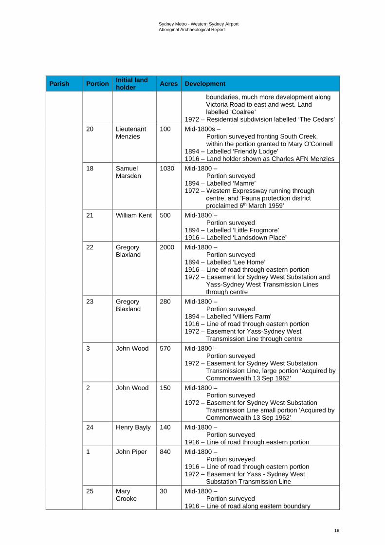
Sydney Metro - Western Sydney Airport Aboriginal Archaeological Report
18
Parish Portion Initial land holder Acres Development
boundaries, much more development along Victoria Road to east and west. Land labelled ‘Coalree’
1972 – Residential subdivision labelled ‘The Cedars’ 20 Lieutenant
Menzies 100 Mid-1800s –
Portion surveyed fronting South Creek, within the portion granted to Mary O’Connell
1894 – Labelled ‘Friendly Lodge’ 1916 – Land holder shown as Charles AFN Menzies
18 Samuel Marsden
1030 Mid-1800 – Portion surveyed
1894 – Labelled ‘Mamre’ 1972 – Western Expressway running through
centre, and ‘Fauna protection district proclaimed 6th March 1959’
21 William Kent 500 Mid-1800 – Portion surveyed
1894 – Labelled ‘Little Frogmore’ 1916 – Labelled ‘Landsdown Place”
22 Gregory Blaxland
2000 Mid-1800 – Portion surveyed
1894 – Labelled ‘Lee Home’ 1916 – Line of road through eastern portion 1972 – Easement for Sydney West Substation and
Yass-Sydney West Transmission Lines through centre
23 Gregory Blaxland
280 Mid-1800 – Portion surveyed
1894 – Labelled ‘Villiers Farm’ 1916 – Line of road through eastern portion 1972 – Easement for Yass-Sydney West
Transmission Line through centre 3 John Wood 570 Mid-1800 –
Portion surveyed 1972 – Easement for Sydney West Substation
Transmission Line, large portion ‘Acquired by Commonwealth 13 Sep 1962’
2 John Wood 150 Mid-1800 – Portion surveyed
1972 – Easement for Sydney West Substation Transmission Line small portion ‘Acquired by Commonwealth 13 Sep 1962’
24 Henry Bayly 140 Mid-1800 – Portion surveyed
1916 – Line of road through eastern portion 1 John Piper 840 Mid-1800 –
Portion surveyed 1916 – Line of road through eastern portion 1972 – Easement for Yass - Sydney West
Substation Transmission Line 25 Mary
Crooke 30 Mid-1800 –
Portion surveyed 1916 – Line of road along eastern boundary
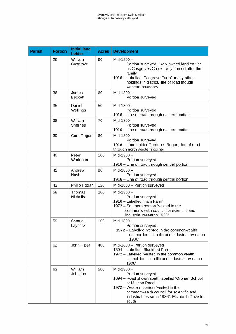
Sydney Metro - Western Sydney Airport Aboriginal Archaeological Report
19
Parish Portion Initial land holder Acres Development
26 William Cosgrove
60 Mid-1800 – Portion surveyed, likely owned land earlier as Cosgroves Creek likely named after the family
1916 – Labelled ‘Cosgrove Farm’, many other holdings in district, line of road though western boundary
36 James Beckett
60 Mid-1800 – Portion surveyed
35 Daniel Wellings
50 Mid-1800 – Portion surveyed
1916 – Line of road through eastern portion 38 William
Sherries 70 Mid-1800 –
Portion surveyed 1916 – Line of road through eastern portion
39 Corn Regan 60 Mid-1800 – Portion surveyed
1916 – Land holder Cornelius Regan, line of road through north western corner
40 Peter Workman
100 Mid-1800 – Portion surveyed
1916 – Line of road through central portion 41 Andrew
Nash 80 Mid-1800 –
Portion surveyed 1916 – Line of road through central portion
43 Philip Hogan 120 Mid-1800 – Portion surveyed
58 Thomas Nicholls
200 Mid-1800 – Portion surveyed
1916 – Labelled ‘Ham Farm” 1972 – Southern portion “vested in the
commonwealth council for scientific and industrial research 1936”
59 Samuel Laycock
100 Mid-1800 – Portion surveyed
1972 – Labelled “vested in the commonwealth council for scientific and industrial research 1936”
62 John Piper 400 Mid-1800 – Portion surveyed 1894 – Labelled ‘Blackford Farm’ 1972 – Labelled “vested in the commonwealth
council for scientific and industrial research 1936”
63 William Johnson
500 Mid-1800 – Portion surveyed
1894 – Road shown south labelled ‘Orphan School or Mulgoa Road’
1972 – Western portion “vested in the commonwealth council for scientific and industrial research 1936”, Elizabeth Drive to south
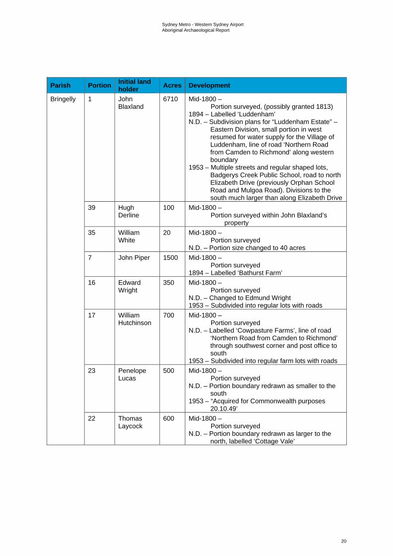
Sydney Metro - Western Sydney Airport Aboriginal Archaeological Report
20
Parish Portion Initial land holder Acres Development
Bringelly 1 John Blaxland
6710 Mid-1800 – Portion surveyed, (possibly granted 1813)
1894 – Labelled ‘Luddenham’ N.D. – Subdivision plans for “Luddenham Estate” –
Eastern Division, small portion in west resumed for water supply for the Village of Luddenham, line of road ‘Northern Road from Camden to Richmond’ along western boundary
1953 – Multiple streets and regular shaped lots, Badgerys Creek Public School, road to north Elizabeth Drive (previously Orphan School Road and Mulgoa Road). Divisions to the south much larger than along Elizabeth Drive
39 Hugh Derline
100 Mid-1800 – Portion surveyed within John Blaxland’s
property 35 William
White 20 Mid-1800 –
Portion surveyed N.D. – Portion size changed to 40 acres
7 John Piper 1500 Mid-1800 – Portion surveyed
1894 – Labelled ‘Bathurst Farm’ 16 Edward
Wright 350 Mid-1800 –
Portion surveyed N.D. – Changed to Edmund Wright 1953 – Subdivided into regular lots with roads
17 William Hutchinson
700 Mid-1800 – Portion surveyed
N.D. – Labelled ‘Cowpasture Farms’, line of road ‘Northern Road from Camden to Richmond’ through southwest corner and post office to south
1953 – Subdivided into regular farm lots with roads 23 Penelope
Lucas 500 Mid-1800 –
Portion surveyed N.D. – Portion boundary redrawn as smaller to the
south 1953 – “Acquired for Commonwealth purposes
20.10.49’ 22 Thomas
Laycock 600 Mid-1800 –
Portion surveyed N.D. – Portion boundary redrawn as larger to the
north, labelled ‘Cottage Vale’
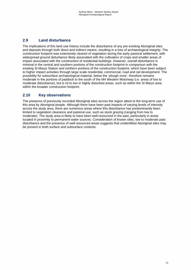
Sydney Metro - Western Sydney Airport Aboriginal Archaeological Report
21
2.9 Land disturbance The implications of this land use history include the disturbance of any pre-existing Aboriginal sites and deposits through both direct and indirect means, resulting in a loss of archaeological integrity. The construction footprint was extensively cleared of vegetation during the early pastoral settlement, with widespread ground disturbance likely associated with the cultivation of crops and smaller areas of impact associated with the construction of residential buildings. However, overall disturbance is minimal in the central and southern portions of the construction footprint in comparison with the existing St Marys Station and northern portions of the construction footprint, which have been subject to higher impact activities through large scale residential, commercial, road and rail development. The possibility for subsurface archaeological material, below the ‘plough zone’, therefore remains moderate in the portions of paddock to the south of the M4 Western Motorway (i.e. areas of low to moderate disturbance), but is nil to low in highly disturbed areas, such as within the St Marys area within the broader construction footprint.
2.10 Key observations The presence of previously recorded Aboriginal sites across the region attest to the long-term use of this area by Aboriginal people. Although there have been past impacts of varying levels of intensity across the study area, there are numerous areas where this disturbance has predominantly been limited to vegetation clearance and pastoral use, such as stock grazing (ranging from low to moderate). The study area is likely to have been well-resourced in the past, particularly in areas located in proximity to permanent water sources. Consideration of known sites, low to moderate past disturbance and the presence of well-resourced areas suggests that unidentified Aboriginal sites may be present in both surface and subsurface contexts.
Sydney Metro - Western Sydney Airport Aboriginal Archaeological Report
22
3. Archaeological context
3.1 Regional archaeological context 3.1.1 The Sydney region Available archaeological data indicate that Aboriginal people have occupied the Sydney region1 for at least 36,000 years (Williams et al., 2014). Late Pleistocene/early Holocene occupation of the region is evidenced by radiometric dates from both coastal and hinterland sites (see Attenbrow, 2010:18, Table 3.1). Excavated material culture assemblages from these periods have been interpreted as evidence of relatively small populations of Aboriginal people employing settlement patterns of high residential and low logistical mobility (Attenbrow 2010:152-154; McDonald, 2008: 39; Williams et al., 2014). Late Pleistocene/early Holocene chipped stone assemblages attest to a preference for silicified tuff sourced from secondary geological sources such as the Hawkesbury-Nepean River gravels (McDonald, 2008; Williams et al., 2014). However, they also indicate the exploitation of other raw material types such as silcrete, quartzite, petrified wood and quartz. Direct freehand percussion appears to have been the dominant reduction technique employed by Late Pleistocene/early Holocene Aboriginals knappers, with bipolar flaking comparatively poorly represented in available assemblages. Retouched ‘tools’ include unifacially-flaked pebble implements, dentated saws, burins and a variety of scrapers, with unmodified utilised flakes also well represented (Kohen et al., 1984; Williams et al., 2014). Stone tools such as these will have been complemented by a range of organic implements such as wooden digging sticks, spears and boomerangs. However, these do not survive archaeologically (Attenbrow, 2010:154).
Compared with the late Pleistocene/early Holocene, archaeological evidence for mid-to-late Holocene Aboriginal occupation of the Sydney Region abounds (for recent syntheses see Attenbrow 2010; McDonald 2008). In keeping with broader Australian developments (e.g. Allen and O’Connell, 1995; Beaton, 1985; Brumm and Moore, 2005; Attenbrow et al., 2009; Lourandos, 1983, 1997; Lourandos and Ross, 1994), the social and economic systems of Aboriginal groups living in the region during this period appear to have become increasingly complex. Available archaeological data, for example, suggest a significant increase in site establishment and population densities over time, as well as a concomitant growth in the size and complexity of social aggregation (but see Attenbrow (2012) and Hiscock (2008) for cautionary notes on the interpretive significance of radiometric date graphs). Growing economic specialisation is indicated by the emergence and/or proliferation of complex fishing and stoneworking technologies, with the latter linked variously to increased foraging risk associated with greater climatic variability as well as other variables such as redefinition of social space, reduction of resources and increased logistical pre-equipping (Attenbrow et al. 2009; McDonald, 2008: 40). Complex, long-distance exchange networks are also attested archaeologically (e.g. Attenbrow et al., 2012; Grave et al., 2012) as are important developments in artistic activities (McDonald, 2008). Higher levels of stylistic heterogeneity in pigment and engraved art across the region, for example, have been linked to increasing territoriality (McDonald, 2008: 42).
With some modification, McCarthy’s (1967) Eastern Regional Sequence (ERS) of stone artefact assemblages remains the dominant chronological framework for Aboriginal occupation of the region. Based on appreciable changes in the composition of chipped stone artefact assemblages over time, the ERS hypothesises a three phase sequence of ‘Capertian’ (earliest), ‘Bondaian’ and ‘Eloueran’ (most recent) assemblages and was developed on the basis of McCarthy’s (1948, 1964) pioneering analyses of stratified flaked stone assemblages from Lapstone Creek rockshelter, on the lower slopes of the Blue Mountains eastern escarpment, and Capertee 3 rockshelter in the Capertee Valley north of Lithgow (see Table 3-1). At present, the most widely cited characterisation of the ERS in the Sydney region is that of a four-phase sequence beginning with the Pre-Bondaian (McCarthy’s Capertian) and moving successively through the Early, Middle and Late phases of the Bondaian, the last of which equates to McCarthy’s (1967) Eloueran phase. The tripartite division of the Bondaian is based principally on the presence/absence and relative abundance of backed artefacts (Attenbrow, 2010: 101). However, other factors, such as changes in the abundance of bipolar artefacts and different stone materials, as well as the presence/absence of edge-ground hatchet-heads are also relevant.
1 Following Attenbrow (2012a), the land bounded by the coast on the east, by the Hawkesbury-Nepean River in the north and west, and by a line running east-west through Picton and Stanwell Park in the south.
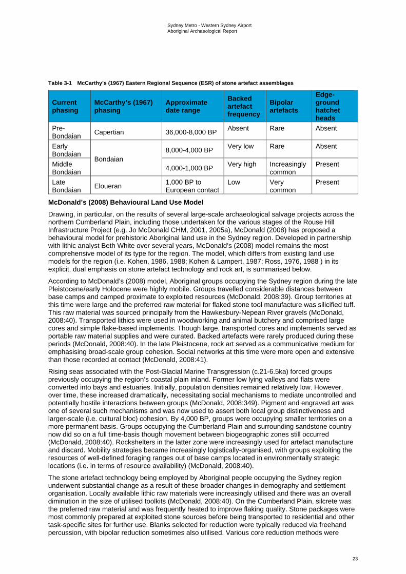
Sydney Metro - Western Sydney Airport Aboriginal Archaeological Report
23
Table 3-1 McCarthy’s (1967) Eastern Regional Sequence (ESR) of stone artefact assemblages
Current phasing
McCarthy’s (1967) phasing
Approximate date range
Backed artefact frequency
Bipolar artefacts
Edge-ground hatchet heads
Pre-Bondaian Capertian 36,000-8,000 BP Absent Rare Absent
Early Bondaian
Bondaian 8,000-4,000 BP Very low Rare Absent
Middle Bondaian 4,000-1,000 BP Very high Increasingly
common Present
Late Bondaian Eloueran 1,000 BP to
European contact Low Very
common Present
McDonald’s (2008) Behavioural Land Use Model Drawing, in particular, on the results of several large-scale archaeological salvage projects across the northern Cumberland Plain, including those undertaken for the various stages of the Rouse Hill Infrastructure Project (e.g. Jo McDonald CHM, 2001, 2005a), McDonald (2008) has proposed a behavioural model for prehistoric Aboriginal land use in the Sydney region. Developed in partnership with lithic analyst Beth White over several years, McDonald’s (2008) model remains the most comprehensive model of its type for the region. The model, which differs from existing land use models for the region (i.e. Kohen, 1986, 1988; Kohen & Lampert, 1987; Ross, 1976, 1988 ) in its explicit, dual emphasis on stone artefact technology and rock art, is summarised below.
According to McDonald’s (2008) model, Aboriginal groups occupying the Sydney region during the late Pleistocene/early Holocene were highly mobile. Groups travelled considerable distances between base camps and camped proximate to exploited resources (McDonald, 2008:39). Group territories at this time were large and the preferred raw material for flaked stone tool manufacture was silicified tuff. This raw material was sourced principally from the Hawkesbury-Nepean River gravels (McDonald, 2008:40). Transported lithics were used in woodworking and animal butchery and comprised large cores and simple flake-based implements. Though large, transported cores and implements served as portable raw material supplies and were curated. Backed artefacts were rarely produced during these periods (McDonald, 2008:40). In the late Pleistocene, rock art served as a communicative medium for emphasising broad-scale group cohesion. Social networks at this time were more open and extensive than those recorded at contact (McDonald, 2008:41).
Rising seas associated with the Post-Glacial Marine Transgression (c.21-6.5ka) forced groups previously occupying the region’s coastal plain inland. Former low lying valleys and flats were converted into bays and estuaries. Initially, population densities remained relatively low. However, over time, these increased dramatically, necessitating social mechanisms to mediate uncontrolled and potentially hostile interactions between groups (McDonald, 2008:349). Pigment and engraved art was one of several such mechanisms and was now used to assert both local group distinctiveness and larger-scale (i.e. cultural bloc) cohesion. By 4,000 BP, groups were occupying smaller territories on a more permanent basis. Groups occupying the Cumberland Plain and surrounding sandstone country now did so on a full time-basis though movement between biogeographic zones still occurred (McDonald, 2008:40). Rockshelters in the latter zone were increasingly used for artefact manufacture and discard. Mobility strategies became increasingly logistically-organised, with groups exploiting the resources of well-defined foraging ranges out of base camps located in environmentally strategic locations (i.e. in terms of resource availability) (McDonald, 2008:40).
The stone artefact technology being employed by Aboriginal people occupying the Sydney region underwent substantial change as a result of these broader changes in demography and settlement organisation. Locally available lithic raw materials were increasingly utilised and there was an overall diminution in the size of utilised toolkits (McDonald, 2008:40). On the Cumberland Plain, silcrete was the preferred raw material and was frequently heated to improve flaking quality. Stone packages were most commonly prepared at exploited stone sources before being transported to residential and other task-specific sites for further use. Blanks selected for reduction were typically reduced via freehand percussion, with bipolar reduction sometimes also utilised. Various core reduction methods were
Sydney Metro - Western Sydney Airport Aboriginal Archaeological Report
24
employed, with asymmetric alternating flaking frequently used. During the Middle Bondaian period (c.4,000 to 1,000 years Before Present (BP)), backed artefacts were manufactured in large numbers across numerous sites, with ‘industrial’ scale production occurring at some sites. These tools were utilised in range of craft and subsistence activities including bone-working, wood-working, plant processing and animal butchery.
During the Late Bondaian period (c.1,000 years to European contact), there was a reduced emphasis on the occupation of rockshelters, with open camp site locations now foci for habitation. This shift away from rockshelters was a response to the increased spatial requirements of larger social groups associated with a dual social system (McDonald, 2008:349). During times of seasonal abundance, groups lived in large, semi-permanent open ‘villages’. However, in times of resource stress, these larger groups dispersed into smaller family or gender-based hunting/fishing groups who reverted to exploiting their traditional foraging ranges. An increased emphasis on bipolar flaking during this period was linked to an even more intensive use of locally available stone. In coastal areas, backed artefacts all but ceased to be produced. Edge-ground hatchets were widely made and used across the region. As in earlier periods, rock art during the Late Bondaian continued to function as an important communicative medium for the assertion of both local group identity and broader culture area cohesion (McDonald 2008:350).
3.1.2 The Cumberland Plain Concentrated archaeological investigation of the Aboriginal archaeological record of Sydney’s Cumberland Plain can be traced to the early-to-mid 1980s, a period marked by a rapid growth in residential and other forms of development across the Plain. Intensive development activities since this time have secured the Cumberland Plain’s place as one of the most intensively investigated archaeological regions in Australia, with potentially thousands of Aboriginal archaeological investigations involving survey and/or excavation having now been undertaken (the exact number difficult to calculate due to the limited circulation of many reports). The majority of these investigations were undertaken as part of larger environmental impact assessments associated with residential development and affiliated infrastructure projects. Unsurprisingly, these investigations have varied significantly in scale and scope, ranging from targeted small-scale surveys to complex, multi-phase survey and excavation projects over large areas. Nonetheless, together they have revealed a rich and diverse record of past Aboriginal occupation, with thousands of Aboriginal archaeological sites now registered in the AHIMS database.
3.1.3 Open artefact sites: distribution, contents and definition Surface and subsurface distributions of stone artefacts, variously referred to as open artefact sites, open sites and open camp sites are the most common and widely distributed form of Aboriginal archaeological site on the Cumberland Plain (see Attenbrow, 2010: Plate 12; Przywolnik, 2007: 46, Table 4.2). Other site types, such as modified trees, quarries, grinding grooves and rockshelters with deposit and/or art or PAD, have also been identified but are comparatively rare. Accordingly, open artefact sites remain the most intensively investigated component of the Aboriginal archaeological record of the Cumberland Plain, with site distribution and the technology of associated flaked stone artefact assemblages, in particular, comprising key research topics (e.g. AMBS, 2000; Craib et al., 1999; Jo McDonald CHM, 2001, 2003, 2005a, 2006a, 2006b, 2006c, 2007, 2009a, 2009b; Kohen, 1986; White & McDonald, 2010).
Existing archaeological survey data for the Cumberland Plain indicate a strong trend for the presence of open artefact sites along watercourses, specifically, on creek banks and ‘flats’ (i.e. flood/drainage plains), terraces and bordering lower slopes. Although this distribution pattern can be attributed in part to geomorphic dynamics and archaeological sampling bias, with extensive fluvial erosion activity along watercourses resulting in higher levels of surface visibility and, by extension, concentrated survey effort, an occupational emphasis on watercourses is supported by the results of numerous subsurface investigations (e.g. AMBS, 2000; Craib et al., 1999; GML, 2012, 2016; Jo McDonald CHM, 2001, 2003, 2005a, 2006a, 2006b, 2007, 2009a, 2009b). Collectively, these investigations have demonstrated that assemblage size and complexity tend to vary significantly in relation to stream order and landform, with larger, more complex2 assemblages concentrated on elevated, low gradient
2 Those containing a wider variety of raw materials and technological types and/or higher mean artefact densities and features such as knapping floors.
Sydney Metro - Western Sydney Airport Aboriginal Archaeological Report
25
landform elements adjacent to higher order watercourses. Artefact distributions associated with major creek lines and confluences tend to consist of localised high density artefact concentrations set within lower density artefact scatters across the broader landscape. Outside of these contexts, surface and subsurface artefact distributions have typically been found to be sparse and discontinuous and are often referred to as ‘background scatter’, being “artefactual material which is insufficient in number or in association with other material to suggest focussed activity in a particular location” (Douglas and McDonald, 1993).
Flaked stone artefacts dominate archaeological assemblages from recorded open artefact sites on the Cumberland Plain, with heat shattered rock also well represented. Items such as complete and broken grindstones, hammerstones and edge-ground hatchet heads have also been recorded though comparatively infrequently. With the notable exception of ‘knapping floors’3, a relatively common component of the Aboriginal archaeological record of the Cumberland Plain, associated archaeological features (e.g. hearths, ground ovens and heat treatment pits) have proven elusive (but see AHMS, 2013; GML, 2016; McDonald and Rich, 1994; Jo McDonald CHM, 2009a for examples). Investigated knapping floors across the Plain have varied considerably in size and complexity, with the largest and most complex examples identified through excavation as opposed to surface survey (e.g. Jo McDonald CHM, 2001, 2005a, 2006b, 2007). Backed artefacts (i.e. Bondi points, geometric microliths and elouera) are a common feature of knapping floors and most of these features were likely specifically associated with their production. In common with regions such as the Hunter Valley (e.g. Hiscock, 1993; Moore, 2000), available evidence supports the suggestion that backed artefact manufacture on the Cumberland Plain was a highly structured or systematic activity.
Although relevant to a variety of site types, geomorphic processes such as soil erosion and colluvial/fluvial aggradation are of particular relevance to the identification and definition of open artefact sites. As in other archaeological contexts (e.g. Dean-Jones & Mitchell, 1993), the visibility of open artefact sites across Sydney’s Cumberland Plain can, for the most part, be attributed to such processes, which have variously exposed or obscured them. Critically, surface artefacts invariably represent only a fraction of the total number of artefacts present within recorded surface open artefact sites across the Plain, with a typical surface to subsurface artefact ratio of 1:25 proposed (Jo McDonald CHM, 2005b: 35). Artefact exposure, unsurprisingly, is highest on erosional surfaces and lowest on depositional ones. At the same time, in many areas, surface artefacts have been shown through dispersed testing programs to form part of more-or-less continuous subsurface distributions of artefacts, albeit with highly variable artefact densities linked to environmental variables such as distance to water, stream order and landform (e.g. White & McDonald, 2010). The presence or absence of surface artefacts on the Cumberland Plain, therefore, is not a reliable indicator of Aboriginal archaeological sensitivity.
3.1.4 Flaked stone artefact technology Virtually indestructible, flaked stone artefacts are a ubiquitous element of the Aboriginal archaeological record of the Cumberland Plain and have assumed a prominent position in archaeological reconstructions of past Aboriginal land use across the region. To date thousands of surface-collected and excavated flaked stone assemblages from across the Cumberland Plain have been analysed, with individual assemblage sizes, research questions, aims, analytical methodologies and terminological schemes varying significantly between researchers and projects. Studies to date have ranged from basic descriptive accounts of assemblage composition in typological terms to detailed reconstructions of past stone reduction and quarrying behaviours through rigorous technological analyses. Particularly informative analyses in the context of the Cumberland Plain include those conducted by Jo McDonald CHM (2001, 2003, 2005a, 2006a, 2006b, 2006c, 2007, 2009a, 2009b) as part of archaeological salvage projects associated with development activities within the Rouse Hill Development Area (RHDA), the former Australian Defence Industries site at St Marys and the Colebee Release Area. Technological analyses of stone artefact assemblages recovered from fluvial sand bodies adjacent to the Parramatta (Jo McDonald CHM, 2005b, 2005c, 2006b) and Hawkesbury Rivers (AHMS 2013; Williams et al. 2012) have likewise proven highly informative, particularly with respect to the documentation of diachronic changes in raw material use and stone artefact technologies.
3 Following White (1997:8), knapping floors can be defined as activity areas “where primacy was given the systematic reduction of stone, with or without additional activities being carried out”.
Sydney Metro - Western Sydney Airport Aboriginal Archaeological Report
26
Available technological and typological data for surface collected and excavated flaked stone artefact assemblages from the Cumberland Plain suggest that the majority of these assemblages belong to what is known as the ‘Australian small-tool tradition’, a term coined by Gould (1969) to describe what was then thought to be the first appearance, in the mid-Holocene4, of a new suite of flaked stone tool forms in the Aboriginal archaeological record of Australia, including backed artefacts, adzes and points (both unifacially and bifacially flaked). Complex, hierarchically-organised reduction sequences associated with the production of these tools contrast markedly with the simple sequences of earlier periods (Moore, 2011). Tools of the Australian small-tool tradition, it has been suggested, formed part of a portable, standardised and multifunctional tool kit aimed specifically at risk reduction (Hiscock, 1994, 2002, 2006). Stone artefact assemblages from late Pleistocene and early Holocene contexts, in contrast, are described by archaeologists as belonging to the ‘Australian core tool and scraper tradition’, a term first used by Bowler et al. (1970) to describe the Pleistocene assemblages recovered from Lake Mungo in western NSW. Bowler et al. (1970) saw the main components of these assemblages - core tools, steep-edged scrapers and flat scrapers - as characteristic of early Australian Aboriginal assemblages and as being of a distinctly different character to those associated with the proceeding small-tool tradition. In southeastern Australia, including the Cumberland Plain, the Australian ‘small-tool’ and ‘core tool and scraper’ traditions are most commonly described in terms of McCarthy’s (1967) ERS, with ‘Capertian’ assemblages assigned to the latter tradition and ‘Bondaian’ assemblages to the former.
Flaked stone artefact assemblages from excavated and surface collected/recorded open artefact sites on the Cumberland Plain attest to the exploitation of a diverse range of lithic raw materials (Corkill, 1999, 2005). However, two rock types - silcrete and silicified tuff (also known as indurated mudstone) - dominate the region’s existing stone artefact record. Other, less commonly exploited raw materials represented in excavated and surface collected/recorded assemblages include quartz, quartzite, petrified wood, chert and various fine-grained volcanics. Alongside silcrete and silicified tuff, these materials occur variously in a number of geological formations and units across the Cumberland Plain (for a detailed review see Corkill 1999). Oft-cited sources include the Tertiary St Marys (Ts) and Rickabys Creek Gravel (Tr) formations, as well as the various unconsolidated Pleistocene units that line as terraces the present day and abandoned channels of the Nepean-Hawkesbury River (e.g. the Cranebrook Formation (Qpc)). Holocene gravel banks along the same river system have likewise been identified as a potentially significant raw material source.
In common with the Sydney region as a whole (Attenbrow, 2010:120-121), various excavated assemblages from the body and peripheries of the Cumberland Plain (e.g. Jo McDonald CHM, 2001a, 2005a; Williams et al., 2012, 2014) attest to a shift, over time, in the relative significance of particular raw materials for flaked stone artefact manufacture, principally silcrete and silicified tuff but also quartz. An ‘early’ (i.e. Pre-Bondaian) emphasis on the procurement and reduction of silicified tuff, for example, appears to have given way to a ‘later’ (i.e. Bondaian) emphasis on silcrete. Quartz use, meanwhile, appears to have peaked in the late Holocene. For the Cumberland Plain, these changes have been linked, in particular, to broader changes in settlement organisation, with a decline in levels of residential mobility over time prompting more intensive use of locally available stone (Jo McDonald CHM, 2005a).
In the northwestern portion of the Cumberland Plain, the Tertiary St Marys Formation has been singled out as a particularly important source of silcrete for flaked stone artefact manufacture. Mapped at various localities across the Mulgoa Creek, South Creek and Eastern Creek catchments, the best known and most intensively investigated outcrops of this formation occur on Plumpton Ridge, a low but locally prominent ridgeline separating the floodplains of Eastern Creek and Bells Creek between the suburbs of Plumpton and Riverstone. The subject of numerous archaeological investigations since the early 1980s (e.g. Australian Museum Business Services, 2002; Baker, 1996; Barry, 2005; McDonald, 1986), Jo McDonald CHM’s (2006c) large-scale archaeological salvage works across what is now Stonecutters Ridge Golf Club unequivocally identified Plumpton Ridge as a major Aboriginal quarry site. At the same time, they highlighted a number of important trends in relation to the procurement and reduction of silcrete obtained from this source. Trends in the relative frequencies of
4 More recent research into the chronology of backed artefacts and points in Australia (e.g. Hiscock & Attenbrow 1998, 2004; Hiscock 1993b) has demonstrated a long history of production and use for these implement types, with both types now known to have been produced, albeit in small numbers, in the early Holocene and likely in the late Pleistocene as well.
Sydney Metro - Western Sydney Airport Aboriginal Archaeological Report
27
raw material types, artefact types and the size of silcrete artefacts in local excavated assemblages, for example, were attributed to a process of ‘distance-decay’ (Jo McDonald CHM’s 2006c: 61).
Procurement evidence at documented Aboriginal quarry sites across the Cumberland Plain, including Plumpton Ridge, has to date consisted of varying surface and/or subsurface densities of flaked stone artefacts in direct spatial association with naturally occurring Tertiary gravel deposits (silcrete dominant). Topographic indicators of ‘open cut’ mining activities, such as localised circular/semi-circular depressions or trenches (cf. Binns & McBryde, 1972; Jones & White, 1988; McBryde, 1973, 1984), have yet to be identified, though this is unsurprising given the nature of the lithic deposits being quarried. Alongside those from the ADI:EPI and ADI-FF2 quarry sites within the former Australian Defence Industries site (Jo McDonald CHM, 2006a, 2008a), excavated flaked stone artefact assemblages from the SA25 and SA26 sample areas on the upper eastern flank of Plumpton Ridge, detailed in Jo McDonald CHM, 2006c, have provided a robust technological ‘signature’ for Aboriginal quarry sites on the Cumberland Plain. Amongst other activities, such as limited tool production/discard and later stage core reduction, stone procurement/reduction activities at exploited stone sources appear to have included ‘primary’ or early stage clast reduction as well as deliberate heat treatment and fracturing (Jo McDonald CHM, 2006c).
Backed artefacts dominate the retouched components of the majority of dated and undated Bondaian assemblages from the Plain and, as such, the technology of their manufacture has received considerable analytical and interpretive attention. Studies by Jo McDonald CHM (2001, 2003, 2005a, 2006a, 2006b, 2007, 2009a, 2009b), in particular, have demonstrated that backed artefact manufacture on the Cumberland Plain was a highly structured or systematic activity involving a complex system of raw material procurement, transportation, preparation and reduction. Differences in the technological character of recovered cores across the region attest to a significant degree of variability in the methods used by Aboriginal knappers to produce flakes for backed artefact manufacture. However, certain techniques (e.g. asymmetric alternating flaking and Hiscock’s (1993) ‘tranchet technique’) are particularly well represented. Evidence for the deliberate heat treatment of silcrete blanks, both as part of systematic backed artefact manufacture activities and other reduction activities, is abundant and widespread, with excavated and surface collected assemblages attesting to the use of heat at various points in the reduction process. As in other contexts (e.g. Hiscock 1993), the thermal alteration of Cumberland Plain silcrete appears to have significantly improved the flaking quality of the stone, increasing the lustre and smoothness of fracture surfaces.
3.1.5 Chronology of occupation In common with the Sydney region as a whole, evidence for late Pleistocene/early Holocene (i.e. Pre-Bondaian/Early Bondaian) Aboriginal occupation of the Cumberland Plain is sparse, with confirmed or potential evidence from these periods obtained from only a limited (<20) number of sites/landscapes. Well documented examples include Rouse Hill sites RH/CC2 (Jo McDonald CHM, 2001), RH/SC5 (Jo McDonald CHM, 2002b), RH/CD12 (Jo McDonald CHM, 2002a) and RHCD7 (Jo McDonald CHM, 2007); Richmond site RMI (Jo McDonald CHM, 1997a); PT12 near Pitt Town (Williams et al., 2012, 2014); Jamisons Creek, Emu Plains (Kohen et al., 1984); Power Street Bridge 2, Doonside (McDonald, 1993), Regentville RS1, Regentville (Koettig & Hughes, 1995; McDonald et al., 1996), the Parramatta CBD (AHMS 2013; Austral Archaeology, 2007; Jo McDonald CHM, 2005b, 2005c, 2006b) and the Windsor Museum site (Austral Archaeology, 2011; Williams et al. 2012; Williams et al. 2014). Claims of a c.40 ka year old date for five ‘flaked pebbles’ recovered from a gravel pit associated with the Cranebrook Terrace near Penrith (Nanson et al. 1987) have been widely questioned, (P. Mitchell, 2010; Mulvaney & Kamminga, 1999; Williams et al., 2012) with legitimate concerns raised over the artefactual status of these pebbles, their provenance and association with available dates (but see Williams et al. 2017 for the results of more recent work at Cranebrook Terrace). For most sites, late Pleistocene/early Holocene occupation has been inferred on the basis of the technological and typological characteristics of recovered flaked stone artefact assemblages as opposed to radiometric dates.
At present, the oldest securely dated archaeological site on the Cumberland Plain is the PT12 site at Pitt Town, with compliance-based archaeological excavations across a source-bordering dune at this site, which overlooks the Hawkesbury River, producing a suite of Optically-Stimulated Luminescence (OSL) dates suggestive of Aboriginal occupation from at least 36,000 years ago (and potentially earlier) (Williams et al. 2012, 2014). Closer to the coast, Late Pleistocene/early Holocene occupation of a sandy fluvial terrace adjacent to the Parramatta River (i.e. the Parramatta Sand Sheet) has been
Sydney Metro - Western Sydney Airport Aboriginal Archaeological Report
28
by proposed by Jo McDonald CHM (2005b, 2005c, 2006b) and seems likely on the basis of available radiometric dates and assemblage characteristics.
In stark contrast to the late Pleistocene/early Holocene, evidence for mid-to-late Holocene (i.e. Middle to Late Bondaian) Aboriginal occupation of the Cumberland Plain abounds, with numerous excavated sites producing assemblages that can be confidently assigned to these periods on the basis of radiometric dates and/or their typological/technological profiles. Available radiometric dates indicate a steady increase in the number of sites occupied over the course of the Holocene, with a peak in the 2nd millennium BP (see, for example, Przywolnik 2007: 53, Fig. 4.6). Taken at face value, this data suggests a progressive increase in the Aboriginal population of the Cumberland Plain over the course of the Holocene. However, following Hiscock (2008: 230-233), it seems likely that the directional population growth suggested by such data is, to a certain extent at least, a product of differential site preservation, with younger sites better preserved than older ones. Other factors, such as the burial of older sites through sediment deposition and bias in the location of archaeological surveys and excavations, may also be relevant.
Critical to any discussion concerning the antiquity of Aboriginal occupation across the Cumberland Plain are the well-documented difficulties surrounding the dating of open artefact sites with active ‘biomantles’ (sensu Paton et al. 1995; see Dean-Jones & Mitchell, 1993; Balek 2002; Hofman 1986; Johnson et al. 2005; Johnson 1989; Paton et al. 1995; Peacock & Fant 2002; Stein 1983). On the Cumberland Plain, the term biomantle is typically used as a collective descriptor for the ‘A’ soil horizons of the Plain’s dominant texture contrast or duplex soil profiles5, which tend to be relatively thin (<30 cm) and exhibit extensive evidence of bioturbation in the form of roots, open/infilled burrows, live insects and/or earthworms and stone lines6. However, it is noted that the uppermost portions of underlying ‘B’ soil horizons can also exhibit such evidence and form part of the biomantle (e.g. AECOM, 2015a). As highlighted by Dean-Jones & Mitchell (1993) and others (e.g. Balek, 2002; Johnson, 1989), excavated finds assemblages from archaeological sites with active biomantles are subject to a range of interpretive constraints, with intact depositional stratigraphy unlikely to be preserved and inset archaeological features (e.g. hearths and heat treatment pits) representing the only reliable means of dating (with any specificity) intercepted archaeological events (Mitchell, 2009: 4). Any stone artefacts discarded at the surface in landscapes with active biomantles are likely, over time, to have been incorporated into the soil profile through bioturbation, with depth of artefact burial ultimately corresponding to the base of major biological activity (i.e. the base of the biomantle). Where biomantles remain relatively undisturbed, horizontal patterns of artefact discard may be preserved. However, in heavily disturbed contexts, the preservation of such patterning is unlikely (Mitchell 2009: 4).
For archaeologists working on the Cumberland Plain, the analytical and interpretive constraints posed by intensive bioturbation have, in combination with a real paucity of dateable features, led to a reliance on the dating of excavated archaeological finds through relative means, specifically, through consideration of the typological and technological composition of associated flaked stone artefact assemblages and reference to a modified version of McCarthy’s (1967) ESR, the broad temporal parameters of which are now well established. While offering a useful chronological framework within which to assess diachronic changes in stone artefact technologies and raw material use, the largely undated and palimpsest character of the Cumberland Plain’s lithic record represents a significant analytical and interpretive obstacle for period-specific reconstructions of Aboriginal mobility regimes (cf. Cowan, 1999). Well dated assemblages from sites retaining stratified deposit(s) are rare, with the most comprehensively dated sequences to date coming from deep fluvial sand bodies adjacent to the Hawkesbury and Parramatta Rivers (i.e. AHMS, 2013; Jo McDonald CHM, 2005c; Williams et al., 2012, 2014). While the preservation and dating potential offered by such bodies has been amply demonstrated, the same cannot be said of alluvial valley fill sequences outside of these major river valley contexts, with comparatively little research directed towards investigating the age, genesis or evolution of alluvial valley fill sequences within the Cumberland Plain’s numerous creek valleys, nor their potential for preserving at depth (i.e. within buried paleosols) Aboriginal archaeological materials
5 These profiles are characterised by loamy topsoils and silty clay to clay subsoils, with boundaries between these two units typically clear to abrupt. Clayey subsoils have formed by in situ weathering of the parent material, while topsoils are derived from a combination of in situ weathering and the deposition of colluvially and/or fluvially transported materials. 6 Stone lines, where present, typically occur at the interface between the A and B horizons.
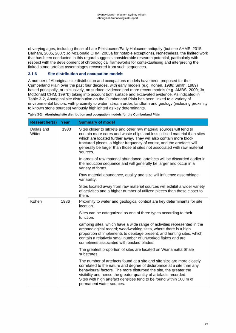
Sydney Metro - Western Sydney Airport Aboriginal Archaeological Report
29
of varying ages, including those of Late Pleistocene/Early Holocene antiquity (but see AHMS, 2015; Barham, 2005, 2007; Jo McDonald CHM, 2005a for notable exceptions). Nonetheless, the limited work that has been conducted in this regard suggests considerable research potential, particularly with respect with the development of chronological frameworks for contextualising and interpreting the flaked stone artefact assemblages recovered from such sequences.
3.1.6 Site distribution and occupation models A number of Aboriginal site distribution and occupations models have been proposed for the Cumberland Plain over the past four decades, with early models (e.g. Kohen, 1986; Smith, 1989) based principally, or exclusively, on surface evidence and more recent models (e.g. AMBS, 2000; Jo McDonald CHM, 1997b) taking into account both surface and excavated evidence. As indicated in Table 3-2, Aboriginal site distribution on the Cumberland Plain has been linked to a variety of environmental factors, with proximity to water, stream order, landform and geology (including proximity to known stone sources) variously highlighted as key determinants. Table 3-2 Aboriginal site distribution and occupation models for the Cumberland Plain
Researcher(s) Year Summary of model Dallas and Witter
1983 Sites closer to silcrete and other raw material sources will tend to contain more cores and waste chips and less utilised material than sites which are located further away. They will also contain more block fractured pieces, a higher frequency of cortex, and the artefacts will generally be larger than those at sites not associated with raw material sources.
In areas of raw material abundance, artefacts will be discarded earlier in the reduction sequence and will generally be larger and occur in a variety of forms.
Raw material abundance, quality and size will influence assemblage variability.
Sites located away from raw material sources will exhibit a wider variety of activities and a higher number of utilized pieces than those closer to them.
Kohen 1986 Proximity to water and geological context are key determinants for site location.
Sites can be categorized as one of three types according to their function:
camping sites, which have a wide range of activities represented in the archaeological record; woodworking sites, where there is a high proportion of implements to debitage present; and hunting sites, which contain a relatively small number of unworked flakes and are sometimes associated with backed blades.
The greatest proportion of sites are located on Wianamatta Shale substrates.
The number of artefacts found at a site and site size are more closely correlated to the nature and degree of disturbance at a site than any behavioural factors. The more disturbed the site, the greater the visibility and hence the greater quantity of artefacts recorded. Sites with high artefact densities tend to be found within 100 m of permanent water sources.
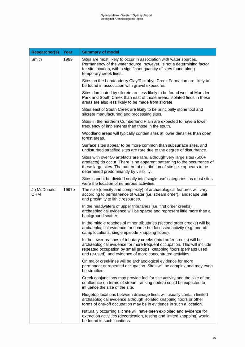
Sydney Metro - Western Sydney Airport Aboriginal Archaeological Report
30
Researcher(s) Year Summary of model Smith 1989 Sites are most likely to occur in association with water sources.
Permanency of the water source, however, is not a determining factor for site location, with a significant quantity of sites found along temporary creek lines.
Sites on the Londonderry Clay/Rickabys Creek Formation are likely to be found in association with gravel exposures.
Sites dominated by silcrete are less likely to be found west of Marsden Park and South Creek than east of those areas. Isolated finds in these areas are also less likely to be made from silcrete.
Sites east of South Creek are likely to be principally stone tool and silcrete manufacturing and processing sites.
Sites in the northern Cumberland Plain are expected to have a lower frequency of implements than those in the south.
Woodland areas will typically contain sites at lower densities than open forest areas.
Surface sites appear to be more common than subsurface sites, and undisturbed stratified sites are rare due to the degree of disturbance.
Sites with over 50 artefacts are rare, although very large sites (500+ artefacts) do occur. There is no apparent patterning to the occurrence of these large sites. The pattern of distribution of site size appears to be determined predominantly by visibility.
Sites cannot be divided neatly into ‘single use’ categories, as most sites were the location of numerous activities.
Jo McDonald CHM
1997b The size (density and complexity) of archaeological features will vary according to permanence of water (i.e. stream order), landscape unit and proximity to lithic resources.
In the headwaters of upper tributaries (i.e. first order creeks) archaeological evidence will be sparse and represent little more than a background scatter;
In the middle reaches of minor tributaries (second order creeks) will be archaeological evidence for sparse but focussed activity (e.g. one-off camp locations, single episode knapping floors).
In the lower reaches of tributary creeks (third order creeks) will be archaeological evidence for more frequent occupation. This will include repeated occupation by small groups, knapping floors (perhaps used and re-used), and evidence of more concentrated activities.
On major creeklines will be archaeological evidence for more permanent or repeated occupation. Sites will be complex and may even be stratified.
Creek conjunctions may provide foci for site activity and the size of the confluence (in terms of stream ranking nodes) could be expected to influence the size of the site.
Ridgetop locations between drainage lines will usually contain limited archaeological evidence although isolated knapping floors or other forms of one-off occupation may be in evidence in such a location.
Naturally occurring silcrete will have been exploited and evidence for extraction activities (decortication, testing and limited knapping) would be found in such locations.
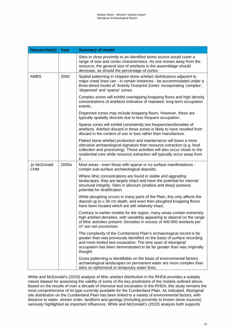
Sydney Metro - Western Sydney Airport Aboriginal Archaeological Report
31
Researcher(s) Year Summary of model Sites in close proximity to an identified stone source would cover a range of size and cortex characteristics. As one moves away from the resource, the general size of artefacts in the assemblage should decrease, as should the percentage of cortex.
AMBS 2000 Spatial patterning in chipped stone artefact distributions adjacent to major creek lines can - in certain instances - be accommodated under a three-tiered model of ‘Activity Overprint Zones’ incorporating ‘complex’, ‘dispersed’ and ‘sparse’ zones.
Complex zones will exhibit overlapping knapping floors and high density concentrations of artefacts indicative of repeated, long-term occupation events.
Dispersed zones may include knapping floors. However, these are typically spatially discrete due to less frequent occupation.
Sparse zones will exhibit consistently low frequencies/densities of artefacts. Artefact discard in these zones is likely to have resulted from discard in the context of use or loss rather than manufacture.
Flaked stone artefact production and maintenance will leave a more obtrusive archaeological signature than resource extraction (e.g. food collection and processing). These activities will also occur closer to the residential core while resource extraction will typically occur away from it.
Jo McDonald CHM
2005a Most areas - even those with sparse or no surface manifestations - contain sub-surface archaeological deposits.
Where lithic concentrations are found in stable and aggrading landscapes, they are largely intact and have the potential for internal structural integrity. Sites in alluvium (shallow and deep) possess potential for stratification.
While ploughing occurs in many parts of the Plain, this only affects the deposit up to c.30 cm depth, and even then ploughed knapping floors have been located which are still relatively intact.
Contrary to earlier models for the region, many areas contain extremely high artefact densities, with variability appearing to depend on the range of lithic activities present. Densities in excess of 400-600 artefacts per m2 are not uncommon.
The complexity of the Cumberland Plain’s archaeological record is far greater than was previously identified on the basis of surface recording and more limited test excavation. The time span of Aboriginal occupation has been demonstrated to be far greater than was originally thought.
Gross patterning is identifiable on the basis of environmental factors: archaeological landscapes on permanent water are more complex than sites on ephemeral or temporary water lines.
White and McDonald’s (2010) analysis of lithic artefact distribution in the RHDA provides a suitably robust dataset for assessing the validity of some of the key predictions of the models outlined above. Based on the results of over a decade of intensive test excavation in the RHDA, this study remains the most comprehensive of its type currently available for the Cumberland Plain. As indicated, Aboriginal site distribution on the Cumberland Plain has been linked to a variety of environmental factors, with distance to water, stream order, landform and geology (including proximity to known stone sources) variously highlighted as important influences. White and McDonald’s (2010) analysis both supports
Sydney Metro - Western Sydney Airport Aboriginal Archaeological Report
32
and negates various aspects of the postulated relationships between these factors and Aboriginal site patterning on the Cumberland Plain. Key findings can be summarised as follows:
• artefact distributions do not, as implied by the models of Kohen (1986) and Smith (1989), form bounded ‘sites’ but rather ‘landscapes’
• artefact distribution does, as variably expressed by AMBS (2000), Kohen (1986), Jo McDonald CHM (1997b, 2005) and Smith (1989), appear to vary with proximity to water, albeit to different extents based on stream order
• artefact density does, as suggested by Jo McDonald CHM (1997b, 2005), appear to vary significantly with stream order
• artefact density does, as suggested by Jo McDonald CHM (1997b, 2005), appear to vary significantly with landform
• Aboriginal archaeological sites on the Cumberland Plain cannot, as proposed by Jo McDonald CHM (2005), be adequately characterized on the basis of surface evidence alone. Most areas, regardless of surface indications, contain subsurface archaeological deposit(s)
• the orientation of open land surfaces appears to have influenced the selection of artefact discard locations in the lower portions of valleys, with generally higher densities on lower slopes facing north and north-east
• distance from known silcrete sources does not, on present evidence at least, appear to have influenced intensity of artefact discard (cf. Dallas & Witter 1983)
• trends in artefact density and distribution indicate long-term, large scale patterns. Short term models of settlement organization are insufficient to account for these artefact distributions
• social and/or symbolic factors may have influenced site selection along with the distributions of economic and other resources.
More recently, AHMS (2015), employing a comparable analytical methodology to White and McDonald (2010), undertook an analysis of lithic artefact distribution across sixteen northwestern Cumberland Plain landscapes subject to dispersed testing and/or targeted open area salvage excavations. The dataset for this analysis, which sought, in common with White and McDonald’s (2010) study, to identify patterns in artefact discard7 comprised 2,988 artefacts from 345 dispersed test pits (1 m2) along multiple pipeline corridors. In common with White and McDonald (2010: 32-33), AHMS found that artefact distribution within their sampled landscapes varied significantly in relation to both stream order and landform, with mean artefact densities highest in 3rd order landscapes (16.7 artefacts/m2) and on terraces (16.9 artefacts/m2). Interestingly, however, the mean artefact density for 3rd order landscapes in AHMS’s (2015) dataset (i.e. 16.7 artefacts/m2) was found to exceed that for 4th order landscapes in the RHDA dataset (13.9 artefacts/m2). The mean artefact density for creek flats in AHMS’s dataset (7.8 artefacts/m2) was likewise found to exceed its counterpart in the RHDA dataset (3.8 artefacts/m2), suggesting that creek flats in AHMS’s sampled landscapes may have been more favoured for occupation than those in the RHDA or, alternatively, that creek flats in the RHDA had been subject to more intensive flood-erosion activity (resulting in a greater loss of artefacts).
In keeping with White and McDonald’s (2010:34) results, AHMS found that in 2nd order landscapes, artefact density was highest within 50 m of water. Distance to water in 4th order landscapes was not assessed by AHMS. However, in a comparable finding to White and McDonald’s (2010:34, Table 9) 4th order dataset, AHMS found that in 3rd order landscapes, artefact density was highest between 51 and 100 m from water. Consideration of 1st and 3rd order landscapes in combination likewise showed that mean artefact density was highest between 51 and 100 m of water, suggesting, in combination with the above, that landform elements located at a slightly greater distance to creeks (and particularly larger creeks) were favoured for sustained/repeated occupation8. While limited to lower slopes, AHMS’s analysis of artefact distribution in relation to slope aspect revealed both similarities and differences with the RHDA dataset, with southeast-facing lower slopes in AHMS’s sampled
7 And, by extension, past Aboriginal land use preferences. 8 For the RHDA, White and McDonald (2010:33) attributed a comparable finding to factors such as allowing animals to drink and catching a cool breeze.
Sydney Metro - Western Sydney Airport Aboriginal Archaeological Report
33
landscapes exhibiting the highest mean artefact density (as opposed to north/northeast-facing slopes in the RHDA dataset), followed by northeast-facing lower slopes. Finally, AHMS’s analysis of artefact distribution in relation to distance to known silcrete sources produced an entirely different result to White and McDonald’s (2010:35, Table 12) analysis of the same relationship, with the latter revealing a pattern of increasing artefact density with increasing distance from known sources. In AHMS’s dataset, artefact density was highest within two to three kilometres of known silcrete sources. However, outside of this finding, no clear patterning was evident, suggesting, in line with White and McDonald’s (2010) findings, that distance to known silcrete sources likely had little influence over artefact discard rates.
3.2 Local archaeological context 3.2.1 Off-airport local context AHIMS database The AHIMS database, administered by Heritage NSW, contains records of all reported Aboriginal objects in accordance with Section 89A of the National Parks and Wildlife Act 1974 (NPW Act). It also contains information about Aboriginal places, which have been declared by the Minister to have special significance with respect to Aboriginal culture. Previously recorded Aboriginal objects and declared Aboriginal places are known as ‘Aboriginal sites’.
Searches of the AHIMS database were undertaken on 1 April 2019 (Search IDs 411399, 411404 and 411419). This was undertaken over three separate search areas as the AHIMS register only provides search results for areas with fewer than 120 sites contained within them. Each of these searches was updated on 13 March 2020, 6 May 2020 and on 22 May 2020 (Search ID 507243). These searches covered an approximate area of 58 kilometres by nine kilometres, centred on the project, as well as sites in the immediate surrounding region.
A total of 360 sites were identified in these search results, comprising the study area for this assessment. Of these, a total of 12 sites were found to have centroids registered within the bounds of the construction footprint, with 10 in the on-airport area and two in the off-airport area. A further two sites were found to have PAD curtilages that extended partially into the off-airport construction corridor. The full search results are included in Appendix B (note: AHIMS Search Results are not shown in the public version of this report).
As is typical for the Cumberland Plain, artefact scatters and isolated artefact sites with and without other forms of archaeological evidence were the most common site type represented within the AHIMS search area (n=309 combined). Other, comparatively poorly represented types included nine PADs, six culturally modified trees, three art sites and one grinding groove site. It should be noted that a PAD is not a site, rather it is an area of potential awaiting verification of site status following further investigation to determine the presence or absence of subsurface artefact bearing cultural deposits.
There were 30 destroyed sites listed in the search results as well, referring to sites that have been destroyed under the conditions of a permit, usually issued for development works. The destroyed sites were predominantly located in the northern portion of the construction footprint, generally falling between St Marys and Claremont Creek. They were destroyed under permits 3762, 3752, 4001, 4096 and 4228. They were destroyed as a part of developing a regional depot at Plumpton and M4 Motorway upgrade road works between Church Street, Parramatta and Coleman Street, St Marys, as well as between Prospect and Emu Plains. These works included impacts in the suburbs of Riverstone, Schofields and Quakers Hill. Further details on AHIPs that intersect with the study area are included below.
There were also two registrations listed as Not a Site. The category Not a Site refers to a registration which, on further investigation, has been verified as not being of Aboriginal origin (i.e. verified as not having been created by Aboriginal people).
It should also be noted that the AHIMS search result data contains multiple inaccuracies. It is possible that some of the artefact scatter sites may be isolated artefacts, as information on the number of artefacts located in site areas is not present for all of those identified in the search results. Coordinate inaccuracy for AHIMS data is also known from past assessments to be an issue. The given

Sydney Metro - Western Sydney Airport Aboriginal Archaeological Report
34
coordinates only represent a centroid, not the full extent of a site’s area. As summarised in Table 3-3, there are 360 registered Aboriginal sites within the total study area.
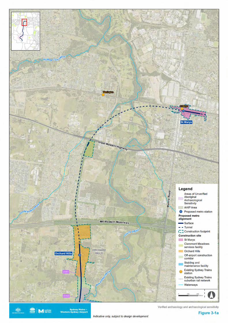
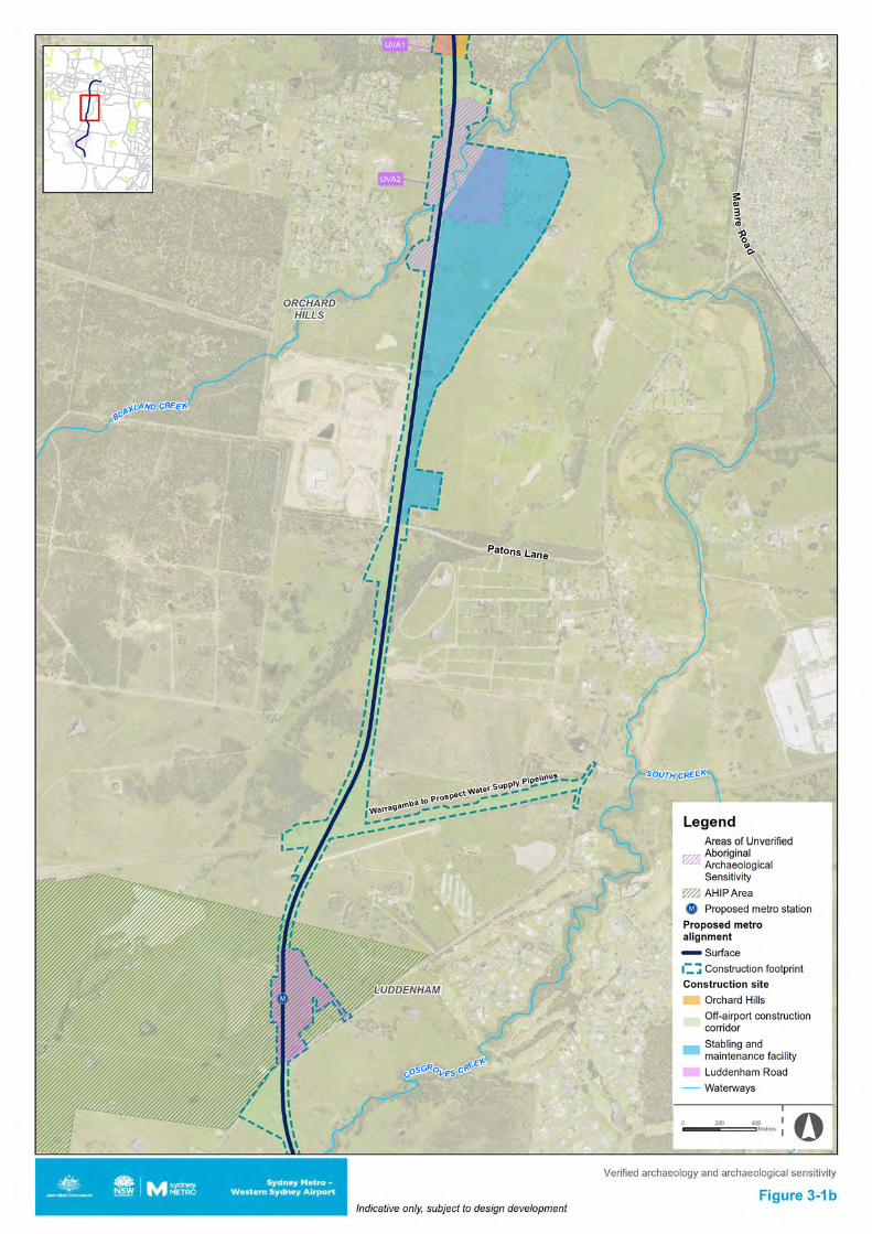
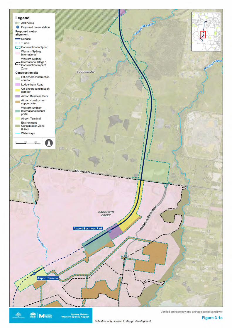
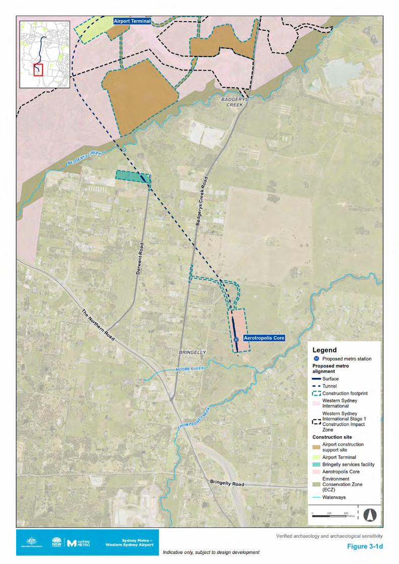
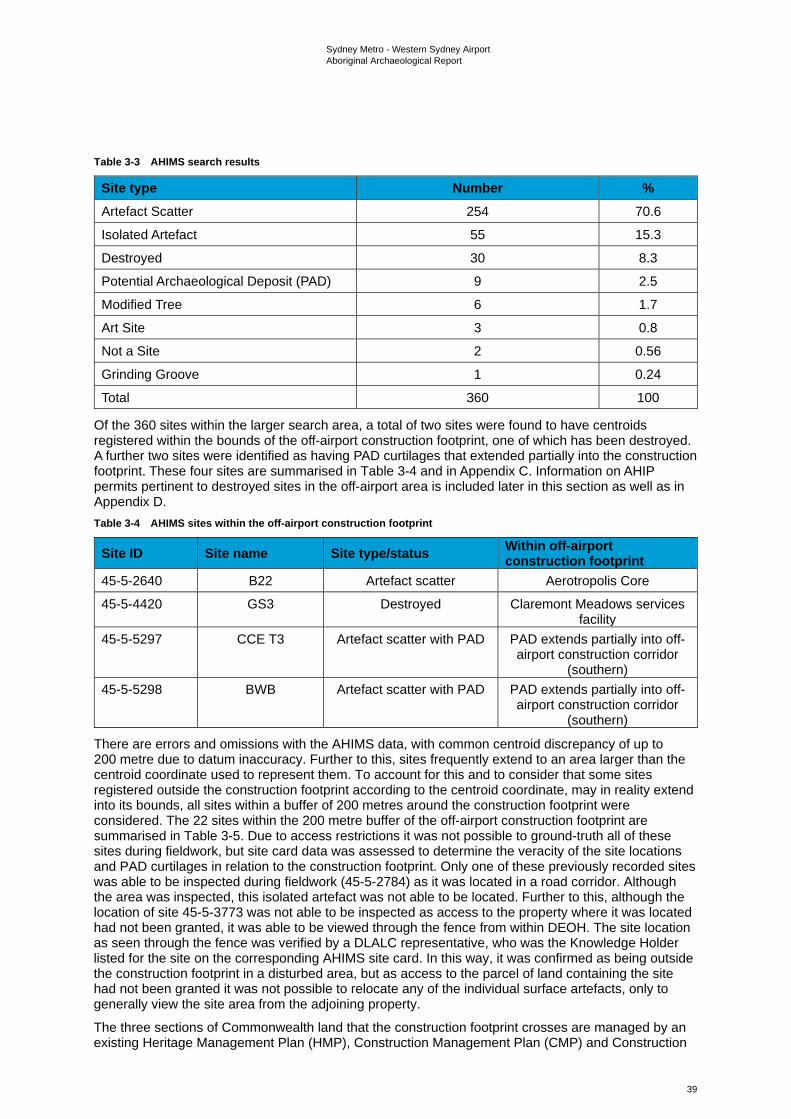
Sydney Metro - Western Sydney Airport Aboriginal Archaeological Report
39
Table 3-3 AHIMS search results
Site type Number % Artefact Scatter 254 70.6
Isolated Artefact 55 15.3
Destroyed 30 8.3
Potential Archaeological Deposit (PAD) 9 2.5
Modified Tree 6 1.7
Art Site 3 0.8
Not a Site 2 0.56
Grinding Groove 1 0.24
Total 360 100
Of the 360 sites within the larger search area, a total of two sites were found to have centroids registered within the bounds of the off-airport construction footprint, one of which has been destroyed. A further two sites were identified as having PAD curtilages that extended partially into the construction footprint. These four sites are summarised in Table 3-4 and in Appendix C. Information on AHIP permits pertinent to destroyed sites in the off-airport area is included later in this section as well as in Appendix D. Table 3-4 AHIMS sites within the off-airport construction footprint
Site ID Site name Site type/status Within off-airport construction footprint
45-5-2640 B22 Artefact scatter Aerotropolis Core
45-5-4420 GS3 Destroyed Claremont Meadows services facility
45-5-5297 CCE T3 Artefact scatter with PAD PAD extends partially into off-airport construction corridor
(southern) 45-5-5298 BWB Artefact scatter with PAD PAD extends partially into off-
airport construction corridor (southern)
There are errors and omissions with the AHIMS data, with common centroid discrepancy of up to 200 metre due to datum inaccuracy. Further to this, sites frequently extend to an area larger than the centroid coordinate used to represent them. To account for this and to consider that some sites registered outside the construction footprint according to the centroid coordinate, may in reality extend into its bounds, all sites within a buffer of 200 metres around the construction footprint were considered. The 22 sites within the 200 metre buffer of the off-airport construction footprint are summarised in Table 3-5. Due to access restrictions it was not possible to ground-truth all of these sites during fieldwork, but site card data was assessed to determine the veracity of the site locations and PAD curtilages in relation to the construction footprint. Only one of these previously recorded sites was able to be inspected during fieldwork (45-5-2784) as it was located in a road corridor. Although the area was inspected, this isolated artefact was not able to be located. Further to this, although the location of site 45-5-3773 was not able to be inspected as access to the property where it was located had not been granted, it was able to be viewed through the fence from within DEOH. The site location as seen through the fence was verified by a DLALC representative, who was the Knowledge Holder listed for the site on the corresponding AHIMS site card. In this way, it was confirmed as being outside the construction footprint in a disturbed area, but as access to the parcel of land containing the site had not been granted it was not possible to relocate any of the individual surface artefacts, only to generally view the site area from the adjoining property.
The three sections of Commonwealth land that the construction footprint crosses are managed by an existing Heritage Management Plan (HMP), Construction Management Plan (CMP) and Construction
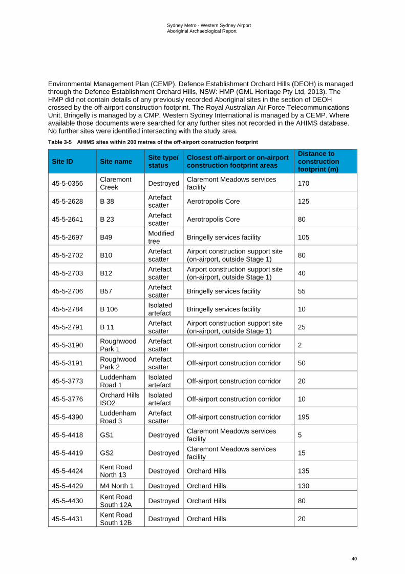
Sydney Metro - Western Sydney Airport Aboriginal Archaeological Report
40
Environmental Management Plan (CEMP). Defence Establishment Orchard Hills (DEOH) is managed through the Defence Establishment Orchard Hills, NSW: HMP (GML Heritage Pty Ltd, 2013). The HMP did not contain details of any previously recorded Aboriginal sites in the section of DEOH crossed by the off-airport construction footprint. The Royal Australian Air Force Telecommunications Unit, Bringelly is managed by a CMP. Western Sydney International is managed by a CEMP. Where available those documents were searched for any further sites not recorded in the AHIMS database. No further sites were identified intersecting with the study area. Table 3-5 AHIMS sites within 200 metres of the off-airport construction footprint
Site ID Site name Site type/ status
Closest off-airport or on-airport construction footprint areas
Distance to construction footprint (m)
45-5-0356 Claremont Creek Destroyed Claremont Meadows services
facility 170
45-5-2628 B 38 Artefact scatter Aerotropolis Core 125
45-5-2641 B 23 Artefact scatter Aerotropolis Core 80
45-5-2697 B49 Modified tree Bringelly services facility 105
45-5-2702 B10 Artefact scatter
Airport construction support site (on-airport, outside Stage 1) 80
45-5-2703 B12 Artefact scatter
Airport construction support site (on-airport, outside Stage 1) 40
45-5-2706 B57 Artefact scatter Bringelly services facility 55
45-5-2784 B 106 Isolated artefact Bringelly services facility 10
45-5-2791 B 11 Artefact scatter
Airport construction support site (on-airport, outside Stage 1) 25
45-5-3190 Roughwood Park 1
Artefact scatter Off-airport construction corridor 2
45-5-3191 Roughwood Park 2
Artefact scatter Off-airport construction corridor 50
45-5-3773 Luddenham Road 1
Isolated artefact Off-airport construction corridor 20
45-5-3776 Orchard Hills ISO2
Isolated artefact Off-airport construction corridor 10
45-5-4390 Luddenham Road 3
Artefact scatter Off-airport construction corridor 195
45-5-4418 GS1 Destroyed Claremont Meadows services facility 5
45-5-4419 GS2 Destroyed Claremont Meadows services facility 15
45-5-4424 Kent Road North 13 Destroyed Orchard Hills 135
45-5-4429 M4 North 1 Destroyed Orchard Hills 130
45-5-4430 Kent Road South 12A Destroyed Orchard Hills 80
45-5-4431 Kent Road South 12B Destroyed Orchard Hills 20
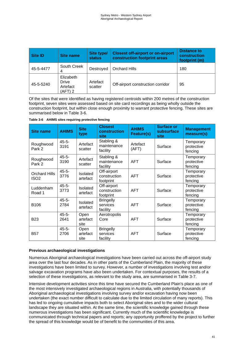
Sydney Metro - Western Sydney Airport Aboriginal Archaeological Report
41
Site ID Site name Site type/ status
Closest off-airport or on-airport construction footprint areas
Distance to construction footprint (m)
45-5-4477 South Creek 4 Destroyed Orchard Hills 180
45-5-5240
Elizabeth Drive Artefact (AFT) 2
Artefact scatter Off-airport construction corridor 95
Of the sites that were identified as having registered centroids within 200 metres of the construction footprint, seven sites were assessed based on site card recordings as being wholly outside the construction footprint, but within close enough proximity to warrant protective fencing. These sites are summarised below in Table 3-6. Table 3-6 AHIMS sites requiring protective fencing
Site name AHIMS Site type
Closest construction site
AHIMS Feature(s)
Surface or subsurface site
Management measure(s)
Roughwood Park 2
45-5-3191
Artefact scatter
Stabling & maintenance facility
Artefact (AFT) Surface
Temporary protective fencing
Roughwood Park 2
45-5-3190
Artefact scatter
Stabling & maintenance facility
AFT Surface Temporary protective fencing
Orchard Hills ISO2
45-5-3776
Isolated artefact
Off-airport construction footprint
AFT Surface Temporary protective fencing
Luddenham Road 1
45-5-3773
Isolated artefact
Off-airport construction footprint
AFT Surface Temporary protective fencing
B106 45-5-2784
Isolated artefact
Bringelly services facility
AFT Surface Temporary protective fencing
B23 45-5-2641
Open artefact site
Aerotropolis Core AFT Surface
Temporary protective fencing
B57 45-5-2706
Open artefact site
Bringelly services facility
AFT Surface Temporary protective fencing
Previous archaeological investigations Numerous Aboriginal archaeological investigations have been carried out across the off-airport study area over the last four decades. As in other parts of the Cumberland Plain, the majority of these investigations have been limited to survey. However, a number of investigations involving test and/or salvage excavation programs have also been undertaken. For contextual purposes, the results of a selection of these investigations, as relevant to the study area, are summarised in Table 3-7.
Intensive development activities since this time have secured the Cumberland Plain’s place as one of the most intensively investigated archaeological regions in Australia, with potentially thousands of Aboriginal archaeological investigations involving survey and/or excavation having now been undertaken (the exact number difficult to calculate due to the limited circulation of many reports). This has led to ongoing cumulative impacts both to select Aboriginal sites and to the wider cultural landscape they are situated within. At the same time, the scientific knowledge gained through these numerous investigations has been significant. Currently much of the scientific knowledge is communicated through technical papers and reports; any opportunity proffered by the project to further the spread of this knowledge would be of benefit to the communities of this area.
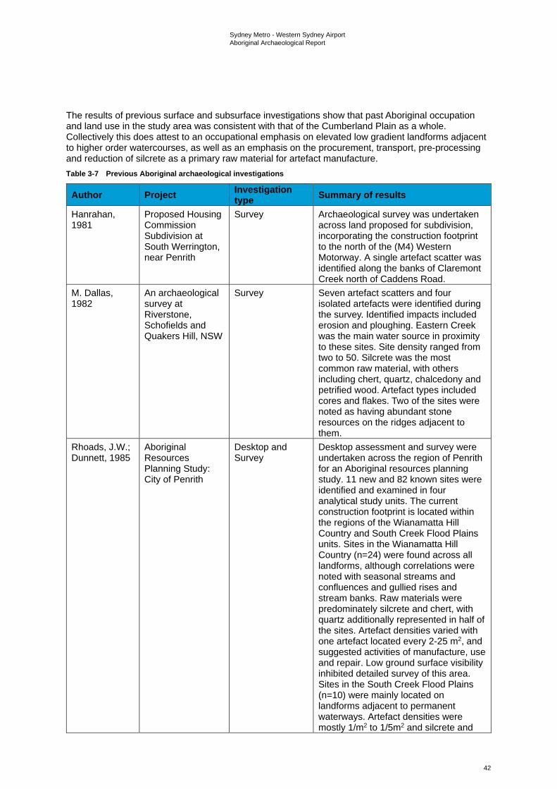
Sydney Metro - Western Sydney Airport Aboriginal Archaeological Report
42
The results of previous surface and subsurface investigations show that past Aboriginal occupation and land use in the study area was consistent with that of the Cumberland Plain as a whole. Collectively this does attest to an occupational emphasis on elevated low gradient landforms adjacent to higher order watercourses, as well as an emphasis on the procurement, transport, pre-processing and reduction of silcrete as a primary raw material for artefact manufacture. Table 3-7 Previous Aboriginal archaeological investigations
Author Project Investigation type Summary of results
Hanrahan, 1981
Proposed Housing Commission Subdivision at South Werrington, near Penrith
Survey Archaeological survey was undertaken across land proposed for subdivision, incorporating the construction footprint to the north of the (M4) Western Motorway. A single artefact scatter was identified along the banks of Claremont Creek north of Caddens Road.
M. Dallas, 1982
An archaeological survey at Riverstone, Schofields and Quakers Hill, NSW
Survey Seven artefact scatters and four isolated artefacts were identified during the survey. Identified impacts included erosion and ploughing. Eastern Creek was the main water source in proximity to these sites. Site density ranged from two to 50. Silcrete was the most common raw material, with others including chert, quartz, chalcedony and petrified wood. Artefact types included cores and flakes. Two of the sites were noted as having abundant stone resources on the ridges adjacent to them.
Rhoads, J.W.; Dunnett, 1985
Aboriginal Resources Planning Study: City of Penrith
Desktop and Survey
Desktop assessment and survey were undertaken across the region of Penrith for an Aboriginal resources planning study. 11 new and 82 known sites were identified and examined in four analytical study units. The current construction footprint is located within the regions of the Wianamatta Hill Country and South Creek Flood Plains units. Sites in the Wianamatta Hill Country (n=24) were found across all landforms, although correlations were noted with seasonal streams and confluences and gullied rises and stream banks. Raw materials were predominately silcrete and chert, with quartz additionally represented in half of the sites. Artefact densities varied with one artefact located every 2-25 m2, and suggested activities of manufacture, use and repair. Low ground surface visibility inhibited detailed survey of this area. Sites in the South Creek Flood Plains (n=10) were mainly located on landforms adjacent to permanent waterways. Artefact densities were mostly 1/m2 to 1/5m2 and silcrete and
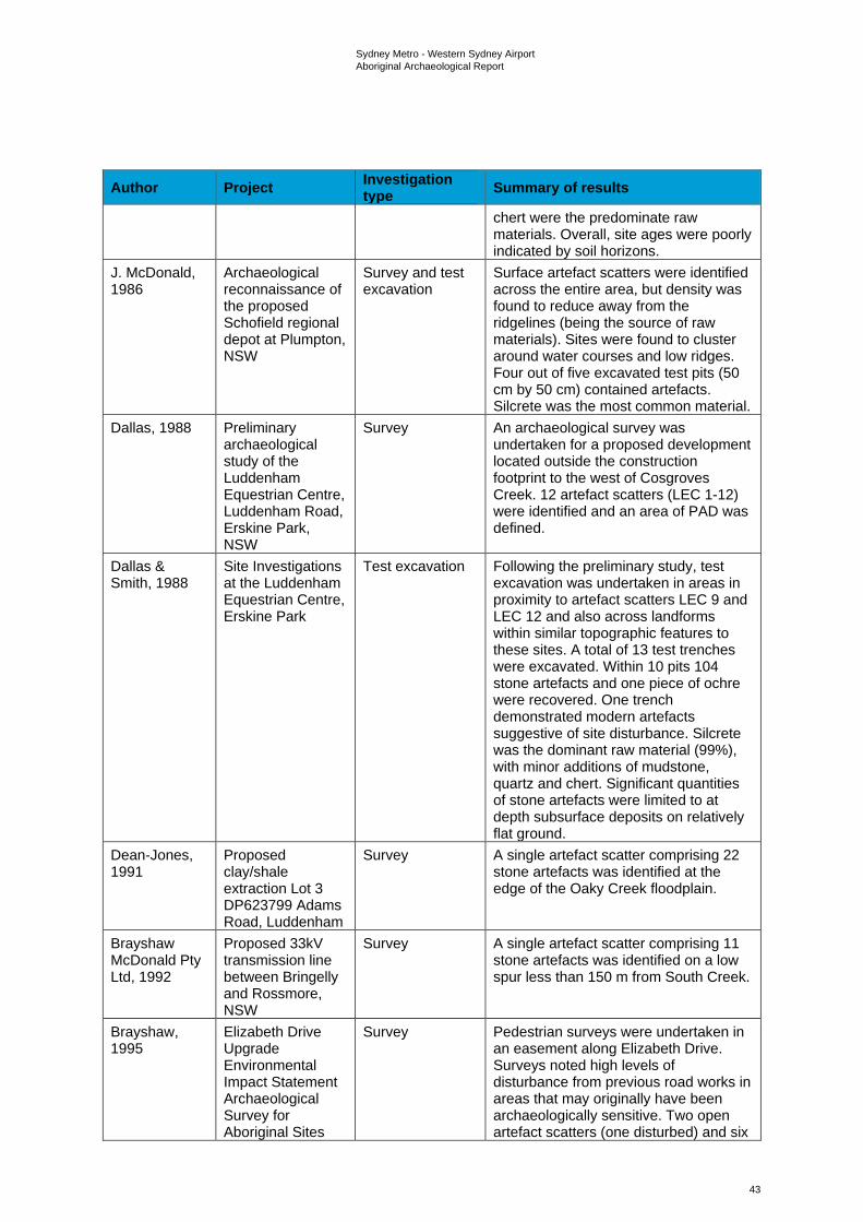
Sydney Metro - Western Sydney Airport Aboriginal Archaeological Report
43
Author Project Investigation type Summary of results
chert were the predominate raw materials. Overall, site ages were poorly indicated by soil horizons.
J. McDonald, 1986
Archaeological reconnaissance of the proposed Schofield regional depot at Plumpton, NSW
Survey and test excavation
Surface artefact scatters were identified across the entire area, but density was found to reduce away from the ridgelines (being the source of raw materials). Sites were found to cluster around water courses and low ridges. Four out of five excavated test pits (50 cm by 50 cm) contained artefacts. Silcrete was the most common material.
Dallas, 1988 Preliminary archaeological study of the Luddenham Equestrian Centre, Luddenham Road, Erskine Park, NSW
Survey An archaeological survey was undertaken for a proposed development located outside the construction footprint to the west of Cosgroves Creek. 12 artefact scatters (LEC 1-12) were identified and an area of PAD was defined.
Dallas & Smith, 1988
Site Investigations at the Luddenham Equestrian Centre, Erskine Park
Test excavation Following the preliminary study, test excavation was undertaken in areas in proximity to artefact scatters LEC 9 and LEC 12 and also across landforms within similar topographic features to these sites. A total of 13 test trenches were excavated. Within 10 pits 104 stone artefacts and one piece of ochre were recovered. One trench demonstrated modern artefacts suggestive of site disturbance. Silcrete was the dominant raw material (99%), with minor additions of mudstone, quartz and chert. Significant quantities of stone artefacts were limited to at depth subsurface deposits on relatively flat ground.
Dean-Jones, 1991
Proposed clay/shale extraction Lot 3 DP623799 Adams Road, Luddenham
Survey A single artefact scatter comprising 22 stone artefacts was identified at the edge of the Oaky Creek floodplain.
Brayshaw McDonald Pty Ltd, 1992
Proposed 33kV transmission line between Bringelly and Rossmore, NSW
Survey A single artefact scatter comprising 11 stone artefacts was identified on a low spur less than 150 m from South Creek.
Brayshaw, 1995
Elizabeth Drive Upgrade Environmental Impact Statement Archaeological Survey for Aboriginal Sites
Survey Pedestrian surveys were undertaken in an easement along Elizabeth Drive. Surveys noted high levels of disturbance from previous road works in areas that may originally have been archaeologically sensitive. Two open artefact scatters (one disturbed) and six
Sydney Metro - Western Sydney Airport Aboriginal Archaeological Report
44
Author Project Investigation type Summary of results
areas of PAD were identified. The artefact scatters contained a total of 13 stone artefacts of varied materials (silcrete, chert, FGS, mudstone and quartzite), with one possible and two definite cores identified. A program of subsurface testing was recommended for the undisturbed site and five of the PADs.
Helen Brayshaw Heritage Consultants, 1996
M4 Upgrade: Archaeological Survey for Aboriginal Sites for Proposal to Upgrade the M4 Motorway from Church Street Parramatta to Coleman Street Marys Hill and Prospect to Emu Plains
Survey Pedestrian survey undertaken prior to upgrade works on the M4, including an area of the construction footprint where the M4 intersects with Kent Road. 20 open artefact sites comprising isolated artefacts or artefact scatters were identified, including four located within or in proximity to the construction footprint (Locations 11, 12A, 12B and 13). Most sites were located in disturbed contexts.
Steele, 1999
Steele, 2001
Steele, 2004
Steele, 2007
Twin Creeks Estate, Luddenham
Survey (1999); Test excavation (2001); Aboriginal Heritage Conservation Action Plan (2004); Excavation and monitoring (2007)
A program of archaeological assessment was undertaken following previous work undertaken at the Luddenham Equestrian Centre by Dallas in 1988. Surveys identified five previously unrecorded open campsites, an isolated artefact and a possible modified tree, in addition to relocating five of 12 previously recorded artefact scatters in the locality.
Preliminary test excavations were undertaken for three of the previously recorded open campsites (AHIMS #45-6-1772, #45-6-1774 and #45-6-1777) which were indicated to contain moderate archaeological potential. Additional excavation was undertaken around a spur identified by the representatives from the Local Aboriginal Land Council (LALC) as potentially sensitive. Angular silcrete gravels and fragments assessed as naturally occurring were present throughout the site. Total worked stone (n=319) consisted of varied proportions of silcrete, tuff and quartz, with small numbers of volcanics, petrified wood and quartzite. The presence of backed artefacts led to the dating of the site to the Middle Bondaian, between 2,800 BP and 1,600 BP.
Sydney Metro - Western Sydney Airport Aboriginal Archaeological Report
45
Author Project Investigation type Summary of results
An Aboriginal Heritage Conservation Action Plan (Steele, 2004) was prepared in conjunction with an application for a Section 90 Heritage Impact Permit Consent with Salvage and Collection for the Twin Creeks Estate development. The area was divided into 9 zones; consent with salvage was requested for Zones F and G, while consent with collection was requested for Zones B, C, D, E and H.
Archaeological excavation and monitoring (Steele, 2007) were undertaken at the Twin Creeks Estate in accordance with the approved Conservation Action Plan and S90 Consent (#2056). Site LEC 12 (AHIMS #45-6-177) was assessed and stabilised; site LEC 10 (AHIMS #45-6-1779) was excavated for salvage; and site TCE 1 (AHIMS #45-5-2991) was collected following its identification during the period of development monitoring. Excavations for LEC 10 recovered 120 artefacts over 16 test trenches, with 57 complete flakes.
Jo McDonald Cultural Heritage Management Pty Ltd, 2000
Archaeological Survey for Aboriginal Sites: Proposed Light Industrial Subdivision, "Austral Site", Mamre Road, Erskine Park, NSW
Survey Five artefact scatters and three isolated artefacts were identified. Salvage works were recommended prior to development proceeding.
Jo McDonald Cultural Heritage Management Pty Ltd, 2001
Survey for Aboriginal Sites 1503 Elizabeth Drive, Kemps Creek
Survey Pedestrian surveys were undertaken for a 25.5 hectares section of Nolans Quarry proposed for redevelopment. One section of PAD was identified on a ridgeline in proximity to Kemps Creek and South Creek, with an associated quartz flake located on the surface. Clearing prior to the survey was suggested to have impacted the surface of the site, potentially having destroyed previous artefacts. Despite this, intact subsurface deposits were considered possible.
Sydney Metro - Western Sydney Airport Aboriginal Archaeological Report
46
Author Project Investigation type Summary of results
URS Australia Pty Ltd, 2001
Gipps Street Landfill Site, Claremont Meadows
Survey An archaeological survey was undertaken of Gipps Street Lane, located within the construction footprint. No Aboriginal sites were identified. Observations concluded that the site had been subject to high levels of past disturbance.
Appleton, 2002
The Archaeological Investigation of Lot 2, DP 120673 The Site of a Proposed New Clay and Shale Extraction Area - Old Wallgrove Road Horsley Park, West of Sydney NSW
Survey Two isolated artefacts and an area of PAD were identified during survey at this location.
Environmental Resources Management Australia Pty Ltd, 2003
Environmental Resources Management Australia Pty Ltd, 2006a
Land Solutions Development, Claremont Meadows
Survey; Test excavation and salvage
Archaeological survey was undertaken for a portion of land located outside the construction footprint, between the M4 and Fowler Street. Nine sites were identified, comprising four artefact scatters, four isolated artefacts and a possible scarred tree. A Section 90 consent to destroy was recommended for disturbed sites in the north of the study area, while testing followed by a Section 90 consent was recommended for site OAD1.
Subsequent test excavations and salvage were undertaken for site OAD1 (AHIMS #45-5-3013), which was determined to form part of AHIMS #45-5-2898. Approximately 2,000 artefacts were recovered, with evidence of complex activity zones including knapping floors and potential associations with heat shatters and campsites. Site distribution within the area was correlated with the crest at the 30 m contour overlooking South Creek.
Environmental Resources Management Australia Pty Ltd, 2006b
Lots 8, 9, 10 DP27107 and Lot 19 DP239091 Claremont Meadows
Survey
Survey was undertaken for a proposed development located outside the construction footprint, to the north west of Kent Road. Six Aboriginal sites were identified in areas of exposure across the site and subsurface potential was predicted for the flat floodplain.
Jo McDonald Cultural Heritage Management Pty Ltd, 2008b
Austral Land Mamre Rd, Erskine Park: Archaeological
Salvage Salvage excavations were undertaken with 298 m2 excavated and 8,867 artefacts retrieved from subsurface deposits. Artefact density was found to be tied to stream order. Use of silcrete
Sydney Metro - Western Sydney Airport Aboriginal Archaeological Report
47
Author Project Investigation type Summary of results
Salvage Excavations
as a raw material diminished as the distance from silcrete sources increased. Backed blades were present as was evidence of bipolar flaking.
Jo McDonald Cultural Heritage Management Pty Ltd, 2008a
Lot 2 DP771697, Claremont Meadows
Survey Pedestrian survey undertaken for a development area located within the construction footprint to the immediate south of the (A44) Great Western Highway. One isolated find (GS01 consisting of a silcrete flake) was identified in the road corridor of Gipps Street at the edge of an eroding bank associated with a drainage line.
Biosis Research Pty Ltd, 2008
Rosehill Recycled Water Scheme Preliminary Cultural Heritage Assessment
Survey No sites were identified during survey, although it was noted that one artefact scatter and one PAD were both located in close proximity. An area of sensitivity was demarcated.
Environmental Resources Management Australia Pty Ltd, 2010
Lots 8, 9, 10 DP27107 and Lot 19 DP239091 Claremont Meadows
Test excavation and salvage
Test excavations were undertaken for three sites identified in the 2006 assessment (CMSW3, CMSW4 and CMSW5), while test excavation and salvage were undertaken for site CMSW1. A total of 773 artefacts were recovered and included flaked stone and flaked glass, suggesting site occupation in the contact period.
Archaeological and Heritage Management Solutions Pty Ltd, 2012
Aboriginal Archaeological Survey Report: Werrington Arterial Road (M4 Motorway – Great Western Highway), Claremont Meadows, NSW
Survey An assessment was undertaken for proposed upgrade works at Gipps Street and Kent Road from the M4 Motorway to the Great Western Highway, near Claremont Meadows. A total of seven Aboriginal sites were identified within the study area, with a further three in close proximity, outside the study area boundary. Five of the sites had been previously recorded; five sites were new recordings. The sites included seven isolated artefacts and three artefact scatters (one identified as having an associated area of PAD). Site #45-5-2898 was verified as being outside the study area, as the AHIMS coordinates had erroneously identified it as within. Site avoidance was recommended with an AHIP stated as needed if sites could not be avoided.
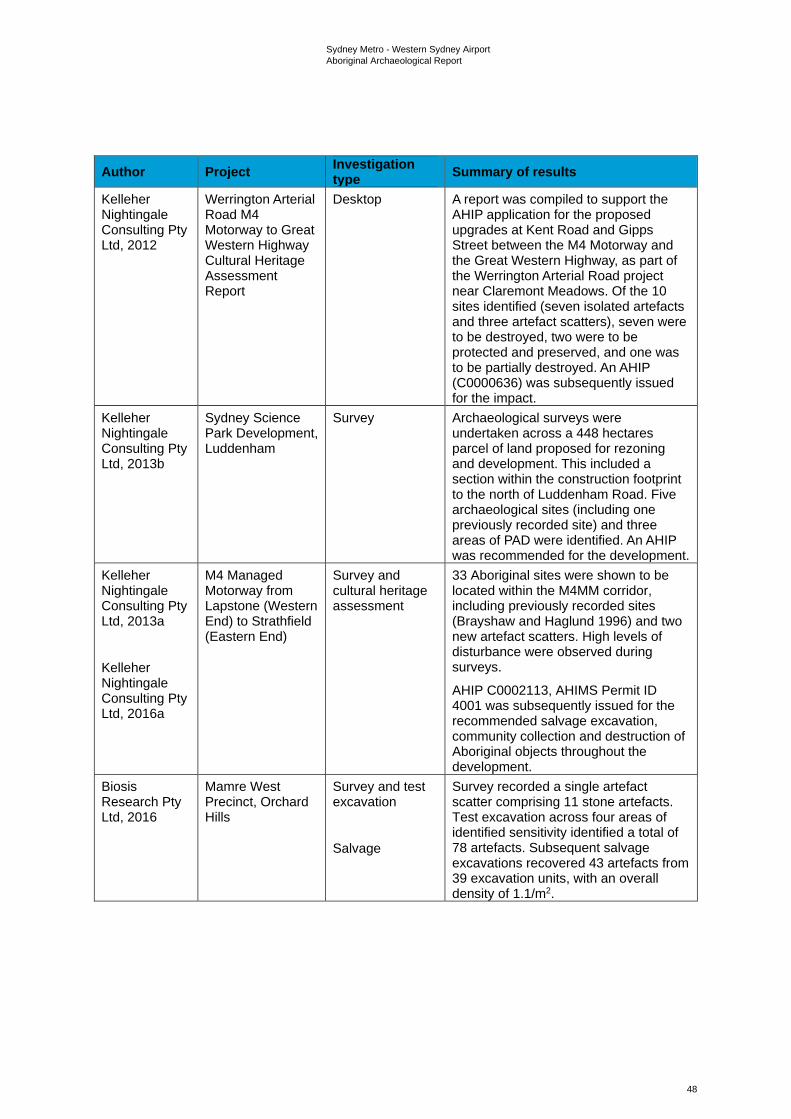
Sydney Metro - Western Sydney Airport Aboriginal Archaeological Report
48
Author Project Investigation type Summary of results
Kelleher Nightingale Consulting Pty Ltd, 2012
Werrington Arterial Road M4 Motorway to Great Western Highway Cultural Heritage Assessment Report
Desktop A report was compiled to support the AHIP application for the proposed upgrades at Kent Road and Gipps Street between the M4 Motorway and the Great Western Highway, as part of the Werrington Arterial Road project near Claremont Meadows. Of the 10 sites identified (seven isolated artefacts and three artefact scatters), seven were to be destroyed, two were to be protected and preserved, and one was to be partially destroyed. An AHIP (C0000636) was subsequently issued for the impact.
Kelleher Nightingale Consulting Pty Ltd, 2013b
Sydney Science Park Development, Luddenham
Survey Archaeological surveys were undertaken across a 448 hectares parcel of land proposed for rezoning and development. This included a section within the construction footprint to the north of Luddenham Road. Five archaeological sites (including one previously recorded site) and three areas of PAD were identified. An AHIP was recommended for the development.
Kelleher Nightingale Consulting Pty Ltd, 2013a
Kelleher Nightingale Consulting Pty Ltd, 2016a
M4 Managed Motorway from Lapstone (Western End) to Strathfield (Eastern End)
Survey and cultural heritage assessment
33 Aboriginal sites were shown to be located within the M4MM corridor, including previously recorded sites (Brayshaw and Haglund 1996) and two new artefact scatters. High levels of disturbance were observed during surveys.
AHIP C0002113, AHIMS Permit ID 4001 was subsequently issued for the recommended salvage excavation, community collection and destruction of Aboriginal objects throughout the development.
Biosis Research Pty Ltd, 2016
Mamre West Precinct, Orchard Hills
Survey and test excavation
Salvage
Survey recorded a single artefact scatter comprising 11 stone artefacts. Test excavation across four areas of identified sensitivity identified a total of 78 artefacts. Subsequent salvage excavations recovered 43 artefacts from 39 excavation units, with an overall density of 1.1/m2.
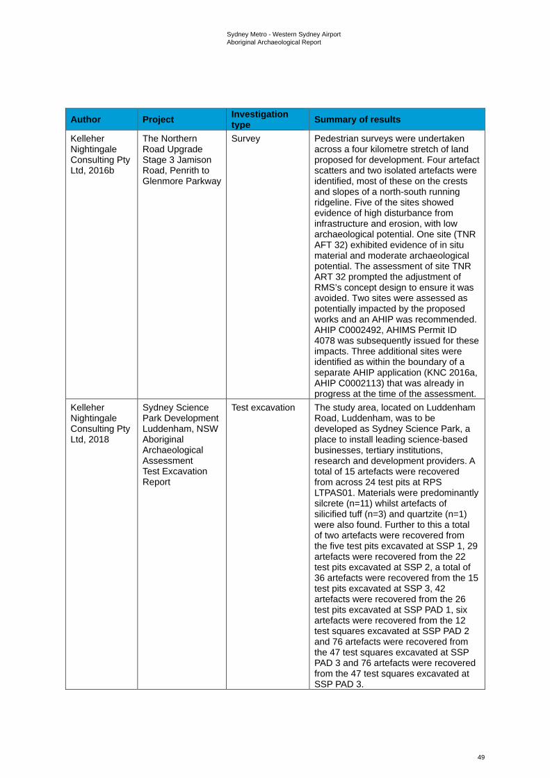
Sydney Metro - Western Sydney Airport Aboriginal Archaeological Report
49
Author Project Investigation type Summary of results
Kelleher Nightingale Consulting Pty Ltd, 2016b
The Northern Road Upgrade Stage 3 Jamison Road, Penrith to Glenmore Parkway
Survey Pedestrian surveys were undertaken across a four kilometre stretch of land proposed for development. Four artefact scatters and two isolated artefacts were identified, most of these on the crests and slopes of a north-south running ridgeline. Five of the sites showed evidence of high disturbance from infrastructure and erosion, with low archaeological potential. One site (TNR AFT 32) exhibited evidence of in situ material and moderate archaeological potential. The assessment of site TNR ART 32 prompted the adjustment of RMS’s concept design to ensure it was avoided. Two sites were assessed as potentially impacted by the proposed works and an AHIP was recommended. AHIP C0002492, AHIMS Permit ID 4078 was subsequently issued for these impacts. Three additional sites were identified as within the boundary of a separate AHIP application (KNC 2016a, AHIP C0002113) that was already in progress at the time of the assessment.
Kelleher Nightingale Consulting Pty Ltd, 2018
Sydney Science Park Development Luddenham, NSW Aboriginal Archaeological Assessment Test Excavation Report
Test excavation The study area, located on Luddenham Road, Luddenham, was to be developed as Sydney Science Park, a place to install leading science-based businesses, tertiary institutions, research and development providers. A total of 15 artefacts were recovered from across 24 test pits at RPS LTPAS01. Materials were predominantly silcrete (n=11) whilst artefacts of silicified tuff (n=3) and quartzite (n=1) were also found. Further to this a total of two artefacts were recovered from the five test pits excavated at SSP 1, 29 artefacts were recovered from the 22 test pits excavated at SSP 2, a total of 36 artefacts were recovered from the 15 test pits excavated at SSP 3, 42 artefacts were recovered from the 26 test pits excavated at SSP PAD 1, six artefacts were recovered from the 12 test squares excavated at SSP PAD 2 and 76 artefacts were recovered from the 47 test squares excavated at SSP PAD 3 and 76 artefacts were recovered from the 47 test squares excavated at SSP PAD 3.
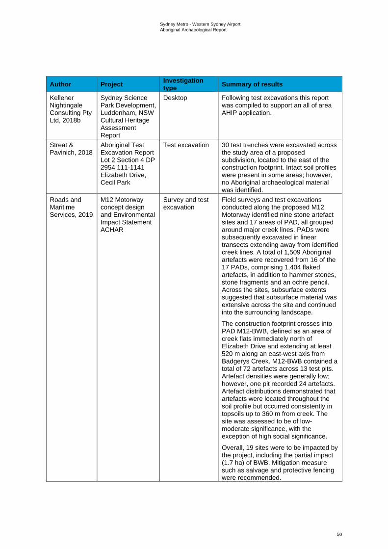
Sydney Metro - Western Sydney Airport Aboriginal Archaeological Report
50
Author Project Investigation type Summary of results
Kelleher Nightingale Consulting Pty Ltd, 2018b
Sydney Science Park Development, Luddenham, NSW Cultural Heritage Assessment Report
Desktop Following test excavations this report was compiled to support an all of area AHIP application.
Streat & Pavinich, 2018
Aboriginal Test Excavation Report Lot 2 Section 4 DP 2954 111-1141 Elizabeth Drive, Cecil Park
Test excavation 30 test trenches were excavated across the study area of a proposed subdivision, located to the east of the construction footprint. Intact soil profiles were present in some areas; however, no Aboriginal archaeological material was identified.
Roads and Maritime Services, 2019
M12 Motorway concept design and Environmental Impact Statement ACHAR
Survey and test excavation
Field surveys and test excavations conducted along the proposed M12 Motorway identified nine stone artefact sites and 17 areas of PAD, all grouped around major creek lines. PADs were subsequently excavated in linear transects extending away from identified creek lines. A total of 1,509 Aboriginal artefacts were recovered from 16 of the 17 PADs, comprising 1,404 flaked artefacts, in addition to hammer stones, stone fragments and an ochre pencil. Across the sites, subsurface extents suggested that subsurface material was extensive across the site and continued into the surrounding landscape.
The construction footprint crosses into PAD M12-BWB, defined as an area of creek flats immediately north of Elizabeth Drive and extending at least 520 m along an east-west axis from Badgerys Creek. M12-BWB contained a total of 72 artefacts across 13 test pits. Artefact densities were generally low; however, one pit recorded 24 artefacts. Artefact distributions demonstrated that artefacts were located throughout the soil profile but occurred consistently in topsoils up to 360 m from creek. The site was assessed to be of low-moderate significance, with the exception of high social significance.
Overall, 19 sites were to be impacted by the project, including the partial impact (1.7 ha) of BWB. Mitigation measure such as salvage and protective fencing were recommended.
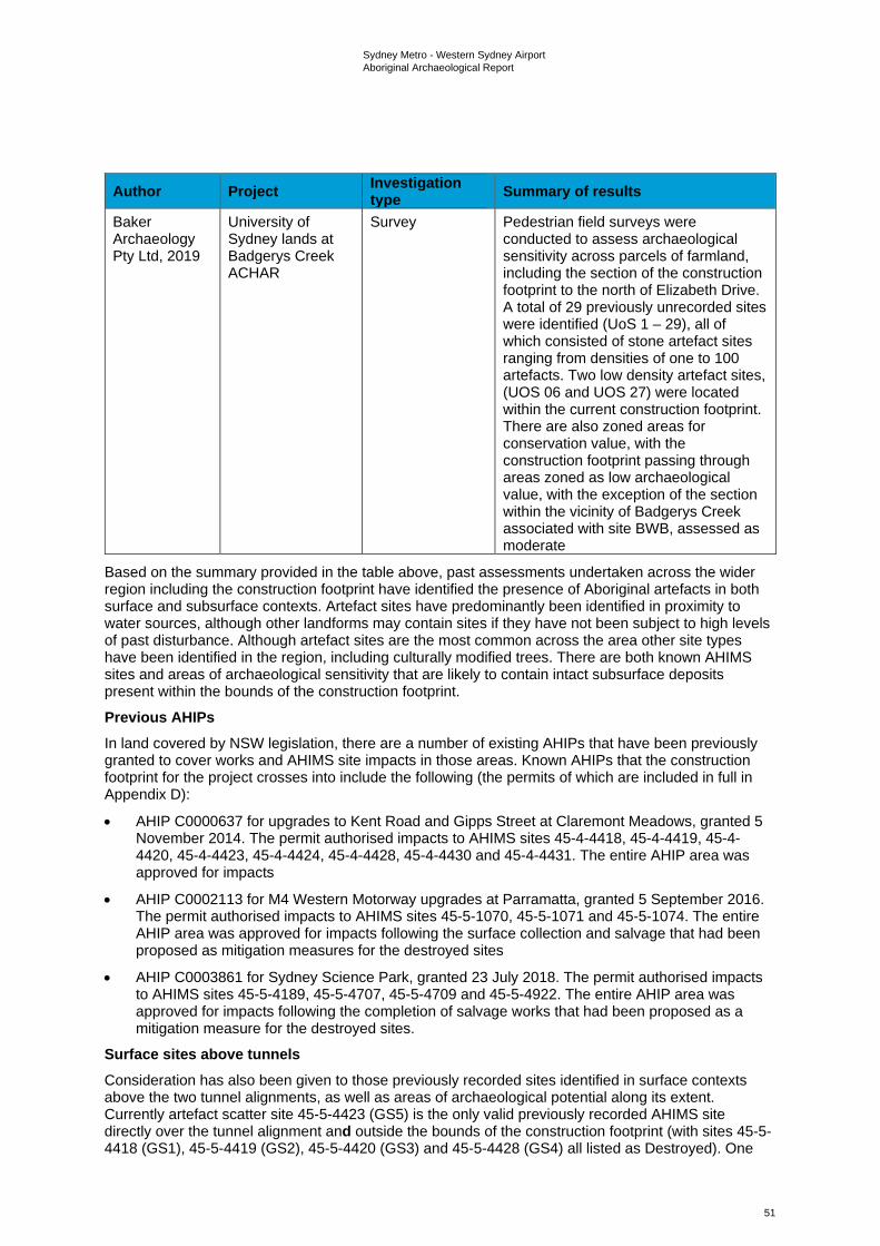
Sydney Metro - Western Sydney Airport Aboriginal Archaeological Report
51
Author Project Investigation type Summary of results
Baker Archaeology Pty Ltd, 2019
University of Sydney lands at Badgerys Creek ACHAR
Survey Pedestrian field surveys were conducted to assess archaeological sensitivity across parcels of farmland, including the section of the construction footprint to the north of Elizabeth Drive. A total of 29 previously unrecorded sites were identified (UoS 1 – 29), all of which consisted of stone artefact sites ranging from densities of one to 100 artefacts. Two low density artefact sites, (UOS 06 and UOS 27) were located within the current construction footprint. There are also zoned areas for conservation value, with the construction footprint passing through areas zoned as low archaeological value, with the exception of the section within the vicinity of Badgerys Creek associated with site BWB, assessed as moderate
Based on the summary provided in the table above, past assessments undertaken across the wider region including the construction footprint have identified the presence of Aboriginal artefacts in both surface and subsurface contexts. Artefact sites have predominantly been identified in proximity to water sources, although other landforms may contain sites if they have not been subject to high levels of past disturbance. Although artefact sites are the most common across the area other site types have been identified in the region, including culturally modified trees. There are both known AHIMS sites and areas of archaeological sensitivity that are likely to contain intact subsurface deposits present within the bounds of the construction footprint.
Previous AHIPs In land covered by NSW legislation, there are a number of existing AHIPs that have been previously granted to cover works and AHIMS site impacts in those areas. Known AHIPs that the construction footprint for the project crosses into include the following (the permits of which are included in full in Appendix D):
• AHIP C0000637 for upgrades to Kent Road and Gipps Street at Claremont Meadows, granted 5 November 2014. The permit authorised impacts to AHIMS sites 45-4-4418, 45-4-4419, 45-4-4420, 45-4-4423, 45-4-4424, 45-4-4428, 45-4-4430 and 45-4-4431. The entire AHIP area was approved for impacts
• AHIP C0002113 for M4 Western Motorway upgrades at Parramatta, granted 5 September 2016. The permit authorised impacts to AHIMS sites 45-5-1070, 45-5-1071 and 45-5-1074. The entire AHIP area was approved for impacts following the surface collection and salvage that had been proposed as mitigation measures for the destroyed sites
• AHIP C0003861 for Sydney Science Park, granted 23 July 2018. The permit authorised impacts to AHIMS sites 45-5-4189, 45-5-4707, 45-5-4709 and 45-5-4922. The entire AHIP area was approved for impacts following the completion of salvage works that had been proposed as a mitigation measure for the destroyed sites.
Surface sites above tunnels Consideration has also been given to those previously recorded sites identified in surface contexts above the two tunnel alignments, as well as areas of archaeological potential along its extent. Currently artefact scatter site 45-5-4423 (GS5) is the only valid previously recorded AHIMS site directly over the tunnel alignment and outside the bounds of the construction footprint (with sites 45-5-4418 (GS1), 45-5-4419 (GS2), 45-5-4420 (GS3) and 45-5-4428 (GS4) all listed as Destroyed). One
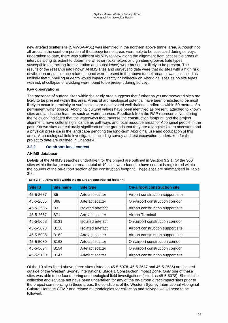
Sydney Metro - Western Sydney Airport Aboriginal Archaeological Report
52
new artefact scatter site (SMWSA-AS1) was identified in the northern above tunnel area. Although not all areas in the southern portion of the above tunnel areas were able to be accessed during surveys undertaken to date, there was sufficient visibility to view along the alignment from accessible areas at intervals along its extent to determine whether rockshelters and grinding grooves (site types susceptible to cracking from vibration and subsidence) were present or likely to be present. The results of the research into known AHIMS sites and surveys to date were that no sites with a high risk of vibration or subsidence related impact were present in the above tunnel areas. It was assessed as unlikely that tunnelling at depth would impact directly or indirectly on Aboriginal sites as no site types with risk of collapse or cracking were found to be present during survey. Key observations The presence of surface sites within the study area suggests that further as yet undiscovered sites are likely to be present within this area. Areas of archaeological potential have been predicted to be most likely to occur in proximity to surface sites, or on elevated well drained landforms within 50 metres of a permanent water source. Aboriginal cultural values have been identified as present, attached to known sites and landscape features such as water courses. Feedback from the RAP representatives during the fieldwork indicated that the waterways that traverse the construction footprint, and the project alignment, have cultural significance as pathways and focal resource areas for Aboriginal people in the past. Known sites are culturally significant on the grounds that they are a tangible link to ancestors and a physical presence in the landscape denoting the long-term Aboriginal use and occupation of this area. Archaeological field investigation, including survey and test excavation, undertaken for the project to date are outlined in Chapter 4.
3.2.2 On-airport local context AHIMS database Details of the AHIMS searches undertaken for the project are outlined in Section 3.2.1. Of the 360 sites within the larger search area, a total of 10 sites were found to have centroids registered within the bounds of the on-airport section of the construction footprint. These sites are summarised in Table 3-8. Table 3-8 AHIMS sites within the on-airport construction footprint
Site ID Site name Site type On-airport construction site
45-5-2637 B5 Artefact scatter Airport construction support site
45-5-2665 B88 Artefact scatter On-airport construction corridor
45-5-2586 B3 Isolated artefact Airport construction support site
45-5-2687 B71 Artefact scatter Airport Terminal
45-5-5068 B131 Isolated artefact On-airport construction corridor
45-5-5078 B136 Isolated artefact Airport construction support site
45-5-5085 B162 Artefact scatter Airport construction support site
45-5-5089 B163 Artefact scatter On-airport construction corridor
45-5-5094 B154 Artefact scatter On-airport construction corridor
45-5-5100 B147 Artefact scatter Airport construction support site
Of the 10 sites listed above, three sites (listed as 45-5-5078, 45-5-2637 and 45-5-2586) are located outside of the Western Sydney International Stage 1 Construction Impact Zone. Only one of these sites was able to be found during archaeological field investigations (listed as 45-5-5078). Should site collection and salvage not have been undertaken for any of the on-airport direct impact sites prior to the project commencing in those areas, the conditions of the Western Sydney International Aboriginal Cultural Heritage CEMP and related methodologies for collection and salvage would need to be followed.
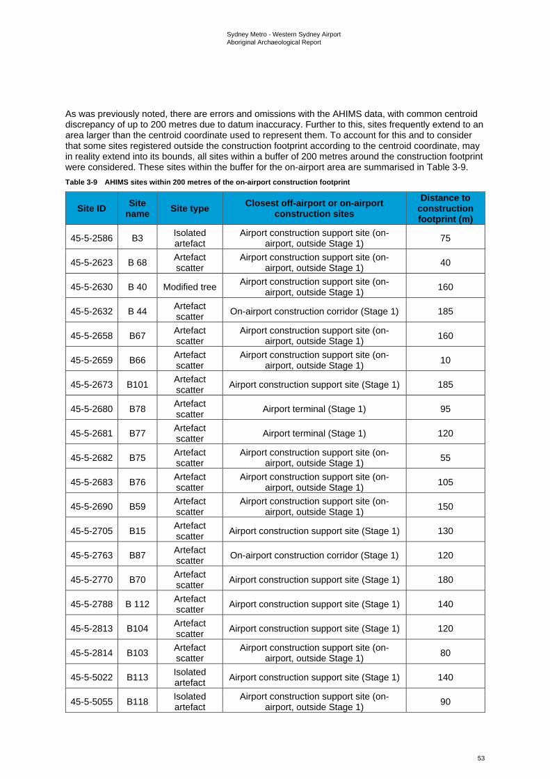
Sydney Metro - Western Sydney Airport Aboriginal Archaeological Report
53
As was previously noted, there are errors and omissions with the AHIMS data, with common centroid discrepancy of up to 200 metres due to datum inaccuracy. Further to this, sites frequently extend to an area larger than the centroid coordinate used to represent them. To account for this and to consider that some sites registered outside the construction footprint according to the centroid coordinate, may in reality extend into its bounds, all sites within a buffer of 200 metres around the construction footprint were considered. These sites within the buffer for the on-airport area are summarised in Table 3-9. Table 3-9 AHIMS sites within 200 metres of the on-airport construction footprint
Site ID Site name Site type Closest off-airport or on-airport
construction sites Distance to
construction footprint (m)
45-5-2586 B3 Isolated artefact
Airport construction support site (on-airport, outside Stage 1) 75
45-5-2623 B 68 Artefact scatter
Airport construction support site (on-airport, outside Stage 1) 40
45-5-2630 B 40 Modified tree Airport construction support site (on-airport, outside Stage 1) 160
45-5-2632 B 44 Artefact scatter On-airport construction corridor (Stage 1) 185
45-5-2658 B67 Artefact scatter
Airport construction support site (on-airport, outside Stage 1) 160
45-5-2659 B66 Artefact scatter
Airport construction support site (on-airport, outside Stage 1) 10
45-5-2673 B101 Artefact scatter Airport construction support site (Stage 1) 185
45-5-2680 B78 Artefact scatter Airport terminal (Stage 1) 95
45-5-2681 B77 Artefact scatter Airport terminal (Stage 1) 120
45-5-2682 B75 Artefact scatter
Airport construction support site (on-airport, outside Stage 1) 55
45-5-2683 B76 Artefact scatter
Airport construction support site (on-airport, outside Stage 1) 105
45-5-2690 B59 Artefact scatter
Airport construction support site (on-airport, outside Stage 1) 150
45-5-2705 B15 Artefact scatter Airport construction support site (Stage 1) 130
45-5-2763 B87 Artefact scatter On-airport construction corridor (Stage 1) 120
45-5-2770 B70 Artefact scatter Airport construction support site (Stage 1) 180
45-5-2788 B 112 Artefact scatter Airport construction support site (Stage 1) 140
45-5-2813 B104 Artefact scatter Airport construction support site (Stage 1) 120
45-5-2814 B103 Artefact scatter
Airport construction support site (on-airport, outside Stage 1) 80
45-5-5022 B113 Isolated artefact Airport construction support site (Stage 1) 140
45-5-5055 B118 Isolated artefact
Airport construction support site (on-airport, outside Stage 1) 90
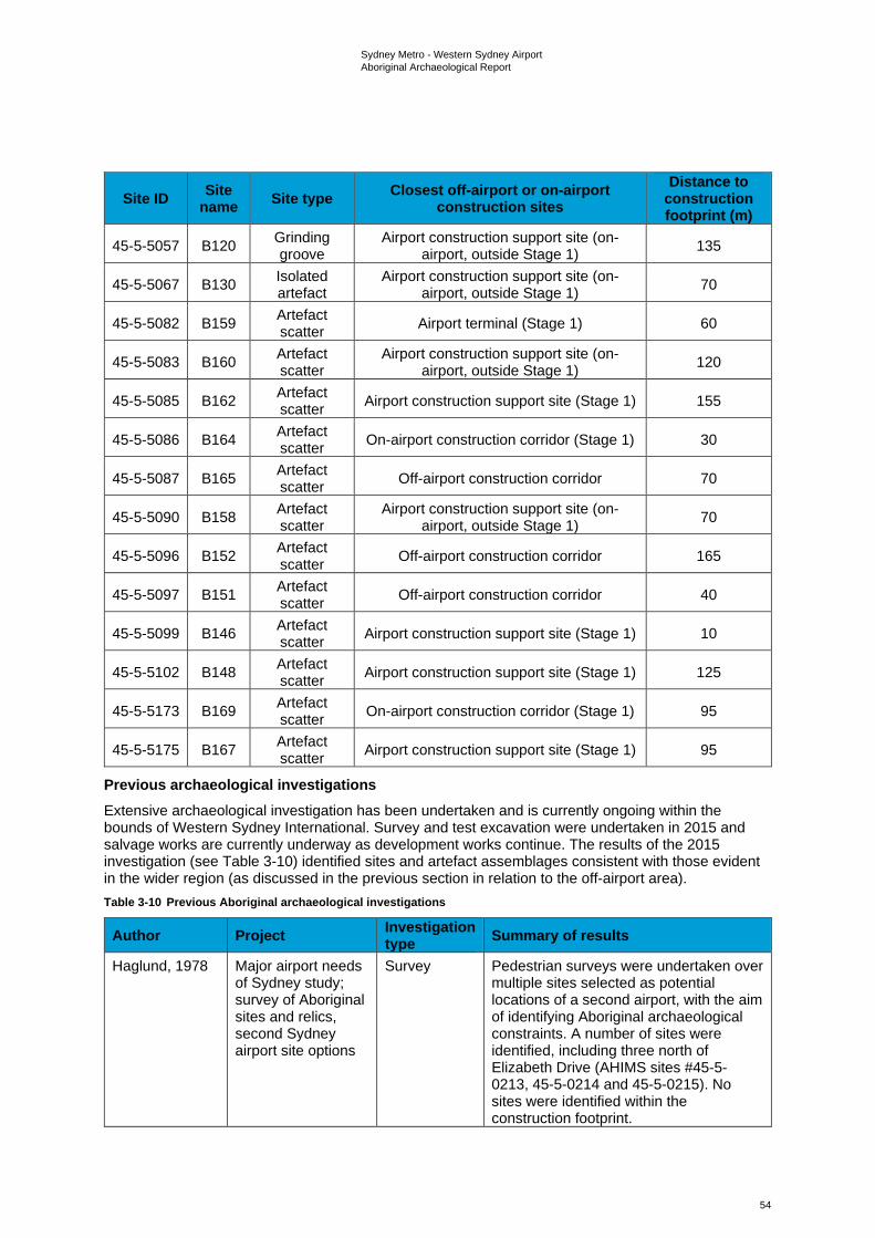
Sydney Metro - Western Sydney Airport Aboriginal Archaeological Report
54
Site ID Site name Site type Closest off-airport or on-airport
construction sites Distance to
construction footprint (m)
45-5-5057 B120 Grinding groove
Airport construction support site (on-airport, outside Stage 1) 135
45-5-5067 B130 Isolated artefact
Airport construction support site (on-airport, outside Stage 1) 70
45-5-5082 B159 Artefact scatter Airport terminal (Stage 1) 60
45-5-5083 B160 Artefact scatter
Airport construction support site (on-airport, outside Stage 1) 120
45-5-5085 B162 Artefact scatter Airport construction support site (Stage 1) 155
45-5-5086 B164 Artefact scatter On-airport construction corridor (Stage 1) 30
45-5-5087 B165 Artefact scatter Off-airport construction corridor 70
45-5-5090 B158 Artefact scatter
Airport construction support site (on-airport, outside Stage 1) 70
45-5-5096 B152 Artefact scatter Off-airport construction corridor 165
45-5-5097 B151 Artefact scatter Off-airport construction corridor 40
45-5-5099 B146 Artefact scatter Airport construction support site (Stage 1) 10
45-5-5102 B148 Artefact scatter Airport construction support site (Stage 1) 125
45-5-5173 B169 Artefact scatter On-airport construction corridor (Stage 1) 95
45-5-5175 B167 Artefact scatter Airport construction support site (Stage 1) 95
Previous archaeological investigations Extensive archaeological investigation has been undertaken and is currently ongoing within the bounds of Western Sydney International. Survey and test excavation were undertaken in 2015 and salvage works are currently underway as development works continue. The results of the 2015 investigation (see Table 3-10) identified sites and artefact assemblages consistent with those evident in the wider region (as discussed in the previous section in relation to the off-airport area). Table 3-10 Previous Aboriginal archaeological investigations
Author Project Investigation type Summary of results
Haglund, 1978 Major airport needs of Sydney study; survey of Aboriginal sites and relics, second Sydney airport site options
Survey Pedestrian surveys were undertaken over multiple sites selected as potential locations of a second airport, with the aim of identifying Aboriginal archaeological constraints. A number of sites were identified, including three north of Elizabeth Drive (AHIMS sites #45-5-0213, 45-5-0214 and 45-5-0215). No sites were identified within the construction footprint.
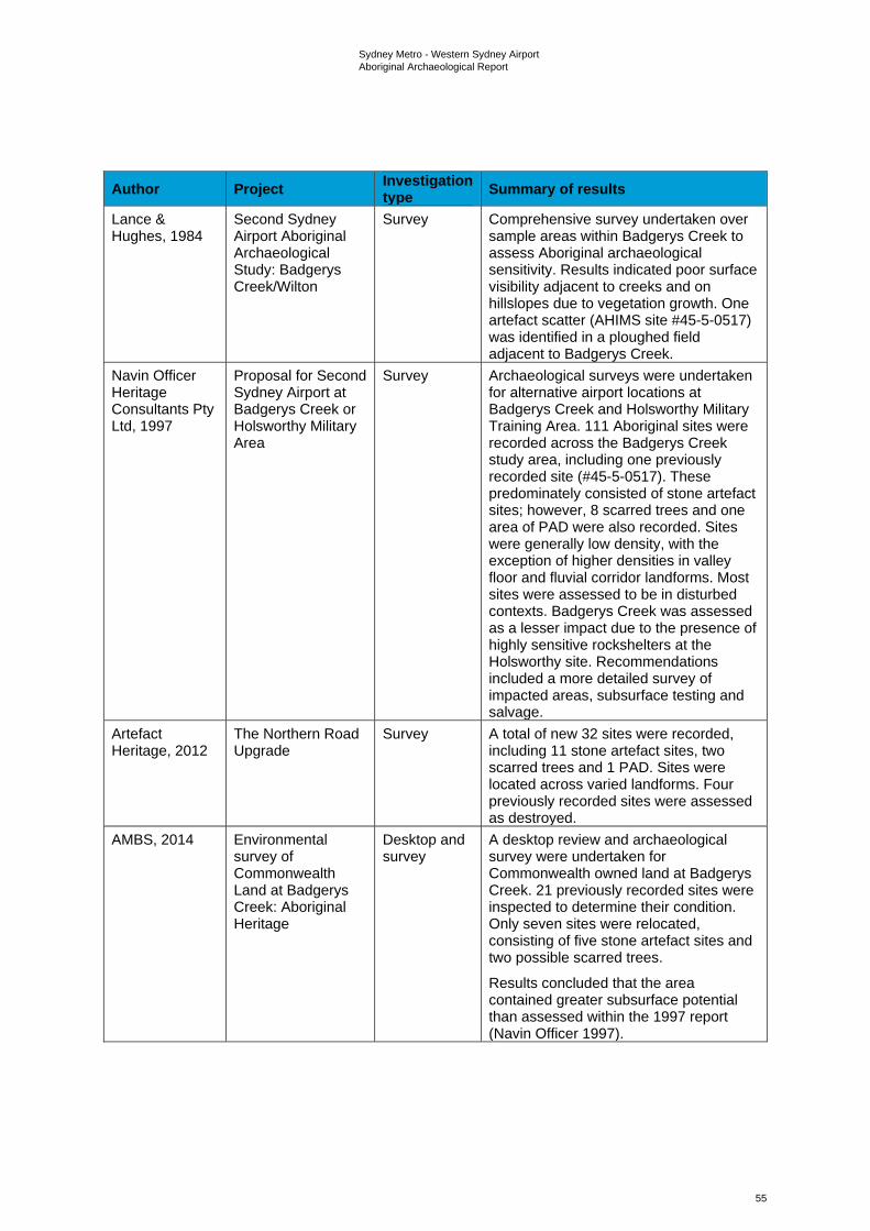
Sydney Metro - Western Sydney Airport Aboriginal Archaeological Report
55
Author Project Investigation type Summary of results
Lance & Hughes, 1984
Second Sydney Airport Aboriginal Archaeological Study: Badgerys Creek/Wilton
Survey Comprehensive survey undertaken over sample areas within Badgerys Creek to assess Aboriginal archaeological sensitivity. Results indicated poor surface visibility adjacent to creeks and on hillslopes due to vegetation growth. One artefact scatter (AHIMS site #45-5-0517) was identified in a ploughed field adjacent to Badgerys Creek.
Navin Officer Heritage Consultants Pty Ltd, 1997
Proposal for Second Sydney Airport at Badgerys Creek or Holsworthy Military Area
Survey Archaeological surveys were undertaken for alternative airport locations at Badgerys Creek and Holsworthy Military Training Area. 111 Aboriginal sites were recorded across the Badgerys Creek study area, including one previously recorded site (#45-5-0517). These predominately consisted of stone artefact sites; however, 8 scarred trees and one area of PAD were also recorded. Sites were generally low density, with the exception of higher densities in valley floor and fluvial corridor landforms. Most sites were assessed to be in disturbed contexts. Badgerys Creek was assessed as a lesser impact due to the presence of highly sensitive rockshelters at the Holsworthy site. Recommendations included a more detailed survey of impacted areas, subsurface testing and salvage.
Artefact Heritage, 2012
The Northern Road Upgrade
Survey A total of new 32 sites were recorded, including 11 stone artefact sites, two scarred trees and 1 PAD. Sites were located across varied landforms. Four previously recorded sites were assessed as destroyed.
AMBS, 2014 Environmental survey of Commonwealth Land at Badgerys Creek: Aboriginal Heritage
Desktop and survey
A desktop review and archaeological survey were undertaken for Commonwealth owned land at Badgerys Creek. 21 previously recorded sites were inspected to determine their condition. Only seven sites were relocated, consisting of five stone artefact sites and two possible scarred trees.
Results concluded that the area contained greater subsurface potential than assessed within the 1997 report (Navin Officer 1997).
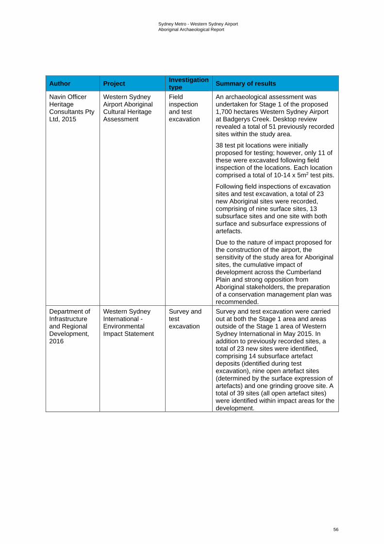
Sydney Metro - Western Sydney Airport Aboriginal Archaeological Report
56
Author Project Investigation type Summary of results
Navin Officer Heritage Consultants Pty Ltd, 2015
Western Sydney Airport Aboriginal Cultural Heritage Assessment
Field inspection and test excavation
An archaeological assessment was undertaken for Stage 1 of the proposed 1,700 hectares Western Sydney Airport at Badgerys Creek. Desktop review revealed a total of 51 previously recorded sites within the study area.
38 test pit locations were initially proposed for testing; however, only 11 of these were excavated following field inspection of the locations. Each location comprised a total of 10-14 x 5m2 test pits.
Following field inspections of excavation sites and test excavation, a total of 23 new Aboriginal sites were recorded, comprising of nine surface sites, 13 subsurface sites and one site with both surface and subsurface expressions of artefacts.
Due to the nature of impact proposed for the construction of the airport, the sensitivity of the study area for Aboriginal sites, the cumulative impact of development across the Cumberland Plain and strong opposition from Aboriginal stakeholders, the preparation of a conservation management plan was recommended.
Department of Infrastructure and Regional Development, 2016
Western Sydney International - Environmental Impact Statement
Survey and test excavation
Survey and test excavation were carried out at both the Stage 1 area and areas outside of the Stage 1 area of Western Sydney International in May 2015. In addition to previously recorded sites, a total of 23 new sites were identified, comprising 14 subsurface artefact deposits (identified during test excavation), nine open artefact sites (determined by the surface expression of artefacts) and one grinding groove site. A total of 39 sites (all open artefact sites) were identified within impact areas for the development.
Sydney Metro - Western Sydney Airport Aboriginal Archaeological Report
57
Author Project Investigation type Summary of results
Navin Officer Heritage Consultants Pty Ltd, 2017
Western Sydney Airport - Enabling Activities, Aboriginal Cultural Heritage Management Plan
Desktop An Aboriginal Cultural Heritage Management Plan (ACHMP) was prepared for Aboriginal archaeological survey and salvage works undertaken prior to the Western Sydney Airport initial enabling works.
Upon completion of the ACHMP and subsequent survey and salvage works in 2018, an updated inventory was prepared of all surface and subsurface sites known across the site (n=127).
WSA Co, 2018 Western Sydney Airport Aboriginal Cultural Heritage Construction Environmental Management Plan
Desktop An Aboriginal Cultural Heritage CEMP was prepared for further works required at the Western Sydney Airport. The CEMP undertook a risk assessment for potential impacts of the works on Aboriginal cultural heritage and detailed mitigation measures for reducing this impact. The CEMP indicated that the previous inventory of Aboriginal archaeological sites across the site would be updated with additional finds following targeted and selective survey and salvage programs.
Cultural values The observations made on cultural values in relation to the off-airport area in Section 3.2.1 have the same validity for the on-airport area.
Key observations The higher number of sites identified within the on-airport area is indicative of the high level of archaeological investigation that has occurred there, rather than that area necessarily having more sites than the off-airport area. Aboriginal cultural values have been identified as present, attached to known sites and landscape features.
Searches of the Aboriginal Heritage Information Management System (AHIMS) database found 10 sites registered within the on-airport construction footprint. Three of these sites are located outside of the Western Sydney International Stage 1 construction footprint. Based on the Western Sydney Airport Aboriginal Cultural Heritage CEMP (Western Sydney Airport, 2019), the seven sites within the Stage 1 construction impact zone should have been salvaged as part of the works undertaken to date within that area. The three sites that are located outside of the Stage 1 construction impact zone (45-5-2586, 45-5-2637 and 45-5-5078), are unlikely to have been salvaged as they were not within an area proposed for development as defined by the Western Sydney Airport Aboriginal Cultural Heritage CEMP (Western Sydney Airport, 2019).
For any of the 10 sites that are not removed as part of the Western Sydney International development, Sydney Metro would prepare an Aboriginal Cultural Heritage Construction Environmental Management Plan for the on-airport rail works which would include the related methodologies for collection and salvage of sites that remain within the construction footprint where required, unexpected finds, and outlining nominated sites for protection.
3.3 Predictions A review of the existing environment and archaeological data has been used to predict likely Aboriginal archaeology within the off-airport construction footprint. The predictions that have been made are as follows:
Sydney Metro - Western Sydney Airport Aboriginal Archaeological Report
58
• the construction footprint contains a range of landforms, varying from alluvial flats and gently inclined slopes, to ridges and flat-topped terraces. The distribution and density of archaeological material associated with past Aboriginal peoples moving through this varied landscape are likely to have been influenced by the suitability of landforms for campsites. Areas considered to have the highest archaeological sensitivity are predominantly undisturbed terraces and flats, especially when elevated and well-drained
• prior to European occupation, the permanency of potable water sources is likely to have played an important role influencing the nature and duration of Aboriginal activity in their vicinity. More permanent watercourses (e.g. South Creek, Badgerys Creek and Blaxland Creek) are likely to have attracted more intensive or longer-term occupation activity; while lower order streams may have attracted short term or single activity occupation
• the availability of raw lithic material (e.g. silcrete boulders observed in South Creek) is also likely to have influenced the nature of activities at the site and may be correlated with higher artefact densities and evidence of tool manufacture
• archaeological deposits may have been preserved at depth in alluvial contexts
• original native vegetation has been cleared from the construction footprint as a result of European land use practices, including farming and grazing. As old growth trees with the potential for cultural modification have been removed during the past clearance activities, it is unlikely that scarred or carved trees will be present within the construction footprint, with the possible exception of the small sections of riparian corridors
• the construction footprint has been subject to a range of historic and recent land use impacts including: native vegetation clearance, pastoral activities (e.g. grazing, fencing and dam excavation), the construction of residential and commercial structures, as well as scientific and industrial facilities with their associated subsurface infrastructure services. Key archaeological implications of these activities include the destruction, in areas of grossly modified terrain, of pre-existing sites and deposit(s); the disturbance of pre-existing sites and deposit(s) through both direct and indirect (e.g. erosion) means, resulting in a loss of archaeological integrity, the removal of culturally modified trees and an increase, in areas affected by erosion, of archaeological site visibility.
Sydney Metro - Western Sydney Airport Aboriginal Archaeological Report
59
4. Archaeological survey
4.1 Aims and objectives Surveys undertaken for the project to date have sought to:
• identify and record any existing surface evidence of past Aboriginal occupation within the construction footprint
• ground truth all AHIMS registered Aboriginal sites within and immediately adjacent to the construction footprint
• sample all accessible landform elements within the study area
• identify areas that, irrespective of the presence or absence of surface artefacts, are likely to contain subsurface archaeological deposit (i.e. areas of PAD)
• provide data that will assist with the development of an appropriate management strategy for the known and potential Aboriginal archaeological values of the study area.
4.2 Survey strategy Consideration was given to the following factors when developing the survey strategy for the project:
• property access and COVID-19 restrictions, with numerous land parcels initially unavailable for access
• the presence of areas of severely disturbed terrain within the study area, all of which were assessed pre-inspection as having negligible potential for the presence of Aboriginal archaeological materials
• generally poor ground surface visibility conditions due to vegetation cover
• a desire to sample all accessible landform elements within the construction footprint and to confirm the presence or absence of sites susceptible to damage from subsidence and vibration (such as rockshelters and grinding grooves) in the above tunnel areas.
Ultimately, in consideration of the above, it was decided that all accessible and non-severely disturbed portions of the construction footprint would be comprehensively sampled, with a particular focus on areas of enhanced archaeological visibility.
To inform the desktop predictions, aid in the effectiveness of the field investigations and inform the impact assessment, areas of archaeological sensitivity (i.e. areas considered likely to contain artefact bearing subsurface deposits) were mapped across the construction footprint.
These areas were informed by landform (low gradient areas in close proximity to water courses), previously identified sites (surface expression taken to be an indication of further artefacts below the ground surface where soil deposits were present) and low levels of past disturbance. Where all these attributes connected within the construction footprint it was considered and mapped to be an area of archaeological sensitivity. Some of these areas were further informed by ground-truthing during the preliminary field inspection before subsequent survey was undertaken for this assessment between October 2020 and February 2021.
Areas above the proposed tunnel alignment were assessed for known sites. Survey of these areas was required to determine if there were previously unrecorded sites in these areas that had the potential to be damaged by vibration and subsidence (e.g. rockshelters, art sites and grinding groove sites).
4.3 Field team and methods The field team for the preliminary field inspections consisted of archaeologists Dr Darran Jordan and Dr Andrew McLaren. RAP representatives consisted of a representative from Gandangara LALC and Deerubbin LALC. Inspections of accessible sections of the construction footprint were undertaken over four days on Thursday 27 February, Wednesday 4 March, Tuesday 28 April and Friday 12 June 2020.
Sydney Metro - Western Sydney Airport Aboriginal Archaeological Report
60
Once further access was granted to undertake survey between October 2020 and February 2021, the field team consisted of archaeologists Dr Darran Jordan, Dr Andrew McLaren, Geordie Oakes, Luke Wolfe and Julia Atkinson. RAP representatives were in attendance from A1 Indigenous Services, Arugung Aboriginal Cultural Heritage Site Assessments, Corroboree Aboriginal Corporation, Cubbitch Barta, Darug Custodian Aboriginal Corporation, Deerubbin Local Aboriginal Land Council, DNC, Gandangara Local Aboriginal Land Council, Gunyuu, Kamilaroi Yankuntjatjara Working Group, Murra Bidgee Mullangari Aboriginal Corporation, Tocomwall, Wailwan Aboriginal Group and Walbunja.
4.3.1 Site definition The definition, in spatial terms, of Aboriginal archaeological sites is a topic of considerable importance to modern cultural heritage management and one that has generated significant discussion in Australian archaeology (e.g. Doelman 2008; Holdaway, 1993; Holdaway et al. 1998, 2000; MacDonald & Davidson 1998; McNiven 1992; Robins 1997; Shiner 2008). Aboriginal archaeological sites, of course, can be broadly defined as places in the landscape that retain physical evidence of past Aboriginal activity. Such evidence can assume a range of forms, depending on the nature of the activity or activities that produced it, and can vary dramatically in quantity and extent. Some Aboriginal archaeological sites are, by their very nature, easy to define in spatial terms. Scarred trees and rockshelters, for example, can be readily delineated from their surrounding landscapes. Difficulties arise, however, for sites whose present-day physical extent is, more often than not, a product of geomorphic processes, as opposed to the actions of Aboriginal people in the past.
Although relevant to a variety of site types, geomorphic processes such as soil erosion and deposition are of particular relevance to identification and definition of surface scatters of stone artefacts, commonly referred to as ‘open camp sites’ or ‘artefact scatters’. It is, for example, now widely accepted that the visibility and preservation of such sites are to a significant extent, products of such processes, both contemporary and historic (Dean-Jones & Mitchell 1993; Fanning et al. 2008, 2009; Shiner 2008). As demonstrated by countless large-scale excavations projects in south-eastern Australia, surface artefacts almost invariably represent only a fraction of the total number of artefacts present within these sites, with the majority occurring in subsurface contexts. Artefact exposure, unsurprisingly, is highest on erosional surfaces and lowest on depositional ones. At the same time, in many areas, surface artefacts have been shown to form part of more-or-less continuous subsurface distributions of artefacts, albeit with highly variable artefact densities linked to environmental variables such as stream order and landform (e.g. White & McDonald 2010).
Such evidence poses a significant analytical and interpretive dilemma. Defining sites on the basis of surface artefacts alone is clearly problematic, with modern site boundaries invariably reflecting the size and distribution of surface exposures as opposed to the actions of Aboriginal people in the past. Nonetheless, for pragmatic reasons, this is the most commonly used approach, with ‘distance’ and ‘density-based’ definitions dominating. In NSW, two of the most commonly employed distance-definitions are ‘two artefacts within 50m of each other’ and ‘two artefacts within 100 m of each other’. Neither definition is derived from a particular theoretical approach or body of empirical research - they are simply pragmatic devices for site definition. Definitions based on artefact density also vary in their particulars. However, one of most commonly used definitions is that which isolates, within an arbitrarily defined ‘background scatter’ of one artefact per 100 m², higher density clusters that are subsequently defined as ‘sites’.
Non-site or distributional archaeology offers an alternative approach to distance and density-based site definitions (Ebert 1992; Foley 1981), with individual artefacts, not sites, treated as the basic units of analysis (for published Australian examples see Doelman 2008; Holdaway et al. 2000; McNiven 1992; Robins 1997; Shiner 2008). While recognising the interpretive potential of non-site approaches with respect to data analysis and discussion, their implementation in the context of cultural heritage management studies is difficult. Here, the identification of ‘sites’ is required for reasons of recording (i.e. their entry into site databases such as AHIMS) as well as ease of relocation, protection, and ongoing management. The identification of spatially-discrete ‘sites’, therefore, offers the most pragmatic approach to Aboriginal heritage management in impact assessment contexts (but see McDonald (1996) for a different view).
The definition for sites identified during the surveys has been based on the 50 metres distance convention cited above.
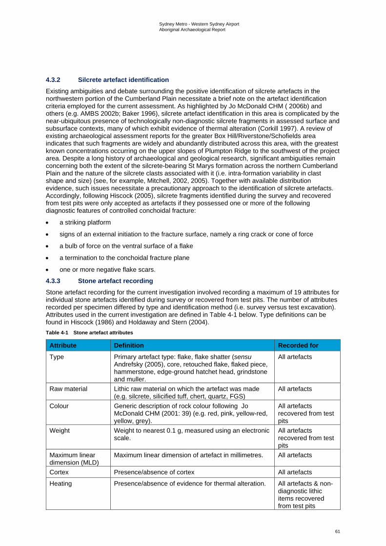
Sydney Metro - Western Sydney Airport Aboriginal Archaeological Report
61
4.3.2 Silcrete artefact identification Existing ambiguities and debate surrounding the positive identification of silcrete artefacts in the northwestern portion of the Cumberland Plain necessitate a brief note on the artefact identification criteria employed for the current assessment. As highlighted by Jo McDonald CHM ( 2006b) and others (e.g. AMBS 2002b; Baker 1996), silcrete artefact identification in this area is complicated by the near-ubiquitous presence of technologically non-diagnostic silcrete fragments in assessed surface and subsurface contexts, many of which exhibit evidence of thermal alteration (Corkill 1997). A review of existing archaeological assessment reports for the greater Box Hill/Riverstone/Schofields area indicates that such fragments are widely and abundantly distributed across this area, with the greatest known concentrations occurring on the upper slopes of Plumpton Ridge to the southwest of the project area. Despite a long history of archaeological and geological research, significant ambiguities remain concerning both the extent of the silcrete-bearing St Marys formation across the northern Cumberland Plain and the nature of the silcrete clasts associated with it (i.e. intra-formation variability in clast shape and size) (see, for example, Mitchell, 2002, 2005). Together with available distribution evidence, such issues necessitate a precautionary approach to the identification of silcrete artefacts. Accordingly, following Hiscock (2005), silcrete fragments identified during the survey and recovered from test pits were only accepted as artefacts if they possessed one or more of the following diagnostic features of controlled conchoidal fracture:
• a striking platform
• signs of an external initiation to the fracture surface, namely a ring crack or cone of force
• a bulb of force on the ventral surface of a flake
• a termination to the conchoidal fracture plane
• one or more negative flake scars.
4.3.3 Stone artefact recording Stone artefact recording for the current investigation involved recording a maximum of 19 attributes for individual stone artefacts identified during survey or recovered from test pits. The number of attributes recorded per specimen differed by type and identification method (i.e. survey versus test excavation). Attributes used in the current investigation are defined in Table 4-1 below. Type definitions can be found in Hiscock (1986) and Holdaway and Stern (2004). Table 4-1 Stone artefact attributes
Attribute Definition Recorded for Type Primary artefact type: flake, flake shatter (sensu
Andrefsky (2005), core, retouched flake, flaked piece, hammerstone, edge-ground hatchet head, grindstone and muller.
All artefacts
Raw material Lithic raw material on which the artefact was made (e.g. silcrete, silicified tuff, chert, quartz, FGS)
All artefacts
Colour Generic description of rock colour following Jo McDonald CHM (2001: 39) (e.g. red, pink, yellow-red, yellow, grey).
All artefacts recovered from test pits
Weight Weight to nearest 0.1 g, measured using an electronic scale.
All artefacts recovered from test pits
Maximum linear dimension (MLD)
Maximum linear dimension of artefact in millimetres. All artefacts
Cortex Presence/absence of cortex All artefacts
Heating Presence/absence of evidence for thermal alteration. All artefacts & non-diagnostic lithic items recovered from test pits
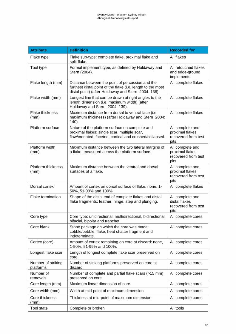
Sydney Metro - Western Sydney Airport Aboriginal Archaeological Report
62
Attribute Definition Recorded for Flake type Flake sub-type: complete flake, proximal flake and
split flake. All flakes
Tool type Formal implement type, as defined by Holdaway and Stern (2004).
All retouched flakes and edge-ground implements
Flake length (mm) Distance between the point of percussion and the furthest distal point of the flake (i.e. length to the most distal point) (after Holdaway and Stern 2004: 138).
All complete flakes
Flake width (mm) Longest line that can be drawn at right angles to the length dimension (i.e. maximum width) (after Holdaway and Stern 2004: 139).
All complete flakes
Flake thickness (mm)
Maximum distance from dorsal to ventral face (i.e. maximum thickness) (after Holdaway and Stern 2004: 140).
All complete flakes
Platform surface Nature of the platform surface on complete and proximal flakes: single scar, multiple scar, flaw/crenated, faceted, cortical and crushed/collapsed.
All complete and proximal flakes recovered from test pits
Platform width (mm)
Maximum distance between the two lateral margins of a flake, measured across the platform surface.
All complete and proximal flakes recovered from test pits
Platform thickness (mm)
Maximum distance between the ventral and dorsal surfaces of a flake.
All complete and proximal flakes recovered from test pits
Dorsal cortex Amount of cortex on dorsal surface of flake: none, 1-50%, 51-99% and 100%.
All complete flakes
Flake termination Shape of the distal end of complete flakes and distal flake fragments: feather, hinge, step and plunging.
All complete and distal flakes recovered from test pits
Core type Core type: unidirectional, multidirectional, bidirectional, bifacial, bipolar and tranchet.
All complete cores
Core blank Stone package on which the core was made: cobble/pebble, flake, heat shatter fragment and indeterminate.
All complete cores
Cortex (core) Amount of cortex remaining on core at discard: none, 1-50%, 51-99% and 100%.
All complete cores
Longest flake scar Length of longest complete flake scar preserved on core.
All complete cores
Number of striking platforms
Number of striking platforms preserved on core at discard
All complete cores
Number of removals
Number of complete and partial flake scars (>15 mm) preserved on core.
All complete cores
Core length (mm) Maximum linear dimension of core. All complete cores
Core width (mm) Width at mid-point of maximum dimension All complete cores
Core thickness (mm)
Thickness at mid-point of maximum dimension All complete cores
Tool state Complete or broken All tools
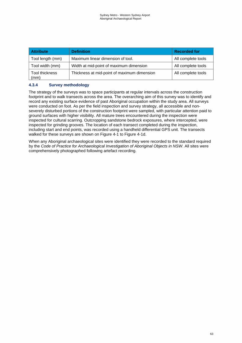
Sydney Metro - Western Sydney Airport Aboriginal Archaeological Report
63
Attribute Definition Recorded for Tool length (mm) Maximum linear dimension of tool. All complete tools
Tool width (mm) Width at mid-point of maximum dimension All complete tools
Tool thickness (mm)
Thickness at mid-point of maximum dimension All complete tools
4.3.4 Survey methodology The strategy of the surveys was to space participants at regular intervals across the construction footprint and to walk transects across the area. The overarching aim of this survey was to identify and record any existing surface evidence of past Aboriginal occupation within the study area. All surveys were conducted on foot. As per the field inspection and survey strategy, all accessible and non-severely disturbed portions of the construction footprint were sampled, with particular attention paid to ground surfaces with higher visibility. All mature trees encountered during the inspection were inspected for cultural scarring. Outcropping sandstone bedrock exposures, where intercepted, were inspected for grinding grooves. The location of each transect completed during the inspection, including start and end points, was recorded using a handheld differential GPS unit. The transects walked for these surveys are shown on Figure 4-1 to Figure 4-1d.
When any Aboriginal archaeological sites were identified they were recorded to the standard required by the Code of Practice for Archaeological Investigation of Aboriginal Objects in NSW. All sites were comprehensively photographed following artefact recording.

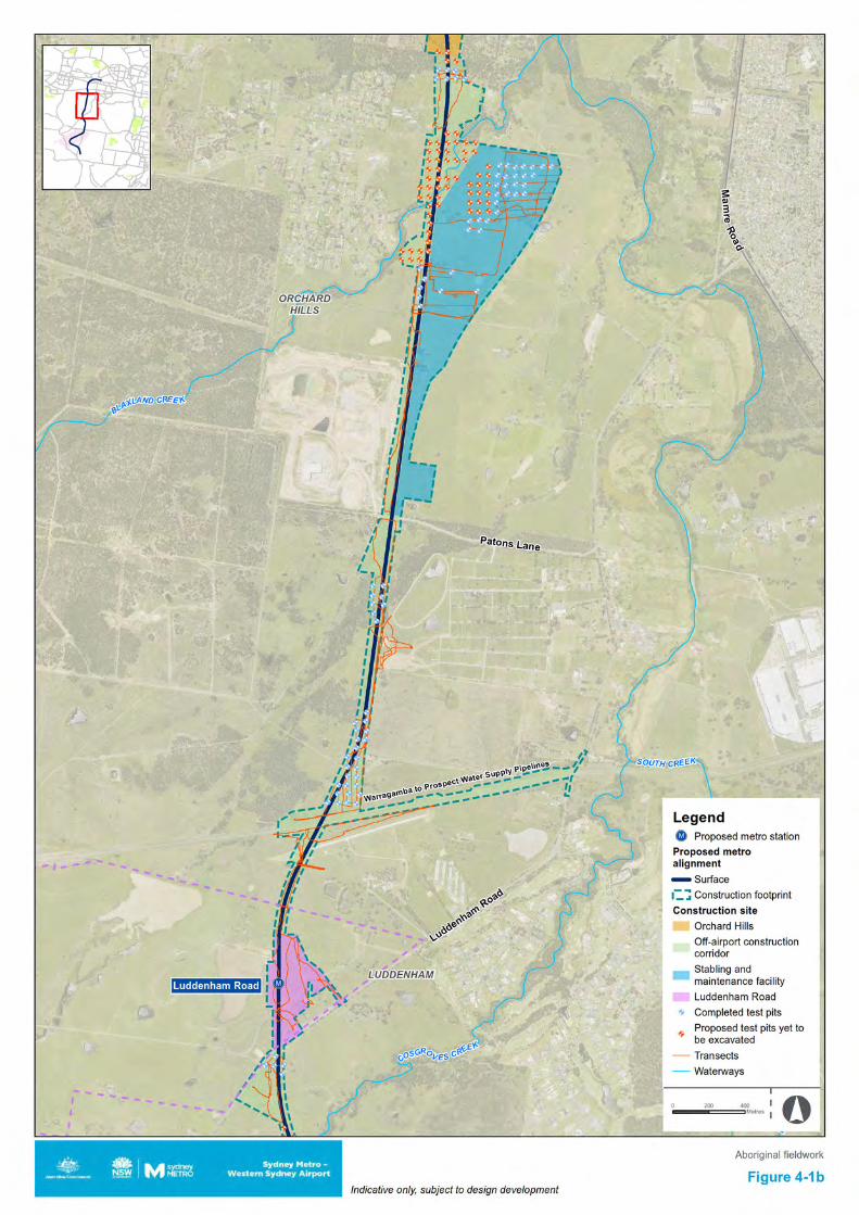

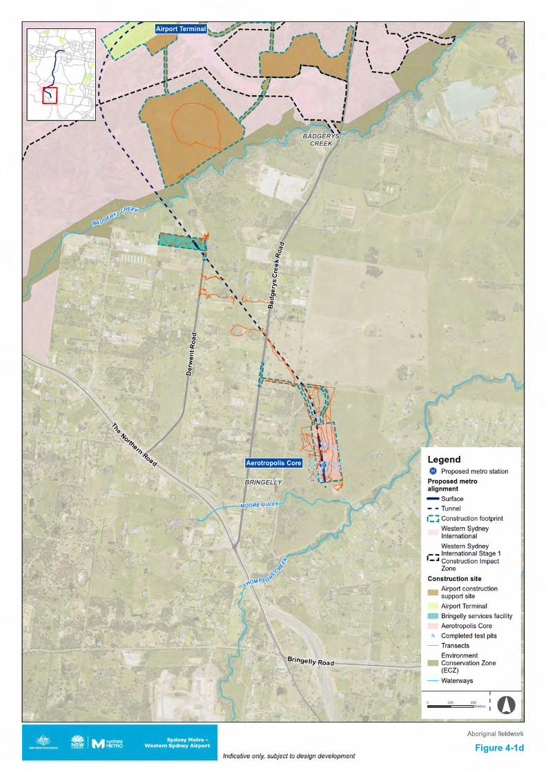
Sydney Metro - Western Sydney Airport Aboriginal Archaeological Report
68
4.4 Survey results 4.4.1 Preliminary investigation results Off-airport Above tunnel areas
Areas above the proposed tunnelling between St Marys and the Great Western Highway were subject to survey on 13 October and 17 November 2020. On average the ground surface visibility (GSV) was fair during the survey, ranging from between 11% and 30%. The ground integrity was assessed as low, having been subject to significant disturbance in the past. This included earthworks associated with roads and the railway line at St Marys, landscaping for the school grounds at St Marys Senior High School and Wollemi College, as well across The Kingsway park. Developments within The Kingsway park area included playing fields, a skateboard park, BMX areas and picnic facilities. The banks on the eastern side of South Creek had been subject to rubbish dumping, but the western banks were in a better maintained condition at the time of inspection. Due to the past disturbance no areas of PAD were identified, but one surface scatter of artefacts was recorded within the bounds of St Marys Senior High School.
The artefact scatter site (SMWSA-AS1) consisted of six surface artefacts in a disturbed context. The area was adjacent to the rail line and had been subject to past earthworks. Since then it had been used by St Marys Senior High School as a farm area for student studies, with goats housed in various enclosures at this location at the time of inspection. These artefacts were in the northern-most enclosure, closest to the rail line, which did not have any animals being housed in it at the time of inspection. Details on the six identified artefacts are included in the table below (Table 4-2). Table 4-2 SMWSA-AS1 artefacts
Raw material Type Flake type Scar count Length
(cm) Width (cm)
Thickness (cm)
Silcrete Flake Complete N/A 1 0.7 0.2 Silcrete Flake Complete N/A 0.5 0.5 0.2 Chert Flake Complete N/A 0.6 0.5 0.1 Silcrete Core N/A 3 2 1.7 1.5 Silcrete Flake Complete N/A 1.2 1 0.7 Silcrete Core N/A 1 0 0 0
Accessible sections of the above tunnel areas between Western Sydney International and the Aerotropolis Core were surveyed on 12 and 13 October, 5, 6, 12 and 14 November 2020. On average the ground surface visibility (GSV) was fair during the survey, ranging from between 11% and 30%. The ground integrity was assessed as low due past disturbances including residential development, road development, dam construction, vegetation clearance and pastoral activities including ploughing and grazing. Sections of the area located in proximity to unnamed drainage lines and multiple dams were also found to be swampy and waterlogged. No surface sites or areas of PAD were identified during the surveys.
No previously recorded AHIMS sites were found to be in the area above the proposed tunnels in the section between St Marys and the Great Western Freeway, and only artefact scatter site SMWSA-AS1 was identified during survey. One previously recorded site, artefact scatter 45-5-4423, was located in the above tunnel area between the Great Western Freeway and the Western Motorway. Two previously recorded AHIMS sites were located in the area above the proposed tunnels between Western Sydney International and the Aerotropolis Core, being artefact scatter 45-5-2666 (consisting of two artefacts on a dam wall) and isolated artefact 45-5-2784 (on the disturbed verge adjacent to a road).
The purpose of undertaking survey in the above tunnel areas was to identify the presence or absence of any site types with a risk of vibration or subsidence impact, including such site types as rockshelters, art sites and grinding groove sites. The AHIMS data identified that none of these site types had previously been recorded in these areas. Survey undertaken of the accessible sections of
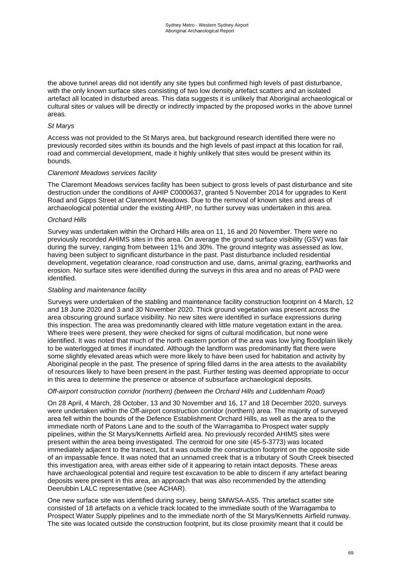
Sydney Metro - Western Sydney Airport Aboriginal Archaeological Report
69
the above tunnel areas did not identify any site types but confirmed high levels of past disturbance, with the only known surface sites consisting of two low density artefact scatters and an isolated artefact all located in disturbed areas. This data suggests it is unlikely that Aboriginal archaeological or cultural sites or values will be directly or indirectly impacted by the proposed works in the above tunnel areas.
St Marys
Access was not provided to the St Marys area, but background research identified there were no previously recorded sites within its bounds and the high levels of past impact at this location for rail, road and commercial development, made it highly unlikely that sites would be present within its bounds.
Claremont Meadows services facility
The Claremont Meadows services facility has been subject to gross levels of past disturbance and site destruction under the conditions of AHIP C0000637, granted 5 November 2014 for upgrades to Kent Road and Gipps Street at Claremont Meadows. Due to the removal of known sites and areas of archaeological potential under the existing AHIP, no further survey was undertaken in this area.
Orchard Hills
Survey was undertaken within the Orchard Hills area on 11, 16 and 20 November. There were no previously recorded AHIMS sites in this area. On average the ground surface visibility (GSV) was fair during the survey, ranging from between 11% and 30%. The ground integrity was assessed as low, having been subject to significant disturbance in the past. Past disturbance included residential development, vegetation clearance, road construction and use, dams, animal grazing, earthworks and erosion. No surface sites were identified during the surveys in this area and no areas of PAD were identified.
Stabling and maintenance facility
Surveys were undertaken of the stabling and maintenance facility construction footprint on 4 March, 12 and 18 June 2020 and 3 and 30 November 2020. Thick ground vegetation was present across the area obscuring ground surface visibility. No new sites were identified in surface expressions during this inspection. The area was predominantly cleared with little mature vegetation extant in the area. Where trees were present, they were checked for signs of cultural modification, but none were identified. It was noted that much of the north eastern portion of the area was low lying floodplain likely to be waterlogged at times if inundated. Although the landform was predominantly flat there were some slightly elevated areas which were more likely to have been used for habitation and activity by Aboriginal people in the past. The presence of spring filled dams in the area attests to the availability of resources likely to have been present in the past. Further testing was deemed appropriate to occur in this area to determine the presence or absence of subsurface archaeological deposits.
Off-airport construction corridor (northern) (between the Orchard Hills and Luddenham Road)
On 28 April, 4 March, 28 October, 13 and 30 November and 16, 17 and 18 December 2020, surveys were undertaken within the Off-airport construction corridor (northern) area. The majority of surveyed area fell within the bounds of the Defence Establishment Orchard Hills, as well as the area to the immediate north of Patons Lane and to the south of the Warragamba to Prospect water supply pipelines, within the St Marys/Kennetts Airfield area. No previously recorded AHIMS sites were present within the area being investigated. The centroid for one site (45-5-3773) was located immediately adjacent to the transect, but it was outside the construction footprint on the opposite side of an impassable fence. It was noted that an unnamed creek that is a tributary of South Creek bisected this investigation area, with areas either side of it appearing to retain intact deposits. These areas have archaeological potential and require test excavation to be able to discern if any artefact bearing deposits were present in this area, an approach that was also recommended by the attending Deerubbin LALC representative (see ACHAR).
One new surface site was identified during survey, being SMWSA-AS5. This artefact scatter site consisted of 18 artefacts on a vehicle track located to the immediate south of the Warragamba to Prospect Water Supply pipelines and to the immediate north of the St Marys/Kennetts Airfield runway. The site was located outside the construction footprint, but its close proximity meant that it could be
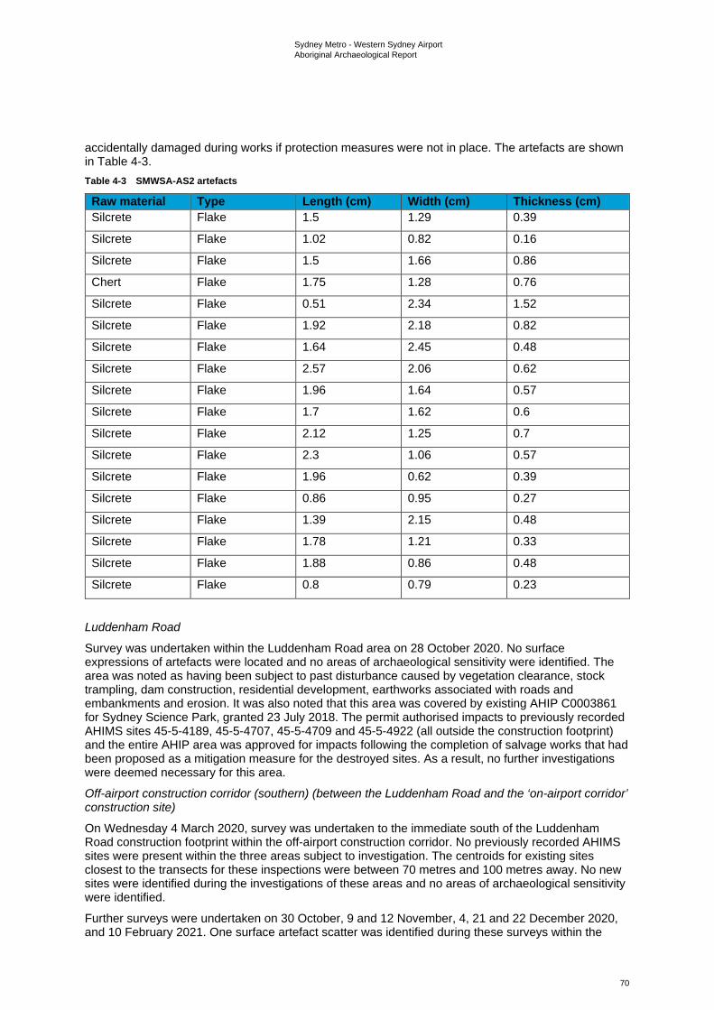
Sydney Metro - Western Sydney Airport Aboriginal Archaeological Report
70
accidentally damaged during works if protection measures were not in place. The artefacts are shown in Table 4-3. Table 4-3 SMWSA-AS2 artefacts
Raw material Type Length (cm) Width (cm) Thickness (cm) Silcrete Flake 1.5 1.29 0.39
Silcrete Flake 1.02 0.82 0.16
Silcrete Flake 1.5 1.66 0.86
Chert Flake 1.75 1.28 0.76
Silcrete Flake 0.51 2.34 1.52
Silcrete Flake 1.92 2.18 0.82
Silcrete Flake 1.64 2.45 0.48
Silcrete Flake 2.57 2.06 0.62
Silcrete Flake 1.96 1.64 0.57
Silcrete Flake 1.7 1.62 0.6
Silcrete Flake 2.12 1.25 0.7
Silcrete Flake 2.3 1.06 0.57
Silcrete Flake 1.96 0.62 0.39
Silcrete Flake 0.86 0.95 0.27
Silcrete Flake 1.39 2.15 0.48
Silcrete Flake 1.78 1.21 0.33
Silcrete Flake 1.88 0.86 0.48
Silcrete Flake 0.8 0.79 0.23
Luddenham Road
Survey was undertaken within the Luddenham Road area on 28 October 2020. No surface expressions of artefacts were located and no areas of archaeological sensitivity were identified. The area was noted as having been subject to past disturbance caused by vegetation clearance, stock trampling, dam construction, residential development, earthworks associated with roads and embankments and erosion. It was also noted that this area was covered by existing AHIP C0003861 for Sydney Science Park, granted 23 July 2018. The permit authorised impacts to previously recorded AHIMS sites 45-5-4189, 45-5-4707, 45-5-4709 and 45-5-4922 (all outside the construction footprint) and the entire AHIP area was approved for impacts following the completion of salvage works that had been proposed as a mitigation measure for the destroyed sites. As a result, no further investigations were deemed necessary for this area.
Off-airport construction corridor (southern) (between the Luddenham Road and the ‘on-airport corridor’ construction site)
On Wednesday 4 March 2020, survey was undertaken to the immediate south of the Luddenham Road construction footprint within the off-airport construction corridor. No previously recorded AHIMS sites were present within the three areas subject to investigation. The centroids for existing sites closest to the transects for these inspections were between 70 metres and 100 metres away. No new sites were identified during the investigations of these areas and no areas of archaeological sensitivity were identified.
Further surveys were undertaken on 30 October, 9 and 12 November, 4, 21 and 22 December 2020, and 10 February 2021. One surface artefact scatter was identified during these surveys within the
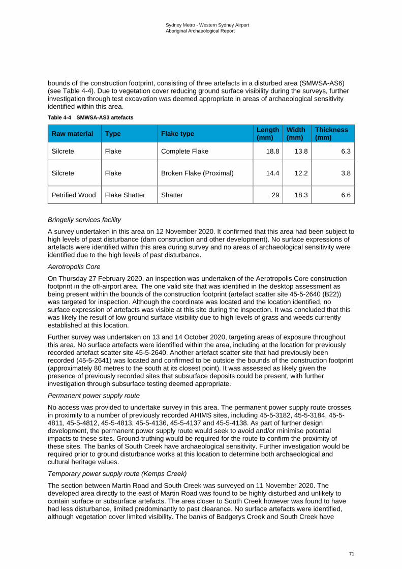
Sydney Metro - Western Sydney Airport Aboriginal Archaeological Report
71
bounds of the construction footprint, consisting of three artefacts in a disturbed area (SMWSA-AS6) (see Table 4-4). Due to vegetation cover reducing ground surface visibility during the surveys, further investigation through test excavation was deemed appropriate in areas of archaeological sensitivity identified within this area. Table 4-4 SMWSA-AS3 artefacts
Raw material Type Flake type Length (mm)
Width (mm)
Thickness (mm)
Silcrete Flake Complete Flake 18.8 13.8 6.3
Silcrete Flake Broken Flake (Proximal) 14.4 12.2 3.8
Petrified Wood Flake Shatter Shatter 29 18.3 6.6
Bringelly services facility
A survey undertaken in this area on 12 November 2020. It confirmed that this area had been subject to high levels of past disturbance (dam construction and other development). No surface expressions of artefacts were identified within this area during survey and no areas of archaeological sensitivity were identified due to the high levels of past disturbance.
Aerotropolis Core
On Thursday 27 February 2020, an inspection was undertaken of the Aerotropolis Core construction footprint in the off-airport area. The one valid site that was identified in the desktop assessment as being present within the bounds of the construction footprint (artefact scatter site 45-5-2640 (B22)) was targeted for inspection. Although the coordinate was located and the location identified, no surface expression of artefacts was visible at this site during the inspection. It was concluded that this was likely the result of low ground surface visibility due to high levels of grass and weeds currently established at this location.
Further survey was undertaken on 13 and 14 October 2020, targeting areas of exposure throughout this area. No surface artefacts were identified within the area, including at the location for previously recorded artefact scatter site 45-5-2640. Another artefact scatter site that had previously been recorded (45-5-2641) was located and confirmed to be outside the bounds of the construction footprint (approximately 80 metres to the south at its closest point). It was assessed as likely given the presence of previously recorded sites that subsurface deposits could be present, with further investigation through subsurface testing deemed appropriate.
Permanent power supply route
No access was provided to undertake survey in this area. The permanent power supply route crosses in proximity to a number of previously recorded AHIMS sites, including 45-5-3182, 45-5-3184, 45-5-4811, 45-5-4812, 45-5-4813, 45-5-4136, 45-5-4137 and 45-5-4138. As part of further design development, the permanent power supply route would seek to avoid and/or minimise potential impacts to these sites. Ground-truthing would be required for the route to confirm the proximity of these sites. The banks of South Creek have archaeological sensitivity. Further investigation would be required prior to ground disturbance works at this location to determine both archaeological and cultural heritage values.
Temporary power supply route (Kemps Creek)
The section between Martin Road and South Creek was surveyed on 11 November 2020. The developed area directly to the east of Martin Road was found to be highly disturbed and unlikely to contain surface or subsurface artefacts. The area closer to South Creek however was found to have had less disturbance, limited predominantly to past clearance. No surface artefacts were identified, although vegetation cover limited visibility. The banks of Badgerys Creek and South Creek have
Sydney Metro - Western Sydney Airport Aboriginal Archaeological Report
72
archaeological sensitivity. Further investigation would be required prior to ground disturbance works at this location to determine both archaeological and cultural heritage values.
Temporary power supply route (Claremont Meadows to Orchard Hills)
No access was provided to undertake survey in this area. Trenching is proposed to be undertaken within road reserves where possible. As road reserves have been subject to high levels of past disturbance, no archaeological sensitivity has been identified within their bounds. Two destroyed sites were located immediately adjacent to this area and one destroyed site was within its bounds. Although the archaeological values have been removed through site destruction these areas may retain cultural values for the Aboriginal community. One valid artefact scatter site (45-5-4423) is present along the proposed temporary power supply route at its southern end. Ground-truthing would be required for the route to confirm the proximity of AHIMS sites. The intention is for further design development for the route to be informed both by known sites and areas of past disturbance.
Discussion
Only one new surface site was identified within the bounds of the construction footprint during surveys of the accessible areas (see also Section 6.3). Feedback from the RAP representatives during the investigations stated that the waterways that crossed the construction footprint have cultural significance as pathways and resource areas for Aboriginal people in the past. The archaeological findings were also that there were likely to be intact deposits associated with either side of the creeks within the construction footprint, including Blaxland Creek, Cosgroves Creek and Badgerys Creek as well as their tributaries. The presence of known sites, areas of potential and waterways linking a connected cultural landscape all attest to the cultural values of the area, elements that may be appropriate to feed into the design and interpretation opportunities for the project. Ground surface visibility was found to be reduced due to vegetation cover. Further investigation through test excavation was deemed appropriate for areas of identified archaeological sensitivity that had been verified through survey as retaining integrity. Sensitivity was determined based on landform, including low gradient and elevated, well-drained areas, proximity to existing sites, proximity to water sources and low to moderate levels of past disturbance. Other areas that were determined to have been subject to high levels of past disturbance were excluded from the testing program.
On-airport On Thursday 27 February 2020, an inspection was undertaken on Western Sydney International outside the Stage 1 construction impact zone. The inspection covered areas both within and outside of the project’s construction footprint. The on-airport areas investigated were all within the airport construction support site. The coordinates of 11 previously recorded AHIMS sites located in accessible land parcels were inspected for ground-truthing, but only two of these previously recorded sites were able to be found, being:
• 45-5-5078, this site is listed as an isolated artefact, but three surface artefacts were identified during the inspection. This site is within the construction footprint in the airport construction support site and outside the Western Sydney International Stage 1 construction impact zone
• 45-5-2699, this site is listed as an artefact scatter, but only a single artefact was able to be identified during the inspection, located on the lower flank of the dam wall. This site is outside the project’s construction footprint and outside the Western Sydney International Stage 1 construction impact zone.
In addition to this, two new sites were identified during the inspection, being one isolated artefact and one artefact scatter. These sites were recorded as WSI-IA1-20 and WSI-AS1-20 (see Plate 1 to Plate 4). Both sites were identified outside the project’s construction footprint and outside the Western Sydney International Stage 1 construction impact zone.
WSI-AS1-20 consists of a scatter of three artefacts in an area of rabbit/fox burrowing within Western Sydney International, outside of the Stage 1 area. The artefacts, consisting of a complete silicified tuff flake, a proximal silcrete flake and a silicified tuff angular shatter fragment, have been exposed through burrowing. Topographically, the site is located on a gently inclined spur crest approximately 85 metres southwest of an unnamed second order drainage line which feeds into a farm dam around 200 metres to the east. A large ant nest is also present. Surrounding vegetation consists of woodland regrowth.
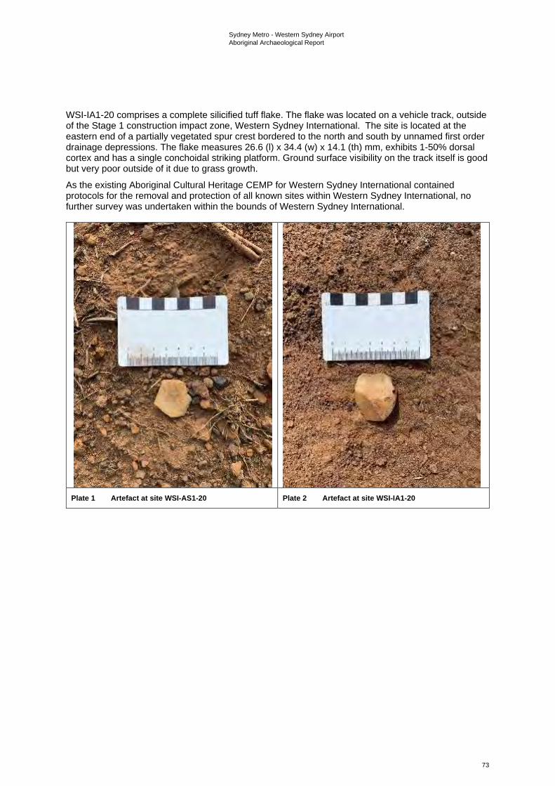
Sydney Metro - Western Sydney Airport Aboriginal Archaeological Report
73
WSI-IA1-20 comprises a complete silicified tuff flake. The flake was located on a vehicle track, outside of the Stage 1 construction impact zone, Western Sydney International. The site is located at the eastern end of a partially vegetated spur crest bordered to the north and south by unnamed first order drainage depressions. The flake measures 26.6 (l) x 34.4 (w) x 14.1 (th) mm, exhibits 1-50% dorsal cortex and has a single conchoidal striking platform. Ground surface visibility on the track itself is good but very poor outside of it due to grass growth.
As the existing Aboriginal Cultural Heritage CEMP for Western Sydney International contained protocols for the removal and protection of all known sites within Western Sydney International, no further survey was undertaken within the bounds of Western Sydney International.
Plate 1 Artefact at site WSI-AS1-20 Plate 2 Artefact at site WSI-IA1-20
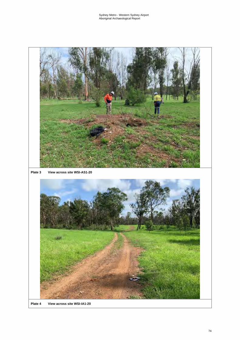
Sydney Metro - Western Sydney Airport Aboriginal Archaeological Report
74
Plate 3 View across site WSI-AS1-20
Plate 4 View across site WSI-IA1-20
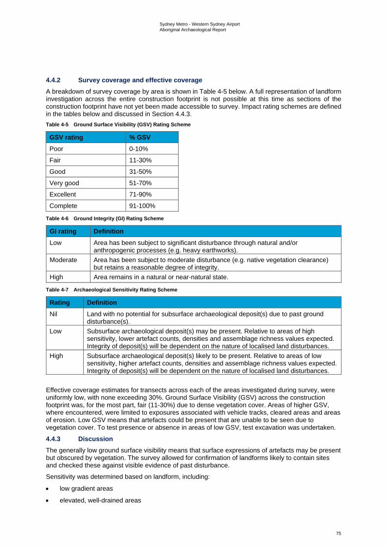
Sydney Metro - Western Sydney Airport Aboriginal Archaeological Report
75
4.4.2 Survey coverage and effective coverage A breakdown of survey coverage by area is shown in Table 4-5 below. A full representation of landform investigation across the entire construction footprint is not possible at this time as sections of the construction footprint have not yet been made accessible to survey. Impact rating schemes are defined in the tables below and discussed in Section 4.4.3. Table 4-5 Ground Surface Visibility (GSV) Rating Scheme
GSV rating % GSV Poor 0-10%
Fair 11-30%
Good 31-50%
Very good 51-70%
Excellent 71-90%
Complete 91-100%
Table 4-6 Ground Integrity (GI) Rating Scheme
GI rating Definition Low Area has been subject to significant disturbance through natural and/or
anthropogenic processes (e.g. heavy earthworks). Moderate Area has been subject to moderate disturbance (e.g. native vegetation clearance)
but retains a reasonable degree of integrity. High Area remains in a natural or near-natural state.
Table 4-7 Archaeological Sensitivity Rating Scheme
Rating Definition Nil Land with no potential for subsurface archaeological deposit(s) due to past ground
disturbance(s). Low Subsurface archaeological deposit(s) may be present. Relative to areas of high
sensitivity, lower artefact counts, densities and assemblage richness values expected. Integrity of deposit(s) will be dependent on the nature of localised land disturbances.
High Subsurface archaeological deposit(s) likely to be present. Relative to areas of low sensitivity, higher artefact counts, densities and assemblage richness values expected. Integrity of deposit(s) will be dependent on the nature of localised land disturbances.
Effective coverage estimates for transects across each of the areas investigated during survey, were uniformly low, with none exceeding 30%. Ground Surface Visibility (GSV) across the construction footprint was, for the most part, fair (11-30%) due to dense vegetation cover. Areas of higher GSV, where encountered, were limited to exposures associated with vehicle tracks, cleared areas and areas of erosion. Low GSV means that artefacts could be present that are unable to be seen due to vegetation cover. To test presence or absence in areas of low GSV, test excavation was undertaken.
4.4.3 Discussion The generally low ground surface visibility means that surface expressions of artefacts may be present but obscured by vegetation. The survey allowed for confirmation of landforms likely to contain sites and checked these against visible evidence of past disturbance.
Sensitivity was determined based on landform, including:
• low gradient areas
• elevated, well-drained areas
Sydney Metro - Western Sydney Airport Aboriginal Archaeological Report
76
• proximity to existing sites
• proximity to water sources
• low to moderate levels of past disturbance.
Areas with a nil rating for archaeological sensitivity were confirmed as being within the bounds of three existing AHIP areas. This was due to the high levels of disturbance in those areas. In other sections of the off-airport construction footprint the differentiation between low and high potential for subsurface archaeology was problematic. This was due to the low GSV encountered during survey, meaning there was limited information on which to base a hierarchy of potential.
The survey results did enable the mapping of areas of Aboriginal archaeological sensitivity. This was due to identifiable evidence of disturbance in some locations. This had been caused by clearance, erosion, dams, houses, roads and other infrastructure. Such areas were removed from the mapped areas proposed for test excavation, with the remaining areas of sensitivity mapped and gridded for testing. Thus, areas proposed for test excavation did not have any further differentiation of low and high ratings.
It was predicted that areas considered to have the highest archaeological sensitivity were predominantly on undisturbed terraces and flats, especially when elevated and well-drained. The test pits were spaced across varying landforms (slopes, flats, floodplain, banks and terraces) within the identified areas of Aboriginal archaeological sensitivity, in order to test the veracity of the predictions that had been made based on desktop research. Further investigation through subsurface testing was deemed warranted to test for the presence or absence of artefacts in subsurface deposits within the construction footprint.
Sydney Metro - Western Sydney Airport Aboriginal Archaeological Report
77
5. Archaeological test excavation
5.1 Purpose, sampling strategy and methods A program of archaeological test excavation was undertaken concurrently with the subsequent archaeological surveys, conducted between October 2020 and February 2021. In accordance with Requirement 3.1 of the Code of Practice, the purpose of the test excavation program was to determine the presence or absence of subsurface archaeological deposits in areas of identified archaeological sensitivity at risk of direct impacts across the construction footprint. Together with the field survey results discussed above, the results of the test excavation program described below provide a robust dataset for assessing the impacts of the proposed development on the Aboriginal archaeological resource of the study area. In accordance with Requirement 15c of the Code of Practice, notification of M2A’s intention to undertake the program of test excavation detailed in this report was provided, in writing, to Heritage NSW on 12 October 2020.
Archaeological test excavation within the construction footprint involved the excavation of a total 196 test pits measuring 0.25 m² (50 x 50 cm). Test pit locations were planned at 50 metre intervals in a grid across the construction footprint where proposed impacts intersected with areas of previously identified archaeological sensitivity. In the field, however, a call was made to exclude those pits that were found upon inspection to have been subject to gross levels of past disturbance. A total of 196 test pits were excavated over non-consecutive days between October 2020 and February 2021, as access to individual land parcels became available. Participants of the combined test excavation program included RAP representatives. Further participation details of individual RAP field representatives are outlined in the ACHAR. Clause 5(ii) of Requirement 16a of the Code of Practice stipulates that the maximum surface area of all test excavation units must be no greater than 0.5% of the area - either PAD or site - being investigated. The test excavation program undertaken for the current investigation was executed in compliance with this clause.
In accordance with the Code of Practice, all test pits were hand excavated as 50 x 50 cm units (0.25 m²), with 5 cm spits employed during the excavation of the first excavated test pit and 10 cm spits thereafter. All test pits were excavated to culturally sterile horizons, with excavation ceasing once clay was identified (at times requiring some excavation into the clay deposit). Excavated sediment was dry-sieved through a 3 millimetre wire-mesh sieve. Wet sieving was considered as an option to be employed if required, but soil was able to pass through the 3 millimetre mesh successfully to enable dry sieving to be undertaken. Where stone artefacts and non-diagnostic lithic items were recovered during sieving, they were bagged by square and spit. Representative profiles in each test pit were photographed. Test pit stratigraphy was recorded on pro forma test pit recording sheets using standard sedimentological terms and criteria (after McDonald & Isbell 2009). All pits were backfilled after excavation.
5.2 Testing results A total of 196 test pits measuring 0.25 m2 (50 x 50 cm) were hand excavated across the construction footprint over non-consecutive days between October 2020 and February 2021, as access to individual land parcels became available. Test pits were generally located at 50 metre intervals across previously identified areas of archaeological sensitivity at risk of direct impacts. Test pit locations are shown in Figure 4-1a to Figure 4-1d. The photographic recording of all test pits is included in Appendix A.
A total of 22 test pits (11.2 per cent) were found to contain Aboriginal objects, with densities ranging from one to five objects per 0.25 metres squared. Collectively, a total of 42 lithic items which satisfied technical criteria for identification as artefacts were recovered as a result of the test excavation program.
Test excavation identified five artefact scatters (SMWSA-AS2, SMWSA-AS3, SMWSA-AS4, SMWSA-AS7 and SMWSA-AS8) and three isolated artefact sites (SMWSA-IA1, SMWSA-IA2 and SMWSA-IA3) within the off-airport construction footprint.
Sydney Metro - Western Sydney Airport Aboriginal Archaeological Report
78
The archaeological testing allowed for refined mapping of areas across the off-airport construction footprint in relation to Aboriginal archaeological sensitivity. Mapping has been classified into the following zones including:
• areas of unverified sensitivity (refer to Figure 3-1a to 3-1d) - this zone comprised of the areas that have been identified as having Aboriginal archaeological sensitivity based on desktop data, but which have not yet been subject to survey or test excavation due to access restrictions
• areas of verified Aboriginal archaeological sensitivity (refer to Figure 3-1a to 3-1d (note: Areas of verified archaeological sensitivity are not shown in the public version of this report)) – this zone contains areas that have sites that have been identified by the results of survey and test excavation, with curtilages capturing associated PAD as appropriate. PAD curtilages were informed by artefact distribution and landform, as per the predictions made in Section 3.3
• areas to be managed by unexpected finds procedures - these areas have been identified through survey and testing as not to have a high likelihood to contain sites based on disturbance, landform and a lack of result from the survey and test excavation. Although these areas cannot be said to have nil potential, the low potential for them to contain sites means that further investigation is unwarranted, and any unexpected finds encountered during works can be managed through the appropriate stop work procedures.
The management of these areas is further described in the ACHMP.
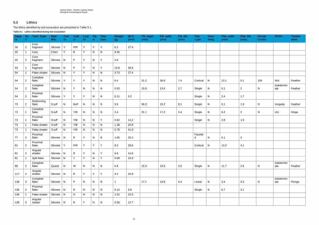
Sydney Metro - Western Sydney Airport Aboriginal Archaeological Report
79
5.3 Lithics The lithics identified by test excavation are presented in Table 5-1. Table 5-1 Lithics identified during test excavation
Square
Spit
Tech. Type Raw Mat.
Cortex
Colour
Lustre
Flaw
Ther. Dam.
Weight (g)
MLD (mm)
Flk. lngth (mm)
Flk. wdth (mm)
Flk. thk (mm)
Plat. Type
Over-hang
Plat. wdth (mm)
Plat. thk (mm)
Dorsal Cortex
DFSO Termin-ation
30 2 Core fragment Silcrete Y P/R Y Y Y 6.2 27.4
32 1 Core Chert Y B Y N N 9.45
32 2 Core fragment Silcrete N P Y N Y 2.6
43 1 Core fragment Silcrete N P Y N Y 13.8 30.6
54 1 Flake shatter Silcrete N Y Y N N 3.73 27.4
54 2 Complete flake Silcrete Y Y Y N N 6.4 31.2 36.8 7.4 Cortical N 13.1 5.1 100 N/A Feather
54 2 Complete flake Silcrete N Y N N N 0.53 15.9 13.4 2.7 Single N 5.1 2 N
Indeterminate Feather
54 2 Proximal flake Silcrete Y Y Y N N 0.11 9.2 Single N 2.4 1.7
73 2 Redirecting flake S.tuff N Buff N N N 5.6 56.3 15.2 8.1 Single N 5.1 1.9 N Irregular Feather
73 1 Complete flake S.tuff N Y/B N N N 2.4 31.1 17.2 3.4 Single N 6.2 2 N Uni Hinge
73 1 Proximal flake S.tuff N Y/B N N Y 0.62 14.2 Single N 2.8 1.9
73 1 Flake shatter S.tuff N Y/B N N N 1.38 25.8
73 1 Flake shatter S.tuff N Y/B N N N 5.78 41.9
77 2 Proximal flake Silcrete N R Y N N 1.65 25.2
Facetted N 6.1 3
81 2 Proximal flake Silcrete Y P/R Y Y Y 8.3 28.6 Cortical N 13.2 4.1
81 2 Angular shatter Silcrete N R Y N Y 0.6 14.6
81 1 Split flake Silcrete N Y Y N Y 0.69 15.9
85 2 Complete flake Quartz N W N N N 0.8 15.3 16.9 3.5 Single N 11.7 2.6 N
Indeterminate Feather
117 2 Angular shatter Silcrete N R Y Y Y 4.2 32.8
136 3 Complete flake Silcrete N P N N N 1 17.1 19.8 4.4 Linear N 3.4 0.3 N
Indeterminate Plunge
136 2 Proximal flake Silcrete N R N N N 0.14 9.9 Single N 6.7 2.1
136 1 Flake shatter Silcrete N G N N N 1.52 22.5
139 3 Angular shatter Silcrete N R Y N N 0.56 12.7
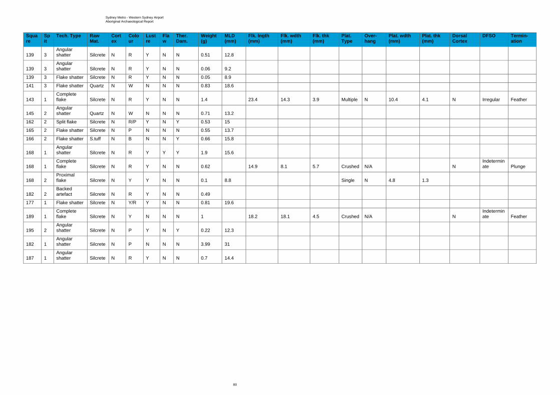
Sydney Metro - Western Sydney Airport Aboriginal Archaeological Report
80
Square
Spit
Tech. Type Raw Mat.
Cortex
Colour
Lustre
Flaw
Ther. Dam.
Weight (g)
MLD (mm)
Flk. lngth (mm)
Flk. wdth (mm)
Flk. thk (mm)
Plat. Type
Over-hang
Plat. wdth (mm)
Plat. thk (mm)
Dorsal Cortex
DFSO Termin-ation
139 3 Angular shatter Silcrete N R Y N N 0.51 12.8
139 3 Angular shatter Silcrete N R Y N N 0.06 9.2
139 3 Flake shatter Silcrete N R Y N N 0.05 8.9
141 3 Flake shatter Quartz N W N N N 0.83 18.6
143 1 Complete flake Silcrete N R Y N N 1.4 23.4 14.3 3.9 Multiple N 10.4 4.1 N Irregular Feather
145 2 Angular shatter Quartz N W N N N 0.71 13.2
162 2 Split flake Silcrete N R/P Y N Y 0.53 15
165 2 Flake shatter Silcrete N P N N N 0.55 13.7
166 2 Flake shatter S.tuff N B N N Y 0.66 15.8
168 1 Angular shatter Silcrete N R Y Y Y 1.9 15.6
168 1 Complete flake Silcrete N R Y N N 0.62 14.9 8.1 5.7 Crushed N/A N
Indeterminate Plunge
168 2 Proximal flake Silcrete N Y Y N N 0.1 8.8 Single N 4.8 1.3
182 2 Backed artefact Silcrete N R Y N N 0.49
177 1 Flake shatter Silcrete N Y/R Y N N 0.81 19.6
189 1 Complete flake Silcrete N Y N N N 1 18.2 18.1 4.5 Crushed N/A N
Indeterminate Feather
195 2 Angular shatter Silcrete N P Y N Y 0.22 12.3
182 1 Angular shatter Silcrete N P N N N 3.99 31
187 1 Angular shatter Silcrete N R Y N N 0.7 14.4
Sydney Metro - Western Sydney Airport Aboriginal Archaeological Report
81
5.3 Analysis and discussion of results Background research identified one site being located wholly within the off-airport construction footprint (45-5-2640) and two with PAD curtilages extending partially into the construction footprint. The survey resulted in one artefact scatter site (SMWSA-AS6) being located within the off-airport construction footprint. Test excavation identified a total of 42 lithic items across 22 of the 196 test pits. The test excavation resulted in eight sites being defined, consisting of five artefact scatters (SMWSA-AS2, SMWSA-AS3, SMWSA-AS4, SMWSA-AS7 and SMWSA-AS8) and three isolated artefacts (SMWSA-IA1, SMWSA-IA2 and SMWSA-IA3).
Lithic analysis resulted in artefacts from raw material types including 31 silcrete, six silicified tuff, three quartz and one chert. Artefact types included 10 pieces of angular shatter, nine pieces of flake shatter, eight complete flakes, six proximal flakes, three core fragments, two split flakes, one redirecting flake, one core and one backed artefact. The presence of cores indicates that stone tool manufacturing was taking place within this area. Although no verified single incident production signature could be verified from the available data, test pit 73 contained a complete flake, a proximal flake, a redirecting flake and two pieces of flake shatter, all from the same raw material type (silicified tuff). The assemblage is at least suggestive of a knapping floor. Only one backed artefact was identified, located in test pit 182 along with a single piece of angular shatter.
The current finds are evidence of the use of the area by Aboriginal people in the past, and retain cultural heritage values to the contemporary Aboriginal community as a tangible link to their past. The identification of the majority of the material in elevated areas in proximity to water sources indicates the accuracy of predictions made based on known sites and landform. The paucity of data means that research questions cannot be accurately answered at this time, although further evidence may be gathered through future test excavation and salvage.
Sydney Metro - Western Sydney Airport Aboriginal Archaeological Report
82
6. Scientific significance assessment This section provides an assessment of the archaeological (or scientific) significance of identified Aboriginal archaeological sites within the study area. Scientific significance ratings are presented as a means of determining, in conjunction with assessed levels of social or cultural significance by RAPs, the most appropriate management / mitigation measures for these sites.
6.1 Assessing values and significance Heritage sites hold value for different communities in a variety of different ways. All sites are not equally significant in terms of archaeological/scientific values and thus not equally worthy of conservation and management (Pearson & Sullivan, 1995: 17). One of the primary responsibilities of cultural heritage practitioners, therefore, is to determine which sites are worthy of preservation and management (and why) and, conversely, which are not (and why) (Smith & Burke, 2007: 227). This process is known as the assessment of cultural significance and, as highlighted by Pearson and Sullivan (1995: 127), incorporates two interrelated and interdependent components. The first involves identifying, through documentary, physical or oral evidence, the elements that make a heritage site significant, as well as the type(s) of significance it manifests. The second involves determining the degree of value that the site holds for society (i.e. its cultural significance) (Pearson & Sullivan, 1995: 126). As has previously been noted, cultural values are either present or not, and RAPs will not draw a hierarchical distinction between sites and features. All known sites have been identified as having cultural values. Other values associated with the scientific/archaeological components of a site are generally determined through assessment guidelines.
In Australia, the primary guide to the assessment of heritage significance is the Australian ICOMOS Charter for Places of Cultural Significance (1999), informally known as The Burra Charter, which defines cultural significance as the “aesthetic, historic, scientific, social or spiritual value for past, present or future generations” of a site or place (ICOMOS, 1999: 2). Under the Burra Charter model, the cultural significance of a heritage site or place is assessed in terms of its aesthetic, historic, scientific and social values, none of which are mutually exclusive (see Table 6-1). Establishing cultural significance under the Burra Charter model involves assessing all information relevant to an understanding of the site and its fabric (i.e. its physical make-up) (ICOMOS, 1999: 12). The assessment of cultural significance and the preparation of a statement of cultural significance are critical prerequisites to making decisions about the management of any heritage site or place (ICOMOS, 1999: 11).
With respect to Aboriginal sites and places, it is possible to identify two major streams in the overall significance assessment process: the assessment of scientific value(s) by archaeologists and the assessment of social (or cultural) value(s) by Aboriginal people. Scientific value refers to the importance of a place in terms of its rarity, representativeness and the extent to which it may contribute further information (i.e. its research potential) (OEH 2011: 9). Social or cultural value, meanwhile, refers to the spiritual, traditional, historic and contemporary associations and attachments a place or area has for Aboriginal people and can only be identified through consultation with Aboriginal people (OEH, 2011: 8). Social or cultural value therefore is not limited to specific sites or objects or physical expressions of place. Table 6-1 Values relevant to determining cultural significance, as defined by The Burra Charter (1999)
Value Definition Aesthetic “Aesthetic value includes aspects of sensory perception for which criteria can and
should be stated. Such criteria may include consideration of the form, scale, colour, texture and material of the fabric; the smells and sounds associated with the place and its use” (ICOMOS, 1999: 12).
Historic “Historic value encompasses the history of aesthetics, science and society...[a] place may have historic value because it has influenced, or has been influenced by, an historic figure, event, phase or activity. It may have historic value as the site of an important event” (ICOMOS, 1999: 12).

Sydney Metro - Western Sydney Airport Aboriginal Archaeological Report
83
Value Definition Scientific “The scientific or research value of a place will depend on the importance of the
data involved, on its rarity, quality or representativeness, and on the degree to which the place may contribute further substantial information” (ICOMOS, 1999:12).
Social “Social value embraces the qualities for which a place has become a focus of spiritual, political, national or other cultural sentiment to a majority or minority group” (ICOMOS, 1999: 12).
6.2 Scientific values (archaeological significance) The scientific (or archaeological) significance of Aboriginal archaeological sites relates primarily to their potential for providing information about past Aboriginal culture and is commonly assessed on the basis of their research potential, representativeness and rarity. Other criteria, such as aesthetic value and education potential, may also be relevant.
Research potential Research potential can be defined as the potential of an archaeological site to address what Bowdler (1981:129) has referred to as “timely and specific research questions”. These questions may relate to any number of issues concerning past human lifeways and environments and, as suggested by Bowdler’s quote, will inevitably reflect current trends or problems in academic research (Burke & Smith, 2004:249). For their part, Bowdler and Bickford (1984:23-4) suggest that the research potential of an archaeological site can be determined by answering the following series of questions:
1. Can the site contribute knowledge which no other resource can?
2. Can the site contribute knowledge which no other such site can?
3. Is this knowledge relevant to general questions about human history or other substantiative subjects?
Several criteria can be used to assess the research potential of an archaeological site. Particularly important in the context of Aboriginal archaeology are the intactness or integrity of the site in question, its complexity and its potential for archaeological deposit (NPWS, 1997: 7). The connectedness of the site to other sites or natural landscape features may also be relevant.
Integrity refers to the extent to which a site has been disturbed by natural and/or anthropogenic phenomena and includes both the state of preservation of particular remains (e.g. animal bones, plant remains) and, where applicable, stratigraphic integrity. Assessments of archaeological integrity are predicated on the notion that undisturbed or minimally disturbed sites are likely to yield higher quality archaeological and/or environmental data than those whose integrity has been significantly compromised by natural and/or anthropogenic phenomena. Establishing levels of preservation or integrity in the context of a surface survey is difficult. Nonetheless, useful rating schemes are available for ‘open’ sites (Coutts & Witter, 1977: 34) and scarred trees (Long, 2003).
The complexity of a site refers primarily to the nature or character of the artefactual materials or features that constitute it but also includes site structure (e.g. the physical size of the site, spatial patterning in observed cultural materials). In the case of open artefact sites, for example, the principal criteria used to assess complexity are the site’s size (i.e. number of artefacts and/or spatial extent), the presence, range and frequency of artefact and raw material types, and the presence of features such as hearths.
Potential for archaeological deposit refers to the potential of a site to contain subsurface archaeological evidence which may, through controlled excavation and analysis, assist in answering questions that are of contemporary archaeological interest. Assessing subsurface potential in the absence of subsurface investigation is difficult. Nonetheless, consideration of a range of factors, including the integrity of the site, the complexity of extant surface evidence, the nature of the local geomorphology (as established through surface observations and documentary research) and the results of previous archaeological excavations in the area, will help inform assessment of this criterion.
Sydney Metro - Western Sydney Airport Aboriginal Archaeological Report
84
Connectedness concerns the relationship between archaeological sites within a given area and may be expressed through a combination of factors such as site location, type and contents. It may, for example, be possible to establish a connection between a stone quarry and hatchet head found nearby. Demonstrating connectedness archaeologically, however, is far from straightforward, especially when dealing with surface evidence alone. Ultimately, this difficulty rests with the need to demonstrate contemporaneity between sites that may have been created hundreds, if not thousands, of years apart. As Shiner (2008: 13) has observed, “much of the surface archaeological record documents the accumulation of materials from multiple behavioural episodes occurring over long periods of discontinuous time”. Contemporaneity, then, needs to be demonstrated not assumed.
Rarity and representativeness Rarity and representativeness are related concepts. Rarity refers to the relative uniqueness of a site within its local and regional context. The scientific significance of a site is usually higher if it is unique or rare within either context; conversely, it is usually considered to be of lower scientific significance if it is common in a local or regional context. The concept of representativeness, meanwhile, refers to the question of whether or not a site is “a good example of its type, illustrating clearly the attributes of its significance” (Burke & Smith, 2004: 247). Representativeness is an important criterion as one of the primary goals of cultural heritage management is to preserve for future generations a representative sample of all archaeological site types in their full range of environmental contexts.
In common with rarity, assessments of representativeness within a region are dependent on the state of current knowledge concerning the number and type of archaeological sites present within that region9. This is a critical point, for as suggested by Kuskie (2000) and others (e.g. Bowdler, 1981; Godwin, 2011; Pearson & Sullivan, 1995), the absence across most of Australia of regional-scale quantitative data for Aboriginal sites and places represents a major constraint in assessments of representativeness and rarity. As Bowdler (1981) stressed almost 40 years ago, detailed regional-scale assessments of the Aboriginal archaeological record of Australia are required to address this issue.
6.3 Identified scientific values The identified scientific values rest in the Aboriginal archaeological sites that have been recorded. Taking into account the results of all archaeological survey and test excavation works undertaken for the project up to and including February 2021, a total of 10 Aboriginal archaeological sites are recognised as being wholly within the off-airport section of the construction footprint, with an additional two sites that have PAD curtilages partially extending into it. Identified sites consist of three valid previously recorded artefact scatter sites, being B22 (45-5-2640) BWB (45-5-5298) and CCE T3 (45-5-5297). Survey identified another artefact scatter site (SMWSA-AS6), while test excavation has identified five artefact scatters (SMWSA-AS2, SMWSA-AS3, SMWSA-AS4, SMWSA-AS7 and SMWSA-AS8) and three isolated artefact sites (SMWSA-IA1, SMWSA-IA2 and SMWSA-IA3) within the off-airport construction footprint.
The artefact assemblages at surface sites 45-5-2640 (B22) and SMWSA-AS6 are low density in disturbed areas and are therefore limited in the research questions that can be answered. It is important to note, however, that these sites are part of a landscape of linked sites and it is its connection to the wider cultural landscape that allows for a larger suite of research questions to be applied.
An assessment of the scientific significance of the 12 Aboriginal sites (listed in Table 6-2) identified within the off-airport construction footprint is presented in Table 6-3. Significance ratings are offered on the basis of the assessed research potential, rarity and representativeness of each site on a local and regional scale. Rankings for the previously recorded artefact site 45-5-2640 (B22), which was not relocated during the survey component of the archaeological field investigation, has been based on site information provided in the associated site card (see Table 6-3).
9 There is, of course, a temporal fluidity to this criterion (i.e. as knowledge of the Aboriginal archaeology of a region increases, assessed levels of representativeness may change, a point of equal relevance to rarity).
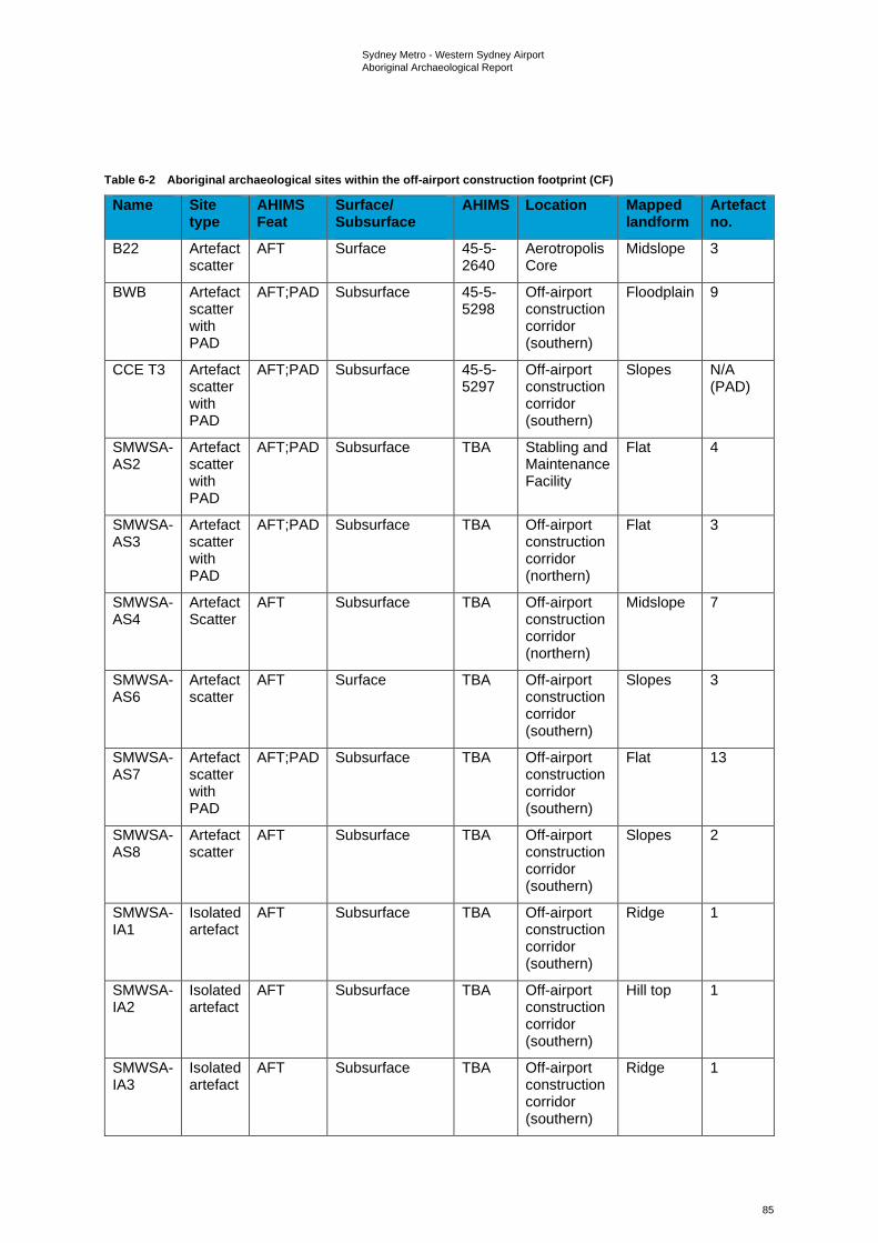
Sydney Metro - Western Sydney Airport Aboriginal Archaeological Report
85
Table 6-2 Aboriginal archaeological sites within the off-airport construction footprint (CF)
Name Site type
AHIMS Feat
Surface/ Subsurface
AHIMS Location Mapped landform
Artefact no.
B22 Artefact scatter
AFT Surface 45-5-2640
Aerotropolis Core
Midslope 3
BWB Artefact scatter with PAD
AFT;PAD Subsurface 45-5-5298
Off-airport construction corridor (southern)
Floodplain 9
CCE T3 Artefact scatter with PAD
AFT;PAD Subsurface 45-5-5297
Off-airport construction corridor (southern)
Slopes N/A (PAD)
SMWSA-AS2
Artefact scatter with PAD
AFT;PAD Subsurface TBA Stabling and Maintenance Facility
Flat 4
SMWSA-AS3
Artefact scatter with PAD
AFT;PAD Subsurface TBA Off-airport construction corridor (northern)
Flat 3
SMWSA-AS4
Artefact Scatter
AFT Subsurface TBA Off-airport construction corridor (northern)
Midslope 7
SMWSA-AS6
Artefact scatter
AFT Surface TBA Off-airport construction corridor (southern)
Slopes 3
SMWSA-AS7
Artefact scatter with PAD
AFT;PAD Subsurface TBA Off-airport construction corridor (southern)
Flat 13
SMWSA-AS8
Artefact scatter
AFT Subsurface TBA Off-airport construction corridor (southern)
Slopes 2
SMWSA-IA1
Isolated artefact
AFT Subsurface TBA Off-airport construction corridor (southern)
Ridge 1
SMWSA-IA2
Isolated artefact
AFT Subsurface TBA Off-airport construction corridor (southern)
Hill top 1
SMWSA-IA3
Isolated artefact
AFT Subsurface TBA Off-airport construction corridor (southern)
Ridge 1
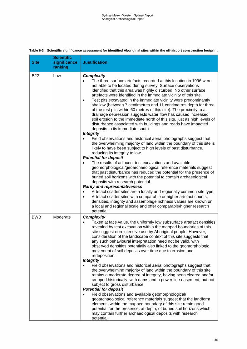
Sydney Metro - Western Sydney Airport Aboriginal Archaeological Report
86
Table 6-3 Scientific significance assessment for identified Aboriginal sites within the off-airport construction footprint
Site Scientific significance ranking
Justification
B22 Low Complexity • The three surface artefacts recorded at this location in 1996 were
not able to be located during survey. Surface observations identified that this area was highly disturbed. No other surface artefacts were identified in the immediate vicinity of this site.
• Test pits excavated in the immediate vicinity were predominantly shallow (between 7 centimetres and 11 centimetres depth for three of the test pits within 60 metres of this site). The proximity to a drainage depression suggests water flow has caused increased soil erosion to the immediate north of this site, just as high levels of disturbance associated with buildings and roads have impacted deposits to its immediate south.
Integrity • Field observations and historical aerial photographs suggest that
the overwhelming majority of land within the boundary of this site is likely to have been subject to high levels of past disturbance, reducing its integrity to low.
Potential for deposit • The results of adjacent test excavations and available
geomorphological/geoarchaeological reference materials suggest that past disturbance has reduced the potential for the presence of buried soil horizons with the potential to contain archaeological deposits with research potential.
Rarity and representativeness • Artefact scatter sites are a locally and regionally common site type. • Artefact scatter sites with comparable or higher artefact counts,
densities, integrity and assemblage richness values are known on a local and regional scale and offer comparable/higher research potential.
BWB Moderate Complexity • Taken at face value, the uniformly low subsurface artefact densities
revealed by test excavation within the mapped boundaries of this site suggest non-intensive use by Aboriginal people. However, consideration of the landscape context of this site suggests that any such behavioural interpretation need not be valid, with observed densities potentially also linked to the geomorphologic movement of soil deposits over time due to erosion and redeposition.
Integrity • Field observations and historical aerial photographs suggest that
the overwhelming majority of land within the boundary of this site retains a moderate degree of integrity, having been cleared and/or cropped historically, with dams and a power line easement, but not subject to gross disturbance.
Potential for deposit • Field observations and available geomorphological/
geoarchaeological reference materials suggest that the landform elements within the mapped boundary of this site retain good potential for the presence, at depth, of buried soil horizons which may contain further archaeological deposits with research potential.

Sydney Metro - Western Sydney Airport Aboriginal Archaeological Report
87
Site Scientific significance ranking
Justification
Rarity and representativeness • Artefact scatter sites are a locally and regionally common site type. • Artefact scatter sites with comparable or higher artefact counts,
densities, integrity and assemblage richness values are known on a local and regional scale and offer comparable/higher research potential.
CCE T3 Low Complexity • This site consists of an area of PAD associated with a larger
artefact scatter site that extends beyond the boundaries of the construction footprint. No known artefacts have been identified within the portion of this PAD area that intersects with the off-airport construction corridor.
Integrity • Field observations and historical aerial photographs suggest that
the overwhelming majority of land within the boundary of this site retains a moderate degree of integrity, having been cleared and/or cropped historically but not subject to gross disturbance.
Potential for deposit • Field observations and available geomorphological/
geoarchaeological reference materials suggest that the landform elements within the mapped boundary of this site retain good potential for the presence, at depth, of buried soil horizons which may contain further archaeological deposits with research potential.
Rarity and representativeness • Artefact scatter sites are a locally and regionally common site type. • Artefact scatter sites with comparable or higher artefact counts,
densities, integrity and assemblage richness values are known on a local and regional scale and offer comparable/higher research potential.
SMWSA-AS2
Moderate Complexity • Taken at face value, the uniformly low subsurface artefact densities
revealed by test excavation within the mapped boundaries of this site suggest non-intensive use by Aboriginal people. However, consideration of the landscape context of this site suggests that any such behavioural interpretation need not be valid, with observed densities potentially also linked to the geomorphologic movement of soil deposits over time due to erosion and redeposition.
Integrity • Field observations and historical aerial photographs suggest that
the overwhelming majority of land within the boundary of this site retains a moderate degree of integrity, having been cleared and/or cropped historically, with some dams, but not subject to gross disturbance overall.
Potential for deposit • Field observations and available geomorphological/
geoarchaeological reference materials suggest that the landform elements within the mapped boundary of this site retain good potential for the presence, at depth, of buried soil horizons which may contain further archaeological deposits with research potential.
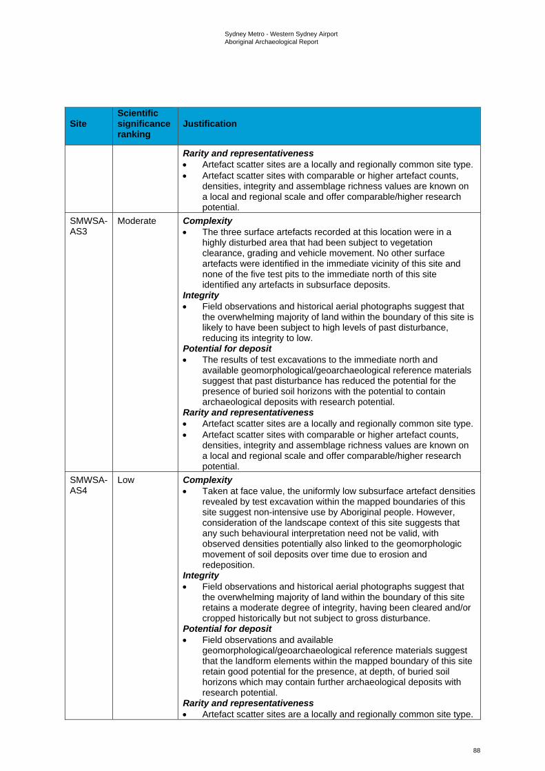
Sydney Metro - Western Sydney Airport Aboriginal Archaeological Report
88
Site Scientific significance ranking
Justification
Rarity and representativeness • Artefact scatter sites are a locally and regionally common site type. • Artefact scatter sites with comparable or higher artefact counts,
densities, integrity and assemblage richness values are known on a local and regional scale and offer comparable/higher research potential.
SMWSA-AS3
Moderate Complexity • The three surface artefacts recorded at this location were in a
highly disturbed area that had been subject to vegetation clearance, grading and vehicle movement. No other surface artefacts were identified in the immediate vicinity of this site and none of the five test pits to the immediate north of this site identified any artefacts in subsurface deposits.
Integrity • Field observations and historical aerial photographs suggest that
the overwhelming majority of land within the boundary of this site is likely to have been subject to high levels of past disturbance, reducing its integrity to low.
Potential for deposit • The results of test excavations to the immediate north and
available geomorphological/geoarchaeological reference materials suggest that past disturbance has reduced the potential for the presence of buried soil horizons with the potential to contain archaeological deposits with research potential.
Rarity and representativeness • Artefact scatter sites are a locally and regionally common site type. • Artefact scatter sites with comparable or higher artefact counts,
densities, integrity and assemblage richness values are known on a local and regional scale and offer comparable/higher research potential.
SMWSA-AS4
Low Complexity • Taken at face value, the uniformly low subsurface artefact densities
revealed by test excavation within the mapped boundaries of this site suggest non-intensive use by Aboriginal people. However, consideration of the landscape context of this site suggests that any such behavioural interpretation need not be valid, with observed densities potentially also linked to the geomorphologic movement of soil deposits over time due to erosion and redeposition.
Integrity • Field observations and historical aerial photographs suggest that
the overwhelming majority of land within the boundary of this site retains a moderate degree of integrity, having been cleared and/or cropped historically but not subject to gross disturbance.
Potential for deposit • Field observations and available
geomorphological/geoarchaeological reference materials suggest that the landform elements within the mapped boundary of this site retain good potential for the presence, at depth, of buried soil horizons which may contain further archaeological deposits with research potential.
Rarity and representativeness • Artefact scatter sites are a locally and regionally common site type.
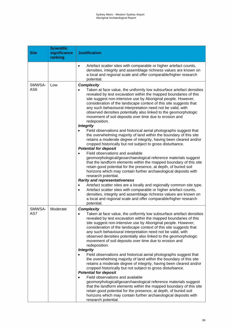
Sydney Metro - Western Sydney Airport Aboriginal Archaeological Report
89
Site Scientific significance ranking
Justification
• Artefact scatter sites with comparable or higher artefact counts, densities, integrity and assemblage richness values are known on a local and regional scale and offer comparable/higher research potential.
SMWSA-AS6
Low Complexity • Taken at face value, the uniformly low subsurface artefact densities
revealed by test excavation within the mapped boundaries of this site suggest non-intensive use by Aboriginal people. However, consideration of the landscape context of this site suggests that any such behavioural interpretation need not be valid, with observed densities potentially also linked to the geomorphologic movement of soil deposits over time due to erosion and redeposition.
Integrity • Field observations and historical aerial photographs suggest that
the overwhelming majority of land within the boundary of this site retains a moderate degree of integrity, having been cleared and/or cropped historically but not subject to gross disturbance.
Potential for deposit • Field observations and available
geomorphological/geoarchaeological reference materials suggest that the landform elements within the mapped boundary of this site retain good potential for the presence, at depth, of buried soil horizons which may contain further archaeological deposits with research potential.
Rarity and representativeness • Artefact scatter sites are a locally and regionally common site type. • Artefact scatter sites with comparable or higher artefact counts,
densities, integrity and assemblage richness values are known on a local and regional scale and offer comparable/higher research potential.
SMWSA-AS7
Moderate Complexity • Taken at face value, the uniformly low subsurface artefact densities
revealed by test excavation within the mapped boundaries of this site suggest non-intensive use by Aboriginal people. However, consideration of the landscape context of this site suggests that any such behavioural interpretation need not be valid, with observed densities potentially also linked to the geomorphologic movement of soil deposits over time due to erosion and redeposition.
Integrity • Field observations and historical aerial photographs suggest that
the overwhelming majority of land within the boundary of this site retains a moderate degree of integrity, having been cleared and/or cropped historically but not subject to gross disturbance.
Potential for deposit • Field observations and available
geomorphological/geoarchaeological reference materials suggest that the landform elements within the mapped boundary of this site retain good potential for the presence, at depth, of buried soil horizons which may contain further archaeological deposits with research potential.
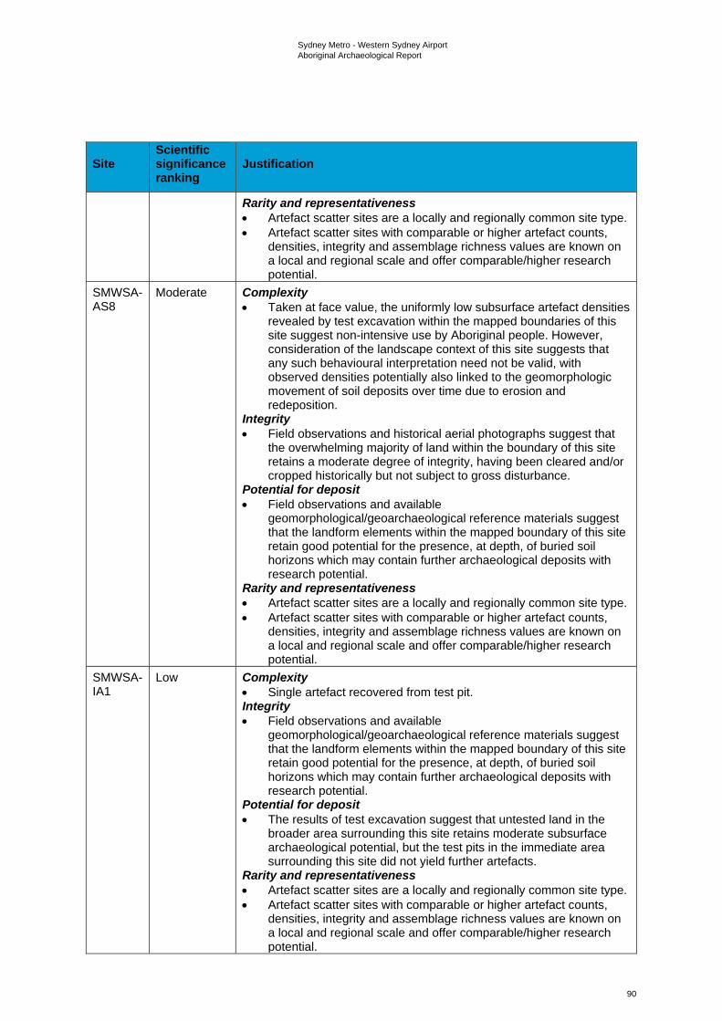
Sydney Metro - Western Sydney Airport Aboriginal Archaeological Report
90
Site Scientific significance ranking
Justification
Rarity and representativeness • Artefact scatter sites are a locally and regionally common site type. • Artefact scatter sites with comparable or higher artefact counts,
densities, integrity and assemblage richness values are known on a local and regional scale and offer comparable/higher research potential.
SMWSA-AS8
Moderate Complexity • Taken at face value, the uniformly low subsurface artefact densities
revealed by test excavation within the mapped boundaries of this site suggest non-intensive use by Aboriginal people. However, consideration of the landscape context of this site suggests that any such behavioural interpretation need not be valid, with observed densities potentially also linked to the geomorphologic movement of soil deposits over time due to erosion and redeposition.
Integrity • Field observations and historical aerial photographs suggest that
the overwhelming majority of land within the boundary of this site retains a moderate degree of integrity, having been cleared and/or cropped historically but not subject to gross disturbance.
Potential for deposit • Field observations and available
geomorphological/geoarchaeological reference materials suggest that the landform elements within the mapped boundary of this site retain good potential for the presence, at depth, of buried soil horizons which may contain further archaeological deposits with research potential.
Rarity and representativeness • Artefact scatter sites are a locally and regionally common site type. • Artefact scatter sites with comparable or higher artefact counts,
densities, integrity and assemblage richness values are known on a local and regional scale and offer comparable/higher research potential.
SMWSA-IA1
Low Complexity • Single artefact recovered from test pit. Integrity • Field observations and available
geomorphological/geoarchaeological reference materials suggest that the landform elements within the mapped boundary of this site retain good potential for the presence, at depth, of buried soil horizons which may contain further archaeological deposits with research potential.
Potential for deposit • The results of test excavation suggest that untested land in the
broader area surrounding this site retains moderate subsurface archaeological potential, but the test pits in the immediate area surrounding this site did not yield further artefacts.
Rarity and representativeness • Artefact scatter sites are a locally and regionally common site type. • Artefact scatter sites with comparable or higher artefact counts,
densities, integrity and assemblage richness values are known on a local and regional scale and offer comparable/higher research potential.
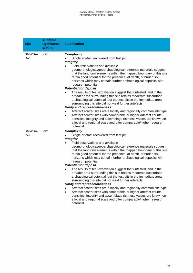
Sydney Metro - Western Sydney Airport Aboriginal Archaeological Report
91
Site Scientific significance ranking
Justification
SMWSA-IA2
Low Complexity • Single artefact recovered from test pit. Integrity • Field observations and available
geomorphological/geoarchaeological reference materials suggest that the landform elements within the mapped boundary of this site retain good potential for the presence, at depth, of buried soil horizons which may contain further archaeological deposits with research potential.
Potential for deposit • The results of test excavation suggest that untested land in the
broader area surrounding this site retains moderate subsurface archaeological potential, but the test pits in the immediate area surrounding this site did not yield further artefacts.
Rarity and representativeness • Artefact scatter sites are a locally and regionally common site type. • Artefact scatter sites with comparable or higher artefact counts,
densities, integrity and assemblage richness values are known on a local and regional scale and offer comparable/higher research potential.
SMWSA-IA3
Low Complexity • Single artefact recovered from test pit. Integrity • Field observations and available
geomorphological/geoarchaeological reference materials suggest that the landform elements within the mapped boundary of this site retain good potential for the presence, at depth, of buried soil horizons which may contain further archaeological deposits with research potential.
Potential for deposit • The results of test excavation suggest that untested land in the
broader area surrounding this site retains moderate subsurface archaeological potential, but the test pits in the immediate area surrounding this site did not yield further artefacts.
Rarity and representativeness • Artefact scatter sites are a locally and regionally common site type. • Artefact scatter sites with comparable or higher artefact counts,
densities, integrity and assemblage richness values are known on a local and regional scale and offer comparable/higher research potential.
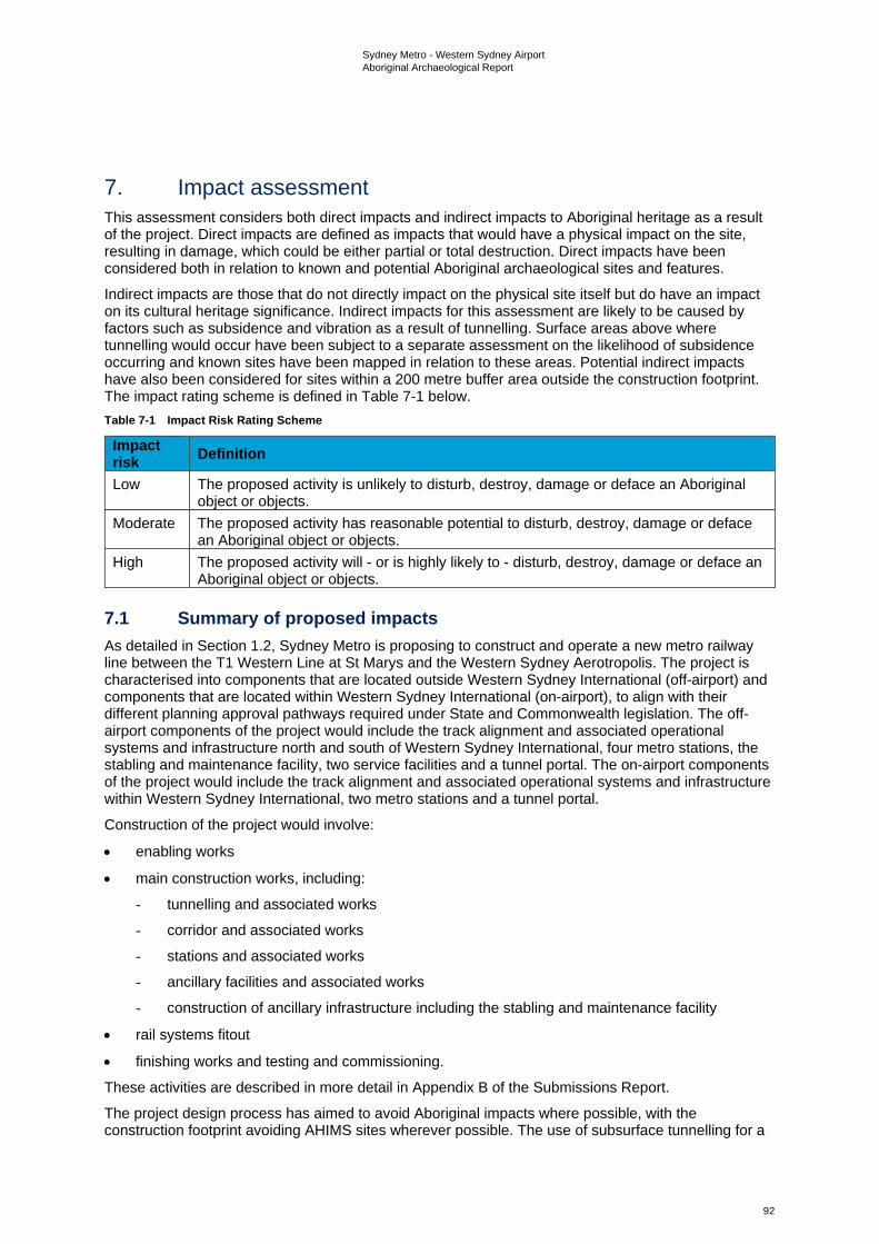
Sydney Metro - Western Sydney Airport Aboriginal Archaeological Report
92
7. Impact assessment This assessment considers both direct impacts and indirect impacts to Aboriginal heritage as a result of the project. Direct impacts are defined as impacts that would have a physical impact on the site, resulting in damage, which could be either partial or total destruction. Direct impacts have been considered both in relation to known and potential Aboriginal archaeological sites and features.
Indirect impacts are those that do not directly impact on the physical site itself but do have an impact on its cultural heritage significance. Indirect impacts for this assessment are likely to be caused by factors such as subsidence and vibration as a result of tunnelling. Surface areas above where tunnelling would occur have been subject to a separate assessment on the likelihood of subsidence occurring and known sites have been mapped in relation to these areas. Potential indirect impacts have also been considered for sites within a 200 metre buffer area outside the construction footprint. The impact rating scheme is defined in Table 7-1 below. Table 7-1 Impact Risk Rating Scheme
Impact risk Definition
Low The proposed activity is unlikely to disturb, destroy, damage or deface an Aboriginal object or objects.
Moderate The proposed activity has reasonable potential to disturb, destroy, damage or deface an Aboriginal object or objects.
High The proposed activity will - or is highly likely to - disturb, destroy, damage or deface an Aboriginal object or objects.
7.1 Summary of proposed impacts As detailed in Section 1.2, Sydney Metro is proposing to construct and operate a new metro railway line between the T1 Western Line at St Marys and the Western Sydney Aerotropolis. The project is characterised into components that are located outside Western Sydney International (off-airport) and components that are located within Western Sydney International (on-airport), to align with their different planning approval pathways required under State and Commonwealth legislation. The off-airport components of the project would include the track alignment and associated operational systems and infrastructure north and south of Western Sydney International, four metro stations, the stabling and maintenance facility, two service facilities and a tunnel portal. The on-airport components of the project would include the track alignment and associated operational systems and infrastructure within Western Sydney International, two metro stations and a tunnel portal.
Construction of the project would involve:
• enabling works
• main construction works, including:
- tunnelling and associated works
- corridor and associated works
- stations and associated works
- ancillary facilities and associated works
- construction of ancillary infrastructure including the stabling and maintenance facility
• rail systems fitout
• finishing works and testing and commissioning.
These activities are described in more detail in Appendix B of the Submissions Report.
The project design process has aimed to avoid Aboriginal impacts where possible, with the construction footprint avoiding AHIMS sites wherever possible. The use of subsurface tunnelling for a
Sydney Metro - Western Sydney Airport Aboriginal Archaeological Report
93
large proportion of the project would successfully avoid many known sites and minimise the impacts to areas of both Aboriginal cultural significance and archaeological potential.
7.2 Impacts to identified Aboriginal sites 7.2.1 Off-airport Potential direct and indirect impacts as a result of the project are discussed below.
Potential direct impacts Potential direct impacts within each construction site are outlined in Table 7-2. Table 7-2 Potential off-airport direct impacts summary
Construction site Impacts St Marys • There are no registered AHIMS sites within the curtilage of the St Marys
construction site (see Figure 3-1a (note: AHIMS sites are not shown in the public version of this report) and Section 3.2). There are no AHIMS sites within 200 metres of the construction site (see Section 3.2 and Figure 3-1a)
• based on the high levels of past disturbance in this construction site (including road corridors, rail corridor, the existing St Marys Station, buildings and services), no areas of archaeological sensitivity have been identified within its bounds (see Figure 3-1a)
• there are no known Aboriginal cultural values specifically associated with this construction site
• no potential direct impacts to Aboriginal archaeological sites have been identified in this construction site. No specific cultural values have yet been identified in this construction zone.
Claremont Meadows services facility
• There was one registered AHIMS site within the bounds of this construction site (artefact scatter site 45-5-4420) (see Figure 3-1a and Section 3.2). This site has however been destroyed under the conditions of AHIP C0000636 and is no longer extant in this construction site. The AHIP covers the entirety of the Claremont Meadows services facility (see Section 3.2)
• there were three AHIMS sites located within 200 metres of this construction site (45-5-0356, 45-5-4418 and 45-5-4419) but all three sites were destroyed under permit conditions (see Section 3.2) and are no longer extant at this location (see Section 3.2 and Figure 3-1a)
• based on the high levels of past disturbance in this construction site (including road corridors, clearance and development), no areas of archaeological sensitivity have been identified within its bounds (see Figure 3-1a)
• no direct impacts to Aboriginal archaeology have been identified at this location as the pre-existing archaeology has already been removed. The only currently known cultural values were those associated with the since destroyed AHIMS sites. Although the physical markers in the landscape that were provided by the sites have been removed the site locations may still have cultural value to the Aboriginal community as areas of past Aboriginal activity.
Orchard Hills • There are no registered AHIMS sites within the Orchard Hills construction site (see Figure 3-1a and Section 3.2). The northern-most part of this construction site has been subject to impacts under AHIP C0002113 (see Section 3.2)
• there were five artefact scatter sites located within 200 metres of the northern extent of this construction site (45-5-4424, 45-5-4429, 45-5-4430, 45-5-4431 and 45-5-4477) (see Figure 3-1a and Section 3.2). All five of these sites have been destroyed under permit conditions and they are no longer extant (see Section 3.2)
Sydney Metro - Western Sydney Airport Aboriginal Archaeological Report
94
Construction site Impacts • although there have been past impacts in this area, they are not so
extensive as to have definitely removed all Aboriginal sites (if present). Based on past impacts, the landform and distance from water channels, archaeological potential has been identified in elevated areas within this construction site (see UVA1 on Figure 3-1a). Access has not yet been provided to undertake survey and testing at this location. If intact subsurface deposits are present in this area there is a risk they may be impacted by the project (see Chapter 9 for details on management and mitigation)
• cultural values are associated with the waterways, areas of potential (if sites are identified therein) and the since destroyed AHIMS sites at the northern extent. Although the physical markers in the landscape (provided by the sites) have been removed, the site locations may still have cultural value to the Aboriginal community as areas of past Aboriginal activity.
Stabling and maintenance facility
• One artefact scatter and one isolated artefact site were identified in subsurface deposits (SMWSA-AS2) during testing within the stabling and maintenance facility construction site (see Figure 3-1b and Section 3.2). There are two artefact scatters (45-5-3190 and 45-5-3191) and an isolated artefact (45-5-3776) within 200 metres of this construction site, but are separated from the stabling and maintenance facility by the off-airport construction corridor (northern). As such these three sites are discussed in the off-airport construction corridor (northern) section
• although field investigations were undertaken in parts of this construction site, there are sections of it that have not yet been able to be accessed (see Chapters 4 and 5). The northern portion of the construction site is close to the confluence of Blaxland Creek and South Creek and is the location where one subsurface site was identified (see Figure 3-1b)
• the known Aboriginal cultural values specifically associated with this construction site are related to the one identified site
• the potential for subsurface deposits to be present in areas that have not yet been subject to survey or testing due to access constraints, means that as yet unidentified sites may be impacted. In addition to this potential, one site would be impacted within this construction site (see UAV2 on Figure 3-1b). This construction footprint would need to be managed in line with the mitigation measures outlined in Chapter 9.
Off-airport construction corridor (northern) (between the Orchard Hills and Luddenham Road construction footprint areas)
• No surface expressions of artefacts were identified during the field inspections undertaken to date, although one surface site was identified outside of its bounds but within 200 metres of the area. This surface site (SMWSA-AS5) consisted of 18 artefacts on a vehicle track located to the immediate south of the Warragamba to Prospect Water Supply pipelines and to the immediate north of the airport runway (see Figure 3-1b)
• Survey and test excavation have been undertaken in parts of this area, resulting in the identification of two artefact scatters within its bounds (SMWSA-AS3, SMWSA-AS4), meaning this area contains both Aboriginal archaeological sensitivity and confirmed sites
• RAPs noted that the water channels crossing through this area had cultural significance as part of the larger cultural landscape, connected by water courses which were used in the past as pathways and resource gathering areas (see Chapters 4 and 5)
• the portion of this area located between the Warragamba to Prospect Water Supply Pipelines and the Luddenham Road construction site has been subject to past impacts under AHIP C0003861 (see Section 3.2.1). The non-AHIP parts of the construction site that have
Sydney Metro - Western Sydney Airport Aboriginal Archaeological Report
95
Construction site Impacts archaeological potential (that have not yet been subject to survey or testing) will need to be surveyed and tested
• there are eight artefact scatters (45-5-3190, 45-5-3191, 45-5-5087, 45-5-5096 and 45-5-5097) and two isolated artefacts (45-5-3773 and 45-5-3776) within 200 metres of this construction site. Potential impacts could occur if adequate protection/management measures are not put into place (see Chapter 9)
• based on the presence of sites in the surrounding area and the identification of three sites in subsurface within this area, it can be confirmed that impacts to archaeological heritage will occur
• cultural values are present associated with the waterways, areas of potential (if sites are identified therein) and the known sites. This construction site would need to be managed in line with the mitigation measures outlined in Chapter 9.
Luddenham Road • There are no registered AHIMS sites within the Luddenham Road construction site (see Section 3.2). There are no known AHIMS sites within 200 metres of this construction site (see Section 3.2)
• this construction site has been subject to impacts under AHIP C0003861 (see Section 3.2) which are likely to have removed archaeological values
• there are no currently known Aboriginal cultural values specifically associated with this construction site
• this construction site would need be managed in line with the mitigation measures outlined in Chapter 9.
Off-airport construction corridor (southern) (Luddenham Road to Elizabeth Drive)
• One artefact scatter site was identified during survey (SMWSA-AS6) within the southern off-airport construction corridor (located between Luddenham Road and the on-airport area) (see Figure 3-1b and Section 4.4) Two previously recorded artefact scatter sites have PAD curtilages associated with them that partially extend into this area (45-5-5297 and 45-5-5298).
• during test excavation within this area two artefact scatters and three isolated artefact sites were identified in subsurface contexts (SMWSA-AS7, SMWSA-AS8, SMWSA-IA1, SMWSA-IA2, SMWSA-IA3)
• RAPs noted that the water channels crossing through this area had cultural significance as part of the larger cultural landscape, connected by water courses which were used in the past as pathways and resource gathering areas (see Chapter 4)
• cultural heritage values are present in the known sites as well as landforms such as waterways and would be present in the areas of archaeological potential if they prove to contain sites. This construction site would need be managed in line with the mitigation measures outlined in Chapter 9.
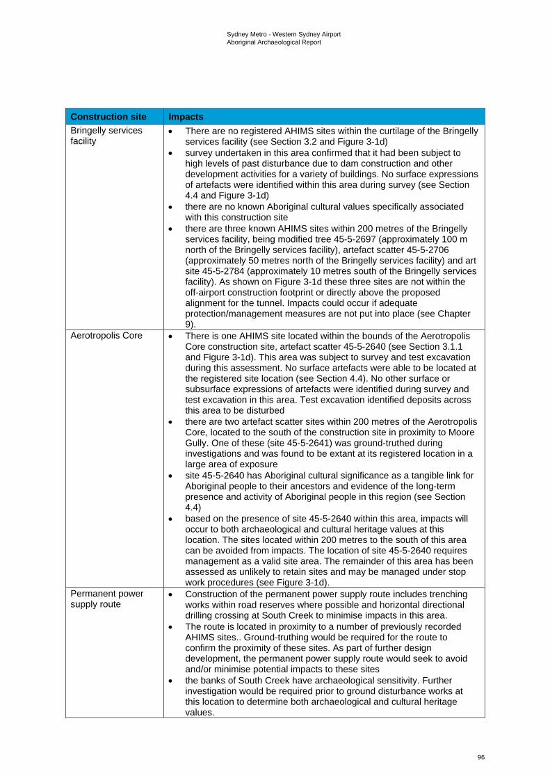
Sydney Metro - Western Sydney Airport Aboriginal Archaeological Report
96
Construction site Impacts Bringelly services facility
• There are no registered AHIMS sites within the curtilage of the Bringelly services facility (see Section 3.2 and Figure 3-1d)
• survey undertaken in this area confirmed that it had been subject to high levels of past disturbance due to dam construction and other development activities for a variety of buildings. No surface expressions of artefacts were identified within this area during survey (see Section 4.4 and Figure 3-1d)
• there are no known Aboriginal cultural values specifically associated with this construction site
• there are three known AHIMS sites within 200 metres of the Bringelly services facility, being modified tree 45-5-2697 (approximately 100 m north of the Bringelly services facility), artefact scatter 45-5-2706 (approximately 50 metres north of the Bringelly services facility) and art site 45-5-2784 (approximately 10 metres south of the Bringelly services facility). As shown on Figure 3-1d these three sites are not within the off-airport construction footprint or directly above the proposed alignment for the tunnel. Impacts could occur if adequate protection/management measures are not put into place (see Chapter 9).
Aerotropolis Core • There is one AHIMS site located within the bounds of the Aerotropolis Core construction site, artefact scatter 45-5-2640 (see Section 3.1.1 and Figure 3-1d). This area was subject to survey and test excavation during this assessment. No surface artefacts were able to be located at the registered site location (see Section 4.4). No other surface or subsurface expressions of artefacts were identified during survey and test excavation in this area. Test excavation identified deposits across this area to be disturbed
• there are two artefact scatter sites within 200 metres of the Aerotropolis Core, located to the south of the construction site in proximity to Moore Gully. One of these (site 45-5-2641) was ground-truthed during investigations and was found to be extant at its registered location in a large area of exposure
• site 45-5-2640 has Aboriginal cultural significance as a tangible link for Aboriginal people to their ancestors and evidence of the long-term presence and activity of Aboriginal people in this region (see Section 4.4)
• based on the presence of site 45-5-2640 within this area, impacts will occur to both archaeological and cultural heritage values at this location. The sites located within 200 metres to the south of this area can be avoided from impacts. The location of site 45-5-2640 requires management as a valid site area. The remainder of this area has been assessed as unlikely to retain sites and may be managed under stop work procedures (see Figure 3-1d).
Permanent power supply route
• Construction of the permanent power supply route includes trenching works within road reserves where possible and horizontal directional drilling crossing at South Creek to minimise impacts in this area.
• The route is located in proximity to a number of previously recorded AHIMS sites.. Ground-truthing would be required for the route to confirm the proximity of these sites. As part of further design development, the permanent power supply route would seek to avoid and/or minimise potential impacts to these sites
• the banks of South Creek have archaeological sensitivity. Further investigation would be required prior to ground disturbance works at this location to determine both archaeological and cultural heritage values.
Sydney Metro - Western Sydney Airport Aboriginal Archaeological Report
97
Construction site Impacts Temporary power supply route (Kemps Creek)
• Construction of the temporary power supply route includes trenching works. Trenching works would be within road reserves where possible
• no previously recorded AHIMS sites were identified along the proposed alignment outside of the construction footprint. No surface sites were identified during survey along the proposed alignment
• the banks either side of South Creek and Badgerys Creek have archaeological sensitivity. Further investigation would be required prior to ground disturbance works at this location to determine both archaeological and cultural heritage values.
Temporary power supply route (Claremont Meadows to Orchard Hills)
• Trenching works are to be within road reserves where possible • two destroyed sites were located immediately adjacent to this area and
one destroyed site was within its bounds. Although the archaeological values have been removed through site destruction these areas may retain cultural values for the Aboriginal community
• one valid artefact scatter site (45-5-4423) is present along the proposed temporary power supply route at its southern end
• ground-truthing would be required for the route to confirm the proximity of AHIMS sites. The intention is for further design development for the route to be informed both by known sites and areas of past disturbance
• further investigation would be required prior to ground disturbance works at this location to determine both archaeological and cultural heritage values.
As noted in Table 7-2 above, the permanent power supply route includes trenching works within road reserves where possible and horizontal directional drilling crossing at South Creek. The proposed route is located in proximity to a number of previously recorded AHIMS sites.
Further works At this stage of the project, limited access to land parcels has prevented some areas of the construction footprint from being subject to survey and test excavation. Further investigation will be required to determine the total cultural and archaeological values within the construction footprint.
As discussed in Section 5.2, off-airport construction footprint has been classified into the following zones including:
• areas of unverified sensitivity (refer to Figure 3-1a to 3-1d) - this zone comprises the areas that have been identified as having Aboriginal archaeological sensitivity based on desktop data, but which have not yet been subject to survey or test excavation due to access restrictions
• areas of verified Aboriginal archaeological sensitivity (refer to Figure 3-1a to 3-1d (note: Areas of verified archaeological sensitivity are not shown in the public version of this report)) – this zone comprises areas that have sites that have been identified by the results of survey and test excavation, with curtilages capturing associated PAD as appropriate. PAD curtilages were informed by artefact distribution and landform, as per the predictions made in Section 3.3
• areas to be managed by unexpected finds procedures - these areas have been identified through survey and testing as not to have a high likelihood to contain sites based on disturbance, landform and a lack of result from the survey and test excavation. Although these areas cannot be said to have nil potential, the low potential for them to contain sites means that further investigation is unwarranted, and any unexpected finds encountered during works can be managed through the appropriate stop work procedures.
The management of these areas is further described in the ACHMP.
Potential indirect impacts Potential indirect impacts as a result of the project, in the off-airport area, are summarised in Table 7-2. Indirect impacts to Aboriginal heritage can include visual impacts. However, no visual impacts have been identified as aesthetic values were not contributory elements to any of the previously
Sydney Metro - Western Sydney Airport Aboriginal Archaeological Report
98
recorded sites. All existing sites within the construction footprint or 200 metres of it were open artefact sites. These types of sites have their scientific significance resting primarily with the research value, while cultural values are tied to the artefacts and to the way in which these sites connect across a broader cultural landscape.
As such, indirect impacts associated with the project include risks to cultural heritage by subsidence and vibration as a result of the tunnel alignment. Vibration from tunnelling is unlikely to impact artefact bearing deposits as the depth of the tunnels is such that they would not impact subsurface deposits, being many levels deeper than the maximum archaeological deposits. The most likely site types to be impacted are rockshelters, art sites and grinding grooves which can all be negatively affected by cracking and rock collapse caused by vibration and settlement. None of these site types have been identified in surface contexts above the tunnel routes in previously recorded AHIMS sites or during survey in above tunnel areas for this project.
7.2.2 Potential on-airport impacts Potential impacts to identified values Potential on-airport direct and indirect impacts as a result of the project are discussed below.
Potential direct impacts The direct impacts in the on-airport area that have been identified through this assessment have been summarised in Table 7-3. It should be noted that these impacts are in relation to current known sites and the construction footprint.
The existing Aboriginal Cultural Heritage CEMP for Western Sydney International contain protocols for the removal and protection of all known sites within Western Sydney International. Sydney Metro would prepare a CEMP for the on-airport rail works, consistent with the existing Aboriginal Cultural Heritage CEMP for Western Sydney International, for approval by the Commonwealth. This would include the related methodologies for collection and salvage of sites that remain within the construction footprint where required, unexpected finds, as well as outlining nominated sites for protection. It should be noted that the areas nominated for protection are outside the bounds of the construction footprint for the project. The Sydney Metro CEMP would also align with the Western Sydney International Survey and Salvage Plan. Table 7-3 On-airport direct impact summary
Construction site Impacts On-airport construction corridor
• There are four artefact scatter sites (45-5-2665, 45-5-5089, 45-5-5094 and 45-5-5100) and one isolated artefact (45-5-5068) located within the on-airport construction corridor in the Stage 1 area (see Sections 3.1.1 and Figure 3-1c and d (note: AHIMS sites are not shown in the public version of this report))
• there are four artefact scatter sites located within 200 metres of the on-Airport construction corridor in the Stage 1 area, being 45-5-2632, 45-5-2763, 45-5-5086 and 45-5-5173 (see Section 5.4, Chapter 6 and Figure 3-1c and Figure 3-1d)
• the only known Aboriginal cultural values in this area are associated with the sites
• it has been assumed that on-airport sites and areas of archaeological sensitivity will be removed as a part of the Western Sydney International development and will therefore not pose a constraint on this project.
Airport Business Park • There are no known Aboriginal cultural values specifically associated with this area
• there are no known AHIMS sites within the Airport Business Park in the Stage 1 area or within 200 metres of the construction site (see Sections 3.1.1 and Figure 3-1d).
Sydney Metro - Western Sydney Airport Aboriginal Archaeological Report
99
Construction site Impacts Western Sydney International tunnel portal
• There are no known Aboriginal cultural values specifically associated with this area
• there are no known AHIMS sites within the Western Sydney International tunnel portal construction site in the Stage 1 area or within 200 metres of the construction site (see Sections 3.1.1 and Figure 3-1d).
Airport Terminal • There is one artefact scatter site (45-5-2687) located within the Airport Terminal construction site in the Stage 1 area (see Sections 3.1.1 and Figure 3-1c and 3-1d)
• there are three artefact scatter sites located within 200 metres of the on-Airport construction corridor in the Stage 1 area, being 45-5-5082, 45-5-2680 and 45-5-2681 (see Figure 3-1d)
• the only known Aboriginal cultural values in this area are associated with the sites
• it has been assumed that the on-airport sites and areas of archaeological potential will be removed as a part of the Western Sydney International development and will therefore not pose a constraint on this project.
Airport construction support site (Stage 1)
• There is one artefact scatter site (45-5-5085) located in the airport construction support site, on-airport, within the Stage 1 area (see Sections 3.1.1 and Figure 3-1c and 3-1d)
• there are eight artefact scatter sites (45-5-2705, 45-5-2673, 45-5-2770, 45-5-2788, 45-5-2813, 45-5-5099, 45-5-5102 and 45-5-5175) and one isolated artefact (45-5-5022) within 200 metres of the Airport construction support site in the Stage 1 area (see Sections 3.1.1 and Figure 3-1c and 3-1d)
• it is assumed that the on-airport development works will remove any sites and areas of archaeological sensitivity and will therefore not pose a constraint on this project.
Airport construction support site (on-airport, outside Stage 1)
• There is one artefact scatter site (45-5-2637) and two isolated artefact sites (45-5-5078 and 45-5-2586) located in the airport construction support site, on-airport, outside the Stage 1 area (see Sections 3.1.1 and Figure 3-1c and 3-1d)
• there are nine artefact scatters (45-5-2623, 45-5-2658, 45-5-2659, 45-5-2682, 45-5-2683, 45-5-2690, 45-5-2814, 45-5-5083 and 45-5-5090), three isolated artefacts (45-5-2586, 45-5-5055 and 45-5-5067), one modified tree (45-5-2630) and one grinding groove site (45-5-5057) within 200 metres of the airport construction support site, on-airport, outside the Stage 1 area. The modified tree and grinding groove sites have already been protected from impacts and are planned for long term conservation (see Sections 3.1.1 and Figure 3-1a to 3-1d)
• the only known Aboriginal cultural values in this area are associated with the sites
• the existing Aboriginal Cultural Heritage CEMP for Western Sydney International contains methodologies for collection and salvage of sites that remain within the construction footprint where required, unexpected finds, as well as outlining nominated sites for protection. Areas nominated for protection are outside the bounds of the construction footprint for the project. The Sydney Metro CEMP would align with the Western Sydney International Survey and Salvage Plan (see Chapter 9).
Sydney Metro - Western Sydney Airport Aboriginal Archaeological Report
100
Potential indirect impacts Since it has been assumed that the on-airport sites and areas of archaeological potential will be removed as a part of the Western Sydney International development and will therefore not pose a constraint on this project, no indirect impacts have been identified as likely for any of the on-airport construction footprint. For sites that are not removed as part of the Western Sydney International development, Sydney Metro would prepare an Aboriginal Cultural Heritage CEMP for the on-airport works in consultation with Western Sydney Airport, for approval by the Commonwealth. The Sydney Metro CEMP would be consistent with the existing Western Sydney Airport Aboriginal Cultural Heritage Construction Environmental Management Plan (Western Sydney Airport, 2019).
7.3 Summary Existing data has identified 10 previously recorded sites within the on-airport area. Only three of these sites are located outside the Stage 1 area. Taking into account the results of all archaeological survey and test excavation works undertaken for the project up to and including February 2021, a total of 10 Aboriginal archaeological sites are recognised as being wholly within the off-airport section of the construction footprint, with a further two sites that have PAD curtilages partially extending into it. Identified sites consist of three valid previously recorded artefact scatter sites, being B22 (45-5-2640) BWB (45-5-5298) and CCE T3 (45-5-5297). Survey identified another artefact scatter site (SMWSA-AS6), while test excavation has identified five artefact scatters (SMWSA-AS2, SMWSA-AS3, SMWSA-AS4, SMWSA-AS7 and SMWSA-AS8) and three isolated artefact sites (SMWSA-IA1, SMWSA-IA2 and SMWSA-IA3) within the off-airport construction footprint.
All other sites in proximity to but outside the construction footprint are proposed to be avoided and protected. Of the sites that were identified as having registered centroids within 200 metres of the construction footprint, five sites were assessed based on site card recordings as being wholly outside the construction footprint, but within close enough proximity to warrant protective fencing or some other form of demarcation being used to ensure impacts to them can be avoided during construction. These sites were 45-5-2784 (an isolated artefact in an area disturbed by road construction), 45-5-3190 (consisting of three surface artefacts in a disturbed area), 45-5-3191 (consisting of 19 surface artefacts and seven subsurface artefacts in a disturbed area, on either side of a gully), 45-5-3773 (consisting of six artefacts in disturbed area at 289 Luddenham Road, adjacent to DEOH) and 45-5-3776 (an isolated artefact in a disturbed area). Additionally, site SMWSA-AS5, identified during survey, was identified as being in close enough proximity to warrant protective fencing during works.
With regard to known sites, therefore, the project is wholly impacting a total of 10 sites in the off-airport portion of the project, being artefact scatter and isolated artefact sites, and partially impacting two artefact scatter with PAD sites whose PAD curtilages partially extend into the off-airport construction footprint. Many similar site types as these are represented across the wider region (i.e. no rarity value by site type). It is also likely that the project would impact upon a number of unidentified sites within its curtilage in both surface and subsurface contexts in areas that have not yet been subject to survey or test excavation, due to access limitations. All sites have cultural heritage values associated with them.
There remain areas of Aboriginal archaeological sensitivity that have not yet been surveyed and proposed test pits that have not yet been excavated due to access restrictions. As a result, further investigation will be required to determine the total cultural and archaeological values within the construction footprint, as specified in the ACHMP for the off-airport construction footprint.
Sydney Metro - Western Sydney Airport Aboriginal Archaeological Report
101
8. Cumulative impact assessment For the purposes of this assessment, cumulative impacts are impacts that, when considered together, have different and/or greater impacts than a single impact on its own. Cumulative impacts result from the successive, incremental and/or combined effects of multiple projects occurring across a shared geographical area. While the project has been assessed in this document in relation to impacts to Aboriginal heritage, so is the surrounding region being impacted by other development projects, including Western Sydney International, Elizabeth Drive road upgrades, M12 Motorway and The Northern Road Upgrade. The Elizabeth Drive project is in its early stages (Transport for NSW, 2020) and due to the lack of availability of further information it is not possible to accurately gauge the cumulative impacts that the Elizabeth Drive road upgrade works may contribute. Consideration of the total impact represented by the other projects is summarised below.
8.1.1 Western Sydney International The currently available data has identified a total of 115 Aboriginal sites within the bounds of Western Sydney International, consisting of 88 artefact scatters, 24 isolated artefacts, two modified trees and one grinding groove site. The Western Sydney Airport Aboriginal Cultural Heritage CEMP notes that salvage (including surface collection and archaeological excavation) will occur across the site but does not specify at which locations. Two of the 115 sites within the Western Sydney International curtilage have been specified as being conserved and protected, being a possible culturally modified tree site (45-5-2630 - B40) and a grinding groove site (45-5-5057 - B120). Areas of sensitivity crossing into its bounds include Oaky Creek and various unnamed drainage lines and tributaries. The south-eastern side of the curtilage is bordered by Badgerys Creek, but sections of this are to be preserved within an Environmental Conservation Zone (Western Sydney Airport, 2019). The project does not propose to impact any sites not previously approved for impact by the airport construction works. Therefore, cumulative impacts within the on-airport area would not result from the project in combination with the development of Western Sydney International according to the available data, but the combination of both would have a cumulative impact on the Aboriginal cultural values and archaeology of the wider region (as discussed further in Section 8.1.4).
8.1.2 Future M12 Motorway The revised construction footprint of the M12 Motorway project covers an area of approximately 429 hectares (Jacobs, 2020) and encompasses areas of archaeological sensitivity associated with several major Cumberland Plain creek systems including Ropes Creek, Kemps Creek, South Creek, Badgerys Creek and Cosgroves Creek. The new motorway is being delivered between the M7 Motorway at Cecil Hills and The Northern Road at Luddenham. The timing of opening of the M12 Motorway is subject to planning approval and the completion of detailed design. However, the project is expected to open prior to the opening of Western Sydney International in 2026. Nineteen Aboriginal archaeological sites are expected to be impacted by the construction of the M12 Motorway, with a complete loss of value reported for eight sites and a partial loss of value reported for the remaining 11 sites (Roads and Maritime, 2019; TfNSW, 2020). Data provided in the M12 Motorway ACHAR indicates that the impacted portions of these sites represent around 17 per cent of the motorway’s revised construction footprint (Roads and Maritime Services, 2019:93-94, Table 11-1). Of the nineteen sites identified within this area, two - artefact scatters CCE T3 (45-5-5297) and BWB (45-5-5298) - extend into the project’s construction footprint and would be subject to additional impacts. Ultimately, these additional impacts would result in a partial loss of value for both sites, with sections of both remaining undisturbed subsequent to the completion of both the M12 Motorway and the project.
8.1.3 The Northern Road Upgrade The Northern Road is proposed for upgrades along a 35-kilometre section between Mersey Road, Bringelly and Glenmore Parkway in Glenmore Park. The Northern Road upgrades are being delivered in stages, with some stages completed and the final stages having started construction in 2019. A total of 28 Aboriginal archaeological sites have been identified as being directly impacted by the proposed upgrade works for The Northern Road. Of the total 28 impacted sites, 20 of them were proposed for salvage (Roads and Maritime Services, 2019:96). The proposed works for the Northern Road upgrade are outside the bounds of the construction footprint, generally to the south and south-west of the Aerotropolis Core. The sites that will be impacted by the Northern Road upgrade are additional to those impacted within the construction footprint, increasing the cumulative impact of the wider region.
Sydney Metro - Western Sydney Airport Aboriginal Archaeological Report
102
8.1.4 Cumulative impacts The available evidence of other projects in the surrounding region is that the finite resource of Aboriginal sites is diminishing rapidly as the impacts of multiple developments have an overall cumulative impact on the Aboriginal cultural record of this area. The currently available data has identified seven artefact scatters and three isolated artefact sites subject to destruction within the off-airport portion of the project, with two additional artefact scatter sites to be partially destroyed. Additionally, 10 sites would be impacted within the on-airport area. All other sites in proximity to but outside the construction footprint are proposed to be avoided and protected. It has been assumed that the 10 on-airport sites will be removed as a part of Western Sydney International and would therefore not pose a constraint on this project. With regard to known sites, therefore, the project is increasing the number of impacted sites by 22 (two being partial impacts), all open artefact sites, being a common site type represented across the wider region (i.e. no rarity value by site type). In addition to the known sites, impact is likely to occur upon a number of unidentified sites in both surface and subsurface contexts in those areas that have not yet been subject to survey or test excavation. Consultation with RAPs to date has identified cultural values associated with identified sites and waterways, with representative Colin Gale also stating that the location of sites is not necessarily restricted to water resource areas alone.
The principles of an ecologically sustainable development follow the precautionary principle, which states that full scientific certainty about the threat of harm should never be used as a reason for not taking measures to prevent harm from occurring. The principle of inter-generational equity holds that the present generation should make every effort to ensure the health, diversity and productivity of the environment – which includes cultural heritage – is available for the benefit of future generations (NSW Office of Environment & Heritage, 2011). As the cumulative impacts have been identified as impacting on the finite resource of Aboriginal sites in this region, management and mitigation measures are required to protect this resource for the future.
Sydney Metro - Western Sydney Airport Aboriginal Archaeological Report
103
9. Recommendations
9.1 Approach to management and mitigation A Construction Environmental Management Framework (CEMF) describes the approach to environmental management, monitoring and reporting during construction. Specifically, it lists the requirements to be addressed by the construction contractor in developing the CEMPs, sub-plans, and other supporting documentation for each specific environmental aspect.
As previously noted in Section 3.2.1 there is an existing HMP to manage heritage within the bounds of DEOH, being Commonwealth land. The Defence Establishment Orchard Hills, NSW: HMP (GML Heritage Pty Ltd, 2013) should be utilised to guide any further heritage work undertaken in that section of the off-airport construction footprint.
Mitigation measures have been developed to manage potential impacts to the known and potential Aboriginal cultural heritage values of the study area. These mitigation measures are contained in full in the Revised ACHAR.
An ACHMP has been developed for the project, as the document to be used to manage Aboriginal heritage during construction of the project. The ACHMP also includes details of test excavation and survey yet to be completed as well as related methodologies for collection and salvage where required, and unexpected find procedures.
The existing Aboriginal Cultural Heritage CEMP for Western Sydney International contains protocols for the removal and protection of all known sites within Western Sydney International. Sydney Metro will prepare a separate Aboriginal Cultural Heritage CEMP for the on-airport works in consultation with Western Sydney Airport, for approval by the Commonwealth. The Sydney Metro CEMP would be consistent with the existing Western Sydney Airport Aboriginal Cultural Heritage Construction Environmental Management Plan (Western Sydney Airport, 2019). This would include the related methodologies for collection and salvage of sites that remain within the construction footprint where required, unexpected finds, as well as outlining nominated sites for protection. The Sydney Metro CEMP would also align with the Western Sydney International Survey and Salvage Plan.
Sydney Metro - Western Sydney Airport Aboriginal Archaeological Report
104
10. References AECOM Australia Pty Ltd. (2015). Archaeological Salvage of Open Artefact Site MPIP5 (45-5-3726) (Vol. 5). Unpublished report for Winten (No. 26) Pty Ltd.
Allen, J., & O’Connell, J. F. (1995). Transitions: Pleistocene to Holocene in Australia and Papua New Guinea. Antiquity, 69(265), ix-862.
AMBS. (2014). Environmental Survey of Commonwealth Land at Badgerys Creek: Aboriginal Heritage.
Andrefsky, W. (2005). Lithics: Macroscopic Approaches to Analysis. Cambridge: Cambridge University Press.
Appleton, J. (2002). The Archaeological Investigation of Lot 2, DP 120673 The Site of a Proposed New Clay and Shale Extraction Area - Old Wallgrove Road Horsley Park, West of Sydney NSW.
Archaeological & Heritage Management Solutions Pty Ltd. (2013). Fernadell Precinct, Pitt Town, NSW: Aboriginal Heritage Impact Permit #1129099 Excavation Report. Unpublished report for Johnson Property Group Pty Ltd.
Archaeological & Heritage Management Solutions Pty Ltd. (2015). Water Related Infrastructure for the North West Growth Centre (NWGC) First and Second Release Precincts: Aboriginal Archaeological Excavation Report. Unpublished report for Lend Lease/Sydney Water.
Archaeological and Heritage Management Solutions Pty Ltd. (2012). Aboriginal Archaeological Survey Report: Werrington Arterial Road (M4 Motorway – Great Western Highway), Claremont Meadows, Nsw.
Artefact Heritage. (2012). The Northernn Road Upgrade from the The Old Northern Road, Narellan, to Mersey Road, Bringelly - Aboriginal Archaeological Survey Report. Unpublished report for Roads and Maritime Services.
Attenbrow, V. (2010). Sydney’s Aboriginal Past: Investigating the Archaeological and Historical Records. Sydney: University of New South Wales Press.
Attenbrow, V. (2012a). Archaeological Evidence of Aboriginal Life in Sydney. Retrieved from Dictionary of Sydney website: http://dictionaryofsydney.org/entry/archaeological_evidence_of_aboriginal_life_in_sydney
Attenbrow, V. (2012b). The Aboriginal Prehistory and Archaeology of Royal National Park and Environs : A Review. Proceedings of the Linnean Society of New South Wales, 134, 39–64.
Attenbrow, V., Graham, I., Kononenko, N., Corkill, T., Byrnes, J., Barron, L., & Grave, P. (2012). Crossing the Great Divide: A Ground-Edge Hatchet-Head from Vaucluse, Sydney. Archaeology in Oceania, 47, 47–52.
Attenbrow, V., Robertson, G., & Hiscock, P. (2009). The Changing Abundance of Backed Artefacts in South-Eastern Australia: A Response to Holocene Climate Change. Journal of Archaeological Science, 36, 2765–2770.
Austral Archaeology Pty Ltd. (2007). Archaeological Salvage Excavations: 95-101 George Street, Parramatta, NSW. Unpublished report for Cultural Resources Management on behalf of Leighton Properties.
Austral Archaeology Pty Ltd. (2011). Windsor Museum, NSW: Aboriginal Archaeological and Cultural Salvage Excavation AHIP #2119. Unpublished report for Hawkesbury City Council.
Australian Museum Business Services. (2000). Mungerie Park Town Centre: Archaeological Salvage Excavations near Kellyville, Cumberland Plain, NSW.
Australian Museum Business Services. (2002). Western Sydney Orbital (WSO) Plumpton Ridge Archaeological Test Excavations. Sydney: Unpublished report for Roads and Traffic Authority.
Baker Archaeology Pty Ltd. (2019). Aboriginal Cultural Heritage Assessment Report University of Sydney lands at Badgerys Creek, NSW DRAFT.
Baker, N. (1996). Archaeological Test Excavations at Plumpton Ridge, Proposed Sydney Orbital Road
Sydney Metro - Western Sydney Airport Aboriginal Archaeological Report
105
Route EIS. Unpublished report for Robynne Mills and Sinclair Knight Pty Ltd.
Balek, C. L. (2002). Buried Artifacts in Stable Upland Sites and the Role of Bioturbation: A Review. Geoarchaeology, 17(1), 41–51.
Bannerman, S. M., & Hazelton, P. A. (1990). Soil Landscapes of the Penrith 1:100 000 Sheet. Sydney: Soil Conservation Service of NSW.
Bannerman, S. M., & Hazelton, P. A. (2011). Soil Landscapes of the Penrith 1:100 000 Sheet. Sydney: Soil Conservation Service of NSW.
Barham, T. (2005). A Preliminary Geoarchaeological Assessment of the Archaeological Potential of the Area Mapped as Quaternary Alluvium on the Eastern Margins of Ropes Creek Based on Observations of Geotechnical Test Pits. Unpublished report for Marys Dallas Consulting Archaeologists.
Barham, T. (2007). Eastern Creek Geoarchaeological Model and Strategy Assessment, Interpretation and Strategic Conservation of the Archaeological Resource. Unpublished report for Hyder Consulting.
Barry, F. (2005). It’s Not Set in Stone: A Landscape Approach to Archaeology in the Cumberland Plain: Investigations from the Western Sydney Orbital (WSO/Westlink M7). Sydney University.
Beaton, J. M. (1985). Evidence for a Coastal Occupation Time-Lag at Princess Charlotte Bay (North Queensland) and Implications for Coastal Colonization and Population Growth Theories for Aboriginal Australia. Archaeology in Oceania, 20, 1–20.
Bickford, A., & Sullivan, S. (1984). Assessing the research significance of historic sites. In S. Sullivan & S. Bowdler (Eds.), Site survey and significance assessment in Australian Archaeology (1st ed., pp. 19–26). Canberra: Australian Institute of Aboriginal Affairs.
Binns, R. A., & McBryde, I. (1972). A Petrological Analysis of Ground-Edge Artefacts from Northern New South Wales. Canberra: Australian Institute of Aboriginal Studies.
Biosis Research Pty Ltd. (2008). Rosehill Recycled Water Scheme: Aboriginal Archaeological and Cultural Heritage Assessment. Unpublished report for Jemena Management Pty Ltd.
Biosis Research Pty Ltd. (2016). Mamre West Precinct, Orchard Hills: Archaeological Report.
Bowdler, S. (1981). Unconsidered Trifles? Cultural Resource Management, Environmental Impact Statements and Archaeological Research in New South Wales. Australian Archaeology, 12.
Bowler, J., Jones, R., Allen, H., & Thorne, A. (1970). Pleistocene Human Remains From Australia: A Living Site and Human Cremation from Lake Mungo, Western New South Wales. World Archaeology, 2, 29–60.
Brayshaw, H. (1995). Elizabeth Drive Upgrade Environmental Impact Statement Archaeological Survey for Aboriginal Sites. Unpublished report to the NSW Roads & Traffic Authority.
Brayshaw McDonald Pty Ltd. (1992). Archaeological Survey of the Proposed 33kV Transmission Line Between Bringelly and Rossmore, NSW. Unpublished report for EDAW Australia.
Brumm, A., & Moore, M. W. (2005). Symbolic Revolutions and the Australian Archaeological Record. Cambridge Archaeological Journal, 15(02), 157–175.
Burke, H., & Smith, C. (2004). The Archaeologist’s Field Handbook. Sydney: Allen & Unwin.
Clark, N. R., & Jones, D. C. (1991). Penrith 1:100,000 Geological Sheet 9030 (1st editio). Sydney: Geological Survey of New South Wales.
Corkill, T. (1997). Red, Yellow and Black: Colour and Heat in Archaeological Stone. Australian Archaeology, 45, 54–55.
Corkill, T. (1999). Here and There: Links Between Stone Sources and Aboriginal Archaeological Sites in Sydney, Australia. Unpublished M.Phil thesis, University of Sydney.
Corkill, T. (2005). Sourcing Stone from the Sydney Region: A Hatchet Job. Australian Archaeology, 60, 41–50.
Coutts, P. J. F., & Witter, D. C. (1977). Summer Field Programme of the Victoria Archaeological
Sydney Metro - Western Sydney Airport Aboriginal Archaeological Report
106
Survey. Australian Archaeology, 6.
Cowan, F. L. (1999). Making Sense of Flake Scatters: Lithic technological Strategies and Mobility. American Antiquity, 64(4), 593–607.
Craib, J. ., Bonhomme, T., Mangold, G. R., & Williams, S. S. (1999). Archaeological Salvage Excavations at Site RS1 (45-5-982), Regentville, Western Sydney: Final Report. Unpublished report for TransGrid.
Dallas, M. (1982). An Archaeological Survey at Riverstone, Schofields and Quakers Hill, N.S.W. Unpublished report for Land Commission of NSW.
Dallas, M. (1988). Preliminary archaeological study of the Luddenham Equestrian Centre, Luddenham Road, Erskine Park, NSW.
Dallas, M., & Smith, L. (1988). Appendix C: Site Investigations at the Luddenham Equestrian Centre, Erskine Park, NSW. Report to the Signature Corporation Australia Limited.
Dallas, M., & Witter, D. C. (1983). Investigation of an Aboriginal Open Site at Plumpton, NSW. Unpublished report for Land Commission of NSW.
Dean-Jones, P. (1991). Proposed Clay/Shale Extraction, Lot 3 DP 623799, Adams Road, Luddenham Archaeological Survey.
Dean-Jones, P., & Mitchell, P. B. (1993). Hunter Valley Aboriginal Sites Assessment Project. Environmental Modelling for Archaeological Site Potential in the Central Lowlands of the Hunter Valley. Unpublished report for NSW National Parks and Wildlife Service.
Department of Infrastructure and Regional Development. (2016). Western Sydney Airport - Environmental Impact Statement.
Doelman, T. (2008). Time to Quarry: The Archaeology of Stone Procurement in Northwestern New South Wales, Australia (BAR Intern). Oxford: Archaeopress.
Douglas, P., & McDonald, J. (1993). Archaeological Investigation of RH/CD5, PAD17 (RH/CD10) and PAD 18 (RH/CD6) at Rouse Hill, NSW: Test Excavation Report. Unpublished report for Rouse Hill (Stage 1) Pty Ltd.
Ebert, J. I. (1992). Distributional Archaeology. Albuquerque: University of New Mexico Press.
Eco Logical Australia. (2011). Box Hill Precinct Planning Study - Biodiversity Assessment. Unpublished report for NSW Department of Planning.
Environmental Resources Management Australia Pty Ltd. (2003). Aboriginal and Historic Heritage Assessment - Claremont Meadows. Unpublished report for Land Solutions.
Environmental Resources Management Australia Pty Ltd. (2006a). Aboriginal Archaeological Salvage Excavation Report of Aboriginal Site OAD1 at Claremont Meadows. Unpublished report for Landcom.
Environmental Resources Management Australia Pty Ltd. (2006b). Lots 8, 10, 11 (DP27107) & Lot 19 (DP239091), Caddens Road, Claremont Meadows, Heritage Assessment. Unpublished report for Landcom.
Environmental Resources Management Australia Pty Ltd. (2010). Claremont Meadows South West 1, Section 90 Excavation, Aboriginal Heritage Excavation Report. Unpublished report for Investa Property Group.
Fanning, P. C., & Holdaway, S. J. (2004). Artifact Visibility at Open Sites in Western New South Wales, Australia. Journal of Field Archaeology, 29, 255–271.
Fanning, P. C., Holdaway, S. J., & Rhodes, E. (2008). A New Geoarchaeology of Aboriginal Artefact Deposits in Western NSW, Australia: Establishing Spatial and Temporal Geomorphic Controls on the Surface Archaeological Record. Geomorphology, 101(3), 524–532. https://doi.org/10.1016/j.geomorph.2007.04.027
Fanning, P. C., Holdaway, S. J., Rhodes, E. J., & Bryant, T. G. (2009). The Surface Archaeological Record in Arid Australia: Geomorphic Controls on Preservation, Exposure, and Visibility. Geoarchaeology, 24(2), 121–146.
Sydney Metro - Western Sydney Airport Aboriginal Archaeological Report
107
Foley, R. (1981). Off-site Archaeology and Human Adaption in Eastern Africa. An Analysis of Regional Artefact Density in the Amboseli, Southern Kenya (BAR Intern). Oxford: British Archaeological Reports.
GML Heritage Pty Ltd. (2012). East Leppington Aboriginal Archaeological Technical Report. Unpublished report for Stockland Development.
GML Heritage Pty Ltd. (2013). Defence Establishment Orchard Hills, NSW: Heritage Management Plan.
GML Heritage Pty Ltd. (2016). East Leppington Open Area Archaeological Excavation Report. Unpublished report for Stockland Development Pty Ltd.
Godwin, L. (2011). The Application of Assessment of Cumulative Impacts in Cultural Heritage Management: A Critique. Australian Archaeology, 73(73), 88–91.
Gould, R. (1969). Puntutjarpa Rockshelter: A Reply to Messrs Glover and Lampert. Archaeology and Physical Anthropology in Oceania, 4, 229–237.
Grave, P., Attenbrow, V., Sutherland, L., Pogson, R., & Forster, N. (2012). Non-Destructive PXRF of Mafic Stone Tools. Journal of Archaeological Science, 39(6), 1674–1686. https://doi.org/10.1016/j.jas.2011.11.011
Haglund, L. (1978). Major Airport Needs of Sydney Study: Survey of Aboriginal Sites and Relics. Unpublished report to MANS Committee.
Hanrahan, J. (1981). Report on Proposed Subdivision at South Werrington, Near Penrith. Unpublished report for the Housing Commission of NSW.
Helen Brayshaw Heritage Consultants. (1996). M4 Upgrade, Archaeological Survey for Aboriginal Sites for Proposal to Upgrade the M4 Motorway from Church Street Parramatta to Coleman Street, Marys Hill and Prospect to Emu Plains. Unpublished report for SWR Constructors Pty Ltd.
Hiscock, P. (1986). A Technological Analysis of Stone Artefact Assemblages from the Hunter River Valley Region. NSW National Parks and Wildlife Service Hunter Valley Region Archaeology Project: Stage 1. Vol 4a. Unpublished report for the NSW National Parks and Wildlife Service.
Hiscock, P. (1993a). Bondian Technology in the Hunter Valley, New South Wales. Archaeology in Oceania, 28, 65–76.
Hiscock, P. (1993b). The Distribution of Points Within Nauwalabila 1. The Beagle, (10), 173–178.
Hiscock, P. (1994). Technological Responses to Risk in Holocene Australia. Journal of World Prehistory, 8(3), 267–292.
Hiscock, P. (2002). Pattern and Context in the Holocene Proliferation of Backed Artefacts in Australia. In R. Elston & S. Kuhn (Eds.), Thinking Small: Global Perspectives on Microlithization (pp. 163–177). Archaeological Papers of the American Anthropological Association.
Hiscock, P. (2005). Artefacts on Aru: Evaluating the Technological Sequences. In S. O’Connor, M. Spriggs, & P. Veth (Eds.), The Archaeology of the Aru Islands, Eastern Indonesia (pp. 205–234). Canberra: Pandanus Books.
Hiscock, P. (2006). Blunt and to the Point: Changing Technological Strategies in Holocene Australia. In I. Lilley (Ed.), Archaeology of Oceania: Australia and the Pacific Islands (pp. 69–95). Oxford: Blackwell.
Hiscock, P. (2008). Archaeology of Ancient Australia. London: Routledge.
Hiscock, P., & Attenbrow, V. (1998). Early Holocene Backed Artefacts From Australia. Archaeology in Oceania, 33(2), 49–63.
Hiscock, P., & Attenbrow, V. (2004). A Revised Sequence of Backed Artefact Production at Capertee 3. Archaeology in Oceania, 39(2), 49–63.
Hofman, J. L. (1986). Vertical Movement of Artifacts in Alluvial and Stratified Deposits. Current Anthropology, 27(2), 163–171.
Sydney Metro - Western Sydney Airport Aboriginal Archaeological Report
108
Holdaway, S. J. (1993). Hunter Valley Aboriginal Sites Assessment Project Archaeological Assessment Standards and Methodological Design. Unpublished report for NSW National Parks and Wildlife service.
Holdaway, S. J., Fanning, P., & Witter, D. C. (2000). Prehistoric Aboriginal Occupation of the Rangelands: Interpreting the Surface Archaeological Record of Far Western NSW. The Rangeland Journal, 22(1), 44–57.
Holdaway, S. J., & Stern, N. (2004). A Record in Stone: The Study of Australia’s Flaked Stone Artefacts. Canberra: Aboriginal Studies Press.
Holdaway, S. J., Witter, D. C., & Fanning, P. (1998). New Approaches to Open Site Spatial Archaeology in Sturt National Park, New South Wales, Australia. Archaeology in Oceania.
ICOMOS (Australia). (2013). The Burra Charter: The Australia ICOMOS Charter for Places of Cultural Significance. Retrieved from Australia ICOMOS website: http://australia.icomos.org/wp-content/uploads/The-Burra-Charter-2013-Adopted-31.10.2013.pdf
Jacobs. (2020). M12 Motorway Amendment Report – Appendix E Aboriginal heritage supplementary technical memorandum.
JAJV. (2019). M12 Motorway Concept Design and Environmental Impact Assessment - Archaeological Assessment Report DRAFT.
Jo McDonald Cultural Heritage Management Pty Ltd. (1997a). Archaeological Salvage of Site RMI at Richmond, NSW: Test and Salvage Excavation Report. Unpublished report for Restifa & Partners.
Jo McDonald Cultural Heritage Management Pty Ltd. (1997b). Interim Heritage Management Report: ADI Site St Marys. Volume 1 - Test Excavation Report. Unpublished report for Lend lease - ADI Joint Venture.
Jo McDonald Cultural Heritage Management Pty Ltd. (2000). Archaeological Survey For Aboriginal Sites : Proposed Light Industrial Subdivision, “Austral Site”, Mamre Road, Erskine Park, NSW.
Jo McDonald Cultural Heritage Management Pty Ltd. (2001a). Salvage Excavations of Six Sites along Caddies, Second Ponds, Smalls and Cattai Creeks in the Rouse Hill Development Area, NSW. Unpublished report for Rouse Hill Infrastructure Consortium.
Jo McDonald Cultural Heritage Management Pty Ltd. (2001b). Survey for Aboriginal Sites, 1503 Elizabeth Drive, Kemps Creek, NSW, October 2001.
Jo McDonald Cultural Heritage Management Pty Ltd. (2002a). Archaeological Excavations at Balfour Drive, Kellyville, NSW (Site RH/SC5). Archaeological Salvage Programme Prior to Residential Development. Unpublished report for Mepstead & Associates on behalf of Bake Investments Pty Ltd and Cardno BLH Pty Ltd.
Jo McDonald Cultural Heritage Management Pty Ltd. (2002b). Archaeological Excavations at Windsor Road, Kellyville, NSW (Site RH/CD12: NPWS #45-5-962). Unpublished report for Australand Holdings Pty Ltd.
Jo McDonald Cultural Heritage Management Pty Ltd. (2003). Archaeological Salvage Excavations at the proposed Xavier College: Site ADI 47+48 (NPWS #45-5-1048), Ninth Avenue, Llandilo, NSW. Unpublished report for PMDL on behalf of the Catholic Education Office, Diocese of Parramatta, NSW.
Jo McDonald Cultural Heritage Management Pty Ltd. (2005a). Archaeological Salvage Excavation of Eight Archaeological Landscapes in the Second Ponds Creek Valley, Rouse Hill Development Area, NSW. Unpublished report for Rouse Hill Infrastructure Pty Ltd and Landcom.
Jo McDonald Cultural Heritage Management Pty Ltd. (2005b). Archaeological Salvage Excavation of Site CG1 (NPWS #45-5-2648), at the Corner of Charles & George Streets, Parramatta, NSW. Unpublished report for Meriton Apartments Pty Ltd.
Jo McDonald Cultural Heritage Management Pty Ltd. (2005c). Archaeological Salvage Excavation of Site RTA-G1, 109-113 George Street, Parramatta, NSW. Sydney: Unpublished report for Landcom.
Sydney Metro - Western Sydney Airport Aboriginal Archaeological Report
109
Jo McDonald Cultural Heritage Management Pty Ltd. (2006a). Archaeological Salvage Excavation at the St Marys Project Eastern Precinct: Site ADI:EPI (NPWS #45-5-2994). Unpublished report for Lend Lease.
Jo McDonald Cultural Heritage Management Pty Ltd. (2006b). Archaeological Salvage Excavation of Site CG3: 101a-105 George Street, Parramatta, NSW. Unpublished report for Rahi Developments Ltd.
Jo McDonald Cultural Heritage Management Pty Ltd. (2006c). Archaeological Salvage Excavation of the Colebee Release Area, Schofields, NSW: Volume 1. Unpublished report for Medallist Gold Holdings Pty Ltd.
Jo McDonald Cultural Heritage Management Pty Ltd. (2007). Salvage Excavation of Four Archaeological Sites in the Caddies Creek Precinct, Rouse Hill Regional Centre, NSW. Unpublished report for Lend Lease GPT (Rouse Hill) Pty Ltd.
Jo McDonald Cultural Heritage Management Pty Ltd. (2008a). Archaeological Salvage at ADI-FF22: The ADI Eastern Precinct Fauna Fence, St Marys. Unpublished report for Delfin Lend Lease.
Jo McDonald Cultural Heritage Management Pty Ltd. (2008b). Assessment of Aboriginal Heritage, Lot 2, DP 771679 Gipps Street, Claremont Meadows.
Jo McDonald Cultural Heritage Management Pty Ltd. (2008c). Austral Land Mamre Rd, Erskine Park: Archaeological Salvage Excavations. Unpublished report for Macquarie Goodman.
Jo McDonald Cultural Heritage Management Pty Ltd. (2009a). Archaeological Subsurface Investigations at the Cadden’s Release. Unpublished report for Landcom.
Jo McDonald Cultural Heritage Management Pty Ltd. (2009b). Archaeological Subsurface Investigations at WP3 and WP4 - Western Precinct St Mary’s Development Site,. Unpublished report for Marylands Development Company.
Johnson, D. L. (1989). Subsurface Stone Lines, Stone Zones, Artifact-Manuport Layers, and Biomantles Produced by Bioturbation via Pocket Gophers (Thomomys Bottae). American Antiquity, 54(2), 370–389.
Johnson, D. L., Domier, J. E. J., & Johnson, D. N. (2005). Reflections on the Nature of Soil and Its Biomantle. Annals of the Association of American Geographers, 95(1), 11–31.
Jones, R., & White, N. (1988). Point Blank: Stone Tool Manufacture at the Ngilipitji Quarry, Arnhem Land 1981. In B. Meehan & R. Jones (Eds.), Archaeology with Ethnography: An Australian Perspective (pp. 51–87). Canberra: Department of Prehistory, Research School of Pacific Studies, Australian National University.
Kelleher Nightingale Consulting Pty Ltd. (2009). Marsden Park Industrial Precinct: Aboriginal Heritage Assessment. Unpublished report to NSW Department of Planning.
Kelleher Nightingale Consulting Pty Ltd. (2012). Werrington Arterial Road M4 Motorway to Great Western Highway Cultural Heritage Assessment Report. Unpublished report for Roads and Maritime Services.
Kelleher Nightingale Consulting Pty Ltd. (2013a). M4 Managed Motorway from Lapstone (Western End) to Strathfield (Eastern End). Review of Environmental Factos: Aboriginal Archaeological Survey Report.
Kelleher Nightingale Consulting Pty Ltd. (2013b). Sydney Science Park Planning Proposal: Aboriginal Heritage Assessment. Report to APP Corporation Pty Ltd.
Kelleher Nightingale Consulting Pty Ltd. (2016a). M4 Managed Motorway, from Lapstone (Western End) to Church Street, Parramatta (Eastern End). Review of Environmental Factors: Cultural Heritage Assessment Report.
Kelleher Nightingale Consulting Pty Ltd. (2016b). The Northern Road Upgrade Stage 3 Jamison Road , Penrith to Glenmore Parkway , Glenmore Park Aboriginal Cultural Heritage Assessment Report. Unpublished report for Roads and Maritime Services.
Kelleher Nightingale Consulting Pty Ltd. (2018a). Sydney Science Development Luddenham, NSW Aboriginal Archaeological Assessment Test Excavation Report.
Sydney Metro - Western Sydney Airport Aboriginal Archaeological Report
110
Kelleher Nightingale Consulting Pty Ltd. (2018b). Sydney Science Park Development Luddenham, NSW Cultural Heritage Assessment Report.
Koettig, M., & Hughes, P. J. (1995). Test Excavations at RS1 Regentville near Penrith on the Cumberland Plain. Unpublished report for Pacific Power.
Kohen, J. (1986). Prehistoric Settlement in the Western Cumberland Plain: Resources, Environment and Technology. Macquarie University, Sydney.
Kohen, J. (1988). The Dharug of the Western Cumberland Plain: Ethnography and Demography. In B. Meehan & R. Jones (Eds.), Archaeology with Ethnography: An Australian Perspective (pp. 238–250). Canberra: Department of Prehistory, Research School of Pacific Studies, Australian National University.
Kohen, J., & Lampert, R. (1987). Hunters and Fishers in the Sydney Region. In D. J. Mulvaney & J. P. White (Eds.), Australians to 1788 (1st ed., pp. 343–365). Sydney: Fairfax, Syme & Weldon Associates.
Kohen, J., Stockton, E., & Williams, M. (1984). Shaws Creek KII Rockshelter: A Prehistoric Occupation Site in the Blue Mountains Piedmont, Eastern New South Wales. Archaeology in Oceania, 19(2), 57–73.
Kuskie, P. J. (2000). An Aboriginal Assessment of the Proposed Mount Arthur North Coal Mine, Near Muswellbrook, Hunter Valley, New South Wales. In HLA-Envirosciences Pty. Ltd. (Ed.), Environmental Impact Statement and Statement of Environmental Effects, Proposed Jerrys Plains Coal Terminal, Rail Spur and Associated Infrastructure. Canberra: Report prepared by South Eastern Archaeology to Umwelt (Australia) Pty. Ltd.
Lance, A., & Hughes, P. J. (1984). Second Sydney Airport Aboriginal Archaeological Study: Badgerys Creek/Wilton. Unpublished report to Kinhill Stearns pty Ltd.
Long, A. (2003). Scarred Trees: An Identification and Recording Manual. Prepared for Aboriginal Affairs Victoria.
Lourandos, H. (1983). Intensification. A Late Pleistocene-Holocene Archaeological Sequence from Southwestern Victoria. Archaeology in Oceania, 18, 81–94.
Lourandos, H. (1997). Continent of Hunter-Gatherers. New Perspectives in Australian Prehistory. Cambridge: Cambridge University Press.
Lourandos, H., & Ross, A. (1994). The Great “Intensification Debate”: Its History and Place in Australian Archaeology. Australian Archaeology, 39, 54–63.
MacDonald, K., & Davidson, I. (1998). Bayswater Archaeological Research Project: Volume 1. Armidale: School of Human and Environmental Studies, University of New England.
Matthiesen, H. (2004). In Situ Measurement of Soil pH. Elsevier, 31(10), 1373–1381. Retrieved from https://doi.org/10.1016/j.jas.2004.03.005
McBryde, I. (1973). Stone Arrangements and a Quartzite Quarry at Brewarrina. Mankind, 9, 118–121.
McBryde, I. (1984). Kulin Greenstone Quarries: The Social Contexts of Production and Distribution for the Mt William site. World Archaeology, 16(2), 267–285.
McCarthy, F. D. (1948). The Lapstone Creek Excavation: Two Culture Periods Revealed in Eastern New South Wales. Records of the Australian Museum, 22(1), 1–34.
McCarthy, F. D. (1964). The Archaeology of the Capertee Valley, New South Wales. Records of the Australian Museum, 26(6), 197–264.
McCarthy, F. D. (1967). Australian Aboriginal Stone Implements (2nd Ed.). Sydney: The Australian Museum Trust.
McDonald, J. (1986). Preliminary Archaeological Reconnaissance of the Proposed Schofields Regional Depot, Plumpton, N.S.W. Unpublished report for the Metropolitan Waste Disposal Authority.
McDonald, J. (1993). Excavation of Two Sites on Eastern Creek (PB1 and PB2), Doonside. Unpublished report for Blacktown City Council.
Sydney Metro - Western Sydney Airport Aboriginal Archaeological Report
111
McDonald, J. (1996). The Conservation of Landscapes: A Strategic Approach to Cultural Heritage Management. In S. Ulm, I. Lilley, & A. Ross (Eds.), Australian Archaeology ’95: Proceedings of the 1995 Australian Archaeological Association Annual Conference (Tempus 6, Vol. 6, pp. 113–121). Brisbane: Anthropology Museum, University of Queensland.
McDonald, J. (2008). Dreamtime Superhighway: Sydney Basin Rock Art and Prehistoric Information Exchange. Canberra: Australian National University Press.
McDonald, J., Mitchell, P., & Rich, E. (1996). A Further Investigation of Site RS1 (#45-5-892) at Regentville, Mulgoa Creek, Western Sydney, NSW. Unpublished report for Pacific Power.
McDonald, J., & Rich, E. (1994). The Discovery of a Heat Treatment Pit on the Cumberland Plain, Western Sydney. Australian Archaeology, (38), 46–47.
McDonald, R. C., & Isbell, R. F. (2009). Soil Profile. In Australian Soil and Land Survey Field Handbook (Third Edit, pp. 147–200). Collingwood: CSIRO Publishing.
McNiven, I. (1992). Shell Middens and Mobility: The Use of Off-Site Faunal Remains, Queensland, Australia. Journal of Field Archaeology, 19(4), 495–508.
Mitchell, P. (2010). Geomorphology and soils in relation to archaeological investigations on the Cranebrook Terrace, Penrith lakes, NSW.
Mitchell, P. B. (2002). Geomorphology and Pedology of Plumpton Ridge at the Western Sydney Orbital Crossing. Unpublished report for Australian Museum Business Service.
Mitchell, P. B. (2005). Geology, Geomorphology and Pedology of the Schofields Project Site, Plumpton Ridge, Colebee, Western Sydney. Unpublished report to Jo McDonald Cultural Heritage Management P/L.
Mitchell, P. B. (2009). Soil Materials and Landscape Disturbance on the Southwestern Sector of the ADI Site at St Marys in Relation to Aboriginal Archaeological Investigations. Unpublished report for Jo McDonald CHM.
Moore, M. W. (2000). Technology of Hunter Valley microlith assemblages, New South Wales. Australian Archaeology, 51, 28–39.
Moore, M. W. (2013). Simple Stone Flaking in Australasia: Patterns and Implications. Quaternary International, 285, 140–149.
Mulvaney, D. J., & Kamminga, J. (1999). The Prehistory of Australia. Crows Nest: Allen & Unwin Pty Ltd.
Nanson, G. C., Young, R. W., & Stockton, E. (1987). Chronology and Palaeoenvironment of the Cranebrook Terrace (near Sydney) Containing Artefacts More than 40,000 Years Old. Archaeology in Oceania, 22, 72–78.
National Heritage Studies Pty Ltd. (1990). Report on Test Excavations at Schofields, N.S.W. A Report to R.W. Corkery and Co.
Navin Officer Heritage Consultants Pty Ltd. (1997). Technical Paper No. 11 Aboriginal Cultural Heritage.
Navin Officer Heritage Consultants Pty Ltd. (2015). Western Sydney Airport - Aboriginal Cultural Heritage Assessment. Unpublished report for GHD.
Navin Officer Heritage Consultants Pty Ltd. (2017). Initial Survey and Salvage Plan Western Sydney Airport - Enabling Activities Aboriginal Cultural Heritage Management Plan.
NSW Department of Environment Climate Change & Water. (2010). Code of Practice for Archaeological Investigation of Aboriginal Objects in New South Wales. Department of Environment, Climate Change and Water.
NSW Office of Environment & Heritage. (2011). Guide to Investigating, Assessing and Reporting on Aboriginal Cultural Heritage in NSW. Office of Environment and Heritage.
Paton, T. R., Humphreys, G. S., & Mitchell, P. B. (1995). Soils: A New Global View. London: UCL Press.
Sydney Metro - Western Sydney Airport Aboriginal Archaeological Report
112
Peacock, E., & Fant, D. W. (2002). Biomantle Formation and Artifact Translocation in Upland Sand Soils: An Example from the Holly Springs National Forest, North-Central Mississippi, U.S.A. Geoarchaeology, 17(1), 91–114.
Pearson, M., & Sullivan, S. (1995). Looking After Heritage Places: The Basics of Heritage Planning for Managers, Landowners and Administrators. Carlton: Melbourne University Press.
Przywolnik, K. (2007). The Western Sydney Regional Aboriginal Heritage Study. Unpublished report to DECCW.
Rhoads, J.W.; Dunnett, G. (1985). Aboriginal Resources Planning Study: City of Penrith. Unpublished report prepared for the National Parks and Wildlife Service of New South Wales.
Roads and Maritime Services. (2019a). M12 Motorway Aboriginal Cultural Heritage Assessment Report. Retrieved from https://majorprojects.planningportal.nsw.gov.au/prweb/PRRestService/mp/01/getContent?AttachRef=SSI-9364%2120191004T003628.449 GMT
Roads and Maritime Services. (2019b). M12 Motorway Environmental Impact Statement - Appendix I Aboriginal Cultural Heritage Assessment. Unpublished report.
Robins, R. (1997). Patterns in the Landscape: A Case Study in Nonsite Archaeology from Southwest Queensland. Memoirs of the Queensland Museum, Cultural Heritage Series, 1(1), 23–56.
Ross, A. (1976). Inter-Tribal Contacts: What the First Fleet Saw. University of Sydney.
Ross, A. (1988). Tribal and Linguistic Boundaries in Sydney at the Time of First British Settlement: A Reassessment of the Evidence. In G. Aplin (Ed.), A Difficult Infant: Sydney Before Macquarie (pp. 42–53). Sydney: University of New South Wales Press.
Shiner, J. (2008). Place as Occupational Histories: An Investigation of the Deflated Surface Archaeological Record of Pine Point and Langwell Stations, Western New South Wales, Australia (BAR Intern). Oxford: Archaeopress.
Smith, C., & Burke, H. (2007). Digging It Up Down Under: A Practical Guide to Doing Archaeology in Australia. New York: Springer.
Smith, L. (1988). Aboriginal Site Planning Study in the Sydney Basin Stage 1: The Cumberland Plain - Interim Report: Site Survey and Site Analysis on the Northern Cumberland Plain. Sydney: Unpublished report for NSW National Parks and Wildlife Service.
Steele, D. (1999). Archaeological Survey Report for land between Luddenham & Mamre Roads, Luddenham, NSW. Unpublished report prepared for Camelot Grange Pty Ltd.
Steele, D. (2001). Preliminary Archaeological Test Excavation Project within Land Between Luddenham and Mamre Roads. Unpublished report for Camelot Grange Pty Ltd.
Steele, D. (2004). Aboriginal Heritage Conservation Action Plan. Application for a Section 90 Heritage Impact Permit (Consent with Salvage & Collection). Twin Creeks Estate, Luddenham Road, Luddenham, NSW. Unpublished report for Luddenham Management Pty Ltd.
Steele, D. (2007). Aboriginal Archaeological Excavation & Monitoring Report: Twin Creeks Estate, Luddenham Road. Unpublished report for Luddenham Management Pty Ltd.
Stein, J. K. (1983). Earthworm Activity: A Source of Potential Disturbance of Archaeological Sediments. American Antiquity, 48(2), 277–289.
Streat, B., & Pavinich, Y. (2018). Aboriginal Test Excavation Report Lot 2 Section 4 DP 2954 111-1141 Elizabeth Drive, Cecil Park, NSW (Fairfield LGA).
Sydney Metro (2020). Sydney Metro Greater West Technical paper 3: Biodiversity Development Assessment Report.
Thorp, W. (1986). The Penrith Heritage Study – The Historical Archaeology Component.
Tozer, M. (2003). The Native Vegetation of the Cumberland Plain , Western Sydney: Systematic Classification and Field Identification of Communities. Cunninghamia, 8(1), 1–75.
Sydney Metro - Western Sydney Airport Aboriginal Archaeological Report
113
URS Australia Pty Ltd. (2001). Gipps Street Landfill Rehabilitation Proposal: Environmental Impact Statement, Werrington, NSW.
Walker, F. (1906). Penrith and district: some items of Early Australian history. Journal and Proceedings of the Royal Australian Historical Society, 2, 43–48.
Western Sydney Airport. (2019). Western Sydney Airport Aboriginal Cultural Heritage Construction Environmental Management Plan.
White, B., & McDonald, J. (2010). Lithic Artefact Distribution in the Rouse Hill Development Area, Cumberland Plain, New South Wales. Australian Archaeology, (70), 29–38.
White, E. (1997). Knapping Floors in the Central Hunter Lowlands, NSW. Unpublished manuscript.
Williams, A. N., Atkinson, F., Lau, M., & Toms, P. S. (2014). A Glacial Cryptic Refuge in South-East Australia: Human Occupation and Mobility from 36,000 years ago in the Sydney Basin, New South Wales. Journal of Quaternary Science, 29(8), 735–748.
Williams, A. N., Mitchell, P., Wright, R., & Toms, P. (2012). A Terminal Pleistocene Open Site on the Hawkesbury River, Pitt Town NSW. Australian Archaeology, 85–97.
WSA Co. (2018). Western Sydney Airport Construction Environmental Management Plan Aboriginal Cultural Heritage Construction Environmental Management Plan.
Appendix A Plates
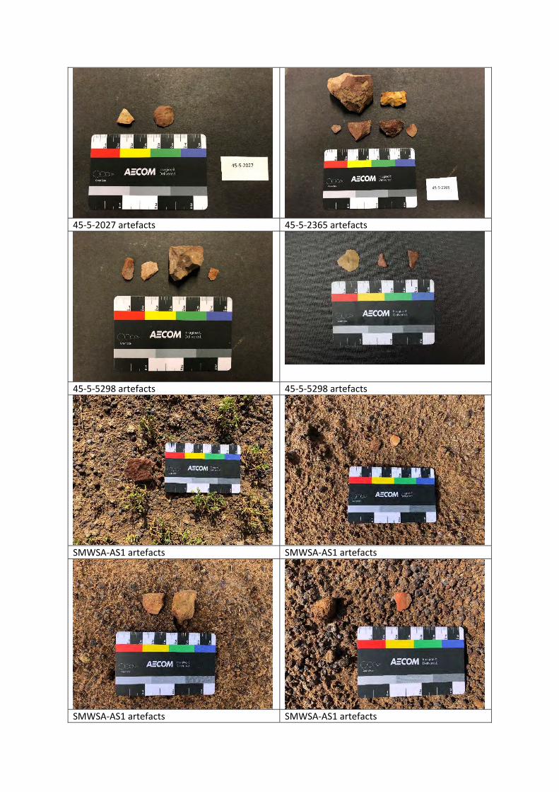
45‐5‐2027 artefacts 45‐5‐2365 artefacts
45‐5‐5298 artefacts 45‐5‐5298 artefacts
SMWSA‐AS1 artefacts SMWSA‐AS1 artefacts
SMWSA‐AS1 artefacts SMWSA‐AS1 artefacts
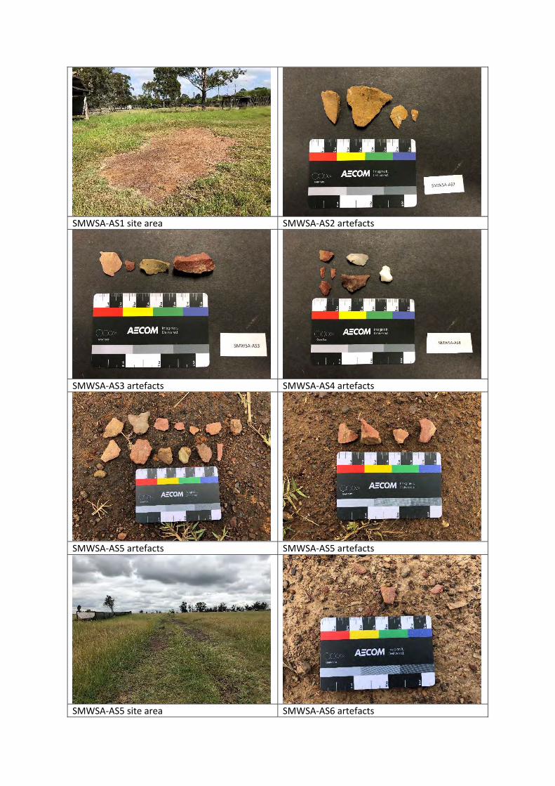
SMWSA‐AS1 site area SMWSA‐AS2 artefacts
SMWSA‐AS3 artefacts SMWSA‐AS4 artefacts
SMWSA‐AS5 artefacts SMWSA‐AS5 artefacts
SMWSA‐AS5 site area SMWSA‐AS6 artefacts
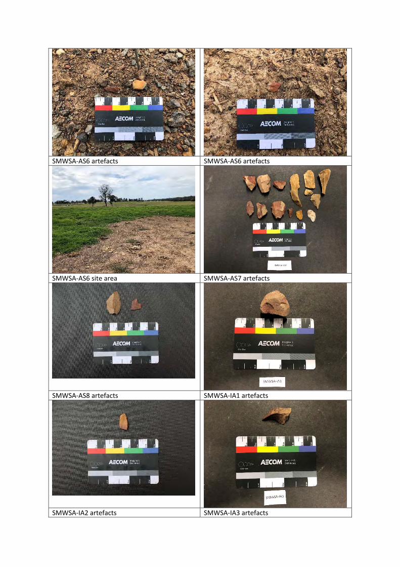
SMWSA‐AS6 artefacts SMWSA‐AS6 artefacts
SMWSA‐AS6 site area SMWSA‐AS7 artefacts
SMWSA‐AS8 artefacts SMWSA‐IA1 artefacts
SMWSA‐IA2 artefacts SMWSA‐IA3 artefacts
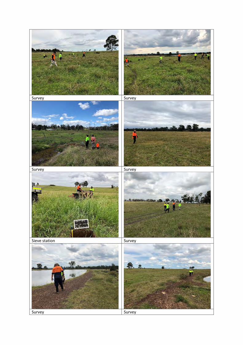
Survey Survey
Survey Survey
Sieve station Survey
Survey Survey
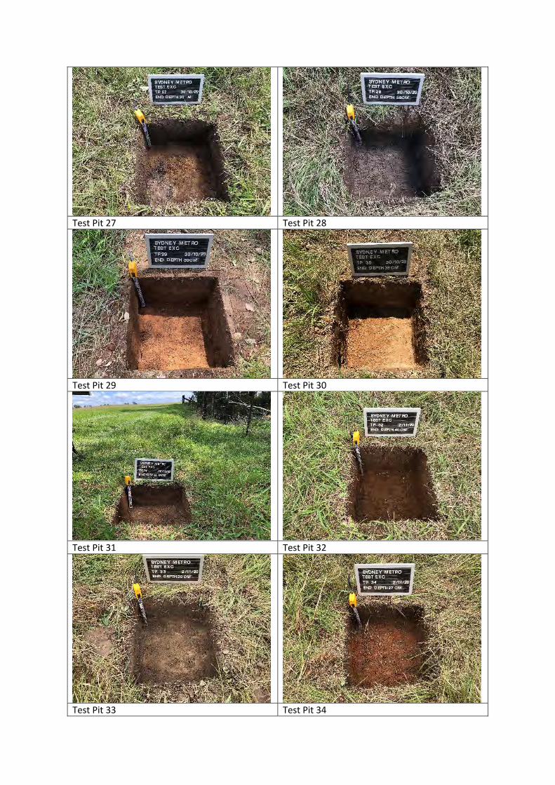
Test Pit 27 Test Pit 28
Test Pit 29 Test Pit 30
Test Pit 31 Test Pit 32
Test Pit 33 Test Pit 34
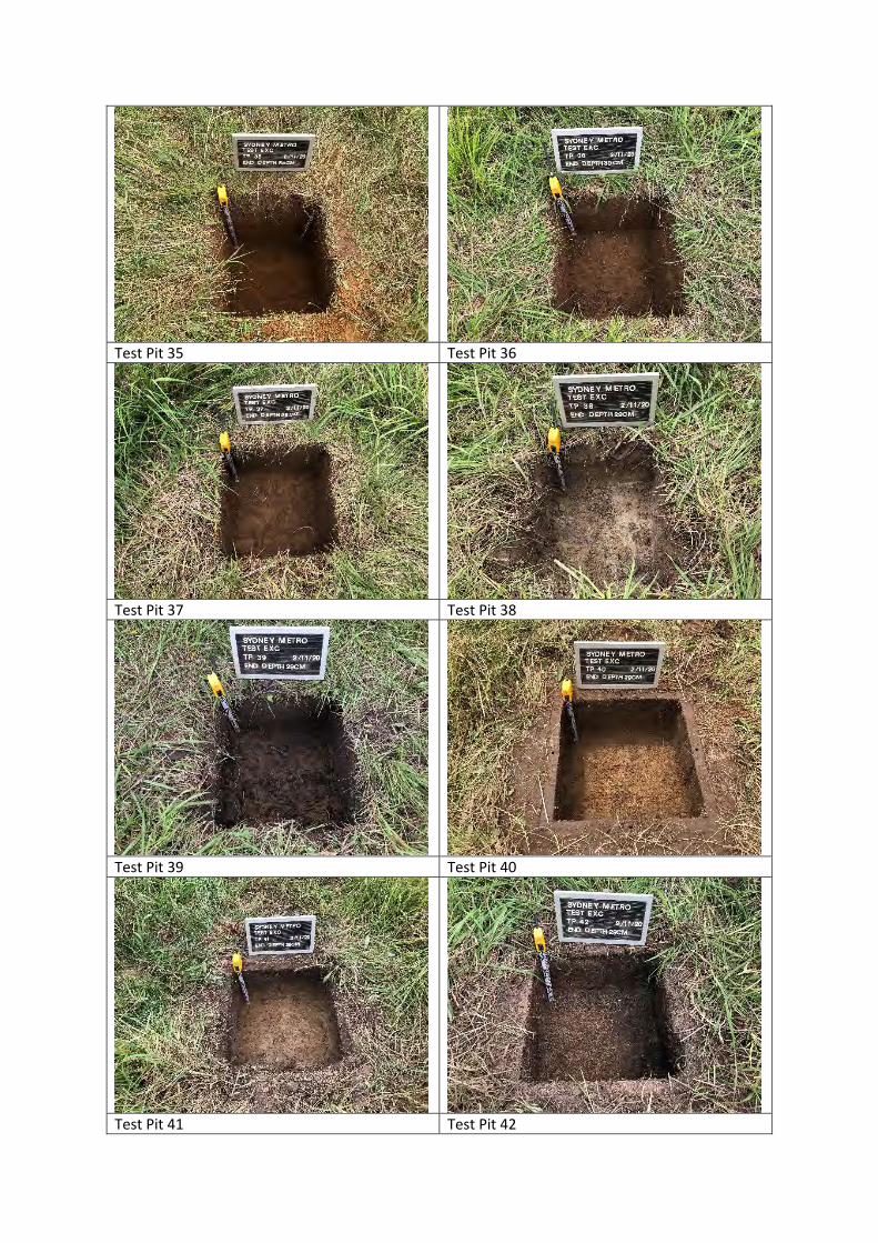
Test Pit 35 Test Pit 36
Test Pit 37 Test Pit 38
Test Pit 39 Test Pit 40
Test Pit 41 Test Pit 42
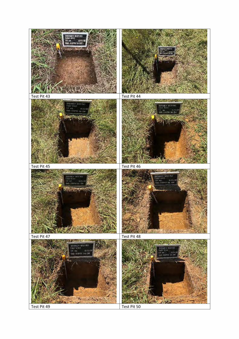
Test Pit 43 Test Pit 44
Test Pit 45 Test Pit 46
Test Pit 47 Test Pit 48
Test Pit 49 Test Pit 50
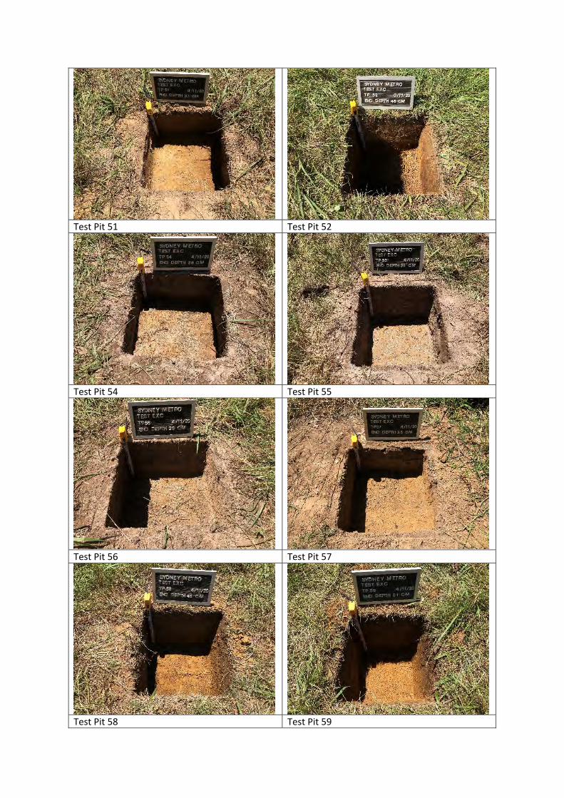
Test Pit 51 Test Pit 52
Test Pit 54 Test Pit 55
Test Pit 56 Test Pit 57
Test Pit 58 Test Pit 59
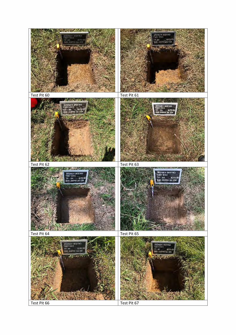
Test Pit 60 Test Pit 61
Test Pit 62 Test Pit 63
Test Pit 64 Test Pit 65
Test Pit 66 Test Pit 67
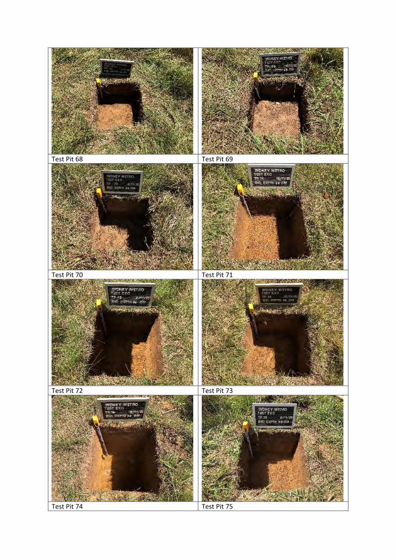
Test Pit 68 Test Pit 69
Test Pit 70 Test Pit 71
Test Pit 72 Test Pit 73
Test Pit 74 Test Pit 75
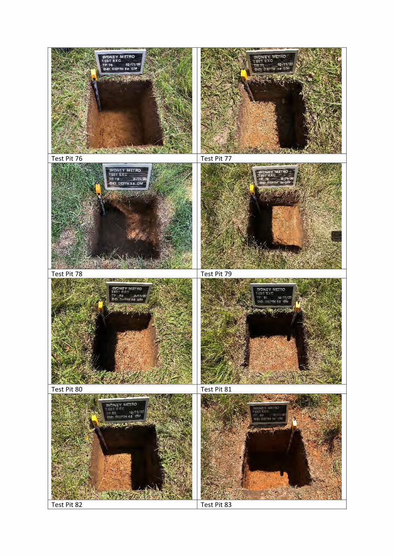
Test Pit 76 Test Pit 77
Test Pit 78 Test Pit 79
Test Pit 80 Test Pit 81
Test Pit 82 Test Pit 83
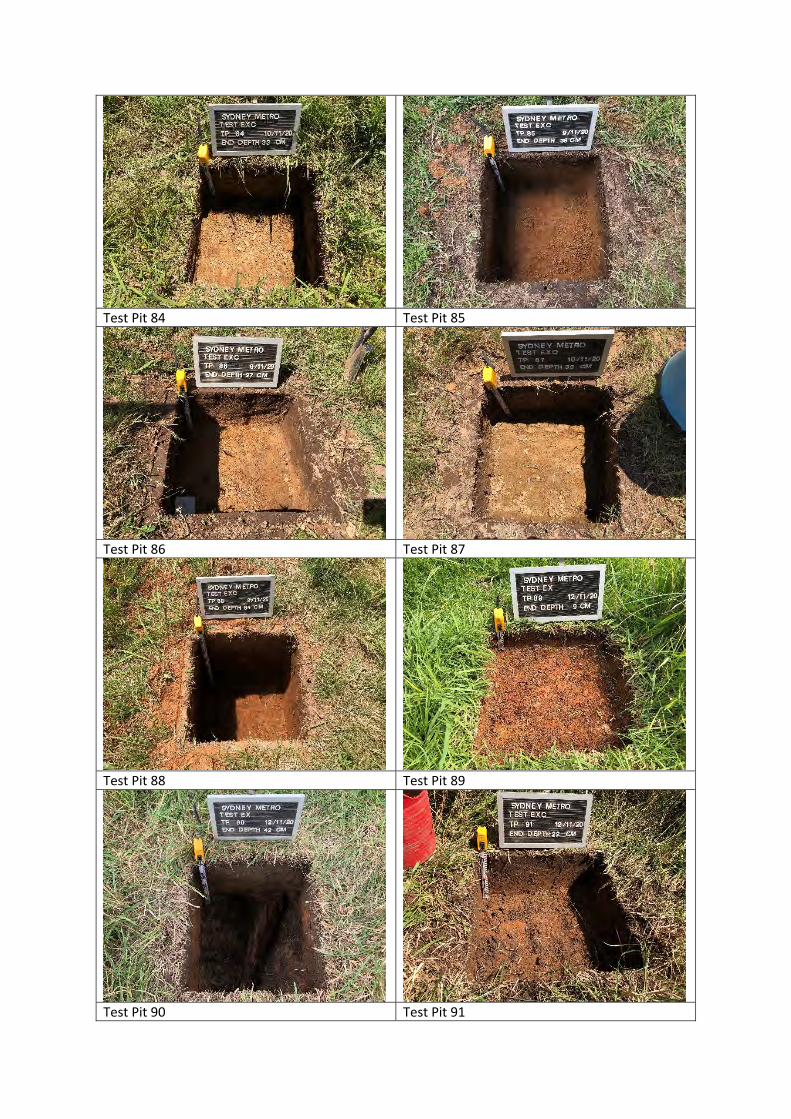
Test Pit 84 Test Pit 85
Test Pit 86 Test Pit 87
Test Pit 88 Test Pit 89
Test Pit 90 Test Pit 91
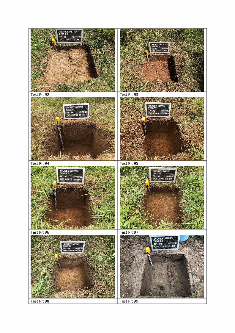
Test Pit 92 Test Pit 93
Test Pit 94 Test Pit 95
Test Pit 96 Test Pit 97
Test Pit 98 Test Pit 99
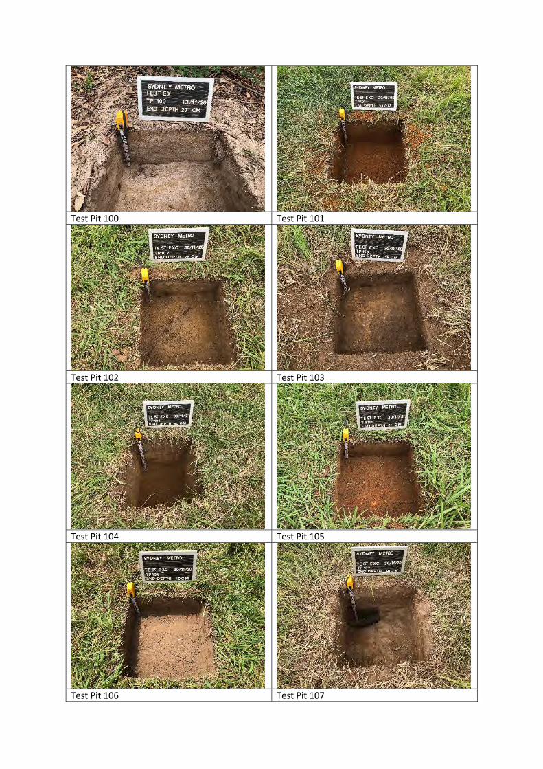
Test Pit 100 Test Pit 101
Test Pit 102 Test Pit 103
Test Pit 104 Test Pit 105
Test Pit 106 Test Pit 107
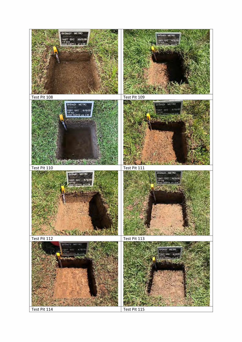
Test Pit 108 Test Pit 109
Test Pit 110 Test Pit 111
Test Pit 112 Test Pit 113
Test Pit 114 Test Pit 115
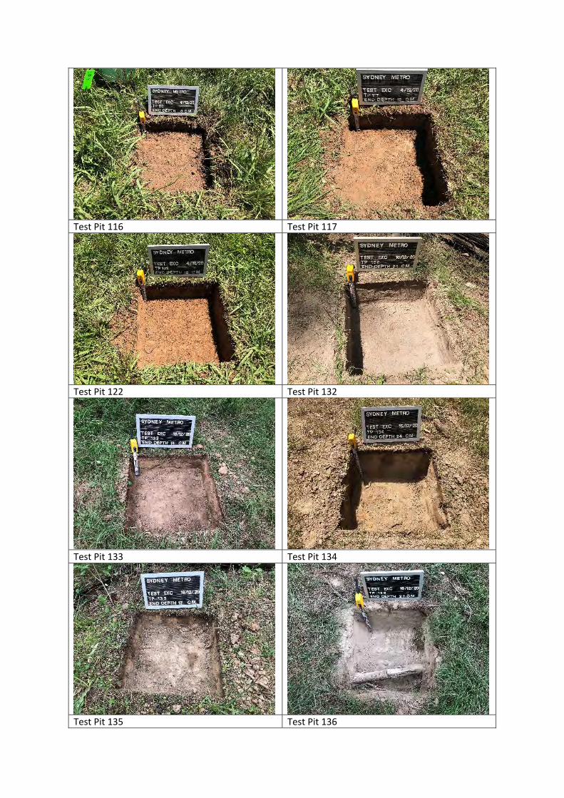
Test Pit 116 Test Pit 117
Test Pit 122 Test Pit 132
Test Pit 133 Test Pit 134
Test Pit 135 Test Pit 136
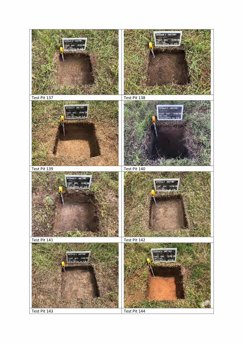
Test Pit 137 Test Pit 138
Test Pit 139 Test Pit 140
Test Pit 141 Test Pit 142
Test Pit 143 Test Pit 144
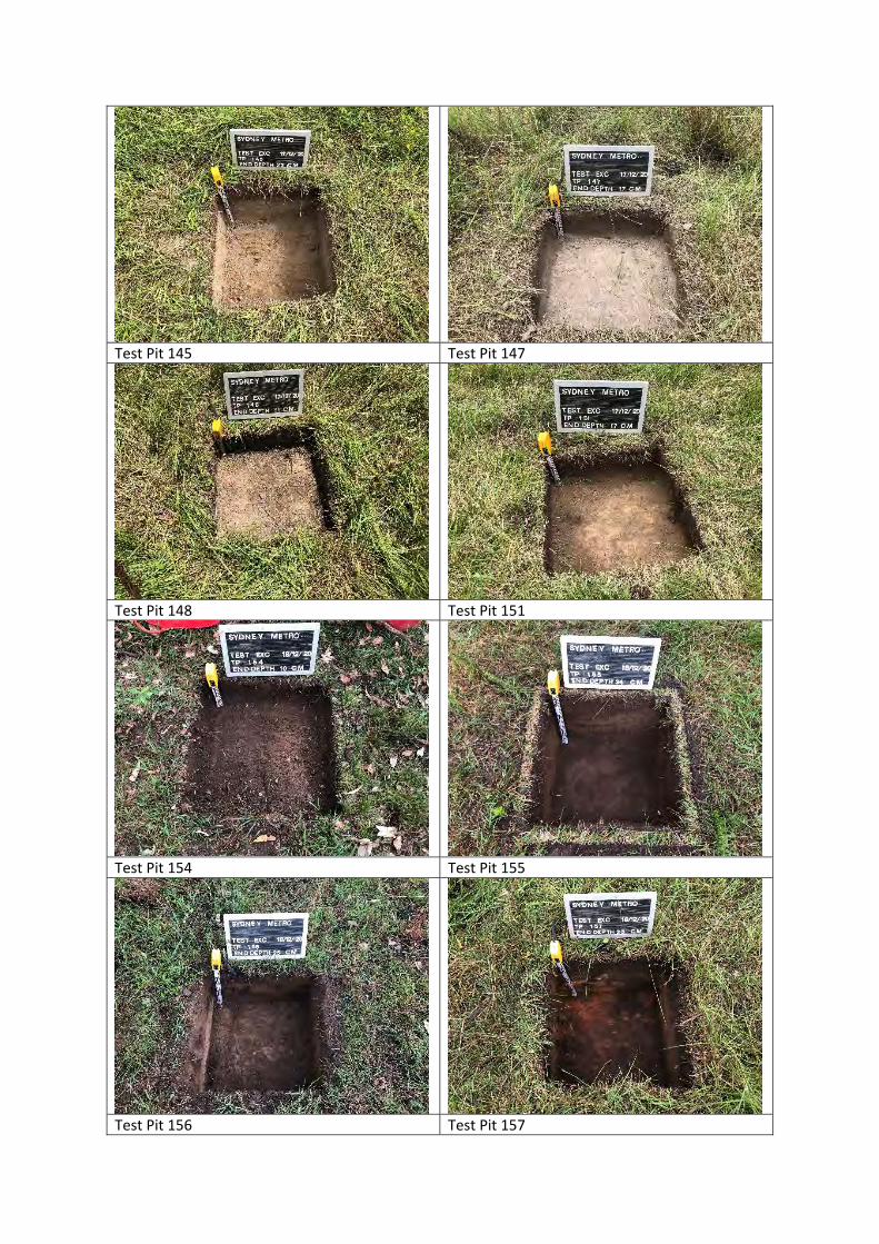
Test Pit 145 Test Pit 147
Test Pit 148 Test Pit 151
Test Pit 154 Test Pit 155
Test Pit 156 Test Pit 157

Test Pit 158 Test Pit 159
Test Pit 160 Test Pit 162
Test Pit 163 Test Pit 176
Test Pit 177 Test Pit 178
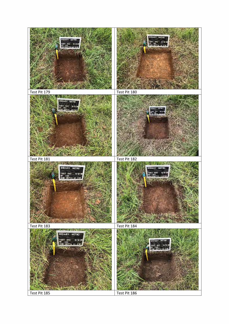
Test Pit 179 Test Pit 180
Test Pit 181 Test Pit 182
Test Pit 183 Test Pit 184
Test Pit 185 Test Pit 186
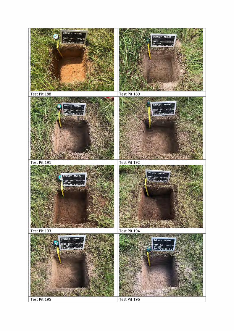
Test Pit 188 Test Pit 189
Test Pit 191 Test Pit 192
Test Pit 193 Test Pit 194
Test Pit 195 Test Pit 196

Appendix B AHIMS search results

Sydney Metro - Western Sydney Airport Aboriginal Archaeological Report
Appendix B AHIMS search results This appendix has been removed for the public version of this report.
Sydney Metro - Western Sydney Airport Sydney Metro – Western Sydney Airport
C AECOM
Appendix C AHIMS site card
summaries

Sydney Metro - Western Sydney Airport Aboriginal Archaeological Report
Appendix C AHIMS site card summaries This appendix has been removed for the public version of this report.
Sydney Metro - Western Sydney Airport Sydney Metro – Western Sydney Airport
D AECOM
Appendix D Previous and current
AHIPs

Sydney Metro - Western Sydney Airport Aboriginal Archaeological Report
Appendix D Previous and current AHIPs This appendix has been removed for the public version of this report.
Sydney Metro - Western Sydney Airport Aboriginal Archaeological Report
Appendix E
Test pit descriptions

Sydney Metro - Western Sydney Airport Aboriginal Archaeological Report
Appendix E Test pit descriptions This appendix has been removed for the public version of this report.

i Sydney Metro | Construction Environmental Management Framework
Construction Environmental Management Framework February 2021
ii Sydney Metro | Construction Environmental Management Framework
Contents February 2021 ........................................................................................................................... i
Contents ii
1. Introduction ............................................................................................................. 1 1.1 Purpose and Scope .............................................................................................................................. 1 1.2 Status .................................................................................................................................................... 1 1.3 Sydney Metro Environment and Sustainability Statement of Commitment ....................................... 1
2. Legislative and Other Requirements ...................................................................... 2 2.2 Planning Approvals ............................................................................................................................... 5 2.3 Environment Protection Licence Requirements (off-airport works) .................................................... 5 2.4 Building Approvals (on-airport works) .................................................................................................. 6 2.5 Other Licences and Permits ................................................................................................................. 6 2.6 Standards and Guidelines .................................................................................................................... 6
3. Environmental Management Requirements ........................................................... 7 3.1 Environmental and Sustainability Management System .................................................................... 7 3.2 Sustainability Management Plan ......................................................................................................... 8 3.3 Construction Workforce Development and Industry Participation Plan ........................................... 10 3.4 Construction Environmental Management Plan(s) ........................................................................... 11 3.5 Off-Airport Construction Environmental Management Sub-Plans .................................................... 13 3.6 Environmental Procedures and Control Maps .................................................................................. 13 3.7 Additional Environmental Assessments ............................................................................................ 14 3.8 Cumulative Impacts ............................................................................................................................ 14 3.9 Condition Surveys .............................................................................................................................. 15 3.10 Register of Hold Points ...................................................................................................................... 15 3.11 Training, Awareness and Competence .............................................................................................. 15 3.12 Emergency and Incident Response................................................................................................... 16 3.13 Independent Environmental Representatives ................................................................................... 17 3.14 Airport Environment Officer ................................................................................................................ 17 3.15 Roles and Responsibilities ................................................................................................................. 17 3.16 Environmental Monitoring, Inspections and Auditing ........................................................................ 18 3.17 Environmental Non-compliances ....................................................................................................... 18 3.18 Environmental Records and Compliance Reporting ......................................................................... 19 3.19 Review and Improvement of the Environment & Sustainability Management Systems .................. 19
4. Stakeholder and Community Involvement ............................................................ 20 4.1 Overview ............................................................................................................................................. 20 4.2 Community Communication Strategy ................................................................................................ 20 4.3 Complaint Handling ............................................................................................................................ 21
iii Sydney Metro | Construction Environmental Management Framework
4.4 Urban Design of Temporary Works ................................................................................................... 21 4.5 Business and Property Impacts ........................................................................................................ 22
5. General Site Works .............................................................................................. 23 5.1 Working Hours ................................................................................................................................... 23 5.2 Construction Traffic Management ..................................................................................................................... 24 5.3 Site Layout ......................................................................................................................................... 24 5.4 Reinstatement .................................................................................................................................... 24
6. Spoil Management ............................................................................................... 25 6.1 Spoil Management Objectives........................................................................................................... 25 6.2 Spoil Management Implementation .................................................................................................. 25 6.3 Spoil Mitigation ................................................................................................................................... 26
7. Groundwater Management .................................................................................. 27 7.1 Groundwater Management Objectives ............................................................................................. 27 7.2 Groundwater Management Implementation ..................................................................................... 27 7.3 Groundwater Mitigation ..................................................................................................................... 27
8. Construction Noise and Vibration Management .................................................. 28 8.1 Construction Noise and Vibration Management Objectives ............................................................. 28 8.2 Construction Noise and Vibration Management Implementation ..................................................... 29 8.3 Construction Noise and Vibration Mitigation ..................................................................................... 30
9. Heritage Management .......................................................................................... 31 9.1 Heritage Management Objectives ..................................................................................................... 31 9.2 Heritage Management Implementation ............................................................................................. 32 9.3 Heritage Mitigation ............................................................................................................................. 32
10. Flora and Fauna Management ............................................................................. 34 10.1 Flora and Fauna Management Objectives........................................................................................ 34 10.2 Flora and Fauna Management Implementation ............................................................................... 35 10.3 Flora and Fauna Mitigation ................................................................................................................ 36
11. Visual Amenity Management ................................................................................ 37 11.1 Visual Amenity Management Objectives .......................................................................................... 37 11.2 Visual Amenity Management Implementation .................................................................................. 37 11.3 Visual Amenity Mitigation ................................................................................................................... 37
12. Soil and Water Management ................................................................................ 38 12.1 Soil and Water Management Objectives ........................................................................................... 38 12.2 Soil and Water Implementation ......................................................................................................... 39 12.3 Soil and Water Mitigation ................................................................................................................... 41
iv Sydney Metro | Construction Environmental Management Framework
13. Air Quality.............................................................................................................. 42 13.1 Air Quality Management Objectives .................................................................................................. 42 13.2 Air Quality Management Implementation .......................................................................................... 42 13.3 Air Quality Mitigation .......................................................................................................................... 43
14. Waste Management .............................................................................................. 44 14.1 Waste Objectives ................................................................................................................................ 44 14.2 Waste Implementation ....................................................................................................................... 44 14.3 Waste Mitigation ................................................................................................................................. 45
15. Acronyms .............................................................................................................. 45
Appendix A – Environment and Sustainability Statement of Commitment ............................ 46
v Sydney Metro | Construction Environmental Management Framework
This page left blank intentionally

1 Sydney Metro | Construction Environmental Management Framework
1. Introduction1.1 Purpose and Scope This Sydney Metro – Western Sydney Airport Construction Environmental Management Framework (CEMF) is a Sydney Metro project framework that has been adapted specifically to set out the environmental, stakeholder and community management requirements for construction of the Sydney Metro Western Sydney Airport (SMWSA) project. It provides a linking document between the planning approval documentation and the construction environmental management documentation to be developed by the Principal Contractors relevant to their scope of works.
Sydney Metro Principal Contractors for SMWSA will be required to implement and adhere to the requirements of this CEMF. This CEMF will form part of the planning approval documentation and be included as a contract document in all design and construction contracts for SMWSA.
This CEMF differs from other Sydney Metro CEMF documents as it specifically incorporates the environmental management requirements applicable to SMWSA in relation to works to be undertaken on the Western Sydney International (Nancy-Bird Walton) Airport (Western Sydney International). These works are referred to as ‘on-airport’ works, whereas works outside Western Sydney International are referred to as ‘off-airport’ works.
Project elements located within the airport site (on-airport works) are subject to approval under the Airports Act 1996 (Cth). Delivery of on-airport works would need to be undertaken in accordance with the Airport Plan, as varied, and other relevant Commonwealth legislation, including the Airports (Environment Protection) Regulations 1997.
Given the on-airport works of SMWSA would be constructed on airport land and at the same time as the construction works associated with Stage 1 of Western Sydney International (being delivered by Western Sydney Airport (WSA)), this CEMF has been prepared to align, where relevant, with the Site Environmental Management Framework prepared by WSA.
1.2 Status This is a controlled document, please refer to the version register below which is updated as required.
Version Description Date
1.1 Minor revision for SMWSA response to submission 9 February 2021
1.3 Sydney Metro Environment and Sustainability Statement of Commitment The Sydney Metro Environment and Sustainability Statement of Commitment (Appendix A) which applies to all Sydney Metro projects. Principal Contractors are required to undertake their works in accordance with this document. The Statement of Commitment reflects a commitment in the delivery of the project to:
Optimise sustainability outcomes, transport service quality, and cost effectiveness.
Develop effective and appropriate responses to the challenges of climate change, carbonmanagement, resource and waste management, land use integration, customer and communityexpectation, and heritage and biodiversity conservation.
Be environmentally responsible, by avoiding pollution, enhancing the natural environment andreducing the project ecological footprint, while complying with all applicable environmental laws,regulations and statutory obligations.
Be socially responsible by delivering a workforce legacy which benefits individuals, communities,the project and industry, and is achieved through collaboration and partnerships.
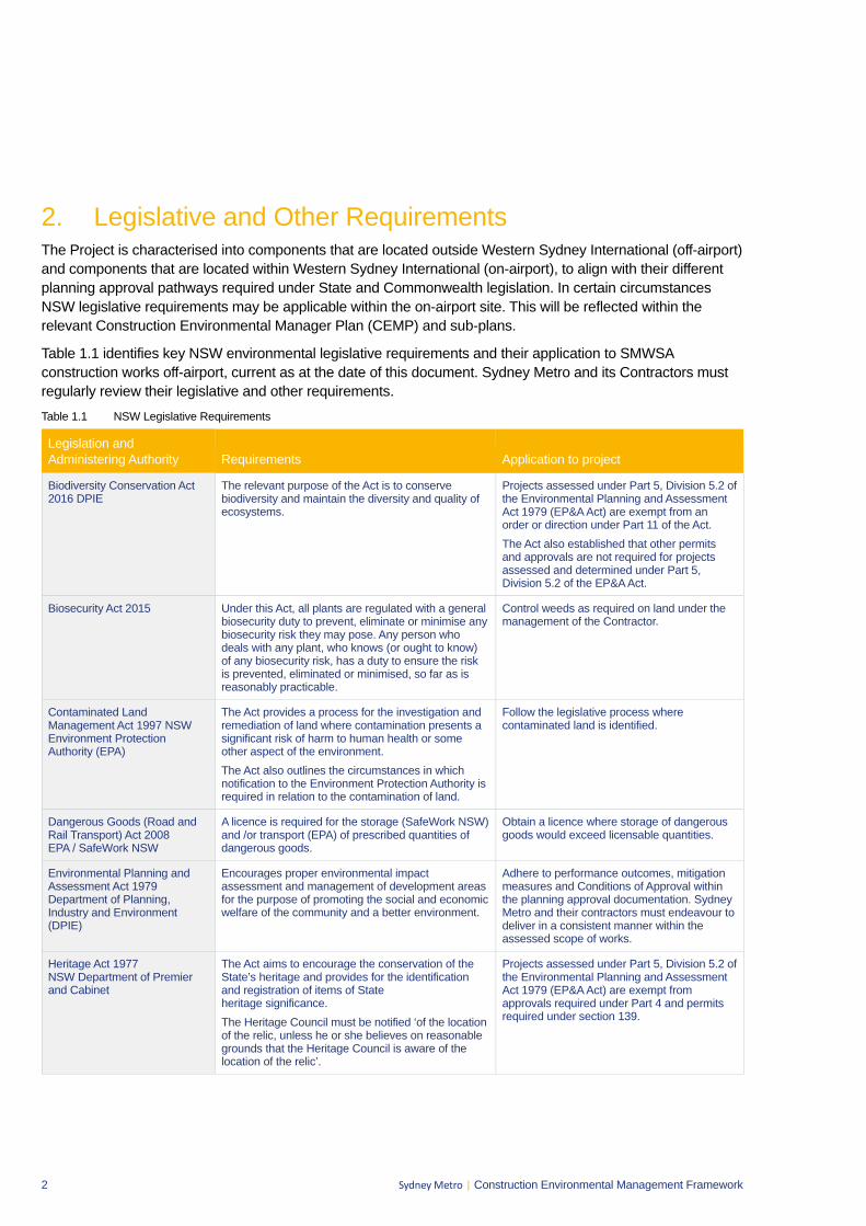
2 Sydney Metro | Construction Environmental Management Framework
2. Legislative and Other Requirements The Project is characterised into components that are located outside Western Sydney International (off-airport) and components that are located within Western Sydney International (on-airport), to align with their different planning approval pathways required under State and Commonwealth legislation. In certain circumstances NSW legislative requirements may be applicable within the on-airport site. This will be reflected within the relevant Construction Environmental Manager Plan (CEMP) and sub-plans.
Table 1.1 identifies key NSW environmental legislative requirements and their application to SMWSA construction works off-airport, current as at the date of this document. Sydney Metro and its Contractors must regularly review their legislative and other requirements. Table 1.1 NSW Legislative Requirements
Legislation and Administering Authority Requirements Application to project
Biodiversity Conservation Act 2016 DPIE
The relevant purpose of the Act is to conserve biodiversity and maintain the diversity and quality of ecosystems.
Projects assessed under Part 5, Division 5.2 of the Environmental Planning and Assessment Act 1979 (EP&A Act) are exempt from an order or direction under Part 11 of the Act. The Act also established that other permits and approvals are not required for projects assessed and determined under Part 5, Division 5.2 of the EP&A Act.
Biosecurity Act 2015 Under this Act, all plants are regulated with a general biosecurity duty to prevent, eliminate or minimise any biosecurity risk they may pose. Any person who deals with any plant, who knows (or ought to know) of any biosecurity risk, has a duty to ensure the risk is prevented, eliminated or minimised, so far as is reasonably practicable.
Control weeds as required on land under the management of the Contractor.
Contaminated Land Management Act 1997 NSW Environment Protection Authority (EPA)
The Act provides a process for the investigation and remediation of land where contamination presents a significant risk of harm to human health or some other aspect of the environment. The Act also outlines the circumstances in which notification to the Environment Protection Authority is required in relation to the contamination of land.
Follow the legislative process where contaminated land is identified.
Dangerous Goods (Road and Rail Transport) Act 2008 EPA / SafeWork NSW
A licence is required for the storage (SafeWork NSW) and /or transport (EPA) of prescribed quantities of dangerous goods.
Obtain a licence where storage of dangerous goods would exceed licensable quantities.
Environmental Planning and Assessment Act 1979 Department of Planning, Industry and Environment (DPIE)
Encourages proper environmental impact assessment and management of development areas for the purpose of promoting the social and economic welfare of the community and a better environment.
Adhere to performance outcomes, mitigation measures and Conditions of Approval within the planning approval documentation. Sydney Metro and their contractors must endeavour to deliver in a consistent manner within the assessed scope of works.
Heritage Act 1977 NSW Department of Premier and Cabinet
The Act aims to encourage the conservation of the State’s heritage and provides for the identification and registration of items of State heritage significance. The Heritage Council must be notified ‘of the location of the relic, unless he or she believes on reasonable grounds that the Heritage Council is aware of the location of the relic’.
Projects assessed under Part 5, Division 5.2 of the Environmental Planning and Assessment Act 1979 (EP&A Act) are exempt from approvals required under Part 4 and permits required under section 139.
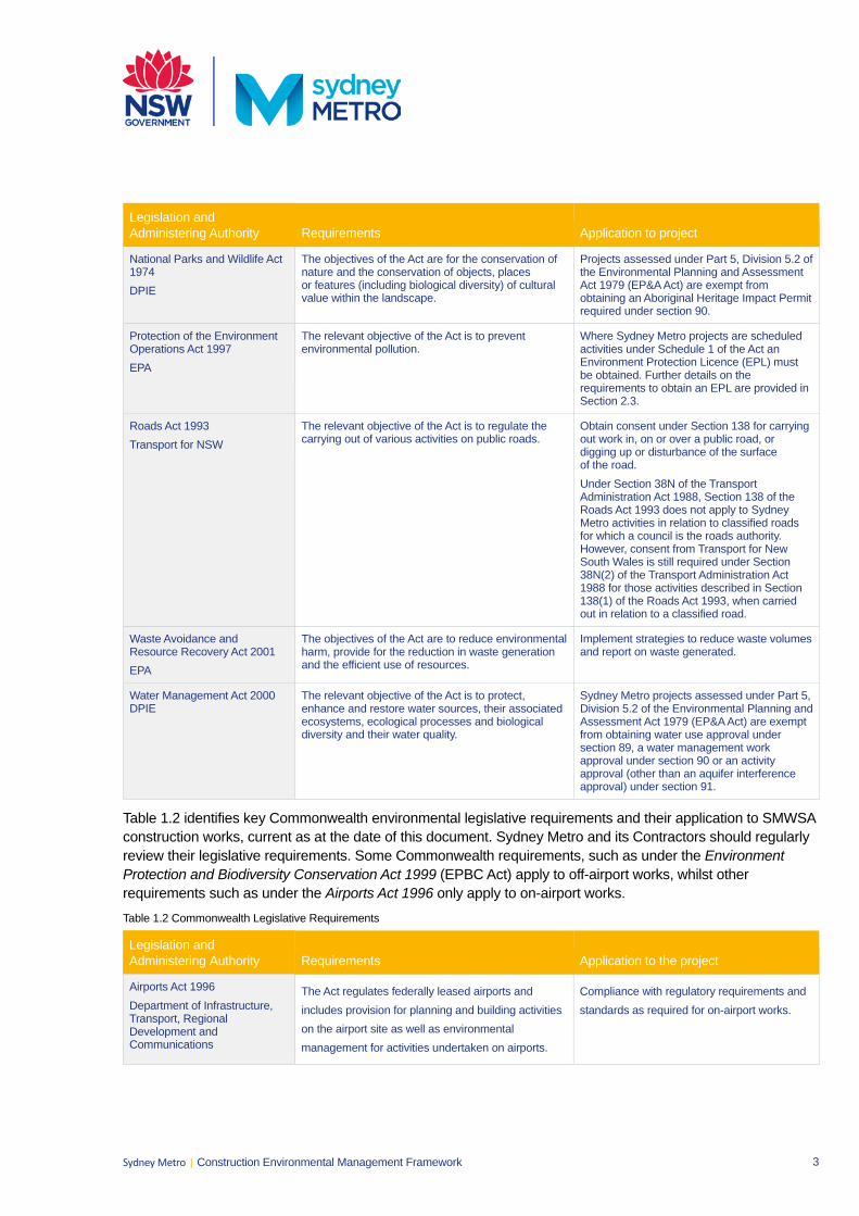
3 Sydney Metro | Construction Environmental Management Framework
Legislation and Administering Authority Requirements Application to project
National Parks and Wildlife Act 1974 DPIE
The objectives of the Act are for the conservation of nature and the conservation of objects, places or features (including biological diversity) of cultural value within the landscape.
Projects assessed under Part 5, Division 5.2 of the Environmental Planning and Assessment Act 1979 (EP&A Act) are exempt from obtaining an Aboriginal Heritage Impact Permit required under section 90.
Protection of the Environment Operations Act 1997 EPA
The relevant objective of the Act is to prevent environmental pollution.
Where Sydney Metro projects are scheduled activities under Schedule 1 of the Act an Environment Protection Licence (EPL) must be obtained. Further details on the requirements to obtain an EPL are provided in Section 2.3.
Roads Act 1993 Transport for NSW
The relevant objective of the Act is to regulate the carrying out of various activities on public roads.
Obtain consent under Section 138 for carrying out work in, on or over a public road, or digging up or disturbance of the surface of the road. Under Section 38N of the Transport Administration Act 1988, Section 138 of the Roads Act 1993 does not apply to Sydney Metro activities in relation to classified roads for which a council is the roads authority. However, consent from Transport for New South Wales is still required under Section 38N(2) of the Transport Administration Act 1988 for those activities described in Section 138(1) of the Roads Act 1993, when carried out in relation to a classified road.
Waste Avoidance and Resource Recovery Act 2001 EPA
The objectives of the Act are to reduce environmental harm, provide for the reduction in waste generation and the efficient use of resources.
Implement strategies to reduce waste volumes and report on waste generated.
Water Management Act 2000 DPIE
The relevant objective of the Act is to protect, enhance and restore water sources, their associated ecosystems, ecological processes and biological diversity and their water quality.
Sydney Metro projects assessed under Part 5, Division 5.2 of the Environmental Planning and Assessment Act 1979 (EP&A Act) are exempt from obtaining water use approval under section 89, a water management work approval under section 90 or an activity approval (other than an aquifer interference approval) under section 91.
Table 1.2 identifies key Commonwealth environmental legislative requirements and their application to SMWSA construction works, current as at the date of this document. Sydney Metro and its Contractors should regularly review their legislative requirements. Some Commonwealth requirements, such as under the Environment Protection and Biodiversity Conservation Act 1999 (EPBC Act) apply to off-airport works, whilst other requirements such as under the Airports Act 1996 only apply to on-airport works. Table 1.2 Commonwealth Legislative Requirements
Legislation and Administering Authority Requirements Application to the project
Airports Act 1996 Department of Infrastructure, Transport, Regional Development and Communications
The Act regulates federally leased airports and includes provision for planning and building activities on the airport site as well as environmental management for activities undertaken on airports.
Compliance with regulatory requirements and standards as required for on-airport works.
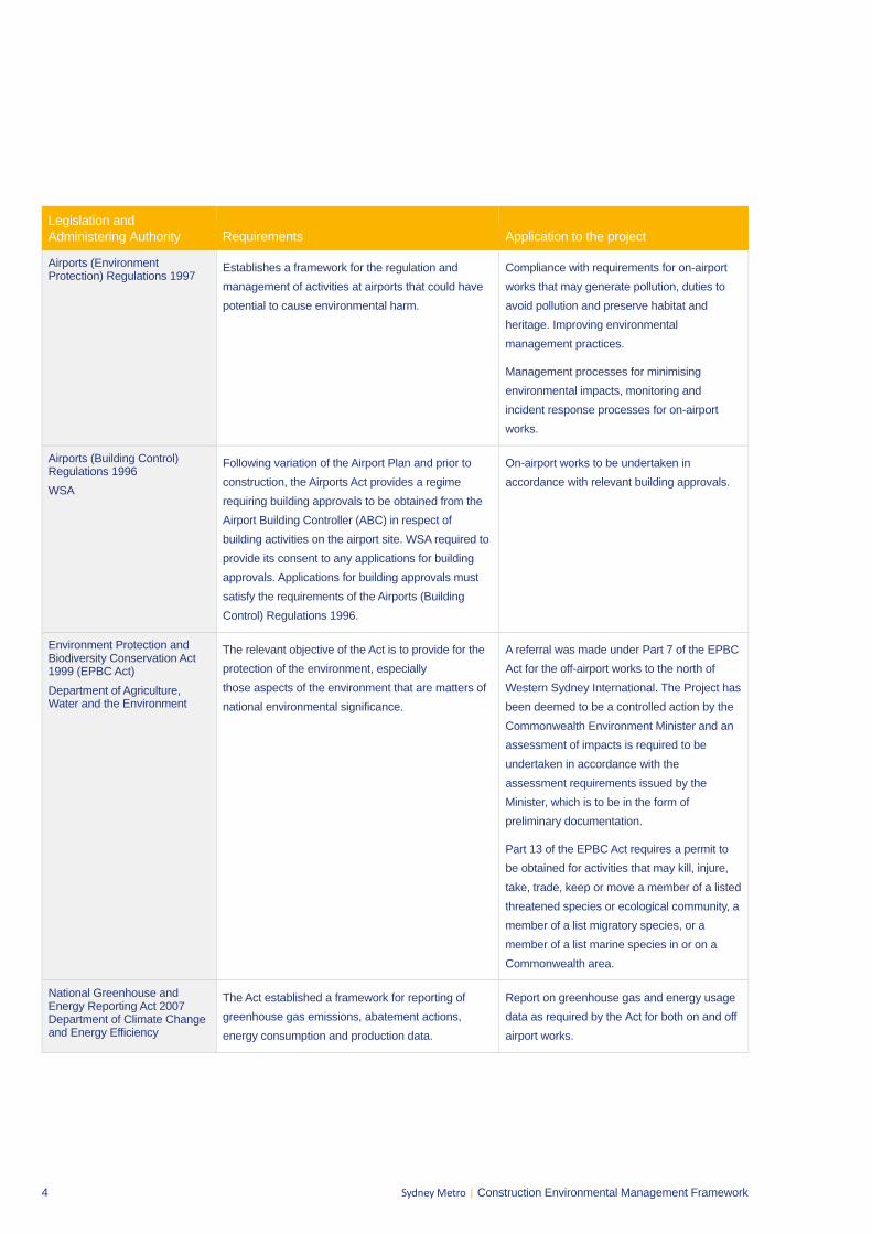
4 Sydney Metro | Construction Environmental Management Framework
Legislation and Administering Authority Requirements Application to the project
Airports (Environment Protection) Regulations 1997
Establishes a framework for the regulation and management of activities at airports that could have potential to cause environmental harm.
Compliance with requirements for on-airport works that may generate pollution, duties to avoid pollution and preserve habitat and heritage. Improving environmental management practices.
Management processes for minimising environmental impacts, monitoring and incident response processes for on-airport works.
Airports (Building Control) Regulations 1996 WSA
Following variation of the Airport Plan and prior to construction, the Airports Act provides a regime requiring building approvals to be obtained from the Airport Building Controller (ABC) in respect of building activities on the airport site. WSA required to provide its consent to any applications for building approvals. Applications for building approvals must satisfy the requirements of the Airports (Building Control) Regulations 1996.
On-airport works to be undertaken in accordance with relevant building approvals.
Environment Protection and Biodiversity Conservation Act 1999 (EPBC Act) Department of Agriculture, Water and the Environment
The relevant objective of the Act is to provide for the protection of the environment, especially those aspects of the environment that are matters of national environmental significance.
A referral was made under Part 7 of the EPBC Act for the off-airport works to the north of Western Sydney International. The Project has been deemed to be a controlled action by the Commonwealth Environment Minister and an assessment of impacts is required to be undertaken in accordance with the assessment requirements issued by the Minister, which is to be in the form of preliminary documentation.
Part 13 of the EPBC Act requires a permit to be obtained for activities that may kill, injure, take, trade, keep or move a member of a listed threatened species or ecological community, a member of a list migratory species, or a member of a list marine species in or on a Commonwealth area.
National Greenhouse and Energy Reporting Act 2007 Department of Climate Change and Energy Efficiency
The Act established a framework for reporting of greenhouse gas emissions, abatement actions, energy consumption and production data.
Report on greenhouse gas and energy usage data as required by the Act for both on and off airport works.
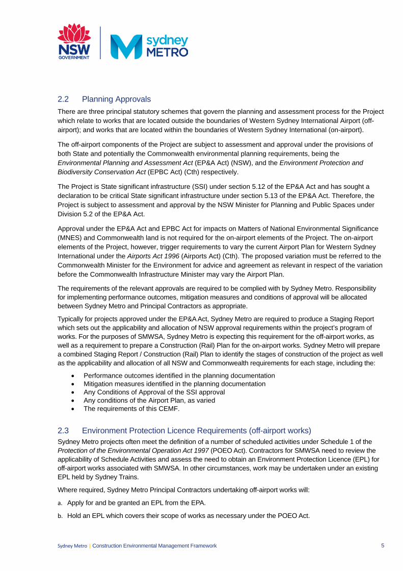
5 Sydney Metro | Construction Environmental Management Framework
2.2 Planning Approvals There are three principal statutory schemes that govern the planning and assessment process for the Project which relate to works that are located outside the boundaries of Western Sydney International Airport (off-airport); and works that are located within the boundaries of Western Sydney International (on-airport).
The off-airport components of the Project are subject to assessment and approval under the provisions of both State and potentially the Commonwealth environmental planning requirements, being the Environmental Planning and Assessment Act (EP&A Act) (NSW), and the Environment Protection and Biodiversity Conservation Act (EPBC Act) (Cth) respectively.
The Project is State significant infrastructure (SSI) under section 5.12 of the EP&A Act and has sought a declaration to be critical State significant infrastructure under section 5.13 of the EP&A Act. Therefore, the Project is subject to assessment and approval by the NSW Minister for Planning and Public Spaces under Division 5.2 of the EP&A Act.
Approval under the EP&A Act and EPBC Act for impacts on Matters of National Environmental Significance (MNES) and Commonwealth land is not required for the on-airport elements of the Project. The on-airport elements of the Project, however, trigger requirements to vary the current Airport Plan for Western Sydney International under the Airports Act 1996 (Airports Act) (Cth). The proposed variation must be referred to the Commonwealth Minister for the Environment for advice and agreement as relevant in respect of the variation before the Commonwealth Infrastructure Minister may vary the Airport Plan.
The requirements of the relevant approvals are required to be complied with by Sydney Metro. Responsibility for implementing performance outcomes, mitigation measures and conditions of approval will be allocated between Sydney Metro and Principal Contractors as appropriate.
Typically for projects approved under the EP&A Act, Sydney Metro are required to produce a Staging Report which sets out the applicability and allocation of NSW approval requirements within the project’s program of works. For the purposes of SMWSA, Sydney Metro is expecting this requirement for the off-airport works, as well as a requirement to prepare a Construction (Rail) Plan for the on-airport works. Sydney Metro will prepare a combined Staging Report / Construction (Rail) Plan to identify the stages of construction of the project as well as the applicability and allocation of all NSW and Commonwealth requirements for each stage, including the:
• Performance outcomes identified in the planning documentation• Mitigation measures identified in the planning documentation• Any Conditions of Approval of the SSI approval• Any conditions of the Airport Plan, as varied• The requirements of this CEMF.
2.3 Environment Protection Licence Requirements (off-airport works) Sydney Metro projects often meet the definition of a number of scheduled activities under Schedule 1 of the Protection of the Environmental Operation Act 1997 (POEO Act). Contractors for SMWSA need to review the applicability of Schedule Activities and assess the need to obtain an Environment Protection Licence (EPL) for off-airport works associated with SMWSA. In other circumstances, work may be undertaken under an existing EPL held by Sydney Trains.
Where required, Sydney Metro Principal Contractors undertaking off-airport works will:
a. Apply for and be granted an EPL from the EPA.
b. Hold an EPL which covers their scope of works as necessary under the POEO Act.
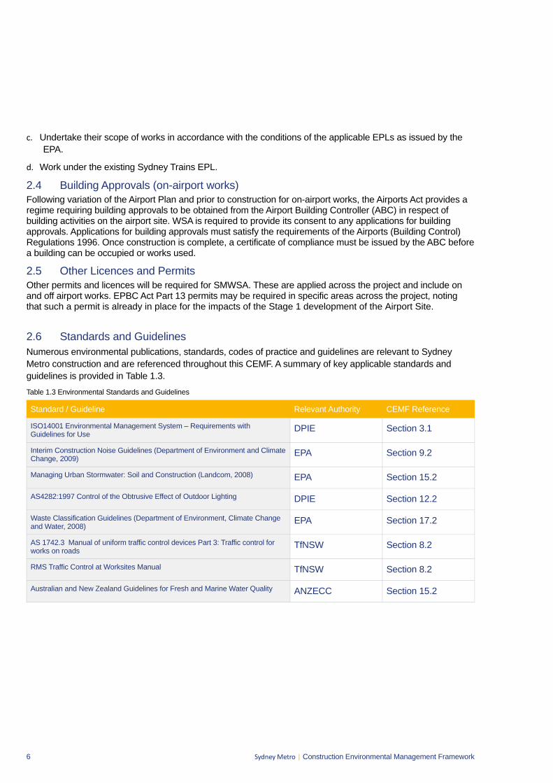
6 Sydney Metro | Construction Environmental Management Framework
c. Undertake their scope of works in accordance with the conditions of the applicable EPLs as issued by the EPA.
d. Work under the existing Sydney Trains EPL.
2.4 Building Approvals (on-airport works) Following variation of the Airport Plan and prior to construction for on-airport works, the Airports Act provides a regime requiring building approvals to be obtained from the Airport Building Controller (ABC) in respect of building activities on the airport site. WSA is required to provide its consent to any applications for building approvals. Applications for building approvals must satisfy the requirements of the Airports (Building Control) Regulations 1996. Once construction is complete, a certificate of compliance must be issued by the ABC before a building can be occupied or works used.
2.5 Other Licences and Permits Other permits and licences will be required for SMWSA. These are applied across the project and include on and off airport works. EPBC Act Part 13 permits may be required in specific areas across the project, noting that such a permit is already in place for the impacts of the Stage 1 development of the Airport Site.
2.6 Standards and Guidelines Numerous environmental publications, standards, codes of practice and guidelines are relevant to Sydney Metro construction and are referenced throughout this CEMF. A summary of key applicable standards and guidelines is provided in Table 1.3. Table 1.3 Environmental Standards and Guidelines
Standard / Guideline Relevant Authority CEMF Reference
ISO14001 Environmental Management System – Requirements with Guidelines for Use
DPIE Section 3.1
Interim Construction Noise Guidelines (Department of Environment and Climate Change, 2009)
EPA Section 9.2
Managing Urban Stormwater: Soil and Construction (Landcom, 2008) EPA Section 15.2
AS4282:1997 Control of the Obtrusive Effect of Outdoor Lighting DPIE Section 12.2
Waste Classification Guidelines (Department of Environment, Climate Change and Water, 2008)
EPA Section 17.2
AS 1742.3 Manual of uniform traffic control devices Part 3: Traffic control for works on roads
TfNSW Section 8.2
RMS Traffic Control at Worksites Manual TfNSW Section 8.2
Australian and New Zealand Guidelines for Fresh and Marine Water Quality ANZECC Section 15.2
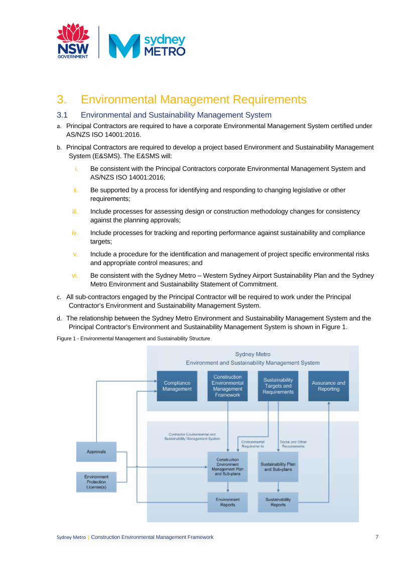
7 Sydney Metro | Construction Environmental Management Framework
3. Environmental Management Requirements3.1 Environmental and Sustainability Management System a. Principal Contractors are required to have a corporate Environmental Management System certified under
AS/NZS ISO 14001:2016.
b. Principal Contractors are required to develop a project based Environment and Sustainability ManagementSystem (E&SMS). The E&SMS will:
i. Be consistent with the Principal Contractors corporate Environmental Management System andAS/NZS ISO 14001:2016;
ii. Be supported by a process for identifying and responding to changing legislative or otherrequirements;
iii. Include processes for assessing design or construction methodology changes for consistencyagainst the planning approvals;
iv. Include processes for tracking and reporting performance against sustainability and compliancetargets;
v. Include a procedure for the identification and management of project specific environmental risksand appropriate control measures; and
vi. Be consistent with the Sydney Metro – Western Sydney Airport Sustainability Plan and the SydneyMetro Environment and Sustainability Statement of Commitment.
c. All sub-contractors engaged by the Principal Contractor will be required to work under the PrincipalContractor’s Environment and Sustainability Management System.
d. The relationship between the Sydney Metro Environment and Sustainability Management System and thePrincipal Contractor’s Environment and Sustainability Management System is shown in Figure 1.
Figure 1 - Environmental Management and Sustainability Structure
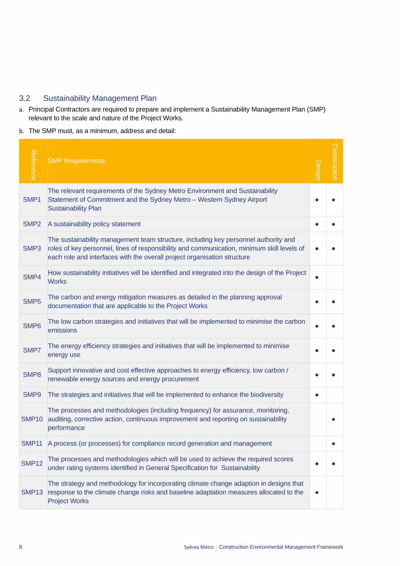
8 Sydney Metro | Construction Environmental Management Framework
3.2 Sustainability Management Plan a. Principal Contractors are required to prepare and implement a Sustainability Management Plan (SMP)
relevant to the scale and nature of the Project Works.
b. The SMP must, as a minimum, address and detail:
Reference
SMP Requirements Design
Construction
SMP1 The relevant requirements of the Sydney Metro Environment and Sustainability Statement of Commitment and the Sydney Metro – Western Sydney Airport Sustainability Plan
● ●
SMP2 A sustainability policy statement ● ●
SMP3 The sustainability management team structure, including key personnel authority and roles of key personnel, lines of responsibility and communication, minimum skill levels of each role and interfaces with the overall project organisation structure
● ●
SMP4 How sustainability initiatives will be identified and integrated into the design of the Project Works ●
SMP5 The carbon and energy mitigation measures as detailed in the planning approval documentation that are applicable to the Project Works ● ●
SMP6 The low carbon strategies and initiatives that will be implemented to minimise the carbon emissions ● ●
SMP7 The energy efficiency strategies and initiatives that will be implemented to minimise energy use ● ●
SMP8 Support innovative and cost effective approaches to energy efficiency, low carbon / renewable energy sources and energy procurement ● ●
SMP9 The strategies and initiatives that will be implemented to enhance the biodiversity ●
SMP10 The processes and methodologies (including frequency) for assurance, monitoring, auditing, corrective action, continuous improvement and reporting on sustainability performance
●
SMP11 A process (or processes) for compliance record generation and management ●
SMP12 The processes and methodologies which will be used to achieve the required scores under rating systems identified in General Specification for Sustainability ● ●
SMP13 The strategy and methodology for incorporating climate change adaption in designs that response to the climate change risks and baseline adaptation measures allocated to the Project Works
●
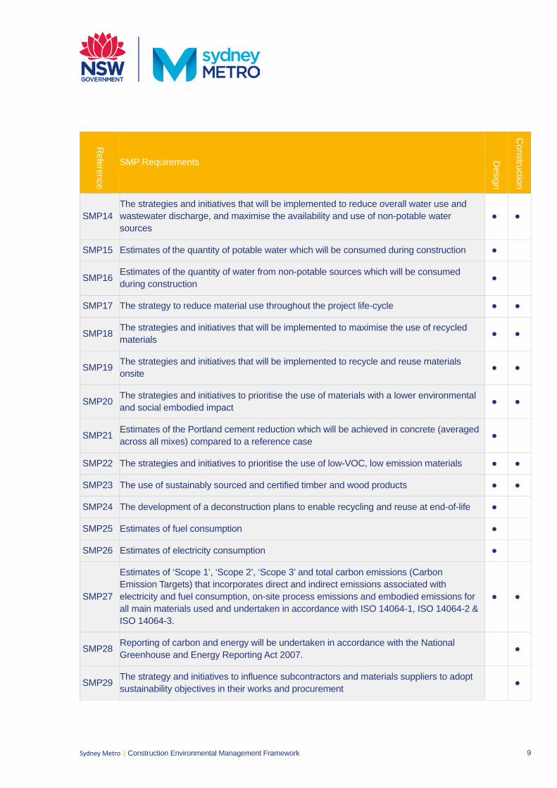
9 Sydney Metro | Construction Environmental Management Framework
Reference
SMP Requirements Design
Construction
SMP14 The strategies and initiatives that will be implemented to reduce overall water use and wastewater discharge, and maximise the availability and use of non-potable water sources
● ●
SMP15 Estimates of the quantity of potable water which will be consumed during construction ●
SMP16 Estimates of the quantity of water from non-potable sources which will be consumed during construction ●
SMP17 The strategy to reduce material use throughout the project life-cycle ● ●
SMP18 The strategies and initiatives that will be implemented to maximise the use of recycled materials ● ●
SMP19 The strategies and initiatives that will be implemented to recycle and reuse materials onsite ● ●
SMP20 The strategies and initiatives to prioritise the use of materials with a lower environmental and social embodied impact ● ●
SMP21 Estimates of the Portland cement reduction which will be achieved in concrete (averaged across all mixes) compared to a reference case ●
SMP22 The strategies and initiatives to prioritise the use of low-VOC, low emission materials ● ●
SMP23 The use of sustainably sourced and certified timber and wood products ● ●
SMP24 The development of a deconstruction plans to enable recycling and reuse at end-of-life ●
SMP25 Estimates of fuel consumption ●
SMP26 Estimates of electricity consumption ●
SMP27
Estimates of ‘Scope 1’, ‘Scope 2’, ‘Scope 3’ and total carbon emissions (Carbon Emission Targets) that incorporates direct and indirect emissions associated with electricity and fuel consumption, on-site process emissions and embodied emissions for all main materials used and undertaken in accordance with ISO 14064-1, ISO 14064-2 & ISO 14064-3.
● ●
SMP28 Reporting of carbon and energy will be undertaken in accordance with the National Greenhouse and Energy Reporting Act 2007. ●
SMP29 The strategy and initiatives to influence subcontractors and materials suppliers to adopt sustainability objectives in their works and procurement ●
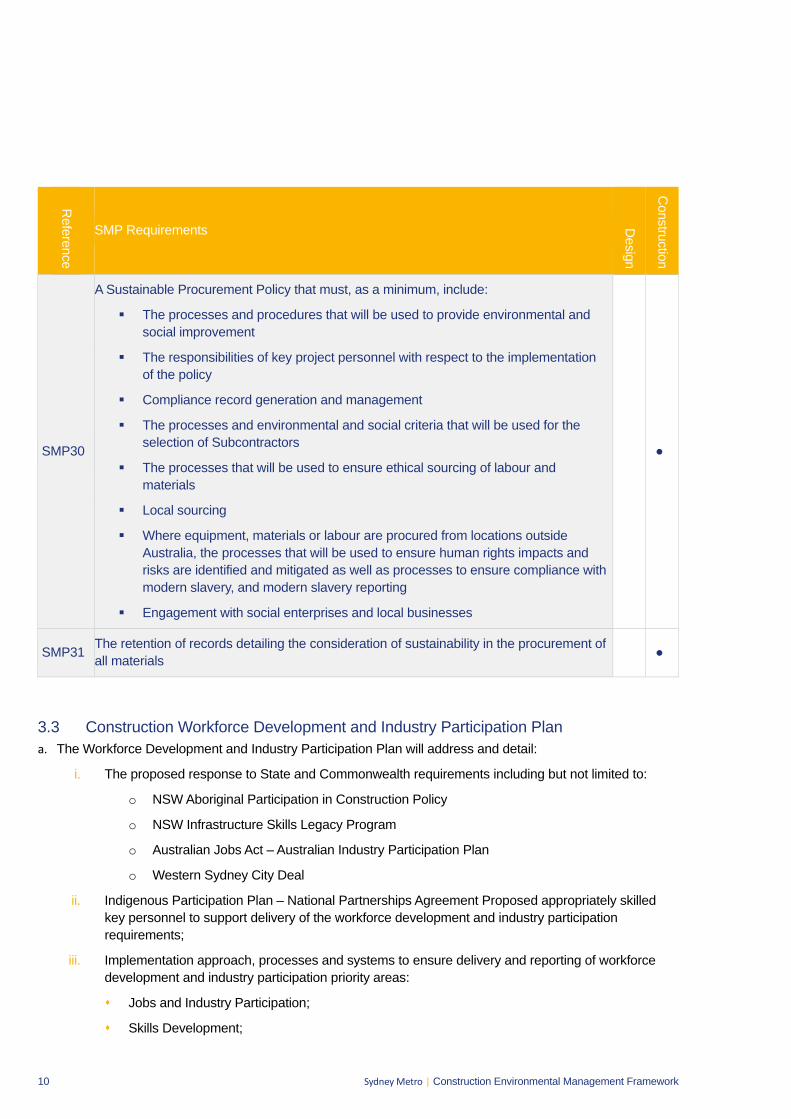
10 Sydney Metro | Construction Environmental Management Framework
Reference
SMP Requirements Design
Construction
SMP30
A Sustainable Procurement Policy that must, as a minimum, include:
The processes and procedures that will be used to provide environmental and social improvement
The responsibilities of key project personnel with respect to the implementation of the policy
Compliance record generation and management
The processes and environmental and social criteria that will be used for the selection of Subcontractors
The processes that will be used to ensure ethical sourcing of labour and materials
Local sourcing
Where equipment, materials or labour are procured from locations outside Australia, the processes that will be used to ensure human rights impacts and risks are identified and mitigated as well as processes to ensure compliance with modern slavery, and modern slavery reporting
Engagement with social enterprises and local businesses
●
SMP31 The retention of records detailing the consideration of sustainability in the procurement of all materials ●
3.3 Construction Workforce Development and Industry Participation Plan a. The Workforce Development and Industry Participation Plan will address and detail:
i. The proposed response to State and Commonwealth requirements including but not limited to:
o NSW Aboriginal Participation in Construction Policy
o NSW Infrastructure Skills Legacy Program
o Australian Jobs Act – Australian Industry Participation Plan
o Western Sydney City Deal
ii. Indigenous Participation Plan – National Partnerships Agreement Proposed appropriately skilled key personnel to support delivery of the workforce development and industry participation requirements;
iii. Implementation approach, processes and systems to ensure delivery and reporting of workforce development and industry participation priority areas:
Jobs and Industry Participation;
Skills Development;
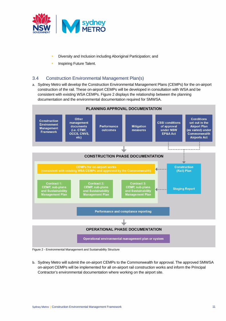
11 Sydney Metro | Construction Environmental Management Framework
Diversity and Inclusion including Aboriginal Participation; and
Inspiring Future Talent.
3.4 Construction Environmental Management Plan(s) a. Sydney Metro will develop the Construction Environmental Management Plans (CEMPs) for the on-airport
construction of the rail. These on-airport CEMPs will be developed in consultation with WSA and beconsistent with existing WSA CEMPs. Figure 2 displays the relationship between the planningdocumentation and the environmental documentation required for SMWSA.
Figure 2 - Environmental Management and Sustainability Structure
b. Sydney Metro will submit the on-airport CEMPs to the Commonwealth for approval. The approved SMWSA on-airport CEMPs will be implemented for all on-airport rail construction works and inform the PrincipalContractor’s environmental documentation where working on the airport site.
12 Sydney Metro | Construction Environmental Management Framework
c. Principal Contractors are required to prepare and implement a Construction Environmental Management Plan (CEMP) relevant to the scale and nature of their off-airport scope of works. The CEMP shall comprise of a main CEMP document, issue specific sub plans, activity specific procedures and site based control maps. The CEMP shall illustrate the relationship between other plans required by the contract, in particular those that relate to design management. The CEMP will address the specific requirements of scope of works and address the off-airport environmental requirements.
d. Depending on the scope and scale of the works, Sydney Metro may decide to streamline the CEMP and sub-plan requirements for off-airport works. For example, depending on the risk associated with particular environmental issues it may be appropriate to remove the need for a sub plan, or replace with a procedure as part of the CEMP. The CEMP and sub-plan requirements from this CEMF for each construction stage / contract will be detailed in the Staging Report / Construction (Rail) Plan for the project.
e. Environmental documentation prepared for works within the on-airport site will be in accordance with the approved SMWSA on-airport CEMPs.
f. The Principal Contractor CEMP will cover the requirements of the relevant planning approval documentation, the conditions of all other permits and licences, the Principal Contractor’s corporate EMS, the environmental provisions of the contract documentation and this Construction Environmental Management Framework.
g. As a minimum the Principal Contractor CEMP will:
i. Include a contract specific environmental policy;
ii. Include a description of activities to be undertaken during construction;
iii. For each plan under the CEMP include a matrix of the relevant SSI Conditions of Approval referencing where each requirement is addressed;
iv. For each plan under the CEMP, set objectives and targets, and identify measurable key performance indicators in relation to these;
v. For each role that has environmental accountabilities or responsibilities, including key personnel, provide a tabulated description of the authority and roles of key personnel, lines of responsibility and communication, minimum skill level requirements and their interface with the overall project organisation structure;
vi. Assign the responsibility for the implementation of the CEMP to the Environment Manager, who will have appropriate experience. The Principal Contractor’s Project Director will be accountable for the implementation of the CEMP;
vii. Identify communication requirements, including liaison with stakeholders and the community;
viii. Include induction and training requirements and a summary of the Training Needs Analysis required in Section 3.11(b);
ix. Management strategies for environmental compliance and review of the performance of environmental controls;
x. Procedures for environmental inspections and monitoring, auditing and review, and reporting on environmental performance including environmental compliance tracking;
xi. Include an annual schedule for auditing the CEMP and Sub-Plans that is updated at least monthly;
xii. Include procedures for emergency and incident management, non-compliance management, and corrective and preventative action; and
13 Sydney Metro | Construction Environmental Management Framework
xiii. Include procedures for the control of environmental records.
h. The Principal Contractor CEMP and associated sub-plans will be reviewed by Sydney Metro prior to anyconstruction works commencing. For off-airport works approved under the CSSI, the independentenvironmental representative (see Section 3.13) will also review the CEMP.
i. Where a corresponding systems document exists within the Sydney Metro Integrated Management System,the Principal Contractor’s procedures will be required to be consistent with any requirements in thosedocuments.
3.5 Off-Airport Construction Environmental Management Sub-Plans a. Subject to Section 3.4(b) the Principal Contractors will prepare issue-specific environmental sub plans to the
CEMP which address each of the relevant environmental impacts at a particular site or stage of the project.Issue specific sub plans will include as a minimum:
i. Spoil management;
ii. Groundwater management;
iii. Traffic and transport management;
iv. Noise and vibration management;
v. Heritage management;
vi. Flora and fauna management;
vii. Visual amenity management;
viii. Soil and water management;
ix. Air quality management; and
x. Waste management.
Some of these sub plans may also be informed by other environmental management documents included in the planning approval, for example the Construction Traffic Management Framework or Construction Noise and Vibration Standard.
b. Additional detail on the minimum requirements for these sub plans is provided in Sections 6 to14 of thisCEMF.
3.6 Environmental Procedures and Control Maps a. The Principal Contractor will prepare and implement activity specific environmental procedures. These
procedures should supplement environmental management sub plans, but may substitute for sub plans inagreement with Sydney Metro if a reasonable risk based justification can be made and the sub plan is not arequirement of any approval.
b. The procedures will include:
i. A breakdown of the work tasks relevant to the specific activity and indicate responsibility for eachtask;
ii. Potential impacts associated with each task;
iii. A risk rating for each of the identified potential impacts;
iv. Mitigation measures relevant to each of the work tasks; and
v. Responsibility to ensure the implementation of the mitigation measures.
14 Sydney Metro | Construction Environmental Management Framework
c. The Principal Contractor will prepare and implement site based, progressive Environmental Control Maps (ECMs) which as a minimum:
i. Depicting the current representation of the site;
ii. Indicate which environmental procedures, environmental approvals, or licences are applicable;
iii. Illustrate the site, showing significant structures, work areas and boundaries;
iv. Illustrate the environmental control measures and environmentally sensitive receivers;
v. Is endorsed by the Principal Contractors Environmental Manager or delegate;
vi. Include all the training and competency requirements for relevant workers; and.
vii. Be communicated to relevant workers, including sign off the appropriate procedures prior to commencing works on the specific site and / or activity.
3.7 Additional Environmental Assessments a. Where the requirement for an additional environmental assessment is identified, this will be undertaken prior
to undertaking any construction activities. The environmental assessment will include:
i. A description of the existing surrounding environment;
ii. Details of the ancillary works and construction activities required to be carried out including the hours of works;
iii. An assessment of the environmental impacts of the works, including, but not necessarily limited to, traffic, noise and vibration, air quality, soil and water, ecology and heritage;
iv. Details of mitigation measures and monitoring specific to the works that would be implemented to minimise environmental impacts; and
v. Identification of the timing for completion of the construction works, and how the sites would be reinstated (including any necessary rehabilitation).
3.8 Cumulative Impacts a. A cumulative construction impacts management plan would be developed. The plan would detail co-
ordination and consultation requirements with the following stakeholders (as relevant) would occur where required to manage the interface of projects under construction at the same time:
i. Western Sydney Airport
ii. Transport for NSW
iii. Department of Planning, Industry and Environment
iv. Western Parkland City Authority (and their contractors)
v. Emergency service providers
vi. Utility providers
b. Co-ordination and consultation requirements with these stakeholders would be detailed in the plan to include:
i. provision of regular updates to the detailed construction program, construction sites and haul routes ii. identification of key interfaces with other construction projects iii. Development of mitigation strategies to manage cumulative impacts associated with these
interfaces.
15 Sydney Metro | Construction Environmental Management Framework
3.9 Condition Surveys a. Prior to the commencement of construction the Principal Contractors are to offer Pre-construction Building
Condition Surveys, in writing, to the owners of buildings where there is a potential for construction activitiesto cause any damage (regardless of severity). If accepted, the Principal Contractor will produce acomprehensive written and photographic condition report produced by an appropriate professional prior torelevant works commencing.
b. Prior to the commencement of construction the Principal Contractor will prepare a Road Dilapidation Reportfor all local public roads proposed to be used by heavy vehicles. Dilapidation reports are to include otherroad infrastructure such as signs, curbs, applicable driveways and pedestrian paths.
3.10 Register of Hold Points a. Principal Contractors will identify hold points, beyond which approval is required to proceed with a certain
activity. Example activities include vegetation removal and water discharge. Hold points will be documentedin relevant CEMPs.
b. Table 1.4 provides the structure for the register of hold points as well as a preliminary list of hold pointswhich will be implemented.
Table 1.4 Preliminary Register of Hold Points
Hold Point Release of Hold Point By Who
Prior to Vegetation Clearing / Ground Disturbance
Pre-clearing inspection Erosion and sediment control plan
Qualified Ecologist Contractor’s Environmental Manager or delegate
Discharge of water Water tested to verify compliance and approval to discharge
Contractor’s Environment Manager or delegate
Out of hours works Noise Assessment Contractor’s Environment Manager
Use of local roads by heavy vehicles
Road Dilapidation Report Appropriate Professional nominated by Principal Contractor
Construction identified as affecting buildings
Building Condition Survey Appropriate Professional nominated by Principal Contractor
3.11 Training, Awareness and Competence a. Principal Contractors are responsible for determining the training needs of their personnel. As a minimum
this will include site induction, regular toolbox talks and topic specific environmental training as follows:
i. The site induction will be provided to all site personnel and will include, as a minimum:
Training purpose, objectives and key issues;
Contractor’s environmental and sustainability policy(s) and key performance indicators;
Due diligence, duty of care and responsibilities;
Relevant conditions of any environmental licence and/or the relevant conditions of approval;
Site specific issues and controls including those described in the environmental procedures;
Reporting procedure(s) for environmental hazards and incidents; and
Communication protocols for interactions with community and stakeholders.
16 Sydney Metro | Construction Environmental Management Framework
ii. Toolbox talks will be held on a regular basis in order to provide a project or site wide update, including any key or recurring environmental issues; and
iii. Topic specific environmental training should be based upon, but is not limited to, issue specific sub-plans required under Section 3.5 (a).
b. Principal Contractors will conduct a Training Needs Analysis which:
i. Identifies that all staff are to receive an environmental training;
ii. Identifies the competency requirements of staff that hold environmental roles and responsibilities documented within the Construction Environmental Management Plan and sub-plans;
iii. Identifies appropriate training courses/events and the frequency of training to achieve and/or maintain these competency requirements; and
iv. Implements and documents as part of the CEMP a training schedule that plans attendance at environmental training events, provides mechanisms to notify staff of their training requirements, and identifies staff who do not attend scheduled training events or who have overdue training requirements.
3.12 Emergency and Incident Response a. Principal Contractors undertaking off-airport work in accordance with an EPL must develop and implement a
Pollution Incident Response Management Plan, in accordance with the requirements of the POEO Act. Contractor’s emergency and incident response procedures will also be consistent with any relevant Sydney Metro procedures and, for on-airport works, consistent with the environmental incident and emergency management requirements identified in the Western Sydney Airport Site Environmental Management Framework, and will include:
i. Categories for environmental emergencies and incidents;
ii. Notification protocols for each category of environmental emergency or incident, including notification to Sydney Metro, WSA (where required for on-airport works) and notification to owners / occupiers in the vicinity of the incident. This is to include relevant contact details;
iii. Identification of personnel who have the authority to take immediate action to shut down any activity, or to affect any environmental control measure (including as directed by an authorised officer of any regulator or government department);
iv. A process for undertaking appropriate levels of investigation for all incidents and the identification, implementation and assessment of corrective and preventative actions; and
v. Notification protocols of incidents to relevant regulators and stakeholders including (but not limited to) the EPA, DPIE, the AEO, WSA and DITRDC for incidents that are made by the Contractor or Sydney Metro.
b. The Contractor will make all personnel aware of the plan and their responsibilities.

17 Sydney Metro | Construction Environmental Management Framework
3.13 Independent Environmental Representatives a. Sydney Metro will engage Independent Environmental Representatives (ERs) as required under the SSI
approval for off-airport works to undertake the following, along with any additional roles as required:
i. Review, provide comment on and endorse (where required) any relevant environmentaldocumentation to verify it is prepared in accordance with relevant environmental legislation,planning approval conditions, Environment Protection Licences, relevant standards and this CEMF;
ii. Monitor and report on the implementation and performance of the above mentioned documentationand other relevant documentation;
iii. Provide independent guidance and advice to Sydney Metro and the Contractors in relation toenvironmental compliance issues and the interpretation of planning approval conditions;
iv. Be the principal point of advice for the DPIE in relation to all questions and complaints concerningthe environmental performance of the project;
v. Ensure that environmental auditing is undertaken in accordance with all relevant projectrequirements; and
vi. Recommend reasonable steps, including ‘stop works’, to be taken to avoid or minimise adverseenvironmental impacts.
3.14 Airport Environment Officer An Airport Environment Officer (AEO) is responsible for the day to day regulatory oversight of compliance with the Airports (Environment Protection) Regulations 1997 (AEPRs) at Western Sydney International and will have a role in relation to the on-airport works for SWMG.
The responsibilities of the AEO in relation to on-airport works of SMWSA include:
i. Monitoring compliance with the AEPRs
ii. Facilitate an understanding of the obligations of the AEPRs
iii. Ensure the best possible outcomes are achieved
iv. Complete site inspections to review monitoring requirements and completion of works
v. Review and comment on incidents and remedial activities
vi. Issue an environment protection order in accordance with Part 7 of the AEPR
vii. Issue an infringement notice in response to an offence against the AEPR.
3.15 Roles and Responsibilities a. In relation to Roles and Responsibilities the Principal Contractor CEMP will:
i. Describe the relationship between the Principal Contractor, Sydney Metro, key regulatorystakeholders, the independent environmental representative and the independent certifier;
ii. For each role that has environmental accountabilities or responsibilities, including key personnel,provide a tabulated description of the authority and roles of key personnel, lines of responsibilityand communication, minimum skill level requirements and their interface with the overall projectorganisation structure;
iii. Provide details of each specialist environment, sustainability or planning consultant who isemployed by the Principal Contractor including the scope of their work; and
18 Sydney Metro | Construction Environmental Management Framework
iv. Provide an overview of the role and responsibilities of the Independent Environmental Representative, the Independent Certifier and other regulatory stakeholders.
b. All sub-contractors engaged by the Principal Contractor will be required to operate within the EMS documentation of that Principal Contractor.
3.16 Environmental Monitoring, Inspections and Auditing a. Issue specific environmental monitoring will be undertaken as required or as additionally required by any
approval, permit or licence conditions.
b. The results of any monitoring undertaken as a requirement of a license or permit that is required to be published will be published on the Principal Contractor’s, or a project specific, website within 14 days of obtaining the results.
c. Environmental inspections will include:
i. Surveillance of environmental mitigation measures by the Site Foreman; and
ii. Periodic inspections by the Principal Contractor’s Environmental Manager (or delegate) to verify the adequacy of all environmental mitigation measures. This will be documented in a formal inspection record.
d. Regular site inspections by Sydney Metro, the ER for off-airport works and the AEO for on-airport works will be undertaken at a frequency to be agreed with the Principal Contractor, based on the risk of activity but as a minimum monthly.
e. Principal Contractors must undertake internal environmental audits. The scope will include:
i. Compliance with any approval, permit or licence conditions;
ii. Compliance with the E&SMS, CEMP, SMP, sub-plans and procedures;
iii. Community consultation and complaint response;
iv. Environmental training records; and
v. Environmental monitoring and inspection results.
f. Sydney Metro will also undertake periodic audits of the Principal Contractor’s E&SMS and compliance with the environmental aspects of contract documentation, including this CEMF. These audits would cover both on- and off-airport works.
g. Off-airport works approved under the SSI approval will be subjected to audits undertaken by the independent environmental auditor. Independent environmental audits will focus on compliance with the planning approval and the conditions of approval. The independent auditor is approved by DPIE and an audit schedule will be developed in consultation with the Principal Contractor and Sydney Metro.
h. On-airport works approved under the Airport Plan, as varied, will be subject to environmental audits and compliance audits, noting unscheduled audits may also be undertaken. The environmental audits would audit the environmental systems and on-site performance of the on-airport works of SMWSA and be undertaken on a 6 monthly basis.
3.17 Environmental Non-compliances a. Principal Contractors will document and detail any non-compliances arising out of the above monitoring,
inspections and audits. Sydney Metro will be made aware of all non-compliances in a timely manner.
19 Sydney Metro | Construction Environmental Management Framework
b. Principal Contractors will develop and implement corrective actions to rectify the non-compliances andpreventative actions in order to prevent a re-occurrence of the non-compliance. Contractors will alsomaintain a register of non-compliances, corrective actions and preventative actions.
c. Sydney Metro may raise non-compliances against environmental requirements. The EnvironmentalRepresentative and Airport Environmental Officer also have the authority to raise a non-compliance for theirrespective areas of work.
3.18 Environmental Records and Compliance Reporting a. Principal Contractors will maintain appropriate records of the following:
i. Site inspections, audits, monitoring, reviews or remedial actions;
ii. Documentation as required by performance conditions, approvals, licences and legislation;
iii. Modifications to site environmental documentation (e.g. CEMP, sub-plans and procedures); and
iv. Other records as required by this Construction Environmental Management Framework.
b. Records must be accessible onsite for the duration of works.
c. Records will be retained by the Principal Contractor for a period of no less than 7 years. Records will bemade available in a timely manner to Sydney Metro (or their representative) upon request.
d. Compliance reports detailing the outcome of any environmental surveillance activity including internal andexternal audits (refer to Section 3.14) will be produced by the Principal Contractors Environmental Manageror delegate. These reports will be submitted to Sydney Metro at an agreed frequency.
3.19 Review and Improvement of the Environment & Sustainability Management Systems a. Principal Contractors will ensure the continual review and improvement of the management systems.
This will generally occur in response to:
i. Issues raised during environmental surveillance and monitoring;
ii. Expanded scope of works;
iii. Environmental incidents; and
iv. Environmental non-conformances.
b. A formal review of the management systems by the Principal Contractor’s Senior Management Team willalso occur on an annual basis, as a minimum. This review shall generate actions for the continualimprovement of the systems and supporting management plans.
20 Sydney Metro | Construction Environmental Management Framework
4. Stakeholder and Community Involvement 4.1 Overview a. Throughout construction, Sydney Metro and the Principal Contractors will work closely with stakeholders
and the community to ensure they are well informed regarding the construction works.
b. Stakeholders and the community will be informed of significant events or changes that affect or may affect individual properties, residences and businesses. These will include:
i. Significant milestones;
ii. Design changes;
iii. Changes to traffic conditions and access arrangements for road users and the affected public; and
iv. Construction operations which will have a direct impact on stakeholders and the community including noisy works, interruptions to utility services or construction work outside of normal work hours.
4.2 Community Communication Strategy a. An Overarching Community Communication Strategy (OCCS) has been developed for SMWSA. The OCCS
incorporates both on and off-airport works, with the on-airport components being developed in consultation with WSA.
b. Each Principal Contractor would be responsible for implementing their own Community Communication Strategy prepared in accordance with this overarching strategy.
c. Key elements of the Community Communication Strategy, which will be implemented at appropriate times in the construction process, include:
i. Notification (including targeted letterbox drops and email) of any works that may disturb local residents and businesses (such as noisy activities and night works) at least seven days prior to those works commencing;
ii. Notification (including targeted letterbox drops and email) of works that may affect transport (such as road closures, changes to pedestrian routes and changes to bus stops);
iii. Traffic alerts (via email) to all key traffic and transport stakeholders advising of any changes to access and local traffic arrangements (at least seven days prior to significant events);
iv. Print and radio advertisements regarding major traffic changes;
v. 24-hour toll-free community project information phone line;
vi. Complaints management process;
vii. Community information sessions, as required;
viii. Regular updates to the Sydney Metro website (sydneymetro.info), including uploading of all relevant documents, and contact details for the stakeholder and community relations team;
ix. Provision of information to the Sydney Metro Community Information Centre including community newsletters, information brochures and fact sheets and interactive web-based activities;
x. Clear signage at the construction sites;
xi. Regular newspaper advertisements in local and metropolitan papers;
xii. Regular inter-agency group meetings;
21 Sydney Metro | Construction Environmental Management Framework
xiii. Community, business and stakeholder satisfaction surveys and feedback forms;
xiv. Translator and interpreter services; and
xv. The Principal Contractor’s Community Relations Team will liaise with the Sydney Metro ProjectCommunications team as the point of contact for the community.
4.3 Complaint Handling a. Community liaison and complaints handling will be undertaken in accordance with the Construction
Complaints Management System and will include:
i. Principal Contractors will deal with complaints in a responsive manner so that stakeholders’concerns are managed effectively and promptly; and
ii. A verbal response will be provided to the complainant as soon as possible and within a maximum oftwo hours from the time of the complaint (unless the complainant requests otherwise). A detailedwritten response will then be provided, if required, to the complainant within one week.
iii. Community liaison and complaints handling for construction of on-airport works will be undertakenin accordance with the Integrated Complaint Handling Procedure. This Procedure will include asingle integrated complaint handling telephone line and email address for all works on the airportsite which will be managed so that any contact made by a stakeholder will be directed to therelevant party responsible for those works so that stakeholder’s concerns are managed effectivelyand promptly.
4.4 Urban Design of Temporary Works a. Principal Contractors will ensure as a minimum:
i. Temporary construction works consider urban design and visual impacts, including:
Artwork, graphics and images to enhance the visual appearance of temporary works in highvisibility locations;
Project information to raise awareness on benefits, explain the proposed works at each site andprovide updates on construction progress;
Community information, including contact numbers for enquiries / complaints;
Signage and information to mitigate impacts on local businesses which may be obscured by theconstruction site;
Sydney Metro advertising / public awareness campaigns; and
Logos / branding, including Sydney Metro, NSW and Commonwealth Government, andContractor branding.
ii. The design of all temporary works will require Sydney Metro approval in relation to urban designand visual impacts and Sydney Metro will stipulate the design of hording artwork, including:
Sydney Metro advertising / public awareness campaigns; and
Logos / branding, including Sydney Metro, NSW and Commonwealth Government, andContractor branding.
b. Construction hoardings, scaffolding and acoustic sheds will be regularly inspected and kept clean and freeof dust build up. Graffiti on construction hoardings, scaffolding or acoustic sheds will be removed or paintedover promptly.
22 Sydney Metro | Construction Environmental Management Framework
c. The principles of Crime Prevention through Environmental Design (CPTED) will be applied to all works, including temporary works that have a public interface.
4.5 Business and Property Impacts a. Principal Contractors will proactively work with potentially affected stakeholders to identify the likely impacts
and put in place measures to minimise impacts.
b. Construction works will be undertaken to meet the following objectives:
i. Minimise the potential impact of the project to businesses affected by construction works;
ii. Ensure businesses are kept informed of the project and consulted in advance of major works or factors that are likely to have a direct impact;
iii. Consult with all business directly affected by changes to access arrangements regarding specific requirements at least two weeks prior to those changes coming into effect; and
iv. Ensure that business stakeholder enquiries and complaints regarding the project are managed and resolved effectively.
c. The Community Communication Strategy (Section 4.2) will document key issues relating to business impacts by locality with a particular focus on proactive consultation with affected businesses. Including:
i. Identification of specific businesses which are sensitive to construction activity disturbances;
ii. Summary of the commercial character of the locality, its general trading profile (daily and annually) and information gained from the business profiling such as:
Operating hours;
Main delivery times;
Reliance on foot traffic;
Any signage or advertising that may be impacted;
Customer origin; and
Other information specific to the business that will need to be considered in construction planning.
iii. Define the roles and responsibilities in relation to the control and monitoring of business disturbances;
iv. Identification of locality specific standard business mitigation measures which would be implemented;
v. Maps and diagrams to illustrate the information for easy identification of measures which would be implemented;
vi. Description of the monitoring, auditing and reporting procedures;
vii. Procedure for reviewing performance and implementing corrective actions;
viii. Description of the complaints handling process; and
ix. Procedure for community consultation and liaison.
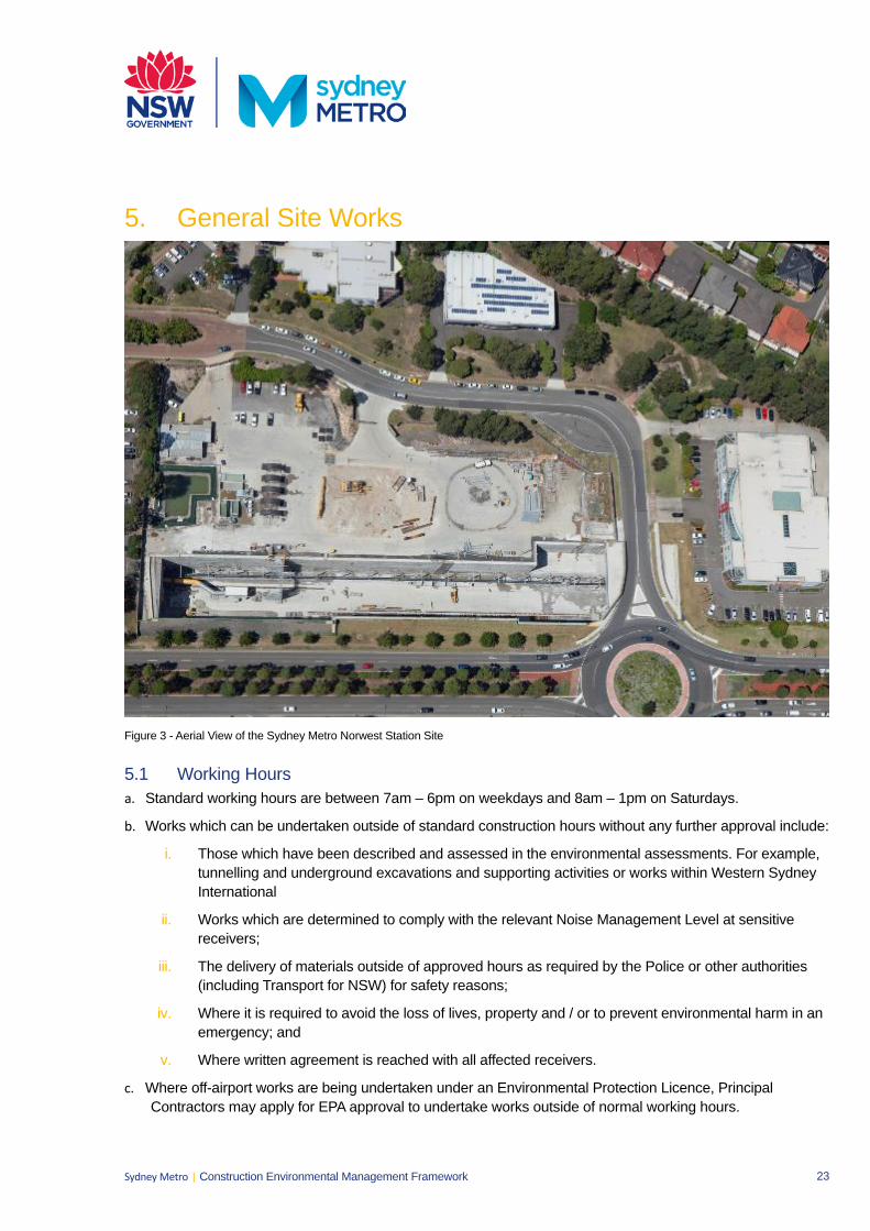
23 Sydney Metro | Construction Environmental Management Framework
5. General Site Works
Figure 3 - Aerial View of the Sydney Metro Norwest Station Site
5.1 Working Hours a. Standard working hours are between 7am – 6pm on weekdays and 8am – 1pm on Saturdays.
b. Works which can be undertaken outside of standard construction hours without any further approval include:
i. Those which have been described and assessed in the environmental assessments. For example,tunnelling and underground excavations and supporting activities or works within Western SydneyInternational
ii. Works which are determined to comply with the relevant Noise Management Level at sensitivereceivers;
iii. The delivery of materials outside of approved hours as required by the Police or other authorities(including Transport for NSW) for safety reasons;
iv. Where it is required to avoid the loss of lives, property and / or to prevent environmental harm in anemergency; and
v. Where written agreement is reached with all affected receivers.
c. Where off-airport works are being undertaken under an Environmental Protection Licence, PrincipalContractors may apply for EPA approval to undertake works outside of normal working hours.
24 Sydney Metro | Construction Environmental Management Framework
5.2 Construction Traffic Management a. The management of traffic impacts due to construction is addressed in the Construction Traffic Management
Framework (CTMF) which sets out system requirements for management plans and other associated documentation. This document applies to Principal Contractors and forms part of the contract documentation.
b. The Construction Traffic Management Framework (CTMF) sets out the approach to managing traffic impacts during the construction of the Sydney Metro projects. The CTMF also outlines contractor requirements, with reference to third party agreements. Principal Contractors are required to produce these documents in accordance with the CTMF.
c. For on-airport works, the Sydney Metro Western Sydney Airport Traffic and Access CEMP will detail all the management objectives and will be consistent with the WSA Traffic and Access CEMP , including all appendices to the CEMP
5.3 Site Layout a. Principal Contractors will consider the following in the layout of construction sites:
i. The location of noise intensive works and 24 hour activities in relation to noise sensitive receivers;
ii. The location of site access and egress points in relation to noise and light sensitive receivers, especially for sites proposed to be utilised 24 hours per day;
iii. The use of site buildings to shield noisy activities from receivers;
iv. The use of noise barriers and / or acoustic sheds where feasible and reasonable for sites proposed to be regularly used outside of daytime hours; and
v. Aim to minimise the requirement for reversing, especially of heavy vehicles.
5.4 Reinstatement a. Where measures for reinstatement are not stipulated in the contracts, mitigation measures for reinstatement
of construction and ancillary lands will be produced in consultation with Sydney Metro, the landowner and stakeholders.
b. Mitigation measures required for reinstatement will be incorporated into the CEMP and will include as a minimum:
i. Principal Contractors will clear and clean all working areas and accesses at project completion;
ii. At the completion of construction all plant, temporary buildings or vehicles not required for the subsequent stage of construction will be removed from the site;
iii. All land, including roadways, footpaths, loading facilities or other land having been occupied temporarily will be returned to their pre-existing condition or better; and
iv. Reinstatement of community spaces, infrastructure and services will occur as soon as possible after completion of construction.
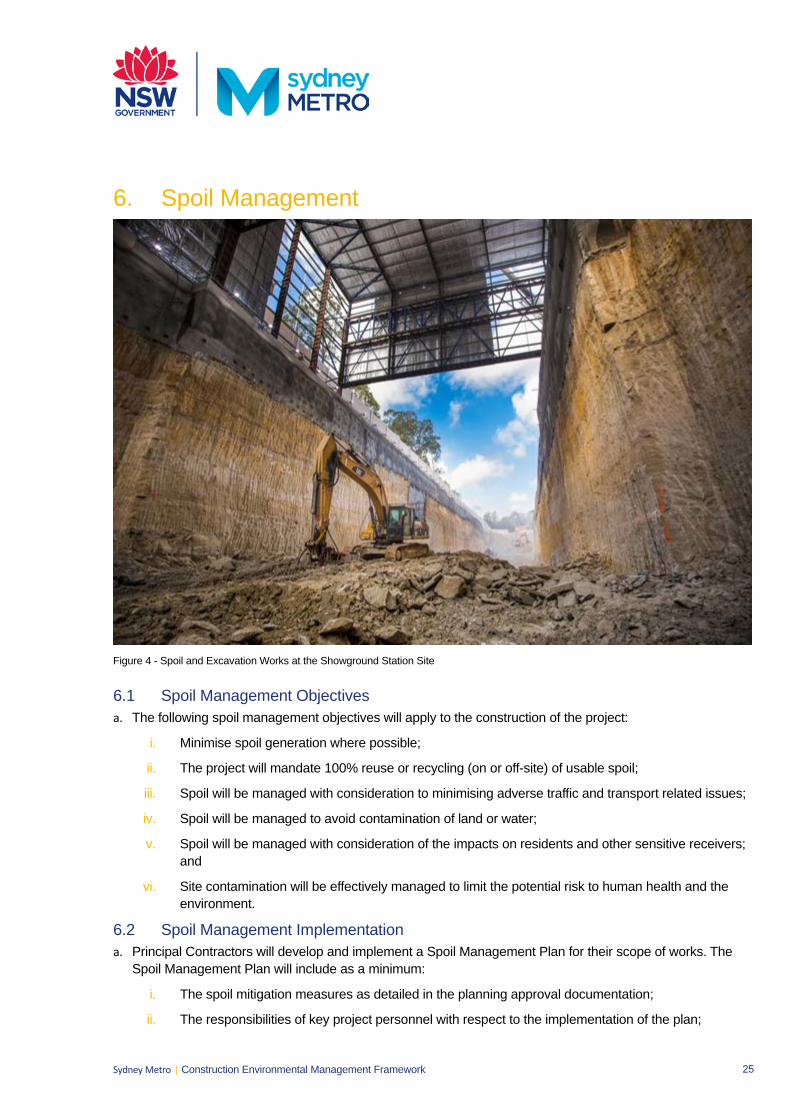
25 Sydney Metro | Construction Environmental Management Framework
6. Spoil Management
Figure 4 - Spoil and Excavation Works at the Showground Station Site
6.1 Spoil Management Objectives a. The following spoil management objectives will apply to the construction of the project:
i. Minimise spoil generation where possible;
ii. The project will mandate 100% reuse or recycling (on or off-site) of usable spoil;
iii. Spoil will be managed with consideration to minimising adverse traffic and transport related issues;
iv. Spoil will be managed to avoid contamination of land or water;
v. Spoil will be managed with consideration of the impacts on residents and other sensitive receivers;and
vi. Site contamination will be effectively managed to limit the potential risk to human health and theenvironment.
6.2 Spoil Management Implementation a. Principal Contractors will develop and implement a Spoil Management Plan for their scope of works. The
Spoil Management Plan will include as a minimum:
i. The spoil mitigation measures as detailed in the planning approval documentation;
ii. The responsibilities of key project personnel with respect to the implementation of the plan;
26 Sydney Metro | Construction Environmental Management Framework
iii. Procedures and methodologies for the haulage and disposal locations, storage and stockpiling arrangements, including those for virgin excavated natural material, contaminated and unsuitable material;
iv. Procedures for the testing, excavation, classification, handling and reuse of spoil;
v. Measures that will be implemented to both reduce spoil quantities and maximise the beneficial reuse of spoil which will be generated during the performance of the Contractor’s Activities, including how spoil generation is minimised through the design development process;
vi. Details, links or references to where traffic movements in relation to spoil are described, and measures that will be implemented to minimise traffic and noise impacts associated with haulage and disposal of spoil;
vii. quantities for reuse of spoil within the Construction Site or Western Sydney International, for beneficial reuse of spoil off site and for spoil disposal;
viii. Processes and procedures for the management of the environmental and social impacts of spoil transfer and reuse;
ix. A register of spoil receipt sites that includes the site or project name, location, capacity, site owner and which tier the site is classified as under the spoil reuse hierarchy;
x. Spoil management monitoring requirements; and
xi. Compliance record generation and management.
b. Spoil management measures will be included in regular inspections undertaken by the Contractor, and compliance records will be retained. These will include:
i. Records detailing the beneficial re-use of spoil either within the project or at off-site locations; and
ii. Waste dockets for any spoil disposed of to landfill sites.
6.3 Spoil Mitigation a. Examples of spoil mitigation measures include:
i. Implementing the spoil re-use hierarchy;
ii. Handling spoil to minimise potential for air or water pollution; and
iii. Minimise traffic impacts associated with spoil removal.
27 Sydney Metro | Construction Environmental Management Framework
7. Groundwater Management7.1 Groundwater Management Objectives a. The following groundwater management objectives will apply to construction:
i. Reduce the potential for drawdown of surrounding groundwater resources;
ii. Prevent the pollution of groundwater through appropriate controls; and
iii. Reduce the potential impacts of groundwater dependent ecosystems.
iv. For on-airport works, the Sydney Metro Western Sydney Airport Soil and Water CEMP will detail allthe groundwater management objectives and will be consistent with the WSA Soil and WaterCEMP, including all appendices to the CEMP.
7.2 Groundwater Management Implementation a. For off-airport works, the following content may be provided within other sub plans such as the Soil and
Water Management Plan and Flora and Fauna Management Plan. Groundwater management of on-airportworks will be implemented through the groundwater management plan approved as part of the SMWSA Soiland Water CEMP. In particular the groundwater quality criteria will be in accordance to the WSA Soil andGroundwater CEMP Appendix G.
b. Principal Contractors will develop and implement a Groundwater Management Plan for off-airport works.The Groundwater Management Plan will include as a minimum:
i. The groundwater mitigation measures as detailed in the planning approval documentation;
ii. The requirements of any applicable licence conditions;
iii. Details of proposed extraction, use and disposal of groundwater, and measures to mitigate potentialimpacts to groundwater sources, incorporating monitoring, impact trigger definition and responseactions for all groundwater sources potentially impacted by SMWSA;
iv. Evidence of consultation with the relevant government agencies, such as DPIE for off-airport worksor land;
v. The responsibilities of key project personnel with respect to the implementation of the plan;
vi. Procedures for the treatment, testing and discharge of groundwater from the site;
vii. Compliance record generation and management; and
viii. Details of groundwater monitoring if required.
7.3 Groundwater Mitigation a. The on-airport Soil and Water CEMP (with the groundwater management plan) and the off-airport
Groundwater Management Plan will include the following groundwater mitigation measures as well asrelevant Conditions:
i. Implementing all feasible and reasonable measures to limit groundwater inflows to stations andcrossovers; and
ii. Undertaking groundwater monitoring during construction (levels and quality) in areas identified as‘likely’ and ‘potential’ groundwater dependent ecosystems.
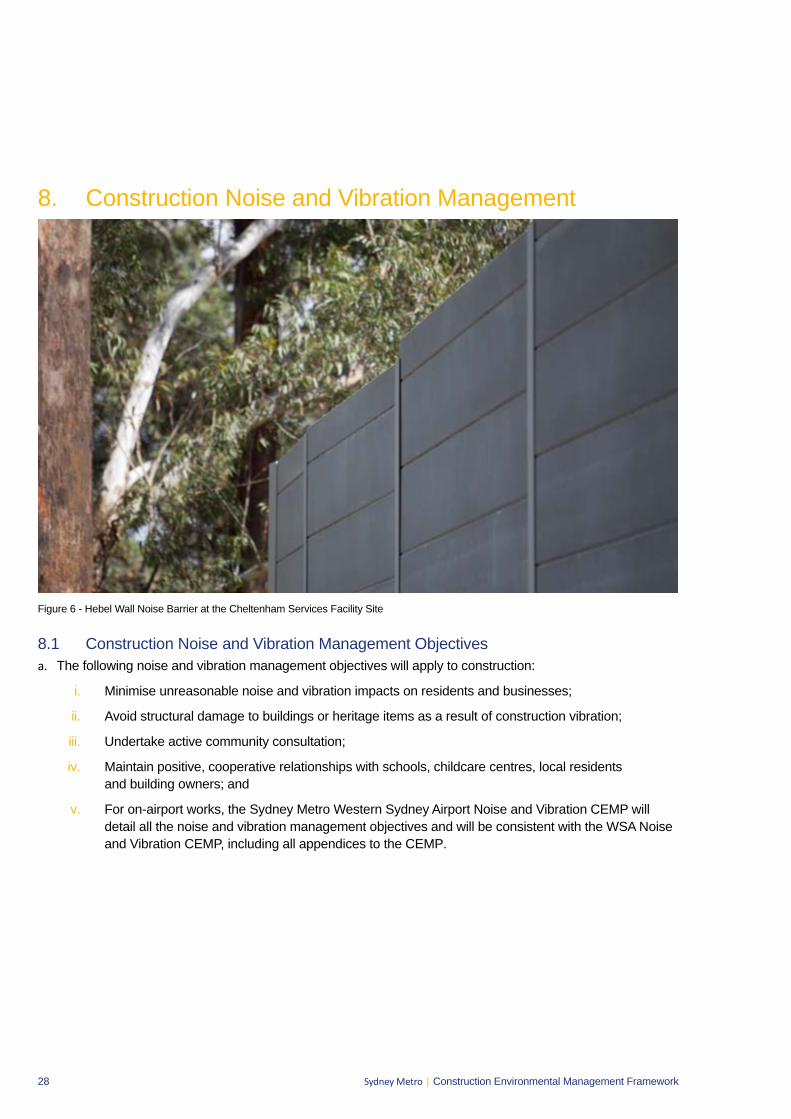
28 Sydney Metro | Construction Environmental Management Framework
8. Construction Noise and Vibration Management
Figure 6 - Hebel Wall Noise Barrier at the Cheltenham Services Facility Site
8.1 Construction Noise and Vibration Management Objectives a. The following noise and vibration management objectives will apply to construction:
i. Minimise unreasonable noise and vibration impacts on residents and businesses;
ii. Avoid structural damage to buildings or heritage items as a result of construction vibration;
iii. Undertake active community consultation;
iv. Maintain positive, cooperative relationships with schools, childcare centres, local residents and building owners; and
v. For on-airport works, the Sydney Metro Western Sydney Airport Noise and Vibration CEMP will detail all the noise and vibration management objectives and will be consistent with the WSA Noise and Vibration CEMP, including all appendices to the CEMP.
29 Sydney Metro | Construction Environmental Management Framework
8.2 Construction Noise and Vibration Management Implementation a. On-airport management of noise and vibration will be achieved through the implementation of the SMWSA
Noise and Vibration CEMP and Principal Contractors will develop and implement a Construction Noise andVibration Management Plan for all off-airport works consistent with the Interim Construction NoiseGuidelines (Department of Environment and Climate Change, 2009). Both plans will include as a minimum:
i. Identification of work areas, site compounds and access points;
ii. Identification of sensitive receivers and relevant construction noise and vibration goals;
iii. Be consistent with, and include the requirements of the noise and vibration mitigation measures asdetailed in the planning approval documentation and the Sydney Metro Construction Noise andVibration Standard (CNVS), including the provision of respite;
iv. Details of construction activities and an indicative schedule for construction works, including theidentification of key noise and/or vibration generating construction activities (based onrepresentative construction scenarios) that have the potential to generate noise or vibration impactson surrounding sensitive receivers, in particular residential areas;
v. Identification of feasible and reasonable procedures and mitigation measures to ensure relevantvibrations and blasting criteria are achieved, including a suitable blast program;
vi. The requirements of any applicable licence or approval (for example EPL);
vii. Additional requirements in relation to activities undertaken 24 hours of the day, 7 days per week;
viii. Pre-construction compliance requirements and hold points;
ix. The responsibilities of key project personnel with respect to the implementation of the plan;
x. Noise monitoring requirements;
xi. Compliance record generation and management; and
xii. An Out of Hours Works Protocol applicable to all construction methods and sites.
b. Detailed Construction Noise and Vibration Impact Statements will be prepared for noise-intensiveconstruction sites and or activities to ensure the adequacy of the noise and vibration mitigation measures.Specifically, Construction Noise and Vibration Impact Statements will be prepared for works proposed to beundertaken outside of standard construction hours and to support applications to undertake out of hoursworks (this includes variations of EPLs and applications to relevant agencies).
c. Noise and vibration monitoring would be undertaken for construction as specified in the CNVS.
d. The following compliance records would be kept by Principal Contractors:
i. Records of noise and vibration monitoring results against appropriate NMLs and vibration criteria;and
ii. Records of community enquiries and complaints, and the Contractor’s response.
30 Sydney Metro | Construction Environmental Management Framework
8.3 Construction Noise and Vibration Mitigation a. All feasible and reasonable mitigation measures would be implemented in accordance with the CNVS. The
on-airport Noise and Vibration CEMP and the off-airport Noise and Vibration Management Plan will include the following noise and vibration mitigation measures as well as relevant Conditions:
i. Construction hours will be in accordance with the working hours specified in Section 5.1;
ii. Hoarding and enclosures will be implemented where required to minimise airborne noise impacts; and
iii. The layout of construction sites will aim to minimise airborne noise impacts to surrounding receivers
iv. Provision of respite periods.
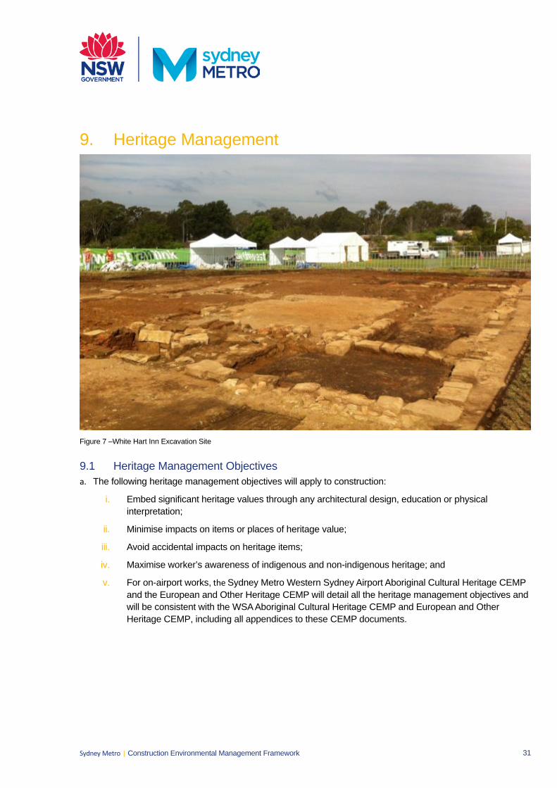
31 Sydney Metro | Construction Environmental Management Framework
9. Heritage Management
Figure 7 –White Hart Inn Excavation Site
9.1 Heritage Management Objectives a. The following heritage management objectives will apply to construction:
i. Embed significant heritage values through any architectural design, education or physicalinterpretation;
ii. Minimise impacts on items or places of heritage value;
iii. Avoid accidental impacts on heritage items;
iv. Maximise worker’s awareness of indigenous and non-indigenous heritage; and
v. For on-airport works, the Sydney Metro Western Sydney Airport Aboriginal Cultural Heritage CEMPand the European and Other Heritage CEMP will detail all the heritage management objectives andwill be consistent with the WSA Aboriginal Cultural Heritage CEMP and European and OtherHeritage CEMP, including all appendices to these CEMP documents.
32 Sydney Metro | Construction Environmental Management Framework
9.2 Heritage Management Implementation a. On-airport management of Aboriginal cultural heritage and European heritage will be achieved through the
implementation of the SMWSA Aboriginal Cultural Heritage and the European and Other Heritage CEMPs .Principal Contractors will develop and implement a Heritage Management Plan for all off-airport works. Plans will include as a minimum:
i. Evidence of consultation with Registered Aboriginal Parties and the NSW Heritage Council;
ii. Identify initiatives that will be implemented for the enhancement of heritage values and minimisation of heritage impacts, including procedures and processes that will be used to implement and document heritage management initiatives;
iii. The heritage mitigation measures as detailed in the planning approval documentation;
iv. The responsibilities of key project personnel with respect to the implementation of the plan;
v. Procedures for interpretation of heritage values uncovered through salvage or excavation during detailed design;
vi. Procedures for undertaking salvage or excavation of heritage relics or sites (where relevant), consistent with and any recordings of heritage relics prior to works commencing that would affect them;
vii. Details for the short and / or long term management of artefacts or movable heritage;
viii. Details of management measures to be implemented to prevent and minimise impacts on heritage items (including further heritage investigations, archival recordings and/or measures to protect unaffected sites during construction works in the vicinity);
ix. Procedures for unexpected heritage finds, including procedures for dealing with human remains;
x. Heritage monitoring requirements; and
xi. Compliance record generation and management.
b. The Contractor’s regular inspections will include checking of Aboriginal and non-Aboriginal heritage mitigation measures.
c. Compliance records will be retained by the Contractor. These will include:
i. Inspections undertaken in relation to heritage management measures;
ii. Archival recordings undertaken of any heritage item;
iii. Unexpected finds and stop work orders; and
iv. Records of any impacts avoided or minimised through design or construction methods.
9.3 Heritage Mitigation a. The on-airport Aboriginal Cultural Heritage and European and Other Heritage CEMPs and the off-airport
Heritage Management Plan will include the following mitigation measures as well as relevant Conditions:
i. Induction courses for site workers will include training in the identification of Aboriginal artefacts and management of Aboriginal heritage values.
ii. Any heritage item not affected by the works will be retained and protected throughout construction;
iii. During construction undertake professional archaeological investigation, excavation, and reporting of any historical Indigenous heritage sites of state significance which will be affected. Reporting may be completed as construction progresses;
33 Sydney Metro | Construction Environmental Management Framework
iv. Undertake archival recordings of all non-Indigenous heritage items affected by the works prior tocommencement of works; and
v. Implement unexpected heritage find procedures for Indigenous and non-Indigenous heritage items.
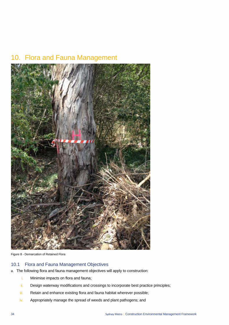
34 Sydney Metro | Construction Environmental Management Framework
10. Flora and Fauna Management
Figure 8 - Demarcation of Retained Flora
10.1 Flora and Fauna Management Objectives a. The following flora and fauna management objectives will apply to construction:
i. Minimise impacts on flora and fauna;
ii. Design waterway modifications and crossings to incorporate best practice principles;
iii. Retain and enhance existing flora and fauna habitat wherever possible;
iv. Appropriately manage the spread of weeds and plant pathogens; and
35 Sydney Metro | Construction Environmental Management Framework
v. For on-airport works, the Sydney Metro Western Sydney Airport Biodiversity CEMP will detail allfauna and flora management objectives and will be consistent with the WSA Biodiversity CEMP,including all appendices to the Biodiversity CEMP.
10.2 Flora and Fauna Management Implementation a. On-airport management of flora and fauna will be achieved through the implementation of the SMWSA
Biodiversity CEMP and Principal Contractors will develop and implement a Flora and Fauna ManagementPlan for all off-airport works. Both plans will include as a minimum:
i. The biodiversity mitigation measures as detailed in the planning approval documentation;
ii. The responsibilities of key project personnel with respect to the implementation of the plan;
iii. Procedures for the clearing of vegetation and the relocation of flora and fauna;
iv. Details on the locations, monitoring program and use of nest boxes by fauna;
v. Procedures for the demarcation and protection of retained vegetation, including all vegetationoutside and adjacent to the construction footprint, and the protection of retained vegetation withinthe environmental conservation zone on the airport site;
vi. Plans for impacted and adjoining areas showing vegetation communities; important flora and faunahabitat areas; locations where threatened species, populations or ecological communities havebeen recorded;
vii. Vegetation management plan(s) for sites where native vegetation is proposed to be retained;
viii. Identification of measures to reduce disturbance to sensitive fauna;
ix. Rehabilitation details, including identification of flora species and sources, and measures for themanagement and maintenance of rehabilitated areas (including duration of the implementation ofsuch measures);
x. Weed and disease management measures focusing on early identification of invasive weeds anddiseases. Protocols to address the effective management of these risks;
xi. A procedure for dealing with unexpected threatened species identified during construction, includingcessation of work and notification to the relevant government department for both on- and off-airportworks. The procedure shall define how appropriate mitigation measures (including relevantrelocation measures) and updating of ecological monitoring or off-set requirements;
xii. Details on the methodology for vegetation mapping and survey;
xiii. Ecological monitoring requirements; and
xiv. Compliance record generation and management.
b. Principal Contractors would undertake the following ecological monitoring as a minimum:
i. A pre-clearing inspection will be undertaken prior to any native vegetation clearing by a suitablequalified ecologist and the Contractor’s Environmental Manager (or delegate). The pre-clearinginspection will include, as a minimum:
Identification of hollow bearing trees or other habitat features;
Identification of any threatened flora and fauna;
A check on the physical demarcation of the limit of clearing;
An approved erosion and sediment control plan for the worksite; and
36 Sydney Metro | Construction Environmental Management Framework
The completion of any other pre-clearing requirements required by any project approvals, permits or licences.
ii. The completion of the pre-clearing inspection will form a HOLD POINT requiring sign-off from the Contractor’s Environmental Manager (or delegate) and a qualified ecologist; and
iii. A post clearance report, including any relevant Geographical Information System files, will be produced that validates the type and area of vegetation cleared including confirmation of the number of hollows impacted and the corresponding nest box requirements to offset these impacts.
c. The Principal Contractor’s regular inspections will include a check on the ecological mitigation measures and project boundary fencing.
d. The following compliance records would be kept by the Principal Contractor:
i. Records of pre-clearing inspections undertaken;
ii. Records of the release of the pre-clearing hold point; and
iii. Records of ecological inspections undertaken.
10.3 Flora and Fauna Mitigation a. The on-airport Biodiversity CEMP and the off-airport Flora and Fauna Management Plan will include the
following flora and fauna mitigation measures as well as any relevant Conditions:
i. Areas to be retained and adjacent habitat areas will be fenced off prior to works to prevent damage or accidental over clearing;
ii. Clearing will follow a two-stage process as follows:
Non-habitat trees will be cleared first after sign-off of the pre-clearing inspection; and
Habitat trees will be cleared no sooner than 48 hours after non-habitat trees have been cleared. A suitably qualified ecologist will be present on site during the clearing of habitat trees. Felled habitat trees will be left on the ground for 24 hours or inspected by the ecologist prior to further processing.
iii. Weed management is to be undertaken in areas affected by construction prior to any clearing works. Off-airport weed management will be undertaken in accordance with the NSW Noxious Weeds Act 1993. On-airport weed management will also be undertaken in accordance with the NSW Noxious Weeds Act 1993 and the NSW Biosecurity Act 2015, which is consistent with the approach adopted in the Western Sydney Airport Weed and Disease Management Plan (Appendix C of the Western Sydney Airport Biodiversity CEMP).
37 Sydney Metro | Construction Environmental Management Framework
11. Visual Amenity Management11.1 Visual Amenity Management Objectives a. The following visual and landscape management objectives will apply to the construction of the project:
i. Minimise impacts on existing landscape features as far as feasible and reasonable;
ii. Ensure the successful implementation of the Landscape Design;
iii. Reduce visual impact of construction to surrounding community; and
iv. For on-airport works, the Sydney Metro Western Sydney Airport Visual and Landscape CEMP willdetail all the visual amenity and landscaping management objectives and will be consistent with theWSA Visual and Landscape CEMP, including all the appendices to the CEMP.
11.2 Visual Amenity Management Implementation a. On-airport management of visual and landscaping will be achieved through the implementation of the
SMWSA Visual and Landscape CEMP and Principal Contractors will develop and implement a VisualAmenity Management Plan for all the off-airport temporary works which will include as a minimum:
i. The visual mitigation measures as detailed in the planning approval documentation for construction;
ii. Input from an experienced Landscape or Urban Designer;
iii. The maintenance of outward facing elements of site hoarding or noise barriers, includingthe removal of graffiti and weeds;
iv. Apply the principles of Australian Standard 4282-1997 Control of the obtrusive effects of outdoorlighting and relevant safety design requirements and detail mitigation measures to minimise lightingimpacts on sensitive receivers for all permanent, temporary and mobile light sources;
v. Identify the processes and procedures that will be used for the incorporation of the principles ofCrime Prevention Through Environmental Design (CPTED) in the design and construction of anytemporary site facilities; and
vi. Compliance record generation and management.
b. Visual and landscape measures will be incorporated into the Principal Contractor’s regular inspectionsincluding checking the health of retained vegetation around site boundaries, checking the condition of anysite hoarding and acoustic sheds, and checking the position and direction of any sight lighting.
c. The Contractor will retain compliance records of any inspections undertaken in relation to visual andlandscape measures.
11.3 Visual Amenity Mitigation a. The on-airport Visual and Landscape CEMP and the off-airport Visual Management Plan will include the
following visual amenity mitigation measures as well as relevant Conditions:
i. Wherever feasible and reasonable, vegetation around the perimeter of the construction sites will bemaintained;
ii. Existing vegetation not affected by the construction works will be retained;
iii. Temporary construction works will be designed with consideration of urban design andvisual amenity as per Section 4.4; and
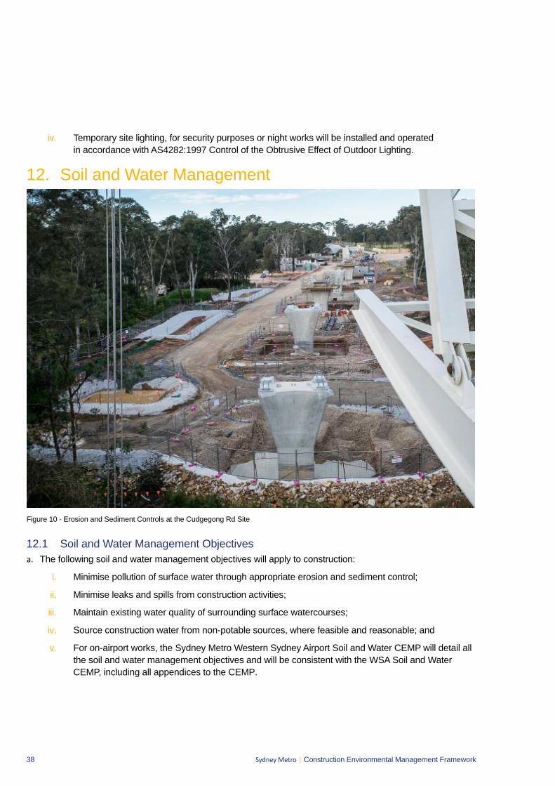
38 Sydney Metro | Construction Environmental Management Framework
iv. Temporary site lighting, for security purposes or night works will be installed and operated in accordance with AS4282:1997 Control of the Obtrusive Effect of Outdoor Lighting.
12. Soil and Water Management
Figure 10 - Erosion and Sediment Controls at the Cudgegong Rd Site
12.1 Soil and Water Management Objectives a. The following soil and water management objectives will apply to construction:
i. Minimise pollution of surface water through appropriate erosion and sediment control;
ii. Minimise leaks and spills from construction activities;
iii. Maintain existing water quality of surrounding surface watercourses;
iv. Source construction water from non-potable sources, where feasible and reasonable; and
v. For on-airport works, the Sydney Metro Western Sydney Airport Soil and Water CEMP will detail all the soil and water management objectives and will be consistent with the WSA Soil and Water CEMP, including all appendices to the CEMP.
39 Sydney Metro | Construction Environmental Management Framework
12.2 Soil and Water Implementation a. On-airport management of soil and water will be achieved through the implementation of the SMWSA Soil
and Water CEMP and Principal Contractors will develop and implement a Soil and Water ManagementPlan for all off-airport works. Both plans will include as a minimum:
i. The soil and water mitigation measures as detailed in the planning approval documentation andsustainability requirements;
ii. Details of construction activities and their locations, which have the potential to impact on watercourses, storage facilities, stormwater flows, and groundwater;
iii. Surface water and ground water impact assessment criteria consistent with the principles of theAustralian and New Zealand Environment Conservation Council (ANZECC) guidelines for off-airportworks and the Airports (Environment Protection) Regulations 1997 for on-airport works (with dueconsideration of the ANZECC guidelines);
iv. Management measures to be used to minimise surface and groundwater impacts, includingidentification of water treatment measures and discharge points, details of how spoil and fill materialrequired by the project will be sourced, handled, stockpiled, reused and managed; erosion andsediment control measures; salinity control measures and the consideration of flood events;
v. A contingency plan, consistent with the NSW Acid Sulphate Soils Manual (EPA 1998), to deal withthe unexpected discovery of actual or potential acid sulphate soils both on and off-airport lands. Theplan must including procedures for the investigation, handling, treatment and management of suchsoils and water seepage;
vi. Management measures for contaminated material (soils, water and building materials)and a contingency plan to be implemented in the case of unanticipated discovery of contaminatedmaterial, including asbestos, during construction;
vii. A description of how the effectiveness of these actions and measures would be monitored duringthe proposed works, clearly indicating how often this monitoring would be undertaken, the locationswhere monitoring would take place, how the results of the monitoring would be recorded andreported, and, if any exceedance of the criteria is detected how any non-compliance can berectified;
viii. The requirements of any applicable licence conditions;
ix. The responsibilities of key project personnel with respect to the implementation of the plan;
x. Procedures for the development and implementation of Progressive Erosion and Sediment ControlPlans;
xi. Identification of locations where site specific Stormwater and Flooding Management Plansare required; and
xii. Compliance record generation and management.
b. Principal Contractors will develop and implement Progressive Erosion and Sediment Control Plans (ESCPs)for all active worksites in accordance with Managing Urban Stormwater: Soils & Construction Volume 1(Landcom, 2004) (known as the “Blue Book”). The ESCPs will be approved by the Contractor’sEnvironmental Manager (or delegate) prior to any works commencing (including vegetation clearing) on aparticular site. Copies of the approved ESCP will be held by the relevant Contractor personnel including theEngineer and the Site Foreman.
40 Sydney Metro | Construction Environmental Management Framework
c. ESCPs will detail all required erosion and sediment control measures for the particular site at the particular point in time and be progressively updated to reflect the current site conditions. Any amendments to the ESCP will be approved by the Contractor’s Environmental Manager (or delegate).
d. Principal Contractors will develop and implement Stormwater and Flooding Management Plans for the relevant construction sites. These plans will identify the appropriate design standard for flood mitigation based on the duration of construction, proposed activities and flood risks. The plan will develop procedures to ensure that threats to human safety and damage to infrastructure are not exacerbated during the construction period.
e. Principal Contractors will undertake the following soil and water monitoring as a minimum:
i. Weekly inspections of the erosion and sediment control measures. Issues identified would be rectified as soon as practicable;
ii. Additional inspections will be undertaken following significant rainfall events (greater than 20 mm in 24 hours); and
iii. All water will be tested (and treated if required) prior to discharge from the site in order to determine compliance with the appropriate approvals and licencing. No water will be discharged from the site without written approval of the Contractor’s Environmental Manager (or delegate). This is to form a HOLD POINT.
f. The following compliance records will be kept by the Principal Contractors:
i. Copies of current ESCPs for all active construction sites;
ii. Records of soil and water inspections undertaken;
iii. Records of testing of any water prior to discharge; and
iv. Records of the release of the hold point to discharge water from the construction site to the receiving environment.
g. The following water resources management objectives will apply to the construction of the project:
i. Minimise demand for, and use of potable water;
ii. Maximise opportunities for water re-use from captured stormwater, wastewater and groundwater;
iii. Examples of measures to minimise potable water consumption include:
Water efficient controls, fixtures and fittings in temporary facilities;
Collecting, treating and reusing water generated in tunnelling operations, concrete batching and casting facility processes;
Using recycled water or treated water from onsite sources in the formulation of concrete;
Harvesting and reusing rainwater from roofs of temporary facilities;
Using water from recycled water networks;
Collecting, treating and reusing groundwater and stormwater;
Using water efficient construction methods and equipment; and
Providing designated sealed areas for equipment wash down.
41 Sydney Metro | Construction Environmental Management Framework
12.3 Soil and Water Mitigation a. The on-airport Soil and Water CEMP and the off-airport Soil and Water Management Plan will include the
following surface water and flooding mitigation measures as well as any relevant Conditions:
i. Clean water will be diverted around disturbed site areas, stockpiles and contaminated areas;
ii. Control measures will be installed downstream of works, stockpiles and other disturbed areas;
iii. Exposed surfaces will be minimised, and stabilised / revegetated as soon feasible and reasonableupon completion of construction;
iv. Dangerous good and hazardous materials storage will be within bunded areas with a capacity of110 per cent of the maximum single stored volume;
v. Chemicals will be stored and handled in accordance with relevant Australian standards such as:
o AS 1940-2004 The storage and handling of flammable and combustible liquids
o AS/NZS 4452:1997 The storage and handling of toxic substances
o AS/NZS 5026:2012 The storage and handling of Class 4 dangerous goods
o AS/NZS 1547:2012 On-site domestic wastewater management
vi. Spill kits will be provided at the batch plants, storage areas and main work sites;
vii. A protocol will be developed and implemented to respond to and remedy leaks or spills.
viii. A remedial action plan and unexpected finds protocol would be established to facilitate thequarantining, isolation and remediation of contamination identified throughout the constructionprogramme. Any asbestos identified on site would be managed in accordance with applicableregulatory requirements.

42 Sydney Metro | Construction Environmental Management Framework
13. Air Quality
Figure 11 - Dust Mitigation at Norwest Station Site
13.1 Air Quality Management Objectives a. The following air quality management objectives will apply to construction:
i. Minimise gaseous and particulate pollutant emissions from construction activities as far as feasible and reasonable;
ii. Identify and control potential dust and air pollutant sources; and
iii. For on-airport works, the Sydney Metro Western Sydney Airport Air Quality CEMP will detail all the air quality management objectives and will be consistent with the WSA Air Quality CEMP including all appendices to the CEMP.
13.2 Air Quality Management Implementation a. On-airport management of soil and water will be achieved through the implementation of the SMWSA Soil
and Water CEMP and Principal Contractors will develop and implement an Air Quality Management Plan for all off-airport works. Both plans will include, as a minimum:
i. The air quality mitigation measures as detailed in the planning approval documentation;
ii. The requirements of any approval and applicable licence conditions;
iii. Site plans or maps indicating locations of sensitive receivers and key air quality / dust controls;
iv. The responsibilities of key project personnel with respect to the implementation of the plan;
v. Air quality and dust monitoring requirements; and
43 Sydney Metro | Construction Environmental Management Framework
vi. Compliance record generation and management.
b. Air quality and dust monitoring will involve the following as a minimum:
i. Meteorological conditions will be monitored and appropriate responses will be organisedand undertaken periodically by the Principal Contractor;
ii. Regular visual monitoring of dust generation from work zones; and
iii. Monitoring emissions from plant and construction vehicles to ensure they have appropriateemission controls and are being maintained correctly.
c. The following compliance records will be kept by the Principal Contractor:
i. Records of any meteorological condition monitoring;
ii. Records of any management measures implemented as a result of adverse, windyweather conditions; and
iii. Records of air quality and dust inspections undertaken.
13.3 Air Quality Mitigation a. The on-airport Air Quality CEMP and the off-airport Air Quality Management Plan will include the following
air quality mitigation measures as well as any relevant Conditions:
i. Plant and equipment will be serviced and maintained in good working order to reduce unnecessaryemissions from exhaust fumes;
ii. Plant and equipment to be switched off engines when not in use;
iii. The avoidance the use of diesel or petrol powered generators and instead using mains electricity orbattery powered equipment, where practicable;
iv. Appropriate vehicle speeds on sealed and unsealed roads;
v. Development and implementation of a construction logistics plan to manage the sustainabledelivery of goods and materials;
vi. Implementing measures to support and encourage sustainable travel for construction workers toand from the construction sites;
vii. Water suppression will be used for active earthwork areas, stockpiles, unsurfaced haul roads andloads of soil being transported to reduce wind-blown dust emissions;
viii. Wheel-wash facilities or rumble grids will be provided and used near the site exit points,as appropriate; and
ix. Dust extraction and filtration systems will be installed for tunnel excavation works anddeep excavation with limited surface exposure.
44 Sydney Metro | Construction Environmental Management Framework
14. Waste Management 14.1 Waste Objectives a. The following waste objectives will apply to construction:
i. Minimise waste throughout the project life-cycle;
ii. Waste management strategies for off-airport works will be implemented in accordance with the Waste Avoidance and Resource Recovery Act 2001 management hierarchy as follows:
Avoidance of unnecessary resource consumption;
Resource recovery (including reuse, reprocessing, recycling and energy recovery); and
Disposal.
iii. Consistent with the Western Sydney Airport Waste and Resource Construction Environmental Management Plan, waste management strategies for on-airport works will also be aligned with the NSW Waste Avoidance and Resource Recovery Strategy under the NSW Waste Avoidance and Resource Recovery Act 2001; and
iv. For on-airport works, the Sydney Metro Western Sydney Airport Waste and Resources CEMP will detail all the waste management objectives and will be consistent with the WSA Waste and Resources CEMP including all appendices to the CEMP.
b. Targets for the recovery, recycling or reuse of construction waste, and beneficial reuse of spoil will be provided by the Principal Contractor.
14.2 Waste Implementation a. On-airport management of waste and resources will be achieved through the implementation of the SMWSA
Waste and Resources CEMP and Principal Contractors will develop and implement a Waste Management Plan for all off-airport works. Both plans will include as a minimum:
i. The waste management mitigation measures as detailed in the planning approval documentation;
ii. The responsibilities of key project personnel with respect to the implementation of the plan;
iii. Waste management monitoring requirements;
iv. A procedure for the assessment, classification, management and disposal of waste in accordance with Waste Classification Guidelines; and
v. Compliance record generation and management.
b. Principal Contractors will undertake the following waste monitoring as a minimum:
i. Weekly inspections will include checking on the waste storage facilities on site; and
ii. All waste removed from the site will be appropriately tracked from ‘cradle to grave’ using waste tracking dockets.
c. Principal Contractors will report all necessary waste and purchasing information to Sydney Metro as required for Sydney Metro to fulfil their WRAPP reporting requirements.
d. Compliance records will be retained by the Principal Contractors in relation to waste management including records of inspections and waste dockets for all waste removed from the site.
45 Sydney Metro | Construction Environmental Management Framework
14.3 Waste Mitigation a. The on-airport Waste and Resources CEMP and the off-airport Waste Management Plan will include the
following waste management mitigation measures as well as relevant Conditions:
i. A central waste area (or areas) would be established, at which waste (including recyclables) wouldbe stored or stockpiled. Stockpiles and bins would be appropriately labelled, managed andmonitored till being removed from site;
ii. All waste materials removed from the sites will be directed to an appropriately licensed wastemanagement facility;
iii. The use of raw materials (noise hoarding, site fencing, etc...) will be reused or shared, betweensites and between construction contractors where feasible and reasonable; and
iv. Recyclable wastes, including paper at site offices, will be stored separately from other wastes.
15. AcronymsAcronym
CEMP Construction Environmental Management Plan
CNVS Construction Noise and Vibration Standard
CPTED Crime Prevention through Environmental Design
DPIE Department of Planning, Industry and Environment
EIS Environmental Impact Statement
EMF Environmental Management Framework
EMS Environmental Management System
EPA Environment Protection Authority
EP&A Act Environmental Planning and Assessment Act 1979
EPL Environment Protection Licence (issued by EPA under the NSW POEO Act)
ER Environmental Representative
ESCP Erosion and Sediment Control Plan
NOHSC National Occupational Health and Safety Commission
POEO Act Protection of the Environment Operation Act 1997
TBM Tunnel Boring Machine
TfNSW Transport for NSW
46 Sydney Metro | Construction Environmental Management Framework
Appendix A – Environment and Sustainability Statement of Commitment

Project: Sydney Metro Date: 28 October 2020
Group: Project Communication Status: FINAL
Author: Michelle Delaat Revision: 2.1
Company: Sydney Metro File number:
File name: Overarching Community Communication Strategy (OCCS)
Unclassified
Overarching Community Communications Strategy (OCCS) A framework for communication and engagement during construction
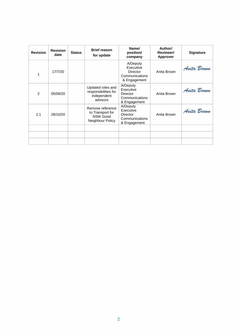
2
Revision Revision date Status
Brief reason for update
Name/ position/ company
Author/ Reviewer/ Approver
Signature
1
17/7/20
A/Deputy Executive Director
Communications & Engagement
Anita Brown Anita Brown
2 05/08/20
Updated roles and responsibilities for
independent advisors
A/Deputy Executive Director Communications & Engagement
Anita Brown Anita Brown
2.1 28/10/20
Remove reference to Transport for
NSW Good Neighbour Policy
A/Deputy Executive Director Communications & Engagement
Anita Brown Anita Brown
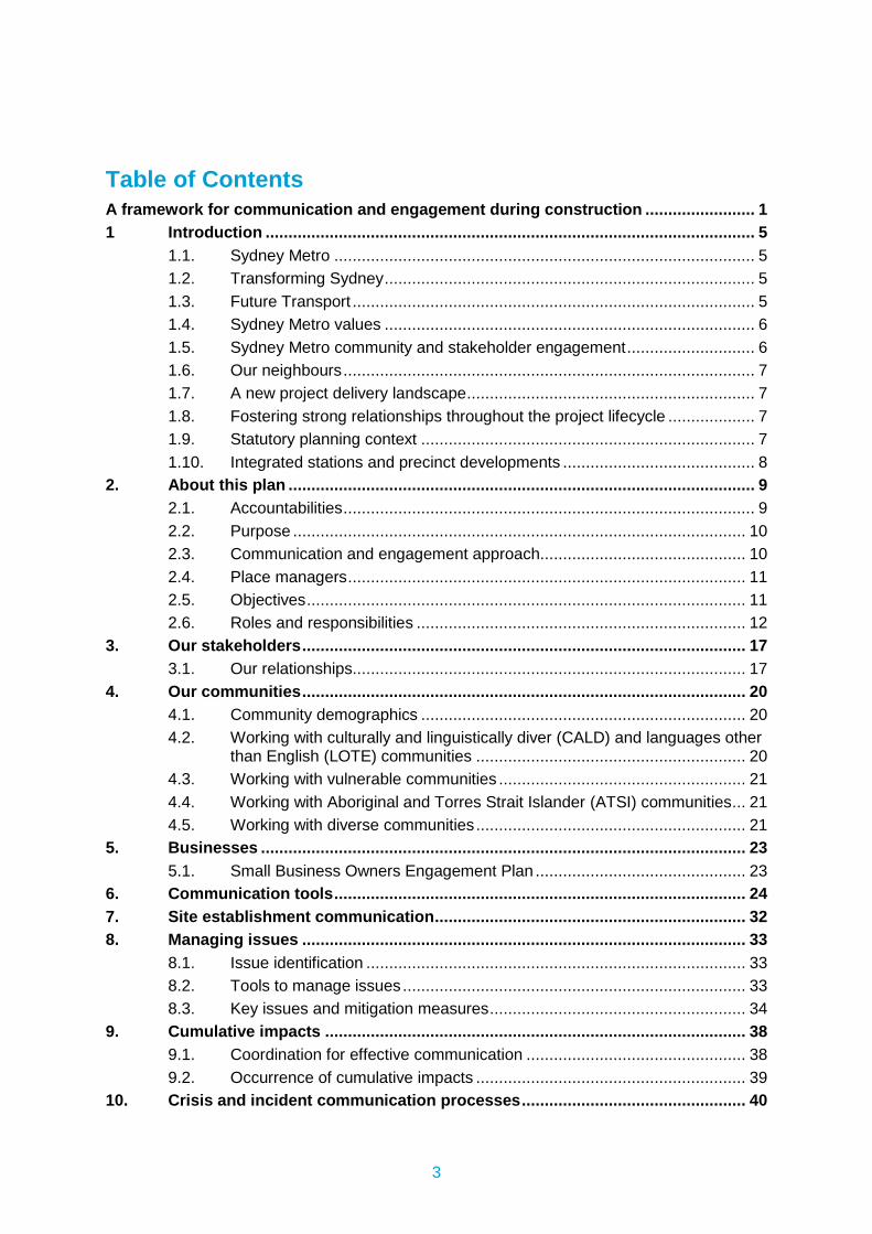
3
Table of Contents A framework for communication and engagement during construction ........................ 1
1 Introduction ........................................................................................................... 5
1.1. Sydney Metro ............................................................................................ 5
1.2. Transforming Sydney ................................................................................. 5
1.3. Future Transport ........................................................................................ 5
1.4. Sydney Metro values ................................................................................. 6
1.5. Sydney Metro community and stakeholder engagement ............................ 6
1.6. Our neighbours .......................................................................................... 7
1.7. A new project delivery landscape ............................................................... 7
1.8. Fostering strong relationships throughout the project lifecycle ................... 7
1.9. Statutory planning context ......................................................................... 7
1.10. Integrated stations and precinct developments .......................................... 8
2. About this plan ...................................................................................................... 9
2.1. Accountabilities .......................................................................................... 9
2.2. Purpose ................................................................................................... 10
2.3. Communication and engagement approach............................................. 10
2.4. Place managers ....................................................................................... 11
2.5. Objectives ................................................................................................ 11
2.6. Roles and responsibilities ........................................................................ 12
3. Our stakeholders ................................................................................................. 17
3.1. Our relationships...................................................................................... 17
4. Our communities ................................................................................................. 20
4.1. Community demographics ....................................................................... 20
4.2. Working with culturally and linguistically diver (CALD) and languages other than English (LOTE) communities ........................................................... 20
4.3. Working with vulnerable communities ...................................................... 21
4.4. Working with Aboriginal and Torres Strait Islander (ATSI) communities ... 21
4.5. Working with diverse communities ........................................................... 21
5. Businesses .......................................................................................................... 23
5.1. Small Business Owners Engagement Plan .............................................. 23
6. Communication tools .......................................................................................... 24
7. Site establishment communication .................................................................... 32
8. Managing issues ................................................................................................. 33
8.1. Issue identification ................................................................................... 33
8.2. Tools to manage issues ........................................................................... 33
8.3. Key issues and mitigation measures ........................................................ 34
9. Cumulative impacts ............................................................................................ 38
9.1. Coordination for effective communication ................................................ 38
9.2. Occurrence of cumulative impacts ........................................................... 39
10. Crisis and incident communication processes ................................................. 40
4
11. Monitoring, evaluation and reporting ................................................................ 41
11.1 Audit and review – site specific CCS’ ....................................................... 41
11.1. Audit and review - businesses ................................................................. 42
12 Low impact or preparatory activities process ................................................... 45
12.1 Purpose ................................................................................................... 45
12.2 Relationship to plans ..................................................................................... 45
12.3 Low impact and preparatory activities ...................................................... 45
12.4 Monitoring and reporting .......................................................................... 46
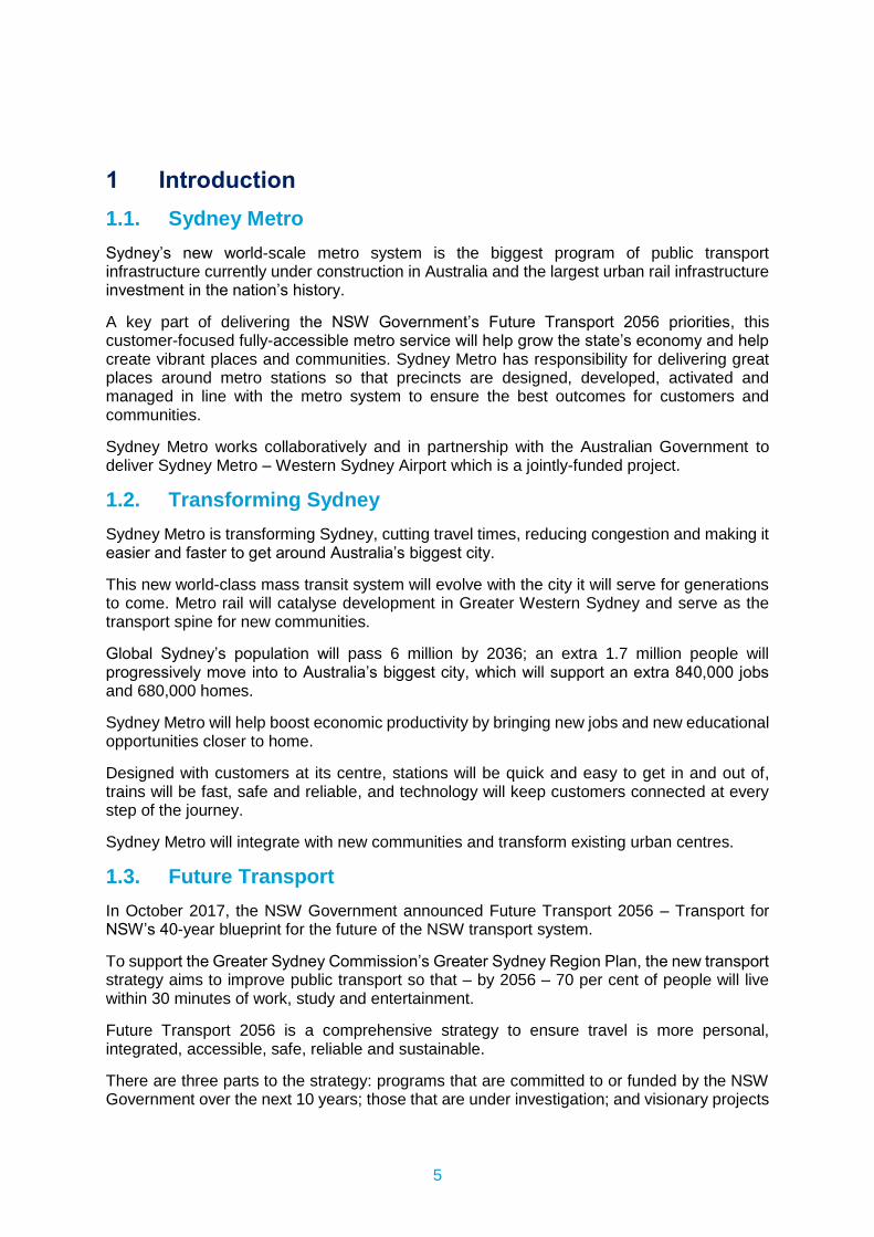
5
1 Introduction 1.1. Sydney Metro Sydney’s new world-scale metro system is the biggest program of public transport infrastructure currently under construction in Australia and the largest urban rail infrastructure investment in the nation’s history.
A key part of delivering the NSW Government’s Future Transport 2056 priorities, this customer-focused fully-accessible metro service will help grow the state’s economy and help create vibrant places and communities. Sydney Metro has responsibility for delivering great places around metro stations so that precincts are designed, developed, activated and managed in line with the metro system to ensure the best outcomes for customers and communities.
Sydney Metro works collaboratively and in partnership with the Australian Government to deliver Sydney Metro – Western Sydney Airport which is a jointly-funded project.
1.2. Transforming Sydney Sydney Metro is transforming Sydney, cutting travel times, reducing congestion and making it easier and faster to get around Australia’s biggest city.
This new world-class mass transit system will evolve with the city it will serve for generations to come. Metro rail will catalyse development in Greater Western Sydney and serve as the transport spine for new communities.
Global Sydney’s population will pass 6 million by 2036; an extra 1.7 million people will progressively move into to Australia’s biggest city, which will support an extra 840,000 jobs and 680,000 homes.
Sydney Metro will help boost economic productivity by bringing new jobs and new educational opportunities closer to home.
Designed with customers at its centre, stations will be quick and easy to get in and out of, trains will be fast, safe and reliable, and technology will keep customers connected at every step of the journey.
Sydney Metro will integrate with new communities and transform existing urban centres.
1.3. Future Transport In October 2017, the NSW Government announced Future Transport 2056 – Transport for NSW’s 40-year blueprint for the future of the NSW transport system.
To support the Greater Sydney Commission’s Greater Sydney Region Plan, the new transport strategy aims to improve public transport so that – by 2056 – 70 per cent of people will live within 30 minutes of work, study and entertainment.
Future Transport 2056 is a comprehensive strategy to ensure travel is more personal, integrated, accessible, safe, reliable and sustainable.
There are three parts to the strategy: programs that are committed to or funded by the NSW Government over the next 10 years; those that are under investigation; and visionary projects
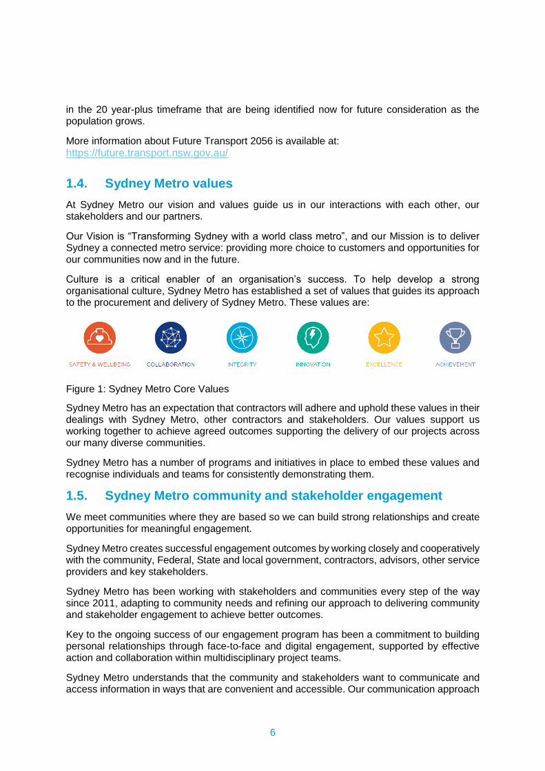
6
in the 20 year-plus timeframe that are being identified now for future consideration as the population grows.
More information about Future Transport 2056 is available at: https://future.transport.nsw.gov.au/
1.4. Sydney Metro values At Sydney Metro our vision and values guide us in our interactions with each other, our stakeholders and our partners.
Our Vision is “Transforming Sydney with a world class metro”, and our Mission is to deliver Sydney a connected metro service: providing more choice to customers and opportunities for our communities now and in the future.
Culture is a critical enabler of an organisation’s success. To help develop a strong organisational culture, Sydney Metro has established a set of values that guides its approach to the procurement and delivery of Sydney Metro. These values are:
Figure 1: Sydney Metro Core Values
Sydney Metro has an expectation that contractors will adhere and uphold these values in their dealings with Sydney Metro, other contractors and stakeholders. Our values support us working together to achieve agreed outcomes supporting the delivery of our projects across our many diverse communities.
Sydney Metro has a number of programs and initiatives in place to embed these values and recognise individuals and teams for consistently demonstrating them.
1.5. Sydney Metro community and stakeholder engagement We meet communities where they are based so we can build strong relationships and create opportunities for meaningful engagement.
Sydney Metro creates successful engagement outcomes by working closely and cooperatively with the community, Federal, State and local government, contractors, advisors, other service providers and key stakeholders.
Sydney Metro has been working with stakeholders and communities every step of the way since 2011, adapting to community needs and refining our approach to delivering community and stakeholder engagement to achieve better outcomes.
Key to the ongoing success of our engagement program has been a commitment to building personal relationships through face-to-face and digital engagement, supported by effective action and collaboration within multidisciplinary project teams.
Sydney Metro understands that the community and stakeholders want to communicate and access information in ways that are convenient and accessible. Our communication approach
7
continues to evolve to ensure our diverse communities have access to a variety of platforms that ensure a personalised approach to community engagement. Sydney Metro will continue to monitor the communication landscape to provide best practice solutions to engagement.
1.6. Our neighbours New metro stations are a catalyst for development, regeneration and renewal of neighbourhoods, bringing to life placemaking opportunities. It can be exciting to watch the metro station and local precinct come to life but we also know that communities located immediately near construction sites will be more likely to notice construction works and associated impacts, and may potentially find the cumulative changes happening in their local area difficult to comprehend.
Sydney Metro’s communication and engagement approach places particular emphasis on these communities whether they are residents, businesses, schools and childcare centres, or places of worship.
Sydney Metro has extensive experience working with a range of businesses located near our construction sites, and we ensure that tailored communication solutions are provided. Our approach ensures businesses are provided with engagement solutions for their type of business, operational hours of work and size of the organisation.
1.7. A new project delivery landscape Sydney is growing and the NSW Government is delivering projects to reduce traffic congestion and improve public transport.
Sydney Metro is committed to working closely with other nearby projects, local councils, Federal and State Government agencies, and our stakeholders to manage and coordinate construction activities and traffic to help minimise impacts on the community.
Sydney Metro works with other nearby projects to enable close coordination of communication, sharing of information to streamline engagement, and assist the community to understand projects more holistically in their area.
1.8. Fostering strong relationships throughout the project lifecycle
Sydney Metro works with the community and its stakeholders throughout project development, planning, and project delivery. At all stages of this project lifecycle, Sydney Metro ensures engagement is open and transparent ensuring goodwill is established and strong relationships formed.
Sydney Metro will work with its delivery partners to ensure project commitments and community and stakeholder needs established during the planning phases are continued and considered during the delivery phase.
1.9. Statutory planning context The delivery of the Sydney Metro network are predominately considered State significant infrastructure (SSI) projects under Division 5.2 of the NSW Environmental Planning and Assessment Act 1979 (EP&A Act) requiring preparation and public exhibition of an Environmental Impact Statement and approval from the NSW Minister for Planning and Public
8
Spaces. The Minister for Planning and Public Spaces may approve the projects subject to conditions of approval.
In addition to approval under the EP&A Act, some Sydney Metro projects may also require assessment and approval under Commonwealth legislation, such as the Commonwealth
Environmental Protection and Biodiversity Conservation Act 1999 (EPBC Act). Specifically, Sydney Metro Western Sydney Airport also requires approval under the Commonwealth Airports Act 1996 (Airports Act) for all works located within the footprint of Western Sydney International (Nancy Bird-Walton) Airport.
Sydney Metro projects associated with the delivery of integrated stations and precinct developments are generally subject to assessment and approval as State significant development (SSD) in accordance with Division 4.7 of the EP&A Act.
This Overarching Community Communication Strategy (OCCS) and the commitments provided within this strategy are intended to form part of any relevant planning approval for Sydney Metro projects. Following the approval of projects, contractor-specific community communication strategies will be prepared in accordance with this overarching strategy and any relevant project-specific conditions of approval.
1.10. Integrated stations and precinct developments New metro stations create opportunities to provide for community needs in consideration of the future vision, relevant planning controls and local character of each area. An integrated station and precinct development is made up of the metro station and building(s) above and/or around the station. Once built, these developments could deliver a range of uses like community facilities, new homes and green spaces, shops, restaurants and commercial office spaces. All future integrated station and precinct developments would be subject to separate planning approval processes that would include community and stakeholder engagement in line with this OCCS and any statutory requirements of a State Significant Development. Where required, early engagement would be undertaken with key project stakeholders to support the development of a two-way dialogue in relation to integrated station and precinct developments ahead of relevant planning approval processes.
9
2. About this plan The Overarching Community Communication Strategy (OCCS) has been prepared to guide Sydney Metro’s approach to stakeholder and community liaison including engagement with communities, stakeholders and businesses. This plan is intended to be used as a framework for community engagement across all Sydney Metro projects and contracts.
The OCCS considers all work activities and packages for Sydney Metro and its projects for the duration of work, and 12 months following the completion of construction.
Sydney Metro is responsible for the development and implementation of the OCCS to ensure there is a coordinated approach to stakeholder, business and community liaison across the entire program of work for Sydney Metro.
Contract specific Community Communication Strategies (CCS) will be developed by appointed project delivery communication teams (PDCT) to address contract and site specific needs of the community, stakeholders and businesses. These strategies will reflect the requirements of the OCCS (this plan) and they will adhere to the requirements outlined in the relevant contract specification – Stakeholder and Community Engagement, along with requirements identified in any relevant planning approval.
The OCCS and CCS’ are supported by a Construction Complaints Management System (CCMS) which outlines the framework for managing complaints, enquiries and escalation processes throughout the project lifecycle. The CCMS also outlines the process for reporting complaints.
The Small Business Owners Engagement Plan (SBOEP) is a stand-alone plan which supports these strategies.
Figure 2: Communication strategy hierarchy
The communication strategy hierarchy is supported by the procedures and processes outlined in Section 8 and the Sydney Metro Integrated Management System’s
Communication and Engagement Management Plan, which outlines Sydney Metro’s
approach to stakeholder management, public affairs, public communication and strategic partnerships.
2.1. Accountabilities The Deputy Executive Director Communication and Engagement, or delegate is accountable for this document. Accountability includes authorising the document, monitoring its effectiveness, and performing a formal document review.
Members of the team including Sydney Metro staff, contractors, subcontractors and consultants are accountable for ensuring the requirements of this plan are implemented within their area of responsibility. This document will be reviewed and reissued annually.
10
2.2. Purpose This OCCS will guide Sydney Metro’s interactions with stakeholders and the community and will outline the: • Approach, objectives, principals, and tools to be used
• Team structure, roles and responsibilities
• Communication protocols and procedures to be followed
• Key stakeholders
• Approach to low impact works or preparatory activities
• Approach to reporting and evaluation.
• The commitments provided in this plan are intended to form part of, and satisfy the obligations of, any relevant planning approval for Sydney Metro projects.
2.3. Communication and engagement approach Sydney Metro is committed to establishing genuine relationships with stakeholders and the community. This is underpinned by the belief that effective communication is a crucial element in the successful delivery of all our projects. Sydney Metro recognises the diverse engagement and information needs of the community and stakeholders and commits to robust and transparent engagement processes that are inclusive in nature.
The International Association for Public Participation (IAP2) is used to guide engagement during different project phases with an emphasis on inform, consult and active participation levels as appropriate. The levels of consultation outlined in the spectrum are provided as a guide only, and the Project team will ensure an individual approach is taken when engaging with each stakeholder.
The spectrum may be considered in engagement with members of the community, stakeholders including Government agencies, members of parliament and public sector stakeholders.
11
Figure 3: The IAP2 public participation spectrum
2.4. Place managers Sydney Metro ensures a personal approach is undertaken when undertaking community engagement by having dedicated community relations specialists called place managers. Their role is to act as a single, direct contact between members of the community and the project team.
Sydney Metro also has personal managers to provide support throughout any property acquisition process. Their role is to work closely with property owners or tenants and to make sure the process is as easy as possible.
2.5. Objectives Sydney Metro’s corporate strategic objectives are:
• Manage customer and community expectations
• Integration of ‘place’
• Record infrastructure investment
• Technological change
• Drive towards long-term financial sustainability
The Sydney Metro project communication and engagement objectives are to:
• Minimise project impacts on stakeholders and the community where possible
• Minimise project impacts on local businesses recognising specific needs and requirements
12
• Provide adequate, timely and coordinated stakeholder and community communication and engagement
• Assist stakeholders and the community in their understanding of project construction including activities to be undertaken by project delivery partners and their objectives, benefits, potential impacts and expected outcomes
• Appropriately address stakeholder and community issues
• Provide consistency across our external communication activities and interfaces with stakeholders during delivery of all Sydney Metro projects
• Coordinate approach to manage project enquiries and complaints with interface projects where appropriate
• Act as a conduit and advocate between the project team and the broader community.
2.6. Roles and responsibilities Figure 4 below demonstrates that throughout the project lifecycle Sydney Metro will begin engaging with the community and stakeholders in the early strategic planning stages of the project and will continue this relationship through to commissioning, and operation of metro services after which point some of these stakeholders and community members will become customers of metro.
The project lifecycle can involve several project phases occurring concurrently. Understanding this assists Sydney Metro and the PDCT(s) to work together to ensure communication is clear and consistent across the different facets of the project.
Figure 4: Potential stakeholder and community engagement touchpoints through the project lifecycle
Figure 5 below outlines key responsibilities of Sydney Metro projects, and project delivery communications teams during project planning and delivery. Figure 5 is intended as a guide noting there would be times when responsibilities would overlap particularly in the pre-construction phase and in the transition between statutory planning and construction communication. The full suite of delivery partner responsibilities for the PDCT would be outlined in the contract general specification – stakeholder and community engagement.
13
Figure 5: Responsibilities during planning and construction
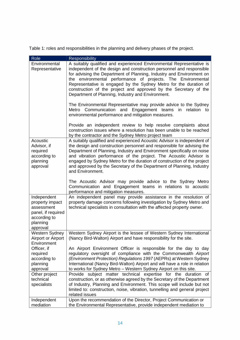
14
Table 1: roles and responsibilities in the planning and delivery phases of the project.
Role Responsibility Environmental Representative
A suitably qualified and experienced Environmental Representative is independent of the design and construction personnel and responsible for advising the Department of Planning, Industry and Environment on the environmental performance of projects. The Environmental Representative is engaged by the Sydney Metro for the duration of construction of the project and approved by the Secretary of the Department of Planning, Industry and Environment. The Environmental Representative may provide advice to the Sydney Metro Communication and Engagement teams in relation to environmental performance and mitigation measures. Provide an independent review to help resolve complaints about construction issues where a resolution has been unable to be reached by the contractor and the Sydney Metro project team
Acoustic Advisor, if required according to planning approval
A suitably qualified and experienced Acoustic Advisor is independent of the design and construction personnel and responsible for advising the Department of Planning, Industry and Environment specifically on noise and vibration performance of the project. The Acoustic Advisor is engaged by Sydney Metro for the duration of construction of the project and approved by the Secretary of the Department of Planning, Industry and Environment. The Acoustic Advisor may provide advice to the Sydney Metro Communication and Engagement teams in relations to acoustic performance and mitigation measures.
Independent property impact assessment panel, if required according to planning approval
An independent panel may provide assistance in the resolution of property damage concerns following investigation by Sydney Metro and technical specialists in consultation with the affected property owner.
Western Sydney Airport or Airport Environment Officer, if required according to planning approval
Western Sydney Airport is the lessee of Western Sydney International (Nancy Bird-Walton) Airport and have responsibility for the site. An Airport Environment Officer is responsible for the day to day regulatory oversight of compliance with the Commonwealth Airport (Environment Protection) Regulations 1997 (AEPRs) at Western Sydney International (Nancy Bird-Walton) Airport and will have a role in relation to works for Sydney Metro – Western Sydney Airport on this site.
Other project technical specialists
Provide subject matter technical expertise for the duration of construction, or as otherwise agreed by the Secretary of the Department of Industry, Planning and Environment. This scope will include but not limited to: construction, noise, vibration, tunnelling and general project related issues
Independent mediation
Upon the recommendation of the Director, Project Communication or the Environmental Representative, provide independent mediation to
15
service(s) (engaged as required)
help resolve complaints about construction issues where a resolution has been unable to be reached by the contractor and the Sydney Metro project team. Any mediator engaged by Sydney Metro, to assist in resolving a complaint, would be required to hold suitable qualifications and have experience mediating similar matters.
Deputy Executive Director Communication & Engagement
Overall responsibility for defining, developing and implementing the strategic direction of Sydney Metro in respect of all communication and engagement activities.
Director Project Communications
Responsible and accountable for authorising all communication and engagement documents, monitoring their effectiveness and performing formal document review.
Sydney Metro Communication and Engagement Team
This team’s key accountabilities and responsibilities include: Communication and engagement Stakeholder management Public affairs Public communication Strategic partnerships Project communications
Project Communication teams (Sydney Metro and PDCT)
Develop and/or implement this Overarching Community Communications Strategy
Provide Place Managers to engage with the local community during the design, planning approval and early work / low impact/major construction activity stages
Develop and implement project communication plans Develop external facing project communication collateral Proactively identify potential issues and work cooperatively to
develop agreed management strategies
2.7. Roles and responsibilities for complaint management during construction
The CCMS will outline the framework for managing complaints, enquiries and escalation processes throughout the project lifecycle.
Complaints are first managed by the PDCT and any unresolved complaints may then be escalated to Sydney Metro.
The Director, Project Communications is the designated complaints handling management representative for the escalation of complaints for independent review. Complaints would only be escalated for independent review following a full and thorough investigation by the PDCT and Sydney Metro. The Director, Project Communication may also refer a complaint to independent mediation at any stage in the complaint management process.
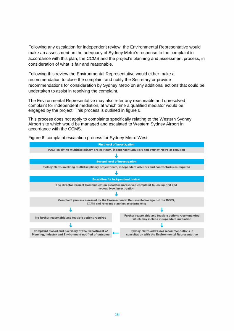
16
Following any escalation for independent review, the Environmental Representative would make an assessment on the adequacy of Sydney Metro’s response to the complaint in
accordance with this plan, the CCMS and the project’s planning and assessment process, in
consideration of what is fair and reasonable.
Following this review the Environmental Representative would either make a recommendation to close the complaint and notify the Secretary or provide recommendations for consideration by Sydney Metro on any additional actions that could be undertaken to assist in resolving the complaint.
The Environmental Representative may also refer any reasonable and unresolved complaint for independent mediation, at which time a qualified mediator would be engaged by the project. This process is outlined in figure 6.
This process does not apply to complaints specifically relating to the Western Sydney Airport site which would be managed and escalated to Western Sydney Airport in accordance with the CCMS.
Figure 6: complaint escalation process for Sydney Metro West
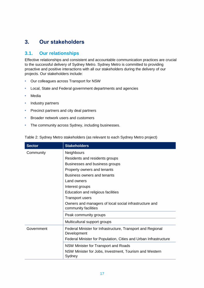
17
3. Our stakeholders
3.1. Our relationships Effective relationships and consistent and accountable communication practices are crucial to the successful delivery of Sydney Metro. Sydney Metro is committed to providing proactive and positive interactions with all our stakeholders during the delivery of our projects. Our stakeholders include:
• Our colleagues across Transport for NSW
• Local, State and Federal government departments and agencies
• Media
• Industry partners
• Precinct partners and city deal partners
• Broader network users and customers
• The community across Sydney, including businesses.
Table 2: Sydney Metro stakeholders (as relevant to each Sydney Metro project)
Sector Stakeholders
Community Neighbours Residents and residents groups Businesses and business groups Property owners and tenants Business owners and tenants Land owners Interest groups Education and religious facilities Transport users Owners and managers of local social infrastructure and community facilities
Peak community groups
Multicultural support groups
Government Federal Minister for Infrastructure, Transport and Regional Development Federal Minister for Population, Cities and Urban Infrastructure
NSW Minister for Transport and Roads NSW Minister for Jobs, Investment, Tourism and Western Sydney
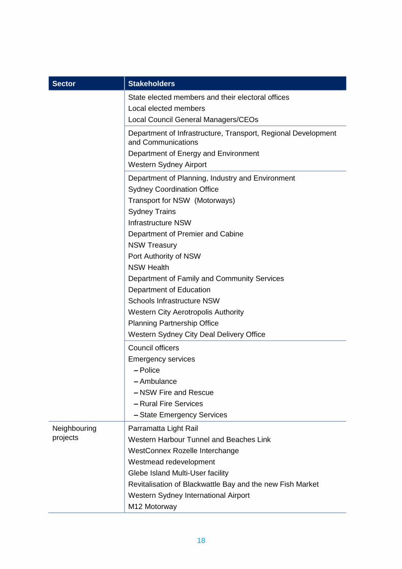
18
Sector Stakeholders
State elected members and their electoral offices Local elected members Local Council General Managers/CEOs
Department of Infrastructure, Transport, Regional Development and Communications Department of Energy and Environment Western Sydney Airport
Department of Planning, Industry and Environment Sydney Coordination Office Transport for NSW (Motorways) Sydney Trains Infrastructure NSW Department of Premier and Cabine NSW Treasury Port Authority of NSW NSW Health Department of Family and Community Services Department of Education Schools Infrastructure NSW Western City Aerotropolis Authority Planning Partnership Office Western Sydney City Deal Delivery Office
Council officers Emergency services
– Police – Ambulance – NSW Fire and Rescue – Rural Fire Services – State Emergency Services
Neighbouring projects
Parramatta Light Rail Western Harbour Tunnel and Beaches Link WestConnex Rozelle Interchange Westmead redevelopment Glebe Island Multi-User facility Revitalisation of Blackwattle Bay and the new Fish Market Western Sydney International Airport M12 Motorway
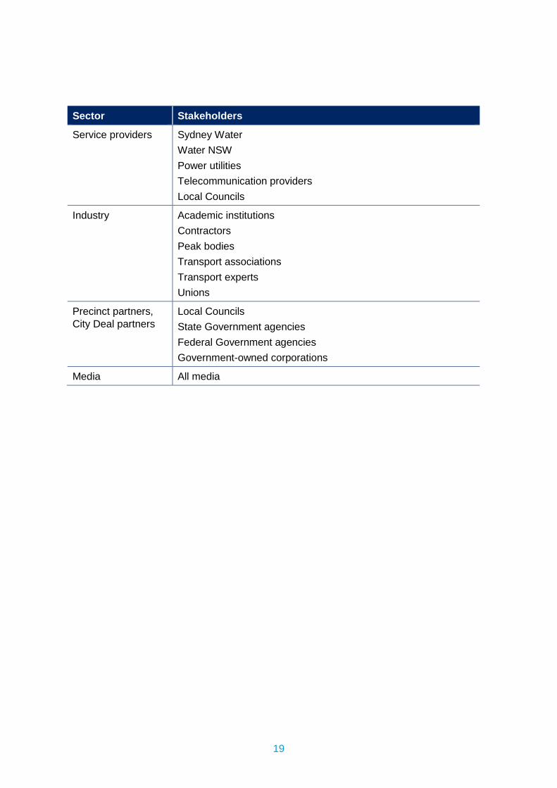
19
Sector Stakeholders
Service providers Sydney Water Water NSW Power utilities Telecommunication providers Local Councils
Industry Academic institutions Contractors Peak bodies Transport associations Transport experts Unions
Precinct partners, City Deal partners
Local Councils State Government agencies Federal Government agencies Government-owned corporations
Media All media
20
4. Our communities Sydney Metro recognises that our projects are undertaken across a range of diverse communities and our information needs to be accessible for all people. The project will continue to monitor, adapt and review communication streams, key messages and audiences to continue to connect with people in ways that are meaningful to them.
4.1. Community demographics Sydney Metro uses area demographics and census data to better understand the communities in which we operate. The information we gather ensures we provide accessible information to people from all backgrounds including: • People with languages other than English (LOTE)
• Culturally and linguistically diverse communities (CALD)
• Vulnerable communities
• Aboriginal and Torres Strait Islander Communities (ATSI)
• Diverse communities
The PDCT CCS must demonstrate how their communication approach will use tools and strategies that meet the needs of their diverse communities. Specific tools outlined below should be considered as appropriate.
4.2. Working with culturally and linguistically diver (CALD) and languages other than English (LOTE) communities
The following processes and communication tools can be used to improve accessibility and outreach with people who come from CALD and LOTE backgrounds:
• Providing project information on the Sydney Metro website which can be translated into 58 different languages.
• Working closely with local councils and community groups to utilise existing CALD relationships.
• Continued outreach with targeted CALD community groups, and face-to-face meetings and briefings with CALD communities as required.
• Advertising project milestones in foreign language newspapers.
• Translating project milestone factsheets and newsletters into targeted languages.
• Ensuring that foreign language submissions can be received.
• Providing translators for meetings and engagements as required.
21
4.3. Working with vulnerable communities Sydney Metro recognises that a range of community members may be vulnerable in relation to disabilities and health, age, employment and housing status, among other issues.
The following processes, communication tools and approaches would be used to improve accessibility and outreach with vulnerable communities:
• Engage with relevant support organisations to keep vulnerable communities informed of work occurring.
• Training construction personal that all interactions with vulnerable people should be respectful and courteous.
• Where required provide regular updates to rough sleepers about construction timing and impacts.
• Businesses impacted by people sleeping rough who may have been displaced by construction should also be kept informed and engaged.
Sydney Metro endorses the NSW Government approach to homelessness by incorporating the Sydney Metro Protocol for Homelessness within all community communication strategies.
4.4. Working with Aboriginal and Torres Strait Islander (ATSI) communities
The following key focus areas have been developed by the Transport for NSW Reconciliation Action Plan (RAP), and will be reflected and incorporated in all engagement objectives and activities undertaken by Sydney Metro:
• Build and strengthen relationships.
• Respect and celebrate culture.
The following processes and communication tools can be used to improve accessibility and outreach with ATSI communities:
• Working collaboratively and respectfully with our Aboriginal and Torres Strait Islander staff, Aboriginal Peak Bodies, and with the communities in which we operate.
• Continue working with our key stakeholders to further build upon existing relationships, and seek to invest in new partnerships to support our progress in delivering meaningful outcomes for Aboriginal and Torres Strait Islander peoples whist delivering on our core business.
4.5. Working with diverse communities Sydney Metro will continue to review its communication tools to ensure inclusive community engagement and the varied information requirements of our communities and stakeholders is prioritised.
The following processes and communication tools can be used to improve accessibility and outreach with diverse communities:
22
• Web and digital based engagement tools allowing people to engage with the project at a time that is convenient to them.
• Using multiple communication platforms to enhance communication reach, for example printed notifications, face-to-face doorknocks and email.
• Ensuring communities are providing with convenient options to access the project team such as providing multiple times for community information sessions and a 1800 number 24 hour a day, seven days a week.
• Harnessing a place management approach to understand the specific needs of communities and tailor communication accordingly.
All Sydney Metro communication materials will adhere to Web Content Accessibility Guidelines (WCAG 2.0).
23
5. Businesses Sydney Metro would work with local businesses within project catchments to ensure communication and engagement is tailored to their specific needs. Sydney Metro’s overarching approach to business engagement is to: • Identify and document potentially impacted businesses prior to project commencement
• Provide early advice to businesses of upcoming projects
• Provide businesses with information about the project and its long terms benefits.
• Provide businesses with information about construction progress.
• Ensure businesses understand the scope of the works and mitigation measures contractors can provide.
• Ensure businesses understand the proposed timing of the works.
• Consult with businesses and take steps to minimise potential impacts.
• Ensure the project team understands the operational requirements and sensitivities of businesses around each site.
The contractor CCS must include at a minimum the identification and details of specific businesses located within 50 metres of each relevant construction site. Contractors must identify the specific needs of each business, any potential impacts associated with construction works, and proposed mitigation measures. These measures must also address if there is a need for translation or cultural and other specialists. The CCS must also outline the approach and timing of holding regular business forums at each construction site. Evaluation and monitoring of business engagement is outlined in section 11.
5.1. Small Business Owners Engagement Plan The Sydney Metro PDCT will provide assistance if required to small business owners located within 50 metres of a Sydney Metro construction site, where they may be potentially impacted by construction activities. For the purposes of this program, a ‘small business’ is
defined as a business that employs fewer than 20 people. Sydney Metro activities to support to eligible businesses may include: • Small business education and mentoring
• Activation events
• Business engagement events
• Marketing and promotion.
24
6. Communication tools Sydney Metro uses a range of communication and engagement tools to ensure project information reaches a wide variety of people likely to be impacted by the project. Using a variety of tools provides our communities with options to engage with the project in ways that suit their needs and lifestyle.
When planning communication strategies the PDCT must consider the requirements of the General Specification – Stakeholder and Community Engagement along with the specific needs of their community as identified in their CCS. The CCS should then outline the specific tools used to reach their identified stakeholders.
The following communication tools matrix is provided as a guide only and other communication tools may be used with prior approval from the Director, Project Communication. CALD communication tools are also included in the table below.
Sydney Metro will provide a suite of project specific templates to the PDCT to assist in the development of communication collateral.
Table 3: Sydney Metro communication and engagement tools
Tool Explanation and purpose Responsibility
Community contact tools
Community information line
Operational 24 hours a day and included on all public communication materials Translation services are available for those with English as a second language.
SM
Community email address
This allows stakeholders and the community to have access to the project teams and to provide feedback and ask questions. All communication materials and the website will include the community email address. During construction, emails will be redirected to relevant contractors as required.
SM
Community post box
All stakeholders can use the postal address: PO Box K659, Haymarket NSW 1240 for all Sydney Metro enquires.
SM
CALD Translation services
All communication will promote our translation services for those with English as a second language.
SM
Information tools
Newsletters Printed and web accessible online site-specific newsletters will include information on: • construction progress
SM/PDCT
25
Tool Explanation and purpose Responsibility • upcoming construction stages and milestones • environmental management achievements • community involvement achievements • three month look-ahead • community contact information. Newsletters will be distributed to local communities, stakeholders and businesses and made available of the Sydney Metro website.
Sydney Metro direct mail email updates
The community, stakeholders and businesses will be offered the opportunity to register to receive Sydney Metro milestone updates.
SM
Construction email updates
The community, stakeholders and businesses will be offered the opportunity to register to receive construction updates.
PDCT
Fact sheets Printed and/or web accessible fact sheets will be used as required to explain key aspects of Sydney Metro to the community and our stakeholders.
PDCT
Photography and videography
Photos and videos will be used to record the construction process and assist with explaining aspects of Sydney Metro to stakeholders and the community. Images and footage will be used in notifications, newsletters, on the Sydney Metro website, presentations and reports as required.
SM/PDCT
Information videos
Information videos can be used to highlight key project milestones, construction information or elements of the statutory planning process
SM/PDCT
Site signage and hoarding banners
Site signage and hoarding banners will identify Sydney Metro and provide contact information.
SM/PDCT
CALD Newsletters and fact sheets
Translating project milestone factsheets and newsletters into targeted languages where required.
SM/PDCT
Online tools
Sydney Metro website
Information about the project will be uploaded to the Sydney Metro website. The website will be referenced in all communication materials as a source of information and will be updated on a regular basis. Information will include:
SM
26
Tool Explanation and purpose Responsibility • Description of the Sydney Metro • Project information including:
– description, current status and timing – newsletters – notifications – up-to-date project information – graphics and images on the project background and
progress – copies of relevant reports – photos, images and maps – links to documents as required under the relevant
projects Conditions of Approval – a link to Sydney Metro contractor webpages.
• Contact information • Email subscription service • The Sydney Metro website is translatable into 58 different
languages using the Google translate function at the bottom of the home page.
Project interactive portal
Sydney Metro may establish and maintain an online portal for the project displaying key project information including: • statutory planning information • project map(s) • graphics and images of the project • newsletters and other project information • specific project information displays • contact information.
SM
Contractor webpage
Each contractor will establish and maintain a web site to upload and maintain information to be published. Including copies of community, environmental, sustainability, transport, traffic and noise and vibration reports and plans. A link will be provided to the Sydney Metro website.
PDCT
Social media Facebook, Twitter and Instagram may be used to provide updates to stakeholders. Stakeholders should be offered the opportunity to join social media feeds via public materials produced for Sydney Metro.
SM
CALD Updating the Sydney Metro website with project information, which can be translated into 58 different languages.
SM/PDCT
27
Tool Explanation and purpose Responsibility Sydney Metro and Contractor website
Ensuring that foreign language submissions can be received.
Face-to-face and interactive tools
Mobile information displays
Mobile information displays can be used at locations like community events, shopping centres and local public spaces to provide information about Sydney Metro, statutory planning processes or construction.
SM/PDCT
Virtual information rooms
Virtual information displays can be used to highlight project milestones, provide information about construction or statutory planning processes.
SM/PDCT
Door knock meetings
Individual door knock meetings will be used as required to discuss potential impacts of Sydney Metro with highly impacted stakeholders, especially residents, businesses directly neighbouring construction sites and owners or managers of nearby social infrastructure or community facilities.
SM/PDCT
In person and/or virtual meetings with individuals or groups
Stakeholder meetings will be used as required to discuss Sydney Metro activities including work in progress and upcoming work or any issues in connection with the activities.
SM/PDCT
Site visits Site visits will be used where appropriate to inform select stakeholders about the progress of Sydney Metro and any key milestones or activities taking place.
SM/PDCT
In person and/or virtual presentations and forums
Presentations and forums will be used where appropriate to inform stakeholders about the progress of Sydney Metro and any key milestones or activities taking place.
SM/PDCT
In person and/or community and business based forums
Forums will be used to focus on key environmental management issues relating to construction activities with impacted community and business stakeholders.
SM/PDCT
CALD In persons and/or virtual tools
Providing translators for virtual and/or in person meetings and engagements as required.
Working closely with local councils and community groups to utilise existing CALD relationships.
SM/PDCT
28
Tool Explanation and purpose Responsibility Continued outreach with targeted CALD community groups, and virtual and/or face-to-face meetings and briefings with CALD communities as required.
CALD Presentations
Presentations will also be offered to local CALD community groups in multiple languages by bi-lingual team members or external translators.
SM/PDCT
Notifications
Emergency works – notification letter
An emergency works* – notification letter will be used to advise properties immediately adjacent to or impacted by emergency works, within two hours of door knock commencing work. Notifications must be delivered by the PDCT, issued on Sydney Metro letterhead and include the following: • scope of work • location of work • hours of work • duration of activity • type of equipment to be used • likely impacts including noise, vibration, traffic, access
and dust • mitigation measures • contact information. *Work required to repair damaged utilities and/or make an area safe after an
incident outside standard construction hours.
PDCT
7 day notification - Community Signage
Signage will be erected at least 7 days prior to any activity with the potential to impact stakeholders or the community. This includes: • work in public areas such as a park • making changes to pedestrian routes • impacting on cycle ways • changing traffic conditions • disrupting access to bus stops. Signage could include A-frames, mobile Variable Message Sign (VMS), hoarding or similar and be placed at either end of the corridor of work.
PDCT
7 day - Traffic alert email
Traffic alert email will be sent at least 7 days prior to any works requiring changes to traffic. Recipients should include:
PDCT
29
Tool Explanation and purpose Responsibility • relevant authorities • transport operators (including bus, coach and taxi
operators). The notification audience and content will be guided by the Traffic and Transport Liaison Group and Traffic Management Plans.
7 day – utility notification
A notification will be sent to relevant utility service authorities at least 7 days before utility service work, to provide detailed information for their relevant call centre messaging.
PDCT
Notification letter
Notification letters will be used to advise the community and stakeholders of any activity with the potential to cause impacts. The notification should be sent at least 7 days prior to the activity occurring to an area of 100 metres around the construction site for day works and 200 metres around the site for night works. Wherever possible works notifications should be combined for the month to include all proposed site activities. Following up communication should be implemented for night works including the use of email, door knock or MetroConnect App reminders. Notifications are required for: • start of construction • significant milestones • changes to scope of work • night works • changes to traffic conditions • modifications to pedestrian routes, cycle ways and bus
stops • out of hours work • changes to residential or business access • changes or disruptions to utility services • investigation activities. Notifications will be issued on Sydney Metro letterhead and include the following: • scope of work • location of work • hours of work • duration of activity • type of equipment to be used
PDCT
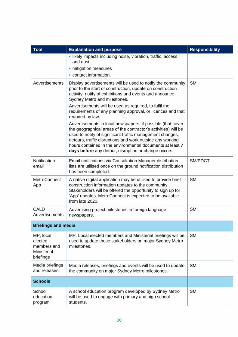
30
Tool Explanation and purpose Responsibility • likely impacts including noise, vibration, traffic, access
and dust • mitigation measures • contact information.
Advertisements Display advertisements will be used to notify the community prior to the start of construction, update on construction activity, notify of exhibitions and events and announce Sydney Metro and milestones. Advertisements will be used as required, to fulfil the requirements of any planning approval, or licences and that required by law. Advertisements in local newspapers, if possible (that cover the geographical areas of the contractor’s activities) will be used to notify of significant traffic management changes, detours, traffic disruptions and work outside any working hours contained in the environmental documents at least 7 days before any detour, disruption or change occurs.
SM
Notification email
Email notifications via Consultation Manager distribution lists are utilised once on the ground notification distribution has been completed.
SM/PDCT
MetroConnect App
A native digital application may be utilised to provide brief construction information updates to the community. Stakeholders will be offered the opportunity to sign up for ‘App’ updates. MetroConnect is expected to be available from late 2020.
SM
CALD Advertisements
Advertising project milestones in foreign language newspapers.
SM
Briefings and media
MP, local elected members and Ministerial briefings
MP, Local elected members and Ministerial briefings will be used to update these stakeholders on major Sydney Metro milestones.
SM
Media briefings and releases
Media releases, briefings and events will be used to update the community on major Sydney Metro milestones.
SM
Schools
School education program
A school education program developed by Sydney Metro will be used to engage with primary and high school students.
SM
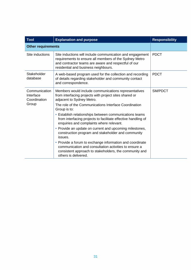
31
Tool Explanation and purpose Responsibility
Other requirements
Site inductions Site inductions will include communication and engagement requirements to ensure all members of the Sydney Metro and contractor teams are aware and respectful of our residential and business neighbours.
PDCT
Stakeholder database
A web-based program used for the collection and recording of details regarding stakeholder and community contact and correspondence.
PDCT
Communication Interface Coordination Group
Members would include communications representatives from interfacing projects with project sites shared or adjacent to Sydney Metro. The role of the Communications Interface Coordination Group is to: • Establish relationships between communications teams
from interfacing projects to facilitate effective handling of enquiries and complaints where relevant.
• Provide an update on current and upcoming milestones, construction program and stakeholder and community issues.
• Provide a forum to exchange information and coordinate communication and consultation activities to ensure a consistent approach to stakeholders, the community and others is delivered.
SM/PDCT
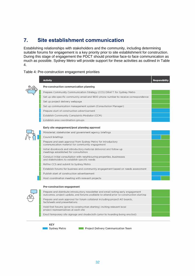
32
7. Site establishment communication Establishing relationships with stakeholders and the community, including determining suitable forums for engagement is a key priority prior to site establishment for construction. During this stage of engagement the PDCT should prioritise face-to face communication as much as possible. Sydney Metro will provide support for these activities as outlined in Table 4.
Table 4: Pre-construction engagement priorities
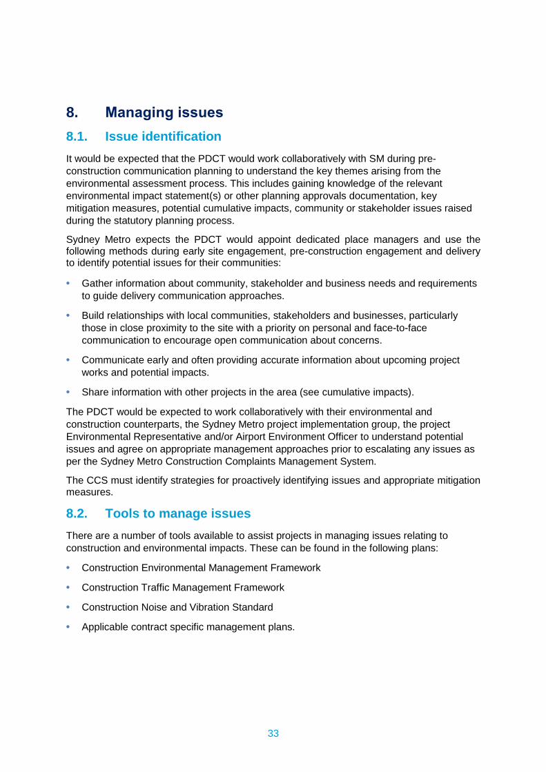
33
8. Managing issues 8.1. Issue identification It would be expected that the PDCT would work collaboratively with SM during pre-construction communication planning to understand the key themes arising from the environmental assessment process. This includes gaining knowledge of the relevant environmental impact statement(s) or other planning approvals documentation, key mitigation measures, potential cumulative impacts, community or stakeholder issues raised during the statutory planning process.
Sydney Metro expects the PDCT would appoint dedicated place managers and use the following methods during early site engagement, pre-construction engagement and delivery to identify potential issues for their communities:
• Gather information about community, stakeholder and business needs and requirements to guide delivery communication approaches.
• Build relationships with local communities, stakeholders and businesses, particularly those in close proximity to the site with a priority on personal and face-to-face communication to encourage open communication about concerns.
• Communicate early and often providing accurate information about upcoming project works and potential impacts.
• Share information with other projects in the area (see cumulative impacts).
The PDCT would be expected to work collaboratively with their environmental and construction counterparts, the Sydney Metro project implementation group, the project Environmental Representative and/or Airport Environment Officer to understand potential issues and agree on appropriate management approaches prior to escalating any issues as per the Sydney Metro Construction Complaints Management System.
The CCS must identify strategies for proactively identifying issues and appropriate mitigation measures.
8.2. Tools to manage issues There are a number of tools available to assist projects in managing issues relating to construction and environmental impacts. These can be found in the following plans:
• Construction Environmental Management Framework
• Construction Traffic Management Framework
• Construction Noise and Vibration Standard
• Applicable contract specific management plans.
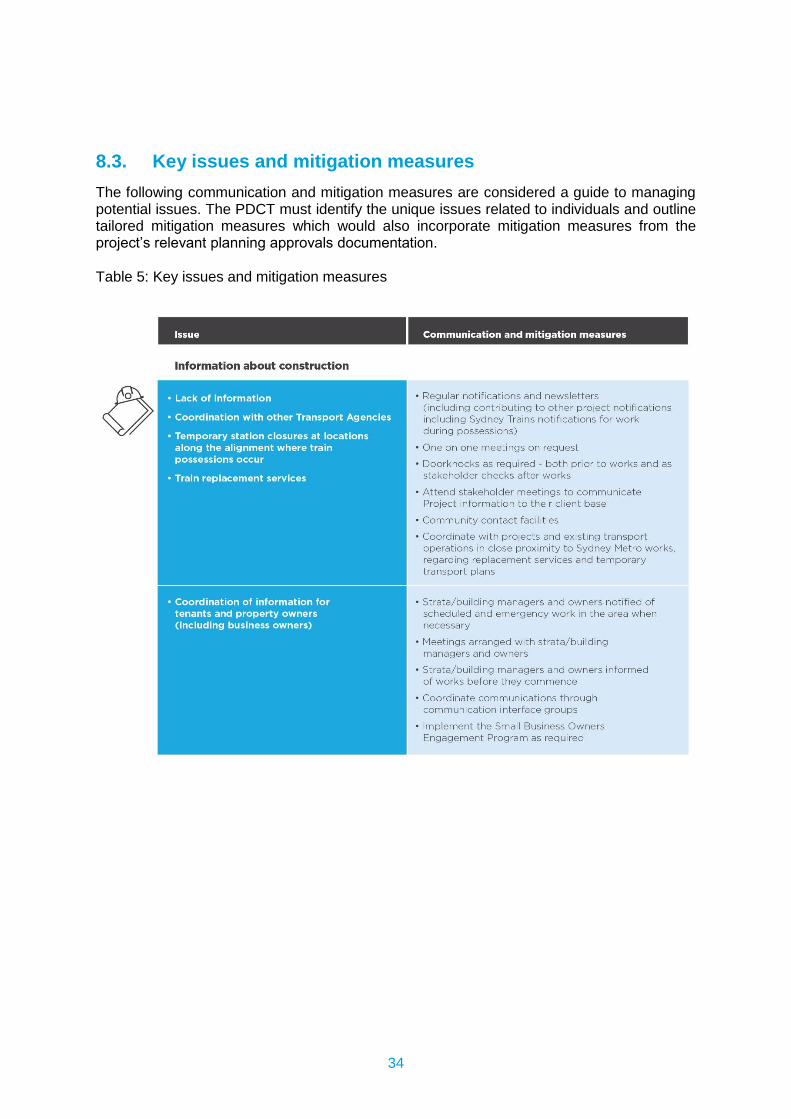
34
8.3. Key issues and mitigation measures The following communication and mitigation measures are considered a guide to managing potential issues. The PDCT must identify the unique issues related to individuals and outline tailored mitigation measures which would also incorporate mitigation measures from the project’s relevant planning approvals documentation.
Table 5: Key issues and mitigation measures
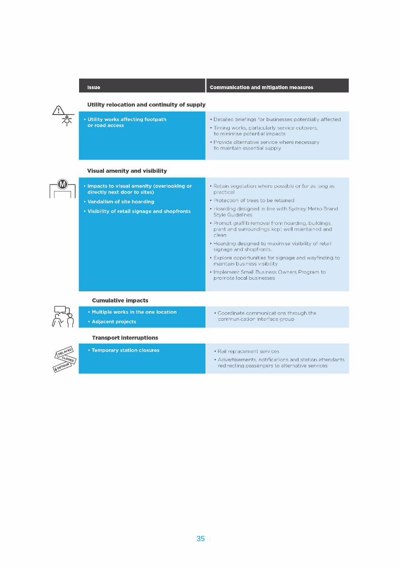
35
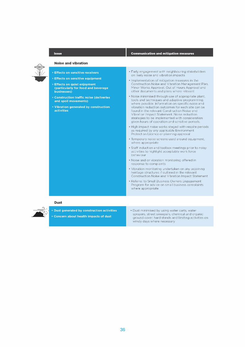
36
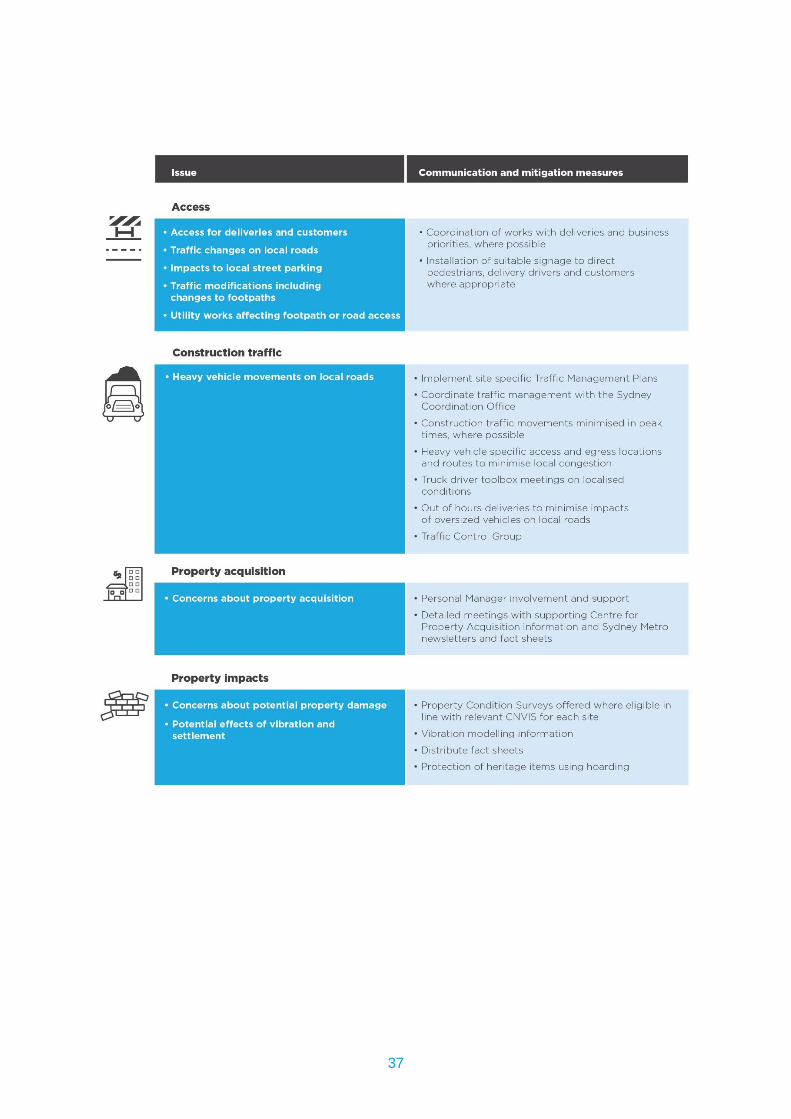
37
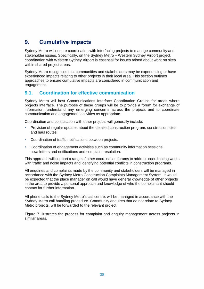
38
9. Cumulative impacts Sydney Metro will ensure coordination with interfacing projects to manage community and stakeholder issues. Specifically, on the Sydney Metro – Western Sydney Airport project, coordination with Western Sydney Airport is essential for issues raised about work on sites within shared project areas.
Sydney Metro recognises that communities and stakeholders may be experiencing or have experienced impacts relating to other projects in their local area. This section outlines approaches to ensure cumulative impacts are considered in communication and engagement.
9.1. Coordination for effective communication Sydney Metro will host Communications Interface Coordination Groups for areas where projects interface. The purpose of these groups will be to provide a forum for exchange of information, understand any emerging concerns across the projects and to coordinate communication and engagement activities as appropriate.
Coordination and consultation with other projects will generally include: • Provision of regular updates about the detailed construction program, construction sites
and haul routes.
• Coordination of traffic notifications between projects.
• Coordination of engagement activities such as community information sessions, newsletters and notifications and complaint resolution.
This approach will support a range of other coordination forums to address coordinating works with traffic and noise impacts and identifying potential conflicts in construction programs.
All enquiries and complaints made by the community and stakeholders will be managed in accordance with the Sydney Metro Construction Complaints Management System. It would be expected that the place manager on call would have general knowledge of other projects in the area to provide a personal approach and knowledge of who the complainant should contact for further information. All phone calls to the Sydney Metro’s call centre, will be managed in accordance with the Sydney Metro call handling procedure. Community enquires that do not relate to Sydney Metro projects, will be forwarded to the relevant project. Figure 7 illustrates the process for complaint and enquiry management across projects in similar areas.
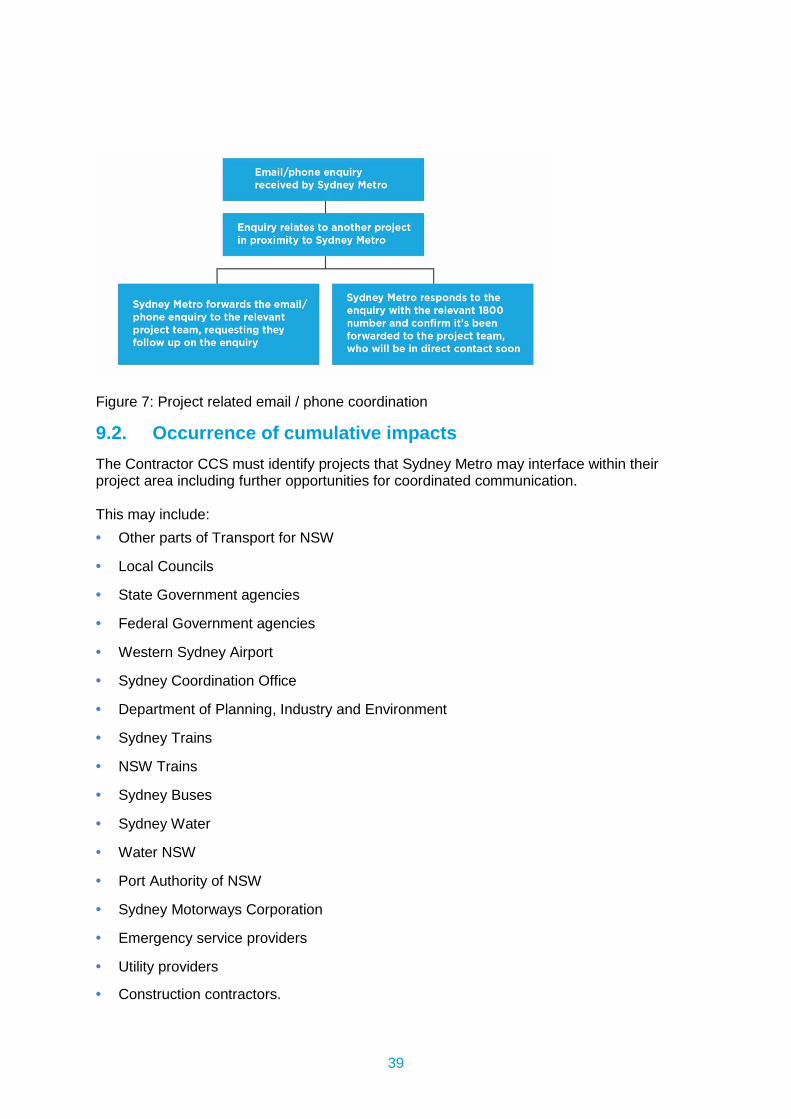
39
Figure 7: Project related email / phone coordination
9.2. Occurrence of cumulative impacts The Contractor CCS must identify projects that Sydney Metro may interface within their project area including further opportunities for coordinated communication. This may include: • Other parts of Transport for NSW
• Local Councils
• State Government agencies
• Federal Government agencies
• Western Sydney Airport
• Sydney Coordination Office
• Department of Planning, Industry and Environment
• Sydney Trains
• NSW Trains
• Sydney Buses
• Sydney Water
• Water NSW
• Port Authority of NSW
• Sydney Motorways Corporation
• Emergency service providers
• Utility providers
• Construction contractors.
40
10. Crisis and incident communication processes In the unlikely event that a crisis or incident occurs, the Sydney Metro Crisis Communications Management System will be in place. Any communication management system prepared by the PDCT as part of the Emergency Management Plan should align with Sydney Metro’s Crisis Communications Plan. Contract teams are required to invite the Director, Communications and the Deputy Executive Director, Communication and Engagement to attend and participate in formal incident and crisis communication exercises when they are conducted. The CCS must reflect Sydney Metro’s Crisis Communications Management Plan and Incident notification process. The PDCT has the following responsibilities in relation to crisis communication: • Immediately notify the Director, Communications within 10 minutes of any incident or
issue that may have an impact on the community, environment, personnel, subcontractors or other stakeholders or may attract the attention of the media, the Minister for Transport, a local MP, council or the broader community. For any other incidents notify the Director, Communications within one hour of the incident occurring.
• Obtain approval from the Director, Communications before contacting or providing information to any person, other than that which is required to directly manage the incident or to comply with Law, including stakeholders, the media or the public.
• Make available suitably qualified and experienced personnel to support the Director, Communications in responding to the community, the media and other stakeholders.
• Provide all necessary communications materials that may need to be disseminated as a result of such incidents.

41
11. Monitoring, evaluation and reporting The PDCT is responsible for monitoring the effectiveness of strategies to inform and to minimise impacts of construction on the community, including businesses. The PDCT is required to provide detailed information to Sydney Metro each month on performance criteria outlined in this plan and the site specific CCS including: • Enquiry and complaint trends and how lessons learned are being applied across the
project to avoid issues recurring, highlighting sensitive receivers and small businesses.
• The status of complaints and details of any escalation required.
• Communication tools used to engage with stakeholders and the community including doorknocks, meetings, presentations, notifications and newsletters.
11.1 Audit and review – site specific CCS’ Evaluation of the performance and effectiveness of the site specific CCS’ will be undertaken every six months or as required. Key elements of the evaluation will include examining the adequacy of the CCS and its implementation in achieving the intent of the consultation as evidenced by the items in table 6.
Table 6: Six monthly CCS audit requirements
Performance Parameters Measures Reporting
Identifying all potential local community, businesses and stakeholders that may be impacted by or have an interest in the project (based on the stakeholder categories provided in this plan)
Inclusion in the CCS of: A thorough stakeholder scan of
local community, businesses and stakeholders including maps.
Accurate and up-to-date listings of local businesses noting changes of leases and ownership at least every six months.
Appropriateness of communication and engagement tools
Inclusion in the CCS of: A communication tool matrix
and/or table detailing communication tools to be used for which stakeholders and why.
Communication matrix and/or table to be updated at least every six months to adjust approach to community needs and lessons learned.
Identifying appropriate mitigation measures to address issues
Inclusion in the CCS of: Mitigation measures that would be
used in response to identified issues
A detailed complaint investigation process to ensure mitigation measures are considered before
Appropriateness of mitigation measures to accommodate community needs and lessons learned to be reviewed at least every six months and the
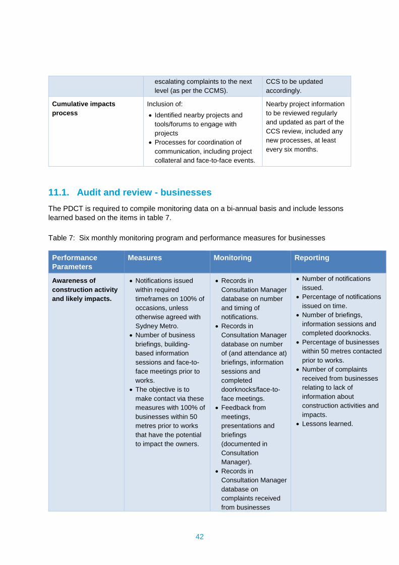
42
escalating complaints to the next level (as per the CCMS).
CCS to be updated accordingly.
Cumulative impacts process
Inclusion of: Identified nearby projects and
tools/forums to engage with projects
Processes for coordination of communication, including project collateral and face-to-face events.
Nearby project information to be reviewed regularly and updated as part of the CCS review, included any new processes, at least every six months.
11.1. Audit and review - businesses The PDCT is required to compile monitoring data on a bi-annual basis and include lessons learned based on the items in table 7. Table 7: Six monthly monitoring program and performance measures for businesses Performance Parameters
Measures Monitoring Reporting
Awareness of construction activity and likely impacts.
Notifications issued within required timeframes on 100% of occasions, unless otherwise agreed with Sydney Metro.
Number of business briefings, building-based information sessions and face-to-face meetings prior to works.
The objective is to make contact via these measures with 100% of businesses within 50 metres prior to works that have the potential to impact the owners.
Records in Consultation Manager database on number and timing of notifications.
Records in Consultation Manager database on number of (and attendance at) briefings, information sessions and completed doorknocks/face-to-face meetings.
Feedback from meetings, presentations and briefings (documented in Consultation Manager).
Records in Consultation Manager database on complaints received from businesses
Number of notifications issued.
Percentage of notifications issued on time.
Number of briefings, information sessions and completed doorknocks.
Percentage of businesses within 50 metres contacted prior to works.
Number of complaints received from businesses relating to lack of information about construction activities and impacts.
Lessons learned.
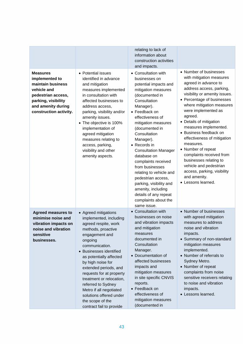
43
relating to lack of information about construction activities and impacts.
Measures implemented to maintain business vehicle and pedestrian access, parking, visibility and amenity during construction activity.
Potential issues identified in advance and mitigation measures implemented in consultation with affected businesses to address access, parking, visibility and/or amenity issues.
The objective is 100% implementation of agreed mitigation measures relating to access, parking, visibility and other amenity aspects.
Consultation with businesses on potential impacts and mitigation measures (documented in Consultation Manager).
Feedback on effectiveness of mitigation measures (documented in Consultation Manager).
Records in Consultation Manager database on complaints received from businesses relating to vehicle and pedestrian access, parking, visibility and amenity, including details of any repeat complaints about the same issue.
Number of businesses with mitigation measures agreed in advance to address access, parking, visibility or amenity issues.
Percentage of businesses where mitigation measures were implemented as agreed.
Details of mitigation measures implemented.
Business feedback on effectiveness of mitigation measures.
Number of repeat complaints received from businesses relating to vehicle and pedestrian access, parking, visibility and amenity.
Lessons learned.
Agreed measures to minimise noise and vibration impacts on noise and vibration sensitive businesses.
Agreed mitigations implemented, including agreed respite, work methods, proactive engagement and ongoing communication.
Businesses identified as potentially affected by high noise for extended periods, and requests for at property treatment or relocation, referred to Sydney Metro if all negotiated solutions offered under the scope of the contract fail to provide
Consultation with businesses on noise and vibration impacts and mitigation measures documented in Consultation Manager.
Documentation of affected businesses impacts and mitigation measures in site specific CNVIS reports.
Feedback on effectiveness of mitigation measures (documented in
Number of businesses with agreed mitigation measures to address noise and vibration impacts.
Summary of non-standard mitigation measures implemented.
Number of referrals to Sydney Metro.
Number of repeat complaints from noise sensitive receivers relating to noise and vibration impacts.
Lessons learned.
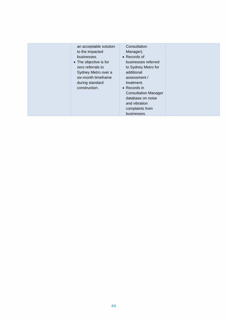
44
an acceptable solution to the impacted businesses.
The objective is for zero referrals to Sydney Metro over a six-month timeframe during standard construction.
Consultation Manager).
Records of businesses referred to Sydney Metro for additional assessment / treatment.
Records in Consultation Manager database on noise and vibration complaints from businesses.
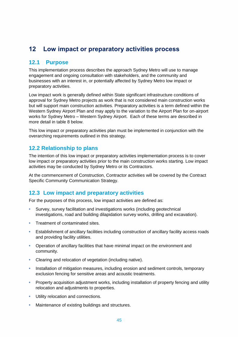
45
12 Low impact or preparatory activities process
12.1 Purpose This implementation process describes the approach Sydney Metro will use to manage engagement and ongoing consultation with stakeholders, and the community and businesses with an interest in, or potentially affected by Sydney Metro low impact or preparatory activities.
Low impact work is generally defined within State significant infrastructure conditions of approval for Sydney Metro projects as work that is not considered main construction works but will support main construction activities. Preparatory activities is a term defined within the Western Sydney Airport Plan and may apply to the variation to the Airport Plan for on-airport works for Sydney Metro – Western Sydney Airport. Each of these terms are described in more detail in table 8 below.
This low impact or preparatory activities plan must be implemented in conjunction with the overarching requirements outlined in this strategy.
12.2 Relationship to plans The intention of this low impact or preparatory activities implementation process is to cover low impact or preparatory activities prior to the main construction works starting. Low impact activities may be conducted by Sydney Metro or its Contractors.
At the commencement of Construction, Contractor activities will be covered by the Contract Specific Community Communication Strategy.
12.3 Low impact and preparatory activities For the purposes of this process, low impact activities are defined as:
• Survey, survey facilitation and investigations works (including geotechnical investigations, road and building dilapidation survey works, drilling and excavation).
• Treatment of contaminated sites.
• Establishment of ancillary facilities including construction of ancillary facility access roads and providing facility utilities.
• Operation of ancillary facilities that have minimal impact on the environment and community.
• Clearing and relocation of vegetation (including native).
• Installation of mitigation measures, including erosion and sediment controls, temporary exclusion fencing for sensitive areas and acoustic treatments.
• Property acquisition adjustment works, including installation of property fencing and utility relocation and adjustments to properties.
• Utility relocation and connections.
• Maintenance of existing buildings and structures.
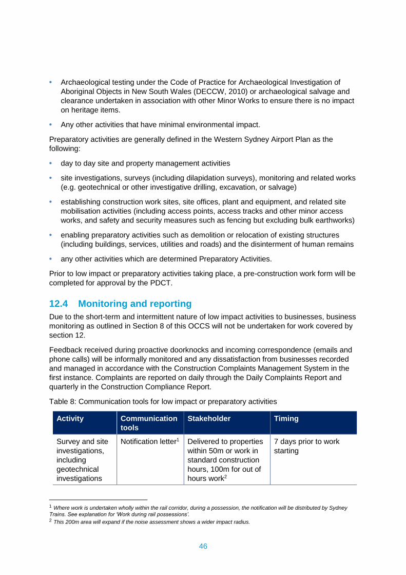
46
• Archaeological testing under the Code of Practice for Archaeological Investigation of Aboriginal Objects in New South Wales (DECCW, 2010) or archaeological salvage and clearance undertaken in association with other Minor Works to ensure there is no impact on heritage items.
• Any other activities that have minimal environmental impact.
Preparatory activities are generally defined in the Western Sydney Airport Plan as the following:
• day to day site and property management activities
• site investigations, surveys (including dilapidation surveys), monitoring and related works (e.g. geotechnical or other investigative drilling, excavation, or salvage)
• establishing construction work sites, site offices, plant and equipment, and related site mobilisation activities (including access points, access tracks and other minor access works, and safety and security measures such as fencing but excluding bulk earthworks)
• enabling preparatory activities such as demolition or relocation of existing structures (including buildings, services, utilities and roads) and the disinterment of human remains
• any other activities which are determined Preparatory Activities.
Prior to low impact or preparatory activities taking place, a pre-construction work form will be completed for approval by the PDCT.
12.4 Monitoring and reporting Due to the short-term and intermittent nature of low impact activities to businesses, business monitoring as outlined in Section 8 of this OCCS will not be undertaken for work covered by section 12.
Feedback received during proactive doorknocks and incoming correspondence (emails and phone calls) will be informally monitored and any dissatisfaction from businesses recorded and managed in accordance with the Construction Complaints Management System in the first instance. Complaints are reported on daily through the Daily Complaints Report and quarterly in the Construction Compliance Report.
Table 8: Communication tools for low impact or preparatory activities
Activity Communication tools
Stakeholder Timing
Survey and site investigations, including geotechnical investigations
Notification letter1
Delivered to properties within 50m or work in standard construction hours, 100m for out of hours work2
7 days prior to work starting
1 Where work is undertaken wholly within the rail corridor, during a possession, the notification will be distributed by Sydney
Trains. See explanation for ‘Work during rail possessions’. 2 This 200m area will expand if the noise assessment shows a wider impact radius.
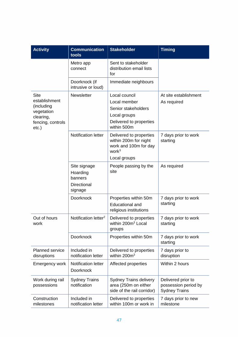
47
Activity Communication tools
Stakeholder Timing
Metro app connect
Sent to stakeholder distribution email lists for
Doorknock (if intrusive or loud)
Immediate neighbours
Site establishment (including vegetation clearing, fencing, controls etc.)
Newsletter Local council Local member Senior stakeholders Local groups Delivered to properties within 500m
At site establishment As required
Notification letter
Delivered to properties within 200m for night work and 100m for day work3 Local groups
7 days prior to work starting
Site signage Hoarding banners Directional signage
People passing by the site
As required
Doorknock Properties within 50m Educational and religious institutions
7 days prior to work starting
Out of hours work
Notification letter2
Delivered to properties within 200m3 Local groups
7 days prior to work starting
Doorknock Properties within 50m 7 days prior to work starting
Planned service disruptions
Included in notification letter
Delivered to properties within 200m3
7 days prior to disruption
Emergency work Notification letter Doorknock
Affected properties Within 2 hours
Work during rail possessions
Sydney Trains notification
Sydney Trains delivery area (250m on either side of the rail corridor)
Delivered prior to possession period by Sydney Trains
Construction milestones
Included in notification letter
Delivered to properties within 100m or work in
7 days prior to new milestone
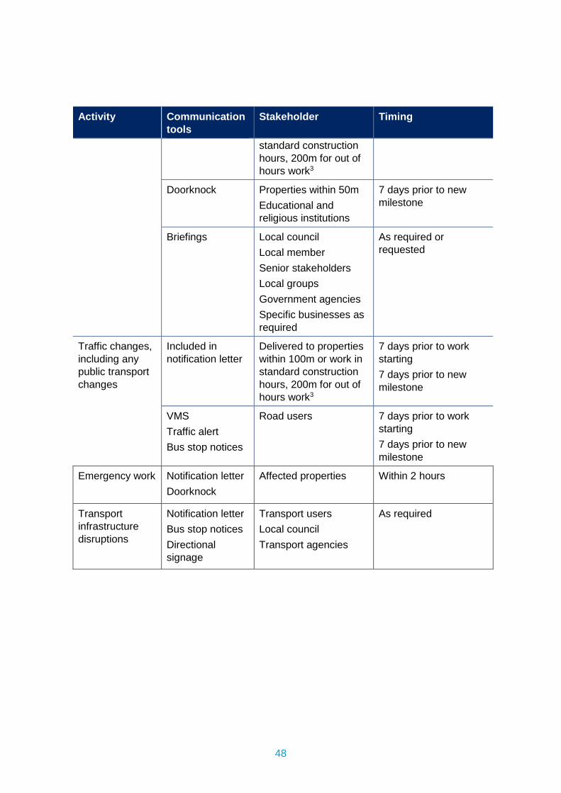
48
Activity Communication tools
Stakeholder Timing
standard construction hours, 200m for out of hours work3
Doorknock Properties within 50m Educational and religious institutions
7 days prior to new milestone
Briefings
Local council Local member Senior stakeholders Local groups Government agencies Specific businesses as required
As required or requested
Traffic changes, including any public transport changes
Included in notification letter
Delivered to properties within 100m or work in standard construction hours, 200m for out of hours work3
7 days prior to work starting 7 days prior to new milestone
VMS Traffic alert Bus stop notices
Road users 7 days prior to work starting 7 days prior to new milestone
Emergency work Notification letter Doorknock
Affected properties Within 2 hours
Transport infrastructure disruptions
Notification letter Bus stop notices Directional signage
Transport users Local council Transport agencies
As required

Integrated
Management
System
Sydney Metro Construction Noise
and Vibration Standard SM-20-00098866
Sydney Metro Integrated Management System (IMS)
Applicable to: Sydney Metro West
Author: Sydney Metro
System owner: Sydney Metro
Status: Final
Version: 4.3
Date of issue: 04/11/2020
Security classification: Open Access
© Sydney Metro 2020
Sydney Metro – Integrated Management System (IMS)
(Uncontrolled when printed)
© Sydney Metro 2020 STANDARD - Construction Noise and Vibration Draft v4.3 Page 2 of 43
Table of Contents 1. PURPOSE AND SCOPE ......................................................................................... 3
1.1. Distribution and Use .................................................................................. 3
1.2. Strategic Objectives ................................................................................... 3
1.3. Construction Noise and Vibration Terminology .......................................... 3
1.4. Documentation Framework ........................................................................ 4
2. NOISE AND VIBRATION GUIDELINES ................................................................. 7
2.1. Construction Hours .................................................................................... 7
2.2. Construction Noise Management Levels (NML) ......................................... 7
2.3. Ground-Borne Vibration ........................................................................... 10
2.4. General Vibration Screening Criterion ...................................................... 13
2.5. Guidelines for Vibration Sensitive and Special Structures ........................ 13
2.6. Vibration and Overpressure from Blasting ............................................... 15
2.7. Ground-Borne (Regenerated) Noise ........................................................ 15
2.8. Traffic Noise Assessment Goals .............................................................. 16
2.9. Sleep Disturbance and Maximum Noise Events ...................................... 17
3. CONSTRUCTION NOISE & VIBRATION ASSESSMENT METHODOLOGY ....... 18
3.1. Detailed Noise and Vibration Impact Statements ..................................... 19
3.2. General Noise and Vibration Impact Assessments .................................. 21
3.3. Noise and Vibration Sensitive Receivers ................................................. 23
3.4. Ground-Borne (Regenerated) Noise ........................................................ 24
3.5. Ground-Borne Vibration ........................................................................... 24
3.6. Vibration and Overpressure from Blasting ............................................... 25
4. STANDARD NOISE AND VIBRATION MITIGATION MEASURES ...................... 26
4.1. Minimum Requirements ........................................................................... 26
4.2. Summary of the Standard Mitigation Measures ....................................... 28
4.3. Maximum Allowable Plant Sound Power Levels ...................................... 32
4.4. Auditing and Monitoring ........................................................................... 33
5. ADDITIONAL NOISE AND VIBRATION MITIGATION MEASURES .................... 34
5.1. Applying Additional Mitigation Measures .................................................. 35
6. MONITORING, AUDITING AND REPORTING ..................................................... 37
6.1. Plant Noise Auditing, Compliance Evaluation and Reporting ................... 37
6.2. Noise Monitoring ...................................................................................... 37
6.3. Vibration Monitoring ................................................................................. 38
6.4. Blast Monitoring ....................................................................................... 38
6.5. Dilapidation Surveys ................................................................................ 39
7. COMPLAINT HANDLING ..................................................................................... 40
8. COMMUNITY CONSULTATION AND LIAISON ................................................... 41
9. DOCUMENTATION REQUIREMENTS ................................................................. 42
10. REFERENCES ...................................................................................................... 43
Sydney Metro – Integrated Management System (IMS)
(Uncontrolled when printed)
© Sydney Metro 2020 STANDARD - Construction Noise and Vibration Draft v4.3 Page 3 of 43
1. PURPOSE AND SCOPE This Standard applies to all Sydney Metro projects and covers all elements of the project lifecycle with the exception of operational activities. Additionally, this standard only applies to design activities insofar as design decisions affect construction-related noise and vibration impacts (such as route selection, at-grade or underground rail systems and tunnel depth).
1.1. Distribution and Use This document may be used in the development of, or referred to in:
Environmental Impact Assessment documents;
Design and construction environmental management documents;
Contract documents; or
Approvals and licences (subject to the agreement of the relevant regulatory authority).
1.2. Strategic Objectives Sydney Metro recognise that sources of Noise and Vibration originating from our activities have a significant impact to local communities. We have adopted several strategic objectives to understand and manage these impacts:
Applying a risk-based approach and implementing an appropriate hierarchy of controls at each stage of the project lifecycle to minimise impacts.
Building an approach to reducing Noise and Vibration risks within each stage of the project lifecycle through active collaboration with internal and external stakeholders.
Developing a clear understanding of our Construction Noise and Vibration Impacts and applying best practice management techniques.
Valuing genuine community engagement that is sensitive to the needs and expectations of local communities and businesses.
Committing to the continual improvement of Noise and Vibration management.
1.3. Construction Noise and Vibration Terminology Decibel (dB): Decibel, often expressed as an ‘A – weighted’ sound pressure level, which has been found to correlate well with human subjective reactions to moderate noise levels. For steady, broadband noise, an increase or decrease of approximately 10 dB corresponds to a subjective doubling or halving of the loudness and a change of 2 to 3 dB is subjectively barely perceptible.
Sound Pressure Level (SPL or Lp): Expressed in dB, it is the level of noise measured by a standard sound level meter. It must be accompanied by a description of the measurement distance from the source, if used in any noise predictions or calculations. In a free field (eg outside on flat ground), each doubling of distance results in approximately 6dB reduction in airborne sound pressure level due to distance attenuation.
Sydney Metro – Integrated Management System (IMS)
(Uncontrolled when printed)
© Sydney Metro 2020 STANDARD - Construction Noise and Vibration Draft v4.3 Page 4 of 43
Sound Power Level (SWL or Lw): Expressed in dB, it is the total acoustic energy radiated by a plant or equipment to the environment. Sound power level is independent of distance from the source of the noise.
Rating Background Level (RBL): Rating background level is the overall single-figure background level representing each assessment period (day/evening/night) over a measurement period. As defined in the EPA “Noise Policy for Industry” dated October 2017.
Vibration: Vibration may be expressed in terms of displacement, velocity and acceleration. Velocity (mm/s), acceleration (m/s2) and Vibration Dose Value (VDV, m/s1.75) are most commonly used when assessing human comfort issues respectively. Peak Particle Velocity (PPV, mm/s) is typically used to assess impacts on structures.
Ground borne noise and Structure-borne noise: The transmission of noise energy as vibration travelling through the ground and / or structures and re-radiated as audible noise.
The three primary noise metrics used to describe construction noise emissions in the modelling and assessments are:
LA1(1minute) The typical ‘maximum noise level for an event’, used in the assessment of
potential sleep disturbance during night-time periods. Alternatively, assessment may be conducted using the LAmax or maximum noise level
LAeq(15minute) The ‘energy average noise level’ evaluated over a 15-minute period. This parameter is used to assess the potential construction noise impacts.
LA90 The ‘background noise level’ in the absence of construction activities. This parameter represents the average minimum noise level during the daytime, evening and night-time periods respectively. The LAeq(15minute) construction noise management levels are based on the LA90 background noise levels.
1.4. Documentation Framework There are five main documents (Figure 1) which comprise the noise and vibration documentation framework. Together they provide a comprehensive approach to the assessment and delivery of works which generate noise and vibration while mitigating the impacts.
Figure 1 - Noise and Vibration Documentation Framework
Sydney Metro – Integrated Management System (IMS)
(Uncontrolled when printed)
© Sydney Metro 2020 STANDARD - Construction Noise and Vibration Draft v4.3 Page 5 of 43
1.4.1. Construction Noise and Vibration Standard (CNVS)
The CNVS (this document) establishes a consistent strategy for the assessment, mitigation and monitoring of noise and vibration generated by construction activities. It defines a minimum standard for managing noise and vibration impacts that considers currently best practice guidelines and other regulatory requirements. It is included in all Sydney Metro Environmental Assessments.
1.4.2. Construction Noise and Vibration Management Plan (CNVMP)
Where works will cause significant noise and vibration impacts upon sensitive receivers Principal Contractors will be required to prepare and implement CNVMP’s. These documents form part of the CEMP suite of documentation.
The function of the CNVMP is to provide a strategic overview of how the requirements of the CNVS will be applied to activities or locations under the control of the Principal Contractor. This overview includes an outline of how quantitative noise and vibration assessments will be undertaken across worksites and/or activities, and an indicative construction schedule.
The CNVMP also links to Community and Stakeholder consultation processes and explains how commercial and residential receivers will be consulted throughout the construction phase with regard to mitigating impacts upon them.
Further detail on the requirements for CNVMP’s can be found in the Sydney Metro Construction Environmental Management Framework.
1.4.3. Noise and Vibration Technical Paper
The Noise and Vibration Technical Paper is produced as part of the Environmental Assessment carried out in the planning phase of Sydney Metro projects. This document is a Quantitative Noise Assessment based upon the information known at the time the assessment is undertaken and makes recommendations for mitigation.
Typically it will include a range of assumptions on equipment lists and construction methodologies on the basis of which the impact upon sensitive receivers will be determined. As such, these Quantitative Assessments are generally conservative and may over predict actual impacts during construction.
1.4.4. Detailed Noise and Vibration Impact Statements (DNVIS)
While quantitative noise assessments are documented in environmental assessments, Principal Contractors will have a better understanding of the exact equipment list and construction methodology to be used in carrying out their works. As a result, certain assumptions made in the Noise and Vibration Technical Paper can be clarified in a secondary quantitative assessment undertaken by the Principal Contractor. These documents are called Detailed Noise and Vibration Impact Statements.
They are typically written with a focus on specific activities or locations and consider works carried out inside and outside of standard working hours.
Where 24/7 works are approved under an SSI approval, a separate DNVIS should be carried out specifically for these activities.
Sydney Metro – Integrated Management System (IMS)
(Uncontrolled when printed)
© Sydney Metro 2020 STANDARD - Construction Noise and Vibration Draft v4.3 Page 6 of 43
Work described in a DNVIS’s cannot proceed until the DNVIS is approved by an Acoustic Advisor appointed under an SSI approval or other delegate approved by Sydney Metro. Should the scope of work or the timing of works change, the Principal contractor must update the DNVIS and seek subsequent approval for the new version. See Section 3.1 for more detail on DNVIS’s.
1.4.5. General Noise and Vibration Impact Statements (GNVIS)
General Noise and Vibration Impact Statements are also secondary assessments and have the same purpose as DNVIS’s except that the assessment process is simplified. A GNVIS may be undertaken for works not being carried out under an SSI Approval.
Work described in a GNVIS’s cannot proceed until the GNVIS is approved by Sydney Metro. Should the scope of work or the timing of works change, the Principal contractor must update the GNVIS and seek subsequent approval for the new version. See Section 3.2 for more detail on GNVIS’s.
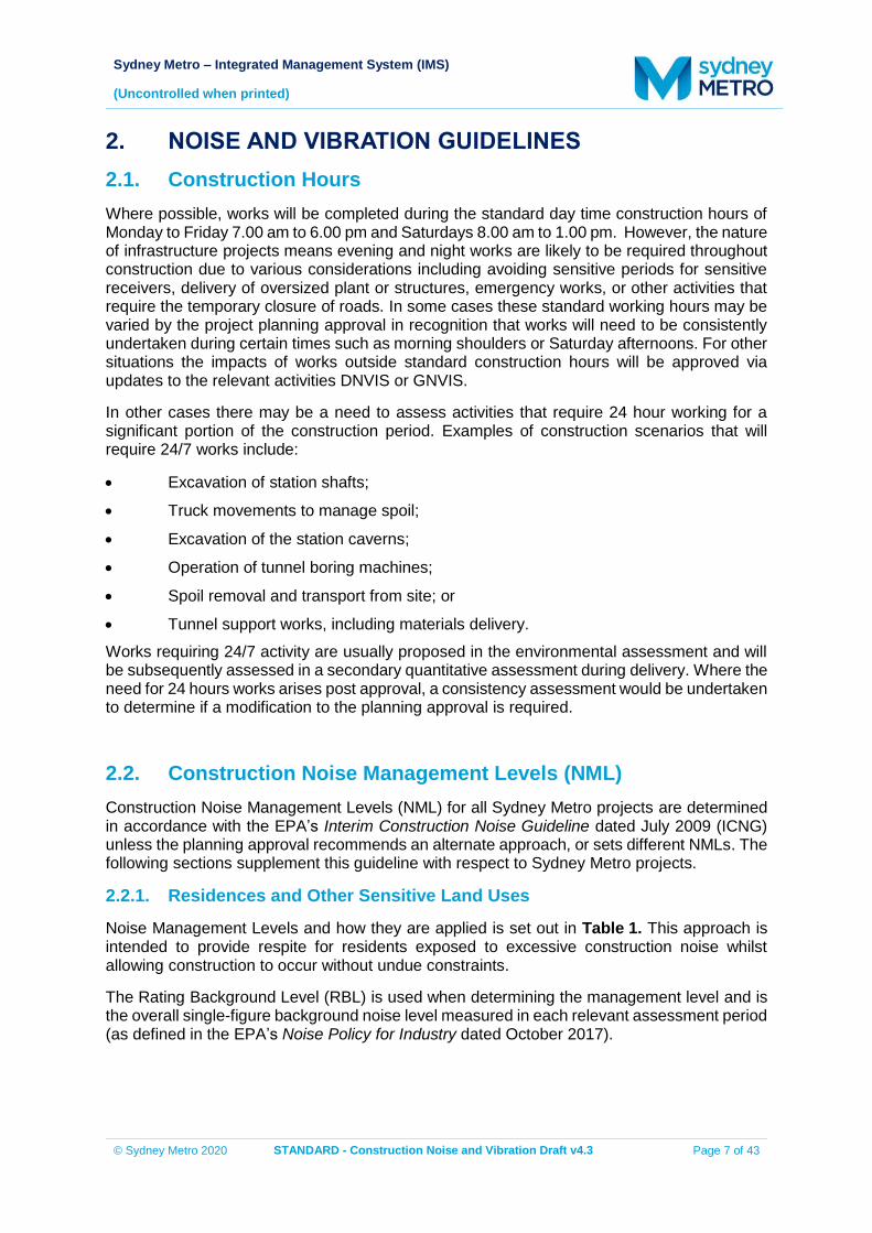
Sydney Metro – Integrated Management System (IMS)
(Uncontrolled when printed)
© Sydney Metro 2020 STANDARD - Construction Noise and Vibration Draft v4.3 Page 7 of 43
2. NOISE AND VIBRATION GUIDELINES 2.1. Construction Hours Where possible, works will be completed during the standard day time construction hours of Monday to Friday 7.00 am to 6.00 pm and Saturdays 8.00 am to 1.00 pm. However, the nature of infrastructure projects means evening and night works are likely to be required throughout construction due to various considerations including avoiding sensitive periods for sensitive receivers, delivery of oversized plant or structures, emergency works, or other activities that require the temporary closure of roads. In some cases these standard working hours may be varied by the project planning approval in recognition that works will need to be consistently undertaken during certain times such as morning shoulders or Saturday afternoons. For other situations the impacts of works outside standard construction hours will be approved via updates to the relevant activities DNVIS or GNVIS.
In other cases there may be a need to assess activities that require 24 hour working for a significant portion of the construction period. Examples of construction scenarios that will require 24/7 works include:
Excavation of station shafts;
Truck movements to manage spoil;
Excavation of the station caverns;
Operation of tunnel boring machines;
Spoil removal and transport from site; or
Tunnel support works, including materials delivery. Works requiring 24/7 activity are usually proposed in the environmental assessment and will be subsequently assessed in a secondary quantitative assessment during delivery. Where the need for 24 hours works arises post approval, a consistency assessment would be undertaken to determine if a modification to the planning approval is required.
2.2. Construction Noise Management Levels (NML) Construction Noise Management Levels (NML) for all Sydney Metro projects are determined in accordance with the EPA’s Interim Construction Noise Guideline dated July 2009 (ICNG) unless the planning approval recommends an alternate approach, or sets different NMLs. The following sections supplement this guideline with respect to Sydney Metro projects.
2.2.1. Residences and Other Sensitive Land Uses
Noise Management Levels and how they are applied is set out in Table 1. This approach is intended to provide respite for residents exposed to excessive construction noise whilst allowing construction to occur without undue constraints.
The Rating Background Level (RBL) is used when determining the management level and is the overall single-figure background noise level measured in each relevant assessment period (as defined in the EPA’s Noise Policy for Industry dated October 2017).
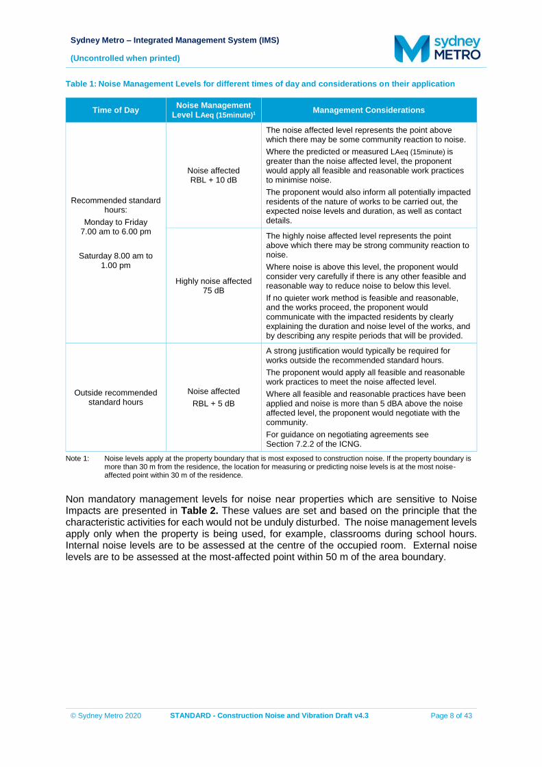
Sydney Metro – Integrated Management System (IMS)
(Uncontrolled when printed)
© Sydney Metro 2020 STANDARD - Construction Noise and Vibration Draft v4.3 Page 8 of 43
Table 1: Noise Management Levels for different times of day and considerations on their application
Time of Day Noise Management Level LAeq (15minute)1 Management Considerations
Recommended standard hours:
Monday to Friday 7.00 am to 6.00 pm
Saturday 8.00 am to
1.00 pm
Noise affected RBL + 10 dB
The noise affected level represents the point above which there may be some community reaction to noise. Where the predicted or measured LAeq (15minute) is greater than the noise affected level, the proponent would apply all feasible and reasonable work practices to minimise noise. The proponent would also inform all potentially impacted residents of the nature of works to be carried out, the expected noise levels and duration, as well as contact details.
Highly noise affected 75 dB
The highly noise affected level represents the point above which there may be strong community reaction to noise. Where noise is above this level, the proponent would consider very carefully if there is any other feasible and reasonable way to reduce noise to below this level. If no quieter work method is feasible and reasonable, and the works proceed, the proponent would communicate with the impacted residents by clearly explaining the duration and noise level of the works, and by describing any respite periods that will be provided.
Outside recommended standard hours
Noise affected RBL + 5 dB
A strong justification would typically be required for works outside the recommended standard hours. The proponent would apply all feasible and reasonable work practices to meet the noise affected level. Where all feasible and reasonable practices have been applied and noise is more than 5 dBA above the noise affected level, the proponent would negotiate with the community. For guidance on negotiating agreements see Section 7.2.2 of the ICNG.
Note 1: Noise levels apply at the property boundary that is most exposed to construction noise. If the property boundary is more than 30 m from the residence, the location for measuring or predicting noise levels is at the most noise-affected point within 30 m of the residence.
Non mandatory management levels for noise near properties which are sensitive to Noise Impacts are presented in Table 2. These values are set and based on the principle that the characteristic activities for each would not be unduly disturbed. The noise management levels apply only when the property is being used, for example, classrooms during school hours. Internal noise levels are to be assessed at the centre of the occupied room. External noise levels are to be assessed at the most-affected point within 50 m of the area boundary.
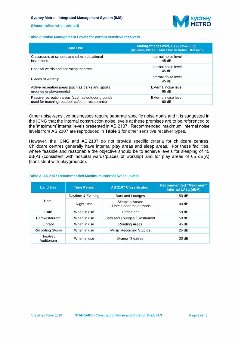
Sydney Metro – Integrated Management System (IMS)
(Uncontrolled when printed)
© Sydney Metro 2020 STANDARD - Construction Noise and Vibration Draft v4.3 Page 9 of 43
Table 2: Noise Management Levels for certain sensitive receivers
Land Use Management Level, LAeq (15minute) (Applies When Land Use is being Utilised)
Classrooms at schools and other educational institutions
Internal noise level 45 dB
Hospital wards and operating theatres Internal noise level 45 dB
Places of worship Internal noise level 45 dB
Active recreation areas (such as parks and sports grounds or playgrounds)
External noise level 65 dB
Passive recreation areas (such as outdoor grounds used for teaching, outdoor cafes or restaurants)
External noise level 60 dB
Other noise-sensitive businesses require separate specific noise goals and it is suggested in the ICNG that the internal construction noise levels at these premises are to be referenced to the ‘maximum’ internal levels presented in AS 2107. Recommended ‘maximum’ internal noise levels from AS 2107 are reproduced in Table 3 for other sensitive receiver types.
However, the ICNG and AS 2107 do not provide specific criteria for childcare centres. Childcare centres generally have internal play areas and sleep areas. For these facilities, where feasible and reasonable the objective should be to achieve levels for sleeping of 45 dB(A) (consistent with hospital wards/places of worship) and for play areas of 65 dB(A) (consistent with playgrounds).
Table 3 AS 2107 Recommended Maximum Internal Noise Levels
Land Use Time Period AS 2107 Classification Recommended “Maximum” Internal LAeq (dBA)
Hotel Daytime & Evening Bars and Lounges 50 dB
Night-time Sleeping Areas: - Hotels near major roads 40 dB
Café When in use Coffee bar 50 dB Bar/Restaurant When in use Bars and Lounges / Restaurant 50 dB
Library When in use Reading Areas 45 dB Recording Studio When in use Music Recording Studios 25 dB
Theatre / Auditorium When in use Drama Theatres 30 dB
Sydney Metro – Integrated Management System (IMS)
(Uncontrolled when printed)
© Sydney Metro 2020 STANDARD - Construction Noise and Vibration Draft v4.3 Page 10 of 43
2.2.2. Commercial and Industrial Premises
Due to the broad range of sensitivities that commercial or industrial land can have to noise from construction, the process of defining Noise Management Levels is separated into three categories. The external noise levels would be assessed at the most-affected occupied point of the premises:
Industrial premises (external): 75 dB LAeq(15minute)
Offices, retail outlets (external): 70 dB LAeq(15minute)
Other businesses that may be very sensitive to noise, where the noise level is project specific as discussed below.
Examples of other noise-sensitive businesses are theatres, studios and child care centres. The proponent would undertake a special investigation to determine suitable noise levels on a project-by-project basis; the recommended internal noise levels presented in Table 1 of AS 2107 “Acoustics - Recommended design sound levels and reverberation times for building interiors” (Standards Australia 2000) may assist in determining relevant noise levels; however, an acoustic consultant would be engaged in order to determine corresponding external noise levels based on the published internal noise levels. The proponent would assess construction noise levels for the project, and consult with occupants of commercial and industrial premises prior to lodging an application where required. During construction, the proponent would regularly update the occupants of the commercial and industrial premises regarding noise levels and hours of work.
2.3. Ground-Borne Vibration The effects of vibration in buildings can be divided into three main categories; those in which the occupants or users of the building are inconvenienced or possibly disturbed, those where the building contents may be affected and those in which the integrity of the building or the structure itself may be prejudiced.
2.3.1. Human Comfort Vibration
The DECCW’s “Assessing Vibration: a technical guideline” dated February 2006 (DEC, 2006) recommends the use of BS 6472-1992 for the purpose of assessing vibration in relation to human comfort.
British Standard 6472-1992 “Guide to evaluation of human exposure to vibration in building” nominates guideline values for various categories of disturbance, the most stringent of which are the levels of building vibration associated with a “low probability of adverse comment” from occupants.
BS 6472-1992 provides guideline values for continuous, transient and intermittent events that are based on a Vibration Dose Value (VDV), rather than a continuous vibration level. The vibration dose value is dependent upon the level and duration of the short term vibration event, as well as the number of events occurring during the daytime or night-time period.
The vibration dose values recommended in BS 6472-1992 for which various levels of adverse comment from occupants may be expected are presented in Table 4.
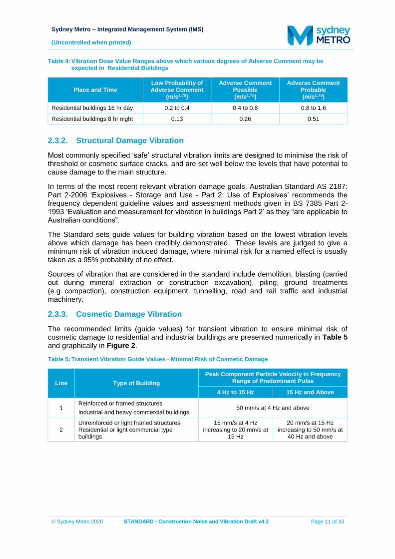
Sydney Metro – Integrated Management System (IMS)
(Uncontrolled when printed)
© Sydney Metro 2020 STANDARD - Construction Noise and Vibration Draft v4.3 Page 11 of 43
Table 4: Vibration Dose Value Ranges above which various degrees of Adverse Comment may be expected in Residential Buildings
Place and Time Low Probability of Adverse Comment
(m/s1.75)
Adverse Comment Possible (m/s1.75)
Adverse Comment Probable (m/s1.75)
Residential buildings 16 hr day 0.2 to 0.4 0.4 to 0.8 0.8 to 1.6
Residential buildings 8 hr night 0.13 0.26 0.51
2.3.2. Structural Damage Vibration
Most commonly specified ‘safe’ structural vibration limits are designed to minimise the risk of threshold or cosmetic surface cracks, and are set well below the levels that have potential to cause damage to the main structure.
In terms of the most recent relevant vibration damage goals, Australian Standard AS 2187: Part 2-2006 ‘Explosives - Storage and Use - Part 2: Use of Explosives’ recommends the frequency dependent guideline values and assessment methods given in BS 7385 Part 2-1993 ‘Evaluation and measurement for vibration in buildings Part 2’ as they “are applicable to Australian conditions”.
The Standard sets guide values for building vibration based on the lowest vibration levels above which damage has been credibly demonstrated. These levels are judged to give a minimum risk of vibration induced damage, where minimal risk for a named effect is usually taken as a 95% probability of no effect.
Sources of vibration that are considered in the standard include demolition, blasting (carried out during mineral extraction or construction excavation), piling, ground treatments (e.g. compaction), construction equipment, tunnelling, road and rail traffic and industrial machinery.
2.3.3. Cosmetic Damage Vibration
The recommended limits (guide values) for transient vibration to ensure minimal risk of cosmetic damage to residential and industrial buildings are presented numerically in Table 5 and graphically in Figure 2.
Table 5: Transient Vibration Guide Values - Minimal Risk of Cosmetic Damage
Line Type of Building Peak Component Particle Velocity in Frequency
Range of Predominant Pulse
4 Hz to 15 Hz 15 Hz and Above
1 Reinforced or framed structures Industrial and heavy commercial buildings
50 mm/s at 4 Hz and above
2 Unreinforced or light framed structures Residential or light commercial type buildings
15 mm/s at 4 Hz increasing to 20 mm/s at
15 Hz
20 mm/s at 15 Hz increasing to 50 mm/s at
40 Hz and above
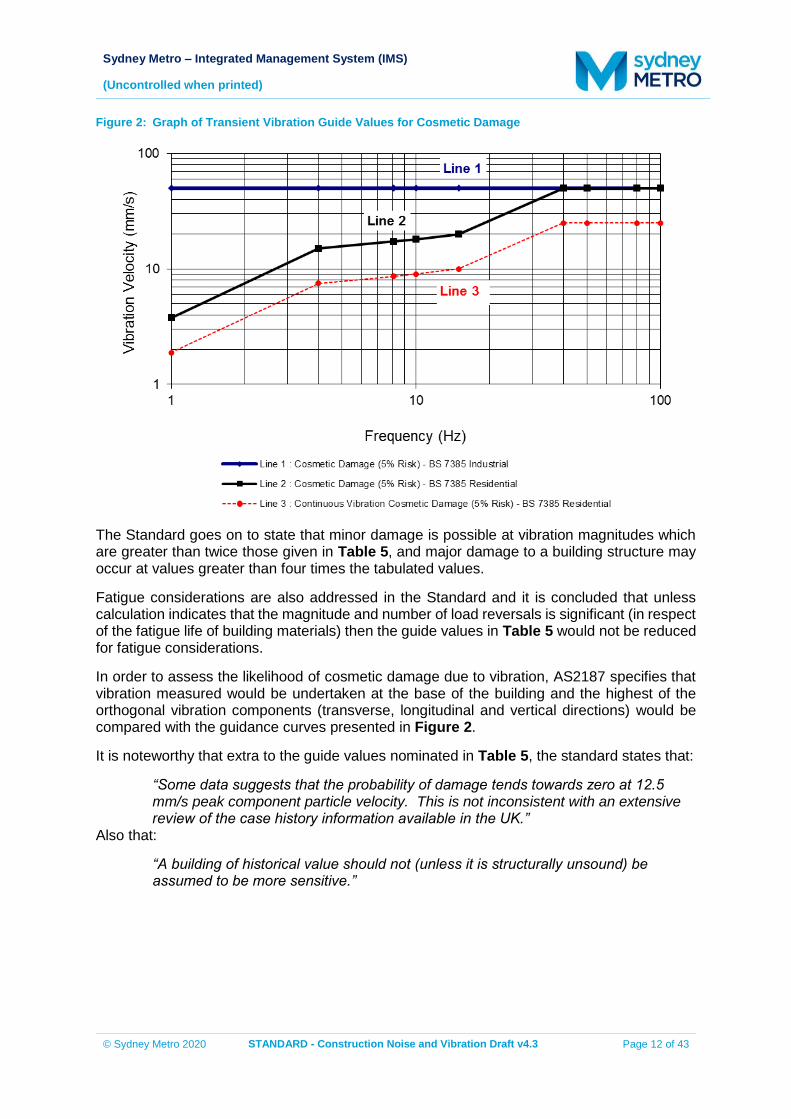
Sydney Metro – Integrated Management System (IMS)
(Uncontrolled when printed)
© Sydney Metro 2020 STANDARD - Construction Noise and Vibration Draft v4.3 Page 12 of 43
Figure 2: Graph of Transient Vibration Guide Values for Cosmetic Damage
The Standard goes on to state that minor damage is possible at vibration magnitudes which are greater than twice those given in Table 5, and major damage to a building structure may occur at values greater than four times the tabulated values.
Fatigue considerations are also addressed in the Standard and it is concluded that unless calculation indicates that the magnitude and number of load reversals is significant (in respect of the fatigue life of building materials) then the guide values in Table 5 would not be reduced for fatigue considerations.
In order to assess the likelihood of cosmetic damage due to vibration, AS2187 specifies that vibration measured would be undertaken at the base of the building and the highest of the orthogonal vibration components (transverse, longitudinal and vertical directions) would be compared with the guidance curves presented in Figure 2.
It is noteworthy that extra to the guide values nominated in Table 5, the standard states that:
“Some data suggests that the probability of damage tends towards zero at 12.5 mm/s peak component particle velocity. This is not inconsistent with an extensive review of the case history information available in the UK.”
Also that:
“A building of historical value should not (unless it is structurally unsound) be assumed to be more sensitive.”
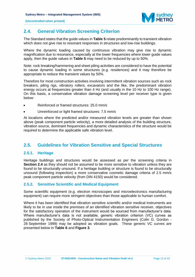
Sydney Metro – Integrated Management System (IMS)
(Uncontrolled when printed)
© Sydney Metro 2020 STANDARD - Construction Noise and Vibration Draft v4.3 Page 13 of 43
2.4. General Vibration Screening Criterion The Standard states that the guide values in Table 5 relate predominantly to transient vibration which does not give rise to resonant responses in structures and low-rise buildings.
Where the dynamic loading caused by continuous vibration may give rise to dynamic magnification due to resonance, especially at the lower frequencies where lower guide values apply, then the guide values in Table 5 may need to be reduced by up to 50%.
Note: rock breaking/hammering and sheet piling activities are considered to have the potential to cause dynamic loading in some structures (e.g. residences) and it may therefore be appropriate to reduce the transient values by 50%.
Therefore for most construction activities involving intermittent vibration sources such as rock breakers, piling rigs, vibratory rollers, excavators and the like, the predominant vibration energy occurs at frequencies greater than 4 Hz (and usually in the 10 Hz to 100 Hz range). On this basis, a conservative vibration damage screening level per receiver type is given below:
Reinforced or framed structures: 25.0 mm/s
Unreinforced or light framed structures: 7.5 mm/s At locations where the predicted and/or measured vibration levels are greater than shown above (peak component particle velocity), a more detailed analysis of the building structure, vibration source, dominant frequencies and dynamic characteristics of the structure would be required to determine the applicable safe vibration level.
2.5. Guidelines for Vibration Sensitive and Special Structures 2.5.1. Heritage
Heritage buildings and structures would be assessed as per the screening criteria in Section 2.4 as they should not be assumed to be more sensitive to vibration unless they are found to be structurally unsound. If a heritage building or structure is found to be structurally unsound (following inspection) a more conservative cosmetic damage criteria of 2.5 mm/s peak component particle velocity (from DIN 4150) would be considered.
2.5.2. Sensitive Scientific and Medical Equipment
Some scientific equipment (e.g. electron microscopes and microelectronics manufacturing equipment) can require more stringent objectives than those applicable to human comfort.
Where it has been identified that vibration sensitive scientific and/or medical instruments are likely to be in use inside the premises of an identified vibration sensitive receiver, objectives for the satisfactory operation of the instrument would be sourced from manufacturer’s data. Where manufacturer’s data is not available, generic vibration criterion (VC) curves as published by the Society of Photo-Optical Instrumentation Engineers (Colin G. Gordon - 28 September 1999) may be adopted as vibration goals. These generic VC curves are presented below in Table 6 and Figure 3.
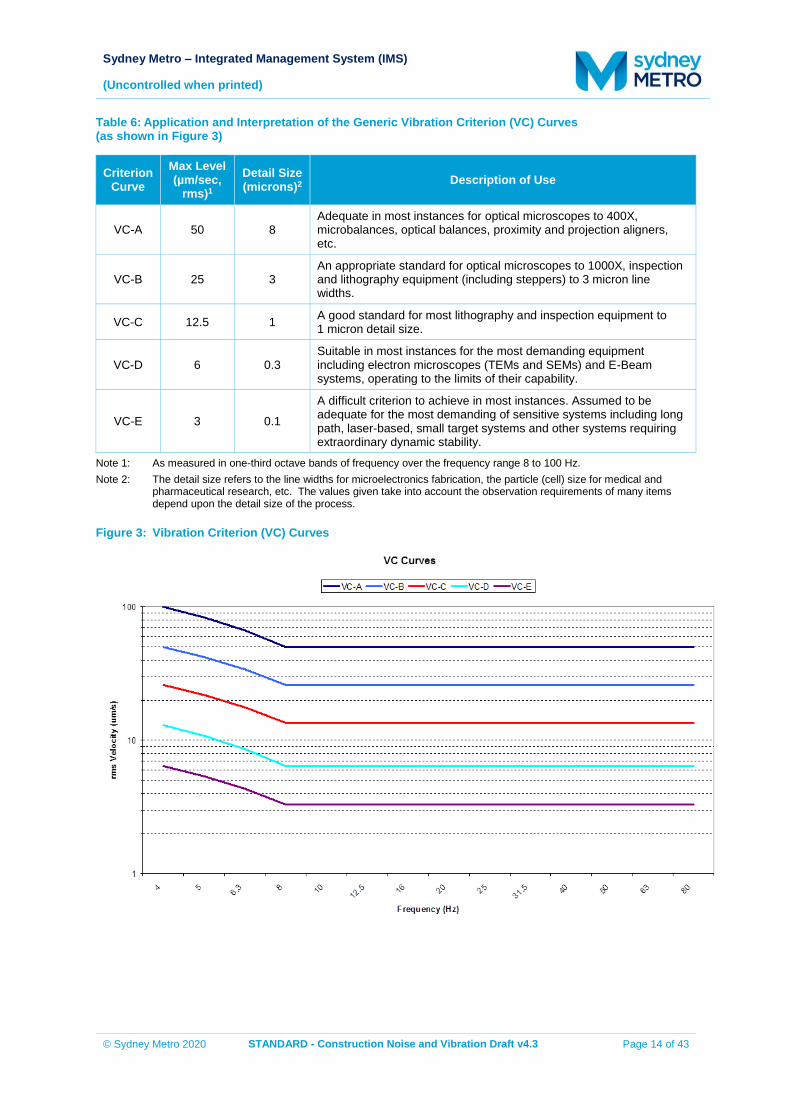
Sydney Metro – Integrated Management System (IMS)
(Uncontrolled when printed)
© Sydney Metro 2020 STANDARD - Construction Noise and Vibration Draft v4.3 Page 14 of 43
Table 6: Application and Interpretation of the Generic Vibration Criterion (VC) Curves (as shown in Figure 3)
Criterion Curve
Max Level (µm/sec,
rms)1 Detail Size (microns)2 Description of Use
VC-A 50 8 Adequate in most instances for optical microscopes to 400X, microbalances, optical balances, proximity and projection aligners, etc.
VC-B 25 3 An appropriate standard for optical microscopes to 1000X, inspection and lithography equipment (including steppers) to 3 micron line widths.
VC-C 12.5 1 A good standard for most lithography and inspection equipment to 1 micron detail size.
VC-D 6 0.3 Suitable in most instances for the most demanding equipment including electron microscopes (TEMs and SEMs) and E-Beam systems, operating to the limits of their capability.
VC-E 3 0.1
A difficult criterion to achieve in most instances. Assumed to be adequate for the most demanding of sensitive systems including long path, laser-based, small target systems and other systems requiring extraordinary dynamic stability.
Note 1: As measured in one-third octave bands of frequency over the frequency range 8 to 100 Hz. Note 2: The detail size refers to the line widths for microelectronics fabrication, the particle (cell) size for medical and
pharmaceutical research, etc. The values given take into account the observation requirements of many items depend upon the detail size of the process.
Figure 3: Vibration Criterion (VC) Curves
Sydney Metro – Integrated Management System (IMS)
(Uncontrolled when printed)
© Sydney Metro 2020 STANDARD - Construction Noise and Vibration Draft v4.3 Page 15 of 43
2.5.3. Other Vibration Sensitive Structures and Utilities
Where structures and utilities are encountered which may be considered to be particularly sensitive to vibration, a vibration goal which is more stringent than structural damage goals presented in Section 2.4 may need to be adopted. Examples of such structures and utilities include:
Tunnels
Gas pipelines
Fibre optic cables Specific vibration goals would be determined on a case-by-case basis. An acoustic consultant would be engaged by the construction contractor and would liaise with the structure or utility’s owner in order to determine acceptable vibration levels.
2.6. Vibration and Overpressure from Blasting The DECC’s ICNG recommends that vibration and overpressure from blasting be assessed against the levels presented in the Australian and New Zealand Environment Council’s (ANZEC) Technical Basis for Guidelines to Minimise Annoyance Due to Blasting Overpressure and Ground Vibration (ANZEC, 1990).
The criteria set by this standard were based on practices undertaken more than 30 years ago and were targeted at operations that occur for long periods of time such as those at mining sites and hence are targeted at protecting human comfort vibration levels. As a result the vibration levels are conservative and can introduce unnecessary constraints when applied to construction projects which typically occur for much shorter time periods. Recent NSW infrastructure project approvals have recognised the restrictive nature of these blasting criteria when applied to construction projects and have therefore allowed the following vibration and overpressure limits:
Vibration (PPV): 25 mm/s
Overpressure: 125 dBL These upper limits are deemed acceptable where the proponent has a written agreement with the relevant landowner to exceed the criteria and the Secretary has approved the terms of the written agreement. These upper limits to vibration and overpressure are intended to target the protection of building structures from cosmetic damage rather than human comfort criteria as construction works are considered short-term.
2.7. Ground-Borne (Regenerated) Noise Ground-borne (regenerated) noise is noise generated by vibration transmitted through the ground into a structure. Ground-borne noise caused, for example by underground works such as tunnelling, can be more noticeable than airborne noise. The following ground-borne noise levels for residences are nominated in the ICNG and indicate when management actions would be implemented. These levels recognise the temporary nature of construction and are only applicable when ground-borne noise levels are higher than airborne noise levels. Any levels exceeding objectives should be considered in the context of any existing exposure to ground-borne noise.
Sydney Metro – Integrated Management System (IMS)
(Uncontrolled when printed)
© Sydney Metro 2020 STANDARD - Construction Noise and Vibration Draft v4.3 Page 16 of 43
The ground-borne noise management levels are given below:
Evening (6.00 pm to 10.00 pm) Internal Residential: 40 dB LAeq(15minute)
Night-time (10.00 pm to 7.00 am) Internal Residential: 35 dB LAeq(15minute)
The evening and night-time criteria are only applicable to residential receivers.
The internal noise levels are to be assessed at the centre of the most-affected habitable room. For a limited number of discrete, ongoing ground-borne noise events, such as drilling or rock-hammering, The LAmax noise descriptor using a slow response on the sound level meter may be better than the LAeq noise descriptor (15 min) in describing the noise impacts. The level of mitigation of ground-borne noise would depend on the extent of impacts and also on the scale and duration of works. Any restriction on the days when construction work is allowed would take into account whether the community:
Has identified times of day when they are more sensitive to noise (for example Sundays or public holidays).
Is prepared to accept a longer construction duration in exchange for days of respite.
2.8. Traffic Noise Assessment Goals When trucks and other vehicles are operating within the boundaries of the various construction sites, road vehicle noise contributions are included in the overall predicted LAeq(15minute) construction site noise emissions. When construction related traffic moves onto the public road network a different noise assessment methodology is appropriate, as vehicle movements would be regarded as ‘additional road traffic’ rather than as part of the construction site.
The ICNG does not provide specific guidance in relation to acceptable noise levels associated with construction traffic. For assessment purposes, guidance is taken from the RNP.
One of the objectives of the RNP is to apply relevant permissible noise increase criteria to protect sensitive receivers against excessive decreases in amenity as the result of a proposal. In assessing feasible and reasonable mitigation measures, an increase of up to 2 dB represents a minor impact that is considered barely perceptible to the average person.
On this basis, construction traffic NMLs set at 2 dB above the existing road traffic noise levels during the daytime and night-time periods are considered appropriate to identify the onset of potential noise impacts. Where the road traffic noise levels are predicted to increase by more than 2 dB as a result of construction traffic, consideration would be given to applying feasible and reasonable noise mitigation measures to reduce the potential noise impacts and preserve acoustic amenity.
In considering feasible and reasonable mitigation measures where the relevant noise increase is greater than 2 dB, consideration would also be given to the actual noise levels associated with construction traffic and whether or not these levels comply with the following road traffic noise criteria in the RNP:
60 dB LAeq(15hour) day and 55 dB LAeq(9hour) night for existing freeway/ arterial/ sub-arterial roads.
55 dB LAeq(1hour) day and 50 dB LAeq(1hour) night for existing local roads.
Sydney Metro – Integrated Management System (IMS)
(Uncontrolled when printed)
© Sydney Metro 2020 STANDARD - Construction Noise and Vibration Draft v4.3 Page 17 of 43
2.9. Sleep Disturbance and Maximum Noise Events Maximum noise level events from construction activities during the night-time period can trigger both awakenings and disturbance to sleep stages. The approach to managing events that cause sleep disturbance shall be consistent with the Noise Policy for Industry (EPA, 2017). Where night-time noise levels at a residential location exceed the:
LAeq,15min 40 dB(A) or the prevailing RBL plus 5 dB, whichever is the greater, and/or the
LAFmax 52 dB(A) or the prevailing RBL plus 15 dB, whichever is the greater, a detailed maximum noise level event assessment is to be undertaken.
The detailed assessment will cover the maximum noise level, the extent to which the maximum noise level exceeds the RBL, and the number of times this happens during the night-time period.
Maximum noise level event assessments should be based on the LAFmax descriptor on an event basis under ‘fast’ time response. The detailed assessment will consider all feasible and reasonable noise mitigation measures with a goal of achieving the above trigger levels for night-time activities.
Sydney Metro – Integrated Management System (IMS)
(Uncontrolled when printed)
© Sydney Metro 2020 STANDARD - Construction Noise and Vibration Draft v4.3 Page 18 of 43
3. CONSTRUCTION NOISE & VIBRATION ASSESSMENT METHODOLOGY
There are planning processes at all levels of government that may apply to works carried out by Sydney Metro, some of these processes (particularly State and Federal planning processes) require a detailed Environmental Assessment of the construction phases for the proposal. As construction contractors are not typically appointed until later in a project’s timeline, the exact construction methodology they will use for a particular project may not be known when the environmental assessment is being carried out (see Table 7).
With respect to the assessment of noise and vibration impacts in environmental assessments they are to include a detailed quantitative assessment that adopts conservative assumptions to account for uncertainty in the precise delivery methodology. In most circumstances the noise and vibration impacts predicted by an environmental assessment will overestimate real impacts during delivery. As a result, this strategy requires secondary quantitative assessments to be undertaken during delivery by the Principal Contractor to verify impacts and better inform how to mitigate impacts.
For construction works approved under Division 5.2 of the EP&A Act, further quantitative noise and vibration assessments will be undertaken for activities and/or locations where work will occur. These are called Detailed Noise and Vibration Impact Statements (DNVIS), and works subject to these assessments will not proceed until the DNVIS has been approved by an Acoustic Advisor appointed under an SSI approval, or where there is no SSI approval, approved by Sydney Metro. Section 3.1 of this Standard provides information on the requirements for a DNVIS.
For construction works approved under any other planning approval pathway, the secondary quantitative noise assessment may take a less detailed approach and is referred to as a General Noise and Vibration Impact Assessment (GNVIS). Section 3.2 of this Standard provides information on the requirements for a GNVIS.
In order to develop a comprehensive secondary assessment framework specific details of the construction methodology (including the size and type of equipment) is required. Detailed design, construction and engineering solutions are progressively developed and applied throughout the life-span of the project and consequently secondary assessments are to be updated to reflect changing design and/or construction methodologies. Secondary assessments may take one of two forms and each are updated when a change occurs:
General Construction Activity for construction scenarios that are consistently the same and progressively move along the project alignment e.g. tunnelling, retaining walls.
Location Specific for construction scenarios that are specific to a location. How these statements are distributed across the scope of work is to be articulated in the Noise and Vibration Management Plan, or where one is not required, the CEMP.
In all cases the overriding objective of noise and vibration assessments is to firstly identify impact reduction techniques to reduce noise and vibration impacts below the NML using Standard Mitigation Measures (refer to Section 4) so that the reliance upon impact offset measures is removed or minimised (refer to Section 5).
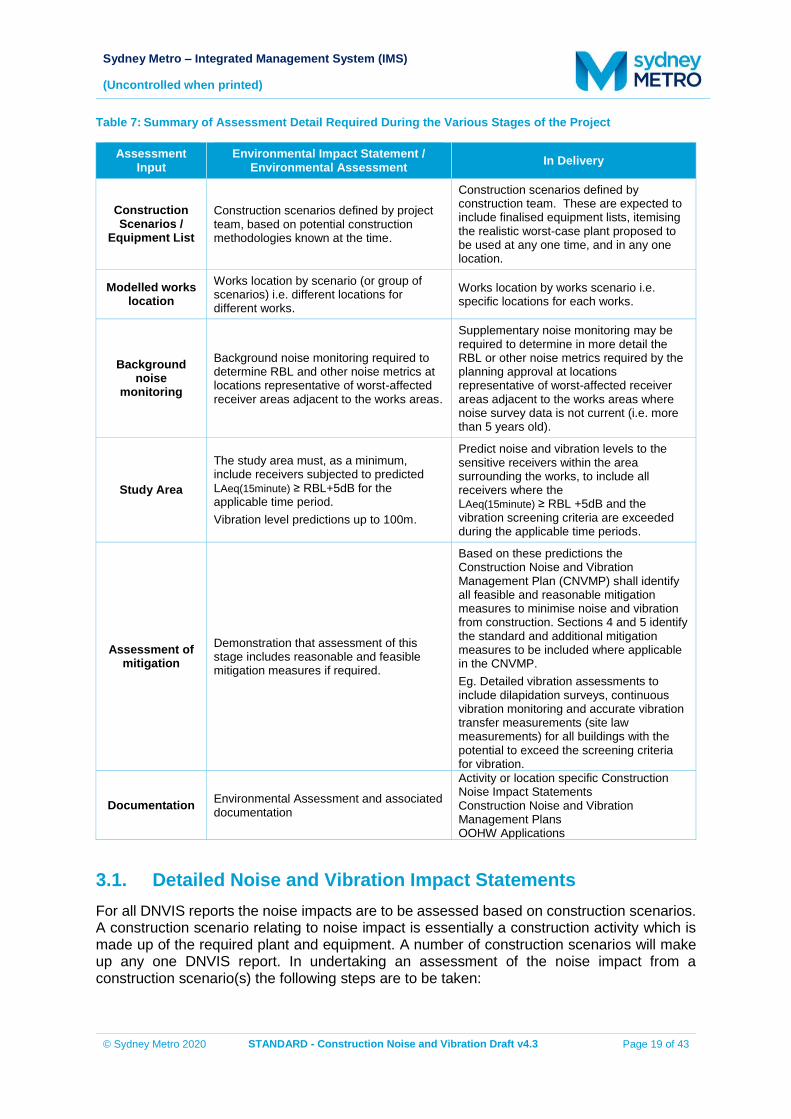
Sydney Metro – Integrated Management System (IMS)
(Uncontrolled when printed)
© Sydney Metro 2020 STANDARD - Construction Noise and Vibration Draft v4.3 Page 19 of 43
Table 7: Summary of Assessment Detail Required During the Various Stages of the Project
Assessment Input
Environmental Impact Statement / Environmental Assessment In Delivery
Construction Scenarios /
Equipment List
Construction scenarios defined by project team, based on potential construction methodologies known at the time.
Construction scenarios defined by construction team. These are expected to include finalised equipment lists, itemising the realistic worst-case plant proposed to be used at any one time, and in any one location.
Modelled works location
Works location by scenario (or group of scenarios) i.e. different locations for different works.
Works location by works scenario i.e. specific locations for each works.
Background noise
monitoring
Background noise monitoring required to determine RBL and other noise metrics at locations representative of worst-affected receiver areas adjacent to the works areas.
Supplementary noise monitoring may be required to determine in more detail the RBL or other noise metrics required by the planning approval at locations representative of worst-affected receiver areas adjacent to the works areas where noise survey data is not current (i.e. more than 5 years old).
Study Area
The study area must, as a minimum, include receivers subjected to predicted LAeq(15minute) ≥ RBL+5dB for the applicable time period. Vibration level predictions up to 100m.
Predict noise and vibration levels to the sensitive receivers within the area surrounding the works, to include all receivers where the LAeq(15minute) ≥ RBL +5dB and the vibration screening criteria are exceeded during the applicable time periods.
Assessment of mitigation
Demonstration that assessment of this stage includes reasonable and feasible mitigation measures if required.
Based on these predictions the Construction Noise and Vibration Management Plan (CNVMP) shall identify all feasible and reasonable mitigation measures to minimise noise and vibration from construction. Sections 4 and 5 identify the standard and additional mitigation measures to be included where applicable in the CNVMP. Eg. Detailed vibration assessments to include dilapidation surveys, continuous vibration monitoring and accurate vibration transfer measurements (site law measurements) for all buildings with the potential to exceed the screening criteria for vibration.
Documentation Environmental Assessment and associated documentation
Activity or location specific Construction Noise Impact Statements Construction Noise and Vibration Management Plans OOHW Applications
3.1. Detailed Noise and Vibration Impact Statements For all DNVIS reports the noise impacts are to be assessed based on construction scenarios. A construction scenario relating to noise impact is essentially a construction activity which is made up of the required plant and equipment. A number of construction scenarios will make up any one DNVIS report. In undertaking an assessment of the noise impact from a construction scenario(s) the following steps are to be taken:
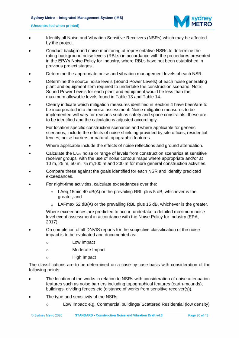
Sydney Metro – Integrated Management System (IMS)
(Uncontrolled when printed)
© Sydney Metro 2020 STANDARD - Construction Noise and Vibration Draft v4.3 Page 20 of 43
Identify all Noise and Vibration Sensitive Receivers (NSRs) which may be affected by the project.
Conduct background noise monitoring at representative NSRs to determine the rating background noise levels (RBLs) in accordance with the procedures presented in the EPA’s Noise Policy for Industry, where RBLs have not been established in previous project stages.
Determine the appropriate noise and vibration management levels of each NSR.
Determine the source noise levels (Sound Power Levels) of each noise generating plant and equipment item required to undertake the construction scenario. Note: Sound Power Levels for each plant and equipment would be less than the maximum allowable levels found in Table 13 and Table 14.
Clearly indicate which mitigation measures identified in Section 4 have been/are to be incorporated into the noise assessment. Noise mitigation measures to be implemented will vary for reasons such as safety and space constraints, these are to be identified and the calculations adjusted accordingly.
For location specific construction scenarios and where applicable for generic scenarios, include the effects of noise shielding provided by site offices, residential fences, noise barriers or natural topographic features.
Where applicable include the effects of noise reflections and ground attenuation.
Calculate the LAeq noise or range of levels from construction scenarios at sensitive receiver groups, with the use of noise contour maps where appropriate and/or at 10 m, 25 m, 50 m, 75 m,100 m and 200 m for more general construction activities.
Compare these against the goals identified for each NSR and identify predicted exceedances.
For night-time activities, calculate exceedances over the: o LAeq,15min 40 dB(A) or the prevailing RBL plus 5 dB, whichever is the
greater, and o LAFmax 52 dB(A) or the prevailing RBL plus 15 dB, whichever is the greater.
Where exceedances are predicted to occur, undertake a detailed maximum noise level event assessment in accordance with the Noise Policy for Industry (EPA, 2017).
On completion of all DNVIS reports for the subjective classification of the noise impact is to be evaluated and documented as: o Low Impact o Moderate Impact o High Impact
The classifications are to be determined on a case-by-case basis with consideration of the following points:
The location of the works in relation to NSRs with consideration of noise attenuation features such as noise barriers including topographical features (earth-mounds), buildings, dividing fences etc (distance of works from sensitive receiver(s)).
The type and sensitivity of the NSRs: o Low Impact: e.g. Commercial buildings/ Scattered Residential (low density)
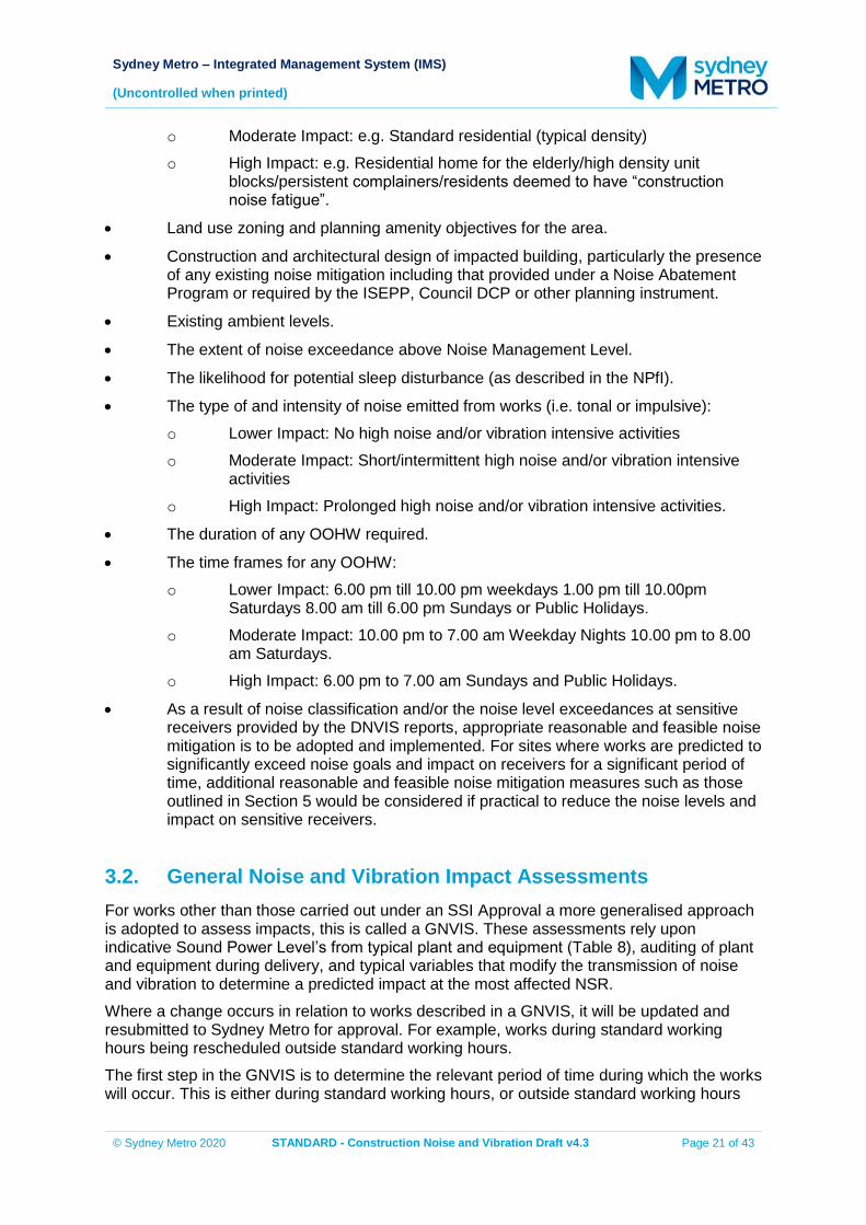
Sydney Metro – Integrated Management System (IMS)
(Uncontrolled when printed)
© Sydney Metro 2020 STANDARD - Construction Noise and Vibration Draft v4.3 Page 21 of 43
o Moderate Impact: e.g. Standard residential (typical density) o High Impact: e.g. Residential home for the elderly/high density unit
blocks/persistent complainers/residents deemed to have “construction noise fatigue”.
Land use zoning and planning amenity objectives for the area.
Construction and architectural design of impacted building, particularly the presence of any existing noise mitigation including that provided under a Noise Abatement Program or required by the ISEPP, Council DCP or other planning instrument.
Existing ambient levels.
The extent of noise exceedance above Noise Management Level.
The likelihood for potential sleep disturbance (as described in the NPfI).
The type of and intensity of noise emitted from works (i.e. tonal or impulsive): o Lower Impact: No high noise and/or vibration intensive activities o Moderate Impact: Short/intermittent high noise and/or vibration intensive
activities o High Impact: Prolonged high noise and/or vibration intensive activities.
The duration of any OOHW required.
The time frames for any OOHW: o Lower Impact: 6.00 pm till 10.00 pm weekdays 1.00 pm till 10.00pm
Saturdays 8.00 am till 6.00 pm Sundays or Public Holidays. o Moderate Impact: 10.00 pm to 7.00 am Weekday Nights 10.00 pm to 8.00
am Saturdays. o High Impact: 6.00 pm to 7.00 am Sundays and Public Holidays.
As a result of noise classification and/or the noise level exceedances at sensitive receivers provided by the DNVIS reports, appropriate reasonable and feasible noise mitigation is to be adopted and implemented. For sites where works are predicted to significantly exceed noise goals and impact on receivers for a significant period of time, additional reasonable and feasible noise mitigation measures such as those outlined in Section 5 would be considered if practical to reduce the noise levels and impact on sensitive receivers.
3.2. General Noise and Vibration Impact Assessments For works other than those carried out under an SSI Approval a more generalised approach is adopted to assess impacts, this is called a GNVIS. These assessments rely upon indicative Sound Power Level’s from typical plant and equipment (Table 8), auditing of plant and equipment during delivery, and typical variables that modify the transmission of noise and vibration to determine a predicted impact at the most affected NSR. Where a change occurs in relation to works described in a GNVIS, it will be updated and resubmitted to Sydney Metro for approval. For example, works during standard working hours being rescheduled outside standard working hours. The first step in the GNVIS is to determine the relevant period of time during which the works will occur. This is either during standard working hours, or outside standard working hours
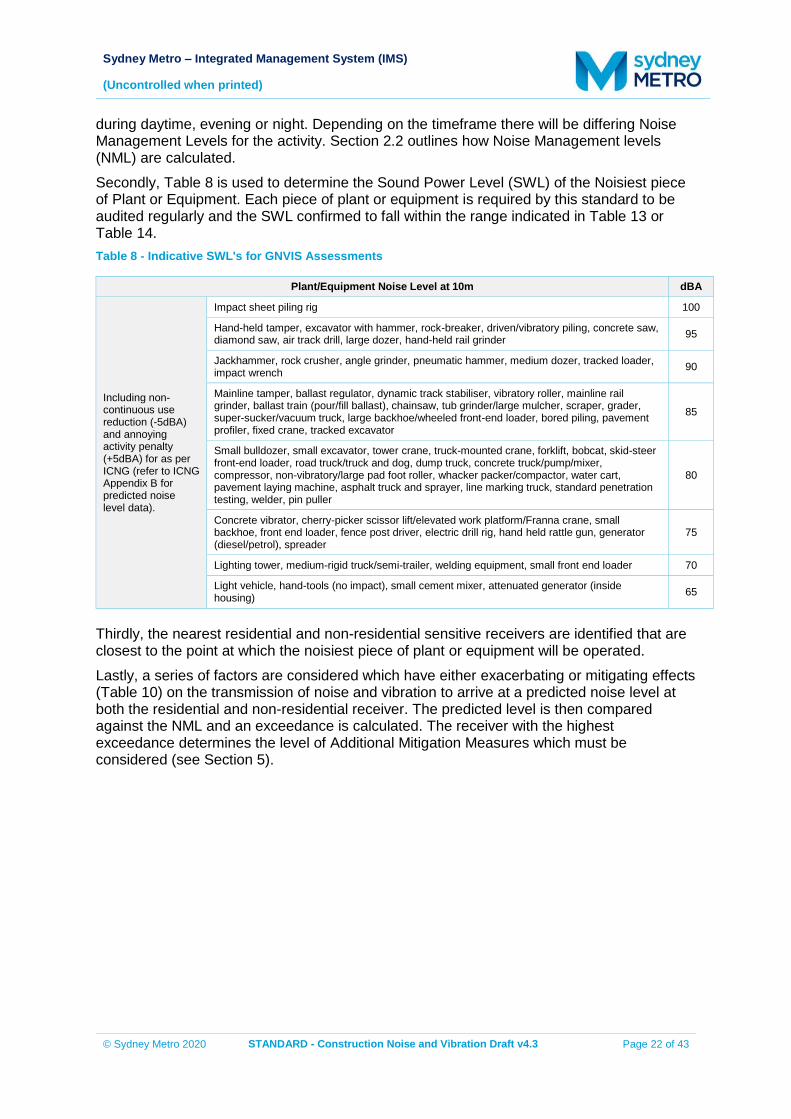
Sydney Metro – Integrated Management System (IMS)
(Uncontrolled when printed)
© Sydney Metro 2020 STANDARD - Construction Noise and Vibration Draft v4.3 Page 22 of 43
during daytime, evening or night. Depending on the timeframe there will be differing Noise Management Levels for the activity. Section 2.2 outlines how Noise Management levels (NML) are calculated. Secondly, Table 8 is used to determine the Sound Power Level (SWL) of the Noisiest piece of Plant or Equipment. Each piece of plant or equipment is required by this standard to be audited regularly and the SWL confirmed to fall within the range indicated in Table 13 or Table 14. Table 8 - Indicative SWL's for GNVIS Assessments
Plant/Equipment Noise Level at 10m dBA
Including non-continuous use reduction (-5dBA) and annoying activity penalty (+5dBA) for as per ICNG (refer to ICNG Appendix B for predicted noise level data).
Impact sheet piling rig 100
Hand-held tamper, excavator with hammer, rock-breaker, driven/vibratory piling, concrete saw, diamond saw, air track drill, large dozer, hand-held rail grinder 95
Jackhammer, rock crusher, angle grinder, pneumatic hammer, medium dozer, tracked loader, impact wrench 90
Mainline tamper, ballast regulator, dynamic track stabiliser, vibratory roller, mainline rail grinder, ballast train (pour/fill ballast), chainsaw, tub grinder/large mulcher, scraper, grader, super-sucker/vacuum truck, large backhoe/wheeled front-end loader, bored piling, pavement profiler, fixed crane, tracked excavator
85
Small bulldozer, small excavator, tower crane, truck-mounted crane, forklift, bobcat, skid-steer front-end loader, road truck/truck and dog, dump truck, concrete truck/pump/mixer, compressor, non-vibratory/large pad foot roller, whacker packer/compactor, water cart, pavement laying machine, asphalt truck and sprayer, line marking truck, standard penetration testing, welder, pin puller
80
Concrete vibrator, cherry-picker scissor lift/elevated work platform/Franna crane, small backhoe, front end loader, fence post driver, electric drill rig, hand held rattle gun, generator (diesel/petrol), spreader
75
Lighting tower, medium-rigid truck/semi-trailer, welding equipment, small front end loader 70
Light vehicle, hand-tools (no impact), small cement mixer, attenuated generator (inside housing) 65
Thirdly, the nearest residential and non-residential sensitive receivers are identified that are closest to the point at which the noisiest piece of plant or equipment will be operated. Lastly, a series of factors are considered which have either exacerbating or mitigating effects (Table 10) on the transmission of noise and vibration to arrive at a predicted noise level at both the residential and non-residential receiver. The predicted level is then compared against the NML and an exceedance is calculated. The receiver with the highest exceedance determines the level of Additional Mitigation Measures which must be considered (see Section 5).
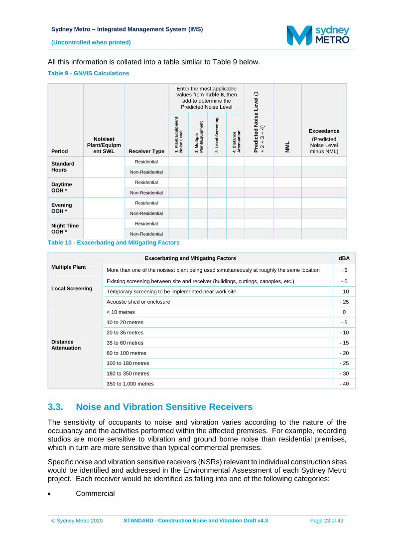
Sydney Metro – Integrated Management System (IMS)
(Uncontrolled when printed)
© Sydney Metro 2020 STANDARD - Construction Noise and Vibration Draft v4.3 Page 23 of 43
All this information is collated into a table similar to Table 9 below. Table 9 - GNVIS Calculations
Period
Noisiest Plant/Equipm
ent SWL Receiver Type
Enter the most applicable values from Table 8, then
add to determine the Predicted Noise Level
Pred
icte
d N
oise
Lev
el (1
+
2 +
3 +
4)
NM
L
Exceedance (Predicted
Noise Level minus NML) 1.
Pla
nt/E
quip
men
t N
oise
Lev
el
2. M
ultip
le
Plan
t/Equ
ipm
ent
3. L
ocal
Scr
eeni
ng
4. D
ista
nce
Atte
nuat
ion
Standard Hours
Residential
Non-Residential
Daytime OOH *
Residential
Non-Residential
Evening OOH *
Residential
Non-Residential
Night Time OOH *
Residential
Non-Residential Table 10 - Exacerbating and Mitigating Factors
Exacerbating and Mitigating Factors dBA Multiple Plant More than one of the noisiest plant being used simultaneously at roughly the same location +5
Local Screening Existing screening between site and receiver (buildings, cuttings, canopies, etc.) - 5
Temporary screening to be implemented near work site - 10
Acoustic shed or enclosure - 25
Distance Attenuation
< 10 metres 0
10 to 20 metres - 5
20 to 35 metres - 10
35 to 60 metres - 15
60 to 100 metres - 20
100 to 180 metres - 25
180 to 350 metres - 30
350 to 1,000 metres - 40
3.3. Noise and Vibration Sensitive Receivers The sensitivity of occupants to noise and vibration varies according to the nature of the occupancy and the activities performed within the affected premises. For example, recording studios are more sensitive to vibration and ground borne noise than residential premises, which in turn are more sensitive than typical commercial premises.
Specific noise and vibration sensitive receivers (NSRs) relevant to individual construction sites would be identified and addressed in the Environmental Assessment of each Sydney Metro project. Each receiver would be identified as falling into one of the following categories:
Commercial
Sydney Metro – Integrated Management System (IMS)
(Uncontrolled when printed)
© Sydney Metro 2020 STANDARD - Construction Noise and Vibration Draft v4.3 Page 24 of 43
Educational
Industrial
Mixed residential/commercial
Residential
Residential occupied by shift workers
Place of Worship
Medical facilities
Other sensitive receivers
3.4. Ground-Borne (Regenerated) Noise Ground-borne noise as a result of construction activities is usually associated with tunnelling projects where equipment such as tunnel boring machines, road headers, rock hammers and drilling rigs are operated underground. It is therefore anticipated that ground-borne noise may be an issue during the construction of Sydney Metro projects.
If NSR’s may be affected by ground-borne noise as a result of construction activities, a DNVIS or GNVIS report specifically in relation to the assessment of ground-borne construction noise would be undertaken.
In undertaking a DNVIS or GNVIS report for ground-borne construction noise the following steps are to be taken:
Identify and quantify if necessary, any significant extraneous sources of ground-borne noise.
Determine the location of each plant and equipment item in relation to each receiver.
On the basis of ground-borne noise versus distance prediction algorithms for each plant item, determine the level of ground-borne noise at each building location. For highly sensitive building occupancies, such as recording studios, the assessment may need to incorporate the acoustic properties of the building space and the structural response of the building. This is to be determined by a qualified acoustic consultant, should ground-borne noise be a potential issue.
Include the effect of all relevant standard mitigation measures as part of the construction scenario.
Calculate the LAeq(15minute) noise levels from the proposed construction actives at each receiver and compare these to the ground-borne noise management levels.
3.5. Ground-Borne Vibration Vibration as a result of construction activities is usually associated with tunnelling projects where equipment such as tunnel boring machines, road headers, rock hammers and drilling rigs are operated underground. It is therefore anticipated that ground-borne vibration may be an issue during the construction of Sydney Metro projects.
If vibration impacts are anticipated as a result of construction activities, a DNVIS or GNVIS report specifically in relation to the assessment of construction vibration would be undertaken.
Sydney Metro – Integrated Management System (IMS)
(Uncontrolled when printed)
© Sydney Metro 2020 STANDARD - Construction Noise and Vibration Draft v4.3 Page 25 of 43
In undertaking a DNVIS or GNVIS report for ground-borne construction vibration the following steps are to be taken:
Determine the location of each plant and equipment item in relation to each receiver.
On the basis of ground-borne vibration versus distance prediction algorithms for each plant item, determine the level of ground-borne vibration at each building location. For highly sensitive building occupancies, such as recording studios, the assessment may need to incorporate the vibration properties of the building space and the structural response of the building. This is to be determined by a qualified acoustic consultant, should ground-borne vibration be a potential issue.
Include the effect of all relevant standard mitigation measures as part of the construction scenario.
Calculate the vibration levels from the proposed construction actives at each receiver and compare these to the ground-borne vibration criteria.
3.6. Vibration and Overpressure from Blasting Vibration and overpressure as a result of construction activities is usually associated with tunnelling projects where blasting is required. If this construction is implemented then vibration and overpressure may be an issue during the construction of Sydney Metro projects.
If vibration and overpressure impacts are anticipated as a result of construction blasting, a DNVIS report, specifically in relation to the assessment of construction blasting would be undertaken regardless of the projects planning approval pathway.
In undertaking a DNVIS report for blasting vibration and overpressure the following steps are to be taken:
Determine the location of blast charge in relation to each receiver.
On the basis of vibration / overpressure versus distance prediction algorithms for blasting determine the level of vibration / overpressure at each receiver (building) location.
Include the effect of all relevant standard mitigation measures as part of the construction scenario.
Calculate the vibration and overpressure levels from the proposed blasting actives at each receiver and compare these to the blasting criteria.
Sydney Metro – Integrated Management System (IMS)
(Uncontrolled when printed)
© Sydney Metro 2020 STANDARD - Construction Noise and Vibration Draft v4.3 Page 26 of 43
4. STANDARD NOISE AND VIBRATION MITIGATION MEASURES
4.1. Minimum Requirements This section sets out the standard construction noise and vibration mitigation measures to be implemented on all Sydney Metro projects and delivered via relevant procedures, systems, environmental assessment, construction environmental management and all relevant contract documentation.
For all Sydney Metro construction projects, the standard mitigation measures in Table 11 shall be applied by default where feasible and reasonable in order to minimise the potential noise and vibration impacts at the surrounding Noise Sensitive Receivers. The effect of applying standard mitigation measures may be considered in noise and vibration assessments to achieve NML’s.
4.1.1. Management Strategies during Construction
Construction hours would be in accordance with the ICNG, project approvals and the EPL if required, except where otherwise specified in an approved noise management plan.
When working adjacent to schools, medical facilities and childcare centres, particularly noisy activities would be scheduled outside normal working hours, where feasible and reasonable.
When working adjacent to churches and places of worship particularly noisy activities would be scheduled outside services, where feasible and reasonable.
Avoiding the coincidence of noisy plant working simultaneously close together and adjacent to sensitive receivers will result in reduced noise emissions.
Where feasible and reasonable, the offset distance between noisy plant items and nearby noise sensitive receivers would be as great as possible.
Regular compliance checks on the noise emissions of all plant and machinery used for the project would indicate whether noise emissions from plant items were higher than predicted. This also identifies defective silencing equipment on the items of plant.
Ongoing noise monitoring during construction at sensitive receivers during critical periods (i.e. times when noise emissions are expected to be at their highest - e.g. piling and hammering) to identify and assist in managing high risk noise events.
Where feasible and reasonable heavy vehicle movements would be limited to daytime hours.
The implementation of procedures to maximise the night-time onsite spoil storage capacity where spoil is produced between the hours of 10.00 pm and 7.00 am.
Where feasible and reasonable, there will be coordination with any required ancillary works (utility relocations etc.) to minimise overall noise impacts and to avoid scheduling such activities during planned respite periods.
Sydney Metro – Integrated Management System (IMS)
(Uncontrolled when printed)
© Sydney Metro 2020 STANDARD - Construction Noise and Vibration Draft v4.3 Page 27 of 43
4.1.2. Site Induction for all Employees, Contractors and Subcontractors
The site induction would include the following as a minimum:
All relevant project specific and standard noise and vibration mitigation measures
Relevant licence and approval conditions
Permissible hours of work
Any limitations on high noise generating activities
Location of nearest sensitive receivers
Construction employee parking areas
Designated loading/unloading areas and procedures
Site opening/closing times (including deliveries)
Identification of activities likely to cause complaint
Environmental incident reporting and management procedures
4.1.3. Source Noise Control Strategies
Engines and exhausts are typically the dominant noise sources on mobile plant such as cranes, graders, excavators, heavy vehicles, etc. In order to minimise noise emissions, residential grade mufflers would be fitted on all mobile plant utilised on Sydney Metro construction projects.
The use of damped hammers is recommended such as the ‘City’ model Rammer hammers. These reduce the ‘ringing’ of the rock pick, cylinder and excavator arm that is commonly associated with rock breaking works. Approximately 10 dB attenuation can be achieved compared to undamped hammers of the same size.
Regular maintenance of all plant and machinery used for the project will assist in minimising noise emissions, including the reporting of the results.
Acoustic enclosure of plant items, if required, as identified during compliance monitoring.
Use of engine exhaust brakes should be avoided where possible. Air brake silencers would be correctly installed and fully operational for any heavy vehicle that approaches and uses any Sydney Metro construction site.
Non-tonal reversing alarms would be used for all permanent mobile plant operating on Sydney Metro construction projects. Whilst the use of non-tonal reversing alarms is suggested to ensure noise impacts are minimised, it is noted that OH&S requirements must also be fully satisfied.
4.1.4. Noise Barrier Control Strategies
Temporary noise barriers are recommended between the noise sources and nearby potentially affected noise sensitive receivers, wherever feasible. Typically, 5 dB to 15 dB attenuation can be achieved with a well designed and constructed barrier.
Sydney Metro – Integrated Management System (IMS)
(Uncontrolled when printed)
© Sydney Metro 2020 STANDARD - Construction Noise and Vibration Draft v4.3 Page 28 of 43
4.1.5. Acoustic Enclosures
Where significant noise impacts are predicted and/or long periods of construction works are planned, acoustic enclosures can be used as an effective mitigation method. Acoustic enclosures act to contain the sources of noise, whilst also providing the benefit of screening the construction site from view. An enclosure with no openings would be expected to provide attenuation the order of 20 dB.
4.1.6. Vibration Control Strategies
Attended vibration measurements are required at the commencement of vibration generating activities to confirm that vibration levels satisfy the criteria for that vibration generating activity. Where there is potential for exceedances of the criteria further vibration site law investigations would be undertaken to determine the site-specific safe working distances for that vibration generating activity. Continuous vibration monitoring with audible and visible alarms would be conducted at the nearest sensitive receivers whenever vibration generating activities need to take place inside the calculated safe-working distances.
4.1.7. Community Consultation
Active community consultation and the maintenance of positive, cooperative relationships with schools, local residents and building owners and occupiers assists in managing impacts from noisier operations and in alleviating concerns and thereby minimising disturbance and complaint. This includes, for example:
Periodic notification or work activities and progress (e.g. regular letterbox drops, e-consult)
Specific notification (letter-box drop) prior to especially noisy activities
Comprehensive website information
Project information and construction response telephone line
Email distribution list
4.2. Summary of the Standard Mitigation Measures The actions set out in Table 11 must be implemented on all Sydney Metro construction projects.
Table 11: Standard Mitigation Measures to Reduce Construction Noise and Vibration
Action required Applies to Details
Management Measures
Implementation of any project specific mitigation
measures required
Airborne noise Ground-borne noise and
vibration
In addition to the measures set out in this table, any project specific mitigation measures identified in the environmental assessment documentation (e.g. EA, REF, submissions or representations report) or approval or licence conditions must be implemented.
Sydney Metro – Integrated Management System (IMS)
(Uncontrolled when printed)
© Sydney Metro 2020 STANDARD - Construction Noise and Vibration Draft v4.3 Page 29 of 43
Action required Applies to Details
Implement community consultation measures
Airborne noise Ground-borne noise and
vibration
Periodic Notification (monthly letterbox drop)1 Website Project information and construction response telephone line Email distribution list Place Managers
Register of Noise Sensitive Receivers
Airborne noise Ground-borne noise and
vibration
A register of all noise and vibration sensitive receivers (NSRs) would be kept on site. The register would include the following details for each NSR: Address of receiver Category of receiver (e.g. Residential,
Commercial etc.) Contact name and phone number
Site inductions Airborne noise
Ground-borne noise and vibration
All employees, contractors and subcontractors are to receive an environmental induction. The induction must at least include: All relevant project specific and standard
noise and vibration mitigation measures Relevant licence and approval conditions Permissible hours of work Any limitations on high noise generating
activities Location of nearest sensitive receivers Construction employee parking areas Designated loading/unloading areas and
procedures Site opening/closing times (including
deliveries) Environmental incident procedures
Behavioural practices Airborne noise
No swearing or unnecessary shouting or loud stereos/radios; on site. No dropping of materials from height; throwing of metal items; and slamming of doors. No excessive revving of plant and vehicle engines Controlled release of compressed air.
Monitoring Airborne noise
Ground-borne noise and vibration
A noise monitoring program is to be carried out for the duration of the works in accordance with the Construction Noise and Vibration Management Plan and any approval and licence conditions.
1 Detailing all upcoming construction activities at least 14 days prior to commencement of relevant works
Sydney Metro – Integrated Management System (IMS)
(Uncontrolled when printed)
© Sydney Metro 2020 STANDARD - Construction Noise and Vibration Draft v4.3 Page 30 of 43
Action required Applies to Details
Attended vibration measurements Ground-borne vibration
Attended vibration measurements are required at the commencement of vibration generating activities to confirm that vibration levels satisfy the criteria for that vibration generating activity. Where there is potential for exceedances of the criteria further vibration site law investigations would be undertaken to determine the site-specific safe working distances for that vibration generating activity. Continuous vibration monitoring with audible and visible alarms would be conducted at the nearest sensitive receivers whenever vibration generating activities need to take place inside the applicable safe-working distances.
Source Controls
Construction hours and scheduling
Airborne noise Ground-borne noise and
vibration
Where feasible and reasonable, construction would be carried out during the standard daytime working hours. Work generating high noise and/or vibration levels would be scheduled during less sensitive time periods.
Construction respite period
Ground-borne noise and vibration
Airborne noise
High noise and vibration generating activities2 may only be carried out in continuous blocks, not exceeding 3 hours each, with a minimum respite period of one hour between each block3.
Equipment selection Airborne noise
Ground-borne noise and vibration
Use quieter and less vibration emitting construction methods where feasible and reasonable. For example, when piling is required, bored piles rather than impact-driven piles will minimise noise and vibration impacts. Similarly, diaphragm wall construction techniques, in lieu of sheet piling, will have significant noise and vibration benefits.
Maximum noise levels Airborne-noise The noise levels of plant and equipment must have operating Sound Power Levels compliant with the criteria in Table 13.
Rental plant and equipment Airborne-noise
The noise levels of plant and equipment items are to be considered in rental decisions and in any case cannot be used on site unless compliant with the criteria in Table 13.
Plan worksites and activities to minimise noise and
vibration
Airborne noise Ground-borne vibration
Plan traffic flow, parking and loading/unloading areas to minimise reversing movements within the site.
Non-tonal reversing alarms Airborne noise
Non-tonal reversing beepers (or an equivalent mechanism) must be fitted and used on all construction vehicles and mobile plant regularly used on site and for any out of hours work.
2 Includes jack and rock hammering, sheet and pile driving, rock breaking and vibratory rolling. 3 “Continuous” includes any period during which there is less than a 60 minutes respite between ceasing and recommencing
any of the work.
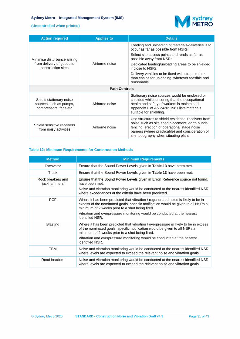
Sydney Metro – Integrated Management System (IMS)
(Uncontrolled when printed)
© Sydney Metro 2020 STANDARD - Construction Noise and Vibration Draft v4.3 Page 31 of 43
Action required Applies to Details
Minimise disturbance arising from delivery of goods to
construction sites Airborne noise
Loading and unloading of materials/deliveries is to occur as far as possible from NSRs Select site access points and roads as far as possible away from NSRs Dedicated loading/unloading areas to be shielded if close to NSRs Delivery vehicles to be fitted with straps rather than chains for unloading, wherever feasible and reasonable
Path Controls
Shield stationary noise sources such as pumps, compressors, fans etc
Airborne noise
Stationary noise sources would be enclosed or shielded whilst ensuring that the occupational health and safety of workers is maintained. Appendix F of AS 2436: 1981 lists materials suitable for shielding.
Shield sensitive receivers from noisy activities Airborne noise
Use structures to shield residential receivers from noise such as site shed placement; earth bunds; fencing; erection of operational stage noise barriers (where practicable) and consideration of site topography when situating plant.
Table 12: Minimum Requirements for Construction Methods
Method Minimum Requirements
Excavator Ensure that the Sound Power Levels given in Table 13 have been met.
Truck Ensure that the Sound Power Levels given in Table 13 have been met.
Rock breakers and jackhammers
Ensure that the Sound Power Levels given in Error! Reference source not found. have been met. Noise and vibration monitoring would be conducted at the nearest identified NSR where exceedances of the criteria have been predicted.
PCF Where it has been predicted that vibration / regenerated noise is likely to be in excess of the nominated goals, specific notification would be given to all NSRs a minimum of 2 weeks prior to a shot being fired. Vibration and overpressure monitoring would be conducted at the nearest identified NSR.
Blasting Where it has been predicted that vibration / overpressure is likely to be in excess of the nominated goals, specific notification would be given to all NSRs a minimum of 2 weeks prior to a shot being fired. Vibration and overpressure monitoring would be conducted at the nearest identified NSR.
TBM Noise and vibration monitoring would be conducted at the nearest identified NSR where levels are expected to exceed the relevant noise and vibration goals.
Road headers Noise and vibration monitoring would be conducted at the nearest identified NSR where levels are expected to exceed the relevant noise and vibration goals.
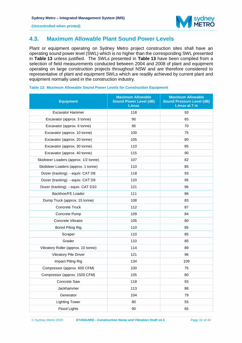
Sydney Metro – Integrated Management System (IMS)
(Uncontrolled when printed)
© Sydney Metro 2020 STANDARD - Construction Noise and Vibration Draft v4.3 Page 32 of 43
4.3. Maximum Allowable Plant Sound Power Levels Plant or equipment operating on Sydney Metro project construction sites shall have an operating sound power level (SWL) which is no higher than the corresponding SWL presented in Table 13 unless justified. The SWLs presented in Table 13 have been compiled from a selection of field measurements conducted between 2004 and 2008 of plant and equipment operating on large construction projects throughout NSW and are therefore considered to representative of plant and equipment SWLs which are readily achieved by current plant and equipment normally used in the construction industry.
Table 13: Maximum Allowable Sound Power Levels for Construction Equipment
Equipment Maximum Allowable
Sound Power Level (dB) LAmax
Maximum Allowable Sound Pressure Level (dB)
LAmax at 7 m
Excavator Hammer 118 93
Excavator (approx. 3 tonne) 90 65
Excavator (approx. 6 tonne) 95 70
Excavator (approx. 10 tonne) 100 75
Excavator (approx. 20 tonne) 105 80
Excavator (approx. 30 tonne) 110 85
Excavator (approx. 40 tonne) 115 90
Skidsteer Loaders (approx. 1/2 tonne) 107 82
Skidsteer Loaders (approx. 1 tonne) 110 85
Dozer (tracking) - equiv. CAT D8 118 93
Dozer (tracking) - equiv. CAT D9 120 95
Dozer (tracking) - equiv. CAT D10 121 96
Backhoe/FE Loader 111 86
Dump Truck (approx. 15 tonne) 108 83
Concrete Truck 112 87
Concrete Pump 109 84
Concrete Vibrator 105 80
Bored Piling Rig 110 85
Scraper 110 85
Grader 110 85
Vibratory Roller (approx. 10 tonne) 114 89
Vibratory Pile Driver 121 96
Impact Piling Rig 134 109
Compressor (approx. 600 CFM) 100 75
Compressor (approx. 1500 CFM) 105 80
Concrete Saw 118 93
Jackhammer 113 88
Generator 104 79
Lighting Tower 80 55
Flood Lights 90 65
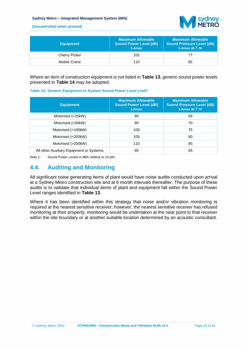
Sydney Metro – Integrated Management System (IMS)
(Uncontrolled when printed)
© Sydney Metro 2020 STANDARD - Construction Noise and Vibration Draft v4.3 Page 33 of 43
Equipment Maximum Allowable
Sound Power Level (dB) LAmax
Maximum Allowable Sound Pressure Level (dB)
LAmax at 7 m
Cherry Picker 102 77
Mobile Crane 110 85
Where an item of construction equipment is not listed in Table 13, generic sound power levels presented in Table 14 may be adopted.
Table 14: Generic Equipment or System Sound Power Level Limit1
Equipment Maximum Allowable
Sound Power Level (dB) LAmax
Maximum Allowable Sound Pressure Level (dB)
LAmax at 7 m
Motorised (<25kW) 90 65
Motorised (<50kW) 95 70
Motorised (<100kW) 100 75
Motorised (<200kW) 105 80
Motorised (>200kW) 110 85
All other Auxiliary Equipment or Systems 90 65
Note 1: Sound Power Levels in dBA relative to 10 pW.
4.4. Auditing and Monitoring All significant noise generating items of plant would have noise audits conducted upon arrival at a Sydney Metro construction site and at 6 month intervals thereafter. The purpose of these audits is to validate that individual items of plant and equipment fall within the Sound Power Level ranges identified in Table 13.
Where it has been identified within this strategy that noise and/or vibration monitoring is required at the nearest sensitive receiver; however, the nearest sensitive receiver has refused monitoring at their property, monitoring would be undertaken at the near point to that receiver within the site boundary or at another suitable location determined by an acoustic consultant.
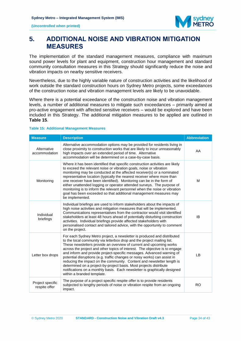
Sydney Metro – Integrated Management System (IMS)
(Uncontrolled when printed)
© Sydney Metro 2020 STANDARD - Construction Noise and Vibration Draft v4.3 Page 34 of 43
5. ADDITIONAL NOISE AND VIBRATION MITIGATION MEASURES
The implementation of the standard management measures, compliance with maximum sound power levels for plant and equipment, construction hour management and standard community consultation measures in this Strategy should significantly reduce the noise and vibration impacts on nearby sensitive receivers.
Nevertheless, due to the highly variable nature of construction activities and the likelihood of work outside the standard construction hours on Sydney Metro projects, some exceedances of the construction noise and vibration management levels are likely to be unavoidable.
Where there is a potential exceedance of the construction noise and vibration management levels, a number of additional measures to mitigate such exceedances – primarily aimed at pro-active engagement with affected sensitive receivers – would be explored and have been included in this Strategy. The additional mitigation measures to be applied are outlined in Table 15.
Table 15: Additional Management Measures
Measure Description Abbreviation
Alternative accommodation
Alternative accommodation options may be provided for residents living in close proximity to construction works that are likely to incur unreasonably high impacts over an extended period of time. Alternative accommodation will be determined on a case-by-case basis.
AA
Monitoring
Where it has been identified that specific construction activities are likely to exceed the relevant noise or vibration goals, noise or vibration monitoring may be conducted at the affected receiver(s) or a nominated representative location (typically the nearest receiver where more than one receiver have been identified). Monitoring can be in the form of either unattended logging or operator attended surveys. The purpose of monitoring is to inform the relevant personnel when the noise or vibration goal has been exceeded so that additional management measures may be implemented.
M
Individual briefings
Individual briefings are used to inform stakeholders about the impacts of high noise activities and mitigation measures that will be implemented. Communications representatives from the contractor would visit identified stakeholders at least 48 hours ahead of potentially disturbing construction activities. Individual briefings provide affected stakeholders with personalised contact and tailored advice, with the opportunity to comment on the project.
IB
Letter box drops
For each Sydney Metro project, a newsletter is produced and distributed to the local community via letterbox drop and the project mailing list. These newsletters provide an overview of current and upcoming works across the project and other topics of interest. The objective is to engage and inform and provide project-specific messages. Advanced warning of potential disruptions (e.g. traffic changes or noisy works) can assist in reducing the impact on the community. Content and newsletter length is determined on a project-by-project basis. Most projects distribute notifications on a monthly basis. Each newsletter is graphically designed within a branded template.
LB
Project specific respite offer
The purpose of a project specific respite offer is to provide residents subjected to lengthy periods of noise or vibration respite from an ongoing impact.
RO
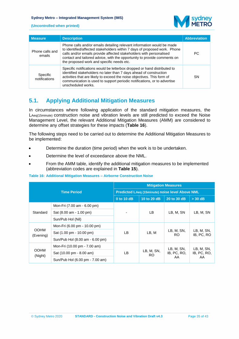
Sydney Metro – Integrated Management System (IMS)
(Uncontrolled when printed)
© Sydney Metro 2020 STANDARD - Construction Noise and Vibration Draft v4.3 Page 35 of 43
Measure Description Abbreviation
Phone calls and emails
Phone calls and/or emails detailing relevant information would be made to identified/affected stakeholders within 7 days of proposed work. Phone calls and/or emails provide affected stakeholders with personalised contact and tailored advice, with the opportunity to provide comments on the proposed work and specific needs etc.
PC
Specific notifications
Specific notifications would be letterbox dropped or hand distributed to identified stakeholders no later than 7 days ahead of construction activities that are likely to exceed the noise objectives. This form of communication is used to support periodic notifications, or to advertise unscheduled works.
SN
5.1. Applying Additional Mitigation Measures In circumstances where following application of the standard mitigation measures, the LAeq(15minute) construction noise and vibration levels are still predicted to exceed the Noise Management Level, the relevant Additional Mitigation Measures (AMM) are considered to determine any offset strategies for these impacts (Table 16).
The following steps need to be carried out to determine the Additional Mitigation Measures to be implemented:
Determine the duration (time period) when the work is to be undertaken.
Determine the level of exceedance above the NML.
From the AMM table, identify the additional mitigation measures to be implemented (abbreviation codes are explained in Table 15).
Table 16: Additional Mitigation Measures – Airborne Construction Noise
Time Period
Mitigation Measures
Predicted LAeq (15minute) noise level Above NML
0 to 10 dB 10 to 20 dB 20 to 30 dB > 30 dB
Standard
Mon-Fri (7.00 am - 6.00 pm)
- LB LB, M, SN LB, M, SN Sat (8.00 am - 1.00 pm)
Sun/Pub Hol (Nil)
OOHW (Evening)
Mon-Fri (6.00 pm - 10.00 pm)
LB LB, M LB, M, SN, RO
LB, M, SN, IB, PC, RO Sat (1.00 pm - 10.00 pm)
Sun/Pub Hol (8.00 am - 6.00 pm)
OOHW (Night)
Mon-Fri (10.00 pm - 7.00 am)
LB LB, M, SN, RO
LB, M, SN, IB, PC, RO,
AA
LB, M, SN, IB, PC, RO,
AA Sat (10.00 pm - 8.00 am)
Sun/Pub Hol (6.00 pm - 7.00 am)
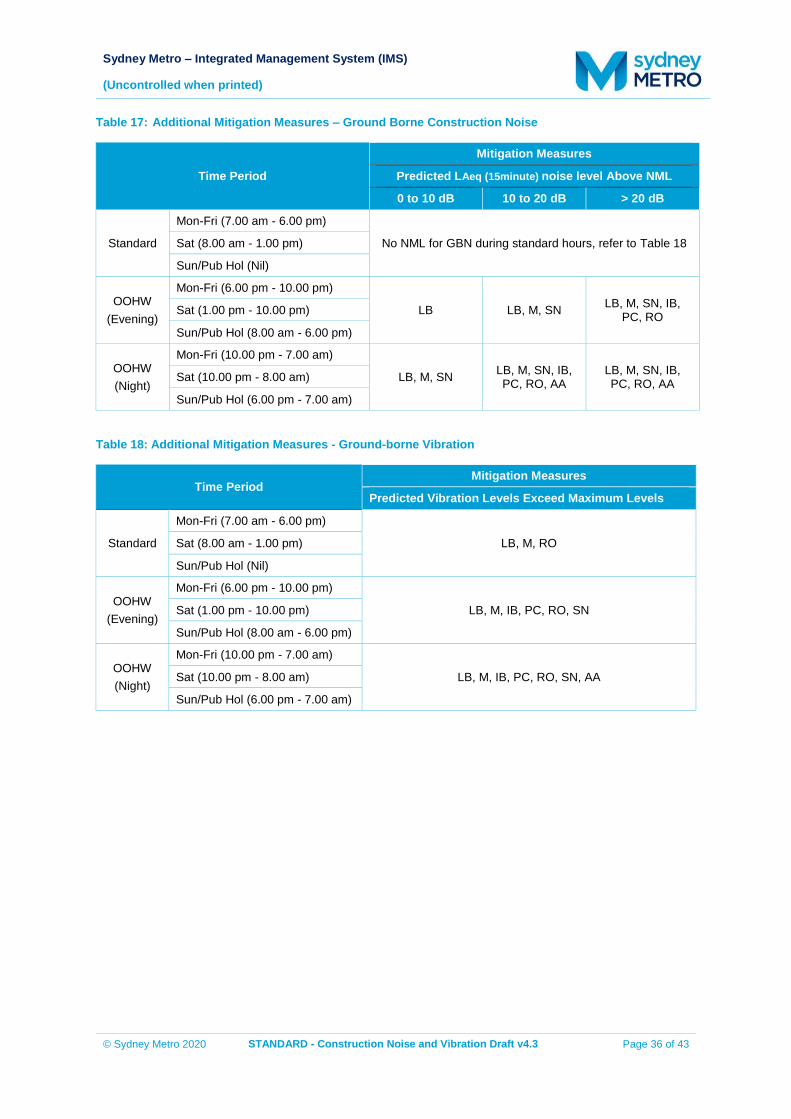
Sydney Metro – Integrated Management System (IMS)
(Uncontrolled when printed)
© Sydney Metro 2020 STANDARD - Construction Noise and Vibration Draft v4.3 Page 36 of 43
Table 17: Additional Mitigation Measures – Ground Borne Construction Noise
Time Period
Mitigation Measures
Predicted LAeq (15minute) noise level Above NML
0 to 10 dB 10 to 20 dB > 20 dB
Standard
Mon-Fri (7.00 am - 6.00 pm)
No NML for GBN during standard hours, refer to Table 18 Sat (8.00 am - 1.00 pm)
Sun/Pub Hol (Nil)
OOHW (Evening)
Mon-Fri (6.00 pm - 10.00 pm)
LB LB, M, SN LB, M, SN, IB, PC, RO Sat (1.00 pm - 10.00 pm)
Sun/Pub Hol (8.00 am - 6.00 pm)
OOHW (Night)
Mon-Fri (10.00 pm - 7.00 am)
LB, M, SN LB, M, SN, IB, PC, RO, AA
LB, M, SN, IB, PC, RO, AA Sat (10.00 pm - 8.00 am)
Sun/Pub Hol (6.00 pm - 7.00 am)
Table 18: Additional Mitigation Measures - Ground-borne Vibration
Time Period Mitigation Measures
Predicted Vibration Levels Exceed Maximum Levels
Standard
Mon-Fri (7.00 am - 6.00 pm)
LB, M, RO Sat (8.00 am - 1.00 pm)
Sun/Pub Hol (Nil)
OOHW (Evening)
Mon-Fri (6.00 pm - 10.00 pm)
LB, M, IB, PC, RO, SN Sat (1.00 pm - 10.00 pm)
Sun/Pub Hol (8.00 am - 6.00 pm)
OOHW (Night)
Mon-Fri (10.00 pm - 7.00 am)
LB, M, IB, PC, RO, SN, AA Sat (10.00 pm - 8.00 am)
Sun/Pub Hol (6.00 pm - 7.00 am)
Sydney Metro – Integrated Management System (IMS)
(Uncontrolled when printed)
© Sydney Metro 2020 STANDARD - Construction Noise and Vibration Draft v4.3 Page 37 of 43
6. MONITORING, AUDITING AND REPORTING 6.1. Plant Noise Auditing, Compliance Evaluation and Reporting In order to compare the noise levels of plant and equipment with the values in Section 4.3, the following guidelines are recommended:
Measurements of Sound Pressure Level (SPL) at 7 m (with plant or equipment stationary) shall be undertaken using procedures that are consistent with the requirements of Australian Standard AS2012–1990 Acoustics – Measurement of Airborne Noise Emitted by Earthmoving Machinery and Agricultural Tractors – Stationary Test Condition Part 1: Determination of Compliance with Limits for Exterior Noise.
Measurements of Sound Power Level (SWL) shall be determined using procedures that are consistent with the requirements of International Standard ISO 9614-2 1996 Acoustics – Determination of sound power levels of noise sources using sound intensity - Part 2: Measurement by scanning.
If measuring the SPL at 7 m of moving plant, compliance measurements would be guided by the requirements of Australian Standard AS2012–1977 Method for Measurement of Airborne Noise from Agricultural Tractors and Earthmoving Machinery.
For all measurements, the plant or equipment under test would be measured while operating under typical operating conditions. If this is not practical, it may be appropriate to conduct a stationary test at high idle.
In the case of an exceedance in Sound Power Levels the item of plant would either be replaced, or the advice of an acoustic consultant would be sought to provide suitable mitigation measures, which may include:
ensuring all bolts are tightened and no parts are loose
cleaning and/or lubricating moving parts
replacing old or worn parts
implementing additional or upgrading existing muffling devices
building enclosures around items of stationary plant (e.g. pumps or generators). A register of measured sound power levels for each item of plant would be kept for reference where future noise audits are conducted. The register would be reviewed annually in conjunction with this strategy and corresponding revisions made to the Sound Power Levels presented in Section 4.3 to represent contemporary plant noise emission levels.
6.2. Noise Monitoring Where a DNVIS or GNVIS has been prepared for a Sydney Metro construction site and it has been predicted that noise levels may be in excess of the nominated construction noise goals at a noise sensitive receiver, noise monitoring would be conducted at:
the affected receiver; or
if more than one affected receiver has been identified, at the nearest affected receiver; or
Sydney Metro – Integrated Management System (IMS)
(Uncontrolled when printed)
© Sydney Metro 2020 STANDARD - Construction Noise and Vibration Draft v4.3 Page 38 of 43
where the nearest affected receiver refuses noise monitoring on their property, at the near point to that receiver within the site boundary.
If it can be demonstrated that direct measurement of noise from the construction site is impractical, alternative means of determining construction noise levels may be adopted in accordance with Chapter 7 of the Noise Policy for Industry.
All noise monitoring results would be assessed against the nominated noise goals and compiled into a report to be forwarded to the construction contractor and project manager. Reporting would be submitted to the construction contractor and project manager within one week of being undertaken or at weekly intervals for continuous monitoring. All noise monitoring reports would also be made available to the public through a publically accessible website.
6.3. Vibration Monitoring Where it is anticipated that an item of plant will exceed the cosmetic damage criteria given in Section 2.3.3, vibration monitoring would be required at the nearest affected receiver. Where it is anticipated that an item of plant will exceed the human response / ground borne noise criteria and concerns have been raised regarding vibration, vibration monitoring would also be required at the receiver(s) under question.
All vibration monitoring results would be assessed against the nominated vibration goals and compiled into a report to be forwarded to the construction contractor and project manager. Reporting would be submitted to the construction contractor and project manager within one week of being undertaken or at weekly intervals for continuous monitoring. All vibration monitoring reports would also be made available to the public through the publically accessible website.
6.4. Blast Monitoring As specified in the minimum requirements presented in Section 3.6, vibration and overpressure monitoring would be conducted for all PCF and blasting activities which take place on Sydney Metro construction sites. Monitoring would be conducted as a minimum at the sensitive receiver(s) likely to receive the maximum vibration and/or overpressure emissions from the blast as identified by an acoustic consultant. All blast monitoring results would be assessed against the nominated goals and compiled into a report to be forwarded to the construction contractor and project manager. All blast monitoring reports would also be made available to the public through the Sydney Metro website.
As the effect of vibration and overpressure from blasting have the potential to cause structural damage to buildings and services, accurate records of all blasts are required to be maintained. Such records would describe the location of the blast and all the blast holes, the design of the blast in terms of type of explosives, mass of explosives, initiating system used, ground vibration and overpressure measurement data.
Records of every blast would be kept for a minimum of seven years. A longer period of retention of the records may be warranted if a construction project is blasted over an extended or disrupted period.
Sydney Metro – Integrated Management System (IMS)
(Uncontrolled when printed)
© Sydney Metro 2020 STANDARD - Construction Noise and Vibration Draft v4.3 Page 39 of 43
For any section of tunnel construction where blasting is proposed, a series of initial trials at reduced scale shall be conducted prior to production blasting to determine site-specific blast response characteristics and to define allowable blast sizes to meet the airblast overpressure and ground vibration limits.
6.5. Dilapidation Surveys If construction activities have the potential to cause damage through vibration to nearby public utilities, structures, buildings and their contents, an Existing Condition Inspection of these items is required to be undertaken in accordance with AS 4349.1 “Inspection of Buildings” except where a planning approval specifies an alternate process.
Prior to conducting the Existing Condition Inspections, the property owners will be advised of the inspection scope and methodology and the process for making a property damage claim. At the same time, maintain a register of all properties inspected and of any properties where owners refused the inspection offer.
The findings of all dilapidation surveys conducted for each Sydney Metro construction site would be complied into a report to be forwarded to the construction contractor and project manager. Follow-up Condition Inspections would be required at the completion of certain major works (e.g. completion of shaft bulk excavation works).
Sydney Metro – Integrated Management System (IMS)
(Uncontrolled when printed)
© Sydney Metro 2020 STANDARD - Construction Noise and Vibration Draft v4.3 Page 40 of 43
7. COMPLAINT HANDLING All complaints handling would be in accordance with the Sydney Metro Construction Complaints Management System.
Sydney Metro – Integrated Management System (IMS)
(Uncontrolled when printed)
© Sydney Metro 2020 STANDARD - Construction Noise and Vibration Draft v4.3 Page 41 of 43
8. COMMUNITY CONSULTATION AND LIAISON All community consultation would be in accordance with relevant project communications plans.
Sydney Metro – Integrated Management System (IMS)
(Uncontrolled when printed)
© Sydney Metro 2020 STANDARD - Construction Noise and Vibration Draft v4.3 Page 42 of 43
9. DOCUMENTATION REQUIREMENTS Any acoustic assessment, CNVIS or CNVMP undertaken for the Sydney Metro project must document the following as a minimum (where applicable): Acoustic Terminology / Glossary Overview of the Project / Works Secretary's Environmental Assessment Requirements EPL conditions (if applicable) Site Plan and Sensitive Receivers Ambient Noise Monitoring: methodology, locations, analysis and results Construction Noise and Vibration Criteria
o Construction Airborne Noise Criteria o Construction Tunnelling Ground-borne Noise Criteria (if applicable) o Construction Ground-borne Noise Criteria o Construction Vibration Criteria
Construction Noise and Vibration Assessment o Construction Airborne Noise Methodology / Predictions o Construction Tunnelling Ground-borne Noise Methodology / Predictions (if
applicable) o Construction Ground-borne Noise Methodology / Predictions o Construction Vibration Methodology / Predictions
Summary of Noise and Vibration Impacts Summary of all Standard and Additional Mitigation Measures References All noise and vibration predictions are to be presented (as a minimum) as facade noise maps for a distance of at least 300 m in all directions from each work site / project area under assessment.
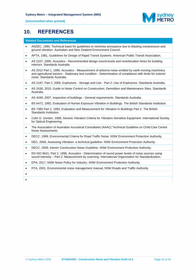
Sydney Metro – Integrated Management System (IMS)
(Uncontrolled when printed)
© Sydney Metro 2020 STANDARD - Construction Noise and Vibration Draft v4.3 Page 43 of 43
10. REFERENCES
Related Documents and References
ANZEC, 1990, Technical basis for guidelines to minimise annoyance due to blasting overpressure and ground vibration. Australian and New Zealand Environment Council.
APTA, 1981, Guidelines for Design of Rapid Transit Systems. American Public Transit Association.
AS 2107, 2000, Acoustics - Recommended design sound levels and reverberation times for building interiors. Standards Australia.
AS 2012 Part 1, 1990, Acoustics - Measurement of airborne noise emitted by earth-moving machinery and agricultural tractors - Stationary test condition - Determination of compliance with limits for exterior noise. Standards Australia.
AS 2187, Part 2, 2006, Explosives - Storage and Use - Part 2: Use of Explosives. Standards Australia.
AS 2436, 2010, Guide to Noise Control on Construction, Demolition and Maintenance Sites. Standards Australia.
AS 4349, 2007, Inspection of buildings - General requirements. Standards Australia.
BS 6472, 1992, Evaluation of Human Exposure Vibration in Buildings. The British Standards Institution.
BS 7385 Part 2, 1993, Evaluation and Measurement for Vibration in Buildings Part 2. The British Standards Institution.
Colin G. Gordon, 1999, Generic Vibration Criteria for Vibration-Sensitive Equipment. International Society for Optical Engineering.
The Association of Australian Acoustical Consultants (AAAC) Technical Guideline on Child Care Centre Noise Assessments
DECC, 1999, Environmental Criteria for Road Traffic Noise. NSW Environment Protection Authority.
DEC, 2006, Assessing Vibration: a technical guideline. NSW Environment Protection Authority.
DECC, 2009, Interim Construction Noise Guideline. NSW Environment Protection Authority.
EN ISO 9641, Part 2, 1996, Acoustics - Determination of sound power levels of noise sources using sound intensity – Part 2: Measurement by scanning. International Organization for Standardization.
EPA, 2017, NSW Noise Policy for Industry. NSW Environment Protection Authority.
RTA, 2001, Environmental noise management manual, NSW Roads and Traffic Authority.

Construction Traffic Management Framework V1-1 1
Construction Traffic Management Framework Sydney Metro West and Sydney Metro – Western Sydney Airport construction
Construction Traffic Management Framework V1-1 2
Contents Definitions and terminology .......................................................................................... 4
1 Introduction ............................................................................................................. 7 1.1 Purpose...................................................................................................... 7 1.2 Scope ......................................................................................................... 7 1.3 Metro West & Western Sydney Airport Project description ........................ 7 1.4 Governance ............................................................................................... 8
2 Traffic management objectives ............................................................................... 9 2.1 General traffic management approach ...................................................... 9 2.2 Traffic management strategy ................................................................... 10 2.3 Hierarchy of access ................................................................................. 11
3 Implementation framework ................................................................................... 13 3.1 Construction Environmental Management Framework (CEMF) .............. 13 3.2 Construction traffic management task ..................................................... 13 3.3 Implementation process ........................................................................... 13
3.3.1 Construction Traffic Management Framework (this document) . 14 3.3.2 Construction traffic management plans ..................................... 14 3.3.3 Site specific CTMP ..................................................................... 14 3.3.4 Traffic control plans and other plans .......................................... 15
4 Consultation groups .............................................................................................. 17 4.1 Traffic and Transport Liaison Group ........................................................ 17
4.1.1 Other organisations .................................................................... 18 4.2 Traffic control group ................................................................................. 19 4.3 Government stakeholders ........................................................................ 19
5 Communication ..................................................................................................... 20 5.1 Existing businesses and residents ........................................................... 20 5.2 Notification of traffic changes or disruptive works .................................... 20 5.3 Responsibilities ........................................................................................ 20 5.4 Roadside messaging ............................................................................... 21
6 Approvals .............................................................................................................. 22 6.1 Policy context and legislative backing ...................................................... 22 6.2 Stakeholders ............................................................................................ 22 6.3 Construction traffic management plans approval process ....................... 22 6.4 Road Occupancy Licence process .......................................................... 24 6.5 Speed zone authorisation ........................................................................ 25 6.6 Special event coordination ....................................................................... 26 6.7 Adjustments to traffic signals ................................................................... 27 6.8 Over-size or Over-mass (OSOM) vehicle permits ................................... 27 6.9 Adjustments to bus routes and stops ....................................................... 28 6.10 Adjustments to Australia Post mail boxes or other roadside furniture ..... 28 6.11 Local Traffic Committees (LTC) ............................................................... 28
7 Management of construction traffic ...................................................................... 30 7.1 Haulage routes......................................................................................... 30 7.2 Management of heavy vehicle movements .............................................. 30 7.3 Work zones and heavy vehicle marshalling ............................................. 30 7.4 Construction/demolition vehicle types ...................................................... 31
7.4.1 Worker access and parking ....................................................... 31 7.4.2 Construction consolidation centre/depot .................................... 31 7.4.3 Driver training ............................................................................. 32
Construction Traffic Management Framework V1-1 3
7.4.4 Chain of responsibility and Heavy Vehicle National Law ........... 32
8 Construction site traffic management requirements ............................................. 33 8.1 Traffic control at construction sites .......................................................... 33
8.1.1 Policy and responsibilities .......................................................... 33 8.1.2 Traffic control techniques ........................................................... 33 8.1.3 Approved clothing for work personnel ........................................ 34 8.1.4 Plant and equipment .................................................................. 34
8.2 Frequency of inspections ......................................................................... 34 8.2.1 Inspections of roadwork traffic management schemes .............. 34
8.3 Emergency incident planning ................................................................... 35 8.3.1 Accidents/incidents and complaints ........................................... 35 8.3.2 Chemical spills and leaks ........................................................... 35
8.4 Traffic controllers and temporary traffic signals ....................................... 36
9 Management of construction sites ........................................................................ 37 9.1 Construction site boundaries ................................................................... 37 9.2 Hoardings................................................................................................. 37 9.3 Site security, site access and signage ..................................................... 38 9.4 Pedestrian security/safety/lighting ........................................................... 38 9.5 Management of risks to vulnerable road users ........................................ 38
10 Road safety audits ................................................................................................ 40 10.1 Purpose and benefits ............................................................................... 40
11 Related documents and references ...................................................................... 42
Appendix A ................................................................................................................. 43
Author: Ken Hind – Traffic Advisor Date: July 2020 Version: 1.1 Reference: Reference Division: Operations, Customer and Place-making
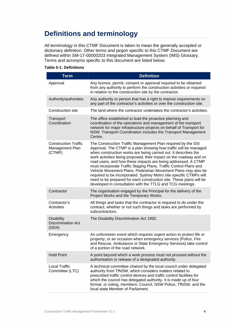
Construction Traffic Management Framework V1-1 4
Definitions and terminology All terminology in this CTMF Document is taken to mean the generally accepted or dictionary definition. Other terms and jargon specific to this CTMF Document are defined within SM-17-00000203 Integrated Management System (IMS) Glossary. Terms and acronyms specific to this document are listed below. Table 0-1: Definitions
Term Definition Approval Any licence, permit, consent or approval required to be obtained
from any authority to perform the construction activities or required in relation to the construction site by the contractor.
Authority/authorities Any authority or person that has a right to impose requirements on any part of the contractor’s activities or over the construction site.
Construction site The land where the contractor undertakes the contractor’s activities.
Transport Coordination
The office established to lead the proactive planning and coordination of the operations and management of the transport network for major infrastructure projects on behalf of Transport for NSW. Transport Coordination includes the Transport Management Centre.
Construction Traffic Management Plan (CTMP)
The Construction Traffic Management Plan required by the SSI Approval. The CTMP is a plan showing how traffic will be managed when construction works are being carried out. It describes the work activities being proposed, their impact on the roadway and on road users, and how these impacts are being addressed. A CTMP must incorporate Traffic Staging Plans, Traffic Control Plans and Vehicle Movement Plans. Pedestrian Movement Plans may also be required to be incorporated. Sydney Metro site-specific CTMPs will need to be prepared for each construction site. These plans will be developed in consultation with the TTLG and TCG meetings.
Contractor The organisation engaged by the Principal for the delivery of the Project Works and the Temporary Works.
Contractor’s Activities
All things and tasks that the contractor is required to do under the contract, whether or not such things and tasks are performed by subcontractors.
Disability Discrimination Act (DDA)
The Disability Discrimination Act 1992.
Emergency An unforeseen event which requires urgent action to protect life or property, or an occasion when emergency services (Police, Fire and Rescue, Ambulance or State Emergency Services) take control of a portion of the road network.
Hold Point A point beyond which a work process must not proceed without the authorisation or release of a designated authority.
Local Traffic Committee (LTC)
A technical committee chaired by the local council under delegated authority from TfNSW, which considers matters related to prescribed traffic control devices and traffic control facilities for which the council has delegated authority. It is made up of four formal, or voting, members: Council, NSW Police, TfNSW, and the local state Member of Parliament.
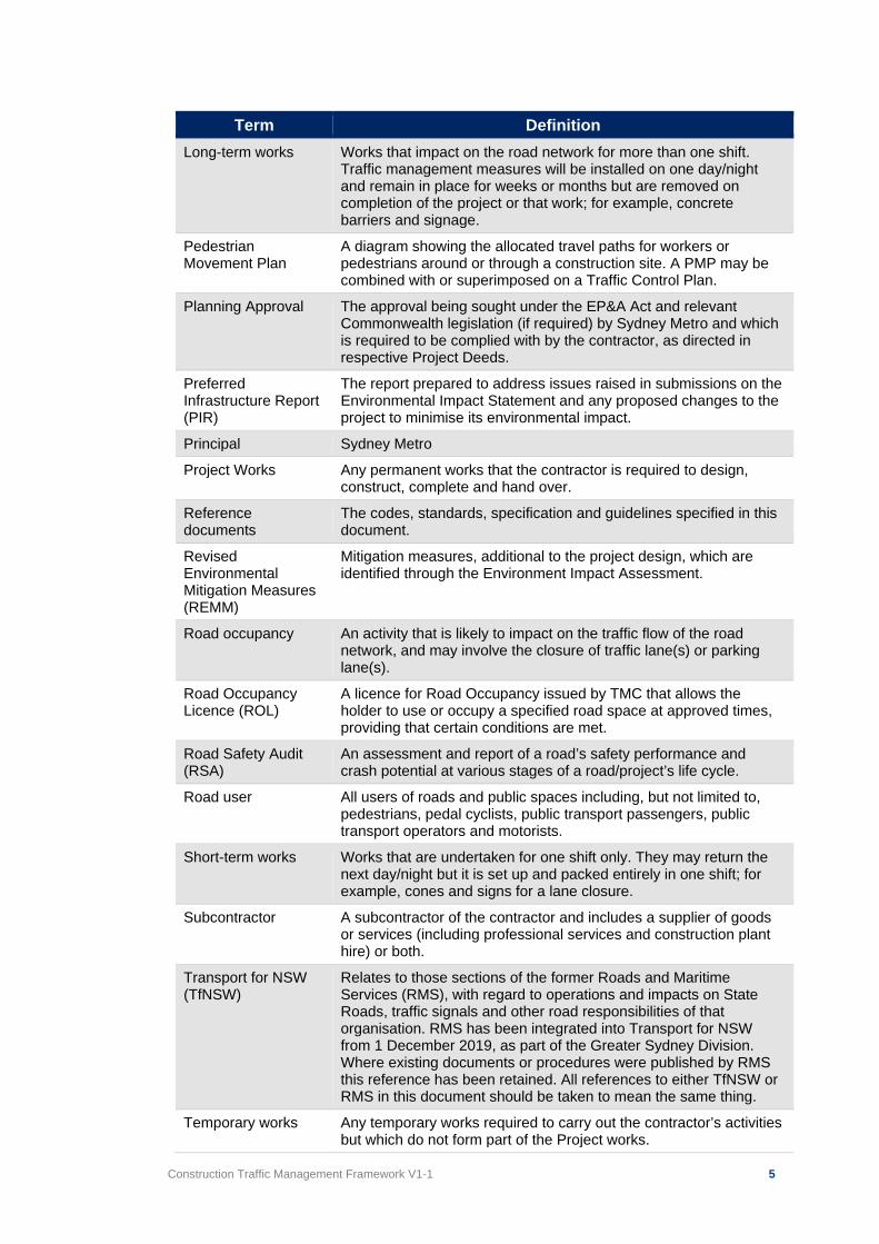
Construction Traffic Management Framework V1-1 5
Term Definition Long-term works Works that impact on the road network for more than one shift.
Traffic management measures will be installed on one day/night and remain in place for weeks or months but are removed on completion of the project or that work; for example, concrete barriers and signage.
Pedestrian Movement Plan
A diagram showing the allocated travel paths for workers or pedestrians around or through a construction site. A PMP may be combined with or superimposed on a Traffic Control Plan.
Planning Approval The approval being sought under the EP&A Act and relevant Commonwealth legislation (if required) by Sydney Metro and which is required to be complied with by the contractor, as directed in respective Project Deeds.
Preferred Infrastructure Report (PIR)
The report prepared to address issues raised in submissions on the Environmental Impact Statement and any proposed changes to the project to minimise its environmental impact.
Principal Sydney Metro
Project Works Any permanent works that the contractor is required to design, construct, complete and hand over.
Reference documents
The codes, standards, specification and guidelines specified in this document.
Revised Environmental Mitigation Measures (REMM)
Mitigation measures, additional to the project design, which are identified through the Environment Impact Assessment.
Road occupancy An activity that is likely to impact on the traffic flow of the road network, and may involve the closure of traffic lane(s) or parking lane(s).
Road Occupancy Licence (ROL)
A licence for Road Occupancy issued by TMC that allows the holder to use or occupy a specified road space at approved times, providing that certain conditions are met.
Road Safety Audit (RSA)
An assessment and report of a road’s safety performance and crash potential at various stages of a road/project’s life cycle.
Road user All users of roads and public spaces including, but not limited to, pedestrians, pedal cyclists, public transport passengers, public transport operators and motorists.
Short-term works Works that are undertaken for one shift only. They may return the next day/night but it is set up and packed entirely in one shift; for example, cones and signs for a lane closure.
Subcontractor A subcontractor of the contractor and includes a supplier of goods or services (including professional services and construction plant hire) or both.
Transport for NSW (TfNSW)
Relates to those sections of the former Roads and Maritime Services (RMS), with regard to operations and impacts on State Roads, traffic signals and other road responsibilities of that organisation. RMS has been integrated into Transport for NSW from 1 December 2019, as part of the Greater Sydney Division. Where existing documents or procedures were published by RMS this reference has been retained. All references to either TfNSW or RMS in this document should be taken to mean the same thing.
Temporary works Any temporary works required to carry out the contractor’s activities but which do not form part of the Project works.
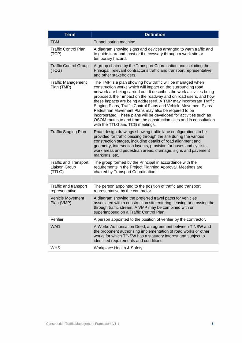
Construction Traffic Management Framework V1-1 6
Term Definition TBM Tunnel boring machine.
Traffic Control Plan (TCP)
A diagram showing signs and devices arranged to warn traffic and to guide it around, past or if necessary through a work site or temporary hazard.
Traffic Control Group (TCG)
A group chaired by the Transport Coordination and including the Principal, relevant contractor’s traffic and transport representative and other stakeholders.
Traffic Management Plan (TMP)
The TMP is a plan showing how traffic will be managed when construction works which will impact on the surrounding road network are being carried out. It describes the work activities being proposed, their impact on the roadway and on road users, and how these impacts are being addressed. A TMP may incorporate Traffic Staging Plans, Traffic Control Plans and Vehicle Movement Plans. Pedestrian Movement Plans may also be required to be incorporated. These plans will be developed for activities such as OSOM routes to and from the construction sites and in consultation with the TTLG and TCG meetings.
Traffic Staging Plan Road design drawings showing traffic lane configurations to be provided for traffic passing through the site during the various construction stages, including details of road alignment and geometry, intersection layouts, provision for buses and cyclists, work areas and pedestrian areas, drainage, signs and pavement markings, etc.
Traffic and Transport Liaison Group (TTLG)
The group formed by the Principal in accordance with the requirements in the Project Planning Approval. Meetings are chaired by Transport Coordination.
Traffic and transport representative
The person appointed to the position of traffic and transport representative by the contractor.
Vehicle Movement Plan (VMP)
A diagram showing the preferred travel paths for vehicles associated with a construction site entering, leaving or crossing the through traffic stream. A VMP may be combined with or superimposed on a Traffic Control Plan.
Verifier A person appointed to the position of verifier by the contractor.
WAD A Works Authorisation Deed, an agreement between TfNSW and the proponent authorising implementation of road works or other works for which TfNSW has a statutory interest and subject to identified requirements and conditions.
WHS Workplace Health & Safety.
Construction Traffic Management Framework V1-1 7
1 Introduction 1.1 Purpose
This Construction Traffic Management Framework (CTMF) sets out the approach to managing traffic impacts during the construction of the Sydney Metro projects (the Project). The CTMF also outlines contractor requirements, with reference to third party agreements.
1.2 Scope
The CTMF provides the overall strategy and approach for construction traffic management for the Project, and an outline of the traffic management requirements and processes that will be common to each of the proposed work sites. It establishes the traffic management processes and acceptable criteria to be considered and followed in managing roads and footpaths adjacent to Project construction sites. A site specific Construction Traffic Management Plan (CTMP), along with Traffic Control Plans (TCPs) as required, will also be documented based on this framework. These documents will be prepared by the Principal contractors responsible for each works package for Sydney Metro construction works to align with the contents, principles and objectives of this CTMF, as well as contractual requirements, Revised Environmental Mitigation Measures (REMM) and all other obligations of the relevant planning approval. Some of the construction sites associated with the Sydney Metro Projects will be located within high-activity, densely developed, and in some cases congested sections of the road network, and any traffic management measures will need to consider all the potential impacts that might occur because of the construction activities, and deliver safe environments for all road users.
1.3 Metro West & Western Sydney Airport Project description
Sydney Metro is a key component of Future Transport 2056 (Transport for NSW, 2018), a plan to create and maintain a world class, safe, efficient and reliable transport system. The Sydney Metro network will consist of a number of metro lines.
• Sydney Metro Northwest is constructed and operational between Tallawong and Chatswood.
• Sydney Metro City and Southwest (Chatswood to Sydenham) is under construction between Chatswood and Sydenham Stations with operations planned to commence in 2024.
• Sydney Metro City and Southwest (Sydenham to Bankstown) is currently in initial stages of construction (early works) with operations planned to commence in 2024.
• Sydney Metro West (Westmead to Sydney CBD) is currently in planning with construction to commence in 2020.
• Sydney Metro – Western Sydney Airport (St Marys to Western Sydney Airport and Western Sydney Aerotropolis) is currently in the initial stages of planning with construction to commence in 2021.
Sydney Metro West will service the key precincts of Greater Parramatta, Sydney Olympic Park, The Bays Precinct and the Sydney CBD. Sydney Metro West includes:
Construction Traffic Management Framework V1-1 8
• A new underground metro station at Westmead, to support the growing residential area as well as the health, research and education precinct
• A new metro station under an existing suburban station on the T1 Northern Line east of Sydney Olympic Park – allowing faster connections for customers from the Central Coast and Sydney’s north to Parramatta and Sydney through a quick and easy interchange between suburban and metro services
• At least one Sydney Metro West station under the Sydney CBD, delivering an easy interchange between suburban rail, new light rail and the new metro stations currently under construction
• Further consultation is being undertaken on new intermediate metro stations between Parramatta and Sydney Olympic Park and between Olympic Park and the Sydney CBD.
Sydney Metro – Western Sydney Airport will service Greater Western Sydney and the new Western Sydney International (Nancy-Bird Walton) Airport. Sydney Metro – Western Sydney Airport will include:
• Stations at Western Sydney Airport and the Western Sydney Aerotropolis;
• A station at St Marys, interchanging with the existing station and connecting customers with the rest of Sydney’s rail system;
• A station at Orchard Hills to service future commercial and mixed-use precinct;
• A station at Luddenham to service future education, innovation and commercial precinct.
The Projects will also include ancillary components, including stabling and maintenance facilities, new or upgraded overhead wiring, signalling, access tracks/paths, rail corridor fencing, noise walls, fresh air ventilation equipment, temporary and permanent alterations to the road network, facilities for pedestrians, and other construction related works.
1.4 Governance
The approved version of the CTMF will be available on the Sydney Metro website. Sydney Metro will be the document owner of the approved CTMF. This CTMF will be part of the EIS for both Sydney Metro – Western Sydney Airport (SMWSA) and Sydney Metro West (SMW) submitted for approval by the Secretary, Department of Planning, Industry and Environment.
Construction Traffic Management Framework V1-1 9
2 Traffic management objectives This section outlines the approach, strategy and hierarchy of access required when managing traffic for Sydney Metro projects. The Projects will require demolition and construction work to be undertaken within various local government areas (councils) and other road authorities within the Greater Sydney Region. At all locations, it is important that adequate consideration and emphasis is given to the operation of public transport, private vehicles, service vehicles, and pedestrian and cyclist management measures, to minimise impacts. It is also important that access for residents and businesses is maintained, where possible. The design and operation of any proposed temporary traffic management measures will require careful planning, coordination and implementation. Pedestrians, cyclists and vehicle drivers expect a high level of safety and service in using the existing road and pedestrian network. This requires efficient, effective and reliable traffic management strategies to be in place that:
• Achieve uniform traffic throughput.
• Minimise changes to pedestrian and cycle routes and movement.
• Ensure reliable and consistent travel times.
• Provide clear information to allow drivers and other road users to make appropriate decisions in relation to their journey.
• Support operation and use of sustainable transport modes to reduce on-road single occupant motor vehicle demand
• Minimise potential road safety risk, especially for pedestrians and cyclists. These traffic management goals will be achieved by:
• Understanding the impacts of the Projects and identifying appropriate methods to mitigate these impacts.
• Strategic advanced planning of the traffic management.
• Taking an approach to traffic management that minimises traffic disruption.
• Ongoing stakeholder engagement and communication.
2.1 General traffic management approach
Sydney Metro is committed to achieving desired performance goals in relation to the health and safety of workers employed to construct Sydney Metro Projects, and to minimising the impacts of the works on road users and the community. The construction objectives that relate to the CTMF are outlined in Table 2-1.
Construction Traffic Management Framework V1-1 10
Table 2-1: CTMF related construction objectives
Key Result Area Construction Objectives
Transport network
Minimise disruption to pedestrians, cyclists and motorists. Ensure Sydney Metro construction traffic accesses the arterial
network as soon as practicable on route to, and immediately after leaving, the construction site.
Keep Sydney moving. Minimise impacts on route bus operations, routes and stops,
where possible. Minimise changes to traffic operation and kerbside access. Minimise construction traffic generation during network peak
periods (maximum peak period construction vehicle volumes should not exceed those outlined in the EIS).
Maintain access to properties and businesses where possible, or arrange alternative.
Maintain a safe environment for pedestrians and cyclists.
Safety No worker injury accidents during construction. No injury accidents to members of the public because of
construction.
Cumulative impacts
Work collaboratively with other stakeholders and other major projects to mitigate traffic and transport impacts.
Amenity Minimise noise and other environmental impacts on the residents
and businesses in the vicinity of the construction sites, in line with the Construction Noise and Vibration Strategy (CNVS)
2.2 Traffic management strategy
There is the potential for activities associated with the construction of the Sydney Metro Projects to have an impact on the surrounding road network. Where possible, these impacts will be minimised through the provision of effective traffic management measures, in accordance with Sydney Metro’s objectives and relevant guidelines and standards, to achieve the objectives of the Project. Development of the traffic management measures will be carried out in consultation with the Traffic Control Group (TCG), Traffic and Transport Liaison Group (TTLG), TfNSW, Transport Coordination and other relevant stakeholders. Priority will be given to providing adequate guidance to pedestrians, cyclists, drivers and the community prior to the commencement of any works. Priority will also be given to responding appropriately to issues and events that may arise during the works. As part of this strategy, some key traffic management measures include:
• The provision of directional signage and line marking to safely direct and guide drivers, cyclists and pedestrians past work sites and to suitable alternative routes (if required) on the surrounding road network.
• Notification of proposed changes and duration using appropriate media e.g. newspapers (local or majors), radio, project website, social media and direct community engagement (as required).
• On-going or direct co-ordination with Transport Coordination, to mitigate congestion and provide rapid response should incidents or increased
Construction Traffic Management Framework V1-1 11
congestion occur as a direct result of the works. Notification of incidents or congestion should also be relayed to Sydney Metro and relevant Transport Coordination representative immediately. The direct contact numbers of the contract-wide and site-specific lead contractors should be provided to Transport Coordination. The contract-wide lead contractor is responsible for ensuring the direct contact numbers are current during any stage of construction.
• Management and coordination of construction vehicle safe access to and from the work sites across pedestrian paths. The type of traffic management to be employed will be dependent on, and adjusted according to, the volume of pedestrians, passing traffic and the volume of construction vehicle activities for the site. The types of management could include manual supervision, physical barriers, temporary/portable traffic signals (where approved by TfNSW, council or other road authority) or modification to existing traffic signals (where approved by TfNSW).
• Ensuring that safe access to existing properties and businesses is maintained during the period of the works, or a suitable alternative is provided.
• Retain existing on-street parking and restrictions, as far as is practicable.
2.3 Hierarchy of access
In identifying the most appropriate form of traffic management for each site, consideration should be given to the priorities of the potential different users. The site specific CTMPs should be developed in line with the following hierarchy of access, listed from the highest to the lowest priority:
1. Incidents and emergency services access 2. Events (special and unplanned) 3. Pedestrians 4. Cyclists 5. Other public transport users – buses, coaches and light rail 6. Service vehicles 7. Coaches 8. Taxis 9. Kiss and ride and rideshare 10. Private cars
Roads are sometimes classified functionally as follows:
• Arterial/State road
• Sub-arterial or Regional road
• Collector road
• Local road TfNSW publishes on its website a schedule of State and classified Regional roads with descriptions, which should be referred to in assessing the functional classification of any roads that may be potentially impacted by works. The document outlines the following: “To manage the extensive network of roads for which councils are responsible for under the Roads Acts 1993, RMS in partnership with local government, established
Construction Traffic Management Framework V1-1 12
an administrative framework of State, Regional and Local Road categories. State Roads are managed and financed by RMS whilst Regional and Local Roads are managed and financed by councils.
Regional Roads perform an intermediate function between the main arterial network of State Roads and council controlled Local Roads. Due to their network significance, RMS provides financial assistance to councils for the management of their Regional Roads. The Regional Road category comprises two sub-categories: those Regional Roads that are classified pursuant to the Roads Act 1993, and those Regional Roads that are unclassified. For completeness, the Schedule includes unclassified Regional Roads.
Local Roads are unclassified roads and therefore are not included in the Schedule.”1
1 Schedule of Classified Roads and Unclassified Regional Roads - RMS, April 2017
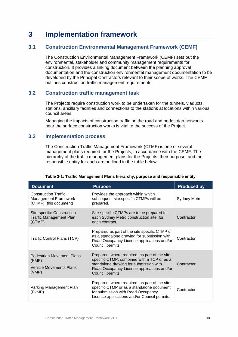
Construction Traffic Management Framework V1-1 13
3 Implementation framework 3.1 Construction Environmental Management Framework (CEMF)
The Construction Environmental Management Framework (CEMF) sets out the environmental, stakeholder and community management requirements for construction. It provides a linking document between the planning approval documentation and the construction environmental management documentation to be developed by the Principal Contractors relevant to their scope of works. The CEMF outlines construction traffic management requirements.
3.2 Construction traffic management task
The Projects require construction work to be undertaken for the tunnels, viaducts, stations, ancillary facilities and connections to the stations at locations within various council areas. Managing the impacts of construction traffic on the road and pedestrian networks near the surface construction works is vital to the success of the Project.
3.3 Implementation process
The Construction Traffic Management Framework (CTMF) is one of several management plans required for the Projects, in accordance with the CEMF. The hierarchy of the traffic management plans for the Projects, their purpose, and the responsible entity for each are outlined in the table below. Table 3-1: Traffic Management Plans hierarchy, purpose and responsible entity
Document Purpose Produced by Construction Traffic Management Framework (CTMF) (this document)
Provides the approach within which subsequent site specific CTMPs will be prepared.
Sydney Metro
Site-specific Construction Traffic Management Plan (CTMP)
Site-specific CTMPs are to be prepared for each Sydney Metro construction site, for each contract.
Contractor
Traffic Control Plans (TCP)
Prepared as part of the site specific CTMP or as a standalone drawing for submission with Road Occupancy License applications and/or Council permits.
Contractor
Pedestrian Movement Plans (PMP)
Vehicle Movements Plans (VMP)
Prepared, where required, as part of the site specific CTMP, combined with a TCP or as a standalone drawing for submission with Road Occupancy License applications and/or Council permits.
Contractor
Parking Management Plan (PkMP)
Prepared, where required, as part of the site specific CTMP or as a standalone document for submission with Road Occupancy License applications and/or Council permits.
Contractor
Construction Traffic Management Framework V1-1 14
Document Purpose Produced by
Other plans Refer to the Principal’s General Specifications relating to Traffic and Transport Management
Sydney Metro
3.3.1 Construction Traffic Management Framework (this document)
This CTMF provides the framework within which subsequent site-specific CTMPs will be prepared. The CTMF describes the traffic management objectives, principles and strategies to be implemented during construction of Sydney Metro Projects. This CTMF identifies and outlines areas that will be potentially impacted by the construction works and will require traffic, cycling and pedestrian management. The development of suitable traffic management plans to minimise, as much as possible, the potential impacts of the works is a key component to managing any disruptions to vehicle and people movement and the efficient construction of the Projects.
3.3.2 Construction traffic management plans
Construction Traffic Management Plans (CTMP) will be prepared by contractors, covering the full spatial extent of their works for sites. The CTMP’s will comply with the Traffic Control at Worksites Manual, relevant Australian Standards, relevant Austroads guides, TfNSW supplements to Australian Standards and Austroads, Principal’s General Specifications – Traffic and Transport Management and the EIS. In addition, site specific CTMPs will be prepared and implemented having regard to the relevant Project specific REMMs and Conditions of Approval.
3.3.3 Site specific CTMP
Contractors will prepare detailed site-specific Construction Traffic Management Plans (CTMPs). These will be developed by the contractor for each work site and identify proposed heavy vehicle routes, traffic and parking management measures. These plans will be developed in consultation with the TTLG and TCG meetings. Details of the consultation including presentation dates to TTLG and TCG and stakeholder consultation are to be included in the CTMP. Details of station and construction work sites are to be provided in the each of the site-specific CTMPs. Site specific CTMPs will detail construction work sites, access points, relevant signage, parking changes (if required), vehicle numbers (heavy and light vehicles) and frequency, maximum vehicle size, swept paths, expected dates and duration of works, work times. Other information to be included includes bus stop relocations (if required), proposed heavy vehicle routes, traffic and parking management measures, relevant correspondence with stakeholders (e.g. bus operators, Australia Post, business owners) and all traffic management and mitigation measures required to implement any proposed works. It must also include Traffic Control Plans (TCP), Vehicle Movement Plans (VMP), Pedestrian Movement Plans (PMP), Parking Management Plans and Traffic Staging Plans for the specific works, unless otherwise agreed in writing with the Principal’s Representative and relevant Authorities. The Parking Management Plan will also provide details regarding on-site and off-site staff parking arrangements, including
Construction Traffic Management Framework V1-1 15
any proposed busing to and from construction sites. The TCP’s should include the intended timing of the proposed traffic management measures e.g. nights, weekends, 24/7. It is an important consideration in the development and approval of a CTMP that sufficient time is allowed for the review process and consideration by Transport Coordination, TfNSW, local Council, bus operators and other stakeholders as required. The identified Project Document Management System (e.g. Teambinder) should be used to distribute documents to stakeholders for review and comment, where available. If not available for the stakeholder being consulted, then the CTMP is to be forwarded by email or hard copy. The Principal’s representative is to be copied in on any submitted documentation. The approval process for CTMP’s is outlined in Section 6.3. Once all comments have been addressed, the final version of the CTMP is then formally submitted to TfNSW for final approval of the CTMP, following Transport Coordination endorsement. Ten business days should be allowed for the final approval.
3.3.4 Traffic control plans and other plans
The site-specific CTMPs provide the basis for preparation of the Traffic Control Plans (TCP) and Road Occupancy Licence (ROL) applications.
3.3.4.1 Traffic control plans All Traffic Control Plans (TCPs) prepared for construction activities will be developed in accordance with Australian Standard AS1742.3 and the TfNSW Traffic Control at Worksites Technical Manual. TCPs must be prepared by a person who has completed and passed the ‘Prepare a Work Zone Traffic Management Plan’ training course and has current certification to the required level. All work sites and related TCPs will be implemented in compliance with the ROL issued by Transport Coordination for the approved times and appropriate standards. Documents to be referenced in the preparation of TCPs include:
• Australian Standard AS1742.3 – Manual of uniform traffic control devices, Part 3, traffic control devices for works on roads.
• Roads and Maritime Services NSW – Traffic Control at Worksites Technical Manual
• Principal’s General Specifications – Traffic and Transport Management.
• Relevant Austroads Guides.
• TfNSW Supplements to Austroads and Australian Standards.
• Sydney Metro Principal Contractor Health and Safety Standard Early consultation with TfNSW and Transport Coordination may highlight site-specific requirements associated with the forecast heavy vehicle and light vehicle movements at proposed work sites along the Project corridor. These will be addressed by contractors during construction planning and CTMP preparation for each of the sites. On local roads, Councils may also have operational requirements and these should be determined in consultation with the Councils.
Construction Traffic Management Framework V1-1 16
3.3.4.2 Vehicle movement plans The Traffic Control at Work Sites Technical manual outlines a vehicle movement plan as “a diagram showing the preferred travel paths for vehicles associated with a worksite entering, leaving or crossing the through traffic stream.” The requirements for the provision of a VMP are detailed in chapter 7 of the Traffic Control at Worksites Technical Manual. Vehicle movement plans should be included in site-specific CTMPs prepared by a suitably qualified person for the contractor. The VMP should also include the proposed site access points and how these are to be managed.
3.3.4.3 Pedestrian movement plans The Traffic Control at Worksites Manual outlines a Pedestrian Movement Plan (PMP) as “a diagram showing the allocated travel paths for workers or pedestrians around or through a worksite.” Wherever it is necessary to divert or warn pedestrians of works the PMP should be included in the CTMP prepared by the contractor. This may be a stand-alone document. The needs of cyclists and other mobility devices (wheelchairs, mobility scooter) must also be considered and management measures documented in the pedestrian and cycle movement plan. This is particularly important where the work site is bounded by major roads such as State and Regional Roads. PMPs are to be prepared for any work sites located where significant pedestrian activity occurs, e.g. shopping centres, commercial/office areas. Other construction sites may also require PMPs subject to site-specific assessments.
3.3.4.4 Parking management plans Parking Management Plans identify parking requirements and also on-site and off-site parking arrangements and associated impacts; remote parking arrangements and associated access between sites and public transport nodes; alternate parking arrangements for displaced parking; and communication and parking management measures. For any proposed kerbside use impacts within a town centre or other activity centre, a proposal for relocation of impacted users may be required. Changes to on-street parking restrictions will require the approval of the relevant road authority; either TfNSW or local council.
Construction Traffic Management Framework V1-1 17
4 Consultation groups The size of Sydney Metro projects requires effective and ongoing interaction between several different organisations, key stakeholders and the general public. This chapter outlines the consultation groups that will be convened to manage these interactions. Requirements for consultation with local businesses and the community are outlined in Chapter 5 Communication. As the Project needs regular and ongoing discussions and distribution of information, the following groups will be convened to assist in traffic management planning, document review and stakeholder consultation:
a) Traffic and Transport Liaison Group(s) (TTLG). b) Traffic Control Group(s) (TCG).
4.1 Traffic and Transport Liaison Group
A Traffic and Transport Liaison Group (TTLG) would operate, to ensure the stakeholders most affected are aware of the proposed construction activities, upcoming works and related traffic and transport implications. The participants in this group will reflect the location of the work site however, representation is anticipated to include, as relevant to the site:
• Sydney Metro
• Transport for NSW including: o Centre for Road and Maritime Safety o Sydney Light Rail o Parramatta Light Rail o Metro Bus and Ferry Planning and Development o Greater Sydney Planning and Programs
• Freight Strategy and Planning
• Transport Coordination
• Sydney Trains
• Port Authority of NSW
• Infrastructure NSW
• Department of Planning, Industry and Environment
• Western Sydney Airport
• Western Parkland City Authority (WPCA)
• Sydney Motorway Corporation (WestConnex)
• NSW Police
• NSW Fire and Rescue
• NSW Ambulance Service
• Local councils (depending on work site locations)
• Bus operators
• Sydney Metro contractors
Construction Traffic Management Framework V1-1 18
The TTLG provides a forum for key stakeholders, contractors and Sydney Metro to discuss matters that could impact on the road network operations around the sites. The TTLG also provides a forum through which information on proposed traffic changes is made available to key stakeholders. It will allow key transport agencies, local councils and other authorities to inform the development of traffic management plans and construction staging by providing local and specialist knowledge and insights. The TTLG:
• Maintains good communication between Sydney Metro project team, contractors and other stakeholders.
• Discusses the construction traffic management arrangements for the Sydney Metro works and approvals.
• Assists in identification and refinement of potential measures to mitigate the impacts of the Sydney Metro works in an area.
• Assists coordination of works for Sydney Metro and other projects.
• Can request the provision of supplementary analysis and modelling for proposed traffic management measures to ensure any disruption to the traffic and pedestrian network is minimised
• Ensures that submitted plans are actioned and agreed in a timely manner in accordance with the overall Sydney Metro project program.
• Is consulted in the preparation of road safety audits before the completion and use of infrastructure.
4.1.1 Other organisations
Other organisations may be asked to attend the TTLG and/or receive relevant information depending on the matters under discussion or consideration. This may include:
• NSW Taxi Council
• NSW Taxi Drivers Association
• BusNSW
• Bicycle NSW
• Bicycle User Group(s)
• Pedestrian Council of Australia
• Sydney Buses
• Private bus operators (such as NightRide contractors)
• Property NSW
• Sydney Ferries, Harbour City Ferries and other relevant ferry operator(s)
• Disability Council of NSW
• Transurban
• NRMA
• NSW Trains
• NSW Health Infrastructure
• Managing Contractors of other adjacent major infrastructure projects
Construction Traffic Management Framework V1-1 19
4.2 Traffic control group
For each (or multiple) Sydney Metro contract, a Traffic Control Group (TCG) will be convened to provide a technical forum for the discussion of proposed works that will impact on the surrounding road network and feedback on proposed TCPs prior to formal submission. This group would meet on regular occasions (weekly, fortnightly or as agreed by TCG members) to provide an assessment of the forthcoming traffic management measures and to ensure that any identified or potential issues are raised and addressed to ensure that works proceed in accordance with the agreed program. The participants in this group will vary depending on the contracts. Representation would be expected to include:
• Relevant Sydney Metro contractor’s Traffic Manager and other construction staff as required.
• Sydney Metro
• Transport for NSW
• Transport Coordination
• Centre for Road and Maritime Safety
• Local councils
• Infrastructure NSW
• Western Sydney Airport
• Port Authority of NSW (Bays West Precinct)
• Western Parkland City Authority The TCG will provide a forum for discussion on proposed traffic management measures during the various stages of each of the contracts, discussion of potential impacts on the road network operations around the sites, and how to address or minimise those impacts.
4.3 Government stakeholders
Consultation with Transport Coordination, Port Authority and TfNSW in the preparation of this CTMF document has been carried out, the outcomes of which have been incorporated into this document. A comments register is provided at Appendix A. A summary of the comments and responses from the consultations has been provided to the Department of Planning, Industry and Environment.
Construction Traffic Management Framework V1-1 20
5 Communication All external communication with the community, including businesses, must follow the guidelines set out in the Sydney Metro Community Communication Strategy. The community must be notified of any current and upcoming works, temporary works or contractor activities that have the potential to impact on stakeholders and the community before they happen. An overview of the approach to stakeholder and community involvement during construction of the Project is provided in the Construction Environmental Management Framework and Community Communication Strategy. A key element of this strategy will relate to notifications to stakeholders, local Councils and the community that may be affected by changes to transport, access and local traffic arrangements.
5.1 Existing businesses and residents
Owners and operators of potentially affected properties and businesses will be consulted throughout the delivery of the Project and notified in accordance with the Community Communications Strategy (CCS) in advance of any works that may potentially disrupt access to their property. Every endeavour is to be made to maintain safe access at all times to properties for both pedestrians and vehicles. If works will temporarily affect access to a property, consideration should be given to the staging of the works, to maintain safe access and limit the disruption. Any access restrictions for residents, tenants or property owners and alternative arrangements are to be undertaken and agreed with the occupiers. Residents, property owners and businesses in the surrounding area will also be notified prior to the start of works.
5.2 Notification of traffic changes or disruptive works
Activity specific communications strategies are required to be developed prior to any traffic event. These strategies should include details of the work, impacts and proposed mitigation measures. In addition to the strategy, activity-specific notifications will need to be developed and issued to directly impacted properties prior to works commencing. Notification of proposed changes should also be included on the Project website. Other communication methods that may be implemented could include, but are not limited to:
• Doorknocks
• Letterbox drops
• Advertising (newspapers)
• Social media updates
• Radio
5.3 Responsibilities
The contractor’s Stakeholder and Community Manager will be responsible for ensuring a system is in place to advise the Sydney Metro Project Communications Team, the TTLG and other key stakeholders each time proposed changes are to be made to traffic arrangements. Advice will include information about the changes to the
Construction Traffic Management Framework V1-1 21
traffic operation, anticipated delays to traffic, any changes to the times and duration of the work, and any other potential major disruptions. This advice should be provided at the earliest opportunity, in accordance with the CCS and provide sufficient time for key agencies to provide comments or information as necessary.
5.4 Roadside messaging
Appropriate signposting, whether static or Variable Message Signs (VMS), should be located and installed to provide for the easy and safe passage of vehicles, pedestrians and cyclists. This also includes public transport users accessing facilities such as bus stops. The installation of signs will be detailed within the relevant CTMP. Any signposting should be placed in accordance with relevant guidelines and standards. Messages should be clear and easily interpreted by drivers, pedestrians and cyclists, and should not create a safety hazard. The proposed location of any VMS would require the approval of the road authority.
Construction Traffic Management Framework V1-1 22
6 Approvals 6.1 Policy context and legislative backing
Notwithstanding the Project SSI Approval being secured under Division 5.2 of the EP&A Act or other approval obtained under relevant Commonwealth legislation (where relevant). Sydney Metro contractors will be required to secure all other required statutory approvals prior to the commencement of works. Any changes to traffic control devices (e.g. traffic signals or traffic signs) and traffic control facilities will require the approval from the road authority and arrangements with the road authority for the changes to occur. Regulatory sign and line-marking changes on local or Regional roads will require approval from the local council through a submission to the local traffic committee. Sign and line marking changes on State roads will require the approval of TfNSW.
6.2 Stakeholders
The agencies that may have a potential interest in the traffic management measures proposed for each Project construction site are outlined below:
• Transport Coordination
• Local council
• Sydney Trains
• Transport for NSW
• Department of Planning, Industry and Environment (for Sydney Olympic Park)
• Port Authority of NSW
• Western Sydney Airport
• Western City and Aerotropolis Authority
6.3 Construction traffic management plans approval process
Construction Traffic Management Plans will require approval and consideration by several key stakeholders. Contractors should assess the overall required approval times at the beginning of the Project to provide adequate scheduling of the preparation and submission of the CTMPs. Construction Traffic Management Plans (CTMPs), consistent with this CTMF, must be prepared for each construction site in consultation with the TTLG(s), and submitted to TfNSW for approval following Transport Coordination endorsement before construction commences at the relevant construction site. In addition, where construction results in conditions in excess of the forecast impacts or where traffic management measures cause excessive delays or impacts, the contractor must review the measures identified in the CTMPs in consultation with the TTLG(s), as relevant. Any changes to the CTMPs must be submitted to TfNSW for approval, following Transport Coordination endorsement, before implementing. An overview of the approvals process for Sydney Metro is as follows:
• Site-specific CTMPs will be prepared consistent with this CTMF by the contractor for each site covered under the contract. These CTMPs must comprise other plans or drawings such as Traffic Staging Plans, Traffic Control Plans, Vehicle Movement Plans, Pedestrian Movement Plans, a
Construction Traffic Management Framework V1-1 23
Parking Management Plan, unless otherwise agreed with the Principal’s representative and the relevant Authorities, and address any changes from the EIS indicative haulage routes.
• Prior to the submission of the CTMP, the planned works and traffic management measures are presented to TfNSW, Transport Coordination and relevant Council at a TCG meeting. This will enable initial comments from the stakeholders to be considered in the preparation of the CTMP. The presentation should be distributed via email or the identified Project Document Management System at least five business days prior to the TCG meeting to enable informed discussion on the proposed traffic management measures.
• Planned works and traffic management measures also presented to TTLG, to obtain feedback from other key stakeholders. Notwithstanding presentation at the TTLG, the CTMP should be distributed to emergency services and other key stakeholders for information.
• The CTMP is modified in accordance with TCG and TTLG feedback
• This would then provide the basis for submission of the CTMP to Transport Coordination, TfNSW and relevant road authority for formal comments. Up to twenty business days should be allowed for the review of the CTMP by stakeholders and return of comments on the plan.
• Once comments have been received and the CTMP discussed at the next available TCG, a revised CTMP is submitted (if required) for review to the stakeholders, allowing ten business days for formal response.
• After review and resolution of issues, submitted to TfNSW for approval following the Transport Coordination endorsement, before construction commences at the relevant site. Ten business days should be allowed for the final approval.
• Sent to DPIE for information only, if required
• Published on the contractor’s website prior to works commencing at the relevant site, if required. The contractor will be responsible for documenting all stakeholder feedback and comments in a document specific issues register. These comments will be addressed and closed out by the contractor in consultation with the relevant stakeholders. Sydney Metro, TfNSW and Transport Coordination will not be responsible for processing or referring comments on behalf of the contractor
• Changes to traffic management requirements at a site which requires material changes to the existing CTMP will require re-submission of the revised CTMP (with tracked changes) to TfNSW, Transport Coordination and local road authority for approval as applicable
This CTMP approval process is outlined in the flow chart in Figure 6-1.
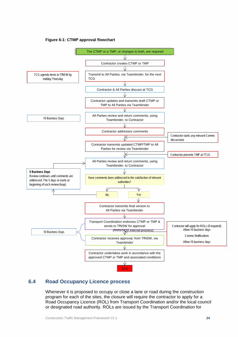
Construction Traffic Management Framework V1-1 24
Figure 6-1: CTMP approval flowchart
6.4 Road Occupancy Licence process
Whenever it is proposed to occupy or close a lane or road during the construction program for each of the sites, the closure will require the contractor to apply for a Road Occupancy Licence (ROL) from Transport Coordination and/or the local council or designated road authority. ROLs are issued by the Transport Coordination for
The CTMP or a TMP, or changes to both, are required
Contractor creates CTMP or TMP
Transmit to All Parties, via Teambinder, for the next TCG
All Parties review and return comments, using Teambinder, to Contractor
Contractor addresses comments
Contractor transmits updated CTMP/TMP to All Parties for review via Teambinder
All Parties review and return comments, using
Teambinder, to Contractor
Contractor transmits final version to All Parties via Teambinder
Transport Coordination endorses CTMP or TMP & sends to TfNSW for approval
(RMS/SCO internal process)
Contractor receives approval, from TfNSW, via Teambinder
Contractor undertakes work in accordance with the approved CTMP or TMP and associated conditions
End
Contractor starts any relevant Comms discussions
10 Business Days
TCG agenda items to TfNSW by midday Thursday
Contractor presents TMP at TTLG
10 Business Days
Contractor will apply for ROLs (if required). Allow 10 business days
Comms Notifications
Allow 10 business days
5 Business Days Review continues until comments are addressed. The 5 days re-starts at beginning of each review (loop)
Contractor updates and transmits draft CTMP or TMP to All Parties via Teambinder
Contractor & All Parties discuss at TCG
Have comments been addressed to the satisfaction of relevant authorities?
Yes No
Construction Traffic Management Framework V1-1 25
approved times, following endorsement by the Transport Coordination, for TfNSW State roads or locations on Regional or local roads within 100 metres of traffic signals. It should be noted that due to the critical nature of the potential traffic impacts for local roads within the Sydney and Parramatta CBDs or other key centres that applications for ROLs on streets within these areas may be required to be submitted to Transport Coordination. The issuing of ROL’s on local or Regional roads for lane or road closures in the CBD’s above will also be subject to the approval of the local council. The contractor will need to consult with stakeholders prior to submission of the ROL application and provide information as required. For local roads, outside of the areas highlighted above, the approval of the local council or road authority will be required. This will require an application in the appropriate method to council or road authority. The ROL requirements are outlined in the TfNSW Road Occupancy Manual (and in the Principal’s General Specifications – Traffic and Transport Management). The Contractor must allow a minimum of 10 business days for a response to an application from Transport Coordination. A minimum of 10 business days should also be assumed for responses to applications from other roads authorities. ROLs will generally be issued for relatively short periods of time and Transport Coordination will require that an approved TCP or site CTMP for the work be in place. Information on proposed and approved ROLs should also be provided to the Sydney Metro Project Communications Team for notification, prior to works commencement. The general process for ROL’s is outlined below:
• ROL and related applications are submitted by the contractor to Transport Coordination for occupation of roadway (other than approved work zones) on State and Regional roads and all works within 100m of traffic signals. These applications are approved by Transport Coordination for the times shown on the licence. A CTMP will be required to be approved prior to approval of the ROL.
• Application made to Transport Coordination for ROL.
• Transport Coordination assesses for potential conflicts, any identified conflicts to be resolved to satisfaction of Transport Coordination.
• Transport Coordination will review and assess prior to submission to TfNSW for approval
• Contractor may be requested by Transport Coordination to consult with other stakeholders including TfNSW (Infrastructure and Services)
• Contractors will require council or road authority approval of road occupancies/lane closures/permits to stand plant/road openings impacting Regional and local roads.
The contractor is to prepare and maintain a register of ROL applications and approvals providing stakeholders with status information throughout construction. Upcoming ROL and related applications are to be discussed at TCG meetings for council and other stakeholder feedback prior to submission.
6.5 Speed zone authorisation
An application must be made to TfNSW for any proposed adjustment of the speed limit on the road network, whether they are proposed as temporary measures for work
Construction Traffic Management Framework V1-1 26
zones and road occupancies or for longer periods such as the duration of the construction works at a site. A Speed Zone Authorisation application usually accompanies a ROL application where a change in speed limit is proposed as part of the road occupancy. The TfNSW speed zone change process involves the submission of the appropriate form, available online from the TfNSW website, which is to be submitted to Transport Coordination’s Planned Incident Unit. Depending on the extent of the works and project familiarity the application will be supported by the site specific CTMP or a TCP. Short-term speed zone changes can be dealt with via the CTMP process. Longer term (over six months) or permanent changes are included in the site specific CTMP and are to be referred to TfNSW for assessment, consideration and approval. Permanent speed zone changes can only be approved by TfNSW.
6.6 Special event coordination
There are many special events that occur in and around the Sydney CBD, Parramatta CBD, Sydney Olympic Park and other locations around Sydney which may impact on the Projects. These special events have an impact through increased visitor numbers, road closures and diversion of bus services. The major events such as New Year’s Eve, Australia Day, Vivid Festival, Royal Easter Show, major sporting events and ANZAC Day all have significant impacts with increased visitor numbers and the need to provide additional rail and bus services, and impacts on the road network. At some sites this may include pedestrian marshals if increased pedestrian activity is identified in the preparation of the CTMP. Class 1 and 2 events, outlined below, are to be facilitated in the planning of work programs as works may not be permitted during these classes of events. For example, works are not permitted to happen between 3pm and midnight during the Vivid Festival in and around the Sydney CBD, Pyrmont and parts of Chatswood. Other areas and times may be incorporated in these restrictions in the future. In addition, pedestrian activity in CBD and shopping centres increases significantly during December and early January, in the lead up to Christmas and the post-Christmas sales. The City of Sydney has a policy of not permitting works that will cause disruption to the retail core of the city during December. Other councils may have similar restrictions during key periods. Works that would have a significant impact on pedestrian paths and station access should be minimised during these periods and/or additional and increased interface supervision should be provided between the site and the adjoining pedestrian network. The TfNSW special event management guidelines identify four classes of special events. These classes provide direction on the approvals required, timeframes and methods of advertising measures such as road closures and other aspects of the event. The classes of events can be summarised as follows:
• Class 1 – Events that impact major traffic and transport systems and result in significant disruption to the non-event community. For example, an event that affects a principal transport route in Sydney, or one that reduces the capacity of the main highway through a country town.
• Class 2 – Events that impact local traffic and transport systems and result in low-scale disruption to the non-event community. For example, an event that blocks off the main street of a town or shopping centre but does not impact a principal transport route or highway.
• Class 3 – Events with minimal impact on local roads and negligible impact on the non-event community. For example, an on-street neighbourhood Christmas party.
Construction Traffic Management Framework V1-1 27
• Class 4 – Events that are conducted entirely under Police control (but is not a protest or demonstration). For example, a small march conducted with a Police escort.
During the Project, special consideration and traffic planning will need to be undertaken for each of the sites to address the road user needs during programmed special events. It should also include the response to ad hoc events that may occur with minimal notice, including marches, protests and other public events. The traffic management requirements of Special Events may require adjustments to times of operation and routes used for haulage or delivery operations as well as varying Road Occupancy Licence (ROL) conditions for Sydney Metro construction. The ROL approval and CTMP approvals will identify any time and day restrictions, taking in to account any known potential conflicts at the time of submission and approval. It should be noted that the contractor will be required to comply with any direction given by Transport Coordination regarding embargos that may be placed during Major / Special Events (all classes) and marches / special operations. Sydney Metro contractors will be responsible for identifying special events that occur in the area of the work site, incorporating known special events into the construction program and detailing responses and contingencies in the CTMP for each site. This coordination will occur through Transport Coordination, approved event registers of councils, the TCG and the TTLG. During development of the site specific CTMPs the proposed traffic management measures must take account of major and regular events, such as ANZAC Day or Royal Easter Show for example, to ensure that proposals do not impede or impact on these events.
6.7 Adjustments to traffic signals
Any temporary or permanent works that impact on the operation of, or require the reconstruction or adjustments to, traffic signals require close consultation with TfNSW and approval of the traffic signal design plans, prior to the commencement of any work. The contractor will need to take account of potentially lengthy approval lead times in any works involving traffic signal construction or modifications. Additional time may also be required to facilitate the modification of the electronic hardware, in addition to undertaking any physical changes onsite. Approvals for modifications to existing traffic signals, or new traffic signals, can take up to six (6) months. The contractor will be responsible for the preparation of any traffic signal designs and obtaining the necessary approvals, allowing sufficient time to maintain the works program. Designs will be required to be carried out by a TfNSW accredited signal designer and comply with the ‘RMS Traffic Signal Design Manual’ (RTA/Pub 08.092). Any works at a traffic signal site shall be carried out by a TfNSW accredited traffic signal contractor. A list of contractors for design and civil works can be found at http://www.rms.nsw.gov.au/business-industry/partners-suppliers/tenders-contracts/prequalified-contractors.html.
6.8 Over-size or Over-mass (OSOM) vehicle permits
Prior approval for the passage of any proposed over-size or over-mass vehicles is required from the National Heavy Vehicle Regulator, TfNSW for State roads, or councils for Regional or local roads, and an authorisation permit issued prior to the operation of the vehicle. A TMP is likely to be required that describes how an OSOM movement will be safely undertaken in NSW. Details can be found on the TfNSW website, which provides all requirements for applications.
Construction Traffic Management Framework V1-1 28
6.9 Adjustments to bus routes and stops
Any proposed adjustments or relocation of bus routes and stops to facilitate construction works require the prior approval of TfNSW, Transport Coordination, the local council and affected bus operators. Any proposed adjustments or relocation of bus shelters associated with bus stop changes or construction works require the approval of the local council and affected bus operators. Customer information and wayfinding information for any relocated bus stops is to be provided before, and after, the relocation works have been carried out. The following procedure for the relocation of bus stops and associated infrastructure is proposed:
1. Contractor consults with Transport Coordination, Transport Integration Section, on the proposal (which, in turn, consults with Infrastructure and Services Group of TfNSW and affected bus operators)
2. Contractor modifies proposal, as required 3. Contractor consults with Council(s) 4. Contractor documents bus stop change proposal in a CTMP 5. Contractor tables proposal at TCG and submits CTMP 6. Contractor to obtain approval through Local Traffic Committee (for local and
Regional roads) or TfNSW (for State roads)
6.10 Adjustments to Australia Post mail boxes or other roadside furniture
Consultation regarding the relocation and/or adjustments to post boxes and the associated kerbside ‘Mail Zone’ will be required to be undertaken with Australia Post and the relevant road authority prior to any relocations occurring. In some instances, post boxes may be able to be relocated, however there will be instances where the post box, for heritage requirements, will not be able to be relocated. These post boxes will need to be protected to ensure that they are not damaged during construction works. Adjustments or relocation of other roadside furniture or modifications to signposting such as advisory signs or regulatory signs will require consultation and approval of the owner. In most cases this will be the local council. Changes to regulatory signposting which defines the mail zone, and linemarking on local and Regional roads will require a submission to the Local Traffic Committee for agreement.
6.11 Local Traffic Committees (LTC)
Changes to regulatory signposting on local roads will require a submission to the Local Traffic Committee for council approval. Each council is delegated authority by TfNSW on certain aspects for the control of traffic on Regional and local roads, including regulatory signposting. The delegation requires council to seek the advice of the NSW Police and TfNSW prior to exercising these delegated functions. This is usually done through the establishment and consultation with the Local Traffic Committee. Councils can sub-delegate the approval of certain traffic control measures, such as Works Zones, to an appropriate staff member. These further delegations are
Construction Traffic Management Framework V1-1 29
determined by each individual council. Contractors will need to consult with council on the extent of the delegations. Where possible, the contractor should endeavour to secure all necessary council approvals under delegation to avoid the need for approvals to be secured through the Local Traffic Committee and council meetings. The Local Traffic Committee is a technical committee that considers matters related to prescribed traffic control devices and traffic control facilities for which the council has delegated authority. It is made up of four formal, or voting, members:
• One representative of council (may be a councillor or council officer)
• One representative of the NSW Police
• One representative of TfNSW
• The local state Member of Parliament or their nominee Matters that may need to be considered by the Local Traffic Committee include:
• Establishment of a kerbside work zone on a local or Regional road
• CTMP’s if regulatory signposting is proposed to be changed
• Changes to parking restrictions
• Road closures It should be noted that a TMP will need to be provided separately to council for the above matters irrespective of any Transport Coordination/ TfNSW approval of a CTMP. Submission and approval of matters through the LTC can involve an extended timeframe. Matters will need to be submitted to council for inclusion on the LTC agenda approximately 2-8 weeks prior to the meeting. Different councils will have different requirements and these should be determined by the contractor to ensure sufficient time is allowed. The LTC does not have delegation to approve matters on behalf of the council. The LTC provides recommendations to the Council. Only once the council has approved the LTC recommendation can work proceed. The timeframe between the LTC meeting and council meeting for approval can be 1-4 weeks. Traffic management changes or proposed amendments to the public domain (e.g. footpaths or access across reserves) will require submission to the relevant Council, including possible referral to the Local Traffic Committee. Road closures will require a TMP to be submitted to TfNSW (through Council) for approval prior to submission to LTC. Once approved by TfNSW it would then be listed for LTC meeting.
Construction Traffic Management Framework V1-1 30
7 Management of construction traffic 7.1 Haulage routes
Designated access routes for heavy vehicle movements during demolition, construction and spoil removal will be along the arterial (state) road network as much as practically possible. Where proposed haulage routes in the CTMP differ from the routes shown in the EIS/Submissions Report/PIR, the contractor will undertake a review and where necessary document these in the contract wide and site-specific CTMPs and provide a justification for these changes. Approved EIS heavy vehicle hourly volumes shall not be exceeded, unless otherwise agreed with relevant road authorities. Details of any proposed routes for heavy vehicle access will be developed in consultation with the TCG, TTLG, relevant state or local government authority and detailed in the appropriate section of the site-specific CTMP. The CTMP would be approved by TfNSW following endorsement by Transport Coordination and the relevant roads authority. In addition, measures should be in place to avoid heavy vehicles queuing on the road network near the worksite. In general, the sites for the project have a very constrained road network surrounding the site and the parking of vehicles on the surrounding road network will not be possible. It will be necessary for the contractor to manage arrivals and departures for each site to ensure a consistent and timely arrival and departure of vehicles for the site, for example, the use of timetables. This should be communicated to all sub-contractors and operators prior to commencement of works. Heavy vehicle movements through designated school zones should be minimised when these zones are in operation (8:00am to 9:30am, 2:30pm to 4:00pm, school days).
7.2 Management of heavy vehicle movements
Heavy vehicle movements must be managed in accordance with construction and traffic management principles of the CTMF and in accordance with the relevant standards. Each site-specific CTMP will need to demonstrate, where applicable, how marshalling facilities will be used to safely manage truck movements and reduce congestion. The arrival of trucks should be scheduled so that there is no queuing of trucks on adjacent streets. Trucks must not park on State, Regional or local roads for the sole purpose of waiting to enter the site. Vehicle and pedestrian access to each work site, including the locations of entries, exits, turning restrictions, slip lanes, traffic signals, signage and other site management requirements will be established in line with the requirements of the Project approvals and in consultation with TfNSW, Transport Coordination and councils. All vehicles are to enter and exit the construction sites in a forward direction. If this cannot be achieved then traffic control is to be provided. Refer to Section 7 of the ‘Traffic Control at Worksites Technical Manual’.
7.3 Work zones and heavy vehicle marshalling
During some stages of the works at each of the sites there may be a requirement for using kerb space on adjacent streets for short-term parking or unloading for deliveries
Construction Traffic Management Framework V1-1 31
to the site. Applications for a Works Zone will be undertaken by the contractor to the relevant authority (council for local and Regional roads and TfNSW for State roads). The use of a Works Zone should be minimised as much as practicable. Where approved, Works Zone locations are to be included in site specific CTMPs. In general, Works Zones will not be permitted within existing bus zones and their operating times, unless arrangements have been approved for the relocation of the bus zone.
7.4 Construction/demolition vehicle types
To minimise the number of heavy vehicle movements on the road network, the selection of vehicle size will consider the number of movements required, the impact of the quantity of vehicles on road and pedestrian movements, road geometry and safety. It is recognised that CBD sites will have constraints on access routes, safety considerations and specific site constraints. The types of truck to be used for the transporting of materials will be assessed in consultation with the relevant authorities in the preparation of the contract wide and site specific CTMPs. Heavy vehicles used on the project must comply with the relevant standards including the safety requirements outlined in the SM PS-ST-221 Sydney Metro Principal Contractor Health and Safety Standard. Higher mass and longer heavy vehicles will be required to transport certain materials to and from the sites (some under permit) and these would be subject to separate approvals. It is anticipated that contractors will need to make use of truck and dog heavy vehicle combinations for the removal of spoil from tunnel or station excavation. Details of proposed truck and dog use are to be provided in the CTMPs. ‘Truck and dog’ combinations of 19m or less in length and up to 4.3m in height are classified as General Access Vehicles (GAV) in that they comply with mass and dimension requirements prescribed by TfNSW and do not require a notice or permit to operate on the road network. These vehicles have general access to the road network unless the road is sign-posted otherwise.
7.4.1 Worker access and parking
The constrained nature of the sites means car parking for construction personnel will not be possible at most sites. At each of the sites there may be the opportunity to provide minimal light vehicle parking spaces for engineers and other site management staff use. The contractor may also be required to identify remote parking areas for workers, to minimise any impacts of workers parking on-street. The assumption for all site specific CTMPs is that there will be no provision, either on the road or within the work site, for worker parking. Workers should be encouraged to use public transport in travelling to and from the work sites.
7.4.2 Construction consolidation centre/depot
To mitigate the potential impact of construction traffic the provision of a centralised Project centre should be considered. This centre could receive deliveries and arrange for combining of loads and materials for distribution to the various construction sites. This would have the potential to reduce construction traffic movements to the sites, particularly for small loads. Contractors may make use of their existing depots.
Construction Traffic Management Framework V1-1 32
7.4.3 Driver training
Heavy vehicle drivers should be made fully aware by the contractor of the construction site traffic management arrangements and site-access requirements, including approach and departure routes and any heavy vehicle noise management measures required. Driver training should consider current best practice and information, including cycle awareness training. The contractor is to ensure that regular briefings are provided to drivers on routes, potential changes and impacts on the routes in the form of toolbox talks. Contractors must ensure mandatory completion of the Sydney Metro project-specific heavy vehicle driver introduction training. Contractors are required to have systems in place to monitor vehicle locations (e.g. telematics) at all times and report and address any identified non-conformances.
7.4.4 Chain of responsibility and Heavy Vehicle National Law
Contractors must have systems in place to ensure compliance with ‘Chain of Responsibility’ legislation, including the Heavy Vehicle National Law and regulations, at all times. All necessary heavy vehicle approvals and permits (for example, over-size, over-mass, etc.) must be obtained from the relevant road manager. Specific ‘Chain of Responsibility’ requirements are further outlined in Sydney Metro Principal Contractor Health and Safety Standard.
Construction Traffic Management Framework V1-1 33
8 Construction site traffic management requirements
8.1 Traffic control at construction sites
The contractor must develop and implement Construction Traffic Management Plans (CTMPs) to minimise and mitigate traffic impacts, including road safety impacts, caused by the contractor’s activities. In consultation with the TTLG, TfNSW, Transport Coordination and the relevant local council or road authority, the contractor must develop, formalise and implement traffic management, control and operational protocols, procedures, processes, systems and communication between the contractor and Transport Coordination. Works within the road reservation will be identified in the CTMP. This consultation will be initiated through the TTLG and TCG.
8.1.1 Policy and responsibilities
Work zones provide for the safe operation of road workers and the safe passage of vehicular and pedestrian traffic. Traffic control devices are provided to warn, instruct and guide road users safely through, around or past construction sites on roads and footpaths. An important aspect is for the planning and staging of the works to ensure that any workers required to work on or near the road are separated from traffic as much as possible. Traffic control at construction sites is to be provided in accordance with the latest edition of the Traffic Control at Work Sites Technical Manual (TfNSW) and Sydney Metro Principal Contractor Health and Safety Standard. Australian Standard AS 1742.3 Manual of uniform traffic control devices – Traffic control for works on roads, is also to be referenced when determining traffic controls and signposting. It is the responsibility of all personnel engaged on the Project and at construction sites to ensure that any works carried out on the road are done so in a safe and efficient manner. The contractor will prepare specific Traffic Control Plans (TCP) for all work that will impact on the road and traffic. TCPs are required to be prepared by a suitably qualified person who holds a current TfNSW certificate – Prepare Work Zone Traffic Management Plan. When temporary speed limits are required, the contractor will be required to make the necessary application to TfNSW. These may also be required to be outlined in the site CTMP, detailing the anticipated impacts and mitigation strategies. This application will need to be submitted with sufficient time prior to the proposed implementation, to allow for processing and authorisation, via the Transport Coordination (TMC) OpLinc system.
8.1.2 Traffic control techniques
There are several traffic control methods that can be used at construction sites, which must be selected in accordance with the hierarchy of controls to ensure safety risks to workers (including traffic controllers) and the public are minimised ‘so far as is reasonably practicable’ (SFAIRP). These include:
(a) Temporary road deviations. (b) Line-marking with raised pavement markers to delineate proposed diversion.
Construction Traffic Management Framework V1-1 34
(c) The use of traffic cones, approved water filled barriers or other approved physical devices to delineate the required route.
(d) Directional and information signposting to direct or advise drivers. This can include Variable Message Signs (VMS), directional arrows or static signs.
(e) Portable traffic signals on local roads to control traffic flows if lane closures are required, subject to the relevant authority approval
(f) Other traffic control devices as provided in the TfNSW ‘Traffic Control at Worksites Technical Manual’.
Refer also to Sydney Metro Principal Contractor Health and Safety Standard. For longer-term works, where traffic management devices are in place for an extended length of time, regular inspections are to be carried out by the contractor’s works supervisor. This is to ensure that the controls in place continue to provide safe traffic management. All controls are to comply with the current TfNSW guidelines.
8.1.3 Approved clothing for work personnel
Any worker working near traffic will be required to wear clothing in accordance with the requirements of Australian Standard AS1742.3 and Sydney Metro Principal Contractor Health and Safety Standard.
8.1.4 Plant and equipment
Any plant used and working near traffic or pedestrians is to be suitably highlighted with physical protection and appropriate warning signs provided to ensure public safety. Refer also to the ’Plant and Equipment’ section of Sydney Metro Principal Contractor Health and Safety Standard.
8.2 Frequency of inspections
For long-term works, that is, longer than one shift, traffic management road inspections will be carried out regularly by the contractor’s works supervisor to ensure the safe movement of traffic and the protection of persons and property through and/or around the construction site. The required inspections of all temporary traffic control devices are detailed in the following section. Inspections will ensure that all signs and devices are properly located, oriented and maintained in an effective condition, and that the layout is satisfactory and not confusing to motorists or pedestrians. Records will be maintained by the contractor of all traffic guidance facilities and any adjustments or changes made to such facilities, together with dates and times the facilities were installed, varied and removed. Inspection reports recording dates and times of inspections of the traffic management facilities are to be recorded on a suitable pro-forma and made available for inspection. Incidents are to be reported, investigated and actioned in accordance with the Sydney Metro Principal Contractor Health and Safety Standard.
8.2.1 Inspections of roadwork traffic management schemes
The requirement to undertake inspections of traffic control measures is outlined in Section 6.1 of the Traffic Control at Worksites Technical Manual (TfNSW) and Appendix A of Australian Standard AS 1742.3 – Manual of uniform traffic control devices – Traffic control for works on roads. There are three main types of inspections to be carried out:
Construction Traffic Management Framework V1-1 35
(a) Pre-start and pre-close-down inspections of short-term traffic control. (b) Weekly inspections of long-term traffic control. (c) Night inspections of long-term traffic control.
Appendix E of the Traffic Control at Worksites Technical Manual provides inspection checklists and forms that can be used for all inspections, whether short term, long term or night. The responsibility and frequency of the inspections required is provided in Section 6.1 of the Traffic Control at Worksites Technical Manual.
8.3 Emergency incident planning
Incident management planning must be carried out in accordance with the Sydney Metro Principal Contractor Health and Safety Standard, and must include incidents that could occur on roads. An Incident Management Plan for on-road incidents, or incidents that impact on the public transport network should be submitted to Transport Coordination Emergency Transport Operation section for review and comment. Examples of incidents could include the following:
• Traffic crashes
• Hazardous material spillage
• Power failure
• Terrorist attack
• Flooding
• Fire
• Structural damage to a rail line, building, road tunnel or bridge The Incident Management Plan should include procedures such as:
• Duties of workers attending the site
• Procedures for contacting Police, emergency services, or back-up assistance from the relevant road authority
• Equipment that is to be ready always on potential call-out vehicles All details of incidents that occur within the area of an approved ROL are to be recorded by the contractor, and reported and investigated in accordance with the requirements of the Sydney Metro Principal Contractor Health and Safety Standard.
8.3.1 Accidents/incidents and complaints
The contractor’s ROL register will maintain records of traffic crashes and incidents reported at construction sites. Any complaints received regarding traffic delays at construction sites should be referred to the Principal. The contractor will be required to table the register, upon request, at TCG meetings. The person in charge of the construction site will continue to be responsible for dealing with complaints regarding safety issues. Where action is considered necessary to address the matters of complaint, an appropriate recommendation will be forwarded to the Principal.
8.3.2 Chemical spills and leaks
Information on procedures to be followed and properties of hazardous chemicals are detailed in:
Construction Traffic Management Framework V1-1 36
• NSW Environmental Protection Authority (http://www.epa.nsw.gov.au/licensing/Dutytonotify.htm)
• Safe Work NSW codes of practice
• TfNSW policy procedure – Procedure for Managing Hazardous Chemicals
• Contractors’ Construction Environmental Management Plans. NSW Fire and Rescue is primarily responsible for rendering safe, and cleaning up after, incidents involving flammable or hazardous substances, vapours, gases or liquid spillage, as well as an actual fire or explosion. NSW Fire and Rescue holds detailed information on dangerous goods and hazardous chemicals. Sydney Metro staff and contractors are to be instructed not to approach such spills until NSW Fire and Rescue have declared the site safe. In such cases the contractor will close the roadway at a safe distance until NSW Fire and Rescue arrives and issues appropriate instructions.
8.4 Traffic controllers and temporary traffic signals
The use of traffic controllers and/or temporary traffic signals to control traffic at construction sites is to be in accordance with the Traffic Control at Work Sites Technical Manual (TfNSW) and Sydney Metro Principal Contractor Health and Safety Standard. Variable Message Signs (VMS) will be used to inform drivers, where necessary, to avoid particular roads or areas where activities associated with Sydney Metro construction would cause disruption. Where these are used, it is to be in accordance with documented Austroads Guidelines, TfNSW supplements, procedures, guidance and approval of the road authority. The placement of temporary VMS must consider pedestrian safety and disabled access needs when placed on footpaths. A ROL may be required when a portable VMS is proposed to be in a parking or loading bay. VMS placement should conform to Austroads Guidelines, TfNSW supplementary material and approval processes of the road authority.
Construction Traffic Management Framework V1-1 37
9 Management of construction sites 9.1 Construction site boundaries
Details of the proposed erection and maintenance of hoardings, scaffolds and associated structures will be documented in the site-specific Construction Traffic Management Plans. Where reasonable and feasible, all construction site boundaries will be clearly defined with the use of hoardings or fencing. The CTMPs will identify the boundaries and detail accesses for the site, the footpath and road controls. Activities within the construction site are excluded from the CTMPs, except in relation to ensuring the movement of construction traffic in and out of the construction site is physically possible and can be done safely. Construction sites include any gantries (e.g. Type B hoardings) or other structures associated with the site layouts. The site specific CTMPs will consider these interactions and the impacts of gantries, etc., on the road and footpaths.
9.2 Hoardings
Hoardings will be required to be erected around the construction sites to protect the site and any passing pedestrians and vehicles. These may also need to provide site facilities for the workers on the site due to the constrained nature of the sites. The erection of hoardings around the sites will require the consideration and approval of the local council if located within the road reserve, and other local authorities where applicable. Applications for scaffolds and hoardings would be to the relevant council with concurrent notifications to Sydney Metro, TfNSW and Transport Coordination. In providing any hoarding and gantry structures, consideration will be given to ensuring sight-lines for side roads, vehicle accesses, signposting, and traffic signals are maintained. Respective councils may have published policies on hoardings on their website. While the policy document provides guidelines for the presentation of the hoarding, the branding and visual aspects of the hoarding are to be in line with TfNSW/Sydney Metro requirements. Each council or other authority may specify requirements for the type of hoarding proposed within the road reserve and may require the submission and approval of an application prior to the commencement of the site establishment works. Detailed information should be obtained from the respective council websites. In some locations there may also be a requirement for the hoarding to comply with design guidelines. All hoardings around Sydney Metro construction sites should comply with the TfNSW/Sydney Metro branding requirements. If it has been determined that an application for a hoarding is required to be submitted to a local council for approval, information that would be required to be submitted with the application can include, but is not limited to, the following:
• Plans of the proposed hoarding drawn to scale, elevations of hoardings and identifying any council or other asset that may be impacted
• An engineer’s statement on the proposed hoarding and any facilities to be provided
• Approval from NSW Police
• Approval from TfNSW (for sites located on a state road or on any road within 100 metres of traffic signals)
• Structural certificate (for Class B hoarding)
Construction Traffic Management Framework V1-1 38
Hoarding application forms for specific councils can generally be found on the council website. In addition, councils or other road authorities may have specific requirements for the type of hoarding and operational requirements. The contractor must check with the relevant council and road authority over any specific requirements. The application for permits to erect hoardings may differ between councils or road authority, and this will need to be considered for each construction site.
9.3 Site security, site access and signage
The issues to be considered in determining the location of site accesses are:
• Safety of travelling public
• Safety of construction workers and equipment
• Efficient and safe entry and exit to the site including turning paths, consistent with the requirements of the relevant Australian Standard, Austroads or TfNSW guidelines
• Impact on local communities in terms of safety, noise and road damage
• Ease of access for emergency vehicles
• Site security The construction sites will have appropriate arrangements to discourage entry without approval and minimise vandalism. All access points to construction sites will have lockable gates. Appropriate information signs will be provided at construction sites to identify the Project and contact persons. Contractors will be required to develop and prepare Security Management Plans based on the site-specific security threats (hazards) identified. Requirements for Security Management Plans are outlined in Sydney Metro Principal Contractor Health and Safety Standard.
9.4 Pedestrian security/safety/lighting
The consideration of safety and security issues for pedestrians will be considered at all construction sites. For those footpath or specific cycle facility areas which will be impacted by construction works the contractor is to undertake a condition assessment to ensure that they remain suitable for use. This would include an assessment of the paving and lighting of the footpath/cycleway to maintain a safe and suitable passage. Any hoardings or other structures on the site boundaries will have lighting in accordance with current standards, particularly where existing street lighting is removed or obscured because of the site works. In those locations where this occurs, supplementary lighting is to be provided to meet the current standards. Discussions will be carried out with the relevant authority or operator of CCTV cameras if the coverage or operation of CCTV cameras is impacted by the works. The relevant authority may be TfNSW, council, other authority or building owner.
9.5 Management of risks to vulnerable road users
The contractor is to adopt applicable vulnerable road user safety measures, as per Sydney Metro Principal Contractor Health and Safety Standard, to minimise the road
Construction Traffic Management Framework V1-1 39
safety risks to pedestrians, cyclists and motorcyclists on route to, and near, construction sites. Such measures include, but are not limited to:
(a) Assessing the suitability of construction haulage routes through sensitive land use areas with respect to road safety
(b) Deployment of speed awareness signs in conjunction with variable message signs near construction sites to provide alerts to drivers
(c) Providing community education and awareness about sharing the road safely with heavy vehicles
(d) Specific construction driver training to understand route constraints, safety and environmental considerations such as sharing the road safely with other road users and limiting the use of compression braking
(e) Requiring technology and equipment to eliminate heavy vehicle blind spots, monitor vehicle location and driver behaviour, and improve vehicle safety standards.
Where construction sites have an impact on footpaths, consideration must be given to the requirements of all pedestrians and especially where there is the potential for vulnerable road users, such as school children, elderly people and mobility impaired people. This is to include condition surveys of affected footpath areas to ensure that they are suitable and appropriate for use. DDA requirements will be adopted with kerb ramps or other measures provided at road crossings. Footpath widths are required to provide for two-way pedestrian traffic allowing for prams or strollers and wheelchairs to pass each other without requiring temporary widening from their existing width prior to construction commencement. Narrowing of the footpath width, if required, is to be approved by the relevant authorities. Where high numbers of vulnerable road users are using a footpath, special provision and design consideration may be required to mitigate any impacts.
Construction Traffic Management Framework V1-1 40
10 Road safety audits 10.1 Purpose and benefits
A Road Safety Audit (RSA) “assesses a road’s safety performance and crash potential at various stages of a road/project’s life cycle” (Road Safety Audits Fact sheet – RTA 2010). It is a formal procedure for checking the design, implementation and operation of road works and other traffic measures from a safety perspective. The establishment of quality systems provides the philosophy underpinning the RSA process. The overriding objective of the process is to ensure that all existing road schemes and future routes operate at an acceptable level of safety, with safety being an integral part of the road network development process. The benefits of a RSA are that:
(a) The likelihood of crashes on the road and the adjacent network can be reduced.
(b) The severity of crashes can be reduced. (c) Road safety is given prominence in the minds of road designers. (d) The need for costly remedial work is reduced. (e) The total cost of a project to the community, including crashes, disruption and
trauma, is reduced. Road Safety Audits will be undertaken by the contractor during the three stages outlined below.
• Detailed design stage At this stage, the geometric design, traffic signage scheme, line-marking plans, lighting plans and landscaping plans are available and will be reviewed in in relation to the operation of the road.
• Pre-opening stage Prior to the opening of a site, an inspection will be made for all relevant conditions during both the night and day for all likely road users, to ensure that the construction has addressed earlier audit concerns and to check for any hazardous conditions that were not apparent at the feasibility or design stages.
• Road safety audits of Construction Traffic Management Plans Sydney Metro and/or its contractors will undertake Road Safety Audits for site-specific CTMPs, to be submitted with the CTMP to stakeholders. The contractor will be required to respond and address all RSA comments before endorsement of the CTMP by Transport Coordination and approval by TfNSW. Regular safety audits of work zones are also to be undertaken to ensure all construction site safety arrangements are in place. These audits will be additional to the daily inspections by the site staff. Attention will be given to WHS guidelines, work areas adjacent to the road, movement of construction traffic, vehicle speeds and all warning devices or systems.
• Road safety audit procedure All Road Safety Audits will be undertaken in accordance with the Guidelines for Road Safety Audit Practices (RMS, 2011), with reference to current practices outlined in
Construction Traffic Management Framework V1-1 41
Guide to Road Safety Part 6, Road Safety Audit (Austroads, 2009) and Sydney Metro Principal Contractor Health and Safety Standard.
Construction Traffic Management Framework V1-1 42
11 Related documents and references Related documents and references SM PS-ST-221 Sydney Metro Principal Contractor Health and Safety Standard Principal’s General Specifications – Traffic and Transport Management SM-17-00000203 Integrated Management System (IMS) Glossary

Construction Traffic Management Framework V1-1 43
Appendix A Comments Register
Construction Traffic Management Framework V1-1 44
COMMENTS REGISTER Report Name: Construction Traffic Management Framework – SMW, SMGW
Author: Sydney Metro
Version: 1
Date: September 2019
Section Issue Stakeholder Comment Response
Transport Coordination
Table 2-1 and 3.3.3 Impacts to bus operations Traffic Management Plans must be developed in consultation with
the relevant Bus Operators.
Bus operators included at 3.3.3. Table 2-1 relates to construction objectives and includes an objective to minimise impacts on bus operations, routes and stops.
2.2 Incident Notifications Incidents and congestion should also be immediately notified to the relevant SCO representative. Noted and edited
2.2 Local access If appropriate, Local Access Plans are to be developed and submitted as part of the CTMP.
Access requirements would be covered with other plans required as part of the CTMP requirements outlined in Section 3.3.3
3.3.2 and 3.3.3 CTMPs CTMPs must also be compliant with the EIS.
Noted and included at 3.3.2. This provides the requirement for all CTMP’s.
3.3.3 CTMPs
CTMPs should contain proposed schedules and durations for the traffic and transport arrangements proposed. TCP’s should note the intended duration of their implementation eg, weekday nights, weekend days, 24/7 etc.
Noted and edited
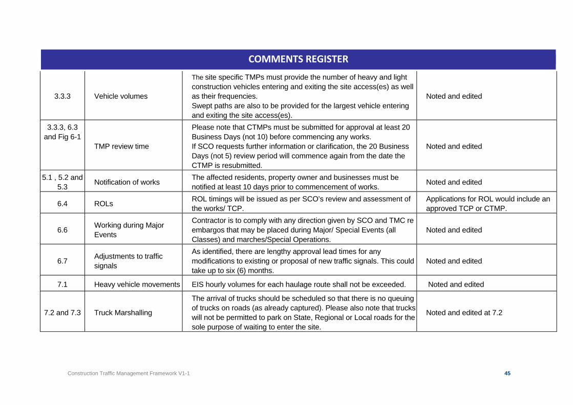
Construction Traffic Management Framework V1-1 45
COMMENTS REGISTER
3.3.3 Vehicle volumes
The site specific TMPs must provide the number of heavy and light construction vehicles entering and exiting the site access(es) as well as their frequencies. Swept paths are also to be provided for the largest vehicle entering and exiting the site access(es).
Noted and edited
3.3.3, 6.3 and Fig 6-1
TMP review time
Please note that CTMPs must be submitted for approval at least 20 Business Days (not 10) before commencing any works. If SCO requests further information or clarification, the 20 Business Days (not 5) review period will commence again from the date the CTMP is resubmitted.
Noted and edited
5.1 , 5.2 and 5.3 Notification of works The affected residents, property owner and businesses must be
notified at least 10 days prior to commencement of works. Noted and edited
6.4 ROLs ROL timings will be issued as per SCO’s review and assessment of the works/ TCP.
Applications for ROL would include an approved TCP or CTMP.
6.6 Working during Major Events
Contractor is to comply with any direction given by SCO and TMC re embargos that may be placed during Major/ Special Events (all Classes) and marches/Special Operations.
Noted and edited
6.7 Adjustments to traffic signals
As identified, there are lengthy approval lead times for any modifications to existing or proposal of new traffic signals. This could take up to six (6) months.
Noted and edited
7.1 Heavy vehicle movements EIS hourly volumes for each haulage route shall not be exceeded. Noted and edited
7.2 and 7.3 Truck Marshalling
The arrival of trucks should be scheduled so that there is no queuing of trucks on roads (as already captured). Please also note that trucks will not be permitted to park on State, Regional or Local roads for the sole purpose of waiting to enter the site.
Noted and edited at 7.2
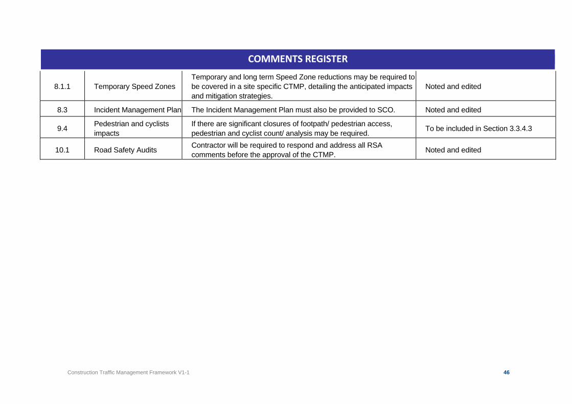
Construction Traffic Management Framework V1-1 46
COMMENTS REGISTER
8.1.1 Temporary Speed Zones Temporary and long term Speed Zone reductions may be required to be covered in a site specific CTMP, detailing the anticipated impacts and mitigation strategies.
Noted and edited
8.3 Incident Management Plan The Incident Management Plan must also be provided to SCO. Noted and edited
9.4 Pedestrian and cyclists impacts
If there are significant closures of footpath/ pedestrian access, pedestrian and cyclist count/ analysis may be required. To be included in Section 3.3.4.3
10.1 Road Safety Audits Contractor will be required to respond and address all RSA comments before the approval of the CTMP. Noted and edited
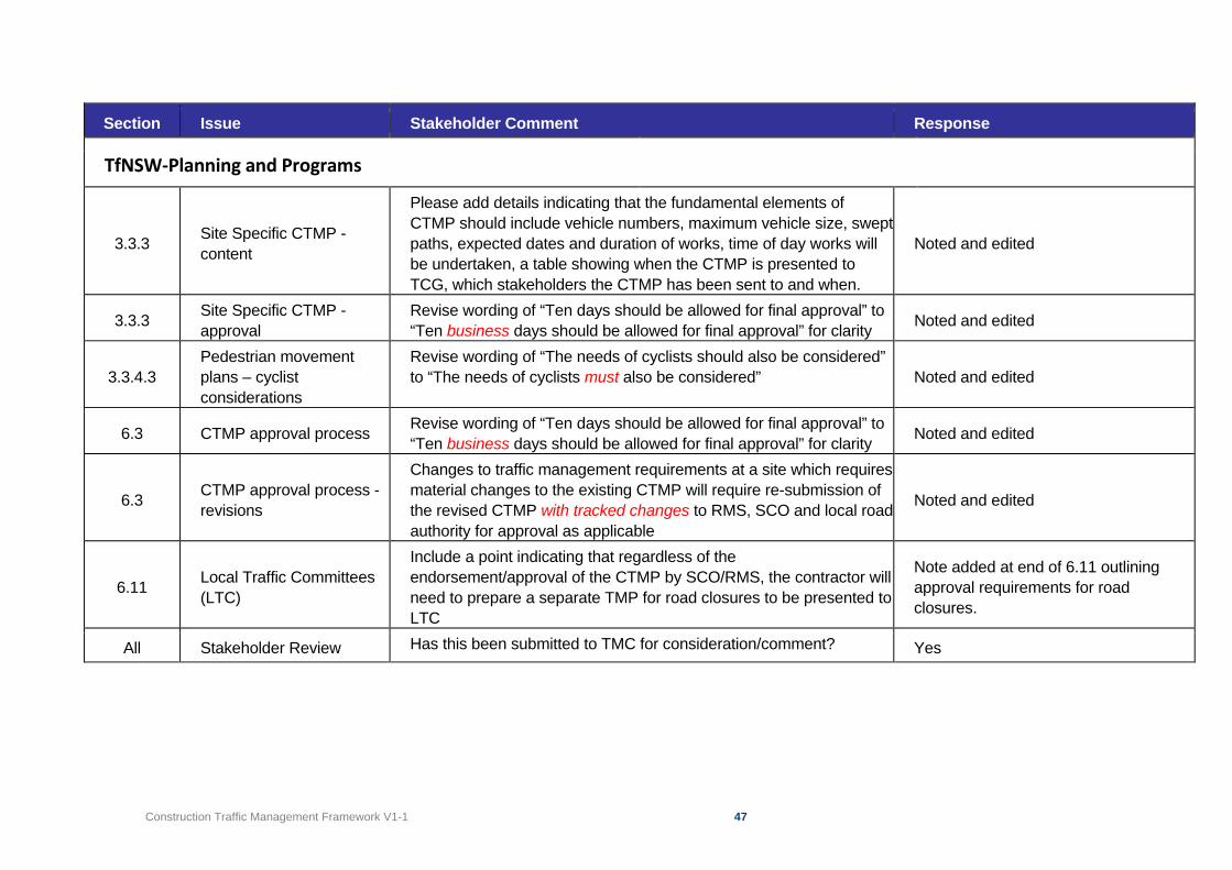
Construction Traffic Management Framework V1-1 47
Section Issue Stakeholder Comment Response
TfNSW-Planning and Programs
3.3.3 Site Specific CTMP - content
Please add details indicating that the fundamental elements of CTMP should include vehicle numbers, maximum vehicle size, swept paths, expected dates and duration of works, time of day works will be undertaken, a table showing when the CTMP is presented to TCG, which stakeholders the CTMP has been sent to and when.
Noted and edited
3.3.3 Site Specific CTMP - approval
Revise wording of “Ten days should be allowed for final approval” to “Ten business days should be allowed for final approval” for clarity Noted and edited
3.3.4.3 Pedestrian movement plans – cyclist considerations
Revise wording of “The needs of cyclists should also be considered” to “The needs of cyclists must also be considered” Noted and edited
6.3 CTMP approval process Revise wording of “Ten days should be allowed for final approval” to “Ten business days should be allowed for final approval” for clarity Noted and edited
6.3 CTMP approval process - revisions
Changes to traffic management requirements at a site which requires material changes to the existing CTMP will require re-submission of the revised CTMP with tracked changes to RMS, SCO and local road authority for approval as applicable
Noted and edited
6.11 Local Traffic Committees (LTC)
Include a point indicating that regardless of the endorsement/approval of the CTMP by SCO/RMS, the contractor will need to prepare a separate TMP for road closures to be presented to LTC
Note added at end of 6.11 outlining approval requirements for road closures.
All Stakeholder Review Has this been submitted to TMC for consideration/comment? Yes
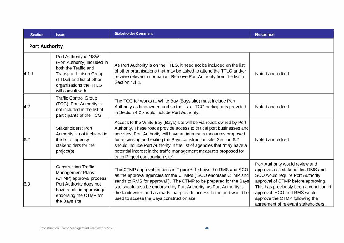
Construction Traffic Management Framework V1-1 48
Section Issue Stakeholder Comment Response
Port Authority
4.1.1
Port Authority of NSW (Port Authority) included in both the Traffic and Transport Liaison Group (TTLG) and list of other organisations the TTLG will consult with
As Port Authority is on the TTLG, it need not be included on the list of other organisations that may be asked to attend the TTLG and/or receive relevant information. Remove Port Authority from the list in Section 4.1.1.
Noted and edited
4.2
Traffic Control Group (TCG): Port Authority is not included in the list of participants of the TCG
The TCG for works at White Bay (Bays site) must include Port Authority as landowner, and so the list of TCG participants provided in Section 4.2 should include Port Authority.
Noted and edited
6.2
Stakeholders: Port Authority is not included in the list of agency stakeholders for the project(s)
Access to the White Bay (Bays) site will be via roads owned by Port Authority. These roads provide access to critical port businesses and activities. Port Authority will have an interest in measures proposed for accessing and exiting the Bays construction site. Section 6.2 should include Port Authority in the list of agencies that “may have a potential interest in the traffic management measures proposed for each Project construction site”.
Noted and edited
6.3
Construction Traffic Management Plans (CTMP) approval process: Port Authority does not have a role in approving/ endorsing the CTMP for the Bays site
The CTMP approval process in Figure 6-1 shows the RMS and SCO as the approval agencies for the CTMPs (“SCO endorses CTMP and sends to RMS for approval”). The CTMP to be prepared for the Bays site should also be endorsed by Port Authority, as Port Authority is the landowner, and as roads that provide access to the port would be used to access the Bays construction site.
Port Authority would review and approve as a stakeholder. RMS and SCO would require Port Authority approval of CTMP before approving. This has previously been a condition of approval. SCO and RMS would approve the CTMP following the agreement of relevant stakeholders.
Construction Traffic Management Framework V1-1 49
6.4
Road Occupancy Licence process: Port Authority does not play any role in approving any proposed occupation or closure of port roads
Any closure or occupation of roads within the Glebe Island/White Bay port precinct would require approval from Port Authority. This should be reflected in Section 6.4.
Noted and edited
Construction Traffic Management Framework V1-1 50
Section Issue Stakeholder Comment Response
TfNSW – Centre for Road Safety
1.2 Scope Specifying delivering safe environments for all road users
Please consider extending paragraph three to “….and any traffic management measures will need to consider all the potential impacts that might occur because of the construction activities, and deliver safe environments for all road users.”
Noted and edited
1.3 Adding in safe connections Dot point three under Metro West, please consider rewording to “delivering a safe and easy interchange between suburban rail…..”
Wording was extracted from Transport for NSW sources. Change not proposed.
1.3 Adding in safe connections Dot point two under Sydney Metro Greater West, please consider rewording to “A station at St Marys, safely interchanging with the existing rail station and connecting…..”
Wording was extracted from Transport for NSW sources. Change not proposed.
2 Adding in safe
Under the fifth paragraph, please consider adding the following dot points: - Remove and reduce road safety risk, especially for pedestrians
and cyclists.
Noted and edited
Table 2.1 Add in safe Please consider adding in a transport network objective of:
- Maintain a safe environment for pedestrians, cyclists and motorists.
Noted and edited
2.2 Traffic management measures
Please consider rewording dot point one to “the provision of directional signage and line marking to safely direct and guide drivers, cyclists and…”
Noted and edited
2.2 Traffic management measures
Please consider rewording dot point four to “Management and coordination of construction vehicle safe access to and from the work sites across pedestrian paths”.
Noted and edited
2.2 Traffic management measures
Please consider rewording dot point five to “Ensuring that safe access to existing properties and businesses is maintained…”. Noted and edited
Construction Traffic Management Framework V1-1 51
Section Issue Stakeholder Comment Response
3.3.4.3 Add in other mobility devices
Paragraph 3 refers to cyclists, can you please consider broadening to also include other mobility devices. Noted and edited
4.2 Add CRSMS Please consider adding Centres for Road and Maritime Safety to the TCG. Noted and edited
5.1 Adding in safe
Please consider rewording of second paragraph to “Every endeavour is to be made to maintain safe access at all times to properties for both pedestrians and vehicles. If works will temporarily affect access to a property, consideration should be given to the staging of the works, to maintain safe access and limit the disruption….”
Noted and edited
7.2 Adding in safe
Please consider rewording second sentence in the first paragraph to “Each site-specific CTMP will need to demonstrate, where applicable, how marshalling facilities will be used to safely manage truck movements and reduce congestion and road safety risks”.
Noted and edited
7.4 Reference to SM PS-ST-221
Does this include additional safety features on all newly purchased vehicles for the project?
The Health and Safety Standard provides a minimum requirement for heavy vehicles.
7.4.3 Driver training requirements
Please consider adding in training for drivers that covers site specific road safety risks along routes, for example areas of known risk such as schools, pubs and transport interchanges.
The contractor’s regular briefings and mandatory completion of the project specific heavy vehicle training would provide identification of specific road safety risks.