Embed Size (px)
Citation preview
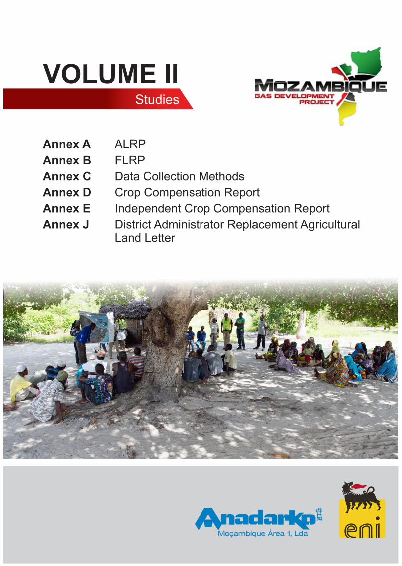
VOLUME IIStudies
Annex A ALRP
Annex B FLRP
Annex C Data Collection Methods
Annex D Crop Compensation Report
Annex E Independent Crop Compensation Report
Annex J District Administrator Replacement AgriculturalLand Letter

RESETTLEMENT PLAN: ANNEX A AGRICULTURAL LIVELIHOODS RESTORATION PLAN
FINAL DRAFT FOR GOVERNMENT APPROVAL
MOZAMBIQUE GAS DEVELOPMENT
i
Mozambique Gas Development Resettlement Plan
Annex A: Agricultural Livelihoods Restoration Plan
Rev. 1 Rev Date: 27-May-16
Table of Contents 1 PROJECT SUMMARY .......................................................................................................... 1
2 BACKGROUND AND JUSTIFICATION ............................................................................... 3
Project environment ................................................................................................................ 3
Perceived needs and constraints ........................................................................................... 3 2.2.1 Dryland machambas .............................................................................................................................4 2.2.2 Wetland machambas ............................................................................................................................5 2.2.3 Fruit trees ..............................................................................................................................................5 2.2.4 Livestock ...............................................................................................................................................6 2.2.5 Foraging ................................................................................................................................................7 2.2.6 Soil conditions .......................................................................................................................................7 Project beneficiaries and associated restoration programs ................................................ 8
Partners and main stakeholders ...........................................................................................10
Alignment with relevant policies ...........................................................................................12
3 PROJECT ACTIVITIES ....................................................................................................... 13
Data collection activities ........................................................................................................13
Livelihood interventions ........................................................................................................14 3.2.1 Program 1: Improved agricultural production .................................................................................... 14 3.2.2 Program 2: Crop storage ................................................................................................................... 17 3.2.3 Program 3: Fruit and vegetable drying and improved stoves ............................................................ 19 3.2.4 Program 4: Vegetable gardens .......................................................................................................... 20 3.2.5 Program 5: Resource facility .............................................................................................................. 23 Implementation team .............................................................................................................24
Project governance, monitoring and stakeholders ..............................................................25
Gantt chart for implementation .............................................................................................27
4 KEY ASSUMPTIONS .......................................................................................................... 40
5 OUTPUTS, OUTCOMES AND SUSTAINABILITY ............................................................. 41
Program 1: Improved cropping/agricultural production ......................................................42
Program 2: Crop storage .......................................................................................................47
Program 3: Drying systems and improved stoves ...............................................................51
Program 4: Vegetable gardens ..............................................................................................57
Program 5: Resource facility .................................................................................................61
6 REQUIRED INPUTS AND BUDGET FOR THE PROJECT ................................................ 65
ii
Mozambique Gas Development Resettlement Plan
Annex A: Agricultural Livelihoods Restoration Plan
Rev. 1 Rev Date: 27-May-16
Inputs ......................................................................................................................................65
Budget .....................................................................................................................................65
ABBREVIATIONS AND ACRONYMS ....................................................................................... 66
List of Figures Figure 2-1: Stakeholder interaction .........................................................................................................11
List of Tables Table 2-1: Number of affected trees ........................................................................................................ 6
Table 2-2: Livestock of Afungi households .............................................................................................. 6
Table 2-3: Physically and economically impacted households ................................................................. 8
Table 3-1: Typical income and expenditure from a 50 m2 vegetable plot in MZN ....................................21
Table 3-2: Potential implementation partners .........................................................................................24
iii

Mozambique Gas Development Resettlement Plan
Annex A: Agricultural Livelihoods Restoration Plan
Rev. 1 Rev Date: 27-May-16
1 PROJECT SUMMARY This Agricultural Livelihoods Restoration Plan (ALRP) is an annex of the Resettlement Plan (RP) that is required by Mozambican legislation. The ALRP provides the framework for the proposed interventions to mitigate the impacts of the planned Mozambique Gas Development Project (hereon referred to as the Project). A summary of the ALRP is set out in Chapter 7 of the RP, with the full body of the document provided in this Annex.
The planned Project in the Afungi peninsula has been provisionally allocated an area of 7,000 hectares (ha) by the Government of Mozambique (GoM). In 2014 the DUAT was demarcated and in June 2014, the final report on the demarcation1 of the DUAT was delivered to the Project proponents. The report indicated that 120 markers were placed to demarcate the DUAT while avoiding sensitive areas such as houses, villages, wetlands, river and lagoons, as well as a 100 m wide strip along the shoreline. Following demarcation, the DUAT area was recorded as 6,625 ha.
There are five villages with their associated agricultural production zones that will be impacted by the DUAT. Local inhabitants earn their living and sustenance from the land and sea, so remedial measures are critical to livelihoods.
Physically and economically displaced households will be impacted through:
• The loss of cultivated, fallow and bushland machambas;
• The loss of fruit trees; and
• If land possession is to take place prior to the harvest season, the loss of annual crops in the ground.
The impacts will be long-term and permanent. In order to mitigate these impacts the Project is proposing the following approach:
• Livelihood restoration programs,
• Replacement agricultural land (up to 1.5 ha of land – subject to availability – for the loss of agricultural land);
• Labor and disturbance rate for every hectare of land that households lose access to;
• Monetary compensation for the loss of fruit trees as well as replacement seedlings; and
• Monetary compensation2 for crop losses.
The goal of the ALRP is to ensure that all displaced households have the opportunity to achieve sustainable levels of food security within eighteen months of being physically relocated. This goal will be
1 The statutorily defined process for surveying and physically marking the DUAT boundaries, which is the responsibility of the DUAT holder. 2 Compensation rates have been identified and documented in a separate study - Crop Compensation Report that is Annex D of the RP
1
Mozambique Gas Development Resettlement Plan
Annex A: Agricultural Livelihoods Restoration Plan
Rev. 1 Rev Date: 27-May-16
achieved through providing access to replacement agricultural land, improving primary production and also assisting affected households to make better use of primary production. The ALRP is aiming to achieve the same or better agricultural production on smaller plots with fewer natural resources. If sustainability is to be achieved, productivity will need to be increased. Affected households and communities will benefit from five sector-specific programs:
1. Improved agricultural production - through introducing conservation agriculture (CA) methods; legume fallows; proper and orderly replanting of replacement fruit trees; reviving the cashew and coconut sector in the area; providing opportunities for intensification; and basic poultry and goat improvement programs;
2. Crop storage – improved storage of grain and seed will reduce current high storage losses and improve marketing opportunities;
3. Fruit and vegetable drying – prolonging the edible lifespan of seasonal crops will reduce wastage and improve the quantity of food available to the household and for sale. Included will be the introduction of fuel efficient stove technology and equipment;
4. Vegetable gardens – in line with more intensified production, community and backyard vegetable gardens will afford households the opportunity to contribute to their nutritional requirements and generate income from marketing surplus produce; and
5. Resource facility – in support of the above activities, information, training and requisites will be available through a center, which will include arrangements with local traders and should have development benefits to multiple sectors in the medium to long term.
Implementation of the programs will be over a minimum of 36 months, with emphasis on the first 18 months to ensure that food sufficiency is achieved and retained. After the initial 36-month period a review of the ALRP will be undertaken to determine whether livelihood restoration can be considered to be complete. Should this review find that the program has not been successful the programs will be continued.
Use will be made of implementing partners, such as Non-Governmental Organizations (NGOs) and private implementation partners. Identification and assessment of potential partners has already begun (as of October 2014). Development of programs will be carried out in close coordination with the Project-sponsored community investment program initiatives.
2
Mozambique Gas Development Resettlement Plan
Annex A: Agricultural Livelihoods Restoration Plan
Rev. 1 Rev Date: 27-May-16
2 BACKGROUND AND JUSTIFICATION This section provides the reader with the necessary baseline information about the agricultural context in the Afungi peninsula. This is achieved through the description of the type, scope and basis for current agricultural activities. This then provides the basis for the rationale for the selection of the intervention programs as well as the target beneficiaries.
Project environment The Project plans to develop a liquefied natural gas (LNG) Facility on the Afungi peninsula in order to harvest the abundant gas resources that were discovered off the coast of Palma. This Facility would be within an allocated project area, or DUAT3, of nominally 6,625 ha.
Several communities are currently settled within the Project area, where residents earn their living and obtain sustenance from the land and sea. The Project will use the entire DUAT area that will significantly impact these communities – to the extent that many of their daily activities will be severely restricted or prevented in within the DUAT. The Project’s economic and physical impacts will be short-term, long-term and permanent. Where impacts are long-term or permanent, plans are in place for livelihood restoration, and where impacts are short-term, material and monetary compensation will be provided.
The RP describes the restorative and remedial measures designed to address all impacts to affected households and communities.
Perceived needs and constraints Approximately eighty percent of the Mozambican population is involved in the agricultural sector, which makes up about 25 percent of the national gross domestic product (GDP). Since the majority of Mozambicans are involved in farming to some degree, the continued growth of this sector is an important factor in reducing poverty. In fact, Mozambique succeeded in reducing poverty levels from 69.4 percent in 1996/7 to 54.1 percent in 2002/34. This reduction was due to strong performance by the agricultural sector, which had grown by an average annual rate of eight percent as at 2011.
The country has 36 million ha of arable land and currently cultivates about ten percent, or 3.3 million ha. Small producers, who occupy about 95 percent of the cultivated area, produce the bulk of agricultural produce. Their farms are small – an average of 1.1 ha per household.
The gender division of labor is along lines found in many other rural communities in Mozambique, with women undertaking most of the agricultural work, domestic duties including child care and cooking, as well as a wide variety of collecting/foraging and petty trading to supplement household income and food security. Men, on the other hand, are more focused on fishing and petty trading (including selling any excess domestic production), as well as supplementing agricultural labor during land preparation. The
3Direito de Uso e Aproveitamento de Terra or DUAT is an expression that means the right to use and enjoy land 4 World Bank, 2006. Mozambique Agricultural Development Strategy, Report 32416-MZ, Washington DC
3
Mozambique Gas Development Resettlement Plan
Annex A: Agricultural Livelihoods Restoration Plan
Rev. 1 Rev Date: 27-May-16
diversification of livelihood activities is typical of poorer, risk averse, households but it is notable that women, rather than men, perform much of the diversification.
In general, the social organization of communities is based on traditional patriarchal values. Although the family unit pools the labor force and the resources it produces, men alone take decisions on the redistribution of all production and revenue, including those generated by women.
The prevailing practices related to marriage, divorce and the death of the husband point to a strong patrilineal and patrilocal tradition, that is at least partly in contradiction with the Mozambican laws that defend women’s rights in access and control of their assets. Yet, some indications exist of the presence of matrilineal and matrilocal traits, as shown in the possibility of women inheriting land or trees and being able to pass them on as inheritance to her offspring, as well as the option of the man moving to the woman’s place in marriage.
The Project will require 6,625 ha of land (excluding replacement agricultural land and the Special License Zone) for development of the LNG Facility, the Livelihood Development Zone and the replacement village. In addition, approximately 158 ha at the coast will be included into a special license application where the Project will develop nearshore infrastructure. Within this area roughly 1,116 ha of claimed machambas (cultivated area) and 1,518 ha of claimed bushland and fallow area, typically used for foraging, will be affected. In addition to the claimed land, 4,145 ha of unclaimed communal land will be affected. This section provides an overview of the type and extent of the land based livelihood activities of households within the Project area. The section also provides an overview of the soil conditions of the Project area. Land based livelihoods can be divided into the following categories:
• Farming in dryland and wetland machambas;
• Fruit trees;
• Livestock; and
• Foraging.
The sections below provide an overview of each of these activities.
2.2.1 Dryland machambas These are areas cleared of natural vegetation and planted with field crops under dryland or rain-fed conditions. The most popular crop in Afungi is cassava. Other crops like Bambara nuts, groundnuts, nhemba beans, watermelons, maize and sorghum are dependent on local conditions, with yield highly dependent on rainfall. Most households have at least one dryland machamba; it is difficult (in terms of labor) for a household to manage a dryland machamba bigger than one hectare.
The median size of cultivated dryland machamba is 0.81 ha per household. From the asset surveys conducted, the extent of the affected dryland machamba area is 2,633 ha, of which 1,116 ha (16%) are cultivated. When two or three slash and burn rotation cycles over eight or more years are considered, it is unlikely that the full extent of this loss can be replaced.
Depending on where machambas are located and the extent of available area, machambas are rotated every three to eight years. This means a machamba is cultivated for a period of three to eight years and rested for a similar period. If there is sufficient space a new machamba is not
4
Mozambique Gas Development Resettlement Plan
Annex A: Agricultural Livelihoods Restoration Plan
Rev. 1 Rev Date: 27-May-16
necessarily opened on the original or old site. Individual household preferences and external factors such as animal interference also contribute to the rotation pattern.
Once a machamba is abandoned it reverts quickly to natural bush. Fallow machambas are not planted to tree fallows or other crops and are used instead for foraging. Usually the regrowth is mature enough after four to five years and can then be used for firewood.
2.2.2 Wetland machambas These are fields within a wetland area that are planted with rice in the summer months (January to June). After harvesting, some fields are planted with vegetables and sweet potatoes between July and December after the rice has been harvested. The areas have a higher production potential but not all households have access to a wetland machamba.
Cultivated wetlands make up only four percent of the total cultivated area surveyed for affected households, with a median size is 0.3 ha. The median size of cultivated wetland machambas is much smaller than dryland machambas due to the fact that wetland machambas have a higher labor requirement. Planting is coordinated with adjacent farmers to facilitate later communal guarding of the crop, from birds and rodents. Where areas are left fallow it is due to factors such as availability of labor (planting rice is an onerous activity), flooding or animal activity.
From the asset surveys conducted, the extent of the cultivated wetland machamba area that will be affected is 48 ha. Wetland machambas are generally not rotated like dryland machambas, but replacing this lost natural resource will also be problematic given the availability of suitable wetlands.
Not all households have access to wetland machambas. Most wetland areas in Afungi appear to be ‘owned’ by someone or some family. These rights are passed on to succeeding generations although user rights are commonly, and usually freely, transferred to other users for agreed periods. Due to their productive nature wetland machambas are highly valued.
Although the edges of some wetland areas are suitable, they are seldom planted with perennial crop or trees as this has implications on future user rights. Perennials that are planted include bananas, mangoes, sugar cane and Moringa.
As with the cultivation of dryland machambas, wetland farmers do not actively replace used nutrients. Wetland machambas are more productive per unit area than dryland machambas as nutrients are introduced naturally through annual flooding.
2.2.3 Fruit trees The abundance of fruit trees in Afungi - especially coconuts, cashews and mangoes - indicates the presence of suitable growing conditions and a high reliance and value on the part of the community. Few trees are planted in orchards or are actively managed. Households typically consume their own fruit and sell any surplus. In addition to the fruit, the trees also provide leaves for roofing, wood and shade, and act as land ownership markers.
Many of the older trees in Afungi, particularly the coconuts, cashews and mangoes, have been inherited and thus have social and cultural significance. Many of the mature cashews trees for
5
Mozambique Gas Development Resettlement Plan
Annex A: Agricultural Livelihoods Restoration Plan
Rev. 1 Rev Date: 27-May-16
example are old and past their productive lives. Other perennial trees such as guavas, papaws, citrus, bananas and pineapples are often planted nearer to the homestead and readily accessible.
Most mango trees are a similar variety and the fruit ripens at the same time over a few months each year. Oversupply results in low prices and wastage during this period. Although each fruit tree has an owner, the fruit, particularly from trees outside the villages, is regarded as communal, with the exception of coconuts.
For many households, resettlement and Project activities will mean losing some of these trees. The extent of the loss, identified through the asset survey is shown in Table 2-1.
Table 2-1: Number of affected trees
Tree type Total No. Median/HH
Cashew 62,721 27
Coconut 9,641 8
Mango 9,312 5
Guava 1,126 4
Other 6,191 2
Total 88,991 27 Source: Resettlement asset survey, 2015
2.2.4 Livestock Ownership of domestic livestock in Afungi is limited to chickens, goats, ducks, sheep and pigeons (see Table 2-2). Livestock holding is low and in certain areas non-existent: chickens and goats are the only livestock held in significant numbers.
Table 2-2: Livestock of Afungi households
Type of livestock % of households (hh) Average No. of animals/hh
Chickens 85% 10
Goats 25% 9
Ducks 5% 6
Pigeons 1% 10
Sheep 0% 3
Source: Resettlement asset survey, 2015
There are several reasons associated with this trend. There is a limited tsetse fly presence in the area, which is associated with trypanosomiasis (causing sleeping sickness) and affects the health of cattle. Wild animals are still present in many parts of the peninsula. These include serval and caracal cats, jackals, baboons, hyenas, leopards, and occasionally lions. Baboons, hyenas and leopards are a particular threat to domestic livestock, forcing livestock owners to securely house
6
Mozambique Gas Development Resettlement Plan
Annex A: Agricultural Livelihoods Restoration Plan
Rev. 1 Rev Date: 27-May-16
their animals at night. A third contributing factor to the limited presence of livestock is the poverty levels and lifestyle of the communities. Most households do not have sufficient resources to invest in livestock, or have higher priorities such as boats or fishing gear. Fish is also the dominant source of protein and households have not developed a strong tradition of keeping livestock.
While livestock production is less significant when compared with other agricultural activities, household wealth is expected to increase over time and both livestock holding and consumption patterns are expected to grow. Although chickens in the area are hardy and survive on foraged food and household scraps, they are susceptible to the occasional outbreak of Newcastle disease.
The goats in the area are small-framed, but well suited to the environment. No specific intervention is proposed to improve goat production except to make animals more accessible to interested households. To help prepare a sound base from which to encourage interested households to enter into or expand livestock production, it is proposed that a simple animal health and management program be introduced. This will include two major focus areas:
• Inoculation of chickens against Newcastle disease; and
• Goat management and development through an animal loan scheme.
These are discussed in more detail in Section 3.
2.2.5 Foraging In the slash and burn cycle of agriculture practiced in Afungi, dryland machambas are abandoned when soil fertility becomes too low for effective production. While individual practices differ, machambas are generally rotated within a three and seven year period, with four to five years being the average. This means that with a median area of 0,74 ha cultivated, a household would typically have at least a similar area, 0,75 ha, of fallow land at any given time. Re-growth takes about three years, and after eight to ten years, fallow land has forest-like characteristics where trees have a diameter at breast height (dbh) of 5 to 10 cm. These trees are a significant source of firewood.
The extent of the Project’s impact on foraging is difficult to define in quantitative terms. All households in Afungi undertake foraging activities, ranging from firewood collection (30-40 kg/week); collection of roofing materials like foraged leaves and poles (although sheet metal is becoming more popular); palm leaves and sedges for mat weaving (less than half the households); and wild fruits. The most popular fruits are: Sweet Apple (Annona squamosa), Wild Custard Apple (Annona senegalensis), Java Plum (Syzygium cumini), Marula (Sclerocarya birrea), Black monkey orange (Strychnos madagascariensis), Green monkey orange (Strychnos spinosa), Mobola Plum (Parinari curatellifolia), African Mangosteen (Garcinealivingstonei).
2.2.6 Soil conditions In order to understand and identify the extent of replacement land available in the general area, the following activities have been undertaken: soil surveys; focus group discussions; case study data collection; satellite imaging analysis; discussions with provincial authorities; and extensive ground-truthing exercises. It is clear that most of the suitable areas for settlement and cultivation
7
Mozambique Gas Development Resettlement Plan
Annex A: Agricultural Livelihoods Restoration Plan
Rev. 1 Rev Date: 27-May-16
in the immediate area, both inside and immediately adjacent to the DUAT, have been occupied and/or used over time.
Provincial authorities have plans for an industrial development zone in the Palma/Afungi area, adjoining the DUAT allocated to the Project, and have indicated a preference for resettlement of affected Afungi communities within the allocated DUAT.
With resettlement and existing agricultural activities taking place outside the DUATT, there will be pressure on available land to accommodate affected households. The proposal for the replacement of agricultural land includes providing for up to 1,5 ha replacement agricultural land subject to availability. It is envisaged that 50 percent of this area will be kept fallow under pigeon peas or a similar tree or vegetative legume contributing towards the household wood fuel requirement.
This is discussed in more detail in Section 3.
Project beneficiaries and associated restoration programs All households that are affected by Project activities within the DUAT will be livelihood project beneficiaries. The households fall broadly into three categories:
• Group 1: Those that are physically impacted and need to be resettled;
• Group 2: Those who do not need to be resettled but are impacted economically; and
• Group 3: Those who are a part of the affected communities and can participate in some of the proposed improvement programs but not directly affected.
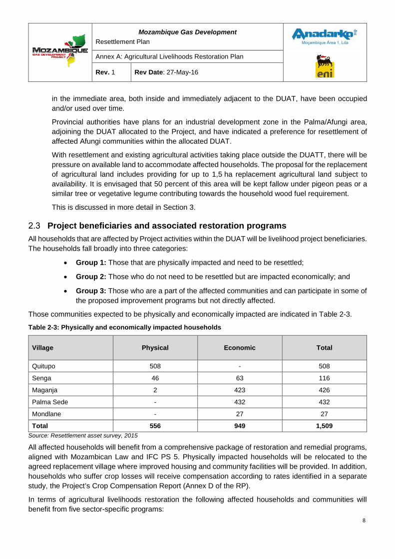
Those communities expected to be physically and economically impacted are indicated in Table 2-3.
Table 2-3: Physically and economically impacted households
Village Physical Economic Total
Quitupo 508 - 508
Senga 46 63 116
Maganja 2 423 426
Palma Sede - 432 432
Mondlane - 27 27
Total 556 949 1,509 Source: Resettlement asset survey, 2015
All affected households will benefit from a comprehensive package of restoration and remedial programs, aligned with Mozambican Law and IFC PS 5. Physically impacted households will be relocated to the agreed replacement village where improved housing and community facilities will be provided. In addition, households who suffer crop losses will receive compensation according to rates identified in a separate study, the Project’s Crop Compensation Report (Annex D of the RP).
In terms of agricultural livelihoods restoration the following affected households and communities will benefit from five sector-specific programs:
8
Mozambique Gas Development Resettlement Plan
Annex A: Agricultural Livelihoods Restoration Plan
Rev. 1 Rev Date: 27-May-16
a. Improved agricultural production – cropping and livestock;
b. Crop storage;
c. Fruit and vegetable drying and improved cooking stoves;
d. Vegetable gardens; and
e. Resource facility.
a. Improved agricultural production
There are four components to this program:
1. Introduction and application of CA principles to all interested farmers in Afungi, irrespective of whether they are being resettled, have relocated machambas, or are continuing to farm on their current machambas. This will include introducing a tree or vegetative legume fallow, which will not only enrich the soil but will also contribute towards the fuel wood component of the household.
2. Correct planting and management of replacement trees for all farmers or households who receive replacement saplings.
3. Rejuvenation of fruit tree production, particularly cashews, through improved orchard hygiene and management techniques, for all interested households who have mature trees that can be rehabilitated for production. Options will also be presented for the establishment of at least one cashew orchard and coconut plantation.
4. Introduction of chicken and goat management and development programs.
b. Crop storage
This involves introduction of technology, infrastructure and equipment for all interested households, particularly those who harvest surpluses and are either forced to sell their crop immediately or experience losses due to current storage methods.
c. Fruit and vegetable drying and improved cooking stoves
This involves introduction of technology and infrastructure to dry fruit, roots and leaves for all households interested in extending the useful life of seasonally available produce. This will help households improve nutrition, build supply during traditional hunger months, and generate additional income.
A sub-program is the provision of improved cooking stoves, and training, to impacted households. Reduced foraging areas will place greater pressure on the availability of fuel wood and more efficient use of available wood fuel for cooking will help to ameliorate this impact.
d. Vegetable gardens
This involves introduction of preparation and cultivation techniques and inputs for all interested households, both physically and economically impacted. Current vegetable production initiatives are underway in Patacua, Quitupo, Simo, Missonobali, Senga, Maganja and Barabarane. The program will focus of two groupings of households – those who will form part of a community vegetable garden,
9
Mozambique Gas Development Resettlement Plan
Annex A: Agricultural Livelihoods Restoration Plan
Rev. 1 Rev Date: 27-May-16
operating individual plots for own account, and those who want to establish gardens in their own backyard, particularly those who are being resettled in the replacement village.
e. Resource facility
The resource facility will be open for all Afungi residents and will provide access to basic farming inputs (handtools, seed, fertilizer, chemicals and packaging) and information. The goal is to encourage a general improvement in agricultural production.
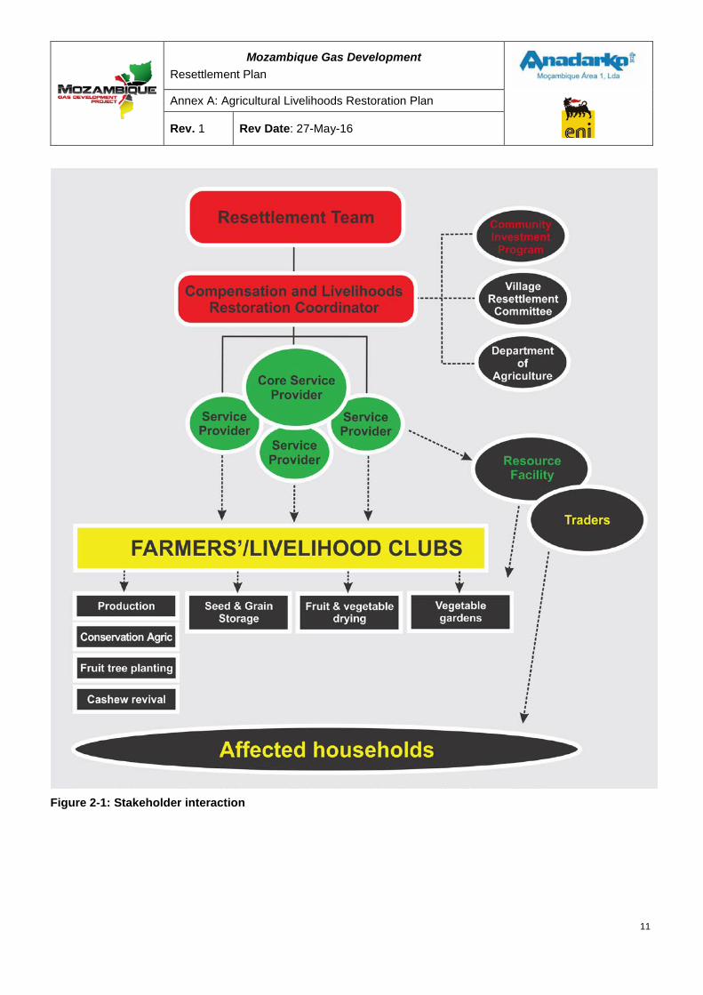
Partners and main stakeholders The Project will manage the ALRP. It is anticipated that one or more partners (service providers and/or NGOs) will implement the agriculturally-related programs over a minimum three-year period, with a review after eighteen months. A core Agricultural Livelihood team (ALT) will coordinate and manage these programs. Development of programs will be carried out in close coordination with related Project-sponsored community investment initiatives.
Other stakeholders are expected to be involved in the various programs. Involvement of some participants, such as INCAJU (Instituto de Fomento do Caju – official Mozambique parastatal responsible for the development and promotion of cashew production), Government and local academic or training institutions, will be at the discretion of the implementation partners and NGOs. However, more formal linkages with the Department of Agriculture and the Palma Development Committee will be necessary on the grounds of sustainability and networking.
Figure 2-1 presents the organogram that illustrates the interaction between the relevant stakeholders during the implementation of the program.
10
Mozambique Gas Development Resettlement Plan
Annex A: Agricultural Livelihoods Restoration Plan
Rev. 1 Rev Date: 27-May-16
Figure 2-1: Stakeholder interaction
11
Mozambique Gas Development Resettlement Plan
Annex A: Agricultural Livelihoods Restoration Plan
Rev. 1 Rev Date: 27-May-16
Alignment with relevant policies Since 1995, the GoM has introduced a number of policies and programs in support of improved agricultural production and development:
• The Agricultural Development Program (PROAGRI) was launched in 1998 to improve the overall agricultural sector and build the capacity of the then Ministry of Agriculture. It was reintroduced in 2006 to improve producer skills.
• Green Revolution Strategy (ERV) was introduced in 2007 to increase productivity and food security.
• The Food Production Action Plan (PAPA) and the Food Security Strategy were introduced in 2008 to replace imports.
• In 2011 two programs were approved – namely:
o the Agricultural Sector Strategic Plan (PEDSA) which focuses on increasing the profitability and competitiveness of the sector; and
o the Strategy to Reduce Chronic Malnutrition, which seeks to reduce the prevailing rates of chronic malnutrition in the country.
Practical actions linked to these policies include intensifying agricultural production in the areas with the greatest potential, and implementing food production and job creation actions. Two funds, the Agricultural Development Fund (FDA) and the District Development Fund (FDD), were developed in order to bring aid to the sector.
None of the proposed ALRP initiatives conflict with the objectives of existing national policies and programs. The proposed programs generally complement or advance the national objectives by building on some progress made to date. Examples include the promotion of cashew productivity through INCAJU and the distribution of improved cassava varieties in Cabo Delgado.
12
Mozambique Gas Development Resettlement Plan
Annex A: Agricultural Livelihoods Restoration Plan
Rev. 1 Rev Date: 27-May-16
3 PROJECT ACTIVITIES A range of activities were undertaken to collect and analyze data in order to assist the Project in determining effective and sustainable interventions that would remedy Project impacts and improve livelihoods (see Annex C of the Resettlement Plan – Data Collection Methods). The results of these activities were used to identify areas of intervention. These areas of intervention are detailed in five separate programs, each focusing and building on specific aspects of current activities that will lead to better use of available resources and improved productivity.
Data collection activities Data collection and community engagement were initiated in January 2013 prior to the official Government announcement (August 2013) introducing the Project’s resettlement requirements to communities. Certain programs such as the demonstration plots, case studies and other pilots are still ongoing in order to ensure sustainability.
This process included the following activities:
1. Data collection from seventy farmers regarding their production practices, areas and performance through interviews;
2. Data collection and focus group meetings around foraging activities in the communities of Maganja, Senga, Patacua, Barabarane, Quitupo, Ngoji, Milamba, Simo and Quitunda;
3. Data collection and focus group meetings around post-harvest crop storage methods in the communities of Maganja, Senga, Patacua, Barabarane, Quitupo, Ngoji, Milamba and Simo;
4. Focus group discussions on land tenure arrangements in the communities of Ngoji, Maganja, Patacua, Senga and Barabarane;
5. Focus group discussions on local product prices in the communities of Milamba, Senga, Barabarane, Quitunda and Maganja;
6. Case study identification and data gathering on typical household and village activities on a weekly basis at Ngoji, Maganja, Patacua and Senga;
7. Dryland cultivation demonstration activities at Maganja, Quitupo, Barabarane and Senga;
8. Wetland demonstration activities at Ngoji and Patacua;
9. Phase 1 of vegetable production trials at Barabarane, Senga, Maganja, Ngoji, Quitunda and Quitupo; and
10. Phase 2 of vegetable production trials at Milamba, Mipama, Senga, Maganja, Simo, Quitupo, Missonobali and Patacua.
All proposed restoration programs are built on the results of the abovementioned activities – particularly crop storage methods, vegetable production and modified dryland cropping practices. The time invested in building relationships with farmers and village structures has led to a level of trust that will provide a basis for introducing future initiatives.
13
Mozambique Gas Development Resettlement Plan
Annex A: Agricultural Livelihoods Restoration Plan
Rev. 1 Rev Date: 27-May-16
Livelihood interventions The livelihood restoration interventions will focus on: (1) making more effective use of the available resources; and (2) maximizing the benefits of the crops that are produced. It is realistic to expect yield and performance improvement across the most popular crops, along with improvement in the manner in which the crops are handled and stored. Suggested interventions for improvement will be based on current crops and activities and should therefore be within the realm of farmer familiarity and understanding.
NGOs and private service providers/implementation partners (IPs) will implement the programs. Due to the overlapping nature of the interventions some service providers may implement more than one program simultaneously. An assessment of possible local service providers/NGOs has been undertaken in Section 3.3.
The ALT, within the project governance and monitoring structure of the resettlement program, will coordinate and manage implementation. It is possible that many of the successful programs will become longer-term community investment projects and programs.
As mentioned in Section 2.3, in terms of agricultural livelihoods restoration, affected households and communities will benefit from five sector-specific programs:
1. Improved agricultural production – cropping and livestock;
2. Crop storage;
3. Fruit and vegetable drying and improved stoves;
4. Vegetable gardens; and
5. Resource facility.
3.2.1 Program 1: Improved agricultural production The District Government will source agricultural land outside the DUAT for those households who will lose agricultural land as a result of the Project’s development. The Project has requested the District Government to provide up to 1.5 ha (subject to availability) of replacement agricultural land for each of those households who will lose their agricultural land. This proposed replacement area for each household of 1.5 ha is based on a median area of 0.75 ha cultivated annually by 70 sampled households. Livelihood restoration strategies for improved agricultural production will account for this 1.5 ha within which a two-cycle land rotation (2 x 0.74 ha) will be promoted.
In order to minimize the need for frequent land rotation, techniques and practices based largely on CA principles will be introduced to improve agricultural productivity. These principles follow sustainable and cost-effective methods for increasing soil fertility; controlling pests and diseases; improving yields; and making use of legume fallows – either tree or vegetative.
Where compensation is accompanied by the provision of replacement trees, there will be training on the most effective methods of planting and caring for these trees. This forms part of a larger program for existing fruit trees, designed to improve orchard management and hygiene, in an effort to increase overall fruit tree production. The aim is to restore lost production for each affected household within a minimum possible period. In line with best practice, two replacement trees for
14
Mozambique Gas Development Resettlement Plan
Annex A: Agricultural Livelihoods Restoration Plan
Rev. 1 Rev Date: 27-May-16
each lost tree will be offered. The number of fruit trees available for planting will justify consideration of one or more cashew orchards and coconut plantations where farmers may plant and manage their trees, for own account, in an ordered and managed fashion.
Activity 1: To introduce improved cropping practices Sub-activities
• Confirm that each farmer has an identified/allocated plot. For those farmers who have lost land this will be part of the Resettlement team’s (RT) responsibility to ensure that each has suitable replacement land. (The initiative to improve cropping practices will also be available to those farmers in Afungi who have not lost land but who would like to participate.)
• Organize farmers into groups. Each group must have access to a training area and demonstration plot as part of the program. These demonstration plots will be located within the Livelihood Development Zone inside the Project’ DUAT. It will be part of the IP’s responsibility to organize and structure practical farmer groups, who will then build a ‘makuti’ (lapa) next to the demonstration plots. Where groups already exist, it will be necessary to link in with existing members and operating procedures.
• Clear land and apply basal fertilizer, where necessary. The IP will be responsible for these tasks, noting that the application of the basal fertilizer (phosphate and/or lime) should be applied according to the analyses from the soil survey undertaken throughout the DUAT and outside the DUAT.
• Establish a firm annual cropping program that includes the application of CA principles like mulching; composting; planting in rows; rotation with legumes; use of natural and artificial insecticides; and no burning. The IP will be responsible for this, keeping in mind that CA principles must be applicable to the local operating conditions and must be established through training, demonstration activities, mentoring and follow-up with group leaders.
• Introduce and establish a fallow crop on the unused (fallow) 0.75 ha. The fallow crop, a legume, will contribute towards nitrogen fixation in the soil; generate vegetative growth for soil organic matter and ground cover; and provide fuel wood.
• Establish farmer days aimed at knowledge sharing. Although the IP will be responsible for sharing and transfer of knowledge, other players will include the ALT and the local office of the Department of Agriculture.
15
Mozambique Gas Development Resettlement Plan
Annex A: Agricultural Livelihoods Restoration Plan
Rev. 1 Rev Date: 27-May-16
Activity 2: To correctly plant and manage replacement saplings This is a short-term project activity but linked closely with farmer groups. It is anticipated that affected households receiving replacement saplings as part of a compensation package will be part of an established farmer group. The IP will demonstrate and facilitate the correct method of planting and caring for replacement saplings, ensuring the greatest chance of establishment and survival so that the period before fruit bearing is minimized. This will apply to all replacement trees.
Activity 3: To introduce a local cashew and coconut industry revitalization program Sub-activities
• The appointed IP will link in with any existing initiatives being undertaken to determine the most effective target groups and focus areas.
• Design or re-design an appropriate program. The IP will present a realistic program with a plan of action that may focus exclusively on cashew and coconut production, or include a tree management approach orientated to fruit trees in general. This sub-activity will include options for the establishment of one or more cashew orchards and coconut plantations where farmers will have the opportunity to farm, for own account, under commercial conditions. These plantations will be located within the Livelihood Development Zone within the DUAT.
• Identify leader farmers and early adapters to participate in a pilot program. The IP will take responsibility for establishing and structuring this pilot.
• Establish an annual management program. The IP will ensure that the program principles and capacity building are established through training, demonstration activities, mentoring and follow-up through group leaders. This will also include a cashew tree renewal or ‘top-working’ (grafting) program, where possible.
• Explore relationships/linkages with support and marketing organizations. Organizations that provide technical and marketing support in the cashew industry will be consulted and invited to participate, where feasible. The IP will take responsibility for these actions.
• Assess the feasibility of developing and/or supporting existing local cashew tree spraying contractors. The IP will conduct an assessment on the viability of developing and commercializing local spraying contractors. This should be based on the nature of the accepted program, on advice from support and marketing organizations and the Department of Agriculture, and on the reaction from local tree owners and any existing local spraying contractors.
• Establish farmer days aimed at knowledge sharing. Although the IP will be responsible for sharing and transfer of knowledge, other players will include the ALT and the local office of the Department of Agriculture.
16
Mozambique Gas Development Resettlement Plan
Annex A: Agricultural Livelihoods Restoration Plan
Rev. 1 Rev Date: 27-May-16
Activity 4: To introduce chicken and goat health and development programs Sub-activities
• Establish connections with existing livestock farmer groups, or form core groups where none exist.
• Introduce the concept of a health program for poultry and a development program for goats. The IP will introduce the principles to be applied and, together with farmers, agree on a course of action to achieve the agreed objectives.
• Train and mentor. The IP, with the help of the group leaders, should convey principles using in-field demonstrations.
• Establish farmer days where knowledge sharing and adherence to activity schedules is key. Although the IP will be responsible for sharing and transfer of knowledge, other players will include the ALT and the local office of the Department of Agriculture.
• Mentoring and entrenchment is the final step. Practices and systems are established through training, demonstration activities, mentoring and follow up through IP group leaders.
3.2.2 Program 2: Crop storage Seed and grain storage by rural farmers is common in Mozambique. Afungi is no exception. Seed is stored for planting in the following season, while grain is stored for consumption. Both seed and grain are usually stored in the house itself because there aren’t other storage facilities for the grain and because it’s difficult to access affordable seed prior to planting.
Storage of seed and grain in this manner results in inevitable losses. Losses are usually due to: inadequate storage methods and drying techniques; rat and insect attacks; and infestation by food-borne diseases.
The result of focus group discussions and direct observations conducted in eight villages in Afungi reveals that post-harvest losses in the region are high. Post-harvest losses are mostly associated with three factors: (1) poor storage systems; (2) lack of control measures; and (3) lack of technical assistance that would help reduce these losses. For cassava production, post-harvest losses are estimated at more than fifty percent of the dried product. For maize and cowpea, losses were observed to be as high as thirty percent of stored produce. Furthermore, in-field seed selection is not common practice in the region.
A complimentary program will improve household crop storage methods through training and introduction of technology and appropriate infrastructure. Limiting crop losses will mean that more effective use can be made of produced crops, both in terms of consumption and income realized. This will, in turn, reduce the need for larger farming areas.
17
Mozambique Gas Development Resettlement Plan
Annex A: Agricultural Livelihoods Restoration Plan
Rev. 1 Rev Date: 27-May-16
Activity 1: To introduce proven post-harvest crop storage methods Sub-activities
• The appointed IP will link in with any existing initiatives being undertaken to determine the most effective target groups and focus areas.
• Introduce the concept to existing/new farmer groups. The IP will introduce the principles and objectives and these will be discussed with participants.
• Design or re-design an appropriate program. The IP will present a realistic program with a plan of action that focuses on the priority areas identified through interaction and farmer discussion.
• Train group leaders. The IP will be responsible for training group leaders. Farmers are trained using demonstrations/pilot by the IP, with the help of the group leaders.
• Provide farmers access to equipment and construct appropriate infrastructure. The IP, with the help of the group leaders, will assist farmers in accessing and building infrastructure. This will be accomplished by demonstrations and provision of materials where necessary, or not available locally.
• Introduce storage methodologies, with care given to the use of chemicals. The IP, with the help of the group leaders, will demonstrate and mentor the use of organic and inorganic chemicals, where relevant.
• Establish farmer days where knowledge sharing is key. Although the IP will be responsible for sharing and transfer of knowledge, other players will include the ALT and the local office of the Department of Agriculture.
• Monitoring and entrenchment is the final step. Practices and systems are established through training, demonstration activities, mentoring and follow up through IP group leaders.
Activity 2: To introduce effective in-field seed and plant material selection Sub-activities
• Establish connections with existing farmer groups. The IP will focus on existing farmer groups and those who demonstrate improved production and superior storage methods.
• Introduce the concept. The IP will introduce the principles to be applied and, together with farmers, agree on a course of action to achieve the agreed objectives.
• Train and mentor. The IP, with the help of the group leaders, should convey principles using in-field demonstrations.
• Establish farmer days where knowledge sharing is key. Although the IP will be responsible for sharing and transfer of knowledge, other players will include the ALT and the local office of the Department of Agriculture.
18
Mozambique Gas Development Resettlement Plan
Annex A: Agricultural Livelihoods Restoration Plan
Rev. 1 Rev Date: 27-May-16
• Monitoring and entrenchment is the final step. Practices and systems are established through training, demonstration activities, mentoring and follow up through IP group leaders.
3.2.3 Program 3: Fruit and vegetable drying and improved stoves Primary agricultural production is the major livelihood activity in Afungi, but almost no value adding takes place. Most farmers only focus on extending the consumption window rather than adding value to the product itself.
Production is seasonal and usually associated with short harvest periods. Cassava, for example, is harvested and dried in the drier months from August to November. Poor storage conditions reduce the edible lifespan of the dried cassava chips. This means that dried cassava is only actively traded from September to February, and at lower prices due to market surplus. Stored produce is affected by inadequate storage methods and drying techniques; attacks by rats and insects; and infestation by food-borne diseases. Similar factors apply to the limited volumes of beans and cereals produced. Mangoes ripen between November and January, and again, supply exceeds demand during this period. There is a lot of waste because there aren’t adequate drying and storage facilities and methods.
Simply introducing a program that covers drying methods and technologies will increase the livelihoods of households. Benefits include: improved household nutrition; better utilization of produce (less wastage and loss); enhanced availability of food during the traditional hunger months of February to April; and increased household income because dried produce can be sold at off-peak times.
Improved stoves Although foraged fuel wood in Afungi is currently not restricted, future availability is expected to decline as some foraging areas is located within the DUAT will be lost to the Afungi community. Fuel wood is the most common use of foraged wood in Afungi and improving the efficiency of fuel wood use will help ameliorate the anticipated increased pressure on the available foraged wood resources. A proposed method of achieving this is the introduction of improved cooking stoves that are more fuel wood efficient. There is a range of stoves available and technology is constantly being developed to promote efficiency and encourage systematic migration to more effective renewable fuels. Both permanent and pre-fabricated fuel-efficient stoves that are being promoted by local NGOs improve fuel wood use by 40-60 percent.
This sub-program will make improved stoves available to physically impacted households, with associated training. The stoves and training will be offered to physically displaced households at no cost to encourage uptake. Stoves and training will be offered to economically impacted households at a subsidized rate
19
Mozambique Gas Development Resettlement Plan
Annex A: Agricultural Livelihoods Restoration Plan
Rev. 1 Rev Date: 27-May-16
Activity 1: To introduce drying technologies to interested households Sub-activities
• Introduce the concept. The IP will introduce the concept to be applied and, together with households, agree on a course of action to achieve the agreed objectives.
• Design or re-design an appropriate program. The IP will present a realistic program with a plan of action that focuses on the priority areas identified through interaction and farmer discussion. An important aspect will be individual vs. shared equipment, and infrastructure.
• Train group leaders. The IP will be responsible for training group leaders.
• Train and mentor. The IP, with the help of the group leaders, should convey principles using in-field demonstrations and piloted activities, and then follow up with mentoring.
• Provide farmers access to equipment and construct appropriate infrastructure. The IP, with the help of the group leaders, will assist farmers in accessing and building infrastructure. This will be accomplished by demonstrations and provision of materials where necessary, or when not locally available.
• Establish farmer days where knowledge sharing is key. Although the IP will be responsible for sharing and transfer of knowledge, other players will include the ALT and the local office of the Department of Agriculture.
• Monitoring and entrenchment is the final step. Practices and systems are established through training, demonstration activities, mentoring and follow up through IP group leaders.
Activity 2: To introduce improved stoves to interested households Sub-activities
• Introduce the concept. The IP will introduce the concept of improved stoves, and together with interested households agree on a course of action to achieve the agreed objectives.
• Design an appropriate program, selecting pre-fabricated or on-site constructed stoves.
• Establish interest groups and train group leaders. The IP will be responsible for this activity.
• Exposure and training. The IP, with the help of the group leaders, should convey principles and use of stoves by conducting demonstrations to households.
• Provide households with access to stoves.
• Monitor current users and roll out to economically impacted households.
• Establish local support system through local dealers.
3.2.4 Program 4: Vegetable gardens Afungi has low levels of vegetable production and consumption. This is related both to sub-optimal production conditions and a lifestyle adapted to the consumption of starch (mainly cassava, maize and rice) and fish. The obvious health benefits and the ease with which many vegetables can be
20
Mozambique Gas Development Resettlement Plan
Annex A: Agricultural Livelihoods Restoration Plan
Rev. 1 Rev Date: 27-May-16
cultivated under managed conditions, make the introduction of vegetable farming an important restoration strategy. This may serve as a catalyst for the development of commercial producers in order to meet an expected growing demand for food, especially vegetables, as the Project and Palma expand.
The demonstration plot activities to date at Maganja, Ngoji, Quitupo, Quitunda, Barabarane and Senga indicate that participants have had a positive experience in the production of vegetables, irrespective of the level of success. Without exception, all participants have a strong desire to continue with vegetable production, and a second round of demonstration plots operated by farmers were also implemented at Patacua, Quitupo, Simo, Missonobali, Senga, Maganja and Mipama. Results from the second round of vegetable demonstration activities show that many of the vegetable garden participants produce surpluses that generate additional household income. An example of income and expenditure from a 50 m2 vegetable plot producing two crops per season for a typical participating household is detailed in Table 3-1.
Table 3-1: Typical income and expenditure from a 50 m2 vegetable plot in MZN
Inputs MZN
Hoe 85
Rake 125
Watering can 300
Fertilizer/manure/compost/mulch 1,200
Spray 100
Seed 240
Total 2,050
Cost per m2 (2 x 50 m2) cultivated 21
Returns MZN
Estimated value of crop (2 x 50 m2) 15,000
Less: estimated home use (33%) 4,950
Net value (surplus available for sale) 10,050
Less: input cost 2,050
Net return 8,000
Net return per m2 cultivated 80
A community vegetable garden, used intensively, can be highly productive. The development of these types of initiatives aims to intensify production on smaller areas of land on a sustainable basis. Not only can they provide a significant portion of the household nutrition requirement, with surpluses generating additional household income, but also by the proximity to the village, members of the household can more readily be involved. Exposing children to vegetable cultivation
21
Mozambique Gas Development Resettlement Plan
Annex A: Agricultural Livelihoods Restoration Plan
Rev. 1 Rev Date: 27-May-16
opens the doors to new possibilities and may stimulate interest in this and other forms of agriculture, supporting the local agricultural sector and its sustainability.
Activity: To establish ten village vegetable gardens
• The appointed IP will link in with any existing initiatives being undertaken to determine the most effective target groups and focus areas.
• Confirm and access suitable natural resources. The IP will assess location and available natural resources as a necessary input into the design of the specific project.
• Design an appropriate program. The IP will prepare a design, building on existing activities and considering the participating groups, the location and the available natural resources. The two group focus areas will be community gardens at suitable locations adjacent to villages, and individual backyard gardens of the resettled households.
• Facilitate the formation of vegetable garden groups. The IP will facilitate the formation of new groups or sub-groups as required, with group leaders, for both community and backyard gardens.
• Train group leaders. The IP will be responsible for training group leaders.
• Allocate production plots to participating households. In line with individual accountability for production, plots at each garden project will be allocated to households. This will be done by the IP group leaders but assisted by the group and village structures. For the backyard gardens each household will establish their own garden within their yard.
• Introduce the concept. The IP will introduce the concept of community and backyard gardens to the groups.
• Erect/construct infrastructure and develop a water source, where required. The IP, with the help of group leaders, will ensure the establishment of the actual garden with the necessary infrastructure, including the development of the water source, if required.
• Assist with access to equipment. The IP, through the group leaders, will assist farmers to access materials and other requisites for production.
• Train and mentor. The IP, with the help of the group leaders, should convey principles using in-field demonstrations and activities, and then follow up with mentoring.
• Establish farmer days where knowledge sharing is key. Although the IP will be responsible for sharing and transfer of knowledge, other players will include the ALT and the local office of the Department of Agriculture.
• Monitoring and entrenchment is the final step. Practices and systems are established through training, demonstration activities, mentoring and follow up through IP group leaders.
22
Mozambique Gas Development Resettlement Plan
Annex A: Agricultural Livelihoods Restoration Plan
Rev. 1 Rev Date: 27-May-16
3.2.5 Program 5: Resource facility The ALRP and a number of RP activities propose various programs to restore and develop agricultural livelihoods in Afungi. Most of these proposals require inputs and interventions not readily available or currently offered in the area. To ensure that the RP fulfills its intended objectives, it will be necessary to implement and operationalize properly structured and functioning resource facilities.
Given the size and nature of agricultural production and associated activities around Afungi, these required support functions are best served by a multi-institutional arrangement. This will prove more sustainable, and more accessible, than a single resource center. An information center can provide training, technology and access to a wealth of information. Farming and other general requisites can be made available to farmers and customers via established local traders who have been incentivized to carry, in addition to their normal trade, a pre-determined range of stock.
The information center will need to be sustainable in the medium-to long-term, and should be compartmentalized so that the privatization of sections, where appropriate, can be encouraged. Close linkages with relevant NGOs and the private sector will help towards this sustainability goal. It is anticipated that the information center will need to be subsidized in the short-term, given the pressing nature of the resettlement program’s objectives. Funding will need to come from the Project, and should be seen as an element of the resettlement program. Such a facility often functions best when it is allocated to an IP, who will manage it for at least the duration of the resettlement program. Thereafter community investment initiatives will help determine the extent of the financial, technical and oversight support required.
By making use of local traders to supply general requisites it may be necessary to subsidize this arrangement for a short period. Once agricultural and other resettlement impacted activities have normalized it should be possible to allow market forces to continue with the supply of the requisites.
The information center, which is also the subject of community investment interventions in the area, would ideally focus on a range of sectors and activities and thereby fulfill a broader mandate to Afungi households. This would help build a foundation for broader community support and greater sustainability in the longer term by encouraging institutions involved in:
• Savings and loans; • Marketing services; • Institutional and business support; and • Value-adding to primary products.
Activity: To establish and capacitate a functional information center with associated arrangements to access general farming requisites
Sub-activities
• Liaise with community investment program IP and link in with existing initiatives. The appointed IP will link in with any existing initiatives being undertaken by the community investment program to determine the most effective target groups and focus areas.
23
Mozambique Gas Development Resettlement Plan
Annex A: Agricultural Livelihoods Restoration Plan
Rev. 1 Rev Date: 27-May-16
• Construct, or secure access to logistically convenient infrastructure that will serve as an information center. This center will require storage, offices and training facilities. Where previous community investment program activity has not already progressed in this matter, the IP will, after due assessment, make an appropriate recommendation to the Project’s Resettlement team.
• Staff the resource facility with relevant personnel and IT capability. The IP will make recommendations to the Project’s Resettlement team about the staffing and IT requirements.
• Involve local traders. The IP will conclude incentivized arrangements with local traders to possibly procure and supply a range of relevant farming requisites.
• Engage in active networking. The IP should formalize linkages with private sector, research and support institutions, and NGOs.
• The District Department of Agriculture should formally endorse the information center initiative as they may, as part of their mandate, play some future role in its function.
• Establish farmer days where knowledge sharing is key. Although the IP will be responsible for sharing and transfer of knowledge, other players will include the ALT and the local office of the Department of Agriculture.
Implementation team It is envisioned that one or more IPs will be appointed to implement the programs. It may be best to allocate more than one program to an IP, given that some of the programs overlap, and share common objectives and beneficiaries. In terms of cost-effectiveness and continuity, it may be worth engaging with IPs who have already been appointed to implement overlapping community investment interventions in Palma District, which are scheduled to start before the commencement of these proposed programs.
Potential IPs, including private service providers and NGOs, were contacted and assessed during a screening process. A summary is presented in Table 3-2.
Table 3-2: Potential implementation partners
NGOs Service Providers
ADPP Agritec
AENA CEAGRE
Africare EMALIKN
AKF Kurima Ne Povo
AMA Pemba HORSPEC
Helvetas Machados Holding
Kulima Murrebue Nursery
Oikos OLIPA ODES
Progresso Service Coop
24
Mozambique Gas Development Resettlement Plan
Annex A: Agricultural Livelihoods Restoration Plan
Rev. 1 Rev Date: 27-May-16
NGOs Service Providers
Swiss Contact -
UMAC -
International NGOs and service providers include: (1) AKF - Aga Khan Foundation; (2) Helvetas - Helvetas Swiss Intercooperation; (3) FH – Association; (4) ADPP - Ajuda Dinamrquesa do Povo para o Povo; (5) Swiss Contact – Swiss Foundation for Technical Cooperation; (6) OIKOS – Cooperação & Desenvolvimento; (7) AFRICARE.
National contacted NGOs and service providers are: (1) Agritec; (2) AMA – Associação do Meio Ambiente; (3) AENA – Associação Nacional de Extensão Rural; (4) KULIMA – Organização para o Desenvolvimento Sócio-económico Integrado; (5) Associação Progresso; (6) OLIPA ODES – Associação para o DesenvolvimentoSustentável; (7) UMAC – União Provincial de Camponeses de Manica, located in Chimoio and specialize in CA, land management, farmers’ awareness and is a farmers’ stakeholders platform, and a member of National Farmers’ Union.
An in-house assessment of the above institutions has been completed. These and any other potential implementation partners will be reassessed during implementation.
Project governance, monitoring and stakeholders Implementation of the RP will be a large undertaking. The census, socio-economic and asset surveys conducted indicate that, in terms of agricultural impact, 453 households will be physically displaced with a further 312 households being economically impacted with interrupted access to their traditional cultivated lands. The agricultural livelihoods restoration program will be only one component of the larger relocation and resettlement exercise that will be coordinated and managed by the RT. For the agricultural program component, the following players and stakeholders will be involved in the process:
• Implementation partners (IPs)
IPs will be responsible for implementation of the ALRP and will monitor progress through their group leaders, regular site visits and household interaction. They will report on a monthly basis and have weekly or fortnightly interface with the ALT, depending on the program and stage of implementation. A review of program activities and progress will be undertaken at 18 months. Through the nature of the work to be undertaken, the IPs will develop relationships and interact regularly with the farmer groups, village structures and the Community Resettlement Committee (CRC). With ongoing, overlapping community investment projects in the area and the similar nature of the proposed programs, there may be justification in appointing a Main or Core IP to drive and coordinate implementation of the smaller or shorter programs should there be a need to appoint multiple or specialist IPs. This may be more cost effective and streamline logistics.
• Agricultural Livelihood team (ALT)
This team, part of the RT, will monitor the field activities of the IPs, meet with them on a weekly or fortnightly basis and review a formal monthly report on progress. The team will
25
Mozambique Gas Development Resettlement Plan
Annex A: Agricultural Livelihoods Restoration Plan
Rev. 1 Rev Date: 27-May-16
also have access to the farmer group leadership and the CRC. This is to ensure appropriate and timely monitoring, particularly if problems arise and grievance procedures need to be followed. The ALT will be responsible for involving the local Department of Agriculture in the program. Key areas to be addressed will be exposure to the projects, network development and linkages, and eventually incorporating the activities in the Department of Agriculture’s annual program.
• Farmer groups or equivalent
These beneficiaries are the key interface to the programs. They will interact on a regular basis with their group leaders, village structures and the CRC. Access to the ALT on a regular basis will also allow feedback and monitoring.
• Community Resettlement Committee (CRC)
The CRCs already established and successfully operating will continue to serve the village or community at the RP level. The CRCs will directly liaise with the RT, or one of its sector arms, e.g. agriculture. This channel of communication will be particularly important both for larger issues that may affect the community or village as whole and dealing with grievance procedures.
• Resettlement team (RT)
This team will carry responsibility for relocation and resettlement of impacted households and communities, which is anticipated to take 36 months. During this time the RT will monitor and report to the Resettlement Program Manager and participate on the District Resettlement Commission (DRC).
• Community investment team
Although not technically part of the RP, community investment projects in the Palma District overlap with RP. Some Quick Impact Projects, commissioned through the community investment program, have a direct impact on RP beneficiary households and communities. Liaison with and feedback from community investment team via the RT will be useful for continuity of common projects, especially when it comes to effective governance and expansion.
• District Resettlement Commission (DRC)
This high-level committee will represent local Government authority. For the purposes of RP, this forum will receive feedback, recommendations and requests from the RT, and provide advice and decisions required from authorities at district or national level. It is expected that the DRC will have its own provincial and national reporting and liaison structures.
26
Mozambique Gas Development Resettlement Plan
Annex A: Agricultural Livelihoods Restoration Plan
Rev. 1 Rev Date: 27-May-16
Gantt chart for implementation The following Gantt charts have been included to indicate the anticipated timing of activities associated with the proposed interventions.
• Chart 1: Improved agricultural production
• Chart 2: Crop storage
• Chart 3: Fruit and vegetable drying and improved stoves
• Chart 4: Vegetable gardens
• Chart 5: Resource facility
The responsibilities for actions and activities noted in the charts refer as follows:
• IP – Implementation partner
• RT – Resettlement team
• RF – Resource Facility
• ALT – Agricultural Livelihood team (part of RT)
• DA – District Administration
• EI – Existing initiatives
• Dept Agric – Department of Agriculture (Provincial and/or District)
• Traders – Local traders who participate in the program
27
Mozambique Gas Development Resettlement Plan
Annex A: Agricultural Livelihoods Restoration Plan
Rev. 1 Rev Date: 27-May-16
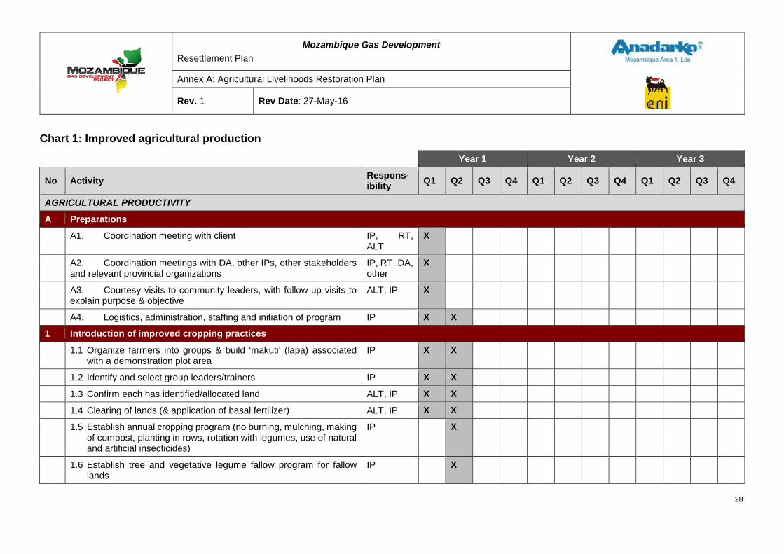
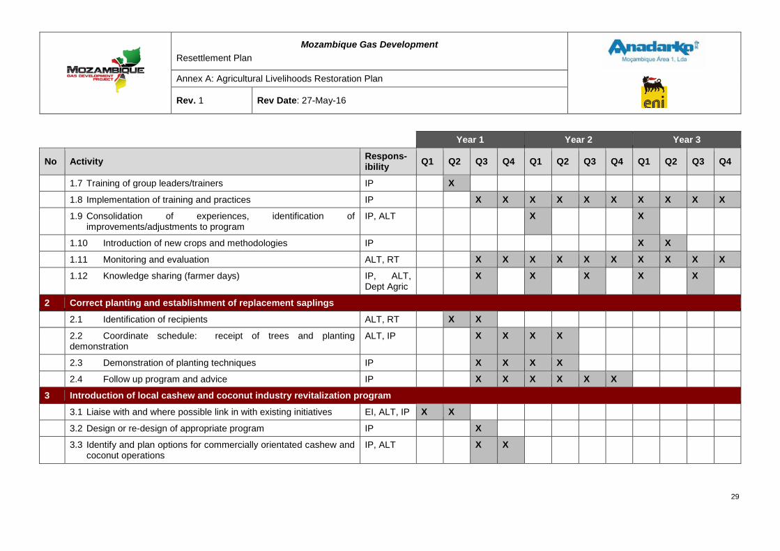
Chart 1: Improved agricultural production
Year 1 Year 2 Year 3
No Activity Respons-ibility Q1 Q2 Q3 Q4 Q1 Q2 Q3 Q4 Q1 Q2 Q3 Q4
AGRICULTURAL PRODUCTIVITY
A Preparations
A1. Coordination meeting with client IP, RT, ALT
X
A2. Coordination meetings with DA, other IPs, other stakeholders and relevant provincial organizations
IP, RT, DA, other
X
A3. Courtesy visits to community leaders, with follow up visits to explain purpose & objective
ALT, IP X
A4. Logistics, administration, staffing and initiation of program IP X X
1 Introduction of improved cropping practices
1.1 Organize farmers into groups & build ‘makuti’ (lapa) associated with a demonstration plot area
IP X X
1.2 Identify and select group leaders/trainers IP X X
1.3 Confirm each has identified/allocated land ALT, IP X X
1.4 Clearing of lands (& application of basal fertilizer) ALT, IP X X
1.5 Establish annual cropping program (no burning, mulching, making of compost, planting in rows, rotation with legumes, use of natural and artificial insecticides)
IP X
1.6 Establish tree and vegetative legume fallow program for fallow lands
IP X
28
Mozambique Gas Development Resettlement Plan
Annex A: Agricultural Livelihoods Restoration Plan
Rev. 1 Rev Date: 27-May-16
Year 1 Year 2 Year 3
No Activity Respons-ibility Q1 Q2 Q3 Q4 Q1 Q2 Q3 Q4 Q1 Q2 Q3 Q4
1.7 Training of group leaders/trainers IP X
1.8 Implementation of training and practices IP X X X X X X X X X X
1.9 Consolidation of experiences, identification of improvements/adjustments to program
IP, ALT X X
1.10 Introduction of new crops and methodologies IP X X
1.11 Monitoring and evaluation ALT, RT X X X X X X X X X X
1.12 Knowledge sharing (farmer days) IP, ALT, Dept Agric
X X X X X
2 Correct planting and establishment of replacement saplings
2.1 Identification of recipients ALT, RT X X
2.2 Coordinate schedule: receipt of trees and planting demonstration
ALT, IP X X X X
2.3 Demonstration of planting techniques IP X X X X
2.4 Follow up program and advice IP X X X X X X
3 Introduction of local cashew and coconut industry revitalization program
3.1 Liaise with and where possible link in with existing initiatives EI, ALT, IP X X
3.2 Design or re-design of appropriate program IP X
3.3 Identify and plan options for commercially orientated cashew and coconut operations
IP, ALT X X
29
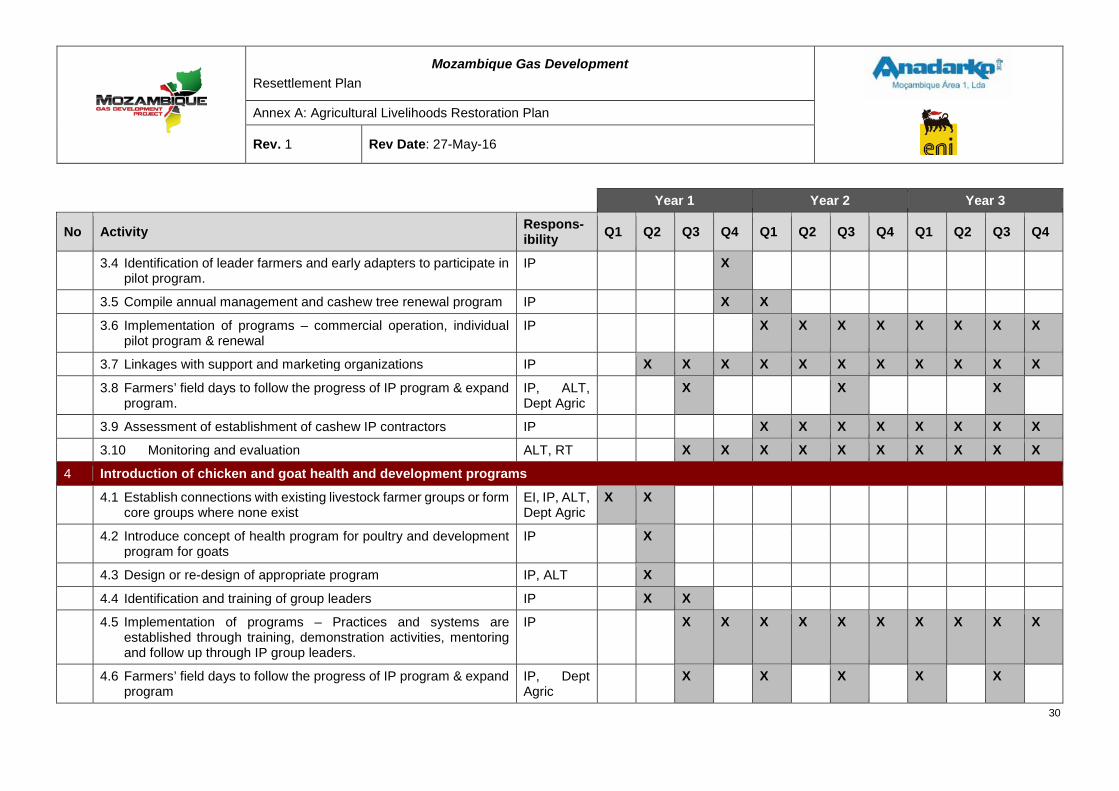
Mozambique Gas Development Resettlement Plan
Annex A: Agricultural Livelihoods Restoration Plan
Rev. 1 Rev Date: 27-May-16
Year 1 Year 2 Year 3
No Activity Respons-ibility Q1 Q2 Q3 Q4 Q1 Q2 Q3 Q4 Q1 Q2 Q3 Q4
3.4 Identification of leader farmers and early adapters to participate in pilot program.
IP X
3.5 Compile annual management and cashew tree renewal program IP X X
3.6 Implementation of programs – commercial operation, individual pilot program & renewal
IP X X X X X X X X
3.7 Linkages with support and marketing organizations IP X X X X X X X X X X X
3.8 Farmers’ field days to follow the progress of IP program & expand program.
IP, ALT, Dept Agric
X X X
3.9 Assessment of establishment of cashew IP contractors IP X X X X X X X X
3.10 Monitoring and evaluation ALT, RT X X X X X X X X X X
4 Introduction of chicken and goat health and development programs
4.1 Establish connections with existing livestock farmer groups or form core groups where none exist
EI, IP, ALT, Dept Agric
X X
4.2 Introduce concept of health program for poultry and development program for goats
IP X
4.3 Design or re-design of appropriate program IP, ALT X
4.4 Identification and training of group leaders IP X X
4.5 Implementation of programs – Practices and systems are established through training, demonstration activities, mentoring and follow up through IP group leaders.
IP X X X X X X X X X X
4.6 Farmers’ field days to follow the progress of IP program & expand program
IP, Dept Agric
X X X X X
30

Mozambique Gas Development Resettlement Plan
Annex A: Agricultural Livelihoods Restoration Plan
Rev. 1 Rev Date: 27-May-16
Year 1 Year 2 Year 3
No Activity Respons-ibility Q1 Q2 Q3 Q4 Q1 Q2 Q3 Q4 Q1 Q2 Q3 Q4
4.7 Monitoring and evaluation ALT, RT X X X X X X X X X X
31
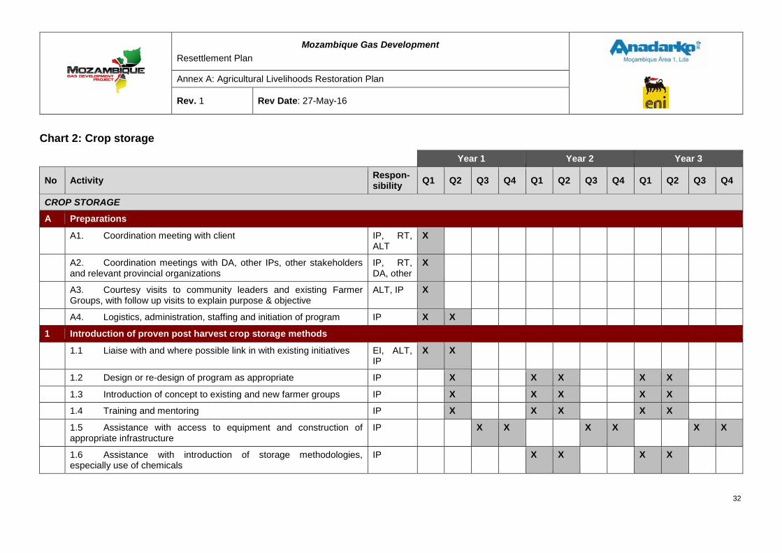
Mozambique Gas Development Resettlement Plan
Annex A: Agricultural Livelihoods Restoration Plan
Rev. 1 Rev Date: 27-May-16
Chart 2: Crop storage
Year 1 Year 2 Year 3
No Activity Respon-sibility Q1 Q2 Q3 Q4 Q1 Q2 Q3 Q4 Q1 Q2 Q3 Q4
CROP STORAGE
A Preparations
A1. Coordination meeting with client IP, RT, ALT
X
A2. Coordination meetings with DA, other IPs, other stakeholders and relevant provincial organizations
IP, RT, DA, other
X
A3. Courtesy visits to community leaders and existing Farmer Groups, with follow up visits to explain purpose & objective
ALT, IP X
A4. Logistics, administration, staffing and initiation of program IP X X
1 Introduction of proven post harvest crop storage methods
1.1 Liaise with and where possible link in with existing initiatives EI, ALT, IP
X X
1.2 Design or re-design of program as appropriate IP X X X X X
1.3 Introduction of concept to existing and new farmer groups IP X X X X X
1.4 Training and mentoring IP X X X X X
1.5 Assistance with access to equipment and construction of appropriate infrastructure
IP X X X X X X
1.6 Assistance with introduction of storage methodologies, especially use of chemicals
IP X X X X
32
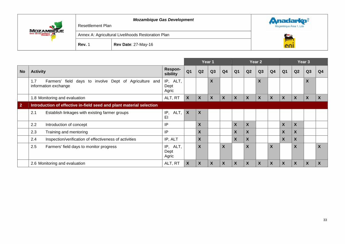
Mozambique Gas Development Resettlement Plan
Annex A: Agricultural Livelihoods Restoration Plan
Rev. 1 Rev Date: 27-May-16
Year 1 Year 2 Year 3
No Activity Respon-sibility Q1 Q2 Q3 Q4 Q1 Q2 Q3 Q4 Q1 Q2 Q3 Q4
1.7 Farmers’ field days to involve Dept of Agriculture and information exchange
IP, ALT, Dept Agric
X X X
1.8 Monitoring and evaluation ALT, RT X X X X X X X X X X X X
2 Introduction of effective in-field seed and plant material selection
2.1 Establish linkages with existing farmer groups IP, ALT, EI
X X
2.2 Introduction of concept IP X X X X X
2.3 Training and mentoring IP X X X X X
2.4 Inspection/verification of effectiveness of activities IP, ALT X X X X X
2.5 Farmers’ field days to monitor progress IP, ALT, Dept Agric
X X X X X X
2.6 Monitoring and evaluation ALT, RT X X X X X X X X X X X X
33
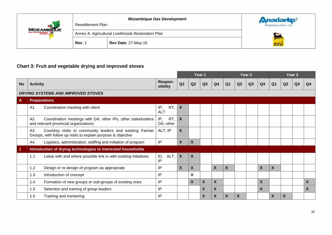
Mozambique Gas Development Resettlement Plan
Annex A: Agricultural Livelihoods Restoration Plan
Rev. 1 Rev Date: 27-May-16
Chart 3: Fruit and vegetable drying and improved stoves
Year 1 Year 2 Year 3
No Activity Respon-sibility Q1 Q2 Q3 Q4 Q1 Q2 Q3 Q4 Q1 Q2 Q3 Q4
DRYING SYSTEMS AND IMPROVED STOVES
A Preparations
A1. Coordination meeting with client IP, RT, ALT
X
A2. Coordination meetings with DA, other IPs, other stakeholders and relevant provincial organizations
IP, RT, DA, other
X
A3. Courtesy visits to community leaders and existing Farmer Groups, with follow up visits to explain purpose & objective
ALT, IP X
A4. Logistics, administration, staffing and initiation of program IP X X
1 Introduction of drying technologies to interested households
1.1 Liaise with and where possible link in with existing initiatives EI, ALT, IP
X X
1.2 Design or re-design of program as appropriate IP X X X X X X
1.3 Introduction of concept IP X
1.4 Formation of new groups or sub-groups of existing ones IP X X X X X
1.5 Selection and training of group leaders IP X X X X
1.6 Training and mentoring IP X X X X X X
34
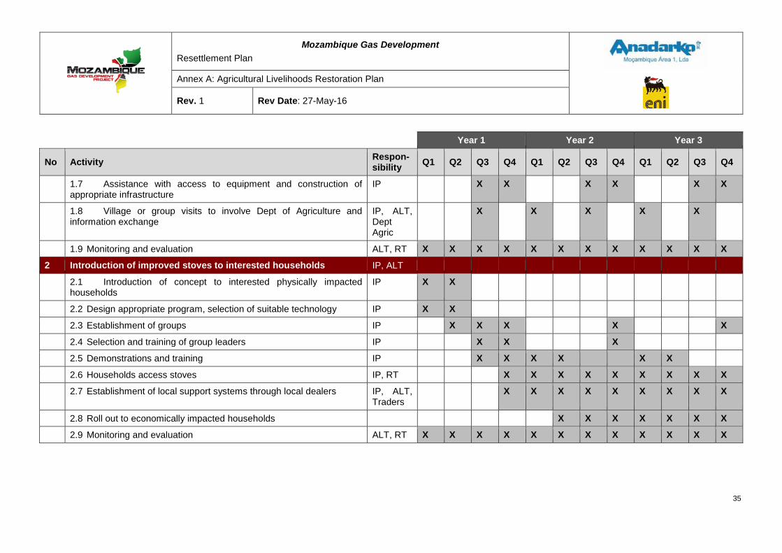
Mozambique Gas Development Resettlement Plan
Annex A: Agricultural Livelihoods Restoration Plan
Rev. 1 Rev Date: 27-May-16
Year 1 Year 2 Year 3
No Activity Respon-sibility Q1 Q2 Q3 Q4 Q1 Q2 Q3 Q4 Q1 Q2 Q3 Q4
1.7 Assistance with access to equipment and construction of appropriate infrastructure
IP X X X X X X
1.8 Village or group visits to involve Dept of Agriculture and information exchange
IP, ALT, Dept Agric
X X X X X
1.9 Monitoring and evaluation ALT, RT X X X X X X X X X X X X
2 Introduction of improved stoves to interested households IP, ALT
2.1 Introduction of concept to interested physically impacted households
IP X X
2.2 Design appropriate program, selection of suitable technology IP X X
2.3 Establishment of groups IP X X X X X
2.4 Selection and training of group leaders IP X X X
2.5 Demonstrations and training IP X X X X X X
2.6 Households access stoves IP, RT X X X X X X X X X
2.7 Establishment of local support systems through local dealers IP, ALT, Traders
X X X X X X X X X
2.8 Roll out to economically impacted households X X X X X X X
2.9 Monitoring and evaluation ALT, RT X X X X X X X X X X X X
35
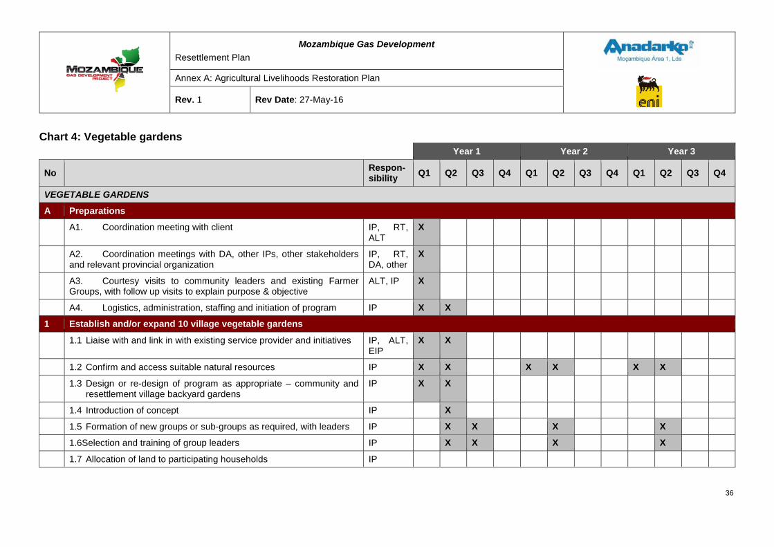
Mozambique Gas Development Resettlement Plan
Annex A: Agricultural Livelihoods Restoration Plan
Rev. 1 Rev Date: 27-May-16
Chart 4: Vegetable gardens Year 1 Year 2 Year 3
No Respon-sibility Q1 Q2 Q3 Q4 Q1 Q2 Q3 Q4 Q1 Q2 Q3 Q4
VEGETABLE GARDENS
A Preparations
A1. Coordination meeting with client IP, RT, ALT
X
A2. Coordination meetings with DA, other IPs, other stakeholders and relevant provincial organization
IP, RT, DA, other
X
A3. Courtesy visits to community leaders and existing Farmer Groups, with follow up visits to explain purpose & objective
ALT, IP X
A4. Logistics, administration, staffing and initiation of program IP X X
1 Establish and/or expand 10 village vegetable gardens
1.1 Liaise with and link in with existing service provider and initiatives IP, ALT, EIP
X X
1.2 Confirm and access suitable natural resources IP X X X X X X
1.3 Design or re-design of program as appropriate – community and resettlement village backyard gardens
IP X X
1.4 Introduction of concept IP X
1.5 Formation of new groups or sub-groups as required, with leaders IP X X X X
1.6Selection and training of group leaders IP X X X X
1.7 Allocation of land to participating households IP
36
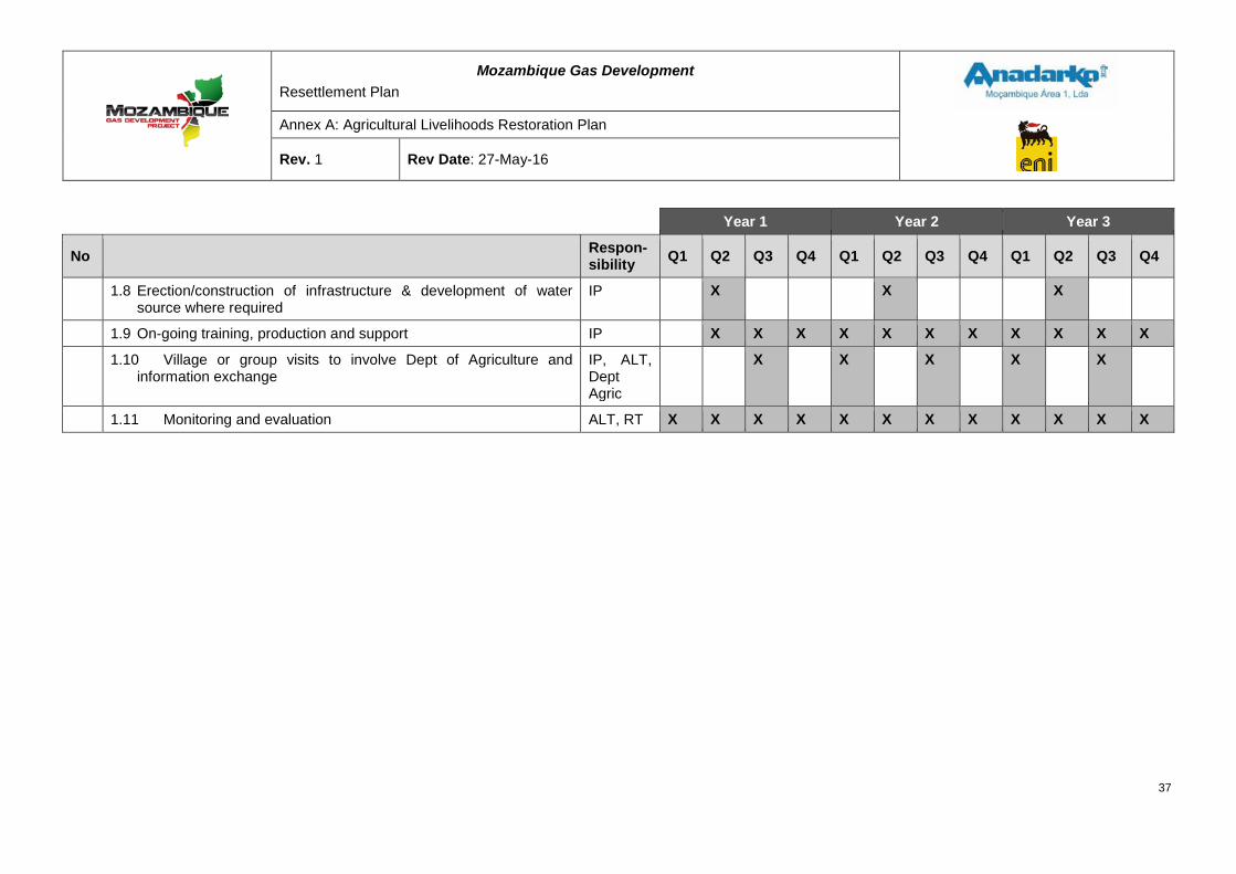
Mozambique Gas Development Resettlement Plan
Annex A: Agricultural Livelihoods Restoration Plan
Rev. 1 Rev Date: 27-May-16
Year 1 Year 2 Year 3
No Respon-sibility Q1 Q2 Q3 Q4 Q1 Q2 Q3 Q4 Q1 Q2 Q3 Q4
1.8 Erection/construction of infrastructure & development of water source where required
IP X X X
1.9 On-going training, production and support IP X X X X X X X X X X X
1.10 Village or group visits to involve Dept of Agriculture and information exchange
IP, ALT, Dept Agric
X X X X X
1.11 Monitoring and evaluation ALT, RT X X X X X X X X X X X X
37
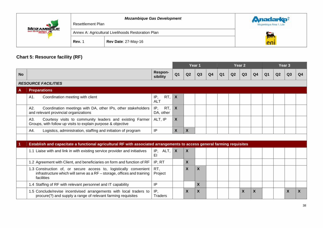
Mozambique Gas Development Resettlement Plan
Annex A: Agricultural Livelihoods Restoration Plan
Rev. 1 Rev Date: 27-May-16
Chart 5: Resource facility (RF)
Year 1 Year 2 Year 3
No Respon-sibility Q1 Q2 Q3 Q4 Q1 Q2 Q3 Q4 Q1 Q2 Q3 Q4
RESOURCE FACILITIES
A Preparations
A1. Coordination meeting with client IP, RT, ALT
X
A2. Coordination meetings with DA, other IPs, other stakeholders and relevant provincial organizations
IP, RT, DA, other
X
A3. Courtesy visits to community leaders and existing Farmer Groups, with follow up visits to explain purpose & objective
ALT, IP X
A4. Logistics, administration, staffing and initiation of program IP X X
1 Establish and capacitate a functional agricultural RF with associated arrangements to access general farming requisites
1.1 Liaise with and link in with existing service provider and initiatives IP, ALT, EI
X X
1.2 Agreement with Client, and beneficiaries on form and function of RF IP, RT X
1.3 Construction of, or secure access to, logistically convenient infrastructure which will serve as a RF – storage, offices and training facilities
RT, Project
X X
1.4 Staffing of RF with relevant personnel and IT capability IP X
1.5 Conclude/revise incentivised arrangements with local traders to procure(?) and supply a range of relevant farming requisites
IP, Traders
X X X X X X
38
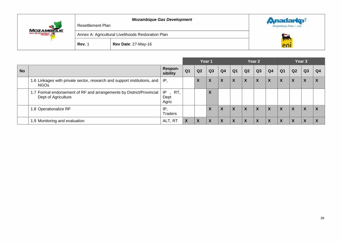
Mozambique Gas Development Resettlement Plan
Annex A: Agricultural Livelihoods Restoration Plan
Rev. 1 Rev Date: 27-May-16
Year 1 Year 2 Year 3
No Respon-sibility Q1 Q2 Q3 Q4 Q1 Q2 Q3 Q4 Q1 Q2 Q3 Q4
1.6 Linkages with private sector, research and support institutions, and NGOs
IP, X X X X X X X X X X X
1.7 Formal endorsement of RF and arrangements by District/Provincial Dept of Agriculture
IP , RT, Dept Agric
X
1.8 Operationalize RF IP, Traders
X X X X X X X X X X
1.9 Monitoring and evaluation ALT, RT X X X X X X X X X X X X
39
Mozambique Gas Development Resettlement Plan
Annex A: Agricultural Livelihoods Restoration Plan
Rev. 1 Rev Date: 27-May-16
4 KEY ASSUMPTIONS The proposed five programs to restore and improve livelihoods of affected Afungi households: improved agricultural production; improved crop storage; fruit and vegetable drying and improved stoves; vegetable gardens; and the resource facility, are all based on current and familiar activities of local households. They are all planned to comply with current Mozambican legislation, and in some case support national agricultural strategy and programs.
Based on experiences of other Mozambican resettlement projects, the National Director of Agriculture specifically requested that all restoration and development programs be based on activities familiar to the beneficiaries. Once the necessary trust and confidence has been built up, these programs may be developed to introduce new concepts and activities.
The proposed programs have their roots in current activities or result from interest shown in demonstration plot activities. They are low risk programs in terms of acceptance by the communities and availability of materials. To implement the planned activities and achieve the outputs and project outcome, the following realistic assumptions, as per the program log frames have been made:
• Cultural/traditional practices and religious beliefs allow for acceptance and adoption of required changes;
• The Project and community have mutual respect and trust (Project) intentions;
• Commitment from compensated farmers, households and cashew tree owners;
• Adequate support for spraying contractors;
• Affordability of options especially chemicals;
• Availability of storage equipment and local materials for construction;
• Availability and affordability of options for the construction of basic drying systems;
• Farmers see the need for and commit to storage and seed selection initiatives;
• Households see the need for and commit to drying and preservation initiatives;
• Suitable natural resources (site, soils and water) available;
• Affordability of options for infrastructure development for improved water sources;
• Suitable existing infrastructure, or resources for construction of infrastructure for vegetable gardens; and
• Normal climatic conditions prevail.
At the Project level, to successfully achieve the Project objectives, the following assumptions have been made:
• Availability of suitable replacement land and foraging areas for household needs;
• Affordability of options with regard to inputs and revitalization measures;
• Continued and timely Government support and buy-in at the provincial and district level;
40
Mozambique Gas Development Resettlement Plan
Annex A: Agricultural Livelihoods Restoration Plan
Rev. 1 Rev Date: 27-May-16
• Appointment of suitable IPs;
• Retention of skills and capacitated project partners; and
• Local traders are willing and able to participate.
5 OUTPUTS, OUTCOMES AND SUSTAINABILITY Implementation of the proposed programs will be accomplished through the use of IPs, under the guidance of the ALT and RT. Guideline budgets and anticipated activities have been identified to ensure that the outputs and outcome of each program are achieved. The outputs are essentially the deliverables expected by the IPs. There will be need for some flexibility in the activities that are chosen to realize these outputs, which in turn may affect outcomes, though hopefully to a limited degree.
The restoration programs will run over 36 months with a review after 18 months. Achieving the program outcomes will mean that the impact will be sustainable household food security in the resettlement and associated areas of Afungi peninsula – all affected households meet their basic nutritional requirements and do not experience hunger within the first 18 months after relocation. Outputs, outcomes with associated sustainability are presented in a logical framework for each of the proposed programs.
41
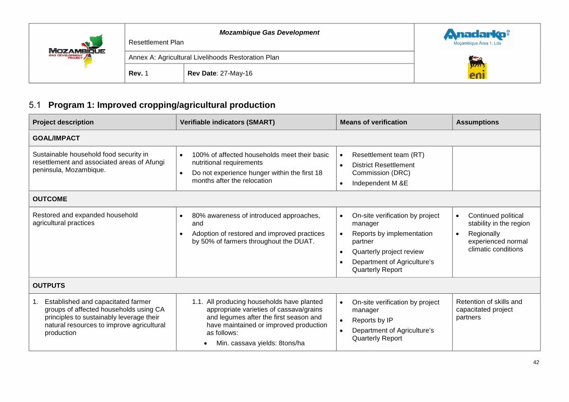
Mozambique Gas Development Resettlement Plan
Annex A: Agricultural Livelihoods Restoration Plan
Rev. 1 Rev Date: 27-May-16
Program 1: Improved cropping/agricultural production
Project description Verifiable indicators (SMART) Means of verification Assumptions
GOAL/IMPACT
Sustainable household food security in resettlement and associated areas of Afungi peninsula, Mozambique.
• 100% of affected households meet their basic nutritional requirements
• Do not experience hunger within the first 18 months after the relocation
• Resettlement team (RT) • District Resettlement
Commission (DRC) • Independent M &E
OUTCOME
Restored and expanded household agricultural practices
• 80% awareness of introduced approaches, and
• Adoption of restored and improved practices by 50% of farmers throughout the DUAT.
• On-site verification by project manager
• Reports by implementation partner
• Quarterly project review • Department of Agriculture’s
Quarterly Report
• Continued political stability in the region
• Regionally experienced normal climatic conditions
OUTPUTS
1. Established and capacitated farmer groups of affected households using CA principles to sustainably leverage their natural resources to improve agricultural production
1.1. All producing households have planted appropriate varieties of cassava/grains and legumes after the first season and have maintained or improved production as follows: • Min. cassava yields: 8tons/ha
• On-site verification by project manager
• Reports by IP • Department of Agriculture’s
Quarterly Report
Retention of skills and capacitated project partners
42
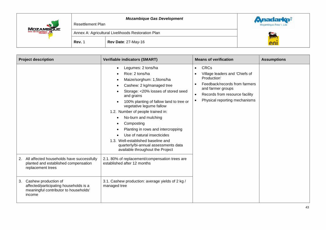
Mozambique Gas Development Resettlement Plan
Annex A: Agricultural Livelihoods Restoration Plan
Rev. 1 Rev Date: 27-May-16
Project description Verifiable indicators (SMART) Means of verification Assumptions
• Legumes: 2 tons/ha • Rice: 2 tons/ha • Maize/sorghum: 1,5tons/ha • Cashew: 2 kg/managed tree • Storage: <20% losses of stored seed
and grains • 100% planting of fallow land to tree or
vegetative legume fallow 1.2. Number of people trained in:
• No-burn and mulching • Composting • Planting in rows and intercropping • Use of natural insecticides
1.3. Well-established baseline and quarterly/bi-annual assessments data available throughout the Project
• CRCs • Village leaders and ‘Chiefs of
Production’ • Feedback/records from farmers
and farmer groups • Records from resource facility • Physical reporting mechanisms
2. All affected households have successfully planted and established compensation replacement trees
2.1. 80% of replacement/compensation trees are established after 12 months
3. Cashew production of affected/participating households is a meaningful contributor to households’ income
3.1. Cashew production: average yields of 2 kg / managed tree
43
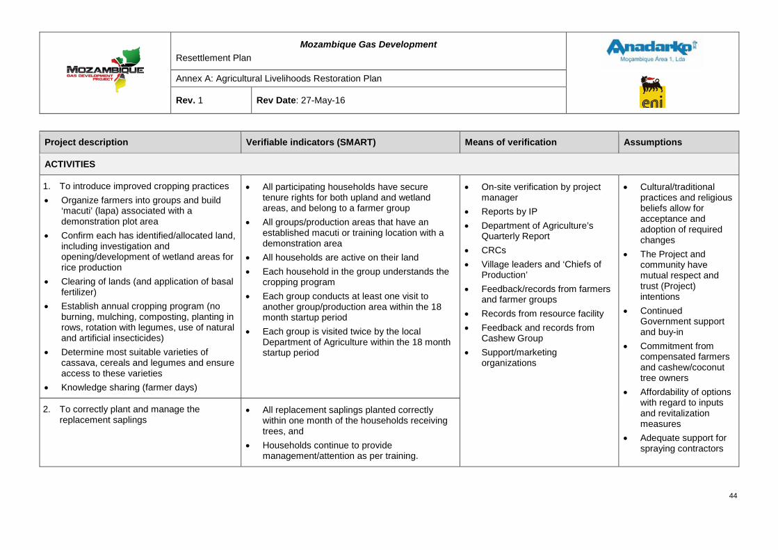
Mozambique Gas Development Resettlement Plan
Annex A: Agricultural Livelihoods Restoration Plan
Rev. 1 Rev Date: 27-May-16
Project description Verifiable indicators (SMART) Means of verification Assumptions
ACTIVITIES
1. To introduce improved cropping practices • Organize farmers into groups and build
‘macuti’ (lapa) associated with a demonstration plot area
• Confirm each has identified/allocated land, including investigation and opening/development of wetland areas for rice production
• Clearing of lands (and application of basal fertilizer)
• Establish annual cropping program (no burning, mulching, composting, planting in rows, rotation with legumes, use of natural and artificial insecticides)
• Determine most suitable varieties of cassava, cereals and legumes and ensure access to these varieties
• Knowledge sharing (farmer days)
• All participating households have secure tenure rights for both upland and wetland areas, and belong to a farmer group
• All groups/production areas that have an established macuti or training location with a demonstration area
• All households are active on their land • Each household in the group understands the
cropping program • Each group conducts at least one visit to
another group/production area within the 18 month startup period
• Each group is visited twice by the local Department of Agriculture within the 18 month startup period
• On-site verification by project manager
• Reports by IP • Department of Agriculture’s
Quarterly Report • CRCs • Village leaders and ‘Chiefs of
Production’ • Feedback/records from farmers
and farmer groups • Records from resource facility • Feedback and records from
Cashew Group • Support/marketing
organizations
• Cultural/traditional practices and religious beliefs allow for acceptance and adoption of required changes
• The Project and community have mutual respect and trust (Project) intentions
• Continued Government support and buy-in
• Commitment from compensated farmers and cashew/coconut tree owners
• Affordability of options with regard to inputs and revitalization measures
• Adequate support for spraying contractors
2. To correctly plant and manage the replacement saplings
• All replacement saplings planted correctly within one month of the households receiving trees, and
• Households continue to provide management/attention as per training.
44
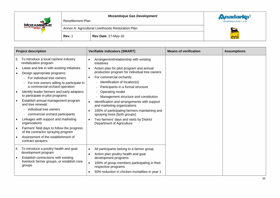
Mozambique Gas Development Resettlement Plan
Annex A: Agricultural Livelihoods Restoration Plan
Rev. 1 Rev Date: 27-May-16
Project description Verifiable indicators (SMART) Means of verification Assumptions
3. To introduce a local cashew industry revitalization program
• Liaise and link in with existing initiatives • Design appropriate programs:
- For individual tree owners - For tree owners willing to participate in
a commercial orchard operation • Identify leader farmers and early adapters
to participate in pilot programs • Establish annual management program
and tree renewal: - individual tree owners - commercial orchard participants
• Linkages with support and marketing organizations
• Farmers’ field days to follow the progress of the contractor spraying program
• Assessment of the establishment of contract sprayers
• Arrangement/relationship with existing initiatives
• Action plan for pilot program and annual production program for individual tree owners
• For commercial orchards: - Identification of location(s) - Participants in a formal structure - Operating model - Management structure and constitution
• Identification and arrangements with support and marketing organizations
• 100% of participating farmers maintaining and spraying trees (both groups)
• Two farmers’ days and visits by District Department of Agriculture
4. To introduce a poultry health and goat development program
• Establish connections with existing livestock farmer groups, or establish core groups
• All participants belong to a farmer group • Action plan poultry health and goat
development programs • 100% of group members participating in their
respective programs • 50% reduction in chicken mortalities in year 1
45
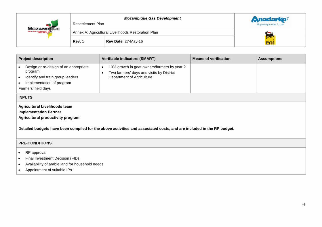
Mozambique Gas Development Resettlement Plan
Annex A: Agricultural Livelihoods Restoration Plan
Rev. 1 Rev Date: 27-May-16
Project description Verifiable indicators (SMART) Means of verification Assumptions
• Design or re-design of an appropriate program
• Identify and train group leaders • Implementation of program Farmers’ field days
• 10% growth in goat owners/farmers by year 2 • Two farmers’ days and visits by District
Department of Agriculture
INPUTS
Agricultural Livelihoods team Implementation Partner Agricultural productivity program Detailed budgets have been compiled for the above activities and associated costs, and are included in the RP budget.
PRE-CONDITIONS
• RP approval • Final Investment Decision (FID) • Availability of arable land for household needs • Appointment of suitable IPs
46
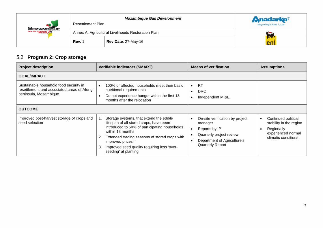
Mozambique Gas Development Resettlement Plan
Annex A: Agricultural Livelihoods Restoration Plan
Rev. 1 Rev Date: 27-May-16
Program 2: Crop storage
Project description Verifiable indicators (SMART) Means of verification Assumptions
GOAL/IMPACT
Sustainable household food security in resettlement and associated areas of Afungi peninsula, Mozambique.
• 100% of affected households meet their basic nutritional requirements
• Do not experience hunger within the first 18 months after the relocation
• RT • DRC • Independent M &E
OUTCOME
Improved post-harvest storage of crops and seed selection
1. Storage systems, that extend the edible lifespan of all stored crops, have been introduced to 50% of participating households within 18 months
2. Extended trading seasons of stored crops with improved prices
3. Improved seed quality requiring less ‘over-seeding’ at planting
• On-site verification by project manager
• Reports by IP • Quarterly project review • Department of Agriculture’s
Quarterly Report
• Continued political stability in the region
• Regionally experienced normal climatic conditions
47
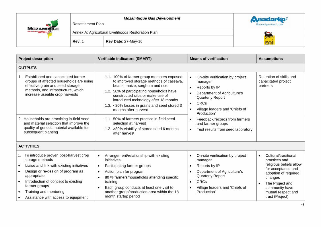
Mozambique Gas Development Resettlement Plan
Annex A: Agricultural Livelihoods Restoration Plan
Rev. 1 Rev Date: 27-May-16
Project description Verifiable indicators (SMART) Means of verification Assumptions
OUTPUTS
1. Established and capacitated farmer groups of affected households are using effective grain and seed storage methods, and infrastructure, which increase useable crop harvests
1.1. 100% of farmer group members exposed to improved storage methods of cassava, beans, maize, sorghum and rice.
1.2. 50% of participating households have constructed silos or make use of introduced technology after 18 months
1.3. <20% losses in grains and seed stored 3 months after harvest
• On-site verification by project manager
• Reports by IP • Department of Agriculture’s
Quarterly Report • CRCs • Village leaders and ‘Chiefs of
Production’ • Feedback/records from farmers
and farmer groups • Test results from seed laboratory
Retention of skills and capacitated project partners
2. Households are practicing in-field seed and material selection that improve the quality of genetic material available for subsequent planting
1.1. 50% of farmers practice in-field seed selection at harvest
1.2. >80% viability of stored seed 6 months after harvest
ACTIVITIES
1. To introduce proven post-harvest crop storage methods
• Liaise and link with existing initiatives • Design or re-design of program as
appropriate • Introduction of concept to existing
farmer groups • Training and mentoring • Assistance with access to equipment
• Arrangement/relationship with existing initiatives
• Participating farmer groups • Action plan for program • 80 % farmers/households attending specific
training • Each group conducts at least one visit to
another group/production area within the 18 month startup period
• On-site verification by project manager
• Reports by IP • Department of Agriculture’s
Quarterly Report • CRCs • Village leaders and ‘Chiefs of
Production’
• Cultural/traditional practices and religious beliefs allow for acceptance and adoption of required changes
• The Project and community have mutual respect and trust (Project)
48
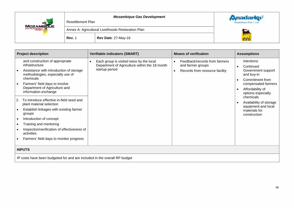
Mozambique Gas Development Resettlement Plan
Annex A: Agricultural Livelihoods Restoration Plan
Rev. 1 Rev Date: 27-May-16
Project description Verifiable indicators (SMART) Means of verification Assumptions
and construction of appropriate infrastructure
• Assistance with introduction of storage methodologies, especially use of chemicals
• Farmers’ field days to involve Department of Agriculture and information exchange
• Each group is visited twice by the local Department of Agriculture within the 18 month startup period
• Feedback/records from farmers and farmer groups
• Records from resource facility
intentions • Continued
Government support and buy-in
• Commitment from compensated farmers
• Affordability of options especially chemicals
• Availability of storage equipment and local materials for construction
2. To introduce effective in-field seed and plant material selection
• Establish linkages with existing farmer groups
• Introduction of concept • Training and mentoring • Inspection/verification of effectiveness of
activities • Farmers’ field days to monitor progress
INPUTS
IP costs have been budgeted for and are included in the overall RP budget
49
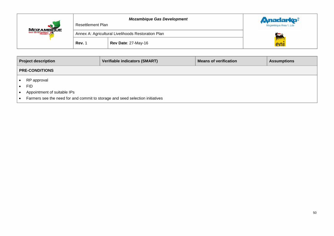
Mozambique Gas Development Resettlement Plan
Annex A: Agricultural Livelihoods Restoration Plan
Rev. 1 Rev Date: 27-May-16
Project description Verifiable indicators (SMART) Means of verification Assumptions
PRE-CONDITIONS
• RP approval • FID • Appointment of suitable IPs • Farmers see the need for and commit to storage and seed selection initiatives
50
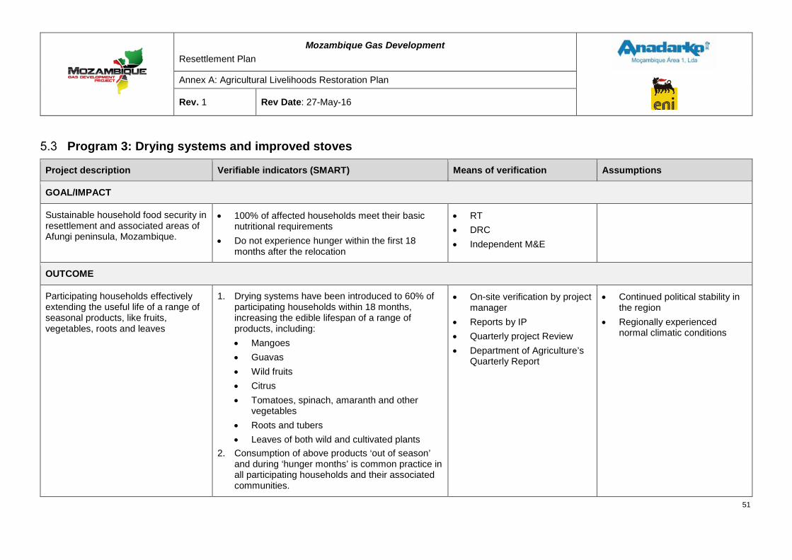
Mozambique Gas Development Resettlement Plan
Annex A: Agricultural Livelihoods Restoration Plan
Rev. 1 Rev Date: 27-May-16
Program 3: Drying systems and improved stoves
Project description Verifiable indicators (SMART) Means of verification Assumptions
GOAL/IMPACT
Sustainable household food security in resettlement and associated areas of Afungi peninsula, Mozambique.
• 100% of affected households meet their basic nutritional requirements
• Do not experience hunger within the first 18 months after the relocation
• RT • DRC • Independent M&E
OUTCOME
Participating households effectively extending the useful life of a range of seasonal products, like fruits, vegetables, roots and leaves
1. Drying systems have been introduced to 60% of participating households within 18 months, increasing the edible lifespan of a range of products, including: • Mangoes • Guavas • Wild fruits • Citrus • Tomatoes, spinach, amaranth and other
vegetables • Roots and tubers • Leaves of both wild and cultivated plants
2. Consumption of above products ‘out of season’ and during ‘hunger months’ is common practice in all participating households and their associated communities.
• On-site verification by project manager
• Reports by IP • Quarterly project Review • Department of Agriculture’s
Quarterly Report
• Continued political stability in the region
• Regionally experienced normal climatic conditions
51
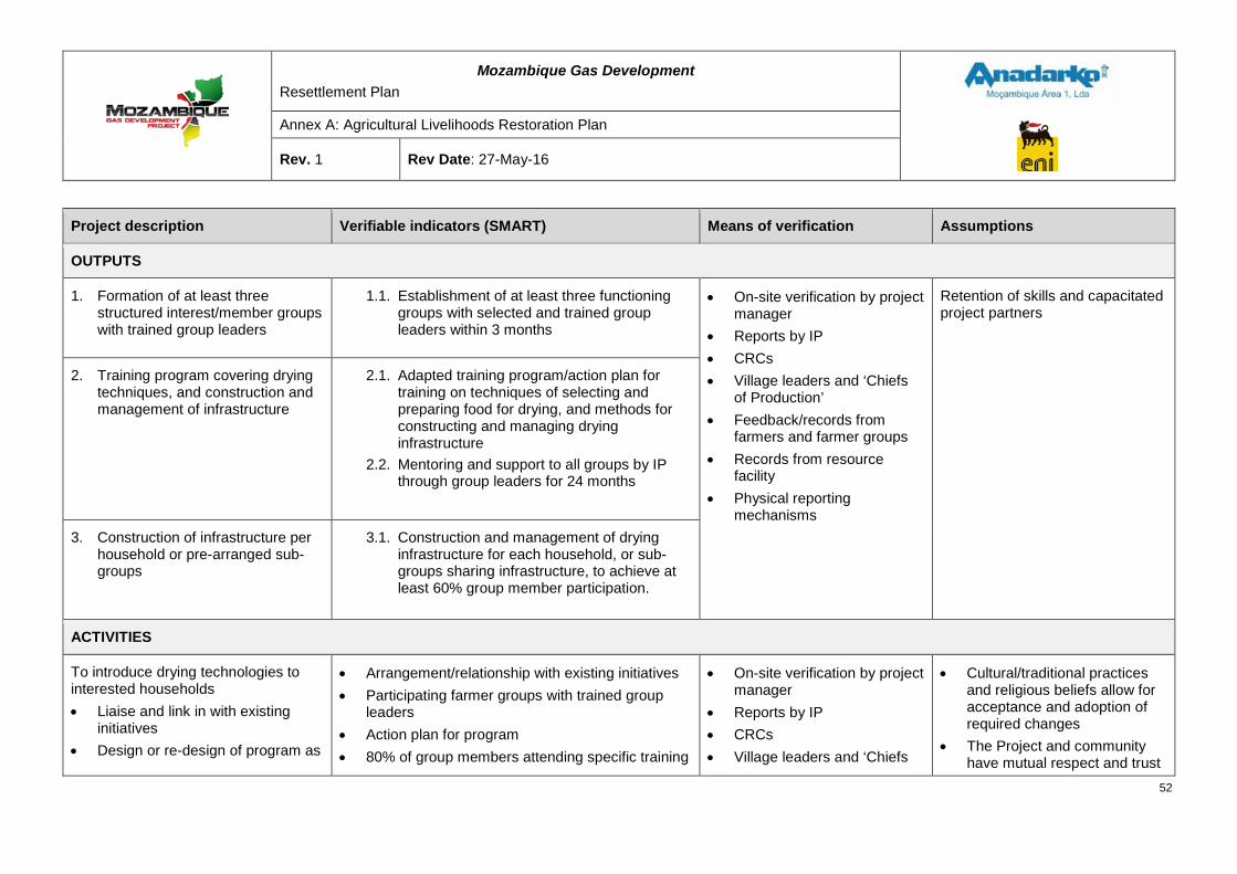
Mozambique Gas Development Resettlement Plan
Annex A: Agricultural Livelihoods Restoration Plan
Rev. 1 Rev Date: 27-May-16
Project description Verifiable indicators (SMART) Means of verification Assumptions
OUTPUTS
1. Formation of at least three structured interest/member groups with trained group leaders
1.1. Establishment of at least three functioning groups with selected and trained group leaders within 3 months
• On-site verification by project manager
• Reports by IP • CRCs • Village leaders and ‘Chiefs
of Production’ • Feedback/records from
farmers and farmer groups • Records from resource
facility • Physical reporting
mechanisms
Retention of skills and capacitated project partners
2. Training program covering drying techniques, and construction and management of infrastructure
2.1. Adapted training program/action plan for training on techniques of selecting and preparing food for drying, and methods for constructing and managing drying infrastructure
2.2. Mentoring and support to all groups by IP through group leaders for 24 months
3. Construction of infrastructure per household or pre-arranged sub-groups
3.1. Construction and management of drying infrastructure for each household, or sub-groups sharing infrastructure, to achieve at least 60% group member participation.
ACTIVITIES
To introduce drying technologies to interested households • Liaise and link in with existing
initiatives • Design or re-design of program as
• Arrangement/relationship with existing initiatives • Participating farmer groups with trained group
leaders • Action plan for program • 80% of group members attending specific training
• On-site verification by project manager
• Reports by IP • CRCs • Village leaders and ‘Chiefs
• Cultural/traditional practices and religious beliefs allow for acceptance and adoption of required changes
• The Project and community have mutual respect and trust
52
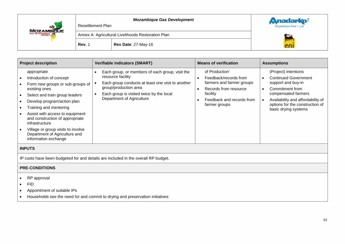
Mozambique Gas Development Resettlement Plan
Annex A: Agricultural Livelihoods Restoration Plan
Rev. 1 Rev Date: 27-May-16
Project description Verifiable indicators (SMART) Means of verification Assumptions
appropriate • Introduction of concept • Form new groups or sub-groups of
existing ones • Select and train group leaders • Develop program/action plan • Training and mentoring • Assist with access to equipment
and construction of appropriate infrastructure
• Village or group visits to involve Department of Agriculture and information exchange
• Each group, or members of each group, visit the resource facility
• Each group conducts at least one visit to another group/production area
• Each group is visited twice by the local Department of Agriculture
of Production’ • Feedback/records from
farmers and farmer groups • Records from resource
facility • Feedback and records from
farmer groups
(Project) intentions • Continued Government
support and buy-in • Commitment from
compensated farmers • Availability and affordability of
options for the construction of basic drying systems
INPUTS
IP costs have been budgeted for and details are included in the overall RP budget.
PRE-CONDITIONS
• RP approval • FID • Appointment of suitable IPs • Households see the need for and commit to drying and preservation initiatives
53
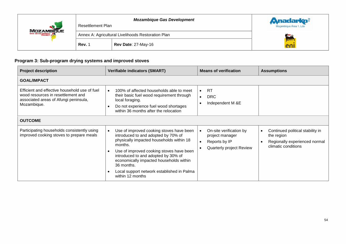
Mozambique Gas Development Resettlement Plan
Annex A: Agricultural Livelihoods Restoration Plan
Rev. 1 Rev Date: 27-May-16
Program 3: Sub-program drying systems and improved stoves
Project description Verifiable indicators (SMART) Means of verification Assumptions
GOAL/IMPACT
Efficient and effective household use of fuel wood resources in resettlement and associated areas of Afungi peninsula, Mozambique.
• 100% of affected households able to meet their basic fuel wood requirement through local foraging.
• Do not experience fuel wood shortages within 36 months after the relocation
• RT • DRC • Independent M &E
OUTCOME
Participating households consistently using improved cooking stoves to prepare meals
• Use of improved cooking stoves have been introduced to and adopted by 70% of physically impacted households within 18 months.
• Use of improved cooking stoves have been introduced to and adopted by 30% of economically impacted households within 36 months.
• Local support network established in Palma within 12 months
• On-site verification by project manager
• Reports by IP • Quarterly project Review
• Continued political stability in the region
• Regionally experienced normal climatic conditions
54
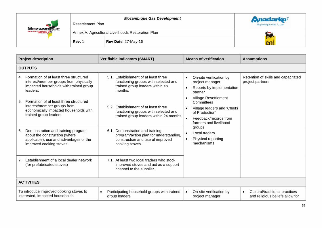
Mozambique Gas Development Resettlement Plan
Annex A: Agricultural Livelihoods Restoration Plan
Rev. 1 Rev Date: 27-May-16
Project description Verifiable indicators (SMART) Means of verification Assumptions
OUTPUTS
4. Formation of at least three structured interest/member groups from physically impacted households with trained group leaders.
5. Formation of at least three structured
interest/member groups from economically impacted households with trained group leaders
5.1. Establishment of at least three functioning groups with selected and trained group leaders within six months.
5.2. Establishment of at least three functioning groups with selected and trained group leaders within 24 months
• On-site verification by project manager
• Reports by implementation partner
• Village Resettlement Committees
• Village leaders and ‘Chiefs of Production’
• Feedback/records from farmers and livelihood groups
• Local traders • Physical reporting
mechanisms
Retention of skills and capacitated project partners
6. Demonstration and training program about the construction (where applicable), use and advantages of the improved cooking stoves
6.1. Demonstration and training program/action plan for understanding, construction and use of improved cooking stoves
7. Establishment of a local dealer network (for prefabricated stoves)
7.1. At least two local traders who stock improved stoves and act as a support channel to the supplier.
ACTIVITIES
To introduce improved cooking stoves to interested, impacted households
• Participating household groups with trained group leaders
• On-site verification by project manager
• Cultural/traditional practices and religious beliefs allow for
55
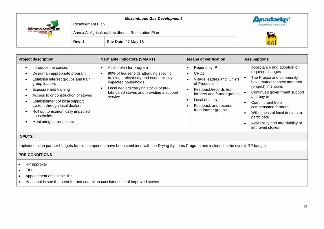
Mozambique Gas Development Resettlement Plan
Annex A: Agricultural Livelihoods Restoration Plan
Rev. 1 Rev Date: 27-May-16
Project description Verifiable indicators (SMART) Means of verification Assumptions
• Introduce the concept • Design an appropriate program • Establish interest groups and train
group leaders • Exposure and training • Access to or construction of stoves • Establishment of local support
system through local dealers • Roll out to economically impacted
households • Monitoring current users
• Action plan for program • 80% of households attending specific
training – physically and economically impacted households
• Local dealers carrying stocks of pre-fabricated stoves and providing a support service.
• Reports by IP • CRCs • Village leaders and ‘Chiefs
of Production’ • Feedback/records from
farmers and farmer groups • Local dealers • Feedback and records
from farmer groups
acceptance and adoption of required changes
• The Project and community have mutual respect and trust (project) intentions
• Continued government support and buy-in
• Commitment from compensated farmers
• Willingness of local dealers to participate
• Availability and affordability of improved stoves
INPUTS
Implementation partner budgets for this component have been combined with the Drying Systems Program and included in the overall RP budget
PRE-CONDITIONS
• RP approval • FID • Appointment of suitable IPs • Households see the need for and commit to consistent use of improved stoves
56
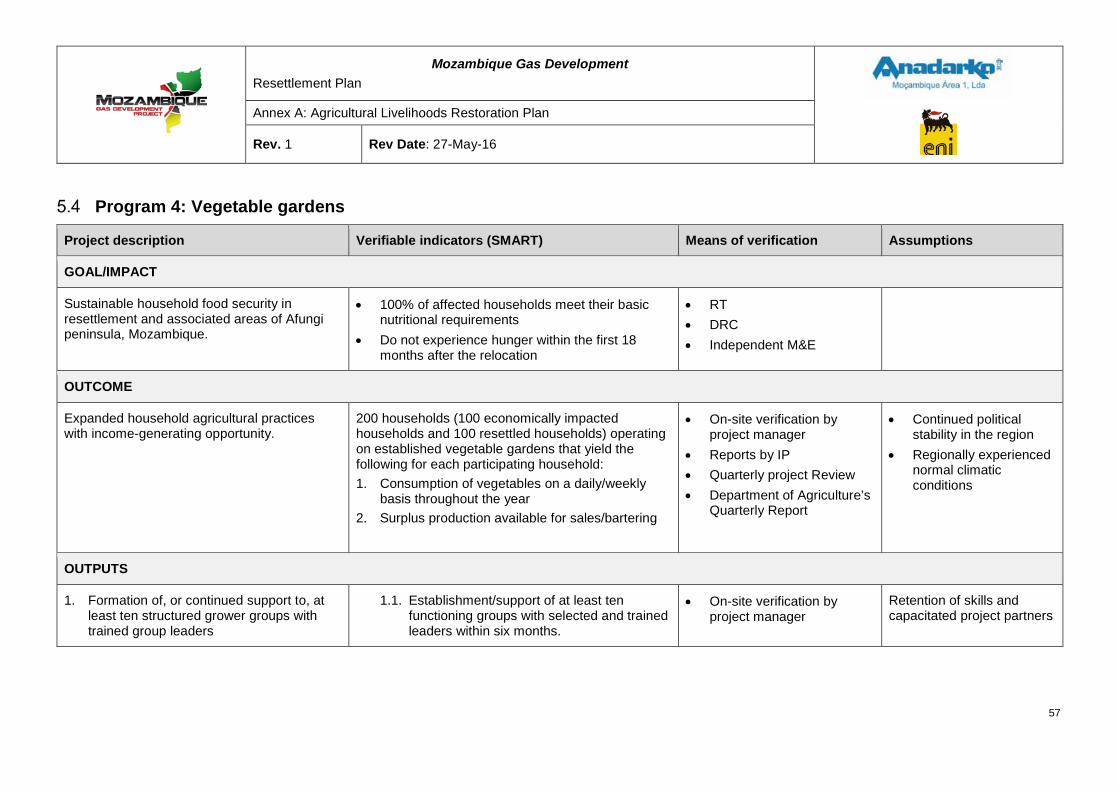
Mozambique Gas Development Resettlement Plan
Annex A: Agricultural Livelihoods Restoration Plan
Rev. 1 Rev Date: 27-May-16
Program 4: Vegetable gardens
Project description Verifiable indicators (SMART) Means of verification Assumptions
GOAL/IMPACT
Sustainable household food security in resettlement and associated areas of Afungi peninsula, Mozambique.
• 100% of affected households meet their basic nutritional requirements
• Do not experience hunger within the first 18 months after the relocation
• RT • DRC • Independent M&E
OUTCOME
Expanded household agricultural practices with income-generating opportunity.
200 households (100 economically impacted households and 100 resettled households) operating on established vegetable gardens that yield the following for each participating household: 1. Consumption of vegetables on a daily/weekly
basis throughout the year 2. Surplus production available for sales/bartering
• On-site verification by project manager
• Reports by IP • Quarterly project Review • Department of Agriculture’s
Quarterly Report
• Continued political stability in the region
• Regionally experienced normal climatic conditions
OUTPUTS
1. Formation of, or continued support to, at least ten structured grower groups with trained group leaders
1.1. Establishment/support of at least ten functioning groups with selected and trained leaders within six months.
• On-site verification by project manager
Retention of skills and capacitated project partners
57
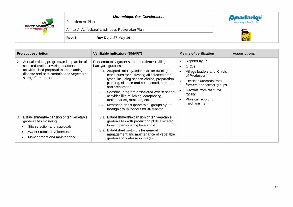
Mozambique Gas Development Resettlement Plan
Annex A: Agricultural Livelihoods Restoration Plan
Rev. 1 Rev Date: 27-May-16
Project description Verifiable indicators (SMART) Means of verification Assumptions
2. Annual training program/action plan for all selected crops, covering seasonal activities, bed preparation and planting, disease and pest controls, and vegetable storage/preparation.
For community gardens and resettlement village backyard gardens:
2.1. Adapted training/action plan for training on techniques for cultivating all selected crop types, including season choice, preparation, planting, disease and pest control, storage and preparation.
2.2. Seasonal program associated with seasonal activities like mulching, composting, maintenance, rotations, etc.
2.3. Mentoring and support to all groups by IP through group leaders for 36 months.
• Reports by IP • CRCs • Village leaders and ‘Chiefs
of Production’ • Feedback/records from
farmers and farmer groups • Records from resource
facility • Physical reporting
mechanisms
3. Establishment/expansion of ten vegetable garden sites including: • Site selection and approvals • Water source development • Management and maintenance
3.1. Establishment/expansion of ten vegetable garden sites with production plots allocated to each participating household.
3.2. Established protocols for general management and maintenance of vegetable garden and water resource(s).
58
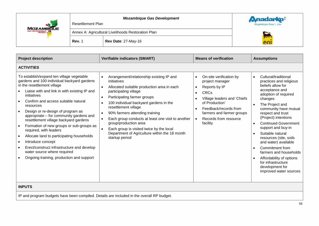
Mozambique Gas Development Resettlement Plan
Annex A: Agricultural Livelihoods Restoration Plan
Rev. 1 Rev Date: 27-May-16
Project description Verifiable indicators (SMART) Means of verification Assumptions
ACTIVITIES
To establish/expand ten village vegetable gardens and 100 individual backyard gardens in the resettlement village • Liaise with and link in with existing IP and
initiatives • Confirm and access suitable natural
resources • Design or re-design of program as
appropriate – for community gardens and resettlement village backyard gardens
• Formation of new groups or sub-groups as required, with leaders
• Allocate land to participating households • Introduce concept • Erect/construct infrastructure and develop
water source where required • Ongoing training, production and support
• Arrangement/relationship existing IP and initiatives
• Allocated suitable production area in each participating village
• Participating farmer groups • 100 individual backyard gardens in the
resettlement village • 90% farmers attending training • Each group conducts at least one visit to another
group/production area • Each group is visited twice by the local
Department of Agriculture within the 18 month startup period
• On-site verification by project manager
• Reports by IP • CRCs • Village leaders and ‘Chiefs
of Production’ • Feedback/records from
farmers and farmer groups • Records from resource
facility
• Cultural/traditional practices and religious beliefs allow for acceptance and adoption of required changes
• The Project and community have mutual respect and trust (Project) intentions
• Continued Government support and buy-in
• Suitable natural resources (site, soils and water) available
• Commitment from farmers and households
• Affordability of options for infrastructure development for improved water sources
INPUTS
IP and program budgets have been compiled. Details are included in the overall RP budget.
59
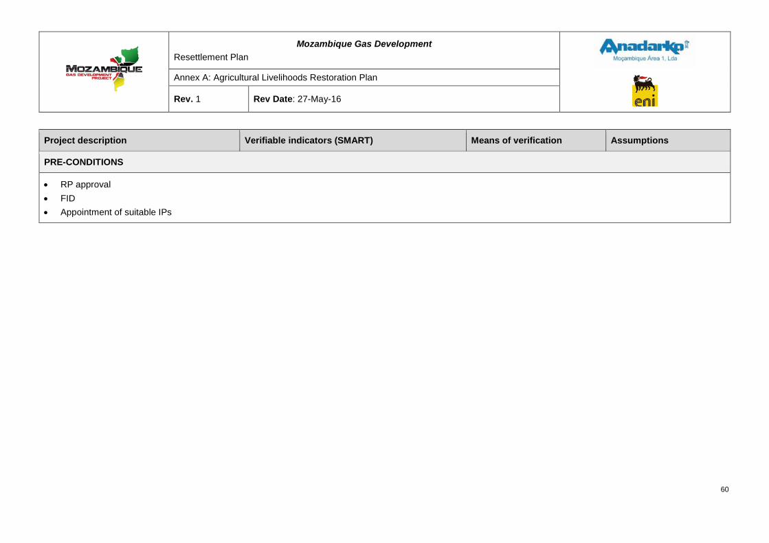
Mozambique Gas Development Resettlement Plan
Annex A: Agricultural Livelihoods Restoration Plan
Rev. 1 Rev Date: 27-May-16
Project description Verifiable indicators (SMART) Means of verification Assumptions
PRE-CONDITIONS
• RP approval • FID • Appointment of suitable IPs
60
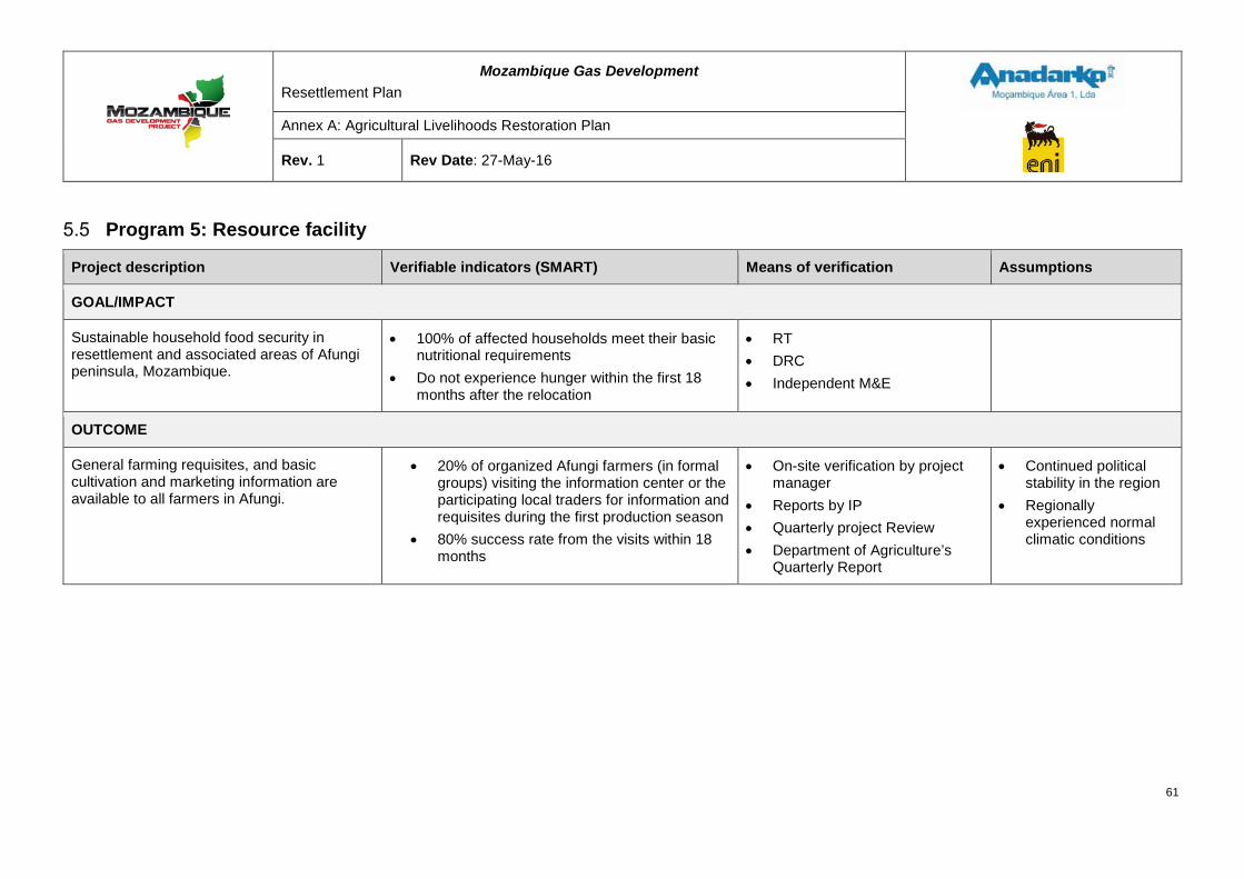
Mozambique Gas Development Resettlement Plan
Annex A: Agricultural Livelihoods Restoration Plan
Rev. 1 Rev Date: 27-May-16
Program 5: Resource facility
Project description Verifiable indicators (SMART) Means of verification Assumptions
GOAL/IMPACT
Sustainable household food security in resettlement and associated areas of Afungi peninsula, Mozambique.
• 100% of affected households meet their basic nutritional requirements
• Do not experience hunger within the first 18 months after the relocation
• RT • DRC • Independent M&E
OUTCOME
General farming requisites, and basic cultivation and marketing information are available to all farmers in Afungi.
• 20% of organized Afungi farmers (in formal groups) visiting the information center or the participating local traders for information and requisites during the first production season
• 80% success rate from the visits within 18 months
• On-site verification by project manager
• Reports by IP • Quarterly project Review • Department of Agriculture’s
Quarterly Report
• Continued political stability in the region
• Regionally experienced normal climatic conditions
61
Mozambique Gas Development Resettlement Plan
Annex A: Agricultural Livelihoods Restoration Plan
Rev. 1 Rev Date: 27-May-16
Project description Verifiable indicators (SMART) Means of verification Assumptions
OUTPUTS
1. Construction or identification of a suitable structure for the information center, with resources that include staff, IT equipment, training equipment and linkages to network partners, including the Department of Agriculture.
1.2. Access to basic agricultural cultivation and marketing information available within 12 months
1.3. Training facilities, with 20% of affected farmers making use of the facility’s services within the first 18 months
1.4. Details and information on network partners, with contact details
1.5. Schedule of regular visits by the Department of Agriculture
• On-site verification by project manager
• Reports by IP • Department of Agriculture’s
Quarterly Report • CRCs • Village leaders and ‘Chiefs of
Production’ • Feedback/records from farmers
and farmer groups • Records from resource facility • Physical reporting mechanisms
Retention of skills and capacitated project partners
2. Participating, incentivized local traders with relevant stock
1.1. Retained local trader partners after 18 months
1.2. Long-term or sustainable arrangement for RF (information center and local trading partners) after 24 months
62
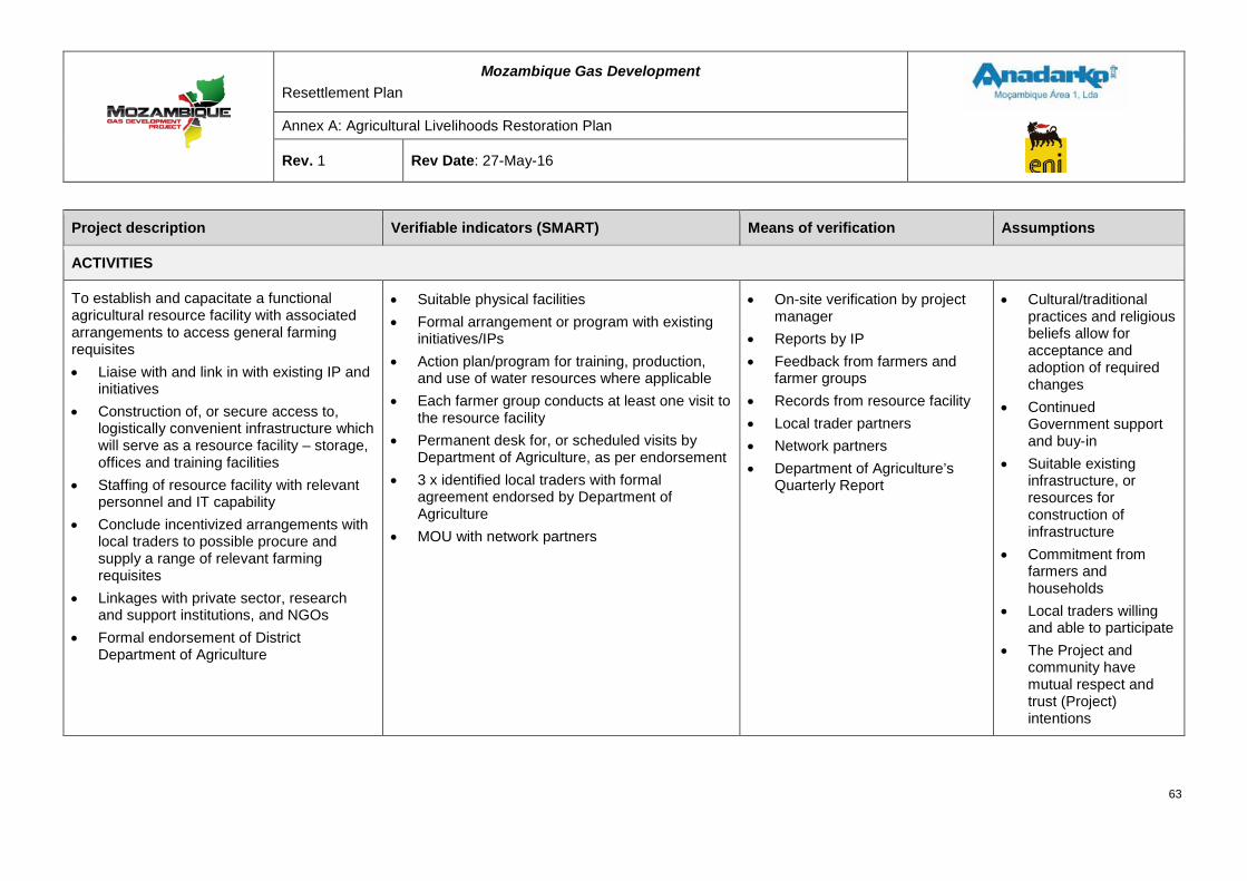
Mozambique Gas Development Resettlement Plan
Annex A: Agricultural Livelihoods Restoration Plan
Rev. 1 Rev Date: 27-May-16
Project description Verifiable indicators (SMART) Means of verification Assumptions
ACTIVITIES
To establish and capacitate a functional agricultural resource facility with associated arrangements to access general farming requisites • Liaise with and link in with existing IP and
initiatives • Construction of, or secure access to,
logistically convenient infrastructure which will serve as a resource facility – storage, offices and training facilities
• Staffing of resource facility with relevant personnel and IT capability
• Conclude incentivized arrangements with local traders to possible procure and supply a range of relevant farming requisites
• Linkages with private sector, research and support institutions, and NGOs
• Formal endorsement of District Department of Agriculture
• Suitable physical facilities • Formal arrangement or program with existing
initiatives/IPs • Action plan/program for training, production,
and use of water resources where applicable • Each farmer group conducts at least one visit to
the resource facility • Permanent desk for, or scheduled visits by
Department of Agriculture, as per endorsement • 3 x identified local traders with formal
agreement endorsed by Department of Agriculture
• MOU with network partners
• On-site verification by project manager
• Reports by IP • Feedback from farmers and
farmer groups • Records from resource facility • Local trader partners • Network partners • Department of Agriculture’s
Quarterly Report
• Cultural/traditional practices and religious beliefs allow for acceptance and adoption of required changes
• Continued Government support and buy-in
• Suitable existing infrastructure, or resources for construction of infrastructure
• Commitment from farmers and households
• Local traders willing and able to participate
• The Project and community have mutual respect and trust (Project) intentions
63
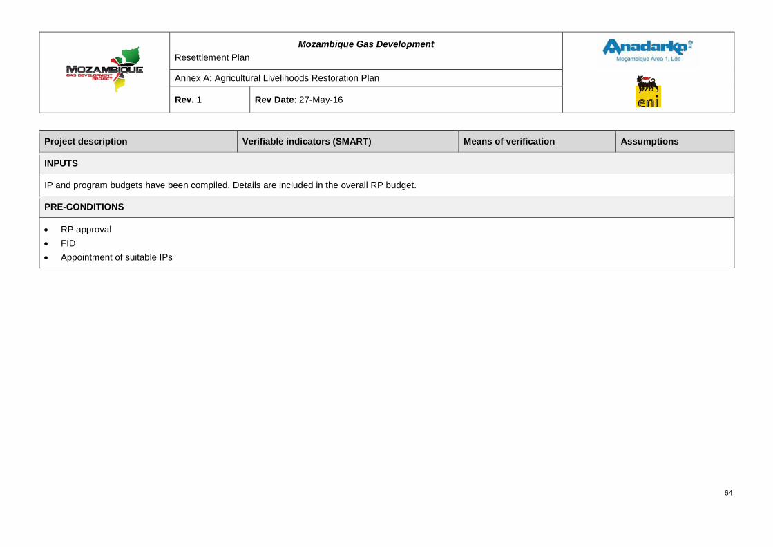
Mozambique Gas Development Resettlement Plan
Annex A: Agricultural Livelihoods Restoration Plan
Rev. 1 Rev Date: 27-May-16
Project description Verifiable indicators (SMART) Means of verification Assumptions
INPUTS
IP and program budgets have been compiled. Details are included in the overall RP budget.
PRE-CONDITIONS
• RP approval • FID • Appointment of suitable IPs
64
Mozambique Gas Development Resettlement Plan
Annex A: Agricultural Livelihoods Restoration Plan
Rev. 1 Rev Date: 27-May-16
6 REQUIRED INPUTS AND BUDGET FOR THE PROJECT
Inputs Implementation partners (IPs), who will set up and operate in Palma town and the Project area, will implement the proposed projects. The human and material resources required for the projects have been identified in the anticipated budgets below.
It is expected that the majority of field staff, especially those interacting with the communities and beneficiaries, will come from the Project area and will be appropriately capacitated. Where multiple or specialist IPs are appointed, it may prove cost-effective and streamline logistics to appoint a main or core IP. This core IP would drive and coordinate the implementation of especially the shorter, smaller programs. Given the nature of the possible overlapping community investment projects in the area and the similar nature of the proposed programs, the appointment of such a core IP makes even more sense. The assessment of the potential IPs indicated capacity in some organizations, while others already have a presence in the area with established networks.
Budget A detailed budget has been drawn up covering the anticipated costs associated with each of the proposed programs to restore agricultural livelihood to the Project area on the Afungi peninsula, over a three-year period. In order to ensure the success of the program, it is proposed to involve a combination of IPs, under the guidance of both the RT and the ALT. Details of this budget is provided in the main RP document.
65
Mozambique Gas Development Resettlement Plan
Annex A: Agricultural Livelihoods Restoration Plan
Rev. 1 Rev Date: 27-May-16
ABBREVIATIONS AND ACRONYMS
ALRP Agricultural Livelihood Restoration Plan
ALT Agricultural Livelihood team
CA Conservation Agriculture
CBO Community Based Organization
CEAGRE O Centro de Estudos de Agricultura e Gestão de Recursos
Naturais (Center of Studies for Agriculture and Natural Resources Management)
CRC Community Resettlement Committee
dbh Diameter at breast height
DRC District Resettlement Commission
DUAT Direito de Uso e Aproveitamento de Terras - Right of Use and Exploitation of Land
EIA Environmental Impact Assessment
ERV Green Revolution Strategy
FAEF Faculdade de Agronomia e Engenharia Florestal (Faculty of Agronomy and Forestry Engineering - Eduardo Mondlane University)
FDA Fundo de Desenvolvimento Agrícola (Agricultural Development Fund)
FDD Fundo de Desenvolvimento Distrital (District Development Fund
FID Final Investment Decision
GDP Gross Domestic Product
GoM Government of Mozambique
ha Hectare
IFC International Finance Corporation
INCAJU Instituto de Fomento do Caju
IP Implementation Partner
IPCC Institution for community consultation and participation
LNG Liquefied Natural Gas
NGO Non-governmental organization
PAPA Food Production Action Plan
PEDSA Agricultural Sector Strategic Plan
PIZ Project Industrial Zone
PROAGRI Agricultural Development Program
PS Performance Standards
66

Mozambique Gas Development Resettlement Plan
Annex A: Agricultural Livelihoods Restoration Plan
Rev. 1 Rev Date: 27-May-16
RP Resettlement Plan
SME Small and Medium Enterprise
67

RESETTLEMENT PLAN
FINAL DRAFT FOR GOVERNMENT APPROVAL ANNEX B: FISHERIES LIVELIHOOD
RESTORATION PLAN
MOZAMBIQUE GAS DEVELOPMENT
Mozambique Gas Development Resettlement Plan
Annex B: Fisheries Livelihood Restoration Plan
Rev. 1 Rev Date: 27-May-16
Table of Contents 1 INTRODUCTION ................................................................................................................... 1
2 STATUTORY AND REGULATORY FRAMEWORK ............................................................. 1
Applicable legislation.............................................................................................................. 1
Customary use and ownership rights .................................................................................... 4
3 LIVELIHOOD SYSTEMS OF PROJECT AFFECTED FISHING COMMUNITIES ................. 4
Activities and benefit sources ................................................................................................ 5
Seasonal influences ................................................................................................................ 5
Dependency ............................................................................................................................. 5
Relative importance of livelihood strategies to households ................................................ 6
Marketing and transport ......................................................................................................... 7
Gender divisions ..................................................................................................................... 7
Organization ............................................................................................................................ 8
4 FISHERIES SYSTEMS ......................................................................................................... 8
Overview of fisheries in the Project area ............................................................................... 8
Vessels ..................................................................................................................................... 9
4.2.1 Vessel types ..........................................................................................................................................9
4.2.2 Vessel numbers ................................................................................................................................. 11
Capture fisheries ....................................................................................................................13
4.3.1 Handline ............................................................................................................................................. 14 4.3.2 Beach seine ....................................................................................................................................... 15
4.3.3 Boat seine .......................................................................................................................................... 15
4.3.4 Nocturnal boat seine .......................................................................................................................... 16
4.3.5 Basket traps ....................................................................................................................................... 17
4.3.6 Monofilament gill nets ........................................................................................................................ 17 4.3.7 Large mesh gill nets ........................................................................................................................... 18
4.3.8 Spear gun .......................................................................................................................................... 19
4.3.9 Spears and harpoons......................................................................................................................... 19
Geographical fishing vessel activity patters ........................................................................20
Seasonality .............................................................................................................................23
Intertidal resource use ...........................................................................................................25
4.6.1 Introduction to intertidal resource collection in the study area .......................................................... 25
4.6.2 Intertidal activity ................................................................................................................................. 25
4.6.3 Intertidal resources ............................................................................................................................ 26 ii
Mozambique Gas Development Resettlement Plan
Annex B: Fisheries Livelihood Restoration Plan
Rev. 1 Rev Date: 27-May-16
Landings and harvesting activity ..........................................................................................30
Status of fisheries ..................................................................................................................33
Market and value chain ..........................................................................................................33
5 IDENTIFICATION OF STAKEHOLDERS ........................................................................... 36
Receptors................................................................................................................................36
Other stakeholders .................................................................................................................39
5.2.1 Central Government ........................................................................................................................... 39
5.2.2 Provincial and Local Government ...................................................................................................... 39 5.2.3 Civil society organizations ................................................................................................................. 39
5.2.4 Non-governmental organizations and other projects ......................................................................... 40
Stakeholder consultation .......................................................................................................40
5.3.1 Approach and methods ...................................................................................................................... 41
5.3.2 Documentation of stakeholder consultation ....................................................................................... 43
5.3.3 Topics and issues .............................................................................................................................. 43
5.3.4 Continuing stakeholder consultation .................................................................................................. 45
6 IMPACT ASSESSMENT ..................................................................................................... 45
Project impact sources, effects and consequences relevant to fisheries livelihoods ......47
Assessed impacts and methodology ....................................................................................56
Critical impacts and potential mitigation measures ............................................................58
Quantitative estimation of impacts .......................................................................................69
7 FISHERIES LIVELIHOOD RESTORATION STRATEGY ................................................... 69
Goal .........................................................................................................................................70
Objectives ...............................................................................................................................70
Coherence...............................................................................................................................70
Elements of the fisheries livelihoods restoration strategy..................................................70
7.4.1 Stakeholders ...................................................................................................................................... 70
7.4.2 Strategic approach ............................................................................................................................. 71
7.4.3 Compensation framework .................................................................................................................. 72 7.4.4 Cross cutting interventions ................................................................................................................ 74
7.4.5 Accidental damage ............................................................................................................................ 75
iii
Mozambique Gas Development Resettlement Plan
Annex B: Fisheries Livelihood Restoration Plan
Rev. 1 Rev Date: 27-May-16
Implementation phases ..........................................................................................................76
Eligibility .................................................................................................................................76
Commonalities with Project programs .................................................................................77
Implementation .......................................................................................................................78
8 PROGRAM DESCRIPTION ................................................................................................ 79
Material assistance ................................................................................................................79
8.1.1 Proposed principles ........................................................................................................................... 80
8.1.2 Sample calculation ............................................................................................................................. 81
Livelihood programs ..............................................................................................................84
8.2.1 Fisheries livelihood programs (individual benefits) ............................................................................ 85
8.2.2 Community level fisheries support programs..................................................................................... 86
Transitional support ...............................................................................................................99
8.3.1 Principles ........................................................................................................................................... 99
8.3.2 Duration of payments ....................................................................................................................... 100 8.3.3 Disbursement ................................................................................................................................... 100
Short term compensation .................................................................................................... 100
8.4.1 Principles ......................................................................................................................................... 100
8.4.2 Expected beneficiaries ..................................................................................................................... 101 8.4.3 Payment of compensation ............................................................................................................... 101
9 ANNEX 1 – LEGAL FRAMEWORK .................................................................................. 102
10 ANNEX 2 – MATERIAL ASSISTANCE PROGRAM ..................................................... 110
11 ANNEX 3 – FISHERIES LIVELIHOOD PROGRAMS .................................................... 112
12 ANNEX 4 – COMMUNITY LEVEL FISHERIES SUPPORT PROGRAMS ..................... 121
13 ANNEX 5 – LOGICAL FRAMEWORKS FOR FISHERIES LIVELIHOOD PROGRAMS 131
14 ABBREVIATIONS AND ACRONYMS ........................................................................... 158
List of Figures Figure 4-1: Dugout canoe fishing with small gill net, Milamba 2 ....................................................... 9
Figure 4-2: Dugout canoe with stabilizers and basket traps .............................................................. 9
Figure 4-3: Dau, with support legs prepared, Rongui Island .............................................................10
Figure 4-4: Mashua under sail, Vamize ..................................................................................................10
Figure 4-5: Motorized mashua/lancha, with boat seine net .....................................................................10
iv
Mozambique Gas Development Resettlement Plan
Annex B: Fisheries Livelihood Restoration Plan
Rev. 1 Rev Date: 27-May-16
Figure 4-6: Mashua under sail, local transport, Palma Sede ...................................................................10
Figure 4-7: Motorized mashua with dories on deck, nocturnal light attraction boat seine. Palma Sede ...11
Figure 4-8: Moma canoe ........................................................................................................................11
Figure 4-9: Fishing activity ......................................................................................................................21
Figure 4-10: Network diagram linking fishing points with base port .........................................................22
Figure 4-11 Intertidal fishing and gathering activity .................................................................................27
Figure 4-12: Operating the dragnet and the catch stored in buckets awaiting sorting and weighing. .......28
Figure 4-13: Fish distribution routes from Palma Sede ...........................................................................35
Figure 6-1: Extent of assessed marine infrastructure, including western and eastern jetties, marine operating facility and one multi pipeline route. ........................................................................................59
Figure 6-2: Extent of 500 m construction marine exclusion zone around marine infrastructure during construction phase .................................................................................................................................60
Figure 6-3: Extent of assumed 1,000 m temporary area of disturbance associated with construction and extent of shipping and disturbance .........................................................................................................61
Figure 6-4: Extent of operational SZ (1,500 m) .......................................................................................62
Figure 7-1: Summary of fisher entitlements ............................................................................................75
Figure 7-2: FLRP implementation ...........................................................................................................79
Figure 8-1: Example of gridded heat map of fishing intensity (Palma canoe fishers) ..............................82
Figure 8-2: Example of grid of Project impacts (Palma canoe fishers) ....................................................83
List of Tables Table 2-1: Legislation applicable to the Project FLRP .............................................................................. 2
Table 4-1: Vessel numbers by location ...................................................................................................11
Table 4-2: Vessel numbers by primary gear ...........................................................................................12
Table 4-3: Vessel numbers by location and primary gear type ................................................................13
Table 4-4: Resident status of fishers in Palma Bay .................................................................................24
Table 4-5: Dragnet catch composition ....................................................................................................28
Table 4-6: Active intertidal fishers assessment .......................................................................................30
Table 4-7 Landings, values and revenue per fishing day ........................................................................32
Table 5-1: Estimated number of vessels, fishers and intertidal collectors directly affected (communities to be resettled) ...........................................................................................................................................36
Table 5-2: Number of vessels, fishers and collectors indirectly affected .................................................37
Table 5-3: Physically affected (to be resettled) fishermen per gear type .................................................37
Table 5-4: Economically affected fishermen per gear type .....................................................................38
Table 5-5: List of engaged stakeholders/stakeholder bodies ..................................................................40 v
Mozambique Gas Development Resettlement Plan
Annex B: Fisheries Livelihood Restoration Plan
Rev. 1 Rev Date: 27-May-16
Table 6-1: Fishing livelihood receptor categories included in the impact assessment .............................46
Table 6-2: Project impacts and receptors ...............................................................................................48
Table 6-3: Impact assessment – critical impacts, significance and mitigation .........................................63
Table 6-4: Degree of impact on fishers and collectors ............................................................................69
Table 7-1: Compensation implementation phases ..................................................................................76
Table 7-2: Estimated numbers of receptors ............................................................................................77
Table 8-1: Capital values of fishing unit groups ......................................................................................80
Table 8-2: Livelihood programs ..............................................................................................................88
Table 8-3 Indicative allocation of receptors between livelihood programs ...............................................95
Table 8-4: Gross daily revenue as basis for compensation .....................................................................99
Table 9-1: List of protected species under the Regulation on Recreational and Sport Fishing .............. 105
vi
Mozambique Gas Development Resettlement Plan
Annex B: Fisheries Livelihood Restoration Plan
Rev. 1 Rev Date: 27-May-16
1 INTRODUCTION The Fisheries Livelihood Restoration Plan (FLRP) is intended to provide an understanding of fisheries and associated livelihoods in Palma Bay through an assessment of the possible impacts of the Project on fisheries and associated livelihoods during construction and operation of the Liquefied Natural Gas (LNG) Facility and export terminal.
The analysis identifies communities and groups of fishers and intertidal collectors who are likely to experience significant disturbance and who will require support to maintain or improve their livelihoods during the period of construction and operation. A series of programs are proposed to mitigate the various disturbances to livelihoods, including a compensation framework designed to offset expected hardships that may be experienced by fishing communities, as a result of Project construction and operation.
In addition to consultations and refinements, a full analysis of the 2013-2014 data collected during the enumeration process provides the baseline from which future impacts may be monitored. This baseline will enable the Project to monitor and evaluate the effectiveness of the fisheries livelihood restoration measures though a program of monitoring fish production in Palma Bay.
Details for the final Project design remain to be specified, including the methods, duration and spatial extent of construction activities that would allow final estimates of the Project impacts on fisheries livelihoods. In the absence of final information on the dredging program; maintenance of water quality; construction phase marine noise and construction phase ship movements assumptions have been made for the magnitude of impacts, and form the basis of the impact assessment.
2 STATUTORY AND REGULATORY FRAMEWORK The primary Mozambican marine fisheries and ecosystems legal statutes affecting the FLRP requirements are:
• The Fisheries Law (Law N° 22/13 of 1st November);
• The Law of the Sea (Law N° 4/96 of 4th January);
• The Regulation on Marine Fishing (Decree N° 43/2003 of 10th December); and
• The Aquaculture Marine Reserve (Decree N° 71/2011 of 30th December).
This FLRP has been prepared to comply with legal requirements and criteria, such as those specified in the Institutional and Legal Framework Review document (Annex 1), and the International Finance Corporation’s (IFC) Performance Standards (PS) 5 and 6 on Social and Environmental Sustainability that included requirements to improve, or restore, the livelihoods and standards of living of displaced persons.
Applicable legislation Table 2-1 provides a brief summary of the relevant legislation and how it is applicable to the Project FLRP.
1
Mozambique Gas Development Resettlement Plan
Annex B: Fisheries Livelihood Restoration Plan
Rev. 1 Rev Date: 27-May-16
Table 2-1: Legislation applicable to the Project FLRP
Legislation Description
The Fisheries Law (Law N° 22/13 of 1st November)
Under this law (Article 10), the fish resources of the territorial waters of Mozambique are property of the State, and it is the State’s responsibility to establish the conditions under which the resources can be used. For its implementation, the State follows the principle of conservation and adequate use of aquatic biologic resources and respective ecosystems; the precautionary principle; the participatory management of the fisheries resources; and the polluter pays principle. Articles 16 and 17 assign responsibility to the Ministério do Mar, Aguas Interiores, e Pescas (MIMAIP) to define and establish fisheries resources conservation measures including: prescribing conservation and management measures; and banning the introduction of any toxic substances or objects from any source liable to cause damage or pollute the environment, disrupt, destroy or poison fish resources and biodiversity. Article 20 gives provision to the MIMAIP to establish, whenever necessary, fishing areas designed exclusively for artisanal fisheries by national citizens. Additionally, Article 27 determines that the area of territorial waters up to three nautical miles, counted from the base lines, is reserved exclusively for small-scale and subsistence fisheries, scientific research and sport fisheries. Article 48 empowers the MIMAIP to authorize the establishment of fish aggregating devices or other forms of fish attraction. The Fisheries Law (Law N° 22/13 of 1st November) is relevant to the Project because all mitigation and offset measures, and the FLRP proposed activities - without prejudice to all fisheries subsector specific legislation - should be in line with the principles stated in this law.
The Law of the Sea (Law N° 4/96 of 4th January)
The Law of the Sea defines the limits of the Mozambican territorial sea and of its exclusive economic zone (EEZ), within which Mozambique has exclusive rights to the exploitation, conservation and management of resources. As per Article 9 of the Law, the EEZ of Mozambique is 200 miles from the territorial sea, which is defined as being 12 miles from the coastline (Article 4, paragraph 2). According to Article 11, within the EEZ, the State has sovereign rights for the purpose of exploration and exploitation, conservation and management of natural resources, including the seabed and subsoil, as well as other activities regarding the exploration and exploitation of the area for economic purposes. Pursuant to Article 17, under the framework of the international law, the State has the exclusive right to construct or regulate the construction, operation and use of artificial islands, installations and structures in the EEZ or continental shelf. Within the framework of restoration of livelihoods of the fishing communities affected by the Project, the introduction of artificial reefs is one of the possibilities, which in turn requires coordination with relevant Government bodies. Without prejudice of the fisheries specific legislation, this Law also defines the need to engage with the Ministry responsible for Maritime Affairs.
2
Mozambique Gas Development Resettlement Plan
Annex B: Fisheries Livelihood Restoration Plan
Rev. 1 Rev Date: 27-May-16
Legislation Description
The Regulation on Marine Fishing (Decree N° 43/2003 of 10th December)
The Regulation stipulates that the MIMAIP adopts participatory management to ensure appropriate management of fisheries resources. As per Article 15 participatory management pursues the following objectives: • Ensure responsible management of fisheries; • Ensure the access rights to fisheries by fishing communities with a view
to protect and promote their welfare; • Promote the participation of fishing communities in the planning and
implementation of fishery management measures; • Promote training activities through fishery extension work; and • Create a favorable environment for a peaceful coexistence between
artisanal fishermen and other industrial operators. The same Article defines the Commission for Fisheries Administration (CAP) and Co-Management Committees as the participatory management forum where all interested groups are represented, from artisanal fishermen, through their Fishery Community Councils (CCPs), to industrial operators. The Co-Management Committee is defined in Article 18 as the forum for participatory management at local, district and provincial level. In addition to the local Fisheries Administration Authority, this forum includes local CCPs, fisheries operators, processors, research and extension workers, maritime authority, and local fisheries related product traders. According to Article 19 of the Regulation, the CCPs are officially recognized by the Minister of MIMAIP and they aim to: • Contribute to the preservation and conservation of ecosystems in their
geographical area; • Identify problems in the use and management of fisheries resources; • Contribute to participatory management of fisheries, working with
government, fishermen and other individuals or groups to ensure access and sustainable use of resources;
• Manage conflicts resulting from fishery activities; and • Develop activities for sustainability of resources and the improvement
of living conditions, incorporating the interests of the community in the development action plan.
Article 28 authorizes the use of Fish Aggregating Devices and stipulates that the Minister of MIMAIP will define the conditions under which they can be installed, used and operated. Article 112 deals with areas reserved for preservation and protection of marine species, and provides for the establishment of marine parks, marine reserves and marine protected areas. Article 117 stipulates that for maritime safety reasons, particularly in canals, bays and estuaries, or during naval exercises, areas with full or partial interdiction of fishing may be established on a permanent or temporary basis. This Article furthermore establishes that the Minister of Transport and Communications, in coordination with the Minister of MIMAIP, is responsible for establishing the referred areas. The relevance of the Regulation on Marine Fishing for the Project is that when proposing mitigation and offset measures such as promoting the continuation of light fish attraction in other areas outside the 500 m
3
Mozambique Gas Development Resettlement Plan
Annex B: Fisheries Livelihood Restoration Plan
Rev. 1 Rev Date: 27-May-16
Legislation Description
construction Marine Exclusion Zone (MEZ) and 1,500 m operations Security Zone (SZ); promoting new fishing gear and techniques; and alternative livelihoods like the introduction of artificial reefs, all should follow what is prescribed in this piece of legislation. The promotion of co-management, one of the activities identified under the FLRP, is also dealt with in the Regulation.
The Aquaculture Marine Reserve (Decree N° 71/2011 of 30th December)
This Decree defines and establishes areas reserved for aquaculture development with the aim to ensure that marine aquaculture represents an alternative way for responsible exploitation of marine aquatic environments and its respective species. It provides for the development of activities that aim at reproduction; growth and fattening; maintaining; and upgrading of aquatic species for production purposes. The Decree promotes the active participation of public, private and local communities in the management and development of marine areas that comprise the Aquaculture Marine Reserves. With the concurrence of the Minister of MIMAIP, this Decree authorizes the implementation of other socio-economic activities within the declared Aquaculture Marine Reserve, as long as they have a comparative advantage, or are complementary to aquaculture. The relevance of this Decree is that the established Aquaculture Marine Reserve covers the area under the Project influence, which means that any activity within this area requires the concurrence of the Minister of MIMAIP. This Decree also identifies the areas and type of culture to be implemented within the Marine Reserve. In other words this means that all Project aquaculture promoted activities should respect what has been prescribed in this Decree.
Customary use and ownership rights Residents of coastal communities use a variety of subsistence and artisanal fishing methods within Palma Bay. The Bay is within the three nautical mile coastal zone where all fishing is restricted to artisanal fisheries as defined in the Fisheries Law (Art. 27, Law N° 22/2013 of 1st November). No commercial fishing vessels are permitted to operate in this area.
Based on customary ownership rights, the artisanal fishery in Palma Bay is primarily restricted to villagers living in shoreline or nearby villages. Within the customary limits, access is open to any villager. No village has asserted exclusive usufruct rights over any part of Palma Bay within the three nautical mile limit; any assertion of such an exclusive right would not be supported by National Legislation.
3 LIVELIHOOD SYSTEMS OF PROJECT AFFECTED FISHING COMMUNITIES
This section describes, in general terms, how fisheries are a part of rural livelihoods strategies; the importance of the activity relative to other sources of benefit; and seasonal changes in livelihood activities. Important gender divisions of labor are prevalent in the sector and these are also documented.
4
Mozambique Gas Development Resettlement Plan
Annex B: Fisheries Livelihood Restoration Plan
Rev. 1 Rev Date: 27-May-16
Activities and benefit sources In common with almost all coastal communities in Mozambique, livelihood systems in the Project area depend primarily on a balance of marine and agricultural activities. Communities closer to the coast in general have poorer, sandier soils in their immediate vicinity; more direct access to marine resources; and unsurprisingly, derive a greater portion of domestic benefit from fishing and collection activities. However, in the Project area, there are communities such as Ngoji 1 and 2 that have a high number of temporary fishing residences and even in these communities, agriculture still makes an important contribution to domestic benefits.
The nature of the fishery in Palma Bay, being subject to seasons generated by the monsoon, results in about 35 percent of fishermen moving their activities from time to time to maintain fish production, therefore not always operating from their home communities.
Aside from agriculture and fishing, which together account for almost 90 percent of domestic consumption in fishing households, other significant sources of benefit include petty trading of goods for domestic consumption (sugar, oil, soap, clothes) and, increasingly, paid labor. The latter is highly linked to the Project and there are already signs that fishers will abandon fishing in preference for paid labor, should the opportunity arise. An unskilled crewman who owns no fishing gear or vessel will earn up to three times more working as a manual laborer for bush clearance as he would from fishing, with the added benefit of an income stream that is not dependent on the variability of fishing, the tide, the weather, or seasons.
In general, women seem to have more diverse sources of benefit than men and may be involved in activities such as petty trade; bread making; fuel wood or reed collection; crafts (specifically the weaving of mats); as well as intertidal fishing/gathering and agriculture. Men, on the other hand, tend to focus on fishing, trade and agriculture.
External remittances from family members play a very limited role in securing livelihoods in the Project area.
Seasonal influences There are significant seasonal influences on fishing activities in Palma Bay and these are described briefly in Section 4.5. Outside of fisheries, the most important influence is the seasonal demand on household labor for agriculture. In general, women will have some involvement in agriculture almost all year round, but with greater commitment in April – June (harvest) and August-October (land clearance). Men’s involvement in agriculture is limited to the physical labor of land clearance prior to seeding, prior to the onset of the rainy season.
Dependency There is no definite pattern of dependency of livelihoods in the Project area on the two principle activities of fisheries and agriculture. Within given communities, households have differing views regarding the fundamental importance of either agriculture or fishing. Some households assert that agriculture provides the staple food, and therefore, agriculture is the most important activity. Other households hold the view that fishing provides immediate sustenance and excess can easily be sold to purchase necessary staples.
5
Mozambique Gas Development Resettlement Plan
Annex B: Fisheries Livelihood Restoration Plan
Rev. 1 Rev Date: 27-May-16
It is considered that whilst fishing and agriculture continue to be part of a subsistence level livelihood (with limited market excess), both are of comparable importance.
Relative importance of livelihood strategies to households1 Agriculture, as reported by 97 percent of the 63 interviewed households, is the major source of subsistence and income. Inland villages rely on agriculture more than coastal villages as a means of livelihood. All households (100%) interviewed inland (total of 51 households) derive subsistence and income from farming, whereas in coastal villages, 83 percent of households derive subsistence and income from farming. All households that farm mentioned cassava as the main cultivated crop. Other important crops include maize (51%), beans (41%), groundnut (30%) and rice (23%). All farmers indicated that farming is usually for own consumption, but more than 75 percent of interviewed households that farm periodically, market their surplus yield locally. Marketing also includes bartering for other products, including fish, in the coastal villages.
Fishing was the second most important livelihood, practiced by 59 percent of all interviewed households. Coastal villages rely on fishing more than inland villages as a means of livelihood, with 75 percent of coastal households interviewed (total of twelve villages) obtaining part of their subsistence and income from fishing. Fishing contributes to subsistence or income of 57 percent of households interviewed in inland villages. More than 91 percent of the households that fish not only consume their catch but also sell surplus catch. Part of the catch is bartered for agricultural products, generally with people from inland villages.
While agriculture and fishing are the dominant livelihood activities of people living in Afungi, foraging is an important supplementary activity. All households included in the sample gather and use forest resources for subsistence and some for income generation. Key forest resources used by household members include firewood, wild fruits, poles and thatching materials. However, the extent to which the forest is used varies among villages, as well as among households within the same village.
The analysis of time spent in different livelihood activities showed no differences in the allocation of productive time between inland and coastal villages. Agriculture is the livelihood activity that takes most of the productive household time. People farm 5.5 hours per day, 5-6 days per week on average, except on Fridays when people attend mosque/church and Sundays when people rest. The results show that fishing is the second most important source of livelihood, with households fishing four days per week, at an average of eight hours per day.
The time analysis shows that the most practiced foraging activities, firewood and wild fruit collection, are carried out 1-2 days per week and 2-3 days per week respectively. Time spent per day is 1.3 and 1.6 hours on average respectively. Cutting poles takes more of the household productive time (four hours per day) than firewood and wild fruit collection due to relatively lower availability of tree species preferred for poles in the proximity of homesteads. However, pole cutting is an occasional activity carried out only when the household wants to build or repair a house. Considering all foraging activities together, the average time
1 Source: Agricultural Livelihood Restoration Plan (ALRP) studies
6
Mozambique Gas Development Resettlement Plan
Annex B: Fisheries Livelihood Restoration Plan
Rev. 1 Rev Date: 27-May-16
spent foraging by each household is at least six hours per day, 2-3 days per week, which is approximately thirty percent of household productive time.
Marketing and transport Marketing systems in the area are focused primarily on Palma Sede, both for inputs and products. However further afield, Moçimboa da Praia (MdP), Tanzania, Nampula city, and the coastal districts of Nampula Province all play important roles. Bulk traded goods include salt, wooden poles, dried fish, and domestic consumables.
MdP is a large consumer market as well as a redistribution center for fish and agricultural produce, serving the northern part of Cabo Delgado Province. There are strong historical and cultural links with southern Tanzania, which are manifested in significant cross border transport of both consumer goods and people. Prior to the recent growth in tourist infrastructure in the Quirimbas Archipelago, there was also a significant population of migrant fishers from Tanzania in the Project area. However, there are signs that constraints on space for fishing camps on the islands and the installation of a marine border patrol at the Rovuma River have resulted in a significant reduction in the influx of seasonal migrants. Nampula city is an important consumer market, and is also the source of many higher value investment items such as nets, motorcycles, etc. Links with the coastal districts of Nampula Province are based on the on-going migration of Macua fishers from these districts to the Qurimbas archipelago, including the Project area. These migrants are concentrated in the villages of Kibunju, Simuco as well as in Palma Sede.
Maritime transport is still important in communities further from the towns of Palma Sede and Olumbi, especially those without good (or any) links to the national road network such as Kibunju, Maganja and Nfunzi to the south, and Suavo, Quirindi and Mbuizi to the north. The northern communities trade via Palma Sede, from where most goods are transported by road. The exception to this is bulk goods, such as wooden poles and even dried fish that may be taken as far as MdP by sea.
As the network improves, road transport is becoming more important, especially for the transport of passengers. There is still some marine transport of passengers within Palma Bay, primarily between Palma Sede and the communities with no road linkages (Nsemo/Kibunju, Nfunzi).
The mobile phone network already plays a very important role in the marketing of local produce, and is used not only to call buyers should there be unforeseen excesses, but also to help traders decide which town might offer the best market for particular products they take from the area. There is mobile phone coverage from at least one of the three national providers in all of the villages around Palma Bay.
Gender divisions The gender division of labor is along lines found in many other rural communities in Mozambique, with women undertaking most of the agricultural work, domestic duties including child care and cooking, as well as a wide variety of collecting/foraging and petty trading to supplement household income and food security. Men, on the other hand, are more focused on fishing and petty trading (including selling any excess domestic production), as well as supplementing agricultural labor during land preparation. The diversification of livelihood activities is typical of poorer, risk averse, households but it is notable that women, rather than men, perform much of the diversification.
7
Mozambique Gas Development Resettlement Plan
Annex B: Fisheries Livelihood Restoration Plan
Rev. 1 Rev Date: 27-May-16
In general, the social organization of communities is based on traditional patriarchal values. Although the family unit pools the labor force and the resources it produces, men alone take decisions on the redistribution of all production and revenue, including those generated by women.
The prevailing practices related to marriage, divorce and the death of the husband point to a strong patrilineal and patrilocal tradition, that is at least partly in contradiction with the Mozambican laws that defend women’s rights in access and control of their assets. Yet, some indications exist of the presence of matrilineal and matrilocal traits, as shown in the possibility of women inheriting land or trees and being able to pass them on as inheritance to her offspring, as well as the option of the man moving to the woman’s place in marriage.
Organization There are very low levels of organization in the communities in the Project area, as described in Section 3.2 of the RP. Governance of the community is vested in the community leader and his board (deputy leader, chiefs of divisions, community police commander, court, production chief, scribe). Civil society organizations are present but not in all settlements.
This sort of structure is, however, only found in the larger villages such as Quitupo and Kibunju. In smaller subordinate settlements such as Milamba and Ngoji the level of community organization is significantly lower and reduced to a community head, often without even a deputy. The level of participation of women in community decision-making is low and the traditional leaders are all male.
There have been attempts to establish community fisheries management as set out in PESPA through Community Fisheries Councils however these have yet to be effective in the Project area.
4 FISHERIES SYSTEMS This section describes the principle fisheries systems in the Project area, with emphasis on vessels, fishing methods, target species, fishing areas and gross returns. The activities covered include both marine capture fisheries as well as fishing/collection in the intertidal zone. A summary is also presented of the most relevant aspects of the marketing and distribution system for fish caught in the Project area.
Overview of fisheries in the Project area Fisheries in the area of Palma District that may be affected by the construction and operation of the Project are characterized by being short range, near shore and generally based on simple non-mechanized technologies. Fishers fall into two clear groups: (1) those indigenous to the area, and (2) migrants who have come to the District either on a temporary or permanent basis. The overwhelming majority of migrants come from the coastal districts of Nampula Province. Tanzanian migrants were reported to be present but in significantly fewer numbers, following the establishment of a Mozambican Defense Force military outpost at the mouth of the Rovuma River.
Fishing activity itself is divided into vessel based marine capture activities and more subsistence oriented collection activities in the intertidal zone, normally on foot without a vessel.
8
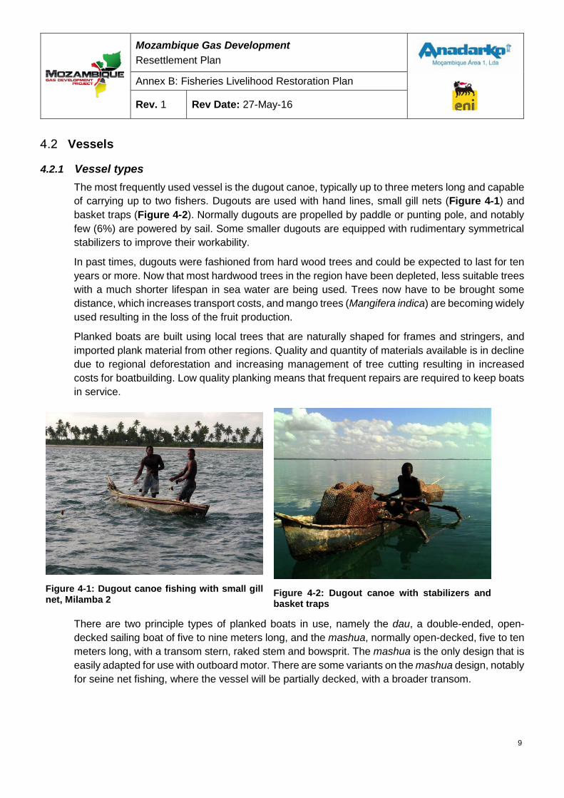
Mozambique Gas Development Resettlement Plan
Annex B: Fisheries Livelihood Restoration Plan
Rev. 1 Rev Date: 27-May-16
Vessels
4.2.1 Vessel types The most frequently used vessel is the dugout canoe, typically up to three meters long and capable of carrying up to two fishers. Dugouts are used with hand lines, small gill nets (Figure 4-1) and basket traps (Figure 4-2). Normally dugouts are propelled by paddle or punting pole, and notably few (6%) are powered by sail. Some smaller dugouts are equipped with rudimentary symmetrical stabilizers to improve their workability.
In past times, dugouts were fashioned from hard wood trees and could be expected to last for ten years or more. Now that most hardwood trees in the region have been depleted, less suitable trees with a much shorter lifespan in sea water are being used. Trees now have to be brought some distance, which increases transport costs, and mango trees (Mangifera indica) are becoming widely used resulting in the loss of the fruit production.
Planked boats are built using local trees that are naturally shaped for frames and stringers, and imported plank material from other regions. Quality and quantity of materials available is in decline due to regional deforestation and increasing management of tree cutting resulting in increased costs for boatbuilding. Low quality planking means that frequent repairs are required to keep boats in service.
Figure 4-1: Dugout canoe fishing with small gill net, Milamba 2
Figure 4-2: Dugout canoe with stabilizers and basket traps
There are two principle types of planked boats in use, namely the dau, a double-ended, open-decked sailing boat of five to nine meters long, and the mashua, normally open-decked, five to ten meters long, with a transom stern, raked stem and bowsprit. The mashua is the only design that is easily adapted for use with outboard motor. There are some variants on the mashua design, notably for seine net fishing, where the vessel will be partially decked, with a broader transom.
9
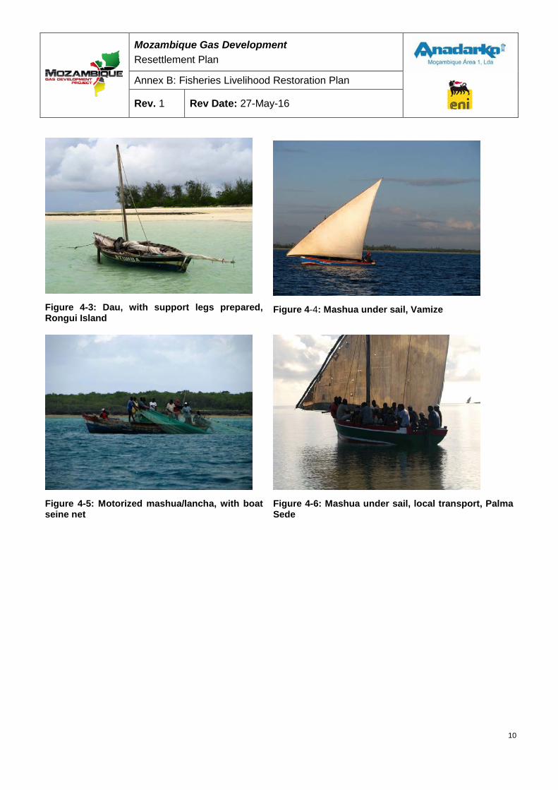
Mozambique Gas Development Resettlement Plan
Annex B: Fisheries Livelihood Restoration Plan
Rev. 1 Rev Date: 27-May-16
Figure 4-3: Dau, with support legs prepared, Rongui Island
Figure 4-4: Mashua under sail, Vamize
Figure 4-5: Motorized mashua/lancha, with boat seine net
Figure 4-6: Mashua under sail, local transport, Palma Sede
10
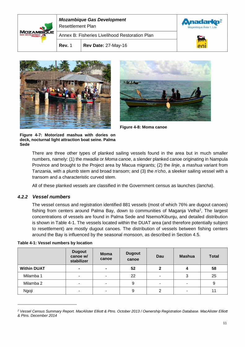
Mozambique Gas Development Resettlement Plan
Annex B: Fisheries Livelihood Restoration Plan
Rev. 1 Rev Date: 27-May-16
Figure 4-7: Motorized mashua with dories on deck, nocturnal light attraction boat seine. Palma Sede
Figure 4-8: Moma canoe
There are three other types of planked sailing vessels found in the area but in much smaller numbers, namely: (1) the mwadia or Moma canoe, a slender planked canoe originating in Nampula Province and brought to the Project area by Macua migrants; (2) the linje, a mashua variant from Tanzania, with a plumb stem and broad transom; and (3) the n’cho, a sleeker sailing vessel with a transom and a characteristic curved stem.
All of these planked vessels are classified in the Government census as launches (lancha).
4.2.2 Vessel numbers The vessel census and registration identified 881 vessels (most of which 76% are dugout canoes) fishing from centers around Palma Bay, down to communities of Maganja Velha2, The largest concentrations of vessels are found in Palma Sede and Nsemo/Kibunju, and detailed distribution is shown in Table 4-1. The vessels located within the DUAT area (and therefore potentially subject to resettlement) are mostly dugout canoes. The distribution of vessels between fishing centers around the Bay is influenced by the seasonal monsoon, as described in Section 4.5.
Table 4-1: Vessel numbers by location
Dugout
canoe w/ stabilizer
Moma canoe
Dugout canoe
Dau Mashua Total
Within DUAT - - 52 2 4 58
Milamba 1 - - 22 - 3 25
Milamba 2 - - 9 - - 9
Ngoji - - 9 2 - 11
2 Vessel Census Summary Report. MacAlister Elliott & Ptns. October 2013 / Ownership Registration Database. MacAlister Elliott & Ptns. December 2014
11
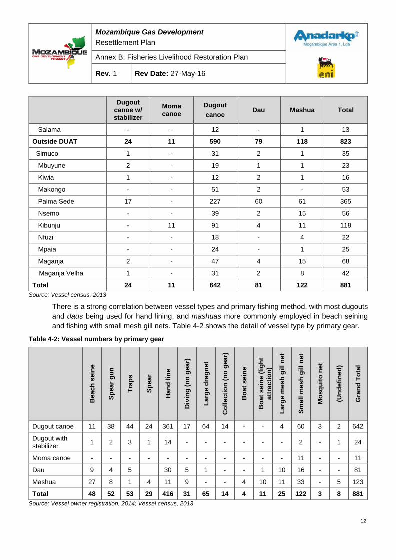
Mozambique Gas Development Resettlement Plan
Annex B: Fisheries Livelihood Restoration Plan
Rev. 1 Rev Date: 27-May-16
Dugout
canoe w/ stabilizer
Moma canoe
Dugout canoe
Dau Mashua Total
Salama - - 12 - 1 13
Outside DUAT 24 11 590 79 118 823
Simuco 1 - 31 2 1 35
Mbuyune 2 - 19 1 1 23
Kiwia 1 - 12 2 1 16
Makongo - - 51 2 - 53
Palma Sede 17 - 227 60 61 365
Nsemo - - 39 2 15 56
Kibunju - 11 91 4 11 118
Nfuzi - - 18 - 4 22
Mpaia - - 24 - 1 25
Maganja 2 - 47 4 15 68
Maganja Velha 1 - 31 2 8 42
Total 24 11 642 81 122 881 Source: Vessel census, 2013
There is a strong correlation between vessel types and primary fishing method, with most dugouts and daus being used for hand lining, and mashuas more commonly employed in beach seining and fishing with small mesh gill nets. Table 4-2 shows the detail of vessel type by primary gear.
Table 4-2: Vessel numbers by primary gear
Bea
ch s
eine
Spea
r gun
Trap
s
Spea
r
Han
d lin
e
Div
ing
(no
gear
)
Larg
e dr
agne
t
Col
lect
ion
(no
gear
)
Boa
t sei
ne
Boa
t sei
ne (l
ight
at
trac
tion)
Larg
e m
esh
gill
net
Smal
l mes
h gi
ll ne
t
Mos
quito
net
(Und
efin
ed)
Gra
nd T
otal
Dugout canoe 11 38 44 24 361 17 64 14 - - 4 60 3 2 642
Dugout with stabilizer 1 2 3 1 14 - - - - - - 2 - 1 24
Moma canoe - - - - - - - - - - - 11 - - 11
Dau 9 4 5 30 5 1 - - 1 10 16 - - 81
Mashua 27 8 1 4 11 9 - - 4 10 11 33 - 5 123
Total 48 52 53 29 416 31 65 14 4 11 25 122 3 8 881 Source: Vessel owner registration, 2014; Vessel census, 2013
12
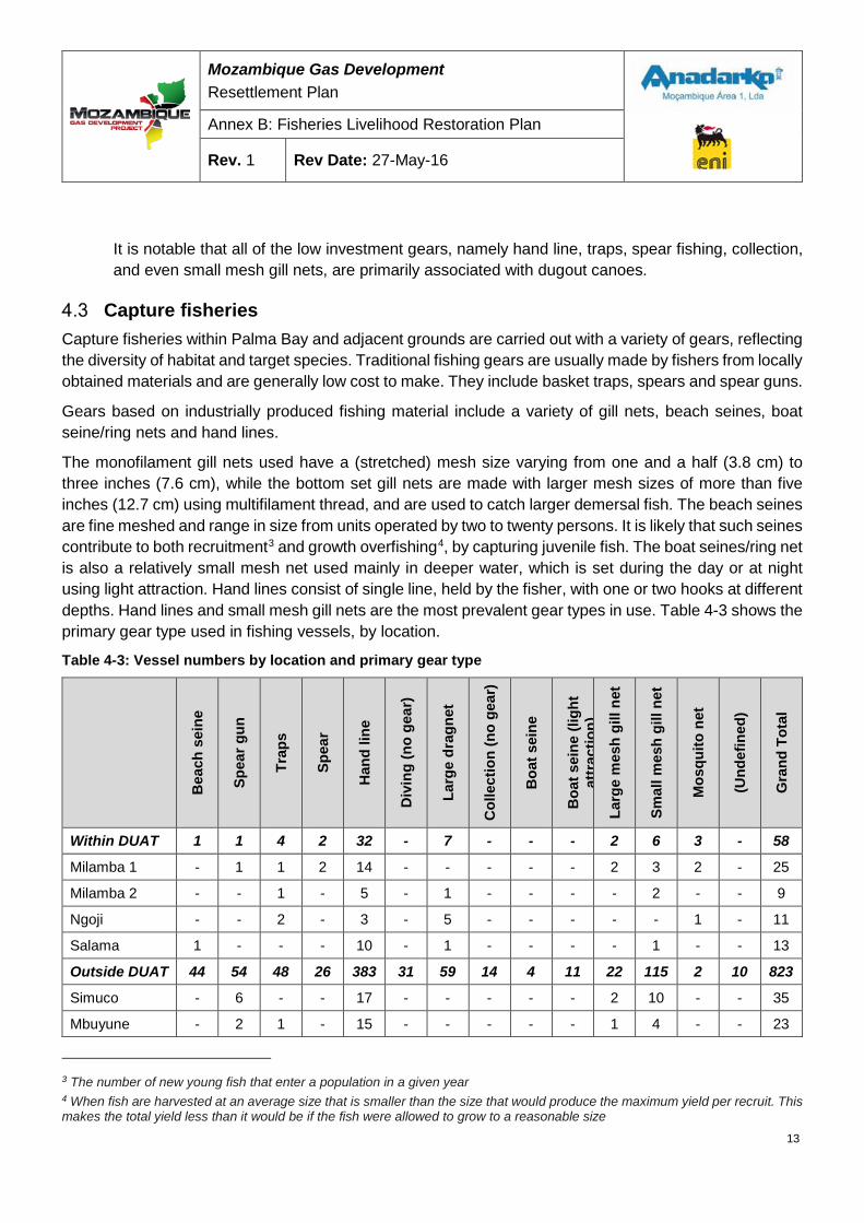
Mozambique Gas Development Resettlement Plan
Annex B: Fisheries Livelihood Restoration Plan
Rev. 1 Rev Date: 27-May-16
It is notable that all of the low investment gears, namely hand line, traps, spear fishing, collection, and even small mesh gill nets, are primarily associated with dugout canoes.
Capture fisheries Capture fisheries within Palma Bay and adjacent grounds are carried out with a variety of gears, reflecting the diversity of habitat and target species. Traditional fishing gears are usually made by fishers from locally obtained materials and are generally low cost to make. They include basket traps, spears and spear guns.
Gears based on industrially produced fishing material include a variety of gill nets, beach seines, boat seine/ring nets and hand lines.
The monofilament gill nets used have a (stretched) mesh size varying from one and a half (3.8 cm) to three inches (7.6 cm), while the bottom set gill nets are made with larger mesh sizes of more than five inches (12.7 cm) using multifilament thread, and are used to catch larger demersal fish. The beach seines are fine meshed and range in size from units operated by two to twenty persons. It is likely that such seines contribute to both recruitment3 and growth overfishing4, by capturing juvenile fish. The boat seines/ring net is also a relatively small mesh net used mainly in deeper water, which is set during the day or at night using light attraction. Hand lines consist of single line, held by the fisher, with one or two hooks at different depths. Hand lines and small mesh gill nets are the most prevalent gear types in use. Table 4-3 shows the primary gear type used in fishing vessels, by location.
Table 4-3: Vessel numbers by location and primary gear type
Bea
ch s
eine
Spea
r gun
Trap
s
Spea
r
Han
d lin
e
Div
ing
(no
gear
)
Larg
e dr
agne
t
Col
lect
ion
(no
gear
)
Boa
t sei
ne
Boa
t sei
ne (l
ight
at
trac
tion)
La
rge
mes
h gi
ll ne
t
Smal
l mes
h gi
ll ne
t
Mos
quito
net
(Und
efin
ed)
Gra
nd T
otal
Within DUAT 1 1 4 2 32 - 7 - - - 2 6 3 - 58
Milamba 1 - 1 1 2 14 - - - - - 2 3 2 - 25
Milamba 2 - - 1 - 5 - 1 - - - - 2 - - 9
Ngoji - - 2 - 3 - 5 - - - - - 1 - 11
Salama 1 - - - 10 - 1 - - - - 1 - - 13
Outside DUAT 44 54 48 26 383 31 59 14 4 11 22 115 2 10 823
Simuco - 6 - - 17 - - - - - 2 10 - - 35
Mbuyune - 2 1 - 15 - - - - - 1 4 - - 23
3 The number of new young fish that enter a population in a given year 4 When fish are harvested at an average size that is smaller than the size that would produce the maximum yield per recruit. This makes the total yield less than it would be if the fish were allowed to grow to a reasonable size
13
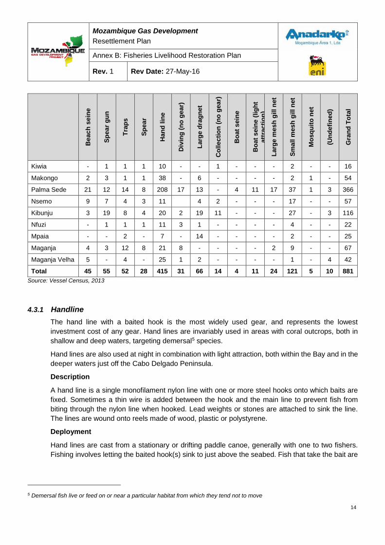
Mozambique Gas Development Resettlement Plan
Annex B: Fisheries Livelihood Restoration Plan
Rev. 1 Rev Date: 27-May-16
Bea
ch s
eine
Spea
r gun
Trap
s
Spea
r
Han
d lin
e
Div
ing
(no
gear
)
Larg
e dr
agne
t
Col
lect
ion
(no
gear
)
Boa
t sei
ne
Boa
t sei
ne (l
ight
at
trac
tion)
La
rge
mes
h gi
ll ne
t
Smal
l mes
h gi
ll ne
t
Mos
quito
net
(Und
efin
ed)
Gra
nd T
otal
Kiwia - 1 1 1 10 - - 1 - - - 2 - - 16
Makongo 2 3 1 1 38 - 6 - - - - 2 1 - 54
Palma Sede 21 12 14 8 208 17 13 - 4 11 17 37 1 3 366
Nsemo 9 7 4 3 11 4 2 - - - 17 - - 57
Kibunju 3 19 8 4 20 2 19 11 - - - 27 - 3 116
Nfuzi - 1 1 1 11 3 1 - - - - 4 - - 22
Mpaia - - 2 - 7 - 14 - - - - 2 - - 25
Maganja 4 3 12 8 21 8 - - - - 2 9 - - 67
Maganja Velha 5 - 4 - 25 1 2 - - - - 1 - 4 42
Total 45 55 52 28 415 31 66 14 4 11 24 121 5 10 881 Source: Vessel Census, 2013
4.3.1 Handline The hand line with a baited hook is the most widely used gear, and represents the lowest investment cost of any gear. Hand lines are invariably used in areas with coral outcrops, both in shallow and deep waters, targeting demersal5 species.
Hand lines are also used at night in combination with light attraction, both within the Bay and in the deeper waters just off the Cabo Delgado Peninsula.
Description
A hand line is a single monofilament nylon line with one or more steel hooks onto which baits are fixed. Sometimes a thin wire is added between the hook and the main line to prevent fish from biting through the nylon line when hooked. Lead weights or stones are attached to sink the line. The lines are wound onto reels made of wood, plastic or polystyrene.
Deployment
Hand lines are cast from a stationary or drifting paddle canoe, generally with one to two fishers. Fishing involves letting the baited hook(s) sink to just above the seabed. Fish that take the bait are
5 Demersal fish live or feed on or near a particular habitat from which they tend not to move
14
Mozambique Gas Development Resettlement Plan
Annex B: Fisheries Livelihood Restoration Plan
Rev. 1 Rev Date: 27-May-16
then hauled to the surface. Hand lines are also used from shore, usually by children, walking on the reef flat at low tide.
Target species
Target species caught using hand lines include: Emperors, Snapper, Grouper, Trevally, Mackerel, Tuna, and Rays. Target species are determined by size of hook and line weight.
Fishing grounds and habitat
Hand lines are primarily used in rocky areas, coral reef, reef edges/slopes, channels or offshore areas to approximately forty meters maximum depth.
4.3.2 Beach seine Beach seines are used on sandy shorelines or banks around Palma Bay at appropriate states of the tide. The gear is relatively high cost on account of small mesh size, the number of panels, and the fact that it requires a vessel for transporting and setting the gear. Beach seines are nonetheless significant due to the employment that each unit generates (10-20 persons) and the potential for occasional very large catches.
Description
Beach seines are robust nets made of multifilament nylon with variable but small mesh size (approximately half to one and a half inches). The net has a float line and a weighted footrope. A section of larger-mesh netting on each wing of the net directs fish towards the smaller-mesh center (cod end) of the net.
Deployment
Beach seines are deployed from the beach or from offshore on a sand bank, and pulled through the water. A team of 10-18 fishers (depending on the size of the net) is used to haul the net. Once the mouth of the net is approximately five meters across, either fishers may enter into the enclosed area and scoop up the fish into the vessel, or the net is dragged onto the beach or sand bank.
Target species
Target species include: Parrotfish, Rabbit fish, Emperor, Sardine, Halfbeak, Goatfish, Silver biddy, Anchovy, Scad, and Kingfish.
Fishing grounds habitat
Beach seines are used in areas with seagrass, reef lagoons, and occasionally offshore reefs and sand banks.
4.3.3 Boat seine Also called a ring net, boat seines are used from mashua/launches with outboard motors, and are especially popular amongst the migrant fishers from Nampula Province. The net is set around shoaling species, often over coral heads, and the encircling and contracting action is completed with the assistance of divers. As with beach seines, the gear is high cost, on account of small mesh size, twine weight, and length. A boat seine team may comprise up to 25 people. The gear is used
15
Mozambique Gas Development Resettlement Plan
Annex B: Fisheries Livelihood Restoration Plan
Rev. 1 Rev Date: 27-May-16
during the neap tide period, as it is difficult to control in strong currents, or with care at the peak of spring low tides.
Description
A boat seine is a small purse seine made of multifilament nylon mesh netting, which is suspended from floats and weighted at the bottom to hold the net vertically in the water. A footrope threaded through metal rings at the bottom of the net is used to close the net to enclose a school of fish. The mesh size used normally ranges from a half to two inches.
Deployment
A ring is usually deployed from either a single vessel or by a “mother vessel” and a smaller support vessel, with a crew of 12-18 fishers. Surface and sub-surface schools of fish are located by telltale surface activity of the fish, by birds feeding on them or, more frequently, by snorkeling divers. Once fish are located, the net is fed out overboard to encircle the fish. When the circle is complete the footrope is pulled to close the net while the surface rope is pulled to bring the net ends together. Divers will help the net to pass over coral heads and other seabed obstructions. The net is then hauled into the boat keeping the net up wind or current to prevent the boat drifting into the net.
Target species
Boat seines are normally deployed on outer reef slopes to catch demersal snapper; and in bays and deep lagoons to target small pelagic Sprat, Sardine and Anchovy. This gear also catches squids.
Fishing grounds habitat
Boat seines are frequently used on outer reef slopes in depths between five and twenty meters and in deep lagoons and inshore bays.
4.3.4 Nocturnal boat seine The nocturnal seine is another form of the ring net described above, but is set at night. The fishery is high value and will be highly impacted due to light pollution and the safety exclusion zone. Nocturnal boat seine units operate from Palma Sede, fishing with fine mesh open water seines at night. Each fishing unit comprises a ten meter motorized mashua/launch, and two small dories to carry the light attraction lanterns. Each unit employs up to 25 crewmen.
Deployment
Target small pelagics are aggregated under the lanterns attached to the dories. These are then brought together and the encircling net deployed by the mother vessel. Once the fish are encircled the net is pursed (bottom drawn together) and the dories are extracted from the ring. The entire net is then hauled on board, but if the catch is large it may be emptied into the hold of the mother vessel beforehand, using small scoop nets. This form of fishing gear was only recently introduced into Palma Bay.
16
Mozambique Gas Development Resettlement Plan
Annex B: Fisheries Livelihood Restoration Plan
Rev. 1 Rev Date: 27-May-16
Target species
Nocturnal seines target shoaling small pelagics including Commerson’s anchovy, and White Sardinella.
Fishing grounds habitat
Nocturnal seines are used in protected coastal and estuarine waters, deeper than 8 meters. The technique can only be used during the ‘dark’ phases of the moon when there is no stray light, limiting operations to a maximum of 18 days per lunar month.
4.3.5 Basket traps Octagonal or hexagonal basket traps made from a bamboo frame and woven split bamboo are used on seagrass beds and fringing coral reefs. Weighted traps are set from canoes or small dau/mashua. Basket traps are not used extensively in the area, but are still present as they can be fabricated at low cost from local materials.
Deployment
Fishers deploy traps from paddle canoes and outriggers, usually carrying one to two but sometimes up to four traps per canoe with an average crew of two fishers. Traps are baited before being lowered into the water by one to two light ropes, and are set on the seabed. The ropes are attached to small floats or plastic bottles that serve as buoys or surface markers. They are normally left overnight, with a normal soak time of 24-hours. The following day the trap is raised, the catch removed, the bait replenished and the trap re-set, sometimes in a different location.
A problem with fish traps is ghost fishing, when the hauling lines break from the trap and the trap sinks to the bottom it continues to fill with fish that die in the trap, as they are not harvested.
Target species (Common species)
Basket traps are used to catch: Rabbit fish, Parrotfish, Emperors, Goatfish. Other species also enter trap such as Wrasse, Surgeonfish, Grouper, Triggerfish and Moray eel.
Fishing grounds habitat
Traps are set on coral reef/rocky areas and seagrass beds, generally in enclosed areas.
4.3.6 Monofilament gill nets Small mesh monofilament gill nets (from one and a half to three inches) are widely used throughout the area. They may be set both floating or bottom set, but generally aim to be positioned such that they block the channels where the fish move into or out of shallower waters with the tide. These nets can be set on foot during spring tides, or from either a canoe or planked vessel.
Description
A monofilament net is a gill net of monofilament nylon, with small floats at the top of the net and small weights attached to a footrope along the base of the net.
17
Mozambique Gas Development Resettlement Plan
Annex B: Fisheries Livelihood Restoration Plan
Rev. 1 Rev Date: 27-May-16
Deployment
A monofilament net is deployed from a canoe or planked boat by one to two fishers. One end of the net is anchored; the net is then fed out into the water moving away from the anchored end. The other end is usually tied to the boat using a rope, or may be set free. Fishers stay with the set net for up to four hours (or the net stays overnight), and then haul the catch moving the boat towards the anchored end.
Target species
Monofilament nets are used to catch Halfbeak, Goatfish, Scad, Silver biddy, Fusilier, Emperor, Grunter, Kingfish, Parrotfish, Needlefish, and Rabbit fish.
Fishing grounds habitat
Monofilament nets are used in reef lagoons and outer reef slopes.
4.3.7 Large mesh gill nets Large mesh gill nets (from five to fifteen inches stretch mesh) are used bottom set to target larger demersal fish, including rays and sharks. The nets have the advantage over small mesh nets that they can be fabricated from twine with relative ease. The size of the gear invariably means that they can only be used from a planked vessel.
Description
Gill nets are suspended by floats and held vertically in the water-column with lead or stone weights. Fish become entangled in the netting by their operculum (gill covering) and further entrap themselves as they struggle to escape.
Deployment
Stationary gill nets are deployed by at least one to two fishers from a canoe or planked boat. They are set at the bottom mid water or at the surface, largely depending on the target species. Bottom set nets are anchored to the seabed. The net is anchored at either end with boulders, marked with a large float and left to fish overnight. Hauling is done daily to prevent catch spoilage. The smaller mesh nets are used inshore in shallow waters. This net is pulled slowly while hitting the water with stakes to scare fish towards the net.
Target species
Large mesh gill nets are used to catch a wide variety of benthic and demersal species including Emperor, Rabbit fish, Rays, Shark, Kingfish, Tuna, Flounder and Lobster.
Fishing ground habitat
Large mesh gill nets are used in reef lagoons, deeper channels and outer reef slopes.
18
Mozambique Gas Development Resettlement Plan
Annex B: Fisheries Livelihood Restoration Plan
Rev. 1 Rev Date: 27-May-16
4.3.8 Spear gun Free divers, often using masks and fins, use spear guns and spears to target demersal and reef-associated species over shallow reef areas. Divers may go in a group with a planked vessel to the dive site and disperse to fish independently.
Description
A spear gun is a long handgun made of wood (sometimes tubular metal) with a separate steel harpoon with sharpened tip, which is propelled by rubber strips. Fishers use a facemask or small goggles to improve visual accuracy.
Deployment
Fishermen paddle in canoes to hunting grounds and then exit the canoe to swim on the surface, with or without fins, while hunting for fish and invertebrates, which they shoot with the spear propelled by releasing taut rubber tubing.
Target species
Spear guns are used to catch Parrotfish, Snapper, Grouper, Rabbit fish, Parrotfish, Octopus, and Lobster.
Fishing grounds habitat
Spear guns are used in near shore shallow waters typically on coral reefs or around rugose habitat.
4.3.9 Spears and harpoons Description
Spear: Steel rod sharpened at one end, sometimes barbed, with or without a wooden handle.
Harpoon: Wooden pole with or without metallic tip.
Deployment
Spear: Fishermen swim on the surface while hunting for fish and invertebrates, which they stab with the spear. Spears are also used occasionally with fence traps and when looking for seashells.
Harpoon: Mainly used from the shore and also from a boat, with the fisher out of the water harpooning the fish or invertebrate through the surface.
Target species
Spears and harpoons are used to target relatively slow moving invertebrates such as octopus, and slow moving fish such as rays and moray eels.
Fishing grounds habitat
Spears and harpoons are used in coral reef related habitats especially exposed reefs flats and shallow near shore waters.
19

Mozambique Gas Development Resettlement Plan
Annex B: Fisheries Livelihood Restoration Plan
Rev. 1 Rev Date: 27-May-16
Geographical fishing vessel activity patters The geographical spread of fishing vessel activities is shown in Figure 4-9 and Figure 4-10, derived from vessel monitoring between April 2013 and April 2014.
20
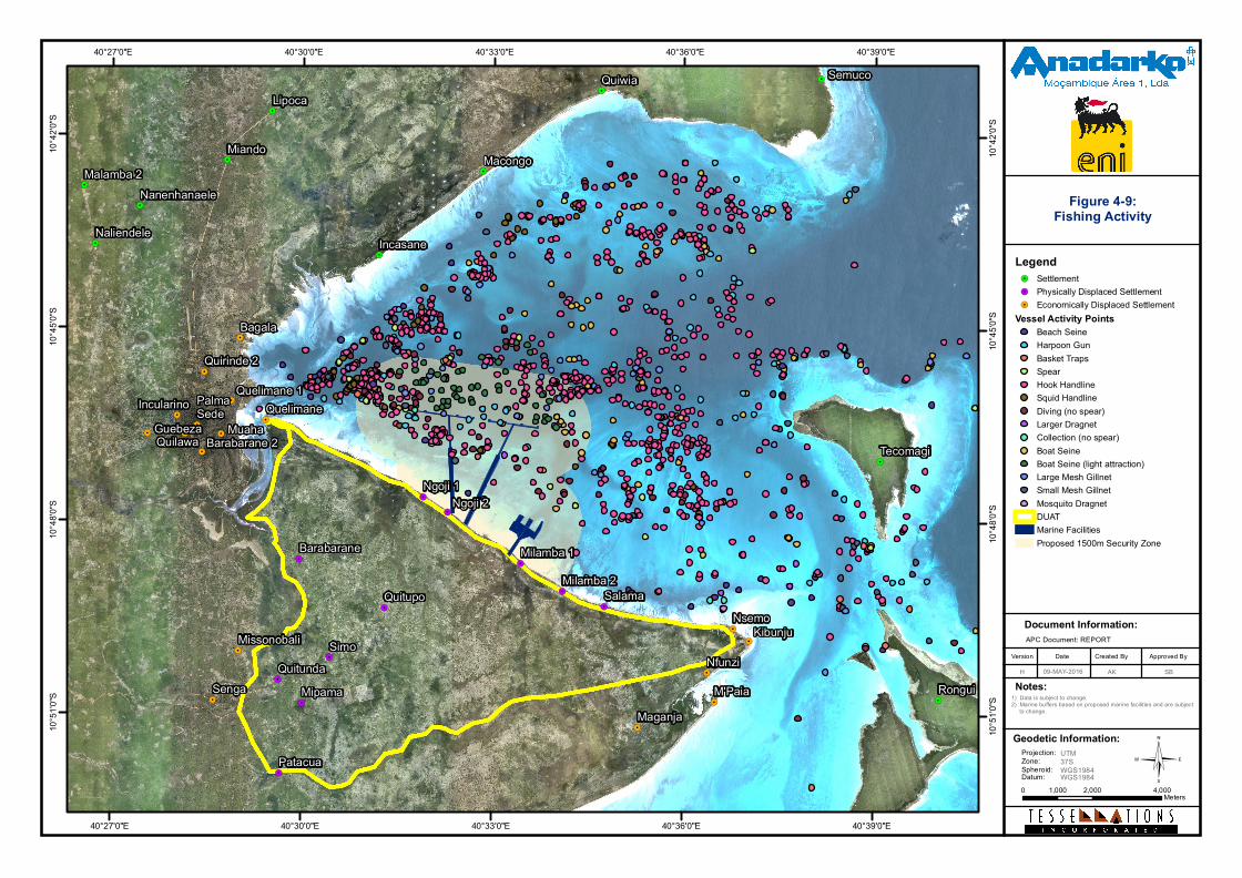
©
Document Information:
Date Created ByVersion Approved By
H
Notes:
APC Document: REPORT
!.
!.
!.
!.
!.
!.
!.
!.
!. !.
!.
!.
!.
!.
!.
!.
!.
!.
!.
!.
!.
!.
!.
!.
!.
!.
!.
!.
!.
!.
!.
!.
!.
!.
!.
!.
!.
!.
!.
!.
SengaMaganja
QuelimanePalmaSede
MissonobaliNsemo
Nfunzi
Guebeza Muaha
Quelimane 1
Barabarane 2
Incularino
Quilawa
Bagala
Quirinde 2
M'Paia
Kibunju
Rongui
Tecomagi
Quiwia
Nanenhanaele
Lipoca
Malamba 2Miando
Naliendele
Semuco
Macongo
Incasane
Patacua
Quitupo
Barabarane
QuitundaMipama
Ngoji 1Ngoji 2
Milamba 2Milamba 1
Simo
Salama
40°39'0"E
40°39'0"E
40°36'0"E
40°36'0"E
40°33'0"E
40°33'0"E
40°30'0"E
40°30'0"E
40°27'0"E
40°27'0"E10
°42'0"
S
10°42
'0"S
10°45
'0"S
10°45
'0"S
10°48
'0"S
10°48
'0"S
10°51
'0"S
10°51
'0"S 1) Data is subject to change.
2) Marine buffers based on proposed marine facilities and are subject to change.
Legend!. Settlement!. Physically Displaced Settlement!. Economically Displaced Settlement
Vessel Activity PointsBeach SeineHarpoon GunBasket TrapsSpearHook HandlineSquid HandlineDiving (no spear)Larger DragnetCollection (no spear)Boat SeineBoat Seine (light attraction)Large Mesh GillnetSmall Mesh GillnetMosquito DragnetDUATMarine FacilitiesProposed 1500m Security Zone
0 2,000 4,0001,000Meters
AK09-MAY-2016
Figure 4-9:Fishing Activity
Geodetic Information:Projection:Zone:Spheroid:Datum:
UTM37SWGS1984WGS1984
SB
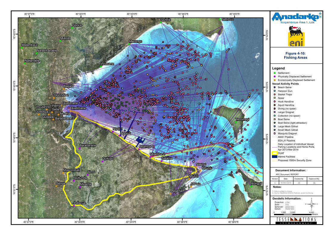
©
Document Information:
Date Created ByVersion Approved By
G
Notes:
APC Document: REPORT
!.
!.
!.
!.
!.
!.
!.
!.
!.
!. !.
!.
!.
!.
!.
!.
!.
!.
!.
!.
!.
!.
!.
!.
!.
!.
!.
!.
!.
!.
!.
!.
!.
!.
!.
!.
!.
!.
!.
!.
!.
SengaMaganja
QuelimanePalmaSede
MissonobaliNsemo
Nfunzi
Guebeza Muaha
Quelimane 1
Barabarane 2
Incularino
Quilawa
Bagala
Quirinde 2
M'Paia
Kibunju
Quiwia
Nanenhanaele
Lipoca
Malamba 2Miando
Naliendele
Semuco
Macongo
Incasane
Rongui
Tecomagi
Patacua
Quitupo
Barabarane
QuitundaMipama
Ngoji 1Ngoji 2
Milamba 2Milamba 1
Simo
Salama
40°39'0"E
40°39'0"E
40°36'0"E
40°36'0"E
40°33'0"E
40°33'0"E
40°30'0"E
40°30'0"E
40°27'0"E
40°27'0"E10
°42'0"
S
10°42
'0"S
10°45
'0"S
10°45
'0"S
10°48
'0"S
10°48
'0"S
10°51
'0"S
10°51
'0"S
1) Data is subject to change.2) Source: MacAlister Elliott & Partners, vessel monitoring
Legend!. Settlement!. Physically Displaced Settlement!. Economically Displaced Settlement
Vessel Activity PointsBeach SeineHarpoon GunBasket TrapsSpearHook HandlineSquid HandlineDiving (no spear)Larger DragnetCollection (no spear)Boat SeineBoat Seine (light attraction)Large Mesh GillnetSmall Mesh GillnetMosquito DragnetAMA1 PipelineEEA JV PipelineDaily Location of individual VesselFishing Locations and Home Ports,Apr 2013-Mar 2014DUATMarine FacilitiesProposed 1500m Security Zone
0 2,000 4,0001,000Meters
AK10-MAY-2016
Figure 4-10:Fishing Areas
Geodetic Information:Projection:Zone:Spheroid:Datum:
UTM37SWGS1984WGS1984
SB
Mozambique Gas Development Resettlement Plan
Annex B: Fisheries Livelihood Restoration Plan
Rev. 1 Rev Date: 27-May-16
From the above maps, the following can be noted:
• Generally short distances travelled between base and fishing ground. Typically this will benot more than 7 km, but exceptionally may be up to 18 km.
• High proportion of fishing effort originating in Palma Sede and Nsemo/Kibunju.
• Pre-dominance of hand lining.
• Concentration of large mesh gill nets in the deep-water channel.
• Clearly defined areas of operation for both beach seines, boat seines, boat seines (lightattraction).
• Low proportion of fishing trips starting or finishing from villages such as Patacua, Senga,Quitupo, and Barabarane.
• Low levels of direct interaction between the Project’s safety exclusion zones, anchoringareas and maritime access routes, and fishers located to the east of the MEZ and SZ. Highlevels of interaction by the majority of operational fishing craft based (55%) in Palma Sede.
• Most fishing effort is by sail and paddle boats. These make effective use of tidal flowsleaving Palma Sede at high tide, fishing throughout the ebb tide and returning with the newflood tide. Daily fishing patterns are therefore dominated by the tidal cycle and winddirection and strength.
Seasonality The conditions for fishing in Palma Bay are different in the two main seasons of the year and dominated by the south monsoon season from April to September. During this period, winds from the south east are frequently strong and can remain high for days at a time, so that dug out canoes cannot operate in open sea conditions and sail powered dau’s and mashua are restricted to sheltered waters. The area south of Afungi point towards Maganja Velha is exposed with strong wave conditions at high tide and so is the northern side of Palma Bay. Fishing activities are moved to protected areas within Palma Bay and access to the islands restricted.
In the inter monsoon months of February and October sea conditions are more calm with light winds making fishing activities possible in all parts of the Bay and coastal areas including the outer reefs of Tecomaji and Rongui. Fishing camps are seasonally established particularly on Tecomaji Island with fish being sun dried or collected by mashua coming from Kibunju.
The northwest monsoon period from November to February has generally lighter winds than the south monsoon. With short periods of strong wind as well as lower humidity, fishing is generally possible in all parts of the Bay and islands during these months.
Data including information on movement of fishermen by boat location and fishing gear use shows that 35 percent of fishers move fishing gear and boat locations.
23
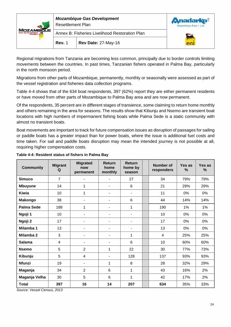
Mozambique Gas Development Resettlement Plan
Annex B: Fisheries Livelihood Restoration Plan
Rev. 1 Rev Date: 27-May-16
Regional migrations from Tanzania are becoming less common, principally due to border controls limiting movements between the countries. In past times, Tanzanian fishers operated in Palma Bay, particularly in the north monsoon period.
Migrations from other parts of Mozambique, permanently, monthly or seasonally were assessed as part of the vessel registration and fisheries data collection programs.
Table 4-4 shows that of the 634 boat respondents, 397 (62%) report they are either permanent residents or have moved from other parts of Mozambique to Palma Bay area and are now permanent.
Of the respondents, 35 percent are in different stages of transience, some claiming to return home monthly and others remaining in the area for seasons. The results show that Kibunju and Nsemo are transient boat locations with high numbers of impermanent fishing boats while Palma Sede is a static community with almost no transient boats.
Boat movements are important to track for future compensation issues as disruption of passages for sailing or paddle boats has a greater impact than for power boats, where the issue is additional fuel costs and time taken. For sail and paddle boats disruption may mean the intended journey is not possible at all, requiring higher compensation costs.
Table 4-4: Resident status of fishers in Palma Bay
Community Migrant Q
Migrated now
permanent
Return home
monthly
Return home by season
Number of responders
Yes as %
Yes as %
Simuco 7 - - 27 34 79% 79%
Mbuyune 14 1 - 6 21 29% 29%
Kiwia 10 1 - - 11 0% 0%
Makongo 38 - - 6 44 14% 14%
Palma Sede 188 1 - 1 190 1% 1%
Ngoji 1 10 - - - 10 0% 0%
Ngoji 2 17 - - - 17 0% 0%
Milamba 1 13 - - - 13 0% 0%
Milamba 2 3 - - 1 4 25% 25%
Salama 4 - - 6 10 60% 60%
Nsemo 5 2 1 22 30 77% 73%
Kibunju 5 4 - 128 137 93% 93%
Nfunzi 19 - 1 8 28 32% 29%
Maganja 34 2 6 1 43 16% 2%
Maganja Velha 30 5 6 1 42 17% 2%
Total 397 16 14 207 634 35% 33% Source: Vessel Census, 2013
24
Mozambique Gas Development Resettlement Plan
Annex B: Fisheries Livelihood Restoration Plan
Rev. 1 Rev Date: 27-May-16
Intertidal resource use The intertidal zone is defined as the area of seashore covered at high tide and uncovered at low tide. Along the shoreline of the Afungi Peninsula, the intertidal zone is highly productive, with a diverse range of flora and fauna that is adapted to survive in a changeable environment.
The intertidal zone on the northern shore of the Afungi Peninsula (south side of Palma Bay) is broad: at low tide the exposed seashore extends to more than 650 m from high tide to low tide. Within this area, there are expanses of sensitive seagrass habitat, supporting an abundance of invertebrate and vertebrate life, notably shellfish and fishes. The fishes found in these areas are predominantly juvenile species of fish that later in life move to habitat further offshore, such as coral reefs, where they are caught by hand line, net and spear fisheries. The intertidal zone and specifically the seagrass habitats are a fundamental link in the lifecycle of many species of ecological and socioeconomic importance.
4.6.1 Introduction to intertidal resource collection in the study area The intertidal zone and the subtidal areas immediately adjacent to the intertidal flats are important sources of resources for communities within and outside the Project area. The types of resources gathered and how they are used differs both within and between communities. Intertidal resources are an important source of food security and income for all communities in the Project area.
In contrast to fishing at sea, no equipment is needed to gather shellfish resources, which can be collected by hand. As such, the intertidal zone is an area easily visited and from which edible or saleable resources can be gathered. However, the majority of people observed and interviewed use equipment, varying from a simple hook fashioned from metal to extract makaza shells (Pinna muricata), to large dragnets - fine mesh (mosquito netting) net panels weighted with shells intricately woven into the foot line of the net. These are dragged through waist-deep water to catch juvenile fish, squid and swimming crabs. Much of the collection occurs in the subtidal zone, with resource collectors wading through water up to neck deep. For those with the financial capacity to buy or loan one, canoes are sometimes used to carry the catch or collected shells, enabling the fisher to collect significant quantities of resources over each tidal cycle. The most intensive method of intertidal resource gathering (equipment and personnel) is beach seining as described in Section 4.3.2.
4.6.2 Intertidal activity People from the communities of Ngoji 1 and 2, Milamba 1 and 2, Salama, Nsemo and Kibunju, Quitupo, Maganja and Barabarane were identified during surveying as using the intertidal zone. The majority of fishing or collection effort enumerated was by people from the coastal communities along the Afungi Peninsula, although collectors from inland communities, notably Quitupo, are also frequent visitors.
Those travelling from inland areas are operating simple, lightweight fishing gears such as the mosquito dragnet, harpoon or spear gun, which can be easily carried to and from their village. People operating more complex fishing gears are typically residents of coastal villages. In contrast to fishing at sea, there is a high prevalence of women engaged in resource gathering, typically collecting shellfish by hand or using mosquito nets to catch juvenile fish.
25
Mozambique Gas Development Resettlement Plan
Annex B: Fisheries Livelihood Restoration Plan
Rev. 1 Rev Date: 27-May-16
Figure 4-11 Illustrates the distribution of enumerated fishing activity in the intertidal zone of the southern coastline of Palma Bay, based on data collection cycles from May-November 2014.
The intertidal and shallow subtidal area that will be occupied by the exclusion zone will prohibit resource gatherers and fishers from a large area that is currently utilized daily. The communities that are most active in the proposed exclusion zone are those that are identified for resettlement, however there are fishers from all coastal communities that have some presence in intertidal areas in the proposed exclusion area, both fishing and passing through.
The returns from intertidal gathering by women is important at a community and household level, as it can be expected that the earnings will be invested in the household.
For many of the people interviewed, fishing in the intertidal zone or collecting resources is a daily routine dictated by the tidal cycle. On spring tides, more activity was observed and is reported to occur, as a result of increased areas of intertidal flats being exposed, and fishers being able to venture further from the shoreline into areas that are less frequently exploited by resource collectors. Correspondingly, on neap tides when the rise and fall of water is least, there is less resource collection activity.
4.6.3 Intertidal resources Resources collected include shellfish (bivalves, gastropods and crustaceans), fishes and cephalopods. Virtually all edible resources are collected either through targeted collection (e.g. makaza gathering) or through unselective methods (e.g. dragging a net over seagrass beds).
The level of fishing effort observed in the intertidal zone is intensive. The makaza shells are easy to collect and are targeted by dozens of women daily. In some areas, women reported that catches had declined, although areas with a high density of shells were observed, some of which were not known to the resource collectors. This suggests that expansion into new areas occurs when one area has been depleted, perhaps enabling one area to recover while gatherers focus their efforts elsewhere.
In terms of fish resources collected, the level of effort targeting fish associated with seagrass beds, which inevitably comprise predominantly juvenile fish, is increasing with time. A notable phenomenon is the use of mosquito nets adapted for use as fine meshed seine or dragnets. This is reported to be a relatively recent phenomenon (within the last ten years). The method of fishing is apparently increasing as the cost of entry to the fishery is low or even zero if nets are obtained through anti-malarial programs, and because the return, while small, contributes to household food security and any excess is easily sold. The use of mosquito nets is a serious concern from social and ecological perspectives, as continued use is causing depletion in fish resources, with potentially profound related social impacts.
To evaluate the fishery Swept 'dragnet' surveys were used to sample fish species on soft-substrate habitats (seagrass meadows) which are particularly important to Palma Bay as (a) a fish nursery area and (b) a commercially important dragnet (mosquito net) fishery.
26
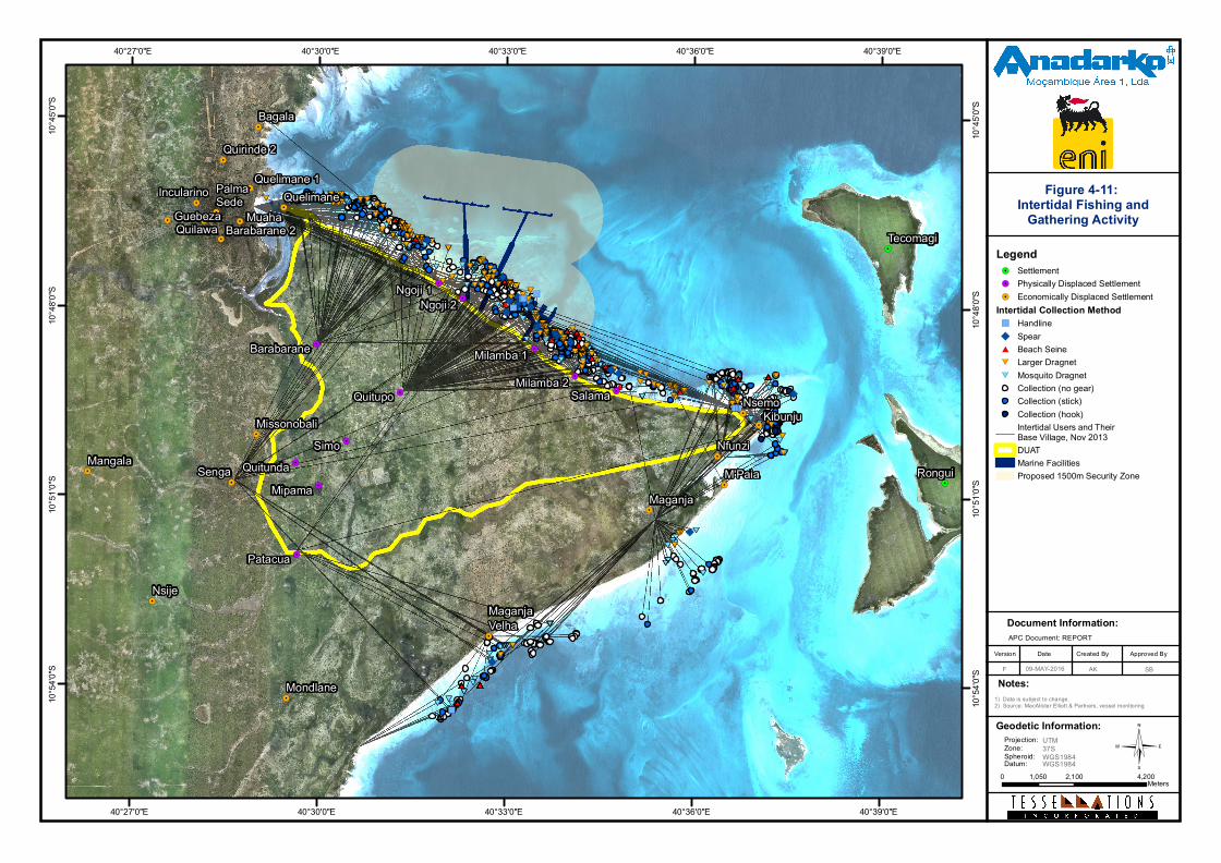
©
Document Information:
Date Created ByVersion Approved By
F
Notes:
APC Document: REPORT
####
#####
###
###
###
##
#######
###
####
###
###
######
#####
###
###
####
####
###
######
###
###
###
###
#
######
######
#############
#####
#
###
###########
#############
######
###
###
## ########
###
###
###
###
###
######
#########
#####
###
####
###
####
###
######
#########
### #
#########
###
###
######
###
###
######
#
##########
#########
####
######
###
####
###
#########
#########
######
####
##
****
*****
***
***
***
**
*******
***
****
***
***
******
*****
***
***
****
****
***
******
***
***
***
***
*
******
******
*************
*****
*
***
***********
*************
******
***
***
** ********
***
***
***
***
***
******
*********
*****
***
****
***
****
***
******
*********
*** *
*********
***
***
******
***
***
******
*
**********
*********
****
******
***
****
***
*********
*********
******
****
**
######
##
####
##
####
####
####
####
####
####
######
##
##
######
####
####
##
###
##
####
##
####
##
####
##
####
##
##
##
##
#########
##
##
## ####
##
#
##
######
#####
##
#### ####
##
### #####
##
####
####
##
##
######
######
##
##
########
######
##
#### ####
##
##
##
######
##
##
######
##
##
##
#####
####
##
####
##
#
######
##
##########
####
####
####
##
##
##
###
##******
**
****
**
****
****
****
****
****
****
******
**
**
******
****
****
**
***
**
****
**
****
**
****
**
****
**
**
**
**
*********
**
**
** ****
**
*
**
******
*****
**
**** ****
**
*** *****
**
****
****
**
**
******
******
**
**
********
******
**
**** ****
**
**
**
******
**
**
******
**
**
**
*****
****
**
****
**
*
******
**
**********
****
****
****
**
**
**
***
**
#
#####
#
################
#####
####
#############
################
###################### #########
#####
####
#
###########
##########
#####
###################
##################################
#########################
###########################
###############################################################
##############
*
*****
*
****************
*****
****
*************
****************
********************** *********
*****
****
*
***********
**********
*****
*******************
**********************************
*************************
***************************
***************************************************************
**************
"
"
"
"
""
"
"
"
"
"
"
""
"
"
"
"
"
)
)
)
)
))
)
)
)
)
)
)
))
)
)
)
)
)
"
"
"""
"""
"""
)
)
)))
)))
)))
!.
!.
!.
!.
!.
!.
!.
!.
!.
!.
!. !.
!.
!.
!.
!.
!.
!.
!.
!.
!.
!.
!.
!.
!.
!.
!.
!.
!.
!.
!.
!.
!.
!.
Senga
Maganja
Mondlane
Quelimane
Mangala
PalmaSede
Missonobali
Nsije
Nsemo
Nfunzi
Guebeza Muaha
Quelimane 1
Barabarane 2
Incularino
Quilawa
Bagala
Quirinde 2
M'Paia
Kibunju
MaganjaVelha
Rongui
Tecomagi
Patacua
Quitupo
Barabarane
QuitundaMipama
Ngoji 1Ngoji 2
Milamba 2Milamba 1
Simo
Salama
40°39'0"E
40°39'0"E
40°36'0"E
40°36'0"E
40°33'0"E
40°33'0"E
40°30'0"E
40°30'0"E
40°27'0"E
40°27'0"E10
°45'0"
S
10°45
'0"S
10°48
'0"S
10°48
'0"S
10°51
'0"S
10°51
'0"S
10°54
'0"S
10°54
'0"S
1) Data is subject to change.2) Source: MacAlister Elliott & Partners, vessel monitoring
Legend!. Settlement!. Physically Displaced Settlement!. Economically Displaced Settlement
Intertidal Collection Method") Handline") Spear#* Beach Seine
#* Larger Dragnet
#* Mosquito DragnetCollection (no gear)Collection (stick)Collection (hook)Intertidal Users and Their Base Village, Nov 2013DUATMarine FacilitiesProposed 1500m Security Zone
0 2,100 4,2001,050Meters
AK09-MAY-2016
Figure 4-11: Intertidal Fishing and
Gathering Activity
Geodetic Information:Projection:Zone:Spheroid:Datum:
UTM37SWGS1984WGS1984
SB
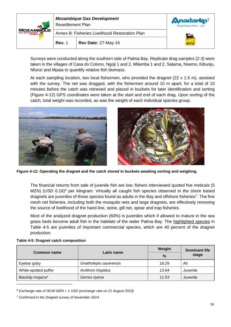
Mozambique Gas Development Resettlement Plan
Annex B: Fisheries Livelihood Restoration Plan
Rev. 1 Rev Date: 27-May-16
Surveys were conducted along the southern side of Palma Bay. Replicate drag samples (2-3) were taken in the villages of Casa do Colono, Ngoji 1 and 2, Milamba 1 and 2, Salama, Nsemo, Kibunju, Nfunzi and Mpaia to quantify relative fish biomass.
At each sampling location, two local fishermen, who provided the dragnet (22 x 1.5 m), assisted with the survey. The net was dragged, with the fishermen around 10 m apart, for a total of 10 minutes before the catch was retrieved and placed in buckets for later identification and sorting (Figure 4-12) GPS coordinates were taken at the start and end of each drag. Upon sorting of the catch, total weight was recorded, as was the weight of each individual species group.
Figure 4-12: Operating the dragnet and the catch stored in buckets awaiting sorting and weighing.
The financial returns from sale of juvenile fish are low; fishers interviewed quoted five meticais (5 MZN) (USD 0.16)6 per kilogram. Virtually all caught fish species observed in the shore based dragnets are juveniles of those species found as adults in the Bay and offshore fisheries7. The fine mesh net fisheries, including both the mosquito nets and large dragnets, are effectively removing the source of livelihood of the hand line, seine, gill net, spear and trap fisheries.
Most of the analyzed dragnet production (60%) is juveniles which if allowed to mature in the sea grass beds become adult fish in the habitats of the wider Palma Bay. The highlighted species in Table 4-5 are juveniles of important commercial species, which are 40 percent of the dragnet production.
Table 4-5: Dragnet catch composition
Common name Latin name Weight Dominant life
stage %
Eyebar goby Gnatholepis cauerensis 18.29 All
White-spotted puffer Arothron hispidus 13.64 Juvenile
Blacktip mojarra* Gerres oyena 11.53 Juvenile
6 Exchange rate of 38.80 MZN = 1 USD (exchange rate on 21 August 2015) 7 Confirmed in the Dragnet survey of November 2014
28
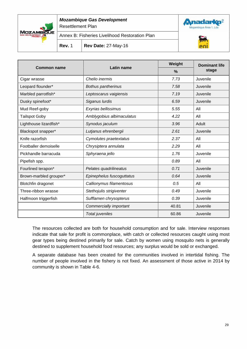
Mozambique Gas Development Resettlement Plan
Annex B: Fisheries Livelihood Restoration Plan
Rev. 1 Rev Date: 27-May-16
Common name Latin name Weight Dominant life
stage %
Cigar wrasse Chelio inermis 7.73 Juvenile
Leopard flounder* Bothus pantherinus 7.58 Juvenile
Marbled parrotfish* Leptoscarus vaigiensis 7.19 Juvenile
Dusky spinefoot* Siganus lurdis 6.59 Juvenile
Mud Reef-goby Exyrias bellissimus 5.55 All
Tailspot Goby Amblygobius albimaculatus 4.22 All
Lighthouse lizardfish* Synodus jaculum 3.96 Adult
Blackspot snapper* Lutjanus ehrenbergii 2.61 Juvenile
Knife razorfish Cymolutes praetextatus 2.37 All
Footballer demoiselle Chrysiptera annulata 2.29 All
Pickhandle barracuda Sphyraena jello 1.76 Juvenile
Pipefish spp. 0.89 All
Fourlined terapon* Pelates quadrilineatus 0.71 Juvenile
Brown-marbled grouper* Epinephelus fuscoguttatus 0.64 Juvenile
Blotchfin dragonet Callionymus filamentosus 0.5 All
Three-ribbon wrasse Stethojulis strigiventer 0.49 Juvenile
Halfmoon triggerfish Sufflamen chrysopterus 0.39 Juvenile
Commercially important 40.81 Juvenile
Total juveniles 60.86 Juvenile
The resources collected are both for household consumption and for sale. Interview responses indicate that sale for profit is commonplace, with catch or collected resources caught using most gear types being destined primarily for sale. Catch by women using mosquito nets is generally destined to supplement household food resources; any surplus would be sold or exchanged.
A separate database has been created for the communities involved in intertidal fishing. The number of people involved in the fishery is not fixed. An assessment of those active in 2014 by community is shown in Table 4-6.
29
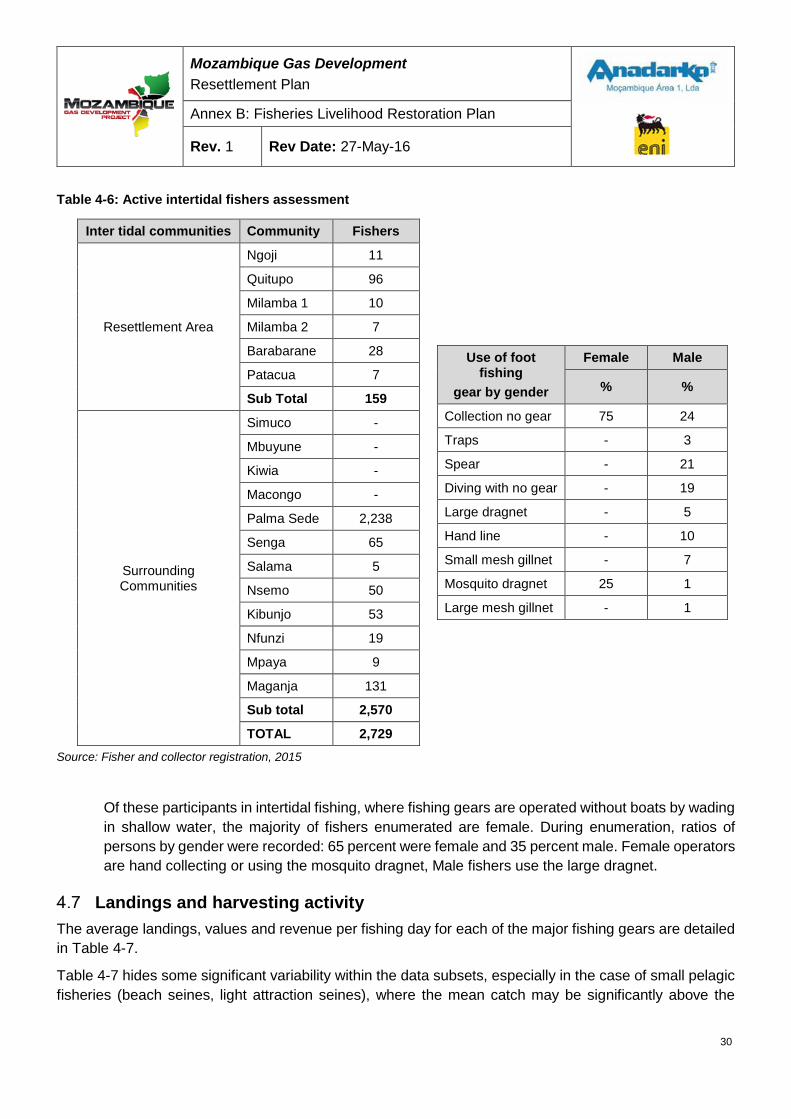
Mozambique Gas Development Resettlement Plan
Annex B: Fisheries Livelihood Restoration Plan
Rev. 1 Rev Date: 27-May-16
Table 4-6: Active intertidal fishers assessment
Inter tidal communities Community Fishers
Resettlement Area
Ngoji 11
Quitupo 96
Milamba 1 10
Milamba 2 7
Barabarane 28
Patacua 7
Sub Total 159
Surrounding Communities
Simuco -
Mbuyune -
Kiwia -
Macongo -
Palma Sede 2,238
Senga 65
Salama 5
Nsemo 50
Kibunjo 53
Nfunzi 19
Mpaya 9
Maganja 131
Sub total 2,570
TOTAL 2,729
Use of foot fishing
gear by gender
Female Male
% %
Collection no gear 75 24
Traps - 3
Spear - 21
Diving with no gear - 19
Large dragnet - 5
Hand line - 10
Small mesh gillnet - 7
Mosquito dragnet 25 1
Large mesh gillnet - 1
Source: Fisher and collector registration, 2015
Of these participants in intertidal fishing, where fishing gears are operated without boats by wading in shallow water, the majority of fishers enumerated are female. During enumeration, ratios of persons by gender were recorded: 65 percent were female and 35 percent male. Female operators are hand collecting or using the mosquito dragnet, Male fishers use the large dragnet.
Landings and harvesting activity The average landings, values and revenue per fishing day for each of the major fishing gears are detailed in Table 4-7.
Table 4-7 hides some significant variability within the data subsets, especially in the case of small pelagic fisheries (beach seines, light attraction seines), where the mean catch may be significantly above the
30

Mozambique Gas Development Resettlement Plan
Annex B: Fisheries Livelihood Restoration Plan
Rev. 1 Rev Date: 27-May-16
modal value. This implies that on any given day, the gear is likely to land a catch smaller than the average value shown in the table.
The levels of activity of fishing units vary with gear type, location, tidal cycle and especially exposure to the trade winds of the season. If the home base is particularly exposed to the north or south wind either a significant number of fishing days will be lost or the fisher may engage in seasonal migration (Section 4.5).
31

Mozambique Gas Development Resettlement Plan
Annex B: Fisheries Livelihood Restoration Plan
Rev. 1 Rev Date: 27-May-16
Table 4-7 Landings, values and revenue per fishing day
Gear type
Bea
ch s
eine
Har
poon
gun
Trap
s
Spea
r
Han
d lin
e
Squi
d ha
ndlin
e
Div
er (n
o ge
ar)
Boa
t sei
ne
Noc
turn
al b
oat
sein
e
Larg
e m
esh
gill
net
Smal
l mes
h gi
ll ne
ts
Col
lect
ion
(no
gear
)
Larg
e dr
agne
t
Mos
quito
dr
agne
t
Mean Nº crew 15.4 1.7 1.1 1.2 1.1 1.0 3.8 17.0 12.8 2.6 5.1 1.5 2.2 1.6
Max recorded catch (kg/vessel/ day) 625 200 80 95 135 50 650 900 1200 300 390 630 80 56.5
Mean catch (kg/vessel/ day) 67 9 12 7 8 5 48 135 243 34 34 22 20 15
Mean Gross Revenue (MZN/vessel/day) 2,789 374 459 272 343 223 2,152 6,522 7,079 1,351 1,600 259 420 375
Mean Gross Revenue (USD/vessel/day) $ 120 $ 16 $ 20 $ 12 $ 15 $ 10 $ 93 $ 281 $ 305 $ 58 $ 69 $ 11 $ 18 $ 16
Source: Catch monitoring 2013-2014
Note: Exchange rate of 38.80 MZN = 1 USD (exchange rate on 21 August 2015)
32
Mozambique Gas Development Resettlement Plan
Annex B: Fisheries Livelihood Restoration Plan
Rev. 1 Rev Date: 27-May-16
Status of fisheries Data collection on fish landings; locations of fishing activity; and revenues from fish sales, together with fisheries surveys of beach activities and recent habitat mapping indicate sub-optimal levels of benefits from fisheries in Palma Bay due to overfishing.
Fishing effort is intensive in all parts of Palma Bay, particularly on the south shore beaches where the capture of juveniles, is depriving other habitats of adult fish and decreasing overall fish landings. The coral reefs of the Bay, fringing and patch reefs around and outside the islands of Tecomaji and Rongui, as well as in Cabo Delgado Bay are also heavily fished by unsustainable methods.
The level of fishing effort paddle and sailboats achieve in Palma Bay is extraordinary given that there are very few motorized vessels. The fishery is utilized by about 3,500 people who depend on fishing as their primary income and source of food for their families.
The fishery is limited to boats built of local trees, and locally made sails. As a result, boats have limited day time range and cannot go far offshore, forcing most fishing effort especially that based in Palma Sede, to remain inside Palma Bay and close to the islands. Fishermen show high levels of skill and determination using the meager equipment that they have.
The pelagic fisheries available in the deeper waters just outside Palma Bay have not been exploited up to now. Habitat surveys have shown the coral reefs and extensive seagrass beds of Palma Bay to be in good condition. There is an obvious lack of adult fish, due to overfishing as described above.
The fisheries of the region have not been managed to date, and there continues to be open/unlimited access to any person wishing to fish/use the resource. If the fisheries are to be a source of food and livelihoods for future generations the fisheries in the region must be managed.
The area is feeling the effects of overfishing and an expanding population. Together with the Project development, these effects may cause significant change to coastal communities. Fishing effort will need to be managed to minimize negative impacts and allow fish stocks to recover. As well as the management of fishing, the integrity of the environment in Palma Bay is vital to the wellbeing of the fish stocks and to communities dependent on fishing.
The links between habitat types in Palma Bay (the coral reefs and seagrass meadows) are critical to supplying resources by sustaining fisheries. Aside from the physical interactions that coral reefs and seagrass provide, which includes the reduction of water energy and sediments; animal migrations form a crucially important link between the two systems that is key to supporting local livelihoods and providing food security.
Market and value chain The structure of the upstream and downstream value chain supporting fishing in Palma Bay is typical of artisanal value chains in Mozambique. Skilled artisanal boat builders supply upstream services. Of these, canoe builders are involved only part time, whereas higher skilled builders of planked vessels depend entirely on the business for livelihood. Gear trading is informal and centered on either small general-purpose shops, which retain a small stock of low-cost fishing gear, or itinerant traders, most of whom also trade fish.
33
Mozambique Gas Development Resettlement Plan
Annex B: Fisheries Livelihood Restoration Plan
Rev. 1 Rev Date: 27-May-16
Figure 4-13 below illustrates routes used for distributing fish from Palma Sede.
Fish from Palma Bay area are traded to inland markets in the north of Cabo Delgado Province and as far afield as the urban markets in Nampula and Nacala. The fisher or the primary trader processes almost all fish by salting and sun drying. Itinerant traders from outside of the fishing communities dominate the trading of fish.
The overall impact of the Project on the fisheries value chain is considered to be limited, however, influenced by the following factors:
• Incoming traders, who are both dynamic and mobile, dominate primary trading (the first sale of fish). In this context the appearance of buyers should not be significantly affected in economically affected communities, and buyers are likely to continue to service physically affected communities in their new locations.
• The distribution of fish from both physically affected and economically affected communities will be influenced to the extent that transport mechanisms may be disrupted. MEZ and SZ will affect maritime transport, and with no alternative land routes between the national road network and Nsemo/Kibunju, Kiwia and Simuco, the affected communities will have to travel additional distances. This could result in constraints to fish marketing.
• In the long term, there is potential for some major changes in the provincial market for fish, driven by general economic growth in Palma District. Presently, Palma Sede ‘exports’ fish to hinterland markets, but should there be significant growth and in-migration, it is likely that Palma Sede may start to consume more than it produces and also offer prices attractive to traders from MdP and Macomia. The implication of this would include price increases and/or product scarcity in inland markets, with negative impacts on local food security. Fish price rises in Palma Sede would obviously be beneficial for fishers but not for consumers.
Mitigation measures would best center on the maintenance or improvement of land transport routes between communities and the existing national road network. General economic development in Palma Sede could have wider reaching impacts on local and hinterland fish prices, as well as affect the availability of fish in nearby inland markets.
34
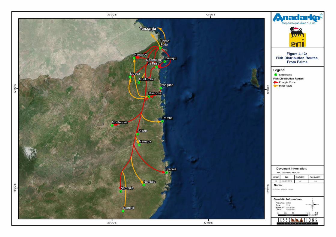
Mozambique Gas Development Resettlement Plan
Annex B: Fisheries Livelihood Restoration Plan
Rev. 1 Rev Date: 27-May-16
Figure 4-13: Fish distribution routes from Palma Sede
35
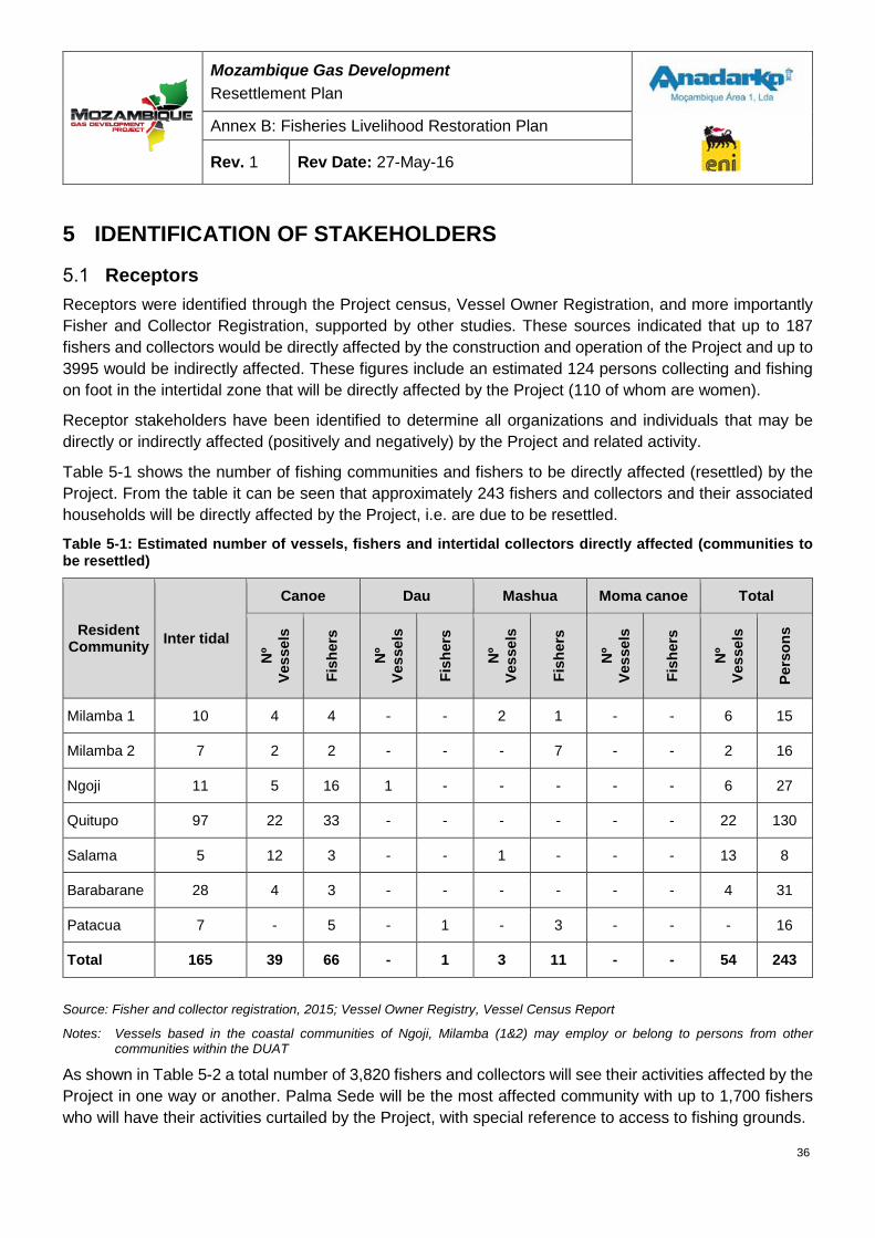
Mozambique Gas Development Resettlement Plan
Annex B: Fisheries Livelihood Restoration Plan
Rev. 1 Rev Date: 27-May-16
5 IDENTIFICATION OF STAKEHOLDERS
Receptors Receptors were identified through the Project census, Vessel Owner Registration, and more importantly Fisher and Collector Registration, supported by other studies. These sources indicated that up to 187 fishers and collectors would be directly affected by the construction and operation of the Project and up to 3995 would be indirectly affected. These figures include an estimated 124 persons collecting and fishing on foot in the intertidal zone that will be directly affected by the Project (110 of whom are women).
Receptor stakeholders have been identified to determine all organizations and individuals that may be directly or indirectly affected (positively and negatively) by the Project and related activity.
Table 5-1 shows the number of fishing communities and fishers to be directly affected (resettled) by the Project. From the table it can be seen that approximately 243 fishers and collectors and their associated households will be directly affected by the Project, i.e. are due to be resettled.
Table 5-1: Estimated number of vessels, fishers and intertidal collectors directly affected (communities to be resettled)
Resident Community Inter tidal
Canoe Dau Mashua Moma canoe Total
Nº
Vess
els
Fish
ers
Nº
Vess
els
Fish
ers
Nº
Vess
els
Fish
ers
Nº
Vess
els
Fish
ers
Nº
Vess
els
Pers
ons
Milamba 1 10 4 4 - - 2 1 - - 6 15
Milamba 2 7 2 2 - - - 7 - - 2 16
Ngoji 11 5 16 1 - - - - - 6 27
Quitupo 97 22 33 - - - - - - 22 130
Salama 5 12 3 - - 1 - - - 13 8
Barabarane 28 4 3 - - - - - - 4 31
Patacua 7 - 5 - 1 - 3 - - - 16
Total 165 39 66 - 1 3 11 - - 54 243
Source: Fisher and collector registration, 2015; Vessel Owner Registry, Vessel Census Report
Notes: Vessels based in the coastal communities of Ngoji, Milamba (1&2) may employ or belong to persons from other communities within the DUAT
As shown in Table 5-2 a total number of 3,820 fishers and collectors will see their activities affected by the Project in one way or another. Palma Sede will be the most affected community with up to 1,700 fishers who will have their activities curtailed by the Project, with special reference to access to fishing grounds.
36
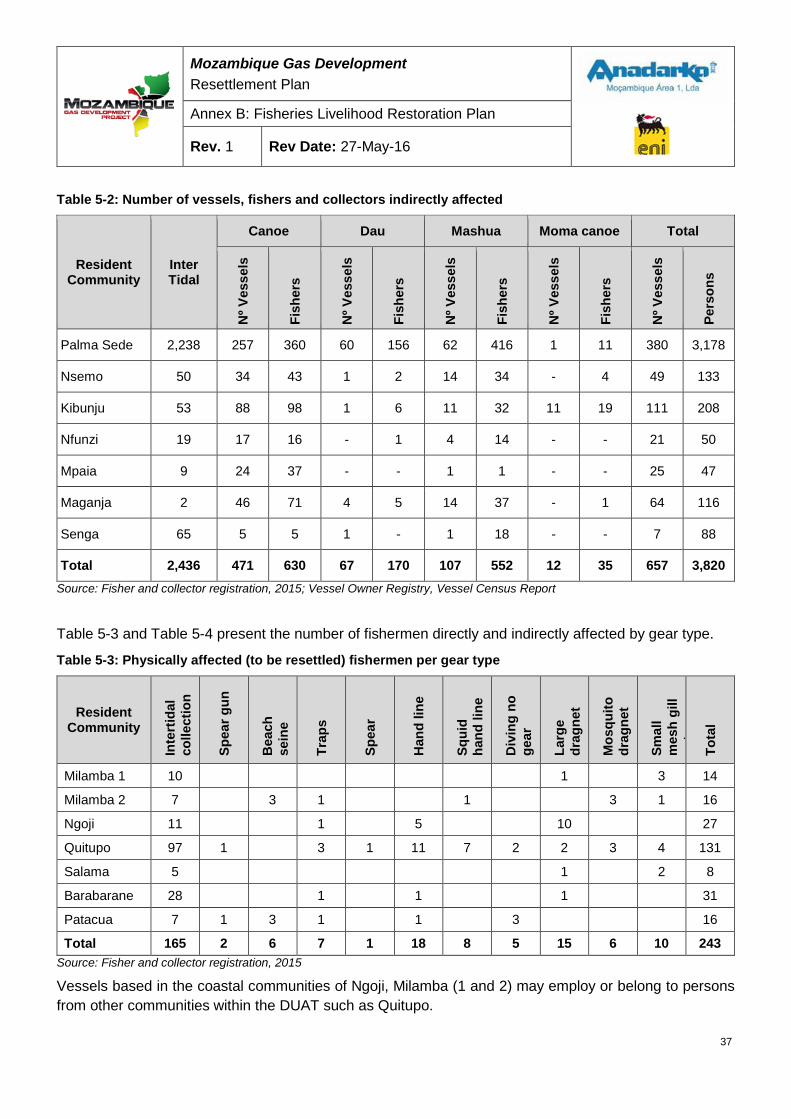
Mozambique Gas Development Resettlement Plan
Annex B: Fisheries Livelihood Restoration Plan
Rev. 1 Rev Date: 27-May-16
Table 5-2: Number of vessels, fishers and collectors indirectly affected
Resident Community
Inter Tidal
Canoe Dau Mashua Moma canoe Total N
º Ves
sels
Fish
ers
Nº V
esse
ls
Fish
ers
Nº V
esse
ls
Fish
ers
Nº V
esse
ls
Fish
ers
Nº V
esse
ls
Pers
ons
Palma Sede 2,238 257 360 60 156 62 416 1 11 380 3,178
Nsemo 50 34 43 1 2 14 34 - 4 49 133
Kibunju 53 88 98 1 6 11 32 11 19 111 208
Nfunzi 19 17 16 - 1 4 14 - - 21 50
Mpaia 9 24 37 - - 1 1 - - 25 47
Maganja 2 46 71 4 5 14 37 - 1 64 116
Senga 65 5 5 1 - 1 18 - - 7 88
Total 2,436 471 630 67 170 107 552 12 35 657 3,820 Source: Fisher and collector registration, 2015; Vessel Owner Registry, Vessel Census Report
Table 5-3 and Table 5-4 present the number of fishermen directly and indirectly affected by gear type.
Table 5-3: Physically affected (to be resettled) fishermen per gear type
Resident Community
Inte
rtid
al
colle
ctio
n
Spea
r gun
Bea
ch
sein
e
Trap
s
Spea
r
Han
d lin
e
Squi
d ha
nd li
ne
Div
ing
no
gear
Larg
e dr
agne
t
Mos
quito
dr
agne
t
Smal
l m
esh
gill
net
Tota
l
Milamba 1 10 1 3 14
Milamba 2 7 3 1 1 3 1 16
Ngoji 11 1 5 10 27
Quitupo 97 1 3 1 11 7 2 2 3 4 131
Salama 5 1 2 8
Barabarane 28 1 1 1 31
Patacua 7 1 3 1 1 3 16
Total 165 2 6 7 1 18 8 5 15 6 10 243 Source: Fisher and collector registration, 2015
Vessels based in the coastal communities of Ngoji, Milamba (1 and 2) may employ or belong to persons from other communities within the DUAT such as Quitupo.
37
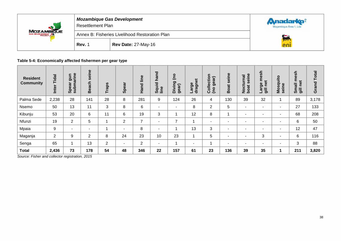
Mozambique Gas Development Resettlement Plan
Annex B: Fisheries Livelihood Restoration Plan
Rev. 1 Rev Date: 27-May-16
Table 5-4: Economically affected fishermen per gear type
Resident Community
Inte
r Tid
al
Spea
r gun
su
bmar
ine
Bea
ch s
eine
Trap
s
Spea
r
Han
d lin
e
Squi
d ha
nd
line
Div
ing
(no
gear
)
Larg
e dr
agne
t
Col
lect
ion
(no
gear
)
Boa
t sei
ne
Noc
turn
al
boat
sei
ne
Larg
e m
esh
gill
net
Mos
quito
se
ine
Smal
l mes
h gi
ll ne
t
Gra
nd T
otal
Palma Sede 2,238 28 141 28 8 281 9 124 26 4 130 39 32 1 89 3,178
Nsemo 50 13 11 3 8 6 - - 8 2 5 - - - 27 133
Kibunju 53 20 6 11 6 19 3 1 12 8 1 - - - 68 208
Nfunzi 19 2 5 1 2 7 - 7 1 - - - - - 6 50
Mpaia 9 - - 1 - 8 - 1 13 3 - - - - 12 47
Maganja 2 9 2 8 24 23 10 23 1 5 - - 3 - 6 116
Senga 65 1 13 2 - 2 - 1 - 1 - - - - 3 88
Total 2,436 73 178 54 48 346 22 157 61 23 136 39 35 1 211 3,820 Source: Fisher and collector registration, 2015
38
Mozambique Gas Development Resettlement Plan
Annex B: Fisheries Livelihood Restoration Plan
Rev. 1 Rev Date: 27-May-16
Other stakeholders Recognizing the strategic importance of the Project, a diverse range of stakeholders have been identified and a comprehensive list has been developed with stakeholders grouped into broad categories reflecting their interests in relation to the fisheries component of the Project. These include:
5.2.1 Central Government • Ministry of the Sea, Inland Waters and Fisheries (MMAIP)
• Small Scale Fisheries Development Institute (IDPPE)
• Fisheries Research Institute (IIP)
• General Directorate for Fisheries Administration (ADNAP)
• National Institute for Aquaculture (INAQUA)
5.2.2 Provincial and Local Government • Provincial Directorate for Fisheries
• Provincial Delegation for the Small Scale Fisheries Development Institute
• Provincial Delegation for the Fisheries Research Institute
• Provincial Delegation for the Fisheries Administration
• Provincial Delegation for the National Institute for Aquaculture
• Palma District Government
• District Services for Economic Activities
• District Department for Fisheries
• District Services for Health, Women and Social Affairs, Department of Gender and Development
5.2.3 Civil society organizations Palma Fisheries Community Council (CCP): The CCPs are community-based organizations with responsibilities and involvement in monitoring compliance measures in conservation and management of fisheries, protection of marine or inland waters, and participation in ensuring the application of all applicable fisheries legislation. The CCPs are responsible for:
• Encouraging the licensing of fishing activity;
• Supporting enforcement actions;
• Mediating conflicts;
• Promoting adoption and use of approved fishing gear and appropriate signage;
• Supporting fisheries extension; 39
Mozambique Gas Development Resettlement Plan
Annex B: Fisheries Livelihood Restoration Plan
Rev. 1 Rev Date: 27-May-16
• Promoting informative and educational actions about the need to protect aquatic environment; and
• Participating in information gathering actions on fishing activities.
Due to institutional weakness, the CCPs have not been able to address all of their responsibilities, and accordingly, their physical area of influence is limited.
5.2.4 Non-governmental organizations and other projects • International Union for the Conservation of Nature (IUCN - Mozambique)
• World Wildlife Fund Mozambique (WWF- Mozambique)
• Our Sea Our Life Project (Cabo Delgado)
• Associação do Meio Ambiente de Cabo Delgado (AMA)
• Muleide Nutrition Centre in Palma Sede
• Vamize Island Marine Project
Stakeholder consultation Throughout the development of the FLRP, consultation has been undertaken with affected and interested stakeholders. Consultation was undertaken for three primary purposes:
• Collect data from those stakeholders who will be affected by the Project;
• Test assumptions and findings with interested stakeholders; and
• Ensure that the affected stakeholders provide input into:
o Findings of the studies undertaken
o Acceptability of the proposed compensation measures
Consultation for the development of the FLRP was undertaken within a broader resettlement engagement program.
An ongoing stakeholder consultation program, involving the Fisheries team and the majority of stakeholders identified in this section, has been developed. The program is supported by extensive surveys undertaken by the Fisheries team, as well as other relevant studies that have included interaction with communities and CCPs.
Table 5-5 provides a list of stakeholders who have been consulted. Subsequent sections provide an overview of the methodology, documentation, topics, feedback and planned future consultations.
Table 5-5: List of engaged stakeholders/stakeholder bodies
Category Stakeholders
Central Government Ministry of the Sea, Inland Waters and Fisheries (MMAIP)
Small Scale Fisheries Development Institute (IDPPE)
40
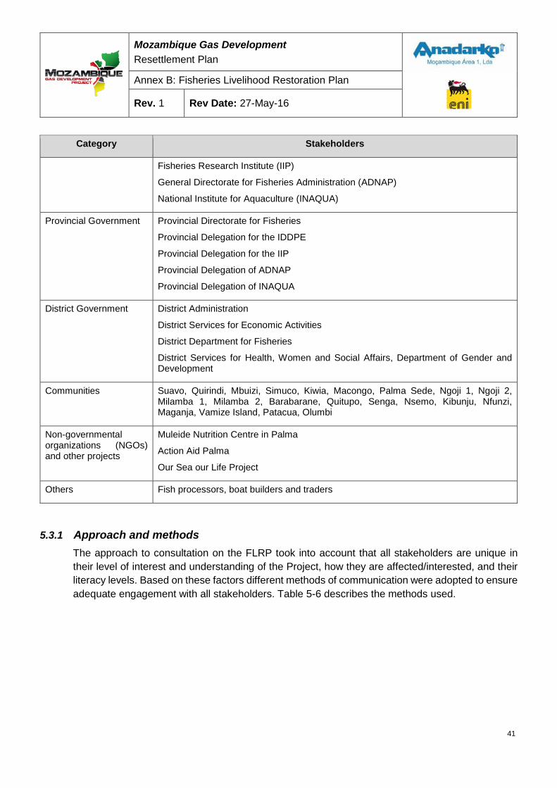
Mozambique Gas Development Resettlement Plan
Annex B: Fisheries Livelihood Restoration Plan
Rev. 1 Rev Date: 27-May-16
Category Stakeholders
Fisheries Research Institute (IIP)
General Directorate for Fisheries Administration (ADNAP)
National Institute for Aquaculture (INAQUA)
Provincial Government Provincial Directorate for Fisheries
Provincial Delegation for the IDDPE
Provincial Delegation for the IIP
Provincial Delegation of ADNAP
Provincial Delegation of INAQUA
District Government District Administration
District Services for Economic Activities
District Department for Fisheries
District Services for Health, Women and Social Affairs, Department of Gender and Development
Communities Suavo, Quirindi, Mbuizi, Simuco, Kiwia, Macongo, Palma Sede, Ngoji 1, Ngoji 2, Milamba 1, Milamba 2, Barabarane, Quitupo, Senga, Nsemo, Kibunju, Nfunzi, Maganja, Vamize Island, Patacua, Olumbi
Non-governmental organizations (NGOs) and other projects
Muleide Nutrition Centre in Palma
Action Aid Palma
Our Sea our Life Project
Others Fish processors, boat builders and traders
5.3.1 Approach and methods The approach to consultation on the FLRP took into account that all stakeholders are unique in their level of interest and understanding of the Project, how they are affected/interested, and their literacy levels. Based on these factors different methods of communication were adopted to ensure adequate engagement with all stakeholders. Table 5-6 describes the methods used.
41
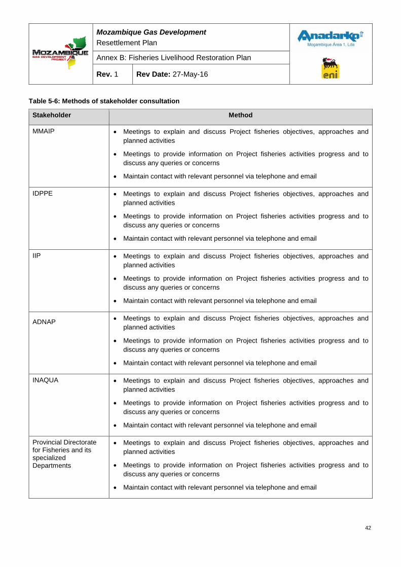
Mozambique Gas Development Resettlement Plan
Annex B: Fisheries Livelihood Restoration Plan
Rev. 1 Rev Date: 27-May-16
Table 5-6: Methods of stakeholder consultation
Stakeholder Method
MMAIP • Meetings to explain and discuss Project fisheries objectives, approaches and planned activities
• Meetings to provide information on Project fisheries activities progress and to discuss any queries or concerns
• Maintain contact with relevant personnel via telephone and email
IDPPE • Meetings to explain and discuss Project fisheries objectives, approaches and planned activities
• Meetings to provide information on Project fisheries activities progress and to discuss any queries or concerns
• Maintain contact with relevant personnel via telephone and email
IIP • Meetings to explain and discuss Project fisheries objectives, approaches and planned activities
• Meetings to provide information on Project fisheries activities progress and to discuss any queries or concerns
• Maintain contact with relevant personnel via telephone and email
ADNAP
• Meetings to explain and discuss Project fisheries objectives, approaches and planned activities
• Meetings to provide information on Project fisheries activities progress and to discuss any queries or concerns
• Maintain contact with relevant personnel via telephone and email
INAQUA • Meetings to explain and discuss Project fisheries objectives, approaches and planned activities
• Meetings to provide information on Project fisheries activities progress and to discuss any queries or concerns
• Maintain contact with relevant personnel via telephone and email
Provincial Directorate for Fisheries and its specialized Departments
• Meetings to explain and discuss Project fisheries objectives, approaches and planned activities
• Meetings to provide information on Project fisheries activities progress and to discuss any queries or concerns
• Maintain contact with relevant personnel via telephone and email
42
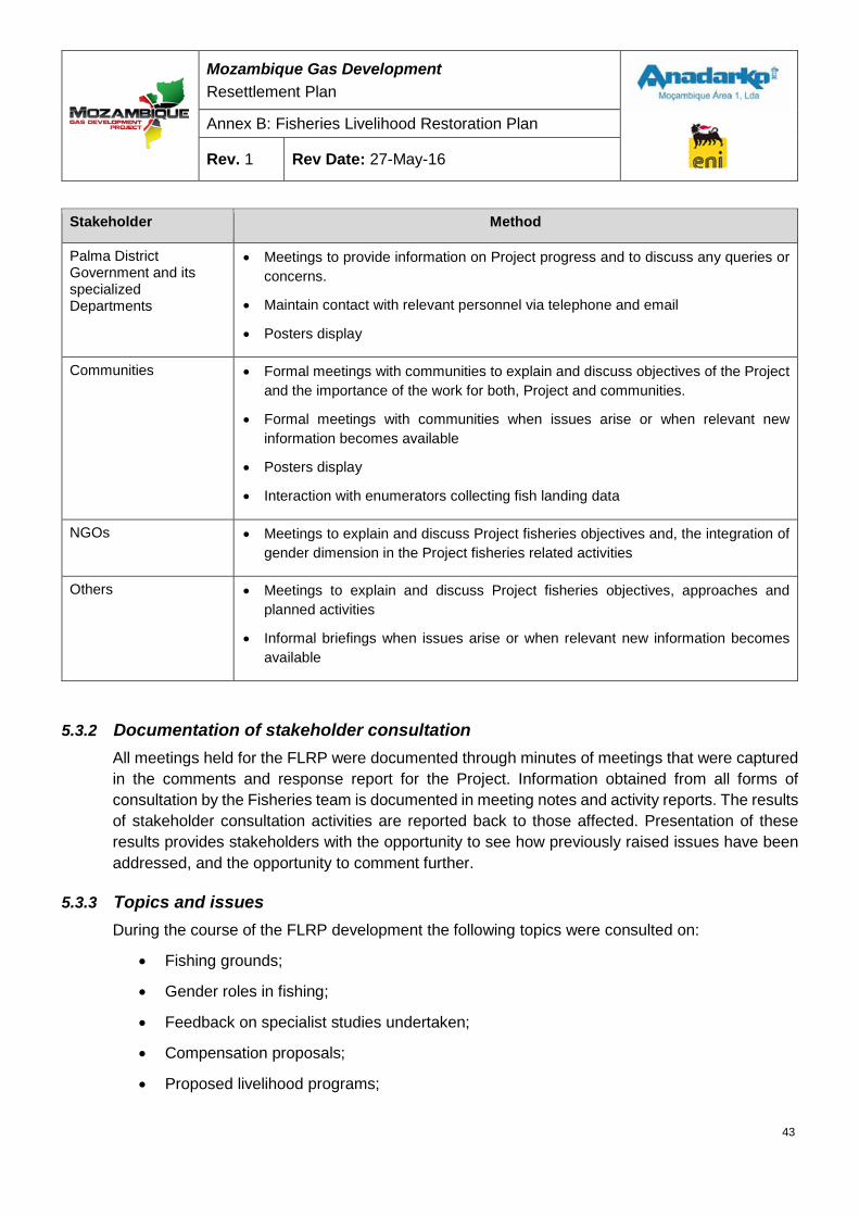
Mozambique Gas Development Resettlement Plan
Annex B: Fisheries Livelihood Restoration Plan
Rev. 1 Rev Date: 27-May-16
Stakeholder Method
Palma District Government and its specialized Departments
• Meetings to provide information on Project progress and to discuss any queries or concerns.
• Maintain contact with relevant personnel via telephone and email
• Posters display
Communities • Formal meetings with communities to explain and discuss objectives of the Project and the importance of the work for both, Project and communities.
• Formal meetings with communities when issues arise or when relevant new information becomes available
• Posters display
• Interaction with enumerators collecting fish landing data
NGOs • Meetings to explain and discuss Project fisheries objectives and, the integration of gender dimension in the Project fisheries related activities
Others • Meetings to explain and discuss Project fisheries objectives, approaches and planned activities
• Informal briefings when issues arise or when relevant new information becomes available
5.3.2 Documentation of stakeholder consultation All meetings held for the FLRP were documented through minutes of meetings that were captured in the comments and response report for the Project. Information obtained from all forms of consultation by the Fisheries team is documented in meeting notes and activity reports. The results of stakeholder consultation activities are reported back to those affected. Presentation of these results provides stakeholders with the opportunity to see how previously raised issues have been addressed, and the opportunity to comment further.
5.3.3 Topics and issues During the course of the FLRP development the following topics were consulted on:
• Fishing grounds;
• Gender roles in fishing;
• Feedback on specialist studies undertaken;
• Compensation proposals;
• Proposed livelihood programs;
43
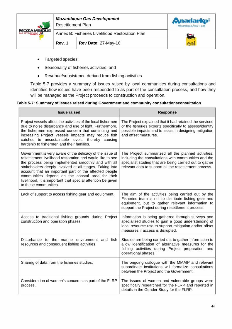
Mozambique Gas Development Resettlement Plan
Annex B: Fisheries Livelihood Restoration Plan
Rev. 1 Rev Date: 27-May-16
• Targeted species;
• Seasonality of fisheries activities; and
• Revenue/subsistence derived from fishing activities.
Table 5-7 provides a summary of issues raised by local communities during consultations and identifies how issues have been responded to as part of the consultation process, and how they will be managed as the Project proceeds to construction and operation.
Table 5-7: Summary of issues raised during Government and community consultationsconsultation
Issue raised Response
Project vessels affect the activities of the local fishermen due to noise disturbance and use of light. Furthermore, the fishermen expressed concern that continuing and increasing Project vessels impacts may reduce fish catches to unsustainable levels, thereby causing hardship to fishermen and their families.
The Project explained that it had retained the services of the fisheries experts specifically to assess/identify possible impacts and to assist in designing mitigation and offset measures.
Government is very aware of the delicacy of the issue of resettlement livelihood restoration and would like to see the process being implemented smoothly and with all stakeholders deeply involved at all stages. Taking into account that an important part of the affected people communities depend on the coastal area for their livelihood, it is important that special attention be given to these communities.
The Project summarized all the planned activities, including the consultations with communities and the specialist studies that are being carried out to gather relevant data to support all the resettlement process.
Lack of support to access fishing gear and equipment. The aim of the activities being carried out by the Fisheries team is not to distribute fishing gear and equipment, but to gather relevant information to support the Project during resettlement process.
Access to traditional fishing grounds during Project construction and operation phases.
Information is being gathered through surveys and specialized studies to gain a good understanding of local resource use to support mitigation and/or offset measures if access is disrupted.
Disturbance to the marine environment and fish resources and consequent fishing activities.
Studies are being carried out to gather information to allow identification of alternative measures for the fishing activities during Project preparation and operational phases.
Sharing of data from the fisheries studies. The ongoing dialogue with the MMAIP and relevant subordinate institutions will formalize consultations between the Project and the Government.
Consideration of women’s concerns as part of the FLRP process.
The issues of women and vulnerable groups were specifically researched for the FLRP and reported in details in the Gender Study for the FLRP.
44

Mozambique Gas Development Resettlement Plan
Annex B: Fisheries Livelihood Restoration Plan
Rev. 1 Rev Date: 27-May-16
Issue raised Response
Need for new and upgraded community production equipment to support sustainability and ensure restoration of levels of subsistence within affected fishers’ communities.
The Project will implement a Community Investment Program that will address strategic community investment, local business opportunities and workforce training. Additionally, during the resettlement process, the compensation framework will address these issues.
Employment/job opportunity for local people. The Project will always give priority to local people for the majority of unskilled work and, at the same time will review skills gap and identify training opportunities for locals.
Strong lack of trust and belief that the outlined mitigation and offset measures will not reach the intended beneficiaries.
The mitigation and compensation process will be as fair and open as possible with the involvement of all interested parties, including Government, Project, communities and Civil Society.
Implementation of the MEZ and SZ will lead to the need to identify new fishing grounds with the consequent requirement of longer travel distances and exposure to winds during the journey.
The Project has engaged a team of fisheries specialists to assist in identifying possible impacts and propose possible mitigations and offset measures. The Project does not intend to prejudice the fishers livelihoods. Any disturbance to fishers’ lives would be fairly and openly compensated. All the mitigation and offset measures will be openly presented and discussed with each interested group of fishers.
5.3.4 Continuing stakeholder consultation Consultation will continue during the construction and operational phases of the Project. This will include regular preparation and distribution of printed materials, placement of informational material in community villages, formal and informal discussions with Government and communities in affected areas, development and implementation of mechanisms for the receipt and handling of stakeholder concerns and comments, and communication of relevant Project milestones via various forms.
6 IMPACT ASSESSMENT Impacts to fisheries livelihoods (either impact to fishers or impacts to fished resources) may arise during the construction and operation phases of the LNG Project. Assessing how the Project will affect fishery-dependent livelihoods is a challenge due to the inherent variability of fishing as a livelihood; the diversity of fishing operations active within the study area; and the current uncertainty about the scale and duration of construction activities arising from the need to maintain Project design flexibility at this stage. This impact assessment, which is specific to fisheries livelihoods, is based on information collected through various studies conducted for the Project and the published Project Environmental Impact Assessment (EIA), and should be revisited once specific information about construction and operation activities becomes available.
45
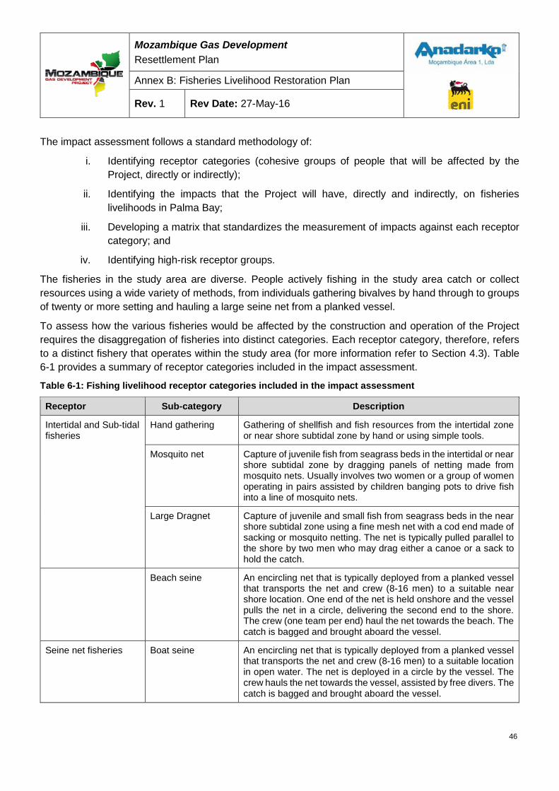
Mozambique Gas Development Resettlement Plan
Annex B: Fisheries Livelihood Restoration Plan
Rev. 1 Rev Date: 27-May-16
The impact assessment follows a standard methodology of:
i. Identifying receptor categories (cohesive groups of people that will be affected by the Project, directly or indirectly);
ii. Identifying the impacts that the Project will have, directly and indirectly, on fisheries livelihoods in Palma Bay;
iii. Developing a matrix that standardizes the measurement of impacts against each receptor category; and
iv. Identifying high-risk receptor groups.
The fisheries in the study area are diverse. People actively fishing in the study area catch or collect resources using a wide variety of methods, from individuals gathering bivalves by hand through to groups of twenty or more setting and hauling a large seine net from a planked vessel.
To assess how the various fisheries would be affected by the construction and operation of the Project requires the disaggregation of fisheries into distinct categories. Each receptor category, therefore, refers to a distinct fishery that operates within the study area (for more information refer to Section 4.3). Table 6-1 provides a summary of receptor categories included in the impact assessment.
Table 6-1: Fishing livelihood receptor categories included in the impact assessment
Receptor Sub-category Description
Intertidal and Sub-tidal fisheries
Hand gathering Gathering of shellfish and fish resources from the intertidal zone or near shore subtidal zone by hand or using simple tools.
Mosquito net Capture of juvenile fish from seagrass beds in the intertidal or near shore subtidal zone by dragging panels of netting made from mosquito nets. Usually involves two women or a group of women operating in pairs assisted by children banging pots to drive fish into a line of mosquito nets.
Large Dragnet Capture of juvenile and small fish from seagrass beds in the near shore subtidal zone using a fine mesh net with a cod end made of sacking or mosquito netting. The net is typically pulled parallel to the shore by two men who may drag either a canoe or a sack to hold the catch.
Beach seine An encircling net that is typically deployed from a planked vessel that transports the net and crew (8-16 men) to a suitable near shore location. One end of the net is held onshore and the vessel pulls the net in a circle, delivering the second end to the shore. The crew (one team per end) haul the net towards the beach. The catch is bagged and brought aboard the vessel.
Seine net fisheries Boat seine An encircling net that is typically deployed from a planked vessel that transports the net and crew (8-16 men) to a suitable location in open water. The net is deployed in a circle by the vessel. The crew hauls the net towards the vessel, assisted by free divers. The catch is bagged and brought aboard the vessel.
46
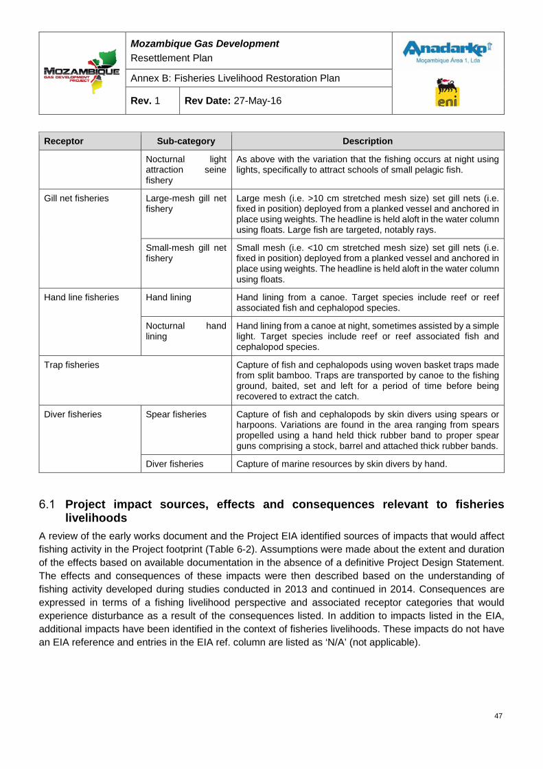
Mozambique Gas Development Resettlement Plan
Annex B: Fisheries Livelihood Restoration Plan
Rev. 1 Rev Date: 27-May-16
Receptor Sub-category Description
Nocturnal light attraction seine fishery
As above with the variation that the fishing occurs at night using lights, specifically to attract schools of small pelagic fish.
Gill net fisheries Large-mesh gill net fishery
Large mesh (i.e. >10 cm stretched mesh size) set gill nets (i.e. fixed in position) deployed from a planked vessel and anchored in place using weights. The headline is held aloft in the water column using floats. Large fish are targeted, notably rays.
Small-mesh gill net fishery
Small mesh (i.e. <10 cm stretched mesh size) set gill nets (i.e. fixed in position) deployed from a planked vessel and anchored in place using weights. The headline is held aloft in the water column using floats.
Hand line fisheries Hand lining Hand lining from a canoe. Target species include reef or reef associated fish and cephalopod species.
Nocturnal hand lining
Hand lining from a canoe at night, sometimes assisted by a simple light. Target species include reef or reef associated fish and cephalopod species.
Trap fisheries Capture of fish and cephalopods using woven basket traps made from split bamboo. Traps are transported by canoe to the fishing ground, baited, set and left for a period of time before being recovered to extract the catch.
Diver fisheries Spear fisheries Capture of fish and cephalopods by skin divers using spears or harpoons. Variations are found in the area ranging from spears propelled using a hand held thick rubber band to proper spear guns comprising a stock, barrel and attached thick rubber bands.
Diver fisheries Capture of marine resources by skin divers by hand.
Project impact sources, effects and consequences relevant to fisheries livelihoods
A review of the early works document and the Project EIA identified sources of impacts that would affect fishing activity in the Project footprint (Table 6-2). Assumptions were made about the extent and duration of the effects based on available documentation in the absence of a definitive Project Design Statement. The effects and consequences of these impacts were then described based on the understanding of fishing activity developed during studies conducted in 2013 and continued in 2014. Consequences are expressed in terms of a fishing livelihood perspective and associated receptor categories that would experience disturbance as a result of the consequences listed. In addition to impacts listed in the EIA, additional impacts have been identified in the context of fisheries livelihoods. These impacts do not have an EIA reference and entries in the EIA ref. column are listed as ‘N/A’ (not applicable).
47
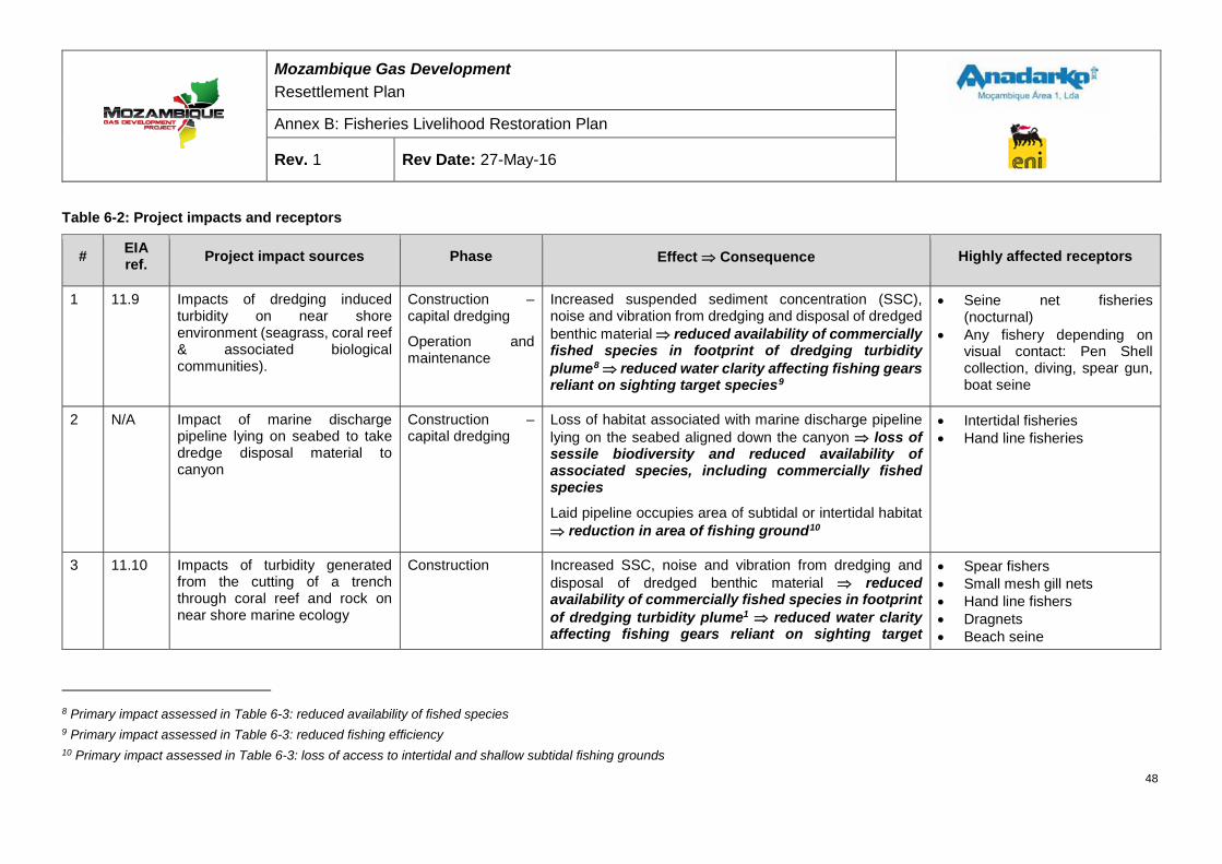
Mozambique Gas Development Resettlement Plan
Annex B: Fisheries Livelihood Restoration Plan
Rev. 1 Rev Date: 27-May-16
Table 6-2: Project impacts and receptors
# EIA ref. Project impact sources Phase Effect ⇒ Consequence Highly affected receptors
1 11.9 Impacts of dredging induced turbidity on near shore environment (seagrass, coral reef & associated biological communities).
Construction – capital dredging
Operation and maintenance
Increased suspended sediment concentration (SSC), noise and vibration from dredging and disposal of dredged benthic material ⇒ reduced availability of commercially fished species in footprint of dredging turbidity plume8 ⇒ reduced water clarity affecting fishing gears reliant on sighting target species9
• Seine net fisheries (nocturnal)
• Any fishery depending on visual contact: Pen Shell collection, diving, spear gun, boat seine
2 N/A Impact of marine discharge pipeline lying on seabed to take dredge disposal material to canyon
Construction – capital dredging
Loss of habitat associated with marine discharge pipeline lying on the seabed aligned down the canyon ⇒ loss of sessile biodiversity and reduced availability of associated species, including commercially fished species
Laid pipeline occupies area of subtidal or intertidal habitat ⇒ reduction in area of fishing ground10
• Intertidal fisheries • Hand line fisheries
3 11.10 Impacts of turbidity generated from the cutting of a trench through coral reef and rock on near shore marine ecology
Construction Increased SSC, noise and vibration from dredging and disposal of dredged benthic material ⇒ reduced availability of commercially fished species in footprint of dredging turbidity plume1 ⇒ reduced water clarity affecting fishing gears reliant on sighting target
• Spear fishers • Small mesh gill nets • Hand line fishers • Dragnets • Beach seine
8 Primary impact assessed in Table 6-3: reduced availability of fished species 9 Primary impact assessed in Table 6-3: reduced fishing efficiency 10 Primary impact assessed in Table 6-3: loss of access to intertidal and shallow subtidal fishing grounds
48
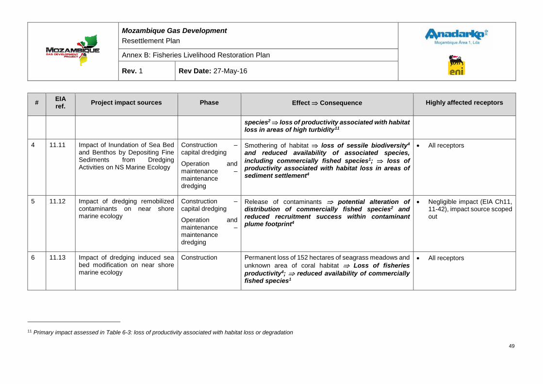
Mozambique Gas Development Resettlement Plan
Annex B: Fisheries Livelihood Restoration Plan
Rev. 1 Rev Date: 27-May-16
# EIA ref. Project impact sources Phase Effect ⇒ Consequence Highly affected receptors
species2 ⇒ loss of productivity associated with habitat loss in areas of high turbidity11
4 11.11 Impact of Inundation of Sea Bed and Benthos by Depositing Fine Sediments from Dredging Activities on NS Marine Ecology
Construction – capital dredging
Operation and maintenance – maintenance dredging
Smothering of habitat ⇒ loss of sessile biodiversity4 and reduced availability of associated species, including commercially fished species1; ⇒ loss of productivity associated with habitat loss in areas of sediment settlement4
• All receptors
5 11.12 Impact of dredging remobilized contaminants on near shore marine ecology
Construction – capital dredging
Operation and maintenance – maintenance dredging
Release of contaminants ⇒ potential alteration of distribution of commercially fished species2 and reduced recruitment success within contaminant plume footprint4
• Negligible impact (EIA Ch11, 11-42), impact source scoped out
6 11.13 Impact of dredging induced sea bed modification on near shore marine ecology
Construction Permanent loss of 152 hectares of seagrass meadows and unknown area of coral habitat ⇒ Loss of fisheries productivity4; ⇒ reduced availability of commercially fished species1
• All receptors
11 Primary impact assessed in Table 6-3: loss of productivity associated with habitat loss or degradation
49
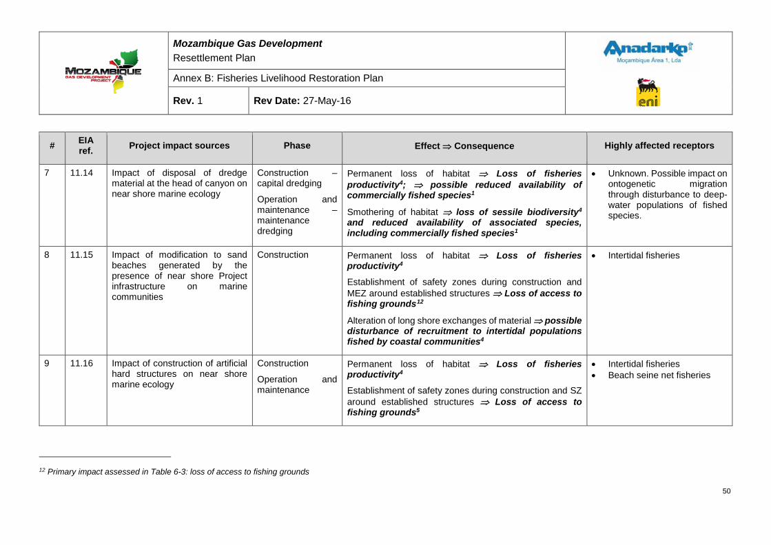
Mozambique Gas Development Resettlement Plan
Annex B: Fisheries Livelihood Restoration Plan
Rev. 1 Rev Date: 27-May-16
# EIA ref. Project impact sources Phase Effect ⇒ Consequence Highly affected receptors
7 11.14 Impact of disposal of dredge material at the head of canyon on near shore marine ecology
Construction – capital dredging
Operation and maintenance – maintenance dredging
Permanent loss of habitat ⇒ Loss of fisheries productivity4; ⇒ possible reduced availability of commercially fished species1
Smothering of habitat ⇒ loss of sessile biodiversity4 and reduced availability of associated species, including commercially fished species1
• Unknown. Possible impact on ontogenetic migration through disturbance to deep-water populations of fished species.
8 11.15 Impact of modification to sand beaches generated by the presence of near shore Project infrastructure on marine communities
Construction Permanent loss of habitat ⇒ Loss of fisheries productivity4
Establishment of safety zones during construction and MEZ around established structures ⇒ Loss of access to fishing grounds12
Alteration of long shore exchanges of material ⇒ possible disturbance of recruitment to intertidal populations fished by coastal communities4
• Intertidal fisheries
9 11.16 Impact of construction of artificial hard structures on near shore marine ecology
Construction
Operation and maintenance
Permanent loss of habitat ⇒ Loss of fisheries productivity4
Establishment of safety zones during construction and SZ around established structures ⇒ Loss of access to fishing grounds5
• Intertidal fisheries • Beach seine net fisheries
12 Primary impact assessed in Table 6-3: loss of access to fishing grounds
50
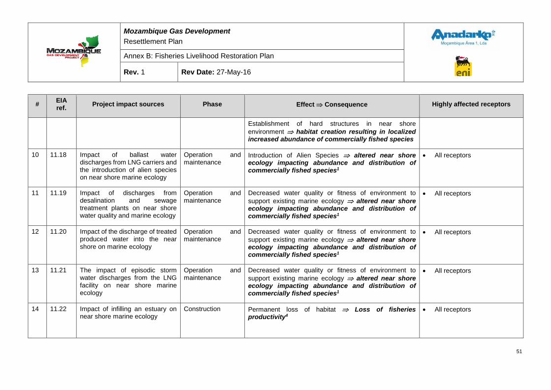
Mozambique Gas Development Resettlement Plan
Annex B: Fisheries Livelihood Restoration Plan
Rev. 1 Rev Date: 27-May-16
# EIA ref. Project impact sources Phase Effect ⇒ Consequence Highly affected receptors
Establishment of hard structures in near shore environment ⇒ habitat creation resulting in localized increased abundance of commercially fished species
10 11.18 Impact of ballast water discharges from LNG carriers and the introduction of alien species on near shore marine ecology
Operation and maintenance
Introduction of Alien Species ⇒ altered near shore ecology impacting abundance and distribution of commercially fished species1
• All receptors
11 11.19 Impact of discharges from desalination and sewage treatment plants on near shore water quality and marine ecology
Operation and maintenance
Decreased water quality or fitness of environment to support existing marine ecology ⇒ altered near shore ecology impacting abundance and distribution of commercially fished species1
• All receptors
12 11.20 Impact of the discharge of treated produced water into the near shore on marine ecology
Operation and maintenance
Decreased water quality or fitness of environment to support existing marine ecology ⇒ altered near shore ecology impacting abundance and distribution of commercially fished species1
• All receptors
13 11.21 The impact of episodic storm water discharges from the LNG facility on near shore marine ecology
Operation and maintenance
Decreased water quality or fitness of environment to support existing marine ecology ⇒ altered near shore ecology impacting abundance and distribution of commercially fished species1
• All receptors
14 11.22 Impact of infilling an estuary on near shore marine ecology
Construction Permanent loss of habitat ⇒ Loss of fisheries productivity4
• All receptors
51
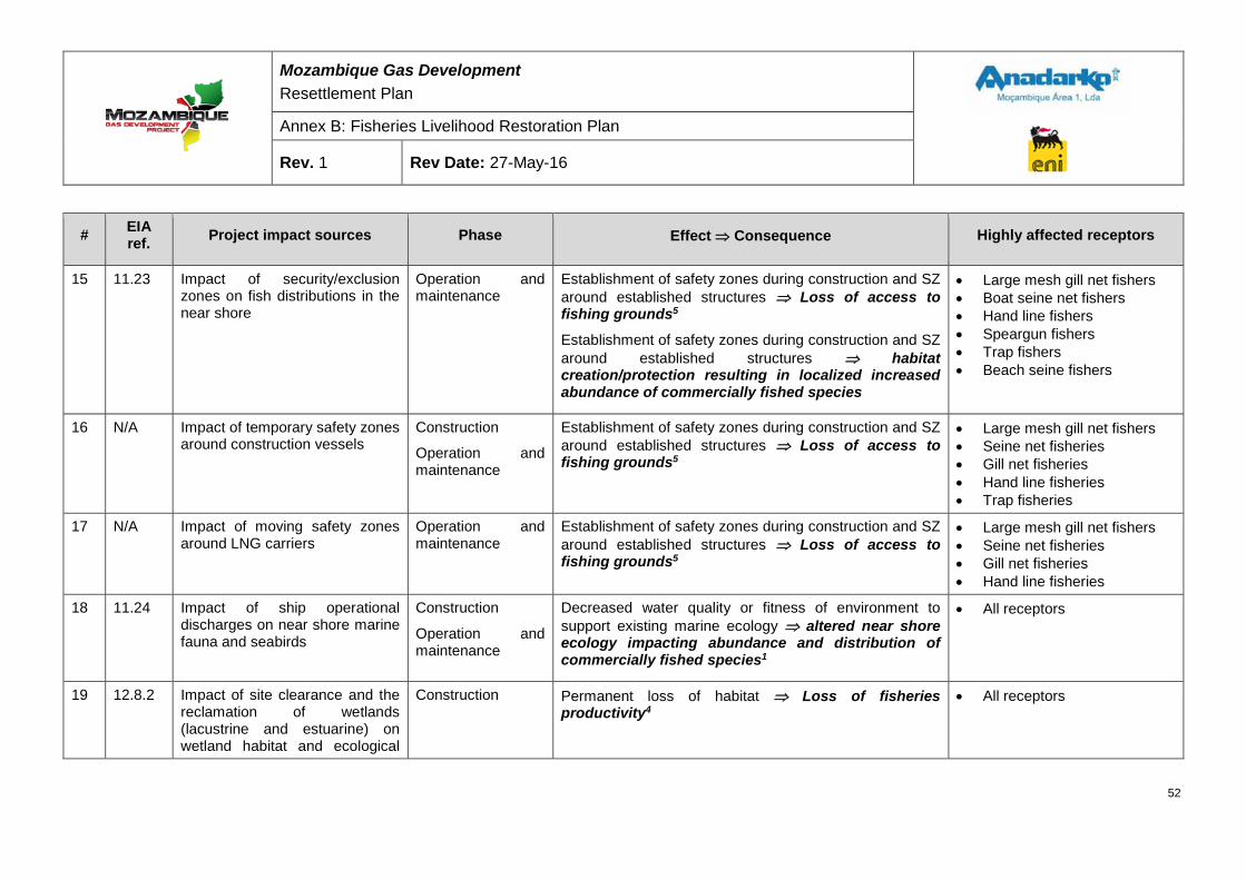
Mozambique Gas Development Resettlement Plan
Annex B: Fisheries Livelihood Restoration Plan
Rev. 1 Rev Date: 27-May-16
# EIA ref. Project impact sources Phase Effect ⇒ Consequence Highly affected receptors
15 11.23 Impact of security/exclusion zones on fish distributions in the near shore
Operation and maintenance
Establishment of safety zones during construction and SZ around established structures ⇒ Loss of access to fishing grounds5
Establishment of safety zones during construction and SZ around established structures ⇒ habitat creation/protection resulting in localized increased abundance of commercially fished species
• Large mesh gill net fishers • Boat seine net fishers • Hand line fishers • Speargun fishers • Trap fishers • Beach seine fishers
16 N/A Impact of temporary safety zones around construction vessels
Construction
Operation and maintenance
Establishment of safety zones during construction and SZ around established structures ⇒ Loss of access to fishing grounds5
• Large mesh gill net fishers • Seine net fisheries • Gill net fisheries • Hand line fisheries • Trap fisheries
17 N/A Impact of moving safety zones around LNG carriers
Operation and maintenance
Establishment of safety zones during construction and SZ around established structures ⇒ Loss of access to fishing grounds5
• Large mesh gill net fishers • Seine net fisheries • Gill net fisheries • Hand line fisheries
18 11.24 Impact of ship operational discharges on near shore marine fauna and seabirds
Construction
Operation and maintenance
Decreased water quality or fitness of environment to support existing marine ecology ⇒ altered near shore ecology impacting abundance and distribution of commercially fished species1
• All receptors
19 12.8.2 Impact of site clearance and the reclamation of wetlands (lacustrine and estuarine) on wetland habitat and ecological
Construction Permanent loss of habitat ⇒ Loss of fisheries productivity4
• All receptors
52
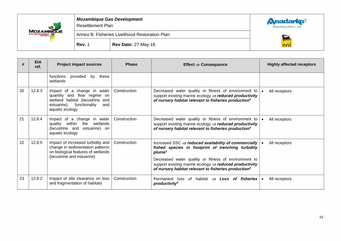
Mozambique Gas Development Resettlement Plan
Annex B: Fisheries Livelihood Restoration Plan
Rev. 1 Rev Date: 27-May-16
# EIA ref. Project impact sources Phase Effect ⇒ Consequence Highly affected receptors
functions provided by these wetlands
20 12.8.3 Impact of a change in water quantity and flow regime on wetland habitat (lacustrine and estuarine), functionality and aquatic ecology
Construction Decreased water quality or fitness of environment to support existing marine ecology ⇒ reduced productivity of nursery habitat relevant to fisheries production4
• All receptors
21 12.8.4 Impact of a change in water quality within the wetlands (lacustrine and estuarine) on aquatic ecology
Construction Decreased water quality or fitness of environment to support existing marine ecology ⇒ reduced productivity of nursery habitat relevant to fisheries production4
• All receptors
22 12.8.5 Impact of increased turbidity and change in sedimentation patterns on biological features of wetlands (lacustrine and estuarine)
Construction Increased SSC ⇒ reduced availability of commercially fished species in footprint of trenching turbidity plume1
Decreased water quality or fitness of environment to support existing marine ecology ⇒ reduced productivity of nursery habitat relevant to fisheries production4
• All receptors
23 12.9.2 Impact of site clearance on loss and fragmentation of habitats
Construction Permanent loss of habitat ⇒ Loss of fisheries productivity4
• All receptors
53
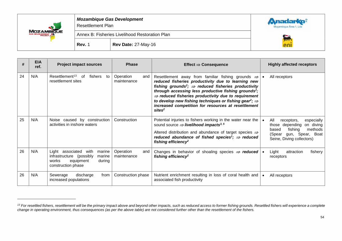
Mozambique Gas Development Resettlement Plan
Annex B: Fisheries Livelihood Restoration Plan
Rev. 1 Rev Date: 27-May-16
# EIA ref. Project impact sources Phase Effect ⇒ Consequence Highly affected receptors
24 N/A Resettlement13 of fishers to resettlement sites
Operation and maintenance
Resettlement away from familiar fishing grounds ⇒ reduced fisheries productivity due to learning new fishing grounds2; ⇒ reduced fisheries productivity through accessing less productive fishing grounds2; ⇒ reduced fisheries productivity due to requirement to develop new fishing techniques or fishing gear2; ⇒ increased competition for resources at resettlement sites2
• All receptors
25 N/A Noise caused by construction activities in inshore waters
Construction Potential injuries to fishers working in the water near the sound source ⇒ livelihood impacts3, 5
Altered distribution and abundance of target species ⇒ reduced abundance of fished species1; ⇒ reduced fishing efficiency2
• All receptors, especially those depending on diving based fishing methods (Spear gun, Spear, Boat Seine, Diving collectors)
26 N/A Light associated with marine infrastructure (possibly marine works equipment during construction phase
Operation and maintenance
Changes in behavior of shoaling species ⇒ reduced fishing efficiency2
• Light attraction fishery receptors
26 N/A Sewerage discharge from increased populations
Construction phase Nutrient enrichment resulting in loss of coral health and associated fish productivity
• All receptors
13 For resettled fishers, resettlement will be the primary impact above and beyond other impacts, such as reduced access to former fishing grounds. Resettled fishers will experience a complete change in operating environment, thus consequences (as per the above table) are not considered further other than the resettlement of the fishers.
54

Mozambique Gas Development Resettlement Plan
Annex B: Fisheries Livelihood Restoration Plan
Rev. 1 Rev Date: 27-May-16
# EIA ref. Project impact sources Phase Effect ⇒ Consequence Highly affected receptors
27 N/A Increased possibilities of non-fishing employment for less skilled labor force
Construction phase Demand for unskilled labor during Project construction phase ⇒ reduced numbers of persons seeking employment in fishing, and a shortage of labor, leading to reduced levels of operation & production and/or higher operating costs & consumer prices.
• Fishing units employing larger crews (boat & beach seines)
55
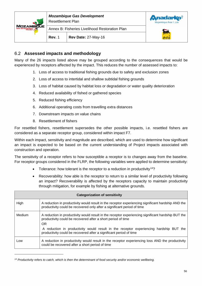
Mozambique Gas Development Resettlement Plan
Annex B: Fisheries Livelihood Restoration Plan
Rev. 1 Rev Date: 27-May-16
Assessed impacts and methodology Many of the 26 impacts listed above may be grouped according to the consequences that would be experienced by receptors affected by the impact. This reduces the number of assessed impacts to:
1. Loss of access to traditional fishing grounds due to safety and exclusion zones
2. Loss of access to intertidal and shallow subtidal fishing grounds
3. Loss of habitat caused by habitat loss or degradation or water quality deterioration
4. Reduced availability of fished or gathered species
5. Reduced fishing efficiency
6. Additional operating costs from travelling extra distances
7. Downstream impacts on value chains
8. Resettlement of fishers
For resettled fishers, resettlement supersedes the other possible impacts, i.e. resettled fishers are considered as a separate receptor group, considered within impact F7.
Within each impact, sensitivity and magnitude are described, which are used to determine how significant an impact is expected to be based on the current understanding of Project impacts associated with construction and operation.
The sensitivity of a receptor refers to how susceptible a receptor is to changes away from the baseline. For receptor groups considered in the FLRP, the following variables were applied to determine sensitivity:
• Tolerance: how tolerant is the receptor to a reduction in productivity14?
• Recoverability: how able is the receptor to return to a similar level of productivity following an impact? Recoverability is affected by the receptors capacity to maintain productivity through mitigation, for example by fishing at alternative grounds.
Categorization of sensitivity
High A reduction in productivity would result in the receptor experiencing significant hardship AND the productivity could be recovered only after a significant period of time
Medium A reduction in productivity would result in the receptor experiencing significant hardship BUT the productivity could be recovered after a short period of time OR A reduction in productivity would result in the receptor experiencing hardship BUT the productivity could be recovered after a significant period of time
Low A reduction in productivity would result in the receptor experiencing loss AND the productivity could be recovered after a short period of time
14 Productivity refers to catch, which is then the determinant of food security and/or economic wellbeing.
56
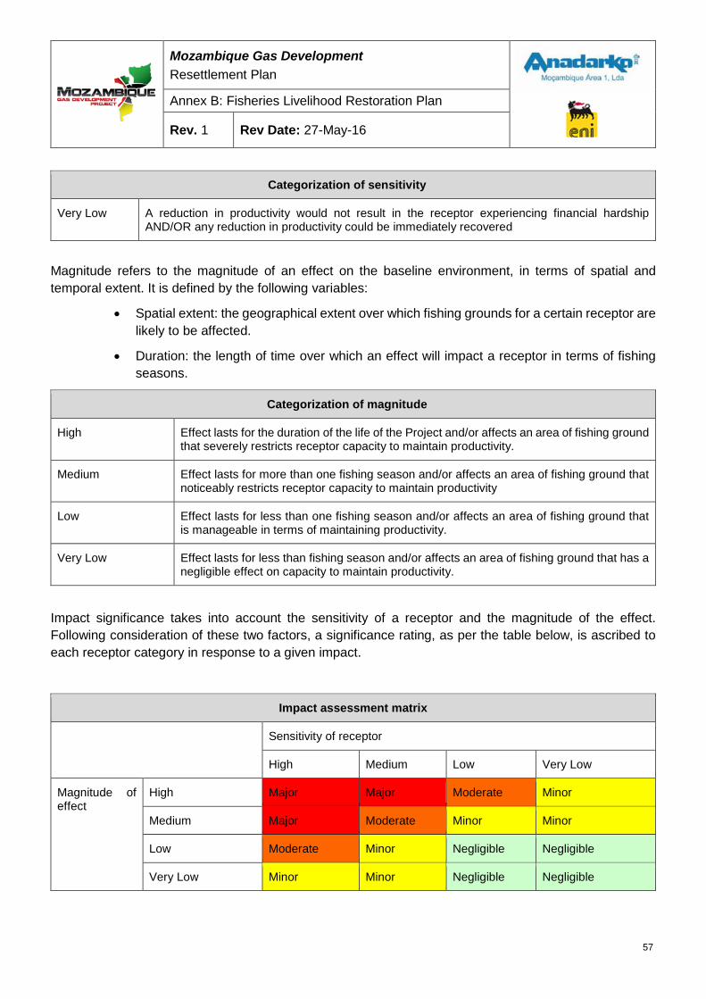
Mozambique Gas Development Resettlement Plan
Annex B: Fisheries Livelihood Restoration Plan
Rev. 1 Rev Date: 27-May-16
Categorization of sensitivity
Very Low A reduction in productivity would not result in the receptor experiencing financial hardship AND/OR any reduction in productivity could be immediately recovered
Magnitude refers to the magnitude of an effect on the baseline environment, in terms of spatial and temporal extent. It is defined by the following variables:
• Spatial extent: the geographical extent over which fishing grounds for a certain receptor are likely to be affected.
• Duration: the length of time over which an effect will impact a receptor in terms of fishing seasons.
Categorization of magnitude
High Effect lasts for the duration of the life of the Project and/or affects an area of fishing ground that severely restricts receptor capacity to maintain productivity.
Medium Effect lasts for more than one fishing season and/or affects an area of fishing ground that noticeably restricts receptor capacity to maintain productivity
Low Effect lasts for less than one fishing season and/or affects an area of fishing ground that is manageable in terms of maintaining productivity.
Very Low Effect lasts for less than fishing season and/or affects an area of fishing ground that has a negligible effect on capacity to maintain productivity.
Impact significance takes into account the sensitivity of a receptor and the magnitude of the effect. Following consideration of these two factors, a significance rating, as per the table below, is ascribed to each receptor category in response to a given impact.
Impact assessment matrix
Sensitivity of receptor
High Medium Low Very Low
Magnitude of effect
High Major Major Moderate Minor
Medium Major Moderate Minor Minor
Low Moderate Minor Negligible Negligible
Very Low Minor Minor Negligible Negligible
57
Mozambique Gas Development Resettlement Plan
Annex B: Fisheries Livelihood Restoration Plan
Rev. 1 Rev Date: 27-May-16
Critical impacts and potential mitigation measures The buffers around the marine infrastructure that have been considered in the impact assessment are indicated in:
• Figure 6-1: Extent of 500 m construction MEZ around marine infrastructure during the construction phase;
• Figure 6-3: Extent of assumed 1,000 m temporary area of disturbance associated with construction and extent of shipping and disturbance; and
• Figure 6-4: Extent of operational SZ 1,500 m.
The 500 m MEZ (Figure 6-1) during construction is a commonly applied buffer around construction activities to minimize risk to life for construction workers and other marine users. The buffer is assumed to be in place for the duration of construction and for the period after construction before the operational SZ of 1,500 m is applied. Although in reality the construction buffer would only be enforced around actual construction activities and installed or partially installed infrastructure, as there is no certainty at this time about construction scheduling and duration, it is assumed to be in place in its entirety for the duration of construction.
Figure 6-2 shows the assumed extent of the zone within which mobile fish species of importance to local fishers would be affected by construction activity generated noise and/or construction activity generated turbidity. The actual extent of disturbance would be influenced by the size of piles installed; the type and size of dredger; the type and size of trenching machinery; and the mitigation measures put in place to minimize the effects of the machinery and construction activities. Within the temporary zone of disturbance, it is assumed that fishing efficiency will be reduced and that fishers livelihoods would be affected for the duration of disturbance and for the duration of the recovery period thereafter, as fishing gear is made less effective and/or resulting from changes in the distribution and abundance of fished species.
From EA-MZ-SR0000-ERM-U17-00006-00 marine modeling study it is noted that plumes from dredging and construction activity may be wide spread in the construction phase and localized in operational period, both will have impacts on fish distribution and abundance.
Figure 6-3 also shows the extent of the area that will be subject to longer-term disturbance due to the project related marine traffic.
In terms of spatial extent, the most significant impact will result from the establishment of the proposed SZ, which extends 1,500 m from operational infrastructure (Figure 6-4).
58
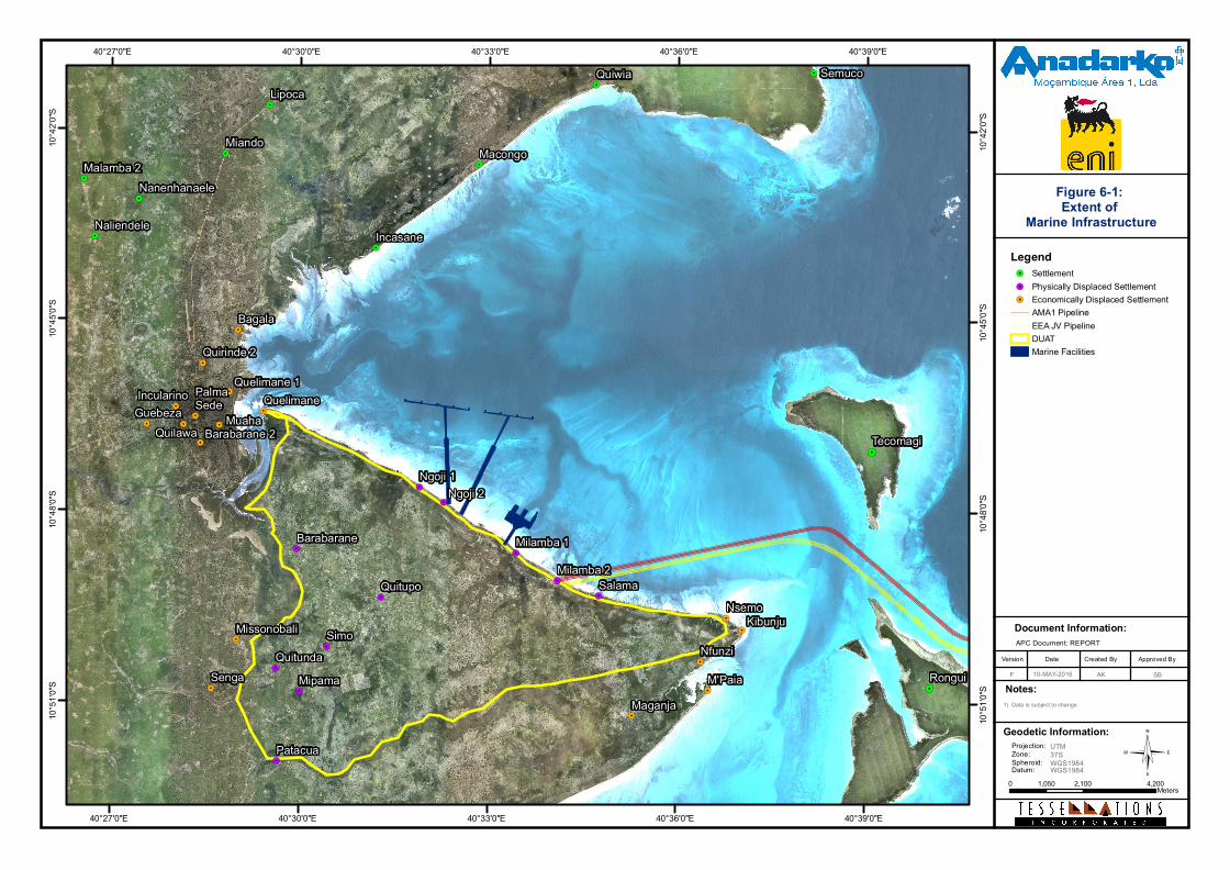
©
Document Information:
Date Created ByVersion Approved By
F
Notes:
APC Document: REPORT
!.
!.
!.
!.
!.
!.
!.
!.
!.
!. !.
!.
!.
!.
!.
!.
!.
!.
!.
!.
!.
!.
!.
!.
!.
!.
!.
!.
!.
!.
!.
!.
!.
!.
!.
!.
!.
!.
!.
!.
!.
Senga
Maganja
QuelimanePalmaSede
MissonobaliNsemo
Nfunzi
Guebeza Muaha
Quelimane 1
Barabarane 2
Incularino
Quilawa
Bagala
Quirinde 2
M'Paia
Kibunju
Quiwia
Nanenhanaele
Lipoca
Malamba 2Miando
Naliendele
Semuco
Macongo
Incasane
Patacua
Quitupo
Barabarane
QuitundaMipama
Ngoji 1Ngoji 2
Milamba 2Milamba 1
Simo
Salama
Rongui
Tecomagi
40°39'0"E
40°39'0"E
40°36'0"E
40°36'0"E
40°33'0"E
40°33'0"E
40°30'0"E
40°30'0"E
40°27'0"E
40°27'0"E10
°42'0"
S
10°42
'0"S
10°45
'0"S
10°45
'0"S
10°48
'0"S
10°48
'0"S
10°51
'0"S
10°51
'0"S
1) Data is subject to change.
Legend!. Settlement!. Physically Displaced Settlement!. Economically Displaced Settlement
AMA1 PipelineEEA JV PipelineDUATMarine Facilities
0 2,100 4,2001,050 Meters
AK10-MAY-2016
Figure 6-1: Extent of
Marine Infrastructure
Geodetic Information:Projection:Zone:Spheroid:Datum:
UTM37SWGS1984WGS1984
SB
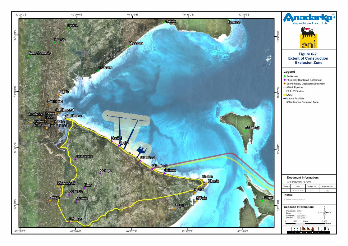
©
Document Information:
Date Created ByVersion Approved By
F
Notes:
APC Document: REPORT
!.
!.
!.!.
!.
!.
!.
!. !.
!.
!.
!.
!.
!.
!.
!.
!.
!.
!.
!.
!.
!.
!.
!.
!.
!.
!.
!.
!.
!.
!.
!.
!.
!.
!.
!.
!.
Senga
Maganja
QuelimanePalmaSede
MissonobaliNsemo
Nfunzi
Guebeza Muaha
Quelimane 1
Barabarane 2
Incularino
Quilawa
Bagala
Quirinde 2
M'Paia
Kibunju
Quiwia
Nanenhanaele
Lipoca
Miando
Semuco
Macongo
Incasane
Patacua
Quitupo
Barabarane
QuitundaMipama
Ngoji 1Ngoji 2
Milamba 2
Milamba 1
Simo
Salama
Rongui
Tecomagi
40°39'0"E
40°39'0"E
40°36'0"E
40°36'0"E
40°33'0"E
40°33'0"E
40°30'0"E
40°30'0"E
40°27'0"E
40°27'0"E10
°42'0"
S
10°42
'0"S
10°45
'0"S
10°45
'0"S
10°48
'0"S
10°48
'0"S
10°51
'0"S
10°51
'0"S 1) Data is subject to change.
Legend!. Settlement!. Physically Displaced Settlement!. Economically Displaced Settlement
AMA1 PipelineEEA JV PipelineDUATMarine Facilities500m Marine Exclusion Zone
0 1,900 3,800950Meters
AK10-MAY-2016
Figure 6-2: Extent of Construction
Exclusion Zone
Geodetic Information:Projection:Zone:Spheroid:Datum:
UTM37SWGS1984WGS1984
SB
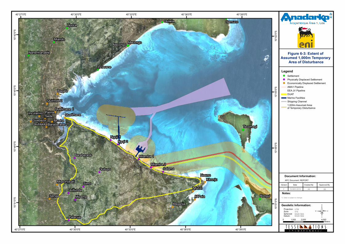
©
Document Information:
Date Created ByVersion Approved By
F
Notes:
APC Document: REPORT
!.
!.
!.!.
!.
!.
!.
!. !.
!.
!.
!.
!.
!.
!.
!.
!.
!.
!.
!.
!.
!.
!.
!.
!.
!.
!.
!.
!.
!.
!.
!.
!.
!.
!.
!.
!.
!.
Senga
Maganja
QuelimanePalmaSede
MissonobaliNsemo
Nfunzi
Guebeza Muaha
Quelimane 1
Barabarane 2
Incularino
Quilawa
Bagala
Quirinde 2
M'Paia
Kibunju
Quiwia
Nanenhanaele
Lipoca
Miando
Semuco
Macongo
Incasane
Patacua
Quitupo
Barabarane
QuitundaMipama
Ngoji 1Ngoji 2
Milamba 2
Milamba 1
Simo
Salama
Macongo
Rongui
Tecomagi
40°39'0"E
40°39'0"E
40°36'0"E
40°36'0"E
40°33'0"E
40°33'0"E
40°30'0"E
40°30'0"E
40°27'0"E
40°27'0"E10
°42'0"
S
10°42
'0"S
10°45
'0"S
10°45
'0"S
10°48
'0"S
10°48
'0"S
10°51
'0"S
10°51
'0"S 1) Data is subject to change.
Legend!. Settlement!. Physically Displaced Settlement!. Economically Displaced Settlement
AMA1 PipelineEEA JV PipelineDUATMarine FacilitiesShipping Channel1,000m Assumed Area of Temporary Disturbance
0 2,000 4,0001,000Meters
AK10-MAY-2016
Figure 6-3: Extent of Assumed 1,000m Temporary
Area of Disturbance
Geodetic Information:Projection:Zone:Spheroid:Datum:
UTM37SWGS1984WGS1984
SB
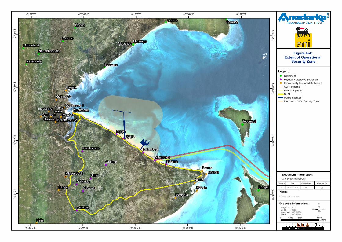
©
Document Information:
Date Created ByVersion Approved By
F
Notes:
APC Document: REPORT
!.
!.
!.
!.
!.
!.
!.
!.
!.
!. !.
!.
!.
!.
!.
!.
!.
!.
!.
!.
!.
!.
!.
!.
!.
!.
!.
!.
!.
!.
!.
!.
!.
!.
!.
!.
!.
!.
!.
!.
!.
!.
SengaMaganja
QuelimanePalmaSede
Missonobali
Nsije
Nsemo
Nfunzi
Guebeza Muaha
Quelimane 1
Barabarane 2
Incularino
Quilawa
Bagala
Quirinde 2
M'Paia
Kibunju
Quiwia
Nanenhanaele
Lipoca
Malamba 2Miando
Naliendele
Semuco
Macongo
Incasane
Patacua
Quitupo
Barabarane
QuitundaMipama
Ngoji 1Ngoji 2
Milamba 2
Milamba 1
Simo
Salama
Macongo
Rongui
Tecomagi
40°39'0"E
40°39'0"E
40°36'0"E
40°36'0"E
40°33'0"E
40°33'0"E
40°30'0"E
40°30'0"E
40°27'0"E
40°27'0"E10
°42'0"
S
10°42
'0"S
10°45
'0"S
10°45
'0"S
10°48
'0"S
10°48
'0"S
10°51
'0"S
10°51
'0"S
1) Data is subject to change.
Legend!. Settlement!. Physically Displaced Settlement!. Economically Displaced Settlement
AMA1 PipelineEEA JV PipelineDUATMarine FacilitiesProposed 1,500m Security Zone
0 2,000 4,0001,000 Meters
AK10-MAY-2016
Figure 6-4: Extent of Operational
Security Zone
Geodetic Information:Projection:Zone:Spheroid:Datum:
UTM37SWGS1984WGS1984
SB
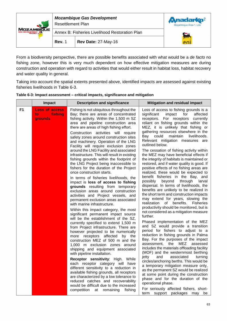
Mozambique Gas Development Resettlement Plan
Annex B: Fisheries Livelihood Restoration Plan
Rev. 1 Rev Date: 27-May-16
From a biodiversity perspective, there are possible benefits associated with what would be a de facto no fishing zone, however this is very much dependent on how effective mitigation measures are during construction and operation with regard to activities that would either result in habitat loss, habitat recovery and water quality in general.
Taking into account the spatial extents presented above, identified impacts are assessed against existing fisheries livelihoods in Table 6-3.
Table 6-3: Impact assessment – critical impacts, significance and mitigation
Impact Description and significance Mitigation and residual impact
F1 Loss of access to fishing grounds
Fishing is not ubiquitous throughout the Bay; there are areas of concentrated fishing activity. Within the 1,500 m SZ area and pipeline construction area there are areas of high fishing effort. Construction activities will require safety zones around construction sites and machinery. Operation of the LNG Facility will require exclusion zones around the LNG Facility and associated infrastructure. This will result in existing fishing grounds within the footprint of the LNG Project being inaccessible to fishers for the duration of the Project once construction starts. In terms of fisheries livelihoods, the impact is loss of access to fishing grounds resulting from temporary exclusion areas around construction activities and Project vessels, and permanent exclusion areas associated with marine infrastructure. Within this impact category, the most significant permanent impact source will be the establishment of the SZ, currently specified to extend 1,500 m from Project infrastructure. There are however projected to be numerically more receptors affected by the construction MEZ of 500 m and the 1,000 m exclusion zones around shipping and equipment associated with pipeline installation. Receptor sensitivity: High. While each receptor category will have different sensitivity to a reduction in available fishing grounds, all receptors are characterized by a low tolerance to reduced catches and recoverability would be difficult due to the increased competition at remaining fishing
Loss of access to fishing grounds is a significant impact for affected receptors. For receptors currently reliant on fishing grounds within the MEZ, it is unlikely that fishing or gathering resources elsewhere in the Bay could maintain livelihoods. Relevant mitigation measures are outlined below. The cessation of fishing activity within the MEZ may have beneficial effects if the integrity of habitats is maintained or restored, and if water quality is good. If positive effects of no fishing areas are realized, these would be expected to benefit fisheries in the Bay, and possibly beyond through larval dispersal. In terms of livelihoods, the benefits are unlikely to be realized in the short term and construction impacts may extend for years, slowing the realization of benefits. Fisheries productivity should be monitored, but is not considered as a mitigation measure further. Phased implementation of the MEZ and SZ would provide a transition period for fishers to adjust to a reduction in fishing grounds in Palma Bay. For the purposes of the impact assessment, the MEZ assessed includes the materials offloading facility (MOF) and the westernmost berthing jetty and associated turning circles/anchoring berths. This would be a temporary mitigation measure only, as the permanent SZ would be realized at some point during the construction phase and for the duration of the operational phase. For seriously affected fishers, short-term support packages may be
63
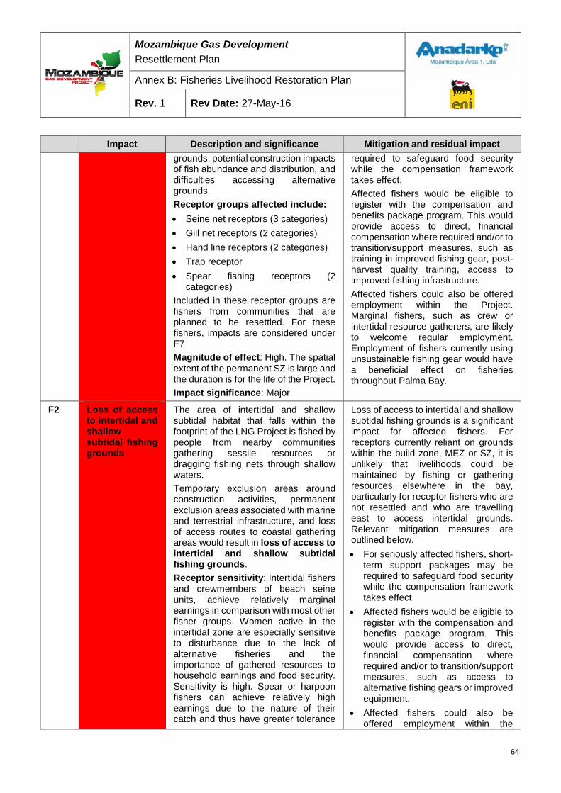
Mozambique Gas Development Resettlement Plan
Annex B: Fisheries Livelihood Restoration Plan
Rev. 1 Rev Date: 27-May-16
Impact Description and significance Mitigation and residual impact grounds, potential construction impacts of fish abundance and distribution, and difficulties accessing alternative grounds. Receptor groups affected include: • Seine net receptors (3 categories)• Gill net receptors (2 categories)• Hand line receptors (2 categories)• Trap receptor• Spear fishing receptors (2
categories)Included in these receptor groups are fishers from communities that are planned to be resettled. For these fishers, impacts are considered under F7 Magnitude of effect: High. The spatial extent of the permanent SZ is large and the duration is for the life of the Project. Impact significance: Major
required to safeguard food security while the compensation framework takes effect. Affected fishers would be eligible to register with the compensation and benefits package program. This would provide access to direct, financial compensation where required and/or to transition/support measures, such as training in improved fishing gear, post-harvest quality training, access to improved fishing infrastructure. Affected fishers could also be offered employment within the Project. Marginal fishers, such as crew or intertidal resource gatherers, are likely to welcome regular employment. Employment of fishers currently using unsustainable fishing gear would have a beneficial effect on fisheries throughout Palma Bay.
F2 Loss of access to intertidal and shallow subtidal fishing grounds
The area of intertidal and shallow subtidal habitat that falls within the footprint of the LNG Project is fished by people from nearby communities gathering sessile resources or dragging fishing nets through shallow waters. Temporary exclusion areas around construction activities, permanent exclusion areas associated with marine and terrestrial infrastructure, and loss of access routes to coastal gathering areas would result in loss of access to intertidal and shallow subtidal fishing grounds. Receptor sensitivity: Intertidal fishers and crewmembers of beach seine units, achieve relatively marginal earnings in comparison with most other fisher groups. Women active in the intertidal zone are especially sensitive to disturbance due to the lack of alternative fisheries and the importance of gathered resources to household earnings and food security. Sensitivity is high. Spear or harpoon fishers can achieve relatively high earnings due to the nature of their catch and thus have greater tolerance
Loss of access to intertidal and shallow subtidal fishing grounds is a significant impact for affected fishers. For receptors currently reliant on grounds within the build zone, MEZ or SZ, it is unlikely that livelihoods could be maintained by fishing or gathering resources elsewhere in the bay, particularly for receptor fishers who are not resettled and who are travelling east to access intertidal grounds. Relevant mitigation measures are outlined below. • For seriously affected fishers, short-
term support packages may berequired to safeguard food securitywhile the compensation frameworktakes effect.
• Affected fishers would be eligible toregister with the compensation andbenefits package program. Thiswould provide access to direct,financial compensation whererequired and/or to transition/supportmeasures, such as access toalternative fishing gears or improvedequipment.
• Affected fishers could also beoffered employment within the
64
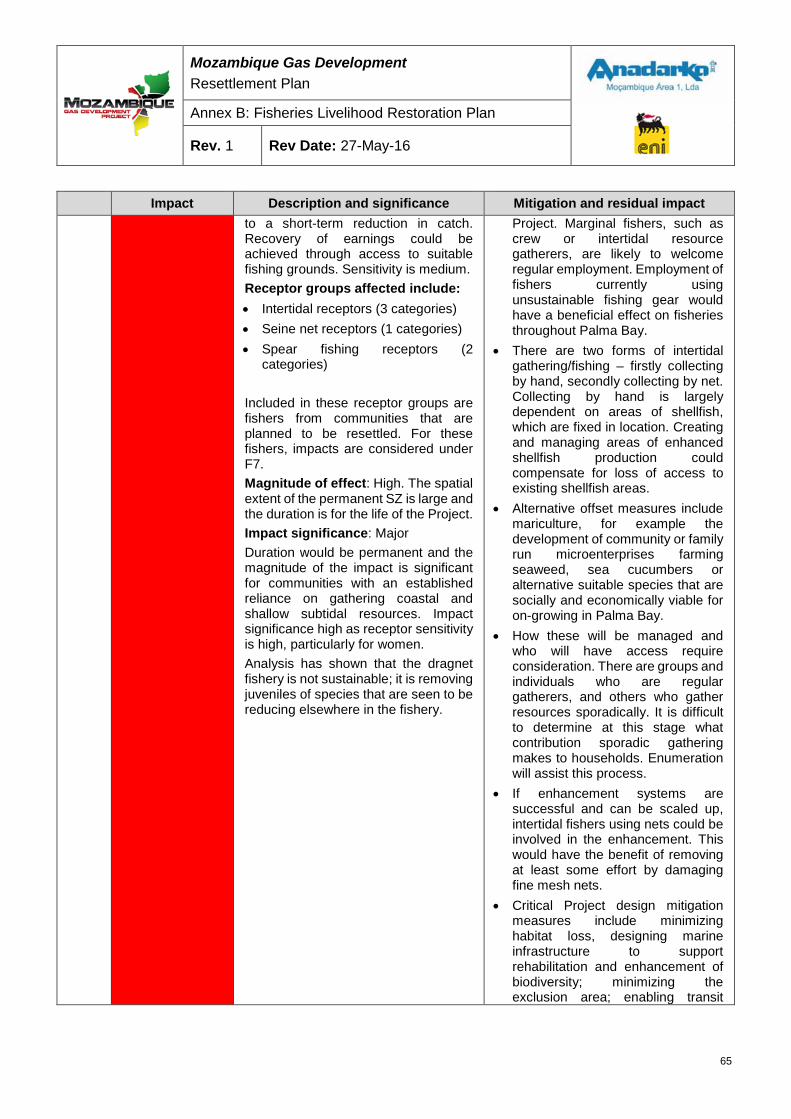
Mozambique Gas Development Resettlement Plan
Annex B: Fisheries Livelihood Restoration Plan
Rev. 1 Rev Date: 27-May-16
Impact Description and significance Mitigation and residual impact to a short-term reduction in catch. Recovery of earnings could be achieved through access to suitable fishing grounds. Sensitivity is medium. Receptor groups affected include: • Intertidal receptors (3 categories) • Seine net receptors (1 categories) • Spear fishing receptors (2
categories) Included in these receptor groups are fishers from communities that are planned to be resettled. For these fishers, impacts are considered under F7. Magnitude of effect: High. The spatial extent of the permanent SZ is large and the duration is for the life of the Project. Impact significance: Major Duration would be permanent and the magnitude of the impact is significant for communities with an established reliance on gathering coastal and shallow subtidal resources. Impact significance high as receptor sensitivity is high, particularly for women. Analysis has shown that the dragnet fishery is not sustainable; it is removing juveniles of species that are seen to be reducing elsewhere in the fishery.
Project. Marginal fishers, such as crew or intertidal resource gatherers, are likely to welcome regular employment. Employment of fishers currently using unsustainable fishing gear would have a beneficial effect on fisheries throughout Palma Bay.
• There are two forms of intertidal gathering/fishing – firstly collecting by hand, secondly collecting by net. Collecting by hand is largely dependent on areas of shellfish, which are fixed in location. Creating and managing areas of enhanced shellfish production could compensate for loss of access to existing shellfish areas.
• Alternative offset measures include mariculture, for example the development of community or family run microenterprises farming seaweed, sea cucumbers or alternative suitable species that are socially and economically viable for on-growing in Palma Bay.
• How these will be managed and who will have access require consideration. There are groups and individuals who are regular gatherers, and others who gather resources sporadically. It is difficult to determine at this stage what contribution sporadic gathering makes to households. Enumeration will assist this process.
• If enhancement systems are successful and can be scaled up, intertidal fishers using nets could be involved in the enhancement. This would have the benefit of removing at least some effort by damaging fine mesh nets.
• Critical Project design mitigation measures include minimizing habitat loss, designing marine infrastructure to support rehabilitation and enhancement of biodiversity; minimizing the exclusion area; enabling transit
65
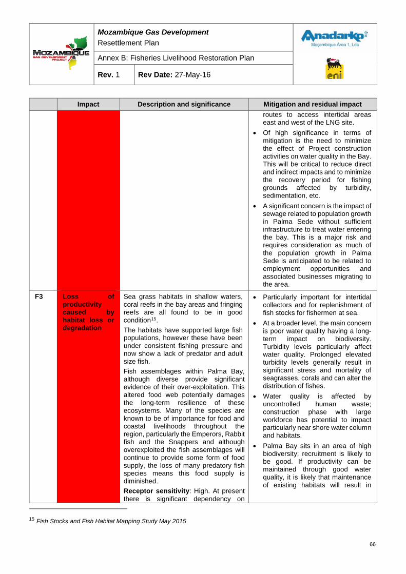
Mozambique Gas Development Resettlement Plan
Annex B: Fisheries Livelihood Restoration Plan
Rev. 1 Rev Date: 27-May-16
Impact Description and significance Mitigation and residual impact routes to access intertidal areas east and west of the LNG site.
• Of high significance in terms ofmitigation is the need to minimizethe effect of Project constructionactivities on water quality in the Bay.This will be critical to reduce directand indirect impacts and to minimizethe recovery period for fishinggrounds affected by turbidity,sedimentation, etc.
• A significant concern is the impact ofsewage related to population growthin Palma Sede without sufficientinfrastructure to treat water enteringthe bay. This is a major risk andrequires consideration as much ofthe population growth in PalmaSede is anticipated to be related toemployment opportunities andassociated businesses migrating tothe area.
F3 Loss of productivity caused by habitat loss or degradation
Sea grass habitats in shallow waters, coral reefs in the bay areas and fringing reefs are all found to be in good condition15. The habitats have supported large fish populations, however these have been under consistent fishing pressure and now show a lack of predator and adult size fish. Fish assemblages within Palma Bay, although diverse provide significant evidence of their over-exploitation. This altered food web potentially damages the long-term resilience of these ecosystems. Many of the species are known to be of importance for food and coastal livelihoods throughout the region, particularly the Emperors, Rabbit fish and the Snappers and although overexploited the fish assemblages will continue to provide some form of food supply, the loss of many predatory fish species means this food supply is diminished. Receptor sensitivity: High. At present there is significant dependency on
• Particularly important for intertidalcollectors and for replenishment offish stocks for fishermen at sea.
• At a broader level, the main concernis poor water quality having a long-term impact on biodiversity.Turbidity levels particularly affectwater quality. Prolonged elevatedturbidity levels generally result insignificant stress and mortality ofseagrasses, corals and can alter thedistribution of fishes.
• Water quality is affected byuncontrolled human waste;construction phase with largeworkforce has potential to impactparticularly near shore water columnand habitats.
• Palma Bay sits in an area of highbiodiversity; recruitment is likely tobe good. If productivity can bemaintained through good waterquality, it is likely that maintenanceof existing habitats will result in
15 Fish Stocks and Fish Habitat Mapping Study May 2015
66
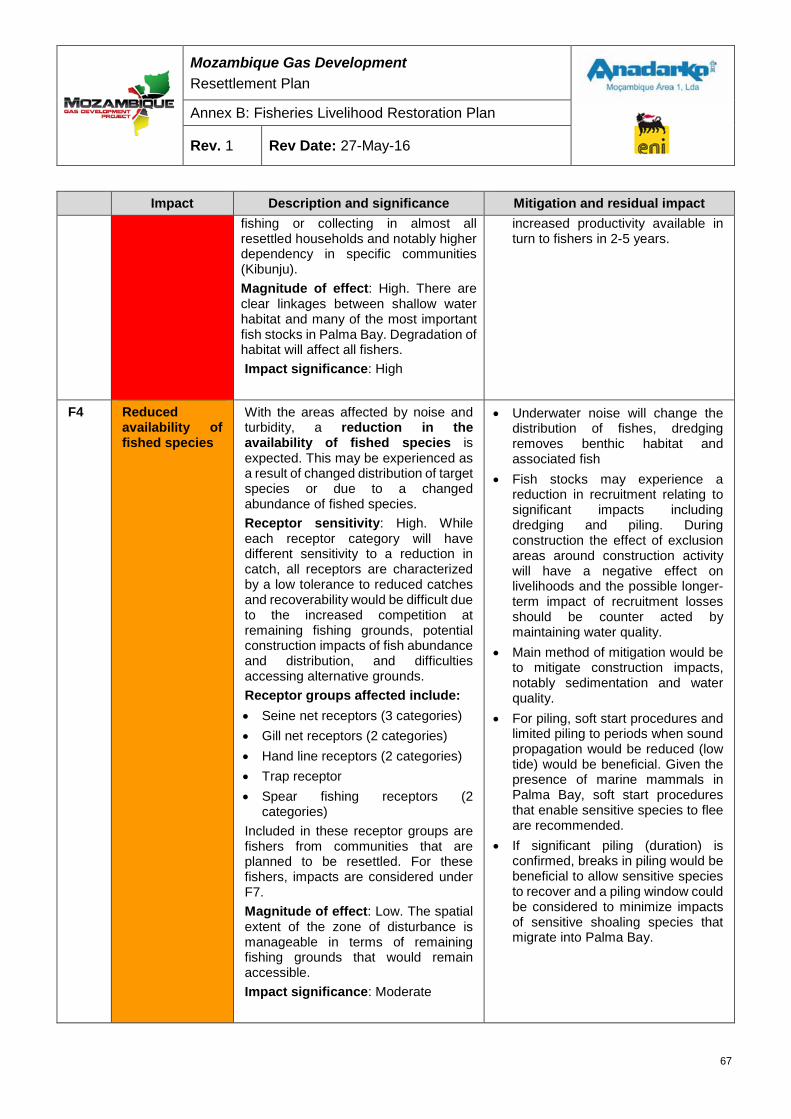
Mozambique Gas Development Resettlement Plan
Annex B: Fisheries Livelihood Restoration Plan
Rev. 1 Rev Date: 27-May-16
Impact Description and significance Mitigation and residual impact fishing or collecting in almost all resettled households and notably higher dependency in specific communities (Kibunju). Magnitude of effect: High. There are clear linkages between shallow water habitat and many of the most important fish stocks in Palma Bay. Degradation of habitat will affect all fishers. Impact significance: High
increased productivity available in turn to fishers in 2-5 years.
F4 Reduced availability of fished species
With the areas affected by noise and turbidity, a reduction in the availability of fished species is expected. This may be experienced as a result of changed distribution of target species or due to a changed abundance of fished species. Receptor sensitivity: High. While each receptor category will have different sensitivity to a reduction in catch, all receptors are characterized by a low tolerance to reduced catches and recoverability would be difficult due to the increased competition at remaining fishing grounds, potential construction impacts of fish abundance and distribution, and difficulties accessing alternative grounds. Receptor groups affected include: • Seine net receptors (3 categories) • Gill net receptors (2 categories) • Hand line receptors (2 categories) • Trap receptor • Spear fishing receptors (2
categories) Included in these receptor groups are fishers from communities that are planned to be resettled. For these fishers, impacts are considered under F7. Magnitude of effect: Low. The spatial extent of the zone of disturbance is manageable in terms of remaining fishing grounds that would remain accessible. Impact significance: Moderate
• Underwater noise will change the distribution of fishes, dredging removes benthic habitat and associated fish
• Fish stocks may experience a reduction in recruitment relating to significant impacts including dredging and piling. During construction the effect of exclusion areas around construction activity will have a negative effect on livelihoods and the possible longer-term impact of recruitment losses should be counter acted by maintaining water quality.
• Main method of mitigation would be to mitigate construction impacts, notably sedimentation and water quality.
• For piling, soft start procedures and limited piling to periods when sound propagation would be reduced (low tide) would be beneficial. Given the presence of marine mammals in Palma Bay, soft start procedures that enable sensitive species to flee are recommended.
• If significant piling (duration) is confirmed, breaks in piling would be beneficial to allow sensitive species to recover and a piling window could be considered to minimize impacts of sensitive shoaling species that migrate into Palma Bay.
67
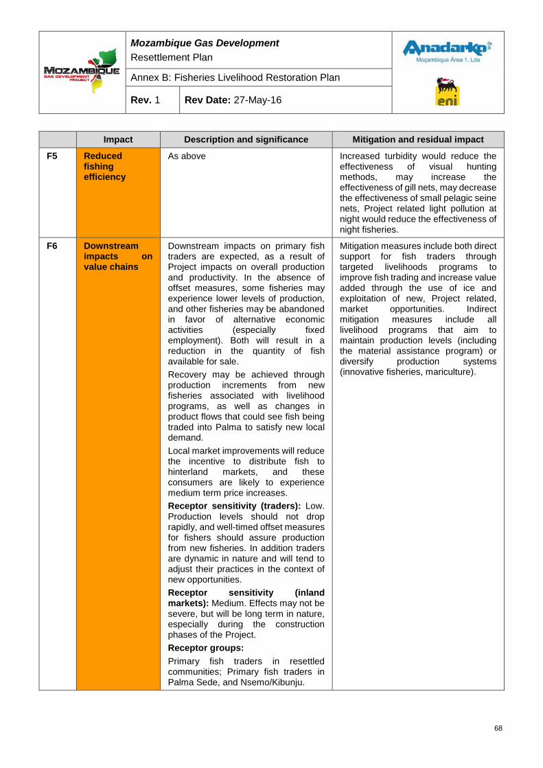
Mozambique Gas Development Resettlement Plan
Annex B: Fisheries Livelihood Restoration Plan
Rev. 1 Rev Date: 27-May-16
Impact Description and significance Mitigation and residual impact
F5 Reduced fishing efficiency
As above Increased turbidity would reduce the effectiveness of visual hunting methods, may increase the effectiveness of gill nets, may decrease the effectiveness of small pelagic seine nets, Project related light pollution at night would reduce the effectiveness of night fisheries.
F6 Downstream impacts on value chains
Downstream impacts on primary fish traders are expected, as a result of Project impacts on overall production and productivity. In the absence of offset measures, some fisheries may experience lower levels of production, and other fisheries may be abandoned in favor of alternative economic activities (especially fixed employment). Both will result in a reduction in the quantity of fish available for sale. Recovery may be achieved through production increments from new fisheries associated with livelihood programs, as well as changes in product flows that could see fish being traded into Palma to satisfy new local demand. Local market improvements will reduce the incentive to distribute fish to hinterland markets, and these consumers are likely to experience medium term price increases. Receptor sensitivity (traders): Low. Production levels should not drop rapidly, and well-timed offset measures for fishers should assure production from new fisheries. In addition traders are dynamic in nature and will tend to adjust their practices in the context of new opportunities. Receptor sensitivity (inland markets): Medium. Effects may not be severe, but will be long term in nature, especially during the construction phases of the Project. Receptor groups: Primary fish traders in resettled communities; Primary fish traders in Palma Sede, and Nsemo/Kibunju.
Mitigation measures include both direct support for fish traders through targeted livelihoods programs to improve fish trading and increase value added through the use of ice and exploitation of new, Project related, market opportunities. Indirect mitigation measures include all livelihood programs that aim to maintain production levels (including the material assistance program) or diversify production systems (innovative fisheries, mariculture).
68

Mozambique Gas Development Resettlement Plan
Annex B: Fisheries Livelihood Restoration Plan
Rev. 1 Rev Date: 27-May-16
Impact Description and significance Mitigation and residual impact Consumers in the inland markets of Nangade, Mueda, and to lesser extent Montepuez, Chiure, Nampula. Magnitude of effect: Medium. Disturbances will go beyond one fishing season. Impact significance: Moderate
F7 Resettlement of fishers
Considered in Section 7.4– compensation framework
Quantitative estimation of impacts In the calculation of quantitative impacts on fishers and collectors for compensation purposes (Section 8) the following global values have been used to estimate the impact on fishing and collecting in areas affected by the project. The table presents the projections of the reduction of fishing and collecting productivity by affected area and phase:
Table 6-4: Degree of impact on fishers and collectors
Affected area Construction Operation
500 m MEZ 100% -
1,000 m buffer zone 50% -
Shipping channel 50% 50%
Fishing areas east of the MEZ/1 10% 10%
Fishing areas north of the pipeline/2 10% -
1,500 m SZ - 100% /1 Only affects fishers from Palma Sede /2 Only affects fishers from Salama to Maganja
It should be noted that in almost all cases fishing areas are not wholly confined to the affected areas. Thus a 100 percent impact does not mean that the fishery is eliminated, but that fishing in that area is eliminated, whilst fishing in other areas may continue. The methodology used to calculate impacts on classes of fishers and collectors is described further in Section 8.1.
7 FISHERIES LIVELIHOOD RESTORATION STRATEGY This section sets out the proposed essentials of the fisheries livelihood restoration strategy. The strategy establishes principles and mechanisms through which livelihoods may be restored or improved in the context of residual Project impacts. This section proposes a strategic approach to be followed by the Project for compensation mechanisms, through physical interventions or financial payments.
69
Mozambique Gas Development Resettlement Plan
Annex B: Fisheries Livelihood Restoration Plan
Rev. 1 Rev Date: 27-May-16
Goal The goal of the fisheries livelihood restoration strategy is:
To improve or restore the livelihoods and standards of living of persons who derive benefits from fishing and marine resources, and who are physically and/ or economically displaced by Project implementation.
Objectives The fisheries livelihood restoration strategy objectives are to:
• Ensure that fisheries livelihoods affected by permanent impacts are supported to establish alternative livelihoods and/or provision of sufficient financial compensation to support transition to alternative livelihoods;
• Establish financial compensation and offset measures whose value to the receptor group matches or exceeds the loss of income and/or benefits as a result of Project related activities;
• Ensure that both the timescale for the delivery and the duration of benefits are in keeping with the nature of impacts;
• Ensure that the administration of financial compensation and delivery of offset measures are practical and implementable within the resources and time frame available; and
• Ensure that both compensation and offset are transparent, cost effective and result in benefits to receptors in keeping with their cost of delivery.
Coherence The strategy as a whole is coherent with Mozambican national legislation on resettlement, Decree 31/2012, of 8 August, as well as IFC PS 5. In addition, the strategy follows, where possible, the Government strategy for the fisheries sector, as set out in the Strategic Plan for Artisanal Fisheries (PESPA). It should be noted that national legislation does not propose any compensation principles or rates specific for the fisheries sector.
There are few national precedents that may guide the FLRP. Previous relevant work includes that carried out for SASOL, associated with gas exploration in the Bazaruto archipelago, but not only were the impacts very short term, but the compensation framework was never released into the public domain.
Elements of the fisheries livelihoods restoration strategy
7.4.1 Stakeholders Stakeholders in the FLRP at community level include persons physically and economically affected by the Project, as detailed in Section 5.1. Under the FLRP, the strategy for these two groups is proposed to be similar, and the approach taken will be determined more by the duration, nature and severity of impacts, rather than whether the affected persons have or have not been physically displaced.
70
Mozambique Gas Development Resettlement Plan
Annex B: Fisheries Livelihood Restoration Plan
Rev. 1 Rev Date: 27-May-16
The GoM is a prime stakeholder in the FLRP and has an important role to play as an implementation partner under the plan. The plan takes into account both Government policy and strategy, as well as current or planned Government interventions in the fisheries sector that that are relevant to the Project’s area of influence. Of particular relevance are the basic tenets of the PESPA, namely:
• The promotion of fisheries outside of the immediate coastal zone;
• An integrated approach to fisheries, including community development, financial services,the development of infrastructure and the associated concentration of services, value chainand technical diversification;
• The recognition of the co-existence of two distinct modes of artisanal fisheries, commercialand subsistence, each with a different set of priorities and needs; and
• The recognition of gender roles in fisheries and the requirement for specific inclusion ofwomen in both capture, value chain and community development.
Within the Government’s current national program for fisheries, the on-going “ProPesca” project (a project with national scope, supported by the International Fund for Agricultural Development), under which Palma Sede has been identified as a development pole, is particularly relevant. During the course of the ProPesca project, Palma Sede should receive support for the development of higher value fisheries through training and investment assistance in the areas of production and post-harvest, infrastructure and services (basic marketing facilities), and financial services.
7.4.2 Strategic approach Impacts resulting from the Project are primarily associated with the partial or complete loss of access to fishing grounds; reduced productivity of accessible grounds; loss of productivity associated with lost habitat; associated losses further down the value chain; and increased costs of fishing due to greater travelling time or finding new fishing areas. Impacts, detailed in Section 6, will be both temporary and permanent in nature, associated with construction and operation respectively.
Benefits made available under the FLRP, including access to livelihood programs and the payment of compensation will, where possible, reflect the severity of impacts. Where the Project only partially compromises fishers’ livelihoods, the FLRP will support the maintenance of those livelihoods if they are sustainable, rather than promote alternative economic activities. Should impacts be sufficiently small, it may be considered that the Project still leaves sufficient opportunities for the continuation of livelihoods, thus not justifying compensation.
Permanent or long term impacts Project Affected Persons (PAPs) suffering long-term impacts will be provided with alternative resources that should secure equivalent livelihood earning potential. This will be achieved through the supply of relevant equipment, and inclusion in targeted Livelihood Programs, reinforced where necessary with transitional support in the form of cash and/or food parcel
71
Mozambique Gas Development Resettlement Plan
Annex B: Fisheries Livelihood Restoration Plan
Rev. 1 Rev Date: 27-May-16
Short-term impacts Short-term impacts will be offset through the provision of cash compensation, equivalent or greater than projected lost earnings. This may be supplemented by the supply of relevant equipment, in keeping with the nature of receptors’ activity and the length of time necessary to re-establish viable economic activity. Where impacts are forecast to be temporary but of major significance, for example dredging induced modification of the seabed in near shore areas, it may be necessary to consider additional short-term compensation in the form of food parcels, made available directly to affected households. The nature and content of the food parcels should reflect the loss of production and venture to maintain a balanced diet in the household.
Social Implications of cash payments Many PAPs will not be used to managing quantities of cash and there is the potential for misuse, thereby depriving families of the support the program intends to deliver. This issue will be common between all livelihood restoration plans and a coordinated approach will be required to achieve objectives.
Note: In keeping with the RP as a whole, the fisheries livelihood restoration strategy and compensation framework contemplates impacts related to the construction and operation of the MOF, the western and eastern jetty, the installation of the Prosperidade Pipeline and the 1,500 m operational SZs.
7.4.3 Compensation framework The proposed benefits packages foreseen under the compensation framework are comprised of four elements, namely
• Material Assistance (MA);
• Livelihoods Programs;
• Transitional Support (TS); and
• Short-term compensation (STC).
The value of benefits packages and the balance between the four elements depends upon the severity and duration of impact as well as the nature of the fishery impacted.
Material Assistance PAPs who wish to continue fishing/collecting will be given access to MA in the form of productive equipment, related to fisheries in compliance with fisheries management plans, either as part of the benefits package or as an elective part of TS (described in detail below). Equipment may be associated not only with sustainable fishing, but also other value chain activities including fish processing and trading. The part of any benefits package attributed to a PAP in the form of MA will not be in money.
The MA program is described in further detain in Section 8.1.
72
Mozambique Gas Development Resettlement Plan
Annex B: Fisheries Livelihood Restoration Plan
Rev. 1 Rev Date: 27-May-16
Individual Livelihood Programs Resettled PAPs and highly impacted receptors who are able and intend to continue fishing activities will be given priority access to specific fisheries livelihood programs as set out in fisheries management plans, targeted at individual or household participation. The programs will be aimed at the expansion of diversified economic activities related to fisheries that will enable PAPs to maintain or improve their livelihoods sustainably.
The fisheries livelihood programs are described in further detail in Section 8.2.1 and will include:
• Development of alternative or improved fisheries.
• Post-harvest processing and marketing; and
• Enhanced fisheries and mariculture
PAPs who are no longer able or willing to remain in the fisheries sector may be given access to non-fisheries livelihoods programs, the most significant of which will be training and facilitation of access to formal employment within the Project.
Transitional Support TS in the form of cash and/or food parcels may be provided individually to PAPs to support livelihoods during transition from one activity to another. As such, only higher impacted receptors engaged in individual livelihood programs should require transitional compensation.
The TS Program is described in Section 8.3.
Short-term compensation STC in the form of cash and/or food parcels will be provided to PAPs receptors of short-term impacts. The value of STC should be equivalent to or greater than lost earnings.
Community level fisheries support programs In keeping with the guidelines for IFC PS 5, livelihood programs that aim to compensate for the loss of access to a common property resource should themselves bring open access benefits. In the case that the Project impact affects a community as a whole (rather than a specific fishery) this may be achieved through support for the development of community infrastructure and services. In the case that a specific fishery is compromised, interventions will be implemented that result in more generalized benefits, accessible to both higher and lower impacted receptors, members of resettled and non-resettled communities alike. These will include:
• Habitat productivity protection;
• Fisheries infrastructure;
• Fisheries co-management; and
• Afungi access road improvements.
Community level fisheries support programs are described in more detail in Section 8.2.2.
73

Mozambique Gas Development Resettlement Plan
Annex B: Fisheries Livelihood Restoration Plan
Rev. 1 Rev Date: 27-May-16
The basic principles of the fisheries entitlements framework are set out in Figure 7-1.
Intertidal gatherers who are subjected to low impacts will benefit from community level support, whilst higher impacted and resettled fishers and collectors will be targeted by fisheries livelihood programs, supported by TS and in-kind MA. Lesser-impacted fishers will be compensated through in-kind MA and TS, should it be necessary. All fishers will benefit from community level support programs.
Any fisher subjected to short-term impacts such as temporary interruptions to fisheries activities will be entitled to compensation through the Short-term compensation program.
7.4.4 Cross cutting interventions The FLRP will support and be supported by several crosscutting interventions under the RP and other Project initiatives such as the Community Investment Execution Plan (CIEP), with activities and impacts beyond the fisheries sector. These include financial services, support for community organizations, diversification of employment, support for government services, and the development of public services and infrastructure.
These activities will have both relevance and impact in the community as a whole and will not be focused solely on the fisheries sector. It should be noted, however, that successful models for the roll out of Rotating Savings and Credit Associations have already been developed for the fisheries sector by IDPPE, supported by relevant NGOs.
The development of community organizations is a fundamental part of the restoration of livelihoods: the support for fisheries management is foreseen under community level fisheries support programs. Although in this case the end is specific to fisheries, the process of organizational development is crosscutting and relevant to other sectors beyond fisheries. Support for producer associations and organizations is not proposed under the FLRP, in the context of long-term negative experience with such institutions in the fisheries sector16.
16 There are a very few examples of positive experience with the development of producer organizations in fisheries, following the progressive model development by the NGO CLUSA/Olipa. The process however is uncertain, with a high failure rate, and very long term.
74
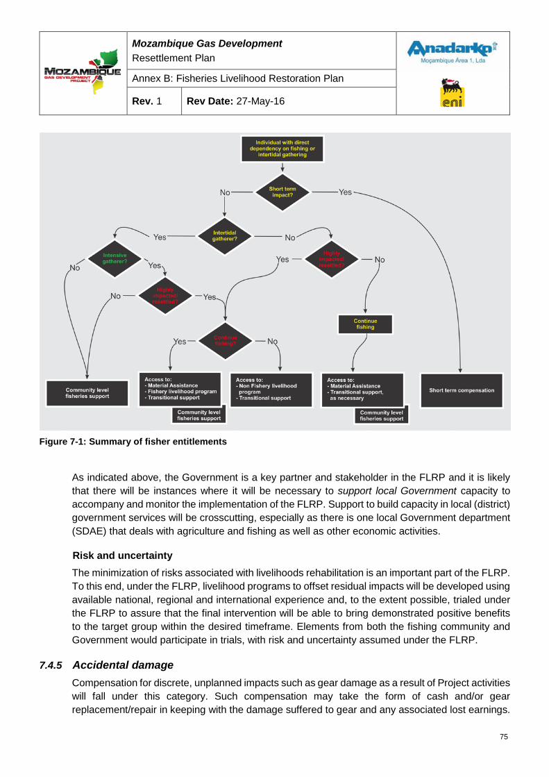
Mozambique Gas Development Resettlement Plan
Annex B: Fisheries Livelihood Restoration Plan
Rev. 1 Rev Date: 27-May-16
Figure 7-1: Summary of fisher entitlements
As indicated above, the Government is a key partner and stakeholder in the FLRP and it is likely that there will be instances where it will be necessary to support local Government capacity to accompany and monitor the implementation of the FLRP. Support to build capacity in local (district) government services will be crosscutting, especially as there is one local Government department (SDAE) that deals with agriculture and fishing as well as other economic activities.
Risk and uncertainty The minimization of risks associated with livelihoods rehabilitation is an important part of the FLRP. To this end, under the FLRP, livelihood programs to offset residual impacts will be developed using available national, regional and international experience and, to the extent possible, trialed under the FLRP to assure that the final intervention will be able to bring demonstrated positive benefits to the target group within the desired timeframe. Elements from both the fishing community and Government would participate in trials, with risk and uncertainty assumed under the FLRP.
7.4.5 Accidental damage Compensation for discrete, unplanned impacts such as gear damage as a result of Project activities will fall under this category. Such compensation may take the form of cash and/or gear replacement/repair in keeping with the damage suffered to gear and any associated lost earnings.
75
Mozambique Gas Development Resettlement Plan
Annex B: Fisheries Livelihood Restoration Plan
Rev. 1 Rev Date: 27-May-16
Implementation phases The implementation phases of the Project will each have specific impacts on fishers and collectors in Palma Bay. As a result the Fisheries Compensation Framework may be rolled out in similar phases. The major phases can be simplified as follows in Table 7-1:
Table 7-1: Compensation implementation phases
Project Implementation Duration Compensation framework phase
Resettlement Permanent Resettlement
MOF construction 15 months Construction
Pipeline construction 30 months/a
Jetty 1 (Western) construction, including dredging
30 months/a
Operations with 1 Jetty Permanent Operation
Construction of Jetty 2 (Eastern) 30 months (estimate)
Operations with Jetty 1 & 2 Permanent /a Concurrent
The first phase will deal specifically with resettled PAPs; the provision of MA and the offer of training towards employment in the Project; the engagement of those who continue fishing in fisheries livelihood programs; and the payment of TS if necessary. This is the only phase where physically resettled receptors will be entitled to compensation.
Also under the second phase, the Compensation Framework will cover recompense for impacts of Project construction up to the completion of the first jetty, as well as permanent impacts from operations within that footprint. Receptors will be economically affected only, with those from Palma Sede and Nsemo/Kibunju expected to experience both long and short long-term impacts. Receptors from other communities may also be subject to short-term impacts and therefore be entitled to STC.
Under the third phase, compensation would be made for the expansion of the MEZ from the 500 m-construction exclusion to the proposed 1,500 m SZ. The receptors will all be economically affected, only. It is foreseen that the entire 1,500 m safety zone will be claimed at this phase, thus excluding fishers permanently not only from the area within 1,500 m of the western jetty but also from the area within 1,500 m of the future, eastern, jetty.
Eligibility Eligibility for compensation amongst physically and economically affected PAPs will be established through registration and census. A detailed register was made in 2015 of all fishers and collectors in all the fisher communities that may be affected by the Project, and this will be the primary way in which eligibility for compensation benefits will be determined.
76
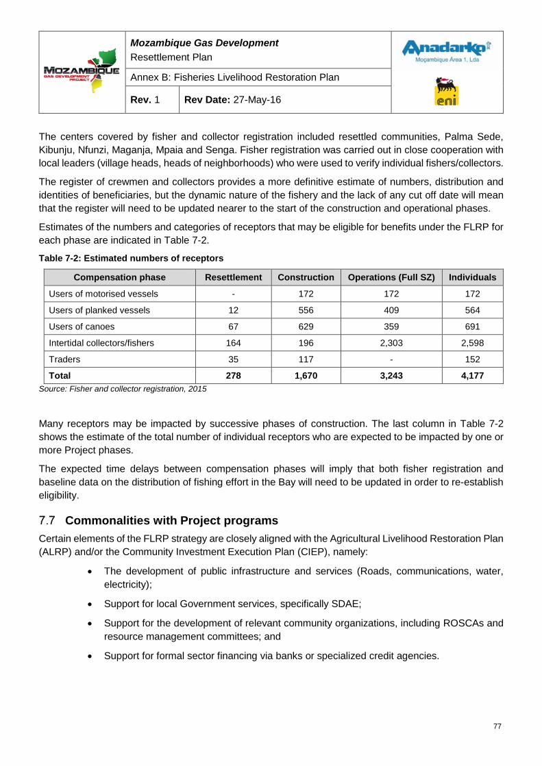
Mozambique Gas Development Resettlement Plan
Annex B: Fisheries Livelihood Restoration Plan
Rev. 1 Rev Date: 27-May-16
The centers covered by fisher and collector registration included resettled communities, Palma Sede, Kibunju, Nfunzi, Maganja, Mpaia and Senga. Fisher registration was carried out in close cooperation with local leaders (village heads, heads of neighborhoods) who were used to verify individual fishers/collectors.
The register of crewmen and collectors provides a more definitive estimate of numbers, distribution and identities of beneficiaries, but the dynamic nature of the fishery and the lack of any cut off date will mean that the register will need to be updated nearer to the start of the construction and operational phases.
Estimates of the numbers and categories of receptors that may be eligible for benefits under the FLRP for each phase are indicated in Table 7-2.
Table 7-2: Estimated numbers of receptors
Compensation phase Resettlement Construction Operations (Full SZ) Individuals
Users of motorised vessels - 172 172 172
Users of planked vessels 12 556 409 564
Users of canoes 67 629 359 691
Intertidal collectors/fishers 164 196 2,303 2,598
Traders 35 117 - 152
Total 278 1,670 3,243 4,177 Source: Fisher and collector registration, 2015
Many receptors may be impacted by successive phases of construction. The last column in Table 7-2 shows the estimate of the total number of individual receptors who are expected to be impacted by one or more Project phases.
The expected time delays between compensation phases will imply that both fisher registration and baseline data on the distribution of fishing effort in the Bay will need to be updated in order to re-establish eligibility.
Commonalities with Project programs Certain elements of the FLRP strategy are closely aligned with the Agricultural Livelihood Restoration Plan (ALRP) and/or the Community Investment Execution Plan (CIEP), namely:
• The development of public infrastructure and services (Roads, communications, water, electricity);
• Support for local Government services, specifically SDAE;
• Support for the development of relevant community organizations, including ROSCAs and resource management committees; and
• Support for formal sector financing via banks or specialized credit agencies.
77
Mozambique Gas Development Resettlement Plan
Annex B: Fisheries Livelihood Restoration Plan
Rev. 1 Rev Date: 27-May-16
Implementation The responsibility for the implementation of the FLRP will be with the Project, and will be supported by contracted consultants and specialized service providers, including NGOs where relevant. It should be noted that although the Government is a stakeholder in the resettlement process, it is not anticipated that the Government will be a service provider as part of FLRP implementation.
The implementation process would follow a phased approach, in keeping with risk reduction, as outlined above.
FLRP implementation will be supported by on-going monitoring as well as specialist studies to asses both direct and indirect impacts of the FLRP, monitor indicators, and determine the effectiveness of implemented livelihood/compensation measures. Monitoring of indicators could be completed by specialized service providers, as part of their contracts to deliver components of the FLRP. An external service provider, not associated with implementation of the FLRP, would complete independent verification or auditing of the FLRP.
The plan will be implemented over a period of five years, although it should be noted that key elements of the Project that will affect fisheries would be implemented outside of this timeframe. This will include the second phase of construction of marine installations (eastern loading jetty. It is proposed that one or more program delivery partners will be responsible for the implementation of fisheries sub-programs. The implementation of the FLRP will be managed through a small coordination and monitoring unit. The unit will consist of at least three persons, thus assuring the presence of at least one member of the team in the field at all times, plus an additional person with specific responsibility for the FLRP monitoring program. The coordination unit would be responsible for:
• Selection of specialized service providers, including definition of scopes of work;
• Coordination of the implementation of sub-programs through specialized service providers;
• Monitoring of sub-programs implemented through specialized service providers;
• Direct implementation of specific programs under the FLRP;
• Direct implementation of the monitoring program of fisheries in Palma Bay and at any newsites accessed by affected persons17;
• Contracting of specialized technical assistance, as required for direct implementation ofspecific programs or monitoring;
• Provision of specialized technical assistance to program delivery partners whereappropriate; and
• Compilation of management reports on the execution of the fisheries program.
The implementation structure for the FLRP is shown in Figure 7-2.
17 Required to confirm claims of decreased fish catches and/or increased level of effort as well as effectiveness of specific sub-programs
78
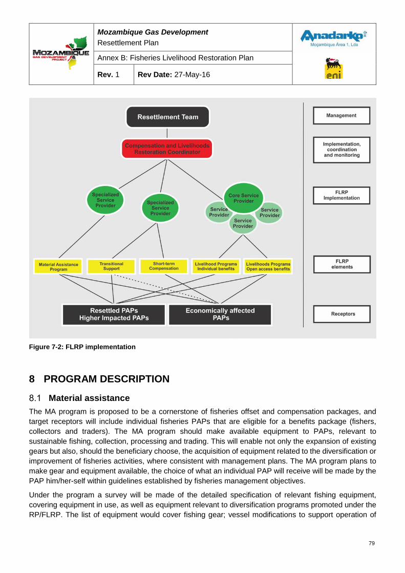
Mozambique Gas Development Resettlement Plan
Annex B: Fisheries Livelihood Restoration Plan
Rev. 1 Rev Date: 27-May-16
Figure 7-2: FLRP implementation
8 PROGRAM DESCRIPTION
Material assistance The MA program is proposed to be a cornerstone of fisheries offset and compensation packages, and target receptors will include individual fisheries PAPs that are eligible for a benefits package (fishers, collectors and traders). The MA program should make available equipment to PAPs, relevant to sustainable fishing, collection, processing and trading. This will enable not only the expansion of existing gears but also, should the beneficiary choose, the acquisition of equipment related to the diversification or improvement of fisheries activities, where consistent with management plans. The MA program plans to make gear and equipment available, the choice of what an individual PAP will receive will be made by the PAP him/her-self within guidelines established by fisheries management objectives.
Under the program a survey will be made of the detailed specification of relevant fishing equipment, covering equipment in use, as well as equipment relevant to diversification programs promoted under the RP/FLRP. The list of equipment would cover fishing gear; vessel modifications to support operation of
79
Mozambique Gas Development Resettlement Plan
Annex B: Fisheries Livelihood Restoration Plan
Rev. 1 Rev Date: 27-May-16
improved or diversified gear; diving equipment (mask, snorkel, flippers); safety equipment; protective clothing; navigational equipment; domestic freezers; fish boxes; cold boxes; sailcloth; and outboard motors. National suppliers of the equipment would be sought through a tender process and a catalogue drawn up, detailing both the specification and delivery cost for each item. Individual fishers would be free to select items from the catalogue up to the value of their benefit package. The equipment supply program would be responsible for compiling bulk orders and channeling these to the previously selected supplier(s), for subsequent procurement and delivery.
The specification of equipment would be strictly within the provisions of current national fisheries legislation, and fisheries management objectives. Mosquito nets, for example, will not be made available. Fishers using such gears would be offered alternatives. MA programs would follow fisheries management plans not to increase overall fishing effort/exploitation and to avoid supporting investment in fisheries that target unsustainably exploited resources or exacerbate effort directed at pressure stocks.
The program will also be available for gear replacement in the event of accidental destruction of fishing gear by a Project-associated vessel or other similar grievance that would require compensation in kind.
8.1.1 Proposed principles Objective: Offset long-term/permanent impacts
Method: Access to the supply of equipment related to fishing and associated activities in compliance with fisheries management objectives
Entitlement: Determined by degree of impact, capital value of fishing unit, crew share
Timing: One off entitlement, made available shortly in advance of projected impact.
Formula: 2 x Capital Value x Impact (%) x Crew Share
For each compensation phase, any affected fishing unit is attributed MA keyed to double the investment cost of the fishing unit, attenuated by the degree of impact. The value of the MA is attributed amongst the owner and crew according to normal crew share.
The basis for the estimation of MA has been simplified by (1) grouping receptors according to the type of vessel used (or lack of vessel if collector) and (2) generalizing the pattern of the division of revenue amongst the crew. Within these classifications, no differentiation is made by gear type. The generalized capital values of fishing units are set out in Table 8-1.
Table 8-1: Capital values of fishing unit groups
Canoe Planked vessel Motorized vessel Intertidal Collector / Fisher
13,600 MZN 204,000 MZN 680,000 MZN 3,400 MZN
The sharing system has been generalized as follows:
• Vessel owner: 50%
• Crew share: 50%, divided equally amongst crewmembers
80
Mozambique Gas Development Resettlement Plan
Annex B: Fisheries Livelihood Restoration Plan
Rev. 1 Rev Date: 27-May-16
• Specialized crew, if present (master): Two crew shares
Fisheries impacts vary greatly by base community, and for example, fishers from Palma Sede are affected in a very different ways by Project activities than fishers from Kibunju. For any given community, impacts on fisheries have been grouped under the classifications shown in Table 8-1 and again no differentiation is made by gear type. Within these classifications, impacts of the different Project phases have been projected by examining the fishing intensity in areas used by that community, which will be affected by the Project. This analysis is based on baseline vessel and intertidal monitoring data and projected areas of impact.
For the first construction phase (MOF, Western Jetty, Prosperidade Pipeline) impact estimates are based on the exclusion of fishers and collectors from the 500 m construction MEZ, and the impacts of a assumed 1,000 m temporary area of disturbance associated with noise and turbidity, restricted access to the shipping channel, and impeded access to fishing grounds, as described in Sections 6.3 and 6.4.
For the operational phase, impact estimates are based on the exclusion of fishers and collectors from the 1,500 m SZ, restricted access to the shipping channel and impeded access to fishing grounds to the east of the marine facilities for fishers coming from Palma Sede.
In the estimation of the impact of a Project phase on fishing activities the following methodology has been adopted:
• For each classification of fisher (Collector/No vessel, Canoe, Planked and Motorized) from each of the affected communities:
• Palma Bay was gridded into 500 m x 500 m grid squares;
• A heat map of intensity of fishing/collecting activity was developed (from baseline monitoring data), giving a quantitative value for fishing/collecting activity in each grid square;
• The cumulative area based impacts for that phase, described in Table 6-4, were evaluated for each grid square;
• The cumulative impacts were applied to the heat map of activity for each grid square, and the global impact for that phase on that classification of fisher evaluated.
The methodology thus takes into account the distribution of fishing effort in the bay, and how both favored and less favored fishing areas are affected by area based project impacts.
8.1.2 Sample calculation The monitored fishing locations of canoe fishers based in Palma Sede are shown in Figure 8-2, together with a gridded heat map of intensity of activity. Figure 8-2 shows the grid of estimated project impacts for canoe-based fishers from Palma Sede for the construction phase.
81
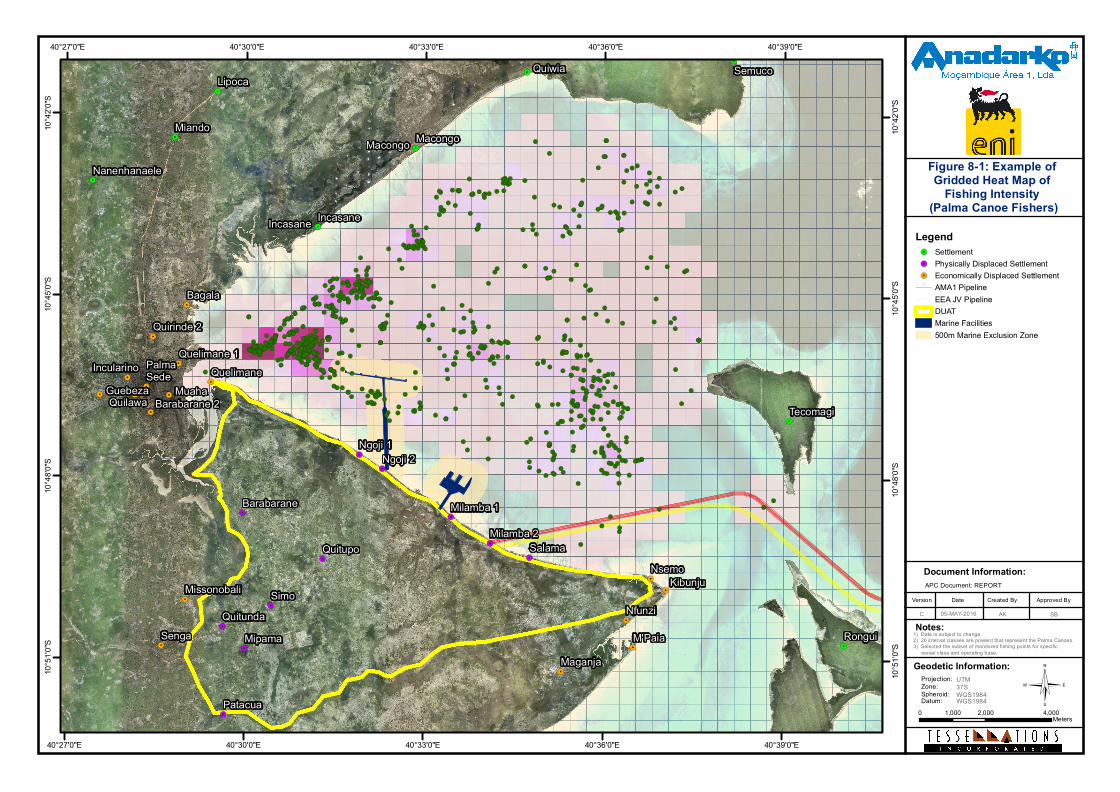
©
Document Information:
Date Created ByVersion Approved By
C
Notes:
APC Document: REPORT
!(
!(
!(
!(
!(
!(
!(
!(
!(
!(!(!(!(!(
!(
!(
!(
!(!(
!(
!(
!(
!(
!(
!(
!(!(
!(
!(!(
!(
!(
!(!(
!(
!(!(
!(
!(
!(
!(
!(!(!(
!(
!(
!(
!(
!(
!(!(
!(
!(
!(
!(
!(
!(
!(
!(!(!(!(!(
!(!(!(!(
!(!(
!(
!(!(
!(
!(
!(
!(
!(
!(
!(
!(
!(
!(
!(
!( !(
!(
!(
!(
!(
!(
!(
!(
!(
!(
!(
!(
!(
!(
!(!(
!(
!(
!(
!(
!(
!(
!(!(!(!(
!( !(
!(!(!(
!(
!(
!(
!(
!(
!(
!(!(
!(
!(
!(
!(
!(
!(
!(
!(
!(
!(
!(
!(
!(
!(
!(
!(
!(
!(
!(!( !(
!(
!(
!(
!(
!(
!(!(
!(
!(
!(
!(
!(
!(
!(!(!(
!(!(!(
!(
!( !(!(!(
!(
!(
!(!(
!(!(
!(!(
!(
!(
!(
!(
!(
!(!(
!(
!(
!( !(
!(!(
!(
!(!(
!(!(!(
!(
!(
!(
!(
!(!(
!(
!(!(
!(
!(!(!(
!(
!( !(
!(
!(
!(
!(
!(!(
!(
!(
!(
!(
!(
!(
!(!(
!(!(
!(!(
!(!(
!(
!(
!(!(
!(!(!(!(
!(
!(
!( !(!(!(
!(
!(!(
!(
!(!(
!(!(
!(!(!(
!(
!(!(!(!(
!(
!(!(
!(!(!(
!(
!(
!( !(
!(!(
!(
!(
!(
!(!(
!(
!(!(
!(!(
!(
!(
!(!(
!(!(!(
!(
!(
!(
!(!(!(
!(
!(
!(
!(
!(
!(
!(
!(
!(
!(
!(
!(
!(!(
!(
!(
!(!(
!(
!(
!(
!(
!(
!(
!( !(
!(
!(
!(!(
!(
!(
!(!(
!(!(
!(
!(
!(!(!(
!( !(
!(!(
!(
!(
!(
!(
!(
!(
!(!(!(!(
!( !(
!(
!(
!(
!(
!(
!(!(
!(
!(!(
!(
!(
!(
!(
!(
!(
!(
!(
!(
!(!(!( !(!(
!(
!(
!(
!(
!(!(
!(
!(
!(!(!(
!(
!(
!(
!(!(
!(
!(!(
!(!(!(!(
!(
!(
!(!(!(
!(
!(
!(
!(
!(
!(
!(
!(!(!(!(
!(
!(
!(
!(!(
!(
!(!(!(!(!(!(!(
!(
!(
!(
!(!(!(
!(
!(
!(
!(!(
!(!(
!(!(
!(
!( !(!(
!(!(
!(!( !(
!(
!(!(
!( !(
!(!(
!(
!(
!(
!(!(!(!(
!(!(
!(
!(!(
!(
!(
!(
!(
!(!(
!(!(
!(
!(
!(
!(
!(
!(!(
!(!(
!(
!(!(
!(!(
!(
!(
!(
!(
!(
!(
!(!(
!(!(
!(
!(
!(!( !(!(!(
!(!(
!(
!(!(
!(
!(
!(
!(!(
!(
!(
!(
!(!(!(
!(
!(!( !(
!(!(
!(!(
!(
!(
!(!(
!(!(!(
!(
!(
!(
!(!(!(!(
!(!(
!( !(
!(!(!(
!(!(
!(
!(!(
!(
!(
!(
!(!(!(
!(!(!(!(
!(
!( !(!(
!(!(
!(
!( !(!(!(
!(!(!(
!(!(
!(!(
!(
!(!(!(!(
!(
!(!(
!(!(!(
!(!(
!(
!(!(
!(
!(
!(
!(
!(!(
!(!(!(
!(!(!(!(!(
!(!(
!(
!(!(
!(!(!(
!(
!(
!(!( !( !(
!(
!(
!(
!(
!(
!(
!(!(
!(!(
!(!(
!(
!(
!(!(!(
!(
!(!(
!(
!(!(
!(
!(!(!(
!( !(
!(
!(
!(
!(
!(!(
!(!(!(
!(
!(
!(
!(!(
!(
!(
!(
!(!(
!(
!(
!(!(
!(
!(
!(
!(
!(
!(!(
!(
!(
!(!(
!(!(
!(
!(!(
!(
!(!(!(!(
!(
!(
!(
!(!( !(
!(
!(
!(!(
!(!(
!(
!(
!(
!(
!(
!(
!(
!( !(!(!(
!(!(
!(
!(
!(
!(
!(
!(
!(
!(
!(
!(!(!(
!(
!(
!(
!(
!(
!(!(
!(
!(
!(
!(
!(
!(
!(
!( !(
!(
!(!(
!.
!.
!.!.
!.
!.
!.
!. !.
!.
!.
!.
!.
!.
!.
!.
!.
!.
!.
!.
!.
!.
!.
!.
!.
!.
!.
!.
!.
!.
!.
!.
!.
!.
!.
!.
!.
!.
!.
Macongo
Incasane
Rongui
Tecomagi
Senga
Maganja
QuelimanePalmaSede
MissonobaliNsemo
Nfunzi
Guebeza Muaha
Quelimane 1
Barabarane 2
Incularino
Quilawa
Bagala
Quirinde 2
M'Paia
Kibunju
Quiwia
Nanenhanaele
Lipoca
Miando
Semuco
Macongo
Incasane
Patacua
Quitupo
Barabarane
QuitundaMipama
Ngoji 1Ngoji 2
Milamba 2
Milamba 1
Simo
Salama
40°39'0"E
40°39'0"E
40°36'0"E
40°36'0"E
40°33'0"E
40°33'0"E
40°30'0"E
40°30'0"E
40°27'0"E
40°27'0"E10
°42'0"
S
10°42
'0"S
10°45
'0"S
10°45
'0"S
10°48
'0"S
10°48
'0"S
10°51
'0"S
10°51
'0"S
1) Data is subject to change.2) 20 interval classes are present that represent the Palma Canoes.3) Selected the subset of monitored fishing points for specific vessel class and operating base.
Legend!. Settlement!. Physically Displaced Settlement!. Economically Displaced Settlement
AMA1 PipelineEEA JV PipelineDUATMarine Facilities500m Marine Exclusion Zone
0 2,000 4,0001,000Meters
AK05-MAY-2016
Figure 8-1: Example of Gridded Heat Map of
Fishing Intensity (Palma Canoe Fishers)
Geodetic Information:Projection:Zone:Spheroid:Datum:
UTM37SWGS1984WGS1984
SB
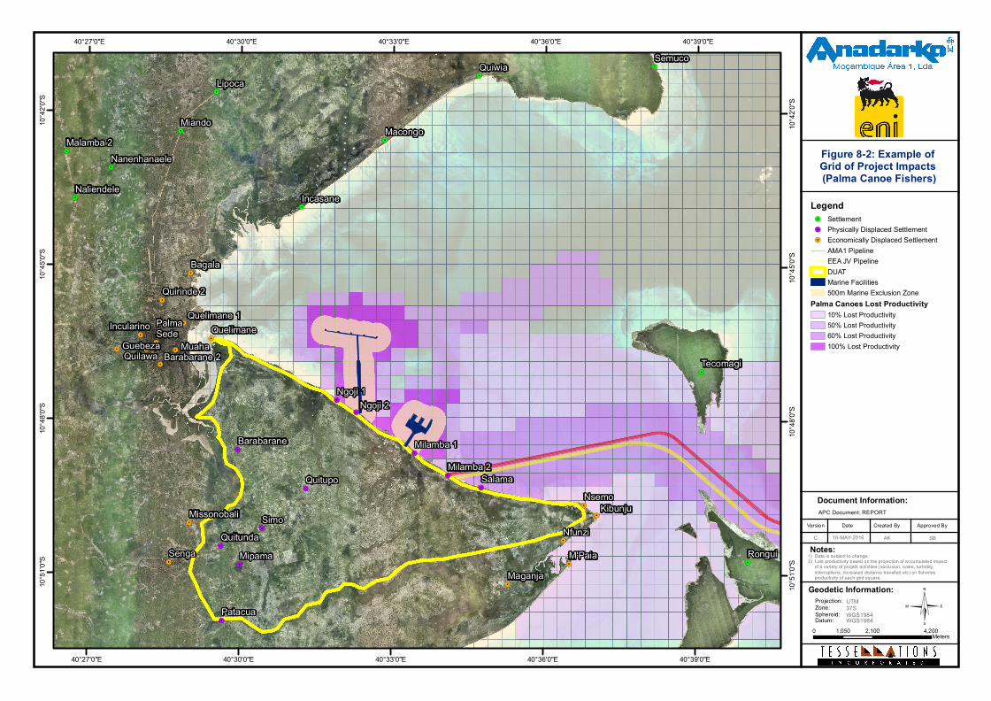
©
Document Information:
Date Created ByVersion Approved By
C
Notes:
APC Document: REPORT
!.
!.
!.
!.
!.
!.
!.
!.
!. !.
!.
!.
!.
!.
!.
!.
!.
!.
!.
!.
!.
!.
!.
!.
!.
!.
!.
!.
!.
!.
!.
!.
!.
!.
!.
!.
!.
!.
!.
!.
SengaMaganja
QuelimanePalmaSede
MissonobaliNsemo
Nfunzi
Guebeza Muaha
Quelimane 1
Barabarane 2
Incularino
Quilawa
Bagala
Quirinde 2
M'Paia
Kibunju
Rongui
Tecomagi
Quiwia
Nanenhanaele
Lipoca
Malamba 2Miando
Naliendele
Semuco
Macongo
Incasane
Patacua
Quitupo
Barabarane
QuitundaMipama
Ngoji 1Ngoji 2
Milamba 2Milamba 1
Simo
Salama
40°39'0"E
40°39'0"E
40°36'0"E
40°36'0"E
40°33'0"E
40°33'0"E
40°30'0"E
40°30'0"E
40°27'0"E
40°27'0"E10
°42'0"
S
10°42
'0"S
10°45
'0"S
10°45
'0"S
10°48
'0"S
10°48
'0"S
10°51
'0"S
10°51
'0"S
1) Data is subject to change.2) Lost productivity based on the projection of accumulated impact of a variety of project activities (exclusion, noise, turbidity, interruptions, increased distance travelled etc) on fisheries productivity of each grid square.
Legend!. Settlement!. Physically Displaced Settlement!. Economically Displaced Settlement
AMA1 PipelineEEA JV PipelineDUATMarine Facilities500m Marine Exclusion Zone
Palma Canoes Lost Productivity10% Lost Productivity50% Lost Productivity60% Lost Productivity100% Lost Productivity
0 2,100 4,2001,050Meters
AK10-MAY-2016
Figure 8-2: Example of Grid of Project Impacts (Palma Canoe Fishers)
Geodetic Information:Projection:Zone:Spheroid:Datum:
UTM37SWGS1984WGS1984
SB
Mozambique Gas Development Resettlement Plan
Annex B: Fisheries Livelihood Restoration Plan
Rev. 1 Rev Date: 27-May-16
The two gridded datasets are combined, resulting in an estimated total impact on Palma Sede based canoe fishers of 18 percent during the construction phase.
The value of benefit under the MA program would be:
2 x Investment cost x Impact x crew share
In the case of a canoes the investment cost is estimated at 13,600 MZN, thus
MA = 2 x 13,600 x 18% = 4,896 MZN per fishing unit
The calculation is specific to phase, vessel type and community, tables have been developed detailing the projected compensation for each category, for each compensation phase.
Further description of the MA program is presented in Annex 2.
Livelihood programs Longer-term impacts may be recompensed through offset measures designed to bring benefits to receptors over a longer time frame whilst disturbances persist. These will be aimed primarily at resettled PAPs and highly impacted receptors.
Catch monitoring and specific studies demonstrate that there are serious over fishing pressures on fisheries resources in Palma Bay, with a lack of predator fish and prevalence of immature or undersized fish, as well as signs of over exploitation of intertidal shellfish resources. Livelihood programs to support income from fisheries will therefore focus on contributing to the capacity of fishers and associated communities to operate sustainably within the existing environment; to enhance the productivity of that environment; and to raise the values of fish products along the marketing chain. Interventions may include technical diversification to focus on underutilized resources, and may include gear exchange and knowledge exchange schemes supported by technology transfer; fish handling; processing; and marketing schemes to raise values and income.
Livelihood programs will include the development of alternative fishing activities that are compatible with Project operations in the long-term, and will bring benefits commensurate with impacts. Where possible, offset interventions will venture to build upon opportunities that will arise associated with Project activities, such as in enhancement of habitat for production inside the protection of the MEZ and SZ, and expanded marketing opportunities among the new populations constructing the Project and linked to general economic development.
Particular livelihood programs will bring wider benefits, accessible to communities as a whole. These may include community organization for improved management; electricity supplies in villages; water and sanitation developments; health care; and education support activities.
As illustrated in Table 8-3 programs for alternative fishing methods towards a sustainable fishery will not be sufficient to absorb all current PAPs: alternative livelihoods outside direct fisheries employment will be necessary. This is particularly important for those engaged in the least sustainable fisheries such as intertidal activities with mosquito netting.
A detailed description of the fisheries livelihood programs is included as Annexes 3 and 4, and summarized below.
84
Mozambique Gas Development Resettlement Plan
Annex B: Fisheries Livelihood Restoration Plan
Rev. 1 Rev Date: 27-May-16
8.2.1 Fisheries livelihood programs (individual benefits)
Enhanced fisheries and mariculture Enhancement and mariculture programs aim to establish sustainable production of marketable resources for sale/processing and sale to local, national or international markets. This would:
• offset the loss of access to areas where resource collection or dragnets (including mosquito nets) are currently conducted;
• provide an increased and more stable source of income; and
• promote an alternative to damaging fishing methods.
The program will focus on shellfish, seaweed and sea cucumber resources, subject to both further research and trials.
Beneficiaries of the programs would experience improved earnings, which would be linked to a method of production that is environmentally benign and which has the potential to provide secure earnings into the future. Key beneficiaries would be women and families currently reliant on resources obtained from the intertidal areas that would be closed by the development of the Project.
Post-harvest processing and marketing General economic growth in Palma District, as well the influx of companies and staff associated with the Project, will provide improved opportunities for the marketing of fresh fish, and higher quality requirements. A program is proposed to promote the use of ice in fishing craft and post-harvest around Palma Bay as well as in other fishing communities in the District that have appropriate infrastructure. This will include support for entrepreneurs with ice production facilities, training for fishermen in the use of ice and fish handling at sea, support for traders in correct handling and storage of ice for fish conservation, and assistance with links to potential markets in Palma Sede, such as catering companies serving the Project and other service providers.
The program will be focused on improved trading of higher value fish products (first grade fish, lobster), which are the best candidates for value addition through improved fresh conservation. Key beneficiaries would include existing traders, as well as others interested in diversifying away from fish production to processing and marketing.
Development of alternative or improved fisheries The objective of implementing improved or novel fisheries is to maintain or improve earnings achieved by fishers operating in Palma Bay whose current fishing methods will be constrained or unable to coexist with the Project, such as fishers for whom significant proportions of existing fishing grounds fall within the MEZ and SZ. The program will provide technical assistance, training and equipment to fishers to enable them to enter new fisheries, focused on currently underutilized resources or fishing grounds. Key beneficiaries will be highly impacted vessel-based fishers. The principal opportunity here is for fishermen to be able to target pelagic and deep slope demersal fish outside the Bay off the Cabo Delgado, Tecomaji and Rongui fringing reefs. These are pelagic fish that do not enter the Bay area and are circulating the western Indian Ocean targeted by industrial
85
Mozambique Gas Development Resettlement Plan
Annex B: Fisheries Livelihood Restoration Plan
Rev. 1 Rev Date: 27-May-16
fisheries, or deep swimming demersal fish that require hauling systems to target. Improved boat types and fish handling, and the use of anchored fish aggregation devices would form the components of the program.
Non-fisheries livelihoods PAPs who are no longer able or willing to remain in the fisheries sector may be provided with access to non-fisheries livelihoods programs, the most significant of which would be facilitation of access to training and formal employment with the Project. The profile of key beneficiaries from the fisheries sector is expected to include both persons currently working in the intertidal zone, and less committed fishers. This is discussed in further detail in Section 8.4 of the RP.
8.2.2 Community level fisheries support programs Linked to the fisheries livelihoods programs will be programs that may result in more generalized benefits, accessible to both highly and lower impacted receptors, members of resettled and non-resettled communities alike.
Afungi road access The road access improvement program will construct and maintain access roads linking the replacement village to the coast, specifically: the coastline to the west of the build zone/SZ (Casa do Colono); Nsemo/Kibunju; and the coastline to the east of the replacement village site (Maganja Velha). The demands on the various parts of this road network are not expected to be uniform, and the link to the more populous centers of Nsemo/Kibunju is expected to be subject to higher demand than the link to Maganja Velha or Casa do Colono. This road construction would be a vital part of improving income to fishing communities who would be able to process products to higher value and reach markets able to pay more for quality fish. This development would enable reduction of fishing effort and increased benefits.
Fisheries co-management The GoM continues to pursue a policy to develop and support the co-management of small-scale fisheries resources, through a hierarchical structure of institutions. The co-management structure should serve to voice and resolve problems and conflicts in the fishery, as well as assist Government in the implementation of national fisheries legislation. The Project will support fisheries management in Palma District through the expansion of co-management institutions and the integration of marine resource users within those institutions. Establishment of community management is a long-term investment involving years of training and community education, it is vital to the future of sustainable fisheries in the Project area.
Fisheries infrastructure The construction of improved fisheries infrastructure is proposed at two locations, namely Palma Sede as the most important fisheries hub, and Nsemo, being the part of the coastline where resettled fishers are expected to establish a base for marine fisheries activities. The construction
86

Mozambique Gas Development Resettlement Plan
Annex B: Fisheries Livelihood Restoration Plan
Rev. 1 Rev Date: 27-May-16
of fisheries infrastructure should contribute to the development of poles for fisheries activities, with improved offloading and storage facilities, and the concentration of services.
The following matrix (Table 8-2) presents details of proposed livelihood programs, together with indication of pros and cons, timescale, indicative budget, and relevant receptor group.
87
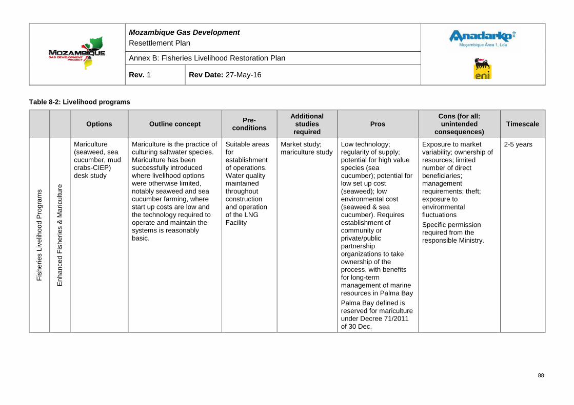
Mozambique Gas Development Resettlement Plan
Annex B: Fisheries Livelihood Restoration Plan
Rev. 1 Rev Date: 27-May-16
Table 8-2: Livelihood programs
Options Outline concept Pre-conditions
Additional studies required
Pros Cons (for all: unintended
consequences) Timescale
Fish
erie
s Li
velih
ood
Prog
ram
s
Enha
nced
Fis
herie
s &
Mar
icul
ture
Mariculture (seaweed, sea cucumber, mud crabs-CIEP) desk study
Mariculture is the practice of culturing saltwater species. Mariculture has been successfully introduced where livelihood options were otherwise limited, notably seaweed and sea cucumber farming, where start up costs are low and the technology required to operate and maintain the systems is reasonably basic.
Suitable areas for establishment of operations. Water quality maintained throughout construction and operation of the LNG Facility
Market study; mariculture study
Low technology; regularity of supply; potential for high value species (sea cucumber); potential for low set up cost (seaweed); low environmental cost (seaweed & sea cucumber). Requires establishment of community or private/public partnership organizations to take ownership of the process, with benefits for long-term management of marine resources in Palma Bay Palma Bay defined is reserved for mariculture under Decree 71/2011 of 30 Dec.
Exposure to market variability; ownership of resources; limited number of direct beneficiaries; management requirements; theft; exposure to environmental fluctuations Specific permission required from the responsible Ministry.
2-5 years
88
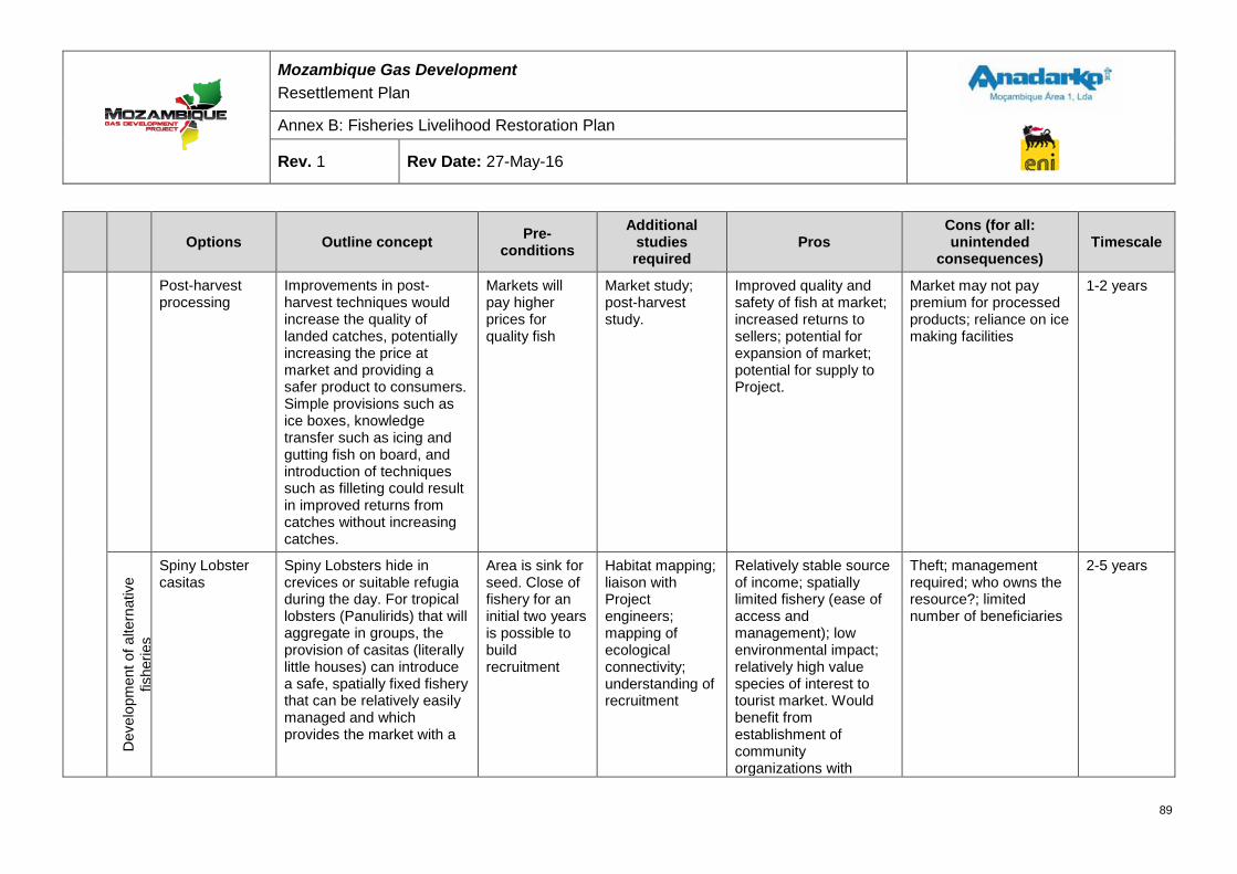
Mozambique Gas Development Resettlement Plan
Annex B: Fisheries Livelihood Restoration Plan
Rev. 1 Rev Date: 27-May-16
Options Outline concept Pre-conditions
Additional studies required
Pros Cons (for all: unintended
consequences) Timescale
Post-harvest processing
Improvements in post-harvest techniques would increase the quality of landed catches, potentially increasing the price at market and providing a safer product to consumers. Simple provisions such as ice boxes, knowledge transfer such as icing and gutting fish on board, and introduction of techniques such as filleting could result in improved returns from catches without increasing catches.
Markets will pay higher prices for quality fish
Market study; post-harvest study.
Improved quality and safety of fish at market; increased returns to sellers; potential for expansion of market; potential for supply to Project.
Market may not pay premium for processed products; reliance on ice making facilities
1-2 years
Dev
elop
men
t of a
ltern
ativ
e fis
herie
s
Spiny Lobster casitas
Spiny Lobsters hide in crevices or suitable refugia during the day. For tropical lobsters (Panulirids) that will aggregate in groups, the provision of casitas (literally little houses) can introduce a safe, spatially fixed fishery that can be relatively easily managed and which provides the market with a
Area is sink for seed. Close of fishery for an initial two years is possible to build recruitment
Habitat mapping; liaison with Project engineers; mapping of ecological connectivity; understanding of recruitment
Relatively stable source of income; spatially limited fishery (ease of access and management); low environmental impact; relatively high value species of interest to tourist market. Would benefit from establishment of community organizations with
Theft; management required; who owns the resource?; limited number of beneficiaries
2-5 years
89
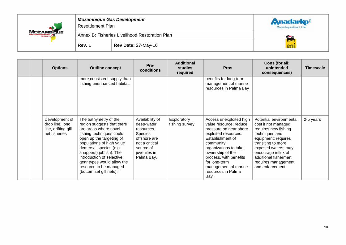
Mozambique Gas Development Resettlement Plan
Annex B: Fisheries Livelihood Restoration Plan
Rev. 1 Rev Date: 27-May-16
Options Outline concept Pre-conditions
Additional studies required
Pros Cons (for all: unintended
consequences) Timescale
more consistent supply than fishing unenhanced habitat.
benefits for long-term management of marine resources in Palma Bay
Development of drop line, long line, drifting gill net fisheries
The bathymetry of the region suggests that there are areas where novel fishing techniques could open up the targeting of populations of high value demersal species (e.g. snappers) jobfish). The introduction of selective gear types would allow the resource to be managed (bottom set gill nets).
Availability of deep-water resources. Species offshore are not a critical source of juveniles in Palma Bay.
Exploratory fishing survey
Access unexploited high value resource; reduce pressure on near shore exploited resources. Establishment of community organizations to take ownership of the process, with benefits for long-term management of marine resources in Palma Bay.
Potential environmental cost if not managed; requires new fishing techniques and equipment; requires transiting to more exposed waters; may encourage influx of additional fishermen; requires management and enforcement.
2-5 years
90
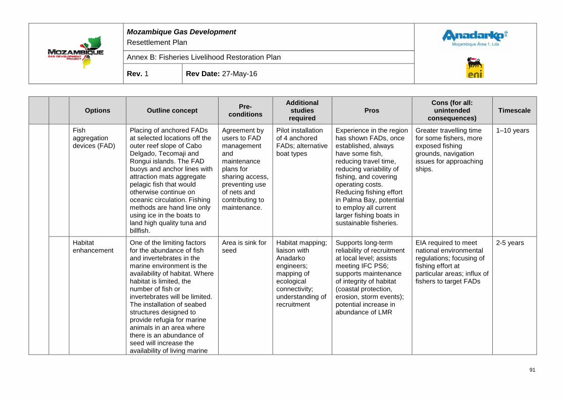
Mozambique Gas Development Resettlement Plan
Annex B: Fisheries Livelihood Restoration Plan
Rev. 1 Rev Date: 27-May-16
Options Outline concept Pre-conditions
Additional studies required
Pros Cons (for all: unintended
consequences) Timescale
Fish aggregation devices (FAD)
Placing of anchored FADs at selected locations off the outer reef slope of Cabo Delgado, Tecomaji and Rongui islands. The FAD buoys and anchor lines with attraction mats aggregate pelagic fish that would otherwise continue on oceanic circulation. Fishing methods are hand line only using ice in the boats to land high quality tuna and billfish.
Agreement by users to FAD management and maintenance plans for sharing access, preventing use of nets and contributing to maintenance.
Pilot installation of 4 anchored FADs; alternative boat types
Experience in the region has shown FADs, once established, always have some fish, reducing travel time, reducing variability of fishing, and covering operating costs. Reducing fishing effort in Palma Bay, potential to employ all current larger fishing boats in sustainable fisheries.
Greater travelling time for some fishers, more exposed fishing grounds, navigation issues for approaching ships.
1–10 years
Habitat enhancement
One of the limiting factors for the abundance of fish and invertebrates in the marine environment is the availability of habitat. Where habitat is limited, the number of fish or invertebrates will be limited. The installation of seabed structures designed to provide refugia for marine animals in an area where there is an abundance of seed will increase the availability of living marine
Area is sink for seed
Habitat mapping; liaison with Anadarko engineers; mapping of ecological connectivity; understanding of recruitment
Supports long-term reliability of recruitment at local level; assists meeting IFC PS6; supports maintenance of integrity of habitat (coastal protection, erosion, storm events); potential increase in abundance of LMR
EIA required to meet national environmental regulations; focusing of fishing effort at particular areas; influx of fishers to target FADs
2-5 years
91
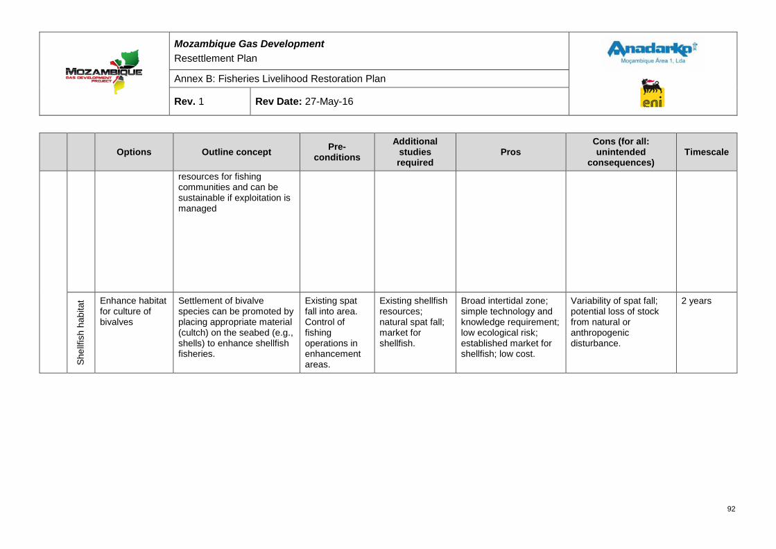
Mozambique Gas Development Resettlement Plan
Annex B: Fisheries Livelihood Restoration Plan
Rev. 1 Rev Date: 27-May-16
Options Outline concept Pre-conditions
Additional studies required
Pros Cons (for all: unintended
consequences) Timescale
resources for fishing communities and can be sustainable if exploitation is managed
Shel
lfish
hab
itat Enhance habitat
for culture of bivalves
Settlement of bivalve species can be promoted by placing appropriate material (cultch) on the seabed (e.g., shells) to enhance shellfish fisheries.
Existing spat fall into area. Control of fishing operations in enhancement areas.
Existing shellfish resources; natural spat fall; market for shellfish.
Broad intertidal zone; simple technology and knowledge requirement; low ecological risk; established market for shellfish; low cost.
Variability of spat fall; potential loss of stock from natural or anthropogenic disturbance.
2 years
92
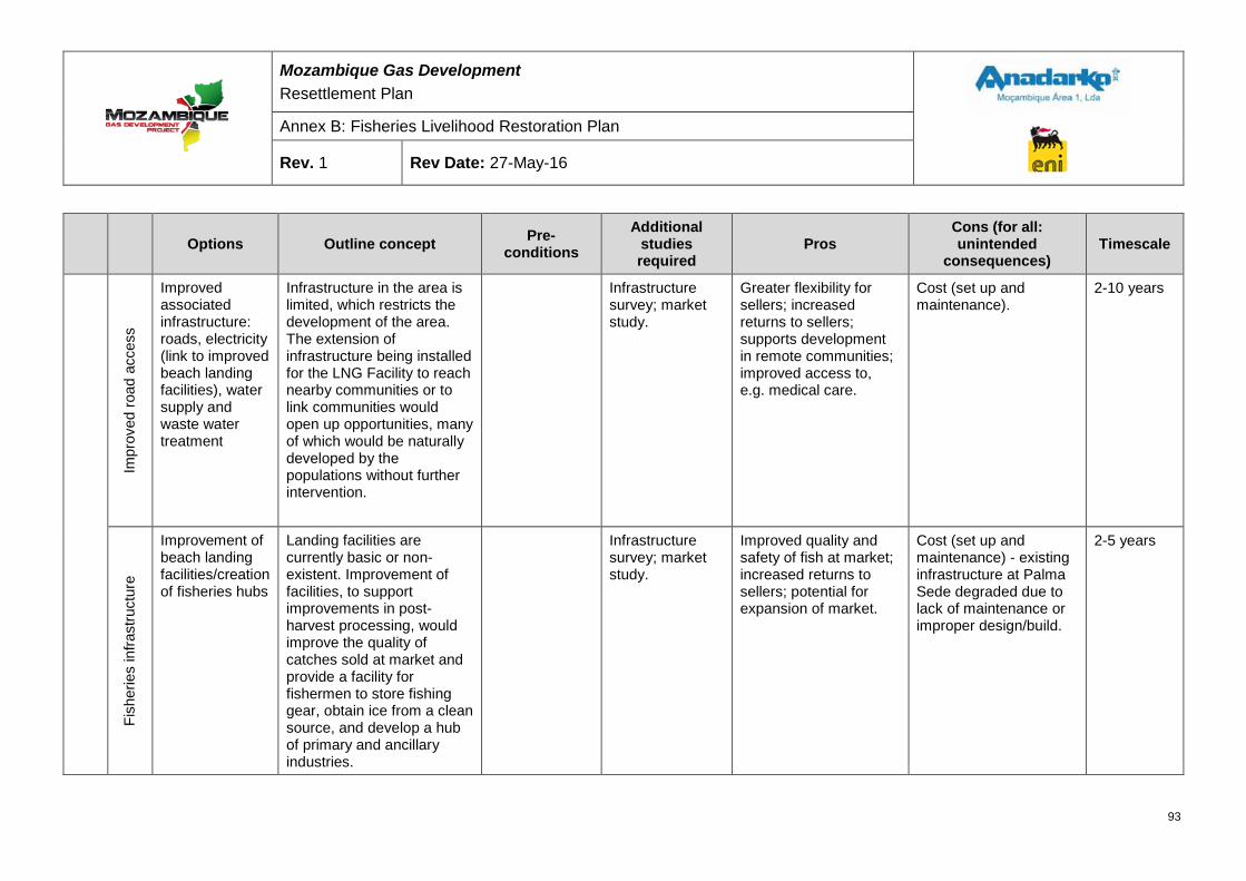
Mozambique Gas Development Resettlement Plan
Annex B: Fisheries Livelihood Restoration Plan
Rev. 1 Rev Date: 27-May-16
Options Outline concept Pre-conditions
Additional studies required
Pros Cons (for all: unintended
consequences) Timescale
Impr
oved
road
acc
ess
Improved associated infrastructure: roads, electricity (link to improved beach landing facilities), water supply and waste water treatment
Infrastructure in the area is limited, which restricts the development of the area. The extension of infrastructure being installed for the LNG Facility to reach nearby communities or to link communities would open up opportunities, many of which would be naturally developed by the populations without further intervention.
Infrastructure survey; market study.
Greater flexibility for sellers; increased returns to sellers; supports development in remote communities; improved access to, e.g. medical care.
Cost (set up and maintenance).
2-10 years
Fish
erie
s in
frast
ruct
ure
Improvement of beach landing facilities/creation of fisheries hubs
Landing facilities are currently basic or non-existent. Improvement of facilities, to support improvements in post-harvest processing, would improve the quality of catches sold at market and provide a facility for fishermen to store fishing gear, obtain ice from a clean source, and develop a hub of primary and ancillary industries.
Infrastructure survey; market study.
Improved quality and safety of fish at market; increased returns to sellers; potential for expansion of market.
Cost (set up and maintenance) - existing infrastructure at Palma Sede degraded due to lack of maintenance or improper design/build.
2-5 years
93
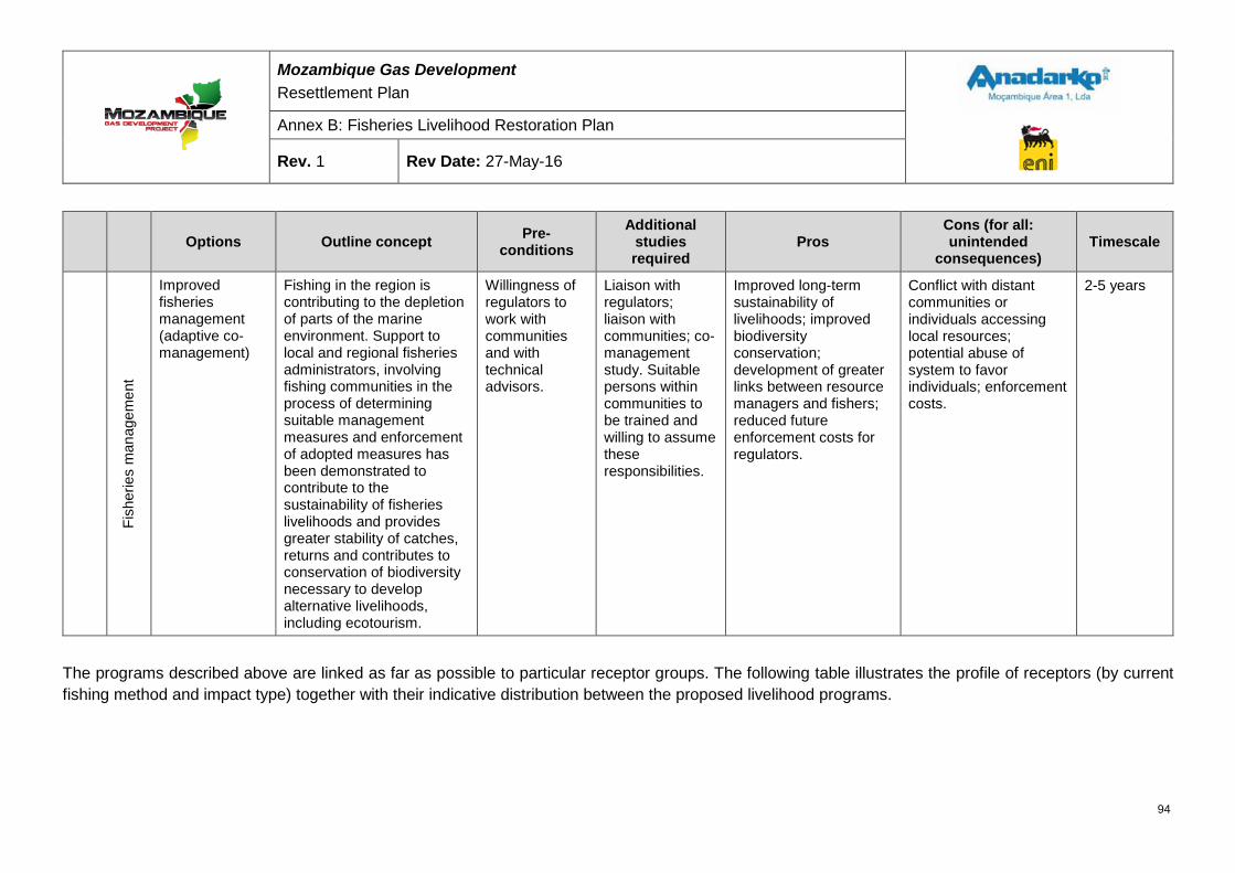
Mozambique Gas Development Resettlement Plan
Annex B: Fisheries Livelihood Restoration Plan
Rev. 1 Rev Date: 27-May-16
Options Outline concept Pre-conditions
Additional studies required
Pros Cons (for all: unintended
consequences) Timescale
Fish
erie
s m
anag
emen
t
Improved fisheries management (adaptive co-management)
Fishing in the region is contributing to the depletion of parts of the marine environment. Support to local and regional fisheries administrators, involving fishing communities in the process of determining suitable management measures and enforcement of adopted measures has been demonstrated to contribute to the sustainability of fisheries livelihoods and provides greater stability of catches, returns and contributes to conservation of biodiversity necessary to develop alternative livelihoods, including ecotourism.
Willingness of regulators to work with communities and with technical advisors.
Liaison with regulators; liaison with communities; co-management study. Suitable persons within communities to be trained and willing to assume these responsibilities.
Improved long-term sustainability of livelihoods; improved biodiversity conservation; development of greater links between resource managers and fishers; reduced future enforcement costs for regulators.
Conflict with distant communities or individuals accessing local resources; potential abuse of system to favor individuals; enforcement costs.
2-5 years
The programs described above are linked as far as possible to particular receptor groups. The following table illustrates the profile of receptors (by current fishing method and impact type) together with their indicative distribution between the proposed livelihood programs.
94
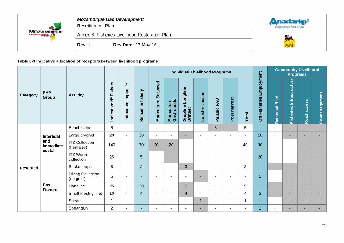
Mozambique Gas Development Resettlement Plan
Annex B: Fisheries Livelihood Restoration Plan
Rev. 1 Rev Date: 27-May-16
Table 8-3 Indicative allocation of receptors between livelihood programs
Category PAP Group Activity
Indi
cativ
e N
º Fis
hers
Indi
cativ
e im
pact
%
Rem
ain
in fi
sher
y
Individual Livelihood Programs
Off
Fish
erie
s Em
ploy
men
t Community Livelihood Programs
Mar
icul
ture
Sea
wee
d
Mar
icul
ture
G
astr
opod
s
Dro
plin
e Lo
nglin
e D
riftn
et
Lobs
ter c
asita
s
Pela
gic
FAD
Post
har
vest
Tota
l
Dem
ersa
l Ree
f
Fish
erie
s In
fras
truc
ture
Roa
d ac
cess
Co-
man
agem
ent
Resettled
Intertidal and immediate costal
Beach seine 5 - - - - - - 5 - 5 - - - - -
Large dragnet 20 - 10 - - - - - - - 10 - - - -
ITZ Collection (Females) 140 - 70 20 20 - - - - 40 30 - - - -
ITZ Worm collection 25 - 5 - - - - - - - 20 - - - -
Bay Fishers
Basket traps 5 - 2 - - 3 - - - 3 - - - - -
Diving Collection (no gear) 5 - - - - - - - - - 5 - - - -
Handline 25 - 20 - - 5 - - - 5 - - - - -
Small mesh gillnet 10 - 4 - - 4 - - - 4 2 - - - -
Spear 1 - - - - - 1 - - 1 - - - - -
Spear gun 2 - - - - - - - - - 2 - - - -
95
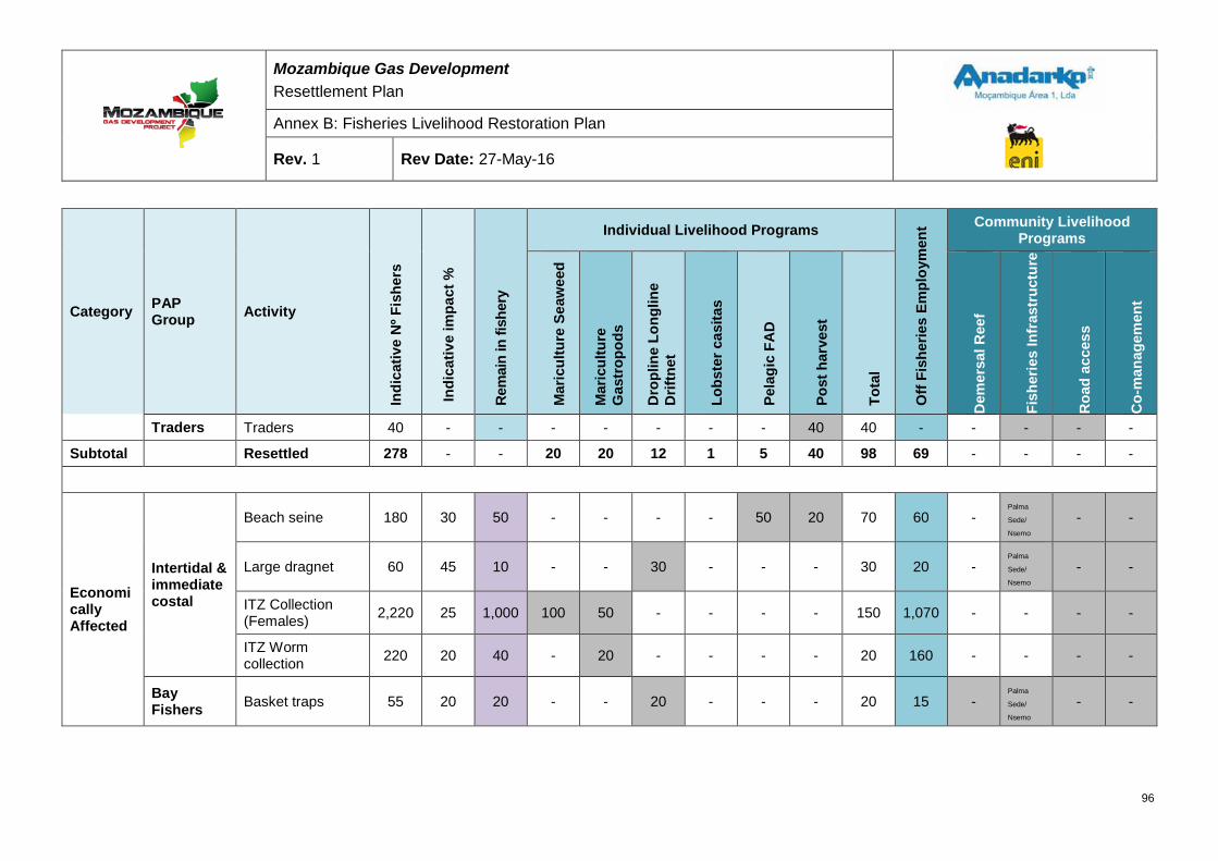
Mozambique Gas Development Resettlement Plan
Annex B: Fisheries Livelihood Restoration Plan
Rev. 1 Rev Date: 27-May-16
Category PAP Group Activity
Indi
cativ
e N
º Fis
hers
Indi
cativ
e im
pact
%
Rem
ain
in fi
sher
y
Individual Livelihood Programs
Off
Fish
erie
s Em
ploy
men
t Community Livelihood Programs
Mar
icul
ture
Sea
wee
d
Mar
icul
ture
G
astr
opod
s
Dro
plin
e Lo
nglin
e D
riftn
et
Lobs
ter c
asita
s
Pela
gic
FAD
Post
har
vest
Tota
l
Dem
ersa
l Ree
f
Fish
erie
s In
fras
truc
ture
Roa
d ac
cess
Co-
man
agem
ent
Traders Traders 40 - - - - - - - 40 40 - - - - -
Subtotal Resettled 278 - - 20 20 12 1 5 40 98 69 - - - -
Economically Affected
Intertidal & immediate costal
Beach seine 180 30 50 - - - - 50 20 70 60 - Palma
Sede/
Nsemo
- -
Large dragnet 60 45 10 - - 30 - - - 30 20 - Palma
Sede/
Nsemo
- -
ITZ Collection (Females) 2,220 25 1,000 100 50 - - - - 150 1,070 - - - -
ITZ Worm collection 220 20 40 - 20 - - - - 20 160 - - - -
Bay Fishers Basket traps 55 20 20 - - 20 - - - 20 15 -
Palma
Sede/
Nsemo
- -
96
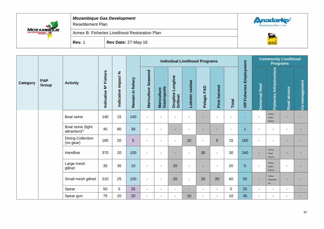
Mozambique Gas Development Resettlement Plan
Annex B: Fisheries Livelihood Restoration Plan
Rev. 1 Rev Date: 27-May-16
Category PAP Group Activity
Indi
cativ
e N
º Fis
hers
Indi
cativ
e im
pact
%
Rem
ain
in fi
sher
y
Individual Livelihood Programs
Off
Fish
erie
s Em
ploy
men
t Community Livelihood Programs
Mar
icul
ture
Sea
wee
d
Mar
icul
ture
G
astr
opod
s
Dro
plin
e Lo
nglin
e D
riftn
et
Lobs
ter c
asita
s
Pela
gic
FAD
Post
har
vest
Tota
l
Dem
ersa
l Ree
f
Fish
erie
s In
fras
truc
ture
Roa
d ac
cess
Co-
man
agem
ent
Boat seine 140 15 140 - - - - - - - - - Palma
Sede/
Nsemo
- -
Boat seine (light attraction)/1 40 80 39 - - - - - - - 1 - - - -
Diving Collection (no gear) 180 20 5 - - - 10 - 5 15 160 - - - -
Handline 370 20 100 - - - - 30 - 30 240 - Palma
Sede/
Nsemo
- -
Large mesh gillnet 35 35 10 - - 20 - - - 20 5 -
Palma
Sede/
Nsemo
- -
Small mesh gillnet 210 25 100 - - 20 - 20 20 60 50 - Palma
Sede/Nse
mo
- -
Spear 50 5 25 - - - - - - 0 25 - - - -
Spear gun 75 20 20 - - - 10 - - 10 45 - - - -
97
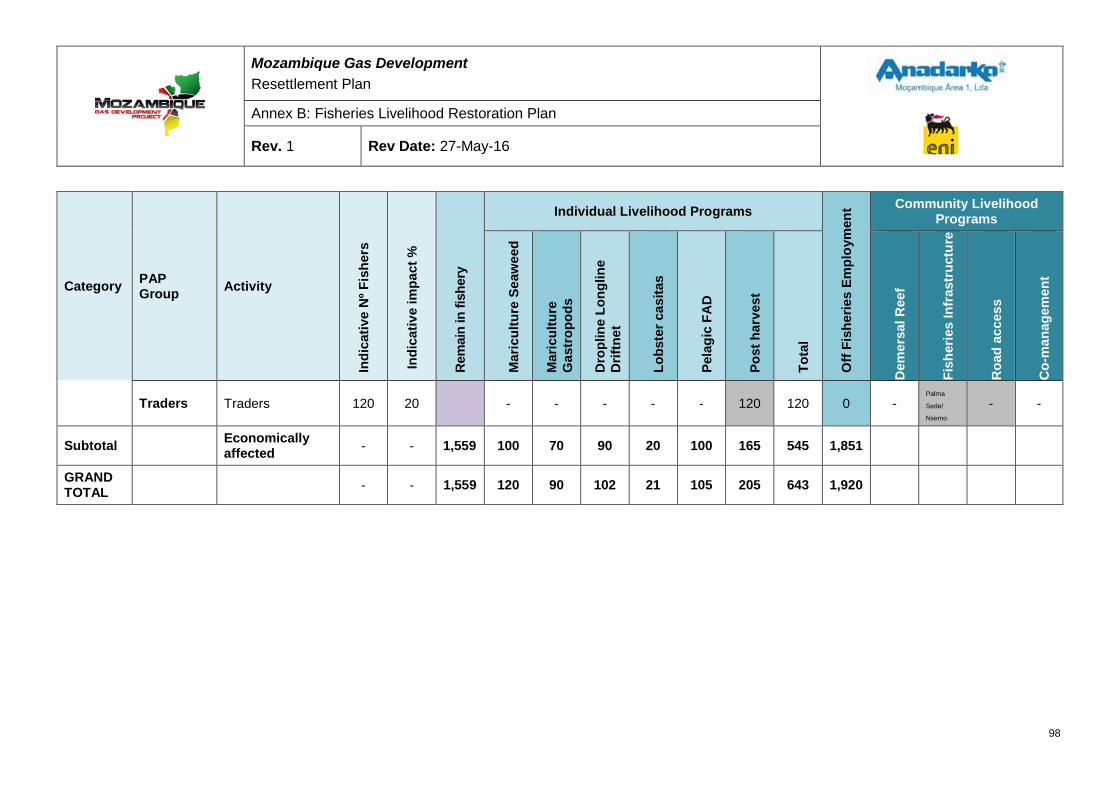
Mozambique Gas Development Resettlement Plan
Annex B: Fisheries Livelihood Restoration Plan
Rev. 1 Rev Date: 27-May-16
Category PAP Group Activity
Indi
cativ
e N
º Fis
hers
Indi
cativ
e im
pact
%
Rem
ain
in fi
sher
y
Individual Livelihood Programs
Off
Fish
erie
s Em
ploy
men
t Community Livelihood Programs
Mar
icul
ture
Sea
wee
d
Mar
icul
ture
G
astr
opod
s
Dro
plin
e Lo
nglin
e D
riftn
et
Lobs
ter c
asita
s
Pela
gic
FAD
Post
har
vest
Tota
l
Dem
ersa
l Ree
f
Fish
erie
s In
fras
truc
ture
Roa
d ac
cess
Co-
man
agem
ent
Traders Traders 120 20 - - - - - 120 120 0 - Palma
Sede/
Nsemo
- -
Subtotal Economically affected - - 1,559 100 70 90 20 100 165 545 1,851
GRAND TOTAL - - 1,559 120 90 102 21 105 205 643 1,920
98
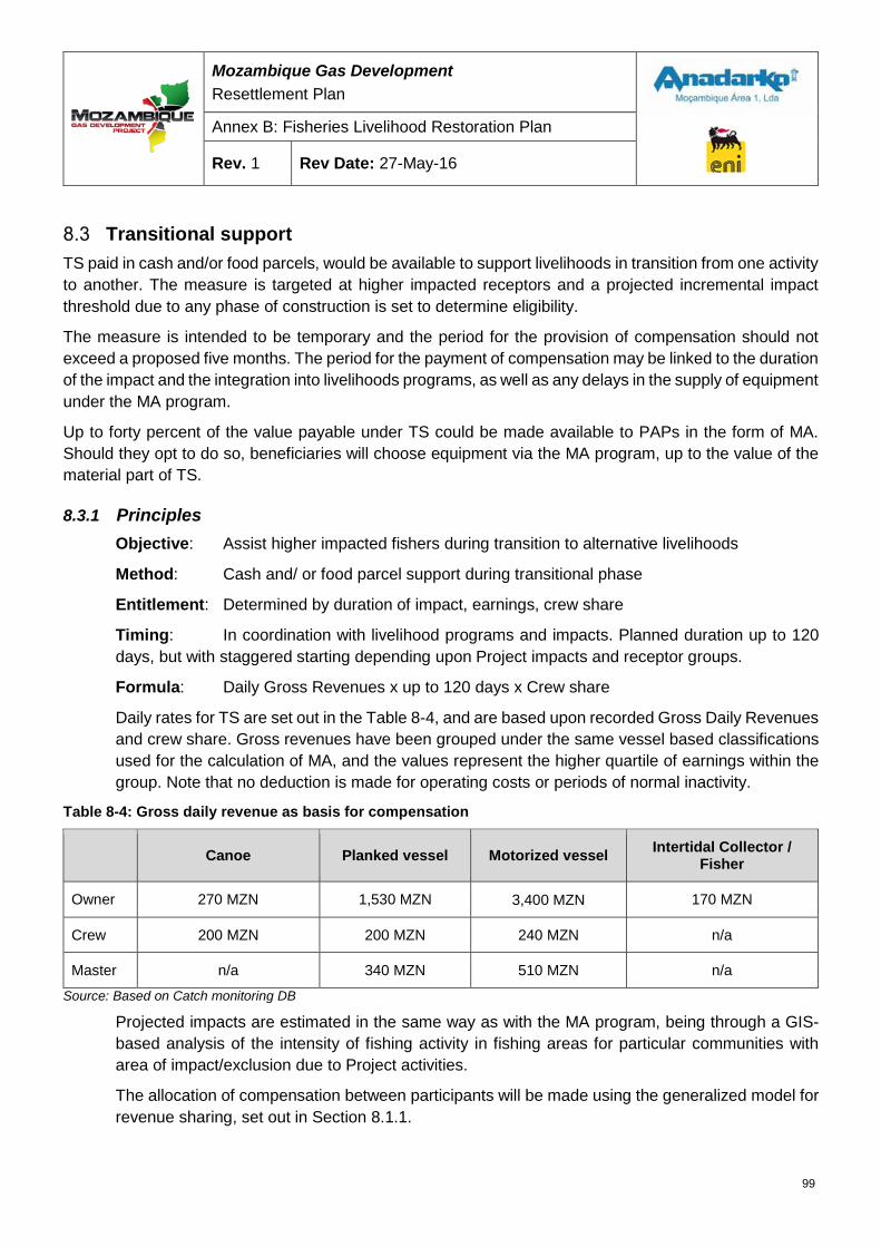
Mozambique Gas Development Resettlement Plan
Annex B: Fisheries Livelihood Restoration Plan
Rev. 1 Rev Date: 27-May-16
Transitional support TS paid in cash and/or food parcels, would be available to support livelihoods in transition from one activity to another. The measure is targeted at higher impacted receptors and a projected incremental impact threshold due to any phase of construction is set to determine eligibility.
The measure is intended to be temporary and the period for the provision of compensation should not exceed a proposed five months. The period for the payment of compensation may be linked to the duration of the impact and the integration into livelihoods programs, as well as any delays in the supply of equipment under the MA program.
Up to forty percent of the value payable under TS could be made available to PAPs in the form of MA. Should they opt to do so, beneficiaries will choose equipment via the MA program, up to the value of the material part of TS.
8.3.1 Principles Objective: Assist higher impacted fishers during transition to alternative livelihoods
Method: Cash and/ or food parcel support during transitional phase
Entitlement: Determined by duration of impact, earnings, crew share
Timing: In coordination with livelihood programs and impacts. Planned duration up to 120 days, but with staggered starting depending upon Project impacts and receptor groups.
Formula: Daily Gross Revenues x up to 120 days x Crew share
Daily rates for TS are set out in the Table 8-4, and are based upon recorded Gross Daily Revenues and crew share. Gross revenues have been grouped under the same vessel based classifications used for the calculation of MA, and the values represent the higher quartile of earnings within the group. Note that no deduction is made for operating costs or periods of normal inactivity.
Table 8-4: Gross daily revenue as basis for compensation
Canoe Planked vessel Motorized vessel Intertidal Collector / Fisher
Owner 270 MZN 1,530 MZN 3,400 MZN 170 MZN
Crew 200 MZN 200 MZN 240 MZN n/a
Master n/a 340 MZN 510 MZN n/a
Source: Based on Catch monitoring DB
Projected impacts are estimated in the same way as with the MA program, being through a GIS-based analysis of the intensity of fishing activity in fishing areas for particular communities with area of impact/exclusion due to Project activities.
The allocation of compensation between participants will be made using the generalized model for revenue sharing, set out in Section 8.1.1.
99
Mozambique Gas Development Resettlement Plan
Annex B: Fisheries Livelihood Restoration Plan
Rev. 1 Rev Date: 27-May-16
8.3.2 Duration of payments For the Construction Phase, resettled households and highly impacted receptors will be attributed up to 120 days of Transitional Compensation, at a rate equal to the Gross Daily Revenue for the type of activity, with no deduction made for periods of normal inactivity (such as unfavorable tidal phase).
8.3.3 Disbursement All attempts will be made to make TS available ex-ante, prior to impacts to avoid food insecurity risks. However, when support is made available after the event, this should be done as soon as possible after the impact. The village leader, a Government representative, and a member of a civil society organization should verify payments.
Cash payments could be made to individuals in the field to the agreed amount, but the preferred method of payments will be through banks or local financial institutions. In Palma Sede, payment will only be made by bank check or voucher, redeemable at the local bank or other financial institution.
For impacts that are anticipated to last more than one month, payment would be best made monthly, in advance.
All disbursements must be accompanied by a signed statement acknowledging receipt of payment as full and final settlement of compensation related to particular impacts/period, countersigned by both a Project representative and a member of the Government. Signing the settlement agreement will waive the claimant’s right to enter further claims relating to the same period of time.
Short term compensation Short-term compensation would be made available to receptors suffering short-term impacts, of the order of one-month duration or less. Impacts of longer duration would be compensated the material assistance program. STC should compensate for lost earnings and should be made available as cash and/or food parcels.
8.4.1 Principles Objective: Offset short term impacts, such as temporary interruptions to fishing activities
Method: Cash and/or food parcel compensation for lost earnings
Entitlement: Determined by duration of impact, earnings, crew share
Timing: Short term, but disbursements foreseen throughout construction
Formula: Gross Daily Revenue x Impact duration x Crew share
Gross Daily Revenue for compensation will be that detailed in Table 8-4. It will be paid without deduction for operating expenses, or normal periods of inactivity.
100
Mozambique Gas Development Resettlement Plan
Annex B: Fisheries Livelihood Restoration Plan
Rev. 1 Rev Date: 27-May-16
8.4.2 Expected beneficiaries It is anticipated that the beneficiaries of STC will include communities affected by planned Project activities with short-term impacts, such as the passage of a vessel laying pipes in a pre-dug trench in front of a fishing center. STC may also be used to compensate for unplanned impacts such as accidents. Beneficiaries are expected to be those most affected by construction and pipe laying activities, but could come from any fishing community.
8.4.3 Payment of compensation STC is expected to only be made available after the impact, especially in the case of accidents. In some cases it should be possible to link STC with community communication related to planned impacts (such as the passing of a vessel), in which case it may be possible to make ex-ante disbursements. Whatever the case, the purpose of STC is to secure short-term livelihoods and, in the context of the subsistence nature of many of the fishing activities, timely availability will be paramount.
101
Mozambique Gas Development Resettlement Plan
Annex B: Fisheries Livelihood Restoration Plan
Rev. 1 Rev Date: 27-May-16
9 ANNEX 1 – LEGAL FRAMEWORK FISHERIES LEGAL FRAMEWORK
Fisheries Law (Law N° 22/13 of 1st November) This law aims at establishing the legal regime of fishing and complementary activities, with a view to protection, conservation and sustainable use of national aquatic biological resources.
To ensure responsible fishing and aquaculture the present law follows, among others, the following principles of conservation and proper utilization of living aquatic resources and their ecosystems:
An ecosystem approach to fisheries and fisheries management that promotes the maintenance of diversity, quality and availability of fishery resources in sufficient quantities for present and future generations in the context of food security and poverty reduction
Precautionary principle, by which, given the degree of uncertainty of scientific knowledge, the management, conservation and exploitation of living aquatic resources aims at their protection, conservation and sustainability, and the prevention is considered harmful to the environment
Principle of participatory management of fishery resources, with the involvement of fishermen, economic associations, and other groups interested in fisheries and aquaculture, in the management of fishery resources on which they depend
Polluter pays principle, which asserts individual or legal persons’ accountability for the replacement cost of the damaged environment, or the costs for the prevention and elimination of pollution they have caused, in the exercise of fishing and fishing related activities.
This law serves as an umbrella law, defining the parameters of the fisheries administration and activities of the economic operators. It also establishes that it is the responsibility of the State to regulate and establish the conditions under which fisheries resources can be explored and exploited. Furthermore, it assigns responsibility to the MMAIP to define fisheries resources conservation measures, including prescribing conservation and management measures, banning or regulating the fishing of marine mammals and other internationally protected species, as well as protecting rare or endangered species.
The Fisheries Law is relevant to the Project because all mitigation and offset measures and, the FLRP proposed activities, without prejudice to all subsector specific legislation, should be in line with the principles sated in this law.
Fisheries Policy and Implementing Strategies (Resolution 11/96 of 28th May) The Fishery Policy aims at improving the domestic supply of fish products to: cover part of the country’s food deficit; increase national net income generated by the sector; and improve the livelihoods of local fishing communities. The main strategies adopted in the framework of the fisheries policy to achieve these objectives include: improving fisheries resource management, fishing methods and techniques accessible to artisanal fisheries; improving artisanal boat building; minimizing post-harvest losses; and better commercialization of fish products.
102
Mozambique Gas Development Resettlement Plan
Annex B: Fisheries Livelihood Restoration Plan
Rev. 1 Rev Date: 27-May-16
This piece of legislation is relevant to the Project once it highlights the general government priorities for fisheries development. The proposed fisheries related activities aimed at restoring the livelihoods of the fishing communities affected by the Project should therefore be in line with government policies and strategies stated in the Resolution 11/96 of 28th May.
Regulation on Marine Fishing (Decree N° 43/2003 of 10th December) This Regulation aims at regulating the provisions laid down in the Fisheries Law regarding marine fisheries.
The MIMAIP adopts participatory management to ensure appropriate management of fisheries resources. As per Article 15 of this Regulation participatory management pursues the following objectives:
a) Ensure responsible management of fisheries
b) Ensure the access rights to fisheries by fishing communities with a view to protect and promote their welfare
c) Promote the participation of fishing communities in the planning and implementation of fishery management measures
d) Promote training activities through fishery extension work
e) Create a favorable environment for peaceful coexistence between artisanal fishermen and other industrial operators.
The same article defines the Commission for Fisheries Administration (CAP) and Co-Management Committees as the participatory management forum where all interested groups are represented, from artisanal fishermen, through their Fishery Community Councils (CCPs), to industrial operators.
Article 16 defines the Commission for Fisheries Administration (CAP) as an advisory body of the fishery administration on matters and scope of the preservation and management of fisheries resources.
The Co-Management Committee is defined in Article 18 as the forum for participatory management at local, district and provincial level. In addition to the local Fisheries Administration Authority, this forum includes local Fisheries Community Councils, fisheries operators, processors, research and extension workers, maritime authority and local fisheries related product traders.
According to Article 19 of the Regulation, Fisheries Community Councils (CCP) are officially recognized by the Minister of MIMAIP and they aim to:
a) Contribute to the preservation and conservation of ecosystems in their geographical area
b) Identify problems in the use and management of fisheries resources
c) Contribute to participative management of fisheries, working with government, fishermen and other individuals or groups to ensure access and sustainable use of resources
d) Manage conflicts resulting from fishery activities
103
Mozambique Gas Development Resettlement Plan
Annex B: Fisheries Livelihood Restoration Plan
Rev. 1 Rev Date: 27-May-16
e) Develop activities for sustainability of resources and the improvement of living conditions, incorporating the interests of the community in the development action plan.
Article 27 authorizes the use of light sources to attract fish. These can be placed above or below the water surface and, may be active both on board the fishing vessels or auxiliary vessels and up to a power of 100 kW per fishing vessel.
Article 28 authorizes the use of Fish Aggregating Devices and stipulates that the Minister of MIMAIP will define the conditions under which they can be installed, used and operated.
Article 112 deals with areas reserved for preservation and protection of marine species and provides for the establishment of marine parks, marine reserves and marine protected areas.
Article 117 stipulates that for maritime safety reasons, particularly in canals, bays and estuaries, or during naval exercises, areas with full or partial cessation of fishing may be established on a permanent or temporary basis. It specifies that the Minister of Transport and Communications, in coordination with the Minister of MIMAIP, is responsible for establishing such areas.
The relevance of the Regulation on Marine Fishing for the Project is in the fact that when proposing mitigation and offset measures like promoting the continuation of light fish attraction in other areas outside the MEZ and SZ, promoting new fishing gear and techniques and, alternative livelihoods like the introduction of Artificial Reefs, should all follow what is prescribed in this piece of legislation. The promotion of co-management, one of the activities identified under the FLRP is also dealt with in the regulation.
Regulation on Aquaculture (Decree 35/2001 of 13th November) This Regulation aims to regulate the Fisheries Law with respect to aquaculture activity. The MIMAIP will promote, whenever necessary, the preparation of aquaculture development plans, which will include aspects related to identification of regions and areas for aquaculture development, and an indication of conditions under which aquaculture activities can be developed.
The Regulation on Aquaculture sets up the guidelines under which aquaculture activities should be promoted in Mozambique. Taking into account that one of the areas identified by the Project as an offset measure to counteract the effect of MEZ and SZ on Intertidal collectors is aquaculture, this piece of legislation should be present in all initiatives leading to that end.
Aquaculture Marine Reserve (Decree 71/2011 of 30th December) This Decree defines and establishes areas reserved for aquaculture development, with the aim to ensure that marine aquaculture represents an alternative way for responsible exploitation of marine aquatic environments and its respective species. It provides for the development of activities that aim at reproduction, growth and fattening, maintaining and upgrading of aquatic species for production purposes. The Decree promotes the active participation of public, private and local communities in the management and development of marine areas that comprise the Aquaculture Marine Reserves. With the concurrence of the Minister of MIMAIP, this Decree authorizes the implementation of other socio-economic activities within the declared Aquaculture Marine Reserve, as long as they have a comparative advantage, or are complementary to aquaculture.
104
Mozambique Gas Development Resettlement Plan
Annex B: Fisheries Livelihood Restoration Plan
Rev. 1 Rev Date: 27-May-16
The relevance of this Decree derives by the fact the established Aquaculture Marine Reserve cover the area under the Project influence, which means that any activity within this area requires the concurrence of the Minister of MIMAIP. This Decree also identifies the areas and type of culture to be implemented within the Marine Reserve. In other words this means that all Project aquaculture promoted activities should respect what has been prescribed in this Decree.
Regulation on Recreational and Sport Fishing (Decree 51/99 of 31st August) The Regulation on Recreational and Sport Fishing establishes the rules by which this sport can be practiced in the territorial waters of Mozambique. It prohibits the fishing of protected species listed in below.
Table 9-1: List of protected species under the Regulation on Recreational and Sport Fishing
Portuguese name English name Scientific name
Peixes Garoupa lanceolatus Dentuço manchado Garoupa batata Pargo vermelho Tubarão branco Répteis Tartarugas marinhas Mamíferos Dugongo Baleias Golfinhos Bivalves Tridacna gigante Tridacna squamosa Gastrópodes Capacete grande Cornata trompteira
Fishes Brindle bass Seventy-four Potato bass Red steenbras White shark Reptiles Marine turtles Mammals Dugong Whales Dolphins Bivalves Giant clam Giant clam Gastropods Hornet helmet Trumpet triton
Fishes Ephinephelus lanceolatus Polysteganus undulosus Ephinephelus tukula Petrus rupestris All species Dugong dugong All species All species Tridacna gigante Tridacna squamosa Cassis cornuta Charonia tritonis
The proposed mitigation and offset measures as well as the proposed fisheries livelihoods restoration measures should be in line with national legislation. Therefore, this piece of legislation will help avoid promoting measures that would stimulate the capture and collection of the above-identified species.
105
Mozambique Gas Development Resettlement Plan
Annex B: Fisheries Livelihood Restoration Plan
Rev. 1 Rev Date: 27-May-16
FISHERIES INSTITUTIONAL ARRANGEMENT
MIMAIP – Presidential Decree 01/2015 of 16th January in conjunction with the Resolution 38/2010 of 22nd December
The Administration of fishing in Mozambique consists of the Ministry of the Sea, Inland Waters and Fisheries (MIMAIP), the respective provincial bodies, the central institutions supervised by the Ministry, and their respective local representations.
The Ministry of the Sea, Inland Waters and Fisheries (MIMAIP) is the political organ of the Government of Mozambique (GoM) responsible for the fisheries administration. Its main responsibilities are related to the establishment of fishing development policies, the translation of policies into plans, coordinating their implementation, and controlling the performance of sector institutions.
The MIMAIP, while a fisheries administration institution, is structured in three components or sub-systems: political; fisheries management; and fisheries development. The National Directorate for Fisheries Economics and Policies –DNEPP, determines the political sub-system. The fisheries management sub-system includes the National Directorate for Fisheries Administration – ADNAP; the Fisheries Research Institute – IIP; the Directorate for Surveillance –DF; and the Institute for Quality Control. Finally the fisheries development sub-system includes the Institute for Small-scale Development – IDPPE; the Fisheries Development Fund – FFP; the Institute for Aquaculture Development – INAQUA; and the Fisheries School – EP
At the local level the fisheries administration is represented at the level of province and district. At a level lower than the district, responsibility for fisheries administration lies with the District Administrator.
Under the delegation of competence by the MMAIP and the respective District Administrations, the Community Fisheries Councils (CCPs) may exercise part of the competence assigned to the administrator.
The MMAIP being the political body of the government responsible for all aspects for fisheries development it also falls under its remit the definition of policies and respective general legislation. Therefore, all Project-related fisheries activities should be strongly coordinated with the MMAIP to ensure there are in line with the defined fisheries development policies and respects the established legislation.
General Directorate for Fisheries Administration (ADNAP) – Resolution 36/2010 of 22nd December ADNAP and its provincial representatives are responsible for monitoring, control and enforcement of fisheries laws and regulations. Coordination of local co-management committees is also part of the fisheries management system.
The General Directorate for Fisheries Administration pursues the following objectives:
a) Ensure that fishing activities take place in compliance with the existing management measures and the provisions of the fisheries law and regulations
b) Monitor the state of exploitation of fisheries and assess their environmental impacts
106
Mozambique Gas Development Resettlement Plan
Annex B: Fisheries Livelihood Restoration Plan
Rev. 1 Rev Date: 27-May-16
c) Propose, adopt and implement management measures required for the sustainability of fisheries
d) Ensure the functioning of participatory fisheries management systems
e) Promote the practice of responsible fisheries and monitor the development of new fisheries.
It also falls under the responsibility of the Directorate to ensure actions leading to co-management of fisheries at different levels, including promoting fisheries community based organizations.
The promotion of co-management institutions under the FLRP is in line with the government to promote the participation of fishing communities in the management of the fishing activity and, falls under the remit of the General Directorate for Fisheries Administration. Therefore, there is a need for coordination during implementation to avoid deviations from government policies and duplication of efforts. Additionally, ADNAP is the institution in the MMAIP that the Project should liaise when proposing the promotion and introduction of new fishing gear and technologies.
Fisheries Research Institute (IIP) – Decree 63/98 of 24th November The primary objective of IIP is the scientific management of fishing resources of Mozambican territorial waters. Specifically, IIP is responsible for:
a) Development of research needed to acquire scientific knowledge of the available fishing resources of Mozambican territorial waters, with a view to their management, conservation and optimum exploitation
b) Realization of environmental studies complementary to research on fishery resources
c) Experimentation of culture techniques for the production of commercial aquatic species adapted to the environmental conditions of the country
d) Implementation of environmental studies in the fields of oceanography and limnology.
The monitoring of fishing activity being carried out by the Project with the aim to acquire reliable information to feed into the preparation of various documentation including the Resettlement Plan (RP) and the FLRP is an activity that is in strong interest of IIP taking into account that they also develop similar activity. Therefore, coordination of both activities, Project and IIP, comparing and adjusting methodologies is of strong relevance for both parties
Institute for Small-Scale Fisheries Development (IDPPE) – Decree 62/98 of 24th November IDPPE aims to promote actions conducive to the development of small-scale fishing production with an emphasis on small-scale fisheries, therefore contributing to improve the living standards and working conditions of the fishing communities, and increase the production of animal protein for the country. Thus, the IDPPE is responsible for:
a) Conducting studies with the aim to establish policies, strategies, programs and plans for the development of small-scale fisheries production
107
Mozambique Gas Development Resettlement Plan
Annex B: Fisheries Livelihood Restoration Plan
Rev. 1 Rev Date: 27-May-16
b) Undertaking studies and promoting activities and development projects for small-scale fisheries production related to socio-economic aspects, fishing technology, and all technology complementary to fishery activities
c) Promoting and coordinating activities and projects of co-operation, training courses and seminars aimed at professional strengthening of government professionals and fishermen, with the aim of fostering support and the development of small-scale fishing production.
The fisheries in Palma Bay and other areas under the influence of the Project are all artisanal, using small-planked vessels and dugout canoes and low technology fishing techniques. This area of activity falls under the remit of the Institute for Small Scale Fisheries Development, which responsibilities have been underlined above. Thus, the relevance of coordinating activities aimed at promoting livelihoods restoration of the artisanal fishers potentially affected by the Project with IDPPE.
National Institute for Aquaculture (INAQUA) – Decree 28/2008 of 3rd July INAQUA aims to: promote, extend, administer, manage and coordinate aquaculture development; monitor all aquaculture related activities; and support local initiatives leading to the development of aquaculture at the local level.
Under the identification of the measures to restore the livelihoods of the fishing community affected by the Project activities, aquaculture is one of the areas with potential for development. The National Institute for Aquaculture has the mandate to oversee aquaculture development in Mozambique and, thus its importance in coordinating actions with Project to ensure that all identified activities are in line with country development priorities.
Co-management Institutions – Ministerial Diploma 49/2007 of 24th May Co-management institutions aim to: ensure responsible fisheries management; ensure the right of access to fisheries for the fishing communities with a view to protecting and promoting their welfare; and promote the participation of the fishing communities in the planning and implementation of fishery management measures.
Commission for Fisheries Administration (CAP) – Ministerial Diploma 63/2012 of 22nd March CAP is an advisory body to the MMAIP on matters related to the conservation of fish resources and fisheries management, including closed season, areas restricted to fishing activities, and fisheries development plans.
Co-Management Committee (CCG) – Ministerial Order 49/2007 of 24th May Similarly to CAP, the CCG is also an advisory body, but for the local authorities of fisheries management (Provincial and District levels). The CCG should issue opinions on various aspects of fisheries management, including proposals for the establishment of closed seasons, fisheries legislation, programs of experimental fishing and fisheries extension, licensing of fishing and their respective fees, and fish surveillance and conflicts.
108
Mozambique Gas Development Resettlement Plan
Annex B: Fisheries Livelihood Restoration Plan
Rev. 1 Rev Date: 27-May-16
In addition to the Fisheries Administration authority the CCG is comprised of the representatives of the CCP, the fishing operators represented by their associations, local and traditional authorities and other fishing interest groups.
Fisheries Community Councils (CCP) – Ministerial Order of 17th June 2008 (BR 24, III Série) CCPs are part of co-management and aim to regulate the use of fisheries resources. Their responsibilities include: ensuring that appropriate fishing technology is used (promoting responsible fishing); promoting environmentally sustainable development; and contributing to participative management of fisheries, working with government, fishermen and other individuals or groups in order to ensure access to and sustainable use of resources. Another important function of the CCPs is to solve disputes and conflicts arising over access to resources.
CCPs generally represent more than one community. In the communities where they operate, CCPs are inclusive forums where important issues concerning fisheries livelihoods and resources are discussed.
Under the FLRP, the promotion of strong and functional Co-management institutions have been identified as one of the important activity to ensure sustainability of the fisheries and, participation of the fishing communities in management of their fisheries. The MIMAIP has included the promotion of Co-Management institutions in the legislation recognition of its importance in fisheries management. Therefore, in promoting co-management the Project should strongly liaise with the government initiatives the area.
109
Mozambique Gas Development Resettlement Plan
Annex B: Fisheries Livelihood Restoration Plan
Rev. 1 Rev Date: 27-May-16
10 ANNEX 2 – MATERIAL ASSISTANCE PROGRAM Receptor groups
The equipment supply program will be a cornerstone of fisheries offset and compensation packages and target receptors will include individual fisheries Project Affected Persons (PAPs) that are eligible for a benefits package (fishers, collectors and traders). The Program will only be available to persons who are either physically or economically impacted by the Project.
Objective The equipment supply program will make available equipment to PAPs, relevant to fishing, collection, processing and trading. The equipment supplied will form part of individual livelihoods rehabilitation benefits packages. The program will also be available for gear replacement in the event of accidental destruction of fishing gear by a Project vessel or other similar impact that would require compensation in kind.
Program description The equipment supply program will work with national commercial suppliers of relevant equipment in order to make equipment available to PAPs as part of compensation benefits. Under the program a survey will be conducted of the detailed specifications of relevant fishing equipment, covering both equipment in use, as well as equipment relevant to diversification programs promoted under the RP/FLRP. The list of equipment should cover fishing gear, diving equipment (mask, snorkel, and flippers), safety equipment, protective clothing, navigational equipment, domestic freezers, fish boxes, cold boxes, vessels, sailcloth and outboard motors. Equipment suppliers will be sought through a tender process and a catalogue drawn up, detailing the specifications and delivery cost for each item. Individual fishers will be free to select items from the catalogue up to the value of their benefit package. The equipment supply program will be responsible for the compilation of bulk orders and channeling these to the previously selected suppliers, for subsequent procurement and delivery. The equipment supply program will run in phases, corresponding to the major implementation phases for resettlement and the construction of marine infrastructure.
Fishers will be permitted to join together and accumulate entitlements so that more expensive items (such as outboard motors) can be purchased jointly.
The items in the equipment supply catalogue will only be those relevant to fishing and trading activities, and specifications will be strictly in accordance with the provisions of current legislation. Illegal small mesh nets, such as those used in mosquito and larger dragnets will not be made available through the catalogue.
The equipment supply program will also support any grievance procedures that should arise, while the equipment supply program is running. Should the Project agree to supply fishing equipment as part of resolution of a grievance process, gear will be selected from the catalogue and procured via the selected suppliers. The program should encourage one or more suppliers to establish a permanent presence in Palma Sede, thus improving long term gear supply to the fishery.
110
Mozambique Gas Development Resettlement Plan
Annex B: Fisheries Livelihood Restoration Plan
Rev. 1 Rev Date: 27-May-16
Expected outcome The equipment supply program is expected to supply at least 80 percent of all equipment by value to be purchased under fisheries related compensation. It is thus expected that the program should deliver approximately 59.2 million MZN (USD 1.74 million)18 of equipment to PAPs.
Risks Any equipment supply project in small scale fisheries runs the risk of beneficiaries claiming that supplied equipment is not as productive as expected, often due to very small differences in specification (for example the particular tint of blue color of multifilament gill nets). It may not be possible to avoid this, but the risk will be minimized by making samples of equipment available, and leaving the PAPs to make their own selection. The prices imputed in the equipment catalogue will be keyed to the commercial prices of the selected traders. Currently much of the fishing equipment enters the fishery via informal channels, escaping many fiscal obligations, and there is a risk that PAPs will complain that, by comparison, the catalogue prices are high.
Phasing/Timescale The initial survey to establish the content of the catalogue and then launch the bid to find commercial suppliers could start as soon as FLRP programs are finalized, and appropriate lists of gear can be drawn up. Any contract with the suppliers should only be signed post Financial Investment Decision. The drawing up of the catalogue, with prices, would immediately follow contracting of the supplier.
The equipment supply program would continue for as long as PAPs are entitled to compensation benefit packages. It is conceivable that there would be phases of more intense activity, associated with resettlement, MOF construction, construction of Jetty 1, pipeline installation, and later the construction of Jetty 2.
Implementation arrangements The equipment supply program will be managed directly by the coordination unit
18 Exchange rate of 38.80 MZN = 1 USD (exchange rate on 21 August 2015)
111
Mozambique Gas Development Resettlement Plan
Annex B: Fisheries Livelihood Restoration Plan
Rev. 1 Rev Date: 27-May-16
Summary table
Program name Description Impacts (as per section 5) Objectives KPIs
Equipment supply
Supply of equipment related to fishing, process and trading as part of compensation benefits packages. Equipment will be offered via a catalogue, selected by PAPs, and supplied though a national commercial supplier.
Fisheries PAPs with timely access to appropriate equipment, allowing them to maintain or further fisheries livelihoods
Supply fishing and related equipment to PAPs as part of compensation benefits
Value of equipment disbursed
11 ANNEX 3 – FISHERIES LIVELIHOOD PROGRAMS This Annex describes the offset programs associated with the restoration of fisheries livelihoods that are designed to result in individual benefits, tailored to specific receptor groups. The programs, together with material assistance (MA) and transitional compensation (TC), comprise the overall receptor benefits packages referred to in the compensation framework (Section 7.4).
The Project will implement a comprehensive Community Investment Program (CIP), which will contain initiatives designed to improve fisheries livelihoods. Every effort will be made to coordinate the FLRP and CIP programs so that synergies can be encouraged and potential conflicts between programs prevented.
Details of initiatives relevant to fisheries that that should mitigate environmental impacts of construction, such as particular construction finish to maximize underwater habitat, are not described in this section of the RP, as they are covered under the Offshore Ecology Management Plan.
Enhanced fisheries and mariculture
Receptor groups Programs that enhance fisheries or promote mariculture would focus on the intertidal and shallow subtidal environments within Palma Bay. Receptor groups that could benefit from these programs include people currently fishing in the intertidal and shallow subtidal environments. These groups include resource collectors currently foraging along the coastline, and groups of fishers operating dragnets (either modified mosquito dragnets or the larger dragnets) in the shallow subtidal waters. Communities that would directly benefit from enhancement and mariculture programs include the coastal communities of Ngoji 1, Ngoji 2, Milamba 1, Milamba 2 and Quitupo. Depending on the scale of the program implemented and the method of managing access to benefits, the beneficiary communities could include all those with members who fish or gather resources in the intertidal/shallow subtidal environments where access will be closed due to the construction and
112
Mozambique Gas Development Resettlement Plan
Annex B: Fisheries Livelihood Restoration Plan
Rev. 1 Rev Date: 27-May-16
operation of the LNG Facility. Given the current composition of intertidal fishers, beneficiaries of the program/s would likely include a substantial proportion of women.
Objective Enhancement and mariculture programs aim to establish sustainable production of marketable resources for sale or processing and sale to local, national or international markets. This would: offset the loss of access to areas where resource collection or dragnets are currently conducted; provide an increased and more stable source of income; and promote an alternative to damaging fishing methods. Beneficiaries of the programs would experience improved earnings, which would be linked to a method of production that is environmentally benign and which has the potential to provide secure earnings over a long timescale. Key beneficiaries would be women and families currently reliant on resources obtained from the intertidal areas that would be closed by the development of the Project.
Program description The simplest approach may be to apply appropriate materials on the seabed to enhance settlement habitat for naturally occurring shellfish spat19. Palma Bay is naturally highly productive, as evidenced by the continued landings of shellfish from the intertidal zone, and areas of suitable habitat would likely be rapidly colonized by shellfish that would be of marketable size in 18 months to 3 years, depending on species, food availability and water quality. The significant challenges would be determining, with communities, a system of set aside whereby enhanced areas are left to flourish without significant disturbance, managing the risk of poaching and managing water quality. An additional challenge would be ensuring that families directly affected by the closure of areas of intertidal habitat are direct beneficiaries of the offset measure.
With sufficient technical assistance and engagement with communities, more comprehensive programs could be implemented, ranging from transferring naturally settled spat into on-growing areas where the crop can be monitored and managed, to the establishment of hatcheries that would provide a stable, high quality source of shellfish spat or juveniles for on-growing. More comprehensive programs are more attractive than a generic offset program, as they can promote the establishment of independent businesses operated by families or groups of families and presents options for mariculture of high value species, including sea cucumber, red seaweed and pacific oysters. Such programs would enable the families identified as most likely to experience significant disruption to be direct beneficiaries of technical assistance. Established models from comparable environments exist, notably in southwest Madagascar, Tanzania and Rodrigues. One of the key attractions of establishing family or community-based mariculture projects would be to provide a viable alternative to traditional (or non-traditional in the case of mosquito nets) small-scale fisheries that exploit pressured resources.
Comparable projects have been successful due to a combination of high demand for cultured products, low operating costs for farms, simple production methods that require minimal initial
19 Spat, or seed, is the free -swimming larval phase of a shellfish.
113
Mozambique Gas Development Resettlement Plan
Annex B: Fisheries Livelihood Restoration Plan
Rev. 1 Rev Date: 27-May-16
training and the negligible adverse environmental impacts associated with mariculture of shellfish, sea cucumbers and seaweed. General demand for shellfish is likely to increase in Palma District, with the influx of companies and staff associated with the Project, and shellfish, seaweed and sea cucumbers feed established international markets with increasing demand, due to the depletion of naturally occurring populations of the desired species.
Expected outcome The number of families or individuals that benefit from the program depends on the scale and nature of the viable options selected following the desk study, and would be specified in the resulting document.
Risks There are multiple risks associated with mariculture that stem from human and environmental factors. There are sufficient examples of mariculture production to suggest that family run farms could be successfully established. Assuming that community or family operated farms can be established and provided with sufficient support to transition to a financially self-sustaining phase, population increase, poaching, deteriorating water quality and climatic events all pose significant threats to established farms. The other significant challenge is access to coastal areas suitable for farms. Access to resources being grown is essential to enable regular monitoring of condition and to prevent poaching. This would require farmers to be able to access their plot or farm on a daily basis or to have a shelter on site.
Phasing/Timescale The program would commence with a desk study to determine the feasibility of production of sea cucumber, shellfish and seaweed in the context of Palma Bay, and the viability of the environment and the area available for on-growing/farming, followed by identification of the necessary partnerships for the viable species with marine science institutes, seafood exporters and mariculture technical expertise.
Enhancing the environment for settlement could occur within a short timescale (minimum three months including sourcing cultch, planning logistics for deployment and community engagement). The desk study would provide a detailed timescale for development and identification of implementation partners.
In terms of cycles, sea cucumber production involves two to three months at hatchery phase, two to three months in juvenile grow-out phase, and 10 months rearing juveniles to maturity in near shore pens. Seaweed culture requires a short period of planting followed by a 45-day growth cycle. After harvesting a four to five day drying period is required before the product can be sold. Shellfish production cycles vary significantly depending on species, most bivalves require about three years to reach harvestable size, but concurrent batches can be cultured, resulting in saleable product every six months. The climate in Palma Bay will allow production year round for most species of shellfish, seaweed and sea cucumber.
114
Mozambique Gas Development Resettlement Plan
Annex B: Fisheries Livelihood Restoration Plan
Rev. 1 Rev Date: 27-May-16
Implementation arrangements Implementation partner requirements vary depending on the programs identified for implementation. Enhancing settlement habitat would not require implementation partners beyond transport and vessel coordination to bring material to site and to deploy material on the seabed. For mariculture, critical implementation partners would include research organizations and business partners for access and support to hatchery technology and/ or supply, access to markets, and technical expertise.
Summary table
Program name Description Impacts (as per section 5) Objectives KPIs
Enhanced fisheries and mariculture
Option 1: installation of shellfish spat settlement material to enhance natural populations Option 2: development of community or family-based mariculture farms to create sustainable alternative livelihood option
Alternative livelihood option for intertidal and shallow subtidal collectors and fishers, associated with improved earnings and financial stability.
Enhancement and mariculture programs aim to establish sustainable production of marketable resources for sale or processing and sale to local, national or international markets.
Number of families trained Number of families employed or operating businesses Number of women employed or operating businesses
Development of alternative or improved fisheries
Receptor groups Programs in this category of livelihood option would benefit existing fishers operating from vessels who are liable to experience reduced earnings as a result of Project construction or operation impacts. The specific focus would be fishers whose activities are anticipated to be severely constrained by the Project, predominantly as a result of MEZ and SZ establishment. These receptor groups include fishers operating fish traps and fixed gill nets, and may include some hand line fishers operating from Palma Sede and communities to be resettled who currently focus fishing effort in areas that will fall within the planned MEZ and SZ.
Objective The objective of implementing novel or improved fisheries is to maintain or improve earnings achieved by fishers operating in Palma Bay whose existing fishing methods will be constrained or unable to coexist with the Project. For fishers for whom significant proportions of existing fishing grounds fall within the MEZ and SZ, accessing alternative grounds will be problematic without technical assistance, or may not be possible if there are no suitable alternative grounds. This is likely to be the case for the deep-water gill net fishery that takes place in the channel that will be
115
Mozambique Gas Development Resettlement Plan
Annex B: Fisheries Livelihood Restoration Plan
Rev. 1 Rev Date: 27-May-16
occupied by marine infrastructure and anchored or maneuvering LNG tankers. Beneficiaries of improved fishing gear and technical assistance would be expected to at least maintain existing earnings and ideally to improve earnings by targeting higher value species.
Program description The bathymetry of Palma Bay suggests that there are areas where novel fishing techniques or improved fishing equipment could open up fisheries targeting populations of demersal and pelagic species that are currently only accessible to a limited number of fishers. The introduction of improved or novel fishing equipment and techniques would require testing of selective gear types supported by collection of basic biological data about catches to first determine if populations are present, secondly that they can support exploitation, and finally to determine what methods of fishing and management could be applied to develop a sustainable fishery.
The most straightforward intervention would be the introduction of fishing gears that are based on existing gears, notably hand lines, where there is an existing skill set within the fishing population and which would require minimal training to take effect. The use of improved lines, selective hooks and multi-rig systems that can be operated from a canoe or planked vessel would open up new grounds for fishers that would compensate for lost ground associated with the MEZ and SZ. Novel fishing techniques, such as drop-lining and long-lining, would require more training, but fulltime fishers across the globe generally have the ability to pick up new techniques quickly, as the principles are not far removed from existing line fisheries. Drop-lining in particular holds promise, as there is a high probability that there are populations of demersal fish in the deeper water around the entrance to Palma Bay.
The use of drifting surface gill nets for larger pelagics is already a known technique in the area, but practiced exclusively by migrants from Tanzania. The technique has significant potential owing to the proximity of deeper water on the eastern side of the islands of Tecomaji and Rongui, and hence the high probability of occurrence of larger pelagics including tuna, sailfish and Spanish mackerel.
Enabling access to these grounds further offshore would require training, the provision of safety equipment (life jackets, radar deflectors), access to improved handling equipment (e.g. ice) and potentially the use of motorized vessels. The risk of enabling a motorized fishery is that without suitable management and knowledge transfer to educate fishers about the risks of overfishing, the resource would be depleted in the short to medium-term.
A sub-program will promote the use of Spiny lobster aggregation devices in the bay, as a way to increase the catch ability of lobster and at the same time create localized favorable habitats. The spiny lobster found in the north of Mozambique (Panulirus spp) tends to forage at night but during the day seeks refuge in shelters and holes. It is gregarious in nature and a suitable habitat will tend to attract a large number of individuals. Artificial shelters (or casitas as they are known in the Caribbean) that attract spiny lobsters, which can then be systematically harvested, can be installed. A casita is effectively a squat shelter, about one to two square meters, looking similar to a large low coffee table. They may be made from a variety of materials including wood, concrete, or iron sheet, many of which are remarkably low cost. Previous experience from trails conducted in the Quirimbas in the 1990s and from the Caribbean indicates that areas of sea grass and sand in four
116
Mozambique Gas Development Resettlement Plan
Annex B: Fisheries Livelihood Restoration Plan
Rev. 1 Rev Date: 27-May-16
to eight meter water depth are most likely to be the best environments. Locations with such conditions are found in front of Nsemo. The harvesting of lobster requires diving, and beneficiary fishers would naturally be those who are already involved in diving based fisheries such as spear and harpoon gun fishing, and the collect of holoturias and gastropods. The fishery produces high value live lobster, which can either be sold immediately on the local market or easily kept alive in pens for later transport to other markets.
The lobster enhancement sub-program will include further detailed desk study, piloting and training/roll out. Gear supply may be contemplated either as part of the program or under the equipment supply program (Annex 2 – Material Assistance Program).
There is currently a productive octopus fishery inside Palma Bay, based on low tide foraging and free diving. A sub program under the development of alternative fisheries will focus on the introduction of appropriate traps or other gears in the octopus fishery, as well as the identification of appropriate management measures. This should enable access to a wider range of resources, especially in areas out of range of free divers.
Following a pilot study using a master fisherman with experience designing fishing gears for use in low-technology environments, fishers identified as candidates for training would receive technical assistance and support with start-up costs (fishing gear, engines if applicable) to aid transition from old fishing techniques to new or improved gear use. Landings would be monitored to provide information about the performance of vessels and the resource. In parallel fishers and fishery managers would receive training about the resource, the life-cycle of target species, linkages to markets and training about post-harvest quality.
Expected outcome Fishers currently operating gear types that will be unviable or severely restricted due to the establishment of the MEZ and SZ will be able to continue fishing at a level that maintains or improves individual and vessel earnings. Co-management of novel target species would be encouraged to enable sustainable exploitation and implementation of management measures should the resource show signs of degradation. The program should also result in the development of lobster fishery in the bay, benefitting in the first instance up to fifty Project-affected fishers, currently involved in diving based fisheries.
Risks The precondition for this program is that deep-water resources exist in viable numbers to support the number of vessels currently operating gear types that will be severely restricted by the Project. The pilot survey should include an environmental risk assessment, based on basic population data and knowledge of the target species, to determine the environmental and social costs of promoting a fishery that targets deep-water or offshore species. Ineffective management is a significant risk, as unmanaged fisheries, especially those that achieve good financial returns, are typically subject to excessive fishing effort that results in a spiral of increasing effort for decreasing returns. Existing management and enforcement is essentially non-existent and would require efforts to work with fishers to encourage a sustainable approach to fishing. If the fishery is successful, a risk will be that
117
Mozambique Gas Development Resettlement Plan
Annex B: Fisheries Livelihood Restoration Plan
Rev. 1 Rev Date: 27-May-16
new entrants to the fishery will hear of the returns and will invest in vessels and equipment, leading to competition for limited resources.
Fishing at grounds that show promise would encourage fishers to access more exposed waters, which would require mitigation through training, improved vessel capabilities and the provision of safety equipment. If improved vessels and engines are made available, additional considerations associated with maintenance, costs of operation, and safety would need to be taken into account at the planning stage.
Phasing/Timescale The program would have the following phases:
• Pilot study, using a master fisherman experienced with low technology gears. Piloting will include the development and testing of gears and the collection of biological data about caught species.
• Training of candidate fishers in the use of new fishing gears (or modified fishing gears) and vessel equipment. This would revolve around fishing demonstrations at sea as the most effective way to transfer knowledge to existing fishers and to indicate approximate fishing grounds.
• Development and implementation of a communications policy between fishers working at sea and Project marine operators. This would include specifying methods of liaison between the Project and fishing sectors that interact with Project marine operators; and a gear loss and grievance reporting system.
• Monitoring of landings would continue alongside the development and operation of the fisheries to provide data about fishery/vessel performance and to provide data about the state of the resources being targeted. Simple biological indicators would be applied to enable simple monitoring of the resource.
Implementation arrangements The key partner would be a suitably experienced master fisherman and, depending on the outcome of fishing trials, identification of business partners and traders to buy, process and trade caught fish. Monitoring data would be collected by the existing enumeration team in the existing format to provide comparable data.
118
Mozambique Gas Development Resettlement Plan
Annex B: Fisheries Livelihood Restoration Plan
Rev. 1 Rev Date: 27-May-16
Summary table
Program name Description Impacts (as per section
5) Objectives KPIs
Alternative and improved fisheries
Implementing novel or improved fisheries
Provision of alternative source of fisheries income for fisheries that will be severely restricted or made unviable due to the MEZ and SZ
To maintain or improve earnings achieved by fishers operating in Palma Bay whose existing fishing methods will be constrained or unable to coexist with the Project
Number of fishers trained Vessel earnings (actual versus expected)
Post-harvest processing
Receptor groups The post-harvest processing program will support fresh fish traders in Palma District, including PAPs. Communities that will be most appropriate hosts for the program will be those that have either good road communications with Palma Sede and/or electricity. These will include Palma Sede, Nsemo/Kibunju and Olumbi.
Objective The program aims to promote the use of ice in the trading of fresh fish, and to link trader with emerging local markets associated with the Project. This should result in improved margins and livelihoods for participating traders and, in the longer term, improved prices paid to fishers for higher value fish products. Traders who are also impacted by the Project should be able to offset Project impacts, including those due to lower catches.
Program description General economic growth in Palma District, as well the influx of companies and staff associated with the Project, will provide improved opportunities for the marketing of fresh fish, and higher quality requirements. A program will be implemented to promote the use of ice post harvest around Palma Bay as well as in other fishing communities in the district that have appropriate infrastructure. This will include: support for entrepreneurs with ice production facilities; support for traders in correct handling and storage of ice for fish conservation; and at a later date the promotion of the use of ice on board fishing vessels. PAPs will receive training as well as appropriate equipment such as cold boxes. Assistance will be provided to traders to link up with potential markets in Palma Sede, such as catering companies serving both the Project and other service providers.
The program will be focused on the improved trading of higher value fish products (first grade fish, lobster) being the best candidates for value addition through improved fresh conservation.
119
Mozambique Gas Development Resettlement Plan
Annex B: Fisheries Livelihood Restoration Plan
Rev. 1 Rev Date: 27-May-16
Expected outcome It is expected that up to 500 traders will be trained in the use of ice, and that within three years ice will be used in the trading of at least 50% of first grade fish.
Risks The program depends on the local market demanding good quality first grade fish. Should caterers and hotels source all fresh fish externally, such market development would be limited. The program also depends on the local availably of ice, which should be secured through infrastructure support, equipment supply (Section 8.1), or the Government Fisheries Support Program.
Phasing/Timescale The program requires no desk study or trials and could be started as soon as ice production facilities are available. It should be noted that in the first instance the program would not require a dedicated ice plant and could use ice produced in domestic freezers. As the demand for ice grows it will be necessary to ensure commercial ice production.
Implementation arrangements The program would be implemented by a selected partner (NGO and/or private sector).
Summary table
Program name Description Impacts (as per section 5) Objectives KPIs
Post harvest processing
Training and equipment supply for the use of ice in the trading of fresh fish, and the linking of traders with new market opportunities associated with the Project and service providers.
Improved value addition and margins for traders of fresh fish. Expansion of the trade in quality fresh fish in Palma District.
Improved value addition for higher quality fresh fish
% of fresh fish traders using ice. Traders’ gross margins
120
Mozambique Gas Development Resettlement Plan
Annex B: Fisheries Livelihood Restoration Plan
Rev. 1 Rev Date: 27-May-16
12 ANNEX 4 – COMMUNITY LEVEL FISHERIES SUPPORT PROGRAMS
This Annex describes the offset programs associated with the restoration of fisheries livelihoods that are designed to bring common resource benefits (such as demersal artificial reef) accessible to communities of fishers.
Habitat productivity
Receptor groups The program to enhance habitat productivity will be open access in nature and benefits should accrue to receptors from many communities around Palma Bay. Benefits are however most likely to be best accessed by marine fishers from Palma Sede and Nsemo.
Objective
The habitat productivity program aims to install or encourage the use of structures that will locally modify fisheries habitat and increase both productivity and catch ability of specific marine resources. The program will offset impacts felt by short-range hand line fishers based in Palma Sede, and diving based fishers capable of accessing resources in the Nsemo area.
Program Description
The program will focus on the enhancement of demersal fisheries resources through the installation of an artificial habitat at a location within Palma Bay. The most suitable locations for such structures are likely to be along the pipeline route, where the substrate has been seriously disturbed during installation. The management of artificial reef habitats are generally problematic, the tendency being that in the case of open access they will attract concentrations of fishing effort, resulting in over exploitation and productivity falling back to the level of surrounding areas. In the case of Palma Bay the MEZ presents an interesting opportunity and it may be possible to place the artificial habitat just inside the MEZ boundary and therefore beyond direct exploitation by fishers. There will however be spill over into the surrounding environment, which will be available to be fished by fishers outside of the MEZ. The most favorable location for the reef would be just inside the western extremity of the MEZ, close to Palma Sede. The location of the reef inside the MEZ will maximize its effectiveness but at the same time increase incentives for fishers to try to fish inside the MEZ. The CIP includes a program to educate fishers on the benefits of no-take zones through participatory monitoring, using the MEZ as an example, and the artificial reef initiative could be promoted within the community through the CIP program. Alternative locations include areas disturbed by pipeline installation, and the artificial habitat would therefore be part of environmental rehabilitation.
Expected outcome It is expected that the habitat productivity program should result in the maintenance of the near-shore hand line fishery in front of Palma Sede in spite of the SZ, benefitting at least eighty hand line fishers based in Palma Sede.
121
Mozambique Gas Development Resettlement Plan
Annex B: Fisheries Livelihood Restoration Plan
Rev. 1 Rev Date: 27-May-16
Risks There is a risk that the program may not technically achieve the expected outcomes, but these should be mitigated through Project sponsored pilot phases. The installation of artificial reefs has an uncertain place in national legislation and none have ever been constructed in national waters to date. The licensing for the construction of the reef may become a long and drawn out process, possibly requiring a separate EIA.
The lobster habitat enhancement program is at risk through theft of both lobsters and casitas. The desk study will focus on this issue to examine how it has been resolved in other parts of the world where casitas are in use.
Phasing/Timescale Both sub-programs require desk study phases to improve both design and implementation. After this it should be possible to construct and install the demersal artificial reef simultaneously with the jetties. It may be possible to consider two reefs, one associated with each of the two jetties, placed in the western edge of the operation SZs.
The lobster enhancement program will need to be piloted, and this could start prior to FID. On completion of successful piloting, roll out could be contemplated immediately following FID.
Implementation arrangements The implementation of the demersal artificial reef program is complex in nature and should be implemented though sub-contract to specialized consultants. The lobster habitat enhancement program should be implemented through the same channel as the improved fisheries program.
The Project fisheries coordination unit should monitor both programs.
Summary table
Program name Description Impacts (as per section 5) Objectives KPIs
Fisheries habitat enhancement
Installation of at least one artificial reef for demersal species inside Palma Bay. Development of enhanced spiny lobster habitant and associated fishery in Palma Bay, based on the use of casitas.
At least 80 hand line fishers from Palma Sede benefitting from enhanced demersal catches 50 fishers engaged in casita lobster fishery.
Partial offset of Project impacts on Palma Sede based hand line fishers (demersal artificial reef) and diver-based fishers (lobster habitat enhancement).
Resource monitoring indicators; landing statistics for Palma Sede hand line fishers; number of participants in lobster fisheries; landing statistics.
122
Mozambique Gas Development Resettlement Plan
Annex B: Fisheries Livelihood Restoration Plan
Rev. 1 Rev Date: 27-May-16
Improved road access on the Afungi Peninsula
Receptor groups Improved road access will benefit all PAPs on the Afungi peninsula, particularly those in the resettlement village, and those based in Nsemo/Kibunju. The beneficiaries include and go beyond those engaged in fishing or collection activities.
Objective The construction of improved roads should facilitate access to the coast for both collectors and fishers, whatever their activity, as well as facilitate access by traders to producer communities, thereby improving general market conditions. Improved road access to the coast should partially offset some of the impacts due to exclusion from the intertidal zone. In addition there would be additional important social benefits such as access to health and other services based in Palma Sede for communities in Afungi.
Program description The road access improvement program will construct and maintain access roads linking the resettlement village to the coast, specifically: the coastline to the west of the build zone/ SZ (Casa do Colono); Nsemo/Kibunju and the coastline to the east of the Quitunda resettlement site (Maganja Velha). The demands on the various parts of this road network are not expected to be uniform, and the link to the more populous centers of Nsemo/ Kibunju is expected to be subject to higher demand than the link to Maganja Velha or Casa do Colono. The exact route(s) of improved access roads can only be determined in consultation with affected communities during detailed engineering design after the approval of the RP.
123
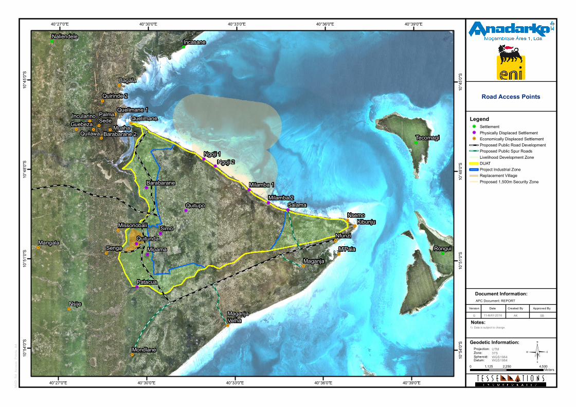
©
Document Information:
Date Created ByVersion Approved By
G
Notes:
APC Document: REPORT
!.
!.
!.
!.
!.
!.
!.
!.
!.
!.
!. !.
!.
!.
!.
!.
!.
!.
!.
!.
!.
!.
!.
!.
!.
!.
!.
!.
!.
!.
!.
!.
!.
!.
!.
!.
Rongui
Tecomagi
Senga
Maganja
Mondlane
Quelimane
Mangala
PalmaSede
Missonobali
Nsije
Nsemo
Nfunzi
Guebeza Muaha
Quelimane 1
Barabarane 2
Incularino
Quilawa
Bagala
Quirinde 2
M'Paia
Kibunju
MaganjaVelha
NaliendeleIncasane
Patacua
Quitupo
Barabarane
QuitundaMipama
Ngoji 1Ngoji 2
Milamba 2Milamba 1
Simo
Salama
40°39'0"E
40°39'0"E
40°36'0"E
40°36'0"E
40°33'0"E
40°33'0"E
40°30'0"E
40°30'0"E
40°27'0"E
40°27'0"E10
°45'0"
S
10°45
'0"S
10°48
'0"S
10°48
'0"S
10°51
'0"S
10°51
'0"S
10°54
'0"S
10°54
'0"S
1) Data is subject to change.
Legend!. Settlement!. Physically Displaced Settlement!. Economically Displaced Settlement
Proposed Public Road DevelopmentProposed Public Spur RoadsLivelihood Development ZoneDUATProject Industrial ZoneReplacement VillageProposed 1,500m Security Zone
0 2,250 4,5001,125Meters
AK11-MAY-2016
Road Access Points
Geodetic Information:Projection:Zone:Spheroid:Datum:
UTM37SWGS1984WGS1984
MXD:
Rd_
Acce
ss_P
oints_
A4
SB
Mozambique Gas Development Resettlement Plan
Annex B: Fisheries Livelihood Restoration Plan
Rev. 1 Rev Date: 27-May-16
Expected outcome The construction of improved access roads should facilitate the diversification of intertidal fishing and collection areas by resettled communities, and improve market conditions for all fishers based in Afungi, especially those in Nsemo/Kibunju who are currently dependent on maritime links.
Risks The principle risks of with the road access program are associated with the difficulty of securing the route(s) (i.e. access to land) and assuring maintenance of the roads either by the Project or by District authorities.
Phasing/Timescale The construction of improved access roads should start immediately after FID.
Implementation arrangements Improved access roads will be constructed as part of early works, under direct supervision of the appropriate Project team
Summary table
Program name Description Impacts (as per section 5)
Objectives KPIs
Improved access roads
Construction of roads linking the resettlement village to the coast at Casa do Colono and Maganja Velha. Constriction of a road linking Nsemo/Kibunju to the main road network and hence Palma Sede.
150 persons with improved market access. Resettlement villages able to maintain benefits from intertidal fishing/collection
Improved access to diversified coastal areas, and hence a deconcentration of fishing/ collection effort. Improved access to markets for both Nsemo/Kibunju and the resettlement village(s)
Road links constructed
Fish Aggregating Devices (FAD)
Receptor groups All boat based fishermen in all communities with boats able to travel to the anchored FADs offshore Cabo Delgado, Tecomaji and Rongui islands and carry insulated boxes with ice for conservation of high value fish.
Objective To diversify fishing effort away from over fished resources within Palma Bay to provide an alternative sustainable fishery and increased incomes.
125
Mozambique Gas Development Resettlement Plan
Annex B: Fisheries Livelihood Restoration Plan
Rev. 1 Rev Date: 27-May-16
Program description The over fishing of all species in Palma Bay and on the fringing reefs threatens the sustainability of all fisheries, most fishermen have not ventured outside the Bay area as there have been fish resources within reach of sail and paddle boats. As these resources are becoming scarce, fishing effort must develop to alternative fisheries. The anchored FAD has been shown to collect pelagic species in other countries of the region, allowing fishermen to target these species without having to travel large distances and the risks of making no catch. Fishing methods on an anchored FAD are limited to hand line only saving investment in gill nets and maintaining higher product value (nets can become entangled in the anchor system and cause the FAD to be lost).
The mashua and dau fishing boat types would be able to reach the anchored FADs under sail, anchor systems would need to be sized to allow sail boats to tie on to streamed lines to make their fishing possible. Motorized mashuas would be able to make direct access.
An improved boat type using simple technology assembled in Palma Sede may be part of the pilot program to demonstrate the need to move away from unsustainable use of local trees.
Expected outcomes
• Fish production of high value pelagic fish landed regularly to processors and traders.
• Fishers using new skills in a sustainable fishery
• Fish resources within Palma Bay in recovery through reduced fishing pressure.
• Availability of quality fish for Project work force consumption.
Risks FAD management agreements between fishing communities are not respected and disputes over access develop. Movement of fishermen from Palma Sede to anchored FADs creates a vessel movement management requirement. FAD maintenance would need to be a Project commitment during the pilot phase.
Phasing/Timescale The pilot program of four anchored FADs would be useful to begin as soon as possible to demonstrate a Project benefit to fishermen in advance of Project impacts.
Implementation arrangements Design and procurement of FAD materials by FAD specialists, deployment by Project vessels, monitoring by fish landing and community monitoring teams.
126
Mozambique Gas Development Resettlement Plan
Annex B: Fisheries Livelihood Restoration Plan
Rev. 1 Rev Date: 27-May-16
Summary table
Program name Description Impacts (as per section 5) Objectives KPIs
Pelagic Fish Aggregating Devices
Installation and maintenance of pilot four anchored FADs and alternative fishing vessels
Increased livelihoods for PAPs from a sustainable fishery. Increased fish stocks in Palma Bay from reduced fishing effort. Stability of supply to fish traders and processors
Improved, sustainable exploitation of fisheries resources. Increased income to PAPs
Fish Production. Revenue to PAPs Fish production statistics
Co-management
Receptor groups The program to support fisheries co-management will offer support for fishers and collectors around Palma Bay as well as in other fishing centers in the districts. The program will however focus on resettled fishers and collectors, and other PAPs who are not already represented in existing co-management institutions.
Objective The aim of the program is to improve fisheries management in Palma District through the expansion of co-management institutions and the integration of marine resource users with those institutions.
Program description The Government of Mozambique (GoM) continues to pursue a policy to develop and support the co-management of small-scale fisheries resources, through a hierarchical structure of institutions. These start at community level with Fisheries Consultative Councils (CCP), and end in the apex body at ministerial level, the Fisheries Administration Commission. The co-management structure should serve to voice and resolve problems and conflicts in the fishery, as well as assist government in the implementation of national fisheries legislation. The institutions in the structure (including the CCPs) are all defined in relevant national legislation, and form an integral part of the government’s management strategy. The program will work in conjunction with local government to set up new CCPs where appropriate and build capacity within fisher communities to enable effective participation in these institutions. The program will not support institutions further up the hierarchy (at District and Provincial levels), these being the clear responsibility of Government. There is presently one CCP in Palma Sede, and another in Olumbi. Although functional, currently they tend to be dominated by local leaders and only partially represent the interest of the community.
Expected outcome It is expected that at least one new CCP should be established in the Afungi Peninsula, and within two years both this body and the existing CCPs in the District should be effectively representing the interest of their relevant fisher communities.
127
Mozambique Gas Development Resettlement Plan
Annex B: Fisheries Livelihood Restoration Plan
Rev. 1 Rev Date: 27-May-16
Risks The effectiveness of a program that provides support for community co-management institutions will partially depend on the complementary support from Government. The effective integration of CCPs into District co-management forums will give the CCPs clear added value and should empower them to debate if not resolve fisheries issues with higher authorities and other marine resource users (including the Project). Should the Government fail to develop such District and Provincial bodies, support for CCPs will run the risk of becoming futile.
Phasing/Timescale The support for new CCPs should only start post resettlement site selection, once it is clear where fishers will be based, and what physical groupings may emerge. It should be noted that institutional support to CCPs tends to be long term and recurrent. As the senior members of the CCP change, the requirement for capacity building is renewed.
Implementation arrangements The program will be implemented by a selected partner (NGO and/or private sector).
Summary table
Program name Description Impacts (as per section 5) Objectives KPIs
Support for fisheries co-management
Improved management of local fisheries resources through community institution building, and integration into the wider co-management structure.
Establishment of one or more CCPs; Fishers and collectors effectively represented in management forums; improved compliance with fisheries legislation.
Improved, sustainable exploitation of fisheries resources; Reduced conflicts between marine resource users.
CCPs established; % of fishers participating in CCP meetings; CCP participation in District Co-management forums.
Fisheries infrastructure
Receptor groups The construction of fisheries related infrastructure would benefit fishing communities of Palma Sede and Nsemo.
Objective The construction of fisheries infrastructure should contribute to the creation of development poles for fisheries activities, with improved offloading and storage facilities, and the concentration of services.
128
Mozambique Gas Development Resettlement Plan
Annex B: Fisheries Livelihood Restoration Plan
Rev. 1 Rev Date: 27-May-16
Program description The construction of improved fisheries infrastructure will be undertaken at two locations, namely Palma Sede as the most important fisheries hub, and Nsemo, being the part of the coastline where resettled fishers are expected to establish a base for marine fisheries activities. There may also be justification for basic infrastructure at Maganja Velha, being the part of the coastline closest to the resettlement village. However, the geography of the coastline (very wide intertidal zone, and exposure to the South East monsoon) does not favor the construction of landing facilities such as a pier or jetty.
The construction of improved landing infrastructure in Palma Sede is considered justified as in the immediate future Palma Sede should continue to be a more important fishing hub than Nsemo/Kibunju, having access to important services that could support a progressive fishery. These include electricity, water, fuel, and mechanical services. Palma Sede already has a primary fish market, constructed by Government. Although the building is in good condition it is generally underutilized, and more fish trading business takes place around the building (with products for sale displayed in poor sanitary conditions, often on the ground) than on the benches inside. Landing facilities for vessels are non-existent and all vessels are beached on the shoreline adjacent to the landing station. The program would build a floating fisheries quay, directly in front of the primary market, and improve the area that links the quay to the primary market. The quay would be up to 350 m long and 6 m wide. The program could be expanded to include the construction and installation of up to two small ice plant (up to one ton/24hrs), depending upon Government fisheries development plans.
During the first phase, basic infrastructure will be constructed in either Salma or Maganja Velha, depending which location was favored by resettled communities. This will include a simple, covered area near the shoreline that could serve both as an area for the marketing of fish and, during periods of low activity, as an area for gear maintenance. Facilities could also be built nearby to this for the storage of fishing gear, on the supposition that fishers will opt to return to the resettlement village at the end of the day and will require a secure place to leave fishing equipment.
Expected outcome It is expected that the infrastructure program will support the emergence of at least two fisheries development centers in Palma Bay.
Risks There are some serious risks inherent in the infrastructure program:
• The design of basic landing infrastructure has historically proven problematic in Mozambique. In spite of the use of best available experience from sources such as The Food and Agricultural Organization of the United Nations (FAO), coupled with community consultations, there are few examples of effective and operational landing / marketing infrastructure in the country
129
Mozambique Gas Development Resettlement Plan
Annex B: Fisheries Livelihood Restoration Plan
Rev. 1 Rev Date: 27-May-16
• The operation and maintenance of a floating quay will inevitably require the participation of appropriate Government authorities, and it may be necessary to assure that they have appropriate capacity
• The success of Salma or Nsemo/Kibunju as a hub will depend partially on the development of other infrastructure such as a road, water supply, and even electricity. Should such developments fail to materialize, it is unlikely that the center will develop, and infrastructure may remain underutilized.
Phasing/Timescale Prior the design of any infrastructure it will be necessary to consult with appropriate Government bodies (MMAIP, Ministry of Transport and Communications) to understand how such plans align with their strategies and projects. Dialogue with Government could start immediately after FID. This would need to be followed by community consultation and detailed design prior to construction and commissioning.
Implementation arrangements The infrastructure program would be managed by an appropriate Project team. Any infrastructure built at a fisheries center supported under the resettlement initiative will be managed as part of the construction of the resettlement village.
Summary table
Program name Description Impacts (as per section 5) Objectives KPIs
Fisheries Infrastructure
Construction of appropriate landing infrastructure for fisheries at Palma Port and Nsemo.
Two fishing hubs developed in Palma Bay
Support for the development of fisheries hubs, as appropriate centers.
Infrastructure constructed, operational and in use.
130
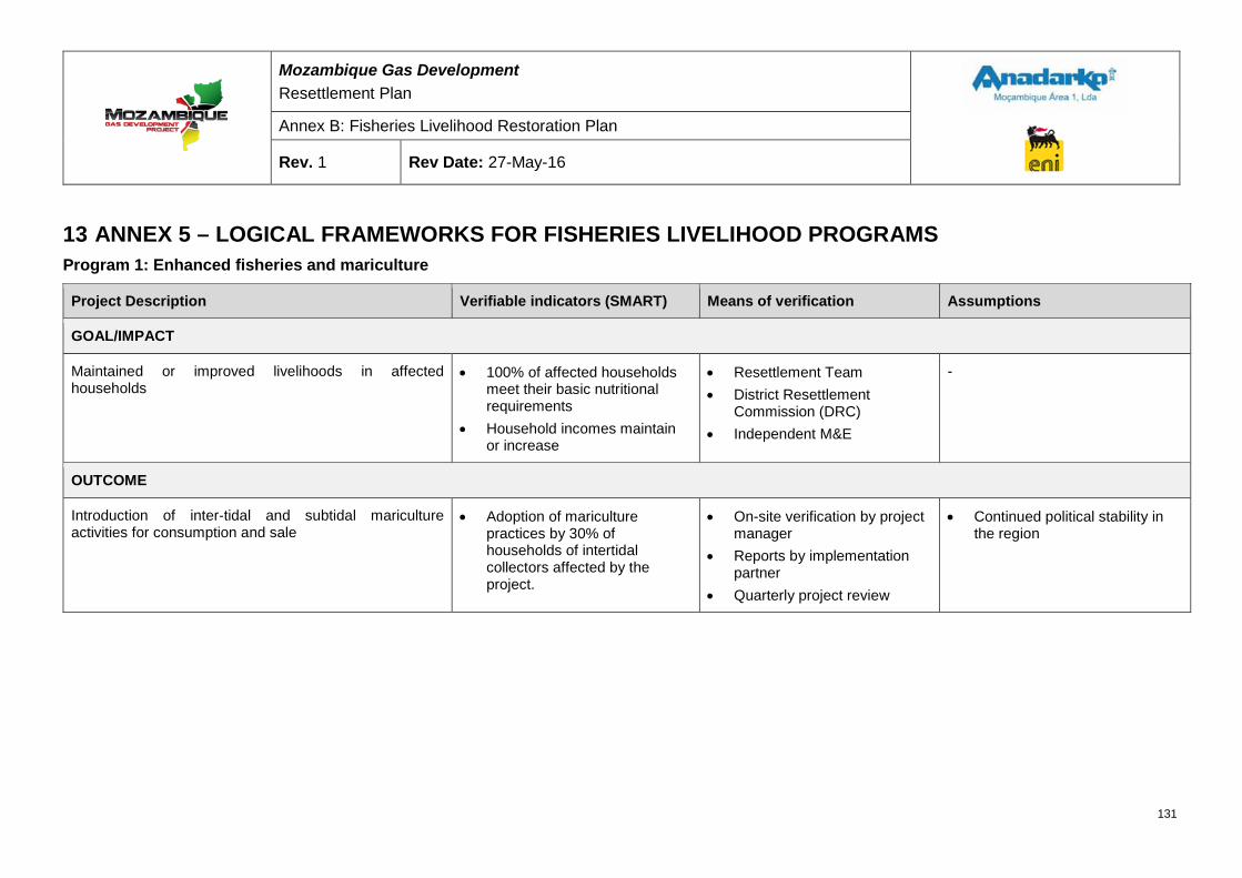
Mozambique Gas Development Resettlement Plan
Annex B: Fisheries Livelihood Restoration Plan
Rev. 1 Rev Date: 27-May-16
13 ANNEX 5 – LOGICAL FRAMEWORKS FOR FISHERIES LIVELIHOOD PROGRAMS Program 1: Enhanced fisheries and mariculture
Project Description Verifiable indicators (SMART) Means of verification Assumptions
GOAL/IMPACT
Maintained or improved livelihoods in affected households
• 100% of affected households meet their basic nutritional requirements
• Household incomes maintain or increase
• Resettlement Team • District Resettlement
Commission (DRC) • Independent M&E
-
OUTCOME
Introduction of inter-tidal and subtidal mariculture activities for consumption and sale
• Adoption of mariculture practices by 30% of households of intertidal collectors affected by the project.
• On-site verification by project manager
• Reports by implementation partner
• Quarterly project review
• Continued political stability in the region
131
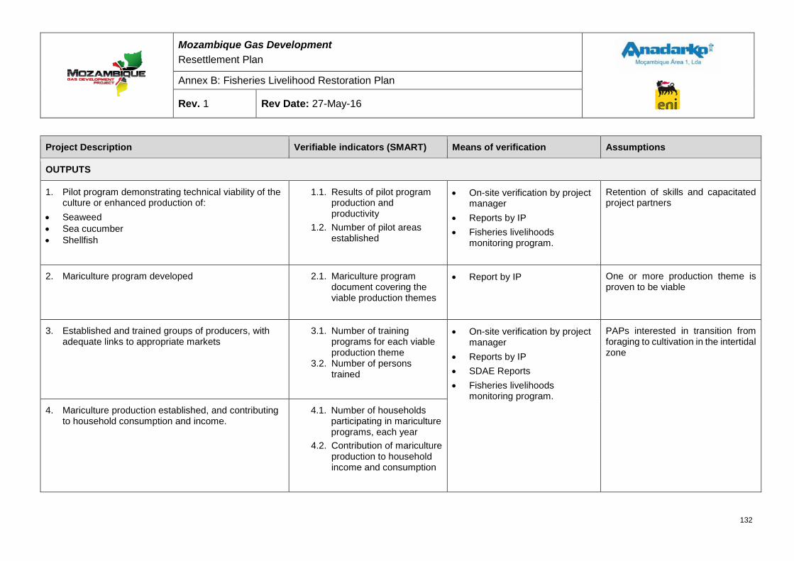
Mozambique Gas Development Resettlement Plan
Annex B: Fisheries Livelihood Restoration Plan
Rev. 1 Rev Date: 27-May-16
Project Description Verifiable indicators (SMART) Means of verification Assumptions
OUTPUTS
1. Pilot program demonstrating technical viability of the culture or enhanced production of:
• Seaweed • Sea cucumber • Shellfish
1.1. Results of pilot program production and productivity
1.2. Number of pilot areas established
• On-site verification by project manager
• Reports by IP • Fisheries livelihoods
monitoring program.
Retention of skills and capacitated project partners
2. Mariculture program developed 2.1. Mariculture program document covering the viable production themes
• Report by IP One or more production theme is proven to be viable
3. Established and trained groups of producers, with adequate links to appropriate markets
3.1. Number of training programs for each viable production theme
3.2. Number of persons trained
• On-site verification by project manager
• Reports by IP • SDAE Reports • Fisheries livelihoods
monitoring program.
PAPs interested in transition from foraging to cultivation in the intertidal zone
4. Mariculture production established, and contributing to household consumption and income.
4.1. Number of households participating in mariculture programs, each year
4.2. Contribution of mariculture production to household income and consumption
132
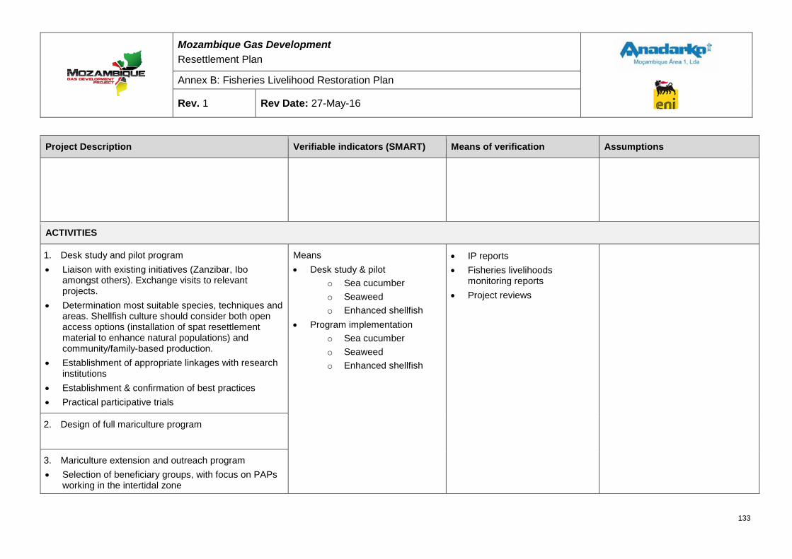
Mozambique Gas Development Resettlement Plan
Annex B: Fisheries Livelihood Restoration Plan
Rev. 1 Rev Date: 27-May-16
Project Description Verifiable indicators (SMART) Means of verification Assumptions
ACTIVITIES
1. Desk study and pilot program • Liaison with existing initiatives (Zanzibar, Ibo
amongst others). Exchange visits to relevant projects.
• Determination most suitable species, techniques and areas. Shellfish culture should consider both open access options (installation of spat resettlement material to enhance natural populations) and community/family-based production.
• Establishment of appropriate linkages with research institutions
• Establishment & confirmation of best practices • Practical participative trials
Means • Desk study & pilot
o Sea cucumber o Seaweed o Enhanced shellfish
• Program implementation o Sea cucumber o Seaweed o Enhanced shellfish
• IP reports • Fisheries livelihoods
monitoring reports • Project reviews
2. Design of full mariculture program
3. Mariculture extension and outreach program • Selection of beneficiary groups, with focus on PAPs
working in the intertidal zone
133
Mozambique Gas Development Resettlement Plan
Annex B: Fisheries Livelihood Restoration Plan
Rev. 1 Rev Date: 27-May-16
Project Description Verifiable indicators (SMART) Means of verification Assumptions
• Design and implementation of training program suitable for production theme
• Start of production systems • Establishment of appropriate commercial linkages
4. Monitoring and support to production • Implementation of production monitoring • Continued support to production groups / individuals
in all areas, including production, processing and marketing.
• Further outreach/extension according to demand
INPUTS
Fisheries Livelihoods Team Implementation Partner
PRE-CONDITIONS
• RP approval • Final Investment Decision (FID) • Appointment of suitable IPs
134
Mozambique Gas Development Resettlement Plan
Annex B: Fisheries Livelihood Restoration Plan
Rev. 1 Rev Date: 27-May-16
Program 2: Development of alternative or improved fisheries
Project Description Verifiable indicators (SMART) Means of verification Assumptions
GOAL/IMPACT
Maintained or improved livelihoods in project affected households
• 100% of affected households meet their basic nutritional requirements
• Household incomes maintain or increase
• Resettlement Team • DRC • Independent M&E
OUTCOME
Introduction of diversified marine fishing methods, producing for consumption and sale
• Adoption of new diversified fishing practices by 30% of marine fishers affected by the project.
• On-site verification by project manager
• Reports by implementation partner
• Quarterly project review
• Continued political stability in the region
135
Mozambique Gas Development Resettlement Plan
Annex B: Fisheries Livelihood Restoration Plan
Rev. 1 Rev Date: 27-May-16
Project Description Verifiable indicators (SMART) Means of verification Assumptions
OUTPUTS
1. Pilot program demonstrating technical viability of a variety of gears including:
• Vertical dropline • Longline • Drifting surface gillnets • Octopus traps • Lobster “casita” aggregators
1.1. Results of pilot program production and productivity
1.2. At least one pilots established for each technique
1.3. Number of trial fishing trips 1.4. Number of local fisher
participants in the pilot
• On-site verification by project manager
• Reports by IP • Fisheries livelihoods
monitoring program.
Retention of skills and capacitated project partners
2. Alternative fisheries program developed 2.1. Diversified fisheries program document covering the viable fishing techniques
• Report by IP One or more fishing technique is proven to be viable
3. Established and trained fishers, with adequate links to appropriate markets
3.1. Number of training programs for each viable production theme
3.2. Number of persons trained
• On-site verification by project manager
• Reports by IP • SDAE Reports • Fisheries livelihoods
monitoring program. • Independent M&E
PAPs interested in diversified fisheries
4. Sustainable and diversified production from diversified fisheries established, contributing to household consumption and income.
4.1. Number of fishers participating in diversified fisheries programs, each year.
4.2. Contribution of diversified fisheries production to household income and consumption.
4.3. Productivity of diversified production maintained to within normal variability.
136
Mozambique Gas Development Resettlement Plan
Annex B: Fisheries Livelihood Restoration Plan
Rev. 1 Rev Date: 27-May-16
Project Description Verifiable indicators (SMART) Means of verification Assumptions
ACTIVITIES
1. Desk study and pilot program • Liaison with existing national initiatives,
including PROPESCA. • Determination of most suitable techniques,
areas and target species. • Establishment of appropriate linkages with
research institutions • Practical participative trials, using both project
and local fishing vessels
Means • Desk study & pilot
o Net/Line/Octopus o Lobster
• Program implementation o Net/Line/Octopus o Lobster
• IP reports • Fisheries livelihoods
monitoring reports • Project reviews
2. Design of full diversified fisheries program
3. Diversified fisheries extension and outreach program
• Selection of beneficiary groups, with focus on higher impacted marine fishers (incl. bottom set gillnets, nocturnal ring seine) and favorably located communities.
• Design and implementation of training program suitable for each fishing method
• Equipping of beneficiaries with 1 set of relevant gear
4. Monitoring and support to production • Implementation of production monitoring
137
Mozambique Gas Development Resettlement Plan
Annex B: Fisheries Livelihood Restoration Plan
Rev. 1 Rev Date: 27-May-16
Project Description Verifiable indicators (SMART) Means of verification Assumptions
• Continued support to production groups / individuals in all areas, including production, processing and marketing.
• Further outreach/extension according to demand
INPUTS
Fisheries Livelihoods Team Implementation Partner
PRE-CONDITIONS
• RP approval • Final Investment Decision (FID) • Appointment of suitable IPs
138
Mozambique Gas Development Resettlement Plan
Annex B: Fisheries Livelihood Restoration Plan
Rev. 1 Rev Date: 27-May-16
Program 3: Post harvest processing
Project Description Verifiable indicators (SMART) Means of verification Assumptions
GOAL/IMPACT
Maintained or improved livelihoods in project affected households
• 100% of affected households meet their basic nutritional requirements
• Household incomes maintain or increase
• Resettlement Team • DRC • Independent M &E
OUTCOME
Introduction of the use of ice in the local trading of fresh fish, directed at opportunities associated with the development of local markets as a result of wider Project activities
• Adoption of the use of ice by 30% of traders buying & selling locally.
• On-site verification by project manager
• Reports by implementation partner
• Quarterly project review
• Continued political stability in the region
OUTPUTS
1. Fish traders trained & equipped for use of ice, with adequate upstream & downstream linkages: • Ice supply • Fish supply, with emphasis on diversified
fisheries program • Local markets, with emphasis on Project
related opportunities
1.1. Number of training programs 1.2. Number of persons trained 1.3. Number ice boxes distributed
• On-site verification by project manager
• Reports by IP • SDAE Reports • Fisheries livelihoods
monitoring program. • Independent M&E
• Diversified fisheries program is operational, with positive results
• Ice availability is assured through fisheries infrastructure program
139
Mozambique Gas Development Resettlement Plan
Annex B: Fisheries Livelihood Restoration Plan
Rev. 1 Rev Date: 27-May-16
Project Description Verifiable indicators (SMART) Means of verification Assumptions
2. Growing use of ice in the trading of fish, and increasing supply to local markets.
2.1. Number of traders using ice at primary landing sites.
2.2. Sales of ice for fisheries related ends
2.3. Quantity of fish purchased locally by Project related establishments (service providers, hotels etc).
ACTIVITIES
1. Trader training program • Liaison with existing national initiatives,
including PROPESCA • Selection of beneficiaries, focused on the larger
fishing centers of Palma Sede, Nsemo/Kibunjo, Maganja
• Establishment of appropriate supply and outlet linkages
• Practical, participative training. • Limited equipment supply (ice box) to trainees
Means • Program implementation
• IP reports • Fisheries livelihoods
monitoring reports • Project reviews
2. Monitoring and support to trading • Implementation of trading monitoring • Periodic support to trainees in all areas • Further outreach/extension according to
demand
140
Mozambique Gas Development Resettlement Plan
Annex B: Fisheries Livelihood Restoration Plan
Rev. 1 Rev Date: 27-May-16
Project Description Verifiable indicators (SMART) Means of verification Assumptions
INPUTS
Fisheries Livelihoods Team Implementation Partner
PRE-CONDITIONS
• RP approval • Final Investment Decision (FID) • Appointment of suitable IPs
141
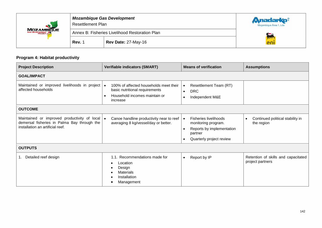
Mozambique Gas Development Resettlement Plan
Annex B: Fisheries Livelihood Restoration Plan
Rev. 1 Rev Date: 27-May-16
Program 4: Habitat productivity
Project Description Verifiable indicators (SMART) Means of verification Assumptions
GOAL/IMPACT
Maintained or improved livelihoods in project affected households
• 100% of affected households meet their basic nutritional requirements
• Household incomes maintain or increase
• Resettlement Team (RT) • DRC • Independent M&E
OUTCOME
Maintained or improved productivity of local demersal fisheries in Palma Bay through the installation an artificial reef.
• Canoe handline productivity near to reef averaging 8 kg/vessel/day or better.
• Fisheries livelihoods monitoring program.
• Reports by implementation partner
• Quarterly project review
• Continued political stability in the region
OUTPUTS
1. Detailed reef design
1.1. Recommendations made for • Location • Design • Materials • Installation • Management
• Report by IP
Retention of skills and capacitated project partners
142
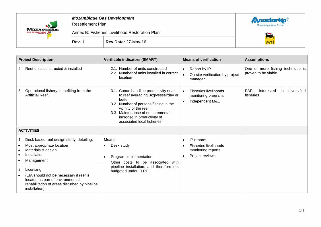
Mozambique Gas Development Resettlement Plan
Annex B: Fisheries Livelihood Restoration Plan
Rev. 1 Rev Date: 27-May-16
Project Description Verifiable indicators (SMART) Means of verification Assumptions
2. Reef units constructed & installed 2.1. Number of units constructed 2.2. Number of units installed in correct
location
• Report by IP • On-site verification by project
manager
One or more fishing technique is proven to be viable
3. Operational fishery, benefiting from the Artificial Reef.
3.1. Canoe handline productivity near to reef averaging 8kg/vessel/day or better
3.2. Number of persons fishing in the vicinity of the reef
3.3. Maintenance of or incremental increase in productivity of associated local fisheries
• Fisheries livelihoods monitoring program.
• Independent M&E
PAPs interested in diversified fisheries
ACTIVITIES
1. Desk based reef design study, detailing: • Most appropriate location • Materials & design • Installation • Management
Means • Desk study • Program implementation
Other costs to be associated with pipeline installation, and therefore not budgeted under FLRP
• IP reports • Fisheries livelihoods
monitoring reports • Project reviews
2. Licensing • (EIA should not be necessary if reef is
located as part of environmental rehabilitation of areas disturbed by pipeline installation)
143
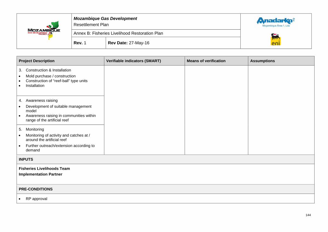
Mozambique Gas Development Resettlement Plan
Annex B: Fisheries Livelihood Restoration Plan
Rev. 1 Rev Date: 27-May-16
Project Description Verifiable indicators (SMART) Means of verification Assumptions
3. Construction & Installation • Mold purchase / construction • Construction of “reef-ball” type units • Installation
4. Awareness raising • Development of suitable management
model • Awareness raising in communities within
range of the artificial reef
5. Monitoring • Monitoring of activity and catches at /
around the artificial reef • Further outreach/extension according to
demand
INPUTS
Fisheries Livelihoods Team Implementation Partner
PRE-CONDITIONS
• RP approval
144
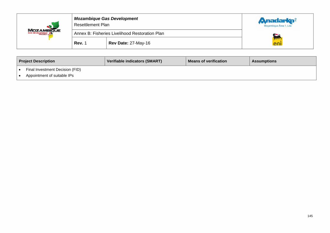
Mozambique Gas Development Resettlement Plan
Annex B: Fisheries Livelihood Restoration Plan
Rev. 1 Rev Date: 27-May-16
Project Description Verifiable indicators (SMART) Means of verification Assumptions
• Final Investment Decision (FID) • Appointment of suitable IPs
145
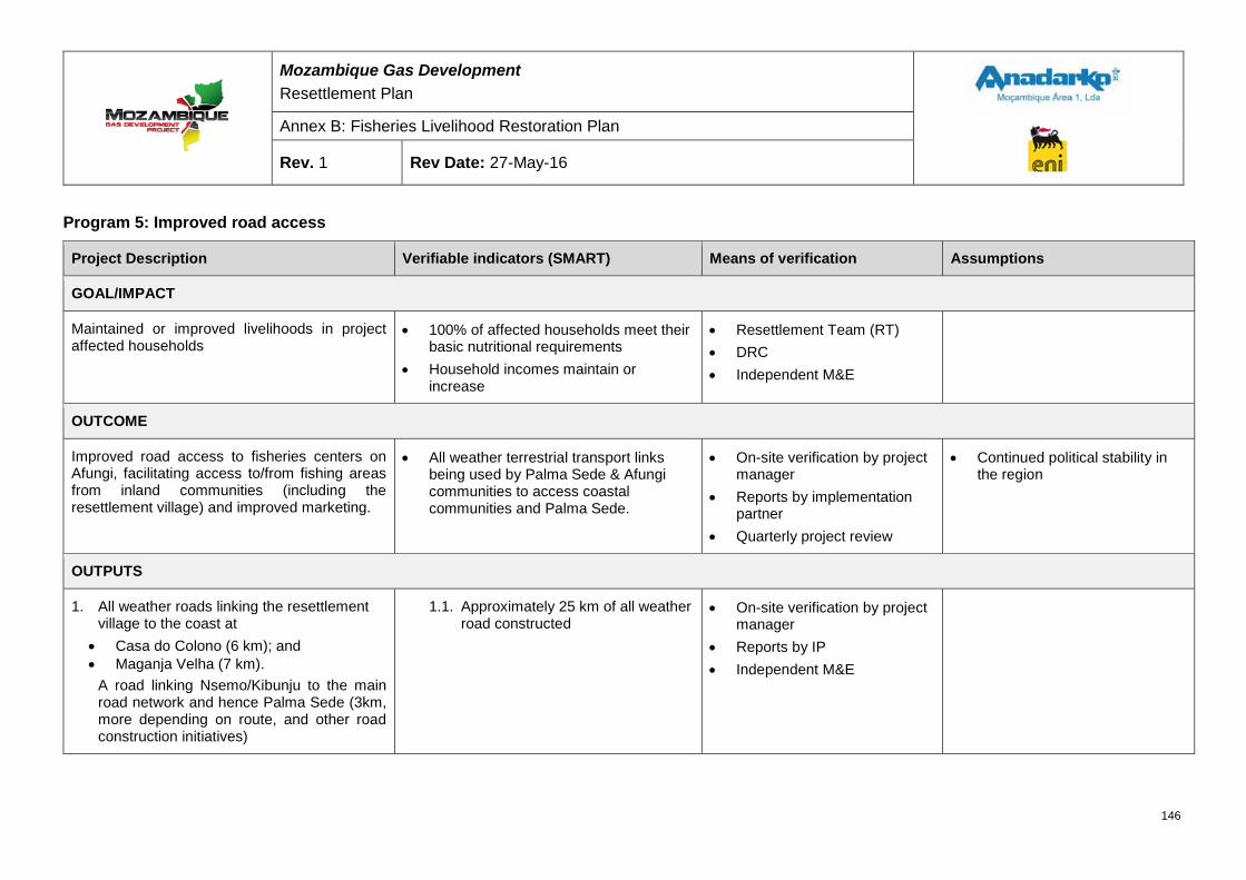
Mozambique Gas Development Resettlement Plan
Annex B: Fisheries Livelihood Restoration Plan
Rev. 1 Rev Date: 27-May-16
Program 5: Improved road access
Project Description Verifiable indicators (SMART) Means of verification Assumptions
GOAL/IMPACT
Maintained or improved livelihoods in project affected households
• 100% of affected households meet their basic nutritional requirements
• Household incomes maintain or increase
• Resettlement Team (RT) • DRC • Independent M&E
OUTCOME
Improved road access to fisheries centers on Afungi, facilitating access to/from fishing areas from inland communities (including the resettlement village) and improved marketing.
• All weather terrestrial transport links being used by Palma Sede & Afungi communities to access coastal communities and Palma Sede.
• On-site verification by project manager
• Reports by implementation partner
• Quarterly project review
• Continued political stability in the region
OUTPUTS
1. All weather roads linking the resettlement village to the coast at
• Casa do Colono (6 km); and • Maganja Velha (7 km).
A road linking Nsemo/Kibunju to the main road network and hence Palma Sede (3km, more depending on route, and other road construction initiatives)
1.1. Approximately 25 km of all weather road constructed
• On-site verification by project manager
• Reports by IP • Independent M&E
146
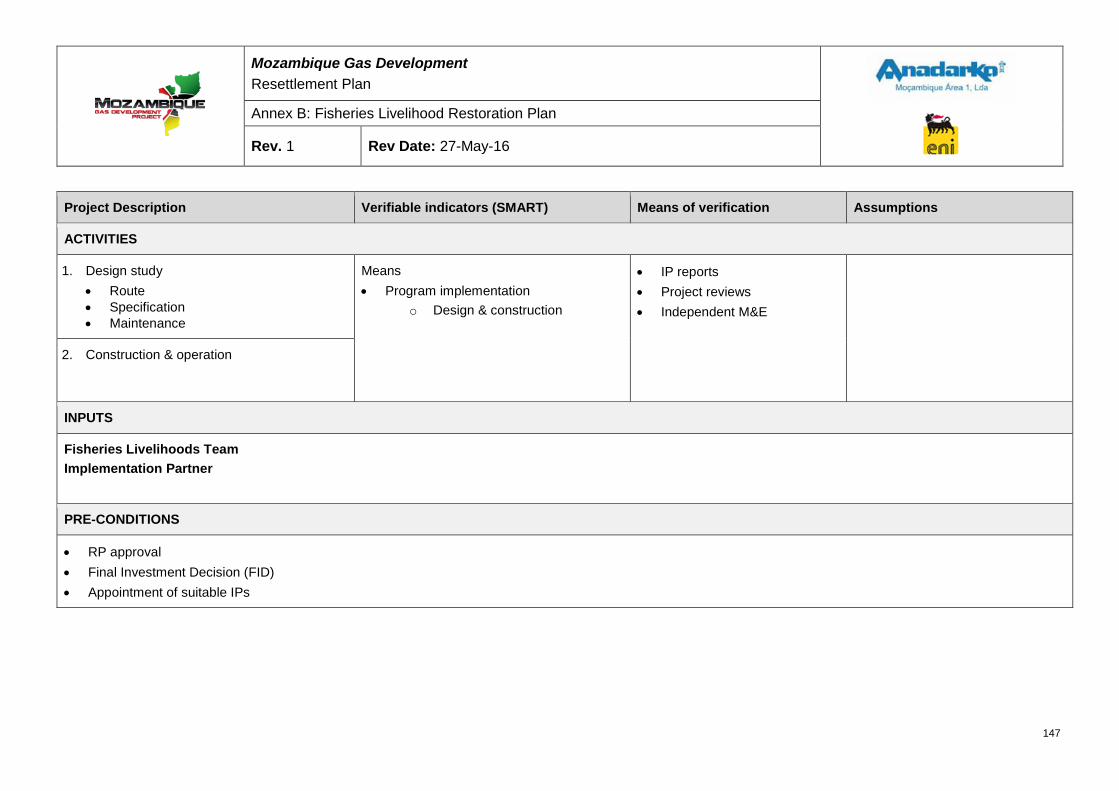
Mozambique Gas Development Resettlement Plan
Annex B: Fisheries Livelihood Restoration Plan
Rev. 1 Rev Date: 27-May-16
Project Description Verifiable indicators (SMART) Means of verification Assumptions
ACTIVITIES
1. Design study • Route • Specification • Maintenance
Means • Program implementation
o Design & construction
• IP reports • Project reviews • Independent M&E
2. Construction & operation
INPUTS
Fisheries Livelihoods Team Implementation Partner
PRE-CONDITIONS
• RP approval • Final Investment Decision (FID) • Appointment of suitable IPs
147
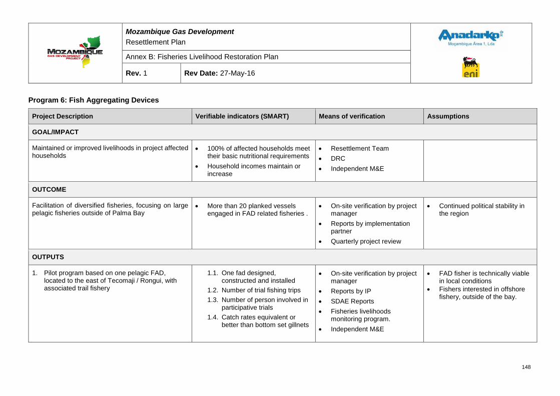
Mozambique Gas Development Resettlement Plan
Annex B: Fisheries Livelihood Restoration Plan
Rev. 1 Rev Date: 27-May-16
Program 6: Fish Aggregating Devices
Project Description Verifiable indicators (SMART) Means of verification Assumptions
GOAL/IMPACT
Maintained or improved livelihoods in project affected households
• 100% of affected households meet their basic nutritional requirements
• Household incomes maintain or increase
• Resettlement Team • DRC • Independent M&E
OUTCOME
Facilitation of diversified fisheries, focusing on large pelagic fisheries outside of Palma Bay
• More than 20 planked vessels engaged in FAD related fisheries .
• On-site verification by project manager
• Reports by implementation partner
• Quarterly project review
• Continued political stability in the region
OUTPUTS
1. Pilot program based on one pelagic FAD, located to the east of Tecomaji / Rongui, with associated trail fishery
1.1. One fad designed, constructed and installed
1.2. Number of trial fishing trips 1.3. Number of person involved in
participative trials 1.4. Catch rates equivalent or
better than bottom set gillnets
• On-site verification by project manager
• Reports by IP • SDAE Reports • Fisheries livelihoods
monitoring program. • Independent M&E
• FAD fisher is technically viable in local conditions
• Fishers interested in offshore fishery, outside of the bay.
148
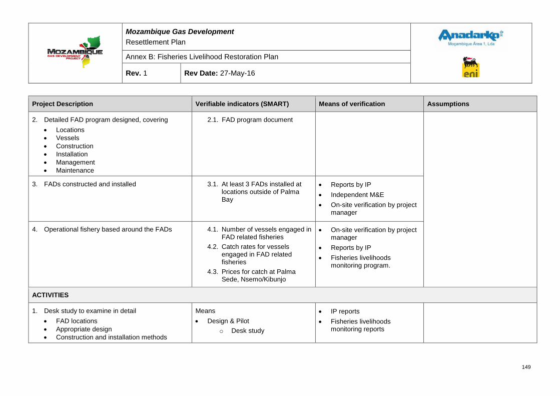
Mozambique Gas Development Resettlement Plan
Annex B: Fisheries Livelihood Restoration Plan
Rev. 1 Rev Date: 27-May-16
Project Description Verifiable indicators (SMART) Means of verification Assumptions
2. Detailed FAD program designed, covering • Locations • Vessels • Construction • Installation • Management • Maintenance
2.1. FAD program document
3. FADs constructed and installed 3.1. At least 3 FADs installed at locations outside of Palma Bay
• Reports by IP • Independent M&E • On-site verification by project
manager
4. Operational fishery based around the FADs 4.1. Number of vessels engaged in FAD related fisheries
4.2. Catch rates for vessels engaged in FAD related fisheries
4.3. Prices for catch at Palma Sede, Nsemo/Kibunjo
• On-site verification by project manager
• Reports by IP • Fisheries livelihoods
monitoring program.
ACTIVITIES
1. Desk study to examine in detail • FAD locations • Appropriate design • Construction and installation methods
Means • Design & Pilot
o Desk study
• IP reports • Fisheries livelihoods
monitoring reports
149
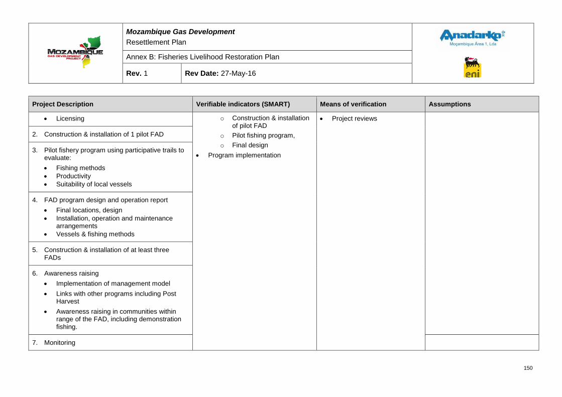
Mozambique Gas Development Resettlement Plan
Annex B: Fisheries Livelihood Restoration Plan
Rev. 1 Rev Date: 27-May-16
Project Description Verifiable indicators (SMART) Means of verification Assumptions
• Licensing o Construction & installation of pilot FAD
o Pilot fishing program, o Final design
• Program implementation
• Project reviews
2. Construction & installation of 1 pilot FAD
3. Pilot fishery program using participative trails to evaluate: • Fishing methods • Productivity • Suitability of local vessels
4. FAD program design and operation report • Final locations, design • Installation, operation and maintenance
arrangements • Vessels & fishing methods
5. Construction & installation of at least three FADs
6. Awareness raising • Implementation of management model • Links with other programs including Post
Harvest • Awareness raising in communities within
range of the FAD, including demonstration fishing.
7. Monitoring
150
Mozambique Gas Development Resettlement Plan
Annex B: Fisheries Livelihood Restoration Plan
Rev. 1 Rev Date: 27-May-16
Project Description Verifiable indicators (SMART) Means of verification Assumptions
• Monitoring of activity and catches at / around the FAD
• Further outreach/extension according to demand
INPUTS
Fisheries Livelihoods Team Implementation Partner
PRE-CONDITIONS
• RP approval • Final Investment Decision (FID) • Appointment of suitable IPs
151
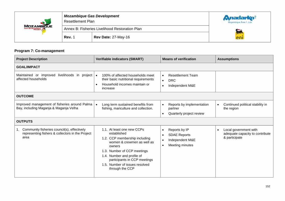
Mozambique Gas Development Resettlement Plan
Annex B: Fisheries Livelihood Restoration Plan
Rev. 1 Rev Date: 27-May-16
Program 7: Co-management
Project Description Verifiable indicators (SMART) Means of verification Assumptions
GOAL/IMPACT
Maintained or improved livelihoods in project affected households
• 100% of affected households meet their basic nutritional requirements
• Household incomes maintain or increase
• Resettlement Team • DRC • Independent M&E
OUTCOME
Improved management of fisheries around Palma Bay, including Maganja & Maganja Velha
• Long term sustained benefits from fishing, mariculture and collection.
• Reports by implementation partner
• Quarterly project review
• Continued political stability in the region
OUTPUTS
1. Community fisheries council(s), effectively representing fishers & collectors in the Project area
1.1. At least one new CCPs established
1.2. CCP membership including women & crewmen as well as owners
1.3. Number of CCP meetings 1.4. Number and profile of
participants in CCP meetings 1.5. Number of issues resolved
through the CCP
• Reports by IP • SDAE Reports • Independent M&E • Meeting minutes
• Local government with adequate capacity to contribute & participate
152
Mozambique Gas Development Resettlement Plan
Annex B: Fisheries Livelihood Restoration Plan
Rev. 1 Rev Date: 27-May-16
Project Description Verifiable indicators (SMART) Means of verification Assumptions
2. Local (District) Co-Management Committee established and operational
2.1. Number Co-management committees meeting meetings
2.2. Number and profile of participants in co-management committee meetings.
3. Local fisheries management initiatives developed and implemented via the community fisheries councils
3.1. Fisheries management plans developed by CCPs
3.2. Fisheries management plans effectively implemented
• Reports by IP • Independent M&E • SDAE reports
ACTIVITIES
1. Support to existing CCP, in coordination with local government • Assessment of current effectiveness • Design & implementation of training plan • Organizational assistance for recurrent
meetings • Rehabilitation of existing CCP meeting
room
Means • Program implementation
• IP reports • Project reviews • SDAE reports
2. Establishment of new CCP(s), in coordination with local government • Awareness raining in communities • Establishment and formalization of new
CCP(s)
153
Mozambique Gas Development Resettlement Plan
Annex B: Fisheries Livelihood Restoration Plan
Rev. 1 Rev Date: 27-May-16
Project Description Verifiable indicators (SMART) Means of verification Assumptions
• Design and implementation of training plan
• Organizational assistance for recurrent meetings
3. Development of management plans: • Support to CCPs to establish
management priorities and plans • Organizational support of implementation
of plans
INPUTS
Fisheries Livelihoods Team Implementation Partner Local Government
PRE-CONDITIONS
• RP approval • Final Investment Decision (FID) • Appointment of suitable IPs
154
Mozambique Gas Development Resettlement Plan
Annex B: Fisheries Livelihood Restoration Plan
Rev. 1 Rev Date: 27-May-16
Program 8: Fisheries infrastructure
Project Description Verifiable indicators (SMART) Means of verification Assumptions
GOAL/IMPACT
Maintained or improved livelihoods in project affected households
• 100% of affected households meet their basic nutritional requirements
• Household incomes maintain or increase
• Resettlement Team • DRC • Independent M&E
OUTCOME
Establishment of appropriate fisheries infrastructure in the project area, facilitating the concentration of fisheries services.
• Percentage of local fishers using the infrastructure
• Availability of basic services (water, sanitation, ice)
• On-site verification by project manager
• Reports by implementation partner
• Quarterly project review
• Continued political stability in the region
OUTPUTS
1. Appropriate landing infrastructure constructed in Palma Sede
1.1. Infrastructure designed, constructed and installed
• On-site verification by project manager
• Reports by IP • SDAE Reports • Independent M&E
• Once built, fishers will use the infrastructure.
2. Appropriate landing infrastructure constructed in Nsemo and other potential locations determined in consultation with affected fishers
2.1. Infrastructure designed, constructed and installed
155
Mozambique Gas Development Resettlement Plan
Annex B: Fisheries Livelihood Restoration Plan
Rev. 1 Rev Date: 27-May-16
Project Description Verifiable indicators (SMART) Means of verification Assumptions
3. Basic social infrastructure established for fisher camps in Maganja Velha • Water • Sanitary facilities
3.1. Infrastructure designed, constructed and installed
ACTIVITIES
1. Desk study, in cooperation with existing government initiatives and local communities to establish: • Infrastructure locations • Appropriate specification & design of
building and any equipment • Land / licensing issues
Means • Program implementation
o Palma Sede o Cabo Afungi/MV
• IP reports • Fisheries livelihoods
monitoring reports • Project reviews
2. Construction of infrastructure in Palma Port
3. Construction of infrastructure in Nsemo
4. Construction of infrastructure in Maganja Velha
5. Establishment of suitable management mechanisms, in cooperation with local government
156
Mozambique Gas Development Resettlement Plan
Annex B: Fisheries Livelihood Restoration Plan
Rev. 1 Rev Date: 27-May-16
Project Description Verifiable indicators (SMART) Means of verification Assumptions
INPUTS
Fisheries Livelihoods Team Implementation Partner
PRE-CONDITIONS
• RP approval • Final Investment Decision (FID) • Appointment of suitable IPs
157
Mozambique Gas Development Resettlement Plan
Annex B: Fisheries Livelihood Restoration Plan
Rev. 1 Rev Date: 27-May-16
14 ABBREVIATIONS AND ACRONYMS ADNAP Direcção Geral da Administração Pesqueira (General Directorate for Fisheries
Administration)
ALRP Agricultural Livelihood Restoration Plan
AMA1 Anadarko Moçambique Área 1, Lda.
CAP Comissão da Administração Pesqueira (Commission for Fisheries Administration)
CCP Conselho Comunitário de Pesca (Community Fisheries Council)
CIP Community Investment Program
CIEP Community Investment Execution Plan
CRC Community Resettlement Committee
DUAT Direito do Uso e Aproveitamento da Terra (Land usage title)
EEZ Exclusive Economic Zone
EIA Environmental Impact Assessment
FAD Fish Aggregating Devices
FID Final Investment Decision
FLRP Fisheries Livelihood Restoration Plan
GoM Governo de Moçambique (Government of Mozambique)
IDPPE Instituto Nacional de Desenvolvimento da Pesca de Pequena Escala (National Institute for the Development of Small Scale Fisheries)
IFC International Finance Corporation
IIP Instituto Nacional de Investigação Pesqueira (National Institute for Fisheries Research)
INAQUA Instituto Nacional de Aquacultura (National Institute for Aquaculture)
LNG Liquefied Natural Gas
MA Material Assistance
MdP Mocímboa da Praia
MEZ Marine Exclusion Zone
MOF Material Offloading Facility
MIMAIP20 Ministério do Mar, Aguas Interiores, e Pescas (Ministry of the Sea Inland Waters and Fisheries)
MZN Meticais
PAP Project Affected Person
20 Acronym not yet officially defined
158
Mozambique Gas Development Resettlement Plan
Annex B: Fisheries Livelihood Restoration Plan
Rev. 1 Rev Date: 27-May-16
PESPA Plano Estratégico do Subsector da Pesca Artisanal (Strategic Plan for Artisanal Fisheries)
PS Performance Standards
RP Resettlement Plan
SSC Suspended Sediment Concentration
SZ Security Zone
TC Transitional Compensation
159

RESETTLEMENT PLAN FINAL DRAFT FOR GOVERNMENT APPROVAL
ANNEX C: DATA COLLECTION METHODS
MOZAMBIQUE GAS DEVELOPMENT
Mozambique Gas Development Resettlement Plan
Annex C: Data Collection Methods
Rev. 1 Rev Date: 27-May-16
Table of Contents 1 INTRODUCTION ................................................................................................................... 1
Review of existing information ................................................................................................ 1
Field surveys and socioeconomic focus groups ................................................................... 1
1.2.1 Census .................................................................................................................................................. 1
1.2.2 Asset survey ......................................................................................................................................... 3
1.2.3 Socioeconomic survey .......................................................................................................................... 4 1.2.4 Communal asset survey ....................................................................................................................... 5
1.2.5 Socioeconomic focus groups ................................................................................................................ 5
1.2.6 Community boundary mapping ............................................................................................................. 7
Livelihood studies .................................................................................................................. 10
2 SURVEY INSTRUMENTS ................................................................................................... 27
2.1 Census questionnaire ............................................................................................................ 27
2.2 Asset survey ........................................................................................................................... 40
2.3 Socioeconomic survey .......................................................................................................... 68
2.4 Communal asset survey ........................................................................................................ 88
2.5 Vessel monitoring survey .................................................................................................... 108
2.6 Catch monitoring survey ..................................................................................................... 109
2.7 Vessel census ...................................................................................................................... 110
2.8 Fish trading (value chain) .................................................................................................... 111
2.9 Intertidal users ..................................................................................................................... 112
2.10 Intertidal biological sampling zones ................................................................................... 113
2.11 Intertidal biological sampling .............................................................................................. 114
2.12 Intertidal activity monitoring survey ................................................................................... 115
2.13 Intertidal monitoring zones ................................................................................................. 116
2.14 Vessel owner registration .................................................................................................... 117
2.15 Fisher and collector registration ......................................................................................... 118
List of Figures Figure 1-1: Enumerator conducting an interview in Nsemo ....................................................................... 2
Figure 1-2: Asset survey CLO photographing an interviewee in front of his cassava crop with the Trimble Yuma. ....................................................................................................................................................... 4
Figure 1-3: Quitupo participatory map ...................................................................................................... 8
ii
Mozambique Gas Development Resettlement Plan
Annex C: Data Collection Methods
Rev. 1 Rev Date: 27-May-16
Figure 1-4: Senga participatory map ......................................................................................................... 9
Figure 1-5: Maganja participatory map ..................................................................................................... 9
Figure 1-6: Mondlane Participatory Map ................................................................................................. 10
Figure 1-7: Detailed soil survey sampling locations ................................................................................ 26
List of Tables Table 1-1: Focus groups conducted as part of resettlement planning ....................................................... 6
Table 1-2: Specialist study methods ....................................................................................................... 11
iii
Mozambique Gas Development Resettlement Plan
Annex C: Data Collection Methods
Rev. 1 Rev Date: 27-May-16
1 INTRODUCTION This annex provides an overview of the information sources and data collection procedures utilized to construct the baseline for the Mozambique Gas Development Project Resettlement Plan (RP). It provides an overview of existing documents and field surveys that were conducted as part of the RP preparation, as well as the various studies that informed the development of the Livelihood Restoration Plan (LRP).
The information collected for the Project baseline will be used as the basis for resettlement implementation outcome monitoring. Additional data will be collected during the implementation phase that will be correlated with the collected baseline data.
Review of existing information A wide range of documents was reviewed to prepare the baseline for the RP as well as to inform the development of impact mitigation and livelihood restoration measures. All documents are referenced in text through the use of footnotes.
Field surveys and socioeconomic focus groups In order to establish the socioeconomic baseline of the Project’s area of direct influence, a number of field surveys were conducted, including a census, an asset survey and a socioeconomic survey, complemented by focus group meetings aimed at understanding the issues affecting specific social groups.
The census and asset survey covered all households that might be physically or economically displaced by the Project, more specifically:
• Households residing inside the DUAT (physically displaced); and
• Households residing outside the DUAT but owning assets inside the DUAT (economically displaced).
Potentially affected households were identified in close coordination with the local authorities and community representatives.
The Project developed an information matrix through which it determined the parameters to be included in data gathering activities. Data collected from the surveys was entered into the Project database.
1.2.1 Census The purpose of the census was to record the number of households that will be affected by the Project (100% sample), their location, and the number of members within specific households. The census included some socioeconomic indicators to inform the Project’s resettlement implementation monitoring plan.
The following information was collected through the census (refer to Section 2.1 for a copy of the census questionnaire):
• General information related to the household;
• Information about the head of the family;
1
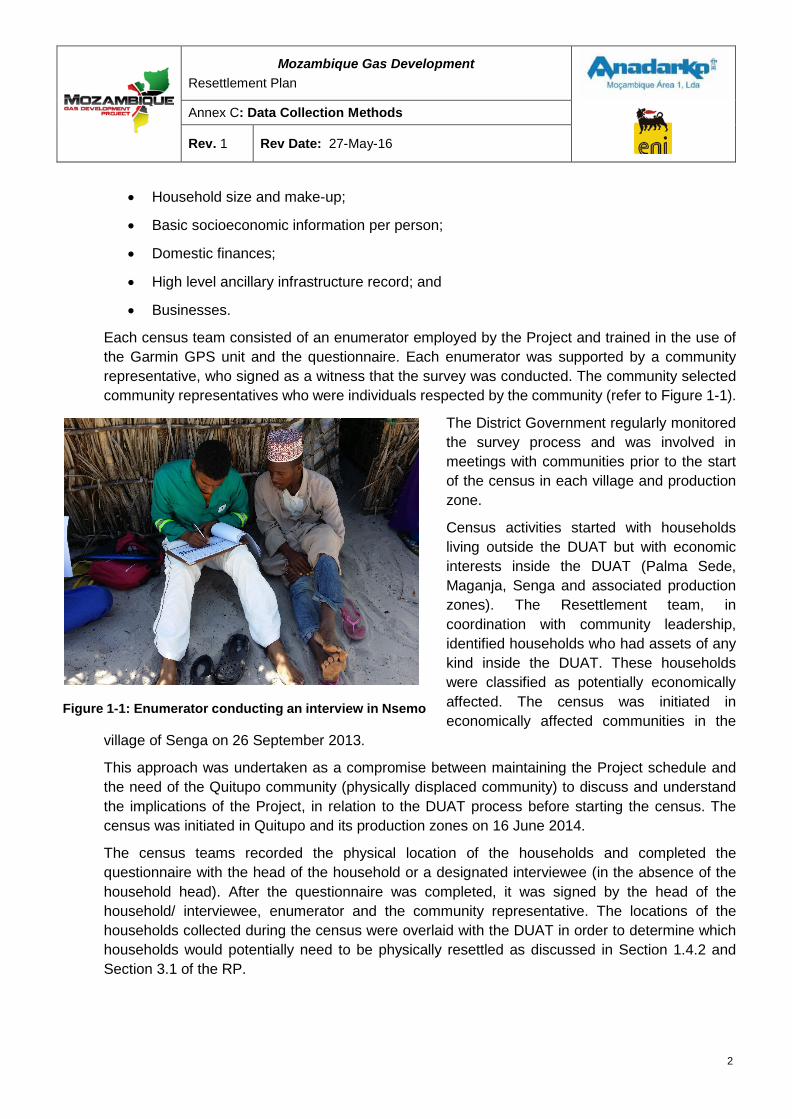
Mozambique Gas Development Resettlement Plan
Annex C: Data Collection Methods
Rev. 1 Rev Date: 27-May-16
• Household size and make-up;
• Basic socioeconomic information per person;
• Domestic finances;
• High level ancillary infrastructure record; and
• Businesses.
Each census team consisted of an enumerator employed by the Project and trained in the use of the Garmin GPS unit and the questionnaire. Each enumerator was supported by a community representative, who signed as a witness that the survey was conducted. The community selected community representatives who were individuals respected by the community (refer to Figure 1-1).
The District Government regularly monitored the survey process and was involved in meetings with communities prior to the start of the census in each village and production zone.
Census activities started with households living outside the DUAT but with economic interests inside the DUAT (Palma Sede, Maganja, Senga and associated production zones). The Resettlement team, in coordination with community leadership, identified households who had assets of any kind inside the DUAT. These households were classified as potentially economically affected. The census was initiated in economically affected communities in the
village of Senga on 26 September 2013.
This approach was undertaken as a compromise between maintaining the Project schedule and the need of the Quitupo community (physically displaced community) to discuss and understand the implications of the Project, in relation to the DUAT process before starting the census. The census was initiated in Quitupo and its production zones on 16 June 2014.
The census teams recorded the physical location of the households and completed the questionnaire with the head of the household or a designated interviewee (in the absence of the household head). After the questionnaire was completed, it was signed by the head of the household/ interviewee, enumerator and the community representative. The locations of the households collected during the census were overlaid with the DUAT in order to determine which households would potentially need to be physically resettled as discussed in Section 1.4.2 and Section 3.1 of the RP.
Figure 1-1: Enumerator conducting an interview in Nsemo
2
Mozambique Gas Development Resettlement Plan
Annex C: Data Collection Methods
Rev. 1 Rev Date: 27-May-16
1.2.2 Asset survey The asset survey was initiated in Senga on 19 October 2013 and ran concurrently with census activities. The purpose of the asset survey was to record all assets (100% sample) owned by households that could potentially be impacted by the Project. The following information was collected by the asset survey (refer to Section 2.2 for a copy of the asset survey questionnaire):
• Residential plot, size, location and any fences;
• Residence physical characteristics, ownership, size and location;
• Other structures physical characteristics, ownership, size and location;
• Location and number of graves and family graveyards;
• Size and location of vegetable gardens and current standing crops;
• Location, size, improvements and standing crops of machambas;
• Location and number of fruit trees;
• Photographs of all fixed assets;
• Livestock – type and number1; and
• Fishing assets2.
The asset survey teams consisted of two Community Liaison Officers (CLOs), one to operate the Trimble Yuma GPS unit that recorded the physical location of assets and another that was responsible for interviewing the household head/ designated interviewee and completing the questionnaire. A community representative and a household member accompanied the teams to the location of each asset. Community representatives witnessed the process to ensure that all assets were captured as well as to assist in solving any boundary disputes or uncertainties should they arise (refer to Figure 1-2).
After the survey questionnaire was completed it was signed by the head of the household/ interviewee, CLO, the community representative and the village chief or chief of production. The locations of the household assets collected during the asset survey were overlaid with the DUAT in order to determine which households were potentially economically affected.
1 Livestock/poultry are not a fixed asset and will not be lost, but were recorded as part of the general asset data. 2 Fishing assets are not a fixed asset and will not be lost, but were recorded as part of the general asset data.
3
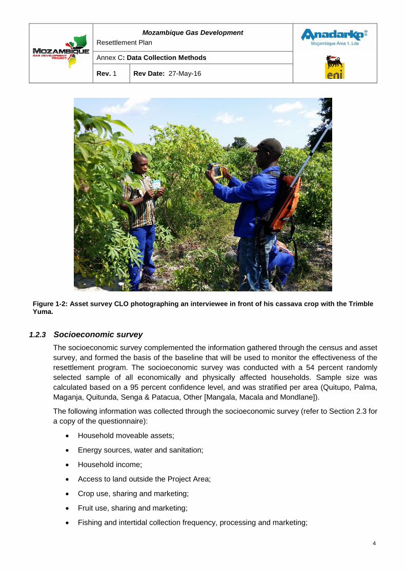
Mozambique Gas Development Resettlement Plan
Annex C: Data Collection Methods
Rev. 1 Rev Date: 27-May-16
Figure 1-2: Asset survey CLO photographing an interviewee in front of his cassava crop with the Trimble Yuma.
1.2.3 Socioeconomic survey The socioeconomic survey complemented the information gathered through the census and asset survey, and formed the basis of the baseline that will be used to monitor the effectiveness of the resettlement program. The socioeconomic survey was conducted with a 54 percent randomly selected sample of all economically and physically affected households. Sample size was calculated based on a 95 percent confidence level, and was stratified per area (Quitupo, Palma, Maganja, Quitunda, Senga & Patacua, Other [Mangala, Macala and Mondlane]).
The following information was collected through the socioeconomic survey (refer to Section 2.3 for a copy of the questionnaire):
• Household moveable assets;
• Energy sources, water and sanitation;
• Household income;
• Access to land outside the Project Area;
• Crop use, sharing and marketing;
• Fruit use, sharing and marketing;
• Fishing and intertidal collection frequency, processing and marketing;
4
Mozambique Gas Development Resettlement Plan
Annex C: Data Collection Methods
Rev. 1 Rev Date: 27-May-16
• Trading;
• Skills;
• Access to credit;
• Health, food security and nutrition;
• Access to services;
• Participation in community activities; and
• Project and resettlement perceptions.
Enumerators conducted the socioeconomic survey with a randomly selected sample of households from each village and related production zone. The enumerators were trained in the use of the questionnaire and meetings were held with the Community Resettlement Committees (CRCs) as well as the general community to explain the purpose of the survey and the procedures that were to be followed. The socioeconomic survey was initiated in Senga on 30 July 2014, whilst the asset survey was still ongoing in Quitupo and Maganja.
A version of this survey will be regularly repeated over a period of time (to be determined in conjunction with the Technical Commission and future Project lenders) once implementation of the resettlement program has started. Changes in responses from households will be analyzed in order to verify the efficiency of the livelihood restoration measures. This will enable the Project to monitor changes in the standards of living of the local families and to develop corrective measures if necessary.
1.2.4 Communal asset survey The communal asset survey recorded all of the communal fixed assets within Quitupo as the assets will be affected by the Project. The results of the communal asset survey were used to identify potential community needs in relation to the resettlement program (refer to Section 2.4 for a copy of the survey).
The survey was conducted by a survey team supervisor with a CLO, in association with the owners/custodians of the assets recorded (District Government officials, community leaders or community members) in the communal asset survey. The location, size and physical characteristics of each asset were recorded on the survey, with accompanying photographs. For each individual asset, ownership was recorded and verified through available means. After the survey was completed the village leader or his representative and a District Government official signed the form.
1.2.5 Socioeconomic focus groups Socioeconomic focus groups were conducted to support and validate the data that was collected through the surveys. Table 1-1 provides an overview of the various focus groups conducted.
5
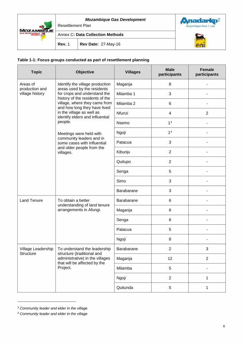
Mozambique Gas Development Resettlement Plan
Annex C: Data Collection Methods
Rev. 1 Rev Date: 27-May-16
Table 1-1: Focus groups conducted as part of resettlement planning
Topic Objective Villages Male participants
Female participants
Areas of production and village history
Identify the village production areas used by the residents for crops and understand the history of the residents of the village, where they came from and how long they have lived in the village as well as identify elders and influential people. Meetings were held with community leaders and in some cases with influential and older people from the villages.
Maganja 8 -
Milamba 1 3 -
Milamba 2 6 -
Nfunzi 4 2
Nsemo 13 -
Ngoji 14 -
Patacua 3 -
Kibunju 2 -
Quitupo 2 -
Senga 5 -
Simo 3 -
Barabarane 3 -
Land Tenure To obtain a better understanding of land tenure arrangements in Afungi.
Barabarane 6 -
Maganja 6 -
Senga 6 -
Patacua 5 -
Ngoji 8 -
Village Leadership Structure
To understand the leadership structure (traditional and administrative) in the villages that will be affected by the Project.
Barabarane 2 3
Maganja 12 2
Milamba 5 -
Ngoji 2 1
Quitunda 5 1
3 Community leader and elder in the village 4 Community leader and elder in the village
6
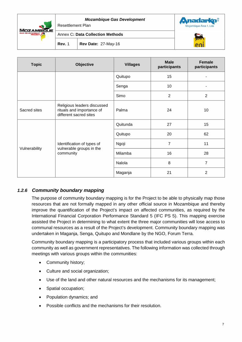
Mozambique Gas Development Resettlement Plan
Annex C: Data Collection Methods
Rev. 1 Rev Date: 27-May-16
Topic Objective Villages Male participants
Female participants
Quitupo 15 -
Senga 10 -
Simo 2 2
Sacred sites Religious leaders discussed rituals and importance of different sacred sites
Palma 24 10
Vulnerability Identification of types of vulnerable groups in the community
Quitunda 27 15
Quitupo 20 62
Ngoji 7 11
Milamba 16 28
Nalola 8 7
Maganja 21 2
1.2.6 Community boundary mapping The purpose of community boundary mapping is for the Project to be able to physically map those resources that are not formally mapped in any other official source in Mozambique and thereby improve the quantification of the Project’s impact on affected communities, as required by the International Financial Corporation Performance Standard 5 (IFC PS 5). This mapping exercise assisted the Project in determining to what extent the three major communities will lose access to communal resources as a result of the Project’s development. Community boundary mapping was undertaken in Maganja, Senga, Quitupo and Mondlane by the NGO, Forum Terra.
Community boundary mapping is a participatory process that included various groups within each community as well as government representatives. The following information was collected through meetings with various groups within the communities:
• Community history;
• Culture and social organization;
• Use of the land and other natural resources and the mechanisms for its management;
• Spatial occupation;
• Population dynamics; and
• Possible conflicts and the mechanisms for their resolution.
7
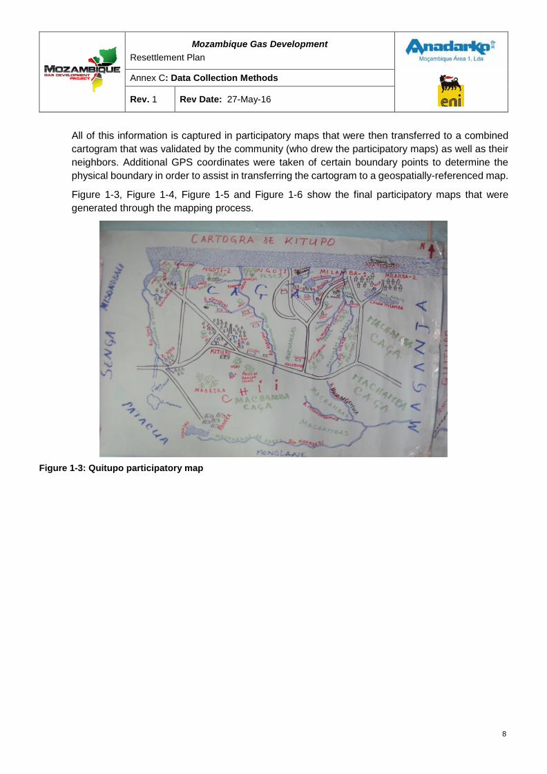
Mozambique Gas Development Resettlement Plan
Annex C: Data Collection Methods
Rev. 1 Rev Date: 27-May-16
All of this information is captured in participatory maps that were then transferred to a combined cartogram that was validated by the community (who drew the participatory maps) as well as their neighbors. Additional GPS coordinates were taken of certain boundary points to determine the physical boundary in order to assist in transferring the cartogram to a geospatially-referenced map.
Figure 1-3, Figure 1-4, Figure 1-5 and Figure 1-6 show the final participatory maps that were generated through the mapping process.
Figure 1-3: Quitupo participatory map
8
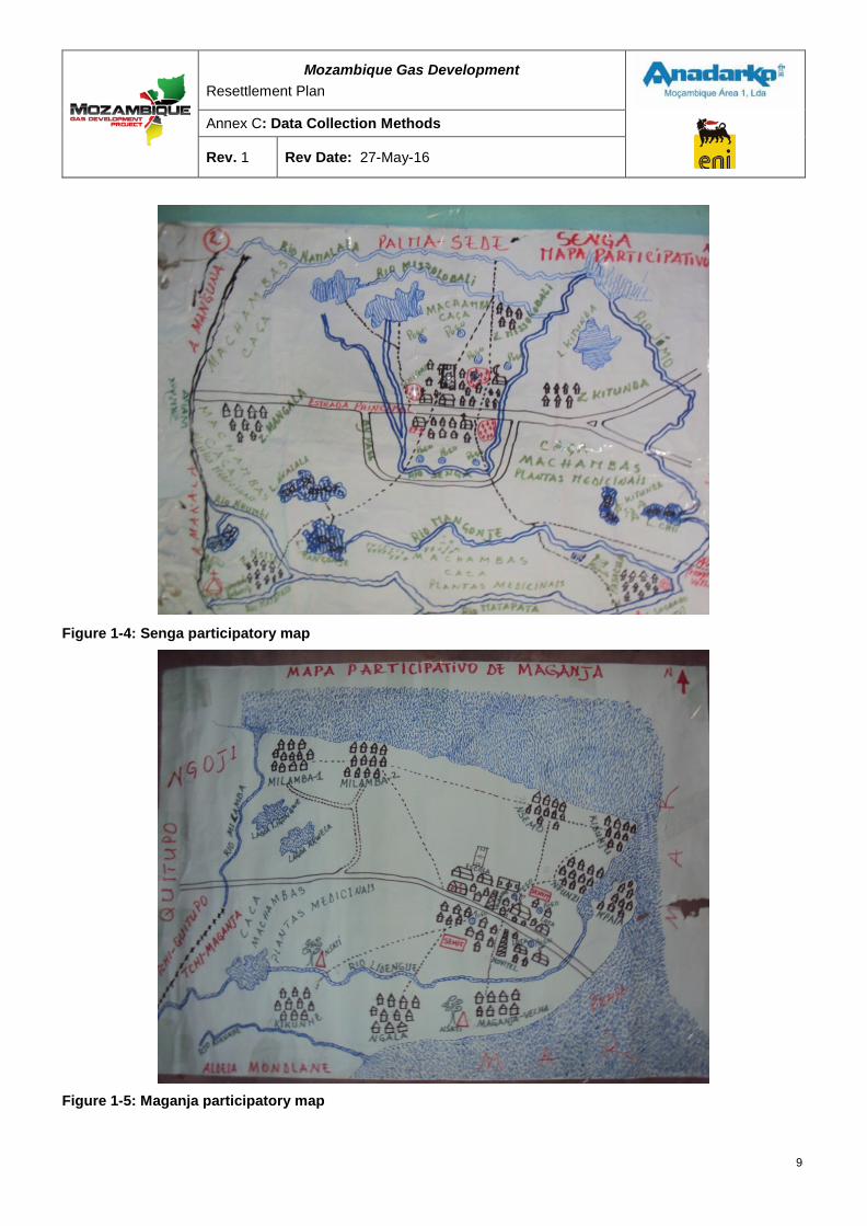
Mozambique Gas Development Resettlement Plan
Annex C: Data Collection Methods
Rev. 1 Rev Date: 27-May-16
Figure 1-4: Senga participatory map
Figure 1-5: Maganja participatory map
9
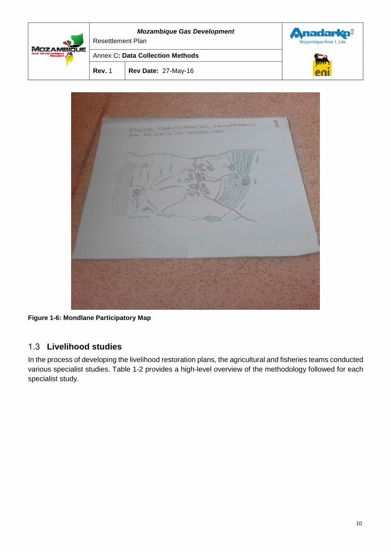
Mozambique Gas Development Resettlement Plan
Annex C: Data Collection Methods
Rev. 1 Rev Date: 27-May-16
Figure 1-6: Mondlane Participatory Map
Livelihood studies In the process of developing the livelihood restoration plans, the agricultural and fisheries teams conducted various specialist studies. Table 1-2 provides a high-level overview of the methodology followed for each specialist study.
10
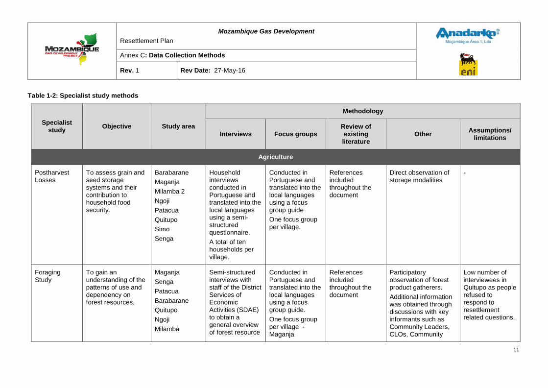
Mozambique Gas Development Resettlement Plan
Annex C: Data Collection Methods
Rev. 1 Rev Date: 27-May-16
Table 1-2: Specialist study methods
Specialist study Objective Study area
Methodology
Interviews Focus groups Review of existing literature
Other Assumptions/ limitations
Agriculture
Postharvest Losses
To assess grain and seed storage systems and their contribution to household food security.
Barabarane Maganja Milamba 2 Ngoji Patacua Quitupo Simo Senga
Household interviews conducted in Portuguese and translated into the local languages using a semi-structured questionnaire. A total of ten households per village.
Conducted in Portuguese and translated into the local languages using a focus group guide One focus group per village.
References included throughout the document
Direct observation of storage modalities
-
Foraging Study
To gain an understanding of the patterns of use and dependency on forest resources.
Maganja Senga Patacua Barabarane Quitupo Ngoji Milamba
Semi-structured interviews with staff of the District Services of Economic Activities (SDAE) to obtain a general overview of forest resource
Conducted in Portuguese and translated into the local languages using a focus group guide. One focus group per village - Maganja
References included throughout the document
Participatory observation of forest product gatherers. Additional information was obtained through discussions with key informants such as Community Leaders, CLOs, Community
Low number of interviewees in Quitupo as people refused to respond to resettlement related questions.
11
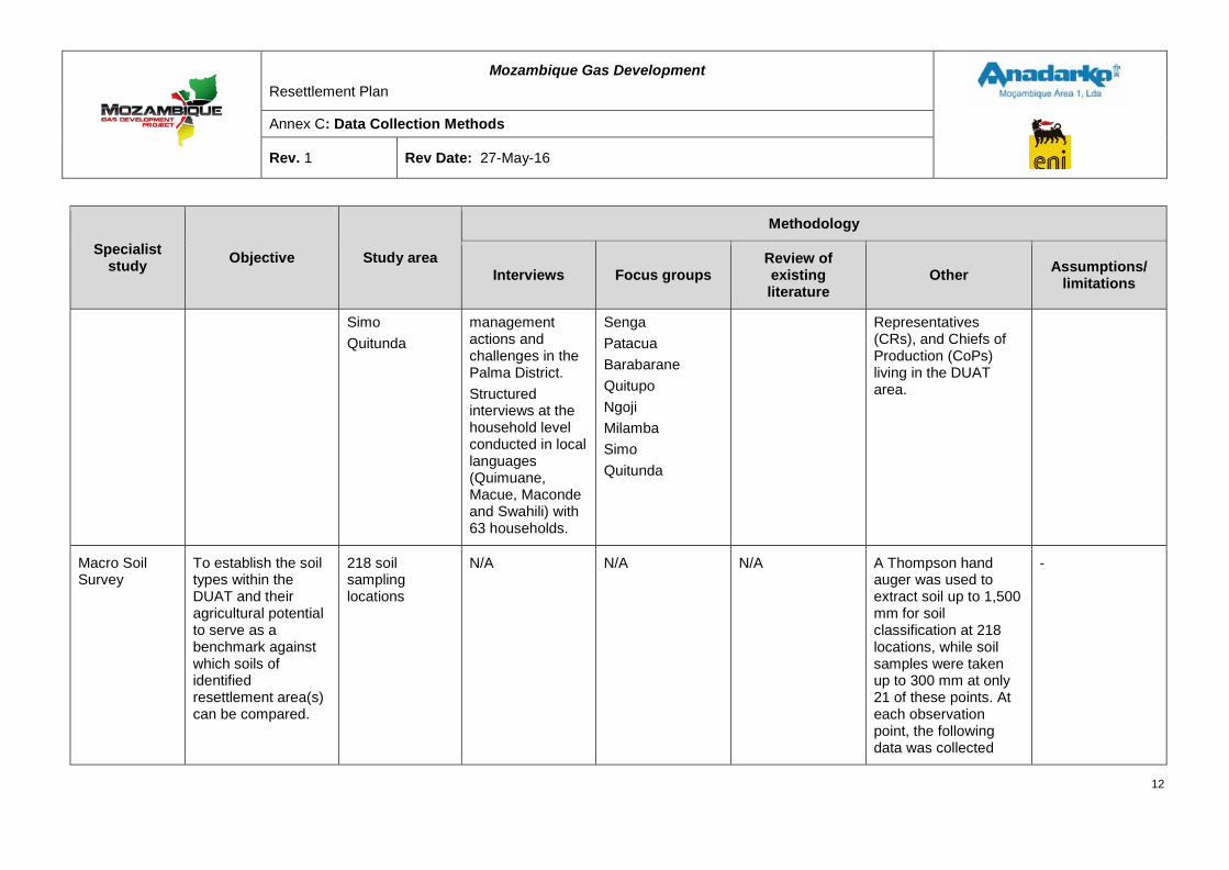
Mozambique Gas Development Resettlement Plan
Annex C: Data Collection Methods
Rev. 1 Rev Date: 27-May-16
Specialist study Objective Study area
Methodology
Interviews Focus groups Review of existing literature
Other Assumptions/ limitations
Simo Quitunda
management actions and challenges in the Palma District. Structured interviews at the household level conducted in local languages (Quimuane, Macue, Maconde and Swahili) with 63 households.
Senga Patacua Barabarane Quitupo Ngoji Milamba Simo Quitunda
Representatives (CRs), and Chiefs of Production (CoPs) living in the DUAT area.
Macro Soil Survey
To establish the soil types within the DUAT and their agricultural potential to serve as a benchmark against which soils of identified resettlement area(s) can be compared.
218 soil sampling locations
N/A N/A N/A A Thompson hand auger was used to extract soil up to 1,500 mm for soil classification at 218 locations, while soil samples were taken up to 300 mm at only 21 of these points. At each observation point, the following data was collected
-
12
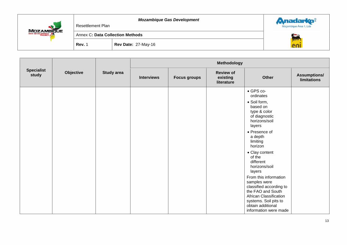
Mozambique Gas Development Resettlement Plan
Annex C: Data Collection Methods
Rev. 1 Rev Date: 27-May-16
Specialist study Objective Study area
Methodology
Interviews Focus groups Review of existing literature
Other Assumptions/ limitations
• GPS co-ordinates
• Soil form,based ontype & colorof diagnostichorizons/soillayers
• Presence ofa depthlimitinghorizon
• Clay contentof thedifferenthorizons/soillayers
From this information samples were classified according to the FAO and South African Classification systems. Soil pits to obtain additional information were made
13
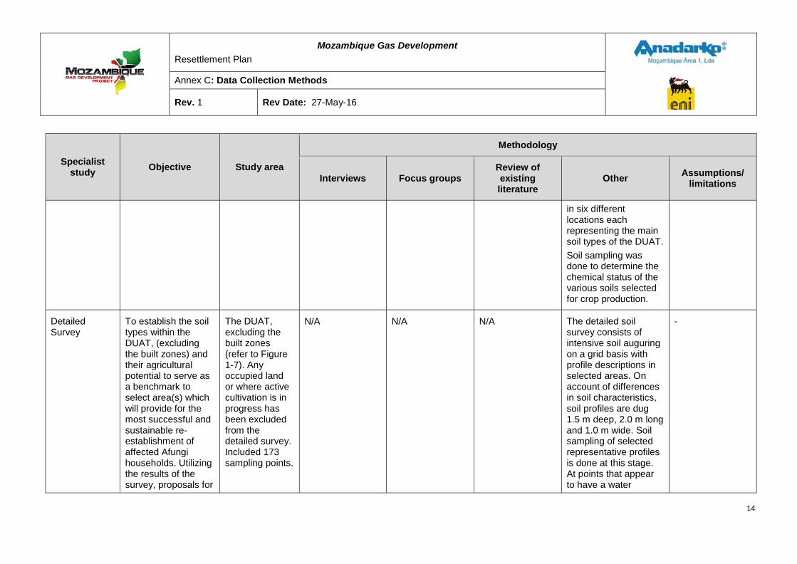
Mozambique Gas Development Resettlement Plan
Annex C: Data Collection Methods
Rev. 1 Rev Date: 27-May-16
Specialist study Objective Study area
Methodology
Interviews Focus groups Review of existing literature
Other Assumptions/ limitations
in six different locations each representing the main soil types of the DUAT. Soil sampling was done to determine the chemical status of the various soils selected for crop production.
Detailed Survey
To establish the soil types within the DUAT, (excluding the built zones) and their agricultural potential to serve as a benchmark to select area(s) which will provide for the most successful and sustainable re-establishment of affected Afungi households. Utilizing the results of the survey, proposals for
The DUAT, excluding the built zones (refer to Figure 1-7). Any occupied land or where active cultivation is in progress has been excluded from the detailed survey. Included 173 sampling points.
N/A N/A N/A The detailed soil survey consists of intensive soil auguring on a grid basis with profile descriptions in selected areas. On account of differences in soil characteristics, soil profiles are dug 1.5 m deep, 2.0 m long and 1.0 m wide. Soil sampling of selected representative profiles is done at this stage. At points that appear to have a water
-
14
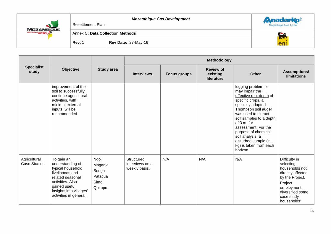
Mozambique Gas Development Resettlement Plan
Annex C: Data Collection Methods
Rev. 1 Rev Date: 27-May-16
Specialist study Objective Study area
Methodology
Interviews Focus groups Review of existing literature
Other Assumptions/ limitations
improvement of the soil to successfully continue agricultural activities, with minimal external inputs, will be recommended.
logging problem or may impair the effective root depth of specific crops, a specially adapted Thompson soil auger was used to extract soil samples to a depth of 3 m, for assessment. For the purpose of chemical soil analysis, a disturbed sample (±1 kg) is taken from each horizon.
Agricultural Case Studies
To gain an understanding of typical household livelihoods and related seasonal activities. Also gained useful insights into villages’ activities in general.
Ngoji Maganja Senga Patacua Simo Quitupo
Structured interviews on a weekly basis.
N/A N/A N/A Difficulty in selecting households not directly affected by the Project. Project employment diversified some case study households’
15
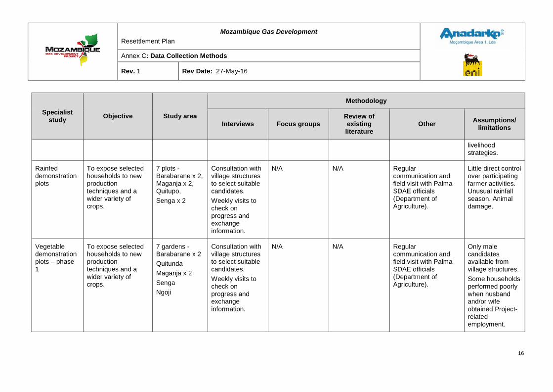
Mozambique Gas Development Resettlement Plan
Annex C: Data Collection Methods
Rev. 1 Rev Date: 27-May-16
Specialist study Objective Study area
Methodology
Interviews Focus groups Review of existing literature
Other Assumptions/ limitations
livelihood strategies.
Rainfed demonstration plots
To expose selected households to new production techniques and a wider variety of crops.
7 plots - Barabarane x 2, Maganja x 2, Quitupo, Senga x 2
Consultation with village structures to select suitable candidates. Weekly visits to check on progress and exchange information.
N/A N/A Regular communication and field visit with Palma SDAE officials (Department of Agriculture).
Little direct control over participating farmer activities. Unusual rainfall season. Animal damage.
Vegetable demonstration plots – phase 1
To expose selected households to new production techniques and a wider variety of crops.
7 gardens - Barabarane x 2 Quitunda Maganja x 2 Senga Ngoji
Consultation with village structures to select suitable candidates. Weekly visits to check on progress and exchange information.
N/A N/A Regular communication and field visit with Palma SDAE officials (Department of Agriculture).
Only male candidates available from village structures. Some households performed poorly when husband and/or wife obtained Project-related employment.
16
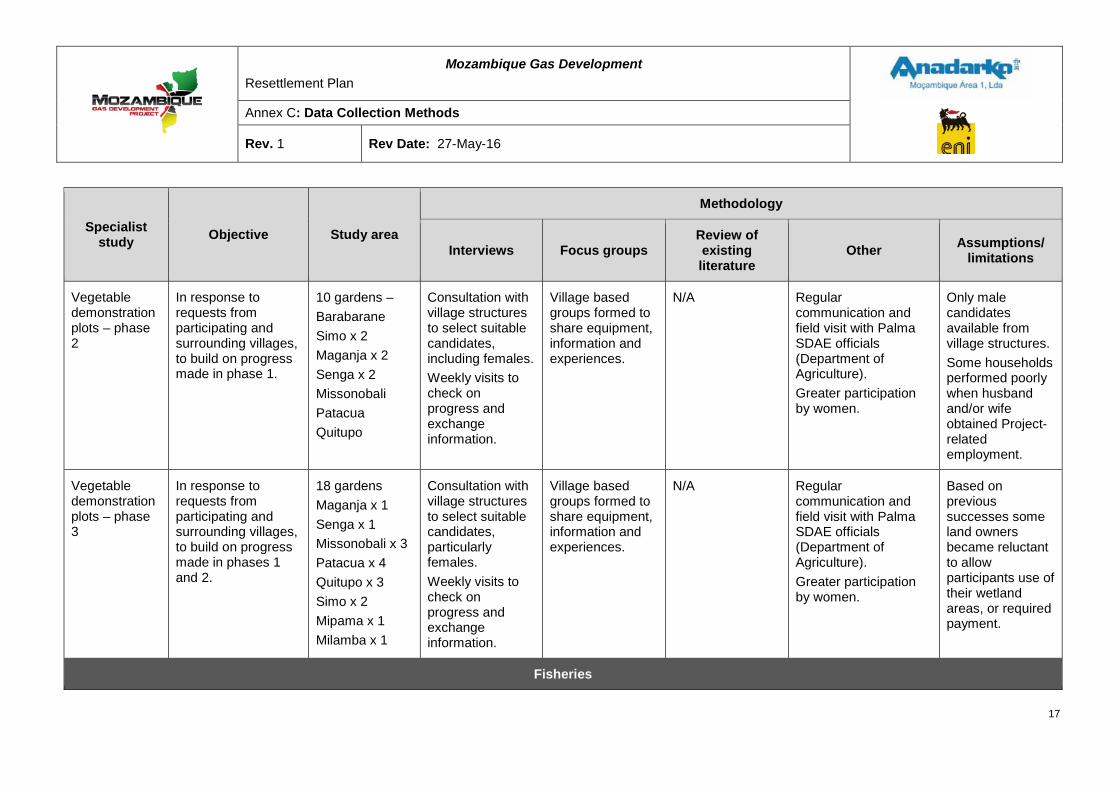
Mozambique Gas Development Resettlement Plan
Annex C: Data Collection Methods
Rev. 1 Rev Date: 27-May-16
Specialist study Objective Study area
Methodology
Interviews Focus groups Review of existing literature
Other Assumptions/ limitations
Vegetable demonstration plots – phase 2
In response to requests from participating and surrounding villages, to build on progress made in phase 1.
10 gardens – Barabarane Simo x 2 Maganja x 2 Senga x 2 Missonobali Patacua Quitupo
Consultation with village structures to select suitable candidates, including females. Weekly visits to check on progress and exchange information.
Village based groups formed to share equipment, information and experiences.
N/A Regular communication and field visit with Palma SDAE officials (Department of Agriculture). Greater participation by women.
Only male candidates available from village structures. Some households performed poorly when husband and/or wife obtained Project-related employment.
Vegetable demonstration plots – phase 3
In response to requests from participating and surrounding villages, to build on progress made in phases 1 and 2.
18 gardens Maganja x 1 Senga x 1 Missonobali x 3 Patacua x 4 Quitupo x 3 Simo x 2 Mipama x 1 Milamba x 1
Consultation with village structures to select suitable candidates, particularly females. Weekly visits to check on progress and exchange information.
Village based groups formed to share equipment, information and experiences.
N/A Regular communication and field visit with Palma SDAE officials (Department of Agriculture). Greater participation by women.
Based on previous successes some land owners became reluctant to allow participants use of their wetland areas, or required payment.
Fisheries
17
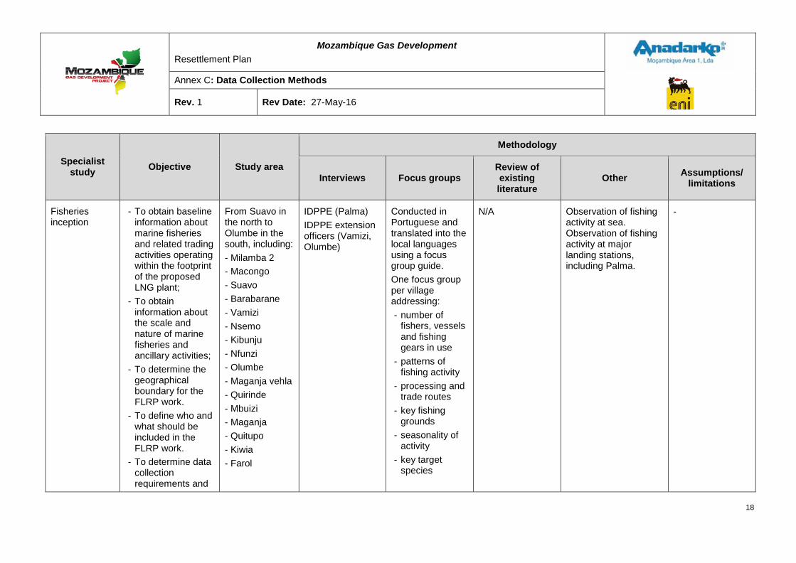
Mozambique Gas Development Resettlement Plan
Annex C: Data Collection Methods
Rev. 1 Rev Date: 27-May-16
Specialist study Objective Study area
Methodology
Interviews Focus groups Review of existing literature
Other Assumptions/ limitations
Fisheries inception
- To obtain baseline information about marine fisheries and related trading activities operating within the footprint of the proposed LNG plant;
- To obtain information about the scale and nature of marine fisheries and ancillary activities;
- To determine the geographical boundary for the FLRP work.
- To define who and what should be included in the FLRP work.
- To determine data collection requirements and
From Suavo in the north to Olumbe in the south, including: - Milamba 2 - Macongo - Suavo - Barabarane - Vamizi - Nsemo - Kibunju - Nfunzi - Olumbe - Maganja vehla - Quirinde - Mbuizi - Maganja - Quitupo - Kiwia - Farol
IDPPE (Palma) IDPPE extension officers (Vamizi, Olumbe)
Conducted in Portuguese and translated into the local languages using a focus group guide. One focus group per village addressing: - number of
fishers, vessels and fishing gears in use
- patterns of fishing activity
- processing and trade routes
- key fishing grounds
- seasonality of activity
- key target species
N/A Observation of fishing activity at sea. Observation of fishing activity at major landing stations, including Palma.
-
18
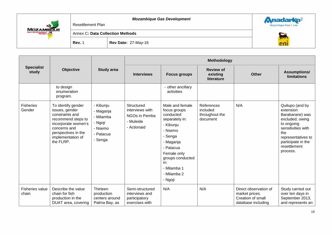
Mozambique Gas Development Resettlement Plan
Annex C: Data Collection Methods
Rev. 1 Rev Date: 27-May-16
Specialist study Objective Study area
Methodology
Interviews Focus groups Review of existing literature
Other Assumptions/ limitations
to design enumeration program.
- other ancillary activities
Fisheries Gender
To identify gender issues, gender constraints and recommend steps to incorporate women’s concerns and perspectives in the implementation of the FLRP.
- Kibunju - Maganja - Milamba - Ngoji - Nsemo - Patacua - Senga
Structured interviews with NGOs in Pemba - Muleide - Actionaid
Male and female focus groups conducted separately in: - Kibunju - Nsemo - Senga - Maganja - Patacua Female only groups conducted in: - Milamba 1 - Milamba 2 - Ngoji
References included throughout the document
N/A Quitupo (and by extension Barabarane) was excluded, owing to ongoing sensitivities with the representatives to participate in the resettlement process.
Fisheries value chain
Describe the value chain for fish production in the DUAT area, covering
Thirteen production centers around Palma Bay, as
Semi-structured interviews and participatory exercises with
N/A N/A Direct observation of market prices. Creation of small database including
Study carried out over ten days in September 2013, and represents an
19
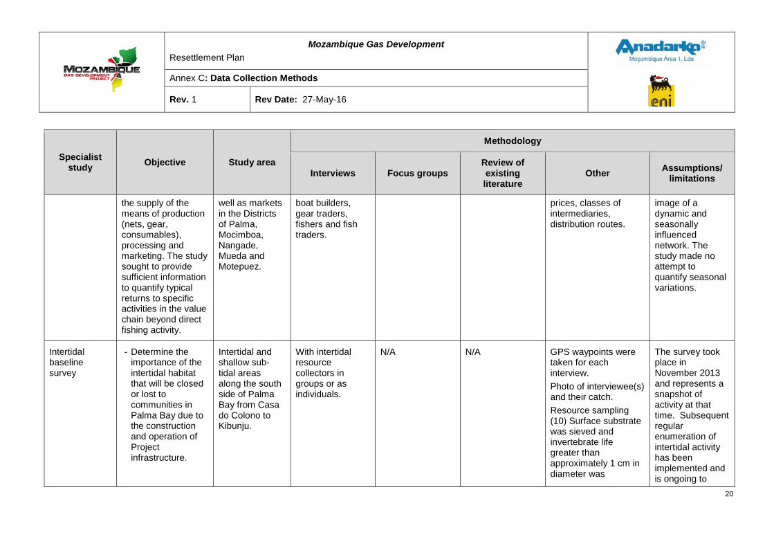
Mozambique Gas Development Resettlement Plan
Annex C: Data Collection Methods
Rev. 1 Rev Date: 27-May-16
Specialist study Objective Study area
Methodology
Interviews Focus groups Review of existing literature
Other Assumptions/ limitations
the supply of the means of production (nets, gear, consumables), processing and marketing. The study sought to provide sufficient information to quantify typical returns to specific activities in the value chain beyond direct fishing activity.
well as markets in the Districts of Palma, Mocimboa, Nangade, Mueda and Motepuez.
boat builders, gear traders, fishers and fish traders.
prices, classes of intermediaries, distribution routes.
image of a dynamic and seasonally influenced network. The study made no attempt to quantify seasonal variations.
Intertidal baseline survey
- Determine the importance of the intertidal habitat that will be closed or lost to communities in Palma Bay due to the construction and operation of Project infrastructure.
Intertidal and shallow sub-tidal areas along the south side of Palma Bay from Casa do Colono to Kibunju.
With intertidal resource collectors in groups or as individuals.
N/A N/A GPS waypoints were taken for each interview. Photo of interviewee(s) and their catch. Resource sampling (10) Surface substrate was sieved and invertebrate life greater than approximately 1 cm in diameter was
The survey took place in November 2013 and represents a snapshot of activity at that time. Subsequent regular enumeration of intertidal activity has been implemented and is ongoing to
20
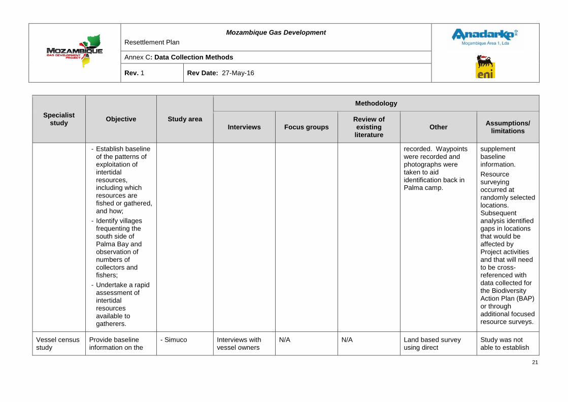
Mozambique Gas Development Resettlement Plan
Annex C: Data Collection Methods
Rev. 1 Rev Date: 27-May-16
Specialist study Objective Study area
Methodology
Interviews Focus groups Review of existing literature
Other Assumptions/ limitations
- Establish baseline of the patterns of exploitation of intertidal resources, including which resources are fished or gathered, and how;
- Identify villages frequenting the south side of Palma Bay and observation of numbers of collectors and fishers;
- Undertake a rapid assessment of intertidal resources available to gatherers.
recorded. Waypoints were recorded and photographs were taken to aid identification back in Palma camp.
supplement baseline information. Resource surveying occurred at randomly selected locations. Subsequent analysis identified gaps in locations that would be affected by Project activities and that will need to be cross-referenced with data collected for the Biodiversity Action Plan (BAP) or through additional focused resource surveys.
Vessel census study
Provide baseline information on the
- Simuco Interviews with vessel owners
N/A N/A Land based survey using direct
Study was not able to establish
21
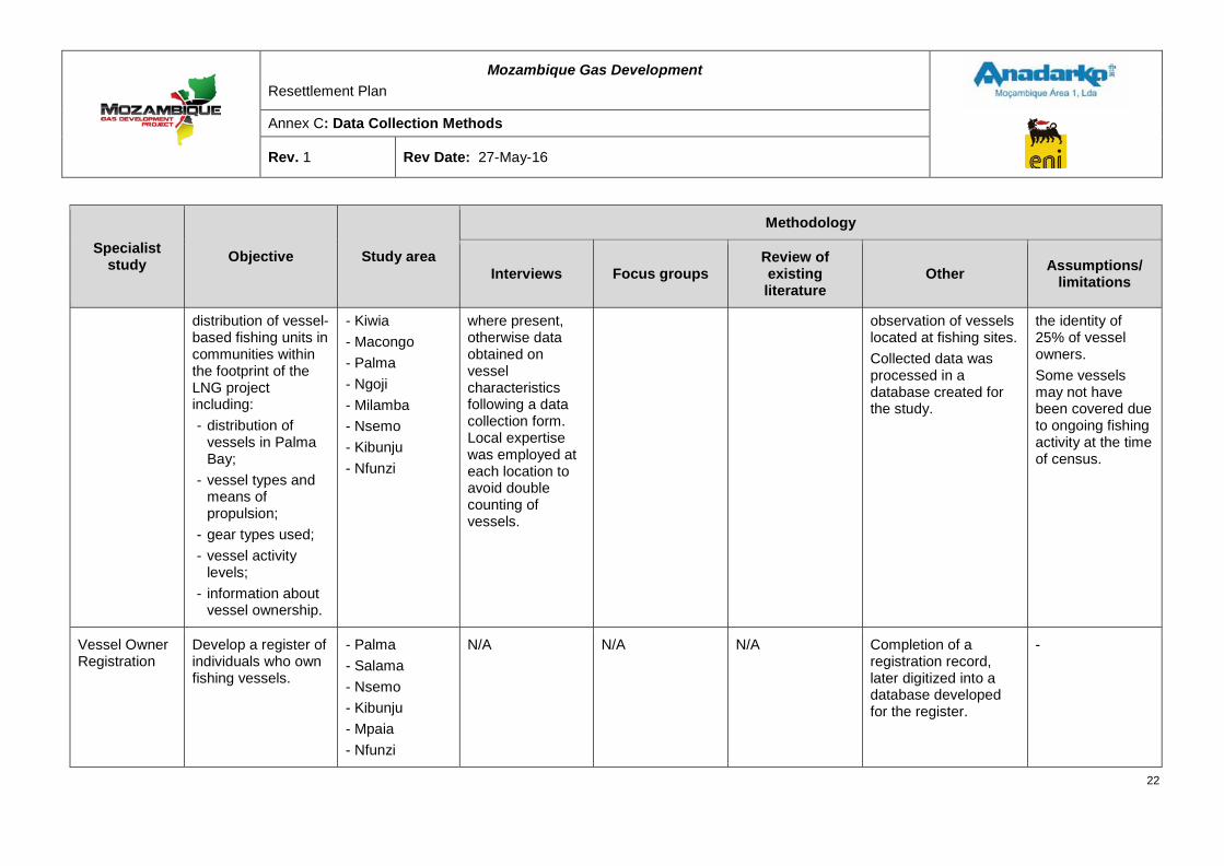
Mozambique Gas Development Resettlement Plan
Annex C: Data Collection Methods
Rev. 1 Rev Date: 27-May-16
Specialist study Objective Study area
Methodology
Interviews Focus groups Review of existing literature
Other Assumptions/ limitations
distribution of vessel-based fishing units in communities within the footprint of the LNG project including: - distribution of
vessels in Palma Bay;
- vessel types and means of propulsion;
- gear types used; - vessel activity
levels; - information about
vessel ownership.
- Kiwia - Macongo - Palma - Ngoji - Milamba - Nsemo - Kibunju - Nfunzi
where present, otherwise data obtained on vessel characteristics following a data collection form. Local expertise was employed at each location to avoid double counting of vessels.
observation of vessels located at fishing sites. Collected data was processed in a database created for the study.
the identity of 25% of vessel owners. Some vessels may not have been covered due to ongoing fishing activity at the time of census.
Vessel Owner Registration
Develop a register of individuals who own fishing vessels.
- Palma - Salama - Nsemo - Kibunju - Mpaia - Nfunzi
N/A N/A N/A Completion of a registration record, later digitized into a database developed for the register.
-
22
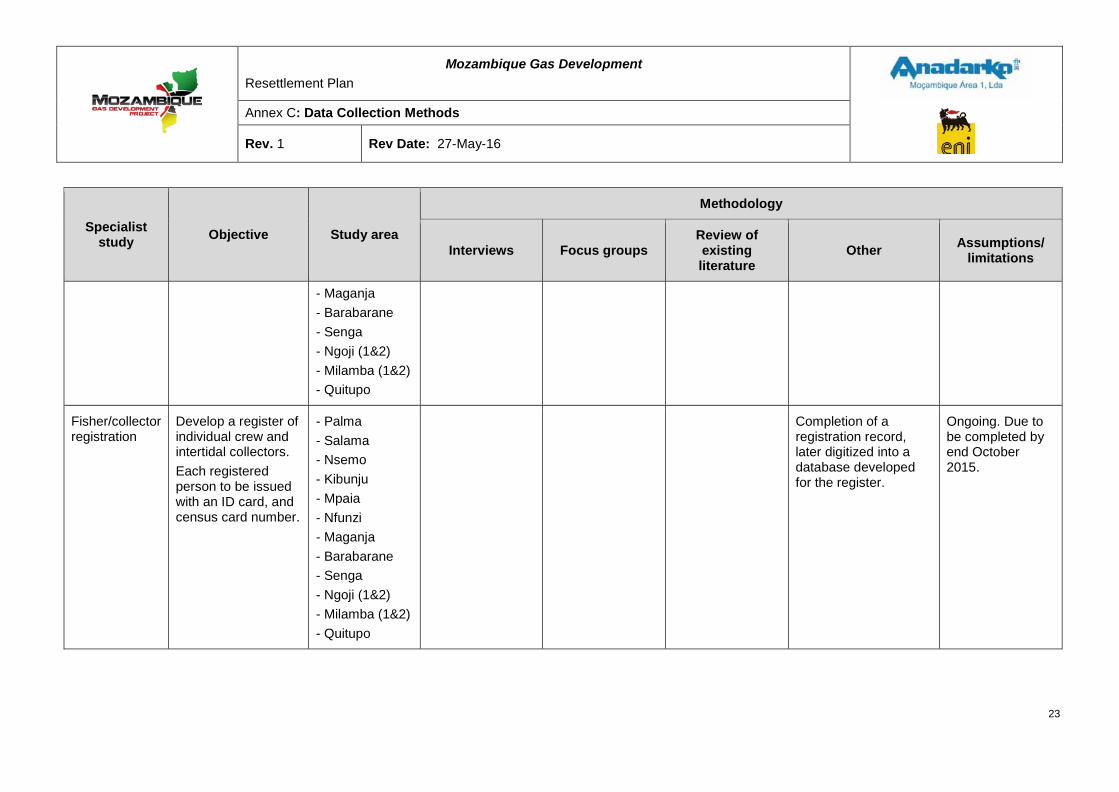
Mozambique Gas Development Resettlement Plan
Annex C: Data Collection Methods
Rev. 1 Rev Date: 27-May-16
Specialist study Objective Study area
Methodology
Interviews Focus groups Review of existing literature
Other Assumptions/ limitations
- Maganja - Barabarane - Senga - Ngoji (1&2) - Milamba (1&2) - Quitupo
Fisher/collector registration
Develop a register of individual crew and intertidal collectors. Each registered person to be issued with an ID card, and census card number.
- Palma - Salama - Nsemo - Kibunju - Mpaia - Nfunzi - Maganja - Barabarane - Senga - Ngoji (1&2) - Milamba (1&2) - Quitupo
Completion of a registration record, later digitized into a database developed for the register.
Ongoing. Due to be completed by end October 2015.
23
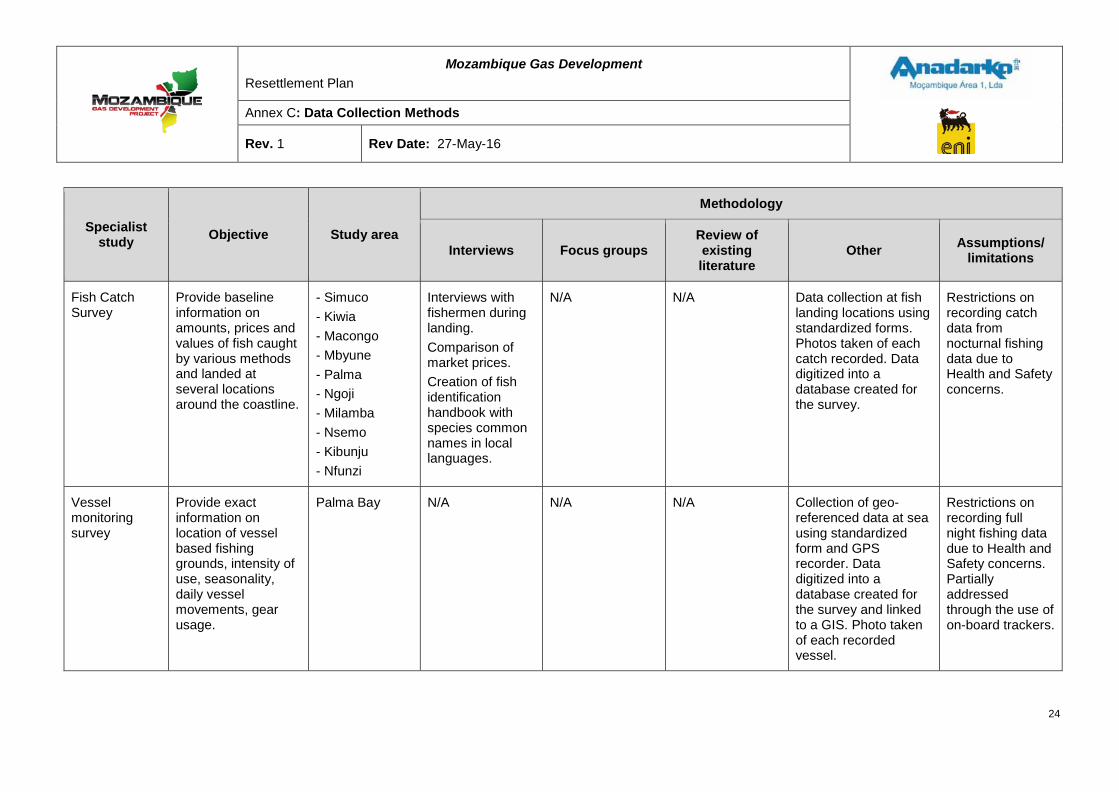
Mozambique Gas Development Resettlement Plan
Annex C: Data Collection Methods
Rev. 1 Rev Date: 27-May-16
Specialist study Objective Study area
Methodology
Interviews Focus groups Review of existing literature
Other Assumptions/ limitations
Fish Catch Survey
Provide baseline information on amounts, prices and values of fish caught by various methods and landed at several locations around the coastline.
- Simuco - Kiwia - Macongo - Mbyune - Palma - Ngoji - Milamba - Nsemo - Kibunju - Nfunzi
Interviews with fishermen during landing. Comparison of market prices. Creation of fish identification handbook with species common names in local languages.
N/A N/A Data collection at fish landing locations using standardized forms. Photos taken of each catch recorded. Data digitized into a database created for the survey.
Restrictions on recording catch data from nocturnal fishing data due to Health and Safety concerns.
Vessel monitoring survey
Provide exact information on location of vessel based fishing grounds, intensity of use, seasonality, daily vessel movements, gear usage.
Palma Bay N/A N/A N/A Collection of geo-referenced data at sea using standardized form and GPS recorder. Data digitized into a database created for the survey and linked to a GIS. Photo taken of each recorded vessel.
Restrictions on recording full night fishing data due to Health and Safety concerns. Partially addressed through the use of on-board trackers.
24
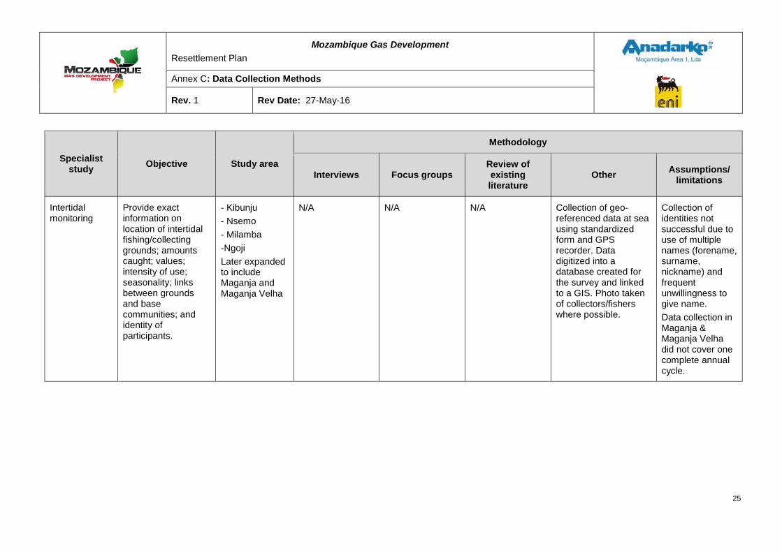
Mozambique Gas Development Resettlement Plan
Annex C: Data Collection Methods
Rev. 1 Rev Date: 27-May-16
Specialist study Objective Study area
Methodology
Interviews Focus groups Review of existing literature
Other Assumptions/ limitations
Intertidal monitoring
Provide exact information on location of intertidal fishing/collecting grounds; amounts caught; values; intensity of use; seasonality; links between grounds and base communities; and identity of participants.
- Kibunju - Nsemo - Milamba -Ngoji Later expanded to include Maganja and Maganja Velha
N/A N/A N/A Collection of geo-referenced data at sea using standardized form and GPS recorder. Data digitized into a database created for the survey and linked to a GIS. Photo taken of collectors/fishers where possible.
Collection of identities not successful due to use of multiple names (forename, surname, nickname) and frequent unwillingness to give name. Data collection in Maganja & Maganja Velha did not cover one complete annual cycle.
25
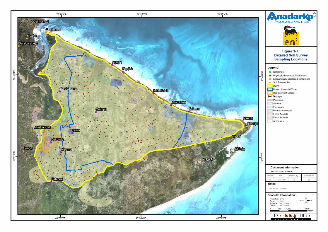
©
Document Information:
Date Created ByVersion Approved By
G
Notes:
APC Document: REPORT
!(
!(
!(
!(
!(
!(
!(
!(!(
!(
!(
!(
!(
!(
!(
!(
!(
!(
!(
!(
!( !( !(
!(
!(
!(
!(
!(
!(
!(
!(!(
!(!(
!(
!(
!(
!(
!(
!(
!(
!(
!(
!(
!(
!(
!(
!(
!(
!(
!(
!(
!(
!(
!(
!(
!(
!(
!(
!(
!(
!(
!(
!(!(
!(
!(
!(
!(
!(
!(
!(
!(
!(
!(
!(!(
!(
!(
!(
!(!(
!(
!(
!(
!(
!(
!(
!(
!( !(
!(!( !(
!(
!(
!(
!(
!(
!(
!(
!(
!(
!(
!(
!(
!(
!(
!(
!(
!(
!(
!(
!(
!(
!(
!(
!(!(
!(
!(
!(
!(
!(
!(
!(
!(
!(
!(!(
!(
!(
!(!(
!(
!(
!(
!(
!(
!(
!(
!(
!(
!(!(
!(
!(
!(
!(
!(
!(
!(
!(
!(
!(
!(
!(
!(
!(
!(
!(
!(
!(
!(
!(
!(
!(
!(
!(
!(
!(
!(
!(
!(
!(
!(
!(
!(
!(!(
!(
!(
!(!(!(
!(
!(
!(
!(
!(!(
!(
!(
!(
!(
!(
!(
!(
!(
!(
!(
!(
!(
!(
!(
!(
!(
!(
!(
!(
!(
!(!(
!(
!(
!(
!(
!(
!(
!(
!(
!(
!(
!(
!(
!(
!(
!(!(!(
!(
!(
!(
!(
!( !(
!(
!(
!(
!(!(
!(
!(
!( !(!(
!(
!(
!(!(
!(!(!( !(!(
!( !(
!(!(!(
!(
!(
!(
!(!( !(
!(
!(
!(!(
!(
!(
!(
!(
!(!(!(
!( !(!(
!(
!(!(!(
!(
!(
!(
!(
!(
!(
!(
!(
!(
!(
!( !(!(
!(!(!(
!(!(
!(
!(
!(
!(!(
!(
!(
!(
!(
!(
!(
!(
!(
!(
!(
!(
!( !(
!(!(
!(
!(
!(
!(!(
!(
!(
!(
!(
!(
!(
!(
!(
!(
!(
!( !(
!(
!(
!(
!(!(
!(
!(
!(
!( !(
!(
!(!(
!(
!(
!( !(!( !(
!(
!(
!(
!(
!(!(
!(
!(!(
!(
!(
!(
!(
!(
!(
!(
!(
!(
!(
!(
!(
!(
!(
!(
!(
!(
!(
!(
!(
!(
!(
!(
!(
!(
!(
!(
!.
!.
!.!.
!.
!.
!.
!.
!.
!.
!.
!.
!.
!.
!.
!.
!.
!.
!.
!.
!.
!.
!.
Senga
Maganja
Quelimane
Missonobali
Nsemo
Nfunzi
Muaha
Quelimane 1
Barabarane 2
M'Paia
Kibunju
Patacua
Quitupo
Barabarane
Quitunda
Mipama
Ngoji 1Ngoji 2
Milamba 2
Milamba 1
Simo
Salama
40°36'0"E
40°36'0"E
40°33'0"E
40°33'0"E
40°30'0"E
40°30'0"E10
°48'0"
S
10°48
'0"S
10°51
'0"S
10°51
'0"S
1) Data is subject to change.
Legend!. Settlement!. Physically Displaced Settlement!. Economically Displaced Settlement!( Soil Sample Site
DUATProject Industrial ZoneReplacement Village
Soil GroupsPlanosolsAlbisolsFerralsolsPlinthic ArenosolsFerric AcrisolsFerric AcrisolsArenosols
0 1,250 2,500625Meters
AK11-MAY-2016
Figure 1-7: Detailed Soil SurveySampling Locations
Geodetic Information:Projection:Zone:Spheroid:Datum:
UTM37SWGS1984WGS1984
SB
Mozambique Gas Development Resettlement Plan
Annex C: Data Collection Methods
Rev. 1 Rev Date: 27-May-16
2 SURVEY INSTRUMENTS
2.1 Census questionnaire
27
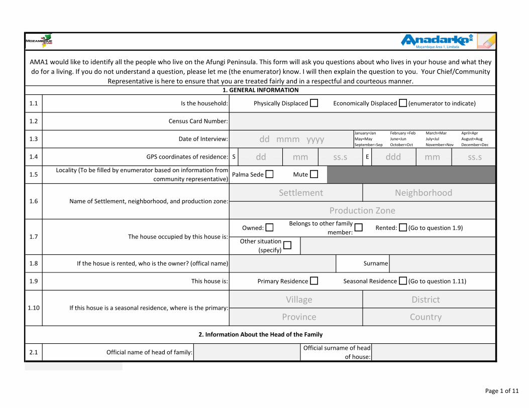
1.6
2.1 Official name of head of family: Official surname of head
of house:
1.7
Seasonal Residence
Owned:Belongs to other family
member:Rented: (Go to question 1.9)��
�
�
2. Information About the Head of the Family
Name of Settlement, neighborhood, and production zone:
1.10 If this hosue is a seasonal residence, where is the primary:
The house occupied by this house is:Other situation
(specify)
1.9
1.8
January=Jan
May=May
September=Sep
February =Feb
June=Jun
October=Oct
March=Mar
July=Jul
November=Nov
April=Apr
August=Aug
December=Dec
E
1.5
1.4 S
Palma Sede� �MuteLocality (To be filled by enumerator based on information from
community representative)
(Go to question 1.11)This house is: �
SurnameIf the hosue is rented, who is the owner? (offical name)
�Primary Residence
1.2
GPS coordinates of residence:
AMA1 would like to identify all the people who live on the Afungi Peninsula. This form will ask you questions about who lives in your house and what they
do for a living. If you do not understand a question, please let me (the enumerator) know. I will then explain the question to you. Your Chief/Community
Representative is here to ensure that you are treated fairly and in a respectful and courteous manner.
1. GENERAL INFORMATION
Is the household:
Census Card Number:
Physically Displaced (enumerator to indicate)1.1 � Economically Displaced�
1.3 Date of Interview:
dd dddss.s ss.smm mm
dd mmm yyyy
Village District
Province Country
Settlement Neighborhood
Production Zone
Page 1 of 11
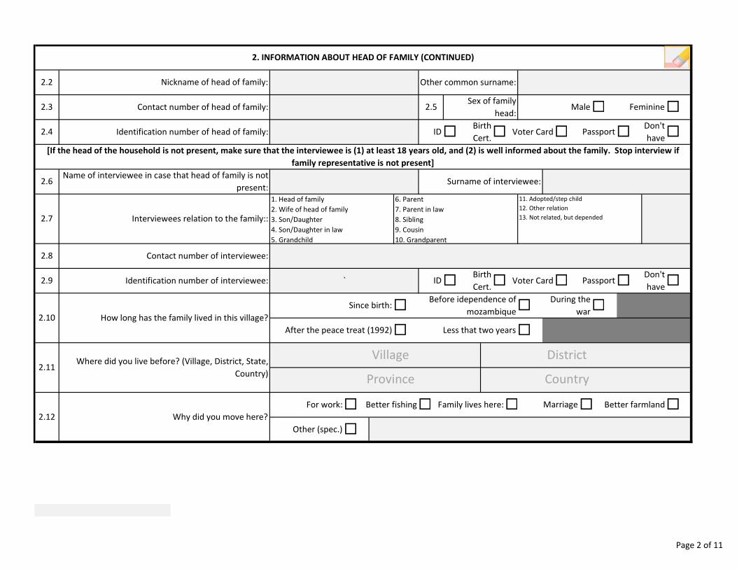
�
PassportDon't
have�
2.7 Interviewees relation to the family::
During the
war
Less that two years
2. INFORMATION ABOUT HEAD OF FAMILY (CONTINUED)
� �
2.3
Identification number of head of family: 2.4
2.8
2.6Name of interviewee in case that head of family is not
present:
Contact number of interviewee:
[If the head of the household is not present, make sure that the interviewee is (1) at least 18 years old, and (2) is well informed about the family. Stop interview if
family representative is not present]
�
IDBirth
Cert.Voter Card` � �
� �
�Since birth:
2.9
Why did you move here?
Identification number of interviewee:
2.12
2.11Where did you live before? (Village, District, State,
Country)
2.10 How long has the family lived in this village?
Contact number of head of family: Feminine
1. Head of family
2. Wife of head of family
3. Son/Daughter
4. Son/Daughter in law
5. Grandchild
6. Parent
7. Parent in law
8. Sibling
9. Cousin
10. Grandparent
11. Adopted/step child
12. Other relation
13. Not related, but depended
� Don't
haveVoter Card� Passport
Before idependence of
mozambique �
After the peace treat (1992)
Sex of family
head:
Surname of interviewee:
� �2.5 Male
ID� Birth
Cert.�
Other (spec.)
For work: Family lives here: Marriage Better farmlandBetter fishing� �� � �
�
Nickname of head of family:2.2 Other common surname:
Village District
Province Country
Page 2 of 11
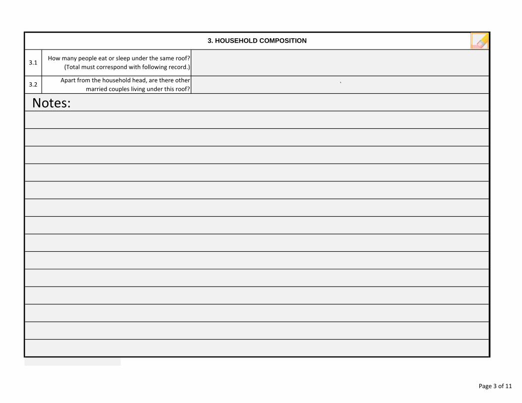
3. HOUSEHOLD COMPOSITION
3.1How many people eat or sleep under the same roof?
(Total must correspond with following record.)
3.2Apart from the household head, are there other
married couples living under this roof?`
Notes:
Page 3 of 11
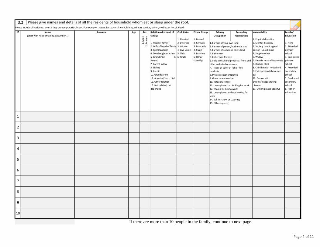
If there are more than 10 people in the family, continue to next page.
Civil Status
1. Married
2. Divorced
3. Widow
4. Civil union
5. Child
6. Single
Ethnic Group
1. Makwé
2. Kimwani
3. Makonde
4. Swaili
5. Makhua
6. Other
(Specify)
Sex
1.
Ma
le
2.
Fe
ma
le
Primary
Occupation
Secondary
Occupation
Vulnerability
1. Physical disability
2. Mental disability
3. Socially handicapped
person (i.e. albinos)
4. Single mother
5. Widow
6. Female head of household
7. Orphan child
8. Child head of household
9. Elder person (above age
60)
10. Person with
chronic/incapacitating
disease
11. Other (please specify)
Level of
Education
1. None
2. Attended
primary
school
3. Completed
primary
school
4. Attended
secondary
school
5. Graduated
secondary
school
6. Higher
education
1. Farmer of your own land
2. Farmer of parent/husband's land
3. Farmer of someone else's land
4. Fisherman
5. Fisherman for hire
6. Sells agricultural products, fruits and
other collected resources
7. Trader or seller of fish or fish
products
8. Private sector employee
9. Government worker
10. Retail merchant
11. Unemployed but looking for work
12. Too old or sick to work
13. Unemployed and not looking for
work
14. Still in school or studying
15. Other (specify)
1
2
ID Age Relation with head of
family:
1. Head of family
2. Wife of head of family
3. Son/Daughter
4. Son/Daughter in law
5. Grandchild 6.
Parent
7. Parent in law
8. Sibling
9. Cousin
10. Grandparent
11. Adopted/step child
12. Other relation
13. Not related, but
depended
Name
(Start with head of family as number 1)
Surname
4
3
5
7
8
9
6
10
3.2 Please give names and details of all the residents of household whom eat or sleep under the roof.
Please include all residents, even if they are temporarily absent. For example, absent for seasonal work, fishing, military service, prison, studies, or hospitalized.
Page 4 of 11
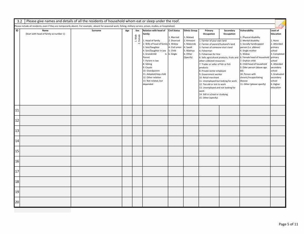
Level of
Education
1. None
2. Attended
primary
school
3. Completed
primary
school
4. Attended
secondary
school
5. Graduated
secondary
school
6. Higher
education
1. Farmer of your own land
2. Farmer of parent/husband's land
3. Farmer of someone else's land
4. Fisherman
5. Fisherman for hire
6. Sells agricultural products, fruits and
other collected resources
7. Trader or seller of fish or fish
products
8. Private sector employee
9. Government worker
10. Retail merchant
11. Unemployed but looking for work
12. Too old or sick to work
13. Unemployed and not looking for
work
14. Still in school or studying
15. Other (specify)
Name
(Start with head of family as number 1)
Surname
12
14
3.2 Please give names and details of all the residents of household whom eat or sleep under the roof.
Please include all residents, even if they are temporarily absent. For example, absent for seasonal work, fishing, military service, prison, studies, or hospitalized.
Ethnic Group
1. Makwé
2. Kimwani
3. Makonde
4. Swaili
5. Makhua
6. Other
(Specify)
11
ID Age Relation with head of
family:
1. Head of family
2. Wife of head of family
3. Son/Daughter
4. Son/Daughter in law
5. Grandchild 6.
Parent
7. Parent in law
8. Sibling
9. Cousin
10. Grandparent
11. Adopted/step child
12. Other relation
13. Not related, but
depended
Civil Status
1. Married
2. Divorced
3. Widow
4. Civil union
5. Child
6. Single
Sex
1.
Ma
le
2.
Fe
ma
le
Primary
Occupation
Secondary
Occupation
Vulnerability
1. Physical disability
2. Mental disability
3. Socially handicapped
person (i.e. albinos)
4. Single mother
5. Widow
6. Female head of household
7. Orphan child
8. Child head of household
9. Elder person (above age
60)
10. Person with
chronic/incapacitating
disease
11. Other (please specify)
16
13
15
18
17
20
19
Page 5 of 11
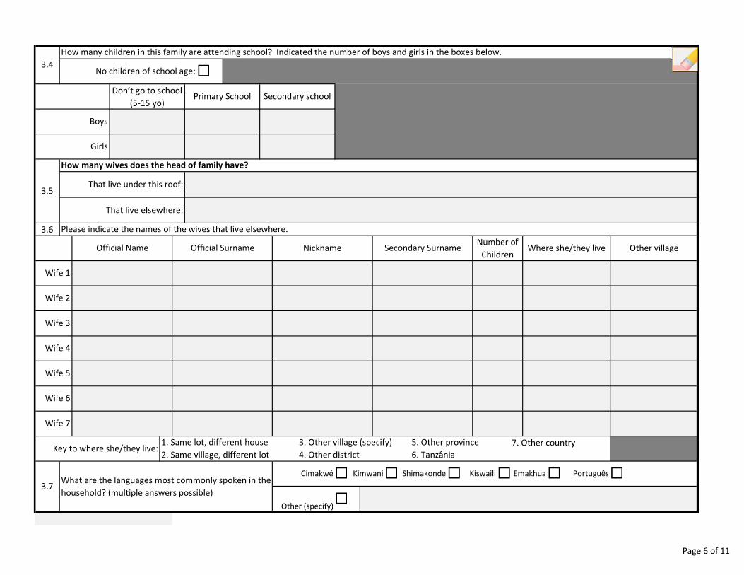
Wife 1
Wife 5
3.4
How many children in this family are attending school? Indicated the number of boys and girls in the boxes below.
No children of school age:�Don’t go to school
(515 yo)Primary School Secondary school
Boys
Girls
3.6 Please indicate the names of the wives that live elsewhere.
Official Name Official Surname Nickname Secondary Surname Where she/they live
3.5
How many wives does the head of family have?
That live under this roof:
That live elsewhere:
Number of
ChildrenOther village
Português
5. Other province
6. Tanzânia
1. Same lot, different house
2. Same village, different lot
3. Other village (specify)
4. Other district
7. Other countryKey to where she/they live:
Wife 4
Wife 7
Wife 6
Wife 2
Wife 3
�
Other (specify) �
Shimakonde� Kiswaili� Emakhua�3.7
What are the languages most commonly spoken in the
household? (multiple answers possible)
Cimakwé� Kimwani�
Page 6 of 11
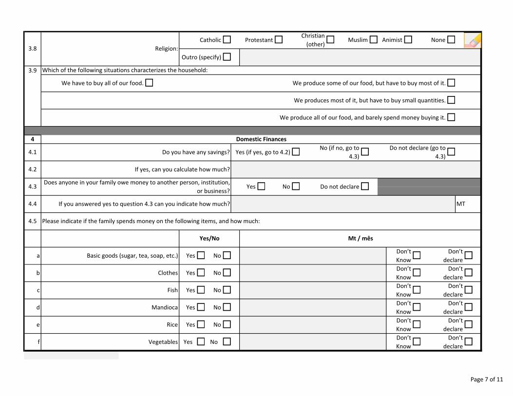
� No�
Mandioca Yes� No� �Don’t
Know
Don’t
declare�Don’t
Know
Don’t
declare�
Don’t
Know �Don’t
declare
Don’t
Know
Don’t
declare�Don’t
Know
Don’t
declare�
�
�
�
�Don’t
Know
Don’t
declare
3.8 Religion:
Catholic� Protestant�
We have to buy all of our food.
�
Outro (specify) �
Christian
(other)� Muslim� Animist� None
�
4 Domestic Finances
4.1 �
3.9 Which of the following situations characterizes the household:
� �
�
�
We produce some of our food, but have to buy most of it.
We produces most of it, but have to buy small quantities.
We produce all of our food, and barely spend money buying it.
�No (if no, go to
4.3)
Do not declare (go to
4.3)Yes (if yes, go to 4.2)
4.2 If yes, can you calculate how much?
Do you have any savings?
4.4
4.3
MTIf you answered yes to question 4.3 can you indicate how much?
Does anyone in your family owe money to another person, institution,
or business?Yes� No� Do not declare�
4.5 Please indicate if the family spends money on the following items, and how much:
Basic goods (sugar, tea, soap, etc.) Yes� No�
Clothes Yes� No
Yes/No
�
�
�
a
b
Mt / mês
Vegetables Yes � No �
Rice Yes� No�
c
d
e
f
Fish Yes
Page 7 of 11
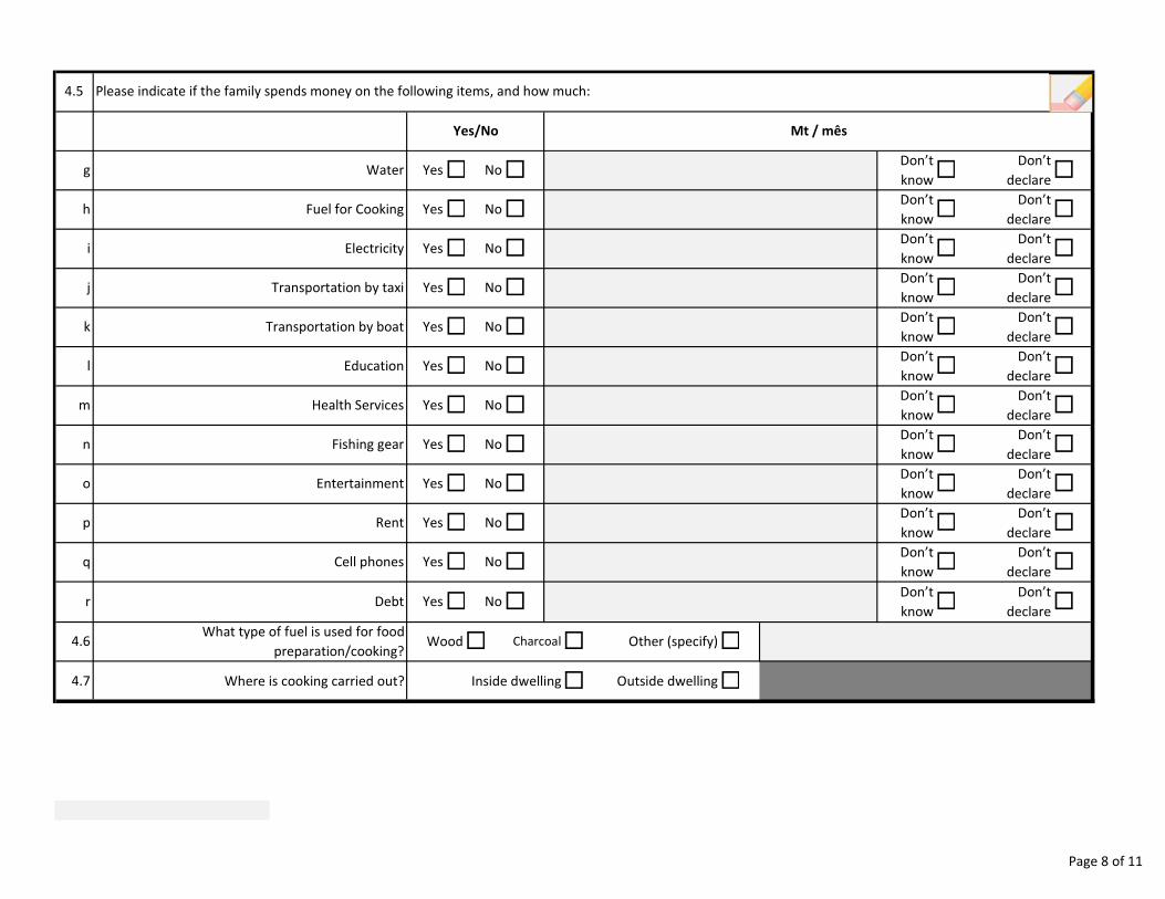
r
i
j
k
l
m
n
o
p
q
Don’t
know
Don’t
declare�Don’t
know
Don’t
declare�Don’t
know
Don’t
declare�
�
�
�
Don’t
know
Don’t
declare�Don’t
know
Don’t
declare�
Don’t
know
Don’t
declare�Don’t
know
Don’t
declare�Don’t
know
Don’t
declare�
�
�
�
�
�
�
4.5 Please indicate if the family spends money on the following items, and how much:
Water Yes� No�
Mt / mês
Fuel for Cooking Yes� No�
g
h
Transportation by taxi Yes� No�
Electricity Yes� No� �
�
�
Don’t
know
Don’t
declare�Don’t
know
Don’t
declare�Don’t
know
Don’t
declare�Don’t
know
Don’t
declare�
Transportation by boat Yes� No�
Education Yes� No�
Cell phones Yes� No�
�
Health Services Yes� No�
Fishing gear Yes� No�
Debt Yes� No
Yes/No
Rent Yes No�
Entertainment Yes� No�
�
4.7 Where is cooking carried out? Inside dwelling� Outside dwelling�
4.6What type of fuel is used for food
preparation/cooking?Wood� Charcoal� Other (specify)�
Page 8 of 11
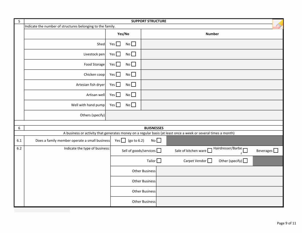
Others (specify)
Other Business
Indicate the number of structures belonging to the family.
Shed Yes
Livestock pen Yes� No
Food Storage Yes�
�
Other Business
Other Business
5 SUPPORT STRUCTURE
Chicken coop Yes� No�
Artisan well
YesArtesian fish dryer
�
Yes� No�
� No
�
Tailor� Carpet Vendor� Other (specify)�
�Indicate the type of business:6.2Beverages
Other Business
Sell of goods/services� Sale of kitchen ware
No�
�
No�
(go to 6.2) No
NumberYes/No
� No�
�
� Hairdresser/Barbe
r
6 BUISNESSES
A business or activity that generates money on a regular basis (at least once a week or several times a month)
6.1 Does a family member operate a small business Yes�
Well with hand pump Yes
Page 9 of 11
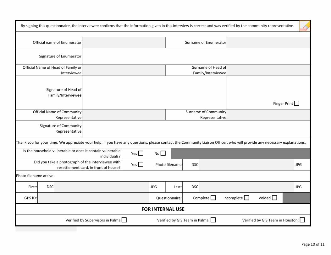
.JPG�
Is the household vulnerable or does it contain vulnerable
individuals?Yes� No�
By signing this questionnaire, the interviewee confirms that the information given in this interview is correct and was verified by the community representative.
Official name of Enumerator
Thank you for your time. We appreciate your help. If you have any questions, please contact the Community Liaison Officer, who will provide any necessary explanations.
Signature of Community
Representative
Surname of Community
Representative
Finger Print�
Surname of Enumerator
Official Name of Community
Representative
FOR INTERNAL USE
� � �Verified by GIS Team in Houston:Verified by GIS Team in Palma:Verified by Supervisors in Palma
.JPG
Did you take a photograph of the interviewee with
resettlement card, in front of house?Yes Photo filename
Photo filename arcive:
DSC
Signature of Enumerator
Surname of Head of
Family/Interviewee
Signature of Head of
Family/Interviewee
Official Name of Head of Family or
Interviewee
Voided
First:
Complete� Incomplete�GPS ID: Questionnaire:
.JPG Last:DSC DSC
�
Page 10 of 11
Mozambique Gas Development Resettlement Plan
Annex C: Data Collection Methods
Rev. 1 Rev Date: 27-May-16
2.2 Asset survey
40
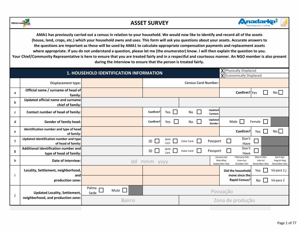
XX
Displacement type:
aOfficial name / surname of head of
family:Yes �
bUpdated official name and surname
chief of family:
c Contact number of head of family: Yes � No �
d Gender of family head: Yes � No � � �
eIdentification number and type of head
of family:Yes �
fUpdated identification number and type
of head of family:ID �
Birth
Cert. � Voter Card � � �
gAdditional identification number and
type of head of family:ID �
Birth
Cert. � Voter Card � � �
h Date of Interview:
Yes �
No �
Palma
Sede �Mute �
ASSET SURVEY
1. HOUSEHOLD IDENTIFICATION INFORMATION
Census Card Number:
�
AMA1 has previously carried out a census in relation to your household. We would now like to identify and record all of the assets
(house, land, crops, etc.) which your household owns and uses. This form will ask you questions about your assets. Accurate answers to
the questions are important as these will be used by AMA1 to calculate appropriate compensation payments and replacement assets
where appropriate. If you do not understand a question, please let me (the enumerator) know. I will then explain the question to you.
Your Chief/Community Representative is here to ensure that you are treated fairly and in a respectful and courteous manner. An NGO member is also present
during the interview to ensure that the person is treated fairly.
Physically Displaced
Economically Displaced
Passport
Passport
Don't
Have
Don't
Have
Did the household
move since the
Rapid Census?
April=Apr
August=Aug
December=Dec
March=Mar
July=Jul
November=Nov
January=Jan
May=May
September=Sep
�
No
No
Confirm?
Confirm?
Female
Confirm?
Confirm?
February=Feb
June=Jun
October=Oct
Updated
Contact:
Updated
Gender:Male
jUpdated Locality, Settlement,
neighborhood, and production zone:
Locality, Settlement, neighborhood,
and
production zone:
i
Vá para 1.j
Vá para 2
dd mmm yyyy
Povoação
Bairro Zona de produção
Page 1 of 77
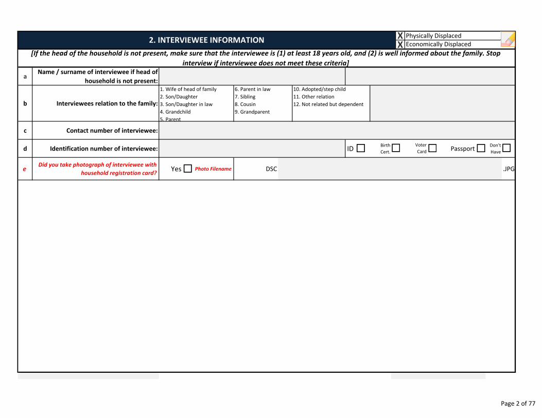
aName / surname of interviewee if head of
household is not present:
b Interviewees relation to the family:
c Contact number of interviewee:
d Identification number of interviewee: ID �Birth
Cert. � Passport�Don't
Have
eDid you take photograph of interviewee with
household registration card?Yes� Photo Filename DSC .JPG
� �
1. Wife of head of family
2. Son/Daughter
3. Son/Daughter in law
4. Grandchild
5. Parent
6. Parent in law
7. Sibling
8. Cousin
9. Grandparent
Voter
Card
XX Economically Displaced
Physically Displaced
10. Adopted/step child
11. Other relation
12. Not related but dependent
2. INTERVIEWEE INFORMATION
[If the head of the household is not present, make sure that the interviewee is (1) at least 18 years old, and (2) is well informed about the family. Stop
interview if interviewee does not meet these criteria]
Page 2 of 77
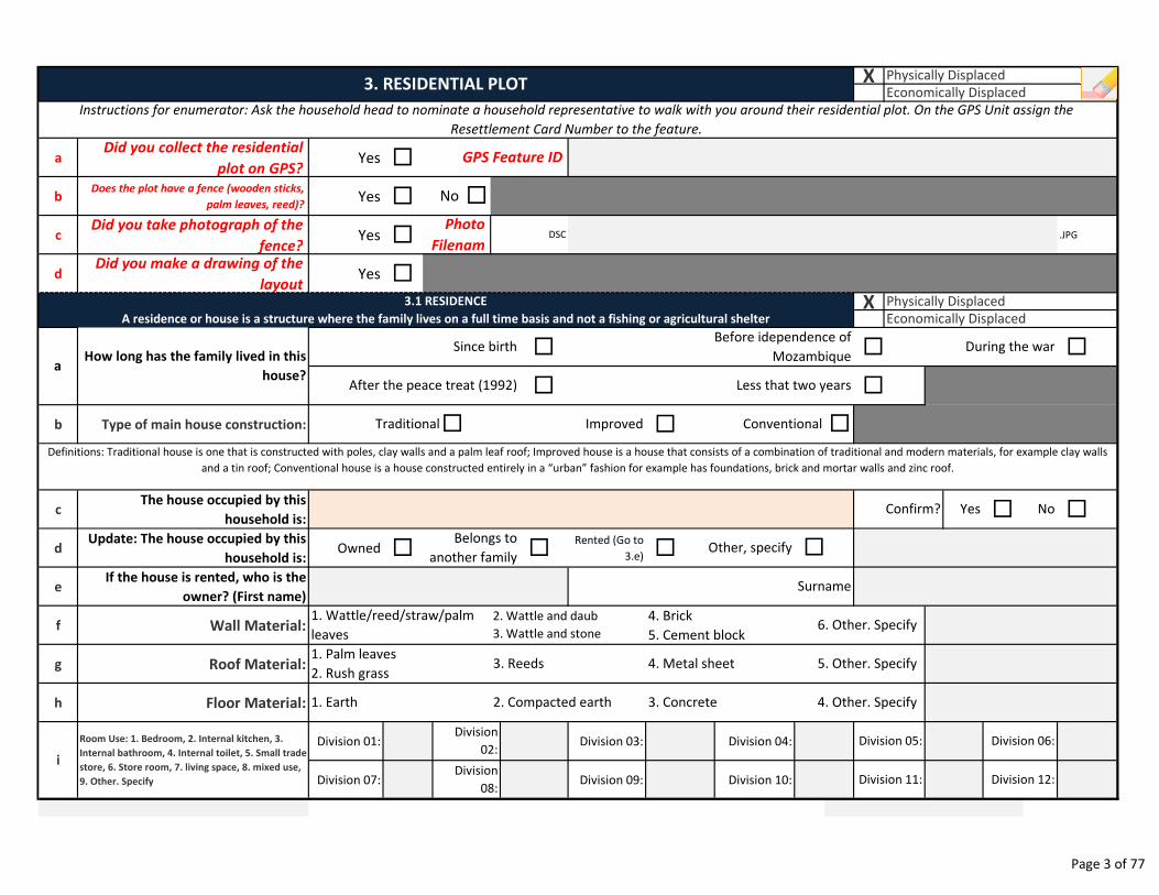
X
aDid you collect the residential
plot on GPS?Yes �
bDoes the plot have a fence (wooden sticks,
palm leaves, reed)?Yes �
cDid you take photograph of the
fence?Yes � .JPG
dDid you make a drawing of the
layoutYes �
X
� � �
� �
b Type of main house construction: �
cThe house occupied by this
household is: � �
dUpdate: The house occupied by this
household is:Owned � �
Rented (Go to
3.e) �
eIf the house is rented, who is the
owner? (First name)
f Wall Material:
g Roof Material:
h Floor Material:
Division 01: Division 03: Division 04:
Division 07: Division 09: Division 10:
Division 05:
Division 11:
Division 06:
Division 12:Division
08:
i
5. Other. Specify
4. Other. Specify
Room Use: 1. Bedroom, 2. Internal kitchen, 3.
Internal bathroom, 4. Internal toilet, 5. Small trade
store, 6. Store room, 7. living space, 8. mixed use,
9. Other. Specify
Surname
6. Other. Specify4. Brick
5. Cement block
Division
02:
3. Reeds
2. Compacted earth
4. Metal sheet
3. Concrete
Belongs to
another family
Physically Displaced
Economically Displaced
Traditional� Improved Conventional �
3.1 RESIDENCE
A residence or house is a structure where the family lives on a full time basis and not a fishing or agricultural shelter
Less that two years
During the war
After the peace treat (1992)
Before idependence of
MozambiqueHow long has the family lived in this
house?
Since birth
Physically Displaced
Economically Displaced3. RESIDENTIAL PLOT
No �
GPS Feature ID
Instructions for enumerator: Ask the household head to nominate a household representative to walk with you around their residential plot. On the GPS Unit assign the
Resettlement Card Number to the feature.
1. Wattle/reed/straw/palm
leaves
1. Palm leaves
2. Rush grass
1. Earth
2. Wattle and daub
3. Wattle and stone
DSCPhoto
Filenam
Other, specify
Definitions: Traditional house is one that is constructed with poles, clay walls and a palm leaf roof; Improved house is a house that consists of a combination of traditional and modern materials, for example clay walls
and a tin roof; Conventional house is a house constructed entirely in a “urban” fashion for example has foundations, brick and mortar walls and zinc roof.
NoYesConfirm?
�
a
Page 3 of 77
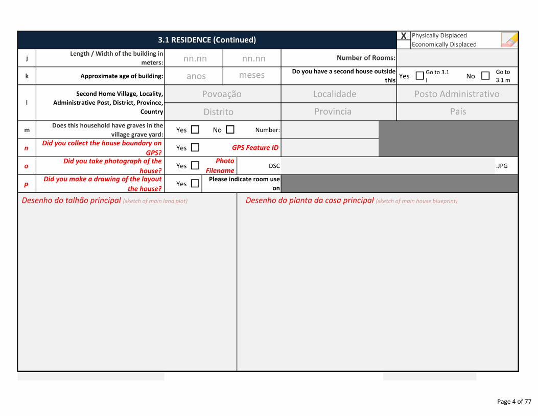
X
jLength / Width of the building in
meters:
k Approximate age of building: Yes �Go to 3.1
lNo �
Go to
3.1 m
mDoes this household have graves in the
village grave yard:Yes � No � Number:
nDid you collect the house boundary on
GPS?Yes �
oDid you take photograph of the
house?Yes � DSC .JPG
pDid you make a drawing of the layout
the house?Yes �
Physically Displaced
Economically Displaced
Number of Rooms:
Do you have a second house outside
this
l
Second Home Village, Locality,
Administrative Post, District, Province,
Country
Please indicate room use
on
GPS Feature ID
Photo
Filename
3.1 RESIDENCE (Continued)
Povoação Localidade
Distrito Provincia
Desenho do talhão principal (sketch of main land plot)
Posto Administrativo
País
Desenho da planta da casa principal (sketch of main house blueprint)
nn.nn nn.nn
anos meses
Page 4 of 77
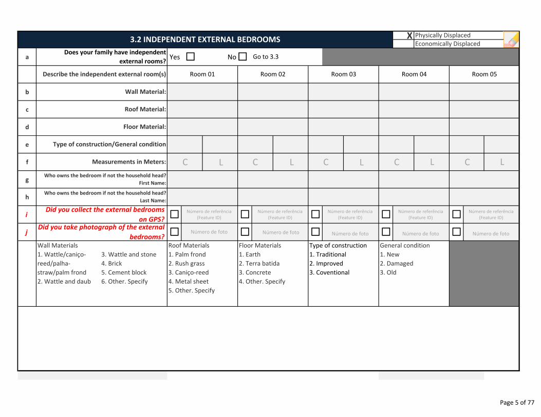
X
a Yes � No�
b
c
d
e
f
g
h
i � � � � �
j � � � � �
Wall Materials
1. Wattle/caniço-
reed/palha-
straw/palm frond
2. Wattle and daub
3. Wattle and stone
4. Brick
5. Cement block
6. Other. Specify
3.2 INDEPENDENT EXTERNAL BEDROOMS
Type of construction
1. Traditional
2. Improved
3. Coventional
General condition
1. New
2. Damaged
3. Old
Room 03 Room 04 Room 05
Physically Displaced
Economically Displaced
Go to 3.3
Roof Materials
1. Palm frond
2. Rush grass
3. Caniço-reed
4. Metal sheet
5. Other. Specify
Floor Materials
1. Earth
2. Terra batida
3. Concrete
4. Other. Specify
Room 01 Room 02
Measurements in Meters:
Who owns the bedroom if not the household head?
First Name:
Who owns the bedroom if not the household head?
Last Name:
Did you collect the external bedrooms
on GPS?
Does your family have independent
external rooms?
Describe the independent external room(s)
Wall Material:
Roof Material:
Floor Material:
Did you take photograph of the external
bedrooms?
Type of construction/General condition
C L C C C
Número de referência
(Feature ID)
Número de foto Número de foto Número de foto Número de foto Número de foto
L C L L L
Número de referência
(Feature ID)
Número de referência
(Feature ID)
Número de referência
(Feature ID)
Número de referência
(Feature ID)
Page 5 of 77
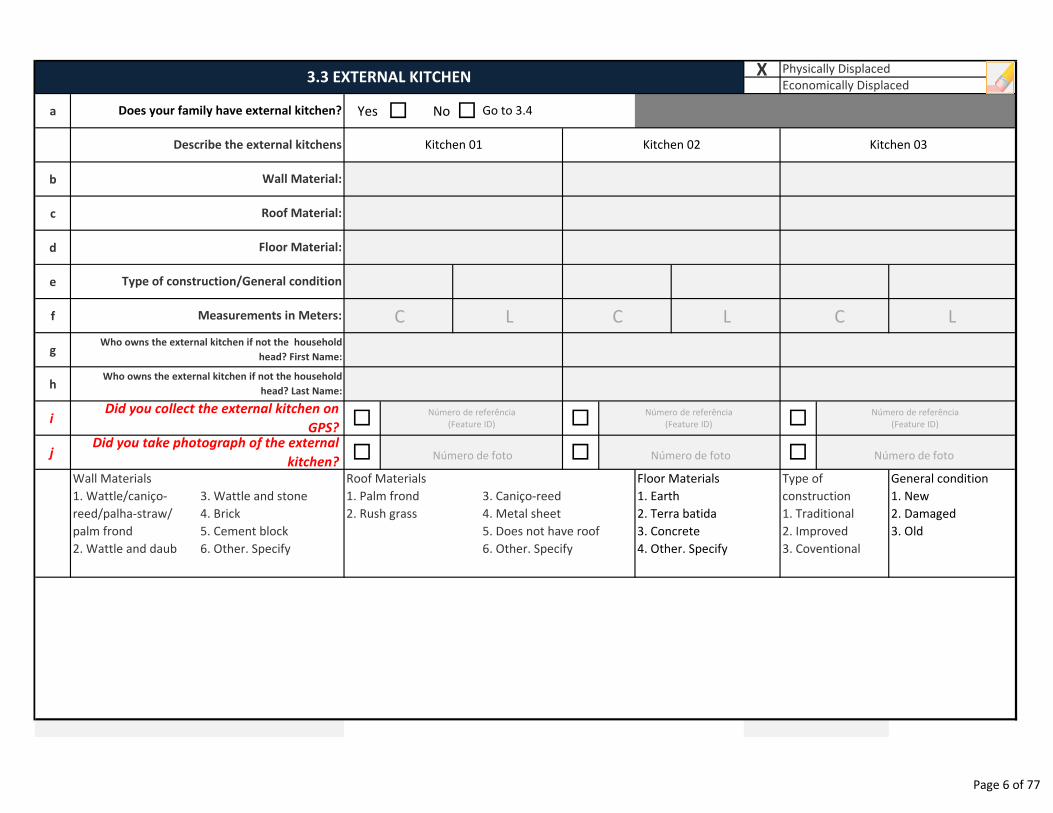
X
a Yes � No �
b
c
d
e
f
g
h
i � � �
j � � �
Wall Materials
1. Wattle/caniço-
reed/palha-straw/
palm frond
2. Wattle and daub
3. Wattle and stone
4. Brick
5. Cement block
6. Other. Specify
General condition
1. New
2. Damaged
3. Old
Physically Displaced
Economically Displaced3.3 EXTERNAL KITCHEN
Go to 3.4
3. Caniço-reed
4. Metal sheet
5. Does not have roof
6. Other. Specify
Floor Materials
1. Earth
2. Terra batida
3. Concrete
4. Other. Specify
Type of
construction
1. Traditional
2. Improved
3. Coventional
Kitchen 01 Kitchen 02 Kitchen 03
Roof Materials
1. Palm frond
2. Rush grass
Measurements in Meters:
Who owns the external kitchen if not the household
head? First Name:
Who owns the external kitchen if not the household
head? Last Name:
Did you collect the external kitchen on
GPS?Did you take photograph of the external
kitchen?
Type of construction/General condition
Does your family have external kitchen?
Describe the external kitchens
Wall Material:
Roof Material:
Floor Material:
C L
Número de foto Número de foto Número de foto
C L C L
Número de referência
(Feature ID)
Número de referência
(Feature ID)
Número de referência
(Feature ID)
Page 6 of 77
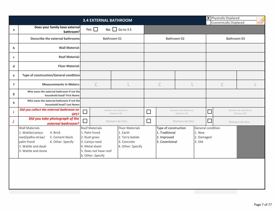
a No Go to 3.5
b
c
d
e
f
g
h
i � �
j � �
Wall Materials
1. Wattle/caniço-
reed/palha-straw/
palm frond
2. Wattle and daub
3. Wattle and stone
4. Brick
5. Cement block
6. Other. Specify
Who owns the external bathroom if not the
household head? First Name:
Physically Displaced
Economically Displaced
X
Does your family have external
bathroom?
Decscribe the external bathrooms
3.4 EXTERNAL BATHROOM
Wall Material:
Roof Material:
Floor Material:
Type of construction/General condition
Measurements in Meters:
�
�
Yes � �
Bathroom 01 Bathroom 02 Bathroom 03
Who owns the external bathroom if not the
household head? Last Name:
Did you collect the external bathroom on
GPS?
Did you take photograph of the
external bathroom?
Roof Materials
1. Palm frond
2. Rush grass
3. Caniço-reed
4. Metal sheet
5. Does not have roof
6. Other. Specify
Floor Materials
1. Earth
2. Terra batida
3. Concrete
4. Other. Specify
Type of construction
1. Traditional
2. Improved
3. Coventional
General condition
1. New
2. Damaged
3. Old
C L
Número de foto Número de foto Número de foto
C L C L
Número de referência
(Feature ID)
Número de referência
(Feature ID)
Número de referência
(Feature ID)
Page 7 of 77
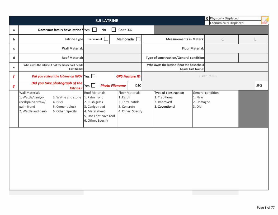
X
a Yes
b �
c
d
e
f Yes
g Yes
Wall Materials
1. Wattle/caniço-
reed/palha-straw/
palm frond
2. Wattle and daub
3. Wattle and stone
4. Brick
5. Cement block
6. Other. Specify
Type of construction
1. Traditional
2. Improved
3. Coventional
Photo Filename� DSC
Wall Material:
Latrine Type
Roof Material:
Physically Displaced
Economically Displaced
Does your family have latrine? � �No
3.5 LATRINE
Go to 3.6
Measurements in Meters:
Floor Material:
Type of construction/General condition
MelhoradaTradicional �
.JPG
Who owns the latrine if not the household head?
First Name:
Who owns the latrine if not the household
head? Last Name:
Did you collect the latrine on GPS? � GPS Feature ID
Did you take photograph of the
latrine?
Roof Materials
1. Palm frond
2. Rush grass
3. Caniço-reed
4. Metal sheet
5. Does not have roof
6. Other. Specify
Floor Materials
1. Earth
2. Terra batida
3. Concrete
4. Other. Specify
General condition
1. New
2. Damaged
3. Old
(Feature ID)
C L
Page 8 of 77
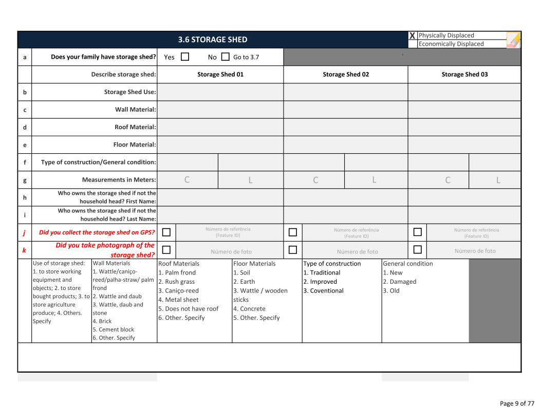
X
a Yes � No � Go to 3.7
b
c
d
e
f
g
h
i
j � �
k � �
Use of storage shed:
1. to store working
equipment and
objects; 2. to store
bought products; 3. to
store agriculture
produce; 4. Others.
Specify
Wall Materials
1. Wattle/caniço-
reed/palha-straw/ palm
frond
2. Wattle and daub
3. Wattle, daub and
stone
4. Brick
5. Cement block
6. Other. Specify
Storage Shed Use:
Floor Material:
Wall Material:
Roof Material:
Type of construction/General condition:
Measurements in Meters:
Physically Displaced3.6 STORAGE SHED
Economically Displaced
Does your family have storage shed?
Describe storage shed: Storage Shed 01 Storage Shed 02 Storage Shed 03
`
Who owns the storage shed if not the
household head? Last Name:
Who owns the storage shed if not the
household head? First Name:
Did you collect the storage shed on GPS?
Did you take photograph of the
storage shed?
General condition
1. New
2. Damaged
3. Old
Roof Materials
1. Palm frond
2. Rush grass
3. Caniço-reed
4. Metal sheet
5. Does not have roof
6. Other. Specify
Floor Materials
1. Soil
2. Earth
3. Wattle / wooden
sticks
4. Concrete
5. Other. Specify
Type of construction
1. Traditional
2. Improved
3. Coventional
�
�
CC CL
Número de foto Número de foto Número de foto
L L
Número de referência
(Feature ID)Número de referência
(Feature ID)
Número de referência
(Feature ID)
Page 9 of 77
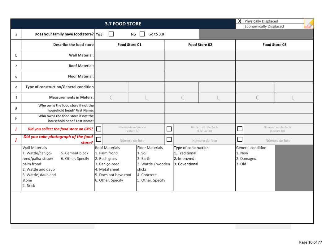
a Yes � No �
b
c
d
e
f
g
h
i � �
j � �
Wall Materials
1. Wattle/caniço-
reed/palha-straw/
palm frond
2. Wattle and daub
3. Wattle, daub and
stone
4. Brick
5. Cement block
6. Other. Specify
3.7 FOOD STORE X Physically Displaced
Economically Displaced
Roof Material:
Floor Material:
Does your family have food store?
Describe the food store
Wall Material:
Go to 3.8
Food Store 01 Food Store 02
Type of construction/General condition
Measurements in Meters:
Did you collect the food store on GPS?
Who owns the food store if not the
household head? First Name:
Who owns the food store if not the
household head? Last Name:
Did you take photograph of the food
store?
Food Store 03
�
�
Roof Materials
1. Palm frond
2. Rush grass
3. Caniço-reed
4. Metal sheet
5. Does not have roof
6. Other. Specify
Floor Materials
1. Soil
2. Earth
3. Wattle / wooden
sticks
4. Concrete
5. Other. Specify
Type of construction
1. Traditional
2. Improved
3. Coventional
General condition
1. New
2. Damaged
3. Old
C
Número de foto Número de foto Número de foto
L C L C L
Número de referência
(Feature ID)
Número de referência
(Feature ID)
Número de referência
(Feature ID)
Page 10 of 77
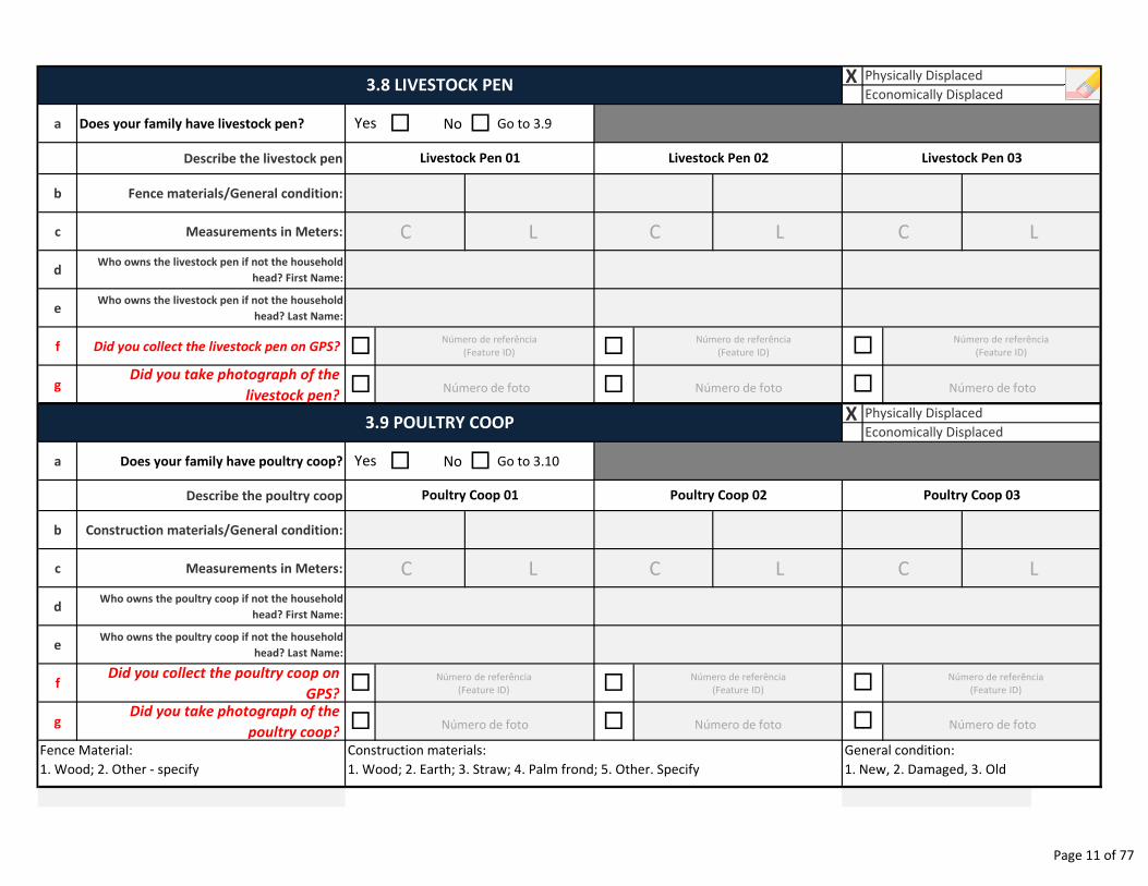
X
a Does your family have livestock pen? � No � Go to 3.9
Describe the livestock pen
b Fence materials/General condition:
c Measurements in Meters:
dWho owns the livestock pen if not the household
head? First Name:
eWho owns the livestock pen if not the household
head? Last Name:
f Did you collect the livestock pen on GPS? � �
gDid you take photograph of the
livestock pen?� �
X
a Does your family have poultry coop? � No � Go to 3.10
Describe the poultry coop
b Construction materials/General condition:
c Measurements in Meters:
dWho owns the poultry coop if not the household
head? First Name:
eWho owns the poultry coop if not the household
head? Last Name:
fDid you collect the poultry coop on
GPS?� �
gDid you take photograph of the
poultry coop?� �
Physically Displaced
Economically Displaced3.9 POULTRY COOP
�
�
Livestock Pen 01 Livestock Pen 02 Livestock Pen 03
3.8 LIVESTOCK PENPhysically Displaced
Economically Displaced
Yes
Yes
Poultry Coop 03Poultry Coop 02Poultry Coop 01
Fence Material:
1. Wood; 2. Other - specify
General condition:
1. New, 2. Damaged, 3. Old
Construction materials:
1. Wood; 2. Earth; 3. Straw; 4. Palm frond; 5. Other. Specify
�
�
CC C
CC C
Número de foto Número de foto Número de foto
Número de foto Número de foto Número de foto
L
L
L
L
L
L
Número de referência
(Feature ID)
Número de referência
(Feature ID)
Número de referência
(Feature ID)
Número de referência
(Feature ID)
Número de referência
(Feature ID)
Número de referência
(Feature ID)
Page 11 of 77
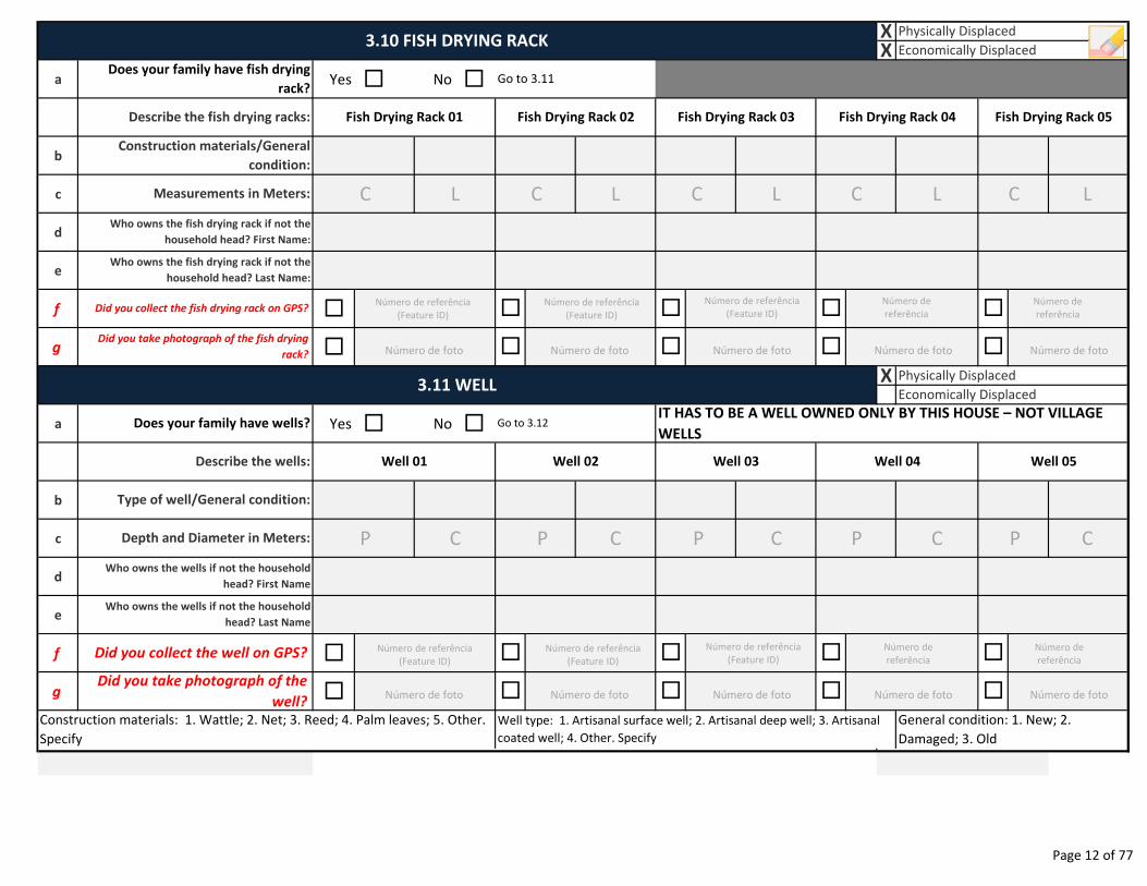
a Yes � No �
b
c
d
e
f �
g �
a Yes � No �
b
c
d
e
f �
g �
Who owns the fish drying rack if not the
household head? Last Name:
3.10 FISH DRYING RACKXX
Physically Displaced
Economically Displaced
Fish Drying Rack 03 Fish Drying Rack 04 Fish Drying Rack 05
Does your family have fish drying
rack?Go to 3.11
Describe the fish drying racks: Fish Drying Rack 01 Fish Drying Rack 02
Who owns the fish drying rack if not the
household head? First Name:
Construction materials/General
condition:
Measurements in Meters:
����
Did you take photograph of the fish drying
rack?
Did you collect the fish drying rack on GPS?
� � � �
Physically Displaced
Economically Displaced
X3.11 WELL
Does your family have wells? Go to 3.12IT HAS TO BE A WELL OWNED ONLY BY THIS HOUSE – NOT VILLAGE
WELLS
Describe the wells: Well 01 Well 02 Well 03 Well 04 Well 05
Type of well/General condition:
Did you collect the well on GPS?
Did you take photograph of the
well?
Who owns the wells if not the household
head? First Name
�
�
Depth and Diameter in Meters:
Who owns the wells if not the household
head? Last Name
�
�
�
�
�
�
Construction materials: 1. Wattle; 2. Net; 3. Reed; 4. Palm leaves; 5. Other.
Specify
General condition: 1. New; 2.
Damaged; 3. Old
Well type: 1. Artisanal surface well; 2. Artisanal deep well; 3. Artisanal
coated well; 4. Other. Specify
C L C C C C
P C P P P P
Número de foto Número de foto Número de foto Número de foto Número de foto
Número de foto Número de foto Número de foto Número de foto Número de foto
L
C
L
C
L
C
L
C
Número de referência
(Feature ID)Número de referência
(Feature ID)
Número de referência
(Feature ID)
Número de
referência
Número de
referência
Número de referência
(Feature ID)Número de referência
(Feature ID)
Número de referência
(Feature ID)
Número de
referência
Número de
referência
Page 12 of 77
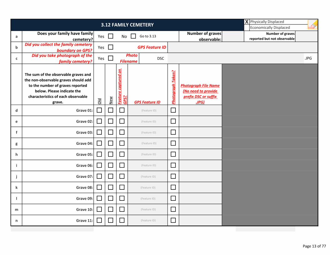
aDoes your family have family
cemetery?Yes � No �
Number of graves
observable:
bDid you collect the family cemetery
boundary on GPS?Yes �
cDid you take photograph of the
family cemetery?Yes � DSC
The sum of the observable graves and
the non-observable graves should add
to the number of graves reported
below. Please indicate the
characteristics of each observable
grave. Old
Ne
w
Fe
atu
re c
ap
ture
d o
n
GP
S?
Ph
oto
gra
ph
Ta
ke
n?
Photograph File Name
(No need to provide
prefix DSC or suffix
.JPG)
d Grave 01: � � � �
e Grave 02: � � � �
f Grave 03: � � � �
g Grave 04: � � � �
h Grave 05: � � � �
i Grave 06: � � � �
j Grave 07: � � � �
k Grave 08: � � � �
l Grave 09: � � � �
m Grave 10: � � � �
n Grave 11: � � � �
3.12 FAMILY CEMETERYX Physically Displaced
Economically Displaced
Go to 3.13
.JPG
Number of graves
reported but not observable
GPS Feature ID
GPS Feature ID
Photo
Filename
(Feature ID)
(Feature ID)
(Feature ID)
(Feature ID)
(Feature ID)
(Feature ID)
(Feature ID)
(Feature ID)
(Feature ID)
(Feature ID)
(Feature ID)
Page 13 of 77
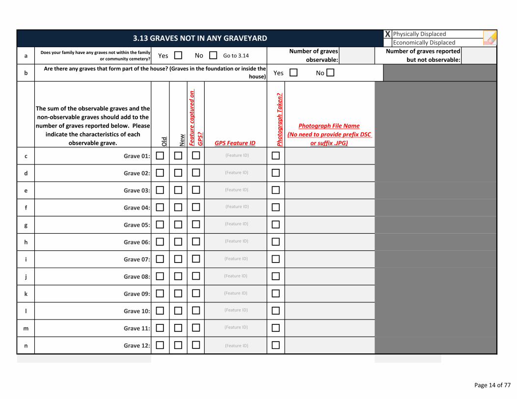
aDoes your family have any graves not within the family
or community cemetery?Yes � � Go to 3.14
b Yes � No�
The sum of the observable graves and the
non-observable graves should add to the
number of graves reported below. Please
indicate the characteristics of each
observable grave. Old
Ne
w
Ph
oto
gra
ph
Ta
ke
n?
c Grave 01: � � �
d Grave 02: � � �
e Grave 03: � � �
f Grave 04: � � �
g Grave 05: � � �
h Grave 06: � � �
i Grave 07: � � �
j Grave 08: � � �
k Grave 09: � � �
l Grave 10: � � �
m Grave 11: � � �
n Grave 12: � � �
Physically Displaced
Economically Displaced
Are there any graves that form part of the house? (Graves in the foundation or inside the
house)
Number of graves reported
but not observable:
3.13 GRAVES NOT IN ANY GRAVEYARD
NoNumber of graves
observable:
X
�
�
�
�
�
�
�
Photograph File Name
(No need to provide prefix DSC
or suffix .JPG)GPS Feature IDFe
atu
re c
ap
ture
d o
n
GP
S?
�
�
�
�
�
(Feature ID)
(Feature ID)
(Feature ID)
(Feature ID)
(Feature ID)
(Feature ID)
(Feature ID)
(Feature ID)
(Feature ID)
(Feature ID)
(Feature ID)
(Feature ID)
Page 14 of 77
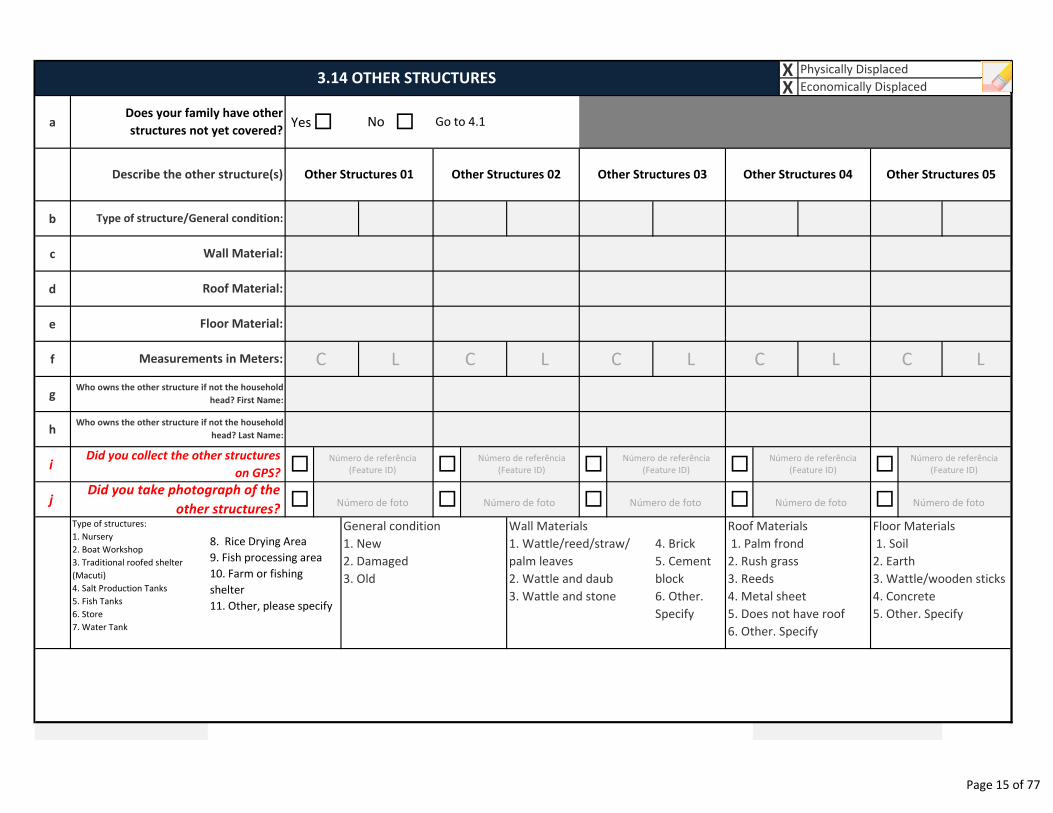
XX
a Yes� �
b
c
d
e
f
g
h
i � � � � �
j � � � � �
Type of structures:
1. Nursery
2. Boat Workshop
3. Traditional roofed shelter
(Macuti)
4. Salt Production Tanks
5. Fish Tanks
6. Store
7. Water Tank
4. Brick
5. Cement
block
6. Other.
Specify
Measurements in Meters:
Who owns the other structure if not the household
head? First Name:
3.14 OTHER STRUCTURESPhysically Displaced
Economically Displaced
Go to 4.1NoDoes your family have other
structures not yet covered?
Other Structures 05
Type of structure/General condition:
Wall Material:
Describe the other structure(s) Other Structures 01 Other Structures 02 Other Structures 03 Other Structures 04
Who owns the other structure if not the household
head? Last Name:
Roof Material:
Floor Material:
Did you collect the other structures
on GPS?
Roof Materials
1. Palm frond
2. Rush grass
3. Reeds
4. Metal sheet
5. Does not have roof
6. Other. Specify
Floor Materials
1. Soil
2. Earth
3. Wattle/wooden sticks
4. Concrete
5. Other. Specify
Did you take photograph of the
other structures?
8. Rice Drying Area
9. Fish processing area
10. Farm or fishing
shelter
11. Other, please specify
General condition
1. New
2. Damaged
3. Old
Wall Materials
1. Wattle/reed/straw/
palm leaves
2. Wattle and daub
3. Wattle and stone
C C C C C
Número de foto Número de foto Número de foto Número de foto Número de foto
L L L L L
Número de referência
(Feature ID)
Número de referência
(Feature ID)
Número de referência
(Feature ID)
Número de referência
(Feature ID)
Número de referência
(Feature ID)
Page 15 of 77
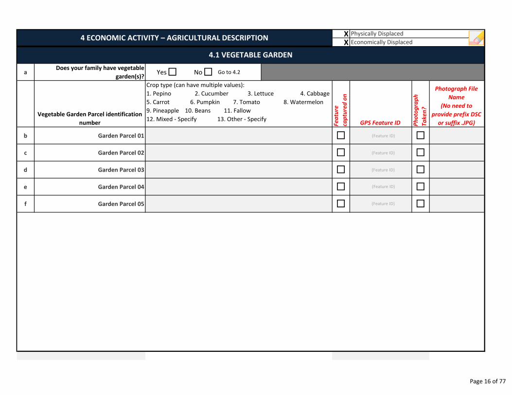
XX
aDoes your family have vegetable
garden(s)?Yes� No� Go to 4.2
Vegetable Garden Parcel identification
number Fe
atu
re
cap
ture
d o
n
GPS Feature ID Ph
oto
gra
ph
Ta
ke
n?
b Garden Parcel 01 � �
c Garden Parcel 02 � �
d Garden Parcel 03 � �
e Garden Parcel 04 � �
f Garden Parcel 05 � �
4.1 VEGETABLE GARDEN
Physically Displaced
Economically Displaced4 ECONOMIC ACTIVITY – AGRICULTURAL DESCRIPTION
Crop type (can have multiple values):
1. Pepino 2. Cucumber 3. Lettuce 4. Cabbage
5. Carrot 6. Pumpkin 7. Tomato 8. Watermelon
9. Pineapple 10. Beans 11. Fallow
12. Mixed - Specify 13. Other - Specify
Photograph File
Name
(No need to
provide prefix DSC
or suffix .JPG)
(Feature ID)
(Feature ID)
(Feature ID)
(Feature ID)
(Feature ID)
Page 16 of 77
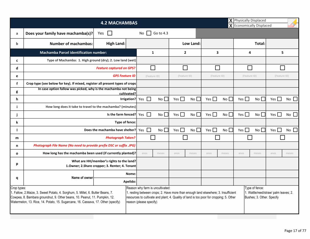
XX
a Does your family have machamba(s)? � �
b Number of machambas:
c
d
e
f
g
h Yes � No � Yes � No � Yes � No � Yes � No � Yes � No �
i
j Yes � No � Yes � No � Yes � No � Yes � No � Yes � No �
k
l Yes � No � Yes � No � Yes � No � Yes � No � Yes � No �
m
n
o
p
Yes No
Total:High Land:
� � �
Crop types:
1. Fallow, 2.Maize, 3. Sweet Potato, 4. Sorghum, 5. Millet, 6. Butter Beans, 7.
Cowpea, 8. Bambara groundnut, 9. Other beans, 10. Peanut, 11. Pumpkin, 12.
Watermelon, 13. Rice, 14. Potato, 15. Sugarcane, 16. Cassava, 17. Other (specify)
Reason why farm is uncultivated:
1. resting between crops; 2. Have more than enough land elsewhere; 3. Insufficient
resources to cultivate and plant; 4. Quality of land is too poor for cropping; 5. Other
reason (please specify)
Type of fence:
1. Wattle/reed/straw/ palm leaves; 2.
Bushes; 3. Other. Specify
Does the machamba have shelter?
�� �
q
��
3 4 5
Nome:
Apelido:Name of owner
Irrigation?
How long does it take to travel to the machamba? (minutes)
Is the farm fenced?
Type of fence:
Photograph Taken?
Photograph File Name (No need to provide prefix DSC or suffix .JPG)
How long has the machamba been used (if currently planted)?
What are HH/member’s rights to the land?
1.Owner; 2.Share cropper; 3. Renter; 4. Tenant
Machamba Parcel identification number: 1 2
Type of Machamba: 1. High ground (dry); 2. Low land (wet)
�
4.2 MACHAMBAS
Feature captured on GPS?
GPS Feature ID
Crop type (see below for key). If mixed, register all present types of crops
In case option fallow was picked, why is the machamba not being
cultivated?
Low Land:
Physically Displaced
Economically Displaced
Go to 4.3
�
anos
(Feature ID) (Feature ID) (Feature ID) (Feature ID)
meses anos meses anos meses anos meses anos meses
(Feature ID)
Page 17 of 77
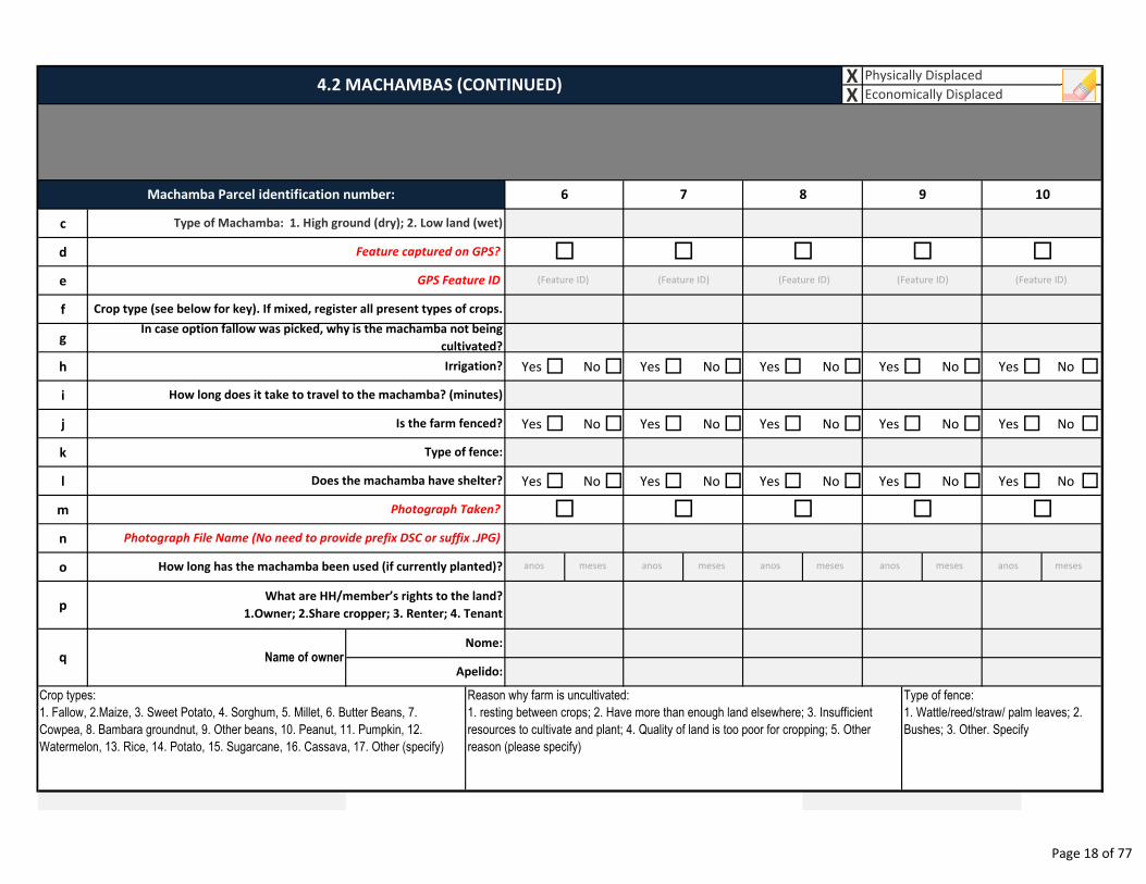
XX
c
d
e
f
g
h Yes � No � Yes � No � Yes � No � Yes � No � Yes � No �
i
j Yes � No � Yes � No � Yes � No � Yes � No � Yes � No �
k
l Yes � No � Yes � No � Yes � No � Yes � No � Yes � No �
m
n
o
p
Nome:
Apelido:
Crop types:
1. Fallow, 2.Maize, 3. Sweet Potato, 4. Sorghum, 5. Millet, 6. Butter Beans, 7.
Cowpea, 8. Bambara groundnut, 9. Other beans, 10. Peanut, 11. Pumpkin, 12.
Watermelon, 13. Rice, 14. Potato, 15. Sugarcane, 16. Cassava, 17. Other (specify)
Reason why farm is uncultivated:
1. resting between crops; 2. Have more than enough land elsewhere; 3. Insufficient
resources to cultivate and plant; 4. Quality of land is too poor for cropping; 5. Other
reason (please specify)
Type of fence:
1. Wattle/reed/straw/ palm leaves; 2.
Bushes; 3. Other. Specify
How long has the machamba been used (if currently planted)?
What are HH/member’s rights to the land?
1.Owner; 2.Share cropper; 3. Renter; 4. Tenant
q Name of owner
Does the machamba have shelter?
Photograph Taken? � � � �
Photograph File Name (No need to provide prefix DSC or suffix .JPG)
�
Irrigation?
How long does it take to travel to the machamba? (minutes)
Is the farm fenced?
Type of fence:
Crop type (see below for key). If mixed, register all present types of crops.
In case option fallow was picked, why is the machamba not being
cultivated?
Feature captured on GPS? � � � � �
GPS Feature ID
4.2 MACHAMBAS (CONTINUED)Physically Displaced
Economically Displaced
Type of Machamba: 1. High ground (dry); 2. Low land (wet)
Machamba Parcel identification number: 6 7 8 9 10
(Feature ID) (Feature ID) (Feature ID) (Feature ID) (Feature ID)
anos meses anos meses anos meses anos meses anos meses
Page 18 of 77
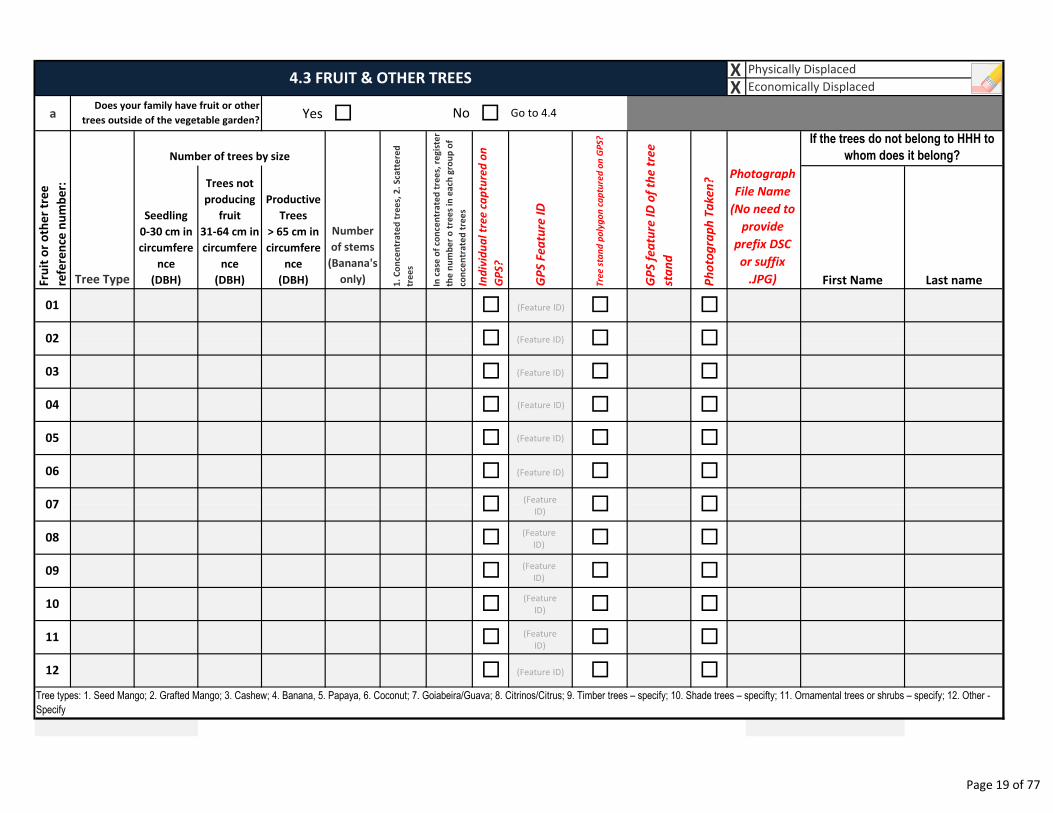
XX
a Yes � �
Seedling
0-30 cm in
circumfere
nce
(DBH)
Trees not
producing
fruit
31-64 cm in
circumfere
nce
(DBH)
Productive
Trees
> 65 cm in
circumfere
nce
(DBH)Fru
it o
r o
the
r tr
ee
refe
ren
ce n
um
be
r:
01
4.3 FRUIT & OTHER TREES
If the trees do not belong to HHH to
whom does it belong?
First Name Last name
Go to 4.4Does your family have fruit or other
trees outside of the vegetable garden?No
Tree Type
Number of trees by size
Number
of stems
(Banana's
only) Ind
ivid
ua
l tr
ee
ca
ptu
red
on
GP
S?
GP
S F
ea
ture
ID
Tre
e s
tan
d p
oly
go
n c
ap
ture
d o
n G
PS
?
GP
S f
ea
ture
ID
of
the
tre
e
sta
nd
Ph
oto
gra
ph
Ta
ke
n?
1.
Co
nce
ntr
ate
d t
ree
s, 2
. S
catt
ere
d
tre
es
In c
ase
of
con
cen
tra
ted
tre
es,
re
gis
ter
the
nu
mb
er
o t
ree
s in
ea
ch g
rou
p o
f
con
cen
tra
ted
tre
es
02
03 �
��
� �
�
���
10
11
12
04
05
06
07
08
09
Tree types: 1. Seed Mango; 2. Grafted Mango; 3. Cashew; 4. Banana, 5. Papaya, 6. Coconut; 7. Goiabeira/Guava; 8. Citrinos/Citrus; 9. Timber trees – specify; 10. Shade trees – specifty; 11. Ornamental trees or shrubs – specify; 12. Other -
Specify
�
�
�
� �
�
�
�
�
Physically Displaced
Economically Displaced
Photograph
File Name
(No need to
provide
prefix DSC
or suffix
.JPG)
�
� �
�
�
�
�
�
�
�
�
�
�
��
�
�
�
(Feature ID)
(Feature ID)
(Feature ID)
(Feature ID)
(Feature ID)
(Feature ID)
(Feature
ID)
(Feature
ID)
(Feature
ID)
(Feature
ID)
(Feature
ID)
(Feature ID)
Page 19 of 77
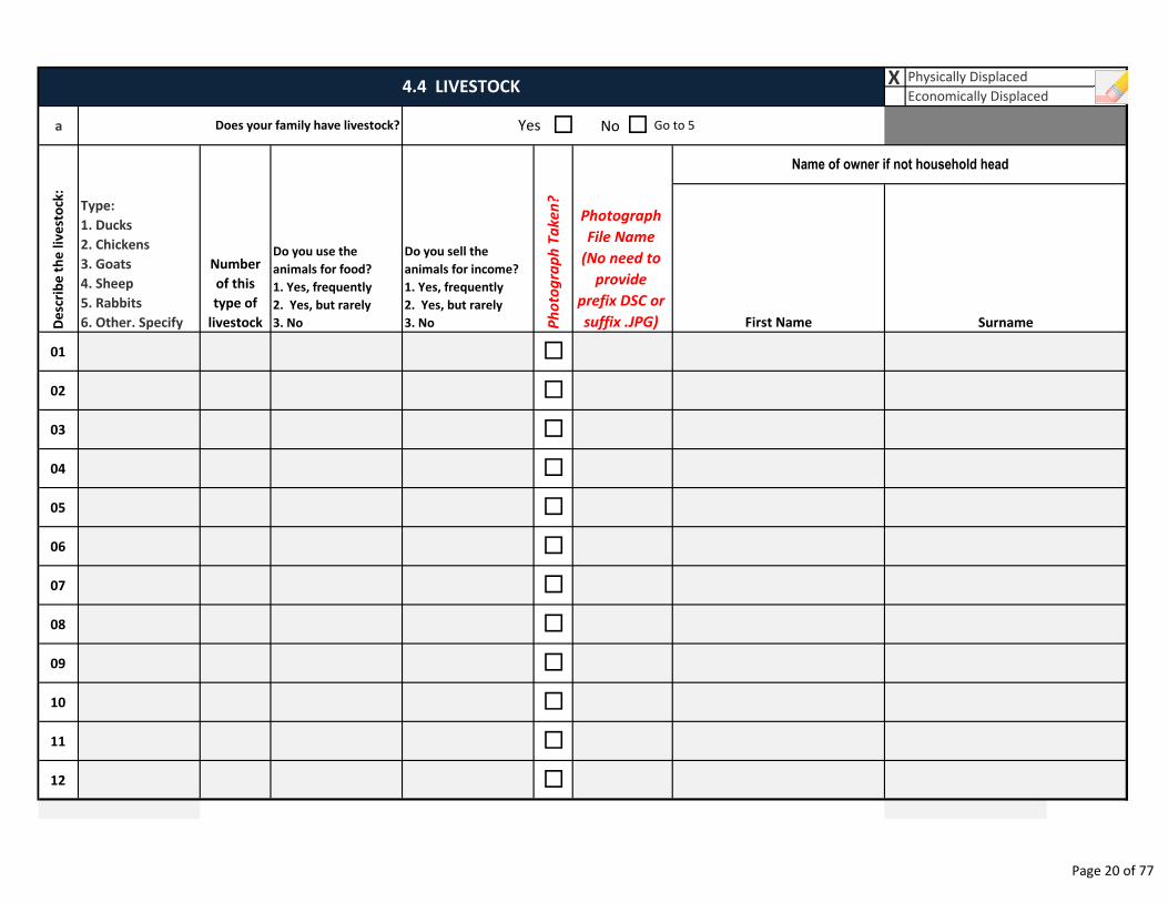
X
a No
First Name
01
02
03
04
05
06
07
08
09
10
11
12
Type:
1. Ducks
2. Chickens
3. Goats
4. Sheep
5. Rabbits
6. Other. Specify
Photograph
File Name
(No need to
provide
prefix DSC or
suffix .JPG)
Name of owner if not household head
Do you use the
animals for food?
1. Yes, frequently
2. Yes, but rarely
3. No
Do you sell the
animals for income?
1. Yes, frequently
2. Yes, but rarely
3. No Ph
oto
gra
ph
Ta
ke
n?
4.4 LIVESTOCKPhysically Displaced
Economically Displaced
�Yes �Does your family have livestock? Go to 5
�
Surname
�
�
�
�
�
�
�
�
�
�
�
De
scri
be
th
e l
ive
sto
ck:
Number
of this
type of
livestock
Page 20 of 77
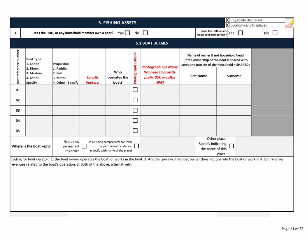
a Yes� � � No �
�
Surname
Name of owner if not household head
(If the ownership of the boat is shared with
someone outside of the household = SHARED)
First Name
NoDoes the HHH, or any household member own a boat?
�Nearby my
permanent
residence
Where is the boat kept?
Coding for boat oerator: 1. the boat owner operates the boat, or works in the boat; 2. Another person. The boat owner does not operate the boat or work in it, but receives
revenues related to the boat's operation. 3. Both of the above, alternatively.
�
Other place.
Specify indicating
the name of this
place.
In a fishing camp/centre far from
my permanent residence.
(specify with name of the place)
�
04
05
03
01 �
�02
Physically Displaced
Economically DisplacedX5. FISHING ASSETS
X
YesDoes the HHH, or any
household member fish?
�
�
5.1 BOAT DETAILS
Bo
at
refe
ren
ce n
um
be
r
Boat Type:
1. Canoe
2. Dhow
3. Mashua
4. Other -
Specify
Propulsion
1. Paddle
2. Sail
3. Motor
4. Other - Specify
Length
(meters)
Who
operates the
boat? Ph
oto
gra
ph
Ta
ke
n?
Photograph File Name
(No need to provide
prefix DSC or suffix
.JPG)
Page 21 of 77
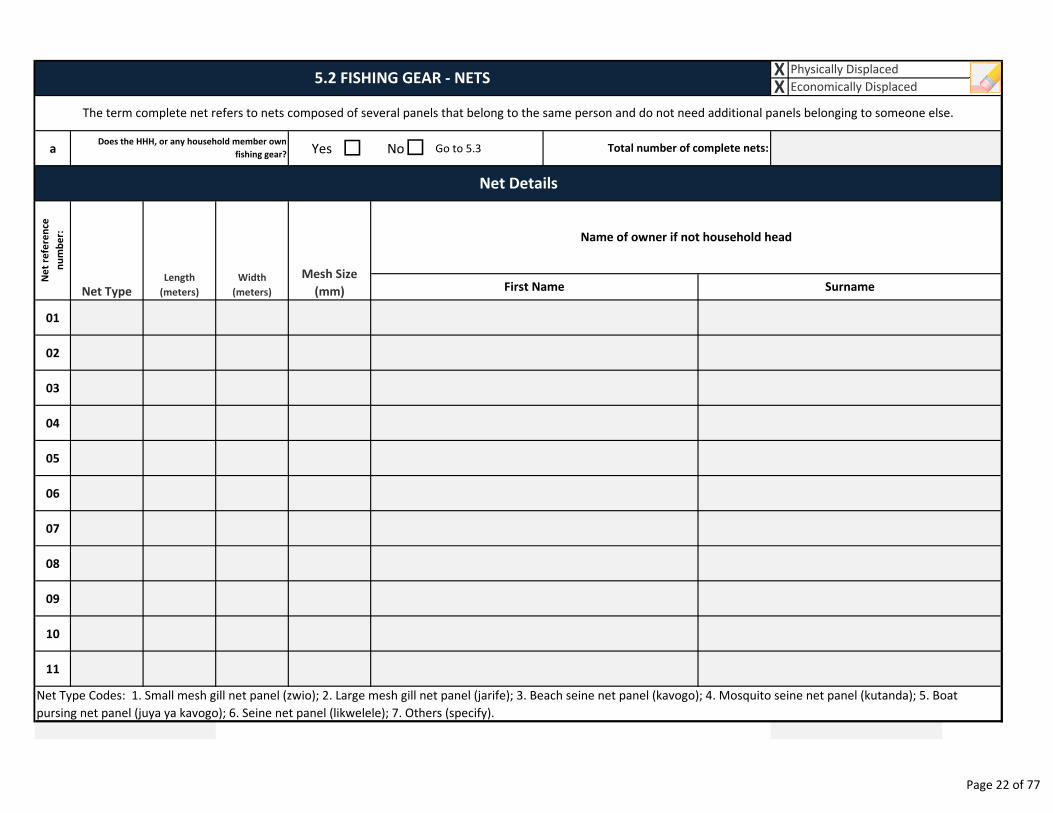
a Yes � No Go to 5.3
01
02
03
04
05
06
07
08
09
10
11
The term complete net refers to nets composed of several panels that belong to the same person and do not need additional panels belonging to someone else.
Net Type Codes: 1. Small mesh gill net panel (zwio); 2. Large mesh gill net panel (jarife); 3. Beach seine net panel (kavogo); 4. Mosquito seine net panel (kutanda); 5. Boat
pursing net panel (juya ya kavogo); 6. Seine net panel (likwelele); 7. Others (specify).
�
5.2 FISHING GEAR - NETSXX
Physically Displaced
Economically Displaced
Net Details
Does the HHH, or any household member own
fishing gear?Total number of complete nets:
Ne
t re
fere
nce
nu
mb
er:
Net TypeLength
(meters)
Width
(meters)
Mesh Size
(mm)
Name of owner if not household head
SurnameFirst Name
Page 22 of 77
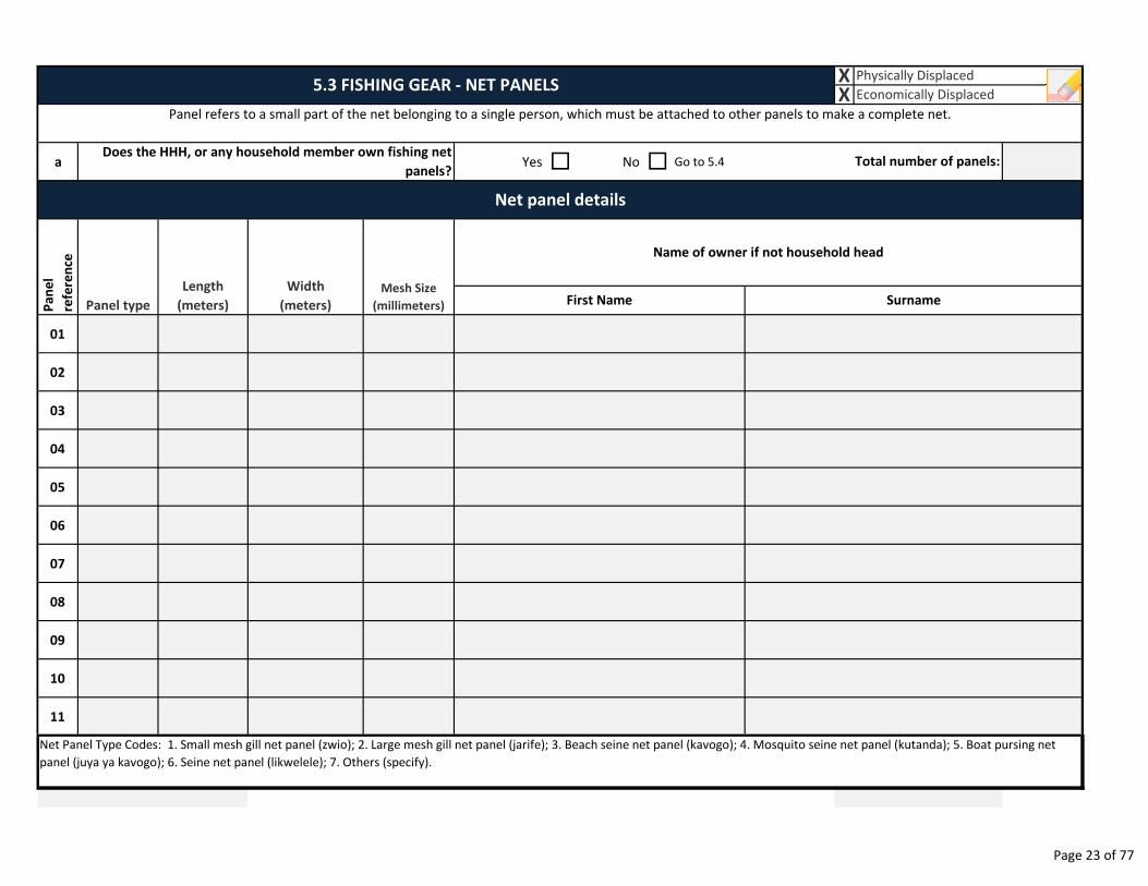
a Yes � No � Go to 5.4
01
02
03
04
05
06
07
08
09
10
11
Surname
Net Panel Type Codes: 1. Small mesh gill net panel (zwio); 2. Large mesh gill net panel (jarife); 3. Beach seine net panel (kavogo); 4. Mosquito seine net panel (kutanda); 5. Boat pursing net
panel (juya ya kavogo); 6. Seine net panel (likwelele); 7. Others (specify).
Panel refers to a small part of the net belonging to a single person, which must be attached to other panels to make a complete net.
Net panel details
First Name
XX
Physically Displaced
Economically Displaced
Pa
ne
l
refe
ren
ce
Panel type
Length
(meters)
Width
(meters)
Mesh Size
(millimeters)
Does the HHH, or any household member own fishing net
panels?
Name of owner if not household head
5.3 FISHING GEAR - NET PANELS
Total number of panels:
Page 23 of 77

XX
a �
b
c
d
e
f
g
h
i Other
j Other
k Other
l Other
m Other
n Yes Drying rack�Smoking
oven or pit�
o � �
Spear (Intertidal collection) (Msengue)
In a fishing camp/centre far from my
permanent residence. (specify with
name of the place)
Other place. Specify
indicating the name of
this place.
Spear Gun (divers) (Ngoo)
Long line (Zurmati)
Squid lure hand line (Mshipi Ngisi)
Cast net (Malema/Madema)
5.4 OTHER FISHING GEAR
Does the HHH, or any household member own
other fishing gear?Yes� No Go to 6
Physically Displaced
Economically Displaced
Gear Type
Hook Hand line (Mshipi Ndoana)
Name of owner if not household head
First Name Surname
DetailsNumber
Harpoon Gun (Divers) (Bunduki)
Other (specify)What processing
equipment do you own?Go to 6�No�
Does the HHH, or any other household
member, own fish processing equipment?
Where is the equipment
located?Near main residence �
Page 24 of 77
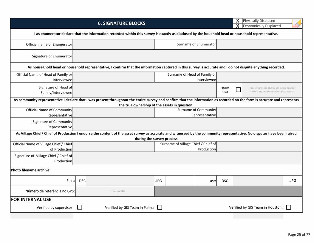
Official name of Enumerator
Signature of Enumerator
Official Name of Head of Family or
Interviewee
Official Name of Community
Representative
Signature of Community
Representative
Official Name of Village Chief / Chief
of Production
Signature of Village Chief / Chief of
Production
DSC .JPG Last: DSC
FOR INTERNAL USE
Verified by supervisor Verified by GIS Team in Palma � �
Signature of Head of
Family/Interviewee
As community representative I declare that I was present throughout the entire survey and confirm that the information as recorded on the form is accurate and represents
the true ownership of the assets in question.
As Village Chief/ Chief of Production I endorse the content of the asset survey as accurate and witnessed by the community representative. No disputes have been raised
during the survey process
Finger
Print �
Surname of Community
Representative
6. SIGNATURE BLOCKSXX
Physically Displaced
Economically Displaced
I as enumerator declare that the information recorded within this survey is exactly as disclosed by the houehold head or household representative.
Surname of Enumerator
As houseghold head or household representative, I confirm that the information captured in this survey is accurate and I do not dispute anything recorded.
Surname of Head of Family or
Interviewee
Surname of Village Chief / Chief of
Production
.JPG
Verified by GIS Team in Houston:
Photo filename archive:
First:
Número de referência no GPS:
�
tirar impressão digital do dedo polegar
caso o entrevistado não saiba assinar
(Feature ID)
Page 25 of 77
7. ENUMERATOR NOTES
__________________________________________________________________________________________________
__________________________________________________________________________________________________
__________________________________________________________________________________________________
__________________________________________________________________________________________________
__________________________________________________________________________________________________
__________________________________________________________________________________________________
__________________________________________________________________________________________________
__________________________________________________________________________________________________
__________________________________________________________________________________________________
__________________________________________________________________________________________________
__________________________________________________________________________________________________
__________________________________________________________________________________________________
__________________________________________________________________________________________________
__________________________________________________________________________________________________
__________________________________________________________________________________________________
__________________________________________________________________________________________________
__________________________________________________________________________________________________
__________________________________________________________________________________________________
__________________________________________________________________________________________________
__________________________________________________________________________________________________
__________________________________________________________________________________________________
__________________________________________________________________________________________________
__________________________________________________________________________________________________
__________________________________________________________________________________________________
__________________________________________________________________________________________________
Page 26 of 77
Date Reviewer Status
SURVEY STATUS MONITORING
Notes
Page 27 of 77
Mozambique Gas Development Resettlement Plan
Annex C: Data Collection Methods
Rev. 1 Rev Date: 27-May-16
2.3 Socioeconomic survey
68
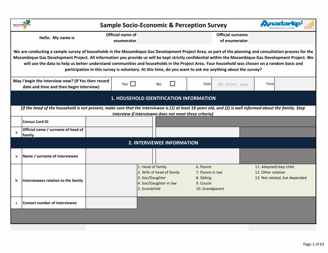
Yes � No
Census Card ID
aOfficial name / surname of head of
family:
a Name / surname of interviewee
b Interviewees relation to the family
c Contact number of interviewee
Sample Socio-Economic & Perception Survey
6. Parent
7. Parent in law
8. Sibling
9. Cousin
10. Grandparent
We are conducting a sample survey of households in the Mozambique Gas Development Project Area, as part of the planning and consultation process for the
Mozambique Gas Development Project. All information you provide us will be kept strictly confidential within the Mozambique Gas Development Project. We
will use the data to help us better understand communities and households in the Project Area. Your household was chosen on a random basis and
participation in this survey is voluntary. At this time, do you want to ask me anything about the survey?
Date
[If the head of the household is not present, make sure that the interviewee is (1) at least 18 years old, and (2) is well informed about the family. Stop
interview if interviewee does not meet these criteria]
May I begin the interview now? (If Yes then record
date and time and then begin interview)Time
1. HOUSEHOLD IDENTIFICATION INFORMATION
1. Head of family
2. Wife of head of family
3. Son/Daughter
4. Son/Daughter in law
5. Grandchild
11. Adopted/step child
12. Other relation
13. Not related, but depended
2. INTERVIEWEE INFORMATION
�
Official surname
of enumeratorHello. My name is
Official name of
enumerator
dd mmm yyyy
Page 1 of 63
a No. of people in HH 12 months ago:
�
�
Fever
Skin problems
b
Problems in having children
Other (Specify)
�
�
�
�
�
�
�
�
�
3 Household Changes and Illness
No. of people in HH now:
What are the common
ailments/diseases/conditions of members
of the household in the last 6 months?
Eye infection
Intestinal worms
Diarrhea
Blood in urine
Stomach aches
Breathing problems/Respiratory diseases
Heart problems
Page 2 of 63
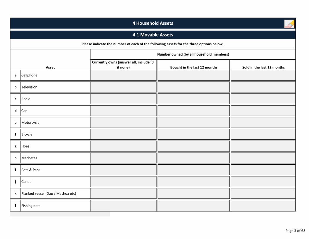
a Cellphone
b Television
c Radio
d Car
e Motorcycle
f Bicycle
g Hoes
h Machetes
i Pots & Pans
j Canoe
k Planked vessel (Dau / Mashua etc)
l Fishing nets
Number owned (by all household members)
Asset
Please indicate the number of each of the following assets for the three options below.
4 Household Assets
Currently owns (answer all, include ‘0’
if none)
4.1 Movable Assets
Bought in the last 12 months Sold in the last 12 months
Page 3 of 63
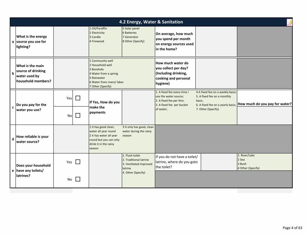
a
What is the energy
source you use for
lighting?
1 Oil/Paraffin
2 Electricity
3 Candle
4 Firewood
5 Solar panel
6 Batteries
7 Generator
8 Other (Specify)
b
What is the main
source of drinking
water used by
household members?
Yes �How much do you pay for water?
No �
dHow reliable is your
water source?
1 it has good clean,
water all year round
2 it has water all year
round but you can only
drink it in the rainy
season
3 It only has good, clean
water during the rainy
season
Yes �
1. River/Lake
2 Sea
3 Bush
4 Other (Specify)
No �
4.2 Energy, Water & Sanitation
c
e
1 Community well
2 Household well
3 Borehole
4 Water from a spring
5 Rainwater
6 Water from rivers/ lakes
7 Other (Specify)
1. Flush toilet
2. Traditional latrine
3. Ventilated improved
latrine
4. Other (Specify)
If you do not have a toilet/
latrine, where do you goto
the toilet?Does your household
have any toilets/
latrines?
Do you pay for the
water you use?
On average, how much
you spend per month
on energy sources used
in the home?
How much water do
you collect per day?
(Including drinking,
cooking and personal
hygiene)
1. A fixed fee every time I
use the water source;
2. A fixed fee per litre.
3. A fixed fee per bucket
of water;
If Yes, How do you
make the
payments
4.A fixed fee on a weekly basis;
5. A fixed fee on a monthly
basis.
6. A fixed fee on a yearly basis;
7. Other (Specify).
Page 4 of 63
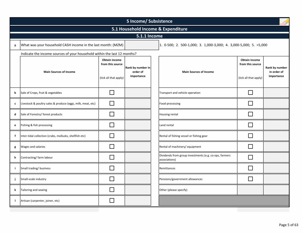
a
Obtain income
from this source
Obtain income
from this source
(tick all that apply) (tick all that apply)
b Sale of Crops, fruit & vegetables � Transport and vehicle operation �
c Livestock & poultry sales & produce (eggs, milk, meat, etc) � Food-processing �
d Sale of Forestry/ forest products � Housing rental �
e Fishing & fish processing � Land rental �
f Inter-tidal collection (crabs, mollusks, shellfish etc) � Rental of fishing vessel or fishing gear �
g Wages and salaries � Rental of machinery/ equipment �
h Contracting/ farm labour �Dividends from group investments (e.g. co-ops, farmers
associations) �
i Small trading/ business � Remittances �
j Small-scale industry � Pensions/government allowances �
k Tailoring and sewing � Other (please specify)
l Artisan (carpenter, joiner, etc) �
5 Income/ Subsistence
5.1.1 Income
1. 0-500; 2. 500-1,000; 3. 1,000-3,000; 4. 3,000-5,000; 5. >5,000What was your household CASH income in the last month: (MZM)
5.1 Household Income & Expenditure
Rank by number in
order of
importance
Rank by number
in order of
importance
Main Sources of IncomeMain Sources of Income
Indicate the income sources of your household within the last 12 months?
TOTAL
Page 5 of 63
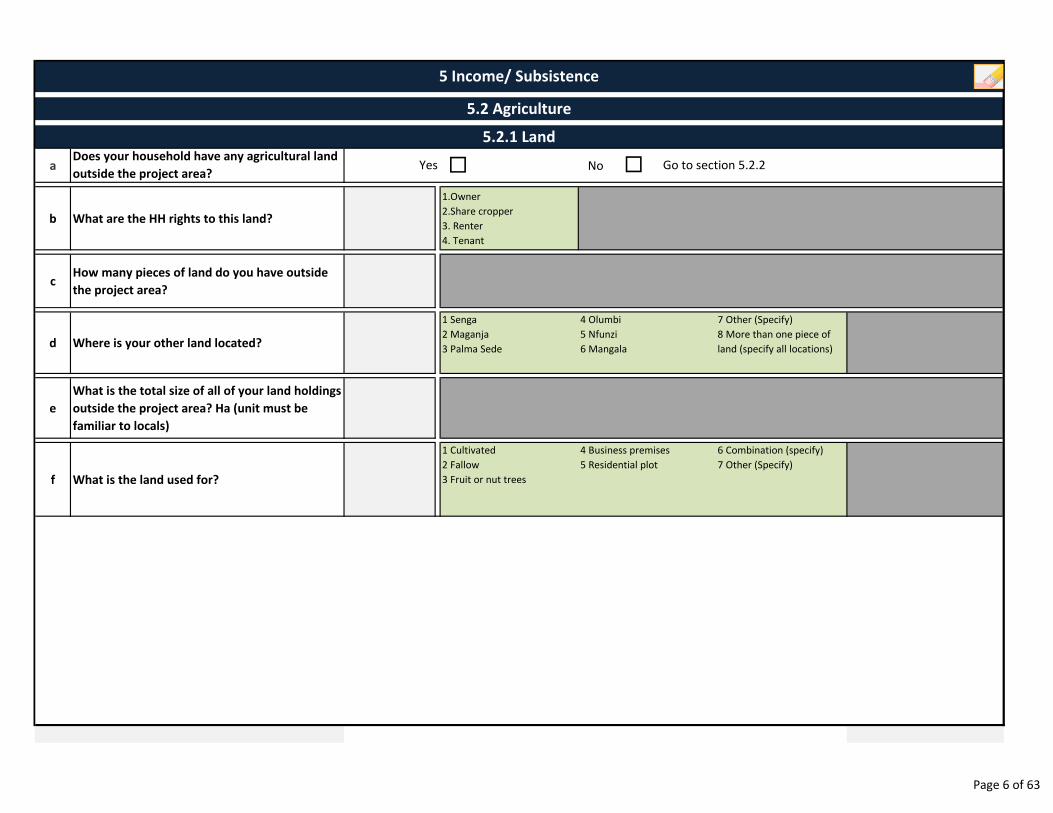
aDoes your household have any agricultural land
outside the project area? � No
b What are the HH rights to this land?
1.Owner
2.Share cropper
3. Renter
4. Tenant
cHow many pieces of land do you have outside
the project area?
d Where is your other land located?
1 Senga
2 Maganja
3 Palma Sede
7 Other (Specify)
8 More than one piece of
land (specify all locations)
e
What is the total size of all of your land holdings
outside the project area? Ha (unit must be
familiar to locals)
f What is the land used for?
1 Cultivated
2 Fallow
3 Fruit or nut trees
6 Combination (specify)
7 Other (Specify)
5 Income/ Subsistence
5.2 Agriculture
5.2.1 Land
Yes Go to section 5.2.2�
4 Business premises
5 Residential plot
4 Olumbi
5 Nfunzi
6 Mangala
Page 6 of 63
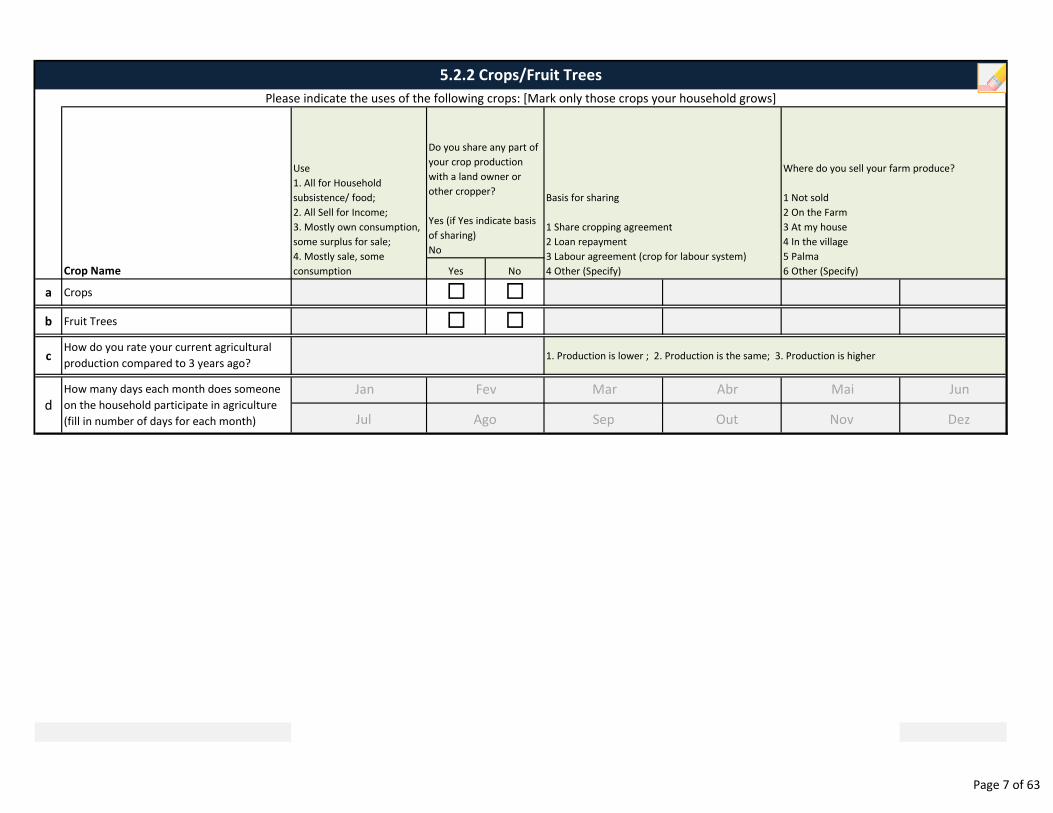
a Crops
b Fruit Trees
c 1. Production is lower ; 2. Production is the same; 3. Production is higher
d
How many days each month does someone
on the household participate in agriculture
(fill in number of days for each month)
How do you rate your current agricultural
production compared to 3 years ago?
5.2.2 Crops/Fruit Trees
Please indicate the uses of the following crops: [Mark only those crops your household grows]
Do you share any part of
your crop production
with a land owner or
other cropper?
Yes (if Yes indicate basis
of sharing)
No
Crop Name
Where do you sell your farm produce?
1 Not sold
2 On the Farm
3 At my house
4 In the village
5 Palma
6 Other (Specify)
Use
1. All for Household
subsistence/ food;
2. All Sell for Income;
3. Mostly own consumption,
some surplus for sale;
4. Mostly sale, some
consumption
Basis for sharing
1 Share cropping agreement
2 Loan repayment
3 Labour agreement (crop for labour system)
4 Other (Specify)Yes No
�
�
�
�
Jan
Jul
Fev
Ago
Mar
Sep
Abr
Out
Mai
Nov
Jun
Dez
Page 7 of 63
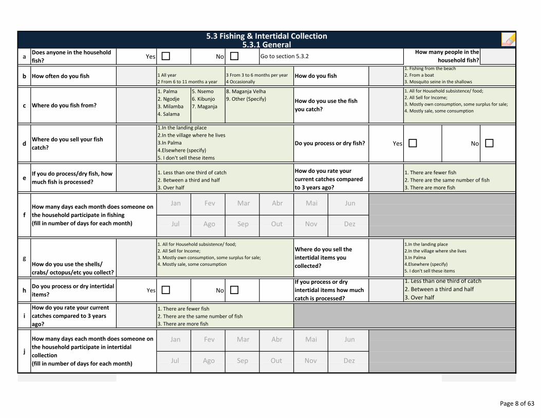
aDoes anyone in the household
fish?Yes � No �
b How often do you fish
c Where do you fish from?
1. Palma
2. Ngodje
3. Milamba
4. Salama
5. Nsemo
6. Kibunjo
7. Maganja
dWhere do you sell your fish
catch?Yes � No �
eIf you do process/dry fish, how
much fish is processed?
gHow do you use the shells/
crabs/ octopus/etc you collect?
hDo you process or dry intertidal
items?Yes � No �
i
How do you rate your current
catches compared to 3 years
ago?
8. Maganja Velha
9. Other (Specify)
1. There are fewer fish
2. There are the same number of fish
3. There are more fish
j
How many days each month does someone on
the household participate in intertidal
collection
(fill in number of days for each month)
f
1. All for Household subsistence/ food;
2. All Sell for Income;
3. Mostly own consumption, some surplus for sale;
4. Mostly sale, some consumption
Where do you sell the
intertidal items you
collected?
1.In the landing place
2.In the village where she lives
3.In Palma
4.Elsewhere (specify)
5. I don't sell these items
If you process or dry
intertidal items how much
catch is processed?
1. Less than one third of catch
2. Between a third and half
3. Over half
1. Less than one third of catch
2. Between a third and half
3. Over half
How do you rate your
current catches compared
to 3 years ago?
How many days each month does someone on
the household participate in fishing
(fill in number of days for each month)
1 All year
2 From 6 to 11 months a year
3 From 3 to 6 months per year
4 Occasionally
How do you use the fish
you catch?
1.In the landing place
2.In the village where he lives
3.In Palma
4.Elsewhere (specify)
5. I don't sell these items
Do you process or dry fish?
How do you fish
5.3 Fishing & Intertidal Collection5.3.1 General
1. Fishing from the beach
2. From a boat
3. Mosquito seine in the shallows
1. All for Household subsistence/ food;
2. All Sell for Income;
3. Mostly own consumption, some surplus for sale;
4. Mostly sale, some consumption
1. There are fewer fish
2. There are the same number of fish
3. There are more fish
How many people in the
household fish?Go to section 5.3.2
Jan
Jul
Fev
Ago
Mar
Sep
Abr
Out
Mai
Nov
Jun
Dez
Jan
Jul
Fev
Ago
Mar
Sep
Abr
Out
Mai
Nov
Jun
Dez
Page 8 of 63
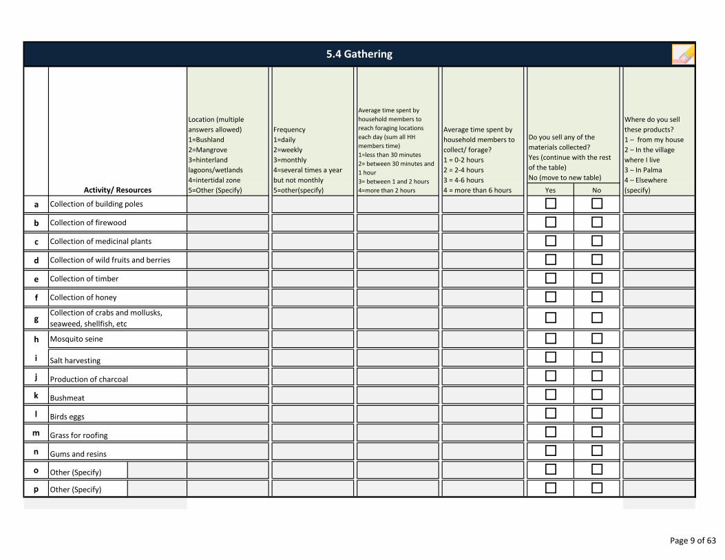
a
b
c
d
e
f
g
h
i
j
k
l
m
n
o Other (Specify)
p Other (Specify)
Gums and resins
Birds eggs
Grass for roofing
Mosquito seine
Production of charcoal
Salt harvesting
Bushmeat
Collection of crabs and mollusks,
seaweed, shellfish, etc
Collection of building poles
Do you sell any of the
materials collected?
Yes (continue with the rest
of the table)
No (move to new table)
5.4 Gathering
Collection of firewood
Collection of medicinal plants
Collection of wild fruits and berries
Collection of timber
Collection of honey
Activity/ Resources
Location (multiple
answers allowed)
1=Bushland
2=Mangrove
3=hinterland
lagoons/wetlands
4=intertidal zone
5=Other (Specify)
Frequency
1=daily
2=weekly
3=monthly
4=several times a year
but not monthly
5=other(specify)
Average time spent by
household members to
reach foraging locations
each day (sum all HH
members time)
1=less than 30 minutes
2= between 30 minutes and
1 hour
3= between 1 and 2 hours
4=more than 2 hours
Average time spent by
household members to
collect/ forage?
1 = 0-2 hours
2 = 2-4 hours
3 = 4-6 hours
4 = more than 6 hours
Where do you sell
these products?
1 – from my house
2 – In the village
where I live
3 – In Palma
4 – Elsewhere
(specify)Yes No
�
� �
�
��
�
�
�
�
�
�
�
�
�
�
�
�
� �
�
�
�
�
�
�
�
�
�
�
�
�
Page 9 of 63
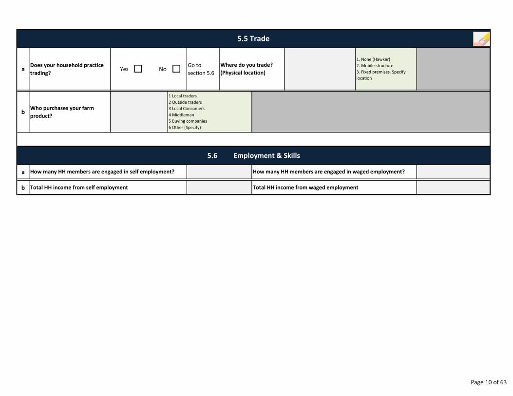
aDoes your household practice
trading?Yes � No �
Go to
section 5.6
bWho purchases your farm
product?
a
b
5.5 Trade
Where do you trade?
(Physical location)
1. None (Hawker)
2. Mobile structure
3. Fixed premises. Specify
location
1 Local traders
2 Outside traders
3 Local Consumers
4 Middleman
5 Buying companies
6 Other (Specify)
How many HH members are engaged in waged employment?
Total HH income from waged employment
5.6 Employment & Skills
How many HH members are engaged in self employment?
Total HH income from self employment
Page 10 of 63
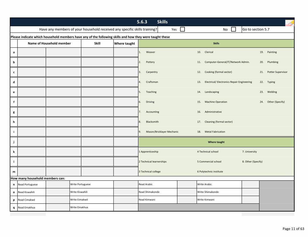
Yes � No �
Where taught
a
b
c
d
e
f
g
h
i
j
k
l
m
n Read Portuguese
o Read Kiswahili
p Read Cimakwé
q Read Emakhua
1. Weaver 10. Clerical 19. Painting
5.6.3 Skills
Please indicate which household members have any of the following skills and how they were taught these
Name of Household member Skill Skills
Have any members of your household received any specific skills training? Go to section 5.7
3. Carpentry 12. Cooking (formal sector) 21. Potter Supervisor
6. Driving 15. Machine Operation 24. Other (Specify)
2. Pottery 11. Computer-General/IT/Network Admin. 20. Plumbing
22. Typing
5. Teaching 14. Landscaping 23. Welding
4. Craftsman 13. Electrical/ Electronics Repair Engineering
8. Blacksmith 17. Cleaning (formal sector)
9. Mason/Bricklayer Mechanic 18. Metal Fabrication
7. Accounting 16. Administrative
1 Apprenticeship
3 Technical college
2 Technical learnerships 5 Commercial school 8. Other (Specify)
6 Polytechnic institute
Write Eimakwé Read Kimwani Write Kimwani
Write Emakhua
Write Kiswahili Read Shimakonde Write Shimakonde
4 Technical school 7. University
Where taught
How many household members can:
Write Portuguese Read Arabic Write Arabic
Page 11 of 63
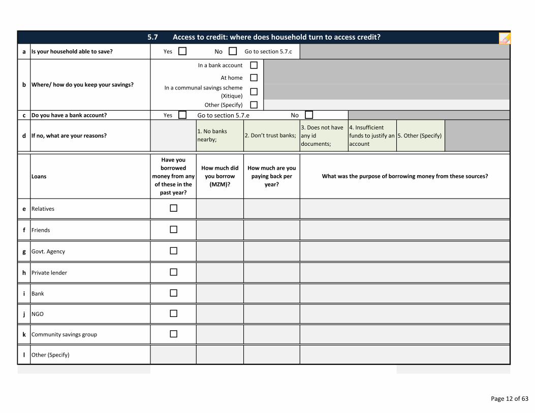
a Is your household able to save? Yes � No � Go to section 5.7.c
�
�
�
�c Do you have a bank account? Yes � No �
d If no, what are your reasons?
3. Does not have
any id
documents;
4. Insufficient
funds to justify an
account
5. Other (Specify)
Loans
e Relatives
f Friends
g Govt. Agency
h Private lender
i Bank
j NGO
k Community savings group
l Other (Specify)
Where/ how do you keep your savings?
5.7 Access to credit: where does household turn to access credit?
b
How much are you
paying back per
year?
�
�
�
�
�
�
�
How much did
you borrow
(MZM)?
Have you
borrowed
money from any
of these in the
past year?
2. Don’t trust banks;
In a communal savings scheme
(Xitique)
Other (Specify)
At home
In a bank account
1. No banks
nearby;
Go to section 5.7.e
What was the purpose of borrowing money from these sources?
Page 12 of 63
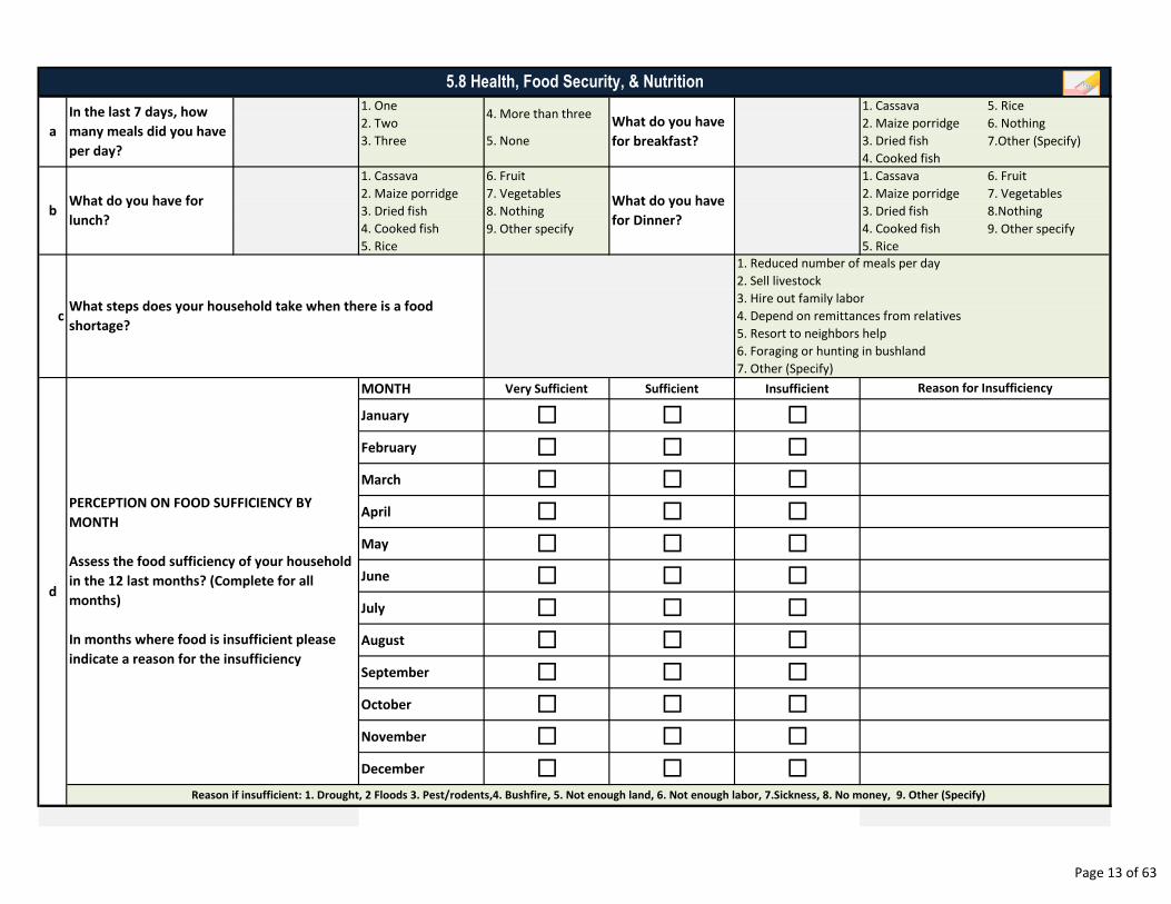
1. One 1. Cassava 5. Rice
2. Two 2. Maize porridge 6. Nothing
3. Three 5. None 3. Dried fish
4. Cooked fish
1. Cassava 6. Fruit 1. Cassava 6. Fruit
2. Maize porridge 7. Vegetables 2. Maize porridge 7. Vegetables
3. Dried fish 8. Nothing 3. Dried fish 8.Nothing
4. Cooked fish 4. Cooked fish
5. Rice 5. Rice
MONTH Very Sufficient Sufficient Insufficient
January � � �
February � � �
March � � �
April � � �
May � � �
June � � �
July � � �
August � � �
September � � �
October � � �
November � � �
December � � �Reason if insufficient: 1. Drought, 2 Floods 3. Pest/rodents,4. Bushfire, 5. Not enough land, 6. Not enough labor, 7.Sickness, 8. No money, 9. Other (Specify)
d
9. Other specify 9. Other specify
7.Other (Specify)
7. Other (Specify)
c
PERCEPTION ON FOOD SUFFICIENCY BY
MONTH
Assess the food sufficiency of your household
in the 12 last months? (Complete for all
months)
In months where food is insufficient please
indicate a reason for the insufficiency
Reason for Insufficiency
5.8 Health, Food Security, & Nutrition
In the last 7 days, how
many meals did you have
per day?
a
What steps does your household take when there is a food
shortage?
bWhat do you have for
lunch?
What do you have
for breakfast?
What do you have
for Dinner?
1. Reduced number of meals per day
4. More than three
2. Sell livestock
3. Hire out family labor
4. Depend on remittances from relatives
5. Resort to neighbors help
6. Foraging or hunting in bushland
Page 13 of 63
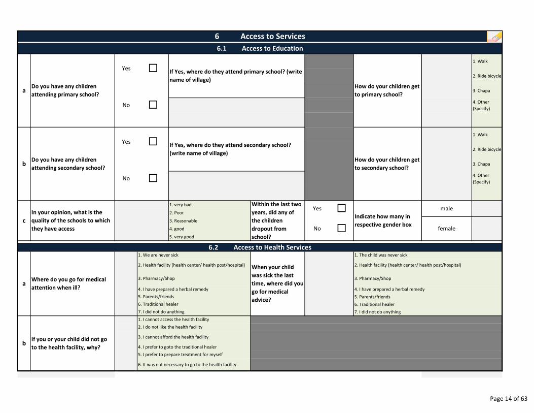
1. Walk
2. Ride bicycle
3. Chapa
4. Other
(Specify)
1. Walk
2. Ride bicycle
3. Chapa
4. Other
(Specify)
1. very bad
2. Poor
3. Reasonable
4. good
5. very good
Do you have any children
attending secondary school?
2. Health facility (health center/ health post/hospital)
1. The child was never sick
When your child
was sick the last
time, where did you
go for medical
advice?
male
female
7. I did not do anything
6. Traditional healer
5. Parents/friends
4. I have prepared a herbal remedya
6. Traditional healer
7. I did not do anything
1. I cannot access the health facility
2. I do not like the health facility
3. I cannot afford the health facility
4. I prefer to goto the traditional healer
5. I prefer to prepare treatment for myself
2. Health facility (health center/ health post/hospital)
Where do you go for medical
attention when ill?
If you or your child did not go
to the health facility, why?
1. We are never sick
3. Pharmacy/Shop
4. I have prepared a herbal remedy
5. Parents/friends
6.2 Access to Health Services
3. Pharmacy/Shop
b
6. It was not necessary to go to the health facility
b
Indicate how many in
respective gender box
Yes �
No �
Within the last two
years, did any of
the children
dropout from
school?
In your opinion, what is the
quality of the schools to which
they have access
c
Yes �
No �
6 Access to Services
6.1 Access to Education
aDo you have any children
attending primary school?
Yes �
How do your children get
to primary school?
No �
How do your children get
to secondary school?
If Yes, where do they attend primary school? (write
name of village)
If Yes, where do they attend secondary school?
(write name of village)
Page 14 of 63
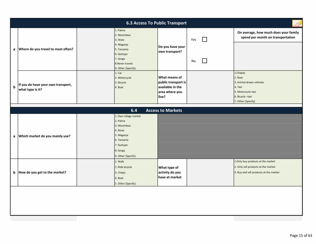
1. Palma
2. Mocímboa
3. Mute
4. Maganja
5. Tanzania
6. Quitupo
7. Senga
8 Never travels
9. Other (Specify)
1. Car
2. Motorcycle
3. Bicycle
4. Boat
1. Own village market
2. Palma
3. Mocímboa
4. Mute
5. Maganja
6. Tanzania
7. Quitupo
8. Senga
9. Other (Specify)
1. Walk
2. Ride bicycle
3. Chapa
4. Boat
5. Other (Specify)
b
a
3. Buy and sell products at the market
What type of
activity do you
have at market
1.Only buy products at the market
2. Only sell products at the market
How do you get to the market?
No
What means of
public transport is
available in the
area where you
live?
On average, how much does your family
spend per month on transportation
Which market do you mainly use?
1.Chapas
2. Boat
3. Animal drawn vehicles
4. Taxi
6.3 Access To Public Transport
6.4 Access to Markets
Where do you travel to most often?Do you have your
own transport?a
b
7. Other (Specify)
�
�
5. Motorcycle-taxi
6. Bicycle –taxi
Yes
If you do have your own transport,
what type is it?
Page 15 of 63
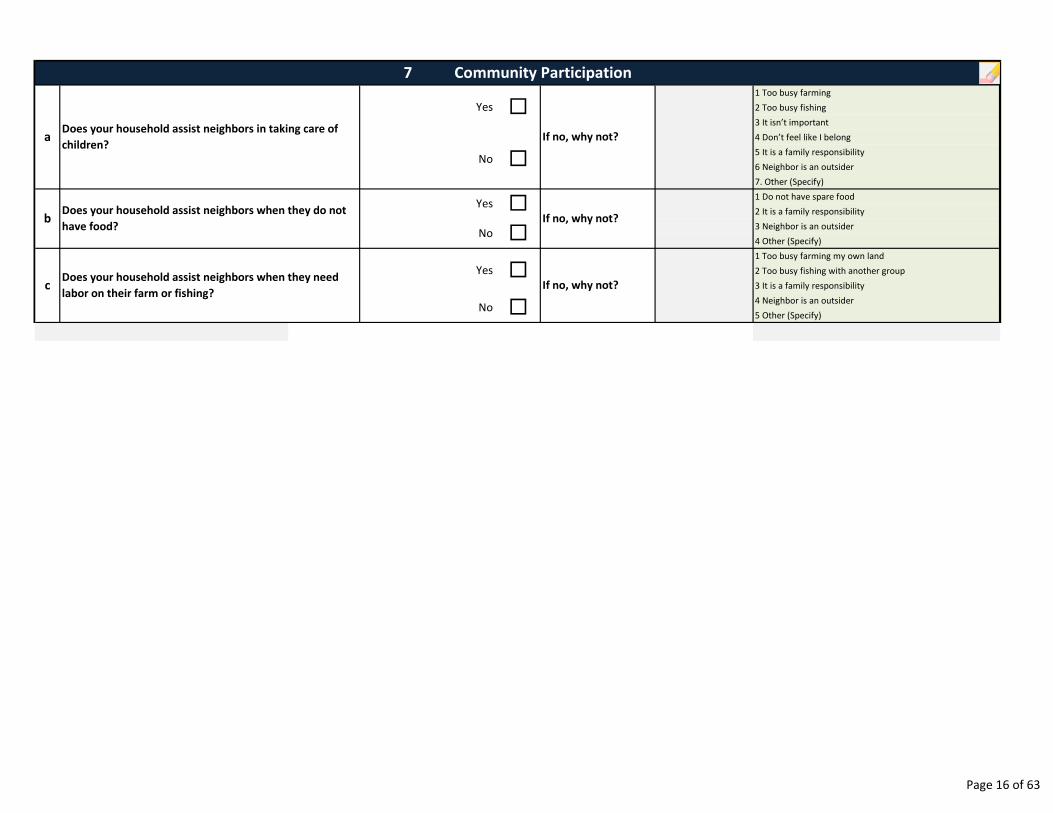
1 Too busy farming
2 Too busy fishing
3 It isn’t important
4 Don’t feel like I belong
5 It is a family responsibility
6 Neighbor is an outsider
7. Other (Specify)
1 Do not have spare food
2 It is a family responsibility
3 Neighbor is an outsider
4 Other (Specify)
1 Too busy farming my own land
2 Too busy fishing with another group
3 It is a family responsibility
4 Neighbor is an outsider
5 Other (Specify)
c
Does your household assist neighbors in taking care of
children?
Does your household assist neighbors when they do not
have food?
Does your household assist neighbors when they need
labor on their farm or fishing?
7 Community Participation
If no, why not?a
b
Yes
No �
�
�
�Yes
No �
If no, why not?
If no, why not?
�Yes
No
Page 16 of 63
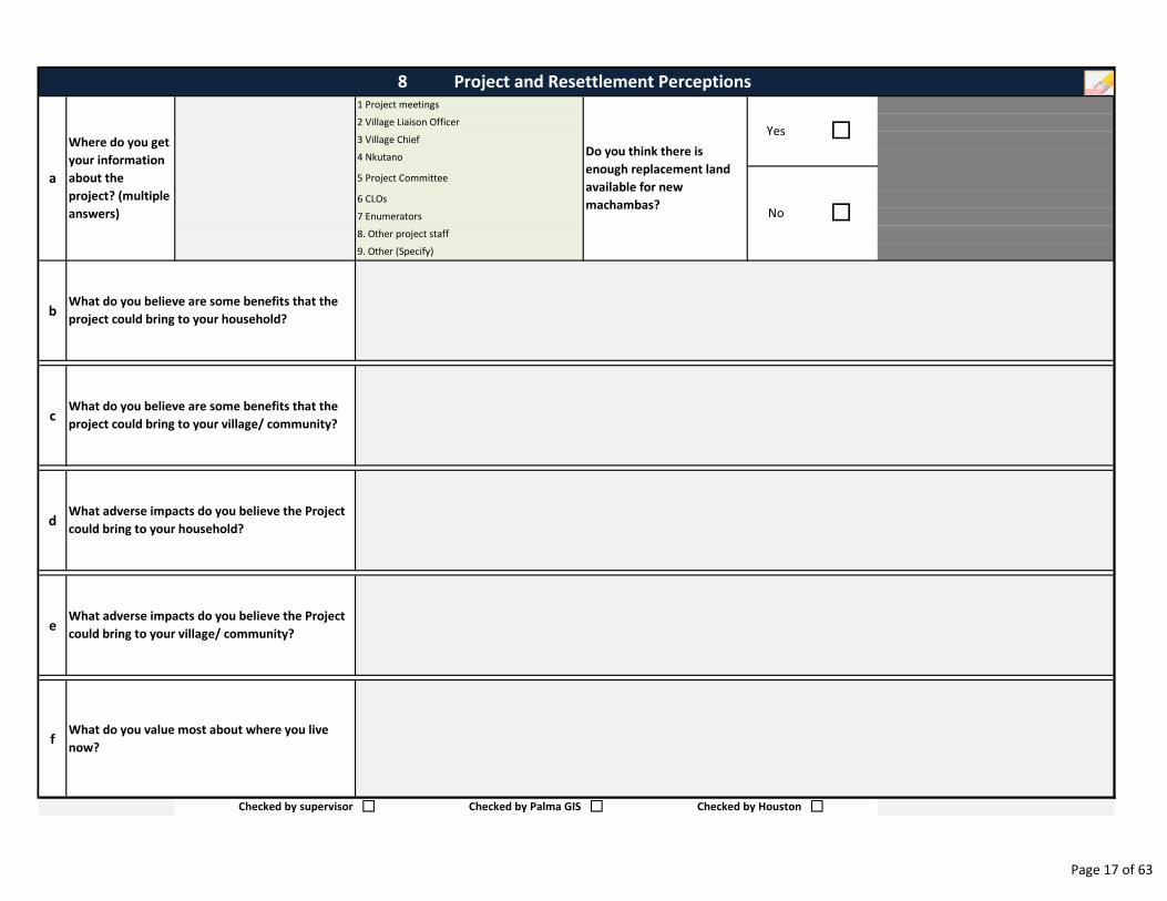
b
c
d
e
f
Checked by supervisor � � �
What adverse impacts do you believe the Project
could bring to your village/ community?
What adverse impacts do you believe the Project
could bring to your household?
What do you value most about where you live
now?
What do you believe are some benefits that the
project could bring to your household?
What do you believe are some benefits that the
project could bring to your village/ community?
Checked by Palma GIS Checked by Houston
No
�
�
3 Village Chief
4 Nkutano
5 Project Committee
8 Project and Resettlement Perceptions
Do you think there is
enough replacement land
available for new
machambas?
a
7 Enumerators
8. Other project staff
9. Other (Specify)
Where do you get
your information
about the
project? (multiple
answers)
6 CLOs
1 Project meetings
2 Village Liaison OfficerYes
Page 17 of 63
9. ENUMERATOR NOTES
_________________________________________________________________________________________________
_________________________________________________________________________________________________
_________________________________________________________________________________________________
_________________________________________________________________________________________________
_________________________________________________________________________________________________
_________________________________________________________________________________________________
_________________________________________________________________________________________________
_________________________________________________________________________________________________
_________________________________________________________________________________________________
_________________________________________________________________________________________________
_________________________________________________________________________________________________
_________________________________________________________________________________________________
_________________________________________________________________________________________________
_________________________________________________________________________________________________
_________________________________________________________________________________________________
_________________________________________________________________________________________________
_________________________________________________________________________________________________
_________________________________________________________________________________________________
_________________________________________________________________________________________________
_________________________________________________________________________________________________
_________________________________________________________________________________________________
Page 18 of 63
Date Reviewer Status
SURVEY STATUS MONITORING
Notes
Page 19 of 63

Mozambique Gas Development Resettlement Plan
Annex C: Data Collection Methods
Rev. 1 Rev Date: 27-May-16
2.4 Communal asset survey
88
a Village Name
b Village Chief First Name
c Locality
d District
e Contact Number Village Chief
f Identification Number of Village Chief
g Type Of Identification ID �Birth
Certificate � Voter Card � Passport �Not
Provided �
h Village Chief Assistant First Name
iContact Number Village Chief
Assistant
jIdentification Number of Village Chief
Assistant
k Type Of Identification ID �Birth
Certificate � Voter Card � Passport �Not
Provided �
l Date of Interview
mPhoto number of Photo of Chief in
front of his houseDSC .JPG
nPhoto number of Photo of Chief's
assistant in front of his houseDSC .JPG
Village Chief Assistant Surname
COMMUNAL ASSET SURVEY
1. VILLAGE REPRESENTATIVE IDENTIFICATION INFORMATION
Village Registration Number
AMA1 would like to identify and record all of the communal assets which your village owns and uses. This form will ask you questions
about communal facilities. Accurate answers to the questions are important as these will be used by AMA1 to assess appropriate
compensation payments and/or replacement assets. If you do not understand a question, please let me (the enumerator) know. I will
then explain the question to you.
Village Chief Surname
dd mmm yyyy
Page 1 of 41
a Yes � No �
b
c
d
e
f
g
� � � � � �
� � �i
j Yes � � Yes � � Yes � �k
l � � � � � �
m Yes � Yes � Yes �n Yes � DSC .JPG Yes � DSC .JPG Yes � DSC .JPG
o
p � No � � No � � No �q � No � � No � � No �r
sThumb
print �Thumb
print �Thumb
print �
Wall Material
1. Wattle & daub 6. None
2. Wattle & stone 7. Other. Specify
3. Wood
4. Brick
5. Cement block
Community
Roof Material
1. Palm frond 6. Other. Specify
2. Rush/grass
3. Wood
4. Metal sheet
5. None
Number of rooms/divisions
Signature or thumbprint of owner/ representative
Floor Material
1. Earth
2. Rush/grass
3. Wood
4. Concrete
5. Other. Specify
Type of Construction
1. Traditional
2. Modern
General Condition
1. New
2. Damaged
3. Old
RepresentativeRepresentative Owner
Government
Roof Material
Floor Material
Type of Construction/General Condition
Measurements in meters
Number of desks and chairs
Government Community
No No NoEvidence obtained of ownership
Type of evidence obtained
Was the owner present during the measurement or a
representative appointed by the owner?
Does the village have a school building?
School Number
Wall Material
2. COMMUNAL PROPERTY/ASSETS
2.1 SCHOOLS
School 03School 02School 01
Go to section 2.2
Type of Evidence
1. Title deed
2. Testimony from
appropriate
authorities
3. Other. Specify
Yes YesYes
Own water supply Yes Yes Yes
hOther. Specify Other. Specify Other. Specify
Ownership of the School building
Representative Owner
Approximate age of building
Electricity supply
Did you collect a point for the school?
Did you take a photograph of the school?
Name & Surname of owner/steward
Owner
Community Government
Núm de foto
Núm de referência (Feature ID)
Núm de foto
Núm de referência (Feature ID)
Núm de foto
Núm de referência (Feature ID)
C L C L C L
anos meses anos meses anos meses
tirar impressão digital do dedo
polegar caso o entrevistado
não saiba assinar
tirar impressão digital do dedo
polegar caso o entrevistado
não saiba assinar
tirar impressão digital do dedo
polegar caso o entrevistado
não saiba assinar
mesas cadeiras mesas cadeiras mesas cadeiras
Page 2 of 41
a Yes � No �
� � �
� � �
� � �
� � �
c
d
e
f
g
h
� � � � � �
� � �
j
k Yes � � Yes � � Yes � �l
m � � � � � �
n Yes � Yes � Yes �o Yes � DSC .JPG Yes � DSC .JPG Yes DSC .JPG
p
q � No � � No � � No �r � No � � No � � No �s
tThumb
print �Thumb
print �Thumb
print �
Wall Material
1. Wattle & daub 6. None
2. Wattle & stone 7. Other. Specify
3. Wood
4. Brick
5. Cement block
Health Center (Rural Type I)
Health Center (Rural Type II)
Health Post
First Aid Post
Health Center (Rural Type I)
Health Center (Rural Type II)
Health Post
First Aid Post
Signature or thumbprint of owner/ representative
Did you collect a point for the Health Facility?
Approximate age of building
Evidence obtained of ownership
Type of evidence obtained
b
Measurements in meters
Number of beds
Floor Material
Roof Material
1. Palm frond 6. Other. Specify
2. Rush/grass
3. Wood
4. Metal sheet
5. None
Electricity supply
Number of rooms/divisions
Yes Yes Yes
Floor Material
1. Earth
2. Rush/grass
3. Wood
4. Concrete
5. Other. Specify
Type of Construction
1. Traditional
2. Modern
General Condition
1. New
2. Damaged
3. Old
Type of Evidence
1. Title deed
2. Testimony from
appropriate
authorities
3. Other. Specify
Own water supply Yes Yes Yes
2.2 HEALTH FACILITIES
Does the village have health facilities? Go to section 2.3
Health Facility Number Health Facility 01 Health Facility 02 Health Facility 03
Health Center (Rural Type I)
Wall Material
Roof Material
Type of Construction/General Condition
Health Center (Rural Type II)
Health Post
No No
First Aid Post
Type of Health Facility
Government CommunityGovernment CommunityGovernment Community
Did you take a photograph of the Health Facility?
Was the owner present during the measurement or a
representative appointed by the owner?
Other. Specify Other. Specify Other. Specifyi Ownership of the Health Facility
Name & Surname of owner/steward
No
Owner Representative Owner Representative Owner Representative
Núm de foto
Núm de referência (Feature ID)
Núm de foto
Núm de referência (Feature ID)
Núm de foto
Núm de referência (Feature ID)
C L C L C L
anos meses anos meses anos meses
tirar impressão digital do dedo
polegar caso o entrevistado não
saiba assinar
tirar impressão digital do dedo
polegar caso o entrevistado
não saiba assinar
tirar impressão digital do dedo
polegar caso o entrevistado
não saiba assinar
Núm de foto Núm de foto Núm de foto
Page 3 of 41
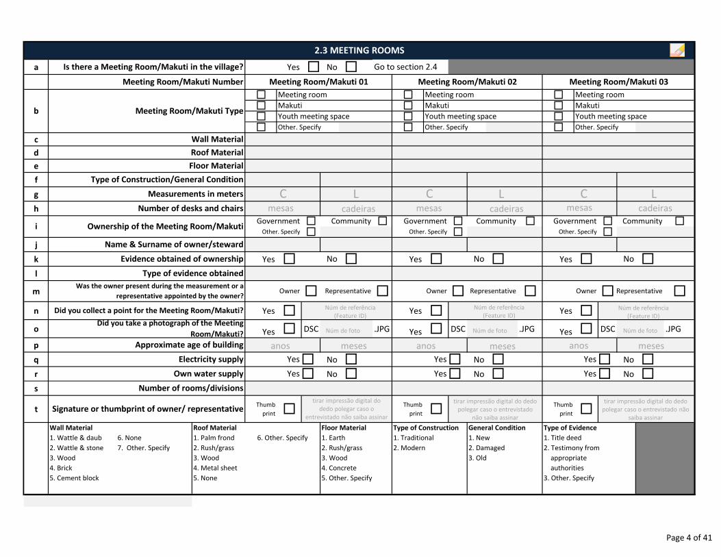
a Yes � No �
� � �
� � �
� � �
� � �
c
d
e
f
g
h
� � � � � �
� � �
j
k Yes � � Yes � � Yes � �l
m � � � � � �
n Yes � Yes � Yes �
o Yes � DSC .JPG Yes � DSC .JPG Yes � DSC .JPG
p
q � No � � No � � No �r � No � � No � � No �s
tThumb
print �Thumb
print �Thumb
print �
Wall Material
1. Wattle & daub 6. None
2. Wattle & stone 7. Other. Specify
3. Wood
4. Brick
5. Cement block
Measurements in meters
Type of Construction/General Condition
Signature or thumbprint of owner/ representative
Roof Material
1. Palm frond 6. Other. Specify
2. Rush/grass
3. Wood
4. Metal sheet
5. None
Electricity supply Yes Yes Yes
Number of rooms/divisions
Approximate age of building
Floor Material
1. Earth
2. Rush/grass
3. Wood
4. Concrete
5. Other. Specify
Type of Construction
1. Traditional
2. Modern
General Condition
1. New
2. Damaged
3. Old
Did you collect a point for the Meeting Room/Makuti?
Did you take a photograph of the Meeting
Room/Makuti?
No NoEvidence obtained of ownership No
Type of evidence obtained
Was the owner present during the measurement or a
representative appointed by the owner?Representative Owner Representative
Government Community
Number of desks and chairs
Government Community Government Community
Roof Material
Floor Material
Youth meeting space
Wall Material
Other. Specify Other. Specify Other. Specify
2.3 MEETING ROOMS
Is there a Meeting Room/Makuti in the village? Go to section 2.4
Meeting Room/Makuti Number Meeting Room/Makuti 01 Meeting Room/Makuti 02 Meeting Room/Makuti 03
b Meeting Room/Makuti Type
Meeting room Meeting room Meeting room
Makuti Makuti Makuti
Youth meeting space Youth meeting space
Type of Evidence
1. Title deed
2. Testimony from
appropriate
authorities
3. Other. Specify
i Ownership of the Meeting Room/Makuti
Own water supply Yes Yes Yes
Other. Specify Other. Specify Other. Specify
Owner RepresentativeOwner
Name & Surname of owner/steward
Núm de referência
(Feature ID)
Núm de referência
(Feature ID)
Núm de referência
(Feature ID)
C L C L C L
anos meses anos meses anos meses
tirar impressão digital do
dedo polegar caso o
entrevistado não saiba assinar
tirar impressão digital do dedo
polegar caso o entrevistado
não saiba assinar
tirar impressão digital do dedo
polegar caso o entrevistado não
saiba assinar
mesas cadeiras mesas cadeiras mesas cadeiras
Núm de foto Núm de foto Núm de foto
Page 4 of 41
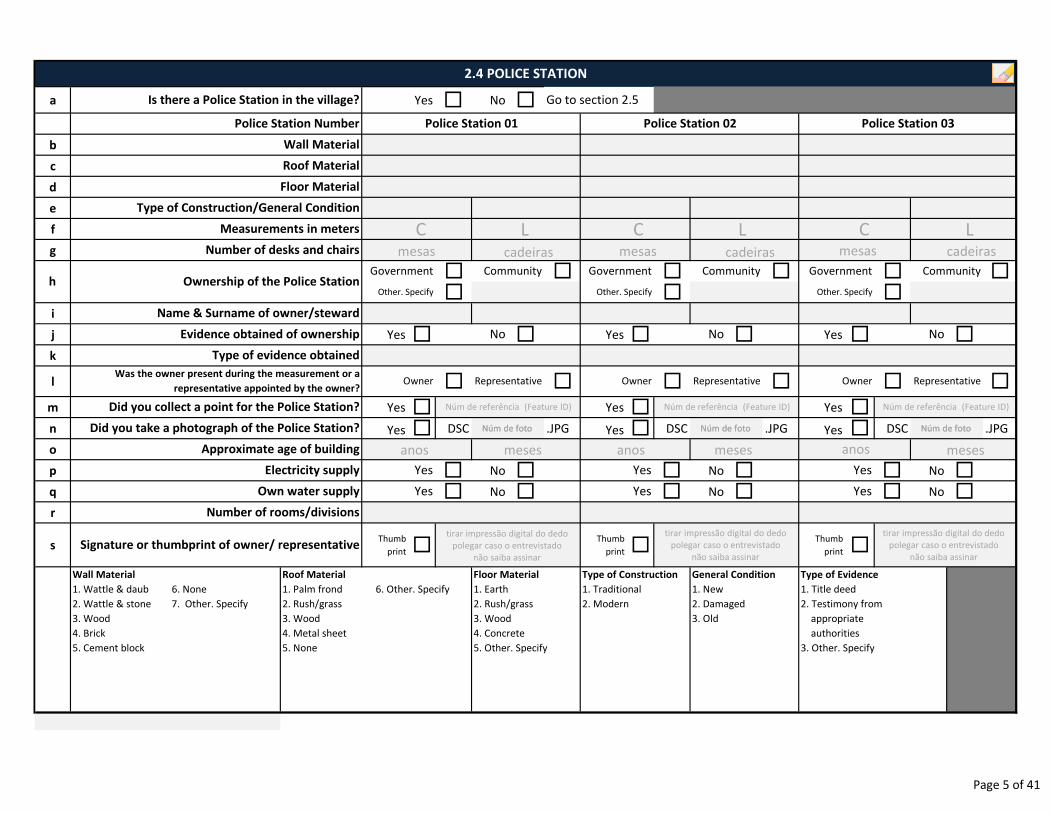
a Yes � No �
b
c
d
e
f
g
� � � � � �
� � �i
j Yes � � Yes � � Yes � �k
l � � � � � �
m Yes � Yes � Yes �n Yes � DSC .JPG Yes � DSC .JPG Yes � DSC .JPG
o
p � No � � No � � No �q � No � � No � � No �r
sThumb
print �Thumb
print �Thumb
print �
Wall Material
1. Wattle & daub 6. None
2. Wattle & stone 7. Other. Specify
3. Wood
4. Brick
5. Cement block
Ownership of the Police StationCommunity
Owner Representative Owner Representative Owner Representative
Government
Other. Specify Other. Specify Other. Specify
Signature or thumbprint of owner/ representative
No
Name & Surname of owner/steward
Roof Material
1. Palm frond 6. Other. Specify
2. Rush/grass
3. Wood
4. Metal sheet
5. None
Floor Material
1. Earth
2. Rush/grass
3. Wood
4. Concrete
5. Other. Specify
Type of Construction
1. Traditional
2. Modern
General Condition
1. New
2. Damaged
3. Old
Type of Evidence
1. Title deed
2. Testimony from
appropriate
authorities
3. Other. Specify
Number of rooms/divisions
Approximate age of building
Electricity supply Yes Yes Yes
Own water supply Yes Yes Yes
Number of desks and chairs
Government Community Government Community
Did you collect a point for the Police Station?
Did you take a photograph of the Police Station?
Evidence obtained of ownership
Was the owner present during the measurement or a
representative appointed by the owner?
Type of evidence obtained
No No
Type of Construction/General Condition
h
Wall Material
2.4 POLICE STATION
Is there a Police Station in the village? Go to section 2.5
Police Station Number Police Station 01 Police Station 02 Police Station 03
Roof Material
Floor Material
Measurements in meters
Núm de foto
Núm de referência (Feature ID)
Núm de foto
Núm de referência (Feature ID)
Núm de foto
Núm de referência (Feature ID)
C L C L C L
anos meses anos meses anos meses
tirar impressão digital do dedo
polegar caso o entrevistado
não saiba assinar
tirar impressão digital do dedo
polegar caso o entrevistado
não saiba assinar
tirar impressão digital do dedo
polegar caso o entrevistado
não saiba assinar
mesas cadeiras mesas cadeiras mesas cadeiras
Núm de foto Núm de foto Núm de foto
Page 5 of 41
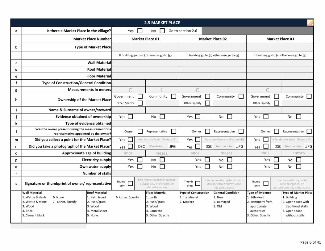
a Yes � No �
b
c
d
e
f
g
� � � � � �
� � �i
j Yes � � Yes � � Yes � �k
l � � � � � �
m Yes � Yes � Yes �n Yes � DSC .JPG Yes � DSC .JPG Yes � DSC .JPG
o
p � No � � No � � No �q � No � � No � � No �r
sThumb
print �Thumb
print �Thumb
print �
Wall Material
1. Wattle & daub 6. None
2. Wattle & stone 7. Other. Specify
3. Wood
4. Brick
5. Cement block
Approximate age of building
Electricity supply Yes Yes
Floor Material
1. Earth
2. Rush/grass
3. Wood
4. Concrete
5. Other. Specify
Type of Construction
1. Traditional
2. Modern
Signature or thumbprint of owner/ representative
Number of stalls
Roof Material
1. Palm frond 6. Other. Specify
2. Rush/grass
3. Wood
4. Metal sheet
5. None
Own water supply Yes
Owner RepresentativeWas the owner present during the measurement or a
representative appointed by the owner?
No
Did you collect a point for the Market Place?
Did you take a photograph of the Market Place?
Community
Name & Surname of owner/steward
Owner Representative Owner Representative
Type of evidence obtained
Government Community Government CommunityGovernment
Evidence obtained of ownership
Roof Material
Floor Material
Type of Construction/General Condition
Yes
No
2.5 MARKET PLACE
Is there a Market Place in the village? Go to section 2.6
Market Place Number Market Place 01 Market Place 02 Market Place 03
Wall Material
Type of Market Place
Measurements in meters
No
Type of Evidence
1. Title deed
2. Testimony from
appropriate
authorities
3. Other. Specify
Type of Market Place
1. Building
2. Open space with
traditional stalls
3. Open space
without stalls
If building go to (c) otherwise go to (g) If building go to (c) otherwise go to (g) If building go to (c) otherwise go to (g)
Ownership of the Market PlacehOther. Specify Other. Specify Other. Specify
Yes
General Condition
1. New
2. Damaged
3. Old
Yes
Núm de foto
Núm de referência (Feature ID)
Núm de foto
Núm de referência (Feature ID)
Núm de foto
Núm de referência (Feature ID)
C L C L C L
anos meses anos meses anos meses
Núm de foto Núm de foto Núm de foto
tirar impressão digital do dedo
polegar caso o entrevistado
não saiba assinar
tirar impressão digital do dedo
polegar caso o entrevistado
não saiba assinar
tirar impressão digital do
dedo polegar caso o
entrevistado não saiba assinar
Page 6 of 41
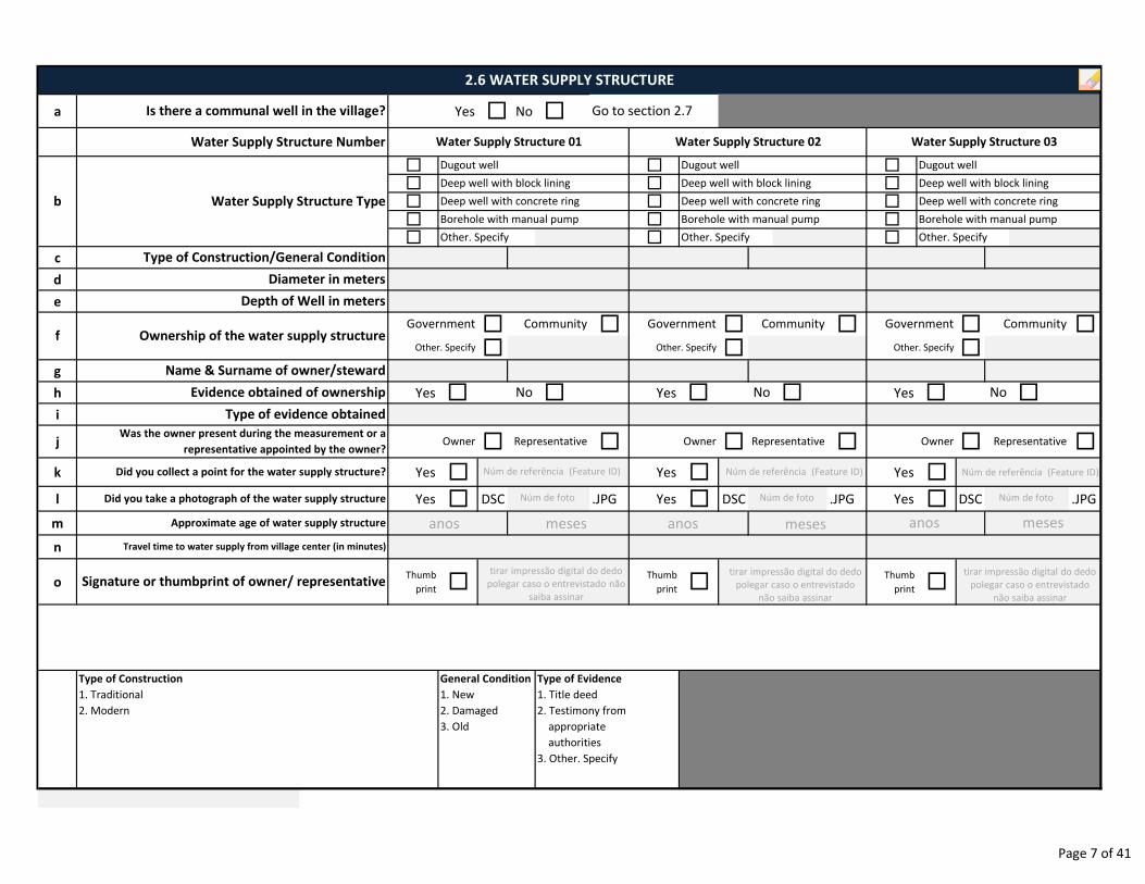
a Yes � No �
� � �
� � �
� � �
� � �
� � �
c
d
e
� � � � � �
� � �g
h Yes � � Yes � � Yes � �i
j � � � � � �
k Yes � Yes � Yes �
l Yes � DSC .JPG Yes � DSC .JPG Yes � DSC .JPG
m
n
oThumb
print �Thumb
print �Thumb
print �
Travel time to water supply from village center (in minutes)
Signature or thumbprint of owner/ representative
Approximate age of water supply structure
Type of Construction
1. Traditional
2. Modern
General Condition
1. New
2. Damaged
3. Old
Type of Evidence
1. Title deed
2. Testimony from
appropriate
authorities
3. Other. Specify
Did you take a photograph of the water supply structure
Was the owner present during the measurement or a
representative appointed by the owner?Owner Representative Owner Representative Owner
Other. Specify Other. Specify
Representative
Did you collect a point for the water supply structure?
Deep well with concrete ring Deep well with concrete ring Deep well with concrete ring
Diameter in meters
Depth of Well in meters
Type of Construction/General Condition
2.6 WATER SUPPLY STRUCTURE
Is there a communal well in the village? Go to section 2.7
Water Supply Structure Number Water Supply Structure 01 Water Supply Structure 02 Water Supply Structure 03
Dugout well Dugout well Dugout well
Water Supply Structure Typeb
Deep well with block lining Deep well with block lining Deep well with block lining
Borehole with manual pump Borehole with manual pump Borehole with manual pump
Other. Specify Other. Specify Other. Specify
f Ownership of the water supply structure
Evidence obtained of ownership No No No
Type of evidence obtained
Community
Name & Surname of owner/steward
Government Community Government Community Government
Other. Specify
Núm de foto
Núm de referência (Feature ID)
Núm de foto
Núm de referência (Feature ID)
Núm de foto
Núm de referência (Feature ID)
anos meses anos meses anos meses
tirar impressão digital do dedo
polegar caso o entrevistado não
saiba assinar
tirar impressão digital do dedo
polegar caso o entrevistado
não saiba assinar
tirar impressão digital do dedo
polegar caso o entrevistado
não saiba assinar
Page 7 of 41
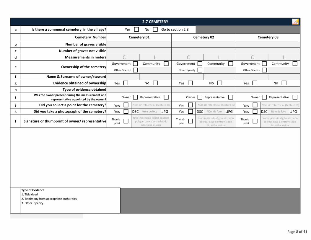
a Yes � No �
b
c
d
� � � � � �
� � �f
g Yes � � Yes � � Yes � �h
i � � � � � �
j Yes � Yes � Yes �k Yes � DSC .JPG Yes � DSC .JPG Yes � DSC .JPG
lThumb
print �Thumb
print �Thumb
print �
Type of Evidence
1. Title deed
2. Testimony from appropriate authorities
3. Other. Specify
Signature or thumbprint of owner/ representative
Measurements in meters
Did you collect a point for the cemetery?
Owner Representative Owner
Number of graves not visible
Number of graves visible
2.7 CEMETERY
Is there a communal cemetery in the village? Go to section 2.8
Cemetery Number Cemetery 01 Cemetery 02 Cemetery 03
Type of evidence obtained
Evidence obtained of ownership No No No
Name & Surname of owner/steward
Was the owner present during the measurement or a
representative appointed by the owner?Owner Representative
Did you take a photograph of the cemetery?
Representative
e Ownership of the cemetery Other. Specify Other. Specify Other. Specify
CommunityGovernment Community Government Community Government
Núm de foto
Núm de referência (Feature ID)
Núm de foto Núm de foto
Núm de referência (Feature ID)
Núm de foto
Núm de referência (Feature ID)
tirar impressão digital do dedo
polegar caso o entrevistado
não saiba assinar
tirar impressão digital do dedo
polegar caso o entrevistado
não saiba assinar
tirar impressão digital do dedo
polegar caso o entrevistado
não saiba assinar
Núm de foto Núm de foto Núm de foto
C L C L C L
Page 8 of 41
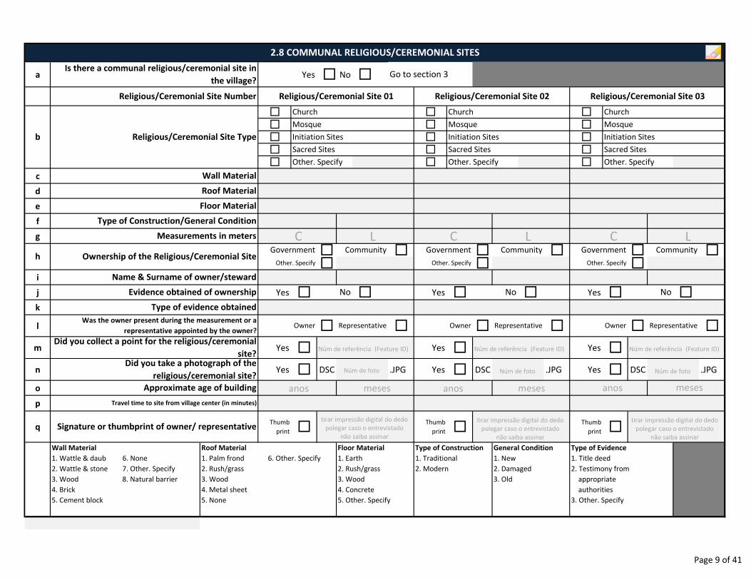
a Yes � No �
� � �
� � �
� � �
� � �
� � �
c
d
e
f
g
� � � � � �� � �
i
j Yes � � Yes � � Yes � �k
l � � � � � �
m Yes � Yes � Yes �
n Yes � DSC .JPG Yes � DSC .JPG Yes � DSC .JPG
o
p
qThumb
print �Thumb
print �Thumb
print �
Wall Material
1. Wattle & daub 6. None
2. Wattle & stone 7. Other. Specify
3. Wood 8. Natural barrier
4. Brick
5. Cement block
Was the owner present during the measurement or a
representative appointed by the owner?
Measurements in meters
No
Name & Surname of owner/steward
Other. Specify Other. Specify Other. Specify
Owner Representative Owner Representative Owner Representative
Other. Specify Other. Specify Other. Specify
Mosque
Travel time to site from village center (in minutes)
Signature or thumbprint of owner/ representative
Roof Material
1. Palm frond 6. Other. Specify
2. Rush/grass
3. Wood
4. Metal sheet
5. None
Approximate age of building
Floor Material
1. Earth
2. Rush/grass
3. Wood
4. Concrete
5. Other. Specify
Type of Construction
1. Traditional
2. Modern
General Condition
1. New
2. Damaged
3. Old
Type of Evidence
1. Title deed
2. Testimony from
appropriate
authorities
3. Other. Specify
Type of Construction/General Condition
Roof Material
Floor Material
2.8 COMMUNAL RELIGIOUS/CEREMONIAL SITES
Is there a communal religious/ceremonial site in
the village?Go to section 3
Religious/Ceremonial Site Number Religious/Ceremonial Site 01 Religious/Ceremonial Site 02 Religious/Ceremonial Site 03
Wall Material
Initiation Sites Initiation Sites Initiation SitesReligious/Ceremonial Site Typeb
Sacred SitesSacred Sites Sacred Sites
Church Church Church
Mosque Mosque
h Ownership of the Religious/Ceremonial SiteCommunity
Type of evidence obtained
Government Community Government Community Government
Evidence obtained of ownership No No
Did you collect a point for the religious/ceremonial
site?Did you take a photograph of the
religious/ceremonial site?Núm de foto
Núm de referência (Feature ID)
Núm de foto
Núm de referência (Feature ID)
Núm de foto
Núm de referência (Feature ID)
C L C L C L
anos meses anos meses anos meses
tirar impressão digital do dedo
polegar caso o entrevistado
não saiba assinar
tirar impressão digital do dedo
polegar caso o entrevistado
não saiba assinar
tirar impressão digital do dedo
polegar caso o entrevistado
não saiba assinar
Page 9 of 41
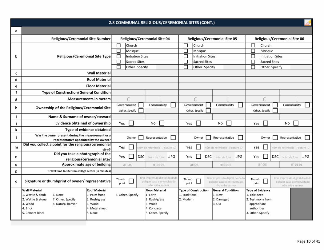
a
� � �
� � �
� � �
� � �
� � �
c
d
e
f
g
� � � � � �� � �
i
j Yes � � Yes � � Yes � �k
l � � � � � �
m Yes � Yes � Yes �
n Yes � DSC .JPG Yes � DSC .JPG Yes � DSC .JPG
o
p
qThumb
print �Thumb
print �Thumb
print �
Wall Material
1. Wattle & daub 6. None
2. Wattle & stone 7. Other. Specify
3. Wood 8. Natural barrier
4. Brick
5. Cement block
Did you take a photograph of the
religious/ceremonial site?
Floor Material
1. Earth
2. Rush/grass
3. Wood
4. Concrete
5. Other. Specify
Evidence obtained of ownership
Roof Material
1. Palm frond 6. Other. Specify
2. Rush/grass
3. Wood
4. Metal sheet
5. None
Signature or thumbprint of owner/ representative
Approximate age of building
Owner Representative Owner Representative Owner Representative
Travel time to site from village center (in minutes)
Was the owner present during the measurement or a
representative appointed by the owner?
Did you collect a point for the religious/ceremonial
site?
Wall Material
Type of evidence obtained
Measurements in meters
Type of Construction/General Condition
Name & Surname of owner/steward
2.8 COMMUNAL RELIGIOUS/CEREMONIAL SITES (CONT.)
Religious/Ceremonial Site Number Religious/Ceremonial Site 04 Religious/Ceremonial Site 05 Religious/Ceremonial Site 06
b Religious/Ceremonial Site Type
Church Church Church
Mosque Mosque Mosque
Initiation Sites Initiation Sites Initiation Sites
Sacred Sites Sacred Sites Sacred Sites
Other. Specify
Other. Specify
Type of Construction
1. Traditional
2. Modern
General Condition
1. New
2. Damaged
3. Old
Government Community Government Community Government Community
No No No
Type of Evidence
1. Title deed
2. Testimony from
appropriate
authorities
3. Other. Specify
h Ownership of the Religious/Ceremonial Site
Roof Material
Floor Material
Other. Specify Other. Specify
Other. Specify Other. Specify
Núm de referência (Feature ID) Núm de referência (Feature ID) Núm de referência (Feature ID)
C L C L C L
anos meses anos meses anos meses
tirar impressão digital do dedo
polegar caso o entrevistado
não saiba assinar
tirar impressão digital do dedo
polegar caso o entrevistado
não saiba assinar
tirar impressão digital do dedo
polegar caso o entrevistado
não saiba assinar
Núm de foto Núm de foto Núm de foto
Page 10 of 41

a
� � �
� � �
� � �
� � �
� � �
c
d
e
f
g
� � � � � �� � �
i
j Yes � � Yes � � Yes � �k
l � � � � � �
m Yes � Yes � Yes �
n Yes � DSC .JPG Yes � DSC .JPG Yes � DSC .JPG
o
p
qThumb
print �Thumb
print �Thumb
print �
Wall Material
1. Wattle & daub 6. None
2. Wattle & stone 7. Other. Specify
3. Wood 8. Natural barrier
4. Brick
5. Cement block
Did you take a photograph of the
religious/ceremonial site?
h
Was the owner present during the measurement or a
representative appointed by the owner?
Did you collect a point for the religious/ceremonial
site?
Evidence obtained of ownership No No
Name & Surname of owner/steward
Ownership of the Religious/Ceremonial Site
Type of evidence obtained
No
Government
Roof Material
1. Palm frond 6. Other. Specify
2. Rush/grass
3. Wood
4. Metal sheet
5. None
Signature or thumbprint of owner/ representative
Approximate age of building
Owner Representative Owner Representative Owner Representative
Travel time to site from village center (in minutes)
Type of Evidence
1. Title deed
2. Testimony from
appropriate
authorities
3. Other. Specify
Floor Material
1. Earth
2. Rush/grass
3. Wood
4. Concrete
5. Other. Specify
Type of Construction
1. Traditional
2. Modern
General Condition
1. New
2. Damaged
3. Old
Roof Material
Floor Material
Other. Specify Other. Specify Other. Specify
Type of Construction/General Condition
Measurements in meters
2.8 COMMUNAL RELIGIOUS/CEREMONIAL SITES (CONT.)
Religious/Ceremonial Site Number Religious/Ceremonial Site 07 Religious/Ceremonial Site 08 Religious/Ceremonial Site 09
Wall Material
b Religious/Ceremonial Site Type
Church Church Church
Mosque Mosque Mosque
Initiation Sites
Sacred Sites
Initiation Sites Initiation Sites
Sacred Sites
Other. Specify
Community Government Community Government Community
Other. SpecifyOther. Specify
Sacred Sites
Núm de referência (Feature ID) Núm de referência (Feature ID) Núm de referência (Feature ID)
C L C L C L
anos meses anos meses anos meses
tirar impressão digital do dedo
polegar caso o entrevistado
não saiba assinar
tirar impressão digital do dedo
polegar caso o entrevistado
não saiba assinar
tirar impressão digital do dedo
polegar caso o entrevistado
não saiba assinar
Núm de foto Núm de foto Núm de foto
Page 11 of 41

a
� � �
� � �
� � �
� � �
� � �
c
d
e
f
g
� � � � � �� � �
i
j Yes � � Yes � � Yes � �k
l � � � � � �
m Yes � Yes � Yes �
n Yes � DSC .JPG Yes � DSC .JPG Yes � DSC .JPG
o
p
qThumb
print �Thumb
print �Thumb
print �
Wall Material
1. Wattle & daub 6. None
2. Wattle & stone 7. Other. Specify
3. Wood 8. Natural barrier
4. Brick
5. Cement block
Other. SpecifyOther. SpecifyOther. Specify
Floor Material
1. Earth
2. Rush/grass
3. Wood
4. Concrete
5. Other. Specify
Type of Construction
1. Traditional
2. Modern
General Condition
1. New
2. Damaged
3. Old
Owner Representative Owner Representative Owner
Signature or thumbprint of owner/ representative
Approximate age of building
Was the owner present during the measurement or a
representative appointed by the owner?
Name & Surname of owner/steward
Evidence obtained of ownership No No No
Type of evidence obtained
Representative
2.8 COMMUNAL RELIGIOUS/CEREMONIAL SITES (CONT.)
Religious/Ceremonial Site Number Religious/Ceremonial Site 10 Religious/Ceremonial Site 11 Religious/Ceremonial Site 12
Wall Material
b Religious/Ceremonial Site Type
Church Church Church
Mosque Mosque Mosque
Initiation Sites Initiation Sites Initiation Sites
Sacred Sites Sacred Sites Sacred Sites
Measurements in meters
Other. Specify Other. Specify Other. SpecifyOwnership of the Religious/Ceremonial Site
Roof Material
Floor Material
Type of Construction/General Condition
hGovernment Community Government Community Government Community
Roof Material
1. Palm frond 6. Other. Specify
2. Rush/grass
3. Wood
4. Metal sheet
5. None
Type of Evidence
1. Title deed
2. Testimony from
appropriate
authorities
3. Other. Specify
Did you collect a point for the religious/ceremonial
site?Did you take a photograph of the
religious/ceremonial site?
Travel time to site from village center (in minutes)
Núm de referência (Feature ID) Núm de referência (Feature ID) Núm de referência (Feature ID)
C L C L C L
anos meses anos meses anos meses
tirar impressão digital do dedo
polegar caso o entrevistado
não saiba assinar
tirar impressão digital do dedo
polegar caso o entrevistado
não saiba assinar
tirar impressão digital do dedo
polegar caso o entrevistado
não saiba assinar
Núm de foto Núm de foto Núm de foto
Page 12 of 41
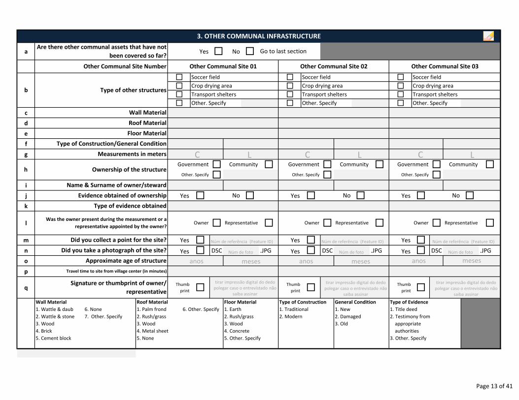
a Yes � No �
� � �
� � �
� � �
� � �
c
d
e
f
g
� � � � � �
� � �i
j Yes � � Yes � � Yes � �k
l � � � � � �
m Yes � Yes � Yes �n Yes � DSC .JPG Yes � DSC .JPG Yes � DSC .JPG
o
p
qThumb
print �Thumb
print �Thumb
print �
Wall Material
1. Wattle & daub 6. None
2. Wattle & stone 7. Other. Specify
3. Wood
4. Brick
5. Cement block
Did you take a photograph of the site?
Other. SpecifyOther. SpecifyOther. Specify
Owner Representative
No No No
Other. Specify
Type of Construction/General Condition
Type of evidence obtained
Type of Evidence
1. Title deed
2. Testimony from
appropriate
authorities
3. Other. Specify
Roof Material
1. Palm frond 6. Other. Specify
2. Rush/grass
3. Wood
4. Metal sheet
5. None
Signature or thumbprint of owner/
representative
Approximate age of structure
Floor Material
1. Earth
2. Rush/grass
3. Wood
4. Concrete
5. Other. Specify
Type of Construction
1. Traditional
2. Modern
General Condition
1. New
2. Damaged
3. Old
Travel time to site from village center (in minutes)
Was the owner present during the measurement or a
representative appointed by the owner?Owner Representative Owner Representative
Did you collect a point for the site?
Soccer field Soccer field
Crop drying area Crop drying area Crop drying area
Transport shelters Transport shelters
Floor Material
Roof Material
Community Government Community Government CommunityGovernment
Name & Surname of owner/steward
Evidence obtained of ownership
Other. Specify Other. SpecifyOwnership of the structureh
3. OTHER COMMUNAL INFRASTRUCTURE
Are there other communal assets that have not
been covered so far?Go to last section
Other Communal Site Number Other Communal Site 01 Other Communal Site 02 Other Communal Site 03
b
Wall Material
Transport sheltersType of other structures
Soccer field
Measurements in meters
Núm de referência (Feature ID) Núm de referência (Feature ID) Núm de referência (Feature ID)
C L C L C L
anos meses anos meses anos meses
tirar impressão digital do dedo
polegar caso o entrevistado não
saiba assinar
tirar impressão digital do dedo
polegar caso o entrevistado não
saiba assinar
tirar impressão digital do dedo
polegar caso o entrevistado não
saiba assinar
Núm de foto Núm de foto Núm de foto
Page 13 of 41
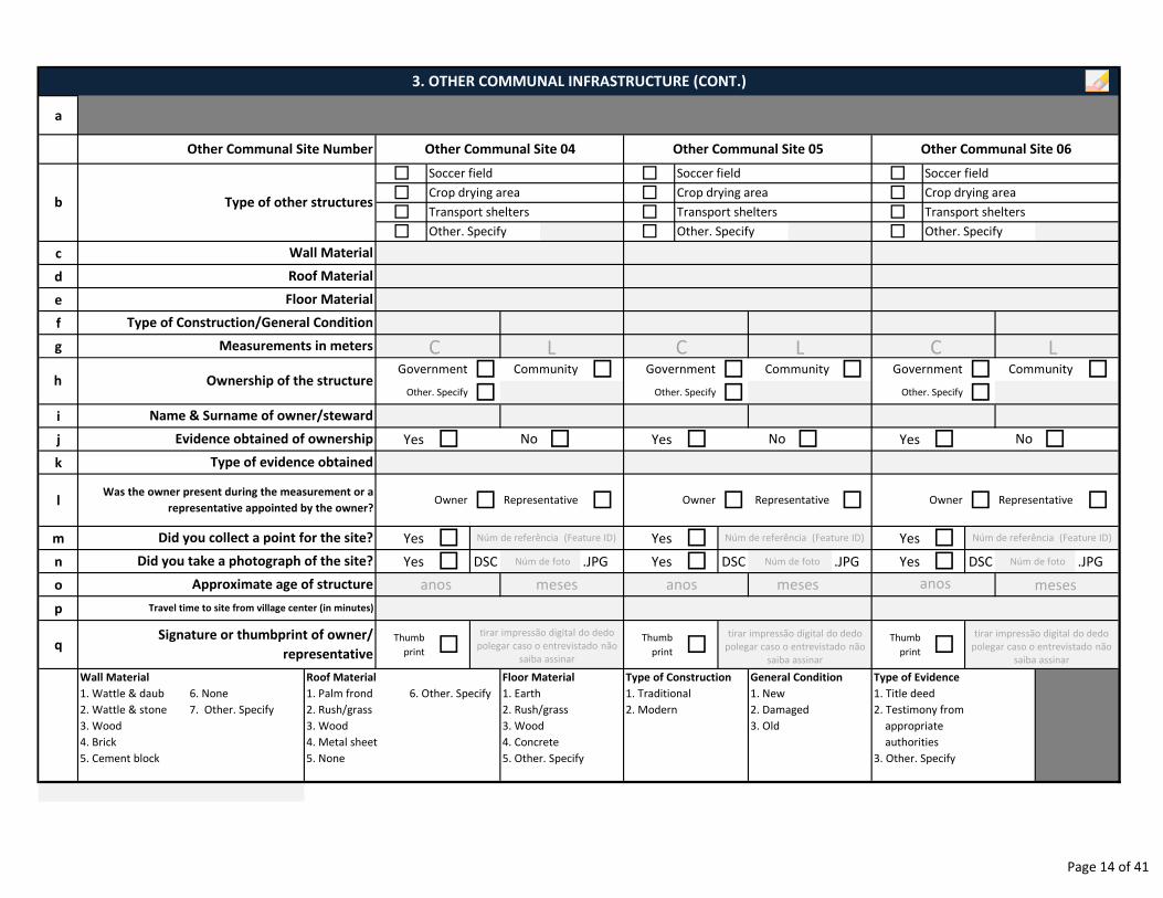
a
� � �
� � �
� � �
� � �
c
d
e
f
g
� � � � � �
� � �i
j Yes � � Yes � � Yes � �k
l � � � � � �
m Yes � Yes � Yes �n Yes � DSC .JPG Yes � DSC .JPG Yes � DSC .JPG
o
p
qThumb
print �Thumb
print �Thumb
print �
Wall Material
1. Wattle & daub 6. None
2. Wattle & stone 7. Other. Specify
3. Wood
4. Brick
5. Cement block
Signature or thumbprint of owner/
representative
Roof Material
1. Palm frond 6. Other. Specify
2. Rush/grass
3. Wood
4. Metal sheet
5. None
Travel time to site from village center (in minutes)
Approximate age of structure
Floor Material
1. Earth
2. Rush/grass
3. Wood
4. Concrete
5. Other. Specify
Type of Construction
1. Traditional
2. Modern
General Condition
1. New
2. Damaged
3. Old
Type of Evidence
1. Title deed
2. Testimony from
appropriate
authorities
3. Other. Specify
RepresentativeOwner Representative Owner Representative OwnerWas the owner present during the measurement or a
representative appointed by the owner?
Other. Specify Other. Specify Other. Specify
No No
Name & Surname of owner/steward
Wall Material
Roof Material
Crop drying area Crop drying area
Transport shelters Transport shelters Transport shelters
Other. SpecifyOther. SpecifyOther. Specify
3. OTHER COMMUNAL INFRASTRUCTURE (CONT.)
Other Communal Site Number Other Communal Site 04 Other Communal Site 05 Other Communal Site 06
b Type of other structures
Soccer field Soccer field Soccer field
Crop drying area
Floor Material
Type of Construction/General Condition
Measurements in meters
h Ownership of the structureCommunity
Type of evidence obtained
Government Community Government Community Government
Did you collect a point for the site?
Did you take a photograph of the site?
Evidence obtained of ownership No
C L C L C L
anos meses anos meses anos meses
tirar impressão digital do dedo
polegar caso o entrevistado não
saiba assinar
tirar impressão digital do dedo
polegar caso o entrevistado não
saiba assinar
tirar impressão digital do dedo
polegar caso o entrevistado não
saiba assinar
Núm de referência (Feature ID) Núm de referência (Feature ID) Núm de referência (Feature ID)
Núm de foto Núm de foto Núm de foto
Page 14 of 41

a
� � �
� � �
� � �
� � �
c
d
e
f
g
� � � � � �
� � �i
j Yes � � Yes � � Yes � �k
l � � � � � �
m Yes � Yes � Yes �n Yes � DSC .JPG Yes � DSC .JPG Yes � DSC .JPG
o
p
qThumb
print �Thumb
print �Thumb
print �
Wall Material
1. Wattle & daub 6. None
2. Wattle & stone 7. Other. Specify
3. Wood
4. Brick
5. Cement block
Signature or thumbprint of owner/
representative
Roof Material
1. Palm frond 6. Other. Specify
2. Rush/grass
3. Wood
4. Metal sheet
5. None
Travel time to site from village center (in minutes)
Approximate age of structure
Floor Material
1. Earth
2. Rush/grass
3. Wood
4. Concrete
5. Other. Specify
Type of Construction
1. Traditional
2. Modern
General Condition
1. New
2. Damaged
3. Old
Type of Evidence
1. Title deed
2. Testimony from
appropriate
authorities
3. Other. Specify
Was the owner present during the measurement or a
representative appointed by the owner?RepresentativeOwner Representative Owner Representative Owner
Wall Material
Roof Material
Type of Construction/General Condition
Measurements in meters
Other. Specify Other. Specify Other. SpecifyOwnership of the structure
Floor Material
3. OTHER COMMUNAL INFRASTRUCTURE (CONT.)
Other Communal Site Number Other Communal Site 07 Other Communal Site 08 Other Communal Site 09
b Type of other structures
Soccer field Soccer field Soccer field
Crop drying area Crop drying area Crop drying area
Transport shelters Transport shelters Transport shelters
Other. SpecifyOther. SpecifyOther. Specify
hCommunity
Type of evidence obtained
Government Community Government Community Government
Did you collect a point for the site?
Did you take a photograph of the site?
Evidence obtained of ownership No No No
Name & Surname of owner/steward
C L C L C L
anos meses anos meses anos meses
tirar impressão digital do dedo
polegar caso o entrevistado não
saiba assinar
tirar impressão digital do dedo
polegar caso o entrevistado não
saiba assinar
tirar impressão digital do dedo
polegar caso o entrevistado não
saiba assinar
Núm de referência (Feature ID) Núm de referência (Feature ID) Núm de referência (Feature ID)
Núm de foto Núm de foto Núm de foto
Page 15 of 41
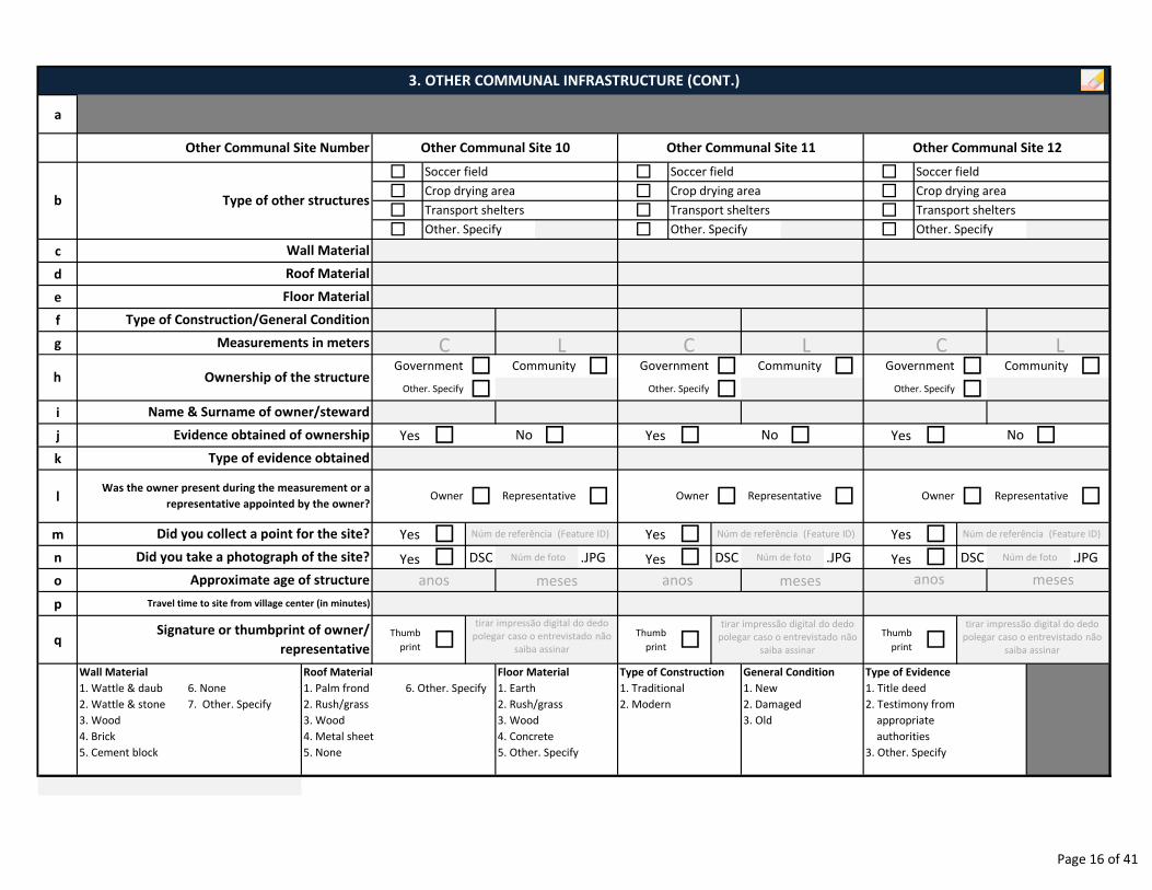
a
� � �
� � �
� � �
� � �
c
d
e
f
g
� � � � � �
� � �i
j Yes � � Yes � � Yes � �k
l � � � � � �
m Yes � Yes � Yes �n Yes � DSC .JPG Yes � DSC .JPG Yes � DSC .JPG
o
p
qThumb
print �Thumb
print �Thumb
print �
Wall Material
1. Wattle & daub 6. None
2. Wattle & stone 7. Other. Specify
3. Wood
4. Brick
5. Cement block
Type of Evidence
1. Title deed
2. Testimony from
appropriate
authorities
3. Other. Specify
Owner Representative Owner Representative Owner Representative
Type of evidence obtained
Approximate age of structure
Did you take a photograph of the site?
Was the owner present during the measurement or a
representative appointed by the owner?
Floor Material
1. Earth
2. Rush/grass
3. Wood
4. Concrete
5. Other. Specify
Type of Construction
1. Traditional
2. Modern
General Condition
1. New
2. Damaged
3. Old
Signature or thumbprint of owner/
representative
Roof Material
1. Palm frond 6. Other. Specify
2. Rush/grass
3. Wood
4. Metal sheet
5. None
Travel time to site from village center (in minutes)
Did you collect a point for the site?
No No No
Name & Surname of owner/steward
CommunityGovernment Community Government Community Government
Evidence obtained of ownership
Other. Specify Other. Specify Other. Specify
Wall Material
Roof Material
Type of Construction/General Condition
Ownership of the structureh
Floor Material
Measurements in meters
3. OTHER COMMUNAL INFRASTRUCTURE (CONT.)
Other Communal Site Number Other Communal Site 10 Other Communal Site 11 Other Communal Site 12
b Type of other structures
Soccer field Soccer field Soccer field
Crop drying area Crop drying area Crop drying area
Transport shelters Transport shelters Transport shelters
Other. SpecifyOther. SpecifyOther. Specify
C L C L C L
anos meses anos meses anos meses
Núm de referência (Feature ID) Núm de referência (Feature ID) Núm de referência (Feature ID)
tirar impressão digital do dedo
polegar caso o entrevistado não
saiba assinar
tirar impressão digital do dedo
polegar caso o entrevistado não
saiba assinar
tirar impressão digital do dedo
polegar caso o entrevistado não
saiba assinar
Núm de foto Núm de foto Núm de foto
Page 16 of 41
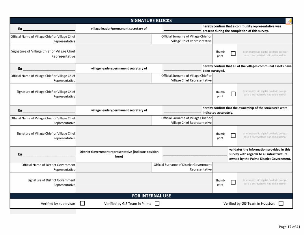
Eu ___________________________ ___________________
Official Name of Village Chief or Village Chief
Representative
Eu ___________________________ ___________________
Official Name of Village Chief or Village Chief
Representative
Eu ___________________________ ___________________
Official Name of Village Chief or Village Chief
Representative
Eu ___________________________
Official Name of District Government
Representative
Verified by supervisor Verified by GIS Team in Palma � �
Signature of District Government
Representative
� Verified by GIS Team in Houston:
Thumb
print �
Thumb
print �
Official Surname of District Government
Representative
Signature of Village Chief or Village Chief
Representative
FOR INTERNAL USE
Signature of Village Chief or Village Chief
Representative
Thumb
print �
SIGNATURE BLOCKS
Official Surname of Village Chief or
Village Chief Representative
Signature of Village Chief or Village Chief
Representative
Thumb
print �
village leader/permanent secretary of hereby confirm that a community representative was
present during the completion of this survey.
village leader/permanent secretary of
village leader/permanent secretary of
District Government representative (indicate position
here)
hereby confirm that all of the villages communal assets have
been surveyed.
hereby confirm that the ownership of the structures were
indicated accurately.
Official Surname of Village Chief or
Village Chief Representative
Official Surname of Village Chief or
Village Chief Representative
_________________________________
validates the information provided in this
survey with regards to all infrastructure
owned by the Palma District Government.
tirar impressão digital do dedo polegar
caso o entrevistado não saiba assinar
tirar impressão digital do dedo polegar
caso o entrevistado não saiba assinar
tirar impressão digital do dedo polegar
caso o entrevistado não saiba assinar
tirar impressão digital do dedo polegar
caso o entrevistado não saiba assinar
Page 17 of 41

ENUMERATOR NOTES
__________________________________________________________________________________________________
__________________________________________________________________________________________________
__________________________________________________________________________________________________
__________________________________________________________________________________________________
__________________________________________________________________________________________________
__________________________________________________________________________________________________
__________________________________________________________________________________________________
__________________________________________________________________________________________________
__________________________________________________________________________________________________
__________________________________________________________________________________________________
__________________________________________________________________________________________________
__________________________________________________________________________________________________
__________________________________________________________________________________________________
__________________________________________________________________________________________________
__________________________________________________________________________________________________
__________________________________________________________________________________________________
__________________________________________________________________________________________________
__________________________________________________________________________________________________
__________________________________________________________________________________________________
__________________________________________________________________________________________________
__________________________________________________________________________________________________
__________________________________________________________________________________________________
__________________________________________________________________________________________________
__________________________________________________________________________________________________
__________________________________________________________________________________________________
Page 18 of 41
Date Reviewer Status
SURVEY STATUS MONITORING
Notes
Page 19 of 41
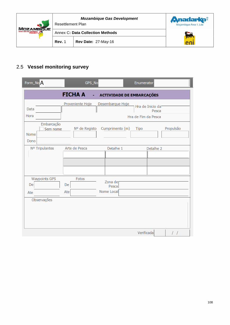
Mozambique Gas Development Resettlement Plan
Annex C: Data Collection Methods
Rev. 1 Rev Date: 27-May-16
2.5 Vessel monitoring survey
108
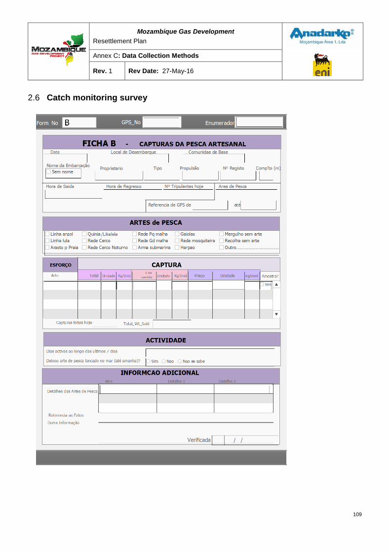
Mozambique Gas Development Resettlement Plan
Annex C: Data Collection Methods
Rev. 1 Rev Date: 27-May-16
2.6 Catch monitoring survey
109
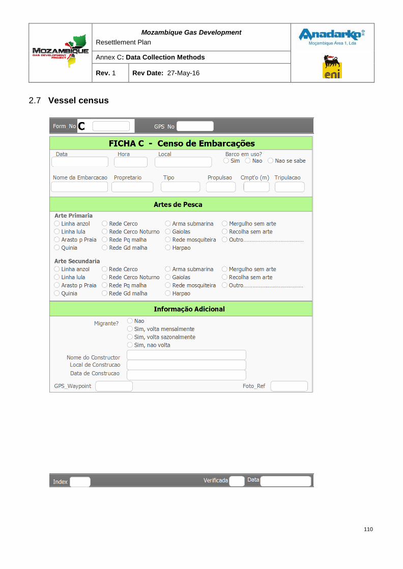
Mozambique Gas Development Resettlement Plan
Annex C: Data Collection Methods
Rev. 1 Rev Date: 27-May-16
2.7 Vessel census
110
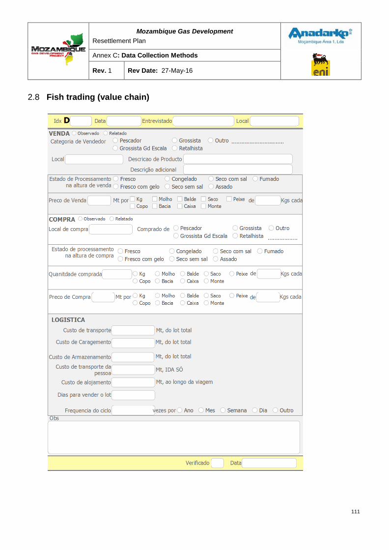
Mozambique Gas Development Resettlement Plan
Annex C: Data Collection Methods
Rev. 1 Rev Date: 27-May-16
2.8 Fish trading (value chain)
111
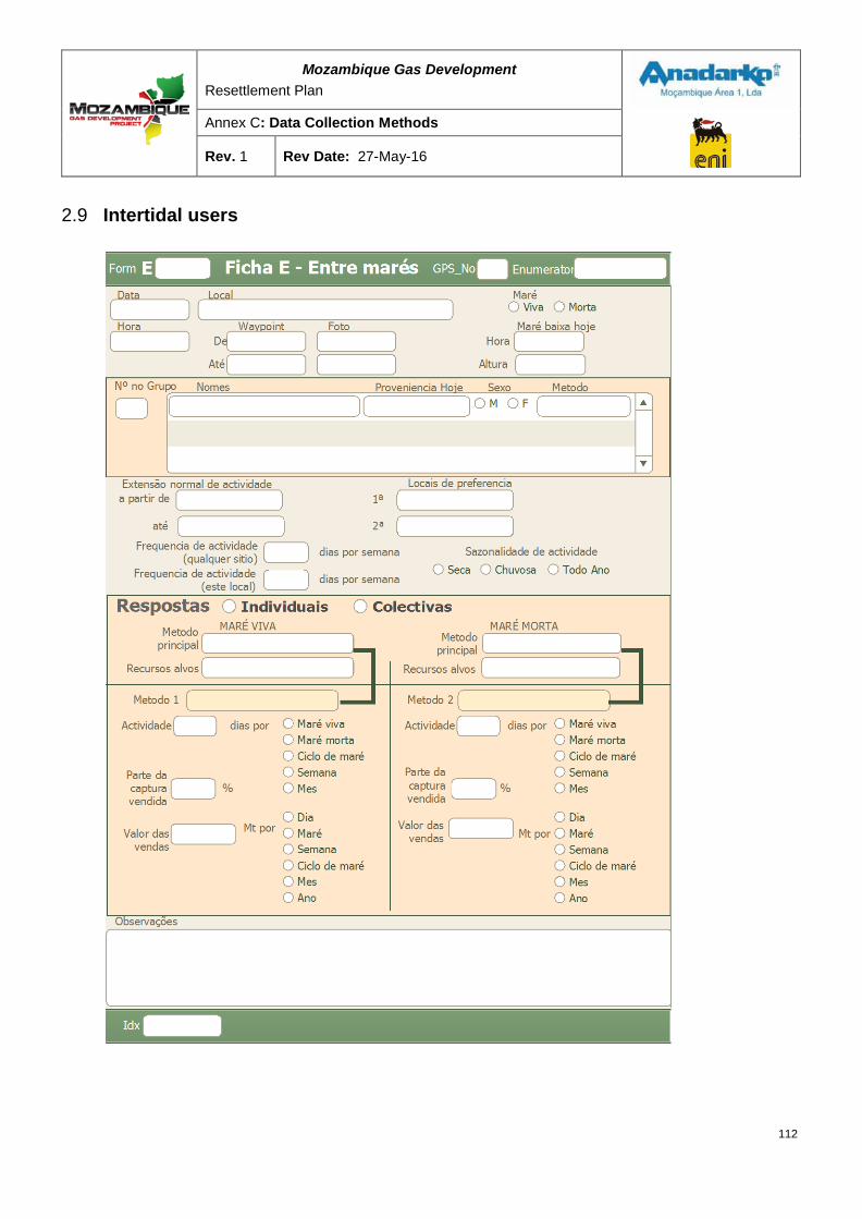
Mozambique Gas Development Resettlement Plan
Annex C: Data Collection Methods
Rev. 1 Rev Date: 27-May-16
2.9 Intertidal users
112
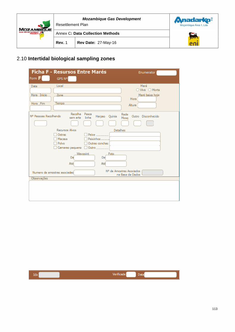
Mozambique Gas Development Resettlement Plan
Annex C: Data Collection Methods
Rev. 1 Rev Date: 27-May-16
2.10 Intertidal biological sampling zones
113
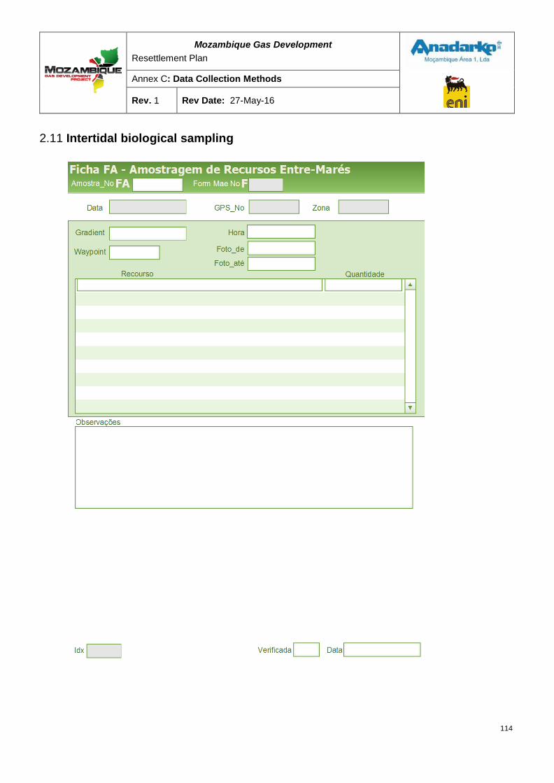
Mozambique Gas Development Resettlement Plan
Annex C: Data Collection Methods
Rev. 1 Rev Date: 27-May-16
2.11 Intertidal biological sampling
114
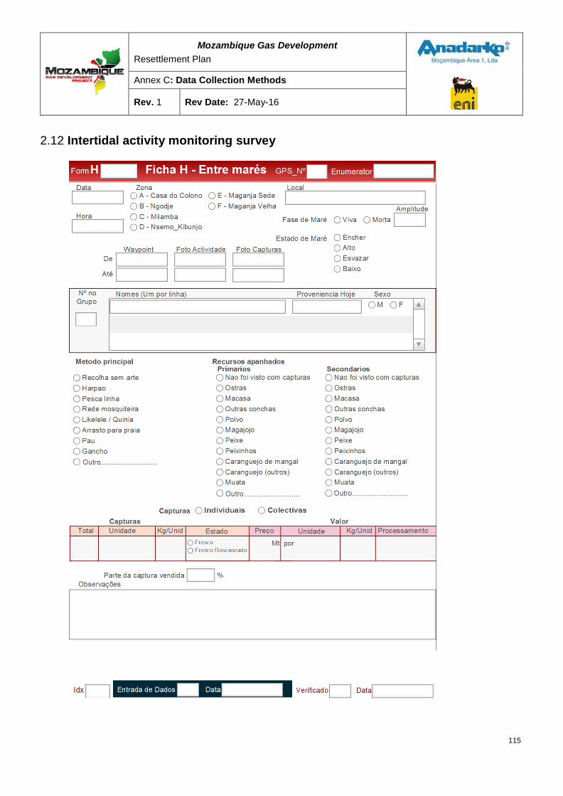
Mozambique Gas Development Resettlement Plan
Annex C: Data Collection Methods
Rev. 1 Rev Date: 27-May-16
2.12 Intertidal activity monitoring survey
115
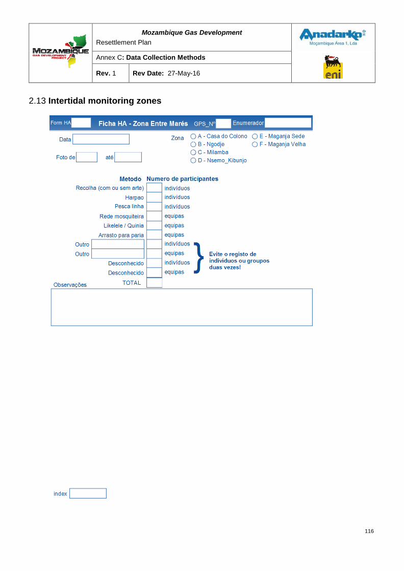
Mozambique Gas Development Resettlement Plan
Annex C: Data Collection Methods
Rev. 1 Rev Date: 27-May-16
2.13 Intertidal monitoring zones
116
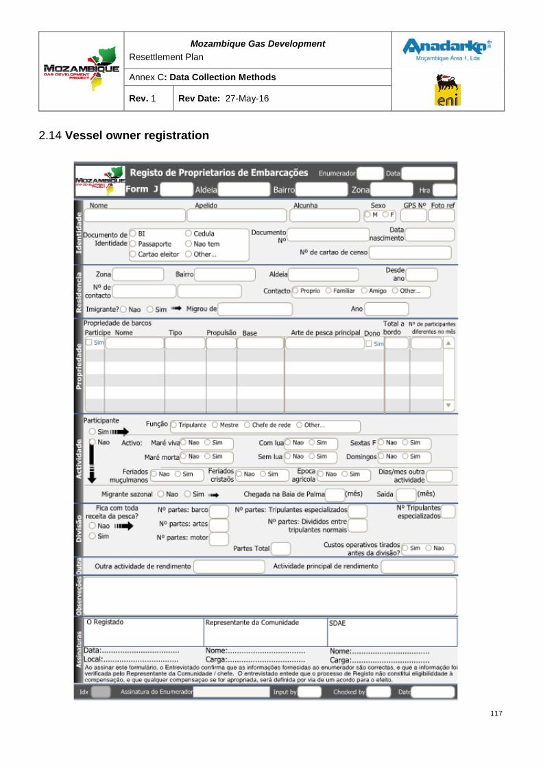
Mozambique Gas Development Resettlement Plan
Annex C: Data Collection Methods
Rev. 1 Rev Date: 27-May-16
2.14 Vessel owner registration
117
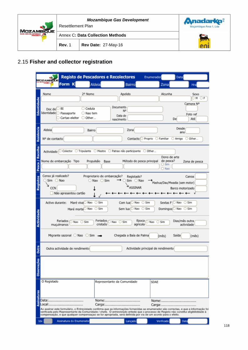
Mozambique Gas Development Resettlement Plan
Annex C: Data Collection Methods
Rev. 1 Rev Date: 27-May-16
2.15 Fisher and collector registration
118

RESETTLEMENT PLAN FINAL DRAFT FOR GOVERNMENT APPROVAL
ANNEX D: CROP COMPENSATION REPORT
MOZAMBIQUE GAS DEVELOPMENT
Mozambique Gas Development Resettlement Plan
Annex D: Crop Compensation Report
Rev. 1 Rev Date: 27-May-16
Table of Contents
1 INTRODUCTION ................................................................................................................... 1
Objective ................................................................................................................................... 1
Study method ........................................................................................................................... 1
2 CURRENT AGRICULTURAL PRACTICES .......................................................................... 4
Overview of farming methods ................................................................................................. 4
2.1.1 Rainfed (dryland) machambas .............................................................................................................. 5
2.1.2 Wetland machambas ............................................................................................................................ 6
2.1.3 Perennial fruit trees ............................................................................................................................... 6
2.1.4 Livestock and poultry ............................................................................................................................ 6
Land tenure ............................................................................................................................... 7
Common crop mixes ................................................................................................................ 8
2.3.2 Dryland machambas ............................................................................................................................. 8
2.3.3 Wetland machambas ............................................................................................................................ 8
Summary of soil survey ........................................................................................................... 9
3 CURRENT YIELDS ............................................................................................................. 10
Yields obtained through own sampling ................................................................................ 10
Qualification ........................................................................................................................... 10
Comparative crop yields and conclusions ........................................................................... 11
4 PRICE ANALYSIS .............................................................................................................. 13
Prices available ...................................................................................................................... 13
Methods of price collection ................................................................................................... 13
4.2.2 Price information from farmers ........................................................................................................... 13
4.2.3 Information from market surveys ........................................................................................................ 14
Comparative crop prices ....................................................................................................... 14
Price conclusions ................................................................................................................... 15
5 CROP VALUATION ............................................................................................................ 15
ii
Mozambique Gas Development Resettlement Plan
Annex D: Crop Compensation Report
Rev. 1 Rev Date: 27-May-16
Existing official Government rates ........................................................................................ 15
Valuation summary: annual crops ........................................................................................ 16
Valuation summary: perennial crops .................................................................................... 17
Valuation conclusion ............................................................................................................. 19
Foraging .................................................................................................................................. 19
6 CONCLUSION AND RECOMMENDATIONS ..................................................................... 19
General recommendations .................................................................................................... 20
Recommendations for compensation in a multi-cropping approach ................................. 21
Recommendations on the escalation of valuations ............................................................. 22
Tree maturity considerations ................................................................................................ 22
Other considerations ............................................................................................................. 23
APPENDIX A ............................................................................................................................. 24
List of Tables Table 2-1: Land ownership pattern of sampled households ...................................................................... 5
Table 2-2: Tree ownership patterns of 755 sampled households .............................................................. 6
Table 2-3: Animal ownership pattern of sampled households ................................................................... 7
Table 3-1: Yield ranges for sampled farmers in Afungi ........................................................................... 11
Table 3-2: Afungi estimates and comparative crop yield data ................................................................. 11
Table 4-1: Crop pricing ........................................................................................................................... 14
Table 5-1: Comparison of compensation rates for annual crops ............................................................. 17
Table 5-2: Comparison of compensation rates for perennial crops ......................................................... 18
Table 6-1: Recommended compensation rates ...................................................................................... 20
Table 6-2: Compensation ratio for immature trees .................................................................................. 22
iii

Mozambique Gas Development Resettlement Plan
Annex D: Crop Compensation Report
Rev. 1 Rev Date: 27-May-16
Executive Summary The Mozambique Gas Project (the Project) has committed to meeting the compensation standards defined by Mozambican legislation and the International Finance Corporation (IFC) Performance Standard 5 Land Acquisition and Resettlement (PS 5). IFC PS 5 requires that assets (including trees and crops) be compensated at full replacement cost. The objectives of this compensation rates study were as follows:
1. To determine the full replacement value of commonly occurring local trees and crops using observed yields and market prices;
2. To compare this full replacement value with the published Ministry of Agriculture (Cabo Delgado) compensation rates (January 2014); and
3. To recommend rates to be used in calculating compensation for trees and crops for the Project.
The study found that the tree and crop compensation rates published by the Ministry of Agriculture (Cabo Delgado, in January 2014) generally exceeded full replacement values determined using site-specific yields and local market prices. The main reasons were that tree and crop yields being achieved on the Afungi Peninsula were consistently much lower than the average yields used to develop the Ministry of Agricultural compensation rates.
As a conclusion of this study, with the exception of Coração de boi and Ateira1 trees, it is recommended to use the published Ministry of Agriculture rates to compensate for loss/damage to annual, perennial, and tree crops. These rates are presented below (Table S-1). These rates will be reviewed in June 2015 and annually thereafter.
Table S-1: Recommended crop compensation rates2
No. Crop Compensation unit Price – MZN
Annual crop
Perennial crop
Field crops
1 Cassava m2 18
2 Rice m2 18
3 Njugo beans m2 18
4 Maize m2 18
5 Sorghum m2 18
6 Nhemba beans m2 18
7 Sesame m2 18
1Wild Custard Apple or Coração de boi (Annona reticulata and Annona senegalensis) and Sugar Apple or Ateira (Annona squamosa) are recommended for compensation at the slightly higher Afungi rate. 2 Exchange rate of 38.80 MZN = 1 USD (exchange rate on 21 August 2015)
iv
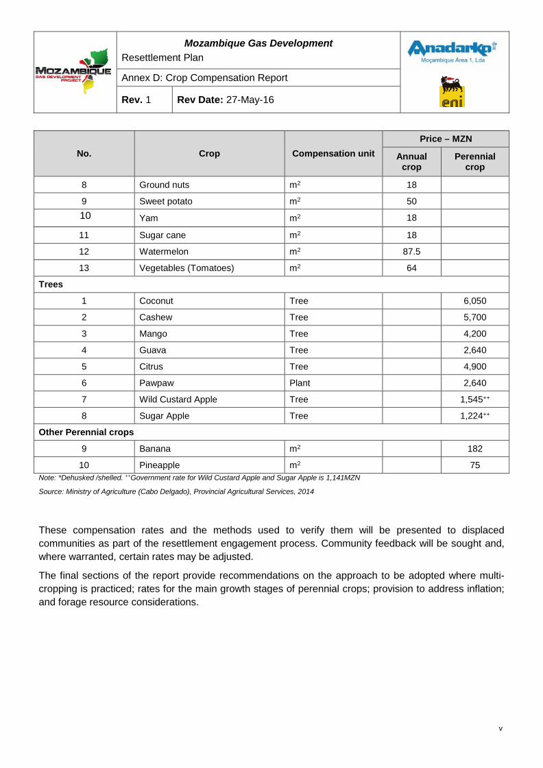
Mozambique Gas Development Resettlement Plan
Annex D: Crop Compensation Report
Rev. 1 Rev Date: 27-May-16
No. Crop Compensation unit Price – MZN
Annual crop
Perennial crop
8 Ground nuts m2 18
9 Sweet potato m2 50 10 Yam m2 18
11 Sugar cane m2 18
12 Watermelon m2 87.5
13 Vegetables (Tomatoes) m2 64
Trees
1 Coconut Tree
6,050
2 Cashew Tree
5,700
3 Mango Tree
4,200
4 Guava Tree
2,640
5 Citrus Tree
4,900
6 Pawpaw Plant
2,640
7 Wild Custard Apple Tree
1,545++
8 Sugar Apple Tree
1,224++
Other Perennial crops
9 Banana m2
182
10 Pineapple m2
75 Note: *Dehusked /shelled. ++Government rate for Wild Custard Apple and Sugar Apple is 1,141MZN
Source: Ministry of Agriculture (Cabo Delgado), Provincial Agricultural Services, 2014
These compensation rates and the methods used to verify them will be presented to displaced communities as part of the resettlement engagement process. Community feedback will be sought and, where warranted, certain rates may be adjusted.
The final sections of the report provide recommendations on the approach to be adopted where multi-cropping is practiced; rates for the main growth stages of perennial crops; provision to address inflation; and forage resource considerations.
v
Mozambique Gas Development Resettlement Plan
Annex D: Crop Compensation Report
Rev. 1 Rev Date: 27-May-16
1 INTRODUCTION In order to develop and utilize the abundant gas resources that were discovered off the coast of Palma, the Mozambique Gas Development Project (the Project) plans to construct and operate a Liquid Natural Gas (LNG) Facility on the Afungi Peninsula, within the 7,000 ha DUAT area.
Much of the land within the DUAT is currently occupied or used by people residing in the settlements of Quitupo, Maganja, Senga and Palma and their associated production centers. Whilst efforts have been made to reduce the overall Project footprint, some areas of land will be permanently occupied or affected by the Project, which will make it impossible for people to continue living and farming in those areas. These people will therefore be impacted economically, or physically (or both) on an interim or permanent basis. Where impacts are permanent the losses will, where possible, be restored, or alternative sources of income established, to allow for livelihood improvement (as per the regulations of the Decree 31/20123). Where losses cannot immediately be restored, such as damage to crops, material and monetary compensation will be the remedy for these losses.
Objective The Mozambique Gas Development Project (the Project) has committed to meeting the compensation standards defined by Mozambican legislation and the International Finance Corporation (IFC) Performance Standard 5 Land Acquisition and Resettlement (PS 5). IFC PS 5 requires that assets (including trees and crops) be compensated at full replacement cost.
In order to meet PS 5, the objectives of this compensation rates study were to:
1. Determine the full replacement value of commonly occurring local trees and crops using observed yields and market prices.
2. Compare this full replacement value with the published Ministry of Agriculture (Cabo Delgado) compensation rates (4 January 2014).
3. Recommend rates to be used in calculating compensation for trees and crops for the Project.
This Crop Compensation Report will contribute to the development of a package of compensation and resettlement assistance that will be developed in close consultation with the affected communities and documented in a Resettlement Plan (RP). The RP, which is currently being drafted, will be subject to approval by the Government of Mozambique.
Study method The approach adopted in preparing this crop compensation report was to:
• Obtain an understanding of the local agricultural conditions in Afungi, practices and performance in terms of costs, yields and income. This was done through collecting
3Proposed Regulations for Resettlement on Account of Economic Activities. 08th August 2012 4 Source: Table of Damages. SPA (2014). Cabo Delgado Provincial Director, (Téc. Sup. Agro Pecuário N1). Issued January 2014
1
Mozambique Gas Development Resettlement Plan
Annex D: Crop Compensation Report
Rev. 1 Rev Date: 27-May-16
specific data on crops and yields collected from 70 farmers; commodity price focus group discussions and regular market surveys and constant in-field observation of crop performance and yields since Feb 2013;
• Apply a monetary value to production outputs to offset Project impacts on agricultural production; and
• Compare these to the official published compensation rates defined by the Ministry of Agriculture (Cabo Delgado) for damages arising from an intervention or expropriation.
Activities undertaken were:
• Review and assessment of available agricultural documentation relating to the study area. This included:
1. International and national studies567;
o Government and Departmental Reports, and the District Agricultural Development Plan8;
o Evaluation of historical yield data for the area; and
o Non-Governmental Organization (NGO) program reports9
• Review and assessment of primary data gathered by the Crop Compensation study itself through:
o General observations;
o Discussions with Government officials, longstanding residents of the Province and District, Project Community Liaison Officers (CLOs), NGO personnel;
o Interviews with staff from national academic and research institutions;
o Interaction with Village Leaders, Chiefs of Production, Community Representatives, farmers and focus groups:
o Interactions, interviews and field visits with 70 farmers involved in a more detailed study; and
o Early observations of case studies and demonstration plot activities.
Data gathering activities sought to cover the following areas:
• Land use/tenure arrangements;
• Cropping patterns, cultivation practices, cycles and rotations;
5RAP for Nandoni Dam, South African Dept. of Water Affairs, 2001 6RAP for Motlhotlo Village and Anglo Platinum, ERM, 2013 7 Environmental Impact Assessment (EIA) Report for the Liquefied Natural Gas Project in Cabo Delgado 8Department of Agriculture Quarterly Agricultural Report for Cabo Delgado, 2012 9Machados Holdings ran SMME development initiatives in Palma from April 2011 to December 2011 and September 2012 to February 2013 under the Centre of Knowledge Program
2
Mozambique Gas Development Resettlement Plan
Annex D: Crop Compensation Report
Rev. 1 Rev Date: 27-May-16
• Types of crops;
• Use of production inputs;
• Crop yields and variations obtained;
• Cropping activities and crop calendars;
• Subsistence requirements and surpluses;
• Extent of foraging, e.g.: use of common resources, bush land and non-cultivated resources;
• Labor inputs and participation by household members;
• Gender related factors in agricultural production;
• Access to markets and marketing;
• Access to agricultural expertise and extension services; and
• External influences, risks and coping strategies.
In addition, focus group discussions sought to:
• Identify benefits derived from cultivated crops;
• Rank importance of these benefits;
• Identify trends in yields and production methods;
• Identify degree of subsistence and potential trading; and
• Identify general construction constraints and challenges as well as risk strategies.
Crop prices were determined following the basic Mozambican and international practice of multiplying yield per area by local farm price. Mozambique makes provision for a productive factor between zero and one. The Project has taken this productive factor as one, which is the maximum value.
When considering the value of fruit trees the Project deviated from internationally accepted methods of valuation by:
• Not considering any input costs;
• Taking value lost over a productive lifespan of the tree; and
• Not applying a discount factor.
These deviations led to compensation values that are higher than when the three above factors are included.
The Mozambican method for the valuation of the fruit tree is similar to the international method. It multiplies the value of fruit over the years of lost production, multiplied by an efficiency or productive factor (minimum 0 and a maximum of 1). When comparing the Project’s method and international methodology and Mozambican methodology, the Project’s method leads to a generous valuation.
3
Mozambique Gas Development Resettlement Plan
Annex D: Crop Compensation Report
Rev. 1 Rev Date: 27-May-16
2 CURRENT AGRICULTURAL PRACTICES
Overview of farming methods Agriculture practiced in the Afungi area is mainly subsistence based and practiced by virtually all households to ensure they obtain the basic household carbohydrate required for sustenance. Even predominantly fishing-based households use land to cultivate some crops. Cropping practices are described in Village Group Discussions conducted by environmental consultants Impacto in November 201110, as based on ‘habit and tradition’ where the passing on of older habits and traditions brings no new techniques or technologies into the production process. Additionally partly due to the lack of education within the community (particularly for women), households tend to look for livelihood strategies which are largely risk averse, with low levels of entrepreneurial activity11.
Agricultural productivity is generally low (Section 3, outlines more specific yield information). The limited availability of general agricultural inputs, lack of extension services and ready markets, and low household income and expenditure (resulting in limiting incentives for private sector agricultural suppliers to establish in Afungi), means that there are in general no external inputs into cultivation and harvesting in Afungi, other than labor.
There are some limited organic and conventional fertilizers used in vegetable production, and some cashew farmers spray their trees with insecticides and fungicides on a limited scale. Although the local Department of Agriculture provides some chemicals for the spraying of cashew trees, the lack of availability means this is only done on an ad-hoc basis and has negligible benefit. More broadly, farmers report little or no information transfer or support from extension officers from the District Agricultural Office in Palma, due to its lack of resources.
Until recently these low input, low impact farming practices, along with low population growth and minimal livestock activity have resulted in an apparently sustainable use of the natural resources available. However anecdotal evidence from village leaders in Afungi suggests that over the last few years there has been an increase in population in the area12, which may start to place additional pressure on the natural resources. The current practices of slash and burn agriculture, and the conversion of wetlands into rice production areas are only sustainable at low levels of usage. With the apparent rise in population the sustainability of current practices is expected to be threatened.
10As part of the broader project EIA Development. 11This risk averse livelihoods strategy is also evident in Palma town and confirmed by business development initiatives of Machado Holdings who ran an SMME development initiative in Palma (April 2011-December 2011, September 2012-February 2013), which resulted in little stimulation of entrepreneurs and business activity. 12The Mozambique Gas Development Project is currently conducting a baseline and impact assessment on the potential in-migration risks in the Project area. While an influx of people has been noticed in Palma and Afungi, observations need to be substantiated by supporting data. The baseline assessment will collect a variety of information on the current situation in and around the Project area, such as an analysis of community population registers, new arrivals recorded in District Government documentation, movement at border crossings, information on current state and capacity of public facilities/utilities (water/sanitation/electricity/waste management, etc.). Data collected will assist to inform an understanding of the current in-migration situation, and will form the basis of a Project-Induced In-Migration (PIIM) Study that will propose mitigation measures for in-migration impacts that could be incorporated as part of broader environmental and social management.
4
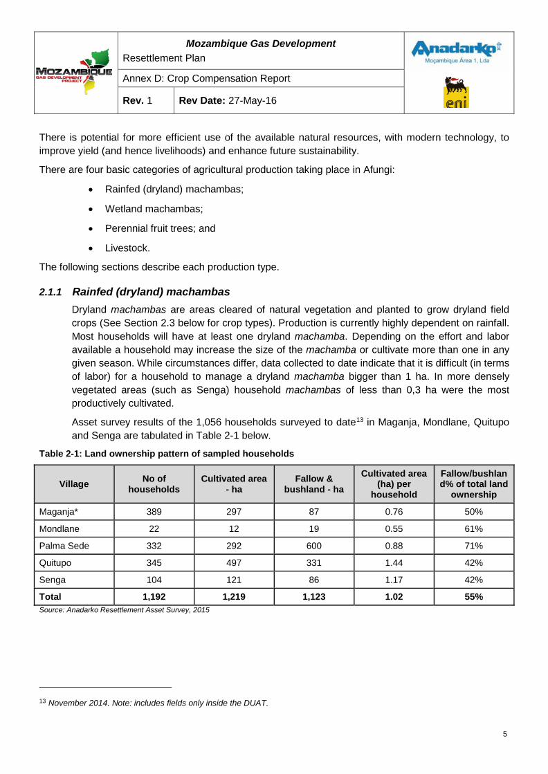
Mozambique Gas Development Resettlement Plan
Annex D: Crop Compensation Report
Rev. 1 Rev Date: 27-May-16
There is potential for more efficient use of the available natural resources, with modern technology, to improve yield (and hence livelihoods) and enhance future sustainability.
There are four basic categories of agricultural production taking place in Afungi:
• Rainfed (dryland) machambas;
• Wetland machambas;
• Perennial fruit trees; and
• Livestock.
The following sections describe each production type.
2.1.1 Rainfed (dryland) machambas Dryland machambas are areas cleared of natural vegetation and planted to grow dryland field crops (See Section 2.3 below for crop types). Production is currently highly dependent on rainfall. Most households will have at least one dryland machamba. Depending on the effort and labor available a household may increase the size of the machamba or cultivate more than one in any given season. While circumstances differ, data collected to date indicate that it is difficult (in terms of labor) for a household to manage a dryland machamba bigger than 1 ha. In more densely vegetated areas (such as Senga) household machambas of less than 0,3 ha were the most productively cultivated.
Asset survey results of the 1,056 households surveyed to date13 in Maganja, Mondlane, Quitupo and Senga are tabulated in Table 2-1 below.
Table 2-1: Land ownership pattern of sampled households
Village No of households
Cultivated area - ha
Fallow & bushland - ha
Cultivated area (ha) per
household
Fallow/bushland% of total land
ownership
Maganja* 389 297 87 0.76 50%
Mondlane 22 12 19 0.55 61%
Palma Sede 332 292 600 0.88 71%
Quitupo 345 497 331 1.44 42%
Senga 104 121 86 1.17 42%
Total 1,192 1,219 1,123 1.02 55% Source: Anadarko Resettlement Asset Survey, 2015
13 November 2014. Note: includes fields only inside the DUAT.
5
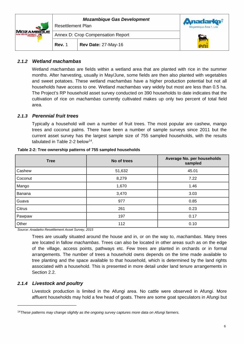
Mozambique Gas Development Resettlement Plan
Annex D: Crop Compensation Report
Rev. 1 Rev Date: 27-May-16
2.1.2 Wetland machambas Wetland machambas are fields within a wetland area that are planted with rice in the summer months. After harvesting, usually in May/June, some fields are then also planted with vegetables and sweet potatoes. These wetland machambas have a higher production potential but not all households have access to one. Wetland machambas vary widely but most are less than 0.5 ha. The Project’s RP household asset survey conducted on 390 households to date indicates that the cultivation of rice on machambas currently cultivated makes up only two percent of total field area.
2.1.3 Perennial fruit trees Typically a household will own a number of fruit trees. The most popular are cashew, mango trees and coconut palms. There have been a number of sample surveys since 2011 but the current asset survey has the largest sample size of 755 sampled households, with the results tabulated in Table 2-2 below14.
Table 2-2: Tree ownership patterns of 755 sampled households
Tree No of trees Average No. per households sampled
Cashew 51,632 45.01
Coconut 8,279 7.22
Mango 1,670 1.46
Banana 3,470 3.03
Guava 977 0.85
Citrus 261 0.23
Pawpaw 197 0.17
Other 112 0.10 Source: Anadarko Resettlement Asset Survey, 2015
Trees are usually situated around the house and in, or on the way to, machambas. Many trees are located in fallow machambas. Trees can also be located in other areas such as on the edge of the village, access points, pathways etc. Few trees are planted in orchards or in formal arrangements. The number of trees a household owns depends on the time made available to tree planting and the space available to that household, which is determined by the land rights associated with a household. This is presented in more detail under land tenure arrangements in Section 2.2.
2.1.4 Livestock and poultry Livestock production is limited in the Afungi area. No cattle were observed in Afungi. More affluent households may hold a few head of goats. There are some goat speculators in Afungi but
14These patterns may change slightly as the ongoing survey captures more data on Afungi farmers.
6
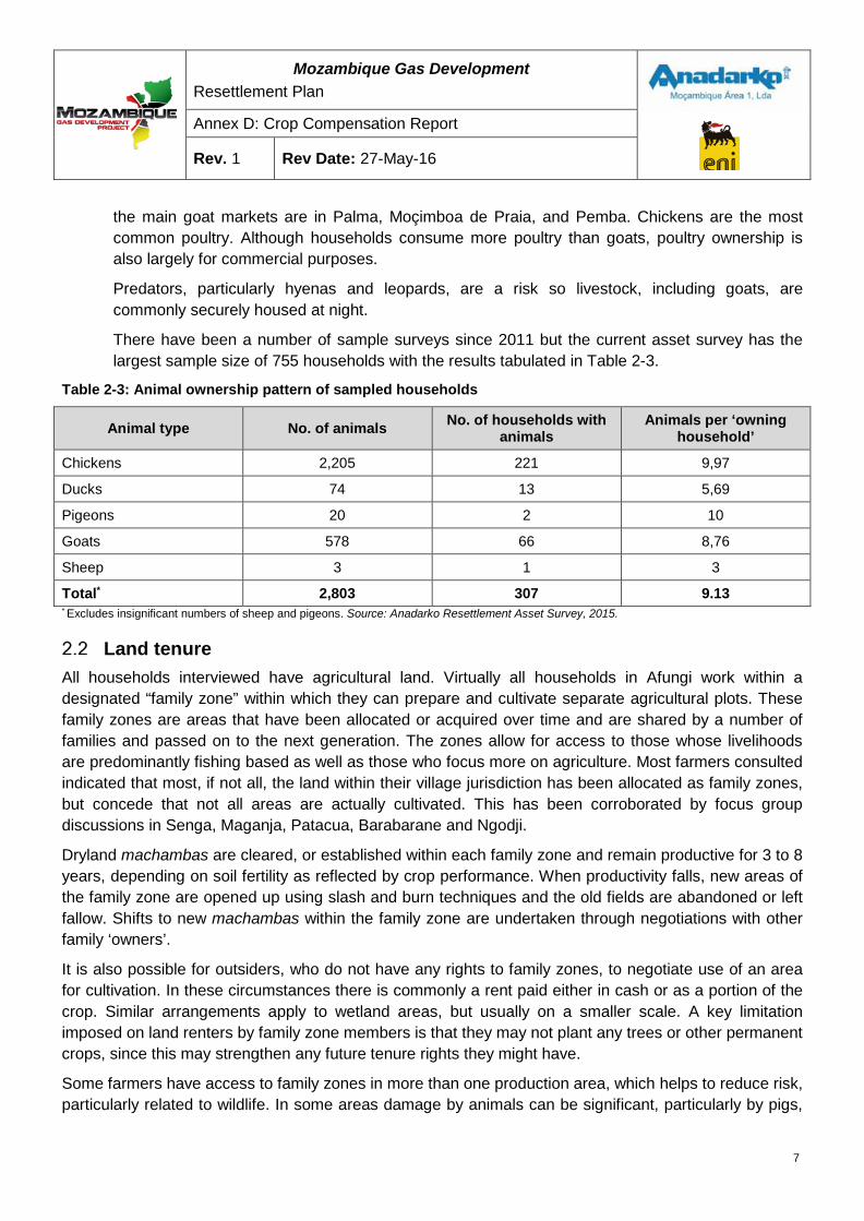
Mozambique Gas Development Resettlement Plan
Annex D: Crop Compensation Report
Rev. 1 Rev Date: 27-May-16
the main goat markets are in Palma, Moçimboa de Praia, and Pemba. Chickens are the most common poultry. Although households consume more poultry than goats, poultry ownership is also largely for commercial purposes.
Predators, particularly hyenas and leopards, are a risk so livestock, including goats, are commonly securely housed at night.
There have been a number of sample surveys since 2011 but the current asset survey has the largest sample size of 755 households with the results tabulated in Table 2-3.
Table 2-3: Animal ownership pattern of sampled households
Animal type No. of animals No. of households with animals
Animals per ‘owning household’
Chickens 2,205 221 9,97
Ducks 74 13 5,69
Pigeons 20 2 10
Goats 578 66 8,76
Sheep 3 1 3
Total* 2,803 307 9.13 * Excludes insignificant numbers of sheep and pigeons. Source: Anadarko Resettlement Asset Survey, 2015.
Land tenure All households interviewed have agricultural land. Virtually all households in Afungi work within a designated “family zone” within which they can prepare and cultivate separate agricultural plots. These family zones are areas that have been allocated or acquired over time and are shared by a number of families and passed on to the next generation. The zones allow for access to those whose livelihoods are predominantly fishing based as well as those who focus more on agriculture. Most farmers consulted indicated that most, if not all, the land within their village jurisdiction has been allocated as family zones, but concede that not all areas are actually cultivated. This has been corroborated by focus group discussions in Senga, Maganja, Patacua, Barabarane and Ngodji.
Dryland machambas are cleared, or established within each family zone and remain productive for 3 to 8 years, depending on soil fertility as reflected by crop performance. When productivity falls, new areas of the family zone are opened up using slash and burn techniques and the old fields are abandoned or left fallow. Shifts to new machambas within the family zone are undertaken through negotiations with other family ‘owners’.
It is also possible for outsiders, who do not have any rights to family zones, to negotiate use of an area for cultivation. In these circumstances there is commonly a rent paid either in cash or as a portion of the crop. Similar arrangements apply to wetland areas, but usually on a smaller scale. A key limitation imposed on land renters by family zone members is that they may not plant any trees or other permanent crops, since this may strengthen any future tenure rights they might have.
Some farmers have access to family zones in more than one production area, which helps to reduce risk, particularly related to wildlife. In some areas damage by animals can be significant, particularly by pigs,
7
Mozambique Gas Development Resettlement Plan
Annex D: Crop Compensation Report
Rev. 1 Rev Date: 27-May-16
baboons, monkeys and elephants. In Maganja, for example, farmers claim that production has been forced to move away from areas close to villages, due to monkeys and baboons, to more distant areas where these animals are less prevalent. In Patacua large production areas have had to be abandoned for periods of up to a year to make way for elephants. Households that are unable to access alternative family zones resign themselves to losses and try to minimize the impact by crop selection and vermin deterrents.
Cultivated areas associated with a particular village are not always exclusively used by farmers from that village. Although limited, there is some outside influence on land use that has developed over time. This confirms the need for most households throughout the District (including Palma town) to access a range of productive agricultural lands (which may not be available in their own settlement areas) to meet their household food requirements. For example, at Nnamba in the northern portion of Afungi the farmers who hold the family zone rights live in Palma Town and cross the river by boat daily to work in their machambas. At Simo, next to Senga, the wetlands are cultivated by some farmers from as far afield as Palma Town, Milamba and Ngodji. Some farmers who come from Palma town, Barabarane and Simo, also cultivate the large wetland areas at Ngodji.
Common crop mixes
2.3.2 Dryland machambas Dryland machambas in the Afungi area are used to cultivate a variety of crops, but most commonly cassava. According to the practice of slash and burn agriculture, newly opened lands are usually planted in the ‘first’ season with njugo beans and/or maize, particularly on the western part of Afungi where it is more climatically suitable. This practice makes best use of the soil fertility of the newly developed land. In subsequent seasons cassava is planted. Throughout Afungi it is common for cassava to be planted on its own, or mixed with secondary crops like watermelons, njugo beans and cowpea (nhemba beans). Less popular secondary crops include sesame, pigeon pea, upland rice, maize and sorghum, and tend to be limited to the western portions of DUAT where soils and climate are more suitable.
Cultivation of secondary crops tends to be limited to small portions or patches of the machamba and planted between the cassava plants. No structured planting patterns (e.g. in rows) have been observed, either for cassava or the secondary crops. No clear reasons were determined for the planting patterns and spacing. For cassava the unstructured planting ranges from 1m x 1,5m to 3m x 3,5m, depending on individual preference, with resultant plant populations ranging from less than 1 000 (one thousand) to 6 600 (six thousand six hundred) plants per hectare.
2.3.3 Wetland machambas Despite their higher fertility, wetland machambas are associated with less crop diversity than dryland machambas. Most of the potential of the wetland machambas is used during the summer rainfall months of December to June for the cultivation of rice. Small areas, where natural resources allow, are used for cultivation of higher value crops like vegetables, sweet potatoes and bananas. In such cases it is usual that only a portion of the machamba is used for this
8
Mozambique Gas Development Resettlement Plan
Annex D: Crop Compensation Report
Rev. 1 Rev Date: 27-May-16
purpose. It is also common that the user may not be the rights holder, but rents this area for the duration of the crop, which will be harvested well in time to prepare for the rice crop.
It is also a common practice to burn crop and vegetation residues before planting in wetland machambas. Although this reduces the amount of organic matter being returned to the soil it does make access and tilling of the soil easier when establishing the rice crop.
Summary of soil survey The soils in Afungi are generally sandy and poor for agricultural purposes. Current farming practices, which do not replace soil nutrients, exacerbate this situation. Cassava, coconuts, and cashews are more suited to these hot, sandy conditions, and produce better yields than most other agricultural crops. With the exception of cassava and coconuts the level of productivity is low.
The macro soil survey of the Afungi peninsular confirmed that the dominant soil is classified as Arenosols (FAO system) or Fernwood (SA binomial system). This is a grey to brownish grey single grain coarse sand (3-5% clay content) topsoil, 20-30 cm thick on a pale grey to grey single grain coarse sand (3-8% clay content) E horizon, which is more than 150 cm deep. This is essentially a greyish to pale grey horizon, which is usually paler than the overlaying topsoil. For agricultural purposes this soil has a low to very low cation exchange capacity as well as a low water holding capacity, and is classified as having low potential.
Within this classification there are pockets of soils, mostly along the western boundary also classified as Fernwood with a more brownish grey color in the upper 80-100 cm, with a pale grey E underneath. Due to the more brownish color in the top 80-100 cm (organic carbon content), these soils will have a slightly higher cation exchange capacity and have a slightly higher agricultural potential.
Found almost exclusively in the western, especially south western, portion of the DUAT there are three types of soils with higher agricultural potential. In order of decreasing agricultural potential these are:
I. Acrisols and Ferisols (FAO) or Hutton and Griffen (SA) – These red soils are the best for agricultural purposes in the surveyed area. The soils have higher clay content, giving it good water holding capacity as well as high to moderate cation exchange capacity.
II. Ferric acrisols, or Clovelly – These soils have a moderate agricultural potential. They have brown sub-soil color, showing little evidence of leaching. The clay content of the sub soil is high enough to have good water holding capacity, as well as a moderate cation exchange capacity.
III. Albisols, or Constantia –These soils can be regarded as the sub-dominant soils of the surveyed area. These soils have a moderate to low agricultural potential. The more brownish sub soil has a slight to moderate higher clay content than the dominant sandy soils of the area. Slight leaching has taken place in the brown colored horizon and the agricultural potential can be regarded as moderate to low.
The wetlands are classified as Planosols and Plinthic Arenosols, or Kroonstad and Longlands. These areas are utilized mainly for rice production, with limited vegetable production during the dry winter season. In these wetland areas the most dominant of the soils has grey topsoil 20-40 cm thick with a pale grey E horizon of 80-100 cm on a poorly developed gleyed/plinthic horizon. These soils are
9
Mozambique Gas Development Resettlement Plan
Annex D: Crop Compensation Report
Rev. 1 Rev Date: 27-May-16
generally waterlogged or have poor drainage. The amount of organic carbon in the profile, (from burning and decomposition), will influence crop yields.
3 CURRENT YIELDS
Yields obtained through own sampling Between May and September 2013 around 70 households were selected to carry out more in-depth research into Afungi agricultural activities. Interviews were conducted with households in the presence of the village Chief of Production or a Community Representative, both of whom are familiar with agricultural practices. Through a combination of structured questions, group discussions and in-field observations and measurements, average crop yields have been determined for the 70 households sampled. The ‘Afungi estimates column’ in Table 3.2 later in this section represents the general level of productivity in the Afungi area derived from the sample survey.
To help verify the accuracy of collected information various other sources were also consulted. The most useful of these included:
• Discussions with Department of Agriculture (Palma and Pemba) Officials;
• Department of Agriculture Quarterly Agricultural Report for Cabo Delgado, 2012;
• The Project EIA15;
• IFPRI Report – Agricultural Growth and Poverty in Mozambique – Technical Analysis in Support of the Comprehensive Africa Agricultural Development Program, 2012;
• Department of Agriculture Strategic Plan for Agricultural Development – PEDSA 2010- 2019.
Qualification Information obtained from the Project’s sampling survey varied widely. Care was taken to ensure the accuracy of information by involving the Chiefs of Production and Community Representatives in the interviews and discussion. But while useful qualitative data was collected from this process, and despite the support from village Chiefs of Production / Community representatives, quantitative data was more difficult to obtain. Attempts were made through cross-reference questioning to determine accuracy of responses. However, much of the information supplied by the households relies on their perceptions, understanding and honesty.
Some variations reported can be attributed to communication constraints, low literacy and numeracy levels, relying on recollections or yield records of previous seasons, the seasonality of production, and non-standard units of measure and bartering, but many variations in data reported is due to household individuality. Although the natural resources across Afungi are broadly similar, the ways in which households use these natural resources differ considerably. Some households are female headed (with less available household labor), some focus on fishing as their main livelihood, others adopt a more
15Anadarko document EA-MZ-SR0100-ERM-U17-00001-00 Environmental Impact Assessment (EIA) Report for the Liquefied Natural Gas Project in Cabo Delgado Rev.0 24 Feb 2014
10
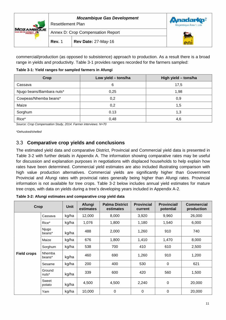
Mozambique Gas Development Resettlement Plan
Annex D: Crop Compensation Report
Rev. 1 Rev Date: 27-May-16
commercial/production (as opposed to subsistence) approach to production. As a result there is a broad range in yields and productivity. Table 3-1 provides ranges recorded for the farmers sampled:
Table 3-1: Yield ranges for sampled farmers in Afungi
Crop Low yield – tons/ha High yield – tons/ha
Cassava 6 17,5
Njugo beans/Bambara nuts* 0,25 1,98
Cowpeas/Nhemba beans* 0,2 0,9
Maize 0,2 1,5
Sorghum 0.13 1,3
Rice* 0,48 4,6 Source: Crop Compensation Study, 2014. Farmer interviews: N=70
*Dehusked/shelled
Comparative crop yields and conclusions The estimated yield data and comparative District, Provincial and Commercial yield data is presented in Table 3-2 with further details in Appendix A. The information showing comparative rates may be useful for discussion and explanation purposes in negotiations with displaced households to help explain how rates have been determined. Commercial yield estimates are also included illustrating comparison with high value production alternatives. Commercial yields are significantly higher than Government Provincial and Afungi rates with provincial rates generally being higher than Afungi rates. Provincial information is not available for tree crops. Table 3-2 below includes annual yield estimates for mature tree crops, with data on yields during a tree’s developing years included in Appendix A-2.
Table 3-2: Afungi estimates and comparative crop yield data
Crop Unit Afungi estimates
Palma District estimates
Provincial current
Provincial/ potential
Commercial production
Field crops
Cassava kg/ha 12,000 8,000 3,920 9,960 26,000
Rice* kg/ha 1,076 1,800 1,180 1,540 6,000
Njugo beans* kg/ha 488 2,000 1,260 910 740
Maize kg/ha 676 1,800 1,410 1,470 8,000
Sorghum kg/ha 538 700 410 610 2,500
Nhemba beans* kg/ha 460 690 1,260 910 1,200
Sesame kg/ha 200 400 530 0 621
Ground nuts* kg/ha 339 600 420 560 1,500
Sweet potato kg/ha 4,500 4,500 2,240 0 20,000
Yam kg/ha 10,000 0 0 0 20,000
11
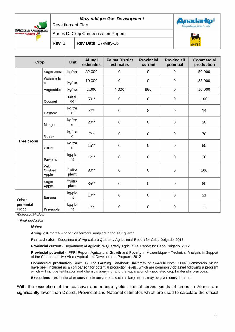
Mozambique Gas Development Resettlement Plan
Annex D: Crop Compensation Report
Rev. 1 Rev Date: 27-May-16
Crop Unit Afungi estimates
Palma District estimates
Provincial current
Provincial/ potential
Commercial production
Sugar cane kg/ha 32,000 0 0 0 50,000
Watermelon kg/ha 10,000 0 0 0 35,000
Vegetables kg/ha 2,000 4,000 960 0 10,000
Tree crops
Coconut nuts/tr
ee 50** 0 0 0 100
Cashew kg/tre
e 4** 0 8 0 14
Mango kg/tre
e 20** 0 0 0 20
Guava kg/tre
e 7** 0 0 0 70
Citrus kg/tre
e 15** 0 0 0 85
Pawpaw kg/pla
nt 12** 0 0 0 26
Wild Custard Apple
fruits/plant
30** 0 0 0 100
Sugar Apple
fruits/plant 35** 0 0 0 80
Other perennial crops
Banana kg/pla
nt 10** 0 0 0 21
Pineapple kg/pla
nt 1** 0 0 0 1
*Dehusked/shelled.
** Peak production
Notes:
Afungi estimates – based on farmers sampled in the Afungi area
Palma district – Department of Agriculture Quarterly Agricultural Report for Cabo Delgado, 2012
Provincial current - Department of Agriculture Quarterly Agricultural Report for Cabo Delgado, 2012
Provincial potential - IFPRI Report. Agricultural Growth and Poverty in Mozambique – Technical Analysis in Support of the Comprehensive Africa Agricultural Development Program, 2012;
Commercial production–Smith. B, The Farming Handbook University of KwaZulu-Natal, 2006. Commercial yields have been included as a comparison for potential production levels, which are commonly obtained following a program which will include fertilization and chemical spraying, and the application of associated crop husbandry practices.
Exceptions – exceptional or unusual circumstances, such as large trees, may be given consideration.
With the exception of the cassava and mango yields, the observed yields of crops in Afungi are significantly lower than District, Provincial and National estimates which are used to calculate the official
12
Mozambique Gas Development Resettlement Plan
Annex D: Crop Compensation Report
Rev. 1 Rev Date: 27-May-16
Government compensation rates (discussed further in Section5). This confirms the difficult local conditions, particularly:
• The harsh coastal climate with dry a winter season extending from May to September,
• Irregular summer rainfall,
• Poor sandy infertile soils,
• Low replacement of soil nutrients, and
• Traditional labor-intensive cultivation methods that lacks any production inputs such as mechanization, fertilizer, chemicals etc.
4 PRICE ANALYSIS
Prices available Price information was obtained from three different sources to allow for validation and comparative purposes. Firstly, the official government compensation rates, issued by the Cabo Delgado Provincial Department of Agriculture for agricultural products in January 2014, have been used as a benchmark against which other prices, yields, and rates are compared.
The second source of prices is the producers themselves. Active trading of agricultural products takes place across Afungi. Because almost all households are both producing and buying agricultural products there is generally good knowledge around pricing. Price information was collected at the time the initial sampling was conducted (May-September 2013) and updated via farmer focus groups conducted in February and March 2014.
The third source of pricing information is local and provincial markets. Since April 2013 market prices of basic agricultural products have been monitored. As expected in market places, where there are several sellers and many buyers, there is less price fluctuation at the market place than at the farm or household level.
Methods of price collection
4.2.2 Price information from farmers As with the collection of data on yields the prices farmers receive for their crops was obtained through direct interviews and group discussions. Although there is less variation in pricing compared with yields, price information did vary. This can be attributed to a number of factors:
• Individual negotiating skills and circumstances,
• Seasonality, and
• Bartering
In addition to recording verbal responses, the calculation of prices for widely used but non-standard units of measure, such as bags, buckets and baskets, were also carried out with the aid
13
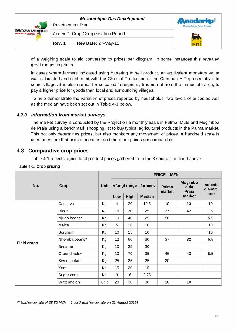
Mozambique Gas Development Resettlement Plan
Annex D: Crop Compensation Report
Rev. 1 Rev Date: 27-May-16
of a weighing scale to aid conversion to prices per kilogram. In some instances this revealed great ranges in prices.
In cases where farmers indicated using bartering to sell product, an equivalent monetary value was calculated and confirmed with the Chief of Production or the Community Representative. In some villages it is also normal for so-called ‘foreigners’, traders not from the immediate area, to pay a higher price for goods than local and surrounding villages.
To help demonstrate the variation of prices reported by households, two levels of prices as well as the median have been set out in Table 4-1 below.
4.2.3 Information from market surveys The market survey is conducted by the Project on a monthly basis in Palma, Mute and Moçimboa de Praia using a benchmark shopping list to buy typical agricultural products in the Palma market. This not only determines prices, but also monitors any movement of prices. A handheld scale is used to ensure that units of measure and therefore prices are comparable.
Comparative crop prices Table 4-1 reflects agricultural product prices gathered from the 3 sources outlined above.
Table 4-1: Crop pricing16
No. Crop Unit
PRICE – MZN
Afungi range - farmers Palma market
Moçimboa da Praia
market
Indicated Govt.
rate Low High Median
Field crops
Cassava Kg 4 20 12.5 10 13 10
Rice* Kg 16 30 25 37 42 25
Njugo beans* Kg 10 40 25 50
5.5
Maize Kg 5 18 10
13
Sorghum Kg 10 15 10
16
Nhemba beans* Kg 12 60 30 37 32 5.5
Sesame Kg 10 35 30
Ground nuts* Kg 10 70 35 46 43 5.5
Sweet potato Kg 25 25 25 20
Yam Kg 15 20 15
Sugar cane Kg 3 6 3.75
Watermelon Unit 20 30 30 18 10
16 Exchange rate of 38.80 MZN = 1 USD (exchange rate on 21 August 2015)
14
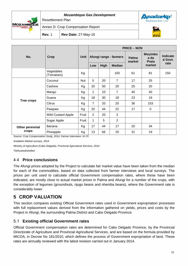
Mozambique Gas Development Resettlement Plan
Annex D: Crop Compensation Report
Rev. 1 Rev Date: 27-May-16
No. Crop Unit
PRICE – MZN
Afungi range - farmers Palma market
Moçimboa da Praia
market
Indicated Govt.
rate Low High Median
Vegetables (Tomatoes) Kg
150 61 81 150
Tree crops
Coconut Nut 5 20 7 17 25
Cashew Kg 20 50 20 25 20
Mango Kg 1 10 7 40 40
Guava Kg 18 30 18 23 19
Citrus Kg 7 33 20 36 153
Pawpaw Kg 20 44 22 17 0
Wild Custard Apple Fruit 2 20 3
Sugar Apple Fruit 1 5 2
Other perennial crops
Banana Kg 17 44 17 20 34
Pineapple Kg 13 66 20 31 19 Source: Crop Compensation Study, 2014. Farmer interviews: N=70
Anadarko Market surveys, 2014
Ministry of Agriculture (Cabo Delgado), Provincial Agricultural Services, 2014
*Dehusked/shelled
Price conclusions The Afungi prices adopted by the Project to calculate fair market value have been taken from the median for each of the commodities, based on data collected from farmer interviews and local surveys. The prices per unit used to calculate official Government compensation rates, where these have been indicated, are mostly close to actual market prices in Palma and Afungi for a number of the crops, with the exception of legumes (groundnuts, njugo beans and nhemba beans), where the Government rate is considerably lower.
5 CROP VALUATION This section compares existing Official Government rates used in Government expropriation processes with full replacement values derived from the information gathered on yields, prices and costs by the Project in Afungi, the surrounding Palma District and Cabo Delgado Province.
Existing official Government rates Official Government compensation rates are determined for Cabo Delgado Province, by the Provincial Directorate of Agriculture and Provincial Agricultural Services, and are based on the formula provided by MICOA, in Decree No 181/2010, which defines the process of Government expropriation of land. These rates are annually reviewed with the latest revision carried out in January 2014.
15
Mozambique Gas Development Resettlement Plan
Annex D: Crop Compensation Report
Rev. 1 Rev Date: 27-May-16
Since 2012, the Project has made compensation payments to households for impacts related to exploratory seismic activity using these Cabo Delgado Provincial Government rates.
For annual crops the Government compensation rate is based on the yield per hectare multiplied by the area under production, multiplied by the market value of the commodity, multiplied by a discretionary factor of 0 to 1 to account for specific local conditions and circumstances such as the state of the plant, soil conditions, spacing, and management. More specific detail on the Government compensation equation for annual crops is included in Appendix A-4.
The government compensation rate includes a so-called ‘annual loss coefficient’, or annual value, multiplied by five for compensation for perennial tree crops. The rate is multiplied by five to allow time for replanted tree crops to reach economic17production over five years. No consideration of the time value of money has been applied in the calculation of any of the government rates. The current compensation rates for tree crops adopted by the Project since seismic studies commenced in 2012 are based on this approach. The seismic compensation guidelines18 specify the following:
“Permanent crops, fruit trees and other valuable trees are usually medium and long term productive assets. Its overall damage represents a physical loss of such assets. To compensate such loss the Project must pay the property owner for loss of annual income for a period of 5 (five) years and must supply new plants or instead must cover the costs for the purchase of new replacement plants and necessary material for farming. Compensated households are in charge of planting and looking after the replacement trees.
Compensation pertaining to loss of permanent or harvested tree crops will be determined according to the standard unit prices established by the Provincial Directorate of Agriculture applied to the area holding permanent crops or the number of trees affected."
Valuation summary: annual crops Valuation for full replacement cost is determined by multiplying average yields for the area by fair producer, or local market prices, less any production costs. Account should be taken of the production systems used by the community/households being compensated.
However, as indicated earlier, virtually no inputs are used in most agricultural production apart from labor. Furthermore, household labor, especially provided by women and children, has no regular alternative or opportunity cost. It is common for extended family members and community members to assist a household during peak labor demand periods such as planting and harvesting. While this is a cost, which is often paid by a share of the crop, the cost is redeemed when that household provides other or comparable assistance in return, and is similarly rewarded by crop sharing or equivalent.
In theory, a small opportunity cost for labor does now exist where agricultural production may be weighed up against opportunities arising from the advent of the Project and other commercial activities now available to Afungi households. However, these are limited and irregular opportunities so a more conservative approach has been adopted.
17 Deemed to be the cumulative value for period until the tree reaches mature production. 18Compensation for physical loss of permanent crops and trees. Seismic Acquisition Program, Mozambique 2012, Compensation Guidelines, AMA1, December 2011
16
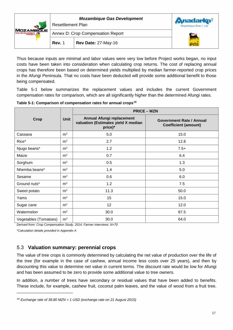
Mozambique Gas Development Resettlement Plan
Annex D: Crop Compensation Report
Rev. 1 Rev Date: 27-May-16
Thus because inputs are minimal and labor values were very low before Project works began, no input costs have been taken into consideration when calculating crop returns. The cost of replacing annual crops has therefore been based on determined yields multiplied by median farmer-reported crop prices in the Afungi Peninsula. That no costs have been deducted will provide some additional benefit to those being compensated.
Table 5-1 below summarizes the replacement values and includes the current Government compensation rates for comparison, which are all significantly higher than the determined Afungi rates.
Table 5-1: Comparison of compensation rates for annual crops19
Crop Unit
PRICE – MZN
Annual Afungi replacement valuation (Estimates yield X median
price)* Government Rate / Annual
Coefficient (amount)
Cassava m2 5.0 15.0
Rice* m2 2.7 12.8
Njugo beans* m2 1.2 7.5+
Maize m2 0.7 6.4
Sorghum m2 0.5 1.3
Nhemba beans* m2 1.4 5.0
Sesame m2 0.6 6.0
Ground nuts* m2 1.2 7.5
Sweet potato m2 11.3 50.0
Yams m2 15 15.0
Sugar cane m2 12 12.0
Watermelon m2 30.0 87.5
Vegetables (Tomatoes) m2 30.0 64.0 Derived from: Crop Compensation Study, 2014. Farmer interviews: N=70
*Calculation details provided in Appendix A
Valuation summary: perennial crops The value of tree crops is commonly determined by calculating the net value of production over the life of the tree (for example in the case of cashew, annual income less costs over 25 years), and then by discounting this value to determine net value in current terms. The discount rate would be low for Afungi and has been assumed to be zero to provide some additional value to tree owners.
In addition, a number of trees have secondary or residual values that have been added to benefits. These include, for example, cashew fruit, coconut palm leaves, and the value of wood from a fruit tree.
19 Exchange rate of 38.80 MZN = 1 USD (exchange rate on 21 August 2015)
17
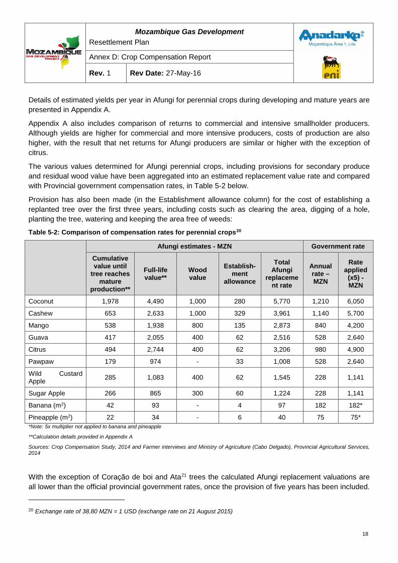
Mozambique Gas Development Resettlement Plan
Annex D: Crop Compensation Report
Rev. 1 Rev Date: 27-May-16
Details of estimated yields per year in Afungi for perennial crops during developing and mature years are presented in Appendix A.
Appendix A also includes comparison of returns to commercial and intensive smallholder producers. Although yields are higher for commercial and more intensive producers, costs of production are also higher, with the result that net returns for Afungi producers are similar or higher with the exception of citrus.
The various values determined for Afungi perennial crops, including provisions for secondary produce and residual wood value have been aggregated into an estimated replacement value rate and compared with Provincial government compensation rates, in Table 5-2 below.
Provision has also been made (in the Establishment allowance column) for the cost of establishing a replanted tree over the first three years, including costs such as clearing the area, digging of a hole, planting the tree, watering and keeping the area free of weeds:
Table 5-2: Comparison of compensation rates for perennial crops20
Afungi estimates - MZN Government rate
Cumulative value until
tree reaches mature
production**
Full-life value**
Wood value
Establish-ment
allowance
Total Afungi
replacement rate
Annual rate – MZN
Rate applied (x5) - MZN
Coconut 1,978 4,490 1,000 280 5,770 1,210 6,050
Cashew 653 2,633 1,000 329 3,961 1,140 5,700
Mango 538 1,938 800 135 2,873 840 4,200
Guava 417 2,055 400 62 2,516 528 2,640
Citrus 494 2,744 400 62 3,206 980 4,900
Pawpaw 179 974 - 33 1,008 528 2,640
Wild Custard Apple 285 1,083 400 62 1,545 228 1,141
Sugar Apple 266 865 300 60 1,224 228 1,141
Banana (m2) 42 93 - 4 97 182 182*
Pineapple (m2) 22 34 - 6 40 75 75* *Note: 5x multiplier not applied to banana and pineapple
**Calculation details provided in Appendix A
Sources: Crop Compensation Study, 2014 and Farmer interviews and Ministry of Agriculture (Cabo Delgado), Provincial Agricultural Services, 2014
With the exception of Coração de boi and Ata21 trees the calculated Afungi replacement valuations are all lower than the official provincial government rates, once the provision of five years has been included.
20 Exchange rate of 38.80 MZN = 1 USD (exchange rate on 21 August 2015)
18
Mozambique Gas Development Resettlement Plan
Annex D: Crop Compensation Report
Rev. 1 Rev Date: 27-May-16
Part of the difference can be attributed to the difficult variable climate, poor soil conditions and production methods that result in low yields for most crops. Further details of the calculations are included in the calculation table in Appendix A22.
Valuation conclusion Yields in Afungi vary widely but are reflective of the difficult climate and agricultural conditions. Prices also vary considerably but are linked to the seasonality of production, limited storage capacity for many of the crops, and marketing costs. There is active trading of agricultural commodities within Afungi and with villages and towns.
Although the Afungi rates differ, in some cases substantially, from the official government rates (Ministry of Agriculture for Cabo Delgado), both yield and pricing used to determine the Afungi compensation rates are considered fair and reflect market replacement values. Perennial crop valuations have been based on aggregated net income streams over the productive life of a tree crop with data gathered from farmers and farming activity in Afungi and greater Palma area. They include an assessment of commercial and smallholder performance for similar crops. This aggregated income also includes additional benefit streams such as cashew fruit, coconut palm leaves, and a value for the wood component of the tree at the end its useful life. A further modest allowance is provided for the cost of establishing the planted tree – clearing a space, digging a hole, planting the tree, watering, cleaning and maintenance for a three year period. Details of these calculations are provided in Appendix A.
Foraging An assessment has been undertaken to identify the forest resources used by communities in Afungi (reference report ‘Forest Resource Use in Households in Afungi DUAT.’ Document No. EA-MZ-SR0000-RRG-U17-00009-00, 14/05/2014). Generally these are firewood, poles and other building materials, wild fruits, weaving materials and bush meat. Less important foraging activities include honey extraction, wood carving and bamboo collection.
With the exception of wood gathering for fuel, and harvesting of poles and roofing material, foraging is not a major livelihood activity. Compensation for communal resources will be provided through access to replacement foraging land to be provided by the government, or through access to adjoining lands with similar resources or communal development and mitigation projects. No individual compensation will be paid.
6 CONCLUSION AND RECOMMENDATIONS The Afungi Peninsula has low agricultural production potential compared to the rest of Cabo Delgado Province owing to a harsher climate and sandy soils poor in nutrients, structure and water holding capacity. Following an investigation into the agricultural potential and practices by farming households in Afungi and identification of yields and produce prices, representative market related compensation rates
21 A liberal approach has been adopted in valuing Wild Custard Apple and Ateira trees as there is a scarcity of information, especially under commercial or cultivated conditions. 22Note: Information from Provincial Department of Agriculture still awaited detailing assumptions adopted for calculation of compensation rates.
19
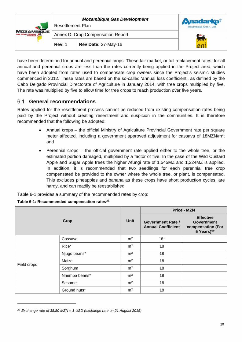
Mozambique Gas Development Resettlement Plan
Annex D: Crop Compensation Report
Rev. 1 Rev Date: 27-May-16
have been determined for annual and perennial crops. These fair market, or full replacement rates, for all annual and perennial crops are less than the rates currently being applied in the Project area, which have been adopted from rates used to compensate crop owners since the Project’s seismic studies commenced in 2012. These rates are based on the so-called ‘annual loss coefficient’, as defined by the Cabo Delgado Provincial Directorate of Agriculture in January 2014, with tree crops multiplied by five. The rate was multiplied by five to allow time for tree crops to reach production over five years.
General recommendations Rates applied for the resettlement process cannot be reduced from existing compensation rates being paid by the Project without creating resentment and suspicion in the communities. It is therefore recommended that the following be adopted:
• Annual crops – the official Ministry of Agriculture Provincial Government rate per square meter affected, including a government approved adjustment for cassava of 18MZN/m2; and
• Perennial crops – the official government rate applied either to the whole tree, or the estimated portion damaged, multiplied by a factor of five. In the case of the Wild Custard Apple and Sugar Apple trees the higher Afungi rate of 1,545MZ and 1,224MZ is applied. In addition, it is recommended that two seedlings for each perennial tree crop compensated be provided to the owner where the whole tree, or plant, is compensated. This excludes pineapples and banana as these crops have short production cycles, are hardy, and can readily be reestablished.
Table 6-1 provides a summary of the recommended rates by crop: Table 6-1: Recommended compensation rates23
Crop Unit
Price - MZN
Government Rate / Annual Coefficient
Effective Government
compensation (For 5 Years)**
Field crops
Cassava m2 18+
Rice* m2 18
Njugo beans* m2 18
Maize m2 18
Sorghum m2 18
Nhemba beans* m2 18
Sesame m2 18
Ground nuts* m2 18
23 Exchange rate of 38.80 MZN = 1 USD (exchange rate on 21 August 2015)
20
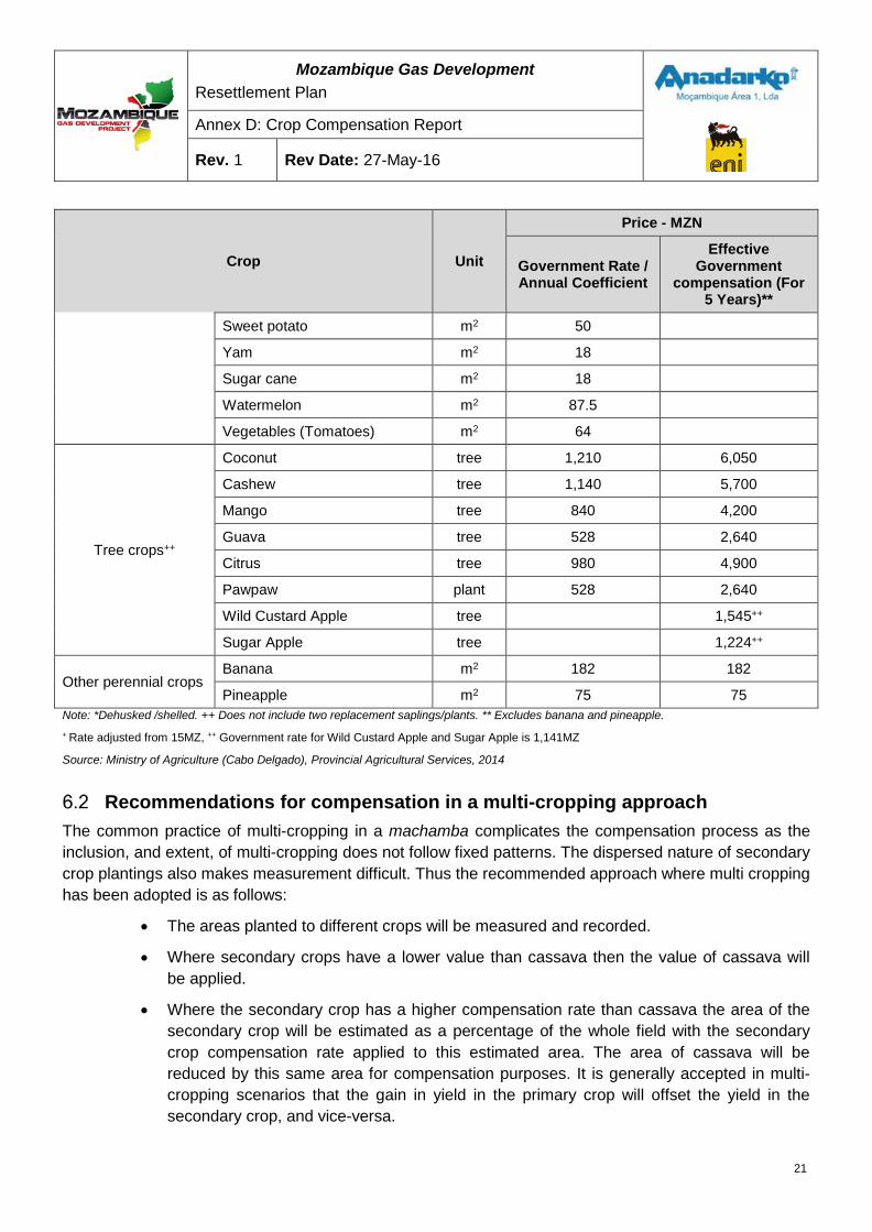
Mozambique Gas Development Resettlement Plan
Annex D: Crop Compensation Report
Rev. 1 Rev Date: 27-May-16
Crop Unit
Price - MZN
Government Rate / Annual Coefficient
Effective Government
compensation (For 5 Years)**
Sweet potato m2 50
Yam m2 18
Sugar cane m2 18
Watermelon m2 87.5
Vegetables (Tomatoes) m2 64
Tree crops++
Coconut tree 1,210 6,050
Cashew tree 1,140 5,700
Mango tree 840 4,200
Guava tree 528 2,640
Citrus tree 980 4,900
Pawpaw plant 528 2,640
Wild Custard Apple tree 1,545++
Sugar Apple tree 1,224++
Other perennial crops Banana m2 182 182
Pineapple m2 75 75 Note: *Dehusked /shelled. ++ Does not include two replacement saplings/plants. ** Excludes banana and pineapple. + Rate adjusted from 15MZ, ++ Government rate for Wild Custard Apple and Sugar Apple is 1,141MZ
Source: Ministry of Agriculture (Cabo Delgado), Provincial Agricultural Services, 2014
Recommendations for compensation in a multi-cropping approach The common practice of multi-cropping in a machamba complicates the compensation process as the inclusion, and extent, of multi-cropping does not follow fixed patterns. The dispersed nature of secondary crop plantings also makes measurement difficult. Thus the recommended approach where multi cropping has been adopted is as follows:
• The areas planted to different crops will be measured and recorded.
• Where secondary crops have a lower value than cassava then the value of cassava will be applied.
• Where the secondary crop has a higher compensation rate than cassava the area of the secondary crop will be estimated as a percentage of the whole field with the secondary crop compensation rate applied to this estimated area. The area of cassava will be reduced by this same area for compensation purposes. It is generally accepted in multi-cropping scenarios that the gain in yield in the primary crop will offset the yield in the secondary crop, and vice-versa.
21
Mozambique Gas Development Resettlement Plan
Annex D: Crop Compensation Report
Rev. 1 Rev Date: 27-May-16
In circumstances where fruit trees are situated in a cultivated area this should not have any material effect on the production of the tree or the crop, and compensation should be treated accordingly.
Recommendations on the escalation of valuations Project activities that may impact agricultural production are expected to take several years. During this time general development in the area may result in inflation and other expansion adjustments.
It is proposed that the compensation rates, for both Afungi and official Ministry of Agriculture for Cabo Delgado, are reviewed on an annual basis to take into account inflation and other relevant trends, which should, at least reflect the general Consumer Price Index. The next review should be undertaken in June 2015.
Tree maturity considerations Consideration of tree maturity should only be relevant for fruit trees, as other agricultural crops are cultivated and harvested within a single season. Official Government compensation rates make a simple distinction for fruit tree maturity between new plants and plants in production. The tables above have included values for trees in full production for comparison purposes, but it is recommended that the Project adopts the same ratios for new plants as identified in the Government rates. The ratio of new plants (immature trees) to plants in production (mature trees) are provided in Table 6-2.The Afungi asset survey questionnaire captures information on mature and immature trees as well as seedlings.
Table 6-2: Compensation ratio for immature trees
Tree crop Ratio of immature to mature trees
Coconut 69%
Cashew 64%
Mango 63%
Guava 22%
Citrus 10%
Pawpaw 35%
To simplify the compensation process, but avoid speculation, it is recommended that:
• Only trees established before the project cut-off date24will qualify for compensation;
• Only trees identified and captured in the asset survey will qualify for compensation;
• Qualifying trees will be assessed for compensation according to the classification as captured in the asset survey; and
• Additional compensation may be considered in exceptional or unusual circumstances, such as for unusually large trees.
24An official date will need to be confirmed and acknowledged by all affected parties
22

Mozambique Gas Development Resettlement Plan
Annex D: Crop Compensation Report
Rev. 1 Rev Date: 27-May-16
Other considerations Compensation will only be paid for standing crops and will be paid only for crops properly rooted, to discourage speculation.
In situations where there is a delay in the provision of alternative replacement land or in the process of re-establishing crops, then additional compensation measures should be identified, as determined by each particular situation but could, for example, include the provision of food vouchers.
23
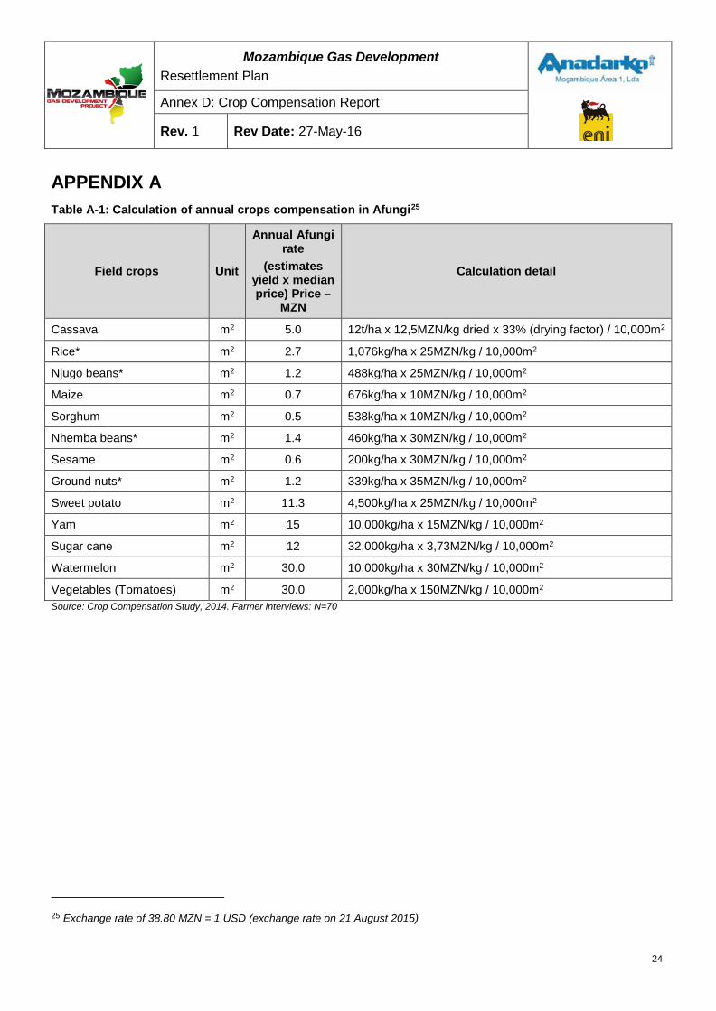
Mozambique Gas Development Resettlement Plan
Annex D: Crop Compensation Report
Rev. 1 Rev Date: 27-May-16
APPENDIX A Table A-1: Calculation of annual crops compensation in Afungi25
Field crops Unit
Annual Afungi rate
(estimates yield x median price) Price –
MZN
Calculation detail
Cassava m2 5.0 12t/ha x 12,5MZN/kg dried x 33% (drying factor) / 10,000m2
Rice* m2 2.7 1,076kg/ha x 25MZN/kg / 10,000m2
Njugo beans* m2 1.2 488kg/ha x 25MZN/kg / 10,000m2
Maize m2 0.7 676kg/ha x 10MZN/kg / 10,000m2
Sorghum m2 0.5 538kg/ha x 10MZN/kg / 10,000m2
Nhemba beans* m2 1.4 460kg/ha x 30MZN/kg / 10,000m2
Sesame m2 0.6 200kg/ha x 30MZN/kg / 10,000m2
Ground nuts* m2 1.2 339kg/ha x 35MZN/kg / 10,000m2
Sweet potato m2 11.3 4,500kg/ha x 25MZN/kg / 10,000m2
Yam m2 15 10,000kg/ha x 15MZN/kg / 10,000m2
Sugar cane m2 12 32,000kg/ha x 3,73MZN/kg / 10,000m2
Watermelon m2 30.0 10,000kg/ha x 30MZN/kg / 10,000m2
Vegetables (Tomatoes) m2 30.0 2,000kg/ha x 150MZN/kg / 10,000m2 Source: Crop Compensation Study, 2014. Farmer interviews: N=70
25 Exchange rate of 38.80 MZN = 1 USD (exchange rate on 21 August 2015)
24
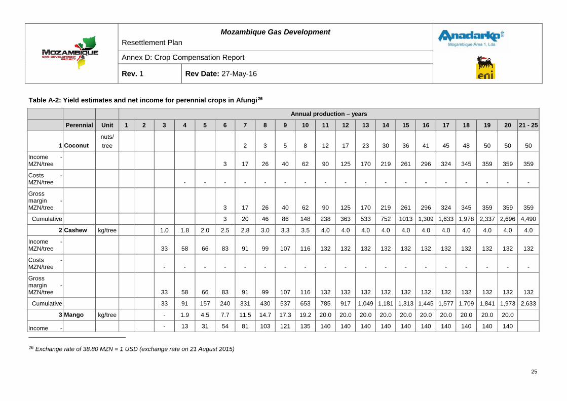
Mozambique Gas Development Resettlement Plan
Annex D: Crop Compensation Report
Rev. 1 Rev Date: 27-May-16
Table A-2: Yield estimates and net income for perennial crops in Afungi26
Annual production – years
Perennial Unit 1 2 3 4 5 6 7 8 9 10 11 12 13 14 15 16 17 18 19 20 21 - 25
1 Coconut nuts/ tree
2 3 5 8 12 17 23 30 36 41 45 48 50 50 50
Income - MZN/tree 3 17 26 40 62 90 125 170 219 261 296 324 345 359 359 359
Costs - MZN/tree - - - - - - - - - - - - - - - - - -
Gross margin - MZN/tree 3 17 26 40 62 90 125 170 219 261 296 324 345 359 359 359
Cumulative
3 20 46 86 148 238 363 533 752 1013 1,309 1,633 1,978 2,337 2,696 4,490
2 Cashew kg/tree
1.0 1.8 2.0 2.5 2.8 3.0 3.3 3.5 4.0 4.0 4.0 4.0 4.0 4.0 4.0 4.0 4.0 4.0 4.0
Income - MZN/tree 33 58 66 83 91 99 107 116 132 132 132 132 132 132 132 132 132 132 132
Costs - MZN/tree - - - - - - - - - - - - - - - - - - -
Gross margin - MZN/tree 33 58 66 83 91 99 107 116 132 132 132 132 132 132 132 132 132 132 132
Cumulative
33 91 157 240 331 430 537 653 785 917 1,049 1,181 1,313 1,445 1,577 1,709 1,841 1,973 2,633
3 Mango kg/tree - 1.9 4.5 7.7 11.5 14.7 17.3 19.2 20.0 20.0 20.0 20.0 20.0 20.0 20.0 20.0 20.0 20.0
Income - - 13 31 54 81 103 121 135 140 140 140 140 140 140 140 140 140 140
26 Exchange rate of 38.80 MZN = 1 USD (exchange rate on 21 August 2015)
25
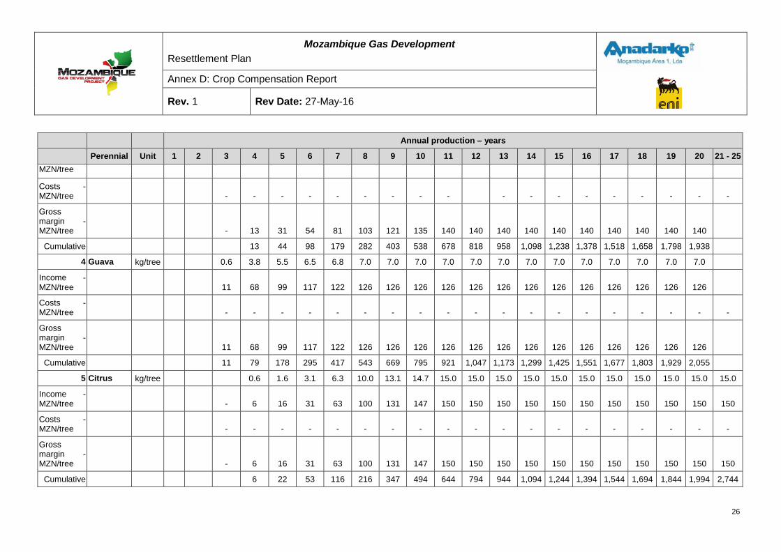
Mozambique Gas Development Resettlement Plan
Annex D: Crop Compensation Report
Rev. 1 Rev Date: 27-May-16
Annual production – years
Perennial Unit 1 2 3 4 5 6 7 8 9 10 11 12 13 14 15 16 17 18 19 20 21 - 25 MZN/tree
Costs - MZN/tree - - - - - - - - - - - - - - - - - -
Gross margin - MZN/tree - 13 31 54 81 103 121 135 140 140 140 140 140 140 140 140 140 140
Cumulative
13 44 98 179 282 403 538 678 818 958 1,098 1,238 1,378 1,518 1,658 1,798 1,938
4 Guava kg/tree 0.6 3.8 5.5 6.5 6.8 7.0 7.0 7.0 7.0 7.0 7.0 7.0 7.0 7.0 7.0 7.0 7.0 7.0
Income - MZN/tree 11 68 99 117 122 126 126 126 126 126 126 126 126 126 126 126 126 126
Costs - MZN/tree - - - - - - - - - - - - - - - - - - -
Gross margin - MZN/tree 11 68 99 117 122 126 126 126 126 126 126 126 126 126 126 126 126 126
Cumulative 11 79 178 295 417 543 669 795 921 1,047 1,173 1,299 1,425 1,551 1,677 1,803 1,929 2,055
5 Citrus kg/tree
0.6 1.6 3.1 6.3 10.0 13.1 14.7 15.0 15.0 15.0 15.0 15.0 15.0 15.0 15.0 15.0 15.0 15.0
Income - MZN/tree - 6 16 31 63 100 131 147 150 150 150 150 150 150 150 150 150 150 150
Costs - MZN/tree - - - - - - - - - - - - - - - - - - -
Gross margin - MZN/tree - 6 16 31 63 100 131 147 150 150 150 150 150 150 150 150 150 150 150
Cumulative
6 22 53 116 216 347 494 644 794 944 1,094 1,244 1,394 1,544 1,694 1,844 1,994 2,744
26
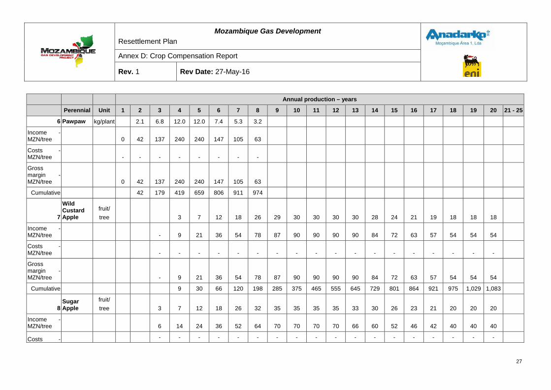
Mozambique Gas Development Resettlement Plan
Annex D: Crop Compensation Report
Rev. 1 Rev Date: 27-May-16
Annual production – years
Perennial Unit 1 2 3 4 5 6 7 8 9 10 11 12 13 14 15 16 17 18 19 20 21 - 25
6 Pawpaw kg/plant
2.1 6.8 12.0 12.0 7.4 5.3 3.2
Income - MZN/tree 0 42 137 240 240 147 105 63
Costs - MZN/tree - - - - - - - -
Gross margin - MZN/tree 0 42 137 240 240 147 105 63
Cumulative
42 179 419 659 806 911 974
7
Wild Custard Apple
fruit/ tree
3 7 12 18 26 29 30 30 30 30 28 24 21 19 18 18 18
Income - MZN/tree
- 9 21 36 54 78 87 90 90 90 90 84 72 63 57 54 54 54
Costs - MZN/tree
- - - - - - - - - - - - - - - - - -
Gross margin - MZN/tree
- 9 21 36 54 78 87 90 90 90 90 84 72 63 57 54 54 54
Cumulative
9 30 66 120 198 285 375 465 555 645 729 801 864 921 975 1,029 1,083
8 Sugar Apple
fruit/ tree
3 7 12 18 26 32 35 35 35 35 33 30 26 23 21 20 20 20
Income - MZN/tree
6 14 24 36 52 64 70 70 70 70 66 60 52 46 42 40 40 40
Costs -
- - - - - - - - - - - - - - - - - -
27
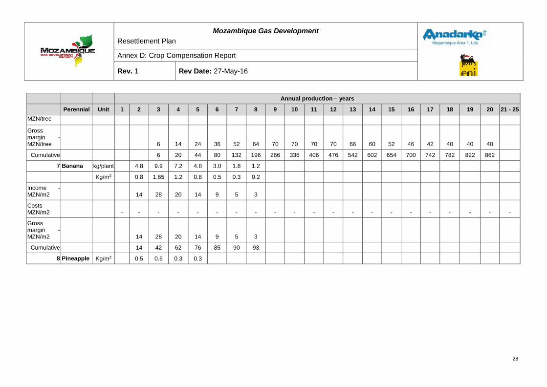
Mozambique Gas Development Resettlement Plan
Annex D: Crop Compensation Report
Rev. 1 Rev Date: 27-May-16
Annual production – years
Perennial Unit 1 2 3 4 5 6 7 8 9 10 11 12 13 14 15 16 17 18 19 20 21 - 25 MZN/tree
Gross margin - MZN/tree
6 14 24 36 52 64 70 70 70 70 66 60 52 46 42 40 40 40
Cumulative
6 20 44 80 132 196 266 336 406 476 542 602 654 700 742 782 822 862
7 Banana kg/plant
4.8 9.9 7.2 4.8 3.0 1.8 1.2
Kg/m2
0.8 1.65 1.2 0.8 0.5 0.3 0.2
Income - MZN/m2
14 28 20 14 9 5 3
Costs - MZN/m2 - - - - - - - - - - - - - - - - - - - - -
Gross margin - MZN/m2
14 28 20 14 9 5 3
Cumulative
14 42 62 76 85 90 93
8 Pineapple Kg/m2
0.5 0.6 0.3 0.3
28
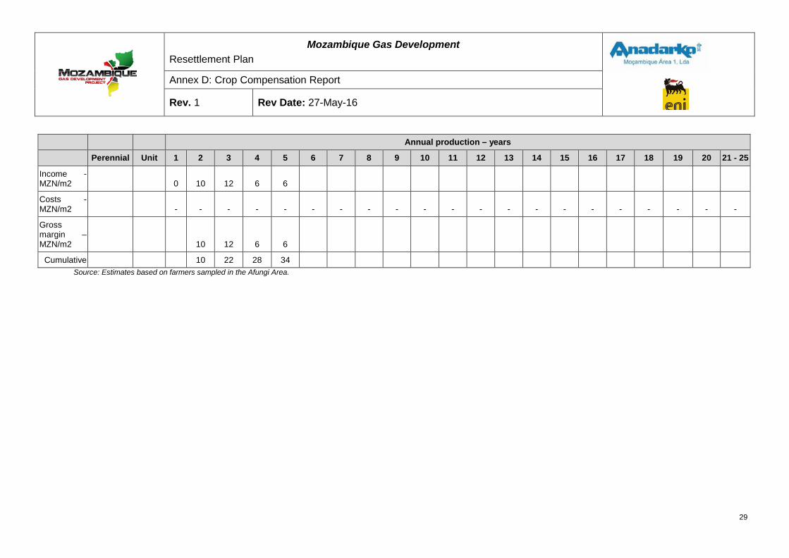
Mozambique Gas Development Resettlement Plan
Annex D: Crop Compensation Report
Rev. 1 Rev Date: 27-May-16
Annual production – years
Perennial Unit 1 2 3 4 5 6 7 8 9 10 11 12 13 14 15 16 17 18 19 20 21 - 25
Income - MZN/m2 0 10 12 6 6
Costs - MZN/m2 - - - - - - - - - - - - - - - - - - - - -
Gross margin – MZN/m2
10 12 6 6
Cumulative 10 22 28 34 Source: Estimates based on farmers sampled in the Afungi Area.
29
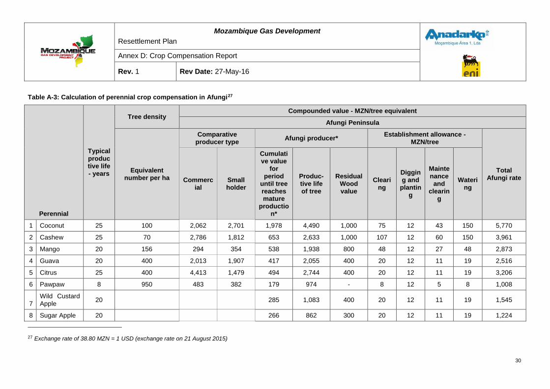
Mozambique Gas Development Resettlement Plan
Annex D: Crop Compensation Report
Rev. 1 Rev Date: 27-May-16
Table A-3: Calculation of perennial crop compensation in Afungi27
Perennial
Typical productive life - years
Tree density Compounded value - MZN/tree equivalent
Afungi Peninsula
Equivalent number per ha
Comparative producer type Afungi producer* Establishment allowance -
MZN/tree
Total Afungi rate Commerc
ial Small holder
Cumulative value
for period
until tree reaches mature
production*
Produc-tive life of tree
Residual Wood value
Clearing
Digging and
planting
Maintenance and
clearing
Watering
1 Coconut 25 100 2,062 2,701 1,978 4,490 1,000 75 12 43 150 5,770
2 Cashew 25 70 2,786 1,812 653 2,633 1,000 107 12 60 150 3,961
3 Mango 20 156 294 354 538 1,938 800 48 12 27 48 2,873
4 Guava 20 400 2,013 1,907 417 2,055 400 20 12 11 19 2,516
5 Citrus 25 400 4,413 1,479 494 2,744 400 20 12 11 19 3,206
6 Pawpaw 8 950 483 382 179 974 - 8 12 5 8 1,008
7 Wild Custard Apple 20
285 1,083 400 20 12 11 19 1,545
8 Sugar Apple 20
266 862 300 20 12 11 19 1,224
27 Exchange rate of 38.80 MZN = 1 USD (exchange rate on 21 August 2015)
30
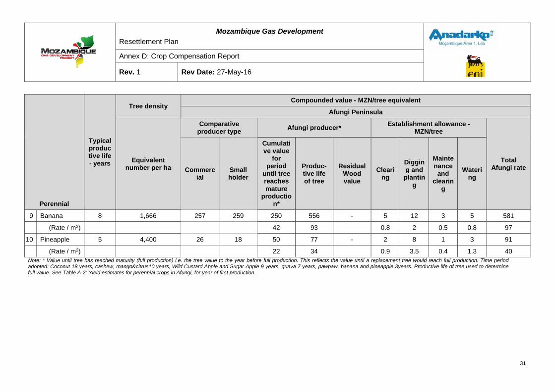
Mozambique Gas Development Resettlement Plan
Annex D: Crop Compensation Report
Rev. 1 Rev Date: 27-May-16
Perennial
Typical productive life - years
Tree density Compounded value - MZN/tree equivalent
Afungi Peninsula
Equivalent number per ha
Comparative producer type Afungi producer* Establishment allowance -
MZN/tree
Total Afungi rate Commerc
ial Small holder
Cumulative value
for period
until tree reaches mature
production*
Produc-tive life of tree
Residual Wood value
Clearing
Digging and
planting
Maintenance and
clearing
Watering
9 Banana 8 1,666 257 259 250 556 - 5 12 3 5 581
(Rate / m2) 42 93 0.8 2 0.5 0.8 97
10 Pineapple 5 4,400 26 18 50 77 - 2 8 1 3 91
(Rate / m2) 22 34 0.9 3.5 0.4 1.3 40 Note: * Value until tree has reached maturity (full production) i.e. the tree value to the year before full production. This reflects the value until a replacement tree would reach full production. Time period adopted: Coconut 18 years, cashew, mango&citrus10 years, Wild Custard Apple and Sugar Apple 9 years, guava 7 years, pawpaw, banana and pineapple 3years. Productive life of tree used to determine full value. See Table A-2: Yield estimates for perennial crops in Afungi, for year of first production.
31
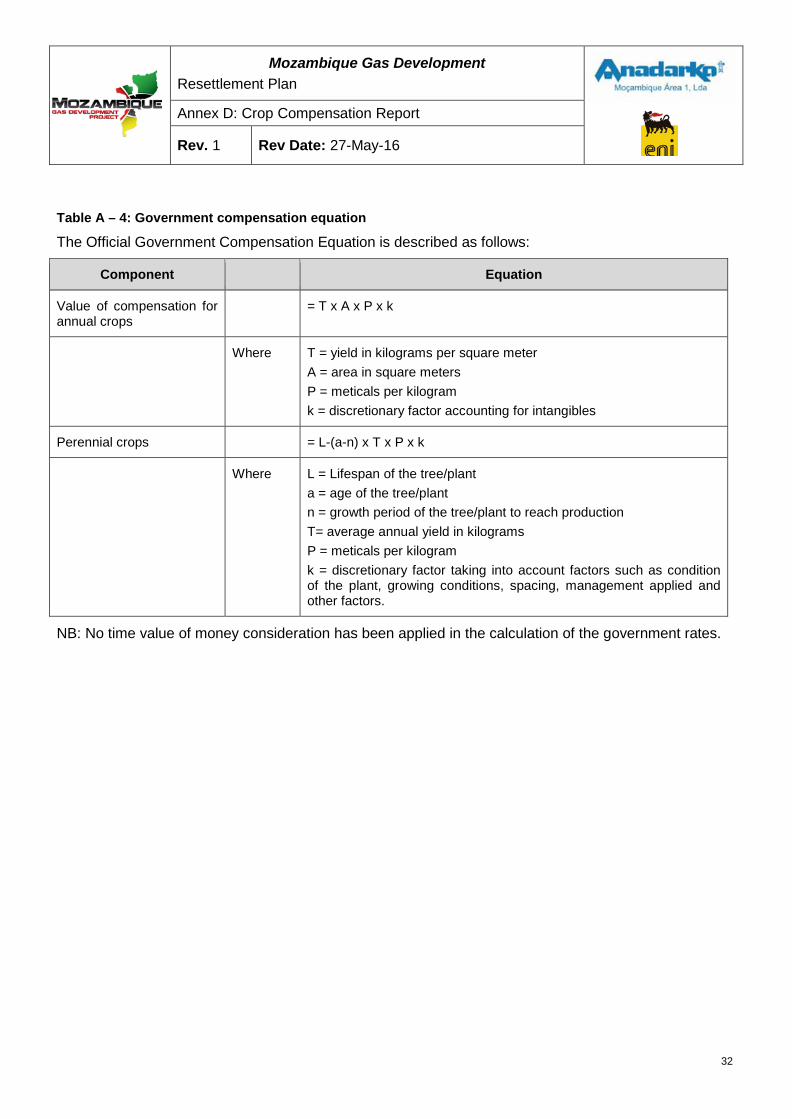
Mozambique Gas Development Resettlement Plan
Annex D: Crop Compensation Report
Rev. 1 Rev Date: 27-May-16
Table A – 4: Government compensation equation
The Official Government Compensation Equation is described as follows:
Component Equation
Value of compensation for annual crops
= T x A x P x k
Where T = yield in kilograms per square meter A = area in square meters P = meticals per kilogram k = discretionary factor accounting for intangibles
Perennial crops = L-(a-n) x T x P x k
Where L = Lifespan of the tree/plant a = age of the tree/plant n = growth period of the tree/plant to reach production T= average annual yield in kilograms P = meticals per kilogram k = discretionary factor taking into account factors such as condition of the plant, growing conditions, spacing, management applied and other factors.
NB: No time value of money consideration has been applied in the calculation of the government rates.
32

RESETTLEMENT PLAN FINAL DRAFT FOR GOVERNMENT
APPROVAL ANNEX E: INDEPENDENT CROP
COMPENSATION REPORT
MOZAMBIQUE GAS DEVELOPMENT


Mozambique Gas Development Resettlement Plan
Annex E: Independent Crop Compensation Report
Rev. 1 Rev Date: 27-May-16

UNIVERSIDADE EDUARDO MONDLANE FACULDADE DE AGRONOMIA E ENGENHARIA FLORESTAL
CEAGRE - Centro dos Estudos de Agricultura e Recursos Naturais
Independent Crop Compensation Report Review for Mozambique Gas Development Project (MGDP)
24 November2014
By Rogério Marcos Chiulele
CEAGRE- Centro dos Estudos de Agricultura e Recursos Naturais, Universidade Eduardo Mondlane
Table of Contents
EXECUTIVE SUMMARY.................................................................................... ii
I. INTRODUCTION ......................................................................................... 1
II. REGULATORY FRAMEWORK FOR RESSETLEMENT AND COMPENSATIONS ............................................................................................ 3
2.1 National legislation guiding resettlement (Decree 31/2012) ...................... 3
2.2 National legislation guiding compensation (Decree 181/2010 and regulation 66/1998) ......................................................................................... 4
2.3 International guidelines for resettlement and compensation ..................... 4
III. METHODOLOGY ........................................................................................ 5
IV. FINDINGS .................................................................................................... 7
4.1 Limitation of the review ............................................................................. 7
4.2 Use of legislation guiding compensation and resettlement ....................... 7
4.3 Crops grown and agricultural production conditions and practices ........... 9
4.3.1 Crops grown in Afungi ......................................................................... 9
4.3.2 Agricultural farming practices and conditions .................................... 10
4.4 Methodology used to determine crop yields in Afungi ............................. 11
4.5 Determination of price for agricultural products in Afungi ........................ 14
4.6 Compensation rates ................................................................................ 15
4.7 Periodic review of rates ........................................................................... 16
V. CONCLUSIONS AND RECOMMENDATIONS ......................................... 17
5.1 Conclusions ............................................................................................ 17
5.2 Recommendations .................................................................................. 18
Annex 1: Terms of Reference for Crop Compensation Report Review ..... 19
i
EXECUTIVE SUMMARY
The Mozambique Gas Development Project (the Project) is in the process of
preparing a Resettlement Plan to describe arrangements for the compensation,
resettlement and livelihood restoration of households on the Afungi peninsula in
Cabo Delgado Province who will be required to relinquish agricultural and
foraging land due to the Project. The Project engaged the Centro dos Estudos
de Agricultura e Recursos Naturais (CEAGRE) of the Universidade Eduardo
Mondlane to conduct an independent review of its proposed compensation
assumptions and rates for crops and fruit trees. The purpose of the review is to
verify whether or not the Project's proposed crop compensation rates meet "full
replacement cost" as envisaged by IFC PS 5. The review also aimed to verify if:
(1) The Project is considering the right factors and crops;
(2) The Project's assumptions about yields and prices are realistic for
Afungi agricultural conditions and practices;
(3) The Project is proposing to use the right measurement units;
(4) The Project is using appropriate methods and formulae for
calculating compensation and foregone income;
(5) The recommended compensation rates meet or exceed the IFC's
requirements or do the rates require alteration according to
CEAGRE’s view; and
(6) The proposal for periodic indexing of rates is appropriate.
The Project included most of the crops grown in Afungi except for some less
commonly cultivated crops, including Sugar apple (Ata), Custard apple
(oxheart), yams and sugarcane which were omitted. The important assumptions
for calculating compensations were considered by the Project which included
assessment of agricultural systems and practices and assessment of soil types.
The Project’s recorded yields and prices are realistic, although yields were
recorded based mostly on interviews, focus group discussion and in-field
observations. Overall, yields in the area are low due to poor agricultural
systems and practices and poor soils and climatic conditions.
ii

The Project made use of appropriate formula for calculating compensation
which was obtained from Decree 181/2010. This formula needs to be applied to
each compensation opportunity where the rate for the particular crops is applied
to the relevant affected area.
The Project’s recommended compensation rates meet the requirement for full
replacement cost as recommended by the IFC PS 5, despite the qualifications
above. The Project’s proposal of periodic indexing of the rates is appropriate
and should be implemented.
iii
I. INTRODUCTION
This review was conducted for The Mozambique Gas Development Project
(MGDP) in October 2014, to review the crop compensation report developed as
part of the preparation of the Resettlement Plan for the households of Afungi
affected by the Project. The focus and scope of the review was defined on the
basis of the Terms of Reference (TORs) prepared by the MGDP (see Annex 1).
The purpose of the review was to verify whether or not the Project used an
appropriate methodology and formulas to calculate compensation, that all the
crops cultivated in Afungi were included in the list of crops for compensation
and that the Project's proposed compensation rates meet "full replacement
cost" as envisaged by IFC PS 5.
The review process was based on:
• Reviewing legislation guiding resettlement and compensation at national
and international levels;
• Reviewing data recorded by the Project on yield, prices, production
conditions and practices;
• Assessment of the methodology and measurement units used to record
yield; and
• Assessment of assumptions and factors for conducting compensation.
In addition to reviewing the existing information recorded by the Project, a site
visit was conducted to observe production conditions and conducted interviews
with village leaders, chiefs of production and village residents to correlate
information received. The site visit aimed to validate the information provided in
reports produced by the Project.
The following questions were to be answered as part of the review process:
1. Did the Project consider the right factors and crops?
2. Are the Project's assumptions about yields and prices realistic for Afungi
agricultural conditions and practices?
3. Is the Project proposing to use the right units of measurement?
1
4. Is the Project using appropriate methods and formulae for calculating
compensation and foregone income?
5. Do the recommended compensation rates meet or exceed the IFC PS 5
requirements or are there rates that in CEAGRE’s view need to be
altered?
6. Are proposals for periodic indexing of rates appropriate?
This report starts by providing the context for the review, followed by an
overview of the legislation guiding resettlement and compensation processes,
and the methodology used to review the Project’s Crop Compensation report.
Section 0 of this report presents the findings of the review while Section V
presents the conclusions and recommendations of this review process.
2
II. REGULATORY FRAMEWORK FOR RESSETLEMENT AND COMPENSATIONS
The legal framework that guides resettlement in Mozambique is Decree
31/2012 and for compensation are the Decree 181/2010 and Regulation
66/1998. In addition to Mozambican legislation, Mozambique makes use of
international guidelines for resettlement and compensation from the World Bank
and the International Finance Corporation Performance Standards. For the
purpose of this review the requirements of the International Finance Corporation
Performance Standard 5 (IFC PS 5) was followed.
2.1National legislation guiding resettlement (Decree 31/2012)
The Decree 31/2012 sets out the requirements for resettlement resulting from
economic activities. The decree establishes the basic rules and principles
governing the process of resettlement in Mozambique. It created a Technical
Commission for Resettlement Monitoring and Supervision that is responsible for
monitoring, supervising and technically advising projects causing resettlement,
and defines the commission’s responsibilities and procedures for the approval
of the Resettlement Plan (RP) as well as activities during resettlement
implementation. The approval of the Resettlement Plan is the responsibility of
the District Government. The decree also:
• Introduces specific procedures for the design and the implementation of
the RP;
• Defines the contents of the RP;
• Defines implementation activities for the RP;
• Defines the responsibilities of the project proponent; and
• Describes the requirements of the public consultation process for
resettlement.
The decree does not however explicitly provide guidance on the establishment
of compensation rates.
3
2.2 National legislation guiding compensation (Decree 181/2010 and regulation 66/1998)
The Decree 181/2010 sets guidelines and standards for the process of
expropriation for land use planning purposes due to development activities of
public interest or utility. It defines i) the contexts in which expropriation can take
place for land planning purposes, and ii) how to conduct the process of
expropriation. The decree also sets the calculation framework for compensation
costs for the expropriation of housing, commercial, industrial, service provision,
seaside, and countryside infrastructure.
Regulation 66/1998 sets the minimum value for trees and crops in the
calculation of compensation costs as a result of a relocation processes. It
defines the compensation guidelines for the loss of trees and crops due to
development projects (which is incurred in the relocation of land users). This
regulation is used by each Provincial Directorate of Agriculture from the Ministry
of Agriculture to define the minimum compensation value for various trees and
crops in Mozambique. Provincial Directorates annually update the guidelines
with tables of value costs for a range of trees and crops.
2.3 International guidelines for resettlement and compensation
The international guideline most widely used to guide resettlement and
compensation is the IFC PS5.IFC PS5 recommends that in cases of land
acquisition or restrictions on land use, compensation should be paid for loss of
assets at full replacement cost.
4
III. METHODOLOGY
The following methodology was used to review the Project’s crop compensation
report:
1. Review Mozambican legislation guiding resettlement (Decree
31/2012) and compensation (Decree 181/2010 and Regulation
66/1998);
2. Review international guidelines for resettlement and compensation
(IFC PS 5);
3. Confirm whether the formulae recommended to calculate
compensation were appropriately used;
4. Review the Project’s agricultural reports to assess data on yields,
production conditions and practices;
5. Review reports from the Ministry of Agriculture at district, provincial
and national levels to compare yield data with the Project’s
compensation report data;
6. Identify issues to confirm during interviews;
7. Conduct interviews with the Project’s agricultural team members to
obtain information on approaches, methods, and measurement units
used for yield estimation and price determination; and
8. Conduct interviews with village leaders, chiefs of production,
community representatives and farmers to check whether all fruit
trees and crops produced in the region were included in the report.
Interviews were conducted in five villages, namely: Senga, Barabarane,
Maganja, Quitupo and Patacua, from 9 to 12 October 2014. In each village, the
village leader, chief of production, a community representative, and several
farmers participated in the interviews. The number of participants in each village
is presented in Table 1.
The information gathered during interviews included amongst others, crops
produced, production conditions, agricultural practices, and marketing which
included main markets for agricultural products produced, as well as prices.
5
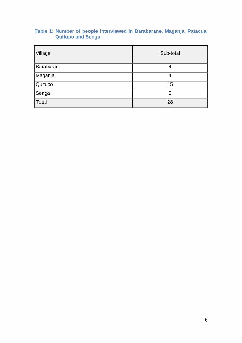
Table 1: Number of people interviewed in Barabarane, Maganja, Patacua, Quitupo and Senga
Village Sub-total
Barabarane 4
Maganja 4
Quitupo 15
Senga 5
Total 28
6
IV. FINDINGS
4.1 Limitation of the review
The site visit to Afungi took place during the agricultural off-season which also
coincided with the period during which political parties prepared for the national
presidential election that took place on 15 October 2014. Given that it was the
agricultural off-season, it was not possible to conduct field observations and
assessment of the cropping practices and crop performance. Such information
could be useful for assessing yield data reported in the Project’s crop
compensation report. Therefore, the review presented here is based on the
reviewers experience, data provided by the Project, discussions with the
Project’s agricultural team and information recorded through interviews and
focus group discussions with village leaders, chiefs of production, community
representatives, and some farmers who participated in the interviews and focus
group discussions.
The pre-election period affected data gathering as there were recommendations
made by the Government that suggested that the Project not convene meetings
with groups larger than 5 persons. Nevertheless the number of participants in
the focus group discussion in Quitupo grew to 15 despite the restriction on large
group meetings. This was a natural process, which was not encouraged by the
reviewer, in that people saw the interviews taking place and wanted to hear
what was being discussed.
Although the number of participants at Barabarane, Maganja and Senga was
low the trends appear to be in line with the reported crops produced and
associated prices
4.2 Use of legislation guiding compensation and resettlement
The crop compensation proposed in the report was calculated following national
legislation and international guidelines for calculating compensation as a result
of land acquisition and involuntary resettlement. The Project used Decree
31/2012 as well as Decree 181/2010 and the land act regulation 66/1998 to
determine the basis for calculating compensation. Following the guidelines for
7
calculating compensation, the formulae recommended to calculate
compensation for crops were also used. These formulae for calculating
compensation for annual and perennial crops are presented below.
Compensation for loss of annual crops
Value of compensation = Prod/ha×At×Pr/kg×a
Where: Prod./ha = is yield in kilograms per hectare;
At = Area under production in hectares;
Pr/kg = Price of the crop in meticais per kilogram;
a = discretionary factor of 0 to 1 to account for specific local conditions
and circumstances such as the state of the plant, soil conditions,
spacing, and management
Compensation for loss of perennial crops
Value of compensation = (VU-(I-X)×Pm×PV×K
Where:
VU = is lifetime of the plant;
I = Age of the plant;
X = growth stage;
Pm= Annual average yield;
PV= Selling price of fruits;
K= Factor;
In addition to national legislation, the requirements of the International Finance
Corporation Performance Standard 5 which deals with land acquisition and
8
involuntary resettlement (IFC PS 5) were followed. The Performance standard 5
recommends that compensation should be calculated at full replacement cost.
4.3 Crops grown and agricultural production conditions and practices
4.3.1 Crops grown in Afungi
The crops grown in Afungi according to the Project compensation report, asset
surveys conducted as part of the resettlement planning process, other Project
data, and information recorded by the Project through interviews, are grouped
into three categories: fruit trees, field crops, and vegetables.
According to the Project’s crop compensation report, fruit trees grown in Afungi
include coconut, cashew nut, mangoes, guava, citrus, pawpaw, banana, and
pineapple. Hence, compensation was also calculated for these crops. In
interviews conducted by the reviewer, participants indicated that in addition to
the above indicated fruit trees, Sugar apple (Annona squamosa, known locally
as ata) and Custard apple (Annona reticulate or coração de boi in Portuguese)
are also grown in the region. Both Sugar and Custard apple trees were common
in Senga but less abundant in Barabarane, Maganja and Quitupo. Given that
are being grown in the region they should be included in the list of crops to be
compensated in all four villages.
According to the Project’s crop compensation report field crops grown in Afungi
are cassava, rice, Bambara nuts, maize, sorghum, cowpea, sesame, groundnut,
sweet potato and water melon. As was the case with fruit trees, compensation
rates were calculated for these crops. During interviews conducted at
Barabarane, Maganja, Quitupo, and Senga for the purpose of reviewing the
compensation report, participants confirmed the above as crops grown in
Afungi. In addition, they included yams and sugarcane as crops grown in the
region. These two crops should thus also be included in the list of crops to be
compensated in Afungi, and appropriate rates calculated.
9
Vegetable crops grown in Afungi include tomato, pepper, chili, carrots, lettuce,
cabbage, eggplant and beetroots. Compensation rates for vegetables were
calculated only for tomato as it is the most common and highest value
vegetable crop in the region. In addition to the listed vegetables, participants in
interviews in the four villages visited indicated amaranths as an important
vegetable crop in the region. Although it was not listed, the decision taken by
the agricultural team to use tomato as the base for calculating compensation
can be used for compensating for amaranths if necessary.
4.3.2 Agricultural farming practices and conditions
Agricultural production in Afungi is mainly for subsistence purposes, practiced
by smallholder farmers in areas ranging between 0.8 and 2.1ha, with an
average size of approximately 1,21ha. Crop production takes place in dryland
and wetland agro-ecologies. According to the Project’s crop compensation
report, dryland agro-ecological production consists mostly of cassava, Bambara
groundnut, cowpeas, groundnut, maize, sorghum, watermelon, millets, sweet
potato, upland rice, sesame, and Pigeon peas, while wetland agro-ecological
production consist mostly of rice and other cereals during the rainy season
(between November and May) and vegetables during the dry season (between
June and October). Dryland field crops are grown during the rainy season
(between November and May).
The most common agricultural practice for dryland crop production, according to
the Project’s crop compensation report, is production of cassava as a main crop
with cowpeas and groundnut as secondary crops. Mono cropping is commonly
undertaken for crops such as cassava, maize, Bambara groundnut, groundnut
and wetland rice.
Soil types in Afungi are variable; there is a predominance of sandy soils in most
of the Afungi peninsula, consisting of Arenosols (Fernwoods), with low clay
content, poor water holding capacity, and a moderate to poor cation exchange
rate. Soil variability is encountered, in the western and particularly south
western portion of the DUAT area where three types of soils are found with
moderate to high agricultural potential, namely: Acrisols and Ferisols, Ferric
10
acrisols, and Albisols. Acrisols and Ferisols are red colored soils with higher
clay content, good water holding capacity, and high to moderate cation
exchange capacity. Ferric acrisols, or Clovellys are soils with brown sub-soil,
with moderate clay content, good water holding capacity and moderate cation
exchange capacity. Albisols or Constantia are soils with moderate to low
agricultural potential.
Farming practices in Afungi are also poor. There is a predominance of
intercropping with no clear planting pattern and poor plant density resulting in
low yields. In addition, there is no external input application – manure, fertilizers
or other chemical sprays. Consequently crop productivity is generally low, and
is among the lowest in the district and province, with the exception of cassava.
The area appears to be appropriate only for crops adapted to marginal soils
such as cassava, coconut and cashew nut.
4.4 Methodology used to determine crop yields in Afungi
Appropriate yield assessment methods should be based on direct
measurements, and complimented by direct observations and other data
recording methods such as structured or semi-structured questionnaires, and
focus group discussions. When direct measurement is used to assess yield,
appropriate sample size should be determined depending on variability of the
farmers and farms where yield estimates are to be taken. When the farmers and
cultivation conditions and practices are homogeneous, sample size of 10 to
15% can be appropriate for yield estimation but when farmers and cultivation
conditions and practices are highly variable, large sample size are required to
provide reliable yield estimates.
The Agricultural Team of the Project obtained yield estimates from a sample of
70 households through a combination of approaches that included in-field
observations and direct measurements, structured questions, and focus group
discussions. Field measurements were also conducted by the Project’s
Agricultural Team on cassava, rice, groundnut and cowpeas.
11
The Project’s yields estimates were mainly based on focus group discussions
and interviews since yield estimates obtained through sampling were generated
from small sample sizes. According to the Project´s agricultural team, cassava
and rice yields were measured on the fields of 10 randomly selected farmers,
while groundnut and cowpea yield measurements were taken from three
farmer’s fields. Other crop yield estimates were based exclusively on
information from focus group discussions, interviews, verified by in-field
observations, and cross checked with yield estimates from provincial and district
data.
Cassava yield was measured at each of the 10 sample sites (fields) in the
following way:
• At each sample site two sample plots measuring 36m2 and 25m2 were
staked out
• The number of plants were counted and harvested for each 36m2 and
25m2plot.
• The roots from each plot were weighed to obtain the fresh root mass for
each plot and fresh root mass per plant.
• The roots were then given to the respective farmers to process, ie peel
and dry for at least five days. After drying the cassava chips were again
weighed to obtain dried weight for estimating dry matter yields for each
36m2 and 25m2 plot. These results were then averaged for that sample
site and an overall yield calculated per hectare.
Rice yields were obtained from two sample sites where, in each case the full
rice field was measured and the total rice crop that was harvested from that field
weighed. For each sample site (full field) the harvested rice was dehulled and
again weighed. From these results the yields of both hulled and dehulled rice
yields were obtained and converted on a per hectare basis. Groundnut and
cowpea yield estimates were determined by a similar method, using the total
field size and grain weight of the crops on these fields.
Yield estimates for fruit crops were obtained through interviews and focus group
discussion, and correlated with yield estimates for commercial, provincial and
12
district data, with the exception of mangoes, where direct measurements were
conducted. For mangoes, yield estimates were obtained from 10 randomly
selected mango trees. In each mango tree, the diameter and height of the plant
canopy was measured and the height of the canopy divided into three sections
of almost equal height. Two sampling areas were taken in each height section
and the number of mango fruits per section counted.
The yield assessment methods used for cassava and rice as well as the
measurement units in the Project’s crop compensation report were appropriate.
However, sample sizes of the farms sampled (14% for cassava and rice and
less than 5% for groundnut and cowpeas) were small considering high
variability in soil types, cultivation practices, and farmers’ typology. Results
obtained however, are aligned with expectations from in-field observations,
surveys and group discussions. Yields are also in line with expectations when
compared with district and provincial performance given local agricultural
conditions and practices.
Cassava is the most important crop in Afungi where it is produced under
dryland conditions, and commonly intercropped as the major component of the
intercrop mix. In the Project’s crop compensation report it was proposed that in
cases of intercropping or mixed cropping, the higher value crop will be used to
calculate compensation for field crops. This suggests that in Afungi, the
calculation of compensation under intercropping or mixed cropping conditions
involving cassava and other field crops, the compensation will be calculated
based on cassava which has the highest value of the common field crops. In
less common situations where higher valued crops of sweet potato, watermelon
and vegetables are produced with cassava the value of each crop will be
determined on a pro rata basis according to the actual area under production.
Compensation of mono crops will simply involve the application of the
applicable compensation rate against the area under production.
Given the local variable factors, range of yields and small sample sizes taken, a
lenient approach in adopting crop yields will ensure that any underestimation is
accounted for. It is suggested, therefore, that crop compensation be based on
yield data obtained from Department of Agriculture at provincial or district levels.
13
However, the exception will be cassava since project sampling has determined
that cassava yields in Afungi are higher than those of the province. Cassava
rates from Afungi and provincial rates for other crops should be considered.
4.5 Determination of price for agricultural products in Afungi
The determination of price for calculating compensation was based on
recording price information from farmers and from market survey data.
Information about prices from farmers was recorded using focus group
discussions and interviews. Price data from market surveys was recorded from
local markets (Afungi and Palma) and provincial markets. Price information
recorded from farmers was recorded over two different periods while market
survey data was recorded at several intervals. The recorded information was
then compared with official government compensation rates, issued by the
Cabo Delgado Provincial Department of Agriculture for agricultural products in
January 2014.
Minimum and maximum price values as well as medians were calculated to
determine appropriate prices for calculating compensation. The median price
was used to determine the appropriate price for compensation given that the
values recorded in market surveys as well as in farmers’ interviews and focus
group discussions had a high standard deviation. Under circumstances where
the standard deviation is high, the median is the best parameter to describe
data.
Overall, the approaches and methods used to record and calculate
compensation prices were appropriate. The fact that the prices were calculated
from data recorded several times makes the price estimates more accurate and
representative of actual crop prices in the region. In addition, the use of data
coming from the market survey that is recorded continuously throughout the
year makes price estimates more reliable and accurate.
14
4.6 Compensation rates
Compensation rates were calculated based on the simple principle of
establishing a value of the crop per unit area, namely crop yield multiplied by
crop price per unit area. This principle is essentially encompassed in the
formulae published in Decree 181/2010 for annual and perennial crops. For
annual crops, the compensation rate is calculated based on the yield per unit
area, in this case one hectare, multiplied by the area under production,
multiplied by the market value of the crop, multiplied by a discretionary factor of
0 to 1 to account for specific local conditions and circumstances such as the
state of the plant, soil conditions, spacing, and management.
In the determination of compensation rates the Project used average crop yields
in Afungi, the median price for each commodity, and discretionary factor of one
to calculate compensation for annual crops. Average yields were obtained
through yield measurements, interviews and focus group discussions with 70
households (as discussed above); median prices were obtained through
interviews and focus group discussion or through market survey data. The
discretionary factor of one was used, assuming good plant growing conditions
and soil conditions, and adequate spacing and crop management. This is a
lenient assumption as these conditions are not generally the case for Afungi.
Actual compensation payments, therefore, will be calculated using the
applicable crop rate multiplied by the area that is affected. Given that the
compensation rate has been fairly determined and reflects a fair, if not lenient
price, multiplying this rate by the areas that are affected should produce
compensation values that indeed meet “full replacement cost”, as envisaged by
IFC PS5.
Compensation rates for perennial crops were based on similar principles. It is
common in compensation cases for perennial crop values to be based on the
lost production window – the productive period from when production is affected
until the replacement plant is able to produce at the same level. However, the
project has adopted a more lenient approach where lost production over the full
productive life-of-plant is used as the basis for the compensation rate. The
15
compensation rate has been calculated taking the accumulated yield over the
productive life of the tree/plant, multiplied by the common price for the
commodity. No deduction is made for inputs, nor is a discount value applied for
the time value. As with the case for annual crops the discretionary factor K
reflects the state of the crop, growth conditions, plant spacing, and
management. Again a liberal rate of one was adopted by the Project.
Actual compensation payments, therefore, will be calculated using the
applicable perennial crop rate multiplied by the number of trees/plants affected.
In addition to recommendations of Decree 181/2010, recommendations from
IFC PS 5 were followed, which propose that compensation should be calculated
at full replacement cost (market value of the assets plus transaction costs). The
Project calculated compensation to meet full replacement cost as
recommended by IFC PS 5.
The Project’s calculated compensation rates are lower than those from the
Provincial Department of Agriculture for both annual and perennial crops, even
where the historical factor of five has been applied to the perennial crops. The
differences between the project rates and the Provincial Department of
Agriculture rates are partly attributed to poor agricultural practices and poor soil
conditions as indicated in the report. The Project however recommends using
the rates proposed by the Provincial Government, which are higher and
therefore more than fair for the crop owners. This recommendation is endorsed.
4.7 Periodic review of rates
The proposed recommendation of an annual review of rates is appropriate
given that inflation and other economic parameters will change, which will
impact agricultural production and hence the compensation rates that conform
to full replacement value.
16
V. CONCLUSIONS AND RECOMMENDATIONS
5.1 Conclusions
• The most important crops in the region were included in the list of crops
for compensation, with the exception of Sweet apple and Custard apple
trees, yams, and sugarcane, which are also cultivated in the region.
• Appropriate factors were considered for calculating compensation, which
included the assessment of agricultural systems and practices, and
assessment of soil types.
• The Project’s assumptions about yields in Afungi are realistic. The
current yields in Afungi are lower than those of the district, provincial and
country, with the exception of cassava. The lower yields are clearly due
to poor soil and climatic conditions associated with poor agronomic
practices.
• The Project’s assumptions about prices are realistic. The methods and
approaches used to collect price data and compute prices for
compensation were appropriate. Prices were recorded considering price
fluctuation during the year, and the approach of using median price for
calculating compensation is appropriate given that the variance for prices
during the year was high.
• The Project’s measurements for yield area and price were appropriate,
except that for measuring yield the number of samples used for
measuring yield were small.
• The Project made use of appropriate formulae for calculating
compensation, which were obtained from Decree 181/2010. The Project
will compensate according to the area required or affected by the project,
regardless of plot size.
• The Project’s recommended compensation rates meet the full
replacement cost requirement of IFC PS 5.
• The Project’s proposal of periodic indexing of the rates on an annual
basis is appropriate.
17
5.2 Recommendations
• Sweet apple, Custard apple, yams, and sugarcane, which have been left
out, should be included in the list of crops for compensation, and their
compensation values calculated
• Given that the Project calculated rates are lower than the government, or
other compensation rates, the higher rate should be applied where
possible, as is proposed by the Project.
• To compensate for annual field crops under mixed cropping conditions,
the Project’s recommendation of using the higher value crop is
appropriate and should be considered.
• The Project’s recommendation of providing two seedlings for each
perennial tree crop to the owner is appropriate and should be considered
during the provision of compensation.
• The Project’s recommendation of annually reviewing the rates according
to the inflation index should also be considered.
18
Annex 1: Terms of Reference for Crop Compensation Report Review
Terms Of Reference
Background
The Mozambique Gas Development Project is in the process of preparing a
Resettlement Plan to describe arrangements for the compensation,
resettlement and livelihood restoration of households on the Afungi peninsula in
Cabo Delgado Province who will be required to relinquish agricultural and
foraging land for the Project. The Project will be seeking project finance from
international lenders including export credit agencies and signatories of the
Equator Principles. Accordingly, the Resettlement Plan is being developed in
accordance not only with Mozambican national legislation, but also International
Finance Corporation Performance Standard 5 Land Acquisition and Involuntary
Resettlement (January 2012). A copy of IFC PS 5 is attached. IFC PS 5
prescribes that compensation should be calculated on the basis of "full
replacement cost" or market value plus transaction costs.
Purpose
The Mozambique Gas Development Project is seeking an independent review
of its proposed compensation assumptions and rates for crops and fruit trees to
be undertaken by an authoritative third party organization such as the
CEAGRE. The purpose of the review is to verify whether or not the Project's
proposed compensation rates meet "full replacement cost" as envisaged by IFC
PS 5.
• Is the Project considering the right factors and crops?
• Are the Project's assumptions about yields and prices realistic
for Afungi agricultural conditions and practices?
• Is the Project proposing to use the right measurement units?
• Is the Project using appropriate methods and formulae for
calculating compensation and foregone income?
19
• Do the recommended compensation rates meet or exceed the
IFC's requirements or are there rates that in CEAGRE’s view need to be
altered?
• Are proposals for periodic indexing of rates appropriate?
Tasks
Some possible tasks are listed below. It is requested that the CEAGRE review
these and develop their own review approach.
• Review of the Mozambique Gas Project's Trees and Crop
Compensation report – see attached document
• Site visit and verification of growing conditions, practices and
yields typically being achieved at Afungi
• Review and collation of data to verify assumptions about yields,
market prices and input costs
• Review completeness of trees and crops considered
• Comparative review of compensation rates paid by the
government and private sector on other projects in Mozambique
• Preparation of a brief report summarizing findings
Deliverable
The final output should a brief report from CEAGRE verifying whether or not the
proposed rates meet IFC PS 5 requirements, with recommendations on any
rates that need inclusion or adjustment.
20
RESETTLEMENT PLAN
FINAL DRAFT FOR GOVERNMENT APPROVAL ANNEX J: DISTRICT ADMINISTRATOR
REPLACEMENT AGRICULTURAL LAND LETTER
MOZAMBIQUE GAS DEVELOPMENT

Mozambique Gas Development Resettlement Plan
Annex J: District Administrator Replacement Agricultural Land Letter
Rev. 1 Rev Date: 27-May-16

Translation
(Coat of arms of the Republic of Mozambique)
REPUBLIC OF MOZAMBIQUE
PROVINCE OF CABO DELGADO
GOVERNMENT OF THE DISTRICT OF PALMA
Our Ref: 227/GDP/SDP/______ 07.10.2015
RE: Land allocation for agriculture in scope of the resettlement process in Cabo Afungi
Pursuant to the request contained in letter ref: AMA1/LD.420/2014, dated 18 December 2014, on the above
mentioned subject, the Government of the District of Palma hereby informs the proponents, Anadarko Area
1, Lda. (AMA1) and Eni East Africa S.p.A. (EEA) that in scope of the resettlement process arising from the
Project, it will allocate replacement land for the affected households for the practice of livelihoods activities,
predominantly agricultural activities, in compliance with the Regulations for Resettlement Resulting from
Economic Activities, approved by Decree 31/2012, dated 8 August.
Please be informed that the area in reference is located close to Mondlane Village, Administrative Post of
Olumbe and that comprehensive studies are underway to determine the real available potential, as the area
under revision is 2.000 of the 1.600 hectares required.
Kind regards,
The District Administrator
(Illegible signature over round ink stamp)
Pedro Romao Jemusse
(Tec. Prof. Public Admin.)
To Anadarko Moçambique Area 1, Lda


