Embed Size (px)
Citation preview
Virtual Trip Lines for Distributed Privacy-Preserving TrafficMonitoring
Baik Hoh, Marco GruteserWINLAB / Dept. of Electrical & Computer Engineering, Rutgers Univ.
Piscataway, NJ USAbaikhoh,[email protected]
Ryan Herring, Jeff Bana, Daniel Work, Juan-Carlos Herrera, Alexandre M. BayenDept. of Civil & Environmental Engineering, UC Berkeley; aCalifornia Center for Innovative Transportation (CCIT)
Berkeley, CA USAryanherring,dbwork,jcherrera,[email protected]; [email protected]
Murali Annavaramb, Quinn Jacobsonc
bMing Hsieh Dept. of Electrical Engineering, USC; cNokia Research CenterbLos Angeles, CA USA; cPalo Alto, CA USA
[email protected]; [email protected]
ABSTRACTAutomotive traffic monitoring using probe vehicles with GlobalPositioning System receivers promises significant improvements incost, coverage, and accuracy. Current approaches, however, raiseprivacy concerns because they require participants to reveal theirpositions to an external traffic monitoring server. To address thischallenge, we propose a system based on virtual trip lines and anassociated cloaking technique. Virtual trip lines are geographicmarkers that indicate where vehicles should provide location up-dates. These markers can be placed to avoid particularly privacysensitive locations. They also allow aggregating and cloaking sev-eral location updates based on trip line identifiers, without knowingthe actual geographic locations of these trip lines. Thus they facil-itate the design of a distributed architecture, where no single entityhas a complete knowledge of probe identities and fine-grained lo-cation information. We have implemented the system with GPSsmartphone clients and conducted a controlled experiment with 20phone-equipped drivers circling a highway segment. Results showthat even with this low number of probe vehicles, travel time esti-mates can be provided with less than 15% error, and applying thecloaking techniques reduces travel time estimation accuracy by lessthan 5% compared to a standard periodic sampling approach.
Categories and Subject Descriptors: K.4.1 [Computer and Soci-ety]: Public Policy Issues—Privacy; K.6 [Management of Comput-ing and Information Systems]: Security and Protection
General Terms: Algorithms, Design, Experimentation, Security
Keywords: Privacy, GPS, Traffic, Data integrity
Permission to make digital or hard copies of all or part of this work forpersonal or classroom use is granted without fee provided that copies arenot made or distributed for profit or commercial advantage and that copiesbear this notice and the full citation on the first page. To copy otherwise, torepublish, to post on servers or to redistribute to lists, requires prior specificpermission and/or a fee.MobiSys’08, June 17–20, 2008, Breckenridge, Colorado, USA.Copyright 2008 ACM 978-1-60558-139-2/08/06 ...$5.00.
1. INTRODUCTIONAutomotive navigation systems enable the effective delivery and
presentation of fine-grained traffic information to drivers and havethus created demand for improved traffic data collection. Conven-tional traffic information services rely on eyewitness reports, trafficcameras, and loop detectors. More recently, traffic estimates arealso generated from cellular base station hand off rates [24]. Due totheir high cost, or low precision position information, these mech-anisms are only available at selected traffic hotspots.
Probe vehicle systems promise to significantly improve cover-age and timeliness of traffic information. Probe vehicle systems es-timate traffic flow and congestion through speed reports collectedfrom a set of GPS-equipped vehicles. Thus, with sufficient pene-tration (fraction of total traffic) this approach could potentially col-lect real-time traffic information over the complete road network atminimal cost for transportation agencies.
Several studies have demonstrated the feasibility of traffic flowestimation through analysis, simulations, and experiments [25, 22,58]. Several open questions remain, however, before such a sys-tem is likely to be realized. First, it is unclear how such a systemcan quickly be bootstrapped since the service is only useful withsufficient participants. While telematics platforms or navigationssystem hardware is capable of performing these functions, theseplatforms are not openly programmable and thus hard to retrofitfor this purpose. Second, it is not known how the quality of theobtained traffic information compares with those collected throughconventional methods (e.g., loop detectors). Third, the system re-quires that cars reveal their positions to a traffic monitoring orga-nization, raising privacy concerns. Our earlier work [37] has pro-posed privacy enhancing technologies that can alleviate concerns.These solutions, however, still require users to trust centralized pri-vacy servers.
To address these challenges, we propose a novel traffic monitor-ing system design based on the concept of virtual trip lines (VTLs)and experimentally evaluate its accuracy. Virtual trip lines are geo-graphical markers stored in the client, which trigger a position andspeed update whenever a probe vehicle passes. Through privacy-aware placement of these trip lines, clients need not rely on a trust-worthy server. The system is designed for GPS-enabled cell phones
to enable rapid software deployment to a large and increasing num-ber of programmable smart phones. The key contributions of thiswork are:
• Arguing that sampling in space (through virtual trip lines)rather than in time leads to increased privacy because it al-lows omitting location samples from more sensitive areas.
• Describing a privacy-aware placement approach that createsthe virtual trip line database.
• Demonstrating that the virtual trip line concept can be imple-mented on a GPS-enabled cellular phone platform.
• Evaluating accuracy and privacy through a 20 vehicle exper-iment on a highway segment.
The remainder of this paper is organized as follows. Section 2summarizes the challenges in currently existing traffic monitoringtechniques. In section 3, we describe the possible privacy risks andthreat models based on highway traffic characteristics in probe ve-hicle based traffic monitoring. Section 4 introduces the traffic mon-itoring approach that uses the novel concept of virtual trip lines. Wedescribe the privacy preserving trip line placement algorithms insection 5. Section 6 describes the system implementation on smart-phones. We describe the experimental setup and privacy and accu-racy results obtained through the 20 car experiment in section 7.We then discuss limitations and extensions in section 8, review re-lated work in section 9, and conclude.
2. TRAFFIC MONITORING CHALLENGESInductive Loop Detection (ILD) systems are the most common
highway traffic monitoring tool, and have been in use for decades.Current highway monitoring systems consist of wire inductive loopsplaced directly in the top layer of the pavement. When a vehi-cle passes over the sensor, it is recorded by a roadside controller.These sensors suffer from two fundamental drawbacks:
• They are accurate for flows (vehicle counts), but often gen-erate inaccurate velocity measurements. California freewaysare equipped with about 23,000 loop detectors embedded inthe pavement, accounting for roughly 8,000 detector stations.Several of these stations feature a single inductive loop perlane, which cannot measure vehicle speed directly. Practi-tioners have attempted to create aggregate velocity estimatesusing the average length of a vehicle on the highway and thepercentage time the sensor is occupied. Even when the sen-sor is working properly, these estimates are particularly noisy(some ranging from 20 mph to 120 mph) for traffic flowing atspeeds greater than 50 mph [21]. This led researchers to de-velop algorithms to improve these single loop estimates [21],[47], [51], [32], [39]. In contrast, dual loops (composed oftwo successive inductive loops) compute velocity by match-ing the respective occupancy patterns. In practice, they alsohave been found to produce significant amounts of error [20].
• They are expensive to deploy and maintain. The sensors costis roughly $900-$2000 based on the type of the loop. Moreimportantly the deployment direct and indirect costs are sig-nificant (staff to install the sensors, and corresponding impacton traffic), and repairing a malfunctioning loop detector isalso costly. According to the PeMS (PErformance Measure-ment System) [3], only 65% of the detectors in California areworking properly, the main cause of malfunction being prob-lems with the controller. In [50], malfunction rates of loop
detectors and their causes were examined using data obtainedfrom loops for the same stretch of I-880 as the present workis based. The average malfunction rate was 21%, despite sig-nificant efforts to maintain the system operational during thestudy.
New technologies have been developed to overcome the limita-tions of loop detectors for travel time estimation, including RFIDIn-Vehicle Transponders (IVTs) and License Plate Readers (LPRs).The IVTs (often used for automatic toll payment, such as FasTrakin California or E-ZPass in some states in the East coast) are readusing roadside readers. The travel times are measured for segmentsof the highway between each reader the vehicle passes. This tech-nology is successful only when drivers have an incentive to carrythe transponder (such as shorter toll booth queues), and can onlyprovide travel times between segments where the readers have beendeployed. Similarly, license plate readers consist of high speedcameras which record the license plates of vehicles on the high-way. As a vehicle passes multiple cameras, the travel time betweenthe readers is computed. Although LPRs avoid the need for in-vehicle equipment, these systems are complicated to install, and re-quire an additional camera for each lane of traffic to be monitored.The relatively high cost of the readers (in the $10,000 plus instal-lation costs), have limited their widespread implementation. Ad-ditionally, both these technology are extremely privacy intrusive,since they link origin-destination information and average speed totransponder ID and plate number in the plate reader case. For anexhaustive description of the different in- and over-roadway sensortechnologies, the reader is referred to [42].
Traffic monitoring through GPS-equipped vehicles promises toovercome the challenges mentioned before. This new sensing tech-nology has greatly impacted the transportation field, constituting anovel way to monitor traffic. Some studies have already started tolook in more detail at how this new source of traffic data can beused for monitoring purposes. Some of the studies use microsim-ulation data to generate the GPS measurement to estimate traveltime [49] and [19], while some others make use of real vehicle tra-jectories to generate GPS measurement to estimate traffic state [34].Note however that while GPS equipped phones have the potentialof providing ubiquitous information for speed of vehicles, the prob-lem of counts remains partially open for new. All these studies alsoassume that GPS-equipped vehicles broadcast their position and/orvelocity in real time at a certain rate, which raises significant pri-vacy concerns, as discussed in the next section.
3. PRIVACY RISKS AND THREAT MODELTraffic monitoring through GPS-equipped vehicles raises signif-
icant privacy concerns, however, because the external traffic mon-itoring entity acquires fine-grained movement traces of the probevehicle drivers. These location traces might reveal sensitive placesthat drivers have visited, from which, for example, medical con-ditions, political affilitations, romantic relationship, speeding, orpotential involvement in traffic accidents could be inferred.
Threat Model and Assumptions. This work assumes that ad-versaries can compromise any single infrastructure component toextract information and can eavesdrop on network communications.We assume that different infrastructure parties do not collude andthat a driver’s own handset is trustworthy. We believe this modelis useful in light of the many data breaches that occur due to dis-honest insiders, hacked servers, stolen computers, or lost storagemedia (see [6] for an extensive list, including a dishonest insidercase that released 4500 records from California’s FasTrak auto-mated road toll collection system). These cases usually involve the
compromise of log files or databases in a single system componentand motivate our approach of ensuring that no single infrastructurecomponent can accumulate sensitive information.
We consider sensitive information any information from whichthe precise location of an individual at a given time can be inferred.Since traffic monitoring does not need to rely on individual nodeidentities, only on the aggregated statistics from a large number ofprobe vehicles, an obvious privacy measure is to anonymize thelocation data by removing identifiers such as network addresses.This approach is insufficient, however, because drivers can often bere-identified by correlating anonymous location traces with identi-fied data from other sources. For example, home locations can beidentified from anonymous GPS traces [44, 36] which may be cor-related with address databases to infer the likely driver. Similarly,records on work locations or automatic toll booth records couldhelp identify drivers. Even if anonymous point location samplesfrom several drivers are mixed, it can be possible to reconstructindividual traces because successive flow updates from the samevehicle inherently share a high spatio-temporal correlation. If over-all vehicle density is low, location updates close in time and spacelikely originate from the same vehicle. This approach is formalizedin target tracking models [52].
As an example of tracking anonymous updates, consider the fol-lowing problem: given a time series of anonymous location andspeed samples mixed from multiple users, extract a subset of sam-ples generated by the same vehicle. To this end, an adversary canpredict the next location update based on the prior reported speedx̂t+∆t = vt · ∆t + xt of the actual reported updates, where xt
and xt+∆t are locations at time t and t + ∆t, respectively, andvt is the reported speed at t. The adversary then associates theprior location update with the next update closest to the prediction,or more formally with the most likely update, where likelihood canbe described through a conditional probability P (xt+1|xt) that pri-marily depends on spatial and temporal proximity to the prediction.The probability can be modelled through a probability density func-tion (pdf) of distance (or time) differences between the predictedupdate and an actual update (under the assumption that the distancedifference is independent of the given location sample).
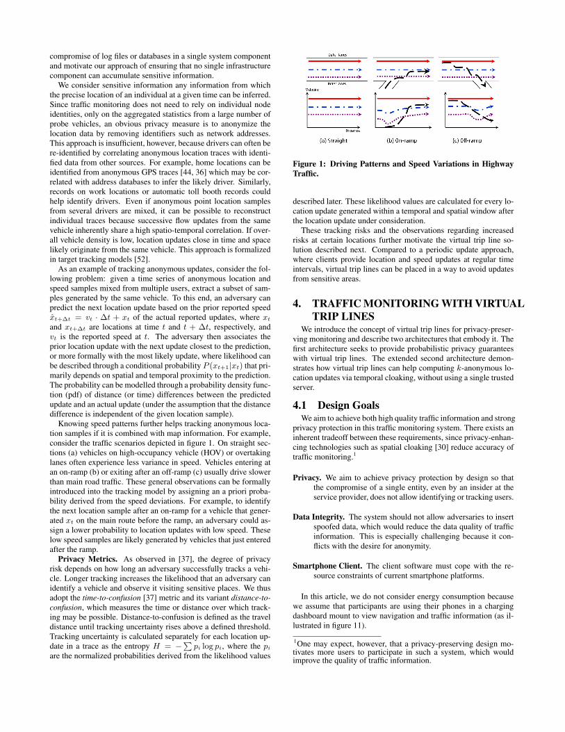
Knowing speed patterns further helps tracking anonymous loca-tion samples if it is combined with map information. For example,consider the traffic scenarios depicted in figure 1. On straight sec-tions (a) vehicles on high-occupancy vehicle (HOV) or overtakinglanes often experience less variance in speed. Vehicles entering atan on-ramp (b) or exiting after an off-ramp (c) usually drive slowerthan main road traffic. These general observations can be formallyintroduced into the tracking model by assigning an a priori proba-bility derived from the speed deviations. For example, to identifythe next location sample after an on-ramp for a vehicle that gener-ated xt on the main route before the ramp, an adversary could as-sign a lower probability to location updates with low speed. Theselow speed samples are likely generated by vehicles that just enteredafter the ramp.
Privacy Metrics. As observed in [37], the degree of privacyrisk depends on how long an adversary successfully tracks a vehi-cle. Longer tracking increases the likelihood that an adversary canidentify a vehicle and observe it visiting sensitive places. We thusadopt the time-to-confusion [37] metric and its variant distance-to-confusion, which measures the time or distance over which track-ing may be possible. Distance-to-confusion is defined as the traveldistance until tracking uncertainty rises above a defined threshold.Tracking uncertainty is calculated separately for each location up-date in a trace as the entropy H = −∑
pi log pi, where the pi
are the normalized probabilities derived from the likelihood values
Figure 1: Driving Patterns and Speed Variations in HighwayTraffic.
described later. These likelihood values are calculated for every lo-cation update generated within a temporal and spatial window afterthe location update under consideration.
These tracking risks and the observations regarding increasedrisks at certain locations further motivate the virtual trip line so-lution described next. Compared to a periodic update approach,where clients provide location and speed updates at regular timeintervals, virtual trip lines can be placed in a way to avoid updatesfrom sensitive areas.
4. TRAFFIC MONITORING WITH VIRTUALTRIP LINES
We introduce the concept of virtual trip lines for privacy-preser-ving monitoring and describe two architectures that embody it. Thefirst architecture seeks to provide probabilistic privacy guaranteeswith virtual trip lines. The extended second architecture demon-strates how virtual trip lines can help computing k-anonymous lo-cation updates via temporal cloaking, without using a single trustedserver.
4.1 Design GoalsWe aim to achieve both high quality traffic information and strong
privacy protection in this traffic monitoring system. There exists aninherent tradeoff between these requirements, since privacy-enhan-cing technologies such as spatial cloaking [30] reduce accuracy oftraffic monitoring.1
Privacy. We aim to achieve privacy protection by design so thatthe compromise of a single entity, even by an insider at theservice provider, does not allow identifying or tracking users.
Data Integrity. The system should not allow adversaries to insertspoofed data, which would reduce the data quality of trafficinformation. This is especially challenging because it con-flicts with the desire for anonymity.
Smartphone Client. The client software must cope with the re-source constraints of current smartphone platforms.
In this article, we do not consider energy consumption becausewe assume that participants are using their phones in a chargingdashboard mount to view navigation and traffic information (as il-lustrated in figure 11).
1One may expect, however, that a privacy-preserving design mo-tivates more users to participate in such a system, which wouldimprove the quality of traffic information.
VTL Server
ID Proxy
Make Updates ANONYMOUSStrip IP/Phone ESN address
Check right to use systemFilter suspicious updates
Ensure PRIVACYAggregation
Query Restrictions
Encrypted RPCSecure HTTP
Satellite
Traffic EstimationData mining and
logging
Traffic estimation feedback through TMC
Ensure PRIVACYVTL Placement
Restrictions
VTLDataBase
VTLUpdate Log
Cellular Networks
VTL Crossing Detection
VTL Caching
Sensing measurement End-to-end encryption
Traffic monitoring service provider
VTL Generator
VTL updates
VTL download
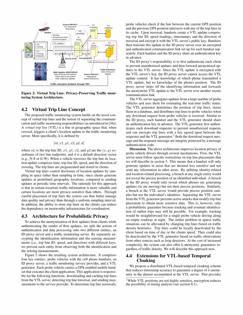
Figure 2: Virtual Trip Line: Privacy-Preserving Traffic moni-toring System Architecture.
4.2 Virtual Trip Line ConceptThe proposed traffic monitoring system builds on the novel con-
cept of virtual trip lines and the notion of separating the communi-cation and traffic monitoring responsibilities (as introduced in [36]).A virtual trip line (VTL) is a line in geographic space that, whencrossed, triggers a client’s location update to the traffic monitoringserver. More specifically, it is defined by
[id, x1, y1, x2, y2, d]
where id, is the trip line ID, x1, y1, x2, and y2 are the (x, y) co-ordinates of two line endpoints, and d is a default direction vector(e.g., N-S or E-W). When a vehicle traverses the trip line its loca-tion update comprises time, trip line ID, speed, and the direction ofcrossing. The trip lines are pregenerated and stored in clients.
Virtual trip lines control disclosure of location updates by sam-pling in space rather than sampling in time, since clients generateupdates at predefined geographic locations, compared to sendingupdates at periodic time intervals. The rationale for this approachis that in certain locations traffic information is more valuable andcertain locations are more privacy-sensitive than others. Throughcareful placement of trip lines the system can thus better managedata quality and privacy than through a uniform sampling interval.In addition, the ability to store trip lines on the clients can reducethe dependency on trustworthy infrastructure for coordination.
4.3 Architecture for Probabilistic PrivacyTo achieve the anonymization of flow updates from clients while
authenticating the sender of flow updates, we split the actions ofauthentication and data processing onto two different entities, anID proxy server and a traffic monitoring server. By separately en-crypting the identification information and the sensing measure-ments (i.e., trip line ID, speed, and direction) with different keys,we prevent each entity from observing both the identification andthe sensing measurements.
Figure 2 shows the resulting system architecture. It comprisesfour key entities: probe vehicles with the cell phone handsets, anID proxy server, a traffic monitoring service provider, and a VTLgenerator. Each probe vehicle carries a GPS-enabled mobile hand-set that executes the client application. This application is responsi-ble for the following functions: downloading and caching trip linesfrom the VTL server, detecting trip line traversal, and sending mea-surements to the service provider. To determine trip line traversals,
probe vehicles check if the line between the current GPS positionand the previous GPS position intersects with any of the trip lines inits cache. Upon traversal, handsets create a VTL update compris-ing trip line ID, speed readings, timestamps, and the direction oftraversal and encrypt it with the VTL server’s public key. Handsetsthen transmit this update to the ID proxy server over an encryptedand authenticated communication link set up for each handset sep-arately. Each handset and the ID proxy share an authentication keyin advance.
The ID proxy’s responsibility is to first authenticate each clientto prevent unauthorized updates and then forward anonymized up-dates to the VTL server. Since the VTL update is encrypted withthe VTL server’s key, the ID proxy server cannot access the VTLupdate content. It has knowledge of which phone transmitted aVTL update, but no knowledge of the phones position. The IDproxy server strips off the identifying information and forwardsthe anonymous VTL update to the VTL server over another securecommunication link.
The VTL server aggregates updates from a large number of probevehicles and uses them for estimating the real-time traffic status.The VTL generator determines the position of trip lines, storesthem in a database, and distributes trip lines to probe vehicles whenany download request from probe vehicles is received. Similar tothe ID proxy, each handset and the VTL generator should sharean authentication key in advance. The VTL generator first authen-ticates each download requester to prevent unauthorized requestsand can encrypts trip lines with a key agreed upon between therequester and the VTL generator.2 Both the download request mes-sage and the response message are integrity protected by a messageauthentication code.
Discussion. The above architecture improves location privacy ofprobe vehicle drivers through several mechanisms. First, the VTLserver must follow specific restrictions on trip line placements thatwe will describe in section 5. This means that a handset will onlygenerate updates in areas that are deemed less sensitive and notsend any information in other areas. By splitting identity-relatedand location-related processing, a breach at any single entity wouldnot reveal the precise position of an identified individual. A breachat the ID proxy would only reveal which phones are generatingupdates (or are moving) but not their precise positions. Similarly,a breach at the VTL server would provide precise position sam-ples but not the individual’s identities. Separating the VTL serverfrom the VTL generator prevents active attacks that modify trip lineplacement to obtain more sensitive data. This is, however, onlya probabilistic guarantee because tracking and eventual identifica-tion of outlier trips may still be possible. For example, trackingwould be straightforward for a single probe vehicle driving alongon empty roadway at night. The outlier problem in sparse trafficsituations can be alleviated by changing trip lines based on trafficdensity heuristics. Trip lines could be locally deactivated by theclient based on time of day or the clients speed. They could alsobe deactivated by the VTL generator based on traffic observationsfrom other sources such as loop detectors. At the cost of increasedcomplexity, the system can also offer k-anonymity guaratnees re-gardless of traffic density. We will describe this approach next.
4.4 Extensions for VTL-based TemporalCloaking
We propose a distributed VTL-based temporal cloaking schemethat reduces timestamp accuracy to guarantee a degree of k-anony-mity in the dataset accumulated at the VTL server. This provides2While VTL positions are not highly sensitive, encryption reducesthe possibility of timing analysis (see section 8.1).
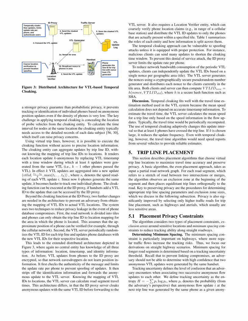
ID Proxy Traffic Server
2. Send the VTL update
1a. Nonce for area
4. Send the cloaked VTL updates
3. Forward the VTL update
Location Verifier
Handset
Temporally cloaks flow updates, limits update rate per phone, and authenticate users
Phone generates the new ID for trip line with nonce from VTL generator
VTLUpdate
Log
1b. Broadcast nonce to phones in area
5. Store the cloaked VTL updates
Coarse location verification to prevent location spoofing
VTL Generator
Figure 3: Distributed Architecture for VTL-based TemporalCloaking.
a stronger privacy guarantee than probabilistic privacy, it preventstracking or identification of individual phones based on anonymousposition updates even if the density of phones is very low. The keychallenge in applying temporal cloaking is concealing the locationof probe vehicles from the cloaking entity. To calculate the timeinterval for nodes at the same location the cloaking entity typicallyneeds access to the detailed records of each data subject [56, 30],which itself can raise privacy concerns.
Using virtual trip lines, however, it is possible to execute thecloaking function without access to precise location information.The cloaking entity can aggregate updates by trip line ID, with-out knowing the mapping of trip line IDs to locations. It renderseach location update k-anonymous by replacing VTL timestampwith a time window during which at least k updates were gen-erated from the same VTL (i.e., k − 1 other phones passed theVTL). In effect k VTL updates are aggregated into a new update(vtlid, s1...sk
k, max(t1 . . . tk)) , where si denotes the speed read-
ing of each VTL update i. Since now k-phones generate the sameupdate, it becomes harder to track one individual phone. The cloak-ing function can be executed at the ID proxy, if handsets add a VTLID to the update that can be accessed by the ID proxy.
Beyond the cloaking function at the ID Proxy, two further changesare needed in the architecture to prevent an adversary from obtain-ing the mapping of VTL IDs to actual VTL locations. The systemuses two techniques to reduce privacy leakage in the event of phonedatabase compromises. First, the road network is divided into tilesand phones can only obtain the trip line ID to location mapping forthe area in which the phone is located. This assumes that the ap-proximate position of a phone can be verified (for example, throughthe cellular network). Second, the VTL server periodically random-izes the VTL ID for each trip line and updates phone databases withthe new VTL IDs for their respective location.
This leads to the extended distributed architecture depicted inFigure 3, where again no central entity has knowledge of all threetypes of information: location, timestamp, and identity informa-tion. As before, VTL updates from phones to the ID proxy areencrypted, so that network eavesdroppers do not learn position in-formation. It first checks the authenticity of the message and limitsthe update rate per phone to prevent spoofing of updates. It thenstrips off the identification information and forwards the anony-mous update to the VTL server. Knowing the mapping of VTLIDs to locations, the VTL server can calculate road segment traveltimes. This architecture differs, in that the ID proxy server cloaksanonymous updates with the same VTL ID before forwarding to the
VTL server. It also requires a Location Verifier entity, which cancoarsely verify phone location claims (e.g., in range of a cellularbase station) and distribute the VTL ID updates to only the phonesthat are actually present within a specified tile. Table 1 summarizesthe roles of each entity and how information is split across them.
The temporal cloaking approach can be vulnerable to spoofingattacks unless it is equipped with proper protection. For instance,malicious clients can send many updates to shorten the cloakingtime window. To prevent this denial of service attack, the ID proxyserver limits the update rate per phone.
To reduce network bandwidth consumption of the periodic VTLupdates, clients can independently update the VTL IDs based on asingle nonce per geographic area (tile). The VTL server generatesthe nonces using a cryptographically secure pseudorandom numbergenerator and distributes each nonce to the clients currently in thetile area. Both clients and server can then compute V TLIDnew =h(nonce, V TLIDold), where h is a secure hash function such asSHA.
Discussion. Temporal cloaking fits well with the travel time es-timation method used in the VTL system because the mean speedcalculation does not depend on accurate timestamp information. Toestimate the travel time, the VTL server calculates the mean speedfor a trip line only based on the speed information in the flow up-dates. Typically, the travel time would be periodically recomputed.The use of temporal cloaking adaptively changes this update inter-val so that at least k phones have crossed the trip line. If k is chosenlarge, it reduces the update frequency. Even with temporal cloak-ing, however, the travel time algorithm would need speed reportsfrom several vehicles to provide reliable estimates.
5. TRIP LINE PLACEMENTThis section describes placement algorithms that choose virtual
trip line locations to maximize travel time accuracy and preserveprivacy. A basic algorithm, the even placement approach, takes asinput a partial road network graph. For each road segment, whichrefers to a stretch of road between two intersections or merges,the algorithm observes an exclusion zone at the beginning of thesegment and then places equidistant trip lines orthogonally to theroad. Key to preserving privacy are the procedures for determiningappropriate trip line spacing parameters and exclusion zone sizes,which we discuss in the following subsection. Privacy is also sig-nificantly improved by selecting only higher traffic roads for tripline placement, such as highways and aterials, which usually areless sensitive areas.
5.1 Placement Privacy ConstraintsThe algorithm considers two types of placement constraints, ex-
clusion areas around sensitive locations and minimum spacing con-straints to reduce tracking ability along straight roadways.
Determining Minimum Spacing. The minimum spacing con-straint is particularly important on highways, where more regu-lar traffic flows increase the tracking risks. Thus, we focus ourderivations on straight highway scenarios. Minimum spacing forlonger road segments is determined based on a tracking uncertaintythreshold. Recall that to prevent linking compromises, an adver-sary should not be able to determine with high confidence that twoanonymous VTL updates were generated by the same handset.
Tracking uncertainty defines the level of confusion that an adver-sary encounters when associating two successive anonymous flowupdates to each other. We define tracking uncertainty as the en-tropy H = −∑
pi log pi, where pi denotes the probability (fromthe adversary’s perspective) that anonymous flow update i at thenext trip line was generated by the same phone as a given anony-
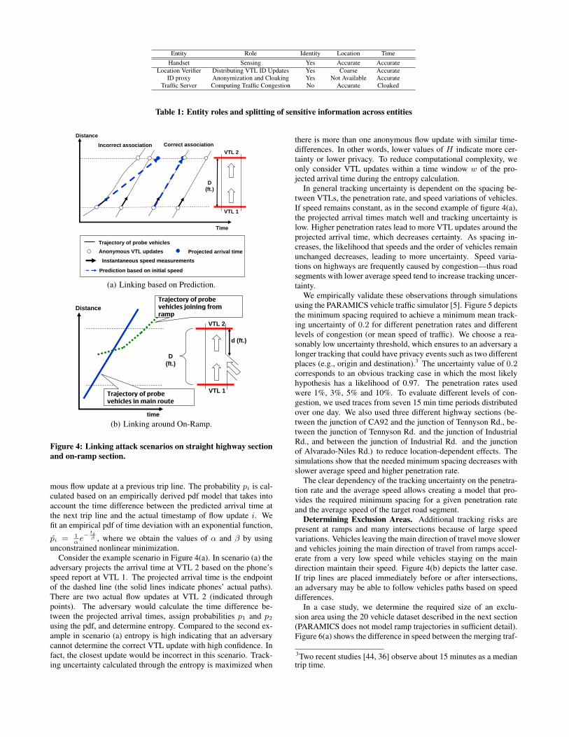
Entity Role Identity Location TimeHandset Sensing Yes Accurate Accurate
Location Verifier Distributing VTL ID Updates Yes Coarse AccurateID proxy Anonymization and Cloaking Yes Not Available Accurate
Traffic Server Computing Traffic Congestion No Accurate Cloaked
Table 1: Entity roles and splitting of sensitive information across entities
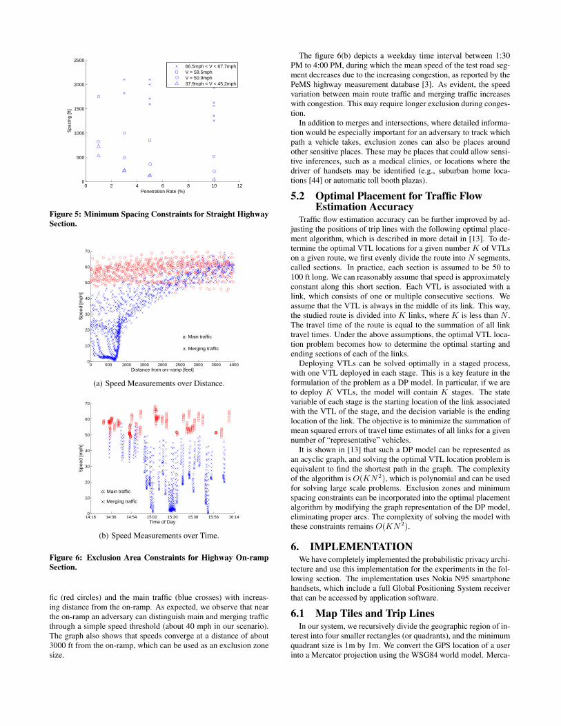
Incorrect association Correct association
Instantaneous speed measurements
Prediction based on initial speed
Anonymous VTL updates
Time
Distance
Trajectory of probe vehicles
D (ft.)
VTL 1
VTL 2
Projected arrival time
(a) Linking based on Prediction.
time
D (ft.)
d (ft.)
DistanceTrajectory of probe
vehicles joining from
ramp
Trajectory of probe
vehicles in main route
VTL 1
VTL 2
(b) Linking around On-Ramp.
Figure 4: Linking attack scenarios on straight highway sectionand on-ramp section.
mous flow update at a previous trip line. The probability pi is cal-culated based on an empirically derived pdf model that takes intoaccount the time difference between the predicted arrival time atthe next trip line and the actual timestamp of flow update i. Wefit an empirical pdf of time deviation with an exponential function,
p̂i = 1α
e− ti
β , where we obtain the values of α and β by usingunconstrained nonlinear minimization.
Consider the example scenario in Figure 4(a). In scenario (a) theadversary projects the arrival time at VTL 2 based on the phone’sspeed report at VTL 1. The projected arrival time is the endpointof the dashed line (the solid lines indicate phones’ actual paths).There are two actual flow updates at VTL 2 (indicated throughpoints). The adversary would calculate the time difference be-tween the projected arrival times, assign probabilities p1 and p2
using the pdf, and determine entropy. Compared to the second ex-ample in scenario (a) entropy is high indicating that an adversarycannot determine the correct VTL update with high confidence. Infact, the closest update would be incorrect in this scenario. Track-ing uncertainty calculated through the entropy is maximized when
there is more than one anonymous flow update with similar time-differences. In other words, lower values of H indicate more cer-tainty or lower privacy. To reduce computational complexity, weonly consider VTL updates within a time window w of the pro-jected arrival time during the entropy calculation.
In general tracking uncertainty is dependent on the spacing be-tween VTLs, the penetration rate, and speed variations of vehicles.If speed remains constant, as in the second example of figure 4(a),the projected arrival times match well and tracking uncertainty islow. Higher penetration rates lead to more VTL updates around theprojected arrival time, which decreases certainty. As spacing in-creases, the likelihood that speeds and the order of vehicles remainunchanged decreases, leading to more uncertainty. Speed varia-tions on highways are frequently caused by congestion—thus roadsegments with lower average speed tend to increase tracking uncer-tainty.
We empirically validate these observations through simulationsusing the PARAMICS vehicle traffic simulator [5]. Figure 5 depictsthe minimum spacing required to achieve a minimum mean track-ing uncertainty of 0.2 for different penetration rates and differentlevels of congestion (or mean speed of traffic). We choose a rea-sonably low uncertainty threshold, which ensures to an adversary alonger tracking that could have privacy events such as two differentplaces (e.g., origin and destination).3 The uncertainty value of 0.2corresponds to an obvious tracking case in which the most likelyhypothesis has a likelihood of 0.97. The penetration rates usedwere 1%, 3%, 5% and 10%. To evaluate different levels of con-gestion, we used traces from seven 15 min time periods distributedover one day. We also used three different highway sections (be-tween the junction of CA92 and the junction of Tennyson Rd., be-tween the junction of Tennyson Rd. and the junction of IndustrialRd., and between the junction of Industrial Rd. and the junctionof Alvarado-Niles Rd.) to reduce location-dependent effects. Thesimulations show that the needed minimum spacing decreases withslower average speed and higher penetration rate.
The clear dependency of the tracking uncertainty on the penetra-tion rate and the average speed allows creating a model that pro-vides the required minimum spacing for a given penetration rateand the average speed of the target road segment.
Determining Exclusion Areas. Additional tracking risks arepresent at ramps and many intersections because of large speedvariations. Vehicles leaving the main direction of travel move slowerand vehicles joining the main direction of travel from ramps accel-erate from a very low speed while vehicles staying on the maindirection maintain their speed. Figure 4(b) depicts the latter case.If trip lines are placed immediately before or after intersections,an adversary may be able to follow vehicles paths based on speeddifferences.
In a case study, we determine the required size of an exclu-sion area using the 20 vehicle dataset described in the next section(PARAMICS does not model ramp trajectories in sufficient detail).Figure 6(a) shows the difference in speed between the merging traf-
3Two recent studies [44, 36] observe about 15 minutes as a mediantrip time.
0 2 4 6 8 10 120
500
1000
1500
2000
2500
Penetration Rate (%)
Spa
cing
[ft]
66.5mph < V < 67.7mphV = 59.5mphV = 50.9mph37.9mph < V < 45.2mph
Figure 5: Minimum Spacing Constraints for Straight HighwaySection.
0 500 1000 1500 2000 2500 3000 3500 40000
10
20
30
40
50
60
70
Distance from on−ramp [feet]
Spe
ed [m
ph]
x: Merging traffic
o: Main traffic
(a) Speed Measurements over Distance.
14:18 14:36 14:54 15:02 15:20 15:38 15:56 16:140
10
20
30
40
50
60
70
Time of Day
Spe
ed [m
ph]
x: Merging traffic
o: Main traffic
(b) Speed Measurements over Time.
Figure 6: Exclusion Area Constraints for Highway On-rampSection.
fic (red circles) and the main traffic (blue crosses) with increas-ing distance from the on-ramp. As expected, we observe that nearthe on-ramp an adversary can distinguish main and merging trafficthrough a simple speed threshold (about 40 mph in our scenario).The graph also shows that speeds converge at a distance of about3000 ft from the on-ramp, which can be used as an exclusion zonesize.
The figure 6(b) depicts a weekday time interval between 1:30PM to 4:00 PM, during which the mean speed of the test road seg-ment decreases due to the increasing congestion, as reported by thePeMS highway measurement database [3]. As evident, the speedvariation between main route traffic and merging traffic increaseswith congestion. This may require longer exclusion during conges-tion.
In addition to merges and intersections, where detailed informa-tion would be especially important for an adversary to track whichpath a vehicle takes, exclusion zones can also be places aroundother sensitive places. These may be places that could allow sensi-tive inferences, such as a medical clinics, or locations where thedriver of handsets may be identified (e.g., suburban home loca-tions [44] or automatic toll booth plazas).
5.2 Optimal Placement for Traffic FlowEstimation Accuracy
Traffic flow estimation accuracy can be further improved by ad-justing the positions of trip lines with the following optimal place-ment algorithm, which is described in more detail in [13]. To de-termine the optimal VTL locations for a given number K of VTLson a given route, we first evenly divide the route into N segments,called sections. In practice, each section is assumed to be 50 to100 ft long. We can reasonably assume that speed is approximatelyconstant along this short section. Each VTL is associated with alink, which consists of one or multiple consecutive sections. Weassume that the VTL is always in the middle of its link. This way,the studied route is divided into K links, where K is less than N .The travel time of the route is equal to the summation of all linktravel times. Under the above assumptions, the optimal VTL loca-tion problem becomes how to determine the optimal starting andending sections of each of the links.
Deploying VTLs can be solved optimally in a staged process,with one VTL deployed in each stage. This is a key feature in theformulation of the problem as a DP model. In particular, if we areto deploy K VTLs, the model will contain K stages. The statevariable of each stage is the starting location of the link associatedwith the VTL of the stage, and the decision variable is the endinglocation of the link. The objective is to minimize the summation ofmean squared errors of travel time estimates of all links for a givennumber of “representative” vehicles.
It is shown in [13] that such a DP model can be represented asan acyclic graph, and solving the optimal VTL location problem isequivalent to find the shortest path in the graph. The complexityof the algorithm is O(KN2), which is polynomial and can be usedfor solving large scale problems. Exclusion zones and minimumspacing constraints can be incorporated into the optimal placementalgorithm by modifying the graph representation of the DP model,eliminating proper arcs. The complexity of solving the model withthese constraints remains O(KN2).
6. IMPLEMENTATIONWe have completely implemented the probabilistic privacy archi-
tecture and use this implementation for the experiments in the fol-lowing section. The implementation uses Nokia N95 smartphonehandsets, which include a full Global Positioning System receiverthat can be accessed by application software.
6.1 Map Tiles and Trip LinesIn our system, we recursively divide the geographic region of in-
terest into four smaller rectangles (or quadrants), and the minimumquadrant size is 1m by 1m. We convert the GPS location of a userinto a Mercator projection using the WSG84 world model. Merca-

tor projects the world into a square planar surface. A zoom of 25 isassumed to be the maximum precision that location can be speci-fied in. By default every GPS location is converted into 25 bit x andy values with zoom set to 25. By using the quadrant representationthe mobile device can efficiently control the granularity by simplychanging the zoom level. In this encoding, the world is treated as asquare grid of four quadrants with zoom level 2, where x and y arethe offsets from the top left corner of the world.
This reprentation makes it easy to specify the specific map tile.We define a map tile as a container that groups all trip lines withinit. When a client wants to download all virtual trip lines withinthe San Francisco Bay Area, it sends the VTL server the triplet,(zoom, x, y) for the corresponding region. In our implementation,we choose 12 as the default zoom level, which corresponds to an 8km by 8 km square.
This representation also helps in reducing storage size and band-width consumption. Since the general area is identified by thequadrant, we only store the 13 least significant bits of the trip lineend point coordinates instead of the full 25 bits used for typicalUTM coordinates. This decreases storage consumption to 68bits(15 bit id, 1 bit direction, 4 · 13 bits coordinates) per trip line.As an example of required storage and bandwidth consumption,consider the section of the San Francisco Bay Area shown in fig-ure 7. The total road network in the white titles shown in the leftfigure contains about 20,000 road segments, according to the Dig-ital Line Graph 1:24K scale maps of the San Francisco Bay AreaRegional Database (BARD [1], managed by USGS). Assuming thatthe system on average places one trip line per segment this resultsin 166KB of storage.
6.2 Client Device and SoftwareWe implemented the client software using J2ME (Java Platform,
Micro Edition) on an Nokia N95 handset. This Symbian OS hand-set uses an ARM11-based Texas Instruments OMAP2420 proces-sor running at 330MHz, and it contains 64MB RAM and 160MBinternal memory. Its storage can be expanded up to 8GB with flashmemory. We use the JSR 179 library (Location API for J2ME) [2]for communicating with the internal TI GPS5300 NaviLink 4.0single-chip GPS/A-GPS module to set the sampling period and re-trieve the position readings. This setup did not provide speed infor-mation. Instead, we calculate the mean speed using two successivelocation readings (in our implementation, every 3 seconds). Theclient software registers the task for checking the traversal of triplines as an event handler for GPS module location updates, whichis automatically invoked whenever a new position reading becomesavailable.
The communication between the handset and the ID proxy server,to send VTL updates or to request VTL downloads, is implementedvia HTTPS GET/POST messages. The client software encrypts themessage content but not the handset identification information us-ing the public key of the VTL server so that only the VTL serverwith the corresponding private key can decrypt the message. Tosave network bandwidth and to reduce delay, we cache the down-loaded trip lines for the nine map tiles closest to the current positionin local memory. When a vehicle crosses a tile boundary, it initiatesVTL download background threads for the missing tiles.
6.3 Servers and DatabasesVTL Server. At the bottom of the hierarchy of our server im-
plementation is a backend database server. The database servercontains two databases. First is a VTL database which holds GPScoordinates of all trip lines. In future we plan to enhance our tripline database to hold meta data associated with that trip line. For
instance, the meta data for a trip line can contain the posted speedlimit at that trip line which can be used by the client application todecide if it is going over the speed limit in which case the clientapplication can disable VTL updates. Write access to this databaseis restricted only to traffic administrators who can add, delete orupdate a VTL.
Figure 7: Road networks extracted from Bay Area DLG files(Left) and Trip Lines per road segment in Palo Alto CA (Right).
The second database is the VTL update database. This databasestores the VTL updates sent by the mobile device whenever the mo-bile device chooses to send an update after crossing a VTL. The up-date database simply appends every VTL update along with a timestamp on when the update was received. To sanitize bogus VTLupdates from the clients, the VTL update database also keeps boththe encrypted and decrypted versions of the VTL update for fur-ther investigation in collaboration with the ID proxy server. Whenbogus VTL updates are detected in the VTL update database, theirencrypted versions are compared to the encrypted version stored inthe ID proxy server to blacklist the originator of bogus VTL up-dates.
We use Microsoft SQL to implement the databases, and we de-velop the VTL server using J2EE (Java Platform, Enterprise Edi-tion) and JDBC (Java Database Connectivity) to control the SQLdatabases that are connected to the VTL server. While we haveused only a single DB server in this prototype, the two databasesshould ideally be implemented by different entities to prevent activetrip line modification attacks by a compromised traffic monitoringentity.
ID Proxy Server. On top of the database server is the ID Proxyserver. The identification proxy server is envisioned to be oper-ated by an entity that is independent of the traffic service provider.We implement the ID proxy server as a servlet-based web serverthat takes in HTTPS GET/POST messages from clients and for-wards messages to the VTL server. The HTTP message receivedby the proxy server from the client has two components. The firstcomponent contains the mobile device identification information,namely phone number of the message origin. This component ofthe message is required for all cell phone communications as op-erator needs to appropriately charge for data communication costs.The second component of the message contains information thatis intended for the database server. The proxy server strips all theidentification information from the message, namely the first com-ponent of the message, and passes on the second component ofthe message to the application server. We implemented the securechannel between ID proxy server and the VTL server using WSDL(Web Service Definition Language)-RPC (Remote Procedure Call)over J2EE Server.
7. EXPERIMENTAL EVALUATIONWe evaluate our system first in terms of travel time estimation
accuracy and then analyze privacy-accuracy tradeoffs.
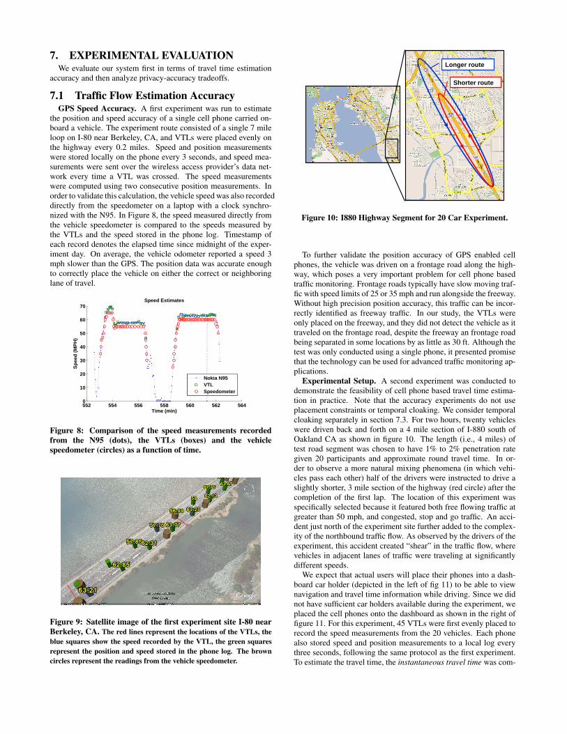
7.1 Traffic Flow Estimation AccuracyGPS Speed Accuracy. A first experiment was run to estimate
the position and speed accuracy of a single cell phone carried on-board a vehicle. The experiment route consisted of a single 7 mileloop on I-80 near Berkeley, CA, and VTLs were placed evenly onthe highway every 0.2 miles. Speed and position measurementswere stored locally on the phone every 3 seconds, and speed mea-surements were sent over the wireless access provider’s data net-work every time a VTL was crossed. The speed measurementswere computed using two consecutive position measurements. Inorder to validate this calculation, the vehicle speed was also recordeddirectly from the speedometer on a laptop with a clock synchro-nized with the N95. In Figure 8, the speed measured directly fromthe vehicle speedometer is compared to the speeds measured bythe VTLs and the speed stored in the phone log. Timestamp ofeach record denotes the elapsed time since midnight of the exper-iment day. On average, the vehicle odometer reported a speed 3mph slower than the GPS. The position data was accurate enoughto correctly place the vehicle on either the correct or neighboringlane of travel.
552 554 556 558 560 562 5640
10
20
30
40
50
60
70Speed Estimates
Sp
eed
(M
PH
)
Time (min)
Nokia N95VTLSpeedometer
Figure 8: Comparison of the speed measurements recordedfrom the N95 (dots), the VTLs (boxes) and the vehiclespeedometer (circles) as a function of time.
Figure 9: Satellite image of the first experiment site I-80 nearBerkeley, CA. The red lines represent the locations of the VTLs, theblue squares show the speed recorded by the VTL, the green squaresrepresent the position and speed stored in the phone log. The browncircles represent the readings from the vehicle speedometer.
Longer route
Shorter route
Figure 10: I880 Highway Segment for 20 Car Experiment.
To further validate the position accuracy of GPS enabled cellphones, the vehicle was driven on a frontage road along the high-way, which poses a very important problem for cell phone basedtraffic monitoring. Frontage roads typically have slow moving traf-fic with speed limits of 25 or 35 mph and run alongside the freeway.Without high precision position accuracy, this traffic can be incor-rectly identified as freeway traffic. In our study, the VTLs wereonly placed on the freeway, and they did not detect the vehicle as ittraveled on the frontage road, despite the freeway an frontage roadbeing separated in some locations by as little as 30 ft. Although thetest was only conducted using a single phone, it presented promisethat the technology can be used for advanced traffic monitoring ap-plications.
Experimental Setup. A second experiment was conducted todemonstrate the feasibility of cell phone based travel time estima-tion in practice. Note that the accuracy experiments do not useplacement constraints or temporal cloaking. We consider temporalcloaking separately in section 7.3. For two hours, twenty vehicleswere driven back and forth on a 4 mile section of I-880 south ofOakland CA as shown in figure 10. The length (i.e., 4 miles) oftest road segment was chosen to have 1% to 2% penetration rategiven 20 participants and approximate round travel time. In or-der to observe a more natural mixing phenomena (in which vehi-cles pass each other) half of the drivers were instructed to drive aslightly shorter, 3 mile section of the highway (red circle) after thecompletion of the first lap. The location of this experiment wasspecifically selected because it featured both free flowing traffic atgreater than 50 mph, and congested, stop and go traffic. An acci-dent just north of the experiment site further added to the complex-ity of the northbound traffic flow. As observed by the drivers of theexperiment, this accident created “shear” in the traffic flow, wherevehicles in adjacent lanes of traffic were traveling at significantlydifferent speeds.
We expect that actual users will place their phones into a dash-board car holder (depicted in the left of fig 11) to be able to viewnavigation and travel time information while driving. Since we didnot have sufficient car holders available during the experiment, weplaced the cell phones onto the dashboard as shown in the right offigure 11. For this experiment, 45 VTLs were first evenly placed torecord the speed measurements from the 20 vehicles. Each phonealso stored speed and position measurements to a local log everythree seconds, following the same protocol as the first experiment.To estimate the travel time, the instantaneous travel time was com-
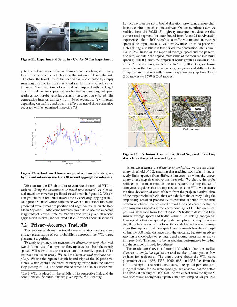
Figure 11: Experimental Setup in a Car for 20 Car Experiment.
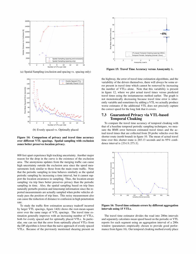
puted, which assumes traffic conditions remain unchanged on everylink4 from the time the vehicle enters the link until it leaves the link.Therefore, the travel time of the section can be computed by simplysumming those of the constituent links at the time a vehicle entersthe route. The travel time of each link is computed with the lengthof a link and the mean speed that is obtained by averaging out speedreadings from probe vehicles during an aggregation interval. Theaggregation interval can vary from 10s of seconds to few minutes,depending on traffic condition. Its effect on travel time estimationaccuracy will be examined in section 7.3.
14:30 15:00 15:30 16:003
4
5
6
7
8
9
10
Time of Day
Tra
vel T
ime
(min
utes
)
Actual Travel TimeEstimated Travel Time
Figure 12: Actual travel times compared with an estimate givenby the instantaneous method (30 second aggregation interval).
We then run the DP algorithm to compute the optimal VTL lo-cations. Using the instantaneous travel time method, we plot ac-tual travel times versus predicted travel times in figure 12. We ob-tain ground truth for actual travel time by checking logging data ofeach probe vehicle. Since variates between actual travel times andpredicted travel times are positive and negative, we calculate RootMean Squared (RMS) error between two sets to see the expectedmagnitude of a travel time estimation error. For a given 30 secondaggregation interval, we achieved a RMS error of about 80 seconds.
7.2 Privacy-Accuracy TradeoffsThis section analyzes the travel time estimation accuracy and
privacy preservation of our probabilistic approach, the VTL-basedplacement algorithm.
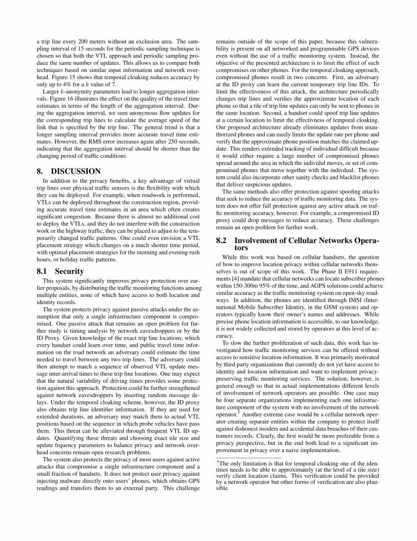
To analyze privacy, we measure the distance-to-confusion withtwo different sets of anonymous flow updates from both the evenlyspaced VTLs (with exclusion area) and the evenly spaced VTLs(without exclusion area). We call the latter spatial periodic sam-pling. We use the repeated south bound trips of the 20 probe ve-hicles, which contain the effect of merging traffic from the shorterloop (see figure 13). The south bound direction also has lower traf-4Each VTL is placed in the middle of its respective link and theconditions on the entire link are given by the VTL reading.
fic volume than the north bound direction, providing a more chal-lenging environment to protect privcay. On the experiment day, weverified from the PeMS [3] highway measurement database thatour test road segment (on south bound from Route 92 to Alvarado)experienced about 5000 vehs/h as a traffic volume and an averagespeed of 55 mph. Because we have 88 traces from 20 probe ve-hicles during our 100 min test period, the penetration rate is about1% to 2%. Based on the reported average speed and the penetra-tion rate, we obtain the approximate value of the required minimumspacing (800 ft.) from the empirical result graph as shown in fig-ure 5. At the on-ramp, we define a 1670 ft (500 meters) exclusionarea. Given the fixed exclusion area, we generated different setsof equidistant trip lines with minimum spacing varying from 333 ft(100 meters) to 1670 ft (500 meters).
3.54miles
1mile
1666ft.
Exclusion area
Figure 13: Exclusion Area on Test Road Segment. Trackingstarts from the point marked by star.
When we measure the distance-to-confusion, we use an uncer-tainty threshold of 0.2, meaning that tracking stops when it incor-rectly links updates from different handsets, or when the uncer-tainty at any step rises above this threshold. We choose the probevehicles of the main route as the test vectors. Among the set ofanonymous updates that are reported at the same VTL, we measurethe time deviation of each of them from the projected arrival timeof the target probe vehicle, then we calculate the entropy using theempirically obtained probability distribution function of the timedeviation between the projected arrival time and each timestampsof anonymous updates at the corresponding VTL. This empiricalpdf was measured from the PARAMICS traffic dataset that havesimilar average speed and traffic volume. In linking anonymousflow updates that the spatial periodic sampling techniques gener-ate, the adversary removes from the candidate set several anony-mous flow updates that have speed measurements less than 40 mphwithin the 500 meter distance from the on-ramp, because an adver-sary has a knowledge on general trend around on-ramps as shownin figure 6(a). This leads to better tracking performance by reduc-ing the number of likely hypotheses.
The results are shown in figure 14(a) which plots the mediandistance-to-confusion against the total number of anonymous flowupdates for each case. The dotted curve shows the VTL-basedplacement cases, 1666, 1333, 1000, 666, and 333 feet from theleft to the right. The solid curve shows the spatial periodic sam-pling techniques for the same spacings. We observe that the dottedline drops at spacing of 1000 feet. As we expect from the figure 5,two successive anonymous updates that are sampled longer than
0 2 4 6 8 10 12 14 160
2000
4000
6000
8000
10000
12000
14000
16000
Number of VTLs per mile
Med
ian
Dis
tanc
e−to
−C
onfu
sion
[ft]
Spatial Sampling (spacing and exclusion)Spatial Sampling (spacing only)
(a) Spatial Sampling (exclusion and spacing vs. spacing only)
0 2 4 6 8 10 12 14 1660
70
80
90
100
110
120
130
140
150
Number of VTLs per mile
Roo
t Mea
n S
quar
ed E
rror
(se
cond
s)
Evenly Spaced VTLsOptimally Placed VTLs
(b) Evenly spaced vs. Optimally placed
Figure 14: Comparison of privacy and travel time accuracyover different VTL spacings. Spatial sampling with exclusionzones better preserves location privacy.
800 feet apart experience high tracking uncertainty. Another majorreason for the drop in the curve is the existence of the exclusionarea. The anonymous updates from the merging traffic can causehigh uncertainty outside the exclusion area since the speed mea-surements look similar to those from the main route traffic. Notethat the periodic sampling in time behaves similarly as the spatialperiodic sampling by increasing a time interval, but it cannot sup-port the location awareness in sampling. Thus, the location-awaresampling via trip lines better preserves privacy than the periodicsampling in time. Also, the spatial sampling based on trip linesnaturally perturbs position and timestamp information since the re-ported measurements are actually sampled when probe vehicles al-ready pass the position of trip lines. This noisy measurement alsocan cause the reduction of distance to confusion in high penetrationrate.
To study the traffic flow estimation accuracy tradeoff incurredby larger VTL spacings, figure 14(b) shows the root-mean-squareerror over the same range of VTL spacings. The travel time es-timation generally improves with an increasing number of VTLs,both for evenly spaced and for optimally placed VTLs. In partic-ular, one can see that the error from optimally placed VTLs fromthe DP algorithm is lower than the naive approach of evenly spacedVTLs. Because of the previously mentioned shearing present on
1 2 3 4 5 6 70
10
20
30
40
50
60
Anonymity Level k
Roo
t M
ean
Squ
are
Err
or [
sec]
VTL-based Temporal Cloaking (spacing=200m)
Temporal Periodic Sampling (interval=15sec)
~4%
Figure 15: Travel Time Accuracy versus Anonymity k.
the highway, the error of travel time estimation algorithms, and thevariability of the drivers themselves, there will always be some er-ror present in travel time which cannot be removed by increasingthe number of VTLs alone. Note that this variability is presentin figure 12, where we plot actual travel times versus predictedtravel times using the instantaneous method earlier. The graph isnot monotonically decreasing because travel time error is inher-ently variable and sometimes by adding a VTL we actually produceworse estimates if the additional VTL does not precisely capturethe correct speed for the long link that it covers.
7.3 Guaranteed Privacy via VTL-basedTemporal Cloaking
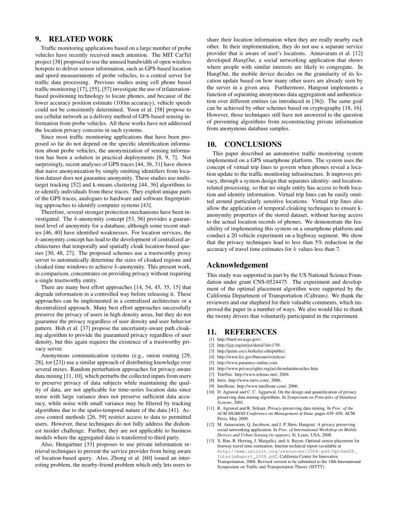
To compare the travel time accuracy of temporal cloaking withthat of a baseline temporal periodic sampling techniques, we mea-sure the RMS error between estimated travel times and the ac-tual travel times that are collected from 20 probe vehicles over theshorter route (north bound) in figure 10. The mean of actual traveltime over this shorter route is 265.13 seconds and its 95% confi-dence interval is (254.9; 275.3).
0 50 100 150 200 250 300 350 40040
45
50
55
60
65
70
75
80
Sampling Interval (seconds)
Roo
t Mea
n S
quar
ed E
rror
(se
cond
s)
Figure 16: Travel time estimate errors by different aggregationintervals using 15 VTLs.
The travel time estimator divides the road into 200m intervalsand separately calculates mean speed based on the periodic or VTLreports for each segment using an aggregation interval of a 200swindow (parameters empirically chosen to provide good perfor-mance from figure 16). Our temporal cloaking method evenly place
a trip line every 200 meters without an exclusion area. The sam-pling interval of 15 seconds for the periodic sampling technique ischosen so that both the VTL approach and periodic sampling pro-duce the same number of updates. This allows us to compare bothtechniques based on similar input information and network over-head. Figure 15 shows that temporal cloaking reduces accuracy byonly up to 4% for a k value of 7.
Larger k-anonymity parameters lead to longer aggregation inter-vals. Figure 16 illustrates the effect on the quality of the travel timeestimates in terms of the length of the aggregation interval. Dur-ing the aggregation interval, we sum anonymous flow updates forthe corresponding trip lines to calculate the average speed of thelink that is specified by the trip line. The general trend is that alonger sampling interval provides more accurate travel time esti-mates. However, the RMS error increases again after 250 seconds,indicating that the aggregation interval should be shorter than thechanging period of traffic conditions.
8. DISCUSSIONIn addition to the privacy benefits, a key advantage of virtual
trip lines over physical traffic sensors is the flexibility with whichthey can be deployed. For example, when roadwork is performed,VTLs can be deployed throughout the construction region, provid-ing accurate travel time estimates in an area which often createssignificant congestion. Because there is almost no additional costto deploy the VTLs, and they do not interfere with the constructionwork or the highway traffic, they can be placed to adjust to the tem-porarily changed traffic patterns. One could even envision a VTLplacement strategy which changes on a much shorter time period,with optimal placement strategies for the morning and evening rushhours, or holiday traffic patterns.
8.1 SecurityThis system significantly improves privacy protection over ear-
lier proposals, by distributing the traffic monitoring functions amongmultiple entities, none of which have access to both location andidentity records.
The system protects privacy against passive attacks under the as-sumption that only a single infrastructure component is compro-mised. One passive attack that remains an open problem for fur-ther study is timing analysis by network eavesdroppers or by theID Proxy. Given knowledge of the exact trip line locations, whichevery handset could learn over time, and public travel time infor-mation on the road network an adversary could estimate the timeneeded to travel between any two trip lines. The adversary couldthen attempt to match a sequence of observed VTL update mes-sage inter-arrival times to these trip line locations. One may expectthat the natural variability of driving times provides some protec-tion against this approach. Protection could be further strengthenedagainst network eavesdroppers by inserting random message de-lays. Under the temporal cloaking scheme, however, the ID proxyalso obtains trip line identifier information. If they are used forextended durations, an adversary may match them to actual VTLpositions based on the sequence in which probe vehicles have passthem. This threat can be alleviated through frequent VTL ID up-dates. Quantifying these threats and choosing exact tile size andupdate frquency parameters to balance privacy and network over-head concerns remain open research problems.
The system also protects the privacy of most users against activeattacks that compromise a single infrastructure component and asmall fraction of handsets. It does not protect user privacy againstinjecting malware directly onto users’ phones, which obtains GPSreadings and transfers them to an external party. This challenge
remains outside of the scope of this paper, because this vulnera-bility is present on all networked and programmable GPS deviceseven without the use of a traffic monitoring system. Instead, theobjective of the presented architecture is to limit the effect of suchcompromises on other phones. For the temporal cloaking approach,compromised phones result in two concerns. First, an adversaryat the ID proxy can learn the current temporary trip line IDs. Tolimit the effectiveness of this attack, the architecture periodicallychanges trip lines and verifies the approximtate location of eachphone so that a tile of trip line updates can only be sent to phones inthe same location. Second, a handset could spoof trip line updatesat a certain location to limit the effectivness of temporal cloaking.Our proposed architecture already eliminates updates from unau-thorized phones and can easily limits the update rate per phone andverify that the approximate phone position matches the claimed up-date. This renders extended tracking of individual difficult becauseit would either require a large number of compromised phonesspread around the area in which the individul moves, or set of com-promised phones that move together with the indivdual. The sys-tem could also incorporate other sanity checks and blacklist phonesthat deliver suspicious updates.
The same methods also offer protection against spoofing attacksthat seek to reduce the accuracy of traffic monitoring data. The sys-tem does not offer full protection against any active attack on traf-fic monitoring accuracy, however. For example, a compromised IDproxy could drop messages to reduce accuracy. These challengesremain an open problem for further work.
8.2 Involvement of Cellular Networks Opera-tors
While this work was based on cellular handsets, the questionof how to improve location privacy within cellular networks them-selves is out of scope of this work. The Phase II E911 require-ments [4] mandate that cellular networks can locate subscriber phoneswithin 150-300m 95% of the time, and AGPS solutions could achievesimilar accuracy as the traffic monitoring system on open-sky road-ways. In addition, the phones are identified through IMSI (Inter-national Mobile Subscriber Identity, in the GSM system) and op-erators typically know their owner’s names and addresses. Whileprecise phone location information is accessible, to our knowledge,it is not widely collected and stored by operators at this level of ac-curacy.
To slow the further proliferation of such data, this work has in-vestigated how traffic monitoring services can be offered withoutaccess to sensitive location information. It was primarily motivatedby third party organizations that currently do not yet have access toidentity and location information and want to implement privacy-preserving traffic monitoring services. The solution, however, isgeneral enough so that in actual implementations different levelsof involvement of network operators are possible. One case maybe four separate organizations implementing each one infrastruc-ture component of the system with no involvement of the networkoperator.5 Another extreme case would be a cellular network oper-ator creating separate entities within the company to protect itselfagainst dishonest insiders and accidental data breaches of their cus-tomers records. Clearly, the first would be more preferable from aprivacy perspective, but in the end both lead to a significant im-provement in privacy over a naive implementation.
5The only limitation is that for temporal cloaking one of the iden-tities needs to be able to approximately (at the level of a tile size)verify client location claims. This verification could be providedby a network operator but other forms of verification are also plau-sible.
9. RELATED WORKTraffic monitoring applications based on a large number of probe
vehicles have recently received much attention. The MIT CarTelproject [38] proposed to use the unused bandwidth of open wirelesshotspots to deliver sensor information, such as GPS-based locationand speed measurements of probe vehicles, to a central server fortraffic data processing. Previous studies using cell phone basedtraffic monitoring [17], [55], [57] investigate the use of trilateration-based positioning technology to locate phones, and because of thelower accuracy position estimate (100m accuracy), vehicle speedscould not be consistently determined. Yoon et al. [58] propose touse cellular network as a delivery method of GPS-based sensing in-formation from probe vehicles. All these works have not addressedthe location privacy concerns in such systems.
Since most traffic monitoring applications that have been pro-posed so far do not depend on the specific identification informa-tion about probe vehicles, the anonymization of sensing informa-tion has been a solution in practical deployments [8, 9, 7]. Notsurprisingly, recent analyses of GPS traces [44, 36, 31] have shownthat naive anonymization by simply omitting identifiers from loca-tion dataset does not guarantee anonymity. These studies use multi-target tracking [52] and k-means clustering [44, 36] algorithms tore-identify individuals from these traces. They exploit unique partsof the GPS traces, analogues to hardware and software fingerprint-ing approaches to identify computer systems [43].
Therefore, several stronger protection mechanisms have been in-vestigated. The k-anonymity concept [53, 56] provides a guaran-teed level of anonymity for a database, although some recent stud-ies [46, 40] have identified weaknesses. For location services, thek-anonymity concept has lead to the development of centralized ar-chitectures that temporally and spatially cloak location-based que-ries [30, 48, 27]. The proposed schemes use a trustworthy proxyserver to automatically determine the sizes of cloaked regions andcloaked time windows to achieve k-anonymity. This present work,in comparison, concentrates on providing privacy without requiringa single trustworthy entity.
There are many best effort approaches [14, 54, 45, 35, 15] thatdegrade information in a controlled way before releasing it. Theseapproaches can be implemented in a centralized architecture or adecentralized approach. Many best effort approaches successfullypreserve the privacy of users in high density areas, but they do notguarantee the privacy regardless of user density and user behaviorpattern. Hoh et al. [37] propose the uncertainty-aware path cloak-ing algorithm to provide the guaranteed privacy regardless of userdensity, but this again requires the existence of a trustworthy pri-vacy server.
Anonymous communication systems (e.g., onion routing [29,28], tor [23]) use a similar approach of distributing knowledge overseveral mixes. Random perturbation approaches for privacy-awaredata mining [11, 10], which perturbs the collected inputs from usersto preserve privacy of data subjects while maintaining the qual-ity of data, are not applicable for time-series location data sincenoise with large variance does not preserve sufficient data accu-racy, while noise with small variance may be filtered by trackingalgorithms due to the spatio-temporal nature of the data [41]. Ac-cess control methods [26, 59] restrict access to data to permittedusers. However, these techniques do not fully address the dishon-est insider challenge. Further, they are not applicable to businessmodels where the aggregated data is transferred to third party.
Also, Hengartner [33] proposes to use private information re-trieval techniques to prevent the service provider from being awareof location-based query. Also, Zhong et al. [60] issued an inter-esting problem, the nearby-friend problem which only lets users to
share their location information when they are really nearby eachother. In their implementation, they do not use a separate serviceprovider that is aware of user’s locations. Annavaram et al. [12]developed HangOut, a social networking application that showswhere people with similar interests are likely to congregate. InHangOut, the mobile device decides on the granularity of its lo-cation update based on how many other users are already seen bythe server in a given area. Furthermore, Hangout implements afunction of separating anonymous data aggregation and authentica-tion over different entities (as introduced in [36]). The same goalcan be achieved by other schemes based on cryptography [18, 16].However, those techniques still have not answered to the questionof preventing algorithms from reconstructing private informationfrom anonymous database samples.
10. CONCLUSIONSThis paper described an automotive traffic monitoring system
implemented on a GPS smartphone platform. The system uses theconcept of virtual trip lines to govern when phones reveal a loca-tion update to the traffic monitoring infrastructure. It improves pri-vacy, through a system design that separates identity- and location-related processing, so that no single entity has access to both loca-tion and identity information. Virtual trip lines can be easily omit-ted around particularly sensitive locations. Virtual trip lines alsoallow the application of temporal cloaking techniques to ensure k-anonymity properties of the stored dataset, without having accessto the actual location records of phones. We demonstrate the fea-sibility of implementing this system on a smartphone platform andconduct a 20 vehicle experiment on a highway segment. We showthat the privacy techniques lead to less than 5% reduction in theaccuracy of travel time estimates for k values less than 7.
AcknowledgementThis study was supported in part by the US National Science Foun-dation under grant CNS-0524475. The experiment and develop-ment of the optimal placement algorithm were supported by theCalifornia Department of Transportation (Caltrans). We thank thereviewers and our shepherd for their valuable comments, which im-proved the paper in a number of ways. We also would like to thankthe twenty drivers that voluntarily participated in the experiment.
11. REFERENCES[1] http://bard.wr.usgs.gov/.[2] http://jcp.org/en/jsr/detail?id=179/.[3] http://pems.eecs.berkeley.edu/public/.[4] http://www.fcc.gov/bureaus/wireless/.[5] http://www.paramics-online.com.[6] http://www.privacyrights.org/ar/chrondatabreaches.htm.[7] TeleNav. http://www.telenav.net/, 2004.[8] Inrix. http://www.inrix.com/, 2006.[9] Intellione. http://www.intellione.com/, 2006.
[10] D. Agrawal and C. C. Aggarwal. On the design and quantification of privacypreserving data mining algorithms. In Symposium on Principles of DatabaseSystems, 2001.
[11] R. Agrawal and R. Srikant. Privacy-preserving data mining. In Proc. of theACM SIGMOD Conference on Management of Data, pages 439–450. ACMPress, May 2000.
[12] M. Annavaram, Q. Jacobson, and J. P. Shen. Hangout: A privacy preservingsocial networking application. In Proc. of International Workshop on MobileDevices and Urban Sensing (to appear), St. Louis, USA, 2008.
[13] X. Ban, R. Herring, J. Margulici, and A. Bayen. Optimal sensor placement forfreeway travel time estimation. Interim technical report (available athttp://www.calccit.org/resources/2008-pdf/OptSenDP_InterimReport_2008.pdf, California Center for InnovativeTransportation, 2008. Revised version to be submitted to the 18th InternationalSymposium on Traffic and Transportation Theory (ISTTT).
[14] A. Beresford and F. Stajano. Mix zones: User privacy in location-awareservices. In IEEE PerSec, 2004.
[15] C. Bettini, X. SeanWang, and S. Jajodia. Protecting privacy againstlocation-based personal identification,. In 2nd VLDB Workshop SDM, 2005.
[16] D. Boneh, X. Boyen, and H. Shacham. Short group signatures. In CRYPTO2004, volume 3152 of Lecture Notes in Computer Science, pages 41–55.Springer, 2004.
[17] R. Cayford and T. Johnson. Operational parameters affecting the use ofanonymous cell phone tracking for generating traffic information.Transportation Research Board 82nd Annual Meeting, 1(3):03–3865, 2003.
[18] D. Chaum and E. V. Heyst. Group signatures. In Advances inCryptology–EUROCRYPT ’91, volume 547 of Lecture Notes in ComputerScience, pages 257–265. Springer, 1991.
[19] L. Chu, S. Oh, and W. Recker. Adaptive Kalman filter based freeway travel timeestimation. In 84th TRB Annual Meeting, Washington D.C., January 9-132005. Transportation Research Board.
[20] B. Coifman. Using dual loop speed traps to identify detector errors.Transportation Research Board, Transportation Research Record1683(-1):47–58, 1999.
[21] B. Coifman. Improved velocity estimation using single loop detectors.Transportation Research Part A, 35(10):863–880, 2001.
[22] X. Dai, M. Ferman, and R. Roesser. A simulation evaluation of a real-timetraffic information system using probe vehicles. In Proceedings of the IEEEIntelligent Transportation Systems, pages 475–480, 2003.
[23] R. Dingledine, N. Mathewson, and P. F. Syverson. Tor: The second-generationonion router. In USENIX Security Symposium, pages 303–320, 2004.
[24] A.-M. Elliott. Tomtom announces tomtom high definition traffic.http://www.pocket-lint.co.uk/news/news.phtml/11248/12272/TomTom-High-Definition-Traffic-announced.phtml, Nov2007.
[25] M. Ferman, D. Blumenfeld, and X. Dai. A simple analytical model of aprobe-based traffic information system. In Proceedings of the IEEE IntelligentTransportation Systems, pages 263–268, 2003.
[26] A. Gal and V. Atluri. An authorization model for temporal data. In Proceedingsof the 7th ACM CCS, pages 144–153, New York, NY, USA, 2000. ACM Press.
[27] B. Gedik and L. Liu. Location privacy in mobile systems: A personalizedanonymization model. In Proceedings of the 25th IEEE ICDCS 2005, pages620–629, Washington, DC, USA, 2005.
[28] D. Goldschlag, M. Reed, and P. Syverson. Onion routing. Communications ofthe ACM, 42(2):39–41, 1999.
[29] D. Goldschlag, M. Reed, and P. Syverson. Onion routing for anonymous andprivate internet connections. Communications of the ACM (USA), 42(2):39–41,1999.
[30] M. Gruteser and D. Grunwald. Anonymous usage of location-based servicesthrough spatial and temporal cloaking. In Proceedings of the ACM MobiSys,2003.
[31] M. Gruteser and B. Hoh. On the anonymity of periodic location samples. InProceedings of the Second International Conference on Security in PervasiveComputing, 2005.
[32] F. Hall and B. Persaud. Evaluation of speed estimates made with single-detectordata from freeway traffic management systems. Transportation Research Board,Transportation Research Record 1232:9–16, 1989.
[33] U. Hengartner. Hiding location information from location-based services. InProc. of International Workshop on Privacy-Aware Location-based MobileServices (PALMS), Mannheim, Germany, 2007.
[34] J. Herrera and A.M.Bayen. Traffic flow reconstruction using mobile sensors andloop detector data. In 87th TRB Annual Meeting, Washington D.C., January12-16 2008. Transportation Research Board.
[35] B. Hoh and M. Gruteser. Protecting location privacy through path confusion. InProceedings of IEEE/Create-Net SecureComm, Athens, Greece, September2005.
[36] B. Hoh, M. Gruteser, H. Xiong, and A. Alrabady. Enhancing security andprivacy in traffic-monitoring systems. IEEE Pervasive Computing, 5(4):38–46,2006.
[37] B. Hoh, M. Gruteser, H. Xiong, and A. Alrabady. Preserving privacy in gpstraces via uncertainty-aware path cloaking. In Proceedings of ACM CCS 2007,October 2007.
[38] B. Hull, V. Bychkovsky, Y. Zhang, K. Chen, M. Goraczko, A. K. Miu, E. Shih,H. Balakrishnan, and S. Madden. CarTel: A Distributed Mobile SensorComputing System. In 4th ACM SenSys, Boulder, CO, November 2006.
[39] Z. Jia, C. Chen, B. Coifman, and P. Varaiya. The PeMS algorithms for accurate,real-time estimates of g-factors and speeds from single-loop detectors. IEEEControl Systems Magazine, 21(4):26–33, 2001.
[40] P. Kalnis, G. Ghinita, K. Mouratidis, and D. Papadias. Preventinglocation-based identity inference in anonymous spatial queries. IEEETransactions on Knowledge and Data Engineering, 19(12):1719–1733, 2007.
[41] H. Kargupta, S. Datta, Q. Wang, and K. Sivakumar. Random data perturbationtechniques and privacy preserving data mining. In IEEE ICDM. IEEE Press,2003.
[42] L. Klein, M. Mills, and D. Gibson. Traffic Detector Handbook, volume 1 and 2.Third edition, October 2006.
[43] T. Kohno, A. Broido, and K. C. Claffy. Remote physical device fingerprinting.In SP ’05: Proceedings of the 2005 IEEE Symposium on Security and Privacy,pages 211–225, Washington, DC, USA, 2005. IEEE Computer Society.
[44] J. Krumm. Inference attacks on location tracks. In Proceedings of the 5thInternational Conference on Pervasive Computing (Pervasive 2007), May 2007.
[45] M. Li, K. Sampigethaya, L. Huang, and R. Poovendran. Swing & swap:user-centric approaches towards maximizing location privacy. In Proceedings ofthe 5th ACM WPES ’06, pages 19–28, New York, NY, USA, 2006. ACM Press.
[46] A. Machanavajjhala, J. Gehrke, D. Kifer, and M. Venkitasubramaniam.l-diversity: Privacy beyond k-anonymity. In Proceedings of the 22ndInternational Conference on Data Engineering (ICDE’06), page 24, 2006.
[47] B. Mikhalkin, H. Payne, and L. Isaksen. Estimation of speed from presencedetectors. Highway Research Record, 388:73–83, 1972.
[48] M. F. Mokbel, C.-Y. Chow, and W. G. Aref. The new casper: query processingfor location services without compromising privacy. In Proceedings of the 32ndVLDB’2006, pages 763–774. VLDB Endowment, 2006.
[49] C. Nanthawichit, T. Nakatsuji, and H. Suzuki. Application of probe-vehicle datafor real-time traffic-state estimation and short-term travel-time prediction on afreeway. Transportation Research Record, 1855:49–59, 2003.
[50] H. Payne and S. Thompson. Malfunction detection and data repair forinduction-loop sensors using i-880 data base. Transportation Research Board,Transportation Research Record 1570(-1):191–201, 1997.
[51] A. Pushkar, F. Hall, and J. Acha-Daza. Estimation of speeds from single-loopfreeway flow and occupancy detectors using cusp catastrophy theory model.Transportation Research Board, Transportation Research Record1457:149–157, 1994.
[52] D. Reid. An algorithm for tracking multiple targets. IEEE Transactions onAutomatic Control, 24(6):843–854, Dec 1979.
[53] P. Samarati and L. Sweeney. Protecting privacy when disclosing information:k-anonymity and its enforcement through generalization and suppression. InProceedings of IEEE Symposium on Research in Security and Privacy, 1998.
[54] K. Sampigethaya, L. Huang, M. Li, R. Poovendran, K. Matsuura, andK. Sezaki. Caravan: Providing location privacy for vanet. In 3rd workshop onEmbedded Security in Cars (ESCAR2005), 2005.
[55] B. Smith, H. Zhang, M. Fontaine, and M. Green. Cell phone probes as anATMS tool. Research Report UVACTS-15-5-79, June 2003.
[56] L. Sweeney. Achieving k-Anonymity Privacy Protection Using Generalizationand Suppression. International Journal on Uncertainty, Fuzziness andKnowledge-based Systems, 10(5):571–588, 2002.
[57] U. o. M. Transportation Studies Center. Final Evaluation Report for theCAPITAL-ITS Operational Test and Demonstration Program. TransportationStudies Center, University of Maryland, 1997.
[58] J. Yoon, B. Noble, and M. Liu. Surface street traffic estimation. In MobiSys ’07:Proceedings of the 5th international conference on Mobile systems,applications and services, pages 220–232, New York, NY, USA, 2007. ACM.
[59] M. Youssef, V. Atluri, and N. R. Adam. Preserving mobile customer privacy: anaccess control system for moving objects and customer profiles. In Proceedingsof the 6th MDM ’05, pages 67–76, New York, NY, USA, 2005. ACM Press.
[60] G. Zhong, I. Goldberg, and U. Hengartner. Louis, lester and pierre: Threeprotocols for location privacy. In Privacy Enhancing Technologies, pages62–76, 2007.


