Embed Size (px)
Citation preview


BUREAU OF AMERICAN ETHNOLOGY BULLETIN 172 PLATE 1
ir
SMITHSONIAN INSTITUTION
BUREAU OF AMERICAN ETHNOLOGYBULLETIN 172
THE STORY OF A TLINGIT COMMUNITY:
A PROBLEM IN THE RELATIONSHIP BETWEENARCHEOLOGICAL, ETHNOLOGICAL, AND
HISTORICAL METHODS
By
FREDERICA DE LAGUNA
UNITED STATES
GOVERNMENT PRINTING OFFICE
WASHINGTON : 1960
For sale by the Superintendent of Docoments, U. S. Government Printing Office
Washington 25, D. C. - Price $2 (cloth)
LETTER OF TRANSMITTAL
Smithsonian Institution,
Bureau of American Ethnology,Washington, D. C, March SI, 1968.
Sir: I have the honor to transmit [herewith a manuscript entitled
"The Story of a Tlingit Community: A Problem in the Relationship
between Archeological, Ethnological, and Historical Methods," byFrederica de Laguna, and to recommend that it be published as a
bulletin of the Bureau of American Ethnology.
Very respectfully yours,
Frank H. H. Roberts, Director.
Dr. Leonard Carmichael,
Secretary, Smithsonian Institution.
\
CONTENTSPAGE
Preface ix
The relationship between Tlingit archeology and ethnology 1
Introduction to the problem 1
Basic premises 4
Conduct of the fieldwork 8
Character of the ethnological data 15
Tlingit concepts of history and geography 16
Angoon tribal territory 23
The Angoon people 23
Angoon land 28Archeological sites in general 30
Admiralty Island north of Kootznahoo Inlet 35
Thayer Creek 35
Kootznahoo Head 36
Kootznahoo Inlet 36
Turn Point 38
Stillwater Anchorage 39
Pillsbury Point and Daxatkanada Island 39
Steamer Passage 40Mitchell Bay 41
Kanalku Bay 43
Baby Pouch 44
Channel Point 44
Sullivan Point 45
Favorite Bay 46
Games Point 46
Angoon 47
Chatham Strait between Angoon and Killisnoo 48
Killisnoo 49
Hood Bay 51
Hood Bay Fort 53
Chaik Bay 53
Whitewater Bay 55
Cliff with paintings 58
Wilson Cove 58
South end of Admiralty Island 59
Tyee 59
Herring and Chapin Bays 59
Eliza Harbor 59
Pybus Bay 60
Chichagof Island 60
Freshwater Bay 60
Tenakee Inlet 60
Basket Bay 61
Peninsula Point 63
in
JNSTiTUTION rEB 1 6 ^960
IV CONTENTS
Angoon tribal territory—Continued
Chichagof Island—Continued page
Point Hayes 63
Point Craven 64
Sitkoh Bay 64
Peril Strait 67
Todd 68
Hanus Bay 68
Baranof Island south of Peril Strait 69
Summary of sib territories 69
Petroglyphs and pictographs 70
Pictographs at Magpie Point near Angoon 73
Pictographs south of Whitewater Bay 75
Petroglyphs at Sitkoh Bay 75
Summary 79
Archeological sites at Daxatkanada Island and Pillsbury Point 79
Daxatkanada Island 79
The shelf 82
The saddle 87
Other test pits 89
Contents of the deposits 90
Wood and seeds 90
Shellfish, barnacles, sea urchins 91
Fish 92
Birds 92
Animals 93
Pillsbury Point 94
Forts 97
Archeological specimens from the Angoon area 99
Introduction 99
Heavj'- stone implements 99
Adzes 99
Mauls and pestles 101
Hammerstones, strike-a-lights, firestones 102
War club 102
Vessels and paint 103
Stone dishes and pottery (?) 103
Paint 104
Abrading tools 105
Stone saws 105
Pumice 105
Whetstones 105
Rubbing tools 106
Unfinished (?) oval stone tools 108
Knives and scrapers 109
Wooden handles 109
Slate blades 109
Shell implements 110
Boulder chips 110
Flakes and cores 110
Sea mammal hunting weapons 111
Toggle harpoon heads 112
Barbed harpoon heads 112
CONTENTS V
Archeological specimens from the Angoon area—Continued pageLand animal hunting weapons 114
Barbed points 114
Unbarbed arrowheads 115
Bone spears or daggers 115
Fishing gear 115
Double-pointed bone pins 117
Bird-bone points 117
Barbs for gaff hooks 117
Miscellaneous bone points 117
Bone tools 118
Awls and drills 118
Beaver-tooth chisels 118
Worked bone 118
Ornaments 119
Pendants 120
Beads 121
Labrets 121
Nose pin (?) 122
Stone disks 122
Bone carving 122
Amulets— 122
Incised tablets 122
Rubbing stone 126
Drinking tube (?) 126
Objects of foreign provenience 126
Copper 126
Iron 126
Trade goods 127
Conclusions 127
History of Angoon 128
Introduction 128
The Flood 130
"The Story of Creation" 130
The Flood 131
The Founding of Angoon 131
Version 1 132
Version 2 133
Version 3 133
Spht between the QanAXAdi and the Decitan 133
Version 1 134
Version 2 134
Origin of the 'An^akhitan 135
Story of Basket Bay 136
Version 1 137
Version 2 137
Origin of the DAql'awedi 137
Migration of the DAql'awedi 139
Story of the Hood Bay Shaman 140
Version 1 140
Version 2 140
Origin of the Wuckitan 141
VI CONTENTS
History of Angoon—Continued page
Origin of the Teq"edi 143
Story about Trouble at Todd 145
Other stories about Angoon sibs 146
Fights between the Decitan and 'An^akhitan and the Sitka
KiksAdi 149
Version 1 149
Version 2 149
Story of Pillsbury Point 150
Siege of Daxatkanada 150
Version 1 150
Version 2 151
Version 3 151
Sequel to Version 3, Trouble at Wrangell 152
Peace between the Wrangell and Angoon people 154
Defeat of the Sitka Kagwantan at Wrangell 155
Massacre of the Wrangell Peace Party at Sitka 155
Attack on the Angoon Wuckitan by the Sitka Kagwantan 157
Murder of the Wuckitan by the Kagwantan at Sitka 157
Recent history of Angoon 158
Introduction 158
Destruction of Angoon, 1882 158
Historical background 159
Letter of Morris 163
Report of Commander Merriman 164
Letter of Mrs. Willard 167
Angoon Versions 168
Version 1 168
Version 2 169
Version 3 171
Historic sketches of Angoon 172
Angoon in 1794 172
Angoon in 1875 173
Angoon in 1879 174
KilUsnoo in 1890 174
Angoon houses 176
Ancient houses 178
Decitan houses 180
'An^akhitan Houses 185
Wuckitan houses 186
Teq'edi houses 187
DAql'awedi Houses 189
Summary 192
Angoon today 192
Conclusions 200
Bibliography 207
Appendix 210
Explanation of plates 231
Index 235
CONTENTS VII
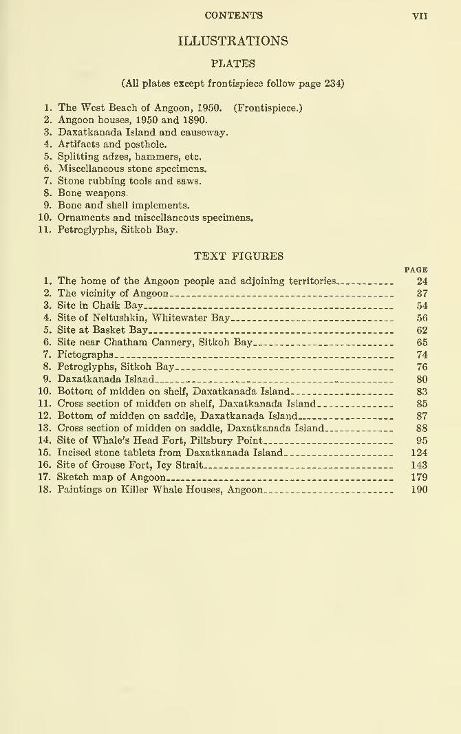
ILLUSTRATIONS
PLATES
(All plates except frontispiece follow page 234)
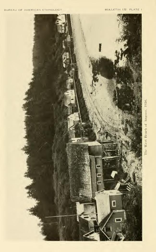
1. The West Beach of Angoon, 1950. (Frontispiece.)
2. Angoon houses, 1950 and 1890.
3. Daxatkanada Island and causeway.
4. Artifacts and posthole.
5. Splitting adzes, hammers, etc.
6. Miscellaneous stone specimens.
7. Stone rubbing tools and saws.
8. Bone weapons.
9. Bone and shell implements.
10. Ornaments and miscellaneous specimens.
11. Petroglyphs, Sitkoh Bay.
TEXT FIGURESPAGE
1. The home of the Angoon people and adjoining territories 24
2. The vicinity of Angoon 37
3. Site in Chaik Bay__ 54
4. Site of Neltushkin, Whitewater Bay 56
5. Site at Basket Bay 62
6. Site near Chatham Cannery, Sitkoh Bay 65
7. Pictographs 74
8. Petroglyphs, Sitkoh Bay 76
9. Daxatkanada Island 80
10. Bottom of midden on shelf, Daxatkanada Island 83
11. Cross section of midden on shelf, Daxatkanada Island 85
12. Bottom of midden on saddle, Daxatkanada Island 87
13. Cross section of midden on saddle, Daxatkanada Island 8814. Site of Whale's Head Fort, Pillsbury Point 95
15. Incised stone tablets from Daxatkanada Island 124
16. Site of Grouse Fort, Icy Strait 143
17. Sketch map of Angoon 179
18. Paintings on Killer Whale Houses, Angoon 190

PKEFACE
The basic data which form the concern of this study were gathered
in the summers of 1949 and 1950 on two exploratory expeditions to
Alaska supported by a post-doctoral fellowship from the Viking Fund(now the Wenner-Gren Foundation for Anthropological Research),
and by two grants-in-aid from the Arctic Institute of North Americafrom funds supplied by the Office of Naval Research.
The objective of the first season was to discover some area within
the territory of the northern Tlingit where an integrated program of
archeological, ethnological, and acculturation studies could best be
undertaken. This meant selecting some tribal group that possessed
at least one native or predominently native community sufficiently
integrated to exhibit a coherent social life, and sufficiently.old-fashioned
to have retained some institutions derived from the aboriginal culture
and to provide informants for the remembered or traditional past.
In addition there should be, within the territory of the tribe, archeolog-
ical sites which were recognized as those inhabited by their ancestors
and which were suitable for excavation. We also hoped to find others
of greater antiquity that might shed light on the more remote past.
During the summer of 1949 I was assisted in the field by EdwardMalin, a graduate of the University of Colorado, and by William
Irving, then an undergraduate at the University of Alaska. Wevisited the tribal territories of the Yakutat (June 8-JuIy 13), Chilkat-
Chilkoot (July 17-Aug. 4), and Kootznahoo or Angoon people
(Aug. 12-29). As a result of this survey, the Yakutat and Angoonareas were judged to be particularly suitable for further work. Arche-
ological investigations in the Chilkat area were disappointing, for while
the Chilkat village of Klukwan was still an ethnological treasure
house, the inhabitants were so suspicious and hostile that work with
them would have been difficult or unproductive. Presumably other
areas, especially those of the Hoonah and Sitka tribes, might also
have been promising, but we did not have time to explore them. Theresults of this survey have been embodied in two mimeographedreports, "An Anthropological Survey of the Northern Tlingit, 1949,"
and "An Archeological Survey in Northern Tlingit Territory,
1949," which were distributed to the institutions supporting the workand to interested individuals.
IX
X PREFACE
The second season (June 14-Sept. 14, 1950) was spent at Angoon
in order to see what could be learned here through a coordinated
program of ethnological and archeological work. The archeological
research was carried out chiefly by Francis A. Riddell and Lloyd R.
ColUns, then graduate students in anthropology at the Universities of
CaHfornia and Oregon, respectively, while the ethnological investiga-
tions were undertaken by Dr. Catharine McClellan and the author,
who also, especially during the last weeks of the summer, participated
in the excavations. The latter were concentrated at one rather small
site, but ex])lorations were made of other sites in the vicinity of An-
goon, supplementing the survey of the previous summer. The results
of the archeological work have been prepared in the form of a mimeo-
graphed report "Archeological Explorations in the Angoon Area,
Southeastern Alaska, 1950: Part I, Sites; Part II, Specimens." Theethnological data, although dealing with all aspects of Tlingit culture,
in both the present and the recent past, are not complete enough for
a comprehensive monograph. Some of the general conclusions con-
cerning social organization have been summarized in an article pub-
lished in the Southwestern Journal of Anthropology (de Laguna,
1952). The present monograph contains not only all the data in the
mimeographed reports pertaining to Angoon, but additional material
from our field notes. It may be considered, therefore, as a compre-
hensive statement of all that we learned about the archeology of the
Angoon area and of that part of the ethnographic information that
bears upon the archeology. How these two types ofdata are related is one
of the problems with which this monograph is particularly concerned.
A preliminary statement has already been published under the title
of "Some Problems in the Relationship between Tlingit Archeology
and Ethnology," Asia and North America: Transpacific Contacts,
assembled by Marian W. Smith, Memoir 9, Society for American
Archaeology, 1953.
To those institutions that supported and sponsored this research,
to the many individuals who gave generous assistance, and to mycompanions in the field, I wish to express my thanks.
Frederica de Laguna,Bryn Mawr College,
Bryn Mawr, Pennsylvania.
THE STORY OF A TLINGIT COMMUNITY: A PROB-LEM IN THE RELATIONSHIP BETWEEN ARCHE-OLOGICAL, ETHNOLOGICAL, AND HISTORICALMETHODS
By Frederica de Laguna
THE RELATIONSHIP BETWEEN TLINGIT ARCHEOLOGYAND ETHNOLOGY
INTRODUCTION TO THE PROBLEM
There are a number of ways in which archeology may relate to
ethnology, but in any given area it may not be possible to trace such
connections fully. IdeaUy, of course, the archeology of a people
should enable the anthropologist to trace the record of the culture
back into stages temporally prior to those which can be explored
through ethnological techniques or historical records. Admittedly
the archeological data, even under conditions of maximum preserva-
tion and most skillful excavation, will never give the complete outline
of a culture. At best the picture would be equivalent to that which
the ethnologist might see if he visited a village from which the in-
habitants had precipitately fled, abandoning all their possessions.
But such a complete inventory of material items, in associations
reflecting technological processes, economic activities, social organiza-
tion, and other nonmaterial aspects of life, is something to which the
archeologist may aspire in vain. Even if he should discover such
another Pompei, his ability to understand what he had found would
depend upon the degree to which he has ethnological insights into the
total culture of which the material remains are the concrete expres-
sions. The more remote the archeological horizon from the related
living culture or cultures, the more limited these insights will be.
This limitation is not simply a product of time and space, for the rate
of cultm*e change is not necessarily uniform from decade to decade
or from mile to mile, but we may expect to encounter periods or
stretches of cultural uniformity and lag, punctuated by striking
changes as we cross critical temporal or areal boundaries. Because
exchanges between neighboring peoples tend to make the cultures
1
2 BUREAU OF AMERICAN ETHTSTOLOGY [Bull. 172
within an area similar to each other and in a sense derivatives of the
past of any one of them, the archeologist may discover in other
archeological or modern cultm-es of the region where he works clues
that shed light on his own particular finds. But even with the aid of
such comparative materials, cautiously or daringly applied, he is
bound to encounter that which remains inexplicable.
The ethnologist, for his part, never works am.ong a people who are
completely unaffected by contact with the civilization of which he is
the representative, even though he himself be the first agent of
contact. Certainly in mid-20th-century North America, no Indian
can be found whose way of life has not been profoundly altered by
European and American influences. Although his interests may lie
primarily in the contemporary scene, the ethnologist cannot escape
the duty of trying to understand what came just before. We will
suppose, however, that his chosen task is to discover as much as possi-
ble of the vanished or vanishing tribal patterns. He now faces
difficulties comparable but opposite to those of the archeologist.
For the ethnologist who elicits by every patient and skillful method
at his command only a verbal account of how "our people lived in
grandfather's time," fails to grasp clearly just those aspects of the
cultm-e which may best be understood in their material embodiments.
The archeologist digging in a site known from historic records to
have been occupied a century ago, and the ethnologist who listens to
descriptions of how "our people lived at that place in grandfather's
time" are dealing with the same culture, and their different approaches
should not simply result in pictures that complement one another
by supplying what the other lacks, but should rather overlap perfectly
at some points, as would an aerial photograph and a surveyed mapof the same region made to the same scale. Furthermore, the museumcollections obtained at the village a century ago and the contemporary
records of missionaries, explorers, or traders should ideally check in
the same fashion. To what extent, however, can these four pictures
taken from these four different perspectives be recognized as pro-
jections of the same reality?
Some reflection will show that we can expect considerable deviation
from an ideal concurrence. In the first place, the archeologist's
collections will tend to represent the "junk" of everyday life, since he
finds chiefly what people have lost or thrown away, whereas the
museum's ethnological collection will more likely contain a greater
proportion of handsome "exhibits." The extent to which one or the
other collection may include items pertaining to the prestige economy,
ceremonialism, or supernatural rites will reflect, on the one hand, the
natives' willingness to part with such items to the collector, and on
the other, the natives' practice of abandoning such things in deserted
de Laguna] THE STORY OF A TLINGIT COMMUNITY 3
houses or dumps, or burying them in graves or in special repositories,
etc., where the lucky archeologist may find them. The museumcollection will surpass tlie best archeological finds in completeness of
perishable items, but it will contain, of necessity, only that which is
transportable, and will lack both the large or the otherwise immovable
objects which the archeologist may study on the spot. The arche-
ological material, as it is uncovered, will occur in associations the
meanings of which may be discoverable. These relationships are
apt to be lost by transfer of objects to the museum, although they
may be recaptiu-ed for both archeological and ethnological collections
in the form of special exhibits, such as reconstructed grave finds,
house interiors, or models of village scenes, for example. The older
ethnological collections, however, are especially likely to contain
isolated objects, identified only by brief notes on use and provenience,
but otherwise torn from the contexts that would make them fully
intelligible. It goes without saying that both archeological and
ethnological collections of material objects and their accompanying
data will reflect the insights and interests of the collectors as individuals
and as representatives of the anthropology of their day.
The same sort of comparison can be made between the written
accounts of early visitors and the monograph of the ethnologist whorecords the oral reports of a vanished way of life. Even though the
former documents may exhibit no obvious distortions due to their
authors' professions as missionaries or traders, we usually cannot
hope to find in them as complete or as integrated a picture as the
ethnologist can draw, nor as conscious an awareness of the inevitable
gaps, but they will certainly contain that which only the eyewitness
or the participant could hope to capture. Furthermore, bias is not
confined to the clerical or commercial layman alone, though where
present it is more easily discovered and discounted than bias in the
work of the ethnologist. The latter, in our hypothetical case, is
primarily dependent upon what he is told by the natives. Obviously,
if the aboriginal culture has completely vanished, so too will have
disappeared the memory of it, and there will be no traditions or
descriptions of the past except in written records. Insofar as
interest in "grandfather's day" is still present and people can still
talk about that period, something of the past has actually survived
and is alive in the contemporary culture. The ideas and attitudes
about the past are all interwoven with concepts and attitudes about
the present and the future, and therefore color the living natives'
statements, behavior, and expectations. So whUe the ethnologist
must depend chiefly upon what he is told, he also can and must"read between the lines," alert to the significance of what is not
said, to the attitudes and values revealed or obscured by tone of
4 BUREAU OF AMERICAN ETHNOLOGY [Bull. 172
voice and manner, and he must also be watchful of contemporary
overt behavior that illustrates or contradicts what he has been told.
The ethnologist's bias arises not only because the natives' accounts
of the past arc limited to what has survived in oral traditions because
it is memorable, or because their statements may also be consciously
or unconsciously screened to present the aboriginal culture in a
favorable light, but also because the ethnologist, by virtue of his
calling, is apt to be particularly sympathetic to the natives' point of
view. It is not often that we encounter this form of bias in the
proselytizing missionary or exploiting trader.
Lastly, both the ethnologist and the archeologist share the particular
preoccupations and interests of their scientific disciplines to which we,
their colleagues and contemporaries, are also blinded. These mayproduce either misleading divergences or concurrences in findings
and interpretations, depending upon the relationship between the
archeological and ethnological viewpoints involved. It is safe to
say that in any case future generations of anthropologists will wantto rewrite their chapters of culture history in ways that we cannot
now foresee.
In the present instance, archeologist and ethnologist are one andthe same person, or at least we have one author responsible for the
selection and interpretation of the data, even though some of these
have been gathered by previous writers or visitors and by her
associates in the field. The reader is therefore warned that in the
following discussion there may appear an unjustified concordance
between the archeological and ethnological pictures. On the other
hand, while the disagreements or inconsistencies may be due to
ignorance or confusion on the part of the author, they may also
reflect those legitimate but baffling discrepancies in available data
which pose the very problems explored in this monograph.
BASIC PREMISES
That the assumptions of the author be made as explicit as possible,
it may be well to state the purpose for which the fieldwork was under-
taken, especially since it was not intended to explore the relationship
between the archeological and ethnological data that might be
gathered in two summers among the northern Tlingit. Such a rela-
tionship was taken for granted, and it was only when the material
was reviewed and organized that the specific agreements and disagree-
ments became apparent. The theoretical problem posed by such
concordances and discrepancies was, finally, one that was raised byDr. Marian W, Smith in the summer of 1951 during discussions with
the author. Had this problem been the original and principal objective
of the fieldwork, the research would naturally have been oriented in a
de Lagnnal THE STORY OF A TLnSTGIT COMMUNITY 5
somewhat different way, and the ethnographic inquiries, for example,
would probably have been directed far more exclusively toward
those aspects of the culture with which the archeology was also con-
cerned. This is not to imply, however, that the resultant data would
have given more insight into the relationships between archeology
and ethnology, for too limited a preoccupation with this problem
might have led to a failure to perceive some of the pertinent ethno-
graphic clues or perspectives which can be obtained only through
concern with the culture as a totality. The anthropologist should be
aware of this problem as only one among many, neither more nor
less important than others.
The fieldwork of the two seasons was conceived and carried out as
preliminary and necessary steps of a larger and more ambitious
project, planned to require several years of research and the col-
laboration of several scholars. The ultimate aim was to trace the
development of Tlingit culture from the earliest period represented
by discoverable remains down to the present time, not simply to
present a descriptive history of Tlingit culture but to explore it as a
case study in cultural dynamics. This would involve consideration
of ancient cultural diffusion, continuities of traits and attitudes,
internal readjustments and shifts in emphasis within the culture, the
growth of those specialized patterns which give Tlingit culture its
distinctive individuality, and the breakdown of these under white
contact with resulting consequences to Tlingit personality.
I had already suggested that from the archeological point of view
there was probably a long period of cultural exchanges between the
southwestern Alaskan Eskimo and the Northwest Coast Indians,
some antedating the formation of the specialized and distinctive
culture of southeastern Alaska (de Laguna, 1947, pp. 12 ff.). Abouta millennium ago (?) these contacts became intensified, bringing to the
Indians strong mfluences from the Asiatic side of the North Pacific.
These influences were among the factors stimulating the growth of
Northwest Coast culture. The Tlingit, their ancestors or their prede-
cessors, would have been not only intermediaries in this give andtake, but also participants in the development of Northwest Coast
culture, the early centers of which probably lay farther to the south.
If this view is correct, we should find three stages of development in
Tlingit archeology. The first would be contemporary with andexhibit relationships to the early prehistoric cultures not only in the
Coast Salish area of British Columbia but also in the Aleut-Pacific
Eskimo area of southwestern Alaska. Then would come an inter-
mediate stage when northern and Asiatic influences were being
received; and finally we should recognize a later prehistoric stage
when these diffused traits were being reshaped to fit the emerging
6 BUREAU OF AMERICAN ETHNOLOGY [Bull. 172
patterns of Northwest Coast culture and the Northwest Coast was
itself serving as a center for cultural diffusion.
This thesis needs to be tested by archeological work. Northern
Tlingit territory is critical because it is intermediary to this assumed
cultural exchange and because it is archeologically almost unexplored.
From an ethnological point of view the northern Tlingit are of
interest because they represent the northern marginal area of North-
west Coast culture. Kjoeber (1939, pp. 28 ff.) has suggested that this
very distinctive culture first began to develop its characteristic forms
in the Coast Salish region about the Gulf of Georgia, that the center
of growth shifted northward to the Kwakiutl-Bella Coola area in
central British Columbia, and in the most recent period shifted again
to the Haida, Tsimshian, and southern Tlingit. The northern Tlingit
might be expected, therefore, to have retained something of the
simpler character of early Northwest Coast culture, even though at
the time of the Russian colonization they were expanding vigorously
across the Gulf of Alaska and into Chugach Eskimo territory in
Prince William Sound.
Drucker (1955) has, however, recently suggested that Northwest
Coast culture developed from a base which was of Eskimoid character,
presumably akin to that described by Borden (1950, 1951, 1954) at
the mouth of the Eraser River and which has a radiocarbon date of
2,430 ±163 years. Drucker also argues that the climax of Northwest
Coast culture has beenlong and still lies within theWakashan area, where
the Nootka and Kwakiutl have the purest and most tjrpically coastal
form of that culture, since it is uncontaminated by diffusion from the
interior, and has preserved most clearly the effects of ancient and
profound contacts with the Aleut and Esldmo, or of its derivation
from an ancestral Eskimo pattern. According to his view, the
Tlingit (and to a lesser degree the Tsimshian and Haida) are not
only peripheral to the ancient Wakashan cultural center, but are
heavily influenced by diffusions and migrations from the Athabaskan
interior. Indeed, all three of these northern tribes are viewed as
relatively recent settlers on the coast, who probably interrupted
communications between the Aleut-Eskimo and the Wakashan-speakers, even though they themselves, and especially the northern
Tlingit, have recently adopted some obvious and superficial Eskimotraits.
Whatever may prove to have been the ultimate origins of North-
west Coast culture, and even if, as Birket-Smith has suggested (Birket-
Smith and de Laguna, 1938, p. 531), the Eyak once occupied what is
now northern Tlingit territory, there is no question but that in his-
toric times the northern Tlingit were middlemen for the southbound
traflic in native copper from the Copper River, and for the north-
de Laguna] THE STORY OF A TLINGIT COMMUNITY 7
bound traffic in slaves and dentalia. A number of northern Tlingit
tribes also carried on organized trade with the Tlingit- and Athabaskan-
speaking tribes of the interior hinterland. Northern Tlingit culture
should not only reflect marginal simplicity and the effects of these
widespread intertribal contacts, a study of which would be of value
in understanding the growth of Northwest Coast culture as a whole,
but it also has its own individual character. Although a number of
excellent monographs have been published on various details and
aspects of Tlingit culture, we still lack an overall, integrated picture.
An ethnographic study of this kind would help us to place northern
Tlingit culture in its historical and regional perspectives, and it would
also serve to reveal characteristic Thngit patterns and configurations.
Materials for such a study would have to be obtained not only from
published sources but from the oral traditions of the natives them-
selves.
The fur trade and Russian colonization at first, and later the min-
ing, fishing, and lumbering industries, missionary and educational
activities, and the growth of white settlements, including military
establishments, have attacked and are continuing to reshape andshatter the configurations of native culture. Tlingit communities
today exhibit in varying degree the effects of acculturation and assimi-
lation. It would be of interest to discover what aboriginal institu-
tions or attitudes are stUl alive, what aspects of culture have broken
down almost completely, and which ones have proved most responsive
to change without losing their continuity with the past. A compari-
son between a relatively old-fashioned community and a greatly
changed one should point up problems of adjustment to the modernworld. This aspect of the study might well involve analyses of life
histories and personality tests.
In all the history of growth, change, and breakdown it should be
possible to trace certain continuities of pattern that are distinctively
Tlingit. The ultimate objective of the whole study should be to
discover some of the underlying causes and factors in this dynamicprocess.
An assumption which was not explicitly stated in the original
formulation of the problem may be presented here, since it is basic
to an understanding of Tlingit culture history, and since it received
vahdation and illustration throughout our work in the field. Stated
in its simplest form it is that the Tlingit themselves are as much re-
sponsible for their own culture and its history as are any of the peoples
who have influenced them. In the past, it was they who, consciously
or unconsciously, chose what to accept of the cultural innovations
offered them through diffusion and what use to make of the oppor-
460927—60 2
8 BUREAU OF AMERICAN ETHNOLOGY [Bull. 172
tunities thus afforded. It has been Tlingit character, interests, andorientations that have determined how these importations were re-
interpreted to fit Thngit ethos and adjusted to THngit culture. Eventoday, when that culture is fast losing its aboriginal coherence, wemust not assume that the Indians are passive recipients of foreign
teachings, or that their culture is an internally static entity to be
molded or broken by external pressures. They are not only themselves
aware of what is going on, but as individuals or groups are taking anactive part in hastening, opposing, or directing the changes which
affect their lives. Furthermore, no one characterization will fit themall to the same degree that it might have in the days of a more homo-geneous aboriginal culture, for today there are not only the old-
fashioned persons who understand no English and whose life is still
largely guided by the old patterns of subsistence hunting and fishing,
by reciprocal sib and lineage obligations, and by the old values, butthere are other persons who have broken with all of these. Amongthe latter are college graduates, veterans, teachers, ministers, civil
servants, local town officials, leaders in the local trade unions, store-
keepers, and commercial fishermen who own valuable boats. Themost important developments in recent years have been the exten-
sion to the Alaska natives of full American citizenship and the legis-
lation abolishing certain discriminatory practices. These have been
won largely through the Tlingit's own efforts, especially by the or-
ganization of the Alaska Native Brotherhood and its affiliated Sister-
hood. Their status as citizens has received recognition through the
election of several natives as Representatives in the Territorial Legis-
lature. The extension of the provisions of the Indian Reorganization
Act to Alaska has made it possible for native communities to secure
Federal loans for commercial undertakings, public works, and educa-
tion. Some Tlingit groups have seized these opportunities; others
have rejected them. In the clash with vested interests, in the legal
confusion over native territorial rights, in the conflict between some-
times opposing policies in different branches of the Government or in
different administrations, in the struggle against old prejudices andapathy within the native communities and outside, and in the uncer-
tainties of the modern world which threaten all of us, the Tlingit
have found both hope and disillusionment. But whatever the solu-
tion or solutions that may be adopted, whatever the patterns of
Alaskan life that may emerge, these will be what they are because of
something essentially Tlingit that has played its part in their creation.
CONDUCT OF THE FIELDWORK
To understand the results obtained from any piece of fieldwork it
is necessary to have some notion of how it was carried out. The
de Laguna] THE STORY OF A TLESTGIT COMMUNITY 9
actual conduct of any field investigations always involves the making
of a series of choices between the various opportunities offered, andthe seizing of one necessarily excludes others. The anthropologist, of
course, has only a limited control over such opportunities, and some-
times none at all. In any case he can never know whether he has
made the fullest use of what was available. But the situation, as he
sees it, provides the background against which we must view the
information he has gathered.
The situation will involve such factors as the size and composition
of the party. Too small a party is handicapped, especially in arche-
ological work, in doing the chores of daily living, and is limited in the
variety of projects that can be undertaken. Too large a party, espe-
cially on an exploratory trip, may disturb the native community bythe sudden intrusion of many strangers, may be unable to find ac-
commodations in the villages or means of transportation, since living
quarters are scarce and all but the smallest and perhaps least sea-
worthy motorboats and skiffs may be engaged in fishing. The length
of the time available for fieldwork, the season of the year, the weather,
the stages of the tide, etc., all impose their pecuhar limitations. Thecharacter of the native community, which involves the various atti-
tudes of its members and component groups toward the investigators
and their researches and toward each other in their relationships to
the anthropologists, the particular interests in or knowledge of their
own culture possessed by the different informants and their ability
to communicate, and above all, the varying extent to which other
interests, especially fishing, absorb the people—all these are factors
affecting what the anthropologist can do and how he proceeds.
The attempt to combine archeological and ethnological work im-
poses its own particular choices on the small party, for there is always
the problem of allotting the amount of time to be spent investigating
potential sites, excavating known ones, interviewing informants, mak-ing new acquaintances, writing up notes, cataloging specimens, etc.
Often the choice is not easy—if, for example, there comes the first
calm sunny day after days or weeks of bad weather. Should this be
the day when the whole party photographs and maps the excavations,
or should all or some of its members seize the opportunity of observing
and participating in the various activities of the community that are
now joyously undertaken outdoors? Of course, at times the choice
is obvious: engagements previously made with the natives should not
be changed, or the state of the tide may make it dangerous for the
whole party to go out to a site in a small skiff. Throughout the
season, fortuitous lucky and unlucky accidents continually modify
the planned program for research as they offer unexpected leads or
prevent the realization of some projected undertaking.
10 BUREAU OF AMERICAN ETHNOLOGY [BuU. 172
It is, therefore, appropriate to give a brief summary of the conduct
of the fieldwork in and about Angoon in 1949 and 1950 before the
results are discussed.
Malin, Irving, and I came to Angoon on August 12, 1949, on a
motorboat that we had chartered in Juneau for a trip of exploration
around Admiralty Island. Thi'ough the kindness of Mr. and Mrs.
Joseph Kahklen, the schoolteachers at Angoon, to whom we hadintroductions from the Alaska Native Service in Juneau, we were able
to stay for about a week at the "Teacherage." The Kahklens, them-
selves Tlingit, introduced us to some of the people who proved to be
our most valuable informants then and in 1950. They also found
interpreters for us or they themselves acted in that capacity when this
was necessary. In addition to gathering information, I was able to
explain the purpose of our work to some of the influential people andto show the letter of introduction to the local officers of the Alaska
Native Brotherhood and Sisterhood that had been given me by Mr.Lester Roberts, the Grand Secretary of the organization. Because it
was immediatelj^ evident that Angoon would be a rich field for eth-
nological research, whereas the archeological potentialities of the area
were unknown, and because the time at our disposal was limited, weconcentrated during our week at Angoon on exploring the sites re-
ported in the vicinity.
After leaving the village on August 19, we visited Hood Bay wherethe Angoon Community Association had recently bought a salmon
cannery with funds obtained under the Indian Reorganization Act.
Since practically all the Angoon families had by this time moved to
Hood Bay, the men to fish and the women to work in the cannery,
we here met ahnost aU of the native population, observed the canneryin operation, and obtained additional information. On our trip
through x\ngoon territory we investigated reported sites at BasketBay on Chichagof Island, and at Hood, Chaik, and Whitewater Baysand Eliza Harbor on Admiralty Island. The only major area claimed
by the Angoon people that we did not visit was Peril Strait betweenChichagof and Baranof Islands, although sites were also reported
here. Some of the places we investigated were unrewarding arche-
ologically: in some cases the information given by the natives seemsto have been incorrect; in others it was so vague or misleading that
the site could not be found, or the archeological remains were too
scanty to warrant excavation. Some of these places can, therefore,
be eliminated from fm-ther investigation, while others might profitabh^
be revisited if more explicit information were obtained, and especially
if a native could be secured as a guide. Of the sites investigated
three seemed to be promising: a fort on Kootznahoo Inlet called
Daxatkanada (excavated in 1950), a fort on Hood Bay, and a village
de Laguna] THE STORY OF A TLINGIT COMMUNITY Hon Whitewater Bay. That the archeologist is not dependent uponnative tradition in locating sites was proved by our spotting the HoodBay fort from a motorboat; only the following year did we learn
anything about it from the natives.
Because of its archeological and ethnological promise, Angoon wasselected as a field for work in 1950. From June 14 to September 13,
Dr. McClellan, Kiddell, Collins, and I, with the permission of the
Alaska Native Service, occupied two classrooms in the schoolhouse,
literally the only quarters available. Again the Kahklens did every-
thing possible to help us until they left on June 29 for a summer in
the States. Since our quarters were at the extreme southern end of
the village, we were inevitably thrown into closer contact with somemembers of the community than with others. The school building
proved in many ways an excellent place in which to entertain friends,
interview informants, and work on the archeological material.
From Angoon the two men made almost daily trips by skiff andoutboard to Daxatkanada Island, which we had decided to excavate
first, while Dr. McClellan and I concentrated on the ethnological
work. The two of us also visited the site from time to time, andafter the middle of August, when most of the natives began to leave
for the canneries, we spent most of our time with the men at the
diggings. In addition to the excavations at Daxatkanada, we madea large test trench at the nearby site on Pillsbury Point and explored
a number of old camps and former villages near Angoon. We were
unable to reach some of the reported sites, however, since the only
boat we could obtain was a skiff which we dared not trust in exposed
waters or swift currents. Despite this, we were able to make twolong and valuable excursions, the first with the Kahklens to Mitchell
Bay at the head of Kootznahoo Inlet, and the second with other
native friends, the Reverend and Mrs. Cyrus Peck, to an important
site on Sitkoh Bay in Peril Strait. Although we had originally
planned to move to Hood Bay in the latter part of the summer, in
order to excavate the fort there and to continue ethnological investi-
gations at the cannery settlement, we abandoned this plan because
the excavation at Daxatkanada took longer than anticipated and noquarters for the party could be obtained at Hood Bay.The archeological work did not involve any unusual techniques.
Exploration of sites included locating the spot on large-scale charts,
making sketch maps and photographs, and digging test holes to
determine the extent and character of the deposits. If these werestratified, measurements and often diagrammatic cross sections
were made to record the various layers, and the occurrence of animalbones, shells, hearths, artifacts, etc., were, of course, noted. Thetwo sites at which more extensive work was undertaken were more
12 BUREAU OF AMERICAN ETHNOLOGY [BuU. 172
accurately mapped, the area to be excavated was laid out in grids,
and the contours of the surface measured before digging was begun,
and more detailed cross-sectional drawings and photographs of the
deposits were made as these were exposed. Animal bones, samples
of shells, of wood, and of the soil in various strata were saved for
identification.
Three localities explored in 1949 and 1950 had pictographs or
petroglyphs. These were photographed and sketched, and tracings
of some were made on tissue paper.
The ethnological work deserves to be described in more detail, if
only because the ethnographer often does not explain the methods
by which he obtains his data. I took pains, both in 1949 and 1950,
to explain to the natives that we had come to gather material for a
serious history of Angoon that would describe how the people used
to live and how their lives had changed; that I was a teacher from
"back East" who wanted to learn and teach the truth about the
Indians so that my students and others would learn to respect them.
With few exceptions, most of the people were not only interested in
our work and ready to help, but were particularly sympathetic whenthey realized that we had not come for a hasty "inspection trip" but
hoped to spend more than one season in learning about the Tlingit.
One young man even thanked us for our efforts to record the "rich
culture of my people before it is all gone." But, of course, someindividuals remained suspicious and unapproachable. We tried,
therefore, to create and retain good will by proceeding slowly andrespecting reticences, rather than to jeopardize future success bytrying to pry out information that was not readily given.
On both trips all members of the party kept diaries, in which wedescribed our activities, the places visited, the people met, andevents that occurred in the communities. In addition, Dr. McClellan
and I made special records of long interviews or conversations andof special events. At many of the interviews, especially at those
which had been arranged in advance and for which fees or gifts were
given to informants, we'^took'running |notes. The usual procedure
was for one of us to write while the other directed the interview with
such questions as seemed appropriate. On many occasions, however,
it seemed best not to keep notes, except perhaps for recording native
words, but to write an account of what was said and done as soon
afterward as possible. We usually began this task by compiling a list
of all the topics which had been covered, then each of us took a share
of these to write up from memory, and each corrected and amplified
the rough draft made by the other before the final draft was typed.
In this way, we found it possible to record the substance and often
many of the actual phrases used by informants in conversations lasting
de Laguna] THE STORY OF A TLINGIT COMMUNITY 13
more than 4 hours. In fact, these records usually do not seem to be
any less detailed than those made from notes taken during the inter-
view. Of course, at many interviews, visits, or casual encounters,
only one of us was present, but on the whole we found it advantageous
to work together and the natives also expected it.
The information gathered in this way covered a variety of topics,
ranging over all major aspects of Tlingit life, contemporary and in the
recent past. Included were data on technology and subsistence, in
the form of verbal descriptionsfof hunting and^fishing methods, of what
we observed on berrying expeditions with the women or in watching a
seal being flensed, of recipes for cooking chitons, of models or drawings
of fishing gear, and lastly, photographs. Data on social organization
included a census of the^community, map of the town, list of sibs and
their lineage houses, short genealogies, etc., as well as explanations,
comments, or descriptions of such institutions as joking relationships,
potlatching, marriage, feuds, and slavery. We also gathered a good
deal of information on shamanism and other aspects of supernatural
beliefs and practices, and recorded (in English) a number of mythsand sib tradition. A Webster wire-recorder loaned by the Wenner-Gren Foundation made it possible to obtain several potlatch songs and
a long speech in Tlingit describing the destruction of Angoon by the
Coast Guard in 1882. Information about current affairs and com-munity problems and some autobiographical material was volunteered.
We do not consider these data as exhaustive on any one topic, but
rather as indicative of the range that can be covered, and as suggesting
certain problems to be solved by further research.
Naturally, the sort of information obtained varied with the age, sex,
sib afl&liation, and particular knowledge, interests, and temperamentof the individual informants, and we were fortunate to be able to workwith many different persons. I should point out, however, that about
half of our information came from one individual who is in some waysatypical. He is a middle-aged man who had received a much better
education in white schools than most Tlingit of his generation. Hehad played for a while a prominent role in community affairs, but wasnow largely withdrawn from much of the ordinary community life.
He finds himself caught between the white man's and the native's
worlds, yet not fuUy belonging to either. He is intellegent enough to
analyze and compare both and to realize his own position. He hadnot only the time but the interest and insight to be a valuable inform-
ant. Most of the information from him pertained to social institutions,
sib traditions, recent community history, etc. He also furnished
some data on hunting and fishing, though most of our data on material
culture and on former sites came from others.
In general, we can say that the Tlingit are reserved, often shy, and
14 BUREAU OF AMERICAN ETHNOLOGY [BuU. 172
sometimes suspicious. Many at first seemed to be afraid that we,
like other whites, would ridicule or disapprove of the old ways. Cus-
toms which were at variance with modern Tlingit or white usages were
sometimes uncomfortable topics of conversation. Here we met with
various degrees of ignorance or reticence, or with attempts to justify
the old waj'S by explaining how they were really like the ways of the
whites, or even how they conformed better than white practices to
modern standards of morality. Such explanations were often not only
revealing of present attitudes but suggestive of ambivalences even in
the past. There are many different attitudes toward the old and the
new; some people lament the loss of old customs, skills, and values;
others turn eagerly toward a brightly envisioned future. We made a
number of real friends, and from them received a flood of confidences,
obviously releasing long-pent tensions, and reflecting the reserve which
is demanded in interpersonal contacts between the Tlingit themselves.
We found that our informants did not like to be guided by questions,
and that they were much more impatient of such interruptions than
are most white Americans. It is apparent, too, that the Tlingit learn
from each other, not by questioning, but by observing and waiting
for explanations or comments to be volunteered. So our informants
said what they wanted to say, in their own way, at their own time and
pace. From this stems both the completeness and incompleteness of
our records, for we obtained valuable information and insights in this
spontaneous way that we would otherwise have missed. Yet we some-
times regretted that it was impossible to recapture the interest of the
informant in something previously discussed and on which we desired
fuller explanations. A great deal of information came, therefore, not
in the form of generalized statements, but in accounts of particular
events that our informants had witnessed or in which they had partici-
pated, or in the form of stories which older people had told them.
This usually meant a wealth of detail, but it was often hard to judge
from the specific instances what were the underlying patterns. Indi-
viduals varied, of coiu-se, in their ability to generalize about their
culture and in their interest in doing so.
We were also struck by the lack of interest shown by the Tlingit
in the customs of other tribes, even of their neighbors, although manyof them had made long trips, for example to Seattle, where they en-
countered people of different cultures. Even the relocation of some
Aleut refugees on a nearby island during the war seems to have left
little mark on the Angoon community, despite the fact that the two
groups had ample opportunity for becoming acquainted. For in-
stance, only one man commented on differences between Aleut and
Tlingit customs (in this instance, methods of preserving seal entrails),
and one other mentioned the different physical appearance of the
de Laguna] THE STORY OF A TLINGIT COMMUNITY 15
Aleut. Exceptions to this general lack of interest in the foreign are
the traditions that the Chilkat blanket was adapted from Tsimshian
weaving, and that the Haida built excellent canoes because they had
red cedar (one Angoon sib claims descent from a woman who married
a Haida, and the canoe is usually mentioned in this connection), and
lastly there is the admitted eagerness with which the Tlingit copy
"Aleut" (Prince William Sound Eskimo) dances and Tsimshian songs.
On the whole, however, the Tlingit live in the center of their owncultural world, and in this respect contrast greatly with such groups
as the Tena (Ingalik) Athabaskans on the lower Yukon, who not only
eagerly copied the ceremonies of their Eskimo neighbors but even
made up a comic dance featuring "Outside Indians," feather bonnet
and all, about whom they had evidently learned in school (de Laguna,
1936, pi. 17, B-S, p. 573). This Tlingit attitude probably accounts
for the few references made to the various white persons who formerly
visited them. Only those who lived among the Tlingit for a long time,
and who thus became in a sense members of the community, seem to
have been remembered or at least thought worthy of mention.
CHARACTER OF THE ETHNOLOGICAL DATA
Certain limitations on the type of ethnological information ob-
tainable have a definite bearing on the problem of relating Tlingit
ethnology to Tlingit archeology or to written historical records.
Thus, a good deal of knowledge about aboriginal material culture,
technology, hunting and fishing, etc., is lost, for the old tools and
weapons are no longer made or used, and in many cases can be seen
only in museums. Many of the artifacts found in our excavations
could not be identified at all, or were assigned obviously fantastic
functions. Stone adzes, harpoon heads, beads, pendants, and labrets
were objects which everyone recognized correctly and found the most
interesting. The labrets, in particular, roused gales of laughter
among the women and animated comment. The needle, however,
has so completely replaced the awl that no one seems to have any clear
ideas of what a bone awl was really like, so that any pointed bone,
especially the double-pointed pins (see p. 117), would be identified
as an awl, and thrust through the informant's jacket to demonstrate
how an awl was used to make a hole in sewing. Again, descriptions of
old-style houses were often vague and stereotyped, for the modernframehouse replaced the aboriginal plank house when today's old
people were children. Yet the smokehouses still in use represent the
whole series of types from the oldest to the most modern.
It might be expected that the older men who had been hunters in
their youth would be able to identify most of the animal bones and
teeth that we found in the excavations. Yet one elderly man, who
16 BUREAU OF AMERICAN ETHNOLOGY [BuU. 172
gave valuable information about hunting and fishing devices, was
unable to recognize the remains of common animals, and usually
identified even the bones and teeth of small mammals (seal, sea otter)
as those of "a bear—oh, a little one." I do not know to what extent
this ignorance is typical: our informant may have forgotten what he
once knew about animals. I suspect, however, that the Tlingit were
never particularly interested in this aspect of animal anatomy. Theconventionalizations of Northwest Coast art in which the articula-
tions between all bones are conceptualized as ball and socket joints
and uniformly symbolized by eye motifs may not only express a lack
of interest in anatomical detail but may even have hindered the per-
ception of it. Whatever the reason, this example of ignorance con-
trasts most strongly with the knowledge displayed by every Eskimo
I have known. An attempt to secure the native names for commonshellfish in the area met with a surprising reaction on the part of an
old lady whom we approached. The shells of species used for food
or for other purposes (i. e., the large mussel formerly used as a knife,
and the large barnacle now used as a flower vase) were readily identi-
fied, but our informant manifested horror at the sight of such things
as rock oyster shells and dried starfish, for handling them brings
storms. It was perhaps all right for us to touch them, but she did not
even want to look at them, she said, and did not know their names.
Traditional native art is virtually dead at Angoon. Only a few
sib heirlooms survived destruction in 1882 or are still treasured, and the
new ceremonial paraphernalia which is being made for potlatches
(mostly beaded robes) is in an altered style. Only a few of the older
women still make baskets, and there are no more wood carvers or
silversmiths. Moreover, the old paintings and carvings on the house
fronts have been obliterated or destroyed, and even if the lineage
chiefs felt it worth the expense to have them restored, they would
have to search far for a competent artist. The decay of heraldic art
involves also a loss of the detailed knowledge of its symbolic meanings.
This may be one reason why it is now difficult to secure specific infor-
mation about petroglyphs and pictographs, although people say that
they could formerly be "read like totem poles." Furthermore, as this
knowledge has become more esoteric, the antiquarians among the
Tlingit, proud of their reputation as experts, are less wilUng to teach
others what they know.
TLINGIT CONCEPTS OF HISTORY AND GEOGRAPHY
As will be seen, we were told a number of stories associated with
various sites or localities, some versions being obviously more com-
plete than others. Whereas some myths, for example those of the
Raven cycle, may be told by anyone, most of the traditions referring
de Laguna] THE STORY OF A TLINGIT COMMUNITY 17
to supposedly historic events and many of the myths and legends are
associated with particular sibs. These are best known by the membersof the sib in question, or by persons whose father or paternal grand-
father belonged to that sib and had taught them the stories when they
were children. Outsiders may be familiar only with the outline of the
tale. In any case, there is a feeling that only those who belong to the
sib should tell the story, while others who may know it usually profess
ignorance. This is natural, since the story may be told or acted out at
potlatches and may provide the basis for potlatch songs, sib regalia,
and ceremonial oratory ("like talking in riddles"). These various
forms of recalling or symbolically portraying the tradition are prerog-
atives of the particular sib, whose members sacrifice wealth at pot-
latches not simply to validate their rights in these monopolies but to
enhance the value of their ceremonial privileges. Again, if the story
refers to fights or quarrels between sibs, as many of them do, it wouldbe interpreted as an insult, a deliberate provocation sufficient to renew
the old quarrel, if a member of one sib told the story or even referred
to the incident in the presence of a member of the other sib involved.
For this reason, such stories do not circulate freely, and there is even
a deliberate attempt to suppress them as dangerous to the peace of
the community.' If thoroughly investigated, it is probable that one
would find as many different versions of the story as there were sibs
involved, each reflecting one side of the affair or magnifying the part
played by one group.
All of these are factors which serve to compartmentalize the tradi-
tional history of a tribe into a series of sib histories that cannot be
reconciled. These histories do not belong so much to the tribal com-munity, therefore, as to the sib, and the sib's various local subdivisions
which form parts of different tribal communities will have a commonfund of tradition. It would be an interesting subject for research in
any one community to study the extent and character of the contra-
dictions and discrepancies between the histories of the various sibs andto explore the reasons for such lack of agreement. A more usual type
of study has dealt with the differences between versions of the samestory gathered in different localities.
I believe it would be possible to show that the individual Tlingit's
sense of history and geography is strongly affected by the dominanceof the sib which controls the social, political, and ceremonial aspects
of his life. Tlingit "histories" are concerned with the origin of lineages
or sibs, the quarrels or other events that caused such family groups
• Dr. Viola Garfield informs me that this also affects the attitude toward some totem poles In the moresouthern Tlingit communities. A white proposal to move some old poles from an abandoned village to the
modem community where they could be guarded from vandalism was vigorously opposed by the people,
because the poles In question carried designs symbolizing or "telling the story" of former feuds which were
better forgotten.
18 BUREAU OF AMERICAN ETHNOLOGY [BuU. 172
to break away from their parent bodies or to leave their original
homes, and the subsequent wanderings of these groups until they
reached their present locations. The stories deal also with the super-
natural occurrences upon which the claims to lineage and sib totemic
crests are based, and lastly they tell of encounters with other sib
groups. These stories and the ceremonial prerogatives they justify
are shared by the various subdivisions of the sib that are scattered in
different communities, and are among the strongest bonds uniting
them. The reality of this history is kept vivid because personal
names, especially those that are assumed as titles, are derived from
legendary or historic events, and those who bear them are the reincar-
nations of the dead ancestors who took part in these events. Similarly,
certain localities, even though they may lie beyond the present bound-
aries of Tlingit country, must have a special meaning, a special quality
of reality for the sib members, because these places are the scenes of
sib history. It is the sib that provides a sort of unity to geography and
history, a "logic" which may prove to be more important than a
purely spatial and temporal framework.
For other peoples, however, history is more clearly anchored to
and organized about a whole area, not a sib migration route, and the
stories a man knows and tells will belong to his whole tribe or mayrefer especially to the section of the country where he Uves. Thus,
the locales of the stories told by the Chugach Eskimo informant with
whom Dr. Kaj Birket-Smith and I worked in 1933 lay largely within
that part of Prince Wilham Sound with which the old man was
familiar. His knowledge of the Sound was expressed, not simply by
his familiarity with places where there were good landing beaches or
dangerous reefs, or hunting grounds, or streams, etc., or by his knowl-
edge of the names for these places, but also by his ability to tell the
stories associated Avith them. Conversely, if he knew a story he
knew where the events had taken place, and his stories were often
good guides to archeological sites. The Sound was not crisscrossed
for him by the migration routes of his ancestors ^ but by the journeys
of famous warriors, chiefs, or shamans, whose kinship affiliations are
seldom mentioned; and certain places did not seem more important
to him because they were associated with his own ancestors, as they
would have been for a Tlingit. Yet many of the plots were the same
as those the Tlingit tell as sib histories.
This is not to be understood as implying, however, that the indi-
vidual Tlingit will be ignorant of the traditions associated with other
sibs in his own community or unable to give information about the
» The Chugach lack migration stories of any kind; "Chugach land" Is the land where the Chugach and
their ancestors have always lived. The nearest approaches to migration stories mention only the founding
Of new villages within the Sound area (Birket-Smlth, 1953, pp. 8, 135, 155 fl.).
de Laguna] THE STORY OF A TLINGIT COMMUNITY 19
territories they claim and the sites of settlements they formerly
occupied. This could hardly be so, if only because information of
this kind belongs to the traditions that furnish the basis for ceremoni-
alism at the potlatches in which all members of the community par-
ticipate. It is rather that the most knowledgeable and interested
informant is the one whose sib claims the story and the territory in
question, and he is, therefore, the best one to ask for information
about old sites within that territory. The only exception is the son
of a man of that sib, because of the special bond between father and
son, or the paternal grandson of a man of the sib. Among informants,
the man who was early recognized as the heir presumptive to a chief is
the best of all, if he can be induced to part with his valued knowledge,
for he was "specially educated" as a child in the traditions of his sib
and house. Some of these men have a wide reputation for theu*
knowledge of the past. But since we did not have the opportunity to
work with any of them, we do not know how justified such reputations
may be, nor to what extent their knowledge may include specific items
pertaining to sibs other than their own.
In the fund of traditions that are common property and that can
be eUcited from any reasonably informed person, are stories of the
remote mythical past, the doings of Kaven, for example, and the
events of the Great Flood which are incorporated into the Ravencycle. These stories often explain the appearance of peculiar rock
formations, or have as their scenes prominent mountains or other
impressive features of the landscape. Some of the stories about
the great mythical heroes or well-known supernatm-al beings, although
associated with particular sibs, are commonly known and many per-
sons have visited the scenes of these adventures. Traditions associ-
ated with the dominant sib of the community are almost communitytraditions because this sib is in a position to em.phasize them through
its prominence in ceremonial affairs, and because its numerical size
assures it representation in most households. The Raven Decitan at
Angoon is such a sib. Even the two smaller Raven groups acknowl-
edge their descent from Decitan forebears, and so share in someDecitan traditions. Pertaining to the more recent past are numerouscommon stories, ranging from such terrible events as the destruction
of Angoon by the Coast Guard in 1882, to the mysterious drowning of
a woman and child in the Inlet a few years ago, or the purchase of
the new cannery at Hood Bay in 1947.
For the Tlingit, as for any people, the land in which they live is
given a dimension and meaning above that which can be expressed in
ordinary geographical terms or in present use. Part of southeastern
Alaska is the territory of their own geographical community or tribe,
subdivided into the areas specially claimed by the component sibs;
20 BUREAU OF AMERICAN ETHNOLOGY [BuU. 172
the rest stretches away into the regions belonging to other Tlingit
tribes and to alien groups with whom they have or used to have
friendly or hostile relations. The land may also be subdivided into
the well-known regions of home and of places often visited, the less
familiar localities that are seldom visited, and, lastly, remote areas
that are known only through hearsay. The land also has special
places or regions of particular significance derived from the myths,
legends, and histories associated with them, modified or overlaid for
each individual by his sib affiliation and by the personal experiences
of himself and his family.
I have spoken of Tlingit land as divided into areas, but this is
probably not how the native thinks of it. For him territory is rather
conceived in terms of points, that is, of spots and localities. We are
accustomed to think of the land in terms of areas that are markedoff by boundaries. There are, or should be, no gaps between these
areas; the boundary of one is the boundary of the next. Our geo-
graphical knowledge we feel is incomplete so long as there remain
"blank spaces on the map." This scheme is natural for a people
who divide land into acres, city blocks, half sections, or national
territories. As individuals we differ, of coiu-se, in our ability to
visualize the country as a map or to retain an awareness^of the cardinal
directions as guides, but om* first impulse when dealing with the
unfamiliar is to orient ourselves with a map.If our picture of the world is that of the farmer, property-owner,
and landlubber, the Tlingit's is that of the traveler, especially the
mariner, who is concerned with places and the routes between them.
The world for the Tlingit is probably visualized more as it is in our
sailing and harbor charts than as it is in our political areal maps, for
such charts reduce the land to landfalls, to reefs, shoals, and anchor-
ages to be avoided or sought, and they sacrifice or distort lineal and
areal measurements to emphasize angles of direction.^ Sib territorial
rights do not refer then to areas but to specific spots : fishing streams,
coves, berry patches, or house sites, etc., and the terrain or waters
between these places are simply the relatively undifferentiated land-
scape through which one travels in going from one to the other.
Even places on the unmarked waters, such as halibut banks, are
located by lines of sight on prominent landmarks. Whereas our
cardinal directions are astronomical in character and function like a
grid which can be superimposed on any part of the world and so
reduce all terrestrial space to one uniform scheme, at least two of the
cardinal directions of the Tlingit refer primarily to the flow of currents
• It would be interesting in this connection to know to what extent and how skillfully the Tlingit
actually make use of U. S. Coast and Geodetic Survey Charts, or of the loran with which a number of
their seine boats are equipped.
de Laguna] THE STORY OF A TLINGIT COMMUNITY 21
in their home waters, and even here they lack an absolute quality.
Thus, "northward," nlndlj, is essentially "upriver," and "southward,"
'fxdE, is "downriver."
As the anthropologist endeavors to learn about the country from
his informants, something derived from all these meanings is conveyed
to him and he, too, catches glimpses of the landscape through then-
eyes. We have, of course, made only a beginning in gathering the
sort of data|needed|to understand the native conceptualization (or
conceptualizations) of his country. In addition to fuller data, weshould also have to determine how far it would be justifiable, from
the native point of view, to separate into different categories the
various spots associated with different types of mythical and historical
traditions. These places would include the rocks that Raven shaped,
mountains where men took refuge during the Flood, places where sib
ancestors had supernatural adventures, sites where sib houses were
first built, and, lastly, villages occupied "in grandfather's time." Thewhite man almost automatically divides such places into those asso-
ciated with myth and those with historical traditions, with perhaps
an intermediate group of legendary-but-maybe-historical, as I have
done here. But is this necessarily the way the natives conceive
them? Our temporal scheme of evenly marching years and centuries
demands the ranking of events into earlier and later points on a
single time scale. Some of the natives' stories are for us simply
incredible; others seem as if they might be true or contain elements
of truth. Traditions about old dwelling places are verified for us
by the finding of such objective remains as camp debris or house
pits. To what extent do the Tlingit have a time scale like ours, and
what for them determines the credibility of tradition?
I suspect, although I cannot prove it, that their time scale is es-
sentially looser than ours, and that even before the deculturation
of recent years had blurred the details of the traditions, the Tlingit
could accommodate more of inconsistency and vagueness than wewould tolerate. I suspect, however, that tney do make a distinction
between ordinarj^ historical time and "myth time," the latter being a
period when the world was mysteriously different or only partly
formed.* But I doubt whether it would be possible for them to rank
in a temporal sequence the bulk of the traditions of the various sibs,
which presumably refer to events that occurred between "myth time"
and the present era. Too often, for example, our informants found
* Boas (1916, p. 565) points out that the Northwest Coast tribes distinguish between myths and tales on
the basis of whether or not the world was different from what it is now (e. g., whether animals might appear
in human form), although some stories are hard to place. This Implies a distinction between "myth time"
and historical time. Boas suggests that most stories referring to the origins of sibs and crests are myths,
although many Tlingit stories of this t3T)e seem to refer to an intermediate period, or even to one that they
recognize as only a few himdred years old.
22 BUREAU OF AMERICAN ETHNOLOGY [BuU. 172
it impossible to say whether an episode was supposed to have occurred
before or after the coming of the Russians. Furthermore, what wewould call the supernatural can apparently happen at any time,
although the greatest manifestations were in the past when shamanshad more power.
In one sense, all of the various traditions are alive today and all
are credible to the less sophisticated native, although perhaps in
different waj-s. For the landscape endures as testimony to the
stories of the past. Thus, cm^iously shaped rocks are the work of
Raven. Bad weather is caused when fooHsh youths climb to the
Flood refuge mountains or even point a finger at them. (Since
Raven, yel, is actually equated by some with the Cliristian Creator,
and the Flood associated with him is the Bibhcal Flood, the teachings
of the Church may even reinforce some of these beliefs.) The salmon
stream at Hood Bay where a shaman obtained power from a rotting
salmon still flows, the cave to which his spirit carried him is still
presumably under Kootznahoo Head, and the shaman himself is
reincarnated in the DAql'awedi chief who bears his name. Although
the archeologists may have failed to find traces of the first DAql'awedi
village on Admu-alty Island at the spot indicated by tradition, the
natives might argue and we would have to agree that this cannot
disprove the tradition, for house pits and stone adzes have been
found at other village sites mentioned in other sib traditions.
In the last analysis, the archeologist cannot afford to neglect
any clue suggested by these stories and myths. The rock supposed
to have been shaped by Raven might tm-n out to have petroglyphs or
pictogi-aphs. (In Prince William Sound, rock paintings had a mythi-
cal origin, being ascribed to a cannibal monster, the chief of the
spirits, not to the ancestors of the Chugach.) It is possible, too,
that the archeologist might find something of interest in the "stone
nests" said to have been built as protection against bears on the
mountaintops during the Flood, for Dr. John C. Reed of the United
States Geological Survey informs me that many years ago he found
some mysterious stone cairns on the uplands of Baranof Island.
While these were not on the peaks, and did not seem to have been
built for defense, they may have suggested the notion of the flood
"nests." Again, the various caves that are mentioned in a numberof stories might yield surprising contents if they could be found.
Even if a majority of the traditions referring to places should prove
to be simply fanciful explanations for natural features without arche-
ological significance, others may refer to places that have caught the
natives' interest because they actually do give evidence of topographic
changes, such as changes of sea level, of drainage, or of glacial move-ments, and so may be of indirect value to the archeologist.
de Laguna] THE STORY OF A TLINGIT COMMUNITY 23
Although I had originally planned to present in the next section
information only on archeological sites, reported or actually tested,
I have come to feel, because of the considerations given above, that
there should be included mention of other localities with mythological
or historical associations, even though these are not supposed to have
any archeological significance.
ANGOON TRIBAL TERRITORY
THE ANGOON PEOPLE
In the following pages ethnological and archeological information
concerning the territory of the Angoon people is presented in an
attempt to explore what this territory means to the natives and whatopportunities it offers to the archeologist. Some of the places men-tioned below were visited and explored by us; others we know only
from hearsay. Neither the ethnological nor the archeological data
should be considered as more than a sampling. Both in the field and
in preparing this report I have relied heavily upon Garfield's sum-mary of Angoon traditions (1947) and upon the survey of aboriginal
territorial claims made by Goldschmidt and Haas (1946). Our trans-
literation of native names has been corrected by reference to Boas'
grammatical study of the Tlingit (1917), and this work has also been
consulted in attempting to translate or explain the meanings of Tlingit
words. ^*
Angoon territory includes most of the west shore and southern
end of Admiralty Island (from Point Marsden or even Funter Bay on
the northwest to Chapin Bay on the southeast) and the opposite
shores of Chichagof and Baranof Islands (from False Bay on the north
to Gut Bay or even Patterson Bay on the south). Chatham Strait,
which bisects their lands, is one of the largest fiords in southeastern
Alaska. Running almost due north from its mouth on the open sea
between Baranof and Kuiu Islands, it cuts diagonally across the north-
ern half of the Alexander Archipelago, and continues, as Lynn Canal,
deep into the mainland. Icy Strait and Cross Sound run westward
from the northern end of Chatham Strait, between Chichagof Island
and the mainland to the north, to give access to the open sea. Farther
south, Frederick Sound branches eastward from the southern part of
Chatham Strait to divide Admiralty Island from the islands of the
Kuiu and Kupreanof group, and connects with Stephens Passage.
The latter is a north-south fiord between Admiralty Island and the
mainland, which leads to Taku Inlet, Juneau, and eventually to LynnCanal. (Fig. 1.)
<» Boas' Tlingit orthogi-aphy is followed here, except that a raised tt Is used instead of his raised u, small
capitals Instead of his lower-ease Greek vowels, and, because of typographical difficulties, the apostrophe
Indicating glottalization follows forms of L instead of being placed over it.
460927—60 3
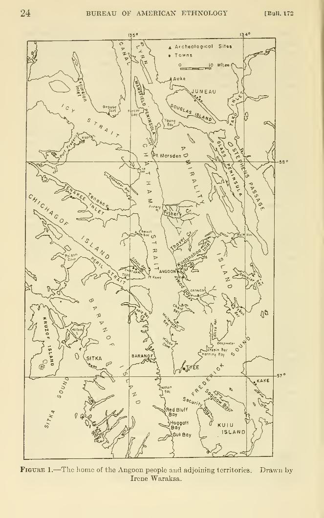
24 BUREAU OF AMERICAN ETHNOLOGY [BuU. 172
Figure 1.—The home of the Angoon people and adjoining territories. Drawn byIrene Waraksa.
de Laguna] THE STORY OF A TLINGIT COMMUNITY 25
Their geographical position marks the Angoon people as one of the
most southerly of the northern Tlingit. Their territory adjoins that
of the Hoonah and Sitka on the north and west, the Kake on the south,
and the Taku and Auke on the east and northeast. Because of their
situation on the central axis of the inland fiord system they are
neither oriented as strongly toward the open sea as are the moremaritime Tlingit groups, nor as exclusively toward the rivers andinland bays as are the mainland tribes. Since their islands lack
certain natural resources, these were formerly obtained in trade
from their neighbors. The Angoon people were and are accomplished
boatmen, for great skill in handling small craft is required to penetrate
the dangerous channels of Kootznahoo Inlet, through which the
tides rise like rivers, or to travel on Chatham Strait which is exposed
to the full violence of southeasterly storms.
The Angoon people are described by Swanton (1907, pt. 1, p. 592)
in the Handbook of American Indians as:
Hutsnuwu ('grizzly bear fort'). A Tlingit tribe on the w. and s. coasts of Ad-miralty id., Alaska; pop. estimated at 300 in 1840, and given as 666 in 1880 and420 in 1890. Their former towns were Angun and Nahltushkan, but the}^ nowlive at Killisnoo. [Since the above was written, the population has been con-
centrated at Angoon, and the other towns are deserted.] Their social divisions
[sibs] are Ankakehittan, Daktiawedi, Deshuhittan, Tekoedi, and Wushketan.
Swanton gives their native name as Xutslnuwu', and lists such
variants as Chuts-ta-k6n (ILrause), Chutznou (Holmberg), Hootz-ah-tar-qwan (Emmons), and Koohznahoo (Petroff), etc.
Our informants referred to themselves as xutsnuwuwedi, "People
of the Brown Bear's Fort." This name is appropriate both from their
point of view and ours. According to tradition, when the people first
came to the site of Angoon ('angun "Isthmus Town"), a narrowstrip of land between Kootznahoo Inlet on Admiralty Island andChatham Strait, there were no trees on this peninsula and a bear
or bears were seen walking around. So the people named the place
xuts nuwu "Brown Bear's Fort." The name is also applied to Ad-miralty Island as a whole, xutsnuwuxal "Brown Bear's Fort Island,"
and the east side of the island is sometimes referred to as xutsnuwu'At'ek "That behind the Brown Bear's Fort." The expression
xutsnuwu lit'A, translated as "Sharp Nose [or knife] of the BrownBear's Fort," is applied both (?) to the north end of the whole island,
and to Danger Point at the end of Angoon Peninsula.
Admiralty Island is noted today for its large population of browngrizzlies, and has been set aside as a preserve for them. The woodsand bushes near Angoon are a favorite resort of bears, and hardly a
week passes in summer without someone either seeing a bear or finding
fresh bear signs, incidents which furnish anxious and excited topics
26 BUREAU OF AMERICAN ETHNOLOGY [Bull. 172
of conversation. In both 1949 and 1950 the townspeople were par-
ticularly concerned because a family of bears had made their homein the berry patches on the peninsula northwest of the town, and the
excitement caused by sighting one of them on the very day of our
arrival in 1950 was probably why the tradition of the name was the
first piece of ethnographic information to be volunteered. There was
talk of organizing a party to dispose of these dangerous neighbors,
but it came to nothing, probably because none of the men was an
experienced bear hunter, and enthusiasm soon gave way to caution.
For weeks people kept watching for the reappearance of the bears
on the beach near the graveyard, or anticipated the reported coming
of a game commissioner to kill them. We were not only entertained
with bear stories—supernatural, heroic, or ludicrous—but the people
kept impressing us with the dangers of venturing unarmed into the
woods, and took care to instruct us in the traditional Tlingit speeches
to be made to a bear should one be encountered. Despite all the
fearful excitement, the native children continued to bicycle along
the road through the woods to Killisnoo Harbor and the women and
children went into the favorite bear haunts to gather berries.
The Angoon people recognize that they form a local community,
but express this by sajdng that they are a group of "tribes" or "na*-
tions," that is, a group of sibs. Although Angoon is now actually a
political unit, composed of "the Indians having a common bond of
residence in the neighborhood of Angoon," (to quote from the Cor-
porate Charter and the Constitution, adopted November 15, 1939),
there was formerly no common bond but the pm'ely social one of
residence, and even that was more tenuous during the last century
when there were several distinct villages. When we speak of "An-
goon tribal territory," therefore, we really refer to the territories or
places claimed or used by the Hneages and sibs formerly resident in
those separate but afl&liated villages and by their present descendants
now hving together in Angoon. It is not easy to define the limits of
these sib territories (i. e., to determine the exact status of certain
outlying localties), because a number of Angoon sibs have local
branches in other tribal centers: at Juneau, Hoonah, and Sitka, each
of which claimed or claims territorial rights. As local subsibs or
hneages died off in one tribe, their relatives in other tribes have claimed
or used their hunting and fishing places. Furthermore, transfers
from sib to sib of territorial rights, through war or peaceful settle-
ments, have resulted in shifts of boundaries (Garfield, 1947, p. 452).
Nevertheless, the xutsnuwuwedi obviously did and do^feel them-
selves to be a distinct group, and recognize closer social and linguistic
afl&hations with other northern Tlingit tribes (to use the term in its
ordinary sense) than with tribes to the south. Frederick Sound is
de Laguna] THE STORY OF A TLINGIT COMMUNITY 27
felt to be something of a cultural and dialectical frontier. There is
also an awareness that the Tlingit as a whole form one people, dis-
tinct from the Haida and Tsimshian to the south, the Gunana or
Athabaskans of the Interior, and the "Aleuts over to the westward"across the Gulf of Alaska. The Haida and Tsimshian are not only-
more Uke themselves, but also Hve in southeastern Alaska, which is
essentially the Tlingit world.
The sense of Tlingit unity has certainly found expression and been
fostered by the creation of the Alaska Native Brotherhood (ANB),originally founded as a pan-Indian organization to secure native
rights, prevent discrimination by the whites, and further native wel-
fare. Although planned to include all native groups in Alaska, it
has remained predominantly Tlingit.
There are now about 350 members of the Angoon community,almost aU of whom live within the narrow Hmits of the town. Theyare divided into five matrilineal sibs that have lineage houses andterritorial rights in the area. In the Raven moiety are the Decitan,
"People of the End of the (Beaver) Trail House," referring to the
story of the founding of Angoon (see pp. 131 ff.). This is the largest
and most important sib in the community. The "Basket (Bay)
People" (qAkwedi, from q^Ak"' "basket") form a somewhat distinct
subdivision of the Decitan. The second Raven sib is the 'Anxakhitan,
"People of the Middle of the Village House," who also refer to them-
selves as the "Dog Salmon People" after their main crest, or as
L'medi to emphasize their close relationship to the sib of that nameat Juneau. They are recognized as having originated from one of
the Decitan lineages.
In the Eagle (or Wolf) moiety are the Teq^edi, sometimes called
the "Brown Bear People" (xutsq'^an); the DAql'awedi, also called the
"Killer Whale People" (kitq^an); and the Wuckitan, "People of the
Over-aU House." The last sib was originally divided into three
branches: (1) Auke Bay or Juneau ('klt^ wuckitan), (2) Freshwater
Bay on Chichagof Island (asanke wuckitan), and (3) Angoon(xutsnuwu wuckitan). The last were apparently very closely related
to lineages at Sitka; in fact, our informant did not distinguish betweenthem. The "true Angoon Wuckitan" became extinct in 1947 or 1948,
and the present representatives of the sib at Angoon are descendants
of the Freshwater Bay division who have inherited the rights of
their Angoon relatives. There are also some Wuckitan men from
Juneau, and some Kagwantan men ("People of the Burned DownHouse"), mostly from Sitka, and a few individuals from other tribes
and sibs, who have married Angoon women and who live in Angoon,although they are still outsiders because they have no lineage houses
in the village.
28 BUREAU OF AMERICAN ETHNOLOGY [Bull. 172
A number of Angoon men and women have married out of the town,
or have left for other reasons, although they would be treated as
citizens if they retm-ned. In addition, the 'Anxakhitan, Teq'^edi,
and DAql'awedi, like the Wucldtan, have branches among other
tribes: Auke, Chilkat, Sitka, and Hoonah, and it is with these groups
that the Angoon people have their closest links.
ANGOON LAND
The world of the people of Angoon is made by the wide arms of the
sea, straits that one day may be calm as oily ponds and the next be
lashed into a fury of whitecaps. From these main thoroughfares the
fiords lead deep into the land, some offering safe haven and easy
passage for canoes, others becoming narrow canyons for fierce tidal
rivers. The sea dominates both the life and death of the people. Of
those who escape the swift devastation of epidemics or the slow rot of
tuberculosis, unknown before the white man's coming, a great manydie by drowning. Often drunkenness can be blamed for the accident,
yet curiously this makes the death less horrible in native eyes, because
of the belief that the body of a drunken man will float and can be
recovered. Those who were never found, according to the old pagan
dogma, could not enjoy the warm afterworld reserved for those whose
bodies were cremated, but were doomed to wander in the guise of
land otters, lurking to kidnap the shipwrecked or children lost in the
woods whom they transformed into creatures like themselves. Special
magical precautions were enjoined on persons who had once been in
danger of drowning and who had escaped, lest the water claim themagain. Enough of these attitudes persist today to make drowning
the most dreaded and tragic of deaths, and the land otter an unpleas-
ant animal to encounter. Although stories of particular drownings
are attached to localities, these do not seem to be places to shun. Thehorror belongs more to the manner of death than to the place, although
the spot may be recognized as dangerous. Rather, the attitude is
that local knowledge and skill (and sometimes in the old days the use
of a respectful fonnula for addressing the water) can make these
places safe. Treacherous waters are dangerous only to strangers,
i. e., enemies, while the rocky headlands and precipitous islands that
rise above the currents and reefs were formerly places of refuge for
the people in time of war.
The sea is also the source of life. From the deeps each year comethe hordes of salmon to spawn in the streams. In the old days, weare told, the runs were so heavy that a few fish traps could supply
aU that a large household (20 to 40 persons) could eat in a year, and
no special magic was necessary for salmon fishing. Schools of herring
used to crowd so tightly into the bays that a strong arm was needed
de Laguna] THE STORY OF A TLINGIT COMMUNITY 29
to drive the fish rake through the mass of their bodies. With them
came the harbor seals, porpoises, and whales. Fur seals, sea lions
and sea otters were killed in the outer waters. (Actually, as we shall
see, there were many sea otters in the bays, although this is now for-
gotten.) Deep holes were the hiding places of devilfish. A few
were said to be so large that they could swallow whole villages and
could render murky all the water in a bay; "ordinary" devilfish,
however, furnished the bait for halibut hooks. These old-style hooks,
when rendered lucky by virtue of their names, their carvings, and the
spells said to them, caught only the largest halibut, it is claimed,
unlike the white man's hook that kills fish before they have attained
their full size. The moving tides along the shores still uncover an
abundance of edible seaweed, salt grass, and shellfish. One only has
to be careful not to eat mussels during the season when the salmon-
berries flower and bear their fruit, for then mussels are poisonous.^
The land, however, rises steep and somber from the rocky shores
or from the narrow flats along the water's edge. Under the dense
forests of hemlock, spruce, fir, and cedar it is always dark. Festoons
of moss drip from the trees, and a wet slippery carpet of moss hides
the fallen logs. Old clearings soon become choked with elderberries,
salmonberries, blueberries, etc., and within a short distance of the
village the women and children can pick heavy buckets or baskets of
fruit. The devilclub, thorny of leaf and branch, stabs the unwary
passer-by, but once furnished magical protection against disease if
pieces were nailed to the comers of the house. Weeds, too, could be
used for medicines and charms. In the forests and swamps there are
still deer, bear, beaver, and other fur bearers.
Although the country of the Angoon people is actually composed
of islands, these have almost the character of the mainland. Theyare so large that their true size and nature can be fully appreciated
only from a plane. Above the timbered slopes rise steep volcanic
peaks, 3,000 to 4,000 feet high, which served as refuges during the
Flood, and today furnish magical means of controlling or predicting
the weather. The larger islands have small glaciers. The interior is
not often traversed, and the dangers of becoming lost in the woodsare recognized. It was inland that the supernatural beings were mostlikely to be encountered in the old days.
The land supphes some food, and also most of the materials needed
for aboriginal tools and manufactures. Aside from sealskin floats,
kelp fishing lines, and mussel-shell knives, almost everything else wasmade from the rocks and plants of the land, but these were sought on
5 Cases of mussel poisoning, resulting in paralysis and death, are well known in both the early and the
modem history of Alaska. The mussels become poisoned by microorganisms that multiply^during the
summer (cf. de Laguna, 1956, pp. 6 f.).
30 BUREAU OF AMERICAN ETHNOLOGY [BuU. 172
the beach or as close to the water as possible. The woodworker in the
old days used a greenstone adz, sandstone or shale whetstone, and
minerals for paint. Trees furnished the posts and planks for the
house, bark for temporary dwellings, logs for canoes. Even the boxes
and baskets in which food was stored and cooked were made of woodand spruce roots, and were stained with vegetable dyes. Deer bones
were preferred for awls and harpoon points.
But the land was in a real sense only the back drop for the life
which faced the salt water. Most of the village sites were small
flats, cramped between the beach and the steep hillside, and where
space permitted the houses were ranged in a line just above the water.
Sites for settlements were chosen more for a good landing beach for
canoes than for convenient access by trail to inland hunting or trap-
ping grounds. Summer villages and camps might be far up the bays
near the salmon streams, but for the winter village of permanent
houses the people prized a view of the more open waters across which
the canoes of their friends or of their enemies might be seen approach-
ing. The hunter went inland as little as possible, and tried to train
his dogs to drive the deer to where he waited on the beach. Ob-
viously, heavy timbers were cut near the water and were towed, not
carried, to their destinations. Even in death the people remained
near the beach. The cemeteries, now and in the past, are on the
slopes close behind the houses or on the shore beyond the end of the
village. A shaman's grave always faced across the water from some
headland or cave in the cliff above the shore, and those who paddled
past usually cast a small offering into the water for his ghost.
Almost all the place names which we secured referred to bodies of
salt water (bays, coves), the streams that enter it, islands, points,
rocks on the shore, or to mountaintops visible from the water. Hadwe been able to go inland with a guide we might have secured names
for hills, tributary streams, etc., but it is probably significant that
not one of our informants mentioned such specific features of the
land, except for a few lakes in which the sockeye salmon spaAvn,^
The Tlingit world is essentially the ribbon of the shoreline that Avinds
along the indented coasts of the islands and fiords. Its parts are
linked by boat routes across the open water. Only in certain places
does the world expand with arms that run inland up the streams to
some lake or to a trail that links the headwaters of two bays.
ARCHEOLOGICAL SITES IN GENERAL
As will be seen from the more detailed descriptions that follow, the
archeological sites comprise chiefly: (1) sites of former villages, most
« Krause, 1885, p. 151: The Tlingit distinguish and name only useful valleys, bays, streams, etc., not
mountains.
de Laguna] THE STORY OF A TLINGIT COMMUNITY 31
of which served for a time as summer camping places after the in-
habitants had moved to Angoon, and which are now all but aban-
doned, (2) sites of forts on high points or small islands, and (3) a
few localities with petroglyphs or pictographs. Other localities are
prominent rocks or landmarks that are supposed to have been shaped
by or are otherwise associated with supernatural agencies.
Perhaps our greatest surprise was that the village sites should be
so small in extent and so meager in cultural deposits. They had
been described to us as places where many people once lived, but wefound nothing to indicate more than half a dozen houses at any one
place, and usually fewer. A house might hold from 10 to almost
40 persons, with 20 as a fair average. At these sites, too, there waslittle to suggest a lengthy occupation. Generally speaking, the
larger the area that might have been inhabited, the thinner and
scantier the traces of midden. Since the land has apparently, from
all observable signs, risen very slightly in this area, we cannot ex-
plain the meagerness of the archeological record as due to destruction
by the encroaching sea.^ On the contrary, the older sites would be
expected to be safe above the present limits of the tide. We must,
however, note the statement made by Vancouver about evidence for
subsidence of the land in this area, especially since his observations
of subsidence in Prince William Sound have been confirmed both b}^
survey parties of the United States Geological Survey and by my ownarcheological work (de Laguna, 1956, pp. 3 1). Thus Vancouver
writes:
[Lt. Whidbey] states, that in his last two excursions [when he explored Icy Strait
and Lynn Canal, and circumnavigated Admiralty Island] several places were
seen, where the ocean was evidently encroaching very rapidly on the land, and
the low borders extending from the base of the mountains to the sea side, had,
at no very remote period of time, produced tall and stately timber; as many of
their dead trunks were found standing erect, and still rooted fast in the ground,
in different stages of decay; those being most perfect that had been least subject
to the influence of the salt water, by which they were surroimded on every flood
tide; such had been the encroachment of the ocean on these shores, that the
shorter stumps in some instances at low water mark, were even with, or below
the surface of the sea. [Vancouver, 1801, vol. 6, pp. 53 f.]
These observations may, of course, refer only to the areas north of
Cross Sound, but if they apply to regions to the south, then we mustbelieve that the relative subsidence of the land here reported musthave been obscured by a relative uplift which occurred since 1794.
If this were the case, sites in the Angoon area may indeed have been
destroyed or well hidden.
At many sites, the configuration of the land is such that only a
' Buddington (1927) summarizes the evidence for uplift in southeastern Alaska south of Cross Sound and
Icy Strait. There was subsidence of at least 20 feet in Glacier Bay, north of Cross Sound, since the climax
of glacial advance about 150 to 200 years ago.
32 BUREAU OF AMERICAN ETHNOLOGY [BuU. 172
limited area seems to have been available for settlement, and here
our test pits probably revealed fairly accurately the archeological
character of the site. In other places, where we searched the adjacent
woods as well as the obvious clearing, we could find no trace of early
occupation. There were often the ridges of abandoned potato
gardens, now overgrowTi with young trees, but nothing more ancient
in the soil itself. Of course, negative evidence of this kind cannot be
taken as conclusive. It is almost impossible to sink a test pit in the
forest, because the interlaced roots of the trees are all but impene-
trable, and more digging than we were able to accomplish would be
necessary to prove that there was, for example, no hidden site in the
woods behind the flat at Chaik Bay.
The situation can, perhaps, be better understood by referring to
two sites at Mole Harbor, on the east side of Admiralt}^ Island,
although these are in the territory of the Taku tribe. The late
Allen Hasselborg showed us these sites in 1949. The younger of the
two, apparently founded within historic times and abandoned in
1895, is on a gravel bar at the mouth of a salmon stream at the head
of the bay. It can be reached by canoe at high tide. Mr. Hasselborg
said there were once two or three houses here, of which nothing nowremains but a few stakes. There is a deep trench cut into the gravel
bank, in which a canoe could have been sheltered under mats. Theolder site is on a higher terrace, on the same side of the stream, but a
quarter of a mile above the mouth. According to native tradition,
salt water at high tide once reached half a mile up the stream, to
where Mr. Hasselborg built his cabin. At that time, the bar on
which the newer settlement was located would have been under water,
and canoes could have gone up to the older settlement. When Mr.Hasselborg started in 1916 to clear the older site for a garden, there
was no visible sign of former occupation, for the site was hidden bytimber 90 to 100 years old, he judged by the tree rings. Under one
tree he found the remains of a still older stump which had been cut
with a stone adz. This site was said to have been abandoned whenthe original Taku inhabitants were massacred by natives from
Wrangell.
Had this place not been selected for a garden, it is doubtful if the
site would ever have been found, for there would have been nothing
to suggest its existence in the forest a good quarter of a mUe up a
stream which is now too shallow for a boat. .Yet here Mr. Hasselborg
has found quantities of artifacts. The only specimen of White manu-facture was an old-fashioned axhead, which was probably lost by a
woodcutter from the newer village downstream. Mr. Hasselborg
judged that there had been about three houses facing the stream, with
a sheUy midden behind them. Practically all his finds were made
de Laguna] THE STORY OF A TLINGIT COMMUNITY 33
within 10 inches of the surface. The quantities of fire-cracked rocks
in the upper layers of the old site are very impressive; he used them
to make a retaining wall along the whole edge of the terrace.
In the test pit which we were permitted to dig, we found the fol-
lowing: the upper 10 inches of soil were disturbed by gardening;
10-24 inches below the surface was humus with shells of mussel,
cockle, and sea lu-chin, and some animal bones ; below this the deposit
became increasingly stoney, with a "pavement" of shale fragments
in rich black earth; at 36 inches was sterile white clay.
Most of the artifacts fomid by Mr. Hasselborg have been given to
the Alaska Territorial Museum at Juneau, but he generously pre-
sented us with the following specimens: ^ broken splitting adz, celt,
3 slate chisels, maul head, 2 heads for war club or war pick, 10 pestles
or hand-hammer fragments (the oldest found in white clay about 30
inches below the surface), 14 slabs of slate or shale and 2 of sandstone
(smoothed on both surfaces, and some neatly beveled along the
edges, used as whetstones, etc.), 2 paddle-shaped slate scrapers,
2 slate chips with naturally sharp edges (very common here, and
probably used as knives), 4 fragments of slate blades (one with a
drilled hole and another with cuts made by a stone saw), tanged and
barbed harpoon head of whalebone, and fragments of worked bone
and stone. Since these specimens represented only a fraction of
those found by Mr. Hasselborg, it is evident that this site was once
very rich.
The lesson to be learned is that the oldest Tlingit sites may well
escape detection, owing to changes in sea level and the growth of the
forests. Excavation of such sites would require great labor in clearing
away trees and stumps before the real archeological work could
begin. Our archeological information is likely, therefore, to be
derived from such sites as have been occupied up to recent years or
have recently been cleared again.
The scantiness of the remains of what appear to be old sites withm
the Angoon area (especially at Whitewater and Sitkoh Bays) needs
explanation. Even these most promising village sites contrast strik-
ingly with the reported forts (Pillsbury Point, Daxatkanada Island,
Marten Fort in Hood Bay), where there were not only real sheUy
middens but artifacts. The soU in southeastern Alaska is naturally
very sour, and unless a sheU midden has accumulated, the acidity of
the soil destroys bone material in a relatively short time. Further-
more, the shells, while encouraging the growth of berry bushes,
apparently prevent for some time the growth of conifers, and there-
fore make sites with shell middens much easier to find and excavate
« University of Pennsylvania Museum, catalog Nos. 49-25-60 to -106.
34 BUREAU OF AMERICAN ETHNOLOGY [BnU. 172
and much more rewarding in bone contents. But why should sites
with shell middens apparently contain more stone artifacts than sites
without middens, since stone is virtually indestructible?
One has the impression that the same habits that led to the accumu-
lation of middens were also responsible for the losing of artifacts in
them; that conversely, where such kitchen refuse is not present, arti-
facts of all types are much rarer. Again we must go outside the
Angoon area for an example which may offer an explanation. Near
Yakutat there is a village site with several house pits. Test holes
dug in one house and in a few places between the houses revealed only
clean sterile sand below the humus. According to local tradition,
the inhabitants of this village used to sweep the place every evening
with eagle \vings and throw the rubbish into the bay. This tradition
would seem to be verified by archeology, except that some kitchen
refuse and artifacts had been deposited in certain places between the
houses to form mounds of midden. Today, the streets, paths, and
yards of Angoon and other Tlingit settlements are relatively clear
of trash; all garbage and refuse and discarded artifacts are thrown onto
the beach, where they are eventually washed away or buried by silt
and gravel. Whether this practice may have originated because of
notions that fish and sea mammal remains must be returned to the
sea, we cannot say, but it evidently represents a deep-seated habit of
the Tlingit. This certainly distinguishes them from the Eskimo,
whose past and present houses are built on or in the accumulated
middens of generations, and whose house cleaning is apt to consist
of little more than throwing refuse out the door. It would appear,
therefore, that the old village sites in the Angoon area are relatively
sterile because the inhabitants threw their rubbish into the sea.
Exceptions would be special trash mounds or pits (abandoned house
sites or underground caches) which may have been used for the dis-
posal of some remains. Especially where houses were built with
platforms projecting over the beach, we should expect that all or
almost all that might interest the archeologist would have been lost
to the sea. Only heavy and indestructible stone artifacts would be
expected to have survived on the beaches, and it is indeed there that
many of our stone adzes were found.
But these habits do not seem to have prevailed to the same extent
at the places used as forts. Here rubbish and discarded artifacts
have accumulated on the surface or spilled down the slopes, and here
the archeologist is likely to find the richest rewards. Unfortunately,
however, because these sites were not permanent settlements—at
least not in most cases—but temporary refuges, we should not expect
to find there the best pieces of carved bone and stone, which would
de Laguna] THE STORY OF A TLINGIT COMMUNITY 35
have been left behind at the winter lineage houses or carefully hidden.^
An impression based upon the artifacts found is likely to be of a muchless rich culture than the prehistoric Tlingit actually possessed. Ourknowledge of the development of Tlingit art will probably be limited
almost entirely to the wood carving of historic times, recorded in
pictures or preserved in museums, except for the designs pecked or
painted on rocks, and the latter, as far as we can teU, exhibit styles
of their own.
ADMIRALTY ISLAND NORTH OF KOOTZNAHOO INLET
The Angoon people probably had no territorial claims in the west
coast of Admu-alty Island north of Point Marsden or Hawk Inlet.
Mansfield Peninsula on the very northwest corner of the island lay
beyond their territories. Hawk Inlet on the west of the Peninsula,
like Young Baj^ on the east, probably belonged to the Auke Bay or
Juneau branch of the Wuckitan, and there were once many of themliving near Young Bay.^° The area between Point Marsden andFishery Point, like the opposite shore of Chichagof Island from False
Bay to Tenakee Inlet inclusive, was also Wuckitan territory, belong-
ing to the Freshwater Bay division, although there do not seem to
have been any permanent settlements on this part of Admiralty
Island. Goldschmidt and Haas (1946, pp. 112, 117) assign the area
south of Florence or Fishery Creek to the Decitan, and report a former
Decitan graveyard between Marble Bluffs and Parker Point in the
middle of this stretch, but deny that there were any permanent campsin the area. Certainly the coastline is relatively straight, with few
features such as streams, islands, coves, etc., which might have at-
tracted settlement. Our informants had little to say about it, andit probably had little meaning for them except as scenery to be passed
in going to Juneau or Hoonah.
THAYER CREEK
We were told that there had been an old village at Thayer Creek
("Poison Water"), about 4 miles north of Angoon. The stream is
called WAtkasatE (possibly wAt "stream mouth," k'A "on," and sat'i
"master of"), and is a sockeye stream that flows from a lake. A white
man reported pictures on the rocks just north of the stream mouth,said to resemble a moon and an eye, but a native who had landed
here many times to hunt had neither seen nor heard of them. Heagreed that there is an old clearing south of the stream mouth, like a
• Lisiansky (1814, p. 160, note) reports finding near old Sitka a cache of cloth and dried fish. "The inhabit-
ants of Sitca sound always conceal in the woods such things as they do not immediately want, to prevent
their being stolen, which would be the case if they kept them in their houses."
" Vancouver (1801, vol. 6, p. 21) reports many natives living on or near Young Bay.
36 BUREAU OF AMERICAN ETHNOLOGY [BuU. 172
garden, with only young spruce growing on it. We were unable to
visit this place.
South of Thayer Creek and a little over 2 miles north of Angoonis a small island, x^t'lk''. On the cliffs behind the island there wasformerly a shaman's grave, like a little log cabin, with a canoe behind
it. This was visible some 30 years ago, but the grave house has
since fallen down. We were told to avoid the place, because, accord-
ing to the old-fashioned belief, a shaman's ghost is dangerous to
intruders and may cause an illness to which women are particularly
susceptible, and which may prove fatal to persons not belonging to
the dead man's sib. About 1,200 yards south of the island is a
waterfall, xAsk "little waterfall",
KOOTZNAHOO HEAD
This high bluff, Kootznahoo Head, which marks the entrance to
Kootznahoo Inlet, is caUed t'at'uk"^' xayi (?) "mouth of the cave."
Here there is said to be a cave under the water, to which a DAql'-
awedi shaman was carried miraculously from Hood Bay by a crane
(see p. 141). Near here there is a place where it used to be possible to
climb to the top of the cliff by means of a notched log, and the spot
is called in consequence* kiix^ tsetki (?) "Marten's Small Ladder."
The ladder is mentioned in one version of the story of Daxatkanada(see p. 151). Material for black paint used to be obtained from the
bluffs under Kootznahoo Head.
KOOTZNAHOO INLET
According to the Coast Pilot :"
Kootznahoo Inlet, comprising an area of about 15 square miles, is an intricate group
of narrow passages, lagoons and bays ... It is full of rocks and reefs, andthrough the narrow passages the tidal currents rush with great velocity.
This area is rich in game and other natural resources and has therefore
attracted settlement (fig. 2). Angoon, the only village left in the
whole region, is on the narrow isthmus between the Inlet and ChathamStrait, about 1 mile above (southeast of) the mouth of the Inlet.
Visible from Angoon and within a radius of Iji miles, are a series of
abandoned or semiabandoned native summer camps and a few cabins
occupied by white men. Many of these camps mark the sites of
earlier settlements. These places are all on the lower part of the Inlet,
most of them in relatively quiet waters, although navigation to themfrom Angoon is dangerous or impossible at certain stages of the tide.
Along the western side of the Inlet between Angoon and Danger Point
at the end of Angoon Peninsula, there are a few smokehouses which
can be reached by skiff along the slack water close to shore. There are
11 United States Coast Pilot, Alaska, 1943, pt. 1, pp. 339-341, describes the inlet.
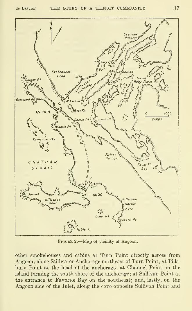
de Laguna] THE STORY OF A TLESTGIT COMMUNITY 37
FiGTJEE 2.—Map of vicinity of Angoon.
other smokehouses and cabins at Turn Point directly across from
Angoon ; along Stillwater Anchorage northeast of Tm"n Point ; at Pills-
bury Point at the head of the anchorage; at Channel Point on the
island forming the south shore of the anchorage; at Sullivan Point at
the entrance to Favorite Bay on the southeast; and, lastly, on the
Angoon side of the Inlet, along the cove opposite Sullivan Point and
38 BUREAU OF AMERICAN ETHNOLOGY [BuU. 172
on what we may call Games Point from the name of the present white
owner. Boats entering the Inlet may anchor for a short time in the
cove at Angoon or moor at high water at the docks of the two stores,
but the safe place where the natives keep their seine boats is still
farther up, at the entrance to Favorite Bay.
The entrance to Kootznahoo Inlet between Danger Point and Kootz-
nahoo Head is only about half a mile wide, and at Turn Point it is
stUl narrower. Here, to quote again from the Coast Pilot (ibid.):
"it divides into three arms; the southernmost continues in a south-
easterly direction 2 miles to Favorite Bay; the northernmost extends
eastward for 5 miles to Mitchell Bay; the middle arm, also extending
eastward, leads among the islands." Since the middle arm lacks an
English name, we shall refer to it by its Tlingit designation, t'uk'qa
[t'uk* gE?], which our informants translated as "Inside the BabyPouch," [possibly "cradle bay"?]. It comprises a series of shallow
lagoons, most of which go dry at low water, but which connect with
Mitchell Bay and Favorite Bay.
Between Turn Point and Angoon is Village Rock, yax-h-hAc (per-
haps ya>:-h-hlc "aboard it drifts"?), and half a mile above this is
Rose Rock. Here the tidal currents rush past at 5 to 8 knots, making
great swirls and eddies. Rose Rock is a gathering place for cormorants,
gulls, and other sea bu'ds, except when covered at high water. It
marks the central point toward which converge the waters from the
three arms of the Inlet.
"Kootznahoo Inlet is called i.klen and was claimed by the Decitan
people." Our informants, however, applied this name (iLen) specifi-
cally to Steamer Passage (see below), and we failed to learn any namefor the Inlet as a whole. A number of oratorical expressions that are
used by the Decitan at potlatches refer to places on the Inlet. In the
following discussion we shall treat each of the three arms of the Inlet
in turn, before describing Angoon. We begin with the northern arm
which affords the main entrance to Mitchell and Kanalku Bays. The
lowest part of this arm is known as Stillwater Anchorage, which ex-
tends about iVi miles from Turn Point to Pillsbury Point, and is
bounded on the south by Channel Point Island.
TURN POINT
Turn Point lies directly across the Inlet from Angoon. Although
there are always eddies even at slack water, the natives row across
apparently without gi-eat concern. At Turn Point there aie a few
cabins belonging to Decitan and Wuckitan men and remains of
formerly extensive gardens. The point is called yAxt'A duwudX (?)
"the cm-rent hits the point on both sides" (?). This is supposed to
have been the first place settled by the Decitan after they had moved
de Laguna] THE STORY OF A TLINGIT COMMUNITY 39
from KillisDOO Harbor on Chatham Strait below Angoon. Since
there was so much tidal current here, they later moved from TurnPoint about 700 yards northeast into Stillwater Anchorage. Although
we were told that stone "axes" (splitting adzes) and small bone
labrets had been found in gardens at Turn Point, we saw only scanty
traces of midden, but may have failed to discover the most promising
area for archeological work.
STILLWATER ANCHORAGE
The Decitan who moved from Turn Point founded qixAtuan
(qexEtudn, qixitudn, or qixituan), translated by an informant as
"Log Jam Village." (It is possibly gExet'u-'an, "Inside-the-mouth-of-
the-bay Village.") This is on the northvrest shore of Stillwater
Anchorage, just north of a small stream. From here, people later
settled at Sullivan Point. According to one informant, it was hunters
from Stillwater Anchorage who followed the beaver to AngoonIsthmus and so came to settle at Angoon, although we gather from
his remarks that Decitan from Killisnoo Harbor and Sullivan Point
also joined them in this move. According to another story, it was
at Stillwater Anchorage that a man discovered his wife's lover in a
box, an incident which led to the separation of the Decitan and the
GanAXAdi, (seep. 133).
A white man, Charley Anderson, lives at the reported site of "Log
Jam Village," having purchased the land and cabin from an Indian.
His garden, which runs along a shelf of high ground for about 30 feet
northeast of his cabin, shows traces of sheUs in the ground, suggestive
of only a small camp. Since he has never found any artifacts here,
the native tradition of a village remains unverified.
There are a number of houses, cabins, and smokehouses between
Anderson's place and Turn Point, and between his house and Pillsbury
Point, most of them belonging to Decitan residents of Angoon.
PILLSBURY POINT AND DAXATKANADA ISLAND
Pillsbury Point is the tongue of land, running southwest, that
marks the lower end of the narrow channel. Steamer Passage, which
leads into Mitchell Bay at the eastern end of Kootznahoo Inlet. Therocky headland at the end of the point, yaicai nu, "Whale's HeadFort," and the small island, Daxatkanada, "Where the tide passes
back and forth," 300 yards southwest of the point, are reported to
have been forts, and would in fact have guarded the entrance to
Steamer Passage. It is impossible to go above them except with a
favorable tide near slack water. Pillsbury Point belonged to the
Wuckitan and Daxatkanada Island to the Decitan, and both seem to
460927—60 4
40 BUREAU OF AMERICAN ETHNOLOGY [BuU. 172
have been abandoned after defeats. Since most of our archeological
work was done at these two places, especially on the island, a detailed
description of these sites will be postponed to a separate section.
The stories about them will be found on pages 150-152.
STEAMER PASSAGE
The narrow channel, Steamer Passage, about IK miles long and 200
yards wide, leads into a larger body of water which eventually opens
into Mitchell Bay, Savage tidal currents rush through the passage,
giving it the name 'iyLen or iLen, "Strong or Great Tidal Rapids."
The Coast Pilot reports velocities of 10 knots, but our informants
spoke of 12 to 14, and "after going further, it gets more swift. Some-
times you look through the water and the waves come together—it's
like you look tlirough a tunnel. If you go down there in a row boat,
you don't come back no more. That's the end of your life." Another
said: "When going through the pass, you must sit still in the boat
and not talk, or the tide will get excited and turn you over." Nearthe upper end of the passage is a rock called "Raven's Halibut," yel
tcaLi. "It is like the picture of the halibut, but the tail has nowfallen off." When coming down, it was customary to look at this
landmark, for if the tide had fallen enough for the rock to go dry, it
was too dangerous to attempt the passage. If safe to go, one should
say "thank you" to the Halibut Rock, and then address the current:
"[This is?] your own canoe—stretch your feet straight out!" (that is,
"Don't raise tide rips!"). A Decitan woman said that when womenof her sib were going through the passage they would talk to the
"fighting water," "because it's our water. We tell it we are Crowwomen." During potlatches given by the Decitan at Angoon, it is
customary to send out a junior (a nephew or grandson of the host) to
"inspect the Halibut Rock." He will report that "the tide is beginning
to run pretty swift," which means that the guests are not supposed to
leave before morning.
When we were taken through Steamer Passage by the Kahklens,
they were very careful to choose the correct stage of the tide and
were also much concerned with the behavior of our small skiff. Onour way back we arrived too early at the upper end of the passage
and had to wait for about an hour, until the sound of the roaring water
below us had subsided enough to indicate that we could proceed.
We were told that once women of the Raven and Eagle moieties
had a canoe race up the passage. They went up side by side with
the rising tide. No one won; it was just for fun.
Whereas the north shore of the passage is formed by Admiralty
Island, the south shore is composed of a series of islands, unnamed on
the chart, and beyond them is the maze of lagoons called the "Baby
de Laguna] THE STORY OF A TLINGIT COMMUNITY 41
Pouch." A narrow opening, 500 yards above Pillsbury Point, which
connects with these lagoons, is called ca-iy-Xlk'^, "Where the female
tide runs" (?) (cf. 'uk'^' or 'uk'' "to boil"). This apparently is the
place also referred to as "Ladies' Pass."
The cove on the north shore just above the end of Steamer Passage
is called nlnds-iA-tlnk, "Its mouth faces (points) inside (back-
wards)," because the mouth of the bay faces upstream or northeast
(nindE).
MITCHELL BAY
Mitchell Bay is about 4% miles long, from North and South Points
at its lower end to the falls at its eastern end where it connects with a
"salt lake." Since this lake discharges the flow from Hasselborg
Creek, the water at the head of the bay is always brackish. This
creek, a camp near the head of the bay, and Mitchell Bay itself are
called xuniye (cf. xun "northwind," and iyi "tidal current of").
The area at the head of the bay and up the creek was mentioned manytimes by the natives as wonderful hunting country, formerly very
rich in beaver. Even the Tsimshian are said to have come here to
hunt black bear for blankets. (This statement probably refers only
to one specific occasion, if indeed it is at all true.) Special wood for
canoes was formerly obtained up the Inlet, presumably in MitcheU
Bay. According to Goldschmidt and Haas (1946, pp. 113 f.), Mitchell
Bay and the Hasselborg Creek area belonged to the Teq'^edi, having
been given to them by the Decitan. They also report that the former
chief of the leading Teq^edi house (Bear House) objected when an
'Anxakhitan man, whose Teq^'edi father had a cabin near the head
of the bay, took a Wuckitan man hunting with him in this area.
Presumably no objection was made to the son's hunting on his dead
father's land, but the Wuckitan man came from Juneau and could
claim no relationship to the owners.
Although we heard no reports of any sites in Mitchell Bay, wewere told about a number of curiously shaped rocks, with which mythsare connected. Our informants were unable to locate these for us on
the chart, but implied that some were near the entrance to the BabyPouch. Throughout Mitchell Bay there are a number of high rocky
headlands, islands, and skerries which would naturally suggest fanciful
interpretations.
One island is said to have had a natural arch. This is called "Raven's
Mooring," yel-xauAX-gwaLi, (literally, "Raven mouth-through
blow-of"). According to one version of the explanatory myth, old
Raven and his wife were camping here. There were no rocks on the
beach to which he could tie his canoe, only round boulders. He said:
''Where are we going to tie our boat?" She got up and poked her
42 BUREAU OF AMERICAN ETHNOLOGY [Bull. 172
finger through the rock and made a hole, so Raven tied his canoe to it.
According to another informant, there is a high cHff here. "Ravencame there with his wife. Maybe he had a power. His wife said:
'Maybe the boat is going to drift away.' He took his line. There wasa hole right through the rock. He tied his boat there. There wasa little lake right on top of the rock where he tied his canoe. Salt
water went back and forth over that little pool year after year. Whena person cuts his hand he puts it in a wash basin and the blood gets
mixed up with the water. Raven put his hand in there [after he had
cut it by punching it through the rock?], and the blood is still there.
Salt water goes over it year after year, but it never changes its color.
I don't know how many times I come there and I looked at it, but it
never go away yet."
Another high rock is "Raven's Slave," yel guxu. It was said byone informant to be the conspicuous high rock near the Teq'^edi campat the eastern end of the bay, but others insisted that this rock was the
"Adolescent Gu-l" (see below).
A group of rocks are said to be three brothers, a bear, and a dog
that turned to stone when an adolescent girl looked at them. Thenshe too turned to stone. The three brothers are called nAsgin^x qa,
"three men." As one informant explained: "They were walking
across there. When a girl comes to woman, and it comes to be her
monthly, they put a blanket or whatever it is over her, so she won't
look out. She peeked out and the men tm'ned to stone. She looked
behind and there was a bear, and he turned to stone, and the stone is
there yet. It doesn't really look like a bear, but it looks something
like a bear—like a face." Another informant said: "A white rock is
a woman, a wetedi [menstruant]. She shouldn't go outside, but she
did. The water went down and she looked at the bear and it turned
to stone. Another rock is the dog, keL. The high tide came and
they all turned to stone. When you see those rocks, you must say:
gunaltcic 'AxsutinE ['Thank you, my supernatural helper'?]."
It is evident that we are dealing here with the concluding incident
of the widely known Tlingit story of Iqay^k'^. According to versions
collected by Swanton (1909, Tale 31, pp. 105 f.) he was the youngest
of three brothers who, with their sister, were born of a woman by a
dog father. The little dog in the story is also one of the litter that
did not change into human form. The brothers and their dog traveled
all over, killing or subduing monsters of various sorts. They were
coming down the Stikine River, when the sister, who was menstruat-
ing, violated the taboo and looked at them, because she heard her
mother cry out that they were about to drown. Whereupon the three
brothers, the dog, the mother, and the girl all turned to stone. (There
is no mention of the bear in this version). Swanton's informant ex-
de Laguna] THE STORY OF A TLINGIT COMMUNITY 43
plained that passers-by formerly put pieces of their clothing into
cracks in the rocks and prayed to the stones for long life. It is interest-
ing that the Angoon people should have transferred the scene of this
story from the Stikine River to Mitchell Bay.
Most of our informants agreed that the "menstruant" was the high
rocky stack on the narrow point just east of the Teq'^edi man's campon the north side of Mitchell Bay, about 1,200 yards below the falls
from Salt Lake. The other characters are presumably rocks on this
point, but could not be identified. A wooden cross was recently set
up on the end of the point to commemorate the drowning here a few
years ago of a woman and her adopted daughter. We camped at this
place with the Kahklens, while on a fishing trip to the falls.
The falls from Salt Lake are yel iyi, "Raven's Tidal Current." It
is possible to enter or leave the lake only at extreme high tide when the
falls are covered. It was here, according to one version of the story
of Daxatkanada (see p. 151), that a war party from Wrangell wasdrowned. We were told that there was a hole in the rocks below the
falls, apparently of mysterious origin and deeper than a man can
reach with his arm. When a now middle-aged informant was a small
boy, a huge fish trap was fastened to a pole set into this hole. Cohoeand sockeye salmon attempting to jump up the falls would tumble
back into the trap. We did not hear of this hole until after our visit
to the fails, and did not notice it.
Our trip to Mitchell Bay was too brief to permit of much explora-
tion, but we were able to land on the point between South Point and
the entrance to Davis Creek that leads to Kanalku Bay. The point
is a high, narrow tongue of rock, shaped like a steamboat. It is
unnamed on the chart, and we were unable to learn the native name.
There is, however, a rock shelter about 40 feet long under the cliff on
the northwest side of the point. Here we found traces of recent campfires, and an older midden deposit into which we dug for 12 inches
without reaching the bottom. There are no cultural deposits on top
of the cliff.
KANALKU BAY
Opening south of Mitchell Bay is Davis Creek, a tidal channel some
2 miles long and 250 yards wide, at the southern end of which is
Kanalku Bay, qaLX or qaLx (probably q^'AL "pot," and -x or -x
"inside," an apt term for the bay). The English name is evidently
derived from the title of the chief of Tuqk'^a hit, a Decitan house.
The bay is about 3 miles long (east-west) and one-half to thi-ee-
fourths of a mile wide. Passage Island nearly blocks the outer end
of Davis Creek, and Stone Island the entrance into Kanalku Bay.
A chief of the Decitan Steel House used to live on Stone Island.
44 BUREAU OF AMERICAN ETHNOLOGY [BuU. 172
Dots and circles were recently painted on the island as aids to naviga-
tion, for at one time coal was mined on the south side of the bay.
There are a number of camp sites belonging to Teq'^edi men on the
north side of the bay, just inside the entrance. A woman who lived
there as a child said that she used to get clay nearby for toy dishes.
We were not able to visit the bay.
BABY POUCH
If we return to Angoon by the route described by one of our in-
formants, we should come down the middle arm, a system of lagoons
called the Baby Pouch, and enter the lower Inlet between Channel
and Sullivan Points. Travel by this route is possible only at high
water. The islands are reported as good hunting places for deer.
The opening at the lower end of the Baby Pouch, which connects
with the channel south of Channel Point Island, is called xusiyE,
which our informant translated as "Crabapple Tide." (However,
xdx is "crabapple," and xus is "club".) This same opening, or the
narrowest part of it, is also called iyfk, "Place inside the tidal cur-
rent" (?).
CHANNEL POINT
This point, about three-quarters of a mile east of Angoon, is on the
lower end of an island which divides the middle channel from Still-
water Anchorage. Daxatkanada lies off the upper end of the island.
On the southernmost part of Channel Point there are still a few
dilapidated smokehouses and cabins built by Decitan and Teq'^edi
men, and remains of gardens can be traced from here thi'ough the
bushes and woods to the top of the 60-foot-high headland which forms
the north side of the point, a distance of about 175 yards. A middle-
aged informant said that these gardens were under cultivation whenhe was a boy. However, a stump with some 70-odd rings stands in
the middle of one plot and the trunk lies across the garden, which
suggest that this part of the area was abandoned much longer ago.
The point is called l'uk^ -'ani, "Cohoe Salmon Village," because it
was always possible to catch cohoes on each side of the point. In the
woods near the headland there is a grave enclosed by a wooden fence
made of banister-type railing. It is said to be the grave of an old
blind Decitan man who was burned to death when two malicious
women set fire to his cabin. The rocky headland was considered his
tombstone. A pole with a United States flag is said to have been
planted at the grave, but no trace of this now remains. Test pits madein various parts of the gardens revealed only scanty midden deposits,
not over 12 inches in depth. We found no articles of native work-
manship, although we were told that stone "axes" had been found
near the south end of the point. There are a number of depressions.
de Laguna] THE STORY OF A TLINGIT COMMUNITY 45
probably remains of root cellars, along the eastern edge of the gardens,
in one of which were fragments of china. This site does not appear
to be very promising archeologically.
sullivanJpoint
This point, about 1 mile southeast of Angoon, is on an island whichforms the north shore of Favorite Bay, and the point marks the
division between this bay and the middle arm of the Inlet. Herewas the site of a village (cAtxiwustm-'an or ceq'ewust6i-'an?),
reportedly occupied by the Decitan after they moved from TurnPoint and before they settled at Angoon, The name applies specifi-
cally to the westernmost part of the point. After the removal to
Angoon, the name was changed to tak^'anicu, "Winter Village,"
although this is felt to designate more particularly the southeastern
section of the point. A settlement near here or a portion of the site
belonged to the 'Anxakhitan and was called daxcu-'an, "Village close
to the backside." There are still a number of summer cabins andsmokehouses along both sides of the point, belonging to men of
different sibs, and some are still used by people from Angoon. Drink-
ing water is obtained from a waterfall across the entrance to Favorite
Bay, in a cove southeast of Games Point, ^t one time coal was minedat Sullivan Point. All of the flat behind the point was formerly
cultivated, and we were told that a splitting adz had been found in a
garden, on a layer of sand, under 3 feet of earth. Our test pits near
the end of the point revealed rich black humus with shells, charcoal,
and cracked rocks to depths of 19 to 26 inches. In one pit we found
a stone saw (pi. 7, g;), a fragment of slate blade, and a cut animal bone.
This would appear to be a prehistoric site, though perhaps not a
rich one.
About half a mile northeast of Sullivan Point, there is a small rocky
knoll at the northernmost point of the island. A dilapidated ware-
house is on the beach below, and on the knoll are two collapsed smoke-houses and a square pit (remains of a root cellar?) . This pit was dugto a depth of 4 feet through shelly midden, but the cultural deposit is
of very Hmited extent, and the madden itself seems to represent
rubbish thrown into a previous pit. Other indistinct depressions on
the forested top of the knoll also suggest similar cellars. At one
place a 12-inch midden was exposed in the cut bank overlooking the
beach. Although we investigated this area, we found no artifacts.
On the flat which extends from the knoll towards the south for about
300 or 400 yards, there are remains of old gardens, most of which are
now overgrown with young trees. A test pit in the most open part
was dug through a 30-inch midden, but no specimens were found. Wedid not learn the name of this place, but the narrow opening north of
46 BUREAU OF AMERICAN ETHNOLOGY [Bull. 172
the point which leads into a shallow lagoon behind the island is
called anteyiiq. We were told that large cockles could be obtained
from the lagoon, but were warned that if we went to get them weshould keep a boat close to us and have one member of the party
watching the tide. This lagoon opens into the upper part of Favorite
Bay.
FAVORITE BAY
The English name for this bay is derived from that of a vessel of the
Northwest Trading Company that operated the station on Eallinsnoo
Island in the 1880's. The native name is wAnk'A gE, "Edge-on Bay."
The head of the bay, mostly mud flats, is almost 3% miles southeast of
Angoon, and the entrance is a long narrow channel. An abandoned
"Fishing Village," marked on the charts on the southwest shore, is
xicwan-'ani, translated as "Fisherman's Town." The bay was
formerly a famous locality for herring. It was apparently at this
settlement that many of the natives were staying when Angoon was
destroyed in 1882. It was not described to us as an old site, and
exploration of the midden exposed in the banks of a small stream at the
village revealed only modern cultural remains.
A Decitan man is buried on the little island off the north shore of
Favorite Bay, near the upper entrance to the lagoon behind SuUivan
Point Island, and another Decitan man has a cabin there (Gold-
schmidt and Haas, 1946, p. 113).
GARNES POINT
Games Point is due west of Sullivan Point, and about 1 mile south-
west of Angoon with which it is connected by road. Mr. Elmer
Games and his wife, both white, have a house and garden here. Thefloat for the Alaska Coastal Airways planes is in the cove below the
point, and above the point is the anchorage used by the Angoon
people for their motorboats. The point itself is called xanAxayE,
and on it we found scanty traces of midden, apparently modem.There are a number of houses on the shores of the cove above GamesPoint. The cove is called k'AtsAsak''. We were told that there
had once been a lineage house here, belonging to the Kagwantan sib.
If this unverified statement were correct, it would mean that this
Eagle sib was once an established part of the Angoon community.
It was here, we were told, that the Indians held two white men pris-
oners, an incident which played an important part in the destruction
of Angoon. There are no indications of an old site in the area.
Children used to find clay here for toy dishes.
de Laguna] THE STORY OF A TLINGIT COMMUNITY 47
ANGOON
According to tradition, the site of Angoon was already occupied
by the GanAXAdi, a Kaven sib, when tlie ancestors of the Decitan
followed a beaver across the isthmus and so discovered this desirable
place. The oldest part of Angoon is apparently at the southern end
of the present town, facing Chatham Strait, and this includes the
school grounds and the point just beyond (see fig. 17, p. 179). It was
here that the GanAXAdi had their houses; the newcomers, who must
have included representatives of other sibs in addition to the Decitan,
presumably settled farther north. Later, the QanAXAdi moved away
from Angoon, surrendering their rights to the Decitan.
The original Kaven House of the GanAXAdi may have been on the
present school grounds. These were once a garden, but the area was
leveled in 1929 when the school building and teacher's house were
built, so that any archeological remains would have been destroyed.
In 1938, when ditches were dug around the playground behind the
school, a number of wooden rods were found at a depth of 4 feet.
These were described by our informants as 2 (or 4 ?) feet long, curved,
pointed at both ends, and apparently treated with oil. None of the
natives was able to guess their function.
The QanAXAdi had a fort or fortified house on the rocky point just
south of the school. This place is stiU called GanAxca nuwu, "GanAx
Women's Fort." Excavation here is impossible because there are
recent graves on the point and a house at its landward end. A midden
which spills down the slope toward the school has a total depth of 38
inches. When exploring this, we found a piece of wood, wrapped
around with a copper band on which was stamped a design suggestive
of an eye. This was found at a depth of 24 inches, at the bottom of
the uppermost layer of the midden. It was impossible to determine
whether this was an object of purely aboriginal manufacture. We also
found a crude maul head (pi. 4, b) at the edge of the garden on the
point.
There are probably other areas within the town limits which were
occupied at an early period, such as the narrow isthmus and the shores
of the coves on each side. It is here that the present sib houses are
concentrated, reportedly on or near the sites of earlier buildings with
the same names (pis. 1 and 2). Any archeological remains here
have been obliterated; nothing can be seen on the surface, and excava-
tion is impossible. Some of the early houses along the west shore maywell have been built in part on piles over the beach. Of these, or of
the refuse from them, we could expect to find little or nothing. Wedid find a broken spHtting adz on the west beach, however; and on one
beach a local resident found an ivory buckle carved like a sea otter.
48 BUREAU OF AMERICAN ETHNOLOGY [BnU. 172
which he said had been used for tightening the chin strap of a woodenhat.
In front of the sib houses on the west beach (pi. 1) can still be seen
a canoe landing place, made by rolling aside some of the larger rocks
to leave a clear lane up the beach. Here, near the high-tide Hne,
there is a very large boulder, called simply the "stone," t'E, or
"boulder," xiL, or referred to as the "Anchor for Angoon." On this
boulder slaves were killed at the old potlatches. Some faint carvings
on the boulder represent faces, allegedly of slaves; other carvings are
arabic numerals. These numbers are obviously the most recent
carvings, while other designs are probably older, since they are too
worn to be deciphered. Some are said to have been made by visiting
Tsimshian Indians when a now elderly informant was a small boy,
and these are probably intermediate in age. The rock is reported to
have been shifted from its original position because teams of two or
three men from rival sibs used to vie with each other in trjdng to
push it around. The carvings are all but worn off because children
are said to climb over the rock.
The ridge south of the isthmus has been cleared of timber, and
while there is rich black humus on top, suggestive of former occupation,
we found no identifiable cultural remains. Since there are a numberof graves along the crest of the ridge facing Chatham Strait, wedared not undertake any extensive digging. Other modern graves
are behind the houses on both sides of the walk across the isthmus,
which again prevents digging in this area.
We were told that there used to be a fort at Danger Point, at the
entrance to Kootznahoo Inlet. This was called xayiida nuwu,
"Fort of the lower end of the point." There was another, called
teak nuwu, "Eagle's Fort," or tcaknuku, "Eagle's Small Fort,"
at Graveyard Point, about 900 yards northwest of Angoon, where
the modern cemetery is located. We did not visit either site.
CHATHAM STRAIT BETWEEN ANGOON AND KILLISNOO
Kenasnow Rocks, which lie off Angoon, are called litxadB, a namewhich is said to refer to a smaU rock or island. (This is possibly
ht xat'i, "-?- island-of "?) On the point directly opposite these
rocks about one-half mile south of Angoon isthmus, there are several
pictographs in red paint. Two of these paintings, about 10 feet above
rocks about ji mile south of Angoon isthmus, there are several picto-
graphs in red paint. Two of these paintings, about 10 feet above
the high-water mark, are clear enough to trace (fig. 7, a, b). Themost distinct and probably the most recent picture represents a three-
masted sailing ship. To the right of it is a mask or animal face, and
there are traces of what appear to be similar faces to the left and above.
de Laguna] THE STORY OF A TLINGIT COMMUNITY 49
According to one tradition, these paintings were made by Tsimshians
in human blood. The point is called "Magpie Point," tsegeni
qago (probably tsegeni xaKu, "Magpie's Little Point"). We were
not able to learn anything further about the pictographs because the
point is associated with the recent drowning of a man who was said
to have been warned by a soothsayer not to pass the point in his boat.
Evidently there is felt to be something unlucky about the spot.
On the south side of the point just below this, there is a vertical
crevice or chimney in the rock, in which a shaman was buried. This
place is called yekk hidi, "Small Spirit's House," or yek k*A hidi.
When we visited the grave, we found that it had been rifled. Ap-parently the body had been laid on planks (or in a box), propped on
rocks and timbers crammed in the cleft. The people stUl avoid this
place and do not cut firewood or pick berries in the vicinity. Anelderly man told us that one could talk to the spirit (ghost, shaman's
familiar ?), and it would answer; then one must say "thank you."
We were told that south of the grave, somewhere in the bight
between Kenasnow Rocks and Killisnoo Island, there is a summercabin owned by an 'Anxakhitan man. Here, or just to the south,
was a former camp called k'et'intci yAdi, "Child of -?-" (see the namefor Killisnoo Harbor Village). Teq^edi from Hanus Bay in Peril
Strait are supposed to have killed a famUy here in historic times.
White rocks on the point opposite Killisnoo Island are called
tcaL xuxgo (probably tcaL xoxu, "HaUbut Meat"). Raven is said
to have cooked a halibut here and the rocks represent the remains of
his meal. This place is also called yel q'^ALi, "Raven's Cooking
Pot."
KILLISNOO
A number of sites are reported in Killisnoo Harbor. It can be
reached by a road from Angoon, about 3 miles north. Killisnoo
was the settlement on the island of that name which grew up about
the stations established by the Northwest Trading Company in 1878.
It was all but destroyed by fire in 1928, after which the last families
moved back to Angoon. The name "Killisnoo" is obviously the
same as "Kenasnow," and was probably the native name for a fort.
Before the war a number of Japanese men lived on the Admiralty
Island shore of the harbor, which is also referred to by the natives
as "Kniisnoo," but these have all died or failed to return since their
wartime internment, except Mr. Sumato who is married to a native
woman. One elderly white man lived alone on the island in 1950.
There were no other residents of the area.
At the Sumato home, midway between the north point of Killisnoo
Harbor and the stream at the head of the bay, is the site of qadasax^-
ayik ("Sand Island, inside of ?"). There is a shell heap here, but
50 BUREAU OF AMERICAN ETHNOLOGY [Bull. 172
excavation is impossible because the area is under intensive cultiva-
tion. The owners told us that they had found a barbed harpoon
point, a pestle or maul, and a stone mortar in their gardens. A chart,
published by Beardslee in 1882, shows the "Prov. [Prob.?] Site for
Fort," and a trail across to the Inlet near Games Point.
The channel between the north point of the harbor and Killisnoo
Island is called wucqahteL'sit, freely translated as "Getting so fat
it's coming together" (probably: wuc "together", q'u "it", h-t'EL'
"to be greasy", sit' "channel"). This name was supposedly given
by the crane who carried the shaman from Hood Bay to Kootznahoo
Head (see p. 141), when it prophesied the establishment of the whaling
station on Killisnoo Island.
The stream at the head of the harbor drains a salt lake or lagoon
called k'AtsAsak'', the same name as that given for the cove above
Games Point in Kootznahoo Inlet.
On Admiralty Island, south of this stream, and almost due east
of the station on Killisnoo Island, is an open beach about 600 yards
long, as measured on a straight line between the reefs that bound it.
The southeastern end of this beach is of sand, and here is reported
to have been the village of ketmt6ian [(possibly: k'et'intci-'an,
"Village where it continually lifts up"). The natives, who were
unable to translate the name, said that it referred to the pounding
surf, which prevented the people from sleeping, so that they eventually
moved to Kootznahoo Inlet and Angoon. Representatives of several
sibs lived here or in the vicinity; the Decitan, Teq^edi, Wuckitan,
and DAql'awedi were specifically mentioned. A middle-aged womansaid that her grandfather had told her that the last inhabitants of the
village died of sickness, and that since there was no one left to burn
the bodies, they were simply left in the houses. This was probably
in the smallpox epidemic of 1836-39. One of the Angoon men whohave cabins and gardens here is said to have found human bones at
a depth of 4 feet, which suggests that they were in an abandoned
house pit. The ridges of formerly extensive gardens can be seen
along the whole beach; it is probably here that were raised the potatoes
for which Killisnoo was famous in the last century and which were
traded by the natives to other tribes. At the end of the gravel north
of the sand beach is a fine stream of clear water, and there is supposed
to have been another stream between the gravel and the sand beach.
We visited the place, and sank test pits at various spots in the gardens
along the cove, but found only scanty traces of midden. We probably
failed to discover the best area for excavation. A small rectangular
slate pebble with notched edge, obviously water-worn, was found
just under the surface of the gravel floor of an abandoned shack.
It may have been an amulet.
de Laguna] THE STORY OF A TLINGIT COMMUNITY 51
The rocky point south of the site, "Potato Point," was once a fort,
dasAklak nuwu or sakqAdat^ayi nu, and another settlement in the
vicinity was called dasuqtag-'an or SAkqadatsayi-'an. Although
we were unable to check the locations of these places their names
suggest a position behind Sand Island, which is called dasaxuq^,
dasAxuk', or tasinux. There were supposed to have been storehouses
for potatoes on this island, but it was probably never inhabited.
The smaller of the two Table Islands, north of Sand Island, mayhave been a fort, for it is called tsAx'^el nuku, "Crow's Little Fort."
HOOD BAY
Hood Bay is the first bay south of KiQisnoo Island. All informants
agreed that the South Arm belonged to the DAql'awedi, but Gold-
schmidt and Haas (1946, p. 115) assign the North Arm to the Decitan.
One DAql'awedi man, however, explained to us that the North Armhad originally been Decitan, but that it was given to the DAql'awedi
by a Decitan chief at the funeral potlatch for the latter's son, a
DAql'awedi boy, who had been kiUed by a bear at the salmon stream,
xdya, at the head of North Arm. This story was not confirmed by
other informants, and the details are certainly confused, for a mancould never give a potlatch for his own son, although he might sur-
render property to his son's sib at a "Peace Ceremony" if he were
held responsible for his son's death. Just southwest of the mouth of
this stream is said to have been an old settlement or camp. Apparently
the name for the stream is applied to all of the North Arm.
Hood Bay Cannery, which was purchased by the Angoon Com-munity Association, is on the north shore of the bay, just inside the
entrance to North Arm. On the small point just above it was the
site of a former village called tAntcusxex or tandjusxiq, which was
roughly translated as "Where the people can't sleep because the
jumping fish make so much noise." People were living here when a
now middle-aged man was a boy. No trace of the settlement could
be found in 1949 when we visited the cannery, but in 1950 when land
was being cleared to build more cabins for the cannery workers,
some stone objects (mortars ?) were found here. If the people ever
move from Angoon to Hood Bay, as many advocate, there will be
extensive buUding in this area, and additional artifacts may be found.
There are a number of dilapidated buildings along the north shore
of Hood Bay between the cannery and Cabin Point to the west.
On the point are cabins belonging to a deceased white man and to a
former DAql'awedi chief. Still farther down toward the mouth of
the bay, the natives used to obtain marble at a place called nixkago
(probably: nexk'Axa), "White Rock Point." This is on the north
shore, opposite House Point. The rock was used to make dolls, and
52 BUREAU OF AMERICAN ETHNOLOGY [Bull. 172
also for polishing carvings in wood and bone, according to our
informant.
The South Arm of Hood Bay is called tsdq'^A, as is the salmon
stream which enters its southern shore near the head. A former
DAql'awedi camp was reported at the rocky point just west of the
stream. A former chief of that sib had a cabin here, but it was
burned after his death in 1948 by careless white campers. The
fishing camp is associated with the Hood Bay shaman (see p. 140)
for it was here that he first obtained his power. There was a logging
camp here in 1949, which caused distress to the Angoon people,
because they felt that it was cutting timber which belonged to them.
The group that formerly lived in Hood Bay were called the Tsa-
g^edi, but whether they were simply a branch of the DAql'awedi
(Garfield, 1947, p. 447) or the original inhabitants, is not clear. In
any case, they, or a group descended from them, moved to Saginaw
Bay in Kake territory, where they now live, and they no longer have
any claim to Hood Bay.
From Hood Bay Cannery a high mountain, evidently a volcanic
neck, is visible above the end of South Arm. It is caUed "Box Moun-tain" from its shape. Like many peaks in the Angoon area, this is
supposed to be one of the mountains where people took refuge during
the Flood. The natives told us that there is a rope coiled up around
the top of the peak, by means of which the people moored their raft
or canoe, and that it is now so old that if touched it turns to ashes.
One of the white men at the cannery reported that there is supposed
to be a pool of water on top of the mountain that will rejuvenate
gray hair because it is hair oil that was lost by an old woman whoclimbed the mountain. (Gray hair is a theme much discussed by
the natives, who lament that people now tm-n gray because they
don't take care of themselves at puberty, as the old people did whose
hair never turned gray.) The same mountain is visible from Mole
Harbor on the east coast of Admiralty Island. Mr. Hasselborg,
who lived at Mole Harbor, told us that the Taku Indians of that area
believed that if you "put your finger on" (point at) the mountain,
it would rain immediately, even though the sky were clear. Whatmay be the same mountain was called by an Angoon informant as
"Hood Bay Old Woman," tsaq'^A canuk^', because an old womanturned to stone on top of it during the Flood. She was a DAql'awedi
woman, and that is why that sib owns Hood Bay. If you point a
finger at her, our informant added, she gets mad and makes it rain.
Petroglyphs were reported in Hood Bay, but the localities were
not specified and we did not see any.
de Laguna] THE STORY OF A TLINGIT COMMTJNITY 53
HOOD BAY FORT
The only archeological site of interest in Hood Bay was at first
not mentioned by the natives. This is on a small rocky promentory
on the south side of the bay, opposite Cabin Point. We discovered
it from the motorboat, because the former clearing on top, now over-
grown with bushes, is visible from the water. Later we learned that
it was called Itux"^ nuwu, "Marten's Fort." It is said to have been
built by the DAql'awedi when they first came to Hood Bay. Ourexamination indicated that the site would probably repay excava-
tion. The old trail to the top evidently started from the beach
on the west side of the point. Here, just above the beach, we found
some 30 inches of midden, consisting of humus, shells, and fire-cracked
rocks. In the deepest layers were a piece of worked stone, the butt
end of a bone tool or arrowhead, and a barbed harpoon head. Thetrail passes a rock shelter about halfway up the slope, under which
is a midden about 24 inches deep. At the summit, where we madetest pits in three places, the midden is 30 to 36 inches deep, and
consists of layers of humus, charcoal, clam and mussel shells, inter-
spersed with fire-cracked rocks. A large barbed harpoon head
(pi. 8, k) and a red shale labret (pi. 10, aa) were found at depths of
18 and 30 inches. There are numerous ledges along the cliffs, some
of which we explored in the vain hope of finding burials. The site
seems well suited for defense, except that we could see no source of
fresh water in the vicinity.
CHAIK BAY
This area is claimed by the Decitan, and is said to have been
occupied by their ancestors before they came to Angoon (Goldschmidt
and Haas, 1946, p. 115; Garfield, 1947, p. 439). Some elderly people
now living at Angoon were born and brought up at the former village
which was located on the north side of the bay, just inside Village
Point (fig. 3) . At that time there were houses here belonging to both
Decitan and DAql'awedi men. A DAql'awedi man even told me that
his people claimed the bay, but this can only mean that they had some
rights in the area. At present there are only a series of abandoned
cabins and smokehouses between Village Point and a cove about
lYi miles to the east, evidently the remains of a summer settlement.
The most interesting part of the area is a rocky point called t6Aqianu,
"Eagle-?-Fort," (cf. teak "eagle"), about 500 yards east of Village
Point. Here we were told that the nat6unedi (probably the
WAshinedi) of Kake made war on the local inhabitants. Near the
end of the promontory we found a midden about 20 feet wide and
18 inches deep. Although we found no specimens here, we picked
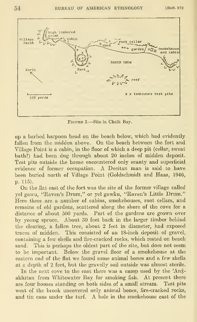
54 BUREAU OF AMERICAN ETHNOLOGY [Bull. 172
North
100 yards
Fort
^v^* .-' root cellar ,
° sheer " -—
—
>^/<Ik^oo,
RAVEN DRUM
i. :av reef
garden/ x^^ smokehouse—-^ ^ and cabin
W
X X Indicates test pits
Figure 3.—Site in Chaik Bav.
up a barbed harpoon head on the beach below, which had evidently-
fallen from the midden above. On the beach between the fort and
VUlage Point is a cabin, in the floor of which a deep pit (cellar, sweat
bath?) had been dug through about 20 inches of midden deposit.
Test pits outside the house encountered only scanty and superficial
evidence of former occupation. A Decitan man is said to have
been buried north of Village Point (Goldschmidt and Haas, 1946,
p. 115).
On the flat east of the fort was the site of the former village called
yel gawu, ''Raven's Drum," or yel gawku, "Raven's Little Drum."Here there are a number of cabins, smokehouses, root cellars, and
remains of old gardens, scattered along the shore of the cove for a
distance of about 500 yards. Part of the gardens are grown over
by young spruce. About 30 feet back in the larger timber behind
the clearing, a fallen tree, about 2 feet in diameter, had exposed
traces of midden. This consisted of an 18-inch deposit of gravel,
containing a few shells and fire-cracked rocks, which rested on beach
sand. This is perhaps the oldest part of the site, but does not seem
to be important. Below the gravel floor of a smokehouse at the
eastern end of the flat we found some animal bones and a few shells
at a depth of 2 feet, but the gravelly soil outside was almost sterile.
In the next cove to the east there was a camp used by the 'An^-
akhitan from Whitewater Bay for smoking fish. At present there
are four houses standing on both sides of a small stream. Test pits
west of the brook uncovered only animal bones, fire-cracked rocks,
and tin cans under the turf. A hole in the smokehouse east of the
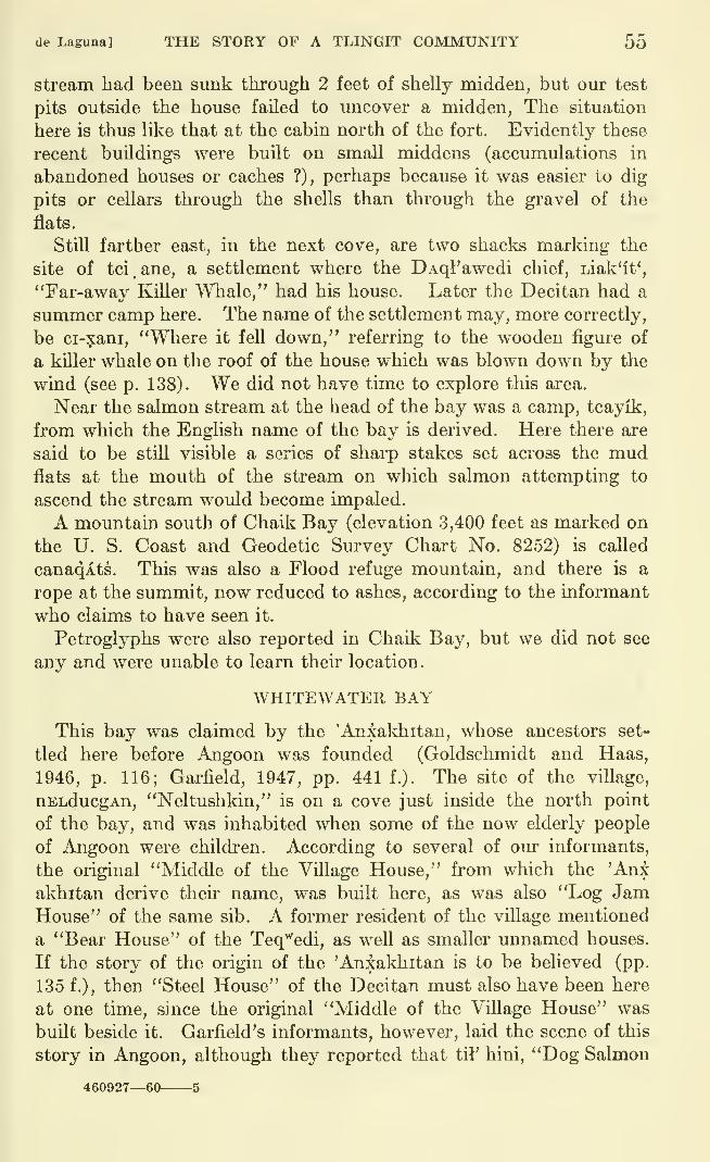
(le Laguna] THE STORY OF A TLINGIT COMMUNITY 55
stream had been sunk tlirough 2 feet of shelly midden, but our test
pits outside the house failed to uncover a midden, The situation
here is thus like that at the cabin north of the fort. Evidently these
recent buildings were built on small middens (accumulations in
abandoned houses or caches ?), perhaps because it was easier to dig
pits or cellars through the shells than through the gravel of the
flats.
Still farther east, in the next cove, are two shacks marking the
site of tci , ane, a settlement where the DAql'awedi chief, Liak'it',
"Far-away Killer Whale," had his house. Later the Decitan had a
summer camp here. The name of the settlement may, more correctly,
be ci-xani, "Where it fell down," referring to the wooden figure of
a killer whale on the roof of the house which was blown down by the
wind (see p. 138). We did not have time to explore this area.
Near the salmon stream at the head of the bay was a camp, tcayik,
from which the English name of the bay is derived. Here there are
said to be still visible a series of sharp stakes set across the mudflats at the mouth of the stream on which salmon attempting to
ascend the stream would become impaled.
A mountain south of Chaik Bay (elevation 3,400 feet as marked on
the U. S. Coast and Geodetic Survey Chart No. 8252) is called
canaqAts. This was also a Flood refuge mountain, and there is a
rope at the summit, now reduced to ashes, according to the informant
who claims to have seen it.
Petroglyphs were also reported in Chaik Bay, but we did not see
any and were unable to learn their location.
WHITEWATER BAY
This bay was claimed by the 'Anxakhitan, whose ancestors set-
tled here before Angoon was founded (Goldschmidt and Haas,
1946, p. 116; Garfield, 1947, pp. 441 f.). The site of the village,
uELducgAn, "Neltushkin," is on a cove just inside the north point
of the bay, and was inhabited when some of the now elderly people
of Angoon were children. According to several of our informants,
the original "Middle of the Village House," from which the 'Anx
akhitan derive their name, was built here, as was also "Log JamHouse" of the same sib. A former resident of the village mentioned
a "Bear House" of the Teq^'edi, as well as smaller unnamed houses.
If the story of the origin of the 'Anxakhitan is to be believed (pp.
135 f.), then "Steel House" of the Decitan must also have been here
at one time, since the original "Middle of the Village House" was
built beside it. Garfield's informants, however, laid the scene of this
story in Angoon, although they reported that til' hini, "Dog Salmon
460927—60 5
56 BUREAU OF AMERICAN ETHNOLOGY [BuU. 172
Stream," at the head of Whitewater Bay, was the exclusive property
of the 'Aniakhitan. This statement suggests that other sibs en-
joyed rights in the ai"ea.
The former village is still marked by a few dilapidated houses,
overgi'own garden patches, and cache pits, and by what appear to be
the pits of older houses (fig. 4) . The site is on a narrow flat, less than
500 yards long, with a steep hillside behind, which would have forced
a concentration of occupation within a relatively small area. There
is an excellent stream of water near the northwest end of the cove.
On the rocky point beyond the stream are painted a red circle (or
semicircle) with a dot in the center, and a red comma-shaped figure
(fish?) (see fig. 7, c).
NORTH
forest
v. steep hillsideHill 111!//
J tree •*• '•^"^'-^
forest
^oung spruce
/
ouses ^ /
100 yards reef lJ.^ ^ ^/
Figures indicate test pits l^
Figure 4.—Site of Neltushkin, Whitewater Bay.
We dug two test pits in the old garden plots near the western end
of the site. In the first, the top 18 to 20 inches consisted of humus,
gravel, fire-cracked rocks, etc. Below this was a layer of crushed
shells, 6 to 10 inches thick, which rested on a hearthy deposit, the
total depth of the midden being 34 inches. The second hole revealed
75 inches of alternating layers of shelly midden and thin lenses of
beach sand. The upper 30 inches here seemed to correspond to the
top 10 inches in the first pit. Interruptions of the strata indicated
that a hole had once been dug from the 26- to the 48-inch level, and
de Laguna] THE STORY OF A TLINGIT COMMUNITY 57
had subsequently been filled with more midden debris. The total
depth of the deposit here suggests that it had accumulated in the
pit of an old house; perhaps several other house pits were later dugat the same spot.
We also sank holes in the bottoms of two modern cache pito near
the eastern end of the site. The original bottoms of these caches
were 64 to 68 inches below the present surface of the ground, and the
cache pits had been dug through middens that extended to depths
of 40 to 72 inches. These older deposits consisted of thin layers of
shell, separated by thicker layers of sand. The cache pits themselves
contained boulders, rotted wood, tin cans, fragments of iron, a faceted
blue glass bead, and a broken cannonball.
One has the impression that occupation of the site had been in-
termittent, allowing for the accumulation of the sterile sand layers
over the successive strata of refuse. The sand may have been washeddown from the hillside, washed up by the sea, or possibly, in somecases, have been brought by the people as clean coverings for the
floors of their houses. Only extensive trenching across the entire
flat could determine the origin of the sand layers and the relationships
between the various strata of the deposits. It is to be regretted that
we found no objects of native manufacture here, for the site appears
to be the oldest in the area, and is one that should be excavated.
There are said to be smokehouses at or near the head of the bay,
but we did not try to explore this area. A Decitan man told us of
salmon-impaling stakes (probably across the mouth of the stream at
the head of the bay), which are supposed to be quite old. He said
that as a boy he pulled one up out of curiosity, but was warned byhis elders not to "fool around with them," because it would bring
bad luck. He also said that Table Alountain, a 2,400-foot peak south
of the bay, was another refuge place during the Flood. There are
ropes of ashes on top, which he has touched, and piles of stone, which
are the remains of walls to keep out the bears that attacked those
who took refuge on the summit. On both occasions when he had"fooled around" on top of the mountain, it rained, and the old people
knew that he had been naughty.
"Head Island," q'acAyi xak'^ (this form of the name suggests a
little point behind the island), is apparently the North Island of
the charts. It has or had "faces on all the rocks." The mother
of an 'Anxakhitan woman of Angoon used to live there and told her
daughter about the pictures, but the latter was unable to find them.
They were probably petroglyphs, for another informant mentioned
some in Whitewater Bay. Again, we were unable to ascertain the
exact location and did not see any.
58 BUREAU OF AMERICAN ETHNOLOGY [Bull. 172
CLIFF WITH PAINTINGS
About 4 miles south of Whitewater Bay and about one-fourth of a
mile north of Eagle Island is a very conspicuous cliff, on which have
been painted three red figures, covering a vertical distance of about
10 feet, (fig. 7, d). They are so high above the nearest ledge that
scaffolding must have been used to make them. One informant told
us that they were made by a Tsimshian war party and were supposed
to represent a canoe with paddlers. We saw nothing of that sort,
however. The pictures consist of a 5-foot X (above), a circle with
four rays almost as big, and (below) a wide horizontal stripe. There
were no other paintings in the vicinity. In 1950, informants whosaw the photographs of these pictures, taken in 1949, identified the
place as tsakqcLE, but told different stories about it. According to
one man, people from Wrangell (L'inedi, or Yenj^edi, or some other
group) were going south (toward home). They got to Gut Bay on
Baranof Island and then came across Chatham Strait on a raft, land-
ing here below Whitewater Bay. They had a shaman with them
who used "mental telepathy" to communicate with another "doctor"
at Hood Bay. The latter announced that there were people whoneeded food and tobacco and blankets. The young fellows did not
believe him, but they went out in their canoes and found those people.
The Wrangell natives put the pictures on the clifiF in memory of this
event. The paint was made of blood mixed with some kind of root.
Another informant said that a Decitan shaman and another man had
escaped from enemies at Sitka. They came to the beach, built a
raft, and finally crossed Chatham Strait. The shaman sent a mes-
sage to a shaman "over here" (Angoon?). The latter said that
someone was calling for help and sent a canoe to rescue the two men,
although the people were skeptical. This story evidently refers to
the same incident.
Somewhere in the vicinity is the source of the clay that the natives
in 1890 used to dig up and burn to make red paint. This is obviously
the type of paint used for pictographs. The material when dug out
is said to have been a reddish-brown clay or claystone.
WILSON COVE
This shallow bay south of Whitewater Bay was also claimed by
the 'Anxakhitan, who are said to have discovered it after they had
settled at Whitewater Bay (Goldschmidt and Haas, 1946, p. 116;
Garfield, 1947, p. 442). There was no village here, onlj^ a camp near
the creek on the north shore of the bay with smokehouses for drying
salmon. The natives also made herring grease here. Wilson Cove
is called kAtAq*, and the people who used to frequent it were called
de r«iguna] THE STORY OF A TLINGIT COMMUNITY 59
KAtAq'^edi, but they have all died off, and there is said to be only a
clearing at the summer camp site. We did not visit Wilson Cove.
SOUTH END OF ADMIRALTY ISLAND
TYEE
Quartz for fire-striking sets is said to have been formerly obtained
from Point Gardner, the southernmost point of Admiralty Island,
southeast of Tyee. Tyee is now only a cannery in Murder Cove.
The latter name refers to the killing of two white men by natives,
which resulted in the destruction of the Kake villages in 1869. Oneof our informants denied that there had ever been an old settlement
at Tyee, unless it had been used by the Kake Indians. Goldschmidt
and Haas (1946, p. 116) reported a former 'Anxakhitan campsite
where the cannery is now located, giving it the name qatckahin, and
located another camp in Surprise Harbor to the west. Garfield also
records the 'Anxakhitan claim to Tyee, qutc?:ahin, "the stream
across from qutcx (Security Harbor)." This designation suggests
occupation or use by the Kake, who live on Security Bay on the south
side of Frederick Sound. Garfield's informants reported that the
common ancestors of the Decitan and 'Anxakhitan are supposed to
have stayed for a time at Tyee, where they absorbed the Gicq^edi,
"Kelp People," the original inhabitants, before they moved to Chaik
Bay and Angoon (Garfield, 1947, pp. 438, 442). We explored the
area around the cannery but found no signs of an earlier occupation,
but the reported camps or settlements may have been in some other
part of the bay.
HERRING AND CHAPIN BAYS
Herring Bay has apparently been frequented in recent years by the
people of Angoon, for Goldschmidt and Haas record claims to it byboth the 'Anxakhitan and the DAql'awedi (Goldschmidt and Haas,
1946, pp. 116 ff.). It is called takawux or takuwux. Chapin Bay,
qatc, was used by both Angoon and Kake people.
ELIZA HARBOR
Garfield reports the tradition that Eliza Harbor was the first
home on Admiralty Island of the ancestors of the Decitan and
'An akhitan and of the ancestors of the DAql'awedi. It is caUed
gAnax or gAnex (Garfield: gu.n?:, "Still Water") (Garfield, 1947, pp.
438, 447). One of our informants said that it had originally been
owned by the Tsag'^edi (see Hood Bay), but was given to the DAql'-
awedi when the Tsag^'edi moved to Saginaw Bay. In any case, it is
now considered as DAql'awedi territory (cf. Goldschmidt and Haas,
1946, p. 117). The original settlement of this sib was described as
60 BUREAU OF AMERICAN ETHNOLOGY [BuU. 172
having been at Loon Point or at Deepwater Point, Aak'A-'an, "Townon the point." They also had a camp on Liesnoi Island, called
tiyat'E. We explored the area on the island which had been indi-
cated as the site of the camp, and also inspected from the motorboat
the shores between Loon and Deepwater Points, but were unable to
land at the latter. However, none of these places seemed suitable for
habitation, and we were unable to confirm the tradition.
PYBUS BAy
This v/as said to have been the home of little dwarfs, called t^inxE,
who were helpful to men although they would never show their faces.
Although tiny, they had such heavy bodies that no one could lift
them. Pybus Bay belonged to the people of Kake, not to Angoon.
The sib that lived here were the WAshinedi, and the local branch were
called da'utuwaxiq^an, "People of the built-up shelter," because their
village was fortified, not by a palisade (nu), but by a wall of horizon-
tally laid logs. This was felt by our Angoon informants to be only a
temporary makeshift, although I suspect it to have been the ordinary
type of fort used by the Kake people. In pre-Russian times this
group became involved in a war or feud, but we did not learn the
story.
CHICHAGOF ISLAND
Goldschmidt and Haas are probably in error when they report that
False Bay, Freshwater Bay, and Tenakee Inlet on the east shore of
Chichagof Island were originally claimed by the Angoon people but
that they were later taken over by the Wuckitan, probably from Auke
Village near Juneau (Goldschmidt and Haas, 1946, p. 112). Rather,
our informants said that this territory belonged to an independent
division of the Wuckitan, the Freshwater Bay branch, and that it was
the latter who inherited rights at Angoon when the Kootznahoo
branch of this sib became extinct.
FRESHWATER BAY
There seems to have been a former village 1 mile east of the sockeye
stream in Freshwater Bay. When a now elderly man v/as a small
boy there were two Wuckitan lineage houses here, and he believes
that the foundations are still visible. Freshwater Bay is called
asangE or asanke.
TENAKEE INLET
The Decitan apparently at one time owned Tenakee Inlet, but
ceded it to the Wuckitan in settlement of a murder (Goldschmidt and
Haas, 1946, p. 117). This story is probably implied in the remarks of
one of our informants who reported that pictures on the rocks near
de Lagunal THE STORY OF A TLINGIT COMMUNITY 61
the settlement of Tenakee marked the scene of a battle where the
Wuckitan were attacked. Those defeated (not specified) were de-
capitated, and their blood ran down over the rocks. Tenakee is
called tJenagE, translated as "Bay on the other side."
At the head of the bay there is a very narrow neck of land dividing
the bay from the head of Port Frederick on the north shore of Chicha-gof Island. The latter is in the territory of the Hoonah tribe.
Beardslee reports that there was a portage here, 150 steps long andonly 15 feet high at high water (Beardslee, 1882, p. 92). Swantoncites the tradition that a canal had been planned to enable boats to
reach Hoonah more easily:
On their way to us the first killer whales came into a bay called Kotsle'Ll, after
Ts!eL!, the first man who came to that bay. They encamped at its head and the
day after began digging into the cliff. The land there is not very high, so theywere soon through, laid skids down, and carried their canoes across. Some people
watched them. The killer whales always used to cross at the place where they
laid down these skids, and now people cross there. It is called Killer whalecrossing place (Kitgunl), but is now overgrown with trees and underbrush.
[Swanton, 1909, p. 27.]
A 4,000-foot mountain south of Tenakee is visible from the extreme
southern end of Angoon. It is called cdq'^La, and is another peak onwhich people are supposed to have taken refuge during the Flood.
It is said to have been formerly bigger, but a few years ago a piece
fell oflF. It is used by the Angoon people to predict the weather, for
a little cloud that usually clings to the summit shows the direction
of the wind in Chatham Strait, often before the wind is felt at Angoon.If some one at Tenakee points at the mountain, this will bring rain.
BASKET BAY
This little bay belongs to the branch of the Decitan known as
the QAk^'edi, who built their original "Basket (qAk'^') or ArchHouse" there. This place is now deserted, although a house and a
couple of smokehouses were stiU occupied in 1902 (Garfield, 1947,
p. 440). This is a spot that has captured the imaginations of the
natives. We were given a number of descriptions of it but unfortu-
nately did not obtain the most detailed accounts until after our visit,
so that we missed some of the most interesting localities reported
(fig- 5).
The large salmon stream that drains Kook Lake (probably k'liq'^*,
"hole") enters the southwest corner of the head of the bay, after
passing under a natural arch from which the bay derives its native
name. Although we did not go above the arch, we were told that
there is a deep hole some 500 yards farther upstream, on the north
bank. At low tide people used to climb down into it by means of a
notched ladder, carrying pitchy torches for light. There were seals
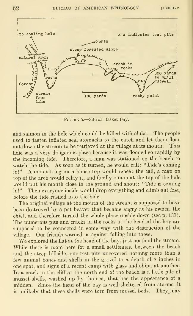
62 BUREAU OF AMERICAN ETHNOLOGY [Bull. 172
to sealing hole X X Indicates teat pita
natviral arch
^_^,„^ North
steep forested slape
X
forest
300 yardsto smallstream
streamfromlake
100 yards rocky point
Figure 5.—Site at Basket Bay.
and salmon in the hole which could be kUled with clubs. The people
used to fasten inflated seal stomachs to the catch and let them float
out down the stream to be retrieved at the village at its mouth. This
hole was a very dangerous place because it was flooded so rapidly by
the incoming tide. Therefore, a man was stationed on the beach to
watch the tide. As soon as it turned, he would call: "Tide's coming
in!" A man sitting on a house top would repeat the call, a man on
top of the arch would relay it, and finally a man at the top of the hole
would put his mouth close to the ground and shout: "Tide is coming
in!" Then everyone inside would drop everything and climb out fast,
before the tide rushed into the hole.
The original village at the mouth of the stream is supposed to have
been destroyed by a pet beaver that became angry at his owner, the
chief, and therefore turned the whole place upside down (see p. 137).
The numerous pits and cracks in the rocks at the head of the bay are
supposed to be connected in some waj^ with the destruction of the
village. Our friends warned us against falling into these.
We explored the flat at the head of the bay, just north of the stream.
While there is room here for a small settlement between the beach
and the steep hillside, our test pits uncovered nothing more than a
few animal bones and shells in the gravel to a depth of 8 inches in
one spot, and signs of a recent camp with glass and china at another.
In a crack in the cliff at the north end of the beach is a little pile of
mussel shells, washed up by the sea, that has the appearance of a
midden. Since the head of the bay is well sheltered from storms, it
is unlikely that these shells were torn from mussel beds. They may
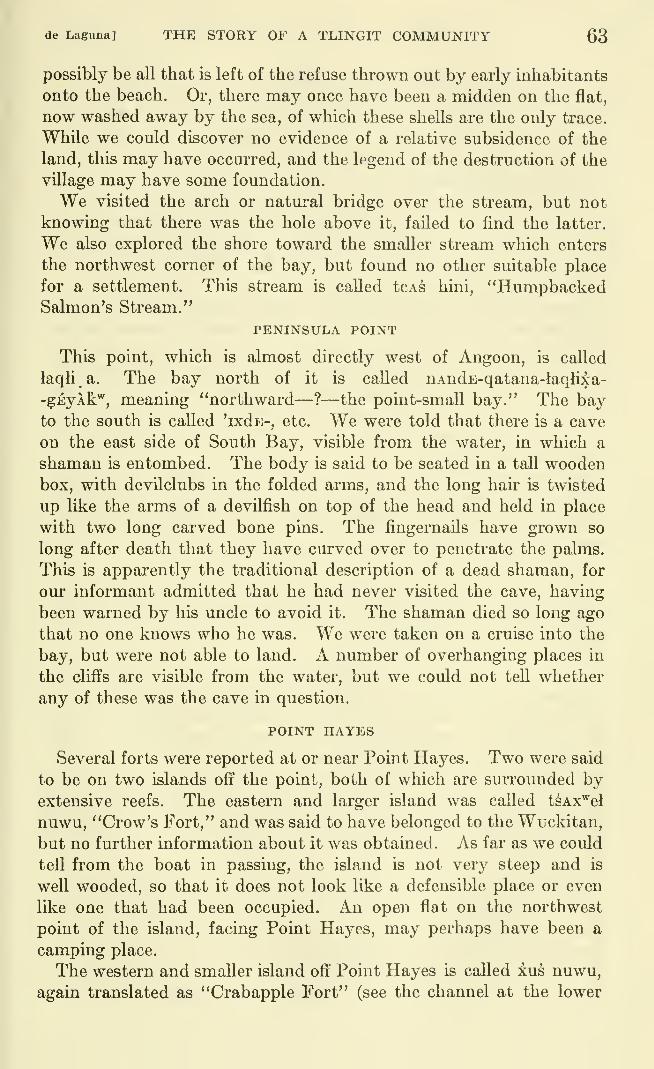
de Laguna] THE STORY OF A TLINGIT COMMUNITY 63
possibly be all that is left of the refuse thrown out by early inhabitants
onto the beach. Or, there may once have been a midden on the flat,
now washed away by the sea, of which these shells are the only trace.
While we could discover no evidence of a relative subsidence of the
land, this may have occurred, and the legend of the destruction of the
village may have some foundation.
We visited the arch or natural bridge over the stream, but not
knowing that there was the hole above it, failed to find the latter.
We also explored the shore toward the smaller stream which enters
the northwest corner of the bay, but found no other suitable place
for a settlement. This stream is called tcAs hini, "HumpbackedSalmon's Stream."
PENINSULA POINT
This point, which is almost directly west of Angoon, is called
laqli a. The bay north of it is called nAndE-qatana-laqlixa-
-gEyAk"^, meaning "northward— ?—the point-small bay." The bayto the south is called 'ixds-, etc. We were told that there is a cave
on the east side of South Bay, visible from the water, in which a
shaman is entombed. The body is said to be seated in a tall woodenbox, with devilclubs in the folded arms, and the long hair is twisted
up like the arms of a devilfish on top of the head and held in place
with two long carved bone pins. The fingernails have grown so
long after death that they have curved over to penetrate the palms.
This is apparently the traditional description of a dead shaman, for
our informant admitted that he had never visited the cave, having
been warned by his uncle to avoid it. The shaman died so long ago
that no one knows who he was. We were taken on a cruise into the
bay, but were not able to land. A number of overhanging places in
the cliffs are visible from the water, but we could not tell whether
any of these was the cave in question.
POINT HAYES
Several forts were reported at or near Point Hayes. Two were said
to be on two islands off the point, both of which are surrounded byextensive reefs. The eastern and larger island was called tsAx^el
nuwu, "Crow's Fort," and was said to have belonged to the Wuckitan,
but no further information about it was obtained. As far as we could
tell from the boat in passing, the island is not very steep and is
well wooded, so that it does not look like a defensible place or even
like one that had been occupied. An open flat on the northwest
point of the island, facing Point Hayes, may perhaps have been a
camping place.
The western and smaller island off Point Hayes is called xus nuwu,
again translated as "Crabapple Fort" (see the channel at the lower
64 BUREAU OF AMERICAN ETHNOLOGY [Bull. 172
end of the Baby Pounch in Kootznahoo Inlet, p. 44). This fort
belonged to the Decitan, who "took a lot of punishment here." The
island appears promising as a site. It is precipitous, apparently
scalable only from the eastern side. The top, which is divided into
several knolls, has some spruce and also a number of berry patches
which suggest old clearings.
Another informant mentioned a Decitan fort, tcaLk'A nu, "Halibut
Place Fort," or "Fort on the Halibut," which was "right inside Morris
Reef," that is, on one of the two islands or on Point Hayes itself.
This fort was raided by the KiksAdi from Sitka long ago, before
Angoon was founded.
We were able to land only on the eastern side of Point Hayes, north
of the eastern island, at a flat with a small stream. The bank, about
3 feet high, has been cut by wave action. As exposed, it consists of
round beach pebbles and a little dark humus, in the upper few inches
of which are traces of charcoal. An Indian with us said that this was
the site of a modern troUing camp. We were unable to explore the
land back of the beach, but there was nothing here to suggest an old
or any extensive site.
At the end of Point Hayes, just opposite the smaller western island,
and also just west of the point inside Sitkoh Bay, there are areas with
young spruce which may be sites. We saw these from the boat but
were unable to land.
POINT CRAVEN
One informant believed that there had once been a village at or near
Point Craven, west of the mouth of Sitkoh Bay, but from the boat wecould see nothing to suggest a site.
SITKOH BAY
Sitkoh Bay, which opens from Peril Strait on the south shore of
Chichagof Island, was once claimed by the GanAXAdi but was sur-
rendered by them when they left Angoon and now belongs to the
Decitan (Goldschmidt and Haas, 1946, p. 118; Garfield, 1947, p. 441).
Traditions concerning the area should be obtained from members of
the QanAXAdi sib, since the Angoon Decitan do not profess muchlocal knowledge. Although we met a QanAXAdi man who claimed
Sitkoh Bay as the original home of his family, he was unwilling to
tell us much.
The bay is still an important area for the Angoon people, since a
number of them work and fish for the New England Fish Companycannery at Chatham, halfway up the southwest side of the bay, and
some also buy then- winter supplies from the cannery store when prices
are reduced at the end of the fishing season. The cannery is about 4
miles above Point Craven. The cabins for the native workers are
de Laguna] THE STORY OF A TLINGIT COMMUNITY 65
scattered between the cannery and a stream about 600 yards still
farther up the bay. Around and behind these shacks are extensive
clearings, which we did not examine, nor did any of our informants
mention a site at this place.
About three-fourths mile above the cannery is the site of the former
GanAXAdi village, sit'qo (possibly sit'xo, "Among the Glaciers")-
Our friends, the Reverend and Mrs. Cyrus Peck, took us to see the
many petroglyphs at this site. The village was on a terraced knoll
(fig. 6), just south of the mouth of Sitkoh River, a sockeye salmon
stream which di'ains Sitkoh Lake some 4 miles inland. The knoll is
about 120 yards long (NW-SE), about 60 yards wide, and about 70
feet high at the highest point. The stream in general runs east, but
just before reaching the site, turns north to flow close under the inland
side of the knoll, and then turns sharply east again to enter the bay.
We were unable to cross the stream, even at low tide, but it does not
look as if there were a site on the opposite bank.
\
Mouth ofSitkoh Piver
SitkohRiver
?Tralls on each banVto Sitkoh Lake
NORTHtimber
spring with ^--^-{ ^^ V'-"."''*4^-"
__^ reported here -'——'yT^ A tidal
flats ^•^ /
Scale: 1000 feetNumber s
indicatetest pits
FiGUBE 6.—Site near Chatham Cannery, Sitkoh Bay,
66 BUREAU OF AMERICAN ETHNOLOGY [BuU. 172
The bedrock in this area is composed of limestone or marble, with
some thin layers of dark shale or slate. The strata are tilted steeply
with a NW-SE strike (i. e., parallel to the axis of Sitkoh Bay), and dip
toward the northeast. At the base of the rocks which form the south-
eastern edge of the knoll are carved a number of pctroglyphs, someon the dip slope of the bedrock, some on the joint planes, and a few on
fallen slabs (see fig. 8; pi. 11). A native who was with us at the site
reported that there used to be a spring which bubbled out of the rocks
along the shore between the site and the stream near the cannery.
Below the spring was a deep pool, and on the rocks above was carved
a face. We all searched for this, and found only a few brooks, but no
petroglyphs near them. This same man also reported that there had
been additional carvings on the flat surfaces of the bedrock opposite
the middle of the site, but believed that they were now covered with
beach gravel. We shoveled a little of this from the rocks on the beach,
but found no more pictm-es. Since our informant had not seen the
carvings since 1904, his memory may well have been inaccurate.
Opposite the site is a small island, connected to the mainland at
low tide. The same Indian commented on how the formerly deep
channel between the village and the island had filled with silt since he
had previously seen it. I believe that he is correct in part, but that a
change in sea level is responsible, since there is evidence of a raised
beach on the little island. The extensive tidal flats around the island
and in the bight to the south and east are now covered with beds of
mussels, but we saw no signs of clams, and no shells of any kind were
found in our test pits at the site.
The village is now covered by an almost impenetrable tangle of sal-
monberry and thimbleberry bushes; there are also some elderberries,
wild celery plants, and a few young spruce. We dug four test pits.
The first was on top of the 40-foot-high knoll at the southeast end of
the site, but this revealed only 10 inches of humus and gravel above
the bedrock. The second, on the highest point of the ridge, near the
southern end of the clearing, was dug through 4 to 6 inches of sterile
humus. The third pit was near the northern end of the site, on the
main ridge, here about 40 feet high. The spot was selected because it
had a growth of nettles, often the sign of previous habitation. Here
humus, some bits of charcoal, and gravel were found to a depth of 30
inches, resting on sterile gravel, but there was nothing else to encourage
excavation.
The last pit was dug on the same ridge, about halfway between the
highest knoll to the south and a clump of young spruce in the middle.
The shelf is here about 55 feet high, is fairly level, and has a growth of
nettles. A slight depression suggested that a house pit might have
been located here. We excavated a hole about 3 by 2 feet to a depth of
de Laguna] THE STORY OF A TLINGIT COMMUNITY 67
4 feet without encountering any clearly defined bottom to the deposit.
Here were the folio\ving layers:
Surface-18 inches: humus with some pebbles and a few fire-cracked rocks
18-19 inches: charcoal
19-22 inches: hard-packed, tan ashy layer (floor?)
22-26 inches: humus with some charcoal
26-28 inches: gray ashy silt (floor?)
28-33 inches: wet greasy earth with charcoal. At 29 inches was a badly rotted
deer (?) bone, and at the same level a fragment of what appeared to be a
human bone (about the size of the humerus), so badly compressed and de-
composed as to be hardly more than a stain. Near this, at the same level,
were the remains of a human skull, the consistency of wet cardboard, and a
number of very much worn teeth, suggesting a senile individual. Thelayers above the skull (at least the tan ashy layer at 19-22 inches) appeared
to be undisturbed. The human bones were not charred; it was not a crema-
tion. We do not know whether this was an intentional burial, an abandonedcorpse, or a slave sacrifice (under a house post?).
33-34 inches: gray earth
34-38 inches: dark earth with considerable amounts of charcoal
38-40 inches: gray earth
40-48 inches (bottom of test pit): gra^-ish-black earth, with a bone fragment
at 41 inches. The bottom of the cultural deposit was not reached.
I think it probable that the test hole was sunk in a former house pit,
which would account for the depth of the deposit. The ashy layers
appeared to be floor levels. There were no shehs, and the soil was in
consequence quite acid, which would account for the condition of the
bones encountered. The inhabited area of the site seems to have been
quite limited in extent; the village must have been small. The deeply
stratified deposit suggested long occupation, but unfortunately wefomid no artifact, so it is difficult to say whether further excavation
would be rewarding.
We also dug a test pit on the north end of the little island opposite
the village site, but found only a thin layer of gravel and humus and
a few scraps of shells which may have been dropped by gulls. Theisland is too low to have been a fort, and the steep slopes of the knoll
at the village site could have been more easily defended.
PERIL STRAIT
Our information about sites in Peril Strait west and south of Sitkoh
Bay is based upon hearsay, for we had no opportunity to explore
them. Territory ascribed to people of Angoon seems to run as far
west as Poison Cove, although Angoon hunters used to continue
through the Narrows to hunt sea otter in Kalinin Bay in Salisbury
Sound, the western enlargement of Peril Strait.
Peril Strait was claimed by the Teq^'edi (Goldschmidt and Haas,
1946, pp. 118 f.), but because of the close ties between the Angoonand Sitka branches of this sib, it is difficult to draw any definite line
68 BUREAU OF AMERICAN ETHNOLOGY [BulH72
between the localities particularly claimed by the two divisions. Thus.
Garfield reports that the Teq^edi settlement, sometimes called
Kut'ixd.n, "Carved-Stone Town," at the foot of Mount Edgecumbeon the southern end of Kruzof Island, was frequented by sea mammalhunters from PerU Strait. The name of the town refers to the manypetroglyphs of murrelets, bear tracks, etc., presumably all Teq'^edi
totemic crests, on the nearby rocks (Garfield, 1947, p. 446). Prob-
ably most of the regular inhabitants were Sitka natives.
TODD
The main Teq'^edi town in Peril Strait was on the north shore, at
the present site of Todd Cannery. It was called q'acA-t'E-wahayiyA,
"Where the rock fell on someone's head," alluding to the story of the
man who rolled a boulder down the cliff to kill his wife's lover (Gar-
field, 1947, p. 445). The stream here is called "Battle Creek,"
dawuL'i hini, because it was the scene of a fight between the supporters
of the husband and the relatives of the murdered man (pp. 144 ff.).
After the fight, the survivors separated, some going to ChUkat and
others to Whitewater Bay and Kootznahoo Inlet, so that the town
was deserted.
Although we were given to understand that Todd was the site of
a pre-Russian village, it is possible that Lindenberg Head, about a
mile east of the cannery, was actually the fortified settlement estab-
lished by the Indians who fled from Sitka in 1804 when the Russians
retook that place. Although one of the chiefs who lived at the
new fort in Peril Strait was certainly a KiksAdi, others may have been
Teq^'edi. We have been unable to identify the site of this fort (see
pp. 147 f.). However, a chart based on surveys in 1879 and 1880 indi-
cates a stockaded village at Todd or Lindenberg Head, although there
is no information as to whether it was still inhabited at that time
(Beardslee, 1882).
HANUS BAY
The Todd people had a fish camp, katsx, on the outlet of Lake Eva,
on the south side of Peril Strait. One middle-aged informant, the
son of a Teq'^edi man, said that he was born at a fishing town on the
peninsula at the east side of Hanus Bay, between Point Moses and
the stream from Lake Eva. This settlement was "large," with a
dozen houses, and may be the same place as the fish camp.
The Teq'^edi also had a fort on Dead Tree Island, the larger (?)
of the two islands in Hanus Bay (Goldschmidt and Haas, 1946,
p. 119). There was once a canoe battle in the bay and native inform-
ants told us that human bones had recently been found in the shallow
water east of the outlet of Lake Eva. In Russian times, Teq'^edi
de Laguna] THE STORY OF A TLINGIT COMMUNITY 69
from the island in Hanus Bay are said to have killed a family living
at a summer camp on the shore between Angoon and Killisnoo Harbor.
It is not clear whether these two incidents are connected.
BARANOF ISLAND SOUTH OF PERIL STRAIT
Goldschmidt and Haas report that the Decitan claim Kelp Bay,
and had a summer camp on Crow Island (Goldschmidt and Haas,
1946, p. 120). Garfield was told that the eastern shore of Baranof
Island from Peril Strait to Nelson Bay was used by aU the AngoonRaven sibs, and was not the exclusive territory of any sib or house
(Garfield, 1947, pp. 442 f.) There was a large camp on Pond Island
in Kelp Bay, especially frequented by people from Whitewater Bay.
The 'Anxakhitan had a hunting camp in Nelson Bay which wasdestroyed by a snowslide that killed all the men in the party.
Redbluff Bay marked the southern limit of Angoon territory, for
the area south of this was used by people from both Angoon and
Kake.^^ The bay was called djigux. We were told that there was a
fish camp here and also a place where greenstone for adzes could be
obtained. Although an 'AnAakhitan man claimed Redbluff Bay for
his sib, he admitted that anyone could obtain as much greenstone as
he wished from the mountainside above it.
Hoggatt Bay, south of Redbluff Bay, was mentioned by one in-
formant because her Wuckitan father made a stone salmon weir at
the stream there. The stream is called wAtkasat's, like Thayer
Creek north of Angoon. The Wuckitan man also had a fish trap at
Gut Bay, 2 miles farther south.
Gut Bay is of interest because here Raven left the print of his
fishnet in the sloping rocks at the north side of the entrance. This
place is called yel gewu, "Raven's Web, or Net." Our informant said
that he had once taken some young men to the spot. They had always
joked about it, not believing that there was anything there, but were
convinced when they saw clearly the marks of the net pressed into
the rocks.
SUMMARY OF SIB TERRITORIES
Territories or areas where the Angoon sibs had rights to fish, hunt,
gather berries, or had built houses, may be summarized as follows
:
Decitan (Raven)
:
From Fisheries Point to Kootznahoo Head, Admiralty Island
Lower part of Kootznahoo Inlet through Steamer Passage
Killisnoo HarborNorth Arm of Hood Bay (later given to DAqi'awedi)
Chaik Bay
12 Goldschmidt and Haas, 1946, p. 120. Emmons, in an unpublished manuscript, ascribed all of the
coast to and Including Patterson Bay to the Angoon people and reports that they also could hunt sea lions
off the southernmost point of Baranof Island.
70 BUREAU OF AMERICAN ETHNOLOGY [Bull. 172
Whitewater Bay ?
Eliza Harbor (occupied by ancestors)
Basket Bay, Chichagof Island (by Basket Bay lineage)
Point Hayes fort
Sitkoh Bay (received from QanAXAdi)
'An?:akhitan (Raven)
:
Sullivan Point, Kootznahoo Inlet
Chaik Bay (summer campsite)
Whitewater BayWilson CoveTyee ? (by ancestors)
Herring BayRedbluff Bay, Baranof Island
All Ravens used Baranof Island from Peril Strait to Nelson Bay.
Wuckitan (Eagle-Wolf)
:
Point Marsden to Fisheries Point, Admiralty Island
Pillsbury Point, Kootznahoo Inlet
Killisnoo HarborFalse Bay to Tenakee Inlet, Chichagof Island
Point Hayes fort
Teq^edi (Eagle-Wolf)
:
Mitchell Bay, Kootznahoo Inlet
Killisnoo HarborWhitewater Bay (some house sites)
Peril Strait west of Sitkoh BayDAql'awedi (Eagle-Wolf)
:
North Arm of Hood Bay (received from Decitan)
Chaik Bay (some house sites)
Herring Bay ?
Eliza Harbor
-Although sibs held title to territories, this did not mean that only
their members could utilize them. Actually anyone in the commu-nity could hunt or fish or gather food on them, provided he or she
acknowledged the legal claims of the owners and could also cite his
or her own relationship to one of the owners. The last was usually
easy to do.
Within the region surveyed, the most promising sites from an arche-
ological point of view are the villages at Whitewater and Sitkoh Bays;
the forts at Pillsbury Point and Daxatkanada Island in KootznahooInlet, and Marten Fort in Hood Bay. Of course, other sites that
were not visited may offer more to the archeologist than any of these,
or some sites, visited but not thoroughly explored, may be of greater
value than we now suppose.
PETROGLYPHS AND PICTOGRAPHS
Localities where rock carvings and paintings were seen or were
reported may be summarized as follows:
(1) At the mouth of Thayer Creek, technique not described; said
to represent a moon and an eye. This report was made by a white
de Laguna] THE STORY OP A TLINGIT COMMUNITY 71
man, based on the statement of another white man, and since it wasnot confirmed by a native who had visited the place many times wemay suspect it.
(2) Stone Island in Kanalku Bay, Kootznahoo Inlet; circles anddots were painted recently on the rocks as an aid to navigation bywhite men prospecting for coal.
(3) "Anchor for Angoon," the large boulder on the west beach in
front of the lineage houses, on which slaves were said to have been
killed at potlatches. It bears badly worn petroglyphs, some repre-
senting faces (eyes and mouth), made by or representing slaves (?);
arable numerals referring to a score in a basketball game; other inde-
cipherable pictures said to have been made by visiting Tsimshian
Indians over 50 years ago. All are so worn that one would suppose
them all to be very old, although they were undoubtedly made at
different times. They were too indistinct to be copied.
(4) Pictographs on the face of a cliff about one-half of a mile south
of Angoon Isthmus, at Magpie Point, said to have been made bythe Tsimshian Indians in human blood. Two of the pictures were
traced and will be described in greater detail below.
(5) Petroglyphs at unspecified localities in Hood Bay, Chaik Bay,
and Whitewater Bay. On Head Island in Whitewater Bay the
rocks are said to have pictures of faces. These petroglyphs could be
"read like totem poles," and thus identified the sibs claiming the area.
(6) Pictographs of a circle (or semicircle) with a dot in the center,
and a comma-shaped figure (fish?), on a low rocky point just north
of the village site in Whitewater Bay (fig. 7, c).
(7) Pictographs on a conspicuous cliff 4 miles south of Whitewater
Bay. According to one report these were made by a Tsimshian war
party and are supposed to represent men in a canoe. Other infor-
mants said that they had been made to commemorate the rescue of
a party that had drifted across Chatham Strait on a raft; the shaman
with the party was able to communicate their plight to a shaman at
Hood Bay or Angoon (see p. 58). These pictures were photographed
and sketched and will be described below.
(8) Pictures near the cannery at Tenakee (technique unknown)
are said to commemorate an attack on the Wuckitan inhabitants of
the former village at Tenakee.
(9) Many petroglyphs at the village site near Chatham in Sitkoh
Bay. These were photographed and sketched and will be described
in a later section.
The petroglyphs in Tlingit territory have received more attention
than the red pictographs, the rock carvings near Wrangell being
especially well known. No thoroughly satisfactory explanation of
460927—60 6
72 BUREAU OF AMERICAN ETHNOLOGY [Bull. 172
the reasons why paintings and carvings were made on the rocks have
been obtained from the natives. Our informants, who probably did
not themselves know the old traditions very well, indicated that rock
pictures were made to commemorate such events as victory in war(Tenakee), transfer of territory or other wealth in settlement of a
feud (Sitkoh Bay), important potlatches, especially ones involving slave
sacrifice ("Anchor for Angoon"), and shamanistic exploits (near
Whitewater Bay). Others ascribed the red paintings at this last
site to Tsimshian war parties (in commemoration of victories?). TheChilkat also said that red pictographs near Klukwan were made to
celebrate the slaying of enemies in battle. In both cases, it is inter-
esting that the red color is supposed to have been derived fromhuman blood. Still others said that the petroglyphs on the "Anchorfor Angoon" were made by the Tlingit themselves and by visiting
Tsimshian simply to pass idle hours.
Keithahn has found that petroglyphs are almost invariably located
below high-tide mark on beaches near the mouths of salmon streams,
and believes that they were made for the purpose of attracting the
salmon. The designs represent sib crests or supernatural beings
(Salmon Boy, Kaven, Eoller Whale, or Sea Monster) (Keithahn, 1940,
pp. 129 f., p. 132 note 4). Since such supernaturals are associated
also with specific sibs (or with groups of allied sibs), the symbols
representing them may also be sib crests. Thus, Emmons has de-
scribed and illustrated the petroglyphs on the northwest point of
Etolin Island. Animal figures predominate and all are totemic,
representing the crests of the Stikine sibs that claim the area. Other
figures are circles (interpreted as the Sun) and spirals (representative
of the Woodworm), both of which are also sib crests. In addition,
are faces, "coppers," and rattles. Emmons also published petro-
glyphs on Lisiansky Bay, Baranof Island, where the totemic crests
are organized to illustrate the Raven myth of the theft of water.
This area was claimed by the Raven KisAdi sib of Sitka. Although
this last design was apparently treated with reverence by the natives,
and was undoubtedly associated with cherished sib traditions, Emmonscould secure no information about the reasons for making the petro-
glyphs nor about their age. The natives simply said that the pic-
tures had already been there in the days of their fathers' fathers
(Emmons, 1908 b).
Our informants implied that petroglyphs and pictographs did
consist of proprietory totemic designs, and so, indh'ectly if not di-
rectly, would indicate the sib that had territorial claims to the areas
where they were made. In a general sense, therefore, we may think
of these rock pictures as graphic representations of sib prerogatives,
analogous to the designs on decorated blankets, crest hats, carved
de Laguna] THE STORY OF A TLINGIT COMMUNITY 73
posts, painted house fronts, etc. Any of these pictures or symbolsmay at one and the same time serve as illustration of the event,
mythical or recent, through which the sib acquired the rights in ques-
tion, and also, if referring to a supernatural encounter, serve as a
magically efficacious token of the powers then obtained. That the
interpretation of rock pictures by the natives is so often vague, maj'^
perhaps be explained by the fact that the techniques of rock painting
and carving are much cruder than those employed in ordinary woodpainting and carving, so that the styles of the pictographs and petro-
glyphs, while related to those of traditional Northwest Coast art, are
yet different.
PICTOGRAPHS AT MAGPIE POINT NEAR ANGOON
These pictures are painted on the vertical face of a cliff whichcan be easily reached at low tide by walking over the beach fromAngoon. Those in the lowest group are about 10 feet above high-tide
level, but are accessible from a convenient ledge. The highest picture
is 6 feet above these, and can only be reached by scrambling up to a
narrow shelf above the lower group. The pictures are in dull red
paint, evidently hematite mixed with some fatty substance. All are
cracked and weathered, but two were clear enough to trace, even
though the exact outlines had to be guessed in places (fig. 7, a, b).
The clearest and apparently most recent painting is that of a
three-masted ship, with jib, 3 j^ards on each mast, and a high stern.
Some of the rigging is shown, but not the sails. There may be a
flagstaff at the stern, and several vertical lines suggest men stand-
ing on the deck. The hull is outlined, not rendered in solid silhouette,
The lines are clumsily drawn as if with the fingers or the frayed end
of a stick. This picture may commemorate a shipwreck which occurred
many years ago somewhere south of Angoon, from which the natives
obtained valuable articles. The widow of John Shuwika (cuwika),
chief of the Wuckitan "Fort House" at Angoon, tried to tell Garfield
about the wreck, and her daughter also mentioned it to us, but
although it was evidently an important historical event, unfortunately
neither of these ladies had sufficient command of English to tell the
story, and no interpreters were available. A Russian steamer waslost off Whitewater Bay, and the American schooner Langley some-
where in Chatham Strait (Morris, 1879, p. 56), and there were doubt-
less other wrecks of which I have been unable to find any record.
The picture may refer to one of these, or may possibly commemoratethe first encounter with Europeans. Our informant, for example,
was evidently familiar with the story of the meeting with La Perouse
in Lituya Bay in 1786.
Just to the right of the ship is a picture which is less distinct and
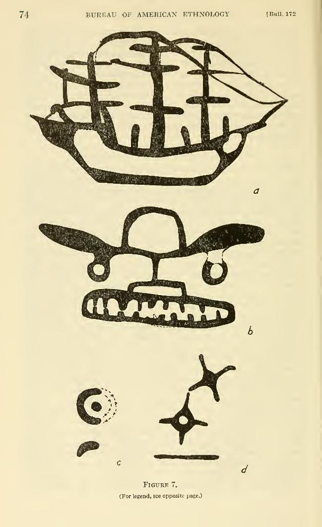
74 BUREAU OF AMERICAN ETHNOLOGY tBull. 172
N <«.
»• f
Figure 7,
(For legend, see opposite page.)
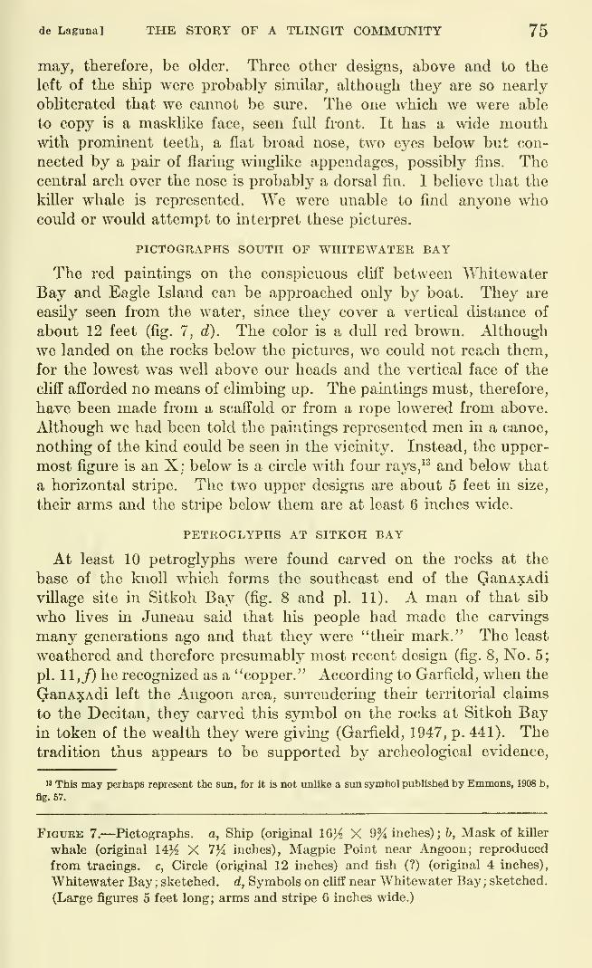
de LagTina] THE STORY OF A TLINGIT COMMUNITY 75
may, therefore, be older. Three other designs, above and to the
left of the ship were probably similar, although they are so nearly
obliterated that we cannot be sure. The one which we were able
to copy is a masklike face, seen full front. It has a wide mouthwith prominent teeth, a flat broad nose, two eyes below but con-
nected by a pair of flaring winglike appendages, possibly fins. Thecentral arch over the nose is probably a dorsal fin. I believe that the
killer whale is represented. We were imable to find anyone whocould or would attempt to interpret these pictures.
PICTOGRAPHS SOUTH OF WHITEWATER BAY
The red paintings on the conspicuous cliff between "V^Tiitewater
Bay and Eagle Island can be approached only by boat. They are
easily seen from the water, since they cover a vertical distance of
about 12 feet (fig. 7, d). The color is a dull red brown. Although
we landed on the rocks below the pictures, we could not reach them,
for the lowest was well above our heads and the vertical face of the
cliff afforded no means of climbing up. The paintings must, therefore,
have been made from a scaffold or from a rope lowered from above.
Although we had been told the paintings represented men in a canoe,
nothing of the kind could be seen in the vicmity. Instead, the upper-
most figure is an X; below is a circle with four rays,^^ and below that
a horizontal stripe. The two upper designs are about 5 feet in size,
their arms and the stripe below them are at least 6 inches wide.
PETROGLYPHS AT SITKOH BAY
At least 10 petroglyphs were found carved on the rocks at the
base of the knoll which forms the southeast end of the QanAx:Adi
village site in Sitkoh Bay (fig. 8 and pi. 11). A man of that sib
who lives in Juneau said that his people had made the carvings
many generations ago and that they were "their mark." The least
weathered and therefore presumably most recent design (fig. 8, No. 5;
pi. 11,/) he recognized as a "copper." According to Garfield, when the
QanAXAdi left the Angoon area, smTendermg their territorial claims
to the Decitan, they carved this symbol on the rocks at Sitkoh Bayin token of the wealth they were giving (Garfield, 1947, p. 441). Thetradition thus appears to be supported by archeological evidence,
M This may perhaps represent the sun, for it is not unlike a sun symbol published by Emmons, 1908 b,
fig. 57.
Figure 7.—Pictographs. a, Ship (original 1Q% X 9% inches); b, Mask of killer
whale (original 14}^ X 7J4 inches), Magpie Point near Angoon; reproduced
from tracings, c, Circle (original 12 inches) and fish (?) (original 4 inches),
Whitewater Bay ; sketched, d, Symbols on cliff near Whitewater Bay ; sketched.
(Large figures 5 feet long; arms and stripe 6 inches wide.)
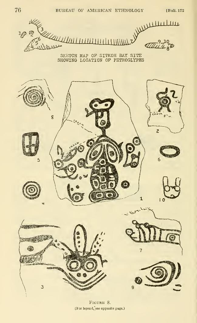
76 BUREAU OF AMERICAN ETHNOLOGY [BuU. 172
^.^^i^A^^
Jill I'll.
<2ZZUlJl^
SKETCH MAP OP SITKOH BAY SITESHOWING LOCATION OP PETROGLYPHS
Figure 8.
(For legend,^see opposite page.)
de Laguna] THE STORY OF A TLINGIT COMMUNITY 77
although, of course, it is not impossible that the petroglyph itself
suggested the story. The "copper," 4^ to 6 inches wide and 9 inches
high, is outlined, and the area is divided into four quarters. Thedesign is similar to that of a "copper" carved on Etolin Island,
except that the latter has only a transverse line across the middle
and a vertical line dividing only the lower half of the shield (Emmons,1908 b, fig. 56).
Our Juneau informant professed to recognize the face surmountedby three featherlike ornaments (fig, 8, No. 3), although we had only a
sketch drawn from memory to show him. He said that the picture was"derived from the Tsimshians," but how we could not learn. It
represented a warrior with face blackened by charcoal, called t'utcduk,
"black face." ^* "Wlien they put that on," he explained, "they don't
go back from their word," that is, blackening the face is like makinga vow. In the winter of 1948-49, an old woman was found dead
in her cabin at Angoon, lying composedly on the bed (or floor ?),
her face blackened with soot from the stove. It was believed that
she had known herself to be dying, and had thus prepared herself
for death to show that she was not afraid. She was the daughter of
a Teq'^edi father, and the Teq'^edi are supposed to be particularly
brave, a trait also claimed by the children of the sib. I am not, how-ever, satisfied with this interpretation of the petroglyph. Dr. ErnaGunther, who saw the drawing made in the field, suggested that it
might represent an octopus or devilfish, since the latter has a headwith pointed beak and large eyes; the "feathers" would represent
the tenacles with suction cups.
Om- informant refused to say anything more about the pictures.
The most complicated carving (fig. 8, No. 1; pi. 11, d) was on a
fallen slab of rock above the beach. The flat surface measures 38 by52 inches, and is cracked in several places. The designs are pecked
to a depth of about one-fourth of an inch, and have been lined with
white paint, evidently smeared on by someone who wished to photo-
graph them. This, however, made it impossible for us to obtain either
" This perhaps refers to the hero, Black Skin (dukt'uL'), cf. Swanton, 1909, pp. 145-150.
Figure 8.—Petroglyphs, Sitkoh Bay. Drawn by Catharine McClellan. Upper,
Sketch map of southeastern end of site, with numbers indicating the location
of the petroglyphs described below. Lower, Petroglyphs: 1, Carved slab, 38
by 52 inches, with frog, raven's head (?), etc. 2, Carved slab, 16 by 17 inches,
with concentric circles with arms. 3, Devilfish (?) face on vertical cliff; total
carved area, 20 by 16 inches. 4, Concentric circles on ledge, 5% inches in
diameter. 5, "Copper" on ledge, 6 by 9 inches. 6, Oval on ledge, about 6
inches long. 7, Unidentified carving on vertical cliff, about 15 inches long.
8, Spiral on low outcrop, 14 inches diameter. 9, Spiral and lines on low out-
crop, 8 by 12 inches. 10, Animal's head on low outcrop, 6 by 6 inches.
78 BUREAU OF AMERICAN ETHNOLOGY [BuU. 172
a completely accurate photograph or sketch. The complicated design,
in which circles with central dots are prominent, suggests a number of
animal or bird figures. The largest element looks like a frog, andabove it is what may be the head of a raven. The other parts cannot
be interpreted. In complexity and style, this carving is not unlike
the petroglyph illustrating Raven's theft of water (Emmons, 1908 b,
fig. 44).
A smaller broken slab (fig. 8, No. 2) is about 16 by 17 inches. This
has a design of two concentric circles with dot in the center and three
or four curving arms. A photograph taken some years ago (pi. 11, a)
shows both lower arms extending beyond the crack, the lower right
arm being curved rather like the upper left one. These portions were
obliterated when we saw it, however.
The face of a devilfish (fig. 8, No. 3) is on a vertical face of rock,
and when we found it, it was covered with moss and lichens. The sur-
face of the rock bends to slant back at an angle of about 20 degrees
at approximately the line of the creature's forehead. The lines of the
head are lightly pecked; those to the left are deeper and wider. Abovethe face are traces of at least two other badly weathered faces with
large round eyes, too indistinct to copy. The total area of these
designs is 20 inches wide and 16 inches high, and the lowest part is
16 inches above the ground.
On the ledge of rock which runs out onto the beach and which is
probably covered at extreme high water (pi. 11,/), are the "copper"
(fig. 8, No. 5), a set of three concentric rings around a central dot
(fig. 8, No. 4), and an oval (fig. 8, No. 6). The circles are 5% inches
in diameter, and the design is almost identical with an Etolin Island
petroglyph identified by Emmons' informants as representing the sun,
although Emmons himself reports that the same design is also used
for the earth (Emmons, 1908 b, fig. 58).
On the cliff at the northwest end of the knoU is a complex design
which we were unable to interpret (fig. 8, No. 7; pi. 11, 6). The peck-
ing is only one-eighth of an inch deep. The petroglyph is smeared
with commercial white paint and has been used for target practice.
The remaining petroglyphs are on low rock outcrops northwest of
the cliff. A spiral, 14 inches in diameter (fig. 8, No. 8; pi. 11, c), faces
the sea. A second spiral, 12 by 8 inches (fig. 8, No. 9), an animal's
head with erect ears, 6 by 6 inches (fig. 8, No. 10), and an indecipher-
able figure (not illustrated) face toward the land. The spirals, as
Emmons indicated for a petroglyph on Etolin Island (Emmons, 1908 b,
fig. 61), may well represent the woodworm, for this is one of the most
important crests of the QanAXAdi.
Although other pictures were reported in the vicinity of the Sitkoh
Bay village site, we could not find them.
de Laguna] THE STORY OF A TLESTGIT COMMUNITY 79
SUMMARY
It is not surprising that the rock carvings and paintings in the
Angoon area should be similar in style to those carved on rocks near
Wrangell (Keithahn, 1940, fig. 14), on Etolin Island in the Wrangell
area, and on Lisiansky Bay near Sitka (Emmons, 1908 b). In addition
to general resemblances in the treatment of animal forms, we may also
note such specific elements as ovals, cu'cles, concentric circles, spirals,
X's, and "coppers." There are also four-pointed stars with a dot in
the hollow center, a five-pointed star with a hollow center, and a
circle with dot in the center and 10 raj^s, all of w^hich are somewhatanalogous to the four-pointed star with hollow center at Whitewater
Bay. Lastly, there are faces, with or without outlines, the eyes indi-
cated by circles, concentric circles, or circles with dots. As Heizer
has pointed out, these same elements are also found among the petro-
glyphs at Cape Alitak on Kodiak Island (Heizer, 1947). However,
although the Kodiak petroglyphs are undoubtedly, as he argues, re-
lated to or derived from Northwest Coast tradition, in feeling they also
seem to be akin to the pictographs in Prince William Sound in manyrespects (de Laguna, 1956, pp. 102-109).
ARCHEOLOGICAL SITES AT DAXATKANADA ISLAND ANDPILLSBURY POINT
DAXATKANADA ISLAND
Since most of our archeological work was concentrated on
Daxatkanada Island and at the nearby site at Pillsbury Point it is
appropriate to describe these in more detail.
The name daxatkanada was translated as "Where the tide passes
back and forth." Swanton (1909, p. 77) refers to a place, the location
of which he does not specify, as datx-xatkAUAdd-nu, which is
etymologically correct for "around rapids-run fort," but which is
not the way the word is pronounced in rapid speech. This is probably
our island, although the only incident connected with it which Swantonreports is that some Indians from the south, who were returning fromsuccessful raids on Hoonah settlements, stopped at the fort and broke
up the canoes of the [Angoon] people to frighten them so that they
would not dare to fight. There is no mention of a long siege. Othertraditions connected with Daxatkanada are recorded on pages 150 ff.
This island (fig. 9) lies about Iji miles northeast of Angoon, at the
upper end of Channel Point Island at the entrance to Steamer Passage.
It is a little over 360 feet long and about 150 feet wide, and is formed
by sharply tilted beds of conglomerate, sandstone and shale. This
formation, which has a strike almost magnetic north and south, with
a steep dip to the east, also makes the rocky headland at Pillsbury
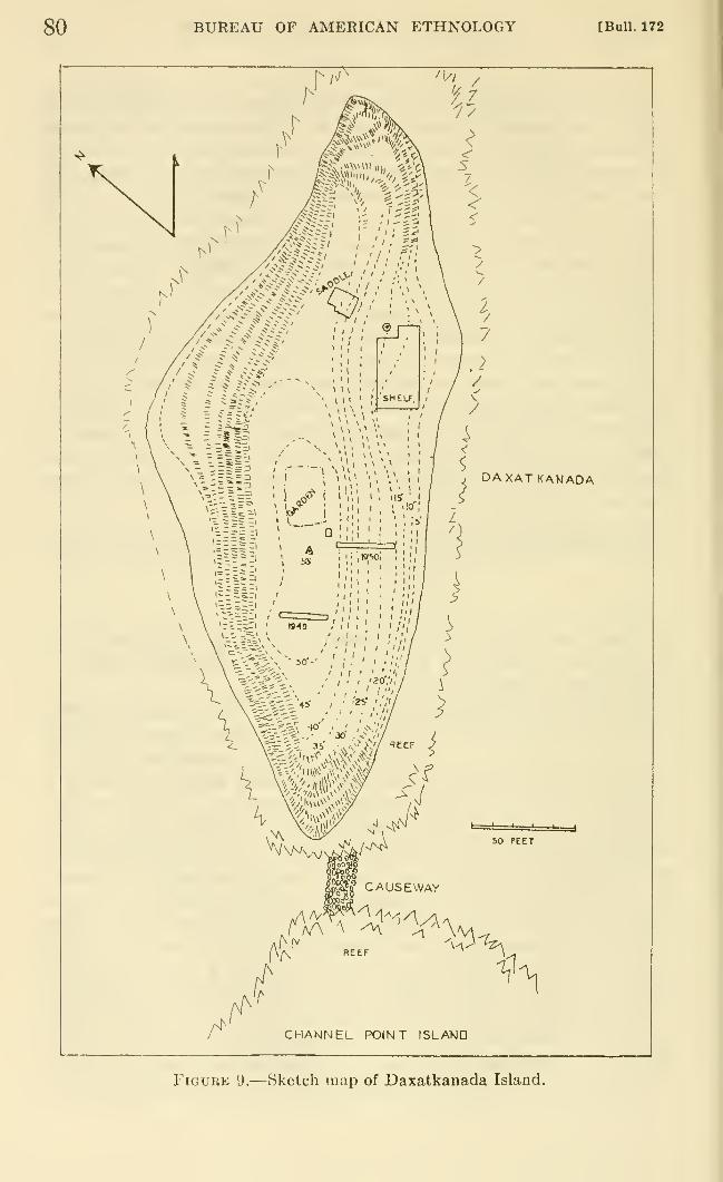
80 BUREAU OF AMERICAN ETHNOLOGY [Bull. 172
DAXAT KANADA
^V\AJvCsw4/-^
y-*'
50 PEET
gSS^o* CAUSEWAY
\\^ REEF *
\
CHANNEL POINT ISLAVIO
Figure 9.—Sketch map of Daxatkanada Island.
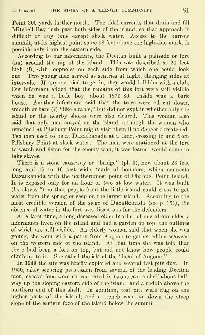
de Lagrina] THE STORY OF A TLINGIT COMMUNITY 81
Point 300 yards farther north. The tidal currents that drain and fill
Mitchell Bay rush past both sides of the island, so that approach is
difficult at any time except slack water. Access to the narrow
summit, at its highest point some 58 feet above the high-tide mark, is
possible only from the eastern side.
According to our informants, the Decitan built a palisade or fort
(nu) around the top of the island. This was described as 20 feet
high (!), with loopholes on each side from which one could look
out. Two young men served as sentries at night, changing sides at
intervals. If anyone tried to get in, they would kill him with a club.
Our informant added that the remains of this fort were still visible
when he was a little boy, about 1870-80. Inside was a bark
house. Another informant said that the trees were all cut down,
smooth or bare (?) "like a table," but did not explain whether only the
island or the nearby shores were also cleared. This woman also
said that only men stayed on the island, although the women whoremained at Pillsbmy Point might visit them if no danger threatened.
Ten men used to be at Daxatkanada at a time, crossing to and from
PUlsbury Point at slack water. The men were stationed at the fort
to watch and listen for the enemy who, it was feared, would come to
take slaves.
There is a stone causeway or "bridge" (pi. 3), now about 28 feet
long and 15 to 16 feet wide, made of boulders, which connects
Daxatkanada with the northernmost point of Channel Point Island.
It is exposed only for an hour or two at low water. It was built
(by slaves ?) so that people from the little island could cross to get
water from the spring or seep on the larger island. According to the
most credible version of the siege of Daxatkanada (see p. 151), the
absence of water in the fort was disastrous for the defenders.
At a later time, a long deceased older brother of one of our elderly
informants lived on the island and had a garden on top, the outlines
of which are still visible. An elderly woman said that when she wasyoung, she went with a party from Angoon to gather edible seaweed
on the western side of the island. At that time she was told that
there had been a fort on top, but did not know how people could
climb up to it. She called the island the "head of Angoon."
In 1949 the site was briefly explored and several test pits dug. In
1950, after securing permission from several of the leading Decitan
men, excavations were concentrated in two areas: a shelf about half-
way up the sloping eastern side of the island, and a saddle above the
northern end of this shelf. In addition, test pits were dug on the
higher parts of the island, and a trench was run down the steep
slope of the eastern face of the island below the summit.
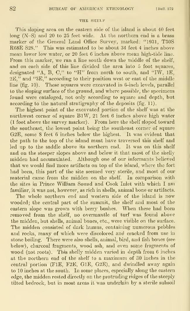
82 BUREAU OF AMERICAN ETHNOLOGY [Bull. 172
THE SHELF
This sloping area on the eastern side of the island is about 40 feet
long (N-S) and 20 to 25 feet wide. At the northern end is a brass
marker of the General Land Office Survey, marked: ''1931, T50SR68E S28." This was estimated to be about 34 feet 4 inches above
mean lower low water, or 20 feet 6 inches above mean high-tide line.
From this marker, we ran a line south down the middle of the shelf,
and on each side of this line divided the area into 5 foot squares,
designated "A, B, C," to "H" from north to south, and "IW, IE,
2E," and "3E," according to their position west or east of the middle
line (fig. 10). These squares were excavated in 6-inch levels, parallel
to the sloping surface of the ground, and where possible, the specimens
found were cataloged, not only according to square and depth, but
according to the natural stratigraphy of the deposits (fig. 11).
The highest point of the excavated portion of the shelf was at the
northwest corner of square BlW, 21 feet 6 inches above high water
(1 foot above the survey marker). From here the shelf sloped toward
the southeast, the lowest point being the southeast corner of square
G2E, some 8 feet 6 inches below the highest. It was evident that
the path to the top of the island must have traversed this shelf and
led up to the saddle above its northern end. It was on this shelf
and on the steeper slopes above and below it that most of the shelly
midden had accumulated. Although one of om" informants believed
that we would find more artifacts on top of the island, where the fort
had been, this part of the site seemed very sterile, and most of our
material came from the midden on the shelf. In comparison with
the sites in Prince William Sound and Cook Inlet with which I amfamiliar, it was not, however, as rich in shells, animal bone or artifacts.
The whole northern end and western side of the island is nowwooded; the central part of the summit, the shelf and most of the
eastern slope was grown with berry bushes. When these had been
removed from the shelf, no overmantie of turf was found above
the midden, but shells, animal bones, etc., were visible on the surface.
The midden consisted of dark humus, containing numerous pebbles
and rocks, many of which were discolored and cracked from use in
stone boiling. There were also shells, animal, bird, and fish bones (see
below), charcoal fragments, wood ash, and even some fragments of
wood (not roots). This shelly midden varied in depth from 6 inches
at the northern end of the shelf to a maximum of 30 inches in the
central portion (FlE, F2E, GlE, G2E), and dwindled away again
to 10 inches at the south. In some places, especially along the eastern
edge, the midden rested directly on the protruding ridges of the steeply
tilted bedrock, but in most areas it was underlain by a sterile subsoil
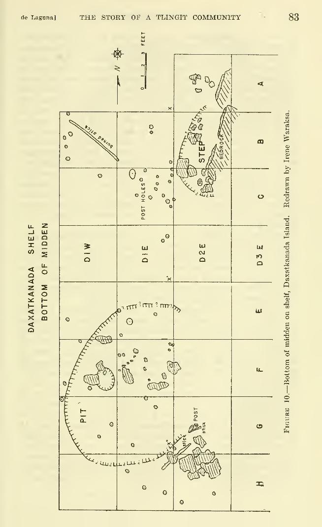
de Laguna] THE STORY OF A TLINGIT COMMUNITY 83
bJ111
tli
X"
<<
<X<o
o
u.
o
o»-
h-oCD
asm
<v
e3
cS
73o3
£3
03
03
.a
aoPI
o
ao
o
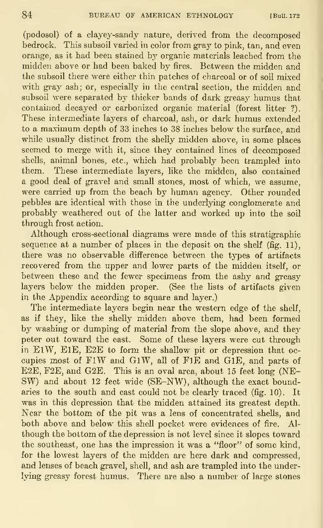
84 BUREAU OF AMERICAN ETHNOLOGY [BuU. 172
(podosol) of a clayey-sandy nature, derived from the decomposedbedrock. This subsoil varied in color from gray to pink, tan, and even
orange, as it had been stained by organic materials leached from the
midden above or had been baked by fii-es. Between the midden andthe subsoil there were either thin patches of charcoal or of soil mixed%\nth gi*ay ash; or, especially in the central section, the midden andsubsoil were separated by thicker bands of dark gi'easy humus that
contained decayed or carbonized organic material (forest litter ?),
These intermediate layers of charcoal, ash, or dark humus extended
to a maximum depth of 33 inches to 38 inches below the surface, andwhile usually distinct from the shelly midden above, in some places
seemed to merge with it, since they contained lines of decomposedshells, animal bones, etc., which had probably been trampled into
them. These intermediate layers, like the midden, also contained
a good deal of gravel and small stones, most of which, we assume,
were carried up from the beach by human agency. Other roundedpebbles are identical with those in the underlying conglomerate andprobably weathered out of the latter and worked up into the soil
through frost action.
Although cross-sectional diagrams were made of this stratigraphic
sequence at a number of places in the deposit on the shelf (fig. 11),
there was no observable difference between the types of artifacts
recovered from the upper and lower parts of the midden itself, or
between these and the fewer specimens from the ashy and greasy
layers below the midden proper. (See the lists of artifacts given
in the Appendix according to square and layer.)
The intermediate layers begin near the western edge of the shelf,
as if they, like the shelly midden above them, had been formedby washing or dumping of material from the slope above, and they
peter out toward the east. Some of these layers were cut through
in ElW, ElE, E2E to form the shallow pit or depression that oc-
cupies most of FlW and GlW, all of FlE and GlE, and parts of
E2E, F2E, and G2E. This is an oval area, about 15 feet long (NE-SW) and about 12 feet wide (SE-NW), although the exact bound-aries to the south and east could not be clearly traced (fig. 10). It
was in this depression that the midden attained its greatest depth.
Near the bottom of the pit was a lens of concentrated shells, andboth above and below this shell pocket were evidences of fire. Al-
though the bottom of the depression is not level since it slopes towardthe southeast, one has the impression it was a "floor" of some kind,
for the lowest layers of the midden are here dark and compressed,
and lenses of beach gravel, shell, and ash are trampled into the under-
lying greasy forest humus. There are also a number of large stones

de Laguua] THE STORY OF A TLINGIT COMMUNITY 85
xOrc3
03
C
c3
-1-3
03
X
P
Oc
T3
Oao
um
03o
O
PS
PO
86 BUREAU OF AMERICAN ETHNOLOGY [BuU. 172
at or near the bottom of the midden, within or close to the edges of
the depression. Both inside and outside this area there are manypostholes, ranging in size from 2 to 6 inches in diameter. They were
made by driving sharpened posts or stakes into the subsoil to depths
of 6 to 10 inches. In a few of these, the remains of posts were actually
preserved; other holes were empty or contained material derived
from the midden above. From the posts themselves and from the
shapes of the holes, it was evident that the posts and stakes had been
cut with sharp-edged metal axes or adzes (pi. 4, c, d). Associated
with these postholes and outside the depression in G2E and H2E,there was a pile of rocks that marked the southern edge of the area.
Although the pattern of postholes is far from regular, it looks as if
there had been here a flimsy shelter of some kind, perhaps made of or
covered with bark, in which fires were built. Some of the posts and
stones inside the shallow pit may have supported an artificial flooring,
but more probably served as racks or spits for smoking or cooking
fish. As time passed, kitchen debris accumulated, some of which wastrampled underfoot, or fell below the flooring.
Remains of what may have been a similar but smaller structure
were discovered at the north end of the shelf, the southern edge of
which is represented by the postholes and piled rocks in C2E, ClE,
and BlW. The eastern edge of the shelter would have been in-
side the ridges of bedrock in B2E and A2E. Inside this area were
hearths and accumulations of gray ash. Just inside the "wall" of
stones in C2E was a stone vessel (pi. 4, a) which may have been a
lamp. This section of the site was excavated before the saddle was
investigated, and it was therefore impossible to compare it with the
steps uncovered on the edge of the saddle above. However, the
cutting or digging away of the subsoil in both areas seems to have
been quite similar, and it is possible that if the terrain between the
shelf and the saddle had been cleared we might have found a series
of steps leading up from the beach to the top of the island. It should
be noted that one of the flat stones found near the bottom of the
midden in C2E was worn smooth as if it had been repeatedly trodden
on, like a stone found in the midden over a step at tlie edge of the
saddle (fig. 12).
That there may once have been repositories of cremated remains
on the island is suggested by finding two human teeth: a charred in-
cisor in A2E and another tooth on the burned subsoil in ClE. Weexplored the ledges in the cliff on the western side of the island, where
partial overhangs might have been used to shelter the bodies of
shamans, but found no trace of graves. The natives did not mention
that burials had been made on the island.
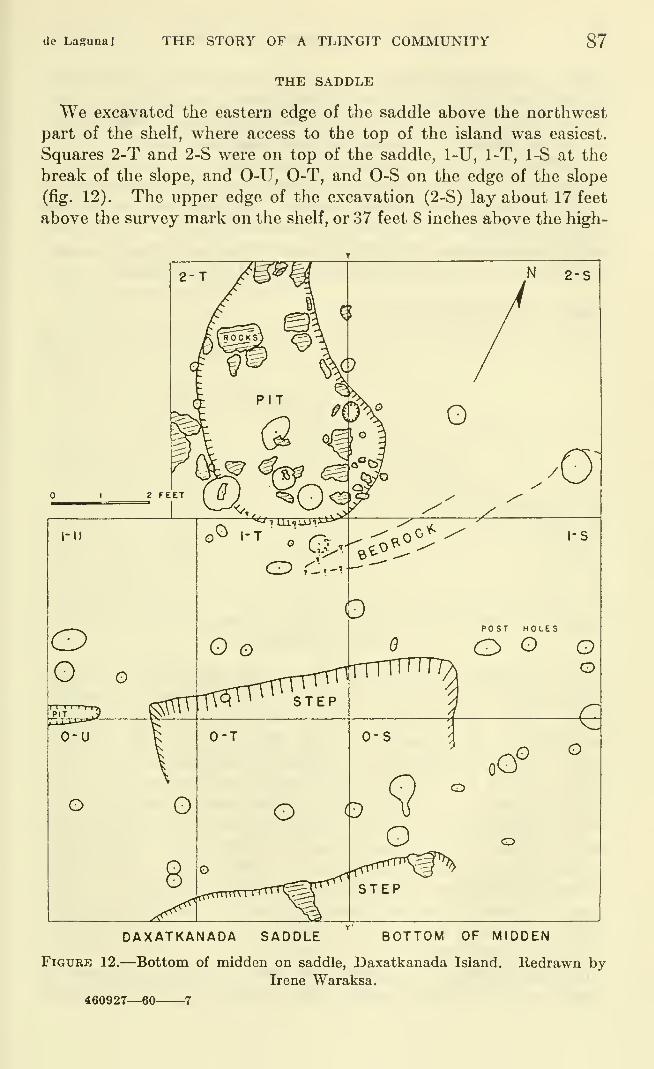
de Laguna] THE STORY OF A TLINGIT COMMUNITY 87
THE SADDLE
We excavated the eastern edge of the saddle above the northwest
part of the shelf, where access to the top of the island was easiest.
Squares 2-T and 2-S were on top of the saddle, 1-U, 1-T, 1-S at the
break of the slope, and 0-U, 0-T, and 0-S on the edge of the slope
(fig. 12). The upper edge of the excavation (2-S) lay about 17 feet
above the survey mark on the shelf, or 37 feet 8 inches above the high-
DAXATKANADA SADDLE BOTTOM OF MIDDEN
Figure 12.—Bottom of midden on saddle, Daxatkanada Island. Redrawn byIrene Waraksa.
460927—60 7
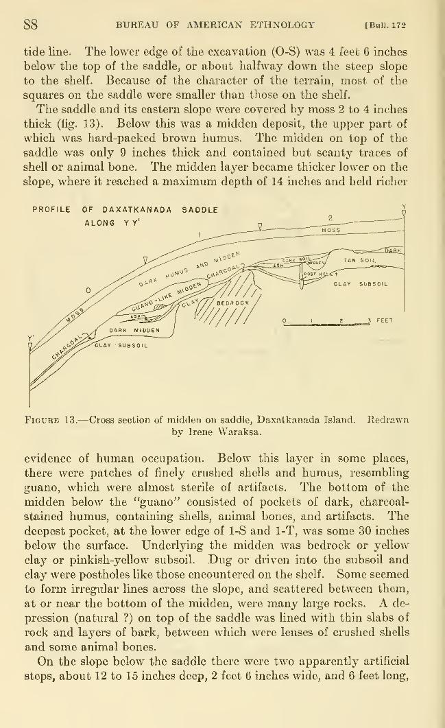
88 BUREAU OF AMERICAN ETHNOLOGY [BuU. 172
tide line. The lower edge of the excavation (0-S) was 4 feet 6 inches
below the top of the saddle, or about halfway down the steep slope
to the shelf. Because of the character of the terrain, most of the
squares on the saddle were smaller than those on the shelf.
The saddle and its eastern slope were covered by moss 2 to 4 inches
thick (fig. 13). Below this was a midden deposit, the upper part of
which was hard-packed brown humus. The midden on top of the
saddle was only 9 inches thick and contained but scanty traces of
shell or animal bone. The midden layer became thicker lower on the
slope, where it reached a maximum depth of 14 inches and held richer
PROFILE OF DAXATKANADA SADDLE
ALONG Y Y'
FiGUBE 13.—Cross section of midden on saddle, Daxatkanada Island.
by Irene Waraksa.
Redrawn
evidence of human occupation. Below this layer in some places,
there were patches of finely crushed shells and humus, resembling
guano, which were almost sterile of artifacts. The bottom of the
midden below the "guano" consisted of pockets of dark, charcoal-
stained humus, containing shells, animal bones, and artifacts. Thedeepest pocket, at the lower edge of 1-S and 1-T, was some 30 inches
below the surface. Underlying the midden was bedrock or yellow
clay or pinkish-yellow subsoil. Dug or driven into the subsoil and
clay were postholes like those encountered on the shelf. Some seemed
to form irregular lines across the slope, and scattered between them,
at or near the bottom of the midden, were many large rocks. A de-
pression (natural ?) on top of the saddle was lined with thin slabs of
rock and layers of bark, between which were lenses of crushed shells
and some animal bones.
On the slope below the saddle there were two apparently artificial
steps, about 12 to 15 inches deep, 2 feet 6 inches wide, and 6 feet long.
de Lagima] THE STORY OF A TLINGIT COMMUNITY 89
cut into the subsoil. It was in these that the deepest layers of mid-
den had accumulated. Since it is also here that there is the easiest
access to the top of the island, we imagine that these steps had been
cut to facilitate the climb. From the top of the saddle there is a
very gentle slope to the highest point of the island.
Although one might have expected to find at the edge of the saddle
the postlioles of the palisade which was said to have been buUt around
the top of the island, most of the holes found in this section of the site
were only 3 to 4 inches in diameter, which would appear to be too
small for a defensive purpose, and there were too few of a larger size
to have made an effective wall.
Again, no difference could be seen between the t3^pes of artifacts
found in the upper and lower parts of the midden on the saddle.
They were of the same kinds as those found in different layers on
the shelf.
OTHER TEST PITS
Two test holes dug in 1949 were on the shelf, one in square ElE and
the other overlapping squares BlW and B2VY.
In 1949 a trench was dug across the top of the island, just south
of the summit. This revealed humus, mixed with ash, charcoal, and
some fire-cracked rocks to a maximum depth of 26 inches, and con-
tained a few artifacts. The level area here is only about 25 feet wide
(E-W) and 50 feet long. In 1950 another test hole was dug just north
of the highest part of the island, where there was only a layer of
humus, 6 or 7 inches deep, on top of sterile subsoil and bedrock. In
the subsoil were found two postholes, one very small, the second
somewhat larger and flanked with rocks which probably served to
wedge in the post more securely. Between the two holes was a broken
splitting adz (pi. 5, a) which appeared to have been driven into the
ground after the cutting end had been broken off. Because the
cultural remains were so scanty, we made no further attempt to
excavate here and thus cannot report whether there is any evidence
to confirm the tradition of a bark house on top of the island. There
was certainly no sign of postholes large enough for a palisade, and
indeed the soil is so thin that it is difficult to see how it could support
anything more than stakes or light poles.
In 1950 we also dug among the trees between the saddle at the
north end of the island and the garden just north of the summit, but
found only forest humus.
The eastern slope of the island just below the summit was also
explored in 1950. This has a mantle of shelly midden about 6 inches
thick and is overgrown with berry bushes. In running a narrow
trench from the top halfway down the slope, remains of a fallen
90 BUREAU OF AMERICAN ETHNOLOGY [BuU. 172
tree or timber were uncovered, but this was not enough to prove the
existence of a palisade in this section of the island.
The north and south ends of the island and the whole western side
have steep cliffs, impossible or exceedingly difficult to climb. Someof the ledges overhang slightly to form shallow rock shelters, but we
found nothing in them.
CONTENTS OF THE DEPOSITS
During the excavations, notes and diagrams were made for each
6-inch level of each square. These records include descriptions of the
character of the soil or midden deposits, sketches of cross sections,
and sketches or photographs indicating the position of postholes,
boulders or piles of rocks, hearths, artifacts in situ, etc. In addition,
we kept for future identification all of the bird, fish, and animal bones
from each level and square, as well as samples of the shells and vegetal
remains. A summary of the character and contents, including arti-
facts, of each level of each excavated square will be found in the
AppendLx.
Despite the differences in the character of the deposits (shelly
midden, dark earthy midden, ash, "guano," dark forest humus, and
subsoil), there were no corresponding differences to be detected in
the types of artifacts or of the food remains found in these various
layers. The total number of specimens was too small to indicate
trends in the proportions of artifact types during the period of occu-
pation. Everything, in fact, indicated that this site had been occupied
only in early historic times.
WOOD AND SEEDS
Fragments of wood and charcoal were collected. These included
posts or pieces found in postholes, firewood, and shaped pieces that
seem to have been remains of wooden implements. Among the latter
were a fragment of a barbed harpoon head, a peg with a slit at one
end, a grooved implement (possibly an ulo handle), and 5 small pegs
or sharp sticks.
The species of wood '* represented are: western hemlock (Tsuga
heterophylla) , mountain hemlock (T. meriensiana) , lodgepole pine
{Pinus contorta), and Sitka spruce (Picea sitchensis). Many of the
specimens of wood and charcoal were interpenetrated by the roots of
a kind of wild grape (Vitis sp.). Hemlock was the wood best repre-
sented, and seems to have been used for all or most of the larger
posts or stakes. One of these (pi. 4, c) appears to have been sharpened
with a steel ax. There is no other definite evidence that steel or
" We are indebted to Dr. Elso S. Barghoom, associate professor of botany and curator of paleobotany
at the Biological Laboratories, Harvard University, for this identification.
de Laguna] THE STORY OF A TLINGIT COMMUNITY 91
iron axes were used at the site, although many of the postholes, as
ahready mentioned, seem to have been made by driving in sharp
stakes which had probably been cut with such metal tools (pi. 4, d).
Berry seeds were found in little piles or pockets at a number of
places in the deposits on the shelf. They are seeds of the red-berried
elder (Sambucus callicarpa (Greene)/^ sometimes classified as Samhucus
racemosa Linn., var. callicarpa (Greene) Jepson). This plant, called
yel' by the natives, grows on the island, and indeed on almost every
clearing in southeastern Alaska. The natives gather the berries in
August, when some green ones may still be found in addition to the
ripe red ones. These are slowly boiled, together with the tiny twigs
which are said to add to the flavor, and the resulting paste is put up in
jars for the winter. Some women add sugar, but others prefer the
unsweetened tartness of the natural berries. In the old days, the
paste was dried in the form of cakes and stored in boxes. The seeds
in the midden may represent the remains of such cakes, or may be the
result of the storing activities of mice. However, since both bears
and the natives' dogs are fond of berries, the seeds may have been
derived from the feces of such animals.
SHELLFISH, BARNACLES, SEA URCHINS
The midden at Daxatkanada indicates that shellfish formed an
important part of the diet. Although no complete count was madeof all the shells uncovered in the excavations, samples indicate that
the most common species ^' used for food were cockles (Cardium corbis
now Clinocardium nuttali (Conrad)), blue mussels {Mytilus edulis
(Linne)), common and giant chitons {Katharina truncata (Wood),
Cryptochiton stelleri now Amicula stelleri (Middendorff)), and espe-
cially clams. The latter were chiefly the common smooth Washington
clam (Saxidomus giganteus (Deshayes)), the Pacific little-neck
(Protothaca staminea (Conrad)), and the large Pacific gaper {Schizo-
theraeus nuttali (Conrad)), although there were also a few examples of
other species of clams {Humilaria kennerleyi (Reeve), Pododesmus
macroschisma (Deshayes), Mya truncata (Linne), Macoma inquinata
(Deshayes)). Less common were small whelks or dogwinkles {Thais
lamellosa (Gmelin), T. lima (Gmelin), T. canaliculata (Duclos), T. sp.)
and tritons {Argobuccinum oregonense (Deshayes), Buccinum sp.),
although they were probably eaten.
According to the natives, shellfish were not eaten during the summerbecause of the danger of poisoning. The presence of shells in the
midden, therefore, suggests occupation of the site in the autumn.
'8 Identified by Dr. LeRoy E. Detling, curator of the herbarium, University of Oregon.
»' Identified by Francis A. Riddell, Allyn G. Smith, and Robert E. Greengo; and also by Dr. Edward W.Giflord, Director of the Anthropologiciil Museum, University of California. The names have been checked
against Abbott, 1954.
92 BUREAU OF AMERICAN ETHNOLOGY [Bull. 172
winter, and spring. Chitons, both large and small species, seem to
have been eaten at any time of the year.
Sea urchin spicules and fragments of shell were found at a numberof places in the midden and were identified as those of Strongylocen-
trotus purpuratus. Sea urchins are said to be eaten in early spring
and in late summer.A few limpets (Acmea testudinalis scutum or patina, and A. pelia),
Sitka periwinkles {Littorina sitkana (Philippi)), and a small burrowing
clam (Saxicava pholadis (Linne), now Hiatella arctica), as well as a
few barnacle shells {Balanus cariosus (Pallas), and possibly B. glan-
dula),^^ were probably introduced into the site by accident, for there
are too few examples from Daxatkanada to suggest that these ever
formed part of the native diet. On the other hand, we did find a
pendant made from a piece of barnacle shell (pi. 10, e).
The shells of a few land snails (Polygyra (Vespericola) columbiana
(Lea) and Haplotrema Vancouverensis (Lea)) were found in the midden,
but these are certainly the remains of animals attracted by the limey
soil, for there is no evidence that snails were eaten by the Tlingit.
FISH
Although many fish bones were found in the midden, most were
too fragmentary to be identified. The species represented ^^ were
salmon {Oncorynchus sp.), halibut (Hippoglossus stenolepis), salmon
trout (Salmo sp.), rockfish or "rock cod" {Sebastodes sp.), and sculpin
(Enophrys bison and possibly Ceratocottus diceraus). Salmon, of
course, formed the basis of Tlingit diet, although halibut were also
important. An informant said that "black cod" was considered the
best variety of cod, but that the people did not care for trout. Thesalmon, of course, are caught only in the summer and fall, but such
quantities were smoked and dried for consumption at other seasons
that the presence of many salmon bones in the deposits gives us no
clue as to the time of year when the island was occupied or visited.
BIRDS
Man}^ bird bones were found, of which a considerable number hadbeen shaped as specimens, but it was not possible to identify the
species represented with ce^taint3^^'' Most of the larger bones and
claws are those of eagles, probably the bald eagle {Haliaeetus leuco-
cephalus) which is very common in the region today, of swans, prob-
1' Identified by Dr. Frank Rogers, California Academy of Sciences, San Francisco.i» We are indebted to Dr. W. I. FoUett, curator of fishes, California Academy of Sciences, San Francisco,
for tbese identifications.
2" Dr. Robert T. Orr, California Academy of Sciences, San Francisco, examined the material but was able
to make only a partial identification.
de Laguna] THE STORY OF A TLINGIT COMMUNITY 93
ably the whistling swan {Cygnus columbianus) , and of loons, probably
the common loon (Gavia immer). The smaller bones seem to belong
to unidentified ducks and shore birds.
ANIMALS
Animal bones were numerous, and represent many of the mammalsindigenous to Admiralty Island today.^^ The present species include
five kinds of brown grizzly (Ursus neglectus, U. insularis, U. eulophus,
U. mirabilis, and U. shirasi) found only on Admiralty Island. There
are also the American black bear (Euarctos americanus americanus)
,
Sitka black-tailed deer {Odocoileus sitkensis), Alexander Archipelago
wolf {Canis lupus ligoni), marten (Martes americana actuosa), Pacific
land otter (Lutra canadensis pacifica), Admu-alty beaver (Castor
canadensis phoeus), marmot (Marmota cf. caligata), mink (Mustela
vison nesolestes), four kinds of weasel (Mustela arminea salea, M. a.
inites, M. a. celendra, and M. a. seculsa), Alaska white-footed mouse(Peromyscus maniculatus hyleus), Admiralty meadow mouse, found
only on Admiralty Island (Microtus admiraltiae) , and the Alaska red
squirrel (Sciurus hudsonicus picatus)
.
Sea mammals in the area are, unless recently extinct, the sea otter
(Enhydra lutris lutris), Pacific harbor seal (Phoca richardii richardii),
sea lion (Eumetopias jubata), and Pacific harbor porpoise (Phocaena
vomerina). In addition, there are various types of whales, chief of
which are the blackfish whale and the killer whale or orca.
Riddell compiled tables indicating the frequency of all identifiable
animal bones in each 6-inch level in each square excavated (see the
Appendix). While these do not indicate any appreciable change in
the types of animals hunted during the occupation of the site, they
probably give an accurate indication of the proportions of the various
species utilized by the natives. The Indians had told us that sea
otter were formerly obtainable only in the outer waters, and it was sur-
prising to discover that this animal, represented by a total of 310
identified bones, was by far the most common species at Daxatkanada(and also at Pillsbury Point, see below). Since the island seems to
have been occupied in early historic times, Riddell concludes that this
animal was hunted for its fur, which was the most valued pelt sought
by the early white traders. It is likely that the Tlingit also ate the
meat. Our informants have evidently forgotten the traditions of
early days when even the inner bays swarmed with these animals.
2> Dufresne, 1946. Animal bones from the site were identified by Francis A. Riddell, assisted by Sheilagh
Thompson and J. Arthur Freed, and by Dr. Seth B. Benson, curator of mammals. Museum of Vertebrata
Zoology, University of California.
94 BUREAU OF AMERICAN ETHNOLOGY [BuU. 172
Thus Vancouver wrote, refen-ing specifically to Kake territory, but
probably equally applicable to Admiralty Island
:
These bays and arms abound with a greater number of salmon and sea-otters,
than Mr. Johnstone had observed on any other part of the coast; and as they were
in greatest abundance at the heads of these places, it was inferred that the salmon,
and other small fish, form a large proportion of the food of the sea-otters, which
are thus induced to frequent these inland channels, to which at this season of the
year [August 1794] such fishes resort. [Vancouver, 1801, vol. 6, pp. 52 f.]
Both the Angoon and Kake natives he encountered had many sea otter
furs to trade. Evidently Kootznahoo Inlet was a rich hunting area.
Next in unportance at Daxatkanada was the harbor seal, repre-
sented by 140 bones. It was undoubtedly hunted for its flesh, blubber,
and skin. It is still hunted by Angoon men, and the older people,
especially, relish the meat and fat. Today the skins are used for
moccasins sold to curio shops, and the Government pays a bounty for
the dried seal noses. One of our informants demonstrated how a seal
humerus was used in divining. She held up the bone and said,
"Tomorrow I will have good luck," speaking through the hole in the
distal end. She then tossed the bone onto the ground. If it lands
and balances keel side up, this is a good omen or means an aflfirmative
answer to a question. On this occasion, she had to throw the bone
several times to achieve the desired result, and the next evening in-
formed us, half jokmg, that her luck had been good.
The other animals were much less important to the people of
Daxatkanada. The totals of bones were: beaver 18, deer 17, por-
poise 14, bear 14, marmot (including porcupine) 9, sea lion 8, land
otter 2, and dog 9. Some of the last may include wolf bones, since the
old breed of hunting dog was described as being very like the wolf.
In addition, there were a number of scraps of whale bone, as well as
implements of whale bone. Our informants said that while their
ancestors did not know how to hunt whales, they ate the meat and also
liked the oil.
Riddell concludes that, aside from fish and shellfish, sea mammalswere more important to the inhabitants of Daxatkanada than were
waterfowl or land animals.
PILLSBURY POINT
This rocky point, which lies about 300 yards north (magnetic)
from Daxatkanada Island, is called yaycayi nu, "Whale's HeadFort," a name evidently inspired by the shape of the headland at the
end of the point. The tongue of land is actually composed of two
headlands, between which is a small flat, about 150 feet wide, on
which there are a cabin and garden (fig. 14). There is said to be a
spring north of the garden, but we did not find it. The native owner,
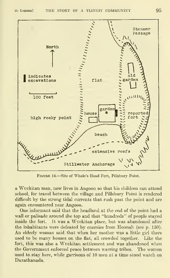
de Laguna] THE STORY OF A TLINGIT COMJVIUNITY 95
steamerPassage
North
Indicatesexcavations
100 feet
Stillwater Anchorage
Figure 14.—Site of Whale's Head Fort, Pillsbury Point.
a Wuckitan man, now lives in Angoon so that his children can attend
school, for travel between the village and Pillsbury Point is rendered
difficult by the strong tidal currents that rush past the point and are
again encountered near Angoon.
One informant said that the headland at the end of the point had a
wall or palisade around the top and that "hundreds" of people stayed
inside the fort. It was a Wuckitan place, but was abandoned after
the inhabitants were defeated by enemies from Hoonah (see p. 150).
An elderly woman said that when her mother was a little girl there
used to be many houses on the flat, all crowded together. Like the
fort, this was also a Wuckitan settlement and was abandoned whenthe Government enforced peace between warring tribes. The womenused to stay here, while garrisons of 10 men at a time stood watch on
Daxatkanada.
96 BUREAU OF AMERICAN ETHNOLOGY [BuU. 172
We found no trace of cultural deposit on the summit of the head-
land nor on top of its lower northern spur, where there are remains of
an abandoned garden. Nor was there any sign of the reported pali-
sade. A test pit in the garden on the flat exposed a midden of black
humus, shells, fire-cracked rocks and pebbles to a depth of 20 mches.
Below this was a layer of burned (?) and rotted wood, about 6 inches
thick, that rested on sterile subsoil. The owner told us that he had
found an "ax" (splitting adz), an implement like an "ax-pick" (head of
a war club?), a labret, and a quartz strike-a-light in his garden.
The midden is much deeper and richer on the eastern edge of the
flat, where refuse had apparently been piled up against the steep
side of the headland or been thrown down from the top of the knoll
above. Since this portion of the site had not been disturbed bygardening, and because the deepest part of the midden was 6 feet
thick in one place, most of our explorations were concentrated here.
We dug a trench 4 feet wide and 18 feet long in the narrow space
between the steep slope and the garden fence. Here 10 major layers
could be distinguished, although some of these either ran together in
some places or petered out and were replaced by minor deposits.
The artifacts recovered are listed in the Appendix. The layers were:
(A) Loose rocks and pebbles from the hillside above, and humus.
(B 1) Humus with rock fragments and whole clam shells.
(B 2) Humus with pebbles and tightly packed crushed shells.
(C) Dark midden of earth and closelj'^ packed shells.
(D) Midden with many sea urchin spines, mussel shells, clam shells, and fire-
cracked rocks. (At both the north and south ends of the trench, layers C and
D were replaced or varied by lenses and pockets of shells, pebbles, charcoal, ash,
sea urchin remains, etc.)
(E) Dark midden with rotted wood.
(F) Midden with many mussel shells, some clams, charcoal, etc. (At the
south end this had been cut away by a pit about 14 inches deep, and filled with
material like that in layer E. We could not determine the areal extent of the
depression.)
(G) Midden, mostly of green sea-urchin spines, with some clam and mussel
shells.
(H) Thin layer of brown sea-urchin spines.
(I) Thin layer of tan-brown ash, sandy soil, wood and charcoal, resting on
the subsoil.
The subsoil had been dug away in places, perhaps to make house
pits or caches, and there were a number of large rocks lying on it
or in the lower layers of the midden. A few postholes were also
found. All this suggests structures of some kind, but our trench
was too narrow to show the size or nature of these depressions, and
we could not enlarge it without tearing down the garden fence and
damaging the berry bushes in the garden. While most of the artifacts
found here were like those obtained at Daxatkanada, a few additional
de Laguna] THE STORY OF A TLINGIT COMMUNITY 97
types were encountered. However, there was nothing to indicate
that the cultures at the two sites were different, although Pillsbury
Point may have been slightly older, since no objects of white manu-
facture were found.
The fish bones were those of salmon, halibut, and "rock cod"; the
shellfish, barnacles, and sea urchins were of the same species as those
represented at Daxatkanada. The animal bones identified by Riddell
consisted of: sea otter, 106; seal, 18; bear, 6; deer, 3; eagle (claws), 5;
beaver, 2; porcupine, 2. There were also fragments of whale or
sea lion bone. Pillsbury Point was evidently an important sea otter
hunting camp.FORTS
Daxatkanada Island and Pillsbury Point, as well as most of the
other sites from which we obtained specimens, were designated bythe natives as forts. These, as well as other places pointed out to
us as having been fortified, were either small steep-sided islets or
rocky promontories equally difficult to climb. They were said to
have been fortified by a palisade of closely set posts. Such forts
(nu) might surround a group of houses or huts, or a single house, like
the former Wuckitan "Fort House" in Angoon that stood inside
its own walls. It was disappointing that we were not able to discover
any archeological evidence as to how such fortifications were
constructed.
The lack of large postholes at Daxatkanada at just the places
where one might have expected them for strategic purposes makes
one question the tradition that the island was fortified, but is not
sufficient to discredit it. Standing trees may have been left as the
main supports of the walls, or some other method may have been
employed to brace them which did not involve the use of posts sunk
in the ground. That there may have been such methods is suggested
by some of the descriptions of Tlingit forts given by the early explorers.
Lisiansky has described the fort erected b}'" the natives at Sitka
and taken by the Russians in 1804 (Lisiansky, 1814, p. 163, pi. 3).
It was an irregular parallelogram, the longest side facing the sea.
It was about 200 feet long and 120 feet wide, and enclosed 14 houses.
The lower part of the walls was made of thi-ee courses of horizontally
laid logs, set in two rows between which rose a palisade of close-set
timbers. The latter were connected near the top by a horizontal
beam (on the outside only?), and this was braced at intervals byposts leaning against the wall. There were a doorway and two holes
for cannon on the side toward the water, and two large doorways or
gates on the landward side. Lisiansky writes that the fort was "so
thick and strong, that the shot from my guns could not penetrate it
at the distance of a cable's length." Such a palisade, which depended
98 BUREAU OF AMERICAN ETHNOLOGY [BuU. 172
upon the horizontal logs at the base of the wall and upon the log
braces at the top for its strength, need not have required postholes.
Indeed, at most of the sites reputedly fortified it would have been
impossible to sink postholes in the shallow rocky soil.
A newer fort, built somewhere in Peril Strait by the natives whohad fled from Sitka, was visited by von Langsdorff in 1805, whodescribes it as follows:
Expelled from Norfolk Sound, they have fortified themselves here, upon a rock
which rises perpendicularly some hundred feet above the water. The only
possible access to it is on the north-west side, and they have rendered this ex-
tremely difficult by strewing it all over with very large trunks of trees which they
have cut down. The rock itself is secured against attack of an enemy by a double
palisade of large trunks of trees stuck close together, measuring from twelve to
fifteen feet in heighth, and from three to four feet in thickness. A high natural
wall of earth beyond the palisading, on the side towards the sea, conceals the
inhabitants effectually, so that they cannot be discerned by any ship, [von
LangsdorflF, 1817, p. 410.]
Inside were a number of plank houses, each large enough to accom-
modate from 30 to 40 persons. The description of this place suggests
that there was enough earth to hold the posts for the fort walls and
for the house frames, as well as to form an outer protection for the
palisade.
Vancouver's men in 1794 saw forts of a different type on the west
coast of Kupreanof Island, that is, in Kake territory. These were
apparently of the same kind as that built by the Kake Indians at
Pybus Bay which our informant described as a temporary defense,
and called by a special term meaning "built-up shelter" of horizontal
logs, to distinguish it from a true fort with palisading. On Hamilton
Bay, writes Vancouver
—
the remains of no less than eight deserted villages were seen; some of them were
more decayed than others, but they were all uniformly situated in the summit of
some precipice, or steep insular rock, rendered by nature almost inaccessible, andby art and great labour made a strong defence; which proved, that the inhabitants
had been subject to the incursions of hostile visitors. These fortified places were
well constructed with a strong platform of wood, laid on the most elevated part of
the rock and projecting so far from its sides as to overspread the declivity. Theedge of the platform was surrounded by a barricade raised by logs of wood placed
on each other. [Vancouver, 1801, vol. 6, pp. 46 f.)
The Kake forts destroyed by Lieutenant Commander Meade of the
U. S. S. Saginaw in 1869 are described as "about 100 feet square and
from 15 to 17 feet high, and built of logs from 9 to 15 inches thick,"
They were apparently stockaded structures. ^^
Unfortunately, none of these descriptions is very detailed, and
Lisiansky's plate was, of course, redrawn by a draftsman who probably
had never seen a Tlingit fort, so it is not very accurate.
2» Beardslee, 1882, p. 54, quoting from Meade's report of February 24, 1869.
de Laguna] THE STORY OF A TLINGIT COMMUNITY 99
ARCHEOLOGICAL SPECIMENS FROM THEANGOON AREAINTRODUCTION
Specimens from the Angoon area are deposited in the University
of Pennsylvania Museum in Philadelphia. The provenience of each
object is given in the Appendix and in the captions of the illustrations.
Here, specimens obtained in 1949 are designated by their museumcatalog numbers, "49-25-1" and so forth, and those in 1950 by their
field numbers since they were not accessioned when this report was
^vritten.
It will be remembered that attempts to correlate artifact types with
layers of presumably different ages at Daxatkanada failed to reveal
any significant differences between younger and older specimens, prob-
ably because the time span involved was so short. All seemed to be-
long to a period when the Tlingit had some access to trade material,
probably obtained in exchange for sea otter skins, but before the
aboriginal culture had been appreciably changed by contact with the
whites. Although Hood Bay Fort and Pillsbury Point may be older
than Daxatkanada, where a fragment of iron, a piece of glass, and a
brass thimble were found, and where evidence of iron tools was
present even in the lowest levels, there is nothing in the scanty finds
from these other sites to suggest any difference in culture. For this
reason all the available archeological specimens have been grouped
together for purposes of description.
Although most of the artifacts can be readily identified either
through comparison with ethnological material in museums or from
information from the natives, it will be noted that there are a few
types which are difficult to interpret. The collection is small and
many of the objects are either crudely made or broken, so that they
fail to give us an adequate impression of the richness of Tlingit arts
and crafts. As already suggested, the impression of poverty may be
due to the fact that the material was obtained from forts and tem-
porary camps, to which the best possessions were probably not taken.
Unless otherwise specified, all the objects are to be understood
as coming from the midden on Daxatkanada Island. Aleasm-ements
enclosed in parenthesis "(—)" are given when the specimens are
broken and the dimensions in question are therefore incomplete.
HEAVY STONE IMPLEMENTS
ADZES
The natives distinguish between the heavy grooved splitting adz
(t'dyis, literally "stone wedge") which is used for chopping trees,
and the smaller ungrooved planing adz (xiIIa, "chopper") which is
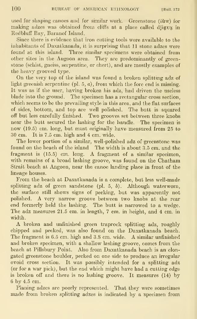
100 BUREAU OF AMERICAN ETHNOLOGY [BuU. 172
used for shaping canoes and for similar work. Greenstone (suw) for
making adzes was obtained from cliffs at a place called djigu? in
Red bluff Ba}^, Baranof Island.
Since there is evidence that iron cutting tools were available to the
inhabitants of Daxatkanada, it is surprising that 11 stone adzes werefound at this island. Three similar specimens were obtained fromother sites in the Angoon area. They are predominantly of green-
stone (schist, gneiss, serpentine, or chert), and are mostly examples of
the heavy grooved type.
On the very top of the island was found a broken splitting adz of
light greenish serpentine (pi. 5, a), from which the fore end is missing.
It was as if the user, having broken his adz, had driven the useless
blade into the ground. The specimen has a rectangular cross section,
which seems to be the prevailing style in this area, and the flat sm-faces
of sides, bottom, and top are well polished. The butt is squared
ojff but less carefully finished. Two grooves set between three knobsnear the butt secured the lashing for the handle. The specimen is
now (19.5) cm. long, but must originally have measured from 25 to
30 cm. It is 7.5 cm. high and 4 cm. Avide.
The lower portion of a similar, well-polished adz of gi-eenstone wasfound on the beach of the island The width is about 3.5 cm. and the
fragment is (15.5) cm. long. A fragment of a similar specimen,
with remains of a broad lashing groove, was found on the ChathamStrait beach at Angoon, near the canoe landing place in front of the
lineage houses.
From the beach at Daxatkanada is a complete, but less well-made
splittmg adz of green sandstone (pi. 5, b). Although waterworn,
the surface still shows signs of pecking, but was apparently not
polished. A very narrow gi'oove between two knobs at the rear
end formerly held the lashing. The butt is nari'owed to a wedge.
The adz measures 21.5 cm. in length, 7 cm. in height, and 4 cm. in
width.
A broken and unfinished green traprock splitting adz, roughly
chipped and pecked, was also found on the Daxatkanada beach.
The fragment is 6.5 cm. high and 3.8 cm. wide. A similar unfinished
and broken specimen, with a shallow lashing gi'oove, comes from the
beach at Pillsbury Point. Also from Daxatkanada beach is an elon-
gated greenstone boulder, pecked on one side to produce an irregular
ovoid cross section. It was possibly intended for a spUtting adz
(or for a war pick) , but the end which might have had a cutting edge
is broken off and there is no lashing gi-oove. It measures (14) by6 by 4.5 cm.
Planing adzes are poorly represented. That they were sometimes
made from broken splitting adzes is indicated by a specimen from
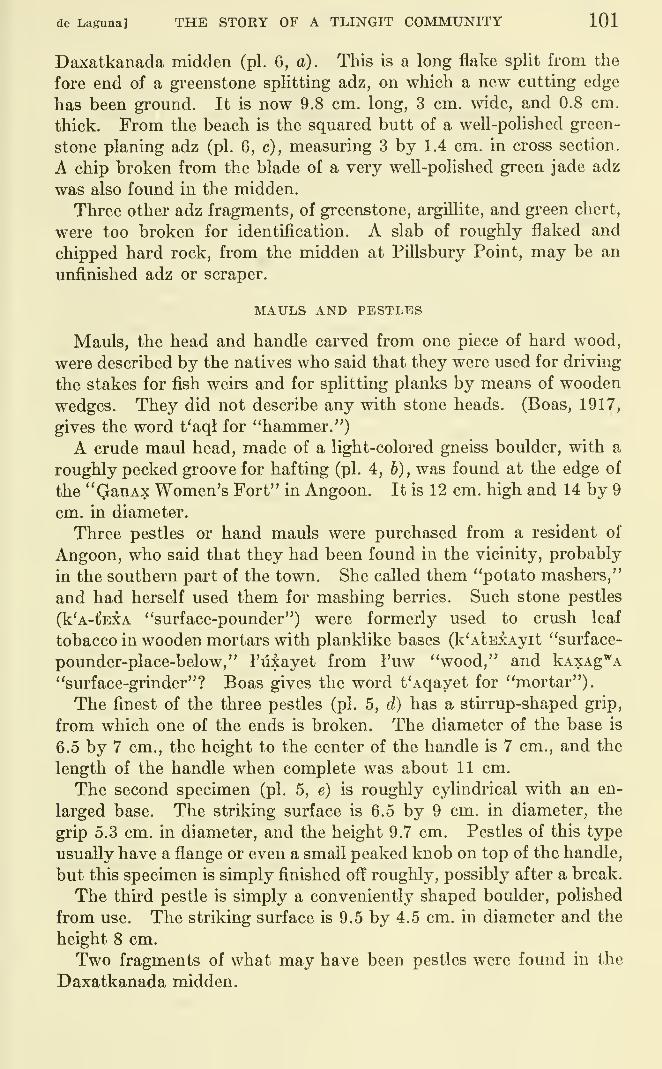
de Laguna] THE STORY OF A TLINGIT COMMUNITY 101
Daxatkanada midden (pi. 6, a). This is a long flake split from the
fore end of a greenstone splitting adz, on which a new cutting edge
has been ground. It is now 9.8 cm. long, 3 cm. wide, and 0.8 cm.
thick. From the beach is the squared butt of a well-polished green-
stone planing adz (pi. 6, c), measuring 3 by 1.4 cm. in cross section.
A chip broken from the blade of a very well-polished green jade adz
was also found in the midden.
Three other adz fragments, of greenstone, argUlite, and green chert,
were too broken for identification. A slab of roughly flaked and
chipped hard rock, from the midden at Pillsbury Point, may be an
unfinished adz or scraper.
MAULS AND PESTL"ES
Mauls, the head and handle carved from one piece of hard wood,
were described by the natives who said that they were used for driving
the stakes for fish weirs and for splitting planks by means of wooden
wedges. They did not describe any with stone heads. (Boas, 1917,
gives the word t'aql for "hammer.")
A crude maul head, made of a light-colored gneiss boulder, with a
roughly pecked groove for hafting (pi. 4, b), was found at the edge of
the "QanAx Women's Fort" in Angoon. It is 12 cm. high and 14 by 9
cm. in diameter.
Three pestles or hand mauls were purchased from a resident of
Angoon, who said that they had been found in the vicinity, probably
in the southern part of the town. She called them "potato mashers,"
and had herself used them for mashing berries. Such stone pestles
(k'A-t'EXA "surface-pounder") were formerly used to crush leaf
tobacco in wooden mortars with planklike bases (k'AlEXAyit "surface-
pounder-place-below," I'lUayet from I'uw "wood," and kAXAg'^A
"surface-grinder"? Boas gives the word t'Aqayet for "mortar").
The finest of the three pestles (pi. 5, d) has a stuTup-shaped grip,
from which one of the ends is broken. The diameter of the base is
6.5 by 7 cm., the height to the center of the handle is 7 cm., and the
length of the handle when complete was about 11 cm.
The second specimen (pi. 5, e) is roughly cylindrical with an en-
larged base. The striking surface is 6.5 by 9 cm. in diameter, the
grip 5.3 cm. in diameter, and the height 9.7 cm. Pestles of this type
usually have a flange or even a small peaked knob on top of the handle,
but this specimen is simply finished off roughly, possibly after a break.
The third pestle is simply a conveniently shaped boulder, polished
from use. The striking surface is 9.5 by 4.5 cm. in diameter and the
height 8 cm.
Two fragments of what may have been pestles were found in the
Daxatkanada midden.
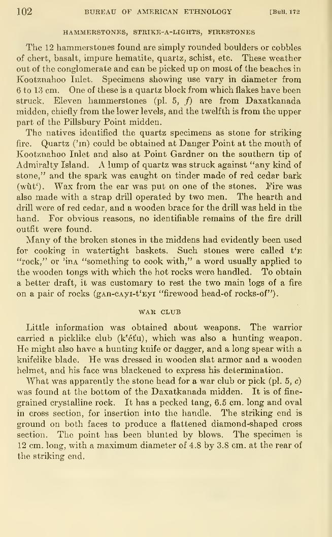
102 BUREAU OF AMERICAN ETHNOLOGY [BuU. 172
HAMMERSTONES, STRIKE-A-LIGHTS, FIRESTONES
The 12 hammerstones found are simply rounded boulders or cobbles
of chert, basalt, impure hematite, quartz, schist, etc. These weather
out of the conglomerate and can be picked up on most of the beaches in
Kootznahoo Inlet. Specimens showing use vary in diameter from
6 to 13 cm. One of these is a quartz block from which flakes have been
struck. Eleven hammerstones (pi. 5, f) are from Daxatkanadamidden, chiefly from the lower levels, and the twelfth is from the upper
part of the Pillsbury Point midden.
The natives identified the quartz specimens as stone for striking
fire. Quartz ('in) could be obtained at Danger Point at the mouth of
Kootznahoo Inlet and also at Point Gardner on the southern tip of
Admiralty Island. A lump of quartz was struck against "any kind of
stone," and the spark was caught on tinder made of red cedar bark
(wuf). Wax from the ear was put on one of the stones. Fire was
also made with a strap drill operated by two men. The hearth and
drill were of red cedar, and a wooden brace for the drill was held in the
hand. For obvious reasons, no identifiable remains of the fire drill
outfit were found.
Many of the broken stones in the middens had evidently been used
for cooking in watertight baskets. Such stones were called t'E
"rock," or 'iuA "something to cook with," a word usually applied to
the wooden tongs with which the hot rocks were handled. To obtain
a better draft, it was customary to rest the two main logs of a fire
on a pair of rocks (gAn-CAyi-t'Eyi "firewood head-of rocks-of"),
WAR CLUB
Little information was obtained about weapons. The warrior
carried a picklike club (k'^t'u), which was also a hunting weapon.
He might also have a hunting knife or dagger, and a long spear with a
knifelike blade. He was dressed in wooden slat armor and a woodenhelmet, and his face was blackened to express his determination.
What was apparently the stone head for a war club or pick (pi. 5, c)
was found at the bottom of the Daxatkanada midden. It is of fine-
grained crystalline rock. It has a pecked tang, 6.5 cm. long and oval
in cross section, for insertion into the handle. The striking end is
ground on both faces to produce a flattened diamond-shaped cross
section. The point has been blunted by blows. The specimen is
12 cm. long, with a maximum diameter of 4.8 by 3.8 cm. at the rear of
the striking end.
\
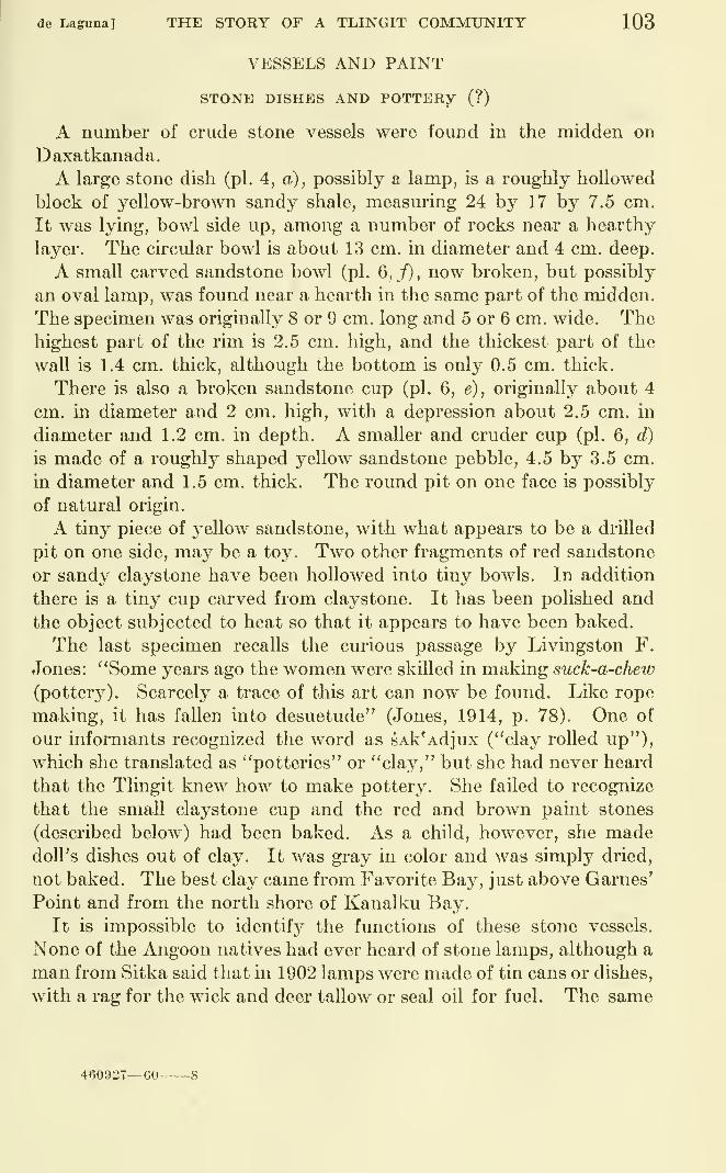
de Laguna] THE STORY OF A TLINGIT COMMUNITY 103
VESSELS AND PAINT
STONE DISHES AND POTTERY (?)
A number of crude stone vessels were found in the midden on
Daxatkanada.
A large stone dish (pi. 4, a), possibly a lamp, is a roughly hollowed
block of yellow-brown sandy shale, measuring 24 by 17 by 7.5 cm.
It was lying, bowl side up, among a number of rocks near a hearthy
layer. The circular bowl is about 13 cm. in diameter and 4 cm. deep.
A small carved sandstone bowl (pi. 6,/), now broken, but possibly
an oval lamp, was found near a hearth in the same part of the midden.
The specimen was originally 8 or 9 cm. long and 5 or 6 cm. wide. Thehighest part of the rim is 2.5 cm. high, and the thickest part of the
wall is 1.4 cm. thick, although the bottom is only 0.5 cm. thick.
There is also a broken sandstone cup (pi. 6, e), originally about 4
cm. in diameter and 2 cm. high, with a depression about 2.5 cm. in
diameter and 1.2 cm. in depth. A smaller and cruder cup (pi. 6, d)
is made of a roughly shaped yellow sandstone pebble, 4.5 by 3.5 cm.
in diameter and 1.5 cm. thick. The round pit on one face is possibly
of natural origin.
A tiny piece of yellow sandstone, with what appears to be a drilled
pit on one side, may be a toy. Two other fragments of red sandstone
or sandy claystone have been hollowed into tiny bowls. In addition
there is a tiny cup carved from claystone. It has been polished and
the object subjected to heat so that it appears to have been baked.
The last specimen recalls the curious passage by Livingston F.
Jones: "Some years ago the women were skilled in making suck-a-chew
(pottery). Scarcely a trace of this art can now be found. Like rope
making, it has fallen into desuetude" (Jones, 1914, p. 78). One of
our informants recognized the word as sAk'Adjux ("clay rolled up"),
which she translated as "potteries" or "cla^^," but she had never heard
that the Tlingit knew how to make pottery. She faUed to recognize
that the small claystone cup and the red and brown paint stones
(described below) had been baked. As a child, however, she madedoll's dishes out of clay. It was graj^ in color and was simply dried,
not baked. The best clay came from Favorite Bay, just above Games'Point and from the north shore of Kanalku Bay.
It is impossible to identif}^ the functions of these stone vessels.
None of the Angoon natives had ever heard of stone lamps, although a
man from Sitka said that in 1902 lamps were made of tin cans or dishes,
with a rag for the wick and deer tallow or seal oil for fuel. The same
460927—60-
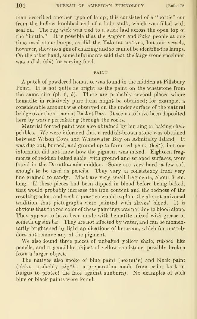
104 BUREAU OF AMERICAN ETHNOLOGY [Bull. 172
man described another type of lamp; this consisted of a "bottle" cut
from the hollow knobbed end of a kelp stalk, which was filled with
seal oil. The rag wick was tied to a stick laid across the open top of
the "bottle." It is possible that the Angoon and Sitka people at one
time used stone lamps, as did the Yakutat natives, but our vessels,
however, show no signs of charring and so cannot be identified as lamps.
On the other hand, some informants said that the large stone specimen
was a dish (six) for serving food.
PAINT
A patch of powdered hematite was found in the midden at Pillsbury
Point. It is not quite as bright as the paint on the whetstone from
the same site (pi. 6, b). There are probably several places where
hematite in relatively pm-e form might be obtained; for example, a
considerable amount was observed on the under surface of the natural
bridge over the stream at Basket Bay. It seems to have been deposited
here by water percolating through the rocks.
Material for red paint was also obtained by burning or baking shale
pebbles. We were informed that a reddish-brown stone was obtained
between Wilson Cove and Whitewater Bay on Admiralty Island. It
was dug out, burned, and ground up to form red paint (lex^), but our
informant did not know how the pigment was mixed. Eighteen frag-
ments of reddish baked shale, with ground and scraped surfaces, were
found in the Daxatkanada midden. Some are very hard, a few soft
enough to be used as pencils. They vary in consistency from very
fine grained to sandy. Most are very small fragments, about 3 cm.
long. If these pieces had been dipped in blood before being baked,
that would probably increase the iron content and the redness of the
resulting color, and such a practice would explain the almost universal
tradition that pictographs were painted with slaves' blood. It is
obvious that the red color of these paintings was not due to blood alone.
They appear to have been made with hematite mixed with grease or
something similar. They are not affected by water, and can be momen-tarily brightened by light applications of kerosene, which fortunately
does not remove an}^ of the pigment.
We also found three pieces of unbaked j^ellow shale, rubbed like
pencils, and a pencillike object of yellow sandstone, possibly broken
from a larger object.
The natives also spoke of blue paint (nexint'E) and black paint
(tsakL, probably sAg^'At, a preparation made from cedar bark or
fungus to protect the face against sunburn). No examples of such
blue or black paints were found.
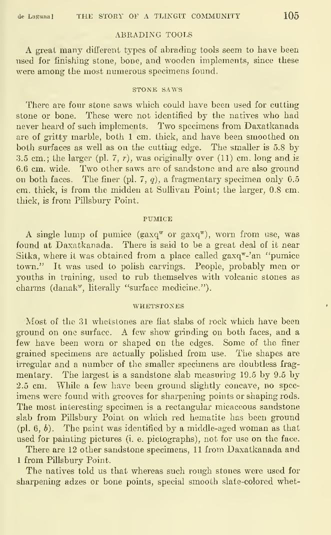
de Laguna] THE STORY OF A TLINGIT COMMUNITY 105
ABRADING TOOLS
A great many different types of abrading tools seem to have been
used for finishing stone, bone, and wooden implements, since these
were among the most numerous specimens found.
STONE SAWS
There are four stone saws which could have been used for cutting
stone or bone. These were not identified by the natives who had
never heard of such implements. Two specimens from Daxatkanadaare of gritty marble, both 1 cm. thick, and have been smoothed on
both surfaces as well as on the cutting edge. The smaller is 5.8 by3.5 cm.; the larger (pi. 7, r), was originally over (11) cm. long and is
6.6 cm. wide. Two other saws are of sandstone and are also ground
on both faces. The finer (pi. 7, g), a fragmentary specimen only 0.5
cm. thick, is from the midden at Sullivan Point; the larger, 0.8 cm.
thick, is from Pillsbury Point.
PUMICE
A single lump of pumice (gaxq^ or gaxq^), worn from use, was
found at Daxatkanada. There is said to be a great deal of it near
Sitka, where it was obtained from a place called gaxq'^-'an "pumice
town." It was used to polish carvings. People, probably men or
youths in training, used to rub themselves with volcanic stones as
charms (danak^, literally "surface medicine."),
WHETSTONES
Most of the 31 whetstones are flat slabs of rock which have been
ground on one surface. A few show grinding on both faces, and a
few have been worn or shaped on the edges. Some of the finer
grained specimens are actually polished from use. The shapes are
irregular and a number of the smaller specimens are doubtless frag-
mentary. The largest is a sandstone slab measuring 19.5 by 9.5 by2.5 cm. While a few have been ground slightly concave, no spec-
imens were found with grooves for sharpening points or shaping rods.
The most interesting specimen is a rectangular micaceous sandstone
slab from Pillsbury Point on which red hematite has been ground
(pi. 6, b). The paint was identified by a middle-aged woman as that
used for painting pictures (i. e. pictographs), not for use on the face.
There are 12 other sandstone specimens, 11 from Daxatkanada and
1 from Pillsbury Point.
The natives told us that whereas such rough stones were used for
sharpening adzes or bone points, special smooth slate-colored whet-
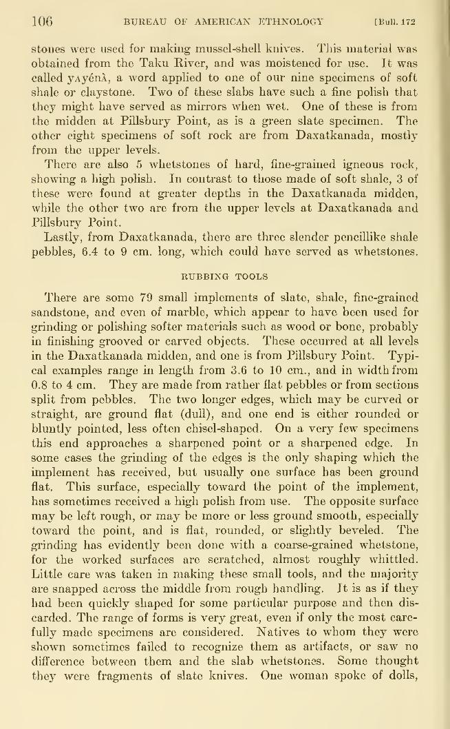
106 BUREAU OF AMERICAN ETHNOLOGY [Bull. 172
stones were used for making mussel-shell knives. This material was
obtained from the Taku River, and was moistened for use. It wascalled yAyenl, a word applied to one of our nine specimens of soft
shale or claystone. Two of these slabs have such a fine polish that
they might have served as mirrors when wet. One of these is from
the midden at Pillsbury Point, as is a green slate specimen. Theother eight specimens of soft rock are from Daxatkanada, mostly
from the upper levels.
There are also 5 whetstones of hard, fine-grained igneous rock,
showing a high polish. In contrast to those made of soft shale, 3 of
these were found at greater depths in the Daxatkanada midden,
while the other two are from the upper levels at Daxatkanada andPillsbury Point.
Lastly, from Daxatkanada, there are three slender pencillike shale
pebbles, 6.4 to 9 cm. long, which could have served as whetstones.
RUBBING TOOLS
There are some 79 small implements of slate, shale, fine-grained
sandstone, and even of marble, which appear to have been used for
grinding or polishing softer materials such as wood or bone, probably
in finishing grooved or carved objects. These occurred at all levels
in the Daxatkanada midden, and one is from Pillsbury Point. Typi-
cal examples range in length from 3.6 to 10 cm., and in width from
0.8 to 4 cm. They are made from rather flat pebbles or from sections
split from pebbles. The two longer edges, which may be curved or
straight, are ground flat (duU), and one end is either rounded or
bluntly pointed, less often chisel-shaped. On a very few specimens
this end approaches a sharpened point or a sharpened edge. In
some cases the grinding of the edges is the only shaping which the
implement has received, but usually one surface has been ground
flat. This surface, especially toward the point of the implement,
has sometimes received a high polish from use. The opposite surface
may be left rough, or may be more or less ground smooth, especially
toward the point, and is flat, rounded, or slightly beveled. Thegrinding has evidently been done with a coarse-grained whetstone,
for the worked surfaces are scratched, almost roughly whittled.
Little care was taken in making these small tools, and the majority
are snapped across the middle from rough handling. It is as if they
had been quickly shaped for some particular purpose and then dis-
carded. The range of forms is very great, even if only the most care-
fully made specimens are considered. Natives to whom they were
shown sometimes failed to recognize them as artifacts, or saw no
difference between them and the slab whetstones. Some thought
they were fragments of slate knives. One woman spoke of dolls,
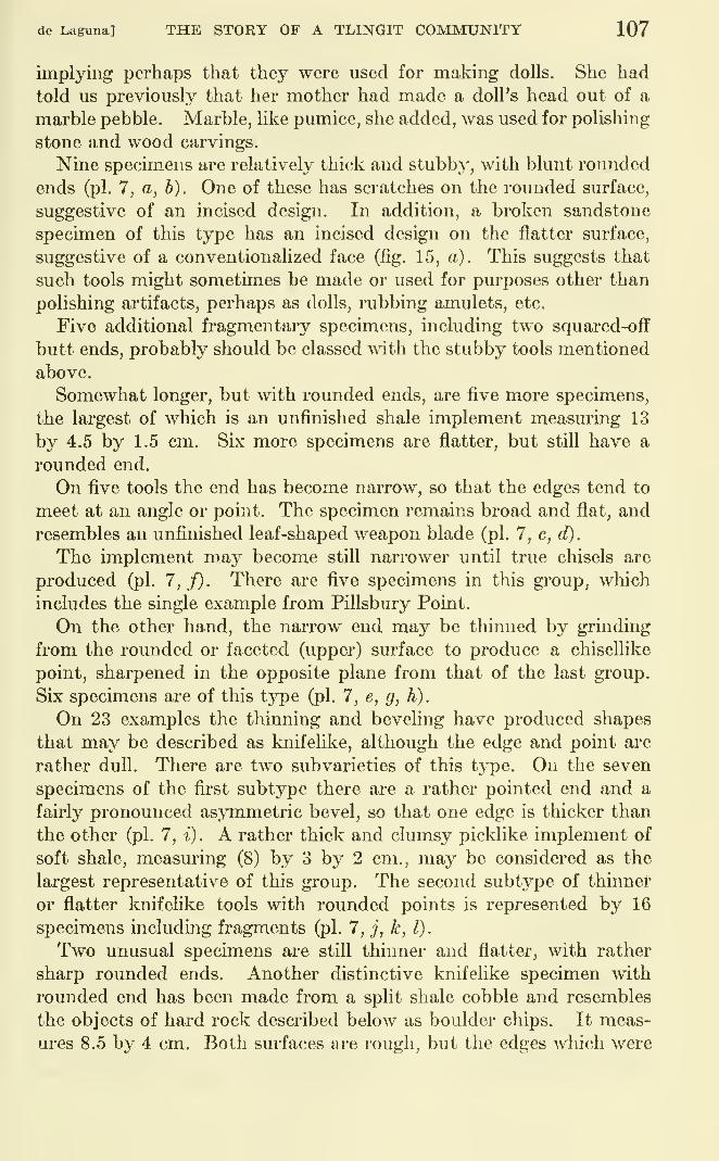
de Laguna] THE STORY OF A TLINGIT COMMUNITY 107
implying perhaps that they were used for making dolls. She had
told us previously that her mother had made a doll's head out of a
marble pebble. Marble, like pumice, she added, was used for polishing
stone and wood carvings.
Nine specimens are relatively thick and stubbj', with blunt rounded
ends (pi. 7, a, h). One of these has scratches on the rounded surface,
suggestive of an incised design. In addition, a broken sandstone
specimen of this type has an incised design on the flatter surface,
suggestive of a conventionalized face (fig. 15, a). This suggests that
such tools might sometimes be made or used for purposes other than
polishing artifacts, perhaps as dolls, rubbing amulets, etc.
Five additional fragmentary specimens, including two squared-off
butt ends, probably should be classed with the stubby tools mentioned
above.
Somewhat longer, but with rounded ends, are five more specimens,
the largest of which is an unfinished shale implement measuring 13
by 4.5 by 1.5 cm. Six more specimens are flatter, but still have a
rounded end.
On five tools the end has become narrow, so that the edges tend to
meet at an angle or point. The specimen remains broad and flat, and
resembles an unfinished leaf-shaped weapon blade (pi. 7, c, d).
The implement may become still narrower until true chisels are
produced (pi. 7,f). There are five specimens in this group, which
includes the single example from Pillsbury Point.
On the other hand, the narrow end may be thinned by grinding
from the rounded or faceted (upper) surface to produce a chisellike
point, sharpened in the opposite plane from that of the last group.
Six specimens are of this type (pi. 7, e, g, h).
On 23 examples the thinning and beveling have produced shapes
that may be described as knifelike, although the edge and point are
rather dull. There are two subvarieties of this type. On the seven
specimens of the fii-st subtype there are a rather pointed end and a
fairly pronounced asymmetric bevel, so that one edge is thicker than
the other (pi. 7, t). A rather thick and clumsy picklike implement of
soft shale, measuring (8) by 3 by 2 cm., may be considered as the
largest representative of this group. The second subtype of thinner
or flatter knifelike tools with rounded points is represented by 16
specimens including fragments (pi. 7, j, k, l).
Two unusual specimens are still thinner and flatter, with rather
sharp rounded ends. Another distinctive knifelike specimen with
rounded end has been made from a split shale cobble and resembles
the objects of hard rock described below as boulder chips. It meas-
ures 8.5 by 4 cm. Both surfaces are rough, but the edges which were
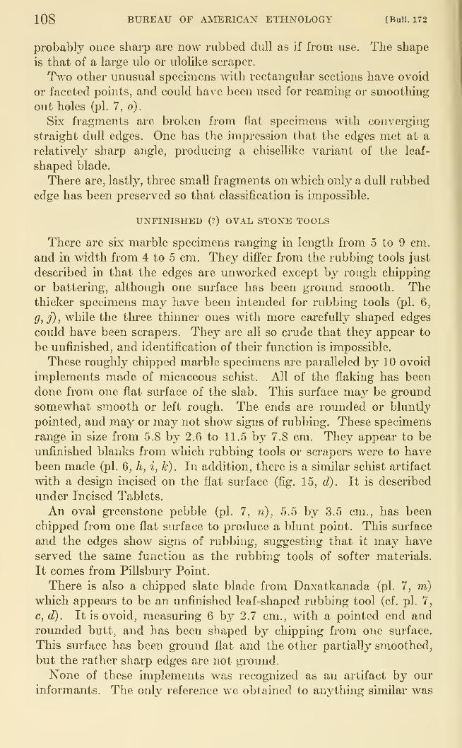
108 BUREAU OF AMERICAN ETHNOLOGY [Bull. 172
probably once sharp are now rubbed dull as if from use. The shape
is that of a large ulo or ulolike scraper.
Two other unusual specimens witli rectangular sections have ovoid
or faceted points, and could have been used for reaming or smoothing
out holes (pi. 7, o).
Six fragments are broken from flat specimens with converging
straight dull edges. One has the impression that the edges met at a
relativeh^ sharp angle, producing a chisellikc variant of the leaf-
shaped blade.
There are, lastly, thi-ee small fragments on which only a dull rubbed
edge has been preserved so that classification is impossible,
UNFINISHED (?) OVAL STONE TOOLS
There are six marble specimens ranging in length from 5 to 9 cm.
and in width from 4 to 5 cm. They differ from the rubbing tools just
described in that the edges are unworked except by rough chipping
or battering, although one surface has been ground smooth. Thethicker specimens may have been intended for rubbing tools (pi. 6,
g, j) , while the three thinner ones with more carefully shaped edges
could have been scrapers. They are all so crude that they appear to
be unfinished, and identification of their function is impossible.
These roughly chipped marble specimens are paralleled by 10 ovoid
implements made of micaceous schist. Ail of the flaking has been
done from one flat surface of the slab. This surface may be ground
somewhat smooth or left rough. The ends are rounded or bluntly
pointed, and may or may not show signs of rubbing. These specimens
range in size from 5.8 by 2.6 to 11.5 by 7.8 cm. They appear to be
unfinished blanks from which rubbing tools or scrapers were to have
been made (pi. 6, h, i, k). In addition, there is a similar schist artifact
with a design incised on the flat surface (fig. 15, d). It is described
under Incised Tablets.
An oval gi-eenstone pebble (pi. 7, n), 5.5 by 3.5 cm., has been
chipped from one flat surface to produce a blunt point. This surface
and the edges show signs of rubbing, suggesting that it maj^ have
served the same function as the rubbing tools of softer materials.
It comes from Pillsbury Point.
There is also a chipped slate blade from Daxatkanada (pi. 7, m)
which appears to be an unfinished leaf-shaped rubbing tool (cf. pi. 7,
c,d). It is ovoid, measuring 6 by 2.7 cm., with a pointed end androunded butt, and has been shaped by chipping from one surface.
This surface has been ground flat and the other partially smoothed,
but the rather sharp edges are not gi'ound.
None of these implements was recognized as an artifact by our
informants. The only reference we obtained to anything similar was
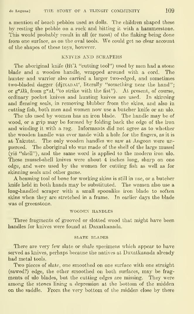
(le Laguna] THE STORY OF A TLINGIT COMMUNITY 109
a mention of beach pebbles used as dolls. The children shaped these
by resting the pebble on a rock and hitting it with a hammerstone.
This would probably result in all (or most) of the flaking being done
from one surface, as on the oval tools. We could get no clear account
of the shapes of these toys, however.
KNIVES AND SCRAPERS
The aboriginal knife (lit'A "cutting tool") used by men had a stone
blade and a wooden handle, wrapped around with a cord. Thehunter and warrior also carried a larger two-edged, and sometimes
two-bladed dagger (djixAnAt', literally "something near the hand";
or g^XlA, from g^Al, "to strike with the fist"). At present, of course,
ordinary pocket laiives and hunting knives are used. In skinning
and flensing seals, in removing blubber from the skins, and also in
cutting fish, both men and women now use a butcher knife or an ulo.
The ulo used by women has an iron blade. The handle may be of
wood, or a grip may be formed by folding back the edge of the konand winding it with a rag. Informants did not agree as to whether
the wooden handle was ever made with a hole for the fingers, as it is
at Yakutat. The only wooden handles we saw at Angoon were un-
pierced. The aboriginal ulo was made of the shell of the large mussel
(yis "shell"), and the same word is applied to the modern iron ulo.
These mussel-sheU knives were about 4 inches long, sharp on one
edge, and were used by the women for cutting fish as well as for
skinning seals and other game.
A beaming tool of bone tor working skins is still in use, or a butcher
knife held in both hands may be substituted. The women also use a
long-handled scraper with a small spoonlike iron blade to soften
skins when they are stretched in a frame. In earlier days the blade
was of greenstone.
WOODEN HANDLES
Three fragments of gi'ooved or slotted wood that might have been
handles for knives were found at Daxatkanada.
SLATE BLADES
There are very few slate or shale specimens which appear to have
served as knives, perhaps because the natives at Daxatkanada already
had metal tools.
Two pieces of slate, one smoothed on one surface with one straight
(sawed?) edge, the other smoothed on both surfaces, may be frag-
ments of ulo blades, but the cutting edges are missing. They were
among the stones lining a depression at the bottom of the middenon the saddle. From the very bottom of the midden close by there
110 BUREAU OF AMERICAN ETHNOLOGiY [Bull. 172
is a crude slate ulo or knife with a blunt straight back and a curved
sharp edge. It is 9.5 cm. long and only 2 cm. wide. Another crude
ulo was made of a naturally sharp slab of slate, 8.5 cm. long and4.5 cm. wide (pi. 7, p). There is also a shale slab with a partially
sharpened straight edge, like a chisel or plane. It is similar to the
knives made of sharp pieces of shale which appear to be common at
the site on Mole Harbor on the other side of Admiralty Island.
A thin fragment of shale with a cut or sawed edge from Pillsbury
Point, a fragment of slate which has been smoothed on one side
from Sullivan Point, and a thin rectangular flake of slatey schist
with worn edges from the bottom of the Daxatkanada midden mayalso be fragments of knives.
A thin chisellike slate blade, possibly for a scraper, has an incised
design on one side consisting of several parallel lines (fig. 15,/). (See
Incised Tablets, pp. 122-125).
SHELL IMPLEMENTS
A fragment of a large mussel-shell knife, probably an ulo, wasfound at Pillsbury Point (pi. 9, n). The shell is that of the large
mussel, Mytilus californiensis. A bluntly cut end meets the naturally
sharp edge of the shell at a right angle.
From Daxatkanada are a clamshell implement with dull edges, a
blue mussell shell ground flat across the hinged end, and a large
clamshell through which a hole has been punched from the outside.
BOULDER CHIPS
There are four oval flakes, made by splitting cobbles or small
boulders of hard rock so as to form a blunt handgrip and a sharper
curved working edge. This edge shows signs of wear, as if these
artifacts had served as scrapers, choppers, or knives. The specimens
vary in length from 5.8 to 8.5 cm, and in width from 1.8 to 6 cm. In
addition, there are a thin flake split from a basalt cobble which showssigns of wear and a large flake or boulder chip of sandy shale. Thelatter is 10 by 6 by 2.5 cm., and has a sharp edge, worn from use.
FLAKES AND CORES
From Daxatkanada midden there are nine flakes and cores madefrom chert pebbles, but only one of these shows signs of use. This
is a green chert core, 4 by 3 by 2 cm, the sharp wedgelike end of whichis dulled as if it had been used as a chisel or scraper. The other eight
fragments are too irregularly shaped to have been serviceable. Since
no chipped implements of chert were found it is hard to understand
for what purpose these pebbles were broken.
de Laguna] THE STORY OF A TLINGIT COMMUNITY 111
In addition, there are also a small quartz chip and a block of
quartz which has been cracked by blows.
A long blade of basalt has sharp edges and a rounded chisellike end,
but shows no signs of wear. A basalt core and a massive flake struck
from such a core (pi. 6, /) came from the deeper levels of the
Daxatkanada midden. Both show the effects of heavy blows.
SEA MAMMAL HUNTING WEAPONS
According to our informants, harpoons were used in hunting harbor
seals, fur seals, and sea otters, and also for spearing fish. Sea otter
are said to have been hunted off Sitka, not near Angoon. This state-
ment can refer only to a relatively recent period, for there were moresea otter bones in the middens at Daxatkanada and Pillsbury Point
than bones of any other animal. The natives also told us that they
used to eat whales and sea lions, but did not know how to kill them.
However, the famous story of "Black-skin" (Swanton, 1909, Tale 32,
p. 149) not only involves a sea lion hunt,|but the cure of a woundedsea lion by cutting out the barbed harpoon point in its side.
Two types of harpoon head were identified by our informants. Thefirst is a toggle head (dena) made of two pieces of bone. This wassupposed to be the better kind because the harpooned seal could not
tear it out. The head apparently fitted directly over the tapered end
of the wooden shaft without an intermediate bone foreshaft or socket
piece. The second, more common type of head (k'At') was a barbed
point with tang for insertion into the socket or slit in the end of the
wooden shaft (adA), not into a bone socket piece. Specimens in recent
use were of iron or copper, usually with barbs on both edges.
The harpoon head was fastened to the shaft by means of a sealskin
line. According to one informant, this line was attached to the end
of the shaft, and even when spearing salmon the whole harpoon wasthrown. It was retained in the hand only when spearing trout.
According to another man, the line from the head of the seal harpoon
was attached to the middle of the shaft, so that the latter would tend
to pull crosswise through the water when the seal was struck and the
head detached from the shaft, but all informants denied a martingale
rig. A running line connected the butt end of the shaft to an inflated
seal stomach that served as a buoy. With this harpoon seals might
be speared on the rocks, or taken from a canoe in which one man acted
as harpooner and a companion as paddler.
Wounded seals were dispatched with a club, or might be hunted on
the rocks with a club alone. A hunter, or his companion, might lure
them by imitating the movements and noises of a seal. While the use
of a sealskin as a disguise was denied by one man, another said that as
a boy he had helped his father by acting as a decoy covered with a
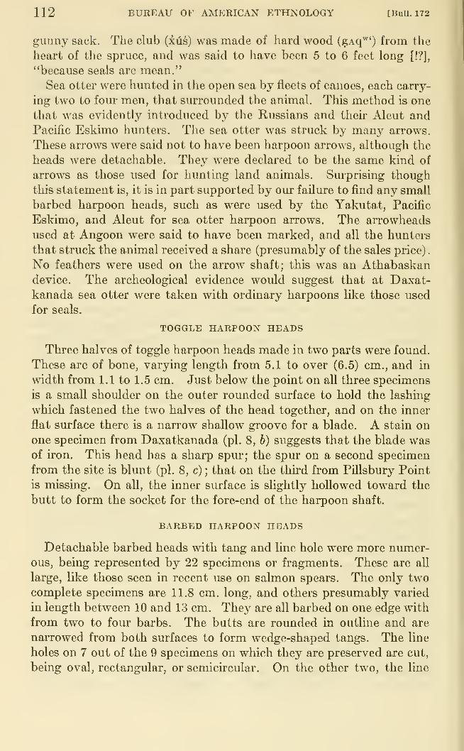
112 BUREAU OF AMERICAN ETHNOLOGY [Bull. 172
gunny sack. The club (ius) was made of hard wood (gAq^') from the
heart of the spruce, and was said to have been 5 to 6 feet long [!?],
"because seals are mean."
Sea otter were hunted in the open sea by fleets of canoes, each carry-
ing two to four men, that surrounded the animal. This metliod is one
that was evidently introduced by the Russians and their Aleut andPacific Eskimo hunters. The sea otter was struck by many arrows.
These arrows were said not to have been harpoon arrows, although the
heads were detachable. They were declared to be the same kind of
arrows as those used for hunting land animals. Surprising though
this statement is, it is in part supported by our failure to find any small
barbed harpoon heads, such as were used by the Yakutat, Pacific
Eskimo, and Aleut for sea otter harpoon arrows. The arrowheads
used at Angoon were said to have been marked, and all the hunters
that struck the animal received a share (presumably of the sales price)
.
No feathers were used on the arrow shaft; this was an Athabaskandevice. The archeological evidence would suggest that at Daxat-
kanada sea otter were taken with ordinary harpoons like those used
for seals.
TOGGLE HARPOON HEADS
Three halves of toggle harpoon heads made in two parts were found.
These are of bone, varying length from 5.1 to over (6.5) cm., and in
width from 1.1 to 1.5 cm. Just below the point on all three specimens
is a small shoulder on the outer rounded surface to hold the lashing
which fastened the two halves of the head together, and on the inner
flat surface there is a narrow shallow groove for a blade. A stain on
one specimen from Daxatkanada (pi. 8, b) suggests that the blade wasof iron. This head has a sharp spm*; the spm- on a second specimen
from the site is blunt (pi. 8, c) ; that on the third from Pillsbury Point
is missing. On all, the inner surface is slightly hollowed toward the
butt to form the socket for the fore-end of the harpoon shaft.
BARBED HARPOON HEADS
Detachable barbed heads with tang and line hole were more numer-ous, being represented by 22 specimens or fragments. These are all
large, like those seen in recent use on salmon spears. The only twocomplete specimens are 11.8 cm. long, and others presumably varied
in length between 10 and 13 cm. They are all barbed on one edge with
from two to four barbs. The butts are rounded in outline and are
narrowed from both surfaces to form wedge-shaped tangs. The line
holes on 7 out of the 9 specimens on which they are preserved are cut,
being oval, rectangular, or semicircular. On the other two, the line
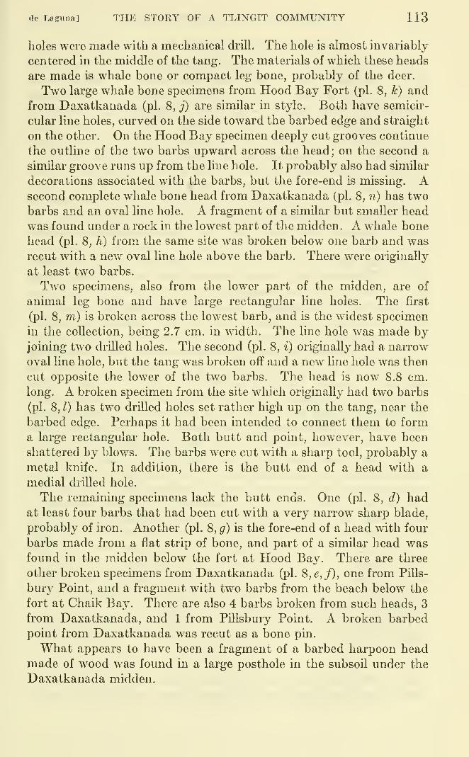
de Lagiina] THE STORY OF A TLINGIT COMMUNITY 113
holes were made with a mechanical di'ill. The hole is almost invariably
centered in the middle of the tang. The materials of which these heads
are made is whale bone or compact leg bone, probably of the deer.
Two large whale bone specimens from Hood Bay Fort (pi. 8, k) and
from Daxatkanada (pi. 8, j) are similar in style. Both have semicir-
cular line holes, cm'ved on the side toward the barbed edge and straight
on the other. On the Hood Bay specimen deeply cut grooves continue
the outline of the two barbs upward across the head; on the second a
similar groove runs up from the line hole. It probably also had similar
decorations associated with the barbs, but the fore-end is missing. Asecond complete whale bone head from Daxatkanada (pi. 8, n) has two
barbs and an oval line hole. A fragment of a similar but smaller head
was found under a rock in the lowest part of the midden. A whale bone
head (pi. 8, h) from the same site was broken below one barb and wasrecut with a new oval line hole above the barb. There were originally
at least two barbs.
Two specimens, also from the lower part of the midden, are of
animal leg bone and have large rectangular line holes. The first
(pi. 8, m) is broken across the low^est barb, and is the widest specimen
in the collection, being 2.7 cm. in width. The line hole was made byjoining two drilled holes. The second (pi. 8, i) originally had a narrow
oval line hole, but the tang was broken off and a new line hole was then
cut opposite the lower of the two barbs. The head is now 8.8 cm.
long. A broken specimen from the site which originally had two barbs
(pi. 8, 1) has two drilled holes set rather high up on the tang, near the
barbed edge. Perhaps it had been intended to connect them to forma large rectangular hole. Both butt and point, however, have been
shattered by blows. The barbs were cut with a sharp tool, probably a
metal knife. In addition, there is the butt end of a head with a
medial drilled hole.
The remaining specimens lack the butt ends. One (pi. 8, d) hadat least four barbs that had been cut with a very narrow sharp blade,
probably of iron. Another (pi. 8, g) is the fore-end of a head with four
barbs made from a flat strip of bone, and part of a similar head wasfound in the midden below the fort at Hood Bay. There are three
other broken specimens from Daxatkanada (pi. S,e,f), one from Pills-
bury Point, and a fragment with two barbs from the beach below the
fort at Chaik Bay. There are also 4 barbs broken from such heads, 3
from Daxatkanada, and 1 from Pillsbury Point. A broken barbed
point from Daxatkanada was recut as a bone pin.
What appears to have been a fragment of a barbed harpoon headmade of wood was found in a large posthole in the subsoil under the
Daxatkanada midden.
114 BUREAU OF AMERICAN ETHNOLOGY [BuU. 172
LAND ANIMAL HUNTING WEAPONS
Deadfalls (j6x or sin) of various types were used for bear, land
otter, mink, and beaver. Some were set across the animal's trail
(de-k*AnAx-yAncu "trail-across-to hunt"), and others were baited
(yanaq'^'-sEt* "bait-place"). One style of deadfall was the "figure
four" trap (t'aj^^x, probably referring to t& "plank"). Snares (da^A)
were used for deer and bear, and boys used small snares to trap gulls
and bluejays. Pitfalls were not made, except by children in play.
Deer and bear were hunted with the help of trained dogs. Thehunter might, like the warrior, carry a picklike club, or a spear
(tsagXr). The shaft was over 6 feet in length, and the double-edged
knifelike blade was about 12 inches long. Bears were also shot with
bows and arrows from "nests" (k'uf) orplatforms built in trees above
their trails.
The most common weapon used in hunting was the bow and arrow
(sAqs). The bowstring was said to have been made of rawhide cut
from a seal's belly and thoroughly stretched, although it is moreprobable that it was made of sinew. The arrows had a plain un-
feathered wooden shaft (tcun^f). The heads (LAq*) were of hard
wood or bone, with a tang which was set into the fore-end of the shaft.
The end of the shaft bulged to prevent the arrow from penetrating
too deeply, so that the shaft would fall to the ground, leaving the
head in the wound. These heads are said never to have been barbed,
however, but were marked with grooves to indicate ownership. Theordinary arrowhead was 4 inches long, but that used for bear meas-
ured 6 inches. There were also practice arrows with large blunt heads
(gAL'). Arrows were carried in a skin quiver (dakedi).
The hunter also carried a whip sling (djux'^A), consisting of a
wooden handle to which was attached a cord with a knotted end. Thedart was called by the same name as the ordinary arrow, and had two
notches into either of which the knotted end of the whip could be
fitted. The notch nearer the fore-end was used for long-range shots.
The detachable point was barbed and had a socket into which the dart
shaft fitted. This point was made from a deer joint and was called
saq* or "bone." A single feather might be attached to the shaft to
make the dart easier to spot. Such darts were used for deer or bear.
A deer call was made of a bunchberry leaf held between the lips or
between two hollowed sticks to make a whistle.
The hunter also had a hunting knife or dagger, as described under
Knives.
BARBED POINTS
From Pillsbury Point there is one complete slender barbed point
with conical tang and seven unilateral barbs, outlined by a pair of
de Laguna] THE STORY OF A TLINGIT COMMUNITY 115
bordering grooves (pi. 8, a). It was probably an arrowhead, even
though our informants denied that they were ever barbed. A small
notch in the tang, which resembles the remains of an eighth barb,
suggests that the specimen was recut from a longer point. A decora-
tive line down the edge opposite the row of barbs may have been cut
with a steel knife. The specimen is 12.7 cm. long and 1.2 by 0.7
cm. in diameter.
Three fragments of points with one, two, and three barbs respec-
tively, but lacking decorative lines, may be parts of barbed arrow-
heads or barbed harpoon heads. These are all from Daxatkanada.
UNBARBED ARROWHEADS
A flat slender specimen of bone, pointed at both ends, one of which
is slightly roughened as if for hafting, may be an arrowhead (pi. 9, u).
It is 16 cm. long, 1.2 cm. wide, and 0.3 cm. thick. A fragment of a
similar object and a broken faceted bone point (pi. 9, m) may also
be parts of arrowheads. A broken bone rod (pi. 9, v) may be an
unfinished arrowhead. These are all from Daxatkanada midden.
On the flat below the fort at Hood Bay was found a long, slender
implement, made of animal leg bone, tapered and flattened as if for
hafting, which may have been the tang of an arrowhead.
BONE SPEARS OR DAGGERS
An antler dagger or spear point from Daxatkanada (pi. 9, r) is
faceted on the outer surface. The broken rear end appears to have
been roughened by hacking for attachment to a handle. The speci-
men is (20.5) cm. long, 2.4 cm. wide, and 1.8 cm. thick.
The butt end of a heavy bone implement (pi. 9, s), with scarfed
tang and a knob on the convex edge, may be broken from a spear
point or pick. It is 2 cm. in diameter and comes from the bottom of
the midden. Another butt end of a bone implement (pi. 9, t), roughly
rectangular in section with a hole cut near one edge, may also be part
of a dagger.
FISHING GEAR
Most salmon were, of course, taken in traps (cal). These were
boxes made of sticks or pieces of slit wood, set either across a water-
fall or placed in the opening of a fence across a stream. The arms of
the trap were called cal-djini "trap arms-of," the posts to which trap
and fence were attached were called x^el, and a tongue-shaped rampthat forced the salmon to slide back into the trap was called xat'-
qeqEdJA "salmon-director." Although a variety of models of such
traps were described, they were all made so that the water in the floor
of the trap was too shallow to permit the fish to swim or jump out.
116 BUREAU OF AMERICAN ETHNOLOGY [BuU. 172
The funnel-shaped trap (gAtc or gAk^tc) was said to have been used
only by the Chilkat.
Salmon were also trapped by the falling tide above stone weirs
(ut'), built across the mouths of streams. Rows of pointed stakes
were also set up in similar localities on which the fish impaled them-
selves when trj'ing to jump. These stakes were called naxAk'At'dn
(evidently derived from k'A "on" and t'an "jump").
Fish were also taken in nets of spruce or of baleen. The latter are
described as from 30 to 40 fathoms long. The baleen from one whale
was enough to make 2 or 3 fathoms of net.
Salmon were both harpooned and gaffed. The harpoon was the
same as that used for seals. The gaffhook for fish (kexA.) was madeof a steamed and bent piece of hard wood (presumabl}'^ attached to a
wooden shaft). Although no bone barbs for gaffs were mentioned,
some archeological specimens described below may have had such a
function. The only place, however, where salmon were gaffed or
speared at night from canoes carrying torches was said to be in Nak-wasina Passage near Sitka, the scene of the Salmon Boy story, where
the hero's miraculous adventures seemed to confer supernatural
sanction on this method of fishing. A gaffhook (fana) was used for
devilfish. Only the Chilkat used a two- or three-pronged leister or
fish spear (Lagwl).
Cod, shark, and halibut were taken mth hook and line. The hook(qosqasd) for cod was a simple V-shaped hook with straight (?)
wooden shank and a barb made of a bone pin. The halibut hook(nlx"^) is much larger, w^ith an alderwood shank carved to represent
some mythological personage, anima,l, or object, from which the hookreceives its personal name. These names are said to belong to sibs,
yet new designs and names are still being invented. The barb is a
stout point of iron, presumably of bone in former times. To the
shank where the barb is attached are fastened some pieces of light
wood (red cedar, or at present cork) to make the hook float clear of
the bottom. The bait is a piece of devilfish (naq'^')- Hooks are used
in pairs. They are attached to lines formerly made of twisted spruce
root or of fine braided skin (sinew?), and were weighted with unshaped
stones. Two floats are attached: one (k'Atsis) is of red cedar carved
in the shape of a duck or gull; the second is an inflated seal stomach(tsa yiiwu). A club or spear was used to Idll large fish when hooked.
Salmon and small fish when caught were strung on a line by meansof an eyed needle made of hard wood, a little over a foot long. Thename given for this needle was simply that for heartwood.
Herring were and still are caught with a fish rake (xfLl). This is
an oar-shaped implement about 15 feet or more long, at present
de Laguna] THE STORY OF A TLINGIT COMMUNITY 117
armed along one edge of the blade with about 40 teeth made fromnails. In earlier times these teeth were of copper or bone.
DOUBLE-POINTED BONE PINS
There are 17 pins from Daxatkanada midden, made of hard animal
or bird bone, and pointed at both ends (pi. 9, a to ^). They range in
length from 3.5 to 8.4 cm., with the majority about 5 or 6 cm. long,
and 0.5 cm. in diameter. One end, presumably the butt, is moreabruptly tapered than the other, but both are sharp. They could
have been used as barbs for cod hooks or halibut hooks, and the
larger ones may have been gorges or the teeth for herring rakes.
However, all sharp pins or splinters of bone were identified by our
informants as awls.
In addition to the 17 complete specimens, there are 7 points which
appear to have been broken from similar pins. Of these, 2 are fromPillsbury Point.
BIRD-BONE POINTS
There are nine pointed splinters of bu'd bone, made of sawed strips
or simplj^ of broken pieces, unworked except at the points. These are
probably barbs for fishhooks. Since the butt ends are not shaped it
is impossible to tell whether or not these specimens are broken.
Some are over 6 cm. long. Eight are from Daxatkanada (pi. 9, ^),
and one fron PiUsbury Point (pi. 9, j). In addition, a bird-bone
point, 4.3 by 0.6 cm., with three small barbs on one edge (pi. 9, h)
may also be part of a fishhook. Two thin strips of bird bone mayhave been broken from bird-bone points.
BARBS FOR GAFF HOOKS
Four points of hard bone, apparently bear penis bone, seem to
be barbs for gaff hooks. The butts of three are thinned or pointed;
that of the fourth is squared off. Presumably they were inserted
into holes in a wooden handle. They are from 7.7 to over 9 cm.
long (pi. 9, I).
A piece of animal rib, 6 cm. long, with thinned butt and pointed
end, may also be a barb for a hook or gaff" (pi. 9, k).
MISCELLANEOUS BONE POINTS
Three pins made of flat strips or splinters of bone, sharp at one endand blunt at the other, may be either barbs or awls. They vary in
length from 6 to 8.4 cm. In addition, there is also the butt of whatwas probably a similar pin, and a broken barbed harpoon head that
was recut as a pin. A point made of a sharpened splinter of bone wasfound in a deposit of fish bones and may be part of a fishhook.
118 BUREAU OF AMERICAN ETHNOLOGY [Bull. 172
BONE TOOLS
AWLS AND DRILLS
Before steel needles were obtained, bone awls (q'^iiA or t'aiAl')
were used for sewing.
For making holes in wood a hand drill with a bone bit was used.
The butt was flattened off at the end and set into a round stick.
The drill was rotated between the palms of the hands.
We found only four specimens which could be identified as awls
or drills. One awl is made of an unsplit bird bone, another is an ani-
mal ulna, and a third, from Pillsbury Point, is made of an unsplit
animal leg bone. The fourth is a fragment of a bone drill or awl with
a detached conical point. In addition, 5 broken bone points may be
fragments of awls.
Two slender bone pins, only 0.3 cm. in diameter, and very care-
fully polished, may be parts of awls or bodkins. They are (6) and
(7.3) cm. long (pi. ^ w, x).
BEAVER-TOOTH CHISELS
There are three chisels made of beaver incisors which wouldhave served admirably for cutting holes or slots. Two are fromDaxatkanada (pi. 9, o, p), the third from PiUsbury Point (pi. 9, g).
WORKED BONE
Bone was apparently worked by splitting, sawing, chipping, andcutting, and bone artifacts were finished by grinding. Five pieces
of bone from Daxatkanada midden have cuts suggestive of a steel
knife; three others have broad, dull cuts suggesting the use of stone
tools. These apparently come from all levels of the midden.
Not only were finished articles of whale bone found, but there
are fragments of worked whale or sea lion bone, 16 from Daxatkanadaand 1 from Pillsbury Point. These are relatively small slabs and rod-
shaped pieces. No large bones of whales, either worked or unworked,
were represented. There is, in addition, a small wedge-shaped piece
of whale bone, with battered butt, (3) by 1.2 by 0.4 cm., which re-
sembles the small wedges which we use to tighten the handle in an
ax head. It comes from Daxatkanada, but its function is unknown.Eighteen animal leg bones, chiefly deer metapodials, have been
sawed into strips. These are all from Daxatkanada, except for one
from Pillsbury Point and another from Sullivan Point.
Thirteen other fragments of animal bone showing sawing andcutting are from Daxatkanada, and four from Pillsbury Point.
Two rather oval slabs of cut animal leg bone from Daxatkanadalook like blanks from which smaU barbed harpoon heads were to have
been cut.
de LagunaJ THE STORY OF A TLINGIT COIVEVIUNITY 119
A fragment of animal leg bone, probably split for the marrow,
shows fine scratches or knife marks.
There are also a few pieces of cut bird bone. Two are the articu-
lations cut from the ends of large bones, probably in making tubes
or beads, a third is a fragment of a b^rd-bone tube with scratches.
Three pieces cut from bird breast bones appear to have been muchhandled. One has a dull worn edge, another has a slot cut at one
end, and the third is pointed. There are also four strips of bird bone,
one of which was found at Pillsbury Point, which are possibly frag-
ments of bird-bone points.
ORNAMENTS
It is impossible to make a sharp distinction between ornaments
and amulets, since the same object, in certain cases, may serve both
a decorative and a magical or religious function. Archeological spec-
imens which might fall into either class comprise pendants, beads,
labrets, nose pins, bone carvings, stone inlays, copper objects, scratch-
ing stones (?), and incised tablets. Some ethnological information
was obtained about these.
Tooth pendants were sometimes worn on a cord around the neck
and were used as scratchers. A bear tooth might be "fixed" (madeinto a pendant? charmed?) by a shaman, and when worn around the
neck was considered good medicine to ward off sickness. Other
amulets supplied by doctors were made of stone. Tooth pendants
were also worn by men and women as ear ornaments. High-class
people might have three holes in the helix and a fourth in the lobe of
the ear. The holes were sometimes made with porcupine quills.
Men wore sea otter teeth, mounted in sUver, as earrings. Earrings
were called guk'^^-'At* or guk'^^-k'adjac.
It was suggested that the beads (kawdt) made of small bird bones,
the small stone beads, and the tooth pendants might have come froma shaman's necklace. One informant, however, suggested that the
small stone beads had been worn by a high-class woman.We found no dentalia (t*Xxxe), but were told that they were worn
around the neck, or ornamented clothing on the shoulders, body, andlegs. The same word was also given for a white "stone" (?), foundin the water and used to inlay dishes and boxes (opercula ?).
High-class people also used to wear nose ornaments (KmXs) at
dances.
The labrets which we found aroused the most interest. Such or-
naments were worn only by aristocratic women. The hole, like that
for the nose ornament, was made with a bear claw, and the first smaUlabret was probably inserted just after the girl emerged from her
460927—60 9
120 BUREAU OF AMERICAN ETHNOLOGY [BaU. 172
puberty confinement (although this could not be verified). As the
hole was stretched, larger labrets were inserted. Our informants hadseen or heard only of bone or wooden labrets, and believed that our
stone specimens must have been worn by very high-class, elderly
women "who had proved themselves." The reason for wearing
labrets was asserted to be to prevent the women from gossiping, since
women caused wars through idle talk about matters which were not
their business. The labret was both a sign of wisdom and a re-
minder to keep quiet. The labret was called xent'a:xa (from :^a
"mouth") and qanux (possibly ?a-nui "mouth-shell"?). Thelarger labret was :^agaq'' or xakaq'' (possibly ia-qAk^ "mouth-wide"?), and some might be 2 inches long.
PENDANTS
There are four pendants made of animal teeth. Three of these,
including one from Pillsbury Point, seem to be sea otter canines,
grooved around the roots for suspension (pi. 10, a, b, c). Thefourth is a sea lion tooth with a drilled hole at the root (pi. 10, d).
There is also a sea otter molar on which the roots have been ground
down (pi. 10, m). It may also have been an ornament, although wedo not know how it was worn.
The left half of the mandible of a young bear, with an incompletely
erupted canine, has a drilled hole at the base of the ramus (pi. 10,
hh). It may have been an amulet, worn as a pendant.
A well-made pendant of ivory, probably obtained from a tooth, is
3.1 cm. long and 1.2 cm. in diameter (pi. 10,/). For suspension
there is a fine groove about a tiny knob at one end. The pendant
is flattened on four sides, each of which bears a double row of drilled
pits. There are 10 pits on three sides, and 9 (evidently an error) on
the fourth. Some of these still contain traces of red paint. One pit
is surrounded by a faint but mechanically perfect circle, indicating
that the implement used to make the decoration had two prongs,
probably of metal, and suggesting that the compass-drawn dot-and-
circle, here produced by accident, was employed as a decorative ele-
ment in other designs. The specimen comes from the bottom of the
Daxatkanada midden.
Two thin, slightly curved strips of bone may have been used as
ornaments. One has a small drilled hole at one end and a medial
line down one side, and may have been a pendant. It is 4.8 cm.
long and 0.8 cm. wide (pi. 10, j). The other is broken at one end
and notched at the other (pi. 10, ^).
A rectangular pendant, 7 by 1.7 cm., is made from a section of a
large barnacle, and is notched at the narrower end for suspension
(pi. 10, e).
de Laguna] THE STORY OF A TLINGIT COMMUNITY 121
There is, lastly, a small pendant of tan shale, now represented only
by a fragment. There was a drilled hole at one rounded end; the
other is missing. Incised lines on one side make a checkerboard
pattern.
BEADS
A bead (pi. 10, n), measuring 1.4 by 1.2 cm., has been made from
the central part of a large tooth, probably a bear canine, from which
the tip and root have been cut, leaving the nerve canal to serve as a
hole for stringing. The tip broken from a bear canine (pi. 10, g) and
the root sawed from a similar tooth (pi. 10, h) illustrate the process
of manufacture.
There are two complete and one broken disk-shaped beads made of
tan shale (pi. 10, o, p, q). These vary from 1 to 1.5 cm. in diameter
and have asymmetrically drilled holes. Three broken specimens,
3 to 3.3 cm. in diameter, are not only much larger but much cruder,
and may have been amulets rather than ornaments. Two are of yellow
sandstone or sandy shale (pi. 10, cc), and the third is of limestone
(pi. 10, dd). A roughly shaped disk of white marble (pi. 10, ee),
chipped from both sides, has a shallow drilled pit on one surface and is
probably an unfinished bead or amulet like the last specimen. It is
4 cm. in diameter and 1.4 cm. thick. It was tentatively identified byour informants as a scratching stone used by adolescent girls.
There are a few bird-bone tubes that were probably used as beads.
The most carefully polished specimen is only 0.9 cm. long and comes
from the bottom of the midden at Pillsbury Point (pi. 10, t). Three
other specimens, 3.8 to 4.1 cm. long (pi. 10, v, w, x), and two fragments
of what may have been similar beads, came from Daxatkanada.
There is a highly polished tubular bead of jet (pi. 10, -u), 1.5 cm. long
and 0.7 cm. in diameter, with a hole evenly drilled from one end. Onehas the impression that the drill must have been of metal. A lump of
cannel coal showing grinding was found in the Daxatkanada midden,
and an unworked lump of the same material was picked up on the
beach opposite Sullivan Point near the waterfall which supplied
drinking water for that settlment. The material was probably derived
from the soft-coal beds at Sullivan Point.
LABRETS
There are three labrets, all, as was to be expected, of the "medial"
type to be worn below the middle of the lower lip. The first (pi. 10, 66)
from Daxatkanada, is of light-green soapstone or badly weathered
steatite, concave on both surfaces, the outer face being especially dish
shaped. It is oval in outline with a deep groove around the edge, andmeasures 3.6 by 3 cm. in diameter and 1.1 cm. in thickness. Thesecond (pi. 10, z) is also an oval labret of greenish steatite. The outer
122 BUREAU OF AMERICAN ETHNOLOGY [BuU. 172
surface is flat, and is both shorter and broader than the inner flange.
The maximum measurements are 2.8 by 1.9 em. in diameter, and 2.1
cm. in thickness. The third (pi. 10, aa), from the bottom of the middenon top of the Hood Bay fort, is a circular labret made of shale, baked
dark red after carving. The outer stud is cone shaped, and rises to a
small point 2 cm. high. There is a rather wide but shallow groove
around the edge, and the inner surface is flat.
From Daxatkanada, an oval-rectangular piece of shale, 4.5 by 2.1
cm., may possibly be an unfinished labret. The edges and both sur-
faces have been whittled smooth, and on one side a small depression
has been gouged out.
NOSE PIN (?)
A broken bone pin (pi. 10, k) with a T-shaped end may possibly
have been an ornament worn in the nose. There is a shallow groove
at the base of the cross bar, as if something had once been attached
here. The specimen is now (3.6) cm. long and 1 cm. wide at the end.
STONE DISKS
Two disks made of micaceous slatey schist may have been used as
ornamental inserts, perhaps as eyes in wood carvings. One (pi. 10, r)
is roughly chipped out and is 1.8 cm. in diameter; the other (pi. 10, s)
is half of a more carefully made specimen Avith ground surfaces and
edges, and originally measured 3.5 cm. in diameter.
A tiny chip of bright-blue talc was probably also part of an ornament
or inlay.
BONE CARVING
A broken piece of what appears to be the flipper bone of a large sea
mammal (sea lion?) bears broad, shallow grooves, evidently part of a
flowing curvilinear design (pi. 10, y). Too little of the specimen re-
mains for the decoration to be deciphered, although it would appear to
be in ordinary Northwest Coast style.
AMULETS
INCISED TABLETS
From Daxatkanada there are a number of roughly shaped slabs or
pebbles bearing very crudely incised designs on one or both faces.
The lines are so fine that it is only with the greatest difficulty that the
patterns can be seen, and I am indebted to Laura Knipe, formerly an
undergraduate at Bryn Mawi' College, for sketches of these specimens.
The designs are hardly more than scribbles composed chiefly of
straight lines and do not suggest in any way the classic Northwest
Coast art style.
de Laguna] THE STORY OF A TLINGIT COMMUNITY 123
Our informants identified them tentatively as scratching stones
used by adolescent girls. A middle-aged woman reported that she
had once seen such a stone with a picture of a bear on it. It was tied
with a string so that it could be hung from the girl's neck. She gave
the name for such a stone as ctayiiduwatigi t*:6 (probably cdayu-
wuduwAt'iyi t*E "stone for scratching one's self"?). It will be remem-bered that pieces of pumice were used as rubbing amulets, presumably
by others than adolescent girls. Stone amulets were said to have
been made by doctors. The pitted marble disk (pi. 10, ee) wasidentified as "medicine" for rubbing the arms and legs, and wascalled daxA^^ (from da "surface", and xas "to scrape"). A smoothgrooved pebble, described below, was said to have been used to
scratch any itchy place on the body and to rub across the lips. While
we were unable to obtain any further information at Angoon, the
Tlingit at Yakutat reported that such pebbles were used by adolescent
girls, widows, and peace hostages to scratch themselves, since it wastaboo to use the fingers. They also rubbed their lips with such
stones as ritual insurance against uttering words that might lead
to war.^^ Some of these stones were pierced for suspension, as were
the stone amulets given by some shamans to their patients. Wecannot, however, be certain of the function of any of the grooved,
pitted, pierced, or incised stone specimens.
Among the incised stone specimens, we have already mentioned
a slate chisellike blade (fig. 15, /) which has faint transverse lines in
pairs across one surface. Other longitudinal scratches and pits are
probably the result of use. We also mentioned a broken sandstone
rubbing tool (fig. 15, a) from the top of Daxatkanada Island, on which
were gouges and scratches suggestive of a face. Two pairs of curved
lines and the end indicate brows; two straight transverse lines seem
to represent the closed eyes; vertical lines below these outline a broad
nose and suggest face painting. Faint gouges appear to indicate
the lip below the nose. The third incised stone specimen already
described was a small shale pendant with a checkerboard design.
Of these three, the design on the rubbing tool is most similar to the
patterns incised on the four stone tablets described below.
The first of these tablets (fig. 15, d) is oval-rectangular in outline,
measm-ing 10 by 3.3 cm, and has been roughly chipped from a slab of
green micaceous schist. It resembles the poorly shaped oval im-
plements described as unfinished rubbing tools or scrapers. On the
smoother surface is a lightly incised design that extends from the
narrower end over two-thirds of the length of the slab. It consists
of two rectangular panels, outlined by single lines. One is filled
" Drucker, 1950, Trait p. 1141, 276, reports that the Chilkat rubbed a pebble aroimd the girl's mouth four
times dally so that she would not become talkative.
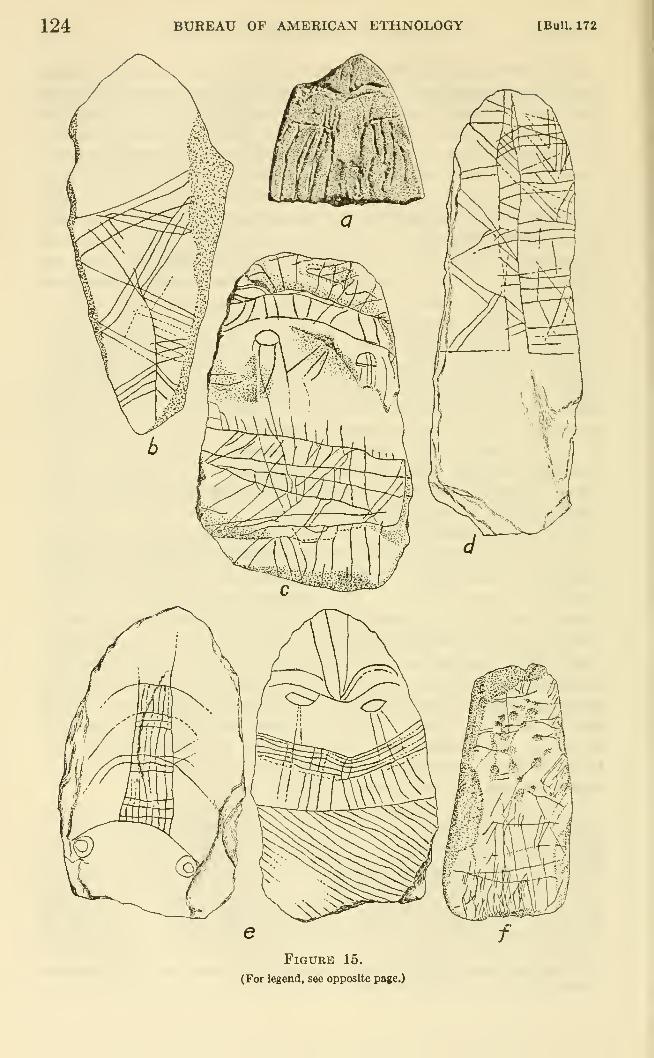
124 BUREAU OF AMERICAN ETHNOLOGY [Bull. 172
Figure 15.
(For legend, see opposite page.)
de Lairunal THE STORY OF A TLINGIT COMMUNITY 125
with double longitudinal zigzag lines. The other panel is crossed bybands of three or four transverse lines and irregularly scattered
pairs of chevrons (V-shaped lines). The narrow central band between
the panels is filled with pairs of zigzags.
A flat shale slab or pebble (fig. 15, b), 8.1 by 3.5 cm., also has an
incised design which covers about two-thirds of its length. This
design consists of double zigzags which run down the middle of the
stone and cross it from edge to edge. There is also a medial longi-
tudinal line, from the ends of which diverge sets of long oblique
spurs in groups of three and four. These two elements are super-
imposed without producing a coherent integrated pattern.
The third tablet (fig. 15, c) is an oval slab split from a pebble of
brown shale or claystone, measuring 7 by 4.8 cm. The design covers
one surface and suggests a highly conventionalized face. Across the
top is a transverse band of zigzags between bordering lines, above
which rise spreading spurs, suggestive of a brow band and a feather
crown. Below this are two oval figures from which lines run down,
suggesting a pair of weeping eyes. Some irregular scratches mayrepresent the nose. Across the bottom half of the slab are a series
of transverse lines, crossed by longitudinal spurs and paired zigzags
or chevrons, the whole faintly suggestive of a mouth or of clothing.
The last specimen (fig. 15, e) is an oval slab roughly chipped from
a piece of thin green micaceous schist. There are faintly incised
designs on both siu"faces. On one side there is a face with oval
weeping eyes, curved brows, hair with a central part (?), a mouth,
and a series of diagonal scratches which may represent clothing or fur.
On the other side is a longitudinal band down the middle, crossed
by curved lines in groups, the whole suggestive of a stylized backbonewith ribs, or possibly a girl's decorated braid. The slab measures
7.3 by 5 cm.
We should probably include in this group a waterworn slate tablet
rectangular in shape, which was found in beach gravel, 6 inches below
the *'fioor" of a small hut at the abandoned settlement on Killisnoo
Harbor. There are a series of fine notches along one of the longer
edges and there may have been similar notches on the other. Thestone is, however, very badly waterworn and any other notches or
possible incising are no longer visible.
Figure 15.—Incised stone tablets from Daxatkanada Island. Drawn by LauraKnipe. a, Broken sandstone rubbing tool, top of island (49-25-19) ; b, shale
pebble, FIE 12-18 inches (No. 309); c, shale or claystone tablet, C3E 12 inches
(No. 77) ; d, green micaceous schist tablet, BSE 3 inches (No. 9) ; e, obverse andreverse of green micaceous schist tablet, 0-T 6-12 inches (No. 320); /, slate
chisellike blade, A3E 3 inches (No. 8). Slightly less than natural size.
126 BUREAU OF AMERICAN ETHNOLOGY [Bull. 172
RUBBING STONE
A roughly egg-shaped pebble with a natural groove around it,
somewhat enlarged by pecking, was found in the Daxatkanadamidden. It shows polish from use or handling. One of the older
women suggested that it may have been a rubbing stone used by anadolescent girl or widow.
DRINKING TUBE (?)
A broken bird-bone tube (pi. 9, y) originally over 9.5 cm., may havebeen a drinking tube. Our informants denied that adolescent girls
had to drink through a tube, but their reluctance to talk about such
matters leaves the question rather open.
OBJECTS OF FOREIGN PROVENIENCE
COPPER
Two objects of copper were found at archeological sites in the
Angoon area. While native copper, obtained primarily from the
Copper River region through trade with the Yakutat and Eyak, wasavailable to the Tlingit in prehistoric times, it would be impossible
to determine the source of these two small pieces without subjecting
them to chemical analysis.
The first is a conical tinkler (pi. 10, I), 1.2 cm. long, made bywinding a scrap of copper around a thong. It comes from the Daxat-
kanada midden.
A fragment of a wooden object, 2.3 cm. wide, flat on one side andfaceted on the other, has been wound about by a strip of copper.
This bears the faint impression of a stamped design suggestive of a
bird's head and eye. It was found 24 inches below the surface of the
midden which spills down the north side of the QanAx Women'sFort at Angoon.
IRON
We have already noted some objects which appear to have been
shaped or cut with iron or steel tools. The total list is a half of a
toggle harpoon head (pi. 8, 6), two barbed heads with tang (pi. 8, </, I),
a jet bead (pi. 10, u), an ivory pendant (pi, 10, /) four cut bones, anda wooden post (pi. 4, c). These came from all levels of the Daxat-
kanada midden. In addition, there is a barbed arrowhead from the
upper part of the midden at Pillsbury Point (pi. 8, a).
From Daxatkanada midden there is a small chisellike piece of
wrought iron (pi. 10, gg), which might have been shaped by hammeringflat a large spike. It is 6.5 cm. long and 2.3 cm. wide.
Before the Tlingit were in contact with white traders, perhaps
de Laguna] THE STORY OF A TLINGIT COMMUNITY 127
before Bering's discovery of Alaska, the natives apparently obtained
iron from driftwood, and worked it, according to tradition, like
native copper by heating and pounding. Such di-ift iron was called
gayEs, and the presence of some iron, or of sharp knife cuts on arche-
ological objects, does not constitute proof of trade relationships
with the whites.
TRADE GOODS
Two other objects from Daxatkanada midden indicate, however,
trade contacts. One of these is a piece of a green glass bottle, and the
other is a brass thimble (pi. lQ,f). The latter has a tiny hole at the
end, evidently made from the inside (by a nail ?). The interior is
filled with carbonized incrustation (glue or pitch) , and the thimble wasprobably used as an ornamental ferule, perhaps on the end of a cane,
rather than as an aid in sewing. It was found well down in the middendeposit and serves, therefore, to date the site as early historic.
In one of the recent cache pits behind the abandoned houses at
Whitewater Bay were found a fragment of a hollow iron cannonball,
probably like those used to shell Angoon in 1882, and a faceted blue
glass bead of the type sold by the Hudson's Bay Company dming the
last centmy.
CONCLUSIONS
Among the most interesting discoveries to be noted is the evidence
that the Tlingit baked clay or claystone for paint and that the children
modeled clay into toy dishes. They seem occasionally to have
achieved a baked-clay object by accident, although we should hesitate
to call this pottery maldng, even though Jones, as quoted above,
credited the Tlingit of former times with this art. To what extent
they may have used clay is a problem for further research.
It is also interesting that our informants were unable to identify or
even sometimes to recognize as artificially shaped the objects which
we have called "rubbing tools," even though these were the mostcommon type of artifact at Daxatkanada. I do not know of anysimilar objects ia museum collections, but this may be because theu*
crudeness has failed to attract the notice of collectors. They resemble
small chisellike or adzlike tools from Yakutat and Prince WUliamSound ia shape (de Laguna, 1956, pp. 121-124) but are unlike these in
that they were evidently used to abrade, whereas the Yakutat andChugach slate tools were used to cut and gouge.
Of greater interest are the incised stone plaques. While some small
slate objects, with suspension holes and designs incised ia moretraditional Northwest Coast style, may be found in museums, wehave never seen any other Tlingit specimens quite like these simple
rough tablets with their fine peculiar ornamentation, except for one
128 BUREAU OF AMERICAN ETHNOLOGY [BuU. 172
late prehistoric specimen from Yakutat. The nearest analogies are
similarly roughly shaped slate plaques from the older deposits in
Prince William Sound (de Laguna, 1956, figs. 25-32, pp. 201-204).
While the latter bear geometric designs and other incisings suggesting
faces, these faces are not like the Tlingit examples with weeping eyes,
but are more akin to the Y-shaped nose-and-brows seen on specimens
from rather late Kodiak sites (Heizer, 1947, fig. 6; 1952, p. 266, fig. 90).
Unfortunately, no incised plaques were found in the stratified sites of
Kachemak Bay, which might have helped to establish their age. If
they occurred here, we failed to notice them. While there is no doubt
that the incised pebbles and tablets of Kodiak, Prince William Sound,
Yakutat, and Angoon belong to a common tradition, each group
exhibits its own peculiarities of style, just as do the rock carvings and
rock paintings which also link these regions. The incised tablets
were presimaably amulets, although we will probably never know just
how they were used.
HISTORY OF ANGOONINTRODUCTION
The history of Angoon and its people seems to faU into several
"periods," represented by different types of traditions or documenta-
tions. The white man would logically divide it into at least three
temporal eras: (1) prehistoric, or prior to contact with Europeans in
the 18th century, and lacking written records; (2) early historic,
beginning perhaps with the discovery of Alaska in 1741, or with the
first venture into Angoon territory by a European; this would be
covered, especially in the later decades of the 18th century, by an
increasing number of reports by explorers, traders, and the Russian-
American Company; (3) recent historic, a well-documented period,
beginning with the pmxhase of Alaska by the United States in 1867
and running into the present. For the native of Angoon the divisions
are not quite the same, especially since the prehistoric and early
historic periods could hardly be distinguished by a people whose con-
tacts over many j^ears with Europeans were only brief and intermit-
tent. It was not, in fact, until 10 years after the purchase of Alaska
by the United States that close association with the white man began.
Then came the founding of the station at KiUisnoo and the Presby-
terian Mission school at Sitka which many Angoon children attended.
Thus it is only within the memory of the old people that native history
and white history reaUy run side by side. Prior to this, some episodes
in native tradition can be equated with events described in written
documents, but others cannot. Often temporal clues are lacking,
because the modern storj^teller does not know, for example, whether
firearms were used in the battles he describes.
de Lagana] THE STORY OF A TLINGIT COMMUNITY 129
The native traditions would seem to fall into four "periods:" (1) a
mythical group, dealing with the Flood, and with the adventures of
Raven and of other beings that gave the world its present form; (2) a
legendary group, overlapping in part with the former, in spirit if not
in time, and telling how the present sibs had their origins, obtained
their crests, and migrated to their present temtories; (3) a more
clearly historical set of stories, dealing largely with clashes between
sibs, and including episodes that can be assigned to the days of the
early explorers and Russians, or to the early American penetration
of the territory; some origins of recent sibs occurred during this
period; (4) and, lastly, modern stories of events that occurred within
the lifetime of the narrator or of his older relatives who witnessed the
events and told the present narrator about them.
Because of the fact that the material dealt with in this chapter is
drawn from native tradition, historical sources, and native statements
of recent or contemporary events, our organization of Angoon history
must be a compromise between the white historian's chronological
scheme, and the less explicit distinctions which can be discovered in
the character of the natives' oral accounts.
Since Garfield has published in 1947 an admirable summary of
Angoon sib traditions, recorded in 1945, we shall rely upon this to a
large extent, amplifying it with stories told by our own informants
and by relevant material gathered by Swanton in 1904 at Sitka andWrangell and published in 1909.
As has already been pointed out, much of the traditional native
history of Angoon consists of the distinct histories of separate sibs
and lineages, and some discrepancies cannot be resolved. And, as
Garfield (1947, p. 452) has made clear, "It is impossible to reconcile
the Deluge tale with even the legendary history of the house groups
and clans," although presumably most of the last type of story wouldbe assigned to a period following the Flood and the episodes recounted
in the Raven myth, if the natives were pressed to attempt such a
chronological arrangement. Some of the natives are evidently puzzled
by inconsistencies in the stories and try to fit them together or explain
them logically. Dr. Garfield has told me that she felt that the Tlingit
were actually in process of organizing the Raven stories into a great
mythological framework. However, we were unable to find confir-
mation for this interesting suggestion, since we obtained only admit-
tedly scattered and abbreviated versions of the myths associated with
Raven and other supernatural characters. It is interesting that
Swanton's informant at Wrangell, Katishan, chief of the Kasqlague'-
dl, succeeded in interweaving most of the sacred myths of a numberof sibs into the framework of the Raven cycle, even though he achieved
no clear chronological progression from one episode to the next, and
130 BUREAU OF AMERICAN ETHNOLOGY [BaU. 172
the scheme upon which he achieved this interweaving is not apparent
(Swanton, 1909, Tale 31).
One informant told us that he knew an old man who had a complete
history of the Tlingit "right back to the Ice Age" recorded on a skin.
This sldn was exhibited (presumably at potlatches or other ceremonial
occasions) to "prove the history." The old man knew about Glacier
Bay "when it was just a sandy beach." Our informant said that he
had been told only a "short-cut version" of this history. Although
it is doubtful that this "histor}^" is actually a comprehensive or
chronologically developed summary of the traditions of all Tlingit
groups, our informant evidently regarded it as such, and this maybe interpreted as evidence of genuine historical interest. Many edu-
cated natives believe that the sib traditions can actually be fitted
together as a true history. To judge by what a well-educated manfrom Klawak told me, the Flood must be imagined as having occurred
"before the Ice Age," or at least before the glaciers retreated, since
many groups are said to have migrated down the rivers to the coast
right after the Flood, when they had to pass under glaciers that havesince melted.
THE FLOOD
It may be said that Tlingit traditional history begins with the
Flood. A version of this was told us by one old man, a devoted
member of the Salvation Army, who called it "The Story of Creation."
It is essentially the same as the Tlingit versions discussed by Boas
(1916, pp. 621-625), although some details are of sufficient interest
to warrant a brief summary.
"the story of creation"
The first man in the world, Qisxx:6? [probably Qis-xu?^, "Flood-Call (er)"]
(not Raven-at-the-head-of-Nass-River, Nas-CAki-yel, as this character is usually
called) was so jealous of his beautiful wife that he killed all his sister's baby boys.
[A nephew in the old days had access to his uncle's wife.] Finally a Crane gavethe grieving mother a hot stone to swallow which resulted in the birth of aninvulnerable son, who grew with miraculous rapidity to manhood. After the
uncle had in vain tried to kill him in various ways, he discovered the young mansleeping with his aunt, and in a rage called up the Tide to drown them. Theyouth clothed his mother and his uncle's wife in the skins of ducks, so that theyescaped by swimming. He donned the skin of a snipe, flew to the sky and sus-
pended himself above the Flood by sticking his bill into the underside of the sky.
Finally, as the Flood subsided, he fell down into some floating kelp. There wasnothing but water then, no land anywhere. But he met two sea otters andinduced them to dive for sand at the bottom of the sea, and from this created the
land. On it he created the trees. The world then was dark, without sun, moon,or stars. He became born as a child to the daughter of the chief who kept these
luminaries in his house. By crjdng, he obtained each of them in turn, and threwthe stars and moon into the sky. When escaping through the smokehole with the
I
de La^na] THE STORY OF A TLINGIT COMMUNITY 131
box containing the sun (daylight), he was trapped for a time, and so becameblackened by soot.
"He was our God, and He created the world. We call him Yel."
(The informant became indignant when we pointed out that this wasthe word for raven. He went on to pomt out that the Flood was the
same as the one in the Bible)
.
^According to other informants, there must have been other people
living in the world at this time. Thus:
THE FLOOD
There was a Flood, when all the people had to go to the tops of the mountains.
They built walls of rocks around the tops, like nests. Some people had dogs.
The bears came up after them. Those that didn't have dogs to chase the bears
were all killed, but those that had dogs were saved.
I have been on top of one of the mountains, above Chaik Bay. I saw the rope
there at the top, all turned to ashes. Another mountain where the people wentis the high one across the Inlet, below Tenakee. You can see it from Angoon(over Graveyard Point). People went to the tops of the mountains—all the
high ones—in the Flood. All the high mountains have nests.
Other refuge mountains are south of Hood Bay and the peak knownas Table Mountain south of Whitewater Bay. It is a general behef
that to touch the nests or the old ropes on these peaks or even to
point at them from the old village sites causes bad weather.
Swanton's version from Wrangell is rather similar to our "Story of
Creation" except that it adds the notion that people escaped the Flood
by climbing the mountains (Swanton, 1909, Tale 31, pp. 119-121).
According to a Sitka story, it was Kaven himself who wanted the
Flood. He got the woman who controls the tides to raise the water
so that he could go under the ocean. This caused the Flood, whichrose so slowly that the people were able to get mto their canoes andfloat up to the tops of the mountains. Bears and other wild animals
took refuge there also, but the people who had dogs with them were
protected. Some people built stone walls around the peaks and tied
their canoes inside. Sometimes now hunters see these stones andthen it becomes foggy (Swanton, 1909, Tale 1, p. 16).
THE FOUNDING OF ANGOON
It is, of course, useless to ask how soon after the Flood Angoon wasfounded, or even whether the Angoon area was first inhabited before
or after the Flood, because when we come to the story of Angoonwe pass into another dimension of time.
The QauAXAdi were the original Ravens in the Angoon area, with
settlements at Whitewater Bay, Angoon, and Sitkoh Bay, but nolarge village. According to tradition,^* they had come originally
2* Garfield, 1947, pp. 440 f.; Swanton 1908, p. 408. The latter reports that they derive their name from anisland, Qa'nAx.
132 BUEEAU OF AMERICAN ETHNOLOGY [Bull. 172
from the south, from Prince of Wales and Kuiu Islands, and were the
first people to settle at Tongas. Our informant explained that they
obtained their name when they were staying at a lake near Ketchikan.
A chief stood up and said: "From now on we will be the people of
QanAx" which was the name of the lake. Before that, they were
called Einedi.
Allied with the QanAXAdi at Angoon were the Decitan, now the
most important Raven group in the area. We obtained no story
about the origin of the Decitan, save that they had lived at a numberof small settlements near Angoon, before they followed the beaver to
Angoon Isthmus, and obtained permission from the QanAXAdi to
live there. One informant further specified that they had lived at
Whitewater Bay before Angoon was founded (before they moved to
Angoon?). The stories of the founding of Angoon refer specifically
to the settling there of the Decitan, who, in fact, derive their namefrom decu hit, "End of the (Beaver) Trail House." Our versions of
this story are in essential agreement with that obtained by Garfield
(1947, p. 439). The latter's informants, however, specified further
that the Decitan were descended from the Einedi (t'lEne.di), also
known as the "Dog Salmon People," who had come down the Stikine
River from the interior, passing under a glacier. They settled first
at Eliza Harbor on the southern end of Admiralty Island, then movedto Tyee, where they absorbed the local "Kelp People" (Gicq^e.di),
and then came to Chaik Bay. Finally the main body moved to
Kootznahoo Inlet, while one small group settled at Basket Bay. Wedid not hear any part of this migration story, and, indeed, one of our
informants derived the Einedi from the Decitan, rather than vice
versa (see origin of the 'Anxakhitan)
.
VERSION 1
There were several places where the people lived before coming to Angoon.
The first place of all the people settled at was ketintci-'an, the big sand beach
opposite Killisnoo Island. They lived there for years and years. The southeast
swells hit it pretty hard, so they moved; it was hard to keep canoes on the beach.
They were all living there, the Decitan and the QanAXAdi.
Then they moved to yA?tAduwudA, Turn Point, and stayed there for years andyears. But there was too much tidal current there. So they moved to qi?Atu-'d,n,
Charlie Anderson's place on Stillwater Anchorage. Then they moved to
CAt?fwustin-'dn, Sullivan Point. After they moved from there to Angoon they
called it tak'anicu, "Winter Village."
There was one old man that had three nephews. They went out in a canoe,
looking for something to eat. They saw a beaver swimming in the Inlet and fol-
lowed it. It landed here [on the east side of Angoon Isthmus] and went across
to the other side [where the walk now goes to the ANB Hall]. There were lots
of trees here then. They followed the beaver across and when they came to the
beach, he was swimming in salt water [Chatham Strait].
de Laguna] THE STORY OF A TLINGIT COMMUNITY 133
The old man followed them, looked around, and liked this place. He said^
"We're going to move here, build our village here." So they got all their families
and moved over.
There were two men who built the village. They could make planks out of
trees with wedges—planks 3 or 4 feet wide—great big ones. The men were
QanA^Adi.
VERSION 2
There were no trees on the point below Angoon, when the people came fromKillisnoo. [It is usually at this point that the bears are mentioned, from which the
name of the peninsula and of Admiralty Island is derived—see p. 25.] Thevillage was on the inside of Killisnoo, above the cannery, and was called
ketintci-'an, named for the pounding surf. People couldn't sleep there, so they
decided to move. They saw a beaver going across a trail (at Angoon Isthmus).
The chief of ketmtci-'an said: "Nobody kill that beaver." So they came to
Angoon. The vilage at Killisnoo belonged to all the tribes: Decitan, Teq^edi,
Wuckitan.
When the people came to Angoon, the chief of the Decitan took the namelangucu, referring to the "homeless" Raven that flies around everywhere. This
was because they couldn't make up their mind to stay at any one place (before?)
.
VERSION 3
People were then living at qi?Atu-'an, Charlie Anderson's place on Stillwater
Anchorage. There were lots of people. Three men were hunting a beaver.
They see it going. They paddled after it. They hit the beaver. It came on the
beach. They followed the beaver, watched where it went. It went across the
isthmus, where the boardwalk is now, to the Chatham Strait side. The men wentthere. They went back to qiXAtu-'an and told the chief they liked that place.
I have lost the name of the three men.The chief was Kaxgucgitx. He came here and liked the place. He said it
was a good place. There were OanAXAdi living where the school is now. Thenew people asked permission to live here. So they came here. The QanAXAdichief was Anialahac.
After a trouble, the QanAXAdi went to that place down south, Ketchikan.
SPLIT BETWEEN THE (?ANA?:ADI AND THE DECITAN
At Angoon the Decitan apparently formed a subservient and low-
class subdivision of the QanAXAdi. Eventually a split between the
two was precipitated by the infidelity of a woman, a common theme
in Tlingit stories. The various versions of this event are in essential
agreement, though each has details not found in the others. We can
assume that the wronged husband was a QanAXAdi man of the QanAs:
Women's Fort House at Angoon, the unfaithful wife was Wuckitan,
and the lover was Decitan. The latter was discovered and slain at
the settlement on Stillwater Anchorage, when the family were pre-
paring to move to Sullivan Point. Garfield's informant (Garfield,
1947, p. 441) credits the discovery and killing to the husband's
nephew, and one of our informants ascribes this to the husband him-
self. In any case, the QanAXAdi left the area, surrendering their
134 BUREAU OF AMERICAN ETHNOLOGY Laguna]
rights to the Decitan; in memory of this they carved the picture of a
"copper" at Sitkoh to symbolize the wealth they were giving away.
According to one of our versions, the issue of which group was to moveaway was settled by a hockey or shinny match between Decitan andQanAx women. The Decitan seem to have given a big potlatch in
order to raise their status, turning the insults of the QanAXAdi into
honorable names.
VERSION 1
[The following is based on accounts given by the same informant at diflferent
times.]
There was a clan called QanAXAdi that at one time lived on a place called
QanAxcanuwu. They separated over a woman. Some moved over to Taku;those that remained behind were then called Decitan.
A woman married to one of the (JanAXAdi men fell in love with a young man of
the Decitan. She took a big square wooden box, called lAkt, and kept her boyfriend inside it. When they were moving about she did not want anyone else to
handle it. The young man was inside. Once they were moving, from where
Charlie Anderson has a farm. The woman was away (she happened to be busy
with something else), so the husband picked up the box. It was very heavy,
which made him suspicious. When he got it on his shoulder, he tried to shift it.
He made sudden jerks up and down, and that made the young man in the box
grunt. The husband packed the box along. He knew what was in it. He wenton packing the box along until he came to a big round rock (xiL) on the beach on
which he threw down the box with all his strength. The box broke, and he killed
the man with a club. This caused bitter feeling in the clan. Both the husbandand the lover were QanA?:Adi. So the big clan separated over it. Some of themstayed here. Those that stayed behind called themselves the Decitan. TheQanAxAdi went to Taku.
At the feast after the QanAxAdi people had separated they say that over forty
slaves were sacrificed (by the Decitan?) [The informant does not know whether
the slaves were killed or given to the opposite moiety, because the phrase used,
gux^ wuduwAdjlq, means either to kill or to give away.]
VERSION 2
There is a funny story about Turn Point.
The girl has a boy friend. The family was moving. They had boxes, with the
cover tied on with ropes. This girl got him in there; so he's going to stow away.
They think it out. One of the men is going to pack it, the box. He was getting
it onto his shoulders, jerking the box to get it on his shoulders. He heard some-thing inside. He came to a boulder on the beach. So he began to shake the box.
The man [inside] made a sound [grunt] from the jerk. So he threw the box downon the stone and smashed his head.
That's why the people split. They talked it over for years. The women were
going to play a hockey game. Whoever lost was going to move from Angoon.
They were the QanAXAdi and the Decitan playing against each other. My tribe
is Decitan. The QanA^Adi were ahead of us, were the boss. They were above
the Decitan. We tried to be a nation with them, like Japanese under U. S. A.
The QanAxca (women) lost the game, so that settled the trouble. They wentover to Taku, Haines, Kake, Klawak, Hydaberg, Ketchikan, and Wrangell.
When they were going, they got out (off shore) a little way and called: "You
[Bull. 172 THE STORY OF A TLINGIT COMAIUNITY 135
people got no place, got uo home—k'elangayfcvi." So the Decitan made a nameout of it, Langucu. Mathew Fred, President of the ANB, has that name. Anothername they were calling: "You people have no tribe—nacd^cfc^." The name from
that is Nacuhdyi. The beach boss at Hood Bay, Robert Johnson, has it. Anothername was: "Your heart is pounding because you're afraid—yi'i yu tAq' tuti gin."
The name is QQdAqti.k—a young Decitan child has it. The QauA^Adi had been
saying that to the Decitan for years. When ihey make a name they shorten the
word a bit.
ORIGIN OF THE 'AN^fAKHITAN
The 'Aniakhitan, "People of the House in the Middle of the
Town/' are the descendants of a Decitan woman who married a Haidaman, Hatsijn, and went to live with him at Kasaan. Years later she
and her grandchildren retm'ned to the Angoon area, where the woman'sbrother, the chief of Steel House, arranged for them to build their
house in the middle of the village. Informants differ as to whether
the village in question was Angoon or the town in Whitewater Bay.
In any case, the 'Anx'akhitan claim special rights at Whitewater Bay.
Two of our informants also said that the Einedi of Juneau were also
descended from this same woman. On the way north from Kasaan,
however, they went to Juneau instead of to Angoon territory. Swan-ton reports only that the two Raven groups of the Hutsnuwu, the
Anqla'ketan of NAltuck-an on Whitewater Bay and the De'citan of
Angu'n, "are said to have separated at some former time over internal
trouble" (Swanton, 1908, p. 412).
Garfield's version adds the following details: The woman had eight
children. The reason their descendants wanted to return to Angoonwas because they were taunted by the Haida for being foreigners.
Before leaving, the woman sent her "power," a seagull, to inform her
relatives in Angoon of her intention to return. They painted its face
and sent it back with a blanket to indicate that they would welcomeher. All the people of Kake were invited to the potlatch when 'anXak
hit was built (Garfield, 1947, p. 442).
The 'Anj^akhitan themselves, my people, sprang from the Decitan. Therewas a chief named Kitcnah He had a sister named QasaygE. She married a Haidaman from Kasaan. She went to live there, since everybody goes to the man'sside when they get married. When their descendants had multiplied at Kasaan,they asked: "Is that all of us who are living now?" Then QasaygE answered:
"No. You have great-uncles living yet. But they are not here. They live at
Kootznahoo."
So the descendants decided to come back among the Tlingit here. That's howthe 'Ana?'khitan came about. The Haida built big red cedar dugouts. Theyhad one (two?) of them. (The two canoes were called t'a.wAq, "Goose," and gA.^*
yAdi, "Sawbill duck's child.") Then they started. The descendants of that womanmoved up here from Kasaan. They brought QasaygE with them, too. All of
them had to come.
460927—60 10
136 BUREAU OF AMERICAN ETHNOLOGY [Bull. 172
When they came here, when they were coming right around the point, people
could hear them singing the songs that they had composed. These were special
songs made up for the event. The singing was just in time with the paddling,
with the paddles going up and down. The people landed right in front of the
houses of the people from whom they had come. Kitcnal, the great chief, thought
of those who came back as his nephews or grandchildren. He said: "We mustmake room for them; we must welcome them, those who have come back. Wewill do that by dividing the whole village in two. Some of the houses will be onone side and some will be on the other side."
The village was divided in two and 'an:jak hit was built in the center. It means"House in the Center." The people came and lived in the center of the village
where they built the new house.
In discussing the story, the informant added that the first 'an:^ak
hit was built at Whitewater Bay. This is also true of the other
lineage house belonging to the sib, yAnxun hit. He thinks that the
DAql'awedi were already living in the Angoon area at this time.
He went on to say:
t'il' hit, "Dog Salmon House," is the same thing as 'anJfak hit, but I've never
heard that t'il' hit was the older name [as the informant's aunt had said]. It
might be just another name. When they are making a reference to 'an^jak hit
they would call it fit' hit. For instance, t'il'ca means "female Dog Salmonwomen." It's just another way of saying 'An^akhitancawAt.
J. G.'s father was from Juneau; he was a L'inedi. J. G. once told me that is
really what we are called. There is a branch in Juneau. When the people
('An^akhitan) were coming back from Kasaan, they stopped around the other
side of Point Gardner. They said to each other: "Which way are you going?"
Some of them came up Chatham Strait and some went up by Sumner Strait to
the Juneau area, Juneau was not known then; it was really the Taku area.
[More correctly, Auke territory.] "Gold Creek" there at Juneau was called
tSAntik'A-hini, before the place was Juneau. Salmon Creek was called t'il'-hini.
Auke Bay, 'ak*, was the main village there. The people had a home there
and that's where the L'inedi went.
STORY OF BASKET BAY
The Basket Bay People are only a lineage or house group of the
Decitan, not a separate sib. They apparently lived at Basket Bayon Chichagof Island until early in the present century, when they
moved to Killisnoo and Angoon. The stories recorded bySwanton and Garfield ^^ are essentially similar to those that we heard,
explaining how the Basket Bay settlement was destroyed by a pet
beaver, Garfield's informants add that the survivors copied the newtype of spear and the powerful bow and arrow made by the beaver,
and also adopted the Beaver as a crest at the funeral potlach given
for their dead relatives.
" Swanton, 1909, Tale 68, "The Beaver of Killisnoo"; Garfield, 1947, p. 440. Both Qarfleld and I are
ndebted to Andrew Davis for the words of the beaver's song.
de Lagunal THE STORY OF A TLINGIT COMMUNITY 137
VERSION 1
A beaver was taken for a pet by one of the people. The little beaver madebows and arrows. At one time, it was making a spear. While it was sharpening
the spear, the little beaver would sing:
"Kluckwan khasg-kee tlyea ott oo-nar-nee,
oosh-ke-tla-goo ahnny kaka kettle,
oosh-ke-tla-goo ahnny kaka chettle.
"Never had such an event taken place in a permanent village. As a legend,
a village I have crumbled. As a legend, a village I have carried away."
All this time the beaver was actually crumbling and taking away the groundfrom under the village. He was making the spear and the bows and arrows to
kill the chief. He hid them somewhere in the woods. One day someone found
them. They brought the weapons to the chief; the little beaver asked to see
them, and shot the chief with the arrow. Then he ducked and turned the village
upside down. That is why Basket Bay is so odd at some places. The people
moved to Angoon.
VERSION 2
The beaver was sharpening a harpoon (d6na) to kill them. The big shot [chief]
asked it: "What are you going to do?" The beaver said: "I don't know," [mean-
ing] that was his business. Finally he killed the big shot. He let the water in
under the town, and jumped in the water, and the town turned upside down whenhe flopped his tail. The big shot turned to stone.
My nephew's father was at Basket Bay when he was a little boy. He saw a
stone in the hole that looked like a man—just like half a face [profile?]. The manturned to stone when the beaver turned the town upside down.
That tlie Tlingit may well have kept tame beavers is suggested
by a story told about the pet beaver that the mother of an informant's
friend kept in her house at Hydaberg. The point of the story turned
on the cleverness of the beaver that stole the woman's gold bracelets
in order to wear them himself.
ORIGIN OF THE DAQL'AWEDI
Swanton (1908, p. 410) records no story of the Eagle DAqi'awedi,
but writes only: "The DAqLlawe'dt, the significance of whose namewas not learned, are another widely scattered group, being found
under that name in Tongas, Hutsnuwu, and Chilkat, while the
Tsague'dt of Kake are a branch." Garfield reports that their ancestors
were the yEnyE'di, "Hemlock People," who migrated to the coast
down the Stikine River, passing under a glacier. Some went to ThomeBay on the east coast of Prince of Wales Island, and eventually movedto Eliza Harbor on the south coast of Admiralty Island, where the first
"Killer Whale House" was built. Then they moved to Hood Bay.
Here the group split, some moving to Angoon, while others, known as
the Tsag^'e'di, "Hood Bay People" (Seal People ?), eventually movedsouth to Saginaw Bay in Kake territory. Garfield's version of the
trouble which led to this split is the same as that told to explain the
138 BUREAU OF AMERICAN ETHNOLOGY [Bull. 172
separation of the QanA^Adi and the Decitan (Garfield, 1947, pp.
447 ff.). She has also recorded versions told at Angoon, Kake,and Klawak of NatsilanE, the man who was abandoned by his jealous
brothers-in-law on a sea lion rock, from which he escaped after curing
the son of the sea lion chief who had been wounded by a harpoon.
Later he made the first killer whales of wood in order to send themagainst his brothers-in-law. This is the origin of the killer whale
crest. Swanton also heard versions of this story at Sitka and Wran-gell, in which NatstlAne' is said to belong to the Tsague'dl, Seal
People, a branch of the DAql'awedi.^^
While we were not told any connected story about the migration
of the DAql'awedi to Angoon, various informants mentioned details.
The only long story (see below) brings this sib after the Flood downfrom the interior to Lynn Canal, which they crossed on a raft. Theywent to Haines and to Chilkoot Lake. There is actually a site at the
outlet of this lake, which we visited in 1949, and which appears to be
old. In addition, there is a modern fish camp nearby.
Another informant said that the DAql'awedi who came from Haines
camped at Deepwater Point (xak'A-'an) in Eliza Harbor, "out in
the open, at the mouth of the bay," but didn't like it because it hadno shelter, and therefore moved to Angoon.
A DAql'awedi chief placed this early settlement in Eliza Harboron Liesnoi Island (Gaua? :^ak'A-'an). Here they built a "Killer WhaleHouse" with a wooden whale on the roof. The wind blew it off.^^
So they said "can kit—poor killer whale!" and made a sad song about
it. They later moved to Angoon which belonged to the Decitan.
I am indebted to Mr. William Paul of Juneau for a translation of
this song:
Pity the killer whale!
Where is his land (home)?
Pity the killer whale!
Just as he takes up anything for his land.
Another DAql'awedi informant said that his ancestors came downthe Stikine River after the Flood and went to Haines. There were
several versions, he reported, of the location of the house that had the
killer whale on the roof which blew down. According to one, this
house was in the interior. But how, he asks, could interior people
know anything about kUler whales? Evidently, he explains, people
from the coast had gone to the interior and told the people there
about the seafoods of the coast. They intermarried with the inland
28 Swanton. 1909, Tale 4, "Origin of the Killer Whale," and Tale 71, "Story of the Killer-Whale Crest of
DAQLlawe'dl.">' Garfield, 1947, p. 447: "The west wind blowing through it made a sad wailing sound which inspired a
song still used by the Killer-whale House people at their feasts."
de Laguna] THE STORY OF A TLINGIT COMMUNITY 139
people, and finally they all moved to the coast and migrated to
Angoon territory.
It will be remembered that "Far-away Killer Whale" had a house in
Chaik Bay. The name for this place suggests the falling down of
the killer whale image.
In connection with the DAql'awedi claim to Hood Bay, we were
told by one man that the Tsag'^edi of Kake used to own both Eliza
Harbor and Hood Bay, but gave them to the DAql'awedi. Another
reason given was that an old woman of the sib turned to stone on
top of a nearby mountain dm-ing the Flood. (It is obvious that weare not going to be able to reconcile this story with that which tells
of the DAql'awedi migration ajter the Flood!) Still another inform-
ant, the DAql'awedi chief, said that his people originally ownedonly the South Arm of Hood Bay, but that the North Aim. wasgiven to them by the Decitan chief whose DAql'awedi son had been
killed there by a bear.
We also heard two versions of the story of the famous DAql'awedi
shaman of Hood Bay. He may have been the same individual as the
one who learned by "mental telepathy" about the party in distress
below Whitewater Bay (see p. 58).
MIGRATION OF THE DAQL'aWEDI
After the Flood, people came down Nass River from the interior. Then whenthe Flood went down, they spread all over.
They began to see fish coming up the river, so they came down to trace the fish,
to see where they came from. So they came down to the bottom [mouth] of the
river. Some came down Stikine, down Taku, and down a stream across fromHaines on Lynn Canal called ikasey hi.n [probably h-gas hin, "Taboo River"].
The DAql'awedi came down this river. After they came down, they thought
the salt water was a lake. When the tide came up, they said the lake was"walking up," and when it went down, they said "the water is walking away,"They didn't understand the tide. A man tried to swallow salt water in his hands,
because he used to drink that way from a lake, but it tasted funny.
They stayed around there for years. Finally they made a raft to go across
Lynn Canal. They took a good calm day. Each family had a separate section
of the raft. They poled to Haines. Then they began to cruise around the beach.
There is a lake above Haines [Chilkoot Lake], called Iqu.ta. The real name is
Iqu.tCAkayE. They saw sockeyes going into the lake so they made a camp there.
Finally they saw something shining in the lake when it was dark. It shone outlike a high-power floodlight. It was laying on the bottom. They can't get at it.
They studied how they were going to get it. Finally they made ropes of tree
roots—no, out of moose hide, ayd.n t'lxi [ayd.n "Yukon Indians", t'lxi "rope-of"].
One young man volunteered. "I'll hang onto a rock. Tie the line to my back,
and let me down in the water. Soon as I let go the rock I'll grab the other
(thing) and jerk on the line. Then pull me up."
So he practiced, got used to staying under water. So they sunk him down.He grabbed that thing, he jerked, and they pull him up. They had a big piece of
140 BUREAU OF AMERICAN ETHNOLOGY [BuU. 172
it put it in the boat. It's heavy. They studied how it's going to turn out. Atdark, it shown like broad daylight. It was a diamond, q'tjtyayanaha ["star"].
So they chipped it, so everyone got a share. Any place they go, they could
put it on a rock, and keep track of each other. They didn't know the coast.
But it shines better in the water. They had it a long time. But it's lost now.
Maybe they sold it, maybe to French Canadians. They came in ships after the
furs, came up with the Chinook language. Old people used to be able to talk
Chinook. French Canadians were called inginA.n. That's the mispronuncia-
tion of their boat's name.
People from Nass River also stopped at the north end of Kruzof Island, near
Sitka, called kuwAti?i-'an.
STORY OF THE HOOD BAY SHAMAN
VERSION 1
A DAql'awedi shaman was in Hood Bay, at the fishing stream, tsdq*X [note
name for the whole South Arm]. The dog salmon had finished spawning and all
were dead. There were just piles of skin and bones. Blow flies had laid eggs in
them and the maggots were wriggling.
He heard one dead fish calling him: "Wtjtcxkaduha, save me!" This was not
his real name, which was Yaicats^t. He picked up the dead fish, put an eagle
feather on its head, and it came alive and jumped into the water. The dog
salmon became one of his powers. There was a spirit in it.
Another time he was near a point northeast of this stream when a crane called
to him: "Qatutctfn, get on my back!" He climbed on the bird's back, and it
packed him all the way to Kootznahoo Head, where there is a cave, and put himdown there. The crane became his power.
VERSION 2
There was a great shaman at Hood Bay, one of the Dxql'awedi. He was so
powerful that when they put his straw mat (gdtc) in front of him, the fringes on it
would move as if they were alive. He was one of the most powerful doctors.
Before he got his full powers he had a challenge contest with a woman doctor.
The man called his spirit. The people had a curtain hung up and they heard it
rip. The man's spirit was a mussel shell knife. The woman, however, gathered
up his spirit in her hand as it was coming in. "Is this your power?" she asked.
This showed that she had more power than he did, so the man was very muchembarrassed.
He went fasting to get more powers. He was called Qatuctfn then.
Once he was going up a salmon stream in Hood Bay when he heard someonecalling. He went up the stream, looking about. He looked down and there wasan old dog salmon with gnats in it. It was calling him W^tcxkaduhd, a namewhich means "bringing things together."
He cleaned the salmon then and put it into a deep pool ('ic). Then he put
feathers on it and pretended to make it jump. The fish jumped and went a little
ways. Then he cleaned it again, and took out a few more gnats and maggots
which were stuck on its tail. This time the fish jumped and disappeared. Hewas testing his powers. Afterwards he told the people that he had a new name.
That name now belongs to Jimmy George, chief of Killer Whale Tooth Houseof Angoon.
Another time he was going along and he heard someone calling him by the samename, WlJtcxkaduhd. He looked around, but didn't see anyone. Then he saw
de Laguna] THE STORY OF A TLINGIT COMMUNITY 141
a bird, a crane (luq'). He came closer, but the bird didn't go away. After awhile he realized that was where the voice was coming from. It said: "Jump onmy neck."
When he got close enough, he did that and the bird went right into the baywith him, although this kind of bird doesn't dive. It started to swim and it dovedown. From Hood Bay it went, and came up at Killisnoo, at the channel called
wucq'uhfEL' sit', which means "it was getting so fat it was getting narrow."
The bird named that place. [Since the whaling station was established at
Killisnoo after this event, the informant thinks that the people thought of that
name then, when there would be whale grease on each side of the channel.]
They got their breath, and the bird told the man to put his head right down byhis neck. It dove again. It took him right down by the cliffs at KootznahooHead, at t'at'dk' xayi. He rode with the bird to the mouth of the cave in the
slanting rocks, a hole in the water, and he came upon great spiritual powers there.
That's where he got the mat that had ends that were alive. He got his mainpowers from the spirits there. After that the bird took him back to Hood Bay.Then when he had the powers from the dog salmon, the crane, and the other
spirits, he went back to the place where he had been embarrassed. He came with
an attendant ('ixt xAn qdwu) [a young man of the shaman's sib who waits on himand beats his drum]. There were a lot of people on the shore watching themcoming. They had some pike poles in the canoe and he told his attendant to
throw one ashore. His attendant threw it ashore and it stuck in the ground.
The young men on shore tried to pull it out but they couldn't do it. All the
young people got interested then. They twisted it but they couldn't pull it out.
This showed that the man's spiritual powers were helping. They were holding
the pole. They twisted it until it was like a rope.
The news spread and the people crowded in the house and jammed in to see himperform. The house was crowded and people on top of the roof were looking
down through the smoke hole. When the time came to give the performance,
the attendant wasn't even near the drum. He was very far off. His hair wasturned up [gathered] on top of his head. He just nodded his head towards the
drum and the people could hear the drum beating. Nobody was beating the
drum, it was just hanging there, but it was making the sound as the man kept
moving his head.
[This incident is the basis for the expression used in public speeches to indicate
that the speaker would like to do something but is unable. "I'm just going to
nod my head towards you people, and the drum will beat." The name of the
attendant is mentioned.]
So they had the challenge again. The woman had her spiritual power from the
owl (tsus4*). She still thought that she had more power than he did. Just as
soon as the people were seated, the performance began. Both doctors [or the manonly?] were going around the fire sunwise. The woman was making a noise like
an owl: hay' hay' hay'! The man disregarded it. Soon she tried to block himagain. He grabbed her power then and said: "Is that yours?" [The informantthinks he crushed it under his feet.] Then he picked her off her feet as if he werea magnet. She stuck right on his back, although she tried to get down. This waswhen he was going around the fire. [The informant does not know the end of the
story.]
ORIGIN OF THE WUCKITAN
We learned little of the history of this Eagle sib.
The WtTckitan used to live up Taku, in an enormous house—the biggest in the
world. But they were too crowded and had trouble among themselves, so some of
142 BUREAU OF AMERICAN ETHNOLOGY [Bull. 172
them decided to leave. The chief they left behind wept and sang a sad song.
They came down Taku and went all over—some to Hydaberg; there are a few there
now—and to other places. But they all know the same story.
Garfield (1947, pp. 449f.) reports the story in more detail, however.
She identifies the ancestors of the Wuckitan as YEnyiSdi, like those of
the DAql'awedi. Both groups migrated to the coast where they built
a "Big House," hit Len. Later the Wuckitan quarreled again, andseparated, one canoe going to Tuxekan, another to Kake, the third to
Haida country, and the fourth starting off for Freshwater Bay. Thelast party stayed for a while at Grouse Fort on Icy Strait, in present
Hoonah territory, where they built a house called nu cak'A hit,
"Fort-on-Top House," or wuck*A hit, "Over-all House," on a bluff
that overlooks the stream, ^A§t'u hi'n, "Jaw-Inside River," at the
mouth of which lived the people who later became the Kagwantan.This village is also mentioned by Swanton as KAqlAnuwu' in the
story which explains the origin of the Kagwantan, "People of the
Burned Down House." In this version, it was a Wolf House that
was burned, and the Angoon Decitan had been invited to the potlatch
to celebrate its erection (Swanton, 1909, Tale 104, pp. 338, 326-334,
342). Swanton also reports: "An old man at Sitka seemed to think
that the Wucketan had come from KAqlAnuwu'; along with the Ka-gwAntan and other Eagle clans" (Swanton, 1908, p. 412). Ourinformants identified this place as kA^nuwu, "Female Grouse Fort,"
and a Kagwantan man claimed it as the "capital" of his people. Wewere also told that formerly both Kagwantan and Wuckitan lived
there. There were two ladies, one belonging to each sib ; the Wuckitanwoman was named Qulgat, but our informant did not remember the
name of the other. When either of the two sibs was going to give a
potlatch, the woman of the other sib would walk around dressed in
dentalium shells. People would hear the rattle of her beads and so
know what was being planned.
We visited this site in 1949. It is on a rocky point, has a shelly
midden on top and on the flat below, and shows the remains of aboutfour house pits (fig. 16). In addition, there is a large, unfinished
but abandoned lineage house belonging to a Kagwantan chief namedT'oyat', "Kwakiutl," now living at Hoonah. It is tempting to think
that the story of the burned house might be verified by excavation
at this site. Our impression is that it would repay further archeologi-
cal work, for we found a stone adz in the midden near one of the house
pits.
From Grouse Fort, to continue Garfield's history, some of the
Wuckitan moved to Excursion Inlet, where they built nu hit, "Fort
House." Again some of their descendants moved, camping in Funter
Bay, Whitestone Harbor, Hawk Inlet, and False Bay, eventually
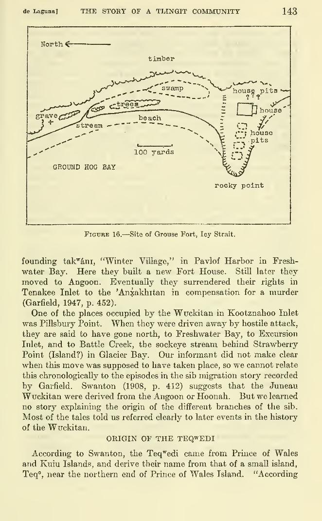
de Lagunal THE STORY OF A TLINGIT COMMUNITY 143
North <
timber
s-^J^ -.:r_ swamp "^^'V^house pits •—
J ^>.''- ,.-.^-^^'^-
' = ?^?' ^^»v->-''^y<v, (.-trees..,—
^
JT I•%- -^ ,•
rI
U bousebeach
100 yards
GROUND HOG BAY
,'•"; house,1": .pits
rocky point
Figure 16.—Site of Grouse Fort, Icy Strait.
founding tak'^S.ni, "Winter Village," in Pavlof Harbor in Fresh-
water Bay, Here they built a new Fort House. Still later they
moved to Angoon. Eventually they surrendered their rights in
Tenakee Inlet to the 'Anxakhitan in compensation for a murder(Garfield, 1947, p. 452).
One of the places occupied by the Wuckitan in Kootznahoo Inlet
was Pillsbury Point. When they were driven away by hostile attack,
they are said to have gone north, to Freshwater Bay, to Excursion
Inlet, and to Battle Creek, the sockeye stream behind Strawberry
Point (Island?) in Glacier Bay. Our informant did not make clear
when this move was supposed to have taken place, so we cannot relate
this chronologically to the episodes in the sib migration story recorded
by Garfield. Swanton (1908, p. 412) suggests that the Juneau
Wuckitan were derived from the Angoon or Hoonah. But we learned
no story explaining the origin of the different branches of the sib.
Most of the tales told us referred clearly to later events in the history
of the Wuckitan.
ORIGIN OF THE TEQWEDI
According to Swanton, the Teq'^edi came from Prince of Wales
and Kuiu Islands, and derive their name from that of a small island,
Teq**, near the northern end of Prince of Wales Island. "According
144 BUREAU OF AMERICAN ETHNOLOGY [BnU. 172
to Haida accounts, they were their chief opponents at the time whenthat tribe invaded Alaska, and they subsequently fled to the main-
land." "From all the accounts obtained, it would seem that the
Te'qoedi constituted a large part of the population of Prince of Wales
Island and moved to Tongas and Sanya at the time when the Haidaimmigration took place, whether that happened peaceably or other-
wise" (Swanton, 1908, pp. 408 f., 481, 443). Garfield's informants
said that their ancestors claimed the areas of Sukkwan and Kasaanon Prince of Wales Island before the Haida came, and that the original
Bear House was at Sukkwan. She also records a myth explaining
how the Teq^'edi of a settlement near Old Kasaan acquired their
name at a peace ceremony given by the Bears to the Dog Salmon,
at which the Bears instructed people in the proper treatment of
dead bears (Garfield, 1947, pp. 443 ff.). She also gives a version of
the story of Kat^ the Teq^'edi man who married a female Bear,
which is told by the Teq^'edi of Tongas and Angoon to justify their
claim to the bear as a crest. The scene of this story is laid near
Ketchikan. Swanton also records a similar story from Wrangell,
and another from Sitka in which Kats is a Kagwantan man (Swanton,
1909, Tale 69 and Tale 19). We heard an abbreviated version at
Angoon.
The most important story of the Angoon Teq^edi centers around
their former settlement at Todd. Garfield's version of the fight here
between two Teq'^edi groups is essentially the same as ours, but
contains further details (Garfield, 1947, pp. 445 f.). Thus, the
unfaithful wife was a Decitan woman, her husband belonged to
Bear House, and the lover whom he kiUed to Valley House. Thehusband was able to recognize his wife when she was with her
lover because he had put red paint on her blanket. Our story lacks
the end which Garfield's informants supplied: After the fight between
the husband (and his relatives) and the relatives of the murdered
lover, the former group went to Chilkat where they became the
Taqestina sib; the lover's relatives went to Whitewater Bay. Aswill be seen, both Bear House and Valley House are, however, rep-
resented at Angoon.
Garfield also records the adventures of some Teq^edi sea-otter
hunters from a camp near Mount Edgecumbe. People from this
camp went to (settled at ?) Todd and Yakutat (Garfield, 1947, pp.
446 f.). The movement to Todd should be remembered in relation
to the establishment in 1804-5 of a fortified village in Peril Strait of
Indians who fled from the Russians at Sitka. Our informants at
Yakutat confirm the movement of Teq'^edi from Mount Edgecumbeto the Yakutat area.
de Laguna] THE STORY OF A TLINGIT COMMUNITY 145
STORY ABOUT TROUBLE AT TODD
They have a story about something that happened near Todd Cannery in
Peril Strait at Lindenberg Head. The place is called q'^cX-t'E-wahayiyE, "Wherea rock fell on somebody's head." It is named after the incident.
There was a woman who was going out with a man. Her husband was going
fishing and he was catching lots of fish. Evi.ry time he would go out fishing she
would go out with the man. Both of the men were Teq'edi. Her husband knew,
and knew he would trap her some day.
One day in the spring when he had gone fishing, he marked her on shore by her
blankets. He saw her go with the man. The husband rows ashore. He goes
around the bluff. They had a fight there after this, the Teq^'edi did. He waslooking below and he saw her with the man, lying down. They were at the bot-
tom of the cliff. He got a big rock. He was planning to kill them both. So he
dropped the rock, but he got only the man. The rock fell on the man's head, but
it did not hurt his wife.
The husband then goes fishing again. He is catching lots of halibut. Thehook with which he killed lots of halibut was called le^'^-wAck'A-s'aq', "red
snapper cheek bone." In the meanwhile the wife gives the alarm that she has
found a man killed by a rock that fell off the bluff onto his head.
Finally the husband brought in his fish. They used to use big shells of a browncolor, big mussels, for cutting fish. A mussel shell knife was called yis. Theman's wife came to meet him and says that an accident had happened to one of
his male relatives.
He said: "Don't worry," and he gave her a sharp yis. "Everything will be
all right," he says. "Take your time, and don't worry. Don't worry too much.Just keep quiet." When he told his wife to take it easy in cleaning the halibut,
he was just trying to rub it in, trying to make her contentious; that is, he wasindicating that he knew what had happened to her lover.
She was cutting fish, but the first cut she made, the woman cut her foot.
Everything was 0. K. for awhile, and after that they had a fight because they
found out.
The husband was out seal hunting. He was with his close relations. Theylanded on the beach and built a fire. In the meantime others who were going
out hunting saw the fire and thought they would join the first party. Thehusband was sitting by the bonfire and was telling his closest relatives that he
had done that [killed his wife's lover]. In the old days the men had long hair,
and when someone died, they would cut it off. The other hunters, when they were
coming in towards the fire, heard a boy saying: "So, after all, it's you that done it,
and now I'm cold without my hair!"
The incoming party heard this remark about how if the man had not done it,
the little boy wouldn't miss his hair. The others wondered then, and they stayed
quiet in their canoes. When they heard the story, they went away just as easy.
Those on shore didn't see them. Now, if people build a bonfire on the shore,
they call out: "Is that you?" just to be sure.
The others who had heard the story went ashore nearby. After they had told
the story, the close relations of the dead man went and attacked the husbandand his party. Just one man of them got away, and though he was speared,
he walked along the shore the whole way to Todd.After the men who had attacked the husband's party came back, the one
survivor of the husband's party told the relatives of the other men that had beenkilled. He got back in the night and told the close relatives of the dead men.Then they started to prepare for war.
146 BUREAU OF AMERICAN ETHNOLOGY [BuU. 172
Then, in those days when they prepared for war, they usually took baths in
winter on the beach so they would be able to withstand any kind of hardship.
They were always preparing for some kind of future war. They would batheright out on the beach.
So all the Teq'edi got into the water together—and right there in the waterthey began to fight each other. The people used to have lots of fights withthemselves.
OTHER STORIES ABOUT ANGOON SIBS
The story of the trouble at Todd might just as well, perhaps, havebeen included in the later history of the Angoon sibs, since it wouldseem from its character to refer to a period of ordinary historical
events. We have included it, however, among the sib origin andmigration stories, since it serves to explain why the Teq'^edi joined the
Angoon people. While it is hopeless to attempt to arrange all the
various sib traditions in chronological order, those to be reported
below would seem to refer to relatively recent times. In a number of
cases an actual date for the event can be ascertained from historical
sources. Thus, we were told a number of stories about the destruc-
tion of the Russian post at Sitka in 1802 but omit them here, since
this victory is ascribed to the Sitka KiksAdi, not an Angoon group.
The stories of the successful attack on the Russians were told us
by a man whose paternal grandfather was a KiksAdi, and who hadlearned these tales as part of the glory of his ancestors when he was a
school boy at Sitka. It is probably characteristic that the defeat of
the Russians was ascribed to the KiksAdi alone, and the leadership to
their chief, KaLian; ^* other Sitka groups were not even mentioned, so
this story seems to be fitted into the set of traditions belonging to
this Raven sib.
Further investigations might well indicate that the Angoon people
did actually play some part, perhaps indirect, in the relations betweenthe Sitkans and Russians, for when Baranof returned to Sitka in
September 1804, to reestablish the Russina post, he learned from a
Kodiak girl who had been a hostage among the Indians that "the
enemy had sent to the inhabitants of Hoosnoff [xutsnuwu], to solicit
assistance" (Lisiansky, 1814, p. 160), and this news made the Russians
determined to seize the native fort at once. A few days after the
Sitkans had fled, abandoning their fort to the Russians, the old chief
who had been acting as ambassador or go-between, especiallj^ in pro-
curing native hostages for the Russians (one of whom was his ownson), again came to the Russians. He was actually a native of
"Hoosnoff," married to a Sitka woman, and had apparentl.y tried
originally to prevent the Sitkans from attacking the Russians in 1802.
" LIslaDsky, 1814, p. 230, refers to "Kotlean," a Sitkan "toyon," or chief, as the prhiclpal agent of the
attack on the Russuans. He came on July 28, 1805, to make friendly overtures to Baranoff, after the Rus-
sians had regained possession of the Indian fort at Sitka.
de Laguna] THE STORY OF A TLINGIT COMMUNITY 147
Failing, he had gone to Chilkat to avoid being involved in the
affair.^* Now he had come on behalf of the "Hoosnoff" to proffer
their friendship and to ask permission of the Russians to make waron the Sitkans. This Lisiansky refused. (It is a pity that Lisiansky
did not report this man's name, as it is impossible to identify him or
the Angoon sib to which he belonged. Lisiansky seems to have been
unaware of Tlingit sib or moiety organization.) In typical Tlingit
oratorical style, the chief explained that the Sitkans "were held in
such contempt by his countrymen . . . that if a Hoosnoff child com-mitted a fault, he was told by way of reprimand, that he was as
great a blockhead as a Sitcan" (Lisiansky, 1814, p. 165). This evi-
dentl}'' is a reference to the story of the children who misunderstood
their mother's instructions and cooked their little sister instead of the
food. Swanton records this incident, which occurred at a camp a
little north of Sitka (Swanton, 1909, Tale 17) and we also heard the
story at Angoon. Our informant further specified that it formed the
basis for a moral proverb. Another story that was told Lisiansky
to prove the worthlessness of the Sitkans referred to their descent
from two brothers who became poor because one of them broke the
taboo against eating a sea cucumber. These men were eventually
given wives by the Stikine Indians who took pity on them (Lisiansky,
1814, pp. 166 f.).
Another way in which the Angoon people may have become involved
with affairs at Sitka was due to the emigration of the Sitka natives
to Angoon territory when they abandoned their fort to the Russians
in October 1804. A group apparently moved to the eastern end of
Peril Strait where they built a fortified village. This place is described
by von Langsdorff, who visited it in the fall of 1805, as located on the
northeast point of the "Island of Sitka" (Baranof Island), on a rocky
headland, some hundred feet high, which could be scaled only from the
northwest side. He places it in 57°46' North latitude, and 134°40'
West longitude (von Langsdorff, 1817, pp. 395, 400, 410). Even if wecorrect these figures by the errors apparent in his location of CapeEdgecumbe, i. e., to 57°23' North and 134°56' West, this still does
not give the correct spot, for the designated place falls in Peril Strait,
but it does suggest either Point Hanus or Point Moses that flank
Hanus Bay on the south shore of Peril Strait. The only high bluff
mentioned by the United States Coast Pilot (1943, pt. 1, p. 378),
however, is Lindenberg Head at Todd on the opposite shore. One of the
charts published by Captain Beardslee (1882), based on surveys of
1879 and 1880, indicate a stockaded village and fort at Todd, which,
as we have suggested, may be the fort in question. In an unpublished
« Lisiansky, 1814, pp. 165, 223. His behavior is typical of the traditional role of the brother-in-law, whoacts as neutral go-between in time of war or feud, or as distributor of gifts at potlatches.
148 BUREAU OF AMERICAN ETHNOLOGY [BuU. 172
manuscript, Emmons identifies the fort as Halibut Fort at Point
Hayes.
Lisiansky describes this fort on the basis of information received
from a native interpreter as being "well situated in a small shallow
bay . . , defended on the water side by a large rock," and he adds
that other communities round about Sitka had also fortified their
villages (Lisiansky, 1814, p. 220). His chart, which is not very accu-
rate, shows a village "Sitca" on the east coast of Chichagof Island, a
short distance north of Peril Strait, which may be intended to indicate
the site of the fort, although it is more likely to refer to the village of
si'tqo near Chatham in Sitkoh Bay (ibid., chart opp. p. 221).
While we are unable to locate the new fort accurately, it does seem
to fall within the area claimed by the Teq'^edi of Angoon, and the
descendants of its founders undoubtedly contributed to the population
of Angoon. "DIchaetin" is the name given by von Langsdorff to one
of the chiefs living at this fortified village. He may be Yel djin, chief
of QaxA'tdja hit, "Lively-Herring House" of the KiksAdi (Swanton,
1908, p. 405). The chief, "Schinchetaez," who lived about 10 miles
(15 versts) west of the fort, cannot be identified. The latter had to
live alone with his family because he had been friendly to the Russians
(von Langsdorff, 1817, p. 406).
Further investigations at Angoon might lead to an identification of
these places, of the chiefs, and of the relationships of the latter to the
Angoon people. It is indeed conceivable that the founding of Toddis related to this early 19th century movement from Sitka, though it is
strange that neither Garfield nor ourselves learned anything about the
origin of this town.
In any case, the enmity between some of the Angoon and Sitka
sibs, suggested by Lisiansky's report, is attested by a number of
stories that we were told by our Angoon informants. Among these
tales are some referring to fights of the Decitan and 'Anxakhitan with
the KiksAdi, although we do not know which of the two incidents re-
counted is supposed to have happened first. There is also a series of
incidents involving fights between the Stikine from Wrangell and the
Sitka Kagwantan, which include some battles between the latter and
the Angoon Wuckitan. Another story which presumably deals with
the later history of Angoon recounts the fight between the Wuckitanand Hoonah people at Pillsbury Point; and there are several versions
of the Wrangell attack on the Decitan at Daxatkanada Island and of
the subsequent troubles between these two groups.
These stories indicate that while feuds were primarily between
sibs, not between whole moieties or communities, the more serious
wars were between sibs that belonged to distinct tribes, and there
de Laguna] THE STORY OF A TLINGIT COMMUNITY 149
was a tendency for other groups of the same moiety or tribe to becomeinvolved because of real or fictitious relationship to the principals
concerned. We should also note that individuals who stand in the rela-
tionship of father, brother-in-law, or son-in-law to those involved in
feuds or wars very often attempt to act as neutral go-betweens, andthat this status may be extended to include all members of their line-
age or sib. Lastly, the way of making peace after a fight, or arranging
a settlement to prevent a fight, was for the disputing groups to ex-
change men of equally high rank as hostages to be honored at Peace
Dances. To refer to old feuds, even now, is to arouse old enmities.
FIGHTS BETWEEN THE DECITAN AND 'aN:KAKHITAN AND THE SITKA
KIKSADI
VERSION 1
The Decitan and L'inedi ('An:sakhitan) stayed on a fort oflF Point Hayes at
Sitkoh Bay, during a war with the KiksAdi of Sitka. I don't know how it started.
All the men on the fort were killed. The name of the fort is xusnuwu.
VERSION 2
The Sitka KiksAdi took the Angoon Decitan for slaves. The Decitan had goneon the south coast on a war party themselves. Some of the women and kids wereleft behind at a place called tcaLk'A nu, "Halibut Place Fort," near Point Hayesat the mouth of Sitkoh Bay. The KiksAdi came and took the womenfolk andchildren who had been left behind and took them as slaves.
When the Decitan got back, there was a fellow called Kitctayi. He was an'Anxakhitan man. They prepared for war. They got ready to take back those
who had been taken to Sitka as slaves. It was not easy, but they challenged the
Sitkans to a fight. The whole bunch went, but M. J. (an elderly 'Anxakhitanman) says that at this time the Decitan were once slaves, and that it took our
"tribe," the 'Anxakhitan, to get them back. This happened before there wasany Angoon, because they didn't live at Angoon at that time, I believe. But this
happened after the Kasaan people got back. The 'Anxakhitan had Haida warcanoes. These could carr}' a lot and outrun the others. There was more power in
them, and there were more men to paddle.
Sometimes over here they are telling about how Kitctayi of Angoon had fought
the KiksAdi and brought back those women that the KiksAdi had taken. TheDecitan boys were boasting; they knew that my grandfathers were KiksAdi andwere trying to belittle them. Anyway, Kitctayi was really 'Anxakhitan. I
then asked if they had heard of the place near Sitka, Nakwasina Passage, called
tcAk-kusaxa-sit', "Eagle Eating (human beings) Small Channel."
The Decitan and 'Anxakhitan had a confiict with the KiksAdi. I heard aboutit; I knew both sides. That time the Decitan and the 'Anxakhitan went there
to fight. They were getting the worst of it so they ran away into the woods.
They landed on Halleck Island and went into the woods. They left their canoes
behind, but hoped to get across the Nakwasina Passage. The Sitka people lined
up in ambush on the mainland side. When the Angoon people were hungry,
they would have to come out. They would swim across. The KiksAdi killed
them as they tried to cross and left their bodies for the eagles to eat. That's
how the passage got its name.
150 BUREAU OF AMERICAN ETHNOLOGY [BuU. 172
(Our informant said that once when he reminded some braggarts of
this story, all the Decitan left, except the man in whose house the
conversation took place. This man told him afterward that he didn't
like to hear about it.)
STORy OF PILLSBURy POINT
Pillsbury Point was an old place. It was called "Whale HeadFort," yaycayl nu. "There used to be a wall around the top of the
cliff and hundreds of people stayed inside. People were burned out
by people from the West Coast and moved to Freshwater Bay"
—
our informant did not know why.
The chief at Pillsbury Point used to capture West Coast people
going south to trade. Finally he went to Hoonah—the informant
was not sure that this was the place—to invite them to make peace.
The West Coast chief came, but after eating, he made a mistake.
He reached under his left arm. (When asked if this was to di^aw a
knife, the informant said that they didn't have steel in those days,
only some kind of bone. In any case, it was a gesture that meanthe was going to attack. In retelling, the informant specified that the
chief made a signal to his people.) The Wuckitan chief had peace
in his heart, but now he knew there could be no peace. That was
why they left. They went to Hoonah. The first place they stayed
after leaving was at Exciu^sion Inlet, then at Battle Creek, the
sockeye stream back of Strawberry Point (Island?) in Glacier Bay.
They were looking for their cousins.
SIEGE OF DAXATKANADA
VERSION 1
The Wrangell people, led by chief Ceks, "Shakes," ^o made war on the Decitan.
The latter stayed on top in the fort at Daxatkanada Island, week after week,
maybe a month. The Wrangell people believed that they did not have anywater, but they had a spring on top. [The informant said he had searched for it,
but never found it. It seems impossible to us that there ever should have been
a spring there.] Finally Chief Shakes called to them to prove they had water.
A young man brought down a basket of water and put it on the "bridge" [cause-
way]. The Wrangell people tasted it and it was fresh, so they gave up and wentaway.
All other informants indicate a very different end to the siege,
because there was no water on the island. One man identified the
chief of the defenders as Kaxgucgitx, chief of the Decitan RavenHouse. Another said:
They had no water, so two brave men, from End of the (Beaver) Trail Housegave their lives to save their people. They were taken to Wrangell, but the
M Identified by Swanton (1908, p. 402) as chief of Hit Len, "Big House," of the NanyaS'yi, a Wolf (Eagle)
sib of the Stiklne.
de Laguna] THE STORY OF A TLINGIT COMMUNITY 151
Wrangell people had so much respect for them they let them go home. [They
were evidently taken as hostages for a Peace Dance.]
VERSION 2
The Wrangell Indians drove the Angoon people up onto this fort. The doctors
on each side were fighting each other. The Wrangell one dried up the atmosphere
until there was no water. The Angoon warriors had to steal the milk fi-om the
babies' mothers. Finally the rain came.
The Wrangell people took some prisoners, but the Angoon people escaped
way up the Inlet into a salt lake [at the head of Mitchell Bay]. Next year the
Wrangell Indians returned and went to look for them, led by their slaves. Theslaves took them into the salt lake, but when they came out, the Wrangell people
didn't know about the waterfall from the lake [which is submerged only at high
water], so they were all drowned.
Later the Angoon people went to Wrangell and shot the canoes of their enemies
oflF High Water Island. When the drowning men grabbed at the canoe rims,
they chopped off their wrists. [The informant thought that this must have been
after the natives had guns.]
VERSION 3
The people [Decitan] had to surrender that time. Some people came downfrom Wrangell with Ceks, Chief Shakes. All his generals [nephews?] were con-
sidered as Shakes, too.
They came with their war canoes oflf Danger Point. Some boys who were outfishing saw the war fleet coming. Right around yAxt'lduwudi. (Turn Point)
there are cliffs, and there is a place called ux" tlisetki, "Marten's Small Ladder."
This is on Kootznahoo Head, opposite Danger Point. You could go up the cliffs
easUy there, and right on top is a steep place you can't climb, and there they hadfixed up logs like some kind of ladder. They chopped steps into the logs.
When the canoes chased them, they [the boys] rowed fast. The tide was going
out strong. And they got ashore and started to run up. They knew the place
and they started up the cliff, and the last man up kicked the log down. Thosewho were chasing couldn't very well get up. They would have to carry the lad-
der up, too. I think that the ladder had been lowered from the woods above,
originally.
The boys walked across this way and came out opposite Daxatkanada. Theytold the people. They thought the enemy didn't know the tide, but instead of
that, the enemy came right up on the island next Daxatkanada. The tide wasgoing out and the people had figured they couldn't make it. The enemy was in
the woods right on Channel Point Island, tuk'-'ani island. That's where the
fort people got their water from.
I used to hear the old men talk about it long ago. M. W.'s father's father used
to talk about it. It was just like they were starving the people out. Theycouldn't get any water. They had got all the water they could in canoes. Watergave them away and they had to give up. Thirst is worse than hunger. Theycarried water in the canoes. I don't see why they stayed out there. They wereDecitan out there. They had some water stored in smaller canoes, but it gave out.
They made peace, I believe. They talked to each other from that island andso forth. They talked like riddles [i. e., with the mythological allusions of cere-
monial oratory]. One side had to be answered by the other side. Then the
Decitan gave up.
This old man claimed his grandfather and so forth were descended from
460927—60 11
152 BUREAU OF AMERICAN ETHNOLOGY [BuU. 172
Shakes. That's why he felt he was all right. He felt he was a little above these
here. He was Decitan, but he was descended from them. He felt a little better
than any around here, because the people had to surrender to his grandparents
one tinne. I believe this happened long before Killisnoo [was founded] but the
people must have had guns.
Later, the Decitan went down to Wrangell for a return engagement. They hada sea battle. They shot the Wrangell canoes and tipped them over. Peopleswam up to hang onto the canoes. These people (Decitan) were vicious and cut
off their hands.
SEQUEL TO VERSION 3, TROUBLE AT WRANGELL
The Reverend Hall Young referred in a letter to a fight at Wrangell withnatives from here [but apparently got it wrong. This occurred in January 1880].
You can't mention old troubles that are settled, so it's hard to find out about it.
People at Wrangell got drunk, so they mentioned the trouble at Daxatkanada.They blamed the ministers for the trouble at Wrangell [which followed]. They[some Wrangell natives ?] went disguised as marshals. They broke into somehouse, confiscating the drinks and so started the trouble. It led to a killing.
One old Decitan man, TawutcAn, claimed he hit an old woman on the head withan ax, but they say he was hidden [during the fight]. The boys used to tease himabout it.
[Apparently the old enmity between the Decitan and the Wrangell Nanya'ayiis not yet forgotten, for recently men from Angoon were at Wrangell, and the
local natives referred to the defeat at Daxatkanada.] The Angoon people didn't
like to hear about Daxatkanada. So one of them said: "What about hands in
halibut stomachs ?" [referring to the sea battle at Wrangell]. He got a beating
up. In olden days, it comes to death, if you make that remark.
According to Captain Beardslee, wlio quotes from letters of eye-
witnesses,^^ and who later investigated the affair, the Angoon natives
were really not to blame, but the chief blame lay with Dr. W. H. R.
Corlies, an independent missionary at Wrangell, of whom Beardslee
writes: "Unfortunately, his zeal is not tempered with discretion andfamiliarity with Indian affairs." He also exhibited "ignorance of
Indian laws and customs, or even disregard of them." ^^
We may summarize Beardslee's story of the trouble as follows : Thenative vUlage of 120 Stikine Indians was east of Fort Wrangell, the
white settlement, while to the west were a number of guest houses,
used by Indians who came to trade at the town. In January 1880,
about 50 natives from Angoon were staying there, and not having been
subjected to missionary teaching, had set up a still to make"hoochenoo," or rum. On January 11, Dr. Corlies ordered a Stikine
Indian who acted as one of the unofficial police at the mission to
destroy the still. The latter at first refused, knowing that trouble
would result if his people attempted to exercise any authority over
81 W. H. Woodcock, Chairman of Committee of Safety at Wrangell, January 24, 1880; M. D. Ball, Col-
lector of Customs at Sitka, who had visited Wrangell, January 26, 1880; W. E. George, coast pilot on the mail
steamer California, January 25, 1880; Dr. W. H. R. Corlies, self-styled "Missionary to the Indians of Alaska,"
January 27, 1880, published in the Alaska Appeal.M Beardslee, 1882, pp. 50, 53. See pp. 50-64, 70 for Beardslee's discussion of the whole affair.
de Laguna] THE STORY OF A TLINGIT COMMUNITY 153
the Angoon natives, but finally yielded to the missionary's impor-tunities. The Stikine posse did destroy the still, but one of them wasstruck in the face, which constituted a deadly insult. Despite the
urgings of Dr. Corlies and the Reverend Young that the Stikine
natives stay away from the Angoon camp, on January 14 a party of
30 unarmed Stikines did return to demand redress. Accordingly,
a young Angoon man stepped out to receive a return blow. This
would have settled the matter if a rash young Stikine had not struck
him a second time. This led to a fight, in which the Angoon menproduced hatchets and other weapons, some of which were snatched
from their hands, with the result that seven men were wounded.Mr. Young and Dr. Corlies visited both groups, dressing wounds,
and urging that the natives meet at Mr. Young's house next morningfor a peaceful councU. Instead, an armed group of Angoon men cameto the Stikine vUlage, and despite the efforts of Mr. Young, broke
into a Stikine house. This precipitated a battle in which shots wereexchanged. Toyatt, a Christian Stikine chief,^^ and two of his people
were killed, the Angoon people lost two men, and a number of others
were wounded, some mortally. The rest of the day was spent in
skirmishing back and forth. The whites formed a Council of Safety
in an attempt to keep the Indians out of the white town, and sent a
message to Sitka asking for protection.
Captain Beardslee sent the requested arms, a gunner and another
man. The gunner, Charles Stewart, had a talk with the Angoonpeople, and learned the truth of the matter. The Angoon people
refused the demands of the Stikines that they surrender one of their
chiefs to balance the death of Toyatt, but they returned home in
January. Then the Stikines destroyed the guest houses, and Colonel
Crittenden, the Deputy Collector of Customs, turned the area into a
garden. This action enraged all the tribes, who in consequence boy-
cotted the traders at Wrangell, and Captam Beardslee reports that
had he known of this while he was still in Alaska, he would have doneall he could to have the guest houses restored.
The trouble between the Wrangell and Angoon people was finally
settled when a Stikine chief came to Sitka in March, as did also
about 40 Angoon people. The latter had come to collect damagesfor the death of one of their women, to whom KaLian, the KiKSAdichief, had furnished liquor. The latter settled for 50 blankets.
Captain Beardslee succeeded in bringing together the Stikine chief andthe Angoon leaders, who promised to keep the peace.
In August, Captain Beardslee visited Killisnoo where he had a
M The name is evidently Toyat', "Kwakiutl," the same as that of the Kagwantan chief who built the
modem house at Grouse Fort in Icy Strait. This suggests that "Toyatt" was also a member of the
Eagle-Wolf moiety, perhaps Nanya'ayl, since this was the most important sib of that division at Wrangell.
154 BUREAU OF AMERICAN ETHNOLOGY [BuU. 172
meeting with the local natives, among whom were "Kitchnath"
(evidently the chief of the Decitan Steel House, a man also knownas Killisnoo Jake, or Saginaw Jake), and "Gandashana" or Andrew.
The Angoon natives again repeated their promise not to renew the
war on the Stikines, and in case of trouble with the whites to appeal to
Captain Beardslee, not to seek redress by retaliation.
The most trustworthy white source available therefore supports
our informant's accusation that the missionary was to blame.
John Muir also has an account of the event, but this is in error on
several counts (Muir, 1915, pp. 202-204). He confuses the Angoonwith the Taku people, ascribing the first blow in the face to the Stikines
and the too violent return blow to a Taku; and he omits all mention
of Dr. Corlies. He does, however, present Toyatt (Toyatte) in the
traditional role of heroic and self-sacrificing chief, as well as a peace-
loving Christian.
PEACE BETWEEN THE WRANGELL AND ANGOON PEOPLE
(It is not clear whether the following event marked the official
closing of the war between the Wrangell and Angoon people related
above. Walter Sobolof was the son of a Russian priest and trader
at Killisnoo, and was for a time bookkeeper for the old herring plant
at Killisnoo. Then he moved to Angoon and opened the Kootznahoo
Store. He was about 65 years old at the time of his death in the
summer of 1950. The incident probably took place early in the
present century).
Mr. Walter Sobolof was at Killisnoo when the Wrangell people came to makepeace. Mr. Sobolof used to say that the dances the natives do now aren't any-
wherenear as good as the old ones ; they are just poor imitations. When the Killisnoo
people saw the Wrangell people coming they got excited and ran around the beach.
Each side took a hostage. They called them "deer" q'uwak'an, because deer are
peaceful and don't fight. Then each side chose a name for their "deer," Theytake a long time figuring out what name to give, because the other side maybewon't like the name, and they won't give back their hostage. The hostages
have to be of equal rank. [We were not told just what happened on this occasion,
unfortunately. Hostages were not consulted in the choice of name, but it had to
imply something good and favorable, and not be subject to misinterpretation.]
The following series of incidents involving the Sitka Kagwantanwere all told by the same informant, but not in the form of a con-
secutive narrative. It is, therefore, possible that in piecing together
his remarks, I may have confused the order of some of the events.
They seem to be, however: (1) Defeat of the Kagwantan at Wrangell;
(2) massacre of the Stikine peace party at Sitka, 1852; (3) attack on
the Angoon Wuckitan by the Kagwantan; (4) murder of the Wuckitanby the Kagwantan at Sitka; (5) peace between the Kagwantan and
Wrangell natives, 1916.
de Laguna] THE STORY OF A TLINGIT COMMUNITY 155
DEFEAT OF THE SITKA KAGWANTAN AT WRANGELL
The Kagwantan people from Sitka had gone to fight with the Wrangell people
who cleaned up on them. . . . That's the time the Kagwantan went down there
before, and the Wrangell people wiped them up. . . . When the Kagwantanwent down to Wrangell and were almost wiped out, I guess they had one man whowas pretty good at climbing or so. They got him, so he tried to climb the hill, and
they had spears underneath if he fell down. He just pretended he couldn't climb,
but he got away.
He said he had a good wife, and there were a lot of them trying to force him.
He said: "No, I've had enough of that woman." "
He was an expert at climbing cliffs, and they [the Wrangell natives?] dared him.
Then they had something called si?aGU djddji, "having-claws snowshoes." Hesaid he could climb the cliff, if he had these on. He got going and went right up
over and notified his people [in Sitka?] what was up. They had figured that all the
rest of them [the other Kagwantan in the war party] were killed off, because they
didn't behave themselves. They fooled with his wife he left behind. They didn't
have enough sense to behave themselves, those warriors—that's why they mettheir fate. By fooling around with that woman, they had broken the law of
chastity any way, the old folks say.
[It is probable that the other Kagwantan who were killed at Wrangell met their
fate because thej' had illicit relations with this man's wife. The informant had
previously explained that men preparing for a crisis, such as a war or hunting
expedition, fasted or at least ate sparingly, kept away from their wives for an
unspecified length of time, and avoided any kind of contact with a menstruating
woman.]
MASSACRE OF THE "WRANGELL PEACE PARTY AT SITKA
If a peace is made, they call the dance to make peace g6wAl!akank. The peace
treaty is called q'uw^k'^n q'Mzitf, "a deer is born." It is at this time that they
take men from either side—either two or three. They are taken as hostages. It
was during this kind of dance that the Kagwantan massacred the Wrangell Indians
at Sitka. This happened some time back; the Kagwantans did this while they
were having a peace dance. They had invited all the Wrangell people to a regular
peace dance. The Wrangell people were all dressed up and unarmed. They had
been warned what would take place by the Angoon people.
The Kagwantan people from Sitka had gone to fight with the Wrangell people
who cleaned up on them. Then the Sitka people got like a trade, I think. They
started to buy things from around Wrangell. The Wrangell people were making
good money. But it was really deceiving work on the part of the Sitka people.
The Angoon people told the Wrangell people what was going to take place. They
must have heard someone talking.
When they had the peace dance at Sitka the Wrangell people came in with no
weapons. But one of them had some pistols, or whatever they had, and he gave
them to his wife in case anything happened. He was a "deer" and was wearing a
Chilkat blanket such as they usually put on a "deer." When trouble came he
threw the blanket off. He had chewed at the thongs so that they would be wet
and undo easilj\
[The informant explained that when a man was a "deer" he was always waited
on hand and foot. He had to stand still without moving his arms, and was not
3< From a version of this story recorded at Yakutat it appears that the Wrangell men were forcing homo-
sexual relations upon their Kagwantan captive. The original cause of the war was the elopment of the wife
of a Sitka Kagwantan man with her lover from Wrangell.
156 BUREAU OF AMERICAN ETHNOLOGY [BnU. 172
supposed to do anything for himself. "It was like he was a bishop or something."
Apparently, for him to move his arms in order to loosen the thongs which tied the
blanket at his neck would be like "breaking a law of nature."] But his wife hadgone against him. She had spit right in the place where the powder goes in the
gun, so that the gun wouldn't fire. [The informant did not know to what group the
wife belonged, but it seems likely that she was a Kagwantan or at least a Sitka
woman.] . . .
Yashka, the old man in Sitka, used to tell me of his experience when the Kagwan-tan were going to have the peace dance at Sitka. The warrior Yak*an was on the
Kagwantan side.'* The old man said that he was the one who came first into the
dance and was in front of Yak'an. Yak'an had a sheet and a spear under it. This
old man, Yashka, who was a KiksAdi, M^as right in front of Yak'an, and that washow they hid the spear.
They announced that Yak'an was coming. He was like their general. Whenthey said this he opened the sheet and took the spear and threw Yashka aside withit. He was a very strong man and he speared right through two men. A Kagwan-tan man had yelled: "Yak^'an de'auAgut!" This means "Yak^'an is on the way."This was the signal for his side to be on their toes, and he threw Yashka aside,
gave a yell and the whole thing started . . .
They would bring back the scalps of the dead. It is dried with the hair. TheWrangell man who was deceived at Sitka [the "deer"]—they dried his scalp with
all the hair. The scalp of this great warrior hangs and they said that even if there
was no wind it always moved. He was one of the great Wrangell warriors whenthe Wrangell people were massacred at Sitka . . .
The moving scalp of the Wrangell man who was deceived in this dance made all
the old people marvel. He must have been pretty mad when he was massacred.
I forget his name. Probably he was the man whose wife had the two pistols. Hewas ready to take Yak'an's challenge. They took him for a "deer" because theyknew he was a strong warrior. It must be a leader from the other side they take
for a "deer." I don't know why they took his scalp. It must be the same as anhonorable burial. It must have been a token of respect to a warrior. The scalp
was in a Kagwantan's house after that massacre.
On account of what his wife did, they always say "Women are never to betrusted." The people involved in these fights won't even dare talk about it.
Tliis incident is evidently the same one mentioned by Tikhmenevwho wrote:
The most treacherous murder in 1852 by the Tlingits from Sitka of 40 of their
tribesmen from Stakhina when these arrived to end by peace a feud of long stand-
ing could have been prevented by sternness on the part of the Administrator
General of the colonies. Plundering by the Stakhina Tlingits of a Company'sestablishment on Sulpher Springs when they were seeking their enemies also wouldnot have taken place.^^
A young Indian woman from Juneau whom I met in the summer of
1931 told me that after the massacre of the Wrangell natives by the
Kagwantan of Sitka, the victors cut off the heads of the most impor-
" Swanton, 1908, p. 405, lists Yakwa'n, as "Swimming Wolf," chief of QotxA' naxa, "Star House," of the
Kagwantan, and further specifies that "this man led in the last great fight with the Stiklne Indians."
Yashka was the Russian nickname for a man named KaLian.M Tikhmenev: Historical survey of the establishment of the Russian American Company and of its ac-
tivities up to the present time, vol. 2, pp. 205-211, St. Petersberg, 1863, MS. translation by Dimitrl Krenov,
in the Library of Congress. Quoted, Gsovski, 1950, p. 67.
de Laguna] THE STORY OF A TLINGIT COMMUNITY 157
tant victims and carefully preserved them. These heads were dis-
played on their triumphal return to Sitka and were later redeemed byrelatives of the slain men. Some of the heads, however, are said to
remain to this day in the possession of the Sitka Indians. From her
account, the massacre would seem to have taken place at Wrangell,
and she dated it in the last quarter of the 19th century, when the
Reverend Young first came to Alaska. I suspect, however, that she
is wrong about both the place and the date of this event, and that she
is actually referring to the massacre at Sitka in 1852 (de Laguna,
1933, p. 744).
ATTACK ON THE ANGOON WUCKITAN BY THE SITKA KAGWANTAN
When they were having trouble after this with the Wuckitan, the latter were
prepared. The Sitka Kagwantan were having a dance, and some of the Wuckitanwent, but a big group sat at home with their rifles, and they were going to clean
up on them if anything happened. This was in the time of InquL'a'a (the grand-
father of the chief of the Teq'edi Valley House who died in 1940). Whenthe Kagv/antan were over here fighting the Wuckitan up where Fort Houseis [near the center of Angoon], a sharpshooter used to sit on top of the fort andknock oflf the Kagwantan men one by one when they came out of the woods.
The Kagwantan were all in the woods around back by the schoolhouse [i. e., be-
hind its present site]. This man was a real sharpshooter. The Kagwantan were
losing a lot of men, so they left. The day after they left a lot of Auke Wuckitancame. They called on the Sitka Kagwantan to come out and have a showdown,but the Kagwantan had already gone. They had gone the day before. . . .
When the Kagwantan came here to fight the Wuckitan they must have had a
doctor along to warn them that the Auke Bay Wuckitan were coming.
MURDER OF THE WUCKITAN BY THE KAGWANTAN AT SITKA
My father had a nu hit, "Fort House," in Sitka. The Wuckitan there used to
have trouble with the Kagwantan. There was a Wuckitan daughter married to
a Kagwantan at Sitka. At some drunken brawl, the hatred for the Kagwantanflared up. The Kagwantan challenged the Wuckitan to come out [of Fort
House] and fight. My grandfather, Cuwika, [mother's father, a Wuckitan] wasa small boy. The Kagwantan son-in-law was pushing the Kagwantan awayfrom his father-in-law's door. The Wuckitan inside did not know what wasgoing on. Finally the Kagwantan got bold enough to hit on the house with a
hammer Then the Wuckitan shot out of the door and they killed their ownson-in-law and another Kagwantan man.Then all the Wuckitan were killed oflf. My grandpa's older brother and another
relative knew they were going to die. They would look outside to see whatKagwantan were outside. They would find out who the Kagwantan man they
saw was, because they wanted to shoot only those who were equal in rank to them-selves. The Wuckitan had a good sharpshooter. But finally all the Wuckitanwere killed by the Kagwantan, except for that little boy, my grandfather, who washidden on the floor so he escaped.
Later he wouldn't like any rough talk. He felt sorry when he grew up that hehadn't been old enough to fight.
The KiksAdi were neutral. They acted as go-betweens and they took care of
my grandfather. They acted as though they were the father of the dead men
158 BUREAU OF AMERICAN ETHNOLOGY (Bnll. 172
and they burned the house down. My father built nu hit at that place later,
because his Wuckitan people were killed there.
Swanton lists Fort House as the only house of the Wuckitan at
Sitka. The chief was Da'tlk^tsla'te, "Stomach of Wolf" (Swanton,
1908, p. 405).
Our informant indicated that a peace ceremony was held finally bythe Kagwantan and the Wuckitan. When the Alaska Native
Brotherhood was founded in 1912, they tried to make peace betweenthe Sitka Kagwantan and the Wrangell people. But this was not
achieved until the day before the United States entered World War I
(de Laguna, 1933, p. 744).
RECENT HISTORY OF ANGOON
INTRODUCTION
Although some of the events described in the preceding section
fall clearly within what would be recognized as modern times byboth the white man and the native, and others may be of no great
age, yet these belong to sequences of events that are tied to the moreremote and uncertain past, or else have been seen through native eyes
in much the same way that purely legendary events have been seen.
Our sources of information have been largely the traditional histories
of the various sibs. We pass now into the more modem history of
Angoon, modern either because it is well documented by historical
written records, or modern because the episodes fall entirely within
the memory of Hving persons. Our division is not, therefore, strictly
chronological.
DESTRUCTION OF ANGOON, 1882
The destruction of Angoon by United States naval forces in 1882
is probably that incident in the community's history which is today
most prominent in the minds of the people. All know the story,
for it occurred in the childhood of elderly men still living or only
recently deceased, and one of the cannon balls with which the townwas shelled was found not long ago and reportedly sent to the Terri-
torial Museum in Juneau. The versions of the story, obtained in
1949 and 1950 from an old man who was a boy at the time, and fromanother man who heard the story from an eyewitness, permit of com-parison with various reports by whites.
It is interesting that the natives today, like the author of the
volume on Alaska in the Eleventh United States Census of 1890
(Porter, 1893, p. 264), explain that the whole trouble was due to a
misunderstanding between whites and natives, that is, ignorance of
each other's ways. While no general hostility toward whites is now
I
de Laguna] THE STORY OF A TLINGIT COMMUNITY 159
felt, the Angoon people still believe that they were greviously wronged
and are entitled to compensation for their sufferings. This is brought
up whenever there is resentment over taxes, restrictive game laws,
or encroachment by whites on lands and fishing grounds claimed bythe natives. The event is important because it apparently involved
all sibs equally, though not, I judge, all families, and has thereby
helped to strengthen community solidarity. The event also serves
as a time marker, a date to which old people who, of course, do not
know their age in years, can refer when qualifying for old-age pensions.
HISTORICAL BACKGROUND
To understand how Angoon came to be destroyed, it should be
remembered that between the purchase of Alaska in 1867 and 1885
there was literally no government of any sort in Alaska, and before
that, Russian dominion in southeastern Alaska had never extended
outside the fortifications of New Archangel at Sitka. The United
States military garrisons which had occupied a few towns since the
purchase had been withdrawn early in the summer of 1877, leaving
as the only representatives of the Federal Government a customs
collector at Sitka and deputy collectors at such towns as Wrangell
and Tongas. Some of the latter, like Isaac C. Dennis at Wrangell,
assumed more authority than they actually possessed, relying uponbold action and bluff to maintain a semblance of law and order in
the town where they were stationed. From time to time, a United
States revenue or naval vessel, on a cruise through Alaskan waters,
temporarily represented the armed might of the Government. Thenatives had possessed firearms since the latter part of the 18th century,
and were stiU proud and independent tribes. Those near the towns
had been debauched by the Army garrisons, and by the Cassiar
miners who made Wrangell their headquarters. Despite laws against
the importation of liquor to Alaska, the traders and saloonkeepers
had plenty, and the natives had learned how to distill a kind of rumcalled "hoochenoo," so-called because they had originally been
taught by an ex-soldier at Killisnoo. (Swan, 1875, in Morris, 1879,
p. 146.)
There had been many clashes between natives and whites, most of
which had been provoked by the whites themselves, or brought about
indirectly through the white man's liquor (Bancroft, 1886, pp. 606-
624; Beardslee, 1882, p. 50). It is quite evident that most of the
whites concerned were either ignorant of or lacked sympathy with the
Indians' principles of justice which were based upon the payment of
damages for any injury, even though accidentally inflicted. Therecognition at that time of something equivalent to our present con-
ception of liability, especially of employers' liability, would have
160 BUREAU OF AMERICAN ETHNOLOGY [Bull. 172
prevented most of these affairs from getting out of hand.^'* Captain
Beardslee, commanding the U. S. S. Jamestown, stationed at Sitka
from June 1879 to September 1880, was one of the few white men in
a position of authority who took the trouble to study
the customs, laws, and superstitions of the Indians, in order that I might be able,
through knowledge thus acquired, to reduce the hostility which had arisen between
them and the whites, and to bring the two races into harmonious relations. [He
was also among the few who could say that the Indians] are not naturally savage
[Beardslee, 1882, p. 131. According to Indian law the man who gets another
drunk is responsible for the acts committed by him while in that state, and for his life
if he dies or is killed. Thus at the very root of the difficulty I found the acts of
bad white men ... If an Indian dies while in the house of another, or is killed
while in the employ of another, the house-owner or employer is responsible.
The Indians seldom fail to yield to this, the very foundation of their laws, and a
refusal to make equitable settlement is always a cause of war. [Ibid., p. 45.]
This principle, as we shall see, was at the bottom of the trouble at
Angoon.
The withdrawal of the Army garrisons in the spring of 1877 left
the whites, especially at Sitka, fearful of serious trouble with the
Indians. Morris, the special agent for the Treasury, predicted in
1878 that this would eventually come, not from
any studied plan of revenge for injuries, real or fancied, but will be the result of
brutality and oppression upon the part of the white man, and craze, fear, deviltry,
and intellect besotted by rum, upon the part of the Indian race [Morris, 1879,
p. 126].
Many persons, probably exaggerating the likelihood of an Indian
uprising, nevertheless felt like M. P. Berry, Collector of Customs at
Sitka in July 1877, that:
If there is not a vessel dispatched at a very early date to this port, this people
will have been handed over bodily for slaughter to the Indians. [Morris, 1879,
p. 24.]
The means by which the whites might be protected and the Indians
punished for any aggresive act were clearly envisioned. There should
be sent to Alaska "an armed vessel . . . able to destroy their villages
and canoes as a means of overawing them, because do this, and their
accumulation of, perhaps years of toil and industry are swept away,
and their very means of livelihood taken from them." ^'^
This type of punitive action had already been inflicted upon the
Stikine and Kake Indians in 1869. The latter episode is also of
interest because it involved at least one Angoon chief, and so it maybe mentioned here. In January 1869, the Kakes had murdered,
without known provocation, two white men at what became known
»«• Cf. Morris, 1879, pp. 131 f., and Beardslee, 1882, pp. 65 f., for examples of cases In which promptpayment
of damages was effective.
«' Capt. J. W. White, commanding the U. S. revenue vessel Thomas Corwin, letter of October 4, 1877,
in Morris, 1879, p. 139. Morris concurred in this; cf. his letter of April 14, 1877, on p. 22.
de Laguna] THE STORY OF A TLINGIT COMMUNITY 161
as Murder Cove, the present site of Tyee Cannery on southern Ad-miralty Island, and had mutilated the bodies. On January 14 and 15,
Lieutenant Commander Meade, commanding the U. S. S. Saginaw,
destroyed a town and three villages (totaling 35 houses), two stockaded
forts, and a number of canoes in Saginaw and Security Bays, KuiuIsland, in reprisal for the murders. Up to 1880 these villages had
not been rebuilt (Beardslee, 1882, p. 54). Among the Indians taken
prisoner during this raid and confined for a time at Mare Island near
San Francisco was the Angoon man "Kitchnath," also known as
Saginaw Jake or Killisnoo Jake. He is evidently the chief of the Decitan
Steel House. Captain Beardslee, who later assumed command, wonhis friendship and that of the other prisoners by his fair treatment,
and we again meet this Indian in August 1880, now restored to his
people, when he was among the chiefs who promised Beardslee not
to renew their feud with the Stildne Indians at Wrangell (see p. 154).
He is perhaps the "Lonigon Jake" who conferred with Captain Merri-
man after the destruction of Angoon (see below). Killisnoo Jake
later became a native policeman at KiUisnoo.
It will not be necessary to follow in any detail the course of the
various frictions and adjustments between whites and Indians, except
to note that it was generally believed that serious trouble between
the whites at Sitka and the KiksAdi had been averted only by the
presence at Sitka from March 1 to April 3, 1879, by H. M. S. Osprey,
that had come in response to an urgent appeal. Captain Beardslee,
who came with the U. S. S. Jamestown in June of that vear, found
that the fears of the whites had been greatly exaggerated, and that
the leading KiksAdi chief, "Katlaan" (KaLian), was not only innocent
of any plot against the whites, but was actually cooperative in
restoring better relations (Beardslee, 1882, pp. 14 f., 45-48). Captain
Beardslee was extraordinarily successful in winning the good wiU of
the Indians, by enlisting the Kagwantan chief "Annahootz" and the
KiksAdi chief "Katlaan" in an unofficial police force, by forming a
council of chiefs to deal with breaches of the peace committed by the
Indians, and by himself acting as arbitrator in their disputes. Hedid not, however, secure the cooperation of the whites in limiting
the sale to the Indians of the ingredients for the manufacture of
"hoochenoo" (ibid., pp. 46-48, 50, 55). He formed a rather poor
opinion in general of the whites at Sitka and of their ability to managetheir own community affairs. Nor did he approve of the arrests
ordered by the Customs Collector, M. D. BaU, who was acting as chief
magistrate for a "Provisional Government," which was for a time
established by the Americans at Sitka, since he felt that the natives
and "Creoles" (Russian halfbreeds) arrested by Ball, were "moreworthy of charity than punishment" (ibid., pp. 27 f.). It should also
162 BUREAU OF AMERICAN ETHNOLOGY [Bull. 172
be added that Captain Beardslee did not share in the behef of manyof the whites that extreme punitive action against the natives wouldbe wise. "Further, any bombardment of an Indian village, especially
the one at Sitka, would inflict injury upon friends and foes alike, for
in nearly every tribe are some families who are friendly, and these
are generally the most powerful, they having amassed riches through
trade with the whites" (ibid., p. 44). He also quotes with approval
a communication from Capt. H. Holmes A'Court, commandingH. M. S. Osprey, who writes: "I am also of the opinion that the
destruction of the Indian villages is a matter that admits of a question,
as there are a great number of friendly Indians, who have lodges andproperty there, the destruction of which, and possibly loss of some of
their lives, would be to make them cast their lot with the others"
(ibid., p. 14).
Beardslee's reputation of fair dealing evidently spread amongmany Indian groups, for he was able to establish friendly relations
even with the fierce and arrogant Chilkat (ibid., pp. 57-79) but, as it
will become evident, many of the whites felt that his policies weretoo lax. Commander Merriman, his successor, was to present a great
contrast, welcomed by the whites, but all the more irritating to the
Indians who had known Beardslee.
In 1878 the Northwest Trading Company established a trading
post on KiUisnoo ("Kenasnow") Island. The following year the
company began in an experimental way the extraction of herring oil
and the manufacture of fertilizer ("guano") from the fish remains.
In 1880 a whaling station was opened here, because of the presence
of many fin-backed whales that fed on the herring, and apparently
some of the Angoon people began to settle on KiUisnoo Island.^^
In 1880, Edward De Groff was in charge of the trading post; Carl
Spuhn and J. M. Vanderbilt were managers of the company at
KilHsnoo, and the last two were also there in 1882 (Beardslee, 1882,
pp. 67, 70).
The troubles between the natives and the whites at KiUisnoo which
culminated with the destruction of Angoon in 1882, events which
occurred only 2 years after the discovery of gold at Juneau and the
founding of the mining towns of Juneau and Douglas, had a profound
effect upon the history of Alaska. The Congi-ess was no longer able to
ignore the pleas for a civil government in the Territory, and in 1884
passed legislation giving to the Territory status as a civil district of
the United States. The following year the Territorial Governmentwas really established (Porter, 1893, pp. 19, 264 f.).
" Porter, 1893, p. 238, reports that whaling was discontinued that same year, an obvious error. Morecorrect is the statement on p. 61 that "KiUisnoo was first [sic] established as a whaling station, but after
difliculties with the natives lin 1882] the catch was changed to herrings."
de Laguna] THE STORY OF A TLINGIT COMMUNITY 163
In telling the story of the destruction of Angoon, we shall first
present the reports of the whites, later contrasting them with the
Indian versions of the events. The most important documents are
those consulted by Bancroft, although his summary is not completely
accurate (Bancroft, 1886, p. 619, note 53, p. 744, note 12). These
are: a letter from M. A. Healy, First Lieutenant of the United States
Revenue Marine (Coast Guard), commanding the Corwin, November20, 1882; a letter from Wm. Gouverneur Morris, Collector of Customsat Sitka, October 28, 1882, who was aboard the Corwin; the report of
Comdr. E. C. Merriman, USN., commanding the U. S. S. Adams,October 28, 1882, who was in charge of the expedition. The latter
includes orders to Lieut. C. W. Bartlett, USN, dated October 23,
26, and 29. Also of interest is a letter by Mrs. Eugene S. Willard, a
missionary's wife, written at Sitka on October 30, 1882, and evidently
based on conversations with Commander Merriman.
LETTER OF MORRIS
Morris, collector of customs at Sitka, who accompanied the punitive
expedition, was evidently in accord with the severe measures taken.
He reports that the Navy had been trying to suppress the Indian
custom of demanding compensation, usually in blankets, for injury
to an Indian, either by another native or by a white man. He writes:
Shortly previous to the case at bar, whilst an Indian was cutting down a tree
for the Northwest Trading Company at Killisnoo, he was warned of the danger,
and continued in a position of peril. The tree fell and killed him. Immediately a
certain number of blankets were levied as a fine upon the company by his rela-
tives, and payment demanded. The company refused, of course. Matters re-
mained in status quo until the Adams, Commander Merriman, arrived in these
waters. He touched at Killisnoo on his way to this port [Sitka], and complaint
was made to him of this exaction, by the superintendent of the company. Heinformed the Indians that in the future no such payments should either be de-
manded or enforced as far as white men were concerned; that if they persisted in
such course he would punish them severely, and that in this instance the companywould and should not pay. They submitted with bad grace.
On the night of October 22, whilst this company were whaling in the KootzenooLagoon, a bomb, shot from the whaleboat at a whale, accidentally exploded andkilled an Indian shaman, who composed one of the crew; whereupon the latter
immediately arose, and aided by about one hundred Indians, overpowered the
two white men in the boat and took them prisoners; captured the boat, nets,
whaling gear, and steam launch of the company, valued at several thousand
dollars, and demanded payment of two hundred blankets for the dead man. Thewhite men were kept close prisoners. A plan was formed to murder the engineer
of the launch, who fortunately did not take the trail expected.
Lieutenant Healy's briefer account adds only the information that
the Northwestern Trading Company refused payment, and that the
Indians then threatened to burn the store, other buildings, and boats,
and to kill the two white men.
164 BUREAU OF AMERICAN ETHNOLOGY [Bull. 172
To continue with Moms' letter:
Capt. J. M. Vanderbilt, the superintendent, at once got up steam on the
company's tugboat Favorite, and started with his family post haste to Sitka for
aid from the naval commander. The Indians endeavored to cut off the Favorite,
but failed.
As soon as Vanderbilt reported the facts to Commander Merriman, the latter
put a howitzer and Gatiing gun on the Favorite, sought the co-operation of the
revenue steamer Corwin, then in port, and as early as practicable, with a force of
about one hundred marines and sailors, started for the scene of action, picking
up his steam launch on the way. I accompanied the expedition.
Upon arriving at the lagoon, matters were found exactly as represented byVanderbilt; the men still prisoners; the Indians increasing in force and very muchexcited. Commander Merriman lost no time in arresting the ringleaders and got
the two principal chiefs of the tribe on board the Corwin, and informed them that,
instead of the Northwest Trading Company paying anything to them, he should
inflict upon them a fine of four hundred blankets, payable the next morning, under
penalty of having their canoes destroyed and principal village shelled and burnt.
So temporizing has been the policy pursued within the past two years by the
Navy [i. e., by Beardslee] toward the Siwashes ^" that they evidently thought this
a game of bluff. They were surly and impertinent, and affected not to think that
Commander Merriman would put his threat into execution. They, however, took
precautions to make use of the intervening night in taking to a place of security
their large canoes and valuables.
On the following day, the Indians having failed to come to time, CommanderMerriman made good his threat, destroyed their canoes, shelled and burned their
village.
Morris concludes that there was
the absolute necessity . . . for such harsh measures being adopted . . . TheHoochenoos are a rich and warlike tribe, very insolent and saucy towards the
whites. Not long ago they proceeded to Wrangell and attacked the church
Indians there, killing several, amongst them Toyatt, a missionary Indian, a very
useful and intelligent man . . .
Once let it be understood by the Siwashes that the life of a white man is sacred,
and that they will be severely handled if they harm him, there will be no danger
or difficulty in small parties [of miners] traversing the country in search of mineral
and other wealth. [Morris seems to have forgotten that Captain Beardslee bymore peaceful means made just this possible, even to securing permission from the
unfriendly Chilkats for miners to use their routes into the interior (Beardslee,
1882, pp. 59-66)].
REPORT OF COMMANDER MERRIMAN
This report includes the orders given to Lieut. C. W. Bartlett, USN,commanding expedition to Kenasnow Rapids (Kootznahoo Inlet).
The first part adds little not already covered by Morris' letter,
except the statement that the Indians threatened that "they would
kill the white men and destroy the fishing steamer and boats unless
paid two hundred blankets,"
'• Although this word for Indian is presumably an ordinary word in Chinook jargon, it carries a connota-
tion, both to whites and Indians, of contempt.
I
de Laguna] THE STORY OF A TLINGIT COMMUNITY 165
As soon as Commander Merriman had received Vanderbilt's report,
he organized a force of 50 men and 20 marines, under Lieutenant
Bartlett of the U. S. S. Adams, and sent him in the tug boat Favorite
toward Angoon. On the way they were to pick up a party in the
Adam's steam launch, Jamestown, under Ensign H, Taylor, who were
surveying in Neoski Strait (Whilistcne Narrows). The revenue
steamer Corwin was then coaling at Sitka, and her commandingofficer offered his ship to Merriman, because the Adams was felt to
be too big to operate at Angoon. The Favorite got underway about
3 a. m., and the Corwin, with Captain Healy, Commander Merriman,and Mr. Morris, left at 7 a. m. on October 24. They overtook the
Favorite and the steam launch, taking the latter in tow, and thoughdelayed by bad weather in Peril Strait, reached Killisnoo Harbor("Keteosoh Harbor") on the 25th of October
to see if the Indians had molested the stores of the merchants. I found them all
absent, and that none of the Indians were allowed to work, and that they still held
possession of the white men, the steamer and the boats.^"
We immediately steamed around to the lagoon [Kootznahoo Inlet] where the
property and people were detained. I held a powwow with the Indians, Lieu-
tenant Bartlet and Ensign Taylor in the meantime collecting all the canoes they
could find. The Indians demanded two hundred blankets in payment for the
accidental death of the medicine-man.
For instance, if our surgeon attended a sick man, and he died, they would de-
mand pay. If a boat capsized and drowned an Indian, they make the man whooriginally directed the boat to be built pay for the man if they can get him, other-
wise the present owner has to suffer.
I had explained to them on my previous visit the fallacy of any claim where the
death was purely accidental. I ascertained that they had attempted to destroy
the boats, and that they were only waiting for another white man to put two to
death. One of the men captured had but one eye, and they wanted a whole one,
or one with two eyes. I told them I demanded a fine of four hundred blankets, or
double what they tried to get, and gave them twenty-four hours to bring them in.
They said they would do so, but went to the village of Angoon, drew their
canoes up in the woods, took their winter food and blankets and their women andchildren with them and sent me word that they would not furnish the blankets;
that if we attempted to land they would fire on us, and would defend the town if
we attempted to burn it. I then sent the chiefs to tell them if they did not furnish
the blankets I would destroy their canoes and shell the town.
When the time was up [October 26], after ascertaining without their knowledge
that their women and children were in the woods, I proceeded to the village [An-
goon], after capturing two of the leaders. As soon as the village was in range, the
Corwin opened fire, and the Favorite following, opened fire with the howitzer,
she having previously destroyed the canoes and the principal houses in the
lagoon.^1 I purposely spared some houses, although apparently accidentally,
sufficient to house the Indians for the winter. After shelling the town for a time,
*" The following division into paragraphs has been made in Merriman's unbroken narrative.
*' Healy specifled that 40 canoes were destroyed but that the houses of friendly Indians were spared.
Bancroft (1886, p. 723, note 12) identifies the houses in the lagoon as being at Killisnoo, but it is clear from the
context that they were in Kootznahoo Inlet, at such places as Turn, Sullivan, and Channel Points.
166 BUREAU OF AMERICAN ETHNOLOGY [Bull. 172
Lieutenant Bartlett landed his force in the Corwin's boats and our whale boat,
and fired the village, sparing five additional houses . , .
Merriman's orders to Bartlett on October 26 were to go up the
"lagoon" (Inlet) behind Angoon with the Favorite and Jamestown,
rescue the employees of the Northwest Trading Company that wereheld prisoner, and to retake the steam launch and other companyproperty from the Indians. The latter would probably try to board
the Favorite, thinking that only the company employees were aboard.
Treat the Indians kindly if they show a peaceful disposition . . . Should the
Indians show fight attack them vigorously.
Meanwhile the Corwin was to come off the Chatham Strait side of
Angoon. Signals indicating that an attack was beginning were speci-
fied ; if given, the other party would go to the aid of the one beginning
the attack.
Get possession of every canoe you can, and get all the Indians to come to the white
settlement possible . . . Should the Indians forcibly resist after knowing yourintentions, do not hesitate; open fire at once, and I will immediately come to yoursupport in the Corwin. Use all diplomacy possible first, however.
Healy's report would indicate that the two white men and the
company property were released immediately upon the arrival of the
Corwin at Angoon, and that Merriman then made his demand for 400
blankets. Yet the orders to Bartlett show that the white men and the
company's property were still in the possession of the Indians for a
good 24 hours after the demand had been made for the blankets. It
is probable that they were rescued by Bartlett while the Corwin wasshelling Angoon. It is a rather puzzling matter that CommanderMerriman did not attempt to rescue the white men sooner, for surely
his demand for an indemnity would have been likely to enrage the
Indians and so further endanger their lives. Furthermore, he nowhere
reports specifically that he tried to secure the release of the prisoners
at his first meeting with the Indians. Nor does he tell us specifically
that the men actually were rescued, much less when, or in what con-
dition they were found. He seems throughout to have been far moreconcerned with fining and punishing the Indians. His narrative
continues:
After burning the town I directed the Indians to come to the trading post
where I would talk to them. A crowd came about 8 p. m., with the Chief Kenalkos
(Chief of the Decitan tuqa hit] and Loginon Jake [Chief of the Decitan Steel
House ?]. I told them in substance what I had said before, that while the
government felt friendly to them and wanted them to till the soil and fish andhunt, and would protect them in pursuing their peaceful avocations, it would put
down with a vigorous hand any attempt to seize and injure white men or their
property, or to distill rum. They replied that they would never attempt any-
thing of the kind again; that the old men and chiefs had tried to restrain the
young men, but were unable to do so; that as a lesson to the young men and
de Laguna] THE STORY OF A TLINGIT COMMUNITY 167
squaws they were glad I had burned the village [!]. To those who had rendered
service to the whites by protecting them I gave small presents. To one old medi-
cine-man and a herculean squaw, who had quietly brought their guns to the
white men's cabins and declared their intention of defending them and the prop-
erty of the trading company, I gave letters, with large seals attached, recounting
their services. I am told they think more of these than anything else, as it gives
them much importance in the tribes.
Lieutenant Bartlett returns to Killisnoo tomorrow [October 30] with a detach-
ment of twenty-five men, and will remain during the fishing season, or about
three weeks. I have directed Lieutenant Bartlett to proceed to the village of
Neltushkin, about 14 miles below Kilisloo, and raid the village for distilleries, as
they are making large quantities of koo-che-hoo there. I have further directed
him to call the headmen and as many of the tribe as possible together, and tell
them that they must look upon the man-of-war as their best friend if they behavethemselves, and to assure them of our protection and care, but that they mustnot make rum or interfere with the white men fishing, as they have threatened to
cut the seines if any fishing is done there except themselves; but I do not appre-
hend any difficulty whatever.
Orders given to Bartlett at Sitka on October 29 said that at Kil-
lisnoo :
You will in every way possible endeavor to bring about a friendly feeling on the
part of the Indians, and as far as possible among themselves, and encourage their
sending their boys over here to school.
At Neltushkin:
As they may not understand properly the cause of our burning Angoon, you will
explain it to them and make them feel that the government is friendly to them,but will put down quickly any attempt at making or selling liquor, or any dis-
turbance. You will also do everything in your power to induce them to send
their children to school ... If obliged to resort to extreme measures you mustuse your judgment.
LETTER OF MRS. WILLARD
Mrs. Wniard, the missionary's wife, wrote from Sitka on October
30, 1882 (Willard, 1884, pp. 237-239):
They are having great trouble in Kill-is-noo, about halfway between here andChilcat, where the North-west Trading Company have their chief post, store,
and great whale-fishery and oil-works. While they were putting up the wharfin the spring, one of the Indians was accidentally killed by the falling of a tree.
As he was in the company's employ, of course, in the eyes of Indian law, they
were responsible, and a payment of two hundred blankets was demanded. Thecompany agreed to pay forty, but Captain Merriman, of the man-of-war Adams,ordered that no payment should be made."
Things have gone on, until Sabbath before last, when the launch and whale-
boat were out after a whale, a harpoon-bomb burst, and one of the Indians—
a
medicine-man—was killed. In a very short time about three hundred of the tribe
had surrounded the boats, which they captured, taking the white men prisoners.
*' It seems likely that 40 blankets would have been accepted by the Indians. It seems to have been
customary to demand more than was expected or felt necessary, and similar cases of accidental death had
been settled at Sitka for about an equal number of blankets.
460927—60 12
168 BUREAU OF AMERICAN ETHNOLOGY [BuU. 17:4
The captain of the launch made out to send a line of advice to Captain Vanderbilt>
in the village, that th ey would take the Favorite too. The note was carried bj'
one of the Indians who had been in the boat with the medicine-man and escaped
to the woods from his people. Captain Vanderbilt at once conveyed his family
to the Favorite, and leaving in the night, ran down here for the man-of-war.
Arriving the next evening, he left his family and started back at twelve o'clock
the same night, accompanied by the Corwin, in charge of Captain Merriman andhis force. Four hundred blankets were demanded for taking the whites prisoners.
The Indians said the.v would not pay. The captain gave the people two hours
to remove their things, then commanded the guns to fire; and away went the
village, all but four houses which he wished saved; forty canoes were broken. Hesaid "if he was called there to settle any more such troubles there would not be a
man left to tell there ever was such a tribe." The effect of this on our people will
be of the utmost moment to us [i. e. she is worried about the future attitude of the
Chilkats towards herself and her husband]; but the Lord is God and will care for
his own work,
Bancroft also consulted an account in the San Francisco Bulletin,
November 13, 1882. This is perhaps the source of the statement that
the huts which had remained standing after the shelling were looted
and then burned by the landing party (Bancroft, 1886, p. 619, note 55).
ANGOON VERSIONS
The following accounts of the destruction of Angoon were obtained
from the natives. The first is a statement made by an elderly man,
who said he was 14 years old and was in Favorite Bay at the time.
He spoke through an interpreter in 1949. The second version was
obtained from this same man in 1950 on a wire recorder, and different
interpreters translated his speech from the wire. The third version
is compiled from remarks made on two different occasions by one of
the interpreters.
VERSION 1
At that time they used to do whaling at the factory at Killisnoo. It was before
the time when the herring plant was started there. A whale came up inside
Kootznahoo Inlet. When they fired at it, the whale gun exploded, and a piece
hit a medicine man on the head and killed him. He was 'til'Len, "Big Dog Salm-
on" [the informant's uncle. The informant's older brother is named after him].
The people went to work afterwards and tied up the boat. They wanted the
boat to stop whaling until the dead man was buried.
The white people at Killisnoo got scared and sent word to Sitka that the
Indians were preparing for war. This was not true. They onlj' wanted the boat
quiet for two days until they buried him. He was an important man. TheTlingit didn't know what the whites wanted until the Coast Guard came out and
they heard the shells and saw the smoke. They were up the Inlet getting herring.
They used to have root cellars back of the community [hneage] houses. [The
implication is that when these burned it made a lot of smoke.] Then this place,
Angoon, M^as already burning. Six children died from the smoke.
The boat called the Favorite led the Coast Guard into the Inlet. They went
up Favorite Bay after they burned the village and got all the people's canoes and
chopped them up. The people stayed where they were. They couldn't move
de La&unal THE STORr 01" A tLINGIT COMMUNITY 169
down, and everything they had at Angoon was gone. People lived that winter
on oil they had put up, and went hunting, and caught fish in the streams. Theysuffered plenty.
The interpreter added that her father, the informant, was about 16
years old at the time. He doesn't Hke to think about it. The in-
formant added that he wants someone to do something about it.
He thinks the people ought to get something for their sufferings.
VERSION 2
This account was recorded in Tlingit on wire in 1950 by the sameman who gave the first version in 1949. The follo\ving translation has
been compiled from the translations given by four interpreters whoheard the wire recording. It is not only a rather free translation, but
also probably a repetitious one.
I would like you to hear me, respectable people. We have been living here at
Angoon for a long time, for many years. At first the beaver's trail ran across this
isthmus. That is why we moved over to this place from different towns. Wecame together from tcukudi [unidentified], from gExEt'u-'An [Stillwater Anchorage],
from k'et'intci-'an [Killisnoo Harbor], from cAtxiwustin-'an [Sullivan Point].
We all moved together to make one village. It was a pleasing place. That wasa long time ago.
I am already an old man. I was a young man when our village was spoiled.
White people spoiled it. They left us homeless on the beach. I know it well,
the history of our town, Angoon. My name is Languc-'u, "Homeless Raven."
That is the man who is telling you the story now, who never received any help
from the Government.
But there is no help from anywhere, from the Government. See how our hves
are. We never received help from anything. The Government helped other
towns with many things, but it has never yet helped us.
You will think about my story. If you wish, you can question me about the
burning of our town, Angoon. If you wish, I will repeat the same thing again.
(Some might think this was a made-up story, but it was driven into my head and
I know it is the truth.)^3 You have already heard why this is our town, why wewent to Angoon. It was a good site. I am going to tell you the story of howAngoon was burned.
I was thirteen years old when they burned this town. I do not know whatmonth it was when the white men moved to Killisnoo. There were many people
at Killisnoo at that time. But I know they were packing herring at Killisnoo.
They were fishing herring inside of Angoon. They were killing whales, too.
Whales were plentiful. At Killisnoo, they called this man, Mr. Spuhn; he wasoperating it.
So that whale came up there and they shot it. The whale gun exploded. Oneman was hit in the head. That was my mother's brother. He was a doctor.
Then they stopped whaling when that gun killed him. We Tlingit Uved in
that way. If there was an accident, they stopped all work for two days, one
day, until after the burial [cremation]. Then they resumed everything they hadbeen doing. That is the way the people have lived from time immemorial.
" Clauses given by only one interpreter and which may therefore represent his comments rather than a
translation are in parentheses.
170 BUREAU OF AMERICAN ETHNOLOGY [BuU. 172
That is what they did. They stopped it, the boat and the gun that killed him,
until they [should?] bury him, and then they [would?] start again.
So then Mr. Spuhn wrote a letter about the people, and wrote to have the
Coast Guard come here to punish the people. That is the way in which he sent
his message. That is why the Coast Guard came from Sitka. At that time wedid not understand the white people as we do now. We did not have the knowl-
edge. When they (the revenue cutter) came, they started shooting at the town.
(The shots were fired right among the people. Even now, when they were fixing
the road, they found some shells in the ground, the ones they shot.) [The in-
formant evidently refers to the finding of a shell a few years ago.]
At that time, the people were living on the other side [on Kootznahoo Inlet].
They were putting up herring. When the boat came to that side, they [the Coast
Guard] smashed up all the Indian canoes—broke them up. No more [totally
destroyed]. And then they started the burning. No more. When the Coast
Guard came back they set the town afire. They were anchored right outside the
village. No more. My mother said to me, "Do you understand what is
happening"? And I said, "Yes, I understand."
Six children—no more [totally destroyed]. They were suffocated by the smoke,
the ones that stayed in the village. The smoke killed them. All the food was de-
stroyed: blankets, clothing, many houses—no more. Nothing was saved. Count-
less things in the houses were all burned up.
I did not see why this happened, what it was that made them treat us like that.
(I did not hear the reason for this trouble.) We were defenseless, but they came to
punish us for nothing. They took everything out of the houses aboard the Coast
Guard boat. They said it was punishment. See how great our trouble was. I
am going to be silent for a while.
[Here the speaker paused for a few moments, overcome with emotion.]
Now hear what I am telling.
When the fall was coming, when the winter was beginning, the people of Angoonnearly starved to death, all of them. How much we suffered! You who are listen-
ing to me are listening to the voice of one who is talking about himself [his ownexperiences].
I am going to add something of my own—a moral. If a man did that, if a Tlingit
did that to someone, what would you say, Government? If someone did this to
you? This is what I ask you: what are you going to say if someone did this to you?
That is all. That is the end of the story of how trouble came to us and we never
received help [compensation] from the Government. That is the end.
[After consultation with his Tlingit listeners and with us, the informant added
the following:]
You have been listening to my words. You are white people and we are Tlingit.
You have taken a black cloth and covered our eyes with it, hiding [?] our land. TheTlingit did not tell you [give you permission] to take all of Alaska. You bought it
from the Russians, but not all of it, only the places that the Russians owned. Thatwas what you bought. Ever since I was small, this is what I heard.
This is our land. They always tell us, [for] any land we claim, anything wetake from it—we have to pay you taxes. Even if we kill a deer, it is not good
for us. The bears are killing all the deer; the wolves are killing them ofif; the
coyotes are killing them off.*^ See how everything is being killed. You white
people, see how much you have destroyedl
The things in the water, you have destroyed. Even last year, they are killing
by burning things. They are burning the herring [for fertilizer]. How is it?
« This is obsctue but may mean that the game laws protect the predators.
de Laguna] THE STORY OF A TLINGIT COMMUNITY 171
Many wrong things are confronting us. It is against the law [of nature] because
the herring are food for the fish. And things that live back in the woods, deer,
the things we eat, you take it away from us. There is nothing that we can
do now.
But just the same, whenever there is going to be war, you take our children bythe hand without a word. You take theri for death. I do not knuw why.You take the children, all those boys, to fight for you, for your country. Wecannot say anything. There is nothing we can say.
When you are going to make laws, you never consult us Tlingit. You never
tell us there is going to be a law made. You make it in secret, and then just tell
us that the law is made (and force it upon us). See how you are treating us,
you white men.
We, who are old people, always feel very sad. Myself, I'm not strong enoughto kill anything [go hunting] any more. I'm all through. I am speaking for the
last time. This is the end of my speech, of my words.
One interpreter at Angoon complained ttiat the speaker skipped
back and forth in telHng the story, making it hard to translate. Hehad particular difficulty in tracing the movements of the boats in
the destruction of Angoon, and in this respect had the same trouble
as Bancroft in following the action. He also thinks that the version
is not quite accurate. The late A. K., he said, could really tell the
story. The following version is based on remarks made by this
interpreter, both following his translation of the recording and onanother occasion.
VERSION 3
The whites sent word to the marine base at Sitka. The Pinta *^ bombardedthe village of Angoon because the natives in Favorite Bay had tied up the whaling
boat and were holding the crew for ransom to pay for the support of the family of
the slain man. A. K., now dead, was a small boy then, and used to tell the story.
[1949.]
The Indians had wanted compensation for the killing and had held two white
men as hostages—not as "deer"—but as prisoners of war until payment for the
death of the medicine man was made. Mr. Spuhn sent a letter to Sitka—Sitka
was the oldest post office in Alaska, and Killisnoo was the second oldest—that the
Indians were uprising. When the Pinta came they demanded indemnity, andfired the town without asking to hear what was the trouble. They should have
had a conference with the Indians first.
The hostages, he thinks, were held up in Favorite Bay, in the cove above
Games Point, where there used to be an old tribal house. It was where Joseph
Lee (now dead) later had a cabin and boathouse, and he thinks the house belonged
to the Kagwantan.The men whaling at Killisnoo were Germans. (Mr. Spuhn certainly was.)
The Indians are mistaken in the way they are trying to sue the Governmentfor compensation for the destruction of Angoon. You can't just ask for money;you must have a case. He feels that their case should be based on the shock
which warped the minds of the people, so that the seed of the parents who hadsuffered became defective, and the children are the victims of this. On the other
hand, the wealth that they lost would not now be considered much. A listener
" While there was a revenue steamer of this name In Alaskan waters at a later date, she was not In anyway Involved in the destruction of Angoon in 1882.
172 BUREAU OF AMERICAN ETHNOLOGY [Bull. 172
to the conversation protested that the people did lose tribal treasures which they
valued very highly. [1950.]
Another informant said that the sailors took thousands of dollars worth of
Hudson Bay blankets and furs from the houses before they burned Angoon. His
oldest brother was one of the seven (?) children who died in the smoke. He also
feels that the Government ought to pay damages to Angoon.
HISTORIC SKETCHES OF ANGOON
No history of Angoon would be complete without mention of the
impression made by Angoon and Killisnoo upon various white visitors.
It is obviously not the purpose of this monograph to present a dis-
cussion of the acculturation of the Angoon people, but the glimpses
we receive of them through the writings of explorers and others help
us to understand the actual development of their history.
ANGOON IN 1794
We are unfortunately unable to identify the settlement visited byVancouver's Lieutenant Whidbey in the summer of 1794, for parts
of the description would fit Thayer Creek north of Angoon, other
parts Angoon itself, and still others no locality in the vicinity. Yetthe account obviously refers to a settlement somewhere between
Point Parker and Killisnoo Island; and Angoon, despite difficulties,
seems to be the most likely place intended (Vancouver, 1801, vol. 5,
pp. 439-446).
A league to the S. E. of point Parker,^^ in one of these bays is an opening
about the eighth part of a mile wide, where many of the natives in their canoes
were assembled. [In order to reload the guns with fresh powder, Lieutenant
Whidbey ordered them discharged.] This soon after produced a discharge of
nearly an equal number from the Indians on shore; but as the boats approached
the opening, the canoes were all hastily paddled off by the natives and soon
disappeared.
In the entrance five fathoms water was found, and after advancing
about half a mile it proved to be only a shallow rocky place, having a small part
of its southern side an island at high water. On each side of the entrance somenew habitations were constructing, and for the first time during our intercourse
with the North West American Indians, in the vicinity of these habitations were
found some square patches of ground in a state of cultivation, producing a plant
that appeared to be a species of tobacco; and which, we understood, is by no
means uncommon amongst the inhabitants of Queen Charlotte's islands, whocultivate much of this plant. On the return of the boats the Indians again madetheir appearance in a large body, headed by a chief who manifested a friendly
disposition, by frequently taking up and laying down his musket, and makingsigns that those in the boats should do the same. On this being complied with,
he sent a young man dressed in a scarlet coat and blue trowsers to invite our
party on shore.
Lieutenant Whidbey declined the invitation, but indicated that
he wanted some fish. About 500 Indians, men, women and children,
<6 Thayer Creek is 3 miles southeast of Point Parker, but is not in a bay, although a small island lies south
oflt.
de Laguna] THE STORY OF A TLINGIT COMMUNITY 173
came out in canoes to trade, but as soon as Whidbey pointed out to
the chief the inconvenience of such a crowd, the chief made a short
speech which induced them all to return to shore, and he himself
"sent out an abundant supply of fish to the boats, for which kindness
a handsome reward was sent back, and Mr, Whidbey pursued his
researches."
About 10 miles from Point Parker, the party passed and namedPoint Samuel (Killisnoo Island) and entered Hood Bay. While
having a meal on the "fourth point of this bay," the party were visited
by 14 small canoes from the same tribe, who had come to offer sea-
otter skins in trade, "of which they had great abundance, and manywere thrown into the boats, for which they thankfully received anytrifling article of wearing apparel in return." Their canoes were in
general like those of Nootka, "although they were better contrived,
far more serviceable, and infinitely neater than any of that sort which
we had seen on this coast." [Does this reflect the Haida canoe-
building tradition of the 'Anxakhitan?] "They conducted them-
selves with the gi'eatest good hum.our, and the strictest honesty; andseemed to be infinitely more inclined to dispose of their sea otter
skins than of their fish." From them Whidbey learned that the
opposite shore of Chatham Strait
was composed of several islands which they had recently passed through, andhad traded with vessels in some port on the exterior coast, from whence they
produced most of the European commodities they had about them, consisting
chiefly of wearing apparel; of which, coats and cloth trousers seemed by them to
be preferred to every other article, excepting arms and ammunition: copper andiron being reduced to a very inferior value.
Whidbey's party then passed two small bays (Chaik and WTiite-
water Bays) and camped in a small cove in latitude 57°13' (just
north of the cliff with pictogi'aphs, between ViTiitewater Bay andWilson Cove). "Soon after dark they were visited b}^ some Indians,
who, on being given to understand that their company was not
desired, quietly departed." On their return north, the party "passed
close by the village of the friendly Indians, but not one of them wasseen, and it is most probable that the badness of the weather hadconfined them to their habitations."
ANGOON IN 1875
James G. Swan, who had gone to Alaska on the Wolcott, in the
summer of 1875, to get curios for exhibit at the Centenial Exposi-
tion, wrote in his report to the Commissioner of Indian Affairs about
his visit to Angoon in the latter part of June
:
The following morning we reached Kootznoo point and village, on the northeast
side of Chatham Strait, east from Lindenburg Harbor. We found the village
regularly laid out in streets, lanes, and alleys. The houses were surrounded with
174 BUREAU OF AMERICAN ETHNOLOGY [Bull. 172
garden patches planted in rows, well heaped up to admit of drainage. Eachgarden was fenced in, and each had narrow strips of bark stretched across from
fence to fence over each bed to keep off the crows, which are exceedingly numerousand great pests. These wary birds, however, are always on the alert for a trap
or a snare, and the strips of bark make them think the fowler has spread his net
for them, and they keep away. This delusion is kept up by the Indians, who hangup the carcasses of several dead crows in each garden patch, tying their legs to
the bark lines as if they had been caught in that position. It is a simple and very
effectual contrivance. The Indians raise most excellent potatoes at this place.
Although most of the tribe were absent on a hunt, there were quite a numberpresent, who beset me with entreaties for a missionary and a teacher, and I
promised them, as I had done the others, that I would present their case to the
Indian Bureau.
I procured several articles of these Indians, most of them of ancient date.
[Swan, in Morris, 1879, p. 147.]
ANGOON IN 1879
John Muir, the naturalist, while traveling with the Reverend Hall
Young, visited "the first of the Hootsenoo villages on Admiralty
Island"—either at Whitewater or, more probably, at Chaik Bay
—
where the party was entertained. They refused some of the native
food offered, but did eat raw turnips and potatoes. The latter,
"the size of walnuts, boiled and peeled and added to a potfull of
salmon, made a savory stew that all seemed to relish." This village
was 10 miles from Killisnoo, from which the chief had removed his
people because of quarrels. The next day they arrived at the "uppervillage" (Killisnoo or Angoon, probably the latter), where the natives
were on "a howling drunk." The houses were in a row, "the largest
house, just opposite the landing, was about forty feet square, built of
immense planks, each hewn from a whole log, and, as usual, the only
opening was a mere hole about two and a half feet in diameter, closed
by a massive hinged plug like the breech of a cannon" (Muir, 1915,
pp. 130, 132).
KILLISNOO IN 1890
Killisnoo, on the little island of Kenasnow, just off the Admiralty shore, is
the site of a large factory for the manufacture of herring oil and fish guano.*^
Killisnoo was first established as a whaling station, but after difficulties with the
natives the catch was changed to herrings, which are much more easily secured
and managed. During the wunter season schools of herrings fill Chatham straits
for miles, and a steam tender tows scows to and from the seining grounds, even
bringing the fish from Peril straits and Sitka sound. 1,000 tons of guano andover 150,000 gallons of oil are produced each year. During the past season a
bark was loaded at Killisnoo with a cargo of guano for Liverpool, being the first
w Guano, "a fish fertilizer, which is shipped chiefly to the Sandwich Islands" (Hawaii) from Killisnoo
(Porter, 1893, p. 226). It will be remembered that the trading station of the Northwest Trading Companywas established here In 1878, that the manufacture of flsh oil and fertilizer was begun in an experimental
way the next year, and whaling was started in 1880 (ibid., p. 238). These statements do not quite cor-
respond with the passage being quoted.
de Laguna] THE STORY OF A TLESTGIT COMMUNITY 175
ship to clear from southeastern Alaska for a foreign port loaded entirely with
Alaskan products. The Killisnoo factory and settlement constitute the modelindustrial establishment on the coast. It is well built and tidily kept, the cottages
and log cabins of the employees standing on the cleared level of the beach, and a
Greek chapel and a government school house on the high terrace above them.
Almost the whole island has been cleared of trees and many garden patches are
cultivated. Some 45 of the Hutznahu tribe are employed in the factory, and the
old chief Saginaw Jake [Chief of Steel House], as native policeman, maintains
order among these people and in the villages tributary to this trading post andsettlement. [Porter, 1893, p. 51.]
The Alaska Oil and Guano Company acquired the property in
January 1887, and that season achieved the maximum production of
380,000 gallons of herring oil. The business of salting herring wasbegun in 1888, with 100 barrels put up; by 1890 the demand exceeded
the pack of 500 barrels and it was planned to increase the output of
this product. In 1891 the company had 3 steam tugs, 5 scows, and2 fishing gangs of 12 men each. There were 35 white men employedat the factory, and about 28 natives hired as fishermen at $1.50 a dayor as laborers at $1.00 a day. There were also two Chinese cooks.
"A considerable number of natives supply the company with over
1,000 cords of spruce and hemlock for fuel" at $2.50 and $2.25 a cord
(ibid., pp. 238 f.).
A large part of the whole Hoochinoo tribe is at various times employed by the
oil company during the season, which begins about July 15 and ends about Jan-
uary 1, and during that time the native population at Killisnoo is about 100.
The larger part of the income of the Hoochinoos is derived from the company,and their primitive food supply of fish, game, and berries is largely supplemented
by foodstuffs purchased at the company's store. Nearly every family of Hoo-chinoos is provided with a garden, potatoes and turnips being the principal
crops. A large number of deerskins are sold to the company. [Ibid., p. 239.]
In addition to the English bark Martha Fisher, chartered in 1891
for taking guano to Liverpool, Killisnoo was regularly visited by the
steamers of the Pacific Coast Steamship Company, carrying mail,
passengers, and freight between San Francisco, Portland, Puget Soundports and such Alaskan towns as Juneau, Douglas, Sitka, and Kil-
lisnoo. While there was monthly service during the winter, this
was increased to provide weekly trips during the excursion season
between May and September, "to accommodate the tourists, whoarmed with Kodak and notebook, annually invade the wilds of
Alaska in ever increasing numbers" (Porter, 1893, p. 241; cf. also
pp. 259, 239).
"The public school building at Killisnoo was built by the govern-
ment in 1888." In 1890 it "reported 1 female teacher and 35 pupils,
15 boys and 20 girls, with an average daily attendance of 15 for the
180 days of the school year. A very small school connected with the
Russian church at this place furnished no report." "The maximum
176 BUREAU OF AMERICAN ETHNOLOGY [Bull. 172
attendance (35) during the census year seems very small considering
the large native popidation in the %acinity" (ibid., pp. 189, 239).
"The Russian chapel at Killisnoo [built in 1889], situated up on a
bluff behind the settlement, is a neat little ediface kept in good repair,
but the place has been supplied mth a priest only intermittently."
"Although there is no resident priest, an extraordinary propaganda
has been maintained, and a large proportion of the Hoochinoo tribe
are nominally converts to that faith" (ibid., pp. 181, 239).
Census data for 1890 give a total population for the "Hutznahu
tribe" as 420 (235 males, 185 females). The population of Angoon("Hoochinoo") was 381 (200 males, 181 females), udth 22 houses
sheltering 113 families. At KHlisnoo lived 79 persons: 31 male and
13 female whites, 2 male Mongoloids, and 18 male and 15 female
Indians. Here there were 18 houses and 29 families, but since the
population was mixed these latter figures tell us nothing about the
patterns of aboriginal residence. No mention is made of other native
settlements or villages in the area (ibid., pp. 3, 158, 163).
ANGOON HOUSES
From the native point of view the history of Angoon can be con-
sidered to some extent as consisting of the histories of the lineages
or houses that make up its sibs. For this reason, we include infor-
mation about Angoon houses, although it is far from complete.
In 1881-82, according to Krause, there were 12 lineage houses at
Angoon, 6 belonging to the Raven Decitan sib, and 3 each to
the Wuckitan and DAql'awedi sibs of the Eagle-Wolf moiety. At
that time the 'Aniakhitan and Teq^edi were hving at Whitewater
Bay according to this report (Krause, 1885, pp. 118 ff.)
An impublished manuscript of the late George T. Emmons reports
94 native dwellings at Angoon in 1890, and lists the following namedHneage houses. The numbers in parenthesis refer to the locations of
the modem houses of the same names on the map of Angoon (fig. 17).
Raven moiety:
Decitan:
Cold Spring House (7)
FUcker House (?)"
House Standing Sidewise (9)
Raven House (10)
Steel House (8)
End of Milage House (16 ?), or Pit Cache House (17 ?)
'Anxakhitan:
House in Middle of the Town (6)
Dog Salmon House (?)
8 nicker House was not mentloBed by any other source. Swanton, 1908, pp. 400, 401 , lists houses of that
name at Tongas and Kulu, but both belonging to the Eagle-Wolf moiety.
de Laguna] THE STORY OF A TLINGIT COMMXnSTITY 177
Eagle-Wolf moiety:
Teq^edi:
Bear House (5), with a totem pole beside it, surmounted by a bear
(pl. 2, 6).
Bear House (?)
DAql'awedi:
Killer Whale House (4), with painted front (pl. 2, 6)
Killer Whale House (3), with painted front
Killer Whale House (2)
Wuckitan:
Fort House (12).
On the basis of information gathered at Sitka and Wrangell in 1904,
Swanton lists 7 houses at Angoon (Swanton, 1908, pp. 399, 403).
The list is evidently not complete. It is given below, and again the
numbers in parenthesis refer to locations on the accompanying sketch
map (fig. 17).
Raven moiety:
De'citan, people of the end-of-road house
Yel hit, Raven house (10)
De'cu hit, house at end of road (11)
Gun hit, spring house (7)
Togye'dl, outlet people, so called because they lived at the outlet of a
lake—part of above. [No house is given. Conceivably reference is madeto the Basket Bay branch of the Decitan.]
Anqla'kitan or Qia'kitan, people of the house in the middle of the valley
[sic. Our informants specified the middle of the village, 'an].
Anq!a' k hit, house in the middle of the valley (6)
Eagle-Wolf moiety:
Wuckita'n, people with houses on top of one another
Nu hit, fort house (12)
DAqLlawe'dl
Kit hit, killer-whale house (2,3, or 4)
Te'qoedt, people of Teq°
!^uts! hit, grizzly-bear house (5)
Andrew Davis, a native resident of Angoon, compiled a list of
lineage houses in 1928, together with the names of their chiefs andthe principal crests associated with them. Later, when some of the
house heads had died, he penciled in the names of their successors or
of the persons occupying the houses. This list which he kindly let
us copy is given below. Again, numbers in parenthesis refer to loca-
tions on the sketch map (fig. 17).
Day-she-tarn, main symbol Raven:
Goon-hit, clear spring water house, a hat used to indicate symbol shelter of
a tree; Little Jack. (7)
Shteen-hit, named for a slave, Shteen; Charlie Andanott. (8)
Took-ka-hit, (?) ; John Paul. (9)
Yeatle-hit, Raven house; George Johnson. (10)
Ahn-chuka-hit, near the end of the village house; Jimmie Paul. (11)
Yeatke-socky-hit, Raven-bones house; Pete Johnson. (13)
178 BUREAU OF AMERICAN ETHNOLOGY [BuU. 172
Khook-hit, Khook means a big hole dug in the ground formerly used for
storing food to keep from freezing; James Hilton. (17, location uncertain)
Day-shu-hit, the end of a street house; Charlie John. (16). [Note that the
present names of houses 11 and 16 have become transposed]
Kar-kowk-hit, named for a curved rock at Basket Bay. Kar-kowk meansa curve, like an arc; symbol, beaver; Basket Bay Chief. (17)
Ahn-kharky-tarn, Dog Salmon:
Yen-khoon-hit, yen-khoon means old logs or stumps lying in creeks, con-
sequently interpreted as a dwelling place of the salmon; Moses Jamestown.
(1)
Ahn-khark-hit, the village central house; John Hunter and William George.
(6)
Woosh-kee-tarn, the Eagle clan. This clan at different times used the symbol of
a mud shark, and a cane of some bird called in Tlingit, cheet [Murrelet]:
Noowa-hit, fort house, John Fred. (12)
Tuck-la-way-tee, the Killer Whale or Thrasher clan:
Keet-hit, "Thrasher" [Killer Whale] house; Jimmy George. (2)
Keet-hit; John Nelson. (3)
Keet-hit; Archie Bell. (4)
Tay-quay-tee, the Bear clan:
Khootz-hit, bear house; Tom G, Brown. (5)
Sha-nak-hit, Sha means mountain; bears live on the mountains so the house is
called mountain house; Albert Kukash and George Klushkan, (15)
Dr. Viola Garfield gathered information about the houses and the sib
affiliations of the Angoon population during her visit in 1945. She
has very generously let me use unpublished material from her note-
books. In 1949 and 1950 we obtained lists of houses, and also census
data, including some short genealogies. In all, we have obtained
references to some 22 houses at Angoon, although not all of these are
still occupied or even still standing. The following summary will
draw upon all sources of available information.
ANCIENT HOUSES
When the QanAXAdi left Angoon, the Decitan acquired the rights
to their house sites and house names, and in this way obtained
yei hit, "Raven House," then, as now, the most important in the
village. We do not know where it was located. The QauAXAdi at that
time also had a fortified house on the point south of the school (22),
called QanAxcanuwu, "Fort oj the Women oj GanAx." There is nowno house of that name, and apparently has been none for some time.
The QanAXAdi were living at the extreme southern end of the town,
in an area which includes the present school grounds. Near here, wewere told, were formerly visible the foundations of two very old
houses. One near the school yard (21), was dug down, that is,
the center was excavated, and the floor was covered with sand.
It carried the symbolic representation (carved house posts?, painted
facade or interior screen?) of a hawk, kidjiik. It was named 'as
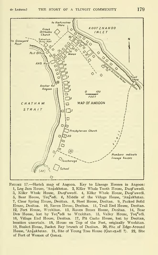
de Laguna] THE STORY OF A TLINGIT COMMUNITY 179
FiGtJKE 17.—Sketch map of Angoon. Key to Lineage Houses in Angoon:
1, Log Jam House, 'An^akhitan. 2, Killer Whale Tooth House, DAql'awedi.
3, Killer Whale House, DAql'awedi. 4, Killer Whale House, DAql'awedi.
5, Bear House, Teq^^edi. 6, Middle of the Village House, 'An^akhitan.
7, Clear Spring House, Decitan. 8, Steel House, Decitan. 9, Packed Solid
House, Decitan. 10, Raven House, Decitan. 11, Trail End House, Decitan.
12, Fort House, Wuckitan. 13, Raven Bones House, Decitan. 14, BearDen House, lost by Teq^^edi to Wuckitan. 15, Valley House, Teq'^edi.
16, Village End House, Decitan. 17, Pit Cache House, lost by Decitan,
location uncertain. 18, House on Top of the Fort, originally Wuckitan.
19, Basket House, Basket Bay branch of Decitan. 20, Site of Edge-AroundHouse, 'An^akhitan. 21, Site of Young Tree House (QanA^Adi ?). 22, Site
of Fort of Women of QanA?.
180 BUREAU OF AMERICAN ETHNOLOGY [BuU. 172
yAtii hit, '* Young Tree House" literally, "Spruce-children House."
Our informant, a middle-aged 'Anxakhitan woman, claimed that
the house belonged to her sib, but it may have belonged to or been
derived from the QanAXAdi, since Swanton lists a kidju'k hit as
belonging to the Tongas division of that sib.**
The second old house, WAnda hit, was at the site of the 'Anxakhitan
house (1), and seems to have belonged to that sib (see below).
DECITA?^ HOUSES
''Raven House" yel hit, was said by all our informants to have
been the first house built at Angoon. We did not learn where the
original location was supposed to have been. It may have been
somewhere on land now leveled for the school grounds. The present
Raven House (10) is on the Chatham Strait side of Angoon, near
the center of the village, and like all the other buildings is of ordinary
frame construction (pi. 1). Formerly it was decorated by two big
carved wooden ravens, one on each side of the door, their beaks
extending out over the boardwalk. No sign of these now remains.
They may have been taken down because the house served as a
place of worship for the Presbyterians before the present church
was built, or they may have been removed in 1929, along with the
totemic insignia on other houses, when the town was modernized
for a meeting of the Grand Camp of the Alaska Native Brotherhood,
since this organization is opposed to the old ways.
The traditional name or title of the head of Raven House is Yel
nawu, "Dead Raven." The earliest known chief was already an
old man in 1890 (?) when he painted the two killer whales that
formerly adorned Killer Whale House (4) (pi. 2, h; fig. 18, h). Thenext (?) chief, called Llxanagut as a boy, was the father of Archie
Bell, the chief of Killer Whale House (4) who was responsible for
the obliteration of these paintings. This Yel nawu was the chief
speaker for the Ravens at a "Peace Dance," held in 1914 or 1915 at
Killer Whale House, to reconcile the Decitan and DAql'awedi after
a Decitan man named L'axkek'^ had been accidentally killed by his
DAql'awedi son. This Yel nawu was also one of the prominent chiefs
in 1917 when the Angoon town council was established. One of the
town meetings was held in Raven House in 1918.
After this man died, the chieftainship went to his maternal nephew,
George Johnson, also called QacAxaw (possibly q'acAxawu, "someone's
head hair"). The latter died about 1928, and his widow married his
younger brother, Samuel Johnson, the present chief. In between
the two Johnson brothers, the head of the house was George Gamble
" Swanton, 1908, p. 400. At Yakutat, however, kidjfik is translated as "golden eagle," and the crest andhouse name belong to the Teq^edi in the Eagle-WoU moiety.
de Laguna] THE STORY OF A TLINGIT COMMUNITY 181
(bom! 1897), called Sik'gfe, whoseTelationship to the Johnsons we donot know, although his mother was a very high-ranking Ravenwoman. His father was a Wuckitan from Juneau. It is hard to
understand why George Gamble, who could only have been a
"nephew" to his predecessor, should hi^ve succeeded rather than the
younger brother, unless the latter, who is the Presbyterian minister,
was absent from Angoon at the time in connection with his calling.
In any case, Samuel G. Johnson (born 1889), called LAxanagut, suc-
ceeded to the chieftainship between 1945 and 1947. He renovated
the house in 1947-48, for which he gave an impressive potlatch, the
last one reported in Angoon (at the time of our visit in 1950).
The father of the two Johnson brothers was Qatcgahet, the Teq'^edi
chief of Bear House (5). Their mother belonged to a lineage that
originally claimed rights at Chaik Bay, rather than at Angoon, Thuswe can see a shift in the paternal affiliations of the Raven Housechiefs from the DAql'awedi to the Teq'^edi.
Raven House is now unoccupied, although sib heirlooms are still
stored in it.
"Raven Bones House," yel ^aqi hit (13), is described by Garfield as
a branch of Raven House. The first chief reported to us was Pete
Johnson, Anxis^. He was succeeded by his younger brother, Billy
Johnson, or Kdklc, and finally by a still younger brother, JimmyJohnson, the present chief. The latter (born 1879), is called 'Ak'^t'A,
"At the Bottom of a Little Lake," and T'il' Len, "Big Dog Salmon."
He married first a Wuckitan woman, then the Kagwantan widow of
his brother Pete, and finally the Kagwantan widow of his brother
Billy. Jimmy Johnson's most honorable name is Datx-qa-sadu-'axtc,
"Something Valuable about which we Talk" (to give a free transla-
tion) . He and his wife occupy the house, while his youngest brother,
BiUy Jones, a noted orator, lives next door. Both of these men, whoare older than the chief of Raven House, assist him at potlatches
with speeches and lead in the singing. The father of these men wasa chief of the DAql'awedi Killer Whale House (4?), and they lived
during their boyhood at Chaik Bay.
The third Decitan house is ctin hit. The word, ctin, is sometimes
translated as "hard stone," but seems to be simply the English word"steel" mispronounced in the usual Tlingit fashion which confuses Nand L. We shall therefore call it "Steel House" (8) , as our most critical
informants and Emmons have done. According to Garfield, the
original founder of the house was a man "who was proud and wealthy
and wished people to regard him as hard as a rock" (Garfield, 1947,
p. 439). The story which we heard, however, was that the builder
had a slave named Ctin, "Steel," who was killed at the potlatch
celebrating the completion of the house. The house was named after
182 BUREAU OF AMERICAN ETHNOLOGY [BuU. 172
him, in accordance with his last wish. Whether or not this story is
correct, it is the one generally current at Angoon.
The chief of the house is traditionally named Kitcnalx (kite "wings,"
nal "treasure", x "on"). This refers to a potlatch at which a large
wooden image of a raven was set up on the beach, with Chilkat
blankets hung over the outstretched wings. As many slaves were
killed on the "Anchor for Angoon," the boulder near the house, as
there were blankets. When the tide came up, the raven figure andthe blankets all floated out to sea. It was QasaygE, sister of the orig-
inal (?) Kitcnalx, who married a Haida, and was the ancestress of the
'An:5:akhitan sib.
The earliest Kitcnalx of whom we heard was the man known as
"Killisnoo Jake," who was mentioned in connection with the destruc-
tion of the Kake villages in 1869. He promised Captain Beardslee
in 1880 not to renew the feud with the Wrangell people, and was
among the chiefs who conferred with Commander Merriman after the
destruction of Angoon in 1882. This man appears, among other
notables, in a photograph taken in 1890 in front of the Greek Orthodox
Church at Killisnoo. He was the marshal at that time. A later
chief of Steel House was Charley Andanott, Andenat or Qux'^atsa.
He became one of the "city fathers" in 1917 when the town council
was formed, and was still chief in 1928. The present chief is George
Davis (born 1899), his maternal nephew. The latter's wife, who died
recently, was the Wuckitan daughter of Jimmy Johnson, chief of
Raven Bones House (13). Unfortunately we do not know to whatlineage or sib Davis' father belonged, but I suspect it was Wuck-itan. In any case, he is felt to belong to the old high-class lines, and
he is well versed in both Decitan and Wuckitan traditions. He and
his children occupy the house; one daughter is attending college.
"Clear Spring House," gun hit (7), was, according to Garfield, built
by the younger brother of the founder of "Steel House" to offset the
latter's boasting (Garfield, 1947, p. 439). We were told that Steel
House became too crowded, so that another house was built, perhaps
a euphemistic reference to friction within the lineage. The present
modern house is said to be on the original site. Whereas all the other
old-style houses were fiUed with smoke from the central fire, this one
was clear. Therefore it was caUed "gun," meaning a calm, clear
spring or pool of water. The lineage has a crest hat symbolizing the
shelter of a tree, 'a^yi (?), "place beneath the spruce." The chief in
1928 was Little Jack, called Wulcuq''. It is now occupied by his
Teq'^edi son, Johnny Jack, and the latter's Decitan wife and children.
It is supposed to belong to these children ; the original lineage has be-
come extinct. The building was formerly larger, but was remodeled
for Little Jack by his children. Garfield has identified the painted
de Laguna] THE STORY OF A TLINGIT COMMUNITY 183
partition with two beavers as originally belonging to this house.
(Swanton, 1908, fig. 106; Garfield, 1947, p. 439.)
The house called tuqk^a hit or tuq'^a hit, translated by Garfield's
informants as "Front, or High House," and by ours as ^'Packed Solid
(like a box) House" (9), has been empty for years and is now almost
in ruins. For this reason perhaps, we were not able to learn anything
definite about the meaning of the name. Emmons translates it as
"House Standing Sidewise." Formerly people moved into it from
both Steel House and Clear Spring House. The traditional title of
the chief is KanAlq"', from which the name Kanalku Bay seems to
be derived. The native name means "Water Coming Up," and refers
to the potlatch given by the chief of Steel House in which the rising
tide washed away the raven figure and the blankets. Emmons has
published a photograph, probably taken in the 1890's, of "Joe Kennel-
Ku, chief of the Da-she-ton family of the Hootz-ah-tar tribe," dressed
in a shirt woven like a Chilkat blanket with a beaver design in front.
(Emmons, 1908 a, p. 68). In 1928 the chief of the house was JohnPaul, Q*aLen, "Big Man." He was married to a Kagwantan woman,the sister of Anaxuts, The latter is a famous Sitka Kagwantan nameand we have already met a chief "Annahoots" acting as a policeman
at Sitka while Captain Beardslee was there. The previous (?) chief
of tuqk^a hit was the father of Robert Willard, the present head of
the Wuckitan Fort House (12). Now, the only surviving member of
the hneage is a woman who lives in Sitka.
What is now called decu hit, "Trail End House" (11), should,
according to one of our informants be called 'antcuk'A hit, "Village
End House" (cf. 16), but the names of the houses have become trans-
posed. The present Trail End House is at the western or ChathamStrait end of the path across the isthmus, next to Raven House.
It was across this path that the beaver ran who led the Decitan to
Angoon, and the name of the house refers to the beaver's trail. Thepresent building was erected in 1912 by "Sitkoh Bay Chief." In
1928, the head of the house was Jimmy Paul, Qat'awu; the present
chief is his brother, Jim Paul, Santu? (born 1892). Both Pauls
were nephews of "Sitkoh Bay Chief." In 1948 Jim Paul had the
foundations of the house lifted, to pay for which he gave a potlatch,
and in 1950 he was contemplating further renovations (repairing the
windows, and painting), in which the Wuckitan would be asked to
help.
The other decu hit or 'antcuk'^Ah.it, "Village End House" (16)^°was
at the east or Kootznahoo Inlet end of the same path across the
M Boas, 1917, p. 108, gives this as 'ancuk'Ax, "at the end of the town," correcting Swanton's tcu "end"to cu. But we also heard It as tcu
460927—60 13
184 BUREAU OF AMERICAN ETHNOLOGY [Bull. 172
isthmus. The present building is fairly new, on or near the site of
an older one, but the second story is said to be unfinished. Thechief in 1928 was Charley John (born 1888), referred to by one of
Garfield's informants as "Chief of the Ravens." After his death in
1949, the house passed to his son-in-law. Jack Bell (born 1914). Thelatter is the Decitan son of Billy Bell, who was apparently a former
chief of the DAql'awedi Killer Whale Tooth House (2). It is quite
possible that according to native reckoning the relationship between
Charley John and Jack Bell was closer than that of father- and son-
in-law. In any case, the latter (?) sold the house to Paul James, an
'Anxaldiitan man, and consequently, since the house is no longer
Decitan, it is felt to have lost its name. It may be because of this
that both house names (decu hit, from which the whole sib is called,
and 'antcukA hit) became attached to Jim Paul's house (11).
Another house, known only from Emmon's list of 1890 and AndrewDavis' list of 1928 is k'liq^' hit, 'Tit Cache House" of the Decitan.
The location of this house (17) is not loiown, but it seems to have
been either near Village End House (16) according to Davis, or
according to Emmons was the same as the latter. In 1928 it wasoccupied by James Hilton, who was unfortunately overlooked in
our genealogies. After him, the occupants were Pete Hobson or
Hotson, Tsin-ic, a DAql'awedi man, and Augustus Hart, both of
whom are now dead. All we know of the last is that he belonged
to the Eagle-Wolf moiety. The wives of both Hobson and Hart
were 'Anxakhitan women. Mrs. Hart, who died in 1949, was the
daughter of a Teq'^edi father, and her husband may, therefore,
have belonged to the same sib. It seems clear that even if JamesHilton were Decitan, the later occupants or owners of the house
were not, and this being the case, we suspect that the house itself,
which had been alienated from the Decitan, was not mentioned
by our informants because it was no longer lineage property.
The last Decitan house belongs to the Basket Bay division of
that sib. The original building was undoubtedly in Basket Bay.
It was called qAk'^'- hit, ''Basket (or Arch) House" (19). The chief
in 1918 and in 1928 had the three names: QaqALdeni, T^eyuc, and
Gitwen. The name Tseyuc is said to be the Tlingit rendering of
James. The last name, Gitwen, is one later held by Peter J. Johnson,
the deceased son of Bessie, a Basket Bay woman, and Robert Johnson,
a DAql'awedi man. The house was, however, inherited by the
nephew of "Basket Bay Chief," Andrew Dick, Qak'^etcE, and later
by the latter 's brother, Peter Dick (born 1886). The earlier location
of the house in Angoon is said to have been on the path across the
isthmus, between Raven Bones House (13) and Village End House(or Trail End House) (16), This building had a painted front. The
de Lagnna] THE STORY OF A TLINGIT COMMUNITY 185
site is now occupied by a private dwelling. The present BasketHouse (19) is farther south, on the Kootznahoo Inlet side of town,
and is distinguished by a round windowpane in the door.
'an?:akhitan houses
"Middle of the Village House, ^^ 'anxak hit, the house from whichthe sib derives its name, is sometimes referred to as t*il' hit, "DogSalmon House," and we were told that the latter was really the
older name. Emmons listed the two, however, as distinct houses.
When the descendants of the sister of the chief of the Decitan Steel
House returned from Kasaan, that chief, their uncle, gave thempermission to build a house beside his own in the middle of the village,
hence the name of their house. The first Middle of the Village
House is said to have been at Whitewater Bay, and was decorated bya painting of a black-and-red dog salmon. The present house at
Angoon (6) is separated from Steel House by the Decitan Clear
Spring House. The traditional title of the house chief is Q'adjaq'^tc,
"Man-Killer." A man of this name was marshal at Killisnoo in
1890, along with "Killisnoo Jake" of Steel House, and was responsible
for erecting the present Middle of the Village House at Angoon. Hewas succeeded by William George, Tak*A, who had the house re-
modeled in 1917. In 1928 the intended heir was George's son-in-law,
John Hunter, Cayxak', but the latter died (before his father-in-law?),
and we Imow of no chief after William George. The house has been
empty for a long time.
The second 'Anxakhitan house is yAnxun hit (1), which was also
originally at Whitewater Bay. The name means '^Log Jam House, ^^
implying a number of hemlock (ysn) stumps, rotting (xun) in the
river, under which the salmon hide. The traditional title of the chief
is Daqatckik. The last chief of this name was Moses Jamestown,
Te'iga-ic, who died in 1950. His English name is derived from that
of the U. S. S. Jamestown, which took him from Whitewater Baywhen he was an unwanted orphan to the Presbyterian Mission school
(Sheldon Jackson School) in Sitka in 1879. He made a will leaving
the house to the DAql'awedi grandchildren of his deceased wife,
men who are not directly related to him at all. It has been said
that George Hobson of Sitka, the 'Anxakhitan son of Pete Hobson(see Pit Cache House, 17), is the rightful heir under the old sib in-
heritance rules. If Moses Jamestown's will be held valid, the house
will cease to be lineage property.
The building is said to have been erected on the site of an earlier,
old-style house called wAnda hit, "Edge-Aroundf^ or "Around-the-
Edge Hou^e" (20). Swanton lists a house of this name belonging to
the Tongas Teq'^edi, and translates wa'ndA as "an ornamental cloak
186 BUREAU OF AMERICAN ETHNOLOGY [BuU. 172
worn at dances . . . trimmed with eagle skins along the sides,"
(Swanton, 1908, p. 400) that is, around the edge. The Angoonhouse, however, was said to have been 'Anxakhitan, like that later
erected at the site, and the name for its chief was also Daqatckik,
Moses Jamestown's title. All this, in fact, suggests that there wasreally only one "house," or house site, with two names. The chief
of the earlier house owned a big painted canoe, which he had bought
for two slaves. The same informant who told us about the earlier
house also said that Moses Jamestown's grandfather owned a big
painted canoe called kit yak'^', "Killer Whale Canoe." These two menmay have been the same person. The 'Anxakhitan are often said
to have had superior war canoes because of their Haida connections.
However, the name of the canoe would indicate that the owner was a
DAql'awedi man, perhaps Moses Jamestown's mother's father.
WUCKITAN HOUSES
The Wuckitan now have only one house at Angoon. This is nuhit, '^Fort House" (12), said to be the third building of that name on the
same site. The first of these, at least, was surrounded by a palisade.
The posts of the second (?) house could still be seen in the garden until
recently. This house had belonged to John Shuwika (Cuwika).
His daughter, born in 1890, remembers that the house had two benches
around the walls, each 5 feet high, with boxlike sleeping rooms above
them. A later chief, who died about 1928, was John Fred, known as
QuL'aha. He was "nephew" to the Davis brothers, the oldest of
whom had the same name. The youngest, John Davis, who died
about 1946, was married to a daughter of his "uncle," John Cuwika.
The affiliations of this lineage were with the 'Anxakhitan, that is,
the men married women of that sib. After John Fred, the headship
of Fort House passed to Charley Frank, a son-in-law of QuL'aha
Davis. The previous chiefs had belonged to the Angoon branch of
the Wuckitan, but Charley Frank was a member of the Freshwater
Bay division. Charley Frank and his son-in-law, Robert Willard,
built the present house, which the latter inherited upon the death of
his father-in-law and renovated in connection with an important
potlatch. This type of inheritance is described by Mrs. Willard as a
"new-style arrangement." (Ideally, under the old rules of preferen-
tial marriage, the maternal nephew and son-in-law would be one and
the same person. The shift from actual nephew to actual son-in-
law, provided that the latter was of the right sib to inherit, seems to
have been caused by two factors : extinction of many family lines, and
missionary teachings against marriage with first-cousins.) Robert
Willard (born 1887) is the son of a Decitan father, and is married
de Laguna] THE STORY OF A TLINGIT COMMUNITY 187
to a Decitan woman. He was known as Delki when a boy, later as
Cawut'an, and his ''big name" is KitcxajL'.
There was also a nu hit at Sitka, with which the Angoon Wuckitanwere closely aj3iliated. This was the house that was destroyed bythe Kagwantan when John Cuwika was a little boy, and he was the
only member of the group to escape. Later the house was rebuilt,
and his son-in-law, John Davis, apparently obtained title to it. Thelatter told his 'An^akhitan son that he could have the house if he
married a Wuckitan woman, that is, he could hold it in trust for his
Wuckitan children. This would have resulted in inheritance by a
paternal grandson, but since the son did not marry, this arrangement
was not carried out.
There was also a former Wuckitan house, nucak*A hit, translated
as "High Class People's House," but more properly perhaps as
"House on Top of the Fort" (18), formerly owned by Charley Davis.
It was sold out of the family, and although bought again by Charley
Walters, brother of Charley Davis, it is no longer considered a sib
house. A song belonging to the lineage of this house referred to the
qjonaqadet, or wealth-bringing water monster. Garfield mentions a
house of the same name, nucak^A hit, "Fort-on-Top House," or
wucak*A hit, "Over-all House," at Grouse Fort, the village on Icy
Strait from which both the Wuckitan and Kagwantan are derived
(Garfield, 1947, p. 450.)
teq'^edi houses
The Teq'^edi formerly owned xuts kudi hit, "Bear Den House" (14),
but this was recently lost to the Wuckitan, although neither Garfield
nor ourselves learned the circumstances (ibid., p. 447). The present
owner is Jimmy Brown, YanastAt', "Bouncing" (like a bird taking
off from the water). He is not at present in Angoon. Evidently
the house had ceased to be lineage property in 1928, for no mention
of it was made on Andrew Davis' list.
The most important Teq^'edi house is xuts hit, "Bear House" (5).
There was formerly a house of the same name in Whitewater Bay.
In 1896, the Angoon house is said to have had four great house posts,
carved to represent the sib hero, Kat^, his Bear wife, and his little dog.
Our informant, who remembers this house from her childhood, said
that it was the only one at the time that had carved house posts, and
that she was afraid to look at them. Emmons, who visited Angoon in
1890, does not mention the interior posts but rather a totem pole
beside the house which was surmounted by the figure of a bear.
This pole was evidently between Bear House and KUler Whale House
(4), as shown in an undated photograph in the State Indian Museumat Sacramento (pi. 2, b). Both houses in this picture are the ones
188 BUREAU OF AMERICAN ETHNOLOGY [Bull. 172
still standing. The pole evidently has a conventionalized bear on
the bottom, a second bearlike figure holding a dog by its tail, and a
human face (Kats ?)between the ears of the second bear. Above are
four bear prints carved in the smooth surface of the pole, and on top
is a very realistic carving in the round of a bear, seated on the pole
and looking down.
The chief of this house in 1917 was Shorty Johnson, Q^tcgah6t,
father of George and Samuel Johnson, chiefs of Raven House. In
1928, the chief was Tom G. Brown. The latter was apparently the
last official chief. His brother, Peter Tom, was supposed to inherit
the house, but it is actually the nephew, Eddy (or Andy) Jack, who
has been living in it since 1950 when he returned to Angoon from
Tenakee. Frank Jack, his younger brother, was also mentioned to us
as a possible head, as was Johnny Jack, another brother. The latter
might perhaps have a special claim since he is son-in-law to Peter Tom.
However, he has a private house of his own. In any case, all of the
brothers are rather young (not over 35?), and it is possible that
none of them would care to undertake the responsibility and expense
of the potlatch necessary to validate the chieftainship. The Jack
brothers are sons of Little Jack, former chief of Clear Spring House
of the Decitan (7).
The other Teq'^edi house is canax hit, "House Between the Moun-tains," or "Valley House" (15), referring to the favorite location for
bears' dens. The present building was erected about 40 years ago.
George Johnson, former chief of Raven House, was the ''builder,"
and was awarded $100 and a ChUkat blanket at the house-building
potlatch. In 1914-15 the house was rebuilt, for which an impressive
potlatch was given by the chief, Albert Kukash, whose native names
were Kukec, Qdcan, and Kitnaq. He was the "brother" (or cousin?)
of Shorty Johnson, chief of Bear House. Albert Kukash was
assisted at the potlatch by his ''nephew," George Klushkan, Luckan.
The latter was son-in-law to Yanatcux or Qadjiiqeq, a noted Teq'^edi
chief of the 1880's, whose carved marble tombstone, representing a
bear, stands near the house. I think this man was actually chief of
Valley House in 1882. He had a summer camp on Channel Point,
which was spared at the time Angoon and the surrounding camps were
burned. This was because the chief's friend, a halfbreed interpreter
on one of the Government boats, testified that he had been away fish-
ing when the white hostages were seized and was in no sense responsi-
ble for this incident. Another daughter of this same chief was the
wife of Shorty Johnson of Bear House. George Klushkan would pre-
sumably have inherited Valley House from his "uncle," but he seems
to have died before the latter. Albert Kukash, who lived until 1940,
built a private house in 1927-28, so that his family would have their
de Laguna] THE STORY OF A TLINGIT COMMUNITY 189
own house after his death. When he died, there was actually no one
living in Valley House. James Jackson (born 1882), whose potlatch
title is Qagec, and whose name is also Euckan, is a "nephew" to
Albert Kukash, and perhaps should be the heir now. Actually,
Frank Jack, one of the sons of Little Jack, and brother to the present
occupant of Bear House, seems to be caring for or even living in Valley
House. For a time it was occupied by Mrs. William George, the
Teq^edi widow of the former chief of Middle of the Village House.
She was the maternal grandmother of the Jack brothers, and the
mother of Willis George (born 1902). The latter, known as Daquct'E
or Taqust'e, also has the potlatch name or title of Qatcgahet, and mayoutrank all the Teq'^edi, although he lives in his own private house.
daql'awedi houses
This sib has three houses at Angoon. Two are known as kit hit,
'^Killer Whale House," but one of these (4), now owned by Peter
Kanash, is more correctly called wutc-daka-din kit hit (''I^iller
Whales Touching Each Other on the Back"??) because it formerly had
a painting on the facade of two Idller whales facing away from each
other. A house of this name with a similar painting is mentioned byEmmons, presumably dating from 1890. This is evidently the samehouse that is illustrated in the undated photograph in the State Indian
Museum at Sacramento (pi. 2, b). The picture shows the present
building as it was before two shed annexes were built on the south side
and a front door with glass panes was added. The photograph of the
painting on the house front is practically identical with the sketch
made in 1950 by Edward Malin (fig. 18, 6). This building is said to
have been erected by the mother's mother's brother of the present
chief. The traditional chief's title is Guctahm, referring to the water
rushing past the fin of the killer whale. The painting on the house
was made by a former chief of Kaven House, when the latter wasan old man, and he received $500 for his work at the subsequent
potlatch. The next chief of Killer Whale House was Archie Bell,
the son of this Raven House chief. Archie Bell was called Nalk,
St'utex, and Danawu, in addition to his title. He was chief in 1928
and was responsible for the obliteration of the killer-whale painting.
Now, only its faint outlines can be seen under grayish-white commer-cial paint. Peter Kanash (born 1885), Archie Bell's half-brother bythe same mother, is the present chief. He put in partitions to makeseveral rooms of what had formerly been a single big room, reshingled
the roof, and strengthened the foundations. It cost $2,300 for the
repairs and $7,000 for the house-building (house-repairing) potlatch.
Billy Jones, half-brother of the chief of Raven Bones House and
son of a former Guctahin (probably the Killer Whale House chief
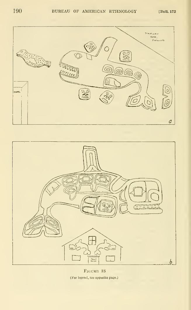
190 BUREAU OF AMERICAN ETHNOLOGY [BuU. 172
FlGUKE 18
(For legend, see opposite page.)
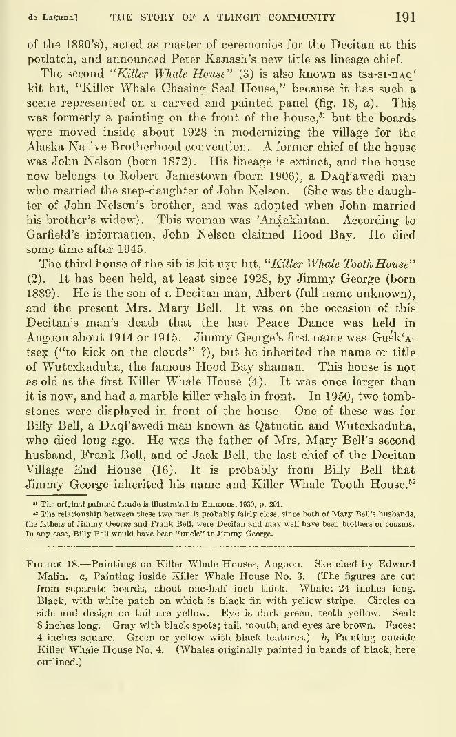
de Laguna] THE STORY OF A TLINGIT COMMUNITY 191
of the 1890's), acted as master of ceremonies for the Decitan at this
potlatch, and announced Peter Kanash's new title as hneage chief.
The second ''Killer Whale House" (3) is also Imown as tsa-si-nAq*
kit hit, "Killer Whale Chasing Seal House," because it has such a
scene represented on a carved and painted panel (fig. 18, a). This
was formerly a painting on the front of the house,^^ but the boards
were moved inside about 1928 in modernizing the village for the
Alaska Native Brotherhood convention. A former chief of the house
was John Nelson (born 1872). His lineage is extinct, and the house
now belongs to Robert Jamestown (born 1906), a DAql'awedi manwho married the step-daughter of John Nelson. (She was the daugh-
ter of John Nelson's brother, and was adopted when John married
his brother's widow). This woman was 'Anxakhitan. According to
Garfield's information, John Nelson claimed Hood Bay. He died
some time after 1945.
The third house of the sib is kit uxu hit, ''Killer Whale Tooth House"
(2). It has been held, at least since 1928, by Jimmy George (born
1889). He is the son of a Decitan man, Albert (full name unknown),
and the present Mrs. Mary Bell. It was on the occasion of this
Decitan's man's death that the last Peace Dance was held in
Angoon about 1914 or 1915. Jimmy George's first name was Gusk'A-
tsex ("to kick on the clouds" ?), but he inherited the name or title
of Wutcxkaduha, the famous Hood Bay shaman. This house is not
as old as the first Killer Whale House (4). It was once larger than
it is now, and had a marble killer whale in front. In 1950, two tomb-
stones were displayed in front of the house. One of these was for
BUly Bell, a DAql'awedi man known as Qatuctin and Wutcxkaduha,who died long ago. He was the father of Mrs. Mary Bell's second
husband, Frank Bell, and of Jack Bell, the last chief of the Decitan
Village End House (16). It is probably from Billy Bell that
Jimmy George inherited his name and Killer Whale Tooth House. ^^
" The original painted facade is Illustrated in Emmons, 1930, p. 291.
« The relationship between these two men is probably fairly close, since both of Mary Bell's husbands,
the fathers of Jimmy George and Frank Bell, were Decitan and may well have been brothers or cousms.
In any case, Billy Bell would have been "uncle" to Jimmy George.
Figure 18.—Paintings on Killer Whale Houses, Angoon. Sketched by EdwardMahn. a, Painting inside Killer Whale House No. 3. (The figures are cut
from separate boards, about one-half inch thick. Whale: 24 inches long.
Black, with white patch on which is black fin with yellow stripe. Circles on
side and design on tail are yellow. Eye is dark green, teeth yellow. Seal:
8 inches long. Gray with black spots; tail, mouth, and eyes are brown. Faces:
4 inches square. Green or yellow with black features.) b, Painting outside
Killer Whale House No. 4. (Whales originally painted in bands of black, here
outlined.)
192 BUREAU OF AMERICAN ETHNOLOGY [Bull. 172
The second tombstone in front of the house was that of Peter James,
a DAql'awedi man who died in 1950. He was the maternal grand-
father of Jimmy George's second wife, the Decitan daughter of
Archie Bell, former chief of Killer Whale House (4). Evidently
Jimmy George was planning a funeral potlatch in honor of these twodistinguished relatives some time during the winter of 1950-51.
Jimmy George's third wife is the Decitan daughter of Peter Jamesby the latter's second wife.
SUMMARY
These genealogies and records of succession, short and incomplete
as they are, show how the leading families in two sibs of opposite
moieties tend to intermarry, so that sometimes the chiefs of their
respective houses are actually father and son, or at least paternal uncle
and nephew, an equivalent relationship in Tlingit thought. We also
see the inheritance of titles, houses, and widows by younger brothers,
with the house and title passing eventually to the maternal nephew(in the old days the widow would also have been so inherited, andshe would also have been a paternal aunt). The more modern schemeis to substitute a son-in-law of the correct sib when no direct heir in
the maternal line is available, or to attempt to pass the house to a
paternal grandson in the sib. Lastly, we have examples of houses
passing completely from the lineage and sib by transfer in settlement
of a dispute, or by sale, and the attempt to do so through a modernlegal will. There seems to be no doubt that with the abandonmentof potlatching, a custom that appears to most of the younger genera-
tion as a waste of time and money, condemned by the Alaska Native
Brotherhood as a sign of cultural backwardness, and discouraged bythe church as smacking of the heathen past, we may expect in the
future that few houses will be inherited as lineage property and that
few titles will be validated by potlatching.
ANGOON TODAY
We may finally close this historical account with a sketch of the
most recent developments at Angoon that make the town what it is
today. This section is based on information obtained from a numberof informants, but in most cases Ave have been unable to check it
against historical records.
The town of Angoon was organized in May 1917 under the Terri-
torial laws of 1915. All the chiefs had to agree. They were afraid,
said our informant, that if they did not establish a government ac-
cording to the white man's law the United States Government might
again burn the town. The chiefs specifically mentioned as taking
part in this meeting were: Yel nawu of Raven House, Charley
de Lagunal THE STORY OF A TLINGIT COMMUNITY 193
Andanott of Clear Spring House, and Basket Bay Chief, all Decitan;
William George of Middle of the Village House, the chief of Log JamHouse, both 'Aniakhitan; Shorty Johnson of Valley House and his
nephew, George Klushkan, both Teq'^edi.
At times old intersib rivalries and 'ntrasib jealousies impeded the
smooth running of the new organization. Although meetings of vari-
ous native groups are now conducted according to Robert's Rules of
Order, the parliamentary procedure which the town council tried to
follow in the early days was undoubtedly unfamiliar to the leaders.
Friction sometimes arose on matters of protocol and procedure betweenthe older men who were both chiefs and city fathers and the youngerschool graduates who were not only essential as clerks and secretaries,
but who were active propagandists for the new ways. There musthave been disagreements, too, over matters of policy, especially since
the younger men in many cases were not only intolerant of the old
customs but even ignorant of the principles on which they were based.
That the organization survived and was able to bring real improve-
ments to the town is evidence of the earnest endeavors and commonsense of its members.
There had been a Greek Orthodox Church at Killisnoo since 1889,
and also a Salvation Army Hall there, before either was built at
Angoon. The first church at Angoon was the Presbyterian Church,
built in 1918-19. Previously the Presbyterian congregation had metfor services at Raven House, but the present chief of the house andPresbyterian minister raised funds to build the church. The wholecommunity worked on it. Since the minister and his family nowlive at the Manse, the old Raven House is unoccupied. The present
chief of Trail End House is one of the elders of the church. A nephewof a previous chief of Raven House is the Presbyterian minister at
Kake. During the summer of 1950, Cyrus Peck, a Kagwantan whois married to the Decitan step-daughter of the chief of Killer WhaleHouse (4) was visiting minister.
The Salvation Ai-my Hall at Angoon was built also by the whole
community, but we do not know the date. The chief of Fort Houseis a captain and the leader of this congregation. The chief of LogJam House who died in 1950 and a number of other 'Anxakhitan
men are active members of the Salvation Army. The Greek OrthodoxChurch at Angoon was built in 1928-29, also through communityeffort, aided by friends from Sitka and Hoonah. There has never
been a regular priest assigned to either Killisnoo or Angoon, but
visiting priests have come from both Sitka and Hoonah, and a num-ber of the Angoon people have toured with the Greek Orthodox choir,
organized by Father Sorgon of Sitka.
194 BUREAU OF AMERICAN ETHNOLOGY [BnU. 172
Estimates of these three congregations in recent years have been:
Greek Orthodox, 100 members; Salvation Army, 80; and Presbyte-
rian, 70. While there is some suggestion that church membershipmay reflect lineage affiliations, there is considerable cooperation be-
tween the congregations. Choirs from the churches tour the townat Christmas time, when all who are able hold open house for them,
and on such occasions as the visit of the Presbyterian Theological
Seminary Choir most of the residents attend the special hymn singing.
All are fond of music.
A public school was built at Killisnoo in 1880, but, as we have
seen, never attracted a large attendance. This building was destroyed
by fire in 1894. A number of middle-aged or elderly residents of
Angoon have attended the Sheldon Jackson Presbyterian Mission
School at Sitka, and some the Greek Orthodox mission school there.
The first school classes at Angoon had to be held in any large house
that happened to be available, and we were told that each year the
people had to wait to see which house could be used. The people
petitioned the Governor for a school, our informant said, and nowthey have one. It is, however, an Alaska Native Service school,
not a Territorial public school. It was apparently first opened in
1920 at the present site, on land which had previously been used for
gardens. In 1929 a new school and "teacherage" was built, with
three large and one small classrooms, superintendent's office, clinic,
storerooms, etc., as well as quarters for two married couples and a
visiting Public Health Nurse. The latter, however, divides her time
between Angoon and Kake. In 1938 the land behind the school wasditched and fitted as a basketball field. About 100 children attend
school, some of the graduates going to the Mt. Edgecumbe HighSchool, and in 1950 two young people, a boy and a girl, were attending
a university.
Among the most important organizations at Angoon is the local
camp of the Alaska Native Brotherhood and the affiliated Sisterhood.
(The following account should be checked against Drucker's, 1958.)
The ANB was originally founded at Sitka in 1912, by Tlingit from
various parts of Alaska, including Eli Katinuk and William Hobsonof Angoon, James Johnson of Klawak, Ralph Young of Hoonah, and a
Tsimshian from New Metlakatla. The organization grew out of a
group that had banded together to protest the refusal of restaurants
and a moving picture theater in Sitka to admit Indians. Such dis-
crimination is now prohibited by Territorial law. The boycotts
were so successful that the group stuck together and founded the
ANB. It now has camps in practically every native community in
southeastern Alaska, and is conceived as a body which will eventually
embrace all the natives of the Territory. The Pribilof Islanders
de Laguna] THE STORY OF A TLINGIT COMMUNITY 195
(Aleut) who were evacuated to southeastern Alaska have joined. In
1949 about 5,000? members were claimed. In addition to the local
camps, there is a Grand Camp, a central organization consisting of
the Grand Officers of the ANB and ANS, the chairmen and two addi-
tional delegates from each subordinate ANB and ANS camp, and all
former Grand Presidents. Conventions are held every Novem.berat some town in southeastern Alaska, the local camp acting as host
to the meeting which lasts about a week. Camp No. 7 was organized
at Angoon in 1921-22 (?), after about 2 years' deliberation, following
visits to Sitka of younger and older people to watch the work of the
original local camp. At that time about half the people in town
joined. The offices of President and Vice President are elective, as
are the corresponding offices in the Alaska Native Sisterhood, and mostof the prominent men and women of Angoon have held them. Aconvention of the Grand Camp was held at Angoon in 1929 and it wasfor this occasion that the paintings of the two Killer Whale Houseswere obliterated or moved.
Article I, Purpose, of the Constitution of the Alaska Native Brother-
hood (dated 1948) states:
The purpose of this organization shall be to assist and encourage the Native in
his advancement from his Native state to his place among the civilized races of
the world, to oppose, to discourage, and to overcome the narrow injustice of
race prejudice, to commemorate the fine qualities of the Native races of NorthAmerica, to preserve their history, lore, art and virtues, to cultivate the morality,
education, commerce and civil government of Alaska, to improve individual andmunicipal health and laboring conditions, and to create a true respect in Natives
and in other persons with whom they deal for the letter and spirit of the Declaration
of Independence and the Constitution and laws of the United States.
All descendants of the aboriginal races of North America are eligible
to fuU membership; their spouses may become full members, except
that they may not hold any of the Grand Offices; and other persons
may become associate or honorary members by unanimous vote of
the local camp or Grand Camp.To carry out the purposes of the organization, provision is made for
the payment of benefits for sickness or injury, and for contributions
to the funeral expenses of members. Local camps have a Citizenship
Committee "who shall endeavor to get as many members to exercise
their privilege of voting as possible," a School Committee (ANS) to
cooperate with the government teacher in insuring attendance of
the children at school, an Improved Home Life Committee (ANS) to
report on health and cleanliness of each home, and make recommenda-tions for improvement that must be carried out by the memberscriticized. ^^ The oath of membership involves support of the Consti-
M Though provided for by the constitution, I do not know how active these committees are. However,
the various types of benefits provided for above are commonly paid, the local ANS often holding social
events to raise money for the needy.
196 BUREAU OF AMERICAN ETHNOLOGY [BuU. 172
tution of the United States, as well as an appeal to the Heavenly Father
for wisdom and strength. Of recent years, the Alaska Native Brother-
hood and the American Federation of Labor have cooperated in
matters affecting the pay of fishermen and cannery workers, etc. TheGrand Camp has a Fisheries Committee. The organization has, I
believe, played a part in the election of native members to the Terri-
torial Legislature, and in 1950 were supporting the movement for
Alaska Statehood, although the individual members seemed to be
divided on this issue in the same proportion as the white citizens
of Alaska.
The large building, standing on piling above the beach at the
Chatham Strait end of the original beaver trail (pi. 1), was built in
1917 as a community hall, the year the town council was organized.
The whole community cooperated in its erection. The timber was
cut in Gut Bay and taken to Warm Springs Bay, Baranof Island,
where there was a sawmill. The people apparently made some ar-
rangement whereby the}' had to pa}^ only for the shingles. The kitch-
en, where food for social gatherings was prepared, was originally
upstairs, but it was too hard for the old people to go up and down,
so a ground-floor addition with a new kitchen was built in 1929, the
year of the ANB convention at Angoon and the same year that the
new schoolhouse was also built. At that time, practically everyone
in town joined the ANB and ANS, and the town hall now functions
as, and is called the ANB Hall. Public notices are posted on the door;
it seems to serve for meetings of all kinds, including parties and dances,
and various local basketball clubs play in it. The hall is said to be
too short for such games, so there is talk of extending the building
out farther over the beach. A number of men use the shelter below
it for working on their skiffs.
There are several electric light plants in Angoon: that supplying
the community line, those for the school and for each of the two stores,
and the last for the post office and weather station. The community
first acquired the public plant in 1924-25. The present diesel motor
supplies current for the lights along the main boardwalks, and light
and power for the houses. Many of the families have electric washing
machines, and also gasoline machines to use in summer when the
town current is usually shut off. The people also have a number of
radios. Each household is taxed about $10 a year for current.
In June 1928 the native settlement at Killisnoo was destroyed
by fire. This is reported by some to have started in a house with a
dirty or defective stove pipe. According to others, the fire was due
to sabotage. They say there had been a strange Japanese living
in that house for about 2 weeks, taking photographs of everything.
He waited until the north wind was blowing, so the people didn't
de Laguna] THE STORY OF A TLINGIT COMMUNITY 197
have a chance, then threw gasoline on his stove and went off in his
boat with all his things. The people were so upset that they did not
try to catch him. This is the third case reported to us in which arson
has been suspected, the other two being attributed to personal malice.
While it is commonly recognized that carelessness alone may lead to
serious conflagrations, since the wooden buildings are highly inflam-
mable and there is no adequate means of fighting fires, it is interesting
that arson should have been suggested in so many cases. A numberof families that had been living at Killisnoo had begun to drift back
to Angoon in 1915 when the herring plant, then operated by the Alaska
Fish Salting and By-Products Company, was temporarily closed
down. This last disaster forced the abandonment of the place, andresulted in the growth of Angoon. The herring plant seems to have
operated spasmodically in the 1920's under the National Fish andSalting Company and later the Killisnoo Packing Company, but oper-
ations were finally suspended in 1931, we were told. The summercabins of the native workers were occupied during World War II by35 Aleuts evacuated from Atka. Now a number of these shacks have
been moved to Angoon to relieve the housing shortage, acute here
as in so many Alaskan towns. It is felt that housing conditions are
aggravated by the small size of the town site, the boundaries of
which are so drawn that even the Kootznahoo Store and the Trail
Store lie outside the town limits. But this does not explain whyonly a very few natives have sought to acquire home sites outside
the town proper.
The most important recent event affecting Angoon came in 1936
when an amendment to the Indian Keorganization Act of 1934 ex-
tended the benefits of this legislation to Alaska. Under the provisions
of this law, the Angoon Community Association was incorporated,
and adopted a constitution and bylaws, which were duly ratified
by a vote of 72 for and 3 against on November 15, 1939. The charter
authorizes the Community Association to purchase, own, and managecommunity property, to make contracts, and to borrow moneyfrom the Federal Government for community business purposes or
to lend to individual members. Income from community investments,
above that needed to pay interest or to refund debts, can be used
for social, educational, or relief purposes. These powers, according
to the constitution, are vested in 7 elected members. The charter
prohibits the sale or mortgage of lands, fishing or mineral rights,
in areas which might be set aside for a reservation.^* The constitu-
tion provides that the choice of legal counsel and the fees to be paid
him must be approved by the Secretary of the Interior.
In January 1948 a law and order code, adapted from those in
M According to recent Federal legislation, the creation of such a reservation is now impossible.
198 BUREAU OF AMERICAN ETHNOLOGY [Bull. 172
effect on reservations in the States, was adopted by the new Com-munity Association. This estabhshed an Angoon Native Village
Court, consisting of a chief judge and three assistants, appointed
and paid by the Village Council, and having jurisdiction over mem-bers of the Community Association. A Village Police Force of four
men is also authorized. The com-t is empowered to try civil cases
involving claims up to $200, and to impose sentences for offenses up
to $60 (for carrying concealed weapons). Assault, theft, fraud, dis-
orderly conduct, liquor violations, adultery, etc., receive Ughter
penalties. These fines and court costs may be worked off at the rate
of $5 a day, or served out at the equivalent of $2 for each day in jail.
Interestingly enough we heard nothing about any civil or criminal
cases at Angoon, and I doubt if the community has a jail.
There was some opposition to the adoption of the communitycharter. This had come, we were told by one man, from persons like
himself, who believed that the people could not possibly pay back the
Government money they might borrow, and that they would fall so
deeply in debt that the Government would "put them on a reserva-
tion." (A common attitude toward reservations, we found, involved
the belief that they were places where natives would be to some extent
confined, or would in some fashion lose their personal freedom. It
is also suspected that the creation of a reservation, although guar-
anteeing certain territorial rights, would in exchange force the surrender
of others outside the reservation to which the people feel equally
entitled.) Our informant was, however, unable to sway public
opinion at Angoon, because one of the men who spoke in favor of the
charter was a chief who had been trained by his father and uncles as
an orator. Our informant told us that when he saw the benefits from
the IRA, he admitted that he had been wrong.
These benefits have been twofold. First, the piu-se-seiners and
smaller troUers, essential for commercial fishing, were originally
financed by mortgages held by private firms, mostly canneries. These
boats cost from $15,000 to $22,000, and in bad fishing years it has
not only been impossible to meet the mortgage payments, but opera-
ting costs may even increase the owner's indebtedness. Now the
community has been able to take over the mortgages, thereby pre-
ventingforec losures in some cases; and, further, the more liberal
terms of the Federal loan to the community have made paymentseasier.
More important, however, has been the purchase by the communityof the salmon cannery at Hood Bay in November 1947. It wasoperated in 1948 by the Whiz Fish Products Company under lease,
but in 1949 the community itself initiated operation. The councU
hired the manager, a white man with many years' experience in the
de Lagima] THE STORY OF A TLINGIT COMMUNITY 199
field, and he in turn selected the rest of the crew. These consist
primarily of the "inside foreman" and his expert assistants (in charge
of the complex canning machinery), the "outside foreman" (in charge
of docks, fish traps, etc.), the storekeeper, and the bookkeeper; these
were all white men. This was because these positions require special
skills, which the natives have not yet learned. The very responsible
positions, however, of comxmanding the cannery tender and barge
would both have been filled by natives, but only one competent manwas available because the rest preferred the excitement of fishing.
Most of the Angoon men fish for the cannery, and most of their wives
work on the cannery line. However, in order to fill some of the heavier
and more dangerous inside jobs for which men are needed, it was
necessary to employ a small crew of Filipinos. All workers received
union wages, and the fish are bought at standard prices.
It has been of the greatest social consequence to the communitythat its members have been thus united in a common enterprise. Thepeople are not only conscious of the economic benefits, but also take
a real pride in their business. It removes them from a position of
indebtedness to a packing company and of social inferiority to its
white owners and managers, a position which in some cases can
amount to virtual peonage. For these reasons, the cannery repre-
sents the realization of ambition; it is a source of hope, of inspiration
for the young people. Before, as one informant expressed it, even
though the men had sailed on these waters and knew them thoroughly,
no white man would give them the responsibility of piloting a big
barge or cannery tender. Now they can have such jobs, and their
sons can look forward to having them, too.
We were told that the loan from the Government to buy the cannery
amounted to $258,000, with 20 years allowed in which to liquidate it,
although payments had to begin in 5 years' time. The season of 1949
was so successful that $130,000 was paid back to the Government,
and in addition there were funds available for the purchase of needed
equipment. (We were unable to check this information.) There
were also plans to use the anticipated profits for establishing newenterprises that could afford year-round sources of income: a sawmill
or a cold storage plant (for halibut, cod, red snappers, and king
salmon). The fishing season of 1950 was, hovv^ever, very poor.
The community is at present debating a proposal to move from An-
goon to Hood Bay. Those in favor of such a move cite the nearness
to the cannery, the present crowded condition of Angoon, and the abun-
dant supply of good water and the safe harbor at Hood Bay, features
lacking at Angoon, Their opponents point to the rugged terrain near
the cannery which leaves insufficient room, they claim, for a village;
the cost of building new houses; and the alleged freezing over of the
46092T—60 14
200 BUREAU OF AMERICAN ETHNOLOGY [BuU. 172
head of the bay in winter. We gathered that opinion for and against
the move was fairly evenly divided, with the younger families in gen-
eral favoring the change, and the older members opposed. Probably
influencing some of the latter is the fact that they own lineage houses
at Angoon, but could not afford to have new lineage houses erected
at another village, especially since their younger relatives would be
unwilling or reluctant to finance the necessary house-building potlatch.
Also, there is the natural attachment to their old home, a feeling which
expresses itself in appreciation of the open view across ChathamStrait " and the aversion to being shut in at Hood Bay. Some feel
that if a move is made, it must be by the community as a whole,
because of legal and financial problems involved, and the necessity of
schooling for their children. It is also felt that it will take several
years before a decision to move or to stay can be reached. In the
meantime, improvements or repairs to property at Angoon which
might otherwise be undertaken are in some cases postponed. Anumber of families are instead improving their summer cabins at the
cannery or building new houses there which could be used either as
comfortable summer houses during the fishing season or as permanent
dwellings. This issue is, perhaps, the one most likely to threaten the
solidarity of the community, and it might indeed lead to the eventual
splitting of Angoon into two villages. ^^
CONCLUSIONS
To the study of the history of the northern Tlingit, especially the
Xutsnuwedi of Angoon, we have made a beginning. This has demon-
strated that archeological, ethnological, and historical data, if com-
bined and analyzed together, can give a deeper insight than any one
type of material or one methodology alone,
" The love of sitting motionless for hours, gazing out to sea, is one which has received comment from e^irly
travelers. Erman suggested a religious significance; Krause (1885, p. 165) thought it was to study
the weather. I think it reflects simply esthetic enjoyment of the changing panorama of sea and sky, and
curiosity about the movements of birds, animals, and passing boats.
'• Since the above was wiitten, an outbreak of witchcraft fears at Angoon was reported in the press for
April 26-29, 1957. This began when a young girl of 16 claimed that her baby had been killed by witchcraft
2 weeks before and that she herself had been bewitched by 20 persons since 1952. Another girl, 12 years old,
joined her in holding nightly seances in which they made vague prophecies of strange occurrences and accused
others of witchcraft. All the latter were so-called "nonbelievers." A number of previously skeptical per-
sons became "believers" when certain individuals, who it was predicted would fall sick, were actually
affected by a virus epidemic that struck the village. One man thought that he saw another turn into a
bird and fly away, because the older gui had told him that something would happen that night to convince
him. The girls also testified that they had been transformed into cats on several occasions when touched by
a human (?) bone held by one of the witches during midnight rites in the cemetery and that they had seen a
witch turn into a cat herself. The baby died because the witch cut off a piece of its clothing and burled
this with dead cats under the house.
The current manifestation follows in part the aboriginal patterns of witchcraft fears and, like the latter,
also reflects social tensions and anxieties, although the present ones seem to be more diffuse and are not, as
was once the tradition, centered on jealousy and trouble within the lineage or sib (de Lagima, 1952, p. 8).
As a matter of fact, there is little to distinguish this Angoon witchcraft episode from similar incidents which
occur from time to time in farming communities not 75 miles from my own home In Pennsylvania.
de Laguna] THE STORY OF A TLINGIT COMMUNITY 201
Interpretation of history involves an understanding of the motives
of human beings, and demands, if we are to read aright the events,
that we should see them, as far as possible, through the eyes of the
participants. Indian and white man can become mutually intelligible
only through the sympathetic translations of the anthropologist^ whousually begins his task long after the events have taken place. Tooseldom is he aided by the insights of contemporaries like Captain
Beardslee, who studied "the laws, customs and superstitions of the
Indians," but he must bring his own understanding of their culture
to illumine and amplify the incomplete report of their behavior.
The biases and prejudices of the white man's records and of the
native's traditions must not only be perceived and reconciled if possi-
ble, but the reasons for bias must be understood. There were ap-
parently members of the Angoon group in 1882 prepared to protect
the officials of the Northwest Trading Company against the Indians
who demanded compensation for the death of the Decitan shamanand who thi-eatened to kill the white hostages. Were these "friendly
Indians" perhaps the Teq^edi? This is suggested by the fact that
the property of the Teq'^edi chief (of Valley House?) was spared byMerriman. Did this difference in attitude toward the whites perhaps
reflect factions within the community based on intersib or inter-
lineage rivalries? Why have the people of Angoon apparently for-
gotten the part played by these friendly Indians, so that according
to the stories we heard all the people seem to have acted together, or
been equally innocent sufferers? Is it because the natives now feel
themselves equally threatened by encroachment, restrictive legislation
and taxation, sources of discomfort and anxiety which revive the mem-ory of Angoon 's destruction and remind them of common Indian
interests? Perhaps further probing might bring to light traditions of
the different roles played by particular individuals in 1882, assuming
that the ethnologist could stay long enough at Angoon to win the con-
fidence of members of aU the lineages. Again, how are we to interpret
the striking omissions and the particular slants in the accounts by
Morris and Merriman? Did the former actually welcome the affair
at Angoon because it justified his dke predictions and because it could
be used, as indeed it was, to force Congress to take Alaska seriously?
Does Merrimam betray vindictiveness toward the Indians because
they had not docilely accepted his views of their proper role, not
simply in relation to the whites in general but to himself, the Naval
officer, the "Senior Officer Present"? Was he possibly led to greater
harshness than his conscience really approved? Is that why we find
this curious combination of avowed concern to make the natives
"look upon the man-of-war as their best friend" with, if we are to
trust Mrs. Willard, a readiness to annihilate the entire tribe? Does
202 BUREAU OF AMERICAN ETHNOLOGY [BuU. 172
this last reported statement express the unconscious wish to wipe
out the doubts of the wisdom and justice of what he had already
done?
Although it is interesting to speculate upon the motivations of
individuals, as individual personalities, this is not our primary task.
We have rather to understand these men as playing roles arising from
and dictated by the social and cultural patterns of their own worlds.
For the most part we shall never know much about them as individuals
and this will be particularly true as we go farther back into the past.
We may indeed have sufficient insight into the character of Baranof
,
but what about his adversary, KaLian, chief of the KiksAdi? Andin any case, events were not shaped by these two men alone. Eachacted within the framework of his culture, in conjunction with other
members of his society. To understand what happened at Sitka,
it is not enough to know the policies and methods of the Russian
American Company ; we need also to grasp the structure of the native
Sitkan community, how it functioned, and w^hat were, for example,
the relations between the Sitkan KiksAdi and the other Sitkan sibs,
and between these and their relatives and enemies in other Tlingit
tribes. From what we learned at Angoon this would be a fruitful
field for research, especially interesting since the Russians themselves
seem to have understood but imperfectly the forces at work in Tlingit
society. There are many similar problems in the history of the
northern Tlingit.
It has been claimed with justice that every people live their ownmyths, that is, that their conduct in the present reflects what they
believe their past to have been, since that past, as well as the present
and the future, are aspects of the "destiny" in which they exhibit
themselves as they think they really are. The Tlingit themselves
sense this and use the term "ha (our) CAgiin" for the origin and destiny
of their sib, including the totemic animal or bird encountered by their
ancestors and the powers and prerogatives obtained from it, as well
as their own place in the universe and the ultimate fate of their
unborn descendants. This is something that goes bej^ond asking
the historian to check the validity of native tradition, or attempting
through native tradition to check the accuracy of historical docu-
ments. Rather it poses for us the problem of how a people view their
history, and in these pages we have discussed some of the methodsby which a solution may be approached. Still further, we mustin every case discover what is the significant social unit involved.
It is obvious that we cannot lump all Tlingit together as one nation if
we wish to understand their past and their present and what these
mean to them, nor can we take one tribe as a single entity in dis-
de Laguna] THE STORY OF A TLINGIT COMMUNITY 203
cussing events at Angoon or Sitka. Rather, as we have tried to show,
we must deal with the Decitan, the Teq'^edi, the KiksAdi, as the
"nations" that inspired "patriotism" (to quote our informants), as
the groups that have acted as units in terms of what they behevedit meant to be Decitan, or Teq'^edi, or KiksAdi. To what extent
separate sib alinements may have crossed and fused is a problem
of importance equal to that of understanding the significance of
their separate traditions and attitudes toward themselves.
Since we have not found archeological material that can with
certainty be referred to a period antedating early contacts with
Europeans, we have not been able to outline an ancient stage in
the development of northern Tlingit culture. Obviously more arche-
ological work is needed in the Angoon area. There are, however,
promising sites for further exploration: Marten Fort in Hood Bayand some of the reported forts in Peril Strait, the village sites at
Whitewater Bay and Sitkoh Bay, and the reported sites at Todd,
Tenakee, and Freshwater Bay. Of particular interest would be
Grouse Fort on Icy Strait with its midden and house pits, since
it is from the inhabitants of this place that lineages at Hoonah,Sitka, and Angoon trace their descent. Cultural influences movingsouthward to Angoon may well have left their imprint here; accord-
ing to tradition the people of Grouse Fort had connections with the
Chilkat, the Yakutat, and the interior Athabaskans.
It is, of course, impossible to predict what site, now known or still
awaiting discovery, may prove crucial in revealing interconnections
between the various tribes. Perhaps the early chapters may for-
ever remain hidden from us. Yet ethnological evidence of regional
diversity in Tlingit culture makes this a subject to which the arche-
ologist should give his attention. We will not understand Angoonuntil we can clearly see it in the perspective of likeness to and differ-
ence from other Tlingit groups, and until we can trace the shifting
patterns of resemblances and divergences through time.
Although traditions concerning a number of ancient settlements
did not coincide with archeological evidence of early occupation,
we must not think that aU problems common to the archeologist
and ethnologist simply mean verifying native stories by the spade.
Rather, the relationship between archeology and ethnology is a
reciprocal one, involving the interpretation of the excavator's finds
through knowledge of native custom and tradition and equally the
illumination or illustration of native report through the antiquities
unearthed.
What do we know about the beginnings of Angoon? If archeology
should fail us, is there any other evidence that might point to the
204 BUREAU OF AMERICAN ETHNOLOGY [BuU. 172
origins of its inhabitants? Swanton has impHed that the sib migra-
tion stories of the Thngit may be used as clues to their past:
The Tlingit quite uniformly trace the origin of nearly all their clans to the
Tsimshian coast "below Port Simpson"; that is, to the neighborhood of the
mouth of the Skeena river. It is said by some that nearly all the present clans
immigrated in this manner, and that most of the "old Alaskans," those whomthey found in possession, have died out. [Swanton obtained the names of someof these latter groups but believes that] many are very small and are more likely
to have been subdivisions than surviving groups. The only point that mayhave significance is the fact that nearly all so enumerated were of the Ravenclan. There are several other bits of evidence which seem to show that the
distinction between the two phratries was of more importance historically than
would at first appear. [It is possible, he suggests, that the distinction between
the two moieties] could have been associated originally with a racial difference,
and such a possibility again presents itself when we come to consider the origins
of the separate clan divisions. [Swanton, 1908, pp. 407 f.]
These stories deal with migrations from the north or south or
interior into the present Tlingit territory and also with population
movements within it. Thus, if we examine the origin stories of the
groups now or formerly claiming rights in the Angoon area, we find
that the GanAXAdi and Teq^'edi came from the far south; the
Decitan, Wuckitan, and DAqt'awedi from the interior; and the
'Anxakhitan are supposedly half Haida. Even the Kagwantan, whothough fairly well represented at Angoon are still not established in
the community, trace their descent from the north. Were there
then no admittedly autochthonous inhabitants? We have only vague
mention of the "Kelp People" at Tyee or possibly of the Tsag'^edi at
Hood Bay and Eliza Harbor to suggest that there were any people
living in the area before these migrations.
These stories should not be interpreted as mass migrations of whole
sibs; as Garfield has pointed out, they refer usually to single lineages,
the inhabitants of one house (Garfield, 1947, p. 451), They recount,
therefore, the traditional or legendary history of certain important
family lines, represented by a chief and his immediate relatives.
If other groups were involved they are simply not mentioned,
and the archeological evidence nowhere suggests large settlements
or even very numerous ones. We cannot believe, therefore, that
large populations accompanied the chief or were absorbed by his
lineage or sib. If we try to interpret these stories as history, wecan never be sure to what period or periods they refer, although, as
suggested, the movement of the Teq'^edi to the Angoon area mayhave been only in the early 19 th century, and the other migrations
are perhaps not very old either. Do these stories refer primarily
to the spread of lineage and sib organization, of titles and crests
carried by a handful of chiefs? Was it perhaps from the mouth of
de Laguna] THE STORY OF A TLINGIT COMMUNITY 205
the Skeena River that the framework of Tlingit social organization
was derived?
Whatever the interpretation we may make, these stories are not
to be dismissed as pm-ely fanciful. Thus, Emmons in 1911 published
a fairly detailed version of the meeting of natives from Grouse Fort
with La Perouse in 1786 at Lituya Bay, in which are not only recorded
the names of certain chiefs involved but such specific incidents as
the loss of some of La Perouse's boats in the tide rips, a tragedy fully
described by La Perouse himself (Emmons, 1911; La Perouse,
1937, pp. 25-32). We heard a briefer version of the same story at
Yakutat in 1949, and at least one of our Angoon informants was
familiar with it, but lacked sufficient command of English to tell it.
This is proof that in some respects Tlingit traditions may be trusted
for a century and a half. A number of traditions referring to glacial
movements are also in accord with geological evidence.
Although we have no accurate census figures before 1880, by which
time several disastrous epidemics had already swept southeastern
Alaska, it seems to be quite evident that the northern Tlingit popu-
lation was never very large in comparison with populations of the
neighboring areas. Thus, Kroeber, using Mooney's figures, esti-
mates 2,500 for the northern Tlingit and 7,500 for the southern Tlingit.
This amounts to a density of 10 persons per 100 square kilometers for
the northern Tlingit and 10.10 for the southern, as compared with
64.70 for the Aleut, 30.60 for the Kodiak Eskimo, 95.10 for the Haida,
and 31.80 for the Tsimshian proper. If we go farther south to the
peoples of Vancouver Island and the opposite mainland areas we again
reach densities comparable to those of tlie Aleut and Kodiak.^'' Since
Kroeber feels that the length of shoreline is a more accurate method
of estimating territorial resources for a coastal people than is land
area, he also computes density of population per mile of shore line,
and arrives at rather similar conclusions. Thus, he finds 4.60 persons
per mile of coast for the Aleut, 8.20 for the Haida, 7.00 for the Tsim-
shian, even 20.00 for the Puget Sound Salish, but only 2.50 for the
Tlingit (Kroeber, 1939, p. 170). No large sites have ever been
reported from the Tlingit area, whereas large archeological sites are
known both from British Columbia and southwestern Alaska and these
increase in size and number as we turn west toward the Aleutians or
approach the mouth of the Fraser River. The archeological evidence,
incomplete as it is, supports these estimates of aboriginal population,
and suggests that in the past the northern Tlingit were anything
but numerous, although the area in which they lived could apparently
have supported much greater numbers. Certainly the concentration
5' Kroeber, 1939, p. 135. His figures for the Chugach and "Ugalakmiut" may be omitted because of the
confusion between the Eskimo and the Eyak.
206 BUREAU OF AMERICAN ETHNOLOGY [Bull. 172
in a few large villages, tribal "capitals" such as Sitka, Hoonah, Juneau,
and Angoon, is a plienomenon of the past fifty or sLxty years in mostinstances, to be explained probably by the shift from subsistence
hunting and fishing to commercial fishing supplemented by other
paid occupations, and the lure of the trading post.
Such evidence as we have suggests a brief expansion of Tlingit
population, of no very great age, an expansion due in part to immigra-
tion from outside the Tlingit area and in part to internal growth.
Pressure by the Haida and Tsimshian may explaia the movementsfrom the south; interior Athabaskans and northerners may have
responded to the attractions of the archipelago. Is it possible that
this population growth was due to contact with the Europeans whose
trade made possible a richer life in Tlingit coastal areas? Kroeber
suggests that the northern Northwest Coast culture represents a rela-
tively recent adjustment from river or sheltered inlet to the moreopen shore, and that the cultural elaboration among the southern
Tlingit, Haida, and Tsimshian, to whom the northern Tlingit owedso much, culminated only in the 19th century (Kroeber, 1939,
pp. 29-31, 156). In his analysis of Eyak culture, Birket-Smith not
only demonstrates that these people must be regarded as having pre-
served in large part the patterns of early Northwest Coast culture
before this culmination, but suggests that the Eyak themselves mayonce have even occupied northern Tlingit territory (Birket-Smith
and de Laguna, 1938, pp. 530 f.). The Eyak were certainly the
original inhabitants of the Gulf of Alaska from the Copper River
almost to the Alsek River, and while we do not know whether they
ever lived in southeastern Alaska, further archeological investiga-
tions may weU reveal the presence here of small settlements with a
similar culture, more fitted to life at the mouths of rivers or along
sheltered beaches than on the wide straits. Was it to the Haida, as
suggested by 'An^akhitan traditions, that the northern Tlingit owed
the perfected canoes that enabled them to conquer the open water-
ways and the sea? Were they just beginning to exploit fully their
favorable maritime environment when population expansion and cul-
tural enrichment were cut short by the collapse of the fur trade and
the ravages of epidemics introduced by the white man?Lastly, it will be remembered that Lieutenant Whidbey observed
that "on both sides of the entrance [to Kootznahoo Inlet?! some newhabitations were constructing." Are we perhaps justified in suspect-
ing that he was actually witnessing the founding of settlements at
Turn Point and Angoon, or the establishment there of those immi-
grants who were to become knowTi later as the Decitan? Is the story
of Angoon one that has imfolded only within the past 160 years?
de Laguna] THE STORY OF A TLINGIT COMMUNITY 207
BIBLIOGRAPHYAbbott, R. Tucker.
1954. American seashells. New York.
Bancroft, Hubert H.
1886. History of Alaska. San Francisco.
Beardslee, L. a.
1882. Reports of . . ., relative to affairs in Alaska, and the operations of theU. S. S. Jamestown under his command, while in the waters of theTerritory, 1882, forwarded by William H. Hunt, Secretary of theNavy. 47th Congr., 1st Sess. Sen. Ex. Doc. No. 71, in vol. 4.
Birket-Smith, Kaj.
1953. The Chugach Eskimo. Nationalmuseets Skrifter, Etnografisk Raekke,VI. Copenhagen.
Birket-Smith, Kaj, and Laguna, Frederica de.
1938. The Eyak Indians of the Copper River Delta, Alaska. Det Kgl.
Danske Videnskabernes Selskab. Copenhagen.Boas, Franz.
1916. Tsimshian mythology. 31st Ann. Rep., Bur. Amer. Ethnol., pp. 29-
1037.
1917. Grammatical notes on the language of the Tlingit Indians. Anthrop.Publ., vol. 8, No. 1, Univ. Pennsylvania Mus. Philadelphia.
Borden, Charles E.
1950. Preliminary report on archaeological investigations in the Fraser Deltaregion. Anthrop. in British Columbia, No. 1, pp. 13-27.
1951. Facts and problems of Northwest Coast prehistory. Anthrop. in
British Columbia, No. 2, pp. 35-52.
1954. Some aspects of prehistoric coastal-interior relations in the Pacific
Northwest. Anthrop. in British Columbia, No. 4, pp. 26-31.
Buddington, A. F.
1927. Abandoned marine benches in southeastern Alaska. Amer. Journ.
Sci., 5th ser., vol. 13, pp. 45-52.
De Laguna, see Laguna, Frederica de.
Drucker, Philip.
1943. Archeological survey on the northern Northwest Coast. Bur. Amer.Ethnol. Bull. 133, Anthrop. Pap. No. 20, pp. 17-142.
1950. Culture element distributions: XXVI, Northwest Coast. Univ. Cali-
fornia Anthrop. Rec, vol. 9, No. 3. Berkeley.
1955. Sources of Northwest Coast culture. New interpretations of aboriginal
American culture history. 75th Anniv. Vol. Anthrop. Soc. Wash-ington. Washington, D. C.
1958. The Native Brotherhood: Modern Intertribal organizations on the
Northwest Coast. Bur. Amer. Ethnol. Bull. 168.
Dufresne, Frank.1946, Alaskan animals and fishes. New York.
Emmons, G. T.
1908 a. The use of the Chilkat blanket. Amer. Mus. Nat. Hist., Amer.
Mus. Journ., vol. 3, pp. 65-72. New York.
1908 b. Petroglyphs in southeastern Alaska. Amer. Anthrop., vol. 10, pp.
221-230.
1911. Native account of the meeting between La P6rouse and the Tlingit.
Amer. Anthrop., vol. 13, pp. 294-298.
1930. The art of the Northwest Coast Indians. Amer. Mus. Nat. Hist., Nat.
Hist., vol. 30, pp. 282-292. New York.
208 BUREAU OF AMERICAN ETHNOLOGY [Bull. 172
Garfield, Viola A.
1947. Historical aspects of Tlingit clans in Angoon, Alaska. Amer. Anthrop.,
vol. 49, pp. 438-452.
GoLDSCHMiDT, WALTER R., and Haas, Theodore H.
1946. Possessory rights of the natives of southeastern Alaska. A Report to
the Commissioner of Indian Affairs. (Mimeographed.) Washing-ton, D. C.
GsovsKi, Vladimir.
1950. Russian administration of Alaska and the status of the Alaskan natives.
81st Congr., 2d Sess., Sen. Ex. Doc. No. 152.
Healy, M. a.
1882. Alleged shelling of Alaskan villages; extract of a letter . . ., Nov. 20,
1882, forwarded by Chas. J. Folger, Secretary of the Treasury.
47th Congr., 2d Sess., House Ex. Doc, No. 9, in vol. 14.
Heizer, Robert H.
1947. Petroglyphs from southwestern Kodiak Island, Alaska. Proc. Amer.Philos. Soc, vol. 91, pp. 284-293. Philadelphia.
1962. Incised slate figurines from Kodiak Island, Alaska. Amer. Antiq.,
vol. 17, p. 266.
Hodge, F. W., Editor.
1907, 1910. Handbook of American Indians north of Mexico, Bur. Amer.Ethnol. Bull. 30, pts. 1 and 2.
Jones, Livingston F.
1914. A study of the Thlingets of Alaska. New York.
Keithahn, E. L.
1940. The petroglyphs of southeastern Alaska. Amer. Antiq., vol. 6, pp.
123-132.
Krause, Aurel.1885. Die Tlinkit-Indianer, etc. Jena.
Kroeber, a. L.
1939. Cultural and natural areas of native North America. Univ. California.
Berkeley.
Laguna, Frederica de.
1933. Mummified heads from Alaska. Amer. Anthrop., vol. 35, pp. 742-744.
1936. Indian masks from the lower Yukon. Amer. Antiq., vol. 38, pp.
569-585.
1947. The prehistory of northern North America as seen from the Yukon.Mem. 3, Soc. Amer. Archaeol.
1952. Some dynamic forces in Tlingit society. Southwestern Journ. Anthrop.,
vol. 8, pp. 1-12.
1953. Some problems in the relationship between Tlingit archaeology andethnology. Asia and North America: Transpacific Contacts, as-
sembled by Marian W. Smith. Mem. 9, Soc. Amer. Archaeol., pp.53-57.
1956. Chugach prehistory: the archaeology of Prince William Sound, Alaska.
Univ. Washington Publ. in Anthrop., vol. 13. Seattle.
Langsdorfp, G. H. von.
1817. Voyages and travels in various parts of the world, etc. Carlisle.
La Perouse, Jean-Francois Galaup de.
1937. Le voyage de Lap6rouse sur les c6tes de I'Alas^a et de la California
(1786), edited by Gilbert Chinard. Cahier X, Historical Documents.Institut Fran^ais de Washington. Baltimore.
de I^aguna] THE STORY OF A TLINGIT COMMUNITY 209
LiSIANSKT, UkET.1814. A voyage round the world .... London.
Merriman, E. C.
1883. Affairs in Alaska, Report of ... , Oct. 28, 1882. 47th Cong., 2d Sess.
House Exec. Doc. No. 9, pt. 3, in vol. 14.
Morris, William Gouvernetjr.
1879. Report upon the customs district, public service, and resources of
Alaska Territory. 45th Cong., 3d Sess. Sen. Exec. Doc, No. 59.
1882. SheUing of an Indian village in Alaska, letter by ... , Nov. 9, 1882.
47th Cong., 2d Sess., House Exec. Doc. No. 9, pt. 2, in vol. 14.
Mtjir, John.
1915. Travels in Alaska. Cambridge, Mass.
Porter, Robert R. (Editor, and in part author).
1893. Report on the population and resources of Alaska. Eleventh Census,
1890, vol. 15. Washington, D. C.
Swan, see Morris, 1879.
SwANTON, John R.
1907. 1910. See Hodge, Frederick Webb, Editor.
1908. Social condition, beliefs, and linguistic relationship of the Tlingit
Indians. 26th Ann. Rep. Bur. Amer. Ethnol., pp. 391-485.
1909. Tlingit myths and texts. Bur. Amer. Ethnol. Bull. 39.
United States Coast and Geodetic Survey.
1943. . . . United States Coast Pilot, Alaska. Part 1. Dixon entrance to
Yakutat Bay. 9th ed. Washington, D. C.
Vancouver, George.1801. A voyage of discovery to the north Pacific Ocean and round the
world, etc. London.
WiLLARD, Mrs. Eugene M.1884. Life in Alaska, letters of ... . Philadelphia.
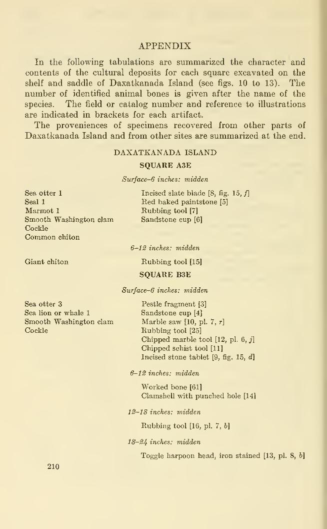
APPENDIX
In the following tabulations are summarized the character and
contents of the cultm'al deposits for each square excavated on the
shelf and saddle of Daxatkanada Island (see figs. 10 to 13). Thenumber of identified animal bones is given after the name of the
species. The field or catalog number and reference to illustrations
are indicated in brackets for each artifact.
The proveniences of specimens recovered from other parts of
Daxatkanada Island and from other sites are summarized at the end.
DAXATKANADA ISLAND
SQUARE A3E
Sea otter 1
Seal 1
Marmot 1
Smooth WashingtonCockle
Common chiton
Giant chiton
Sea otter 3
Sea lion or whale 1
Smooth WashingtonCockle
Surface-6 inches: midden
Incised slate blade [8, fig. 15, f]
Red baked paintstone [5]
Rubbing tool [7]
clam Sandstone cup [6]
6-12 inches: midden
Rubbing tool [15]
SQUARE BSE
Surface-6 inches: midden
Pestle fragment [3]
Sandstone cup [4]
clam Marble saw [10, pi. 7, r]
Rubbing tool [25]
Chipped marble tool [12, pi. 6, j]
Chipped schist tool [11]
Incised stone tablet [9, fig. 15, d]
6-12 inches: midden
Worked bone [61]
Clamshell with punched hole [14]
12—18 inches: midden
Rubbing tool [16, pi. 7, h]
18-24 inches: midden
Toggle harpoon head, iron stained [13, pi. 8, h]
210
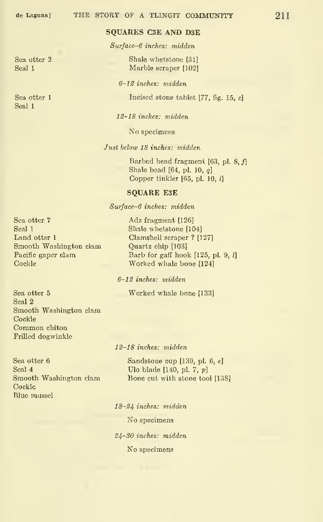
de Laguna] THE STORY OF A TLINGIT COMMUNITY 211
Sea otter 2
Seal 1
Sea otter 1
Seal 1
Sea otter 7
Seal 1
Land otter 1
Smooth Washington clam
Pacific gaper clam
Cockle
Sea otter 5
Seal 2
Smooth Washington clam
Cockle
Common chiton
FriUed dogwinkle
Sea otter 6
Seal 4
Smooth Washington clam
Cockle
Blue mussel
SQUARES C3E AND D3E
Surface-6 inches: midden
Shale whetstone [31]
Marble scraper [102]
6-12 inches: midden
Incised stone tablet [77, fig. 15, c]
12-18 inches: midden
No specimens
Just below 18 inches: midden
Barbed head fragment [63, pi. 8, f]
Shale bead [64, pi. 10, q]
Copper tinkler [65, pi. 10, /]
SQUARE E3E
Surface-6 inches: midden
Adz fragment [126]
Shale whetstone [104]
Clamshell scraper ? [127]
Quartz chip [103]
Barb for gaff hook [125, pi. 9, I]
Worked whale bone [124]
6-12 inches: midden
Worked whale bone [133]
12-18 inches: midden
Sandstone cup [139, pi. 6, e]
Ulo blade [140, pi. 7, p]
Bone cut with stone tool [138]
18-24 inches: midden
No specimens
24-SO inches: midden
No specimens
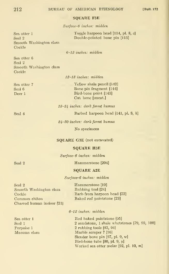
212 BUREAU OF AMERICAN ETHNOLOGY
SQUARE F3E
Surface-6 inches: midden
[Bull. 172
Sea otter 1
Seal 2
Smooth Washington clam
Cockle
Sea otter 6
Seal 2
Smooth Washington clam
Cockle
Toggle harpoon head [114, pi. 8, c]
Double-pointed bone pin [113]
6-12 inches: midden
Sea otter 7
Seal 6
Deer 1
Seal 4
12-18 inches: midden
Yellow shale pencil [142]
Bone pin fragment [144]
Bird-bone point [143]
Cut bone [uncat.]
18-24 inches: dark forest humus
Barbed harpoon head [141, pi. 8, h]
24-30 inches: dark forest humus
No specimens
Seal 2
SQUARE G3E (not excavated)
SQUARE H3E
Surface-6 inches: midden
Hammerstone [204]
SQUARE A2E
Surface-6 inches: midden
Seal 2
Smooth Washington clam
Cockle
Common chiton
Charred human incisor [21]
Sea otter 1
Seal 1
Porpoise 1
Macoma clam
Hammerstone [19]
Rubbing tool [24]
Barb from harpoon head [22]
Baked red paintstone [23]
6-12 inches: midden
Red baked paintstone [95]
2 sandstone, 1 shale whetstones [79, 99, 100]
2 rubbing tools [93, 94]
Marble scraper ? [96]
Slender bone pin [97, pi. 9, w]
Bird-bone tube [80, pi. 9, y]
Worked sea otter molar [92, pi. 10, m]
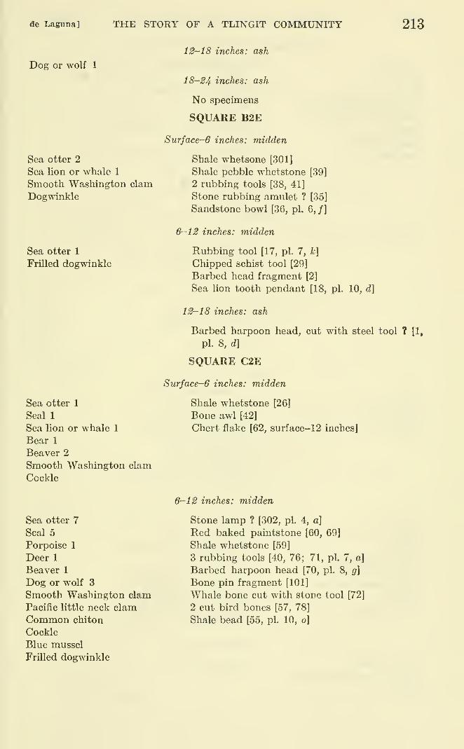
de Laguna] THE STORY OF A TLINGIT COMMUNITY 213
Dog or wolf 1
Sea otter 2
Sea lion or whale 1
Smooth Washington clam
Dogwinkle
Sea otter 1
Frilled dogwinkle
Sea otter 1
Seal 1
Sea lion or whale 1
Bear 1
Beaver 2
Smooth Washington clam
Cockle
12-18 inches: ash
18-24 inches: ash
No specimens
SQUARE B2E
Surface-6 inches: midden
Shale whetsone [301]
Shale pebble whetstone [39]
2 rubbing tools [38, 41]
Stone rubbing amulet ? [35]
Sandstone bowl [36, pi. 6, /]
6-12 inches: midden
Rubbing tool [17, pi. 7, k]
Chipped schist tool [29]
Barbed head fragment [2]
Sea lion tooth pendant [18, pi. 10, d]
12-18 inches: ash
Barbed harpoon head, cut with steel tool ? [1,
pi. 8, d]
SQUARE C2E
Surface-6 inches: midden
Shale whetstone [26]
Bone awl [42]
Chert flake [62, surface-12 inches]
Sea otter 7
Seal 5
Porpoise 1
Deer 1
Beaver 1
Dog or wolf 3
Smooth Washington clam
Pacific little neck clamCommon chiton
Cockle
Blue mussel
FriUed dogwinkle
6-12 inches: midden
Stone lamp ? [302, pi. 4, a]
Red baked paintstone [60, 69]
Shale whetstone [59]
3 rubbing tools [40, 76; 71, pi. 7, a]
Barbed harpoon head [70, pi. 8, g]
Bone pin fragment [101]
Whale bone cut with stone tool [72]
2 cut bird bones [57, 78]
Shale bead [55, pi. 10, o]
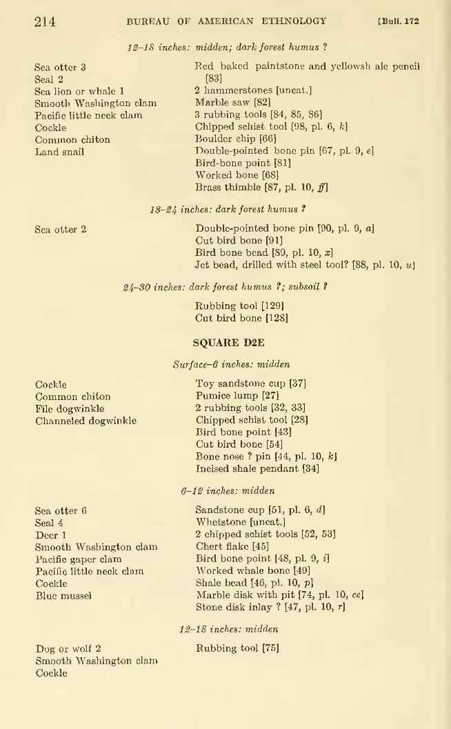
214 BUREAU OF AMERICAN ETHNOLOGY [BuU. 172
12-18 inches: midden; dark forest humus ?
Sea otter 3
Seal 2
Sea lion or whale 1
Smooth Washington clam
Pacific little neck clam
Cockle
Common chiton
Land snail
Sea otter 2
Red baked paintstone and yellowsh ale pencil
[83]
2 hammerstones [uncat.]
Marble saw [82]
3 rubbing tools [84, 85, 86]
Chipped schist tool [98, pi. 6, k\
Boulder chip [66]
Double-pointed bone pin [67, pi. 9, e\
Bird-bone point [81]
Worked bone [68]
Brass thimble [87, pi. 10, ff]
18-S4 inches: dark forest humus ?
Double-pointed bone pin [90, pi. 9, a\
Cut bird bone [91]
Bird bone bead [89, pi. 10, x]
Jet bead, drilled with steel tool? [88, pi. 10, u\
24-30 inches: dark forest humus f; subsoil ?
Rubbing tool [129]
Cut bird bone [128]
Cockle
Common chiton
File dogwinkle
Channeled dogwinkle
Sea otter 6
Seal 4
Deer 1
Smooth Washington clam
Pacific gaper clam
Pacific little neck clam
Cockle
Blue mussel
Dog or wolf 2
Smooth Washington clam
Cockle
SQUARE D2E
Surface-6 inches: midden
Toy sandstone cup [37]
Pumice lump [27]
2 rubbing tools [32, 33]
Chipped schist tool [28]
Bird bone point [43]
Cut bird bone [54]
Bone nose ? pin [44, pi. 10, A;J
Incised shale pendant [34]
6-12 inches: midden
Sandstone cup [51, pi. 6, d]
Whetstone [uncat.]
2 chipped schist tools [52, 53]
Chert flake [45]
Bird bone point [48, pi. 9, i]
Worked whale bone [49]
Shale bead [46, pi. 10, p]
Marble disk with pit [74, pi. 10, ee]
Stone disk inlay ? [47, pi. 10, r]
12-18 inches: midden
Rubbing tool [75]
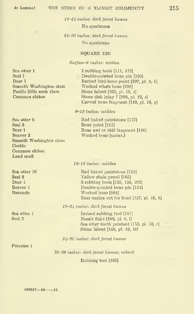
de Laguna] THE STORY OF A TLINGIT COIMMUNITT 215
18-24 inches: dark forest humus
No specimens
24-30 inches: dark forest humus
No specimens
SQUARE E2E
Surface~6 inches: midden
Sea otter 1
Seal 1
Deer 1
Smooth Washington clam
Pacific little neck clam
Conomon chiton
Sea otter 6
SealsBear 1
Beaver 2
Smooth Washington clam
Cockle
Common chiton
Land snail
Sea otter 10
SealsDeer 1
Beaver 1
Barnacle
2 rubbing tools [111, 112]
Double-pointed bone pin [109]
Barbed bird-bone point [107, pi. 9, h]
Worked whale bone [108]
Stone labret [105, pi. 10, z]
Stone disk inlay ? [106, pi. 10, s]
Carved bone fragment [110, pi. 10, y]
6-12 inches: midden
Red baked paintstone [117]
Bone point [115]
Bone awl or drill fragment [116]
Worked bone [uncat.]
12-18 inches: midden
Red baked paintstone [159]
Yellow shale pencil [165]
3 rubbing tools [135, 156, 163]
Double-pointed bone pin [134]
Worked bone [164]
Bear canine cut for bead [157, pi. 10, h]
Sea otter 1
Seal 2
Porpoise 1
18-24 inches: dark forest humus
Incised rubbing tool [167]
Basalt flake [168, pi. 6, /]
Sea otter tooth pendant [152, pi.
Stone labret [166, pi. 10, bb]
24-SO inches: dark forest humus
30-36 inches: dark forest humus; stibsoil
Rubbing tool [160]
10, r]
460927—60- -15
216 BUREAU OF AMERICAN ETHNOLOGY
SQUARE F2E
Surface-6 inches: midden
[Bull. 172
Sea otter 7
de Laguna] THE STORY OF A TLINGIT CORIMUNITY 217
Sea otter 2
Seal 2
Smooth Washington clam
Macoma clam
Cockle
Channeled dogwinkle
Land snail
Sea otter 8
Seal 1
Deer 1
Dog or wolf 1
Smooth Washington clam
Cockle
Sea otter 1
Deer 1
Smooth Washington clam
Cockle
Common chiton
Shield limpet
Channeled dogwinkle
Land snail
SQUARE G2E
Surface-6 inches: midden
Baked claystone cup [154]
Red baked paintstone [153]
Double-poii.ted bone pin [155, pi. 9, c]
6-12 inches: midden
Barbed harpoon head [176, pi. 8, j]
Cut bone [158]
12-18 inches: midden
Hammerstone [180, pi. 5, /]
Rubbing tool [181]
2 cut bones [uncat.]
Ornamental bone strip [162, pi. 10, i]
18-24 inches: midden; dark forest humus
Seal 2
Porpoise 1
Bear 2
Beaver 1
Marmot 2
Smooth Washington clam
Cockle
Common chiton
Frilled dogwinkle
Channeled dogwinkle
Plate limpet
Shield limpet
Sea otter 3
Seal 1
Smooth Washington clam
Cockle
Hammerstone [214]
Whetstone [213]
Cut bone [177]
Drilled bear jaw [178, pi. 10, hh]
Wooden peg [uncat.]
Wooden post cut by steel ax [pi. 4, c]
SQUARE H2E
Surface-6 inches: midden
Chipped schist tool [188]
Sea otter tooth pendant [246, pi. 10, b]
218 BUREAU OF AMERICAN ETHNOLOGY [Bull. 172
Sea otter 2
Seal 2
Smooth Washington clara
Pacific little neck clam
Macoma clam
Cockle
Land snail
Sea otter 13
Seal 2
Porpoise 1
Dog or wolf 1
Smooth Washington clam
Pacific little neck clam
Pacific gaper clam
Cockle
Land snail
Sea otter 7
Seal 1
Sea lion or whale 1
Bear 1
Common chiton
Oregon triton
Sea otter 5
Seal 1
Porpoise 1
Smooth Washington clam
Pacific little neck clam
Cockle
Land snail
6-1 S inches: midden
Double-pointed bone pin [1901
Cut bird bone [189]
12-18 inches: midden
2 Rubbing tools [202, 210]
Barbed harpoon head, steel cut [198, pi. 8, I]
Slender bone pin [227, pi. 9, x]
Cut bone [211]
Wooden peg [uncat.]
18-24 inches: midden
24-SO inches: midden
Wooden post and peg [uncat.]
SQUARE AlE (not excavated)
SQUARE BIE
Surface-6 inches: midden
Sea otter 2
Seal 1
Deer 1
Bear 1
Smooth Washington clam
Pacific little neck clam
Red baked paintstone [184]
3 rubbing tools [182, 185; 183, pi. 7, i]
Chert flake [186]
Blue talc chip [187]
de I/aguna] THE STORY OF A TLINGIT COMMUNITY 219
Sea otter 1
Deer 1
Smooth Washington clam
Elderberry seeds (in humus)
Beaver 1
6-12 inches: midden; dark forest humus
2 rubbing tools [207, 208]
Boulder chip [209]
Sea otter 4
Channeled dogwinkle
Sea otter 5
Seal 3
Human tooth [258]
Sea otter 2
Sea otter 3
Smooth Washington clam
Barnacle
12-18 inches: subsoil
SQUARE CIE
Surface-6 inches: midden
Shale whetstone [217]
2 rubbing tools [216, 220]
Double-pointed bone pin [219]
Gaff hook barb [218, pi. 9, k]
6-12 inches: midden
Barbed harpoon head [279, pi. 8, n\
12-18 inches: burned subsoil
SQUARE DIE
SxirJace-6 inches: midden
Rubbing tool [256]
Bone-point fragment [uncat.l
Cut bone [225]
Cut bird bone [226]
Ivory bead [255, pi. 10, n]
6-12 inches: midden
Rubbing tool fragment [278]
Cut bone [206]
Sea otter 2
Seal 1
Smooth Washington clam
12-18 inches: midden; dark forest humus
2 hammerstones [347 a, b; 3481
18-24 inches: midden; dark forest hurmis
Porpoise 1
Smooth Washington clam
Whetstone [375]
Chert fiake [376]
24-30 inches: dark forest humusf; subsoil
Bear 1
Smooth Washington clam
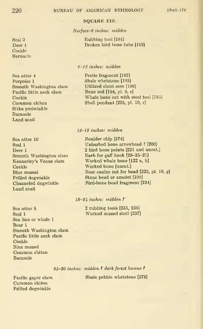
220
Seal 2
Deer 1
Cockle
Barnacle
BUREAU OF AMERICAN ETHNOLOGY
SQUARE ElE
Surface-6 inches: midden
Rubbing tool [191]
Broken bird bone tube [192]
[Bull. 172
Sea otter 4
Porpoise 1
Smooth Washington clam
Pacific little neck clam
Cockle
Common chiton
Sitka periwinkle
Barnacle
Land snail
Sea otter 10
Seal 1
Deer 1
Smooth Washington clam
Kennerley's Venus clam
Cockle
Blue mussel
Frilled dogwinkle
Channeled dogwinkle
Land snail
Sea otter 5
Seal 1
Sea lion or whale 1
Bear 1
Smooth Washington clam
Pacific little neck clam
Cockle
Blue mussel
Common chiton
Barnacle
6-1^ inches: midden
Pestle fragment [197]
Shale whetstone [193]
Utilized chert core [196]
Bone rod [194, pi. 9, v]
Whale bone cut with steel tool [195]
Shell pendant [205, pi. 10, e]
I12-18 inches: midden
Boulder chip [374]
Unbarbed bone arrowhead ? [200]
2 bird bone points [221 and uncat.]
Barb for gaff hook [29-25-21]
Worked whale bone [122 a, b]
Worked bone [uncat.]
Bear canine cut for bead [223, pi. 10, g]
Stone bead or amulet [199]
Bird-bone bead fragment [224]
18-24 inches: midden f
2 rubbing tools [235, 236]
Worked mussel shell [237]
Pacific gaper clam
Common chiton
Frilled dogwinkle
24-SO inches: midden t dark forest humus f
Shale pebble whetstone [378]
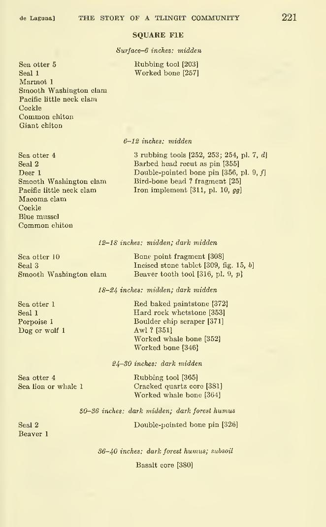
de Lagana] THE STORY OF A TLLNGIT COMMUNITY 221
Sea otter 5
Seal 1
Marmot 1
Smooth Washington clam
Pacific little neck clam
Cockle
Common chiton
Giant chiton
Sea otter 4
Seal 2
Deer 1
Smooth Washington clam
Pacific little neck clam
Macoma clam
Cockle
Blue mussel
Common chiton
SQUARE FIE
Surface-6 inches: midden
Rubbing tool [203]
Worked bone [257]
6-1^ inches: midden
3 rubbing tools [252, 253; 254, pi. 7, d]
Barbed head recut as pin [355]
Double-pointed bone pin [356, pi. 9, /]
Bird-bone bead ? fragment [25]
Iron implement [311, pi. 10, gg]
12-18 inches: midden; dark midden
Sea otter 10
SealsSmooth Washington clam
Bone point fragment [308]
Incised stone tablet [309, fig. 15, 6]
Beaver tooth tool [316, pi. 9, p]
Sea otter 1
Seal 1
Porpoise 1
Dog or wolf 1
Sea otter 4
Sea lion or whale 1
18-24 inches: midden; dark midden
Red baked paintstone [372]
Hard rock whetstone [353]
Boulder chip scraper [371]
Awl ? [351]
Worked whale bone [352]
Worked bone [346]
24-30 inches: dark midden
Rubbing tool [365]
Cracked quartz core [381]
Worked whale bone [364]
Seal 2
Beaver 1
S0-S6 inches: dark midden; dark forest humus
Double-pointed bone pin [326]
36-40 inches: dark forest humus; subsoil
Basalt core [380]
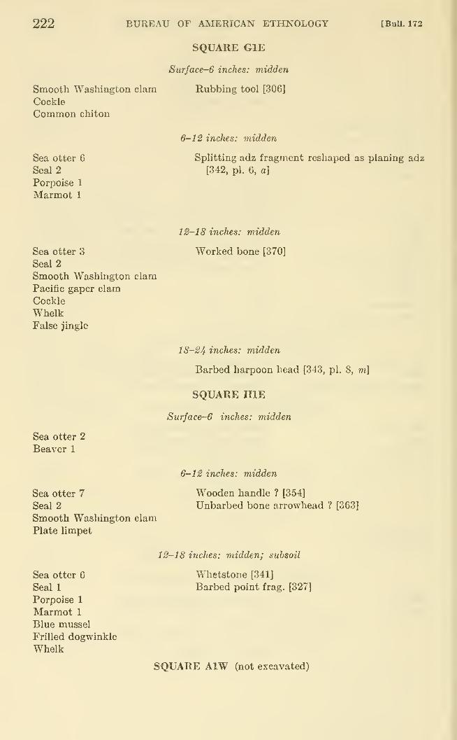
222
Smooth Washington clam
Cockle
Common chiton
Sea otter G
Seal 2
Porpoise 1
Marmot 1
BUREAU OF AMERICAN ETHNOLOGY
SQUARE GlE
Surface-6 inches: midden
Rubbing tool [306]
[BuU. 172
6~12 inches: midden
Splitting adz fragment reshaped as planing adz
[342, pi. 6, a]
Sea otter 3
Seal 2
Smooth Washington clam
Pacific gaper clam
Cockle
WhelkFalse jingle
12-18 inches: midden
Worked bone [370]
Sea otter 2
Beaver 1
Sea otter 7
Seal 2
Smooth Washington clam
Plate limpet
18-24 inches: midden
Barbed harpoon head [343, pi. 8, m]
SQUARE HIE
Surface-6 inches: midden
6-12 inches: midden
Wooden handle ? [354]
Unbarbed bone arrowhead ? [363]
Sea otter G
Seal 1
Porpoise 1
Marmot 1
Blue mussel
Frilled dogwinkle
Whelk
12-18 inches: midden; subsoil
Whetstone [341]
Barbed point frag. [327]
SQUARE AlW (not excavated)
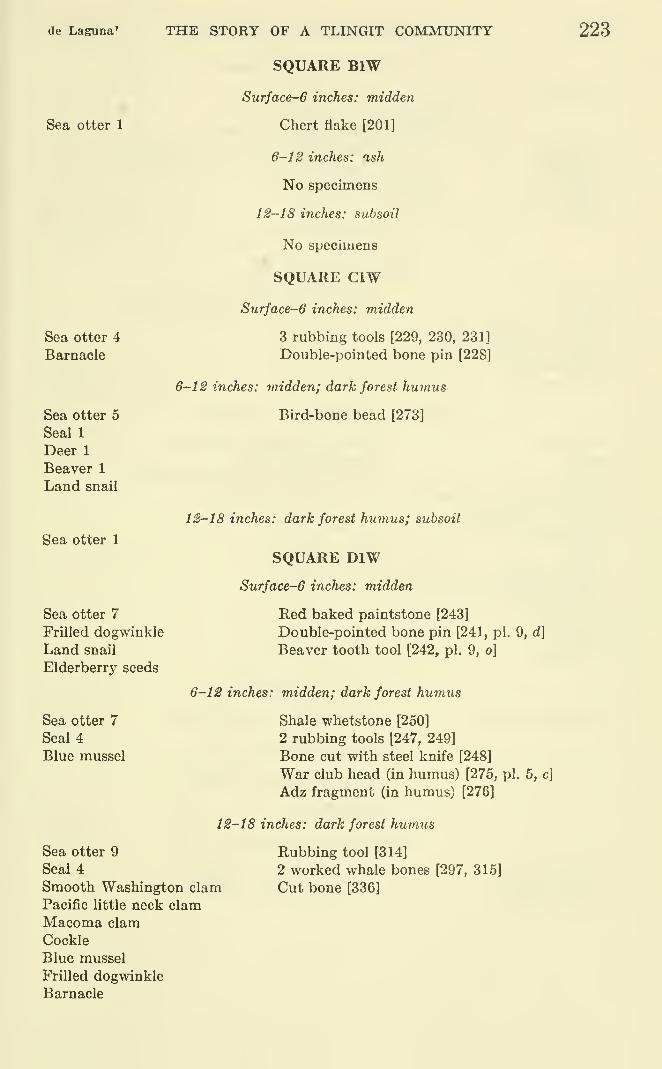
de Laguna' THE STORY OF A TLINGIT COMMUNITY 223
Sea otter 1
Sea otter 4
Barnacle
Sea otter 5
Seal 1
Deer 1
Beaver 1
Land snail
Sea otter 1
Sea otter 7
Frilled dogwinkle
Land snail
Elderberry seeds
Sea otter 7
Seal 4
Blue mussel
SQUARE BIW
Surface-6 inches: midden
Chert flake [201]
6-12 inches: ash
No specimens
12-18 inches: subsoil
No specimens
SQUARE CIW
Surface-6 inches: midden
3 rubbing tools [229, 230, 231]
Double-pointed bone pin [228]
6-12 inches: midden; dark forest humus
Bird-bone bead [273]
12-18 inches: dark forest humus; subsoil
SQUARE DIW
Surface-6 inches: midden
Red baked paintstone [243]
Double-pointed bone pin [241, pi. 9, d]
Beaver tooth tool [242, pi. 9, o]
6-12 inches: midden; dark forest humus
Shale whetstone [250]
2 rubbing tools [247, 249]
Bone cut with steel knife [248]
War club head (in humus) [275, pi. 5, c]
Adz fragment (in humus) [276]
12-18 inches: dark forest hum.us
Sea otter 9
Seal 4
Smooth Washington clamPacific little neck clamMacoma clam
Cockle
Blue mussel
Frilled dogwinkle
Barnacle
Rubbing tool [314]
2 worked whale bones [297, 315]
Cut bone [336]
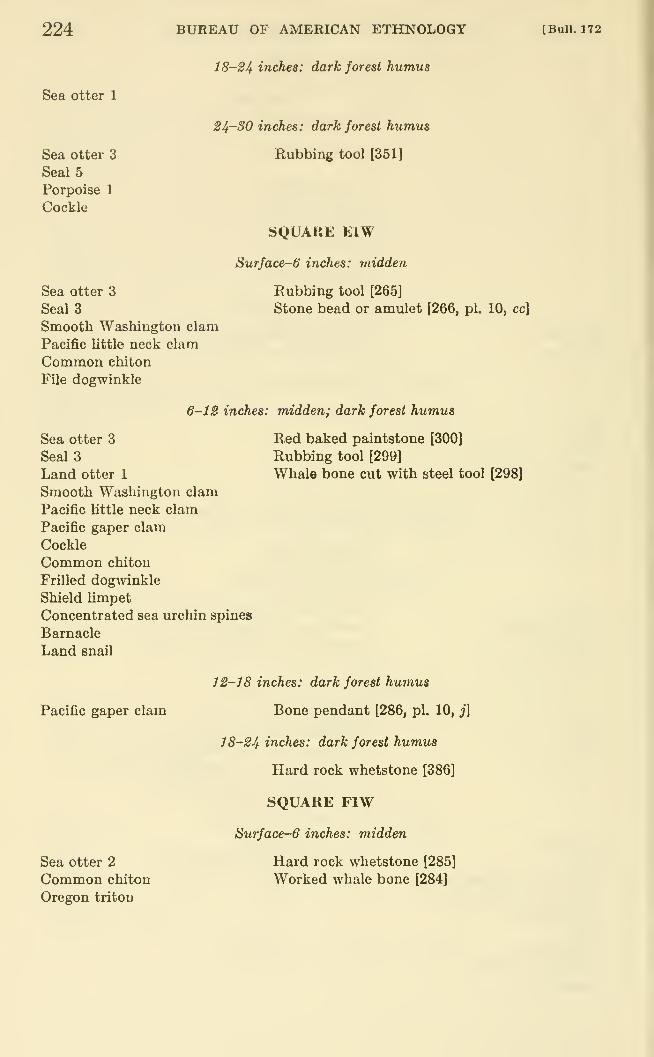
224 BUREAU OF AMERICAN ETHNOLOGY [Bull. 172
Sea otter 1
Sea otter 3
Seal 5
Porpoise 1
Cockle
18-S4 inches: dark forest humus
24-SO inches: dark forest humus
Rubbing tool [351]
SQUARE EIW
Surface-6 inches: midden
Sea otter 3
Seal 3
Smooth Washington clam
Pacific little neck clam
Common chiton
File dogwinkle
Rubbing tool [265]
Stone bead or amulet [266, pi. 10, cc]
6-12 inches: midden; dark forest humus
Sea otter 3
Seal 3
Land otter 1
Smooth Washington clam
Pacific little neck clam
Pacific gaper clam
Cockle
Common chiton
Frilled dogwinkle
Shield limpet
Concentrated sea urchin spines
Barnacle
Land snail
Red baked paintstone [300]
Rubbing tool [299]
Whale bone cut with steel tool [298]
Pacific gaper clam
Sea otter 2
Common chiton
Oregon tritou
12-18 inches: dark forest humus
Bone pendant [286, pi. 10, j]
18-24 inches: dark forest humus
Hard rock whetstone [386]
SQUARE FIW
Surface-6 inches: midden
Hard rock whetstone [285]
Worked whale bone [284]
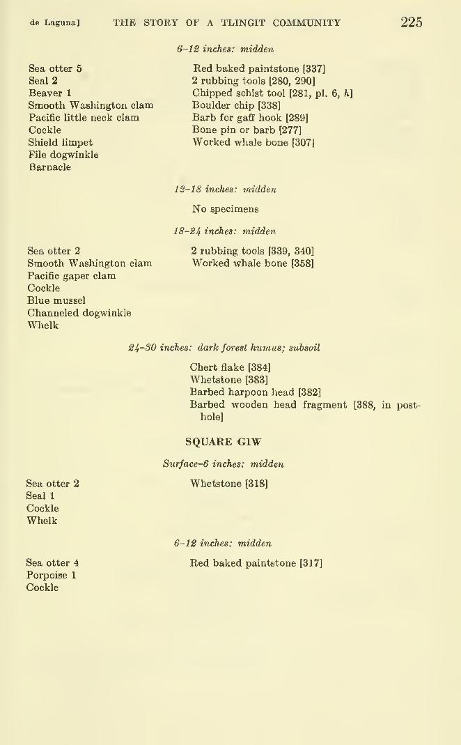
de Laguna] THE STORY OF A TLINGIT COMMtJNITY 225
Sea otter 5
Seal 2
Beaver 1
Smooth Washington clam
Pacific little neck clam
Cockle
Shield limpet
File dogwinkle
Barnacle
Sea otter 2
Smooth Washington clam
Pacific gaper clam
Cockle
Blue mussel
Channeled dogwinkle
Whelk
6-12 inches: midden
Red baked paintstone [337]
2 rubbing tools 1280, 290]
Chipped schist tool [281, pi. 6, h]
Boulder chip [338]
Barb for gaff hook [289]
Bone pin or barb [277]
Worked whale bone [307]
12-18 inches: midd&n
No specimens
18-24 inches: midden
2 rubbing tools [339, 340]
Worked whale bone [358]
Sea otter 2
Seal 1
Cockle
Whelk
Sea otter 4
Porpoise 1
Cockle
24-30 inches: dark forest humus; subsoil
Chert flake [384]
Whetstone [383]
Barbed harpoon head [382]
Barbed wooden head fragment [388, in post-
hole]
SQUARE GIW
Surface-6 inches: midden
Whetstone [318]
6-12 inches: midden
Red baked paintstone [317]
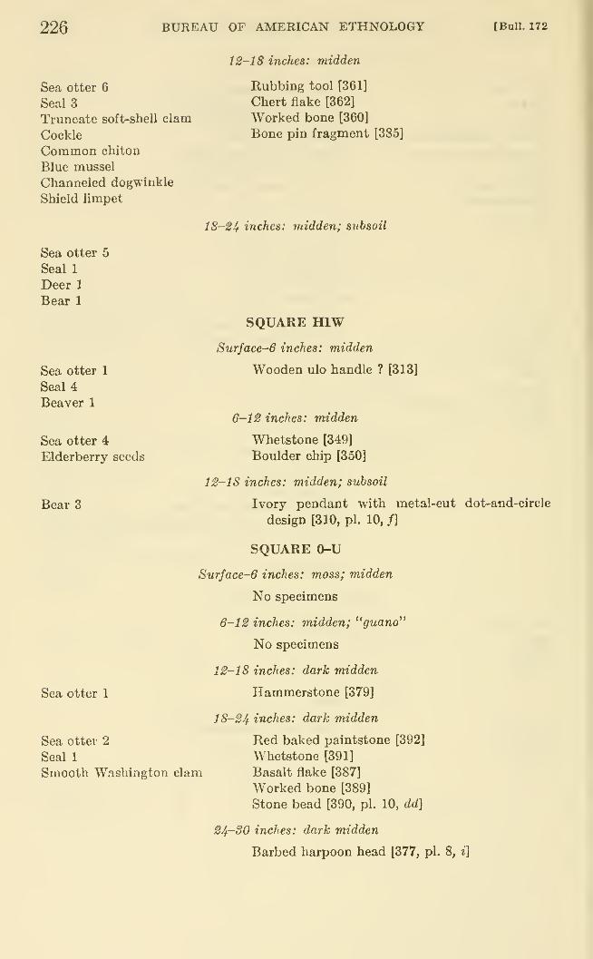
226 BUREAU OF AMERICAN ETHNOLOGY [Bull. 172
12-18 inches: midden
Sea otter 6
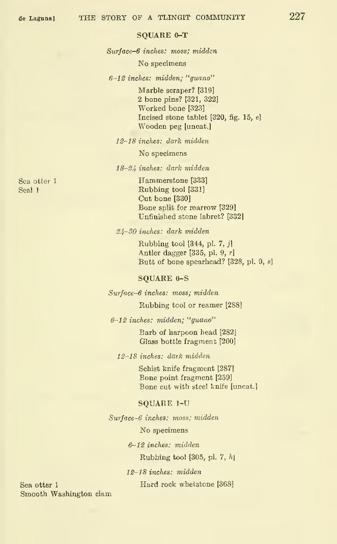
de Laguna] THE STORY OF A TLINGIT COM]VnmiTY
SQUARE 0-T
Surface-6 inches: moss; midden
No specimens
6-12 inches: midden; "guano"
Marble scraper? [319]
2 bone pins? [321, 322]
Worked bone [323]
Incised stone tablet [320, fig. 15, e]
Wooden peg [uncat.]
12-18 inches: dark midden
No specimens
18-24 inches: dark midden
Sea otter 1 Hammerstone [333]
Seal 1 Rubbing tool [331]
Cut bone [330]
Bone split for marrow [329]
Unfinished stone labret? [332]
24-30 inches: dark midden
Rubbing tool [344, pi. 7, j]
Antler dagger [335, pi. 9, r]
Butt of bone spearhead? [328, pi. 9, s]
SQUARE 0-S
Surface-6 inches: moss; midden
Rubbing tool or reamer [288]
6-12 inches: midden; "guano"
Barb of harpoon head [282]
Glass bottle fragment [260]
12-18 inches: dark midden
Schist knife fragment [287]
Bone point fragment [259]
Bone cut with steel knife [uncat.]
SQUARE 1-U
Surface-6 inches: jnoss; midden
No specimens
6-12 inches: midden
Rubbing tool [305, pi. 7, h\
12-18 inches: midden
Sea otter 1 Hard rock whetstone [368]
Smooth Washington clam
227
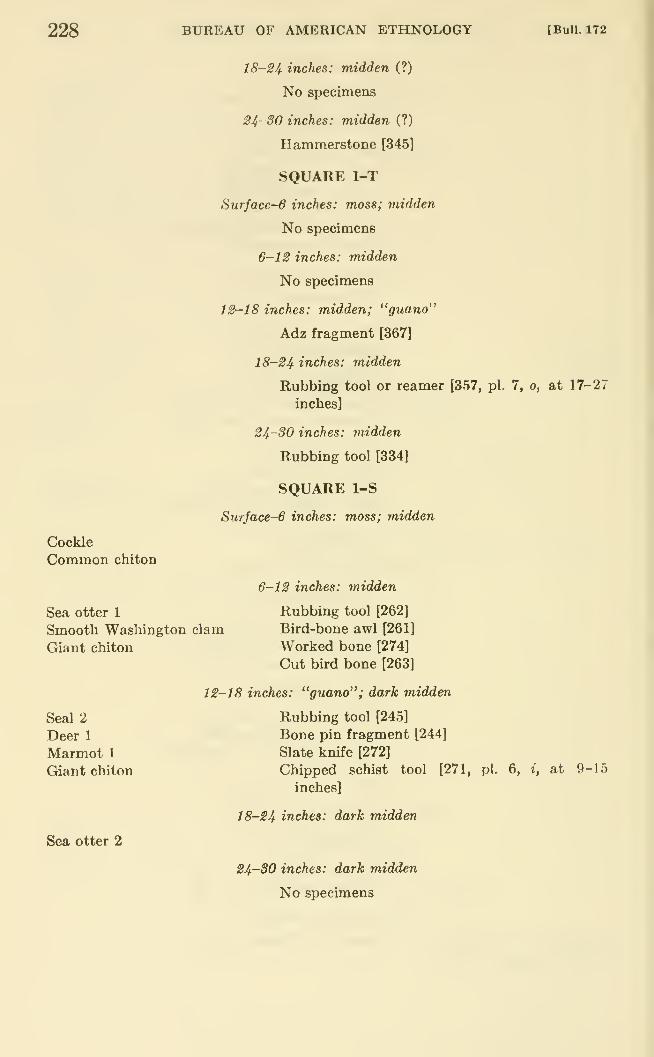
228 BUREAU OF AMERICAN ETHNOLOGY [Bull. 172
Cockle
Common chiton
18-24 inches: midden (?)
No specimens
24' 30 inches: midden (?)
Hammerstone [345]
SQUARE 1-T
Surfaces inches: moss; midden
No specimens
6-12 inches: midden
No specimens
12-18 inches: midden; "guano"
Adz fragment [367]
18-24 inches: midden
Rubbing tool or reamer [357, pi. 7, o, at 17-27
inches]
24-30 inches: midden
Rubbing tool [334]
SQUARE 1-S
Surface-6 inches: moss; midden
Sea otter 1
Smooth Washington clam
Giant chiton
6-12 inches: midden
Rubbing tool [262]
Bird-bone awl [261]
Worked bone [274]
Cut bird bone [263]
Seal 2
Deer 1
Marmot 1
Giant chiton
Sea otter 2
12-18 inches: "guano"; dark midden
Rubbing tool [245]
Bone pin fragment [244]
Slate knife [272]
Chipped schist tool [271, pi. 6, i, at 9-15
inches]
18-24 inches: dark midden
24-30 inches: dark midden
No specimens
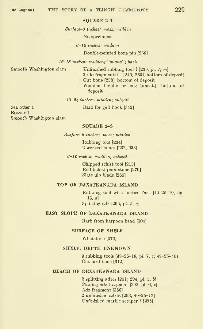
de Laguna] THE STORY OF A TLINGIT COMMUNITY 229
SQUARE 2-T
Surface-6 inches: moss; midden
No specimens
6-12 inches: midden
Double-pointed bone pin [268]
12-18 inches: midden; "guano"; bark
Smooth Washington clam Unfinished rubbing tool ? [239, pi. 7, m]2 ulo fragments? [240, 285], bottom of deposit
Cut bone [238], bottom of deposit
Wooden handle or peg [uncat.], bottom of
deposit
18-24 inches: midden; subsoil
Sea otter 1 Barb for gaff hook [312]
Beaver 1
Smooth Washington clam
SQUARE 2-S
Surface-6 inches: moss; midden
Rubbing tool [234]
2 worked bones [232, 233]
6-12 inches: midden; subsoil
Chipped schist tool [215]
Red baked paintstone [270J
Slate ulo blade [269]
TOP OF DAXATKANADA ISLAND
Rubbing tool with incised face [49-26-19, fig.
15, a]
Splitting adz [296, pi. 5, a]
EAST SLOPE OF DAXATKANADA ISLAND
Barb from harpoon head [304]
SURFACE OF SHELF
Whetstone [373]
SHELF, DEPTH UNKNOWN2 rubbing tools [49-25-18, pi. 7, c; 49-25-401
Cut bird bone [312]
BEACH OF DEXATKANADA ISLAND
2 splitting adzes [291; 294, pi. 5, b]
Planing adz fragment [292, pi. 6, c]
Adz fragment [366]
2 unfinished adzes [293, 49-25-17]
Unfinished marble scraper ? [295]
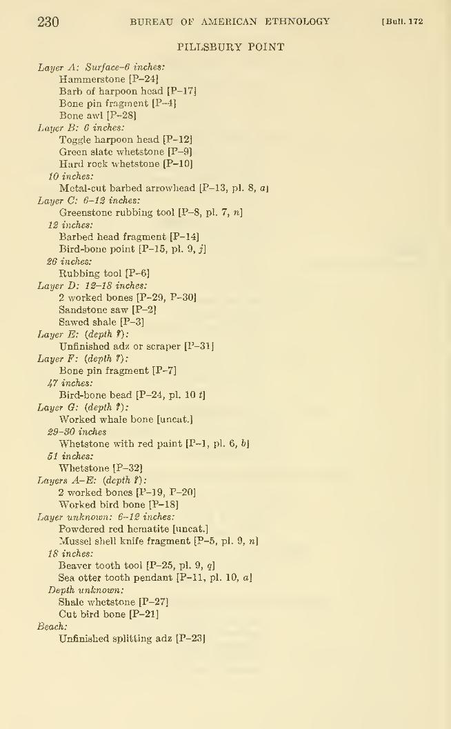
230 BUREAU OF AMERICAN ETHNOLOGY [Bull. 172
PILLSBURY POINT
Layer A: Surface-6 inches:
Hammerstone [P-24]
Barb of harpoon head [P-17J
Bone pin fragment [P-4]
Bone awl [P-28]
Layer B: 6 inches:
Toggle harpoon head [P-12]
Green slate whetstone [P-9]
Hard rock whetstone [P-10]
10 inches:
Metal-cut barbed arrowhead [P-13, pi. 8, a\
Layer C: 6-12 inches:
Greenstone rubbing tool [P-8, pi. 7, n]
12 inches:
Barbed head fragment [P-14]
Bird-bone point [P-15, pi. 9, j]
26 inches:
Rubbing tool [P-6]
Layer D: 12-18 inches:
2 worked bones [P-29, P-30]
Sandstone saw [P-2]
Sawed shale [P-3]
Layer E: {depth f):
Unfinished adz or scraper [P-31J
Layer F: (depth ?):
Bone pin fragment [P-7]
47 inches:
Bird-bone bead [P-24, pi. 10 f]
Layer G: (depth f):
Worked whale bone [uncat.]
29-30 inches
Whetstone with red paint [P-1, pi. 6, b]
51 inches:
Whetstone [P-32]
Layers A-E: (depth f)
:
2 worked bones [P-1 9, P-20]
Worked bird bone [P-18]
Layer unknown: 6-12 inches:
Powdered red hematite [uncat.]
Mussel shell knife fragment [P-5, pi. 9, n\
18 inches:
Beaver tooth tool [P-25, pi. 9, q]
Sea otter tooth pendant [P-11, pi. 10, a\
Depth unknown:Shale whetstone [P-27]
Cut bird bone [P-21]
Beach:
Unfinished splitting adz [P-23J
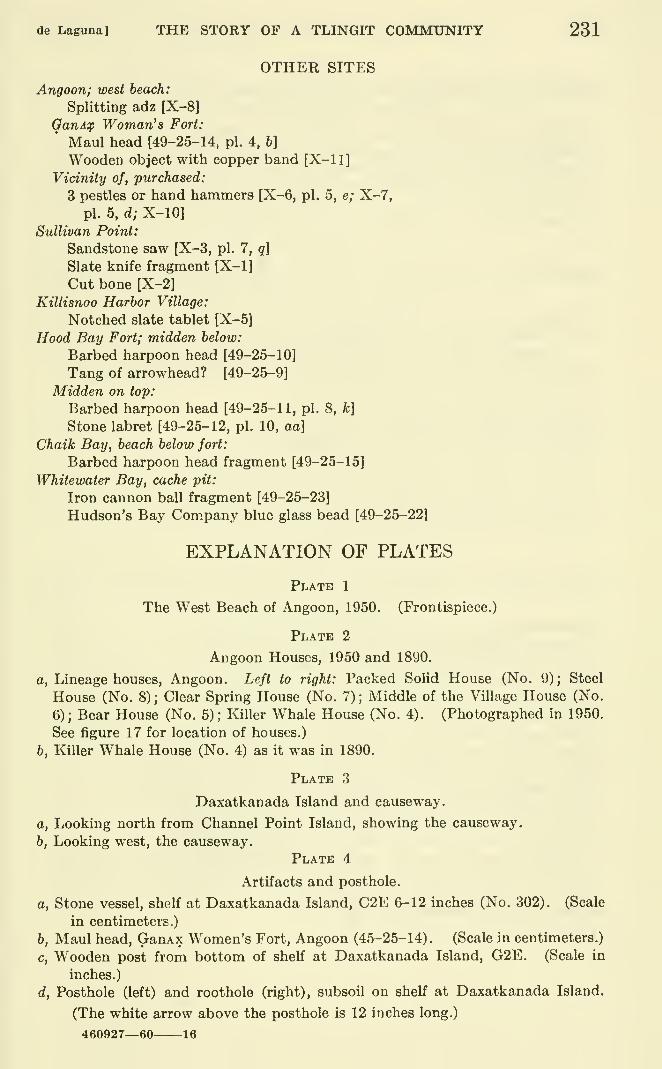
de Laguna] THE STORY OF A TLINGIT COMMUNITY 231
OTHER SITES
Angoon; west beach:
Splitting adz [X-8]
GanA^p Woman's Fort:
Maul head [49-25-14, pi. 4, b]
Wooden object with copper band [X-11]
Vicinity of, purchased:
3 pestles or hand hammers [X-6, pi. 5, e; X-7,
pi. 5, d; X-10]
Sullivan Point:
Sandstone saw [X-3, pi. 7, q]
Slate knife fragment [X-1]
Cut bone [X-2]
Killisnoo Harbor Village:
Notched slate tablet [X-51
Hood Bay Fort; midden below:
Barbed harpoon head [49-25-10]
Tang of arrowhead? [49-25-9]
Midden on top:
Barbed harpoon head [49-25-11, pi. 8, k]
Stone labret [49-25-12, pi. 10, aa]
Chaik Bay, beach below fort:
Barbed harpoon head fragment [49-25-15]
Whitewater Bay, cache pit:
Iron cannon ball fragment [49-25-23]
Hudson's Bay Com.pany blue glass bead [49-25-22]
EXPLANATION OF PLATES
Plate 1
The West Beach of Angoon, 1950. (Frontispiece.)
Plate 2
Angoon Houses, 1950 and 1890.
a, Lineage houses, Angoon. Left to right: Packed SoUd House (No. 9); Steel
House (No. 8); Clear Spring House (No. 7); Middle of the Village House (No.
6); Bear House (No. 5); Killer Whale House (No. 4). (Photographed in 1950.
See figure 17 for location of houses.)
b, Killer Whale House (No. 4) as it was in 1890.
Plate 3
Daxatkanada Island and causeway.
a, Looking north from Channel Point Island, showing the causeway.
b, Looking west, the causeway.
Plate 4
Artifacts and posthole.
a, Stone vessel, shelf at Daxatkanada Island, C2E 6-12 inches (No. 302), (Scale
in centimeters.)
b, Maul head, GanAx Women's Fort, Angoon (45-25-14). (Scale in centimeters.)
c, Wooden post from bottom of shelf at Daxatkanada Island, G2E. (Scale in
inches.)
d, Posthole (left) and roothole (right), subsoil on shelf at Daxatkanada Island.
(The white arrow above the posthole is 12 inches long.)
460927—60 16
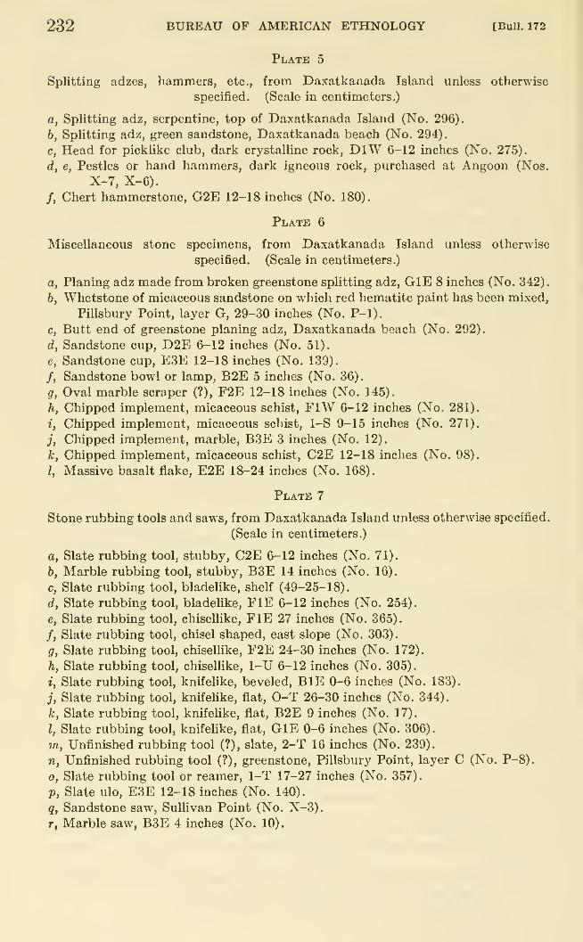
232 BUREAU OF AMERICAN ETHNOLOGY [Bull. 172
Plate 5
Splitting adzes, hammers, etc., from Daxatkanada Island unless otherwise
specified. (Scale in centimeters.)
a, Splitting adz, serpentine, top of Daxatkanada Island (No. 296).
b, Splitting adz, green sandstone, Daxatkanada beach (No. 294).
c, Head for picklike club, dark crystalline rock, DlW 6-12 inches (No. 275).
d, e, Pestles or hand hammers, dark igneous rock, purchased at Angoon (Nos.
X-7, X-6).
/, Chert hammerstone, G2E 12-18 inches (No, 180).
Plate 6
Miscellaneous stone specimens, from Daxatkanada Island unless otherwise
specified. (Scale in centimeters.)
a, Planing adz made from broken greenstone splitting adz, GlE 8 inches (No. 342).
b, Whetstone of micaceous sandstone on which red hematite paint has been mixed,
Pillsbury Point, layer G, 29-30 inches (No. P-1).
c, Butt end of greenstone planing adz, Daxatkanada beach (No. 292).
d, Sandstone cup, D2E 6-12 inches (No. 51).
e, Sandstone cup, E3E 12-18 inches (No. 139).
/, Sandstone bowl or lamp, B2E 5 inches (No. 36).
g, Oval marble scraper (?), F2E 12-18 inches (No. 145).
h, Chipped implement, micaceous schist, FIW 6-12 inches (No. 281).
i, Chipped implement, micaceous schist, 1-S 9-15 inches (No. 271).
j, Chipped implement, marble, B3E 3 inches (No. 12).
k, Chipped implement, micaceous schist, C2E 12-18 inches (No. 98).
I, Massive basalt flake, E2E 18-24 inches (No. 168).
Plate 7
Stone rubbing tools and saws, from Daxatkanada Island unless otherwise specified.
(Scale in centimeters.)
a, Slate rubbing tool, stubby, C2E 6-12 inches (No. 71).
b, Marble rubbing tool, stubby, B3E 14 inches (No. 16).
c, Slate rubbing tool, bladelike, shelf (49-25-18).
d, Slate rubbing tool, bladeUke, FIE 6-12 inches (No. 254).
e, Slate rubbing tool, chisellike, FIE 27 inches (No. 365).
/, Slate rubbing tool, chisel shaped, east slope (No. 303).
g, Slate rubbing tool, chiselUke, F2E 24-30 inches (No. 172).
h, Slate rubbing tool, chiselUke, 1-U 6-12 inches (No. 305).
i, Slate rubbing tool, knifehke, beveled, BlE 0-6 inches (No. 183).
j, Slate rubbing tool, knifehke, flat, 0-T 26-30 inches (No. 344).
k, Slate rubbing tool, knifelike, flat, B2E 9 inches (No. 17).
I, Slate rubbing tool, knifehke, flat, GlE 0-6 inches (No. 306).
m, Unfinished rubbing tool (?), slate, 2-T 16 inches (No. 239).
n. Unfinished rubbing tool (?), greenstone, Pillsbury Point, layer C (No. P-8).
0, Slate rubbing tool or reamer, 1-T 17-27 inches (No. 357).
p. Slate ulo, E3E 12-18 inches (No. 140).
q, Sandstone saw, Sullivan Point (No. X-3).
r, Marble saw, B3E 4 inches (No. 10).
de Laguna] THE STORY OF A TLINGIT COMMUNITY 233
Plate 8
Bone weapons, from Daxatkanada Island unless otherwise specified. (Scale in
centimeters.)
a, Slender barbed point for arrow (?), Pillsbury Point, layer B, 10 inches (No.
P-13).
b, Half of toggle harpoon head, BSE 19 inches (No. 13).
c, Half of toggle harpoon head, F3E 0-6 inches (No. 114).
d, Barbed harpoon head, B2E 17 inches (No. 1).
e, Barbed harpoon head, F2E 18-24 inches (No. 148).
/, Barbed harpoon head, C3E below 18 inches (No. 63).
g, Barbed harpoon head, C2E 6-12 inches (No. 70).
h, Barbed harpoon head, F3E 18-24 inches (No. 141).
i, Barbed harpoon head, O-U 27-28 inches (No. 377).
j, Barbed harpoon head, G2E 6-12 inches (No. 176).
k, Barbed harpoon head. Hood Bay Fort (49-25-11).
I, Barbed harpoon head, H2E 12-18 inches (No. 198).
m, Barbed harpoon head, GlE 21 inches (No. 343).
n, Barbed harpoon head, CIE 6-12 inches (No. 279).
Plate 9
Bone and shell implements, from Daxatkanada Island unless otherwise specified.
(Scale in centimeters).
a, Double-pointed bone pin, C2E 18-24 inches (No. 90).
b, Double-pointed bone pin, F2E 24-30 inches (No. 169).
c, Double-pointed bone pin, G2E 0-6 inches (No. 155).
d, Double-pointed bone pin, DlW 0-6 inches (No. 241).
e, Double-pointed bone pin, C2E 12-18 inches (No. 67).
f, Double-pointed bone pin, FIE 6-12 inches (No. 356).
g, Double-pointed bone pin, F2E 24-30 inches (No. 150).
h, Barbed bird-bone point, E2E 0-6 inches (No. 107).
i, Bird-bone point, D2E 6-12 inches (No. 48).
j, Bird-bone point, Pillsbury Point, layer C, 12 inches (No. P-15).
k, Gaflf hook barb, rib, CIE 0-6 inches (No. 218).
I, Gaff hook barb, bear penis bone, E3E 0-6 inches (No. 125).
m, Bone weapon point, F2E 6-12 inches (No. 136).
n, Mussel shell knife, Pillsbury Point, 6-12 inches (No. P-5).
0, Beaver tooth tool, DlW 0-6 inches (No. 242).
p, Beaver tooth tool, FIE 18 inches (No. 316).
g, Beaver tooth tool, Pillsbury Point, 18 inches (No. P-25).
r, Antler dagger or spear point, 0-T 28 inches (No. 335).
s. Butt of heavy implement, 0-T bottom of midden on saddle (No. 328).
t, Butt of heavy implement, F2E 12-18 inches (No. 132).
u, Bone arrowhead, HIE 12 inches (No. 363).
V, Bone rod, ElE 6-12 inches (No. 194).
w, Slender bone pin, A2E 6-12 inches (No. 97).
X, Slender bone pin, H2E 12-18 inches (No. 227).
y, Bird-bone tube, A2E 6-12 inches (No. 80).
234 BUREAU OF AMERICAN ETHNOLOGY [BuU. 172
Plate 10
Ornaments and miscellaneous specimens, from Daxatkanada Island unless
otherwise specified. (Scale in centimeters.)
a, Tooth pendant, Pillsbury Point, 18 inches(No. P-11).
b, Tooth pendant, H2E 0-6 inches (No. 246.)
c, Tooth pendant, E2E 18-24 inches (No. 152).
d, Tooth pendant, B2E 11 inches (No. 18).
e, Shell pendant, ElE 6-12 inches (No. 205).
/, Ivory pendant, HIW 14 inches (No. 310).
g, Bear canine cut for bead, ElE 12-18 inches (No. 223).
h, Bear canine cut for bead, E2E 12-18 inches (No. 157).
i, Ornamental bone strip, G2E 12-18 inches (No. 162).
j, Bone pendant, DlW 12-18 inches (No. 286).
k, Bone nose (?) pin, D2E 5 inches (No. 44).
1, Copper tinkler, C3E below 18 inches (No. 65).
m, Worked sea otter molar, A2E 6-12 inches (No. 92).
n, Ivory bead, DIE 0-6 inches (No. 255).
0, Shale bead, C2E 6-12 inches (No. 55).
p. Shale bead, D2E 6-12 inches (No. 46).
q, Shale bead, C3E below 18 inches (No. 64).
r, Slatey disk for inlay (?), D2E 6-12 inches (No. 47).
s, Slatey disk for inlay (?), E2E 0-6 inches (No. 106).
t, Bird-bone bead, Pillsbury Point, layer F, 47 inches (No. P-24).
u, Jet bead, C2E 18-24 inches on shelf (No. 88).
V, Bird-bone bead, ClW 6-12 inches (No. 273).
w, Bird-bone bead, F2E 0-6 inches (No. 121).
X, Bird-bone bead, C2E 18-24 inches (No. 89).
y, Bone carving, E2E 0-6 inches (No. 110).
2, Soapstone labret, E2E 0-6 inches (No. 105).
aa, Red baked shale labret. Hood Bay Fort (49-25-12).
bb, Soapstone labret, E2E 18-24 inches (No. 166).
cc, Sandstone bead. ElW 0-6 inches (No. 266).
dd, Limestone bead, 0-U 18-24 inches (No. 390).
ee, Marble disk with pit, D2E 6-12 inches (No. 74).
ff, Brass thimble, C2E 17 inches (No. 87).
gg, Iron implement, FIE 6-12 inches (No. 311).
hh, Young bear jaw with hole, G2E 18-24 inches (No. 178).
Plate 11
Petroglyphs, Sitkoh Bay. (Numbers refer to location of petroglyphs as given on
sketch map in figure 8, p. 76.)
a, Concentric circle with arms (No. 2).
b, Unidentified figure (No. 7).
c, Spiral (No. 8).
d, Frog, etc. (No. 1).
e, Devilfish (?) (No. 3).
/, Oval, "copper," and concentric circles (Nos. 6, 5, 4).
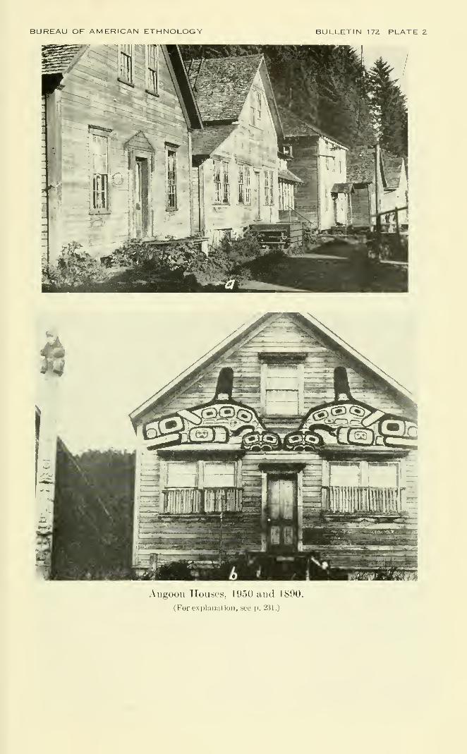
BUREAU OF AMERICAN ETHNOLOGY BULLETIN 172 PLATE 2
Angoon Houses, 1950 and 1890.
(For explanation, see p. 231.)
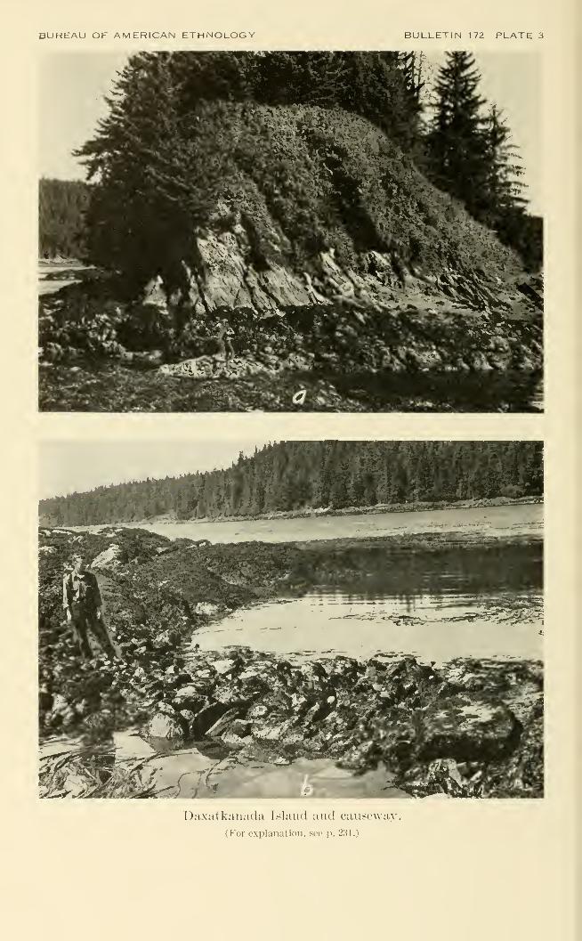
BUREAU OF AMERICAN ETHNOLOGY BULLETIN 172 PLATE 3
Daxatkanada Island and causeway.
(For explanation, see p. 231.)
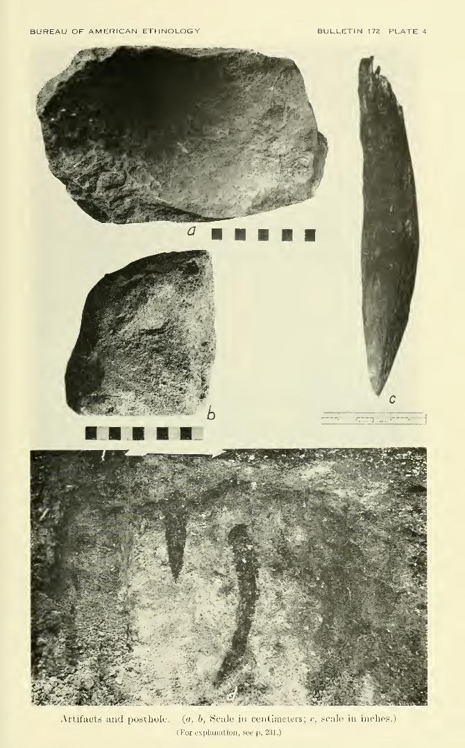
BUREAU OF AMERICAN ETHNOLOGY BULLETIN 172 PLATE 4
-}f
1r
^--^-H
Artifacts and posthole. (a, 6, Scale in centimeters; c, iscale in inclies.j
(For explanation, see p. 231.)
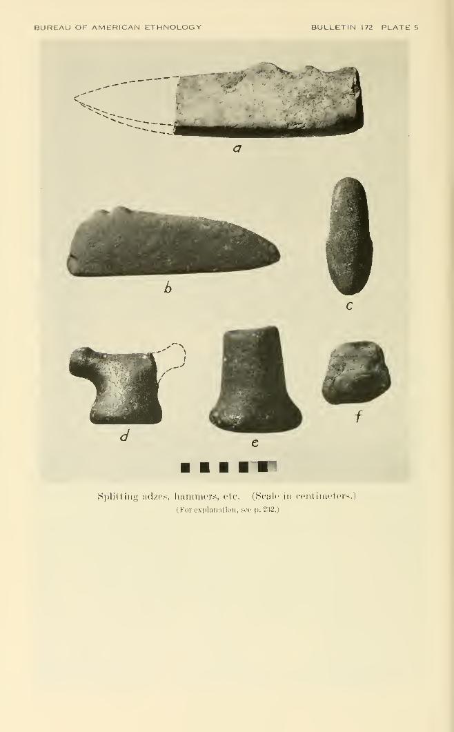
BUREAU OF AMERICAN ETHNOLOGY BULLETIN 172 PLATE 5
Splitting adzes, hammors, etc. (Scale in centimeters.)
(For e-xplaiiation, sec p. 232.)
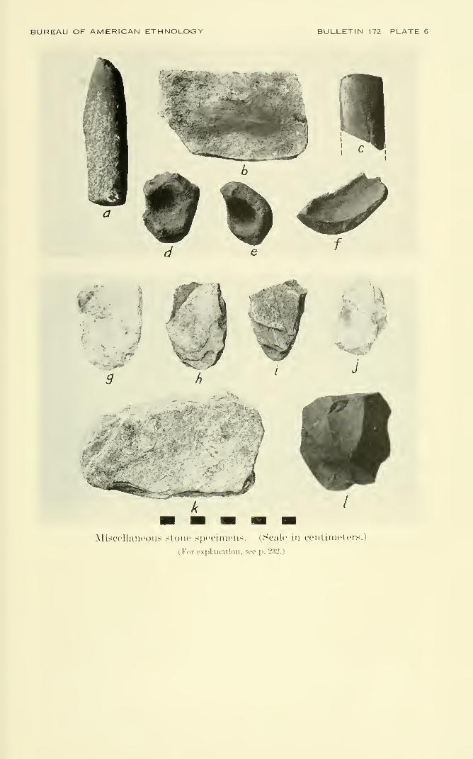
BUREAU OF AMERICAN ETHNOLOGY BULLETIN 172 PLATE 6
fJ
>^>
t.., a
Miscellaneous stone specimens. (Scale in centimeters.)
(For explanation, see p. 232.)
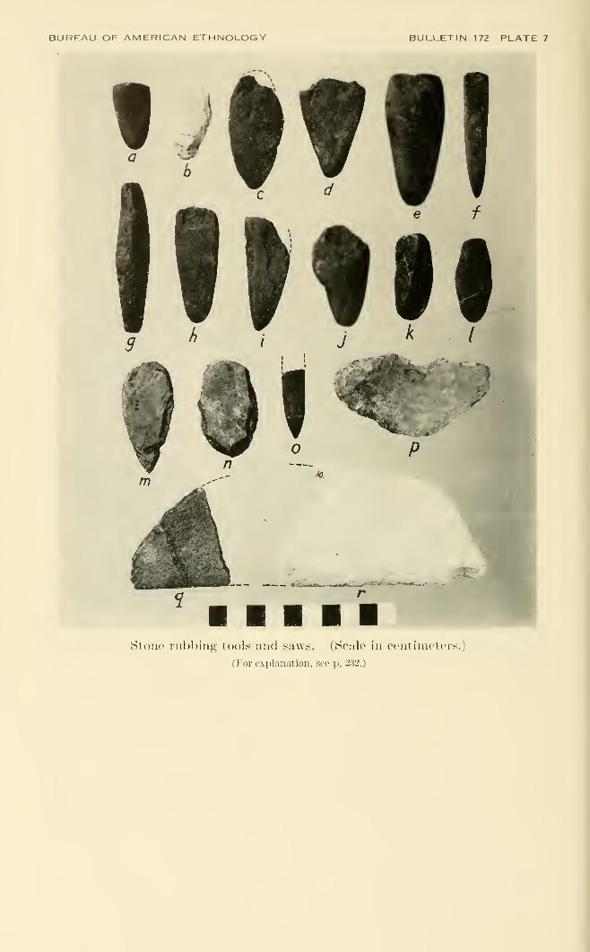
BUREAU OF AMERICAN ETHNOLOGY BULLETIN 172 PLATE 7
'•-^^"^.K;^T;3$ii^gyiiw.^ ^
Stone rul)hing tools and saws. (Scale in centimeters.)
(For e.xplanation, .see p. 232.)
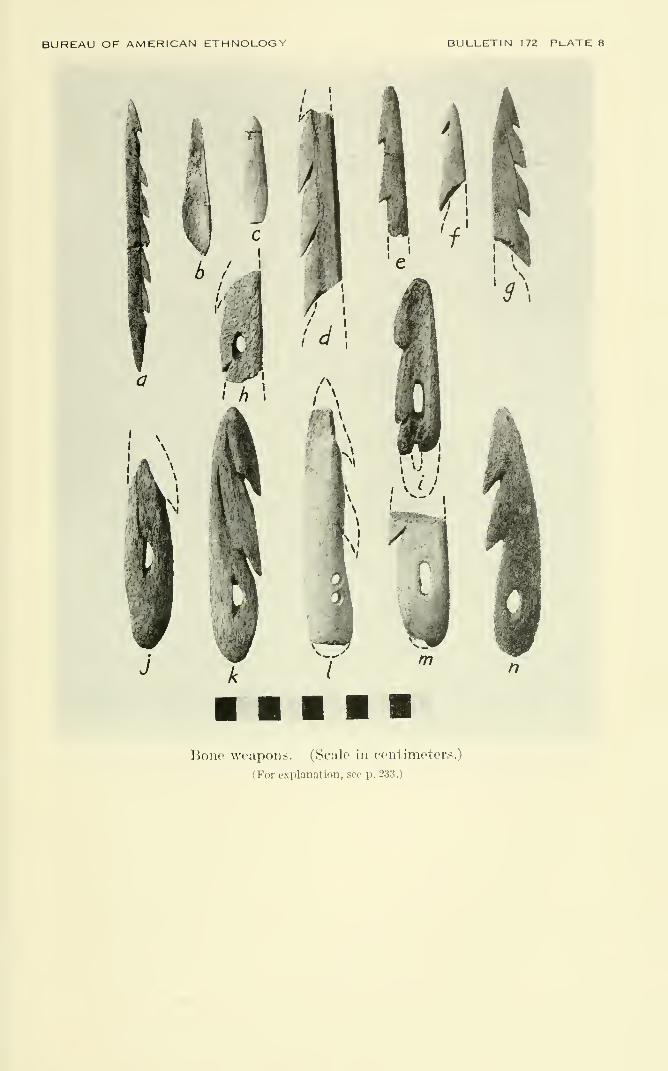
BUREAU OF AMERICAN ETHNOLOGY BULLETIN 172 PlATE 8
a
Bone weapons. (Scale in centimeters.)
(For explanation, see p. 2.3.3.)
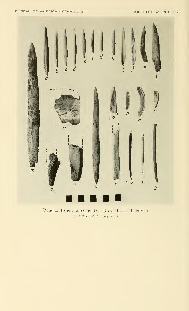
BUREAU OF AMERICAN ETHNOLOGY
I
b c ci
f ^ h
m
'^r.
11
w X
f
(/ y
Eoiie and shell inipleiiHMits. (Scale in contiin('t(>rs.)
(For explanation, soe p. 233.)
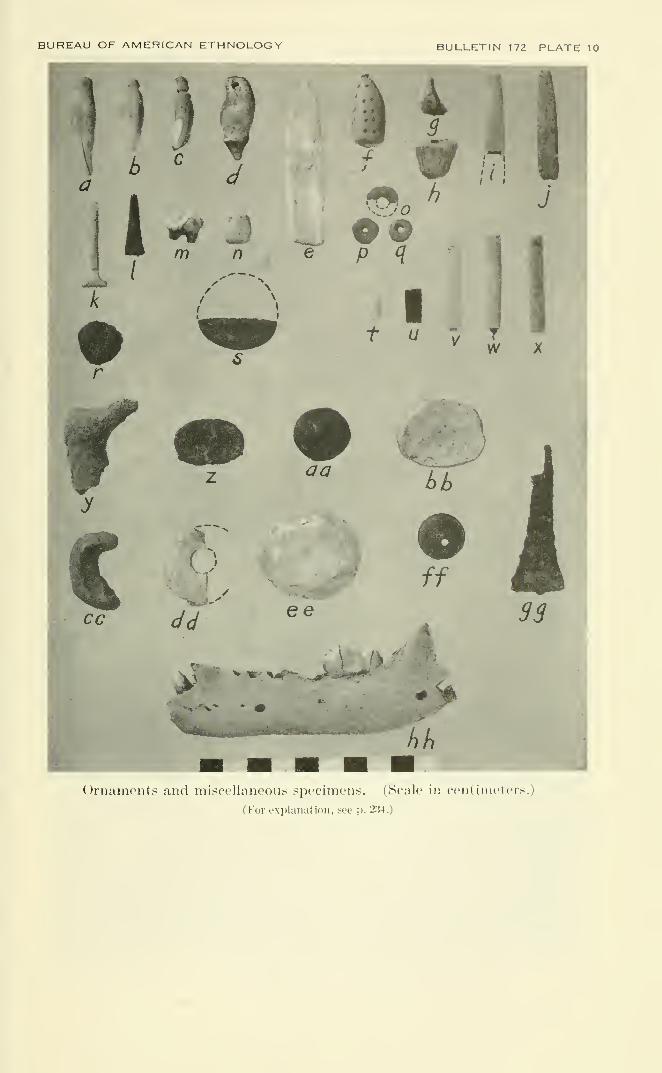
BUREAU OF AMERICAN ETHNOLOGY BULLETIN 17? PIATE 10
OriKUiu'iits uikI ini:<cellaiieous speciineiis. (Scale in crntiiiiclci>.;
(For explanation, see p. 234.)
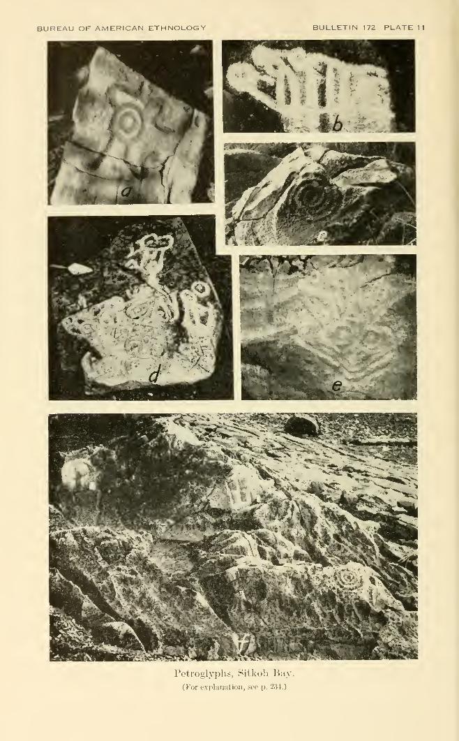
BUREAU OF AMERICAN ETHNOLOGY BULLETIN 172 PLATE 11
Petroglyphs, Sitkoh Bay.
(For explanation, see p. 234.)
INDEX
Abbott, R. Tucker, 91Abrading tools, 105-108Acmea pelta, 92
testudinalis patina, 92testudinalis scutum, 92
Adayns, U.S.S., commanded by Capt.E. C. Merriman, 163, 164, 165,167
Admiralty Island, brown grizzly pre-serve, 25-26
fishing stations on, 10North of Kootznahoo Inlet, 35-36part of Angoon Territory, 23, 24
(map), 25, 31, 32, 40, 49, 50, 52,
93, 94, 104, 133, 137south end of, 59-60, 102
"Adolescent Girl," native name for arock, 42
Adz, fragment, 228greenstone, 30, 69, 100metal, 86planing, 99, 100-101, 222, 229splitting, 33, 39, 45, 47, 89, 96, 99,
100, 222, 229, 230, 231stone, 15, 32, 34, 99-101, 105, 142,
211, 223, 230Ahn-chuka-hit, near the end of the vil-
lage house, 177Ahn-khark-hit, village central house,
178Ahn-kharky-tarn, Dog Salmon, 178
'Ak" Wuckitan, Auke Bay or Juneaubranch of sib, 27
Alaska, discovery of, 128established as Territory, 162purchase of, from Russia, 128, 170
Alaska Coastal Airways, float for planesof, 46
Alaska Fish-Salting and By-ProductsCompany, 197
Alaska Native Brotherhood, camp of,
194Committees, 195, 196Constitution of, 195efforts on behalf of natives, 8, 27founding of, 158, 194Grand Camp, 195, 196Grand Officers, 195opposed to old ways, 180, 192purposes of, 195-196
Alaska Native Brotherhood Conven-tion, 191
Alaska Native Brotherhood Hall, 196
Alaska Native Service, help from, 10, 11
Alaska Native Service School, Angoon,194
Alaska Native Sisterhood, affiliated withBrotherhood, 194
effect of, on natives, 8help given by, 10
Alaskan Eskimo, 5Alaska Oil and Guano Company, 175Alaska Territorial Museum, Juneau, 33Aleut, 6, 27, 112, 195, 197, 205
dances of, adopted by Tlingit, 15refugees, 14, 15
Aleut-Eskimo and Wakoshan, 6Aleut-Pacific Eskimo area, 5Alexander Archipelago, Alaska, 23, 24
(map)Alsek River, 206American citizenship, effect on natives, 8American Federation of Labor, coopera-
tion with Alaska Native Brother-hood, 196
Amicula stelleri, 91Amulets, 50, 119, 122-125, 128
stone, 119, 123, 213, 224"Anchor for Angoon," native name for
a stone, 48, 71, 72, 182Andanott, Charlie, chief of Shteen-hit,
177, 182, 193Anderson, Charley, white owner of
"Log Jam Village," 39, 132,133, 134
Angoon, 28-30archeological specimens from, 99-
127art, virtually dead, 16destruction of, native versions,
168-172destruction of by Coast Guard, 19,
46,»127, 158-159,U61, 162, 163,166-167, 182, 188, 201
"
explorations ^made^at,^ 10, 11, 12,
24 (map), 25, 33, 34*founding of, 131-133, 206history of, 128-158, 172-174houses of, 176-192"Isthmus Town," 25, 31, 36, 37
(map), 38, 39, 45, 46, 47-48, 53,
55, 63, 64, 71, 112, 123, 128, 131,
134, 135, 136, 165, 166, 172, 177,
185, 203, 206, 231native fort on, 47population of, 27, 46proposals to move from, 199recent history of, 158-200sketch map, 179town council, 180tribal territory, 23, 24 (map)-79
Angoon Community Association, ac-tivities of, 10, 51
incorporation of, 197235
236 BUREAU OF AMERICAN ETHNOLOGY [Bull. 172
Angoon Decitan, 149Angoon Isthmus, 39, 71, 132, 133Angoon Peninsula, 25, 36Angoon people, ix, x, 10, 14, 23, 24
(map)-28, 69, 60, 64, 67, 69, 94,104, 135, 137, 143, 146, 147, 151,152, 153, 154, 162, 175
peace between the Wrangell and,154
Angoon sibs, 26-27, 67, 69-70, 146-158,176
Angoon Territory, explanation of, 23,24 (map), 138
Angoon today, 192-200Angoon Wuckitan, attack on by Sitka
Kagwantan, 157'dngiin, 25, 135Animals, 93-94Ankakehittan, Angoon sib, 25Anqla'ketan, of Naltuck-an of White-
water Bay, 135, 177'Anpkhitan, origin of, 135-136'Anxakhitan, Raven sib, 27, 28, 41,
45, 49, 54, 55, 56, 57, 58, 59, 69,132, 143, 148, 173, 176 (list), 179(map), 180, 182, 184, 191, 193,204, 206
rights of, 70, 135'An?akhrtan Houses, 185-186Appendix, 210-231Archeological sites, general character,
30-35at Daxatkanada Island and Pills-
bury Point, 79-97most promisihg, 70
Archeological work, techniques for, 11-12Arctic Institute of North America, ixArgillite, tools of, 101Argobuccinus oregonense, 91Armor, wooden slat, 102"Around-the-Edge House," 185Arrowhead, barbed, 114-115, 211, 216,
222, 230, 231bone, 53, 105, 114, 115hardwood, 114unbarbed, 115, 220, 222
Arrows, 112, 114harpoon, 112
Arrowshafts, featherless, 112, 114Artifacts, finding of, 32, 33, 34, 35, 88,
89, 90, 96stone, 34, 123wooden, 47 ,
AsdngE or Asdnke, native name forFreshwater Bay, 60
'As yAtxi hit, "Young Tree House," 180Athabaskan interior, migrations from, 6Athabaskans, 27, 112, 203, 206
trade with, 7Atka, Aleuts from, 197Auke, sites at, 24 (map), 136Auke Bay or Juneau Wuckitan, 27, 35Auke tribes, 25, 28Auke Village, near Juneau, 60
Awls, 116, 118, 212, 221bird bone, 228, 230bone, 15, 117, 118, 213, 215deer bone, 30stone, 15
Axes, metal, 86, 90, 91stone, 39, 44, 96
Axhead, of White manufacture, 32"Ax-pick," 96
Baby Pouch, vicinity of Angoon, 37(map), 38, 40-41, 44, 64
Balanus cariosus, 92glandula, 92
Ball, M. D., Collector of Customs atSitka, 152, 161
Bancroft, Hubert H., information from,159, 163, 165, 168, 171
Baranof, Russian explorer, 146, 202Baranof Island, Angoon Territory, 23,
24 (map), 58site at, 10, 22south of Peril Strait, 69, 147, 196
Barbs, fishhook, 116, 211, 212, 213, 219,220, 221, 225, 229
Barghoorn, Dr. Elso E., wood identified
by, 90Barnacles, 92, 97, 215, 219, 220, 223,
224, 225used as pendants, 120used as vases, 16
Bartlett, Lt. C. W., 163, 164, 165,
166, 167Basalt, 102, 111, 221Basalt flake, 215, 226Basket Bay, Chichagof Island, 10, 24
(map), 61-63, 62 (map), 70, 104,
132, 136, 178, 184the story of, 136-137
Basket Bay Chief, 193"Basket Bay People," Angoon sib, 27,
136, 177, 179, 184Basket House, Basket Bajj- branch of
Decitan, 169 (map), 185"Basket or Arch House," of Decitan
people, 61, 184Baskets, 16, 30
watertight, used for cooking, 102Bathing, hardening process, 146Battle Creek, Glacier Bay, 143, 150"Battle Creek," Todd Cannery, 68"Bay on the other side," native name
for Tenakee, 61Beads, 119, 121
blue glass, 57, 127, 231bone, 119, 121, 214, 216, 220, 221,
223, 230disk-shaped, 121ivory, 219jet, 121, 126, 214shale, 211, 213, 214stone, 15, 119, 220, 224, 226tooth, 121, 215, 220
Bear Clan, 178Bear Crest, claimed by Teq'edi, 144
INDEX 237
Bear Den House, Wuckitan sib, 179(map), 187
Bear House, leading Teq^edi house, 41,
55, 144, 177, 178, 179 (map), 181,
187, 189Beardslee, L. A., chart by, 50, 68, 147
information from, 61, 98, 152, 153,154, 159, 160, 101, 162, 164, 182,183 201
Bears, 29, 91, 94, 97, 114, 170, 213, 215,216, 217, 218, 219, 220, 226
American black {Euroactos ameri-canus americans), 41, 93
bones of, 117, 120, 217brown grizzly, 25, 93carving of, 187-188claws, use of, 119myths about, 57, 131, 133, 144sib, 144teeth worn as amulets, 119teeth worn as beads, 121, 220
Beaver, 29, 39, 41, 47, 94, 97, 114, 137,
213, 215, 217, 219, 221, 222, 223,225, 226, 229
Admiralty (Castor canadensisphoeus), 93
legends of, 62, 132, 133, 136-137,183
Bell, Archie, chief of Keet-hit, 178, 180,
189, 192Bell, Billy, former chief of Killer Whale
Tooth House, 184, 191Bell, Frank, second husband of Mrs.
Mary Bell, 191Bell, Jack, son of Billy Bell, 184, 191Bell, Mrs. Mary, Mother of Jimmy
George, 191Benson, Dr. Seth B., animals identified
by, 93Berries, bushes in garden, 96
gathering rights, 69patches, remains of garden, 64, 82, 89seeds, deposits of, 91See also Blueberries.
Berry, M. P., information from, 160Bibliography, 207-209"Big Man," see Paul, John.Birds, shore, 93Birket-Smith, Kaj, 18
quotations from, 6, 206"Black face," significance of, 77, 102Black paint, from Kootznahoo Head, 36"Black Skin," legendary hero, 77, 111Blades, iron, 113
leaf-shaped, 108slate, 33, 45, 109-110, 123, 210unfinished, 107
Blankets, 153, 163, 164, 165, 166, 167,
168, 172, 183bearskins, 41Chilkat, 15, 155, 182, 188decorated, 72medium of exchange, 163, 164, 165,
167Blood, used for paint, 49, 58, 72, 104
Blueberries, 29See also Berries.
Bluejays, 114Boas, Franz, information from, 21, 23,
101, 183Boat, row, 40Bodkin, bone, 212Boues, animal, 54, 118
animal, found in pit, 33, 62, 82, 84,88, 90, 97, 113, 118-119
bird, 82, 90, 119, 121, 213, 216, 218,219, 223, 230
carved, 34, 45, 122deer, use of, 30, 67, 113, 118fish, 82, 90, 97human, decomposed, 67sea lion, 118, 122seals, used for divining, 94worked, 118-119, 126, 210, 211, 212,
214, 215, 216, 217, 218, 219, 220,221, 222, 223, 226, 227, 229, 230,231
Borden, Charles E., quotations from, 6Bottle, green glass, 127, 227Boulders, 57, 100, 101, 102
carvings on, 48sacrificial, 48chips, 110, 214, 219, 220, 225, 226
Bowl, sandstone, 103, 104, 213yellow-brown shale, 103
Bows and arrows, 114, 136Bowstrings, 114"Box Mountain," Angoon area, 52Boxes, storage, 30Bracelets, gold, 137Brown, Jimmy, owner of Bear Den
House, 187Brown, Tom G., chief of Bear House,
178, 188"Brown Bear People," Angoon sib, 27Buccinum sp., 91Buckle, carved ivory, 47Buddington, A. F., information from, 31Buildings, recent, 55Bunchberry leaf, deer call made of, 114
Cabin Point, Hood Bay, 51, 53Cabins, 37, 39, 44, 54 (map), 95 (map)
summer, 45, 53, 54 (map)Cache pits, 35, 55, 56 (map), 57
Ca-iy-Xk"', native name for "LadiesPass," 41
Campsites, 44, 54, 55, 59
Canadians, French, 140CanaqXts, native name for mountain
near Chaik Bay, 55
Cams lupus ligoni, 93Cannery, Hood Bay, operation of,
198-199Murder Cove, 59
Cannery barges, 199Cannery tenders, 199Cannon ball, broken, found in pit, 57,
127, 158, 170, 231
238 BUREAU OF AMERICAN ETHNOLOGY [Bull. 172
Canoe race, sport, 40Canoes, 58, 111, 112, 116, 132, 142, 151,
154, 165, 172destroyed in reprisal bv Coast
Guard, 161, 164, 168, 170landing place, 48, 100log, 30, 32, 131painted, 186red cedar, 15, 135war, 149, 151, 152, 186wood for, 41
Cape Alitak, Kodiak Island, petroglyphsat, 79
Cape Edgecumbe, 147C&q'^hk, native name for mountain near
Tenakee, 61Cardium corbis, 91" Carved-Stone Town," Teq^edi settle-
ment, 68Carvings, bone, 119, 122
on sacrificial boulder, 48wood, native, 73wood, of historic times, 35
Cassiar miners, effect on natives, 159Castor canadensis phoeus, 93Causeway, Daxatkanada Island, 80
(map), 81Cedar, 29
red, 102, 116bark of, used for paint, 104
Celt, 33Cemeteries, location of, 30, 48Census data, 176Ceratocottus diceraus, 92Chaik Bay, Admiralty Island, 10, 24
(map), 32, 53, 54 (map), 55, 59,
69, 70, 71, 131, 132, 139, 173, 174,
181, 231Channel Point Island, vicinity of
Angoon, 37 (map), 38, 44r-45, 79,
80 (map), 81, 151, 165, 188Chapin Bay, Admiralty Island, 23, 24
(map), 59Charcoal, 45, 53, 64, 66, 67, 82, 84, 89,
90, 96Chatham Cannery, Sitkoh Bay, site
near, 65 (map), 71Chatham Strait, between Angoon and
Killisnoo, 48-49, 100, 136, 183southeast Alaska, 23, 24 (map), 25,
36, 37 (map), 39, 47, 48-49, 58,
61, 71, 73, 132, 133, 148, 166, 173,
174, 180, 196, 200Chert, 100, 101, 102, 110, 214, 216, 218,
219, 220, 223, 225, 226green, 110
Chichagof Island, Angoon territory, 23,
24 (map), 35, 60, 64, 148fishing stations at, 10, 24 (map), 61
Chilkat area, ix, 68, 144, 147, 167Chilkat-Chilkoot Indians, ix
Chilkat tribes, 28, 72, 116, 123, 137, 162,
164, 168, 203Chilkoot Lake, 138China, fragments of, 45, 62Chinook, 140
Chisel, beaver tooth, 118slate, 33, 107See also Tools.
Chitons, common, 210, 211, 212, 213,214, 215, 216, 217, 218, 220, 221,222, 224, 226, 228
giant (Katharina iruncata), 91, 92,210, 216, 221, 228
Choppers, 110Chugash Eskimo, 18, 22, 127Chugash Eskimo territory, 6, 18Ci-?ani, native name for settlement of
Chaik Bay, 55Clams, 91
Kennerley's Venus, 220Macoma, 212, 217, 218, 221, 223burrowing (Saxicava pholadus), 92Pacific gaper, 211, 214, 218, 220,
222, 224Pacific little-neck (Protothaca stami-
nea), 91, 213, 214, 215, 218, 220,
221, 223, 224, 225smooth Washington (Saxidomus
giganteus), 91, 210, 211, 212, 213,
214, 215, 216, 217, 218, 219, 220,221, 222, 223, 224, 225, 226, 227,
228, 229truncate soft-shell, 226
Clamshells, 53, 96, 210implements of, 110
Clay, potters, 103used for making paint, 58, 127
Claystone, sandy, 103, 106, 125, 127Clear Spring House, Decitan sib, 179
(map), 182-185, 188, 193Clinocardium nuttali, 91Cloak, worn at dances, 186Clubs, fish, 116
picklike, 114used for seal hunting. 111, 112war, 223
Coal, cannel, 121, 216Coal beds, soft, 121Coal mine, located on Mitchell Bay, 44
located at SulUvan Point, 45Coast Guard, Angoon destroyed by, 170
See also Angoon, destruction of.
Coast Salish area, 5, 6Cobbles, shale, 107Cockle shells, found in pit, 33Cockles, 46, 210, 211, 212, 213, 214, 215,
216, 217, 218, 220, 221, 222, 223,
224, 225, 226, 228{Cardium corbis), 91
Cod, 116rock, 97
Cohoe fish, 43, 44"Cohoe Salmon Village," native name
for Channel Point, 44
Cold Spring House, 176
Cold Storage Plant, purchase of, 199
Collins, Lloyd R., x, 11
Community Association, 198
Community Charter, opposition to, 198
Community Hall, Chatham Strait, 196
INDEX 239
Cook Inlet, 82"Copper," petroglvph, 75, 76 (fig.), 77,
78, 79, 134'
trade in, 6, 126ornaments, 119
Copper River, 206Cork, used on fishing lines, 116Corlies, Dr. W. H. R., missionary, 152,
153, 154Cormorants, 38Corporate Charter and Constitution,
quotations from, 26Corwin, commanded by Lt. M. A, Healy,
163, 164, 165, 166, 168Courts, powers of, 198Coyotes, 170"Crabapple Fort," Point Hays, 63"Crabapple Tide," native name for a
channel, 44Crane, myth about, 50, 130Creation, story of, 130-131Cremation, practice of, 28"Creoles" (Russian halfbreeds), 161Crittenden, Colonel, Deputy Collector
of Customs, 153Cross Sound, Alaska, 23, 24 (map), 31
Crow clan, 40Crow Island, 69Crows, 174"Crow's Fort," Point Hays, 63
"Crow's Little Fort," native name for
Table Island, 51
Cryptochiton stelleri, 91
Crystalline rock, 102Ctin, slave sacrificed at Steel House, 181
Cup, claystone, 103, 217sandstone, 103, 210, 211, 214toy sandstone, 214
Cuwika, John, 187Cygnus columbianus, 93
Dagger, antler, 227bone, 115, 216See also Knife, hunting.
Daktlawedi, Angoon sib, 25Danger Point, Angoon Peninsula, 25, 36,
37 (map), 38, 48, 102, 151
Daqatckik, traditional title of chief of
"Log Jam House," 185, 186Daql'awedi, "Killer Whale People," 27,
28, 36, 50, 51, 52, 53, 55, 59, 138,
139, 140, 142, 176, 177 (list), 179(map), 180, 181, 184, 191, 204
migrations of, 139-140, 142origin of, 137-140village of, 22
Daql'awedi chief, reincarnated shaman,22, 139
Daql'awedi (Eagle-Wolf) sib, rights of,
70Daql'awedi Houses, 189-192Darts, 114Da'utuwa^iq'an, "People of the
built-up shelter," 60
460927—60 17
Davis, Andrew, information from, 177,184, 187
Andrew, songs from, 136Davis, Charley, 187Davis, George, chief of Steel House, 182Davis, John, married to daughter of
John Shuwika, 186, 187Davio Creek, Mitchell Bay, 43DawdL'i hini, native name for "Battle
Creek,^' 68Daxdtkanad^, native name for "Where
the tide passes back and forth,"
79, 152Daxatkanada Island, archeological sites
at, 79, 80 (map)-81, 97, 99, 103,
105, 108, 113, 118, 121, 122, 124(figs.), 125, 148, 210-229 (tables)
fort on Kootznahoo Inlet, 10,
11, 37 (map), 39, 81, 95, 151saddle, 87 (fig.), 88 (map), 89, 109shelf, 80 (map), 82, 83 (map), 85
(map)-86siege of, native versions, 150-152vicinity of Angoon, 33, 44, 70, 80
(map), 81, 96, 97, 99, 100, 101,102, 112, 115, 123, 148, 150
Daxcu-'an, native name for "Villageclose to the backside," 45
Day-shu-hit, end of a street house, 178Day-she-tarn, main symbol Raven, 177Dead Raven, chief of Raven House, 180Dead Tree Island, Hanus Bay, 68Deadfalls, 114Decitan, 38, 39, 40, 41, 44, 45, 46, 47,
50, 51, 53, 54, 55, 57, 58, 59, 60,
61, 64, 69, 75, 81, 132, 133, 134,
135, 144, 148, 151, 152, 177, 180,
182, 183, 184, 186, 187, 191, 192,
193, 203, 204graveyard, 35, 44, 46houses, 180-185lineages, 27, 35, 38, 176 (list), 179separation from Gana?adi, 133-135,
138, 178, 206village, remains of, 45wars of, 149-154
Decitan and An?akhitan, fights withSitka Kiksadi, 149-150
Decitan (Raven) sibs, rights of, 69-70
Decitan Steel House, 43, 55, 154, 161,
166, 185
De'cu htt, house at end of road, 177, 183
Deepwater, Frederick Sound, 24 (map),
60, 138Deer, 29, 30, 44, 94, 97, 114, 170, 171,
212, 213, 214, 215, 216, 217, 218,
219, 220, 221, 223, 226, 228Sitka black-tailed {Odocoileus sit-
kensis), 93Deer call, made of bunchberry leaf, 114
Deerskins, trade in, 175
Deer tallow, lamp fuel, 103
De Groff, Edward, in charge of tradingpost, 162
240 BUREAU OF AMERICAN ETHNOLOGY [BuU. 172
de Laguna, Frederica, 10, 11, 12, 29, 79,
128, 157, 158, 200"Deluge" tradition, 129Dennis, Isaac C, deputy collector, 159Dentalia, 119, 142
trade in, 7Deshuhittan, Angoon sib, 25Detling, Dr. Leroy E., plants identified
by, 91Devilclub, beliefs regarding, 29
buried with shaman, 63Devilfish, 29, 116
petroglyphg, 76 (fig.), 78used for bait, 29, 116
Dick, Andrew, 184Dick, Peter, brother of Andrew, 184Diesel motor, electricity supplied by, 196Dishes, stone, 103
toy, 44, 46, 103, 127Disks, marble, 214
stone, 122, 123, 214, 215Djiguy, native name for Redbluff Bay,
69Doctors, see Shamans.Dogs, 213, 214, 217, 218, 221
hunting, 30, 94, 114myths about, 131native, 91, 94
"Dog Salmon House," 'Amjakhitanhouse, 136, 176, 178, 185
"Dog Salmon People," Angoon sib, 27,
132, 144"Dog Salmon Stream," at head of
Whitewater Bay, 55-56Dogwinkle, 213
channeled, 214, 216, 217, 219, 220,225, 226
file, 214, 216, 225frilled, 211, 213, 217, 220, 222, 223,
224DoUs, 107
pebbles used as, 109Douglas, mining town, 162Douglas Island, Alaska, 24 (map), 175Drills, bone, 118, 215
mechanical, 113Drinking tube (?), 126Drowning, common cause of death, 28
native beliefs regarding, 28Drucker, Philip, quotations from, 6, 123Drunkenness, common cause of acci-
dents, 28Ducks, 93Dugouts, see Canoes, red cedar.
Dwarfs, beliefs about, 60Dwellings, bark, 30Dyes, vegetable, 30
Eagle, bald (Haliaeetus leucocephalus)
,
92Eagle clan, 178Eagle (or Wolf) moiety, "Brown Bear
People," 27, 40, 46Eagle claws, 97, 142
"Eagle Eating (human beings) SmallChannel," 149
"Eagle-?-Fort," native name for fort onChaik Bay, 53, 54 (map)
Eagle Island, Whitewater Bay, 58, 75"Eagle's Fort," on Graveyard Point, 48Eagle wings, used as brooms, 34Eagle-Wolf moiety, 153, 176, 177 (list),
184Ear wax, used in firemaking, 102Earrings, 119Edge-Around House, 'Anakhi?tan sib,
179 (map), 185"Edge-on Bay," native name for Favor-
ite Bay, 46Educational activities, effect on native
culture, 7Elder, red-berried {Sambucus calUcar-
pa), 91Elderberries, 29, 66
preserves of, 91seeds of, 219, 223
Electric-light plants, Angoon, 196Eliza Harbor, Admiralty Island, 10, 24
(map), 59-60, 70, 132, 137, 138,139, 204
Emmons, G. T., information from, 69,
72, 75, 77, 78, 79, 148, 176, 181,183, 184, 185, 187, 189, 191, 205
"End of the (Beaver) Trail House,"native name for the Decitanpeople, 132, 150
"End of Village House," Decitan House,176, 177, 179, 184, 185
Enemies, decapitation of, 156-157Enhydra lutris lutris, 93Enophrys bison, 92Epidemics, occurrence of, 28, 206Erman, information from, 200Eskimo, Pacific, 6, 16, 34, 112Ethnographer, methods used by, 12Ethnological data, character of, 15-16Ethnologist, problems of, 2Etolin Island, 72, 77, 79Eumetopias jubata, 93Euroados americanus americanus, 93European wearing apparel, value of, 173Excursion Inlet, Alaska, 24 (map), 142,
143, 150Explorations, conclusions drawn from,
127Eyak Indians, 6, 126, 206Faces, pictures of, 79False Bay, Angoon territory, 23, 24
(map), 35, 60, 70, 142"Far-away Killer Whale," Daql'awedi
chief, 55, 139Father Sorgon of Sitka, organizer of
Greek Orthodox choir, 193Favorite, trading company's tugboat,
164, 165, 166, 168Favorite Bay, vicinity of Angoon, 37
(map), 38, 45, 46, 103, 168, 171Federal loans, effects on natives, 198,
199"Female Grouse Fort," 142
INDEX 241
Fieldwork, conduct of, 8-15among Tlingit, purpose of, 4-8
Filipinos, empioj'ed at cannery, 199Fir, 29Firearms, possessed by natives, 159Firedrill, strap, 102Fire hearth, 103
red cedar, 102Firemaking devices, 102Fish, 92
racks for cooking, 86Fish camp, Hanus Bay, 68Fish cannery, natives work for, 10
Fishery Creek, Admiralty Island, 24(map), 35
Fishery Point, Admiralty Island, 24(map), 35, 69, 70
Fishing gear, 115-117Fishing industry, effect on native cul-
ture, 7, 9Fishing lines, kelp, 29Fishing rights, 69Fishing Village, vicinity of Angoon, 37
(map), 46Flakes and cores, 110-111Flicker House, 176Floats, sealskin, 29Flood, Great, myths about, 19, 21, 22,
29, 52, 55, 57, 61, 129, 130-131138, 139
Floor, gravel, 50, 54Florence Creek, 35FoUett, Dr. W. I., fishes identified
by, 92Food siipply, 175"Fort House," in Angoon, 97, 142, 143,
157, 158, 177, 179 (map), 186, 193"Fort of the lower end of the point,"
native name for fort at DangerPoint, 48
"Fort of the Women of GanAx," 178,
179 (map)"Fort on Top House," 142, 187Forts, 31, 34, 48, 50, 51, 60, 97-98
destroj'^ed in reprisal for murders,161
Frank, Charley, chief of Fort House, 186Fraser River, 205Fred, John, chief of Eagle Clan, 178, 186
Freed, J. Arthur, animals identified
by, 93Frederick Sound, Alaska, 23, 24 (map),
26, 59Freshwater Bay, Chichagof Island, 24
(map), 60, 142, 143, 150, 203branch of Angoon sib, 27, 35, 60,
186Front, or High House, see Packed Solid
House.Fruit, gathered by women and children,
29Fungus, used for paint, 104Funter Bay, Admiralty Island, 23, 24
(map), 142Fur bearers, 29
Fur trade, effect on native culture,
7, 206
Gaff hooks, barbs for, 117, 211, 225fish, wooden, 116used for devilfish, 116
Gambier Bay, Admiralty Island, 24(map)
Gamble, George, former chief of RavenHouse, 180, 181
Games, basketball, played by natives,
194, 196hockey, 134
QanA?Adi, separated from Decitans, 39,
47, 64, 65, 70, 75, 78, 131, 132,
133-135, 138, 178, 180, 204GanA^Adi village site, 75OanA?ca nuwu, "GanAX Women's
Fort," 47, 134, 178GanAX Island, 131, 132"GanA? Women's Fort," in Angoon,
101, 126, 133, 231Gaper, Pacific {Schizotheraeua nuttali),
91Gardens, cultivated, 172, 174, 175
remains of, 38, 44, 45, 47, 50, 64(map), 56, 80 (map), 81, 89, 95(map), 96
Garfield, Dr. Viola, information from,
17, 23, 26, 52, 55, 59, 61, 68, 69,
75, 129, 132, 133, 135, 136, 137,
138, 142, 143, 144, 148, 178, 181,
182, 183, 184, 187, 191, 204Games, Elmer, and wife, occupants of
Games Point, 46Games Point, vicinity of Angoon, 37
(map), 38, 45, 46, 50, 103, 171
Gavia immer, 93Genealogies, records of succession, 192
George, Albert, father of Jimmy George,191
George, Jimmie, chief of Keet-hit, 178,
191, 192George, W. E., coast pilot on steamer
California, 152George, William, chief of Ahn-khark-hit,
178, 185, 193George, Willis, 189
Ge?et'u-'an, " Inside-the-mouth-of-the-
bav Village," 39Giq^edi, "Kelp People," 59, 132
Gifford, Dr. Edward W., shells identified
by, 91Girls, adolescent, scratching stones used
by, 123, 126Glacier Bay, 130, 150Glass, found in pit, 62, 99Glass Peninsula, Admiralty Island, 24
(map)Gneiss, 100, 101Gold, discovery of, 162Goldschmidt, Walter R., and Haas,
Theodore H., information from,
23, 35, 41, 46, 51, 53, 54, 55, 58,
59, 60, 64, 67, 68, 69
Goon-hit, clear spring water house, 177
242 BUREAU OF AMERICAN ETHNOLOGY IBull. 172
Grape, wild (Vitis sp.), 90Grass, salt, 29Gravel, 56, 66Graves, shaman's, 30, 36, 49, 63Graveyard, Decitan, 35, 44, 46, 48Graveyard Point, vicinity of Angoon,
37 (map), 131Greek Orthodox Church, 182, 193, 194
choir, native members of, 193Greek Orthodox Mission School, Sitka,
194Greengo, Robert E., shells identified
by, 91Greenstone, adzes made from, 69, 100,
101Greenstone pebbles, 108Grouse Fort, Alaska, 24 (map), 142, 143
(map), 153, 187, 203, 205"Guano," 88, 90, 162, 174, 175Gulf of Alaska, 27, 206Gulls, 38, 114Gunana Indians, see Athabaskans.Gun hit, spring house, 177, 182Guns, 152Gunther, Dr. Erna, information from, 77Gut Bay, Baranof Island, 23, 24 (map),
58, 69, 196
Haida country, 142Haida Indians, 6, 15, 27, 135, 144, 182,
204, 205, 206canoes built by, 15, 149, 173, 186,
206Haines, Alaska, 134, 138, 139Hairpins, carved bone, 63Haliaeetus leucocephalus, 92Halibut ( Hippoglossus stenolepis) , 92, 97,
145fishing methods, 29, 116
Halibut Fort, Point Hayes, 148"Habilbut Meat," native name for
white rocks opposite KillisnooIsland, 49
"Halibut Place Fort," Point Hayes, 64,149
Halleck Island, 24 (map), 149Hamilton Bay, ruins on, 98Hammers, hand, 231. See also Pestles.
Hammerstones, 109, 212, 214, 217, 219,226, 227, 228, 230
strike-a-lights, firestones, 102Handles, wooden, 109, 222, 229Hanus Bay, Peril Strait, 49, 68-69, 147Haplotrema vancouverensis, 92Harpoon heads, barbed, 50, 53, 54, 90,
111, 112-113, 115, 212, 213, 216,217, 218, 219, 222, 225, 226, 227,230, 231
bone, 112, 113deer bone, 30iron, 112, 126stone, 15, 33toggle. 111, 112, 210, 212, 230
Harpoon heads—Continuedunfinished, 216whale bone, 33, HIwooden, 113
Harpoons, 111, 112, 116fish, 116metal, 111
Hart, Augustus, 184Hasselborg, Allen, information from, 32,
33, 52Hasselborg Creek, 41Hatchets, used in fight, 153Hats, crest, 72
wooden, 48Hawk Inlet, Admiralty Island, 24
(map), 35, 142Head Island, Whitewater Bay, 57, 71Healy, Captain M. A., 165, 166
letter from, 163Hearths, 90Heizer, Robert H., information from,
79, 128Helmet, wooden, 102Hematite, 102
red, 105, 230used for paint, 73, 104
Hemlock, 29, 90, 185mountain {Tsuga mertensiana) , 90western (Tsuga heterophylla) , 90
"Hemlock People," see Yenye di.
Herring, 46, 162, 168, 171fishing methods, 28, 116grease, making of, 58oil, 162, 174, 175
Herring Bay, Admiralty Island, 24(map), 59, 70
Herring plant, Killisnoo, 197Hiatella arctica, 92High Class People's House, Wuckitan
house, 187High Water Island, 151Hilton, James, chief of Khook-hit, 178,
184Hippoglossus stenolepis, 92Historv, prehistoric, 128-157
recent, 158-200Tlingit, conclusions from, 200-206
History and geography, Tlingit concep-tion of, 16-23
Hobson, George, son of Pete Hobson,185
Hobson, Pete, 184, 185Hobson, William, founder of Alaska
Native Brotherhood, 194Hockey, see Games.Hoggatt Bay, Baranof Island, 24 (map),
69Holmes A'Court, Captain H., command-
er of H.M.S. Osprey, 162
"Hoochenoo," native rum, 159, 161, 167
Hoochinoo tribe, 175, 176Homosexuality, practice of, 155
INDEX 243
Hood Bay, Admiralty Island, 24 (map),36, 50, 51-53,'58, 69, 70, 71, 131,137, 139, 140, J41, 171, 191, 199,200, 203, 204
fish cannery at, 10, 11, 19, 24 (map),51, 52, 198-199, 200
lo2;ging camp at, 52Hood Bay Fort, 53, 99, 113, 231
excavation at, 11, 33, 115, 122"Hood Bay Old Woman," native name
for mountain near Hood Bay, 52"Hood Bay People," see Tsag^edi.Hood Bay shaman, story of, 140-141Hook and line, 116Hooks, fish, 116, 145Hoonah, Alaska, 24 (map), 26, 35, 79,
142, 150, 193, 194, 206Hoonah tribes, ix, 25, 28, 61, 95, 143, 148Hoosnoff, assistance asked from, 146,
147Hostages, function of, 149, 151, 154, 155,
171"House between the Mountains," 188House fronts, painted, 73"House in Middle of the Town,"
'Aniakhitan House, 176, 177House on Top of the Fort, originally
Wuckitan, 179 (map), 187House pits, 34, 50, 56, 57, 66-67, 142,
203House Point, Hood Bay, 51House posts, carved, 187Houses, 39, 47, 55, 56 (map), 57, 95
(map), 174ancient, 178, 179 (map)-180bark, 81, 89guest, 153plank, 30, 98, 174plank, replaced by framehouse, 15Angoon sibs rights to build, 69
"House Standing Sidewise," DecitanHouse, 176, 183
Hudson's Bay Company, trade goodsfrom, 127
Human remains, cremated, 86Humilaria kennerlyi, 91"Humpbacked Salmon's Stream," na-
tive name for stream nearBasket Bay, 62 (map), 63
Humus, 53, 56, 64, 66, 67, 82, 84, 88,
89, 90, 96Hunter, John, chief of Ahn-khark-hit,
178, 185Hunters, sea mammal, 68Hunting and fishing devices, 16Hunting camp, 69Hunting rights, 69Hutsnuwu, see Angoon people.Hydaberg, Alaska, 134, 137, 142
Icy Strait, Alaska, 23, 24 (map), 31,
142, 143 (map), 153, 187, 203iLen, native name for Steamer Passage,
38
Implements, clamshell, 110, 211heavy stone, 99-102iron, 221shell, 110
Incisor, human, charred, 212Indian Bureau, 173, 174Indian Reorganization Act, amendment
to, 197efifects of, 8, 10, 198
Indians, threats by, 163, 164Informants, cooperation of, 14
information derived from, 18, 19,21-22, 25, 27, 30, 35, 38, 39, 40,42, 43, 44, 47, 48, 49, 52, 55, 57,58, 59, 60, 64, 66, 68, 69,72, 77, 81, 82, 84, 104, 108, 109.Ill, 117, 119, 130, 131, 133, 134,136, 138, 142, 143, 144, 150, 151,154, 155, 168-172, 181, 183, 184,186, 187, 192, 198, 199, 203, 205
Inheritance, customs regarding, 192Inlays, stone, 119"Inside-the-mouth-of-the-bay Village,"
39Iron, 126-127
fragments, found in pits, 57, 99from driftwood, 127working of, 127
Irving, William, ix, 10
Jack, Eddy, 188Jack, Frank, brother of Eddy, 188, 189Jackson, James, 189Jade, green, 101James, Paul, 184James, Peter, maternal grandfather of
Jimmy George's second wife, 192Jamestown, Moses, chief of Yen-khoon-
hit, 178, 185, 186Jamestown, Robert, married to John
Nelson's daughter, 191Jamestown, U.S.S., commanded by Cap-
tain Beardslee, 161, 166, 185Jingles, false, 222John, Charlie, chief of Day-shu-hit, 178,
184Johnny Jack, son of Little Jack, 182, 188Johnson, Billy, chief of Raven Bones
House, 181
Johnson, George, chief of Yeatle-hit,177, 180, 188
Johnson, James, of Klawak, 194Johnson, Jimmy, present chief of Raven
Bones House, 181, 182Johnson, Pete, chief of Yeatke-sockv-
hit, 177, 181Johnson, Peter J., son of Robert John-
son, 184Johnson, Robert, father of Peter J., 184Johnson, Samuel, chief of Raven House,
180, 181, 188Johnson, Shorty, chief of Bear House,
188, 193
244 BUREAU OF AMERICAN ETHNOLOGY [Bull. 172
Jones, Billy, noted orator, 181, 189Jones, Livingston F., information from,
103, 127Juneau, Alaska, 23, 24 (map), 26, 27, 35,
41, 60, 75, 135, 136, 143, 156, 162,
175, 181, 206Justice, Indians conception of, 159-160
Kachemak Bay, sites at, 128Kagwantan, "People of the Burned
Down House," 27, 46, 142, 144,
148, 153, 154, 156, 161, 171, 181,183, 187, 193, 204
murder of Wrrckitan at Sitka by,157-158
Kahklen, Mr. and Mrs. Joseph, helpfrom, 10, 11. 40, 43
Kake, sites at, 24 (map)Kake forts, 98Kake territory, 52, 94, 98, 134, 135, 137,
138, 142, 193, 194Kake tribes, 25, 59, 60, 69, 94, 9S, 100Kake villages, destruction of, 59, 98, 182KaLian, chief of the Kisadi, 161, 202
adversary of Baranof, 202Kalinin Bay, Salisbury Sound, 67Kanalku Bay, Mitchell Bay, 38, 43-44,
71, 103, 183Kanalq'', title of chief of Packed Solid
House, 183Kanash, Peter, 189, 191
Kar-kowt-hit, named for curved rock atBasket Bay, 178
Kasaan, Alaska, 135, 136, 144, 149, 185
Kasqiague'df, 129
Kataq*, native name for Wilson Cove,58
Kataq^edi, people from Wilson Cove, 59
Katharina iruncata, 91
Katinuk, Eli, founder of Alaska NativeBrotherhood, 194
Katishan, chief of the Kasqiague'dt, 129
"Katlaan," see KaLian.Kats, sib hero, 187, 188
K'AtsAsak", native name for cove onGaines Point, 46, 50
Keet-hit, Killer Whale (Thrasher)house, 178
Keithahn, E. L., information from, 72,
79Kelp Bay, Baranof Island, 24 (map), 69"Kelp People," 59, 132, 204Kenasnow Island, 174Kenasnow Rapids, Kootznahoo Inlet,
164Kenasnow Rocks, vicinity of A^ugoon,
37 (map), 48, 49KennelKu, Joe, chief of Da-she-ton
family of Hootz-ah-tar tribe, 183Ketchikan, 132, 133, 134, 144
Khook-hit, big hole in the ground, 178Kidju'k hit. Tongas division of
Oana?adi sib, 180
KiksAdi, native tribe, 04, 68, 146, 148,149, 153, 156, 157, 101, 203
Killer Whale, legends of, 138painting, oi^literation of, 189, 195pictograph of, 74 (fig.), 75supernatural being, 72
"Killer Whale Canoe," 186"Killer Whale Chasing Seal House," 190
(fig.), 191"Killer Whale House," 137, 138, 140,
177 (list), 179 (map), 180, 181,187, 189, 190 (figs.), 191, 192,193, 195
"Killer Whale People," Angoon sib, 27,178
"Killer Whale Tooth House," 179 (map),184, 191
Killisnoo, Angoon town, 25, 37 (map),50, 128, 133, 130, 152, 153, 154,162, 163, 165, 172, 175, 182, 185,193, 194, 196, 197, 231
destroyed by fire, 196herring plant at, 197history of, 174-176, 196
Killisnoo Harbor, vicinitv of Angoon,37 (map), 39, 49, 69, 70, 125,141, 165, 169, 171
Killisnoo Island, famous for potatoes, 50herring plant at, 168, 174vicinity of Angoon, 37 (map), 46,
49-51, 132, 162, 167, 172, 173,174
whaling station on, 50, 162, 168,
174, 175Killisnoo Jake, see Kitchnath.KUlisnoo Packing Company, 197Kitchnath, Decitan chief, 154, 161, 175
182, 185Kitcnal, Decitan chief, 135, 136, 182
Kit hit, Killer Whale House, 177, 189Kitq^an, "KHler Whale People," 27Klawak, Alaska, 130, 134, 137, 138, 194Klukwan, Chilkat village, ix, 72Klushkan, George, chief of Mountain
House, 178, 188, 193
Knipe, Laura, drawings by, 122
Knives, butcher, 109hunting, 102, 109, 114mussel-shell, 29, 106, 110, 230pocket, 109schist fragment, 227shale, 110slate, 33, 106, 107, 110, 228, 231steel, 118stone, 109two-bladed, 109
Knives and scrapers, 109-110Kodiak Island, 79, 128, 205Kook Lake, Basket Bay, 61
Kootz-hit, Bear House, 178Kootznahoo Head, 36, 37 (map), 38, 50,
69, 141, 151, 173cave under 22, 36
Kootznahoo Indians, ix, 60
INDEX 245
Kootznahoo Inlet, 24 (map), 25, 35,
36-47, 50, 64, 68, 69, 94, 102, 132,
135, 143, 165, 168, 170fort on, 10, 11, 24 (map), 48, 50, 70,
71, 163. 164, 165, 183, 185, 206Kootznahoo Store, property of Walter
Sobolof, 154, 197Krause, Aurel, information from, 30,
176, 200Kroeber, A. L., quotations from, 6, 205,
206Kruzof Island, 24 (map), 68, 140Kuiu Island, 23, 24 (map), 132, 143, 161,
176Kukash, Albert, chief of Mountain
House, 178, 188, 189Kupreanof Island group, 23, 24 (map),
98
Kutixd.n, native name for "Carved-Stone Town," 68
Kdx' nuwu, native name for Marten'sFort, 53
"Kwakiutl," Kagwantan chief, 142Kwakiutl-Bella Coola area, 6
Kwakiutl Indians, 6, 153
Labrets, 119-120, 121-122bone, 120red shale, 53, 122soapstone, 121
stone, 15, 39, 96, 120, 215, 227, 231
wooden, 120"Ladies Pass," 41Lake Eva, Peril Strait, 68Lamp, kelp stalk, 104
stone, 104, 213tin can, 103See also bowl.
Lamp oil, deer or seal, 103Lamp wick, rag, 103, 104Langley, American schooner lost in
Chatham Strait, 73Langsdorff, G. H. von, information
^from, 98, 147, 148
Laqliia, native name for PeninsulaPoint, 63
Law and Order Code, adoption of,
197-198Liesnoi Island, Admiralty Island, 60,
138Life after death, native beliefs on, 28Limestone, 66, 121Limpets, 92, 93
plate, 217, 222shield, 217, 224, 225, 226
Lindenburg Harbor, 173Lindenberg Head, near Todd cannery,
68, 145, 147Lineage houses, property of sibs, 27, 60,
100, 136, 142, 176 (list), 177(list), 179 (key to), 185, 187
L'inedi, former name of GanAj^ Adi, 132,
135, 136Liquor, laws regarding importation of,
159
Lisiansky, Urey, information from, 35,
97, 98, 146, 147, 148Lisiansky Bay, Baranof Island, 72, 79Little Jack, chief of Goon-hit, 177, 182,
188, 189Littorina sitkana, 92Lituya Bay, 205LitlddB, native name for Kenasnow
Rocks, 48"Lively Herring House," of the Kik-
sadi, 148
,
L'inedi, see 'Anxakhitan, 27"Logjam House," built at Neltushkin,
55, 179 (map), 185, 193"Logjam Village," founded by the Deci-
tan, 39Lone Rock, vicinity of Angoon, 37 (map)"Lonigon Jake," possibly Kitchnath,
161, 166Loon Point, Admiralty Island, 60Loons (Gavia immer), 93Lumbering industry, effect on native
culture, 7
Lutra canadensis pacifica, 93Lynn Canal, Alaska, 23, 24 (map), 31,
138, 139
Macoma inquinata, 91"Magpie Point," pictographs at, 73, 74
(fig.), 75superstition regarding, 49vicinity of Angoon, 37 (map), 49, 71
Malin, Edward, ix, 10, 189, 190(sketch by)
Mammals, sea, 93Mansfield Peninsula, Admiralty Island,
24 (map), 35Marble, from "White Rock Point,"
51native uses of, 51-52, 106, 107, 108,
121Marble Bluff, 35Marble or limestone, bedrock of, 66Marmot, 93, 94, 210, 216, 217, 221, 222,
228Marten Fort, Hood Bay, 33, 53, 70, 203"Marten's Small Ladder," 36, 151
Martes americana actuosa, 93Martha Fisher, English Bark, 175Martin {Martes americana actuosa), 93Mats, 32Maul head, 33, 47, 101, 231Mauls, 101
stone, 50, 101McClellan, Dr. Catherine, x, 11, 12, 76Meade, Lt. Comdr., Kake forts de-
stroyed by, 98, 161
Medicine man, see Shaman.Merriman, Capt. C. E., 161, 162, 163,
164, 166, 167, 168, 182, 201
report of, 164-167Mice, 91Microtus admiraltiae, 93Middens, 39, 43, 44, 45, 46, 47, 50, 53,
54, 55, 56, 57, 63, 82, 84, 96,
101, 142, 203
246 BUREAU OF AMERICAN ETHNOLOGY [Bull. 172
Middens—ContinuedDaxatkanada Island, 82, 83 (map),
84, 85 (map), 87 (diagram), 88(diagram), 90, 101, 102, 103, 104,106, 109, 110, 111, 117, 120, 126,127
shell, 32, 33, 34, 02 82, 84, 89"Middle of the Village House," original
house built in Neltushkin, 55, 179(map), 185, 189, 193
Migration, stories of, 204Mining industry, effect on native cul-
ture, 7
Mink {Mustela vison nesolestes), 93, 114Missionary activities, effect on native
culture, 7, 22, 186, 192Mitchell Bay, expedition to, 10
vicinity of Angoon, 38, 39, 40, 41-4370, 81, 151
Moccasins, harbor sealskin, 94Mole Harbor, Admiralty Island, 24
(map), 32, 52, 110Moon, myth about, 130Mooney, information from, 205Morris, William Gouverneur, collector
of customs, 163information from, 160, 163-164,
165, 201letter of, 163-164
Morris Reef, Point Hays, 64Mortar, stone, 50, 51
wooden, 101Moss, 29, 88Motorboats, owned by natives, 46
transportation by, 10, 11, 53, 60Mount Edgecumbe, on Kruzof Island,
68, 144Mt. Edgecumbe High School, 194Mouse, Admiralty meadow {Microius
admiraltiae) , 93Alaska white-footed {Peromyscus
maniculatus hyleus), 93Muir, John, information from, 154, 174Murder Cove, cannery in, 59, 161Mussel shells, 62, 66, 110, 145
found in pit, 33, 53, 96knives of, 109, 146
Mussels, blue {Mytilus edulis), 91, 110,
211, 213, 214, 220, 221, 222, 223,225, 226
poisonous at times, 29, 91Mustela arminea celendra, 93
arminea inites, 93arminea salea, 93arminea seculsa, 93vison nesolestes, 93
Mya iruncala, 91
"Myth time," Tlingit traditional
time, 21
Myths, Great Flood, 19, 21, 22, 52, 55,
57, 61, 129, 130-131, 138, 139Raven cycle, 16, 19, 21, 22relation to geography, 42relation to native history, 17-18,
20, 22, 144, 145
Myths—Continuedrelation to potlatches, 17, 19relation to sibs, 19
Mytilus californiensis, 110edulis, 91
Nahltushkan, former Angoon town, 25Nakwasina Passage, near Sitka, 116,
149NAndE-qatana-laqh?a-g]6yAk", bay
north of Peninsula Point, 63Nass River, 139National Fish and Salting Company, 197Native art, decline of, 16Native names, list of, 25Natural arch. Basket Bay, 62 (map), 63Needles, 15, 116, 118
steel, 118NELducgAn, native name for "Neltush-
kin" village, 55Nelson, John, chief of Keet-hit, 178, 191Nelson Bay, Baranof Island, 24 (map),
69, 70Neltushkin, village on Whitewater Bay,
55, 56 (map), 167Neoski Strait (Whilistone Narrows), 165Nests, flood shelters, 131
hunting blinds, 114Nets, fish, 116Nettles, 66New England Fish Company, cannery
and store operated by, 64native employees of, 65
New Metlakatla, Alaska, 194Nootka, Alaska, 173Nootka Indians, 6
Norfolk Sound, 98North Arm, Hood Bay, 51North Island, see Head Island.
Northern Tlingit culture, 7
Northern Tlingit Indians, 6Northern Tlingit territory, 6Northward, "up river," 21
Northwest Coast art, conventionalized,
16, 73, 79, 122, 127, 206Northwest Coast culture, 5, 6, 7, 206Northwest Coast Indians, 5
Northwest Trading Company, settle-
ment established bv, 49, 162, 163,
164, 166, 167, 201~
vessel of, 46, 164Nu hit, fort house, 177, 186, 187
Objects of foreign provenience, 126-127Odocoileus sitkensis, 93Office of Naval Research, ix
Oncorynchus sp., 92Ornaments, 119-122
ear, tooth pendants worn as, 119nose, 119, 122sea lion teeth worn as, 120, 213sea otter teeth, 119, 120, 212, 215,
217, 230worn by men, 119worn by women, 119, 120
INDEX 247
Orr, Dr. Robert T., birds identified by,92
Osprey, H.M.S., present in Sitka harbor,161, 162
Otters, land, 28, 94, 114, 211, 224Pacific land {Lutra canadensis pa-
cifica), 93sea. {Enhydra lutris lutris), 93, 111
"Over All House," 142, 187
Pacific Coast Steamship Company, 175Packed Solid House, Decitan sib, 179
(map), 183Paint, 104
black, 104blue, 104making of, 127mineral, 30red, 56, 58, 104, 105, 120
Paintings, 48-49, 56 (map), 58animal faces, 48rock, 35, 73, 79, 128Whitewater Bay, 56 (map), 58See also Pictographs.
Paint stones, red baked, 103, 104, 210,212, 213, 214, 215, 216, 217, 218,221, 223, 224, 225, 226, 229
Palisades, 95, 96, 97, 98, 186Parker Point, 35Passage Island, Davis Creek, 43Patterson Bay, Baranof Island, 23, 24
(map), 69Paul, Jim, chief of Trail End House, 183,
184Paul, Jimmie, chief of Ahn-chuka-hit,
177, 183Paul, John, chief of Took-ka-hit, 177,
183Paul, William, songs translated by, 138"Pavement," shale fragment, found in
pit, 33Pavlof Harbor, Freshwater Bay, 143"Peace Ceremony," potlatch ceremony,
51, 159Peace Dances, 149, 151, 155, 180, 191Peace treaty, 155Pebble, slate, found under floor, 50Peck, Rev. and Mrs. Cyrus, help from,
11, 65, 193Peg, with slit end, 90
wooden, 217, 218, 227Pencils, yellow shale, 212, 215Pendants, 119, 120-121
barnacle, 120bone, 224ivory, 120, 126, 226sea hon tooth, 119, 120sea otter tooth, 120shale, 123, 214sheU, 92, 220stone, 15, 121tooth, 119, 120, 215, 217, 230
Peninsula Point, west of Angoon, 63"People of the built-up shelter," people
of Pybus Bay, 60
"People of the Burned Down House,"Angoon sib, 27, 142
"People of the End of the (Beaver)Trail House," Angoon sib, 27
"People of the House in the Middle ofthe Town," native name for
'An?akhitan, 135, 136"People of the Middle of the Village
House," Angoon sib, 27"People of the Over-all House," An-
goon sib, 27Peril Strait, 64, 67-68, 69, 70, 98, 144,
145, 147, 148, 165, 174, 203site at, 11, 24 (map), 49, 67
Periwinkles, Sitka {Liltorina sithana),92, 220
Peromyscus maniculatus hyleus, 93Pestles or hand hammers, 33, 50, 101,
210, 220, 231stone, 101
Petrof, Ivan, information from, 174Petroglyphs, 12, 16, 22, 31, 52, 55, 57,
65 (map), 66, 68, 76 (figs.)
Petroglyphs and pictographs, 70-80Phoca richardii richardii, 93Phocaena vomerina, 93Picea sitchensis, 90Pictographs, 12, 16, 22, 31, 48, 58
red, 71, 72, 73, 75, 105Pillsbury Point, excavations at, IL 33,
96, 98story of, 150vicinity of Angoon, 37 (map), 38,
39, 41, 70, 79, 81, 93, 94, 95(map), 97, 99, 100, 101, 102,104, 105, 106, 107, 108, 110, 111,113, 114, 117, 118, 119, 120, 121,126, 143, 148, 230-231 (list)
Pillsbury Point and Daxatkanada Is-
land, 39-40Pin, bone, 113, 117, 118, 212, 213, 218,
225, 226, 227, 228, 230double-pointed, 117, 212, 214, 215,
216, 217, 218, 219, 221, 223, 229nose, 119, 122, 214
Pine, lodgepole (Pinus contoria), 90Pinta, revenue steamer, 171Pinus contorta, 90Pit, shallow, 86
square, 45"Pit Cache House," see "End of
Village House."Pitfalls, made by children, 114Pits or cellers, 55Plaques, incised stone, 127, 128Platforms, protective, 98, 114Pododesmus macroschisma, 91
Point Craven, Freshwater Bay, 64Point Gardner, Admiralty Island, 59,
102, 136Point Hanus, 147Point Hays, Freshwater Bay, 63-64, 70,
148, 149Point Marsden, Admiralty Island, 23, 24
(map), 35, 70
248 BUREAU OF AMERICAN ETHNOLOGY [Bull. 172
Point Moses, Hanus Bay, 68, 147Point Parker, Killisnoo Island, 172, 173Point Samuel, Killisnoo Island, 37
(map), 173Points, barbed, 114-115
bird bone, 117, 212, 214, 215, 216,219, 220, 221, 227, 230
miscellaneous, 117Poison Cove, 24 (map), 67"Poison Water" village, 35Poles, 89Polygyra (Vespericola) columbiana, 92Pond Island, Kelp Bay, 69Porcupines, 94, 97
quills, use of, 119Porpoises, 29, 94, 212, 213, 215, 216, 217,
218, 219, 220, 221, 222, 224, 225Pacific harbor (Phocaena vojnerina),
93Porter, Robert R., information from,
162, 175Port Frederick, Chichagof Island, 24
(map), 61Portland, trade with, 175Port Simpson, Alaska, 204Postholes, 85 (fig), 86, 88 (diagram), 89,
90, 96, 97, 113Posts, carved, 72
wooden, 126, 217, 218Potato gardens, abandoned, 32, 50"Potato mashers," mauls, 101Potato Point, near Angoon, 37 (map), 51Potatoes, 174, 175
storehouses for, 51trade in, 50
Potlatches, 38, 40, 130, 134, 135, 136,142, 181, 182, 183, 186, 188, 189,191, 192, 200
funeral, gifts given at, 51, 136, 192sacrifices at, 48songs for, 17
Potters clay, 103Pottery, 103, 127
lost art, 103Pre-Russian times, 60
village, site of, 68Presbyterian Church, Angoon, 193, 194Presbyterian Minister, also chief of
Raven House, 193at Kake, 193
Presbyterian Mission school, at Sitka,
128, 185Presbyterian Theological Seminary
Choir, visit of, 194Pribilof Islanders, 194Prince of Wales Island, 132, 137, 143,
144Prince WiUiam Sound, 18, 22, 79, 82,
127, 128Prisoners, taken by Government in
reprisal for murders, 161white, taken by Indians, 163
Protothaca staminea, 91Pubhc Health Nurse, Angoon, 194Public schools, 175, 194Puget Sound ports, trade with, 175
Puget Sound SaUsh, 205Pumice, lump of, 214
uses of, 105, 123Purse seiners, 198Pybus Bay, Admiralty
(map), 60, 98Island, 24
Q'^cX-t'fe-wahayiyX, native name for" Where the rock fell on some-one's head", 68
Q'acAyi ^ak* native name for "HeadIsland," 57
Qadasax^ayik, native name for SandIsland 49
Q'adjaqnc (kan Killer), title of chiefof Middle of Village House, 185
QIa'kitan, see Anqla'kitan, 177QAk'f'edi, Basket People, 27, 61
Qatckahin, former campsite, 59
Qixatudn, native narpe for "LogjamVillage," 39, 133
Quartz, chips. 111, 211core, cracked, 221for fire-striking sets, 59, 102hammerstones of, 102
Queen Charlotte's Islands, 172Quiver, skin, 114
Qutc:jahin, name for Tyee, 59
Radios, owned by natives, 196Rakes, fish, 29, 116Raven, equated with Christian Creator,
22supernatural being, 72, 129, 131
Raven Bones house, 177, 179 (map),181-182, 184, 189
Raven cycle myths, 16, 19, 21, 22, 41-42, 49, 69, 72, 129
Raven Decitan, Angoon sib, 19, 27,
176 (list), 176, 180"Raven House," first house built at
Angoon, 180, 192, 193of OanAxAdi, 47, 178, 179 (map),
180-181, 183, 188Raven KiksAdi sib, 72, 146Raven Moiety, 40, 177 (list)
Ravens, carved, decorations of RavenHouse, 180, 182, 183
"Raven's Cooking Pot," native namefor point near Killisnoo Island,
49"Raven's Drum," village on Chaik
Bay, 54 (map)"Raven's Halibut," name of rock in
Steamer Passage, 40Raven sib, 47, 69, 70, 131, 132, 135, 204"Raven's Mooring," island in Mitchell
Bay, 41" Raven's Slave," native name for a rock,
42"Raven's theft of water," petrograph
of, 78"Raven's Tidal Current," native name
for Salt Lake Fall, 43"Raven's Web, or Net," Gut Bay, 69
INDEX 249
Records of fieldwork kept, 12-13Red Bluff Bay, Baranof Island, 24
(map), 69, 70, 100Red cedar bark, tinder of, 102Reed, Dr. John, information from, 22Relationsiiip between Tlingit archeology
and ethnology, 1-23Reservations, native feelings toward,
198Riddell, Francis A., x, 11, 91, 93
animals identified by, 93, 94, 97Roberts, Lester, Grand Secretary of
Native organization, 10
Robert's Rules of Order, used by sibs,
193Robes, beaded, 16Rock, igneous, use of, 106Rock carvings, 79, 128Rockfish or "rock cod" {Sebastodes sp.),
92Rock oyster shells, beliefs regarding, 16
Rocks, 'fire-cracked, finding of, 33, 45,
53, 54, 56, 67, 82, 89, 96, 102native names for, 41piles of, 90
Rock shelter, 43, 53, 90Rods, bone, 115, 220
wooden, 47Rogers, Dr. Frank, shells identified by,
92Root cellers, remains of, 45, 54 (map)Rope, myths about, 131Rose Rock, vicinity of Angoon, 37
(map), 38Rubbing stone, 126, 213Rubbing tools, 106-108, 123, 127, 210,
212, 213, 214, 215, 216, 217, 218,
219, 220, 221, 222, 223, 224, 225,
226, 227, 228. 229, 230Russian-American Company, 128, 202Russian colonization, effect on native
cultures, 7
Russian post at Sitka, destruction of,
146Russian relations with natives, 202Russian schools, 175, 176Russian times, incident during, 68Russians, hunting methods introduced
by, 112native forts taken by, 97
Saddle, Daxatkanada Island, 80 (map),
82, 86, 87-89, 87 (diagram), 88(diagram)
Saginaw, U.S. ship, 161Saginaw Bay, Kuiu Island, 24 (map),
52, 59, 137, 161Saginaw Jake, see Kitchnath.Sailing ship, three-masted, pictographs
of, 48Salisbury Sound, Peril Strait, 67Salmo sp., 92Salmon, dog, 140, 185
dried, 58, 92fishing for, 116hunting of, 62, 116
Salmon—Continued{Oncorynchus sp.), 92, 94, 97sockeye, 30, 43, 139staple food, 28supposed connection with petro-
glyphs, 72spearing of, 111trap, 55, 57, 115, 116
Salmonberries, 29, 66Salmon Boy, supernatural being, 72, 116Salmon Cannery at Hood Bay, pur-
chased by community, 198Salt Lake, 43Salvation Army, natives members of,
193, 194Salvation Army Hall, Angoon, 193
Killisnoo Island, 193Samhucus callicarpa, 91
racemosa callicarpa, 91San Francisco, trade with, 175"Sand Island," native name for Killis-
noo Harbor, 49, 50Sandstone, dishes of, 103
fine-grained, 106, 107green, 100red, 103yellow, 103, 104, 121
Sanya, 144Saw, gritty marble, 104, 210, 214
sandstone, 104, 230, 231stone, 45, 105
Sawmill, purchase of, 199Warm Springs Bay, 196
Saxicava pholadus, 92Saxidomus giganteus, 91Scalps, taking of, 156Schist, 100, 102
micaceous, 108, 122, 123, 125Schizotheraeus nuttali, 91
School building, Angoon, 47
Sciurus hudsomcus picatus, 93
Scrapers, boulder chip, 221clamshell, 211greenstone, 109, 123marble, 211, 212, 216, 227, 229slate, paddleshaped, 33, 109ulolike, 108unfinished, 108, 110
Scratching stone, 119, 121, 123
Sculpin, 92
Sea, source of life, 28
Sea cucumbers, taboos about, 147
Sealing hole. Basket Bay, 62 (map)
Sea lions, 29, 93, 94, 97, 111, 210, 213,
214, 218, 220, 221eaten by natives. 111
legends of, 138teeth worn as ornaments, 120, 213
Sea oil, lamp fuel, 103, 104
"Seal People," 138
Seals, 97, 112, 145, 210, 211, 212, 213,
214, 215, 216, 217, 218, 219, 220,
221, 222, 223, 224, 225, 226, 227,
228
250 BUREAU OF AMERICAN ETHNOLOGY [Bull. 172
Seals—Continuedbone used for divining, 94fur, 29, 111harbor, 29, 93, 94, 111hunting methods, 62, 111Pacific harbor (Phoca richardii
richardii), 93stomachs, inflated, use of, 62, 111, 116
Sealskin disguises, use of. 111Sea Monster, supernatural being, 72Sea otters, 29, 67, 93, 94, 97, 111, 210,
211, 212, 213, 214, 215, 216, 217,218, 219, 220, 221, 222, 223, 224,225, 226, 227, 228, 229
design, carved, 47hunting of, 112, 144teeth, worn as ornaments, 119, 120,
212, 215, 217, 230skins, trade in, 99, 173value of, 93, 94
Sea urchins (Strongylocentrotus pur-puratus), 92
shells, found in pit, 33, 92spines, 96, 97, 224
Seaweed, edible, 29Sebastodes sp., 92Secretary of the Interior, 197Security Bay, Kuiu Island, 24 (map), 59Security Harbor, Admiralty Island, 59Seeds, berry, 90-91Serpentine, 100Shale, brown, 125
dish of, 103knives, 109, 110layers, in bedrock, 66pendant, tan, 121sandy, 121sawed, 230soft, 106, 107yellow, used in paint, 104
Shale fragment "pavement," found in
pit, 33Shale pebbles, burned for paint, 104
flat, 125pencillike, 106
Shaman, accidental death of, 163, 165,
167, 201Shaman, Story of the Hood Bay,
140-141, 191Shamans, 22, 119, 123
ghost, beliefs regarding, 36graves of, 30, 36, 49, 63ornaments worn by, 119power of, 52, 58, 140-141
Sha-nak-hit, Mountain House, 178Sharks, fishing for, 116Shed, 54 (map)Sheldon Jackson School, Presbyterian
Mission School, 185, 194Shelf, Daxatkanada Island, 80 (map),
82, 83 (map), 85 (map)-86Shellfish, 29, 91, 97Shells, 45, 53, 54, 55, 56, 57, 62, 66, 67,
82, 84, 88, 90, 96, 220used as knives, 16
Shelters, flimsy, 86
Ship, pictograph of, 73, 74 (fig.)
Shteen-hit, named for a slave, 177Shuwika, John, former chief of Wuckitan
"Fort House" at Angoon, 73, 186Sib ancestors, myths about, 21Sib crests, 72Sib heirlooms, few survive, 16Sib houses, 47, 48Sib rights, illustrations of, 73Sibs, 15, 17, 19
efl"ect on native histories, 17-18, 20,21, 148, 203
matrilineal, 27rival, sports of, 48territorial rights, 20, 26, 72territories, 25, 69-70traditions, 129, 130
Sitka, Alaska, 24 (map), 26, 35, 58, 64,
68, 97, 98, 105, 111, 116, 129, 131,
138, 144, 146, 148, 153, 157, 158,
162, 164, 165, 167, 170, 171, 175,
177, 183, 187, 193, 202, 203, 206destruction of Russian post at, 146white residents of, 160, 161
Sitka Kagwantan, attack on AngoonWuckitan by, 157
defeat of, at Wrangell, 155, 156Sitka KiksAdi, fights between Decitan
and Aniakhitan, 149-150, 202Sitka Sound, 24 (map), 35, 174Sitka tribes, ix, 25, 28, 67, 68, 104, 146,
147Sitkoh Bay, in Peril Strait, 11, 24
(map), 33, 64-67, 70, 71, 72, 73,76 (map), 131, 134, 148, 149. 203
petroglyphs at, 75, 76 (figs.)-79
"Sitkoh Bay Chief," 183Sitkoh Lake, drained by Sitkoh River,
65 (map)Sitkoh River, sockeye salmon stream, 65
(map)Siwashes, 164Skeena River, 204, 205SkiflF, dangerous in swift currents, 10Skull, human, 67, 86Slabs, sandstone, 33
slate or shale, 33Slate, blades of, 109-110
green, 106Slavery, practice of, 81Slaves, 151
blood, used for paint, 104sacrifice of, 48, 134, 182traflBc in, 7
Smallpox epidemic, 50"Small Spirit's House," Shaman's grave,
49Smith, AUyn G., shells identified by, 91
Smith, Marian W., x, 4Smokehouses, wooden, 15, 36, 37, 39,
44, 45, 54 (map), 57, 58, 61Snails, land, 92, 214, 215, 216, 217, 218,
220, 223, 224, 225Snares, 114Soapstone, light green, 121Sobolof, Walter, information from, 154
INDEX 251
South Arm, Hood Bay, 51, 52South Bay, Peninsula Point, 63South Point, Mitchell Bay, 43Southern Tlingit Indians, 6Southward, "down river," 21Spearhead, bone, 227Spears, 102, 114, 115, 136, 156
fish. 111, 116salmon, 112, 116
Spruce, 29, 54, 64, 66, 112, 116Sitka (Picea sitchensis) , 90
"Spruce-children House," 180Spuhn, Carl, manager of trading com-
pany, 162, 169, 171Squirrel, Alaska red (Sciurus hudsoniciis
picatus), 93Starfish, beliefs regarding, 16Stars, designs, 79
myths about, 130State Indian Museum, Sacramento, 187,
189Steamer Passage, vicinity of Angoon, 37
(map), 38, 39, 40-41, 69, 79, 95(map)
Steatite, 121Steel, scarce, 90"Steel House," of the Decitan, 55. 175,
176, 179 (map), 181, 183, 185Stephens Passage, Alaska, 23, 24 (map)Stewart, Charles, interpreter, 153Stikine Indians, 147, 148, 153, 154, 160,
161Stikine River, 42, 43, 132, 137, 138, 139Stikine sibs, 72, 152, 153Still for rum making at Fort Wrangell,
destruction of, cause of war, 152Stillwater Anchorage, vicinity of An-
goon, 37 (map), 38, 39, 44, 95(map), 132, 133, 169
Stone, carved, 34cooking, 102rubbing, 126worked, 53
Stone Island, Kanalku Bay, 43, 71"Stone nests," myths regarding, 22Stories, native, 133, 134, 135, 136, 137,
139, 140-141, 145, 149, 150, 151,
152, 155-156, 157-158Strawberry Point, Glacier Bay, 143, 150Strike-a-light, quartz, 96"Strong or Great Tidal Rapids," native
name for Steamer Passage, 40Strongylocentrotus purpuratus, 92Subsoil, 96
colors of, 84, 85 (cross section),
88 (fig.)
"Suck-a-chew," native name for pot-tery, 103
Sukkwan, Prince of Wales Island, 144Sullivan Point, vicinity of Angoon, 37
(map), 39, 44, 45-46, 70, 105,
110, 118, 121, 132, 133, 165, 169,
231Sumato, Mr., Japanese married to a
native woman, 49
Sumner Strait, 136Sun, myths about, 130
petroglyphs of, 72, 74 (fig.), 75,76 (fig.), 78
Supernatural beings, beliefs regarding,29, 31
petroglyphs of, 72Surprise Harbor, Admiralty Island, can-
nery at, 59Swan, James G., information from,
173-174Swans, whistling {Cygnus columbianus)
,
93Swanton, John R., information from,
25, 42, 61, 77, 79, 111, 129, 130,131, 135, 136, 137, 138, 142,143, 144, 147, 148, 150, 156,158, 176, 177, 180, 183, 185,186, 204
Table Island, Alaska, 37 (map), 51Table Mountain, south of Whitewater
Bay, 57, 131Tablets, incised, 108, 119, 122-123, 124
(figs.), 125, 128, 210, 211, 221,227, 231
Taboos, 123, 147Takawux, native name for Herring
Bay, 59Taku Inlet, Alaska, 23, 24 (map), 134,
136, 139, 141, 142Taku River, 106Taku tribes, 25, 32, 52, 154Tak^anicu, "Winter Village," south-
eastern part of Sullivan Point, 45Talc, bright blue, 122, 218Taquestina sib, 144Taylor, Ensign H., 165Tay-quay-tee, Bear Clan, 178
Teak, native name for fort on ChaikBay, 53, 54 (map)
Teak nuwu, native name for fort onGraveyard point, 48
TcaLk'A nu, native name for "HalibutPlace Fort," 64
Teas hini, native name for stream nearBasket Bay, 63
Tcayik, native name for camp on ChaikBay, 55
Teacher's House, Angoon, 47Tekoedi, Angoon sib, 25
Tena (Ingalik) Athabaskans, 15
TenagE, native name for "Bay on theother side," 61
Tenakee, cannery at, 71settlement at, 24 (map), 61, 72, 188
Tenakee Inlet, 24 (map), 35, 60-61, 70,
131, 143, 203Teq", island near Prince of Wales
Island, 143Te'qoedt, People of Teq", 127
252 BUREAU OF AMERICAN ETHNOLOGY [Bull. 172
Teq'edi. Eagle (or Wolf) moietv, 27,28, 41, 42, 43, 44, 49, 50, 55, 67,68, 77, 133, 146, 176, 177 (list),
179 (map), 181, 182, 184, 187,
193, 201, 203, 204origin of, 143-146sib, rights of, 70totemic crests, 68
Teq^'edi Houses, 187-189Teq'edi Valley House, 157, 201Territorial laws of 1915, 192Territorial Legislature, 196Territorial Museum in Juneau, 158Test pits, 44, 45, 50, 53, 54 (map), 56
(map), 62 (map), 65 (map), 66,81, 89-90, 96
findings in, 33 (list), 45 (Ust), 67(list), 96 (list)
Thais canaliculata, 91lamellosa, 91lima, 91
Thayer Creek, Admiralty Island, 24(map), 35-36, 69, 70, 172
Thimble, brass, found in ruins, 99, 127,214
Thimbleberry bushes, 66Thompson, Sheilagh, animals identified
by. 93Thorne Bay, 137Tikhmenev, Russian author, informa-
tion from, 156Tit' hini, native name for "Dog Salmon
Stream," 55Timbers, cut near water, 30Tin cans, found in pits, 57Tinder, red cedar bark, 102Tinkler, copper, 126, 211
Ti:5atE, native name for Liesnoi Island,60
Tlingit Indians, ix, 4, 5, 6, 7, 8, 16, 19,25, 27, 72, 92, 93, 97, 98, 99, 123,126, 127, 128, 129, 130, 133, 135,137, 147, 156, 168, 170, 171, 192,194, 200, 202, 204, 205
characteristics of, 13-14, 16, 18, 20,34, 202
conception of geographv, 20-21culture, 5, 7, 8, 12, ' 13, 15-16,
103, 203culture, relation to other cultures,
14, 15, 99, 127, 203history, summary of, 200-206population, theories on, 205-206sibs, 147territory, 6, 19-20, 30, 71, 204, 206
Tobacco, cultivated, 172leaf, 101
Todd, Chichagof Island, 24 (map), 68,144, 147, 148, 203
Cannery, 68, 145story of trouble at, 145-146
Togye'dt, outlet people, 177Tom, Peter, 188Tombstone, carved marble, 188,Sl91
Tongas settlement, 132, 137, 144, 159,176, 180
Tongas Teq'edi, 185Tongs, wooden, used in cooking, 102Took-ka-hit, lineage house, 177Tools, abrading, 105-108
beaming, 109beaver tooth, 221, 223, 230bone, 53, 109, 118chipped marble, 210iron, 99, 100, 109, 126picklike, 107polishing, 106rubbing, 106-108schist, 210 213, 214, 217, 225, 228,229
unfinished, 108-109Tooth, human, 86, 219
sea lion, worn as ornament, 120, 213Torches, used in fishing, 116Totem poles, 17, 187-188Town Council, organization of, 193Toyatt, Christian Stikine chief, 153, 154,
164Trade goods, 127Trade with Indians, 173Traditions, belief in, 22
legendary, 129modern, 129more historical, 129mythical, 129
Trail End House, Decitan sib, 179(map), 183, 184, 193
Trail Store, 197Transportation methods, motorboat, 10Traps, "figure-four," 114
fish, 28, 43, 57, 69, 116fvmnel-shaped, 116salmon, 55, 57, 115, 116
Traprock, green, 100Trash, disposal of, 34Trash mounds, 34Trash pits, 34Trees, date set by, 32Tritons, Oregon, 91, 218, 224TroUers, 198Trolling camp, modern, 64Trout, salmon {Salmo sp.), 92
spearing of. 111
Tsag^'edi, former inhabitants of HoodBay, 52, 59, 137, 138, 139, 204
Ts^q"!, native name for South Arm,Hood Bay, 52
Tsaq'A canuk, native name for "HoodBay Old Woman," 52
, >
TsAx'el nuku, native name for "Crow'sLittle Fort," 51
TsAx'el nuwu, native name for "Crow'sFort," 63
Tsegeni qago, native name for MagpiePoint, 49
Tsimshian Indians, 6, 15, 27, 41, 48, 49,
58, 71, 72, 77, 203, 205, 206songs adopted by Tlingit, 15
INDEX 253
TsinxB, native name for dwarfs, 60
Tsuga heterophylla, 90mertensiana, 90
Tube, bird bone, 212, 220drinking?, 126
Tuberculosis, introduced by whites, 28
Tuck - la - way - tee, Killer Whale or
Thrasher clan, 178
Tukqa, native name for Inside BabyPouch, 37 (map), 38
Tuqk'^a hit, Decitan chief, 43, 183
Turnips, 174, 175Turn Point, near Angoon, 37 (map),
38-39, 45, 132, 134, 151, 165, 206Tuxekan, 142Tyee, Admiralty Island, 24 (map), 59,
70, 132, 161, 204
Ulo, iron, 109knife, or scraper, 108, 109slate, 110, 229
Ulo blade, 211, 229Ulo handle, 90, 109, 226United States Coast Pilot, Alaska,
description of Kootznahoo Inlet,
36, 38, 40University of Pennsylvania Museum,
specimens at, 33, 99Ursus eulophus, 93
U. insularis, 93U. mirabilis, 93U. neglectus, 93U. shirasi, 93
Valley House, Teq'^edi house, 144, 179(map), 188, 189, 193
Vancouver, George, information from,
31, 35, 94, 98, 172Vancouver Island, 205Vanderbilt, J. M., manager of trading
company, 162, 164, 168Vessel, stone, 86Vessels, crude stone, 103-104Viking Fimd, see Wenner-Gren Founda-
tion for Antliropological Re-search, ix
"Village close to the backside," nativename for a village on SullivanPoint, 45
Village End House, Decitan sib, 179(map), 183, 184, 191
Village Point, Chaik Bay, 53, 54 (map)Village Police Force, 198Village Rock, vicinity of Angoon, 38Villages, destroyed in reprisal for
murders, 161remains of, 98summer, location of, 30, 31winter, location of, 30
Vitis sp., 90
Wakashan area, 6Wakashan Indians, 6Wall, horizontally laid logs, 60Walters, Charley, brother of Charley
Davis, 187
WAnda hit, 'An^akhTtan sib, 180
WAukA gfi, native name for FavoriteBay, 46
War, preparations for, 155Waraksa, Irene, drawings by, 83, 85, 87,
88War club, 102
heads, 33, 96, 102Warehouse, dilapidated, 45Warm Springs Bay, Baranof Island,
sawmill at, 196War pick, 33, 100, 102
Washinedi of Kake, warlike natives,
53, 60Washing machines, electric, 196Water, lack of, 151"Water Coming Up," native name for
"Packed SoUd House," 183
WAtkasatB, native name for stream, 69WAtkasatE, native name for "Poison
Water," 35Wax, ear, used in firemaking, 102Weapon point, bone, 216Weapons, hunting, 102, 111-115
sea mammal hunting, 111-113war, 102
Weasel, 93Weather, beliefs regarding, 131
predictions of, 29Weaving, Tsimshian, adopted by Chilkat
Indians, 15Wedges, wooden, 101Weeds, use of, 29Weirs, fish, 101, 116
stone salmon, 69, 116Wenner-Gren Foundation for Anthro-
pological Research, ix
help from, 13West Coast people, 150Whale, killer, marble figure of, 191
killer, myth about, 61killer, v/ooden figure of, 55
Whales, 29, 93, 169, 210, 213, 214, 218,
220, 221blackfish, 93bones, 94, 97, 113, 118, 211, 213,
214, 215, 216, 220, 221, 223, 224,
225, 230eaten by natives, 111finback, 162killer or orca, 93, 189
"Whales Head Fort," vicinity of Angoon,39, 94, 150
Whelks, 91, 222, 225
"Where the rock fell on someone'shead," Teq^'edi town, 68, 145
Whetstone, 217, 219, 222, 225, 226, 229,
230green slate, 230hard rock, 221, 224, 227, 230sandstone or shale, 30, 33, 104,
105-106, 211, 212, 213, 214, 219,
220, 223, 230smooth, use of, 105
254 BUREAU OF AMERICAN ETHNOLOGY [Bull. 172
Whidbey, Lt., 172, 173, 206Whilistone Narrows, 165Whip sling, 114White, Capt., J. W., information from,
160White men, murder of, 160-161"White Rock Point," marble from, 51White settlements, eflFect on native cul-
ture, 7Whitestone Harbor, 142Whitewater Bay, Admiralty Island, 10,
11, 24 (map), 33, 54, 55-59, 68,69, 70, 71, 72, 73, 104, 127, 131,132, 135, 136, 139, 144, 173, 174,176, 185, 187, 203, 231
pictographs south of, 74 (fig.), 75,79
Whiz Fish Products Company, 198Widows, rubbing stone used by, 126Wild celery plants, 66Willard, Mrs. Eugene S., letter by, 163,
167-168, 186, 201Willard, Robert, chief of Wuckitan Fort
House, 183, 186Wilson Cove, Admiraltv Island, 24
(map), 58-59, 70, 104, 173"Winter Village," native name for Sulli-
van Point, 45, 132, 143Wire recorder, loaned by Wenner-Gren
Foundation, 13Witchcraft, belief in, 200Wolcott, Government boat, 173Wolves, 170, 213, 214, 217, 218, 221
Alexander Archipelago {Cams lupusligoni), 93, 94
Wood, rotted, 57, 82, 90, 96Wood ash, 82, 84, 86, 89, 96Wood carving, see Carving.Woodcock, W. H., Chairman of Com-
mittee of Safety at Wrangell, 152Wood painting, native, 73Woodworm, sib crest, 72, 76 (fig.), 78Woosh-kee-tarn, Eagle Clan, 178Wrangell, 32, 43, 58, 71, 79, 129, 131,
134, 138, 144, 148, 150, 151, 152,153, 154, 155, 157, 159, 161, 164,177
trouble at, 152-154Wrangell and Angoon people, peace
between, 154, 182Wrangell peace party, massacre of at
Sitka, 155-157Wuckitan, "People of the Over-all
House," 27, 28, 35, 38, 39, 41, 50,60, 61, 63, 69, 71, 73, 95, 97, 133,142, 148, 150, 154, 176, 177, 179,181, 182, 183, 187, 204
murder of, bv Kagwantan at Sitka,157-158
origin of, 141-143true Angoon, extinct, 27
Wuckitan houses, 186-187Fort House, 183
Wuckitan (Eagle-Wolf) sib, rights of70, 176
'
Wushketan, Angoon sib, 25Wutc-daka-din kit hit (Killer whales
touching each other on the bacW189
''
Wutcxkaduha, famous Hood Bay sha-man, 191
5[aka-'an, native name for DeepwaterPoint, 60
Xana?ayE, native name for GamesPoint, 46
Xayiida nuwu, Native name for "Fortof the lower end of the point," 48
Xicwan-'ani, native name for "FishingVillage," 46
Xus nuwu, native name for "CrabappleFort," 63
Xuts! Hit, grizzly-bear house, 177, 187Xutsnuwuwedi, native name for "People
of Brown Bear's Fort," 25, 26,200
Xutsnuwu Wuckitan, branch of Angoonsib, 27
Xutsnuwu xat, native name forAdmiralty Island, 25
Xutsq'an, Brown Bear People, 27
Yakutat, Alaska, 34, 109, 123, 126, 127128, 144, 205
Yakutat Indians, ix, 104, 112, 203Yak"an, Kagwantan warrior, 156Yaycavi nu, native name for Whale's
Head Fort," 94, 150Yeatke-socky-hit, Raven-Bones House,
177Yeatle-hit, Raven House, 177
Yekk hidi, native name for "SmallSpirit's House," 49
Yel, native name for God, 131Yel djin, native chief, 148Yel gawu, native name for "Raven's
Drum," 54 (map)Yel gewu, native name for "Raven's
Web, or Net," 69Yel hit, Raven House, 177, 178, 180Yel nawu, title of head of Raven House,
180, 192Yel q"Ali, native name for "Raven's
Cooking Pot," 49Yen-khoon-hit, dwelling place of the
Salmon, 178YEnyE'di, (Hemlock people), 137, 142
Young, Ralph, of Hoonah, 194Young, Rev. Hall, 152, 153, 157, 174Young Bay, Admiralty Island, 24 (map),
35Young Tree House (QanAxAdi ?), 179
(map), 180
O


SMITHSONIAN INSTfTUTION LIBRARIES
3 9088 0142 9224


