Embed Size (px)
Citation preview
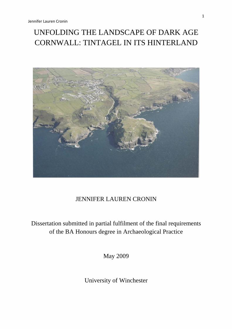
1 Jennifer Lauren Cronin
UNFOLDING THE LANDSCAPE OF DARK AGE
CORNWALL: TINTAGEL IN ITS HINTERLAND
JENNIFER LAUREN CRONIN
Dissertation submitted in partial fulfilment of the final requirements
of the BA Honours degree in Archaeological Practice
May 2009
University of Winchester
2 Jennifer Lauren Cronin
Acknowledgements
This study would not have been possible without the constant guidance of Dr Niall Finneran
at the University of Winchester. As a supervisor he went beyond his job role when
complications arose and consistently showed his support throughout this demanding period.
Additionally Dr Keith Wilkinson aided and supported my work with GIS, both teaching and
nurturing my computer skills even when his timetable was notably full. Their help and
supervision proved invaluable and I would like to express my gratitude. The basis of my GIS
work was formed of NMR data, supplied by Joe Parsons, owner of the Arthurian Centre in
Slaughterbridge. The valuable and varied information held in the Arthurian centre, along
with the NMR data provided by Joe, has been crucial to the creating of accurate and valid
interpretations and so I would like to thank him for his contributions.
3 Jennifer Lauren Cronin
Table of Contents
Acknowledgements .................................................................................................................... 2
Table of Figures ......................................................................................................................... 4
Synopsis ..................................................................................................................................... 5
Introduction ................................................................................................................................ 6
Chapter One: Cornwall in the Early Medieval Period ............................................................... 8
1.1 Critique of Roman Influence ............................................................................................ 8
1.2 Main Theories .................................................................................................................. 9
1.3 Historical Sources within Dumnonia ............................................................................... 9
1.4 Tin Industry .................................................................................................................... 10
Chapter Two: Site Description: Tintagel ................................................................................. 13
2.1 Outline of Site ................................................................................................................ 13
2.2 Site Description .............................................................................................................. 14
2.3 Excavation History and Interpretations .......................................................................... 15
2.4 Chronology Revealed by Excavation ............................................................................. 17
2.5 Interpretation and the Arthurian Myth ........................................................................... 18
Chapter Three: Tintagel in its Landscape ................................................................................ 21
3.1 Study Area: Geology and Place Names ......................................................................... 21
3.2 Main Elite Sites within the Study area ........................................................................... 22
3.3 Other Types of Sites ....................................................................................................... 23
3.4 The Arthurian ‘Landscape’ ............................................................................................ 27
Chapter Four: Geographical Information System Analysis ..................................................... 30
4.1 Methodology .................................................................................................................. 30
4.2 Data Gathering ............................................................................................................... 31
4.3 Data Analysis ................................................................................................................. 31
4.4 Distribution Maps ........................................................................................................... 34
Overview .................................................................................................................................. 41
Bibliography ............................................................................................................................ 44
Appendix A .............................................................................................................................. 47
Appendix B .............................................................................................................................. 50
Appendix C .............................................................................................................................. 54
4 Jennifer Lauren Cronin
Table of Figures
Figure 1 - Location Map, the red square denotes the study area. .............................................. 6
Figure 2 – Above depicts two milestones found at Tintagel (left) and Trethevy (right)
(Thomas 1993: 14). .................................................................................................................... 8
Figure 3 - A geology map highlighting the granite regions ..................................................... 11
Figure 4 – An illustration of the Trewhiddle hoard (Penhallurick 1986: 183) ........................ 12
Figure 5 – Tintagel Island: looking north east. (Jennifer Cronin) ........................................... 13
Figure 6 – A plan of Tintagel Island showing many of the features highlighted in red (Turner
2006: 4a) .................................................................................................................................. 14
Figure 7 – Depicts a variety of imported post Roman B ware (Barrowman et al. 2007: 239).
.................................................................................................................................................. 16
Figure 8 – This is Radford’s site C at the north side of the island depicting Dark Age houses
(Jennifer Cronin) ...................................................................................................................... 18
Figure 9 – Illustrates the study area within the red square. ..................................................... 21
Figure 10 – Illustrates the extent to which the Cornish landscape is scattered with many place
names beginning with tre (Turner 2006: 77) ........................................................................... 22
Figure 11 – An aerial view of Tintagel and St Matheriana, highlighting the lann around the
church (Turner 2006: 60). ........................................................................................................ 24
Figure 12 – A table showing the percentage of monastic buildings on hill tops or slopes
(Turner 2006: 47). .................................................................................................................... 25
Figure 13 – Two Roman rounds at Tregonning Hill, picture taken from the north (Johnson
and Rose 1993: 45). ................................................................................................................. 26
Figure 14 - The left figure shows the Arthur stone (Barrowman et al. 2007: Covering page)
and the right shows an illustration of the inscribed slate with all lettering highlighted
(Barrowman et al. 2007: 193). ................................................................................................. 29
Figure 15 – A distribution map showing the location of three Roman milestones.................. 34
Figure 16 – This is a distribution map illustrating the key elite sites within the study area
including St Michael’s Mount as it is an important monastic site. .......................................... 35
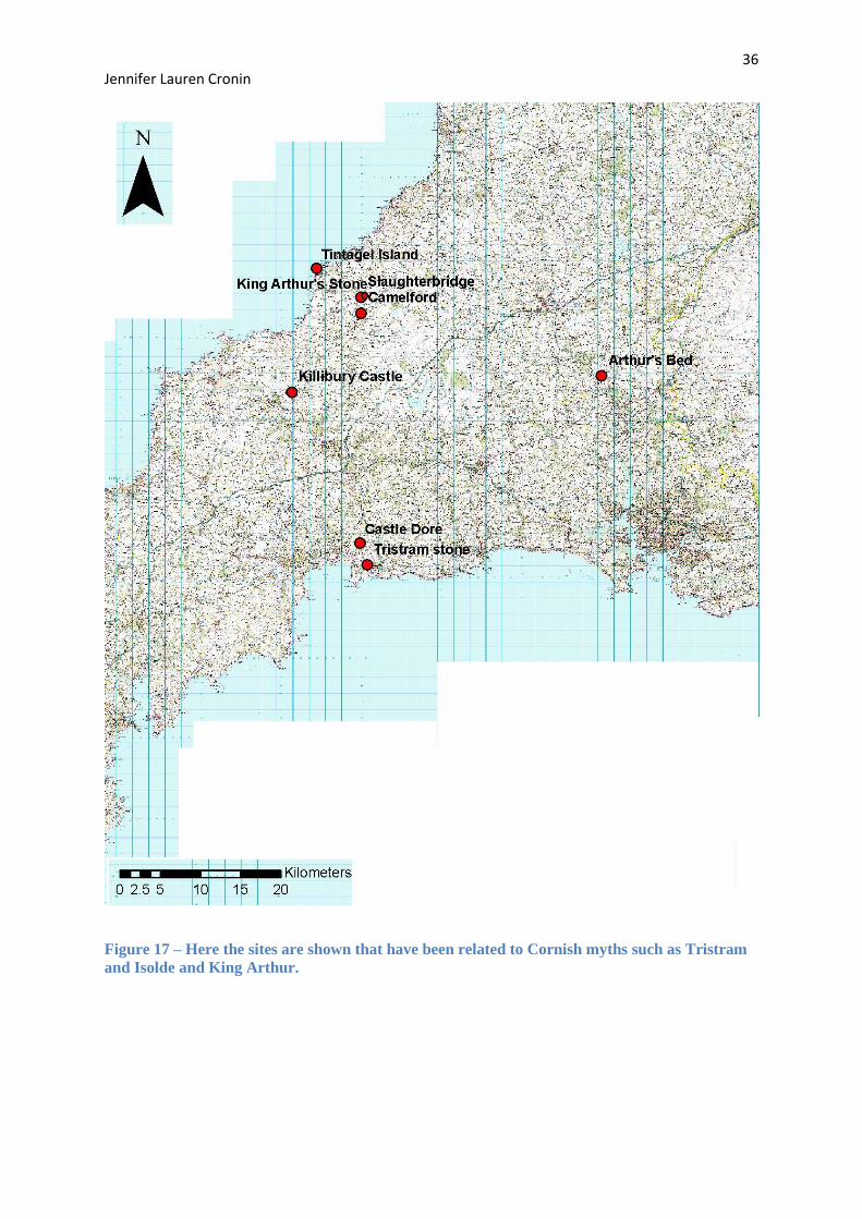
Figure 17 – Here the sites are shown that have been related to Cornish myths such as
Tristram and Isolde and King Arthur. ...................................................................................... 36
Figure 18 – A viewshed was conducted here from the point of Tintagel Island. .................... 37
Figure 19 – A viewshed from Tintagel churchyard, it was chosen to do a further viewshed
from this point as it is located on a much higher terrain. ......................................................... 38
Figure 20 – Killibury castle is involved in the beacon theory and so a viewshed was
conducted to assess the visibility. ............................................................................................ 39
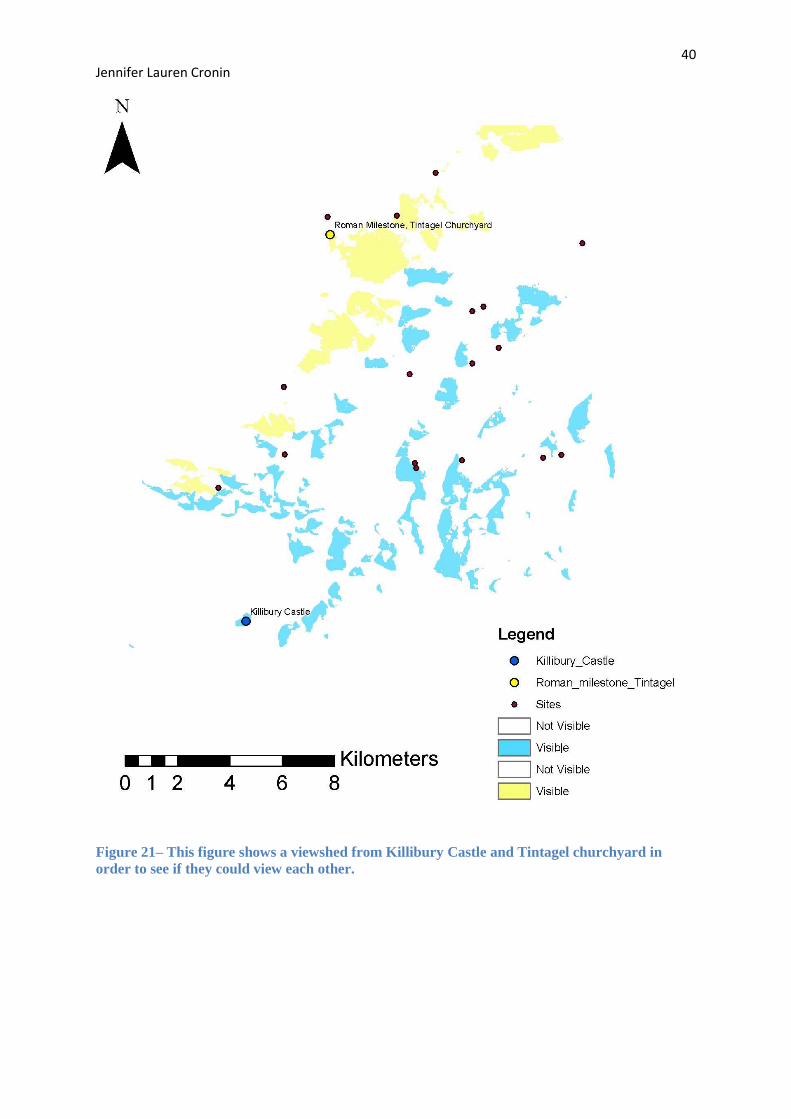
Figure 21– This figure shows a viewshed from Killibury castle and Tintagel churchyard in
order to see if they could view each other. .............................................................................. 40
Cover picture is an aerial photograph of Tintagel Island taken facing inland (Barrowman et
al. 2007: 236)
5 Jennifer Lauren Cronin
Synopsis
Tintagel has long been a focus of academic study and the centre of the Arthurian myth so
widely known. Set in the wild landscape of North Cornwall, Tintagel is richly endowed with
legend, royal connections and international links; its mysteries have yet to be explored. For
80 years Tintagel has been the centre of archaeological fieldwork and diverse interpretations;
however it appears to have only been analysed in isolation, not being considered in context
within its hinterland. This is the primary aspect to be explored along with the analysis of the
Cornish economy, culture and politics and how they all individually and combined dictated
the development of the landscape within the early Medieval period.
6 Jennifer Lauren Cronin
Introduction
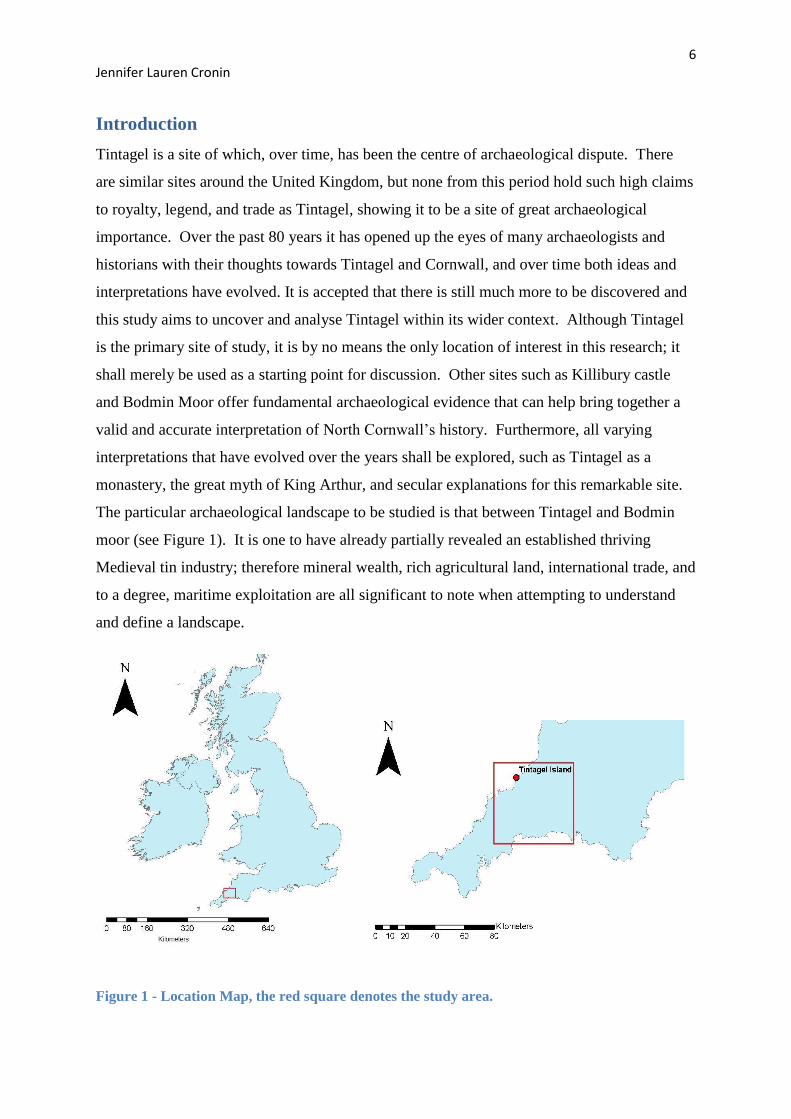
Tintagel is a site of which, over time, has been the centre of archaeological dispute. There
are similar sites around the United Kingdom, but none from this period hold such high claims
to royalty, legend, and trade as Tintagel, showing it to be a site of great archaeological
importance. Over the past 80 years it has opened up the eyes of many archaeologists and
historians with their thoughts towards Tintagel and Cornwall, and over time both ideas and
interpretations have evolved. It is accepted that there is still much more to be discovered and
this study aims to uncover and analyse Tintagel within its wider context. Although Tintagel
is the primary site of study, it is by no means the only location of interest in this research; it
shall merely be used as a starting point for discussion. Other sites such as Killibury castle
and Bodmin Moor offer fundamental archaeological evidence that can help bring together a
valid and accurate interpretation of North Cornwall’s history. Furthermore, all varying
interpretations that have evolved over the years shall be explored, such as Tintagel as a
monastery, the great myth of King Arthur, and secular explanations for this remarkable site.
The particular archaeological landscape to be studied is that between Tintagel and Bodmin
moor (see Figure 1). It is one to have already partially revealed an established thriving
Medieval tin industry; therefore mineral wealth, rich agricultural land, international trade, and
to a degree, maritime exploitation are all significant to note when attempting to understand
and define a landscape.
Figure 1 - Location Map, the red square denotes the study area.
7 Jennifer Lauren Cronin
Important factors shall be evaluated so see to what extent they signify change. The computer
software Geographical Information Systems (GIS) shall be utilised in order to analyse the
layout of settlements from different periods, status and forms of occupation. It is hoped that
this comprehensive study will help archaeologists to gain a full understanding of this
particular study area, and how it interacts with the rest of the country during the early
Medieval period. Cornwall during the Early Medieval period was remote, under populated
and many thought to be uncivilised. Excavations in the past 100 years have highlighted
numerous sites of importance, some of which having been involved in political and religious
developments along with strong indications of international connections; some of which shall
be explored throughout this analysis of the North Cornwall study area. Over the past 80
years Cornwall has gradually been pulled out of the darkness of history books by
archaeologists such as Ralegh Radford, who have dedicated much of their life to helping the
world appreciate the importance of this richly endowed county, so highly ignored by many.
8 Jennifer Lauren Cronin
Chapter One: Cornwall in the Early Medieval Period
1.1 Critique of Roman Influence
Roman occupation of England has been thoroughly discussed by many archaeologists and
historians; however the south west has long remained obscure due to the infinitesimal
quantity of evidence discovered. Charles Thomas in 1993 stressed that activity in Cornwall
during Roman control was elusive, and could only be determined through interpretation of
material culture found within the south west of Britain (Barrowman et al, 2007: 3). The
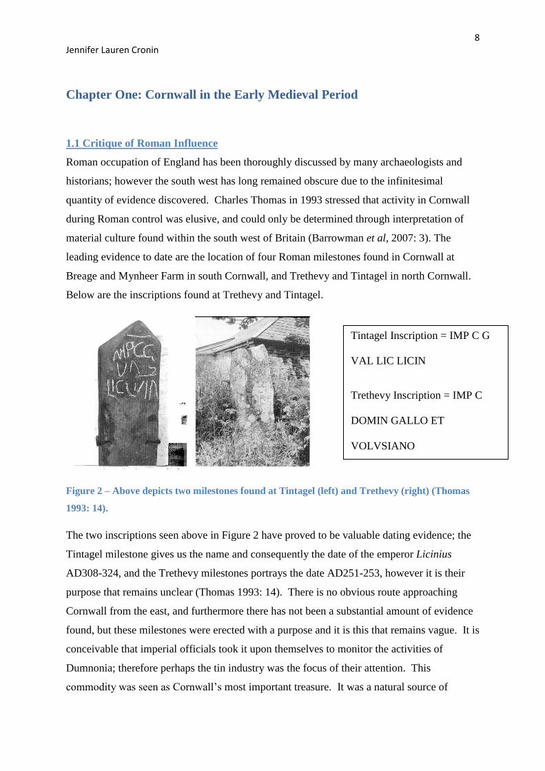
leading evidence to date are the location of four Roman milestones found in Cornwall at
Breage and Mynheer Farm in south Cornwall, and Trethevy and Tintagel in north Cornwall.
Below are the inscriptions found at Trethevy and Tintagel.
Figure 2 – Above depicts two milestones found at Tintagel (left) and Trethevy (right) (Thomas
1993: 14).
The two inscriptions seen above in Figure 2 have proved to be valuable dating evidence; the
Tintagel milestone gives us the name and consequently the date of the emperor Licinius
AD308-324, and the Trethevy milestones portrays the date AD251-253, however it is their
purpose that remains unclear (Thomas 1993: 14). There is no obvious route approaching
Cornwall from the east, and furthermore there has not been a substantial amount of evidence
found, but these milestones were erected with a purpose and it is this that remains vague. It is
conceivable that imperial officials took it upon themselves to monitor the activities of
Dumnonia; therefore perhaps the tin industry was the focus of their attention. This
commodity was seen as Cornwall’s most important treasure. It was a natural source of
Tintagel Inscription = IMP C G
VAL LIC LICIN
Trethevy Inscription = IMP C
DOMIN GALLO ET
VOLVSIANO
9 Jennifer Lauren Cronin
money that helped employment and encouraged trade, and so it is feasible that the Romans
wanted to monitor, or perhaps control all economic activities. Additional evidence for
Romano-British activity is the location of a few, but nevertheless important Cornish Roman
forts and rounds, most famously Nanstallon. Nanstallon is a rectangular earthwork of a large
Roman fort on Tregear farm near Bodmin that is recognised to have had Roman occupation
(Fox and Ravenhill 1966: 28). It has been said that Nanstallon and Restormel were,
‘strategically placed to enable policing of not only the main east-west landward trade-route
but also the north-south traffic using the river system’ (Anon 2008). Its location in North
Cornwall along with other Roman forts such as Calstock and Restormel all contradict the
theory of abandonment by the Romans as these forts show strong evidence for occupation.
Political occupation and control such as the Romans, is an important factor to consider when
attempting to understand a site such as Tintagel in an archaeological and landscape context;
political context can unveil motives for change.
1.2 Main Theories
Many archaeologists have judged and interpreted all aspects of Early Medieval Cornwall and
thus many different theories have been published. As discussed earlier, the debate on the
topic of occupation of North Cornwall during the Roman period is ongoing and there appears
to be varying opinions, but this is not where the discrepancies end. The myth of King Arthur
that surrounds Cornwall and Devon has had many academics pondering about his existence
and the places that he allegedly affected during his life; see Figure 17 for a distribution map
of some key sites related to Cornish myths. From Camelford to Cadbury archaeological sites
all over south-west England have been proposed to be the lost town of Camelot where
famously Uther Pendragon, and later Arthur, ruled (Thomas 1993: 23). There is,
unfortunately, little archaeology to prove or disprove any theories associated with this myth,
but it does not stop the speculation of archaeologists and myth enthusiasts. Many of the
interpretations known today have been sourced from Medieval literature, of which the
majority are not contempory to Arthur’s life, so reliability is easily questioned.
1.3 Historical Sources and within Dumnonia
Dumnonia is a key area of archaeological importance in south-west Britain. Encompassing
Cornwall, Devon and much of Somerset it is no wonder that it has been a focus of many
excavations over the years (Thomas 1993: 88). Referred to briefly in Medieval literature,
battles and conquering heroes are what paint the small picture we have of the role of
Dumnonia and its importance. It is widely known and accepted that this period has been
10 Jennifer Lauren Cronin
crudely named the ‘Dark Ages’ as archaeological evidence from this period is noticeably
diminutive, but indications of Dumnonia can be gained by piecing together what can be
found in works by Gildas, Geoffrey of Monmouth and Nennius. Although they may not
often refer to Dumnonia by name they often discuss key sites and topics within this kingdom,
such as the battle of Camlaan, Tintagel and the elusive King Arthur. However, the reliability
of Medieval literature must be called in to question, in particular the writings of Geoffrey of
Monmouth. Henry Marsh argues, ‘If Bede can be called the father of English history,
perhaps Geoffrey is entitled to be known as the father of historical fiction’ (Marsh 1970: 190)
and this only amplifies the need for caution when using Medieval literature as evidence.
Additional substantiation comes not from looking at the past, but at the present. Place names
offer an interesting outlook when defining the development of a landscape, and it is a
technique often forgotten. With regards to Cornwall this method proves very useful as
Cornish place names are distinctively different to those that are English. Susan Pearce notes
that when one looks at the Tamar, a clear distinction can be seen. The east of the Tamar
offers names of English origin, where as the west boasts a combination of British and Cornish
foundations (Pearce 1981: 178). Refer to chapter three for an in depth discussion of the
importance of place name evidence along with common trends.
1.4 Tin Industry
There are many aspects to consider when exploring a landscape, and industry is integral to
the good economic running of a kingdom, a county and a country. Tin is the most valuable
commodity of Cornwall, no doubt due to the abundance of granite that this county sits upon
(see Figure 3 overleaf). For many centuries it has provided employment, subsistence and has
been in high demand all over the world for the manufacturing of both bronze and pewter;
vital for the construction of church bells. The arrival of Christianity would no doubt have
affected the economy and trade during this period as demand would have heavily increased
(Penhallurick 1986: 243).
11 Jennifer Lauren Cronin
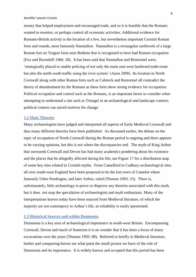
Figure 3 - A geology map highlighting the granite regions
Figure 3 above highlights the extent of granite found within Cornwall’s geology. As one
would expect, the key tin streams have been located upon the granite. We know from
Medieval literature and material culture that Dark Age Cornish tin was traded all over
Europe, even as far as Alexandria. Many authors including Hencken cite the story of a man
named St John of Alexandria. It is said that his ship was blown westwards for 20 days until
he reached a poverty stricken country: Britain. Here, authors say, he exchanged his cargo of
corn for coinage and tin (Penhallurick 1986: 237). It can be assumed that Cornwall was his
unintentional destination as this was the only tin producing area of Britain, and furthermore,
it highlights the necessity, reputation and importance of the Cornish tin industry. For British
tin to be known and admired as far as Africa, one can presume that it had a good reputation,
so much so that it was known across the globe. Excavations from tin stream works have
provided us with datable artefacts that allow a better understanding of this crucial aspect of
Dark Age Cornish life. The most famous discoveries include the Boscarne shovel found in
the Boscarne tin stream. Thought originally to be Roman, the radio carbon date revealed a
date of 635-1045 AD (Penhallurick. 1986: 66). This pleased many archaeologists as it added
to the growing amount of much needed material culture that we are gathering from the Dark
Ages. The Trewhiddle hoard is another remarkable discovery found in a tin stream near St
Austell. Thought to be one of the most important Celtic Cornwall discoveries up to date, it
comprises of a large amount of Saxon silver, see Figure 4.
12 Jennifer Lauren Cronin
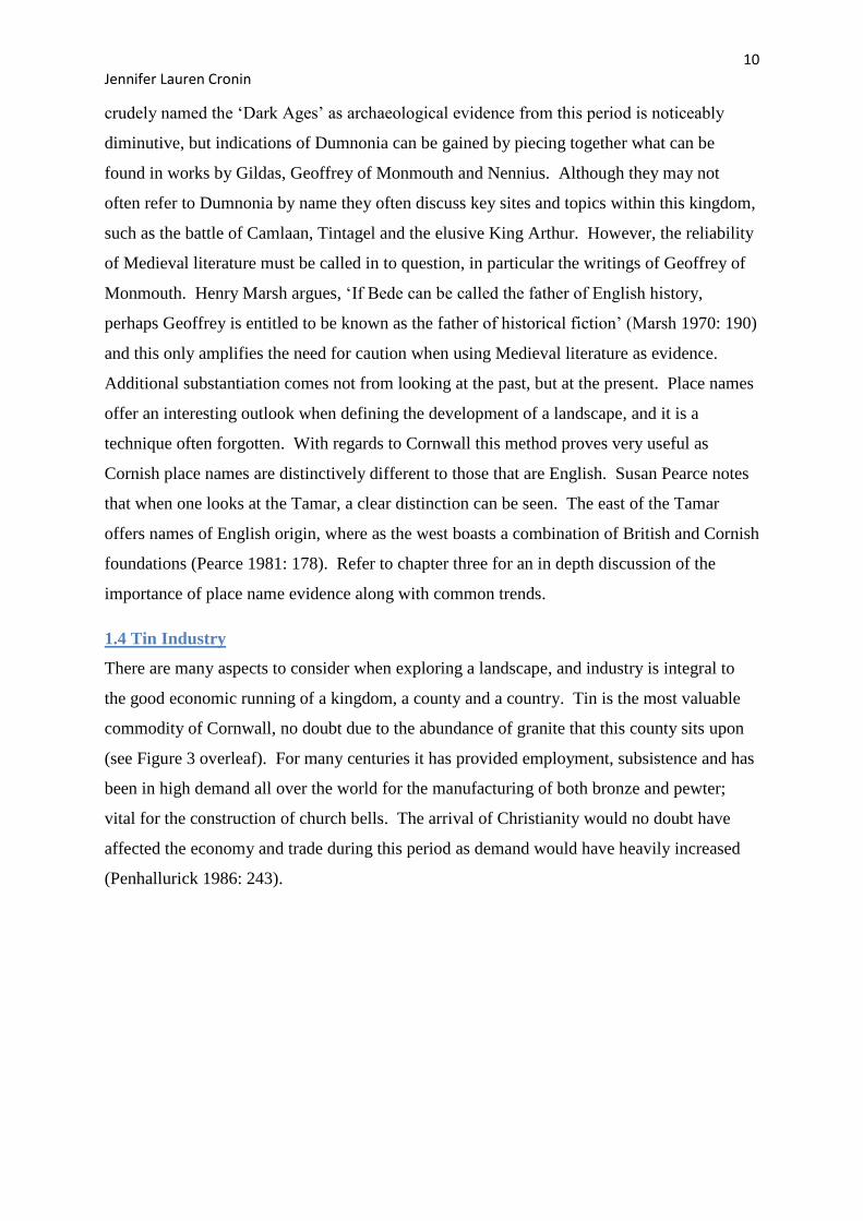
Figure 4 – An illustration of the Trewhiddle hoard (Penhallurick 1986: 183)
A Coelwulf coin within the hoard tells us that it could not have been deposited before AD
874, stressing the value of a well preserved artefact. If the finds can be dated, then we as
archaeologists can gain a sufficient indication of the tin mining areas favoured by
civilisations of the past, helping us to construct the landscape. The tin industry is an aspect of
Cornish life that is ever-present over the entirety of the landscape with four large areas
abundant in granite that were exploited for tin mining and panning. The evidence found in
tin streams denotes that the Cornish tin industry was thriving throughout the Saxon period
and continued in to the Medieval period. It can be seen that this healthy industry was firmly
set on the path which led it to monopolising the world’s tin trade in later centuries
(Penhallurick 1986: 181).
13 Jennifer Lauren Cronin
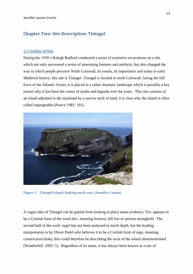
Chapter Two: Site Description: Tintagel
2.1 Outline of Site
During the 1930’s Ralegh Radford conducted a series of extensive excavations on a site
which not only uncovered a series of interesting features and artefacts, but also changed the
way in which people perceive North Cornwall, its events, its importance and status in early
Medieval history, this site is Tintagel. Tintagel is located in north Cornwall; facing the full
force of the Atlantic Ocean, it is placed in a rather dramatic landscape which is possibly a key
reason why it has been the centre of myths and legends over the years. This site consists of
an island adjoined to the mainland by a narrow neck of land; it is clear why the island is often
called impregnable (Pearce 1981: 191).
Figure 5 – Tintagel Island: looking north east. (Jennifer Cronin)
A vague idea of Tintagel can be gained from looking at place name evidence; Tin- appears to
be a Cornish form of the word din-, meaning fortress, hill fort or ancient stronghold. The
second half of the word -tagel has not been analysed in much depth, but the leading
interpretation is by Oliver Padel who believes it to be a Cornish form of tage, meaning
constriction/choke; this could therefore be describing the neck of the island aforementioned
(Weatherhill. 2005: 5). Regardless of its name, it has always been known as a site of
14 Jennifer Lauren Cronin
importance, with occupation spanning several centuries and varying interpretations
surrounding it.
2.2 Site Description
The site of Tintagel has been subject to many centuries of occupation. On the island one can
see a Medieval castle which appears as the most dominant feature on the island, but other
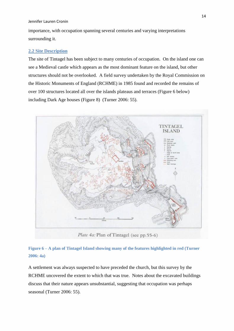
structures should not be overlooked. A field survey undertaken by the Royal Commission on
the Historic Monuments of England (RCHME) in 1985 found and recorded the remains of
over 100 structures located all over the islands plateaus and terraces (Figure 6 below)
including Dark Age houses (Figure 8) (Turner 2006: 55).
Figure 6 – A plan of Tintagel Island showing many of the features highlighted in red (Turner
2006: 4a)
A settlement was always suspected to have preceded the church, but this survey by the
RCHME uncovered the extent to which that was true. Notes about the excavated buildings
discuss that their nature appears unsubstantial, suggesting that occupation was perhaps
seasonal (Turner 2006: 55).
15 Jennifer Lauren Cronin
2.3 Excavation History and Interpretations
Ralegh Radford in the 1930’s conducted the first extensive excavations at Tintagel. He
opened up several trenches around the island and brought to light new structures and
artefacts. Radford’s interpretations of his finds led him to believe that Tintagel was home to
a Celtic monastery. With other secluded monasteries known to the archaeological world
which appear to mirror Tintagel’s wild landscape and isolated location, (Iona in Scotland is
one example) it can be understood why an assumption such as this could be easily adopted by
many. However the structures and artefacts found during Radford’s excavations appear to
offer a different account. Approximately twenty rectangular and sub rectangular stone
buildings were uncovered along terraces on the eastern slopes and the plateau around the 13th
Century Castle Chapel dedicated to St. Juliot (Barrowman et al. 2007: 6). Due to the known
lifestyle of the monks only a few buildings would have been expected, nothing like what was
discovered upon the island of Tintagel. This possibly is an example of one of the first
deterrents from the monastic idea. The visible structures at the monastic site of Iona are not
located in abundance; an abbey and nunnery can be found today, although previously sheds,
barns and a communal eating area are thought to have existed, the quantity is nowhere near
the number of structures located at Tintagel (MacArthur 1995: 11). Hence the archaeology at
Tintagel suggests a much larger settlement of some kind. It is worth noting that the
excavations conducted by Radford at Tintagel suffered from poor archaeological practice
(Barrowman et al. 2007: 3). Similar to so many other sites excavated during this period,
reports were left unfinished and work even lost, making accurate interpretations hard to
construct.
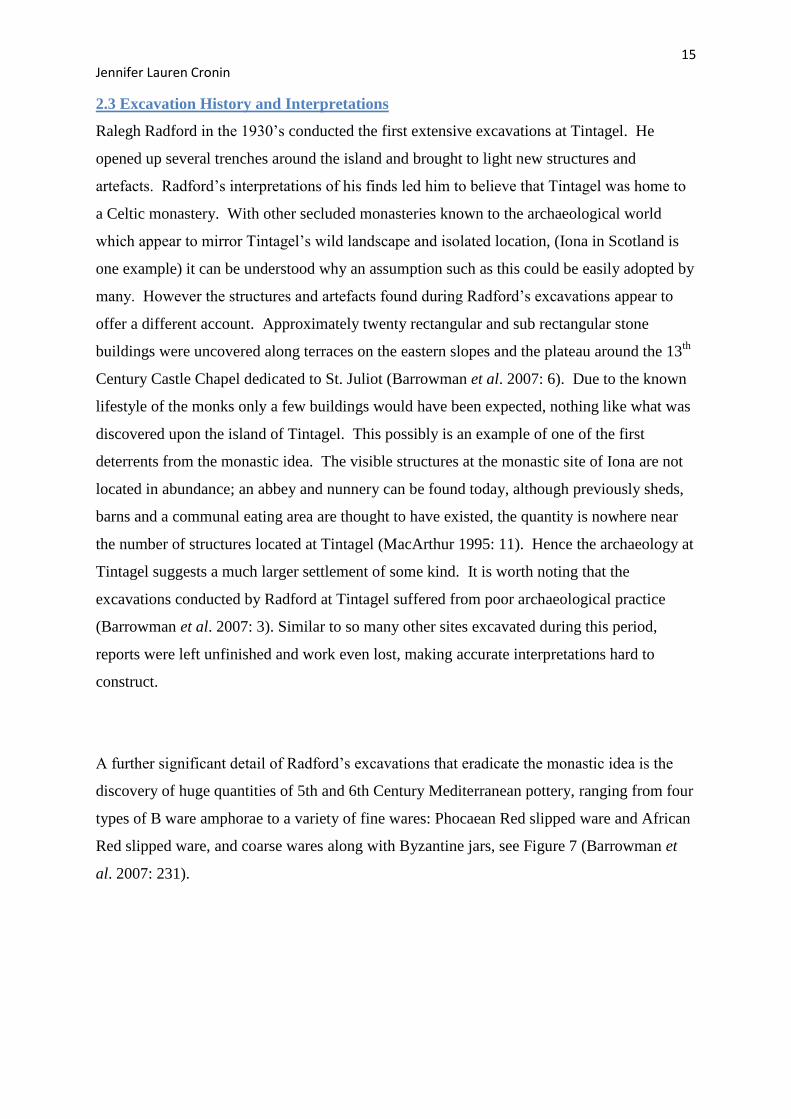
A further significant detail of Radford’s excavations that eradicate the monastic idea is the
discovery of huge quantities of 5th and 6th Century Mediterranean pottery, ranging from four
types of B ware amphorae to a variety of fine wares: Phocaean Red slipped ware and African
Red slipped ware, and coarse wares along with Byzantine jars, see Figure 7 (Barrowman et
al. 2007: 231).
16 Jennifer Lauren Cronin
Figure 7 – Depicts a variety of imported post Roman B ware (Barrowman et al. 2007: 239).
These intriguing finds meant the site, and perhaps the whole coast of Cornwall needed to be
re-evaluated as this strong international link took Tintagel out of the darkness in history
books, and highlighted it as a strong, central archaeological site of Early Medieval England.
This ceramic evidence is fundamental to the interpretation of Tintagel not only due to their
production location, but also the total count of sherds: 1821 in total. Imported pottery has
been found on other sites around the United Kingdom, such as Mothecombe in Devon,
Glastonbury Tor in Somerset, and Dinas Powys in Wales, showing that international trade
stretched all over the country, but specifically at sites of elite or religious importance
(Thomas 1981: 10). Although trade and the discovery of imported ceramics does not appear
to be isolated to our study area, Tintagel is made interesting by the quantity; more pottery has
been found on the site of Tintagel than the total haul from all other Dark Age sites in Britain
combined (Barrowman et al. 2007: 246). Furthermore, there is no literary evidence of trade
routes from England to the continent, so this discovery of imported ware not only affected the
archaeologists’ idea of Tintagel, but also developed the understanding of Cornwall as an
economically active county during the Early Medieval period (Fulford 1977: 35). The
monastic idea had too much evidence to oppose it and so was soon re-evaluated.

17 Jennifer Lauren Cronin
The monastic paradigm was the leading explanation for 50 years and took a man named
Charles Thomas to see the true potential of Tintagel. Thomas re-evaluated the post Roman
period of Tintagel and suggested a secular site (Thomas 1993: 87). He was the archaeologist
who saw the differences between Tintagel Island and monasteries. He had the knowledge
and experience to detect what Radford could not, and interpret his finds in a way which
involved a much wider context. He saw the pottery assemblages as a sign of wealth and
status leading him to the interpretation that is generally accepted today. Tintagel, it is
thought, was a site of high importance and almost certainly home to the King of Dumnonia;
with excellent access to the sea, a defensive location, strong international trade network and a
nearby flourishing tin industry it seems a very plausible idea. However the wild landscape
and harsh weather attacking the island from the west would have meant only seasonal
residency; the winter months would have made full time residency almost impossible, if not
highly impractical (Turner 2006: 55). Both the quality of artefacts and quantity of structures
support this theory, and is the most current we have today. This is an outstanding detail and
offers many intriguing questions about the importance of Cornwall and the role Tintagel
played. It is fair to say that Cornwall and indeed Tintagel may not be as uncivilised and
insignificant as first thought.
2.4 Chronology Revealed by Excavation
The site of Tintagel is overwhelmed by the picturesque castle remains, and its historical
importance prior to this is often overlooked. One cannot say that Tintagel is completely
devoid of Prehistoric significance, as evidence from this period is often concealed or less
stated than that of Medieval date. It is supposed however, that recent excavations would
have upturned the material before now, but perhaps more work is needed for an accurate
evaluation of this complex period. With a severe lack of Roman evidence on site one must
look to the Dark Age houses found, see Figure 8
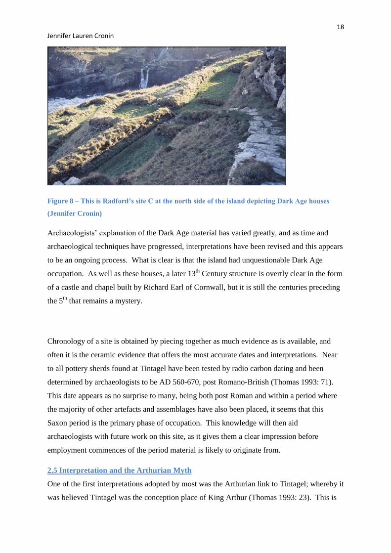
18 Jennifer Lauren Cronin
Figure 8 – This is Radford’s site C at the north side of the island depicting Dark Age houses
(Jennifer Cronin)
Archaeologists’ explanation of the Dark Age material has varied greatly, and as time and
archaeological techniques have progressed, interpretations have been revised and this appears
to be an ongoing process. What is clear is that the island had unquestionable Dark Age
occupation. As well as these houses, a later 13th
Century structure is overtly clear in the form
of a castle and chapel built by Richard Earl of Cornwall, but it is still the centuries preceding
the 5th
that remains a mystery.
Chronology of a site is obtained by piecing together as much evidence as is available, and
often it is the ceramic evidence that offers the most accurate dates and interpretations. Near
to all pottery sherds found at Tintagel have been tested by radio carbon dating and been
determined by archaeologists to be AD 560-670, post Romano-British (Thomas 1993: 71).
This date appears as no surprise to many, being both post Roman and within a period where
the majority of other artefacts and assemblages have also been placed, it seems that this
Saxon period is the primary phase of occupation. This knowledge will then aid
archaeologists with future work on this site, as it gives them a clear impression before
employment commences of the period material is likely to originate from.
2.5 Interpretation and the Arthurian Myth
One of the first interpretations adopted by most was the Arthurian link to Tintagel; whereby it
was believed Tintagel was the conception place of King Arthur (Thomas 1993: 23). This is

19 Jennifer Lauren Cronin
primarily due to the writings of a welsh monk, Geoffrey of Monmouth in the 1100’s. At the
time of Geoffrey’s work, many of the structures, including the 13th
Century church, had not
been built so the content, it can be assumed, was based on myth and legend itself; not a
reliable foundation. However it is the extensive chapters on Arthur’s life that have captivated
the interest of scholars and archaeologists alike for many centuries (Alcock 1971: 18). Never
before had this supposed king been described in so much depth including dates and lists of
places that he was involved with. However, as time passed his work was constantly
scrutinised, many have thought Geoffrey of Monmouth as an author to be an, “inexorable
forger who made up his stories from an inordinate love of lying” (Ford 1998: 1). A statement
such as this may seem unwarranted as although there may be little fact in his work, there is
also no one to disprove these statements. Ironically, it seems that a lack of archaeology is the
only form of evidence available to oppose Geoffrey’s words. This appears as a negative
outlook on the situation as much larger aspects of our world today are based on literature
from a similar period of history: Christianity. Regardless of the reliability of his work, it was
Geoffrey of Monmouth that made the link between Arthur and Tintagel, calling it his place of
conception and it is no doubt his work that made the Arthurian legend come alive and last for
several centuries. St Gildas is another Medieval contributor to the myth of King Arthur. St.
Gildas’ work is particularly important because it is contemporary. It implies that he would
have experienced a firsthand account of Arthur’s life and so is more reliable than other
sources. In his 6th
Century book ‘De Excidio British History Clube’, he referred not to a man
named Arthur but a character called ‘The Bear’, which is the Celtic meaning for the word Art
(Ford 2008). This may be seen as a link that is far too interpretive and not based on fact, but
when dealing with literature, interpretation is the sole tool both historians and archaeologists
possess. Too often writers hide their meaning under metaphors and riddles, but this does not
necessarily make it less reliable. With regards to Gildas, bias may certainly be present in his
works. ‘De Excidio British History Clube’ was his only literary accomplishment as it is said
that it was used as a way to track, note and no doubt enjoy the loss of the Roman empire and
their impact on England; being a monk it can be assumed that Gildas would have blamed the
Roman leaders as their imperial power was thought by many to have degraded Christian
values (Ford 2008). This again is merely an interpretation, but valid none the less and shows
the importance in trying to understand the author behind the words. These interpretations
about King Arthur are still founded on myth and unreliable Medieval literature, with very
little archaeological evidence to persuade academics, these are key reasons archaeologists
today often disregard this interpretation entirely. Sites such as Tintagel and Slaughterbridge

20 Jennifer Lauren Cronin
have today used this opportunity to present such sites as tourism spots. Tintagel receives
thousands of visitors each year, and they are attracted chiefly by the idea of King Arthur, so
although not necessarily factual, this parable is still affecting our landscape today.
21 Jennifer Lauren Cronin
Chapter Three: Tintagel in its Landscape
3.1 Study Area: Geology and Place Names
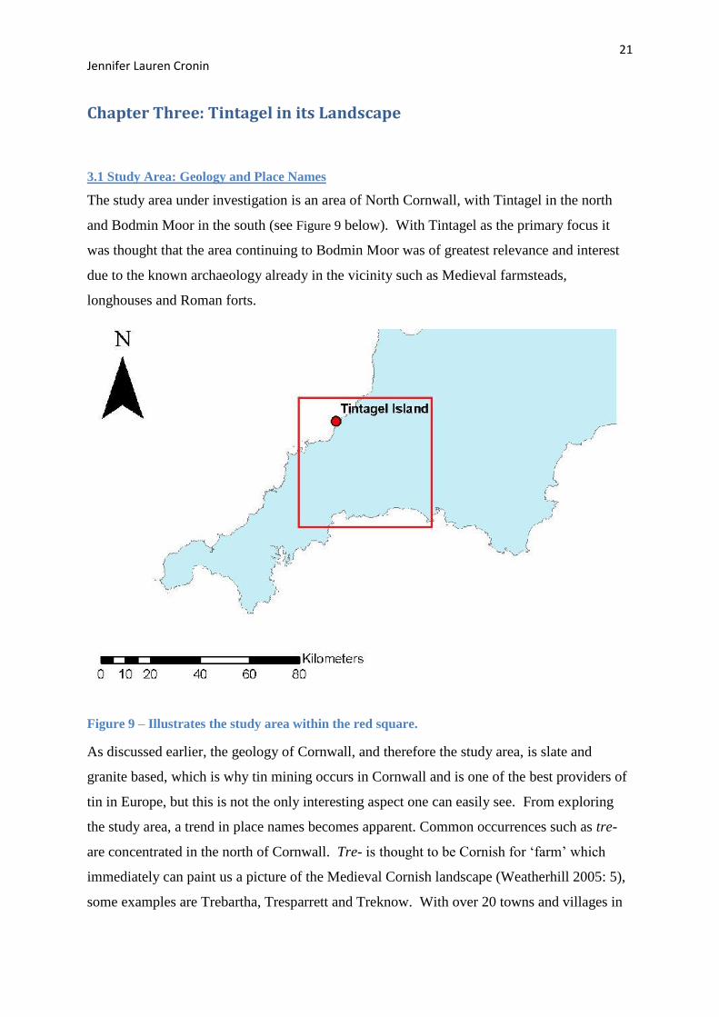
The study area under investigation is an area of North Cornwall, with Tintagel in the north
and Bodmin Moor in the south (see Figure 9 below). With Tintagel as the primary focus it
was thought that the area continuing to Bodmin Moor was of greatest relevance and interest
due to the known archaeology already in the vicinity such as Medieval farmsteads,
longhouses and Roman forts.
Figure 9 – Illustrates the study area within the red square.
As discussed earlier, the geology of Cornwall, and therefore the study area, is slate and
granite based, which is why tin mining occurs in Cornwall and is one of the best providers of
tin in Europe, but this is not the only interesting aspect one can easily see. From exploring
the study area, a trend in place names becomes apparent. Common occurrences such as tre-
are concentrated in the north of Cornwall. Tre- is thought to be Cornish for ‘farm’ which
immediately can paint us a picture of the Medieval Cornish landscape (Weatherhill 2005: 5),
some examples are Trebartha, Tresparrett and Treknow. With over 20 towns and villages in
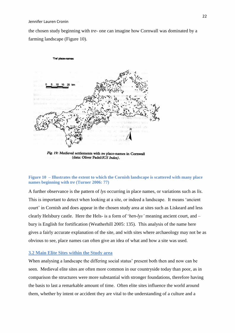
22 Jennifer Lauren Cronin
the chosen study beginning with tre- one can imagine how Cornwall was dominated by a
farming landscape (Figure 10).
Figure 10 – Illustrates the extent to which the Cornish landscape is scattered with many place
names beginning with tre (Turner 2006: 77)
A further observance is the pattern of lys occurring in place names, or variations such as lis.
This is important to detect when looking at a site, or indeed a landscape. It means ‘ancient
court’ in Cornish and does appear in the chosen study area at sites such as Liskeard and less
clearly Helsbury castle. Here the Hels- is a form of ‘hen-lys’ meaning ancient court, and –
bury is English for fortification (Weatherhill 2005: 135). This analysis of the name here
gives a fairly accurate explanation of the site, and with sites where archaeology may not be as
obvious to see, place names can often give an idea of what and how a site was used.
3.2 Main Elite Sites within the Study area
When analysing a landscape the differing social status’ present both then and now can be
seen. Medieval elite sites are often more common in our countryside today than poor, as in
comparison the structures were more substantial with stronger foundations, therefore having
the basis to last a remarkable amount of time. Often elite sites influence the world around
them, whether by intent or accident they are vital to the understanding of a culture and a
23 Jennifer Lauren Cronin
landscape. The study area boasts some of the most impressive elite sites in the country
including a variety of castles and fortified hill forts. Helsbury castle is an example of an Iron
Age hillfort whose name and nature exudes Cornish history. It is unclear to many
archaeologists whether this hillfort was for defence or just a display of wealth and power.
What is known is that, although it displays only a single rampart, unlike others such as
Warbstow Bury, it does not in any way mean it is defected or symbolic of less status; it
would undeniably have played an active role during Medieval Cornish life (Johnson and
Rose. 1993: 29). Warbstow Bury is another example of a significant elite site and is one of
the largest hillforts in Cornwall. Two large ramparts and ditches make up this incredible fort
and it is thought that many round houses would have been built in the inner enclosure, but no
evidence has been discovered to date (Johnson and Rose. 1993: 47). This important
stronghold is thought to have been home to a chieftain or leader of some sort, showing
parallels to Tintagel. Killibury Castle paints a similar picture. It is a small banked and
ditched fort of definite Dark Age construction and occupation (Castleden 2003: 168).
Interesting finds from this site include imported Mediterranean pottery, comparable with
Dinas Powys, Tintagel and Castle Cadbury to name a few. This particular collection of
imported wares makes the site of great significance to archaeologists as trade and trade routes
in the Dark Ages have been of particular interest over the years. It remains unclear exactly
how and where the trading occurred along the Cornish coast but many theories do exist on
this particular matter. An important site that has clearer archaeological evidence to shed light
on this topic is St Michaels Mount. Although it is not strictly within the boundaries of the
study area, it is important to note within a wider context. It has long been heralded as an
important Prehistoric, Roman and Medieval centre showing consistent presence of power
through several centuries. Its strategic location, defensibility and shape have led
archaeologists to believe that it was a secular power house; however during the Medieval
period the Benedictine Priory located on this site became a famous place of pilgrimage,
highlighting a drastic change in purpose (Herring 1993: 37).
3.3 Other Types of Sites
Within Tintagel’s hinterland there is a variety of important sites as well as those that are elite.
Within Cornwall the elite and the church were thought to be closely linked. Religious
communities were often the focus of a settlement and often acted as administrative centres so
are clearly crucial to understand if the landscape is to be analysed (Turner 2006: 53). The
Domesday Book has proven vital for information on Early Medieval ecclesiastical estates in
24 Jennifer Lauren Cronin
Cornwall. This piece of Medieval literature highlights Bodmin, specifically St Petroc at
Bodmin, as having the largest estate (Turner 2006: 123). One of the first forms of religious
sites and communities involved ‘lanns’. The word ‘lann’ has been attributed to a common
shape that has been found around churches today and Charles Thomas has created a model
that has proved to be one of the most influential models for ecclesiastical sites in western
Britain. He comments that after the conversion to Christianity, traditional burial grounds
underwent a series of changes. The first change noted was that a curvilinear boundary would
be made around the site to enclose it. This form can be seen around many churches over
England (Thomas 1993: 105). A particularly fine example is that at Tintagel, the church of St
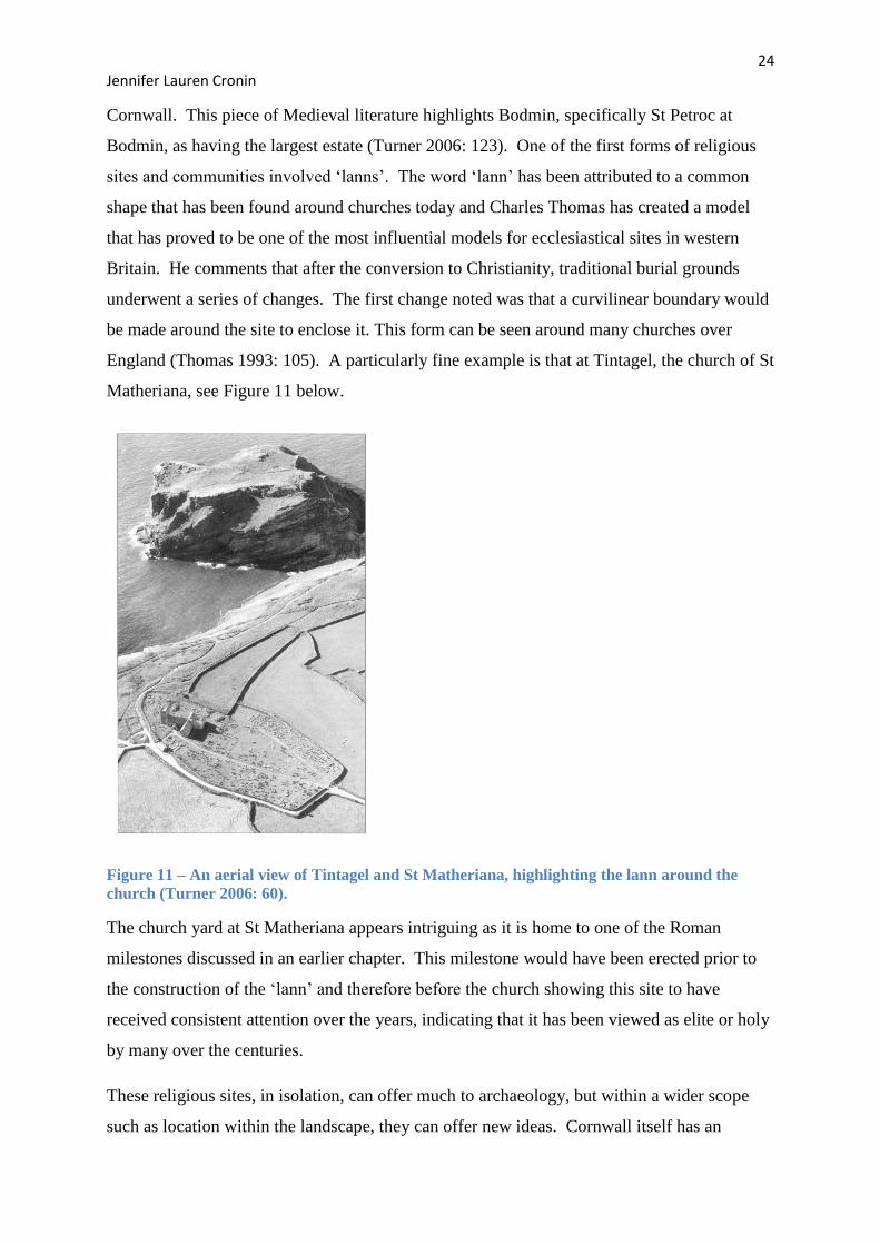
Matheriana, see Figure 11 below.
Figure 11 – An aerial view of Tintagel and St Matheriana, highlighting the lann around the
church (Turner 2006: 60).
The church yard at St Matheriana appears intriguing as it is home to one of the Roman
milestones discussed in an earlier chapter. This milestone would have been erected prior to
the construction of the ‘lann’ and therefore before the church showing this site to have
received consistent attention over the years, indicating that it has been viewed as elite or holy
by many over the centuries.
These religious sites, in isolation, can offer much to archaeology, but within a wider scope
such as location within the landscape, they can offer new ideas. Cornwall itself has an
25 Jennifer Lauren Cronin
extremely varied countryside consisting of steep valleys that can often give an impression of
seclusion; which contrasts greatly to the majority of England where broad valleys give an
impression of open countryside (Turner 2006: 35). It could be that this style of landscape,
offering seclusion and appearing secretive could be a Celtic style, certainly one that
differentiates the west from the rest of the country. Within the landscape it may be thought
that hilltops would be the prime location for monasteries, offering isolation and solitude, but
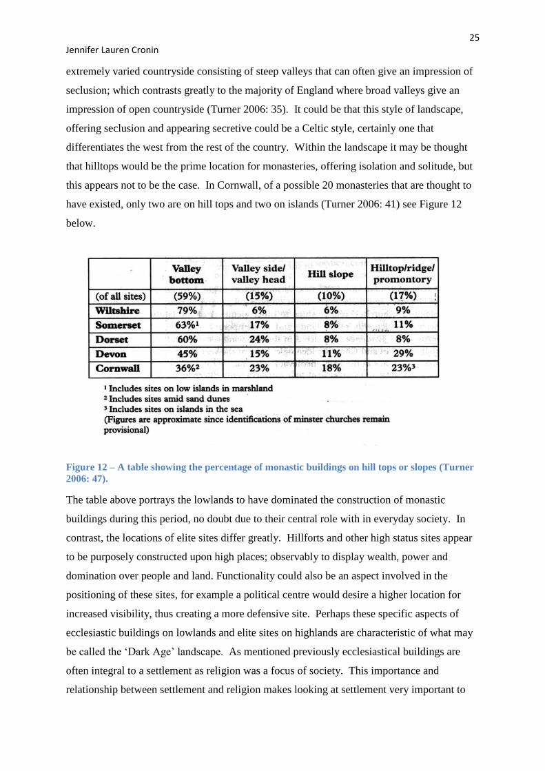
this appears not to be the case. In Cornwall, of a possible 20 monasteries that are thought to
have existed, only two are on hill tops and two on islands (Turner 2006: 41) see Figure 12
below.
Figure 12 – A table showing the percentage of monastic buildings on hill tops or slopes (Turner
2006: 47).
The table above portrays the lowlands to have dominated the construction of monastic
buildings during this period, no doubt due to their central role with in everyday society. In
contrast, the locations of elite sites differ greatly. Hillforts and other high status sites appear
to be purposely constructed upon high places; observably to display wealth, power and
domination over people and land. Functionality could also be an aspect involved in the
positioning of these sites, for example a political centre would desire a higher location for
increased visibility, thus creating a more defensive site. Perhaps these specific aspects of
ecclesiastic buildings on lowlands and elite sites on highlands are characteristic of what may
be called the ‘Dark Age’ landscape. As mentioned previously ecclesiastical buildings are
often integral to a settlement as religion was a focus of society. This importance and
relationship between settlement and religion makes looking at settlement very important to
26 Jennifer Lauren Cronin
the analysis of a landscape. In North Cornwall a large quantity and variety of transhumant
and agricultural sites can be seen today in our countryside, reflecting the past’s landscape.
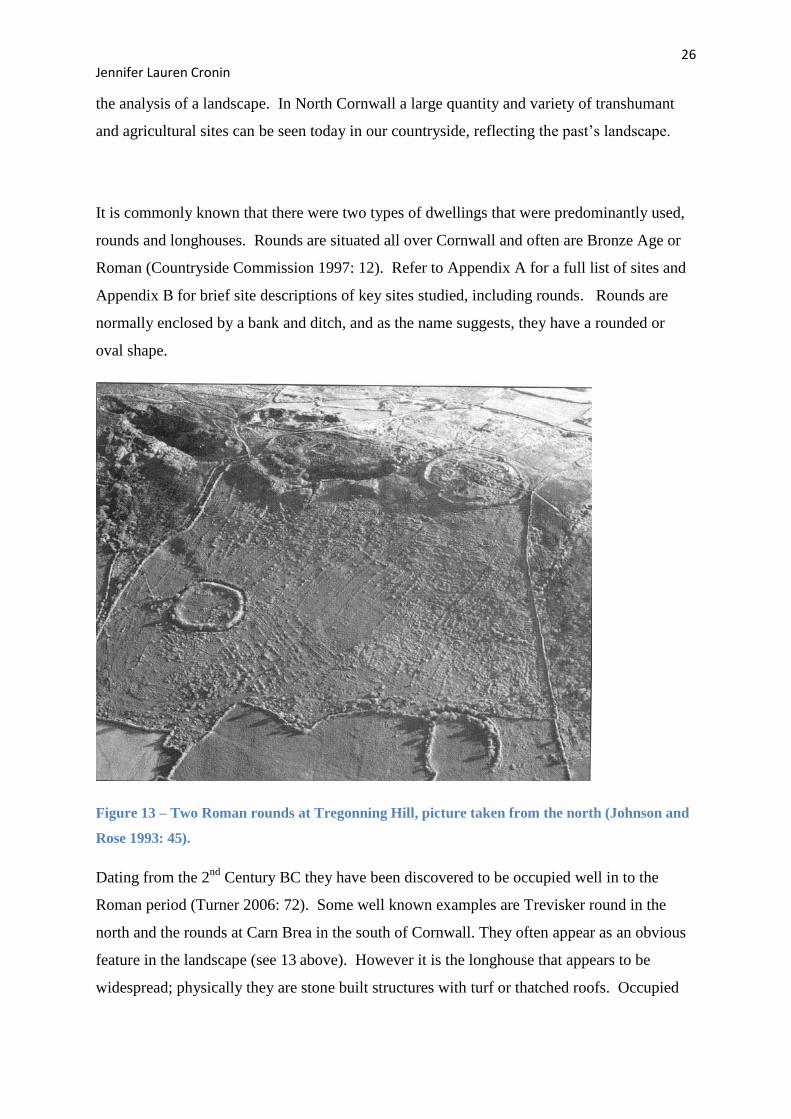
It is commonly known that there were two types of dwellings that were predominantly used,
rounds and longhouses. Rounds are situated all over Cornwall and often are Bronze Age or
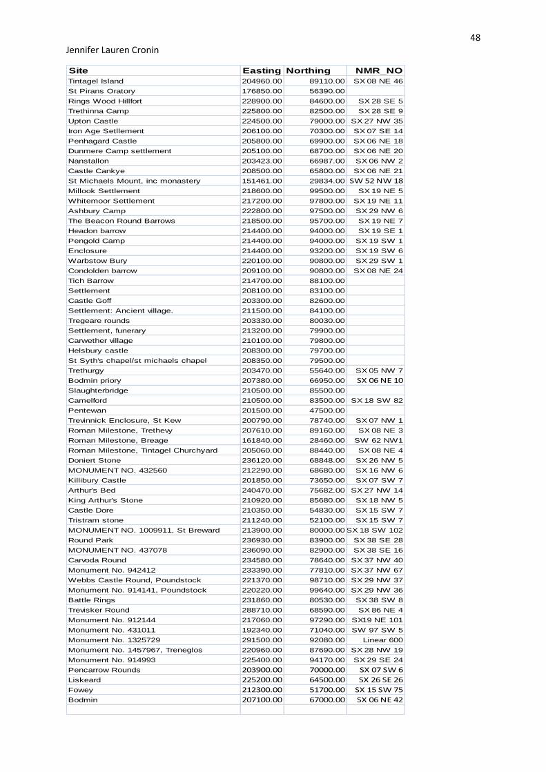
Roman (Countryside Commission 1997: 12). Refer to Appendix A for a full list of sites and
Appendix B for brief site descriptions of key sites studied, including rounds. Rounds are
normally enclosed by a bank and ditch, and as the name suggests, they have a rounded or
oval shape.
Figure 13 – Two Roman rounds at Tregonning Hill, picture taken from the north (Johnson and
Rose 1993: 45).
Dating from the 2nd
Century BC they have been discovered to be occupied well in to the
Roman period (Turner 2006: 72). Some well known examples are Trevisker round in the
north and the rounds at Carn Brea in the south of Cornwall. They often appear as an obvious
feature in the landscape (see 13 above). However it is the longhouse that appears to be
widespread; physically they are stone built structures with turf or thatched roofs. Occupied
27 Jennifer Lauren Cronin
by Medieval farming families, it can be no surprise that they are frequently seen throughout
Cornwall and often in clusters as several longhouses together form a hamlet (Cornwall
County Council 2009). Within these hamlets, some of the longhouses may be what is called
transhumant. Transhumant sites show an interesting use of space and a bond with their
animals. In these forms of longhouses both family and animals would have shared this living
space during the winter months. The bringing in of their cattle or flock to their personal
homes shows the relationship between the family and their animals, and perhaps reflects their
priorities and the care they take to ensure their livelihood. Surrounding these transhumant
sites and hamlets would have been extensive fields divided into long strips; such formations
can still be seen at various places throughout the landscape, perhaps most famously Brown
Willy at Bodmin Moor. Longhouse settlements rarely survive in lowland areas as they often
are superseded by later buildings. It is highland settlements that have been preserved to a
higher standard, and this is why Bodmin Moor offers so much to the world of archaeology.
These longhouses are some of the first Medieval settlements. Many of them are located
sensibly close to a spring and good arable land; both crucial for living and earning (Herring
2006: 84). The food they cultivated would have been taken to markets to be traded. This
would have been a good opportunity to meet with neighbours from nearby hamlets. In the
Domesday Book 5 markets were recorded; Launceston, Liskeard, Bodmin, St Germans and
Marazion (Cornwall County Council 2009). All except Liskeard were religious centres
which show an interesting link between religion and trade. Perhaps ecclesiastical centres also
acted as active trading centres. If this is the case, market sites would have been crucial to
agricultural and transhumant sites.
3.4 The Arthurian ‘Landscape’
Landscape is crafted and moulded by numerous factors. Many of the key aspects have been
explored such as religion and people of power, but myth and legend are often forgotten
elements. When examining the myths that surround Cornwall, it can be noted that a magical
element is present; forbidden loves, sorcerers and dramatic fortresses and coastlines all
appear present in early Medieval Cornwall, but to what extent has it affected the landscape.
When Cornwall is thought of it is the legend of King Arthur that prevails in the mind of
many, no doubt due to the media as it has been a focus of books and adaptations for
television. Archaeologically, many sites over south-west England have been intrinsically
linked to Arthur and all the tales derived from this original tale. Tintagel has been a focal
point of Arthur’s life but Dr Oliver Padel was producing an alternative historical context for
28 Jennifer Lauren Cronin
the importance of the site through association with Tristan and Isolde. Padel famed Tintagel
castle as the home of King Mark in the 14th
Century (Barrowman et al. 2007: 32). King
Mark was the uncle of Tristram, from the lovers’ tale of Tristram and Isolde; Tristram was
also penned as one of Arthur’s Knights of the Round Table. Medieval literature also placed
these lovers in various other areas such as Roche Rock and Castle Dore; Castle Dore being
the original setting for the Tristram Stone dating to 5/6th
Century with the inscription reading
‘ Drustanus lies here, the son of Conumorus’; translating to ‘Tristram lies here, the son of
Conumrus’ (Castleden 2003: 98). Both Tristram and Arthur have heavily affected people’s
views of various sites across the study area. Geoffrey of Monmouth saw him as a brave King
of Camelot; Camelot is a fictional kingdom whose title has been attributed to many sites
across our landscape including Camelford and Killibury castle. Furthermore, Arthur was said
to be involved in the battle of Camlaan at Slaughterbridge, placing another site under the
name of King Arthur (Parsons n.d.). All these sites linked to King Arthur help us today to
see the landscape in terms of ‘Arthur’s reign’, but as stated previously there does appears to
be no factual evidence. What is clear from analysing the Arthur myth is that it is based upon
literature alone raising problems of reliability, but their power should not be doubted.
Legends from the past have affected the landscape throughout the past and can mould the
landscape of today; for example Caenarvon Castle was built during the Medieval period for
Edward I in order to express his interest in the Arthurian Legend (Liddiard 2005: 58). In
North Cornwall today the Arthurian Centre can be found in Slaughterbridge near Camelford,
making its profits off of this legend by means of a tourist attraction involving the battle site of
Camlaan and the famous Arthur Stone. Arthurian enthusiasts became excited in 1998 upon
the discovery of what they call the ‘Arthur Stone’. Discovered by Glasgow University it is a
1500 year old piece of slate with 2 forms of Latin inscriptions (Barrowman et al. 2007: 191).
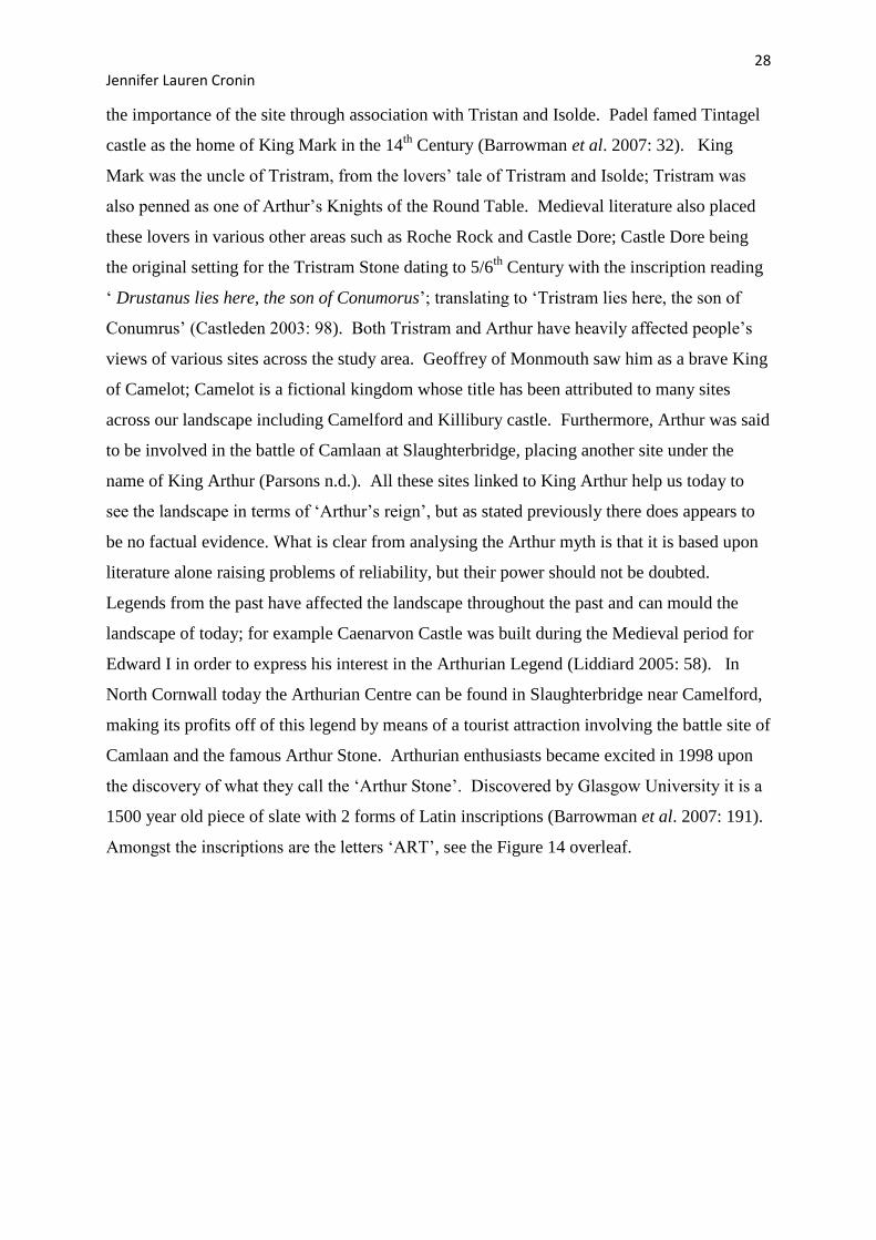
Amongst the inscriptions are the letters ‘ART’, see the Figure 14 overleaf.
29 Jennifer Lauren Cronin
Figure 14 - The left figure shows the Arthur stone (Barrowman et al. 2007: Covering page) and
the right shows an illustration of the inscribed slate with all lettering highlighted (Barrowman et
al. 2007: 193).
Many believe this to be related to the King Arthur, but more objective archaeologists can
comprehend that several Early Medieval names contain these letters, and so an assumption
such as this should not be so hastily made. Regardless of the truth of these myths, over time
they have helped to build the landscape around us, with businesses thriving and interest ever
present and growing, the influence they exude can be seen everywhere.
30 Jennifer Lauren Cronin
Chapter Four: Geographical Information System Analysis
4.1 Methodology
Geographical Information Systems (GIS) is the computer software that was used to
manipulate the data gathered and has proved very useful. GIS is a modern technique
adopted by many and is highly valued by the majority of archaeologists. It allows many
forms of geological data, ordinance survey and contour maps to be displayed along with point
or polyline data that can be added by the user to make the maps specific to their requirements.
The method conducted to analyse the data was deductive. Ideas and questions were raised
before the data was generated, and it was these that were sought to be answered. The aims
were clear from the outset; to effectively examine Tintagel within its hinterland, and use the
knowledge of current water routes, ecclesiastical centres along with Roman and early
Medieval settlements to aid our understanding of the study area in question: North Cornwall.
The contour lines have proved critical to the analysis of the material as several ‘viewsheds’
were conducted. This is a process whereby the user can observe the visibility from a single
point on any given site and resulted in being the primary technique used for this study. It was
originally intended for several viewsheds to be conducted across the entirety of the study area
and further into the Cornish landscape but problems arose. The file containing the contour
data proved too big for GIS to handle and so the quantity of viewsheds possible decreased
dramatically. With this in view, the study adapted and only the sites involved in the pre-set
questions were used, along with the sites which held the most mystery and thought to have
had potential for uncovering unknown aspects of the Cornish landscape. A study area within
the original designated study area was picked; a 20km square around the focal site of
Tintagel. The appropriate contour data was extracted for this newly defined area and then
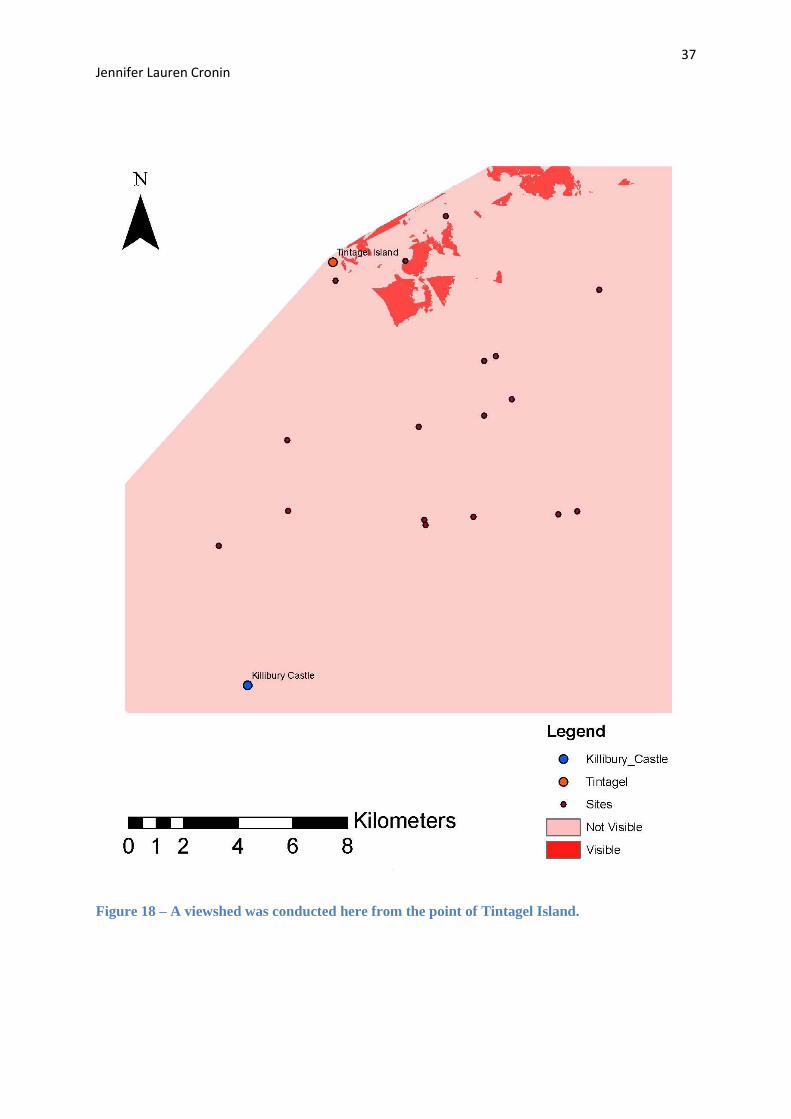
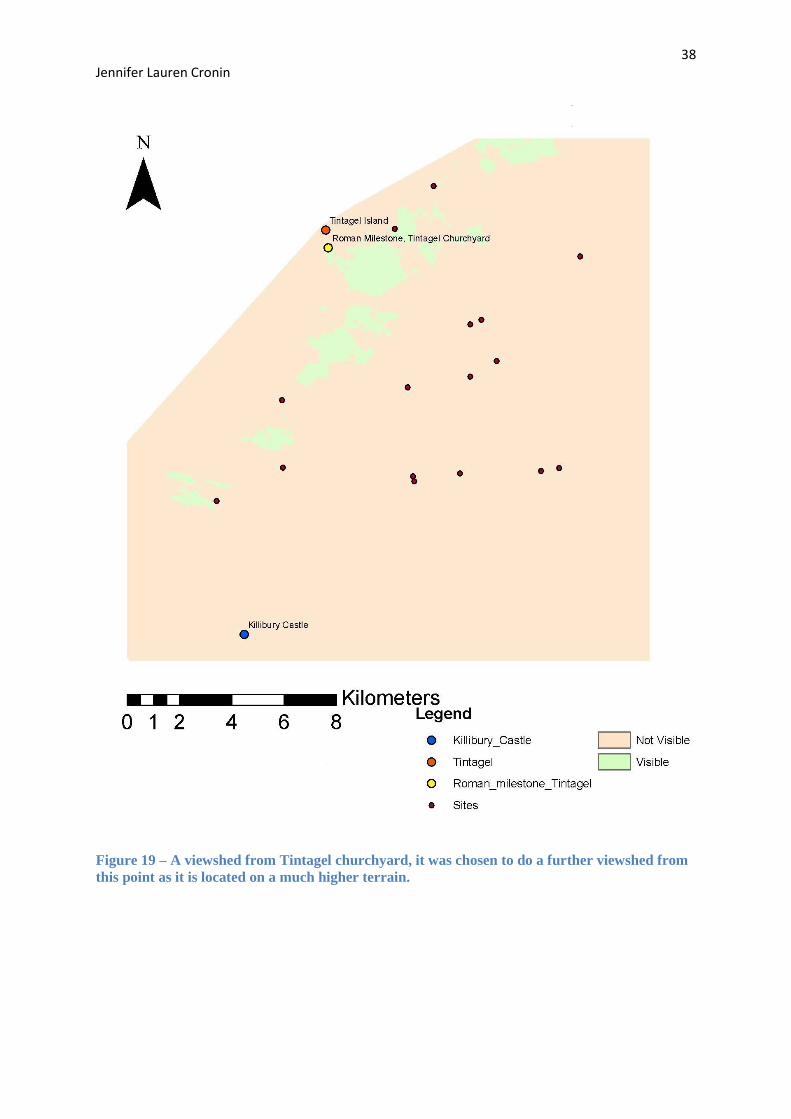
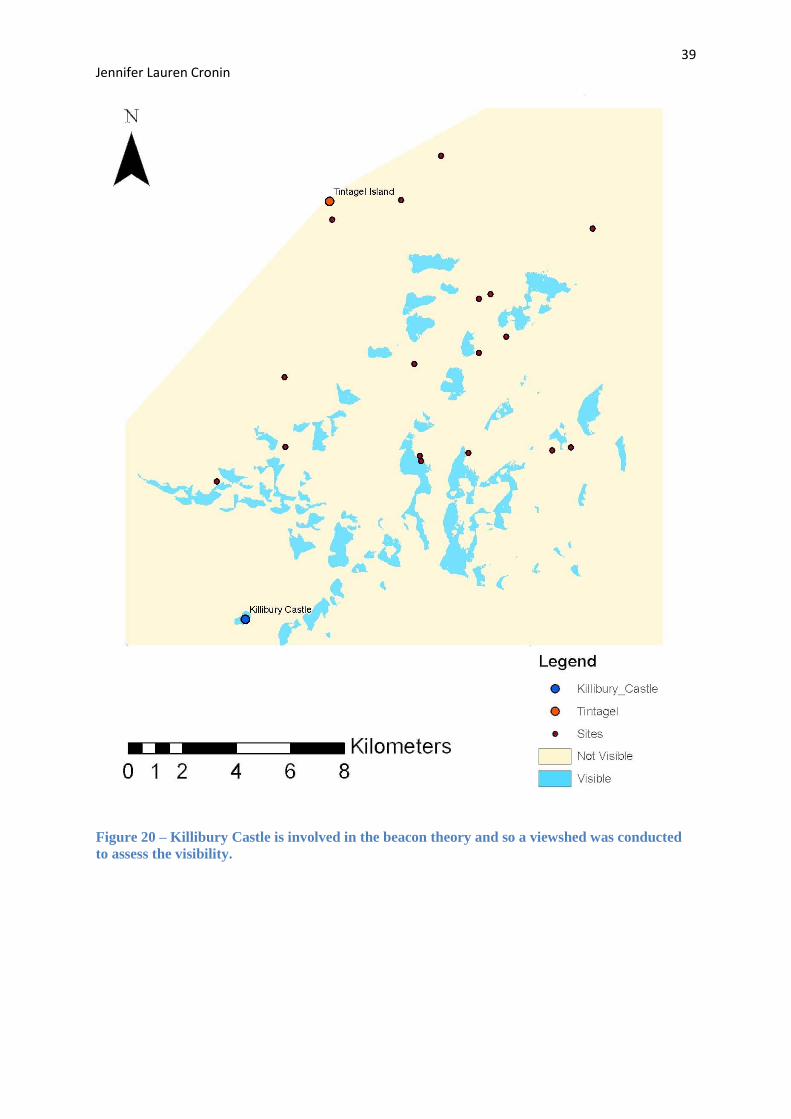
several viewsheds were completed. The viewsheds conducted involved the sites: Tintagel
Island, Tintagel churchyard (milestone) and Killibury Castle. These sites were chosen due to
a theory that Tintagel and Killibury Castle were linked intrinsically by beacons and therefore
their elevation would have to be of a particular height in order to view over a large amount of
the Cornish landscape that lies between the two. The contour data was therefore crucial.
31 Jennifer Lauren Cronin
GIS was further used as a way of analysing spatial data. The locations of sites relating to
Cornish myths were plotted in an attempt to view how far myths, in particular King Arthur,
can spread across a landscape. Additionally, elite sites were plotted along with water courses
in order to recognise trends in settlement location, and to remark on reasons behind
positioning.
4.2 Data Gathering
The data gathered has come from many sources, primarily internet based. NMR records and
Pastscape have proved invaluable and their contribution has formed the base of the practical
element of this dissertation. It was determined early on that names, co-ordinates, NMR
numbers and a brief description would be vital for GIS in order for any user to understand
each site individually as well as in context with the others.
4.3 Data Analysis
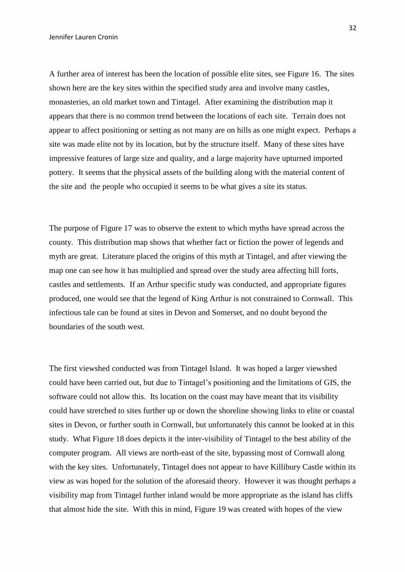
The analysis of the data both revealed and raised further questions. Over 50 Roman and early
Medieval sites were used to give this study a varied base and hopefully inspire accurate
interpretations; a full list of the sites used for this study (with map) can be found in Appendix
A. Several questions were to be pursued along with general queries. Roman occupation in
Cornwall has long been a point of discussion. With no large amount of evidence to support
Roman influence it was a point of this study to look at the evidence that does exist, not just in
the study area but all over Cornwall. As aforementioned Roman milestones have been
located in Cornwall and it is important to speculate as to why they were erected and to what
purpose. Figure 15 shows the location of 3 Roman milestones mentioned in a previous
chapter. This highlights that the Romans reached as far south in Cornwall as Breage,
indicating that there must have been something of interest in Cornwall to the Romans.
However a thought arose concerning the reliability of the milestones. It has been assumed
that it was the Romans themselves who erected the milestones, but this is not known with
complete certainty. It could be that they were erected later by officials who merely sailed to
Cornwall to retrieve or trade items, and constructed the milestones as a means of marking
their arrival and allegiance. Interestingly, the locations of the stones appear to be near the
coast line indicating not only that the aforementioned theory could be a possibility, but also
offers further evidence that it was the activities along the coastline that concerned the
Romans; perhaps the pottery being imported from the Mediterranean, refer to Appendix C for
a brief analysis of Cornish ports and the trade activity within them.
32 Jennifer Lauren Cronin
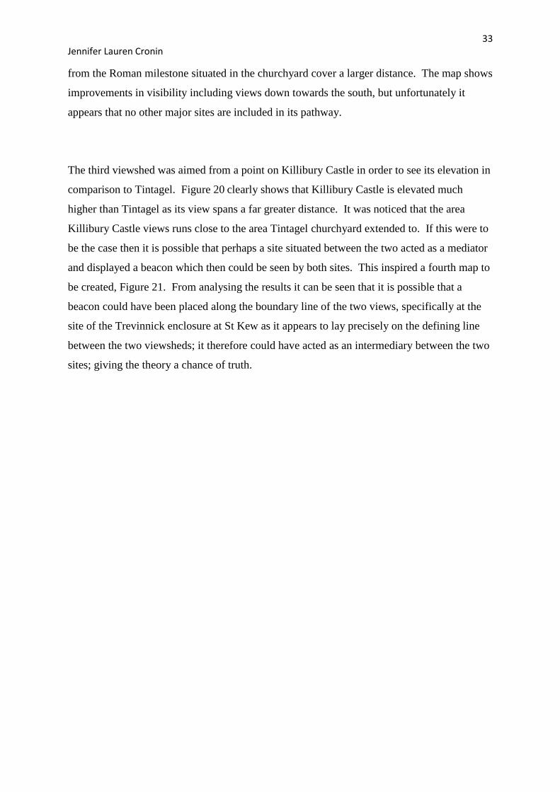
A further area of interest has been the location of possible elite sites, see Figure 16. The sites
shown here are the key sites within the specified study area and involve many castles,
monasteries, an old market town and Tintagel. After examining the distribution map it
appears that there is no common trend between the locations of each site. Terrain does not
appear to affect positioning or setting as not many are on hills as one might expect. Perhaps a
site was made elite not by its location, but by the structure itself. Many of these sites have
impressive features of large size and quality, and a large majority have upturned imported
pottery. It seems that the physical assets of the building along with the material content of
the site and the people who occupied it seems to be what gives a site its status.
The purpose of Figure 17 was to observe the extent to which myths have spread across the
county. This distribution map shows that whether fact or fiction the power of legends and
myth are great. Literature placed the origins of this myth at Tintagel, and after viewing the
map one can see how it has multiplied and spread over the study area affecting hill forts,
castles and settlements. If an Arthur specific study was conducted, and appropriate figures
produced, one would see that the legend of King Arthur is not constrained to Cornwall. This
infectious tale can be found at sites in Devon and Somerset, and no doubt beyond the
boundaries of the south west.
The first viewshed conducted was from Tintagel Island. It was hoped a larger viewshed
could have been carried out, but due to Tintagel’s positioning and the limitations of GIS, the
software could not allow this. Its location on the coast may have meant that its visibility
could have stretched to sites further up or down the shoreline showing links to elite or coastal
sites in Devon, or further south in Cornwall, but unfortunately this cannot be looked at in this
study. What Figure 18 does depicts it the inter-visibility of Tintagel to the best ability of the
computer program. All views are north-east of the site, bypassing most of Cornwall along
with the key sites. Unfortunately, Tintagel does not appear to have Killibury Castle within its
view as was hoped for the solution of the aforesaid theory. However it was thought perhaps a
visibility map from Tintagel further inland would be more appropriate as the island has cliffs
that almost hide the site. With this in mind, Figure 19 was created with hopes of the view
33 Jennifer Lauren Cronin
from the Roman milestone situated in the churchyard cover a larger distance. The map shows
improvements in visibility including views down towards the south, but unfortunately it
appears that no other major sites are included in its pathway.
The third viewshed was aimed from a point on Killibury Castle in order to see its elevation in
comparison to Tintagel. Figure 20 clearly shows that Killibury Castle is elevated much
higher than Tintagel as its view spans a far greater distance. It was noticed that the area
Killibury Castle views runs close to the area Tintagel churchyard extended to. If this were to
be the case then it is possible that perhaps a site situated between the two acted as a mediator
and displayed a beacon which then could be seen by both sites. This inspired a fourth map to
be created, Figure 21. From analysing the results it can be seen that it is possible that a
beacon could have been placed along the boundary line of the two views, specifically at the
site of the Trevinnick enclosure at St Kew as it appears to lay precisely on the defining line
between the two viewsheds; it therefore could have acted as an intermediary between the two
sites; giving the theory a chance of truth.
34 Jennifer Lauren Cronin
4.4 Distribution Maps
Figure 15 – A distribution map showing the location of three Roman milestones.
35 Jennifer Lauren Cronin
Figure 16 – This is a distribution map illustrating the key elite sites within the study area
including St Michael’s Mount as it is an important monastic site.
36 Jennifer Lauren Cronin
Figure 17 – Here the sites are shown that have been related to Cornish myths such as Tristram
and Isolde and King Arthur.
37 Jennifer Lauren Cronin
Figure 18 – A viewshed was conducted here from the point of Tintagel Island.
38 Jennifer Lauren Cronin
Figure 19 – A viewshed from Tintagel churchyard, it was chosen to do a further viewshed from
this point as it is located on a much higher terrain.
39 Jennifer Lauren Cronin
Figure 20 – Killibury Castle is involved in the beacon theory and so a viewshed was conducted
to assess the visibility.
40 Jennifer Lauren Cronin
Figure 21– This figure shows a viewshed from Killibury Castle and Tintagel churchyard in
order to see if they could view each other.
41 Jennifer Lauren Cronin
Overview
The landscape can be affected in many ways. From observing the landscape it can be seen
that every inch is moulded and dominated by man. It is directed and urged into particular
routes or paths whether by buildings, roads or field boundaries, mans infliction can overtly be
seen. Cornwall today is one of the poorest counties in England and this may be accountable
to the main industry: agriculture, a business sector that has become increasingly exploited and
less of a necessity. This is an aspect of the economy that was stable and evident in the early
Medieval period, and if one looks at Cornwall from an aerial view one can still see a
patchwork of field patterns within vast amounts of countryside, showing that Cornwall’s
current landscape was primarily constructed in the Early Medieval period. The Dark Ages
have always been a period shrouded in mystery, Cornwall in particular still holds much to be
revealed, and this study of North Cornwall has highlighted some of the key aspects involved
in Early Medieval economy and society, all of which play a role in how a landscape is
crafted.
Cornwall in the Medieval Period
Cornwall boasts a variety of important sites, elite, monastic and economic, all of which have
contributed to the construction of the landscape. This study has looked at the location of sites
within the landscape in hopes of determining and therefore understanding the positioning of
common elite and monastic centres. Ecclesiastical sites seemed fairly simple in the idea
behind location as monks living in monasteries wished for isolated, a key reason why many
such as Radford believed Tintagel was home to a monastery, and churches were often central
to settlements. As well as religion being an active and crucial role to those living in the
hamlets in Cornwall, the thriving tin industry acted as the back bone to their economy and
gave Cornwall a purpose and place in Medieval England. Luckily for archaeologists the
nature of the tin streams has meant a variety of artefacts have survived for our analysis and
interpretation, such as the Boscarne shovel.
Tintagel
For a substantial amount of time Tintagel was victim to heavy misinterpretations.
Excavations have proved this site to be the key site within the Early Medieval Kingdom of
Dumnonia. Until Charles Thomas saw the ceramic evidence as imported, Tintagel could
have been called unremarkable, and reminiscent of other island sites. However because of
our knowledge of the vast amounts of imported pottery, Tintagel has now been seen in a new
42 Jennifer Lauren Cronin
light. This has affected not only the site but the world of archaeology due to the quantity
found. If only the bare archaeology is examined of Tintagel, one can appreciate a site that
has been occupied for many centuries, a site that has been involved in an extensive network
of trading with the Mediterranean and primarily a site with elite significance from the Roman
to Early Medieval period. No doubt many elite sites exist in north Cornwall, but none such
as Tintagel that combine all the aforementioned characteristics of an outstanding
archaeological site which can offer so much to the world of today about the world of the past.
Tintagel in its Landscape
Within Tintagel’s hinterland there are a variety of aspects to look at that can open windows in
to the past. Place name evidence has been key and fairly reliable as Cornish language
elements are still present in names today. Examples such as ‘bod’, ‘tre’ and ‘lis’ all reveal
small aspects about the past such as economy, employment, status, and general life.
Understanding a site’s status is crucial, and can often be misunderstood, such as at Tintagel.
If a series of elite sites are known then it portrays what specific land people thought
appropriate and important enough for those who were wealthy. Similarly with ecclesiastic
sites, one can begin to understand the land that was thought sacred by studying their
locations. With regards to the study area specified one can see that monastic sites do not
appear to have any strong influences that affect their location. Ecclesiastical buildings
ranging from monasteries to churches scatter the landscape on hill tops, in lowlands, on cliffs
and in fields. So if land was not influential, perhaps it was the location of people, such as the
hamlets and villages. The need for a church would have been fundamental in any settlement,
and so it may be logical to conclude that ecclesiastical buildings were constructed by
persuasion of the people, and not topography or terrain.
Tintagel in the past 100 years has been greatly misinterpreted, but even though its occupation,
use and archaeological significance are thought now to be known, there are still many
unanswered questions. The intrigue of Tintagel lies in the fact that it was chosen as an elite
site. The artefacts found from the site clearly show this high status, but its location is
puzzling. It is far from monasteries, granite wealth and other elite sites of near similarity, so
it housing the Dumnonian chieftain must mean it a highly significance location, but perhaps
its meaning we have yet to understand, or may never. Many aspects of society and life are
43 Jennifer Lauren Cronin
often lost as the people themselves pass away, showing that archaeologists, on occasion, have
to generalise and assume, and accept the implications that come with this.
An alternate meaning that has dominated Tintagel’s modern day popularity is the myth of
King Arthur. Myth is often forgotten when looking at how a landscape is moulded but
should not be overlooked so hastily as the power of words can be colossal. Myths from the
past can mould the landscape of today, for example King Arthur has helped tourism boom in
south-west England at places such as Tintagel, South Cadbury, and Slaughterbridge. A
centre purely dedicated to King Arthur exists at Slaughterbridge, showing the power of past
myths on the present day.
The distribution maps created using Geographical Information Systems have proved useful
with regards to analysing Tintagel within its hinterland. From the Bronze Age to the
Medieval period the Cornish landscape has been scattered with Roman rounds, castles,
towns, hamlets and vast lands of agricultural use. The information North Cornwall has to
offer us about our past is outstanding and vital. A countries landscape is shaped by mans
action, intentions, beliefs and interactions throughout history, and we are only at the
beginning of uncovering how valuable the county of Cornwall is, and the contribution it can
make to our archaeological records. Cornwall is often regarded as unimportant, redundant,
and an insignificant seclusion from major historical events, but it has merely been forgotten.
Now it is beginning to come out of the darkness of history books and finally archaeologists
are paying attention to this remarkable site.
44 Jennifer Lauren Cronin
Bibliography
Alcock, L. 1971. Arthur’s Britain. Allen Lane: London.
Anon. (n.d.). Sir Tristram. http://www.legendofkingarthur.co.uk/arthurs-knights/sir-
tristan.htm (last accessed 4th October 2008).
Barrett, J. Freeman, P.W.M. Woodward, A. 2000. Cadbury Castle Somerset: Later
Prehistoric and early Historic Archaeology. English Heritage: London.
Barrowman, R. Batey, C. Morris, C. 2007. Excavations at Tintagel Castle, Cornwall, 1990-
1999. The Society of Antiquaries of London: London.
Castleden, R. 2003. King Arthur: the Truth Behind the Legend. Routledge: London
Cornwall County Council. 2009. The Medieval Countryside. http://www.historic-
cornwall.org.uk/flyingpast/medieval.html (last accessed 21st January 2009)
Countryside Commission. 1997. The Cornish Landscape: An assessment of the Areas of
Outstanding Natural Beauty in Cornwall. Countryside Commission: Northampton .
English Heritage. 2008. Tintagel Castle.
http://www.pastscape.org.uk/hob.aspx?hob_id=431862&sort=4&search=all&criteria=tintagel
&rational=q&recordsperpage=10 (last accessed 27th
April 2009).
Fox, A. Ravenhill, W.L.D. 1966. Excavation of the Roman Fort at Tregear, Nanstallon,
1965: Interim Report. Cornish Archaeology 5, 28-33.
Fulford, M. 1977. Pottery and Britain’s Foreign Trade in the Latter Roman Period. In
Peacock, D. P. S. (ed.) Pottery and Early Commerce: Characterisation and Trade in Roman
and Later Ceramics. Academic Press: London: 35-84.
45 Jennifer Lauren Cronin
Herring, P. 2006. Medieval Fields at Brown Willy, Bodmin Moor. In Turner, S. (ed.)
Medieval Devon and Cornwall, Shaping an Ancient Countryside. Windgather Press:
Macclesfield: 78-103.
Herring, P. 1993. St Michael’s Mount. The National Trust: Truro.
Johnson, N. Rose, P. 1993. Cornwall’s Archaeological Heritage. Twelveheads Press: Truro.
Liddiard, R. 2005. Castles in Context: Power, Symbolism and Landscape, 1066-1500.
Windgather Press: Macclesfield.
MacArthur, E. M. 1995. Columba’s Island: Iona from Past to Present. Edinburgh University
Press: Edinburgh.
Mark, T. 1994. The Lost Ports of Cornwall. Tor Mark: Redruth.
Marsh, H. 1970. Dark Age Britain: Some Sources of History. David and Charles Limited:
Newton Abbot.
Parsons, J. (n.d). King Arthur’s Cornwall Discovery Trail. http://www.arthur-
online.co.uk/home.htm (last accessed 27th April 2009)
Penhallurick, R, D. 1986. Tin in Antiquity: its mining and trade throughout the ancient world
with particular reference to Cornwall. The Institute of Metals. London.
Quinnell, H. 2004. Excavations at Trethurgy Round, St Austell: Community and Status in
Roman and Post Roman Cornwall. Cornwall County Council: Truro.
Thomas, C. 1981. A provisional List of Imported Pottery in Post Roman Western Britain and
Ireland. The Institute of Cornish Studies: Redruth.
Thomas, C. 1993. Tintagel Arthur and Archaeology. BT Batsford Ltd/ English Heritage:
London.

46 Jennifer Lauren Cronin
Turner, S. 2006. Making a Christian Landscape. University of Exeter Press: Exeter.
Weatherhill, C. 2005. Place Names in Cornwall and Scilly. Wessex Books: Launceston.
Webster, C. 2008. Early Medieval. In Webster, C. J. (ed.) 2008. The Archaeology of South
West England. Somerset County Council: Taunton: 169-188.
47 Jennifer Lauren Cronin
Appendix A
48 Jennifer Lauren Cronin
Site Easting Northing NMR_NO
Tintagel Island 204960.00 89110.00 SX 08 NE 46
St Pirans Oratory 176850.00 56390.00
Rings Wood Hillfort 228900.00 84600.00 SX 28 SE 5
Trethinna Camp 225800.00 82500.00 SX 28 SE 9
Upton Castle 224500.00 79000.00 SX 27 NW 35
Iron Age Setllement 206100.00 70300.00 SX 07 SE 14
Penhagard Castle 205800.00 69900.00 SX 06 NE 18
Dunmere Camp settlement 205100.00 68700.00 SX 06 NE 20
Nanstallon 203423.00 66987.00 SX 06 NW 2
Castle Cankye 208500.00 65800.00 SX 06 NE 21
St Michaels Mount, inc monastery 151461.00 29834.00 SW 52 NW 18
Millook Settlement 218600.00 99500.00 SX 19 NE 5
Whitemoor Settlement 217200.00 97800.00 SX 19 NE 11
Ashbury Camp 222800.00 97500.00 SX 29 NW 6
The Beacon Round Barrows 218500.00 95700.00 SX 19 NE 7
Headon barrow 214400.00 94000.00 SX 19 SE 1
Pengold Camp 214400.00 94000.00 SX 19 SW 1
Enclosure 214400.00 93200.00 SX 19 SW 6
Warbstow Bury 220100.00 90800.00 SX 29 SW 1
Condolden barrow 209100.00 90800.00 SX 08 NE 24
Tich Barrow 214700.00 88100.00
Settlement 208100.00 83100.00
Castle Goff 203300.00 82600.00
Settlement: Ancient village. 211500.00 84100.00
Tregeare rounds 203330.00 80030.00
Settlement, funerary 213200.00 79900.00
Carwether village 210100.00 79800.00
Helsbury castle 208300.00 79700.00
St Syth's chapel/st michaels chapel 208350.00 79500.00
Trethurgy 203470.00 55640.00 SX 05 NW 7
Bodmin priory 207380.00 66950.00 SX 06 NE 10
Slaughterbridge 210500.00 85500.00
Camelford 210500.00 83500.00 SX 18 SW 82
Pentewan 201500.00 47500.00
Trevinnick Enclosure, St Kew 200790.00 78740.00 SX 07 NW 1
Roman Milestone, Trethevy 207610.00 89160.00 SX 08 NE 3
Roman Milestone, Breage 161840.00 28460.00 SW 62 NW1
Roman Milestone, Tintagel Churchyard 205060.00 88440.00 SX 08 NE 4
Doniert Stone 236120.00 68848.00 SX 26 NW 5
MONUMENT NO. 432560 212290.00 68680.00 SX 16 NW 6
Killibury Castle 201850.00 73650.00 SX 07 SW 7
Arthur's Bed 240470.00 75682.00 SX 27 NW 14
King Arthur's Stone 210920.00 85680.00 SX 18 NW 5
Castle Dore 210350.00 54830.00 SX 15 SW 7
Tristram stone 211240.00 52100.00 SX 15 SW 7
MONUMENT NO. 1009911, St Breward 213900.00 80000.00 SX 18 SW 102
Round Park 236930.00 83900.00 SX 38 SE 28
MONUMENT NO. 437078 236090.00 82900.00 SX 38 SE 16
Carvoda Round 234580.00 78640.00 SX 37 NW 40
Monument No. 942412 233390.00 77810.00 SX 37 NW 67
Webbs Castle Round, Poundstock 221370.00 98710.00 SX 29 NW 37
Monument No. 914141, Poundstock 220220.00 99640.00 SX 29 NW 36
Battle Rings 231860.00 80530.00 SX 38 SW 8
Trevisker Round 288710.00 68590.00 SX 86 NE 4
Monument No. 912144 217060.00 97290.00 SX19 NE 101
Monument No. 431011 192340.00 71040.00 SW 97 SW 5
Monument No. 1325729 291500.00 92080.00 Linear 600
Monument No. 1457967, Treneglos 220960.00 87690.00 SX 28 NW 19
Monument No. 914993 225400.00 94170.00 SX 29 SE 24
Pencarrow Rounds 203900.00 70000.00 SX 07 SW 6
Liskeard 225200.00 64500.00 SX 26 SE 26
Fowey 212300.00 51700.00 SX 15 SW 75
Bodmin 207100.00 67000.00 SX 06 NE 42
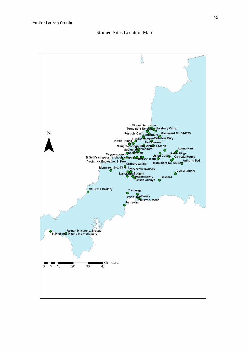
49 Jennifer Lauren Cronin
Studied Sites Location Map
50 Jennifer Lauren Cronin
Appendix B
51 Jennifer Lauren Cronin
Descriptions of Key Sites within Tintagel’s Hinterland
Bodmin
Bodmin is the largest of the medieval towns in Cornwall even being mentioned in the
Domesday Book and has offered much to archaeology. In the area of Bodmin there are
preserved strip farms at Brown Willy, a priory, a parish church, St Guron’s Well, a 14th
Century Chantry Chapel and is close to Cornwall’s most important monastery, St Petroc’s
(Johnson and Rose 1993: 19).
Breage – Roman Milestone
As discussed during this study a Roman milestone is located. It exact location is within a 15th
Century church and is inscribed in Latin shorthand to ‘the Emperor Caesar our lord Marcus
Cassianus Latinius Postumus, pious, fortunate, august’ giving it a date of AD258-268; this is
the only milestone left in Britain to be dedicated to Postumus (Johnson and Rose 1993: 19).
Castle Dore
Castle Dore is a hill slope enclosure consisting of two ramparts (Pearce 1981: 269).
Excavations conducted in 1936 revealed several round houses in the interior and confirmed
that the ramparts were reinforced in 1st Century BC (Johnson and Rose 1993: 22).
Doniert’s Stone
Late 9th
Century in date, this stone is an excellent example of pre-conquest decoration
(Turner 2006: 163).
Fowey
A large Medieval borough, consisting of an artillery fort and blockhouses (Johnson and Rose
1993:27).
52 Jennifer Lauren Cronin
St Michael’s Mount
An important prehistoric and Roman centre consisting of a 14th
Century priory it is thought to
be a place of pilgrimage, and is with no doubt a defensive site (Herring 1993: 37). Dark Age
imported pottery has been found here, indicating that it may have had an elite status (Turner
2006): 54). It is generally accepted today that it was a secular stronghold, which became
ecclesiastical post conquest (Herring 1993: 63-66).
St Piran’s Oratory
This is a pre-Norman chapel, and due to evidence from the Domesday Book it is thought that
an important early monastery was once here. The large size of the churchyard indicates that
it may have been the original monastic enclosure of ‘Lanpiran’ (Johnson and Rose 1993: 39).
St Piran’s Round is also here which is a Iron Age/Romano British enclosed farmstead, later
converted in the Medieval period to a Playing Place; a place of performance shaped as an
amphitheatre (Johnson and Rose 1993: 40).
Poundstock
Poundstock has an early church dedicated to Winwaloe, a Celtic Saint (Johnson and Rose
1993: 40).
Tintagel
Tintagel comprises of a 13th
Century castle, a Norman church, a Roman milestone, and a
series of earth works. It has been the focus or m any archaeologists for the past 80 years as
more and more material culture and evidence of occupation is constantly being uncovered,
but it is thought now that it is an elite site, no doubt a seasonal home to a chieftain or king
(Barrowman et al. 2007: 29). For more information refer to text.
Tristram Stone
53 Jennifer Lauren Cronin
This stone is 6th
Century in date and is linked to the story of King Mark, Tristram and Isolde.
Erected in 550AD it is thought by many to be Tristrams grave stone due to its markings. On
one side there is a raised ‘T’ thought to represent a Christian cross, and on the reverse is the
word Tristram (Anon (n.d.)).
Warbstow
An extremely well preserved multivallate Iron Age hillfort thought to be a stronghold. It is
one of the largest hillforts in Cornwall, is similar to Castle-an-Dinas, and it has evidence of a
change of layout. It has two massive ramparts and ditches and a long mound in the centre of
the site known as the Giants Grave. Due to the status and layout of the site it is thought that
many round houses would have been built within the inner enclosure (Johnson and Rose
1993:47).
54 Jennifer Lauren Cronin
Appendix C
55 Jennifer Lauren Cronin
Cornish Ports and Trade
Cornwall during the Dark Ages depended on the sea for its transport; tin would have been the
primary export and pottery the main import (Mark 1994: 3). On discovering the strong
similarity between the countryside of today with that of the past, one might assume that it is
the same for the coastal landscape but this is not the case. Today the major Cornish ports are
Par and Fowey, and this surprisingly does not reflect the maritime landscape of the early
Medieval period (Mark 1994: 3). Excavations have been able to highlight the ports that were
in use during this the Early Medieval period by the material culture found, primarily pottery.
Pottery as aforementioned is one of the most reliable sources used to date a site due to the
advances in scientific techniques such as radio carbon dating. The site of Padstow has been
excavated and upon discovery of particular post Roman pottery the archaeologists determined
that this site had participated in a high level of trade, particularly with Ireland; this again
shows the importance of accurate dating material. One particular port that should be noted is
St Michael’s Mount. Discussed previously for its elite status it has also played as role in
Cornwall’s maritime archaeological landscape. St Michael’s Mount was one of Cornwall’s
earliest ports and was an economic focus for much of the Medieval period (Herring 1993:
42). It is home to a square shaped harbour on the islands north west side and has been
described by ancient writers as the island of ‘Iktis’, from which the Cornish supposedly
exported their tin (Mark 1994: 18). The imported pottery found made archaeologists realise
the importance of the site as not only an elite structure, but as an important port of the
Medieval world. Similarly, the pottery discovered at Gweek port revealed that this particular
site had been trading with Spain since AD 450. Additionally, the unearthing of Roman
pottery along with the consideration of the proximity to the Roman site of Grambla, one can
assume that Gweek port was occupied throughout the Roman period (Mark 1994: 21).
Imported ware should be a focus of study as it can have huge implications for the
understanding of a site, but Cornish made pottery is also significant as it allows one to gain
an understanding of the economy on an internal basis. Excavations on many sites over
Cornwall have provided evidence for a continuity of pottery manufacture, especially
Gwithian style from a gabbroic fabric; this has been discovered as sites such as Trethurgy
(Webster 2008). Discoveries such as this allow historians and archaeologists today to
perceive that although trade is important and signifies status, Cornish made pottery can draw
attention to the styles preferred and materials favoured for local, and no doubt cheaper to
purchase, ceramics. It is remarkable the amount of information one can extract from a piece,
56 Jennifer Lauren Cronin
or assemblage of pottery. It is known today that the international trade stretched from
Cornwall, to the Mediterranean and Africa, highlighting an acute awareness of geography,
business, pottery production, naval navigation and political diplomacy; opening a window
into a complex aspect of Cornish life. These are however interpretations, which can often be
wrong or mislead, but archaeology is often full of academic generalisations and assumptions
which improve and become more accurate as techniques and excavations develop and the
analysis of material culture becomes more in depth and accurate.
With regards to the site of Tintagel it can be said there is no obvious indication of a harbour,
and the rough sea weather that it is victim to would no doubt make docking incredibly
difficult, if not impossible; however there are those who disagree. Sir Richard Grenville in
1583 commented that he thought there was room for 5 large ships to embark or disembark
troops, highlighting Tintagel as a possible military stronghold (Mark 1994: 6). Slate was also
thought to have been quarried nearby and so exporting from Tintagel would have been ideal
and logical in terms of location as the river Tamar, Cornwall’s most navigable river is in
close proximity. Additionally, the substantial amounts of imported pottery found at this site
makes one wonder how it came to obtain such as large quantity of imported ware if it was not
used as a port; it is currently a topic being debated today. The landscape and weather
conditions however do seem to strongly oppose this, and no archaeological evidence has been
found to date so perhaps further investigation is needed.


