Embed Size (px)
Citation preview

This document does not reflect the intent or official position of the bill sponsor or House of Representatives.
Page | 1
FINAL BILL ANALYSIS
BILL #: HB 7207 FINAL HOUSE FLOOR ACTION: 87 Y’s 31 N’s SPONSOR: Rep. Aubuchon (Rep. Workman) GOVERNOR’S ACTION: Approved COMPANION BILLS: CS/HB 7129, CS/CS/SB 1122, HB 945, SB 1440, HB 987, CS/CS/SB 1904
SUMMARY ANALYSIS
HB 7207 passed the House on May 6, 2011, and subsequently passed the Senate on May 6, 2011. The bill was approved by the Governor on June 2, 2011, chapter 2011-139, Laws of Florida, and took effect on June 2, 2011. This bill focuses the state oversight role in growth management on protecting important state resources and facilities. This bill, designated as “The Community Planning Act”, substantially amends part II of ch. 163, F.S., to reflect the experience of local government planning efforts, to streamline processes and to remove unworkable provisions that delay economic development and result in outcomes that hinder urban development and flexible planning solutions. This bill amends the necessary components for various required elements within a comprehensive plan. Within the Future Land Use Element, this bill modifies and incorporates provisions relating to “urban sprawl” and modifies the need requirement to be based upon a minimum population. Within the Capital Improvements Element, this bill removes the financial feasibility requirement and requires local governments to list their funded and unfunded capital improvements. This bill also removes specific provisions for optional elements within a local government’s comprehensive plan. This bill repeals rule 9J-5 of the Florida Administrative Code (FAC) and incorporates important and relevant definitions and provisions of the rule into statute. This bill changes the requirements associated with the large-scale planning tools of sector plans and rural land stewardship areas. This bill streamlines the comprehensive plan amendment process while maintaining public participation in the local government planning process. State review and challenges are focused on protecting important state resources and facilities. This bill removes the twice-a-year limitation on local government adoption of plan amendments. This bill removes state required concurrency for transportation, parks and recreation, and schools, but allows local governments to continue applying concurrency in these areas without taking any action. This bill continues to require local governments to evaluate their comprehensive plans once every seven years and to adopt update amendments as necessary, but this bill removes the state requirement for local governments to adopt an evaluation and appraisal report every seven years. This bill grants a 4-year extension to already approved development of regional impact (DRI) projects, provides exemptions from the DRI review process for certain non-residential developments, and increases the substantial deviation standards for certain job-related types of development. This bill grants a 2-year extension to certain permits set to expire between January 1, 2012 and January 1, 2014, and provides a 2-year extension for certain permits extended in 2009. However, the cumulative extensions granted to a permit by the Legislature in 2009, 2010, and under this bill may not exceed 4 years. This bill does not require any updates to a local government’s comprehensive plan prior to the regular adoption of update amendments following the required seven year local evaluation of the plan. Part II of ch. 163, F.S., as amended by this bill, continues to provide the minimum standards for Florida’s comprehensive growth management system. This bill is not intended to reduce the home rule authority of any local government. This bill repeals several provisions in law including 163.3189, F.S., relating to the process for amendment of an adopted plan, 163.32465, F.S., relating to the alternative state review pilot program, and rules 9J-5 and 9J-11.023, FAC. The Century Commission for a Sustainable Florida is to be repealed on June 30, 2013.
Page | 2
I. SUBSTANTIVE INFORMATION
A. EFFECT OF CHANGES: GROWTH MANAGEMENT IN FLORIDA Current Situation In 1972, Florida took its first step towards an intergovernmental system of planning by adopting the Environmental Land and Water Management Act that created a program to designate areas of critical state concern1 and a program to provide increased regulation and regional and state oversight for
DRIs2 affecting multiple jurisdictions. In 1975, the Legislature passed the Local Government
Comprehensive Planning Act that required local governments to adopt comprehensive plans by July 1, 1979, and to manage development according to the adopted plans. In response to continued rapid growth and the challenges of state and local governments to adequately address development impacts, the Legislature adopted Florida’s Growth Management Act in 1985, known officially as “The Local Government Comprehensive Planning and Land Development Regulation Act” (the Act).3 The Act was designed to remedy deficiencies in the 1975 Act by giving
more state oversight and control of the planning process to the Department of Community Affairs (DCA), the state’s land planning agency. As directed by law, DCA adopted minimum standards for all local plans.4 The 1985 Act created the intergovernmental system of planning we know today. Today,
every county and municipality is required to adopt a local government comprehensive plan in order to guide future growth and development, and the Act authorizes DCA to review comprehensive plans and plan amendments for compliance with the Act. Other state and regional entities also review local government plans and amendments and provide comments to DCA. With state, regional, and local government oversight, Florida has one of the most comprehensive, regulatory, growth management systems in the country. Since it was adopted, the Act has been amended in some way almost every year. Recent notable changes occurred in 2005 and 2009.5 Since 1985, the Act has been amended to address certain
unintended consequences and to provide numerous specific options to meet the needs of a few local governments. In some cases the changes have provided more flexibility, less state oversight and more creative planning tools for local governments, but in other cases, the changes created solutions that were inflexible and unworkable for all but a few local governments. Florida’s growth management system today is much different than it was in 1985. Currently, every local government has a comprehensive plan in place containing required elements along with adopted local land use regulations to implement the plan. Local governments that were inexperienced and unsophisticated in land use planning in 1985 are now more sophisticated and many have employed creative planning techniques to guide the future growth of their communities. Though the specific criteria and guidelines put into law in 1985 were designed to help local governments manage their growth, some requirements have hindered the ability of local governments to effectively manage growth and promote economic development within their communities. Effect of the Bill This bill substantially amends part II of ch. 163, F.S., in order to modernize Florida’s growth management laws. In addition, this bill recognizes the progress that local governments have made since the 1985 Growth Management Act was first adopted by providing local governments with greater local control over planning decisions that affect the growth of their communities. This bill preserves part II of ch.163, F.S., as the minimum standards for Florida’s comprehensive growth management system. This bill also preserves the opportunities in current law for public participation in the local planning
1 See s. 380.05, F.S.
2 See s. 380.06, F.S.
3 See ch. 163, pt. II, F.S.
4 Rule 9J-5, F.A.C. (Minimum Criteria for Review of Local Government Comprehensive Plans and Determination of Compliance).
5 See ch. 2005-157, ch. 2005-290, ch. 2005-291, ch. 2009-85, ch. 2009-96, L.O.F.
Page | 3
process and maintains the broad standing for affected persons to challenge a plan or plan amendment adopted by a local government. In addition, this bill focuses the state’s role in the growth management process to one of protecting important state resources and facilities. CONTENTS OF A COMPREHENSIVE PLAN Current Situation The Act requires all local governments to adopt comprehensive land use plans and implement those plans through land development regulations and development orders. Each local government comprehensive plan must include at least two planning periods, one covering at least the first 5-year period after the plan's adoption and one covering at least a 10-year period.
Each comprehensive plan contains chapters or “elements” that address future land use (including a future land use map), housing, transportation, infrastructure, coastal management, conservation, recreation and open space, intergovernmental coordination, capital improvements (and a 5-year capital improvement schedule) and public school facilities. Section 163.3177, F.S., and rule 9J-5, FAC, provide the requirements for elements of local comprehensive plans. The statute also provides for scheduled updates to various elements and imposes penalties for failure to adopt or update elements. Effect of the Bill This bill maintains the required comprehensive plan elements in current law but no longer mandates a public school facilities element. Most provisions relating to public school facilities are only required if a local government chooses to maintain school concurrency at the local level. This bill removes many of the state specifications and requirements for optional elements in the comprehensive plan, but specifically states that a local government’s comprehensive plan may continue to include optional elements. All mandatory and optional elements of a comprehensive plan and plan amendments are required to be based upon professionally accepted data. Local governments are not required, but may choose to use original data as long as their methodologies are professionally accepted. This bill maintains that a major objective of the planning process is for elements to be coordinated with one another and requires elements within a plan to be consistent with one another. In addition to the 5-year and 10-year planning periods, this bill specifically allows for other planning periods for specific components, elements, land use amendments or projects. Rule 9J-5 Current Situation Rule 9J-5, FAC, establishes the minimum criteria for the preparation, review, and determination of compliance of comprehensive plans and plan amendments pursuant to part II of ch. 163, F.S. DCA adopted rule 9J-5, FAC, at the direction of the Legislature in the 1985 Growth Management Act. This rule was important at the time of adoption because it provided the necessary detail and specificity that local governments needed to create their local comprehensive plans. All plans and plan amendments must meet the technical guidelines of rule 9J-5, FAC, in order to be “in compliance” under part II of ch. 163, F.S. Initially, rule 9J-5, FAC, required ratification by the Legislature to become effective. Since that time, DCA has amended the rule several times pursuant to the requirements of ch. 120, F.S. Effect of the Bill This bill repeals rule 9J-5, FAC, and incorporates into the law important and relevant definitions and provisions of the rule relating to the contents of and requirements for elements within a comprehensive plan. Capital Improvements Element Current Situation In order to maintain a financially feasible 5-year schedule of capital improvements, the Legislature in 2005 required local governments to update their capital improvements schedule, within their capital improvements element (CIE), as an annual amendment to the comprehensive plan to demonstrate a financially feasible 5-year schedule of capital improvements.6 The 5-year schedule of capital
6 S. 163.3177(3)(b)1, F.S.
Page | 4
improvements must include specific capital projects necessary to achieve and maintain level-of-service standards identified in other areas of the comprehensive plan, reduce existing deficiencies, provide for necessary replacements, and meet future demand during the time period covered by the schedule. Failure to update can result in penalties such as ineligibility for certain grant programs, or ineligibility for revenue sharing funds. In order to be financially feasible, the CIE must identify sufficient revenues to fund the 5-year schedule of capital improvements. Local governments have had difficulty meeting this requirement. When the financial feasibility and update requirements were strengthened, local governments had until December 1, 2007, to meet the requirements. The Legislature later extended that date to December 1, 2008. In early 2009, a majority of local governments had failed to submit their financial feasibility reports by the December 1, 2008, deadline. In 2009, the deadline for local governments to comply with the financial feasibility requirement was extended again from December 1, 2008, to December 1, 2011.
Effect of the Bill This bill requires a local government to review its CIE on an annual basis. Modifications to the capital improvements schedule may be accomplished by ordinance and are not deemed to be amendments to the local comprehensive plan. These changes are a return to the pre-2005 standard. This bill also removes the requirement that the capital improvements element be financially feasible. However, this bill provides that projects necessary to ensure that any adopted level-of-service standards are achieved and maintained for the 5-year period must be listed and identified as either funded or unfunded and given a level of priority for funding. Future Land Use Plan Element Current Situation The future land use element includes a future land use map or map series. The law has numerous requirements relating to the designation of existing and future land uses. Several provisions are specifically mentioned including compatibility of land uses with military bases and airports, siting of schools, and future municipal incorporation. Effect of the Bill This bill changes the format of the future land use element provisions to increase readability. Specific requirements from rule 9J-5, FAC, have been added, including provisions relating to urban sprawl. Each map depicting future conditions must reflect the principles, guidelines, and standards within all elements and each such map must be included in the comprehensive plan. This bill requires the future land use element to clearly identify the land use categories in which public schools are an allowable use, but removes outdated language relating to compliance. This bill also removes requirements relating to energy efficiency and green house gas reductions. Further, this bill addresses population projections, the issue of identified need for future development and highlights the need to address outdated land uses, such as antiquated subdivisions. The issues of need, urban sprawl, and antiquated subdivisions are addressed below.
Need Effect of the Bill This bill requires the comprehensive plan to be based upon permanent and seasonal population estimates and projections, which must either be those provided by the University of Florida, Bureau of Economic and Business Research (BEBR), or generated by the local government based upon a professionally acceptable methodology.7 This bill requires the future land use plan and plan
amendments to be based in part upon the amount of land designated for future planned uses to provide a balance of uses that foster vibrant, viable communities, provide economic development strategies, and address outdated development patterns, such as antiquated subdivisions. This bill requires, as a minimum standard, that the comprehensive plan must accommodate at least the amount of land required to accommodate the medium projections of BEBR for at least a 10-year planning period. However, areas of critical state concern that are limited in their population growth
7 Rule 9J-5, FAC.
Page | 5
under s. 380.05, F.S., including related rules of the Administration Commission are not required to plan based on the medium projections of BEBR.
Urban Sprawl Current Situation One of the key components of rule 9J-5, FAC, and of growth management law in Florida is the discouragement of urban sprawl. Land use planning is designed to avoid urban sprawl, which forces limited resources to be allocated to the creation of new infrastructure rather than to maintaining existing infrastructure, thereby creating burdens on local governments, disrupting agricultural land uses, and creating scattered automobile-dependent communities. Effect of the Bill This bill provides a definition of urban sprawl and incorporates, from rule 9J-5, FAC, the thirteen primary indicators that a plan or plan amendment does not discourage urban sprawl. In addition, this bill adds eight indicators that a plan or plan amendment discourages urban sprawl. If the future land use element or a plan amendment achieves four of these eight indicators within its development pattern or urban form it will be determined to discourage the proliferation of urban sprawl.
Antiquated Subdivisions Current Situation Because they were created prior to the enactment of land development regulations, areas known as “antiquated subdivisions” share characteristics that hinder their vitality in today’s market, and result in detrimental effects on the local economies and environment. Largely platted throughout the 1950’s and 1960’s, antiquated subdivisions are often predominantly residential land with insufficient space reserved for industrial or commercial enterprises necessary for sustaining the community. Many such subdivisions lack adequate infrastructure including sewer systems and higher capacity arterial roads, and local law enforcement, fire, and emergency services often struggle to reach these remote developed parcels. Effect of the Bill This bill requires the future land use plan and plan amendments to be based upon surveys, studies, and data regarding the area, as applicable, including the need to modify land uses and development patterns within antiquated subdivisions. This bill requires the future land use plan and plan amendments to be based in part upon the amount of land designated for future planned uses to provide a balance of uses that foster vibrant, viable communities, provide economic development strategies, and address outdated development patterns, such as antiquated subdivisions. This bill requires the local government to consider outdated subdivisions such as antiquated subdivisions when developing its future land use plan and plan amendments, but it does not require any action by a local government in regards to outdated subdivisions.
Other Comprehensive Plan Elements Current Situation Comprehensive plans also must include an element for sanitary sewer, solid waste, drainage, potable water, and natural groundwater aquifer recharge, as well as elements for transportation, conservation, recreation and open space, housing, and intergovernmental coordination. Coastal counties and municipalities must also adopt a coastal element. The coastal element includes a provision that encourages local governments to adopt recreational surface water use policies. The Office of Program Policy Analysis and Governmental Accountability (OPPAGA) completed a review of the recreational surface water use policies and noted that most local governments were unaware of the 2006 statutory provision and have addressed this issue through other mechanisms. 8 Currently, the transportation
requirements for elements are located in various subsections9 of the law, which apply to local
8 “Few Local Governments Have Adopted Optional Recreational Surface Water Use Policies,” OPPAGA Report No. 10-58.
9 Ss. 163.3177(6)(b), 163.3177(6)(i) – (k) and 163.3177(7)(a) – (d), F.S.
Page | 6
governments with differing characteristics, such as size and whether they are members of a metropolitan planning organization. Effect of the Bill Provisions of rule 9J-5, FAC, are included in this bill to provide the necessary direction and guidance for the contents of a comprehensive plan. In the housing element, the provision requiring the element to include principles, guidelines, standards and strategies for energy efficiency and renewable energy resources in the design and construction of new housing is removed. Further, the provision requiring counties meeting certain requirements to adopt a plan for workforce housing has been removed, as well as the limitation on receipt of affordable housing funds if the county fails to adopt such a plan. The provisions relating to assistance in data collection are also removed. In the coastal management element, the optional provisions relating to recreational surface water use policies are removed. In the interlocal agreement element, several redundant provisions, and outdated provisions are removed. This bill combines the multiple subsections of the transportation element into one subsection of law. PROCESS Current Situation DCA is designated as the lead oversight agency, responsible for reviewing comprehensive plans and amendments to determine consistency with state law. Amendments to comprehensive plans generally may be adopted no more than two times during any calendar year; however, over time a number of statutory exceptions have been created for situations where the twice-a-year limit is unworkable.
Traditional State Review Process (s. 163.3184, F.S.) Section 163.3184, F.S., sets forth the criteria for the adoption of comprehensive plans and amendments to those plans. A local government may amend its comprehensive plan provided certain conditions are met including two advertised public hearings on a proposed amendment before its adoption and review by the state land planning agency. State, regional, and local governmental agencies submit comments on the plan or plan amendment to the state land planning agency, which has the option to review the amendment, unless required to review upon a request from the regional planning council (RPC), an affected person, or the local government transmitting the amendment. If DCA elects to review or is required to review it must issue the local government an objections, recommendations, and comments report (ORC report) regarding whether the plan or plan amendment is “in compliance.”10 After receiving the report, the local government has 60 days to adopt the
amendment, adopt the amendment with changes, or not adopt the amendment.11 Currently, the
statutorily prescribed processing timeline for a comprehensive plan amendment requires at a minimum 136 days.12
After adoption, within 10 days, the local government must transmit the adopted plan amendment to DCA that has between 20 and 45 days to issue a notice of intent (NOI) to find the amendment either “in compliance” or “not in compliance.”13 If DCA issues a NOI to find in compliance, within 21 days any
“affected person”14 may challenge the plan or plan amendment by filing a petition with the Division of
10
S. 163.3184(1)(b), F.S. defines “in compliance” as “consistent with the requirements of ss. 163.3177, 163.3178, 163.3180,
163.3191, and 163.3245, with the state comprehensive plan, with the appropriate strategic regional policy plan, and with chapter 9J-5,
Florida Administrative Code, where such rule is not inconsistent with this part and with the principles for guiding development in
designated areas of critical state concern and with part III of chapter 369, where applicable.” 11
The local government has 120 days to hold the second hearing regarding adoption if adopting a new plan or an amendment pursuant
to the Evaluation and Appraisal Report. 12
OPPAGA Report No. 08-62. 13
On February 16, 2011, DCA provided written responses to questions posed at the February 9, 2011, meeting of the Community &
Military Affairs Subcommittee. DCA stated that “the vast majority of plan amendments [are] announced through a notice of intent
published in a local newspaper publication. During FY 2010-2011, about $390,000 was budgeted for the newspaper publication.” 14
Section 163.3184(1)(a), F.S., defines “affected person” as “the affected local government; persons owning property, residing, or
owning or operating a business within the boundaries of the local government whose plan is the subject of the review; owners of real
property abutting real property that is the subject of a proposed change to a future land use map; and adjoining local governments that
can demonstrate that the plan or plan amendment will produce substantial impacts on the increased need for publicly funded
infrastructure or substantial impacts on areas designated for protection or special treatment within their jurisdiction.”
Page | 7
Administrative Hearings (DOAH), and DCA may intervene in the proceeding. If DCA issues a NOI to find not in compliance the NOI is forwarded to DOAH for a hearing and any affected person may intervene in the proceeding. Depending on the entity initiating the challenge, the administrative law judge’s recommended order is submitted to either DCA or the Administration Commission for final agency action. The burden of proof regarding plans and plan amendments adopted pursuant to s. 163.3184, F.S., is provided in statute based on DCA’s NOI determination. If the adopted plan or plan amendment is challenged and the state land planning agency issued a NOI to find in compliance, the plan or plan amendment will be determined to be in compliance if the local government's determination of compliance is “fairly debatable.”15 If the adopted plan or plan amendment is challenged and the state
land planning agency issued a NOI to find not in compliance, the local government's determination that the comprehensive plan or plan amendment is in compliance is presumed to be correct and the local government's determination will be sustained unless it is shown by a preponderance of the evidence16
that the comprehensive plan or plan amendment is not in compliance. Alternative State Review Process Pilot Program (s. 163.32465, F.S.) In 2007, the Legislature created a pilot program to provide an alternate, expedited process for plan amendments based on streamlined state agency review. Under the pilot process, selected communities17 transmit proposed plan amendments directly to specified state agencies and local
governmental entities after the first public hearing on the plan amendment. Most plan amendments proposed in the pilot program jurisdictions are required to follow the alternative review process.18 In
2009, the Legislature authorized any local government to use the alternative state review process to designate an urban service area in its comprehensive plan. State agencies commenting on a plan amendment under the alternative review process may include technical guidance on issues of agency jurisdiction as it relates to part II of ch. 163, F.S. Such comments must clearly identify issues that, if not resolved, may result in an agency challenge to the plan amendment. Comments are sent to the local government proposing the plan amendment within 30 days after the commenting agency receives the amendment. Following a second public hearing for the purpose of adopting the plan amendment, the local government must transmit the adopted amendment to the state land planning agency and any other state agency or local government that provided timely comments. An affected person, as defined in s. 163.3184(1)(a), F.S., or the state land planning agency may challenge a plan amendment adopted by a pilot community within 30 days after adoption of the amendment. A challenge by the state land planning agency is limited to those issues raised in the comments by the reviewing agencies, however the state land planning agency is encouraged to focus its challenges on issues of regional or statewide importance. The state land planning agency does not issue a report detailing its objections, recommendations, and comments (ORC report) on the proposed amendment or a NOI on the adopted amendment. In a challenge initiated by the state land planning agency or an affected person, the local government’s determination that the amendment is in compliance is presumed to be correct and is sustained unless it is shown by a preponderance of the evidence that the amendment is not in
15
“The fairly debatable standard of review is a highly deferential standard [for the local government] requiring approval of a planning
action if reasonable persons could differ as to its propriety.” Martin County v. Yusem, 690 So. 2d 1288 (Fla. 1997). 16
“Preponderance of the evidence” is the burden of proof in most civil trials and is also known as the “greater weight of the evidence”
defined in the Florida Standard Jury Instructions as “the more persuasive and convincing force and effect of the entire evidence in the
case.” In re Standard Jury Instructions In Civil Cases- Report No. 09-01 (Reorganization of the Civil Jury Instructions), 35 So. 3d
666 (Fla. 2010). 17
Local governments subject to the pilot program include: Pinellas and Broward Counties, and the municipalities within these
counties, and Jacksonville, Miami, Tampa and Hialeah. 18
Plan amendments not eligible for the alternative review process that must undergo the traditional state review process are those that
propose a rural land stewardship area pursuant to section 163.3177(11)(d), F.S.; propose an optional sector plan; update a
comprehensive plan based on an evaluation and appraisal report; implement new statutory requirements; or new plans for newly
incorporated municipalities. Small-scale amendments may still be adopted in the pilot program jurisdictions according to section
163.3187(1)(c) and (3), F.S.
Page | 8
compliance. The alternative state review process shortens statutorily prescribed timeline for comprehensive plan amendments process from 136 days to 65 days.19 DCA has stated that expanded
use of the Alternative State Review Pilot Program would result in cost savings for expenses and staff resources.20 Small-Scale Amendment Process Small-scale comprehensive plan amendment adoption is treated differently than other amendments. Amendments must meet several criteria to be eligible as a “small-scale amendment.” Small-scale amendments are limited to properties that are 10 acres or fewer, cannot be located in an area of critical state concern with exceptions, and must meet certain density criteria if it involves residential land use, among other requirements. Small-scale amendments may not change goals, policies, or objectives of the local government’s comprehensive plan. Instead, these amendments propose changes to the future land use map for site-specific small scale development activity. Unlike other comprehensive plan amendments, small-scale amendments require only one public hearing and are not subject to the twice-a-year limitation on plan amendments. The state land planning agency does not review or issue a NOI stating whether a small scale development amendment is in compliance with the comprehensive plan. Any affected person may challenge the amendment’s compliance in an administrative hearing, and the state land planning agency may intervene. Local Government Comprehensive Planning Certification Program In 2002, the Legislature created the Local Government Comprehensive Planning Certification Program. Since that time, only five local governments have chosen to apply for certification. Three local governments were certified by DCA (cities of Lakeland, Miramar, and Orlando) while two withdrew their applications (cities of Naples and Sarasota). The City of Freeport was certified as a result of a law passed during the 2005 legislative session. The four certified cities have been subject to less state and regional oversight of their comprehensive plan amendments allowing them to expedite the amendments’ approval. Counties, RPCs, and DCA generally report that they have not experienced problems as a result of the cities participating in the program.21 Effect of the Bill
Removes the twice-a-year limit for the adoption of plan amendments allowing local governments to determine if and when their plans should be amended;
Continues to require local governments to hold two public hearings on most proposed changes to the local comprehensive plan;
Streamlines the review of plans and plan amendments into one of three processes: o The Expedited State Review Process is designed for most plan amendments and is
similar to the alternative state review pilot program process; o The State Coordinated Review Process is designed for new comprehensive plans and
plan amendments that require a more comprehensive review. The state land planning agency under the state coordinated review process issues an ORC report, NOI, and may challenge plans and plan amendments based on whether they are in compliance;
o Maintains and streamlines the Small-Scale Amendment Review Process; and o Maintains the Local Government Comprehensive Planning Certification Program.
Maintains the same state, regional, and local reviewing agencies and focuses state agency comments on adverse impacts to important state resources and facilities within their jurisdiction;
Requires commanding officers of military installations that will be affected by a proposed plan or plan amendment to submit comments according to s. 163.3175, F.S., along with other reviewing agencies under the expedited and state coordinated review processes.
Limits DCA’s ORC report and NOI to the state coordinated review process for new plans and certain amendments that require a more comprehensive review.
19
OPPAGA Report No. 08-62. 20
See DCA written responses to questions posed at the February 9, 2011, meeting of the Community & Military Affairs
Subcommittee. (Responses provided February 16, 2011, and on file with the Community & Military Affairs Subcommittee). 21
OPPAGA Report No. 07-47.
Page | 9
Modifies the standard of review for challenges and removes the state land planning agency’s ability to intervene in a challenge initiated by an affected person.
Maintains the ability of parties to a challenge to enter into compliance agreements. This bill contains new procedures for compliance agreements.
Maintains the ability of an affected person or the state land planning agency, after filing a petition challenging a plan or plan amendment, to demand mediation or expeditious resolution of its case.
Modifies the Administration Commission’s authority to impose sanctions. Sanctions may be imposed on a local government if the local government elects to make an amendment effective notwithstanding a determination of noncompliance or if a local government adopts a plan amendment that amends a plan that has not been finally determined to be in compliance.
Expedited State Review Process This bill renames the alternative state review pilot program process the “expedited state review process” and expands it to statewide application. This process may be used for all plan amendments except those that are specifically required to undergo the state coordinated review process. The expedited state review process requires two public hearings and plan amendments are transmitted to reviewing agencies including the state land planning agency that may provide comments on the proposed plan amendment. The reviewing agencies22 are kept the same as under current law, except
that if a plan amendment affects a military installation, the commanding officer of the military installation is now subject to the same timing requirements for comments as other reviewing agencies. Local governments that receive military installation comments must also be sensitive to private property rights and may not be unduly restrictive on those rights. This bill limits the scope of state agency comments on a proposed plan amendment. State agencies may only comment on specified subjects within their jurisdiction as they relate to important state resources and facilities that will be adversely impacted by an amendment if adopted. The state land planning agency must limit its comments to important state resources and facilities outside the jurisdiction of other commenting state agencies and may include comments on countervailing planning policies and objectives served by the plan amendment that should be balanced against potential adverse impacts to important state resources and facilities. Comments provided by state agencies must state with specificity how the plan amendment will adversely impact an important state resource or facility and must list measures the local government may take to eliminate, reduce, or mitigate the adverse impacts. Comments regarding state resources and facilities that will be adversely impacted may result in a challenge. After receiving reviewing agency comments, the local government is required to hold a second public hearing on whether to adopt the amendment. The second public hearing must be conducted within 180 days after the agency comments are received. For most plan amendments, if a local government fails to adopt the plan amendment within 180 days, the plan amendment is deemed withdrawn. Unless otherwise specified, the 180 day requirement may be extended by agreement as long as notice is provided to the state land planning agency and any affected person that provided comments on the plan amendment. After adopting an amendment, the local government must transmit the plan amendment to the state land planning agency within 10 days of the second public hearing, and the state land planning agency must notify the local government of any deficiencies with the plan amendment within 5 working days. Unless timely challenged, an amendment adopted under the expedited review process does not become effective until 31 days after the state land planning agency notifies the local government that the plan amendment package is complete.
22
"Reviewing agencies" means: state land planning agency; appropriate regional planning council; appropriate water management
district; Department of Environmental Protection; Department of State; Department of Transportation; in the case of plan amendments
relating to public schools, the Department of Education; in the case of plans or plan amendments that affect a military installation
listed in section 163.3175, the commanding officer of the affected military installation; in the case of county plans and plan
amendments, the Fish and Wildlife Conservation Commission and the Department of Agriculture and Consumer Services; and in the
case of municipal plans and plan amendments, the county in which the municipality is located.
Page | 10
Within 30 days after the local government adopts the amendment, any affected person may file a challenge with the Division of Administrative Hearings (DOAH). This bill maintains the same broad definition of an “affected person” from current law. The state land planning agency may also challenge an adopted amendment by filing a challenge with DOAH within 30 days after the state land planning agency notifies the local government that the plan amendment is complete. The state land planning agency’s challenge is limited to the comments provided by the reviewing agencies upon a determination by the state land planning agency that an important state resource or facility will be adversely impacted by the adopted plan amendment. In a challenge brought by the state land planning agency, a local government may contest the agency’s determination of an important state resource or facility, and if contested, the state land planning agency must prove its determination of an important state resource or facility by clear and convincing evidence.
This bill maintains the challenge process in current law involving an administrative law judge, the state land planning agency, and the Administration Commission. For challenges initiated by an “affected person”, the plan amendment is determined to be in compliance if the local government’s determination of compliance is fairly debatable. In challenges initiated by the state land planning agency, the local government's determination that the amendment is in compliance is presumed to be correct and will be sustained unless it is shown by a preponderance of the evidence that the amendment is not in compliance. State Coordinated Review Process This bill amends section 163.3184, F.S., to create the state coordinated review process for new comprehensive plans and for amendments that require a more comprehensive review. Amendments that are in an area of critical state concern designated pursuant to s. 380.05, F.S., propose a rural land stewardship area pursuant to s. 163.3248, F.S.,23 propose a sector plan pursuant to s. 163.3245, F.S.,
update a comprehensive plan based on an evaluation and appraisal pursuant to s. 163.3191, F.S., and new plans for newly incorporated municipalities adopted pursuant to s. 163.3167, F.S., are required to follow the state coordinated review process. The state coordinated review process requires two public hearings and a proposed plan or plan amendment is transmitted to the reviewing agencies within 10 days after the initial hearing. The scope of reviewing agency comments under the state coordinated review process is the same as under the expedited state review process, but the state land planning agency is able to comment more broadly on whether the plan or plan amendment is in compliance. Under the state coordinated review process, reviewing agency comments are sent to the state land planning agency that may elect to issue an ORC report to the local government within 60 days after receiving the proposed plan or plan amendment. The state land planning agency’s ORC report details whether the proposed plan or plan amendment is in compliance and whether the proposed plan or plan amendment will adversely impact important state resources and facilities. When the state land planning agency makes an objection regarding an important state resource or facility that will be adversely impacted, it is required to state with specificity how the important state resource or facility will be adversely impacted and list measures that the local government may take to eliminate, reduce, or mitigate the adverse impacts. Challenges brought by the state land planning agency, to a plan or plan amendment adopted under the state coordinated review process, are limited to objections made in the ORC. Once a local government receives the ORC report, it has 180 days to hold a second public hearing on whether to adopt the plan or plan amendment. If not held within 180 days, the plan or plan amendment will be deemed withdrawn, unless the 180 day time requirement is extended by agreement and notice is provided to the state land planning agency and any affected person that submitted comments. After a plan or amendment is adopted, the local government must transmit the plan or plan amendment to the state land planning agency within 10 days of the second public hearing, and the state land planning agency must notify the local government of any deficiencies within 5 working days. The state land planning agency then has 45 days to determine if the plan or plan amendment is in compliance and if
23
S. 163.3177(11)(d), F.S., (2010).

Page | 11
not in compliance, to file a petition with DOAH challenging the plan or plan amendment. The compliance determination is limited to objections raised in the ORC report, unless the plan or amendment has substantially changed from the one commented on. The state land planning agency must issue a NOI to find that the plan or plan amendment is in compliance or not in compliance and must post a copy of the NOI on its website. If a NOI is issued to find the plan or plan amendment not in compliance, the NOI is forwarded to DOAH for a compliance hearing and the state land planning agency. The parties to the proceeding are the state land planning agency, the affected local government, and any affected person who intervenes. No new issue may be alleged as a reason to find a plan or plan amendment not in compliance in an administrative pleading filed more than 21 days after publication of notice unless good cause for not alleging the issue within that time period is established. The burdens of proof for challenges brought against a plan or plan amendment adopted under the state coordinated review process are identical to those under the expedited state review process. Small-Scale Amendment Review Process This bill removes the density restriction on small-scale plan amendments, but maintains the current 10 acre per amendment limit and the 120 acre per year limit. It also maintains the requirement that a small-scale amendment must only undergo one public hearing. This bill changes the standard of review for challenges brought by an affected person. It provides that the plan amendment will be determined to be in compliance if the local government’s determination that the small scale development amendment is in compliance is fairly debatable. This bill also removes the state land planning agency’s ability to intervene in challenges filed by an affected person. CONCURRENCY Current Situation Concurrency requires public facilities and services to be available concurrent with the impacts of development. Concurrency in Florida is required for sanitary sewer, solid waste, drainage, potable water, parks and recreation, schools and transportation. Concurrency is tied to provisions requiring local governments to adopt level-of-service standards, address existing service deficiencies, and provide infrastructure to accommodate new growth reflected in the comprehensive plan. Rule 9J-5.0055(3), FAC, establishes the minimum requirements for satisfying concurrency. Local governments are charged with setting level-of-service standards within their jurisdiction, and if level-of-service standards are not met, development permits may not be issued without an applicable exception. For example, a new development leading to traffic that exceeds the level-of-service for a roadway may be prohibited from moving forward unless improvements are scheduled within three years of the development’s commencement, or the development is located in a transportation concurrency exception area (TCEA), or it meets other criteria or exceptions provided by law and the comprehensive plan. Effect of the Bill This bill maintains the state concurrency requirements for sanitary sewer, solid waste, drainage, and potable water. This bill removes the state concurrency requirements for parks and recreation, schools, and transportation facilities. If concurrency is applied to other public facilities, the local government comprehensive plan must provide the principles, guidelines, standards, and strategies, including adopted levels-of-service, to guide its application. This bill specifies that in order for a local government to remove any optional concurrency provisions from its comprehensive plan, an amendment is required. An amendment removing any optional concurrency is not subject to state review. Further, local governments should consider the number of facilities that will be necessary to meet level-of-service demands when determining the appropriate levels-of-service, and the schedule of facilities that are necessary to meet the adopted level-of-service must be reflected in the capital improvements element. Infrastructure needed to ensure that adopted level-of-service standards are achieved and maintained for the 5-year period of the capital improvement schedule must be identified as either funded or unfunded.
Page | 12
Transportation Concurrency Current Situation Local governments are required to employ a systematic process to ensure new development does not occur unless adequate transportation infrastructure is in place to support the growth. To implement concurrency, local governments must define what constitutes an adequate level-of-service for the transportation system and measure whether the service needs of a new development exceed existing capacity and scheduled improvements for that period. The Florida Department of Transportation (FDOT) is responsible for establishing level-of-service standards on the highway component of the strategic intermodal system (SIS) and for developing guidelines to be used by local governments on other roads. The SIS consists of statewide and interregional significant transportation facilities and services and plays a critical role in moving people and goods between major economic regions in Florida, to and from other states, as well as to shipment centers for global distribution. Often, transportation concurrency requirements create unintended consequences. For example, transportation concurrency in urban areas is often times more costly and functionally difficult than in non-urban areas. As a result, transportation concurrency can result in urban sprawl and the discouragement of development in urban areas. This conflicts with the goals and policies of part II of ch. 163, F.S., and can prevent viable alternative forms of transportation from being employed. Strict application of concurrency has resulted in developers seeking capacity in undeveloped areas. Consequently, methods to allow for greater flexibility to meet public policy objectives were adopted. In 1992, Transportation Concurrency Management Areas (TCMA) were authorized, which allowed an area-wide level-of-service standard, rather than facility-specific designations, to promote urban infill and redevelopment and provide greater mobility in those areas through alternatives such as public transit systems. Subsequently, two additional relaxations of concurrency were authorized: TCEAs and Long-term Transportation Concurrency Management Systems. Specifically, the TCEA is intended to “reduce the adverse impact transportation concurrency may have on urban infill and redevelopment” by exempting certain areas from the concurrency requirement. Long-term Transportation Concurrency Management Systems are intended to address significant backlogs. Broward County uses an alternative approach to concurrency called transit-oriented concurrency. The governor through the Office of Tourism, Trade, and Economic Development (OTTED) administers an expedited permitting process for “those types of economic development projects which offer job creation and high wages, strengthen and diversify the state’s economy, and have been thoughtfully planned to take into consideration the protection of the state’s environment.” These projects may also have transportation concurrency waived under certain circumstances. Effect of the bill This bill removes the state requirement for transportation concurrency, but allows local governments the option of continuing to apply transportation concurrency locally within their jurisdictional boundaries without having to take any action. Local governments may identify transportation concurrency exception areas and may continue to utilize existing areas as an exception to locally required transportation concurrency. For local governments that choose to continue to apply transportation concurrency, this bill provides the minimum requirements and guidelines for doing so. This bill specifically provides that if a local government wishes to remove transportation concurrency, it must adopt a comprehensive plan amendment. However, that amendment is not subject to state review. Proportionate Fair-Share Mitigation and Proportionate Share Mitigation Current Situation Proportionate fair-share mitigation is a method for mitigating the impacts of development on transportation facilities through the cooperative efforts of the public and private sectors. Proportionate
Page | 13
fair-share mitigation can be used by a local government to determine a developer’s fair-share of costs to meet concurrency. The developer’s fair-share may be combined with public funds to construct future improvements; however, the improvements must be part of a plan or program adopted by the local government or the FDOT. If an improvement is not part of the local government’s plan or program, the developer may still enter into a binding agreement at the local government’s option provided the improvement satisfies part II of ch. 163, F.S., and:
the proposed improvement satisfies a significant benefit test; or
the local government plans for additional contributions or payments from developers to fully mitigate transportation impacts in the area within 10 years.
The formula used for proportionate share mitigation for DRI and non-DRI developments is provided in statute. Effect of the Bill This bill modifies proportionate share to clarify that when an applicant for a development permit contributes or constructs its proportionate share mitigation of impacts, a local government cannot require payment or construction of transportation facilities whose costs are greater than the development’s proportionate share necessary to mitigate its transportation impacts. This bill provides a specific formula for calculating proportionate share contribution and specifies that when a development’s proportionate share has been satisfied for a particular stage or phase of development, all of the transportation impacts from that stage or phase will be deemed fully mitigated in any cumulative transportation analysis for a subsequent stage or phase of development. This bill also provides that applicants are not responsible for funding “transportation backlog” or the cost of reducing or eliminating transportation deficits that existed prior to the filing of an application. Further, if an applicant is required to pay transportation impact fees in the future on the development, the local government is required to provide the applicant with a dollar-for-dollar credit on the transportation impact fees for the proportionate share already paid. The credit is to be reduced up to 20 percent by the percentage share that the project's traffic represents the added capacity of the selected improvement, or by the amount specified by local ordinance, whichever yields the greater credit. The FDOT is directed to develop and submit a report by December 15, 2011, to the Senate President and Speaker of the House with recommendations, if any, for changes or alternatives to the proportionate share calculation. The FDOT’s recommendations are to be developed in consultation with developers and representatives of local governments and must be designed to ensure that contributions are assessed in a predictable, equitable, and fair manner.
School Concurrency
Current Situation School concurrency allows for coordinated planning between school boards and local governments in planning and permitting developments that will impact school capacity and utilization rates. In 2005, the Legislature required local governments and school boards to adopt a school concurrency system in order to implement a comprehensive focus on school planning.24 Prior to this, school concurrency was
optional. Mitigation options for developers to address school concurrency requirements include the contribution of land; the construction, expansion, or payment for land acquisition; or construction of a public school facility.
As part of implementing school concurrency, local governments were required by December 1, 2008, to adopt a Public Schools Facilities Element in their comprehensive plan and to update their existing public school interlocal agreement. Most counties and municipalities met this deadline. Failure to comply could subject non-compliant local governments and school boards to financial sanctions imposed by the Administration Commission.
24
Ch. 2005-290, L.O.F.

Page | 14
Certain smaller counties are allowed a waiver from the school concurrency requirement. DCA may allow for a projected 5-year capital outlay student growth rate to exceed 10 percent when the projected 10-year capital outlay student enrollment is less than 2,000 students and the capacity rate for all schools within the district will not exceed 100 percent in the tenth year. Effect of the Bill This bill removes the state requirement for school concurrency, but allows local governments the option of continuing to apply school concurrency locally without having to take any action. This bill provides the minimum requirements and guidelines for doing so. This bill specifically provides that if a local government wishes to remove school concurrency, it must adopt a comprehensive plan amendment. However, that amendment is not subject to state review. If a county and one or more municipalities within the county have adopted school concurrency into its comprehensive plan and interlocal agreement that represents at least 80 percent of the total countywide population, the failure of one or more municipalities within the county to adopt school concurrency and enter into the interlocal agreement does not prevent school concurrency from occurring in those jurisdictions that have opted to implement it. All local government provisions included in comprehensive plans regarding school concurrency within a county must be consistent with each other as well as the requirements of part II of ch. 163. For local governments that choose to apply school concurrency, this bill encourages school concurrency to be applied to development on a districtwide basis so that a concurrency determination for a specific development will be based upon the availability of school capacity districtwide. However, if a local government elects to apply school concurrency on a less than districtwide basis, then certain requirements must be met. The CIE within a comprehensive plan that imposes school concurrency must identify facilities necessary to meet adopted levels of service during a 5-year period consistent with the school board's educational facilities plan. For local governments that maintain school concurrency, this bill provides that a local government still may allow a landowner to move forward with developing a specific parcel of land without satisfying school concurrency, if certain requirements are met. Options for proportionate-share mitigation of impacts on public school facilities must be established in the comprehensive plan and the interlocal agreement according to s. 163.3177, F.S. PUBLIC SCHOOLS INTERLOCAL AGREEMENT Current Situation In 2000, almost 40 percent of Florida’s public schools were at 90 percent or greater capacity. The Legislature enacted SB 1906 in 2002 that focused on school planning through coordination of information between local governments and school boards. This is accomplished by a required interlocal agreement that addresses school siting, enrollment forecasting, school capacity, infrastructure, collocation and joint use of civic and school facilities, and sharing of development and school construction information. These interlocal agreements are reviewed and approved by DCA with the assistance of the Department of Education. A local government or school board that does not enter into an interlocal agreement is subject to financial sanctions. There are exemptions from the statutory requirements for those local governments that do not require increased capacity because they are not experiencing growth in school age populations. Those exemptions are available if certain conditions are met, such as when there are not any schools within the jurisdiction's boundaries and when the school board verifies in writing that there is not any need for schools in the 5-year and 10-year planning period. Effect of the Bill Interlocal agreements between a county, the municipalities within, and a school board are maintained in this bill in order to coordinate plans and processes of the local governments and school boards. However, this bill removes state oversight and review of the interlocal agreements while maintaining
Page | 15
certain minimum issues that the interlocal agreement must address. If a local government chooses to maintain optional school concurrency within its jurisdiction, this bill specifies that the interlocal agreement must also meet additional requirements. EVALUATION AND APPRAISAL REPORT Current Situation Because planning is a continuous and ongoing process, s. 163.3191, F.S., requires each local government to adopt an evaluation and appraisal report (EAR) once every seven years in order to assess its progress in implementing the comprehensive plan. The EAR is the principle process for updating local comprehensive plans to address changes in the local community and changes in state law relating to growth management. The report evaluates the success of the community in addressing land use planning issues through implementation of its comprehensive plan. Based on this evaluation, the report suggests how the plan should be revised to better address community objectives, changing conditions and trends affecting the local community, and changes in state requirements. The local government is required to submit its report to DCA, which conducts a sufficiency review to ensure the report fulfills the requirements of s. 163.3191, F.S. The local government is also required to adopt amendments to its plan, based on the recommendations in the report, within 18 months after DCA determines the report to be sufficient. The Administration Commission is authorized to impose sanctions if the local government fails to adopt and submit its report or fails to implement its report through timely amendments to its comprehensive plan. Although the report can serve an important purpose in requiring local governments to keep their comprehensive plans updated and current, the process of preparing an evaluation and appraisal report is both time consuming and costly, especially for smaller local governments who often are required to hire outside consultants to assist in the preparation of the report. Effect of the Bill This bill removes the state requirement for local governments to adopt an evaluation and appraisal report once every seven years along with the specific requirements regarding the preparation, adoption, submittal, and review of the evaluation and appraisal report. This bill continues to direct each local government, at least once every seven years, to evaluate its comprehensive plan to determine if plan amendments are necessary to reflect changes in state requirements since the last update of the comprehensive plan. The local government must notify the state land planning agency by letter as to its determination. If changes are necessary, a local government must amend its plan and transmit the amendments updating the plan to the reviewing agencies within one year. If the local government fails to submit a letter to the state land planning agency regarding its need to amend its plan or update the plan as needed, it may not adopt any new plan amendments until the necessary amendments to update its plan are adopted. Local governments are encouraged to comprehensively evaluate, and as necessary, update their plans to reflect changes in local conditions. This bill provides that local governments that are due or overdue for the submittal of its EAR or EAR-based amendments are to follow the revised provisions of s. 163.3191, F.S. SECTOR PLANS Current Situation Established as an alternative to the DRI program, the optional sector planning process is designed to promote large scale planning of areas that include at least 5,000 acres and to avoid the duplicative data and analysis that would otherwise be necessary if projects were planned as DRIs. The optional sector plan process is designed to minimize repetitive permitting while ensuring adequate mitigation of a development’s impacts. DCA enters into agreements to authorize the preparation of an optional sector plan. The process involves the development of a long-term, build-out overlay and detailed specific area plans. Currently, the optional sector plan is a pilot program limited to five local governments, or combinations of local governments.
Page | 16
Effect of the Bill This bill amends s. 163.3245, F.S., to remove the pilot status of the optional sector plan program and increase the minimum acreage for a sector plan to 15,000 acres, which includes all existing approved sector plans. Sector plans continue to be prohibited in designated areas of critical state concern. This bill allows the local government, prior to preparing a sector plan, to request a scoping meeting. The scoping meeting must be noticed and open to the public and is conducted by the applicable RPC with affected local governments and certain state agencies. If a scoping meeting is conducted, the RPC must make written recommendations to the state land planning agency and affected local governments on the issues requested by the local government. This bill specifies that the sector planning process encompass two levels:
1) adoption of a long-term master plan (formerly a “conceptual long-term buildout overlay”) for the entire planning area as an amendment to the local comprehensive plan adopted pursuant to the state coordinated review process in s. 163.3184(4), F.S., and 2) adoption by a local development order of two or more detailed specific area plans that implement the long-term master plan and within which DRI requirements are waived.
This bill specifies that the long-term master plan must include maps, illustrations, and text supported by data and analysis to address and identify: land uses, water supply and conservation measures, transportation facilities, other regionally significant public facilities that may include central utilities, regionally significant natural resources based on the best available data and policies setting forth the procedures for protection or conservation, procedures and policies to facilitate intergovernmental coordination, and other general principles and guidelines including addressing the urban form and the interrelationships of future land uses and the protection, and as appropriate, restoration and management of lands identified for permanent preservation through recordation of conservation easements. This bill provides that the detailed specific area plans must be consistent with and implement the long-term master plan and must include certain specific requirements similar to the long-term master plan. The two level planning process in this bill provides that a long-term master plan and a detailed specific area plan may be based upon a planning period longer than the planning period of the local comprehensive plan. Both the long-term master plan and the detailed specific area plan must specify the projected population within the planning area during the chosen planning period. A long-term master plan may include a phasing or staging schedule that allocates a portion of the local government's future growth to the planning area through the planning period. Both the long-term master plan and a detailed specific area plan are not required to demonstrate need based upon projected population growth or on any other basis. This bill specifies that when the state land planning agency is reviewing a long-term master plan it must consult with certain state and governmental agencies. When a local government issues a development order approving a detailed specific area plan, it must provide copies of the order to the state land planning agency and the owner or developer of the property affected by the order according to the rules established for DRI development orders. This order may be appealed by the owner, developer, or state land planning agency to the Florida Land and Water Adjudicatory Commission (Governor and Cabinet) by filing a petition alleging that the detailed specific area plan is not consistent with the long-term master plan or the local government’s comprehensive plan. The administrative proceeding for review of a detailed specific area plan is to be conducted according to s. 380.07(6), F.S., and the commission must grant or deny permission to develop according to the long-term master plan and may attach conditions or restrictions to its decision. If a development order is challenged by an aggrieved and adversely affected party in a judicial proceeding pursuant to s. 163.3215, F.S., the state land planning agency, if it has received notice, must dismiss its appeal to the commission and may intervene in the pending judicial proceeding.

Page | 17
Once a long-term master plan becomes legally effective, this bill requires the plan to be connected to any long-range transportation plan developed by a metropolitan planning organization and the regional water supply plan. A water management district also may issue consumptive use permits for durations commensurate with the long-term master plan or detailed specific area plan while considering the ability of the master plan area to contribute to regional water supply availability and the need to maximize reasonable-beneficial use of the water resource. The permitting criteria must be applied based upon the projected population, the approved densities and intensities of use and their distribution in the long-term master plan, but the allocation of the water may be phased over the duration of the permit to reflect actual projected needs. This bill specifically provides that it does not supersede the public interest test in s. 373.223, F.S.
When a detailed specific area plan becomes effective for a portion of the planning area governed by a long-term master plan, developments within the area of the detailed specific area plan are not subject to DRI review. This bill authorizes a developer to enter into a development agreement with the local government and provides that the duration of the agreement may be through the planning period of the long-term master plan or the detailed specific area plan.
This bill allows property owners within the planning area of a proposed long-term master plan to withdraw their consent to the master plan prior to adoption by the local government, and the parcels withdrawn will not be subject to the long-term master plan, any detailed specific area plan, and the exemption from DRI review. After the local government adopts the long-term master plan, a property owner may withdraw from the master plan only if the local government approves by adopting a plan amendment. This bill protects existing agricultural, silvicultural, and other natural resource activities within a long-term master plan or a detailed specific area plan. This bill also protects properties against downzoning, unit density reduction, or intensity reduction in the detailed specific area for the duration of the buildout date. This bill provides that a landowner or developer who has received approval of a master DRI order may apply to implement the order by filing one or more applications to approve a detailed specific area plan. Because the sector plan pilot program was limited to five areas, this bill allows large-scale plan amendments that were adopted by local governments on or before July 1, 2011, that meet the requirements for a long-term master plan, following a public hearing, to be subject to the sector plan provisions in statute notwithstanding any provision related to DRIs or planning agreement or plan policy to the contrary. This bill provides that any detailed specific area plan to implement a conceptual long-term buildout overlay, adopted by a local government and found in compliance before July 1, 2011, will be governed by s. 163.3245, F.S., as amended by this bill. RURAL LAND STEWARDSHIP AREAS Current Situation The Legislature originally enacted the Rural Land Stewardship Area (RLSA) Program as a pilot program in 2001.25 The stated intent of the RLSA program has been the “restoration and maintenance
of the economic value of rural land; control of urban sprawl; identification and protection of ecosystems, habitats, and natural resources; promotion of rural economic activity; maintenance of the viability of Florida’s agriculture economy; and protection of the character of the rural areas of Florida.”26 The
program uses a “transfer of development rights” process by which owners of land in designated conservation areas may trade their rights from the conserved areas for the right to use land in
25
Ch. 2001-279, L.O.F., codified as s. 163.3177(11)(d), F.S. 26
S. 163.3177(11)(d)2., F.S.
Page | 18
designated development areas. In 2004, the Legislature removed the pilot status from the program and substantially amended the statute.27 The statute was again amended in 200528 and 2006.29 Florida
currently has two rural land stewardship areas: one consisting of approximately 200,000 acres in Collier County30 and another of approximately 15,000 acres in St. Lucie County. In 2009, DCA adopted two
rules governing rural land stewardship areas that were objected to and cited by critics as overly restrictive and unnecessary. Effect of the Bill This bill creates s. 163.3248, F.S., and transfers current provisions of law relating to RLSAs into the section with modifications to make the RLSA process more workable with less state oversight. This bill states that “rural land stewardship areas are designed to establish a long-term incentive based strategy to balance and guide the allocation of land so as to accommodate future land uses in a manner that protects the natural environment, stimulates economic growth and diversification, and encourages the retention of land for agriculture and other traditional rural land uses.” RLSAs must be at least 10,000 acres and are to be located outside of municipalities and established urban service areas. A RLSA is not required to demonstrate need based on population or any other factor. A local government or property owner may request assistance and participation in the development of a RLSA from the state land planning agency and other state agencies, the appropriate regional planning council, private land owners, and stakeholders. This bill repeals rules 9J-5.026 and 9J-11.023, FAC, which govern the RLSA process, and specifies that rulemaking is not authorized and the provisions of this section are to be implemented pursuant to law. Plan amendments proposing a RLSA are subject to the state coordinated review process in s. 163.3184(4), F.S., of this bill, and each local government with jurisdiction over a RLSA must designate the area through a plan amendment. This bill specifies that the local government voting requirements for designating a receiving area within a rural land stewardship area must be by resolution with a simple majority vote. Upon the adoption of a plan amendment creating a RLSA, the local government must pass an ordinance establishing a rural land stewardship overlay zoning district, which provides the methodology for the creation, conveyance, and use of stewardship credits. This bill creates an improved process for determining the amount of transferrable stewardship credits that may be assigned within a RLSA and provides limitations on stewardship credits. In addition to stewardship credits, this bill provides other incentives to encourage owners of land within a RLSA to enter into an agreement, such as mitigation credits, extended permit agreements, opportunities for recreational leases and ecotourism, compensation for land management activities of public benefit, and option agreements for sale to public or private entities. This bill provides that the original RLSA in Collier County, which was created by a final order of the Governor and the Cabinet, receive the same incentives as newly created RLSAs. DEVELOPMENTS OF REGIONAL IMPACT A DRI is defined in s. 380.06, F.S., as “any development which, because of its character, magnitude, or location, would have a substantial effect upon the health, safety, or welfare of citizens of more than one county.” Section 380.06, F.S., provides for both state and regional review of local land use decisions involving DRIs. RPCs coordinate the review process with local, regional, state and federal agencies and recommend conditions of approval or denial to local governments. DRIs are also reviewed by DCA for compliance with state law and to identify the regional and state impacts of large-scale developments. The local governments receive recommendations from DCA for approving, suggesting mitigation conditions, or not approving proposed developments. Local DRI development orders may be appealed by the owner, the developer, or the state land planning agency to the Governor and Cabinet,
27
Ch. 2004-372, L.O.F. 28
Ch. 2005-290, L.O.F. 29
Ch. 2006-220, L.O.F. 30
Collier County’s area was created by a final order of the Governor and Cabinet prior to the creation of the rural land stewardship
program in statutes.
Page | 19
sitting as the Florida Land and Water Adjudicatory Commission.31 Section 380.06(24), F.S., exempts
numerous types of projects from review as a DRI. In 2007,32 the Legislature, in recognition of the 2007 real estate market conditions, provided a 3-year
extension for all phase, buildout, and expiration dates for certain DRIs, and specified that the extension did not constitute a substantial deviation. In 200933 and again in 2010,34 the Legislature provided a retroactive 2-year extension and renewal for
buildout dates previously granted under s. 380.016(19)(c), F.S., which at the time of the extension had an expiration date of September 1, 2008, through January 1, 2012. Those eligible for the 2-year extension were required to notify the authorizing agency in writing no later than December 1, 2009, for the 2009 extension and December 31, 2010, for the 2010 extension identifying the specific authorization for which the holder intended to use the extension and the anticipated timeframe for acting on the authorization. The 2010 extension was provided for in addition to the 2009 extension. Effect of the Bill 4-year Extension for Current DRIs This bill in recognition of the slowed economy and its effect on real estate market conditions, grants a 4-year extension, in addition to any other extension granted, to all commencement, phase, buildout, and expiration dates for projects that are currently valid DRIs. In order to receive the 4-year extension, a developer must notify the local government in writing by December 31, 2011. Associated mitigation requirements are extended for the same period unless, prior to December 1, 2011, the governmental entity notifies a developer that began construction within the phase for which the mitigation is required that a contract has been entered into for construction of a facility that relies on the development’s mitigation funds for that phase. This bill provides that the 4-year extension is not a substantial deviation, is not subject to further DRI review, and may not be considered when determining whether a subsequent extension is a substantial deviation. Exemptions This bill exempts movie theaters, industrial plants, industrial parks, and distribution, warehousing or wholesaling facilities, and hotel or motel development from DRI review. This bill also exempts from DRI review any proposed solid mineral mine and any proposed addition to, expansion of, or change to an existing solid mineral mine. In order for mineral mines to be exempt from DRI review, the mine owner must enter into a binding agreement with the FDOT to mitigate impacts to SIS facilities. This bill specifically provides that all local government regulations of proposed solid mineral mines remain applicable to any new solid mineral mine or to any proposed addition to, expansion of, or change to an existing solid mineral mine. Pursuant to s. 380.115(1), F.S., a previously approved solid mineral mine DRI will continue to enjoy vested rights and continue to be effective unless rescinded by the developer. Proposed changes to previously approved solid mineral mine DRI development orders having vested rights, are not subject to further review or approval as a DRI or notice of proposed change review or approval as a substantial deviation, except that those applications pending as of July 1, 2011, must be governed by s. 380.115(2), F.S. This bill further exempts projects from DRI review that no longer meet the criteria for review based on revisions to the statutory threshold levels. This exemption applies notwithstanding any provisions in an agreement with or among a local government, regional agency, or the state land planning agency, and notwithstanding any provision in a local government’s comprehensive plan to the contrary.
31
S. 380.07(2), F.S. 32
S. 8, ch. 2007-198, L.O.F. 33
S. 14, ch. 2009-96, L.O.F. 34
S. 46, ch. 2010-147, L.O.F.
Page | 20
Substantial Deviation Increases This bill targets and increases the substantial deviation standards by approximately 50 percent for attraction or recreational facilities, office development, and commercial development. This bill does not affect any substantial deviation standards for residential development. Other
Clarifies that local governments may deny a proposed change to a DRI based on local issues such as plat restrictions on the underlying land.
Provides that changes in a development order resulting from the recalculation of proportionate share contribution is presumed not to create a substantial deviation and may not be considered an additional regional transportation impact.
Removes the requirement for DCA to submit a report to the Senate President and the Speaker of the House regarding the certification of local governments.
Removes the “voluntary sharing of infrastructure” from factors to be considered for aggregation purposes and increases the total number of factors that must be met from two to three.
Dense Urban Land Area Exemption from DRI Review Current Situation In 2009,35 the Legislature created the “dense urban land area” (DULA), defined in s. 163.3164(34), F.S.,
as:
A municipality that has an average of at least 1,000 people per square mile of land area and a minimum total population of at least 5,000;
A county, including the municipalities located therein, which has an average of at least 1,000 people per square mile of land area; or
A county, including the municipalities located therein, which has a population of at least 1 million.
The Office of Economic and Demographic Research (EDR) is required to annually calculate the population and density criteria needed to determine which jurisdictions qualify as DULAs. Every year, EDR is required to submit to the state land planning agency a list of jurisdictions that meet the dense urban land area designation requirements. It is the responsibility of the state land planning agency to publish the list of jurisdictions on its website within 7 days of receiving the list.36
TCEAs are designated in:
A municipality that qualifies as a DULA;
An urban service area that has been adopted into the local comprehensive plan and is located within a county that qualifies as a DULA;
A county, including the municipalities located therein, which has a population of at least 900,000 and qualifies as a DULA, but does not have an urban service area designated in the local comprehensive plan.
DULAs also qualify for exemption from DRI review. Section 380.06(29)(a) exempts from the DRI review process developments within:
A municipality that qualifies as a DULA;
An urban service area that has been adopted into the local comprehensive plan and is located within a county that qualifies as a DULA;
35
Ch. 2009-96, L.O.F. 36
See 2010 List of Local Governments Qualifying as Dense Urban Land Areas, available at
http://www.dca.state.fl.us/fdcp/DCP/Legislation/2010/CountiesMunicipalities.cfm (last visited June 2, 2011). In 2009, there were 246
local governments that qualified as DULAs. In 2010, there were 245 local governments qualifying as DULAs. Palm Coast was on the
prior year's list (2009), but no longer meets the criteria. No other jurisdictions were added in 2010.
Page | 21
A county, including the municipalities located therein, which has a population of at least 900,000 and qualifies as a DULA but does not have an urban service area designated in its comprehensive plan.
If a local government qualifies as a DULA for DRI exemption purposes and later becomes ineligible for designation as a DULA, developments within that area having a complete, pending application for authorization to commence development may maintain the exemption if the developer is continuing the application process in good faith or if the development is approved. The exemption from the DRI process does not apply within any area of critical state concern, within the boundary of the Wekiva Study Area, or within 2 miles of the boundary of the Everglades Protection Area. Effect of the Bill This bill removes state required transportation concurrency, and therefore makes DULAs, which qualify as TCEAs under current law, irrelevant for purposes of part II of ch. 163, F.S. This bill removes the definition of a DULA from s. 163.3164(34), F.S., and incorporates the same population and density requirements from that definition into s. 380.06(29)(a), F.S., for DRI exemption purposes. EDR continues to be required to calculate the population and density criteria to help determine which jurisdictions meet the criteria necessary to be exempt from DRI review. If any local government has had an annexation, contraction, or new incorporation, EDR must determine the population density using the new jurisdictional boundaries. EDR is required to submit to the state land planning agency, annually by July 1, a list of jurisdictions that meet the total population and density criteria. The state land planning agency must publish the list on its website within 7 days of receipt. This bill specifically changes current law by providing that:
Any jurisdiction that was placed on the DULA list before the effective date of this bill must remain on the list;
Any county that meets the DULA criteria must remain on the list; and
If a municipality that has previously met the DULA criteria no longer meets the criteria, the state land planning agency must maintain the municipality on the list and indicate the year the jurisdiction last met the criteria. However, any proposed DRI not within the established boundaries of a municipality at the time the municipality last met the criteria must meet the DRI requirements until such time as the municipality as a whole meets the criteria for exemption.
This bill provides that a development located partially outside of an area that is exempt from DRI review must still undergo DRI review for the entire development. However, if the total acreage within the DRI exempt area exceeds 85 percent of the total acreage and square footage of the approved DRI, the DRI development order may be rescinded by both local governments pursuant to s. 380.115(1), F.S., unless the portion of the development outside the exempt area meets the threshold criteria of a DRI. OTHER ISSUES ADDRESSED Planning Innovations and Technical Assistance Effect of the Bill This bill creates s. 163.3168, F.S., which encourages local governments to apply innovative planning tools to address future new development areas, urban service area designations, urban growth boundaries, and mixed-use, high-density development in urban areas. The majority of provisions in this newly created section were transplanted from more detailed provisions in the law or rule 9J-5, FAC, which this bill repeals. Section 163.3168, F.S., requires the state land planning agency to provide direct and indirect technical assistance to help local governments find creative solutions to foster vibrant, healthy communities, while protecting the functions of important state resources and facilities. If a plan amendment may adversely impact an important state resource or facility, upon request by the local government, the state land planning agency must coordinate multi-agency assistance, if needed, to develop an amendment to minimize any adverse impacts. The state land planning agency is required to provide guidance on its website for the submission and adoption of comprehensive plans,
Page | 22
plan amendments, and land development regulations. This guidance must not be adopted as an agency rule and is exempt from s. 120.54(1)(a), F.S. Development Agreements Effect of the Bill This bill specifies that a development agreement may not exceed 30 years unless the local government and the developer agree to an extension and a public hearing is held. This bill removes the requirement to send a copy of a recorded development agreement between a local government and a developer to the state land planning agency. This bill maintains the requirement for the local government to review land subject to a development agreement once every year, but the requirement to send a written report to the state land planning agency and all parties to the agreement for years 6-10 of a development agreement is removed. This bill also removes the state land planning agency’s ability to file an action in circuit court to enforce the terms of a development agreement or to challenge compliance of the agreement with the provisions of ss. 163.3220-163.3243, F.S. Century Commission for a Sustainable Florida Current Situation The Century Commission was created in 2005 as a standing body charged with helping the state envision and plan for the future using a 25-year and a 50-year planning horizon.37 The Century
Commission must submit an annual report containing specific recommendations for addressing growth management in the state. The report, which must be submitted to the Governor, the President of the Senate, and the Speaker of the House of Representatives, must also contain discussions regarding the need for intergovernmental cooperation and the balancing of environmental protection with future development, as well as recommendations regarding dedicated funding sources for sewer facilities, water supply and quality, transportation facilities, and educational infrastructure.
The Century Commission consists of 15 members representing local governments, school boards, developers, homebuilders, the business, agriculture, environmental communities and other appropriate stakeholders. The Governor, President of the Senate, and Speaker of the House of Representatives each receive five appointments to the commission.
The commissioners serve without compensation, but, with the exception of FY 2010-1138 may receive
reimbursement for per diem and travel expenses while in performance of their duties. Meetings of the commission are held at least three times a year in different regions of the state to collect public input and the DCA provides staff and other resources necessary for the Century Commission to accomplish its goals. The Century Commission was not funded for FY 2010-11. In recent years, the commission has operated primarily on private funding. Effect of the Bill This bill repeals s. 163.3247, F.S., and abolishes the Century Commission on June 30, 2013. Comprehensive Plan Referenda39
Current Situation Section 163.3167(12), F.S., prohibits a local government from adopting “an initiative or referendum process in regard to any development order or in regard to any local comprehensive plan amendment or map amendment that affects five or fewer parcels of land.” Under state law, local governments are not prohibited from adopting an initiative or referendum process for approval of development orders or
37
Section 163.3247, F.S. 38
Ch. 2010-153, L.O.F. 39
A local referendum or initiative process for approving comprehensive plan amendments has become known as “mini-hometown
democracy.” Amendment 4, which appeared on the 2010 ballot, proposed an amendment to the Florida Constitution stating that
before a local government may adopt a new comprehensive land use plan, or amend a comprehensive land use plan, the proposed plan
or amendment must be subject to vote of the electors of the local government by referendum. This amendment became known as
“Hometown Democracy” in reference to “Florida Hometown Democracy” the group that succeeded in getting the amendment on the
ballot. Amendment 4 was defeated overwhelmingly 67% to 33% in the November 2010 election.
Page | 23
comprehensive plan amendments or future land use map amendments that affect more than five parcels of land. The city of St. Pete Beach has attracted the most attention for its use of the referendum process for local land use decisions. In 2006, voters amended the city's charter to require voter referendums on all future changes to the comprehensive land use plan, community redevelopment plans, and any regulation increasing allowable building height. These actions effectively stalled local development. Voters in St. Pete Beach on March 8, 2011, approved three charter amendments that removed the referendum requirements imposed in 2006.40
Effect of the Bill This bill prohibits a local government from adopting any initiative or referendum process in regard to any development order or in regard to any local comprehensive plan amendment or map amendment. This bill provides that a plan amendment adopted according to s. 163.32465, F.S., subject to voter referendum by local charter, and found in compliance prior to this bill becoming law, may be readopted by ordinance and will become effective upon approval by the local government. Further the readopted amendment is not subject to review or challenge pursuant to ss. 163.3184 or 163.32465, F.S. Military Issues Effect of the Bill
This bill amends s. 163.3175(6), F.S., to provide that local governments when reviewing military installation comments must be sensitive to private property rights and not be unduly restrictive on those rights. This bill also clarifies that a local government that amended its comprehensive plan to address military installation compatibility requirements after 2004 and was found to be in compliance is not required to amend its plan again to meet new statutory requirements until required to do so after its 7- year evaluation and appraisal of the comprehensive plan according to s. 163.3191, F.S. This bill further clarifies that the commanding officer's comments, underlying studies, and reports are not binding on the local government.
Transportation Backlog Effect of the Bill This bill renames a number of items within s. 163.3182, F.S., including renaming “transportation concurrency backlog area” as “transportation deficiency area”, “transportation concurrency backlog authority” as “transportation facility authority”, and “transportation concurrency backlog plans” as “transportation sufficiency plans.” This bill makes conforming changes to this section as well. Permit Extensions Current Situation In 2009,41 the Legislature provided a retroactive 2-year extension and renewal for permits that at the
time had an expiration date of September 1, 2008, through January 1, 2012, from the date of expiration for:
Any permit issued by the Department of Environmental Protection or a Water Management District pursuant to part IV of ch. 373, F.S.;
Any local government-issued development order or building permit; and
Buildout dates, including a buildout date extension previously granted under section 380.016(19)(c), F.S.
Those with valid permits or other authorization that were eligible for the 2-year extension were required to notify the authorizing agency in writing no later than December 1, 2009, identifying the specific
40
See Sheila Mullane Estrada, St. Pete Beach Voters Give Development Decisions back to City Commission, ST. PETERSBURG TIMES,
Mar. 9, 2011, available at: http://www.tampabay.com/news/politics/elections/st-pete-beach-voters-give-development-decisions-back-
to-city-commission/1156081 (last visited June 2, 2011).
41
S. 14, ch. 2009-96, L.O.F.
Page | 24
authorization for which the holder intended to use the extension and the anticipated timeframe for acting on the authorization.
The 2-year extensions did not apply to a permit or authorization:
Under any programmatic or regional general permit issued by the Army Corps of Engineers;
Held by an owner or operator determined to be in significant noncompliance with the conditions of the permit; and
That would delay or prevent compliance with a court order if extended.
Permits extended continued to be governed by the rules in effect at the time the permit was issued, except when it could be demonstrated that the rules in effect at the time would create an immediate threat to public safety or health.
This applied to any modification of the plans, terms, and conditions of the permit that lessens the environmental impact, except that any such modification could not extend the time limit beyond two additional years. The Legislature in 201042 reauthorized the 2-year extensions granted in 2009 because the underlying
law was being challenged in court.43
In 2010,44 the Legislature also provided another retroactive 2-year extension and renewal from the date
of expiration for permits that at the time had an expiration date of September 1, 2008, through January 1, 2012. The types of permits eligible for the extension were identical to the types eligible in 2009. The 2-year extension granted in 2010 was in addition to the 2-year extension granted in 2009. Those with valid permits or other authorization that were eligible for the 2-year extension were required to notify the authorizing agency in writing by December 31, 2010, identifying the specific authorization for which the holder intended to use the extension and the anticipated timeframe for acting on the authorization. Because the 2-year extensions granted in 2009 and 2010 only applied to those permits and authorizations that had expiration dates of September 1, 2008 through January 1, 2012, there were certain permits and authorizations that were extended beyond the September 1, 2008, to January 1, 2012, window by the 2009 2-year extension, and therefore were unable to take advantage of the 2010 2-year extension. Effect of the Bill This bill extends and renews any permit or any authorization that was extended by ch. 2009-96, s. 14, Laws of Florida, as reauthorized by ch. 2010-147, s. 47, Laws of Florida, for a period of two additional years with conditions from its previously scheduled expiration date. This extension is in addition to the extension granted by ch. 2009-96, s. 14, Laws of Florida, as reauthorized by ch. 2010-147, s. 47, Laws of Florida. The holder of a valid permit or authorization eligible for the 2-year extension must notify the authorizing agency in writing by December 31, 2011, identifying the specific authorization for which the holder intended to use the extension and the anticipated timeframe for acting on the authorization. Permits that were extended by a total of 4 years pursuant to ch. 2009-96, s. 14, Laws of Florida, as reauthorized by ch. 2010-147, s. 47, Laws of Florida, and ch. 2010-147, s. 46, Laws of Florida, are not eligible for this extension. This bill also, in recognition of the 2011 real estate market conditions, extends and renews for a period of 2-years with conditions any building permit, and any permit issued by DEP or by a water management district pursuant to part IV of ch. 373, F.S., which has an expiration date from January 1, 2012, through January 1, 2014. This extension includes any local government-issued development
42
S. 47, ch. 2010-147, L.O.F. 43
Because ch. 2009-96, L.O.F., was involved in pending litigation, see City of Weston v. Crist, Case No. 09-CA-2639 (Fla. 2d Cir. Ct.
2010), the Legislature in 2010 reauthorized the permit extensions granted in ch. 2009-96, L.O.F. in order to protect those who had
relied on the extensions. 44
S. 46, ch. 2010-147, L.O.F.
Page | 25
order or building permit including certificates of levels-of-service and is in addition to any existing permit extension. DRI development order extensions are not eligible for this extension and any permit that has received a cumulative extension of 4-years pursuant to ch. 2009-96, s. 14, Laws of Florida, as reauthorized by ch. 2010-147, s. 47, Laws of Florida; ch. 2010-147, s. 46, Laws of Florida; or another extension granted by this bill are not eligible for this 2-year extension.
Transition Language and Preservation of Rights Effect of the Bill This bill requires the state land planning agency, within 60 days of the effective date of this bill, to review administrative and judicial proceedings filed by it to determine if the issues raised are consistent with the revised provisions of ch.163, part II, F.S. If none of the issues raised are consistent with the revised provisions, the state land planning agency must dismiss the proceeding. If one or more issues raised are consistent with the revised provisions, the agency must amend its petition to specifically state how the plan or plan amendment fails to meet the revised provisions. In all challenges filed by the state land planning agency prior to the effective date of this bill that continue after the effective date the local government's determination that the comprehensive plan or plan amendment is in compliance is presumed to be correct, and the local government's determination shall be sustained unless it is shown by a preponderance of the evidence that the comprehensive plan or plan amendment is not in compliance.
Amendments to Implement New Statutory Requirements Effect of the Bill
This bill clarifies existing law that local governments are not required to adopt amendments to their comprehensive plan in order to implement new statutory requirements until required by the evaluation and appraisal in s. 163.3191, F.S. However, any new comprehensive plan amendments adopted must comply with the statutory requirements in effect at the time of adoption. Adaptation Action Area Effect of the Bill This bill defines “adaptation action area” or “adaptation area” and allows local governments to designate an area in low-lying coastal zones that experience coastal flooding as well as adopt policies and criteria to address issues related to flooding. Definition of “Urban Service Area” Effect of the Bill
This bill modifies the definition of “urban service area” to mean areas identified in the comprehensive plan where public facilities and services, including, but not limited to, central water and sewer capacity and roads, are already in place or are identified in the CIE. The definition also provides that the term includes any areas identified in the comprehensive plan as urban service areas, regardless of local government limitation. Definition of “In Compliance”
Effect of the Bill This bill adds s. 163.3248, F.S., the newly created section dealing with RLSAs, to the definition of “in compliance.” This bill no longer requires a plan or plan amendment to be consistent with the requirements of the state comprehensive plan and rule 9J-5, FAC, in order to be “in compliance.”
II. FISCAL ANALYSIS & ECONOMIC IMPACT STATEMENT
A. FISCAL IMPACT ON STATE GOVERNMENT: 1. Revenues:
None.
2. Expenditures:
Page | 26
DCA would likely see significant cost savings because of the reduction in state oversight and review that the agency currently handles. On February 16, 2011, DCA provided written comments to questions that were posed at the February 9, 2011, meeting of the Community & Military Affairs Subcommittee. Specifically, in regards to the amendment adoption process, DCA stated that expanding the alternative review process pilot program statewide would result in cost savings for expenses and staff resources. This bill does not require DCA to issue or publish a NOI for plan amendments adopted under the expedited state review process. For plans and plan amendments adopted under the state coordinated review process, DCA is required to issue a NOI, but newspaper publication is no longer required and publication is accomplished by posting the NOI on the agency’s website. During FY 2010-2011, DCA budgeted $390,000 for newspaper publications that are no longer required under this bill. The agency would see a reduction in their need for staff resources because under the expedited state review process and the state coordinated review process, DCA’s ability to comment and challenge is narrowed and focused, and therefore DCA may screen most proposed and adopted amendments specifically for adverse impacts to important state resources and facilities. DCA would be able to dedicate staff resources only to those amendments that will create an adverse impact on important state resources and facilities, and DCA would only have to conduct a comprehensive review on certain plan amendments and new plans as opposed to a detailed review of each and every single amendment. These savings, however, may be offset to some degree given the rapid pace of the expedited review process. Additionally, since DCA is not required to publish a NOI under the expedited state review process, most affected party challenges will be directed towards a local government action and not DCA’s compliance determination. Consequently, DCA will not have to participate in each and every administrative proceeding. There also would likely be a minor reduction in the staff resources necessary for plan processing and publication.
B. FISCAL IMPACT ON LOCAL GOVERNMENTS: 1. Revenues:
This bill does not restrict the ability of local governments to raise revenues through their home rule powers. The 4-year extension of the expiration date for projects that are currently valid DRIs may delay local governments’ receipt of certain funds that have already been budgeted for. However, mitigation requirements will not be extended if prior to December 1, 2011, the governmental entity notifies a developer that began construction within a phase for which the mitigation is required that a contract was entered into for construction of a facility with some or all of the development’s mitigation funds for that phase. This bill eliminates unnecessary and redundant state oversight and gives local governments the ability to promote increased economic development within their jurisdictions.
2. Expenditures: This bill does not appear to specifically require local governments to expend any funds. In addition, any funds that a local government may have to expend as a result of this bill are likely to be offset by the numerous cost savings for local governments provided for in this bill. Specifically, this bill:
Removes state required transportation and school concurrency, allowing local governments the flexibility to employ less costly methods of managing transportation and school impacts. However, the local governments’ authority to continue applying concurrency is retained.
Page | 27
Removes the requirement for local governments to submit a financially feasible CIE, and the requirement for local governments to annually amend their comprehensive plans to update the element and to submit the update for state review.
Provides greater deference to local government decisions, therefore potentially reducing the likelihood of lengthy and drawn-out challenge proceedings.
Removes the requirement for local governments to submit the costly evaluation and appraisal report every seven years.
C. DIRECT ECONOMIC IMPACT ON PRIVATE SECTOR:
By streamlining the plan amendment process, the private sector will likely see cost savings as a result of the expedited process. The 4-year extension of the expiration date for projects that are currently valid DRIs and the 2-year extension of certain permits will provide cost savings and avoid delays for private developers who otherwise would have had to renew certain permits and undergo costly review.
D. FISCAL COMMENTS: None.
Page 1
830 So.2d 144, 27 Fla. L. Weekly D2165 (Cite as: 830 So.2d 144)
© 2011 Thomson Reuters. No Claim to Orig. US Gov. Works.
District Court of Appeal of Florida, Fifth District.
Betty Jean MANN, Petitioner, v.
BOARD OF COUNTY COMMISSIONERS, etc., et al., Respondents.
No. 5D01-1741.
Oct. 4, 2002. Certify Question Denied Nov. 14, 2002.
Landowner sought certiorari review of an order
of the Circuit Court, Orange County, denying her petition for writ of certiorari challenging zoning board's decision refusing her request to rezone prop-erty for residential development. The District Court of Appeal held that board observed the essential re-quirements of law in denying landowner's request to rezone land.
Certiorari denied.
West Headnotes [1] Zoning and Planning 414 1624 414 Zoning and Planning 414X Judicial Review or Relief 414X(C) Scope of Review 414X(C)1 In General 414k1624 k. Decisions of boards or officers in general. Most Cited Cases (Formerly 414k605) Zoning and Planning 414 1698 414 Zoning and Planning 414X Judicial Review or Relief 414X(C) Scope of Review 414X(C)4 Questions of Fact 414k1698 k. Substantial evidence in general. Most Cited Cases (Formerly 414k703)
On certiorari review of a zoning board decision, the circuit court must determine whether procedural due process was afforded, whether the essential re-quirements of law have been observed, and whether the board's decision is supported by competent, sub-stantial evidence. [2] Zoning and Planning 414 1160 414 Zoning and Planning 414III Modification or Amendment; Rezoning 414III(A) In General 414k1158 Particular Uses or Restrictions 414k1160 k. Changes to comprehensive or general plan. Most Cited Cases (Formerly 414k167.1)
Zoning board observed the essential require-ments of law in denying landowner's request to re-zone land for residential development, because it had statutory authority to deny the zoning request based on the rezoning's inconsistencies with the compre-hensive policy plan's (CPP) public schools facilities element. West's F.S.A. § 163.3194(1)(a). *145 Eric B. Marks and Thomas T. Ross and Harry A. Stewart of Akerman, Senterfitt & Eidson, P.A., Orlando, and Michael D. Jones of Leffler & Associ-ates, P.A., Winter Springs, for Petitioner. Thomas J. Wilkes, County Attorney, and Vivien J. Monaco, Assistant County Attorney, Orange County Attorney's Office, Orlando, for Respondent Orange County. Carl W. Hartley, Jr., and Richard F. Wall and Todd K. Norman of Hartley, Wall & Norman, Orlando, for Respondent Orange County Public Schools. Ted R. Brown of Akerman, Senterfitt & Eidson, P.A., Orlando, for Amicus Curiae, Association of Florida Community Developers. Robert M. Rhodes, Executive Vice President and General Counsel, Jacksonville, and David L. Powell and Dan R. Stengle of Hopping Green & Sams, P.A., Tallahassee, for Amicus Curiae, The St. Joe Compa-
Page 2
830 So.2d 144, 27 Fla. L. Weekly D2165 (Cite as: 830 So.2d 144)
© 2011 Thomson Reuters. No Claim to Orig. US Gov. Works.
ny. Michael L. Rosen of Bricklemyer Smolker & Bolves, P.A., Tallahassee, for Amici Curiae, Florida Home Builders Association, Florida Association of Real-tors, and the Florida Chamber. Cari Roth, General Counsel, and Karen Brodeen, Assistant General Counsel, Tallahassee, Amicus Cu-riae, for Department of Community Affairs. Carl J. Zahner, Tallahassee, Amicus Curiae, for the Florida School Boards Association. Scott L. Knox, County Attorney, Viera, Amicus Curiae, for Brevard County, Florida. Edward A. Dion, County Attorney, and Jose Raul Gonzalez, Assistant County Attorney, Broward County Attorney's Office, Fort Lauderdale, Amici Curiae, for Florida Association of Counties, and Flor-ida Association of County Attorneys. PER CURIAM.
[1][2] Petitioner Betty Jean Mann seeks certiora-ri review of the order from a three-judge panel of the circuit court in its appellate capacity which denied her petition for writ of certiorari. The dispositive is-sue is whether the circuit court departed from the essential requirements of law in ruling that respond-ent, Board of County Commissioners of Orange County, was entitled to deny her rezoning request on the basis that the rezoning would be inconsistent with the Orange County Comprehensive Policy Plan. In an order dated June 3, 2002, we granted her motion for rehearing and vacated this court's earlier order of February 11, 2002, denying certiorari. Upon further consideration, we agree with the following well-reasoned order of Judge Richard Conrad, Judge Law-rence Kirkwood, and Judge Donald Grincewicz and elect to adopt it as the opinion of this court:
Petitioner, Betty Jean Mann (“Mann”), seeks certiorari review of the Decision on Appeal Before the Board of County Commissioners Orange County, Florida (the “Board”), entered August 15, 2000. This Court has jurisdiction pursuant to Flori-da Rule of Appellate Procedure 9.030(c).
On April 5, 2000, Mann filed an application to the Planning and Zoning Commission of Orange
County for a change *146 in zoning classification from A-2 to R-1, agricultural to single family resi-dential. Prior to the scheduled public hearing be-fore the Planning and Zoning Commission, the planning division rezoning staff prepared a report concluding that the proposed R-1 zoning was “compatible with the existing development in the area.” Nonetheless, the staff found the request to be inconsistent with the Comprehensive Policy Plan (“CPP”), and recommended denying the requested rezoning at that time “due to the lack of adequate school capacity.” On June 15, 2000, a public hear-ing was held before the Planning and Zoning Commission. At the conclusion of the hearing, the Commission denied the application.
Petitioner timely requested an appeal of the deci-
sion of the Planning and Zoning Commission to the Board of County Commissioners for Orange County. At the hearing, the County Planner repre-sented to the Board that the staff recommended de-nial of the rezoning request, finding that the lack of adequate school capacity rendered the development plan inconsistent with two elements of the CPP, the Future Land Use Element and an objective of the Public Schools Facilities Element. He also stated that based on the tracts surrounding the subject property, allowing this rezoning would establish a precedent for all the other tracts to rezone to begin residential development.
Then, a member of the Orange County School
Board (the “School”) addressed the Board. He ex-plained the enrollment growth problem in Orange County. He also illustrated the aggressive school construction program which has attempted to ac-commodate the growth in enrollment, but which has had to work with a decrease in funding. In ad-dition, he gave a very comprehensive explanation of how school capacity figures are determined. Then, he explained that the attendant elementary school for the proposed development project was over capacity, and had no funds available to im-prove its facility or construct a new facility. He al-so represented that the surrounding schools were also overcrowded, and therefore, rezoning the school districts was not a viable alternative.
Subsequent to these presentations, the hearing
was opened to the public, including a presentation from the property owner's representative. After
Page 3
830 So.2d 144, 27 Fla. L. Weekly D2165 (Cite as: 830 So.2d 144)
© 2011 Thomson Reuters. No Claim to Orig. US Gov. Works.
several statements by the public and Board mem-bers, a motion was made to uphold the recommen-dation of the Commission. Further discussion and debate was held between the Board members; after which, the Board voted to uphold the decision of the Commission. This Petition for Writ of Certiora-ri follows.
Petitioner argues that the sole reason for denying
the zoning request was the “Chairman's Initiative,” and that Initiative put in place a “de facto morato-rium.” This “Initiative” was an interoffice memo-randum sent on March 29, 2000, from Orange County Chairman, Mel Martinez to the Board of the County Commissioners. In this memorandum, the Chairman informed the board members that if a requested map amendment or re-zoning will sub-stantially aggravate the overcrowded conditions of local schools, then the staff will recommend a de-nial of the request. The memorandum also ex-plained in detail the process which would be fol-lowed for the staff to reach its conclusion. The Chairman concluded the memorandum invit[ed] the Board to “support this new approach.”
Petitioner also argues that the implementation of
the Initiative is arbitrary, discriminatory, and un-reasonable, and that it attempts to circumvent the statutory*147 implementation of a school concur-rency requirement. Petitioner contends that the leg-islature's enactment of a statutory school concur-rency implementation process preempts any other power the Board possesses to deny a request based on school overcrowding. Thus, Petitioner argues that when the Board denied her zoning request due to lack of school concurrency, it failed to follow the essential requirements of law.
The Board points out that the Chairman's memo-
randum did not create any type of moratorium on rezonings or other types of land-use approvals. The Board argues that it did not deny Petitioner's zon-ing request based on lack of school concurrency, but rather based on the County's constitutional and statutory “home-rule” powers.FN1
FN1. The Court finds it unnecessary to dis-cuss the County's “home-rule” powers be-cause as discussed below, the Board had statutory authority to deny the zoning re-quest. Also omitted is an extensive discus-
sion of the propriety of the Initiative because again, the Board's decision was not based on the Initiative.
On certiorari review, the circuit court must de-
termine whether procedural due process was af-forded, whether the essential requirements of law have been observed, and whether the Board's deci-sion is supported by competent, substantial evi-dence. See City of Deerfield Beach v. Vaillant, 419 So.2d 624, 626 (Fla.1982). Petitioner challenges that the Board did not follow the essential require-ments of law when affirming the Commission's de-nial of her zoning request.
Petitioner is correct that Orange County's CPP
does not include a school concurrency requirement. However, as Petitioner acknowledges, in 1997, Or-ange County amended its CPP to include a Public Schools Facilities Element pursuant to § 163.177(7)(e), Florida Statutes. Petitioner does not challenge the propriety of the adoption of the Pub-lic School Facilities Element. The CPP also in-cludes a Future Land Use Element. Petitioner does not challenge the propriety of the adoption of this element.
Section 163.3194(1)(a), Florida Statutes, part of
the Local Government Comprehensive Planning and Land Development Regulation Act, requires that
After a comprehensive plan, or element or por-tion thereof, has been adopted in conformity with this act, all development undertaken by, and all actions taken in regard to development orders by, governmental agencies in regard to land covered by such plan or element shall be consistent with such plan or element as adopted.
Subsection (3)(a) of this section provides that
A development order ... shall be consistent with the comprehensive plan if the land uses, densities or intensities, and other aspects of development permitted by such order ... are compatible with and further the objectives, policies, land uses, and densities or intensities in the comprehensive plan.
Page 4
830 So.2d 144, 27 Fla. L. Weekly D2165 (Cite as: 830 So.2d 144)
© 2011 Thomson Reuters. No Claim to Orig. US Gov. Works.
Orange County's CPP is a lawfully adopted ordi-nance. “As such, the county is empowered by stat-ute to disapprove an application for site approval if it finds that a proposed development is inconsistent with any of the objectives in the comprehensive plan.” Franklin County v. S.G.I. Limited, 728 So.2d 1210, 1211 (Fla. 1st DCA 1999).
One of the findings of fact made by the Board
was that the zoning request was inconsistent with Future Land Use Policy 1.1.14, regarding timing of zoning and adequate facilities. Pertinent parts of this policy provide that
*148 The Zoning Map is subject to continuous amendments so that land, over time, will gradu-ally and systematically be rezoned to be con-sistent with the planning policies and long-range objectives of the Comprehensive Policy Plan.... Land use compatibility, the location, availability and capacity of services and facilities, market demand, and environmental features shall also be used in determining which specific zoning dis-trict is most appropriate.
This policy further provides that
[I]n making the transition for residential devel-opment, the Future Land Use Map shall only es-tablish the maximum permitted density and in-tensity of development. It is permissible to im-pose a more restrictive zoning district classifica-tion as an interim use until such time as the property is found ... to be suitable and ready for ultimate development. (Emphasis added).
The Board also found that the zoning request was inconsistent with Objective 4.3 of the Public Schools Facilities Element, which provides that the Board may
Manage the timing of new development to coor-dinate with adequate school capacity.
Contrary to Petitioner's allegations, the Board's de-nial of her zoning request was not based on the Chairman's Initiative, but rather on its own findings that the rezoning was inconsistent with specific policies and objectives of the CPP. This Court con-cludes that these policies and objectives are specif-
ic enough to be taken into consideration and used as a basis for the Board's denial of the zoning re-quest. See Franklin v. S.G.I. Limited, 728 So.2d 1210 (Fla. 1st DCA 1999). Thus, this Court finds that the Board observed the essential requirements of law because it had statutory authority to deny the zoning request based on the rezoning's incon-sistencies with the elements of the CPP.
Based on the foregoing, it is hereby ORDERED
AND ADJUDGED that the Petition for Writ of Certiorari is DENIED.
We conclude that the circuit court did not depart
from the essential requirements of law and deny the Petition for Writ of Certiorari.
CERTIORARI DENIED. SHARP, W., PETERSON and SAWAYA, JJ., con-cur. Fla.App. 5 Dist.,2002. Mann v. Board of County Com'rs. 830 So.2d 144, 27 Fla. L. Weekly D2165 END OF DOCUMENT
Page 1
627 So.2d 469, 18 Fla. L. Weekly S522 (Cite as: 627 So.2d 469)
© 2011 Thomson Reuters. No Claim to Orig. US Gov. Works.
Supreme Court of Florida. BOARD OF COUNTY COMMISSIONERS OF
BREVARD COUNTY, Florida, Petitioner, v.
Jack R. SNYDER, et ux., Respondents.
No. 79720. Oct. 7, 1993.
Rehearing Denied Dec. 23, 1993.
Property owners brought original action seeking writ of certiorari after county board denied their ap-plication for rezoning of property from general use to medium density multiple-family dwelling use. The District Court of Appeal, 595 So.2d 65, granted peti-tion. On review for direct conflict of decisions, the Supreme Court, Grimes, J., held that: (1) rezoning action which entails application of general rule or policy to specific individuals, interests or activities is quasi-judicial in nature, subject to strict scrutiny on certiorari review; (2) landowner who demonstrates that proposed use of property is consistent with com-prehensive plan is not presumptively entitled to such use; (3) landowner seeking to rezone property has burden of proving that proposal is consistent with comprehensive plan, and burden thereupon shifts to zoning board to demonstrate that maintaining exist-ing zoning classification accomplishes legitimate public purpose; and (4) although board is not re-quired to make findings of fact in denying application of rezoning, upon review by certiorari in the circuit court it must be shown there was competent substan-tial evidence presented to board to support its ruling.
Decision of District Court of Appeal quashed.
Shaw, J., dissented.
West Headnotes [1] Counties 104 58 104 Counties 104II Government 104II(C) County Board
104k58 k. Appeals from decisions. Most Cited Cases
Legislative action of county board of commis-sioners is subject to attack in circuit court; however, in deference to policymaking function of board when acting in a legislative capacity, its actions will be sustained as long as they are fairly debatable. [2] Counties 104 58 104 Counties 104II Government 104II(C) County Board 104k58 k. Appeals from decisions. Most Cited Cases
Rulings of county board of commissioners acting in its quasi-judicial capacity are subject to review by certiorari and will be upheld only if they are support-ed by substantial competent evidence. [3] Counties 104 58 104 Counties 104II Government 104II(C) County Board 104k58 k. Appeals from decisions. Most Cited Cases
It is character of hearing that determines whether or not county board action is legislative or quasi-judicial, for purposes of judicial review; generally speaking, legislative action results in formulation of a general rule of policy, whereas judicial action results in application of a general rule of policy. [4] Zoning and Planning 414 1575 414 Zoning and Planning 414X Judicial Review or Relief 414X(A) In General 414k1572 Nature and Form of Remedy 414k1575 k. Certiorari. Most Cited Cases (Formerly 414k565)
Page 2
627 So.2d 469, 18 Fla. L. Weekly S522 (Cite as: 627 So.2d 469)
© 2011 Thomson Reuters. No Claim to Orig. US Gov. Works.
Zoning and Planning 414 1623 414 Zoning and Planning 414X Judicial Review or Relief 414X(C) Scope of Review 414X(C)1 In General 414k1623 k. Modification or amend-ment; rezoning. Most Cited Cases (Formerly 414k604) Zoning and Planning 414 1702 414 Zoning and Planning 414X Judicial Review or Relief 414X(C) Scope of Review 414X(C)4 Questions of Fact 414k1702 k. Modification or amend-ment; rezoning. Most Cited Cases (Formerly 414k703)
Comprehensive rezonings affecting a large por-tion of the public are legislative in nature, and are subject to “fairly debatable” standard of review; however, rezoning actions which can be viewed as policy application, rather than policy setting, and which have an impact on a limited number of persons or property owners are quasi-judicial in nature and are properly reviewable by petition for certiorari; on such review they are subject to strict scrutiny and to substantial evidence standard. [5] Zoning and Planning 414 1575 414 Zoning and Planning 414X Judicial Review or Relief 414X(A) In General 414k1572 Nature and Form of Remedy 414k1575 k. Certiorari. Most Cited Cases (Formerly 414k565)
County board's denial of landowner's application to rezone property to zoning classification which would allow construction of 15 residential units per acre was in the nature of a quasi-judicial proceeding, and was properly reviewable by petition for certiora-ri. [6] Zoning and Planning 414 1351
414 Zoning and Planning 414VIII Permits, Certificates, and Approvals 414VIII(A) In General 414k1350 Right to Permission, and Discre-tion 414k1351 k. In general. Most Cited Cases (Formerly 414k375.1) Zoning and Planning 414 1698 414 Zoning and Planning 414X Judicial Review or Relief 414X(C) Scope of Review 414X(C)4 Questions of Fact 414k1698 k. Substantial evidence in general. Most Cited Cases (Formerly 414k703)
Even where denial of a zoning application would be inconsistent with comprehensive plan, local gov-ernment should have discretion to decide that maxi-mum development density should not be allowed provided governmental body approves some devel-opment that is consistent with the plan and govern-ment's decision is supported by substantial, compe-tent evidence. [7] Zoning and Planning 414 1151 414 Zoning and Planning 414III Modification or Amendment; Rezoning 414III(A) In General 414k1149 Comprehensive or General Plan 414k1151 k. Conformity of change to plan. Most Cited Cases (Formerly 414k194.1)
Landowner who demonstrates that proposed use is consistent with comprehensive zoning plan is not presumptively entitled to such use if opposing gov-ernmental agency fails to prove by clear and convinc-ing evidence that specifically stated public necessity requires a more restricted use; property owner is not necessarily entitled to relief by proving such con-sistency when agency action is also consistent with plan. [8] Zoning and Planning 414 1262
Page 3
627 So.2d 469, 18 Fla. L. Weekly S522 (Cite as: 627 So.2d 469)
© 2011 Thomson Reuters. No Claim to Orig. US Gov. Works.
414 Zoning and Planning 414V Construction, Operation, and Effect 414V(C) Uses and Use Districts 414V(C)1 In General 414k1262 k. Maps, plats, and plans; subdivision regulations. Most Cited Cases (Formerly 414k245)
Growth Management Act was not intended to preclude development but only to ensure that it pro-ceed in an orderly manner. West's F.S.A. § 163.3161 et seq. [9] Zoning and Planning 414 1146 414 Zoning and Planning 414III Modification or Amendment; Rezoning 414III(A) In General 414k1146 k. Public interest and need; gen-eral welfare. Most Cited Cases (Formerly 414k157) Zoning and Planning 414 1151 414 Zoning and Planning 414III Modification or Amendment; Rezoning 414III(A) In General 414k1149 Comprehensive or General Plan 414k1151 k. Conformity of change to plan. Most Cited Cases (Formerly 414k159) Zoning and Planning 414 1182 414 Zoning and Planning 414III Modification or Amendment; Rezoning 414III(B) Proceedings to Modify or Amend 414k1179 Notice and Hearing 414k1182 k. Hearing or meeting in general. Most Cited Cases (Formerly 414k194.1)
Landowner seeking to rezone property has bur-den of proving that proposal is consistent with com-prehensive plan and complies with all procedural requirements of zoning ordinance; burden thereupon shifts to governmental board to demonstrate that maintaining existing zoning classification with re-spect to the property accomplishes a legitimate public
purpose; board will have burden of showing refusal to rezone property is not arbitrary, discriminatory, or unreasonable; if board carries burden, application should be denied. [10] Zoning and Planning 414 1189 414 Zoning and Planning 414III Modification or Amendment; Rezoning 414III(B) Proceedings to Modify or Amend 414k1189 k. Filing, publication, and post-ing; minutes and findings. Most Cited Cases (Formerly 414k199) Zoning and Planning 414 1702 414 Zoning and Planning 414X Judicial Review or Relief 414X(C) Scope of Review 414X(C)4 Questions of Fact 414k1702 k. Modification or amend-ment; rezoning. Most Cited Cases (Formerly 414k703)
Although zoning board is not required to make findings of fact in making decision on landowner's application to rezone property, it must be shown there was competent substantial evidence presented to the board to support its ruling in order to sustain its ac-tion, upon review by certiorari in circuit court. *470 Robert D. Guthrie, County Atty., and Eden Bentley, Asst. County Atty., Melbourne, for petition-er. Frank J. Griffith, Jr., Cianfrogna, Telfer, Reda & Faherty, P.A., Titusville, for respondents. Denis Dean and Jonathan A. Glogau, Asst. Attys. Gen., Tallahassee, amicus curiae, for Atty. Gen., State of FL. Nancy Stuparich, Asst. Gen. Counsel, and Jane C. Hayman, Deputy Gen. Counsel, Tallahassee, amicus curiae, for FL League of Cities, Inc. Paul R. Gougelman, III, and Maureen M. Matheson, Reinman, Harrell, Graham, Mitchell & Wattwood, P.A., Melbourne, amicus curiae, for Space Coast League of Cities, Inc., City of Melbourne, and Town
Page 4
627 So.2d 469, 18 Fla. L. Weekly S522 (Cite as: 627 So.2d 469)
© 2011 Thomson Reuters. No Claim to Orig. US Gov. Works.
of Indialantic. Richard E. Gentry, FL Home Builders Ass'n, and Robert M. Rhodes and Cathy M. Sellers, Steel, Hec-tor and Davis, Tallahassee, amicus curiae, for FL Home Builders Ass'n. David La Croix, Pennington, Wilkinson & Dunlap, P.A., and William J. Roberts, Roberts and Eagan, P.A., Tallahassee, amicus curiae, for FL Ass'n of Counties. David J. Russ and Karen Brodeen, Asst. Gen. Coun-sels, Tallahassee, amicus curiae, for FL Dept. of Community Affairs. Richard Grosso, Legal Director, Tallahassee, and C. Allen Watts, Cobb, Cole and Bell, Daytona Beach, amicus curiae, for 1000 Friends of FL. Neal D. Bowen, County Atty., Kissimmee, amicus curiae, for Osceola County. M. Stephen Turner and David K. Miller, Broad and Cassel, Tallahassee, amicus curiae, for Monticello Drug Co. John J. Copelan, Jr., County Atty., and Barbara S. Monahan, Asst. County Atty. for Broward County, Fort Lauderdale, and Emeline Acton, County Atty. for Hillsborough County, Tampa, amici curiae, for Broward County, Hillsborough County and FL Ass'n of County Attys., Inc. Thomas G. Pelham, Holland & Knight, Tallahassee, amicus curiae, pro se. GRIMES, Justice.
We review Snyder v. Board of County Commis-sioners, 595 So.2d 65 (Fla. 5th DCA1991), because of its conflict with Schauer v. City of Miami Beach, 112 So.2d 838 (Fla.1959); City of Jacksonville Beach v. Grubbs, 461 So.2d 160 (Fla. 1st DCA1984), re-view denied, 469 So.2d 749 (Fla.1985); and Palm Beach County v. Tinnerman, 517 So.2d 699 (Fla. 4th DCA1987), review denied, *471 528 So.2d 1183 (Fla.1988). We have jurisdiction under article V, sec-tion 3(b)(3) of the Florida Constitution. Jack and Gail Snyder owned a one-half acre parcel of property on Merritt Island in the unincorporated area of Brevard
County. The property is zoned GU (general use) which allows construction of a single-family resi-dence. The Snyders filed an application to rezone their property to the RU-2-15 zoning classification which allows the construction of fifteen units per acre. The area is designated for residential use under the 1988 Brevard County Comprehensive Plan Future Land Use Map. Twenty-nine zoning classifications are considered potentially consistent with this land use designation, including both the GU and the RU-2-15 classifications.
After the application for rezoning was filed, the Brevard County Planning and Zoning staff reviewed the application and completed the county's standard “rezoning review worksheet.” The worksheet indicat-ed that the proposed multifamily use of the Snyders' property was consistent with all aspects of the com-prehensive plan except for the fact that it was located in the one-hundred-year flood plain in which a max-imum of only two units per acre was permitted. For this reason, the staff recommended that the request be denied.
At the planning and zoning board meeting, the county planning and zoning director indicated that when the property was developed the land elevation would be raised to the point where the one-hundred-year-flood plain restriction would no longer be appli-cable. Thus, the director stated that the staff no longer opposed the application. The planning and zoning board voted to approve the Snyders' rezoning request.
When the matter came before the board of coun-ty commissioners, Snyder stated that he intended to build only five or six units on the property. However, a number of citizens spoke in opposition to the rezon-ing request. Their primary concern was the increase in traffic which would be caused by the development. Ultimately, the commission voted to deny the rezon-ing request without stating a reason for the denial.
The Snyders filed a petition for certiorari in the circuit court. Three circuit judges, sitting en banc, reviewed the petition and denied it by a two-to-one decision. The Snyders then filed a petition for certio-rari in the Fifth District Court of Appeal.
The district court of appeal acknowledged that zoning decisions have traditionally been considered legislative in nature. Therefore, courts were required
Page 5
627 So.2d 469, 18 Fla. L. Weekly S522 (Cite as: 627 So.2d 469)
© 2011 Thomson Reuters. No Claim to Orig. US Gov. Works.
to uphold them if they could be justified as being “fairly debatable.” Drawing heavily on Fasano v. Board of County Commissioners, 264 Or. 574, 507 P.2d 23 (1973), however, the court concluded that, unlike initial zoning enactments and comprehensive rezonings or rezonings affecting a large portion of the public, a rezoning action which entails the applica-tion of a general rule or policy to specific individuals, interests, or activities is quasi-judicial in nature. Un-der the latter circumstances, the court reasoned that a stricter standard of judicial review of the rezoning decision was required. The court went on to hold:
(4) Since a property owner's right to own and use his property is constitutionally protected, review of any governmental action denying or abridging that right is subject to close judicial scrutiny. Effective judicial review, constitutional due process and oth-er essential requirements of law, all necessitate that the governmental agency (by whatever name it may be characterized) applying legislated land use restrictions to particular parcels of privately owned lands, must state reasons for action that denies the owner the use of his land and must make findings of fact and a record of its proceedings, sufficient for judicial review of: the legal sufficiency of the evidence to support the findings of fact made, the legal sufficiency of the findings of fact supporting the reasons given and the legal adequacy, under applicable law (i.e., under general comprehensive zoning ordinances, applicable state and case law and state and federal constitutional provisions) of the reasons given for the result of the action taken.
(5) The initial burden is upon the landowner to
demonstrate that his petition or application for use of privately owned *472 lands, (rezoning, special exception, conditional use permit, variance, site plan approval, etc.) complies with the reasonable procedural requirements of the ordinance and that the use sought is consistent with the applicable comprehensive zoning plan. Upon such a showing the landowner is presumptively entitled to use his property in the manner he seeks unless the oppos-ing governmental agency asserts and proves by clear and convincing evidence that a specifically stated public necessity requires a specified, more restrictive, use. After such a showing the burden shifts to the landowner to assert and prove that such specified more restrictive land use constitutes a taking of his property for public use for which he
is entitled to compensation under the taking provi-sions of the state or federal constitutions.
Snyder v. Board of County Commissioners, 595
So.2d at 81 (footnotes omitted).
Applying these principles to the facts of the case, the court found (1) that the Snyders' petition for re-zoning was consistent with the comprehensive plan; (2) that there was no assertion or evidence that a more restrictive zoning classification was necessary to protect the health, safety, morals, or welfare of the general public; and (3) that the denial of the request-ed zoning classification without reasons supported by facts was, as a matter of law, arbitrary and unreason-able. The court granted the petition for certiorari.
Before this Court, the county contends that the standard of review for the county's denial of the Snyders' rezoning application is whether or not the decision was fairly debatable. The county further argues that the opinion below eliminates a local gov-ernment's ability to operate in a legislative context and impairs its ability to respond to public comment. The county refers to Jennings v. Dade County, 589 So.2d 1337 (Fla. 3d DCA1991), review denied, 598 So.2d 75 (Fla.1992), for the proposition that if its rezoning decision is quasi-judicial, the commission-ers will be prohibited from obtaining community input by way of ex parte communications from its citizens. In addition, the county suggests that the re-quirement to make findings in support of its rezoning decision will place an insurmountable burden on the zoning authorities. The county also asserts that the salutary purpose of the comprehensive plan to pro-vide controlled growth will be thwarted by the court's ruling that the maximum use permitted by the plan must be approved once the rezoning application is determined to be consistent with it.
The Snyders respond that the decision below should be upheld in all of its major premises. They argue that the rationale for the early decisions that rezonings are legislative in nature has been changed by the enactment of the Growth Management Act. Thus, in order to ensure that local governments fol-low the principles enunciated in their comprehensive plans, it is necessary for the courts to exercise stricter scrutiny than would be provided under the fairly de-batable rule. The Snyders contend that their rezoning application was consistent with the comprehensive
Page 6
627 So.2d 469, 18 Fla. L. Weekly S522 (Cite as: 627 So.2d 469)
© 2011 Thomson Reuters. No Claim to Orig. US Gov. Works.
plan. Because there are no findings of fact or reasons given for the denial by the board of county commis-sioners, there is no basis upon which the denial could be upheld. Various amici curiae have also submitted briefs in support of their several positions.
Historically, local governments have exercised the zoning power pursuant to a broad delegation of state legislative power subject only to constitutional limitations. Both federal and state courts adopted a highly deferential standard of judicial review early in the history of local zoning. In Village of Euclid v. Ambler Realty Co., 272 U.S. 365, 47 S.Ct. 114, 71 L.Ed. 303 (1926), the United States Supreme Court held that “[i]f the validity of the legislative classifica-tion for zoning purposes be fairly debatable, the leg-islative judgment must be allowed to control.” 272 U.S. at 388, 47 S.Ct. at 118. This Court expressly adopted the fairly debatable principle in City of Mi-ami Beach v. Ocean & Inland Co., 147 Fla. 480, 3 So.2d 364 (1941).
Inhibited only by the loose judicial scrutiny af-forded by the fairly debatable rule, local zoning sys-tems developed in a markedly inconsistent manner. Many land use experts and practitioners have been critical of the local zoning system. Richard Babcock deplored the effect of “neighborhoodism” and *473 rank political influence on the local decision-making process. Richard F. Babcock, The Zoning Game (1966). Mandelker and Tarlock recently stated that “zoning decisions are too often ad hoc, sloppy and self-serving decisions with well-defined adverse con-sequences without off-setting benefits.” Daniel R. Mandelker and A. Dan Tarlock, Shifting the Pre-sumption of Constitutionality in Land-Use Law, 24 Urb.Law. 1, 2 (1992).
Professor Charles Harr, a leading proponent of zoning reform, was an early advocate of requiring that local land use regulation be consistent with a legally binding comprehensive plan which would serve long range goals, counteract local pressures for preferential treatment, and provide courts with a meaningful standard of review. Charles M. Harr, “In Accordance With A Comprehensive Plan,” 68 Harv.L.Rev. 1154 (1955). In 1975, the American Law Institute adopted the Model Land Development Code, which provided for procedural and planning reforms at the local level and increased state partici-pation in land use decision-making for developments
of regional impact and areas of critical state concern.
Reacting to the increasing calls for reform, nu-merous states have adopted legislation to change the local land use decision-making process. As one of the leaders of this national reform, Florida adopted the Local Government Comprehensive Planning Act of 1975. Ch. 75-257, Laws of Fla. This law was sub-stantially strengthened in 1985 by the Growth Man-agement Act. Ch. 85-55, Laws of Fla.
Pursuant to the Growth Management Act, each county and municipality is required to prepare a comprehensive plan for approval by the Department of Community Affairs. The adopted local plan must include “principles, guidelines, and standards for the orderly and balanced future economic, social, physi-cal, environmental, and fiscal development” of the local government's jurisdictional area. Section 163.3177(1), Fla.Stat. (1991). At the minimum, the local plan must include elements covering future land use; capital improvements generally; sanitary sewer, solid waste, drainage, potable water, and natural ground water aquifer protection specifically; conser-vation; recreation and open space; housing; traffic circulation; intergovernmental coordination; coastal management (for local government in the coastal zone); and mass transit (for local jurisdictions with 50,000 or more people). Id., § 163.3177(6).
Of special relevance to local rezoning actions, the future land use plan element of the local plan must contain both a future land use map and goals, policies, and measurable objectives to guide future land use decisions. This plan element must designate the “proposed future general distribution, location, and extent of the uses of land” for various purposes. Id., § 163.3177(6)(a). It must include standards to be utilized in the control and distribution of densities and intensities of development. In addition, the future land use plan must be based on adequate data and analysis concerning the local jurisdiction, including the projected population, the amount of land needed to accommodate the estimated population, the availa-bility of public services and facilities, and the charac-ter of undeveloped land. Id., § 163.3177(6)(a).
The local plan must be implemented through the adoption of land development regulations that are consistent with the plan. Id. § 163.3202. In addition, all development, both public and private, and all de-
Page 7
627 So.2d 469, 18 Fla. L. Weekly S522 (Cite as: 627 So.2d 469)
© 2011 Thomson Reuters. No Claim to Orig. US Gov. Works.
velopment orders approved by local governments must be consistent with the adopted local plan. Id., § 163.3194(1)(a). Section 163.3194(3), Florida Statutes (1991), explains consistency as follows:
(a) A development order or land development regulation shall be consistent with the comprehen-sive plan if the land uses, densities or intensities, and other aspects of development permitted by such order or regulation are compatible with and further the objectives, policies, land uses, and den-sities or intensities in the comprehensive plan and if it meets all other criteria enumerated by the local government.
Section 163.3164, Florida Statutes (1991), reads
in pertinent part:
(6) “Development order” means any order grant-ing, denying, or granting with conditions an appli-cation for a development permit.
*474 (7) “Development permit” includes any
building permit, zoning permit, subdivision ap-proval, rezoning, certification, special exception, variance, or any other official action of local gov-ernment having the effect of permitting the devel-opment of land.
Because an order granting or denying rezoning
constitutes a development order and development orders must be consistent with the comprehensive plan, it is clear that orders on rezoning applications must be consistent with the comprehensive plan.
[1][2] The first issue we must decide is whether the Board's action on Snyder's rezoning application was legislative or quasi-judicial. A board's legislative action is subject to attack in circuit court. Hirt v. Polk County Bd. of County Comm'rs, 578 So.2d 415 (Fla. 2d DCA1991). However, in deference to the policy-making function of a board when acting in a legisla-tive capacity, its actions will be sustained as long as they are fairly debatable. Nance v. Town of Indialan-tic, 419 So.2d 1041 (Fla.1982). On the other hand, the rulings of a board acting in its quasi-judicial ca-pacity are subject to review by certiorari and will be upheld only if they are supported by substantial com-petent evidence. De Groot v. Sheffield, 95 So.2d 912 (Fla.1957).
Enactments of original zoning ordinances have
always been considered legislative. Gulf & Eastern Dev. Corp. v. City of Fort Lauderdale, 354 So.2d 57 (Fla.1978); County of Pasco v. J. Dico, Inc., 343 So.2d 83 (Fla. 2d DCA1977). In Schauer v. City of Miami Beach, this Court held that the passage of an amending zoning ordinance was the exercise of a legislative function. 112 So.2d at 839. However, the amendment in that case was comprehensive in nature in that it effected a change in the zoning of a large area so as to permit it to be used as locations for mul-tiple family buildings and hotels. Id. In City of Jack-sonville Beach v. Grubbs and Palm Beach County v. Tinnerman, the district courts of appeal went further and held that board action on specific rezoning appli-cations of individual property owners was also legis-lative. Grubbs, 461 So.2d at 163; Tinnerman, 517 So.2d at 700.
[3] It is the character of the hearing that deter-mines whether or not board action is legislative or quasi-judicial. Coral Reef Nurseries, Inc. v. Babcock Co., 410 So.2d 648 (Fla. 3d DCA1982). Generally speaking, legislative action results in the formulation of a general rule of policy, whereas judicial action results in the application of a general rule of policy. Carl J. Peckingpaugh, Jr., Comment, Burden of Proof in Land Use Regulations: A Unified Approach and Application to Florida, 8 Fla.St.U.L.Rev. 499, 504 (1980). In West Flagler Amusement Co. v. State Rac-ing Commission, 122 Fla. 222, 225, 165 So. 64, 65 (1935), we explained:
A judicial or quasi-judicial act determines the rules of law applicable, and the rights affected by them, in relation to past transactions. On the other hand, a quasi-legislative or administrative order prescribes what the rule or requirement of adminis-tratively determined duty shall be with respect to transactions to be executed in the future, in order that same shall be considered lawful. But even so, quasi-legislative and quasi-executive orders, after they have already been entered, may have a quasi-judicial attribute if capable of being arrived at and provided by law to be declared by the administra-tive agency only after express statutory notice, hearing and consideration of evidence to be ad-duced as a basis for the making thereof.
[4][5] Applying this criterion, it is evident that
Page 8
627 So.2d 469, 18 Fla. L. Weekly S522 (Cite as: 627 So.2d 469)
© 2011 Thomson Reuters. No Claim to Orig. US Gov. Works.
comprehensive rezonings affecting a large portion of the public are legislative in nature. However, we agree with the court below when it said:
[R]ezoning actions which have an impact on a lim-ited number of persons or property owners, on identifiable parties and interests, where the deci-sion is contingent on a fact or facts arrived at from distinct alternatives presented at a hearing, and where the decision can be functionally viewed as policy application, rather than policy setting, are in the nature of ... quasi-judicial action....
Snyder, 595 So.2d at 78. Therefore, the board's
action on Snyder's application was in the nature of a quasi-judicial proceeding and *475 properly review-able by petition for certiorari.FN1
FN1. One or more of the amicus briefs sug-gests that Snyder's remedy was to bring a de novo action in circuit court pursuant to sec-tion 163.3215, Florida Statutes (1991). However, in Parker v. Leon County, 627 So.2d 476 (Fla.1993), we explained that this statute only provides a remedy for third par-ties to challenge the consistency of devel-opment orders.
We also agree with the court below that the re-
view is subject to strict scrutiny. In practical effect, the review by strict scrutiny in zoning cases appears to be the same as that given in the review of other quasi-judicial decisions. See Lee County v. Sunbelt Equities, II, Ltd. Partnership, 619 So.2d 996 (Fla. 2d DCA1993) (The term “strict scrutiny” arises from the necessity of strict compliance with comprehensive plan.). This term as used in the review of land use decisions must be distinguished from the type of strict scrutiny review afforded in some constitutional cases. Compare Snyder v. Board of County Comm'rs, 595 So.2d 65, 75-76 (Fla. 5th DCA1991) (land use), and Machado v. Musgrove, 519 So.2d 629, 632 (Fla. 3d DCA1987), review denied, 529 So.2d 693 (Fla.1988), and review denied, 529 So.2d 694 (Fla.1988) (land use), with In re Estate of Greenberg, 390 So.2d 40, 42-43 (Fla.1980) (general discussion of strict scrutiny review in context of fundamental rights), appeal dismissed, 450 U.S. 961, 101 S.Ct. 1475, 67 L.Ed.2d 610 (1981), Florida High Sch. Ac-tivities Ass'n v. Thomas, 434 So.2d 306 (Fla.1983) (equal protection), and Department of Revenue v.
Magazine Publishers of America, Inc., 604 So.2d 459 (Fla.1992) (First Amendment).
[6] At this point, we depart from the rationale of the court below. In the first place, the opinion over-looks the premise that the comprehensive plan is in-tended to provide for the future use of land, which contemplates a gradual and ordered growth. See City of Jacksonville Beach, 461 So.2d at 163, in which the following statement from Marracci v. City of Scap-poose, 552 P.2d 552, 553 (Or.Ct.App.1976), was approved:
[A] comprehensive plan only establishes a long-range maximum limit on the possible intensity of land use; a plan does not simultaneously establish an immediate minimum limit on the possible inten-sity of land use. The present use of land may, by zoning ordinance, continue to be more limited than the future use contemplated by the comprehensive plan.
Even where a denial of a zoning application
would be inconsistent with the plan, the local gov-ernment should have the discretion to decide that the maximum development density should not be al-lowed provided the governmental body approves some development that is consistent with the plan and the government's decision is supported by sub-stantial, competent evidence.
[7] Further, we cannot accept the proposition that once the landowner demonstrates that the proposed use is consistent with the comprehensive plan, he is presumptively entitled to this use unless the opposing governmental agency proves by clear and convincing evidence that specifically stated public necessity re-quires a more restricted use. We do not believe that a property owner is necessarily entitled to relief by proving consistency when the board action is also consistent with the plan. As noted in Lee County v. Sunbelt Equities II, Limited Partnership:
[A]bsent the assertion of some enforceable proper-ty right, an application for rezoning appeals at least in part to local officials' discretion to accept or re-ject the applicant's argument that change is desira-ble. The right of judicial review does not ipso facto ease the burden on a party seeking to overturn a decision made by a local government, and certainly does not confer any property-based right upon the
Page 9
627 So.2d 469, 18 Fla. L. Weekly S522 (Cite as: 627 So.2d 469)
© 2011 Thomson Reuters. No Claim to Orig. US Gov. Works.
owner where none previously existed.
....
Moreover, when it is the zoning classification that is challenged, the comprehensive plan is rele-vant only when the suggested use is inconsistent with that plan. Where any of several zoning classi-fications is consistent with the plan, the applicant seeking a change from one to the other is not enti-tled to judicial relief absent proof the status quo is no longer reasonable. It is not enough simply to be “consistent”; the proposed change cannot be incon-sistent, and will be subject to the “strict *476 scru-tiny” of Machado to insure this does not happen.
619 So.2d at 1005-06.
[8] This raises a question of whether the Growth
Management Act provides any comfort to the land-owner when the denial of the rezoning request is con-sistent with the comprehensive plan. It could be ar-gued that the only recourse is to pursue the traditional remedy of attempting to prove that the denial of the application was arbitrary, discriminatory, or unrea-sonable. Burritt v. Harris, 172 So.2d 820 (Fla.1965); City of Naples v. Central Plaza of Naples, Inc., 303 So.2d 423 (Fla. 2d DCA1974). Yet, the fact that a proposed use is consistent with the plan means that the planners contemplated that that use would be ac-ceptable at some point in the future. We do not be-lieve the Growth Management Act was intended to preclude development but only to insure that it pro-ceed in an orderly manner.
[9] Upon consideration, we hold that a landown-er seeking to rezone property has the burden of prov-ing that the proposal is consistent with the compre-hensive plan and complies with all procedural re-quirements of the zoning ordinance. At this point, the burden shifts to the governmental board to demon-strate that maintaining the existing zoning classifica-tion with respect to the property accomplishes a legit-imate public purpose. In effect, the landowners' tradi-tional remedies will be subsumed within this rule, and the board will now have the burden of showing that the refusal to rezone the property is not arbitrary, discriminatory, or unreasonable. If the board carries its burden, the application should be denied.
[10] While they may be useful, the board will not
be required to make findings of fact. However, in order to sustain the board's action, upon review by certiorari in the circuit court it must be shown that there was competent substantial evidence presented to the board to support its ruling. Further review in the district court of appeal will continue to be gov-erned by the principles of City of Deerfield Beach v. Vaillant, 419 So.2d 624 (Fla.1982).
Based on the foregoing, we quash the decision below and disapprove City of Jacksonville Beach v. Grubbs and Palm Beach County v. Tinnerman, to the extent they are inconsistent with this opinion. How-ever, in the posture of this case, we are reluctant to preclude the Snyders from any avenue of relief. Be-cause of the possibility that conditions have changed during the extended lapse of time since their original application was filed, we believe that justice would be best served by permitting them to file a new appli-cation for rezoning of the property. The application will be without prejudice of the result reached by this decision and will allow the process to begin anew according to the procedure outlined in our opinion.
It is so ordered. BARKETT, C.J., and OVERTON, McDONALD, KOGAN and HARDING, JJ., concur. SHAW, J., dissents. Fla.,1993. Board of County Com'rs of Brevard County v. Snyder 627 So.2d 469, 18 Fla. L. Weekly S522 END OF DOCUMENT
Page 1
52 So.3d 707, 35 Fla. L. Weekly D2775 (Cite as: 52 So.3d 707)
© 2011 Thomson Reuters. No Claim to Orig. US Gov. Works.
District Court of Appeal of Florida, Third District.
Herbert PAYNE; Ann Stetser; The Durham Park Neighborhood Association, a Florida not-for-profit corporation; and The Miami River Marine Group,
Inc., a Florida not-for-profit corporation, Appellants, v.
CITY OF MIAMI, a Florida municipal corporation; and Balbino Investments, LLC, Appellees.
No. 3D06–1799.
Dec. 8, 2010. Background: Neighborhood group, business owner, resident, and marine trade association sought judicial review of a decision by the Department of Communi-ty Affairs to dismiss their petition challenging a small-scale amendment to city's comprehensive neighborhood plan that changed a land-use designa-tion so as to allow developer to construct a mixed-use project, which included high-rise condominium buildings, on commercial boatyard and marina prop-erty. The District Court of Appeal, 913 So.2d 1260, reversed and remanded. While that action was pend-ing, the Circuit Court, Miami–Dade County, Norman S. Gerstein, J., granted developer's motion to dismiss trade association from the petition. Trade association appealed, and the District Court of Appeal, 927 So.2d 904, reversed and remanded. On remand, petitioners sought leave to amend petition to include arguments regarding additional provisions contained in the comprehensive plan, which was denied. The Depart-ment of Community Affairs entered an order approv-ing ALJ's finding that amendment was consistent with the comprehensive plan, and petitioners ap-pealed. Holdings: The District Court of Appeal, Rothenberg, J., held that: (1) proposed use was inconsistent with river port subelement of comprehensive plan; (2) river port subelement encompassed water-
dependent and water-related marine industries on river; (3) amendment dramatically changed the permitted land development uses such that river port subele-ment applied to amendment; (4) amendment was inconsistent with plan's coastal management section; (5) amendment was inconsistent with plan's future land use section; (6) plan's future use policy of “diversification in the mix of industrial and commercial activities and ten-ants” in river corridor did not support amendment; and (7) amendment was inconsistent with river master plan.
Reversed; motion for rehearing en banc denied.
Gersten, J., dissented and specially concurred
with the dissent of Wells, J., on denial of rehearing en banc, and filed opinion in which Shepherd, J., con-curred.
Wells, J., dissented from denial of rehearing en banc and filed opinion in which Gersten, Shepherd, and Suarez, JJ., concurred.
West Headnotes
[1] Zoning and Planning 414 1623 414 Zoning and Planning 414X Judicial Review or Relief 414X(C) Scope of Review 414X(C)1 In General 414k1623 k. Modification or amend-ment; rezoning. Most Cited Cases
Amendments to a local government's compre-hensive plan are legislative in nature and, therefore, are subject to the fairly-debatable standard of review; thus, where reasonable persons could differ as to the
Page 2
52 So.3d 707, 35 Fla. L. Weekly D2775 (Cite as: 52 So.3d 707)
© 2011 Thomson Reuters. No Claim to Orig. US Gov. Works.
propriety of the planning action, it should be af-firmed. West's F.S.A. § 120.68.
[2] Zoning and Planning 414 1152 414 Zoning and Planning 414III Modification or Amendment; Rezoning 414III(A) In General 414k1149 Comprehensive or General Plan 414k1152 k. Change to plan itself, in general. Most Cited Cases
Because the future land use map of a compre-hensive plan represents a local government's funda-mental policy decisions, any proposed change to that established policy is a policy decision that requires that those policies be reexamined.
[3] Zoning and Planning 414 1220 414 Zoning and Planning 414V Construction, Operation, and Effect 414V(A) In General 414k1220 k. Comprehensive or general plan. Most Cited Cases
The Local Government Comprehensive Planning and Land Development Regulation Act was enacted to strengthen local governments' role in the estab-lishment and implementation of comprehensive plan-ning to control future development. West's F.S.A. § 163.3161.
[4] Zoning and Planning 414 1175 414 Zoning and Planning 414III Modification or Amendment; Rezoning 414III(B) Proceedings to Modify or Amend 414k1175 k. In general. Most Cited Cases
Under the Local Government Comprehensive Planning and Land Development Regulation Act, before a small scale future land use map (FLUM) amendment may be approved without complying with the requirements normally imposed, the appli-cant must demonstrate that the amendment involves a
use of ten acres or less and the proposed amendment involves a residential use with a density of ten units or less per acre or that the property is designated in the comprehensive plan as urban infill, urban rede-velopment, or downtown revitalization. West's F.S.A. §§ 163.3177 (6)(a), 163.3187 (1)(c).
[5] Zoning and Planning 414 1280 414 Zoning and Planning 414V Construction, Operation, and Effect 414V(C) Uses and Use Districts 414V(C)1 In General 414k1280 k. Water-related uses and regulations; flooding and wetlands. Most Cited Cases
Developer's proposed use of marina and boatyard land for mixed-use project, which included high-rise condominium buildings, was inconsistent with river port sub-element of city's comprehensive neighbor-hood plan; plan required city to protect the port from encroachment by nonwater-dependent or water-related land uses, sub-element provided clear policy which required city to encourage the maintenance of water-dependent and water-related uses along river banks and to encourage expansion of the port, and mixed-use project was neither water-dependent nor water-related and would have limited future expan-sion of the port.
[6] Zoning and Planning 414 1280 414 Zoning and Planning 414V Construction, Operation, and Effect 414V(C) Uses and Use Districts 414V(C)1 In General 414k1280 k. Water-related uses and regulations; flooding and wetlands. Most Cited Cases
River port sub-element in city's comprehensive neighborhood plan did not relate only to the 14 com-mercial shipping companies that were located along river when plan was adopted but, rather, encom-passed water-dependent and water-related marine industries on river, which included shipping compa-nies, terminals, and the associated supporting marine industries on river; river master plan later adopted by city recognized that port name was simply coined to
Page 3
52 So.3d 707, 35 Fla. L. Weekly D2775 (Cite as: 52 So.3d 707)
© 2011 Thomson Reuters. No Claim to Orig. US Gov. Works.
satisfy a U.S. Coast Guard regulation and that there were between 25 and 30 independent shipping com-panies operating on the river, infill plan made it clear that the term included the shipping terminals along the river wherever they were located and regardless of the name or ownership, and two experts testified that port encompassed marine industrial uses and properties along river.
[7] Zoning and Planning 414 1160 414 Zoning and Planning 414III Modification or Amendment; Rezoning 414III(A) In General 414k1158 Particular Uses or Restrictions 414k1160 k. Changes to comprehensive or general plan. Most Cited Cases
Small-scale amendment to city's comprehensive neighborhood plan that changed land-use designation of riverfront property from industrial to restricted commercial dramatically changed the permitted land development uses such that river port sub-element of comprehensive plan applied to amendment and ALJ was required to consider whether amendment was consistent with objectives and policies of the sub-element, where the only water-related or water-dependent use permitted in the restricted commercial classification was a marina, amendment would have permitted residential use, which was a use specifical-ly precluded by the waterfront industrial zoning clas-sification, and developer's applications to change comprehensive plan and to change zoning were pre-sented together, dependent on the other for approval, and approved together.
[8] Zoning and Planning 414 1160 414 Zoning and Planning 414III Modification or Amendment; Rezoning 414III(A) In General 414k1158 Particular Uses or Restrictions 414k1160 k. Changes to comprehensive or general plan. Most Cited Cases
Small-scale amendment to city's comprehensive neighborhood plan that changed land-use designation of riverfront property from industrial to restricted
commercial so as to allow developer to build mixed-use project, including high-rise condominium build-ings, on marina and boatyard land was inconsistent with plan's coastal management section, which had a stated goal of no net loss of acreage devoted to water-dependent uses in city's coastal area, although change would have permitted a commercial marina; property was currently a commercial marina, amendment and city's corresponding development approval allowed developer to construct residential units on property where residential units were previously precluded, and development eliminated the commercial marina and 27 of the 93 dry boat slips on river.
[9] Zoning and Planning 414 1160 414 Zoning and Planning 414III Modification or Amendment; Rezoning 414III(A) In General 414k1158 Particular Uses or Restrictions 414k1160 k. Changes to comprehensive or general plan. Most Cited Cases
Small-scale amendment to city's comprehensive neighborhood plan that changed land-use designation of riverfront property from industrial to restricted commercial so as to allow developer to build mixed-use project, including high-rise condominium build-ings, on marina and boatyard land was inconsistent with plan's future land-use section, which had goals of maintaining land-use pattern that protected the quality of life, that fostered redevelopment of blight-ed areas, that promoted economic development, and that protected natural and coastal resources; proposed development would have increased traffic on already-congested roads, city infill and redevelopment plan stated that waterfront industrial zoning should be maintained, development threatened the viability of the surrounding marine industrial uses and their jobs, and development altered city's coastal resources.
[10] Zoning and Planning 414 1160 414 Zoning and Planning 414III Modification or Amendment; Rezoning 414III(A) In General 414k1158 Particular Uses or Restrictions 414k1160 k. Changes to comprehensive
Page 4
52 So.3d 707, 35 Fla. L. Weekly D2775 (Cite as: 52 So.3d 707)
© 2011 Thomson Reuters. No Claim to Orig. US Gov. Works.
or general plan. Most Cited Cases
Future use policy in city's comprehensive neigh-borhood plan which encouraged “diversification in the mix of industrial and commercial activities and tenants” in river corridor applied only to appropriate-ly zoned areas and thus did not support small-scale amendment to comprehensive plan that changed land-use designation of riverfront property from in-dustrial to restricted commercial so as to allow de-veloper to build mixed-use project, including high-rise condominium buildings, on marina and boatyard land.
[11] Zoning and Planning 414 1160 414 Zoning and Planning 414III Modification or Amendment; Rezoning 414III(A) In General 414k1158 Particular Uses or Restrictions 414k1160 k. Changes to comprehensive or general plan. Most Cited Cases
Small-scale amendment to city's comprehensive neighborhood plan that changed land-use designation of riverfront property from industrial to restricted commercial so as to allow developer to build mixed-use project, including high-rise condominium build-ings, on marina and boatyard land was inconsistent with river master plan, although plan recognized the importance of housing opportunities in the mid-river area; plan specifically limited housing to land not reserved for water-dependent uses such that the sub-ject land was specifically excluded from the plan's stated residential development goals, and proposed development likely would have raised property val-ues and taxes and created a financial strain on smaller marine businesses critical to the working waterfront. *710 Andrew W.J. Dickman, Naples, for appellants. Greenberg Traurig and David C. Ashburn, Tallahas-see; Greenberg Traurig and Elliot H. Scherker and Lucia Dougherty and Paul R. Lipton, Miami, and Pamela A. DeBooth, for appellee Balbino Invest-ments, LLC; Jorge L. Fernandez, City Attorney, and Rafael Suarez–Rivas, Assistant City Attorney, for appellee City of Miami.
Before GERSTEN, CORTIÑAS, and ROTHENBERG, JJ. On Balbino Investments, LLC's Motions for Rehear-
ing ROTHENBERG, J.
The City of Miami (“City”) and Balbino Invest-ments, LLC (“Balbino”) filed motions for Rehearing and Rehearing En Banc. The City subsequently with-drew its motions. Balbino's Motion for Rehearing is denied. We, however, withdraw this Court's opinion issued on August 8, 2007, and issue the following opinion in its stead to address the dissenting opinion to the denial of the Motion for Rehearing En Banc.
Balbino owns a parcel of land located on the north side of the Miami River at approximately N.W. 18th Avenue, Miami, Florida, and which was being used as a commercial boatyard and marina. Balbino applied for and obtained from the City a small scale amendment to the Future Land Use Map (“FLUM Amendment”) of the Miami Comprehensive Neigh-borhood Plan (“Comprehensive Plan”), changing the land use designation of the property from Industrial and General Commercial to Restricted Commercial. Balbino also applied for and obtained a zoning change from SD–4.2 Waterfront Industrial to C–1 Restricted Commercial and a Major Use Special Permit (“MUSP”), thereby allowing Balbino to con-struct a multi-family development project with a maximum density of 150 units per acre on the proper-ty. The ordinance approving the FLUM Amendment, Ordinance No. 12550, was adopted *711 by the City Commission on June 24, 2004. The City approved the rezoning of the property and the MUSP on the same day. The approved development on this water-front parcel is for three high-rise buildings consisting of 1,073 condominium units with a median price of $200,000 to $225,000 per unit.
The following parties filed a petition with the Division of Administrative Hearing (“DOAH”), chal-lenging the ordinance that approved the FLUM Amendment: Herbert Payne (“Payne”), a boat captain who owns and operates one of the largest tugboat companies on the Miami River and who relies exclu-sively on commercial marine business on the Miami River for his livelihood; Ann Stetser, a local resident; The Durham Park Neighborhood Association, Inc. (“Durham Park”), a non-profit neighborhood associa-tion composed of approximately ninety homeowners
Page 5
52 So.3d 707, 35 Fla. L. Weekly D2775 (Cite as: 52 So.3d 707)
© 2011 Thomson Reuters. No Claim to Orig. US Gov. Works.
and businesses located in the Durham Park area, which is located across the Miami River and to the west of Balbino's property; and The Miami River Marine Group, Inc. (“Marine Group”), a trade associ-ation representing marine and industrial businesses along the Miami River (collectively, “the appel-lants”). This petition was dismissed as untimely filed. On appeal, this Court reversed and remanded, finding that the petition was timely filed. Payne v. City of Miami, 913 So.2d 1260 (Fla. 3d DCA 2005) (“ Payne I”).
Meanwhile, the circuit court dismissed Marine Group from the petition, finding that it lacked stand-ing. That decision, which will be addressed more fully in this opinion, was also reversed by this Court in Payne v. City of Miami, 927 So.2d 904 (Fla. 3d DCA 2005) (“ Payne II”).
On remand, the appellants sought leave to amend the petition to include arguments regarding additional provisions contained in the Comprehensive Plan. Balbino objected, arguing that the provisions the ap-pellants sought to include pertained to land devel-opment regulations, and therefore, did not apply to the challenged FLUM Amendment which pertains to land use. The administrative law judge (“ALJ”) agreed with Balbino, and he denied the appellants' motion for leave to amend the petition with allega-tions arising from those provisions. After a hearing, the ALJ issued a Recommended Order, which was subsequently adopted by the State of Florida Depart-ment of Community Affairs (“the Department”), and to which the appellants now appeal.
Because the appellants are challenging agency action, our review is governed by section 120.68, Florida Statutes (2006), and Coastal Development of North Florida, Inc. v. City of Jacksonville Beach, 788 So.2d 204 (Fla.2001). The relevant provisions of sec-tion 120.68 provide:
(7) The court shall remand a case to the agency for further proceedings consistent with the court's decision or set aside agency action, as appropriate, when it finds that:
(a) There has been no hearing prior to agency ac-
tion and the reviewing court finds that the validity of the action depends upon disputed facts;
(b) The agency's action depends on any find-ing of fact that is not supported by competent, substantial evidence ...;
(c) The fairness of the proceedings or the cor-
rectness of the action may have been impaired by a material error in procedure or a failure to follow prescribed procedure;
(d) The agency has erroneously interpreted a
provision of law and a correct interpretation compels a particular action; or
*712 (e) The agency's exercise of discretion was:
1. Outside the range of discretion delegated to
the agency by law;
2. Inconsistent with agency rule;
3. Inconsistent with officially stated agency poli-cy or a prior agency practice, if deviation therefrom is not explained by the agency; or
4. Otherwise in violation of a constitutional or
statutory provision[.]
(Emphasis added).
[1][2] Amendments to a local government's comprehensive plan are legislative in nature and, therefore, are subject to the fairly debatable standard of review. Martin County v. Yusem, 690 So.2d 1288, 1295 (Fla.1997). Thus, where reasonable persons could differ as to the propriety of the planning action, it should be affirmed. Id.; see also Coastal Dev., 788 So.2d at 206 (applying the fairly debatable standard of review to small scale development amendments). However, because the future land use map of a com-prehensive plan represents a local government's fun-damental policy decisions, any proposed change to that established policy is a policy decision that re-quires that those policies be reexamined. Coastal Dev., 788 So.2d at 209.
It seems to us that all comprehensive plan amend-ment requests necessarily involve the formulation of policy, rather than its mere application. Regard-less of the scale of the proposed development, a comprehensive plan amendment request will re-
Page 6
52 So.3d 707, 35 Fla. L. Weekly D2775 (Cite as: 52 So.3d 707)
© 2011 Thomson Reuters. No Claim to Orig. US Gov. Works.
quire that the governmental entity determine whether it is socially desirable to reformulate the policies previously formulated for the orderly fu-ture growth of the community. This will, in turn, require that it consider the likely impact that the proposed amendment would have on traffic, utili-ties, other services, and future capital expenditures, among other things.
Id. at 209 (quoting with approval City of Jack-
sonville Beach v. Coastal Dev. of N. Fla., Inc., 730 So.2d 792, 794 (Fla. 1st DCA 1999)).
In applying these standards, the City Commis-sion recognized: the importance of the Miami River to the marine industry and the City; the need to strike a balance between supporting and protecting this val-uable resource; that each conversion from industrial to residential use on the river increases the pressure on land owners who support the marine industry; that a moratorium on the river should be instituted in or-der to properly address and develop a comprehensive plan on how development should proceed on the riv-er; and that the City was “bordering upon letting the development on the Miami River get out of control,” and the “need to apply the brakes to this before it happens.” Nonetheless, the City Commission ap-proved this FLUM Amendment without addressing the fundamental policy considerations and ramifica-tions of its decision, leaving consideration of these issues for another day.
After performing a careful and thorough review of the record, we conclude that reversal of the “agen-cy's action” is required for failure to comply with the requirements of section 120.68. Specifically, many of the ALJ's findings are unsupported by competent substantial evidence; the ALJ incorrectly interpreted the law and failed to follow existing law; and the ALJ failed to examine the FLUM Amendment's impact on and consistency with other fundamental policy deci-sions contained in the Comprehensive Plan and the Miami River Master Plan. We additionally conclude that had the correct law been applied to the facts that are supported by competent substantial evidence, it would compel a finding that the Balbino FLUM Amendment*713 is inconsistent with both the Com-prehensive Plan and the Miami River Master Plan.
STATUTORY REQUIREMENTS [3] Section 163.3161, Florida Statutes (2004),
which is known as the Local Government Compre-hensive Planning and Land Development Regulation Act, was enacted to strengthen local governments' role in the establishment and implementation of com-prehensive planning to control future development. Section 163.3161 provides, in part:
(5) It is the intent of this act that adopted com-prehensive plans shall have the legal status set out in this act and that no public or private develop-ment shall be permitted except in conformity with comprehensive plans, or elements or por-tions thereof, prepared and adopted in conform-ity with this act.
....
(7) The provisions of this act in their interpreta-
tion and application are declared to be the mini-mum requirements necessary to accomplish the stated intent, purposes, and objectives of this act; to protect human, environmental, social, and econom-ic resources; and to maintain, through orderly growth and development, the character and sta-bility of present and future land use and devel-opment in this state.
(Emphasis added).
Section 163.3177(2) provides in pertinent part
that “[t]he several elements of the comprehensive plan shall be consistent, and the comprehensive plan shall be financially feasible ...” Additionally, section 163.3177(6), provides that the comprehensive plan shall include certain elements, including:
(a) A future land use plan element designating proposed future general distribution, location, and extent of the uses of land for residential uses, commercial uses, industry, agriculture, recreation, conservation, education, public buildings and grounds, other public facilities, and other catego-ries of the public and private uses of land.... For coastal counties, the future land use element must encourage the preservation of recreational and commercial working waterfronts as defined in s. 342.07....
Amendments to the comprehensive plan may not
be made more than two times during any calendar
Page 7
52 So.3d 707, 35 Fla. L. Weekly D2775 (Cite as: 52 So.3d 707)
© 2011 Thomson Reuters. No Claim to Orig. US Gov. Works.
year except: (a) in the case of an emergency, (b) when the amendment is directly related to a proposed development of regional impact, or (c) if the amend-ment is for a small scale development. § 163.3187(1)(a)-(c), Fla. Stat. (2004). The Balbino FLUM Amendment was sought and granted as a small scale development pursuant to section 163.3187(1)(c).
Section 163.3187(1)(c), provides an exception to the time limitation for small scale amendments to comprehensive plans if:
1. The proposed amendment involves a use of 10 acres or fewer and:
....
f. If the proposed amendment involves a residen-
tial land use, the residential land use has a density of 10 units or less per acre, except that this limita-tion does not apply to small scale amendments de-scribed in sub-sub-subparagraph a.(l ) that are des-ignated in the local comprehensive plan for urban infill, urban redevelopment, or downtown revitali-zation as defined in s. 163.3164, urban infill and redevelopment areas designated under s. 163.2517, transportation concurrency exception areas ap-proved pursuant to s. 163.3180(5), or regional ac-tivity centers and urban *714 central business dis-tricts approved pursuant to s. 380.06(2)(e).
[4] Thus, before the Balbino small scale FLUM
Amendment could be approved without complying with the requirements normally imposed, it was re-quired to demonstrate that the amendment involved property that is ten acres or less and the proposed amendment involved a residential use with a density of ten units or less per acre or that the property is designated in the Comprehensive Plan as urban infill, urban redevelopment, or downtown revitalization.
We note that the ALJ and the City incorrectly applied the 2005 version of this statute.FN1 The densi-ty exception does not apply as the density for the proposed development is over ten units per acre, and the current Industrial classification, which pertains to nearly all of the property contained in this small scale FLUM Amendment, permits no residential uses. Thus, the exception the Balbino FLUM Amendment relies on is that the subject property is located in an
urban infill zone. The Amendment is able to rely on the “urban infill” exception because the City has de-clared the entire City an urban infill site, and is thus able to bypass obtaining State approval and State oversight for all small scale amendments to its Future Land Use Map.
FN1. The 2005 version of this statute pro-vides a further exception where the future land use category allows a maximum resi-dential density allowable under the existing land use category, an exception which does not pertain to the Balbino FLUM Amend-ment.
In addition to the statutes regulating land use, re-
quiring the enactment of comprehensive planning to control future development and providing a regulato-ry scheme for amendments to comprehensive plans, is the City's Zoning Code.
THE CITY'S ZONING CODE Article 6 of the City of Miami Zoning Code
(2004) (“City's Zoning Code”) provides for the crea-tion of SD Special Districts to protect certain areas or districts within the City. Article 6, Section 600, provides in pertinent part as follows:
Section 600. Intent.
It is the intent of these regulations to permit crea-tion of SD Special Districts:
(a) In general areas officially designated as hav-ing special and substantial public interest in protection of existing or proposed character, or of principal views of, from, or through the ar-eas[.]
....
It is further intended that such districts and the
regulations adopted for them shall be in accord with, and promote the policies set out in, the Miami Comprehensive Neighborhood Plan and other offi-cially adopted plans in accordance therewith.
City of Miami Zoning Code, Art. 6, § 600 (em-
phasis added). “The regulations shall be designed to promote the special purposes of the district, as set out
Page 8
52 So.3d 707, 35 Fla. L. Weekly D2775 (Cite as: 52 So.3d 707)
© 2011 Thomson Reuters. No Claim to Orig. US Gov. Works.
in the statement of intent.” Id. at § 600.4.3. Article 6, section 604 of the City's Zoning Code specifically provides for the creation of a waterfront industrial district to regulate the waterfront property along the Miami River, and states, in pertinent part, as follows:
Sec. 604. SD–4 Waterfront Industrial District.
Sec. 604.1. Intent.
This district designation is intended for applica-tion in areas appropriately located for marine activ-ities, including industrial operations and major movements of passengers and commodities. In view of the importance of such *715 activities to local economy and the limited area suitable and available for such activities, it is intended to lim-it principal and accessory uses to those reasona-bly requiring location within such districts, and not to permit residential, general commercial, service, office or manufacturing uses not pri-marily related to waterfront activities except for office uses in existing office structures. For the purposes of section 3(mm) of the City of Miami Charter, this district shall be construed as an industrial district.
Sec. 604.4. Principal uses and structures.
604.4.1. Permitted principal uses and structures.
1. Piers, wharves, docks, and railroad service to related loading, storage or distribution facilities.
2. Freight terminals; facilities for warehousing and storage, packing, packaging and crating of materials from or for marine shipment; assembly and distribution facilities for marine shipments, except as provided under permitted uses and structures in section 604.4.2 below.
3. Passenger terminals, including related facili-ties for handling baggage or freight, ground transportation, parking, and establishments to serve needs of passengers and visitors including retail shops, eating and drinking establishments, ticket agencies, currency exchanges and the like.
4. Facilities for construction, maintenance, ser-vice, repair, supply or storage of vessels, includ-ing shipyards, dry docks, marine railways, shops
for marine woodworking, electrical, communica-tion and instrument installation and repair, weld-ing, sail making, engine and motor repair and maintenance; ship chandlers; fuel supply estab-lishments. Manufacture, maintenance, service, repair and/or sales or supply of parts, accessories and equipment for marine needs.
5. Bases for marine dredging, salvage, towing; marine construction offices and yards, piloting headquarters.
6. Sales, charter or rental of vessels, marine sup-plies and equipment, marine sporting goods and supplies.
7. Establishments for collection, processing and/or distribution or sales of marine food prod-ucts and byproducts, including eating and drink-ing establishments related to such operations.
8. Hiring halls for seamen and dock workers.
9. Telecommunication transmission and relay stations; radar installation.
10. Structures and uses other than as listed above for performance of governmental functions (in-cluding private facilities supplementing or sub-stituting for governmental functions such as fire protection or provision of security), or relating to operation of public utilities.
11. Commercial marinas, including permanent occupancy of private pleasure craft as living quarters and for temporary occupancy for transi-ents (maximum stay: thirty (30) days) as shall be required for work or security purposes, or for re-pair work within the district.
12. Cellular communications site provided that where a transmission tower is used the transmis-sion tower shall be by Special Exception only. The transmission tower and anchoring devices, if directly-abutting a residential district, must: (1) be located in the interior side or rear yard of the property; (2) meet minimum setback require-ments; (3) be securely anchored, *716 installed and maintained in accordance with all applicable codes; (4) not exceed a maximum height of one
Page 9
52 So.3d 707, 35 Fla. L. Weekly D2775 (Cite as: 52 So.3d 707)
© 2011 Thomson Reuters. No Claim to Orig. US Gov. Works.
hundred and fifty (150) feet; and (5) be separated from adjacent properties by a landscape buffer.
Despite section 163.3161(5), which prohibits de-
velopment unless it is in conformity with the City's Comprehensive Plan; section 163.3161(7), which specifies that the purpose of the Act is to protect cer-tain resources and to maintain the character and sta-bility of development in this state through orderly growth and development; section 163.3187, which limits amendments to the Comprehensive Plan; and Article 6 of the City's Zoning Code, designating key areas on the Miami River within a protected district due to its importance to the City's economy, a desig-nation that specifically prohibits residential use or other uses not primarily related to waterfront activi-ties, the City granted Balbino a small scale FLUM Amendment for its property located within this spe-cially protected district, thereby allowing the con-struction of residential units that are not primarily related to waterfront activities. As will be addressed in depth herein, Balbino's FLUM Amendment is con-trary to these provisions and is inconsistent with the Miami Comprehensive Neighborhood Plan and the Miami River Master Plan.
THE MIAMI COMPREHENSIVE NEIGHBORHOOD PLAN
(“Comprehensive Plan”) The ALJ found that the FLUM Amendment was
consistent with the goals, objectives, and policies of the Comprehensive Plan. The ALJ's evaluation of the evidence is, however, flawed because he failed to consider critical goals, objectives, and policies found in the “Port of Miami River,” “Coastal Manage-ment,” and “Future Land Use” sections of the Com-prehensive Plan in reaching this conclusion. We will address each of these sections of the Comprehensive Plan separately. A. The Port of Miami River Subelement
[5] The Comprehensive Plan was adopted by the City Commission in 1989 and amended through Au-gust of 2004. Within the Comprehensive Plan is a section devoted to “Ports, Aviation and Related Fa-cilities,” specifying the City's goals, objectives, and policies regarding development within these critical areas. Within this section there is a subelement titled the “Port of Miami River.” The appellants claim that the Balbino FLUM Amendment is inconsistent with this subelement.
Although the appellants attempted to present ev-
idence to substantiate their claim that the Balbino FLUM Amendment is inconsistent with the Port of Miami River subelement of the Comprehensive Plan, the ALJ precluded them from introducing evi-dence regarding this subelement because he incor-rectly concluded it was not relevant. The ALJ based his conclusion, in part, on the Department's definition of the term “Port of Miami River” in Monkus v. City of Miami, DOAH Case No. 04–1080 GM (Depart-ment of Community Affairs, Final Order, Oct. 28, 2004) (“ Monkus ”), despite our contrary conclusion in Payne II. At the time of the hearing, the ALJ's jus-tification for failing to apply this Court's holding in Payne II was that Payne II was still under considera-tion for rehearing and rehearing en banc. Although the appellants moved for a continuance pending the issuance of a mandate by this Court in Payne II, the ALJ denied the motion and precluded the appellants from introducing any evidence or making any argu-ment regarding the Port of Miami River subelement of the Comprehensive Plan. The ALJ's refusal to permit the appellants*717 to introduce evidence or present argument that the Balbino FLUM Amend-ment is inconsistent with the Port of Miami River subelement of the Comprehensive Plan was error.
[6] The basis for the ALJ's exclusion of this rele-vant evidence was his finding that the Port of Miami River subelement only relates to the fourteen com-mercial shipping companies that were located along the Miami River in 1989. The ALJ's finding is prem-ised on a footnote found in the Port of Miami River subelement of the Comprehensive Plan, which states:
The “Port of Miami River” is simply a legal name used to identify some 14 independent, privately-owned small shipping companies located along the Miami River, and is not a “Port Facility” within the usual meaning of the term. The identification of these shipping concerns as the “Port of Miami Riv-er” was made in 1986 for the sole purpose of satis-fying a U.S. Coast Guard regulation governing bilge pump outs.
Based upon this footnote, the ALJ found, Balbi-
no continues to argue on appeal, and the dissenting opinion issued by the members of this Court who voted to grant en banc review (“the dissent”) con-cludes that the policies and objectives regarding the
Page 10
52 So.3d 707, 35 Fla. L. Weekly D2775 (Cite as: 52 So.3d 707)
© 2011 Thomson Reuters. No Claim to Orig. US Gov. Works.
Port of Miami River in the Comprehensive Plan only apply to those fourteen companies. This argument was, however, rejected by this Court in Payne II and by Balbino's own witness, Lourdes Slazyk, the Assis-tant Director of the City's Planning Department, a witness heavily relied on by the dissent. In Payne II this Court stated the following:
We find that the “Port of Miami River” subsec-tion is not limited to 14 unidentified companies. Rather, the footnote explains that the “Port of Mi-ami River” is not a port in the traditional sense of the word. Accordingly, appellants did not have to allege that they were one of the 14 shipping com-panies referenced in the footnote.
Payne, 927 So.2d at 908 (footnote omitted)
(emphasis added). Ms. Slazyk, in fact, agreed with this Court's definition of the Port of Miami River in Payne II and rejected the narrow definition relied on by the ALJ and the dissent.
The ALJ's finding and Balbino's argument, that the objectives and policies contained in the Port of Miami River subelement of the Comprehensive Plan do not apply to the Balbino property because it is not located on one of the original shipping company sites, is also illogical. First, it is undisputed that many of the fourteen shipping companies that were located at various sites along the Miami River in 1989 have moved, changed hands, or no longer exist, and that instead of fourteen shipping companies along the Miami River, there are now at least twenty-eight. Second, since the Comprehensive Plan's enactment in 1989, the City adopted The Miami River Master Plan, which will be addressed more fully herein, and the City has amended and readopted the Comprehen-sive Plan. Third, it is also undisputed that the marine industry along the Miami River has grown substan-tially and has become an important economic asset to the City. The Miami River generates over $800 mil-lion in input, $427 million in income, $45 million in tax revenue per year, and provides employment to 7,500 people. The shipping industry along the Miami River is not only growing, further expansion is all but certain when the U.S. Army Corps of Engineers completes its dredging of the Miami River. It is, therefore, illogical to conclude that the City meant only to protect the original fourteen shipping compa-nies along the Miami River when it drafted, enacted, amended and readopted the Comprehensive Plan. Thus, we reaffirm our *718 position in Payne II, that
the “Port of Miami River” referred to in the Compre-hensive Plan, and as amended and adopted in 2004, is not limited to the fourteen shipping companies that existed in 1989.
Our conclusion is supported by the findings con-tained in the Miami River Master Plan, prepared by the City of Miami Department of Planning, Building and Zoning, and adopted by the City on January 23, 1992, by Resolution # 92–61. In this document, the City recognized that, although the Miami River is a navigable waterway used extensively for commercial shipping, it is not officially regulated as a port by state or local government; these commercial shipping operations are 100% owned and operated by private enterprise and, therefore, do not enjoy the structure, authority, and advantages normally associated with ports; the name Port of Miami River was simply coined in 1986 to satisfy a U.S. Coast Guard regula-tion governing bilge pumpouts; and there are current-ly between twenty-five and thirty independent ship-ping companies operating on the Miami River as op-posed to the fourteen companies operating in 1989. Miami River Master Plan, River Management, Port of Miami River, 2.12 (Jan.1992). Indeed, based upon this rather unusual structure, or lack thereof, the Mi-ami River Master Plan stresses the need for a formal organization to manage the use of these facilities, providing, in part, as follows:
RECOMMENDATIONS Policy:
2.4.9 Create an official “port” organization with re-sponsibility to assist with enforcement of rules and regulations applicable to commercial shipping ac-tivity.
(a) Support the private sector efforts to fulfill the role of a port through a cooperative organization.
(b) If the private port cooperative fails to effec-tively manage shipping activity, establish a pub-lic port agency with legal authority to enforce regulations.
Id. at 2.13.
Additionally, the Miami River Corridor Infill
Plan (“Infill Plan”) which will be addressed more
Page 11
52 So.3d 707, 35 Fla. L. Weekly D2775 (Cite as: 52 So.3d 707)
© 2011 Thomson Reuters. No Claim to Orig. US Gov. Works.
fully in this opinion, contains a summary specifically addressing the Port of Miami River subelement. It reads as follows:
In 1988 The Port of Miami River consisted of ap-proximately 14 independent shipping terminals, along the Miami River as shown in Figure IV–16, that were joined together in 1986 in order to com-ply with U.S. Coast Guard regulations regarding pumpout of bilge water.
The Infill Plan lists the fourteen original ship-
ping terminals; discusses the services provided and the tonnage of cargo shipped; notes the estimated $1.7 billion value; and then addresses the Port of Mi-ami River subelement as it existed in 1995:
As shown in Figure IV–19, in 1995 the Port of Mi-ami River consists of about 28 independent ship-ping terminals located along navigable 5.5 miles of the Miami River that stretch from the salinity dam to the Biscayne Bay.
The Infill Plan names the twenty-eight shipping
terminals that existed in 1995, which were considered the Port of Miami River at that time. While the Infill Plan does not provide a more current list of the Port of Miami River entities, its drafters make it clear that the term clearly includes the shipping terminals along the river wherever they are located and regardless of the name or ownership.
Our finding is further supported by the testimony of Jack Luft. Jack Luft, who testified for the appel-lants, was accepted *719 by the ALJ as an expert in the field of comprehensive land planning. Mr. Luft was a land planner with the City for twenty-eight years; participated in the rewrite of the Comprehen-sive Plan in 1978; was the senior project manager for several components of the Comprehensive Plan in the 1980's; wrote master plans for various cities and are-as, including Virginia Key, Dinner Key, Coconut Grove, downtown, Watson Island, Bicentennial Park, and a number of neighborhood revitalization parks; planned the Design District in the 1990's; was a con-sultant for Sunny Isles Beach's Comprehensive Mas-ter Plan in 2000; and is considered an expert for last year's Comprehensive Plan. Additionally, Mr. Luft served as the Director for the Department of Devel-opment for the City and was involved in revitaliza-tion strategies for Little Havana and Little River, where he analyzed census information, income data,
and housing costs and conditions to determine how to approach the revitalization of these communities.
Mr. Luft testified that the Port of Miami River is not specifically defined in the Comprehensive Plan, but rather, it is only “vaguely referred to as a collec-tion of marine industries and nonspecific locations of an unspecific number.” It is Mr. Luft's expert opinion that the Port of Miami River encompasses the marine industrial uses and properties along the Miami River, which include the shipping terminals, shipping opera-tions, and an array of services including freight for-warders, port construction companies, repair facili-ties, equipment suppliers, and other entities that oper-ate and service the vessels on the Miami River.
Dr. Francis Bohnsack, the Executive Director of the Miami River Marine Group and who serves as the Miami River Port Director for the United States Coast Guard as a liaison for the marine industry on the Miami River with local, state, and federal agen-cies, agrees with Mr. Luft's definition of the Port of Miami River. Dr. Bohnsack explained that the Miami River Marine Group was established because of the Port of Miami River's unconventional structure. While conventional ports have an operational infra-structure owned by the government, the Port of Mi-ami River is composed of privately owned companies that compete with each other. The Miami River Ma-rine Group was established as an independent entity to serve its interests and the interests of the marine industry. She further explained that the Port of Miami River is a “riverine port” with many terminal ad-dresses running along the entire length of the Miami River in designated marine industrial sites. It is, therefore, the position of both Mr. Lutz and Dr. Bohnsack that the Port of Miami River includes the port facilities that are water-dependent, zoned SD–4, and regulated by the Coast Guard, customs, and the various federal, state and local agencies.
Based on this Court's ruling in Payne II and the testimony of the witnesses, including Balbino's own witness, the ALJ clearly erred in finding that the Port of Miami River subelement did not apply to Balbino's property because it is not the site of one of the ship-ping companies located on the Miami River in 1989. We also conclude that the evidence presented sup-ports Mr. Luft's and Dr. Bohnsack's conclusions that the Port of Miami River subelement encompasses the water-dependent and water-related marine industries
Page 12
52 So.3d 707, 35 Fla. L. Weekly D2775 (Cite as: 52 So.3d 707)
© 2011 Thomson Reuters. No Claim to Orig. US Gov. Works.
on the river, which includes the shipping companies, shipping terminals, and the associated supporting marine industries zoned SD–4 on the Miami River. Thus, the ALJ erred in refusing to permit the appel-lants to introduce evidence or to argue that Balbino's FLUM Amendment is inconsistent with the objec-tives and policies of the Port of Miami River subele-ment and by failing to *720 consider the relevant objectives and policies contained in the Port of Mi-ami River subelement.
Balbino and the dissent attempt to dismiss, or in the alternative, to minimize the ALJ's refusal to apply this Court's holding in Payne II during the hearing by arguing that because the ALJ ultimately “recognized” this Court's holding in Payne II in his Recommended Order, the error was cured. We reject this argument. “Recognizing” the error without providing the appel-lants with an opportunity to present relevant evidence and make critical arguments regarding the FLUM Amendment's impact on and inconsistency with the Port of Miami River subelement of the Comprehen-sive Plan does not cure the error. Furthermore, even after “recognizing” this Court's holding in Payne II, the ALJ still refused to apply the goals, policies, and objectives of this subelement. This too was error.
Some of the objectives and policies found in the Port of Miami River subelement of the Comprehen-sive Plan that the ALJ failed to consider when he found that the FLUM Amendment was consistent with the Comprehensive Plan are:
Objective PA–3.1: The City of Miami, through its Land development regulations, shall help protect the Port of Miami River from encroachment by non water-dependent or water-related land uses, and shall regulate its expansion and redevelopment in coordination with the City's applicable coastal management and conservation plans and policies.
Policy PA–3.1.1: The City shall use its land devel-opment regulations to encourage the establishment and maintenance of water-dependent and water-related uses along the banks of the Miami River, and to discourage encroachment by incompatible uses.
Policy PA–3.1.2: The City shall, through its land development regulations, encourage the develop-ment and expansion of the Port of Miami River
consistent with the coastal management and con-servation elements of the City's Comprehensive Plan.
Policy PA–3.1.3: The City shall, through its land development regulations, encourage development of compatible land uses in the vicinity of the Port of Miami River so as to mitigate potential adverse impacts arising from the Port of Miami River upon adjacent natural resources and land uses.
Policy PA–3.3.1: The City of Miami, through its Intergovernmental Coordination Policies, shall support the functions of the Port of Miami River consistent with the future goals and objectives of the Comprehensive Plan, particularly with respect to the unique characteristics of the Port of Miami River's location and its economic position and functioning within the local maritime industry, and the necessity for coordination of these characteris-tics and needs with the maritime industry that complements, and often competes with, the Port of Miami River.
Failure to consider these objectives and policies
is material, as Balbino's proposed land use is clearly inconsistent with the Port of Miami River subelement of the Comprehensive Plan. Objective PA–3.1 re-quires the City to “protect the Port of Miami River from encroachment by non water-dependent or water-related land uses ....” (emphasis added). This subelement also provides clear policy which requires the City through its land development regulations to encourage the maintenance of water-dependent and water-related uses along the banks of the Mi-ami River and to encourage expansion of the Port of Miami River. Contrary to *721 these objectives and policies, the City approved Balbino's small scale FLUM Amendment to the Comprehensive Plan, changing the land use designation, which is mostly Industrial, to Restricted Commercial, and also per-mitted this parcel of land, located directly on the Mi-ami River, to be rezoned from SD–4.2 Waterfront Industrial to Restricted Commercial, thereby allow-ing the construction of a mixed-use project that is neither water-dependent nor water-related and will limit future expansion of the Port of Miami River.
[7] Balbino and the City argue that the Port of Miami River subelement only applies to land devel-opment regulations (zoning), and not to land use,
Page 13
52 So.3d 707, 35 Fla. L. Weekly D2775 (Cite as: 52 So.3d 707)
© 2011 Thomson Reuters. No Claim to Orig. US Gov. Works.
which is what the FLUM Amendment addresses. Balbino and the City, therefore, argue that regardless of how we define the Port of Miami River, the ALJ did not err in refusing to consider whether Balbino's FLUM Amendment was consistent with the objec-tives and policies of the Port of Miami River subele-ment. The dissent agrees with this finding and further claims that the only issue before the ALJ was “the City's legislative decision to reformulate its policy ... regarding this change. Because no land devel-opment, that is, zoning issues were involved, the ALJ properly refused to consider those parts of this sub-element.” (Emphasis added).
The dissent also argues that “Planning is not zon-ing and changing the Plan does not automatically result in changing the zoning ... zoning follows plan-ning ... planning is not affected by zoning ... a new use designation does not mean that the rezoning re-quest will or must be granted ... and the fact that this parcel of property is zoned SD–4.2, is wholly irrele-vant as to whether changing the land use designation of this property from Industrial to Restricted Com-mercial is consistent with the Port of Miami River sub-element.” These arguments, however ignore the fact that Policy PA–3.3.1 does not address land development regulations and is clearly relevant when considering a land use amendment, and also disregards the record in this case.
The Balbino property was, for the most part, zoned SD–4.2 Waterfront Industrial. Therefore, its land use designation was, by necessity, identified as Industrial. The Industrial land use, coupled with the SD–4.2 land development classification, precludes any residential uses. The Industrial land use and the SD–4.2 land development classifications were placed on this property to reserve and preserve it as a water-dependent or water-related Industrial use that could not be used for residential purposes. The Port of Mi-ami River subelement was enacted to specifically protect the shipping industry by “encourage[ing] and maintain[ing] the water-dependent and water-related uses along the banks of the Miami River, and to dis-courage encroachment by incompatible uses.” Policy PA–3.1.1. By changing the land use designation from Industrial to Restricted Commercial, the only water-related or water-dependent use permitted in that clas-sification would be for a marina. More importantly, the FLUM Amendment will permit residential use, a land use specifically precluded by the SD–4.2 land
development classification. Thus, by changing the land use, the FLUM Amendment dramatically changes the permitted land development uses, and limits the specifically designated sites reserved by the City to support the shipping industry on the Miami River.
While we agree with the dissent that land use planning and zoning are separate issues which gener-ally must be considered separately, even when amendments to both are presented together, we con-clude that because both requests were tied together, dependent on the other, and the zoning *722 amend-ment was the driving force and was essential to ob-taining the land use amendment, the zoning amend-ment cannot be ignored in this case.
The record reflects that Balbino's applications to the City to change the Comprehensive Plan by amending the Future Land Use Map from Industrial and General Commercial to Restricted Commercial, and to change the zoning from SD–4, Waterfront Industrial to C–1 Restricted Commercial, were pre-sented together, defendant on the other for approval, and approved together. In fact, an honest reading of the City's minutes of the hearing reflects that the land use amendment (the FLUM Amendment) and the land development amendment (the zoning amend-ment) were approved because the Commissioners liked the project (1,073 condominium units consist-ing of three highrise buildings), not because the City made a “legislative decision to reformulate its poli-cy,” as the dissent claims. In fact, the land use (FLUM Amendment) was approved for the specific purpose to allow the proposed development.
Chairman Teele: ... I really do think ... the whole issue of the Commission sitting in the zoning role is really to determine what the uses of land will be....
....
Chairman Teele: ... I'm going to support this pro-ject because I think ... this project is a handsome project, and I am persuaded ... that [the] communi-ty [is] crying out for residential opportunities and residential values....
The transcript of the hearing before the ALJ also
reveals that Lourdes Slazyk, the Assistant Director of
Page 14
52 So.3d 707, 35 Fla. L. Weekly D2775 (Cite as: 52 So.3d 707)
© 2011 Thomson Reuters. No Claim to Orig. US Gov. Works.
the City's Planning Department, a witness called by Balbino and heavily relied on by the dissent, con-firmed that the applications for the land use and the zoning (land development) were tied together and that the City Commission would not approve one without approving the other. She testified that Bal-bino submitted all of its applications together in a “book”: its applications for a major use special per-mit, a land use amendment, and a land development amendment, and confirmed that the “zoning ordi-nance allows them to travel as companions.” The relevant testimony by Ms. Slazyk is as follows:
[Ms. Slazyk]: ... The ultimate recommendation is made by the planning director, but she takes into consideration the analysis prepared by the land de-velopment section....
...
[Ms. Slazyk]: ... zoning ordinance allows—when a project is the scale of a major use special permit, our zoning ordinance allows all of the subordinate reviews and approvals to be considered at the same time. They can file it all together.
[Counsel for appellants]: Meaning the land use amendment, the zoning?
[Ms. Slazyk]: And any other variances, any other subordinate special permits.
[Counsel for appellants]: The whole bucket of stuff.
[Ms. Slazyk]: The major use is seen as the umbrel-la that covers all of the subordinate reviews and approvals....
When asked if either the land use amendment or
the zoning amendment could be approved without approving the other, Ms. Slazyk replied:
Our land use and our zoning at least need to be compatible. If they approve a land use change that allows something that the zoning doesn't allow the same uses as the land use, they're mutually exclu-sive in some cases. I don't think they can do that. I think the—our law department would advise the City Commission*723 not to approve one without
the other.
Ms. Slazyk additionally testified that “[w]hen we do an analysis of a land use and zoning classification, we don't look at it in a vacuum. We study the area.” She explained that their study included a review of how the surrounding properties were zoned and what they were actually being used for.
It is thus clear that: (1) the FLUM Amendment, zoning change, and special use permit all traveled together and were decided together; (2) the City did not make a legislative decision to reformulate its pol-icy regarding the marine industry and land use along the Miami River and in fact, the City decided to leave that decision for another day; (3) the City's decision to approve the FLUM Amendment was, instead, based on its decision to approve the proposed mixed use project which required a zoning change from SD–4 water dependent/water related Industrial to non-water dependent/water related Restricted Com-mercial, which in turn necessitated the FLUM Amendment, not the other way around.
Thus, when the dissent argues that: “[b]ecause no land development, that is zoning, issues were in-volved, the ALJ properly refused to consider those parts of this sub-element dealing with zoning ordi-nances' ”; “planning is not zoning and changing the Plan does not automatically result in changing the zoning”; “zoning follows planning; planning is not affected by zoning”; “a new use designation does not mean that the rezoning request will or must be grant-ed,” and “the fact that this parcel of property is zoned SD–4.2, is wholly irrelevant as to whether changing the land use designation of this property from Indus-trial to Restricted Commercial is consistent with the Port of Miami River sub-element,” ignores the record in this case and pretends that Balbino's land use amendment application was presented and considered in a vacuum and on its own merits. The record is the record. We cannot ignore it.
Balbino's FLUM Amendment is clearly incon-sistent with the following mandates found in the pre-viously cited objectives and policies listed in the Port of Miami River subelement of the Comprehensive Plan and which the ALJ refused to consider: Objec-tive PA–3.1, which requires the City to “protect the Port of Miami River from encroachment by non wa-ter-dependent or water-related land uses”; Policy
Page 15
52 So.3d 707, 35 Fla. L. Weekly D2775 (Cite as: 52 So.3d 707)
© 2011 Thomson Reuters. No Claim to Orig. US Gov. Works.
PA–3.1.1, which requires the City to “encourage the establishment and maintenance of water-dependent and water-related uses along the banks of the Miami River, ... and to discourage encroachment by incom-patible uses”; Policy PA–3.1.2, which requires the City to encourage the development and expansion of the Port of Miami River; Policy 3.1.3, which requires the City to encourage development of compatible land uses in the vicinity of the Port of Miami River; and Policy PA–3.3.1, which requires the City to “support the functions of the Port of Miami River consistent with future goals and objectives of the Comprehensive Plan, particularly with respect to the unique characteristics of the Port of Miami River's location and its economic position and functioning within the local maritime industry.” FN2
FN2. Policy PA–3.3.1 does not involve land development. Its relevance is therefore not in dispute.
Thus, we conclude that the ALJ erred in refusing
to allow the appellants to offer evidence as to Balbi-no's FLUM Amendment's inconsistency with the Port of Miami*724 subelement of the Comprehensive Plan and for failing to consider this subelement in determining whether the FLUM Amendment was consistent with the Comprehensive Plan. Based on the record, we also reject the notion that the City's decision to grant the FLUM Amendment was made after legislatively reformulating its policy regarding the overall vision of the Miami River. B. Coastal Management
[8] The Comprehensive Plan also contains a sec-tion or subelement, titled “Coastal Management,” which addresses the coastal areas located within the City. One of the goals specified in this section is to “[p]rovide an adequate supply of land for water de-pendent uses.” Goal CM–3. In order to accomplish this goal, Objective CM–3.1 provides: “Allow no net loss of acreage devoted to water dependent uses in the coastal area of the City of Miami.” (emphasis added). Moreover, Policy CM–3.1.1 states: “Future land use and development regulations will encourage water dependent uses along the shoreline.”
Despite the stated goals, objectives, and policies regarding the coast of the Miami River, the City ap-proved the Balbino FLUM Amendment to the Com-prehensive Plan, changing the land use designation
from Industrial to Restricted Commercial and ap-proved a change in the zoning from SD–4.2 Water-front Industrial to Restricted Commercial. These changes will preclude the very use the Comprehen-sive Plan specifies should be protected and it is obvi-ously a net loss of acreage devoted to water-dependent use, thereby conflicting with Coastal Man-agement Goal CM–3. Instead of “[p]rovid[ing] an adequate supply of land for water dependent uses[,] ... [a]llow[ing] no net loss of acreage devoted to wa-ter dependent uses in the coastal area of the City of Miami,” and using its land use regulations to “en-courage water dependent uses along the shoreline,” the City approved this land use change to enable it to eliminate the special Waterfront Industrial zoning and avoid the restriction against residential develop-ment. The result is an obvious net loss of acreage devoted to water-dependent use and decreases the available supply of land for water-dependent uses without conducting a study and determining whether an adequate supply of land for water-dependent uses still remains.
In addressing Goal CM–3, the ALJ concluded that because the change to a Restricted Commercial land use designation will still permit a commercial marina to operate at that location, the FLUM Amendment will result in no loss of acreage devoted to water-dependent use. This conclusion is unsup-ported by competent record evidence and ignores the intent of Coastal Management Goal CM–3, the rec-ord in this case, and the distinction between acreage “devoted to a water-dependent use” and acreage that “may be used for a marina” but may not be used for any other water-dependent use.
The FLUM Amendment and zoning changes, to Restricted Commercial, with the concurrent approval by the City to allow Balbino to construct over one thousand residential units that are neither water-dependent nor water-related is clearly inconsistent with the goals, objectives, and stated policies of the Coastal Management Section of the Comprehensive Plan. The FLUM Amendment, which allows residen-tial uses and the reclassification of this property from Industrial to Restricted Commercial, has in fact re-sulted in the elimination of the commercial marina currently operating at that location, as well as twenty-seven of the ninety-three dry boat slips on the Miami River. The Balbino FLUM Amendment to the Comprehensive*725 Plan, changing the land
Page 16
52 So.3d 707, 35 Fla. L. Weekly D2775 (Cite as: 52 So.3d 707)
© 2011 Thomson Reuters. No Claim to Orig. US Gov. Works.
use designation, which is primarily Industrial to Re-stricted Commercial, and the zoning from SD–4.2 Waterfront Industrial to Restricted Commercial, will result in a net loss of acreage devoted to water-dependent use. The loss of acreage specifically re-served for water-dependent or water-related use con-flicts with Coastal Management Goal CM–3. Instead of “[p]rovid[ing] an adequate supply of land for wa-ter dependent uses,” ... “[a]llow[ing] no net loss of acreage devoted to water dependent uses in the coastal area of the City of Miami,” and using its land use regulations to “encourage water dependent uses along the shoreline,” these changes to this property's land use [and zoning] will deplete land specifically reserved by the City for Industrial water-dependent uses in its Comprehensive Plan.
The Comprehensive Plan's goals, objectives, and policy considerations regarding coastal areas, and specifically those coastal areas along the Miami Riv-er, are in recognition of how important the shipping industry and other water-dependent uses are to the City's economy.
In view of the importance to the local economy, the limited available areas suitable for high intensity water dependent uses, and strong population pres-sures of the 1960's, the City created in the mid 1960's a zoning classification entitled Waterfront Industrial. This zoning classification strictly pro-hibits uses that are not directly related to water-front activities.
....
Since any new water dependent or related facilities would involve redevelopment of existing water-front properties, these zoning ordinances are con-sidered sufficient to insure that adequate land area for water-dependent or related uses is pro-tected.
....
Along the Miami River, an economic study in 1986 reported that the firms located in the study area ... have a significant impact on the Miami econo-my. They employ an estimated 7,000 workers on a full time basis and over 600 part time. Total sales are estimated at $613 million, or about $87,000 for a full time worker. An additional indirect impact of
$1.2 billion of business activity in the Miami area is created by firms in the study area. Many of the firms located in the study area are marine related businesses in part composed of water dependent and water related activities.
Miami Comprehensive Neighborhood Plan
1989–2000, Volume II, Data and Analysis, Coastal Management Element (emphasis added).
The ALJ, however, failed to consider the im-portance of the marine industry to the City's economy or to appreciate that the Industrial land use designa-tion and Waterfront Industrial SD–4 zoning classifi-cation were created to protect those uses and to en-sure that there will be adequate land area for water-dependent and water related uses. Because there was no evidence presented, nor was a study performed, to evaluate the sufficiency of the remaining SD–4 zoned land along the Miami River, in light of the expected future increases in shipping and other related marine services along the river due to the dredging of the Miami River, the ALJ had insufficient evidence to conclude that the FLUM Amendment would not be inconsistent with the Coastal Management section of the Comprehensive Plan. C. Future Land Use
As with the two preceding sections or subele-ments of the Comprehensive Plan, the ALJ made findings that were unsupported by competent evi-dence and he *726 failed to consider important rele-vant goals contained in the Future Land Use section of the Comprehensive Plan.
[9] The Future Land Use section of the Compre-hensive Plan provides that one of its future land use goals is to “[m]aintain a land use pattern that (1) protects and enhances the quality of life in the city's residential neighborhoods; (2) fosters rede-velopment and revitalization of blighted or declin-ing areas; (3) promotes and facilitates economic development and the growth of job opportunities in the city ... and (6) protects and conserves the city's significant natural and coastal resources.” Goal LU–1.
The ALJ found that the FLUM Amendment is consistent with Goal LU–1. He concluded that be-cause the “FLUM Amendment will eliminate the potential for development of industrial uses that may
Page 17
52 So.3d 707, 35 Fla. L. Weekly D2775 (Cite as: 52 So.3d 707)
© 2011 Thomson Reuters. No Claim to Orig. US Gov. Works.
generate excessive amounts of noise, smoke, fumes, illumination, traffic, hazardous wastes, or negative visual impact[,]” it will improve the quality of life of the surrounding neighborhoods, and it is, therefore, consistent with LU–1(1). He additionally found that because the Balbino property is located in Allapattah, a declining area, the FLUM Amendment will provide redevelopment and revitalization of the area, and is, therefore, consistent with subpart LU–1(2). There was, however, no actual evidence presented to sup-port these conclusions, and the evidence that was presented, is contrary.
The Future Land Use section of the Comprehen-sive Plan, Goal LU–1(1) requires the City to “[m]aintain a land use pattern that protects and en-hances the quality of life in the city's residential neighborhoods.” Ms. Stetser, a resident who lives in Allapattah near the Balbino property, testified that rather than “enhancing the quality of life” in the neighborhood, the addition of over two thousand ad-ditional cars to the already congested two-lane North River Drive and to the 17th Avenue bridge, which already backs up, will cause further delays and frus-tration to the neighborhood's drivers. This evidence was unrefuted. In fact, as will be discussed later, no transportation studies were conducted.
Additionally, the following evidence, which the ALJ failed to consider, was presented. In 1997, the Florida Legislature created the Miami River Study Commission to assess the various issues along the Miami River and to make recommendations for im-proving its management; in 1998, the Legislature established the Miami River Commission to coordi-nate state, regional, and local activities impacting the Miami River; and in 1999, the Legislature adopted the Urban Infill and Redevelopment Act to assist local governments in implementing their local com-prehensive plans. In 2000, in recognition of the im-portance of the Miami River and the need for a sin-gle, multi-jurisdictional plan for the entire Miami River Corridor, the City, Miami–Dade County, and the Miami River Commission executed a joint plan-ning agreement to create an urban infill plan for the Miami River Corridor. After two years of collabora-tive effort, the Infill Plan was adopted by the Miami River Commission and Miami–Dade County as their Strategic Plan. While the City has not yet adopted the Infill Plan it helped create, it does periodically refer to data contained in the Infill Plan, and it was relied
upon, in part, by the City, the ALJ, and Balbino dur-ing the proceedings.
The Infill Plan identifies the Allapattah area as a neighborhood stretching from N.W. 17th Avenue to N.W. 27th Avenue on the north bank of the Miami River. The Balbino property is located at approxi-mately N.W. 18th Avenue directly on the north side of the Miami River. The Infill *727 Plan notes that Allapattah is the home to thriving marinas, two of the largest yacht basins on the Miami River, numerous produce and flower markets, and a thriving wholesale and retail clothing district on N.W. 20th Street. In addressing the waterfront properties along the Miami River, the Infill Plan specifically states that both high density and lower density residential development may not be the most appropriate use of the neighbor-hood's river frontage and that “Allapattah's water-front industrial zoning should be maintained.”
LU–1(2) of the Future Land Use section of the Comprehensive Plan requires the City to “[m]aintain a land use pattern that fosters redevelopment and revitalization of blighted areas.” The ALJ found the FLUM Amendment was consistent with LU–1(2). This finding, however, is unsupported by the evi-dence. While some of the neighborhoods in Allapat-tah may be “declining,” recent studies show that oth-ers, including some Industrial waterfront properties, are “thriving.” Additionally, while it may be benefi-cial to encourage development in the Allapattah area as a whole, residential development along the water-front in areas designated as Industrial on the land use map and zoned Waterfront Industrial is inconsistent with various other provisions within the Comprehen-sive Plan. For example: LU–1(6) of the Future Land Use section of the Comprehensive Plan requires the City to “[m]aintain a land use pattern that protects and conserves the city's significant natural and coastal resources.” Thus, when encouraging devel-opment in the City and the Allapattah area, the City must do so in a way that also protects and conserves the City's coastal resources, and does not violate any of the provisions of the River Plan or other elements of the Comprehensive Plan.
LU–1(3) of the Future Land Use section of the Comprehensive Plan requires the City to “[m]aintain a land use pattern that promotes and facilitates eco-nomic development and the growth of job opportuni-ties in the city.” Rather than promoting economic
Page 18
52 So.3d 707, 35 Fla. L. Weekly D2775 (Cite as: 52 So.3d 707)
© 2011 Thomson Reuters. No Claim to Orig. US Gov. Works.
development and the growth of job opportunities as required in LU–1(3), the evidence establishes that the FLUM Amendment will do just the opposite. Jack Luft testified that the Miami River Master Plan; the Urban Infill Plan; the City of Miami, Miami River Market Analysis; and the 2004 Economic Impact Analysis all reflect that the Miami River and its ma-rine industrial base are a significant source of jobs and economic enhancement to the City. This includes not only the shipping industry, but also a variety of marine industrial support services that reinforce and directly serve the industry. He noted that from 1991 to 2001, the marine industries on the river doubled in ports serving the Caribbean and in the cargo handled along the river. Jobs have tripled. The Miami River marine industry is an important economic asset to the City which provided over $4 billion in trade during the ten-year period from 1991 to 2001. Mr. Luft testi-fied that “this amendment eliminates irreplaceable marine industrial land from the river. There is not another place to recapture it, and it completely vio-lates the promotion and facilitation of economic de-velopment of one of the most important industries in the city. It's clear.” Mr. Luft additionally stated that the FLUM Amendment not only eliminates this par-ticular marine use on the Miami River, it threatens the viability and the very existence of the surround-ing marine industrial uses and it is the Miami River maritime industry itself that provides jobs in the re-gion. Again, this evidence was unrefuted. The only evidence Balbino offered was that his high density residential high-rise complex would be located*728 in close proximity to the Civic Center, and could provide housing to those working within the area of the Civic Center. While it is true that there is a large number of people employed within the Civic Center area, there was no evidence presented that additional housing was needed to support the Civic Center workforce. But more importantly, the ALJ failed to recognize that even if the development of residential units in Allapattah could benefit people working in the area of the Civic Center, those units could be con-structed on a number of other sites within Allapattah, and even along the banks of the Miami River, with-out converting one of the few remaining Industrial water-related/water–dependent parcels of land re-served for and to support the maintenance of the ma-rine industry.
The ALJ also failed to address LU–1(6), which requires the City to “[m]aintain a land use pattern that protects and conserves the city's significant natural
and coastal resources.” Since 2000, fifty percent of the properties designated for marine industrial water-related and water-dependent uses along the banks of the Miami River have been lost due to the multiple small scale land use amendments passed to make way for residential high-rises. These small scale amendments do not require the scrutiny that is normally required to amend the Com-prehensive Plan. Therefore, developers, with City approval, have been compromising the marine indus-try and, in effect, changing the Comprehensive Plan piecemeal, rather than performing a comprehensive review with appropriate public and governmental input and oversight. The Balbino FLUM Amendment is an example of this piecemeal alteration of the City's coastal resources, and when viewed in con-junction with the other small scale amendments, dramatically affects the stated goals and objectives to preserve the Miami River as a working river, which are to protect the marine industries along the river and to reserve a sufficient amount of waterfront in-dustrial land for expansion of water-dependent and water-related uses.
[10] Despite the FLUM Amendment's conflict with the overall goals, objectives, and policies speci-fied in Goal LU–1 of the Future Land Use section of the Comprehensive Plan, the ALJ upheld Balbino's FLUM Amendment because he found that it was consistent with Policy LU–1.3.6, which encourages “diversification in the mix of industrial and commer-cial activities and tenants” in certain areas of the City, including the “River Corridor.” The ALJ, how-ever, failed to consider that while diversification and mixed-use classifications may be desirable in certain locations along the River Corridor, the Comprehen-sive Plan and the River Master Plan make it clear that these goals only apply to appropriately zoned areas, not to land reserved for waterfront indus-trial purposes:
Goal CM–3: Provide an adequate supply of land for water dependent uses.
Objective CM–3.1: Allow no net loss of acreage devoted to water dependent uses in the coastal area of the City of Miami.
Miami Comprehensive Neighborhood Plan 1989–2000, Volume II, Data and Analysis, Coastal Man-agement Element: In view of the importance to
Page 19
52 So.3d 707, 35 Fla. L. Weekly D2775 (Cite as: 52 So.3d 707)
© 2011 Thomson Reuters. No Claim to Orig. US Gov. Works.
the local economy, the limited available areas suitable for high intensity water dependent uses, and strong population pressures of the 1960's, the City created in the mid 1960's a zoning clas-sification entitled Waterfront Industrial. This zoning classification strictly prohibits uses that are not directly related to waterfront activities.
*729 River Master Plan, 0.2: The function of the Miami River as a “working waterfront” should be preserved. Scarce waterfront land should be reserved, wherever possible, for use by busi-nesses that are dependent on a waterfront loca-tion or are essentially related to the maritime economy of the area.
River Master Plan, Urban Design 4.20: New hous-ing construction should be encouraged, except on lands reserved for water-dependent uses.
River Master Plan, Urban Design 4.20, Objective 4.8: Encourage residential development on ap-propriately zoned lands in the Mid–River area.
(Emphasis added).
While residential development may be desirable
in certain areas along the Miami River, the Compre-hensive Plan and the Miami River Master Plan make it clear that the very limited specially protected In-dustrial parcels of land on the Miami River, which have been reserved through a very lengthy compre-hensive process of land use planning, must be pre-served. In addition to this long-range planning strate-gy for the Miami River are the measures taken in support of the City's long-range plan.
Jack Luft testified that Miami and Florida have initiated an aggressive marketing campaign to strengthen its ports. The Caribbean Basin Initiative and the recent Central American Free Trade Agree-ment (CAFTA) are two of those initiatives. He addi-tionally noted that Rule 9J–5 of the State Administra-tive Code requires the City to do an assessment of need. In compliance with Rule 9J–5, the studies per-formed demonstrate an enormous need to pre-serve waterfront industrial sites along the Miami River. The Port of Miami River handles one-third of the tonnage that serves the Caribbean basin and is one of the major ports serving the shallow draft ports of the Caribbean. Mr. Luft testified that the existing
need, while great, is continuing to grow with no other location to fulfill the need. He astutely point-ed out that while there are many suitable upland loca-tions for the residential buildings planned by this developer, the marine industry has no such latitude.
We therefore find that the ALJ's finding that Balbino's FLUM Amendment is consistent with the Future Land Use section of the Comprehensive Plan is unsupported by the evidence presented. We con-clude, that based on the evidence presented, it is clearly inconsistent.
MIAMI RIVER MASTER PLAN (“River Master Plan”)
[11] The River Master Plan is the result of a planning study undertaken by the City of Miami De-partment of Planning, Building and Zoning, to pro-vide a long-range and a short-range vision of the Mi-ami River as a “working waterfront.” The River Mas-ter Plan provides a pattern of land use that encom-passes this “vision” and was intended to offer certain-ty in the marine industry for potential expansion and investment. To accomplish these goals, the River Master Plan specifically provides that:
The function of the Miami River as a “working waterfront” should be preserved. Scarce water-front land should be reserved, wherever possi-ble, for use by businesses that are dependent on a waterfront location or are essentially related to the maritime economy of the area.
The river should grow as a shallow draft sea-port—a lifeline to the Caribbean Basin—providing good-paying jobs for city residents. New shipping *730 terminals should be located where they will not be detrimental to residential neighborhoods.
The river's role in the regional market for re-pair, sales and service of boats and marine equipment should be maintained and strength-ened.
The marine character embodied by the fishing industry on the river should be preserved.
River Master Plan, Executive summary, at 0.2
(emphasis added).
Page 20
52 So.3d 707, 35 Fla. L. Weekly D2775 (Cite as: 52 So.3d 707)
© 2011 Thomson Reuters. No Claim to Orig. US Gov. Works.
The River Master Plan addresses the limited
availability of land suitable to development and ex-pansion of water-dependent marine businesses, stat-ing in pertinent part:
Within Dade County, there is estimated to be only 13.7 acres of undeveloped land [FN3] with suitable water access and zoning to permit expansion of water-dependent marine businesses. Of that total, 8 acres are located on the Miami River. Given the economic significance of the marine industry, particularly in terms of the type and number of jobs created, it is important to prevent en-croachment upon the limited amount of land available for growth of marine activities in the Miami River area.
FN3. The River Master Plan was adopted in 1992. Thus, the data is reflective of availa-ble water-dependent land at that time.
....
RECOMMENDATIONS
Objective:
1.1 Reserve the limited amount of waterfront land available for expansion of marine indus-tries.
Policies:
1.1.1 Retain and enforce the requirement for water-dependent and water-related uses within areas currently designated SD–4 in the City of Miami.
River Master Plan, The Working Waterfront at 1.4—1.5 (emphasis added).
The River Master Plan also specifically address-
es the SD–4 zoning designation for coastal areas along the Miami River to provide protection from intrusion by non-water-dependent or related uses.
In the City of Miami, marine industries along the Miami River and its tributaries are protected by a
special zoning designation from intrusion by other uses that are not dependent on a waterfront loca-tion. This special zoning is called “SD–4, Water-front Industrial Special District.” It is intended for application in areas appropriately located for marine activities, to limit principal and accesso-ry uses to those reasonably requiring waterfront locations, and to exclude residential, general commercial, service, office or manufacturing uses not primarily related to waterfront activi-ties.
River Master Plan, The Working Waterfront, at
1.12 (emphasis added). The River Master Plan di-vides the SD–4 zoning classification into two catego-ries: SD–4.1, Waterfront Commercial and SD–4.2, Waterfront Industrial. Waterfront Commercial, SD–4.1 includes marinas, boatyards, fisheries, boat sales and service, mixed use, and limited restaurant or res-idential with water dependent use. Waterfront Indus-trial, SD–4.2 includes shipping terminals, marine contractors, commercial shipyards, towing, and sal-vage, and all SD–4.1 uses, except residential.
This waterfront zoning classification was rec-ommended by City planners in 1956, was adopted by the City in 1961, and generally remained intact until recent years when the City began approving *731 small scale amendments to the Comprehensive Plan and the concurrent zoning changes. Most of Balbino's property is zoned SD–4.2, Waterfront Industrial property, and therefore, is reserved for waterfront industrial purposes and specifically excludes any residential uses.
The City, Balbino, the ALJ, and the dissent all contend that, because the subject property is located in the “Mid–River” section where most of the exist-ing housing is located along the Miami River, a change from an Industrial land use, zoned SD–4.2, Waterfront Industrial, to a mixed-use residential Re-stricted Commercial designation is consistent with the area's land use. We disagree, as the River Master Plan, which recognizes the importance of housing opportunities in the Mid–River area, specifically lim-its housing to land not reserved for water-dependent uses.
Residential Development
....
Page 21
52 So.3d 707, 35 Fla. L. Weekly D2775 (Cite as: 52 So.3d 707)
© 2011 Thomson Reuters. No Claim to Orig. US Gov. Works.
A number of opportunities remain for development of new housing by building on vacant lots or by in-creasing the density of existing developed lots. New housing construction should be encour-aged, except on lands reserved for water-dependent uses. In the proposed SD–4.1 Water-front Commercial zoning district (see page 1.14) residential development could be permitted as an accessory use to a marina.
....
Objective:
4.8 Encourage residential development on appro-priately zoned lands in the Mid–River area.
River Master Plan, Mid–River, at 4.20 (emphasis
added). Balbino's property, which is zoned SD–4.2, Waterfront Industrial, therefore, is specifically ex-cluded from the City's stated residential development goals along the Mid–River. Even SD–4.1, Waterfront Commercial zoned land may only include residential development as an accessory use to a marina.
Lastly, the River Master Plan recognizes that higher land values and the concomitant increase in property taxes would result in the displacement of marine businesses and that the SD–4, Waterfront Industrial zoning was created, in part, to protect the maritime industry along the Miami River from being priced out of the location. It, therefore, provides for specific objectives and policies to protect these ma-rine businesses from displacement by higher land values.
Land Values
One issue which directly affects the continued via-bility of marinas and small boatyards, as well as other businesses along the Miami River, is that of increasing land values and the concomitant in-crease in property taxes. Clearly this has been the case in the Downtown portion of the river and has resulted in the displacement of marine businesses with office buildings....
RECOMMENDATIONS
Objective:
1.3 Preserve the marine repair, service, equipment and related industries along the Miami River that are vital to the shipping industry or the recreational boating industry.
Policies:
1.3.1 Protect boatyards and related marine busi-nesses from displacement by higher land value uses by adopting separate “marine industrial” and “ma-rine commercial” zoning district classifications.
River Master Plan, Marinas and Boatyards, at
1.9. Balbino's FLUM Amendment, changing the land use designation from Industrial to Restricted Com-mercial, is clearly inconsistent with the objectives *732 and policy considerations relating to property values. Balbino's 1,073–unit residential towers would most likely raise nearby property values and taxes, not protect them, thereby creating a financial strain on smaller marine businesses critical to the working waterfront. The ALJ erred in failing to consider this issue in finding that the FLUM Amendment was con-sistent with the River Master Plan.
Inexplicably, the dissent and the ALJ completely ignore the River Master Plan despite its adoption by the City in 1992 and the fact that the ALJ and the parties referenced its provisions throughout the pro-ceedings. Perhaps this oversight is due to the clear language contained in the River Master Plan which requires the City to protect the “working waterfront,” preserve the waterfront locations reserved for the maritime industry, and to prevent encroachment upon the limited amount of land available along the Miami River for growth of maritime activities on and along the River.
MISCELLANEOUS (1) Concurrency:
Section 163.3180(1)(a) provides that concurren-cy requirements regarding sanitary sewer, solid waste, drainage, potable water, and transportation facilities be met. Additionally, Florida Administrative Code Rule 9J–5.005(2)(a) provides that “[a]ll goals, objectives, policies, standards, findings and conclu-sions ... within plan amendments and their support documents, shall be based upon relevant and appro-priate data and the analyses applicable to each ele-
Page 22
52 So.3d 707, 35 Fla. L. Weekly D2775 (Cite as: 52 So.3d 707)
© 2011 Thomson Reuters. No Claim to Orig. US Gov. Works.
ment.” While Rule 9J–5.005 does not require the City or Planning Department to personally compile the original data and perform its own original analysis, it does require review of the applicable data and that it be provided by acceptable existing sources. Rule 9J–5(2)(a) further specifies that “[a]ll tables, charts, graphs, maps, figures and data sources, and their limitations, shall be clearly described where such data occur in the above documents,” and that the De-partment must determine whether the data was “col-lected and applied in a professionally acceptable manner.”
Although Ms. Slazyk testified that Balbino's FLUM Amendment met the concurrency require-ments of section 163.3180(1)(a), there is no compe-tent evidence in this record to support her conclusory statement. In fact, the only record evidence relating to concurrency is a one-page “analysis” submitted by the Department addressing the impact of the Balbino FLUM Amendment on recreation and open space, potable water, sanitary sewer transmission, storm sewer capacity, solid waste collection, and traffic. This one-page document, however, performs no analysis and reflects that the conclusions reached were, instead, based on “assumptions.” The recrea-tion/open space concurrency, by the Department's own admission, was assumed. Sanitary sewer trans-mission, by the Department's own admission, was assumed, and the Department admits that the capacity to service 2,877 new residents is “currently not known.” As to the collection of solid waste, the “analysis” shows that the excess capacity prior to the proposed Amendment was eight hundred and with the addition of 2,877 residents, a deficit would exist. The availability of potable water was not even ana-lyzed. The conclusions reached regarding these ele-ments are not supported by any data, and the De-partment lists no sources for the data it allegedly re-lied on.
Jack Luft specifically addressed the Depart-ment's failure to comply with Rule 9J–5. As to the Department's assumptions regarding the City's ability to meet transportation*733 requirements, he stated the following:
This site is particularly problematic.... I am—I'm supportive of high density, but the Master Plan specifically says that high densities shall be located in proximity to, convenient to, accessible to, con-
centrations of employment, mass transit facilities, and services. And, indeed, the river plan speaks specifically to the question of the lack of services. We're talking about basic services along the river. At his location, we have marine industrial to the west. We have an already built multi-family struc-ture to the east, and we have no immediate services at this location. None.
Mr. Luft additionally demonstrated the need for
concrete data, as opposed to mere assumptions. For example, the City made an assumption that twenty percent of the trips in and out of this site would be by something other than an automobile (bike, walking, bus). However, Mr. Luft noted that bus service is several blocks away; there is no direct bus service to the Civic Center, which Balbino claims will benefit from the “affordable” housing he intends to provide; and the Metrorail, which is a mile away and is locat-ed within the Civic Center, will not provide transpor-tation from Allapattah to the Civic Center or visa-versa. Mr. Luft, drawing on his experience as a mixed use and transit land planner, explained that the best mixed-use environments such as Brickell Ave-nue may support a fifteen percent ratio, which he explained is a very high split, but such an assumption for the Allapattah area is totally unrealistic.
[T]his project has one glaring problem, ... if you read the MUSP very carefully, and that is the im-pacts of traffic on critical north/south arterial inter-sections, and the project has just managed to bring those impacts into the level of Service “E” catego-ry to avoid collapsing the intersection, and do you know how they manage to do that by the numbers? They said, this location is essentially the same as the Omni and Brickell, in terms of mass transit ac-cess, in terms of pedestrian movements, and in terms of bicycles, and by saying that, they can magically transform 17 percent of the trips from automobiles to bicycles and pedestrians, and bus-ses, but you'd have to buy into the argument that this location at 19th Avenue and the river, with no direct bus access from there to the Civic Center, is going to engender the same kind of pedestrian traf-fic as the People Mover system and the transit sys-tem in downtown and the Omni. As a planner for your transit system and your station area plan for 10 years in the City, I will tell you, it will not, and as a member of the Governor's Planning Council for six years on bicycle planning in the State of

Page 23
52 So.3d 707, 35 Fla. L. Weekly D2775 (Cite as: 52 So.3d 707)
© 2011 Thomson Reuters. No Claim to Orig. US Gov. Works.
Florida, I will tell you, you will not get more than one percent, and that's my expert opinion. In other words, those assumptions are incorrect and if you use the proper numbers, those intersections fail, and when they fail, you have an adverse impact that Section 1308 says you must mitigate, and there is no way to do it with this number of units. It fails to meet the standards of protecting adverse impacts against neighborhoods.
Mr. Luft opined that the reason the City assumed
a twenty percent ratio was because the traffic con-sultants for this project noted that the level of service for 17th Avenue was right at the margin of Service E, which is as low as the City is permitted to go, and that any additional traffic beyond the City's “assump-tions,” even a small increase, would put the level of service at Service D, which according to the Com-prehensive Plan, is not acceptable.
*734 Lastly, Mr. Luft testified that the purpose of the Future Land Use Map in the Comprehensive Plan is to direct the market to areas where infrastruc-ture is already in place, that a guiding principle of Florida's Growth Management is to allow market demand to drive the planning process, and this pro-ject violates these principles. (2) Support for the project:
The dissent documents individual support for the project. There was not, however, overwhelming sup-port for the project. Tucker Gibbs, representing the Durham Park Neighborhood Association (a plaintiff in this litigation), which is located directly across the Miami River from the proposed project and is com-posed of approximately ninety affected homeowners, testified that his clients objected to the proposed land use and zoning amendments and the Special Use permit granted by the City to Balbino. He expressed his concern on behalf of his clients that in the preced-ing three-and-a-half years, the City approved Com-prehensive Plan amendments to 27.4 acres of the re-maining 79.8 acres of the designated Marine Indus-trial sites along the Miami River—almost one-third of the Industrial property on the Miami River. He noted that the City wanted a mega yacht marina but that it was reducing the available sites to service the-se yachts and it was destroying the marine industry on the River. He noted that these three residential buildings—in excess of twenty stories each—were incompatible with the industry along the Miami River
and single family and low density condominium resi-dential units in the area. He concluded by reminding the City that its Comprehensive Plan is its constitu-tion regarding land use and by systematically turning its back on its constitution, the City was turning its back on a very valuable resource that once destroyed cannot be recaptured.
Horacio Aguirre, who lives across the Miami River from the Balbino property, testified that the Miami River is not the property of the Allapattah neighborhood and that it is a valuable resource to the City of Miami and Miami–Dade County. Mr. Aguirre testified that the City advertises itself as a boating capital and eliminating the property currently being used as a recreational marine boatyard will strike a serious blow to the boating community. He also testi-fied that the recreational marine industry in Greater Miami is at a peril to the condominium developers.
Dr. Francis Bohnsack, the Executive Director of the Miami River Marine Group and the Port Director of the Port of Miami River, testified on behalf of the Miami River Marine Group, a trade association con-sisting of approximately sixty members who own businesses on the Miami River and who object to the FLUM Amendment. Although the ALJ did not per-mit Dr. Bohnsack to render any opinions regarding the impact the Balbino FLUM Amendment would have on the marine industry, she did testify that the marine industry on the Miami River is a growing industry which will grow further after the dredging is completed. She testified that the loss of marine indus-trial land on the Miami River jeopardizes business on the Miami River.
Ann Freemont, a resident across the Miami River in Durham Park only five hundred feet from the pro-ject, also testified regarding her objections to the Balbino FLUM Amendment. She stated that: she is a “pleasure boater,” she depends on the boatyard at that location, the City has seven hundred boaters in mari-nas that need to be serviced, and there are over four thousand vessels in the water in her area which need to be serviced and depend *735 on the marine indus-try on the Miami River. Ms. Freemont strongly ob-jected.
Ann Stetser who lives in Allapattah testified that she and her husband are “very opposed” to the pro-ject, as did Deborah Trujillo–Carpenter, who also
Page 24
52 So.3d 707, 35 Fla. L. Weekly D2775 (Cite as: 52 So.3d 707)
© 2011 Thomson Reuters. No Claim to Orig. US Gov. Works.
lives in Allapattah. Ms. Trujillo–Carpenter testified that these 28–story buildings would dwarf everything in the neighborhood, block the sun, block the wind, block their views, and if the City eliminates self-help boatyards like this one, people will resort to fixing their boats in their yards. She additionally noted that mega yachts go past her home all day and they need some place to “be fixed as well.”
Mr. Payne, who owns a towing and transporta-tion tug company and two properties on the Miami River, also objected to the Balbino FLUM Amend-ment, noting that the jobs produced by the marine industry on the River are important to the people of Allapattah. He testified: “I think that instead of build-ing on the river and killing this resource we have, I think we need to embrace this resource,” and he not-ed that the City was running out of property along the Miami River to do that.
Brett Bibeaux, the Managing Direct of the Mi-ami River Commission, who appeared at the request of the City Commission to provide an advisory rec-ommendation on behalf of the Miami River Commis-sion, informed the City that the Miami River Com-mission found the Balbino proposal to be inconsistent with the Miami River Corridor Urban Infill Plan, “our adopted plan of Miami River Corridor im-provement initiatives.”
And lastly, the record reflects that the City's Planning Advisory Board also did not approve the proposed FLUM Amendment.
CONCLUSION While we recognize that agency action enjoys
great deference, findings of fact must be supported by competent, substantial evidence. Furthermore, when the agency incorrectly interprets the law or fails to apply the law, the decision rendered is subject to re-versal. We conclude that the ALJ erred in: precluding the appellants from introducing evidence and in mak-ing argument regarding the FLUM Amendment's inconsistency with the Port of Miami River subele-ment of the Comprehensive Plan; failing to consider the Port of Miami River subelement of the Compre-hensive Plan and critical areas of the Coastal Man-agement and Future Land Use sections of the Com-prehensive Plan; failing to consider critical sections of the River Master Plan; and making findings that were unsupported by the evidence. We find that had
the ALJ considered these areas of the Comprehensive Plan and the River Master Plan, he could not have concluded that Balbino's FLUM Amendment was consistent with either. We therefore reverse.
We further note that these “small scale” amend-ments, when viewed together as a whole, are chang-ing the character of the Miami River waterfront with-out proper long range planning or input from appro-priate agencies, departments, and citizen groups. Be-cause the Miami River is such an important asset to the City, County, and State, such piecemeal, haphaz-ard changes are not only ill-advised, they are contrary to the goals and objectives of those who worked to-gether, debated, and determined how the Miami Riv-er waterfront should be developed. If the City's vision for the Miami River has changed, then that change should be clearly reflected in its Comprehensive Plan to provide*736 industries and land owners along the Miami River with fair notice.
Reversed. CORTIÑAS, J., concurs. GERSTEN, J., dissents and concurs with Judge Wells' dissent on rehearing en banc. See Payne v. City of Miami, 3D06–1799 (2010)(GERSTEN, J., concurring dissent). Before RAMIREZ, C.J., and GERSTEN, WELLS, SHEPHERD, SUAREZ, CORTIÑAS, ROTHENBERG, LAGOA and SALTER, JJ.
ON MOTION FOR REHEARING EN BANC PER CURIAM.
The motion for rehearing en banc is denied. RAMIREZ, C.J., and CORTIÑAS, ROTHENBERG, LAGOA, and SALTER, JJ., concur. GERSTEN, J. specially concurring with Judge WELLS's dissent from the denial of Rehearing En Banc.
I concur with Judge Wells's dissent, would grant rehearing en banc, withdraw the panel opinion, and affirm the Department of Community Affairs' (“De-partment”) order. I write separately to explain my reasoning for respectfully disagreeing with the major-ity's analysis in this case. First, I will discuss why a proper analysis requires separating land use planning from zoning matters. Then, I will review the findings of fact and legal conclusions which support the City's
Page 25
52 So.3d 707, 35 Fla. L. Weekly D2775 (Cite as: 52 So.3d 707)
© 2011 Thomson Reuters. No Claim to Orig. US Gov. Works.
land use planning decision in this case.
Factual Background Balbino Investments, LLC (“Balbino”) requested
a small scale amendment to the Future Land Use Map (“FLUM Amendment”) of the Miami Comprehensive Neighborhood Plan (“Comprehensive Plan”). The City of Miami (“City”) approved the FLUM Amendment, changing the land use designation of Balbino's property on the Miami River from Industri-al to Restricted Commercial.FN4
FN4. The City also approved a zoning change from SD 4.2 Waterfront Industrial to C–1 Restricted Commercial, and a major use special permit to allow Balbino to build two 12–story residential buildings, marina, river walk promenade, and commercial office space.
Herbert Payne, Ann Stetser, The Durham Park
Neighborhood Association, Inc., and the Miami River Marine Group, Inc. (collectively “petitioners”) peti-tioned the Division of Administrative Hearing (“DOAH”), challenging the ordinance that approved the FLUM Amendment. After an evidentiary hearing, the ALJ issued a recommended order. The order con-cluded that it was fairly debatable that: (1) the amendment was internally consistent with other pro-visions of the plan; and (2) the plan amendment anal-ysis was supported by professionally acceptable data. Subsequently, the Department adopted the ALJ's or-der.
The petitioners appealed the ALJ's order, and this Court reversed. Balbino moved for rehearing and rehearing en banc. This Court denied the rehearing, but substituted a revised opinion, and denied the re-hearing en banc outright.
On motions for rehearing, the petitioners contend that: (1) the ALJ erred in striking certain provisions of the Comprehensive Plan; (2) the FLUM Amend-ment is inconsistent with the Comprehensive Plan; and (3) the City did not perform the necessary con-currency analysis. Balbino asserts that: (1) the ALJ did not err because the stricken provisions are irrele-vant,*737 relating to zoning only; (2) the FLUM Amendment is consistent with the Comprehensive Plan; and (3) the City relied on professionally accept-ed sources on concurrency. I agree with Balbino and
would affirm the ALJ's order.
Standard of Review Our review of this case is limited by section
120.68, Florida Statutes (2004). The court shall re-mand a case to the agency for further proceedings consistent with the court's decision or set aside agen-cy action, as appropriate, when it finds that, among other things: “the agency's action depends on any finding of fact that is not supported by competent, substantial evidence in the record of a hearing con-ducted pursuant to sections 120.569 and 120.57; however, the court shall not substitute its judgment for that of the agency as to the weight of the evidence on any disputed finding of fact.” See § 120.68(7)(b), Fla. Stat. (2004).
Here, there was competent, substantial evidence to support the ALJ's findings. The majority's over-broad analysis improperly re-weighs the evidence on the Comprehensive Plan and concurrency in direct violation of section 120.68(7)(b).
Land Use Planning versus Zoning A comprehensive plan is a statutorily mandated
legislative plan to control and direct the use and de-velopment of property within a county or municipali-ty. See § 163.3167(1), Fla. Stat. (2004). A compre-hensive plan acts as a constitution for all future de-velopment within the governmental boundary. Machado v. Musgrove, 519 So.2d 629, 632 (Fla. 3d DCA 1987). Zoning, on the other hand, is the means by which a comprehensive plan is implemented. 519 So.2d at 632. “The present use of land may, by zon-ing ordinance, continue to be more limited than the future use contemplated by the comprehensive plan.” Bd. of County Comm'rs of Brevard County v. Snyder, 627 So.2d 469 (Fla.1993).
Land use planning and zoning are different exer-cises of sovereign power, and a proper analysis re-quires that courts consider them separately. Machado, 519 So.2d at 631. Moreover, a joint analy-sis is unnecessary when the new land use designation is not wholly inconsistent with the current zoning. Snyder, 627 So.2d at 469.
Here, the record shows that zoning follows plan-ning in the City's practices. The assistant director to the Miami Planning Department (“the AD”) testified that the City Commission “vote[s] separately on the
Page 26
52 So.3d 707, 35 Fla. L. Weekly D2775 (Cite as: 52 So.3d 707)
© 2011 Thomson Reuters. No Claim to Orig. US Gov. Works.
Comp Plan Amendment, the zoning change, and the major use special permit. They don't take one vote. They have to consider them separately because they have separate criteria.” She also testified that in the City's procedure for considering planning and zoning changes, the City Commission is “scheduled [to vote on] the land use amendment ... first, because you can't change the zoning if the Comp Plan has not been changed.”
Additionally, both the present zoning, “SD 4.2 Waterfront,” and requested land use, “Commercial Industrial,” include commercial marinas and living quarters on vessels. Thus, because the proposed land use designation is not wholly inconsistent with the present zoning, there is no need to consider zoning matters in deciding on the FLUM amendment. The Commission, therefore, was free to approve the FLUM Amendment without approving any subse-quent zoning change. Accordingly, the ALJ properly excluded consideration of any provisions that dealt solely with zoning as irrelevant.
Land Use Planning Analysis Accordingly, I review the ALJ's conclusions as
to those provisions in the Comprehensive Plan which apply to land use, and not to those that apply to zon-ing. I also *738 focus solely on the evidence relating to the land use goals, objectives, and policies:
Land Use Goal LU–1 This goal requires that the city
“[m]aintain a land use pattern that (1) protects and enhances the quality of life in the city's residential neighborhoods; (2) fosters redevelopment and revi-talization of blighted or declining areas; (3) pro-motes and facilitates economic development and growth of job opportunities in the city; ... (5) pro-motes the efficient use of land and minimizes land use conflicts; and (6) protects and conserves the city's significant natural and coastal resources.”
I will discuss separately the ALJ's finding as to
each of these land use pattern goals.
A. Residential Neighborhood Quality of Life The ALJ found that the property was surrounded
by residential neighborhoods and eliminated the po-tential for industrial development that may generate noise, smoke, fumes, illumination, traffic, hazardous
wastes, or negative visual impact. It also found that the property would enhance the quality of life for the residents of Allapattah. There was witness testimony from the ALJ and City Commission hearings to sup-port a finding that the property is surrounded by resi-dential neighborhoods. The industrial classification in the Comprehensive Plan specifies that industrial land may be used for the aforementioned nuisances. The majority substitutes this finding with the assertion from a non-expert witness that the proposed project (not the land use change) may create traffic. This assertion is improper.
B. Revitalization of Blighted Areas The ALJ found that the property is located in Al-
lapattah, which, according to expert testimony, “has been a neighborhood development zone, a communi-ty development target area, [which means] it's gener-ally one of the poorer neighborhoods in the city.” The majority substitutes this finding with its finding that while some of the neighborhoods in Allapattah are declining, “studies show that [other neighborhoods in Allapattah] are ‘thriving.’ ” Thus, the majority im-properly re-weighed another piece of evidence.
C. Economic Development and Job Growth The ALJ found that there was no persuasive evi-
dence to support that the change in land use would negatively impact economic development and job growth. Perhaps this was because the property could continue operating as a commercial marina after the land use change became effective.
The majority argues that protecting the potential for marine industry jobs is more important than providing housing close to an established major em-ployment center. This argument is contingent upon rezoning and approval of the proposed project, which as mentioned above, is not relevant here.
D. Efficient Land Use The ALJ found that there is no evidence that the
FLUM Amendment is inconsistent with the concept of promotion of efficient use of land. The AD testi-fied:
[t]he restricted commercial classification is more appropriate for this particular piece of property than the industrial classification for which it was comp planned because of its proximity to the resi-dential neighborhoods.
Page 27
52 So.3d 707, 35 Fla. L. Weekly D2775 (Cite as: 52 So.3d 707)
© 2011 Thomson Reuters. No Claim to Orig. US Gov. Works.
This is not a segment—it's not a piece of proper-
ty that was currently being used for heavy industri-al use. It wasn't being used for shipping or anything that was loud or smoke or fumes. It's got [single family residential property] right *739 across the way from it. It's got two other residential properties next to it. The residential areas around it would be more detrimentally impacted by a heavy industrial use than by a restricted commercial use.
The majority does not contest this finding.
E. Conservation of Natural and Coastal Resources
The ALJ found that there was no evidence that the FLUM Amendment is inconsistent with subpart (6). The finding is bolstered by witness testimony that “the land use change in and of itself is not incon-sistent with [subpart (6) ]. It's how the property is developed and how they actually build on it where the City will have to enforce if it's not [consistent].” Thus, the majority mistakenly reads subsection (6) as protecting and conserving natural and coastal re-sources so that only marine industry may use them.
Land Use Objective LU 1.2 This objective requires that the City “[p]romote
the redevelopment and revitalization of blighted, de-clining or threatened residential, commercial, and industrial areas.”
The ALJ stated that because Allapattah is a de-clining residential neighborhood, the FLUM Amendment will promote redevelopment. This find-ing is somewhat misleading, but not wholly incorrect. The FLUM Amendment does not affect this objec-tive. It does not promote any specific redevelopment or revitalization, but it does not discourage redevel-opment or revitalization either. It simply allows for a different form of redevelopment. Therefore, this find-ing was proper.
Land Use Objective LU 1.3 This objective requires that:
The city will continue to encourage commercial, office and industrial development within existing commercial office and industrial areas, increase the utilization and enhance the physical character and appearance of existing buildings; and concentrate
new commercial and industrial activity in areas where the capacity of existing public facilities can meet or exceed the minimum standards for Level of Service adopted in the Capital Improvement El-ement.
The ALJ found that the FLUM Amendment is
consistent with this objective because the new land use designation, by definition, allows commercial office use. The ALJ also found that the concurrency analysis the City performed shows approval of the FLUM Amendment alone will not result in a failure of existing public facilities to meet or exceed appli-cable level of service standards. Thus, these findings are supported by the Comprehensive Plan itself and the City's concurrency analysis.
Coastal Management Objectives and Policy Coastal Management Element Objective 3.1 re-
quires that the City “[a]llow no net loss of acreage devoted to water dependent uses in the coastal area of the City of Miami.” Coastal Management Policy 3.1.1 states that, “Future land use and development regulations will encourage water dependent uses along the shore line.”
It is a definitional impossibility that a land use amendment can come into conflict with this objective or its policy. As explained at the ALJ hearing, “[n]either the industrial category nor the restricted commercial category are water-dependent categories ... whether it's restricted commercial or industrial land use is irrelevant for this objective, because nei-ther one is a water-dependent classification.” Further, there is no land use classification that permits water dependent uses.
*740 The majority substitutes the ALJ's finding with the testimony of the petitioners' witness that “the use of this parcel under industrial must be water de-pendent and the use under the change need not be.” The Comprehensive Plan refutes this assertion be-cause it does not define the industrial classification or the restricted commercial classification as “water-dependent.” Therefore, the majority's assertion im-properly relies on a zoning analysis and not a plan-ning analysis.
Port of Miami River Objective FN5
FN5. I concur with Judge Wells's dissent
Page 28
52 So.3d 707, 35 Fla. L. Weekly D2775 (Cite as: 52 So.3d 707)
© 2011 Thomson Reuters. No Claim to Orig. US Gov. Works.
that the ALJ not only officially recognized this Court's decision in Payne II, but consid-ered and applied the broad definition of the Port of Miami River from Payne II. The ALJ did not consider most of the provisions because they were applicable to zoning only.
Port of Miami River Objective 3.3 states “The
City of Miami shall coordinate its Port of Miami Riv-er planning activities with those of port facilities and regulators including the U.S. Corps of Engineers, U.S. Coast Guard, and Miami–Dade County's Port of Miami.”
The ALJ found that the petitioners failed to pre-sent any evidence concerning a lack of coordination relative to the FLUM Amendment. There was com-petent evidence in the record that the Planning De-partment coordinated with the Miami River Commis-sion, and then recommended accordingly to the City Commission.
Thus, the ALJ properly considered only those provisions of the Comprehensive Plan relating to planning issues. Further, the ALJ had competent sub-stantial evidence that the FLUM Amendment was not inconsistent with the relevant portions of the Com-prehensive Plan. Testimony from the record shows that the FLUM Amendment advanced the majority of relevant Comprehensive Plan goals, policies, and objectives. Accordingly, I would affirm the ALJs conclusion that the FLUM Amendment was con-sistent with the Comprehensive Plan.
Concurrency Analysis I also disagree with the majority's analysis of the
concurrency requirements relating to this FLUM amendment. Again, the majority fails to distinguish between the land use planning decision and any fu-ture zoning decision.
Florida's Local Government Comprehensive Planning and Land Development Regulation Act re-quires that comprehensive plans consider the water supply sources necessary to meet and achieve exist-ing and projected water use demands. § 163.3167(13), Fla. Stat. (2004). Further, section 163.3180, Florida Statutes (2004), provides that con-currency requirements regarding sanitary sewer, solid waste, drainage, potable water facilities be met prior to any development.
As related to sanitary sewer, solid waste, drain-
age, and potable water, the statute states that appro-priate facilities “shall be in place and available to serve new development no later than the issuance by the local government of a certificate of occupancy or its functional equivalent.” § 163.3180(2)(a). This statute clearly indicates that concurrency must be met on a time frame that relates to development of a property. Not surprisingly, the specific development data the majority asks for is not part of the record in this land use decision.
Florida Administrative Code Rule 9J–5.005(2)(a) states, “[a]ll goals, objectives, policies, standards, findings and conclusions ... within plan amendments and their support documents, shall be based upon relevant and appropriate data and *741 the analyses applicable to each element.” The rule further states that the Planning Department will de-termine whether the data was collected and applied in a professionally accepted manner. Therefore, the rule requires that any assertion in the Comprehensive Plan or amendment be based on data which the Planning Department determines to be from a professionally acceptable source. Here, the AD, a Planning Depart-ment employee, testified that the data used was pro-fessionally acceptable. The majority finds that the testimony of the petitioners' witness carries more weight on the issue. However, the petitioners' witness is not a Planning Department employee. This substi-tution deprives the Planning Department of an ex-press statutory responsibility to determine whether data is professionally acceptable.
Additionally, the FLUM Amendment support documents did not mislead the City Commission by making unfounded assertions. In fact, the FLUM Amendments support documents explicitly stated when data was not known or was unavailable. The FLUM Amendments supporting documents met the requirement of only relying on data from professional sources. Therefore, concurrency requirements for the FLUM Amendment were clearly satisfied.
Conclusion After a careful review of the record, I agree with
Judge Wells's dissent from the denial of rehearing en banc. The ALJ properly considered only those provi-sions of the Comprehensive Plan relevant to land use planning. There is competent, substantial evidence to
Page 29
52 So.3d 707, 35 Fla. L. Weekly D2775 (Cite as: 52 So.3d 707)
© 2011 Thomson Reuters. No Claim to Orig. US Gov. Works.
support the ALJ's findings that the FLUM Amend-ment is consistent with the Comprehensive Plan. Fur-ther, the City relied on appropriate data to make its concurrency determination. Accordingly, I would affirm the Department's order. SHEPHERD, J., concurs. WELLS, Judge, dissenting from denial of Rehearing En Banc.
I would grant rehearing en banc, withdraw the panel opinion, and affirm the order of the Department of Community Affairs which adopted the recom-mended order of the administrative law judge (ALJ) finding the small scale amendment at issue consistent with the Miami Comprehensive Neighborhood Plan. I would do so for the following reasons.
First, the opinion improperly reweighs the evi-dence in direct contravention of section 120.68(7)(b) of the Florida Statutes which, as pertinent here, ex-pressly provides that although a court may set aside agency action when it finds that “agency action de-pends on any finding of fact that is not supported by competent, substantial evidence in the record,” the court may not “substitute its judgment for that of the agency as to the weight of the evidence on any dis-puted finding of fact.”
Second, the opinion ignores controlling prece-dent which establishes that land use planning and zoning are two distinct exercises of sovereign power which must be considered separately. That is, in re-versing the underlying order, the opinion improperly considers zoning in this land use planning determina-tion to come to a conclusion that land use planning must be consistent with zoning, in contravention of:
• Machado v. Musgrove, 519 So.2d 629, 631 (Fla. 3d DCA 1987):
Land use planning and zoning are different exer-cises of sovereign power, ... therefore, a proper analysis, for review purposes, requires that they be considered separately.
(Citations omitted);
• Martin County v. Yusem, 690 So.2d 1288, 1293, 1294 (Fla.1997), holding that an amendment to a
comprehensive*742 plan even though combined with a rezoning application, must be considered separate and apart from the rezoning request:
[W]e expressly conclude that amendments to comprehensive land use plans are legislative de-cisions. This conclusion is not affected by the fact that the amendments to comprehensive land use plans are being sought as part of a rezoning application in respect to only one piece of prop-erty.
(Footnote omitted);
• Board of County Commissioners of Brevard County v. Snyder, 627 So.2d 469, 475 (Fla.1993), confirming that zoning follows planning, not the other way around:
[A] comprehensive plan only establishes a long-range maximum limit on the possible intensity of land use; a plan does not simultaneously estab-lish an immediate minimum limit on the possible intensity of land use. The present use of land may, by zoning ordinance, continue to be more limited than the future use contemplated by the comprehensive plan.
(quoting Marracci v. City of Scappoose, 26 Or.App. 131, 552 P.2d 552, 553 (1976)).
Reviewing what occurred here, a landowner ap-
plied for a section 163.3187 small scale development amendment to a future land use map (FLUM).FN6i § 163.3187(1)(c), Fla. Stat. (2004).FN7 As in Coastal Development of North Florida, Inc. v. City of Jack-sonville Beach, 788 So.2d 204 (Fla.2001), the land-owner also sought to have the property rezoned. There the Florida *743 Supreme Court confirmed that “small-scale development amendments ... are legislative decisions.” Id. at 210. Moreover, “[b]y its very nature, a proposed amendment to the FLUM, as an element of the comprehensive plan, requires poli-cy reformulation because the amendment seeks a change to the FLUM.” Id. at 209.
FN6. The opinion which follows contains both footnotes, as indicated by Arabic nu-merals (1, etc.), and endnotes, as indicated by Roman numerals (i, etc.).
Page 30
52 So.3d 707, 35 Fla. L. Weekly D2775 (Cite as: 52 So.3d 707)
© 2011 Thomson Reuters. No Claim to Orig. US Gov. Works.
FN7. This section, in pertinent part, pro-vides:
(1) Amendments to comprehensive plans adopted pursuant to this part may be made not more than two times during any cal-endar year, except:
....
(c) Any local government plan amend-ments directly related to proposed small scale development activities.... A small scale development amendment may be adopted only under the following condi-tions:
1. The proposed amendment involves a use of 10 acres or fewer and:
a. The cumulative annual effect of the acreage for all small scale development amendments adopted by the local gov-ernment shall not exceed:
(I) A maximum of 120 acres in a local government that contains areas specifical-ly designated in the local comprehensive plan for urban infill, urban redevelopment, or downtown revitalization....
(II) A maximum of 80 acres in a local government that does not contain any of the designated areas set forth in sub-sub-subparagraph (I).
(III) A maximum of 120 acres in a county established pursuant to s. 9, Art. VIII of the State Constitution.
b. The proposed amendment does not in-volve the same property granted a change within the prior 12 months.
c. The proposed amendment does not in-volve the same owner's property within 200 feet of property granted a change within the prior 12 months.
d. The proposed amendment does not in-volve a text change to the goals, policies, and objectives of the local government's comprehensive plan, but only proposes a land use change to the future land use map for a site-specific small scale development activity.
e. The property that is the subject of the proposed amendment is not located within an area of critical state concern, unless the project ... involves the construction of af-fordable housing units
....
f. If the proposed amendment involves a residential land use, the residential land use has a density of 10 units or less per acre, except that this limitation does not apply to small scale amendments ... that are designated in the local comprehensive plan for urban infill....
§ 163.3187(1)(c)1.a-f, Fla. Stat. (2004).
The City of Miami, as was authorized by section
163.3187 of the Florida Statutes, decided to reformu-late its policy regarding the property at issue. The City decided to change the property's designation on the FLUM from Industrial to Restricted Commercial, based, in significant part, on the analysis of the City's professional staff.
Petitioners sought administrative review of this legislative decision claiming that this amendment was inconsistent with virtually the entire Plan. Fol-lowing an evidentiary hearing, during which City officials as well as neighboring property owners testi-fied, an ALJ concluded that the City's decision was “fairly debatable.” FN8 The ALJ recommended to the Department of Community Affairs (herein, Depart-ment) that the City's reformulation of its Plan for this property be approved. The Department, the state agency charged with oversight of all municipal com-prehensive plans, agreed with the ALJ's conclusions and found the amendment to be “in compliance.” See § 163.3164(20), Fla. Stat. (2004) (defining the term “state land planning agency” as the Department of
Page 31
52 So.3d 707, 35 Fla. L. Weekly D2775 (Cite as: 52 So.3d 707)
© 2011 Thomson Reuters. No Claim to Orig. US Gov. Works.
Community Affairs); Coastal Dev., 788 So.2d at 207 (confirming the Department's state-wide oversight of plan amendments).FN9
FN8. The fairly debatable standard of re-view that is to be applied to the instant sec-tion 163.3187 small scale amendment is a “highly deferential” standard which man-dates approval of a FLUM amendment where, for any reason, it can be said that such a legislative decision is open to dispute on grounds that make sense:
The fairly debatable standard of review is a highly deferential standard requiring ap-proval of a planning action if reasonable persons could differ as to its propriety. In other words, an ordinance may be said to be fairly debatable when for any reason it is open to dispute or controversy on grounds that make sense or point to a log-ical deduction that in no way involves its constitutional validity.
Yusem, 690 So.2d at 1295 (citations and initial quotation marks removed); Coastal Dev., 788 So.2d at 205 n. 1 (applying the fairly debatable standard to section 163. 3187(1)(c) small scale FLUM amend-ments).
FN9. See § 163.3187(3)(b)1–2, Fla. Stat. (2004) (“If the administrative law judge rec-ommends that the small scale development amendment be found in compliance, the administrative law judge shall submit the recommended order to the state land plan-ning agency.... If the state land planning agency determines that the plan amendment is in compliance, the agency shall enter a fi-nal order.”).
With competent substantial evidence supporting
the Department's decision and the City's legislative reformulation of its Plan being fairly debatable, and with Petitioners having failed to demonstrate any inconsistency between that reformulation and the remainder of the Plan, the Department's determina-tion should have been affirmed by this court.
FACTS
Balbino Investments, LLC is the owner of a par-cel of land located at 18th Avenue and Northwest North River Drive in Allapattah. This parcel of prop-erty is located on the northern side of the Miami Riv-er and is bounded on the south by the river, on the north by Northwest North River Drive, on the east by a condominium development, and on the west by a privately owned marina. A residential neighborhood, Durham Park, comprised primarily of single family homes, lies across the Miami River to the south.
*744 This property, previously used as a com-mercial marina that accommodated self-help boat repairs, is in a deteriorating neighborhood located directly west of the Jackson Memorial Hospi-tal/University of Miami Medical School complex, the Cedars Medical Center, a Veterans Administration Hospital complex, and the Metropolitan Justice Cen-ter where a jail, the State Attorney's office, Miami–Dade County's criminal courts, and other government offices are located. Literally thousands of people work in this inner-city complex.
UNDERLYING PROCEEDINGS Proceedings before the City Commission
In December 2003, Balbino filed a section 163.3187(1)(c) application with the City of Miami seeking a small scale amendment to the FLUM to change the land use designation of this property from Industrial and General Commercial to Restricted Commercial. Balbino also sought to rezone the prop-erty to permit a 1075 unit, affordable housing FN10 condominium complex with a riverfront restaurant, grade level townhouses lining the riverfront, 100 slip-marina, and public “river-walk” promenade connect-ing the development to a nearby public park.
FN10. The proposed starting price for one of these units is $167,000.
Balbino's applications were approved by the City
of Miami Commission following a public hearing during which the Commission heard testimony from a number of witnesses both for and against the pro-ject. Those in favor of the applications included the City's Assistant Planning Director, on behalf of the Planning Director—the individual expressly charged in the Plan with “making all determinations of con-currency as defined in state statutes, and ... inter-pret[ing] the [future land use] map based on all appli-cable state laws and administrative regulations and on
Page 32
52 So.3d 707, 35 Fla. L. Weekly D2775 (Cite as: 52 So.3d 707)
© 2011 Thomson Reuters. No Claim to Orig. US Gov. Works.
consistency between the proposed change or changes and the goals, objectives, and policies expressed in the [Plan].” See Miami Comprehensive Neighbor-hood Plan, Vol. I, Interpretation of the Future Land Use Map, p. 13, paragraph 2.FN11
FN11. The parties relied on the August 2004 version of the Miami Comprehensive Neighborhood Plan, which is quoted exten-sively herein, with emphasis as in the origi-nal.
The Assistant Planning Director confirmed that
the requested FLUM amendment met all applicable concurrency requirements related to recreation and open space, potable water transmission,ii storm sewer transmission, solid waste collection, and traffic circu-lation, and that the requested amendment was con-sistent with the Plan. A number of residents of the condominium complex immediately to the east of the proposed project also testified about the positive im-pact the project would have on their property and neighborhood. Residents of Allapattah testified their support for the project citing the revitalizing impact it would have on their deteriorating neighborhood.
The owner of the then-derelict marina located immediately to the west of the proposed project also supported the project for the positive impact it would have on marine businesses on the river:
Ms. Wiseheart–Joyce: Right now, [our 88 boat slips] are empty and I'll tell you how that came to be. Our dad bought the property in the early 1940s and leased it to the Hardy's, who ran it as Hardy's Boatyard ... for the past 60 years. Last year, the Hardy's moved out and gave the property back to us empty, so we put the property on the market to sell it, but when we heard *745 about ... [Balbino's] project ... and the bright future that [it] was going to bring to Allapattah and to the river, we took it off the market. We decided to fix it up. It was our motivation to put money into the project. We're go-ing to build a dock master's house and run it as a marina, and I think that's why [the project] is going to be good for the river. It's going to bring people to live on the river, people who are going to have boats, and if they don't already have boats, when they get there and see how nice it is, they're going to want to have boats, and we hope they're going to keep them at our marina. I know [the project] is go-
ing to have over 100 slips of their own; they're go-ing to have a big marina, but we hope there's going to be a lot of people that want to keep their boats with us. Now they're going to also want to have their boats repaired at places nearby, so other busi-nesses are going to benefit. [This project] is going to bring jobs and life to the river.
The owner of the Miami Yacht and Engine
Works (the Cummins engine dealer and a Port of Miami River “member”) also welcomed the project for the increased vitality and business—Port of Mi-ami River business—that it would generate.
The project was opposed by the residents of Durham Park, the single-family neighborhood across the river from the proposed project, who did not want multi-story buildings across the river from their sin-gle family homes. The Port of Miami River Group, Inc., an entity representing marine and industrial business owners along the Miami River, also object-ed to the project. It claimed that this and two other pending projects would leave only 39 of the 79 acres of marine industrial property that existed in 2000 for industrial and commercial uses in the “Port of Miami River,” a reduction that would, according to its ex-pert, create an inconsistency between the FLUM and the text of the Plan, with its goals and policies de-signed to encourage and expand the Port of Miami River.
Finding that the project met section 163.3187 re-quirements, the City approved Balbino's application for a small scale amendment to the Plan, concluding:
Section 3. It is found that this Comprehensive Plan designation change:
(a) is necessary due to changed or changing condi-tions;
(b) involves a residential land use of 10 acres or less and a density of less than 10 units per acre or involves other land use categories, singularly or in combination with residential use, of 10 acres or less and does not, in combination with other changes during the last year, produce a cumulative effect of having changed more than 60 acres through the use of “Small Scale development” pro-cedures;
Page 33
52 So.3d 707, 35 Fla. L. Weekly D2775 (Cite as: 52 So.3d 707)
© 2011 Thomson Reuters. No Claim to Orig. US Gov. Works.
(c) is one which involves property that has not been the specific subject of a Comprehensive Plan change within the prior twelve months;
(d) is one which does not involve the same owner's property within 200 feet of property that has been granted a Comprehensive Plan change within the prior twelve months;
(e) the proposed amendment does not involve a text change to goals, policies, and objectives of the local government's comprehensive plan, but pro-poses a land use change to the future land use map for a site-specific development; and
(f) is one which is not located within an area of critical state concern.
This small scale amendment is the only order
under review here. *746 Proceedings before the Administrative Law
Judge Herbert Payne, the operator of a tugboat and
towing business on the Miami River, Ann Stetser, a resident in a neighboring condominium complex, the Miami River Marine Group, and the Durham Park Neighborhood Association, Inc., petitioned for ad-ministrative review of the City Commission's deci-sion.iii
Their amended petition made three claims: first, it claimed that the gross lot area of Balbino's parcel exceeded the 10 acre limit for a small scale amend-ment; second, it claimed that there is no data or ana-lytical support for the Commission's determination that Balbino's application met concurrency require-ments (that is, that it satisfied sanitary and storm sewers, potable water, solid waste collection, trans-portation, parks, recreation and open space, coastal management, natural resources, capital improve-ments, and intergovernmental coordination require-ments); and, third, it claimed that the FLUM amend-ment was inconsistent with virtually every portion of the Plan. The petition did not claim that the amend-ment “produced a cumulative effect of having changed more than 60 acres.”
The testimony presented at the administrative
hearing which followed was generally the same as that presented to the City Commission. The assistant director of the City's Planning Department, Lourdes Slazyk,iv testified that for the past twenty two years, the City had used net lot area, not gross lot area, for calculating lot size for comprehensive planning pur-poses and that the net lot area of this parcel is 7.91 acres. Ms. Slazyk also testified that data and infor-mation supporting this application were submitted, gathered, investigated, and considered by the City's various departments, committees, and independent consultants which determined that this application satisfied all applicable concurrency requirements (that is, it satisfied the requirements governing sani-tary and storm sewers, potable water, solid waste collection, transportation, parks, recreation and open space, coastal management, natural resources, capital improvements, and intergovernmental coordination requirements).
The testimony also was: (1) that the property is located in one of Miami's poorest neighborhoods, which has been designated as a community redevel-opment zone; (2) that the property is located only a few blocks from the Civic Center and the Jackson Memorial/University of Miami/Veterans' Administra-tion/Cedars Medical Center Complex, which is the second highest employment center in the City with many thousands of employees; (3) that the property is located in a neighborhood with virtually no afforda-ble housing for these employees; and (4) that the property is located in close proximity to public trans-portation (Metrorail), all of which makes changing the designation of this property from Industrial and General Commercial to Restricted Commercial con-sistent with the multiple goals of revitalizing a strug-gling residential neighborhood, reducing urban sprawl, decreasing traffic and stress on infrastructure, and conserving resources.
Based on this testimony, the ALJ hearing the matter found that Balbino's project did not exceed the 10 acre limit for a small scale amendment, that it was supported by professionally acceptable data and analysis and that it was “fairly debatable that ... the City reacted to that data and analysis in an appropri-ate manner.” v
The ALJ also found that Petitioners had failed to adduce any evidence whatsoever, and had, therefore, failed to satisfy their (Petitioners') burden of proving,
Page 34
52 So.3d 707, 35 Fla. L. Weekly D2775 (Cite as: 52 So.3d 707)
© 2011 Thomson Reuters. No Claim to Orig. US Gov. Works.
that the FLUM amendment was inconsistent with *747 some fifteen provisions of the Plan as Petition-ers claimed. vi See Miami Comprehensive Neighbor-hood Plan, Volume I, Policy LU–1.2.3,vii Policy LU–1.3.1,viii Objective HO–1.1,ix Objective HO–l.2,x Ob-jective SS–1.4,xi Objective SS–2.1,xii Objective SS–2.2,xiii Objective SS–2.5,xiv Objective SW–1.1,xv Ob-jective PR–1.1,xvi Objective PR–1.4,xvii Objective CM–1.1,xviii Objective CM–2.1,xix Objective CM–4.2,xx Objective NR–1.1,xxi Objective NR–1.2,xxii Ob-jective NR–3.2,xxiii Objective CI–1.3.xxiv
The ALJ also found that Petitioners had failed to carry their burden of proof with regard to ten remain-ing claims. Specifically, the ALJ rejected Petitioners' claim that the requested change was inconsistent with Plan Goal LU–1 and Objective LU–1.2.
Goal LU–1 sets a goal for the City to:
Maintain a land use pattern that (1) protects and enhances the quality of life in the city's residen-tial neighborhoods; (2) fosters redevelopment and revitalization of blighted or declining areas; (3) promotes and facilitates economic development and the growth of job opportunities in the city; (4) fosters the growth and development of downtown as a regional center of domestic and international commerce, culture and entertainment; (5) pro-motes the efficient use of land and minimizes land use conflicts; and (6) protects and conserves the city's natural and coastal resources.
Miami Comprehensive Neighborhood Plan, Vol-
ume I, Goal LU–1. Objective LU–1.2 states one of the objectives of this goal is to “[p]romote the rede-velopment and revitalization of blighted, declining or threatened residential, commercial and indus-trial areas.” Miami Comprehensive Neighborhood Plan, Volume I, Objective LU–1.2.
Based on testimony that this property is located near other residential properties, including a multi-story condominium next door; that this property is located in Allapattah, a poor neighborhood designat-ed for redevelopment and revitalization; that this property is located near the City's hospital and civic centers where thousands of people are employed; that there is a lack of affordable housing in the City avail-able for these employees; and that this Plan amend-ment will bring people back to the City thereby re-
ducing urban sprawl and pressure on infrastructure and resources, the ALJ concluded that this Plan amendment was consistent with this land use goal and objective. The ALJ also concluded that changing the designation of this property to Restricted Com-mercial, and thereby eliminating the “excessive ... noise, smoke, fumes, illumination, traffic, hazardous wastes, [and] negative visual impact[s]” permitted in industrial areas, was not inconsistent with the criteria stated in Goal LU–1 and the objective stated in Ob-jective LU–1.2 of the Plan.
The ALJ also found no testimony to support a conclusion that this small scale amendment is incon-sistent with the criteria stated in Objective LU–1.3:
The City will continue to encourage commercial, office and industrial development within exist-ing commercial, office and industrial areas; in-crease the utilization and enhance the physical character and appearance of existing buildings; and concentrate new commercial and industrial activity in areas where the capacity of existing public facilities can meet or exceed the mini-mum standards for Level of Service (LOS) adopted in the Capital Improvement Element (CIE).
Miami Comprehensive Neighborhood Plan, Vol-
ume I, Objective LU–1.3.
*748 The testimony was that this property had no structures on it to enhance and that it had never been used for industrial purposes. While the FLUM amendment in this case does eliminate future indus-trial uses on this particular parcel of property, the new designation will continue to permit commercial and office uses. As the ALJ found, the City's concur-rency analysis, which was not rebutted, confirms that the amendment meets LOS minimum standards.
The ALJ similarly found that Petitioners had failed to demonstrate any inconsistency between the amendment and the policy stated in Policy LU–1.3.6 of continuing “to encourage a diversification in the mix of industrial and commercial activities and ten-ants through strategic and comprehensive market-ing and promotion efforts so that the local economy is buffered from national and international cycles,” with particular emphasis on the “River Corridor,” among other areas. Miami Comprehensive Neighbor-
Page 35
52 So.3d 707, 35 Fla. L. Weekly D2775 (Cite as: 52 So.3d 707)
© 2011 Thomson Reuters. No Claim to Orig. US Gov. Works.
hood Plan, Volume I, Policy 1.3.6 (emphasis added). Other than the fact that no testimony was adduced regarding the City's marketing and promotional ef-forts, the ALJ noted that the amendment permitted greater flexibility in developing this property thereby complying with this policy.
The ALJ found Objective LU–1.6, the stated ob-jective of which is to “[r]egulate the development and redevelopment of real property within the city,” Miami Comprehensive Neighborhood Plan, Volume I, Objective LU–1.6, to be irrelevant because this objective, along with its underlying policies, re-late to land development—zoning—not planning. The ALJ also found no proof of inconsistency be-tween this objective and the amendment.
The ALJ also found no evidence to show that the amendment was inconsistent with the objective stated in Objective PW–1.2: to “[e]nsure adequate levels of safe potable water are available to meet the needs of the city.” Miami Comprehensive Neighbor-hood Plan, Volume I, Objective PW–1.2. The unre-butted testimony was that potable water is provided to the City by Miami–Dade County and that the City relies on the County to determine whether sufficient potable water is available. The City, according to expert testimony, enforces compliance with the County's determination at the permitting stage so that “not a single brick may go into the ground” unless the County has confirmed that potable water is avail-able. Because there was no testimony that this amendment will result in a shortage of potable water or that this objective does not permit the City to rely on the County's analysis regarding this criterion, FN12 the ALJ concluded that no inconsistency had been demonstrated.
FN12. Section 163.3180(2)(a) of the Florida Statutes, governing concurrency, expressly authorizes local governments to “consult with the applicable water supplier to deter-mine whether adequate water supplies” will be available and has until issuance of “a cer-tificate of occupancy or its functional equiv-alent” to do so.
Because Petitioners' expert witness conceded
that he had no expertise in traffic analysis and that the person who performed this analysis for the City had the appropriate expertise, the ALJ concluded that
there was no evidence to demonstrate an inconsisten-cy between this amendment and Objective TR–1.1 relating to roadways and traffic.xxv
The ALJ also found no inconsistency between the amendment and Objective CM–3.1, which stated objective is to “[a]llow no net loss of acreage devot-ed to water dependent uses in the coastal area of the City of Miami.” Miami Comprehensive*749 Neighborhood Plan, Volume I, Objective CM–3.1. As the ALJ recognized, a water-dependent use is de-fined as a use which can “be carried out only on, in or adjacent to water areas because the use requires ac-cess to the water body for: water-borne transporta-tion....” Fla. Admin. Code R. 9J–5.003(137). Because this parcel of property was in an area designated In-dustrial and General Commercial, which carry no requirement that property be used for any water-related or water-dependent purpose, the ALJ recog-nized that changing its designation to Restricted Commercial, which like the Industrial and General Commercial designations permit water-related and water-dependent uses, created no inconsistency.
The ALJ also found that the testimony that this property had previously been used as a destination for boats seeking shelter from hurricanes created no inconsistency with Objective CM–3.1, because this objective imposes no obligation on any water-front property owner, whether or not that owner uses that property for water-related or water-dependent pur-poses, to provide hurricane boat-shelters to members of the public.
While the parties agreed that manatees could be found in the Miami River, the ALJ found that there was no evidence that this amendment would adverse-ly impact them so as to create an inconsistency with Objective NR–1.3 providing for maintenance and enhancement of native species of fauna and flora. See Miami Comprehensive Neighborhood Plan, Volume I, Objective NR–1.3. Rather, the ALJ found that “[i]t is fair to conclude that by eliminating the potential for development that might include such uses that involve noise, fumes, smoke, and hazardous wastes [which are permitted in industrial areas], this [amendment from Industrial and General Commercial to Restricted Commercial] will enhance the status of native species of flora and fauna.”
The ALJ rejected the claim of an inconsistency
Page 36
52 So.3d 707, 35 Fla. L. Weekly D2775 (Cite as: 52 So.3d 707)
© 2011 Thomson Reuters. No Claim to Orig. US Gov. Works.
between the amendment and Objective CI–1.4, which states the objective of “[e]nsur[ing] that public cap-ital expenditure within the coastal zone does not encourage private development that is subject to significant risk of storm damage,” observing in part that “[t]he amendment does not trigger the expendi-ture of public funds for capital improvements.”
Finally, the ALJ found no evidence of an incon-sistency between the Port of Miami River sub-element and this amendment. Concluding that only Objective PA–3.3 applied to this amendment, the ALJ found that there was no evidence that the City failed to coordinate Port of Miami River planning with other port facilities and regulators including the U.S. Corps of Engineers, the U.S. Coast Guard, and Miami–Dade County's Port of Miami. The evidence with regard to this objective was that pursuant to state law and City ordinance, the City submitted this amendment to the Miami River Commission, which took testimony, considered the application, and made a recommendation to the City Commission. While the River Commission recommended against this amendment, there is no requirement in this objective that the City follow the Commission's recommenda-tion.
Based on this evidence and these findings, the ALJ recommended that the Department of Communi-ty Affairs approve the small scale amendment grant-ed by the City. Proceedings before the Department of Community
Affairs Petitioners filed extensive exceptions to the
ALJ's recommendations with the Department of Community Affairs rearguing *750 their entire case. As pertinent here, Petitioners claimed that:
(1) although the ALJ considered claims that the in-stant small scale amendment was inconsistent with 25 Goals, Objectives, and Policies stated in the comprehensive plan, the ALJ erred in striking their claims with regard to an additional 28 Goals, Ob-jectives, and Policies because consideration of the-se Goals, Objectives, and Policies was necessary “to understand the planning framework ... [and to review] the plan as a whole”; xxvi
(2) the ALJ improperly refused to recognize Payne v. City of Miami, 927 So.2d 904 (Fla. 3d DCA
2006) (“ Payne II ”), and in doing so improperly excluded evidence relating to “the meaning and application of the goals, objectives and policies in the subpart of the comprehensive plan called the ‘Port of Miami River’ ”;
(3) the ALJ focused too narrowly on what portions of the comprehensive plan were relevant and “failed to consider all the goals objectives and pol-icies under goal PA–3 which collectively are in-tended to maintain a water-dependent/water-related marine industrial character within the river corri-dor”;
(4) the ALJ erroneously relied on the Miami River Master Plan for delineating the location of the low-er, middle, and upper river districts and making his recommendations and then ignored the zoning des-ignation that same plan imposes on this property;
(5) the ALJ erred in relying on data contained in the Miami River Master Plan rather than that con-tained in the Miami River Corridor Urban Infill Plan xxvii to support the conclusion that the small scale amendment was appropriate for redevelop-ment of the Allapattah area;
(6) the size of the parcel exceeds ten acres taking it outside the provisions governing small scale plan amendments;
(7) the ALJ erred in applying a “fairly debatable” standard of review rather than determining whether Petitioners' claims were supported by a preponder-ance of the evidence and consequently: (1) disre-garded their evidence that the amendment was in-consistent with Goal LU–1 and its subparts; (2) overlooked their evidence that the amendment will generate excessive traffic and be out of scale with the single family neighborhood across the river; (3) overlooked their evidence that the amendment will hamper redevelopment and revitalization of the marine industries on the river; (4) ignored their ev-idence that converting water-dependent uses will negatively impact marine uses on the Miami River; (5) ignored their evidence that high density multi-family residential developments miles from the City center hinders development of the downtown area and results in urban sprawl; (6) ignored their evidence that the amendment is inconsistent with the marine industrial uses on the River; and (7) ig-
Page 37
52 So.3d 707, 35 Fla. L. Weekly D2775 (Cite as: 52 So.3d 707)
© 2011 Thomson Reuters. No Claim to Orig. US Gov. Works.
nored their evidence “regarding conservation of the water-dependent uses on the Miami River, which by definition is part of the city's coastal resources”;
(8) the amendment is not supported by profession-ally acceptable data and analysis because the ALJ relied on data from the Miami River Master Plan rather than data from the Miami*751 River Corri-dor Urban Infill Plan and in doing so ignored data (1) from the United States Coast Guard; (2) about manatee protection; (3) about potable water and sanitary sewers; and (4) about conditions in Al-lapattah; and,
(9) the Port of Miami River Sub-element is not an optional part of the comprehensive plan and that by so defining it the ALJ improperly excluded from consideration all but Objective PA–3.3 and failed to consider any input from the Coast Guard or the Miami River Marine Group in making its determi-nation.
Following a review of the entire record, the Sec-
retary of the Department of Community Affairs agreed that the ALJ had improperly applied the “fair-ly debatable” standard in making two findings and, noting that these findings did not change the ultimate outcome, eliminated them from the recommended order. Other than making a few other minor correc-tions to the order, the Department rejected the re-mainder of Petitioners' exceptions primarily because they either improperly argued that the ALJ erred in accepting the evidence adduced by Balbino over that adduced by Petitioners or they reargued positions “repeatedly asserted before the ALJ.” See Prysi v. Dep't of Health, 823 So.2d 823, 825 (Fla. 1st DCA 2002) (confirming that agencies cannot reweigh evi-dence or make supplemental fact findings not made by ALJs); Lawnwood Med. Ctr. Inc. v. Agency for Health Care Admin., 678 So.2d 421, 425 (Fla. 1st DCA 1996) (same); Britt v. Dep't of Prof'l Regula-tion, 492 So.2d 697, 700 (Fla. 1st DCA 1986), disap-proved on other grounds, Dep't of Prof'l Regulation v. Bernal, 531 So.2d 967 (Fla.1988) (confirming that the agency need not address issues raised and ad-dressed before an ALJ).
The Department also rejected Petitioners' argu-ment that its claims regarding the City's land devel-opment (zoning ) goals, objectives and policies were improperly stricken because “[s]uch goals, objec-
tives, and policies provide direction for later deci-sions which implement the plan. A plan amendment, such as the subject of this case, does not implement the comprehensive plan, it changes the comprehen-sive plan ... [and such land development goal, objec-tives, and policies] are not appropriate subjects of a compliance proceeding under Chapter 163, Fla. Stat.” Payne v. City of Miami, DCA Case No. 06–GM–132, DOAH Case No. 04–2754 (Fla. Dep't of Cmty. Af-fairs June 21, 2006). It also rejected the claims that the ALJ ignored the decision in Payne II, and that this property was too large to be considered as a small scale amendment. With minor corrections, the remainder of the ALJ's recommendations were ac-cepted, and the “small-scale comprehensive plan amendment adopted by [the City was] determined to be in compliance as defined in § 163.3184(1)(b) (2005).” Id.
OUR REVIEW Proceedings in This Court
Petitioners appealed from the final order entered by the Department of Community Affairs finding the small scale amendment adopted by the City to be “in compliance.” Here, Petitioners, now the Appellants, argued, as they had before the Department, that: (1) the Durham Park Neighborhood Association has standing to bring this action; (2) the City may not rely on Miami–Dade County's assessment regarding availability of potable water in determining concur-rency; (3) the ALJ erred in striking “certain sections of [their] amended petition”; and, (4) the ALJ im-properly ignored this court's decision in Payne II to erroneously prevent *752 them from presenting tes-timony relating to the Port of Miami River sub-element of the Plan.
Not one of these claims supports reversal of the Department's order.
1. Standing:
First, while I agree that the ALJ erred in con-cluding that the Durham Park Neighborhood Asso-ciation did not have standing to prosecute this matter, see Sw. Ranches Homeowners Ass'n v. Broward County, 502 So.2d 931, 934 (Fla. 4th DCA 1987), I find this error to be neither dispositive nor relevant in light of the fact that: (1) there is no dispute that the other Appellants who prosecuted this matter had standing; (2) Durham Park and the remaining parties
Page 38
52 So.3d 707, 35 Fla. L. Weekly D2775 (Cite as: 52 So.3d 707)
© 2011 Thomson Reuters. No Claim to Orig. US Gov. Works.
were all represented by the same counsel; (3) Durham Park's president testified; and (4) Durham Park did not proffer any evidence that it would have adduced but was not adduced as a consequence of this error.
2. Concurrency:
Second, the record confirms that concurrency re-quirements regarding potable water were met. Sec-tion 163.3180(2)(a) governing concurrency expressly authorizes local governments to “consult with the applicable water supplier to determine whether ade-quate water supplies” will be available and has until issuance of “a certificate of occupancy or its func-tional equivalent” to confirm availability. § 163.3180(2)(a), Fla. Stat. (2006). The City may, therefore, by law rely on Miami–Dade County's as-sessment regarding availability of potable water in determining concurrency and has a substantial amount of time beyond the date of the enactment of a Plan amendment to obtain such an assessment. That is precisely what the testimony shows that the City is doing in this case. 3. Application of the City's zoning ordinances to this Plan amendment:
Third, Appellants argue that the ALJ erred in failing to consider those elements of the City's Plan addressing “land development regulations” or “de-velopment orders” because, according to Appellants, a zoning change will by necessity immediately follow the Plan amendment without these elements ever hav-ing been considered:
If Appellants are not permitted to seek enforcement of FLUM amendments on the River pertaining to the POMR sub-element, the City is capable of al-tering its land development regulations [zoning or-dinances] and issuing development orders [zoning orders] on the River with little or no consideration of the [the Plan].
By definition, land development regulations and
orders relate to zoning, not planning. See Bd. of County Commr's of Brevard County v. Snyder, 627 So.2d 469, 474 (Fla.1993) (stating that “an order granting or denying rezoning constitutes a develop-ment order”); § 163.3164(7), Fla. Stat. (2006) (defin-ing a development order as “any order granting, denying or granting with conditions an application
for a development permit”); § 163.3164(8), Fla. Stat. (2006) (defining a development permit as including “any building permit, zoning permit, subdivision ap-proval, rezoning, certification, special exception, var-iance, or any other official action of local govern-ment having the effect of permitting the develop-ment of land”); § 163.3164(23), Fla. Stat. (2006) (defining land development regulations as “ordinanc-es enacted by governing bodies for the regulation of any aspect of development and includes any local government zoning, rezoning, subdivision, building construction, or sign regulations*753 or any other regulations controlling the development of land”).
Zoning regulations and orders implement a Plan. They do not control it. See Machado v. Musgrove, 519 So.2d 629, 632 (Fla. 3d DCA 1987). As this court made clear in Machado, because planning and zoning are two distinct exercises of sovereign power, each must be considered separately. Id. at 631. The fact that rezoning may follow a plan amendment is not, therefore, relevant to a plan amendment determi-nation:
[L]and development regulations are not relevant to a plan or plan amendment compliance determina-tion. Land development regulations must be con-sistent with the adopted comprehensive plan, not the other way around. The comprehensive plan is implemented by appropriate land development reg-ulations.
Robbins v. Dep't of Cmty. Affairs & City of Mi-
ami Beach, DCA Case No. 98–051–FOF–GM, DOAH Case No. 97–0754GM, 1997 WL 1432207, at *7 (Dep't of Cmty. Affairs Dec. 9, 1997) (citations omitted); see also Smith v. City of Panama City, Case No. 04–4364GM, 2005 Fla. Div. Adm. Hear. LEXIS 1272, at *54 (DOAH Oct. 6, 2005) (“ ‘[C]onsistency with land development regulations is not a compli-ance criterion,’ because it is not required by the defi-nition of ‘in compliance’ with Subsection 163.3184(1)(b).” (quoting Brevard County v. Dep't of Cmty. Affairs & City of Palm Bay, Case Nos. 00–1956GM and 02–0391GM, 2002 WL 31846455, at *11 (DOAH Dec. 16, 2002; DCA Feb. 25, 2003))).
As Snyder, 627 So.2d at 475–76, makes clear, a plan amendment does not make an immediate change in zoning a fait accompli:
Page 39
52 So.3d 707, 35 Fla. L. Weekly D2775 (Cite as: 52 So.3d 707)
© 2011 Thomson Reuters. No Claim to Orig. US Gov. Works.
[T]he comprehensive plan is intended to provide for the future use of land, which contemplates a gradual and ordered growth. See City of Jackson-ville Beach, 461 So.2d at 163, in which the follow-ing statement from Marracci v. City of Scappoose, 26 Or.App. 131, 552 P.2d 552, 553 (1976), was approved:
[A] comprehensive plan only establishes a long-range maximum limit on the possible intensity of land use; a plan does not simultaneously estab-lish an immediate minimum limit on the possible intensity of land use. The present use of land may, by zoning ordinance, continue to be more limited than the future use contemplated by the comprehensive plan.
....
[T]he fact that a proposed use is consistent with the plan means that the planners contemplated that that use would be acceptable at some point in the fu-ture. We do not believe the Growth Management Act was intended to preclude development but only to insure that it proceed in an orderly manner.
Upon consideration, we hold that a landowner
seeking to rezone property has the burden of prov-ing that the proposal is consistent with the compre-hensive plan and complies with all procedural re-quirements of the zoning ordinance. At this point, the burden shifts to the governmental board to demonstrate that maintaining the existing zoning classification with respect to the property accom-plishes a legitimate public purpose. In effect, the landowners' traditional remedies will be subsumed within this rule, and the board will now have the burden of showing that the refusal to rezone the property is not arbitrary, discriminatory, or unrea-sonable. If the board carries its burden, the applica-tion should be denied.
Because a Plan amendment is a legislative re
formulation of existing policy, it is not dependent on the zoning regulations *754 that implement the poli-cy being changed. Yusem, 690 So.2d at 1293–94. The ALJ was, therefore, correct in striking Appellants' arguments asserting that this plan amendment was inconsistent with those portions of the Plan relating to land development—zoning—regulations and or-ders.
4. The Port of Miami River sub-element:
Fourth, the ALJ did not, as Appellants' claim, ig-nore this court's decision in Payne II so as to disre-gard this sub-element. Although the ALJ initially refused to take notice of that decision because rehear-ing was pending in this court, the recommended order confirms that the ALJ did take notice of the decision once that decision became final:
On March 3, 2006, Petitioners filed a Notice of Filing Additional Case Law and requested that the undersigned take official recognition of the case of Herbert Payne et al. v. City of Miami et al., 927 So.2d 904, (Fla. 3d DCA, 2005) ( Payne II ), which involved an appeal from a circuit court decision which dismissed for lack of standing two of four petitioners (Payne and the Marine Group) who had filed a challenge under Section 163.3215, Florida Statutes, alleging that the City's decision to rezone the property in question and to issue a major use special permit to Intervenor was inconsistent with the Plan. The Court, by a 2–1 vote, reversed the lower court's determination. However, because the decision was not yet final at the time of hearing, as a Motion for Rehearing and Rehearing En Banc had been pending before that Court since Novem-ber 28, 2005, the Request for Official Recognition was denied. On May 10, 2006, the Court denied the Motion for Rehearing and Rehearing En Banc, and the decision is now final. Accordingly, the earlier ruling is vacated, and the request for official recognition is granted.
(Emphasis added).
The ALJ also did not improperly ignore the pur-
ported mandate of Payne II to consider the Port of Miami River sub-element when deciding the validity of the instant Plan amendment, primarily because Payne II imposes no such mandate. Payne II deals exclusively with the standing of Herbert Payne and the Miami River Marine Group to bring suit in circuit court to challenge the City's decision to rezone Bal-bino's property; it has nothing to do with whether the Port of Miami River sub-element should or must be considered when granting the instant small scale amendment.
Even if such a mandate were imposed by Payne II, there would be no basis for reversal because the
Page 40
52 So.3d 707, 35 Fla. L. Weekly D2775 (Cite as: 52 So.3d 707)
© 2011 Thomson Reuters. No Claim to Orig. US Gov. Works.
ALJ took substantial testimony regarding the mean-ing of the term “Port of Miami River” and application of this sub-element to this amendment. Horatio Aguirre, the president of the Durham Park Home-owners Association testified about this sub-element. So did Herbert Payne (the owner of a tug boat com-pany doing business on the River) who testified as to the definition of the term “Port of Miami River.” Fran Bohnsack, a representative of the Miami River Group, also testified extensively about this sub-element, as did both the City's and the Appellants' experts.
The ALJ's recommended order also confirms that the ALJ actually considered this sub-element:
83.... Because [Balbino's] property is not includ-ed within the definition of the Port of Miami River, in reviewing the application, the City adhered to its long-standing interpretation that the Sub–Element was not applicable or relevant to the analysis of the amendment's consistency with the Plan.
*755 84. Under the majority opinion in Payne II,
however, the Sub–Element appears to be relevant and is “intended to apply to the ‘uses along the banks of the Miami River[’]”, and not just to spe-cific companies named in the definition. Even so, only Objective PA–3.3 would require considera-tion.
(Citation omitted) (footnotes omitted).
Addressing that objective, the ALJ observed:
85. Petitioners failed to present any evidence
concerning a lack of coordination activities relative to the FLUM amendment. Coordination does not mean that adjacent local governments or other in-terested persons have veto power over the City's ability to enact plan amendments.... Rather the City needs only take into consideration input from inter-ested persons.
(Citations omitted).
A review of this sub-element demonstrates why
the ALJ's treatment of it was correct.
This sub-element, in pertinent part, provides:
PORTS, AVIATION AND RELATED
FACILITIES ....
Port of Miami River1 [ 1The “Port of Miami River” is simply a legal name used to identify some 14 independent, pri-vately-owned small shipping companies located along the Miami River, and is not a “Port Facility” within the usual meaning of the term. The identifi-cation of these shipping concerns as the “Port of Miami River” was made in 1986 for the sole pur-pose of satisfying a U.S. Coast Guard regulation governing bilge pump outs.]
Goal PA–3: The Port of Miami River, a group of privately owned and operated commercial ship-ping companies located at specific sites along the Miami River, shall be encouraged to continue op-eration as a valued and economically viable com-ponent of the city's maritime industrial base.
Objective PA–3.1: The City of Miami, through its Land development regulations, [zoning ordi-nances] shall help protect the Port of Miami River from encroachment by non water-dependent or water-related land uses, and shall regulate its expansion and redevelopment in co-ordination with the City's applicable coastal management and conservation plans and poli-cies.
Objective PA–3.2: The City of Miami shall co-ordinate the surface transportation access to the Port of Miami River with the traffic and mass transit system shown on the traffic circulation map series.
Objective PA–3.3: The City of Miami shall co-ordinate its Port of Miami River planning activi-ties with those of ports facilities providers and regulators including the U.S. Corps of Engi-neers, U.S. Coast Guard, and Miami–Dade County's Port of Miami.
Miami Comprehensive Neighborhood Plan, Vol-ume I, Goal PA–3, Objective PA–3.1, Objective PA–3.2, Objective PA–3.3. (Some emphasis add-ed).
Page 41
52 So.3d 707, 35 Fla. L. Weekly D2775 (Cite as: 52 So.3d 707)
© 2011 Thomson Reuters. No Claim to Orig. US Gov. Works.
The stated purpose of this entire sub-element is to “encourage [ ] ... continued operation” of the commercial marine entities which operate on the Mi-ami River. This purpose is to be achieved in three ways: first, by adoption and application of the City's “Land development regulations”—that is, by its zon-ing ordinances; second, by coordinating surface transportation; and third, by coordinating Port of Mi-ami River planning activities with those *756 of oth-er ports and regulators. Of these three, only the first, relating to enactment of zoning regulations to help protect the Port of Miami River from encroachment by non water-dependent or water-related land uses, arguably has any application. However, as both Ma-chado and Yusem make clear, consideration of the City's zoning ordinances in this Plan amendment re-quest is wholly inappropriate.
The ALJ did not, therefore, err in either failing to consider this element or in the consideration given to it. The only matter before the ALJ was Balbino's ap-plication to change this property's current Industrial and General Commercial designations to something else and the City's legislative decision to reformulate its policy—as expressly provided by section 163.3187—regarding this change. Because no land development, that is, zoning, issues were involved, the ALJ properly refused to consider those parts of this sub-element dealing with zoning ordinances, and based on the record and evidence before him, the ALJ properly concluded that the City's legislative determination to reformulate its policy regarding this property was supported by the record and fairly de-batable. That determination, approved as it was by the Department of Community Affairs, should have been affirmed. This Court's Opinion and Reconsideration on Re-
hearing en Banc Although the claims actually raised by Appel-
lants have no merit, this court concluded that the ALJ erred: (1) in either failing to permit Appellants to introduce evidence concerning, or in failing to con-sider, inconsistencies between the requested amend-ment and (a) the Port of Miami River sub-element and (b) the Future Land Use and Coastal Manage-ment elements of the City's Plan; and (2) in making findings unsupported by the evidence. The opinion also “note[s]” that “these ‘small scale’ amendments, when viewed together as a whole, are changing the character of the Miami River waterfront without
proper long range planning or input from appropriate agencies, departments, and citizen groups.” These determinations ignore both controlling law and the record. 1. No consideration of the cumulative effect of other small scale amendments is appropriate in this case.
There can be no doubt that the driving force be-hind the instant opinion is the conclusion, stated in the last paragraph, that the instant small scale amendment, when viewed with other pending amendments, improperly changes the character of the Miami River waterfront:
We further note that these ‘small scale’ amend-ments, when viewed together as a whole, are changing the character of the Miami River water-front without proper long range planning or input from appropriate agencies, departments, and citizen groups. Because the Miami River is such an im-portant asset to the City, County, and State, such piecemeal, haphazard changes are not only ill-advised, they are contrary to the goals and objec-tives of those who worked together, debated, and determined how the Miami River waterfront should be developed. If the City's vision for the Miami River has changed, then that change should be clearly reflected in its Comprehensive Plan to pro-vide industries and land owners along the Miami River with fair notice.
Payne, 06–1799, substituted opinion.
This conclusion stems from the faulty determina-
tion, made many paragraphs earlier, that section 163.3187(1)(c), which governs this action, does no more that provide “an exception to the time limitation for small scale amendments to the comprehensive plan if ... [t]he proposed *757 amendment involves the use of 10 acres or fewer and ... the proposed amendment involves a residential land use ... [that] has a density of 10 units or less per acre.” Id.
Section 163.3187(1)(c), is not, however, so lim-ited. This provision also expressly authorizes an un-limited number of such amendments so long as they do not exceed a stated cumulative annual acreage limit:
a. The cumulative annual effect of the acreage
Page 42
52 So.3d 707, 35 Fla. L. Weekly D2775 (Cite as: 52 So.3d 707)
© 2011 Thomson Reuters. No Claim to Orig. US Gov. Works.
for all small scale development amendments adopted by the local government shall not ex-ceed:
(I) A maximum of 120 acres in a local government that contains areas specifically designated in the local comprehensive plan for urban infill, urban re-development, or downtown revitalization as de-fined in s. 163.3164, urban infill and redevelop-ment areas designated under s. 163.2517, transpor-tation concurrency exception areas approved pur-suant to s. 163.3180(5), or regional activity centers and urban central business districts approved pur-suant to s. 380.06(2)(e); however, amendments un-der this paragraph may be applied to no more than 60 acres annually of property outside the designat-ed areas listed in this sub-sub-subparagraph. Amendments adopted pursuant to paragraph (k) shall not be counted toward the acreage limitations for small scale amendments under this paragraph.
(II) A maximum of 80 acres in a local government that does not contain any of the designated areas set forth in sub-sub-subparagraph (I).
(III) A maximum of 120 acres in a county estab-lished pursuant to s. 9, Art. VIII of the State Con-stitution.
§ 163.3187(1)(c)1.a.(I)-(III), Fla. Stat. (2006)
(emphasis added); Coastal Dev., 788 So.2d at 207 (confirming that under section 163.3187(1)(c)1.a. “[a] local government is limited to a cumulative acre limit per year of total area within that government's boundaries that may be subject to small-scale amendments”) (footnote omitted).
By virtue of these provisions, the Florida Legis-lature has determined (and the Florida Supreme Court in Coastal Development has confirmed) that “piece-meal” changes to a Plan such as the change at issue here, which do not individually or collectively exceed the cumulative annual acreage identified in the stat-ute, do not change the character of an area or neigh-borhood so as to require any “long range planning,” or input from any agencies, departments, or groups as the opinion suggests. Thus, notwithstanding this court's broad statement that such changes are “ill-advised” or “haphazard,” they are nonetheless ex-pressly authorized by law.
The record in this case reflects that whether con-sidered alone or in combination with any others this amendment does not exceed the cumulative acreage limitations set by section 163.3187. This perhaps explains why Appellants did not challenge below the City's express determination that the cumulative ef-fect of this amendment did not exceed that authorized by section 163.3187(1)(c)1.a.(I)-(III).
Because the instant small scale amendment met all of the requirements imposed by section 163.3187, the City's legislative decision to change the designa-tion for this parcel should have been reviewed solely to determine whether that decision was supported by competent, substantial evidence and was internally consistent with the remainder of the Plan—not whether it met criteria outside the requirements of section 163.3187(1)(c). 2. There is no inconsistency between the Port of Miami River sub-element and this small scale amendment.
The ALJ did not err in either failing to consider, or in considering, the Port of *758 Miami River sub-element because no inconsistency between that sub-element and the instant small scale amendment ex-ists.
Section 163.3187 provides that comprehensive plans may only be amended in such a way as to pre-serve the “internal consistency” of a Plan. § 163.3187(2), Fla. Stat. (2004); Coastal Dev., 788 So.2d at 208 (stating that the “FLUM must be inter-nally consistent with the other elements of the com-prehensive plan”) (footnote omitted). Balbino sought to amend the future land use map element of the City's plan to change only the Industrial and General Commercial designations of this particular property to Restricted Commercial. This change created no inconsistency with the Port of Miami River sub-element of the Plan.
First, and no matter how the term “Port of Miami River” is defined (that is, as either “a legal name used to identify some 14 independent privately owned small shipping companies located along the Miami River,” as expressly stated in the footnote to this el-ement, or as any other “use” on the banks of the river as stated in Payne II ), this sub-element mandates no particular land use designation for this “port.” See Payne II, 927 So.2d at 908. Thus, this change to the

Page 43
52 So.3d 707, 35 Fla. L. Weekly D2775 (Cite as: 52 So.3d 707)
© 2011 Thomson Reuters. No Claim to Orig. US Gov. Works.
land use map, on its face, creates no internal incon-sistency with this sub-element.
Second, the limited change requested by Balbino is not in any manner inconsistent with either the stat-ed goals, objectives or policies of this sub-element. The single stated goal of this sub-element is to “en-courage” continued operation of the Port of Miami River, not to ensure its existence at the expense of other property owners on the Miami River:
Goal PA–3: The Port of Miami River, a group of privately owned and operated commercial ship-ping companies located at specific sites along the Miami River, shall be encouraged to continue op-eration as a valued and economically viable com-ponent of the city's maritime industrial base.
Miami Comprehensive Neighborhood Plan, Vol-
ume I, Goal PA–3. (emphasis added).
The manner in which this goal is to be achieved is not through designations on the future land use map, but by enactment of land development regula-tions, that is, by enactment of zoning ordinances:
Objective PA–3.1: The City of Miami, through its Land development regulations [zoning regula-tions], shall help protect the Port of Miami Riv-er from encroachment by non water-dependent or water-related land uses, and shall regulate its expansion and redevelopment in coordination with the City's applicable coastal management and conservation plans and policies.
Policy PA–3.1.1: The City shall use its land devel-opment regulations [zoning regulations] to en-courage the establishment and maintenance of wa-ter-dependent and water-related uses along the banks of the Miami River, and to discourage en-croachment by incompatible uses.
Policy PA–3.1.2: The City shall, through its land development regulations [zoning regulations], en-courage the development and expansion of the Port of Miami River consistent with the coastal man-agement and conservation elements of the City's Comprehensive Plan.
Policy PA–3.1.3: The City shall, through its land
development regulations [zoning regulations], en-courage development of compatible land uses in the vicinity of the Port of Miami River so as to mit-igate potential adverse impacts arising from the Port of Miami *759 River upon adjacent natural re-sources and land uses.
Miami Comprehensive Neighborhood Plan, Vol-
ume I, Objective PA–3.1, Policy PA–3.1.1, Policy PA–3.1.2, Policy PA–3.1.3 (emphasis added).
The instant land use designation change on the FLUM from Industrial to Restricted Commercial cannot, therefore, be incompatible with this objective and its policies for the simple reason that planning is not zoning and changing the Plan does not automati-cally result in changing the zoning. Snyder, 627 So.2d at 475 (observing “[t]he present use of land may, by zoning ordinance, continue to be more lim-ited than the future use contemplated by the compre-hensive plan”).
Third, this change in designation gives rise to no inconsistency with the remainder of the sub-element. The second Objective to this sub-element, Objective PA–3.2 and its single Policy deal with coordinating surface transportation access to the Port of Miami River with the mass transit system shown on the traf-fic circulation map:
Objective PA–3.2: The City of Miami shall co-ordinate the surface transportation access to the Port of Miami River with the traffic and mass transit system shown on the traffic circulation map series.
Policy PA–3.2.1: The City of Miami shall, through the Transportation Element of the Comprehensive Plan, coordinate intermodal surface and water transportation access serving the Port of Miami River.
Miami Comprehensive Neighborhood Plan, Vol-
ume I, Objective PA–3.2, Policy PA–3.2.1.
There is no evidence whatsoever that this Objec-tive and its Policy apply to the instant amendment much less that the amendment is inconsistent with them.
Page 44
52 So.3d 707, 35 Fla. L. Weekly D2775 (Cite as: 52 So.3d 707)
© 2011 Thomson Reuters. No Claim to Orig. US Gov. Works.
The third Objective, PA–3.3, states only that the City of Miami will “coordinate its Port of Miami River planning activities with those of ports facili-ties providers and regulators including the U.S. Corps of Engineers, U.S. Coast Guard, and Mi-ami–Dade County's Port of Miami.” Its single Pol-icy, PA–3.3.1, states that the City, “through its Inter-governmental Coordination Policies,” will support the functions of the Port of Miami River. See Miami Comprehensive Neighborhood Plan, Volume I, Ob-jective PA–3.3, Policy PA–3.3.1. .As to this Objec-tive and Policy, the testimony was that this applica-tion was submitted to the Miami River Commission, the clearinghouse for all interests on the Miami River and that the Commission made a recommendation against it. This element requires only coordination with such an entity; it does not bind the City to its recommendations. The requirements of this Objective and Policy were met.
In sum, this small scale amendment to the FLUM to redesignate Balbino's property as Restrict-ed Commercial is not, as a matter of law, inconsistent with this sub-element.
Despite the fact that no inconsistency could be nor was demonstrated to exist between the Port of Miami River sub-element and the FLUM as a conse-quence of this small scale amendment, the opinion focuses on Objective PA–3.1 of this sub-element and its policy regarding land development regulations—that is zoning ordinances—to conclude that the FLUM amendment is inconsistent with the Compre-hensive Plan.
The majority opinion buttresses its conclusion with Ms. Slazyk's testimony that land use and zoning “need to be compatible.” However it is the land use designation that is determinative. The opinion itself quotes Ms. Slazyk's acknowledgement that “The ma-jor use is seen as the *760 umbrella that covers all of the subordinate reviews and approvals....” Supporting its decision, the majority puts the cart before the horse.
Thus, the majority's conclusion and the analysis by which it is reached directly conflict with the de-termination made by both the Florida Supreme Court and this court that zoning ordinances must be con-sistent with a comprehensive plan, not the other way around. Specifically, the conclusion that because
“[t]he Balbino property was, for the most part, zoned SD–4.2 Waterfront Industrial ... its land use designa-tion was by necessity, identified as Industrial,” is directly contrary to the determination in Snyder that “[t]he local plan must be implemented through the adoption of land development regulations [zoning ordinances] that are consistent with the plan.” Snyder, 627 So.2d at 473, 474 (citation omitted) (“Because an order granting or denying rezoning constitutes a de-velopment order and development orders must be consistent with the comprehensive plan, it is clear that orders on rezoning applications must be con-sistent with the comprehensive plan.”); see also Coastal Dev., 788 So.2d at 209 (stating that “a pro-posed zoning change ... must be consistent with the FLUM”); Machado, 519 So.2d at 632 (“local com-prehensive plans ... are not zoning laws. [Chapter 163] require[s] that all zoning action conform to [the] approved land use plan”). As these decisions confirm, zoning follows planning; planning is not affected by zoning. Thus, the statement that because this property was zoned SD–4.2 it necessarily had to be designated as Industrial is wholly inimical to controlling law.
So too is the suggestion that because “the FLUM Amendment will permit residential use, a land use specifically precluded by the SD–4.2 land develop-ment classification ... by changing the land use, the FLUM Amendment [will] dramatically change[ ] the permitted land development [zoning] uses.” Payne, 06–1799, substituted opinion. As the Supreme Court in Snyder confirmed, the fact that a rezoning request is consistent with a new use designation does not mean that the rezoning request will or must be grant-ed:
Further, we cannot accept the proposition that once the landowner demonstrates that the proposed use is consistent with the comprehensive plan, he is presumptively entitled to the use.... We do not be-lieve that a property owner is necessarily entitled to relief by proving consistency when the board ac-tion is also consistent with the plan.
Snyder, 627 So.2d at 475.
A change in a land use designation does not,
therefore, equate with a change in zoning.
In short, the fact that this parcel of property is zoned SD–4.2, is wholly irrelevant as to whether
Page 45
52 So.3d 707, 35 Fla. L. Weekly D2775 (Cite as: 52 So.3d 707)
© 2011 Thomson Reuters. No Claim to Orig. US Gov. Works.
changing the land use designation of this property from Industrial to Restricted Commercial is con-sistent with the Port of Miami River sub-element. Moreover, because the Port of Miami River sub-element, as pertinent here, relates to land develop-ment orders—that is zoning—it too is wholly irrele-vant and can give rise to no conflict with the instant amendment. Thus, I find that this court's conclusion that the Department's final order approving the ALJ's determination had to be reversed because the ALJ failed to take into consideration “the goal, objectives, and policies of the Port of Miami River subelement [which relates to zoning],” is contrary to both the record and controlling law. 3. There is no inconsistency between this amend-ment and the Future Land Use element of the Plan.
The Future Land Use element sets forth broad goals for the City's Plan as a whole:
*761 FUTURE LAND USE Goal LU–1: Maintain a land use pattern that (1) protects and enhances the quality of life in the city's residential neighborhoods; (2) fosters rede-velopment and revitalization of blighted or declin-ing areas; (3) promotes and facilitates economic development and the growth of job opportunities in the city; (4) fosters the growth and development of downtown as a regional center of domestic and international commerce, culture and entertain-ment; (5) promotes the efficient use of land and minimizes land use conflicts; and (6) protects and conserves the city's significant natural and coastal resources.
Objective LU–1.2: Promote the redevelopment and revitalization of blighted, declining or threatened residential, commercial and indus-trial areas.
Objective LU–1.5: Land development regula-tions [zoning ordinances] will protect the city's unique natural and coastal resources, and its historic and cultural heritage.
Objective LU–1.6: Regulate the development or redevelopment of real property within the city to insure consistency with the goals, objectives and policies of the Comprehensive Plan.
Miami Comprehensive Neighborhood Plan, Vol-ume I, Goal LU–1, Objective LU–1.2, Objective LU–1.5, Objective LU–1.6.
Changing the designation for this particular
property on the FLUM creates no inconsistency with this element internally or otherwise.
The testimony from Lourdes Slazyk, the assis-tant director of Planning for the City,FN13 was that this amendment will permit construction of affordable housing, a riverwalk to a nearby park, and a 100 slip marina where a derelict boat repair facility now sits. According to this expert witness, this change in des-ignation will foster redevelopment and revitalization in, and enhance the quality of life of, neighboring Allapattah, a poor residential neighborhood already designated as a community redevelopment zone. This witness also confirmed that this amendment will fa-cilitate economic development and the growth of job opportunities in the City by providing much needed affordable housing to thousands of individuals em-ployed in the immediate vicinity, and will bring them and their families back to the City from outlying are-as. This witness further confirmed that bringing em-ployees and their families from outlying areas back to the City where they work will (1) result in more effi-cient land use by reducing urban sprawl; (2) reduce traffic and stress on infrastructure; (3) reduce stress on the Everglades thereby conserving natural re-sources; and (4) foster economic growth and devel-opment in the City itself (as opposed to outlying sub-urbs somewhere else). This testimony confirms that this *762 amendment is consistent with this element and its objectives.
FN13. This testimony from this individual who is charged in the Plan with determining concurrency and consistency with the Plan, is competent substantial evidence. See City of Hialeah Gardens v. Miami–Dade Charter Found., Inc., 857 So.2d 202, 205 (Fla. 3d DCA 2003) (confirming that the testimony of professional staff, when based on “pro-fessional experiences and personal observa-tions, as well as [information contained in an] application, site plan, and traffic study” constitutes competent substantial evidence); Palm Beach County v. Allen Morris Co., 547 So.2d 690, 694 (Fla. 4th DCA 1989) (con-firming that professional staff reports ana-
Page 46
52 So.3d 707, 35 Fla. L. Weekly D2775 (Cite as: 52 So.3d 707)
© 2011 Thomson Reuters. No Claim to Orig. US Gov. Works.
lyzing a proposed use constituted competent substantial evidence); Metro. Dade County v. Fuller, 515 So.2d 1312, 1314 (Fla. 3d DCA 1987) (stating that staff recommenda-tions constituted evidence); Dade County v. United Res., Inc., 374 So.2d 1046, 1050 (Fla. 3d DCA 1979) (confirming that the recommendation of professional staff “is probative”).
Rather than focusing on this testimony, the opin-
ion reweighs the evidence to focus on the rejected testimony of two of Appellants' witnesses. The first, Ann Stetser, a neighborhood resident, testified that traffic will increase as a consequence of the instant development. This is not competent, substantial evi-dence on this issue. See DeGroot v. Sheffield, 95 So.2d 912 (Fla.1957) (stating that competent substan-tial evidence is that which a reasonable mind would accept as adequate to support a conclusion); City of Hialeah Gardens v. Miami–Dade Charter Found., Inc., 857 So.2d 202, 204 (Fla. 3d DCA 2003) (ob-serving that “generalized statements in opposition to a land use proposal, even those from an expert, should be disregarded”). It also was contradicted by the second witness, Jack Luft, Appellants' expert, who after admitting that he lacked the requisite ex-pertise to opine on this subject, confirmed that this subject is not relevant to a small scale amendment. And, although Mr. Luft did, as the opinion notes, testify that the Miami River and its marine industrial base provide significant jobs and economic en-hancement to the City, this court is not free to accept this testimony over that accepted by the ALJ and which fully supports this amendment. See § 120.68(7)(b), Fla. Stat. (2004) (stating that “the court shall not substitute its judgment for that of the agency as to the weight of the evidence on any disputed find-ing of fact”); Roche Sur. & Cas. Co. v. Dep't of Fin. Servs., Office of Ins. Regulation, 895 So.2d 1139, 1141 (Fla. 2d DCA 2005) (“On appellate review of the agency order, the issue for the appellate court is whether the record contains evidence sufficient to support the original finding of fact by the ALJ.”); Yaeger v. Fla. Unemployment Appeals Comm'n, 786 So.2d 48, 51 (Fla. 3d DCA 2001) (“Generally speak-ing, neither the UAC or this court may reweigh the evidence and substitute its findings for those of the referee. See Grossman v. Jewish Community Center of Greater Fort Lauderdale, Inc., 704 So.2d 714, 716 (Fla. 4th DCA 1998); Studor, Inc. v. Duren, 635 So.2d 141, 142 (Fla. 2d DCA 1994); Verner v. Un-
employment Appeals Comm'n, 474 So.2d 909 (Fla. 2d DCA 1985) ... section 120.57, Fla. Stat. (1999).”).FN14
FN14. See also Graham v. Estuary Props., Inc., 399 So.2d 1374, 1380 n. 10 (Fla.1981) (“The reviewing court cannot substitute its judgment for that of the agency on a finding of fact or the weight thereof.”); Lenard v. A.L.P.H.A. “A Beginning” Inc., 945 So.2d 618, 623 (Fla. 2d DCA 2006) (observing that “[w]hen reviewing the findings and conclusions of a government agency, this court is not permitted to substitute its judg-ment for that of the agency if competent, substantial evidence supports the agency's factual findings and the agency correctly ap-plied the applicable statutory criteria. § 120.68(7), (8), Fla. Stat. (2005)”); Young v. Dep't of Educ., Div. of Vocational Rehab., 943 So.2d 901, 902 (Fla. 1st DCA 2006) (“[I]t is the responsibility of the administra-tive law judge to evaluate and weigh the tes-timony and other evidence submitted at the hearing to resolve factual conflicts, and to arrive at findings of fact. It is not the role of the appellate court to reweigh the evidence anew.”); Mullins v. Dep't of Law Enforce-ment, 942 So.2d 998, 1000 (Fla. 5th DCA 2006) (“This Courts review of the Commis-sion's final order accepting and adopting the ALJ's findings of fact and conclusions of law is governed by section 120.68, Florida Statutes (2005). See Legal Envtl. Assistance Found., Inc. v. Clark, 668 So.2d 982, 986 (Fla.1996). A reviewing court may set aside agency action only when it finds that the ac-tion is dependent on findings of fact that are not supported by substantial competent evi-dence in the record, material errors in proce-dure, incorrect interpretations of law, or an abuse of discretion. § 120.68(7), Fla. Stat. (2005). When factual findings are reviewed, the court must not substitute its judgment for that of the agency in assessing the weight of the evidence or resolving disputed issues of fact. See § 120.68(10), Fla. Stat. (2005); Malave v. Dep't of Health, Bd. of Med., 881 So.2d 682, 684 (Fla. 5th DCA 2004); Gross v. Dep't of Health, 819 So.2d 997, 1002 (Fla. 5th DCA 2002).”); Knight v. Winn, 910 So.2d 310, 312 (Fla. 4th DCA 2005) (“[T]his court may not ‘substitute its judg-
Page 47
52 So.3d 707, 35 Fla. L. Weekly D2775 (Cite as: 52 So.3d 707)
© 2011 Thomson Reuters. No Claim to Orig. US Gov. Works.
ment for that of the agency as to the weight of the evidence on any disputed finding of fact.’ ” (quoting § 120.68(7)(b), Fla. Stat.)); Quevedo v. S. Fla. Water Mgmt. Dist., 762 So.2d 982, 988 (Fla. 4th DCA 2000) (“This court is ‘prohibited from substituting [its] judgment for that of the agency in assessing the weight of the evidence resolving disput-ed factual issues.’ ” (quoting Perdue v. TJ Palm Assocs., Ltd., 755 So.2d 660, 666 (Fla. 4th DCA 1999))); Schrimsher v. Sch. Bd. of Palm Beach County, 694 So.2d 856, 861 (Fla. 4th DCA 1997) (“[W]e are prohibited from substituting our judgment for that of the agency in assessing the weight of the ev-idence or resolving disputed factual issues. § 120.68(10), Fla. Stat. (Supp.1996). The School Board's action may be set aside only after a determination that the agency's find-ings are not supported by competent sub-stantial evidence in the record. § 120.68(10), Fla. Stat. (Supp.1996).”); Gershanik v. Dep't of Prof'l Regulation, Bd. of Med. Exam'rs, 458 So.2d 302, 304 (Fla. 3d DCA 1984) (“[T]his court may not substitute its judg-ment for that of the agency as to disputed findings of fact or as to weight of the evi-dence.”); Pasco County Sch. Bd. v. Fla. Pub. Employees Relations Comm'n, 353 So.2d 108, 116 (Fla. 1st DCA 1977) (“We may on-ly set aside such action or remand the case to the agency if we find the agency's order depends upon any finding of fact which is not supported by competent substantial evi-dence in the record. It is not appropriate for us to resolve conflicts in the testimony ad-duced before an administrative tribunal.... [N]or is it our province to displace an agen-cy's choice between two conflicting views even if we would be justified in deciding the issue differently were it before us in the first instance.”); Bd. of Regents v. Budjan, 242 So.2d 163, 165 (Fla. 1st DCA 1970) (“It is well settled that the Commission is a fact-finding body and that this Court will not substitute its judgment for that of the trier of fact.”); Pauline v. Lee, 147 So.2d 359, 363 (Fla. 2d DCA 1962) (A reviewing court should not “substitute its judgment for that of the administrative fact finder who heard the testimony and was in a position to evalu-ate the credibility of witnesses.”).
*763 Changing the designation of this parcel of
property on the FLUM from Industrial and General Commercial to Restricted Commercial created no internal or other inconsistency with the Future Land Use element of the Plan. To the contrary, the evi-dence that was accepted by the ALJ was that it ad-vanced the goals of the land use element. This deter-mination should have been affirmed. 4. There is no inconsistency between this amend-ment and the Coastal Management element of the Plan.
The instant change to the FLUM also created no inconsistency with the Coastal Management element of the Plan. This element states that the City will pro-vide an “adequate” supply of land for water depend-ent uses with the objective of allowing no “net loss” of acreage devoted to water dependent uses in the coastal area of the entire City, not just along the Mi-ami River:
Goal CM–3: Provide an adequate supply of land for water dependent uses.
Objective CM–3.1: Allow no net loss of acreage devoted to water dependent uses in the coastal area of the City of Miami.
Miami Comprehensive Neighborhood Plan, Vol-
ume I, Goal CM–3, Objective CM–3.1.
Appellants presented no testimony whatsoever as to the “net” number of acres devoted to “water de-pendent” uses in the coastal area of the City. Nor did they present evidence as to whether this amendment will result in a “net” loss of acreage devoted to such uses. More to the point, changing the FLUM designa-tion of this property from Industrial and General Commercial to Restricted Commercial—the change of which is all that is involved in this amendment—implicates no water use, dependent or otherwise, at all:
*764 Industrial: The areas designated as “indus-trial” allow manufacturing, assembly and storage activities. The “Industrial” designation generally includes activities that would otherwise generate excessive amounts of noise, smoke, fumes, illumi-nation, traffic, hazardous wastes, or negative visual
Page 48
52 So.3d 707, 35 Fla. L. Weekly D2775 (Cite as: 52 So.3d 707)
© 2011 Thomson Reuters. No Claim to Orig. US Gov. Works.
impact unless properly controlled. Stockyards, ren-dering works, smelting and refining plants and sim-ilar activities are excluded. Residential uses are not permitted in the “industrial” designation, except for rescue missions, and live-aboards in commercial marinas.
....
General Commercial: Areas designated as “Gen-eral Commercial” allow all activities included in the “Office” and the “Restricted Commercial” des-ignations, as well as wholesaling and distribution activities that generally serve the needs of other businesses; generally require on and off loading fa-cilities; and benefit from close proximity to indus-trial areas. These commercial activities include re-tailing of second hand items, automotive repair services, new and used vehicle sales, parking lots and garages, heavy equipment sales and service, building material sales and storage, wholesaling, warehousing, distribution and transport related ser-vices, light manufacturing and assembly and other activities whose scale of operation and land use impacts arc similar to those uses described above. Multifamily residential structures of a density equal to R–3 or higher, but not to exceed a maxi-mum of 150 units per acre, are allowed by Special Exception only, upon finding that the proposed site's proximity to other residentially zoned proper-ty makes it a logical extension or continuation of existing residential development and that adequate services and amenities exist in the adjacent area to accommodate the needs of potential residents. This category also allows commercial marinas and liv-ing quarters on vessels for transients.
Miami Comprehensive Neighborhood Plan, Vol.
I, Interpretation of the Future Land Use Map, p. 18, paragraph 3–p. 19, paragraph 2.
Changing these designations to a Restricted Commercial designation, which like the Industrial and General Commercial designations neither man-dates water dependent uses nor precludes them, can-not, therefore, create an internal inconsistency with this element of the Plan.
To get around this, the opinion relies on zoning regulations and a 1986 economic study cited in Vol-ume II of the Plan:
The Balbino FLUM Amendment to the Compre-
hensive Plan, changing the land use designation, which is primarily Industrial to Restricted Com-mercial, and the zoning from SD–4.2 Waterfront Industrial to Restricted Commercial, will result in a net loss of acreage devoted to water-dependent use. The loss of acreage specifically reserved for water-dependent or water-related use conflicts with Coastal Management Goal CM–3. Instead of “[p]rovid[ing] an adequate supply of land for water dependent uses,” ... “[a]llow[ing] no net loss of acreage devoted to water dependent uses in the coastal area of the City of Miami,” and using its land use regulations to “encourage water dependent uses along the shoreline,” these changes to this property's land use [and zoning] will deplete land specifically reserved by the City for Industrial wa-ter-dependent uses in its Comprehensive Plan.
The Comprehensive Plan's goals, objectives, and
policy considerations regarding coastal areas, and specifically those coastal areas along the Miami River, are in recognition of how important *765 the shipping industry and other water-dependent uses are to the City's economy.
In view of the importance to the local econo-
my, the limited available areas suitable for high intensity water dependent uses, and strong popu-lation pressures of the 1960's, the City created in the mid 1960's a zoning classification entitled Waterfront Industrial. This zoning classification strictly prohibits uses that are not directly re-lated to waterfront activities.
....
Since any new water dependent or related fa-
cilities would involve redevelopment of existing waterfront properties, these zoning ordinances are considered sufficient to insure that ade-quate land area for water-dependent or relat-ed uses is protected.
....
Along the Miami River, an economic study in
1986 reported that the firms located in the study area ... have a significant impact on the Miami
Page 49
52 So.3d 707, 35 Fla. L. Weekly D2775 (Cite as: 52 So.3d 707)
© 2011 Thomson Reuters. No Claim to Orig. US Gov. Works.
economy. They employ an estimated 7,000 workers on a full time basis and over 600 part time. Total sales are estimated at $613 million, or about $87,000 for a full time worker. An addi-tional indirect impact of $1.2 billion of business activity in the Miami area is created by firms in the study area. Many of the firms located in the study area are marine related businesses in part composed of water dependent and water related activities.
Miami Comprehensive Neighborhood Plan 1989–2000, Volume II, Data and Analysis, Coastal Man-agement Element (emphasis added).
Payne, 06–1799, substituted opinion (some em-
phasis added).
Zoning is not, as already stated, planning and consideration of zoning ordinances in a planning con-sistency determination simply is not appropriate. Robbins v. Dept. of Cmty. Affairs, 1997 WL 1432207, at *7 (“[L]and development regulations are not rele-vant to a plan or plan amendment compliance deter-mination. Land development regulations must be consistent with the adopted comprehensive plan, not the other way around. The comprehensive plan is implemented by appropriate land development regu-lations.”) (citations omitted); see Smith v. Panama City, 2005 WL 2484796 at *20 (“ ‘[C]onsistency with land development regulations is not a compli-ance criterion,’ because it is not required by the defi-nition of ‘in compliance’ under Subsection 163.3184(1)(b).” (quoting Brevard County v. Dep't of Cmty. Affairs & City of Palm Bay, Case Nos. 00–1956GM and 02–0391GM, 2002 WL 31846455 at *11)); see also Machado, 519 So.2d at 632. The fact that the two matters went before the Commission at the same time does not change that result.
And, in 1992, six years after the economic study cited above, the City adopted in principle the Miami River Master Plan. This report or plan has never be-come, by amendment or otherwise, part of the City's Comprehensive Plan and cannot, therefore, give rise to any inconsistency with the instant amendment. This plan confirms that contrary to the rosy picture painted in 1986, a majority of the water dependent uses on the Miami River (such as commercial ship-ping, marinas, fisheries, boat yards and some boat sales) were in decline:
Problems Facing Small Boatyards and Marinas
While there are a number of boat repair facilities that have a growing business, many of the marinas and small boatyards (under 10 employees) on the Miami*766 River have experienced a contraction in business activity since 1985. In fact, four of the 26 small boatyards and marinas identified in 1985 by the draft Biscayne Bay Aquatic Preserve Man-agement Plan, are no longer in business nor have they been replaced by a marine business.
One factor affecting this decline has been the rapid expansion of competing facilities in Broward County.... The problems for marinas and small boatyards have been deepened by the recessionary climate.... Further, the reputation of the river as a hurricane sanctuary was undermined as a result of statements by the South Florida Water Manage-ment District (later retracted) regarding the poten-tial of a wall of flood water being released into the Miami River from the Everglades....
....
[The Seafood Industry]
There have been significant changes in the charac-ter of the fishing industry during the last several decades resulting from the level of catch available domestically, competitiveness of U.S. fishing ves-sels, and the economics of the processing and dis-tribution end of the business.
....
The current level of direct employment in both processing and wholesale activity by Miami River fisheries is 150. In the survey of businesses on the river, comments from the owners of these fish es-tablishments indicated that much of the seafood ar-rived by truck, and that the Keys and the airport were important sources. Although for many, loca-tion on the waterfront is no longer critical to their operation, the Miami River area does provide good access to major arterials and the proximity to the air and sea ports.
Miami River Master Plan at 1.8, 1.10.
Page 50
52 So.3d 707, 35 Fla. L. Weekly D2775 (Cite as: 52 So.3d 707)
© 2011 Thomson Reuters. No Claim to Orig. US Gov. Works.
In short, there is no evidence that changing the
land use designation of for this small parcel of prop-erty from Industrial and General Commercial to Re-stricted Commercial will have any effect whatsoever on the supply of land for water dependent uses or that it will result in a net loss of acreage devoted to water dependent uses in the coastal area of the entire City. Because neither the evidence nor applicable law sup-ports the majority's conclusion that this small scale amendment is inconsistent with the Coastal Man-agement Element of the City's Plan, the Department's order should have been affirmed.
CONCLUSION The City of Miami made a legislative decision to
grant a property owner's application for a small scale amendment to the future land use element of the City's Comprehensive Plan. When challenged, on administrative review, the ALJ hearing the matter found the City's decision to be supported by the evi-dence and professionally acceptable data and con-cluded that the decision was “in compliance.” The Department of Community Affairs agreed with that determination and also found the amendment to be “in compliance.” Because this decision is fully sup-ported by both the evidence and applicable control-ling law, it should have been affirmed. Accordingly, and for the reasons stated herein, I would grant re-hearing en banc, withdraw the current opinion and affirm. GERSTEN, SHEPHERD, and SUAREZ, JJ., concur.
Endnotes i By law a local comprehensive land use plan
must include a number of elements, *767 one of which is a future land use element. The future land use map (FLUM) is a component of the future land use element of the comprehensive plan. See § 163.3177(6)(a), Fla. Stat. (2006).
A comprehensive plan is composed of several el-ements. One element of the comprehensive plan is the future land use element. The future land use el-ement designates “proposed future general distribu-tion, location, and extent of the uses of land for res-idential uses, commercial uses, industry, agricul-ture, recreation, conservation, education, public buildings and grounds, other public facilities, and other categories of the public and privates uses of land.” The future land use map (FLUM) is a com-
ponent of the future land use element of the com-prehensive plan. See Yusem, 690 So.2d at 1292. The FLUM is a pictorial depiction of the future land use element and is supplemented by written “goals, policies, and measurable objectives.”
Coastal Dev. of N. Fla., Inc. v. City of Jacskon-
ville Beach, 788 So.2d at 207–08 (footnotes omitted); see also § 163.3177, Fla. Stat. (2006) (delineating the mandatory and optional elements of comprehensive plans).
ii The Planning and Zoning Department's analy-sis noted that the sanitary sewer concurrency re-quirement had to be met by obtaining a permit from the Metro–Dade Water and Sewer Authority Depart-ment (WASA).
iii Section 163.3187(3)(a), Florida Statutes (2006), sets out the initial step in the procedure to challenge the compliance of a small scale develop-ment amendment:
The state land planning agency shall not review or issue a notice of intent for small scale development amendments which satisfy the requirements of par-agraph (1)(c). Any affected person may file a peti-tion with the Division of Administrative Hearings pursuant to ss. 120.569 and 120.57 to request a hearing to challenge the compliance of a small scale development amendment with this act within 30 days following the local government's adoption of the amendment, shall serve a copy of the peti-tion on the local government, and shall furnish a copy to the state land planning agency. An admin-istrative law judge shall hold a hearing in the af-fected jurisdiction not less than 30 days nor more than 60 days following the filing of a petition and the assignment of an administrative law judge. The parties to a hearing held pursuant to this subsection shall be the petitioner, the local government, and any intervenor. In the proceeding, the local gov-ernment's determination that the small scale devel-opment amendment is in compliance is presumed to be correct. The local government's determination shall be sustained unless it is shown by a prepon-derance of the evidence that the amendment is not in compliance with the requirements of this act. In any proceeding initiated pursuant to this subsec-tion, the state land planning agency may intervene.
Page 51
52 So.3d 707, 35 Fla. L. Weekly D2775 (Cite as: 52 So.3d 707)
© 2011 Thomson Reuters. No Claim to Orig. US Gov. Works.
iv Ms. Slazyk, who holds a Bachelor of Arts de-gree in Architecture from the University of Miami, has been employed in the City's Planning Department for over 22 years.
v The testimony was that the data and infor-mation regarding compliance with these require-ments, while not spread on the record as part of the Planning Department's formal recommendation, ex-ists and is available to the public on request. As the Planning Department's report to the City Commission notes, because water is supplied to City occupants by Miami–Dade County, compliance with this criterion is determined by the County, not the City, and thus addressed by the City at the *768 permitting stage. With regard to traffic, the ALJ correctly noted what petitioners' expert stated, that traffic concurrency requirements do not apply to small scale amend-ments.
vi The parties rely upon the August 2004 version of the Comprehensive Plan, which has been quoted extensively herein.
vii Policy LU–1.2.3: The City's residential, com-mercial and industrial revitalization programs will continue to place highest priority on protecting neighborhoods threatened with declining conditions, second priority to reversing trends in declining areas, and third priority to removing blighted conditions, and the City will continue its efforts to secure federal and state aid in developing comprehensive redevel-opment programs.
viii Policy LU–1.3.1: The City will continue to provide incentives for commercial redevelopment and new construction in the Edison Center, Latin Quarter, Little Haiti, Little River Industrial District, River Corridor, Design District, Grand Avenue, Flag-ler Street, the River Quadrant, the Omni Area Rede-velopment District, and Southeast Overtown/Park West (N.W. 3 Avenue) and other areas where such redevelopment will contribute to the improvement in the built environment. Such incentives may be of-fered through the building façade treatment program, Community Development Block Grant (CDBG) funds, and other redevelopment assistance programs.
ix Objective HO–1.1: Provide a local regulato-ry, investment, and neighborhood environment that will assist the private sector in increasing the
stock of affordable housing within the city at least 10 percent by 2005.
x Objective HO–1.2: Conserve the present stock of low and moderate-income housing within the city and reduce the number of substandard units through rehabilitation, reduce the number of unsafe structures through demolition, and insure the preservation of historically significant housing through identification and designation.
xi Objective SS–1.4: The City of Miami's sani-tary sewer collection system is a valuable and cost-ly element of the urban infrastructure, and its use is to be maximized in the most efficient manner.
xii Objective SS–2.1: In accordance with the 1986 Storm Drainage Master Plan and subsequent updates, the City will address the most critical drainage problems. The City's goals for retrofit-ting subcatchment areas within the city will meet or exceed the 5–year frequency, 24–hour duration standard while utilizing water quality design cri-teria. The City will confer with local agencies, namely the Miami–Dade County Department of Environmental Resources Management (DERM) when retrofitting City projects to incorporate de-sign criteria and best management practices (BMPs).
xiii Objective SS–2.2: The practice of storm-water management within the city will be designed to reduce pollutant-loading rates to surface wa-ters.
xiv Objective SS–2.5: The City of Miami's storm drainage system is a valuable and costly element of the urban infrastructure, and its use is to be maximized in the most efficient manner to serve this fully developed community.
xv Objective SW–1.1: The City will continue to provide solid waste collection services to city resi-dents and businesses in a manner that ensures public health and safety, and a clean urban envi-ronment.
xvi Objective PR–1.1: Increase public access to all identified recreation sites, facilities and open spaces including the Miami River and beaches and
Page 52
52 So.3d 707, 35 Fla. L. Weekly D2775 (Cite as: 52 So.3d 707)
© 2011 Thomson Reuters. No Claim to Orig. US Gov. Works.
enhance *769 the quality of recreational and edu-cational opportunities for all age groups and handicapped persons within the city's neighbor-hoods.
xvii Objective PR–1.4: Ensure that future de-velopment and redevelopment pay an equitable, proportional share of the cost of public open space and recreational facilities required to maintain adopted LOS standards.
xviii Objective CM–1.1: Preserve and protect the existing natural systems including wetlands and beach/dune systems within Virginia Key and those portions of Biscayne Bay that lie within the City's boundaries; and improve water quality within the Miami River, its tributaries and the Little River.
xix Objective CM–2.1: Prevent the net loss of, and, where feasible, increase, physical and visual public access to Biscayne Bay and the city's shore-line.
xx Objective CM–4.2: The City will adhere to and cooperate with the County in executing evac-uation procedures as well as annually update in-formation and procedural brochures for the pub-lic; these brochures will contain information on evacuation procedures and routes, and will be distributed to city residents at local businesses and government agencies.
xxi Objective NR–1.1: Preserve and protect the existing natural systems within Virginia Key, the Dinner Key spoil islands, and those portions of Biscayne Bay that lie within the City's boundaries.
xxii Objective NR–1.2: Improve the water quality of, and ensure health safety within, the Miami River, its tributaries and the Little River.
xxiii Objective NR–3.2: Prevent the degrada-tion of ambient air quality within the city.
xxiv Objective CI–1.3: Ensure that future de-velopment and redevelopment pay an equitable, proportional share of the cost of public facilities required to maintain adopted LOS standards.
xxv Objective TR–1.1: All arterial and collec-tor roadways under County and State jurisdiction that lie within the City's boundaries will operate at levels of service established by the respective agency. All other City streets will operate at levels of service that are consistent with an urban center possessing an extensive urban public transit sys-tem and characterized by compact development and moderate-to-high residential densities and land use intensities, and within a transportation concurrency exception area (TCEA). The City will monitor the levels of service of all arterial and collector roadways to continue to develop and en-hance transportation strategies that promote transit and minimize the impacts of the TCEA.
xxvi Eleven of these items deal solely with zon-ing: Objective LU–1.1 and its Policies LU–1.1.1 and LU–1.1.3 require (1) development regulations and orders—that is zoning regulations and orders—that meet minimum level of service standards as adopted in the Capital Improvements Element of the compre-hensive plan, and (2) a “zoning ordinance” that pro-tects against encroachment of incompatible land uses, adverse impacts that degrade public health and safe-ty, and transportation policies that fragment estab-lished neighborhoods. Miami Comprehensive Neigh-borhood Plan, Volume I, Objective LU–1.1, Policy LU–1.1.1, Policy LU–1.1.3.
Objective LU–1.5 states that land development regulations—that is, zoning regulations—will protect the City's natural and coastal resources. Miami Com-prehensive Neighborhood Plan, Volume I, Objective *770 LU–1.5. Policy LU–1.5.1 mandates develop-ment orders—zoning orders—that are “consistent with the goals, objectives and policies of the Natural Resource Conservation and Coastal Management elements of the Miami Comprehensive Neighborhood Plan.” Miami Comprehensive Neighborhood Plan, Volume I, Policy LU–1.5.1.
Policy LU–1.6.5 states that special district desig-nations will be used as “a land development regula-tion [zoning ] instrument.” Miami Comprehensive Neighborhood Plan, Volume I, Policy LU–1.6.5. Pol-icy LU–1.6.9 states that land development regula-tions—that is, “zoning regulations—will mitigate adverse impacts of future development.” Miami Comprehensive Neighborhood Plan, Volume I, Poli-cy LU–1.6.9.
Page 53
52 So.3d 707, 35 Fla. L. Weekly D2775 (Cite as: 52 So.3d 707)
© 2011 Thomson Reuters. No Claim to Orig. US Gov. Works.
There is no “LU–1.10” as suggested by Petition-
ers' exceptions.
Policies HO–1.1.5, HO–1.1.7, and HO–1.1.8 are policies that implement an objective to “assist the private sector in increasing the stock of affordable housing within the city by at least 10 percent by 2005.” Miami Comprehensive Neighborhood Plan, Volume I, Objective HO–1.1. These policies require the City to enforce and strengthen zoning regulations that will preserve and enhance the appearance and character of the City's neighborhoods; to use zoning regulations to restrict development that may nega-tively impact residential neighborhoods; and to use the City's zoning ordinance to retain residential zon-ing where suitable. Miami Comprehensive Neighbor-hood Plan, Volume I, Policy HO–1.1.5, Policy HO–1.1.7, Policy HO–1.1.8.
Two of the items stricken relate to general pro-cedures involved in plan amendments and rezoning: Objective 3–1 requires prompt review and action on petitions for land use plan amendments and rezoning in infill and redevelopment areas; Objective 3.2 re-quires creation of “formal procedures” for coordinat-ing City planning and operating functions that are directly related to the City's comprehensive plan with various federal, state, and local agencies and organi-zations. Miami Comprehensive Neighborhood Plan, Volume I, Objective 3.1, Objective 3.2.
Objective HO–2.1 states that the City will “[a]chieve a livable downtown with a variety of urban housing types for persons of all income lev-els.” Miami Comprehensive Neighborhood Plan, Volume I, Objective HO–2.1.
Objectives CI–1.1 and CI–1.2 relate to capital improvements and fiscal planning to provide the capital facilities required to maintain adopted LOS standards and are two of four objectives to assure that adequate resources are secured either from public or private sources “to maintain existing public infra-structure, that meet the need for public facilities resulting from future development and redevelop-ment.... ” Miami Comprehensive Neighborhood Plan, Volume I, Goal CI–1.
There is no “IC–1.2” as suggested by Petitioners' exceptions. Objective IC–2.1 requires only the adop-
tion of “a planning coordination mechanism” to ensure that consideration is given to the impacts of land development and transportation policies within Miami on areas outside the City and the impacts of development outside the City on the City. Miami Comprehensive Neighborhood Plan, Volume I, Ob-jective IC–2.1.
Objective TR–1.5 states its objective to be to “support Miami–Dade County, which is the sole authorized operator of public transit in Miami–Dade County, in the provision of ... essential pub-lic transit services.” Miami Comprehensive Neigh-borhood Plan, Volume I, Objective TR–1.5. Objec-tive TR–1.9 deals solely with the Port of Miami and Miami International Airport and states that the “City shall *771 seek to achieve consistency and coordi-nation” between the two entities and the comprehen-sive plan. Miami Comprehensive Neighborhood Plan, Volume I, Objective TR–1.9.
Objectives SS–1.3 and PW–1.1 deal with con-currency and state that the City's land use regula-tions—that is, zoning ordinances—will ensure that redevelopment will not occur unless adequate waste and potable water transportation exists to serve that development. Miami Comprehensive Neighborhood Plan, Volume I, Objective SS–1.3, Objective PW–1.1.
Objective PA–1.1 deals solely with the Port of Miami and states that the City “through its land development regulations,” that is, zoning regula-tions, will coordinate land use in those areas of the City located adjacent to the port with transportation related activities to ensure compatibility. Miami Comprehensive Neighborhood Plan, Volume I, Ob-jective PA–1.1.
The remaining items deal with the Port of Miami River. Objective PA–3.1 and Policy PA–3.1.3 require the City “through land development regulations,” that is zoning regulations, to “help protect the Port of Miami River from encroachment by non water-dependent or water-related land uses,” and to “mitigate potential adverse impacts arising from the Port of Miami River upon adjacent natural resources and land uses.” Miami Comprehensive Neighborhood Plan, Volume I, Objective PA–3.1, Policy PA–3.1.3. Objective PA–3.2 requires the City to coordinate surface transportation access to the Port of Miami
Page 54
52 So.3d 707, 35 Fla. L. Weekly D2775 (Cite as: 52 So.3d 707)
© 2011 Thomson Reuters. No Claim to Orig. US Gov. Works.
River with the system shown on the traffic circulation map. Miami Comprehensive Neighborhood Plan, Volume I, Objective PA–3.2. Policy PA–3.3.1 re-quires the City “through its Intergovernmental Coor-dination Policies,” to support the functions of the Port of Miami River. Miami Comprehensive Neighbor-hood Plan, Volume I, Policy PA–3.3.1. There is no “PA–3.12” as suggested by Petitioners' exceptions.
xxvii Petitioners stipulated in the administrative proceeding that this plan had never been adopted by the City and thus was not binding on it. Fla.App. 3 Dist.,2010. Payne v. City of Miami 52 So.3d 707, 35 Fla. L. Weekly D2775 END OF DOCUMENT
MEMORANDUM AND GUIDANCE ON PROPORTIONATE SHARE AGREEMENTS AFTER HB 7207
Following passage of The Community Planning Act, House Bill 7207 (the Act), there is no longer state-mandated concurrency. If a local government opts to retain transportation concurrency, there must be a prop share “pay and go” option for development, and there can generally be no prop share charge for “deficient” state roads. One issue facing FDOT Districts is whether agreements executed between developers, local governments, and FDOT for proportionate share contributions prior to passage of the Act can be modified based upon the new proportionate share provisions in the Act. Questions have arisen in both DRI and sub-DRI contexts. The purpose of this Guidance Memorandum is to discuss changes in the law and provide guidance on addressing the issues through partner coordination.
Authority to Grant Modifications
At the outset, it is important to bear in mind that the decision-maker on these issues is the local government with jurisdiction over the development. FDOT will likely be interested, but FDOT cannot grant or deny proportionate share modifications. However, if FDOT is a signatory to the proportionate share agreement, then any modification to the agreement necessitates consent by FDOT. Because each proportionate share agreement is in some ways unique, there is no “one size fits all” approach to determining the status of proportionate share agreements as a whole. The circumstances surrounding each agreement will be different. Depending on the situation, none, some, or all of the development may have occurred, and none or some of the proportionate share funds transfers or transportation improvement construction may have occurred. What are the parties to the agreement still authorized and obligated to do? Do developers still have to honor their transportation concurrency commitments made before the Act became effective? How can developers change what those commitments are?
Status of Previous Agreements
The Act does not expressly provide that the new requirements for proportionate share apply to existing development. That is, the Act is not retroactive. Proportionate share agreements are contracts, and as such are binding on the parties as a general principle. However, developers can ask that proportionate share agreements be modified.
Process for Modification of Agreements
The question is, if a developer asks to modify the proportionate share agreement, how does the developer do that and what else is subject to discussion and modification as part of the process? The answer will depend on whether the development is a DRI or sub-DRI in terms of the process for seeking a change, but for DRIs what is anticipated is that developers will request a change through a Notice of Proposed Change (NOPC). A NOPC is procedurally simple and eligible changes are set forth in Section 380.06(19) (e), F.S.. The Act made the following addition to Section 380.06(19) (e):
6. If a local government agrees to a proposed change, a change in the transportation proportionate share calculation and mitigation plan in an adopted development order as a result of recalculation of the proportionate share contribution meeting the requirements of s. 163.3180(5) (h) in effect as of the date of such change shall be presumed not to create a substantial deviation. For purposes of this subsection, the proposed change in the proportionate share calculation or mitigation plan shall not be considered an additional regional transportation impact. [emphasis added]
2
This provision allows a local government to agree to allow a change in the mitigation plan including a recalculation of proportionate share through the NOPC process. This would appear to be the case even if the “new” proportionate share calculation showed a drastic decrease in a developer’s required contribution, perhaps up to a 100% reduction.
The key is that the local government must agree to the change. To take an example, if a proportionate share agreement for a DRI required $10 million-worth of improvements, but a recalculated proportionate share amount under the Act would be only $1 million, the local government does not have to accept this change. Even if the recalculation is consistent with the new proportionate share calculation requirements after HB 7207, the local government does not have to accept the change if the development would then be inconsistent with the local comprehensive plan and/or land development regulations. For example, if the local land development regulations would not authorize the development rights authorized by the DRI, the local government may choose to deny or postpone approval of development rights with the reduction in proportionate share contribution. There is no “right” for a development to get the reduction in proportionate share mitigation yet maintain development entitlements. See Section 163.3180(5) (h)3.d, Fla. Stat. (“This subsection does not require a local government to approve a development that is not otherwise qualified for approval pursuant to the applicable local comprehensive plan and land development regulations.”).
This principle will also apply when a developer seeks credit for payment of other transportation-related fees under the Act in reliance on Section 163.3180(5) (h)3.c.II.E., which states:
The applicant shall receive a credit on a dollar-for-dollar basis for impact fees, mobility fees, and other transportation concurrency mitigation requirements paid or payable in the future for the project. The credit shall be reduced up to 20 percent by the percentage share that the project’s traffic represents of the added capacity of the selected improvement, or by the amount specified by local ordinance, whichever yields the greater credit. [emphasis added]
Again, although this appears to indicate that existing proportionate share agreements, under which impact fees were paid or are payable in the future, should get a dollar-for-dollar reduction for the impact fee payments. Application of this portion of the statutes to previously approved development prior to passage of the Act is at the option of the local government. Clearly, the intent of the Act was, in part, to reduce the requirements for development in terms of transportation mitigation. However, it does not appear to have been the intent to undermine previous development decisions, and so the Act should apply prospectively, i.e., to new development, unless the local government agrees to the recalculation.
In conclusion, the presumption that there is no substantial deviation to recalculate the proportionate share mitigation is conditioned on the local government’s agreement to the change. In a modification where FDOT is a party to a development agreement, FDOT will need to agree to the modification.

3
Actions by District
Where a developer is seeking to amend an existing proportionate share mitigation calculation or mitigation plan, the district should:
1. Coordinate with Central Office staff to ensure all parties understand the applicability of new requirements.
2. Coordinate with the local government regarding the local governments’ position on allowing the change to its proportionate share mitigation.
3. Assist the local government in evaluating the impact of removing the prior commitment and assist them with the recalculation of proportionate share mitigation. For example, does reducing the developer contribution affect projects included in the FDOT Work Program.
4. If FDOT is a party to the Proportionate Share Agreement, the department must agree to the changes in the agreement.
5. Impact fees payable by the project that are credited against proportionate share mitigation payments for impacts on the state highway system (SHS) should be directed to a regionally significant project that benefits the SHS.
While no formal process has been developed, the Office of Policy Planning in Central Office will act as a clearinghouse and coordinator when issues arising from pre-Act proportionate share agreements arise. It is critical that FDOT maintain consistent practice and responses in these situations. Initial CO OPP contact can be made with Rob Magee at (850) 414-4803 or Maria Cahill at (850) 414-4820.


S T A T E O F F L O R I D A
D E P A R T M E N T O F C O M M U N I T Y A F F A I R S
“Dedicated to making Florida a better place to call home”
RICK SCOTT BILLY BUZZETT Governor Secretary
2 5 5 5 S H U M A R D O A K B O U L E V A R D ♦ T A L L A H A S S E E , F L 3 2 3 9 9 - 2 1 0 0 8 5 0 - 4 8 8 - 8 4 6 6 ( p ) ♦ 8 5 0 - 9 2 1 - 0 7 8 1 ( f ) ♦ W e b s i t e : w w w . d c a . s t a t e . f l . u s
♦ COMMUNITY PLANNING 850-488-2356 (p) 850-488-3309 (f) ♦ FLORIDA COMMUNITIES TRUST 850-922-2207 (p) 850-921-1747 (f) ♦ ♦ HOUSING AND COMMUNITY DEVELOPMENT 850-488-7956 (p) 850-922-5623 (f) ♦
M E M O R A N D U M TO: All Interested Parties FROM: Mike McDaniel DATE: July 22, 2011 SUBJECT: Transportation Questions Related to Chapter 2011-139,
Laws of Florida (HB7207) The State Land Planning Agency has coordinated with the Department of Transportation to answer some of the many questions we have received regarding how the changes to the transportation provisions in Chapter 163, particularly proportionate share, should be interpreted. Listed below are answers to some of those questions. Please direct additional questions to Jeannette Hallock-Solomon at [email protected], or by phone at 850-922-1809. 1. Question: Deficient Roadways: How will deficient roadways, for purposes of exemption from development impacts, be managed? Will there be some standard means of determining, projecting, and tracking which roads will be deficient in a given jurisdiction such that they will be applied uniformly for each development application? Who will make those determinations? Response: The determination of deficient roadways is made by the local government. A “transportation deficiency,” as defined in Section 163.3180(5)(h)3.e., F.S., means a facility or facilities on which the adopted level of service standard is exceeded by existing committed and vested trips, plus additional projected background trips from any source other than the development project under review, and trips that are forecast by established traffic standards, including traffic modeling, consistent with the University of Florida’s Bureau of Economic and Business Research medium population projections. Additional projected background trips are to be coincident with the particular stage or phase of development under review.
It is the responsibility of the local government to establish a standard means of determining, projecting, and monitoring transportation deficient facilities. The system should be uniform throughout the jurisdiction, and pursuant to 163.3180(5)(g), F.S., the methodologies used for measuring impacts should be coordinated with adjacent local governments. Comment: AGREE
2. Question: If a local government chooses to eliminate concurrency, what would provide the basis for a deficient roadway?
Response: The definition of a transportation deficiency is not relevant for the area within which transportation concurrency is eliminated. However, the concept would continue to be applicable to DRIs and the basis for determining a deficiency would be the level of service standards adopted in the comprehensive plan. All local governments must maintain a transportation element in the comprehensive plan, even if they elect to eliminate transportation concurrency, and the element must establish level of service standards for the jurisdiction’s major thoroughfares and transportation routes and identify capital improvements (funded and unfunded) that are needed. Comment: AGREE 3. Question: SIS Level of Service Standard – Paragraph 163.3180(5)(h)1 states that local governments must consult with FDOT regarding impacts on the SIS. Does this mean that while local governments must consult with FDOT, it is not mandatory they adopt the standards established by FDOT? Response: While local governments must consult with FDOT regarding impacts to the SIS, local governments are not required to adopt the LOS standard adopted by FDOT for SIS facilities. Comment: AGREE
4. Question: Binding Agreement – Paragraph 163.3180(5)(h)3.a states that the applicant must enter into a binding agreement to pay for or construct its proportionate share of required improvements, but it doesn’t say with whom. Which entity must the agreement be with? Response: The binding agreement should at a minimum include the developer and the local government. Where the roadway improvement lies within the jurisdiction of another entity, the agency with jurisdiction must agree to the improvement and be a party to the binding agreement.
Comment: AGREE 5. Question: Sufficiency of Proportionate Share – Paragraph 163.3180(5)(h)3.b states that the proportionate share contribution or construction must be sufficient to accomplish one or more mobility improvements that will benefit a regionally significant transportation facility. Suppose the proportionate share amount is not sufficient to complete the entire improvement at the time the developer pays, but that the local government’s and/or FDOT’s strategy is to pool the proportionate share amounts collected over time until sufficient funding exists, can the developer pay his share and proceed with the development?
Response: Yes, the developer may pay his proportionate share and proceed with the development under the following conditions:
1) The developer enters into a binding agreement to pay for or construct its proportionate share of the required improvements; and
2) The proportionate share contribution or construction is sufficient to accomplish one or more mobility improvements that will benefit a regionally significant transportation facility.
The parties will need to agree that the mobility improvement benefits a regionally significant facility and that the funding is sufficient to accomplish the mobility improvement. Nothing in the statute specifies the timing for when the mobility improvement must be accomplished. Additionally, should the contribution not be sufficient to accomplish the improvement, the local government may need to provide other options for funding the mobility improvement (for example, by supplementing the proportionate share amount with its own funds or funds from other sources). The schedule of capital improvements should be amended to include any publically funded projects and may include privately funded projects for which the local government has no fiscal responsibility. (s. 163.3177(3)a.4.)
Given the treatment of deficient roadways in the revised formula of proportionate share, it appears that the pooling of proportionate share contributions may not be permissible under the statutory framework. Once the facility becomes deficient, the improvement to correct the deficiency is assumed to be in place and only that amount greater than the assumed improvement needed to correct the deficiency can be collected through additional proportionate share payments.
Comment: AGREE – This answer is problematic in one respect. Since the change in HB 7207 lumping DRI and sub-DRI into “development”, it has the changed the meanings and application of certain terms. Regionally significant may be one of these. I believe it would be helpful if DCA further identified what the agency is referencing in regard to “regionally significant facility” (state road, train station, new transit system, or improvements to an existing transit system, county road between two counties, hurricane evacuation, or traffic counts or perhaps local bus circulator systems, etc.) to better guide your meaning for local governments. I am aware that FAC does identify “regionally significant roadways” but
that definition ties this process to roadways and does not seem to recognize the “any modes of transportation” allowance of the law. Perhaps an update for 9J-2 would be in order stressing the utility for transit. Second, I am not aware of anything in the new statute that prohibits or inhibits the collection of Prop Share payments until such time that a pooling of funds (other developers, public, Deficiency Authority, state funds) allow the improvement to be built. This ace of commitment would meet the requirement of developer funding, and would clarify that the local government is responsible through its CIE to insure that the project is built. Otherwise, a local could try and stop the “pay and go’ by saying you don’t have enough Prop Share and we currently don’t wish to fund our deficiency. That is contrary to your conclusions stated in this letter. DEO Response: Question 5 deals with the pooling of proportionate share contributions. You say you agree with our interpretation but ask for further clarification of what is meant by “regionally significant transportation facility”. The term regionally significant transportation facility is not defined in Chapter 163, though Rule 9J-2, F.A.C. (the Development of Regional Impact rule), does contain a definition. When dealing with DRIs, therefore, the 9J-2 definition should be used. When dealing with non-DRIs, the local government should coordinate with FDOT in determining what constitutes a regionally significant transportation facility. Your comment also discusses the type of improvements that might benefit a regionally significant facility and you urge that it include such items as state roads, train stations, a new transit system or improvements to an existing transit system, a county road between two counties, hurricane evacuation routes, or a local bus circulator system. We agree that, depending on the circumstances, those types of improvements could qualify as “one or more mobility improvements that will benefit a regionally significant transportation facility.” Your comment under this question continues by saying that you are not aware of anything in the new statute that prohibits the collection of proportionate share until such time that a pooling of funds allow the improvement to be built. As we indicate in our answer to this question, we do not believe that the statutory language allows proportionate share dollars to be pooled over time until sufficient funds exist to construct the improvement. That approach would not meet the criterion the statute establishes, that the funds “must be sufficient to accomplish one or more mobility improvements that will benefit a regionally significant transportation facility.” We are not opposed to the concept of pooling, but believe the statutory language must be modified to authorize it. 6. Question: Significance Test – Paragraph 163.3180(5)(h)3.c.(II)(B) says that the proportionate-share formula provided in this subparagraph shall be applied only to those facilities that are determined to be significantly impacted by the project traffic under review. Significant impacts are not defined in the Chapter 163, but are defined in 9J-2 as being at least 5% of the service volume of the roadway at the adopted level of service standard. Does the same definition of significance apply here, or must local government define it in their comp plan?
Response: Chapter 163, F.S., does not define significant impact. For review of Development of Regional Impact projects, the Rule 9J-2, F.A.C., 5% significance test should be used. However, for non-DRI project reviews, the local government has discretion over the percentage of significance, or the definition of what constitutes a significant impact, which should be adopted into the comprehensive plan or land development regulations. In cases where the local government has not yet defined a significant impact, one approach would be for the local government to consider a significant impact to be any impact which results in the adopted level of service standard being exceeded. Comment: I believe this answer is somewhat confusing. I am not aware of anything in the new statute on Prop Share that allows for the distinction between DRI’s and non DRI’s. Your reference to 9J-2 is the correct one above and that deals with the issue of DRI’s. In the absence of any non-DRI’s provision in statute, I assume a local government would have to identify a funding source and system. Would that trigger a required Comp Plan amendments since the new law currently is silent on non-DRI’s and the existing, local government adopted system, probably referenced Prop Fair-Share which no-longer exists. In any event, I seriously doubt that the locals could create a system that redefines the word “significant” from the Webster’s dictionary meaning and thus doubt your answer of “any impact” would meet a plain English reading of the law. Since existing and past law establishes what significant impact means for development and the new law does not make a distinction between DRI and sub-DRI, it may be difficult to find a definition that could unequally apply to both in existing concurrency systems. As an additional note, I am not entirely happy with the term “significantly impacted” in the law for several reasons. Debate focused in the session on the two phrases- significantly impacted- and significant and adversely impacted. Traffic engineers look to the latter. Significant impact (i.e. 5% SV consumption) alone does not trigger mitigation. The DRI process is a two prong test that considers whether-first, the roadway in question is significantly impacted by the said project traffic; and second, whether the roadway is adversely impacted (i.e. drops below the adopted level of service standard). Unless both the significant and adversity conditions are met, a Prop Share calculation is not required. While the meaning in the law may be clear to some, it is also subject to interpretation which is not good given the rewrite of this section. DEO Response: This question concerns the issue of what constitutes a significant impact to a transportation facility. As our answer states, significant impact is not defined in Chapter 163, though it is for DRIs. Therefore, local government should use the 9J-2 definition for DRIs, and for non-DRIs, the local government should define what constitutes a significant impact in its comprehensive plan. We agree with you that it ought to be more than just slightly exceeding the level of service standard. You also say we should draw a distinction between a “significant impact” and a “significant and adverse impact”. We believe this distinction is already inherent in the concept of concurrency itself, which requires proportionate share to be paid only if the level of service standard is not met (i.e., if the impact is adverse).
7. Question: Paragraph 163.3180(5)(h)3.c.(II)(B) also states that “if any road is determined to be transportation deficient without the project traffic under review, the costs of correcting that deficiency shall be removed from the project’s proportionate share calculation and the necessary transportation improvements to correct that deficiency shall be considered to be in place for purposes of the proportionate share calculation.” Does this passage mean that any improvements needed to achieve the level of service standard must be assumed to be in place, and that the test of significance is measured against the additional capacity those assumed improvements would provide? Response: For the purpose of calculating the proportionate share amount, improvements needed to achieve the level of service standard should be assumed to be in place before project traffic is added, whether they are funded or not. However, for the purpose of determining whether a project has a significant impact, only existing and funded improvements should be considered to be in place. Comment: AGREE – However, this answer is troubling in its implications. I think it is correct in a logical interpretation, however I believe it may open the door to many interpretations. The short answer above is – “yes, the improvement is assumed to be in place” – not a percentage of the improvement as appears in some questions. Second, since there no-longer is financial feasibility at the state level and only a requirement to post funded and unfunded projects in the CIE, what does it matter if only existing and funded are considered – and where is this statement in this new section of law? This seems to require unnecessary bookkeeping at the state- or local, level. What if the development has a binding agreement with local government, but the developer cash would not be available till Phase 2? Is that “existing and funded” in everyone’s interpretation of this language since Phase 2 sometimes does not materialize in this market? In such a case the project traffic impact may certainly be much lower in any case. Why should the next development be penalized for the local government’s failure to execute a proper agreement or to collect a guarantee to fulfill this language requirement? Such a guarantee may take several forms including the creation of a Deficiency Authority to “guarantee” some funding. Perhaps an example(s) would help clarify your explanation for everyone. Also, I might point out determining significance based only on “existing and funded” may be contrary to FAC – significant impacts means 5% and “adverse”. The response seems to be written considering the separation of significant and adverse which would be inconsistent with the FAC. DEO Response: While you say you agree with our answer to Question 7, you nevertheless feel our answer is “troubling in its implications.” The point of our answer is that in determining whether project impacts are significant, project traffic should be measured only against capacity that exists or is funded for construction. For the purpose of calculating proportionate share, road improvements needed to correct deficient roads (roads that are or will be deficient before project
traffic is added) must be assumed to be in place. You ask whether a road improvement would be considered to be funded if it was backed up by a developer’s agreement. Yes, we believe a developer’s agreement could be considered a funded improvement. And again, your distinction between significant versus significant and adverse does not really apply to concurrency: in order for concurrency to apply in the first place the level of service standard must be exceeded (i.e., the impact would be adverse). If it were not exceeded, then concurrency would be met and proportionate share would not apply. Significant and adverse is a concept really only applicable to DRIs, since in order for a DRI to be responsible for mitigating regional impacts the impact must be both significant (i.e., exceed 5% of the road capacity) and adverse (i.e., and the road will be operating below the level of service standard). 8. Question: If the project traffic has a significant impact, would the developer be responsible only for any improvements needed beyond the assumed additional capacity? Response: Yes, if the project traffic has a significant impact, the developer will be responsible only for those improvements needed beyond the assumed additional capacity. Comment: AGREE—But I would add an additionally clarification for this and every answer on Prop Share questions to be: “in this phase for Prop Share”. Many locals are quoting the law to mean that they cannot charge money to a development on a deficient roadway. They can- impact fees; and as you correctly point out later in this letter, it is for the phase being considered- not all phases. Once cumulative is considered, I seriously doubt any DRI will be relieved of traffic mitigation. I believe your answer is correct, perhaps just not fully explanatory. DEO Response: Under Question 8 you point out, and we agree, that proportionate share is calculated based on the number of trips from the proposed development expected to reach roadways during the peak hour from the stage or phase being approved. 9. Question: Cumulative analysis – How does paragraph 163.3180(5)(h)3.c.(II)(C), F.S. affect cumulative analysis of project trips? For purposes of calculating the mitigation amount, are trips from an earlier phase excluded from project traffic (i.e., excluded from the numerator) if they have already been mitigated, but for purposes of determining significance (i.e., whether the trips constitute 5% of service volume) should all trips be included from earlier phases whether mitigated or not? Response: Yes, for purposes of calculating the mitigation amount, the mitigated trips from an earlier phase are excluded. However, for purposes of determining significance, all trips are counted in the analysis whether mitigated or not.
Comment: AGREE – I think what you said is correct for cumulative analysis in answer one. However, if the local government has created a baseline traffic analysis after Legislative adoption of this law (a baseline for their own protection), and the future developments are funded in a binding letter and improvements scheduled/built to create capacity, the system will function. Answer two is the more important part of the above and the only part that matters since “other” trips will be eliminated. 10. Question: What does the phrase “required and provided” in paragraph 163.3180(5)(h)3.c.(II)(C), F.S., mean? Does ‘provided’ mean the mitigation must actually be accomplished, or is it sufficient that it will be provided in accordance with a schedule or terms included in the DO? Response: A binding agreement or DO condition requiring the improvement to be provided in accordance with a schedule or defined condition is considered to constitute “required and provided.” Comment: AGREE – but the above may not go far enough in the context of a full answer. An example would be helpful to those reading this document. In phase 1, if a development is required to pay Prop Share and that payment is “required and provided” (in whatever from, - as per the developer agreement as you rightly indicate) then they have met their mitigation obligation for that phase and are free to go. However, if in the next phase, the traffic analysis indicates that additional trips from the project under review are present, then the developer would still owe for those trips since the “new” trips were not “required and provided”. So Phase 1 – 1000 trips; Phase 2- 1000 trips plus 100 additional trips that are from the project under review that are discovered in the analysis- the developer “may” owe for 1100 trips. The may is discretionary with the local government- not the developer. Conversely, if a development did not pay in Phase 1, then no mitigation was “required and provided” and the 9J-2 cumulative impacts would be assessed in a later phase. DEO Response: Question 10 deals with the meaning of the phrase “required and provided” as it relates to the adequacy of mitigation, not trips which you seem to infer in your comment. You indicate you agree with our answer, but believe an example would be helpful. Examples of required and provided mitigation include (1) a binding agreement between the developer and local government to construct a defined improvement within a time certain; (2) a condition in a development order requiring the mitigation to be provided in accordance with a schedule linked to a particular phase; or (3) mitigation which is required when a defined condition occurs, such as once trips from the project reach a certain level or when a particular part of the development is commenced.
11. Question: Credits -- Paragraph 163.3180(5)(h)3.c.(II)(E), F.S., says that the proportionate share credit shall be reduced up to 20 percent by the percentage share that the project’s traffic represents of the added capacity of the selected improvement, or by the amount specified by local ordinance, whichever yields the greater credit. How should this be interpreted? Response: Once the proportionate share calculation has been performed and the contribution amount determined, the applicant shall receive credit for any transportation impact fees, mobility fees, and other transportation concurrency mitigation requirements paid or payable in the future. However, that credit shall be reduced by up to 20 percent, or by the amount specified in local ordinance, whichever yields the greater credit, by the percentage share that the project’s trips consume of the selected improvement. For example, if a project’s trips represent 5% of the added capacity of the improvement, the amount of the credit is reduced by 5%. Comment: This appears to be a meaningless phrase in the context of its location in the statute. The general agreement of all traffic and local government officials I have spoken with is this requirement is confusing at best and unenforceable at worst. I do not believe you can give a 20% reduction in credit for a Prop Share payment and meet the requirement of the law that this is your impacts and you receive credit for payments made. I believe the wording is (may be) referring only to impact fee credits for non-impact fee creditable roads. In any event, it is in the wrong section of law- i.e. Prop Share-, rather than local impact fee authority and ordinances, and as such may be meaningless in its current location if that is its intended target. DEO Response: Under Question 11 you indicate that the paragraph in the statute regarding conditions which may reduce the proportionate share credit against other fees by up to 20% may be a meaningless phrase. We have offered our best interpretation of the language and believe our reading is reasonable. However, we are not opposed to legislative clarification of this passage. 12. Question: What do you believe is the effective date of the new traffic concurrency provision? We are discussing whether we would have to amend our Comp Plan and our Land Development Regulations prior to it becoming effective vs. the opinion that the law is in effect now and we must allow a developer that is starting now through our processes to use the proportionate share to meet traffic concurrency as put forth in the law. Response: The new law went into effect on June 2, 2011, and local governments must begin implementing it now. However, they are not required to amend the comprehensive plan to reflect the new provisions until the evaluation and appraisal process in accordance with the schedule published on the Department’s web site, unless the law specifies otherwise. In the interim, a local government that continues to implement optional transportation concurrency must apply the provisions of the new law, whether the plan and land development regulations are
updated or not. There are three specific requirements that local governments that implement transportation concurrency must apply. They are: 1 - Consult with FDOT on impacts to the SIS; 2- Exempt public transit facilities from transportation concurrency; and 3- Allow an applicant for a DRI, rezoning, or other land use development permit to satisfy transportation concurrency and s. 380.06, when applicable, through proportionate share mitigation consistent with the provisions of Section 163.3180(5)(h)3, F.S. A local government choosing not to implement transportation concurrency in all or a portion of its jurisdiction must rescind the application of concurrency by means of a plan amendment, which is not subject to state review. A number of local governments have adopted alternative mobility approaches to concurrency in their comprehensive plans that are in compliance with state law. These alternative approaches replace traditional transportation concurrency and therefore proportionate share mitigation is not required under such programs. For example, in 8 of Broward County’s 10 concurrency districts, transit oriented fees are required in lieu of traditional transportation concurrency; Alachua County provides for a payment of multimodal transportation fees in lieu of traditional transportation concurrency; and Jacksonville Duval County has adopted a mobility fee approach to replace traditional transportation concurrency. If traditional transportation concurrency is retained in a portion of a local government’s jurisdiction, the local government must allow developers the option to satisfy concurrency through proportionate share mitigation in that portion. Comment: AGREE 13. Question: Referencing 163.3180 (5)(h)(3)(c)(II)(B) – How do we interpret when Proportionate Share is to be applied to a given roadway? First example: We understand that we have to require/allow the first developer that will take a “sufficient” road to a “deficient” road to use prop share. Question: Once the first developer receives approval and makes his payment, the next developer impacting that road will be impacting a “deficient” road (since we have to include the first developer’s traffic). Under one reading of the language, the second developer cannot be made to contribute a prop share – since “the costs of correcting that deficiency shall be removed from the project’s proportionate share calculation and the necessary transportation improvements to correct that deficiency shall be considered to be in place for purposes of the proportionate-share calculation.” Second example: The two lane road is 5% over capacity when a developer submits his study. Question: Can he ignore the road for purposes of calculating proportionate share, since government would have to build two lanes (can’t build 5% of a lane) as the “necessary transportation improvements….”?
Response: First example: To the extent that the assumed improvements to correct the deficiency created by the first developer would accommodate the second developer’s impacts, then the second developer would not be responsible for making a proportionate share contribution for that facility. Second example: Even if the road is only 5% deficient, the necessary improvements to correct the deficiency must be assumed to be in place, even if those improvements add more capacity than is actually needed to accommodate the development’s impacts. And again, to the extent that the additional capacity will accommodate the development’s traffic, then proportionate share would not be required. Comment: AGREE – This answer is somewhat confusing – but essentially correct. The first answer is I believe is misleading in its wording. The first and second developer accommodation is irrelevant in one reading, and perhaps correct in another depending on your meaning. A further clarification might be helpful. Perhaps this: -- If the first developer triggers a deficiency, he will pay Prop Share for that phase. If the second developer does not trigger an additional deficiency he will not pay Prop-share in that phase for his impacts- is much clearer as to meaning. Your part two answer essentially says this without the first example above. DEO Response: Question 13 responds to two hypothetical scenarios we were asked to comment on. While you agree with our answer, you say it is confusing. Here is an attempt to be clearer: if capacity improvements must be assumed in order to correct a deficiency created by the first developer, the second developer can assume those improvements are in place for the purpose of calculating his proportionate share, and if they provide sufficient capacity to accommodate the impacts of the second development without exceeding the level of service standard, then the second developer would not be required to pay proportionate share, even though the actual road improvements do not exist and are not scheduled for construction. 14. Question: There is specific language in section 163.3180 (5)(h)(3)(b) that states “The proportionate-share contribution or construction is sufficient to accomplish one or more mobility improvements that will benefit a regionally significant transportation facility.” What is the intent of this provision? Example: Current two-lane road is right at capacity (even calculating “background). If there is a 2% impact (we will assume that 2% is significant) on future needed capacity – and in this example let’s say it is a one-mile stretch of two lane road that is projected to cost $3m to provide an additional two lanes – the prop share is $3m x .02 = $60,000. Do I read the legislation to read that it is our (government’s) choice on how to spend the money, and on what? And/or does the developer have to also agree since we have to enter into a “binding agreement” as per the language in the immediately preceding section of the law? Given the language it looks like I could take the money and extend a turn lane on a road 10 miles away, or I could maybe run an extra bus during the day until the money runs out on a road 15 miles away – or any other of an almost limitless things that “will benefit a regionally significant transportation
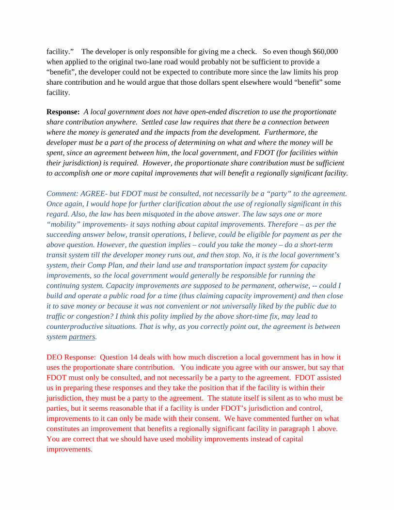
facility.” The developer is only responsible for giving me a check. So even though $60,000 when applied to the original two-lane road would probably not be sufficient to provide a “benefit”, the developer could not be expected to contribute more since the law limits his prop share contribution and he would argue that those dollars spent elsewhere would “benefit” some facility. Response: A local government does not have open-ended discretion to use the proportionate share contribution anywhere. Settled case law requires that there be a connection between where the money is generated and the impacts from the development. Furthermore, the developer must be a part of the process of determining on what and where the money will be spent, since an agreement between him, the local government, and FDOT (for facilities within their jurisdiction) is required. However, the proportionate share contribution must be sufficient to accomplish one or more capital improvements that will benefit a regionally significant facility. Comment: AGREE- but FDOT must be consulted, not necessarily be a “party” to the agreement. Once again, I would hope for further clarification about the use of regionally significant in this regard. Also, the law has been misquoted in the above answer. The law says one or more “mobility” improvements- it says nothing about capital improvements. Therefore – as per the succeeding answer below, transit operations, I believe, could be eligible for payment as per the above question. However, the question implies – could you take the money – do a short-term transit system till the developer money runs out, and then stop. No, it is the local government’s system, their Comp Plan, and their land use and transportation impact system for capacity improvements, so the local government would generally be responsible for running the continuing system. Capacity improvements are supposed to be permanent, otherwise, -- could I build and operate a public road for a time (thus claiming capacity improvement) and then close it to save money or because it was not convenient or not universally liked by the public due to traffic or congestion? I think this polity implied by the above short-time fix, may lead to counterproductive situations. That is why, as you correctly point out, the agreement is between system partners. DEO Response: Question 14 deals with how much discretion a local government has in how it uses the proportionate share contribution. You indicate you agree with our answer, but say that FDOT must only be consulted, and not necessarily be a party to the agreement. FDOT assisted us in preparing these responses and they take the position that if the facility is within their jurisdiction, they must be a party to the agreement. The statute itself is silent as to who must be parties, but it seems reasonable that if a facility is under FDOT’s jurisdiction and control, improvements to it can only be made with their consent. We have commented further on what constitutes an improvement that benefits a regionally significant facility in paragraph 1 above. You are correct that we should have used mobility improvements instead of capital improvements.
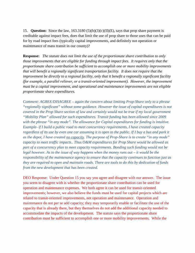
15. Question: Since the law, 163.3180 (5)(h)(3)(c)(II)(E), says that prop share payment is creditable against impact fees, does that limit the use of prop share to those uses that can be paid for by road impact fees (typically capital improvements, and definitely not operation or maintenance of mass transit in our county)? Response: The statute does not limit the use of the proportionate share contribution to only those improvements that are eligible for funding through impact fees. It requires only that the proportionate share contribution be sufficient to accomplish one or more mobility improvements that will benefit a regionally significant transportation facility. It does not require that the improvement be directly to a regional facility, only that it benefit a regionally significant facility (for example, a parallel reliever, or a transit-oriented improvement). However, the improvement must be a capital improvement, and operational and maintenance improvements are not eligible proportionate share expenditures. Comment: AGREE/DISAGREE – again the concern about limiting Prop-Share only to a phrase “regionally significant” without some guidance. However the issue of capital expenditures is not covered in the Prop Share section of law and certainly would not be true if my local government “Mobility Plan” allowed for such expenditures. Transit funding has been allowed since 2009 with the phrase “in any mode”. The allowance for Capital expenditures for funding is intuitive. Example- if I build a public road to meet concurrency requirements, I have created capacity regardless of its use by even one car assuming it is open to the public. If I buy a bus and park it as the depot, I have created no capacity. The purpose of Prop-Share is to create “in any mode” capacity to meet traffic impacts.. Thus O&M expenditures for Prop Share would be allowed as part of a concurrency plan to meet capacity requirements. Bonding such funding would not be legal however. As to the issue of way happens when the money runs out – it would be the responsibility of the maintenance agency to ensure that the capacity continues to function just as they are required to open and maintain roads. There are tools to do this by dedication of funds from the new development that has been created. DEO Response: Under Question 15 you say you agree and disagree with our answer. The issue you seem to disagree with is whether the proportionate share contribution can be used for operation and maintenance expenses. We both agree it can be used for transit-oriented improvements; however, we also believe the funds must be used for capital projects which are related to transit-oriented improvements, not operation and maintenance. Operation and maintenance do not per se add capacity; they may temporarily enable or facilitate the use of the capacity that is already there, but they themselves do not add the additional capacity needed to accommodate the impacts of the development. The statute says the proportionate share contribution must be sufficient to accomplish one or more mobility improvements. While the

term improvement is not defined in the statute, our interpretation of the use of this term in the context of this statute is that it must be a capital improvement that adds capacity for mobility.


