Embed Size (px)
Citation preview
CITY COUNCIL MEETING MAY 24, 2021 PAGE 1
Tomas Mendoza, Councilmember John Mounce, Councilmember Chrissa Hartle, Councilmember
James Clark, Mayor Pro Tem Jim Tate, Councilmember
Elizabeth Woodall, Mayor
CITY OF JUSTIN CITY COUNCIL AGENDA MONDAY, MAY 24, 2021 415 N. COLLEGE AVE.
5:00 P.M.
CALL TO ORDER
Convene into session: Roll Call:
PRESENTATION/ STAFF UPDATES
• Police Chief, Alex Coss• Monthly Financials
WORKSHOP SESSION
1. Discussion and conduct a Public Hearing for a Special Use Permit (SUP 21-01) to allow aFarmer’s Market in the Light Industrial Zoning District. Location: southeasterly corner ofFM 407 and FM 156. Applicant: Texoma Farms.
2. Discussion and conduct a Public Hearing consider adopting an amendment of City Off-Street Parking Ordinance, Chapter 52, Section 52-233 to 52-269.
3. Discussion and conduct a Public Hearing to consider adopting regulations for Mobile FoodTruck Operations in the City.
4. Discussion regarding continuation of a Public Hearing to consider an amendment to theCity’s Sign Ordinance, Chapter 36.
5. Discussion regarding continuation of a Public Hearing to consider a Reatta Ridge, Phases 3& 5, Zone Change (ZC 21-01) of 50 acres from SF 1A to SF 2-PD and a Preliminary Plat(PPLT 21-01) to create up to 216 single family residential lots and 5 open space lots forparks, trails and amenities.
6. Discussion regarding a Final Plat for Timberbrook Phases 3B and 4A.
CITY COUNCIL MEETING MAY 24, 2021 PAGE 2
7. Discussion regarding approval of Resolution 556-21 Calling the Public Hearing forImprovement Area #2-A of the Justin Timberbrook PID.
8. Discussion regarding Resolution 557-21 appointing a representative to the Upper TrinityBoard of Directors.
9. Discussion regarding audio, video, and live stream upgrades for City meetings.
10. Discussion regarding Stop Sign and Yield Sign intersections in the City.
11. Discussion regarding City Council Meeting dates and times.
12. Consider and take appropriate action to approve Resolution 558-21 denying OncorElectric Delivery Company’s request to amend its Distribution Cost Recovery Factor.
CONVENE INTO REGULAR SESSION- Immediately Following Workshop Session
CALL TO ORDER
Convene into Session: Invocation and Pledge of Allegiance American Flag
Texas Flag: “Honor the Texas Flag; I pledge allegiance to thee, Texas, one state, under God, one and indivisible”
PUBLIC COMMENT
In order to expedite the flow of business and to provide all citizens the opportunity to speak, the Mayor may impose a three-minute limitation on any person addressing the Council. The Texas Open Meetings Act prohibits the City Council from discussing issues, which the public have not been given a seventy-two (72) hour notice. Issues raised may be referred to City staff for research and/or placed on a future agenda.
PUBLIC HEARING
13. PUBLIC HEARING (7:00 P.M.): Conduct a Public Hearing to consider a Special UsePermit (SUP 21—01) to allow a Farmer’s Market in the Light Industrial Zoning District.Location: southeasterly corner of FM 407 and FM 156. Applicant: Texoma Farms.
a. Open public hearingb. Close public hearingc. Consider and take appropriate action
14. PUBLIC HEARING (7:00 P.M.): Conduct a Public Hearing to consider adopting anamendment to City Off-Street Parking Ordinance, Chapter 52, Section 52-233 to 52-269.
a. Open public hearingb. Close public hearing
CITY COUNCIL MEETING MAY 24, 2021 PAGE 3
c. Consider and take appropriate action
15. PUBLIC HEARING (7:00 P.M.): Conduct a Public Hearing to consider adoptingregulations for Mobile Food Truck Operations and Land Use in the City.
d. Open public hearinge. Close public hearingf. Consider and take appropriate action
16. PUBLIC HEARING (7:00 P.M.): Continuation of a Public Hearing to consider anamendment to the City’s Sign Ordinance, Chapter 36.
a. Open public hearingb. Close public hearingc. Consider and take appropriate action
17. PUBLIC HEARING (7:00 P.M.): Continuation of a Public Hearing to consider aPreliminary Plat (PPLT 21-01) to create up to 216 single family residential lots and 5open space lots for parks, trails and amenities. Also consider a request to rezoneapproximately 50 acres from SF-1A to SF 2-PD.
a. Open public hearingb. Close public hearingc. Consider and take appropriate action
POSSIBLE ACTION ITEMS
18. Consider and take appropriate action approving a Final Plat for Timberbrook Phases 3B and4A.
19. Consider and take appropriate action to approve Resolution 556-21 Calling the PublicHearing for Improvement Area #2-A of the Justin Timberbrook PID.
20. Consider and take appropriate action approving Resolution 557-21 appointing arepresentative to the Upper Trinity Board of Directors.
21. Consider and take appropriate action approving audio, video, and live stream upgrades forCity meetings.
22. Consider and take appropriate action regarding Stop Sign and Yield Sign intersections in theCity.
23. Consider and take appropriate action approving City Council Meeting dates and times.
24. Consider and take appropriate action to approve Resolution 558-21 denying OncorElectric Delivery Company’s request to amend its Distribution Cost Recovery Factor.
CONSENT
CITY COUNCIL MEETING MAY 24, 2021 PAGE 4
Any Council Member may request an item on the Consent Agenda to be taken up for individual consideration
25. Consider and take appropriate action to approve an Interlocal Agreement with DentonCounty for shared Governance Communications and Dispatch Services System.
26. Consider and take appropriate action to approve City Council minutes dated April 26, 2021May 10, 2021 canvass minutes, May 10, 2021 regular meeting minutes, and May 12, 2021.
EXECUTIVE SESSION
Any item on this posted agenda could be discussed in Executive Session as long as it is within one of the permitted categories under sections 551.071 through 551.076 and Section 551.087 of the Texas Government Code.
• Under Section 551.071, to conduct private consultation with the City Attorneyregarding:
o Extraterritorial Jurisdiction Development Issues (DevelopmentAgreement for the Preserve)
Convene into executive session.
Adjourn into open meeting.
27. Discuss, consider, and act on items discussed in Executive Session.
FUTURE AGENDA ITEMS
ADJOURN
I, the undersigned authority, do hereby certify that the above notice of the meeting of the City Council of the City of Justin, Texas, is a true and correct copy of the said notice that I posted on the official bulletin board at Justin Municipal Complex, 415 North College Street, Justin, Texas, a place of convenience and readily accessible to the general public at all times, and said notice posted this 21st day of May 2021 by 5:00 p.m., at least 72 hours preceding the scheduled meeting time.
Brittany Andrews Brittany Andrews, City Secretary
Page 1 of 12
City Council Meeting
May 24, 2021
Justin City Hall, 415 North College Street
City Council Cover Sheet
Agenda Item: #1 (Workshop) #13 (Public Hearing)
Title: Conduct a Public Hearing to consider a Special Use Permit (SUP 21—01) to allow a Farmer’s Market in the Light Industrial Zoning District. Location: southeasterly corner of FM 407 and FM 156. Applicant: Texoma Farms.
Department: Planning and Development Services
Contact: Director, Darrell Gentry
Recommendation: Staff recommends that City Council conduct a Public Hearing to consider a Special Use Permit (SUP 21-01) to allow a Farmer’s Market in the Light Industrial Zoning District at southwesterly corner of East 5th Street (FM 407) and FM 156. Applicant: Texoma Farms. Property Owner: Rimrock Enterprises aka Carla Hardeman.
Background:
This request item is to conduct a workshop discussion and a Public Hearing to consider a Special Use Permit to allow a farmer’s market operation in a City Light Industrial Zoning district and allow specific special events on a seasonal basis. SUP could allow up to 40 farmer vendors to sell and farm grown products for sale.
The Planning & Zoning Commission conducted a public hearing at its May 18, 2021 meeting. Commission unanimously approved SUP 21-01 with conditions as presented. Commission determined the use permit would be harmonious with surrounding land uses and recommended that the City Council grant approval for SUP 21-01 with conditions of approval as presented.
The applicant attended the meeting and answered questions by Commission and agreed with the Conditions of Approval as presented. There were no other persons spoke for or against the proposed Special Use Permit.
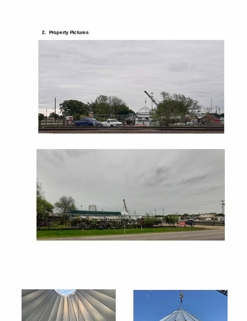
SUP 21-01 could allow for seasonal participation of farm vendors displaying a variety of farm goods and products for sale. The existing nursery operation, also a part of Texoma Farms, is an allowable land use permitted in the Light Industrial Zone per the City’s
Page 2 of 12
adopted Schedule of Uses. The proposed Farmer’s Market and nursery operations are compatible land uses.
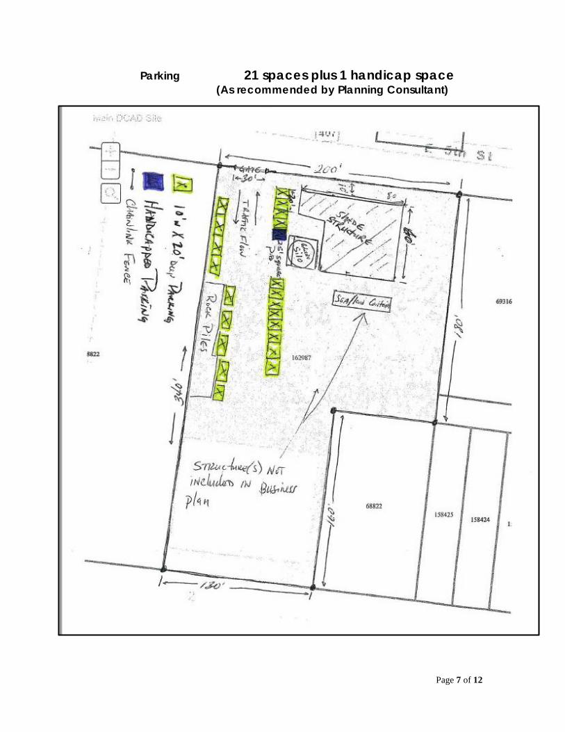
The applicant is also seeking a waiver of parking area improvements due to the nature and operations associated with a typical Farmer’s Market. Applicant has agree to use an asphalt mix and parking space wheel stops with ADA reserved signage for compliance with ADA requirements. The planned wheel stops will assist with providing identifiable parking spaces.
If the Farmer’s Market operation should expand to use the existing building or provide a new building structure, or grow the number of vendors beyond the planned number then more permanent parking area improvements may be required for continued Farmer’s Market usage.
Applicant has expressed an intent to use a mural on the existing silo structure that functions as a sales hut. The mural is not considered a sign unless it displays the name of the business. If that occurs then the entire mural is considered, by definition, as a sign. The applicant would like to use the mural with Texoma Farms name included as a part of such a mural.
This is possible but there are no details about the mural size to determine what the overall mural area size would be or if it would meet the sign ordinance requirements. If the applicant is willing to provide such additional information and apply for a sign permit with a detailed drawing for the proposed mural, staff can assist the applicant. City Council may want to provide such direction.
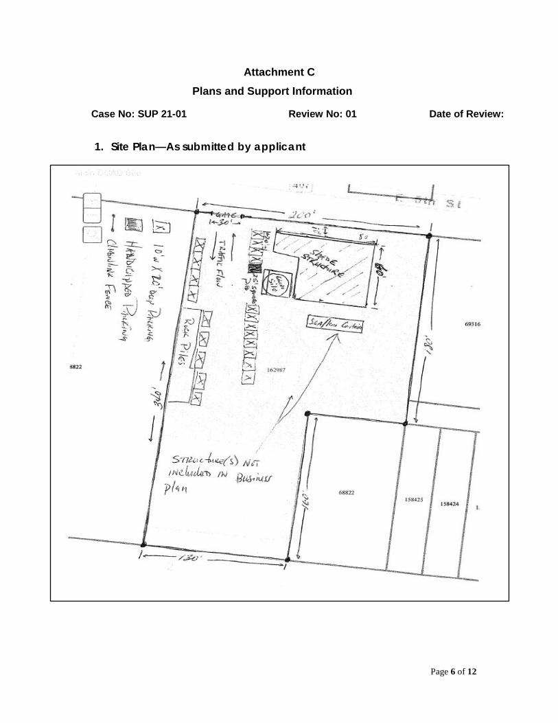
All City application reviewing persons have provided review comments and changes to be done for SUP 21-01. An alternative Site Plan layout, as prepared by planning consultant, Mr. Wilhite AICP, was approved by the Planning & Zoning Commission.
_______________________________________________________________________
City Attorney Review: N/A ________________________________________________________________________
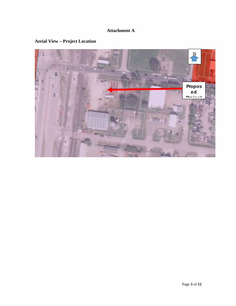
Attachments: Attachment “A” – Site Location Attachment “B” – City Review Summary Attachment “C” – Plans
Page 3 of 12
Attachment A
Aerial View – Project Location
N
Proposed
Project
Page 4 of 12
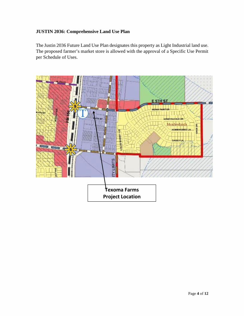
JUSTIN 2036: Comprehensive Land Use Plan
The Justin 2036 Future Land Use Plan designates this property as Light Industrial land use. The proposed farmer’s market store is allowed with the approval of a Specific Use Permit per Schedule of Uses.
Texoma Farms Project Location
Page 5 of 12
Attachment B
Staff Review Summary
Public Works Review
Josh Little, Public Works Director Phone: (940) 648-2541 E-mail: [email protected] No comments or requirements.
Tree Conservation/Landscape Review No mature or protected trees are known to be found on site.
Planning Consultant Review Eric Wilhite, AICP Phone: (817) 412-7155 Email: [email protected] See Attached Review Letter dated May 6, 2021 and redlined site plan exhibit
General Informational Comments The following conditions for granting SUP 21-01 shall be required:
1) Justin Fire Department inspection of facilities shall be performed and comply with any Fire Department requirement for occupancy and use.
2) Off-street parking spaces shall be provided for all employees and visitors of said facility. The City Off-Street Parking requirements, Chapter 52, Section 52-233 does not list parking requirements for a Farmers Market. A waiver for parking area improvements and standards is being requested. Gravel should use asphalt milling on site and kept in good condition as needed.
3) Specific Use Permit (SUP) shall expire automatically in 6 months, if reliance in use, as a Farmer’s Market use has not begun within that timeframe. Any proposed petting zoo or area on site must be located to not overflow into delineated parking area or traffic lane.
4) This Specific Use Permit shall be subject to City review at any time if there is an expansion of use without prior City Approval.
If the City Council elects to approve the Specific Use Permit (SUP21-01) as presented, then the conditions should be included for SUP 21-01.
Case No: SUP 21-01
Page 6 of 12
Attachment C
Plans and Support Information
1. Site Plan—As submitted by applicant
Case No: SUP 21-01 Review No: 01 Date of Review:
Page 7 of 12
Parking 21 spaces plus 1 handicap space (As recommended by Planning Consultant)

Page 8 of 12
Property Aerial View –2021
Page 9 of 12
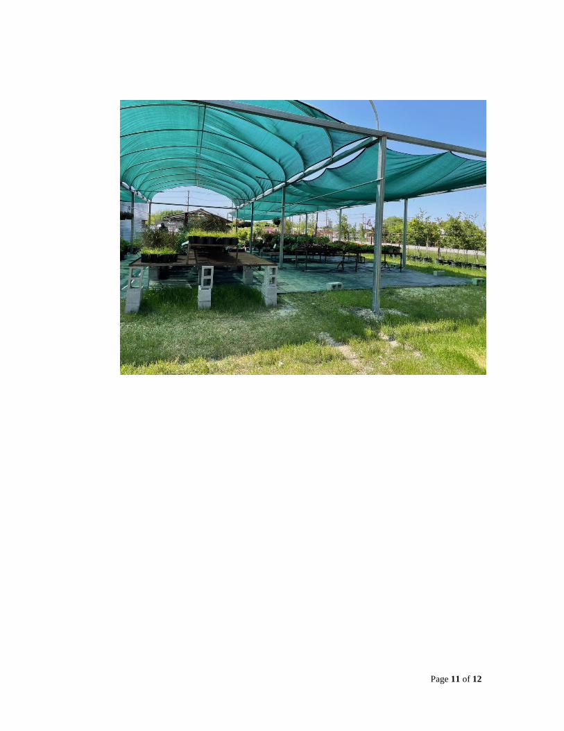
2. Property Pictures
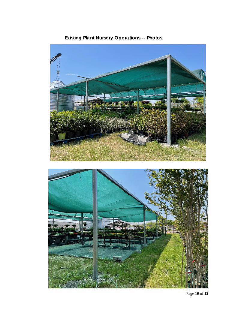
Page 10 of 12
Existing Plant Nursery Operations -- Photos
Page 11 of 12
Page 12 of 12
Exhibit A Conditions of Approval
Special Use Permit (SUP 21-01) Texoma Farms—Farmer’s Market
The conditions below must be completed prior to CO being issued: 1) Applicant(s) must apply for sign permit prior to constructing, installing or erecting
any sign for business, products for sale or identifying the farmer’s market orexisting plant nursery operation. All signs advertising the business must conformto the City Sign Ordinance regulations. Murals are allowed as long as no businessname or products advertised for sale are included or shown as a part of a muraldisplay.
2) Specific Use Permit (SUP 21-01) is hereby granted specifically for the existinglocation at 104 East 5th Street only. Any change in location shall mean that thisSUP is null and void without any further action by the City. SUP, as approved, isnot transferrable to the property owner or another user. A new use permit shall berequired for any other location within the City of Justin. SUP 21-01 is subject toannual review on or about the use permit anniversary date, for conformance to theConditions of Approval as set forth in City Council action & decision. Anniversarydate shall mean date of City Council approval.
3) Applicant shall comply with applicable and required Justin Fire Departmentrequirements and/or inspections prior to the storage of vehicles, materials orequipment onsite. Proof of Fire Department inspection or approval shall be on filewith the City Development Services Department.
4) The modified site plan (see attached exhibit by consultant), as presented byPlanning Consultant, is the plan for which the SUP is being approved, including awaiver of parking area improvements. Said waiver is hereby approved due to theproposed land use as a seasonal farmer’s market (limited time period for said landuse). Unimproved parking area should use gravel with asphalt milling materialand 90 degree parking spaces onsite.
5) If said seasonal land use becomes a year-round or expands its onsite operationsand area on the subject property to allow more farmer vendors or permanentbuilding usage, then parking improvements with drainage may be required by City.
6) Applicant shall obtain a Certificate of Occupancy inspection by City BuildingOfficial within 30 days of approval by City Council.
Signed and executed as in agreement with Conditions as specified:
Dianna Streetman applicant Date
City of Justin Signature Date
May 6, 2021
Mr. Darrell Gentry
Director of Development Services
City of Justin
415 N. College Ave.
Justin, Texas 76247
Re: Special Use Permit SUP 21-01 Review
Farmers Market
Justin, Texas
Darrell,
In accordance with the request of April 30, 2021 we have reviewed the SUP Site Plan andapplicant information provided, for the referenced project and offer the following comments. I havealso included a redline markup of submitted SUP Site Plan exhibit.
SUP Site Plan
▪ A updated site plan sketch has been provided.
▪ Parking is more efficient and safer if made 90deg. Parking as indicted as parallel will impedeflow from entry gate more when maneuvering than head in. There appears to be adequatespace to accommodate head in parking. Also, if purchasing goods rear of vehicle will be moreaccessible for loading merch. People will more likely park head in anyway.
▪ No issue with request of parking surface variance request. However, the gravel should beimproved via use of asphalt milling on site and be kept in good condition via addition of softsurface as needed.
▪ A mural on silo is fine, however if mural has company name it, it acts as signage and mustmeet sign code. Sign requested on fence or other location along roadway should be moresolid such as metal or wood, not a banner.
▪ Please provide location of proposed petting zoo on site and pumpkin patch. None of thisactivity shall overflow into delineated parking area and circulation.
▪ All shade material shall be kept in good condition at all times.
Regards,
Eric Wilhite, AICP
Page 1 of 1
City Council Meeting
May 24, 2021
Justin City Hall, 415 North College Street
City Council Cover Sheet
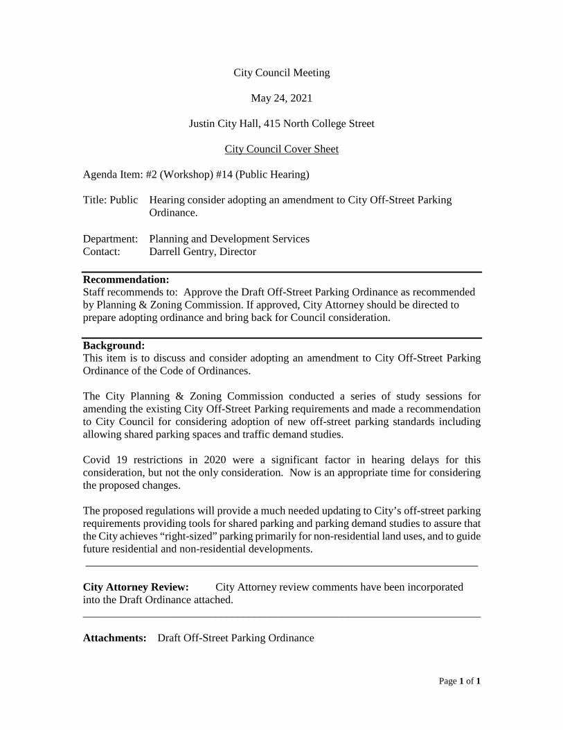
Agenda Item: #2 (Workshop) #14 (Public Hearing)
Title: Public Hearing consider adopting an amendment to City Off-Street Parking Ordinance.
Department: Planning and Development Services Contact: Darrell Gentry, Director
Recommendation: Staff recommends to: Approve the Draft Off-Street Parking Ordinance as recommended by Planning & Zoning Commission. If approved, City Attorney should be directed to prepare adopting ordinance and bring back for Council consideration.
Background: This item is to discuss and consider adopting an amendment to City Off-Street Parking Ordinance of the Code of Ordinances.
The City Planning & Zoning Commission conducted a series of study sessions for amending the existing City Off-Street Parking requirements and made a recommendation to City Council for considering adoption of new off-street parking standards including allowing shared parking spaces and traffic demand studies.
Covid 19 restrictions in 2020 were a significant factor in hearing delays for this consideration, but not the only consideration. Now is an appropriate time for considering the proposed changes.
The proposed regulations will provide a much needed updating to City’s off-street parking requirements providing tools for shared parking and parking demand studies to assure that the City achieves “right-sized” parking primarily for non-residential land uses, and to guide future residential and non-residential developments. _______________________________________________________________________
City Attorney Review: City Attorney review comments have been incorporated into the Draft Ordinance attached. ________________________________________________________________________
Attachments: Draft Off-Street Parking Ordinance
Draft 9-29-20
Page 1 of 25 Section 52-233 et al
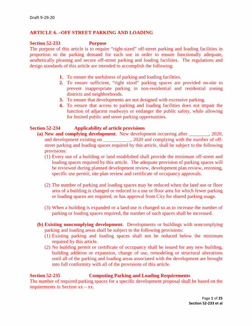
ARTICLE 6. –OFF STREET PARKING AND LOADING
Section 52-233 Purpose The purpose of this article is to require “right-sized” off-street parking and loading facilities in proportion to the parking demand for each use in order to ensure functionally adequate, aesthetically pleasing and secure off-street parking and loading facilities. The regulations and design standards of this article are intended to accomplish the following:
1. To ensure the usefulness of parking and loading facilities. 2. To ensure sufficient, “right sized” parking spaces are provided on-site to
prevent inappropriate parking in non-residential and residential zoning districts and neighborhoods.
3. To ensure that developments are not designed with excessive parking. 4. To ensure that access to parking and loading facilities does not impair the
function of adjacent roadways or endanger the public safety, while allowing for limited public and street parking opportunities.
Section 52-234 Applicability of article provisions
(a) New and complying development. New development occurring after ________, 2020, and development existing on ___________, 2020 and complying with the number of off-street parking and loading spaces required by this article, shall be subject to the following provisions: (1) Every use of a building or land established shall provide the minimum off-street and
loading spaces required by this article. The adequate provision of parking spaces will be reviewed during planned development review, development plan review, rezoning, specific use permit, site plan review and certificate of occupancy approvals.
(2) The number of parking and loading spaces may be reduced when the land use or floor area of a building is changed or reduced to a use or floor area for which fewer parking or loading spaces are required, or has approval from City for shared parking usage.
(3) When a building is expanded or a land use is changed so as to increase the number of
parking or loading spaces required, the number of such spaces shall be increased.
(b) Existing noncomplying development. Developments or buildings with noncomplying parking and loading areas shall be subject to the following provisions: (1) Existing parking and loading spaces shall not be reduced below the minimum
required by this article. (2) No building permit or certificate of occupancy shall be issued for any new building,
building addition or expansion, change of use, remodeling or structural alterations until all of the parking and loading areas associated with the development are brought into full conformity with all of the provisions of this article.
Section 52-235 Computing Parking and Loading Requirements The number of required parking spaces for a specific development proposal shall be based on the requirements in Section xx – xx.
Draft 9-29-20
Page 2 of 25 Section 52-233 et al
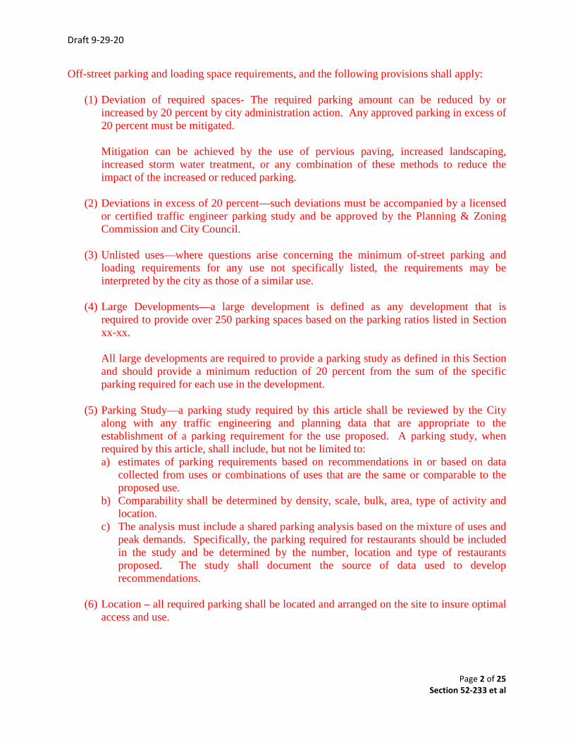
Off-street parking and loading space requirements, and the following provisions shall apply:
(1) Deviation of required spaces- The required parking amount can be reduced by or increased by 20 percent by city administration action. Any approved parking in excess of 20 percent must be mitigated. Mitigation can be achieved by the use of pervious paving, increased landscaping, increased storm water treatment, or any combination of these methods to reduce the impact of the increased or reduced parking.
(2) Deviations in excess of 20 percent—such deviations must be accompanied by a licensed
or certified traffic engineer parking study and be approved by the Planning & Zoning Commission and City Council.
(3) Unlisted uses—where questions arise concerning the minimum of-street parking and
loading requirements for any use not specifically listed, the requirements may be interpreted by the city as those of a similar use.
(4) Large Developments—a large development is defined as any development that is
required to provide over 250 parking spaces based on the parking ratios listed in Section xx-xx. All large developments are required to provide a parking study as defined in this Section and should provide a minimum reduction of 20 percent from the sum of the specific parking required for each use in the development.
(5) Parking Study—a parking study required by this article shall be reviewed by the City
along with any traffic engineering and planning data that are appropriate to the establishment of a parking requirement for the use proposed. A parking study, when required by this article, shall include, but not be limited to: a) estimates of parking requirements based on recommendations in or based on data
collected from uses or combinations of uses that are the same or comparable to the proposed use.
b) Comparability shall be determined by density, scale, bulk, area, type of activity and location.
c) The analysis must include a shared parking analysis based on the mixture of uses and peak demands. Specifically, the parking required for restaurants should be included in the study and be determined by the number, location and type of restaurants proposed. The study shall document the source of data used to develop recommendations.
(6) Location – all required parking shall be located and arranged on the site to insure optimal
access and use.
Draft 9-29-20
Page 3 of 25 Section 52-233 et al
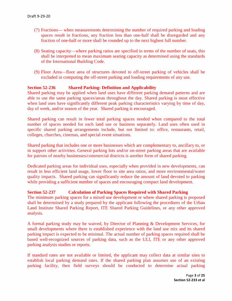
(7) Fractions— when measurements determining the number of required parking and loadingspaces result in fractions, any fraction less than one-half shall be disregarded and anyfraction of one-half or more shall be rounded up to the next highest full number.
(8) Seating capacity—where parking ratios are specified in terms of the number of seats, thisshall be interpreted to mean maximum seating capacity as determined using the standardsof the International Building Code.
(9) Floor Area—floor area of structures devoted to off-street parking of vehicles shall beexcluded in computing the off-street parking and loading requirements of any use.
Section 52-236 Shared Parking: Definition and Applicability Shared parking may be applied when land uses have different parking demand patterns and are able to use the same parking spaces/areas throughout the day. Shared parking is most effective when land uses have significantly different peak parking characteristics varying by time of day, day of week, and/or season of the year. Shared parking is encouraged.
Shared parking can result in fewer total parking spaces needed when compared to the total number of spaces needed for each land use or business separately. Land uses often used in specific shared parking arrangements include, but not limited to: office, restaurants, retail, colleges, churches, cinemas, and special event situations.
Shared parking that includes one or more businesses which are complementary to, ancillary to, or in support other activities. General parking lots and/or on-street parking areas that are available for patrons of nearby businesses/commercial districts is another form of shared parking.
Dedicated parking areas for individual uses, especially when provided in new developments, can result in less efficient land usage, lower floor to site area ratios, and more environmental/water quality impacts. Shared parking can significantly reduce the amount of land devoted to parking while providing a sufficient number of spaces and encouraging compact land development.
Section 52-237 Calculation of Parking Spaces Required with Shared Parking The minimum parking spaces for a mixed use development or where shared parking is proposed shall be determined by a study prepared by the applicant following the procedures of the Urban Land Institute Shared Parking Report, ITE Shared Parking Guidelines, or any other approved analysis.
A formal parking study may be waived, by Director of Planning & Development Services, for small developments where there is established experience with the land use mix and its shared parking impact is expected to be minimal. The actual number of parking spaces required shall be based well-recognized sources of parking data, such as the ULI, ITE or any other approved parking analysis studies or reports.
If standard rates are not available or limited, the applicant may collect data at similar sites to establish local parking demand rates. If the shared parking plan assumes use of an existing parking facility, then field surveys should be conducted to determine actual parking
Draft 9-29-20
Page 4 of 25 Section 52-233 et al
accumulation. If possible, these surveys should consider the seasonal peak period for the combination of land uses involved. The applicant shall determine the minimum number of parking spaces required for shared parking arrangements or mixed use developments by the following the example procedures detailed in Appendix “A” herein.
Section 52-238 Distance to Parking Spaces and Pedestrian Connection Requirements The closer shared spaces are to the land uses they serve, the more likely the arrangement will be a success. Shared spaces for residential units must be located within 300 feet of dwelling unit entrances they serve. Shared spaces at other uses must be located within 500 feet of the principal building entrances of all sharing uses. However, up to 20 percent of the spaces may be located greater than 500 feet but less than 1,000 feet from the principal entrances.
Clear, safe pedestrian connections must be provided. Pedestrian should not be required to cross an arterial street except at a signalized intersection along the pedestrian pathway. Up to 50 percent of nonresidential spaces may be provided at greater distances if dedicated shuttle bus or van service is provided from a remote parking facility.
Section 52-239 Captive Market Parking Requirements For uses that are considered ancillary to a larger business, no additional parking may be required.
Examples of this case include a coffee or snack shop within an office or hotel development, a copy/package store within a business park or redevelopment of small retail uses in a large business district. Parking requirements for similar ancillary uses may be reduced to account for the likely cross patronage among the adjacent uses located within a maximum walking distance of 500 feet. Parking requirements may be reduced up to 90 percent as appropriate.
Section 52-240 Agreement Between Sharing Property Owners If a privately owned parking facility is to serve two or more separate properties, a legal agreement between property owners guaranteeing access to, use of, and management of designated spaces may be required by the City and must be recorded with County.
Section 52-241 Shared Parking Plan A shared parking plan must be submitted for Planning & Zoning Commission and City Council approval prior to site development or use of shared parking. A shared parking plan may be included in a site development plan and/or a landscaping plan, or as a separate document.
If a separate shared parking plan is submitted then said parking plan shall include one or more of the following:
A. Site plan of parking spaces intended for shared parking and their proximity to landuses that they will serve.
B. A signage plan that directs drivers to the most convenient parking areas for eachparticular use or group of uses.
Draft 9-29-20
Page 5 of 25 Section 52-233 et al
C. A pedestrian circulation plan that shows connections and walkways between parking areas and land uses. These paths should be as direct and short as possible. D. A safety and security plan that addresses lighting and maintenance of the parking areas. Section 52-242 Application of Shared Parking This section defines when shared parking requirements would apply. Specific criteria are proposed, which appear in bold, and it is intended that each jurisdiction consider what values would be appropriate. A. Applicants for new developments or significant redevelopment* of site(s) shall examine the feasibility of using shared parking arrangements. (Significant redevelopment could be defined as increasing building size or land uses so that the site’s trip generation and/or parking demand would increase by a certain percentage similar to (2) below.). B. Shared parking arrangements shall be considered when the number of parking spaces requested by the developer/applicant is more than 10* percent higher or more than 10* spaces higher than the minimum number of parking spaces required by Code for a site, whichever is more. C. When applicants for new and redeveloping developments utilizing a shared parking agreement/plan shall record, by separate document if necessary, said agreement/plan as approved by the City, with the County of Denton. Shared parking easements shall be included for preliminary and final platting for recordation with County of Denton, when a new development or redevelopment project utilizes shared parking to meet City parking regulations. D. Shared parking easements may be imposed as a condition of approval for: Specific Use Permits, Planned Developments or Development Review Committee recommendations for site specific developments regardless of zoning designation. Section 52-243 Parking requirements based on use. (a) In all zoning districts, there shall be provided at the time any building or structure is erected
or structurally altered (except as provided in Section xx-xx), off-street parking spaces, including handicap spaces as required by the Americans With Disabilities Act ("ADA"). Parking shall be provided, in accordance with the following requirements as shown on parking requirement and ADA charts.
(b) Any person, firm or corporation violating any of the provisions or terms of this ordinance shall be subject to the same penalty as provided for in the City Zoning Ordinance, as amended, and upon conviction shall punished by a fine not to exceed the sum of $2,000.00 for each offense; and each and every day such violation shall continue shall be deemed to constitute a separate offense.
Draft 9-29-20
Page 6 of 25 Section 52-233 et al
PARKING REQUIREMENTS CHART
City of Justin Off-Street Parking Requirements Table
Land Use Off-Street Parking Requirements
Animal hospital 1 space per 350 feet gross floor area.
Appliance store
2 spaces,
plus one additional space for each 500 feet gross floor area over 1,000 feet.
Art gallery
10 spaces,
plus one additional space for each 300 feet gross floor area in excess of 2,000 feet gross floor area. Or if an auditorium is included as a part of
the building, then 1 space per 4 seats.
Assembly 1 space for each 100 feet gross floor area.
Assisted living* 0.6 space per dwelling unit plus 1 space for every 2 employees.
Automobile parts sales 6.2 spaces per 1,000 feet gross floor area.or shared parking agreement
Bank w/drive-thru 1 space per reach 300 feet gross floor area or shared parking
agreement.
Bed and breakfast 1 space per each guest room,
plus 2 spaces for proprietor.
Bottling plant
1½ parking space for each employee on maximum working shift
plus space to accommodate all trucks and vehicles used in plant operations, but not less than one parking space for each 1,000 feet
gross floor area.
Bowling alley
6 spaces per each bowling lane or alley or a shared parking agreement based on demand study approved by City.
Draft 9-29-20
Page 7 of 25 Section 52-233 et al
Building materials and lumber store
3.8 spaces per 1,000 feet gross floor area. or a shared parking agreement based on demand study approved by City.
Business
3 spaces,
plus one additional space per each 200 feet gross floor area over 500 feet or a shared parking agreement based on demand study approved
by City.
Cafe 1 space per each 100 gross floor area.
Carwash (stand-alone)
5 queuing spaces per bay,
plus one per employee.
Church or other place of worship
1 space per each 3 seats in the worship auditorium.
Clinic 1 space per each 250 gross feet floor area.
Clothing store 1 space per each 200 feet gross floor area.
College or university 1 space for each classroom,
plus one space per each four students.
Community center 1 space per 500 feet gross floor area,
plus 1 space per 10,000 feet gross floor area. Minimum of 10 spaces.
Construction office 2 spaces per unit.
Continuing care retirement community
1.3 spaces per dwelling unit plus 1.5 spaces for every 2 employees.
Country club or golf club 7 spaces per hole.
Dance hall 1 space per each 100 feet gross floor area.
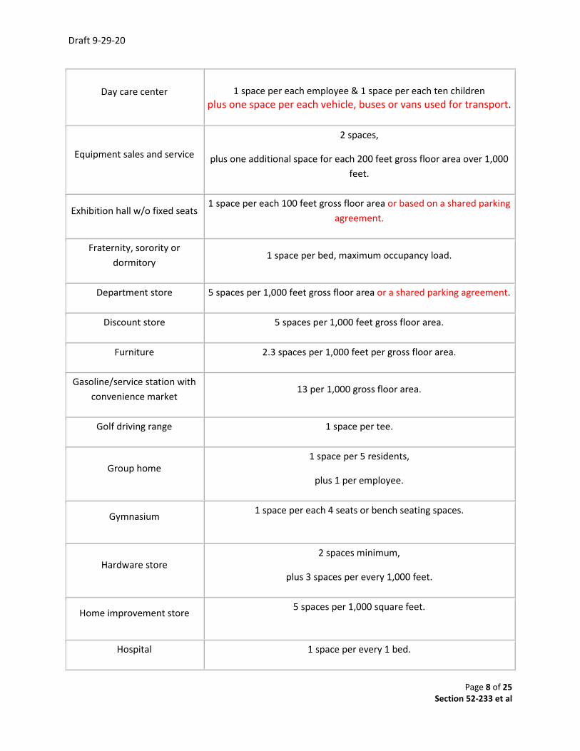
Draft 9-29-20
Page 8 of 25 Section 52-233 et al
Day care center
1 space per each employee & 1 space per each ten children plus one space per each vehicle, buses or vans used for transport.
Equipment sales and service
2 spaces,
plus one additional space for each 200 feet gross floor area over 1,000 feet.
Exhibition hall w/o fixed seats 1 space per each 100 feet gross floor area or based on a shared parking
agreement.
Fraternity, sorority or dormitory
1 space per bed, maximum occupancy load.
Department store 5 spaces per 1,000 feet gross floor area or a shared parking agreement.
Discount store 5 spaces per 1,000 feet gross floor area.
Furniture 2.3 spaces per 1,000 feet per gross floor area.
Gasoline/service station with convenience market
13 per 1,000 gross floor area.
Golf driving range 1 space per tee.
Group home 1 space per 5 residents,
plus 1 per employee.
Gymnasium 1 space per each 4 seats or bench seating spaces.
Hardware store 2 spaces minimum,
plus 3 spaces per every 1,000 feet.
Home improvement store 5 spaces per 1,000 square feet.
Hospital 1 space per every 1 bed.

Draft 9-29-20
Page 9 of 25 Section 52-233 et al
Hotel 1 space per each 2 sleeping rooms or suites,
plus 1 space per 200 square feet.
Library 10 spaces,
plus 1 space per 300 square feet.
Manufacturing or industrial establishment
1 space per each 2 employees
or 1 space per 1,000 square feet or whichever is the greater.
Medical/dental office 4 spaces per 1,000 square feet gross floor area or a shared parking
agreement based on demand study approved by City.
Mini-warehouse 0.2 spaces per 1,000 square feet.
Mobile home park 1.0 spaces per each mobile home,
plus additional spaces as required for accessory uses.
Model home 2 spaces per unit.
Mortuary or funeral homes 1 space per 4 fixed seats in the main chapel.
Motel 1 space per room.
Motor-vehicle salesrooms and used car lots
1 space per each 500 square feet of sales floor for indoor uses,
or 1 space for each 1,000 square feet of lot area for outdoor uses.
Multifamily residential 1.5 spaces per 1 bedroom dwelling units;
2 spaces per dwelling unit for units with 3 bedrooms, plus 1 additional space per each bedroom for units with over 3
bedrooms.
Museum, small (2,500 square feet and under)
2 spaces, plus 1 per employee/volunteer
Museum, large institutional (over 2,500 square feet)
10 spaces,
plus 1 additional space for each 300 square feet in excess of 2,500 square feet.
Draft 9-29-20
Page 10 of 25 Section 52-233 et al
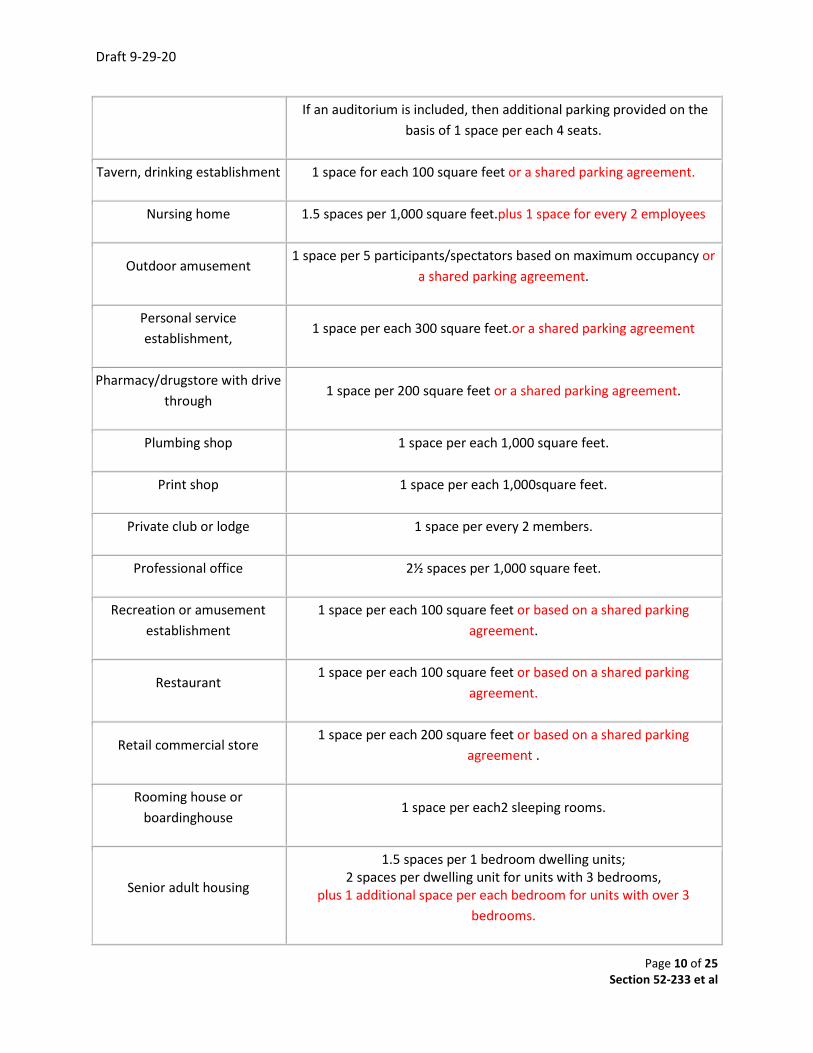
If an auditorium is included, then additional parking provided on the basis of 1 space per each 4 seats.
Tavern, drinking establishment 1 space for each 100 square feet or a shared parking agreement.
Nursing home 1.5 spaces per 1,000 square feet.plus 1 space for every 2 employees
Outdoor amusement 1 space per 5 participants/spectators based on maximum occupancy or
a shared parking agreement.
Personal service establishment,
1 space per each 300 square feet.or a shared parking agreement
Pharmacy/drugstore with drive through
1 space per 200 square feet or a shared parking agreement.
Plumbing shop 1 space per each 1,000 square feet.
Print shop 1 space per each 1,000square feet.
Private club or lodge 1 space per every 2 members.
Professional office 2½ spaces per 1,000 square feet.
Recreation or amusement establishment
1 space per each 100 square feet or based on a shared parking agreement.
Restaurant 1 space per each 100 square feet or based on a shared parking
agreement.
Retail commercial store 1 space per each 200 square feet or based on a shared parking
agreement .
Rooming house or boardinghouse
1 space per each2 sleeping rooms.
Senior adult housing
1.5 spaces per 1 bedroom dwelling units; 2 spaces per dwelling unit for units with 3 bedrooms,
plus 1 additional space per each bedroom for units with over 3 bedrooms.
Draft 9-29-20
Page 11 of 25 Section 52-233 et al
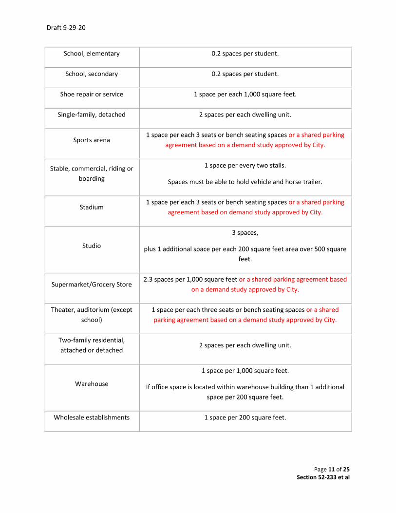
School, elementary 0.2 spaces per student.
School, secondary 0.2 spaces per student.
Shoe repair or service 1 space per each 1,000 square feet.
Single-family, detached 2 spaces per each dwelling unit.
Sports arena 1 space per each 3 seats or bench seating spaces or a shared parking
agreement based on a demand study approved by City.
Stable, commercial, riding or boarding
1 space per every two stalls.
Spaces must be able to hold vehicle and horse trailer.
Stadium 1 space per each 3 seats or bench seating spaces or a shared parking
agreement based on demand study approved by City.
Studio
3 spaces,
plus 1 additional space per each 200 square feet area over 500 square feet.
Supermarket/Grocery Store 2.3 spaces per 1,000 square feet or a shared parking agreement based
on a demand study approved by City.
Theater, auditorium (except school)
1 space per each three seats or bench seating spaces or a shared parking agreement based on a demand study approved by City.
Two-family residential, attached or detached
2 spaces per each dwelling unit.
Warehouse
1 space per 1,000 square feet.
If office space is located within warehouse building than 1 additional space per 200 square feet.
Wholesale establishments 1 space per 200 square feet.

Draft 9-29-20
Page 12 of 25 Section 52-233 et al
Section 52-244 Parking spaces for persons with disabilities
Generally – For parking areas with ten or more required spaces, a portion of the total number of required parking spaces in each off-street parking area shall be specifically designated, located and reserved for use by persons with disabilities. Number of Spaces—Parking spaces reserved for persons with disabilities shall be counted toward fulfilling the overall off-street parking standards. One in every eight handicapped accessible spaces, but not less than one, shall be designated “van accessible”. The minimum number of ADA compliant spaces shall be a portion of the total number required, as determined from the following schedule:
ADA Parking Space Requirements
Total Parking Spaces in Lot
Minimum Required Accessible Spaces*
1 to 25 1
26 to 50 2
51 to 75 3
76 to 100 4
101 to 150 5
151 to 200 6
201 to 300 7
301 to 400 8
401 to 500 9
501 to 1,000 2% of total spaces
1,001 + 20 spaces, plus 1 space for every 100 spaces, or fraction thereof, over 1,000*One van
accessible parking space shall be provided for every 6 accessible parking spaces or fraction thereof. Source: 2012 Texas Accessibility Standards (TAS) Field Manual
Draft 9-29-20
Page 13 of 25 Section 52-233 et al
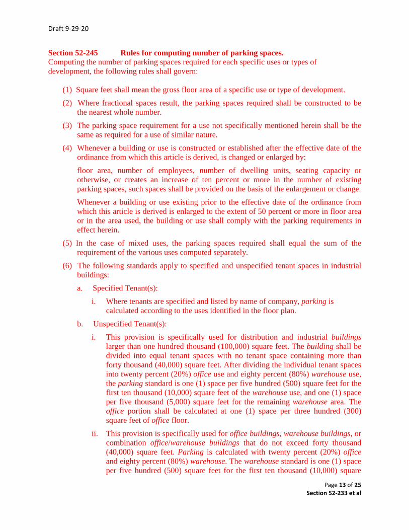
Section 52-245 Rules for computing number of parking spaces. Computing the number of parking spaces required for each specific uses or types of development, the following rules shall govern:
(1) Square feet shall mean the gross floor area of a specific use or type of development.(2) Where fractional spaces result, the parking spaces required shall be constructed to be
the nearest whole number.(3) The parking space requirement for a use not specifically mentioned herein shall be the
same as required for a use of similar nature.(4) Whenever a building or use is constructed or established after the effective date of the
ordinance from which this article is derived, is changed or enlarged by:floor area, number of employees, number of dwelling units, seating capacity orotherwise, or creates an increase of ten percent or more in the number of existingparking spaces, such spaces shall be provided on the basis of the enlargement or change.Whenever a building or use existing prior to the effective date of the ordinance fromwhich this article is derived is enlarged to the extent of 50 percent or more in floor areaor in the area used, the building or use shall comply with the parking requirements ineffect herein.
(5) In the case of mixed uses, the parking spaces required shall equal the sum of therequirement of the various uses computed separately.
(6) The following standards apply to specified and unspecified tenant spaces in industrialbuildings:a. Specified Tenant(s):
i. Where tenants are specified and listed by name of company, parking iscalculated according to the uses identified in the floor plan.
b. Unspecified Tenant(s):i. This provision is specifically used for distribution and industrial buildings
larger than one hundred thousand (100,000) square feet. The building shall bedivided into equal tenant spaces with no tenant space containing more thanforty thousand (40,000) square feet. After dividing the individual tenant spacesinto twenty percent (20%) office use and eighty percent (80%) warehouse use,the parking standard is one (1) space per five hundred (500) square feet for thefirst ten thousand (10,000) square feet of the warehouse use, and one (1) spaceper five thousand (5,000) square feet for the remaining warehouse area. Theoffice portion shall be calculated at one (1) space per three hundred (300)square feet of office floor.
ii. This provision is specifically used for office buildings, warehouse buildings, orcombination office/warehouse buildings that do not exceed forty thousand(40,000) square feet. Parking is calculated with twenty percent (20%) officeand eighty percent (80%) warehouse. The warehouse standard is one (1) spaceper five hundred (500) square feet for the first ten thousand (10,000) square
Draft 9-29-20
Page 14 of 25 Section 52-233 et al
feet and one (1) space per five thousand (5,000) square feet for the remaining warehouse area. The office shall be calculated at one (1) space per three hundred (300) square feet. No minimum floor area is specified in this scenario.
Section 52-246 Location of parking spaces. All parking spaces required herein shall be located on the same lot with the building or use served, except:
(1) Where an increase in the number of spaces is required by a change or enlargement of use or where such spaces are provided collectively or used jointly by two or more buildings or establishments, the required spaces may be located not to exceed 300 feet from a building served and not to exceed 500 feet from any other building(s) served.
(2) Not more than 50 percent of the parking spaces required for:
a. Theaters, bowling alleys, dance halls, night clubs, cafes or similar uses; and b. Not more than 80 percent of the parking spaces required for a church or school auditorium or similar uses may be provided and used jointly by similar uses not normally open, used or operated during the same hours as those listed in subsection (2) (a) of this section; provided, however, that written agreement thereto is properly executed and filed as specified below.
In any case where the required parking spaces are not located on the same lot with the building or use served, or where such spaces are collectively or jointly provided and used, a written agreement assuring their retention for such purposes, shall be properly drawn and executed by the parties concerned, approved as to form by the city and executed by the parties concerned, approved as to form by the city attorney and shall be filed with the application for a building permit. Section 52-247 Aisle dimensions and parking space dimensions The minimum required dimensions of parking spaces and aisles shall be as indicated in the following table. If proposed parking angles are not shown in the table, dimensions shall be interpolated from the table by the City Engineer or Director of Planning and Development Services. All dimensions are in feet. Minor deviations from these standards may be approved by the City Engineer, Building Official and Director of Planning and Development Services for the design of parking structures. The dimensions in the table are graphically illustrated in the figure following the table in this Section:
(Go to next page)

Draft 9-29-20
Page 15 of 25 Section 52-233 et al
(a) 90-degree angle parking. Each parking space shall be not less than eight feet wide nor less than 18 feet in length. Maneuvering space shall be in addition to parking space and shall not be less than 24 feet perpendicular to the building or parking line.
(b) 60-degree angle parking. Each parking space shall be not less than eight feet wide perpendicular to the parking angle nor less than 17 feet in length when measured at right angles to the building or parking line. Maneuvering space shall be in addition to parking space and shall be not less than 20 feet perpendicular to the building or parking line.
(c) 45-degree angle parking. Each parking space shall be not less than eight feet wide perpendicular to the parking angle nor less than 16 feet in length when measured at right angles to the building or parking line. Maneuvering space shall be in addition to parking space and shall be not less than 18 feet perpendicular to the building or parking line.
(d) Parking facilities next to alley. When off-street parking facilities are located adjacent to a public alley, the width of the alley may be assumed to be a portion of the maneuvering space requirement.
(e) Parking facilities in excess of required minimum. When off-street parking facilities are provided in excess of the minimum amounts herein specified, or when off-street parking facilities are provided but not required by this article, the off-street parking facilities shall comply with the minimum requirements for parking and maneuvering space herein specified.
(f) Parking facilities next to public street. When off-street parking facilities are located adjacent to a public street (other than FM 156 or FM. 407) in the SF-OT or GB-OT overlay district, the public street right-of-way may be used as all or a portion of the maneuvering space requirement.
Section 52-248 Off-street loading space. Every building or part erected or occupied for retail business, service, manufacturing, storage, warehousing, hotel, mortuary, or any other uses similarly involving the receipt or distribution by vehicles of materials or merchandise shall provide and maintain on the same premises loading space in accordance with the following requirements: (1) In districts LI, one loading space for each 1,000 feet, or fraction thereof, of floor area in the building. (2) In districts LI and GB, one loading space for the first 5,000 to 15,000 square feet of floor area in the building and one additional loading space for each 15,000 square feet, or fraction thereof, of floor area in excess of 15,000 square feet. (3) Each required loading space shall have a minimum size as described for loading spaces under section xx-xx.
Draft 9-29-20
Page 16 of 25 Section 52-233 et al
Section 52-249 Old Town Parking Overlay standards Old Town zoning overlay district shall require one parking space per 1,000 square feet of enclosed building area for all uses allowed; on Lots 1-10, Block 18; Lots 1-10, Block 25; Lots 1-17, Block 32; Lots 1-10, Lot 18R, and Lots 21-24, Block 39, city Old Town. Section 52-250 Parking Area Design All off-street parking areas, other than those designed solely for a single dwelling unit and not sharing a common parking area, shall comply with the following design requirements:
(1) Each off-street parking space shall open directly onto an aisle or driveway that is not a public street or a public alley, provided that this subsection shall not apply to parking spaces provided by the city for city parks.
(2) Aisles and driveways shall not be used for parking vehicles, except for single-family residential zoned districts, including Old Town Overlay Zoning District.
(3) Parking spaces shall be designed to permit entry and exit without moving any other vehicle.
(4) No parking space shall be located so as to block access by emergency vehicles. (5) No off-street parking spaces shall be located within the right-of-way of a public street
public alley or required joint access easement. (6) A minimum queuing distance of 20 feet, for parking areas including ten or more
spaces, shall be provided along all access drives between the street right-of-way line and the nearest parking space.
(7) Parking areas with five or more spaces shall delineate each space by single or double stripes on each side of the space. Parallel parking spaces, the stall width shall be measured from the centerline of one stripe to the centerline of the other stripe.
(8) Curbs shall be provided to prevent any vehicle using a parking area from encroaching on any public right-of-way, required landscaping area or adjacent property, unless otherwise approved by the City.
(9) Parallel parking spaces shall have a minimum length of 23 feet and a minimum width of eight feet. A minimum width of ten feet shall be required if any structure or obstacle that would impede the opening of a vehicle door is within two feet of the curbside of a parallel parking space.
Section 52-251 Residential parking area design Required parking spaces for residential dwelling units, other than multifamily, shall be a minimum of nine feet wide and 20 feet length. Such parking spaces may be located on a driveway or in an enclosed garage and may be placed end to end, but no portion of any parking space shall be located within the right-of-way of a public street or a public alley. Residential parking spaces for residential dwelling units other than multifamily or mobile homes shall be located in an enclosed garage. Section 52-252 Sight Triangle Standards --Public Right-Of-Ways It is not permitted for any person within the City of Justin, without obtaining a permit to erect, construct, reconstruct, alter or repair, or to permit the erection, construction, alteration or repair

Draft 9-29-20
Page 17 of 25 Section 52-233 et al
of any fence, wall, hedge, or structure of any kind, on or across public right-of-ways, or within the sight triangle.
No person shall place, maintain, permit or cause to be placed or maintained, any tree, shrub, or plant of any kind, or vehicle of any kind on or across public right-of-way in such a way as:
• to obstruct passage on and use of that area by the public,• to create a hazard to persons using the right-of-way, or• to restrict the drainage flow. (These restrictions shall apply to used right-of-way between
the property line and the curb line)
Driveways should observe the same sight triangle standards as described for street and alley corners. All parts of any vehicle parked adjacent to a public street or public right-of-way should be parked entirely on private property, and should not extend into the public right-of-way. This vehicle should also be parked in observance of the sight triangle standards.
All signs shall comply with the applicable section in the City of Justin Zoning Ordinance and should also be placed in observance of sight triangle standards.
Schematic of REQUIRED MINIMUM SIGHT DISTANCE AT DRIVEWAYS AND INTERSECTIONS
Draft 9-29-20
Page 18 of 25 Section 52-233 et al
Section 52 – 253 Paving standards All parking and loading spaces and driveways constructed after December 31, 1974 shall be free of weeks and surfaced with concrete, asphalt brick or other accepted pavement, as approved by the city engineer, public works director or director of planning & development services. Section 52-254 Site plan required. A site plan for every new or enlarged off-street parking lot or motor vehicle sales area shall be approved by the reviewing official prior to construction. The site plan shall comply with the provisions for general or detailed site plans in Section ____and Figure ____ and Table____, Parking Stall Specifications, and shall show the proposed development, locations, size, shape and design of the parking spaces, curb cuts, lighting, method of on-site drainage, adjacent streets, circulation of vehicular and pedestrian traffic, signage, finished grade contours not to exceed one foot interval, landscaping, irrigation and other features of the proposed parking lot. Section 52-255 Lighting. Lighting shall be provided to illuminate any off- street parking or loading space used at night. When provided, lighting shall be directed to reflect away from adjacent properties. Section 52-256 Design and construction. All off-street parking, including motor vehicle sales lots, shall be constructed in the following manner: A. Surfacing. 1. Required off-street parking, loading and maneuvering areas, motor vehicle sales lots and employee parking for industrial and commercial uses having a capacity of more than five (5) vehicles shall have paved surfaces; surfaces may include permeable pavement. 2. Industrial uses in industrial zones shall have a paved area for employee parking as required in subsection (A) (1) of this section. All other areas used for maneuvering, loading access and parking of trucks or other vehicles or equipment associated with the industrial use must be surfaced with an all-weather gravel surface substrate. 3. Off-street parking facilities providing five (5) or fewer parking spaces may be surfaced with all-weather gravel on a stable substrate, permeable pavement, or equivalent surfacing acceptable to the reviewing official, so as to eliminate weeds, dust or mud. B. Grading and Drainage. Grading and storm water facilities shall be designed in accordance with Chapter ____. C. Border Barricades. Any parking lot or motor vehicle sales area abutting the street property line shall provide a concrete curb or timber barrier at least six (6) inches in height and located at least two feet from the street property line. The curb or barrier shall be securely anchored. No curb or barrier shall be required across a parking lot separated from the street by a fence or hedge.
Draft 9-29-20
Page 19 of 25 Section 52-233 et al
D. Markings. All parking spaces (except vehicle sales area) shall be marked by durable painted lines at least four (4) inches wide and extending the length of the stall or by curbs or other means approved by the reviewing official to indicate individual parking stalls. Signs or markers located on the parking lot surface shall be used as necessary to ensure safe and efficient use of the parking lot. E. Minimum Parking Area Dimensions. Minimum parking area dimensions shall be as provided in Parking Design Specifications. F. Slope. The slope of entrance and exit driveways providing access to public streets for off-street parking areas shall not exceed ten percent unless otherwise recommended by the Development Review Committee and approved by the City Engineer. G. Driveways and Maneuverability. 1. All required parking spaces shall be properly maintained and adequate ingress to and egress from each space shall be provided without the need to move another vehicle. 2. Turning and maneuvering space shall be located entirely on private property unless specifically approved by the design review committee. 3. All parking spaces shall be internally accessible to one another without re- entering adjoining public streets unless otherwise approved by the design review committee. 4. Ingress and egress to and from any off-street parking area shall not be located closer than twenty feet from point of tangent to an intersection or pedestrian crosswalk unless otherwise approved by the design review committee.
5. The Development Review Committee may require ingress separate from egress for smoother and safer flow of traffic.
6. The number of curb cuts shall be kept to a minimum whenever possible so as to reduce the potential traffic flow conflict of vehicles and pedestrians.
Section 52-257 Maintenance. The owner or lessee of a required parking area shall maintain the paved surface, storm water facilities, landscaping, lighting, and irrigation facilities in conformance with the standards of this Chapter and the approved site plan. Section 52 – 258 Use of parking areas Required off street parking spaces, associated aisles and maneuvering areas shall be used for vehicle parking only. No sales, storage, display of merchandise (including automobiles), repair work or dismantling shall be permitted in a public parking area or private parking space.
Draft 9-29-20
Page 20 of 25 Section 52-233 et al
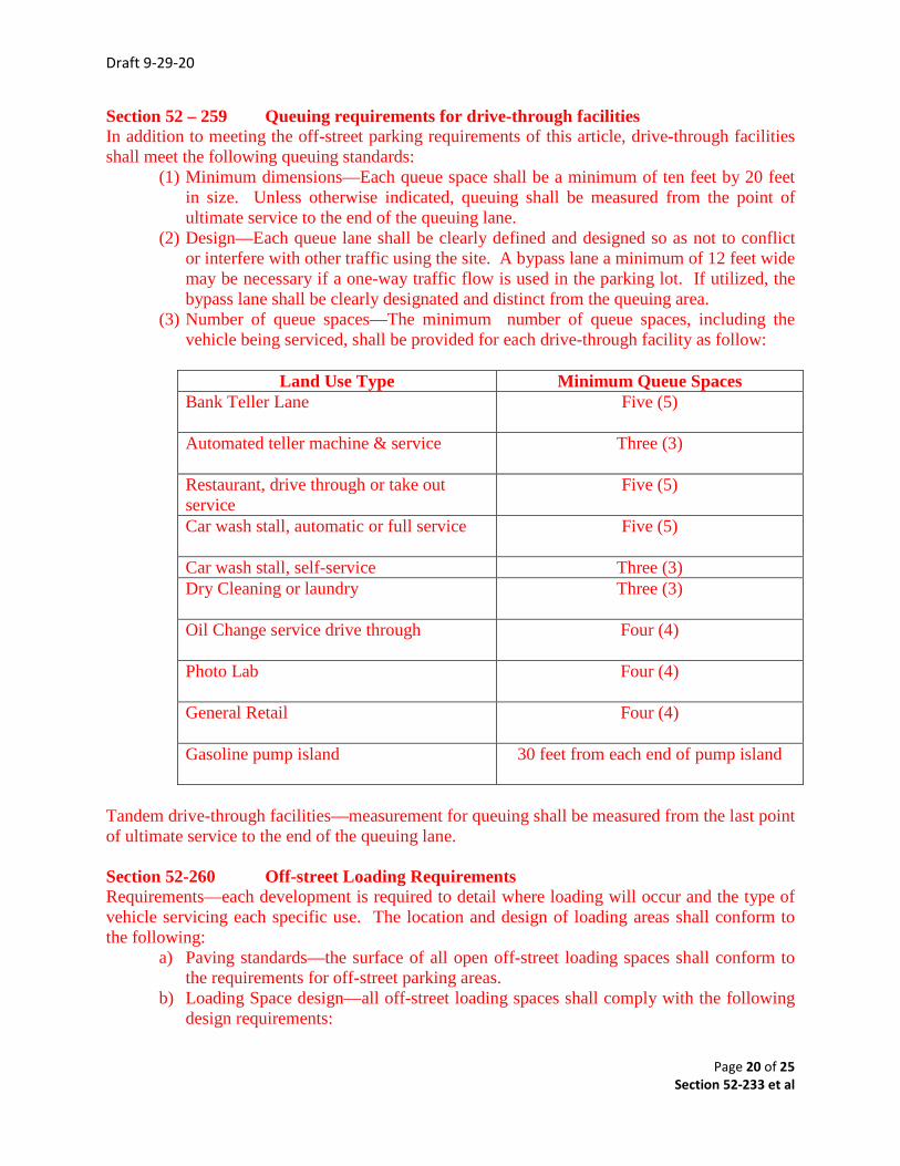
Section 52 – 259 Queuing requirements for drive-through facilities In addition to meeting the off-street parking requirements of this article, drive-through facilities shall meet the following queuing standards:
(1) Minimum dimensions—Each queue space shall be a minimum of ten feet by 20 feetin size. Unless otherwise indicated, queuing shall be measured from the point ofultimate service to the end of the queuing lane.
(2) Design—Each queue lane shall be clearly defined and designed so as not to conflictor interfere with other traffic using the site. A bypass lane a minimum of 12 feet widemay be necessary if a one-way traffic flow is used in the parking lot. If utilized, thebypass lane shall be clearly designated and distinct from the queuing area.
(3) Number of queue spaces—The minimum number of queue spaces, including thevehicle being serviced, shall be provided for each drive-through facility as follow:
Land Use Type Minimum Queue Spaces Bank Teller Lane Five (5)
Automated teller machine & service Three (3)
Restaurant, drive through or take out service
Five (5)
Car wash stall, automatic or full service Five (5)
Car wash stall, self-service Three (3) Dry Cleaning or laundry Three (3)
Oil Change service drive through Four (4)
Photo Lab Four (4)
General Retail Four (4)
Gasoline pump island 30 feet from each end of pump island
Tandem drive-through facilities—measurement for queuing shall be measured from the last point of ultimate service to the end of the queuing lane.
Section 52-260 Off-street Loading Requirements Requirements—each development is required to detail where loading will occur and the type of vehicle servicing each specific use. The location and design of loading areas shall conform to the following:
a) Paving standards—the surface of all open off-street loading spaces shall conform tothe requirements for off-street parking areas.
b) Loading Space design—all off-street loading spaces shall comply with the followingdesign requirements:
Draft 9-29-20
Page 21 of 25 Section 52-233 et al
1. No off-street loading space shall be located within the right-of-way of a public street. Any loading dock or door shall be set back far enough from the right-of-way so that no portion of the right-of-way is occupied by trucks or other vehicles while loading or unloading.
2. The location of the loading area shall not interfere with the free circulation of vehicles in the off-street parking area. Where loading areas are directly adjacent to or integrated with an off-street parking lot, the city engineer may require installation of physical barriers or other means of separating loading areas from parking areas and pedestrian traffic.
3. No loading space shall be located that results in blocking access by emergency vehicles.
c) Use of loading areas—Required off-street loading spaces and associated aisles and maneuvering areas shall be used for vehicle loading only. No sales, storage, display of merchandise (including automobiles), repair work or dismantling shall be permitted in such areas.
Section 52 – 261 Landscaping standards and requirements Required parking and loading area shall also provide a Landscape Plan that complies with on-site landscaping requirements specified in the Zoning Code. Said landscape plan shall be approved by City Planning & Development Services Department as a part of plan review for permit issuance, reviews by Planning & Zoning Commission and/or City Council. Section 52-262 Perimeter or Boundary Landscaping In all office, commercial, and industrial zoning districts, perimeter or boundary landscaping shall be provided along the abutting public rights-of-way (except an alley). Trees shall be placed so as not to obstruct sight distances, or vehicular or pedestrian circulation. Increased landscaped area may be substituted for trees by increasing the landscaped area proportionate to the decrease in number of required trees. Perimeter or boundary landscaping shall be appropriate to the character of the site. The landscaped areas shall be sized to allow for proper maintenance. Parkway may be counted in meeting the minimum landscape requirements, except where documented plans propose an action that will involve or include the use of the parkway for widening of a street, placement of a sidewalk or installation of storm drainage. Landscaping within the parkway shall be executed in such a manner as to provide for bicycle and/or pedestrian passage.
Draft 9-29-20
Page 22 of 25 Section 52-233 et al
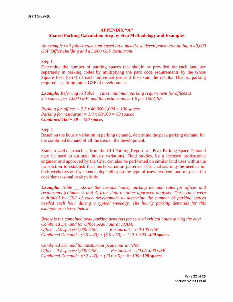
APPENDIX “A” Shared Parking Calculation Step by Step Methodology and Examples
An example will follow each step based on a mixed-use development containing a 40,000 GSF Office Building and a 5,000 GSF Restaurant.
Step 1. Determine the number of parking spaces that should be provided for each land use separately in parking codes by multiplying the park code requirements by the Gross Square Feet (GSF) of each individual use and then sum the results. That is, parking required = parking rate x GSF of development.
Example: Referring to Table __rates, minimum parking requirement for offices is 2.5 spaces per 1,000 GSF, and for restaurants is 1.0 per 100 GSF.
Parking for offices = 2.5 x 40,000/1,000 = 100 spaces Parking for restaurant = 1.0 x 50/100 = 50 spaces Combined 100 + 50 = 150 spaces
Step 2. Based on the hourly variation in parking demand, determine the peak parking demand for the combined demand of all the uses in the development.
Standardized data such as from the ULI Parking Report or a Peak Parking Space Demand may be used to estimate hourly variations. Field studies, by a licensed professional engineer and approved by the City, can also be performed on similar land uses within the jurisdiction to establish the hourly variation patterns. This analysis may be needed for both weekdays and weekends, depending on the type of uses involved, and may need to consider seasonal peak periods.
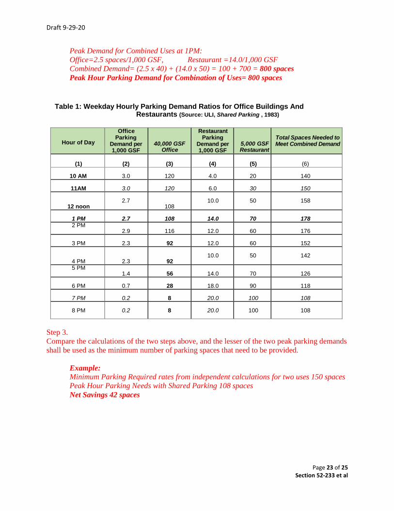
Example: Table __ shows the various hourly parking demand rates for offices and restaurants (columns 2 and 4) from data or other approved analysis. These rates were multiplied by GSF of each development to determine the number of parking spaces needed each hour during a typical weekday. The hourly parking demands for this example are shown below:
Below is the combined peak parking demands for several critical hours during the day: Combined Demand for Office peak hour at 11AM: Office= 3.0 spaces/1,000 GSF, Restaurant = 6.0/100 GSF Combined Demand= (3.0 x 40) + (6.0 x 50) = 120 + 300=420 spaces
Combined Demand for Restaurant peak hour at 7PM: Office= 0.2 spaces/1,000 GSF, Restaurant = 20.0/1,000 GSF Combined Demand= (0.2 x 40) + (20.0 x 5) = 8+100=108 spaces
Draft 9-29-20
Page 23 of 25 Section 52-233 et al
Peak Demand for Combined Uses at 1PM: Office=2.5 spaces/1,000 GSF, Restaurant =14.0/1,000 GSF Combined Demand= (2.5 x 40) + (14.0 x 50) = 100 + 700 = 800 spaces Peak Hour Parking Demand for Combination of Uses= 800 spaces
Table 1: Weekday Hourly Parking Demand Ratios for Office Buildings And Restaurants (Source: ULI, Shared Parking , 1983)
Hour of Day
Office Parking
Demand per 1,000 GSF
40,000 GSF Office
Restaurant Parking
Demand per 1,000 GSF
5,000 GSF Restaurant
Total Spaces Needed to Meet Combined Demand
(1)
(2)
(3)
(4)
(5)
(6)
10 AM
3.0
120
4.0
20
140
11AM
3.0
120
6.0
30
150
12 noon
2.7
108
10.0
50
158
1 PM
2.7
108
14.0
70
178
2 PM 2.9
116
12.0
60
176
3 PM
2.3
92
12.0
60
152
4 PM
2.3
92
10.0
50
142
5 PM 1.4
56
14.0
70
126
6 PM
0.7
28
18.0
90
118
7 PM
0.2
8
20.0
100
108
8 PM
0.2
8
20.0
100
108
Step 3. Compare the calculations of the two steps above, and the lesser of the two peak parking demands shall be used as the minimum number of parking spaces that need to be provided. Example: Minimum Parking Required rates from independent calculations for two uses 150 spaces Peak Hour Parking Needs with Shared Parking 108 spaces Net Savings 42 spaces

Draft 9-29-20
Page 24 of 25 Section 52-233 et al
Shared parking Calculation Methodology and Guide
Shared parking may be used as a means of satisfying otherwise applicable off-street parking requirements where all of the following standards have been met:
1. Ineligible Parking—Shared parking may not be used to satisfy the off-street parking standards for residential uses.
2. Location—Shared parking spaces must be located within 600 feet of the primary entrance
of all uses served. Uses within the Old Town Overlay District shall be within 1,000 feet. The method of measurement is provided in __________, Measurements and Exceptions.
3. Shared Parking Analysis
A shared parking analysis shall be submitted that clearly demonstrates the feasibility of shared parking. The analysis shall address, at a minimum, the size and type of the development, the composition of uses, the anticipated rate of parking turnover and the anticipated peak parking and traffic loads for all uses that will be sharing off-street parking spaces. The procedures for determining shared parking requirements shall be as follows: • Determine the minimum amount of parking required for each separate use as
described in Section____. • Multiply the parking requirement for each use by the corresponding percentage for
each of the time periods in Table 3-1. a) Sum the total parking requirements for all uses for each of the time periods in
Table 3-1. b) The parking requirement for the time period having the largest required total
number of parking spaces shall be the minimum required number of parking spaces.
(Tables 3.1 and 3.2--on Next Page)
Draft 9-29-20
Page 25 of 25 Section 52-233 et al
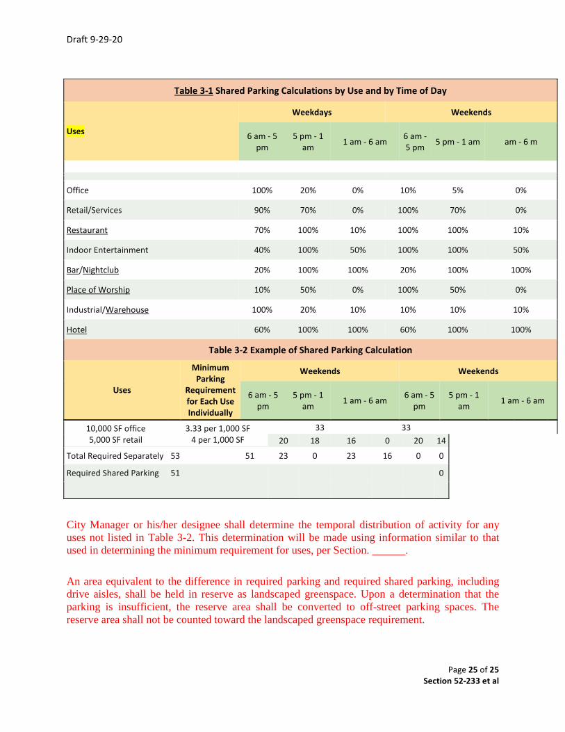
10,000 SF office 5,000 SF retail
3.33 per 1,000 SF 4 per 1,000 SF
33 33 20 18 16 0 20 14
Total Required Separately 53 51 23 0 23 16 0 0
Required Shared Parking 51 0
City Manager or his/her designee shall determine the temporal distribution of activity for any uses not listed in Table 3-2. This determination will be made using information similar to that used in determining the minimum requirement for uses, per Section. ______.
An area equivalent to the difference in required parking and required shared parking, including drive aisles, shall be held in reserve as landscaped greenspace. Upon a determination that the parking is insufficient, the reserve area shall be converted to off-street parking spaces. The reserve area shall not be counted toward the landscaped greenspace requirement.
Table 3-1 Shared Parking Calculations by Use and by Time of Day
Uses
Weekdays Weekends
6 am - 5 pm
5 pm - 1 am 1 am - 6 am 6 am -
5 pm 5 pm - 1 am am - 6 m
Office 100% 20% 0% 10% 5% 0%
Retail/Services 90% 70% 0% 100% 70% 0%
Restaurant 70% 100% 10% 100% 100% 10%
Indoor Entertainment 40% 100% 50% 100% 100% 50%
Bar/Nightclub 20% 100% 100% 20% 100% 100%
Place of Worship 10% 50% 0% 100% 50% 0%
Industrial/Warehouse 100% 20% 10% 10% 10% 10%
Hotel 60% 100% 100% 60% 100% 100%
Table 3-2 Example of Shared Parking Calculation
Uses
Minimum Parking
Requirement for Each Use Individually
Weekends Weekends
6 am - 5 pm
5 pm - 1 am 1 am - 6 am 6 am - 5
pm 5 pm - 1
am 1 am - 6 am
City Council Meeting
May 24, 2021
Justin City Hall, 415 North College Street
City Council Cover Sheet
Agenda Item: #3 (Workshop) #15 (Public Hearing)
Title: Public Hearing to consider adopting regulations for Mobile Food Truck
Operations and Land Use.
Department: Planning and Development Services
Contact: Director, Darrell Gentry Recommendation:
Staff recommends City Council action to: Approve and adopt proposed regulations for Mobile Food Truck operations as presented. Give direction to City Attorney to prepare an adopting ordinance, if City Council approves the proposed regulations as presented or with added changes, to be brought back for adoption.
Background:
This item is conduct a workshop discussion and a Public Hearing to consider adopting new regulations for Mobile Food Truck operations and land use in the City.
This proposed regulation is in follow-up to City Council direction given in late 2019 to address the identified issues of: 1) Restructures SUP costs for a mobile food truck operation and,2) Clarifies regulations, requirements and definitions of mobile food trucks,3) Updates the permit review procedures for mobile food truck operations.
The Planning & Zoning Commission has previously conducted a series of study sessions and received public input from local restaurants as well as others. The Commission unanimously recommended that the proposed regulations be approved and adopted by the City Council in mid spring 2020. There were delays in considering these proposed changes to City regulations due to the onset of COVID health protocols and other administrative changes.
STATE LAW: State law related to mobile food trucks includes regulations: a) Annual and periodic inspectionsb) Daily cleaning of mobile food trucks or trailers away from location of
food sales
c) Sanitation facilities, restrooms and hand washingd) Trash and waste collection, including solids and liquidse) Use and identification of commissary kitchens for food preparationf) Compliance with building code requirements, such as vented hoods
specifically for food trucksg) Annual renewal of mobile food truck permit.
JUSTIN ZONING: current Justin Zoning requirements related to mobile food trucks:
a) Obtain a SUP and pay processing fee of $1,085. Justin’s Schedule ofFees includes Plan Review, Fire Review and Engineering Review(Engineering has a 2 hour minimum cost at $250.00/hour).
b) Obtain and renew an Annual Food Establishment license to operate at$200.00 annually.
c) Obtain and renew an Annual Health Permit at a cost of $200.00.The proposed regulations would create 4 tiers of allowable mobile food truck operations in the City. The 4-tier structure would replace the existing regulations that specifies all mobile food trucks obtain an SUP that is processed as a public hearing item by P&Z Commission and City Council with an application fee of $1,085. In 2019, there was public testimony to City Council requesting the City to revisit its regulations and to reduce fee charges as may be appropriate. These proposed regulations are intended to replace the existing requirements and to allow for limited administrative reviews with lower associated fees.
The proposed regulations also have been reviewed by the City’s Health Inspector for consistence with State Health regulations. Input received has been incorporated into the Draft Mobile Food Truck regulations
If these regulations are approved, then a revision to the Schedule of Uses and Master Fee Schedule would be necessary. Staff will schedule these revisions as future agenda items assuming the proposed changes are approved.
Proposed Mobile Food Truck Regulations in Summary: • Amends Chapter 12, Section 12.313 of City’s Code of Ordinances.• Provides for 4 Classifications of mobile food trucks:
Class I-Special Events allowed in any zoning district of the City, lasting no more than 4 days with the issuance of an administrative special use permit with reduced fees.
Class II-Seasonal allowed at only specific sites locations, lasting up to 6 months or less with an administrative special use permit and reduced fees. Class III-Yearly allowed at specific site locations, lasting more than 6 months but no more than 1 year with a public hearing SUP and a $1,085 fee. Class IV—In Town Restaurants allowed at specific site locations, lasting a year or more with a public hearing SUP and a $1,085 fee.
If the Draft regulations are approved as presented or with added changes, then the City Attorney should be directed to prepare an adopting ordinance for Council action at next scheduled regular meeting. ___________________________________________________________________ City Attorney Review: Proposed regulations have been reviewed by City Attorney and all changes have been incorporated in the proposed draft regulations attached. ________________________________________________________________________
Attachments: 1) Draft Mobile Food Truck Regulations with existing requirements—May 24, 2021
Page 1 of 8 May 24 2021
Section 12.313 is amended as follows: TO BE DELETED Sec. 12-313. - Mobile food units. (a) Display of permit. The mobile food unit permit sticker for a mobile food unit shall be displayed on the
upper left rear area of the vehicle in a conspicuous location. If such location is not practicable, the permit shall be located in a location approved by the director.
(b) Mobile barbecue trailers. Mobile barbecue trailer cooking surfaces shall be tightly enclosed and constructed in such a way as to protect all food contact surfaces from possible contamination both in transit and during use. Mobile barbecue trailers shall be used in conjunction with an approved and permitted commissary and mobile food unit.
(c) Commissary. All mobile food units handling open potentially hazardous foods, catering units and pushcarts shall operate from a commissary, or other fixed food service establishment that is regularly inspected by a regulatory health agency.
(d) Servicing area. All mobile food units handling open foods, catering units, and pushcarts shall have a servicing area, which shall have overhead protection, a location(s) for draining and flushing liquid wastes and a location(s) for the loading and unloading of food and related supplies.
(e) Servicing area operation.
(1) All liquid waste containers shall be thoroughly flushed and drained daily during servicing operations.
(2) Flushing and draining activities shall be conducted in the servicing area. No flushing or draining of liquid waste shall be permitted on public streets or in any other area other than the servicing area.
(f) Waste retention.
(1) All liquid waste shall be stored in a retention tank that shall have a minimum capacity of 7.5 gallons or that is at least 15 percent larger in capacity than the fresh water supply tank, whichever is greater.
(2) Solid waste shall be contained in an easily cleanable, self-closing, lidded trash receptacle, which shall be kept on or near the mobile unit at all times.
(g) Water system. All mobile food units handling open potentially hazardous foods shall provide not less than 15 gallons of water under pressure (including gravity flow) at all times for use in utensil cleaning, sanitizing and hand washing. A single water inlet shall be located so as not to be contaminated by waste discharge. Such inlet shall be capped at all times except when being filled, and shall contain only potable water. Connection or direct hook-up to water sources other than those on the mobile unit are prohibited unless approved by the director.
(h) Temporary events. Mobile food units and caterers may operate at temporary events by possessing a valid mobile food unit permit or by obtaining a temporary food establishment permit and meeting the requirements of a temporary food service establishment as described in this article.
(i) Violation. The owner or operator of a mobile food unit commits an offense if the mobile food unit is operated in violation of any provision of this section.
Sec. 12-313. – Mobile Food Units PROPOSED AMENDMENT
Definitions
The following words, terms and phrases, when used in section 12-313, shall have the meanings ascribed to them in this section, except where the context clearly indicates a different meaning:
Approved source. Any facility where food is prepared, handled or stored which complies with all laws relating to food and food labeling.
Page 2 of 8 May 24 2021
Certified food manager means any person who has attended a certified food manager's class approved by the state department of health and who possesses a current food manager's certificate.
Commissary also known as a central preparation facility; base of operations; or premises from which a mobile unit operates. A commissary shall be used as a base of operations for all classes of mobile food Units. A commissary is a site approved by the City Health Department at which food preparation, storage and cleaning or servicing of the vehicle occurs. State law prohibits the use of a private residence as a central preparation facility or warehouse.
Employee means the permit holder, person in charge, person having supervisory or management duties, person on the payroll, family member, volunteer, person performing work under contractual agreement, or other person working in a food establishment.
Food means any raw, cooked, or processed edible substance, ice, beverage, or ingredient used or intended for use or for sale in whole or in part for human consumption.
Food establishment a food establishment means an operation that stores, prepares, packages, serves, vends, or otherwise provides food for human consumption as follows:
(A) a restaurant, retail food store, satellite or catered feeding location, catering operation if theoperation provides food directly to a consumer or to a conveyance used to transport people, market,vending location, (machine), self-service food market, conveyance used to transport people,institution, or food bank;
(B) an establishment that relinquishes possession of food to a consumer directly, or indirectlythrough a delivery service such as home delivery of grocery orders or restaurant takeout orders, ordelivery service that is provided by common carriers; and
(C) includes an element of the operation such as a transportation vehicle or a central preparationfacility that supplies a vending location or satellite feeding location unless the vending or feedinglocation is permitted by the regulatory authority and an operation that is conducted in a mobile,stationary, temporary, or permanent facility or location; where consumption is on or off thepremises; and regardless of whether there is a charge for the food.
(D) food establishment does not include an establishment that offers only prepackaged foods thatare not time / temperature controlled for safety food, a produce stand that only offers whole, uncutfresh fruits and vegetables, a food processing plant, a cottage food industry, an area where cottagefood is prepared, sold or offered for human consumption, a Bed and Breakfast Limited facility asdefined in this chapter, or a private home that receives catered or home-delivered food.
Food handler means an individual working with unpackaged food, food equipment or utensils, or food-contact surfaces.
Health department means the health department or individual designated by contract with the city to provide permitting and inspection services for food service establishments.
Mobile food unit vehicle mounted, self or otherwise propelled, self-contained food service operation, designed to be readily movable (including, but not limited to catering trucks, trailers, push carts, and roadside vendors) and used to store, prepare, display, serve or sell food. Mobile units must completely retain their mobility at all times. A roadside food vendor is classified as a MFU.
Packaged. Bottled, canned, cartooned, bagged, or wrapped, whether in a food establishment or in a food processing plant. Does not include wrapped or placed in a carry-out container to protect the food during service or delivery to the consumer by a food employee upon consumer request.
Permit holder. The entity that is legally responsible for the operation of the food establishment such as the owner, the owner’s agent, or other person who possesses a valid permit to operate a food establishment. Can also be referred to as a license holder as per paragraph (77) of this section.
Page 3 of 8 May 24 2021
Person. Any individual, partnership, association, corporation, corporation, firm, club, trustee, receiver, and body politic and corporate.
Regulatory authority. Any municipal officer or department of the city appointed by the City Manager to administer this article.
Sanitizer means any chlorine, iodine, quaternary ammonium compound or other chemical sanitizing agent used at temperatures, pHs and concentrations in accordance with the EPA-approved manufacturer's use label and approved by the state board of health.
Sanitary facilities. Toilet or restroom facilities, which discharge the sewage effluent and wastewater into an approved holding tank, on-site sewage disposal system, or municipal sanitary system.
Servicing area means a designated area provided for the supplying, cleaning or serving of mobile units.
Single-service articles means cups, containers, lids, closures, plates, knives, forks, spoons, stirrers, paddles, straws, napkins, wrapping materials, toothpicks, and similar articles intended for one-time, one-person use and then discarded.
Special event. A temporary gathering including but not limited to a party, a festival, a sporting event, a fundraiser, a musical performance, an amusement exhibition or any other exhibition of artistry, goods, services, sales or a combination of events.
Stationary food unit. A self-contained cart, or trailer mounted on wheels designed to be readily movable. The unit remains in a fixed position during food preparation and its hours of operation at the same location throughout the year. Also known as Class II.
Temporary food service establishment means a food establishment that operates at a fixed location for not more than 14 consecutive days in conjunction with a single event or celebration.
Trash Receptacle means a self-closing lidded container and waste handling unit for refuse, recyclable and returnable used with materials containing food residue and used outside the food establishment shall be designed and constructed to have a tight-fitting lids, doors or covers. Used to minimize insect and rodent attraction.
Utensil means any implement used in the storage, preparation, transportation, or service of food.
Mobile Food Units are subject to the following regulations: a) Compliance Required
It shall be unlawful for any mobile food unit to sell, offer or exhibit, for the purpose of taking orders for sale thereof, any food, food product or food additive at any location within the city without first having complied with the provisions of this section.
b) Types of Mobile Food Unit Permits Allowed and Specific Use Permit Requirements 1, Class I - Special Event – Defined as a commercially manufactured, motorized or stationary mobile food unit in which pre-prepared and ready-to-eat-food is cooked, wrapped, packaged, processed, or portioned for service, sale, or distribution. Temporary Mobile Food Unit Permit that is in conjunction with a special event not lasting more than four (4) days and may be located in any City Zoning District.
2. Class II – Seasonal - Defined as a commercially manufactured, motorized or stationary mobile food unit in which ready-to-eat-food is cooked, wrapped, packaged, processed, or portioned for service, sale, or distribution. Permit shall expire at six (6) months.

Page 4 of 8 May 24 2021
Class III - Yearly– Defined as a commercially manufactured, motorized or stationary mobile food unit in which ready-to-eat-food is cooked, wrapped, packaged, processed, or portioned for service, sale, or distribution. Permit shall expire at end of one (1) year.
3. Class IV In-Town Restaurant- Defined as a commercially manufactured, motorized or stationary mobile food unit of a current food establishment with a valid City of Justin Health Permit in which ready-to-eat-food is cooked, wrapped, packaged, processed, or portioned for service, sale, or distribution. This permit allows food establishments within the city to expand their current operations to a mobile unit. Class IV must be registered under the food establishment’s name and must use the food establishment as the commissary.
Location: a. All Class II mobile food units must be located on a parcel within the following zoning districts
when applying for a Specific Use Permit: or the following Zoning District when a SUP is granted for operating.
i. Light Retail ii. General Business iii. Light Industrial
b. All Mobile Food Units shall comply with applicable regulations of 25 TFER Section 228 et al, and applicable City of Justin Building Code requirements pertaining to mobile food units.
c. Mobile food units shall be located on an individual private parcel, where an existing permanent business operates in a building with a certificate of occupancy.
d. Mobile food units shall provide the city with a copy of written permission from the property owner on an annual basis to allow the operation of a mobile food unit and to allow the mobile food unit and their customers’ access to sanitary facilities on-site.
e. A mobile food unit shall submit a site plan depicting the location of the mobile food unit on the property; shall secure or provide a current mobile food unit permit; and supply food handler cards from Denton or Tarrant County, with copies given to the city.
f. Mobile food units shall be located within 500 feet of an entrance of a primary building that holds the certificate of occupancy.
g. No mobile food units shall be located on a vacant lot. WITHOUT PROPERTY OWNER WRITTEN CONSENT PRIOR TO PERMIT ISSUANCE
h. No mobile food units, their merchandise, advertising, or seating shall obscure traffic sight visibility.
i. No mobile food units operating under this regulation shall be allowed to sell or service food on any public street, sidewalk, or other public right-of-way unless approved in writing by the city.
j. Mobile food units shall not operate in driveways or fire lanes. k. Mobile food units, including any applicable seating, may operate in parking spaces in a non-
residential zoned individual property, parcel, tract or platted lot, if the required parking for the center remains in compliance with the parking code located in the city ordinance Section 52-233, subject to obtaining a specific use permit prior to commencement. A site plan indicating the specific location is required.
l. Mobile food units shall be removed from the parcel on a daily basis and may only operate during the business hours of the primary business and may not be parked longer than 12 hours.
Use of Streets a. No vendor shall have any exclusive right to any location in the public streets nor shall any
be permitted at a stationary location.
Page 5 of 8 May 24 2021
b. No vendor shall be permitted to operate in any congested areas where their operations might impede or inconvenience the public. For the purpose of this section, the judgment of an enforcement officer, exercised in good faith, shall be deemed conclusive as to whether the area is congested or the public impeded or inconvenienced.
c. As an exception, Class I and Class II Mobile Food units shall be allowed to establish location on private property upon compliance with the following:
i. Written permission is obtained from the private property owner for the establishment of the stationary location and this permission authorizes utilization of the on-site restroom facilities for the employees of the mobile food unit. This permission shall be submitted to the regulatory authority prior to initiation of such activity.
ii. The mobile food unit shall only be allowed on the premises from 7:00 a.m. until 7:00 p.m. or, if the private property is a business, during the business's regular hours of operation.
iii. The mobile food unit shall be required to return to a commissary for daily cleaning and maintenance as required by this section and 25 TFER Section 228 et al.
iv. This exception shall apply to property zoned as light retail, general business, and light industrial, as designated by the city's zoning ordinance. This exception may also apply to private property located in any other zoning district if authorized by Planning and Zoning Commission and City Council on a case-by-case basis.
Motorized or Stationary Application Class I, Class II, and Class III Under this section the applicant must submit an application with the regulatory authority at least seventy-two (72) hours before vending activities begin. An application shall contain the following information: 1. Name, date of birth, and driver's license number of the applicant; 2. Applicant's permanent address (both physical and mailing addresses) and telephone
number; 3. If the applicant is an employee or agent of the company, the name, address and
telephone number of this company; 4. The number of the limited sales tax permit issued to the business by the state
comptroller's office; 5. Name, address, telephone number, driver’s license, and date of birth of all persons
having use of the vending vehicle; 6. A description of the vending vehicle which will be used under this permit. This
information shall include the manufacturer, model year, color and vehicle identification number; License plate number
7. Any other information required by the regulatory authority.
In addition to the application form, the applicant must provide a letter signed by the operator of the commissary stating that the applicant has access to commissary facilities for all food and utensil storage, cleaning and maintenance activities.
Motorized or Stationary Application – Class II a. Any person operating a Motorized or stationary food unit must comply with the following:
i. The application shall include a signed commissary agreement. ii. A written permission from the property owner to use property and restrooms must
be obtained and submitted with the application. iii. The unit must be made of stainless steel, anodized aluminum, or fiberglass
reinforced plastic. No wood or any other absorbent materials are allowed. iv. The unit must be mounted on wheels, non-motorized, and easily movable. v. The bottom of the unit must be at least six (6) inches from the ground
Page 6 of 8 May 24 2021
vi. The unit must have the following accessories:1. Internal tank with potable water;2. Internal tank for wastewater;3. A handwashing sink;4. Liquid soap and paper towels;5. Hot holding compartment to maintain hot foods hot and proper venting;6. Cooling compartment to maintain cold foods cold.
b. Mobile unit must be removed at the end of each day and washed, sanitized, and stored atthe commissary
i. Unit must operate within fifty (50) feet of an entrance of a primary building thatholds a certificate of occupancy.
ii. Mobile vendors may operate only during the normal business hours of the primarybusiness on the property.
iii. Mobile food vendor may not operate from parking spaces, driveways, fire lanes, orpublic roads.
iv. A drive-through is not permitted.v. Mobile vendors shall be set back a minimum of one hundred (100) feet from main
roads or streets.vi. No bare-hands contact is permitted. Gloves and hair restraint must be worn at all
times.vii. Only single service articles are to be used.viii. Stem-type food thermometers must be available to check for internal food
temperatures.ix. Cutting, slicing, chopping, etc., of fruits or vegetables is not permitted.x. If used, ice must be drained into a retention tank to be properly disposed of at the
commissary.xi. Unit must display the business name and permit on both sides in at least three-
inch lettersVehicle
All mobile food units shall have a valid vehicle registration, motor vehicle operator's license, proof of vehicle liability insurance, and a Texas Sales Tax Permit.
Mobile Unit Operations c. The owner or operator of a mobile food unit which handles open food shall make certain
that at least one certified food manager is on duty during all hours of operation.d. A drive-through is not permitted in conjunction with the mobile food unit and shall not
provide a drive-through service of any kind.e. All mobile food units shall be equipped with a self-closing lidded, trash receptacle. The
trash receptacle must be placed outside next to the mobile food units for use by the patronsof the unit. The area around the mobile food units shall be kept clean and free from litter,garbage, debris, and food waste
f. Temporary connections to potable water are prohibited. Water shall be from an internaltank, and electricity shall be from a generator or an electrical outlet via a portable cord thatis in conformance with the Electrical Code as adopted by the City of Justin.
g. Except as otherwise limited by the City of Justin Code of Ordinances, or other city codes,a mobile food unit may utilize outside seating consisting of a portable table and a seatingcapacity of not to exceed four.
h. Except as otherwise limited by city codes, a mobile food unit shall be allowed amplifiedmusic as long as such music shall not violate the nuisance definitions of noise establishedby section 28-29 of the Justin Code of Ordinances.
i. All foods shall be from an approved sourcej. Cooking shall not be conducted while the vehicle is in motion.
Page 7 of 8 May 24 2021
k. If wanting to serve alcoholic beverages, a mobile food vendor shall follow all necessary Texas Alcoholic Beverage Commission and the City of Justin requirements.
l. A hold-harmless agreement is required to be completed with the City of Justin if the mobile food unit is to be located on City of Justin property.
Issuance of all Class I and Class II mobile food permit holders
m. Upon completion and presentation of the application, the regulatory authority shall issue a permit in the form of a sticker, which shall be affixed to the vending vehicle in a location to be determined by the regulatory authority. Permits shall be valid for one (1) year from the date of issue. Permits are nontransferable and shall not be prorated.
n. Each person who works under this permit shall be issued an identification badge which must be worn by the vendor in a place where it is visible by the general public at all times while vending. The identification badge will be issued unless grounds for denial exist under section 12-313(n) of this article. Such identification badge shall contain the signature of the issuing officer and shall show the vendor's name, address, and vending vehicle(s) to which the vendor is authorized to use thereunder. The regulatory authority shall keep a permanent record of all identification badges issued.
Expiration of Mobile Food Unit Permits
o. Class I: Unless otherwise specified, Mobile Food Unit Permits and Identification badges issued under the provisions of this section shall expire six (6) months from the date of issuance.
p. Class II: Unless otherwise specified, Mobile Food Unit Permits and Identification badges issued under the provisions of this section shall expire one (1) year from the date of issuance.
q. Class III: Permit shall expire four (4) days from date of issuance r. Class IV: Unless otherwise specified, Mobile Food Unit Permits and Identification badges
issued under the provisions of this section shall expire at the end of the year, December 31, or when the parent food establishment location has their health inspection revoked.
Transfer
s. No permit issued under the provisions of this article shall be transferred or assigned. i. A person commits an offense if he/she alters or uses the identification badge of
any other person. ii. A person commits an offense if he/she allows another person to use such
identification badge. Exhibiting identification
Mobile vendors are required to exhibit their identification badge and/or permit at the request of an authorized officer of the city or any citizen. Identification badges shall be worn on their person in public view at all times while vending.
Fees
The Mobile Food Unit permit fee shall be located on the City of Justin’s Fee Schedule as established and as approved by resolution of the City Council.
Records
t. The regulatory authority shall maintain a record for each vehicle's vending permit and all badge permit issued and record of reports of violation therein.

Page 8 of 8 May 24 2021
Denial of permit u. The regulatory authority may deny or suspend a Mobile Food Unit permit for failure to
comply with any provisions of this section.v. The regulatory authority shall make a notification of denial within forty-eight (48) hours from
receipt of the application via email, phone call or written letter.
Suspension of permit. w. Refer to Section 12-217
Revocation of permit x. Refer to Section 12-219
Appeal Any applicant aggrieved by the action of the regulatory authority with reference to the revocation of a permit shall have the right to appeal to the City Council. Such appeal shall be taken by filing with the City Secretary, within fourteen (14) days after notice of the action complained of has been mailed to such person's address given in the application, a written statement setting forth fully the grounds for the appeal.
The time and place for a hearing on such appeal and notice of such hearing shall be given to the appellant. The decision of the City Council on such appeal shall be final and conclusive.
Exemptions The provisions of this section shall not be held applicable to vendors of farm produce, poultry, stock or agricultural products in their natural state if raised on land owned or leased by the vendor, and if such products are sold at the site where the items are grown or raised by any member of such owner's or lessee's household.
Fines for violations; remedies y. Refer to Section 12-220
Page 1 of 2
City Council Meeting
May 24, 2021
Justin City Hall, 415 North College Street
City Council Cover Sheet
Agenda Item: #4 (Workshop) #16 (Public Hearing)
Title: Continued Public Hearing to consider adopting an amendment to the City Sign Ordinance, Chapter 36.
Department: Planning & Development Services
Contact: Darrell W. Gentry, Director
Recommendation: Staff recommends adopting the amendment to the City Sign Ordinance Ch. 36 to include a comprehensive revision to signage regulation and add standards for use of electronic messaging center signs.
City Attorney should be directed to prepare the adopted ordinance form and bring back for City Council approval at next regularly scheduled meeting.
Background: City Council called for a Public Hearing at the March 29, 2021 Council meeting after the Planning and Zoning Commission completed its comprehensive review, and on April 26, 2021 continued the hearing to May 24, 2021.
In prior City Council discussions about the Draft Sign Ordinance, Council asked that a variance procedure be added to the Sign Ordinance regulations. Staff has prepared a variance provision that uses the Board of Adjustment hearing and procedures for considering a proposed or requested sign variance.
This Board of Adjustment hearing and procedure process is spelled out in existing City Code of Ordinances as Chapter 52, Division 3, Sections 52-369 et al. These requirements specified a public hearing by the Board, which is the City Council performing the duties of the Board on variance request and application. Public Hearing notifications are required by City Ordinance. The processing fees, per adopted Schedule of Fees is $750 for non-residential variance applications.
The Draft Sign Ordinance would provide a reference that any request for a sign ordinance variance be subject to Chapter 52, Division 3, Sections 52-369 et al of the City Code of Ordinances.
Page 2 of 2
Section 36-23 of the proposed Draft Ordinance spells out a variance procedure for signs.
____________________________________________________________________ City Attorney Review:
City Attorney has reviewed the proposed draft Sign Ordinance and inputs have been incorporated into the draft document. ________________________________________________________________________
Attachments: Draft City Sign Ordinance including proposed electronic messaging center sign regulations.
Page 1 of 34
EXHIBIT “A” Chapter 36 – SIGN REGULATIONS
Rev #2 Date – 8-31-20Sec. 36.01 - Purpose and intent. (a) The purpose and intent is to:
1) Promote the creation of an attractive visual environment that aids a healthy economyby regulating, control andcontrolling and administering, without reference to content, the use of signs within the boundaries of the city and within the city's extraterritorial jurisdiction as allowed by law, and;
2) Provide for the safety and well-being of the city's citizens by permitting businesses toinform, identify and communicate effectivelyproviding safe and aesthetically pleasing signage without causing undue hardship or burden on businesses.
3) Direct the public and businesses through the use of signs while maintaining attractiveand harmonious application of signs on buildings and on properties.
4) Protect and enhance the physical appearance of the community in a lawful manner that recognizes the rights of property owners through orderly sign placement, appropriate design, scale and location of signs.
5) Avoids inflexible regulations that results in monotonous uniformity.6) Fosters public safety by assuring that all signs are in appropriate locations.7) Establishes administrative review procedures that are the minimum to:
a) balance the community objectives and regulatory requirements;b) allow for consistent Sign Code enforcement;c) minimize sign application review time periods;d) provide flexibility as to the sign number, area, height and placement so the
regulations are responsive to business needs while maintaining community standards.
Sec. 36.02 – Applicability (a) All City ordinances adopted f o r by the City regulating the erection, structure, size
location, and placement of all signs and advertisements shall be and are hereby madeapplicable to all properties and land within the extraterritorial jurisdiction of theCity in addition to the corporate and territorial limits of the City. To the extentthat such regulations are applicable to outdoor signs, and the City does herebyextend the provisions of said outdoor sign regulatory ordinances to the City’s areaof extraterritorial jurisdiction.
(b) Any sign which was not lawfully existing at the time of adoption of this ordinanceshall not become or be made legal solely by adoption of this ordinance. Any sign oruse not specifically permitted is prohibited.
Sec. 36-03. - Definitions. For purposes of this Chapter, the following definitions shall apply unless the context clearly
indicates or requires a different meaning: Advertising sign or structure. See Sign. A-frame sign means a temporary sign which has two sides, the frame or support structure of
which is hinged or connected at the top of the sign in such a manner that the sign is easily moved and erected. This type of sign is also known as a sandwich sign.
Page 2 of 34
Alter means to change the size, shape, outlines, configuration, intent, location or type of sign. Animation means the presentation of pictorials or graphics in a progression of frames which
give the illusion of motion, including moving objects, moving patterns or bands of light, or expanding or contracting shapes.
Sign Area of a sign means the area within a series of straight lines around the outermost extremities of all text, symbols, graphics, advertising surfaces, framing, background and ornamentation, but not including sign poles or other supporting structures. If dimensions and a means of calculating the area of circular, oval-shaped or triangular signs are readily available, they may be used for such signs.
Awning means an architectural projection designed to provide weather protection, identification or decoration, and supported by the structure to which it is attached. An awning is comprised of a frame over which is placed a cover of fabric or other similar materials.
Back-lighting means the light source is behind the sign to illuminate the letters with a glowing effect.
Banner means a temporary sign composed of lightweight flexible material on which letters, symbols or pictures are painted or printed.
Billboard means an off-premises sign on which the message or copy can be changed periodically through manual means. A billboard sign is also known as an off-site advertising, non-digital messaging sign.
Billboard, electronic or digital, means an off-premise sign, display or device, internally illuminated, which changes the static message or copy by electronic means, remote or automatic, for outdoor advertising of a use, product or service. The sign must be operated by an entity possessing an outdoor advertising license issued by Texas Department of Transportation (TXDOT).
Bulletin board means a sign containing information where a portion of such information may be periodically changed, providing such change shall be effected by the replacement or interchange of letters, numbers or other graphic symbols by insertion, attachment, or similar means. Also known as a community bulletin board.
Building identification sign means a building identification sign which identifies the name of the building, but displays no goods or services for sale or advertising.
Building official means the Planning & Development Services Department of the City or the building official of the city or the building official's authorized representative.
Canopy means a roof-like structure that shelters a use such as, but not restricted to, a gasoline pump island, and which is supported by either one or more columns or by the building to which it is an accessory and open on two or more sides. An example of canopy includes those structures erected above a drive-thru facility.
Canopy sign means a sign that is permanently affixed to a canopy by paint, glue, sewing, or any other type of non-structural type of attachment.
Page 3 of 34
Changeable advertisements means a permanent on-site sign comprised of a fixed frame or pole sign holding a removable promotional placard or insert that advertises goods for sale or announcements of service.
City means the City of Justin, Texas, together with all its governing and operating bodies. City Council means the lawfully elected governing body of the city.
City Manager means the person holding the position of city manager, as appointed by the Ccity Ccouncil.
Construction sign means an on-premises sign which may be erected identifying any or all of the property owners, engineers, architects, mortgagees, or other participants in the construction or improvement of the premises; but which displays no goods or services for sale or other advertising. Also known as a contractor sign.
Dilapidated or deteriorated condition means: That condition as determined by the Planning & Development Services Department or any
appointed representative that the structural support is visibly bent, broken, dented or torn, or in the case of wood or similar products, splintered in such a way as to constitute an unsightly or harmful condition; or where the message or wording is faded or can no longer be clearly read; or where any part of the sign is not in compliance with the requirements of the building, electrical or other model codes currently adopted by the city; or where any part of the sign is not in compliance with the requirements of the building, electrical or other model codes currently adopted by the City; or where a sign or its elements are twisted or leaning or are at another angle other than those at which it was originally constructed (such as may result from being blown by the wind or from the failure of a structural support) as determined by the Planning & Development Services Department or building official or any officially appointed representative.
Directional sign means a sign which contains only information designed to direct pedestrian or vehicular traffic to the location of a facility on the property on which the sign is located. Such signs may include, but are not limited to, arrows, words, or logos. No goods or services for sale may be listed on a directional sign. Electronic message center (EMC) sign means an on-premises sign on which the message or copy can be changed by remote or automatic means, including EMC signs that display gas pricing. Erect means to build, construct, attach, hang, place, suspend or affix a sign, including the
painting of signs on the exterior surface of a building or structure or on the exterior or interior surface of a window.
Flag means a permanent sign made of fabric, bunting, or flexible material, containing distinctive colors, patterns, logos, wording or symbols used to signify or identify civic organizations, logos, schools, colleges or universities, or the government of the United States, the state, county or the city, and generally designed to be mounted on one end so as to move in the wind.
Page 4 of 34
Freestanding sign means a sign which is attached to or part of a completely self-supporting structure such as a frame of one or more poles which is not attached to any building or any other structure and which is permanently affixed to the ground.
Front means one side of a structure through which the majority of customers, patrons or visitors enter the structure.
Glare means an effect created when an illumination source shines with sufficient brightness to cause discomfort, distract attention, or lead to the reduction or loss of visibility or visual function of the public. Grand Opening signs means advertising or announcing a business’ Grand Opening shall be considered a temporary sign, subject to the regulations for temporary signage specified in this ordinance.
Illuminated sign means a sign which has characters, letters, figures, or designs internally illuminated by electric lights, luminous tubes or other means that are specifically placed to draw attention to, or to provide nighttime viewing of, the subject matter on the sign face.
Inflatable sign means a balloon or other device expanded or enlarged by the use of air or gas used as a sign or to support or display any sign.
Kiosk sign means a multi-sided, freestanding monument-type sign for the display of advertising for economic development purposes. Light pole banner sign means a temporary sign which is painted or printed on a strip of all-weather cloth, canvas, or other flexible material that is designed or manufactured for outdoor use mounted on a light pole on private property and secured to render sign stationary.
Logo means an identifying symbol used for advertising purposes, which may or may not be a registered trademark or service mark of the entity identified.
Lot means an individual parcel or tract of land recorded by a plat or deed in the office of the county clerk's office.
Lumen means the luminous flux emitted per unit solid angle from a uniform point source whose luminous intensity is one candela.
Marquee sign means a projecting sign attached to or hung from a marquee or canopy or covered structure projecting from and supported by a primary building, when such marquee, canopy or covered structure extends beyond the building, building line, or property line.
Menu board means a sign displaying the menu for drive-thru window service. Monument sign means a permanent sign with a display surface that is an integral part of the
support structure. Any ground sign exceeding four feet in height or any pole sign with less than nine feet of ground clearance or with a sign structure that is greater than two feet in width shall be considered a monument sign.
Municipality-owned sign means a sign which identifies a park, an entrance to the city, a place of interest within the city, a city sponsored event, or any city owned facility.
Page 5 of 34
Nonconforming sign means a sign, structure lawfully used as of the effective date of the ordinance from which this article is derived or amendments thereto, but which does not conform to the use regulations currently in effect.
Off-premises sign means a sign displaying advertising copy that pertains to a business, person, organization, activity, event, place, service, or product not principally located or primarily manufactured or sold on the premises on which the sign is located.
On-premises sign means a freestanding sign identifying or advertising a business, person, or activity, and installed and maintained on the same premises as the business, person or activity.
Parcel means a measured portion of a tract of land, which is described and fixed in a recorded plat. Also known as a lot.
Pennant means a temporary sign made of lightweight plastic, fabric or other material, which may or may not contain a message of any kind, suspended from a rope, wires or string, usually in a series and designed to move in the wind.
Permanent sign means a sign constructed of any ridged material, with or without frames, permanently attached to the ground or to a wall, building or other structure, and displayed for an indefinite period of time. The following signs are considered permanent signs: changeable signs, freestanding signs, monument signs, pole signs, and wall signs.
Pole sign means a permanent sign with a display surface that is attached to a self-supporting structure by one or two poles which has at least nine feet of ground clearance.
Political sign means a temporary sign that contains primarily a political message as specified by State of Texas law and regulation governing political campaigns and causes signage.
Portable sign means a temporary sign which is designed to permit removal and reuse, and which includes, but is not limited to, A-frame and other such signs, and signs mounted on a trailer, wheeled carrier, vehicle, or other portable structure.
Property line means the line denoting the limits of legal ownership of property. Public property means any real property open or dedicated to a public use or owned by the
City. Real estate sign means a temporary sign pertaining to the sale or lease of the premises, on
which the sign is located. Roof means those parts of a structure other than vertical walls that provide protection from the
elements. Roof sign means a sign that is painted on or erected upon or above the roof of the building. Scoreboard means a permanent sign that displays scores, results, identification of donors, or
other information pertinent to athletic activities. Searchlight means an apparatus on a swivel base that projects a strong, far reaching, beam of
light. Sign means an outdoor structure, sign, display, light device, figure, painting, drawing,
message, plaque, poster, billboard, or other thing that is designed, intended, or used to advertise or inform.
Page 6 of 34
Sign area means the entire area within a single continuous perimeter enclosing the actual message or display area of a sign, and shall include the border and trim, but excluding the sign structure, provided that no goods or services for sale or other advertising is displayed on the structure.
Sign face means that portion of the sign that is or can be used to identify, display, advertise or communicate information or for a visual representation which attracts or intends to attract the attention of the public for any purpose.
Sign height means the vertical distances between the highest point of the sign or its supporting structure and the natural grade directly below the sign.
Sign structure means any structure which is designed specifically for the purpose of supporting a sign, has supported or is capable of supporting a sign. The term "sign structure" includes any decorative covers, braces, wires, supports, or components attached to or placed around the sign structure. Where any goods or services for sale or other advertisement is displayed on the structure, then said structure shall be counted as part of the sign area.
Snipe sign means a sign that is tacked, nailed, posted, glued, or otherwise attached to trees, stakes, fences, utility poles ground or other like objects, the advertising matter of which is not applicable to the present use of the premises on which the sign is posted. Also known as bandit signs.
Spectacular sign means any sign that physically rotates, oscillates, contains any moving parts, or contains flashing lights in sequence.
Street frontage means the length of the property line of a lot or tract immediately adjacent to a public or private street, measured in feet.
Temporary sign means a sign not permanently affixed to the ground or to a building or other structure and shall include, but not limited to these types of temporary signage: Coming soon, grand opening, going out of business, portable, inflatable, and for sale and lease signs. Transition means a visual effect used on an electronic sign to change from one message to another.
Visibility Triangles means areas that are located at the intersection of streets and alley right-of-way and the intersection of streets and driveways and conforms to public open space easement (POSE) regulations and standards of the City.
Wall sign means a permanent sign placed on, or attached directly to a fence or building surface, including window areas (translucent areas which are visible from a street or alley, that extends not more than 15 inches from the face or wall of a building. Wind device sign means a banner, pennant, streamer, inflatable balloon or similar device made of cloth, canvas, plastic, or other similar flexible material, with or without a frame or other supporting structure, and used as a sign.
Window sign means a temporary sign placed on, affixed to, painted on or located within the frame of a transparent opening in the wall of a building that may not be larger 20 percent of the window opening.
Page 7 of 34
Sec. 36.04 Measurement Standards. 1. Wall signs.
(a) Wall sign(s) that are framed, outlined, painted or otherwise prepared and intended to provide a background for a sign display, the sign area and dimensions shall include the entire portion within such a background or frame.
(b) Wall signs comprised of individual letters, figures or elements on a wall or similar building or structure, the sign area and dimensions shall encompass a regular geometric shape (rectangle, circle, trapezoid, triangle, etc.), or combination of regular geometric shapes, which form or approximate, the perimeter of all elements in the display, the frame, and any applied background that is not a part of the building architecture. When separate elements are organized to form a single sign, but are separated by open space, the sign area and dimensions shall be calculated by determining the geometric form, or combination of forms, comprising all of the display areas, including the space between different elements. Minor appendages to a particular regular shape shall not be included in the total area of a sign.
2. Freestanding signs. (a) The sign area shall include the frame, if any, but shall not include:
1. A pole or other structural support unless such pole or structural support is internally illuminated or otherwise so designed to constitute a display device, or a part of a display device.
2. Architectural features that are either part of the building or part of a freestanding structure, and not an integral part of the sign, and which may consist of landscaping, building or structural forms complementing the site in general.
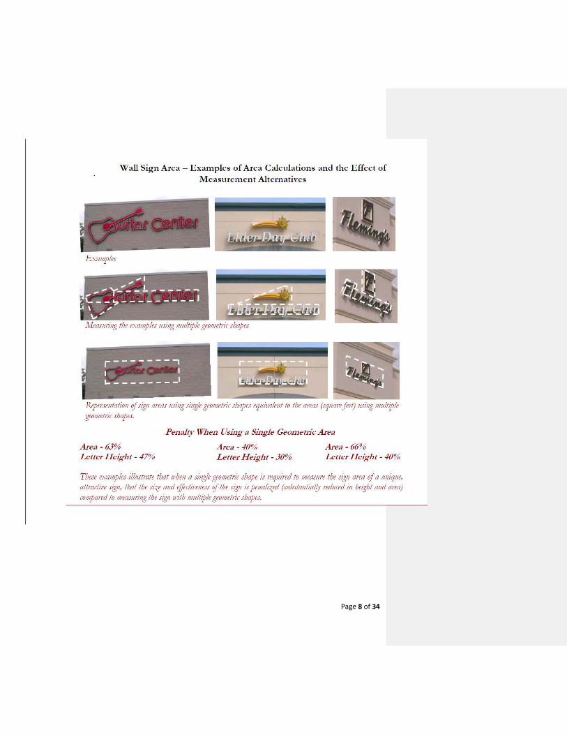
Page 8 of 34
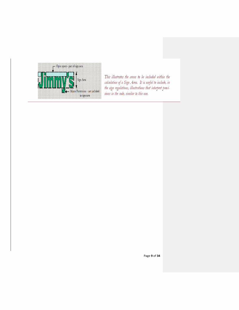
Page 9 of 34
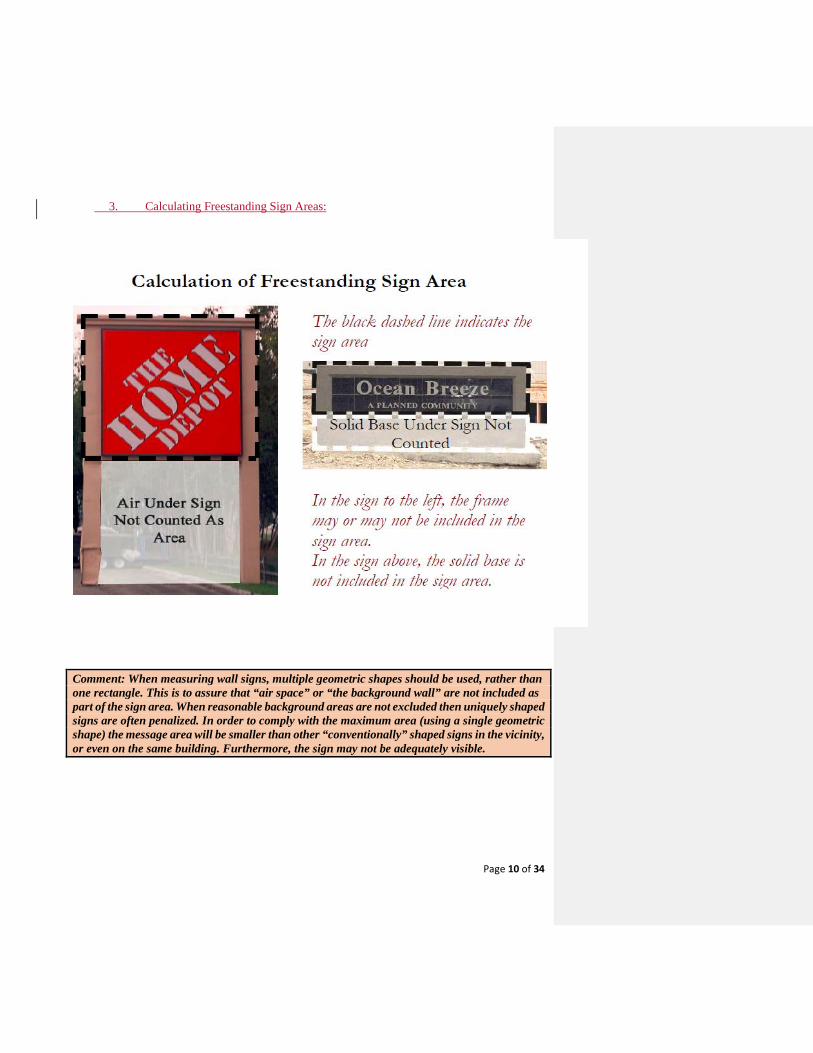
Page 10 of 34
3. Calculating Freestanding Sign Areas:
Comment: When measuring wall signs, multiple geometric shapes should be used, rather than one rectangle. This is to assure that “air space” or “the background wall” are not included as part of the sign area. When reasonable background areas are not excluded then uniquely shaped signs are often penalized. In order to comply with the maximum area (using a single geometric shape) the message area will be smaller than other “conventionally” shaped signs in the vicinity, or even on the same building. Furthermore, the sign may not be adequately visible.
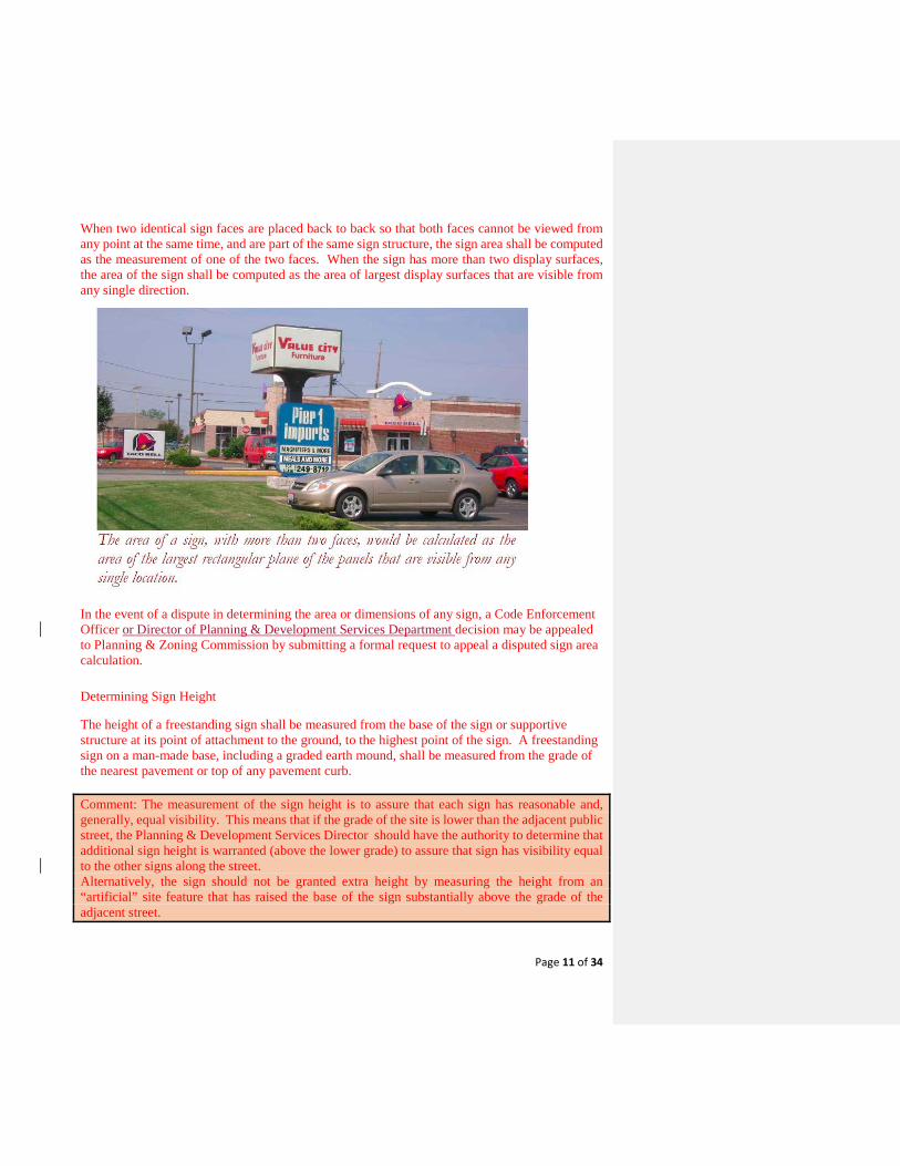
Page 11 of 34
When two identical sign faces are placed back to back so that both faces cannot be viewed from any point at the same time, and are part of the same sign structure, the sign area shall be computed as the measurement of one of the two faces. When the sign has more than two display surfaces, the area of the sign shall be computed as the area of largest display surfaces that are visible from any single direction.
In the event of a dispute in determining the area or dimensions of any sign, a Code Enforcement Officer or Director of Planning & Development Services Department decision may be appealed to Planning & Zoning Commission by submitting a formal request to appeal a disputed sign area calculation.
Determining Sign Height
The height of a freestanding sign shall be measured from the base of the sign or supportive structure at its point of attachment to the ground, to the highest point of the sign. A freestanding sign on a man-made base, including a graded earth mound, shall be measured from the grade of the nearest pavement or top of any pavement curb. Comment: The measurement of the sign height is to assure that each sign has reasonable and, generally, equal visibility. This means that if the grade of the site is lower than the adjacent public street, the Planning & Development Services Director should have the authority to determine that additional sign height is warranted (above the lower grade) to assure that sign has visibility equal to the other signs along the street. Alternatively, the sign should not be granted extra height by measuring the height from an “artificial” site feature that has raised the base of the sign substantially above the grade of the adjacent street.
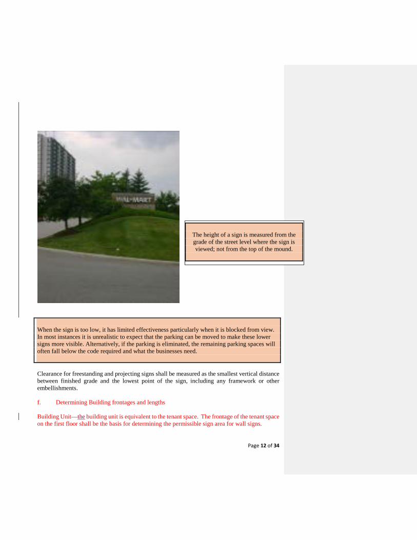
Page 12 of 34
When the sign is too low, it has limited effectiveness particularly when it is blocked from view. In most instances it is unrealistic to expect that the parking can be moved to make these lower signs more visible. Alternatively, if the parking is eliminated, the remaining parking spaces will often fall below the code required and what the businesses need. Clearance for freestanding and projecting signs shall be measured as the smallest vertical distance between finished grade and the lowest point of the sign, including any framework or other embellishments. f. Determining Building frontages and lengths Building Unit—the building unit is equivalent to the tenant space. The frontage of the tenant space on the first floor shall be the basis for determining the permissible sign area for wall signs.
The height of a sign is measured from the grade of the street level where the sign is viewed; not from the top of the mound.
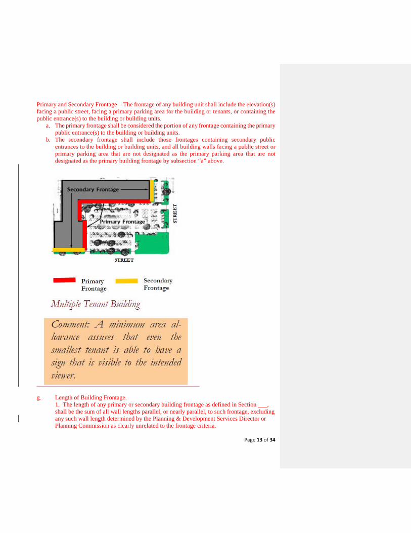
Page 13 of 34
Primary and Secondary Frontage—The frontage of any building unit shall include the elevation(s) facing a public street, facing a primary parking area for the building or tenants, or containing the public entrance(s) to the building or building units.
a. The primary frontage shall be considered the portion of any frontage containing the primary public entrance(s) to the building or building units.
b. The secondary frontage shall include those frontages containing secondary public entrances to the building or building units, and all building walls facing a public street or primary parking area that are not designated as the primary parking area that are not designated as the primary building frontage by subsection “a” above.
g. Length of Building Frontage. 1. The length of any primary or secondary building frontage as defined in Section ___, shall be the sum of all wall lengths parallel, or nearly parallel, to such frontage, excluding any such wall length determined by the Planning & Development Services Director or Planning Commission as clearly unrelated to the frontage criteria.
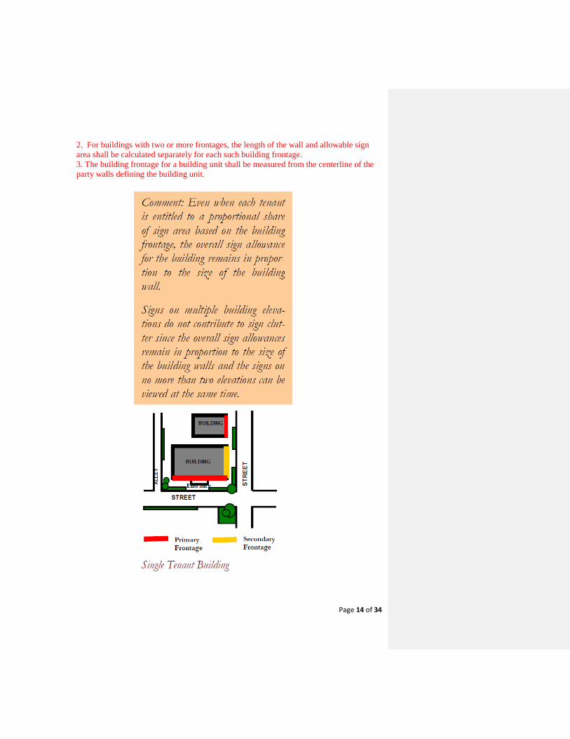
Page 14 of 34
2. For buildings with two or more frontages, the length of the wall and allowable sign area shall be calculated separately for each such building frontage. 3. The building frontage for a building unit shall be measured from the centerline of the party walls defining the building unit.
Page 15 of 34
Sec. 36-05. – Sign Permits and Permitted Signs. Application for sign permit. (a) An application for a sign permit shall be made in writing upon forms furnished by the
building department. Such application shall contain the location by street and number of the proposed sign structure as well as the name and address of the owner and the sign contractor or erector. The city manager or authorized representative may require the filing of plans drawn to scale, building materials or other pertinent information where such information is necessary to ensure compliance with the sign regulations. Four copies of colored plans at one-quarter-inch scale must be submitted along with the application for all permanent signs.
(b) Permit fees will be set by an appropriate fee resolution by the city council, and such permit are nonrefundable and nontransferable.
(c) The permit is valid for 60 days. If work authorized by a permit issued under this article has not been commenced within 60 days after the date of issuance, nor completed within 120 days after commencement of construction, the permit shall become null and void. If a permit expires by lapse of time, a new permit and fee shall be required before beginning, recommencing or completing the work.
Sec. 36-06. – Permit Revocation. (a) The City Manager or an appointed official may suspend or revoke any permit issued under
the provisions of this article whenever: (1) It is determined by the City Manager or an appointed official that the permit is issued
on the basis of incorrect or false information supplied; or (2) A sign for which such permit is issued violates any of the provisions of this article or
any other ordinance of the city or laws of the state or the United States. Such suspension or revocation shall be effective, when communicated in writing to the person to whom the permit is issued, the owner of the sign or the owner of the premises upon which the sign is located.
(b) The City Manager or an appointed official is hereby authorized to withhold issuance of a sign permit to any person who has previously failed or refused to pay any fees or costs assessed under provisions of this article, or who is currently in violation of any provision of a city ordinance, until such fees are paid or ordinance violations are abated.
(c) Whenever any work for which a permit is required by this article has been commenced without first obtaining said permit, a special investigation shall be made before a permit may be issued for such work. This associated investigation shall have a fee that is provided for in the City's fee schedule and will be assessed in addition to any permit fee.
Sec. 36-07. - Maintenance and removal of signs; nuisances; violations. (a) All signs shall be kept in a proper state of repair and preservation. It is a violation of this
article to keep or allow to be kept any sign in a dilapidated or deteriorated condition. (b) All signs and sign structures shall comply with the minimum standards established by the
building codes of the city, as amended, unless standards described in this article are more restrictive, then in such an event the provisions of this article shall apply.
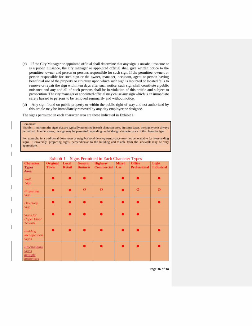
Page 16 of 34
(c) If the City Manager or appointed official shall determine that any sign is unsafe, unsecure or is a public nuisance, the city manager or appointed official shall give written notice to the permittee, owner and person or persons responsible for such sign. If the permittee, owner, or person responsible for such sign or the owner, manager, occupant, agent or person having beneficial use of the property or structure upon which such sign is mounted or located fails to remove or repair the sign within ten days after such notice, such sign shall constitute a public nuisance and any and all of such persons shall be in violation of this article and subject to prosecution. The city manager or appointed official may cause any sign which is an immediate safety hazard to persons to be removed summarily and without notice.
(d) Any sign found on public property or within the public right-of-way and not authorized by this article may be immediately removed by any city employee or designee.
The signs permitted in each character area are those indicated in Exhibit 1. Comment: Exhibit 1 indicates the signs that are typically permitted in each character area. In some cases, the sign type is always permitted. In other cases, the sign may be permitted depending on the design characteristics of the character type. For example, in a traditional downtown or neighborhood development, space may not be available for freestanding signs. Conversely, projecting signs, perpendicular to the building and visible from the sidewalk may be very appropriate.
Exhibit 1—Signs Permitted in Each Character Types Character Types Area
Original Town
Local Retail
General Business
Highway Commercial
Mixed Use
Office Professional
Light Industrial
Wall Sign
• • • • • • •
Projecting Sign
• • ο ο • ο ο
Directory Sign
• • • • • • •
Signs for Upper Floor Tenants
• • • • • •
Building Identification Signs
• • • • • • •
Freestanding Signs multiple businesses
• • • • •
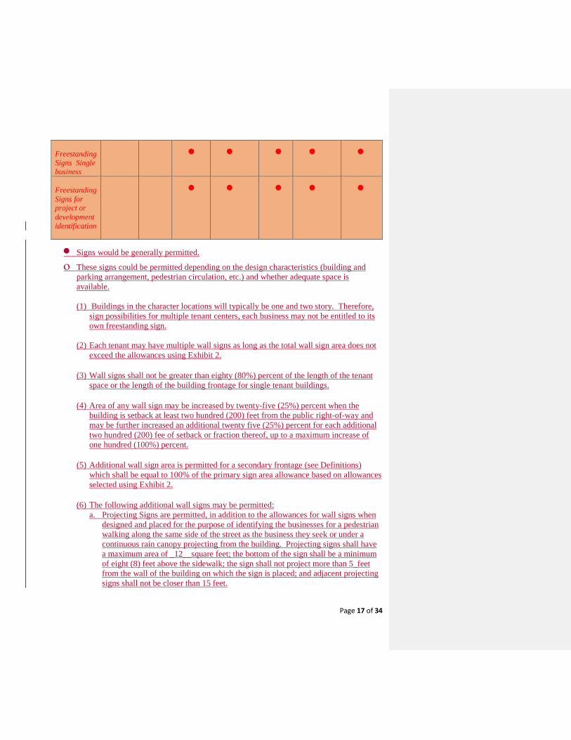
Page 17 of 34
Freestanding Signs Single business
• • • • •
Freestanding Signs for project or development identification
• • • • •
• Signs would be generally permitted.
ο These signs could be permitted depending on the design characteristics (building and parking arrangement, pedestrian circulation, etc.) and whether adequate space is available. (1) Buildings in the character locations will typically be one and two story. Therefore,
sign possibilities for multiple tenant centers, each business may not be entitled to its own freestanding sign.
(2) Each tenant may have multiple wall signs as long as the total wall sign area does not exceed the allowances using Exhibit 2.
(3) Wall signs shall not be greater than eighty (80%) percent of the length of the tenant
space or the length of the building frontage for single tenant buildings. (4) Area of any wall sign may be increased by twenty-five (25%) percent when the
building is setback at least two hundred (200) feet from the public right-of-way and may be further increased an additional twenty five (25%) percent for each additional two hundred (200) fee of setback or fraction thereof, up to a maximum increase of one hundred (100%) percent.
(5) Additional wall sign area is permitted for a secondary frontage (see Definitions)
which shall be equal to 100% of the primary sign area allowance based on allowances selected using Exhibit 2.
(6) The following additional wall signs may be permitted:
a. Projecting Signs are permitted, in addition to the allowances for wall signs when designed and placed for the purpose of identifying the businesses for a pedestrian walking along the same side of the street as the business they seek or under a continuous rain canopy projecting from the building. Projecting signs shall have a maximum area of _12__square feet; the bottom of the sign shall be a minimum of eight (8) feet above the sidewalk; the sign shall not project more than 5_feet from the wall of the building on which the sign is placed; and adjacent projecting signs shall not be closer than 15 feet.
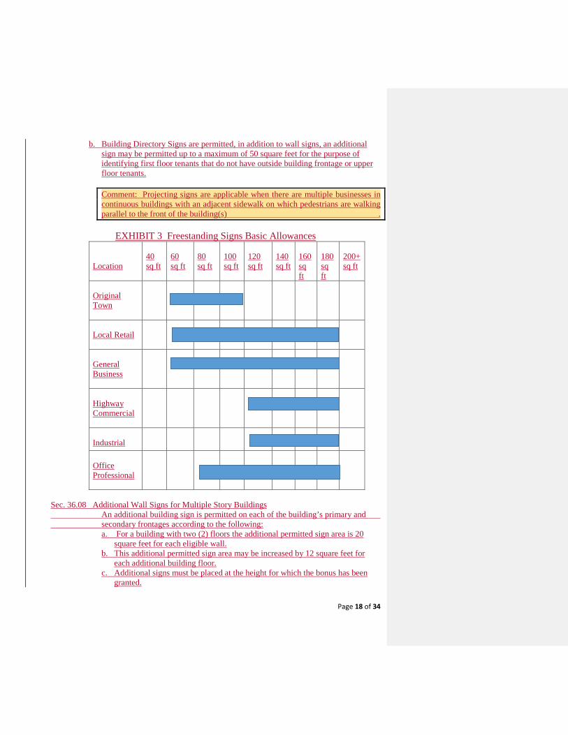
Page 18 of 34
b. Building Directory Signs are permitted, in addition to wall signs, an additional sign may be permitted up to a maximum of 50 square feet for the purpose of identifying first floor tenants that do not have outside building frontage or upper floor tenants. Comment: Projecting signs are applicable when there are multiple businesses in continuous buildings with an adjacent sidewalk on which pedestrians are walking parallel to the front of the building(s) .
EXHIBIT 3 Freestanding Signs Basic Allowances Location
40 sq ft
60 sq ft
80 sq ft
100 sq ft
120 sq ft
140 sq ft
160 sq ft
180 sq ft
200+ sq ft
Original Town
Local Retail
General Business
Highway Commercial
Industrial
Office Professional
Sec. 36.08 Additional Wall Signs for Multiple Story Buildings An additional building sign is permitted on each of the building’s primary and secondary frontages according to the following:
a. For a building with two (2) floors the additional permitted sign area is 20 square feet for each eligible wall.
b. This additional permitted sign area may be increased by 12 square feet for each additional building floor.
c. Additional signs must be placed at the height for which the bonus has been granted.
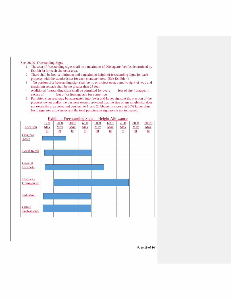
Page 19 of 34
Sec. 36.09 Freestanding Signs
1. The area of freestanding signs shall be a maximum of 200 square feet (as determined by Exhibit 3) for each character area.
2. There shall be both a minimum and a maximum height of freestanding signs for each property with the standards set for each character area. (See Exhibit 4)
3. No portion of a freestanding sign shall be in, or project over, a public right-of-way and maximum setback shall be no greater than 25 feet.
4. Additional freestanding signs shall be permitted for every ____feet of site frontage, in excess of_______feet of lot frontage and for corner lots.
5. Permitted sign area may be aggregated into fewer and larger signs, at the election of the property owner and/or the business owner, provided that the size of any single sign does not excee the area permitted pursuant to 1. and 2. Above by more that 50% larger than basic sign area allowances and the total permissible sign ares is not increased.
Exhibit 4 Freestanding Signs – Height Allowance
Location
12 ft Max
ht
20 ft Max
ht
30 ft Max
ht
40 ft Max
ht
50 ft Max
ht
60 ft Max
ht
70 ft Max
ht
80 ft Max
ht
100 ft Max
ht Original Town
Local Retail
General Business
Highway Commercial
Industrial
Office Professional

Page 20 of 34
Methodolgy for Estimating Appropriate Area of Freestanding Signs (Three Options Based on Highway Speeds)
Lower than 25
MPH Speed 26-40 MPH Speed
55 MPH or greater speed
Distance Sign is Viewed
200 feet
320 feet
440 feet
Letter Height
7 inches
10 inches
15 inches
Viewing Time
4-6 seconds
4- 6 seconds
4-6 seconds
Total Area of Lettering/Symbols
14-20 feet
28-42 feet
63-94 feet
Total Sign Area (with message less 40% of total area)
35-50 square feet
70-105 square
feet
160-235 square feet
Source: Street Graphics & the Law Sec. 36.10 Instructional or Wayfinding Signs.
Instructional or “way finding” signs shall be permitted in addition to all other signs when they are of such size and location that satisfy the intended purpose, such as identifying local historical buildings or sites, and based on their size, location and intended purpose will not constitute additional advertising. Wayfinding signage shall be allowed in public rights of way.
Instructional signs shall be permitted without limitation as to number or size and may not include the name of the business and logos. All such instructional signs must be located on site, no off site location instructional signs shall be allowed. Sec. 36.11 Window Signs
(a) Permanent window signs shall not exceed twenty-five (25%) percent of the area of a window and the total area of all window signs, including both permanent and temporary, shall not exceed fifty (50%) percent of the window area.
Sec. 36.12 Temporary Signs
(1) Temporary signs. a. One temporary, unlit sign announcing the sale, rental, or lease of an individually
platted residential lot may be placed on such lot provided the following conditions are met: 1. The sign shall not exceed eight square feet in area; 2. The sign shall be removed within one week following the close of sale or lease
of the lot;
Page 21 of 34
3. The lot must be part of a subdivision for which a final plat shall have been filed and recorded with the county; and
4. The subdivision and its public improvements and infrastructure shall have been accepted by the city.
b. For any residential subdivisions under construction, only four temporary unlit signs shall be permitted announcing the builder, sale price, and other pertinent information within the city provided the following conditions are met: 1. One sign is permitted onsite in the subdivision during the construction phase
and three additional signs are permitted to in other legal locations throughout the city;
2. Only one sign is permitted per major existing street frontage; 3. Only one sign is permitted on any one lot or tract of land. There does not have
to be a main structure on the lot or tract of land; 4. Such sign shall be placed within the property lines of the lot or tract; 5. Such sign shall be located behind a 25-foot visibility triangle only after a final
plat of the development shall have been filed and recorded with the county; 6. Such sign shall not exceed 15 feet in height or 100 square feet in area; and 7. All signs shall be removed when construction on all phases in the subdivision
are complete.
c. On any undeveloped property or tract of land, only one temporary unlit sign announcing the sale, rental, or lease (all or portion), name and/or contact information, and any other pertinent information for said property shall be allowed, provided the following conditions are met: 1. Only one sign is permitted for any one lot and tract of land. There does not have
to be a main structure on the lot or tract of land; 2. Such sign shall be placed within the property lines of the lot or tract; 3. Such sign shall be located behind a 25-foot visibility triangle; 4. Such sign shall not exceed 15 feet in height and 100 square feet in area; and 5. Such sign shall be removed within one week following the close of sale or lease
of land. Sec. 36.13 Non-Conforming Signs General Provisions
(a) Nonconforming signs are signs which were lawfully approved prior to the effective date of the ordinance from which this article is derived; but which are no longer in compliance with the sign regulations currently in effect.
(b) It is the declared the purpose of this ordinance that nonconforming signs be eventually discontinued and the use of the premises be required to conform to the regulations prescribed by this Chapter.
Page 22 of 34
Sec. 36.15 Limitations for Non-Conforming Signs (a) A nonconforming sign may be used and maintained in good repair, but it shall not be
altered, remodeled, or enlarged.(d) The right to use or maintain a nonconforming sign shall cease and such use shall be terminated if:
(1) The sign is altered, remodeled, removed, or enlarged, regardless of whether such alteration, remodel, removal or enlargement was necessitated by right-of-way acquisition by a governmental agency;
(2) The sign or structure is replaced; (3) The sign is relocated; (4) The sign identifies a business, person or activity that has ceased to operate on
the premises on which the sign is located for a period of one (1) year or; (5) The premises on which the sign is located is leased and two years have passed
since the most recent tenant has ceased to operate on the premises; or (6) The sign or a substantial part of it is blown down or otherwise destroyed or
dismantled for any purpose other than maintenance operations or for changing the letters, symbols, or other matter on the sign. The term "substantial part" shall mean the cost of repairing the sign is more than 60 percent of the cost of erecting a new sign of the same type at the same location.
Sec. 36.14 Sign Review Procedures (a) An application for signage shall be separate from building and/or construction permits. (b) An application for signage must be deemed complete for processing. All sign permits
must contain the following, at a minimum: 1. A permit application either filed electronically or at the Planning & Development
Services counter at City Hall. Applications must be signed by the applicant or by the sign contractor.
2. A site plan, at a 1” = 20 feet scale, of the property where said sign is to be installed. 3. A drawing of signage to be reviewed and installed with sufficient details to review
for conformance to 2018 IBC and 2017 National Electric Codes. 4. Permit fees shall be paid prior to release of plans for construction or installation and
after plans are approved by appropriate city departments. 5. Time limits – All sign applications shall be reviewed for compliance with these
regulations within ten (10) business days from the time a completed application has been accepted by the Planning & Development Services Department.
6. All appeals and variances regarding the sign ordinance would be heard by the Planning & Zoning Commission rather than by a Board of Zoning Appeals if not otherwise prohibited by law.
7. A Comprehensive Sign Plan (CSP) may be submitted that permits consideration of unique conditions, flexibility and creativity. Such CSP is subject to approval by the Planning Commission. The application of such plan can not be viewed as imposing more restrictive requirements than permitted by the basic standards, but rather, may permit additional signs and/or sign area based on the applicant’s demonstration of unique characteristics of the design, building, and/or site and appropriate landscaping associated with the freestanding signs. Once a CSP has been approved subsequent applications for specific signs shall be
Page 23 of 34
approved administratively when the proposed sign is in compliance with the approved CSP.
8. If proposed signs do not comply with the provisions of Section 106.01, the applicantmay submit an application to the Planning Commission to determine the adjustments, if any that are appropriate to satisfy the requirements of Section 106.01.
Sec. 36.15 Supplemental Considerations A. Constructions Standards:
The construction, erection, safety and maintenance of all signs shall comply with the (This blank should refer to the applicable building code) and all of the following: 1. Signs shall be structurally sound and located so as to pose no reasonable threat
to pedestrian or vehicular traffic. 2. All permanent freestanding signs shall have self-supporting structures erected
on, or permanently attached to, concrete foundations. 3. If possible, signs should not be in locations that obscure architectural features
such as pilasters, arches, windows, cornices, etc. 4. The signs should not be in locations that interfere with safe vehicular and
pedestrian circulation or public safety signals and signs. 5. No signs shall be erected, constructed or maintained so as to obstruct any fire
escape, required exit, window, or door opening used as a means of egress. 6. Signs shall be structurally designed in compliance with ANSI and ASCI
standards. All elective signs shall be constructed according to the technical standards of a certified testing laboratory.
7. Signs may be illuminated by external or internal means provided that:a. The brightness and intensity shall not be greater than necessary to meet
reasonable needs of the business or use served; b. Light sources shall be shielded from all adjacent buildings and streets; andc. The lighting shall not create excessive glare to pedestrians and/or motorists,
and will not obstruct traffic control or any other public informational signs.
B. MaintenanceAll signs shall be maintained in accordance with the following: 1. The property owner shall maintain the sign; in a condition appropriate to the
intended use; to all City standards; and has a continuing obligation to comply with all City building code requirements.
2. If the sign is deemed by the Code Enforcement Officer to be in an unsafecondition, the owner of the business shall be immediately notified in writing, and shall, within 48 hours of receipt of such notification, respond to the city
with a plan to correct the unsafe condition, remove the unsafe sign, or cause it to be removed. If after 5 days, the unsafe condition has not been corrected through repair or removal, the Zoning Enforcement Officer may cause the repair or removal of such sign, at the expense of the property owner or lessee.
If the total costs are not paid in full within 35 days of the repairs or removal, the amount owed shall be certified as an assessment against the property of the
Formatted: Justified
Page 24 of 34
sign owner, and lien upon that property, together with an additional 2.5 percent penalty for collection as prescribed for unpaid real estate taxes.
3. In cases of emergency, the Code Enforcement Officer may cause the immediateremoval of a dangerous or defective sign without notice. Whenever any sign, either conforming or nonconforming to these regulations, is required to be removed for the purpose of repair, relettering or repainting, the same may be done without a permit or without any payment of fees provided that all of the following conditions are met:
a. There is no alteration or remodeling to the structure or the mountingof the sign itself;
b. There is no enlargement or increase in any of the dimensions of thesign or its structure;
d. The sign is accessory to a legally permitted, conditional or nonconforming us
Sec.36-16 Political Signs
Allowed without a required permit: 1. Political signs on private real property.
(a) A political sign consistent with this article may be placed on private realproperty with the consent of the owner, provided such sign is placed so as to notobstruct the line of sight for either a vehicle or pedestrian.(b) No political sign may be placed on public property, public easement or public right-of-way.(c) A political sign may not be illuminated or have any moving parts.(d) A permit or approval of a political sign is not required.(e) A political sign may not exceed eight feet in height.(f) A political sign may not have an effective area greater than 36 square feet.(g) May not be placed in a visibility triangle area as defined herein.
Sec. 36-17 Temporary Signs allowed during Roadway Construction Zones (h) Temporary signs allowed during roadway construction zones:.
(1) Businesses adjacent to a major public roadway construction projectscheduled for six months or more duration may be eligible for temporarysignage when roadway construction activities are commencingimmediately adjacent to the business or when the construction activity istaking place within 300 feet downstream of the business’ customer accesspoint located on the same side of the street. The following conditions shallapply:
A. Approval of construction as a public roadway project by the CityManager or his/her designee shall be required.
Page 25 of 34
B. Only commercial properties whose access is impacted for a period of two weeks or more are eligible to apply for a temporary sign permit to be issued by the City.
C. Said signs may contain the name of the business and a directional message/graphic only.
D. Signs may be located: 1) Only commercial properties whose access is impacted for a
period of two weeks or more are eligible to apply for a temporary sign permit to be issued by the City.
2) Signs may contain the name of the business and a directional
message/graphic only. Signs promoting products and services are prohibited.
3) Signs may be located at the property line, but shall not be placed
within the street or public right-of-way.
4) Only one on premise sign is allowed per parcel. One off-premise sign may be installed provided written permission is obtained from the property owner and the sign is located within 300 feet of the business it is advertising.
5) Signs shall be constructed of lightweight materials, such as a
yard sign or an A-frame sign, and shall not exceed six square feet in area or 30 inches in height.
6) The City manager or his/her designee is authorized to approve
alternate sign combinations on a case-by-case basis depending on site conditions and construction activities.
Sec. 36.18 Signs Exempt from the Regulations The following signs do not require a permit:
(a) Copy change and sign face replacement, when there is no increase in sign area or height made, for signs otherwise allowed under this section, not including changes proposed on a nonconforming sign or to modify any sign to an electronic message center, are exempt from the permit requirements of this article.
(b) Construction signs when placed upon the public project construction site following the issuance of a building permit. If said signs are for a public project, then permit fees shall be waived.
(c) Flags of the United States, state, or any other political subdivision, any flag of a bona fide region, fraternal or charitable organizations, and flags of corporations, subdivisions, or community associations or organizations.
(d) City kiosks signs or a city industrial zone monument business sign that is located in the city street right-of-way in a light industrial zone district, with a revocable license agreement approved by the city council, provided it is a multi-sided, freestanding
Page 26 of 34
monument-type sign for the display of advertising for economic development purposes and for businesses in the industrial areas of the city. Such signs may have the city identification panel at the top of the sign. The total sign shall not exceed 14 feet in height or ten feet in width; it may be internally illuminated.
(e) Memorial plaques, building identification signs, and building cornerstones when cut or carved into the masonry surface or when made of noncombustible material and is made an integral part of the building or structure. These signs shall not exceed four square feet in area.
(f) On-site directional signs not exceeding four square feet, provided such sign does not contain advertising and is not used as such. Directional signs are only permitted behind the property line.
(g) Political signs. (h) Traffic or other municipally-owned signs, legal notices, danger and such emergency,
temporary or non-advertising signs as may be approved by the city council or its authorized agent.
(i) Signs on fences or other structures within public parks or signs that are positioned internally within public sport fields. No sign shall be larger than 32 square feet in area.
(j) Signs prepared by or for the local, state or federal government, including sites or buildings of historical significance.
(k) Temporary signs advertising garage sales, provided that such signs shall be removed within one day after the temporary event. No sign shall be affixed to utility poles or street signs.
(l) Window signs of a temporary nature only. They may be no larger than 20 percent of the total opening.
(m) Wall decorations and works of art that do not include a commercial message or logos. Sec. 36.19 Prohibited Signs All signs not expressly permitted or exempt from this article are prohibited. The following signs are prohibited in the city and the city's extraterritorial jurisdiction (ETJ):
(1) Any sign erected in a manner that would confuse or obstruct the view or interpretation of any official traffic sign, signal or device;
(2) Electronic messaging signs, portable signs, inflatable signs, free-standing light poles, streamers, pennants, ribbons, spinners, search lights, and other such temporary signs, except that are allowed in this article;
(3) Snipe signs or any advertising sign placed on a utility pole, rock, tree or other natural features;
(4) Off-premises signs or billboards; (5) Roof signs or any advertising sign painted, erected or affixed on the roof of a building; (6) Wind devices;
Page 27 of 34
(7) A parked vehicle and/or trailer used as an advertisement, except signage on delivery vehicles;
(8) Spectacular signs and signs which emit audible sound, odor, or visible matter; and (9) Signs on the right-of-way of a road or highway maintained by the city.
(10) Electronic message center or digital message Boards: Electronic message boards are prohibited and shall not be allowed within the City of Justin or its ETJ area. Electronic message board signs that are in place as of the effective date of this ordinance shall be classified as non-conforming and subject to the provisions and requirements of this Ordinance. A sign permit is not included with a building permit.
(a) No person shall erect, install, repair, remodel, expand, or display a sign without first obtaining a sign permit as required by this Chapter.
(b) No signage other than the main permitted sign shall be painted on or attached to a pole or support members of any sign.
Sec. 36.20. - Prohibited signs.
All signs not expressly permitted or exempt from this article are prohibited. The following signs are prohibited in the city and the city's extraterritorial jurisdiction (ETJ):
(1) Any sign erected in a manner that would confuse or obstruct the view or interpretation of any official traffic sign, signal or device;
(2) Portable signs, inflatable signs, free-standing light poles, streamers, pennants, ribbons, spinners, search lights, and other such temporary signs, except that are allowed in this article;
(3) Snipe signs or any advertising sign placed on a utility pole, rock, tree or other natural features;
(4) Off-premises signs or billboards; (5) Roof signs or any advertising sign painted, erected or affixed on the roof of a building; (6) Wind devices; (7) A parked motor vehicle and/or trailer used as an advertisement, except signage on
delivery vehicles; (8) Spectacular signs and signs which emit audible sound, odor, or visible matter; and (9) Signs on the right-of-way of a road or highway maintained by the city. (10) Electronic message center or digital message Boards: Electronic message boards are
prohibited and shall not be allowed within the City of Justin or its ETJ area. Electronic message board signs that are in place as of the effective date of this ordinance shall be classified as non-conforming and subject to the provisions and requirements of Section 36-07 of this Ordinance.
Page 28 of 34
All signs not expressly permitted or exempt from this article are prohibited. The following signs are prohibited in the city and the city's extraterritorial jurisdiction (ETJ):
(1) Any sign erected in a manner that would confuse or obstruct the view or interpretation of any official traffic sign, signal or device;
(2)Portable signs, inflatable signs, free-standing light poles, streamers, pennants, ribbons, spinners, search lights, and other such temporary signs, except that are allowed in this article;
(3)Snipe signs or any advertising sign placed on a utility pole, rock, tree or other natural features;
(4)Off-premises signs or billboards; (5) Roof signs or any advertising sign painted, erected or affixed on the roof of a building; (6)Wind devices; (7) A parked motor vehicle and/or trailer used as an advertisement, except signage on
delivery vehicles; (8)Spectacular signs and signs which emit audible sound, odor, or visible matter; and (9)Signs on the right-of-way of a road or highway maintained by the city.
(10) Electronic message center or digital message Boards: Electronic message boards are prohibited and shall not be allowed within the City of Justin or its ETJ area. Electronic message board signs that are in place as of the effective date of this ordinance shall be classified as non-conforming and subject to the provisions and requirements of Section 36-07 of this Ordinance. Sec. 36-07. - Nonconforming signs; removal.
(a) Nonconforming signs are signs which were lawfully approved prior to the effective date of the ordinance from which this article is derived; but which are no longer in compliance with the sign regulations currently in effect.
(b) It is the declared the purpose of this ordinance that nonconforming signs be eventually discontinued and the use of the premises be required to conform to the regulations prescribed by this Chapter.
(c) A nonconforming sign may be used and maintained in good repair, but it shall not be altered, remodeled, or enlarged.(d) The right to use or maintain a nonconforming sign shall cease and such use shall be terminated if:
(1) The sign is altered, remodeled, removed, or enlarged, regardless of whether such alteration, remodel, removal or enlargement was necessitated by right-of-way acquisition by a governmental agency;
(2) The sign or structure is replaced; (3) The sign is relocated; (4) The sign identifies a business, person or activity that has ceased to operate on
the premises on which the sign is located for a period of one (1) year or; (5) The premises on which the sign is located is leased and two years have passed
since the most recent tenant has ceased to operate on the premises; or
Page 29 of 34
(6) The sign or a substantial part of it is blown down or otherwise destroyed or dismantled for any purpose other than maintenance operations or for changing the letters, symbols, or other matter on the sign. The term "substantial part" shall mean the cost of repairing the sign is more than 60 percent of the cost of erecting a new sign of the same type at the same location.
Sec. 36-21 – Billboard Signs.
(a) Digital Billboard Requirements:
Digital billboard signs shall be reviewed and approved, at a duly noticed public hearing in accordance with Section 52-427 and notification to surrounding property owner, by the Planning & Zoning Commission prior to the issuance of a building permit.
A building permit and permit fee are required for all digital billboards. Building permit shall include but not be limited to: plans for electrical, structural, soils reports, erosion controls pre-construction, construction and post-construction conditions, wind shear conditions, or drainage as may be specified by the City.
(b) Digital billboards: With approval by the Planning & Zoning Commission, an existing legal nonconforming off-premise billboard signs located on lots having frontage on a state highway, farm-to-market roadway or a tollway may be converted to digital billboards under the following conditions:
1. Each message shall be displayed for at least eight seconds and a change of message shall be accomplished within two seconds or less.
2. Transitions between the display of a message, content, and/or image shall be immediate only and shall occur simultaneously on the entire sign face.
3. No display shall include animation, full motion video, blinking, flashing, dissolving or fading images, moving light, scrolling images or text, nor shall it project a static image upon a stationary object.
4. The display of message, content, and/or image shall be visible only from one direction of traffic travel per sign face on the primary roadway to which the sign is designed to be read.
5. No portion of a digital billboard shall project into a dedicated utility easement or be closer than five feet to a federal, state, or local right-of-way at the time of initial construction.
6. The main support structure shall have a decorative finish consisting of brick, stone, or other approved masonry finish materials. The use of EIFS shall not constitute an approved finish material.
7. A minimum spacing of 1,500 feet distance shall be required between one digital billboard and any other digital or conventional billboard on the same roadway. The Planning & Zoning Commission is authorized to grant variances to the minimum spacing requirements provided that no variance violates the Highway Beautification Act of 1965.
Page 30 of 34
8. A digital billboard shall have a default mechanism built in to either turn the display off or show "full black" on the display in the event of a malfunction.
9. The display may not display light of such intensity or brilliance to cause glare or otherwise impair the vision of the driver, or results in a nuisance to the driver.
10. A digital billboard shall be equipped with both a dimmer control and a photocell, which automatically adjusts the display's intensity according to natural ambient light conditions. The brightness of the display shall not exceed 0.3 foot-candles over ambient light measurement at a distance of 250 feet from the sign.
(c) Upon notification, the sign operators shall coordinate with city staff to display emergency information critical to the traveling public, such as but not limited to AMBER ALERTS from a National Center for Missing and Exploited Children (NCMEC) authorized source, Homeland Security, and other alerts involving terrorist attacks, and natural disasters. Emergency messages are to remain in the display's rotation according to the designated issuing agency's protocols until further notified.
(d) The owner of a digital billboard shall provide contact information for a person who is available to be contacted at any time and is able to turn off the sign promptly after malfunction occurs or reduce the intensity of the sign within 12 hours of a request by the City of Justin City Manager or his/her designee or the Texas Department of Transportation to a level acceptable to the City.
(e) A digital billboard or its message, content and/or image shall not be configured to resemble a warning or danger signal or cause a driver to mistake it for a warning or danger signal.
(g) A digital billboard or its message, content and/or image shall not resemble or simulate any lights of official signage used to control traffic in accordance with the currently adopted edition of the TXDOT manual on Uniform Traffic Control Devices.
(h) Prohibitions: A digital billboard shall not: 1. Be allowed within 250 feet of single-family residential, single-family planned or
multi-family residential developments.
2. Exceed 672 feet in total display area.
3. Electronic message board and billboard signs that are in place as of the effective date of this ordinance shall be classified as non-conforming and subject to the provisions and requirements of Section 36-23 of this Ordinance.
(i) Conversion of an Existing Billboard:
In cases where a conventional billboard is converted to a digital billboard of larger size, the net area increase of the proposed digital billboard display must be physically
Page 31 of 34
removed from other conventional billboards located within the city and under the same ownership or control as the owner proposing the conversion. Once an inventory of all billboards within the city is submitted, the owner may choose which specific conventional billboard face(s) are to be removed in exchange for the net area increase caused by the digital sign conversion. The square footage can be accumulated by the surrendering of smaller conventional billboard face(s) as long as the aggregate amount removed equals or exceeds the area increase caused by the conversion.
(j) Removal of an Existing Billboard:A demolition permit application and permit fee shall be required in order to remove anexisting billboard.
(k) Appeals:The decision of the Planning & Zoning Commission is final, unless an appeal is filed inwriting within ten (10) days after the Commission’s decision. An applicant may appeal aCommission decision to the City Council. An appeal shall be filed with City DevelopmentServices Department and a fee paid for processing an appeal for City Councilconsideration.
Sec. 36-22. - Permitted signs. The following signs are permitted in the following City's zoning districts: local retail, general
business, general business old town, multi-family residential and light industrial with a sign permit issued:
(1) Monument signs (single-tenant).a. Maximum height: Ten feet measured from the ground level of the sign base.b. Size: One square foot of signage per 50 square feet of total building space.c. Maximum size: 120 square feet.d. Base of sign: 20 percent of the entire sign area is required for the sign base.e. Main sign support structure: May not be visible from any direction.f. Material of sign: The base must be made of natural stone, brick, poured-in-place
decorative concrete, or stucco covered concrete.g. Placement of sign:
1. Front: Five feet back from established right-of-way.2. Side: 25 feet from established property line.3. Proximity to other signs: Not less than 50 feet from any other sign.4. Outside of any required POSE (public open space easement) visibility triangle.5. When a monument sign is situated within an island or a driveway location at the
entryway of a development where vehicular driving land is located on one ormore frontages.
h. Maximum number of signs: One sign per parcel or street frontage.
Page 32 of 34
i. Illumination: All monument signs may be either internally illuminated or externally illuminated. If illuminated internally, only the sign face may be illuminated. If illuminated externally, the light shall only illuminate the sign face. No glare or over wash shall be permitted from this type of lighting.
j. Special requirements: All proposed monument signs must have an approved site plan before building permit will be issued.
(2) Monument signs (multi-tenant). a. Maximum height: 18 feet measured from the ground level of the sign base. b. Size: One square foot of signage per 40 square feet of total building space. c. Maximum size: 180 square feet. d. Base of sign: 20 percent of the entire sign area is required for the sign base. e. Main sign support structure: May not be visible from any direction. f. All monument signs shall be framed by a masonry, stone, wood or combination of
these framing materials g. Material of sign: The base must be made of natural stone, brick, poured-in-place
decorative concrete, or stucco covered concrete. h. Placement of sign:
1. Front: Five feet back from established right-of-way. 2. Side: 25 feet from established property line. 3. Proximity to other signs: Not less than 50 feet from any other sign.
i. Maximum number of signs: One sign per parcel. j. Illumination: All monument signs may be either internally illuminated or externally
illuminated. If illuminated internally, only the sign face may be illuminated. If illuminated externally, the light shall only illuminate the sign face. No glare or over wash shall be permitted from this type of lighting.
k. Special requirements: Proposed monument signs must have an approved sight plan before building permit will be issued.
(3) Wall signs. a. Maximum height: Six feet from base of sign to top of the sign. The wall sign may
not project above the top of the wall or be placed on roof. b. Size: One square foot per one linear foot of building width. c. Maximum size: 200 square feet. d. Projection: No wall sign may project more than one foot from the wall from which
it is affixed. No wall sign may project into, over or otherwise encroach upon a public right-of-way. No sign shall cover, wholly or partially, any wall opening.

Page 33 of 34
e. Illumination: Wall signage shall consist of only internally illuminated face litchannel letters, reverse channel lit letters. Internally illuminated signs shall have anopaque background with only letters and logo illuminated.1. Awning signs . Awning signs may project from the wall of the building to
protect the main entrance.(a) Minimum height: The bottom of the awning shall be a minimum of eight
feet above the ground surface when projecting over a private or publicsidewalk.
(b) Projection: Shall not project more than five feet into the public right-of-wayand shall project no closer than two feet from the face of the curb line.
(c) Signs on awnings shall count towards the total of the maximum size of thetotal wall size limit.
(d) Projection of sign on awning: Shall be no larger than three feet from thefront or side of the awning. No projection of the awning shall be closer thantwo feet from the curb and may be no lower than the minimum height of the awing.
(e) Illumination: The projected sign will be internally illuminated if illuminated. (f) Special requirements: All proposed awnings and associated signage must
have an approved site plan before building permit will be issued.2. Canopy. Canopies may be freestanding or supported independently by columns
and subject to the following:(a) Maximum height: 18 feet from ground level to top of highest point of
canopy.(b) Minimum height: 14 feet from ground level to lowest point of canopy.(c) Projection: No sign shall project more than two feet from end of canopy.
There shall be no overlap of signage from the bottom or top of the canopy.(d) Signs on canopy: There may be three company logos placed on the two
sides of the canopy and one logo sign on the front. Direction of the canopyis determined by the front property line. The signs may each be a total of 16square feet. One fuel price sign shall be permitted on the two end sides ofcanopy. One fuel price sign shall be permitted on the front side determinedby the lot frontage. The three fuel signs may be 16 square feet each and bean electronic message center (EMC) type sign.
(e) Monument sign: There shall be one single-tenant monument signpermitted per property. It shall comply with all standards set forth in thisarticle.
(f) Illumination: All attached canopy signs shall be either backlit or canisterilluminated. Except that the fuel price signs may be EMC signs.
(g) Special requirements: All proposed canopies and associated signage musthave an approved site plan before building permit will be issued.
Page 34 of 34
(4) Banners.a. Maximum size: 15 square feet in area.b. Time limit: Banners shall be limited to 30 consecutive days.c. Single use occupancy: One banner limit.d. Multi-use occupancy: One banner per occupied store frontage.e. Illumination: None.f. Special regulations:
1. No banners shall be hung over public roads or encroach into public right-of-way.
2. Banners promoting a business must be attached to and parallel with wall on theprimary front entrance.
Sec. 36.23 - Application for variance to board of adjustment. Any property owner may apply to the board of adjustment of the city to request the board to
vary any or all terms of these sign regulations. The board may grant a variance to the terms of this article upon a specific finding from
evidence presented to it that strict compliance with the provisions of this article will result in substantial hardship or inequity to the applicant without corresponding benefit to the city and its citizens in accomplishing the objectives of this article.
In no event shall the granting of such a variance permit a sign to be placed in public right-of-way, an unsafe sign, a waiver of the permit requirements of this article, reconstruction of a nonconforming sign, or the placement of a commercial sign in a residential zone. Notice of a public hearing on such application shall be given in the same manner as for a zoning application. Sec. 36.24 - Severable provisions. If any section, subsection, paragraph, sentence, clause, phrase or word in this article, or the application thereof to any person or circumstances is held invalid by any court of competent jurisdiction, such invalidity shall not affect any remaining portions of this article.
, and the The City Council of the City of Justin, Texas hereby declares it would have enacted such remaining portions of this article despite any such invalidity and to this end the provisions of this Ordinance are declared severable.
Page 1 of 8
City Council Meeting
May 24, 2021
Justin City Hall, 415 North College Street
City Council Cover Sheet
Agenda Item: #5 (Workshop) #17 (Public Hearing)
Title: Continued Public Hearing to consider a Preliminary Plat (PPLT 21-01) to create up to 216 single family residential lots and 5 open space lots for parks, trails and amenities. Also consider a request to rezone approximately 50 acres from SF-1 to SF 2-PD.
Department: Planning & Development Services
Contact: Darrell W. Gentry, Director
Recommendation: This is a continuance from the April 26 meeting regarding a public hearing for the proposed Zone Change (ZC 21-01) rezoning approximately 50 acres from SF-1 to SF-2 PD and Preliminary Plat (PPLT 21-01) to create up to 217 single family residential lots and 5 open space lots for parks, trails and amenities.
Discuss and consider an applicant request to continue the Public Hearing to May 10, 2021 or May 24th depending whether or not the City Council refers this application back to the P&Z Commission. The City Council could consider but is not obligated to refer this application back to the Planning Commission for further consideration.
Background: The applicant, Gra-son Land Development, has requested a continuance of the public hearing until May 10, 2021 to have sufficient time to resolve P&Z Commission questions.
The City Council sent this Zone Change and Preliminary Plat back to the Planning & Zoning Commission for further consideration and a recommendation. At its May 18th meeting, the Commission considered the requested Zone Change (ZC 21-01) to rezone the subject properties from SF-1A to SF-2 PD (Planned Development) and the Preliminary Plat (PPLT 21-01) to create up to 216 single family residential lots with approximately 9 acres of public parkland, trail system and reserved open space easement for Trail Creek area. For this Commission proceeding, the applicant provided additional information and agreed to provide added public and private amenities for the subdivision.
Specifically, the subdivider/applicant has agreed to provide a public pedestrian bridge across Trail Creek at no cost to the public and additionally to provide an 8 foot wide
Page 2 of 8
walkway for the bridge access. The proposed 9 acre public parkland and connecting trail system remain a part of the requested Zone Change and Preliminary Plat.
The further change to the requested Plat and Zone Change is for the private recreation lot which has been expanded with the loss of 1 residential lot. The applicant has worked closely with the existing Reatta Ridge HOA organization. As a result, the HOA is in support of this Zone Change and the Preliminary Plat with the added amenities, public and private. A copy of HOA newsletter stating their support for the requested Zone Change and Preliminary Plat is attached with this report.
Site Analysis: Phases 3 & 5 (Proposes SF2-PD Zone)
• Proposes an overall average lot size of 7,667 sq.ft.• SF-2 Zone requires a minimum lot size of 7,500 sq.ft. (SF 1A requires 10,000 sq.
ft)• Two residential areas in proposed subdivision with lot sizes ranging from 6,982 sq
ft to 8,117 sq ft.• Proposes 2 minimum home sizes of 1,600 for 1-story and 1,800 sq.ft. for 2-stories.
Phases 1 & 2 SF-PD 273 Zone Existing Reatta Ridge Development Phase 1 (106 lots)
• Overall average lot size is 6,648 sq.ft. with density of 4.35 du/acre• Minimum house sizes – 1,400 sq ft for 1-story, 1,800 sq.ft. for 2-stories
Phase 2 (121 lots) • Overall average lot size is 6,648 sq.ft.• Minimum house sizes – 1,600 sq.ft. for 1 – story, 1,800 sq. ft. for 2-story
Phase 4 (SF2-PD 273 Zone) Presently under construction for 158 dwellings with minimum home sizes similar to Phases 1 & 2 or slightly larger.
The P& Z Commission recommended a conditional approval of the zone change with a minimum lot size of not less than 7,500 sq ft. The Commission’s vote on this motion did pass by a split vote of Commissioners. If the Commission’s recommendation is accepted and approved by the City Council, then the applicant should be directed to revise the filed Preliminary Plat to show a minimum lot size for all plat lot of not less than 7,500 sq ft. to be consistent with their recommended zoning classification.
City staff’s recommendation to approve the requested ZC 21-01 Zone Change to SF-2 PD and to approve Preliminary Plat PPLT 21-01 as presented remains unchanged.
Staff acknowledges that this project’s requested Zone Change to SF-2 PD is consistent with the Future Land Use Plan and the surrounding existing residential neighborhood. Additionally, the Reatta Ridge HOA for Phases 1, 2 & 4 are compatible single family neighborhoods for this location and terrain.

Page 3 of 8
The overall community benefits are: additional public parklands; a pedestrian bridge crossing over Trail Creek, preservation of the Trail Creek and mature trees there in an open space easement and expanded private recreational lot to serve future and existing residents; the installation of a 12 inch water line along Boss Range Road; the dedication of right of way for the eventual widening of Boss Range Road and the connection of a minor collector street, Wilkerson Lane connecting Boss Range Road to FM 156.
ACTION NEEDED: 1) Conduct a Public Hearing review of the proposed Preliminary Plat
(PPLT 21-01) and Zone Change (ZC 21-01) as presented forconformance to the Subdivision Regulations, and Zone Change fromSF-1A to SF-2. Take action on Zone Change first, then the Plat.
2) Hear any public testimony for or against the plat and other items listed.
3) Make a recommendation to City Council for the requested PreliminaryPlat and related items listed to approve, conditionally approve, or denythe requested Preliminary Plat (PP 21-01) and Zone Change (ZC 21-01).
STAFF RECOMMENDATION: Staff recommends approval of the Preliminary Plat and Zone Change based on:
1) It is consistent with the City’s adopted 2017 Comprehensive Land Use Plandesignation of Single family Residential.
2) Zoning for the property is Single Family Residential (SF-1A). Zone changerequest from SF-1A to SF-2 with a PD (Planned Development) overlaydesignation.
3) Complies with the City’s Subdivision requirements for preliminary plat._________________________________________________________________ City Attorney Review: N/A ________________________________________________________________________ Attachments: Zone Change Exhibit
Preliminary Plat Map HOA letter of support City Engineer Review Letter Planning Consultant Review Letter
Page 4 of 8
Attachment A
BACKGROUND INFORMATION - PPLT 21-01/ZC 21-01
APPLICANT AND OWNER: Gra-son Land Inc.
PROPERTY: Surrounding Properties are designated as: SF-1 zoning district is located north, south, and west of the subject property. SF-2 zoning district is located on the east side of the subject property. Residential homes are located north, south, and east of the subject property.
LEGAL DESCRIPTION: REATTA RIDGE ADDITION, LOT 1, BLOCKS 1 & 2, BORDEN
AND MARY POLK SURVEY, ABSTRACT NO.207 & 993, JUSTIN, TEXAS, DENTON COUNTY
LAND USE CATEGORY: currently vacant residential
CURRENT ZONING: SF-1A Single Family Residential
REQUESTED ZONING: SF-2, Single Family Residential with a PD overlay designation
HISTORY: The City Council approved and adopted the Justin 2036 Comprehensive Land Use Plan establishing land use designations citywide. The requested “SF-2” – Single

Page 5 of 8
Family Residential zoning for the subject property is consistent with the Justin 2036 Comprehensive Plan remains unchanged.
The subject property was rezoned to its original zoning designation in 2019 by City Council action. The 2019 City Council action was predicated on the original PD document language that granted the City the right to reclassify property to original zoning, SF-1A without a PD designation.
STAFF COMMENTS:
Staff review comments are provided in Exhibit B attached hereto.
Page 6 of 8
Attachment B Staff Review Summary
Public Works Review Josh Little, Public Works Director
Phone: (940) 648-2541 E-mail: [email protected]
Development and construction of improvements must comply with City TechnicalSpecifications and Standards Manual requirements at the time of construction plan permit applications.
City Engineer and Transportation Plan Review Chris Cha, City Engineer Phone: (940) 648-8671
Proposed Preliminary Plat conforms to City requirements.
Fire Department Review Brian Gilmore, Fire Marshal Phone: (940) 230-6245
No Comments Provided.
Tree Conservation/Landscape Review
Trees located within Trail Creek floodway boundaries are being preserved as a part of a dedicated open space easement reserved to the City of Justin. Dedication is shown on the Preliminary Plat map.
City Planner Review Eric Wilhite, AICP Phone: (940) 648-8671
See Review Letter Attached.
General Informational Comments
The following shall be incorporated as conditions of approval for PPLT 21-01/ZC 20-01
No conditions of approval are proposed or required for PPLT 21-01/ZC 21-01.
Case No.: PPLT 21-01/ZC 20-21 Review No.: THIRD Date of Review:

Page 7 of 8
Attachment C
Plans and Support Information
(Plans are provided by separately to P & Z members and are on file with City Development Services Department)
N VICINTY MAP
Page 8 of 8
Attachment D
EXHIBIT “A”
CONDITIONS OF APPROVAL
PPLT 21-001/ZC 20-21
The following conditions shall be required for approval of PPLT21-01/ZC 20-21:
No conditions of approval are proposed or required for PPLT 21-01/ZC 21-01.
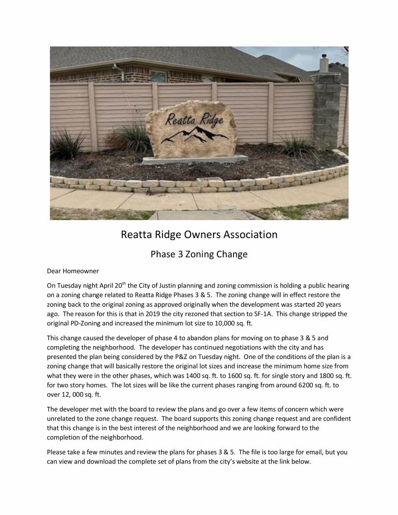
Reatta Ridge Owners Association
Phase 3 Zoning Change
Dear Homeowner
On Tuesday night April 20th the City of Justin planning and zoning commission is holding a public hearing
on a zoning change related to Reatta Ridge Phases 3 & 5. The zoning change will in effect restore the
zoning back to the original zoning as approved originally when the development was started 20 years
ago. The reason for this is that in 2019 the city rezoned that section to SF-1A. This change stripped the
original PD-Zoning and increased the minimum lot size to 10,000 sq. ft.
This change caused the developer of phase 4 to abandon plans for moving on to phase 3 & 5 and
completing the neighborhood. The developer has continued negotiations with the city and has
presented the plan being considered by the P&Z on Tuesday night. One of the conditions of the plan is a
zoning change that will basically restore the original lot sizes and increase the minimum home size from
what they were in the other phases, which was 1400 sq. ft. to 1600 sq. ft. for single story and 1800 sq. ft.
for two story homes. The lot sizes will be like the current phases ranging from around 6200 sq. ft. to
over 12, 000 sq. ft.
The developer met with the board to review the plans and go over a few items of concern which were
unrelated to the zone change request. The board supports this zoning change request and are confident
that this change is in the best interest of the neighborhood and we are looking forward to the
completion of the neighborhood.
Please take a few minutes and review the plans for phases 3 & 5. The file is too large for email, but you
can view and download the complete set of plans from the city’s website at the link below.

April-20-2021-Commission-Agenda-Full-Packet.pdf
It would be great if you want to attend the meeting or send a message to the city regarding support of,
concerns regarding this zoning change. The person responsible for the meeting on Tuesday is Darrell
Gentry, he is the Director of Planning & Development Services and his email address is
If approved by the P&Z the next step will be the city council.
Swimming Pool Update
We have a couple of issues at the swimming pool and had to postpone the inspection we had scheduled
this week. We are awaiting on parts for a plumbing repair in the men’s restroom and one of the pumps
went down last week and we are awaiting parts for that repair as well. The plumbing parts are a couple
of weeks out but unfortunately, we do not have a firm ETA on the pump repair. We still plan to open
early May but will be unable to set a date until we have the repairs made.
Sincerely,
The Reatta Ridge Board of Directors
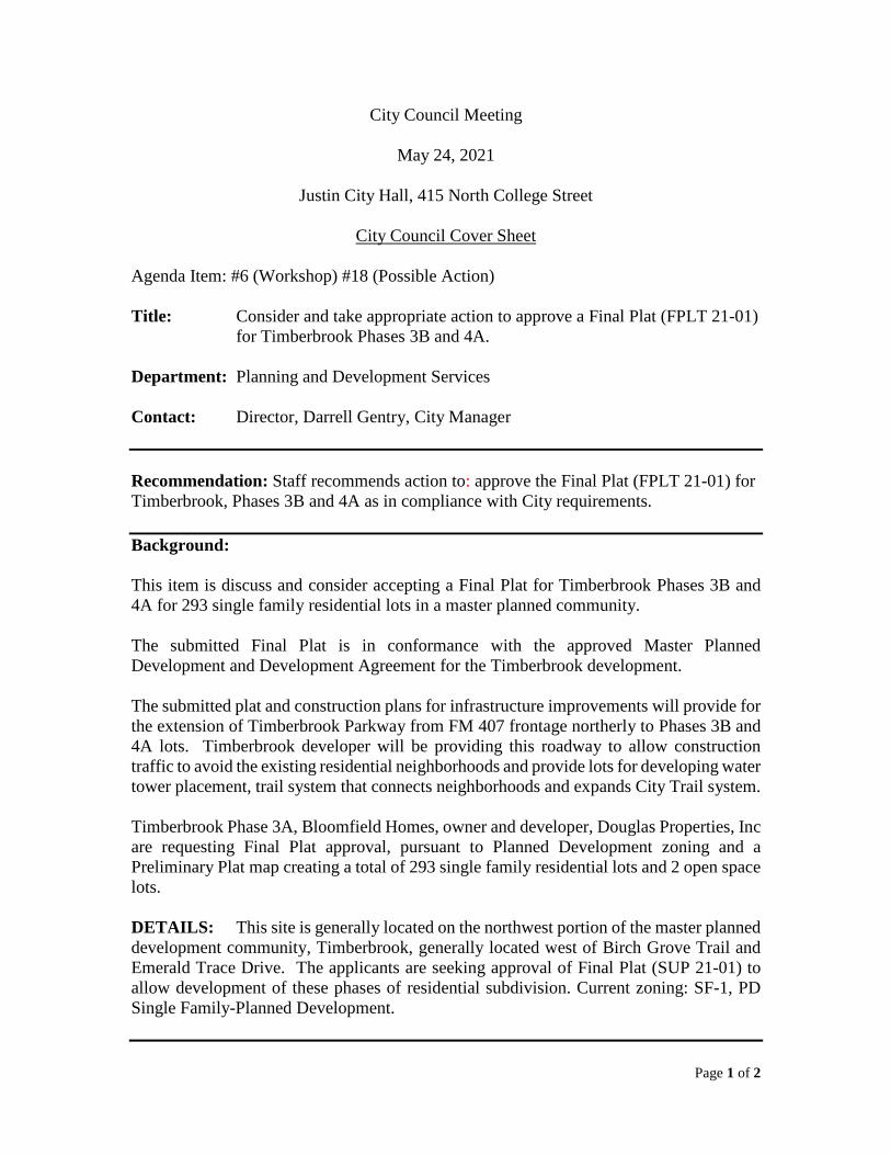
Page 1 of 2
City Council Meeting
May 24, 2021
Justin City Hall, 415 North College Street
City Council Cover Sheet
Agenda Item: #6 (Workshop) #18 (Possible Action)
Title: Consider and take appropriate action to approve a Final Plat (FPLT 21-01) for Timberbrook Phases 3B and 4A.
Department: Planning and Development Services
Contact: Director, Darrell Gentry, City Manager
Recommendation: Staff recommends action to: approve the Final Plat (FPLT 21-01) for Timberbrook, Phases 3B and 4A as in compliance with City requirements.
Background:
This item is discuss and consider accepting a Final Plat for Timberbrook Phases 3B and 4A for 293 single family residential lots in a master planned community.
The submitted Final Plat is in conformance with the approved Master Planned Development and Development Agreement for the Timberbrook development.
The submitted plat and construction plans for infrastructure improvements will provide for the extension of Timberbrook Parkway from FM 407 frontage northerly to Phases 3B and 4A lots. Timberbrook developer will be providing this roadway to allow construction traffic to avoid the existing residential neighborhoods and provide lots for developing water tower placement, trail system that connects neighborhoods and expands City Trail system.
Timberbrook Phase 3A, Bloomfield Homes, owner and developer, Douglas Properties, Inc are requesting Final Plat approval, pursuant to Planned Development zoning and a Preliminary Plat map creating a total of 293 single family residential lots and 2 open space lots.
DETAILS: This site is generally located on the northwest portion of the master planned development community, Timberbrook, generally located west of Birch Grove Trail and Emerald Trace Drive. The applicants are seeking approval of Final Plat (SUP 21-01) to allow development of these phases of residential subdivision. Current zoning: SF-1, PD Single Family-Planned Development.

Page 2 of 2
City Attorney Review: N/A ______________________________________________________________________
Attachments: (A) Final Plat 21-01 (Timberbrook Phases 3B and 4A) (B) City Engineer’s Review Letter May 15, 2020
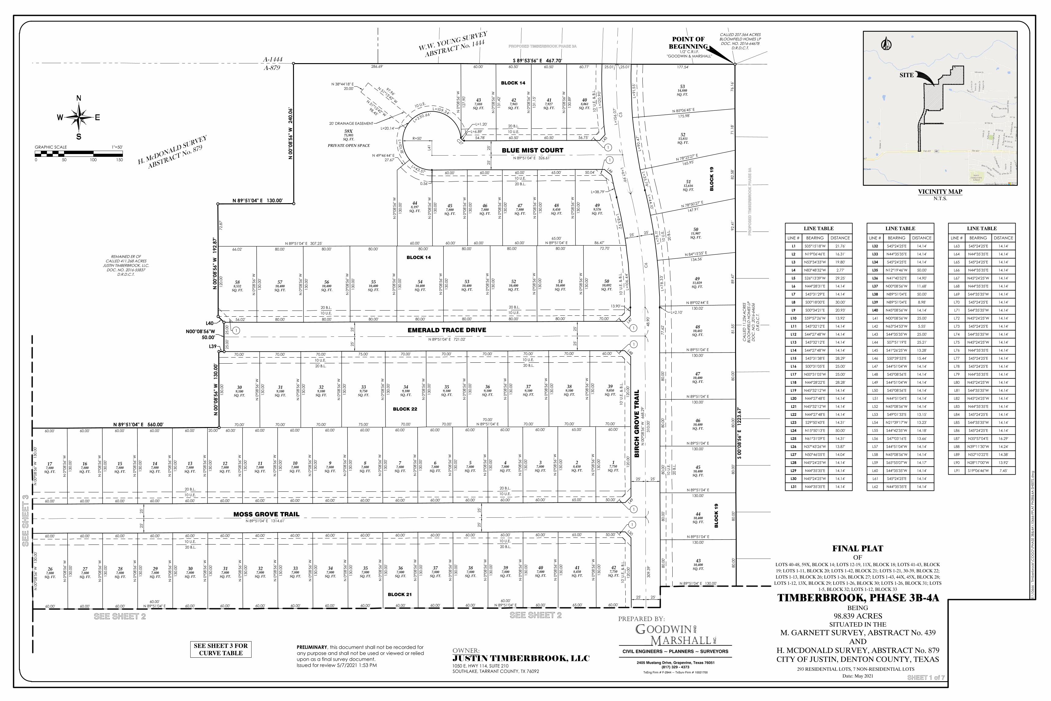
1/2" C.R.I.F."GOODWIN & MARSHALL"
N00°08'56"W50.00'
BLUE MIST COURT
BIR
CH
GR
OV
E T
RA
IL
EMERALD TRACE DRIVE
BLOCK 14
BLOCK 14
BLOCK 22
BLOCK 21
BLO
CK
19
BLO
CK
19
327,800
SQ. FT.
427,750
SQ. FT.
418,450
SQ. FT.
407,800
SQ. FT.
397,800
SQ. FT.
387,800
SQ. FT.
377,800
SQ. FT.
367,800
SQ. FT.
357,800
SQ. FT.
347,800
SQ. FT.
337,800
SQ. FT.
267,800
SQ. FT.
317,800
SQ. FT.
307,800
SQ. FT.
297,800
SQ. FT.
287,800
SQ. FT.
277,800
SQ. FT.
28,450
SQ. FT.
37,800
SQ. FT.
47,800
SQ. FT.
57,800
SQ. FT.
67,800
SQ. FT.
87,800
SQ. FT.
97,800
SQ. FT.
107,800
SQ. FT.
117,800
SQ. FT.
17,750
SQ. FT.
359,100
SQ. FT.
319,100
SQ. FT.
329,100
SQ. FT.
77,800
SQ. FT.
5410,400SQ. FT.
5710,400SQ. FT.
5610,400SQ. FT.
5510,400SQ. FT.
5110,400SQ. FT.
5310,400SQ. FT.
5210,400SQ. FT.
339,750
SQ. FT.
349,100
SQ. FT.
5010,092
SQ. FT.
379,100
SQ. FT.
369,100
SQ. FT.
389,100
SQ. FT.
399,050
SQ. FT.
N 0
°08'
56" W
130.
00'
60.00'65.00'60.00'N 89°51'04" E60.00'60.00'60.00'60.00'60.00'60.00'60.00'60.00'60.00'N 89°51'04" E
N 0
°08'
56" W
130.
00'
120.
00'
60.00' 60.00' 60.00' 60.00' 60.00' 60.00' 60.00' 60.00' 60.00' 60.00' 60.00' 60.00' 60.00' 60.00' 60.00' 65.00' 50.00'
N 0
°08'
56" W
130.
00'
L=12
0.90
'
72.70'86.47'
65.00'N 89°51'04" E
80.00'60.00'
80.00'60.00'
80.00'60.00'
80.00'N 89°51'04" E 307.25'
80.00'80.00'80.00'66.02'
N 0
°08'
56" W
130.
00'
N 0
°08'
56" W
130.
00'
N 0
°08'
56" W
130.
00'
N 0
°08'
56" W
130.
00'
N 0
°08'
56" W
130.
00'
N 0
°08'
56" W
130.
00'
N 0
°08'
56" W
130.
00'
N 0
°08'
56" W
130.
00'
N 0
°08'
56" W
130.
00'
N 0
°08'
56" W
130.
00'
N 0
°08'
56" W
130.
00'
N 0
°08'
56" W
130.
00'
N 0
°08'
56" W
130.
00'
N 0
°08'
56" W
130.
00'
N 0
°08'
56" W
130.
00'
N 0
°08'
56" W
130.
00'
N 0
°08'
56" W
130.
00'
N 0
°08'
56" W
130.
00'
N 0
°08'
56" W
130.
00'
N 0
°08'
56" W
130.
00'
60.00'70.00'
65.00'70.00'
60.00'70.00'
60.00'
70.00'N 89°51'04" E
60.00'70.00'
60.00'70.00'
60.00'75.00'60.00'
70.00'60.00'
70.00'60.00'60.00'
70.00'
N 0
°08'
56" W
130.
00'
70.00' 70.00' 75.00' 70.00' 70.00' 70.00' 70.00' 70.00' 60.00'
120.
00'
120.
00'
50.00'65.00'60.00'60.00'60.00'60.00'60.00'60.00'60.00'60.00'60.00'60.00'60.00'60.00'60.00'60.00'60.00'
N 0
°08'
56" W
130.
00'
N 0
°08'
56" W
130.
00'
N 0
°08'
56" W
130.
00'
N 0
°08'
56" W
130.
00'
N 0
°08'
56" W
130.
00'
N 0
°08'
56" W
130.
00'
N 0
°08'
56" W
130.
00'
N 0
°08'
56" W
130.
00'
N 0
°08'
56" W
130.
00'
N 0
°08'
56" W
130.
00'
N 0
°08'
56" W
130.
00'
N 0
°08'
56" W
130.
00'
N 0
°08'
56" W
130.
00'
N 0
°08'
56" W
130.
00'
N 0
°08'
56" W
130.
00'
N 0
°08'
56" W
130.
00'
N 0
°08'
56" W
130.
00'
N 0
°08'
56" W
130.
00'
N 0
°08'
56" W
130.
00'
N 0
°08'
56" W
130.
00'
N 0
°08'
56" W
130.
00'
N 0
°08'
56" W
130.
00'
N 0
°08'
56" W
130.
00'
N 0
°08'
56" W
130.
00'
N 0
°08'
56" W
130.
00'
N 0
°08'
56" W
130.
00'
N 0
°08'
56" W
130.
00'
N 0
°08'
56" W
130.
00'
N 0
°08'
56" W
130.
00'
N 0
°08'
56" W
130.
00'
N 0
°08'
56" W
130.
00'
N 0
°08'
56" W
130.
89'
N 0
°08'
56" W
131.
15' L=
91.5
5'L=
90.4
7'
L= 35.79'L=44.10'
L=78
.11'
L=78
.33'
L=2.10'
77.6
2'80
.00'
80.0
0'80
.00'
80.0
0'80
.00'
80.0
0'
N 85°06'45" E
175.98'
N 78°25'27" E
165.95'
N 78°50'27" E
147.91'
N 89°51'04" E 130.00'
N 89°51'04" E130.00'
N 0
°08'
56" W
127.
90'
N 84°15'55" E
134.56'
N 0
°08'
56" W
131.
42'
N 89°02'44" E130.02'
N 89°51'04" E130.00'
N 89°51'04" E130.00'
N 89°51'04" E130.00'
N 89°51'04" E130.00'
60.00'
70.00'
S 00
°08'
56" E
12
23.6
7'80
.00'
80.0
0'80
.00'
81.5
5'89
.47'
92.4
1'82
.58'
71.1
8'76
.16'
177.54'60.77'60.50'60.50'60.00'286.69'
72.8
7'12
0.00
'13
0.00
'
20.00'60.00'60.00'60.00'60.00'60.00'
5112,616
SQ. FT.
5213,811
SQ. FT.
5314,880SQ. FT.
4210,400
5011,907SQ. FT.
177,800
SQ. FT.
4310,400SQ. FT.
588,532
SQ. FT.
4410,400
SQ. FT.
309,100
SQ. FT.
4510,400SQ. FT.
127,800
SQ. FT.
4610,400
SQ. FT.
137,800
SQ. FT.
4710,400SQ. FT.
147,800
SQ. FT.
4810,482
SQ. FT.
157,800
SQ. FT.
4911,029SQ. FT.
167,800
SQ. FT.
80.0
0'80
.00'
80.0
0'
N 89°51'04" E 326.61'
N 89°51'04" E 721.02'
N 89°51'04" E 1314.61'
310.
00'
48.9
0'N
00°
08'5
6" W
66
8.29
'
C5
C6
L=67.99'
L=15
6.07
'
L41
10 U.E.20 B.L.
10 U.E.20 B.L.
10 U.E.20 B.L.
10 U.E.20 B.L.
S 89°53'56" E 467.70'
N 0
0°08
'56"
W
240.
06'
25'
25'
25'
25'
25'
25'
25'
25'
25'
25'
MOSS GROVE TRAIL
309.
39'
25.01' 25.01'
25.0
0'25
.00'
25' 25'
25' 25'
25' 25'
BLO
CK
19
N 0
0°08
'56"
W
130.
00'
N 0
0°08
'56"
W
130.
00'
N 89°51'04" E 130.00'
N 0
0°08
'56"
W
192.
87'
10 U.E.20 B.L.
10 U.E.20 B.L.
10 U.E.
10 U
.E.
20 B
.L.
10 U
.E.
20 B
.L.
10 U.E.20 B.L.
10 U.E.20 B.L.
10 U.E.20 B.L.
10 U.E.20 B.L.
R=50'
L45
L48
L49
L50
10' U
.E. &
B.L
.
10' U
.E. &
B.L
.10
' U.E
. & B
.L.
1
1
1
1
1
1
N 0
0°08
'56"
W
130.
00'
N 89°51'04" E 560.00'
A-879
A-1444
REMAINED ER OFCALLED 411.268 ACRES
JUSTIN TIMBERBROOK, LLC.DOC. NO. 2016-55837
D.R.D.C.T.
W.W. YOUNG SURVEY
ABSTRACT No. 1444
408,061
SQ. FT.
477,800
SQ. FT.
417,927
SQ. FT.
488,450
SQ. FT.
427,943
SQ. FT.
499,576
SQ. FT.
437,888
SQ. FT.
59X75,993
SQ. FT.
448,197
SQ. FT.45
7,800SQ. FT.
467,800
SQ. FT.
56.75'60.50'60.50'54.78'L=6.89'
L=1.20'L=
230.66'
L=43.57'
0.56'
60.00' 60.00' 60.00' 65.00' 50.04'
L=38.79'
L=83.92 '
L=10
6.44
'
13.90'
70.00'80.00'80.00'80.00'80.00'80.00'80.00'80.00'56.02'
N 49°46'44" E27.67'
L39
L40
60.00'
L46
L47
C27
N 89°51'04" E 130.00'
60.00'65.00'60.00'60.00'60.00'60.00'60.00'60.00'60.00'60.00'60.00'60.00'
60.00'N 89°51'04" E60.00'60.00'60.00'
H. McDONALD SURVEY
ABSTRACT No. 879
POINT OFBEGINNING
60.00'N 89°51'04" E
CA
LLED
11.
234
AC
RES
BLO
OM
FIEL
D H
OM
ES L
PD
OC
. NO
. 201
6-64
656
D.R
.D.C
.T.
PR
OP
OS
ED
TIM
BE
RB
RO
OK
PH
AS
E 3
A
PROPOSED TIMBERBROOK PHASE 3A
PROPOSED TIMBERBROOK PHASE 3A
CALLED 207.564 ACRESBLOOMFIELD HOMES LPDOC. NO. 2016-64678
D.R.D.C.T.
1
10' U
.E. &
B.L
.
L=109.34'
L=1 01.18'
L=20.14'
97.96'
N 51°15'42" WN 51°15'42" W98.45'
N 38°44'18" E20.00'
20' DRAINAGE EASEMENT
PRIVATE OPEN SPACE
© 2021 Microsoft Corporation © 2021 TomTom
LINE TABLE
LINE #
L1
L2
L3
L4
L5
L6
L7
L8
L9
L10
L11
L12
L13
L14
L15
L16
L17
L18
L19
L20
L21
L22
L23
L24
L25
L26
L27
L28
L29
L30
L31
BEARING
S05°15'18"W
N19°06'46"E
N53°34'33"W
N83°48'32"W
S26°13'39"W
N44°28'31"E
S45°31'29"E
S00°18'00"E
S00°34'21"E
S59°57'26"W
S45°32'12"E
S44°27'48"W
S45°32'12"E
S44°27'48"W
S45°31'38"E
S00°31'05"E
N00°31'05"W
N44°28'22"E
N45°32'12"W
N44°27'48"E
N45°32'12"W
N44°27'48"E
S29°50'43"E
N15°50'13"E
N61°31'09"E
N37°43'26"W
N50°46'05"E
N45°24'25"W
N44°35'35"E
N45°24'25"W
N44°35'35"E
DISTANCE
21.76'
16.31'
19.80'
2.77'
29.25'
14.14'
14.14'
30.00'
20.93'
13.92'
14.14'
14.14'
14.14'
14.14'
28.29'
25.00'
25.00'
28.28'
14.14'
14.14'
14.14'
14.14'
14.31'
50.00'
14.31'
13.87'
14.04'
14.14'
14.14'
14.14'
14.14'
LINE TABLE
LINE #
L32
L33
L34
L35
L36
L37
L38
L39
L40
L41
L42
L43
L44
L45
L46
L47
L48
L49
L50
L51
L52
L53
L54
L55
L56
L57
L58
L59
L60
L61
L62
BEARING
S45°24'25"E
N44°35'35"E
S45°24'25"E
N12°19'46"W
N41°40'52"E
N00°08'56"W
N89°51'04"E
N89°51'04"E
N45°08'56"W
N00°08'56"W
N63°54'53"W
S44°35'35"W
S07°51'19"E
S41°26'25"W
S50°39'53"E
S44°51'04"W
S45°08'56"E
S44°51'04"W
S45°08'56"E
N44°51'04"E
N45°08'56"W
S49°01'33"E
N21°39'17"W
S44°42'35"W
S47°03'16"E
S44°51'04"W
N45°08'56"W
S65°55'07"W
S44°35'35"W
S45°24'25"E
N44°35'35"E
DISTANCE
14.14'
14.14'
14.14'
50.00'
14.90'
11.68'
50.00'
8.98'
14.14'
25.00'
5.55'
25.00'
25.21'
13.28'
15.44'
14.14'
14.14'
14.14'
14.14'
14.14'
14.14'
13.15'
13.23'
14.18'
13.66'
14.14'
14.14'
14.17'
14.14'
14.14'
14.14'
LINE TABLE
LINE #
L63
L64
L65
L66
L67
L68
L69
L70
L71
L72
L73
L74
L75
L76
L77
L78
L79
L80
L81
L82
L83
L84
L85
L86
L87
L88
L89
L90
L91
BEARING
S45°24'25"E
N44°35'35"E
S45°24'25"E
N44°35'35"E
N45°24'25"W
N44°35'35"E
S44°35'35"W
S45°24'25"E
S44°35'35"W
N45°24'25"W
S45°24'25"E
S44°35'35"W
N45°24'25"W
N44°35'35"E
S45°24'25"E
S45°24'25"E
N44°35'35"E
N45°24'25"W
S44°35'35"W
N45°24'25"W
N44°35'35"E
S45°24'25"E
S44°35'35"W
S45°24'25"E
N35°57'04"E
N39°11'30"W
N52°10'22"E
N28°17'00"W
S19°06'46"W
DISTANCE
14.14'
14.14'
14.14'
14.14'
14.14'
14.14'
14.14'
14.14'
14.14'
14.14'
14.14'
14.14'
14.14'
14.14'
14.14'
14.14'
14.14'
14.14'
14.14'
14.14'
14.14'
14.14'
14.14'
14.14'
16.29'
14.24'
14.38'
13.92'
7.45'
FINAL PLATOF
LOTS 40-48, 59X, BLOCK 14; LOTS 12-19, 11X, BLOCK 18; LOTS 41-43, BLOCK19; LOTS 1-11, BLOCK 20; LOTS 1-42, BLOCK 21; LOTS 1-21, 30-39, BLOCK 22;LOTS 1-13, BLOCK 26; LOTS 1-26, BLOCK 27; LOTS 1-43, 44X, 45X, BLOCK 28;
LOTS 1-12, 13X, BLOCK 29; LOTS 1-26, BLOCK 30; LOTS 1-26, BLOCK 31; LOTS1-5, BLOCK 32; LOTS 1-12, BLOCK 33
TIMBERBROOK, PHASE 3B-4ABEING
98.839 ACRESSITUATED IN THE
M. GARNETT SURVEY, ABSTRACT No. 439AND
H. MCDONALD SURVEY, ABSTRACT No. 879CITY OF JUSTIN, DENTON COUNTY, TEXAS
293 RESIDENTIAL LOTS, 7 NON-RESIDENTIAL LOTS SDate: May 2021
PREPARED BY:
GM
OODWINARSHALL
CIVIL ENGINEERS ~ PLANNERS ~ SURVEYORS
AN
D
INC
.
2405 Mustang Drive, Grapevine, Texas 76051(817) 329 - 4373
TxEng Firm # F-2944 ~ TxSurv Firm # 10021700
E:\1
0666
- Tim
berb
rook
\CO
GO
\PHA
SE 3
B&4A
\106
66-F
PLA
T PH
3B&
4A-S
HEET
S.d
wg
SHEET 1 of 7
GRAPHIC SCALE 1"=50'
0 50 100 150
VICINITY MAPN.T.S.
SEE SHEET 2 SEE SHEET 2
SE
E S
HE
ET
3
OWNER:JUSTIN TIMBERBROOK, LLC1050 E. HWY 114, SUITE 210SOUTHLAKE, TARRANT COUNTY, TX 76092
SITE
SEE SHEET 3 FORCURVE TABLE
PRELIMINARY, this document shall not be recorded forany purpose and shall not be used or viewed or reliedupon as a final survey document.Issued for review 5/7/2021 1:53 PM
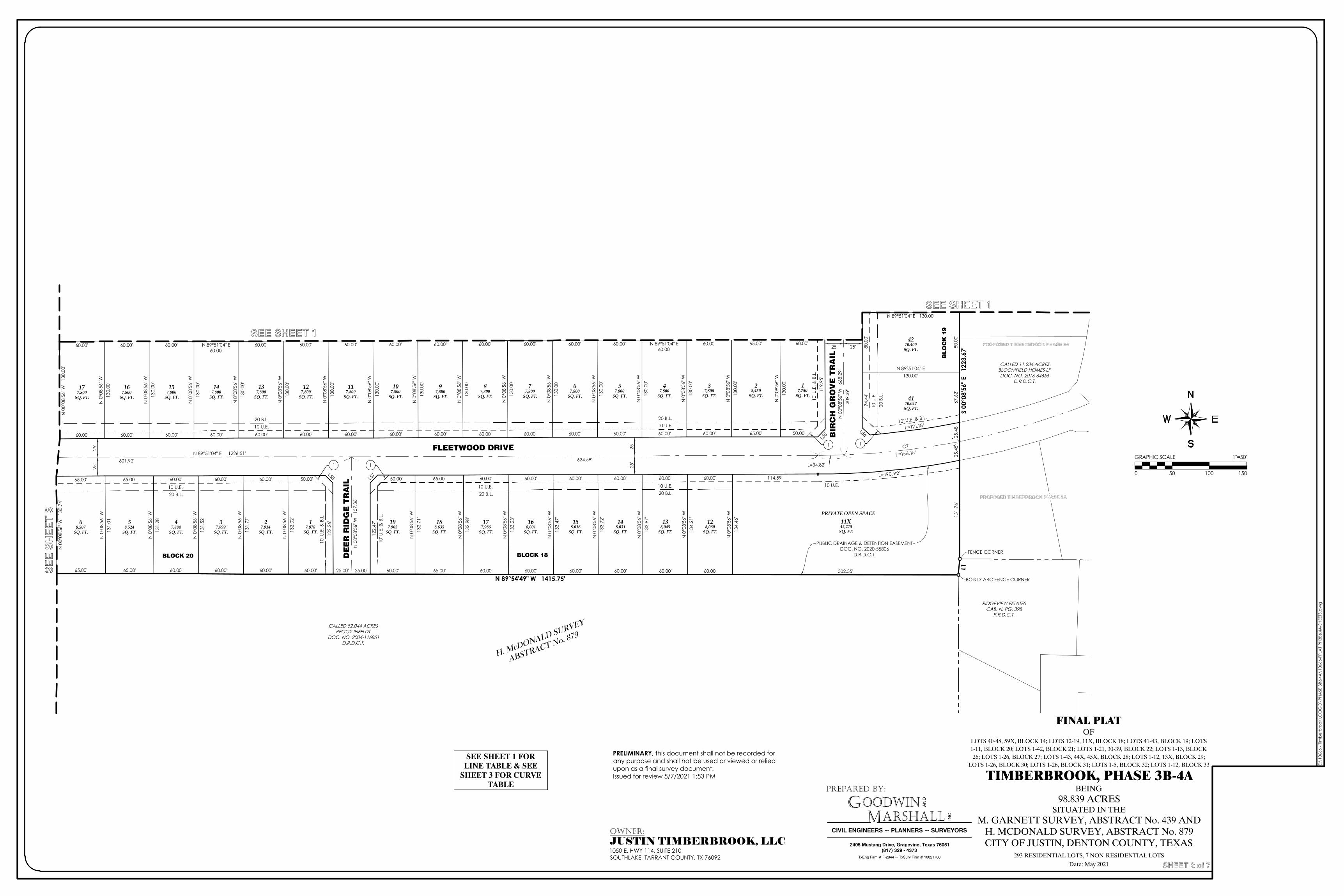
FLEETWOOD DRIVE
DE
ER
RID
GE
TR
AIL
BLOCK 21
BLOCK 18BLOCK 20
PRIVATE OPEN SPACE
PUBLIC DRAINAGE & DETENTION EASEMENTDOC. NO. 2020-55806
D.R.D.C.T.
117,800
SQ. FT.
17,750
SQ. FT.
28,450
SQ. FT.
37,800
SQ. FT.
47,800
SQ. FT.
57,800
SQ. FT.
67,800
SQ. FT.
77,800
SQ. FT.
87,800
SQ. FT.
97,800
SQ. FT.
107,800
SQ. FT.
177,800
SQ. FT.
127,800
SQ. FT.
137,800
SQ. FT.
147,800
SQ. FT.
157,800
SQ. FT.
167,800
SQ. FT.
N 0
°08'
56" W
130.
00'
60.00'65.00'60.00'N 89°51'04" E
60.00'60.00'60.00'60.00'60.00'60.00'60.00'60.00'60.00'60.00'N 89°51'04" E
60.00'60.00'60.00'60.00'
N 0
°08'
56" W
130.
00'
119.
95'
50.00'65.00'60.00'60.00'60.00'60.00'60.00'60.00'60.00'60.00'60.00'60.00'60.00'60.00'60.00'60.00'60.00'
N 0
°08'
56" W
130.
00'
N 0
°08'
56" W
130.
00'
N 0
°08'
56" W
130.
00'
N 0
°08'
56" W
130.
00'
N 0
°08'
56" W
130.
00'
N 0
°08'
56" W
130.
00'
N 0
°08'
56" W
130.
00'
N 0
°08'
56" W
130.
00'
N 0
°08'
56" W
130.
00'
N 0
°08'
56" W
130.
00'
N 0
°08'
56" W
130.
00'
N 0
°08'
56" W
130.
00'
N 0
°08'
56" W
130.
00'
N 0
°08'
56" W
130.
00'
122.
26'
50.00'60.00'60.00'60.00'65.00'65.00'
N 0
°08'
56" W
134.
21'
L=190.92'114.59'60.00'60.00'60.00'60.00'60.00'60.00'65.00'50.00'
122.
47'
N 0
°08'
56" W
134.
46'
80.0
0'74
.44'
L=121.18'
N 0
°08'
56" W
133.
97'
N 0
°08'
56" W
133.
72'
N 0
°08'
56" W
133.
47'
N 89°51'04" E 130.00'
N 0
°08'
56" W
133.
23'
N 0
°08'
56" W
131.
01'
N 0
°08'
56" W
131.
28'
N 89°51'04" E130.00'
N 0
°08'
56" W
132.
98'
N 0
0°08
'56"
W
130.
74'
N 0
°08'
56" W
132.
71'
N 0
°08'
56" W
132.
02'
N 0
°08'
56" W
131.
77'
N 0
°08'
56" W
131.
52'
S 00
°08'
56" E
12
23.6
7'
65.00' 65.00' 60.00' 60.00' 60.00' 60.00' 60.00' 65.00' 60.00' 60.00' 60.00' 60.00'
168,001
SQ. FT.
158,016
SQ. FT.
148,031
SQ. FT.
138,045
SQ. FT.
128,060
SQ. FT.
11X42,215
SQ. FT.
4110,027SQ. FT.
68,507
SQ. FT.
177,986
SQ. FT.
4210,400
SQ. FT.
58,524
SQ. FT.
47,884
SQ. FT.
37,899
SQ. FT.
27,914
SQ. FT.
17,878
SQ. FT.
197,905
SQ. FT.
188,635
SQ. FT.
60.00' 60.00' 302.35'
131.
76'
67.6
2'80
.00'
N 89°54'49" W 1415.75'
N 89°51'04" E 1226.51'624.59'
309.
39'
N 0
0°08
'56"
W
157.
36'
L=156.15'
L=34.82'
C725'
25'
BIR
CH
GR
OV
E T
RA
ILN
00°
08'5
6" W
66
8.29
'
25.4
5'25
.48'
25.00' 25.00'
25' 25'
25' 25'
BLO
CK
19
601.92'
N 0
0°08
'56"
W
130.
00'
N 0
0°08
'56"
W
130.
00'
N 0
0°08
'56"
W
130.
00'
N 0
0°08
'56"
W
130.
00'
10 U
.E.
20 B
.L.
10 U.E.20 B.L.
10 U.E.20 B.L.
10 U.E.20 B.L.
10 U.E.20 B.L.
10 U.E.20 B.L.
10 U.E.
L55
L56
L57L58
CALLED 82.044 ACRESPEGGY INFELDT
DOC. NO. 2004-116851D.R.D.C.T.
10' U
.E. &
B.L
.
10' U
.E. &
B.L
.
10' U
.E. &
B.L
.
1 1
11
L1
N 89°51'04" E 130.00'
60.00'65.00'60.00'60.00'60.00'60.00'60.00'60.00'60.00'60.00'60.00'60.00'
60.00'N 89°51'04" E60.00'60.00'60.00'
H. McDONALD SURVEY
ABSTRACT No. 879
60.00'N 89°51'04" E
CALLED 11.234 ACRESBLOOMFIELD HOMES LPDOC. NO. 2016-64656
D.R.D.C.T.
PROPOSED TIMBERBROOK PHASE 3A
FENCE CORNER
BOIS D' ARC FENCE CORNER
RIDGEVIEW ESTATESCAB. N. PG. 398
P.R.D.C.T.
10' U.E. & B.L.
25'
25'
PROPOSED TIMBERBROOK PHASE 3A
FINAL PLATOF
LOTS 40-48, 59X, BLOCK 14; LOTS 12-19, 11X, BLOCK 18; LOTS 41-43, BLOCK 19; LOTS1-11, BLOCK 20; LOTS 1-42, BLOCK 21; LOTS 1-21, 30-39, BLOCK 22; LOTS 1-13, BLOCK26; LOTS 1-26, BLOCK 27; LOTS 1-43, 44X, 45X, BLOCK 28; LOTS 1-12, 13X, BLOCK 29;
LOTS 1-26, BLOCK 30; LOTS 1-26, BLOCK 31; LOTS 1-5, BLOCK 32; LOTS 1-12, BLOCK 33
TIMBERBROOK, PHASE 3B-4ABEING
98.839 ACRESSITUATED IN THE
M. GARNETT SURVEY, ABSTRACT No. 439 ANDH. MCDONALD SURVEY, ABSTRACT No. 879CITY OF JUSTIN, DENTON COUNTY, TEXAS
293 RESIDENTIAL LOTS, 7 NON-RESIDENTIAL LOTSDate: May 2021
PREPARED BY:
GM
OODWINARSHALL
CIVIL ENGINEERS ~ PLANNERS ~ SURVEYORS
AN
D
INC
.
2405 Mustang Drive, Grapevine, Texas 76051(817) 329 - 4373
TxEng Firm # F-2944 ~ TxSurv Firm # 10021700
E:\1
0666
- Tim
berb
rook
\CO
GO
\PHA
SE 3
B&4A
\106
66-F
PLA
T PH
3B&
4A-S
HEET
S.d
wg
SHEET 2 of 7
GRAPHIC SCALE 1"=50'
0 50 100 150
SEE SHEET 1
SEE SHEET 1
SE
E S
HE
ET
3
OWNER:JUSTIN TIMBERBROOK, LLC1050 E. HWY 114, SUITE 210SOUTHLAKE, TARRANT COUNTY, TX 76092
SEE SHEET 1 FORLINE TABLE & SEE
SHEET 3 FOR CURVETABLE
PRELIMINARY, this document shall not be recorded forany purpose and shall not be used or viewed or reliedupon as a final survey document.Issued for review 5/7/2021 1:53 PM
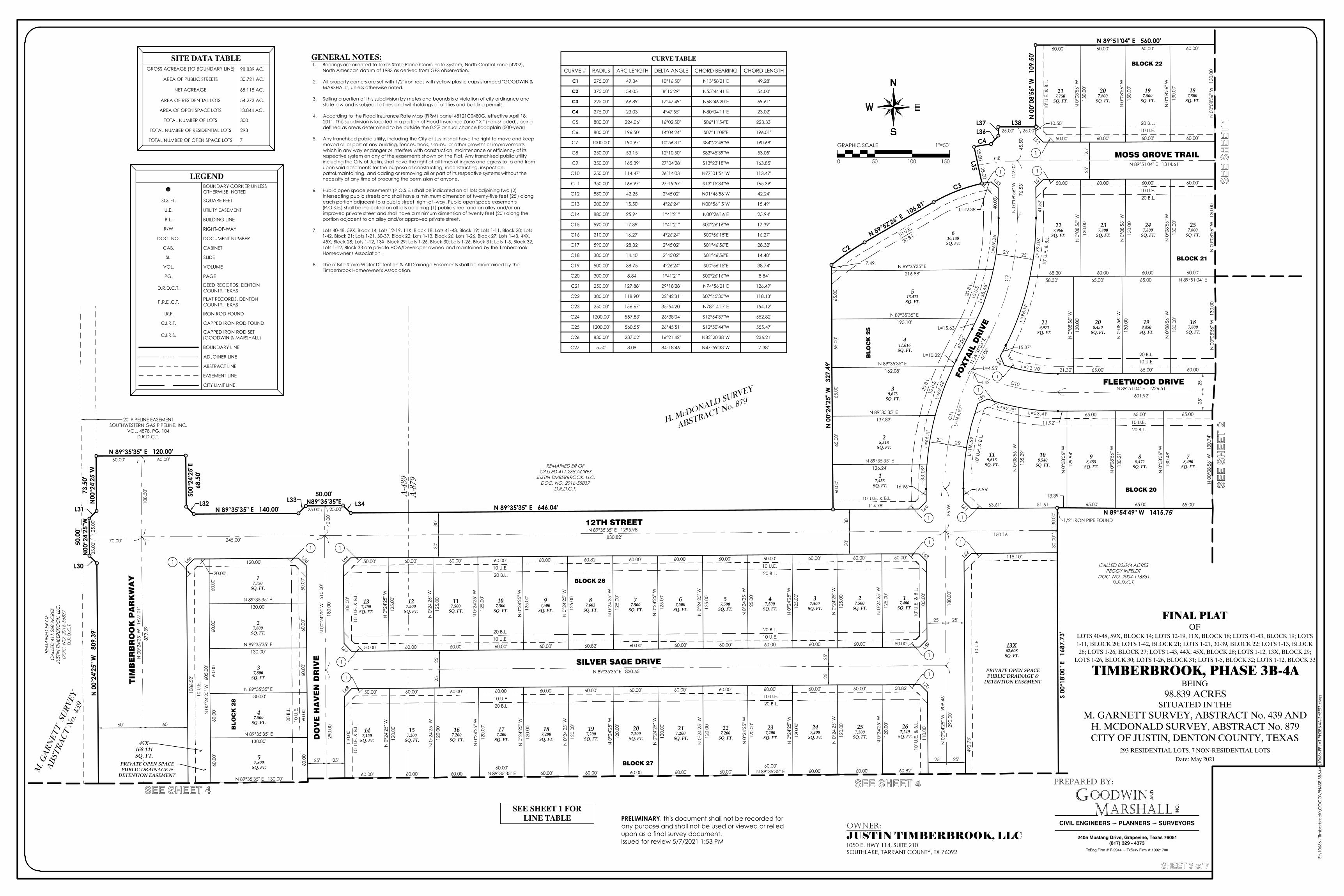
L42
25.00'
25.00'
25.0
0'
REM
AIN
ED E
R O
FC
ALL
ED 4
11.2
68 A
CRE
SJU
STIN
TIM
BERB
ROO
K, L
LC.
DO
C. N
O. 2
016-
5583
7D
.R.D
.C.T
.
M. G
AR
NE
TT
SU
RV
EY
AB
ST
RA
CT
No. 439
50.00'N89°35'35"E
50.0
0'N
00°2
4'25
"W
20' PIPELINE EASEMENTSOUTHWESTERN GAS PIPELINE, INC.
VOL. 4878, PG. 104D.R.D.C.T.
MOSS GROVE TRAIL
DO
VE
HA
VE
N D
RIV
E
FOXTA
IL D
RIV
E
12TH STREET
SILVER SAGE DRIVE
BLOCK 21
BLO
CK
25
BLOCK 26
BLOCK 27
BLO
CK
28
77,500
SQ. FT.
147,150
SQ. FT.
17,400
SQ. FT.
208,450
SQ. FT.
187,800
SQ. FT.
257,800
SQ. FT.
227,966
SQ. FT.
27,500
SQ. FT.
37,500
SQ. FT.
47,500
SQ. FT.
219,971
SQ. FT.
57,500
SQ. FT.
67,500
SQ. FT.
107,500
SQ. FT.
137,400
SQ. FT.
127,500
SQ. FT.
117,500
SQ. FT.
87,603
SQ. FT.
97,500
SQ. FT.
217,200
SQ. FT.
157,200
SQ. FT.
167,200
SQ. FT.
177,200
SQ. FT.
187,200
SQ. FT.
197,200
SQ. FT.
207,200
SQ. FT.
247,200
SQ. FT.
227,200
SQ. FT.
237,200
SQ. FT.
267,249
SQ. FT.
257,200
SQ. FT.
17,750
SQ. FT.
27,800
SQ. FT.
37,800
SQ. FT.
47,800
SQ. FT.
57,800
SQ. FT.
198,450
SQ. FT.
119,613
SQ. FT.
20.00'
120.00'
50.0
0'60
.00'
60.0
0'60
.00'
60.0
0'
60.0
0'60
.00'
60.0
0'60
.00'
60.0
0'
N 0
°24'
25" W
125.
00'
50.00'60.00'60.00'60.00'60.00'60.00'60.00'60.82'60.00'60.00'60.00'60.00'50.00'
105.
00'
50.00' 60.00' 60.00' 60.00' 60.00' 60.82' 60.00' 60.00' 60.00' 60.00' 60.00' 60.00' 50.00'
105.
00'
N 0
°24'
25" W
125.
00'
110.
00'
50.00' 60.00' 60.00' 60.00' 60.00' 60.00' 60.00' 60.00' 60.00' 60.00' 60.00' 60.00' 50.82'
110.
00'
N 0
°24'
25" W
120.
00'
60.00' 60.00'60.00'
N 89°35'35" E 60.00' 60.00' 60.00' 60.00' 60.00'60.00'
N 89°35'35" E 60.00' 60.82'
N 89°51'04" E60.00'60.00'
65.00'60.00'
65.00'68.30'
60.00'65.00'65.00'21.32'L=73.20'
15.37'
L=98
.14'
L=79
.06 '
41.5
2'
50.00' 60.00' 60.00' 60.00'
N 0
°24'
25" W
125.
00'
N 0
°08'
56" W
130.
00'
N 0
°08'
56" W
130.
00'
N 0
°08'
56" W
130.
00'
N 0
°08'
56" W
130.
00'
N 0
°08'
56" W
130.
00'
N 0
°08'
56" W
130.
00'
N 0
°24'
25" W
125.
00'
N 0
°24'
25" W
125.
00'
N 0
°24'
25" W
125.
00'
60.00'60.00'60.00'50.00'
10.50'
N 0
°24'
25" W
125.
00'
N 0
°24'
25" W
125.
00'
N 0
°24'
25" W
125.
00'
N 0
°24'
25" W
125.
00'
N 0
°24'
25" W
125.
00'
N 0
°24'
25" W
125.
00'
N 0
°24'
25" W
120.
00'
N 0
°24'
25" W
120.
00'
N 0
°24'
25" W
120.
00'
N 0
°24'
25" W
120.
00'
N 0
°24'
25" W
120.
00'
N 0
°24'
25" W
120.
00'
N 0
°24'
25" W
120.
00'
N 0
°24'
25" W
120.
00'
N 0
°24'
25" W
120.
00'
N 0
°24'
25" W
120.
00'
N 0
°24'
25" W
120.
00'
N 89°35'35" E130.00'
N 89°35'35" E130.00'
N 89°35'35" E130.00'
N 89°35'35" E130.00'
N 89°35'35" E 130.00'
65.00'65.00'65.00'
11.92'
L=53.41'
L=42.18'
L=11
6.59
'
16.96'
63.61' 51.61'
N 0
°08'
56" W
135.
29'
N 89°35'35" E162.08'
L=12.38' 40.0
9'L=
69. 2
6 '
L=68
.68 '
L=15.63'
47.0
6'
L=10.22'
L=69
. 48 '
L=66
.11'
L =3 3
.09 '
16.96'
114.78'
N 89°35'35" E137.83'
N 0
°08'
56" W
130.
00'
N 89°35'35" E126.24'
N 0
°08'
56" W
130.
00'
N 0
°08'
56" W
130.
00'
N 89°35'35" E216.88'
N 89°35'35" E195.10'
N 0
0°08
'56"
W
109.
50'
N 0
0°24
'25"
W
327.
49'
N 89°35'35" E 120.00'
S00°
24'2
5"E
68.5
0'
N 89°35'35" E 646.04'N 89°35'35" E 140.00'
73.5
0'N
00°2
4'25
"WN
00°
24'2
5" W
80
9.39
'
N 0
°08'
56" W
129.
94'
N 0
°08'
56" W
130.
21'
492.
73'
115.10'
N 0
0°08
'56"
W
130.
74'
N 0
°08'
56" W
130.
48'
58.30'
PRIVATE OPEN SPACEPUBLIC DRAINAGE &
DETENTION EASEMENT
247,800
SQ. FT.
237,800
SQ. FT.
65.00'
60.00'60.00'60.00'60.00'
187,800
SQ. FT.
197,800
SQ. FT.
13X62,608
SQ. FT.
207,800
SQ. FT.
108,540
SQ. FT.
217,750
SQ. FT.
98,455
SQ. FT.
616,148
SQ. FT.
88,472
SQ. FT.
513,472
SQ. FT.
78,490
SQ. FT.
411,616SQ. FT.
39,673
SQ. FT.
28,518
SQ. FT.
17,453
SQ. FT.
S 00
°18'
00" E
16
87.7
3'
N 89°54'49" W 1415.75'
601.92'
45.5
0'76
.53'
N 0
0°08
'56"
W
122.
02'
N 89°35'35" E 1295.98'150.16'830.82'245.00'70.00'
N 89°35'35" E 830.65'
N 0
0°24
'25"
W
510.
00'
N 0
0°24
'25"
W
909.
46'
290.
00'
180.
00'
56.9
6'108.
50'
180.
00'
290.
00'
40.0
0'
N 26
°55'3
3" E
47.0
6'
L=4.55'
C8
C9
C10
C11
FLEETWOOD DRIVE
25'
25'
25'
25'
25'
25'
25'
25'
N 89°51'04" E 1314.61'
30.0
0'30
.00'
25.00'
25.00'25.00'
25.00'
25.0
0'
60.00' 60.00'
25' 25'
25' 25'
25' 25'
25' 25'
25' 25'
30'
30'
30'
30'
60' 60'
60.00'60.82'60.00'
60.00'N 89°35'35" E
60.00'60.00'60.00'60.00'60.00'60.00'N 89°35'35" E
60.00'60.00'
60.00'60.00' 60.00'
BLOCK 20
BLOCK 22
N 89°51'04" E 1226.51'
N 0
0°08
'56"
W
130.
74'
N 0
0°08
'56"
W
130.
00'
N 0
0°08
'56"
W
130.
00'
N 0
0°08
'56"
W
130.
00'
N 0
0°08
'56"
W
130.
00'
TIM
BE
RB
RO
OK
PA
RK
WA
YN
00°
24'2
5" W
16
27.0
1'87
9.39
'
10 U.E.20 B.L.
10 U.E.20 B.L.
10 U.E.20 B.L.
10 U
.E.
20 B
.L.
10 U
.E.
20 B
.L.
10 U.E.20 B.L.
25' 25'
25' 25'
L51
L52
L53
L54
L59
L60 L61
L62L63
L64L65L66
L67
L68
L69
L70
CALLED 82.044 ACRESPEGGY INFELDT
DOC. NO. 2004-116851D.R.D.C.T.
10 U.E.20 B.L.
10 U.E.20 B.L.
10 U.E.20 B.L.
10 U.E.20 B.L.
10 U.E.20 B.L.
10 U.E.20 B.L.
10 U
.E.
10 U
.E.
20 B
.L.
10 U
.E.
10' U
.E. &
B.L
.
10' U
.E. &
B.L
.
10' U
.E. &
B.L
.
1
1
1 1
1 1
1
1 1
1
11
1
N 59°52'26" E 106.81'
1 1
1
N 89°51'04" E 560.00'
REMAINED ER OFCALLED 411.268 ACRES
JUSTIN TIMBERBROOK, LLC.DOC. NO. 2016-55837
D.R.D.C.T.
A-8
79
A-4
39
10' U
.E. &
B.L
.
7.49'
65.0
0'65
.00'
65.0
0'65
.00'
60.0
0'
L30
L31L32 L33 L34
L35
L36L37 L38
C2
C3
C4
1086
.52' H. M
cDONALD SURVEY
ABSTRACT No. 879
H. McDONALD SURVEY
ABSTRACT No. 879
N 89°35'35" E 130.00'
N 0
0°24
'25"
W
605.
00'
13.39'
65.00' 65.00'
1/2" IRON PIPE FOUND
10' U
.E. &
B.L
.
10 U.E.
20 B.L.
10' U
.E. &
B.L
.
L=16
6.97
'
10' U
.E. &
B.L
.
10' U.E. & B.L.
45X168.141SQ. FT.
PRIVATE OPEN SPACEPUBLIC DRAINAGE &
DETENTION EASEMENT
CURVE TABLE
CURVE #
C1
C2
C3
C4
C5
C6
C7
C8
C9
C10
C11
C12
C13
C14
C15
C16
C17
C18
C19
C20
C21
C22
C23
C24
C25
C26
C27
RADIUS
275.00'
375.00'
225.00'
275.00'
800.00'
800.00'
1000.00'
250.00'
350.00'
250.00'
350.00'
880.00'
200.00'
880.00'
590.00'
210.00'
590.00'
300.00'
500.00'
300.00'
250.00'
300.00'
250.00'
1200.00'
1200.00'
830.00'
5.50'
ARC LENGTH
49.34'
54.05'
69.89'
23.03'
224.06'
196.50'
190.97'
53.15'
165.39'
114.47'
166.97'
42.25'
15.50'
25.94'
17.39'
16.27'
28.32'
14.40'
38.75'
8.84'
127.88'
118.90'
156.67'
557.83'
560.55'
237.02'
8.09'
DELTA ANGLE
10°16'50"
8°15'29"
17°47'49"
4°47'55"
16°02'50"
14°04'24"
10°56'31"
12°10'50"
27°04'28"
26°14'03"
27°19'57"
2°45'02"
4°26'24"
1°41'21"
1°41'21"
4°26'24"
2°45'02"
2°45'02"
4°26'24"
1°41'21"
29°18'28"
22°42'31"
35°54'20"
26°38'04"
26°45'51"
16°21'42"
84°18'46"
CHORD BEARING
N13°58'21"E
N55°44'41"E
N68°46'20"E
N80°04'11"E
S06°11'54"E
S07°11'08"E
S84°22'49"W
S83°45'39"W
S13°23'18"W
N77°01'54"W
S13°15'34"W
N01°46'56"W
N00°56'15"W
N00°26'16"E
S00°26'16"W
S00°56'15"E
S01°46'56"E
S01°46'56"E
S00°56'15"E
S00°26'16"W
N74°56'21"E
S07°45'30"W
N78°14'17"E
S12°54'37"W
S12°50'44"W
N82°20'38"W
N47°59'33"W
CHORD LENGTH
49.28'
54.00'
69.61'
23.02'
223.33'
196.01'
190.68'
53.05'
163.85'
113.47'
165.39'
42.24'
15.49'
25.94'
17.39'
16.27'
28.32'
14.40'
38.74'
8.84'
126.49'
118.13'
154.12'
552.82'
555.47'
236.21'
7.38'
FINAL PLATOF
LOTS 40-48, 59X, BLOCK 14; LOTS 12-19, 11X, BLOCK 18; LOTS 41-43, BLOCK 19; LOTS1-11, BLOCK 20; LOTS 1-42, BLOCK 21; LOTS 1-21, 30-39, BLOCK 22; LOTS 1-13, BLOCK26; LOTS 1-26, BLOCK 27; LOTS 1-43, 44X, 45X, BLOCK 28; LOTS 1-12, 13X, BLOCK 29;
LOTS 1-26, BLOCK 30; LOTS 1-26, BLOCK 31; LOTS 1-5, BLOCK 32; LOTS 1-12, BLOCK 33
TIMBERBROOK, PHASE 3B-4ABEING
98.839 ACRESSITUATED IN THE
M. GARNETT SURVEY, ABSTRACT No. 439 ANDH. MCDONALD SURVEY, ABSTRACT No. 879CITY OF JUSTIN, DENTON COUNTY, TEXAS
293 RESIDENTIAL LOTS, 7 NON-RESIDENTIAL LOTSDate: May 2021
PREPARED BY:
GM
OODWINARSHALL
CIVIL ENGINEERS ~ PLANNERS ~ SURVEYORS
AN
D
INC
.
2405 Mustang Drive, Grapevine, Texas 76051(817) 329 - 4373
TxEng Firm # F-2944 ~ TxSurv Firm # 10021700
E:\1
0666
- Tim
berb
rook
\CO
GO
\PHA
SE 3
B&4A
\106
66-F
PLA
T PH
3B&
4A-S
HEET
S.d
wg
SHEET 3 of 7
GRAPHIC SCALE 1"=50'
0 50 100 150
SE
E S
HE
ET
1S
EE
SH
EE
T 2
SEE SHEET 4SEE SHEET 4
OWNER:JUSTIN TIMBERBROOK, LLC1050 E. HWY 114, SUITE 210SOUTHLAKE, TARRANT COUNTY, TX 76092
SITE DATA TABLEGROSS ACREAGE (TO BOUNDARY LINE) 98.839 AC.
AREA OF PUBLIC STREETS 30.721 AC.
NET ACREAGE 68.118 AC.
AREA OF RESIDENTIAL LOTS 54.273 AC.
AREA OF OPEN SPACE LOTS 13.844 AC.
TOTAL NUMBER OF LOTS 300
TOTAL NUMBER OF RESIDENTIAL LOTS 293
TOTAL NUMBER OF OPEN SPACE LOTS 7
LEGENDBOUNDARY CORNER UNLESSOTHERWISE NOTED
SQ. FT. SQUARE FEET
U.E. UTILITY EASEMENT
B.L. BUILDING LINE
R/W RIGHT-OF-WAY
DOC. NO. DOCUMENT NUMBER
CAB. CABINET
SL. SLIDE
VOL. VOLUME
PG. PAGE
D.R.D.C.T. DEED RECORDS, DENTONCOUNTY, TEXAS
P.R.D.C.T. PLAT RECORDS, DENTONCOUNTY, TEXAS
I.R.F. IRON ROD FOUND
C.I.R.F. CAPPED IRON ROD FOUND
C.I.R.S.CAPPED IRON ROD SET(GOODWIN & MARSHALL)
BOUNDARY LINE
ADJOINER LINE
ABSTRACT LINE
EASEMENT LINE
CITY LIMIT LINE
GENERAL NOTES:1. Bearings are oriented to Texas State Plane Coordinate System, North Central Zone (4202),
North American datum of 1983 as derived from GPS observation.
2. All property corners are set with 1/2" iron rods with yellow plastic caps stamped "GOODWIN &MARSHALL", unless otherwise noted.
3. Selling a portion of this subdivision by metes and bounds is a violation of city ordinance andstate law and is subject to fines and withholdings of utilities and building permits.
4. According to the Flood Insurance Rate Map (FIRM) panel 48121C0480G, effective April 18,2011. This subdivision is located in a portion of Flood Insurance Zone " X " (non-shaded), beingdefined as areas determined to be outside the 0.2% annual chance floodplain (500-year)
5. Any franchised public utility, including the City of Justin shall have the right to move and keepmoved all or part of any building, fences, trees, shrubs, or other growths or improvementswhich in any way endanger or interfere with construction, maintenance or efficiency of itsrespective system on any of the easements shown on the Plat. Any franchised public utilityincluding the City of Justin, shall have the right at all times of ingress and egress to to and fromupon said easements for the purpose of constructing, reconstructing, inspection,patrol,maintaining, and adding or removing all or part of its respective systems without thenecessity at any time of procuring the permission of anyone.
6. Public open space easements (P.O.S.E.) shall be indicated on all lots adjoining two (2)intersecting public streets and shall have a minimum dimension of twenty-five feet (25') alongeach portion adjacent to a public street right-of -way. Public open space easements(P.O.S.E.) shall be indicated on all lots adjoining (1) public street and an alley and/or animproved private street and shall have a minimum dimension of twenty feet (20') along theportion adjacent to an alley and/or approved private street.
7. Lots 40-48, 59X, Block 14; Lots 12-19, 11X, Block 18; Lots 41-43, Block 19; Lots 1-11, Block 20; Lots1-42, Block 21; Lots 1-21, 30-39, Block 22; Lots 1-13, Block 26; Lots 1-26, Block 27; Lots 1-43, 44X,45X, Block 28; Lots 1-12, 13X, Block 29; Lots 1-26, Block 30; Lots 1-26, Block 31; Lots 1-5, Block 32;Lots 1-12, Block 33 are private HOA/Developer owned and maintained by the TimberbrookHomeowner's Association.
8. The offsite Storm Water Detention & All Drainage Easements shall be maintained by theTimberbrook Homeowner's Association.
SEE SHEET 1 FORLINE TABLE PRELIMINARY, this document shall not be recorded for
any purpose and shall not be used or viewed or reliedupon as a final survey document.Issued for review 5/7/2021 1:53 PM
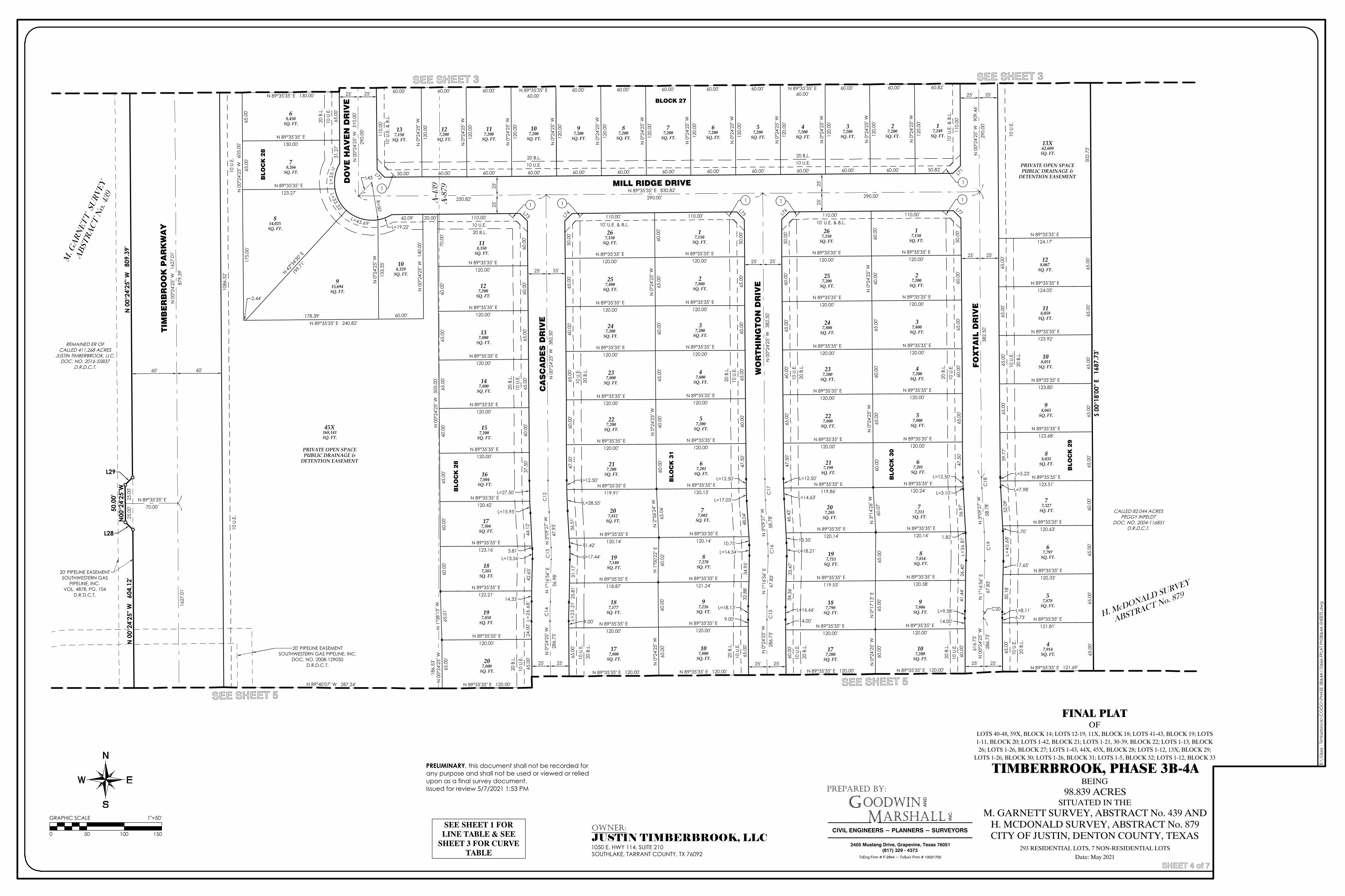
H. McDONALD SURVEY
H. McDONALD SURVEY
ABSTRACT No. 879
M. G
AR
NE
TT
SU
RV
EY
AB
ST
RA
CT
No. 439
REMAINED ER OFCALLED 411.268 ACRES
JUSTIN TIMBERBROOK, LLC.DOC. NO. 2016-55837
D.R.D.C.T.
M. G
AR
NE
TT
SU
RV
EY
50.0
0'N
00°2
4'25
"W
L43
FO
XT
AIL
DR
IVE
MILL RIDGE DRIVE
WO
RT
HIN
GT
ON
DR
IVE
CA
SC
AD
ES
DR
IVE
TIM
BE
RB
RO
OK
PA
RK
WA
Y
BLO
CK
28
BLO
CK
31
BLO
CK
30
BLO
CK
29
PRIVATE OPEN SPACEPUBLIC DRAINAGE &
DETENTION EASEMENT
207,205
SQ. FT.20
7,812SQ. FT.
77,802
SQ. FT.
77,200
SQ. FT.
137,150
SQ. FT.
127,200
SQ. FT.
117,200
SQ. FT.
107,200
SQ. FT.
97,200
SQ. FT.
87,200
SQ. FT.
37,200
SQ. FT.
67,200
SQ. FT.
57,200
SQ. FT.
47,200
SQ. FT.
17,249
SQ. FT.
27,200
SQ. FT.
267,150
SQ. FT.
27,200
SQ. FT.
87,854
SQ. FT.
177,200
SQ. FT.
107,200
SQ. FT.
187,798
SQ. FT.
97,806
SQ. FT.
197,753
SQ. FT.
57,800
SQ. FT.
247,800
SQ. FT.
217,199
SQ. FT.
77,211
SQ. FT.
227,800
SQ. FT.
37,800
SQ. FT.
237,200
SQ. FT.
47,200
SQ. FT.
257,200
SQ. FT.
17,150
SQ. FT.
814,025
SQ. FT.
915,694
SQ. FT.
108,329
SQ. FT.
68,450
SQ. FT.
78,266
SQ. FT.
17,150
SQ. FT.
267,150
SQ. FT.
27,800
SQ. FT.
257,800
SQ. FT.
37,200
SQ. FT.
247,200
SQ. FT.
47,800
SQ. FT.
237,800
SQ. FT.
57,200
SQ. FT.
227,200
SQ. FT.
67,201
SQ. FT.
217,200
SQ. FT.
197,140
SQ. FT.
87,270
SQ. FT.
97,226
SQ. FT.
187,177
SQ. FT.
107,800
SQ. FT.
177,800
SQ. FT.
187,381
SQ. FT.
118,350
SQ. FT.
197,858
SQ. FT.
127,200
SQ. FT.
207,800
SQ. FT.
137,800
SQ. FT.
147,800
SQ. FT.
157,200
SQ. FT.
167,804
SQ. FT.
177,304
SQ. FT.
N 89°40'07" W 287.24'
1086
.52'
65.0
0'31
.27'
L=3 5
.11'
L= 33.32 '
L=45.69'L=19.22'
42.09' 20.00' 110.00'
60.0
0'60
.00'
65.0
0'65
.00'
60.0
0'37
.50'
L=27.50'
L=15.95'
44.1
2'
3.81'L=13.56'
42.6
5'
14.33'
L=26
.68 '
24.0
0'65
.00'
65.0
0'65
.00'
175.
00'
2.44'
178.39' 60.00'
N 0
0°24
'25"
W
140.
00'
70.0
0'60
.00'
65.0
0'65
.00'
60.0
0'65
.00'
60.0
0'60
.00'
N 1
°38'
13" W
65.0
1'65
.00'
50.82'60.00'60.00'60.00'60.00'60.00'60.00'60.00'60.00'60.00'60.00'60.00'50.00'
110.
00'
110.
00'
N 0
°24'
25" W
120.
00'
60.00' 60.00' N 89°35'35" E 60.00' 60.00' 60.00' 60.00' 60.00' N 89°35'35" E 60.00' 60.82'
N 89°35'35" E119.86'
N 89°35'35" E120.24'
60.0
0'N
0°2
4'25
" W60
.00'
65.0
0'60
.00'
N 0
°24'
25" W
65.0
0'60
.00'
N 3
°14'
26" W
60.0
7'65
.00'
N 0
°17'
13" E
65.0
0'N
0°2
4'25
" W60
.00'
N 89°35'35" E120.14'
N 89°35'35" E120.14'
50.0
0'60
.00'
65.0
0'60
.00'
65.0
0'47
.50'
L=12.50'
56.9
7'
1.82'
L=36
.81'
26.4
0'41
.44'
L=9.58'
14.00'
60.0
0'
60.0
0'
14.00'
L=16.66'
34.3
6'33
.47'
L=18.21'
13.35'
45.4
3'
L=14.63'
L=12.50'
47.5
0'65
.00'
60.0
0'65
.00'
60.0
0'50
.00'
110.00' 110.00'
N 89°35'35" E120.13'
N 89°35'35" E119.91'
60.0
0'N
0°2
4'25
" W65
.00'
60.0
0'65
.00'
N 0
°24'
25" W
60.0
0'60
.00'
N 2
°56'
24" W
65.0
6'N
1°0
0'22
" E60
.02'
60.0
0'N
0°2
4'25
" W65
.00'
N 89°35'35" E120.14'
N 89°35'35" E120.14'
50.0
0'65
.00'
60.0
0'65
.00'
60.0
0'47
.50'
L=12.50'
L=28.55'
36.5
1'
11.42'
L=17.44'
31.1
7'25
.81'
L=25
. 21 '
9.00'
65.0
0'
65.0
0'
9.00'
L=18.13'
32.8
8'34
.95'
L=14.34'
10.75'
48.0
4'
L=17.03'
L=12.50'
47.5
0'60
.00'
65.0
0'60
.00'
65.0
0'50
.00'
110.00'110.00'
N 0
°24'
25" W
120.
00'
N 0
°24'
25" W
120.
00'
N 0
°24'
25" W
120.
00'
N 0
°24'
25" W
120.
00'
N 0
°24'
25" W
120.
00'
N 0
°24'
25" W
120.
00'
N 0
°24'
25" W
120.
00'
N 0
°24'
25" W
120.
00'
N 0
°24'
25" W
120.
00'
N 0
°24'
25" W
120.
00'
N 0
°24'
25" W
120.
00'
N 89°35'35" E120.00'
N 89°35'35" E120.00'
N 89°35'35" E120.00'
N 89°35'35" E120.00'
N 89°35'35" E119.53'
N 89°35'35" E120.58'
N 89°35'35" E 120.00' N 89°35'35" E 120.00'
N 89°35'35" E120.00'
N 89°35'35" E120.00'
N 89°35'35" E120.00'
N 89°35'35" E120.00'
N 89°35'35" E120.00'
N 89°35'35" E120.00'
N 89°35'35" E120.00'
N 89°35'35" E120.00'
N 89°35'35" E123.27'
N 42°3
4'30"
E19
9.71'
N 0
°24'
25" W
133.
35'
N 89°35'35" E 130.00'
N 89°35'35" E130.00'
N 89°35'35" E120.00'
N 89°35'35" E120.00'
N 89°35'35" E120.00'
N 89°35'35" E120.00'
N 89°35'35" E120.00'
N 89°35'35" E120.00'
N 89°35'35" E120.00'
N 89°35'35" E120.00'
N 89°35'35" E120.00'
N 89°35'35" E120.00'
N 89°35'35" E 120.00'N 89°35'35" E 120.00'
N 89°35'35" E121.24'
N 89°35'35" E118.87'
N 89°35'35" E120.00'
N 89°35'35" E120.00'
N 89°35'35" E123.16'
N 89°35'35" E122.21'
N 89°35'35" E120.00'
N 89°35'35" E120.00'
N 89°35'35" E120.00'
N 89°35'35" E 120.00'
N 89°35'35" E120.00'
N 89°35'35" E120.00'
N 89°35'35" E120.00'
N 89°35'35" E120.42'
N 0
0°24
'25"
W
809.
39'
N 0
0°24
'25"
W
604.
12'
65.0
0'
6.73'L=8.11'
50.1
8'
17.65'
L=40
.68'
6.70'
52.0
9'
L=7.98'
L=5.23'
59.7
7'65
.00'
65.0
0'65
.00'
65.0
0'
N 89°35'35" E124.17'
N 89°35'35" E124.05'
N 89°35'35" E123.92'
N 89°35'35" E 121.69'
N 89°35'35" E123.80'
N 89°35'35" E123.68'
N 89°35'35" E123.51'
N 89°35'35" E120.63'
N 89°35'35" E120.33'
N 89°35'35" E121.81'
N 0
0°24
'25"
W
605.
00'
N 89°35'35" E 240.82'
N 0
0°24
'25"
W
505.
00'
186.
53'
N 0
0°24
'25"
W
67,201
SQ. FT.
L=3.10'
118,059
SQ. FT.
128,067
SQ. FT.
108,051
SQ. FT.
3
47,914
SQ. FT.
57,878
SQ. FT.
67,797
SQ. FT.
77,327
SQ. FT.
88,035
SQ. FT.
98,043
SQ. FT. S 00
°18'
00" E
16
87.7
3'
N 89°35'35" E 830.82'
N 0
0°24
'25"
W
382.
50'
N 0
0°24
'25"
W
382.
50'
382.
50'
250.82' 290.00' 290.00'
N 0
0°24
'25"
W
1627
.01'
879.
39'
N 89°35'35" E70.00'
N 1
°16'
56" E
56.9
8'
N 1
°16'
56" E
67.8
3'
N 1
°16'
56" E
67.8
3'N
3°0
9'27
" W
58.7
8'
N 3
°09'
27" W
58.7
8'
N 3
°09'
27" W
47.9
3'
C12
C13
C14
C15
C16
C17
C18
C19
C20
DO
VE
HA
VE
N D
RIV
E
25'
25'
25'
25'
25.0
0'25
.00'
25' 25'
25' 25'25' 25'25' 25'
WO
RT
HIN
GT
ON
DR
IVE
60' 60'
290.
00'
N 0
0°24
'25"
W
909.
46'
PRIVATE OPEN SPACEPUBLIC DRAINAGE &
DETENTION EASEMENT
N 89°40'07" W 287.24'
N 89°35'35" E 120.00' N 89°35'35" E 120.00' N 89°35'35" E 120.00' N 89°35'35" E 120.00' N 89°35'35" E 121.69'
60.00'60.82'60.00'
60.00'N 89°35'35" E
60.00'60.00'60.00'60.00'60.00'60.00'N 89°35'35" E
60.00'60.00'
60.00'60.00' 60.00'
BLOCK 27
BLO
CK
28
BLO
CK
31
BLO
CK
30
BLO
CK
29
13X62,608
SQ. FT.
290.
00'
N 0
0°24
'25"
W
510.
00'
R=50'
25' 25'
25' 25'
25' 25'25' 25'
L71L72
L73 L74
L75 L76 L77
N 89°35'35" E 120.00'
45X168,141SQ. FT.
10 U.E.20 B.L.
10 U.E.20 B.L.
10 U.E.20 B.L.
10 U
.E.
20 B
.L.
10 U
.E.
20 B
.L.
10 U
.E.
20 B
.L.
10 U
.E.
20 B
.L.
10 U
.E.
20 B
.L. 10
U.E
.20
B.L
.
10 U
.E.
20 B
.L.
10 U
.E.
20 B
.L.
10 U
.E.
20 B
.L.
10 U
.E.
20 B
.L.
10 U
.E.
20 B
.L.
10 U
.E.
20 B
.L.
10 U
.E.
20 B
.L.
10 U
.E.
10 U
.E.
10' U
.E. &
B.L
.
1
1 1
1
1 1 1
CALLED 82.044 ACRESPEGGY INFELDT
DOC. NO. 2004-116851D.R.D.C.T.
10' U
.E. &
B.L
.
L28
L29
N 89°35'35" E 130.00'
PUBLIC DRAINAGE &DETENTION EASEMENT
20' PIPELINE EASEMENTSOUTHWESTERN GAS PIPELINE, INC.
DOC. NO. 2008-129050D.R.D.C.T.
1627
.01'
20' PIPELINE EASEMENTSOUTHWESTERN GAS
PIPELINE, INC.VOL. 4878, PG. 104
D.R.D.C.T.
A-8
79
A-4
39
N 0
°24'
25" W
286.
73'
N 0
°24'
25" W
286.
73'
616.
73'
N 0
0°24
'25"
W28
6.73
'
10 U
.E.
65.0
0'65
.00'
65.0
0'65
.00'
65.0
0'60
.00'
65.0
0'65
.00'
65.0
0'50
2.73
'
10' U.E. & B.L. 10' U.E. & B.L.
FINAL PLATOF
LOTS 40-48, 59X, BLOCK 14; LOTS 12-19, 11X, BLOCK 18; LOTS 41-43, BLOCK 19; LOTS1-11, BLOCK 20; LOTS 1-42, BLOCK 21; LOTS 1-21, 30-39, BLOCK 22; LOTS 1-13, BLOCK26; LOTS 1-26, BLOCK 27; LOTS 1-43, 44X, 45X, BLOCK 28; LOTS 1-12, 13X, BLOCK 29;
LOTS 1-26, BLOCK 30; LOTS 1-26, BLOCK 31; LOTS 1-5, BLOCK 32; LOTS 1-12, BLOCK 33
TIMBERBROOK, PHASE 3B-4ABEING
98.839 ACRESSITUATED IN THE
M. GARNETT SURVEY, ABSTRACT No. 439 ANDH. MCDONALD SURVEY, ABSTRACT No. 879CITY OF JUSTIN, DENTON COUNTY, TEXAS
293 RESIDENTIAL LOTS, 7 NON-RESIDENTIAL LOTSDate: May 2021
PREPARED BY:
GM
OODWINARSHALL
CIVIL ENGINEERS ~ PLANNERS ~ SURVEYORS
AN
D
INC
.
2405 Mustang Drive, Grapevine, Texas 76051(817) 329 - 4373
TxEng Firm # F-2944 ~ TxSurv Firm # 10021700
E:\1
0666
- Tim
berb
rook
\CO
GO
\PHA
SE 3
B&4A
\106
66-F
PLA
T PH
3B&
4A-S
HEET
S.d
wg
SHEET 4 of 7
GRAPHIC SCALE 1"=50'
0 50 100 150
SEE SHEET 3 SEE SHEET 3
SEE SHEET 5SEE SHEET 5
OWNER:JUSTIN TIMBERBROOK, LLC1050 E. HWY 114, SUITE 210SOUTHLAKE, TARRANT COUNTY, TX 76092
SEE SHEET 1 FORLINE TABLE & SEE
SHEET 3 FOR CURVETABLE
PRELIMINARY, this document shall not be recorded forany purpose and shall not be used or viewed or reliedupon as a final survey document.Issued for review 5/7/2021 1:53 PM
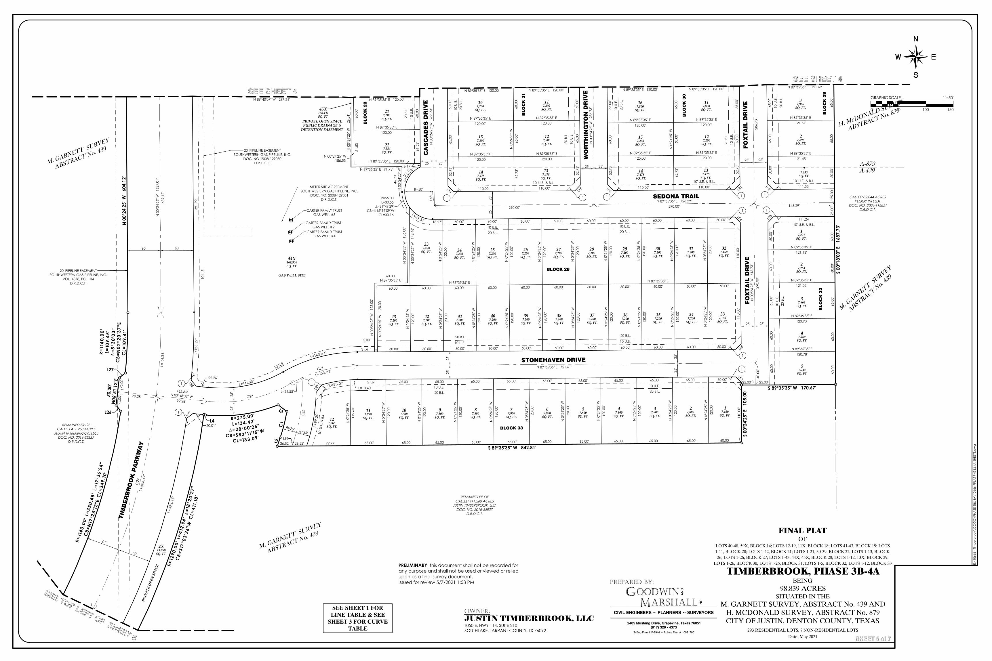
M. GARNETT SURVEY
ABSTRACT No. 439
H. McDONALD SURVEY
ABSTRACT No. 879
25.0
0'25
.00'
25.00'
M. G
ARN
ETT
SU
RVEY
ABST
RACT
No. 4
39
L=24.55'
50.0
0'N
06°5
1'12
"E
CARTER FAMILY TRUSTGAS WELL #5
CARTER FAMILY TRUSTGAS WELL #2
CARTER FAMILY TRUSTGAS WELL #4
METER SITE AGREEMENTSOUTHWESTERN GAS PIPELINE, INC.
DOC. NO. 2008-129051D.R.D.C.T.
FO
XT
AIL
DR
IVE
SEDONA TRAIL
STONEHAVEN DRIVE
BLOCK 28
BLO
CK
32
BLOCK 33
GAS WELL SITE
45X168,141SQ. FT.
317,200
SQ. FT.
147,478
SQ. FT.
137,478
SQ. FT.
157,200
SQ. FT.
127,200
SQ. FT.
167,800
SQ. FT.
117,800
SQ. FT.
327,150
SQ. FT.
307,200
SQ. FT.
297,200
SQ. FT.
287,200
SQ. FT.
277,200
SQ. FT.
267,200
SQ. FT.
257,200
SQ. FT.
247,200
SQ. FT.
237,478
SQ. FT.
44X169,936SQ. FT.
117,200
SQ. FT.
167,200
SQ. FT.
127,800
SQ. FT.
157,800
SQ. FT.
137,478
SQ. FT.
147,478
SQ. FT.
SQ. FT.
217,200
SQ. FT.
227,384
SQ. FT.
367,200
SQ. FT.
377,200
SQ. FT.
387,200
SQ. FT.
397,200
SQ. FT.
407,200
SQ. FT.
337,150
SQ. FT.41
7,200SQ. FT.
347,200
SQ. FT.42
7,200SQ. FT.
357,200
SQ. FT.43
7,200SQ. FT.
N 0
0°24
'25"
W
125.
00'
60.00'N 89°35'35" E
N 0
0°24
'25"
W
136.
00'
R=55.00'L=30.55'
∆=31°49'29"CB=N16°19'09"W
CL=30.16'
46.2
0'N
00°
24'2
5" WN 89°35'35" E 91.73'
N 0
0°24
'25"
W
126.
31'
N 89°40'07" W 287.24'
L=12
3.27
'39
1.99
'
60.0
0'61
.53'
6.17'
L=85
.2
2'
L=49.37' 18.27' 60.00' 60.00' 60.00' 60.00' 60.00' 60.00' 60.00' 60.00' 50.00'
110.
00'
110.
00'
50.00'60.00'60.00'60.00'60.00'60.00'60.00'60.00'60.00'60.00'60.00'
5.00'
31.61'
L=140.67'
L=141.00'22.26'
60.0
0'61
.53'
N 89°35'35" E 120.00'
N 0
°24'
25" W
120.
00'
N 0
0°24
'25"
W
142.
46'
60.00'60.00'N 89°35'35" E
60.00'60.00'60.00'60.00'60.00'60.00'N 89°35'35" E
60.00'60.00'60.00'
N 0
0°24
'25"
W
120.
00'
65.0
0'N
0°2
4'25
" W60
.00'
62.7
3'
65.0
0'60
.00'
52.7
3'
110.00'110.00'
52.7
3'60
.00'
65.0
0'
60.0
0'N
0°2
4'25
" W65
.00'
62.7
3'
60.0
0'65
.00'
52.7
3'
110.00' 110.00'
52.7
3'65
.00'
60.0
0'
N 0
°24'
25" W
120.
00'
N 0
°24'
25" W
120.
00'
N 0
°24'
25" W
120.
00'
N 0
°24'
25" W
120.
00'
N 89°35'35" E120.00'
N 89°35'35" E120.00'
N 89°35'35" E120.00'
N 89°35'35" E120.00'
N 89°35'35" E 120.00' N 89°35'35" E 120.00'
N 0
°24'
25" W
120.
00'
N 0
°24'
25" W
120.
00'
N 0
°24'
25" W
120.
00'
N 0
°24'
25" W
120.
00'
N 0
°24'
25" W
120.
00'
N 0
°24'
25" W
120.
00'
N 0
°24'
25" W
120.
00'
N 0
°24'
25" W
120.
00'
N 0
°24'
25" W
120.
00'
N 0
°24'
25" W
120.
00'
N 0
°24'
25" W
120.
00'
N 0
°24'
25" W
120.
00'
N 0
°24'
25" W
120.
00'
N 0
°24'
25" W
120.
00'
N 89°35'35" E 120.00'N 89°35'35" E 120.00'
N 89°35'35" E120.00'
N 89°35'35" E120.00'
N 89°35'35" E120.00'
N 89°35'35" E120.00'
N 89°35'35" E 120.00'
N 89°35'35" E120.00'
N 0
0°24
'25"
W
604.
12'
R=1 1
40.0
0 'L =
109 .
45'
∆=
5 °30
'03 "
CB=
N0 2
°20 '
3 7"E
CL =
109.
41'
S 89°35'35" W 842.81'
R=11
40.0
0 'L=
350.
48'
∆=17
°36'
5 4"
CB=
N17
°25 '
12"E
CL=
3 49.
10'
N 89°35'35" E121.02'
60.0
0'60
.00'
65.0
0'60
.00'
50.0
0'
111.24'
N 89°35'35" E121.13'
29.2
5'
L=39
2.45
'
20.01'
111.33'
50.0
0'65
.00'
65.0
0'
L=99
. 20 '
L=53.01'L=13.40'
51.61' 65.00' 65.00' 65.00' 65.00' 65.00' 65.00' 65.00' 65.00' 65.00' 50.00'
N 0
°24'
25" W
119.
60'
N 89°35'35" E120.90'
N 89°35'35" E120.78'
N 89°35'35" E121.57'
N 89°35'35" E 121.69'
N 0
°24'
25" W
120.
00'
N 0
°24'
25" W
120.
00'
N 0
°24'
25" W
120.
00'
N 89°35'35" E121.45'
N 0
°24'
25" W
120.
00'
N 0
°24'
25" W
120.
00'
N 0
°24'
25" W
120.
00'
N 0
°24'
25" W
120.
00'
N 0
°24'
25" W
120.
00'
N 0
°24'
25" W
120.
00'
N 0
°24'
25" W
120.
00'
110.
00'
186.
53'
N 0
0°24
'25"
W
17,150
SQ. FT.
57,244
SQ. FT.
47,250
SQ. FT.
37,862
SQ. FT.
2X13,058
SQ. FT.
27,264
SQ. FT.
127,668
SQ. FT.
17,221
SQ. FT.
117,798
SQ. FT.
17,233
SQ. FT.
107,800
SQ. FT.
27,800
SQ. FT.
27,898
SQ. FT.
97,800
SQ. FT.
37,906
SQ. FT.
87,800
SQ. FT.
77,800
SQ. FT.
67,800
SQ. FT.
57,800
SQ. FT.
47,800
SQ. FT.
37,800
SQ. FT.
R=12
90.0
0 'L=
412.
94'
∆=18
°20 '
27"
CB=
S17 °
03'2
6"W
CL=
411.
18'
R=275.00'
L=134.42'
∆=28°00'25"
CB=S82°11'15"W
CL=133.09'
S 89°35'35" W 170.67'
S 00
°18'
00" E
16
87.7
3'
N 89°35'35" E 726.29'146.29'290.00'290.00'
N 0
0°24
'25"
W
616.
73'
N 0
0°24
'25"
W
286.
73'
N 0
0°24
'25"
W
286.
73'
286.
73'
290.
00'
40.0
0'
N 89°35'35" E 721.61'
162.55'N 83°48'32" W
92.28'70.28'
639.
12'
C21
L=103.33'
C22
C23
C24
L=15
1.3 6
'
L=40
6.47
'
25'
25'
25'
25'
25'
25'
25'
25'
25.0
0'25
.00'
25.00'
26.52'26.52'
25' 25'25' 25'
25' 25'
CA
SC
AD
ES
DR
IVE
WO
RT
HIN
GT
ON
DR
IVE
FO
XT
AIL
DR
IVE
25' 25'
60' 60'
60'
60'
60'
N 89°40'07" W 287.24'
N 00°24'25" W186.53'
N 89°35'35" E 120.00' N 89°35'35" E 120.00' N 89°35'35" E 120.00' N 89°35'35" E 120.00' N 89°35'35" E 121.69'
BLO
CK
28
BLO
CK
31
BLO
CK
30
BLO
CK
29
TIM
BE
RB
RO
OK
PA
RK
WA
Y
R=50'
L44
L78 L79 L80 L81 L82
L83L84
L85
L86
L87
L88
L89
N 89°35'35" E 120.00'
PRIVATE OPEN SPACEPUBLIC DRAINAGE &
DETENTION EASEMENT
N 0
0°24
'25"
W
1627
.01'
10 U.E.20 B.L.
10 U.E.20 B.L.
10 U.E.20 B.L.
10 U.E.20 B.L.
10 U.E.20 B.L.
10 U.E.20 B.L.
10 U
.E.
20 B
.L.
10 U
.E.
20 B
.L.
10 U
.E.
20 B
.L.
10 U
.E.
20 B
.L.
10 U
.E.
20 B
.L.
10 U
.E.
20 B
.L.
10 U
.E.
20 B
.L.
10 U
.E.
20 B
.L.
10 U.E.
10' U
.E. &
B.L
.
L91
1 1 1 1 1
1 1
1
1
11
1
CALLED 82.044 ACRESPEGGY INFELDT
DOC. NO. 2004-116851D.R.D.C.T.
REMAINED ER OFCALLED 411.268 ACRES
JUSTIN TIMBERBROOK, LLC.DOC. NO. 2016-55837
D.R.D.C.T.
REMAINED ER OFCALLED 411.268 ACRES
JUSTIN TIMBERBROOK, LLC.DOC. NO. 2016-55837
D.R.D.C.T.
A-879A-439
S 00
°24'
25" E
10
5.00
'
L2
L3
L4
L26
L27
C1
10 U
.E.
65.0
0'65
.00'
60.0
0'
10' U.E. & B.L. 10' U.E. & B.L. 10' U.E. & B.L.
10' U.E. & B.L.
R=25' R=25'
79.77' 65.00' 65.00' 65.00' 65.00' 65.00' 65.00' 65.00' 65.00' 65.00' 65.00' 60.00'
20' PIPELINE EASEMENTSOUTHWESTERN GAS PIPELINE, INC.
DOC. NO. 2008-129050D.R.D.C.T.
20' PIPELINE EASEMENTSOUTHWESTERN GAS PIPELINE, INC.
VOL. 4878, PG. 104D.R.D.C.T.
60.0
0'60
.00'
65.0
0'60
.00'
60.0
0'
PRIV
ATE
OPE
N S
PACE
M. GARNETT SURVEY
ABSTRACT No. 439 FINAL PLATOF
LOTS 40-48, 59X, BLOCK 14; LOTS 12-19, 11X, BLOCK 18; LOTS 41-43, BLOCK 19; LOTS1-11, BLOCK 20; LOTS 1-42, BLOCK 21; LOTS 1-21, 30-39, BLOCK 22; LOTS 1-13, BLOCK26; LOTS 1-26, BLOCK 27; LOTS 1-43, 44X, 45X, BLOCK 28; LOTS 1-12, 13X, BLOCK 29;
LOTS 1-26, BLOCK 30; LOTS 1-26, BLOCK 31; LOTS 1-5, BLOCK 32; LOTS 1-12, BLOCK 33
TIMBERBROOK, PHASE 3B-4ABEING
98.839 ACRESSITUATED IN THE
M. GARNETT SURVEY, ABSTRACT No. 439 ANDH. MCDONALD SURVEY, ABSTRACT No. 879CITY OF JUSTIN, DENTON COUNTY, TEXAS
293 RESIDENTIAL LOTS, 7 NON-RESIDENTIAL LOTSDate: May 2021
PREPARED BY:
GM
OODWINARSHALL
CIVIL ENGINEERS ~ PLANNERS ~ SURVEYORS
AN
D
INC
.
2405 Mustang Drive, Grapevine, Texas 76051(817) 329 - 4373
TxEng Firm # F-2944 ~ TxSurv Firm # 10021700
E:\1
0666
- Tim
berb
rook
\CO
GO
\PHA
SE 3
B&4A
\106
66-F
PLA
T PH
3B&
4A-S
HEET
S.d
wg
SHEET 5 of 7
GRAPHIC SCALE 1"=50'
0 50 100 150
SEE SHEET 4
SEE SHEET 4
SEE TOP LEFT OF SHEET 6
OWNER:JUSTIN TIMBERBROOK, LLC1050 E. HWY 114, SUITE 210SOUTHLAKE, TARRANT COUNTY, TX 76092
SEE SHEET 1 FORLINE TABLE & SEE
SHEET 3 FOR CURVETABLE
PRELIMINARY, this document shall not be recorded forany purpose and shall not be used or viewed or reliedupon as a final survey document.Issued for review 5/7/2021 1:53 PM
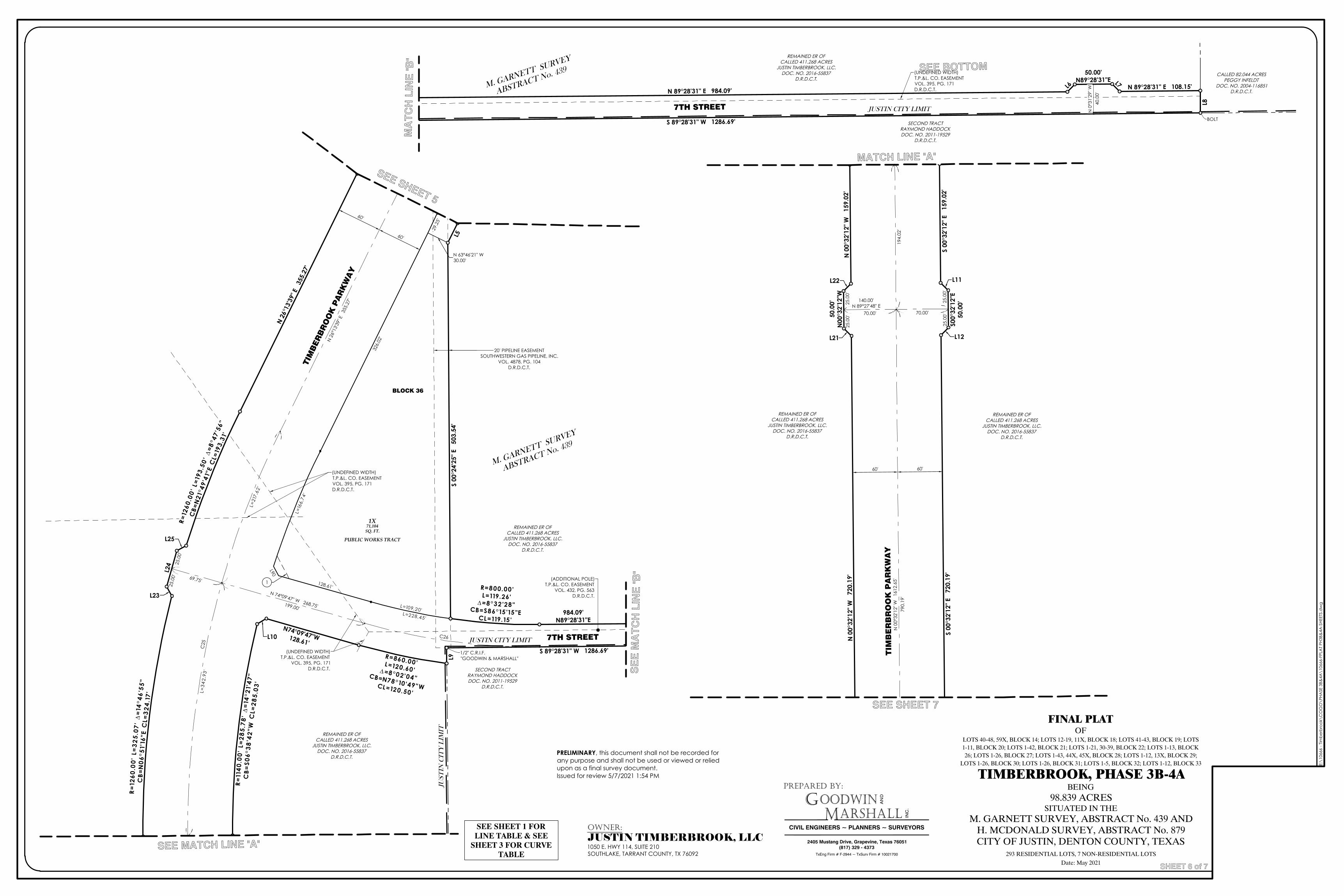
25.0
0'25
.00'
R=860.00'L=120.60'∆=8°02'04 "CB=N78°10'49"WCL=120.50'
(UNDEFINED WIDTH)T.P.&L. CO. EASEMENTVOL. 395, PG. 171D.R.D.C.T.
(UNDEFINED WIDTH)T.P.&L. CO. EASEMENT
VOL. 395, PG. 171D.R.D.C.T.
(ADDITIONAL POLE)T.P.&L. CO. EASEMENT
VOL. 432, PG. 563D.R.D.C.T.
TIM
BER
BR
OO
K P
AR
KW
AY
BLOCK 36
N 26
°13'3
9" E
35
5.27
'
S 89°28'31" W 1286.69'
N74°09'47"W128.61'
L=109.20'
128.61'
L=16
6.7 4
'
326.
02'
29.2
5'
N 63°46'21" W30.00'
L=228.45'
1X71,104SQ. FT.
R =11
40.0
0 'L=
285 .
78'
∆=1
4°21
'47 "
CB=
S06 °
38'4
2 "W
CL=
285.
03'
R=12
60.0
0 'L=
193 .
50'
∆=8 °
47'5
6 "
CB=
N21
°49 '
41"E
CL=
193.
31'
R=12
6 0.0
0 'L=
3 25.
07'
∆=1
4 °46
'55 "
CB=
N06
°51'
16"E
CL=
3 24.
17'
R=800.00'L=119.26'
∆=8°32'28"CB=S86°15'15"E
CL=119.15'984.09'
N89°28'31"E
R=
N 26
°13'3
9" E
35
5.27
'
N 74°09'47" W 268.75'199.00'
69.75'
C25
L=3 4
2.93
'
L=21
7.62
'
C26
60'
60'
7TH STREET
L90
1
REMAINED ER OFCALLED 411.268 ACRES
JUSTIN TIMBERBROOK, LLC.DOC. NO. 2016-55837
D.R.D.C.T.
S 00
°24'
25" E
50
3.54
'L5
L9
L10
L24
L25
L23
JUSTIN CITY LIMIT
JUS
TIN
CIT
Y L
IMIT
1/2" C.R.I.F."GOODWIN & MARSHALL"
PRIV
ATE
OPE
N S
PACE
M. GARNETT SURVEY
ABSTRACT No. 439
PUBLIC WORKS TRACT
REMAINED ER OFCALLED 411.268 ACRES
JUSTIN TIMBERBROOK, LLC.DOC. NO. 2016-55837
D.R.D.C.T.
20' PIPELINE EASEMENTSOUTHWESTERN GAS PIPELINE, INC.
VOL. 4878, PG. 104D.R.D.C.T.
SECOND TRACTRAYMOND HADDOCKDOC. NO. 2011-19529
D.R.D.C.T.
M. GARNETT SURVEY
ABSTRACT No. 439
S 89°28'31" W 1286.69'
(UNDEFINED WIDTH)T.P.&L. CO. EASEMENTVOL. 395, PG. 171D.R.D.C.T.
7TH STREET
N 89°28'31" E 108.15'
50.00'N89°28'31"E
N 89°28'31" E 984.09'
REMAINED ER OFCALLED 411.268 ACRES
JUSTIN TIMBERBROOK, LLC.DOC. NO. 2016-55837
D.R.D.C.T.CALLED 82.044 ACRES
PEGGY INFELDTDOC. NO. 2004-116851
D.R.D.C.T.
L6
L7
L8
N 0
°31'
29" W
40.0
0'
JUSTIN CITY LIMIT
BOLTSECOND TRACT
RAYMOND HADDOCKDOC. NO. 2011-19529
D.R.D.C.T.
25.0
0'25
.00'
25.0
0'25
.00'50
.00'
N00
°32'
12"W
S00°
32'1
2"E
50.0
0'
TIM
BE
RB
RO
OK
PA
RK
WA
Y
N 0
0°32
'12"
W
720.
19'
N 0
0°32
'12"
W
159.
02'
S 00
°32'
12" E
72
0.19
'S
00°3
2'12
" E
159.
02'
N 0
0°32
'12"
W
1612
.65'
194.
02'
790.
19'
140.00'N 89°27'48" E
70.00'70.00'
60' 60'
REMAINED ER OFCALLED 411.268 ACRES
JUSTIN TIMBERBROOK, LLC.DOC. NO. 2016-55837
D.R.D.C.T.
REMAINED ER OFCALLED 411.268 ACRES
JUSTIN TIMBERBROOK, LLC.DOC. NO. 2016-55837
D.R.D.C.T.
L11
L12L21
L22
FINAL PLATOF
LOTS 40-48, 59X, BLOCK 14; LOTS 12-19, 11X, BLOCK 18; LOTS 41-43, BLOCK 19; LOTS1-11, BLOCK 20; LOTS 1-42, BLOCK 21; LOTS 1-21, 30-39, BLOCK 22; LOTS 1-13, BLOCK26; LOTS 1-26, BLOCK 27; LOTS 1-43, 44X, 45X, BLOCK 28; LOTS 1-12, 13X, BLOCK 29;
LOTS 1-26, BLOCK 30; LOTS 1-26, BLOCK 31; LOTS 1-5, BLOCK 32; LOTS 1-12, BLOCK 33
TIMBERBROOK, PHASE 3B-4ABEING
98.839 ACRESSITUATED IN THE
M. GARNETT SURVEY, ABSTRACT No. 439 ANDH. MCDONALD SURVEY, ABSTRACT No. 879CITY OF JUSTIN, DENTON COUNTY, TEXAS
293 RESIDENTIAL LOTS, 7 NON-RESIDENTIAL LOTSDate: May 2021
PREPARED BY:
GM
OODWINARSHALL
CIVIL ENGINEERS ~ PLANNERS ~ SURVEYORS
AN
D
INC
.
2405 Mustang Drive, Grapevine, Texas 76051(817) 329 - 4373
TxEng Firm # F-2944 ~ TxSurv Firm # 10021700
E:\1
0666
- Tim
berb
rook
\CO
GO
\PHA
SE 3
B&4A
\106
66-F
PLA
T PH
3B&
4A-S
HEET
S.d
wg
SHEET 6 of 7
PRELIMINARY, this document shall not be recorded forany purpose and shall not be used or viewed or reliedupon as a final survey document.Issued for review 5/7/2021 1:54 PM
SEE SHEET 5
SEE MATCH LINE "A"
SEE BOTTOM
MA
TC
H L
INE
"B"
MATCH LINE "A"
SE
E M
AT
CH
LIN
E "B
"
SEE SHEET 7
OWNER:JUSTIN TIMBERBROOK, LLC1050 E. HWY 114, SUITE 210SOUTHLAKE, TARRANT COUNTY, TX 76092
SEE SHEET 1 FORLINE TABLE & SEE
SHEET 3 FOR CURVETABLE
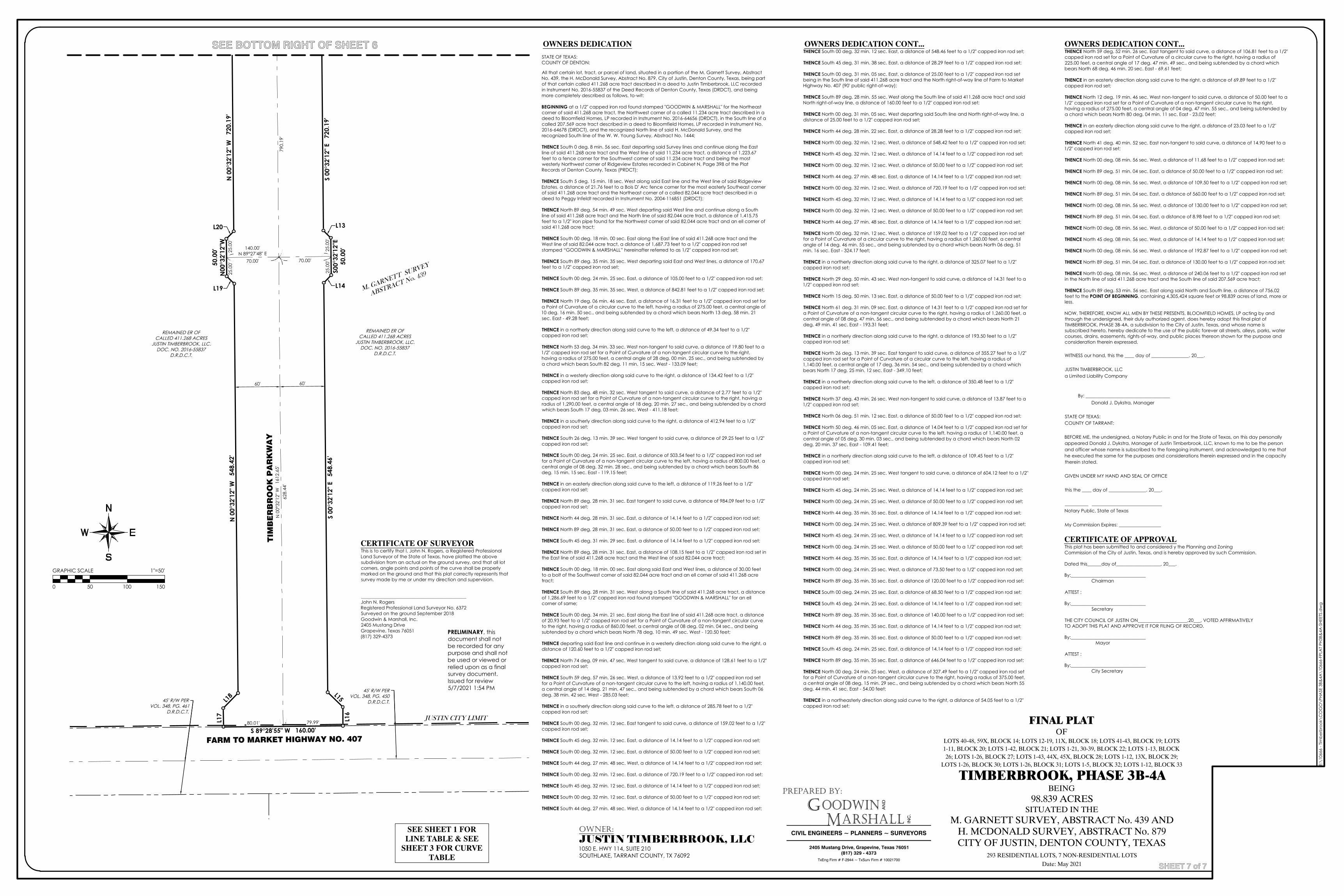
25.0
0'25
.00'
25.0
0'25
.00'50
.00'
N00
°32'
12"W
45' R/W PERVOL. 348, PG. 450
D.R.D.C.T.45' R/W PERVOL. 348, PG. 461
D.R.D.C.T.
FARM TO MARKET HIGHWAY NO. 407
N 0
0°32
'12"
W
720.
19'
N 0
0°32
'12"
W
548.
42'
S 89°28'55" W 160.00'
S 00
°32'
12" E
54
8.46
'S0
0°32
'12"
E50
.00'
S 00
°32'
12" E
72
0.19
'
628.
44'
70.00'70.00'
140.00'N 89°27'48" E
80.01' 79.99'
60' 60'
N 0
0°32
'12"
W
1612
.65'
TIM
BE
RB
RO
OK
PA
RK
WA
Y79
0.19
'
REMAINED ER OFCALLED 411.268 ACRES
JUSTIN TIMBERBROOK, LLC.DOC. NO. 2016-55837
D.R.D.C.T.
REMAINED ER OFCALLED 411.268 ACRES
JUSTIN TIMBERBROOK, LLC.DOC. NO. 2016-55837
D.R.D.C.T.
M. GARNETT SURVEY
ABSTRACT No. 439
L13
L14
L15
L16
L17
L18
L19
L20
JUSTIN CITY LIMIT FINAL PLATOF
LOTS 40-48, 59X, BLOCK 14; LOTS 12-19, 11X, BLOCK 18; LOTS 41-43, BLOCK 19; LOTS1-11, BLOCK 20; LOTS 1-42, BLOCK 21; LOTS 1-21, 30-39, BLOCK 22; LOTS 1-13, BLOCK26; LOTS 1-26, BLOCK 27; LOTS 1-43, 44X, 45X, BLOCK 28; LOTS 1-12, 13X, BLOCK 29;
LOTS 1-26, BLOCK 30; LOTS 1-26, BLOCK 31; LOTS 1-5, BLOCK 32; LOTS 1-12, BLOCK 33
TIMBERBROOK, PHASE 3B-4ABEING
98.839 ACRESSITUATED IN THE
M. GARNETT SURVEY, ABSTRACT No. 439 ANDH. MCDONALD SURVEY, ABSTRACT No. 879CITY OF JUSTIN, DENTON COUNTY, TEXAS
293 RESIDENTIAL LOTS, 7 NON-RESIDENTIAL LOTSDate: May 2021
PREPARED BY:
GM
OODWINARSHALL
CIVIL ENGINEERS ~ PLANNERS ~ SURVEYORS
AN
D
INC
.
2405 Mustang Drive, Grapevine, Texas 76051(817) 329 - 4373
TxEng Firm # F-2944 ~ TxSurv Firm # 10021700
E:\1
0666
- Tim
berb
rook
\CO
GO
\PHA
SE 3
B&4A
\106
66-F
PLA
T PH
3B&
4A-S
HEET
S.d
wg
SHEET 7 of 7
GRAPHIC SCALE 1"=50'
0 50 100 150
CERTIFICATE OF APPROVALThis plat has been submitted to and considered y the Planning and ZoningCommission of the City of Justin, Texas, and is hereby approved by such Commission.
Dated this______day of___________________, 20___.
By:________________________________Chairman
ATTEST :
By:________________________________Secretary
THE CITY COUNCIL OF JUSTIN ON_____________________,20___, VOTED AFFIRMATIVELYTO ADOPT THIS PLAT AND APPROVE IT FOR FILING OF RECORD.
By:________________________________ Mayor
ATTEST :
By:________________________________City Secretary
CERTIFICATE OF SURVEYORThis is to certify that I, John N. Rogers, a Registered ProfessionalLand Surveyor of the State of Texas, have platted the abovesubdivision from an actual on the ground survey, and that all lotcorners, angle points and points of the curve shall be properlymarked on the ground and that this plat correctly represents thatsurvey made by me or under my direction and supervision.
_____________________________________________John N. RogersRegistered Professional Land Surveyor No. 6372Surveyed on the ground September 2018Goodwin & Marshall, Inc.2405 Mustang DriveGrapevine, Texas 76051(817) 329-4373
OWNERS DEDICATION
STATE OF TEXAS:COUNTY OF DENTON:
All that certain lot, tract, or parcel of land, situated in a portion of the M. Garnett Survey, AbstractNo. 439, the H. McDonald Survey, Abstract No. 879, City of Justin, Denton County, Texas, being partof that certain called 411.268 acre tract described in a deed to Justin Timberbrook, LLC recordedin Instrument No. 2016-55837 of the Deed Records of Denton County, Texas (DRDCT), and beingmore completely described as follows, to-wit:
BEGINNING at a 1/2" capped iron rod found stamped "GOODWIN & MARSHALL" for the Northeastcorner of said 411.268 acre tract, the Northwest corner of a called 11.234 acre tract described in adeed to Bloomfield Homes, LP recorded in Instrument No. 2016-64656 (DRDCT), in the South line of acalled 207.569 acre tract described in a deed to Bloomfield Homes, LP recorded in Instrument No.2016-64678 (DRDCT), and the recognized North line of said H. McDonald Survey, and therecognized South line of the W. W. Young Survey, Abstract No. 1444;
THENCE South 0 deg. 8 min. 56 sec. East departing said Survey lines and continue along the Eastline of said 411.268 acre tract and the West line of said 11.234 acre tract, a distance of 1,223.67feet to a fence corner for the Southwest corner of said 11.234 acre tract and being the mostwesterly Northwest corner of Ridgeview Estates recorded in Cabinet N, Page 398 of the PlatRecords of Denton County, Texas (PRDCT);
THENCE South 5 deg. 15 min. 18 sec. West along said East line and the West line of said RidgeviewEstates, a distance of 21.76 feet to a Bois D' Arc fence corner for the most easterly Southeast cornerof said 411.268 acre tract and the Northeast corner of a called 82.044 acre tract described in adeed to Peggy Infeldt recorded in Instrument No. 2004-116851 (DRDCT);
THENCE North 89 deg. 54 min. 49 sec. West departing said West line and continue along a Southline of said 411.268 acre tract and the North line of said 82.044 acre tract, a distance of 1,415.75feet to a 1/2" iron pipe found for the Northwest corner of said 82.044 acre tract and an ell corner ofsaid 411.268 acre tract;
THENCE South 00 deg. 18 min. 00 sec. East along the East line of said 411.268 acre tract and theWest line of said 82.044 acre tract, a distance of 1,687.73 feet to a 1/2" capped iron rod setstamped “GOODWIN & MARSHALL” hereinafter referred to as 1/2" capped iron rod set;
THENCE South 89 deg. 35 min. 35 sec. West departing said East and West lines, a distance of 170.67feet to a 1/2" capped iron rod set;
THENCE South 00 deg. 24 min. 25 sec. East, a distance of 105.00 feet to a 1/2" capped iron rod set;
THENCE South 89 deg. 35 min. 35 sec. West, a distance of 842.81 feet to a 1/2" capped iron rod set;
THENCE North 19 deg. 06 min. 46 sec. East, a distance of 16.31 feet to a 1/2" capped iron rod set fora Point of Curvature of a circular curve to the left, having a radius of 275.00 feet, a central angle of10 deg. 16 min. 50 sec., and being subtended by a chord which bears North 13 deg. 58 min. 21sec. East - 49.28 feet;
THENCE in a northerly direction along said curve to the left, a distance of 49.34 feet to a 1/2"capped iron rod set;
THENCE North 53 deg. 34 min. 33 sec. West non-tangent to said curve, a distance of 19.80 feet to a1/2" capped iron rod set for a Point of Curvature of a non-tangent circular curve to the right,having a radius of 275.00 feet, a central angle of 28 deg. 00 min. 25 sec., and being subtended bya chord which bears South 82 deg. 11 min. 15 sec. West - 133.09 feet;
THENCE in a westerly direction along said curve to the right, a distance of 134.42 feet to a 1/2"capped iron rod set;
THENCE North 83 deg. 48 min. 32 sec. West tangent to said curve, a distance of 2.77 feet to a 1/2"capped iron rod set for a Point of Curvature of a non-tangent circular curve to the right, having aradius of 1,290.00 feet, a central angle of 18 deg. 20 min. 27 sec., and being subtended by a chordwhich bears South 17 deg. 03 min. 26 sec. West - 411.18 feet;
THENCE in a southerly direction along said curve to the right, a distance of 412.94 feet to a 1/2"capped iron rod set;
THENCE South 26 deg. 13 min. 39 sec. West tangent to said curve, a distance of 29.25 feet to a 1/2"capped iron rod set;
THENCE South 00 deg. 24 min. 25 sec. East, a distance of 503.54 feet to a 1/2" capped iron rod setfor a Point of Curvature of a non-tangent circular curve to the left, having a radius of 800.00 feet, acentral angle of 08 deg. 32 min. 28 sec., and being subtended by a chord which bears South 86deg. 15 min. 15 sec. East - 119.15 feet;
THENCE in an easterly direction along said curve to the left, a distance of 119.26 feet to a 1/2"capped iron rod set;
THENCE North 89 deg. 28 min. 31 sec. East tangent to said curve, a distance of 984.09 feet to a 1/2"capped iron rod set;
THENCE North 44 deg. 28 min. 31 sec. East, a distance of 14.14 feet to a 1/2" capped iron rod set;
THENCE North 89 deg. 28 min. 31 sec. East, a distance of 50.00 feet to a 1/2" capped iron rod set;
THENCE South 45 deg. 31 min. 29 sec. East, a distance of 14.14 feet to a 1/2" capped iron rod set;
THENCE North 89 deg. 28 min. 31 sec. East, a distance of 108.15 feet to a 1/2" capped iron rod set inthe East line of said 411.268 acre tract and the West line of said 82.044 acre tract;
THENCE South 00 deg. 18 min. 00 sec. East along said East and West lines, a distance of 30.00 feetto a bolt of the Southwest corner of said 82.044 acre tract and an ell corner of said 411.268 acretract;
THENCE South 89 deg. 28 min. 31 sec. West along a South line of said 411.268 acre tract, a distanceof 1,286.69 feet to a 1/2" capped iron rod found stamped "GOODWIN & MARSHALL" for an ellcorner of same;
THENCE South 00 deg. 34 min. 21 sec. East along the East line of said 411.268 acre tract, a distanceof 20.93 feet to a 1/2" capped iron rod set for a Point of Curvature of a non-tangent circular curveto the right, having a radius of 860.00 feet, a central angle of 08 deg. 02 min. 04 sec., and beingsubtended by a chord which bears North 78 deg. 10 min. 49 sec. West - 120.50 feet;
THENCE departing said East line and continue in a westerly direction along said curve to the right, adistance of 120.60 feet to a 1/2" capped iron rod set;
THENCE North 74 deg. 09 min. 47 sec. West tangent to said curve, a distance of 128.61 feet to a 1/2"capped iron rod set;
THENCE South 59 deg. 57 min. 26 sec. West, a distance of 13.92 feet to a 1/2" capped iron rod setfor a Point of Curvature of a non-tangent circular curve to the left, having a radius of 1,140.00 feet,a central angle of 14 deg. 21 min. 47 sec., and being subtended by a chord which bears South 06deg. 38 min. 42 sec. West - 285.03 feet;
THENCE in a southerly direction along said curve to the left, a distance of 285.78 feet to a 1/2"capped iron rod set;
THENCE South 00 deg. 32 min. 12 sec. East tangent to said curve, a distance of 159.02 feet to a 1/2"capped iron rod set;
THENCE South 45 deg. 32 min. 12 sec. East, a distance of 14.14 feet to a 1/2" capped iron rod set;
THENCE South 00 deg. 32 min. 12 sec. East, a distance of 50.00 feet to a 1/2" capped iron rod set;
THENCE South 44 deg. 27 min. 48 sec. West, a distance of 14.14 feet to a 1/2" capped iron rod set;
THENCE South 00 deg. 32 min. 12 sec. East, a distance of 720.19 feet to a 1/2" capped iron rod set;
THENCE South 45 deg. 32 min. 12 sec. East, a distance of 14.14 feet to a 1/2" capped iron rod set;
THENCE South 00 deg. 32 min. 12 sec. East, a distance of 50.00 feet to a 1/2" capped iron rod set;
THENCE South 44 deg. 27 min. 48 sec. West, a distance of 14.14 feet to a 1/2" capped iron rod set;
OWNERS DEDICATION CONT...THENCE South 00 deg. 32 min. 12 sec. East, a distance of 548.46 feet to a 1/2" capped iron rod set;
THENCE South 45 deg. 31 min. 38 sec. East, a distance of 28.29 feet to a 1/2" capped iron rod set;
THENCE South 00 deg. 31 min. 05 sec. East, a distance of 25.00 feet to a 1/2" capped iron rod setbeing in the South line of said 411.268 acre tract and the North right-of-way line of Farm to MarketHighway No. 407 (90' public right-of-way);
THENCE South 89 deg. 28 min. 55 sec. West along the South line of said 411.268 acre tract and saidNorth right-of-way line, a distance of 160.00 feet to a 1/2" capped iron rod set;
THENCE North 00 deg. 31 min. 05 sec. West departing said South line and North right-of-way line, adistance of 25.00 feet to a 1/2" capped iron rod set;
THENCE North 44 deg. 28 min. 22 sec. East, a distance of 28.28 feet to a 1/2" capped iron rod set;
THENCE North 00 deg. 32 min. 12 sec. West, a distance of 548.42 feet to a 1/2" capped iron rod set;
THENCE North 45 deg. 32 min. 12 sec. West, a distance of 14.14 feet to a 1/2" capped iron rod set;
THENCE North 00 deg. 32 min. 12 sec. West, a distance of 50.00 feet to a 1/2" capped iron rod set;
THENCE North 44 deg. 27 min. 48 sec. East, a distance of 14.14 feet to a 1/2" capped iron rod set;
THENCE North 00 deg. 32 min. 12 sec. West, a distance of 720.19 feet to a 1/2" capped iron rod set;
THENCE North 45 deg. 32 min. 12 sec. West, a distance of 14.14 feet to a 1/2" capped iron rod set;
THENCE North 00 deg. 32 min. 12 sec. West, a distance of 50.00 feet to a 1/2" capped iron rod set;
THENCE North 44 deg. 27 min. 48 sec. East, a distance of 14.14 feet to a 1/2" capped iron rod set;
THENCE North 00 deg. 32 min. 12 sec. West, a distance of 159.02 feet to a 1/2" capped iron rod setfor a Point of Curvature of a circular curve to the right, having a radius of 1,260.00 feet, a centralangle of 14 deg. 46 min. 55 sec., and being subtended by a chord which bears North 06 deg. 51min. 16 sec. East - 324.17 feet;
THENCE in a northerly direction along said curve to the right, a distance of 325.07 feet to a 1/2"capped iron rod set;
THENCE North 29 deg. 50 min. 43 sec. West non-tangent to said curve, a distance of 14.31 feet to a1/2" capped iron rod set;
THENCE North 15 deg. 50 min. 13 sec. East, a distance of 50.00 feet to a 1/2" capped iron rod set;
THENCE North 61 deg. 31 min. 09 sec. East, a distance of 14.31 feet to a 1/2" capped iron rod set fora Point of Curvature of a non-tangent circular curve to the right, having a radius of 1,260.00 feet, acentral angle of 08 deg. 47 min. 56 sec., and being subtended by a chord which bears North 21deg. 49 min. 41 sec. East - 193.31 feet;
THENCE in a northerly direction along said curve to the right, a distance of 193.50 feet to a 1/2"capped iron rod set;
THENCE North 26 deg. 13 min. 39 sec. East tangent to said curve, a distance of 355.27 feet to a 1/2"capped iron rod set for a Point of Curvature of a circular curve to the left, having a radius of1,140.00 feet, a central angle of 17 deg. 36 min. 54 sec., and being subtended by a chord whichbears North 17 deg. 25 min. 12 sec. East - 349.10 feet;
THENCE in a northerly direction along said curve to the left, a distance of 350.48 feet to a 1/2"capped iron rod set;
THENCE North 37 deg. 43 min. 26 sec. West non-tangent to said curve, a distance of 13.87 feet to a1/2" capped iron rod set;
THENCE North 06 deg. 51 min. 12 sec. East, a distance of 50.00 feet to a 1/2" capped iron rod set;
THENCE North 50 deg. 46 min. 05 sec. East, a distance of 14.04 feet to a 1/2" capped iron rod set fora Point of Curvature of a non-tangent circular curve to the left, having a radius of 1,140.00 feet, acentral angle of 05 deg. 30 min. 03 sec., and being subtended by a chord which bears North 02deg. 20 min. 37 sec. East - 109.41 feet;
THENCE in a northerly direction along said curve to the left, a distance of 109.45 feet to a 1/2"capped iron rod set;
THENCE North 00 deg. 24 min. 25 sec. West tangent to said curve, a distance of 604.12 feet to a 1/2"capped iron rod set;
THENCE North 45 deg. 24 min. 25 sec. West, a distance of 14.14 feet to a 1/2" capped iron rod set;
THENCE North 00 deg. 24 min. 25 sec. West, a distance of 50.00 feet to a 1/2" capped iron rod set;
THENCE North 44 deg. 35 min. 35 sec. East, a distance of 14.14 feet to a 1/2" capped iron rod set;
THENCE North 00 deg. 24 min. 25 sec. West, a distance of 809.39 feet to a 1/2" capped iron rod set;
THENCE North 45 deg. 24 min. 25 sec. West, a distance of 14.14 feet to a 1/2" capped iron rod set;
THENCE North 00 deg. 24 min. 25 sec. West, a distance of 50.00 feet to a 1/2" capped iron rod set;
THENCE North 44 deg. 35 min. 35 sec. East, a distance of 14.14 feet to a 1/2" capped iron rod set;
THENCE North 00 deg. 24 min. 25 sec. West, a distance of 73.50 feet to a 1/2" capped iron rod set;
THENCE North 89 deg. 35 min. 35 sec. East, a distance of 120.00 feet to a 1/2" capped iron rod set;
THENCE South 00 deg. 24 min. 25 sec. East, a distance of 68.50 feet to a 1/2" capped iron rod set;
THENCE South 45 deg. 24 min. 25 sec. East, a distance of 14.14 feet to a 1/2" capped iron rod set;
THENCE North 89 deg. 35 min. 35 sec. East, a distance of 140.00 feet to a 1/2" capped iron rod set;
THENCE North 44 deg. 35 min. 35 sec. East, a distance of 14.14 feet to a 1/2" capped iron rod set;
THENCE North 89 deg. 35 min. 35 sec. East, a distance of 50.00 feet to a 1/2" capped iron rod set;
THENCE South 45 deg. 24 min. 25 sec. East, a distance of 14.14 feet to a 1/2" capped iron rod set;
THENCE North 89 deg. 35 min. 35 sec. East, a distance of 646.04 feet to a 1/2" capped iron rod set;
THENCE North 00 deg. 24 min. 25 sec. West, a distance of 327.49 feet to a 1/2" capped iron rod setfor a Point of Curvature of a non-tangent circular curve to the right, having a radius of 375.00 feet,a central angle of 08 deg. 15 min. 29 sec., and being subtended by a chord which bears North 55deg. 44 min. 41 sec. East - 54.00 feet;
THENCE in a northeasterly direction along said curve to the right, a distance of 54.05 feet to a 1/2"capped iron rod set;
OWNERS DEDICATION CONT...THENCE North 59 deg. 52 min. 26 sec. East tangent to said curve, a distance of 106.81 feet to a 1/2"capped iron rod set for a Point of Curvature of a circular curve to the right, having a radius of225.00 feet, a central angle of 17 deg. 47 min. 49 sec., and being subtended by a chord whichbears North 68 deg. 46 min. 20 sec. East - 69.61 feet;
THENCE in an easterly direction along said curve to the right, a distance of 69.89 feet to a 1/2"capped iron rod set;
THENCE North 12 deg. 19 min. 46 sec. West non-tangent to said curve, a distance of 50.00 feet to a1/2" capped iron rod set for a Point of Curvature of a non-tangent circular curve to the right,having a radius of 275.00 feet, a central angle of 04 deg. 47 min. 55 sec., and being subtended bya chord which bears North 80 deg. 04 min. 11 sec. East - 23.02 feet;
THENCE in an easterly direction along said curve to the right, a distance of 23.03 feet to a 1/2"capped iron rod set;
THENCE North 41 deg. 40 min. 52 sec. East non-tangent to said curve, a distance of 14.90 feet to a1/2" capped iron rod set;
THENCE North 00 deg. 08 min. 56 sec. West, a distance of 11.68 feet to a 1/2" capped iron rod set;
THENCE North 89 deg. 51 min. 04 sec. East, a distance of 50.00 feet to a 1/2" capped iron rod set;
THENCE North 00 deg. 08 min. 56 sec. West, a distance of 109.50 feet to a 1/2" capped iron rod set;
THENCE North 89 deg. 51 min. 04 sec. East, a distance of 560.00 feet to a 1/2" capped iron rod set;
THENCE North 00 deg. 08 min. 56 sec. West, a distance of 130.00 feet to a 1/2" capped iron rod set;
THENCE North 89 deg. 51 min. 04 sec. East, a distance of 8.98 feet to a 1/2" capped iron rod set;
THENCE North 00 deg. 08 min. 56 sec. West, a distance of 50.00 feet to a 1/2" capped iron rod set;
THENCE North 45 deg. 08 min. 56 sec. West, a distance of 14.14 feet to a 1/2" capped iron rod set;
THENCE North 00 deg. 08 min. 56 sec. West, a distance of 192.87 feet to a 1/2" capped iron rod set;
THENCE North 89 deg. 51 min. 04 sec. East, a distance of 130.00 feet to a 1/2" capped iron rod set;
THENCE North 00 deg. 08 min. 56 sec. West, a distance of 240.06 feet to a 1/2" capped iron rod setin the North line of said 411.268 acre tract and the South line of said 207.569 acre tract;
THENCE South 89 deg. 53 min. 56 sec. East along said North and South line, a distance of 756.02feet to the POINT OF BEGINNING, containing 4,305,424 square feet or 98.839 acres of land, more orless.
NOW, THEREFORE, KNOW ALL MEN BY THESE PRESENTS, BLOOMFIELD HOMES, LP acting by andthrough the undersigned, their duly authorized agent, does hereby adopt this final plat ofTIMBERBROOK, PHASE 3B-4A, a subdivision to the City of Justin, Texas, and whose name issubscribed hereto, hereby dedicate to the use of the public forever all streets, alleys, parks, watercourses, drains, easements, rights-of-way, and public places thereon shown for the purpose andconsideration therein expressed.
WITNESS our hand, this the ____ day of ________________. 20___.
JUSTIN TIMBERBROOK, LLCa Limited Liability Company
By: ____________________________________Donald J. Dykstra, Manager
STATE OF TEXAS:COUNTY OF TARRANT:
BEFORE ME, the undersigned, a Notary Public in and for the State of Texas, on this day personallyappeared Donald J. Dykstra, Manager of Justin Timberbrook, LLC, known to me to be the personand officer whose name is subscribed to the foregoing instrument, and acknowledged to me thathe executed the same for the purposes and considerations therein expressed and in the capacitytherein stated.
GIVEN UNDER MY HAND AND SEAL OF OFFICE
this the ____ day of ________________. 20___.
__________ ______________________________Notary Public, State of Texas
My Commission Expires: __________________
SEE BOTTOM RIGHT OF SHEET 6
OWNER:JUSTIN TIMBERBROOK, LLC1050 E. HWY 114, SUITE 210SOUTHLAKE, TARRANT COUNTY, TX 76092
PRELIMINARY, thisdocument shall notbe recorded for anypurpose and shall notbe used or viewed orrelied upon as a finalsurvey document.Issued for review5/7/2021 1:54 PM
SEE SHEET 1 FORLINE TABLE & SEE
SHEET 3 FOR CURVETABLE
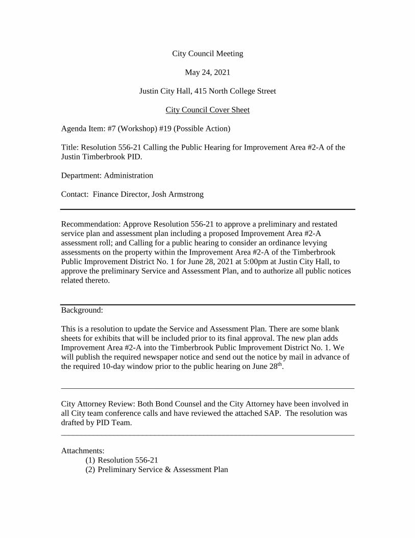
City Council Meeting
May 24, 2021
Justin City Hall, 415 North College Street
City Council Cover Sheet
Agenda Item: #7 (Workshop) #19 (Possible Action)
Title: Resolution 556-21 Calling the Public Hearing for Improvement Area #2-A of the Justin Timberbrook PID.
Department: Administration
Contact: Finance Director, Josh Armstrong
Recommendation: Approve Resolution 556-21 to approve a preliminary and restated service plan and assessment plan including a proposed Improvement Area #2-A assessment roll; and Calling for a public hearing to consider an ordinance levying assessments on the property within the Improvement Area #2-A of the Timberbrook Public Improvement District No. 1 for June 28, 2021 at 5:00pm at Justin City Hall, to approve the preliminary Service and Assessment Plan, and to authorize all public notices related thereto.
Background:
This is a resolution to update the Service and Assessment Plan. There are some blank sheets for exhibits that will be included prior to its final approval. The new plan adds Improvement Area #2-A into the Timberbrook Public Improvement District No. 1. We will publish the required newspaper notice and send out the notice by mail in advance of the required 10-day window prior to the public hearing on June 28th.
________________________________________________________________________
City Attorney Review: Both Bond Counsel and the City Attorney have been involved in all City team conference calls and have reviewed the attached SAP. The resolution was drafted by PID Team. ________________________________________________________________________
Attachments: (1) Resolution 556-21(2) Preliminary Service & Assessment Plan
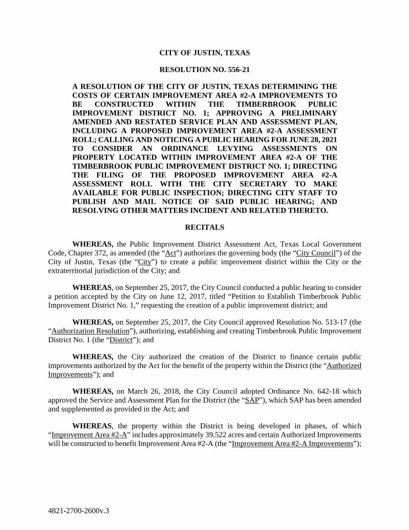
CITY OF JUSTIN, TEXAS
RESOLUTION NO. 556-21
A RESOLUTION OF THE CITY OF JUSTIN, TEXAS DETERMINING THE COSTS OF CERTAIN IMPROVEMENT AREA #2-A IMPROVEMENTS TO BE CONSTRUCTED WITHIN THE TIMBERBROOK PUBLIC IMPROVEMENT DISTRICT NO. 1; APPROVING A PRELIMINARY AMENDED AND RESTATED SERVICE PLAN AND ASSESSMENT PLAN, INCLUDING A PROPOSED IMPROVEMENT AREA #2-A ASSESSMENT ROLL; CALLING AND NOTICING A PUBLIC HEARING FOR JUNE 28, 2021 TO CONSIDER AN ORDINANCE LEVYING ASSESSMENTS ON PROPERTY LOCATED WITHIN IMPROVEMENT AREA #2-A OF THE TIMBERBROOK PUBLIC IMPROVEMENT DISTRICT NO. 1; DIRECTING THE FILING OF THE PROPOSED IMPROVEMENT AREA #2-A ASSESSMENT ROLL WITH THE CITY SECRETARY TO MAKE AVAILABLE FOR PUBLIC INSPECTION; DIRECTING CITY STAFF TO PUBLISH AND MAIL NOTICE OF SAID PUBLIC HEARING; AND RESOLVING OTHER MATTERS INCIDENT AND RELATED THERETO.
RECITALS
WHEREAS, the Public Improvement District Assessment Act, Texas Local Government Code, Chapter 372, as amended (the “Act”) authorizes the governing body (the “City Council”) of the City of Justin, Texas (the “City”) to create a public improvement district within the City or the extraterritorial jurisdiction of the City; and
WHEREAS, on September 25, 2017, the City Council conducted a public hearing to consider a petition accepted by the City on June 12, 2017, titled “Petition to Establish Timberbrook Public Improvement District No. 1,” requesting the creation of a public improvement district; and
WHEREAS, on September 25, 2017, the City Council approved Resolution No. 513-17 (the “Authorization Resolution”), authorizing, establishing and creating Timberbrook Public Improvement District No. 1 (the “District”); and
WHEREAS, the City authorized the creation of the District to finance certain public improvements authorized by the Act for the benefit of the property within the District (the “Authorized Improvements”); and
WHEREAS, on March 26, 2018, the City Council adopted Ordinance No. 642-18 which approved the Service and Assessment Plan for the District (the “SAP”), which SAP has been amended and supplemented as provided in the Act; and
WHEREAS, the property within the District is being developed in phases, of which “Improvement Area #2-A” includes approximately 39.522 acres and certain Authorized Improvements will be constructed to benefit Improvement Area #2-A (the “Improvement Area #2-A Improvements”);
4821-2700-2600v.3
WHEREAS, the City desires to update, amend, and restate the SAP to reflect the Improvement Area #2-A Improvements and the construction and development of Improvement Area #2-A of the District;
WHEREAS, the City Council and the City staff have been presented an “Timberbrook Public Improvement District No. 1 Preliminary 2021 Amended and Restated Service and Assessment Plan (June Update)” including the Proposed Improvement Area #2-A Assessment Roll attached thereto (the “Proposed Improvement Area #2-A Assessment Roll”), dated May 24, 2021 (collectively, the “Preliminary SAP Update”), a copy of which is attached hereto as Exhibit A and is incorporated herein for all purposes; and
WHEREAS, the Preliminary SAP Update sets forth the estimated total costs of the Improvement Area #2-A Improvements to be financed within the District and the Proposed Improvement Area #2-A Assessment Roll states the assessments proposed to be levied against each assessable parcel of land in Improvement Area #2-A of the District for costs of the Improvement Area #2-A Improvements as determined by the method of assessment chosen by the City; and
WHEREAS, the Act requires that the Proposed Improvement Area #2-A Assessment Roll be filed with the City Secretary of the City (the “City Secretary”) and be subject to public inspection; and
WHEREAS, the Act requires that a public hearing (the “Assessment Hearing”) be called to consider the proposed assessments and requires the City Council to hear and pass on any objections to the proposed assessments at, or on the adjournment of, the Assessment Hearing; and
WHEREAS, the Act requires that notice of the Assessment Hearing be mailed to property owners liable for assessment and published in a newspaper of general circulation in the City before the tenth (10th) day before the date of the Assessment Hearing.
NOW THEREFORE, BE IT RESOLVED BY THE CITY COUNCIL OF THE CITY OF JUSTIN, TEXAS AS FOLLOWS:
SECTION 1. THAT the recitals set forth above in this Resolution are true and correct and are hereby adopted as findings of the City Council and are incorporated into the body of this Resolution as if fully set forth herein.
SECTION 2. THAT the City Council does hereby accept the Preliminary SAP Update for the District, including the Proposed Improvement Area #2-A Assessment Roll, a copy of which is attached hereto as Exhibit A and is incorporated herein for all purposes. All capitalized terms not otherwise defined herein shall have the meanings given to such terms in the Preliminary SAP Update.
SECTION 3. THAT the City Council hereby determines that the total costs of the Improvement Area #2-A Improvements (as defined in the Preliminary SAP Update) to be financed by the District are as set forth in Exhibit B-1 of the Preliminary SAP Update, which costs do include the payment of expenses incurred in the administration of the District or related to the issuance of any bonds.
SECTION 4. THAT the City Council’s final determination and approval of the costs of the Improvement Area #2-A Improvements, or any portion thereof, shall be subject to and contingent upon
City Council’s approval of a final Service and Assessment Plan Update which will include a final Improvement Area #2-A Assessment Roll, after the properly noticed and held Assessment Hearing.
SECTION 5. THAT the Proposed Improvement Area #2-A Assessment Roll states the assessment proposed to be levied against each assessable parcel of land in Improvement Area #2-Aof the District for the costs of the Improvement Area #2-A Improvements as determined by the method of assessment chosen by the City in the Authorization Resolution and as more fully described in the Preliminary SAP Update.
SECTION 6. THAT the City Council hereby authorizes and directs the filing of the Proposed Improvement Area #2-A Assessment Roll with the City Secretary and the same shall be available for public inspection.
SECTION 7. THAT the City Council hereby authorizes and calls a public hearing (the Assessment Hearing, as defined above) to be held on June 28, 2021 at or after 5:00 p.m. at the Justin City Hall, 415 N. College Avenue, Justin, Texas 76247, at which the City Council shall, among other actions, hear and pass on any objections to the proposed assessments; and, upon the adjournment of the Assessment Hearing, the City Council will consider an ordinance levying the assessments as special assessments on property within Improvement Area #2-A of the District (which ordinance shall specify the method of payment of the assessments).
SECTION 9. THAT the City Council hereby authorizes and directs the City Secretary to publish notice of the Assessment Hearing to be held on June 28, 2021, in substantially the form attached hereto as Exhibit B and incorporated herein for all purposes, in a newspaper of general circulation in the City, before the tenth (10th) day before the date of the Assessment Hearing, as required by Section 372.016(b) of the Act.
SECTION 10. THAT when the Proposed Improvement Area #2-A Assessment Roll is filed with the City Secretary, the City Council hereby authorizes and directs the City Secretary to mail to owners of property liable for assessment notice of the Assessment Hearing to be held on June 28, 2021 as required by Section 372.016(c) of the Act.
SECTION 11. THAT City staff is authorized and directed to take such other actions as are required (including, but not limited to, notice of the public hearing as required by the Texas Open Meetings Act and the Act) to place the public hearing on the agenda for the June 28, 2021 meeting of the City Council.
SECTION 12. THAT this Resolution shall become effective from and after its date of passage in accordance with law.
[Remainder of Page Intentionally Left Blank]
DULY RESOLVED AND ADOPTED BY THE CITY COUNCIL OF THE CITY OF JUSTIN, TEXAS ON MAY 24, 2021.
CITY OF JUSTIN, TEXAS APPROVED: ________________________________ Liz Woodall, Mayor ATTEST: _____________________________ Brittany Andrews, City Secretary

EXHIBIT A
PRELIMINARY SERVICE AND ASSESSMENT PLAN

EXHIBIT B
NOTICE OF PUBLIC HEARING
NOTICE IS HEREBY GIVEN THAT a public hearing will be conducted by the City Council of the City of Justin, Texas on June 28, 2021 at or after 5:00 p.m.at Justin City Hall, 415 N. College Avenue, Justin, Texas 76247. The public hearing will be held to consider proposed assessments to be levied against the assessable property within Improvement Area #2-A of the Timberbrook Public Improvement District No. 1 (the “District”) pursuant to the provisions of Chapter 372 of the Texas Local Government Code, as amended (the “Act”). The general nature of the proposed public improvements (collectively, the “Improvement Area #2-A Improvements”) may include: (a) acquisition, construction, and improvement of: (i) street, roadway and sidewalk improvements, including related drainage, utility relocation, signalization, landscaping, lighting, signage, off-street parking and right-of-way; (ii) drainage improvements and facilities; (iii) parks, trails and recreational facilities improvements (iv) water improvements and facilities; (v) wastewater improvements and facilities; (vi) projects similar to those listed above authorized by the Act, including similar off-site projects that provide a benefit to the Property within the District; (vii) acquisition of real property, interests in real property, or contract rights in connection with each Authorized Improvement; (viii) payment of costs, including, without limitation, design, engineering, permitting, legal, required payment, performance and maintenance bonds, bidding, support, construction, construction management, administrative and inspection costs, associated with developing and financing the public improvements listed in (i) through (vii) above; (ix) payment of costs of establishing, administering, and operating the District, as well as the interest, costs of issuance, reserve funds, or credit enhancement of bonds issued for the purposes described in (i) through (viii) above; and (b) the payment of expenses incurred in the establishment, administration, and operation of the District, including costs of issuance, funding debt service and capitalized interest reserves and credit enhancement fees of any bonds issued on behalf of the District, if necessary.
The total costs of the Improvement Area #2-A Improvements, including the costs of issuing the bonds, is estimated to be approximately $3,392,127. The term of the assessments for the Improvement Area #2-A Improvements, to the extent payable on an annual basis, will be 30 years as reflected in the Preliminary Service and Assessment Plan available at the Justin City Hall. The boundaries of Improvement Area #2-A the District include approximately 39.522 acres in the District, which District is located in the corporate limits of the City, bounded by Oliver Creek on the North; FM 156 on the east, 1,300 feet north of 12th street; FM 407 on the south, 3,000 feet west of Boss Range Road; and the extraterritorial jurisdiction of Fort Worth on the west. A full description of the boundaries of the Timberbrook Public Improvement District No. 1 and Improvement Area #2-A of the District is available at the Justin City Hall, 415 N. College Avenue, Justin, Texas 76247. All written or oral objections on the proposed assessment within Improvement Area #2-A of the District will be considered at the public hearing. A copy of the Assessment Roll relating to the Improvement Area #2-A Improvements (the “Assessment Roll”), which Assessment Roll includes the assessments to be levied against each assessable parcel in the District for the costs of acquisition of the Improvement Area #2-A

Improvements, is available for public inspection at the office of the City Secretary, 415 N. College Avenue, Justin, Texas 76247.
TIMBERBROOK SAP 1
AUSTIN, TX | NORTH RICHLAND HILLS, TX
Timberbrook Public Improvement District No. 1 PRELIMINARY 2021 AMENDED AND RESTATED SERVICE AND ASSESSMENT PLAN (JUNE UPDATE)
MAY 24, 2021
TIMBERBROOK PUBLIC IMPROVEMENT DISTRICT NO. 1 PRELIMINARY 2021 AMENDED AND RESTATED SERVICE AND ASSESSMENT PLAN (JUNE UPDATE) 1
TABLE OF CONTENTS
Table of Contents ............................................................................................................................ 1
Introduction .................................................................................................................................... 3
Section I: Definitions ....................................................................................................................... 5
Section II: The District ................................................................................................................... 15
Section III: Authorized Improvements .......................................................................................... 15
Section IV: Service Plan ................................................................................................................. 21
Section V: Assessment Plan .......................................................................................................... 22
Section VI: Terms of the Assessments .......................................................................................... 28
Section VII: Assessment Roll ......................................................................................................... 34
Section VIII: Additional Provisions ................................................................................................ 34
Section IX: Additional Updates ..................................................................................................... 35
Exhibits .......................................................................................................................................... 40
Appendices .................................................................................................................................... 41
Exhibit A-1 – District Boundary Map ............................................................................................. 42
Exhibit A-2 – Major Improvement Area Boundary Map ............................................................... 43
Exhibit A-3 – Improvement Area #1 Boundary Map..................................................................... 44
Exhibit A-4 – Improvement Area #2 Boundary Map..................................................................... 45
Exhibit A-5 – Improvement Area #2-A Boundary Map ................................................................. 46
Exhibit A-6 – Improvement Area #2-B Boundary Map ................................................................. 47
Exhibit B-1 – Authorized Improvements ....................................................................................... 48
Exhibit B-2 – Allocation/Apportionment of Costs of Authorized Improvements ......................... 49
Exhibit C – Service Plan ................................................................................................................. 50
Exhibit D – Sources and Uses of Funds ......................................................................................... 51
Exhibit E-1 – Major Improvement Area Assessment Roll ............................................................. 52
Exhibit E-2 – Major Improvement Area Projected Annual Installments ...................................... 53
Exhibit F-1 – Improvement Area #1 Assessment Roll ................................................................... 54
Exhibit F-2 – Improvement Area #1 Projected Annual Installments ............................................ 64
Exhibit G-1 – Improvement Area #2-A Assessment Roll ............................................................... 65
Exhibit G-2 – Improvement Area #2-A Projected Annual Installments and Major Improvement Area Projected Annual Installments Allocable to Improvement Area #2-A ................................. 66
Exhibit H – Maps Depicting Authorized Improvements ............................................................... 67
TIMBERBROOK PUBLIC IMPROVEMENT DISTRICT NO. 1 PRELIMINARY 2021 AMENDED AND RESTATED SERVICE AND ASSESSMENT PLAN (JUNE UPDATE) 2
Exhibit I – Estimated Buildout Value and Maximum Assessment ................................................ 70
Exhibit J – Homebuyer Disclosures ............................................................................................... 71
Timberbrook PID: Lot Type 1 Homebuyer Disclosure................................................................... 72
Timberbrook PID: Lot Type 2 Homebuyer Disclosure................................................................... 75
Timberbrook PID: Lot Type 3 Homebuyer Disclosure................................................................... 78
Timberbrook PID: Lot Type 4 Homebuyer Disclosure................................................................... 81
Timberbrook PID: Lot Type 5 Homebuyer Disclosure................................................................... 84
Exhibit K – Notice of Termination of Assessment ......................................................................... 87
Exhibit L-1 – Debt Service Schedule for Major Improvement Area Bonds ................................... 90
Exhibit L-2 – Debt Service Schedule for Improvement Area #1 Bonds ......................................... 91
Exhibit M-1 – District Legal Description ........................................................................................ 92
Exhibit M-2 – Major Improvement Area Legal Description ........................................................ 101
Exhibit M-3 – Improvement Area #1 Legal Description .............................................................. 107
Exhibit M-4 – Improvement Area #2 Legal Description .............................................................. 112
Exhibit M-5 – Improvement Area #2-A Legal Description .......................................................... 118
Exhibit M-6 – Improvement Area #2-B Legal Description .......................................................... 121
Appendix A – Improvement Area #2 Engineer’s Report ............................................................. 125
[Remainder of page intentionally left blank.]
TIMBERBROOK PUBLIC IMPROVEMENT DISTRICT NO. 1 PRELIMINARY 2021 AMENDED AND RESTATED SERVICE AND ASSESSMENT PLAN (JUNE UPDATE) 3
INTRODUCTION
Capitalized terms used in this 2021 Amended and Restated Service and Assessment Plan (June Update) shall have the meanings given to them in Section I unless otherwise defined in this 2021 Amended and Restated Service and Assessment Plan (June Update) or unless the context in which a term is used clearly requires a different meaning. Unless otherwise defined, a reference to a "Section", "Exhibit", or an “Appendix” shall be a reference to a Section of this 2021 Amended and Restated Service and Assessment Plan (June Update) or an Exhibit or Appendix attached to and made a part of this 2021 Amended and Restated Service and Assessment Plan (June Update) for all purposes.
On September 25, 2017, the City passed and approved Resolution No. 513-17 authorizing the establishment of the District in accordance with the Act, which authorization was effective upon publication as required by the Act. The purpose of the District is to finance the Actual Costs of Authorized Improvements that confer a special benefit on approximately 571.869 acres located within the corporate limits of the City, as described by the legal description on Exhibit M-1 and depicted on Exhibit A-1.
On March 26, 2018, the City approved the 2018 Service and Assessment Plan for the District by adopting the 2018 Assessment Ordinances, which approved the levy of Assessments on Assessed Property within the Improvement Area #1 and the Major Improvement Area of the District and approved the Improvement Area #1 Assessment Roll and the Major Improvement Area Assessment Roll.
On July 8, 2019, the City Council approved the 2019 Annual Service Plan Update for the District by council action, which updated the Improvement Area #1 Assessment Roll and the Major Improvement Area Assessment Roll for 2019.
On June 29, 2020, the City Council approved the 2020 Annual Service Plan Update for the District by approving Resolution No. 544-20, which updated the Improvement Area #1 Assessment Roll and the Major Improvement Area Assessment Roll for 2020.
On June 21, 2021, the City Council anticipates approving this 2021 Amended and Restated Service and Assessment Plan (June Update) for the District by adopting Ordinance No. ______, which serves to amend and restate the 2018 Service and Assessment Plan, including all previously approved Annual Service Plan Updates (including the 2019 Annual Service Plan Update and 2020 Annual Service Plan Update), in its entirety for the purposes of (1) identifying the Improvement Area #2 Improvements, Improvement Area #2-A Improvements, and Improvement Area #2-B
TIMBERBROOK PUBLIC IMPROVEMENT DISTRICT NO. 1 PRELIMINARY 2021 AMENDED AND RESTATED SERVICE AND ASSESSMENT PLAN (JUNE UPDATE) 4
Improvements, (2) levying Improvement Area #2-A Assessments, and (3) updating the Improvement Area #1 Assessment Roll and the Major Improvement Area Assessment Roll.
The Act requires a service plan covering a period of at least five years and defining the annual indebtedness and projected cost of the Authorized Improvements. The Service Plan is contained in Section IV.
The Act requires that the Service Plan include an Assessment Plan that assesses the Actual Costs of the Authorized Improvements against the District based on the special benefits conferred on the District by the Authorized Improvements. The Assessment Plan is contained in Section V.
The Act requires an Assessment Roll that states the Assessment against each Parcel determined by the method chosen by the City Council. The Assessment against each Parcel must be sufficient to pay the share of the Actual Costs of the Authorized Improvements apportioned to the Parcel and cannot exceed the special benefit conferred on the Parcel by such Authorized Improvements. The Assessment Rolls for the Major Improvement Area, Improvement Area #1, and Improvement Area #2-A are included in this 2021 Amended and Restated Service and Assessment Plan (June Update) as Exhibit E-1, Exhibit F-1, and Exhibit G-1, respectively.
[Remainder of page intentionally left blank.]
TIMBERBROOK PUBLIC IMPROVEMENT DISTRICT NO. 1 PRELIMINARY 2021 AMENDED AND RESTATED SERVICE AND ASSESSMENT PLAN (JUNE UPDATE) 5
SECTION I: DEFINITIONS
“2018 Assessment Ordinances” means Ordinance No. 635-18 and Ordinance No. 642-18, approved and adopted by the City Council on March 16, 2018, which levied the Major Improvement Area Assessment and Improvement Area #1 Assessment on the Major Improvement Area and Improvement Area #1, respectively.
“2018 Service and Assessment Plan” means the Timberbrook Public Improvement District No. 1 Service and Assessment Plan approved by the City Council on March 26, 2018 by the 2018 Assessment Ordinances, as updated annually, and which is to be replaced in its entirety by this 2021 Amended and Restated Service and Assessment Plan (June Update).
“2021 Amended and Restated Service and Assessment Plan (June Update)” means this 2021 Amended and Restated Service and Assessment Plan (June Update), which replaces in its entirety the 2018 Service and Assessment Plan, as it may be modified and updated from time to time.
“Actual Costs” mean, with respect to Authorized Improvements, the actual costs paid or incurred by or on behalf of owners and developers of the District: (1) to plan, finance, design, acquire, construct, install, and dedicate such improvements to the City; (2) to prepare plans, specifications (including bid packages), contracts, and as-built drawings; (3) to obtain zoning, licenses, plan approvals, permits, inspections, and other governmental approvals; (4) to acquire easements and other right-of-way; (5) for third-party professional consulting services including, but not limited to, engineering, surveying, geotechnical, land planning, architectural, landscaping, legal, accounting, and appraisals; (6) for labor, materials, equipment, fixtures, payment and performance bonds and other construction security, and insurance premiums; (7) for fees charged by the City or any other political subdivision or governmental authority; and (8) to implement, administer, and manage the above-described activities. Actual Costs shall not include general contractor’s fees in an amount that exceeds a percentage equal to the percentage of work completed. Amounts expended for costs described in subsections (3), (4), (5), (7) above shall be excluded from the amount upon which the general contractor and construction management fees are calculated.
“Act” means Chapter 372, Texas Local Government Code, as updated or amended.
“Additional Interest” means the 0.50% additional interest charged on Assessments pursuant to Section 372.018 of the Act.
“Administrative Expenses” mean the actual or budgeted costs and expenses related to the creation and operation of the District, the issuance and sale of PID Bonds, and the construction, operation, and maintenance of the Authorized Improvements, including, but not limited to, costs
TIMBERBROOK PUBLIC IMPROVEMENT DISTRICT NO. 1 PRELIMINARY 2021 AMENDED AND RESTATED SERVICE AND ASSESSMENT PLAN (JUNE UPDATE) 6
and expenses for: (1) the Administrator; (2) legal counsel, engineers, accountants, financial advisors, and other consultants engaged by the City; (3) calculating, collecting, and maintaining records with respect to Assessments and Annual Installments; (4) preparing and maintaining records with respect to Assessment Rolls and Annual Service Plan Updates; (5) issuing, paying, and redeeming PID Bonds; (6) investing or depositing Assessments and Annual Installments; (7) complying with this 2021 Amended and Restated Service and Assessment Plan (June Update) and the Act with respect to the issuance and sale of PID Bonds, including continuing disclosure requirements; (8) the paying agent/registrar and Trustee in connection with PID Bonds, including their respective legal counsel; and (9) administering the construction of the Authorized Improvements. Administrative Expenses collected but not expended in any year shall be carried forward and applied to reduce Administrative Expenses for subsequent years.
“Administrator” means the City or independent firm designated by the City who shall have the responsibilities provided in this 2021 Amended and Restated Service and Assessment Plan (June Update), each Indenture, or any other agreement or document approved by the City related to the duties and responsibilities of the administration of the District. The initial Administrator is P3Works, LLC.
“Annual Installment” means the annual installment payment of an Assessment as calculated by the Administrator and approved by the City Council, that includes: (1) principal; (2) interest; (3) Administrative Expenses; and (4) Additional Interest, if applicable.
“Annual Service Plan Update” means an update to this 2021 Amended and Restated Service and Assessment Plan (June Update) prepared no less frequently than annually by the Administrator and approved by the City Council.
“Apportioned Property” means any Parcel within the District against which the costs of the Authorized Improvements are apportioned based on special conferred benefit anticipated to be levied, but not yet levied.
“Apportionment of Costs” means an amount allocated by this Service and Assessment Plan to a Parcel within the District for future Authorized Improvement costs, other than Non-Benefitted Property, subject to a future levy of Assessments by the City and also subject to reallocation upon the subdivision of such Parcel or reduction according to the provisions herein and in the PID Act.
“Assessed Property” means any Parcel within the District against which an Assessment is levied.
“Assessment” means an assessment levied against a Parcel imposed pursuant to an Assessment Ordinance and the provisions herein, as shown on any Assessment Roll, subject to reallocation upon the subdivision of such Parcel or reduction according to the provisions herein and the Act.

TIMBERBROOK PUBLIC IMPROVEMENT DISTRICT NO. 1 PRELIMINARY 2021 AMENDED AND RESTATED SERVICE AND ASSESSMENT PLAN (JUNE UPDATE) 7
“Assessment Ordinance” means the ordinance adopted by the City Council in accordance with the Act that levied the Assessments.
“Assessment Roll” means the Assessment Roll for the Assessed Property within the District, as updated, modified or amended from time to time in accordance with the procedures set forth herein and in the Act, including updates prepared in connection with the issuance of PID Bonds or in connection with any Annual Service Plan Updates. The Assessment Rolls for the Major Improvement Area, Improvement Area #1, and Improvement Area #2-A are included in this 2021 Amended and Restated Service and Assessment Plan (June Update) as Exhibit E-1, Exhibit F-1, and Exhibit G-1, respectively.
“Assessment Plan” assesses the Actual Costs of the Authorized Improvements against the District based on the special benefits conferred on the District by the Authorized Improvements, more specifically described in Section V.
“Authorized Improvements” mean improvements authorized by Section 372.003 of the Act as more specifically described in Section III.
“City” means the City of Justin, Texas.
“City Council” means the governing body of the City.
“County” means Denton County, Texas.
“Delinquent Collection Costs” mean, for a Parcel, interest, penalties, and other costs and expenses authorized by the Act that directly or indirectly relate to the collection of delinquent Assessments, delinquent Annual Installments, or any other delinquent amounts due under this 2021 Amended and Restated Service and Assessment Plan (June Update), including costs and expenses to foreclose liens.
“Development Agreement” means that the Development Agreement executed by the City and Justin Timberbrook, LLC on June 6, 2016.
“District” means approximately 571.869 acres located within the City, as shown on Exhibit A-1 and as more specifically described by the legal description in Exhibit M-1.
“District Formation and Bond Issuance Costs” means the costs associated with forming the District and issuing PID Bonds, including but not limited to attorney fees, financial advisory fees, consultant fees, appraisal fees, printing costs, publication costs, City costs, capitalized interest, reserve fund requirements, first year District administration reserves, underwriter’s discount,
TIMBERBROOK PUBLIC IMPROVEMENT DISTRICT NO. 1 PRELIMINARY 2021 AMENDED AND RESTATED SERVICE AND ASSESSMENT PLAN (JUNE UPDATE) 8
fees charged by the Texas Attorney General, and any other cost or expense directly associated with the establishment of the District and/or the issuance of PID Bonds.
“Engineer’s Report” means a report provided by a licensed professional engineer that identifies the Authorized Improvements, including their costs, location, and benefit, and is attached hereto as Appendix A for Improvement Area #2.
“Estimated Buildout Value” means the estimated buildout value of an Assessed Property or Apportioned Property, as provided by the Owner and confirmed by the City Council, calculated by considering such factors as density, Lot size, proximity to amenities, view premiums, location, market conditions, historical sales, builder contracts, discussions with homebuilders, reports from third party consultants, or any other factors that, in the judgment of the City, may impact value. The Estimated Buildout Value for a Lot is shown on Exhibit I.
“Future Improvement Area(s)” means a distinct portion of the Major Improvement Area, save and except Improvement Area #1 and Improvement Area #2, and developed as individual phases after Improvement Area #1 and Improvement Area #2, with such area(s) to be described and designated in future Annual Service Plan Updates.
“Future Improvement Area Bonds” mean bonds issued to fund Future Improvement Area Improvements. If issued, Future Improvement Area Bonds will be secured by and paid only from Assessments to be levied in the future on Parcels within the Future Improvement Area.
“Future Improvement Area Improvements” means the Authorized Improvements which only benefit the Future Improvement Areas and are described in Section III.F.
“Improvement Area #1” means the initial area to be developed within the District as generally shown on the map on Exhibit A-3 and as described by legal description in Exhibit M-3 consisting of approximately 160.226 acres.
“Improvement Area #1 Annual Installments” means the Annual Installments of Improvement Area #1 Assessments.
“Improvement Area #1 Assessed Property” means any and all Parcels within Improvement Area #1 other than Non-Benefited Property.
“Improvement Area #1 Assessment Roll” means the Assessment Roll for Improvement Area #1 included in this 2021 Amended and Restated Service and Assessment Plan (June Update) as Exhibit F-1, as updated, modified, or amended from time to time in accordance with the procedures set forth herein and in the Act, including updates prepared in connection with the issuance of PID Bonds or in connection with any Annual Service Plan Updates.

TIMBERBROOK PUBLIC IMPROVEMENT DISTRICT NO. 1 PRELIMINARY 2021 AMENDED AND RESTATED SERVICE AND ASSESSMENT PLAN (JUNE UPDATE) 9
“Improvement Area #1 Assessments” means the Assessments levied on Improvement Area #1 Assessed Property in accordance with the 2018 Service and Assessment Plan.
“Improvement Area #1 Bonds” means those certain “City of Justin, Texas, Special Assessment Revenue Bonds, Series 2018 (Timberbrook Public Improvement District No. 1 Phase #1 Project)” that are secured by Assessments levied against Improvement Area #1 Assessed Property.
“Improvement Area #1 Improvements” means the Authorized Improvements which only benefit the Improvement Area #1 Assessed Property and are described in Section III.B hereto.
“Improvement Area #1 Projects” means, collectively (1) the pro rata portion of the Major Improvements allocable to Improvement Area #1, and (2) the Improvement Area #1 Improvements.
“Improvement Area #2” means the second area to be developed within the District as generally shown on the map on Exhibit A-4 and as described by legal description in Exhibit M-4 consisting of approximately 251.478 acres. Improvement Area #2 is wholly located within the Major Improvement Area and consists of Improvement Area #2-A and Improvement Area #2-B.
“Improvement Area #2 Bonds” mean those certain “City of Justin, Texas, Special Assessment Revenue Bonds, Series 2021 (Justin Public Improvement District No. 1 Improvement Area #2 Project)” that are secured by Assessments levied on Improvement Area #2-A and Improvement Area #2-B and are expected to be issued in calendar year 2021.
“Improvement Area #2 Improvements” means the Authorized Improvements which only benefit Improvement Area #2 and are described in Section III.C hereto.
“Improvement Area #2-A” means the first area to be developed within Improvement Area #2, which is wholly located within the Major Improvement Area of the District as generally shown on the map on Exhibit A-5 and as described by legal description in Exhibit M-5 consisting of approximately 39.522 acres.
“Improvement Area #2-A Annual Installments” means the Annual Installments of Improvement Area #2-A Assessments that include (1) principal, (2) interest, (3) Administrative Expenses, and (4) Additional Interest, if applicable. Additional Interest is not charged on the Improvement Area #2-A Reimbursement Obligation, but will be included in the event Improvement Area #2 Bonds are issued.
“Improvement Area #2-A Assessed Property” means any and all Parcels within Improvement Area #2-A other than Non-Benefited Property.

TIMBERBROOK PUBLIC IMPROVEMENT DISTRICT NO. 1 PRELIMINARY 2021 AMENDED AND RESTATED SERVICE AND ASSESSMENT PLAN (JUNE UPDATE) 10
“Improvement Area #2-A Assessment Roll” means the Assessment Roll for Improvement Area #2-A included in this 2021 Amended and Restated Service and Assessment Plan (June Update) as Exhibit G-1, as updated, modified, or amended from time to time in accordance with the procedures set forth herein and in the Act, including updates prepared in connection with the issuance of PID Bonds or in connection with any Annual Service Plan Updates.
“Improvement Area #2-A Assessments” means the Assessments levied on Improvement Area #2-A Assessed Property in accordance with this 2021 Amended and Restated Service and Assessment Plan (June Update).
“Improvement Area #2-A Improvements” means the Authorized Improvements which only benefit the Improvement Area #2-A Assessed Property and are described in Section III.D hereto.
“Improvement Area #2-A Initial Parcel” means all property located within Improvement Area #2-A, which is more particularly described on Exhibit M-5.
“Improvement Area #2-A Projects” means, collectively (1) the pro rata portion of the Improvement Area #2 Improvements allocable to Improvement Area #2-A and (2) the Improvement Area #2-A Improvements.
“Improvement Area #2-A Reimbursement Agreement” means that certain “Justin Timberbrook Public Improvement District No. 1 Improvement Area #2-A Reimbursement Agreement,” effective __________, 2021 by and between the City and Owner in which the Owner agrees to construct the Improvement Area #2-A Projects and to fund certain Actual Costs of the Improvement Area #2-A Projects, and the City agrees to reimburse the Owner for Actual Costs of the Improvement Area #2-A Projects paid solely from the revenue collected by the City from Improvement Area #2-A Assessments securing the Improvement Area #2-A Reimbursement Obligation, including Improvement Area #2-A Annual Installments, or from the proceeds of the Improvement Area #2 Bonds.
“Improvement Area #2-A Reimbursement Obligation” means an amount not to exceed $2,550,609 secured by the Improvement Area #2-A Assessments to be paid to the Owner pursuant to the Improvement Area #2-A Reimbursement Agreement. The Annual Installments for the Improvement Area #2-A Reimbursement Obligation are shown on Exhibit G-2.
“Improvement Area #2-B” means the second area to be developed within Improvement Area #2 after Improvement Area #2-A, which is wholly located within the Major Improvement Area of the District as generally shown on the map on Exhibit A-6 and as described by legal description in Exhibit M-6 consisting of approximately 212.203 acres.
TIMBERBROOK PUBLIC IMPROVEMENT DISTRICT NO. 1 PRELIMINARY 2021 AMENDED AND RESTATED SERVICE AND ASSESSMENT PLAN (JUNE UPDATE) 11
“Improvement Area #2-B Apportioned Property” means any Parcel within Improvement Area #2-B against which the costs of the Improvement Area #2-B Projects are apportioned based on special conferred benefit, and against which an Assessment is expected to be levied, but not yet levied.
“Improvement Area #2-B Apportionment of Costs” means an Apportionment of Costs against a Parcel within Improvement Area #2-B for the Improvement Area #2-B Projects, as shown on Exhibit B-2, subject to reallocation upon the subdivision of such Parcel or reduction according to the provisions herein and in the PID Act.
“Improvement Area #2-B Improvements” means the Authorized Improvements which only benefit Improvement Area #2-B are described in Section III.E hereto.
“Improvement Area #2-B Initial Parcel” means all of Improvement Area#2-B, which is more particularly described on Exhibit M-6.
“Improvement Area #2-B Projects” means collectively: (1) the pro rata portion of the Improvement Area #2 Improvements allocable to Improvement Area #2-B and (2) the Improvement Area #2-B Improvements.
“Indenture” means an Indenture or Indentures of Trust entered into in connection with the issuance of one or more series of PID Bonds, as amended from time to time, between the City and the Trustee setting forth terms and conditions related to the applicable PID Bonds.
“Listed Event” has the meaning provided in either (1) for Improvement Area #1, the Improvement Area #1 Continuing Disclosure Agreement of Issuer dated April 1, 2018, and the Improvement Area #1 Continuing Disclosure Agreement of Developer dated April 1, 2018, or (2) for the Major Improvement Area, the Major Improvement Area Continuing Disclosure Agreement of Issuer dated April 1, 2018, and the Major Improvement Area Continuing Disclosure Agreement of Developer dated April 1, 2018.
“Lot” means for any portion of the District for which a final subdivision plat has been recorded in the official public records of the County, a tract of land described by "lot” in such final and recorded subdivision plat.
“Lot Type” means a classification of final building Lots with similar characteristics (e.g. commercial, light industrial, multi-family, single family residential, etc.), as determined by the Administrator and confirmed by the City Council. In the case of single family residential Lots, the Lot Type shall be further defined by classifying the residential Lots by the Estimated Buildout Value of the Lot as determined by the Administrator and confirmed by the City Council.

TIMBERBROOK PUBLIC IMPROVEMENT DISTRICT NO. 1 PRELIMINARY 2021 AMENDED AND RESTATED SERVICE AND ASSESSMENT PLAN (JUNE UPDATE) 12
“Lot Type 1” means a Lot in Improvement Area #1 zoned SF-7, generally marketed to home builders as a 60’ Lot.
“Lot Type 2” means a Lot in Improvement Area #1 zoned SF-8.5, generally marketed to home builders as a 70’ Lot.
“Lot Type 3” means a Lot in Improvement Area #1 zoned SF-10, generally marketed to home builders as an 80’ Lot.
“Lot Type 4” means a Lot in Improvement Area #2-A zoned SF-8.5, generally marketed to home builders as a 70’ Lot.
“Lot Type 5” means a Lot in Improvement Area #2-A zoned SF-10, generally marketed to home builders as an 80’ Lot.
“Major Improvement Area” means all property in the District not contained within Improvement Area #1, as depicted on the map on Exhibit A-2 and as described by legal description in Exhibit M-2 consisting of approximately 411.643 acres.
“Major Improvement Area Annual Installments” means the Annual Installments of the Major Improvement Area Assessments.
“Major Improvement Area Assessed Property” means any and all Parcels within the Major Improvement Area other than Non-Benefited Property.
“Major Improvement Area Assessment Roll” means the Assessment Roll for the Major Improvement Area, attached hereto as Exhibit E-1, as updated, modified, or amended from time to time in accordance with the procedures set forth herein and in the Act, including updates prepared in connection with the issuance of PID Bonds or in connection with any Annual Service Plan Updates.
“Major Improvement Area Assessments” means the Assessments levied on the Major Improvement Area Assessed Property.
“Major Improvement Area Bonds” means those certain “City of Justin, Texas, Assessment Revenue Bonds, Series 2018 (Timberbrook Public Improvement District No. 1 Major Improvement Project)” that are secured by Assessments levied against the Major Improvement Area Assessed Property.
“Major Improvement Area Initial Parcel” means the all property located within the Major Improvement Area, which is more particularly described by legal description on Exhibit M-2.
TIMBERBROOK PUBLIC IMPROVEMENT DISTRICT NO. 1 PRELIMINARY 2021 AMENDED AND RESTATED SERVICE AND ASSESSMENT PLAN (JUNE UPDATE) 13
“Major Improvement Area Projects” means the pro rata portion of the Major Improvements allocable to the Major Improvement Area.
“Major Improvements” means those Authorized Improvements that confer special benefit to all of the Assessed Property within the District, and as further described in Section III.A.
“Maximum Assessment” means, for each Lot, an Assessment equal to the lesser of (1) the amount calculated pursuant to Section VI.A or (2) the amount shown on Exhibit I.
“Non-Benefited Property” means Parcels that receive no special benefit from the Authorized Improvements as determined by the City Council which may include Public Property.
“Owner” means Justin Timberbrook, LLC, a Texas limited liability company and Bloomfield Homes, L.P., a Texas limited partnership and any successor owner of the Property or any portion thereof.
“Parcel” or “Parcels” means a specific property within the District identified by either a tax map identification number assigned by the Denton Central Appraisal District for real property tax purpose, by metes and bounds description, or by lot and block number in a final subdivision plat recorded in the Official Public Records of the County, or by any other means determined by the City.
“PID Bonds” means the bonds to be issued by the City, in one or more series, to finance the Authorized Improvements that confer special benefit on the property within the District, which may include funds for any required reserves and amounts necessary to pay the District Formation and Bond Issuance Costs, and to be secured by a pledge of the Assessments pursuant to the authority granted in the Act, for the purposes of (1) financing the costs of Authorized Improvements and related costs, and (2) reimbursement for Actual Costs paid prior to the issuance of the PID Bonds. This term is used throughout this 2021 Amended and Restated Service and Assessment Plan (June Update) to collectively refer to the Improvement Area #1 Bonds, Improvement Area #2 Bonds, the Major Improvement Area Bonds, and the Future Improvement Area Bonds, including any bonds issued to refund these bonds.
“Prepayment” means the payment of all or a portion of an Assessment before the due date of the final Annual Installment thereof. Amounts received at the time of a Prepayment which represent a payment of principal, interest, or penalties on a delinquent installment of an Assessment are not to be considered a Prepayment, but rather are to be treated as the payment of the regularly scheduled Annual Installment.
TIMBERBROOK PUBLIC IMPROVEMENT DISTRICT NO. 1 PRELIMINARY 2021 AMENDED AND RESTATED SERVICE AND ASSESSMENT PLAN (JUNE UPDATE) 14
“Prepayment Costs” means interest and expenses to the date of Prepayment, plus any additional expenses related to the Prepayment, reasonably expected to be incurred by or imposed upon the City as a result of any Prepayment.
“Public Property” means real property, whether conveyed or dedicated in fee simple, as an easement, license, or otherwise, to the Federal Government, to the County, to the City, or to any other political subdivision, public or government agency, or public utility.
“Quarterly Report” has the meaning provided in either (1) for Improvement Area #1, the Improvement Area #1 Continuing Disclosure Agreement of Developer dated April 1, 2018, or (2) for the Major Improvement Area the Major Improvement Area Continuing Disclosure Agreement of Developer dated April 1, 2018.
“Trustee” means the trustee (or successor trustee) under an Indenture.
[Remainder of page intentionally left blank.]
TIMBERBROOK PUBLIC IMPROVEMENT DISTRICT NO. 1 PRELIMINARY 2021 AMENDED AND RESTATED SERVICE AND ASSESSMENT PLAN (JUNE UPDATE) 15
SECTION II: THE DISTRICT
The District includes approximately 571.869 contiguous acres located within the City, as more particularly described by legal description on Exhibit M-1 and depicted on Exhibit A-1. Development of the District is anticipated to include 1,392 single-family homes. The District also includes 17.89 acres of anticipated commercial land use within Improvement Area #2-B.
Improvement Area #1 includes the initial area to be developed within the District as generally shown on the map on Exhibit A-3 and is described by legal description on Exhibit M-3 consisting of approximately 160.226 acres. Improvement Area #1 is comprised of 390 residential Lots.
The Major Improvement Area comprises future development phases for the District, none of which is within Improvement Area #1. The Major Improvement Area is anticipated to be comprised of approximately 1,002 residential Lots and 17.89 acres of commercial land use. The Major Improvement Area boundary is shown on Exhibit A-2 and is described by legal description on Exhibit M-2. Improvement Area #2, including Improvement Area #2-A and Improvement Area #2-B, is wholly located within the Major Improvement Area. In addition to Improvement Area #2, the Major Improvement Area includes approximately 160.165 acres that are expected to be developed as Future Improvement Areas.
Improvement Area #2 includes an area wholly within the Major Improvement Area of the District to be developed as generally shown on the map on Exhibit A-4 and is described by legal description bounds on Exhibit M-4 consisting of approximately 251.478 acres. Improvement Area #2 is comprised of (1) Improvement Area #2-A, as generally shown on the map on Exhibit A-5 and described by legal description on Exhibit M-5, consisting of approximately 39.522 acres; and (2) Improvement Area #2-B, as generally shown on the map on Exhibit A-6 and described by legal description bounds on Exhibit M-6, consisting of approximately 212.203 acres. Improvement Area #2-A is anticipated to be comprised of approximately 79 residential Lots. Improvement Area #2-B is anticipated to be comprised of approximately 538 residential Lots and 17.89 acres of commercial land use.
SECTION III: AUTHORIZED IMPROVEMENTS
The City Council, based on information provided by (1) the Owner, (2) the Improvement Area #2 Engineer’ Report attached hereto as Appendix A, and (3) the Owner’s engineer and reviewed by the City staff and by third-party consultants retained by the City, has determined that the improvements described below are Authorized Improvements authorized by the Act that confer a special benefit on the Assessed Property, as summarized on Exhibit B-1. Authorized Improvements will be designed and constructed in accordance with City standards and
TIMBERBROOK PUBLIC IMPROVEMENT DISTRICT NO. 1 PRELIMINARY 2021 AMENDED AND RESTATED SERVICE AND ASSESSMENT PLAN (JUNE UPDATE) 16
specifications, as modified by the Development Agreement, and will be owned and operated by the City.
A. Major Improvements
Street
Improvements including subgrade stabilization (including lime treatment and compaction), concrete and reinforcing steel for roadways, testing, handicapped ramps, and street lights. All related earthwork, excavation, erosion control, retaining walls, intersections, signage, lighting and re-vegetation of all disturbed areas within the right-of-way are included. The street improvements will provide street access to each Lot within the District.
Water
Improvements including trench excavation and embedment, trench safety, PVC piping, manholes, service connections, testing, related earthwork, excavation, and erosion control all necessary appurtenances required to provide water service to all Lots within the District.
Sanitary Sewer
Improvements including trench excavation and embedment, trench safety, PVC piping, manholes, service connections, testing, related earthwork, excavation, and erosion control all necessary appurtenances required to provide wastewater service to all Lots within the District.
Storm Drainage
Improvements including earthen channels, swales, curb and drop inlets, RCP piping and boxes, headwalls, concrete flumes, rock rip rap, concrete outfalls, and testing as well as all related earthwork, excavation, and erosion control necessary to provide storm drainage for all Lots in the District.
Soft Costs
Improvements including engineering and design, construction inspection fees, geotechnical testing and governmental submittal fees for the costs associated with the street, water, sanitary sewer and storm drainage improvements as described above.
TIMBERBROOK PUBLIC IMPROVEMENT DISTRICT NO. 1 PRELIMINARY 2021 AMENDED AND RESTATED SERVICE AND ASSESSMENT PLAN (JUNE UPDATE) 17
B. Improvement Area #1 Improvements
Street
Improvements including subgrade stabilization (including lime treatment and compaction), concrete and reinforcing steel for roadways, testing, handicapped ramps, and street lights. All related earthwork, excavation, erosion control, retaining walls, intersections, signage, lighting and re-vegetation of all disturbed areas within the right-of-way are included. The street improvements will provide street access to each Lot within Improvement Area #1.
Water
Improvements including trench excavation and embedment, trench safety, PVC piping, manholes, service connections, testing, related earthwork, excavation, and erosion control all necessary appurtenances required to provide water service to all Lots within Improvement Area #1.
Sanitary Sewer
Improvements including trench excavation and embedment, trench safety, PVC piping, manholes, service connections, testing, related earthwork, excavation, and erosion control all necessary appurtenances required to provide wastewater service to all Lots within Improvement Area #1.
Storm Drainage
Improvements including earthen channels, swales, curb and drop inlets, RCP piping and boxes, headwalls, concrete flumes, rock rip rap, concrete outfalls, and testing as well as all related earthwork, excavation, and erosion control necessary to provide storm drainage for all Lots in Improvement Area #1.
Soft Costs
Improvements including engineering and design, construction inspection fees, geotechnical testing and governmental submittal fees for the costs associated with the street, water, sanitary sewer and storm drainage improvements as described above.
TIMBERBROOK PUBLIC IMPROVEMENT DISTRICT NO. 1 PRELIMINARY 2021 AMENDED AND RESTATED SERVICE AND ASSESSMENT PLAN (JUNE UPDATE) 18
C. Improvement Area #2 Improvements
Street
Improvements including subgrade stabilization (including lime treatment and compaction), concrete and reinforcing steel for roadways, testing, handicapped ramps, and street lights. All related earthwork, excavation, erosion control, retaining walls, intersections, signage, lighting and re-vegetation of all disturbed areas within the right-of-way are included. The street improvements will provide street access to each Lot within Improvement Area #2.
Water
Improvements including trench excavation and embedment, trench safety, PVC piping, manholes, service connections, testing, related earthwork, excavation, and erosion control all necessary appurtenances required to provide water service to all Lots within Improvement Area #2.
Sanitary Sewer
Improvements including trench excavation and embedment, trench safety, PVC piping, manholes, service connections, testing, related earthwork, excavation, and erosion control all necessary appurtenances required to provide wastewater service to all Lots within Improvement Area #2.
Storm Drainage
Improvements including earthen channels, swales, curb and drop inlets, RCP piping and boxes, headwalls, concrete flumes, rock rip rap, concrete outfalls, and testing as well as all related earthwork, excavation, and erosion control necessary to provide storm drainage for all Lots in Improvement Area #2.
Soft Costs
Improvements including engineering and design, construction inspection fees, geotechnical testing and governmental submittal fees for the costs associated with the street, water, sanitary sewer and storm drainage improvements as described above.
TIMBERBROOK PUBLIC IMPROVEMENT DISTRICT NO. 1 PRELIMINARY 2021 AMENDED AND RESTATED SERVICE AND ASSESSMENT PLAN (JUNE UPDATE) 19
D. Improvement Area #2-A Improvements
Street
Improvements including subgrade stabilization (including lime treatment and compaction), concrete and reinforcing steel for roadways, testing, handicapped ramps, and street lights. All related earthwork, excavation, erosion control, retaining walls, intersections, signage, lighting and re-vegetation of all disturbed areas within the right-of-way are included. The street improvements will provide street access to each Lot within Improvement Area #2-A.
Water
Improvements including trench excavation and embedment, trench safety, PVC piping, manholes, service connections, testing, related earthwork, excavation, and erosion control all necessary appurtenances required to provide water service to all Lots within Improvement Area #2-A.
Sanitary Sewer
Improvements including trench excavation and embedment, trench safety, PVC piping, manholes, service connections, testing, related earthwork, excavation, and erosion control all necessary appurtenances required to provide wastewater service to all Lots within Improvement Area #2-A.
Storm Drainage
Improvements including earthen channels, swales, curb and drop inlets, RCP piping and boxes, headwalls, concrete flumes, rock rip rap, concrete outfalls, and testing as well as all related earthwork, excavation, and erosion control necessary to provide storm drainage for all Lots in Improvement Area #2-A.
Soft Costs
Improvements including engineering and design, construction inspection fees, geotechnical testing and governmental submittal fees for the costs associated with the street, water, sanitary sewer and storm drainage improvements as described above.
TIMBERBROOK PUBLIC IMPROVEMENT DISTRICT NO. 1 PRELIMINARY 2021 AMENDED AND RESTATED SERVICE AND ASSESSMENT PLAN (JUNE UPDATE) 20
E. Improvement Area #2-B Improvements
Street
Improvements including subgrade stabilization (including lime treatment and compaction), concrete and reinforcing steel for roadways, testing, handicapped ramps, and street lights. All related earthwork, excavation, erosion control, retaining walls, intersections, signage, lighting and re-vegetation of all disturbed areas within the right-of-way are included. The street improvements will provide street access to each Lot within the Improvement Area #2-B.
Water
Improvements including trench excavation and embedment, trench safety, PVC piping, manholes, service connections, testing, related earthwork, excavation, and erosion control all necessary appurtenances required to provide water service to all Lots within the Improvement Area #2-B.
Sanitary Sewer
Improvements including trench excavation and embedment, trench safety, PVC piping, manholes, service connections, testing, related earthwork, excavation, and erosion control all necessary appurtenances required to provide wastewater service to all Lots within the Improvement Area #2-B.
Storm Drainage
Improvements including earthen channels, swales, curb and drop inlets, RCP piping and boxes, headwalls, concrete flumes, rock rip rap, concrete outfalls, and testing as well as all related earthwork, excavation, and erosion control necessary to provide storm drainage for all Lots in the Improvement Area #2-B.
Soft Costs
Improvements including engineering and design, construction inspection fees, geotechnical testing and governmental submittal fees for the costs associated with the street, water, sanitary sewer and storm drainage improvements as described above.
F. Future Improvement Area Improvements
As Future Improvement Areas are developed, this section will be updated with Future Improvement Area Improvements specific to the Future Improvement Areas.
TIMBERBROOK PUBLIC IMPROVEMENT DISTRICT NO. 1 PRELIMINARY 2021 AMENDED AND RESTATED SERVICE AND ASSESSMENT PLAN (JUNE UPDATE) 21
G. District Formation and Bond Issuance Costs
District Formation Costs
Includes first year District administration reserves and any other cost or expense directly associated with the establishment of the District.
Debt Service Reserve Fund
Equals the amount required under an Indenture in connection with the issuance of PID Bonds to fund account(s) of a reserve fund created for such series of PID Bonds.
Capitalized Interest
Equals the capitalized interest payments on PID Bonds as reflected in an applicable Indenture.
Underwriting Discount
Equals a percentage of the par amount of a series of PID Bonds plus a fee for underwriter’s counsel.
Cost of Issuance
Includes costs associated with issuing PID Bonds, including but not limited to first year Administrative Expenses, attorney fees, financial advisory fees, consultant fees, appraisal fees, printing costs, publication costs, City costs, fees charged by the Texas Attorney General, and any other cost or expense directly associated with the issuance of PID Bonds.
SECTION IV: SERVICE PLAN
The Act requires the service plan to cover a period of at least five years. The service plan is required to define the annual projected costs and indebtedness for the Authorized Improvements undertaken within the District during the five year period. The Service Plan must be reviewed and updated by the City Council at least annually. Exhibit C summarizes the Service Plan for the Major Improvement Area, Improvement Area #1, and Improvement Area #2-A.
Exhibit D summarizes the sources and uses of funds required to construct the Authorized Improvements, fund required reserves and issue the PID Bonds. The sources and uses of funds shown in Exhibit D shall be updated each year in the Annual Service Plan Update to reflect any budget revisions and Actual Costs.
TIMBERBROOK PUBLIC IMPROVEMENT DISTRICT NO. 1 PRELIMINARY 2021 AMENDED AND RESTATED SERVICE AND ASSESSMENT PLAN (JUNE UPDATE) 22
SECTION V: ASSESSMENT PLAN
The Act allows the City Council to apportion the Authorized Improvements to the Assessed Property based on the special benefit received by the Authorized Improvements. The Act provides that such costs may be apportioned: (1) equally per front foot or square foot; (2) according to the value of property as determined by the City Council, with or without regard to improvements constructed on the property; or (3) in any other manner approved by the City Council that results in imposing equal shares of such costs on property similarly benefited. The Act further provides that the governing body may establish by ordinance or order reasonable classifications and formulas for the apportionment of the cost between the municipality and the area to be assessed and the methods of assessing the special benefits for various classes of improvements.
This section of this 2021 Amended and Restated Service and Assessment Plan (June Update) describes the special benefit received by each Parcel within the District as a result of the Authorized Improvements and provides the basis and justification for the determination that this special benefit exceeds the amount of the Assessments to be levied on the Assessed Property for such Authorized Improvements.
The determination by the City Council of the assessment methodologies set forth below is the result of the discretionary exercise by the City Council of its legislative authority and governmental powers and is conclusive and binding on the Owner and all future owners and developers of the Assessed Property.
A. Assessment Methodology
The City Council, acting in its legislative capacity based on information provided by the Owner and its engineer and reviewed by the City staff and by third-party consultants retained by the City, has determined that the cost of the Authorized Improvements shall be allocated or apportioned as follows:
Major Improvements were allocated between Improvement Area #1 and the Major Improvement Area based on the total number of estimated residential Lots at the time the 2018 Service and Assessment Plan was approved. At that time, Improvement Area #1 was allocated 27.55% of the Major Improvements. The remaining 72.45% of Major Improvements was allocated to the Major Improvement Area. This amount shall be allocated or apportioned between Improvement Area #2-A, Improvement Area #2-B, and the Future Improvement Area pro rata based on the Estimated Buildout Value of Assessed Property or Apportioned Property.
TIMBERBROOK PUBLIC IMPROVEMENT DISTRICT NO. 1 PRELIMINARY 2021 AMENDED AND RESTATED SERVICE AND ASSESSMENT PLAN (JUNE UPDATE) 23
Improvement Area #1 Projects were allocated 100% to Improvement Area #1 Assessed Property by spreading the entire Improvement Area #1 Assessment across all Improvement Area #1 Assessed Property based on the ratio of the Estimated Buildout Value of each Parcel designated as Improvement Area #1 Assessed Property to the Estimated Buildout Value of all Improvement Area #1 Assessed Property at the time the 2018 Service and Assessment Plan was approved.
Improvement Area #2 Improvements shall be allocated or apportioned to each Improvement Area #2-A Assessed Property and Improvement Area #2-B Apportioned Property in Improvement Area #2 pro rata based on the Estimated Buildout Value of all Parcels within Improvement Area #2, as depicted on Exhibit B-2.
Improvement Area #2-A Improvements shall be allocated 100% to Improvement Area #2-A Assessed Property by spreading the entire Improvement Area #2-A Assessment across all Improvement Area #2-A Assessed Property based on the ratio of the Estimated Buildout Value of each Parcel designated as Improvement Area #2-A Assessed Property to the Estimated Buildout Value of all Improvement Area #2-A Assessed Property. Currently, the Improvement Area #2-A Initial Parcel is the only Parcel within Improvement Area #2-A, and as such, the Improvement Area #2-A Initial Parcel is allocated 100% of the Improvement Area #2-A Improvements.
Improvement Area #2-B Improvements shall be apportioned to each Improvement Area #2-B Apportioned Property in Improvement Area #2-B pro rata based on the Estimated Buildout Value of all Parcels designated as Improvement Area #2-B Apportioned Property within Improvement Area #2-B, as shown on Exhibit B-2. Currently, the Improvement Area #2-B Initial Parcel is the only Parcel within Improvement Area #2-B, and as such, the Improvement Area #2-B Initial Parcel is apportioned 100% of the Improvement Area #2-B Improvements.
B. Assessments
Assessments are levied on the Assessed Property according to the Major Improvement Area Assessment Roll, Improvement Area #1 Assessment Roll, and Improvement Area #2-A Assessment Roll attached hereto as Exhibit E-1, Exhibit F-1, and Exhibit G-1, respectively. The projected Annual Installments for the Major Improvement Area, Improvement Area #1, and Improvement Area #2-A are shown on Exhibit E-2, Exhibit F-2, and Exhibit G-2, respectively, and are subject to revisions made in any Annual Service Plan Update. Upon division or subdivision of the Major Improvement Area Initial Parcel or Improvement Area #2-A Initial Parcel, the Major Improvement Area Assessment and Improvement Area #2-A Assessment will be reallocated pursuant to Section VI.
TIMBERBROOK PUBLIC IMPROVEMENT DISTRICT NO. 1 PRELIMINARY 2021 AMENDED AND RESTATED SERVICE AND ASSESSMENT PLAN (JUNE UPDATE) 24
The Maximum Assessment for each Lot Type within Improvement Area #1 and Improvement Area #2-A is shown on Exhibit I. In no case will the Assessment for Lot Type 1, Lot Type 2, Lot Type 3, Lot Type 4, or Lot Type 5 within Improvement Area #1 or Improvement Area #2-A exceed the corresponding Maximum Assessment.
C. Findings of Special Benefit
The City Council, acting in its legislative capacity based on information provided by the Owner and its engineer and reviewed by the City staff and by third-party consultants retained by the City, has found and determined:
1. Major Improvement Area Projects
a. The Major Improvement Area Projects costs plus the District Formation and Bond Issuance Costs allocable to the Major Improvement Area equal $7,180,001, as shown on Exhibit B-1; and
b. The Major Improvement Area Assessed Property receives special benefit from the Major Improvement Area Projects equal to or greater than the Actual Cost of the Major Improvement Area Projects; and
c. With the adoption of the 2018 Assessment Ordinances, Major Improvement Area Assessed Property was allocated 100% of the Major Improvement Area Assessments levied for the Major Improvement Area Projects, which equals $7,180,000; and
d. The special benefit ( ≥ $7,180,001) received by the Major Improvement Area Assessed Property from the Major Improvement Area Projects is greater than the amount of the Major Improvement Area Assessments ($7,180,000) levied on the Major Improvement Area Assessed Property for the Major Improvement Area Projects.
e. At the time the City Council approved the 2018 Service and Assessment Plan, the Owner owned 100% of the Major Improvement Area Assessed Property. The Owner acknowledged that the Major Improvement Area Projects confer a special benefit on the Major Improvement Area Assessed Property and consented to the imposition of the Major Improvement Area Assessments to pay for the Actual Costs associated therewith. The Owner ratified, confirmed, accepted, agreed to and approved: (1) the determinations and findings by the City Council as to the special benefits described herein and the 2018 Assessment Ordinances; (2) this
TIMBERBROOK PUBLIC IMPROVEMENT DISTRICT NO. 1 PRELIMINARY 2021 AMENDED AND RESTATED SERVICE AND ASSESSMENT PLAN (JUNE UPDATE) 25
2021 Amended and Restated Service and Assessment Plan (June Update) and the 2018 Assessment Ordinances, and (3) the levying of the Major Improvement Area Assessments on the Major Improvement Area Assessed Property.
2. Improvement Area #1 Projects
a. The Improvement Area #1 Projects costs plus the District Formation and Bond Issuance Costs allocable to Improvement Area #1 equal $11,867,662, as shown on Exhibit B-1; and
b. The Improvement Area #1 Assessed Property receives special benefit from the Improvement Area #1 Projects equal to or greater than the Actual Cost of the Improvement Area #1 Projects; and
c. With the adoption of the 2018 Assessment Ordinances, Improvement Area #1 Assessed Property was allocated 100% of the Improvement Area #1 Assessments levied for the Improvement Area #1 Projects, which equals $8,130,000; and
d. The special benefit ( ≥ $11,867,662) received by Improvement Area #1 Assessed Property from the Improvement Area #1 Projects is greater than the amount of the Improvement Area #1 Assessments ($8,130,000) levied on Improvement Area #1 Assessed Property for the Improvement Area #1 Projects.
e. At the time the City Council approved the 2018 Service and Assessment Plan, the Owner owned 100% of the Improvement Area #1 Assessed Property. The Owner acknowledged that the Improvement Area #1 Projects confer a special benefit on the Improvement Area #1 Assessed Property and consented to the imposition of the Improvement Area #1 Assessments to pay for the Actual Costs associated therewith. The Owner ratified, confirmed, accepted, agreed to and approved: (1) the determinations and findings by the City Council as to the special benefits described herein and the 2018 Assessment Ordinances; (2) this 2021 Amended and Restated Service and Assessment Plan (June Update) and the 2018 Assessment Ordinances, and (3) the levying of Improvement Area #1 Assessments on the Improvement Area #1 Assessed Property.
3. Improvement Area #2-A Projects
a. The Improvement Area #2-A Projects costs plus the District Formation and Bond Issuance Costs related to the Improvement Area #2 Bonds allocable to Improvement Area #2-A equal $3,392,127, as shown on Exhibit B-1; and
TIMBERBROOK PUBLIC IMPROVEMENT DISTRICT NO. 1 PRELIMINARY 2021 AMENDED AND RESTATED SERVICE AND ASSESSMENT PLAN (JUNE UPDATE) 26
b. The Improvement Area #2-A Assessed Property receives special benefit from the Improvement Area #2-A Projects equal to or greater than the Actual Cost of the Improvement Area #2-A Projects; and
c. The Improvement Area #2-A Initial Parcel is allocated 100% of the Improvement Area #2-A Assessments in the amount of $2,550,609; and
d. The special benefit ( ≥ $3,392,127) received by Improvement Area #2-A Assessed Property from the Improvement Area #2-A Projects is greater than the amount of the Improvement Area #2-A Assessments ($2,550,609) levied on Improvement Area #2-A Assessed Property for the Improvement Area #2-A Projects; and
e. At the time the City Council approved this 2021 Amended and Restated Service and Assessment Plan (June Update), the Owner owned 100% of the Improvement Area #2-A Initial Parcel. The Owner acknowledged that the Improvement Area #2-A Projects confer a special benefit on the Improvement Area #2-A Assessed Property and consented to the imposition of the Improvement Area #2-A Assessments to pay for the Actual Costs associated therewith. The Owner ratified, confirmed, accepted, agreed to and approved: (1) the determinations and findings by the City Council as to the special benefits described herein, the 2018 Assessment Ordinances, and the Assessment Ordinance levying the Improvement area #2-A Assessment, (2) this 2021 Amended and Restated Service and Assessment Plan (June Update), and (3) the levying of the Major Improvement Area Assessment allocable to Improvement Area #2-A and the Improvement Area #2-A Assessments on the Improvement Area #2-A Initial Parcel.
4. Improvement Area #2-B Projects
a. The total costs of Improvement Area #2-B Projects as financed by the Owner equal $22,957,025, as shown on Exhibit B-2; and
b. The Improvement Area #2-B receives special benefit from the Improvement Area #2-B Projects equal to or greater than the Actual Cost of the Improvement Area #2-B Projects; and
c. The Improvement Area #2-B Initial Parcel will be apportioned 100% of the Improvement Area #2-B Apportionment of Costs for the Improvement Area #2-B Projects, which equals $22,957,025, as shown on Exhibit B-2, of which all or a portion of such amount is expected to be levied by the City at a later date; and
TIMBERBROOK PUBLIC IMPROVEMENT DISTRICT NO. 1 PRELIMINARY 2021 AMENDED AND RESTATED SERVICE AND ASSESSMENT PLAN (JUNE UPDATE) 27
d. At the time the City Council approved this 2021 Amended and Restated Service and Assessment Plan (June Update), the Owner owned 100% of the Improvement Area #2-B Initial Parcel. The Owner acknowledged that the Improvement Area #2-B Projects confer a special benefit on the Improvement Area #2-B Initial Parcel and consented to the imposition of the Improvement Area #2-B Apportionment of Costs in anticipation of a future levy by the City Council to pay for all or a portion of the Improvement Area #2-B Apportionment of Costs of Improvement Area #2-B Projects associated therewith. The Owner ratified, confirmed, accepted, agreed to, and approved: (1) the determinations and findings by the City Council as to the special benefits described herein; (2) this 2021 Amended and Restated Service and Assessment Plan (June Update); and (3) the Apportionment of Costs on the Improvement Area #2-B Initial Parcel.
5. Future Improvement Area
As Future Improvement Areas are developed, this section will be updated with special benefit specific to the Future Improvement Areas.
D. Administrative Expenses
The costs of administering the District and collecting the Annual Installments shall be paid for on a pro rata basis by each Parcel based on the amount of outstanding Assessment remaining on the Parcel. The Administrative Expenses shall be collected as part of and in the same manner as Annual Installments in the amounts shown on the Assessment Roll, which may be revised based on actual costs incurred in Annual Service Plan Updates.
E. Additional Interest
The interest rate on Assessments levied on the Assessed Property may exceed the interest rate on the PID Bonds by the Additional Interest. The Additional Interest shall be collected as part of each Annual Installment. The Additional Interest shall be deposited and used as described in the Indenture for any PID Bonds.
The interest on the Improvement Area #2-A Assessment securing the Improvement Area #2-A Reimbursement Obligation shall be collected at rates established under the Improvement Area #2-A Reimbursement Agreement as part of the Improvement Area #2-A Annual Installment. Additional Interest cannot be collected on the Improvement Area #2-A Assessment securing the Improvement Area #2-A Reimbursement Obligation.
TIMBERBROOK PUBLIC IMPROVEMENT DISTRICT NO. 1 PRELIMINARY 2021 AMENDED AND RESTATED SERVICE AND ASSESSMENT PLAN (JUNE UPDATE) 28
SECTION VI: TERMS OF THE ASSESSMENTS
A. Reallocation of Assessments
1. Upon Division Prior to Recording of Subdivision Plat
Upon the division of any Assessed Property (without the recording of a subdivision plat), the Administrator shall reallocate the Assessment for the Assessed Property prior to the division among the newly divided Assessed Properties according to the following formula:
A = B x (C ÷ D)
Where the terms have the following meanings:
A = the Assessment for the newly divided Assessed Property B = the Assessment for the Assessed Property prior to division C = the Estimated Buildout Value of the newly divided Assessed Property D = the sum of the Estimated Buildout Value for all of the newly divided Assessed Properties
The calculation of the Estimated Buildout Value of an Assessed Property shall be performed by the Administrator based on information from the Owner, homebuilders, market studies, appraisals, official public records of the County, and any other relevant information regarding the Assessed Property. The calculation as confirmed by the City Council shall be conclusive.
The sum of the Assessments for all newly divided Assessed Properties shall equal the Assessment for the Assessed Property prior to subdivision. The calculation shall be made separately for each newly divided Assessed Property. The reallocation of an Assessment for an Assessed Property that is a homestead under Texas law may not exceed the Assessment prior to the reallocation. Any reallocation pursuant to this section shall be reflected in an update to this Service and Assessment Plan approved by the City Council.
2. Upon Subdivision by a Recorded Subdivision Plat
Upon the subdivision of any Assessed Property based on a recorded Subdivision Plat, the Administrator shall reallocate the Assessment for the Assessed Property prior to the subdivision among the new subdivided Lots based on the Estimated Buildout Value according to the following formula:
TIMBERBROOK PUBLIC IMPROVEMENT DISTRICT NO. 1 PRELIMINARY 2021 AMENDED AND RESTATED SERVICE AND ASSESSMENT PLAN (JUNE UPDATE) 29
A = [B x (C ÷ D)]/E
Where the terms have the following meanings: A = the Assessment for the newly subdivided Lot B = the Assessment for the Parcel prior to subdivision C = the sum of the Estimated Buildout Value of all newly subdivided Lots with same Lot Type D = the sum of the Estimated Buildout Value for all of the newly subdivided Lots excluding Non-Benefitted Property E= the number of Lots with same Lot Type
Prior to the recording of a subdivision plat, the Owner shall provide the City an Estimated Buildout Value as of the date of the recorded subdivision plat for each Lot created by the recorded subdivision plat considering factors such as density, lot size, proximity to amenities, view premiums, location, market conditions, historical sales, discussions with homebuilders, and any other factors that may impact value. The calculation of the Estimated Buildout Value for a Lot shall be performed by the Administrator and confirmed by the City Council based on information provided by the Owner, homebuilders, third party consultants, and/or the official public records of the County regarding the Lot.
The sum of the Assessments for all newly subdivided Lots shall not exceed the Assessment for the portion of the Assessed Property subdivided prior to subdivision. The calculation shall be made separately for each newly subdivided Assessed Property. The reallocation of an Assessment for an Assessed Property that is a homestead under Texas law may not exceed the Assessment prior to the reallocation. Any reallocation pursuant to this section shall be reflected in an update to this Service and Assessment Plan approved by the City Council.
3. Upon Consolidation
If two or more Lots or Parcels are consolidated, the Administrator shall allocate the Assessments against the Lots or Parcels before the consolidation to the consolidated Lot or Parcel, which allocation shall be approved by the City Council in the next Annual Service Plan Update.
B. Mandatory Prepayment of Assessments
1. Transfer to exempt person or entity
If the Assessed Property is transferred to a person or entity that is exempt from payment
TIMBERBROOK PUBLIC IMPROVEMENT DISTRICT NO. 1 PRELIMINARY 2021 AMENDED AND RESTATED SERVICE AND ASSESSMENT PLAN (JUNE UPDATE) 30
of the Assessment, the owner transferring the Assessed Property shall pay to the City the full amount of the Assessment, plus Prepayment Costs and Delinquent Collection Costs, prior to the transfer. If the owner of the Assessed Property causes the Assessed Property to become Non-Benefited Property, the owner causing the change in status shall pay to the City the full amount of the Assessment, plus Prepayment Costs and Delinquent Collection Costs, prior to the change in status.
2. Maximum Assessment exceeded at plat
Prior to the City approving a final subdivision plat, the Administrator will certify that such plat will not result in the Assessment per Lot for any Lot Type to exceed the Maximum Assessment. If the Administrator determines that the resulting Assessment per Lot for any Lot Type will exceed the Maximum Assessment, then (1) the Assessment applicable to each Lot Type shall each be reduced to the Maximum Assessment, and (2) the person or entity filing the plat shall pay to the City the amount the Assessment was reduced, plus Prepayment Costs and Delinquent Collection Costs, prior to the City approving the final plat.
C. Reduction of Assessments
If as a result of cost savings or an Authorized Improvement not being constructed, the Actual Costs of completed Authorized Improvements are less than the Assessments levied for such Authorized Improvements, (1) in the event PID Bonds related to such Assessments have not been issued, the City Council shall reduce each Assessment related to such Authorized Improvements on a pro-rata basis such that the sum of the resulting reduced Assessments for all Assessed Properties equals the reduced Actual Costs or (2) in the event that PID Bonds related to such Assessments are issued, the Trustee shall apply amounts on deposit to be used for purposes of the Project Fund, to redeem outstanding PID Bonds, in accordance with the applicable Indenture. The Assessments shall not, however, be reduced to an amount less than the series of outstanding PID Bonds secured by such Assessment.
The Administrator shall update (and submit to the City Council for review and approval as part of the next Annual Service Plan Update) the Assessment Roll and corresponding Annual Installments to reflect the reduced Assessments.
D. Prepayment of Assessments
The owner of the Assessed Property may pay, at any time, all or any part of an Assessment in accordance with the Act. Prepayment Costs, if any, may be paid from the Additional Interest. If

TIMBERBROOK PUBLIC IMPROVEMENT DISTRICT NO. 1 PRELIMINARY 2021 AMENDED AND RESTATED SERVICE AND ASSESSMENT PLAN (JUNE UPDATE) 31
an Annual Installment has been billed prior to payment, the Annual Installment shall be due and payable and shall be credited against the Prepayment.
If an Assessment is paid in full, with interest: (1) the Administrator shall cause the Assessment to be reduced to zero and the Assessment Roll to be revised accordingly; (2) the Administrator shall cause the revised Assessment Roll to be approved by the City Council as part of the next Annual Service Plan Update; (3) the obligation to pay the Assessment and corresponding Annual Installments shall terminate; and (4) the City shall provide the owner with a recordable "Notice of PID Assessment Termination."
If an Assessment is prepaid in part, with Prepayment Costs: (1) the Administrator shall cause the Assessment to be reduced and the Assessment Roll revised accordingly; (2) the Administrator shall prepare the revised Assessment Roll and submit to the City Council for review and approval as part of the next Annual Service Plan Update; and (3) the obligation to pay the Assessment will be reduced to the extent of the Prepayment made.
E. Payment of Assessment in Annual Installments
Assessments that are not paid in full shall be due and payable in Annual Installments. Annual Installments are subject to adjustment in each Annual Service Plan Update.
Exhibit E-2 shows the projected total Major Improvement Area Annual Installment.
Exhibit F-2 shows the projected total Improvement Area #1 Annual Installments forImprovement Area #1.
Exhibit G-2 shows the projected total Improvement Area #2-A Annual Installments forImprovement Area #2-A.
Prior to the recording of a final Subdivision Plat, if any Parcel shown on the Assessment Roll is assigned multiple tax parcel identification numbers for billing and collection purposes, the Annual Installment shall be allocated pro rata based on the acreage of the property as shown by the Denton Central Appraisal District for each tax parcel identification number.
The Administrator shall prepare and submit to the City Council for its review and approval an Annual Service Plan Update to allow for the billing and collection of Annual Installments. Each Annual Service Plan Update shall include an updated Assessment Roll and updated calculations of Annual Installments. Administrative Expenses shall be allocated equally among Parcels for which the Assessments remain unpaid. Annual Installments shall be reduced by any credits applied under the applicable Indenture, such as capitalized interest, interest earnings on account balances, and any other funds available to the Trustee for such purposes. Annual Installments

TIMBERBROOK PUBLIC IMPROVEMENT DISTRICT NO. 1 PRELIMINARY 2021 AMENDED AND RESTATED SERVICE AND ASSESSMENT PLAN (JUNE UPDATE) 32
shall be collected by the City in the same manner and at the same time as ad valorem taxes. Annual Installments shall be subject to the penalties, procedures, and foreclosure sale in case of delinquencies as set forth in the Act and in the same manner as ad valorem taxes for the City. The City Council may provide for other means of collecting Annual Installments. Assessments shall have the lien priority specified in the Act.
Sales of the Assessed Property for nonpayment of Annual Installments shall be subject to the lien for the remaining unpaid Annual Installments against the Assessed Property, and the Assessed Property may again be sold at a judicial foreclosure sale if the purchaser fails to timely pay the non-delinquent Annual Installments as they become due and payable.
The City reserves the right to refund PID Bonds in accordance with the Act. In the event of a refunding, the Administrator shall recalculate the Annual Installments so that total Annual Installments will be sufficient to pay the refunding bonds, and the refunding bonds shall constitute “PID Bonds.”
Each Annual Installment of an Assessment, including interest on the unpaid principal of the Assessment, shall be updated annually. Each Annual Installment shall be delinquent if not paid prior to February 1 of the following year.
Failure of an Owner to receive an invoice for an Annual Installment on the property tax bill shall not relieve the Owner of the responsibility for payment of the Assessment. Assessments, or Annual Installments thereof, that are delinquent shall incur Delinquent Collection Costs. The City may provide for other means of collecting the Annual Installments to the extent permitted by the PID Act or other applicable law.
F. Prepayment as a Result of an Eminent Domain Proceeding or Taking
Subject to applicable law, if any portion of any Parcel of Assessed Property is taken from an owner as a result of eminent domain proceedings or if a transfer of any portion of any Parcel of Assessed Property is made to an entity with the authority to condemn all or a portion of the Assessed Property in lieu of or as a part of an eminent domain proceeding (a “Taking”), the portion of the Assessed Property that was taken or transferred (the “Taken Property”) shall be reclassified as Non-Benefitted Property.
For the Assessed Property that is subject to the Taking as described in the preceding paragraph, the Assessment that was levied against the Assessed Property (when it was included in the Taken Property) prior to the Taking shall remain in force against the remaining Assessed Property (the Assessed Property less the Taken Property) (the “Remaining Property”), following the reclassification of the Taken Property as Non-Benefitted Property, subject to an adjustment of
TIMBERBROOK PUBLIC IMPROVEMENT DISTRICT NO. 1 PRELIMINARY 2021 AMENDED AND RESTATED SERVICE AND ASSESSMENT PLAN (JUNE UPDATE) 33
the Assessment applicable to the Remaining Property after any required Prepayment as set forth below. The owner of the Remaining Property will remain liable to pay in Annual Installments, or payable as otherwise provided by this 2021 Amended and Restated Service and Assessment Plan (June Update), as updated, or the PID Act, the Assessment that remains due on the Remaining Property, subject to an adjustment in the Assessment applicable to the Remaining Property after any required Prepayment as set forth below. Notwithstanding the foregoing, if the Assessment that remains due on the Remaining Property exceeds the Maximum Assessment, the owner of the Remaining Property will be required to make a Prepayment in an amount necessary to ensure that the Assessment against the Remaining Property does not exceed the Maximum Assessment, in which case the Assessment applicable to the Remaining Property will be reduced by the amount of the partial Prepayment. If the City or owner receives all or a portion of the eminent domain proceeds (or payment made in an agreed sale in lieu of condemnation), such amount shall be credited against the amount of Prepayment, with any remainder credited against the assessment on the Remainder Property. In all instances the Assessment remaining on the Remaining Property shall not exceed the Maximum Assessment.
By way of illustration, if an owner owns 100 acres of Assessed Property subject to a $100 Assessment and 10 acres is taken through a Taking, the 10 acres of Taken Property shall be reclassified as Non-Benefitted Property and the remaining 90 acres of Remaining Property shall be subject to the $100 Assessment, (provided that this $100 Assessment does not exceed the Maximum Assessment on the Remaining Property). If the Administrator determines that the $100 Assessment reallocated to the Remaining Property would exceed the Maximum Assessment on the Remaining Property by $10, then the owner shall be required to pay $10 as a Prepayment of the Assessment against the Remaining Property and the Assessment on the Remaining Property shall be adjusted to be $90.
Notwithstanding the previous paragraphs in this subsection, if the owner of the Taken Property notifies the City and the Administrator that the Taking prevents the Remaining Property from being developed for any use which could support the Estimated Buildout Value requirement, the owner shall, upon receipt of the compensation for the Taken Property, be required to prepay the amount of the Assessment required to buy down the outstanding Assessment to the Maximum Assessment on the Remaining Property to support the Estimated Buildout Value requirement. Said owner will remain liable to pay the Annual Installments on both the Taken Property and the Remaining Property until such time that such Assessment has been prepaid in full.
Notwithstanding the previous paragraphs in this subsection, the Assessments shall never be reduced to an amount less than the amount required to pay all outstanding debt service requirements on all outstanding PID Bonds.
TIMBERBROOK PUBLIC IMPROVEMENT DISTRICT NO. 1 PRELIMINARY 2021 AMENDED AND RESTATED SERVICE AND ASSESSMENT PLAN (JUNE UPDATE) 34
G. Allocating Improvement Area #2-A Annual Installments
Any amounts collected from the Improvement Area #2-A Annual Installments shall be allocated, first on a pro rata basis to amounts due for the Improvement Area #2 Bonds including any amounts due for Additional Interest and Administrative Expenses, and second to amounts due the Improvement Area #2-A Reimbursement Obligation.
SECTION VII: ASSESSMENT ROLL
The Major Improvement Area Assessment Roll, Improvement Area #1 Assessment Roll, and Improvement Area #2-A Assessment Roll is attached hereto as Exhibit E-1, Exhibit F-1, and Exhibit G-1, respectively. The Administrator shall prepare, and submit to the City Council for review and approval, proposed revisions to the Major Improvement Area Assessment Roll, Improvement Area #1 Assessment Roll, and Improvement Area #2-A Assessment Roll, as well as the Major Improvement Area Annual Installments, Improvement Area #1 Annual Installments, and Improvement Area #2-A Annual Installments as part of each Annual Service Plan Update.
SECTION VIII: ADDITIONAL PROVISIONS
A. Calculation Errors
If the owner of a Parcel claims that an error has been made in any calculation required by this 2021 Amended and Restated Service and Assessment Plan (June Update), including, but not limited to, any calculation made as part of any Annual Service Plan Update, the owner’s sole and exclusive remedy shall be to submit a written notice of error to the City within 30 days of the mailing of a bill for the Annual Installment resulting from the Annual Service Plan Update; otherwise, the owner shall be deemed to have unconditionally approved the calculation. Upon receipt of a written notice of error from an owner, the City shall refer the notice to the Administrator who shall provide a written response to the City and the owner within 30 days of such referral. The City Council shall consider the owner’s notice of error and the Administrator’s response, and within 30 days the City Council shall make a final determination as to whether or not an error has been made. If the City Council determines that an error has been made, the City Council shall take such corrective action as is authorized by the Act, this 2021 Amended and Restated Service and Assessment Plan (June Update), the Assessment Ordinance levying the Improvement Area #2-A Assessments, or the Indenture, or as otherwise authorized by the discretionary power of the City Council. The determination by the City Council as to whether an error has been made, and any corrective action taken by the City Council, shall be final and binding on the owner and the Administrator.
TIMBERBROOK PUBLIC IMPROVEMENT DISTRICT NO. 1 PRELIMINARY 2021 AMENDED AND RESTATED SERVICE AND ASSESSMENT PLAN (JUNE UPDATE) 35
B. Amendments
Amendments to this 2021 Amended and Restated Service and Assessment Plan (June Update) must be made by the City Council in accordance with the Act. To the extent permitted by the Act, this 2021 Amended and Restated Service and Assessment Plan (June Update) may be amended without notice to owners of the Assessed Property: (1) to correct mistakes and clerical errors; (2) to clarify ambiguities; and (3) to provide procedures to collect Assessments, Annual Installments, and other charges imposed by this 2021 Amended and Restated Service and Assessment Plan (June Update).
C. Administration and Interpretation
The Administrator shall: (1) perform the obligations of the Administrator as set forth in this 2021 Amended and Restated Service and Assessment Plan (June Update); (2) administer the District for and on behalf of and at the direction of the City Council; and (3) interpret the provisions of this 2021 Amended and Restated Service and Assessment Plan (June Update). Interpretations of this 2021 Amended and Restated Service and Assessment Plan (June Update) by the Administrator shall be in writing and shall be appealable to the City Council by owners or developers adversely affected by the interpretation. Appeals shall be decided by the City Council after holding a public hearing at which all interested parties have an opportunity to be heard. Decisions by the City Council shall be final and binding on the owners and developers and their successors and assigns.
D. Severability
If any provision of this 2021 Amended and Restated Service and Assessment Plan (June Update) is determined by a governmental agency or court to be unenforceable, the unenforceable provision shall be deleted and, to the maximum extent possible, shall be rewritten to be enforceable. Every effort shall be made to enforce the remaining provisions.
SECTION IX: ADDITIONAL UPDATES
A. Listed Events
Major Improvement Area
Below is a list of all Listed Events that have occurred in the Major Improvement Area.
$120,000 partial sinking fund redemption on September 1, 2020.
TIMBERBROOK PUBLIC IMPROVEMENT DISTRICT NO. 1 PRELIMINARY 2021 AMENDED AND RESTATED SERVICE AND ASSESSMENT PLAN (JUNE UPDATE) 36
Improvement Area #1
Below is a list of all Listed Events that have occurred in Improvement Area #1.
$135,000 partial sinking fund redemption on September 1, 2019.
$140,000 partial sinking fund redemption on September 1, 2020.
Improvement Area #2-A
Listed Events are not applicable to Improvement Area #2-A.
B. Parcel Subdivision
The following plats have been recorded in the District.
Major Improvement Area
No final plats have been recorded in the real property records of the County for the Major Improvement Area.
Improvement Area #1
Improvement Area #1 consists of Phase 1A, Phase 1B, and Phase 2.
The final plat of Timberbrook, Phase 1A was filed and recorded within the Official Records of Denton County on May 8, 2018 and consists of 121 residential Lots and 4 Lots of Non-Benefited Property.
The final plat of Timberbrook, Phase 1B was filed and recorded within the Official Records of Denton County on May 8, 2018 and consists of 88 residential Lots and 1 Lot of Non-Benefited Property.
The replat of Timberbrook, Phase 1A Lots 31XR – 33R, Block 3 was recorded on April 3, 2019 and consists of 2 residential Lots and 1 Lot of Non-Benefited Property.
The replat of Timberbrook, Phase 1B Lots 30R – 36R, Block 6 was recorded on April 3, 2019 and consists of 7 residential Lots and 0 Lots of Non-Benefited Property.
The replat of Timberbrook, Phase 1A Lots 31XR-33R, Block 3 and the replat of Timberbrook, Phase 1B Lots 30R – 36R, Block 6 added 9 additional residential Lots of previously Non-Benefited Property to Improvement Area #1. The replats caused the outstanding Assessments on all Assessed Property in Improvement Area #1 to be reallocated in accordance with Section VI.A of this 2021 Amended and Restated Service and Assessment Plan (June Update), effectively lowering the outstanding Assessment on all Assessed Property in Improvement Area #1.

TIMBERBROOK PUBLIC IMPROVEMENT DISTRICT NO. 1 PRELIMINARY 2021 AMENDED AND RESTATED SERVICE AND ASSESSMENT PLAN (JUNE UPDATE) 37
Improvement Area #2-A
No final plats have been recorded in the real property records of the County for Improvement Area #2-A.
C. Lot and Home Sales
Major Improvement Area
No Lots or homes have been sold in the Major Improvement Area.
Improvement Area #1
Per the Quarterly Report dated March 31, 2021, a total of 245 homes have been built, an additional 318 homes are under construction, and 245 homes have been sold to end-users. All homes in Improvement Area #1 are expected to be completed by the first quarter of 2022.
Improvement Area #2-A
No Lots or homes have been sold in Improvement Area #2-A.
See Exhibit J for Homebuyer Disclosures.
D. Full Prepayments
Major Improvement Area
No full Prepayments of Major Improvement Area Assessments have occurred within the Major Improvement Area.
Improvement Area #1
The following is a list of all Improvement Area #1 Lots that have been paid in full:
Improvement Area #2-A
No full Prepayments of Improvement Area #2-A Assessments have occurred within Improvement Area #2-A.
Property ID Address Lot Type Prepayment DateRecorded Lien
Release Number732123 237 SPRUCE VALLEY DR 1 7/30/2020 Pending
Improvement Area #1
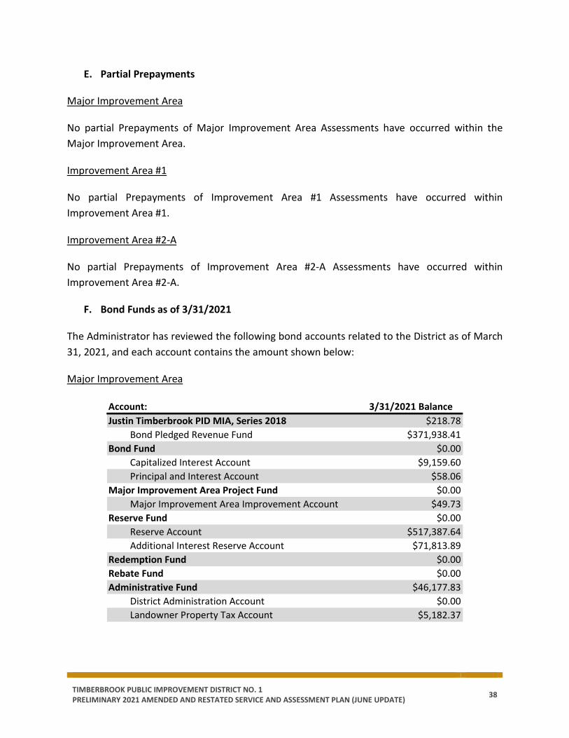
TIMBERBROOK PUBLIC IMPROVEMENT DISTRICT NO. 1 PRELIMINARY 2021 AMENDED AND RESTATED SERVICE AND ASSESSMENT PLAN (JUNE UPDATE) 38
E. Partial Prepayments
Major Improvement Area
No partial Prepayments of Major Improvement Area Assessments have occurred within the Major Improvement Area.
Improvement Area #1
No partial Prepayments of Improvement Area #1 Assessments have occurred within Improvement Area #1.
Improvement Area #2-A
No partial Prepayments of Improvement Area #2-A Assessments have occurred within Improvement Area #2-A.
F. Bond Funds as of 3/31/2021
The Administrator has reviewed the following bond accounts related to the District as of March 31, 2021, and each account contains the amount shown below:
Major Improvement Area
Account: 3/31/2021 BalanceJustin Timberbrook PID MIA, Series 2018 $218.78
Bond Pledged Revenue Fund $371,938.41Bond Fund $0.00
Capitalized Interest Account $9,159.60Principal and Interest Account $58.06
Major Improvement Area Project Fund $0.00Major Improvement Area Improvement Account $49.73
Reserve Fund $0.00Reserve Account $517,387.64Additional Interest Reserve Account $71,813.89
Redemption Fund $0.00Rebate Fund $0.00Administrative Fund $46,177.83
District Administration Account $0.00Landowner Property Tax Account $5,182.37
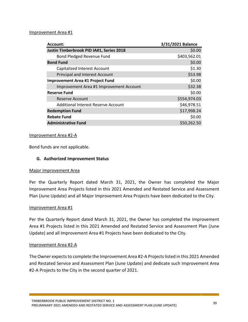
TIMBERBROOK PUBLIC IMPROVEMENT DISTRICT NO. 1 PRELIMINARY 2021 AMENDED AND RESTATED SERVICE AND ASSESSMENT PLAN (JUNE UPDATE) 39
Improvement Area #1
Improvement Area #2-A
Bond funds are not applicable.
G. Authorized Improvement Status
Major Improvement Area
Per the Quarterly Report dated March 31, 2021, the Owner has completed the Major Improvement Area Projects listed in this 2021 Amended and Restated Service and Assessment Plan (June Update) and all Major Improvement Area Projects have been dedicated to the City.
Improvement Area #1
Per the Quarterly Report dated March 31, 2021, the Owner has completed the Improvement Area #1 Projects listed in this 2021 Amended and Restated Service and Assessment Plan (June Update) and all Improvement Area #1 Projects have been dedicated to the City.
Improvement Area #2-A
The Owner expects to complete the Improvement Area #2-A Projects listed in this 2021 Amended and Restated Service and Assessment Plan (June Update) and dedicate such Improvement Area #2-A Projects to the City in the second quarter of 2021.
Account: 3/31/2021 BalanceJustin Timberbrook PID IA#1, Series 2018 $0.00
Bond Pledged Revenue Fund $403,562.01Bond Fund $0.00
Capitalized Interest Account $1.30Principal and Interest Account $53.98
Improvement Area #1 Project Fund $0.00Improvement Area #1 Improvement Account $32.38
Reserve Fund $0.00Reserve Account $554,974.03Additional Interest Reserve Account $46,978.51
Redemption Fund $17,998.24Rebate Fund $0.00Administrative Fund $50,262.50
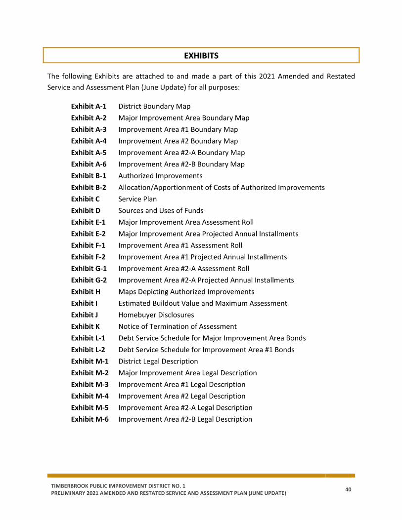
TIMBERBROOK PUBLIC IMPROVEMENT DISTRICT NO. 1 PRELIMINARY 2021 AMENDED AND RESTATED SERVICE AND ASSESSMENT PLAN (JUNE UPDATE) 40
EXHIBITS
The following Exhibits are attached to and made a part of this 2021 Amended and Restated Service and Assessment Plan (June Update) for all purposes:
Exhibit A-1 District Boundary Map Exhibit A-2 Major Improvement Area Boundary Map Exhibit A-3 Improvement Area #1 Boundary Map Exhibit A-4 Improvement Area #2 Boundary Map Exhibit A-5 Improvement Area #2-A Boundary Map Exhibit A-6 Improvement Area #2-B Boundary Map Exhibit B-1 Authorized Improvements Exhibit B-2 Allocation/Apportionment of Costs of Authorized Improvements Exhibit C Service Plan Exhibit D Sources and Uses of Funds Exhibit E-1 Major Improvement Area Assessment Roll Exhibit E-2 Major Improvement Area Projected Annual Installments Exhibit F-1 Improvement Area #1 Assessment Roll Exhibit F-2 Improvement Area #1 Projected Annual Installments Exhibit G-1 Improvement Area #2-A Assessment Roll Exhibit G-2 Improvement Area #2-A Projected Annual Installments Exhibit H Maps Depicting Authorized Improvements Exhibit I Estimated Buildout Value and Maximum Assessment Exhibit J Homebuyer Disclosures Exhibit K Notice of Termination of Assessment Exhibit L-1 Debt Service Schedule for Major Improvement Area Bonds Exhibit L-2 Debt Service Schedule for Improvement Area #1 Bonds Exhibit M-1 District Legal Description Exhibit M-2 Major Improvement Area Legal Description Exhibit M-3 Improvement Area #1 Legal Description Exhibit M-4 Improvement Area #2 Legal Description Exhibit M-5 Improvement Area #2-A Legal Description Exhibit M-6 Improvement Area #2-B Legal Description

TIMBERBROOK PUBLIC IMPROVEMENT DISTRICT NO. 1 PRELIMINARY 2021 AMENDED AND RESTATED SERVICE AND ASSESSMENT PLAN (JUNE UPDATE) 41
APPENDICES
The following Appendices are attached to and made a part of this 2021 Amended and Restated Service and Assessment Plan (June Update) for all purposes:
Appendix A Improvement Area #2 Engineer’s Report
[Remainder of page intentionally left blank.]
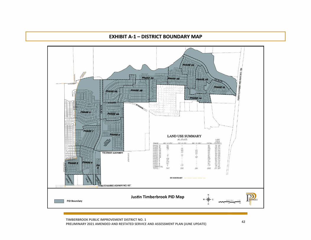
TIMBERBROOK PUBLIC IMPROVEMENT DISTRICT NO. 1 PRELIMINARY 2021 AMENDED AND RESTATED SERVICE AND ASSESSMENT PLAN (JUNE UPDATE) 42
EXHIBIT A-1 – DISTRICT BOUNDARY MAP

TIMBERBROOK PUBLIC IMPROVEMENT DISTRICT NO. 1 PRELIMINARY 2021 AMENDED AND RESTATED SERVICE AND ASSESSMENT PLAN (JUNE UPDATE) 43
EXHIBIT A-2 – MAJOR IMPROVEMENT AREA BOUNDARY MAP
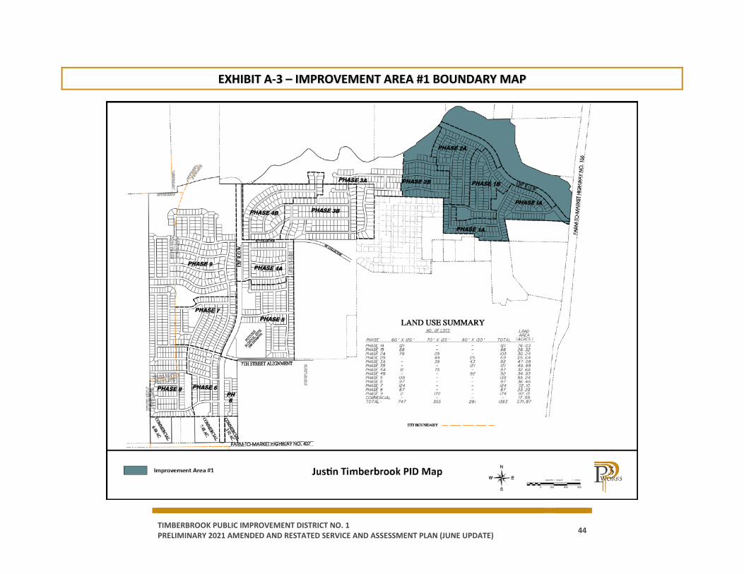
TIMBERBROOK PUBLIC IMPROVEMENT DISTRICT NO. 1 PRELIMINARY 2021 AMENDED AND RESTATED SERVICE AND ASSESSMENT PLAN (JUNE UPDATE) 44
EXHIBIT A-3 – IMPROVEMENT AREA #1 BOUNDARY MAP
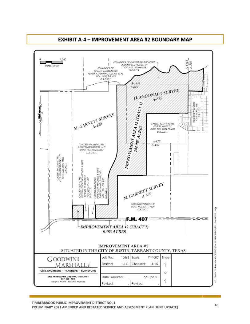
TIMBERBROOK PUBLIC IMPROVEMENT DISTRICT NO. 1 PRELIMINARY 2021 AMENDED AND RESTATED SERVICE AND ASSESSMENT PLAN (JUNE UPDATE) 45
EXHIBIT A-4 – IMPROVEMENT AREA #2 BOUNDARY MAP
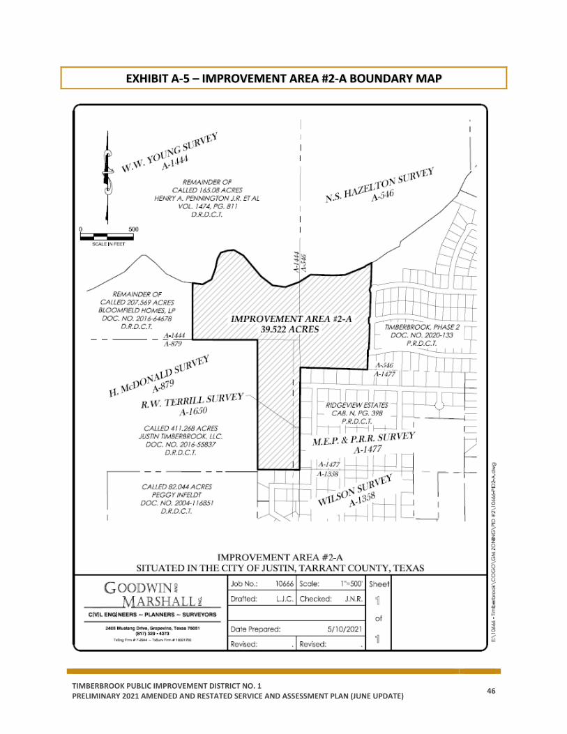
TIMBERBROOK PUBLIC IMPROVEMENT DISTRICT NO. 1 PRELIMINARY 2021 AMENDED AND RESTATED SERVICE AND ASSESSMENT PLAN (JUNE UPDATE) 46
EXHIBIT A-5 – IMPROVEMENT AREA #2-A BOUNDARY MAP
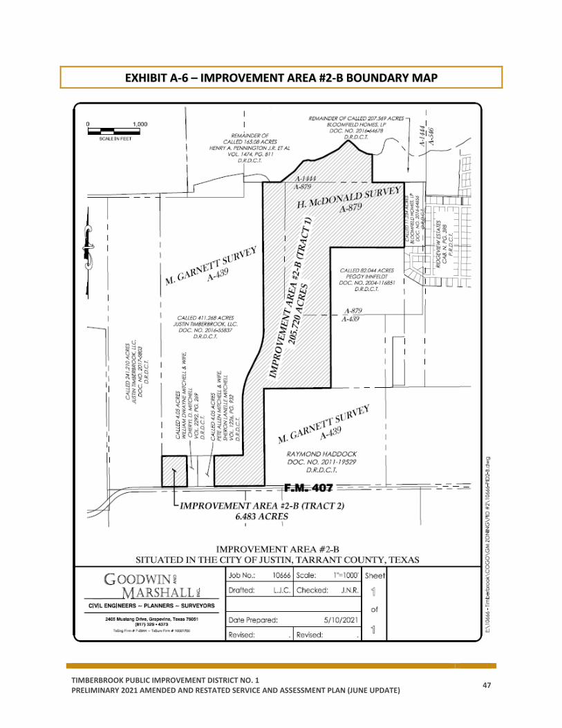
TIMBERBROOK PUBLIC IMPROVEMENT DISTRICT NO. 1 PRELIMINARY 2021 AMENDED AND RESTATED SERVICE AND ASSESSMENT PLAN (JUNE UPDATE) 47
EXHIBIT A-6 – IMPROVEMENT AREA #2-B BOUNDARY MAP
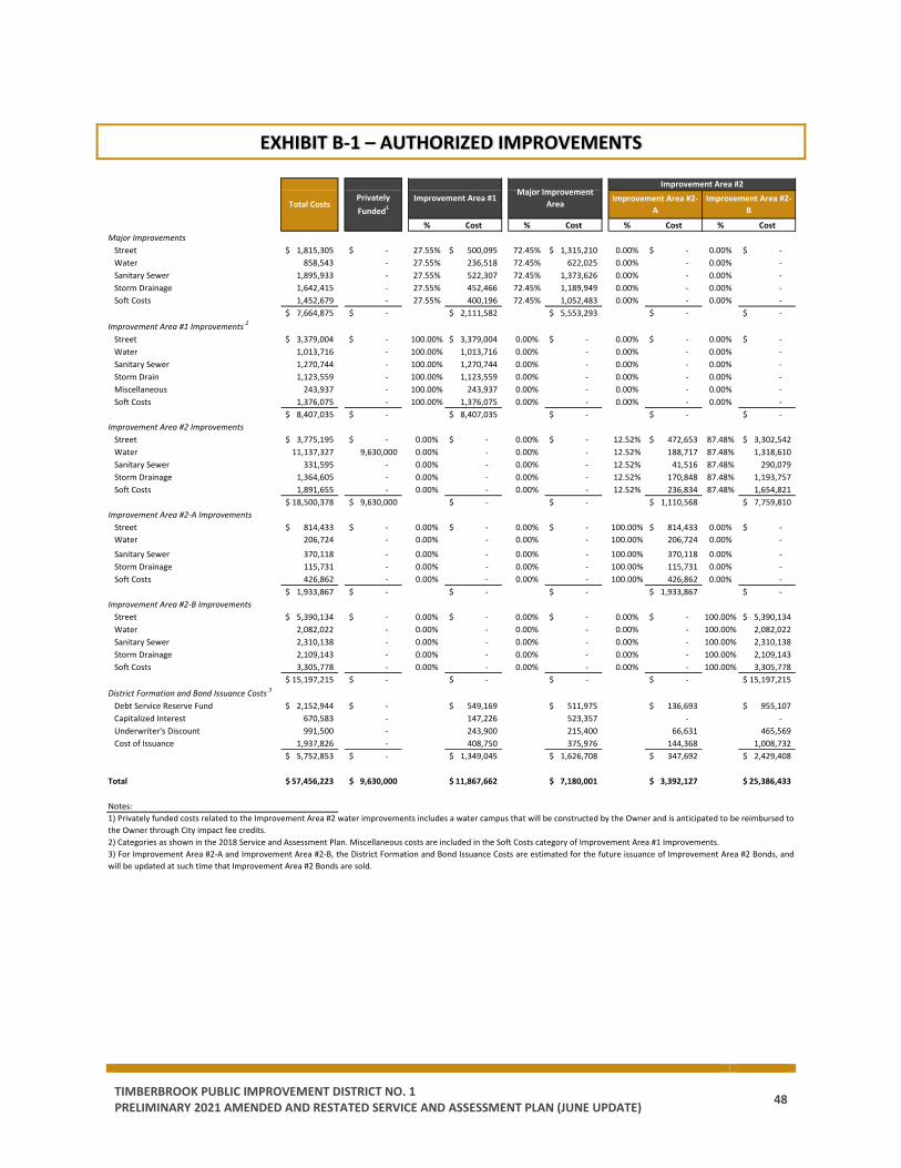
TIMBERBROOK PUBLIC IMPROVEMENT DISTRICT NO. 1 PRELIMINARY 2021 AMENDED AND RESTATED SERVICE AND ASSESSMENT PLAN (JUNE UPDATE) 48
EXHIBIT B-1 – AUTHORIZED IMPROVEMENTS
% Cost % Cost % Cost % CostMajor Improvements
Street 1,815,305$ -$ 27.55% 500,095$ 72.45% 1,315,210$ 0.00% -$ 0.00% -$ Water 858,543 - 27.55% 236,518 72.45% 622,025 0.00% - 0.00% - Sanitary Sewer 1,895,933 - 27.55% 522,307 72.45% 1,373,626 0.00% - 0.00% - Storm Drainage 1,642,415 - 27.55% 452,466 72.45% 1,189,949 0.00% - 0.00% - Soft Costs 1,452,679 - 27.55% 400,196 72.45% 1,052,483 0.00% - 0.00% -
7,664,875$ -$ 2,111,582$ 5,553,293$ -$ -$ Improvement Area #1 Improvements 2
Street 3,379,004$ -$ 100.00% 3,379,004$ 0.00% -$ 0.00% -$ 0.00% -$ Water 1,013,716 - 100.00% 1,013,716 0.00% - 0.00% - 0.00% - Sanitary Sewer 1,270,744 - 100.00% 1,270,744 0.00% - 0.00% - 0.00% - Storm Drain 1,123,559 - 100.00% 1,123,559 0.00% - 0.00% - 0.00% - Miscellaneous 243,937 - 100.00% 243,937 0.00% - 0.00% - 0.00% - Soft Costs 1,376,075 - 100.00% 1,376,075 0.00% - 0.00% - 0.00% -
8,407,035$ -$ 8,407,035$ -$ -$ -$ Improvement Area #2 Improvements
Street 3,775,195$ -$ 0.00% -$ 0.00% -$ 12.52% 472,653$ 87.48% 3,302,542$ Water 11,137,327 9,630,000 0.00% - 0.00% - 12.52% 188,717 87.48% 1,318,610 Sanitary Sewer 331,595 - 0.00% - 0.00% - 12.52% 41,516 87.48% 290,079 Storm Drainage 1,364,605 - 0.00% - 0.00% - 12.52% 170,848 87.48% 1,193,757 Soft Costs 1,891,655 - 0.00% - 0.00% - 12.52% 236,834 87.48% 1,654,821
18,500,378$ 9,630,000$ -$ -$ 1,110,568$ 7,759,810$ Improvement Area #2-A Improvements
Street 814,433$ -$ 0.00% -$ 0.00% -$ 100.00% 814,433$ 0.00% -$ Water 206,724 - 0.00% - 0.00% - 100.00% 206,724 0.00% -
Sanitary Sewer 370,118 - 0.00% - 0.00% - 100.00% 370,118 0.00% - Storm Drainage 115,731 - 0.00% - 0.00% - 100.00% 115,731 0.00% - Soft Costs 426,862 - 0.00% - 0.00% - 100.00% 426,862 0.00% -
1,933,867$ -$ -$ -$ 1,933,867$ -$ Improvement Area #2-B Improvements
Street 5,390,134$ -$ 0.00% -$ 0.00% -$ 0.00% -$ 100.00% 5,390,134$ Water 2,082,022 - 0.00% - 0.00% - 0.00% - 100.00% 2,082,022 Sanitary Sewer 2,310,138 - 0.00% - 0.00% - 0.00% - 100.00% 2,310,138 Storm Drainage 2,109,143 - 0.00% - 0.00% - 0.00% - 100.00% 2,109,143 Soft Costs 3,305,778 - 0.00% - 0.00% - 0.00% - 100.00% 3,305,778
15,197,215$ -$ -$ -$ -$ 15,197,215$ District Formation and Bond Issuance Costs 3
Debt Service Reserve Fund 2,152,944$ -$ 549,169$ 511,975$ 136,693$ 955,107$ Capitalized Interest 670,583 - 147,226 523,357 - - Underwriter's Discount 991,500 - 243,900 215,400 66,631 465,569 Cost of Issuance 1,937,826 - 408,750 375,976 144,368 1,008,732
5,752,853$ -$ 1,349,045$ 1,626,708$ 347,692$ 2,429,408$
Total 57,456,223$ 9,630,000$ 11,867,662$ 7,180,001$ 3,392,127$ 25,386,433$
Notes:1) Privately funded costs related to the Improvement Area #2 water improvements includes a water campus that will be constructed by the Owner and is anticipated to be reimbursed to the Owner through City impact fee credits.2) Categories as shown in the 2018 Service and Assessment Plan. Miscellaneous costs are included in the Soft Costs category of Improvement Area #1 Improvements.3) For Improvement Area #2-A and Improvement Area #2-B, the District Formation and Bond Issuance Costs are estimated for the future issuance of Improvement Area #2 Bonds, andwill be updated at such time that Improvement Area #2 Bonds are sold.
Improvement Area #2-A
Improvement Area #2Improvement Area #1
Total CostsPrivately Funded1
Major Improvement Area Improvement Area #2-
B
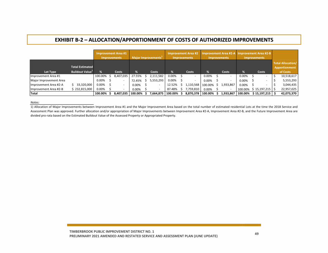
TIMBERBROOK PUBLIC IMPROVEMENT DISTRICT NO. 1 PRELIMINARY 2021 AMENDED AND RESTATED SERVICE AND ASSESSMENT PLAN (JUNE UPDATE) 49
EXHIBIT B-2 – ALLOCATION/APPORTIONMENT OF COSTS OF AUTHORIZED IMPROVEMENTS
Lot TypeTotal Estimated Buildout Value1 % Costs % Costs % Costs % Costs % Costs
Improvement Area #1 100.00% 8,407,035$ 27.55% 2,111,582$ 0.00% -$ 0.00% -$ 0.00% -$ 10,518,617$ Major Improvement Area 0.00% -$ 72.45% 5,553,293$ 0.00% -$ 0.00% -$ 0.00% -$ 5,553,293$ Improvement Area #2-A 33,320,000$ 0.00% -$ 0.00% -$ 12.52% 1,110,568$ 100.00% 1,933,867$ 0.00% -$ 3,044,435$ Improvement Area #2-B 232,815,000$ 0.00% -$ 0.00% -$ 87.48% 7,759,810$ 0.00% -$ 100.00% 15,197,215$ 22,957,025$ Total 100.00% 8,407,035$ 100.00% 7,664,875$ 100.00% 8,870,378$ 100.00% 1,933,867$ 100.00% 15,197,215$ 42,073,370$
Notes:
Improvement Area #2 Improvements
1) Allocation of Major Improvements between Improvement Area #1 and the Major Improvement Area based on the total number of estimated residential Lots at the time the 2018 Service andAssessment Plan was approved. Further allocation and/or appropriation of Major Improvements between Improvement Area #2-A, Improvement Area #2-B, and the Future Improvement Area aredivided pro-rata based on the Estimated Buildout Value of the Assessed Property or Appropriated Property.
Improvement Area #1 Improvements Major Improvements1
Total Allocation/ Apportionment
of Costs
Improvement Area #2-B Improvements
Improvement Area #2-A Improvements
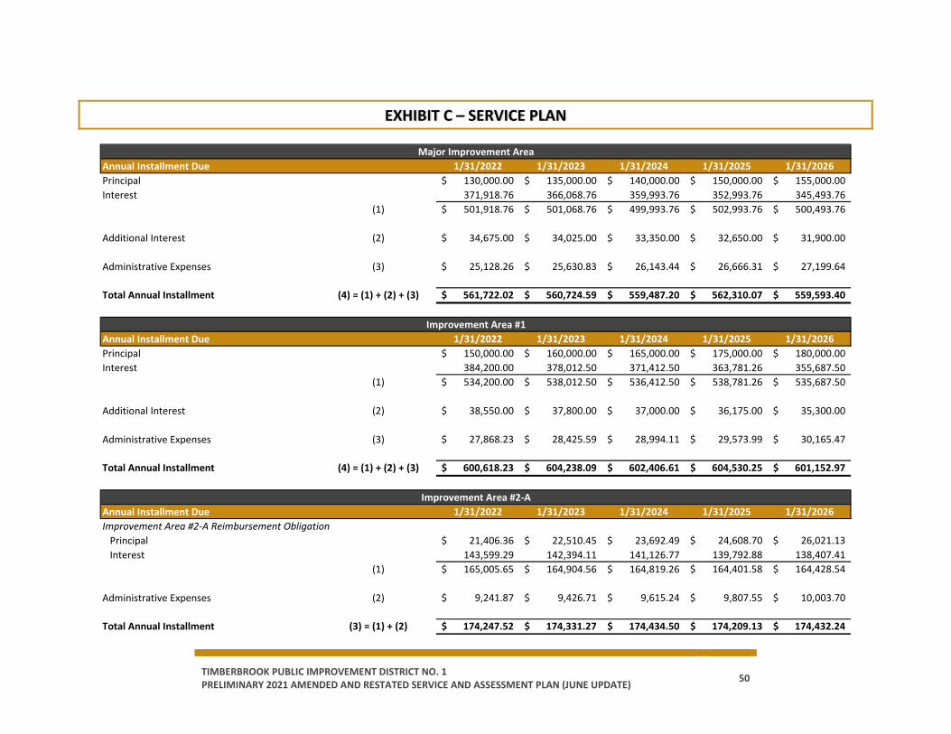
TIMBERBROOK PUBLIC IMPROVEMENT DISTRICT NO. 1 PRELIMINARY 2021 AMENDED AND RESTATED SERVICE AND ASSESSMENT PLAN (JUNE UPDATE) 50
EXHIBIT C – SERVICE PLAN
Annual Installment Due 1/31/2022 1/31/2023 1/31/2024 1/31/2025 1/31/2026Principal 130,000.00$ 135,000.00$ 140,000.00$ 150,000.00$ 155,000.00$ Interest 371,918.76 366,068.76 359,993.76 352,993.76 345,493.76
(1) 501,918.76$ 501,068.76$ 499,993.76$ 502,993.76$ 500,493.76$
Additional Interest (2) 34,675.00$ 34,025.00$ 33,350.00$ 32,650.00$ 31,900.00$
Administrative Expenses (3) 25,128.26$ 25,630.83$ 26,143.44$ 26,666.31$ 27,199.64$
Total Annual Installment (4) = (1) + (2) + (3) 561,722.02$ 560,724.59$ 559,487.20$ 562,310.07$ 559,593.40$
Annual Installment Due 1/31/2022 1/31/2023 1/31/2024 1/31/2025 1/31/2026Principal 150,000.00$ 160,000.00$ 165,000.00$ 175,000.00$ 180,000.00$ Interest 384,200.00 378,012.50 371,412.50 363,781.26 355,687.50
(1) 534,200.00$ 538,012.50$ 536,412.50$ 538,781.26$ 535,687.50$
Additional Interest (2) 38,550.00$ 37,800.00$ 37,000.00$ 36,175.00$ 35,300.00$
Administrative Expenses (3) 27,868.23$ 28,425.59$ 28,994.11$ 29,573.99$ 30,165.47$
Total Annual Installment (4) = (1) + (2) + (3) 600,618.23$ 604,238.09$ 602,406.61$ 604,530.25$ 601,152.97$
Annual Installment Due 1/31/2022 1/31/2023 1/31/2024 1/31/2025 1/31/2026Improvement Area #2-A Reimbursement Obligation
Principal 21,406.36$ 22,510.45$ 23,692.49$ 24,608.70$ 26,021.13$ Interest 143,599.29 142,394.11 141,126.77 139,792.88 138,407.41
(1) 165,005.65$ 164,904.56$ 164,819.26$ 164,401.58$ 164,428.54$
Administrative Expenses (2) 9,241.87$ 9,426.71$ 9,615.24$ 9,807.55$ 10,003.70$
Total Annual Installment (3) = (1) + (2) 174,247.52$ 174,331.27$ 174,434.50$ 174,209.13$ 174,432.24$
Major Improvement Area
Improvement Area #1
Improvement Area #2-A

TIMBERBROOK PUBLIC IMPROVEMENT DISTRICT NO. 1 PRELIMINARY 2021 AMENDED AND RESTATED SERVICE AND ASSESSMENT PLAN (JUNE UPDATE) 51
EXHIBIT D – SOURCES AND USES OF FUNDS
Improvement Area #1 Major Improvement Area Improvement Area #2-A Improvement Area #2-B
Improvement Area #1 Bonds 8,130,000$ -$ -$ -$ Improvement Area #2-A Reimbursement Obligation - - 2,550,609 - Major Improvement Area Bonds - 7,180,000 - - Owner Contribution - Non Reimbursable1 3,737,662 1 841,518 - Owner Contribution - Improvement Area #2-B2 - - - 25,386,433 Owner Contribution - Private Costs3 - - 1,205,672 8,424,328 Total Sources 11,867,662$ 7,180,001$ 4,597,799$ 33,810,761$
Major Improvements 2,111,582$ 5,553,293$ -$ -$ Improvement Area #1 Improvements 8,407,035 - - - Improvement Area #2 Improvements - - 1,110,568 7,759,810 Improvement Area #2-A Improvements - - 1,933,867 - Improvement Area #2-B Improvements - - - 15,197,215 Private Costs3 - - 1,205,672 8,424,328
10,518,617$ 5,553,293$ 4,250,108$ 31,381,352$ District Formation and Bond Issuance Costs 4
Debt Service Reserve Fund 549,169$ 511,975$ 136,693$ 955,107$ Capitalized Interest 147,226 523,357 - - Underwriter's Discount 243,900 215,400 66,631 465,569 Cost of Issuance 408,750 375,976 144,368 1,008,732
1,349,045$ 1,626,708$ 347,692$ 2,429,408$
Total Uses 11,867,662$ 7,180,001$ 4,597,799$ 33,810,761$
Notes:
Sources of Funds
Uses of Funds
1) Not reimbursable to Owner through Assessments.2) Reimbursable to Owner from future Assessments anticipated to be levied on Improvement Area #2-B.3) Not eligible for reimbursement through PID Bonds or Assessments. Private costs related to the Improvement Area #2 water improvements includes a water campus that will beconstructed by the Owner and is anticipated to be reimbursed to the Owner through City impact fee credits.4) For Improvement Area #2-A and Improvement Area #2-B, the District Formation and Bond Issuance Costs are estimated for the future issuance of Improvement Area #2 Bonds,and will be updated at such time that Improvement Area #2 Bonds are sold.
Improvement Area #2
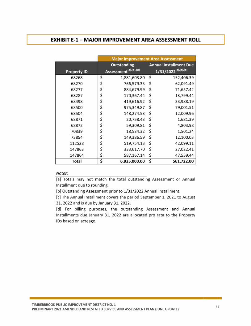
TIMBERBROOK PUBLIC IMPROVEMENT DISTRICT NO. 1 PRELIMINARY 2021 AMENDED AND RESTATED SERVICE AND ASSESSMENT PLAN (JUNE UPDATE) 52
EXHIBIT E-1 – MAJOR IMPROVEMENT AREA ASSESSMENT ROLL
Property IDOutstanding
Assessment[a],[b],[d]Annual Installment Due
1/31/2022[a],[c],[d]
68268 1,881,603.80$ 152,406.39$ 68270 766,579.33$ 62,091.49$ 68277 884,679.99$ 71,657.42$ 68287 170,367.44$ 13,799.44$ 68498 419,616.92$ 33,988.19$ 68500 975,349.87$ 79,001.51$ 68504 148,274.53$ 12,009.96$ 68871 20,758.43$ 1,681.39$ 68872 59,309.81$ 4,803.98$ 70839 18,534.32$ 1,501.24$ 73854 149,386.59$ 12,100.03$
112528 519,754.13$ 42,099.11$ 147863 333,617.70$ 27,022.41$ 147864 587,167.14$ 47,559.44$
Total 6,935,000.00$ 561,722.00$
Notes:[a] Totals may not match the total outstanding Assessment or AnnualInstallment due to rounding.[b] Outstanding Assessment prior to 1/31/2022 Annual Installment.[c] The Annual Installment covers the period September 1, 2021 to August31, 2022 and is due by January 31, 2022.[d] For billing purposes, the outstanding Assessment and AnnualInstallments due January 31, 2022 are allocated pro rata to the PropertyIDs based on acreage.
Major Improvement Area Assessment
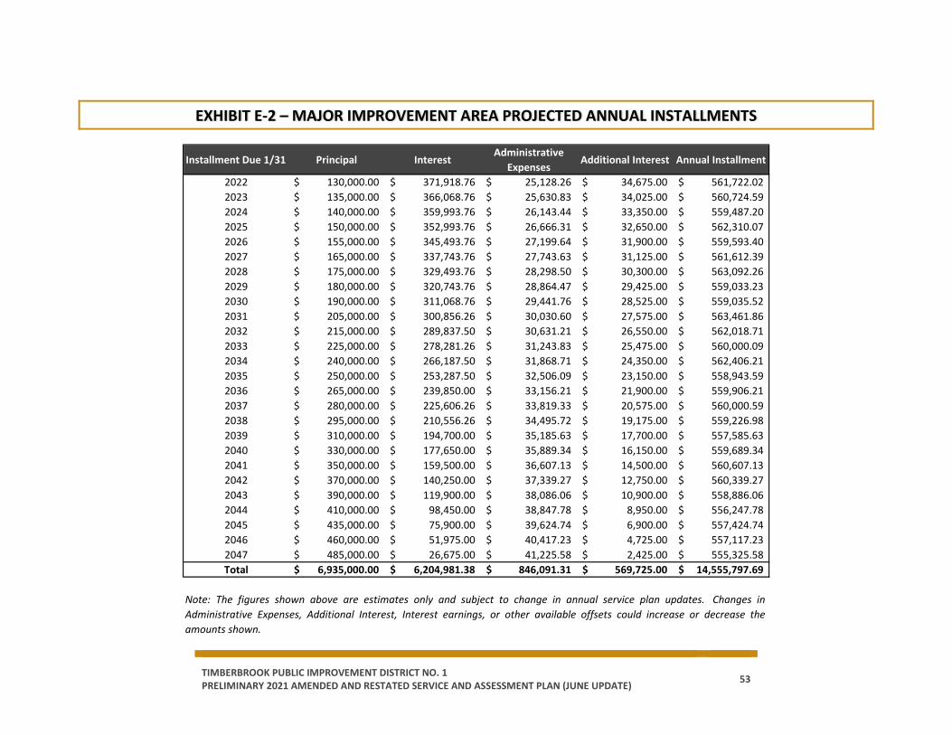
TIMBERBROOK PUBLIC IMPROVEMENT DISTRICT NO. 1 PRELIMINARY 2021 AMENDED AND RESTATED SERVICE AND ASSESSMENT PLAN (JUNE UPDATE) 53
EXHIBIT E-2 – MAJOR IMPROVEMENT AREA PROJECTED ANNUAL INSTALLMENTS
Installment Due 1/31 Principal InterestAdministrative
ExpensesAdditional Interest Annual Installment
2022 130,000.00$ 371,918.76$ 25,128.26$ 34,675.00$ 561,722.02$ 2023 135,000.00$ 366,068.76$ 25,630.83$ 34,025.00$ 560,724.59$ 2024 140,000.00$ 359,993.76$ 26,143.44$ 33,350.00$ 559,487.20$ 2025 150,000.00$ 352,993.76$ 26,666.31$ 32,650.00$ 562,310.07$ 2026 155,000.00$ 345,493.76$ 27,199.64$ 31,900.00$ 559,593.40$ 2027 165,000.00$ 337,743.76$ 27,743.63$ 31,125.00$ 561,612.39$ 2028 175,000.00$ 329,493.76$ 28,298.50$ 30,300.00$ 563,092.26$ 2029 180,000.00$ 320,743.76$ 28,864.47$ 29,425.00$ 559,033.23$ 2030 190,000.00$ 311,068.76$ 29,441.76$ 28,525.00$ 559,035.52$ 2031 205,000.00$ 300,856.26$ 30,030.60$ 27,575.00$ 563,461.86$ 2032 215,000.00$ 289,837.50$ 30,631.21$ 26,550.00$ 562,018.71$ 2033 225,000.00$ 278,281.26$ 31,243.83$ 25,475.00$ 560,000.09$ 2034 240,000.00$ 266,187.50$ 31,868.71$ 24,350.00$ 562,406.21$ 2035 250,000.00$ 253,287.50$ 32,506.09$ 23,150.00$ 558,943.59$ 2036 265,000.00$ 239,850.00$ 33,156.21$ 21,900.00$ 559,906.21$ 2037 280,000.00$ 225,606.26$ 33,819.33$ 20,575.00$ 560,000.59$ 2038 295,000.00$ 210,556.26$ 34,495.72$ 19,175.00$ 559,226.98$ 2039 310,000.00$ 194,700.00$ 35,185.63$ 17,700.00$ 557,585.63$ 2040 330,000.00$ 177,650.00$ 35,889.34$ 16,150.00$ 559,689.34$ 2041 350,000.00$ 159,500.00$ 36,607.13$ 14,500.00$ 560,607.13$ 2042 370,000.00$ 140,250.00$ 37,339.27$ 12,750.00$ 560,339.27$ 2043 390,000.00$ 119,900.00$ 38,086.06$ 10,900.00$ 558,886.06$ 2044 410,000.00$ 98,450.00$ 38,847.78$ 8,950.00$ 556,247.78$ 2045 435,000.00$ 75,900.00$ 39,624.74$ 6,900.00$ 557,424.74$ 2046 460,000.00$ 51,975.00$ 40,417.23$ 4,725.00$ 557,117.23$ 2047 485,000.00$ 26,675.00$ 41,225.58$ 2,425.00$ 555,325.58$ Total 6,935,000.00$ 6,204,981.38$ 846,091.31$ 569,725.00$ 14,555,797.69$
Note: The figures shown above are estimates only and subject to change in annual service plan updates. Changes inAdministrative Expenses, Additional Interest, Interest earnings, or other available offsets could increase or decrease theamounts shown.

TIMBERBROOK PUBLIC IMPROVEMENT DISTRICT NO. 1 PRELIMINARY 2021 AMENDED AND RESTATED SERVICE AND ASSESSMENT PLAN (JUNE UPDATE) 54
EXHIBIT F-1 – IMPROVEMENT AREA #1 ASSESSMENT ROLL
Property ID Lot Type NotesOutstanding
Assessment[d]Annual Installment Due 1/31/2022[e]
732105 1 18,812.53$ 1,465.68$ 732106 1 18,812.53$ 1,465.68$ 732107 1 18,812.53$ 1,465.68$ 732108 1 18,812.53$ 1,465.68$ 732109 1 18,812.53$ 1,465.68$ 732110 1 18,812.53$ 1,465.68$ 732111 1 18,812.53$ 1,465.68$ 732112 1 18,812.53$ 1,465.68$ 732113 1 18,812.53$ 1,465.68$ 732114 1 18,812.53$ 1,465.68$ 732115 1 18,812.53$ 1,465.68$ 732116 1 18,812.53$ 1,465.68$ 732117 1 18,812.53$ 1,465.68$ 732118 1 18,812.53$ 1,465.68$ 732119 1 18,812.53$ 1,465.68$ 732120 1 18,812.53$ 1,465.68$ 732121 1 18,812.53$ 1,465.68$ 732122 1 18,812.53$ 1,465.68$ 732123 1 [a] -$ -$ 732124 1 18,812.53$ 1,465.68$ 732126 1 18,812.53$ 1,465.68$ 732127 1 18,812.53$ 1,465.68$ 732128 1 18,812.53$ 1,465.68$ 732129 1 18,812.53$ 1,465.68$ 732130 1 18,812.53$ 1,465.68$ 732131 1 18,812.53$ 1,465.68$ 732132 1 18,812.53$ 1,465.68$ 732133 1 18,812.53$ 1,465.68$ 732134 1 18,812.53$ 1,465.68$ 732135 1 18,812.53$ 1,465.68$ 732136 1 18,812.53$ 1,465.68$ 732137 1 18,812.53$ 1,465.68$ 732138 1 18,812.53$ 1,465.68$ 732139 1 18,812.53$ 1,465.68$ 732140 1 18,812.53$ 1,465.68$ 732141 1 18,812.53$ 1,465.68$ 732142 1 18,812.53$ 1,465.68$ 732143 1 18,812.53$ 1,465.68$ 732144 1 18,812.53$ 1,465.68$ 732145 1 18,812.53$ 1,465.68$
Improvement Area #1[c]

TIMBERBROOK PUBLIC IMPROVEMENT DISTRICT NO. 1 PRELIMINARY 2021 AMENDED AND RESTATED SERVICE AND ASSESSMENT PLAN (JUNE UPDATE) 55
Property ID Lot Type NotesOutstanding
Assessment[d]Annual Installment Due 1/31/2022[e]
732146 1 18,812.53$ 1,465.68$ 732147 1 18,812.53$ 1,465.68$ 732148 1 18,812.53$ 1,465.68$ 732149 1 18,812.53$ 1,465.68$ 732150 1 18,812.53$ 1,465.68$ 732151 1 18,812.53$ 1,465.68$ 732152 1 18,812.53$ 1,465.68$ 732153 1 18,812.53$ 1,465.68$ 732154 1 18,812.53$ 1,465.68$ 732155 1 18,812.53$ 1,465.68$ 732156 1 18,812.53$ 1,465.68$ 732157 1 18,812.53$ 1,465.68$ 732158 1 18,812.53$ 1,465.68$ 732159 1 18,812.53$ 1,465.68$ 732160 1 18,812.53$ 1,465.68$ 732161 1 18,812.53$ 1,465.68$ 732162 1 18,812.53$ 1,465.68$ 732163 1 18,812.53$ 1,465.68$ 732164 1 18,812.53$ 1,465.68$ 732165 1 18,812.53$ 1,465.68$ 732166 1 18,812.53$ 1,465.68$ 732167 1 18,812.53$ 1,465.68$ 732168 1 18,812.53$ 1,465.68$ 732169 1 18,812.53$ 1,465.68$ 732170 1 18,812.53$ 1,465.68$ 732171 1 18,812.53$ 1,465.68$ 732172 1 18,812.53$ 1,465.68$ 732173 1 18,812.53$ 1,465.68$ 732174 1 18,812.53$ 1,465.68$ 732175 1 18,812.53$ 1,465.68$ 732176 1 18,812.53$ 1,465.68$ 732177 1 18,812.53$ 1,465.68$ 732178 1 18,812.53$ 1,465.68$ 732179 1 18,812.53$ 1,465.68$ 732180 1 18,812.53$ 1,465.68$ 732181 1 18,812.53$ 1,465.68$ 732182 1 18,812.53$ 1,465.68$ 732183 1 18,812.53$ 1,465.68$ 732184 1 18,812.53$ 1,465.68$ 732185 1 18,812.53$ 1,465.68$
Improvement Area #1[c]
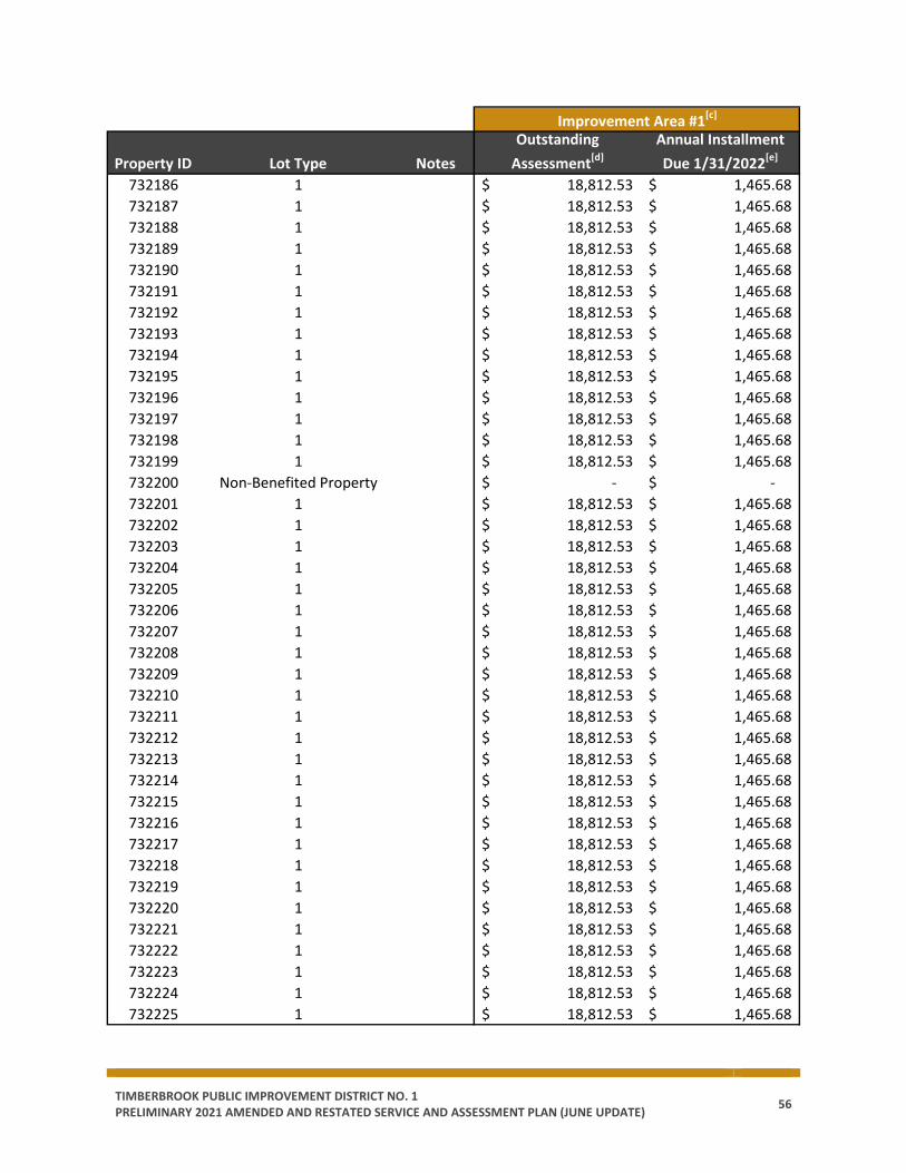
TIMBERBROOK PUBLIC IMPROVEMENT DISTRICT NO. 1 PRELIMINARY 2021 AMENDED AND RESTATED SERVICE AND ASSESSMENT PLAN (JUNE UPDATE) 56
Property ID Lot Type NotesOutstanding
Assessment[d]Annual Installment Due 1/31/2022[e]
732186 1 18,812.53$ 1,465.68$ 732187 1 18,812.53$ 1,465.68$ 732188 1 18,812.53$ 1,465.68$ 732189 1 18,812.53$ 1,465.68$ 732190 1 18,812.53$ 1,465.68$ 732191 1 18,812.53$ 1,465.68$ 732192 1 18,812.53$ 1,465.68$ 732193 1 18,812.53$ 1,465.68$ 732194 1 18,812.53$ 1,465.68$ 732195 1 18,812.53$ 1,465.68$ 732196 1 18,812.53$ 1,465.68$ 732197 1 18,812.53$ 1,465.68$ 732198 1 18,812.53$ 1,465.68$ 732199 1 18,812.53$ 1,465.68$ 732200 Non-Benefited Property -$ -$ 732201 1 18,812.53$ 1,465.68$ 732202 1 18,812.53$ 1,465.68$ 732203 1 18,812.53$ 1,465.68$ 732204 1 18,812.53$ 1,465.68$ 732205 1 18,812.53$ 1,465.68$ 732206 1 18,812.53$ 1,465.68$ 732207 1 18,812.53$ 1,465.68$ 732208 1 18,812.53$ 1,465.68$ 732209 1 18,812.53$ 1,465.68$ 732210 1 18,812.53$ 1,465.68$ 732211 1 18,812.53$ 1,465.68$ 732212 1 18,812.53$ 1,465.68$ 732213 1 18,812.53$ 1,465.68$ 732214 1 18,812.53$ 1,465.68$ 732215 1 18,812.53$ 1,465.68$ 732216 1 18,812.53$ 1,465.68$ 732217 1 18,812.53$ 1,465.68$ 732218 1 18,812.53$ 1,465.68$ 732219 1 18,812.53$ 1,465.68$ 732220 1 18,812.53$ 1,465.68$ 732221 1 18,812.53$ 1,465.68$ 732222 1 18,812.53$ 1,465.68$ 732223 1 18,812.53$ 1,465.68$ 732224 1 18,812.53$ 1,465.68$ 732225 1 18,812.53$ 1,465.68$
Improvement Area #1[c]

TIMBERBROOK PUBLIC IMPROVEMENT DISTRICT NO. 1 PRELIMINARY 2021 AMENDED AND RESTATED SERVICE AND ASSESSMENT PLAN (JUNE UPDATE) 57
Property ID Lot Type NotesOutstanding
Assessment[d]Annual Installment Due 1/31/2022[e]
732226 1 18,812.53$ 1,465.68$ 732227 1 18,812.53$ 1,465.68$ 732228 Non-Benefited Property -$ -$ 732229 Non-Benefited Property -$ -$ 732590 1 18,812.53$ 1,465.68$ 732591 1 18,812.53$ 1,465.68$ 732592 1 18,812.53$ 1,465.68$ 732593 1 18,812.53$ 1,465.68$ 732594 1 18,812.53$ 1,465.68$ 732595 1 18,812.53$ 1,465.68$ 732596 1 18,812.53$ 1,465.68$ 732597 1 18,812.53$ 1,465.68$ 732598 1 18,812.53$ 1,465.68$ 732599 1 18,812.53$ 1,465.68$ 732600 1 18,812.53$ 1,465.68$ 732601 1 18,812.53$ 1,465.68$ 732602 1 18,812.53$ 1,465.68$ 732603 1 18,812.53$ 1,465.68$ 732604 1 18,812.53$ 1,465.68$ 732605 1 18,812.53$ 1,465.68$ 732606 1 18,812.53$ 1,465.68$ 732607 1 18,812.53$ 1,465.68$ 732608 1 18,812.53$ 1,465.68$ 732609 1 18,812.53$ 1,465.68$ 732610 1 18,812.53$ 1,465.68$ 732611 1 18,812.53$ 1,465.68$ 732612 1 18,812.53$ 1,465.68$ 732613 1 18,812.53$ 1,465.68$ 732614 1 18,812.53$ 1,465.68$ 732615 1 18,812.53$ 1,465.68$ 732616 1 18,812.53$ 1,465.68$ 732617 1 18,812.53$ 1,465.68$ 732618 1 18,812.53$ 1,465.68$ 732620 1 18,812.53$ 1,465.68$ 732621 1 18,812.53$ 1,465.68$ 732622 1 18,812.53$ 1,465.68$ 732623 1 18,812.53$ 1,465.68$ 732624 1 18,812.53$ 1,465.68$ 732625 1 18,812.53$ 1,465.68$ 732626 1 18,812.53$ 1,465.68$
Improvement Area #1[c]

TIMBERBROOK PUBLIC IMPROVEMENT DISTRICT NO. 1 PRELIMINARY 2021 AMENDED AND RESTATED SERVICE AND ASSESSMENT PLAN (JUNE UPDATE) 58
Property ID Lot Type NotesOutstanding
Assessment[d]Annual Installment Due 1/31/2022[e]
732627 1 18,812.53$ 1,465.68$ 732628 1 18,812.53$ 1,465.68$ 732629 1 18,812.53$ 1,465.68$ 732630 1 18,812.53$ 1,465.68$ 732631 1 18,812.53$ 1,465.68$ 732632 1 18,812.53$ 1,465.68$ 732633 1 18,812.53$ 1,465.68$ 732634 1 18,812.53$ 1,465.68$ 732635 1 18,812.53$ 1,465.68$ 732636 1 18,812.53$ 1,465.68$ 732637 1 18,812.53$ 1,465.68$ 732638 1 18,812.53$ 1,465.68$ 732639 1 18,812.53$ 1,465.68$ 732640 1 18,812.53$ 1,465.68$ 732641 1 18,812.53$ 1,465.68$ 732642 1 18,812.53$ 1,465.68$ 732643 1 18,812.53$ 1,465.68$ 732644 1 18,812.53$ 1,465.68$ 732645 1 18,812.53$ 1,465.68$ 732646 1 18,812.53$ 1,465.68$ 732647 1 18,812.53$ 1,465.68$ 732648 1 18,812.53$ 1,465.68$ 732649 1 18,812.53$ 1,465.68$ 732650 1 18,812.53$ 1,465.68$ 732651 1 18,812.53$ 1,465.68$ 732652 1 18,812.53$ 1,465.68$ 732653 1 18,812.53$ 1,465.68$ 732654 1 18,812.53$ 1,465.68$ 732655 1 18,812.53$ 1,465.68$ 732656 1 18,812.53$ 1,465.68$ 732657 1 18,812.53$ 1,465.68$ 732658 1 18,812.53$ 1,465.68$ 732659 1 18,812.53$ 1,465.68$ 732660 1 18,812.53$ 1,465.68$ 732661 1 18,812.53$ 1,465.68$ 732662 1 18,812.53$ 1,465.68$ 732663 1 18,812.53$ 1,465.68$ 732665 1 18,812.53$ 1,465.68$ 732666 1 18,812.53$ 1,465.68$ 732667 1 18,812.53$ 1,465.68$
Improvement Area #1[c]
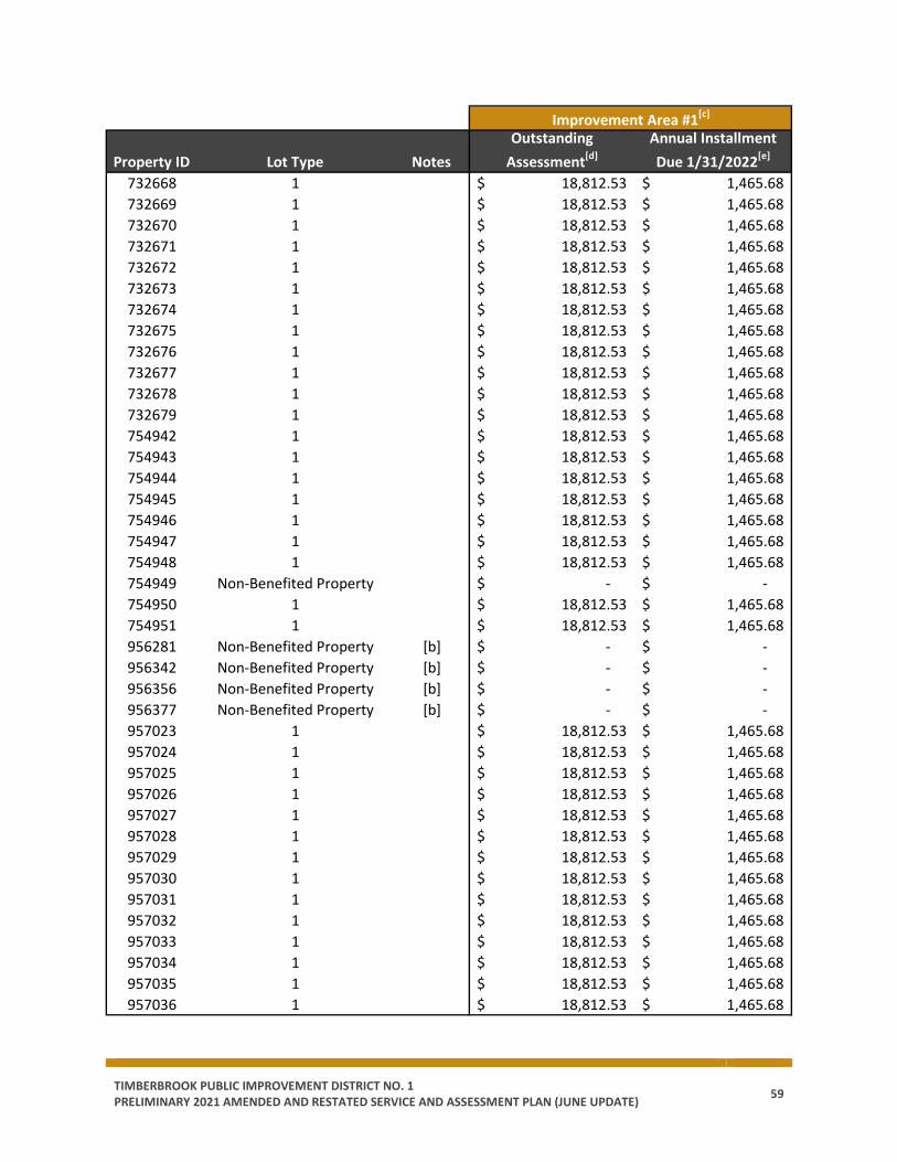
TIMBERBROOK PUBLIC IMPROVEMENT DISTRICT NO. 1 PRELIMINARY 2021 AMENDED AND RESTATED SERVICE AND ASSESSMENT PLAN (JUNE UPDATE) 59
Property ID Lot Type NotesOutstanding
Assessment[d]Annual Installment Due 1/31/2022[e]
732668 1 18,812.53$ 1,465.68$ 732669 1 18,812.53$ 1,465.68$ 732670 1 18,812.53$ 1,465.68$ 732671 1 18,812.53$ 1,465.68$ 732672 1 18,812.53$ 1,465.68$ 732673 1 18,812.53$ 1,465.68$ 732674 1 18,812.53$ 1,465.68$ 732675 1 18,812.53$ 1,465.68$ 732676 1 18,812.53$ 1,465.68$ 732677 1 18,812.53$ 1,465.68$ 732678 1 18,812.53$ 1,465.68$ 732679 1 18,812.53$ 1,465.68$ 754942 1 18,812.53$ 1,465.68$ 754943 1 18,812.53$ 1,465.68$ 754944 1 18,812.53$ 1,465.68$ 754945 1 18,812.53$ 1,465.68$ 754946 1 18,812.53$ 1,465.68$ 754947 1 18,812.53$ 1,465.68$ 754948 1 18,812.53$ 1,465.68$ 754949 Non-Benefited Property -$ -$ 754950 1 18,812.53$ 1,465.68$ 754951 1 18,812.53$ 1,465.68$ 956281 Non-Benefited Property [b] -$ -$ 956342 Non-Benefited Property [b] -$ -$ 956356 Non-Benefited Property [b] -$ -$ 956377 Non-Benefited Property [b] -$ -$ 957023 1 18,812.53$ 1,465.68$ 957024 1 18,812.53$ 1,465.68$ 957025 1 18,812.53$ 1,465.68$ 957026 1 18,812.53$ 1,465.68$ 957027 1 18,812.53$ 1,465.68$ 957028 1 18,812.53$ 1,465.68$ 957029 1 18,812.53$ 1,465.68$ 957030 1 18,812.53$ 1,465.68$ 957031 1 18,812.53$ 1,465.68$ 957032 1 18,812.53$ 1,465.68$ 957033 1 18,812.53$ 1,465.68$ 957034 1 18,812.53$ 1,465.68$ 957035 1 18,812.53$ 1,465.68$ 957036 1 18,812.53$ 1,465.68$
Improvement Area #1[c]
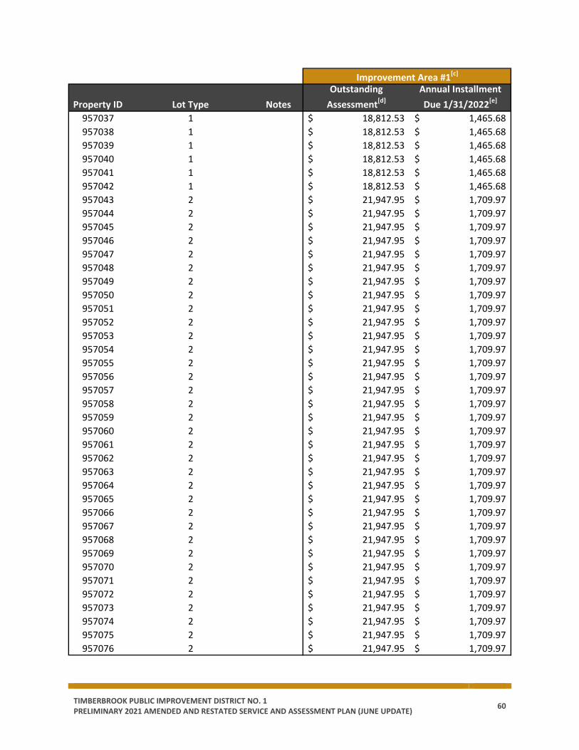
TIMBERBROOK PUBLIC IMPROVEMENT DISTRICT NO. 1 PRELIMINARY 2021 AMENDED AND RESTATED SERVICE AND ASSESSMENT PLAN (JUNE UPDATE) 60
Property ID Lot Type NotesOutstanding
Assessment[d]Annual Installment Due 1/31/2022[e]
957037 1 18,812.53$ 1,465.68$ 957038 1 18,812.53$ 1,465.68$ 957039 1 18,812.53$ 1,465.68$ 957040 1 18,812.53$ 1,465.68$ 957041 1 18,812.53$ 1,465.68$ 957042 1 18,812.53$ 1,465.68$ 957043 2 21,947.95$ 1,709.97$ 957044 2 21,947.95$ 1,709.97$ 957045 2 21,947.95$ 1,709.97$ 957046 2 21,947.95$ 1,709.97$ 957047 2 21,947.95$ 1,709.97$ 957048 2 21,947.95$ 1,709.97$ 957049 2 21,947.95$ 1,709.97$ 957050 2 21,947.95$ 1,709.97$ 957051 2 21,947.95$ 1,709.97$ 957052 2 21,947.95$ 1,709.97$ 957053 2 21,947.95$ 1,709.97$ 957054 2 21,947.95$ 1,709.97$ 957055 2 21,947.95$ 1,709.97$ 957056 2 21,947.95$ 1,709.97$ 957057 2 21,947.95$ 1,709.97$ 957058 2 21,947.95$ 1,709.97$ 957059 2 21,947.95$ 1,709.97$ 957060 2 21,947.95$ 1,709.97$ 957061 2 21,947.95$ 1,709.97$ 957062 2 21,947.95$ 1,709.97$ 957063 2 21,947.95$ 1,709.97$ 957064 2 21,947.95$ 1,709.97$ 957065 2 21,947.95$ 1,709.97$ 957066 2 21,947.95$ 1,709.97$ 957067 2 21,947.95$ 1,709.97$ 957068 2 21,947.95$ 1,709.97$ 957069 2 21,947.95$ 1,709.97$ 957070 2 21,947.95$ 1,709.97$ 957071 2 21,947.95$ 1,709.97$ 957072 2 21,947.95$ 1,709.97$ 957073 2 21,947.95$ 1,709.97$ 957074 2 21,947.95$ 1,709.97$ 957075 2 21,947.95$ 1,709.97$ 957076 2 21,947.95$ 1,709.97$
Improvement Area #1[c]
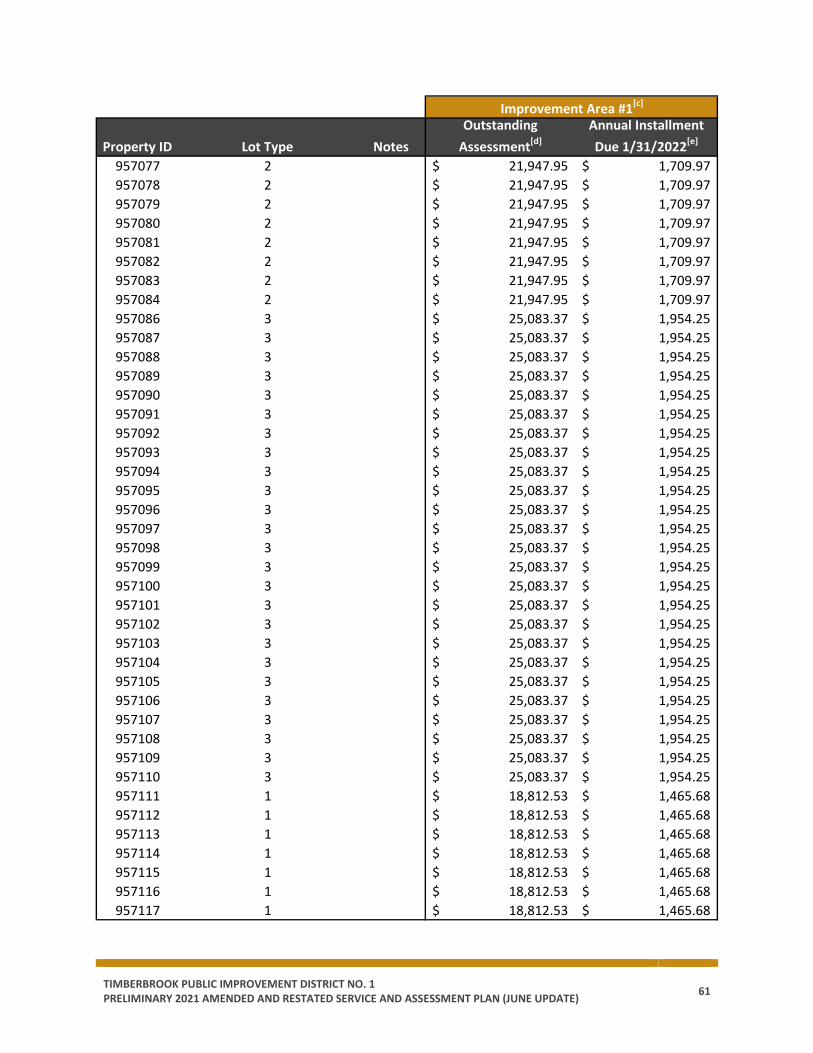
TIMBERBROOK PUBLIC IMPROVEMENT DISTRICT NO. 1 PRELIMINARY 2021 AMENDED AND RESTATED SERVICE AND ASSESSMENT PLAN (JUNE UPDATE) 61
Property ID Lot Type NotesOutstanding
Assessment[d]Annual Installment Due 1/31/2022[e]
957077 2 21,947.95$ 1,709.97$ 957078 2 21,947.95$ 1,709.97$ 957079 2 21,947.95$ 1,709.97$ 957080 2 21,947.95$ 1,709.97$ 957081 2 21,947.95$ 1,709.97$ 957082 2 21,947.95$ 1,709.97$ 957083 2 21,947.95$ 1,709.97$ 957084 2 21,947.95$ 1,709.97$ 957086 3 25,083.37$ 1,954.25$ 957087 3 25,083.37$ 1,954.25$ 957088 3 25,083.37$ 1,954.25$ 957089 3 25,083.37$ 1,954.25$ 957090 3 25,083.37$ 1,954.25$ 957091 3 25,083.37$ 1,954.25$ 957092 3 25,083.37$ 1,954.25$ 957093 3 25,083.37$ 1,954.25$ 957094 3 25,083.37$ 1,954.25$ 957095 3 25,083.37$ 1,954.25$ 957096 3 25,083.37$ 1,954.25$ 957097 3 25,083.37$ 1,954.25$ 957098 3 25,083.37$ 1,954.25$ 957099 3 25,083.37$ 1,954.25$ 957100 3 25,083.37$ 1,954.25$ 957101 3 25,083.37$ 1,954.25$ 957102 3 25,083.37$ 1,954.25$ 957103 3 25,083.37$ 1,954.25$ 957104 3 25,083.37$ 1,954.25$ 957105 3 25,083.37$ 1,954.25$ 957106 3 25,083.37$ 1,954.25$ 957107 3 25,083.37$ 1,954.25$ 957108 3 25,083.37$ 1,954.25$ 957109 3 25,083.37$ 1,954.25$ 957110 3 25,083.37$ 1,954.25$ 957111 1 18,812.53$ 1,465.68$ 957112 1 18,812.53$ 1,465.68$ 957113 1 18,812.53$ 1,465.68$ 957114 1 18,812.53$ 1,465.68$ 957115 1 18,812.53$ 1,465.68$ 957116 1 18,812.53$ 1,465.68$ 957117 1 18,812.53$ 1,465.68$
Improvement Area #1[c]

TIMBERBROOK PUBLIC IMPROVEMENT DISTRICT NO. 1 PRELIMINARY 2021 AMENDED AND RESTATED SERVICE AND ASSESSMENT PLAN (JUNE UPDATE) 62
Property ID Lot Type NotesOutstanding
Assessment[d]Annual Installment Due 1/31/2022[e]
957118 1 18,812.53$ 1,465.68$ 957119 1 18,812.53$ 1,465.68$ 957120 1 18,812.53$ 1,465.68$ 957121 1 18,812.53$ 1,465.68$ 957122 1 18,812.53$ 1,465.68$ 957123 1 18,812.53$ 1,465.68$ 957124 1 18,812.53$ 1,465.68$ 957125 1 18,812.53$ 1,465.68$ 957126 1 18,812.53$ 1,465.68$ 957127 1 18,812.53$ 1,465.68$ 957128 1 18,812.53$ 1,465.68$ 957129 1 18,812.53$ 1,465.68$ 957130 1 18,812.53$ 1,465.68$ 957132 1 18,812.53$ 1,465.68$ 957133 1 18,812.53$ 1,465.68$ 957134 1 18,812.53$ 1,465.68$ 957135 1 18,812.53$ 1,465.68$ 957136 1 18,812.53$ 1,465.68$ 957137 1 18,812.53$ 1,465.68$ 957138 1 18,812.53$ 1,465.68$ 957139 1 18,812.53$ 1,465.68$ 957140 1 18,812.53$ 1,465.68$ 957141 2 21,947.95$ 1,709.97$ 957142 2 21,947.95$ 1,709.97$ 957143 2 21,947.95$ 1,709.97$ 957144 2 21,947.95$ 1,709.97$ 957145 2 21,947.95$ 1,709.97$ 957146 2 21,947.95$ 1,709.97$ 957147 2 21,947.95$ 1,709.97$ 957148 2 21,947.95$ 1,709.97$ 957149 2 21,947.95$ 1,709.97$ 957150 2 21,947.95$ 1,709.97$ 957151 2 21,947.95$ 1,709.97$ 957152 2 21,947.95$ 1,709.97$ 957153 2 21,947.95$ 1,709.97$ 957154 2 21,947.95$ 1,709.97$ 957155 2 21,947.95$ 1,709.97$ 957156 2 21,947.95$ 1,709.97$ 957157 2 21,947.95$ 1,709.97$ 957158 2 21,947.95$ 1,709.97$
Improvement Area #1[c]

TIMBERBROOK PUBLIC IMPROVEMENT DISTRICT NO. 1 PRELIMINARY 2021 AMENDED AND RESTATED SERVICE AND ASSESSMENT PLAN (JUNE UPDATE) 63
Property ID Lot Type NotesOutstanding
Assessment[d]Annual Installment Due 1/31/2022[e]
957159 Non-Benefited Property -$ -$ 957160 2 21,947.95$ 1,709.97$ 957161 2 21,947.95$ 1,709.97$ 957162 2 21,947.95$ 1,709.97$ 957163 2 21,947.95$ 1,709.97$ 957164 2 21,947.95$ 1,709.97$ 957165 2 21,947.95$ 1,709.97$ 957166 2 21,947.95$ 1,709.97$ 957167 2 21,947.95$ 1,709.97$ 957168 2 21,947.95$ 1,709.97$ 957169 1 18,812.53$ 1,465.68$ 957170 1 18,812.53$ 1,465.68$ 957171 1 18,812.53$ 1,465.68$ 957172 1 18,812.53$ 1,465.68$ 957173 1 18,812.53$ 1,465.68$ 957174 1 18,812.53$ 1,465.68$ 957176 1 18,812.53$ 1,465.68$ 957177 1 18,812.53$ 1,465.68$ 957178 1 18,812.53$ 1,465.68$ 957179 1 18,812.53$ 1,465.68$ 957180 1 18,812.53$ 1,465.68$ 957181 1 18,812.53$ 1,465.68$ 957182 1 18,812.53$ 1,465.68$ 957183 1 18,812.53$ 1,465.68$ 957184 1 18,812.53$ 1,465.68$ 957185 1 18,812.53$ 1,465.68$ 957186 1 18,812.53$ 1,465.68$ 957187 1 18,812.53$ 1,465.68$ 957188 1 18,812.53$ 1,465.68$ 957189 1 18,812.53$ 1,465.68$ 957190 1 18,812.53$ 1,465.68$ 957191 1 18,812.53$ 1,465.68$ 957192 1 18,812.53$ 1,465.68$ 957193 1 18,812.53$ 1,465.68$ 957194 1 18,812.53$ 1,465.68$ 957195 1 18,812.53$ 1,465.68$ 957196 1 18,812.53$ 1,465.68$ 957197 1 18,812.53$ 1,465.68$ 957198 1 18,812.53$ 1,465.68$
7,691,189.15$ 599,219.78$
Notes:[a] Property ID has prepaid their Assessment in full.[b] Non-benefited Property. Personal Property, per County appraisal district.[c] Totals may not match the total outstanding Assessment or Annual Installment due to (1) rounding,or (2) Prepayments received that have not redeemed Improvement Area #1 Bonds.[d] Outstanding Assessment prior to 1/31/2022 Annual Installment.[e] The Annual Installment covers the period September 1, 2021 to August 31, 2022 and is due by1/31/2022.
Total
Improvement Area #1[c]
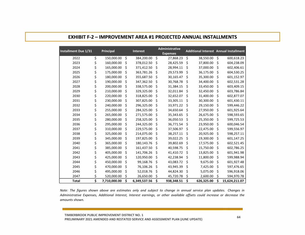
TIMBERBROOK PUBLIC IMPROVEMENT DISTRICT NO. 1 PRELIMINARY 2021 AMENDED AND RESTATED SERVICE AND ASSESSMENT PLAN (JUNE UPDATE) 64
EXHIBIT F-2 – IMPROVEMENT AREA #1 PROJECTED ANNUAL INSTALLMENTS
Installment Due 1/31 Principal InterestAdministrative
ExpensesAdditional Interest Annual Installment
2022 150,000.00$ 384,200.00$ 27,868.23$ 38,550.00$ 600,618.23$ 2023 160,000.00$ 378,012.50$ 28,425.59$ 37,800.00$ 604,238.09$ 2024 165,000.00$ 371,412.50$ 28,994.11$ 37,000.00$ 602,406.61$ 2025 175,000.00$ 363,781.26$ 29,573.99$ 36,175.00$ 604,530.25$ 2026 180,000.00$ 355,687.50$ 30,165.47$ 35,300.00$ 601,152.97$ 2027 190,000.00$ 347,362.50$ 30,768.78$ 34,400.00$ 602,531.28$ 2028 200,000.00$ 338,575.00$ 31,384.15$ 33,450.00$ 603,409.15$ 2029 210,000.00$ 329,325.00$ 32,011.84$ 32,450.00$ 603,786.84$ 2030 220,000.00$ 318,825.00$ 32,652.07$ 31,400.00$ 602,877.07$ 2031 230,000.00$ 307,825.00$ 33,305.11$ 30,300.00$ 601,430.11$ 2032 240,000.00$ 296,325.00$ 33,971.22$ 29,150.00$ 599,446.22$ 2033 255,000.00$ 284,325.00$ 34,650.64$ 27,950.00$ 601,925.64$ 2034 265,000.00$ 271,575.00$ 35,343.65$ 26,675.00$ 598,593.65$ 2035 280,000.00$ 258,325.00$ 36,050.53$ 25,350.00$ 599,725.53$ 2036 295,000.00$ 244,325.00$ 36,771.54$ 23,950.00$ 600,046.54$ 2037 310,000.00$ 229,575.00$ 37,506.97$ 22,475.00$ 599,556.97$ 2038 325,000.00$ 214,075.00$ 38,257.11$ 20,925.00$ 598,257.11$ 2039 345,000.00$ 197,825.00$ 39,022.25$ 19,300.00$ 601,147.25$ 2040 365,000.00$ 180,143.76$ 39,802.69$ 17,575.00$ 602,521.45$ 2041 385,000.00$ 161,437.50$ 40,598.75$ 15,750.00$ 602,786.25$ 2042 405,000.00$ 141,706.26$ 41,410.72$ 13,825.00$ 601,941.98$ 2043 425,000.00$ 120,950.00$ 42,238.94$ 11,800.00$ 599,988.94$ 2044 450,000.00$ 99,168.76$ 43,083.72$ 9,675.00$ 601,927.48$ 2045 470,000.00$ 76,106.26$ 43,945.39$ 7,425.00$ 597,476.65$ 2046 495,000.00$ 52,018.76$ 44,824.30$ 5,075.00$ 596,918.06$ 2047 520,000.00$ 26,650.00$ 45,720.78$ 2,600.00$ 594,970.78$ Total 7,710,000.00$ 6,349,537.56$ 938,348.51$ 626,325.00$ 15,624,211.07$
Note: The figures shown above are estimates only and subject to change in annual service plan updates. Changes inAdministrative Expenses, Additional Interest, Interest earnings, or other available offsets could increase or decrease theamounts shown.
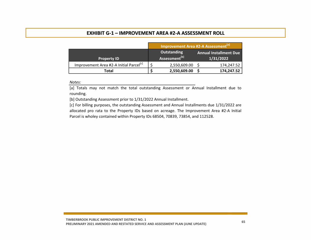
TIMBERBROOK PUBLIC IMPROVEMENT DISTRICT NO. 1 PRELIMINARY 2021 AMENDED AND RESTATED SERVICE AND ASSESSMENT PLAN (JUNE UPDATE) 65
EXHIBIT G-1 – IMPROVEMENT AREA #2-A ASSESSMENT ROLL
Property IDOutstanding
Assessment[b]Annual Installment Due
1/31/2022Improvement Area #2-A Initial Parcel[c] 2,550,609.00$ 174,247.52$
Total 2,550,609.00$ 174,247.52$
Notes:[a] Totals may not match the total outstanding Assessment or Annual Installment due torounding.[b] Outstanding Assessment prior to 1/31/2022 Annual Installment.[c] For billing purposes, the outstanding Assessment and Annual Installments due 1/31/2022 areallocated pro rata to the Property IDs based on acreage. The Improvement Area #2-A InitialParcel is wholey contained within Property IDs 68504, 70839, 73854, and 112528.
Improvement Area #2-A Assessment[a]
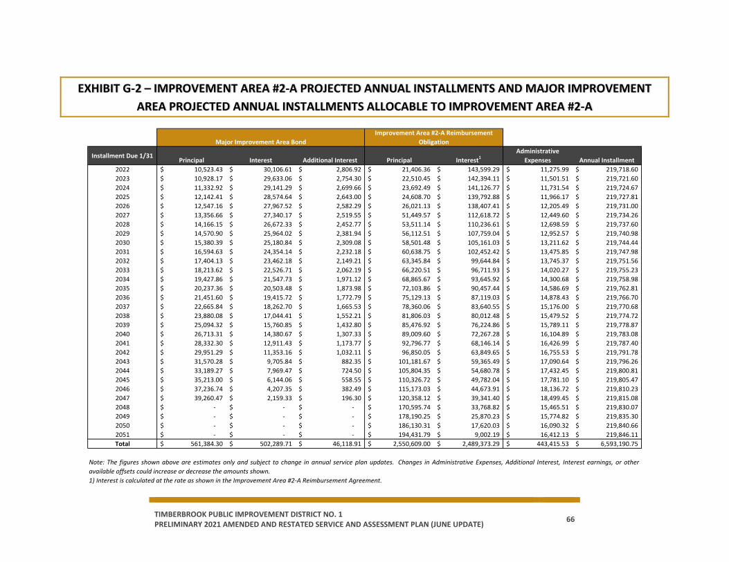
TIMBERBROOK PUBLIC IMPROVEMENT DISTRICT NO. 1 PRELIMINARY 2021 AMENDED AND RESTATED SERVICE AND ASSESSMENT PLAN (JUNE UPDATE) 66
EXHIBIT G-2 – IMPROVEMENT AREA #2-A PROJECTED ANNUAL INSTALLMENTS AND MAJOR IMPROVEMENT AREA PROJECTED ANNUAL INSTALLMENTS ALLOCABLE TO IMPROVEMENT AREA #2-A
Installment Due 1/31Principal Interest Additional Interest Principal Interest1
Administrative Expenses Annual Installment
2022 10,523.43$ 30,106.61$ 2,806.92$ 21,406.36$ 143,599.29$ 11,275.99$ 219,718.60$ 2023 10,928.17$ 29,633.06$ 2,754.30$ 22,510.45$ 142,394.11$ 11,501.51$ 219,721.60$ 2024 11,332.92$ 29,141.29$ 2,699.66$ 23,692.49$ 141,126.77$ 11,731.54$ 219,724.67$ 2025 12,142.41$ 28,574.64$ 2,643.00$ 24,608.70$ 139,792.88$ 11,966.17$ 219,727.81$ 2026 12,547.16$ 27,967.52$ 2,582.29$ 26,021.13$ 138,407.41$ 12,205.49$ 219,731.00$ 2027 13,356.66$ 27,340.17$ 2,519.55$ 51,449.57$ 112,618.72$ 12,449.60$ 219,734.26$ 2028 14,166.15$ 26,672.33$ 2,452.77$ 53,511.14$ 110,236.61$ 12,698.59$ 219,737.60$ 2029 14,570.90$ 25,964.02$ 2,381.94$ 56,112.51$ 107,759.04$ 12,952.57$ 219,740.98$ 2030 15,380.39$ 25,180.84$ 2,309.08$ 58,501.48$ 105,161.03$ 13,211.62$ 219,744.44$ 2031 16,594.63$ 24,354.14$ 2,232.18$ 60,638.75$ 102,452.42$ 13,475.85$ 219,747.98$ 2032 17,404.13$ 23,462.18$ 2,149.21$ 63,345.84$ 99,644.84$ 13,745.37$ 219,751.56$ 2033 18,213.62$ 22,526.71$ 2,062.19$ 66,220.51$ 96,711.93$ 14,020.27$ 219,755.23$ 2034 19,427.86$ 21,547.73$ 1,971.12$ 68,865.67$ 93,645.92$ 14,300.68$ 219,758.98$ 2035 20,237.36$ 20,503.48$ 1,873.98$ 72,103.86$ 90,457.44$ 14,586.69$ 219,762.81$ 2036 21,451.60$ 19,415.72$ 1,772.79$ 75,129.13$ 87,119.03$ 14,878.43$ 219,766.70$ 2037 22,665.84$ 18,262.70$ 1,665.53$ 78,360.06$ 83,640.55$ 15,176.00$ 219,770.68$ 2038 23,880.08$ 17,044.41$ 1,552.21$ 81,806.03$ 80,012.48$ 15,479.52$ 219,774.72$ 2039 25,094.32$ 15,760.85$ 1,432.80$ 85,476.92$ 76,224.86$ 15,789.11$ 219,778.87$ 2040 26,713.31$ 14,380.67$ 1,307.33$ 89,009.60$ 72,267.28$ 16,104.89$ 219,783.08$ 2041 28,332.30$ 12,911.43$ 1,173.77$ 92,796.77$ 68,146.14$ 16,426.99$ 219,787.40$ 2042 29,951.29$ 11,353.16$ 1,032.11$ 96,850.05$ 63,849.65$ 16,755.53$ 219,791.78$ 2043 31,570.28$ 9,705.84$ 882.35$ 101,181.67$ 59,365.49$ 17,090.64$ 219,796.26$ 2044 33,189.27$ 7,969.47$ 724.50$ 105,804.35$ 54,680.78$ 17,432.45$ 219,800.81$ 2045 35,213.00$ 6,144.06$ 558.55$ 110,326.72$ 49,782.04$ 17,781.10$ 219,805.47$ 2046 37,236.74$ 4,207.35$ 382.49$ 115,173.03$ 44,673.91$ 18,136.72$ 219,810.23$ 2047 39,260.47$ 2,159.33$ 196.30$ 120,358.12$ 39,341.40$ 18,499.45$ 219,815.08$ 2048 -$ -$ -$ 170,595.74$ 33,768.82$ 15,465.51$ 219,830.07$ 2049 -$ -$ -$ 178,190.25$ 25,870.23$ 15,774.82$ 219,835.30$ 2050 -$ -$ -$ 186,130.31$ 17,620.03$ 16,090.32$ 219,840.66$ 2051 -$ -$ -$ 194,431.79$ 9,002.19$ 16,412.13$ 219,846.11$ Total 561,384.30$ 502,289.71$ 46,118.91$ 2,550,609.00$ 2,489,373.29$ 443,415.53$ 6,593,190.75$
Note: The figures shown above are estimates only and subject to change in annual service plan updates. Changes in Administrative Expenses, Additional Interest, Interest earnings, or otheravailable offsets could increase or decrease the amounts shown.1) Interest is calculated at the rate as shown in the Improvement Area #2-A Reimbursement Agreement.
Major Improvement Area BondImprovement Area #2-A Reimbursement
Obligation
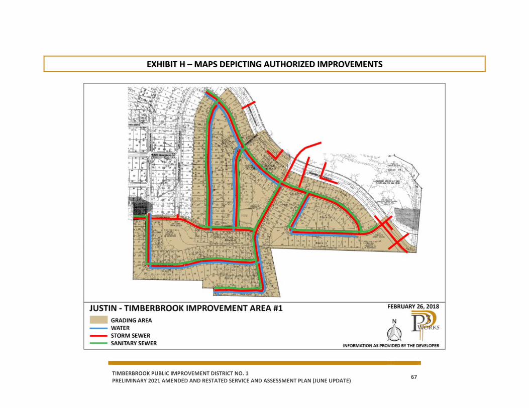
TIMBERBROOK PUBLIC IMPROVEMENT DISTRICT NO. 1 PRELIMINARY 2021 AMENDED AND RESTATED SERVICE AND ASSESSMENT PLAN (JUNE UPDATE) 67
EXHIBIT H – MAPS DEPICTING AUTHORIZED IMPROVEMENTS
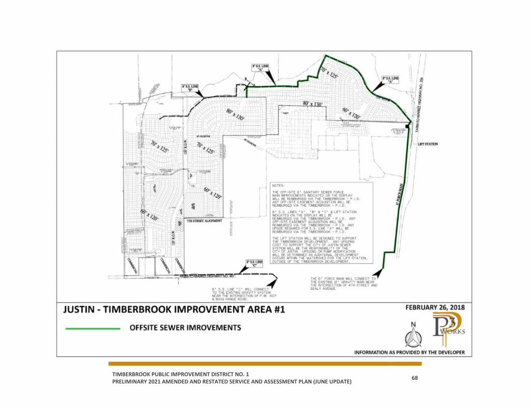
TIMBERBROOK PUBLIC IMPROVEMENT DISTRICT NO. 1 PRELIMINARY 2021 AMENDED AND RESTATED SERVICE AND ASSESSMENT PLAN (JUNE UPDATE) 68
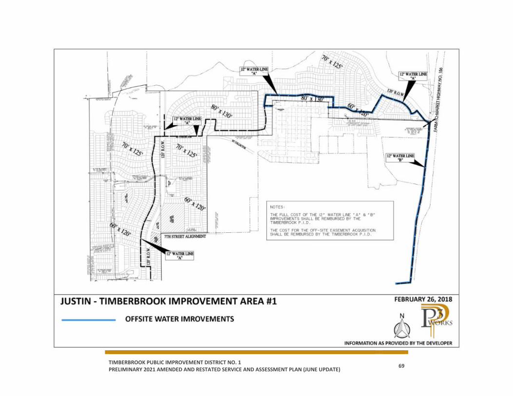
TIMBERBROOK PUBLIC IMPROVEMENT DISTRICT NO. 1 PRELIMINARY 2021 AMENDED AND RESTATED SERVICE AND ASSESSMENT PLAN (JUNE UPDATE) 69
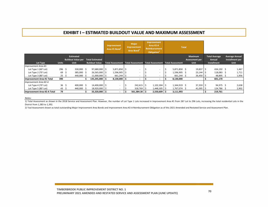
TIMBERBROOK PUBLIC IMPROVEMENT DISTRICT NO. 1 PRELIMINARY 2021 AMENDED AND RESTATED SERVICE AND ASSESSMENT PLAN (JUNE UPDATE) 70
EXHIBIT I – ESTIMATED BUILDOUT VALUE AND MAXIMUM ASSESSMENT
Lot Type Units
Estimated Buildout Value per
UnitTotal Estimated Buildout Value Total Assessment Total Assessment Total Assessment Total Assessment
Maximum Assessment per
Unit
Total Average Annual
Installment
Average Annual Installment per
UnitImprovement Area #1
Lot Type 1 (60' Lot) 296 330,000$ 97,680,000$ 5,871,850$ -$ -$ 5,871,850$ 19,837$ 434,192$ 1,467$ Lot Type 2 (70' Lot) 69 385,000$ 26,565,000$ 1,596,905$ -$ -$ 1,596,905$ 23,144$ 118,083$ 1,711$ Lot Type 3 (80' Lot) 25 440,000$ 11,000,000$ 661,244$ -$ -$ 661,244$ 26,450$ 48,895$ 1,956$
Improvement Area #1 Total 390 135,245,000$ 8,130,000$ -$ -$ 8,130,000$ 601,170$ Improvement Area #2-A
Lot Type 4 (70' Lot) 36 400,000$ 14,400,000$ -$ 242,615$ 1,102,304$ 1,344,919$ 37,359$ 94,975$ 2,638$ Lot Type 5 (80' Lot) 43 440,000$ 18,920,000$ -$ 318,769$ 1,448,305$ 1,767,074$ 41,095$ 124,786$ 2,902$
Improvement Area #2-A Total 79 33,320,000$ -$ 561,384.30$ 2,550,609$ 3,111,993$ 219,761$
Notes:1) Total Assessment as shown in the 2018 Service and Assessment Plan. However, the number of Lot Type 1 Lots increased in Improvement Area #1 from 287 Lot to 296 Lots, increasing the total residential Lots in theDistrict from 1,383 to 1,392.2) Toal Assessment shown as total outstanding Major Improvement Area Bonds and Improvement Area #2-A Reimbursement Obligation as of this 2021 Amended and Restated Service and Assessment Plan.
Improvement Area #1 Bond1
Major Improvement
Area Bond2
Improvement Area #2-A
Reimbursement Obligation2
Total
TIMBERBROOK PUBLIC IMPROVEMENT DISTRICT NO. 1 PRELIMINARY 2021 AMENDED AND RESTATED SERVICE AND ASSESSMENT PLAN (JUNE UPDATE) 71
EXHIBIT J – HOMEBUYER DISCLOSURES
Homebuyer Disclosures for the following Lot Types are found in this Exhibit:
Improvement Area #1
o Lot Type 1
o Lot Type 2
o Lot Type 3
Improvement Area #2-A
o Lot Type 4
o Lot Type 5
[Remainder of page intentionally left blank.]

TIMBERBROOK PUBLIC IMPROVEMENT DISTRICT NO. 1 PRELIMINARY 2021 AMENDED AND RESTATED SERVICE AND ASSESSMENT PLAN (JUNE UPDATE) 72
TIMBERBROOK PID: LOT TYPE 1 HOMEBUYER DISCLOSURE
NOTICE OF OBLIGATION TO PAY
PUBLIC IMPROVEMENT DISTRICT ASSESSMENTS TO THE CITY OF JUSTIN, TEXAS
CONCERNING THE PROPERTY AT:
_____________________________________ STREET ADDRESS
LOT TYPE 1 PRINCIPAL ASSESSMENT: $18,812.53
As the purchaser of the real property located at the street address set forth above, you are obligated to pay assessments to the City of Justin, Texas, for the costs of a portion of public improvements (the “Authorized Improvements”) undertaken for the benefit of the property within “Timberbrook Public Improvement District No. 1” (the “District”) created under Subchapter A, Chapter 372, Local Government Code, as amended. THE PRINCIPAL OF THE ASSESSMENT AGAINST YOUR PROPERTY FOR THE AUTHORIZED IMPROVEMENTS IS $18,812.53, WHICH MAY BE PAID IN FULL AT ANY TIME; HOWEVER, IF NOT PAID IN FULL, IT WILL BE DUE AND PAYABLE IN ANNUAL INSTALLMENTS WHICH WILL VARY FROM YEAR TO YEAR DEPENDING ON THE AMOUNT OF INTEREST PAID, ADMINISTRATIVE EXPENSES, AND DELINQUENCY COSTS. An estimate of the annual installments is attached; however, it is only an estimate and is subject to change. The exact amount of the annual installments, including the annual installments thereof, will be approved each year by the City Council in the Annual Service Plan Update for the District. More information about the assessments, including the amounts and due dates, may be obtained from the City Secretary of Justin, Texas. Your failure to pay any assessment, or any annual installment thereof, may result in penalties and interest being added to what you owe and could result in a lien on and the foreclosure of your property. The undersigned purchaser acknowledges receipt of the foregoing notice prior to the effective date of a binding contract for the purchase of the real property at the street address set forth above.

TIMBERBROOK PUBLIC IMPROVEMENT DISTRICT NO. 1 PRELIMINARY 2021 AMENDED AND RESTATED SERVICE AND ASSESSMENT PLAN (JUNE UPDATE) 73
IN WITNESS WHEREOF, I have signed this certificate this ____________, 20__.
PURCHASER: By: ____ By: _____ Name: ____________________________ Name: _____________________________ Title: _____________________________ Title: ______________________________ STATE OF TEXAS § § COUNTY OF DENTON §
The foregoing instrument was acknowledged before me by ______________________, known to me to be the person whose name is subscribed to the foregoing instrument, and acknowledged to me that he or she executed the same for the purposes therein expressed, in the capacity stated and as the act and deed of the above-referenced entities as an authorized signatory of said entities.
Given under my hand and seal of office on this _________________, 20__.
__________________________________________ Notary Public, State of Texas
STATE OF TEXAS § § COUNTY OF DENTON §
The foregoing instrument was acknowledged before me by ______________________, known to me to be the person whose name is subscribed to the foregoing instrument, and acknowledged to me that he or she executed the same for the purposes therein expressed, in the capacity stated and as the act and deed of the above-referenced entities as an authorized signatory of said entities.
Given under my hand and seal of office on this _________________, 20__.
__________________________________________
Notary Public, State of Texas
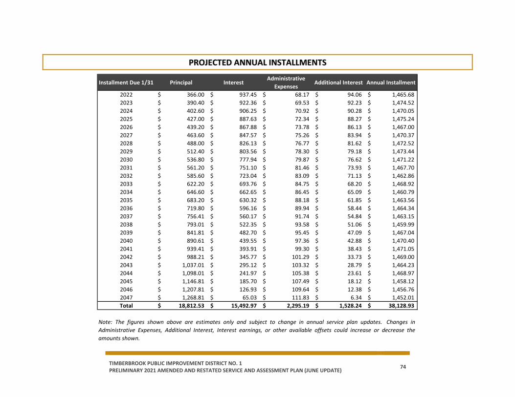
TIMBERBROOK PUBLIC IMPROVEMENT DISTRICT NO. 1 PRELIMINARY 2021 AMENDED AND RESTATED SERVICE AND ASSESSMENT PLAN (JUNE UPDATE) 74
PROJECTED ANNUAL INSTALLMENTS
Installment Due 1/31 Principal InterestAdministrative
ExpensesAdditional Interest Annual Installment
2022 366.00$ 937.45$ 68.17$ 94.06$ 1,465.68$ 2023 390.40$ 922.36$ 69.53$ 92.23$ 1,474.52$ 2024 402.60$ 906.25$ 70.92$ 90.28$ 1,470.05$ 2025 427.00$ 887.63$ 72.34$ 88.27$ 1,475.24$ 2026 439.20$ 867.88$ 73.78$ 86.13$ 1,467.00$ 2027 463.60$ 847.57$ 75.26$ 83.94$ 1,470.37$ 2028 488.00$ 826.13$ 76.77$ 81.62$ 1,472.52$ 2029 512.40$ 803.56$ 78.30$ 79.18$ 1,473.44$ 2030 536.80$ 777.94$ 79.87$ 76.62$ 1,471.22$ 2031 561.20$ 751.10$ 81.46$ 73.93$ 1,467.70$ 2032 585.60$ 723.04$ 83.09$ 71.13$ 1,462.86$ 2033 622.20$ 693.76$ 84.75$ 68.20$ 1,468.92$ 2034 646.60$ 662.65$ 86.45$ 65.09$ 1,460.79$ 2035 683.20$ 630.32$ 88.18$ 61.85$ 1,463.56$ 2036 719.80$ 596.16$ 89.94$ 58.44$ 1,464.34$ 2037 756.41$ 560.17$ 91.74$ 54.84$ 1,463.15$ 2038 793.01$ 522.35$ 93.58$ 51.06$ 1,459.99$ 2039 841.81$ 482.70$ 95.45$ 47.09$ 1,467.04$ 2040 890.61$ 439.55$ 97.36$ 42.88$ 1,470.40$ 2041 939.41$ 393.91$ 99.30$ 38.43$ 1,471.05$ 2042 988.21$ 345.77$ 101.29$ 33.73$ 1,469.00$ 2043 1,037.01$ 295.12$ 103.32$ 28.79$ 1,464.23$ 2044 1,098.01$ 241.97$ 105.38$ 23.61$ 1,468.97$ 2045 1,146.81$ 185.70$ 107.49$ 18.12$ 1,458.12$ 2046 1,207.81$ 126.93$ 109.64$ 12.38$ 1,456.76$ 2047 1,268.81$ 65.03$ 111.83$ 6.34$ 1,452.01$ Total 18,812.53$ 15,492.97$ 2,295.19$ 1,528.24$ 38,128.93$
Note: The figures shown above are estimates only and subject to change in annual service plan updates. Changes inAdministrative Expenses, Additional Interest, Interest earnings, or other available offsets could increase or decrease theamounts shown.
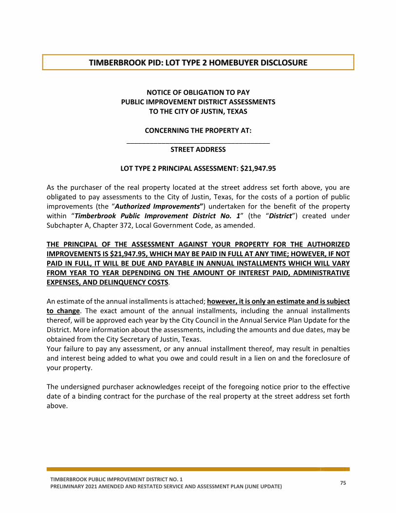
TIMBERBROOK PUBLIC IMPROVEMENT DISTRICT NO. 1 PRELIMINARY 2021 AMENDED AND RESTATED SERVICE AND ASSESSMENT PLAN (JUNE UPDATE) 75
TIMBERBROOK PID: LOT TYPE 2 HOMEBUYER DISCLOSURE
NOTICE OF OBLIGATION TO PAY
PUBLIC IMPROVEMENT DISTRICT ASSESSMENTS TO THE CITY OF JUSTIN, TEXAS
CONCERNING THE PROPERTY AT:
_____________________________________ STREET ADDRESS
LOT TYPE 2 PRINCIPAL ASSESSMENT: $21,947.95
As the purchaser of the real property located at the street address set forth above, you are obligated to pay assessments to the City of Justin, Texas, for the costs of a portion of public improvements (the “Authorized Improvements”) undertaken for the benefit of the property within “Timberbrook Public Improvement District No. 1” (the “District”) created under Subchapter A, Chapter 372, Local Government Code, as amended. THE PRINCIPAL OF THE ASSESSMENT AGAINST YOUR PROPERTY FOR THE AUTHORIZED IMPROVEMENTS IS $21,947.95, WHICH MAY BE PAID IN FULL AT ANY TIME; HOWEVER, IF NOT PAID IN FULL, IT WILL BE DUE AND PAYABLE IN ANNUAL INSTALLMENTS WHICH WILL VARY FROM YEAR TO YEAR DEPENDING ON THE AMOUNT OF INTEREST PAID, ADMINISTRATIVE EXPENSES, AND DELINQUENCY COSTS. An estimate of the annual installments is attached; however, it is only an estimate and is subject to change. The exact amount of the annual installments, including the annual installments thereof, will be approved each year by the City Council in the Annual Service Plan Update for the District. More information about the assessments, including the amounts and due dates, may be obtained from the City Secretary of Justin, Texas. Your failure to pay any assessment, or any annual installment thereof, may result in penalties and interest being added to what you owe and could result in a lien on and the foreclosure of your property. The undersigned purchaser acknowledges receipt of the foregoing notice prior to the effective date of a binding contract for the purchase of the real property at the street address set forth above.

TIMBERBROOK PUBLIC IMPROVEMENT DISTRICT NO. 1 PRELIMINARY 2021 AMENDED AND RESTATED SERVICE AND ASSESSMENT PLAN (JUNE UPDATE) 76
IN WITNESS WHEREOF, I have signed this certificate this ____________, 20__.
PURCHASER: By: ____ By: _____ Name: ____________________________ Name: _____________________________ Title: _____________________________ Title: ______________________________ STATE OF TEXAS § § COUNTY OF DENTON §
The foregoing instrument was acknowledged before me by ______________________, known to me to be the person whose name is subscribed to the foregoing instrument, and acknowledged to me that he or she executed the same for the purposes therein expressed, in the capacity stated and as the act and deed of the above-referenced entities as an authorized signatory of said entities.
Given under my hand and seal of office on this _________________, 20__.
__________________________________________ Notary Public, State of Texas
STATE OF TEXAS § § COUNTY OF DENTON §
The foregoing instrument was acknowledged before me by ______________________, known to me to be the person whose name is subscribed to the foregoing instrument, and acknowledged to me that he or she executed the same for the purposes therein expressed, in the capacity stated and as the act and deed of the above-referenced entities as an authorized signatory of said entities.
Given under my hand and seal of office on this _________________, 20__.
__________________________________________
Notary Public, State of Texas
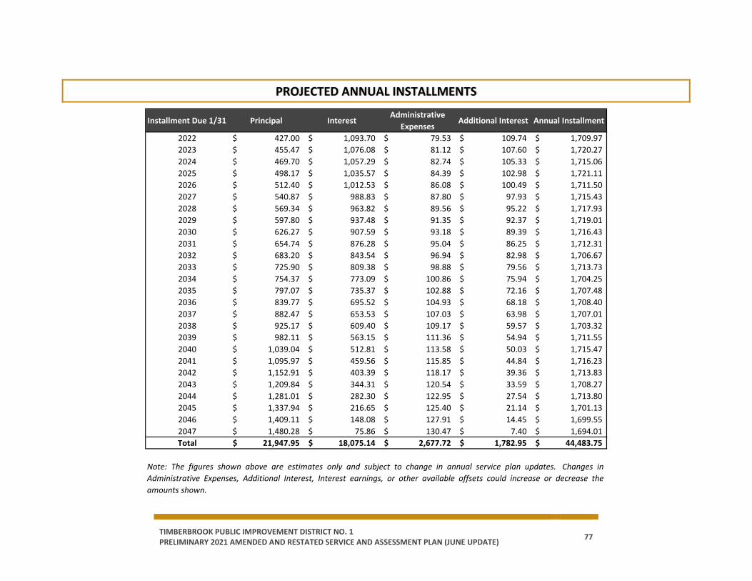
TIMBERBROOK PUBLIC IMPROVEMENT DISTRICT NO. 1 PRELIMINARY 2021 AMENDED AND RESTATED SERVICE AND ASSESSMENT PLAN (JUNE UPDATE) 77
PROJECTED ANNUAL INSTALLMENTS
Installment Due 1/31 Principal InterestAdministrative
ExpensesAdditional Interest Annual Installment
2022 427.00$ 1,093.70$ 79.53$ 109.74$ 1,709.97$ 2023 455.47$ 1,076.08$ 81.12$ 107.60$ 1,720.27$ 2024 469.70$ 1,057.29$ 82.74$ 105.33$ 1,715.06$ 2025 498.17$ 1,035.57$ 84.39$ 102.98$ 1,721.11$ 2026 512.40$ 1,012.53$ 86.08$ 100.49$ 1,711.50$ 2027 540.87$ 988.83$ 87.80$ 97.93$ 1,715.43$ 2028 569.34$ 963.82$ 89.56$ 95.22$ 1,717.93$ 2029 597.80$ 937.48$ 91.35$ 92.37$ 1,719.01$ 2030 626.27$ 907.59$ 93.18$ 89.39$ 1,716.43$ 2031 654.74$ 876.28$ 95.04$ 86.25$ 1,712.31$ 2032 683.20$ 843.54$ 96.94$ 82.98$ 1,706.67$ 2033 725.90$ 809.38$ 98.88$ 79.56$ 1,713.73$ 2034 754.37$ 773.09$ 100.86$ 75.94$ 1,704.25$ 2035 797.07$ 735.37$ 102.88$ 72.16$ 1,707.48$ 2036 839.77$ 695.52$ 104.93$ 68.18$ 1,708.40$ 2037 882.47$ 653.53$ 107.03$ 63.98$ 1,707.01$ 2038 925.17$ 609.40$ 109.17$ 59.57$ 1,703.32$ 2039 982.11$ 563.15$ 111.36$ 54.94$ 1,711.55$ 2040 1,039.04$ 512.81$ 113.58$ 50.03$ 1,715.47$ 2041 1,095.97$ 459.56$ 115.85$ 44.84$ 1,716.23$ 2042 1,152.91$ 403.39$ 118.17$ 39.36$ 1,713.83$ 2043 1,209.84$ 344.31$ 120.54$ 33.59$ 1,708.27$ 2044 1,281.01$ 282.30$ 122.95$ 27.54$ 1,713.80$ 2045 1,337.94$ 216.65$ 125.40$ 21.14$ 1,701.13$ 2046 1,409.11$ 148.08$ 127.91$ 14.45$ 1,699.55$ 2047 1,480.28$ 75.86$ 130.47$ 7.40$ 1,694.01$ Total 21,947.95$ 18,075.14$ 2,677.72$ 1,782.95$ 44,483.75$
Note: The figures shown above are estimates only and subject to change in annual service plan updates. Changes inAdministrative Expenses, Additional Interest, Interest earnings, or other available offsets could increase or decrease theamounts shown.

TIMBERBROOK PUBLIC IMPROVEMENT DISTRICT NO. 1 PRELIMINARY 2021 AMENDED AND RESTATED SERVICE AND ASSESSMENT PLAN (JUNE UPDATE) 78
TIMBERBROOK PID: LOT TYPE 3 HOMEBUYER DISCLOSURE
NOTICE OF OBLIGATION TO PAY
PUBLIC IMPROVEMENT DISTRICT ASSESSMENTS TO THE CITY OF JUSTIN, TEXAS
CONCERNING THE PROPERTY AT:
_____________________________________ STREET ADDRESS
LOT TYPE 3 PRINCIPAL ASSESSMENT: $25,083.37
As the purchaser of the real property located at the street address set forth above, you are obligated to pay assessments to the City of Justin, Texas, for the costs of a portion of public improvements (the “Authorized Improvements”) undertaken for the benefit of the property within “Timberbrook Public Improvement District No. 1” (the “District”) created under Subchapter A, Chapter 372, Local Government Code, as amended. THE PRINCIPAL OF THE ASSESSMENT AGAINST YOUR PROPERTY FOR THE AUTHORIZED IMPROVEMENTS IS $23,083.37, WHICH MAY BE PAID IN FULL AT ANY TIME; HOWEVER, IF NOT PAID IN FULL, IT WILL BE DUE AND PAYABLE IN ANNUAL INSTALLMENTS WHICH WILL VARY FROM YEAR TO YEAR DEPENDING ON THE AMOUNT OF INTEREST PAID, ADMINISTRATIVE EXPENSES, AND DELINQUENCY COSTS. An estimate of the annual installments is attached; however, it is only an estimate and is subject to change. The exact amount of the annual installments, including the annual installments thereof, will be approved each year by the City Council in the Annual Service Plan Update for the District. More information about the assessments, including the amounts and due dates, may be obtained from the City Secretary of Justin, Texas. Your failure to pay any assessment, or any annual installment thereof, may result in penalties and interest being added to what you owe and could result in a lien on and the foreclosure of your property. The undersigned purchaser acknowledges receipt of the foregoing notice prior to the effective date of a binding contract for the purchase of the real property at the street address set forth above.
TIMBERBROOK PUBLIC IMPROVEMENT DISTRICT NO. 1 PRELIMINARY 2021 AMENDED AND RESTATED SERVICE AND ASSESSMENT PLAN (JUNE UPDATE) 79
IN WITNESS WHEREOF, I have signed this certificate this ____________, 20__.
PURCHASER: By: ____ By: _____ Name: ____________________________ Name: _____________________________ Title: _____________________________ Title: ______________________________ STATE OF TEXAS § § COUNTY OF DENTON §
The foregoing instrument was acknowledged before me by ______________________, known to me to be the person whose name is subscribed to the foregoing instrument, and acknowledged to me that he or she executed the same for the purposes therein expressed, in the capacity stated and as the act and deed of the above-referenced entities as an authorized signatory of said entities.
Given under my hand and seal of office on this _________________, 20__.
__________________________________________ Notary Public, State of Texas
STATE OF TEXAS § § COUNTY OF DENTON §
The foregoing instrument was acknowledged before me by ______________________, known to me to be the person whose name is subscribed to the foregoing instrument, and acknowledged to me that he or she executed the same for the purposes therein expressed, in the capacity stated and as the act and deed of the above-referenced entities as an authorized signatory of said entities.
Given under my hand and seal of office on this _________________, 20__.
__________________________________________
Notary Public, State of Texas

TIMBERBROOK PUBLIC IMPROVEMENT DISTRICT NO. 1 PRELIMINARY 2021 AMENDED AND RESTATED SERVICE AND ASSESSMENT PLAN (JUNE UPDATE) 80
PROJECTED ANNUAL INSTALLMENTS
Installment Due 1/31 Principal InterestAdministrative
ExpensesAdditional Interest Annual Installment
2022 488.00$ 1,249.94$ 90.89$ 125.42$ 1,954.25$ 2023 520.54$ 1,229.81$ 92.70$ 122.98$ 1,966.03$ 2024 536.80$ 1,208.34$ 94.56$ 120.37$ 1,960.07$ 2025 569.34$ 1,183.51$ 96.45$ 117.69$ 1,966.99$ 2026 585.60$ 1,157.18$ 98.38$ 114.84$ 1,956.00$ 2027 618.14$ 1,130.09$ 100.35$ 111.92$ 1,960.49$ 2028 650.67$ 1,101.50$ 102.35$ 108.82$ 1,963.35$ 2029 683.20$ 1,071.41$ 104.40$ 105.57$ 1,964.59$ 2030 715.74$ 1,037.25$ 106.49$ 102.16$ 1,961.63$ 2031 748.27$ 1,001.46$ 108.62$ 98.58$ 1,956.93$ 2032 780.81$ 964.05$ 110.79$ 94.84$ 1,950.48$ 2033 829.61$ 925.01$ 113.01$ 90.93$ 1,958.55$ 2034 862.14$ 883.53$ 115.27$ 86.78$ 1,947.72$ 2035 910.94$ 840.42$ 117.57$ 82.47$ 1,951.41$ 2036 959.74$ 794.88$ 119.92$ 77.92$ 1,952.46$ 2037 1,008.54$ 746.89$ 122.32$ 73.12$ 1,950.87$ 2038 1,057.34$ 696.46$ 124.77$ 68.08$ 1,946.65$ 2039 1,122.41$ 643.59$ 127.26$ 62.79$ 1,956.06$ 2040 1,187.47$ 586.07$ 129.81$ 57.18$ 1,960.53$ 2041 1,252.54$ 525.21$ 132.41$ 51.24$ 1,961.40$ 2042 1,317.61$ 461.02$ 135.05$ 44.98$ 1,958.66$ 2043 1,382.68$ 393.49$ 137.75$ 38.39$ 1,952.31$ 2044 1,464.01$ 322.63$ 140.51$ 31.48$ 1,958.63$ 2045 1,529.08$ 247.60$ 143.32$ 24.16$ 1,944.15$ 2046 1,610.41$ 169.24$ 146.19$ 16.51$ 1,942.34$ 2047 1,691.74$ 86.70$ 149.11$ 8.46$ 1,936.02$ Total 25,083.37$ 20,657.30$ 3,060.25$ 2,037.66$ 50,838.57$
Note: The figures shown above are estimates only and subject to change in annual service plan updates. Changes inAdministrative Expenses, Additional Interest, Interest earnings, or other available offsets could increase or decrease theamounts shown.
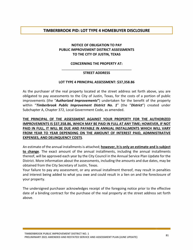
TIMBERBROOK PUBLIC IMPROVEMENT DISTRICT NO. 1 PRELIMINARY 2021 AMENDED AND RESTATED SERVICE AND ASSESSMENT PLAN (JUNE UPDATE) 81
TIMBERBROOK PID: LOT TYPE 4 HOMEBUYER DISCLOSURE
NOTICE OF OBLIGATION TO PAY
PUBLIC IMPROVEMENT DISTRICT ASSESSMENTS TO THE CITY OF JUSTIN, TEXAS
CONCERNING THE PROPERTY AT:
_____________________________________ STREET ADDRESS
LOT TYPE 4 PRINCIPAL ASSESSMENT: $37,358.86
As the purchaser of the real property located at the street address set forth above, you are obligated to pay assessments to the City of Justin, Texas, for the costs of a portion of public improvements (the “Authorized Improvements”) undertaken for the benefit of the property within “Timberbrook Public Improvement District No. 1” (the “District”) created under Subchapter A, Chapter 372, Local Government Code, as amended. THE PRINCIPAL OF THE ASSESSMENT AGAINST YOUR PROPERTY FOR THE AUTHORIZED IMPROVEMENTS IS $37,358.86, WHICH MAY BE PAID IN FULL AT ANY TIME; HOWEVER, IF NOT PAID IN FULL, IT WILL BE DUE AND PAYABLE IN ANNUAL INSTALLMENTS WHICH WILL VARY FROM YEAR TO YEAR DEPENDING ON THE AMOUNT OF INTEREST PAID, ADMINISTRATIVE EXPENSES, AND DELINQUENCY COSTS. An estimate of the annual installments is attached; however, it is only an estimate and is subject to change. The exact amount of the annual installments, including the annual installments thereof, will be approved each year by the City Council in the Annual Service Plan Update for the District. More information about the assessments, including the amounts and due dates, may be obtained from the City Secretary of Justin, Texas. Your failure to pay any assessment, or any annual installment thereof, may result in penalties and interest being added to what you owe and could result in a lien on and the foreclosure of your property. The undersigned purchaser acknowledges receipt of the foregoing notice prior to the effective date of a binding contract for the purchase of the real property at the street address set forth above.

TIMBERBROOK PUBLIC IMPROVEMENT DISTRICT NO. 1 PRELIMINARY 2021 AMENDED AND RESTATED SERVICE AND ASSESSMENT PLAN (JUNE UPDATE) 82
IN WITNESS WHEREOF, I have signed this certificate this ____________, 20__.
PURCHASER: By: ____ By: _____ Name: ____________________________ Name: _____________________________ Title: _____________________________ Title: ______________________________ STATE OF TEXAS § § COUNTY OF DENTON §
The foregoing instrument was acknowledged before me by ______________________, known to me to be the person whose name is subscribed to the foregoing instrument, and acknowledged to me that he or she executed the same for the purposes therein expressed, in the capacity stated and as the act and deed of the above-referenced entities as an authorized signatory of said entities.
Given under my hand and seal of office on this _________________, 20__.
__________________________________________ Notary Public, State of Texas
STATE OF TEXAS § § COUNTY OF DENTON §
The foregoing instrument was acknowledged before me by ______________________, known to me to be the person whose name is subscribed to the foregoing instrument, and acknowledged to me that he or she executed the same for the purposes therein expressed, in the capacity stated and as the act and deed of the above-referenced entities as an authorized signatory of said entities.
Given under my hand and seal of office on this _________________, 20__.
__________________________________________
Notary Public, State of Texas
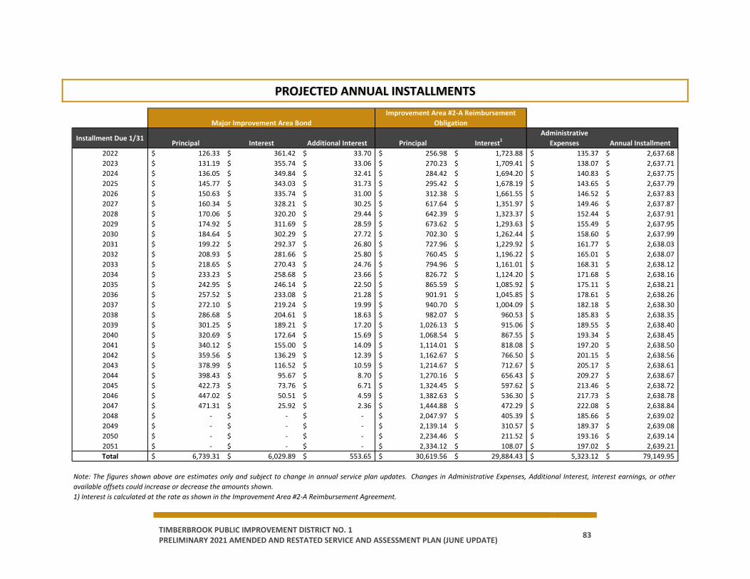
TIMBERBROOK PUBLIC IMPROVEMENT DISTRICT NO. 1 PRELIMINARY 2021 AMENDED AND RESTATED SERVICE AND ASSESSMENT PLAN (JUNE UPDATE) 83
PROJECTED ANNUAL INSTALLMENTS
Installment Due 1/31Principal Interest Additional Interest Principal Interest1
Administrative Expenses Annual Installment
2022 126.33$ 361.42$ 33.70$ 256.98$ 1,723.88$ 135.37$ 2,637.68$ 2023 131.19$ 355.74$ 33.06$ 270.23$ 1,709.41$ 138.07$ 2,637.71$ 2024 136.05$ 349.84$ 32.41$ 284.42$ 1,694.20$ 140.83$ 2,637.75$ 2025 145.77$ 343.03$ 31.73$ 295.42$ 1,678.19$ 143.65$ 2,637.79$ 2026 150.63$ 335.74$ 31.00$ 312.38$ 1,661.55$ 146.52$ 2,637.83$ 2027 160.34$ 328.21$ 30.25$ 617.64$ 1,351.97$ 149.46$ 2,637.87$ 2028 170.06$ 320.20$ 29.44$ 642.39$ 1,323.37$ 152.44$ 2,637.91$ 2029 174.92$ 311.69$ 28.59$ 673.62$ 1,293.63$ 155.49$ 2,637.95$ 2030 184.64$ 302.29$ 27.72$ 702.30$ 1,262.44$ 158.60$ 2,637.99$ 2031 199.22$ 292.37$ 26.80$ 727.96$ 1,229.92$ 161.77$ 2,638.03$ 2032 208.93$ 281.66$ 25.80$ 760.45$ 1,196.22$ 165.01$ 2,638.07$ 2033 218.65$ 270.43$ 24.76$ 794.96$ 1,161.01$ 168.31$ 2,638.12$ 2034 233.23$ 258.68$ 23.66$ 826.72$ 1,124.20$ 171.68$ 2,638.16$ 2035 242.95$ 246.14$ 22.50$ 865.59$ 1,085.92$ 175.11$ 2,638.21$ 2036 257.52$ 233.08$ 21.28$ 901.91$ 1,045.85$ 178.61$ 2,638.26$ 2037 272.10$ 219.24$ 19.99$ 940.70$ 1,004.09$ 182.18$ 2,638.30$ 2038 286.68$ 204.61$ 18.63$ 982.07$ 960.53$ 185.83$ 2,638.35$ 2039 301.25$ 189.21$ 17.20$ 1,026.13$ 915.06$ 189.55$ 2,638.40$ 2040 320.69$ 172.64$ 15.69$ 1,068.54$ 867.55$ 193.34$ 2,638.45$ 2041 340.12$ 155.00$ 14.09$ 1,114.01$ 818.08$ 197.20$ 2,638.50$ 2042 359.56$ 136.29$ 12.39$ 1,162.67$ 766.50$ 201.15$ 2,638.56$ 2043 378.99$ 116.52$ 10.59$ 1,214.67$ 712.67$ 205.17$ 2,638.61$ 2044 398.43$ 95.67$ 8.70$ 1,270.16$ 656.43$ 209.27$ 2,638.67$ 2045 422.73$ 73.76$ 6.71$ 1,324.45$ 597.62$ 213.46$ 2,638.72$ 2046 447.02$ 50.51$ 4.59$ 1,382.63$ 536.30$ 217.73$ 2,638.78$ 2047 471.31$ 25.92$ 2.36$ 1,444.88$ 472.29$ 222.08$ 2,638.84$ 2048 -$ -$ -$ 2,047.97$ 405.39$ 185.66$ 2,639.02$ 2049 -$ -$ -$ 2,139.14$ 310.57$ 189.37$ 2,639.08$ 2050 -$ -$ -$ 2,234.46$ 211.52$ 193.16$ 2,639.14$ 2051 -$ -$ -$ 2,334.12$ 108.07$ 197.02$ 2,639.21$ Total 6,739.31$ 6,029.89$ 553.65$ 30,619.56$ 29,884.43$ 5,323.12$ 79,149.95$
Major Improvement Area BondImprovement Area #2-A Reimbursement
Obligation
Note: The figures shown above are estimates only and subject to change in annual service plan updates. Changes in Administrative Expenses, Additional Interest, Interest earnings, or otheravailable offsets could increase or decrease the amounts shown.1) Interest is calculated at the rate as shown in the Improvement Area #2-A Reimbursement Agreement.

TIMBERBROOK PUBLIC IMPROVEMENT DISTRICT NO. 1 PRELIMINARY 2021 AMENDED AND RESTATED SERVICE AND ASSESSMENT PLAN (JUNE UPDATE) 84
TIMBERBROOK PID: LOT TYPE 5 HOMEBUYER DISCLOSURE
NOTICE OF OBLIGATION TO PAY
PUBLIC IMPROVEMENT DISTRICT ASSESSMENTS TO THE CITY OF JUSTIN, TEXAS
CONCERNING THE PROPERTY AT:
_____________________________________ STREET ADDRESS
LOT TYPE 5 PRINCIPAL ASSESSMENT: $41,094.75
As the purchaser of the real property located at the street address set forth above, you are obligated to pay assessments to the City of Justin, Texas, for the costs of a portion of public improvements (the “Authorized Improvements”) undertaken for the benefit of the property within “Timberbrook Public Improvement District No. 1” (the “District”) created under Subchapter A, Chapter 372, Local Government Code, as amended. THE PRINCIPAL OF THE ASSESSMENT AGAINST YOUR PROPERTY FOR THE AUTHORIZED IMPROVEMENTS IS $41,094.75, WHICH MAY BE PAID IN FULL AT ANY TIME; HOWEVER, IF NOT PAID IN FULL, IT WILL BE DUE AND PAYABLE IN ANNUAL INSTALLMENTS WHICH WILL VARY FROM YEAR TO YEAR DEPENDING ON THE AMOUNT OF INTEREST PAID, ADMINISTRATIVE EXPENSES, AND DELINQUENCY COSTS. An estimate of the annual installments is attached; however, it is only an estimate and is subject to change. The exact amount of the annual installments, including the annual installments thereof, will be approved each year by the City Council in the Annual Service Plan Update for the District. More information about the assessments, including the amounts and due dates, may be obtained from the City Secretary of Justin, Texas. Your failure to pay any assessment, or any annual installment thereof, may result in penalties and interest being added to what you owe and could result in a lien on and the foreclosure of your property. The undersigned purchaser acknowledges receipt of the foregoing notice prior to the effective date of a binding contract for the purchase of the real property at the street address set forth above.

TIMBERBROOK PUBLIC IMPROVEMENT DISTRICT NO. 1 PRELIMINARY 2021 AMENDED AND RESTATED SERVICE AND ASSESSMENT PLAN (JUNE UPDATE) 85
IN WITNESS WHEREOF, I have signed this certificate this ____________, 20__.
PURCHASER: By: ____ By: _____ Name: ____________________________ Name: _____________________________ Title: _____________________________ Title: ______________________________ STATE OF TEXAS § § COUNTY OF DENTON §
The foregoing instrument was acknowledged before me by ______________________, known to me to be the person whose name is subscribed to the foregoing instrument, and acknowledged to me that he or she executed the same for the purposes therein expressed, in the capacity stated and as the act and deed of the above-referenced entities as an authorized signatory of said entities.
Given under my hand and seal of office on this _________________, 20__.
__________________________________________ Notary Public, State of Texas
STATE OF TEXAS § § COUNTY OF DENTON §
The foregoing instrument was acknowledged before me by ______________________, known to me to be the person whose name is subscribed to the foregoing instrument, and acknowledged to me that he or she executed the same for the purposes therein expressed, in the capacity stated and as the act and deed of the above-referenced entities as an authorized signatory of said entities.
Given under my hand and seal of office on this _________________, 20__.
__________________________________________
Notary Public, State of Texas
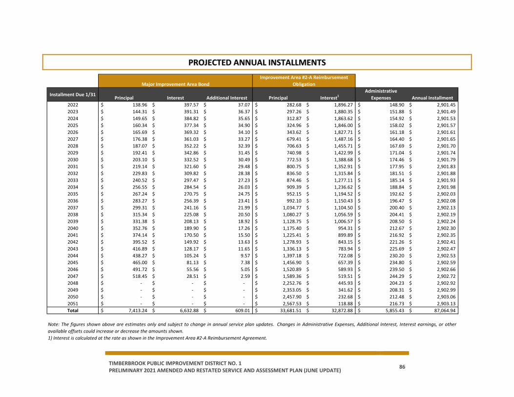
TIMBERBROOK PUBLIC IMPROVEMENT DISTRICT NO. 1 PRELIMINARY 2021 AMENDED AND RESTATED SERVICE AND ASSESSMENT PLAN (JUNE UPDATE) 86
PROJECTED ANNUAL INSTALLMENTS
Installment Due 1/31Principal Interest Additional Interest Principal Interest1
Administrative Expenses Annual Installment
2022 138.96$ 397.57$ 37.07$ 282.68$ 1,896.27$ 148.90$ 2,901.45$ 2023 144.31$ 391.31$ 36.37$ 297.26$ 1,880.35$ 151.88$ 2,901.49$ 2024 149.65$ 384.82$ 35.65$ 312.87$ 1,863.62$ 154.92$ 2,901.53$ 2025 160.34$ 377.34$ 34.90$ 324.96$ 1,846.00$ 158.02$ 2,901.57$ 2026 165.69$ 369.32$ 34.10$ 343.62$ 1,827.71$ 161.18$ 2,901.61$ 2027 176.38$ 361.03$ 33.27$ 679.41$ 1,487.16$ 164.40$ 2,901.65$ 2028 187.07$ 352.22$ 32.39$ 706.63$ 1,455.71$ 167.69$ 2,901.70$ 2029 192.41$ 342.86$ 31.45$ 740.98$ 1,422.99$ 171.04$ 2,901.74$ 2030 203.10$ 332.52$ 30.49$ 772.53$ 1,388.68$ 174.46$ 2,901.79$ 2031 219.14$ 321.60$ 29.48$ 800.75$ 1,352.91$ 177.95$ 2,901.83$ 2032 229.83$ 309.82$ 28.38$ 836.50$ 1,315.84$ 181.51$ 2,901.88$ 2033 240.52$ 297.47$ 27.23$ 874.46$ 1,277.11$ 185.14$ 2,901.93$ 2034 256.55$ 284.54$ 26.03$ 909.39$ 1,236.62$ 188.84$ 2,901.98$ 2035 267.24$ 270.75$ 24.75$ 952.15$ 1,194.52$ 192.62$ 2,902.03$ 2036 283.27$ 256.39$ 23.41$ 992.10$ 1,150.43$ 196.47$ 2,902.08$ 2037 299.31$ 241.16$ 21.99$ 1,034.77$ 1,104.50$ 200.40$ 2,902.13$ 2038 315.34$ 225.08$ 20.50$ 1,080.27$ 1,056.59$ 204.41$ 2,902.19$ 2039 331.38$ 208.13$ 18.92$ 1,128.75$ 1,006.57$ 208.50$ 2,902.24$ 2040 352.76$ 189.90$ 17.26$ 1,175.40$ 954.31$ 212.67$ 2,902.30$ 2041 374.14$ 170.50$ 15.50$ 1,225.41$ 899.89$ 216.92$ 2,902.35$ 2042 395.52$ 149.92$ 13.63$ 1,278.93$ 843.15$ 221.26$ 2,902.41$ 2043 416.89$ 128.17$ 11.65$ 1,336.13$ 783.94$ 225.69$ 2,902.47$ 2044 438.27$ 105.24$ 9.57$ 1,397.18$ 722.08$ 230.20$ 2,902.53$ 2045 465.00$ 81.13$ 7.38$ 1,456.90$ 657.39$ 234.80$ 2,902.59$ 2046 491.72$ 55.56$ 5.05$ 1,520.89$ 589.93$ 239.50$ 2,902.66$ 2047 518.45$ 28.51$ 2.59$ 1,589.36$ 519.51$ 244.29$ 2,902.72$ 2048 -$ -$ -$ 2,252.76$ 445.93$ 204.23$ 2,902.92$ 2049 -$ -$ -$ 2,353.05$ 341.62$ 208.31$ 2,902.99$ 2050 -$ -$ -$ 2,457.90$ 232.68$ 212.48$ 2,903.06$ 2051 -$ -$ -$ 2,567.53$ 118.88$ 216.73$ 2,903.13$ Total 7,413.24$ 6,632.88$ 609.01$ 33,681.51$ 32,872.88$ 5,855.43$ 87,064.94$
Major Improvement Area BondImprovement Area #2-A Reimbursement
Obligation
Note: The figures shown above are estimates only and subject to change in annual service plan updates. Changes in Administrative Expenses, Additional Interest, Interest earnings, or otheravailable offsets could increase or decrease the amounts shown.1) Interest is calculated at the rate as shown in the Improvement Area #2-A Reimbursement Agreement.
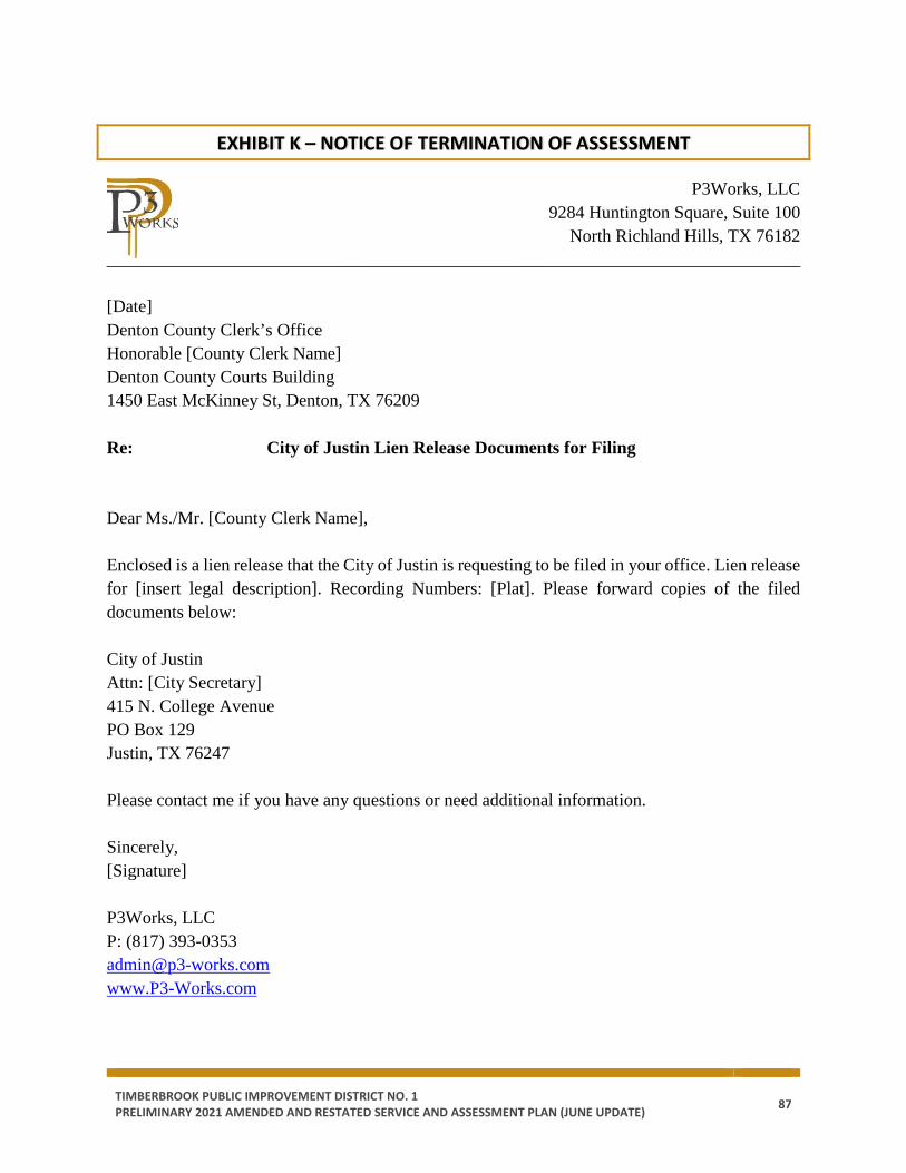
TIMBERBROOK PUBLIC IMPROVEMENT DISTRICT NO. 1 PRELIMINARY 2021 AMENDED AND RESTATED SERVICE AND ASSESSMENT PLAN (JUNE UPDATE) 87
EXHIBIT K – NOTICE OF TERMINATION OF ASSESSMENT
P3Works, LLC 9284 Huntington Square, Suite 100 North Richland Hills, TX 76182 ______________________________________________________________________________ [Date] Denton County Clerk’s Office Honorable [County Clerk Name] Denton County Courts Building 1450 East McKinney St, Denton, TX 76209 Re: City of Justin Lien Release Documents for Filing Dear Ms./Mr. [County Clerk Name], Enclosed is a lien release that the City of Justin is requesting to be filed in your office. Lien release for [insert legal description]. Recording Numbers: [Plat]. Please forward copies of the filed documents below: City of Justin Attn: [City Secretary] 415 N. College Avenue PO Box 129 Justin, TX 76247 Please contact me if you have any questions or need additional information. Sincerely, [Signature] P3Works, LLC P: (817) 393-0353 [email protected] www.P3-Works.com
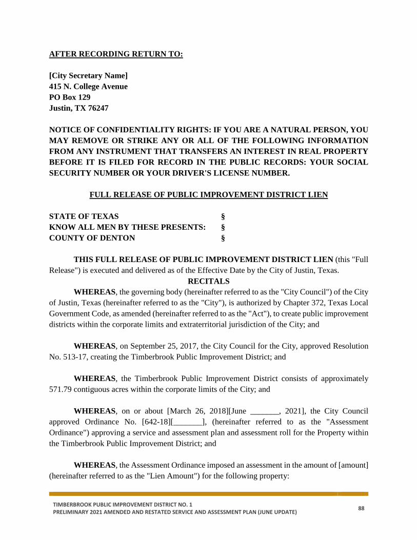
TIMBERBROOK PUBLIC IMPROVEMENT DISTRICT NO. 1 PRELIMINARY 2021 AMENDED AND RESTATED SERVICE AND ASSESSMENT PLAN (JUNE UPDATE) 88
AFTER RECORDING RETURN TO: [City Secretary Name] 415 N. College Avenue PO Box 129 Justin, TX 76247 NOTICE OF CONFIDENTIALITY RIGHTS: IF YOU ARE A NATURAL PERSON, YOU MAY REMOVE OR STRIKE ANY OR ALL OF THE FOLLOWING INFORMATION FROM ANY INSTRUMENT THAT TRANSFERS AN INTEREST IN REAL PROPERTY BEFORE IT IS FILED FOR RECORD IN THE PUBLIC RECORDS: YOUR SOCIAL SECURITY NUMBER OR YOUR DRIVER'S LICENSE NUMBER.
FULL RELEASE OF PUBLIC IMPROVEMENT DISTRICT LIEN STATE OF TEXAS § KNOW ALL MEN BY THESE PRESENTS: § COUNTY OF DENTON §
THIS FULL RELEASE OF PUBLIC IMPROVEMENT DISTRICT LIEN (this "Full Release") is executed and delivered as of the Effective Date by the City of Justin, Texas.
RECITALS WHEREAS, the governing body (hereinafter referred to as the "City Council") of the City
of Justin, Texas (hereinafter referred to as the "City"), is authorized by Chapter 372, Texas Local Government Code, as amended (hereinafter referred to as the "Act"), to create public improvement districts within the corporate limits and extraterritorial jurisdiction of the City; and
WHEREAS, on September 25, 2017, the City Council for the City, approved Resolution No. 513-17, creating the Timberbrook Public Improvement District; and
WHEREAS, the Timberbrook Public Improvement District consists of approximately 571.79 contiguous acres within the corporate limits of the City; and
WHEREAS, on or about [March 26, 2018][June _______, 2021], the City Council approved Ordinance No. [642-18][_______], (hereinafter referred to as the "Assessment Ordinance") approving a service and assessment plan and assessment roll for the Property within the Timberbrook Public Improvement District; and
WHEREAS, the Assessment Ordinance imposed an assessment in the amount of [amount]
(hereinafter referred to as the "Lien Amount") for the following property:
TIMBERBROOK PUBLIC IMPROVEMENT DISTRICT NO. 1 PRELIMINARY 2021 AMENDED AND RESTATED SERVICE AND ASSESSMENT PLAN (JUNE UPDATE) 89
[legal description], a subdivision in Denton County, Texas, according to the map or plat of record in Document/Instrument No. ________ of the Plat Records of Denton County, Texas (hereinafter referred to as the "Property"); and
WHEREAS, the property owners of the Property have paid unto the City the Lien Amount.
RELEASE NOW THEREFORE, the City, the owner and holder of the Lien, Instrument No. ________, in the Real Property Records of Denton County, Texas, in the amount of the Lien Amount against the Property releases and discharges, and by these presents does hereby release and discharge, the above-described Property from said lien held by the undersigned securing said indebtedness. EXECUTED to be EFFECTIVE this the _____ day of _________, 20__.
CITY OF JUSTIN, TEXAS,
By: _______________________________ [Manager Name], City Manager
ATTEST: ______________________________ [Secretary Name], City Secretary STATE OF TEXAS §
§ COUNTY OF DENTON §
This instrument was acknowledged before me on the ____ day of ________, 20__, by [Manager Name], City Manager for the City of Justin, Texas, on behalf of said municipality. _______________________________ Notary Public, State of Texas
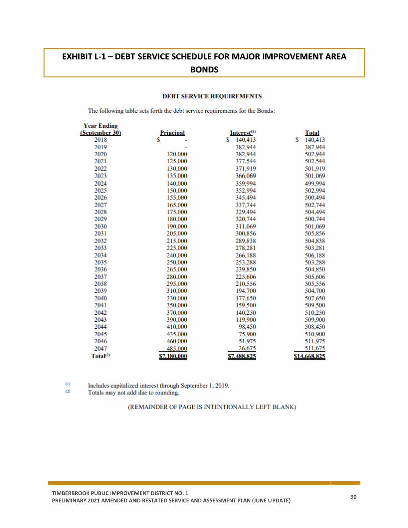
TIMBERBROOK PUBLIC IMPROVEMENT DISTRICT NO. 1 PRELIMINARY 2021 AMENDED AND RESTATED SERVICE AND ASSESSMENT PLAN (JUNE UPDATE) 90
EXHIBIT L-1 – DEBT SERVICE SCHEDULE FOR MAJOR IMPROVEMENT AREA BONDS
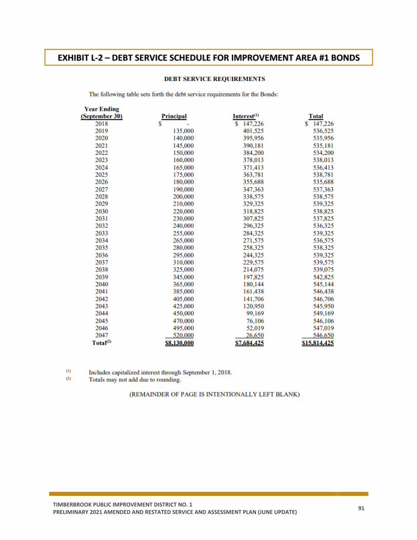
TIMBERBROOK PUBLIC IMPROVEMENT DISTRICT NO. 1 PRELIMINARY 2021 AMENDED AND RESTATED SERVICE AND ASSESSMENT PLAN (JUNE UPDATE) 91
EXHIBIT L-2 – DEBT SERVICE SCHEDULE FOR IMPROVEMENT AREA #1 BONDS
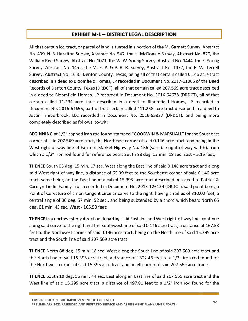
TIMBERBROOK PUBLIC IMPROVEMENT DISTRICT NO. 1 PRELIMINARY 2021 AMENDED AND RESTATED SERVICE AND ASSESSMENT PLAN (JUNE UPDATE) 92
EXHIBIT M-1 – DISTRICT LEGAL DESCRIPTION
All that certain lot, tract, or parcel of land, situated in a portion of the M. Garnett Survey, Abstract No. 439, N. S. Hazelton Survey, Abstract No. 547, the H. McDonald Survey, Abstract No. 879, the William Reed Survey, Abstract No. 1071, the W. W. Young Survey, Abstract No. 1444, the E. Young Survey, Abstract No. 1452, the M. E. P. & P. R. R. Survey, Abstract No. 1477, the R. W. Terrell Survey, Abstract No. 1650, Denton County, Texas, being all of that certain called 0.146 acre tract described in a deed to Bloomfield Homes, LP recorded in Document No. 2017-11065 of the Deed Records of Denton County, Texas (DRDCT), all of that certain called 207.569 acre tract described in a deed to Bloomfield Homes, LP recorded in Document No. 2016-64678 (DRDCT), all of that certain called 11.234 acre tract described in a deed to Bloomfield Homes, LP recorded in Document No. 2016-64656, part of that certain called 411.268 acre tract described in a deed to Justin Timberbrook, LLC recorded in Document No. 2016-55837 (DRDCT), and being more completely described as follows, to-wit:
BEGINNING at 1/2” capped iron rod found stamped “GOODWIN & MARSHALL” for the Southeast corner of said 207.569 acre tract, the Northeast corner of said 0.146 acre tract, and being in the West right-of-way line of Farm-to-Market Highway No. 156 (variable right-of-way width), from which a 1/2” iron rod found for reference bears South 88 deg. 15 min. 18 sec. East – 5.16 feet;
THENCE South 05 deg. 15 min. 17 sec. West along the East line of said 0.146 acre tract and along said West right-of-way line, a distance of 65.39 feet to the Southeast corner of said 0.146 acre tract, same being on the East line of a called 15.395 acre tract described in a deed to Patrick & Carolyn Timlin Family Trust recorded in Document No. 2015-126134 (DRDCT), said point being a Point of Curvature of a non-tangent circular curve to the right, having a radius of 310.00 feet, a central angle of 30 deg. 57 min. 52 sec., and being subtended by a chord which bears North 65 deg. 01 min. 45 sec. West - 165.50 feet;
THENCE in a northwesterly direction departing said East line and West right-of-way line, continue along said curve to the right and the Southwest line of said 0.146 acre tract, a distance of 167.53 feet to the Northwest corner of said 0.146 acre tract, being on the North line of said 15.395 acre tract and the South line of said 207.569 acre tract;
THENCE North 88 deg. 15 min. 18 sec. West along the South line of said 207.569 acre tract and the North line of said 15.395 acre tract, a distance of 1302.46 feet to a 1/2” iron rod found for the Northwest corner of said 15.395 acre tract and an ell corner of said 207.569 acre tract;
THENCE South 10 deg. 56 min. 44 sec. East along an East line of said 207.569 acre tract and the West line of said 15.395 acre tract, a distance of 497.81 feet to a 1/2” iron rod found for the
TIMBERBROOK PUBLIC IMPROVEMENT DISTRICT NO. 1 PRELIMINARY 2021 AMENDED AND RESTATED SERVICE AND ASSESSMENT PLAN (JUNE UPDATE) 93
Southwest corner of said 15.395 acre tract, the most southerly Southeast corner of said 207.569 acre tract, the Northwest corner of a called 33.301 acre tract and the Northeast corner of a called 16.791 acre tract described in said deed to Patrick & Carolyn Timlin Family Trust;
THENCE North 88 deg. 43 min. 58 sec. West along the South line of said 207.569 acre tract, the North line of said 16.791 acre tract, and the North line of a called 4.28 acre tract described in a deed to C & S Oilfield Services, LLC recorded in Document No. 2007-78273 (DRDCT), a distance of 670.17 feet to a 5/8” iron rod found for a South corner of said 207.569 acre tract and an ell corner of said 4.28 acre tract;
THENCE North 00 deg. 07 min. 01 sec. East along said South line and the North line of said 4.28 acre tract, a distance of 72.33 feet to a 5/8” iron rod found for an ell corner of said 207.569 acre tract and an ell corner of said 4.28 acre tract;
THENCE North 88 deg. 51 min. 24 sec. West along the South line of said 207.569 acre tract and the North line of said 4.28 acre tract, a distance of 107.69 feet to a 1/2” capped iron rod found stamped “GOODWIN & MARSHALL” for an ell corner of said 207.569 acre tract, the Northwest corner of said 4.28 acre tract, the Northeast corner of a called 5.011 acre tract described in a deed to Sandra Copp recorded in Document No. 94-R0086702 (DRDCT), and the Southeast corner of a called 1.904 acre tract described in a deed to Sandra Copp recorded in Volume 4070, Page 1426 (DRDCT);
THENCE North 00 deg. 29 min. 49 sec. East along the South line of said 207.569 acre tract and the East line of said 1.904 acre tract, a distance of 75.15 feet to a 1/2” iron rod found for an ell corner of said 207.569 acre tract and the Northeast corner of said 1.904 acre tract;
THENCE North 89 deg. 00 min. 55 sec. West along the South line of said 207.569 acre tract and the North line of said 1.904 acre tract, a distance of 699.50 feet to a 1/2” capped iron rod found stamped “GOODWIN & MARSHALL” for an ell corner of said 207.569 acre tract, the Northwest corner of said 1.904 acre tract, and being in the East line of a called 7.910 acre tract described in a deed to David & Heather Stone recorded in Document No. 2013-92970 (DRDCT);
THENCE North 00 deg. 31 min. 26 sec. East along a West line of said 207.569 acre tract, the East line of said 7.910 acre tract, and the East line of Ridgeview Estates recorded in Cabinet N, Page 398 of the Plat Records of Denton County, Texas (PRDCT), a distance of 795.24 feet to a 60D nail found for an ell corner of said 207.569 acre tract and the Northeast corner of said Ridgeview Estates;
THENCE North 88 deg. 13 min. 32 sec. West along the South line of said 207.569 acre tract and the North line of said Ridgeview Estates, a distance of 1555.09 feet to a 3/8” iron rod found for a
TIMBERBROOK PUBLIC IMPROVEMENT DISTRICT NO. 1 PRELIMINARY 2021 AMENDED AND RESTATED SERVICE AND ASSESSMENT PLAN (JUNE UPDATE) 94
Southwest corner of said 207.569 acre tract, the Northwest corner of said Ridgeview Estates, and being in the East line of said 11.234 acre tract;
THENCE South 00 deg. 24 min. 46 sec. West along the East line of said 11.234 acre tract and the West line of said Ridgeview Estates, a distance of 965.92 feet to a 1/2” capped iron rod found stamped “3638” for the Southeast corner of said 11.234 acre tract and an ell corner of said Ridgeview Estates;
THENCE North 89 deg. 31 min. 56 sec. West along the South line of said 11.234 acre tract and the North line of said Ridgeview Estates, a distance of 394.61 feet to a fence corner found for the Southwest corner of said 11.234 acre tract, the most westerly Northwest corner of said Ridgeview Estates, and being in the East line of said 411.268 acre tract;
THENCE South 05 deg. 15 min. 18 sec. West along the East line of said 411.268 acre tract and the West line of said Ridgeview Estates, a distance of 21.76 feet to a Bois d’ Arc fence corner for the most easterly Southeast corner of said 411.268 acre tract and the Northeast corner of a called 82.044 acre tract described in a deed to Peggy Ihnfeldt recorded in Document No. 2004-116851 (DRDCT);
THENCE North 89 deg. 54 min. 49 sec. West departing the West line of said Ridgeview Estates and continue along the South line of said 411.268 acre tract and the North line of said 82.044 acre tract, a distance of 1415.75 feet to a 1/2” iron pipe found for an ell corner of said 411.268 acre tract and the Northwest corner of said 82.044 acre tract;
THENCE South 00 deg. 18 min. 00 sec. East along the East line of said 411.268 acre tract and the West line of said 82.044 acre tract, a distance of 2692.74 feet to a bolt found for an ell corner of said 411.268 acre tract, the Southwest corner of said 82.044 acre tract, and being in the North line of a tract of land described in a deed to Raymond Haddock recorded in Document No. 2011-19529 (DRDCT);
THENCE South 89 deg. 28 min. 31 sec. West along the South line of said 411.268 acre tract and the North line of said Haddock tract, a distance of 1286.69 feet to an ell corner of said 411.268 acre tract and the Northwest corner of said Haddock tract;
THENCE South 00 deg. 32 min. 43 sec. East along the East line of said 411.268 acre tract and the West line of said Haddock tract, a distance of 1860.56 feet to the Southeast corner of said 411.268 acre tract, the Southwest corner of said Haddock tract, and being in the North right-of-way line of Farm-to-Market Highway No. 407 (90’ right-of-way width), from which a 100D nail found for reference bears South 00 deg. 32 min. 43 sec. East – 0.79 feet;
TIMBERBROOK PUBLIC IMPROVEMENT DISTRICT NO. 1 PRELIMINARY 2021 AMENDED AND RESTATED SERVICE AND ASSESSMENT PLAN (JUNE UPDATE) 95
THENCE South 89 deg. 26 min. 19 sec. West along the South line of said 411.268 acre tract and said North right-of-way line, a distance of 962.81 feet to an ell corner of said 411.268 acre tract and the Southeast corner of a called 4.05 acre tract described in a deed to Pete Allen Mitchell, et ux recorded in Volume 1226, Page 932 (DRDCT);
THENCE North 00 deg. 32 min. 43 sec. West departing said North right-of-way line and continue along a West line of said 411.268 acre tract and the East line of said 4.05 acre tract, a distance of 588.43 feet to an ell corner of said 411.268 acre tract and the Northeast corner of said 4.05 acre tract;
THENCE South 89 deg. 20 min. 19 sec. West along a South line of said 411.268 acre tract, the North line of said 4.05 acre tract, and a North line of a called 3.0 acre tract described in a deed to William D. Mitchell recorded in Volume 2292, Page 269 (DRDCT), a distance of 522.50 feet to a 5/8” iron rod found “bent” for an ell corner of said 411.268 acre tract and the Northwest corner of said 3.0 acre tract;
THENCE South 00 deg. 32 min. 43 sec. East along an East line of said 411.268 acre tract and the West line of said 3.0 acre tract, a distance of 588.16 feet to an ell corner of said 411.268 acre tract, the Southwest corner of said 3.0 acre tract, and being in the North right-of-way line of said Farm-to-Market Highway No. 407;
THENCE South 89 deg. 20 min. 19 sec. West along the South line of said 411.268 acre tract and said North right-of-way line, a distance of 480.36 feet to a 5/8” iron rod found for the Southwest corner of said 411.268 acre tract and the Southeast corner of a called 241.210 acre tract described in a deed to Justin Timberbrook, LLC recorded in Document No. 2017-5803 (DRDCT);
THENCE North 00 deg. 25 min. 35 sec. West departing said North right-of-way line and continue along the West line of said 411.268 acre tract and the East line of said 241.210 acre tract, a distance of 1412.84 feet to a;
THENCE North 82 deg. 33 min. 17 sec. East departing said East and West line, a distance of 654.90 feet to a Point of Curvature of a non-tangent circular curve to the right, having a radius of 2640.00 feet, a central angle of 9 deg. 53 min. 45 sec., and being subtended by a chord which bears North 09 deg. 02 min. 00 sec. West - 455.41 feet;
THENCE in a northerly direction along said curve to the right, a distance of 455.97 feet;
THENCE North 00 deg. 25 min. 43 sec. West non-tangent to said curve, a distance of 2736.00 feet to a Point of Curvature of a non-tangent circular curve to the right, having a radius of 2640.00
TIMBERBROOK PUBLIC IMPROVEMENT DISTRICT NO. 1 PRELIMINARY 2021 AMENDED AND RESTATED SERVICE AND ASSESSMENT PLAN (JUNE UPDATE) 96
feet, a central angle of 26 deg. 01 min. 14 sec., and being subtended by a chord which bears North 13 deg. 59 min. 29 sec. East - 1188.66 feet;
THENCE in a northeasterly direction along said curve to the right, a distance of 1198.94 feet to the North line of said 411.268 acre tract;
THENCE North 74 deg. 21 min. 14 sec. East non-tangent to said curve and continue along said North line, a distance of 88.17 feet;
THENCE North 71 deg. 02 min. 07 sec. East along said North line, a distance of 83.84 feet;
THENCE North 75 deg. 52 min. 49 sec. East along said North line, a distance of 225.33 feet;
THENCE North 80 deg. 02 min. 08 sec. East along said North line, a distance of 347.22 feet;
THENCE South 00 deg. 04 min. 18 sec. East along said North line, a distance of 168.49 feet to a 10” cedar fence corner for the Southwest corner of a called 1.1732 acre tract described in a deed to Gary Place recorded in Volume 1443, Page 975 (DRDCT);
THENCE South 89 deg. 53 min. 56 sec. East along the North line of said 411.268 acre tract and the South line of said 1.1732 acre tract, a distance of 706.32 feet to the most westerly corner of said 207.569 acre tract, said corner being in the center of Oliver Creek;
THENCE in a Northeasterly direction departing the North line of said 411.268 acre tract, and continue along the North line of said 207.569 acre tract and the centerline of said Oliver Creek the following forty-seven (47) courses;
North 51 deg. 15 min. 16 sec. East, a distance of 151.43 feet;
North 52 deg. 27 min. 07 sec. East, a distance of 196.96 feet;
North 40 deg. 16 min. 03 sec. East, a distance of 154.27 feet;
North 42 deg. 51 min. 10 sec. East, a distance of 100.33 feet;
North 77 deg. 17 min. 59 sec. East, a distance of 94.06 feet;
South 73 deg. 35 min. 56 sec. East, a distance of 49.93 feet;
North 87 deg. 18 min. 55 sec. East, a distance of 72.64 feet;
North 69 deg. 58 min. 14 sec. East, a distance of 170.43 feet;
TIMBERBROOK PUBLIC IMPROVEMENT DISTRICT NO. 1 PRELIMINARY 2021 AMENDED AND RESTATED SERVICE AND ASSESSMENT PLAN (JUNE UPDATE) 97
North 61 deg. 45 min. 38 sec. East, a distance of 342.10 feet;
North 45 deg. 09 min. 40 sec. East, a distance of 135.87 feet;
North 48 deg. 22 min. 12 sec. East, a distance of 95.16 feet;
South 88 deg. 00 min. 22 sec. East, a distance of 33.23 feet;
South 51 deg. 06 min. 32 sec. East, a distance of 113.07 feet;
South 45 deg. 09 min. 04 sec. East, a distance of 149.75 feet;
South 64 deg. 04 min. 16 sec. East, a distance of 170.34 feet;
South 82 deg. 58 min. 49 sec. East, a distance of 191.84 feet;
North 61 deg. 17 min. 34 sec. East, a distance of 94.24 feet;
North 20 deg. 00 min. 00 sec. East, a distance of 105.84 feet;
North 11 deg. 44 min. 28 sec. East, a distance of 97.33 feet;
North 29 deg. 09 min. 43 sec. East, a distance of 66.14 feet;
North 72 deg. 48 min. 46 sec. East, a distance of 65.89 feet;
North 84 deg. 08 min. 17 sec. East, a distance of 60.16 feet;
South 60 deg. 01 min. 59 sec. East, a distance of 103.62 feet;
South 40 deg. 07 min. 11 sec. East, a distance of 256.88 feet;
South 51 deg. 54 min. 24 sec. East, a distance of 138.91 feet;
South 82 deg. 48 min. 45 sec. East, a distance of 122.06 feet;
North 70 deg. 21 min. 18 sec. East, a distance of 136.98 feet;
North 57 deg. 07 min. 49 sec. East, a distance of 128.52 feet;
South 88 deg. 18 min. 12 sec. East, a distance of 215.06 feet;
North 87 deg. 33 min. 35 sec. East, a distance of 110.30 feet;

TIMBERBROOK PUBLIC IMPROVEMENT DISTRICT NO. 1 PRELIMINARY 2021 AMENDED AND RESTATED SERVICE AND ASSESSMENT PLAN (JUNE UPDATE) 98
North 67 deg. 52 min. 06 sec. East, a distance of 207.51 feet;
North 08 deg. 48 min. 05 sec. East, a distance of 5.83 feet;
North 62 deg. 35 min. 14 sec. East, a distance of 119.17 feet;
North 54 deg. 18 min. 14 sec. East, a distance of 124.51 feet;
North 62 deg. 18 min. 21 sec. East, a distance of 127.99 feet;
North 14 deg. 24 min. 26 sec. East, a distance of 46.68 feet;
North 53 deg. 29 min. 27 sec. East, a distance of 462.51 feet;
North 45 deg. 52 min. 08 sec. East, a distance of 224.12 feet;
North 26 deg. 02 min. 20 sec. East, a distance of 196.97 feet;
North 41 deg. 40 min. 15 sec. East, a distance of 164.67 feet;
North 59 deg. 45 min. 26 sec. East, a distance of 196.15 feet;
North 89 deg. 38 min. 11 sec. East, a distance of 72.18 feet;
South 66 deg. 12 min. 45 sec. East, a distance of 104.63 feet;
South 52 deg. 47 min. 32 sec. East, a distance of 100.44 feet;
South 80 deg. 30 min. 56 sec. East, a distance of 154.09 feet;
South 62 deg. 10 min. 20 sec. East, a distance of 281.52 feet;
South 43 deg. 45 min. 32 sec. East, a distance of 57.60 feet;
THENCE North 88 deg. 11 min. 41 sec. East departing said centerline and continue along said North line, a distance of 139.80 feet to a 1/2” iron rod found for the Southwest corner of a called 20.000 acre tract described in a deed to Brad Judge and Jessica Judge recorded in Document No. 2006-113979 (DRDCT);
THENCE North 88 deg. 38 min. 53 sec. East along the North line of said 207.569 acre tract and the South line of said 20.000 acre tract, a distance of 378.60 feet to a 1/2” capped iron rod found stamped “GOODWIN & MARSHALL” for a North corner of said 207.569 acre tract and the
TIMBERBROOK PUBLIC IMPROVEMENT DISTRICT NO. 1 PRELIMINARY 2021 AMENDED AND RESTATED SERVICE AND ASSESSMENT PLAN (JUNE UPDATE) 99
Northwest corner of a called 38.494 acre tract described in a deed to Gary Lyn Place recorded in Volume 4889, Page 892 (DRDCT);
THENCE in a southeasterly direction departing the South line of said 20.000 acre tract and continue along the Northeast line of said 207.569 acre tract and the Southwest line of said 38.494 acre tract the following nine (9) courses;
South 01 deg. 33 min. 02 sec. West, a distance of 78.50 feet to a 30” hackberry;
South 54 deg. 40 min. 59 sec. East, a distance of 144.58 feet to a 24” elm;
South 01 deg. 44 min. 42 sec. West, a distance of 367.88 feet to a 1/2” capped iron rod found stamped “GOODWIN & MARSHALL”;
South 19 deg. 25 min. 18 sec. East, a distance of 480.95 feet to a 1/2” capped iron rod found stamped “GOODWIN & MARSHALL”;
South 58 deg. 15 min. 18 sec. East, a distance of 147.50 feet to a 1/2” capped iron rod found stamped “GOODWIN & MARSHALL”;
South 68 deg. 25 min. 18 sec. East, a distance of 194.30 feet to a 1/2” capped iron rod found stamped “GOODWIN & MARSHALL”;
South 66 deg. 15 min. 18 sec. East, a distance of 194.00 feet to a 1/2” capped iron rod found stamped “GOODWIN & MARSHALL”;
South 73 deg. 00 min. 18 sec. East, a distance of 184.60 feet to a 1/2” capped iron rod found stamped “GOODWIN & MARSHALL”;
South 83 deg. 45 min. 18 sec. East, a distance of 211.20 feet to a 1/2” capped iron rod found stamped “GOODWIN & MARSHALL” for the Northwest corner of a called 1.058 acre tract described in a deed to Gary L. Place recorded in Volume 1066, Page 226 (DRDCT);
THENCE in a southeasterly direction departing the South line of said 38.494 acre tract and continue along the Northeast line of said 207.569 acre tract and the Southwest line of said 1.058 acre tract the following six (6) courses;
South 43 deg. 14 min. 42 sec. West, a distance of 26.50 feet to a 1/2” capped iron rod found stamped “GOODWIN & MARSHALL”;
South 11 deg. 45 min. 18 sec. East, a distance of 29.60 feet to a 1/2” capped iron rod found stamped “GOODWIN & MARSHALL”;

TIMBERBROOK PUBLIC IMPROVEMENT DISTRICT NO. 1 PRELIMINARY 2021 AMENDED AND RESTATED SERVICE AND ASSESSMENT PLAN (JUNE UPDATE) 100
South 62 deg. 59 min. 18 sec. East, a distance of 195.20 feet to a 1/2” capped iron rod found stamped “GOODWIN & MARSHALL”;
South 35 deg. 37 min. 18 sec. East, a distance of 116.90 feet to a 1/2” capped iron rod found stamped “GOODWIN & MARSHALL”;
South 31 deg. 59 min. 42 sec. West, a distance of 79.40 feet to a 1/2” capped iron rod found stamped “GOODWIN & MARSHALL”;
South 42 deg. 46 min. 18 sec. East, a distance of 105.55 feet to a 1/2” capped iron rod found stamped “GOODWIN & MARSHALL” for the easterly Northeast corner of said 207.569 acre tract, the Southeast corner of said 1.058 acre tract, and being in the West right-of-way line of said Farm-to-Market Highway No. 156;
THENCE South 05 deg. 15 min. 17 sec. West along the East line of said 207.569 acre tract and said West right-of-way line, a distance of 645.70 feet to the POINT OF BEGINNING, containing 24,910,596 square feet or 571.869 acres of land, more or less.
Bearings are referenced to Texas State Plane Coordinate System, North Central Zone (4202), North American Datum of 1983 as derived from GPS observation.
TIMBERBROOK PUBLIC IMPROVEMENT DISTRICT NO. 1 PRELIMINARY 2021 AMENDED AND RESTATED SERVICE AND ASSESSMENT PLAN (JUNE UPDATE) 101
EXHIBIT M-2 – MAJOR IMPROVEMENT AREA LEGAL DESCRIPTION
All that certain lot, tract, or parcel of land, situated in a portion of the M. Garnett Survey, Abstract No. 439, N. S. Hazelton Survey, Abstract No. 547, the H. McDonald Survey, Abstract No. 879, the William Reed Survey, Abstract No. 1071, the W. W. Young Survey, Abstract No. 1444, the R. W. Terrell Survey, Abstract No. 1650, Denton County, Texas, being part of that certain called 207.569 acre tract described in a deed to Bloomfield Homes, LP recorded in Document No. 2016-64678 of the Deed Records of Denton County, Texas (DRDCT), all of that certain called 11.234 acre tract described in a deed to Bloomfield Homes, LP recorded in Document No. 2016-64656, part of that certain called 411.268 acre tract described in a deed to Justin Timberbrook, LLC recorded in Document No. 2016-55837 (DRDCT), and being more completely described as follows, to-wit:
BEGINNING at a point in the South line of said 207.569 acre tract and the North line of Ridgeview Estates recorded in Cabinet N, Page 398 of the Plat Records of Denton County, Texas (PRDCT), from which a 60D nail found for an ell corner of said 207.569 acre tract and the Northeast corner of said Ridgeview Estates bears South 88 deg. 13 min. 32 sec. West – 921.85 feet
THENCE North 88 deg. 13 min. 32 sec. West along the South line of said 207.569 acre tract and the North line of said Ridgeview Estates, a distance of 633.23 feet to a 3/8” iron rod found for a Southwest corner of said 207.569 acre tract, the Northwest corner of said Ridgeview Estates, and being in the East line of said 11.234 acre tract;
THENCE South 00 deg. 24 min. 46 sec. West along the East line of said 11.234 acre tract and the West line of said Ridgeview Estates, a distance of 965.92 feet to a 1/2” capped iron rod found stamped “3638” for the Southeast corner of said 11.234 acre tract and an ell corner of said Ridgeview Estates;
THENCE North 89 deg. 31 min. 56 sec. West along the South line of said 11.234 acre tract and the North line of said Ridgeview Estates, a distance of 394.61 feet to a fence corner found for the Southwest corner of said 11.234 acre tract, the most westerly Northwest corner of said Ridgeview Estates, and being in the East line of said 411.268 acre tract;
THENCE South 05 deg. 15 min. 18 sec. West along the East line of said 411.268 acre tract and the West line of said Ridgeview Estates, a distance of 21.76 feet to a Bois d’ Arc fence corner for the most easterly Southeast corner of said 411.268 acre tract and the Northeast corner of a called 82.044 acre tract described in a deed to Peggy Ihnfeldt recorded in Document No. 2004-116851 (DRDCT);
THENCE North 89 deg. 54 min. 49 sec. West departing the West line of said Ridgeview Estates and continue along the South line of said 411.268 acre tract and the North line of said 82.044
TIMBERBROOK PUBLIC IMPROVEMENT DISTRICT NO. 1 PRELIMINARY 2021 AMENDED AND RESTATED SERVICE AND ASSESSMENT PLAN (JUNE UPDATE) 102
acre tract, a distance of 1415.75 feet to a 1/2” iron pipe found for an ell corner of said 411.268 acre tract and the Northwest corner of said 82.044 acre tract;
THENCE South 00 deg. 18 min. 00 sec. East along the East line of said 411.268 acre tract and the West line of said 82.044 acre tract, a distance of 2692.74 feet to a bolt found for an ell corner of said 411.268 acre tract, the Southwest corner of said 82.044 acre tract, and being in the North line of a tract of land described in a deed to Raymond Haddock recorded in Document No. 2011-19529 (DRDCT);
THENCE South 89 deg. 28 min. 31 sec. West along the South line of said 411.268 acre tract and the North line of said Haddock tract, a distance of 1286.69 feet to an ell corner of said 411.268 acre tract and the Northwest corner of said Haddock tract;
THENCE South 00 deg. 32 min. 43 sec. East along the East line of said 411.268 acre tract and the West line of said Haddock tract, a distance of 1860.56 feet to the Southeast corner of said 411.268 acre tract, the Southwest corner of said Haddock tract, and being in the North right-of-way line of Farm-to-Market Highway No. 407 (90’ right-of-way width), from which a 100D nail found for reference bears South 00 deg. 32 min. 43 sec. East – 0.79 feet;
THENCE South 89 deg. 26 min. 19 sec. West along the South line of said 411.268 acre tract and said North right-of-way line, a distance of 962.81 feet to an ell corner of said 411.268 acre tract and the Southeast corner of a called 4.05 acre tract described in a deed to Pete Allen Mitchell, et ux recorded in Volume 1226, Page 932 (DRDCT);
THENCE North 00 deg. 32 min. 43 sec. West departing said North right-of-way line and continue along a West line of said 411.268 acre tract and the East line of said 4.05 acre tract, a distance of 588.43 feet to an ell corner of said 411.268 acre tract and the Northeast corner of said 4.05 acre tract;
THENCE South 89 deg. 20 min. 19 sec. West along a South line of said 411.268 acre tract, the North line of said 4.05 acre tract, and a North line of a called 3.0 acre tract described in a deed to William D. Mitchell recorded in Volume 2292, Page 269 (DRDCT), a distance of 522.50 feet to a 5/8” iron rod found “bent” for an ell corner of said 411.268 acre tract and the Northwest corner of said 3.0 acre tract;
THENCE South 00 deg. 32 min. 43 sec. East along an East line of said 411.268 acre tract and the West line of said 3.0 acre tract, a distance of 588.16 feet to an ell corner of said 411.268 acre tract, the Southwest corner of said 3.0 acre tract, and being in the North right-of-way line of said Farm-to-Market Highway No. 407;
TIMBERBROOK PUBLIC IMPROVEMENT DISTRICT NO. 1 PRELIMINARY 2021 AMENDED AND RESTATED SERVICE AND ASSESSMENT PLAN (JUNE UPDATE) 103
THENCE South 89 deg. 20 min. 19 sec. West along the South line of said 411.268 acre tract and said North right-of-way line, a distance of 480.36 feet to a 5/8” iron rod found for the Southwest corner of said 411.268 acre tract and the Southeast corner of a called 241.210 acre tract described in a deed to Justin Timberbrook, LLC recorded in Document No. 2017-5803 (DRDCT);
THENCE North 00 deg. 25 min. 35 sec. West departing said North right-of-way line and continue along the West line of said 411.268 acre tract and the East line of said 241.210 acre tract, a distance of 1412.84 feet to a;
THENCE North 82 deg. 33 min. 17 sec. East departing said East and West line, a distance of 654.90 feet to a Point of Curvature of a non-tangent circular curve to the right, having a radius of 2640.00 feet, a central angle of 9 deg. 53 min. 45 sec., and being subtended by a chord which bears North 09 deg. 02 min. 00 sec. West - 455.41 feet;
THENCE in a northerly direction along said curve to the right, a distance of 455.97 feet;
THENCE North 00 deg. 25 min. 43 sec. West non-tangent to said curve, a distance of 2736.00 feet to a Point of Curvature of a non-tangent circular curve to the right, having a radius of 2640.00 feet, a central angle of 26 deg. 01 min. 14 sec., and being subtended by a chord which bears North 13 deg. 59 min. 29 sec. East - 1188.66 feet;
THENCE in a northeasterly direction along said curve to the right, a distance of 1198.94 feet to the North line of said 411.268 acre tract;
THENCE North 74 deg. 21 min. 14 sec. East non-tangent to said curve and continue along said North line, a distance of 88.17 feet;
THENCE North 71 deg. 02 min. 07 sec. East along said North line, a distance of 83.84 feet;
THENCE North 75 deg. 52 min. 49 sec. East along said North line, a distance of 225.33 feet;
THENCE North 80 deg. 02 min. 08 sec. East along said North line, a distance of 347.22 feet;
THENCE South 00 deg. 04 min. 18 sec. East along said North line, a distance of 168.49 feet to a 10” cedar fence corner for the Southwest corner of a called 1.1732 acre tract described in a deed to Gary Place recorded in Volume 1443, Page 975 (DRDCT);
THENCE South 89 deg. 53 min. 56 sec. East along the North line of said 411.268 acre tract and the South line of said 1.1732 acre tract, a distance of 706.32 feet to the most westerly corner of said 207.569 acre tract, said corner being in the center of Oliver Creek;
TIMBERBROOK PUBLIC IMPROVEMENT DISTRICT NO. 1 PRELIMINARY 2021 AMENDED AND RESTATED SERVICE AND ASSESSMENT PLAN (JUNE UPDATE) 104
THENCE in a Northeasterly direction departing the North line of said 411.268 acre tract, and continue along the North line of said 207.569 acre tract and the centerline of said Oliver Creek the following thirty-three (33) courses;
North 51 deg. 15 min. 16 sec. East, a distance of 151.43 feet;
North 52 deg. 27 min. 07 sec. East, a distance of 196.96 feet;
North 40 deg. 16 min. 03 sec. East, a distance of 154.27 feet;
North 42 deg. 51 min. 10 sec. East, a distance of 100.33 feet;
North 77 deg. 17 min. 59 sec. East, a distance of 94.06 feet;
South 73 deg. 35 min. 56 sec. East, a distance of 49.93 feet;
North 87 deg. 18 min. 55 sec. East, a distance of 72.64 feet;
North 69 deg. 58 min. 14 sec. East, a distance of 170.43 feet;
North 61 deg. 45 min. 38 sec. East, a distance of 342.10 feet;
North 45 deg. 09 min. 40 sec. East, a distance of 135.87 feet;
North 48 deg. 22 min. 12 sec. East, a distance of 95.16 feet;
South 88 deg. 00 min. 22 sec. East, a distance of 33.23 feet;
South 51 deg. 06 min. 32 sec. East, a distance of 113.07 feet;
South 45 deg. 09 min. 04 sec. East, a distance of 149.75 feet;
South 64 deg. 04 min. 16 sec. East, a distance of 170.34 feet;
South 82 deg. 58 min. 49 sec. East, a distance of 191.84 feet;
North 61 deg. 17 min. 34 sec. East, a distance of 94.24 feet;
North 20 deg. 00 min. 00 sec. East, a distance of 105.84 feet;
North 11 deg. 44 min. 28 sec. East, a distance of 97.33 feet;
North 29 deg. 09 min. 43 sec. East, a distance of 66.14 feet;
TIMBERBROOK PUBLIC IMPROVEMENT DISTRICT NO. 1 PRELIMINARY 2021 AMENDED AND RESTATED SERVICE AND ASSESSMENT PLAN (JUNE UPDATE) 105
North 72 deg. 48 min. 46 sec. East, a distance of 65.89 feet;
North 84 deg. 08 min. 17 sec. East, a distance of 60.16 feet;
South 60 deg. 01 min. 59 sec. East, a distance of 103.62 feet;
South 40 deg. 07 min. 11 sec. East, a distance of 256.88 feet;
South 51 deg. 54 min. 24 sec. East, a distance of 138.91 feet;
South 82 deg. 48 min. 45 sec. East, a distance of 122.06 feet;
North 70 deg. 21 min. 18 sec. East, a distance of 136.98 feet;
North 57 deg. 07 min. 49 sec. East, a distance of 128.52 feet;
South 88 deg. 18 min. 12 sec. East, a distance of 215.06 feet
North 87 deg. 33 min. 35 sec. East, a distance of 110.30 feet;
North 67 deg. 52 min. 06 sec. East, a distance of 207.51 feet;
North 08 deg. 48 min. 05 sec. East, a distance of 5.83 feet;
North 62 deg. 35 min. 14 sec. East, a distance of 65.10 feet;
THENCE South 01 deg. 46 min. 28 sec. West departing said North line and centerline, a distance of 224.07 feet to a Point of Curvature of a non-tangent circular curve to the left, having a radius of 50.00 feet, a central angle of 73 deg. 12 min. 01 sec., and being subtended by a chord which bears South 01 deg. 46 min. 28 sec. West - 59.62 feet;
THENCE in a southerly direction along said curve to the left, a distance of 63.88 feet;
THENCE South 01 deg. 46 min. 28 sec. West non-tangent to said curve, a distance of 224.78 feet;
THENCE South 44 deg. 04 min. 10 sec. West, a distance of 14.86 feet;
THENCE South 01 deg. 43 min. 48 sec. West, a distance of 50.18 feet;
THENCE South 45 deg. 45 min. 05 sec. East, a distance of 13.51 feet;
THENCE South 01 deg. 46 min. 28 sec. West, a distance of 234.76 feet;
THENCE South 44 deg. 05 min. 06 sec. West, a distance of 14.79 feet;

TIMBERBROOK PUBLIC IMPROVEMENT DISTRICT NO. 1 PRELIMINARY 2021 AMENDED AND RESTATED SERVICE AND ASSESSMENT PLAN (JUNE UPDATE) 106
THENCE South 00 deg. 06 min. 57 sec. West, a distance of 50.08 feet;
THENCE South 01 deg. 46 min. 28 sec. West, a distance of 132.90 feet to the POINT OF BEGINNING, containing 17,931,161 square feet or 411.643 acres of land, more or less.
Bearings are referenced to Texas State Plane Coordinate System, North Central Zone (4202), North American Datum of 1983 as derived from GPS observation.
TIMBERBROOK PUBLIC IMPROVEMENT DISTRICT NO. 1 PRELIMINARY 2021 AMENDED AND RESTATED SERVICE AND ASSESSMENT PLAN (JUNE UPDATE) 107
EXHIBIT M-3 – IMPROVEMENT AREA #1 LEGAL DESCRIPTION
All that certain lot, tract, or parcel of land, situated in a portion of the N. S. Hazelton Survey, Abstract No. 547, the E. Young Survey, Abstract No. 1452, the M. E. P. & P. R. R. Survey, Abstract No. 1477, Denton County, Texas, being all of that certain called 0.146 acre tract described in a deed to Bloomfield Homes, LP recorded in Document No. 2017-11065 of the Deed Records of Denton County, Texas (DRDCT), portion of that certain called 207.569 acre tract described in a deed to Bloomfield Homes, LP recorded in Document No. 2016-64678 (DRDCT), and being more completely described as follows, to-wit:
BEGINNING at 1/2” capped iron rod found stamped “GOODWIN & MARSHALL” for the Southeast corner of said 207.569 acre tract, the Northeast corner of said 0.146 acre tract, and being in the West right-of-way line of Farm-to-Market Highway No. 156 (variable right-of-way width), from which a 1/2” iron rod found for reference bears South 88 deg. 15 min. 18 sec. East – 5.16 feet;
THENCE South 05 deg. 15 min. 17 sec. West along the East line of said 0.146 acre tract and along said West right-of-way line, a distance of 65.39 feet to the Southeast corner of said 0.146 acre tract, same being on the East line of a called 15.395 acre tract described in a deed to Patrick & Carolyn Timlin Family Trust recorded in Document No. 2015-126134 (DRDCT), said point being a Point of Curvature of a non-tangent circular curve to the right, having a radius of 310.00 feet, a central angle of 30 deg. 57 min. 52 sec., and being subtended by a chord which bears North 65 deg. 01 min. 45 sec. West - 165.50 feet;
THENCE in a northwesterly direction departing said East line and West right-of-way line, continue along said curve to the right and the Southwest line of said 0.146 acre tract, a distance of 167.53 feet to the Northwest corner of said 0.146 acre tract, being on the North line of said 15.395 acre tract and the South line of said 207.569 acre tract;
THENCE North 88 deg. 15 min. 18 sec. West along the South line of said 207.569 acre tract and the North line of said 15.395 acre tract, a distance of 1302.46 feet to a 1/2” iron rod found for the Northwest corner of said 15.395 acre tract and an ell corner of said 207.569 acre tract;
THENCE South 10 deg. 56 min. 44 sec. East along an East line of said 207.569 acre tract and the West line of said 15.395 acre tract, a distance of 497.81 feet to a 1/2” iron rod found for the Southwest corner of said 15.395 acre tract, the most southerly Southeast corner of said 207.569 acre tract, the Northwest corner of a called 33.301 acre tract and the Northeast corner of a called 16.791 acre tract described in said deed to Patrick & Carolyn Timlin Family Trust;
THENCE North 88 deg. 43 min. 58 sec. West along the South line of said 207.569 acre tract, the North line of said 16.791 acre tract, and the North line of a called 4.28 acre tract described in a
TIMBERBROOK PUBLIC IMPROVEMENT DISTRICT NO. 1 PRELIMINARY 2021 AMENDED AND RESTATED SERVICE AND ASSESSMENT PLAN (JUNE UPDATE) 108
deed to C & S Oilfield Services, LLC recorded in Document No. 2007-78273 (DRDCT), a distance of 670.17 feet to a 5/8” iron rod found for a South corner of said 207.569 acre tract and an ell corner of said 4.28 acre tract;
THENCE North 00 deg. 07 min. 01 sec. East along said South line and the North line of said 4.28 acre tract, a distance of 72.33 feet to a 5/8” iron rod found for an ell corner of said 207.569 acre tract and an ell corner of said 4.28 acre tract;
THENCE North 88 deg. 51 min. 24 sec. West along the South line of said 207.569 acre tract and the North line of said 4.28 acre tract, a distance of 107.69 feet to a 1/2” capped iron rod found stamped “GOODWIN & MARSHALL” for an ell corner of said 207.569 acre tract, the Northwest corner of said 4.28 acre tract, the Northeast corner of a called 5.011 acre tract described in a deed to Sandra Copp recorded in Document No. 94-R0086702 (DRDCT), and the Southeast corner of a called 1.904 acre tract described in a deed to Sandra Copp recorded in Volume 4070, Page 1426 (DRDCT);
THENCE North 00 deg. 29 min. 49 sec. East along the South line of said 207.569 acre tract and the East line of said 1.904 acre tract, a distance of 75.15 feet to a 1/2” iron rod found for an ell corner of said 207.569 acre tract and the Northeast corner of said 1.904 acre tract;
THENCE North 89 deg. 00 min. 55 sec. West along the South line of said 207.569 acre tract and the North line of said 1.904 acre tract, a distance of 699.50 feet to a 1/2” capped iron rod found stamped “GOODWIN & MARSHALL” for an ell corner of said 207.569 acre tract, the Northwest corner of said 1.904 acre tract, and being in the East line of a called 7.910 acre tract described in a deed to David & Heather Stone recorded in Document No. 2013-92970 (DRDCT);
THENCE North 00 deg. 31 min. 26 sec. East along a West line of said 207.569 acre tract, the East line of said 7.910 acre tract, and the East line of Ridgeview Estates recorded in Cabinet N, Page 398 of the Plat Records of Denton County, Texas (PRDCT), a distance of 795.24 feet to a 60D nail found for an ell corner of said 207.569 acre tract and the Northeast corner of said Ridgeview Estates;
THENCE North 88 deg. 13 min. 32 sec. West along the South line of said 207.569 acre tract and the North line of said Ridgeview Estates, a distance of 921.85 feet, from which a 3/8” iron rod found for a Southwest corner of said 207.569 acre tract and the Northwest corner of said Ridgeview Estates bears North 88 deg. 13 min. 32 sec. West – 633.23 feet;
THENCE North 01 deg. 46 min. 28 sec. East departing said North and South lines, a distance of 132.30 feet;
TIMBERBROOK PUBLIC IMPROVEMENT DISTRICT NO. 1 PRELIMINARY 2021 AMENDED AND RESTATED SERVICE AND ASSESSMENT PLAN (JUNE UPDATE) 109
THENCE North 00 deg. 06 min. 57 sec. East, a distance of 50.08 feet;
THENCE North 44 deg. 05 min. 06 sec. East, a distance of 14.79 feet;
THENCE North 01 deg. 46 min. 28 sec. East, a distance of 234.76 feet;
THENCE North 45 deg. 45 min. 05 sec. West, a distance of 13.51 feet;
THENCE North 01 deg. 43 min. 48 sec. East, a distance of 50.18 feet;
THENCE North 44 deg. 04 min. 10 sec. East, a distance of 14.86 feet;
THENCE North 01 deg. 46 min. 28 sec. East, a distance of 224.78 feet to a Point of Curvature of a non-tangent circular curve to the right, having a radius of 50.00 feet, a central angle of 73 deg. 12 min. 01 sec., and being subtended by a chord which bears North 01 deg. 46 min. 28 sec. East - 59.62 feet;
THENCE in a northerly direction along said curve to the right, a distance of 63.88 feet;
THENCE North 01 deg. 46 min. 28 sec. East non-tangent to said curve, a distance of 224.07 feet to the North line of said 207.569 acre tract and being the centerline of Oliver Creek;
THENCE in a northeasterly direction along said North line and the centerline of said Oliver Creek the following fifteen (15) courses;
North 62 deg. 35 min. 14 sec. East, a distance of 54.06 feet;
North 54 deg. 18 min. 14 sec. East, a distance of 124.51 feet;
North 62 deg. 18 min. 21 sec. East, a distance of 127.99 feet;
North 14 deg. 24 min. 26 sec. East, a distance of 46.68 feet;
North 53 deg. 29 min. 27 sec. East, a distance of 462.51 feet;
North 45 deg. 52 min. 08 sec. East, a distance of 224.12 feet;
North 26 deg. 02 min. 20 sec. East, a distance of 196.97 feet;
North 41 deg. 40 min. 15 sec. East, a distance of 164.67 feet;
North 59 deg. 45 min. 26 sec. East, a distance of 196.15 feet;
North 89 deg. 38 min. 11 sec. East, a distance of 72.18 feet;

TIMBERBROOK PUBLIC IMPROVEMENT DISTRICT NO. 1 PRELIMINARY 2021 AMENDED AND RESTATED SERVICE AND ASSESSMENT PLAN (JUNE UPDATE) 110
South 66 deg. 12 min. 45 sec. East, a distance of 104.63 feet;
South 52 deg. 47 min. 32 sec. East, a distance of 100.44 feet;
South 80 deg. 30 min. 56 sec. East, a distance of 154.09 feet;
South 62 deg. 10 min. 20 sec. East, a distance of 281.52 feet;
South 43 deg. 45 min. 32 sec. East, a distance of 57.60 feet;
THENCE North 88 deg. 11 min. 41 sec. East departing said centerline and continue along said North line, a distance of 139.80 feet to a 1/2” iron rod found for the Southwest corner of a called 20.000 acre tract described in a deed to Brad Judge and Jessica Judge recorded in Document No. 2006-113979 (DRDCT);
THENCE North 88 deg. 38 min. 53 sec. East along the North line of said 207.569 acre tract and the South line of said 20.000 acre tract, a distance of 378.60 feet to a 1/2” capped iron rod found stamped “GOODWIN & MARSHALL” for a North corner of said 207.569 acre tract and the Northwest corner of a called 38.494 acre tract described in a deed to Gary Lyn Place recorded in Volume 4889, Page 892 (DRDCT);
THENCE in a southeasterly direction departing the South line of said 20.000 acre tract and continue along the Northeast line of said 207.569 acre tract and the Southwest line of said 38.494 acre tract the following nine (9) courses;
South 01 deg. 33 min. 02 sec. West, a distance of 78.50 feet to a 30” hackberry;
South 54 deg. 40 min. 59 sec. East, a distance of 144.58 feet to a 24” elm;
South 01 deg. 44 min. 42 sec. West, a distance of 367.88 feet to a 1/2” capped iron rod found stamped “GOODWIN & MARSHALL”;
South 19 deg. 25 min. 18 sec. East, a distance of 480.95 feet to a 1/2” capped iron rod found stamped “GOODWIN & MARSHALL”;
South 58 deg. 15 min. 18 sec. East, a distance of 147.50 feet to a 1/2” capped iron rod found stamped “GOODWIN & MARSHALL”;
South 68 deg. 25 min. 18 sec. East, a distance of 194.30 feet to a 1/2” capped iron rod found stamped “GOODWIN & MARSHALL”;
TIMBERBROOK PUBLIC IMPROVEMENT DISTRICT NO. 1 PRELIMINARY 2021 AMENDED AND RESTATED SERVICE AND ASSESSMENT PLAN (JUNE UPDATE) 111
South 66 deg. 15 min. 18 sec. East, a distance of 194.00 feet to a 1/2” capped iron rod found stamped “GOODWIN & MARSHALL”;
South 73 deg. 00 min. 18 sec. East, a distance of 184.60 feet to a 1/2” capped iron rod found stamped “GOODWIN & MARSHALL”;
South 83 deg. 45 min. 18 sec. East, a distance of 211.20 feet to a 1/2” capped iron rod found stamped “GOODWIN & MARSHALL” for the Northwest corner of a called 1.058 acre tract described in a deed to Gary L. Place recorded in Volume 1066, Page 226 (DRDCT);
THENCE in a southeasterly direction departing the South line of said 38.494 acre tract and continue along the Northeast line of said 207.569 acre tract and the Southwest line of said 1.058 acre tract the following six (6) courses;
South 43 deg. 14 min. 42 sec. West, a distance of 26.50 feet to a 1/2” capped iron rod found stamped “GOODWIN & MARSHALL”;
South 11 deg. 45 min. 18 sec. East, a distance of 29.60 feet to a 1/2” capped iron rod found stamped “GOODWIN & MARSHALL”;
South 62 deg. 59 min. 18 sec. East, a distance of 195.20 feet to a 1/2” capped iron rod found stamped “GOODWIN & MARSHALL”;
South 35 deg. 37 min. 18 sec. East, a distance of 116.90 feet to a 1/2” capped iron rod found stamped “GOODWIN & MARSHALL”;
South 31 deg. 59 min. 42 sec. West, a distance of 79.40 feet to a 1/2” capped iron rod found stamped “GOODWIN & MARSHALL”;
South 42 deg. 46 min. 18 sec. East, a distance of 105.55 feet to a 1/2” capped iron rod found stamped “GOODWIN & MARSHALL” for the easterly Northeast corner of said 207.569 acre tract, the Southeast corner of said 1.058 acre tract, and being in the West right-of-way line of said Farm-to-Market Highway No. 156;
THENCE South 05 deg. 15 min. 17 sec. West along the East line of said 207.569 acre tract and said West right-of-way line, a distance of 645.70 feet to the POINT OF BEGINNING, containing 6,979,435 square feet or 160.226 acres of land, more or less.
Bearings are referenced to Texas State Plane Coordinate System, North Central Zone (4202), North American Datum of 1983 as derived from GPS observation.
TIMBERBROOK PUBLIC IMPROVEMENT DISTRICT NO. 1 PRELIMINARY 2021 AMENDED AND RESTATED SERVICE AND ASSESSMENT PLAN (JUNE UPDATE) 112
EXHIBIT M-4 – IMPROVEMENT AREA #2 LEGAL DESCRIPTION
TRACT 1:
All that certain lot, tract, or parcel of land, situated in a portion of the M. Garnett Survey, Abstract No. 439, the H. McDonald Survey, Abstract No. 879, the Nathaniel S. Hazelton Survey, Abstract No. 546, the R.W. Terrill Survey, Abstract No. 1650, and the William W. Young Survey, Abstract No. 1444, City of Justin, Denton County, Texas, being part of that certain called 411.268 acre tract described in a deed to Justin Timberbrook, LLC recorded in Instrument No. 2016-55837 of the Deed Records of Denton County, Texas (DRDCT), being part of that certain called 207.569 acre tract described in a deed to Bloomfield Homes, LP recorded in Document No. 2016-64678 (DRDCT), and all of that certain called 11.234 acre tract described in a deed to Bloomfield Homes, LP recorded in Document No. 2016-64656 (DRDCT), and being more completely described as follows, to-wit:
BEGINNING at a 3/8" iron rod found for a Northwest corner of Ridgeview Estates recorded in Cabinet N, Page 398 of the Plat Records of Denton County, Texas, an ell corner of said 207.569 acre tract, and being in the East line of said 11.234 acre tract;
THENCE South 00 deg. 24 min. 46 sec. West along the East line of said 11.234 acre tract and the West line of said Ridgeview Estates, a distance of 965.92 feet to a 1/2" capped iron rod found stamped "3638" for an ell corner of said Ridgeview Estates and the Southeast corner of said 11.234 acre tract;
THENCE North 89 deg. 31 min. 56 sec. West along the North line of said Ridgeview Estates and the South line of said 11.234 acre tract, a distance of 394.61 feet to a found fence corner at the Southwest corner of said 11.234 acre tract, the most westerly Northwest corner of said Ridgeview Estates, and being in the East line of said 411.268 acre tract;
THENCE South 5 deg. 15 min. 18 sec. West along the East line of said 411.268 acre tract and the West line of said Ridgeview Estates, a distance of 21.76 feet to a Bois D' Arc fence corner for the most easterly Southeast corner of said 411.268 acre tract and the Northeast corner of a called 82.044 acre tract described in a deed to Peggy Ihnfeldt recorded in Instrument No. 2004-116851 (DRDCT);
THENCE North 89 deg. 54 min. 49 sec. West along a South line of said 411.268 acre tract and the North line of said 82.044 acre tract, a distance of 1,415.75 feet to a 1/2" iron pipe found for the Northwest corner of said 82.044 acre tract and an ell corner of said 411.268 acre tract;
TIMBERBROOK PUBLIC IMPROVEMENT DISTRICT NO. 1 PRELIMINARY 2021 AMENDED AND RESTATED SERVICE AND ASSESSMENT PLAN (JUNE UPDATE) 113
THENCE South 0 deg. 18 min. 0 sec. East along the East line of said 411.268 acre tract and the West line of said 82.044 acre tract, a distance of 2,692.74 feet to a bolt found for the Southwest corner of said 82.044 acre tract and an ell corner of said 411.268 acre tract;
THENCE South 89 deg. 28 min. 31 sec. West along a South line of said 411.268 acre tract, a distance of 1,286.69 feet to a 1/2" capped iron rod found stamped "GOODWIN & MARSHALL" for an ell corner of same;
THENCE South 0 deg. 32 min. 43 sec. East along the East line of said 411.268 acre tract, a distance of 1,860.56 feet to a point for corner for the most southerly Southeast corner of said 411.268 acre tract and being in the North right-of-way line of Farm-to-Market Highway No. 407 (90’ public right-of-way), from which a 100D nail found bears South 0 deg. 32 min. 43 sec. East - 0.79 feet;
THENCE South 89 deg. 26 min. 19 sec. West along the South line of said 411.268 acre tract and said North right-of-way line, a distance of 962.81 feet to a 1/2" capped iron rod found stamped "GOODWIN & MARSHALL" for an ell corner of said 411.268 acre tract and the Southeast corner of a called 4.05 acre tract described in a deed to Pete Allen Mitchell, et ux recorded in Volume 1226, Page 932 (DRDCT);
THENCE North 0 deg. 32 min. 43 sec. West departing said North right-of-way line and continue along a West line of said 411.268 acre tract and the East line of said 4.05 acre tract, a distance of 588.43 feet to a 1/2" capped iron rod found stamped "GOODWIN & MARSHALL" for an ell corner of said 411.268 acre tract and the Northeast corner of said 4.05 acre tract;
THENCE North 89 deg. 31 min. 9 sec. East departing said lines, a distance of 553.79 feet;
THENCE North 0 deg. 32 min. 12 sec. West, a distance of 1,024.54 feet to a Point of Curvature of a circular curve to the right, having a radius of 1,260.00 feet, a central angle of 26 deg. 45 min. 51 sec., and being subtended by a chord which bears North 12 deg. 50 min. 44 sec. East - 583.24 feet;
THENCE in a northerly direction along said curve to the right, a distance of 588.58 feet;
THENCE North 26 deg. 13 min. 39 sec. East tangent to said curve, a distance of 355.27 feet to a Point of Curvature of a circular curve to the left, having a radius of 1,140.00 feet, a central angle of 26 deg. 38 min. 4 sec., and being subtended by a chord which bears North 12 deg. 54 min. 37 sec. East - 525.18 feet;
THENCE in a northerly direction along said curve to the left, a distance of 529.94 feet;
TIMBERBROOK PUBLIC IMPROVEMENT DISTRICT NO. 1 PRELIMINARY 2021 AMENDED AND RESTATED SERVICE AND ASSESSMENT PLAN (JUNE UPDATE) 114
THENCE North 0 deg. 24 min. 25 sec. West tangent to said curve, a distance of 2,805.66 feet to the North line of said 411.268 acre tract and the South line of said 207.569 acre tract;
THENCE South 89 deg. 53 min. 56 sec. East along said North and South lines, a distance of 340.04 feet to the West corner of said 207.569 acre tract and being the approximate centerline of Oliver Creek;
THENCE in an easterly direction along the North line of said 207.596 acre tract and centerline the following thirty-two (32) courses;
North 51 deg. 55 min. 53 sec. East, a distance of 348.37 feet;
North 40 deg. 16 min. 03 sec. East, a distance of 154.27 feet;
North 42 deg. 51 min. 10 sec. East, a distance of 100.33 feet;
North 77 deg. 17 min. 59 sec. East, a distance of 94.06 feet;
South 73 deg. 35 min. 56 sec. East, a distance of 49.93 feet;
North 87 deg. 18 min. 55 sec. East, a distance of 72.64 feet;
North 69 deg. 58 min. 14 sec. East, a distance of 170.43 feet;
North 61 deg. 45 min. 38 sec. East, a distance of 342.10 feet;
North 45 deg. 09 min. 40 sec. East, a distance of 135.87 feet;
North 48 deg. 22 min. 12 sec. East, a distance of 95.16 feet;
South 88 deg. 00 min. 22 sec. East, a distance of 33.23 feet;
South 51 deg. 06 min. 32 sec. East, a distance of 113.07 feet;
South 45 deg. 09 min. 04 sec. East, a distance of 149.75 feet;
South 64 deg. 04 min. 16 sec. East, a distance of 170.34 feet;
South 82 deg. 58 min. 49 sec. East, a distance of 191.84 feet;
North 61 deg. 17 min. 34 sec. East, a distance of 94.24 feet;
North 20 deg. 00 min. 00 sec. East, a distance of 105.84 feet;
TIMBERBROOK PUBLIC IMPROVEMENT DISTRICT NO. 1 PRELIMINARY 2021 AMENDED AND RESTATED SERVICE AND ASSESSMENT PLAN (JUNE UPDATE) 115
North 11 deg. 44 min. 28 sec. East, a distance of 97.33 feet;
North 29 deg. 09 min. 43 sec. East, a distance of 66.14 feet;
North 72 deg. 48 min. 46 sec. East, a distance of 65.89 feet;
North 84 deg. 08 min. 17 sec. East, a distance of 60.16 feet;
South 60 deg. 01 min. 59 sec. East, a distance of 103.62 feet;
South 40 deg. 07 min. 11 sec. East, a distance of 256.88 feet;
South 51 deg. 54 min. 24 sec. East, a distance of 138.91 feet;
South 82 deg. 48 min. 45 sec. East, a distance of 122.06 feet;
North 70 deg. 21 min. 18 sec. East, a distance of 136.98 feet;
North 57 deg. 07 min. 49 sec. East, a distance of 128.52 feet;
South 88 deg. 18 min. 11 sec. East, a distance of 215.05 feet;
North 87 deg. 33 min. 36 sec. East, a distance of 110.32 feet;
North 67 deg. 52 min. 06 sec. East, a distance of 207.51 feet;
North 08 deg. 48 min. 05 sec. East, a distance of 5.83 feet;
North 62 deg. 35 min. 14 sec. East, a distance of 65.10 feet;
THENCE South 01 deg. 46 min. 28 sec. West departing said North line and centerline, a distance of 224.07 feet to a 1/2" capped iron rod set stamped “GOODWIN & MARSHALL” herein after referred to as 1/2” capped iron rod set, for a Point of Curvature of a non-tangent circular curve to the left, having a radius of 50.00 feet, a central angle of 73 deg. 12 min. 1 sec., and being subtended by a chord which bears South 01 deg. 46 min. 28 sec. West - 59.62 feet;
THENCE in a southerly direction along said curve to the left, a distance of 63.88 feet to a 1/2" capped iron rod set;
THENCE South 01 deg. 46 min. 28 sec. West non-tangent to said curve, a distance of 224.78 feet to a 1/2" capped iron rod set;
TIMBERBROOK PUBLIC IMPROVEMENT DISTRICT NO. 1 PRELIMINARY 2021 AMENDED AND RESTATED SERVICE AND ASSESSMENT PLAN (JUNE UPDATE) 116
THENCE South 44 deg. 04 min. 10 sec. West, a distance of 14.86 feet to a 1/2" capped iron rod set;
THENCE South 01 deg. 43 min. 48 sec. West, a distance of 50.18 feet to a 1/2" capped iron rod set;
THENCE South 45 deg. 45 min. 05 sec. East, a distance of 13.51 feet to a 1/2" capped iron rod set;
THENCE South 01 deg. 46 min. 28 sec. West, a distance of 234.76 feet to a 1/2" capped iron rod set;
THENCE South 44 deg. 05 min. 06 sec. West, a distance of 14.79 feet to a 1/2" capped iron rod set;
THENCE South 00 deg. 06 min. 57 sec. West, a distance of 50.08 feet to a 1/2" capped iron rod set;
THENCE South 01 deg. 46 min. 28 sec. West, a distance of 132.90 feet to a 1/2" capped iron rod set in the North line of said Ridgeview Estates and the South line of said 207.569 acre tract;
THENCE North 88 deg. 13 min. 32 sec. West along said North and South lines, a distance of 633.23 feet to the POINT OF BEGINNING, containing 10,671,967 square feet or 244.995 acres of land, more or less.
TRACT 2:
All that certain lot, tract, or parcel of land, situated in a portion of the M. Garnett Survey, Abstract No. 439, City of Justin, Denton County, Texas, being part of that certain called 411.268 acre tract described in a deed to Justin Timberbrook, LLC recorded in Instrument No. 2016-55837 of the Deed Records of Denton County, Texas (DRDCT), and being more completely described as follows, to-wit:
BEGINNING at a 5/8" iron rod found for the Southwest corner of said 411.268 acre tract, the Southeast corner of a called 241.210 acre tract described in a deed to Justin Timberbrook, LLC recorded in Instrument No. 2017-5803 (DRDCT), and being in the North right-of-way line of Farm-to-Market Highway No. 407 (90’ public right-of-way);
THENCE North 0 deg. 25 min. 43 sec. West departing said North right-of-way line and continue along the West line of said 411.268 acre tract and the East line of said 241.210 acre tract, a distance of 589.13 feet;
TIMBERBROOK PUBLIC IMPROVEMENT DISTRICT NO. 1 PRELIMINARY 2021 AMENDED AND RESTATED SERVICE AND ASSESSMENT PLAN (JUNE UPDATE) 117
THENCE North 89 deg. 27 min. 17 sec. East departing said East and West lines, a distance of 479.16 feet to a 5/8" iron rod found "bent" for an ell corner of said 411.268 acre tract and the Northwest corner of a called 3.0 acre tract described in a deed to William D. Mitchell recorded in Volume 2292, Page 269 (DRDCT);
THENCE South 0 deg. 32 min. 43 sec. East along the East line of said 411.268 acre tract and the West line of said 3.0 acre tract, a distance of 588.16 feet to a 1/2" capped iron rod found stamped "GOODWIN & MARSHALL" for an ell corner of said 411.268 acre tract, the Southwest corner of said 3.0 acre tract and being in the North right-of-way line of said Farm-to-Market Highway No. 407;
THENCE South 89 deg. 20 min. 19 sec. West along the South line of said 411.268 acre tract and said North right-of-way line, a distance of 480.36 feet to the POINT OF BEGINNING, containing 282,408 square feet or 6.483 acres of land, more or less.
TIMBERBROOK PUBLIC IMPROVEMENT DISTRICT NO. 1 PRELIMINARY 2021 AMENDED AND RESTATED SERVICE AND ASSESSMENT PLAN (JUNE UPDATE) 118
EXHIBIT M-5 – IMPROVEMENT AREA #2-A LEGAL DESCRIPTION
All that certain lot, tract, or parcel of land situated in a portion of the Hugh McDonald Survey, Abstract No. 879, the Nathaniel S. Hazelton Survey, Abstract No. 546, the R.W. Terrill Survey, Abstract No. 1650, and the William W. Young Survey, Abstract No. 1444, City of Justin, Denton County Texas, being part of that certain called 207.569 acre tract described in a deed to Bloomfield Homes, LP recorded in Document No. 2016-64678 of the Deed Records of Denton County, Texas (DRDCT), and all of that certain called 11.234 acre tract described in a deed to Bloomfield Homes, LP recorded in Document No. 2016-64656 (DRDCT), and being more completely described as follows to-wit;
BEGINNING at a 3/8" iron rod found for a Northwest corner of Ridgeview Estates recorded in Cabinet N, Page 398 of the Plat Records of Denton County, Texas, an ell corner of said 207.569 acre tract, and being in the East line of said 11.234 acre tract;
THENCE South 00 deg. 24 min. 46 sec. West along the East line of said 11.234 acre tract and the West line of said Ridgeview Estates, a distance of 965.92 feet to a 1/2" capped iron rod found stamped "3638" for an ell corner of said Ridgeview Estates and the Southeast corner of said 11.234 acre tract;
THENCE North 89 deg. 31 min. 56 sec. West along the North line of said Ridgeview Estates and the South line of said 11.234 acre tract, a distance of 394.61 feet to a found fence corner at the Southwest corner of said 11.234 acre tract, the most westerly Northwest corner of said Ridgeview Estates, and being in the East line of a called 411.268 acre tract described in a deed to Justin Timberbrook, LLC recorded Document No. 2016-55837 (DRDCT);
THENCE North 00 deg. 08 min. 56 sec. West along said East line and the West line of said 11.234 acre tract, a distance of 1,223.67 feet to a 1/2" capped iron rod set for the Northwest corner of said 11.234 acre tract, the Northeast corner of said 411.268 acre tract, and being in the South line of said 207.569 acre tract;
THENCE North 89 deg. 53 min. 56 sec. West, along the North line of said 411.268 acre tract and said South lines, a distance of 611.21 feet to a 1/2" capped iron rod set;
THENCE North 00 deg. 06 min. 04 sec. East, departing said North and South lines a distance of 534.46 feet to the North line of said 207.569 acre tract and being the approximate centerline of Oliver Creek;
TIMBERBROOK PUBLIC IMPROVEMENT DISTRICT NO. 1 PRELIMINARY 2021 AMENDED AND RESTATED SERVICE AND ASSESSMENT PLAN (JUNE UPDATE) 119
THENCE in an easterly direction along said North line and centerline the following eighteen (18) courses;
South 82 deg. 58 min. 49 sec. East, a distance of 95.92 feet;
North 61 deg. 17 min. 34 sec. East, a distance of 94.24 feet;
North 20 deg. 00 min. 00 sec. East, a distance of 105.84 feet;
North 11 deg. 44 min. 28 sec. East, a distance of 97.33 feet;
North 29 deg. 09 min. 43 sec. East, a distance of 66.14 feet;
North 72 deg. 48 min. 46 sec. East, a distance of 65.89 feet;
North 84 deg. 08 min. 17 sec. East, a distance of 60.16 feet;
South 60 deg. 01 min. 59 sec. East, a distance of 103.62 feet;
South 40 deg. 07 min. 11 sec. East, a distance of 256.88 feet;
South 51 deg. 54 min. 24 sec. East, a distance of 138.91 feet;
South 82 deg. 48 min. 45 sec. East, a distance of 122.06 feet;
North 70 deg. 21 min. 18 sec. East, a distance of 136.98 feet;
North 57 deg. 07 min. 49 sec. East, a distance of 128.52 feet;
South 88 deg. 18 min. 11 sec. East, a distance of 215.05 feet;
North 87 deg. 33 min. 36 sec. East, a distance of 110.32 feet;
North 67 deg. 52 min. 06 sec. East, a distance of 207.51 feet;
North 08 deg. 48 min. 05 sec. East, a distance of 5.83 feet;
North 62 deg. 35 min. 14 sec. East, a distance of 65.10 feet;
THENCE South 01 deg. 46 min. 28 sec. West departing said North line and centerline, a distance of 224.07 feet to a 1/2" capped iron rod set for a Point of Curvature of a non-tangent circular curve to the left, having a radius of 50.00 feet, a central angle of 73 deg. 12 min. 1 sec., and being subtended by a chord which bears South 01 deg. 46 min. 28 sec. West - 59.62 feet;
TIMBERBROOK PUBLIC IMPROVEMENT DISTRICT NO. 1 PRELIMINARY 2021 AMENDED AND RESTATED SERVICE AND ASSESSMENT PLAN (JUNE UPDATE) 120
THENCE in a southerly direction along said curve to the left, a distance of 63.88 feet to a 1/2" capped iron rod set;
THENCE South 01 deg. 46 min. 28 sec. West non-tangent to said curve, a distance of 224.78 feet to a 1/2" capped iron rod set;
THENCE South 44 deg. 04 min. 10 sec. West, a distance of 14.86 feet to a 1/2" capped iron rod set;
THENCE South 01 deg. 43 min. 48 sec. West, a distance of 50.18 feet to a 1/2" capped iron rod set;
THENCE South 45 deg. 45 min. 05 sec. East, a distance of 13.51 feet to a 1/2" capped iron rod set;
THENCE South 01 deg. 46 min. 28 sec. West, a distance of 234.76 feet to a 1/2" capped iron rod set;
THENCE South 44 deg. 05 min. 06 sec. West, a distance of 14.79 feet to a 1/2" capped iron rod set;
THENCE South 00 deg. 06 min. 57 sec. West, a distance of 50.08 feet to a 1/2" capped iron rod set;
THENCE South 01 deg. 46 min. 28 sec. West, a distance of 132.90 feet to a 1/2" capped iron rod set in the North line of said Ridgeview Estates and the South line of said 207.569 acre tract;
THENCE North 88 deg. 13 min. 32 sec. West along said North and South lines, a distance of 633.23 feet to the POINT OF BEGINNING, containing 1,721,565 square feet or 39.522 acres of land, more or less.
TIMBERBROOK PUBLIC IMPROVEMENT DISTRICT NO. 1 PRELIMINARY 2021 AMENDED AND RESTATED SERVICE AND ASSESSMENT PLAN (JUNE UPDATE) 121
EXHIBIT M-6 – IMPROVEMENT AREA #2-B LEGAL DESCRIPTION
Tract 1:
All that certain lot, tract, or parcel of land, situated in a portion of the M. Garnett Survey, Abstract No. 439, the H. McDonald Survey, Abstract No. 879, City of Justin, Denton County, Texas, being part of that certain called 411.268 acre tract described in a deed to Justin Timberbrook, LLC recorded in Instrument No. 2016-55837 of the Deed Records of Denton County, Texas (DRDCT), and a part of a called 207.569 acre tract described in a deed to Bloomfield Homes, LP recorded in Instrument No. 2016-64678 (DRDCT), and being more completely described as follows, to-wit:
BEGINNING at a 1/2" capped iron rod found stamped "GOODWIN & MARSHALL" for the Northeast corner of said 411.268 acre tract, the Northwest corner of a called 11.234 acre tract described in a deed to Bloomfield Homes, LP recorded in Instrument No. 2016-64656 (DRDCT), in the South line of said 207.569 acre tract, and the recognized North line of said H. McDonald Survey, and the recognized South line of the W. W. Young Survey, Abstract No. 1444;
THENCE South 0 deg. 8 min. 56 sec. East departing said Survey lines and continue along the East line of said 411.268 acre tract and the West line of said 11.234 acre tract, a distance of 1,223.67 feet to a fence corner for the Southwest corner of said 11.234 acre tract and being the most westerly Northwest corner of Ridgeview Estates recorded in Cabinet N, Page 398 of the Plat Records of Denton County, Texas (PRDCT);
THENCE South 5 deg. 15 min. 18 sec. West along said East line and the West line of said Ridgeview Estates, a distance of 21.76 feet to a Bois D' Arc fence corner for the most easterly Southeast corner of said 411.268 acre tract and the Northeast corner of a called 82.044 acre tract described in a deed to Peggy Ihnfeldt recorded in Instrument No. 2004-116851 (DRDCT);
THENCE North 89 deg. 54 min. 49 sec. West departing said West line and continue along a South line of said 411.268 acre tract and the North line of said 82.044 acre tract, a distance of 1,415.75 feet to a 1/2" iron pipe found for the Northwest corner of said 82.044 acre tract and an ell corner of said 411.268 acre tract;
THENCE South 0 deg. 18 min. 0 sec. East along the East line of said 411.268 acre tract and the West line of said 82.044 acre tract, a distance of 2,692.74 feet to a bolt found for the Southwest corner of said 82.044 acre tract and an ell corner of said 411.268 acre tract;
THENCE South 89 deg. 28 min. 31 sec. West along a South line of said 411.268 acre tract, a distance of 1,286.69 feet to a 1/2" capped iron rod found stamped "GOODWIN & MARSHALL" for an ell corner of same;
TIMBERBROOK PUBLIC IMPROVEMENT DISTRICT NO. 1 PRELIMINARY 2021 AMENDED AND RESTATED SERVICE AND ASSESSMENT PLAN (JUNE UPDATE) 122
THENCE South 0 deg. 32 min. 43 sec. East along the East line of said 411.268 acre tract, a distance of 1,860.56 feet to a point for corner for the most southerly Southeast corner of said 411.268 acre tract and being in the North right-of-way line of Farm-to-Market Highway No. 407 (90’ public right-of-way), from which a 100D nail found bears South 0 deg. 32 min. 43 sec. East - 0.79 feet;
THENCE South 89 deg. 26 min. 19 sec. West along the South line of said 411.268 acre tract and said North right-of-way line, a distance of 962.81 feet to a 1/2" capped iron rod found stamped "GOODWIN & MARSHALL" for an ell corner of said 411.268 acre tract and the Southeast corner of a called 4.05 acre tract described in a deed to Pete Allen Mitchell, et ux recorded in Volume 1226, Page 932 (DRDCT);
THENCE North 0 deg. 32 min. 43 sec. West departing said North right-of-way line and continue along a West line of said 411.268 acre tract and the East line of said 4.05 acre tract, a distance of 588.43 feet to a 1/2" capped iron rod found stamped "GOODWIN & MARSHALL" for an ell corner of said 411.268 acre tract and the Northeast corner of said 4.05 acre tract;
THENCE North 89 deg. 31 min. 9 sec. East departing said lines, a distance of 553.79 feet;
THENCE North 0 deg. 32 min. 12 sec. West, a distance of 1,024.54 feet to a Point of Curvature of a circular curve to the right, having a radius of 1,260.00 feet, a central angle of 26 deg. 45 min. 51 sec., and being subtended by a chord which bears North 12 deg. 50 min. 44 sec. East - 583.24 feet;
THENCE in a northerly direction along said curve to the right, a distance of 588.58 feet;
THENCE North 26 deg. 13 min. 39 sec. East tangent to said curve, a distance of 355.27 feet to a Point of Curvature of a circular curve to the left, having a radius of 1,140.00 feet, a central angle of 26 deg. 38 min. 4 sec., and being subtended by a chord which bears North 12 deg. 54 min. 37 sec. East - 525.18 feet;
THENCE in a northerly direction along said curve to the left, a distance of 529.94 feet;
THENCE North 0 deg. 24 min. 25 sec. West tangent to said curve, a distance of 2,805.66 feet to the North line of said 411.268 acre tract and the South line of said 207.569 acre tract;
THENCE South 89 deg. 53 min. 56 sec. East along said North and South lines, a distance of 340.04 feet to the West corner of said 207.569 acre tract and being the approximate centerline of Oliver Creek;
THENCE in an easterly direction along the North line of said 207.596 acre tract and centerline the following fifteen (15) courses;
TIMBERBROOK PUBLIC IMPROVEMENT DISTRICT NO. 1 PRELIMINARY 2021 AMENDED AND RESTATED SERVICE AND ASSESSMENT PLAN (JUNE UPDATE) 123
North 51 deg. 55 min. 53 sec. East, a distance of 348.37 feet;
North 40 deg. 16 min. 03 sec. East, a distance of 154.27 feet;
North 42 deg. 51 min. 10 sec. East, a distance of 100.33 feet;
North 77 deg. 17 min. 59 sec. East, a distance of 94.06 feet;
South 73 deg. 35 min. 56 sec. East, a distance of 49.93 feet;
North 87 deg. 18 min. 55 sec. East, a distance of 72.64 feet;
North 69 deg. 58 min. 14 sec. East, a distance of 170.43 feet;
North 61 deg. 45 min. 38 sec. East, a distance of 342.10 feet;
North 45 deg. 09 min. 40 sec. East, a distance of 135.87 feet;
North 48 deg. 22 min. 12 sec. East, a distance of 95.16 feet;
South 88 deg. 00 min. 22 sec. East, a distance of 33.23 feet;
South 51 deg. 06 min. 32 sec. East, a distance of 113.07 feet;
South 45 deg. 09 min. 04 sec. East, a distance of 149.75 feet;
South 64 deg. 04 min. 16 sec. East, a distance of 170.34 feet;
South 82 deg. 58 min. 49 sec. East, a distance of 95.92 feet;
THENCE South 00 degrees 06 minutes 04 seconds West departing said North line and center line, a distance of 534.46 feet to the South line of said 207.569 acre tract and the North line of said 411.268 acre tract;
THENCE South 89 degrees 53 minutes 56 seconds East, a distance of 611.21 feet to the POINT OF BEGINNING, containing 8,961,164 square feet or 205.720 acres of land, more or less.
TRACT 2:
All that certain lot, tract, or parcel of land, situated in a portion of the M. Garnett Survey, Abstract No. 439, City of Justin, Denton County, Texas, being part of that certain called 411.268 acre tract described in a deed to Justin Timberbrook, LLC recorded in Instrument No. 2016-55837 of the
TIMBERBROOK PUBLIC IMPROVEMENT DISTRICT NO. 1 PRELIMINARY 2021 AMENDED AND RESTATED SERVICE AND ASSESSMENT PLAN (JUNE UPDATE) 124
Deed Records of Denton County, Texas (DRDCT), and being more completely described as follows, to-wit:
BEGINNING at a 5/8" iron rod found for the Southwest corner of said 411.268 acre tract, the Southeast corner of a called 241.210 acre tract described in a deed to Justin Timberbrook, LLC recorded in Instrument No. 2017-5803 (DRDCT), and being in the North right-of-way line of Farm-to-Market Highway No. 407 (90’ public right-of-way);
THENCE North 0 deg. 25 min. 43 sec. West departing said North right-of-way line and continue along the West line of said 411.268 acre tract and the East line of said 241.210 acre tract, a distance of 589.13 feet;
THENCE North 89 deg. 27 min. 17 sec. East departing said East and West lines, a distance of 479.16 feet to a 5/8" iron rod found "bent" for an ell corner of said 411.268 acre tract and the Northwest corner of a called 3.0 acre tract described in a deed to William D. Mitchell recorded in Volume 2292, Page 269 (DRDCT);
THENCE South 0 deg. 32 min. 43 sec. East along the East line of said 411.268 acre tract and the West line of said 3.0 acre tract, a distance of 588.16 feet to a 1/2" capped iron rod found stamped "GOODWIN & MARSHALL" for an ell corner of said 411.268 acre tract, the Southwest corner of said 3.0 acre tract and being in the North right-of-way line of said Farm-to-Market Highway No. 407;
THENCE South 89 deg. 20 min. 19 sec. West along the South line of said 411.268 acre tract and said North right-of-way line, a distance of 480.36 feet to the POINT OF BEGINNING, containing 282,408 square feet or 6.483 acres of land, more or less.
TIMBERBROOK PUBLIC IMPROVEMENT DISTRICT NO. 1 PRELIMINARY 2021 AMENDED AND RESTATED SERVICE AND ASSESSMENT PLAN (JUNE UPDATE) 125
APPENDIX A – IMPROVEMENT AREA #2 ENGINEER’S REPORT
[Owner to provide.]
[Remainder of page intentionally left blank.]

TIMBERBROOK PUBLIC IMPROVEMENT DISTRICT NO. 1 PRELIMINARY 2021 AMENDED AND RESTATED SERVICE AND ASSESSMENT PLAN (JUNE UPDATE) 126
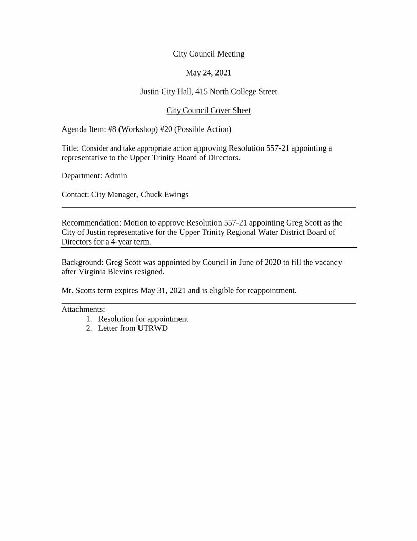
City Council Meeting
May 24, 2021
Justin City Hall, 415 North College Street
City Council Cover Sheet
Agenda Item: #8 (Workshop) #20 (Possible Action) Title: Consider and take appropriate action approving Resolution 557-21 appointing a representative to the Upper Trinity Board of Directors. Department: Admin Contact: City Manager, Chuck Ewings ________________________________________________________________________ Recommendation: Motion to approve Resolution 557-21 appointing Greg Scott as the City of Justin representative for the Upper Trinity Regional Water District Board of Directors for a 4-year term. Background: Greg Scott was appointed by Council in June of 2020 to fill the vacancy after Virginia Blevins resigned. Mr. Scotts term expires May 31, 2021 and is eligible for reappointment. ________________________________________________________________________ Attachments:
1. Resolution for appointment 2. Letter from UTRWD
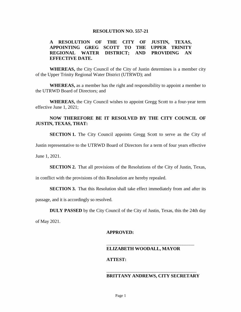
Page 1
RESOLUTION NO. 557-21
A RESOLUTION OF THE CITY OF JUSTIN, TEXAS, APPOINTING GREG SCOTT TO THE UPPER TRINITY REGIONAL WATER DISTRICT; AND PROVIDING AN EFFECTIVE DATE.
WHEREAS, the City Council of the City of Justin determines is a member city of the Upper Trinity Regional Water District (UTRWD); and WHEREAS, as a member has the right and responsibility to appoint a member to the UTRWD Board of Directors; and WHEREAS, the City Council wishes to appoint Gregg Scott to a four-year term effective June 1, 2021; NOW THEREFORE BE IT RESOLVED BY THE CITY COUNCIL OF JUSTIN, TEXAS, THAT: SECTION 1. The City Council appoints Gregg Scott to serve as the City of
Justin representative to the UTRWD Board of Directors for a term of four years effective
June 1, 2021.
SECTION 2. That all provisions of the Resolutions of the City of Justin, Texas,
in conflict with the provisions of this Resolution are hereby repealed.
SECTION 3. That this Resolution shall take effect immediately from and after its
passage, and it is accordingly so resolved.
DULY PASSED by the City Council of the City of Justin, Texas, this the 24th day
of May 2021.
APPROVED:
______________________________________ ELIZABETH WOODALL, MAYOR ATTEST: _______________________________________ BRITTANY ANDREWS, CITY SECRETARY

Page 2
APPROVED AS TO FORM: ___________________________________ CITY ATTORNEY
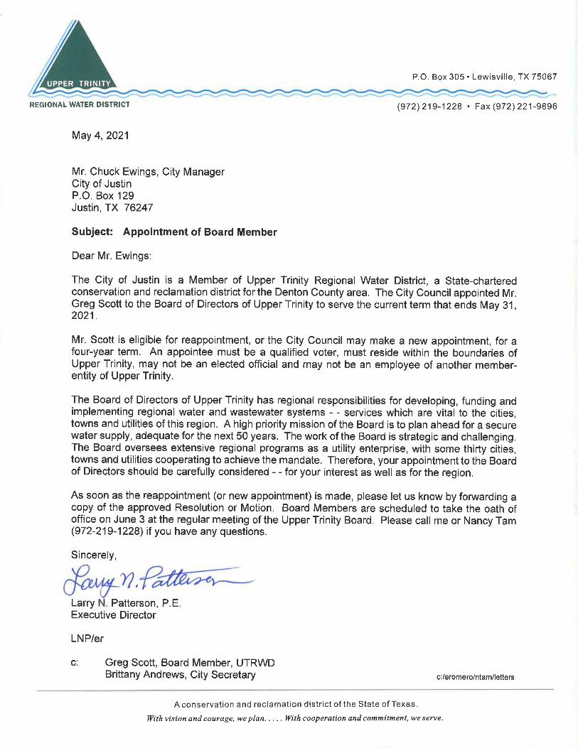
City Council Meeting
May 24, 2021
Justin City Hall, 415 North College Street
City Council Cover Sheet
Agenda Item: #9 (Workshop) #21 (Possible Action) Title: Consider and take appropriate action regarding audio, visual, and live stream upgrades for City meetings. Department: Administrative Contact: Abbey Reece, Director of Strategic Services Recommendation: No official contracts have been provided for you at this time. This item has been placed on the agenda to further the discussion. Background: Communication and live streaming of meetings has been expressed as a priority from city council. To further the discussion, we have included the responses we received from council members about their top priorities. Councilman Mounce: Full Interactive participation of Council and Staff regardless of location. End user can select option for full or partial data view. Automatic recording, and storage on City of Justin owned storage devices. Audio and video controls to manage sound and picture quality. Speaker on camera options. Audience management. Allow speech and picture on an attendee basis. Simple transition for public to Executive session, and access controls. Ability to allow attendees to easily give presentations, share pictures, play audio, etc. Being present in chambers or remote. Full interaction only available directly from City of Justin website. Ability to stream via other platforms. Compliance with current State and Federal open records requirements. Vendor commitment to continued compliance. Adaptable to changing locations and number of active attendees. Ability to have at least two (2} concurrent meetings. Track attendance. By user, start time, end time.
Councilwoman Hartle: Great Audio Video is important of entire council but don't feel that individual faces are needed. Able to be easily accessible after meeting. Live steaming Secure (no hackers) Councilman Mendoza Hardware: a) 12 Wired Microphones (Council, etc) b) 3 Wireless Microphones (for public comments) c) 1 Wide angle camera to cover Council Meetings d) 1 Camera with pan and optical zoom to focus on the Council (when talking) e) 1 Camera for the speaker addressing the council f) Mixer/receiver for cameras and microphones Software: a) Video format to edit and broadcast b) Scalable Storage (how long are we required to store) c) Broadcast to City Website d) City website to include 'share' buttons for social media e) City Website to provide a searchable option (video and/or minutes, transcripts?) The council requested a more “apples to apples” comparison of live streaming companies; however, it has been made clear that the two leading companies (Swagit and Granicus) have different pros and cons. SWAGIT is the one of its kind in that it offers hands free livestreaming from their support staff, data integration, and hardware upgrades all in one. Their proposal gives a breakdown of the basic and pro package, along with the additional yearly associated costs. The one area that Swagit is unable to assist with is an agenda management software (agenda/packet preparation). Swagit would need to integrate an outside company such as: Granicus, CivicPlus, Municode, etc. to assist with the agenda/minute portion. Another aspect to note is they would be incorporating our existing audio equipment (mixer) for their installation. Examples: Northlake, Celina, Argyle, and Denton. GRANICUS is another company we have explored. They mostly known for their agenda management software, but not as much on the livestreaming portion. They do have a live streaming capability, but the hardware upgrades and logistics of changing camera angles and indexing for the meeting would be up to current staff. Maverick is working to get costs associated for new cameras/installation, along with their rate for running the system during meetings. Example: North Richland Hills

CIVICPLUS we have kept this add-on each feature as a third option due to the fact that there is not another company similar to Swagit or Granicus. They have a streaming option that does not include hardware upgrades or any type of agenda management software. City Attorney Review: N/A ________________________________________________________________________ Attachments:
1. Swagit Proposal 2. Granicus Proposal 3. CivicPlus Proposal
EXECUTIVE SUMMARY Company History and Information
Swagit Productions, LLC, founded in 2003, is a privately held company headquartered in Dallas, Texas.
Swagit is a progressive company that is pioneering the broadband multimedia communication service industry
by providing clients a hands-free approach to always being connected to end-users’ information needs. In
combining Swagit’s EASE™ and Avior™ HD solutions, clients are offered the most comprehensive hands-free
experience possible.
Swagit specializes in providing streaming media solutions to cities, counties,
states, school districts, and health providers. In addition, Swagit is a
complete video production entity, providing services such as post-
production, studio and recording booth sessions.
Swagit began with a mission to supply clients an affordable solution to
stream their own content in an overpriced, complicated, hands-on video
industry. From its beginnings as a company specializing in turnaround
streams for cities, counties, states and school districts, Swagit has grown
significantly and provides an open API which allows for integrations with all
major Agenda/Document Management and Voting Solutions. This lets our
clients choose the best Agenda/Voting Solution for their unique needs.
With Swagit’s EASE™ streaming video solution, clients are able to stream their public content live and on-
demand through the jurisdiction’s website. HTML5 compatibility makes getting to the content even easier and
more convenient as viewers are able to access all of the video content via their computers, smart phones or
tablets. Archived meetings are indexed and broken up into clips by agenda item for a superior end-user
experience.
Avior™ HD is Swagit’s hands-free broadcast solution: a complete package of 3+ HD cameras, professional video
switching equipment, and associated components that allows either Swagit’s video department to remotely
control the cameras or on-site camera control by government staff. When bundled with Swagit’s hands-free
EASE™ video streaming system, Avior™ HD can offer a full end-to-end hands-free broadcast solution that
requires no client staff involvement for operation of cameras and streaming of an event or meeting.
The Swagit network stretches across North America, ensuring fast connect times from the closest point-of-
presence (POP) to an end-user’s location. Swagit’s network is fully redundant, giving clients peace of mind and
keeping with the Swagit motto, “Always Connected.”
Points of Difference • Swagit’s EASE™ solution is completely hands-free and requires no staff time or resources
• Sound Search™ allows residents to search for the spoken word in a meeting which is synced to video
• Swagit’s open API allows integrations with agenda management solutions
• Swagit is the only government streaming provider that has developed its own content delivery network, ensuring quick and reliable connections for your constituents
• Unlimited storage for Specialty Content and Meetings
• Swagit’s unique hands-free solutions typically qualify as a sole-source purchase, allowing for quick deployments
PROPOSAL
Justin, TX| April 28, 2021
2
© 2021 Swagit Productions, LLC • 12801 N. Central Expressway, Suite 900 • Dallas, TX 75243 469-913-9747 • 800-573-3160 • swagit.com
SWAGIT PRODUCTIONS, LLC PROPRIETARY AND CONFIDENTIAL. INTENDED FOR INTERNAL USE ONLY. DO NOT DISTRIBUTE WITHOUT WRITTEN PERMISSION.
OVERVIEW OF PROPOSED SOLUTION
EASE™ Hands-Free Streaming
Swagit's Extensible Automated Streaming Engine (EASE™) solution meets all
current and future needs for government without creating additional work for staff. EASE™ is a hands-free tool that eliminates the need for client staff members to index, edit, or time-stamp their video content. Each EASE™ package includes on-demand archiving, a 24/7 live stream via internet and PEG, streaming to mobile devices, and up to 120 hours of additional generic specialty content each year. If live streaming is not applicable, clients can upload media via FTP.
Avior™ HD Broadcast System
Swagit’s Avior™ HD Broadcast System is a complete package of high-definition
PTZ (Pan, Tilt, and Zoom) cameras, professional video-switching equipment, and associated components, that enables any client to fully outsource the operation and production of a multi-camera broadcast for public meetings. Avior™ also offers video graphics/titles overlay and Real Time Captioning support.
EASE™ HD/SDI Premium Captioning Encoder with SDI CC Encoding Unit
Swagit’s EASE™ HD/SDI Premium Captioning Encoder is a high definition
and/or standard definition (HD-SDI) encoding unit for video plus captioning. The package includes:
• Web-based multi-encoder management and closed captioning support
• Web Based caption GUI
• EASE ™ HD-SDI Remote Video Indexing Kit (includes Scheduler)
• HD/SD Encoding/Transcoding Software - server or cloud deployable encoding/transcoding software
• HD/SD Baseband or IP Encode/Transcode single-channel license (enables encoding/transcoding of 1 HD/SD channel)
• SDI CC Encoding Unit (to provide audio captions over IP, for real-time captioning service)
Closed Captioning Live Automated Transcribing is intelligent assisted real-time speech-to-text
automation for captioning. Swagit’s Caption Sync service works in conjunction with Live Automated Captioning; Swagit cleans up existing transcripts and synchronizes them with meeting video for on-demand viewing.
Social Media eXstream Social Media eXstream connects meetings and events with live social platforms
such as Facebook Live and YouTube Live. Jurisdictions can instantly live-stream local events to followers and engage with viewers in real time with Swagit’s Social Media eXstream Package.
Sound Search™ Sound Search™ is an innovative product which improves the search for specific
content in archived videos. A positive search hit for a spoken word or phrase will take the viewer to the exact location that it was spoken within a meeting video.
Note: Some features listed in this document may be system options
or may require equipment not included in the provided pricing proposal.

PROPOSAL
Justin, TX| April 28, 2021
3
© 2021 Swagit Productions, LLC • 12801 N. Central Expressway, Suite 900 • Dallas, TX 75243 469-913-9747 • 800-573-3160 • swagit.com
SWAGIT PRODUCTIONS, LLC PROPRIETARY AND CONFIDENTIAL. INTENDED FOR INTERNAL USE ONLY. DO NOT DISTRIBUTE WITHOUT WRITTEN PERMISSION.
SERVICE
DESCRIPTIONS

PROPOSAL
Justin, TX| April 28, 2021
4
© 2021 Swagit Productions, LLC • 12801 N. Central Expressway, Suite 900 • Dallas, TX 75243 469-913-9747 • 800-573-3160 • swagit.com
SWAGIT PRODUCTIONS, LLC PROPRIETARY AND CONFIDENTIAL. INTENDED FOR INTERNAL USE ONLY. DO NOT DISTRIBUTE WITHOUT WRITTEN PERMISSION.
EASE™ Streaming Appliance Video Capture, Encoding, and Streaming
The Extensible Automated Streaming Engine (EASE™) is a software framework consisting of foundation and
extension modules that work together to automate many otherwise manually intensive tasks. This completely
hands-off solution meets the current and future needs of your entity without creating any additional work for
your clerks or webmasters.
▪ Video Capture and Encoding EASE™ Streaming Appliance records content according to your broadcast schedule and transfers the
recorded audio/video to the Swagit Content Network via a secure Virtual Private Network (VPN)
connection, making it available for live and/or on-demand streaming.
▪ Indexing and Cross Linking Using your published meeting agendas as a guide, Swagit’s Managed Service Division (SMSD) indexes the
meetings without any work from the city. SMSD will annotate your content by adding jump-to points with
specific item headings, giving users the greatest flexibility to find the specific content they need. With
these jump-to points, users can step through video by searching for or clicking specific items.
▪ Agenda Management Integration If meeting packets or other related information is available online, SMSD will link them directly to the video
player for easy access.
Swagit’s EASE™ solution integrates with all major Document/Agenda Management solutions.
▪ Archiving Client audio/video can be stored securely on the Swagit Content Network indefinitely. Fault tolerance and
high availability is assured through replication of audio/video content to multiple, geographically
redundant, Storage Area Networks (SAN). Our packages offer unlimited storage.
▪ Presentation By navigating through the video library, users can view a list of meetings chronologically and once in a
selected meeting you can unleash the power of the jump-to markers to search for specific points within
individual audio/video clips.
▪ Delivery In order to deliver on-demand content to end users in a format that is compatible with their computer’s
operating system, Swagit can deliver content in all major streaming video formats: Flash, Windows Media,
QuickTime, Real, and HTML5. Swagit is proud to support Flash as its default format, which has proven itself
as the format of choice from such vendors as YouTube, Google Video, ABC and NBC/Universal. With HTML5
streaming, Swagit provides content to mobile devices including iPhones, iPads and Android devices.

PROPOSAL
Justin, TX| April 28, 2021
5
© 2021 Swagit Productions, LLC • 12801 N. Central Expressway, Suite 900 • Dallas, TX 75243 469-913-9747 • 800-573-3160 • swagit.com
SWAGIT PRODUCTIONS, LLC PROPRIETARY AND CONFIDENTIAL. INTENDED FOR INTERNAL USE ONLY. DO NOT DISTRIBUTE WITHOUT WRITTEN PERMISSION.
▪ Monitoring Swagit is monitoring all aspects of the Swagit Content Network to ensure its health and availability. This
monitoring extends to cover remote Swagit EASE™ streaming appliances that are deployed on client
premises. In the rare event of trouble our engineers are promptly notified so that they may dispatch a swift
response in accordance with our support
procedures.
▪ Statistics Swagit collates log files from our streaming
servers monthly and processes them with the
industry recognized Google Analytics. Google
Analytics generates reports ranging from high-
level, executive overviews to in depth quality
of service statistics. These reports help to
highlight growth trends and identify popular
content.
▪ Support Beyond our proactive monitoring and
response, Swagit offers ongoing, 24/7
technical support for any issues our clients
may encounter. While our choice of quality
hardware vendors and a thorough pre-
installation testing phase go a long way
toward ensuring trouble-free operation of our
EASE™ streaming appliances, we do recognize that occasionally unforeseen issues arise. In the event that
our engineers detect a fault, they will work to diagnose the issue. If necessary, next business day
replacement of parts will be completed. Swagit offers continual software updates and feature
enhancements to our services and products for the life of your managed services contract.

PROPOSAL
Justin, TX| April 28, 2021
6
© 2021 Swagit Productions, LLC • 12801 N. Central Expressway, Suite 900 • Dallas, TX 75243 469-913-9747 • 800-573-3160 • swagit.com
SWAGIT PRODUCTIONS, LLC PROPRIETARY AND CONFIDENTIAL. INTENDED FOR INTERNAL USE ONLY. DO NOT DISTRIBUTE WITHOUT WRITTEN PERMISSION.
Avior™ Hands-Free Broadcast System HD Video Capture, Encoding, Broadcast, and Streaming System
Built on years of industry experience and developed to address
the growing transparency needs of government, Swagit’s Avior™
HD Broadcast System is a complete package of HD PTZ (Pan, Tilt,
and Zoom) cameras, professional video-switching equipment, and
associated components, that enable any client to fully outsource
the operation and production of a multi-camera broadcast for
public meetings.
Avior™ HD cameras are installed by Swagit personnel in one or
multiple positions within a meeting room. As a meeting is being
recorded, Swagit’s video department controls the Avior™ system
from their Dallas, Texas headquarters — switching between
cameras (for views of the podium, presentation slides, and dais),
while also directing and controlling those cameras through
selective panning, close-ups, and wide shots. The Avior™ HD
broadcast-quality robotic cameras are able to tilt and pan through wide angles of motion and can zoom through
large ranges.
Avior™ enables detailed direct camera positioning (pan, tilt, zoom, focus, and more), preset-positions, and video
settings (white balance, backlight, brightness) for the robotic cameras. Additionally, Avior™ communicates with
the switcher to allow direct operation of the 'wipe' function from the camera control GUI. With this powerful
package you or Swagit can control all your cameras individually and switch video sources on a video switcher
locally or remotely. Avior™ is an invaluable integration of camera-control with switcher operations for use with
live production setups like city chambers, churches, meeting rooms, and more.
Avior™ includes 3+ robotic (computer-controllable pan/tilt/zoom) cameras. These popular robotic cameras have
excellent video quality and performance, with the ability for panning through wide angles of motion, tilting
through large ranges with superb optical zoom, and dual video output of Y/C and composite. They also support
both RS232 and RS422 (long distance over 1000 meters) control signals. In addition, the cameras can be
mounted either “up” or “hanging upside down” for your convenience (they have built-in reversal of the picture
and left/right/up/down motion controls).
Avior™ HD is a remotely operated one-of-a-kind hands-free transparency suite that will save your jurisdiction
time and money. When bundled with Swagit’s hands-free EASE™ video streaming system, Avior™ can offer a full
end-to-end hands-free broadcast solution that requires no client staff involvement for operation of cameras
and/or streaming of an event or meeting.
• Fully automated • Free software updates
• 3+ HD camera solution • Can be used locally when/if applicable
• Hands-free broadcast system • Typically Integrates with existing A/V equipment
• Video graphics/titles overlay • Small footprint — equipment is self-contained on its own rack

PROPOSAL
Justin, TX| April 28, 2021
7
© 2021 Swagit Productions, LLC • 12801 N. Central Expressway, Suite 900 • Dallas, TX 75243 469-913-9747 • 800-573-3160 • swagit.com
SWAGIT PRODUCTIONS, LLC PROPRIETARY AND CONFIDENTIAL. INTENDED FOR INTERNAL USE ONLY. DO NOT DISTRIBUTE WITHOUT WRITTEN PERMISSION.
Avior™ Broadcast System Diagram
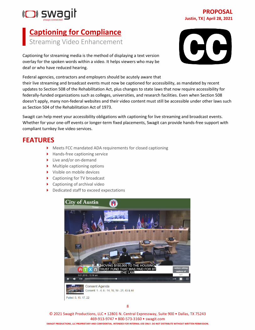
PROPOSAL
Justin, TX| April 28, 2021
8
© 2021 Swagit Productions, LLC • 12801 N. Central Expressway, Suite 900 • Dallas, TX 75243 469-913-9747 • 800-573-3160 • swagit.com
SWAGIT PRODUCTIONS, LLC PROPRIETARY AND CONFIDENTIAL. INTENDED FOR INTERNAL USE ONLY. DO NOT DISTRIBUTE WITHOUT WRITTEN PERMISSION.
Captioning for Compliance Streaming Video Enhancement
Captioning for streaming media is the method of displaying a text version
overlay for the spoken words within a video. It helps viewers who may be
deaf or who have reduced hearing.
Federal agencies, contractors and employers should be acutely aware that
their live streaming and broadcast events must now be captioned for accessibility, as mandated by recent
updates to Section 508 of the Rehabilitation Act, plus changes to state laws that now require accessibility for
federally-funded organizations such as colleges, universities, and research facilities. Even when Section 508
doesn’t apply, many non-federal websites and their video content must still be accessible under other laws such
as Section 504 of the Rehabilitation Act of 1973.
Swagit can help meet your accessibility obligations with captioning for live streaming and broadcast events.
Whether for your one-off events or longer-term fixed placements, Swagit can provide hands-free support with
compliant turnkey live video services.
FEATURES Meets FCC mandated ADA requirements for closed captioning
Hands-free captioning service
Live and/or on-demand
Multiple captioning options
Visible on mobile devices
Captioning for TV broadcast
Captioning of archival video
Dedicated staff to exceed expectations
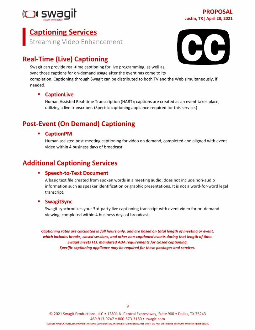
PROPOSAL
Justin, TX| April 28, 2021
9
© 2021 Swagit Productions, LLC • 12801 N. Central Expressway, Suite 900 • Dallas, TX 75243 469-913-9747 • 800-573-3160 • swagit.com
SWAGIT PRODUCTIONS, LLC PROPRIETARY AND CONFIDENTIAL. INTENDED FOR INTERNAL USE ONLY. DO NOT DISTRIBUTE WITHOUT WRITTEN PERMISSION.
Captioning Services Streaming Video Enhancement
Real-Time (Live) Captioning Swagit can provide real-time captioning for live programming, as well as
sync those captions for on-demand usage after the event has come to its
completion. Captioning through Swagit can be distributed to both TV and the Web simultaneously, if
needed.
▪ CaptionLive Human Assisted Real-time Transcription (HART); captions are created as an event takes place,
utilizing a live transcriber. (Specific captioning appliance required for this service.)
Post-Event (On Demand) Captioning
▪ CaptionPM Human assisted post-meeting captioning for video on demand, completed and aligned with event
video within 4 business days of broadcast.
Additional Captioning Services
▪ Speech-to-Text Document A basic text file created from spoken words in a meeting audio; does not include non-audio
information such as speaker identification or graphic presentations. It is not a word-for-word legal
transcript.
▪ SwagitSync Swagit synchronizes your 3rd-party live captioning transcript with event video for on-demand
viewing; completed within 4 business days of broadcast.
Captioning rates are calculated in full hours only, and are based on total length of meeting or event,
which includes breaks, closed sessions, and other non-captioned events during that length of time.
Swagit meets FCC mandated ADA requirements for closed captioning.
Specific captioning appliance may be required for these packages and services.
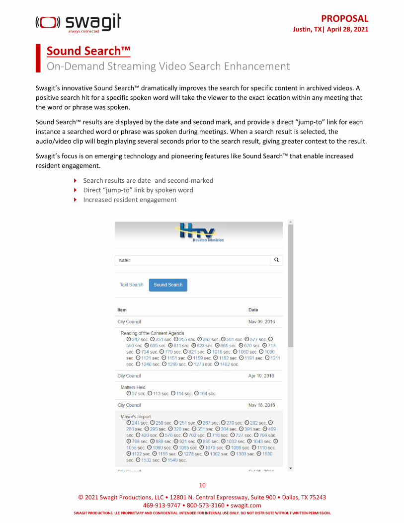
PROPOSAL
Justin, TX| April 28, 2021
10
© 2021 Swagit Productions, LLC • 12801 N. Central Expressway, Suite 900 • Dallas, TX 75243 469-913-9747 • 800-573-3160 • swagit.com
SWAGIT PRODUCTIONS, LLC PROPRIETARY AND CONFIDENTIAL. INTENDED FOR INTERNAL USE ONLY. DO NOT DISTRIBUTE WITHOUT WRITTEN PERMISSION.
Sound Search™ On-Demand Streaming Video Search Enhancement
Swagit’s innovative Sound Search™ dramatically improves the search for specific content in archived videos. A
positive search hit for a specific spoken word will take the viewer to the exact location within any meeting that
the word or phrase was spoken.
Sound Search™ results are displayed by the date and second mark, and provide a direct “jump-to” link for each
instance a searched word or phrase was spoken during meetings. When a search result is selected, the
audio/video clip will begin playing several seconds prior to the search result, giving greater context to the result.
Swagit’s focus is on emerging technology and pioneering features like Sound Search™ that enable increased
resident engagement.
Search results are date- and second-marked
Direct “jump-to” link by spoken word
Increased resident engagement

PROPOSAL
Justin, TX| April 28, 2021
11
© 2021 Swagit Productions, LLC • 12801 N. Central Expressway, Suite 900 • Dallas, TX 75243 469-913-9747 • 800-573-3160 • swagit.com
SWAGIT PRODUCTIONS, LLC PROPRIETARY AND CONFIDENTIAL. INTENDED FOR INTERNAL USE ONLY. DO NOT DISTRIBUTE WITHOUT WRITTEN PERMISSION.
Social Media eXstream Social Live Video Streaming
Instantly stream live your jurisdiction's local events to followers and engage with viewers in real time with Swagit's Social Media eXstream Package. Live streaming is the future growth of social media and has become a part of culture that government can easily use to reach more residents online. Users can watch live broadcasts, whether on a PC or mobile device, in a matter of seconds. Social Media eXstream connects your meetings and events with live social platforms such as Facebook Live and YouTube Live.
Live multi-destination streaming
Multi-bitrates
Affordable and simple
Additional resident accessibility to meetings and events
Expanded reach and audience growth
Increased distribution channels
Streaming to social media live platforms can immediately expand your audience and increase distribution
channels. For example, Facebook engages your viewers by sending a notification alert to your followers before
the stream begins. Residents can then easily connect, interact and follow your event in real time.
PSA Example: Veterans Day

PROPOSAL
Justin, TX| April 28, 2021
12
© 2021 Swagit Productions, LLC • 12801 N. Central Expressway, Suite 900 • Dallas, TX 75243 469-913-9747 • 800-573-3160 • swagit.com
SWAGIT PRODUCTIONS, LLC PROPRIETARY AND CONFIDENTIAL. INTENDED FOR INTERNAL USE ONLY. DO NOT DISTRIBUTE WITHOUT WRITTEN PERMISSION.
Implementation & Training
Once Swagit receives two signed original agreements, you’ll hear from Swagit’s team of deployment experts.
We’ll also send you a welcome packet, requesting basic information we’ll need to complete your installation
(such as your meeting schedule, contact info, IP information, and graphics for your video library/video player).
▪ Phase 1 - Hardware Provisioning/Development Hardware ordered (out of stock items may impact delivery)
Hardware assembled by Swagit engineers
Operating system installed and configured per installation
Swagit EASE™ streaming appliance software installed
System burn-in testing conducted under fail-test load
Hardware sign-off by Swagit
Welcome packet information (meeting schedule, IP info, etc.) returned to Swagit
▪ Phase 2 – Web Element Design Video library and player designed by Swagit in consultation with Client
Linking instructions provided to Client Webmaster/IT
Design sign-off by Client
▪ Phase 3 – Deployment/Implementation Assembled hardware shipped
Remote configuration and testing of audio/video feed quality by Swagit
Confirmation of correct video library linking and integration with Client’s website
Installation sign-off by Swagit
▪ Phase 4 - Acceptance Testing Dry run of meeting capture, indexing and encoding process using next available meeting rebroadcast,
alternate content or live meeting
Final signoff by Client and fulfillment of purchase order
▪ Deliverables Installation checklist
Configuration, testing and installation of Swagit EASE™ streaming appliance
Secure FTP account for pre-edited digital content
Customized video library
Customized video player
Monthly usage statistics
If your service package includes client-controlled indexing, Swagit will provide remote training to teach your
staff how to index meeting videos as well as how to include links to attachments. No additional training is
necessary; Swagit’s traditional services are hands-free.
PROPOSAL
Justin, TX| April 28, 2021
13
© 2021 Swagit Productions, LLC • 12801 N. Central Expressway, Suite 900 • Dallas, TX 75243 469-913-9747 • 800-573-3160 • swagit.com
SWAGIT PRODUCTIONS, LLC PROPRIETARY AND CONFIDENTIAL. INTENDED FOR INTERNAL USE ONLY. DO NOT DISTRIBUTE WITHOUT WRITTEN PERMISSION.
REFERENCES
City of Austin, Texas 301 W. 2nd., Austin TX 78701 Live Site: http://www.austintexas.gov/page/atxn-video-archive
City of Miami Beach, Florida 1700 Convention Center Dr., Miami Beach FL 33139 Live Site: http://web.miamibeachfl.gov/mbtv77/
Sandoval County, New Mexico 711 Camino Del Pueblo, Bernalillo NM 87004 Live Site: http://www.sandovalcountynm.gov/commission/sandoval-county-meeting-videos/
Brea, California 1 Civic Center Circle, Brea CA 92821 Live Site: http://www.ci.brea.ca.us/812/Government-Access-Channel
City of Elliot Lake, Ontario 45 Hillside Drive North, Elliot Lake ON P5A 1X5 Live Site: http://www.cityofelliotlake.com/en/cityhall/CouncilWebcasts.asp
ATTACHMENTS
• Sole Source Letter for Consideration Upon Request
• Swagit Solutions can also be purchased on both state and national contracts (i.e. TIPS, DIR, U.S. Communities Contract)
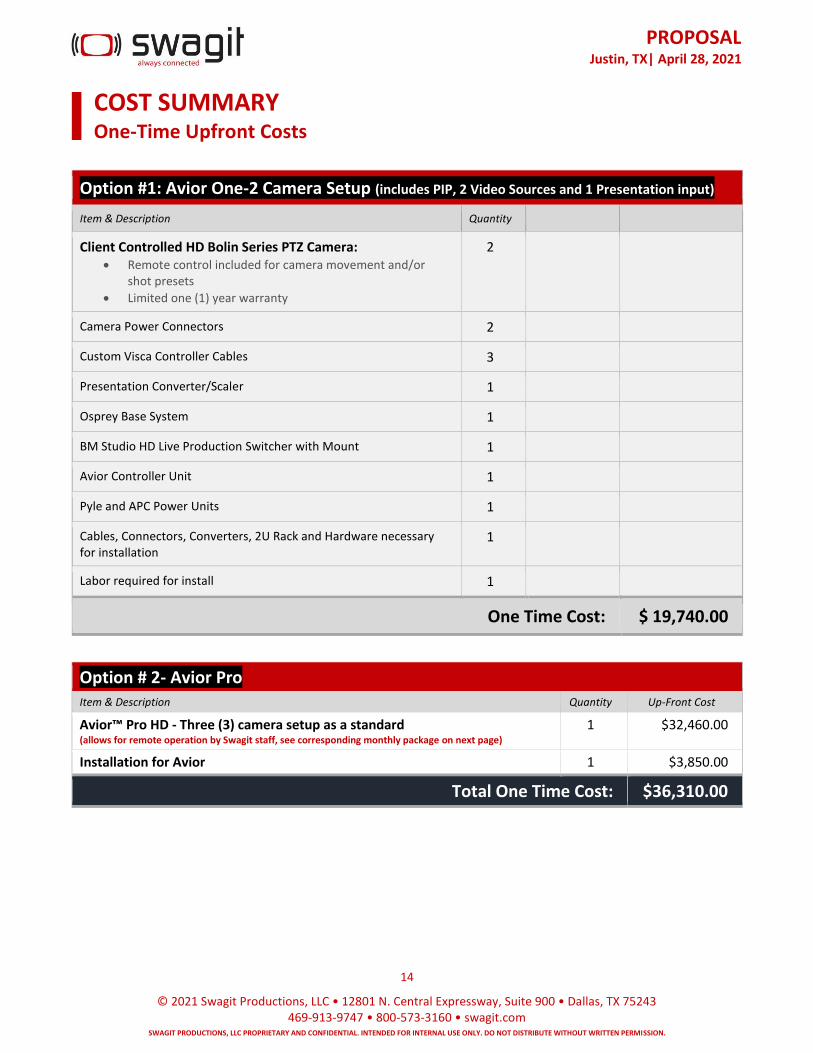
PROPOSAL
Justin, TX| April 28, 2021
14
© 2021 Swagit Productions, LLC • 12801 N. Central Expressway, Suite 900 • Dallas, TX 75243 469-913-9747 • 800-573-3160 • swagit.com
SWAGIT PRODUCTIONS, LLC PROPRIETARY AND CONFIDENTIAL. INTENDED FOR INTERNAL USE ONLY. DO NOT DISTRIBUTE WITHOUT WRITTEN PERMISSION.
COST SUMMARY One-Time Upfront Costs
Option #1: Avior One-2 Camera Setup (includes PIP, 2 Video Sources and 1 Presentation input)
Item & Description Quantity
Client Controlled HD Bolin Series PTZ Camera: • Remote control included for camera movement and/or
shot presets
• Limited one (1) year warranty
2
Camera Power Connectors 2
Custom Visca Controller Cables 3
Presentation Converter/Scaler 1
Osprey Base System 1
BM Studio HD Live Production Switcher with Mount 1
Avior Controller Unit 1
Pyle and APC Power Units 1
Cables, Connectors, Converters, 2U Rack and Hardware necessary for installation
1
Labor required for install 1
One Time Cost: $ 19,740.00
Option # 2- Avior Pro Item & Description Quantity Up-Front Cost
Avior™ Pro HD - Three (3) camera setup as a standard (allows for remote operation by Swagit staff, see corresponding monthly package on next page)
1 $32,460.00
Installation for Avior 1 $3,850.00
Total One Time Cost: $36,310.00
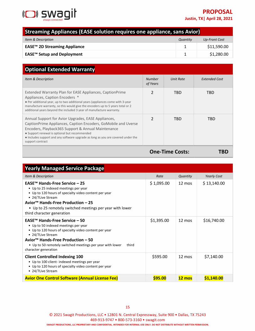
PROPOSAL
Justin, TX| April 28, 2021
15
© 2021 Swagit Productions, LLC • 12801 N. Central Expressway, Suite 900 • Dallas, TX 75243 469-913-9747 • 800-573-3160 • swagit.com
SWAGIT PRODUCTIONS, LLC PROPRIETARY AND CONFIDENTIAL. INTENDED FOR INTERNAL USE ONLY. DO NOT DISTRIBUTE WITHOUT WRITTEN PERMISSION.
Streaming Appliances (EASE solution requires one appliance, sans Avior) Item & Description Quantity Up-Front Cost
EASE™ 2D Streaming Appliance 1 $11,590.00
EASE™ Setup and Deployment 1 $1,280.00
Optional Extended Warranty
Item & Description Number of Years
Unit Rate Extended Cost
Extended Warranty Plan for EASE Appliances, CaptionPrime Appliances, Caption Encoders * ● Per additional year, up to two additional years (appliances come with 3-year manufacture warranty, so this would give the encoders up to 5 years total or 2 additional years beyond the included 3 year of manufacture warranty.
2 TBD TBD
Annual Support for Avior Upgrades, EASE Appliances, CaptionPrime Appliances, Caption Encoders, GoMobile and Uverse Encoders, Playback365 Support & Annual Maintenance ● Support renewal is optional but recommended ● Includes support and any software upgrade as long as you are covered under the support contract
2 TBD TBD
One-Time Costs: TBD
Yearly Managed Service Package Item & Description Rate Quantity Yearly Cost
EASE™ Hands-Free Service – 25 • Up to 25 indexed meetings per year • Up to 120 hours of specialty video content per year • 24/7Live Stream
Avior™ Hands-Free Production – 25 • Up to 25 remotely switched meetings per year with lower third character generation
$ 1,095.00 12 mos $ 13,140.00
EASE™ Hands-Free Service – 50 • Up to 50 indexed meetings per year • Up to 120 hours of specialty video content per year • 24/7Live Stream
Avior™ Hands-Free Production – 50 • Up to 50 remotely switched meetings per year with lower third character generation
$1,395.00 12 mos $16,740.00
Client Controlled Indexing 100 • Up to 100 client- indexed meetings per year • Up to 120 hours of specialty video content per year • 24/7Live Stream
$595.00 12 mos $7,140.00
Avior One Control Software (Annual License Fee) $95.00 12 mos $1,140.00
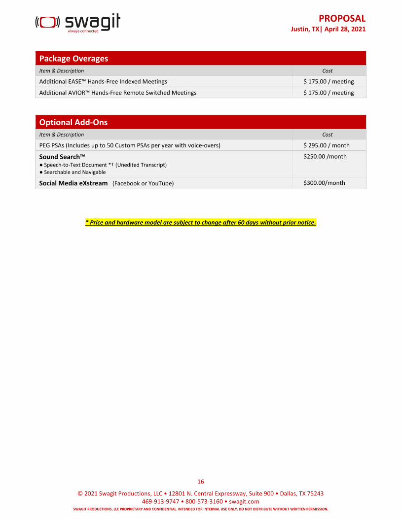
PROPOSALJustin, TX| April 28, 2021
16
© 2021 Swagit Productions, LLC • 12801 N. Central Expressway, Suite 900 • Dallas, TX 75243 469-913-9747 • 800-573-3160 • swagit.com
SWAGIT PRODUCTIONS, LLC PROPRIETARY AND CONFIDENTIAL. INTENDED FOR INTERNAL USE ONLY. DO NOT DISTRIBUTE WITHOUT WRITTEN PERMISSION.
Package Overages Item & Description Cost
Additional EASE™ Hands-Free Indexed Meetings $ 175.00 / meeting
Additional AVIOR™ Hands-Free Remote Switched Meetings $ 175.00 / meeting
Optional Add-Ons Item & Description Cost
PEG PSAs (Includes up to 50 Custom PSAs per year with voice-overs) $ 295.00 / month
Sound Search™ ● Speech-to-Text Document *† (Unedited Transcript)● Searchable and Navigable
$250.00 /month
Social Media eXstream (Facebook or YouTube) $300.00/month
* Price and hardware model are subject to change after 60 days without prior notice.
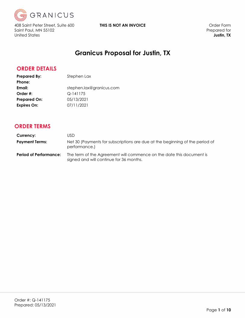
408 Saint Peter Street, Suite 600 THIS IS NOT AN INVOICE Order FormSaint Paul, MN 55102 Prepared forUnited States Justin, TX
Order #: Q-141175Prepared: 05/13/2021
Page 1 of 10
Granicus Proposal for Justin, TX
ORDER DETAILSPrepared By: Stephen LaxPhone:Email: [email protected] #: Q-141175Prepared On: 05/13/2021Expires On: 07/11/2021
Currency: USDPayment Terms: Net 30 (Payments for subscriptions are due at the beginning of the period of
performance.)
Period of Performance: The term of the Agreement will commence on the date this document is signed and will continue for 36 months.
ORDER TERMS

Order FormJustin, TX
Order #: Q-141175Prepared: 05/13/2021
Page 2 of 10
PRICING SUMMARYThe pricing and terms within this Proposal are specific to the products and volumes contained within thisProposal.
One-Time Fees
Solution Billing Frequency Quantity/Unit One-Time Fee
Meeting Efficiency - Setup & Configuration (Standard) Up Front 1 Each $900.00
Minutes - Online Training Upon Delivery 6 Hours $1,350.00
Government Transparency - Setup & Configuration Up Front 1 Each $0.00
Granicus Encoding Appliance Hardware - SDI (AMAX) (GT) Upon Delivery 1 Each $3,500.00
Granicus Video - Online Training Upon Delivery 6 Hours $0.00
Peak - Setup & Configuration Up Front 1 Each $0.00
Peak Online Group Training Upon Delivery 8 Hours $0.00
Open Platform - Setup and Configuration Up Front 1 Hours $0.00
Granicus Encoding Appliance Hardware - Setup & Config Upon Delivery 1 Each $0.00
Granicus Encoding Appliance Hardware - Setup & Config Upon Delivery 1 Each $875.00
US Shipping Charge C - Large Item Upon Delivery 1 Each $125.00
Open Platform - Setup and Configuration Up Front 1 Hours $0.00
Send Agenda (Peak) Set up and Config Up Front 1 Each $0.00
govDelivery for Integrations Set Up and Config Up Front 1 Each $0.00
SUBTOTAL: $6,750.00

Order FormJustin, TX
Order #: Q-141175Prepared: 05/13/2021
Page 3 of 10
New Subscription Fees
Solution Billing Frequency Quantity/Unit Annual Fee
Meeting Efficiency SuiteAnnual 1 Each $0.00
Government Transparency SuiteAnnual 1 Each $2,568.00
Peak Agenda ManagementAnnual 1 Each $3,300.00
Open Platform SuiteAnnual 1 Each $0.00
Upgrade to SDI 720p StreamingAnnual 1 Each $600.00
Open Platform SuiteAnnual 1 Each $0.00
Send Agenda (Peak)Annual 1 Each $0.00
Granicus Encoding Appliance Software (GT) Annual 1 Each $1,200.00
govDelivery for IntegrationsAnnual 1 Each $0.00
SUBTOTAL: $7,668.00
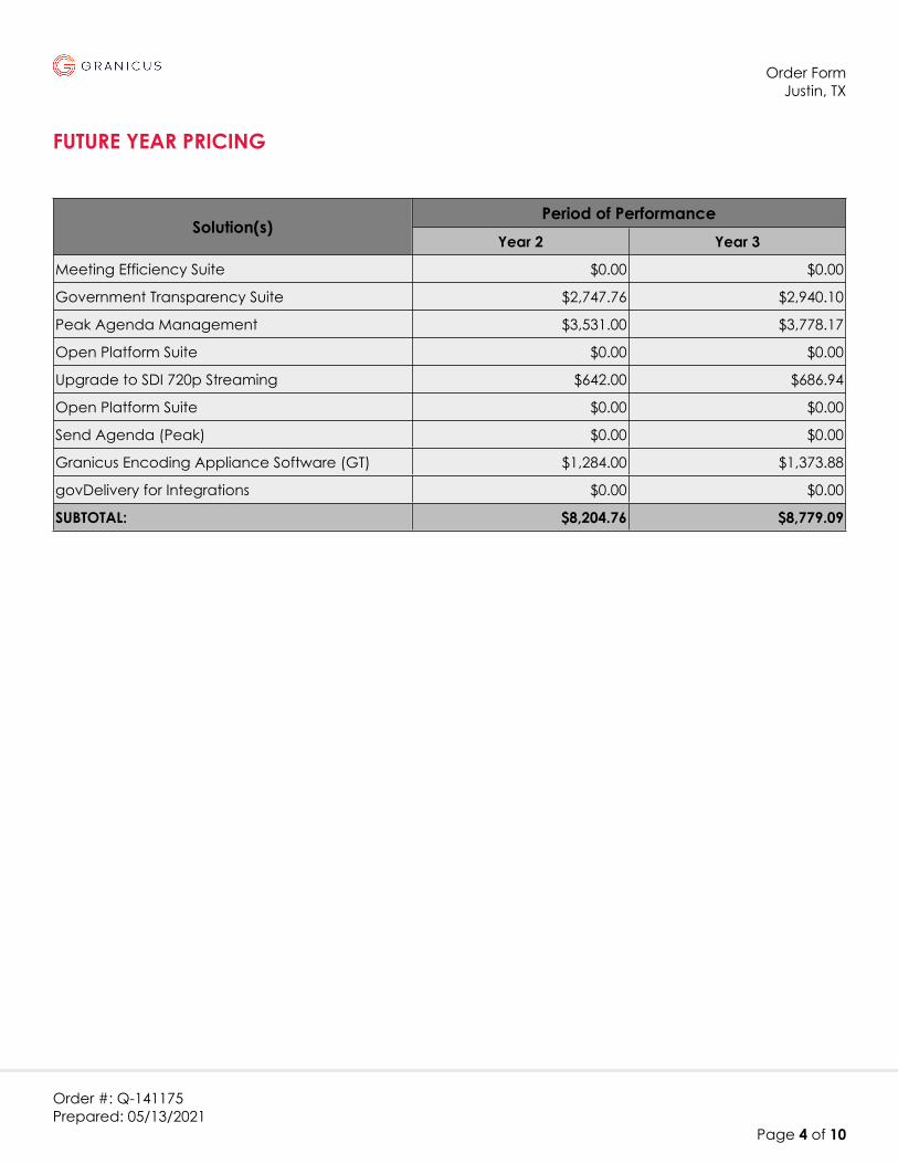
Order FormJustin, TX
Order #: Q-141175Prepared: 05/13/2021
Page 4 of 10
FUTURE YEAR PRICING
Period of PerformanceSolution(s)
Year 2 Year 3
Meeting Efficiency Suite $0.00 $0.00
Government Transparency Suite $2,747.76 $2,940.10
Peak Agenda Management $3,531.00 $3,778.17
Open Platform Suite $0.00 $0.00
Upgrade to SDI 720p Streaming $642.00 $686.94
Open Platform Suite $0.00 $0.00
Send Agenda (Peak) $0.00 $0.00
Granicus Encoding Appliance Software (GT) $1,284.00 $1,373.88
govDelivery for Integrations $0.00 $0.00
SUBTOTAL: $8,204.76 $8,779.09

Order FormJustin, TX
Order #: Q-141175Prepared: 05/13/2021
Page 5 of 10
PRODUCT DESCRIPTIONS
Solution Description
Meeting Efficiency Suite Meeting Efficiency is a hybrid Software-as-a-Service (SaaS) and Hardware-as-a-Service (HaaS) solution that enables government organizations to simplify the in-meeting management and post-meeting minutes creation processes of the clerk’s office. By leveraging this solution, the client will be able to streamline meeting data capture and minutes production, reducing staff efforts and decreasing time to get minutes published. During a meeting, use LiveManager to record roll calls, motions, votes, notes, and speakers, all indexed with video. Use the index points to quickly edit minutes, templates to format in Microsoft Word, and publish online with the click of a button. Meeting Efficiency includes:
• Unlimited user accounts
• Unlimited meeting bodies
• Unlimited storage of minutes documents
• Access to the LiveManager software application for recordinginformation during meetings
• Access to the Word Add-in software component for minutesformatting in MS Word if desired
• Up to one (1) MS Word minutes template (additional templates canbe purchased if needed)
Government Transparency Suite
Government Transparency are the live in-meeting functions. Streaming of an event, pushing of documents, and indexing of events.
Peak Agenda Management Peak Agenda Management is a Software-as-a-Service (SaaS) solution that enables government organizations to simplify the agenda management and minutes recording process of the clerk’s office. Peak Agenda Management allows clerks to streamline the way they compile and produce agendas and record minutes for public meetings and includes:
• Unlimited user accounts
• Unlimited meeting bodies and meeting types
• Access to up to one (1) Peak Agenda Management site
Order FormJustin, TX
Order #: Q-141175Prepared: 05/13/2021
Page 6 of 10
Solution Description
Meeting Efficiency - Setup & Configuration (Standard)
Setup and Configuration for Meeting Efficiency Suite includes implementation of:
• Up to one (1) client Installation of Minutes Maker (compatible clienthardware required for software)
• Up to one (1) Minutes report
Minutes - Online Training online training for Minutes, which allows clients to have online sessions with a Granicus trainer to show clerks how to take minutes during a meeting and how to edit and publish them after a meeting.
Open Platform Suite Open Platform is access to MediaManager, upload of archives, ability to post agendas/documents, and index of archives. These are able to be published and accessible through a searchable viewpage.
Government Transparency - Setup & Configuration
Setup and Configuration for Government Transparency Suite includes implementation of:
• Up to one (1) View Page and Player template
• Up to one (1) Live Manager configuration
Upgrade to SDI 720p Streaming Upgrade to SDI 720p Streaming (requires Digital encoder and HD feed)
Granicus Encoding Appliance Hardware - SDI (AMAX) (GT)
AMAX Encoder with Osprey SDI Card. Used to pass commands and data from LiveManager that include Start/Stop of webcast, indexing, and document display. Also serves to distribute video and captions to be distributed to the CDN or Performance Accelerator.
Granicus Video - Online Training Granicus Video - Online Training
Open Platform Suite Open Platform is access to MediaManager, upload of archives, ability to post agendas/documents, and index of archives. These are able to be published and accessible through a searchable viewpage.
Send Agenda (Peak) Send Agenda is dependent on an active subscription to the relevant govMeetings agenda.
Peak - Setup & Configuration Setup and Configuration for Peak Agenda Management includes implementation of:
• Up to one (1) meeting body’s Standard Agenda, Cover Page andMinutes report template
• Up to one (1) public view page portal
Order FormJustin, TX
Order #: Q-141175Prepared: 05/13/2021
Page 7 of 10
Solution Description
Peak Online Group Training Peak Agenda Management - Online Group Training is for Group training of Peak Agenda Management, which allows clients to have up to six (6) users participate in online Group sessions with a Granicus trainer and other client users, to learn how to use the system.
Open Platform - Setup and Configuration
Setup and configuration for Open Platform
Granicus Encoding Appliance Hardware - Setup & Config
Remote configuration and deployment of an encoding appliance.
Granicus Encoding Appliance Software (GT)
Granicus Encoding Appliance Software (GT) This includes the LiveManager Software solution where webcasts are started/stopped, agendas amended and indexed, votes and attendance recorded, and minutes created.
Granicus Encoding Appliance Hardware - Setup & Config
Remote configuration and deployment of an encoding appliance.
US Shipping Charge C - Large Item
US shipping of a large item
Open Platform - Setup and Configuration
Setup and configuration for Open Platform
govDelivery for Integrations Send notification bulletins directly to constituents who subscribe to receive updates directly through Granicus (powered by govDelivery). Recieve a monthly metrics report delivered via email to show subscriber growth and engagement activity for the past month of bulletin sends, and grow subscribers through access to the Granicus Advanced Network.
Note: govDelivery intergrations is dependent on an active subscription to the relevant govMeetings agenda or govAccess CMS solutions.
GRANICUS ADVANCED NETWORK AND SUBSCRIBER INFORMATION
• Granicus Communications Suite Subscriber Information. o Data provided by the Client and contact information gathered through the Client's own web
properties or activities will remain the property of the Client ('Direct Subscriber'), including any and all personally identifiable information (PII). Granicus will not release the data without the express written permission of the Client, unless required by law.
o Granicus shall: (i) not disclose the Client's data except to any third parties as necessary to operate the Granicus Products and Services (provided that the Client hereby grants to Granicus a perpetual, non-cancelable, worldwide, non-exclusive license to utilize any data, on
Order FormJustin, TX
Order #: Q-141175Prepared: 05/13/2021
Page 8 of 10
an anonymous or aggregate basis only, that arises from the use of the Granicus Products by the Client, whether disclosed on, subsequent to, or prior to the Effective Date, to improve the functionality of the Granicus Products and any other legitimate business purpose, including the right to sublicense such data to third parties, subject to all legal restrictions regarding the use and disclosure of such information).
• Data obtained through the Granicus Advanced Network.o Granicus offers a SaaS product, known as the Communications Cloud, that offers Direct
Subscribers recommendations to subscribe to other Granicus Client's digital communication (the 'Advanced Network'). When a Direct Subscriber signs up through one of the recommendations of the Advanced Network, that subscriber is a 'Network Subscriber' to the agency it subscribed to through the Advanced Network.
o Network Subscribers are available for use while the Client is under an active subscription with Granicus. Network Subscribers will not transfer to the Client upon termination of any Granicus Order, SOW, or Exhibit. The Client shall not use or transfer any of the Network Subscribers after termination of its Order, SOW, or Exhibit placed under this agreement. All information related to Network Subscribers must be destroyed by the Client within 15 calendar days of the Order, SOW, or Exhibit placed under this agreement terminating.
o Opt-In. During the last 10 calendar days of the Client's subscription, the Client may send an opt-in email to Network Subscribers that shall include an explanation of the Client's relationship with Granicus terminating and that the Network Subscribers may visit the Client's website to subscribe to further updates from the Client in the future. Any Network Subscriber that does not opt-in will not be transferred with the subscriber list provided to the Client upon termination.
Order FormJustin, TX
Order #: Q-141175Prepared: 05/13/2021
Page 9 of 10
TERMS & CONDITIONS• Link to Terms: https://granicus.com/pdfs/Master_Subscription_Agreement.pdf
• This quote is exclusive of applicable state, local, and federal taxes, which, if any, will be included in the invoice. It
is the responsibility of Justin, TX to provide applicable exemption certificate(s).
• Granicus certifies that it will not sell, retain, use, or disclose any personal information provided by Client for any
purpose other than the specific purpose of performing the services outlined within this Agreement.
• Any lapse in payment may result in suspension of service and will require the payment of a setup fee to reinstate
the subscription.
• Notwithstanding anything to the contrary, Granicus reserves the right to adjust pricing at any renewal in which
the volume has changed from the prior term without regard to the prior term's per-unit pricing.
• Granicus will provide a three (3) year warranty with respect to required hardware. Within the three (3) year
warranty period, Granicus shall repair or replace any required hardware provided directly from Granicus that fails
to function properly due to normal wear and tear, defective workmanship, or defective materials.
Order FormJustin, TX
Order #: Q-141175Prepared: 05/13/2021
Page 10 of 10
BILLING INFORMATIONBilling Contact: Purchase Order
Required?[ ] - No[ ] - Yes
Billing Address: PO Number:If PO required
Billing Email: Billing Phone:
If submitting a Purchase Order, please include the following language: The pricing, terms, and conditions of quote Q-141175 dated 05/13/2021 are incorporated into this Purchase Order by reference and shall take precedence over any terms and conditions included in this Purchase Order.
AGREEMENT AND ACCEPTANCEBy signing this document, the undersigned certifies they have authority to enter the agreement. The undersigned also understands the services and terms.
Justin, TXSignature:
Name:
Title:
Date:
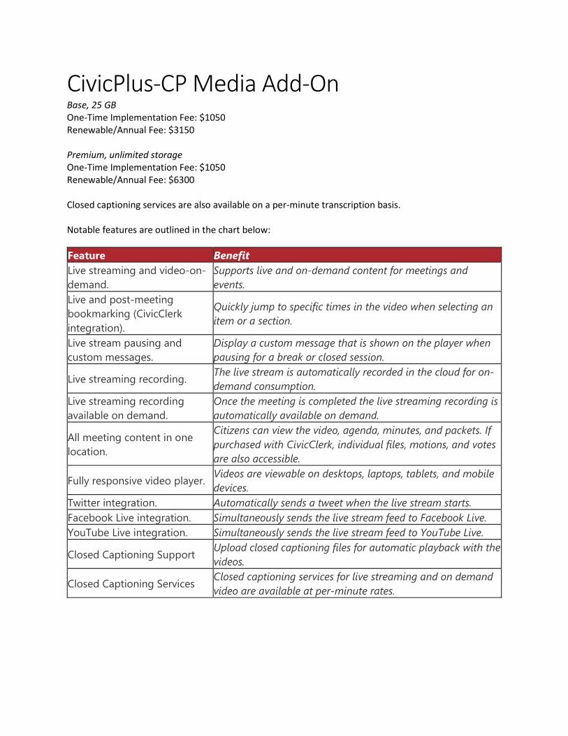
CivicPlus-CP Media Add-On Base, 25 GB One-Time Implementation Fee: $1050 Renewable/Annual Fee: $3150 Premium, unlimited storage One-Time Implementation Fee: $1050 Renewable/Annual Fee: $6300 Closed captioning services are also available on a per-minute transcription basis. Notable features are outlined in the chart below:
Feature Benefit Live streaming and video-on-demand.
Supports live and on-demand content for meetings and events.
Live and post-meeting bookmarking (CivicClerk integration).
Quickly jump to specific times in the video when selecting an item or a section.
Live stream pausing and custom messages.
Display a custom message that is shown on the player when pausing for a break or closed session.
Live streaming recording. The live stream is automatically recorded in the cloud for on-demand consumption.
Live streaming recording available on demand.
Once the meeting is completed the live streaming recording is automatically available on demand.
All meeting content in one location.
Citizens can view the video, agenda, minutes, and packets. If purchased with CivicClerk, individual files, motions, and votes are also accessible.
Fully responsive video player. Videos are viewable on desktops, laptops, tablets, and mobile devices.
Twitter integration. Automatically sends a tweet when the live stream starts. Facebook Live integration. Simultaneously sends the live stream feed to Facebook Live. YouTube Live integration. Simultaneously sends the live stream feed to YouTube Live.
Closed Captioning Support Upload closed captioning files for automatic playback with the videos.
Closed Captioning Services Closed captioning services for live streaming and on demand video are available at per-minute rates.

City Council Meeting
May 24, 2021
Justin City Hall, 415 North College Street
City Council Cover Sheet
Agenda Item: #10 (Workshop) #22 (Possible Action) Title: Consider and take appropriate action regarding Stop Sign and Yield Sign intersections in the City. Department: Administration Contact: Administration ________________________________________________________________________ Recommendation: Discussion to determine Council desire to move forward. ________________________________________________________________________ Background: This item was discussed at the May 10 meeting. Chief Coss will be giving a brief presentation regarding violations, accidents involving the intersections within Old Town. There are a number of signs that were passed by Ordinance to be Yield signs, and at some point in time, changed to Stop signs without updating the City Ordinance. Jennifer Butcher from Pacheco Koch advised of the potential safety concerns for changing out the already erected signs. The best process to determine whether to change them out, or leave them as is would be to go through the process of having a warrant study done and determine which signage and/or traffic signals would be acceptable in specific areas. The quote that was presented by staff at that time to complete the study was between $24,000-$35,000. Chris Cha advised that he did not feel the City needed that level of study completed and proposed other options. Sam Hawk with Boyle and Lowry recommended amending the Ordinance to reflect the current areas where Stop signs have been erected in place of the Yield sign. For the entire discussion related to this item, please click the link below and go to 2:08:37.

https://us02web.zoom.us/rec/share/khqJFB_j-c5rKWNS6GJo1rYEn14oSwQYiTusZ9v4Y7sYPrSzioJT5xpL7bgHPaPL.K6G2mk9ElP10WtaD ________________________________________________________________________ City Attorney Review: YES ________________________________________________________________________ Attachments: 1.
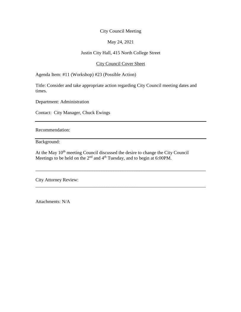
City Council Meeting
May 24, 2021
Justin City Hall, 415 North College Street
City Council Cover Sheet
Agenda Item: #11 (Workshop) #23 (Possible Action) Title: Consider and take appropriate action regarding City Council meeting dates and times. Department: Administration Contact: City Manager, Chuck Ewings Recommendation: Background: At the May 10th meeting Council discussed the desire to change the City Council Meetings to be held on the 2nd and 4th Tuesday, and to begin at 6:00PM. ________________________________________________________________________ City Attorney Review: ________________________________________________________________________ Attachments: N/A
City Council Meeting
May 24, 2021
Justin City Hall, 415 North College Street
City Council Cover Sheet
Agenda Item: #12 (Workshop) #24 (Possible Action) Title: Consider and take appropriate action to approve Resolution 558-21 denying Oncor Electric Delivery Company’s request to amend its Distribution Cost Recovery Factor. Department: Administration Contact: City Manager, Chuck Ewings Recommendation: Motion to approve the Resolution to deny Oncor’s request to amend its Distribution Cost Recovery Factor Background: On April 8, 2021, Oncor Electric Delivery Company LLC (“Oncor” or “Company”) filed an Application for Approval to Amend its Distribution Cost Recovery Factor (“DCRF”) to Increase Distribution Rates with each of the cities in their service area. In the filing, the Company asserts that it is seeking an increase in total distribution revenue requirement by approximately $97,826,277. The resolution authorizes the City to join with the Steering Committee of Cities Served by Oncor (“OCSC”) to evaluate the filing, determine whether the filing complies with law, and if lawful, to determine what further strategy, including settlement, to pursue. Ultimately, this gives cities an opportunity to review the application and ensure charges are appropriate with a goal to reduce the amount of rate increase customers may experience. ________________________________________________________________________ City Attorney Review: ________________________________________________________________________ Attachments: N/A
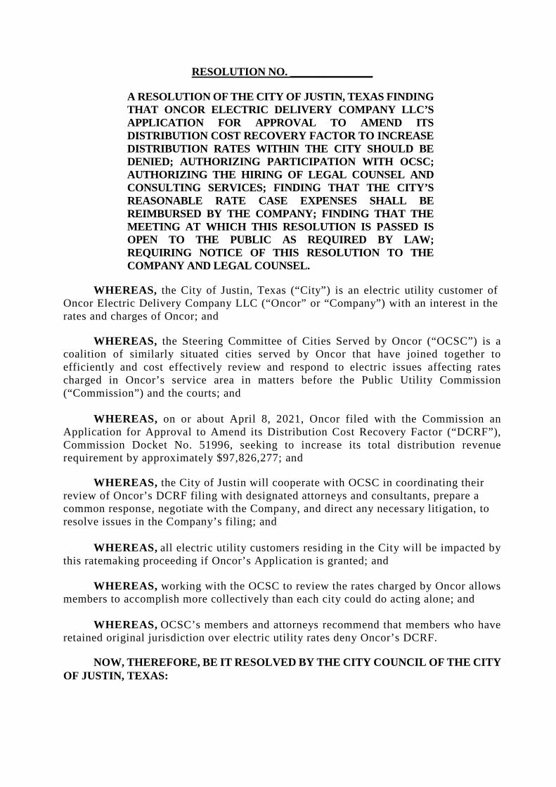
RESOLUTION NO. _______________
A RESOLUTION OF THE CITY OF JUSTIN, TEXAS FINDING THAT ONCOR ELECTRIC DELIVERY COMPANY LLC’S APPLICATION FOR APPROVAL TO AMEND ITS DISTRIBUTION COST RECOVERY FACTOR TO INCREASE DISTRIBUTION RATES WITHIN THE CITY SHOULD BE DENIED; AUTHORIZING PARTICIPATION WITH OCSC; AUTHORIZING THE HIRING OF LEGAL COUNSEL AND CONSULTING SERVICES; FINDING THAT THE CITY’S REASONABLE RATE CASE EXPENSES SHALL BE REIMBURSED BY THE COMPANY; FINDING THAT THE MEETING AT WHICH THIS RESOLUTION IS PASSED IS OPEN TO THE PUBLIC AS REQUIRED BY LAW; REQUIRING NOTICE OF THIS RESOLUTION TO THE COMPANY AND LEGAL COUNSEL.
WHEREAS, the City of Justin, Texas (“City”) is an electric utility customer of Oncor Electric Delivery Company LLC (“Oncor” or “Company”) with an interest in the rates and charges of Oncor; and
WHEREAS, the Steering Committee of Cities Served by Oncor (“OCSC”) is a coalition of similarly situated cities served by Oncor that have joined together to efficiently and cost effectively review and respond to electric issues affecting rates charged in Oncor’s service area in matters before the Public Utility Commission (“Commission”) and the courts; and
WHEREAS, on or about April 8, 2021, Oncor filed with the Commission an Application for Approval to Amend its Distribution Cost Recovery Factor (“DCRF”), Commission Docket No. 51996, seeking to increase its total distribution revenue requirement by approximately $97,826,277; and
WHEREAS, the City of Justin will cooperate with OCSC in coordinating their review of Oncor’s DCRF filing with designated attorneys and consultants, prepare a common response, negotiate with the Company, and direct any necessary litigation, to resolve issues in the Company’s filing; and
WHEREAS, all electric utility customers residing in the City will be impacted by this ratemaking proceeding if Oncor’s Application is granted; and
WHEREAS, working with the OCSC to review the rates charged by Oncor allows members to accomplish more collectively than each city could do acting alone; and
WHEREAS, OCSC’s members and attorneys recommend that members who have retained original jurisdiction over electric utility rates deny Oncor’s DCRF.
NOW, THEREFORE, BE IT RESOLVED BY THE CITY COUNCIL OF THE CITY OF JUSTIN, TEXAS:
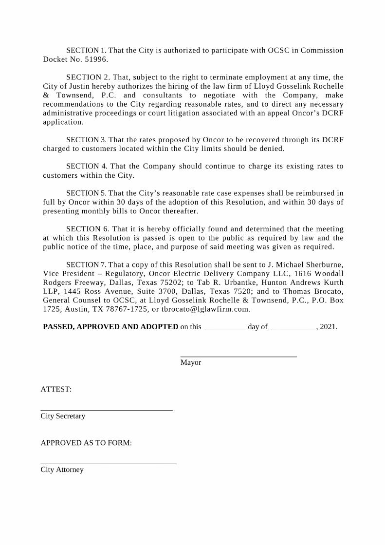
SECTION 1. That the City is authorized to participate with OCSC in Commission Docket No. 51996.
SECTION 2. That, subject to the right to terminate employment at any time, the City of Justin hereby authorizes the hiring of the law firm of Lloyd Gosselink Rochelle & Townsend, P.C. and consultants to negotiate with the Company, make recommendations to the City regarding reasonable rates, and to direct any necessary administrative proceedings or court litigation associated with an appeal Oncor’s DCRF application.
SECTION 3. That the rates proposed by Oncor to be recovered through its DCRF charged to customers located within the City limits should be denied.
SECTION 4. That the Company should continue to charge its existing rates to customers within the City.
SECTION 5. That the City’s reasonable rate case expenses shall be reimbursed in full by Oncor within 30 days of the adoption of this Resolution, and within 30 days of presenting monthly bills to Oncor thereafter.
SECTION 6. That it is hereby officially found and determined that the meeting at which this Resolution is passed is open to the public as required by law and the public notice of the time, place, and purpose of said meeting was given as required.
SECTION 7. That a copy of this Resolution shall be sent to J. Michael Sherburne, Vice President – Regulatory, Oncor Electric Delivery Company LLC, 1616 Woodall Rodgers Freeway, Dallas, Texas 75202; to Tab R. Urbantke, Hunton Andrews Kurth LLP, 1445 Ross Avenue, Suite 3700, Dallas, Texas 7520; and to Thomas Brocato, General Counsel to OCSC, at Lloyd Gosselink Rochelle & Townsend, P.C., P.O. Box 1725, Austin, TX 78767-1725, or [email protected].
PASSED, APPROVED AND ADOPTED on this ___________ day of ____________, 2021.
Mayor
ATTEST: __________________________________ City Secretary APPROVED AS TO FORM: ___________________________________ City Attorney
City Council Meeting
May 24, 2021
Justin City Hall, 415 North College Street
City Council Cover Sheet
Agenda Item: 25 & 26 (Consent) Title: See Below. Department: Administration Contact: City Secretary, Brittany Andrews, Police Chief, Alex Coss Recommendation: Approve consent Items Background:
24. Consider and take appropriate action to approve an Interlocal Agreement for Dispatch Services.
25. Consider and take appropriate action to approve City Council minutes dated April 26, 2021 May 10, 2021 canvass minutes, May 10, 2021 regular meeting minutes, and May 12, 2021.
________________________________________________________________________ City Attorney Review: ________________________________________________________________________ Attachments: 1. ILA for dispatch services 2. April 26, 2021 minutes 3. May 10, 2021 canvass and regular meeting minutes 4. May 12, 2021 minutes
STATE OF TEXAS § §
COUNTY OF DENTON §
INTERLOCAL COOPERATION AGREEMENT FOR SHARED GOVERNANCE COMMUNICATIONS & DISPATCH SERVICES SYSTEM
This Interlocal Cooperation Agreement for Shared Governance Communications and Dispatch Services System, hereinafter referred to as "Agreement", is made by and between Denton County, a political subdivision of the State of Texas, hereinafter referred to as the "County", and
I Name of Agency: Justin Police Department hereinafter referred to as "Agency".
WHEREAS, the County is a duly organized political subdivision of the State of Texas engaged in the administration of county government and related services for the benefit of the citizens of Denton County, Texas; and
WHEREAS, the Agency is duly organized and operating under the laws of the State of Texas engaged in the provision of municipal government and/or related services for the benefit of the citizens of Agency; and
WHEREAS, parties agree that the utilization of combined communications and dispatch services system will be in the best interests of both the County and the Agency,
WHEREAS, the County and the Agency mutually desire to be subject to the provisions of the Interlocal Cooperation Act of the V.T.C.A. Government Code, Chapter 791; and
NOW THEREFORE, the County and the Agency, for the mutual consideration hereinafter stated, agree and understand as follows:
1. PURPOSE. The Denton County Sheriff ("Sheriff') has the facilities to provide emergencytelecommunications and dispatch services throughout Denton County. The Agency wishes to utilize the Sheriffs available telecommunications and dispatch services ("Services") during the term of this agreement.
2. ADVISORY BOARD. The Denton County Sheriff's Office will establish an AdvisoryBoard for the Shared Governance Communication and Dispatch System "Advisory Board". The membership of the board shall be the Chief of each Agency, or designee. The Advisory Board may advise and make recommendations to the Sheriff and the Sheriff's Office on matters relating to the Communications Center, as well as the recommendations for the Annual Agency Workload and Cost Statistics, within the limitations set forth in paragraph 6.1, herein.
3. TERM OF AGREEMENT. The initial term of this Agreement shall be for a one-year periodbeginning October 1, 2021 and ending on September 30, 2022.
4. TERMINATION OF AGREEMENT. Either party may terminate this agreement, withor without cause, after providing ninety (90) days written notice to the other party.
lntertocal Cooperation Agreement for 2021-22 Page I
Shared Governance Communications & Dispatch Services System / Justin Police Department
5. ANNUAL SERVICE FEE. Each Agency shall pay to the County a fee for services basedon the workload generated by the Agency.
5. I. Agency shall pay to County the Total Amount on Exhibit "A".
5.2. The Agency shall complete Exhibit "A", Agency Payment Worksheet, to identify the payment terms preferred by Agency. Agency is responsible for sending payments to County
5.3. The fee for service will be based on the pro rata share of the workload generated by the Agency.
5.4. County agrees to provide Agency a proposed service fees for the next budget/fiscal year as agreed by the parties.
5.5 If this Agreement is terminated prior to the expiration of the term of the Agreement, payment shall be pro-rated by written agreement between the parties.
5.6 Dispatch costs for the upcoming fiscal year are calculated utilizing 50% of the approved Communications Budget for the current fiscal year and agency workload statistics from the previous fiscal year.
Agency workload percentages are calculated by: 5.6.1. Determining the agency's percentage of total Calls For Service (CFS) 5.6.2 Determining the agency's percentage of total Officer Initiated Activity
(OIA)· 5.6.3 Averaging the values from# 5.6.l & # 5.6.2 5 .6.4 Determining the percentage of OIA that is Mobile Data Computer
(MDC) activity5.6.5 Determining agency OIA that is not MDC Activity 5.6.6 Determining adjusted percentage of OIA that is MDC activity by
dividing value of# 5.6.5 by total OIA 5 .6. 7 Determining agency CFS that are public requests by subtracting agency
assists or mutual aid calls from the agency's CFS 5.6.8 Determining adjusted percentage of total CFS that are public requests by
dividing value of# 5.6.7 by total CFS 5.6.9 Determining agency workload percentage by calculating average of
# 5.6.6 and# 5.6.8 5 .6.10 Determining agency final cost by workload by multiplying value of
# 5.6.9 against 50% of the approved Communications budget
6. COUNTY SERVICES AND RESPONSIBILITIES. The County agrees to provide thefollowing services and responsibilities:
6.1 The Sheriff shall have the sole discretion as to the method of providing the Services including, but not limited to the order of response to calls, and shall be the sole judge as to the most expeditious and effective manner of handling and responding to calls for service or the rendering thereof. The Sheriff shall have the sole discretion as to the method and final decision regarding the annual workload and cost statistics. The Sheriff will devote sufficient time to insure the performance of all duties and obligations set forth herein.
6.2 County shall furnish full-time communications services including a twenty-four (24) hours a day, seven (7) days a week public safety answering point, radio services, dispatching services,or law enforcement transmission originating from AGENCY requesting law enforcement and tire
lnterlocal Cooperation Agreement for 2021-22 Page 2
Shared Governance Communications & Dispatch Services System I Justin Police Department
protection services and access to local, regional, state, and national data bases and telecommunications systems.
6.3 The services provided by County include the following: 6.3. l twenty-four (24) hours a day, seven (7) days a week public safety answering
point; 6.3.2. receiving emergency and routine calls for law enforcement, fire, and medical
services; 6.3.3 directing a response to said calls by dispatching the appropriate law
enforcement, fire, and medical services; 6.3.4. providing on-going communication support to the emergency personnel in the
field; and 6.3.5 updating, maintaining, and managing the County owned radio
communications system, computer systems, support files, and resource materials necessary to accomplish the above.
6.4 County may add new Agencies not currently served by Denton County at the discretion of Denton County and the Denton County Sheriffs Office.
7. AGENCY RESPONSIBil,ITIES. The Agency agrees to the following responsibilities:
7. I · Providing accurate current GIS data of the corporate limits and extraterritorialjurisdiction of the Agency.
7.2 Furnish County with a current list of all Officers and Reserves authorized byAgency to use the communications system.
7.3 Agency is responsible for the costs and upgrades associated with maintainingAgency's communication equipment.
7.4 Agency agrees to abide by all laws of the United States and the State of Texas andall present or hereafter approved rules, policies and procedures of TLETS, NLETS,TCIC, NCIC and any other system now or in the future associated with TLETSconcerning the collection, storage, processing, retrieval, dissemination andexchange of information for criminal justice purposes
7.5 Adherence to all Sheriff's Office communications rules and regulations.7 .6 Agency agrees to provide all necessary and required TLETS paperwork. See Exhibit
"B".
7. 7 Appoint representative and agree to participate in the Advisory Board.7 .8 Agency is responsible for sending payments to County as more fully described in
Exhibit "A" to this Agreement.
8. AGREEMENT. The parties acknowledge they have read and understand and intend to bebound by the terms and conditions of this Agreement. This Agreement contains the entire understanding between the parties concerning the subject matter hereof. No prior understandings, whether verbal or written, between the parties or their agents are enforceable unless included in writing in this agreement. This Agreement may be amended only by written instrument signed by both parties.
9. AGREEMENT LIA SONS. Each party to this agreement shall designate a Liaison to insurethe performance of all duties and obligations of the parties. The Liaison for each party shall devote
lnterlocal Cooperation Agreement for 2021-22 Page 3
Shared Governance Communications & Dispatch Services System / Justin Police Department
sufficient time and attention to the execution of said duties on behalf of the Party to ensure full compliance with the tenns and conditions of this Agreement.
10. ASSIGNMENT. Neither party shall assign, transfer, or sub-contract any of its rights,burdens, duties, or obligations under this Agreement without the prior written pennission of the other party to this Agreement.
11. AGENCY LIABILITY. The Agency understands and agrees that the Agency, itsemployees, servants, agents, and representatives shall at no time represent themselves to be employees, servants, agents, and/or representatives of the County. The Agency shall not be required to indemnify nor defend County for any liability arising out of the wrongful acts of employees or agents of County to the extent allowed by Texas law.
12. COUNTY LIABILITY. The County understands and agrees that the County, its employees,servants, agents, and representatives shall at no time represent themselves to be employees, servants, agents, and/or representatives of the Agency. The County shall not be required to indemnify nor defend Agency for any liability arising out of the wrongful acts of employees or agents of Agency to the extent allowed by Texas law.
13. DISPUTES/RECOURSE. County and Agency agree that any disputes or disagreements thatmay arise which are not resolved at the staff level by the parties should be referred to the Appointed Liaisons for each entity. Any further disputes arising from the failure of either Agency or County to perfonn and/or agree on proportionate reduction in fees shall be submitted to mediation, with the parties splitting the mediation fees equally. It is further agreed and understood that the scope of matters to be submitted to dispute mediation as referenced above is limited to disputes concerning sufficiency of performance and duty to pay or entitlement, if any, to any reduced fee or compensation. Any other disputes or conflicts involving damages or claimed remedies outside the scope of sufficiency of perfonnance and compensation adjustment shall be referred to a court of competent jurisdiction in Denton County, Texas.
14. EXHIBITS. Attached hereto, and referred to elsewhere in this Agreement are the followingExhibits, which are hereby incorporated by reference.
Exhibit A
Exhibit B
Agency Payment Worksheet
TEXAS LAW ENFORCEMENT TELECOMMUNICATION
SYSTEM (TLETS) NON - TWENTY-FOUR HOUR TERMINAL AGENCY AGREEMENT
.__ ____ _..._ _____ _
15. MULTIPLE ORIGINALS. It is understood and agreed that this Agreement may beexecuted in a number of identical counterparts, each of which shall be deemed an original for all purposes.
lnterlocal Cooperation Agreement for 2021-22 Page 4
Shared Governance Communications & Dispatch Services System / Justin Police Department
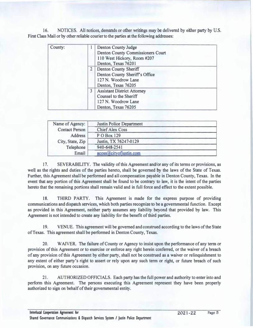
16. NOTICES. All notices, demands or other writings may be delivered by either party by U.S.First Class Mail or by other reliable courier to the parties at the following addresses:
County: 1 Denton County Judge Denton County Commissioners Court 110 West Hickory, Room #207 Denton, Texas 76201
2 Denton County Sheriff Denton County Sheriff's Office 127 N. Woodrow Lane Denton, Texas 76205
3 Assistant District Attorney Counsel to the Sheriff 127 N. Woodrow Lane Denton, Texas 76205
Name of Agency: Justin Police Department Contact Person Chief Alex Coss
Address P O Box 129 City, State, Zip Justin, TX 76247-0129
Telephone 940-648-2541Email acoss(a)citvofiustin.com
17. SEVERABILITY. The validity of this Agreement and/or any of its terms or provisions, aswell as the rights and duties of the parties hereto, shall be governed by the laws of the State of Texas. Further, this Agreement shall be performed and all compensation payable in Denton County, Texas. In the event that any portion of this Agreement shall be found to be contrary to law, it is the intent of the parties hereto that the remaining portions shall remain valid and in full force and effect to the extent possible.
18. THIRD PARTY. This Agreement is made for the express purpose of providingcommunications and dispatch services, which both parties recognize to be a governmental function. Except as provided in this Agreement, neither party assumes any liability beyond that provided by law. This Agreement is not intended to create any liability for the benefit of third parties.
19. VENUE. This agreement will be governed and construed according to the laws of the Stateof Texas. This agreement shall be performed in Denton County, Texas.
20. W AIYER. The failure of County or Agency to insist upon the performance of any term orprovision of this Agreement or to exercise or enforce any right herein conferred, or the waiver of a breach of any provision of this Agreement by either party, shall not be construed as a waiver or relinquishment to any extent of either party's right to assert or rely upon any such term or right, or future breach of such provision, on any future occasion.
21. AUTHORIZED OFFICIALS. Each party has the full power and authority to enter into andperform this Agreement. The persons executing this Agreement represent they have been properly authorized to sign on behalf of their governmental entity.
I rtocal Cooperition Agreement for 2021-22 Page 5
Shared Governance Communications & Dispatch Services System / Justin Police Department
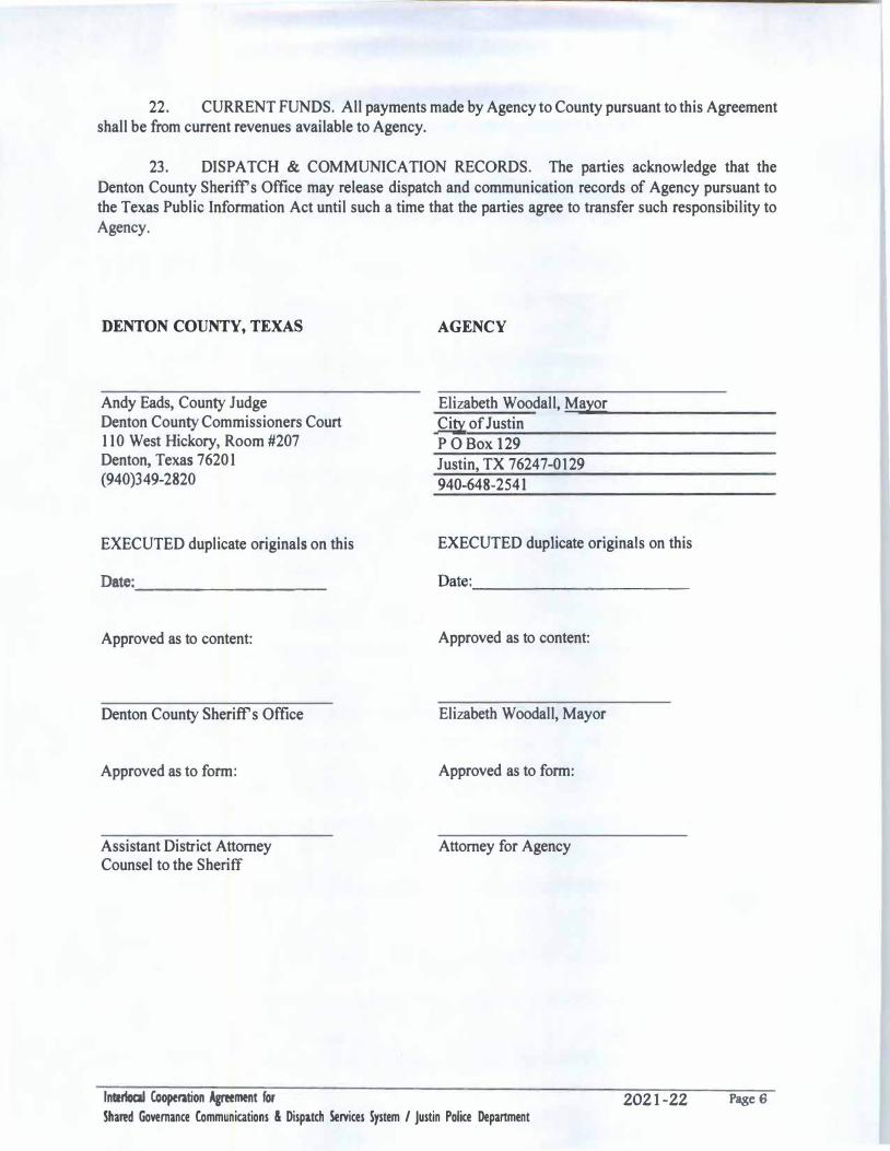
22. CURRENT FUNDS. All payments made by Agency to County pursuant to this Agreementshall be from current revenues available to Agency.
23. DISPATCH & COMMUNICATION RECORDS. The parties acknowledge that theDenton County Sheriffs Office may release dispatch and communication records of Agency pursuant to the Texas Public Information Act until such a time that the parties agree to transfer such responsibility to Agency.
DENTON COUNTY, TEXAS
Andy Eads, County Judge Denton County Commissioners Court 110 West Hickory, Room #207 Denton, Texas 76201 (940)349-2820
EXECUTED duplicate originals on this
Date: ·----------
Approved as to content:
Denton County Sheriff's Office
Approved as to form:
Assistant District Attorney Counsel to the Sheriff
lntertocal Cooperation Agreement for
AGENCY
Elizabeth Woodall, Mayor City of Justin P O Box 129 Justin, TX 76247-0129 940-648-2541
EXECUTED duplicate originals on this
Approved as to content:
Elizabeth Woodall, Mayor
Approved as to form:
Attorney for Agency
2021-22
Shared Governance Communications & Dispatch Services System / Justin Police Department Page6
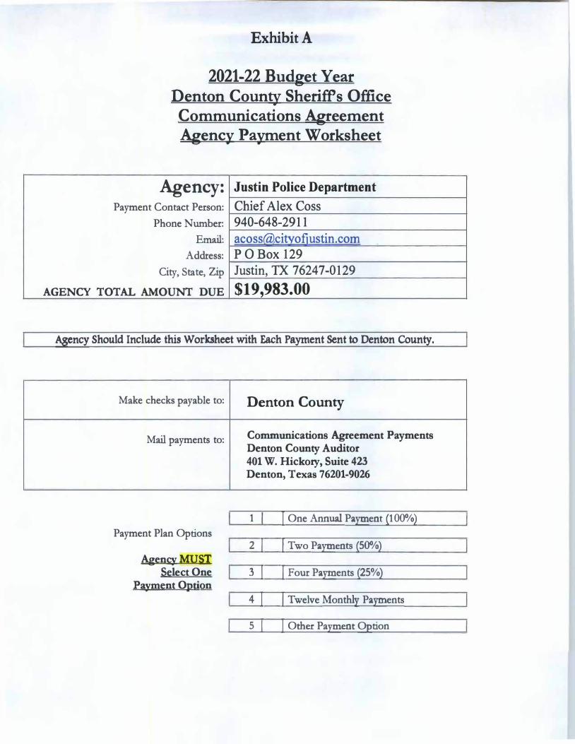
Exhibit A
2021-22 Budget Year Denton County Sheriffs Office Communications Agreement Agency Payment Worksheet
Agency: Justin Police Department
Payment Contact Person: Chief Alex Coss
Phone Number: 940-648-2911
Email: acossca)citvofiustin.com
Address: PO Box 129
City, State, Zip Justin, TX 76247-0129
AGENCY TOTAL AMOUNT DUE $19,983.00
Agency Should Include this Worksheet with Each Payment Sent to Denton County.
Make checks payable to:
Mail payments to:
Payment Plan Options
Agency: MUSI Select One
Payment Option
Denton County
Communications Agreement Payments Denton County Auditor 401 W. Hickory, Suite 423 Denton, Texas 76201-9026
1 I One Annual Payment (100%)
z I j Two Payments (50%)
3 I I Four Payments (25%)
4! I Twelve Monthly Payments
s I ! Other Payment Option
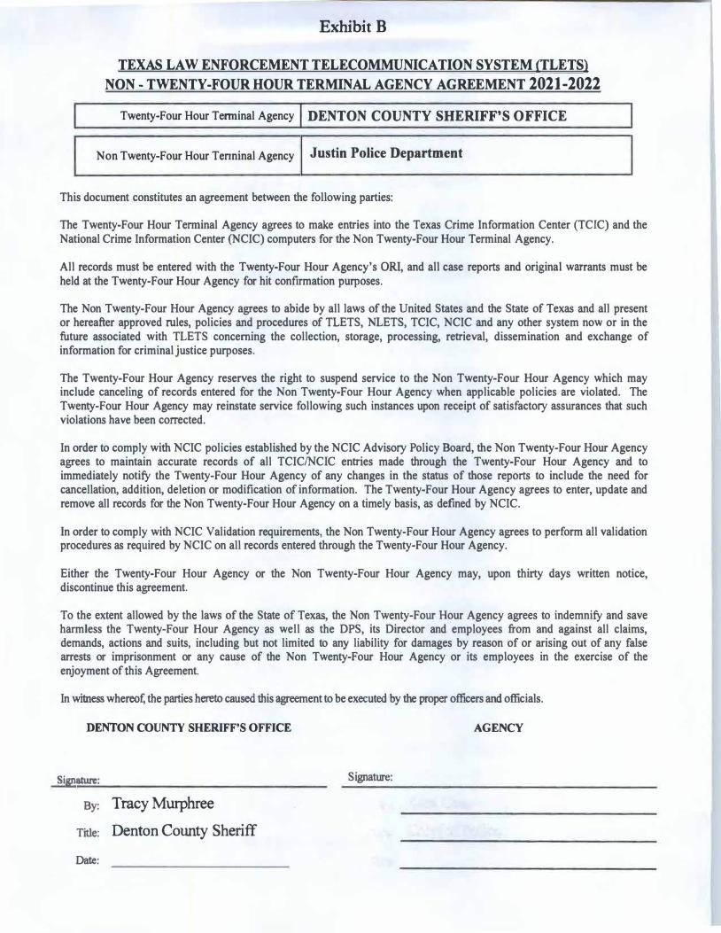
Exhibit B
TEXAS LAW ENFORCEMENT TELECOMMUNICATION SYSTEM (TLETS}
NON - TWENTY-FOUR HOUR TERMINAL AGENCY AGREEMENT 2021-2022
Twenty-Four Hour Tenninal Agency DENTON COUNTY SHERIFF'S OFFICE
Non Twenty-Four Hour Tenninal Agency Justin Police Department
This document constitutes an agreement between the following parties:
The Twenty-Four Hour Tenninal Agency agrees to make entries into the Texas Crime Information Center (TCIC) and the National Crime Information Center {NCIC) computers for the Non Twenty-Four Hour Terminal Agency.
All records must be entered with the Twenty-Four Hour Agency's ORI, and all case reports and original warrants must be held at the Twenty-Four Hour Agency for hit confirmation purposes.
The Non Twenty-Four Hour Agency agrees to abide by all laws of the United States and the State of Texas and all present or hereafter approved rules, policies and procedures of TLETS, NLETS, TCIC, NCIC and any other system now or in the future associated with TLETS concerning the collection, storage, processing, retrieval, dissemination and exchange of information for criminal justice purposes.
The Twenty-Four Hour Agency reserves the right to suspend service to the Non Twenty-Four Hour Agency which may include canceling of records entered for the Non Twenty-Four Hour Agency when applicable policies are violated. The Twenty-Four Hour Agency may reinstate service following such instances upon receipt of satisfactory assurances that such violations have been corrected.
In order to comply with NCIC policies established by the NCIC Advisory Policy Board, the Non Twenty-Four Hour Agency agrees to maintain accurate records of all TCIC/NCIC entries made through the Twenty-Four Hour Agency and to immediately notify the Twenty-Four Hour Agency of any changes in the status of those reports to include the need for cancellation, addition, deletion or modification of information. The Twenty-Four Hour Agency agrees to enter, update and remove all records for the Non Twenty-Four Hour Agency on a timely basis, as defined by NCIC.
In order to comply with NCIC Validation requirements, the Non Twenty-Four Hour Agency agrees to perform all validation procedures as required by NCIC on all records entered through the Twenty-Four Hour Agency.
Either the Twenty-Four Hour Agency or the Non Twenty-Four Hour Agency may, upon thirty days written notice, discontinue this agreement.
To the extent allowed by the laws of the State of Texas, the Non Twenty-Four Hour Agency agrees to indemnify and save harmless the Twenty-Four Hour Agency as well as the DPS, its Director and employees from and against all claims, demands, actions and suits, including but not limited to any liability for damages by reason of or arising out of any false arrests or imprisonment or any cause of the Non Twenty-Four Hour Agency or its employees in the exercise of the enjoyment of this Agreement.
In witness whereof; the parties hereto caused this agreement to be executed by the proper officers and officials.
DENTON COUNTY SHERIFF'S OFFICE AGENCY
Si&!!ature: Signature:
By: Tracy Murphree
Title: Denton County Sheriff
Date:

CITY COUNCIL MEETING MINUTES APRIL 26, 2021 PAGE 1
John Mounce, Councilmember James Clark, Mayor Pro Tem Jim Tate, Councilmember Chrissa Hartle, Councilmember Nick Krueger, Councilmember
Alan Woodall, Mayor
MINUTES
State of Texas County of Denton City of Justin
Justin City Council Regular Session Meeting- April 26, 2021
One or more members of the City Council may participate in this meeting remotely in compliance with the Texas Open Meetings Act or under the provisions provided by the Governor of Texas in conjunction with the Declaration of Disaster enacted March 13, 2020.
In accordance with Order of the Office of the Governor issued March 16, 2020 and March 19, 2020, the Justin City Council will conduct the meeting scheduled at 5:00 p.m. on Monday, April 26, 2021 by telephone conference in order to advance the public health goal of limiting face-to-face meetings (also called "social distancing") to slow the spread of the Coronavirus (COVID-19). There will be no public access to the location described above. A recording of the telephonic meeting will be made, and will be available to the public.
The Zoom meeting may be viewed by clicking the following link: https://us02web.zoom.us/rec/share/91XfDAqJQZwKLlhMvlR4jbPnQj_dU8svbThGe0FRyg5GrQARXL1xzMa-duCjlr78.HZjkdH6kY7oEnWMu
CALL TO ORDER
Convene into session: Mayor Woodall called the Workshop Meeting to order at 5:01PM
Roll Call: Mayor Woodall, Mayor Pro Tem Clark, Councilman Mounce, Councilwoman Hartle, and Councilman Tate. Not Present: Councilman Krueger
Staff Present: Public Works Director, Josh Little, Police Chief, Alex Coss, Finance Director, Josh Armstrong, Director of Strategic Services, Abbey Reece, Director of Planning and Development Services, Darrell Gentry, City Secretary, Brittany Andrews, City Engineer, Chris Cha, City Planner, Eric Wilhite and City Attorney, Matthew Boyle.
PROCLAMATION
Proclamation of Excellence - Honoring Detective Kelli Thielemann for 25 years of service
Tabled Proclamation reading to May 10, 2021
CITY COUNCIL MEETING MINUTES APRIL 26, 2021 PAGE 2
STAFF/ BOARD UPDATES
• Library Update • Court Update • Monthly Financials • Quarterly Financials
WORKSHOP SESSION
1. Discussion regarding a Public Hearing to consider an amendment to the City’s Sign
Ordinance, Chapter 36.
2. Discussion regarding a Public Hearing to consider a Preliminary Plat (PPLT 21-01) to create up to 217 single family residential lots and 5 open space lots for parks, trails and amenities. Also consider a request to rezone approximately 50 acres from SF-1 to SF 2-PD.
3. Discussion regarding a possible amendment to the Downtown Parking Multi-Use Agreement.
4. Discuss pay scale study for the Justin Volunteer Fire Department part time EMS staff.
5. Discuss planning and process to begin holding in person meetings.
6. Discussion regarding updates on the 12th Street Lift Station Environmental Impact.
7. Discussion regarding an update on the Emergency Response Planning. Mayor and Council discussed items 1-7 with Staff.
CONVENE INTO REGULAR SESSION- Immediately Following Workshop Session
CALL TO ORDER at 6:10PM
Convene into Session: Invocation by Pastor Hinote Pledge of Allegiance American Flag Texas Flag:
“Honor the Texas Flag; I pledge allegiance to thee, Texas, one state, under God, one and indivisible”
PUBLIC COMMENT
In an effort to allow the public the ability to participate in the public comment portion and not attend the meeting in person, the City will allow the following: The public may email their comment to the City Secretary by 5:00 pm on Monday, April 26, 2021 at [email protected]. The City Secretary will read the email to Council during
CITY COUNCIL MEETING MINUTES APRIL 26, 2021 PAGE 3
the public comment portion of the meeting. Please make sure to include your name and address, along with your comment pertaining to an item on the agenda, in the body of the email.
PUBLIC HEARING
8. PUBLIC HEARING (7:00 P.M.): Conduct a Public Hearing to consider an amendmentto the City’s Sign Ordinance, Chapter 36.
a. Open public hearing at 7:00PMb. Close public hearing at 7:02PMc. Consider and take appropriate action
Councilman Mounce made the motion to continue the Public Hearing to May 24th.
Seconded by: Councilwoman Hartle Ayes: Councilmembers Hartle, Mounce, Clark, and Tate Nay: 0 Motion Carries
9. PUBLIC HEARING (7:00 P.M.): Conduct a Public Hearing to consider aPreliminary Plat (PPLT 21-01) to create up to 217 single family residential lots and 5open space lots for parks, trails and amenities. Also consider a request to rezoneapproximately 50 acres from SF-1 to SF 2-PD.
a. Open public hearing at 7:02PMb. Close public hearing 7:02c. Consider and take appropriate action
Councilman Mounce made the motion to continue the Public Hearing to May24th.
Seconded by: Mayor Pro Tem, Clark Ayes: Councilmembers Hartle, Mounce, Clark, and Tate Nay: 0 Motion Carries
POSSIBLE ACTION ITEMS
10. Consider and take appropriate action regarding an amendment to the Downtown ParkingMulti-Use Agreement.
Councilman Mounce moved to approve the amendment to the Downtown ParkingMulti Use Agreement using Option 2.
Seconded by: Mayor Pro Tem, ClarkAyes: Councilmembers Hartle, Mounce, Clark, and Tate
CITY COUNCIL MEETING MINUTES APRIL 26, 2021 PAGE 4
Nay: 0 Motion Carries
11. Consider and take appropriate action regarding pay scale study for the Justin Volunteer Fire Department part time EMS staff. Mayor Pro Tem, Clark moved to approve the pay scale study as presented. Councilman Mounce made an amendment to remove the Parker County ESD and Celina from the study, include averaging the remaining cities as discussed to use for pay scale. Seconded by: Councilwoman Hartle Ayes: Councilmembers Hartle, Mounce, Clark, and Tate Nay: 0 Motion Carries
12. Consider and take appropriate action to approve an Interlocal Agreement Allocating Extraterritorial Jurisdiction and Retail Water and Sewer Service Areas Between the Town of Northlake, Texas, the City of Justin, Texas, and the City of Fort Worth, Texas. Mayor Pro Tem, Clark moved to approve as presented and to authorize the Mayor to sign all necessary documents. Seconded by: Councilman Mounce Ayes: Councilmembers Hartle, Mounce, Clark, and Tate Nay: 0 Motion Carries
13. Consider and take appropriate action regarding Joint Resolution #551-21 Allocating Certain Extraterritorial Jurisdiction (ETJ) of the Cities of Fort Worth and Justin. Mayor Pro Tem, Clark moved to approve as presented. Seconded by: Councilman Mounce Ayes: Councilmembers Hartle, Mounce, Clark, and Tate Nay: Motion Carries
14. Consider and take appropriate action regarding Resolution #552-21 Releasing Extraterritorial Jurisdiction. Mayor Pro Tem, Clark moved to approve as presented Seconded by: Councilman Mounce Ayes: Councilmembers Hartle, Mounce, Clark, and Tate Nay:0 Motion Carries
CITY COUNCIL MEETING MINUTES APRIL 26, 2021 PAGE 5
15. Consider and take appropriate action regarding Ordinance #688-21 DisannexingTerritory.
Mayor Pro Tem, Clark moved to approve as presented
Seconded by: Councilman MounceAyes: Councilmembers Hartle, Mounce, Clark, and TateNay: 0Motion Carries
16. Consider and take appropriate action regarding Ordinance #689-21 Extending andExpanding the City of Justin’s Extraterritorial Jurisdiction to include approximately549.992 acres of land owned by Justin Timberbrook, LLC.
Mayor Pro Tem, Clark moved to approve as presented
Seconded by: Councilwoman HartleAyes: Councilmembers Hartle, Mounce, Clark, and TateNay: 0Motion Carries
17. Consider and take appropriate action regarding Ordinance #690-21 Extending andExpanding the City of Justin’s Extraterritorial Jurisdiction to include approximately749.4acres of land owned by Petrus Investment, LP.
Mayor Pro Tem, Clark moved to approve as presented
Seconded by: Councilwoman HartleAyes: Councilmembers Hartle, Mounce, Clark, and TateNay: 0Motion Carries
18. Consider and take appropriate action regarding Ordinance #691-21 Extending andExpanding the City of Justin’s Extraterritorial Jurisdiction to include approximately191.188 acres of land owned by Bloomfield Homes, L.P.
Mayor Pro Tem, Clark moved to approve as presented
Seconded by: Councilman MounceAyes: Councilmembers Hartle, Mounce, Clark, and TateNay: 0Motion Carries
19. Consider and take appropriate action regarding a Development Agreement with PetrusInvestment, LP
Mayor Pro Tem, Clark moved to approve as presented
CITY COUNCIL MEETING MINUTES APRIL 26, 2021 PAGE 6
Seconded by: Councilman Mounce Ayes: Councilmembers Hartle, Mounce, Clark, and Tate Nay: 0 Motion Carries
20. Consider and take appropriate action regarding a Development Agreement with JustinTimberbrook, LLC and Bloomfield Homes, LP, and Royal Crest Properties, LLC
Mayor Pro Tem, Clark moved to approve as presented
Seconded by: Councilman MounceAyes: Councilmembers Hartle, Mounce, Clark, and TateNay: 0Motion Carries
21. Consider and take appropriate action regarding Resolution #553-21 Consenting to theAddition of Certain Land into Tradition Municipal Utility District No. 2A of DentonCounty.
Mayor Pro Tem, Clark moved to approve as presented
Seconded by: Councilwoman HartleAyes: Councilmembers Hartle, Mounce, Clark, and TateNay: 0Motion Carries
22. Consider and take appropriate action regarding Resolution #554-21 Consenting to theUndertaking of Road Projects by Tradition Municipal Utility District No. 2A of DentonCounty.
Mayor Pro Tem, Clark moved to approve as presented
Seconded by: Councilwoman HartleAyes: Councilmembers Hartle, Mounce, Clark, and TateNay: 0Motion Carries
23. Consider and take appropriate action regarding Resolution #555-21 Consenting to theFuture Division of Tradition Municipal Utility District No. 2A of Denton County.
Mayor Pro Tem, Clark moved to approve as presented
Seconded by: Councilwoman HartleAyes: Councilmembers Hartle, Mounce, Clark, and TateNay: 0Motion Carries
24. Consider and take appropriate action regarding the Third Amendment to DevelopmentAgreement with Continental U.S. Management, LLC.
CITY COUNCIL MEETING MINUTES APRIL 26, 2021 PAGE 7
Mayor Pro Tem, Clark moved to approve as presented
Seconded by: Councilman Mounce Ayes: Councilmembers Hartle, Mounce, Clark, and Tate Nay: 0 Motion Carries
25. Consider and take appropriate action on planning and process to begin holding in personmeetings
No Action
CONSENT
Any Council Member may request an item on the Consent Agenda to be taken up for individual consideration
26. Consider and take appropriate action to approve City Council minutes dated April 12,2021.
Councilman Mounce made the motion to approve consent items.
Seconded by: Mayor Pro Tem, ClarkAyes: Councilmembers Hartle, Mounce, Clark, and TateNay: 0Motion Carries
EXECUTIVE SESSION
Any item on this posted agenda could be discussed in Executive Session as long as it is within one of the permitted categories under sections 551.071 through 551.076 and Section 551.087 of the Texas Government Code.
• Under Section 551.071, to conduct private consultation with the City Attorneyregarding:
o Appellate Docket No. 06-17-00054-CV – City of Justin v. Town ofNorthlake;
o State Supreme Court Case No. 18-0651 – Town of Northlake v. Cityof Justin;
o Denton County Municipal Utility District No. 10 and/or the TexasCommission on Environmental Quality’s Executive Director’s actionin granting approval for the creation of Denton County MunicipalUtility District No. 10
o Extraterritorial boundaries and associated agreements
CITY COUNCIL MEETING MINUTES APRIL 26, 2021 PAGE 8
• Under Section 551.074, to deliberate the appointment, employment,evaluation, reassignment, duties, discipline, or dismissal of a public officer oremployee.
o Abbey Reece
Convene into executive session at 7:10PM
Adjourn into open meeting at 9:31PM
27. Discuss, consider, and act on items discussed in Executive Session.
Mayor Pro Tem, Clark moved to approve compensation for Abbey Reece asdiscussed in executive session.
Seconded by: Councilman MounceAyes: Councilmembers Hartle, Mounce, Clark, and TateNay: 0Motion Carries
FUTURE AGENDA ITEMS
ADJOURN
With there being no further business the meeting was adjourned at 9:45PM
Brittany Andrews Brittany Andrews, City Secretary Seal:

CITY COUNCIL MEETING MINUTES MAY 10, 2021 PAGE 1
James Clark, Mayor Pro Tem Jim Tate, Councilmember Chrissa Hartle, Councilmember
MINUTES State of Texas County of Denton City of Justin Justin City Council Regular Session Meeting- May 10, 2021 CONVENE INTO SESSION: at 5:30PM
ACTION ITEMS
1. Consider and act on the approval of an Ordinance canvassing and declaring the results for the General Election for May 1, 2021. Councilwoman Hartle moved to approve the Ordinance as presented. Seconded by: Councilman Tate Aye votes: Councilmembers, Tate, Clark and Hartle Nay: 0 Motion carries
2. Administer Oath of Office and Issue Certificates of Election.
City Secretary, Brittany Andrews administered the Oath of Office and Issued Certificates of Election to Mayor, Elizabeth Woodall, Councilmember, John Mounce, and Councilmember, Tomas Mendoza.
ADJOURN With there being no further business the meeting was adjourned at 5:35 PM
Brittany Andrews Brittany Andrews, City Secretary Seal:

CITY COUNCIL MEETING MINUTES MAY 10, 2021 PAGE 1
James Clark, Mayor Pro Tem Jim Tate, Councilmember Tomas Mendoza, Councilmember Chrissa Hartle, Councilmember John Mounce, Councilmember
MINUTES State of Texas County of Denton City of Justin Justin City Council Regular Session Meeting- May 10, 2021 CONVENE INTO SESSION: at 6:00PM
PROCLAMATION
• Proclamation – Mental Health Awareness Month
• Proclamation of Excellence - Honoring Detective Kelli Thielemann for 26 years of service
OUTGOING COUNCIL PRESENTATION
• Mayor Woodall to present outgoing City Council awards to Mayor, Alan Woodall, Councilwoman Moore, Councilman Crites, Councilman Rieger, and Councilman Krueger
WORKSHOP SESSION
1. Discussion regarding contracting with Vepo for backflow testing certification and data recordation.
2. Discussion regarding audio, video, and live stream upgrades for City meetings.
3. Discussion regarding an Ordinance Designating Stop Sign and Yield Sign intersections in the City.
4. Discuss City Council meeting dates and times. Mayor, Council and Staff discussed workshop items 1-4.
CONVENE INTO REGULAR SESSION- Immediately Following Workshop Session
CALL TO ORDER at 7:54PM
Convene into Session: Invocation and Pledge of Allegiance by Mayor Pro Tem, Clark American Flag
CITY COUNCIL MEETING MINUTES MAY 10, 2021 PAGE 2
Texas Flag: “Honor the Texas Flag; I pledge allegiance to thee, Texas, one state, under God, one and indivisible”
PUBLIC COMMENT
In order to expedite the flow of business and to provide all citizens the opportunity to speak, the Mayor may impose a three-minute limitation on any person addressing the Council. The Texas Open Meetings Act prohibits the City Council from discussing issues, which the public have not been given a seventy-two (72) hour notice. Issues raised may be referred to City staff for research and/or placed on a future agenda. No Public Comment
POSSIBLE ACTION ITEMS
5. Consider and take appropriate action to contract with Vepo for backflow testing
certification and data recordation. Councilwoman Hartle moved to approve the contract with Vepo as presented. Seconded by: Councilman Mounce Aye votes: Councilmembers Mounce, Hartle, Tate, Clark, and Mendoza Nay: 0 Motion carries
6. Consider and take appropriate action regarding audio, video, and live stream upgrades for City meetings. Tabled
7. Consider and take appropriate action to approve an Ordinance Designating Stop Sign and Yield Sign intersections in the City. Tabled
8. Consider and take appropriate action regarding City Council meeting dates and times. Tabled
CONSENT Any Council Member may request an item on the Consent Agenda to be taken up for individual consideration
9. Consider and take appropriate action to approve Charles “Chuck” Ewings as a signatory
to all city bank accounts.
CITY COUNCIL MEETING MINUTES MAY 10, 2021 PAGE 3
10. Consider and take appropriate action to approve the Joint City Council and EDC/CDC minutes dated April 15, 2021.
11. Consider and take appropriate action to approve City Council minutes dated April 26, 2021. Councilman Mounce moved to approve consent items 9 and 10 as presented. Seconded by: Councilwoman Hartle Aye votes: Councilmembers Mounce, Hartle, Tate, Clark, and Mendoza Nay: 0 Motion carries
EXECUTIVE SESSION
Any item on this posted agenda could be discussed in Executive Session as long as it is within one of the permitted categories under sections 551.071 through 551.076 and Section 551.087 of the Texas Government Code.
• Under Section 551.071, to conduct private consultation with the City Attorney regarding:
o Appellate Docket No. 06-17-00054-CV – City of Justin v. Town of Northlake;
o State Supreme Court Case No. 18-0651 – Town of Northlake v. City of Justin;
o Denton County Municipal Utility District No. 10 and/or the Texas Commission on Environmental Quality’s Executive Director’s action in granting approval for the creation of Denton County Municipal Utility District No. 10
o Extraterritorial boundaries and associated agreements
Convene into executive session. Adjourn into open meeting.
12. Discuss, consider, and act on items discussed in Executive Session.
ADJOURN
With there being no further business the meeting was adjourned at 8:01PM

CITY COUNCIL MEETING MINUTES MAY 10, 2021 PAGE 4
Brittany Andrews Brittany Andrews, City Secretary Seal:


