Embed Size (px)
Citation preview
Advances in 21st Century Human Settlements
T.M. Vinod Kumar Editor
E-Democracy for Smart Cities

Advances in 21st Century Human Settlements
Series editor
Bharat Dahiya, Chulalongkorn University, Bangkok, Thailand

More information about this series at http://www.springer.com/series/13196
T.M. Vinod KumarEditor
E-Democracy for SmartCities
123
EditorT.M. Vinod KumarSchool of Planning and Architecture,New Delhi (SPA-D)
Calicut, KeralaIndia
ISSN 2198-2546 ISSN 2198-2554 (electronic)Advances in 21st Century Human SettlementsISBN 978-981-10-4034-4 ISBN 978-981-10-4035-1 (eBook)DOI 10.1007/978-981-10-4035-1
Library of Congress Control Number: 2017932771
© Springer Nature Singapore Pte Ltd. 2017This work is subject to copyright. All rights are reserved by the Publisher, whether the whole or partof the material is concerned, specifically the rights of translation, reprinting, reuse of illustrations,recitation, broadcasting, reproduction on microfilms or in any other physical way, and transmissionor information storage and retrieval, electronic adaptation, computer software, or by similar or dissimilarmethodology now known or hereafter developed.The use of general descriptive names, registered names, trademarks, service marks, etc. in thispublication does not imply, even in the absence of a specific statement, that such names are exempt fromthe relevant protective laws and regulations and therefore free for general use.The publisher, the authors and the editors are safe to assume that the advice and information in thisbook are believed to be true and accurate at the date of publication. Neither the publisher nor theauthors or the editors give a warranty, express or implied, with respect to the material contained herein orfor any errors or omissions that may have been made. The publisher remains neutral with regard tojurisdictional claims in published maps and institutional affiliations.
Printed on acid-free paper
This Springer imprint is published by Springer NatureThe registered company is Springer Nature Singapore Pte Ltd.The registered company address is: 152 Beach Road, #21-01/04 Gateway East, Singapore 189721, Singapore

Contents
1 State of the Art of E-Democracy for Smart Cities . . . . . . . . . . . . . . 1T.M. Vinod Kumar
Part I E-Democracy State of the Art City Studies
2 E-Democracy for Smart City Lagos . . . . . . . . . . . . . . . . . . . . . . . . . . 51Femi Olokesusi and Femi Ola Aiyegbajeje
3 Outline Development Plan for Feroke Municipalityin Execution Framework of Internet of People, Internetof Government and Internet of Things . . . . . . . . . . . . . . . . . . . . . . . 71T.M. Vinod Kumar, P. Bimal and Aruna Sri Reddi
4 E-Democracy in New Delhi Municipal Council:A Case of Smart City Planning Processes . . . . . . . . . . . . . . . . . . . . . 121Ashok Kumar
5 E-Engagement in Hong Kong . . . . . . . . . . . . . . . . . . . . . . . . . . . . . . . 143Sujata S. Govada, Frank Wong, Timothy Rodgers,Ho Yan Claudia Chow and Krista Busa
Part II E-Democracy Domain Studies
6 The Indian Theory of E-Democracy and E-Governanceand Its Linkages with the Smart Cities Mission . . . . . . . . . . . . . . . . 183Ashok Kumar
7 SMART DUBAI: Accelerating Innovation and LeapfroggingE-Democracy . . . . . . . . . . . . . . . . . . . . . . . . . . . . . . . . . . . . . . . . . . . . 197Ashmita Karmakar and Ummer Sahib
8 Smart Water Management and eDemocracy in India . . . . . . . . . . . 259Prabh Bedi and Neha Goel Tripathi
v
9 Preparation of Town Planning Schemes—An E-DemocracyFramework for Citizen Centric Planning . . . . . . . . . . . . . . . . . . . . . 281R.D. Desai, J.E.M. Macwan, Krupesh A. Chauhanand Partha Tripathy
10 Smart City Project Selection, Prioritization, Customizationand Implementation—Voice of Smart Citizens Case Studyof Bhubaneswar and Surat . . . . . . . . . . . . . . . . . . . . . . . . . . . . . . . . . 303Partha Tripathy, Krupesh A. Chauhan and Anjali K. Khambete
11 Smart Grid: Energy Backbone of Smart Cityand e-Democracy . . . . . . . . . . . . . . . . . . . . . . . . . . . . . . . . . . . . . . . . . 319Jignesh G. Bhatt and Omkar K. Jani
Part III E-Democracy Tools and Issues
12 Integration of Existing Information Systems as a SpatialeDemocracy Tool for Smart Cities in India. . . . . . . . . . . . . . . . . . . . 369Mahavir and Prabh Bedi
13 Geo-enabled e-Democracy Tools and Services for Smart Cities . . . .. . . . 391Pramod Kumar, Kshama Gupta, Harish Chandra Karnatak,Asfa Siddiqui and A. Senthil Kumar
14 Attaining E-Democracy Through Digital Platformsin Kenya. . . . . . . . . . . . . . . . . . . . . . . . . . . . . . . . . . . . . . . . . . . . . . . . 441Romanus Opiyo, Baraka Mwau, Keziah Mwang’aand Dennis Mwaniki
15 Politics of Open Data in Russia: Regionaland Municipal Perspectives . . . . . . . . . . . . . . . . . . . . . . . . . . . . . . . . 461Yury Kabanov, Mikhail Karyagin and Viacheslav Romanov
16 Urbane: Community Driven Architectureand Planning Through a Mobile Social Platform . . . . . . . . . . . . . . . 487Swapnil Shrivastav
17 Blockchain-Powered Internet of Things, E-Governanceand E-Democracy . . . . . . . . . . . . . . . . . . . . . . . . . . . . . . . . . . . . . . . . 509Renming Qi, Chen Feng, Zheng Liu and Nezih Mrad
Part IV Conclusions
18 E-Democracy for Smart Cities: Conclusion and Path Ahead . . . . . . 523T.M. Vinod Kumar
vi Contents
Editor and Contributors
About the Editor
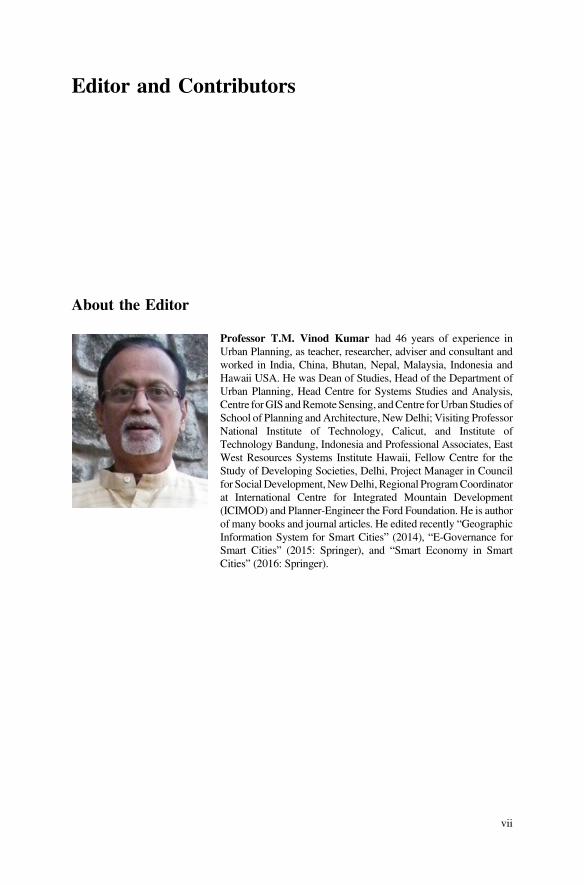
Professor T.M. Vinod Kumar had 46 years of experience inUrban Planning, as teacher, researcher, adviser and consultant andworked in India, China, Bhutan, Nepal, Malaysia, Indonesia andHawaii USA. He was Dean of Studies, Head of the Department ofUrban Planning, Head Centre for Systems Studies and Analysis,Centre forGIS andRemoteSensing, andCentre forUrbanStudies ofSchool of Planning and Architecture, NewDelhi; Visiting ProfessorNational Institute of Technology, Calicut, and Institute ofTechnology Bandung, Indonesia and Professional Associates, EastWest Resources Systems Institute Hawaii, Fellow Centre for theStudy of Developing Societies, Delhi, Project Manager in Councilfor Social Development, NewDelhi, Regional ProgramCoordinatorat International Centre for Integrated Mountain Development(ICIMOD) and Planner-Engineer the Ford Foundation. He is authorof many books and journal articles. He edited recently “GeographicInformation System for Smart Cities” (2014), “E-Governance forSmart Cities” (2015: Springer), and “Smart Economy in SmartCities” (2016: Springer).
vii
Contributors
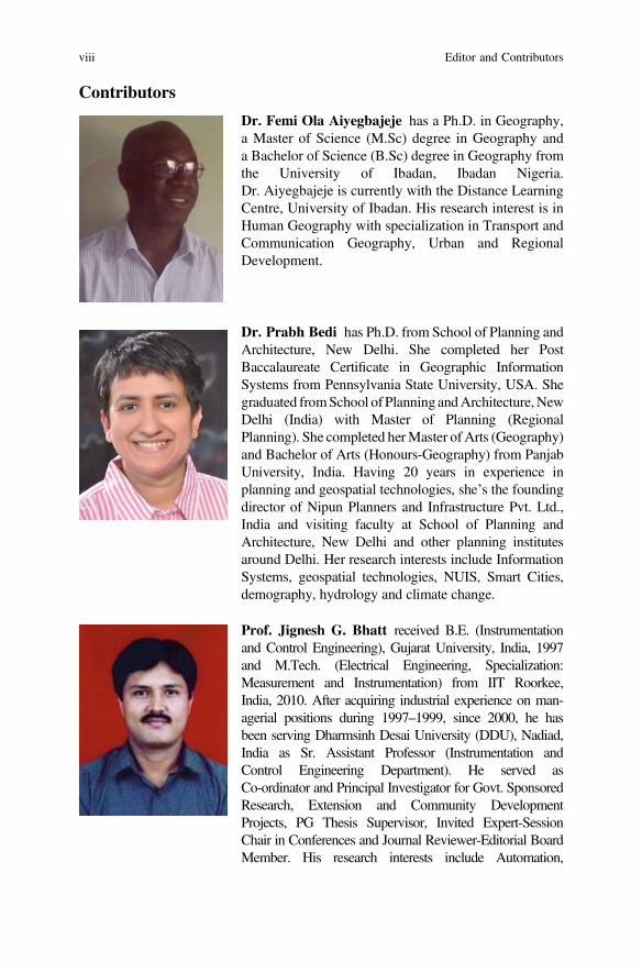
Dr. Femi Ola Aiyegbajeje has a Ph.D. in Geography,a Master of Science (M.Sc) degree in Geography anda Bachelor of Science (B.Sc) degree in Geography fromthe University of Ibadan, Ibadan Nigeria.Dr. Aiyegbajeje is currently with the Distance LearningCentre, University of Ibadan. His research interest is inHuman Geography with specialization in Transport andCommunication Geography, Urban and RegionalDevelopment.
Dr. Prabh Bedi has Ph.D. from School of Planning andArchitecture, New Delhi. She completed her PostBaccalaureate Certificate in Geographic InformationSystems from Pennsylvania State University, USA. Shegraduated fromSchool ofPlanning andArchitecture,NewDelhi (India) with Master of Planning (RegionalPlanning). She completed herMaster ofArts (Geography)and Bachelor of Arts (Honours-Geography) from PanjabUniversity, India. Having 20 years in experience inplanning and geospatial technologies, she’s the foundingdirector of Nipun Planners and Infrastructure Pvt. Ltd.,India and visiting faculty at School of Planning andArchitecture, New Delhi and other planning institutesaround Delhi. Her research interests include InformationSystems, geospatial technologies, NUIS, Smart Cities,demography, hydrology and climate change.
Prof. Jignesh G. Bhatt received B.E. (Instrumentationand Control Engineering), Gujarat University, India, 1997and M.Tech. (Electrical Engineering, Specialization:Measurement and Instrumentation) from IIT Roorkee,India, 2010. After acquiring industrial experience on man-agerial positions during 1997–1999, since 2000, he hasbeen serving Dharmsinh Desai University (DDU), Nadiad,India as Sr. Assistant Professor (Instrumentation andControl Engineering Department). He served asCo-ordinator and Principal Investigator for Govt. SponsoredResearch, Extension and Community DevelopmentProjects, PG Thesis Supervisor, Invited Expert-SessionChair in Conferences and Journal Reviewer-Editorial BoardMember. His research interests include Automation,
viii Editor and Contributors
e-Democracy, e-Governance, e-Learning, Instrumentationand Control, Smart City, Smart Grid, Solar City, SolarEnergy and Wireless Sensor Networks.
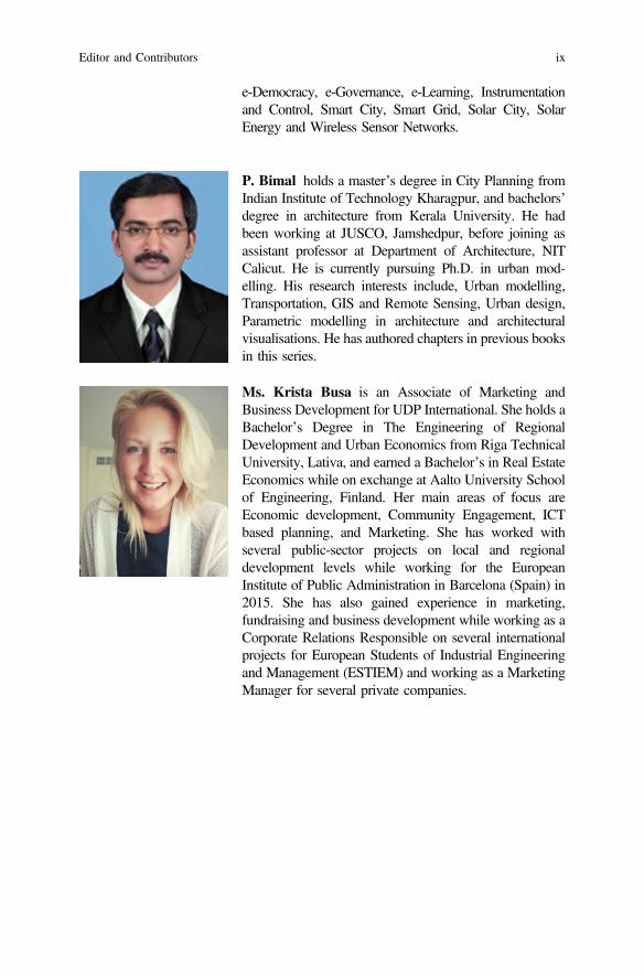
P. Bimal holds a master’s degree in City Planning fromIndian Institute of Technology Kharagpur, and bachelors’degree in architecture from Kerala University. He hadbeen working at JUSCO, Jamshedpur, before joining asassistant professor at Department of Architecture, NITCalicut. He is currently pursuing Ph.D. in urban mod-elling. His research interests include, Urban modelling,Transportation, GIS and Remote Sensing, Urban design,Parametric modelling in architecture and architecturalvisualisations. He has authored chapters in previous booksin this series.
Ms. Krista Busa is an Associate of Marketing andBusiness Development for UDP International. She holds aBachelor’s Degree in The Engineering of RegionalDevelopment and Urban Economics from Riga TechnicalUniversity, Lativa, and earned a Bachelor’s in Real EstateEconomics while on exchange at Aalto University Schoolof Engineering, Finland. Her main areas of focus areEconomic development, Community Engagement, ICTbased planning, and Marketing. She has worked withseveral public-sector projects on local and regionaldevelopment levels while working for the EuropeanInstitute of Public Administration in Barcelona (Spain) in2015. She has also gained experience in marketing,fundraising and business development while working as aCorporate Relations Responsible on several internationalprojects for European Students of Industrial Engineeringand Management (ESTIEM) and working as a MarketingManager for several private companies.
Editor and Contributors ix
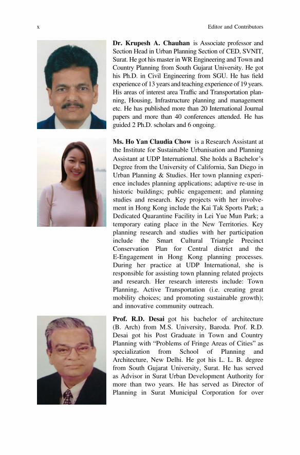
Dr. Krupesh A. Chauhan is Associate professor andSection Head in Urban Planning Section of CED, SVNIT,Surat. He got his master inWREngineering and Town andCountry Planning from South Gujarat University. He gothis Ph.D. in Civil Engineering from SGU. He has fieldexperience of 13 years and teaching experience of 19 years.His areas of interest area Traffic and Transportation plan-ning, Housing, Infrastructure planning and managementetc. He has published more than 20 International Journalpapers and more than 40 conferences attended. He hasguided 2 Ph.D. scholars and 6 ongoing.
Ms. Ho Yan Claudia Chow is a Research Assistant atthe Institute for Sustainable Urbanisation and PlanningAssistant at UDP International. She holds a Bachelor’sDegree from the University of California, San Diego inUrban Planning & Studies. Her town planning experi-ence includes planning applications; adaptive re-use inhistoric buildings; public engagement; and planningstudies and research. Key projects with her involve-ment in Hong Kong include the Kai Tak Sports Park; aDedicated Quarantine Facility in Lei Yue Mun Park; atemporary eating place in the New Territories. Keyplanning research and studies with her participationinclude the Smart Cultural Triangle PrecinctConservation Plan for Central district and theE-Engagement in Hong Kong planning processes.During her practice at UDP International, she isresponsible for assisting town planning related projectsand research. Her research interests include: TownPlanning, Active Transportation (i.e. creating greatmobility choices; and promoting sustainable growth);and innovative community outreach.
Prof. R.D. Desai got his bachelor of architecture(B. Arch) from M.S. University, Baroda. Prof. R.D.Desai got his Post Graduate in Town and CountryPlanning with “Problems of Fringe Areas of Cities” asspecialization from School of Planning andArchitecture, New Delhi. He got his L. L. B. degreefrom South Gujarat University, Surat. He has servedas Advisor in Surat Urban Development Authority formore than two years. He has served as Director ofPlanning in Surat Municipal Corporation for over
x Editor and Contributors

Thirteen years with duties like town planning schemes,Town Development etc.
He is founder chairman of
1. Surat Centre of Indian Institute of Architecture,Gujarat chapter
2. Surat Centre of Gujarat Regional Chapter of Instituteof Town Planners, India
3. Sanskruti Cultural Organization arranging culturalprograms and dramas
4. Trustee, Shri Sogayo Kelavani Mandal conductingprimary to higher secondary schools for urban poor-Shri D.K. Bhatkar School at Althan, Surat.Currently he is President of Surat Centre, Gujarat
Regional Chapter of ITPI and Hon. Director of GCPIA.His areas of expertise are Town Planning Schemes,Development Plan, City Fringe area Development etc.
Dr. Chen Feng received the M.A.Sc. and Ph.D.degrees from the Department of Electrical andComputer Engineering, University of Toronto, Canada,in 2009 and 2014, respectively. From 2014 to 2015, hewas a Postdoctoral Fellow with Boston University,USA, and EPFL, Switzerland. He joined the School ofEngineering, University of British Columbia, Kelowna,Canada, in July 2015, where he is currently anAssistant Professor.
His research interests include data networks, codingtheory, information theory, and network coding.Dr. Feng was a recipient of the prestigious NSERCPostdoctoral Fellowship in 2014. He was recognizedby the IEEE Transactions on Communications(TCOM) as an Exemplary Reviewer in 2015.
Dr. Sujata S. Govada is an award winning qualifiedurban designer, certified town planner and a registeredarchitect in India, with over thirty-five years of diverseinternational experience in Hong Kong, PRC, India,Philippines and the US working on design and planningprojects. She is the Founding Director of the Institutefor Sustainable Urbanisation and the Founding andManaging Director of UDP International, a boutiqueglobal practice. Her expertise and research interestsinclude sustainable urbanization, smart city develop-ment, transit and pedestrian oriented development,
Editor and Contributors xi

harbourfront planning, new town development, urbanrenewal, heritage conservation, affordable housing andcommunity engagement. She is Adjunct AssociateProfessor at the School of Architecture, ChineseUniversity of Hong Kong and previously taught in theurban planning and urban design programs atThe University of Hong Kong. She is the GlobalTrustee of ULI and the Founding Vice President of theHong Kong Institute of Urban Design and the PastPresident of the American Institute of Hong Kong.
Mrs. Kshama Gupta is currently working as Scientistin Indian Institute of Remote Sensing (Indian Spaceresearch Organization), Dehradun. She had completedher M.Tech. in Urban Planning from School ofPlanning and Architecture, New Delhi, India in 2001after the completion of Bachelors in Architecture fromMalviya National Institute of Technology, Jaipur, India.Since then she is working as researcher in the field ofremote sensing and GIS applications for urban man-agement and made contributions in many national levelprojects and research areas. She has more than50 publications to her name as research papers ininternational/national journals/conferences and ISROtechnical reports. Her research interest includes smartplanning, urban climate and micro climate, urban greenspaces and 3D modeling of urban areas.
Dr. Omkar K. Jani is currently the PrincipalResearch Scientist (Solar Energy) at Gujarat EnergyResearch and Management Institute (GERMI). Hisprimary goals include advisory for various solar-relatedgovernment and private initiatives, developing andundertaking fundamental and applied research, andcapacity building. Dr. Jani is a member of the StateAdvisory Committee of the Gujarat ElectricityRegulatory Commission (GERC). He is also an advisorto several clean-tech companies and NGOs. Dr. Janireceived his Ph.D. in Electrical Engineering fromGeorgia Institute of Technology with specialization inSolar Photovoltaic Science and Engineering, and hispost-doctoral fellowship from the Institute of EnergyConversion, Delaware, USA.
xii Editor and Contributors
Yury Kabanov is a lecturer at the Department ofApplied Political Science, the National ResearchUniversity Higher School of Economics(St. Petersburg). His research interests include com-parative authoritarianism, political regime dynamics,electronic participation and Internet politics. He haspublished several articles in Russian and English on thedevelopment of e-government/open government/opendata in Russia and comparative e-participationdevelopment in non-democracies.
Ashmita Karmakar A graduate in Architecture,Masters in Town and Regional Planning and Ph.D. inEnvironmental Planning from School of Planning andArchitecture, New Delhi, India. Ashmita has beenworking in the field of Urban Planning since year 2002.She has worked with various Consulting companies,Semi Government companies and GovernmentAuthorities in the UAE from 2007 focusing on develop-ing concept plan to final master plan proposal, feasibilitystudies, impact assessment studies and formulation ofDevelopment control guidelines and regulations.
Apart from the professional field, she is activelyparticipating in academics by mentoring young plan-ners of the region and contributing articles for journalsand international publications.
Dr. Harish Chandra Karnatak is currently workingas a Scientist and Head, Geoweb Services, IT andDistance Learning Department at Indian Institute ofRemote Sensing (IIRS), ISRO Dehradun, India. Hereceived his Ph.D. Degree in Computer Science withspecialization in Geoinformatics. Dr. Karnatak has madesignificant contributions in various national level projectsand outreach programmes on applications of space tech-nology for natural resources and disaster management inIndia. His area of specialization includes web/Internetbased GIS, spatial DBMS, online geoprocessing andanalysis. Currently he is leading a team of scientists andtechnologists for development of online digital contentand capacity building programmes on space technologyand its applications under IIRS outreach programme. Hehas published more than 60 peer reviewed researchpapers in various scientific journals, seminars and
Editor and Contributors xiii
conferences. Dr. Karnatak is also a recipient of variousprofessional awards in the area of remote sensing andgeospatial technologies.
Mikhail Karyagin is a Ph.D. student at the NationalResearch University Higher School of Economics(St. Petersburg). He is Master of Arts in PoliticalScience and currently holds the position of a leadingexpert at the Infometer Project Center. His scientificinterests are the open data research, ICTs and politics,political regimes and elections. He has carried out andpublished several articles on the topics in Russianand English.
Dr. (Mrs.) Anjali K. Khambete is Associate professorof Civil Engineering Department, SVNIT, and Surat. Shegot her Bachelors’ Degree in Civil engineering andmasters in Environment engineering from SVNIT, Surat.She did her Ph.D. in “Integrated Efficiency based per-formance evaluation of wastewater treatment plant usingfuzzy logic approach” from SVNIT, Surat. She hasteaching experience of over 32 years. She has published7 books and many papers in national and internationaljournal and reviewer for various journals. She has guided4 Ph.D. students and 38 M.Tech. Students throughout hercareer. She is active in consultancy work as auditorregarding environment engineering with governmentagencies and member in audit committee at GujaratPollution Control Board, Gandhinagar. She is acting asnominee director at Ms/Vapi Green Enviro Ltd. at Vapiand Sarigam CETP (SCT), Sarigam.
Professor Ashok Kumar, Ph.D., is working as aProfessor in the School of Planning and Architecture,New Delhi since 1993. His research interests includeInclusive City Planning, Spatial Justice, and PlanningEpistemologies. He has published nearly 100 papers innational and international refereed journals, written andedited 8 books, and published 18 book chapters. He isthe Editor of the ITPI Journal since 2002.A co-authored chapter is slated for publication in TheRoutledge Handbook of Planning Theory in early 2017.Currently, Prof. Kumar is working on a co-authored
xiv Editor and Contributors
book manuscript on “City Planning in India” undercontract with Routledge, which is expected to bepublished in 2017.
Pramod Kumar is Head, Urban and Regional StudiesDepartment, IIRS, Dehradun, India. He is also the GroupHead of Programme Planning and Evaluation Group ofIIRS. He is an alumnus of IIT, Kharagpur, India andjoined Indian Space Research Organization in 1991.Earlier, he has worked as Assistant Engineer at CES,New Delhi. He has been involved in more than50 national level/ technology demonstration andresearch projects using geospatial data and techniques toevolve solutions for natural resources management andbrought out technical reports and research publications.He has published more than 40 papers in journals andconference proceedings and many technical reports. Heis the recipient of ISRO Team Excellence Awards fortwo projects. At present, he has research interests inurban water utilities and urban hydrology.
Dr. Zheng Liu received the Doctorate degree in engi-neering from Kyoto University, Kyoto, Japan, in 2000.He joined and served the National Research Council(NRC) Canada, Ottawa, ON, Canada from 2001–2012.He was working for the Toyota Technological Institute,Nagoya, Japan from 2012–2015 and is currently withUBC Okanagan. His research interests include imageand data fusion, computer vision, pattern recognition,sensors and sensor networks, IoT, structural healthmonitoring, and non-destructive inspection and evalua-tion. Dr. Liu is senior member of IEEE and serves on theeditorial board for a number of peer-reviewed journals ofIEEE, Elsevier, and Springer.
Editor and Contributors xv
Dr. J.E.M. Macwan did his B.Tech in CivilEngineering from South Gujarat University, Surat. In thesame university he got his Master degree in civil engi-neering with specialization in “Evaluation of …Bio-kinetic Constants of Industrial wastes”. He got hisPh.D. from South Gujarat University with specializationin “Fuzzy Simulation analysis of Residential Locationbehavior for Metropolitan”. He has total teaching expe-rience of 33 years in S V National Institute ofTechnology, Surat. Currently he is Head of CivilEngineering Department. He is Author of over23 International and 11 National Journal papers. Heguided more than 60 Post Graduates in various fields ofcivil engineering and 4 Ph.D. Scholars. His areas ofinterest are Smart Mass Transportation, Smart Housing,Affordable Housing, Water and Waste water etc.
Prof. Mahavir holds a degree in Architecturefollowed by a Master’s degree in Urban and RegionalPlanning. He subsequently obtained a PG Diploma inRemote Sensing from ITC, Netherlands. He was alsoawarded PhD jointly by the ITC and UtrechtUniversity, Netherlands. He has been engaged inteaching, practice and research in the fields of Urbanand Regional Planning and GeoSpatial information forover 30 years. Prof. Mahavir has authored and editedseveral books. He has published over 40 papers,nationally and internationally. He is currently Professorand Editor of the SPACE Journal at School of Planningand Architecture, New Delhi, India.
Dr. Nezih Mrad received the Ph.D. degree in engi-neering from Pennsylvania State University in 1995, andtwo Masters degrees, in applied mathematics and inmechanical engineering, from the University of SouthCarolina, Columbia, in 1987 and 1988, respectively.
He is currently a Defence Scientist with the DefenceR&D Canada (DRDC), Department of National Defence,Ottawa,ON,Canada.He is also anAdjunct ProfessorwithCarleton University and the University of Sherbrooke. Hehas intensive experience in advanced sensing, wirelesssensors and sensor networks, IoT, energy harvesting, and
xvi Editor and Contributors
RFID sensors. He conducts and manages R&D activitiesin CBM, SHM, PHM, micro- and nanotechnologies, andautonomic logistics. He has authored or co-authored over250 publications.
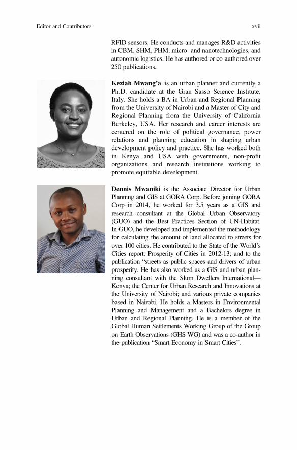
Keziah Mwang’a is an urban planner and currently aPh.D. candidate at the Gran Sasso Science Institute,Italy. She holds a BA in Urban and Regional Planningfrom the University of Nairobi and a Master of City andRegional Planning from the University of CaliforniaBerkeley, USA. Her research and career interests arecentered on the role of political governance, powerrelations and planning education in shaping urbandevelopment policy and practice. She has worked bothin Kenya and USA with governments, non-profitorganizations and research institutions working topromote equitable development.
Dennis Mwaniki is the Associate Director for UrbanPlanning and GIS at GORA Corp. Before joining GORACorp in 2014, he worked for 3.5 years as a GIS andresearch consultant at the Global Urban Observatory(GUO) and the Best Practices Section of UN-Habitat.In GUO, he developed and implemented the methodologyfor calculating the amount of land allocated to streets forover 100 cities. He contributed to the State of the World’sCities report: Prosperity of Cities in 2012-13; and to thepublication “streets as public spaces and drivers of urbanprosperity. He has also worked as a GIS and urban plan-ning consultant with the Slum Dwellers International—Kenya; the Center for Urban Research and Innovations atthe University of Nairobi; and various private companiesbased in Nairobi. He holds a Masters in EnvironmentalPlanning and Management and a Bachelors degree inUrban and Regional Planning. He is a member of theGlobal Human Settlements Working Group of the Groupon Earth Observations (GHS WG) and was a co-author inthe publication “Smart Economy in Smart Cities”.
Editor and Contributors xvii
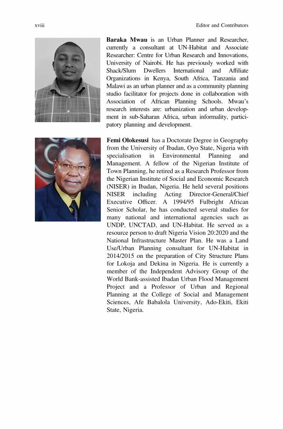
Baraka Mwau is an Urban Planner and Researcher,currently a consultant at UN-Habitat and AssociateResearcher: Centre for Urban Research and Innovations,University of Nairobi. He has previously worked withShack/Slum Dwellers International and AffiliateOrganizations in Kenya, South Africa, Tanzania andMalawi as an urban planner and as a community planningstudio facilitator for projects done in collaboration withAssociation of African Planning Schools. Mwau’sresearch interests are: urbanization and urban develop-ment in sub-Saharan Africa, urban informality, partici-patory planning and development.
Femi Olokesusi has a Doctorate Degree in Geographyfrom the University of Ibadan, Oyo State, Nigeria withspecialisation in Environmental Planning andManagement. A fellow of the Nigerian Institute ofTown Planning, he retired as a Research Professor fromthe Nigerian Institute of Social and Economic Research(NISER) in Ibadan, Nigeria. He held several positionsNISER including Acting Director-General/ChiefExecutive Officer. A 1994/95 Fulbright AfricanSenior Scholar, he has conducted several studies formany national and international agencies such asUNDP, UNCTAD, and UN-Habitat. He served as aresource person to draft Nigeria Vision 20:2020 and theNational Infrastructure Master Plan. He was a LandUse/Urban Planning consultant for UN-Habitat in2014/2015 on the preparation of City Structure Plansfor Lokoja and Dekina in Nigeria. He is currently amember of the Independent Advisory Group of theWorld Bank-assisted Ibadan Urban Flood ManagementProject and a Professor of Urban and RegionalPlanning at the College of Social and ManagementSciences, Afe Babalola University, Ado-Ekiti, EkitiState, Nigeria.
xviii Editor and Contributors
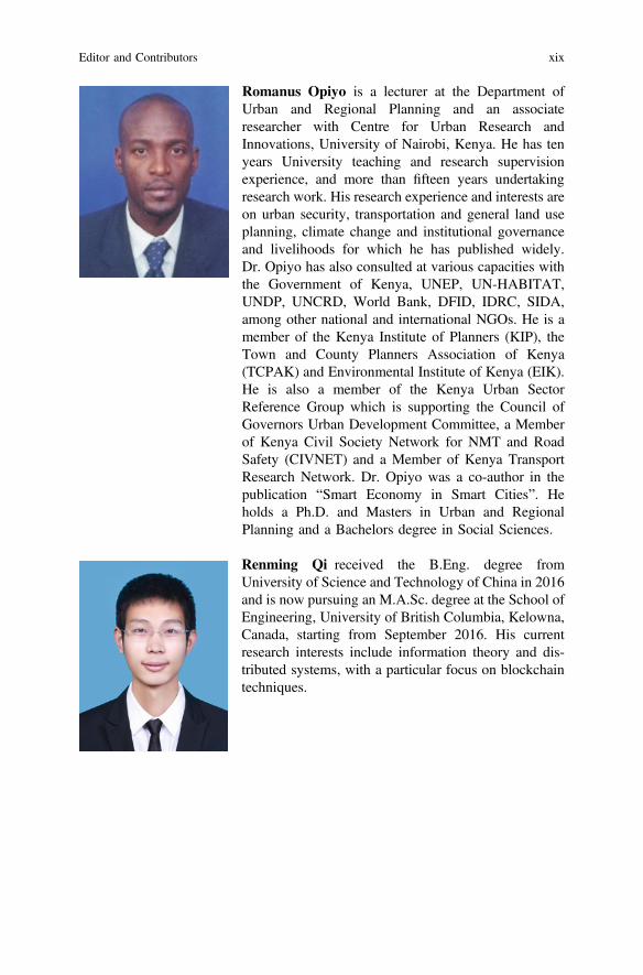
Romanus Opiyo is a lecturer at the Department ofUrban and Regional Planning and an associateresearcher with Centre for Urban Research andInnovations, University of Nairobi, Kenya. He has tenyears University teaching and research supervisionexperience, and more than fifteen years undertakingresearch work. His research experience and interests areon urban security, transportation and general land useplanning, climate change and institutional governanceand livelihoods for which he has published widely.Dr. Opiyo has also consulted at various capacities withthe Government of Kenya, UNEP, UN-HABITAT,UNDP, UNCRD, World Bank, DFID, IDRC, SIDA,among other national and international NGOs. He is amember of the Kenya Institute of Planners (KIP), theTown and County Planners Association of Kenya(TCPAK) and Environmental Institute of Kenya (EIK).He is also a member of the Kenya Urban SectorReference Group which is supporting the Council ofGovernors Urban Development Committee, a Memberof Kenya Civil Society Network for NMT and RoadSafety (CIVNET) and a Member of Kenya TransportResearch Network. Dr. Opiyo was a co-author in thepublication “Smart Economy in Smart Cities”. Heholds a Ph.D. and Masters in Urban and RegionalPlanning and a Bachelors degree in Social Sciences.
Renming Qi received the B.Eng. degree fromUniversity of Science and Technology of China in 2016and is now pursuing an M.A.Sc. degree at the School ofEngineering, University of British Columbia, Kelowna,Canada, starting from September 2016. His currentresearch interests include information theory and dis-tributed systems, with a particular focus on blockchaintechniques.
Editor and Contributors xix
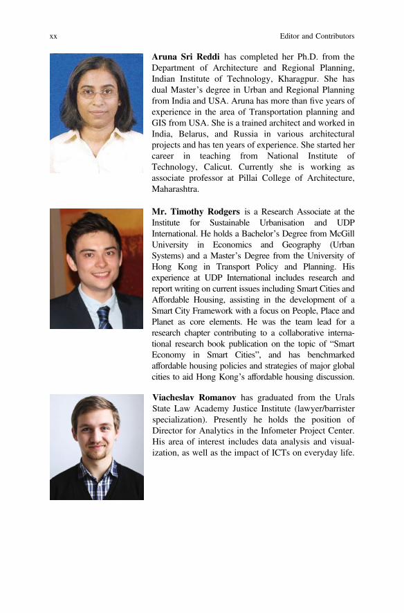
Aruna Sri Reddi has completed her Ph.D. from theDepartment of Architecture and Regional Planning,Indian Institute of Technology, Kharagpur. She hasdual Master’s degree in Urban and Regional Planningfrom India and USA. Aruna has more than five years ofexperience in the area of Transportation planning andGIS from USA. She is a trained architect and worked inIndia, Belarus, and Russia in various architecturalprojects and has ten years of experience. She started hercareer in teaching from National Institute ofTechnology, Calicut. Currently she is working asassociate professor at Pillai College of Architecture,Maharashtra.
Mr. Timothy Rodgers is a Research Associate at theInstitute for Sustainable Urbanisation and UDPInternational. He holds a Bachelor’s Degree from McGillUniversity in Economics and Geography (UrbanSystems) and a Master’s Degree from the University ofHong Kong in Transport Policy and Planning. Hisexperience at UDP International includes research andreport writing on current issues including Smart Cities andAffordable Housing, assisting in the development of aSmart City Framework with a focus on People, Place andPlanet as core elements. He was the team lead for aresearch chapter contributing to a collaborative interna-tional research book publication on the topic of “SmartEconomy in Smart Cities”, and has benchmarkedaffordable housing policies and strategies of major globalcities to aid Hong Kong’s affordable housing discussion.
Viacheslav Romanov has graduated from the UralsState Law Academy Justice Institute (lawyer/barristerspecialization). Presently he holds the position ofDirector for Analytics in the Infometer Project Center.His area of interest includes data analysis and visual-ization, as well as the impact of ICTs on everyday life.
xx Editor and Contributors
Ummer Sahib is a City Planner with 30 years ofexperience in geospatial technology and development ofinnovative solutions for City Planning and Management.He has been responsible for process automation in exe-cuting large GIS, LIS and Urban mapping projects inAsia, Middle East, Europe and Africa. Mr. Sahib is cur-rently the Executive Director of Informap TechnologyCenter in Sharjah, UAE heading Future Technologies andapplication development.
Starting his career in GIS software development pro-ject for Department of Electronics, Govt. of India,Mr. Sahib’s expertise lies in GIS, Open source webmapping applications, navigation data production,Geo-analytics and perfecting a virtual addressing systemcalled GRL (Geo Reference Locator) for the UAE. Since2005, Mr. Sahib is the driving force behind his com-pany’s creative innovation on GPS and NFC technologysolutions. He is passionate on integrating IoT, Big Dataand cloud technologies for establishing Urban OperatingSystem to realize the true meaning of a SMART CITY.
Mr. Sahib holds Post Graduate Diploma (M.Tech) inCity Planning (1985) from School of Planning andArchitecture, CEPT Ahmedabad, India. He is also theAssociate member of the Institute of Town Planners,ITPI India, since 1986.
He has co-authored book on E-Governance forSmart Cities published by Springer in January 2015. Hewas a panel member in the 4th GCC Municipalities &smart cities conference and speaker at the GITEX 2014Smart Cities conference held in Dubai. He has publishedseveral papers on GIS/LIS and accident management andis currently leading a team on designing and developingMobile Apps for Smart Cities.
Dr. A. Senthil Kumar received M.Sc. (Engg.) andPh.D. from the Indian Institute of Science, Bangalore inthe field of image processing in 1985 and 1990,respectively. He worked as consultant andpost-doctoral fellow at the Raman Research Institute,Bangalore for six months before joining ISRO in 1991.Since then, he has served in Indian Remote Sensingprogrammes in various capacities. He has beeninvolved in sensor characterization, radiometric dataprocessing, image restoration, data fusion techniques,and artificial neural networks. As an outcome of his
Editor and Contributors xxi
research work, he has published more than 60 technicalpapers in international journals and conferences and ISROtechnical reports in the areas of image processing andremote sensing. He has received prestigious Prof. SatishDhawan Award conferred by the Indian Society ofRemote Sensing apart from ISRO Team Awards for hiscontribution to Chandrayaan-1 and Cartosat-1 missions.
He is currently serving as the Director of IndianInstitute of Remote Sensing, Dehradun and UN affili-ated Centre for Space Science and TechnologyEducation in Asia and the Pacific. Besides, he is thePresident of ISPRS Technical Commission V onEducation and Outreach and Vice Chair of CEOSWorking Group on Capacity Building and DataDemocracy.
Swapnil Shrivastav I am a 23-year old entrepreneurworking in the domain of clean-tech, water and Internetof Things (IoT). I graduated as an architect fromNational Institute of Technology Calicut in 2016.Design thinking and sustainable solutions are mystrong focus areas. I have previously worked on pro-jects involving rain-water harvesting, grey-water treat-ment systems, architectural design and UI/UX. At mystartup, Uravu Labs, we are working on technologieswhich involve generating drinking water from air andare on a mission to make water accessible to everyone!
Asfa Siddiqui is currently working as Scientist inIndian Institute of Remote Sensing (Indian Spaceresearch Organization) since 2014. She did herBachelors in Architecture from Govt. College ofArchitecture, Lucknow and Masters in Urban Planningfrom School of Planning and Architecture, New Delhi.She has also worked in NIT Calicut prior to joiningISRO. Her research interests are in areas of smartenergy, smart environment, thermal remote sensing andhyperspectral remote sensing.
xxii Editor and Contributors
Dr. Neha Goel Tripathi is an environmental plannerwith over 15 years of experience in EnvironmentalManagement and Architecture. She is presently work-ing as Assistant Professor in School of Planning andArchitecture, New Delhi. She did her post graduationfrom School of Planning and Architecture, New Delhiin Master of Planning, specialization in EnvironmentalPlanning (2003) and was awarded the Gold medal foroverall performance. She is Associate member, Instituteof Town Planners, New Delhi, Member, Council ofArchitecture, New Delhi and Member, Indian BuildingCouncil, New Delhi. National Environmental ScienceAcademy. Experience of more than 10 years in the fieldof environmental planning and architecture and workedon projects like Zonal Development Plan for Eco sen-sitive Area, Mount Abu, Indian Institute ofManagement, Indore, Manali Redevelopment Plan etc.She has published articles on field of Ecologicalfoortprint, Solar Zoning, Climate change etc. Awardedthe first prize from the Hon’ble Minister for Housing &Urban Poverty Alleviation, Kumari Selja for paperpresentation, Climate Change and Indian CitiesPerspectives presented for World Habitat Day 2011organized by HUDCO, New Delhi.
Partha Tripathy has a Bachelors in Engineering fromSVNIT, Surat, Post Graduation in Project Managementfrom CEPT, Ahmedabad and a MA in RegulatoryStudies from TERI University, New Delhi. Partha ispursuing his Ph.D. in Urban Planning from SVNIT,Surat working on Smartness Index for Indian Cities.He has published 3 research papers in InternationalConferences on E-governance, Mobility in Smart Citiesand financing of Smart Cities projects. He has nearly16 years of experience in Project Development in thePPP projects and has worked in State GovernmentPSUs in Gujarat as well as Odisha. Partha is a certifiedPPP trainer under the National PPP Capacity BuildingProgramme (NPCBP) of the Department of EconomicAffairs (DEA), Ministry of Finance, Govt. of India.Partha is currently working as a consultant withInternational Finance Corporation.
Editor and Contributors xxiii
Mr. Frank Wong is a versatile and multi-disciplinaryprofessional in the development industry specializing incross-disciplinary project management and town plan-ning. Throughout his career, he has acquired a varietyof project management experience including culturaldistrict development, new town development, anddesign and implementation of sustainable greeningframework. His town planning experience includesplanning studies, statutory planning, public engage-ment, development consultancy, urban design andmaster planning, strategic planning and cross-boundaryfacilities planning. During his practice at UDPInternational, he is responsible for business develop-ment as well as providing advice to clients on variousaspects ranging from real estate development (incl.preliminary valuation, retail and market studies forcommercial property, strategic advice on acquisition),town planning and urban design.
xxiv Editor and Contributors
Chapter 1State of the Art of E-Democracyfor Smart Cities
T.M. Vinod Kumar
Abstract A well-functioning smart city require a vibrant e-democracy. The theo-retical foundation for “E-Democracy for Smart Cities” is presented here. Thischapter in detail studies the relationship of smart cities and e-democracy. The basicdemocratic principles are stated and then the culture of democracy that evolvedthrough many centuries were studied. The present constitutional provision andancient Greek and Indian models of democracy were discussed and democracy inpanchayat system were also studied. Advantages and disadvantages of democracywere discussed. E-democracy was defined, E-democratic models investigated ande-democracy typologies were postulated as well as ten models of e-democracy.Finally, several tools used in e-democracy were enumerated. The chapter concludedwith a vision of e-democracy in large urban agglomeration.
Keywords Smart cities Democracy Culture of democracy Ancient Indian andGreece practice of democracy Citizen participation Democracy and panchayatsystem Advantages and disadvantages of democracy E-democracy defined E-democracy and smart cities E-democracy and smart economic development E-democracy typologies Ten models of e-democracy Tools of e-democracy
1.1 Smart Cities
Smart city is a knowledge-based city that develops extraordinary capabilities to beself-aware, how it functions 24 h and 7 days a week and communicate, selectively,in real time knowledge to citizen end users for satisfactory way of life with easypublic delivery of services, comfortable mobility, conserve energy, environmentand other natural resources, and create energetic face to face communities and avibrant urban economy even at a time there are National economic downturns [1].
T.M. Vinod Kumar (&)National Institute of Technology, Calicut, Kerala, Indiae-mail: [email protected]
© Springer Nature Singapore Pte Ltd. 2017T.M. Vinod Kumar (ed.), E-Democracy for Smart Cities, Advances in 21st CenturyHuman Settlements, DOI 10.1007/978-981-10-4035-1_1
1
This self-awareness of smart cities is derived out of successfully modelling throughICT technology means, (such as for example geospatial and sensors technologies) areal-world smart city at every instance to a cyberspace Smart city model that can beused to intervene in real world smart city. Simplistically, it can be a website whichcan be used to intervene automatically in the real-world cities using big data cloudand apps by intelligent entities like Internet of Things. Using a ubiquitous networkof sensors, the smart city is associated with the physical city. A cloud computingplatform handles the massive data storage, computation, analysis, anddecision-making process, and conducts automated control based on the results ofthose analyses and decisions. At the level of the smart city, the digital and physicalcities can be linked by the Internet of Things, thereby forming an integratedcyber-physical space. Smart Water supply or intelligent water is a good example ofthis modelling. Therefore, a simple formula, we can denote the smart city as fol-lows: Smart City = digital city in cyberspace + Internet of Things + cloud com-puting. Using radio frequency identification (RFID), infrared sensors, globalpositioning systems (GPS), laser scanners, and other information-sensing devices,the Internet of Things connects things and the Internet based on protocols andconducts information exchange and communication to achieve intelligent identifi-cation, positioning, tracking, monitoring, and management. Cloud computing is anInternet-based computing model for public participation. Its computing resources(including computing power, storage capacity, interactivity, etc.) are dynamic,scalable, virtualized, and provided as a service. Cloud computing is a model ofInternet-based computing, an extension of distributed computing and grid com-puting. Cloud computing can rapidly process the huge amounts of data produced bythe smart cities and simultaneously service millions of users using apps.
A smart city is characterised by six components such as Smart People, SmartEconomy, Smart Mobility, Smart Environment, Smart Living and SmartGovernment [1–3]. The ability of any city to transform and progress towards thesesix components of smart cities from the existing conditions in an integrated andcomprehensive manner is the ability to transform the city to smart city. Primemovers for this capacity to transform cities, are Smart People and Smart Economy.This proposition contradicts the highly simplified approach of many Governmentsin developing countries world over who considers Smart Cities are there because ofinvestment decisions made for deployment of smart ICT enabled infrastructuretechnologies such as Internet of Things and other smart city infrastructure whichcan be purchased from Multi-National Companies. This is far from the truth. Thesmart cities shall be considered as centres of emerging third industrial revolution [4,5] where sharing economy develops and move towards marginal cost of productionnearing to zero, triggered by a smart economy which is sustainable and resilient.A Smart city has the capacity to grow more and more smart people to multiply theiropportunities for engaging in smart economy. The emergent needs of the smarteconomy and smart people fix the configuration of smart mobility, smart envi-ronment and resulting smart living. There can be many variations of these com-ponents as per the ecology. Here the technologies used is evolving over time andwhat is used some three years before will be totally obsolete afterwards and
2 T.M. Vinod Kumar
technologies are developed in these cities by smart people and not imported frommultinationals. Without these two prime components of this smart city system, it isimpossible to transform a city to smart city and smart city creation cannot take placeby simply investing in smart infrastructure and smart ICT enabled technologies in acity.
‘Smart City Economy’, requires the following attributes.
1. A Smart City understands its economic DNA.2. A Smart City is driven by innovation and supported by universities that focus
on cutting-edge research, not only for science, industry and business but alsofor cultural heritage, architecture, planning, development and the like.
3. A Smart City highly values creativity and welcomes new ideas.4. A Smart City has enlightened entrepreneurial leadership.5. A Smart City offers its citizens diverse economic opportunities.6. A Smart City knows that all economics works at the local level.7. A Smart City is prepared for the challenges posed by and opportunities of
economic globalisation.8. A Smart City experiments to support and promotes sharing economy.9. A Smart City thinks locally, acts regionally and competes globally.
10. A Smart City makes strategic investments on its strategic assets.11. A Smart City develops and supports compelling national brand/s.12. A Smart City insists on balanced and sustainable economic development
(growth).13. A Smart City is a destination that people want to visit (tourism).14. A Smart City is nationally competitive on selected and significant factors.15. A Smart City is resourceful, making the most of its assets while finding
solutions to problems.16. A Smart City excels in productivity.17. A Smart City has the high flexibility of labour market.18. A Smart City welcomes human resources that enhance its wealth.19. A Smart City’s inhabitants strive for sustainable natural resource management
and understand that without this its economy will not function indefinitely [3].
These six components of smart cities are characterised by two importantomissions. There is no explicit mention of smart technologies in these six com-ponents that can create smart cities which are generally ICT enabled and culturallybound. Also, there is no explicit mention about e-democracy. These two are implicitin these six components. Smart Technologies and e-democracy is an integral part ofall these six components. A 24 h 7 days uninterrupted water supply which we maycall smart water supply in smart city standards can only be possible if we embracean ICT and SCADA (Supervisory Control And Data Acquisition)-enabled citywater supply well known to engineers’ world over. Technology development in allsix components of smart cities is available off the shelf, however with the short lifecycle and uncertain feasibilities.
1 State of the Art of E-Democracy for Smart Cities 3
1.1.1 Smart City as an Ecological and Cultural Systemand E-Democracy
The smart city is an ecological and cultural system. Because of the unique ecologyof Smart Cities, a generalised model of the cyber city in cyberspace is not possible.So also, a generalised solution for a smart city is not workable. The spatial andecological structure of built space forming land use and transportation system asalso varies and other ecological elements of the city. However, these ecologicalelements are ideal candidates for dealing with the smart city conceptualisation andfor cyberspace interventions at real time using Internet of Things.
The smart city is also having unique cultural characteristics. There are innu-merable factors that influence the culture of a people in a smart city. The culture ofthe city is determined by the regularity of behaviour of inhabitants of smart cities.These factors determine the cultural attributes of smart cities. These cultural factorsalso have a bearing on smart city functioning and will influence the functioning andmanaging of smart cities in 24 h and 7 days a week functioning. Also, there is acultural element that influences the deployment of smart technologies. While watersupply can be efficiently provided for by smart technology, water use pattern in asmart city which aims for water conservation is culturally conditioned and requirecultural adaptation to be water conserving. In any country where there is open air,defecation is culturally prevalent then the use pattern of built toilet must be bycultural transformation if it all it is to be used.
While Smart city as Ecosystem can be managed in cyberspace-modelling byInternet of Things, this is not sufficient to manage the smart city as socio- economicand cultural system. There are two additional systems along with Internet of Thingsare required. They are Internet of People or e-democracy and Internet ofGovernance or E-Governance.
Smart cities are the meeting place of heterogeneous socio-cultural groups, andcultures which demand heterogeneous use pattern of urban space and urbaninfrastructure. This can only be ensured by a powerful e-democracy system whichwe call Internet of People. Our experience shows that Government alone cannotmanage and sort out all problems of smart cities and leads the city to the path ofprosperity and wellbeing. For example, there is no history in any city where pot-holes are repaired the next day it is sighted. To achieve this, an e-democracy systemfor road repairs and drainage correction is required using smartphone apps.
Now Internet of People is not the legitimate party to address a variety of actionsGovernment can do such as punishing for crime, collecting taxes, conducting ajudicial enquiry and so on. These actions are based on legislations that protect theinterest of all sections of society framed after great deliberation and scrutiny. Theyare implemented by judiciary and bureaucracy and people are not entitled to thesepowers.
Hence a right mixture of Internet of Things, Internet of Government and Internetof People are to be in place in a city for the effective functioning of smart cities.
4 T.M. Vinod Kumar
Efficiency, transparency and accountability of bureaucracy charged with imple-menting Government policy go up if there is a proper mixture of Internet of Things,Internet of Governance and Internet of People and every action is visible to all on aninternet.
In ecological management, energy conservation is paramount important. Manyecological issues can be easily solved by the deployment of Internet of Things. Forexample, energy conservation in street lighting can be affected by Internet of Thingsin such a way street lights brightens up only when a moving object approaches nearthe service area of street lights and otherwise it is very dim or even off.E-democracy can be used for reporting for replacement of bulbs but the operation ofenergy conservation in street lighting can only be executed by Interne to Things.
It may be noted that Internet of Governance is most expensive than Interne ofThings and least Expensive is the Internet to People. For example, there are caseswhere the major part of revenue collected goes to the salary of Municipal staffleaving an insignificant part of revenue for city development. In such a situation,there is no value addition to the city by Municipality, a constitutional body. Furtheradministrative activities as such will not bring about any value addition to the urbaneconomy and hence the role of administration in economic development is debat-able and often found not contributing to smart city economic development. Internetof Governance shall reduce the administrative cost and further reduction of cost canbe achieved by a city by a proper combination of functions allocated to Internet ofPeople, Internet of Things and Internet of Governance. This is a decision whichJointly Government and People of the city must make.
However, e-democracy cannot be purchased off the shelf from a technologyprovider unlike Internet of Things but developed within the Nation, State and Citiesand within the framework of Constitutions which changes from country to country.The cultural and social system has a greater influence in framing the constitutionwhich is also the basis of democracy.
This book address one important component of Smart Cities called e-democracythat is all pervading in all the six components of smart cities and I would like to usethe term Internet of People or Internet of Democracy alternatively for e-democracyand Internet of Governance for E-Governance. The effective combination ofInternet of Governance [4] and Internet of Democracy is the foundation of thedevelopment of any smart cities. Constitution of India provides for the active role ofDemocracy in the spatial-social-economic development of cities and villages. Theseventy-fourth and seventy-third constitutional amendment of India states the roleof participatory democracy in Governance which includes identification of issues,policy making, planning and implementation. The Constitution also spells out thelimits of power of Government and People in a democracy based on various rightsenshrined in Indian constitutions, all of which are protected by the constitution.Therefore, there are definite legal boundaries between Internet of People andInternet of Governance enshrined in the constitution and one cannot overpower andsubjugate the other.
The foundation of the smart city is built based on the ability of a smart city toconvert the total population to Smart People irrespective of their income, caste,
1 State of the Art of E-Democracy for Smart Cities 5
class, religion, and educational attainment. So, the smart people are all equal likethe citizen of India. There can be many means such as continuous functionaleducation, distant education, ICT deployment, and broadband accessibility and soon are means of continuing distant education. The minimum requirement for aSmart People is that they should be the citizen who can vote and who can even bePrime Minister or President of this country and other constitutional functionaries.For this, Indian constitutions do not give any prescription to limit the population ofthe citizen about to religion, sex, caste, educational attainment and so on but the agelimit is prescribed. The additional requirement is that citizen is willing to learn andcan be part of continuous learning that makes him part of the ever changing anddynamic world, with changing economic opportunities, requiring changing capa-bility. ‘Collectives of Commons’ of the third industrial revolution is only possiblein that way. The ‘Smart People’, the fundamental building block of a Smart CitySystem, require many crucial attributes as given,
(a) Smart people excel in skills what they do professionally and otherwise.(b) Smart people have a high Human Development Index.(c) A Smart City integrates its universities and colleges into all aspects of city life
and bring them closer to every household.(d) It attracts high human capital, for example, knowledge workers from any part of
the world.(e) A Smart City maintains high Graduate Enrolment Ratio and has ever increasing
the pool of people with high level of qualifications and expertise.(f) Its inhabitants opt for lifelong learning and use e-learning models.(g) People in a Smart City are highly flexible and resilient to the changing
circumstances.(h) Smart City inhabitants excel in creativity and find unique solutions to chal-
lenging issues.(i) Smart people are cosmopolitan, open-minded, and hold a multicultural
perspective.(j) Smart people maintain a healthy lifestyle [3].
Many documentations available regarding the functioning of parliament delib-eration of ancient Republics whether it is in Greece or India was most dignifieddeliberation unlike what we see in Indian parliament where deliberation wasobstructed by slogan shouting and parliamentarian moving to the well where thespeaker is seated calling for adjournment of parliament. There was even fist fightingand destruction of property in parliament. In e-democracy, E-Parliament andE-Town Hall such things are not possible since it is in a virtual world wherefurniture of parliament cannot be destroyed or deliberation of E-Parliament cannotbe obstructed and there is no adjournment of Mr Speaker. What you can do in thisvirtual world deliberately, discuss, and e-vote your point of view with dignity.Thereby e-democracy creates a parliament of the whole city more dignified andaway from uncivilised actions in parliament.
6 T.M. Vinod Kumar
1.2 Democracy
Democracy, or democratic government, is defined by the Oxford EnglishDictionary as “a system of government in which all the people of a state or polity…are involved in making decisions about its affairs, typically by voting to electrepresentatives to a parliament or similar assembly”. Democracy is further definedas (a) “government by the people; especially: rule of the majority” (b) “a govern-ment in which the supreme power is vested in the people and exercised by themdirectly or indirectly through a system of representation usually involving period-ically held free elections”. When we look democracy from top down, these defi-nition looks alright, but when we look at democracy from ward level and citizen,the lowest constitutional level in India to multi-level constitutional bodies upwards,such as Municipality, Metropolitan Planning Committee Area, District State leg-islative assemblies and National Parliament, there can be questions about the twodefinitions given above especially regarding representative democracy. Wardcommittee meetings are generally attended by all people and debate the develop-ment issues. Ward member will not have greater say than people of the ward in suchdeliberations. Why not this model is replicated in multi levels using ICT. In suchlegislative debates, there can be not only these elected members but also all peopleif not those who could attend the deliberations using the broadband internet. Underparticipatory democracy, Indian Constitution is in full agreement with this type ofdeliberations at ward level. The centre of the debate is always the developmentissue of the ward and not those at a higher level of constitutional bodies and oftenoverlook multi-level development issues. The only requirement is revised rulebooksof Parliament and Assemblies procedures must be rewritten to incorporatee-democracy so that people can voice their point of view at multi-level higher thanward on multi-level sector issues starting from ward level.
If this is agreeable why not the same approach of face to face discussioninvolving all people be applied at the higher level of constitutional bodies such asMunicipal Level, Metropolitan regional level, District Level, State Level andNational Level above ward level. The answer is it is difficult just because of the sizeof the population involved and so the representative democracy is feasible andhence election to these constitutional bodies. These bodies shall have quickresponse reaction by interested population by ICT for all policy and plan decisionthrough what we call Internet of Democracy. The recent development of ICT makesit easy for even 1.25 billion plus people of India can react to policy decisions usingtechnologies. Hence, much-debated land legislation for land acquisition in IndianParliament can be amended after eVoting of 1.25 billion populations if systems andprocedures are well formulated for eVoting which is within the capability of ICTtechnologies. This will give out most feasible legislative option for the country orstate overlooking the vested interest of political parties in the parliament.
Political scientist Larry Diamond postulates that, democracy consists of four keyelements: (a) A political system for choosing and replacing the government throughfree and fair elections; (b) The active participation of the people, as citizens,
1 State of the Art of E-Democracy for Smart Cities 7
in politics and civic life; (c) Protection of the human rights of all citizens, and (d) Arule of law, in which the laws and procedures apply equally to all citizens [6].
The term democracy originates from the Greek dηlojqasίa (dēmokratía) “ruleof the people” [7] which was found from dῆlo1 (dêmos) “people” and jqάso1(krátos) “power” or “rule”, in the 5th century BC to denote the political systemsthen existing in Greek city-states, notably Athens; the term is an antonym toἀqirsojqasίa (aristokratía) “rule of an elite”. While theoretically, these definitionsare in opposition, in practice the distinction has been blurred historically [8]. Thepolitical system of Classical Athens, for example, granted democratic citizenship toan elite class of free men and excluded slaves and women from political partici-pation which is not what Indian democracy follows. In virtually all democraticgovernments throughout ancient and modern history, democratic citizenship con-sisted of an elite class until full enfranchisement was won for all adult citizens inmost modern democracies through the suffrage movements of the 19th and 20thcenturies. Prior to Greek, Lichhavis in Eastern India practised a system ofdemocracy and Sangha of Buddhism also practised democracy. So, democracy canbe applied to factories, schools, hospitals and commercial establishments. This isimportant for a smart city which is a collective of commons and for the smarteconomic development of cities.
Democracy contrasts with forms of government where power is either held by anindividual, as in an absolute monarchy, or where power is held by a small numberof individuals, as in an oligarchy. Nevertheless, these oppositions, inherited fromGreek philosophy [9], are now ambiguous because contemporary governmentshave mixed democratic, oligarchic, and monarchic elements. Karl Popper defineddemocracy in contrast to dictatorship or tyranny, thus focusing on opportunities forthe people to control their leaders and to oust them without the need for a revolutionthe dream of every Socialist and Marxist.
No consensus exists on how to define democracy, but legal equality, politicalfreedom, and the rule of law have been identified as important characteristics [10,11]. These principles are reflected in all eligible citizens being equal before the lawand having equal access to legislative processes. For example, in a representativedemocracy, every vote has equal weight, no unreasonable restrictions can apply toanyone seeking to become a representative, and the freedom of its eligible citizensis secured by legitimised rights and liberties which are typically protected by aconstitution [12, 13].
One theory holds that democracy requires three fundamental principles: (1) up-ward control, i.e. sovereignty residing at the lowest levels of authority, (2) politicalequality, and (3) social norms by which individuals and institutions only consideracceptable acts that reflect the first two principles of upward control and politicalequality [14].
The term “democracy” is sometimes used as shorthand for liberal democracy,which is a variant of representative democracy that may include elements such aspolitical pluralism; equality before the law; the right to petition elected officials forredress of grievances; due process; civil liberties; human rights; and elements ofcivil society outside the government. Roger Scruton argues that democracy alone
8 T.M. Vinod Kumar
cannot provide personal and political freedom unless the institutions of civil societyare also present [15].
In some countries, notably in the United Kingdom which originated theWestminster system, the dominant principle is that of “parliamentary sovereignty”,while maintaining judicial independence [15, 16] which is also followed in IndianDemocracy. Democracy practised in India borrows many characteristics of BritishDemocracy. In the United States, separation of powers is often cited as a centralattribute. In India, parliamentary sovereignty is subject to the Constitution of Indiawhich includes judicial review [17]. Other uses of “democracy” include that ofdirect democracy. Though the term “democracy” is typically used in the context ofa political state, the principles also are applicable to private organisations such asbusiness and industries, as stated. In the third industrial revolution, democracy shallbe practised by collective commons having the same interest.
Majority rule is often listed as a characteristic of democracy. Hence, democracyallows for political minorities to be oppressed by the “tyranny of the majority” inthe absence of legal protections of individual or group rights. In Indian Democracyif majoritarian goes against the rights enshrined in the constitution the majoritylegislation is invalid. An essential part of an “ideal” representative democracy iscompetitive elections that are fair both substantively and procedurally. Freedom ofpolitical expression, freedom of speech, and freedom of the press are consideredimportant to ensure that voters are well informed enabling them to vote per theirown interests [18, 19]. The freedom is all subjected to rights given in the consti-tutions to all.
It has also been suggested that a basic feature of democracy is the capacity of allvoters to participate freely and fully in the life of their society [20]. With itsemphasis on notions of social contract and the collective will of all the voters,democracy can also be characterised as a form of political collectivism because it isdefined as a form of government in which all eligible citizens have an equal say inlaw-making [20].
While representative democracy is sometimes equated with the republican formof government, the term “republic” classically has encompassed both democraciesand aristocracies [21]. Many democracies are constitutional monarchies, such as theUnited Kingdom.
The term “democracy” first appeared in ancient Greek political and philosoph-ical thought in the city-state of Athens [22, 23]. Led by Cleisthenes, Atheniansestablished what is generally held as the first democracy in 508–507 BC.Cleisthenes is referred to as “the father of Athenian democracy” [24].
Athenian democracy took the form of a direct democracy, and it had two dis-tinguishing features: the random selection of ordinary citizens to fill the fewexisting government administrative and judicial offices [25], and a legislativeassembly consisting of all eligible Athenian citizens [26]. All eligible citizens couldspeak and vote in the assembly, which set the laws of the city-state. However, asstated Athenian citizenship excluded women, slaves, foreigners, and males under20 years old. Of the estimated 200,000–400,000 inhabitants of Athens, there werebetween 30,000 and 60,000 citizens. The exclusion of large parts of the population
1 State of the Art of E-Democracy for Smart Cities 9
from the citizen body is closely related to the ancient understanding ofcitizenship. In those time, the benefit of citizenship was tied to the obligation tofight war campaigns.
Athenian democracy was not only direct in the sense that decisions were madeby the assembled people, but also the most direct in the sense that the peoplethrough the assembly and courts of law controlled the entire political process and alarge proportion of citizens were involved constantly in the public business [27].Even though the rights of the individual were not secured by the Athenian con-stitution in the modern sense (the ancient Greeks had no word for “rights”) [28], theAthenians enjoyed their liberties not in opposition to the government but by livingin a city that was not colony to another power [29].
In some countries for example Bhutan, a king would voluntarily relinquish hisauthority, by establishing a constitution, empowering a legislature, expandingvoting rights, and extending civil liberties and even restricting the King. Thisperhaps may deter revolution in some other country, but an unlikely situation inBhutan and encourages the private sector to invest (and, thereby, to expand the piethat the government can tax). An increase in human capital that raises in democracymay result in the people’s ability to resist oppression but also raises the ruler’sbenefits from subjugating them.
Similarly, a rise in urbanisation and transformation of cities to smart cities makesit easier for people to meet and communicate—which presumably makes themharder to suppress—but also makes it easier for an autocrat to monitor and controlactivities using the same ICT.
The data for a large panel of countries confirm the Lipset/Aristotle hypothesis[30, 31], which says that a higher standard of living promotes democracy [32]. Thisrelation shows up when democracy is represented by electoral rights or civil lib-erties and when the standard of living is measured by per capita GDP, primaryschool attainment, the gap between male and female, and the importance of themiddle class. Democracy does not relate significantly to school attainment at thesecondary and higher levels. For a given standard of living, democracy tends to fallwith urbanisation and a greater reliance on natural resources but has little relation tocountry size. The apparently strong relation of democracy to colonial heritagemostly disappears when the measures of standard of living are held constant.Similarly, the allowance for the standard of living weakens the interplay betweendemocracy and religious affiliation.
1.2.1 Democracy and Indian Panchayat System
Panchayat system that is practised in India and many parts of the world for manycenturies was a perfect democratic system. All people of the village sat together todiscuss the problem they are faced with. The problem can be a household wherepeople get sick continuously or problem of sharing water for agriculture or issuesarising out of sharing common properties like village land. The cause and remedies
10 T.M. Vinod Kumar
were discussed and an action plan formulated which all villagers follows jointlywithout resorting to the bureaucracy to implement. As the size of the population ofhabitat became bigger and bigger, it was found impractical to discuss such issues ina face to face manner in a situation where high-speed broadband was not there forvideo conferencing. They found the best way out is to accept representativedemocracy where one person is selected based on some representation ratio forexample one state legislative assembly seat for every 200,000 populations to rep-resent the constituency and discuss the problem. Then an administrative system wasdeveloped to see the implementation is attempted with adequate financial resourcesfrom taxing and accepted administrative procedures. There was no provision toevaluate bureaucrats performance in 24 h and 7 days a week unlike in a Panchayatwith a face to face community able to oversee the outcome of joint decisionmaking. Soon, there was a general dissatisfaction with this system. Many timedemocracies were subverted to mere non-accountable and irresponsible bureau-cracy with no proper accountability and unsatisfactory outcomes and no immedi-ately actionable interventions by people to replace habitual corrupt and erringpoliticians and bureaucrats. In an Athenian democracy, instances are there that thiswas easily done and so also in ancient Indian panchayats. In India, many membersof parliament had criminal records and were easily prone to all corrupt practices of acriminal that violate Indian Penal Codes. There was no strict control on them. Nowonder such parliamentarians disrupted for passing of legislation likes Goods andServices Tax for certain narrow political considerations not necessarily related tothe wellbeing of the country. There was no way to monitor the functioning of bothadministration and represented elected members in 24 h and 7 days a week. Thismade them often corrupt. Barring few discussions that appear in the National TVand News Papers on corruption based on which some remedial action precipitated,most instances of corruption and inefficiency in the execution of legislative ordersescape public scrutiny. No effort could weed out corrupt politician and adminis-trators immediately since several laws protect the corrupt. For example, PeoplesRepublic of China could identify just more than 50,000 corrupt politician andadministrators last two years each making this number 100,000 plus and action arebeing taken to punish them as reported in media. This can be a lower number or atip of the iceberg of corruption in China. A similar attempt is also made to weed outthese undesirable actors of democracy in many Nations like India, and so on.Global experience shows that socialist and communist countries which depend onbureaucracies to implemented their regimental goals are most corrupt.
Cities are growing bigger day by day with the addition of millions of popula-tions. The major issue is to find ways and means to reinvent well tested and ancientpanchayat system in a practical way in very large metropolises. This Panchayatsystem in large size cities can continue as face to face community to analyse theirissues of habitat and find a joint solution and attempt to implement the solutionsjointly in an ICT enriched with high-speed broadband cities using Internet ofThings, Internet of Democracy/People and Internet of Governance.
1 State of the Art of E-Democracy for Smart Cities 11
1.2.2 Culture of Democracy
The culture of democracy is one which is something natural to people and passedover to the present generation from times immemorial from the earliest knownhistory. The configuration and layout of Mohan Je Daro cities in India show thesecities cannot function without a democracy since it was not a king’s city but that ofpeople’s city. The Sumerian city-states are believed to have had some form ofDemocratic setup initially. They became monarchies over time.
Evidence of a Democratic system of government in India is originally found inthe Vedas which is oldest written document available in India. There is distinctiveevidence from Rig Veda, which mentions a thriving republican form ofGovernment in India. Therefore, after independence from colonial rulers, Indianaturally went back to declare India as a Republic, the cultural root of India. Here Iquote shlokas from Rig Veda which were to be sung in unison at the beginning ofthe republican assembly in several centuries back in Indian republics
We pray for a spirit of unity; may we discuss and resolve all issues amicably, may wereflect on all matters (of state) without rancour, may we distribute all resources (of the state)to all stakeholders equitably, may we accept our share with humility—[33].
In ancient Indian written history, one of the earliest instances of democracy in acivilisation was found in many republics in ancient India, which were establishedsometime before the 6th century BC, and prior to the birth of Gautama Buddha.These republics were known as Maha Janapadas, and among these states, Vaishali(in the present Bihar, India) was considered as the world’s first republic. Thedemocratic Sangha, Gana, and Panchayat systems were used in some of theserepublics; the Panchayat from 6th century BC and the republican system is still usedtoday in Indian villages and cities as a part of village culture.
Later during the time of Alexander, the Great in the 4th century BC, the Greekswrote about the Sabarcae and Samba star states in what is now Pakistan andAfghanistan, whose “form of government was democratic and not a monarchy”according to Greek scholars at the time. Another example was Gopala’s rise topower by democratic election in Bengal, which was documented by the Tibetanhistorian Taranath. Republican and Panchayat system was spread in all parts ofIndia North, South, East, and West from where the Indian democratic cultureemerged.
The following conversation with Gautama Buddha and Ananda describe howDemocracy functioned in Vaishali.
The Buddha’s commitment to republicanism (the ideal republican virtues) was astrong one if we are to believe the Mahaparinibbanasuttanta, among the oldest ofBuddhist texts [34]. As is common in the Buddhist scriptures, a precept is illustratedby a story. Here Ajatasastru, the King of Maghada, wishes to destroy the Vajjianconfederacy (of the Licchavis of Vaishali) and sends a minister, Vassakara theBrahman, to the Buddha to ask his advice. Will his attack be a success? Rather thananswer directly, the Buddha speaks to Ananda, his closest disciples:
12 T.M. Vinod Kumar
“Have you heard, Ananda, that the Vajjians hold full and frequent public assemblies?”
“Lord, so I have heard,” replied he.
“So long, Ananda,” re-joined the Blessed One, “as the Vajjians hold these full and frequentpublic assemblies; so long may they be expected not to decline, but to prosper…
In a series of rhetorical questions to Ananda, the Buddha outlines otherrequirements for Vajjian prosperity:
So long, Ananda, as the Vajjians meet together in concord, and rise in concord, and carryout their undertakings in concord…so long as they enact nothing not already established,abrogate nothing that has been already enacted, and act in accordance with the ancientinstitutions of the Vajjians as established in former days…so long as they honour andesteem and revere and support the Vajjian elders, and hold it a point of duty to hearken totheir words…so long as no women or girls belonging to their clans are detained amongthem by force or abduction…so long as they honour and esteem and revere and support theVajjian shrines in town or country, and allow not the proper offerings and rites, as formerlygiven and performed, to fall into desuetude…so long as the rightful protection, defence, andsupport shall be fully provided for the Arahats among them, so that Arahats from a distancemay enter the realm, and the Arahats therein may live at ease so long may the Vajjians beexpected not to decline, but to prosper.
Then the Blessed One addressed Vassakara the Brahman, and said,
When I was once staying, O Brahman, at Vesali at the Sarandada Temple, I taught theVajjians these conditions of welfare; and so long as those conditions shall continue to existamong the Vajjians, so long as the Vajjians shall be well instructed in those conditions, solong may we expect them not to decline, but to prosper.
The comment of the king’s ambassador underlines the point of this advice: “So,Gotama, the Vajjians cannot be overcome by the king of Magadha; that is, not inbattle, without diplomacy or breaking up their alliance” [35].
The same story tells us that once the king’s envoy had departed, the Buddha andAnanda went to meet the assembly of monks. Buddha told the monks that they toomust observe seven conditions if they were to prosper: Full and frequent assem-blies, concord, preserving and not abrogating established institutions, honouringelders, falling “not under the influence of that craving which, springing up withinthem, would give rise to renewed existence,” delighting in a life of solitude, andtraining “their minds that good and holy men shall come to them, and those whohave come shall dwell at ease”.
It may be emphasised here that the Buddha saw the virtues necessary for arighteous and prosperous community, whether secular or monastic, as being muchthe same. Foremost among those virtues was the holding of “full and frequentassemblies.” In this, the Buddha spoke not only for himself, and not only out of hispersonal view of justice and virtue. He based himself on what may be called thedemocratic tradition in ancient Indian politics democratic in that it argued for a widerather than narrow distribution of political rights, and government by discussionrather than by command and submission [36]. The Pali Canon gives us our earliest,and perhaps our best, detailed look at Indian republicanism, its workings, and itspolitical philosophy. About no other republics do we know as much as we do about
1 State of the Art of E-Democracy for Smart Cities 13
the Buddhist Sangha and the Licchavis in the time of Buddha even though we doknow that republics survived and were a significant factor until perhaps the fourthcentury A.D., a period of over 800 years? Scattered inscriptions, a great number ofcoins, and the occasional notice in Greek sources, the Jatakas or other Indianliterature give us a few facts, but any history of Indian republicanism is necessarilya rather schematic one.
In Ancient Greece, present before the world, the speaker’s platform in the Pnyx,the meeting ground of the assembly where all the great political struggles of Athenswere fought out during the “Golden Age”. Here Athenian statesmen stood to speak,such as Pericles and Aristides in the 5th century and Demosthenes and Aeschines inthe 4th, along with countless humbler citizens as well. In the background high onthe Acropolis is the Parthenon, the temple of Athena, the city’s protective goddess,looking down upon their deliberations.
The culture of democracy was well studied by Gautama Buddha and adopted itin codifying the Sangha he built. Many pillars of democracy are discussed byGautama Buddha as follows.
1. Buddha spoke about the equality of all human beings (long before AbrahamLincoln on the USA) the existing oldest democracy, and that classes and castesare artificial barriers erected by society. This means all people in a smart city isequal. The only classification of human beings, per the Buddha, is based on thequality of their moral conduct which is valid today when a corrupt politician,businessman, and administrators are not respected in Indian Society.
2. Buddha encouraged the spirit of social -co-operation and active participation insociety. This spirit is actively promoted in the political process of modernsocieties. The third industrial revolution that may take place in Smart Citiesrequires “collectives of commons” which can only be achieved throughe-democracy.
3. Since no one was appointed as the Buddha’s successor, the members of theOrder were to be guided by the Dhamma and Vinaya, or in short, the Rule ofLaw. Until today very member of the Sangha is to abide by the Rule of Lawwhich governs and guides their conduct. In a democracy, successive leaders areselected by votes and not based on the qualifications. In India, dynastic politicsstill exists in many political parties, some hundred-year-old.
4. Buddha encouraged the spirit of consultation and the democratic process. This isshown within the community of the Order in which all members have the rightto decide on matters of general concern. When a serious question arosedemanding attention, the issues were put before the monks and discussed in amanner like the democratic parliamentary system used today. Thisself-governing procedure may come as a surprise to many to learn that in theassemblies of Buddhists in India 2500 years and more ago are to be found theculture of the parliamentary practice of the present day. A special officer like‘Mr. Speaker’ was appointed to preserve the dignity of the Parliamentary ChiefWhip, was also appointed to see if the quorum was secured. Matters were putforward in the form of a motion which was open to discussion. In some cases,
14 T.M. Vinod Kumar
it was done once, in others three times, thus anticipating the practice ofParliament in requiring that a bill is read a third time before it becomes law. Ifthe discussion showed a difference of opinion, it was to be settled by the vote ofthe majority through balloting.
The Buddhist approach to political power is the moralization and the responsibleuse of public power. The Buddha preached non-violence and peace as a universalmessage. He did not approve of violence or the destruction of life and declared thatthere is no such thing as a ‘just’ war. He taught: ‘The victor breeds hatred, thedefeated lives in misery. He who renounces both victory and defeat is happy andpeaceful.’
In the Jataka, the Buddha had given to rules for Good Government, known as‘Dasa Raja Dharma’. These ten rules can be applied even today by any governmentwhich wishes to rule the country peacefully. The rules are as follows:
1. be liberal and avoid selfishness,2. maintain a high moral character,3. be prepared to sacrifice one’s own pleasure for the well-being of the subjects,4. be honest and maintain absolute integrity,5. be kind and gentle,6. lead a simple life for the subjects to emulate,7. be free from hatred of any kind,8. exercise non-violence,9. practice patience, and
10. respect public opinion to promote peace and harmony.
Regarding the behaviour of rulers, He further advised:
– A good ruler should act impartially and should not be biased and discriminatebetween one group of subjects against another.
– A good king should not harbour any form of hatred against any of his subjects.– A good ruler should show no fear whatsoever in the enforcement of the law if it
is justifiable.– A good ruler must possess a clear understanding of the law to be enforced. It
should not be enforced just because the ruler has the authority to enforce thelaw. It must be done in a reasonable manner and with common sense—(Cakkavatti Sihananda Sutta).
1.2.3 Advantages and Disadvantages of Democracy
Democracy is a type of political system that requires a popular vote (representativeelection) to take place to elect the leader of the country and other officials. Theleaders are chosen by the people. Many countries in the world, operate under ademocratic form of government. While democracy is noted as one of the mostefficient government systems ever, it is, however, not without any downsides.
1 State of the Art of E-Democracy for Smart Cities 15
Gautama Buddha spoke about the prosperity of Vaishali that goes hand in handwith democratic practice in earlier para. Empirical studies [29, 30] shows there isthe impact of economic development on a country’s propensity when democracy isexperienced. A common view since Lipset’s [31] research is that prosperity stim-ulates democracy; this idea is often called the Lipset hypothesis [32]. Lipset creditsthe idea to Aristotle: “From Aristotle down to the present, men have argued thatonly in a wealthy society in which relatively few citizens lived in real poverty coulda situation exist in which the mass of the population could intelligently participatein politics and could develop the self-restraint necessary to avoid succumbing to theappeals of irresponsible demagogues” (For a statement of Aristotle’s views, seeAristotle [1932, book 6].). Theoretical models of the effect of economic conditionson the extent of democracy are not well developed. Lipset et al. [32] emphasisedincreased education and an enlarged middle class as key elements, and he alsostressed the thinking of Tocqueville’s (1835) idea that private organisations andinstitutions are important as checks on centralised government power. This pointhas been extended by Putnam (1993), who argues that the propensity for civicactivity is the key underpinning of good government in the regions of Italy. ForHuber et al. (1993, pp. 74–75), the crucial concept is that capitalist developmentlowers the power of the landlord class and raises the power and ability to organisethe working and middle classes.
1.2.3.1 Advantages of Democracy
1. It protects the interest of citizens.
Citizens in a democratic country are given the right to vote on political, social andeconomic issues, particularly the representatives they want to oversee making majordecisions, as the Members of Parliament and legislative assembly. This can greatlyprotect the people from anything they would disagree to occur.
2. It prevents monopoly of authority.
Since the government is bound by an election term where parties compete to regainauthority, democracy prevents monopoly of the ruling authority. The elected rulingparty would make sure their policies will work for the people as they will not beable to remain in power after their term with bad records—they will not bere-elected.
3. It promotes equality.
Generally, democracy is based on the rule of equality, which means that all peopleare equal as far as the law is concerned. Every person has the right to experienceand enjoy equal political, social and economic rights, and the state is not allowed todiscriminate him on the standard of sex, class, caste, religion and income.
16 T.M. Vinod Kumar
4. It makes for a responsible and stable administration.
When there are elected and fixed representatives, a more responsible government isformed. Thus, democracy can be efficient, firm and stable. Its administration is ruledand conducted with a sense of dedication, and people under this system discussmatters and problems thoroughly to come up with sensible decisions.
5. It brings a feeling of obligation towards the citizens.
The ruling authorities owe their success to elections by the citizens, so they wouldfeel grateful to and socially responsible for them. This can serve as their motivatingfactor to work for the citizens, for they have the right of choosing their government.
6. It imparts political education to the people.
One argument in favour of democracy is that it can serve as a training school forcitizens—they are driven to take part in state affairs. During elections, politicalparties propose their programs and policies in support of their candidates throughpublic meetings, demonstrations, television, radio, posters and speeches by theirleaders to win public favour. These can impact political consciousness among thepeople.
7. It helps make good citizens.
Democracy aims to create the ideal environment that is conducive to personalityimprovement, character cultivation, and good habits. As per the experts, thispolitical system seems to function as the first school for good citizenship, whereindividuals can learn about their rights and duties from birth to the time of death.
8. It allows a little chance of revolution.
Since this system is based upon the public will, there will be little to no chance ofpublic revolt. Elected representatives conduct state affairs with public support, andif they do not work efficiently or do not meet the public’s expectations, they willprobably not do well during the next elections. Democracy or other popular gov-ernments often function with consensus; thus, the question of revolution would notarise.
9. It promotes change.
This political system can promote changes in the government without having toresort to any form of violence. It tries to make citizens feel great and even providesthem with a good sense of participation and involvement.
1.2.3.2 Disadvantages of Democracy
1. It might allow misuse of public funds and time. Nothing can be done if theparliament does not legislate by obstructing the proceedings by oppositionparliamentarians as can be seen in the Indian parliament as routine
1 State of the Art of E-Democracy for Smart Cities 17

adjournments. Democratic governments can lead to wasted time and resources,considering that it takes a huge amount of time on formulating laws and requiresa lot of money to be spent during elections. It is also highly possible that thecountry will be ruled by incompetent and irresponsible leaders who will justspend public funds for their own tours and recreation.
2. It instigates corruption.
Those who are elected to power might resort to unethical means for personalinterests and engage in corrupt practices. During their tenure in office, they mighttake advantage of authority for personal gains, putting the interests of the masses inthe backseat.
3. It risks the wrong choice of public servants.
Not all individuals under a democratic government are aware of the political andsocial circumstances in their country. In a voting system, majority wins, and there isno distinction between the votes cast by the literate and the illiterate; informed anduninformed member. People may favour a candidate based on other factors otherthan pure and required capability. Taking these things into consideration, theelected official may not always be the perfect person for the seat, leading to erro-neous decisions.
4. It allows not exercising the right to vote.
Sadly, in some democratic countries, people fail to exercise their right to vote.Perhaps, they are reluctant to do it or are just less aware of the impact of their votes.Or, perhaps they do not see it as a privilege and take the process less seriously.
5. It may put more emphasis on quantity, rather than quality.
In terms of providing services—it tends to put more emphasis on quantity, ratherthan quality. Also, considering that the system might be governed by irresponsibleand incompetent leaders, equality might be in question for only the rich and famousmight be prioritised more than the poor. Since money is required for contestingelection, poor cannot be a contesting election.
6. It can take long to make decisions.
Because it takes long to make decisions, it will also take long to implement them.Unlike in a monarchy where one person is making decisions that are implementedquickly, democracy requires majority voting in implementation, thus, it is relativelyless prompt in taking actions.
7. It may involve immoral practices during elections.
To lure the masses, election campaigns might involve immoral practices, wherecandidates would use muscle power to draw most votes, even trying to tarnish theiropponents’ reputation. Money and power may be abused to influence the people todisregard opposing parties.
18 T.M. Vinod Kumar
By weighing their advantages and disadvantages, of a democracy, we canconclude that the democracy is best for the people.
1.3 Nature of E-Democracy in Cities
E-democracy in a city is the support and enhancement of democracy, democraticinstitutions and democratic processes by means of ICT. E-democracy concerns allsectors of democracy, all democratic institutions, and all levels of government.E-democracy cannot be isolated from traditional democratic processes. It is addi-tional, complementary to, and interlinked with traditional democratic processes, towiden the choices available to the public for taking part in political processes [37].
1. E-democracy does not in itself affect the constitutional duties and other dutiesand responsibilities of decision makers; rather, it can provide them with addi-tional benefits.
2. E-democracy requires information, dialogue, communication, deliberation andthe ongoing creation of open cyberspaces where citizens can get together touphold their civic interests.
3. E-democracy is an integral part of the information society, which has ushered ina range of traditional and innovative tools that can usefully be applied indemocratic processes and institutions.
4. E-democracy flourishes best where there are the political will and leadership tomake it work effectively by introducing the structural changes needed to takeaccount of the opinions expressed. The incorporation of ICT into democraticprocesses usually requires structural changes and procedural reform.
E-democracy in smart cities is a mean for disseminating more of city-basedpolitical information and for enhancing communication and participation, as well ashopefully in the long run for the transformation of the political debate and thepolitical culture of a city. Participants in the field of e-democracy in cities includecivil society (organised and non-organized), Non-Governmental Organisations,journalists, the administration, and politicians from ward level to national level and—the citizen irrespective of their caste, class, income, religion, gender or age.
E-democracy as related to smart city development should be defined broadly asgiven above, since computers and telecommunications, particularly tied to theInternet and web, are connected to nearly all aspects of politics and governance inany city. From paving roads or filling in potholes in the road, to electing politiciansat the ward, municipal or above levels, electronic media are reshaping access towhat people know, who they communicate with, and what they need to know to getthings done. In these ways, technical change can enable democratic patterns ofcommunicative power.
E-democracy covers those arrangements by which electronic communicationsare used by those with power and the citizens they serve to interact with each other
1 State of the Art of E-Democracy for Smart Cities 19
to inform and modify the way that power is used. E-democracy is NOT aboutpaying speeding fines over the Internet (that is e-government); it IS about con-sulting on whether the speed limit on a stretch of road should be raised, lowered orleft as it is or whether the road shall be converted to cycling path and walkway anddebar cars and buses to use it. Thereby, the spatial structure of the smart city isreshaped by people using electronic means using past experiences based on data. Itmay, one day, be used as a way of empowering citizens in the process of makingmajor national decisions when the power of e-democracy expand from city level tonational level.
E-democracy is a deliberate way citizen act to facilitate greater and most con-venient participation in government using digital or electronic means. These ini-tiatives can include e-forums, e-town hall meetings (virtual and not real),e-consultations, e-referenda, e-voting, e-rule-making, and other forms ofe-participation, and any form of ‘digital engagement’.
1.4 Definition of E-Democracy
Democracy is defined by Webster’s dictionary as ‘a government in which thesupreme power is vested in the people and exercised by them directly or indirectlythrough a system of representation.’ Electronic democracy is simply the use oftechnology tools to facilitate democratic activities. “E-democracy consists of allelectronic means of communication that enable/empower citizens in their efforts tohold rulers/politicians accountable for their actions in the public realm. Dependingon the aspect of democracy being promoted, e-democracy can employ differenttechniques: (1) for increasing the transparency of the political process; (2) forenhancing the direct involvement and participation of citizens, and (3) improvingthe quality of opinion formation by opening new spaces of information anddeliberation” [38]. The Internet and e-democracy present one way to positivelyredefine democratic processes and reinvigorate the relationship between citizensand their elected representatives.
There are many different definitions of e-democracy. A recent study for theEuropean Parliament adopted a definition focusing on accountability as an objectiveof e-democracy. “E-democracy consists of all electronic means of communicationthat enable/empower citizens in their efforts to hold rulers/politicians accountablefor their actions in the public realm.
Other definitions focus on the procedures and tools by which the enhancement ofdemocracy shall be achieved. E-democracy is concerned with “the use of infor-mation and communication technologies to engage citizens, support the democraticdecision-making processes and strengthen representative democracy. The principalICT mechanism is the internet accessed through an increasing variety of channels,including PCs, both in the home and in public locations, mobile phones, andinteractive digital TV. The democratic decision-making process can be divided intotwo main categories: one addressing the electoral process, including e-voting, and
20 T.M. Vinod Kumar
the other addressing citizen e-participation in democratic decision-making.”Following this segmentation into e-voting and e-participation differentiatese-participation into
• “Information (eEnabling)—a one-way relation in which government producesand delivers information for use by citizens.
• Consultation (eEngaging)—a two-way relationship in which citizens providefeedback to government, based on the prior definition of the government of theissue on which citizens’ views are being sought.
• Active participation (eEmpowerment)—a relation based on a partnership withgovernment, in which citizens actively engage in the policy-making process. Itacknowledges a role for citizens in proposing policy options and shaping thepolicy dialogue, although the responsibility for the final decision or policyformulation rests with the government.
“E-democracy consists of all electronic means of communication thatenable/empower citizens in their efforts to hold rulers/politicians accountable fortheir actions in the public realm. Depending on the aspect of democracy beingpromoted, e-democracy can employ different techniques: (1) for increasing thetransparency of the political process; (2) for enhancing the direct involvement andparticipation of citizens, and (3) improving the-the efficiency [39].
1.5 E-Democracy
E-democracy is Democracy plus ICT or specifically Internet. E-democracy, there-fore, can be called Internet of People (IOP). The resulting solution, therefore, issupplementing representative democracy at multi-levels, reducing proliferating,expensive and largely ineffective bureaucracy to e-democracy and leave imple-mentation directed by empowered people instead of bureaucracy. It has beendemonstrated e-budgeting by people do not depend on bureaucracy and imple-mentation can be electronically monitored and reported in real time on the internetaccessible to all concerned. These practical and workable processes supplement andcomplement representative democracy and bureaucracy.
“Dick Morris, the one-time strategic adviser to Bill Clinton, claimed in his 1999book, “www.Vote.com”, that Jefferson’s ‘utopian vision of a democracy based ontown meetings and direct popular participation is about to become a reality then.’Although such plebiscitary visions persist, they have been supplemented in recentyears by two other trends. Firstly, there have been several experiments in using theinternet to make representative democracy more effective. These range from localinitiatives, such as municipal planning consultations in Germany and Sweden, tonational projects, such as the Estonian Government’s TOM portal where citizenscan propose new laws, and a series of online consultations in the UK Parliament.Secondly, there has been the emergence of policies for e-democracy, most notably
1 State of the Art of E-Democracy for Smart Cities 21
in the UK where both Parliament and the Government has outlined a set of policyprinciples for e-democracy, and several e-democracy projects have been publiclyfunded. In his direction, but there has not been much progress in India focusing one-democracy.
Today, all OECD member countries recognise new ICTs to be powerful tools forenhancing citizen engagement in public policy-making. Despite the limited expe-rience to date, some initial lessons for online citizen engagement in policy-makingare emerging: Technology is an enabler, not the solution. Integration with tradi-tional, ‘offline’ tools for access to information, consultation and public participationin policy-making is needed to make the most of the ICTs. The online provision ofinformation is an essential precondition for engagement, but quantity does not meanquality. Active promotion and competent moderation are key to effective onlineconsultations. The barriers to greater online citizen engagement in policy-makingare cultural, organisational and constitutional not technological. Overcoming thesechallenges will require greater efforts to raise awareness and capacity both withingovernments and among citizens.
E-democracy for Smart Cities is based on the belief that Smart People in a citycan transform the urban economy to smart economy, urban environment to smartenvironment, urban mobility to smart mobility, urban governance to smart gover-nance and urban living to smart living [1–3]. The infrastructure requirement is ICTaccessible to all through ownership of smartphones, or computer services can berented at nominal cost from a place which is within walking distance and abovenearly full e-literacy. The only additional requirement is continuing education andempowering people to smart people for articulating their views on all matter ofcities that relates to their living, governance, environment, and personal mobilityand see it is heard. There are many aspects of empowerment of citizen to smartpeople and e-democracy is one and the most important.
1.5.1 E-Democracy for Smart Cities Versus E-Democracyin Smart Cities
If authors of this book are alive and writing another revised volume of this book in2117 AD, probably we may use the book title “IN” and not use “FOR” for thatbook. By 2116 AD there may be experiences accumulated on e-democracy forSmart cities in some smart cities to be studied, evaluated and reapplied in manycultural environments. There can be a big portfolio of Internet of People apps whichcan be adapted to many cities. There can also be trillions of Internet of Things andapps for Internet of Governance which can be available as open sources. Probablythe way we plan and execute plan will change and will be based on Internet ofThings, Internet of People and Internet of Governance through a judicious mixtureof all. As of today, however, the number of smart cities being born per year globallyis very small [3] and the e-democracy experiences accumulated is also insignificant.
22 T.M. Vinod Kumar
The current program of 100 smart cities in India is not giving any stress one-democracy there and there may not be much to learn from that experience fore-democracy development in the year 2116.
We are now in Research and Development stage to design some prototypes andmost authors in this book are trying to answer what e-democracy to be designedsuited for Smart Cities in different geographic regions under differing constitutions.Indeed, we are much ahead of time in this book and it may give unexpectedsolutions. Chapter 3 shows a new way. This is not the way Town Planners worldover prepare execution plan for Outline Development Plans. The interesting part iseveryone knows the usefulness of e-democracy for Smart Cities and otherwise allauthors who agreed to write this book will not join me. This fully justifies our titleof the book.
I find Smart Cities are the cities of Third Industrial Revolution what Rifkin [4, 5]talks about and we do not have examples of third industrial revolution which theEuropean Union is making a blueprint for action and China is also taking somebaby steps. The third industrial revolution is highly sustainable ecologically, eco-nomically and socially since Industrial production, mobility, marketing, servicesand all will be in near zero marginal cost. The third industrial revolution requiresthe collaboration of commons and e-democracy provides for that.
1.6 E-Democracy Typologies of Initiative in City Level
One of the most important developments to occur with the emergence of theInternet and other new ICTs are networks of online communities. These onlinecommunities are the founding blocks of e-democracy. The networked world allowsthe flow of knowledge and ideas in ways not known before succinctly summarisesthe characteristics of networked interaction, of which the Internet is a primeexample, as follows [40]:
• “distributed intelligence in place of monopolies of information;• flatter structure, as there is less need for layers of knowledge keepers and
cultivators;• simultaneous action as against vertical hierarchy of administrative action known
for very slow responses;• an exponential increase in actors and participants as against few administrators;• a structure organised around flexible nodes of information and exchange
replacing the conventional hierarchies;• three-dimensional structure in the sense that a network consists of an almost
infinite number of “layers” of other networks;• non-differentiation in potential influence between organisations and individuals;• interactivity, as information flows in all directions and is constantly exchanged,
not simply channelled.”
1 State of the Art of E-Democracy for Smart Cities 23
While this development has created the potential for non-hierarchical activitiesthat could lead to more distributed power from government—and give the gov-ernment wider opportunities to communicate and interact with the citizen—it doesnot necessarily mean this is happening.
E-democracy enhances transparency, participation, and deliberation continu-ously at a city level from the earlier model of representative democracy in whichcitizen vote once in five years and then forget direct proactive involvement, only towake up from sleep after five years to vote again like zombies. In e-democracy, ICTenables citizens to monitor their elected representatives in all his daily performancecontinuously and elected members gets an opportunity instantly broadcast theirmessage of their achievements, and create their own image. ICTs bring the potentialfor much farther reaching citizen consultation and other, novel means of partici-pating in the city governing the process. These activities achieve transparency andbroadly falls into two categories. The first type simply provides a central source forinformation about the government and its activities. The second type ofe-democracy initiative that works to increase transparency is that which uses ICTsand especially Web 2.0 technology to make massive text-based, audio, and evenvisual records of Municipal government activity available on citizens’ computerscreens. Often the information made available in this way can be pre-sorted in termsof topic or author to present the citizen with exactly that information which he orshe desires. These two major types of initiatives effectively summarise the largerdimension of transparency-enhancing e-democracy initiatives. This e-democracyinitiative uses of ICTs that promote citizen participation in the governing process.There are three major subtypes to this dimension. The first type is a direct evolutionof the voting process that allows citizens to vote online on all major issues. Thesecond, and by far most common, the subtype is that of “citizen feedback” or“e-consultation.” This type of e-democracy initiative can be as simple as offering aform like a google form for citizens to fill out online or as well-organized as aquestion and answer chat sessions with mayors or could even include a system thatallows citizens to offer advice via SMS. The third type offers citizens the option ofparticipating in tradition political processes online. For instance, a system thatallows citizens to give online feedback on Municipal budget allocation or to launcha ballot initiative online transform how citizens can participate in political pro-cesses, making it much easier. While the latter two subtypes offer citizens thechance to communicate with and give feedback to their representatives in new andpotentially simpler ways, the former offers a new way to participate in selectingthose representatives in the first place. In both cases, however, ICTs are beginningto make participation in modern democracies, the level of which has beendecreasing over the last generations, as easy as the click of a button. The result ofthis is not only the potential for higher participation in processes. The third type ofe-democracy initiative is that which attempts to recreate a sense of the publicsphere online using opportunities given by Facebook and Twitter. In general,
24 T.M. Vinod Kumar

these initiatives offer citizens of the local region or municipality the option ofparticipating in a discussion forum that is intended to be a space to raise issues oflocal importance. In some cases, these discussion forums are simply a place fordiscussion, supplanting the literal public space which is becoming less and lessimportant in an era dominated by computerised communication and telecommuting.However, these discussion forums serve as the ingredients with which legislation isformed as the discussion threads are often officially monitored by legislators andadministrators to gain ideas. Overall, those projects that fit this third archetype ofe-democracy initiative harness the interactive capacity of ICTs to allow citizens totalk to each other via the new medium that is replacing physical public space. Inaddition to online, text-based forums, some of the most exciting initiatives makeavailable the option of more interactive forums. The critical departure from the webforum is the real-time element. This could be an online chat session with amunicipal leader. A more innovative example is the provision of a video Questionand Answer session with an administrative leader where citizens can create adialogue directly with a politician. Some of these have been already practised inmany States in India.
There are many types of e-democracy initiative oriented toward increasingtransparency. The first type of e-technique used is simply the addition of a per-sonalization element to a web page of Mayor of Municipality who address thecitizen from time to time. It allows citizens to filter all the information provided bytheir governments.
The second type is an official blog. In all the cases identified, this blog is kept bythe chief administrator of a municipality. The mayor’s blog posts are interspersedwith occasional posts from other members of his administration, who shareimportant events or decisions they have made. In this way, the municipality’sadministration and the way it works become more open to the people. To be able totrack these change in zonal legislation required a trip to the physical place wherethat legislation was being considered. With the advent of ICTs, many legislatureshave begun to facilitate this process. It is not becoming quite common to find thatlegislative websites at both the State and the municipal level are equipped withinformation not only about every bill that is currently being debated but about allbills either decided upon or still on the table for any legislative session.
To be able to monitor the activity of the legislative branch from any computer isquite a large step forward in the effort to reinvigorate open vigorous discussion in ademocratic context. However, even this provision of information appears rudi-mentary in comparison to the most overwhelming e-democracy. Webcasting har-nesses the full audio-visual power of communication technology. A webcast is astream of data that a host sends to a user which relies upon the presence of a digitalmedia player to be turned into audio or visual playback on the user-end. In otherwords, a webcast is a soundtrack or a video sent to a PC tool.
1 State of the Art of E-Democracy for Smart Cities 25
1.7 Smart City and E-Democracy
E-democracy in a smart city is nothing else but a virtual face-to-face democracypractised in ancient Licchavi or Athens discussed in earlier para using multimedia.This is possible in a smart city with a high level endowment of broadband and ICTinfrastructure even if the city population size is in several million unlike ancientAthens or Licchavi. E-democracy is the technological adaptation of ancientface-to-face democratic tradition in an ICT-enriched smart city. It is the use ofinformation and communication technologies and strategies by ‘democratic sectors’within the political processes of local communities, states/regions, nations and onthe global stage. Democratic actors and sectors in this context include, in order ofimportance, citizens/voters, political organisations, the media, elected officials andgovernments. E-democracy, like democracy in its proactive form, is a directdemocracy which is the primary requirement of smart cities. E-democracy oftenrefers to technological adjuncts to a smart city republic, i.e. the use of informationand communication technologies and strategies in political and governance pro-cesses. In few cases, the word ‘e-democracy’ is used to refer to anything politicalthat involves the Internet. It may be also called Internet of Democracy.E-democracy is concerned with the use of information and communication tech-nologies to engage citizens in supporting the democratic decision- making pro-cesses and strengthen representative democracy. E-democracy is said to aim formore active citizen participation by using the Internet, mobile communications, andother technologies in today’s representative democracy, as well as through moreparticipatory or direct forms of citizen involvement in addressing public challenges.
1.8 Strategic Approach of E-Democracy in SelectedCountries
1. E-democracy as part of the Information Society Strategy (Estonia)
Estonia—The Estonian Information Society Strategy 2013–14 (approvedNovember 2006) sets out objectives and defines fields of action and measures forthe development of the information society in a long-term perspective.
2. E-Government strategy with some elements of e-democracy and e-InclusionStrategy (Hungary, Latvia, Slovakia, Slovenia)
Hungary—There is no specific strategy for e-democracy, but there is a strategy fore-Public Administration which covers some elements of e-democracy and ane-Inclusion Strategy.
Latvia—Declaration of the Intended Activities of the Cabinet of Ministers (avail-able in English) Guidelines for Government Communication Policy 2008–2013,
26 T.M. Vinod Kumar
(available only in Latvian); Programme of Consolidation of Civil Society 2008–2012 (available only in Latvian).
Slovakia—The e-Government Strategy of the Slovak republic Slovenia—Thestrategies are outlined in the SEP2010-11 e-Government Strategy of the Republic ofSlovenia for the period 2006 to 2010. In SEP 2010, e-democracy represents one ofthe several strategic orientations for the Republic of Slovenia in the development ofe-Government.
3. Special policy document for e-democracy, Whitepapers (Austria)
Austria—Finished: Standards of Public Participation (offline- and online partici-pation; adopted by the Austrian Council of Ministers on 2 July 2008);Whitepaper EDEM (principles for e-democracy and e-participation); Austriane-democracy Strategy; Overview of national e-democracy and e-participation pro-jects (to be updated); In process: e-democracy and e-participation Tools;e-participation Prototype Processes; e-participation Guidelines.
E-participation is a necessary component, or even, more precisely, a prerequisiteof e-democracy. It refers to the means of ICT-supported participation in processesconcerning administration, policy making, decision making, service delivery,information provision, consultation, deliberation, etc.
E-voting enables people to vote from anywhere using their identity card and asmart-card reader to select their favoured candidate from lists posted on the relevantwebsite.
4. Regional or local strategies (Italy, Spain, Switzerland)
Italy—Among the most important initiatives, the initiatives of the Tuscany Regionhave highlighted: The Regional Law on Participation (2006) and the 2007–2013regional planning initiative, in which many ICT projects to support e-participationare included.
Spain—In the Spanish highly decentralised model of government, the regionshave extensive legislative powers. In exercising these powers, the ValenciaRegional Government has adopted a Citizen Participation Regional Act of Valencia(Ley de la Comunidad Valenciana 11/2008), which includes an electronic channelamong the means of participation that citizens have at their disposal. The regionalgovernment of the Canary Islands is undertaking a similar regional Act for par-liamentary approval. These regional legislative frameworks define specific policiesenforced within each geographic area.
Switzerland—National e-Government strategy. This strategy was developed inclose cooperation with representatives of the cantons and the municipalities, underthe direction of the FSUIT. The strategy constitutes the basis for the Confederation,the cantons, and the municipalities to orient their efforts towards common goals.
5. Strategies based on the CoE Recommendations, still in process, envisaged for2010—(Denmark, Sweden)
1 State of the Art of E-Democracy for Smart Cities 27

The main objectives of this document include:
1. Increasing transparency and traceability2. Improving e-Participation and communication3. Developing new cooperation models4. More efficient participation projects5. Promoting social networks (web 2.0).
In general terms, the administration models can be divided into two types:
– Centralized model—Austria, Slovenia, Switzerland, Slovenia– Decentralized model—Norway; Estonia, Latvia, Denmark, Spain.
1.8.1 Models of E-Democracy for Smart Cities
Historically, the city-state of Licchavi, Vaishali and Athens were the firstwell-recorded and widely known democratic state that engaged in direct democ-racy. Nearly 200 years that democracy thrived in Athens and it changed throughseveral evolutions. At the height of their practices of democracy, 6000–8000 citi-zens of Athens would gather almost weekly to form a consensus on legislativeissues which looks like an ideal democracy. In fact, this was not a modern inclusivedemocracy as we understand it today, as vast numbers of Athenians were excluded.Those not participating were the slaves as well as members of families who wereconsidered immigrants (an immigrant family could be one that arrived in Athens asmuch as four or more generations earlier. Women were also excluded, thus elim-inating over half the population from the process. However, the democratic practicein ancient Athens is an early, though flawed because non-inclusive, an example ofthe practice of direct democracy through the reaching of consensus amongst theparticipants. Ancient Indonesian village community decides based on discussionand consensus where no one is excluded. This is a model for smart citye-democracy which requires the full potential of democracy to bring out the best insmart cities. In fact, there are about ten models of democracy for the smart city tochoose from which are briefly outlined below. Held’s [37] ideal forms of democ-racy contain four historical models: Classical Athenian, Republicanism, Liberal,and Direct Marxism and four contemporary models: Competitive Elitist, Pluralism,Legal, and Participatory.
1.8.2 Liberal E-Democracy
Liberal democracy as we practice in India, in terms of its structural characteristics,is as follows:
28 T.M. Vinod Kumar
1. Pluralistic competition among parties and individuals for all positions of gov-ernment power;
2. Participation among equal citizens in the selection of parties and representativesthrough free, fair and periodic elections; and civil and political liberties to speak,publish, assemble and organize, as necessary conditions, to ensure effectivecompetition and participation.
1.8.3 Ten Models of E-Democracy
Ten models of democracy with few subtle variations are given below.
1. The participatory democracy model emphasizes the importance of participation.Equal rights can only be obtained in a participatory society which encourages asense of political efficacy [37, 39]. Related models are the deliberative model[40, 41] and the strong model [42]. This model emphasizes the role of publicdiscussions, the importance of citizen participation, and the existence of awell-functioning public sphere.
2. In accordance with the direct democracy model, network-based groups andindividuals take over the role of traditional institutions [43, 44]. The quickDemocracy model allows that the majority should directly influence decisionmaking although the representative model of decision-making be necessary incertain situations. The direct democracy model represents a radical alternativeto the representative models of democracy which is technically feasible in largeICT-enriched smart cities. The idea of citizens participating directly in politicaldecision making originates from the classical ideas of democracy and partici-pation in the state, focusing on equal rights to rule and be ruled in turn by thecollective of free male citizens. In smart cities, ICT plays a critical role inimplementations where the Internet no longer represents a supplement to tra-ditional communication channels, but instead a crucial precondition fordemocracy [43]. A direct e-democracy initiative requires communicationtechnology to support coordination among a great number of decision makers,i.e. citizens, possibly geographically scattered, with diverse interests andbackgrounds. The direct democracy model emphasizes the importance ofbringing power to the public. Decisions are justified by consensus (commu-nism) or by frequent elections giving mandates to elected members of gov-ernment (socialism).
3. The liberal democracy model is characterized by a representative government.Citizens are involved as voters as well as elected representatives at themulti-level such as ward, municipality, district, state and nation level, and asparticipators in the public debate.
4. Competitive elitism is represented in Held’s model [37] on modern democracy.Experts represent (or claim to represent) different interests in society and act in
1 State of the Art of E-Democracy for Smart Cities 29
policy networks. Political experts are heavily involved in the formation ofpolicies and the definition of public services.
5. The pluralist democracy model exhibits, a competitive electoral system, con-sisting of a minimum of two parties or two major coalitions, which may includeregional parties along with national parties, secures the government throughelectoral majority and political liberty. In a multi-party system like that prac-ticed in India, two parties get transformed into two coalitions. This politicalsystem divides power through checks and balances into three branches ofgovernment: the legislative, the executive, and the Judiciary, in addition to theoperational administration. In the legalise democracy model, the majorityprinciple protects individuals from random governance. Effective politicalleadership is underpinned by liberal principles, characterized by minimal stateintervention with civil society and the general public’s private life. The par-ticipatory democracy model emphasizes that equal rights are achieved througha participatory process where skilled members of society are profoundlyinvolved in the governing process.
6. Partisan democracy initiatives are characterized by citizen-initiated participa-tion and implicit citizen intervention in the decision-making process. Activecitizens participate in the political debate, but not through traditional channelsor solely through representatives. Information technology seeks to obtain vis-ibility for alternative political expressions and criticism without interruptionsfrom the political elite [44–54]. Unrestricted discussions set the agenda.Examples include use of independent online communities discussing politics[54], chat room discussions [45], Usenet discussions [55], and blogging [56].The opportunity to be heard and to meet an audience can be consideredimportant, even when the audience is scarce or absent. New voices in thepolitical arena and empowered citizens expressing alternative ideologies mightfortify the importance of partisan democracy solutions, even when the con-nection to the prevailing decision-making processes remains implicit or absent.The review showed a gap between the reported cases and the theoretical dis-cussions on various democracy models. Under the partisan e-democracy model,the main challenge is to create a movement which would involve the audienceand facilitate the evolution of emerging arguments. Partisan e-democracyimplementations have the greatest influence in situations where alternativearenas for expressing political viewpoints are absent or difficult to access.Citizen participation can be increased both by addressing a common objectiveand by addressing the existence of contradictory views in the political debateand cultivating such contradictions to crystallize the standpoints of the partic-ipants. Any implementation of partisan e-democracy should facilitate free andindependent debate.
7. The government-based agenda for decision making and implicit citizen par-ticipation in the decision-making process outside elections characterizes liberaldemocracy. This category includes several previously defined democracymodels and concepts. Liberal democracy, in general, is characterized by arepresentative government, where citizens from the electorate, giving mandates
30 T.M. Vinod Kumar
to representatives at the local level but also participating in the public debate.The purpose of politics is to reconcile conflicting interests, and politicians areresponsible for mediating these conflicts as they occur, through negotiation[40]. In a liberal democracy, the majority rule protects individuals from randomgovernment. Effective political leadership is underpinned by liberal principlessuch as minimum state intervention in civil society and respect for individualprivacy [57, 58].
8. The ideal of deliberative democracy connects citizens more explicitly anddirectly to decision-making processes [39] and emphasizes the role of opendiscussions in a well-functioning public sphere [37]. Politicians and citizensshare an interest in dialogue and discourse leading to the formation of politicalopinion. Still, as it is a form of representative democracy, the input, andcooperation of citizens and politicians constitute the legalization of display ofpower. In relation to deliberative democracy, several ideas and concepts havebeen suggested. The concepts of participative, protective, and developmentaldemocracies emphasize the achievement of equal rights and a balance of powerthat can only be accomplished in a participatory society. The importance ofcitizen participation and involvement are emphasized further in the concepts ofneo-republican and plebiscitary democracy [57]. In smart cities, informationtechnologies are developed with the purpose of increasing citizen participationand involvement in political decision making beyond casting their vote inelections or participating in electoral campaigns.
9. The consumer model of democracy focuses on the role of citizens as consumersof public services while accepting well-established features of democracy suchas parliamentary institutions, elections, and parties. The main democratic valueis the legal right to services, and the model seeks to re-focus democracy aroundthe effective provision of these services emphasising value for money. Right toservice being legislated in India is an expression of consumer model ofdemocracy. Elitist democracy also accepts traditional institutional features asthe basis for democracy. The general public’s main personal interests areassumed to lie outside ‘high’ politics, rather on services and economic pros-perity. This lack of interest leads to the fact that political decision-making is theresponsibility of an elite of specialists and experts, whose task is to be medi-ators in conflicting interests and claims. Experts representing (or claiming torepresent) differing interests in society act in extended policy networks, formingthe elite which is effectively involved in the formation of consensus, thearticulation of policy and the defining of services.
10. Neo-republican democracy focuses on the quality of citizen’s participation andinvolvement. Citizens are expected to be active, especially at the micro- andlocal level, their citizenship contributing both to the emancipation of thepolitical sphere and to their own moral, social, and intellectual development.The model is rooted in radical assumptions of common social rights andresponsibilities, where the revitalizing of civic spirit is a central objective.
1 State of the Art of E-Democracy for Smart Cities 31
The cyber-democratic model represents the most radical change to traditionaldemocratic institutions and features. Here, traditional institutions lose powerand influence in favour of network-based groups forging identities withalienated individuals defying barriers caused by society, and the nation states,cultural background and class. This virtual society of networks is dependent onthe use of the self-organizing Internet communities. In this post-modern visionof extended pluralism escaping the bounds of cultural hegemony, yet strugglingto retain social cohesion and collective political will, ICT is no longer a sup-plement to traditional communication channels, but a condition fore-democracy in smart cities.
1.8.4 Smart City E-Democracy Framework
The concept of e-democracy refers to the use of information and communicationtechnology (ICT) in political debates and decision-making processes, comple-menting or contrasting traditional means of communication, such as face-to-faceinteraction or one-way mass media. Initiatives for e-democracy from the localmunicipality level [58] to international programs [59], for instance, e-Europe 2005,are addressing a belief that the new ICT may increase democratization. Held’sframework forms the background for a body of theoretical work which relates ICTto forms of political organizations, suggesting models of e-democracy. Van Dijk[57] abandons the obviously less relevant historical models, and analyses the role ofICT in relation to Held’s four modern democracy models: pluralist, participatory,legalise and competitive democracy. He considers the models to be primarilycharacterized by:
1. Whether the main goal of democracy is opinion forming or decision making,and
2. Whether the primary means of democracy is the use of elected representatives ordirect voting by the people.
A related, but the simpler framework of four e-democracy models is introducedby Bellamy [57]. Whereas Van Dijk discusses the role of ICT as a supplement totraditional communication mechanisms, Bellamy adds a post-Internet democracymodel (Cyberdemocracy), where the Internet no longer represents a supplement totraditional communication channels but emerges as a crucial pre-condition fordemocracy. Bellamy claims that her four models (consumer, demo-elitist,neo-republican, and cyberdemocratic) serve as logically coherent constructsabstracted from specific social settings or from competing for political values,seeking to ‘ground electronic democracy’ in a set of rival discourses connectingdemocratic values to technological change.
32 T.M. Vinod Kumar
1.9 Practical Point of View
From the practical viewpoint, ten models of democracy indicate that e-democracyimplementations need to be holistically considered from the viewpoint of thepolitical and decision-making context as a part of the larger issue of democratisationin society, not as a target for development. Unless new communication practices aremade official, let alone recognised, by the key stakeholders such as politicians andcitizens, the development may have little impact. Traditional communicationchannels and e-democracy will continue to exist side by side. So far, an incrediblyhigh number of e-democracy applications have been left without an explicit con-nection to the traditional democratic communication and decision-makingprocesses.
Practitioners should be also aware that the different stakeholders of e-democracymay have different ideas and ideals of democracy, which may affect the use ofcertain e-democracy applications. Considering the framework, these differencescould be considered by the practitioners who may want to choose to promote acertain kind of e-democracy. Based on the suggested framework, any implemen-tation of e-democracy can be specific about the actual democracy model pursued inan initiative.
Full implementation of ICT provides for more effective participatorye-democracy than that exists today anywhere globally. There are many examples ofe-democracy emerging in different countries. It generally triggers community actionin urban space based on mass mobilisation. There is an organisation in fewcountries promoting e-democracy. There are attempts to spread open sourcee-democracy software. In Kerala (India), this participatory democratic mobilisationwas utilised to achieve eradication of illiteracy and achieving implementation oflow population growth rate without using any coercive policy measures or punitiveadministrative interventions which are the traditional tools of legacy democracy.This was also done without e-democracy with great effort, expenditure, and massmobilisation. These were based on people’s movement which is logically an inte-gral part of smart city democracy. Now Kerala is about to reach zero populationgrowth rates by 2031 without using policy measures China has adopted. Ife-democracy is practised it could have been accomplished with far lesser effort andmoney and result would have been much faster. Now there is well tested, since the1990s, a participatory annual planning system in Kerala also called as people’splanning movement (Janakiya Asuthranam) yielding results for participatorydemocracy. No doubt there are policy changes in participatory planning whengovernment changes which often dilutes decentralisation. Community action for thespatial development of locality can be achieved by better ICT implementation.Spatially, urban compaction and urban design of public realm can be executed aspart of annual planning through participatory e-democracy. This will show muchbetter result than the bureaucratic implementation of legislations which is, ingeneral, are not accepted by people.
1 State of the Art of E-Democracy for Smart Cities 33
Imagine how easy citizens’ life will be if democratically elected ward committeemember using ICT can be the only community focal point or as an interface ofcentral, state and municipal government, acting as a local representative for allpublic service issues of government. Citizen need not meet officers in manydepartments whose service tradition is deplorably very bad although citizen paysfor their salaries by taxes. If e-democracy is practised, this could have beenaccomplished with far lesser effort and money.
Indian democracy has been strengthened with 73rd and 74th constitutionalamendment and has empowered panchayat and municipal system of democracy asthe third tier after State Assembly and National Parliament. Unlike state legislativeassembly and National Parliament, panchayat and municipality are more progres-sive in working out participatory democracy in India. They have mandatory 50%female representative as elected persons, unlike the national and stateassemblies/parliaments. Participatory democracy and governance are what thisconstitutional amendment has introduced and it is working but can be strengthenedconsiderably with e-democracy by opening it up to the virtual face-to-face com-munity in a million-plus city.
Governance system thus formed needs considerable refinement. Like cities,governance system evolves out of accumulated experiences as a goal seekingautomatic system. They must evolve in the direction of e-democracy. Today city isfor the people and by the people but has grown into a very complex large entity likeurban agglomeration, unlike ancient Mohenjo-Daro cities, Licchavi cities or Greekcities where strong democratic tradition is known to be of existence and were smallsettlements. When our cities get transformed to smart cities as the next phase ofdevelopment, e-democracy is the logical extension of the present democracy. Ine-democracy the size of settlement does not matter with the application of broad-band, the Internet, and ICT.
Today in Indian democracy, 500 or so members of parliament in India framelegislations on a variety of topics related to urban and rural living without con-sulting the opinion of 1.25 billion diverse people in diverse and heterogeneouscircumstances at the grass roots who are expected to benefit or suffer out of thislegislation. Can these 500 people have all the wisdom of 1.25 billion people? Dothey have the qualification of all knowledgeable and expert representative of1.25 billion populations? E-democracy facilitates answers to this question andeffect such consultation and participation at least cost.
Although the city is largely a high-density living, city dwellers exist as isolatedatomised individual entities in an urban society characterised by urban anonymity.In a participatory democracy, they must come together, articulate their thinking andshape the future of our cities. It is only possible through e-democracy. This can bemore successful in smart cities, hopefully, to make urban living more enjoyable.
34 T.M. Vinod Kumar
1.9.1 From E-Democracy to E-Governance or Internetof Governance for Smart Cities
Electronic governance means governments online to deliver their services andprograms, to provide government information, and to interact with the citizen.E-governance differs from e-government. E-government constitutes the way gov-ernment institutions use ICT to apply public administration principles and conductsthe business of government, using new tools to enhance the delivery of existingservices [60]. E-governance includes the vision, strategies, planning, leadership andresources needed to carry this out. Included within the concept of e-governance ise-democracy, which deals with how the citizen interacts with government orinfluences the legislative process. It seeks to engage the citizen with governmentsand legislatures using the ICT.
There are two main avenues of citizen participation in e-governance: onlinevoting and online consultation. However, there are other forms of participatorydemocracy, such as input into policy decisions, town meetings, online publichearings, and organisation of like-minded individuals and groups through globalnetworking and the building of online communities.
The United Nations’ Public Economics and Public Administration division andthe American Society for Public Administration conducted a global survey [61],which broadly defined e-government as: Including the use of all information andcommunications technologies from outdated fax machines to yester years wirelesspalm pilots or modern mobile smartphones to facilitate the daily administration ofgovernment. However, like e-commerce, the popular interpretation of e-governmentis one that defines it exclusively as an Internet-driven activity that improves citizenaccess to government information, services and expertise to ensure citizen partic-ipation in, and satisfaction with the governing process. Although it speaks ofe-government, the UN definition captures the essential role of e-governance and theevolving, new relationship of government with the citizen. E-governance results inthe formation of new relationships with non-governmental organisations, citizen’sgroups, unions, associations, volunteer groups, business, along with citizens andother levels of government. One aspect of the changing nature of this relationship isthe capacity that citizens now must access a wide range of services and informationfrom all manner of organisations.
The UN’s five guiding principles on e-government objectives are [61]:
1. Building services around citizens’ choices2. Making government and its services more accessible3. Social inclusion4. Providing information responsibly5. Using IT and human resources effectively and efficiently.
1 State of the Art of E-Democracy for Smart Cities 35

The UN’s eight issues on the content of current e-government are as follows:
1. Are governments doing enough to maximise the use of online services?2. Coordination of e-government initiatives among the country’s different levels of
government3. Implementing technology options, i.e. leapfrogging with wireless
communications4. Legislative and policy-making environments5. Policy initiatives that governments are taking6. Greater citizen participation in the policy-making environment (e-democracy)7. Addressing the digital divide8. E-government participation: users and non-users of e-government; measuring
e-government performance.
The OECD’s (Organisation for Economic Co-operation and Development) tenguiding principles on e-government are [62]:
1. Commitment: proclaim feasible goals and provide financial support2. Rights: assure access, privacy and confidentiality to all users3. Clarity: adopt measurement standards for electronic service delivery4. Time: provide long-term time frames; avoid artificial deadlines5. Objectivity: set criteria for network performance and user satisfaction6. Resources: hire skilled personnel to design, implement and operate facilities7. Co-ordination: use common look and feel, and document content control8. Accountability: be accountable for electronic service quality and quantity9. Evaluation: conduct annual e-government audits and performance reviews
10. Active citizenship: encourage active use; incorporate suggested improvements.
The approaches to delivering local e-government fell into three broad categories:
1. E-services—securing and providing government services by electronic means2. E-governance—linking up citizens, stakeholders and elected representatives to
participate in the governance of communities by electronic means (includinge-democracy)
3. E-knowledge—developing the skills and the ICT infrastructure to exploitknowledge for competitive advantage.
In 2001, the US National Electronic Commerce Coordinating Council (NECCC)put forward definitions for e-government portals based on five levels, i.e. the fiveways in which the web will develop [63]:
The first-level portal provides information or services easily, hiding organisationalcomplexity and showing government as the citizen wants to see it.The second-level portal offers online transactions such as vehicle registration,business licensing, tax filing and bill payment.The third-level portal lets people jump from one service to the next without havingto authenticate themselves again.
36 T.M. Vinod Kumar
The fourth-level portal draws out data needed for a transaction from all availablegovernment sources.The fifth—and highest—level portal adds value and allows people to interact withgovernment on their own terms, providing aggregated and customised informationand services in subject areas corresponding to the citizen’s own circumstance.
Singapore’s e-Citizen portal is considered by many to be closest to the level-5portal. Their government website can integrate information, determine the speed ofa person’s connection when a request comes in, identify who the person is makingthe request and then do an automatic search which profiles the person. Students cancome online to register for university, someone else can see a birth certificate,another be directed to make an appointment with a doctor or request a healthservice. People can apply for a TV license, change their address, or receiveinformation on a variety of government services, such as renting or buying flats (thegovernment owns 80% of all flats in Singapore) [61].
1.10 Citizen Participation in Smart City
These past experiences clearly demonstrate that simple ICT applications can havewidespread impacts when the appropriate needs of the community in which they areto be applied are addressed. Doing this for jurisdictions with large national popu-lations is a more difficult challenge unlike in smart city scale. However, what isclear from a review of many surveys and studies conducted is that most thee-government applications, as well as discussion of their successes and failures,revolve around the effectiveness of ICTs in reducing costs and increasing theefficiency of government service delivery programs. Even where there is recogni-tion of the need for greater citizen participation if all aspects of e-governance are tobe achieved, there is a noticeable lack of direction or programs for implementationof this dimension.
It is also evident that the movement towards citizen participation is limited inlarger jurisdictions, though there may be more engagement of citizens in localjurisdictions that are closer to the public like in the smart city. Nevertheless, thedanger in the tendency to merge e-governance and e-government and to use theterms interchangeably has the effect of discounting e-democracy—and true citizene-participation—from the e-governance equation, where it then may be given aneven lower priority by the government.
Electronic democracy suggests that the rise of ICTs offers some hope in that theymay be used to facilitate a greater participation of the citizen by providing:
1. Access to more government information and interactivity using online gov-ernment services, thereby contributing to the creation of a more informedcitizenry.
1 State of the Art of E-Democracy for Smart Cities 37
2. A forum for the free exchange of ideas and the ability to share informed debateon issues of the day.
3. Input by citizens, through online consultations, into the decision-making processof government on those issues that directly affect them.
1.11 Relationship of E-Democracy with E-Governance
Clift [64, 65] describes e-democracy as referring to “how the Internet can be used toenhance our democratic processes and provide increased opportunities for indi-viduals and communities to interact with government and for the government toseek input from the community.” Characteristics of the Internet which he claimsfacilitate e-democracy are those which provide an opportunity to participate indebates as they happen. This e-participation is less limited by geography, disabilityor community networks, and facilitates the access to information and provision ofinput by individuals and groups who previously had not been included in thesedebates.
One of the proponents of e-government in Canada, the Centre for CollaborativeGovernment, has dispensed with the term ‘e-governance’. It uses e-government toencompass all such electronic activities and programs, with e-democracy includedas a ‘growing’ part of e-government. Terms such as ‘digital government’ and‘digital voice’ have also come into use. E-democracy is treated more because ofe-government rather than an equal part of the equation. The Centre’s emphasis onthe use of ICTs by the government and elected officials often overshadows the realdifficulties involved in online citizen engagement, which is presented as if it weremerely an extension of more traditional consultation methods. E-government pre-sents a real transformation in democratic governance, including design,decision-making, and service delivery capabilities. E-governance refers to newprocesses of coordination made possible or even necessary by the advent of tech-nology—and the spreading of online activities. Thus, e-government refers to anIT-led reconfiguration of governance. Key elements found to enhance the demo-cratic experience are:
1. Multiple channels for dialogue and interaction;2. Partnership between government and a civil society group; and how knowledge,
power, and purpose are redistributed considering new technological realities;3. Terms of engagement made clear at the start—government shares in the risk but
can reach out to some not normally reached. If the process is to be credible, itmust be reciprocal;
4. Even though not every suggested solution could be implemented, active lis-tening is important, giving citizens the feeling their opinions are valuable;
5. Fostering of civic literacy, with abundant information and background materialsprovided, and time for deliberation;
38 T.M. Vinod Kumar
6. Transparent dialogue where answers of others could be accessed (if permissionto publish was given); and
7. Active moderation by the research group per civil rules (which were publishedon the site) so that the discussion could not be hijacked nor turn into afree-for-all.
The two main thrusts of their democratic reform agenda are e-participation ande-voting.
E-voting is the use of ICT to facilitate participation in elections or other ballotsunder statutory control. This comprises e-voting in:
• elections;• referendums and• private ballots under statutory control.
This track also includes online registration of voters and online application to bean absentee voter.
E-participation—the use of ICT to open new channels for participation in thedemocratic process between elections. This comprises e-participation of citizens in:
• government’s policy process;• the processes of policy-making, law-making and scrutiny by elected
representatives;• the processes of policy formulation in political parties; and other civil society
organisations.
While there have been several e-consultations, as well as an experiment withe-voting in few countries, the Office of the e-Envoy has been disappointed with theutilisation of these electronic methods both by government departments and by thecitizens. British MP Edward Leigh, Chairman of the House of Commons PublicAccounts Committee, reported that “Where take-up figures are available they oftentell a depressing tale of low usage” (BBC News, December 13, 2002). With the aimof intensifying the engagement of its citizens, the city council of Kalix in Swedenconducted an experiment in online deliberation. It enabled the citizens to haveonline discussions with local politicians and each other and to give their opinionson the renovation of the town centre. Over a two-week period, citizens couldparticipate through the Internet, as well as through traditional means of commu-nication such as the telephone, post, and fax. Most (86%) of those participatingchose to use the Internet. The citizens were also able to vote on the issue online. Toensure that only those entitled to do so could vote and that they voted only once, thecouncil set up a password-protected website and issued a password to registeredvoters. For citizens without computer access, the council arranged for PCs to bemade available at schools and libraries. Approximately 1200 of the 15,000inhabitants participated, 72% of whom reported the experience as a valuabledemocratic initiative.
1 State of the Art of E-Democracy for Smart Cities 39
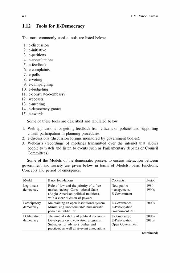
1.12 Tools for E-Democracy
The most commonly used e-tools are listed below;
1. e-discussion2. e-initiative3. e-petitions4. e-consultations5. e-feedback6. e-complaints7. e-polls8. e-voting9. e-campaigning
10. e-budgeting11. e-consulate/e-embassy12. webcasts13. e-meeting14. e-democracy games15. e-awards.
Some of these tools are described and tabulated below
1. Web applications for getting feedback from citizens on policies and supportingcitizen participation in planning procedures.
2. e-discussions (discussion forums monitored by government bodies).3. Webcasts (recordings of meetings transmitted over the internet that allows
people to watch and listen to events such as Parliamentary debates or CouncilCommittees).
Some of the Models of the democratic process to ensure interaction betweengovernment and society are given below in terms of Models, basic functions,Concepts and period of emergence.
Model Basic foundations Concepts Period
Legitimatedemocracy
Rule of law and the priority of a freemarket society. Constitutional State(Anglo-American political tradition),with a clear division of powers
New publicmanagement,E-Government
1980–1990s
Participatorydemocracy
Maintaining an open institutional system.Minimising unaccountable bureaucraticpower in public life
E-Governance,E-ParticipationGovernment 2.0
2000s
Deliberativedemocracy
The mutual validity of political decisions.Developing civic education programs.Subsidies for advisory bodies andpractices, as well as relevant associations
E-democracy,E-ParticipationOpen Government
2005–2010s
(continued)
40 T.M. Vinod Kumar
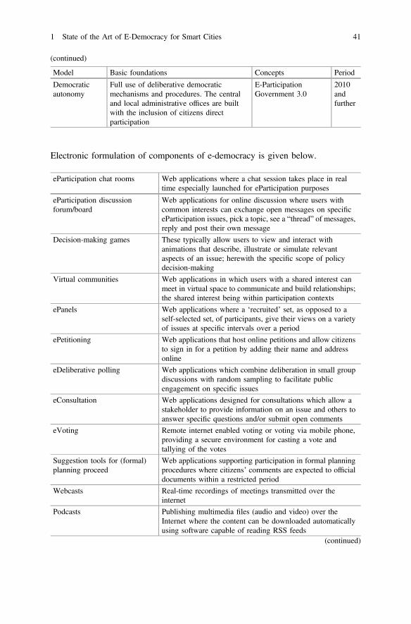
(continued)
Model Basic foundations Concepts Period
Democraticautonomy
Full use of deliberative democraticmechanisms and procedures. The centraland local administrative offices are builtwith the inclusion of citizens directparticipation
E-ParticipationGovernment 3.0
2010andfurther
Electronic formulation of components of e-democracy is given below.
eParticipation chat rooms Web applications where a chat session takes place in realtime especially launched for eParticipation purposes
eParticipation discussionforum/board
Web applications for online discussion where users withcommon interests can exchange open messages on specificeParticipation issues, pick a topic, see a “thread” of messages,reply and post their own message
Decision-making games These typically allow users to view and interact withanimations that describe, illustrate or simulate relevantaspects of an issue; herewith the specific scope of policydecision-making
Virtual communities Web applications in which users with a shared interest canmeet in virtual space to communicate and build relationships;the shared interest being within participation contexts
ePanels Web applications where a ‘recruited’ set, as opposed to aself-selected set, of participants, give their views on a varietyof issues at specific intervals over a period
ePetitioning Web applications that host online petitions and allow citizensto sign in for a petition by adding their name and addressonline
eDeliberative polling Web applications which combine deliberation in small groupdiscussions with random sampling to facilitate publicengagement on specific issues
eConsultation Web applications designed for consultations which allow astakeholder to provide information on an issue and others toanswer specific questions and/or submit open comments
eVoting Remote internet enabled voting or voting via mobile phone,providing a secure environment for casting a vote andtallying of the votes
Suggestion tools for (formal)planning proceed
Web applications supporting participation in formal planningprocedures where citizens’ comments are expected to officialdocuments within a restricted period
Webcasts Real-time recordings of meetings transmitted over theinternet
Podcasts Publishing multimedia files (audio and video) over theInternet where the content can be downloaded automaticallyusing software capable of reading RSS feeds
(continued)
1 State of the Art of E-Democracy for Smart Cities 41

(continued)
eParticipation chat rooms Web applications where a chat session takes place in realtime especially launched for eParticipation purposes
Wikis Web applications that allow users to add and edit contentcollectively
Blogs Frequently modified web pages that look like a diary as datedentries are listed in reverse chronological order
Quick polls Web-based instant survey
Surveys Web-based, self-administered questionnaires, where thewebsite shows a list of questions which users answer andsubmit their responses online
GIS-tools Web applications that enable the users to have a look at mapsunderlying planning issues and to use them in various ways
Search Engines Web applications to support users find and retrieve relevantinformation typically using keyword searching
Alert services One-way communication alerts to inform people about anews item or an event, e.g. email Alerts and RSS Feeds
Online newsletters One-way communication tools to inform a general audienceor a pre-registered audience of specific news items and events
Frequent asked questions(FAQ)
A ‘tree’ of questions and answers that can be searched usingkeywords or by inputting a question or statement
Web portals Web sites providing a gateway to a set of specific informationand applications
Groupware tools Tool environment to support computer-based group works
1.13 Conclusion
Although it is desirable to convert as many cities in India to smart cities, it is notsimply possible. There should be potential for smart cities in states and unionterritories. Smart people and smart communities are primary requirements to triggerthe development of smart cities. They work within the framework of e-democracy,e-governance, and e-government. They are there wherever there is high HDI. It isonly smart people who can create smart communities and smart cities. Evidence ofemerging urban economy is indicated by the high urban content of the states. TheLarge impact of the smart economy can be there only in million-plus urbanagglomeration. When one combines all these requirements, not all 53 million-pluscities in India that appeared in 2011 census in India can be potential candidates forsmart cities. Even if few of this million-plus agglomeration or cities are shortlistedas candidates, they can never be smart cities unless they are having an appropriateinstitutional framework which can shape them to smart cities such as e-democracy,e-government, and e-governance. Seventy-fourth constitutional amendments pro-vide for the metropolitan planning committees which need to be legislated by the
42 T.M. Vinod Kumar
respective states. Triple Helix Model is the only dynamic framework that can shapesmart cities. It presupposes that members of this constitutional body, themetropolitan committee shall have representatives of democratically elected rep-resentatives such as mayor, chairman/president municipality, and panchayat in themetropolitan region. Members should be there from industrial sector or its repre-sentative bodies such as the chamber of commerce and industries. There shall beacademicians such as vice chancellors, directors of higher educational institutions,directors of public research institutions, and eminent professors in metropolitancommittee. This committee shall have an implementing authority with senioradministrator heading implementing body whose main function is to implement thedecisions of the metropolitan committee. The administrator shall be assisted bythree wings namely metropolitan planning wing with highest level of capability formetropolitan regional development planning and capability to manage the moderncentre for metropolitan geographic information system using e-democracy fore-government and e-governance; an engineering wing with senior engineermanaging it and a finance wing whose main capability shall be the mobilisation oflarge-scale finances from national and international sources for implementinglarge-scale infrastructure and other development tasks in addition to traditionalaccount keeping. All these wings shall have provision to employ the highest level ofexpert consultants to accomplish tasks which normally they cannot perform atmarket rate.
A global alliance of smart cities shall be formed where Indian smart cities shallbe members to exchange experience and share software development. Metropolitanplanning committee shall have 20-year spatial and infrastructure development plan,5-year metropolitan social and economic development plans in tune with state andnational five-year plans and annual plans for implementation of the plan as perannual budget. A share of annual budget shall come from state government, andanother central government and metropolitan planning committee shall have theirown financial resources from entering commercial developments such as landdevelopment and leasing of land for industries, development of infrastructure topotential entrepreneurs or running major transport networks. Institute of TownPlanners India can have a positive role in formulating model metropolitan planningcommittee legislation and model organisation framework for the smart citymetropolitan committee and its implementing authority. This will considerably helpthe state government to formulate legislations for the creation of metropolitanplanning committee. India’s experience in the direction of the metropolitan plan-ning committee is very meagre or one can say almost non-existent.
There are specialised hardware and software required for the functioning ofsmart cities and smart communities. Many of these technologies are not imple-mented in Indian cities. Most of them aim at resource conserving metropolitanfunctioning of smart cities whether it is of energy or water use or on transportation.Outright purchase of technology and licence for local manufacture and commercialproduction is one approach for large-scale deployment of these technologies inemerging Indian smart cities. Another approach is collaborative research and jointproduction. Still another approach is to develop appropriate smart city technologies
1 State of the Art of E-Democracy for Smart Cities 43

in Indian research centres based on specific needs. There is a need to appraiseglobally available smart city technologies and formulate appropriate Indian stan-dards. Indian Standard Institution is competent to develop such standards, andMinistry of Science and Technology can conduct a global smart city urban tech-nologies assessment.
There are no smart city policies for India or states of India. There is a need toconduct basic research leading towards the formulation of policies. This policyformulation can be from the study of other countries such as for example Europeancommunity who is taking many steps in this direction. Another approach is toevaluate the existing smart cities to learn the experience and transfer it to Indiancondition.
There are few experiences such as e-governance and e-commerce available inIndia. There are also resources conserving technologies being developed in Indiawhich can be used in smart cities. These needs to be studied and expanded in scope.
Smart cities open to an information or knowledge society. It is likely thatinformation society may trespass in the privacy of a citizen. These needs to bestudied and appropriate norms need to be applied to smart cities 1. E-democracy forSmart Cities.
This book “E-Democracy for Smart Cities” is organized into five sections andwithin each section there are one or more chapters.
The first section introduction is meant to lay out the dominant thinking onDemocracy and e-democracy mainly derived from literature surveys and experi-ences across the world to evolve an operational e-democracy model for SmartCities.
The second session presents a series of case studies on the state of the Art ofE-Democracies in emerging smart cities across the world. Unlike E-Governance,e-democracy is not widely practiced. Therefore, the nascent state of e-democracy inall these cities will be evident. These chapters also point out the potentials.
The third section deals with a series of case studies on different domains ine-democracy. These domain studies show there has been progress in selectedsectors of domain studies in e-democracy while the full practice of e-democracy isnowhere to be found in any cities.
The fourth section discusses issues and the emerging tools of e-democracy.The fifth and final section combines all conclusions derived out of all chapters of
the book in one chapter.
References
1. Vinod Kumar TM et al (ed) (2014) Geographic information system for smart cities. CopalPublishing Group, New Delhi
2. Vinod Kumar TM (ed) (2015) E-governance for smart cities. Springer, Singapore3. Vinod Kumar TM (ed) (2016) Smart economy in smart cities. Springer, Singapore4. Rifkin J (2013) The third industrial revolution: how lateral power is transforming energy, the
economy, and the world. Kindle Edition
44 T.M. Vinod Kumar
5. Rifkin J (2015) The zero marginal cost society: the internet of things, the collaborativecommons, and the eclipse of capitalism. Kindle Edition
6. Diamond L, Lecture at Hilla University for Humanistic Studies 21 Jan 2004: What isdemocracy?; Diamond L, Morlino L (2016) The quality of democracy. In: Diamond L(ed) Search of democracy. Routledge, London. ISBN 978-0-415-78128-2
7. dηlojqasίa in Henry George Liddell, Robert Scott, A Greek-English Lexicon, at Perseus8. Wilson NG (2006) Encyclopedia of ancient Greece. Routledge, New York. p 511. ISBN
0-415-97334-19. Barker E (1906) The political thought of Plato and Aristotle, Chapter VII, Section 2.
G.P. Putnam’s Sons10. Staff writer (22 Aug 2007) Liberty and justice for some. The Economist (Economist Group)11. O’Donnell G (2005) Why the rule of law matters? In: Diamond L, Morlino L (eds) Assessing
the quality of democracy. Johns Hopkins University Press, Baltimore, pp 3–17. ISBN9780801882876. Preview
12. Dahl RA, Shapiro I, Cheibub JA (2003) The democracy sourcebook. MIT Press, CambridgeDetails. ISBN 9780262541473
13. Hénaff M, Strong TB (2001) Public space and democracy. University of Minnesota Press,Minneapolis. ISBN 9780816633883
14. Kimber R (1989) On democracy. Scand Polit Stud 12(3):201, 199–219. doi:10.1111/j.1467-9477.1989.tb00090.x. Full text
15. Scruton R (9 Aug 2013) A point of view: is democracy overrated? BBC News (BBC)16. Kopstein J, Lichbach M, Hanson SE (eds) (2014) Comparative politics: interests, identities,
and institutions in a changing global order (4, revised edn). Cambridge University Press,Cambridge, pp 37–39. ISBN 1139991388
17. Parliamentary sovereignty. UK Parliament. Retrieved 18 Aug 2014; Independence. Courtsand Tribunals Judiciary. Retrieved 9 Nov 2014
18. Daily Express News (2 Aug 2013) All-party meet vows to uphold Parliament supremacy. TheNew Indian Express (Express Publications (Madurai) Limited). Retrieved 18 Aug 2013
19. Barak A (2006) Protecting the constitution and democracy. In: Barak A (ed) The judge in ademocracy. Princeton University Press, Princeton, New Jersey, p 27. ISBN 9780691120171.Preview
20. Kelsen H (1955) Foundations of democracy. Ethics, special issue: Part 2: foundations ofdemocracy (Chicago J) 66(1):1–101. doi:10.1086/291036.JSTOR2378551
21. Nussbaum M (2000) Women and human development: the capabilities approach. CambridgeUniversity Press, Cambridge New York. ISBN 9780521003858
22. Snyder R, Samuels D (2006) Devaluing the vote in Latin America. In: Diamond L,Plattner MF (eds) Electoral systems and democracy. Johns Hopkins University Press,Baltimore, p 168. ISBN 9780801884757
23. Montesquieu, Spirit of the laws, Book II, Chap. 2–324. Everdell WR (2000) [1983] The end of kings: a history of republics and republicans, 2nd edn.
University of Chicago Press, Chicago. ISBN 978022622482425. Dunn J (1994) Democracy: the unfinished journey 508 BC–1993 AD, 91994. Oxford
University Press, Oxford. ISBN 0-19-827934-5. Raaflaub, Ober & Wallace 200726. Po-chia Hsia R, Hunt L, Martin TR, Rosenwein BH, Smith BG (2007) The making of the
West, peoples and cultures, a concise history, vol I: To 1740. Bedford/St. Martin’s, Bostonand New York, p 44
27. Grinin LE (2004) The early state, its alternatives and analogues. ‘Uchitel’ Publishing House28. Lape S (2009) Reproducing Athens: Menander’s comedy, democratic culture, and the
Hellenistic city. Princeton University Press, Princeton, p 4. ISBN 140082591129. Huber E, Rueschemeyer D, Stephens JD (1993) The impact of economic development on
democracy. J Econ Pers 7:71–8530. Aristotle (1932) Politics (Translated by H Rackham). Harvard University Press, Cambridge31. Lipset SM (1959) Some social requisites of democracy: economic development and political
legitimacy. Am Polit Sci Rev 53(01):69–105
1 State of the Art of E-Democracy for Smart Cities 45
32. Lipset SM, Seong K-R, Torres JC (1993) A comparative analysis of the social requisites ofdemocracy. Int Soc Sci J 45(2):155–175
33. The Mahaparinibbanasuttanta is the story of the “great decease of the Buddha” and as suchincludes both colourful anecdotes and important last minute instructions to his followers
34. The Pali Canon uses both the term Vajji (Vriji in Sanskrit) and Licchavi to designate arepublican polity based at Vesali. Scholars believe that the Licchavi were the people wholived at Vesali, while Vajji was the name of a confederation that they headed. For a detaileddiscussion, see Sharma
35. http://faculty.nipissingu.ca/muhlberger/HISTDEM/INDIADEM.HTM 8/1636. In this sense, R.C Majumdar was right in calling the Buddha “an apostle of democracy;”37. Held D (1996) Models of democracy. Blackwell, Oxford38. Corporate Life, p 219. Contra, Drekmeier, Kingship and community in early India, p 113
(Alexander H. Trechsel and Fernando Mendez, The European Union and E-Voting(Routledge, London, 2005), p 5 (Italics added)
39. Pateman C (1970) Participation and democratic theory. Cambridge University Press,Cambridge
40. Eriksen EO, Weigård J (1999) Kommunikativ handling of deliberative democratic: JürgenHabermas’ teori om politikk og samfunn. Fagbokforlaget, Bergen
41. Gimmler A (2001) Deliberative democracy, the public sphere and the internet. Philos SocCriticism 27(4):21–39
42. Barber BR (1984) Strong democracy: participatory politics for a new age. University ofCalifornia Press, Berkeley
43. Bellamy C (2000) Modelling electronic democracy, towards democratic discourses for aninformation age. In: Hoff J, Horrocks I, Tops P (eds) Democratic governance and newtechnology, technologically mediated innovations in political practice in Western Europe.Routledge, London, pp 33–54
44. Lynne E (2004) Direkte demokrati. Pax, Oslo45. Fung A (2002) One city, two systems: democracy in an electronic chat room in Hong Kong.
Javnost-The Publ 9(2):77–9346. Hurwitz R (1999) Who needs politics? Who needs people? The ironies of democracy in
cyberspace. Contemp Sociol 28:655–66147. Moon JY, Yang S (2003) The internet as an agent of political change: the case of “Rohsamo”
in the South Korean Presidential Campaign of 2002. In: Twenty-fourth internationalconference on information systems
48. Olsson T, Sandstrom H, Dahlgren P (2003) An information society for everyone? Gaz: Int JCommun Stud 65(4–5):347–363
49. Paolillo JC, Heald D (2002) Democratic participation in the discursive management ofUsenet. In: Proceedings of the 35th annual Hawaii international conference on systemsciences, vol 35, pp 1040–1049
50. Papacharissi Z (2004) Democracy online: civility, politeness, and the democratic potential ofonline political discussion groups. New Media Soc 6(2):259–283
51. Rodan G (1998) The internet and political control in Singapore. Polit Sci Q 113(1):63–8952. Schneider SM (1996) Creating a democratic public sphere through political discussion—a
case study of abortion conversation on the internet. Soc Sci Comput Rev 14(4):373–39353. Stromer-Galley J (2002) New voices in the public sphere: a comparative analysis of
interpersonal and online political talk. Javnost-The Publ 9(2):23–4154. Tsaliki L (2002) Online forums and the enlargement of public space: research findings from a
European project. Javnost-The Publ 9(2):95–11255. Hill KA, Hughes JE (1998) Cyberpolitics: citizen activism in the age of the internet. Rowman
& Littlefield, Lanham, MD56. Griffiths M (2004) e-Citizens: blogging as democratic practice. Eur J E-Gov 2(3):155–16657. Van Dijk J (2000) Models of democracy and concepts of communication. In: Hacker KL, Van
Dijk J (eds) Digital democracy, issues of theory and practice. Sage, London
46 T.M. Vinod Kumar

58. Grönlund Å (2003) Emerging electronic infrastructures—exploring democratic components.Soc Sci Comput Rev 21(1):55–72
59. Commission E (2002) eEurope 2005: an information society for all. http://europa.eu.int/information_society/eeurope/2002/news_library/documents/eeurope2005/eeurope2005_en.pdf,current 10 June 2004
60. Okot-Uma RWO (2000) Electronic governance: re-inventing good governance.Commonwealth Secretariat, London
61. United Nations (2002) A global survey of e-government 2002. www.nuasurveys.org onlinenewsletter, 24 June 2002: 2
62. Holmes D (2001) E-gov: e-business strategies for government. Nicholas Brealey Publishing,London
63. Clift S (2001) E-governance to e-democracy: progress in Australia and New Zealand. Onlinehttp://www.electronicgov.net
64. Clift S (2002) The future of e-democracy. Democracy Online Newswire65. http://www.e-democracy.org
1 State of the Art of E-Democracy for Smart Cities 47

Part IE-Democracy State of the Art
City Studies
Chapter 2E-Democracy for Smart City Lagos
Femi Olokesusi and Femi Ola Aiyegbajeje
Abstract Information and Communication Technologies (ICTs) have strengthenedthe democratic processes of most democracies in the world. The adoption ofE-democracy is to encourage good governance and to properly monitor thedemocratic processes for the benefits of Lagos residents. Lagos has the fastest andmost lucrative ICT market in Nigeria and Africa, yet in spite of this obvious andsignificant progress, little is known about its E-democracy adoption. This paperprovides a comprehensive review of E-democracy in order to assess the levels ofE-democracy implementation, evaluate critical success factors of E-democracyimplementation and discusses the successes and failures of E-democracy. Theanalysis of the impact of E-democracy on service delivery in Lagos is also pro-vided. It notes that Lagos is facing a number of challenges in the introduction ofE-democracy. Given the importance of the successful implementation of electronicdemocratic services and from a practical perspective, the paper suggests that gov-ernment should take a positive position towards the factors which will bring abouteffective and efficient E-democracy in Nigeria, particularly in Lagos. Lagos StateGovernment needs to widen access to ICT services and guarantee enabling envi-ronment for attracting the right level of investments. The paper concludes that thereis a lot of hope on the potential of E-democracy to transform the internal efficiencyof government and the relationship of government with citizens.
Keywords E-democracy Smart city Lagos Information and communicationstechnology Lagos
F. OlokesusiCollege of Social and Management Sciences, Afe Babalola University,Ado-Ekiti, Ekiti State, Nigeriae-mail: [email protected]
F.O. Aiyegbajeje (&)Department of Geography, Faculty of the Social Sciences,University of Ibadan, Ibadan, Nigeriae-mail: [email protected]
© Springer Nature Singapore Pte Ltd. 2017T.M. Vinod Kumar (ed.), E-Democracy for Smart Cities, Advances in 21st CenturyHuman Settlements, DOI 10.1007/978-981-10-4035-1_2
51
2.1 Introduction
Democracy is a system of governance that establishes a social contract between thecitizens and the representatives [1]. This therefore necessitated prompt responsivecommunication between the people and the government. Democracy as a form ofgovernance stretches beyond campaign, voting and other electoral practices as itsbasic components. It also involves interaction among participants in a democraticsetup. Democracy actually entails the governing of a people by the people but withthe use of electronic (Information and Communication Technology), democracybecomes e-democracy. The ‘people’ in this context, refers to the elected people andthe governed or voters resident in the state. E-democracy is the use of informationtechnologies (such as Wide Area Networks (WAN), the Internet, and mobilecomputing) that have the ability to transform relations with citizens, businesses, andother forms of human endeavours. These technologies can serve a variety of dif-ferent ends: better delivery of government services to citizens, improved interac-tions with business and industry, citizen empowerment through access toinformation, or more efficient government management. By putting a suffix “e” infront of democracy means nothing more than using information technology tools tofacilitate, improve and ultimately extend the exercise of democracy [1].
E-democracy is positioned as a tool in enhancing and making the democraticprocess more accessible; ensuring citizen participation in public policydecision-making. E-democracy allows a broader influence in policy outcomes asmore individuals involved could yield smarter policies; increasing transparency andaccountability, and keeping the government closer to the consent of the governed,increasing its political legitimacy, especially considering Lagos state where resi-dents continuously accused the state government of lack of transparency and badgovernance which constitute hindrances to the development of democracy anddemocratic principles in the state. In this regard, representative democracy hasfailed and hence has led to frustration and reduced trust in democracy but theadoption of electronic based democratic practices in Lagos state has re-enacted aray of hope. The growth of ICT does not only focus its attention on the internet butalso spreads its wings to cover telecommunication, whereby people are connectedand can communicate to themselves through cell phones, home personal computersand other medium. From the available statistics, the Internet facility has beendiscovered to be the most used medium of communication than the personalcomputers and the telephone put together [2]. For instance, the use of Facebook andTwitter in the last general elections of 2011 and 2015 in Lagos Nigeria was veryimpressive. It created a necessary platform for the contestants and the electorates tointeract.
E-democracy is an attempt aimed at developing digital citizenship (Netizen)through the use of information and communication technology (ICT) to createpersonal contact, dialogue and consultation among participants in democracy [3].E-democracy offers a level playing ground and bridge communication gap amongadministrators, citizens, associations and public and private entities across the
52 F. Olokesusi and F.O. Aiyegbajeje
various tiers of government. E-democracy, presents a new form of democraticpractice carried out through information and communication technology. Oneessential elements of E-democracy is the relevance of residents’ participation indecision making. According to Azeta et al. [4], E-democracy is an innovation stillin its infant stage; and is still subject to much debate and activity within govern-ment, civic oriented groups and societies around the world. Through the internetand social media, government and its officials communicate with the residents moreeffectively, and also aid the communication between citizens and their fellow cit-izens to discuss political and governmental issues which could be a resourcefulcontribution to the improvement of governance and most democracy.Citizen-participation in governance is at an increasing level in the nation owing tothe involvement of ICT in governance. E-democracy does not just stop at the levelsof the citizens, but goes as far as fostering the communication among administra-tors, associations, public and private entities among the various tiers ofgovernments.
ICT has the potential to engage people in all areas of the political process such asthe generation of information, enhanced deliberation among citizens, and most ofall enhance participation in decision making [3]. According to Policy and LegalAdvocacy Centre [5], the 2011 elections in Nigeria witnessed a remarkable use ofthe social media as a tool for political communication. However, in the 2015election in Lagos, the social media became more potent and largely deployed toexecute the elections in Lagos. The social media pass information freely because itis unregulated. Information pertaining to elections and campaign flew around onsocial media applications such as WhatsApp, BBM, blogs, Facebook, and Twitter.ICT is also one of the best means of bridging the communication gaps between thepeople and the government. Through the internet, it is now possible for the gov-ernment to communicate with the residents easily via social media, and also aids thecommunication between residents and their fellow residents of the state to discusspolitical and governmental issues which could be a resourceful contribution to theimprovement of governance and most democracy.
One of the most embraced aspects of ICT in Nigeria is the mobile telephonetechnology. A new publication sub-Saharan Africa Mobility Report by Ericson saysthat Nigeria is the largest and fastest telecommunication market in Africa withabout US$38 billion investment and active mobile subscription of over 150 millionas at September 2016 [6]. Further, with respect to subscription to mobile telephoneservices, the Nigeria Bureau of Statistics (NBS) report of the first quarter of 2016puts Lagos State as having the highest active mobile telephone and Internet sub-scribers in the country [7]. Nigeria recorded about 148.74 million active voice andinternet subscribers in the first quarter (Q1) of 2016. In its quarterly report onNigerian Telecommunications in the first quarter of 2016, the National Bureau ofStatistics (NBS) revealed that the report represents the total number of active voiceand internet subscribers in the 36 states of the country including the FCT at the endof the first quarter 2016 disaggregated by States. The report showed that the numberof active voice subscriptions in the country stood at 148.74 million at the end of Q12016.
2 E-Democracy for Smart City Lagos 53

According to the NBS, out of the 36 States in Nigeria, Lagos State accounted forthe largest share of active voice subscribers with 19.04 million (12.8%) of the total,followed by Ogun State with 8.53 million subscribers (5.7%), Kano State with 7.81million (5.25%), Oyo State with 7.53 million subscribers (5.06%), then FCT andRivers State with 6.03 million (4.05%) and 5.84 million (3.93%) respectively [7]. Itis observed that all of the top five States with respect to active voice subscriptionshad total subscribers in excess of their official population number as provided by theNigerian Population Commission, except for Kano and Rivers, whose officialpopulation figures exceeded the number of active voice subscribers at the end of Q12016. On the other hand, the following States of the Federation; Bayelsa (1.11million), Yobe (1.40 million), Ekiti (1.42 million) and Ebonyi (1.43 million) hadthe smallest number of active subscriber as of Q1 2016 [7].
Against this backdrop, the objectives of this study are to appraise E-democracypractice in Lagos city by assessing the levels of E-democracy implementation,critical success factors of e-democracy implementation, and analyse the impact ofE-democracy on service delivery in Lagos state. Lagos is one of the 36 federatingunits of Nigeria and not a fully autonomous state because of the several provisionsof the Constitution of the Federal Republic of Nigeria which does not give theFederating States absolute powers to operate as independent units of the Federationas obtained in developed democracy such as the United State of America.
2.1.1 Lagos in Brief
Lagos is one of the 36 federating units in Nigeria. It is located in the coastal part ofthe south-western part of the country Nigeria (see Fig. 2.1). Lagos is the largest cityin Nigeria and arguably the most populous city in Africa. Lagos is often referred toas the economic capital of Nigeria. Lagos city is a huge metropolis with streamingpopulation in the south-western archipelagos of the Nigerian coastline whichincludes the mainland and the surrounding Islands. Lagos is also the former capitalcity of Nigeria; it has since been replaced by Abuja. Abuja city officially gained its
Fig. 2.1 Political map of Lagos State, Nigeria. Source [20]
54 F. Olokesusi and F.O. Aiyegbajeje
status as the capital city of Nigeria on 12 December 1991; although the decision tomove the federal capital had been made in Decree No. 6 of 1976.
The leading air and sea ports in Nigeria are situated in Lagos. The Lagos SeaPort is operated by the Nigerian Port Authority and it is divided into three mainsections: Lagos port, Apapa Port and Tin Can Port, all located on the Gulf ofGuinea. Oil and petroleum products provide 20% of GDP and about 95% of foreignexchange earnings in Nigeria. Lagos is also Nigeria’s commercial centre as majorityof the country’s largest banks and financial institutions are located here. More thanhalf of Nigeria’s industrial capacity is located in Lagos’s mainland suburbs, par-ticularly in the Apapa, Matori, Ilupeju and Ikeja industrial estates. A wide range ofmanufactured goods are produced in the city.
2.2 E-Democracy Implementation and Achievementsin Lagos-Nigeria
Basically, E-democracy represents the use of electronic communications tech-nologies such as the Internet to enhance and advance the democratic process of arepublic. In this part of the world, there exists a low attitude of participation of thecitizens in governance, but with the advent of electronic communication technol-ogy, the level of awareness and participation has tremendously increased among thecitizenry. The benefits of having an E-Democracy system are numerous: It reducesthe success of rigging during elections. It is time saving because it reduced someundue electoral processes. It allows for easy communication between the citizensand their elected candidates. And it allows for participatory governance.
The E-democracy implementation assesses the citizens’ E-participation(E-information, E-consultation, E-decision-making), E-campaign, E-voting,E-forum, and E-monitoring of projects. However, in Lagos city, onlyE-information, E-campaign and E-monitoring of projects have been successfullyutilized. E-information involves dissemination of information about governmentministries, departments and agencies while E-campaign involves the use of socialmedia to canvass for votes. Government also uses it to disseminate vital informationto the residents of the city. Electronic-monitoring of projects involve the use of thecitizens residing where government projects are being executed to report to thegovernment via a dedicated social media platform such as Facebook, Twitter, andvarious dedicated websites) created by government for the purpose of monitoringprojects. Another important aspect of E-monitoring of projects is the use of elec-tronic facilities to monitor the traffic situation in the metropolis. This has largelyhelp motorists to plan their route effectively. To some extent, these techniques havebeen successful but not without some shortcomings such as irregular update ofinformation, disseminating of hate campaigns against political opponents as evi-denced in the 2015 elections in Lagos.
2 E-Democracy for Smart City Lagos 55

2.2.1 E-Participation
E-participation comprises of a participatory processes including E-information,E-consultation, E-decision-making. E-information: This assesses the state govern-ment’s websites and portals to determine if governments are providing the basicinformation that serves as the foundation for citizen participation. Lagos stategovernment has about twenty-eight (28) website addresses for the state ministries[8] and eighty-seven (87) official websites for the state departments and agencies[9]. Although these websites are not interactive, but provide vital information aboutgovernment activities in the respected ministries, departments and agencies(MDAs). The major problems associated with this platform are poor or no feed-back, not providing updated information on the website, and in some cases, thewebsites are not functioning. Appendix 1 shows few examples of the websiteaddresses of the ministries in Lagos State Government while Appendix 2 similarlyindicates the website addresses of the State Government’s Departments andAgencies.
2.2.2 E-Campaign
E-Campaign is the utilisation of various interactive platforms on electronic com-munication devices by electoral candidates as promotional campaign strategies toattract more support from voters. It also provides the political parties a platform notonly to disseminate their ideologies and manifestoes to the voters but also to getfeedback. E-campaign of various forms includes Facebook, Twitter, WhatsApp,E-mail, Blog, Youtube, Friendster, Myspace, SMS, Forum and others. E-campaignin Lagos is fast gaining ground in the political space since 2007 to date. This islargely because of the wide acceptance of ICT and coupled with high number ofmobile telephone users among the citizens. The use of ICT in political campaignswas highly deployed in the last previous elections of 2011 and particularly 2015 inLagos State because most of the social media platforms were accessed via mobiletelephone.
Adoption of the Internet usage as one of the promotional political campaignstrategies is widespread in the developed countries. For instance, in the 1997 and2001 UK general elections, it was asserted that the internet plays an importantcampaign role [10]. Similarly, the 2012 and 2016 US Presidential elections areexamples in justifying the transformed use of Internet through the development ofwebsites and email [11]. The adoption of this technology was also experienced inthe 2015 governorship and state house of assembly elections held in Lagos Stateand some of other States of the Nigerian Federation.
The Internet technology adoption took a similar trend in the Nigeria politicalscene, especially in the 2011 and 2015 general elections. The application ofe-campaign strategies in the Nigeria’s 2011 and 2015 elections in Lagos further
56 F. Olokesusi and F.O. Aiyegbajeje
raised the level of awareness among voters and citizens giving the high level ofmobile telephone subscription in Lagos State (12.8%) which is the highest inNigeria [7]. During the 2011 and 2015 general elections in Lagos, the E-campaignstrategy was adopted by all electoral candidates across party lines in all theelections.
The social media was hugely deployed with more than 134 million users ofmobile phones and about 70 million Nigerians on the internet, according tostatistics from the Nigerian Communication Commission. It therefore explains thereason social media played an influential role in electioneering campaign in Lagosin the 2015 elections. The most accessible new media consisting of Facebook,Twitter, Youtube, Instagram, Google Plus, WhatsApp and LinkedIn among manyothers have become a veritable tool for interacting and mobilizing citizens towardsactive participation in the political process and democratic projects. Their flexi-bility, accessibility and affordability have made them attractive to the youths whoare the most active users and the largest voting bloc.
2.2.3 E-Voting
The goal of any voting system is to establish the intent of the voter and transfer thatintent to the vote counter. The efficiency of the voting method and the accuracy ofthe vote counter are the crucial determinants of the ability and capacity of thesystem to correctly determine the wish of the voters [12]. Electronic voting(E-voting) is the use of ICTs in the conduct of elections. This idea was adopted inNigeria during the 2015 elections to address the major problems associated withelections. These problems include missing names of some registered voters,intimidation and disenfranchisement of voters, multiple and under aged voting,snatching or destruction of ballot boxes, miscomputation and falsification of results[13, 14]. The only aspect of the E-voting that is still practicable in Nigeria is the useof Card Reader Machine (CRM). The introduction of card reader machine andpermanent voters card (PVC) by the Independent National Electoral Commission(INEC) was aimed at stemming the tides of the problems listed earlier. This cardreader machine is dedicated to read the Permanent Voters Card (PVC) issued toeligible voters. The PVC is screened by the card reader machine in order to checkfor fraudulent practices among the voters.
Unfortunately, as beautiful and workable this initiative is, there were still someshortcomings and challenges identified in the 2015 general elections in Nigeria.Theseinclude the inability of card reader to identify some PVCs, lack of back-up batteries topower the card readers, poor electricity, people’s attitude towards the technology,poor technical know-how among the INEC staff and ad hoc staff among others.
For the success of implementing the e-voting in Lagos and by extension Nigeria,the provision for the adoption of E-voting must be inserted in the constitution of thecountry to make it legal for conducting future elections. Also there should be aconcerted effort in reviving the power and ICT sectors for quality service delivery.
2 E-Democracy for Smart City Lagos 57
The National Orientation Agency (NOA) needs to embark on a serious campaignand advocacy on behavioural change and technology acceptance of e-democracy.
Despite the foregoing shortcomings, E-voting still retains a measure of attractionfor the electoral process in Nigeria. It is believed that E-voting can facilitate theprocesses of free and fair elections in Nigeria. The proposition on the introductionof E-voting in the electoral process of Nigeria subsequently reached the NigerianSenate again, as component of a new Electoral Act to drive the 2015 generalelections but was rejected by the Nigerian Senate April 2014.
2.2.4 E-Poll
Provides available functionalities for the creation of opinion polls for users to casttheir opinion on trending issues. This is a method of assessing and evaluatinggovernment’s progress and public opinion on a particular issue of interest. It is alsoused in determining the acceptance of electoral candidates before the election. InNigeria, this is mainly done by both print and non-print media houses e.g. ChannelsTelevision, African Independent Television, Punch Newspaper, GuardianNewspaper etc. Sometimes, the use of mobile telephone is deployed and thisinvolves the use of mobile telephone to send short messages (sms) to dedicatedmembers of the public for or against an opinion.
2.3 Strengthening E-Democracy in Nigeria
Whereas, there is evidence of the diffusion of E-democracy in Lagos, E-democracyis yet to be fully deployed in the democratic space of Nigeria especially in the areaof E-voting despite its immense importance. A critical area where E-democracyneeds to be seriously strengthened includes provision of virile legal frameworks,because the existing legal frameworks only allows for a physical and manual votingwhere a voter is expected to cast his vote by thumb-printing a ballot paper and thendrop the ballot paper in a ballot box provided by INEC at the polling booth. Also,the electricity provision must be enhanced and with a serious advocacy on beha-vioural change and technology acceptance.
All this efforts will go a long way to entrench E-democracy in Lagos and Nigeriaat large. As suggested, before adopting any form of electronic voting method, acritical appraisal of such a method must be undertaken [12]. Such chosen systemmust as a matter of fundamental necessity possesses a certain basic attributes thatwill recommend it. These include among others: the system must increase andguarantee voter confidence and secrecy; must be voter and user friendly; offer thebest in terms of reliability, usability and recountability; and must be secure.
58 F. Olokesusi and F.O. Aiyegbajeje
2.3.1 Success of E-Democracy in Lagos
E-democracy has attained some level of successes in making Lagos a smart city. Asearlier mentioned, one of the areas of success of E-democracy in Lagos State are inthe area of E-participation, E-campaign, e-monitoring of projects, E-poll. Keyamong these successes is seen in the E-monitoring of projects and one major areathis has contributed is the rapid growth of infrastructural facilities. This was madepossible because projects are being monitored via the social media where citizenscan update government officials in charge of the projects latest developmentwithout these officials being on the site. Also, by monitoring the traffic situation inthe city has a way of helping to create an enabling environment for businesses tothrive because we all understand the negative impact that a chaotic traffic envi-ronment can do to businesses.
To better understand the successes and achievements what E-democracy hasbrought to infrastructure development in Lagos metropolis through the adoption ofE-monitoring of projects concept, few critical infrastructures are critically reviewedbelow to buttress this fact.
2.3.1.1 Transportation
The transportation sector is a key factor for the economic development of anysociety because of the important roles it plays in the movement of people, servicesand information. For government to achieve this, E-democracy has helped themovement of about 7 million passengers per day [15]. The scope of E-democracy inthis regard include the introduction of E-ticketing for Bus Rapid Transit (BRT),involvement of the masses in decision making via media, introduction of trafficradio 96.1 FM station to divulge information pertaining to traffic situation in allareas of the metropolis (see Fig. 2.2).
Presently, road transportation accounts for over 90% of domestic passengers andfreight movement on about 30,500 km State owned roads and 129,577 km of Localgovernment roads in Lagos State [16]. There is a daily haulage of 6 million pas-sengers between the Mainland and Lagos Island in about 75,000 unregulatedmini-buses. In a bid to reform this situation, the Lagos State Government in col-laboration with the World Bank initiated the Lagos Urban transport Project (LUTP),to create an efficient and effective integrated inter-modal mass transit system in theState. The Lagos State Government in its effort to improve the public transportsystem has through LAMATA deliberately eased out the old para transit busespopularly called Molues to give way to brand new and more comfortable busescalled Bus rapid Transit (BRT) and LAGBUS plying over dedicated lanes withinthe metropolis. The BRT Lite scheme commenced operation with a total number of220 Ashok Leyland high floor capacity buses along Mile 12—TBS corridor from6:00 am to 10:00 pm daily. Over 900 bus pilots/bus officers and 57inspectors/monitoring officers were employed for BRT operations with about 106
2 E-Democracy for Smart City Lagos 59
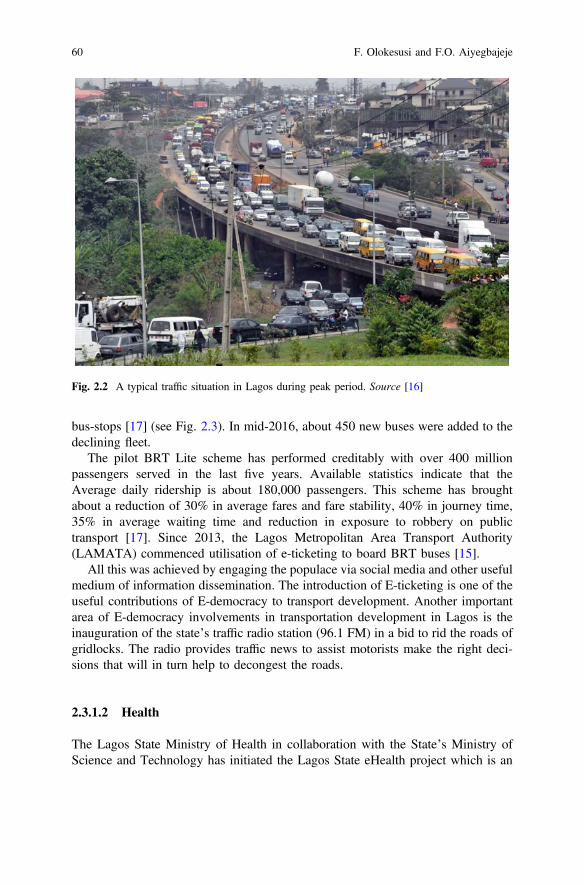
bus-stops [17] (see Fig. 2.3). In mid-2016, about 450 new buses were added to thedeclining fleet.
The pilot BRT Lite scheme has performed creditably with over 400 millionpassengers served in the last five years. Available statistics indicate that theAverage daily ridership is about 180,000 passengers. This scheme has broughtabout a reduction of 30% in average fares and fare stability, 40% in journey time,35% in average waiting time and reduction in exposure to robbery on publictransport [17]. Since 2013, the Lagos Metropolitan Area Transport Authority(LAMATA) commenced utilisation of e-ticketing to board BRT buses [15].
All this was achieved by engaging the populace via social media and other usefulmedium of information dissemination. The introduction of E-ticketing is one of theuseful contributions of E-democracy to transport development. Another importantarea of E-democracy involvements in transportation development in Lagos is theinauguration of the state’s traffic radio station (96.1 FM) in a bid to rid the roads ofgridlocks. The radio provides traffic news to assist motorists make the right deci-sions that will in turn help to decongest the roads.
2.3.1.2 Health
The Lagos State Ministry of Health in collaboration with the State’s Ministry ofScience and Technology has initiated the Lagos State eHealth project which is an
Fig. 2.2 A typical traffic situation in Lagos during peak period. Source [16]
60 F. Olokesusi and F.O. Aiyegbajeje
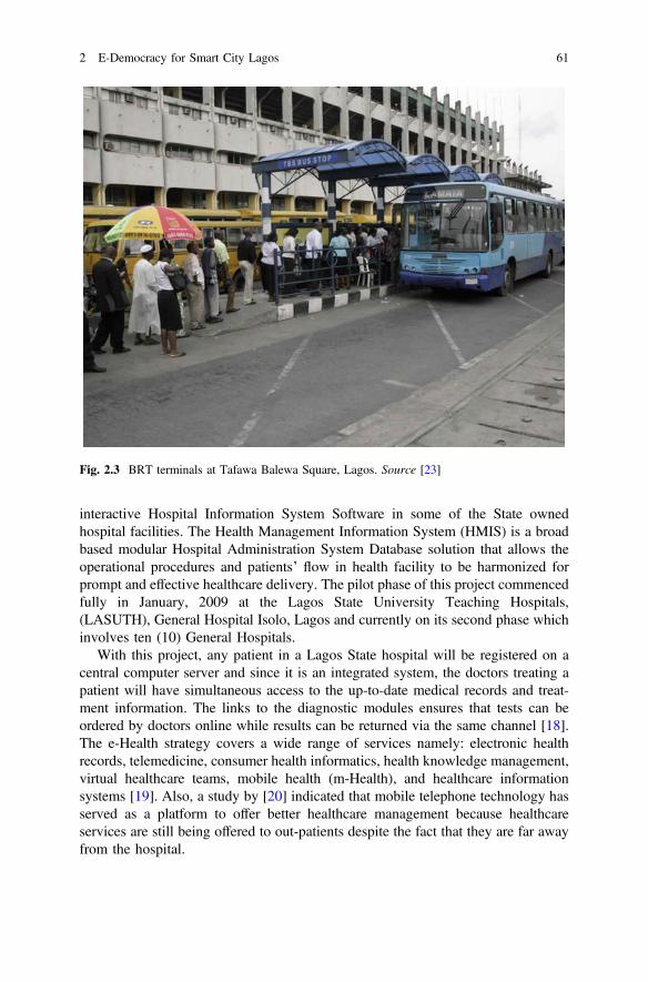
interactive Hospital Information System Software in some of the State ownedhospital facilities. The Health Management Information System (HMIS) is a broadbased modular Hospital Administration System Database solution that allows theoperational procedures and patients’ flow in health facility to be harmonized forprompt and effective healthcare delivery. The pilot phase of this project commencedfully in January, 2009 at the Lagos State University Teaching Hospitals,(LASUTH), General Hospital Isolo, Lagos and currently on its second phase whichinvolves ten (10) General Hospitals.
With this project, any patient in a Lagos State hospital will be registered on acentral computer server and since it is an integrated system, the doctors treating apatient will have simultaneous access to the up-to-date medical records and treat-ment information. The links to the diagnostic modules ensures that tests can beordered by doctors online while results can be returned via the same channel [18].The e-Health strategy covers a wide range of services namely: electronic healthrecords, telemedicine, consumer health informatics, health knowledge management,virtual healthcare teams, mobile health (m-Health), and healthcare informationsystems [19]. Also, a study by [20] indicated that mobile telephone technology hasserved as a platform to offer better healthcare management because healthcareservices are still being offered to out-patients despite the fact that they are far awayfrom the hospital.
Fig. 2.3 BRT terminals at Tafawa Balewa Square, Lagos. Source [23]
2 E-Democracy for Smart City Lagos 61
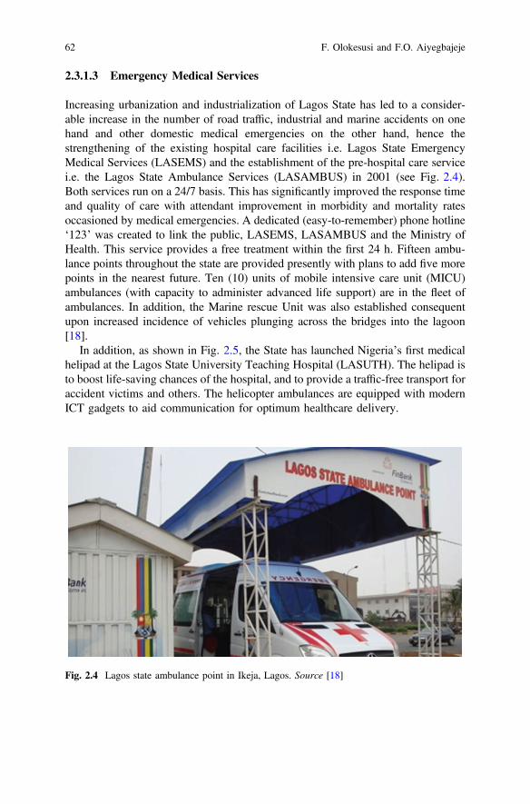
2.3.1.3 Emergency Medical Services
Increasing urbanization and industrialization of Lagos State has led to a consider-able increase in the number of road traffic, industrial and marine accidents on onehand and other domestic medical emergencies on the other hand, hence thestrengthening of the existing hospital care facilities i.e. Lagos State EmergencyMedical Services (LASEMS) and the establishment of the pre-hospital care servicei.e. the Lagos State Ambulance Services (LASAMBUS) in 2001 (see Fig. 2.4).Both services run on a 24/7 basis. This has significantly improved the response timeand quality of care with attendant improvement in morbidity and mortality ratesoccasioned by medical emergencies. A dedicated (easy-to-remember) phone hotline‘123’ was created to link the public, LASEMS, LASAMBUS and the Ministry ofHealth. This service provides a free treatment within the first 24 h. Fifteen ambu-lance points throughout the state are provided presently with plans to add five morepoints in the nearest future. Ten (10) units of mobile intensive care unit (MICU)ambulances (with capacity to administer advanced life support) are in the fleet ofambulances. In addition, the Marine rescue Unit was also established consequentupon increased incidence of vehicles plunging across the bridges into the lagoon[18].
In addition, as shown in Fig. 2.5, the State has launched Nigeria’s first medicalhelipad at the Lagos State University Teaching Hospital (LASUTH). The helipad isto boost life-saving chances of the hospital, and to provide a traffic-free transport foraccident victims and others. The helicopter ambulances are equipped with modernICT gadgets to aid communication for optimum healthcare delivery.
Fig. 2.4 Lagos state ambulance point in Ikeja, Lagos. Source [18]
62 F. Olokesusi and F.O. Aiyegbajeje
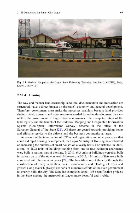
2.3.1.4 Housing
The way and manner land ownership, land title, documentation and transaction arestructured, have a direct impact on the state’s economy and general development.Therefore, government must make the processes seamless because land providesshelters, food, minerals and other resources needed for urban development. In viewof this, the government of Lagos State commissioned the computerization of theland registry and the launch of the Cadastral Mapping and Geographic InformationSystem (Geo-Spatial Information Survey) scheme in the office of theSurveyor-General of the State [21]. All these are geared towards providing betterand effective service to the citizens and the business community at large.
As a result of the introduction of ICT in land registration and other processes thatcould aid rapid housing development, the Lagos Ministry of Housing has embarkedon increasing the numbers of smart houses on a yearly basis. For instance, in 2010,a total of 2892 units of buildings ranging from one to four bedroom apartmentswere built in various part of the state. In 2011, 643 units of buildings were also builtin various parts of the state as well. However, in 2012, 434 units of flats were builtcompared with the previous years [22]. The beautification of the city through theconstruction of many relaxation parks, roundabouts and planting of trees andgrasses along major highways are parts of numerous efforts of the state governmentto smartly build the city. The State has completed about 116 beautification projectsin the State making the metropolitan Lagos more beautiful and livable.
Fig. 2.5 Medical Helipad at the Lagos State University Teaching Hospital (LASUTH), Ikeja,Lagos. Source [24]
2 E-Democracy for Smart City Lagos 63
2.3.1.5 E-Governance-Tax Payments
The Lagos State Government Electronic Banking System of Revenue CycleManagement (LASG EBS-RCM) is aimed to Go-online with the Direct BankLodgment System (DBLS) of the revenue collection process and provides infor-mation for tax administration and planning while monitoring and coordinating allrevenue generating activities of the state. It is an information network systemlinking tax stations and other revenue agencies to lodgment banks. The system usesan E-Pay messaging system for inter-bank communications by creating andmaintaining a database of all revenue collection activities thus allowing for on-linetracking. This system has largely assisted the State in constantly increasing theinternally generated revenue base, provides easy administration, monitoring andco-ordination of all revenue activities in the state and has been assisting to identifyfraudulent debit, diversion of funds and excess charge on the state accounts [20].
2.3.1.6 Security and Surveillance
Under the flagship ‘Rapid Response Squad’ (RRS) project, the Lagos StateGovernment has spent several billions of naira on the acquisition of ICT gadgets toassist the smooth operation of RRS. The RRS is a security outfit made up of thepolice and military created to respond swiftly to any security breach in any part ofthe metropolis. Recently, over one billion naira was realised as cash donations fromvarious corporate organisations and individuals to support the Lagos State SecurityTrust Fund (LSSTF) towards advancing a safer Lagos. The fund used to acquire 10brand new Hilux vehicles and 15 motorbikes were handed over to the Lagos StatePolice Command as part of the state government’s commitment to ensure a securedand investors’ friendly state. Likewise, 100 new power bikes, 10 armoured tanksand a helicopter have been acquired by the state government to reinforce security inthe state. This is in addition to the purchase of 100 new squad cars for a newinitiative tagged Special Operation Service (SOS), which will harmonize commu-nity policing in partnership with the RRS.
Given that we now live in an ICT driven world, the state government is alreadyworking on a scheme to incorporate technology into the state’s security system.Through this scheme, the whole of Lagos would be electronically monitored inorder to prevent violent crimes, protect lives and property and to be able to preventcrisis and to manage crime situations at any location in the state. The technologicaldevice has the ability to recall events in real time at an accurate date and provideinformation that may lead to the detection and prosecution of criminal activities.The device is to be used in sensitive parts in the state.
64 F. Olokesusi and F.O. Aiyegbajeje
2.3.1.7 Emergency and Disaster Management
The Lagos State Government has provided ambulances with a direct emergencynumber at strategic positions in the metropolis for immediate response to emer-gencies. Also, the use of ICT is being deployed in disaster managements such asfire incidences, flooding and other challenges. For instance, the Lagos Fire Serviceprovided several mobile telephone emergency numbers to be reached in case of anyfire or related disasters. Also, the Lagos State Emergency Services (LASEMS)deployed the use of ICT to disseminate information on impending flooding in 2014,2015 and 2016. This measure went a long way to reduce the negative impact offlooding in those years. In addition, estimated properties worth N992.1 billion hasbeen saved in the cause of fire/rescue operations Lagos metropolis, while an esti-mated properties worth N436.55 billion were lost [9].
2.3.2 Failures of E-Democracy in Lagos
Irrespective of the successes of e-Democracy outlined earlier, there exist somefailures as well. These failures are not because E-Democracy is not a viable con-cept. The shortcomings are as a result of the prevailing conditions in this part of theworld. The failure of E-democracy in Lagos has been largely due to poor electricityinfrastructure, abuse of the concept where the idea is used to spread hate campaign.Also, the attitude of politicians towards the transparency and sanity which E-votingwill bring to the political space is one major failure of E-democracy.
2.4 Conclusion
From the foregoing, e-democracy is thriving in other aspect of the electioneeringprocesses such as E-campaign and the screening of eligible voters using CRM.Another critical area where E-democracy is contributing positively is in the area ofe-monitoring of projects. This has largely being helpful in the provision of criticalsocial infrastructure in Lagos metropolis. Therefore, the potential of E-democracy totransform the internal efficiency of government and the relationship of governmentwith citizens is one of the ultimate panaceas that would place Nigeria’s democracyon the global democratic map. However, E-democracy in Lagos is currently markedby some level of apathy arising from the constitutional framework and the history ofelections in Nigeria. The history of elections in Nigeria has shown that Nigerianscannot rely on the technology as veritable means of installing the kind of leaders theywant and by implication in changing the material conditions of their existence. Theoverarching implication is the need for government to sensitise Nigerians on theimperative of genuine transparency in the electoral process.
2 E-Democracy for Smart City Lagos 65
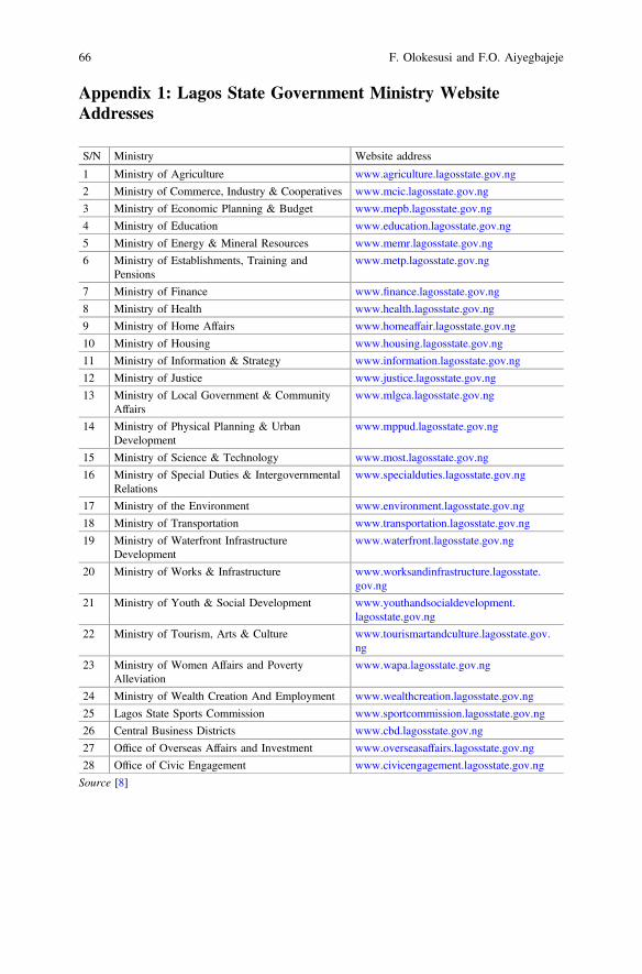
Appendix 1: Lagos State Government Ministry WebsiteAddresses
S/N Ministry Website address
1 Ministry of Agriculture www.agriculture.lagosstate.gov.ng
2 Ministry of Commerce, Industry & Cooperatives www.mcic.lagosstate.gov.ng
3 Ministry of Economic Planning & Budget www.mepb.lagosstate.gov.ng
4 Ministry of Education www.education.lagosstate.gov.ng
5 Ministry of Energy & Mineral Resources www.memr.lagosstate.gov.ng
6 Ministry of Establishments, Training andPensions
www.metp.lagosstate.gov.ng
7 Ministry of Finance www.finance.lagosstate.gov.ng
8 Ministry of Health www.health.lagosstate.gov.ng
9 Ministry of Home Affairs www.homeaffair.lagosstate.gov.ng
10 Ministry of Housing www.housing.lagosstate.gov.ng
11 Ministry of Information & Strategy www.information.lagosstate.gov.ng
12 Ministry of Justice www.justice.lagosstate.gov.ng
13 Ministry of Local Government & CommunityAffairs
www.mlgca.lagosstate.gov.ng
14 Ministry of Physical Planning & UrbanDevelopment
www.mppud.lagosstate.gov.ng
15 Ministry of Science & Technology www.most.lagosstate.gov.ng
16 Ministry of Special Duties & IntergovernmentalRelations
www.specialduties.lagosstate.gov.ng
17 Ministry of the Environment www.environment.lagosstate.gov.ng
18 Ministry of Transportation www.transportation.lagosstate.gov.ng
19 Ministry of Waterfront InfrastructureDevelopment
www.waterfront.lagosstate.gov.ng
20 Ministry of Works & Infrastructure www.worksandinfrastructure.lagosstate.gov.ng
21 Ministry of Youth & Social Development www.youthandsocialdevelopment.lagosstate.gov.ng
22 Ministry of Tourism, Arts & Culture www.tourismartandculture.lagosstate.gov.ng
23 Ministry of Women Affairs and PovertyAlleviation
www.wapa.lagosstate.gov.ng
24 Ministry of Wealth Creation And Employment www.wealthcreation.lagosstate.gov.ng
25 Lagos State Sports Commission www.sportcommission.lagosstate.gov.ng
26 Central Business Districts www.cbd.lagosstate.gov.ng
27 Office of Overseas Affairs and Investment www.overseasaffairs.lagosstate.gov.ng
28 Office of Civic Engagement www.civicengagement.lagosstate.gov.ng
Source [8]
66 F. Olokesusi and F.O. Aiyegbajeje

Appendix 2: Lagos State Government:Department/Agency/Office Website Addresses
S/N Department/Agency/Office Website address
1 Drain Ducks www.drainducks.lagosstate.gov.ng
2 Lagos State Film and Video Censors Board www.lsfvcb.lagosstate.gov.ng
3 Hotel Licensing Authority www.hla.lagosstate.gov.ng
4 Judicial Service Commission www.jsc.lagosstate.gov.ng
5 Kick Against Indiscipline(KAI) Brigade www.kai.lagosstate.gov.ng
6 Lagos State Agriculture Inputs Supply Authority www.laisa.lagosstate.gov.ng
7 Lagos State Agricultural Land Holdings Authority(ALHA)
www.alha.lagosstate.gov.ng
8 Lagos State Agricultural Development Authority www.ada.lagosstate.gov.ng
9 Lagos State Blood Transfusion Services www.bloodtransfusion.lagosstate.gov.ng
10 Lagos State Building Control Agency www.buildingcontrol.lagosstate.gov.ng
11 Lagos State Security Trust Fund www.lsstf.lagosstate.gov.ng
12 Lagos State Infrastructure Asset ManagementAgency, LASIAMA
www.lasiama.lagosstate.gov.ng
13 Lagos State Council for Arts and Culture www.artandculture.lagosstate.gov.ng
14 Radio Lagos www.radiolagos.lagosstate.gov.ng
15 Eko FM www.ekofm.lagosstate.gov.ng
16 Lagos State Electricity Board www.electricityboard.lagosstate.gov.ng
17 Lagos State Emergency Management Agency www.lasema.lagosstate.gov.ng
18 Lagos State Environmental and Special OffencesEnforcement Unit
www.taskforce.lagosstate.gov.ng
19 Lagos State Environmental protection Agency www.lasepa.lagosstate.gov.ng
20 Lagos State Examination Board www.examboard.lagosstate.gov.ng
21 Lagos State Ferry Services Corporation www.ferryservices.lagosstate.gov.ng
22 Lagos State Independent Electoral Commission www.lasiec.lagosstate.gov.ng
23 Lagos Traffic Radio www.trafficradio.lagosstate.gov.ng
24 Lagos State Liaison Office www.liaisonoffice.lagosstate.gov.ng
25 Lagos State Library Board www.libraryboard.lagosstate.gov.ng
26 Lagos State Metropolitan Area Transport Authority www.lamata.lagosstate.gov.ng
27 Lagos State Muslim Pilgrims’ Welfare Board www.muslimpilgrims.lagosstate.gov.ng
28 Lagos State Pension Board www.pensionboard.lagosstate.gov.ng
29 Lagos State Planning & Environmental MonitoringAuthority
www.environmentalmonitoring.lagosstate.gov.ng
30 Lagos State Printing Corporation www.printing.lagosstate.gov.ng
31 Lagos State Public Service Staff Development Centre www.staffdevelopment.lagosstate.gov.ng
(continued)
2 E-Democracy for Smart City Lagos 67
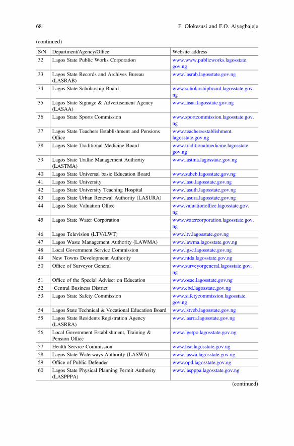
(continued)
S/N Department/Agency/Office Website address
32 Lagos State Public Works Corporation www.www.publicworks.lagosstate.gov.ng
33 Lagos State Records and Archives Bureau(LASRAB)
www.lasrab.lagosstate.gov.ng
34 Lagos State Scholarship Board www.scholarshipboard.lagosstate.gov.ng
35 Lagos State Signage & Advertisement Agency(LASAA)
www.lasaa.lagosstate.gov.ng
36 Lagos State Sports Commission www.sportcommission.lagosstate.gov.ng
37 Lagos State Teachers Establishment and PensionsOffice
www.teachersestablishment.lagosstate.gov.ng
38 Lagos State Traditional Medicine Board www.traditionalmedicine.lagosstate.gov.ng
39 Lagos State Traffic Management Authority(LASTMA)
www.lastma.lagosstate.gov.ng
40 Lagos State Universal basic Education Board www.subeb.lagosstate.gov.ng
41 Lagos State University www.lasu.lagosstate.gov.ng
42 Lagos State University Teaching Hospital www.lasuth.lagosstate.gov.ng
43 Lagos State Urban Renewal Authority (LASURA) www.lasura.lagosstate.gov.ng
44 Lagos State Valuation Office www.valuationoffice.lagosstate.gov.ng
45 Lagos State Water Corporation www.watercorporation.lagosstate.gov.ng
46 Lagos Television (LTV/LWT) www.ltv.lagosstate.gov.ng
47 Lagos Waste Management Authority (LAWMA) www.lawma.lagosstate.gov.ng
48 Local Government Service Commission www.lgsc.lagosstate.gov.ng
49 New Towns Development Authority www.ntda.lagosstate.gov.ng
50 Office of Surveyor General www.surveyorgeneral.lagosstate.gov.ng
51 Office of the Special Adviser on Education www.osae.lagosstate.gov.ng
52 Central Business District www.cbd.lagosstate.gov.ng
53 Lagos State Safety Commission www.safetycommission.lagosstate.gov.ng
54 Lagos State Technical & Vocational Education Board www.lstveb.lagosstate.gov.ng
55 Lagos State Residents Registration Agency(LASRRA)
www.lasrra.lagosstate.gov.ng
56 Local Government Establishment, Training &Pension Office
www.lgetpo.lagosstate.gov.ng
57 Health Service Commission www.hsc.lagosstate.gov.ng
58 Lagos State Waterways Authority (LASWA) www.laswa.lagosstate.gov.ng
59 Office of Public Defender www.opd.lagosstate.gov.ng
60 Lagos State Physical Planning Permit Authority(LASPPPA)
www.laspppa.lagosstate.gov.ng
(continued)
68 F. Olokesusi and F.O. Aiyegbajeje
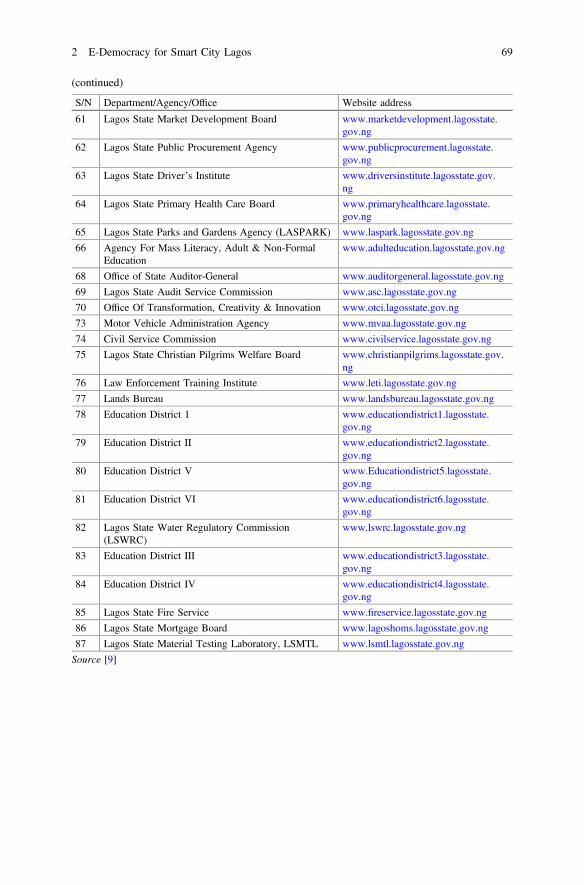
(continued)
S/N Department/Agency/Office Website address
61 Lagos State Market Development Board www.marketdevelopment.lagosstate.gov.ng
62 Lagos State Public Procurement Agency www.publicprocurement.lagosstate.gov.ng
63 Lagos State Driver’s Institute www.driversinstitute.lagosstate.gov.ng
64 Lagos State Primary Health Care Board www.primaryhealthcare.lagosstate.gov.ng
65 Lagos State Parks and Gardens Agency (LASPARK) www.laspark.lagosstate.gov.ng
66 Agency For Mass Literacy, Adult & Non-FormalEducation
www.adulteducation.lagosstate.gov.ng
68 Office of State Auditor-General www.auditorgeneral.lagosstate.gov.ng
69 Lagos State Audit Service Commission www.asc.lagosstate.gov.ng
70 Office Of Transformation, Creativity & Innovation www.otci.lagosstate.gov.ng
73 Motor Vehicle Administration Agency www.mvaa.lagosstate.gov.ng
74 Civil Service Commission www.civilservice.lagosstate.gov.ng
75 Lagos State Christian Pilgrims Welfare Board www.christianpilgrims.lagosstate.gov.ng
76 Law Enforcement Training Institute www.leti.lagosstate.gov.ng
77 Lands Bureau www.landsbureau.lagosstate.gov.ng
78 Education District 1 www.educationdistrict1.lagosstate.gov.ng
79 Education District II www.educationdistrict2.lagosstate.gov.ng
80 Education District V www.Educationdistrict5.lagosstate.gov.ng
81 Education District VI www.educationdistrict6.lagosstate.gov.ng
82 Lagos State Water Regulatory Commission(LSWRC)
www.lswrc.lagosstate.gov.ng
83 Education District III www.educationdistrict3.lagosstate.gov.ng
84 Education District IV www.educationdistrict4.lagosstate.gov.ng
85 Lagos State Fire Service www.fireservice.lagosstate.gov.ng
86 Lagos State Mortgage Board www.lagoshoms.lagosstate.gov.ng
87 Lagos State Material Testing Laboratory, LSMTL www.lsmtl.lagosstate.gov.ng
Source [9]
2 E-Democracy for Smart City Lagos 69
References
1. Caldow J (2004) E-democracy: putting down global roots. Institute for ElectronicGovernment. http://www01.ibm.com/industries/government/ieg/pdf/edemocracy%20putting%20dow%20roots.pdf
2. lamata.lagosstate.gov.ng3. Briony O (2003) The potential contribution of ICTs to the political process. Electr J
e-Government 1(1):31–394. Azeta A, Azeta V, Olaniyan O, Azeta A, Ayeni G (2015) Implementing an e-democracy
system in Nigeria. J Res Dev Manage 4:20155. Policy and Legal Advocacy Centre (2012) Social Media and the 2011 Elections in Nigeria.
PLAC6. www.ericsson.com7. http://www.vanguardngr.com/2016/05/lagos-leads-latest-active-voice-internet-users-survey/8. http://www.lagosstate.gov.ng/lagos-state-governmentministries-addresses/9. http://www.lagosstate.gov.ng
10. Jackson N (2007) Political parties, the internet and the 2005 general election: third time lucky.Internet Res 17(3):249–271
11. Williams P, Tramell K, Postelnicu M, Landreville K, Martin J (2005) Blogging and hyperlinking use of the web to enhance visibility during the 2004 US campaign. Journal Stud 6(2):177–186
12. Iwu MM (2008) Electronic voting and the future of the electoral system in Nigeria. The NigerElectoral J 2(1):1–29
13. Alabi MO (2009) Electoral reforms and democratic consolidation in Nigeria: the Electoral Act2006. CEU Polit Sci J 4(2):278–304. Retrieved from http://www.ceeol.com/aspx/getdocument.aspx?logid=5&id=73488cf8239a482ca21618b0bf0a4e00
14. Ogbaudu F (2011) General election review: experience sharing, lessons learnt and the wayforward—the Nigeria Police perspective. Paper presented at the review of elections securityduring the 2011 General Elections in Nigeria Justice Sector Reform Monograph Series
15. www.lamata.lagosstate.gov.ng16. www.lagosstate.gov.ng/mepbbc/transportation17. www.lamata-ng.com/brt/php18. www.lagosstateministryofhealth.com/programme19. Aiyegbajeje FO (2016) Mobile telephone usage and physical accessibility to healthcare
services in Lagos Metropolis Nigeria. An unpublished PhD thesis submitted to theDepartment of Geography, Faculty of the Social Sciences, University of Ibadan, p 203
20. Aiyegbajeje FO, Ajayi DD (2016) Mobile telephone technology for better healthcare serviceprovision in Lagos Metropolis, Nigeria. Digital Transformations and Global Society. Volume674 of the series Communications in Computer and Information Science. SpringerInternational Publishing AG, pp 532–543
21. The Guardian Newspapers 29/01/2009, p 1922. Digest of Statistics (2013) Lagos Bureau of Statistics, Ministry of Economic Planning and
Budget, the Secretariat. Alausa, Ikeja, Lagos23. www.snitchngr.com/brt-to-commence-e-ticketing-on-tuesday24. www.naij.com/92485425. Flavio C, Eleonora P, Alberto P (2005) E-democracy: a solution for disadvantaged territories.
In: eceg2005, Conference Proceedings, pp 101–110
70 F. Olokesusi and F.O. Aiyegbajeje
Chapter 3Outline Development Plan for FerokeMunicipality in Execution Frameworkof Internet of People, Internetof Government and Internet of Things
T.M. Vinod Kumar, P. Bimal and Aruna Sri Reddi
Abstract Historically, the urban planning in India has been implemented with atop-down approach where there was little opportunity for citizen participation. Theintervention of information technology or ‘smart technology’ is changing thisscenario. More people can voice their opinions on different forums online andexpedite the process of participation. Currently, this process is widely used withinthe realm of private/ personal opinion sharing, and improvement of business per-formance. Though slowly, different government agencies are also catching up theuse of information technology. They are using different online services andtelecommunications for police response, birth-death certificate registration, pay-ment for different public services, etc. To maintain the quality of these services, it isimportant for the governing bodies to have an inflow of citizen participation andopinion sharing as a constant process. The 74th amendment of Indian constitutiongives authority to Urban Local Bodies (ULB) to self-govern and plan for future oftheir respective jurisdictions. Outline Development Plan (ODP) is proposed for aperiod of 20 years that includes future direction of spatial development and eco-nomic aspirations of that jurisdiction as per the amendment requirement of eco-nomic development and social welfare. Citizen involvement is critical in everystage of development ODP. Traditionally, public participation meetings were heldfor general public and stakeholder groups’ involvement in the plan development.E-governance and e-democracy, use of information technology for informationdissipation, and citizen participation in the plan making is expected to improve thefrequency and number of citizens participating. The current study looks at the City
T.M. Vinod Kumar (&)School of Planning and Architecture, New Delhi (Spa-D), Indiae-mail: [email protected]
P. Bimal A.S. ReddiDepartment of Architecture and Planning, National Institute of Technology Calicut,Kozhikode, Kerala, Indiae-mail: [email protected]
A.S. Reddie-mail: [email protected]
© Springer Nature Singapore Pte Ltd. 2017T.M. Vinod Kumar (ed.), E-Democracy for Smart Cities, Advances in 21st CenturyHuman Settlements, DOI 10.1007/978-981-10-4035-1_3
71
of Feroke for implementing the ODP in the e-governance and e-democracy format.With more than 80% people being high-school graduates and very high literacy ande-literacy based on state sponsored project, the city of Feroke, Kerala, is a goodexample for implementing the use of information technology in the ODP devel-opment. Different approaches such as web-based information, interaction, andweb-profile in the social networking sites, emails, and telephonic interviews wereused as part of the e-democracy while developing the ODP. Along with it, atraditional household survey using a questionnaire was also used. Delphi was usedfor analyzing the specific stakeholders and expert opinions. Six areas—smartpeople, smart economy, smart living, smart mobility, smart environment, and smartgovernment—were identified for implementing various smart technologies. Theexecutive framework for Feroke Municipality ODP adopted Internet of People orE-Democracy (IOP), Internet of Government E-Governance (IOG), and Internet ofThings (IOT). The project concludes with spatial proposals, specification for IOP,IOG, and IOT emerging out of six systems of Smart Cities.
Keywords E-Democracy Outline Development Plan Internet of People (IOP) Internet of Governance (IOG) Internet of Things (IOT)
3.1 Feroke City
Feroke is a medium sized municipality about 10 km south of the city of Calicut(Kozhikode). Kozhikode is the third largest city in Kerala. Feroke has a land area of1424 ha (14.24 km2). Feroke was classified as a ‘Gram Panchayat’ as per the‘Peoples Planning structure’ [1] and got the municipality status in 2014. As per2011 census, the population of Feroke is 54074, and the population density is 37.95people per hectare. Feroke demands the attention of urban planners due to itsphenomenal growth of built-up space in a short period of 2006–2011 as shown inFig. 3.1. In the past, Feroke has always been an important centre of historicalsignificance. It was ruled by Zamorin until 1788 when Malabar was conquered byTipu Sultan from Karnataka. Tipu selected Feroke, which he called Farookhabad tobe his capital for Malabar [2]. He began construction of a new fort in Feroke, whichhe was unable to complete as British defeated him before completion. British tookover the control, and established tile industry at Feroke, taking advantage of theperineal river and large deposits of clay in the region. Feroke was well known as thecapital of tile industry in the southern India which were never allowed to furtherdiversify and develop under British rule and in the age of industrial revolution,thereby losing its significance in South India. The timber industry was establishedeven before tile industry due to the ease of transporting timber through Chaliyarriver from Nilambur forests in the eastern side which helped British develop Railsystem around Ferole. Feroke had established itself as an industrial town in themodern period with a chain of tile factories along the Chaliyar river, forming itsindustrial base.
72 T.M. Vinod Kumar et al.
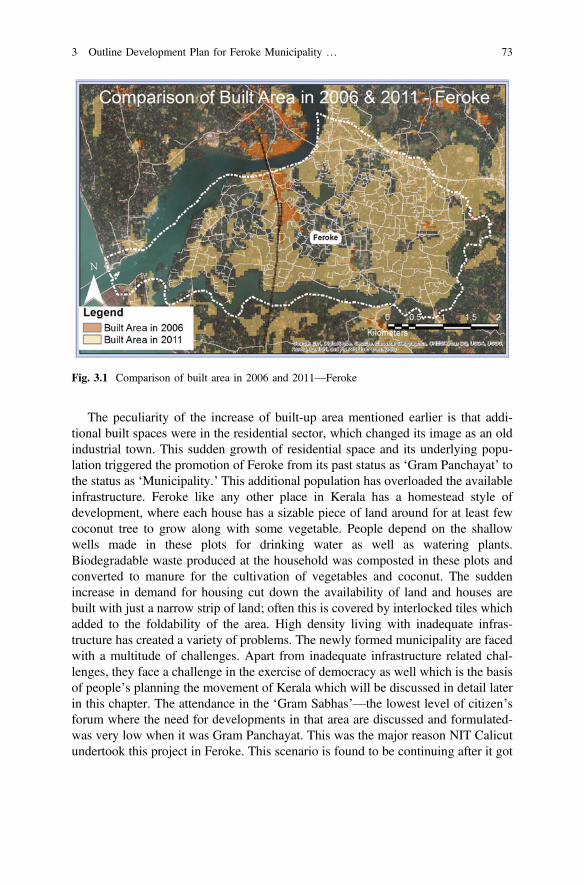
The peculiarity of the increase of built-up area mentioned earlier is that addi-tional built spaces were in the residential sector, which changed its image as an oldindustrial town. This sudden growth of residential space and its underlying popu-lation triggered the promotion of Feroke from its past status as ‘Gram Panchayat’ tothe status as ‘Municipality.’ This additional population has overloaded the availableinfrastructure. Feroke like any other place in Kerala has a homestead style ofdevelopment, where each house has a sizable piece of land around for at least fewcoconut tree to grow along with some vegetable. People depend on the shallowwells made in these plots for drinking water as well as watering plants.Biodegradable waste produced at the household was composted in these plots andconverted to manure for the cultivation of vegetables and coconut. The suddenincrease in demand for housing cut down the availability of land and houses arebuilt with just a narrow strip of land; often this is covered by interlocked tiles whichadded to the foldability of the area. High density living with inadequate infras-tructure has created a variety of problems. The newly formed municipality are facedwith a multitude of challenges. Apart from inadequate infrastructure related chal-lenges, they face a challenge in the exercise of democracy as well which is the basisof people’s planning the movement of Kerala which will be discussed in detail laterin this chapter. The attendance in the ‘Gram Sabhas’—the lowest level of citizen’sforum where the need for developments in that area are discussed and formulated-was very low when it was Gram Panchayat. This was the major reason NIT Calicutundertook this project in Feroke. This scenario is found to be continuing after it got
Fig. 3.1 Comparison of built area in 2006 and 2011—Feroke
3 Outline Development Plan for Feroke Municipality … 73

converted to the municipality. Attendance in ward councils– which are the lowestcitizen’s forum as per Kerala Municipality Act [3] is found to be very low in reality.This low level of participation poses a fundamental concern about the validity of theglorified ‘people’s planning’ movement in Feroke Municipality. Hence there is adire need of a system to increase participation of citizen’s in the a strengtheneddemocratic planning process which is the subject matter of this chapter.
This chapter is, therefore, an attempt made by National Institute of Technology,to explore possibilities of transforming the present democratic planning process inthe framework of smart city technology which we believe can only survive inE-Democracy where all population is involved. The project was formulated as aplanning exercise for Master’s students of Urban Planning. The project was toprepare an Outline Development Plan (ODP) to convert Feroke to a self-financingSmart City, although it is not a rich city with high per capita income. The projectalso explored possibilities of enhancing the democratic process by extensive use ofICT-enabled technologies.
3.2 Participatory Planning
The fundamental definition of democracy requires the massive citizen participationin the decision-making process of the government. The definition of ‘citizen’ andamount of participation differed at different times. Even the existing oldest moderndemocracy in the USA did not have the voting rights to all its citizens immediatelyafter the independence from the Great Britain. Poor whites, women, and AfricanAmericans were restricted to vote in political elections at the beginning of itsdemocratic governance in the USA. However, today the USA is considered as oneof the best of nations for its democratic values and citizen participation in thedecision-making process of the government. The countries that are considered asadvanced are not only economically developed but also have strong citizen par-ticipation in the government decision-making process which is considered as thesecret of the prosperity of cities and nations.
Until very recently, the citizen participation in governance is limited to voting toselect a political representative. It is understood that the political representative is anextraordinary citizen who ‘knows all’ and takes the right decision on behalf of all herepresents who elected him. The reality is far from this ideal. Their political rep-resentative is however guided by his political party which is again under theinfluence of various interest group who may not be interested in developing the areahe represents according to the wish of people there. This makes the local populationvery sceptical of representative democracy practised in India. Some nations havegovernment functionaries that make every decision related to daily life of its citi-zens. It is believed that the communist governments in the Eastern Europe have hadthis system. In other countries, such as in some countries in the Middle East, quite
74 T.M. Vinod Kumar et al.
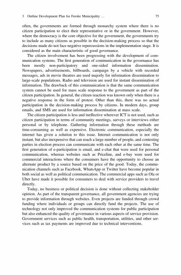
often, the governments are formed through monarchy system where there is nocitizen participation to elect their representative or in the government. However,where the democracy is the core objective for the government, the governments tryto include as many citizens as possible in the decision-making process so that thedecisions made do not face negative repercussions in the implementation stage. It isconsidered as the main characteristic of good governance.
The citizen involvement has been progressing with the development of com-munication systems. The first generation of communication in the governance hasbeen mostly non-participatory and one-sided information dissemination.Newspapers, advertisements, billboards, campaign by a vehicle with recordedmessages, ads in movie theatres are used majorly for information dissemination tolarge-scale populations. Radio and television are used for instant dissemination ofinformation. The drawback of this communication is that the same communicationsystem cannot be used for mass scale response to the government as part of thecitizen participation. In general, the citizen reaction was known only when there is anegative response in the form of protest. Other than this, there was no actualparticipation in the decision-making process by citizens. In modern days, groupemails, and SMS are used for information dissemination at mass scale.
The citizen participation is less and ineffective wherever ICT is not used, such ascitizen participation in terms of community meetings, surveys or interviews eitherpersonal or by telephone. Gathering information through these methods aretime-consuming as well as expensive. Electronic communication, especially theinternet has given a solution to this issue. Internet communication is not onlyinstant, but also inexpensive that can reach a large number of people, and contestingparties in election process can communicate with each other at the same time. Thefirst generation of e-participation is email, and e-chat that were used for personalcommunication, whereas websites such as Priceline, and e-bay were used forcommercial interactions where the consumers have the opportunity to choose analternate product by a source based on the price of the good. Today, the commu-nication channels such as Facebook, WhatsApp or Twitter have become popular inboth social as well as political communication. The commercial apps such as Ola orUber have made it possible for consumers to deal with service providers to traveldirectly.
Today, no business or political decision is done without collecting stakeholderopinion. As part of the transparent governance, all government agencies are tryingto provide information through websites. Even projects are funded through crowdfunding where individuals or groups can directly fund the projects. The use oftechnology not only improved the communication systems for public participationbut also enhanced the quality of governance in various aspects of service provision.Government services such as public health, transportation, utilities, and other ser-vices such as tax payments are improved due to technical interventions.
3 Outline Development Plan for Feroke Municipality … 75

3.3 Existing Situation of Participatory Planning in Kerala
Documentary evidence of participatory planning is available as a spatial outcome inthe cadastral maps and land schedule of Feroke if you know how to read it withrespect to participation. Further evidence emerges in the existing land use map ofthree Master Plans of Calicut area which also includes Feroke. The degree ofparticipation that was evident in three phases of development of Feroke prior to1920, 1921–2016 and afterwards differs a great deal.
Prior to 1920, Municipality of Calicut existed which does not include Ferokeeven as its planning area. Feroke was a village with agriculture economy withpaddy cultivation, river and sea-based fisheries and animal husbandry as the mainoccupation where females also participated more than today. Thereafter, the jointfamily system the mainstay of agriculture started gave way to nuclear families. Thisimplied that large holdings gave way in Feroke to fragmentation of holdings whenit became nuclear families and this continued in all these periods. The system ofadoption of survey number of plots divided gives insight to how this division tookplace. Soon these subdivided plots had a house constructed and a compound wallaround in most cases.
The biggest problem faced during the subdivision was the access to footpaths,cycle paths, and roads. The house owners themselves identified a footpath or cycletracks by donating part of their land holdings without any Government interven-tions or seeking compensation which can be considered as an outcome of partici-patory planning and development by beneficiaries. That community of land ownerswho were far-sighted with an idea of a hierarchy of footpaths created wider pathsand others narrower paths. No attention was spared about drainage structure on oneside of the paths. There was no concept of a hierarchy of these paths in generalwhich requires wider and wide footpaths in higher levels from the footpath to thecycle path and then to motor-able roads. There was none to educate them on linkagehierarchies.
The resulting footpaths were surveyed using Remote sensing maps and GPS inthis project and are given below (Fig. 3.2) for Feroke Municipality.
Historically residential areas were islands within the large extents of paddyfields. These paddy fields progressively reduced to islands in the residential area inthe existing land use plan (Fig. 3.3) and even in the proposed ODP.
This was mainly due to the subdivision of land primarily to transfer it to the nextgeneration by parents as per the existing legislation. The current land legislationgave indications of how the land should be subdivided and who should get familyhouse based on whether you are Muslim, Hindu of different castes, or Christians.There was nothing in these legislations to preserve the existing drainage structure inthe area of high rainfall or for environmental conservation. This is a testimony oflegislative ignorance. These created vast areas of water logging during rains andsoil erosion due to the disturbances of drainage structure due to improper propertypartitions.
76 T.M. Vinod Kumar et al.
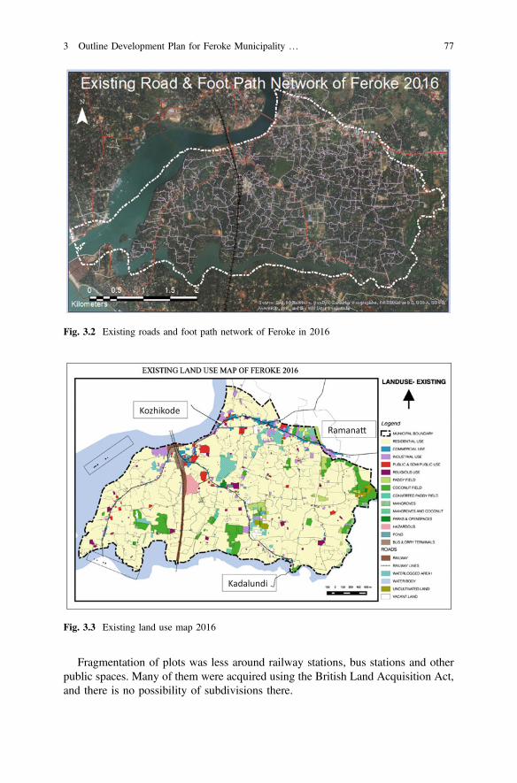
Fragmentation of plots was less around railway stations, bus stations and otherpublic spaces. Many of them were acquired using the British Land Acquisition Act,and there is no possibility of subdivisions there.
Ramana
Kadalundi
Kozhikode
Fig. 3.3 Existing land use map 2016
Fig. 3.2 Existing roads and foot path network of Feroke in 2016
3 Outline Development Plan for Feroke Municipality … 77
Although local self-government existed during British, Colonial days in Feroke,there was no attempt to study the habitat as a whole and find ways and means todevelop it scientifically prior to 1920. There were concerns about public health andenvironmental engineering, but no attempt was spared to use participatory ways ofdeveloping urban areas. There was no effort spared to building upon the experienceof participatory footpath making graduated to participatory integrated area planningthrough participatory public awareness. It can be considered as a great opportunitylost by authors of this chapter.
Prior to the independence of India in 1920, Madras Town Planning Act whichwas adopted in Malabar as Malabar Town and Country Planning Act 1920 came upwhich gave a legislation to reshape towns in Malabar spatially. There were TownPlanning Scheme and Detailed Town Planning Scheme embodied in 1920 act.There was not much of democracy in planning and participation was not soughtsince British Colonial rulers felt their bureaucrats knows better what the nativeIndians want. The government mostly was using the British Land Acquisition Actfor the native Indian than detailed town planning schemes requiring a great amountof work for bureaucrats for eliciting wider participation in urban development wasabsent and hence did not show much of success in urban development?. Thisapproach is very much evident in all Kerala even today which we consider as a badcolonial legacy. Land acquisition act does not treat landowners and Government onequal footing and eminent domain which actually help British than Indians wasimplemented with the police force. Detailed Town Planning schemes were largelynot successful and made largely not participatory in reshaping all plots. This mostlygave approaches to widen the existing paths at Government expenses since theywere carrying motor vehicle traffic from the yester years bullock carts and horsecarts. This killed the participatory initiative of the local population who gave birthsto footpaths and cycle paths in Feroke sharing their own lands freely.
In 1993, there was an attempt to deepen the democracy at the local level with theenacting of 73rd and 74th Constitutional Amendment Act (CAA). Prior to that andeven after that, Urban Planning and urban land development were a bureaucraticexercise with no or very limited participation of people. There were practically nomajor urban development projects in Malabar including Feroke. Very few TownPlanning Schemes were successfully completed in all towns of Malabar under 1920acts. 1920 Town Planning Act was not in a position to incorporate democraticplanning and development with the high participation of People and need revisionimmediately. The slow and out of date urban land management practised in Keraladid not give an impetus to change the 1920 Act in tune with 74th CAA immedi-ately. Only in 2016 Government of Kerala could legislate a Town and CountryPlanning Act in tune with the democratic planning and development at an instanceof a court ruling on this subject. Implementing 1920 Act in Feroke and Malabarcreated a negative impact in Feroke as well as all towns in Malabar region ofKerala. It resulted in the narrow roads which cannot carry present traffic volume,
78 T.M. Vinod Kumar et al.
more road accidents cities with any adequate public and semi-public and recre-ational areas and inadequate parking spaces which affect the shop keepers and otherservices were the result of not converting the Town Planning Act in tune with CAA.1920 Act strengthen bureaucrats against community initiatives and if this processwas reversed with community gave all powers then Feroke and Malabar shouldhave a better urban structure.
The participatory planning at spatial level was not there to show success inKerala. However, people’s planning movement which essentially assessed feltneeds at ward and village panchayat level integrated district and state level thatcame out in the 1990s was a positive development in democratic planning anddevelopment in Kerala.
3.3.1 People’s Planning Movement in Kerala
Grass root level participatory planning has been the focus of academic and pro-fessional discussion for several decades in India. The practice of people’s planningand execution has been there for many decades in Kerala. However, attempt toimplement this concept has not been taken up so seriously because of severeobstacles faced to achieve this goal. They are non-availability of planning expertiseat the local level, weak and highly centralised administrative setup and inadequacyin administrative procedure, lack of experience, and inadequate database. Becauseof these limitations, State Government felt it tough to pass on the financial andmanagement functions to the grass root level. However, Government of Kerala tooka bold initiative to embark on people’s planning movement despite the abovelimitations. The strategy adopted was to venture boldly based on well thought outprocedures. Action learning from people’s planning experiences was utilised tostraighten the movement in subsequent years. All the time the goal of decentrali-sation and 73rd and 74th constitutional amendments were kept in mind. The lessonslearned are utilised in the following annual plans.
Kerala’s people’s planning movement demonstrates the art of decentralisation ofpower to plan manage and make financial decisions in area development by localpeople within a multi-level planning framework. This experience is fascinating andunique for in any part of the world both developed and developing nation. It is anoteworthy example of a model of translating the 74th and 73rd Constitutionalamendment without any reservation or holding on to power at the State head-quarters. The belief in local people that is so much lacking in India is the soundbasis of such venture. This is in contrast to the then existing centralised adminis-tration, which does not trust local people with public finance, management, andplanning, and over-administer them with checks, counter check as if they arecriminals. This has been by and large non-productive for urban and regionaldevelopment. At present in many States in India, decentralised planning meansplanning at district level without massive mobilisation and active participatorydecision-making at Municipal Ward and Gram Panchayat level. Kerala’s attempt is
3 Outline Development Plan for Feroke Municipality … 79

to empower people and local self-government such as ward, municipality, village,block and district to undertake area development planning and implementation.
The people’s movement of planning started in Kerala in the financial year 1997–98. A constitutional amendment has spelt out and confirmed the role and respon-sibilities of local government such as Panchayat and Municipalities. These insti-tutions are being converted into strong constitutional institutions of planning andgovernance in Kerala. Mandatory periodic elections and assured share of StateGovernment grant through mandatory Finance Commission recommendations aretwo pillars of strength for participatory planned area development. They now havethe power to decide the developmental activities and implement it. There is con-siderable scope for improvement in people’s planning movement, and this researchand development project for E-Democracy for Smart Cities focus on the scope forimprovement using technology and tools of Geographic Information Science.
The most significant contribution of the people’s movement of planning was theway in which Kerala mobilised the participation of people. Further, State PlanningBoard in Kerala steered the complex activities of people’s planning with theirdirection, training programs, documentation and evaluation of past experiences.Beneficiary Committees Task Forces, the working group worked side by side withthe elected members of local bodies. They showed that they have an important roleto perform in people’s planning movement. The initial mistrust between elected andlocal people melted away as the planning movement started showing positiveresults. All obstacles prevalent for these committees and Task Forces have beenremoved for their better functioning. In the past, such committees and officials aresubjected to the rigour of administrative controls. These controls have not resultedin better governance. The experience shows that more the controls, more the cor-ruption and administrative inefficiencies. The result is exhibited in the websites ofCentral Vigilance Commission that show never ending a long list of corrupt senioradministrators. Even Chief Secretaries the administrative head of state in somestates are kept behind jail for corruption so that they do not pollute the rest ofpopulation with corruption. It looks like corruption is a part of Indian administra-tion. The government of Kerala took a bold stand that these Task Forces will notmisuse power given to them since they are closely watched by local people in theirtransparent functioning. It is hard to be corrupt when several local persons areinvolved in decision making for a local level project, which benefits many. Further,there is scope for reviewing decisions at different levels. In a situation where all areequal as far as decision-making power is concerned, then corruption gets reduced.
During 1998–99 Rs. 950 Crores was set aside by the Government of Kerala toimplement plans prepared by the local Government. This was 25% higher than thatwas allocated during the financial year 1997–98. The next budget for 1999–2000has earmarked for Panchayat Raj/Nagar Palika institutions a sum of Rs.1020 Crores as plan grant (Rs. 40 Crores for Tribal Sub Plan, Rs. 200 Crores forSpecial Component Plan, and Rs. 780 Crores for the General Sector Plan). Further,local planning body should mobilise as many local resources as possible other thanState Government grant. Earlier the usual practice of State Government Grant doesnot spend during the financial year was largely known only to Government officers,
80 T.M. Vinod Kumar et al.
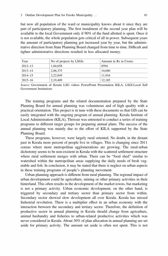
but now all population of the ward or municipality knows about it since they arepart of participatory planning. The first instalment of the second year plan will beavailable to the local Government only if 90% of the fund allotted is spent. Once itis not available, the whole population gets critical of all in power. Subsequent yearsthe amount of participatory planning got increased year by year, but the adminis-trative direction from State Planning Board changed from time to time. Difficult andtighter administrative directions resulted in less allocated money.
Year No of projects by LSGIs Amount in Rs in Crores
2012–13 1,84,658 8594
2013–14 2,06,375 10,680
2014–15 2,22,849 11,916
2015–16 2,19,409 12,185
Source Government of Kerala LSG videos PowerPoint Presentation KILA. LSGI-Local SelfGovernment Institutions
The training programs and the related documentation prepared by the StatePlanning Board for annual planning was voluminous and of high quality with apractical orientation. This project is in tune with these documents so that GIS can beeasily integrated with the ongoing program of annual planning. Kerala Institute ofLocal Administration (KILA), Thrissur was entrusted to conduct a series of trainingprograms to different target groups for preparing annual plans. The success of theannual planning was mainly due to the effort of KILA supported by the StatePlanning Board.
These programs, however, were largely rural oriented. No doubt, in the distantpast in Kerala more percent of people live in villages. This is changing since 2011census where more metropolitan agglomerations are growing. The rural-urbandichotomy seems to be non-existent in Kerala with the scattered settlement structurewhere rural settlement merges with urban. There can be “food shed” similar towatershed within the metropolitan areas supplying the daily needs of fresh veg-etable and fish. In conclusion, it may be stated that there is neglect on urban aspectsin these training programs of people’s planning movement.
Urban planning approach is different from rural planning. The regional impact ofurban development could be agriculture, mining or other primary activities in theirhinterland. This often results in the development of the market towns, but marketingis not a primary activity. Urban economic development, on the other hand, istriggered by secondary and tertiary sector than primary sector from within.Secondary sector showed slow development all over Kerala. Kerala has missedIndustrial revolution. There is a multiplier effect in an urban economy with theinteraction between the secondary and tertiary sector. Therefore, the definition ofproductive sector in annual planning in Kerala should change from agriculture,animal husbandry and fisheries to urban-related productive activities which wasnever considered in Kerala. About 30% of plan allocation in annual planning are setaside for primary activity. The amount set aside is often not spent. This is not
3 Outline Development Plan for Feroke Municipality … 81
justifiable in Kerala’s annual planning of urban centres where there are not manyagricultural activities in cities.
Another aspect of the rural and urban approach is more pronounced in themanner in which financial resource mobilisation is possible for land and urbaninfrastructure development. Community cooperation is the key for financialresource mobilisation in urban management. Annual Planning is paving the way forhigh-level community cooperation. Urban development can be self-generating.Finance can be mobilised using urban land as resources in a participatory planningprocess which were not attempted. This 30% misallocation to urban centres and notusing land and community to mobilise resources are largely due to the ignorance ofthe State Planning Board on matter urban and so-called rural lobby of Keralapolitics.
The essential characterises of Kerala’s “Janakiya Asuthranam” or people’splanning is enumerated below.
1. Towns and Village Panchayats were in a position to know the total annual planbudget they are likely to get in the financial year using a formula that translatesFinance Commission’s recommendations as interpreted by State Planning Boardof Kerala.
2. State Planning Board suggested the percentage split of this budget under severalsectors based on State Priorities and policies which were more rural orientedthan urban.
3. A series of training program conducted by Kerala Institute of LocalAdministration (KILA) taught all how to conduct Janakiaya Asuthranam.
4. A voluminous background information for Janakiyya Asuthranam was preparedby State Planning Board and distributed.
5. A timetable of multi-level planning (Ward, Municipality, and District) underpeople’s planning was implemented for the financial grant, monitoring ofimplementation and other administrative details by the State Planning Board.
6. Task force for different sectors was convened to study and formulate projects.7. Ward conventions gave opportunities to deliberated problems and solutions in
every ward and identify projects and estimate costs and prepare an annualbudget.
3.3.2 Participatory Planning in Operation
Important stages of this participatory planning methodology are outlined below:
1. Needs identification: The felt needs of the community are identified in GramSabha/Ward Sabha meetings. All living in these places were invited, but 10–20% attended these meetings and sometimes it was difficult to get a number ofpeople to attend. These meetings are held in a semi-structured manner withplenary sessions and subgroup sessions dealing with identified specific
82 T.M. Vinod Kumar et al.
developmental issues. The decisions are recorded and forwarded to the LocalGovernments. Each meeting is chaired by the elected member and has an officialas its Coordinator.
2. Situation analysis: Based on the demands emanating from the first specialGrama Sabha/Ward Sabha and based on developmental data, both primary andsecondary, exhaustive Development Reports have been prepared and printed inthe case of every Local Government in the State. These reports describe thestatus in each sector of development with reference to available data, analyse theproblems and point out the directions for further development.
3. Strategy setting: Based on the Grama Sabha/Ward Sabha feedback and theDevelopment Report, a one-day seminar is held at the Local Government levelin which participation of experts, elected members, representatives nominatedby the Sabhas, practitioners from among the public is ensured. The developmentseminars suggest the broad priorities and general strategies for developmentalprojects to be taken up for a particular year.
4. Projectisation: The ideas thrown up by the above three stages are translated inthe form of projects by Working Groups at the Local Government level. Foreach Local Government, about eight Working Groups are dealing with differentsectors of development. Each Working Group is headed by an elected memberand is convened by the concerned government official. The Vice-Chairman ofthe Working Group is usually a nongovernment expert in the sector. The pro-jects are prepared in the suggested format outlining the objectives, describingthe benefits, explaining the funding and detailing the mode of execution andphasing of the project.
5. Plan finalisation: From among the projects, based on the allocation commu-nicated, the concerned Local Government finalises its plan for the year, and thisplan is submitted to the District Planning Committees (DPCs) through theTechnical Advisory Committees. The Panchayat is free to take up any project,irrespective of its cost, subject of course to the resources actually available andwithin the sectoral limits.
6. Plan vetting: The Technical Advisory Committees at the Block or the Districtlevel consisting of official and nonofficial experts vet the projects for theirtechnical viability and conformity with the mandatory government guidelines onplanning and costing and forward them to the District PlanningCommitte(DPC). They cannot change priorities or projects; they can only ask forrectification.
7. Plan approval: The DPC gives the formal approval to the plans after which theLocal Government can start implementation. It is to be noted that the DPC alsocannot change the priority of a Local Government. It can only ensure thatgovernment guidelines are followed. The Local Government gives administra-tive approval for implementation projects. Every Local Government hasunlimited powers of Administrative sanctions subject only to the limits of itsfinancial resources.
This broad approach has the following execution steps
3 Outline Development Plan for Feroke Municipality … 83

3.3.3 Participatory Planning Optional Steps
1. Identifying and Entrusting Plan Coordinator2. Formation of Working Groups for subjects suggested by planning board3. Preparation of Status Report4. Discussion with Banks5. Stakeholder Discussion6. Plan Formulation on Gram/Ward Sabha7. Finalisation of Status Report and Suggestions on Projects8. Preparation of Development Report and Plan Documents9. Exploring possibilities of Integration
10. Development Seminar11. Approval of Development Report12. Preparation of Projects in ‘Sulekha’ software13. Finalisation of Plan14. Approval of Plan15. Scrutiny and Approval of Projects In ‘Sulekha’ software16. Approval of Plan by DPC ‘Sulekha’ software.
Sulekha software is used to implement annual planning and development atLocal Self-Government which is explained below. Before that, the first planningprocess in 1999–2000 is given in a flow chart (Fig. 3.4).
Fig. 3.4 Plan formulation procedure for the annual plan 1999–2000
84 T.M. Vinod Kumar et al.
3.3.4 Sulekha Software
Sulekha software is a software used for decentralised planning and monitoring inKerala. It is in fact computerised centralised planning and monitoring server basedsystem. Kerala participatory planning has now progressed from using hard copypreparation ten years back, shown in the flow chart above to soft copy orientedpreparation which can be accessed from anywhere by a hierarchy of sanctioningauthorities and those who wants to monitor progress from the server.
Sulekha is the Plan monitoring software developed by Information KeralaMission for Local Self Government Department (LSGD) of Government of Keralafor the formulation and monitoring of the nearly 2 lakhs annual decentralised planprojects of local governments. Sulekha is being used in Kerala for more than onedecade; tailor made to track several steps enumerated above in the plan formulation,appraisal, approval, monitoring, revision processes and expenditure tracking of theplan projects of local governments of Kerala. This web application suite meets therequirements of not only the Local Self Governments but also of the State PlanningBoard and several ministries and departments of State Government of Kerala.
3.3.5 Steps in Decentralized Planning in Kerala as Per Useof Sulekha
3.3.5.1 Planning in Sulekha
Planning as per Sulekha system is a process in public governance that analyses thesituation, identifies the needs, sets the priorities, allocates the resources and fixes thetargets for achieving the pre-determined objectives in a participatory way in apredetermined structured process. A plan must be a realistic account of theexpectations of the local population. Preparation of a comprehensive plan may notguarantee success, but the lack of a sound plan will almost certainly ensure failure.It was as well believed that Gram Sabha, the people’s assembly at the ward level,could play a major role as well as ward Sabha in towns. The scope of Sulekha isdiagrammatically presented in Fig. 3.5, which is self-explanatory.
The objective of the plan can be increasing production, establishing publicfacilities, creating job opportunities, reducing disparity among different sections ofpeople, enhancing the capacity of citizens, redressing of physical inabilities,improving knowledge level of the population or so. The process of prioritisation isused in different components of planning such as need identification, choosingfocus areas, allocation of resources, and fixation of targets. Success in planningdepends on how the planner can use prioritisation skill and strategically use thedeveloping and critical sectors in enhancing the economic development. Propersequencing of components and strategic timing are other elements that make
3 Outline Development Plan for Feroke Municipality … 85
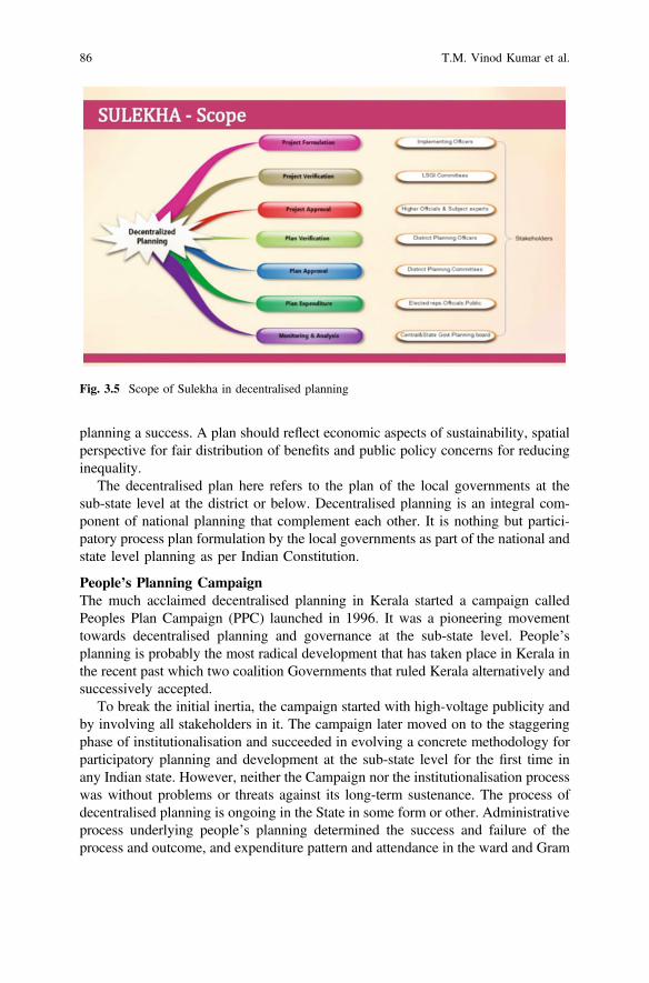
planning a success. A plan should reflect economic aspects of sustainability, spatialperspective for fair distribution of benefits and public policy concerns for reducinginequality.
The decentralised plan here refers to the plan of the local governments at thesub-state level at the district or below. Decentralised planning is an integral com-ponent of national planning that complement each other. It is nothing but partici-patory process plan formulation by the local governments as part of the national andstate level planning as per Indian Constitution.
People’s Planning CampaignThe much acclaimed decentralised planning in Kerala started a campaign calledPeoples Plan Campaign (PPC) launched in 1996. It was a pioneering movementtowards decentralised planning and governance at the sub-state level. People’splanning is probably the most radical development that has taken place in Kerala inthe recent past which two coalition Governments that ruled Kerala alternatively andsuccessively accepted.
To break the initial inertia, the campaign started with high-voltage publicity andby involving all stakeholders in it. The campaign later moved on to the staggeringphase of institutionalisation and succeeded in evolving a concrete methodology forparticipatory planning and development at the sub-state level for the first time inany Indian state. However, neither the Campaign nor the institutionalisation processwas without problems or threats against its long-term sustenance. The process ofdecentralised planning is ongoing in the State in some form or other. Administrativeprocess underlying people’s planning determined the success and failure of theprocess and outcome, and expenditure pattern and attendance in the ward and Gram
Fig. 3.5 Scope of Sulekha in decentralised planning
86 T.M. Vinod Kumar et al.
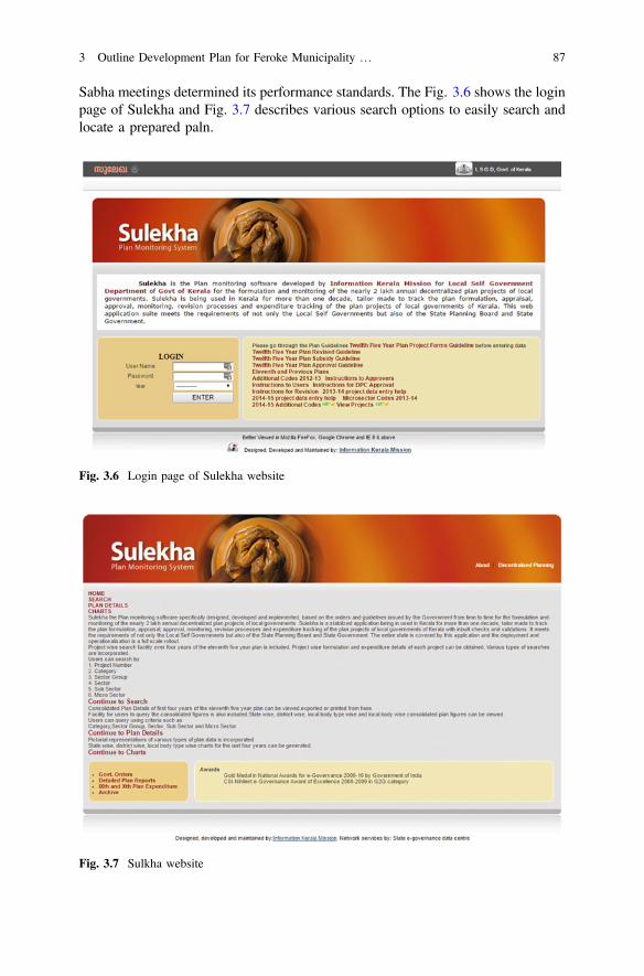
Sabha meetings determined its performance standards. The Fig. 3.6 shows the loginpage of Sulekha and Fig. 3.7 describes various search options to easily search andlocate a prepared paln.
Fig. 3.6 Login page of Sulekha website
Fig. 3.7 Sulkha website
3 Outline Development Plan for Feroke Municipality … 87
Steps in Decentralized Planning in SulekhaKerala follows a multi-level decentralised plan formulation process that hastremendous de-bureaucratisation potential. The different stages adopted and foundsuccessful in this decentralised planning are environment setting, situation analysis,need identification, vision setting, plan formulation, prioritisation, plan vetting, planapproval and plan implementation. Each stage has a few sub-components too.
3.3.5.2 Environment Setting
Creation of Working Groups and making them functional for setting the planningprocess to move on, are the twin items coming under this.
Constitution of Working Groups was made mandatory for each local govern-ment to constitute Working Groups for the sectors, as listed below, at the beginningof every Five-Year Plan.
The first activity towards situation analysis is the constitution of WorkingGroups for important development sectors in Local governments. The local gov-ernments have the freedom to constitute as many Working Groups as required inaddition to the following mandatory ones.
Mandatory Working GroupsThe mandatory working groups are
1. Watershed Management including Environment, Agriculture, Irrigation,Animal Husbandry, Dairying, Fisheries and related sectors
2. Local Economic Development other than agriculture including local industries,promotion of private and community investment and mobilisation of credit
3. Poverty Reduction including housing4. Development of Scheduled Castes5. Development of Women and Children6. Health7. Water Supply and Sanitation including Solid Waste Management8. Education, Culture, Sports and Youth9. Infrastructure
10. Social Security including care of the aged and disabled11. Energy12. Governance Plan.
The Local Governments having allocation under Tribal Sub Plan will have toconstitute a separate Working Group for Development of Scheduled Tribes, also. InUrban Local Governments, the Working Group on Poverty Reduction would lookafter the Slum Development sector too.
88 T.M. Vinod Kumar et al.
Working Group: Its StructureEach Working Group will have an elected member of the Local Government as itsChairperson. The Working Group on Development of Scheduled Castes should bechaired by a Scheduled Caste Member and the Working Group for Women andChildren by a women member. The Working Groups on Watershed Managementand Anti-Poverty Sub Plan should be headed by the Chairperson of the concernedlocal government. A leading expert in the sector, who is nominated by the localgovernment has to function as the Vice-Chairman of each Working Group. TheConvener of each Working Group in the local government should be the seniormost official devolved to the local government in that sector. Other professionalofficers and Experts capable of contributing to the functioning of Working Groupscan be included in the Working Groups as members. The experts from outside thelocal government jurisdiction who are willing to work voluntarily in the WorkingGroup can also be included. In short, any practitioner or professional showinginterest and activism in the sector can be included in the Working Group.
At least one member of the Community Development Society of theKudumbashree should be included in each Working Group, and two should be therein the Working Groups on Poverty Reduction, Development of Women andChildren and Development of Scheduled Castes. Scheduled Caste Promoters shouldbe nominated for every Working Group. The Working Group has the power toco-opt more member to its fold and to set up Task Forces to perform any taskdevolved on to it.
Working Group Meeting: ProcedureThe Working Group has to meet as frequently as possible and keep a brief record ofits deliberations. The quorum for the meetings shall be four including the manda-tory presence of the Convener. It should be ensured that representatives of com-mercial banks participate, in the Working Group on Watershed Management andLocal Economic Development, to the extent possible to ensure the bank loans forplan projects. In Local Governments having the Forest areas, officers of the ForestDepartment and the Presidents and the Secretaries of Vanasamrakshana Smithiesshall be inducted into the Working Group on Watershed Management.
Situation Analysis or Status AssessmentPreparation of status reports for every Sector starts with a survey of existingresources, analysis of the situation, and exploration of development potential comeunder this. Each Working Group will have to prepare a development status reportfor each sector with the following items of content for the purpose:
1. List of schemes taken up in the sector in earlier Five Year Plans by the LocalGovernments.
2. Key indicators of physical and financial achievements of the above schemes.3. A comprehensive list of beneficiaries of the plan projects for earlier plans in the
local government.
3 Outline Development Plan for Feroke Municipality … 89
4. A list of assets created during earlier plans.5. List out major schemes implemented in the sector by Government or other
agencies within the Local Government area.6. The database relevant to the sector from all available secondary sources.7. A note on issues in the planning, implementation, and monitoring aspects in the
last ten years.8. Preparation of development problem matrix for different wards or areas in the
local government.9. A note on key issues facing the sector, existing gaps, the local potential for
development in the sector, strategies for addressing the issues and achieving thepotential for development.
10. Potential projects—for Plan and Maintenance Plan.
Methodology for Working Group Report PreparationThe Working Group may verify records, conduct field visits, discuss with selectedbeneficiaries of the previous scheme, interact with key stakeholders, conduct sur-veys or make studies, for the preparation of the working group report. The WorkingGroups should maintain frequent interaction or sharing among the key members soas to bring about cross-sectoral linkages but should not remain as watertightcompartments.
It is necessary to use services of all officials devolved to the local governments inthe functioning of respective Working Groups. A framework of the Working GroupReport was also developed in the form of a template to serve as a guide for thepreparation of the report. Working groups shall continue to work even after thepreparation of annual plan till the final stage of plan implementation.
The Working Group reports containing a microcosm of the plan set the basicframework for local development. The working group reports will be acceptable topeople in the next stages if they are in tune with the people’s perception.
3.3.5.3 Need Identification
Identification of the needs of the people is the next step in the process. The needidentification encompasses a wide range of consultations and consolidation of ideas.It starts with the holding of stakeholders meeting for gathering their needs.
Consultation with StakeholdersThe next component is holding consultations with the principal stakeholders in eachlocal government as enlisted below:
• Farmers and agricultural workers.• People engaged in industrial activities and services (both traditional and mod-
ern) including workers.• All the Area Development Societies.• Headmasters and key PTA office bearers.• Anganwadi workers and Mothers’ Committee Chairpersons.
90 T.M. Vinod Kumar et al.
• All Hospital Management Committee members of the Government Hospitalswithin the Local Government (of all three streams) and key medical profes-sionals within the Local Government from the NGO and the private sector.
• Youth Clubs, youth organisations and activists and functionaries of the literacyand library movements, eminent persons in the field of arts and culture andrepresentatives of disabled groups.
• Vanasamrakshana Smithies and environmental activists.• Political parties and trade unions.• Citizens consultation: In the Gram Sabha/Ward Sabha.
The basic purpose of this meeting is to gather development needs. Beforeholding the meeting of Grama Sabha/Ward Sabhas, there would be sufficientenvironment creation and information dissemination by using the media. SixFacilitators consisting of three women nominated by the Area Development Societyof Kudumbashree and one woman and two men identified unanimously by theLocal Government concerned should be trained for and involved in each GramaSabha/Ward Sabha. The agenda for discussion in the Gram Sabha/Ward Sabhashould be a semi-structured questionnaire type one covering key developmentissues within the Local Government as a whole. After the plenary session, theparticipants should divide into breakout groups based on development sectors fordeeper discussion and assemble in the summing up session to consolidate thediscussion in all the break-out groups.
In the discussion, the Grama Sabha/Ward Sabhas would be asked to list outdevelopment priorities ranked in the descending order of preference. In the case ofinfrastructure like roads, buildings, irrigation schemes, water supply schemes,electrification the Grama Sabha/Ward Sabha should put forth norms for prioriti-sation of beneficiaries for the whole Village Panchayat/Municipality/Corporation.The Gram Sabha/Ward Sabha should prepare suggestions on maintenance of assetsseparately.
The following records shall be collected and maintained by the Secretary of thelocal government to ensure strict compliance with the instruction.
1. Photographs2. Attendance register showing details like House No., address, age, whether male
or female, whether belonging to SC, whether belonging to ST, occupation, etc.3. Record of discussions of breakout groups on development needs4. Recommendations of the Grama Sabha/Ward Sabha in a consolidated form.
In the case of Block Panchayats, Grama Sabha like sessions would be held withall elected members of Village, Block and District Panchayats within their juris-diction; in the case of District Panchayats this exercise would be limited to StandingCommittee Chairpersons of Grama Panchayats and elected members of BlockPanchayats and the District Panchayat.
3 Outline Development Plan for Feroke Municipality … 91
3.3.5.4 Goal or Vision Setting
Every plan should be based on a development vision derived after wide discussionand consultation.
Preparation of Vision Cum Development ReportNext step is the preparation of a two-part document Vision and DevelopmentReport prepared by a team consisting of officials and resource persons based on theoutputs from the Working Groups and Gram Sabha meetings held as above. Thereport may appear like the City Development Plan under JNNURM. The DistrictPanchayats would not have a separate Development Report and Vision Document.The District Planning Committee would prepare the Development Report andVision Document for the whole district.
The vision document would set the objectives, output or outcome of planningattempt. The Vision Document part would go beyond five years and give the visionof the overall development of the Local Government as well as development indifferent sectors.
The Development Report would focus on the development situation in the LocalGovernment in respect of various sectors along with an overall assessment ofdevelopment based on all data available locally and collecting additional datarequired especially for the purpose. Development Report would summarise thestrategies being followed by the local Plan, the key project interventions and theiroutcomes as assessed by the Working Groups and project beneficiaries.
3.3.5.5 Preparation of Draft Plan
Each Local Government would estimate the broad allocations for different sectorsand call a meeting of Working Groups and arrive at a consensus on key strategiesand priority of schemes. The local government should set the priority sector orsectors for the entire plan periods or annually synchronise the local plan with thestate and national plan and focus on building up necessary pre-requisites. Thismeeting should finalise the draft project proposals emerged from the DevelopmentReport. The draft Five Year Plan document should consist of the followingchapters.
1. Development scenario of the local government.2. Efforts during the past ten years.3. Success and failures.4. Physical and Financial achievements and outcomes in the Ninth and Tenth
Plan.5. Strategic vision of the local government.6. Summary of possible projects sector wise within each sector giving the existing
scenario, the intended scenario, size of the gap and the intended phases of fillingup of the gaps with monitorable targets—separately for Plan and Maintenanceplan.
92 T.M. Vinod Kumar et al.
7. Allocation of resources sub-sector-wise.8. Write up on Anti-Poverty Sub Plan and Destitute Plan, Women Component
Plan, Plan for Special Groups and Special Component Plan and GovernancePlan -only very brief summaries.
9. Maintenance Plan (summary only).10. Write up on credit linkages.11. Write up on integration.12. Write up on monitoring arrangements intended.13. The Anti-Poverty Sub Plan, Governance Plan, Maintenance Plan and wherever
applicable, the Tribal Sub Plan should be separate documents with full detailspresented.
14. Consensus Building in Development Seminar.
A Development Seminars of the local government as a whole would be held byinvolving the key representatives from different walks of life and professionalsincluding two representatives—one male and one female—nominated by eachGrama Sabha/Ward Sabha to evolve a consensus on development strategy. TheDraft Plan and Maintenance Plan would be discussed in these seminars throughgroup discussions. The gist of the Development Report and Vision Documentwould be circulated. The Development Seminar would thus fine-tune the specificstrategies to be followed and will fix the priority. Each Local Government shouldhave a key development theme for the Plan as a whole or for each of the five yearsin relation to the broad themes for the district developed by the District PlanningCommittee.
The following records of the development seminar need to be maintained.
1. Photographs2. Attendance Register showing details like House No., address, age, whether male
or female, whether belonging to SC, whether belonging to ST, occupation, etc.3. Record of discussions of breakout groups4. Recommendations of the Seminar.
The elected Councils of local governments would meet along with key membersof Working Groups and consider the suggestions and recommendations of thedevelopment seminar and make suitable refinement in the priorities, strategies, andallocations.
3.3.5.6 Stakeholder Discussion for Plan Refinement
A second stakeholder discussion of modifying the allocation for each sector, settingsectoral priority and other aspects on the basis of Gram Sabha consultation andDevelopment Seminar Discussions need to be conducted.
3 Outline Development Plan for Feroke Municipality … 93

3.3.5.7 Preparation of Detailed Projects
The Working Groups would then prepare detailed projects in the prescribed formatsby limiting the estimated expenditure within the pre-determined allocation. Theproject proposals should be submitted to a web-based support system to ensurestandardisation, easy approval, and consolidation at the State level.
The quality of projects is directly related to the quality of functioning of theWorking groups. While preparing projects they should have a full understanding ofthe experience of last ten years. Working Groups would also be responsible forproper technical assessment in matters of the suitable type of irrigation projects, amix of measures in watershed management, source sustainability in water supplyprograms, technological and managerial soundness in sanitation projects, etc. TheWorking Groups should give an accurate assessment of cost as well as environ-mental implications of projects having such implications. The number of projectsshould be reduced significantly by completely avoiding small and low-impactprojects and a thin spread of resources.
Plan Finalisation and Submission for ApprovalPlan finalisation would be done by the Local Government. The following docu-ments should be submitted along with the plan for approval by the District PlanningCommittee.
• The documents relating to the Grama Sabha/Ward Sabha, Working Groups andDevelopment Seminar
• Two printed copies of the Development reports and two CDs• Prescribed expenditure statements for the Five Year Plan 2002–07• Eleventh Five-Year (2007–12) Plan Document• Master Plan Document on Watershed development• Anti-Poverty Sub Plan• Tribal Sub Plan (wherever applicable)• Maintenance Plan• Governance Plan• Statistical Annexes• Details of own revenue included in the Plan• Resolutions of the Local Government approving the Plan Document Nos. 3 to 9
shall also be given in the electronic form to be developed by IKM
3.3.5.8 Plan Vetting
The Technical Advisory Groups (TAGs) created at the district and block level willvet the plans. TAGs are constituted at the district level for Block Panchayats andDistrict Panchayat, at the Block level for Village Panchayats and at theMunicipality/Corporation level for Municipalities/Corporation. The members are
94 T.M. Vinod Kumar et al.
chosen from among the experts from departments, professional colleges, academicinstitutions, public/private sector organisations, NGOs, Bankers and from amongretired personnel and practitioners as members. The District Collector would be theChairman and District Planning Officer the Convenor and Secretary of district levelTAG. The Secretary concerned, would be the Convener and Secretary of otherTAGs. The TAGs should have subgroups for different sectors. The Chairpersons ofTAGs other than the District and the Chairpersons and Conveners of sub-groups ofall TAGs would also be decided by the DPC. DPC would also fix the quorum forthe subgroups, and it shall not be less than three including one non-official.
Functions of TAGsThe functions of the TAGs are:
1. Ensuring that local government plans are in accordance with the mandatoryguidelines issued by Government particularly in relation to investment ceilingsfor the broad sectors, subsidy limits, sectoral guidelines, priorities to variousgroups, ineligible categories for assistance, etc.
2. Ensuring that the plans are in accordance with prevailing technical guidelines.3. Verifying whether the costing is appropriate and the phasing is reasonable.4. Giving suggestions for innovative plans and integrated projects, which Local
Governments may accept if they so desire.
The TAG does not have any power to change the priority determined by a LocalGovernment or to force a local government to take up a particular scheme or work.Any dispute regarding acceptance of a scheme at theBlock/Municipality/Corporation TAG may be referred to the District TAG fordecision.
The TAG subgroups should go through every project in detail, visit sites ifrequired and make suitable recommendations to the DPC. A checklist for vettingdifferent kinds of projects would be incorporated into an electronic process ofappraisal. In case the TAG identifies any problem with Local Government projectsit should hold discussions with the elected head and the implementing officerconcerned of the Local Government and sort out matters across the table. No plan,which does not have the required allocation for the mandatory schemes, should beforwarded to DPC.
The appraisal of projects by Technical Advisory Group should be donescrupulously to ensure the quality of projects. The District Collectors can initiatepenal action against those members of Technical Advisory Group who recommendprojects without proper scrutiny.
The Local Governments would submit their plans in one lot to the Secretary ofthe TAG concerned and obtain a receipt. The Secretary of TAG should conduct aquick preliminary scrutiny and then divide the projects among different subgroupsof the TAG and pass them on to them for detailed scrutiny. The TAG shall not takemore than 10 days for vetting the Plan of a local government.
The draft Plan of District Panchayat and Corporations are to be submitted to aState Level Technical Group after vetting by TAG. Technical Advisory Groups
3 Outline Development Plan for Feroke Municipality … 95
should submit a special report to the DPC on their general assessment of the qualityof projects along with suggestions on improving the quality of implementation.
3.3.5.9 Plan Approval
The projects vetted by the Technical Advisory Groups should be considered indetail by the DPCs. Technical Advisory Groups may be asked to present theirassessments before the DPC and a considered decision taken. DPCs should gobeyond ensuring adhering guidelines to verifying whether the plans of local gov-ernments match with the priorities outlined in their vision documents as well as thedistrict vision. DPCs cannot give ad hoc clearances or conditional clearances. IfDPCs view that modification of a Local Government plan is necessary, the dis-cussion should be held with key representatives of the Local Government includingthe elected head. If there is a dispute that cannot be sorted out locally, the matterneeds to be referred to the Decentralization Co-ordination Committee at the Statelevel.
A summary of the approved plan in an electronic form containing details likeallocation, implementing officer, physical targets, implementation charts, etc.,would be given to the office of the DPC for approval. The DPC would issue anofficial order containing those details. The order would be used for fund release bytreasuries and monitoring purposes by the DPC.
3.4 The Importance of Developing Outline DevelopmentPlan for Feroke Municipality for ActivatingE-Democracy
Spatial Planning of Feroke Municipality being a complex, hierarchical andmulti-level spatial decision-making exercise, the political and democratic process ofplanning is not sacrificed on the altar of technicality and complexity. A democratic,participatory planning of a complex town planning task does not mean oversim-plification. Technical temper in which spatial information are systematically anal-ysed to reach rational decision making by community shall be encouraged throughE-Democracy and public consultation. This is because of spatial planning, unlikeparticipatory planning practice in Kerala discussed in Sect. 3.3 does not merelyassessing felt needs under limited information not supported by most up-to-datelocation specific spatial information and attribute data for making a decision by thelocal community.
State of Kerala practices Multi-level Governance for designated constitutionalareas having power for local self-government and a prefixed share of consolidatedfunds of the Indian Union and the State of Kerala as per the Indian Constitution andbased on the recommendation of Finance Commissions from time to time. Since
96 T.M. Vinod Kumar et al.
they use public funds, they are expected to ensure its rational utilisation based onmost up to date information. They also have freedom to mobilise funds fromvarious sources to implement plans prepared. These constitutional areas adoptrepresentative democracy with elected members for a five years’ period of majorityrule in participation with the citizen of these areas. The success of representativedemocracy is measured by how well the representative can represent the needs ofthe community he represents.
These are areal units of spatial Governance. Indian constitutions mention arealevels such as the state, district, Metropolitan area, Municipality, wards and GramPanchayats. In multi-level planning framework, Feroke appears in the KozhikodeDistrict Plan and Metropolitan Area plan as well as the area plan of KozhikodeMunicipal Corporation Area Plan. These higher-level plans give vertical functionallinkages of these multi-level areas and are involved with strategies of spatial eco-nomic development in higher levels such as integrated infrastructure, and municipalservices can be planned, managed and executed holistically.
The twelfth schedule given in the 74th constitutional amendment gives powerfor Feroke Municipality to plan and execute development in an area under theirjurisdiction respecting the democratic rights of municipal wards. Department ofPlanning, National Institute of Technology Calicut adopted Outline DevelopmentPlan approach for area planning of Feroke Municipality. Outline DevelopmentPlans (ODPs) are a form of local structure planning undertaken to provide guidanceand flexibility for the future development of Feroke Municipality. ODP is notcomprehensive planning but strategic planning based on SWOT analysis. Thereby anew structure of Feroke is designed to serve the people of Feroke better based on adetailed spatial analysis of community participation. ODP of Feroke is prepared inconjunction with the community, local experts, homeowners, residential welfareassociations, and elected members of Municipality of Feroke and the relevantOfficials of Government Agencies.
An ODP ordinarily consists of a plan supported by a report and technicalappendices. These documents are available in public domain through a website,prepared in consultation with the community and can be viewed on the City’swebsite prepared by National Institute of Technology, Calicut (www.odpferoke.co.in). This website itself is interactive, and anyone who logs in can put forwards hisor her point of view regarding the development of and management of Feroke(Fig. 3.8).
An ODP does not change the zoning under present use of land under a ZoningScheme. However, zones depicted on an ODP provide for the same permitted usesas those depicted in the Scheme. NIT Calicut has used mixed land use in a variousproportion of mixed-use strategy to achieve this goal. In essence, an ODP providesan interim flexible measure to allow development to proceed and reduces the needfor formal Scheme Amendments. NIT Calicut Prepared existing land use based onrecent Remote sensing data available and updated by field surveys. It may bementioned here that aerial photography survey is the preferred database supportedby Total Station Surveys, but NIT Calicut did not use it since these are mostlyrequired in the Urban Land Management stage or Detailed Town Planning
3 Outline Development Plan for Feroke Municipality … 97

Scheme stage which is not executed by NIT Calicut. The Plan uses a variety ofsurveys in addition to land use survey such as Household survey as well as transportand traffic surveys and ODP is prepared based on secondary official documents.Household surveys were conducted with the local community involved and coveredall municipal wards with an adequate number of household sample per ward.
ODP provide future direction for the development of Feroke Municipality bydesigning an appropriate urban structure and related land use and infrastructure byaugmenting the existing infrastructure. ODP makes an excellent reference tool forlandowners both existing and proposed. Although ODPs are flexible, any subdi-vision and/or development are required to be in accordance with an adopted andsanctioned ODP as per the existing legislative and administrative procedures inKerala. This means they have to follow zonal codes of ODP and building codes ofKerala Building by-laws. At the time of development and/or subdivision, it is agood practice to assess and collect a once-off site cost contribution may be payabletoward Common Infrastructure Works for the area by Feroke Municipality. This isnot in practice today in Feroke, but people totally depends on Government budgetwhich often fails to materialise resulting in the inadequate provision of infras-tructure resulting in the poor urban area. The payment of contributions, whererequired, ensures that area-level infrastructure in town is able to be provided in acoordinated manner to support the overall development of the area. Unfortunately,such practices are not here in Kerala which practices a client consumer democracyas if all city development shall be done by meagre tax revenue and this tax revenueis from an insignificant tax base of the total population of India. The mindset ofpeople of Feroke shall change to incorporate that users pay for what they get if at allthey desire a comfortable life. This can be achieved by the democratisation of ODPand better awareness and education on urban development.
Fig. 3.8 Home page of ODP website for Feroke
98 T.M. Vinod Kumar et al.
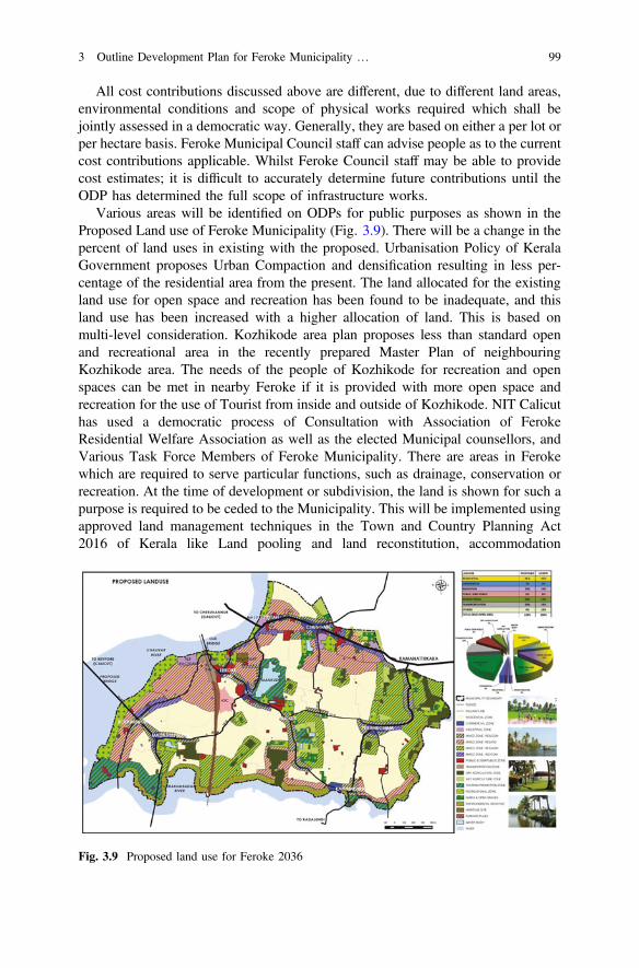
All cost contributions discussed above are different, due to different land areas,environmental conditions and scope of physical works required which shall bejointly assessed in a democratic way. Generally, they are based on either a per lot orper hectare basis. Feroke Municipal Council staff can advise people as to the currentcost contributions applicable. Whilst Feroke Council staff may be able to providecost estimates; it is difficult to accurately determine future contributions until theODP has determined the full scope of infrastructure works.
Various areas will be identified on ODPs for public purposes as shown in theProposed Land use of Feroke Municipality (Fig. 3.9). There will be a change in thepercent of land uses in existing with the proposed. Urbanisation Policy of KeralaGovernment proposes Urban Compaction and densification resulting in less per-centage of the residential area from the present. The land allocated for the existingland use for open space and recreation has been found to be inadequate, and thisland use has been increased with a higher allocation of land. This is based onmulti-level consideration. Kozhikode area plan proposes less than standard openand recreational area in the recently prepared Master Plan of neighbouringKozhikode area. The needs of the people of Kozhikode for recreation and openspaces can be met in nearby Feroke if it is provided with more open space andrecreation for the use of Tourist from inside and outside of Kozhikode. NIT Calicuthas used a democratic process of Consultation with Association of FerokeResidential Welfare Association as well as the elected Municipal counsellors, andVarious Task Force Members of Feroke Municipality. There are areas in Ferokewhich are required to serve particular functions, such as drainage, conservation orrecreation. At the time of development or subdivision, the land is shown for such apurpose is required to be ceded to the Municipality. This will be implemented usingapproved land management techniques in the Town and Country Planning Act2016 of Kerala like Land pooling and land reconstitution, accommodation
Fig. 3.9 Proposed land use for Feroke 2036
3 Outline Development Plan for Feroke Municipality … 99
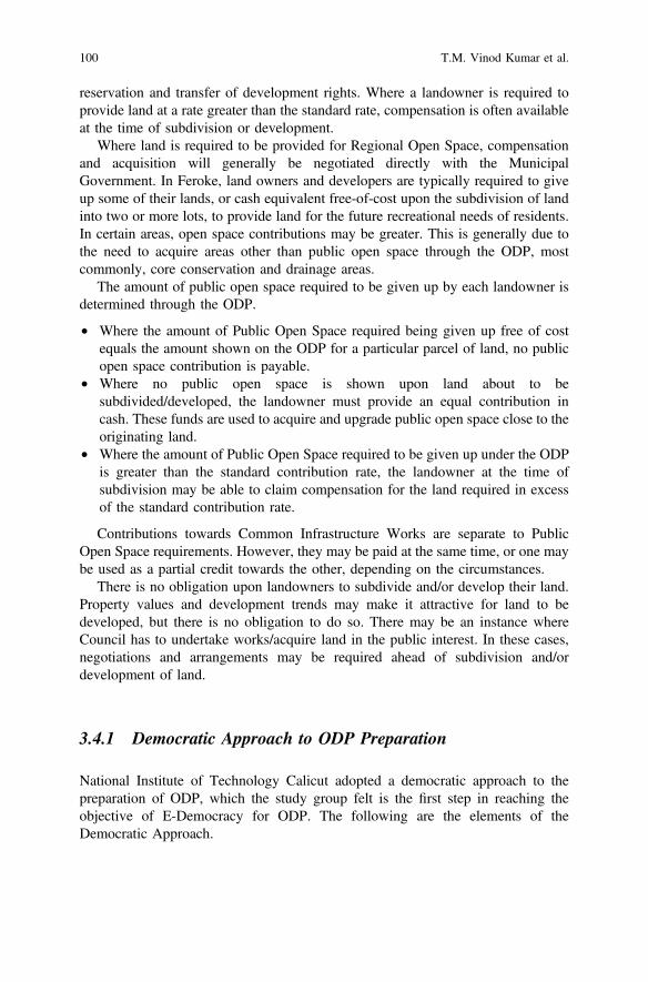
reservation and transfer of development rights. Where a landowner is required toprovide land at a rate greater than the standard rate, compensation is often availableat the time of subdivision or development.
Where land is required to be provided for Regional Open Space, compensationand acquisition will generally be negotiated directly with the MunicipalGovernment. In Feroke, land owners and developers are typically required to giveup some of their lands, or cash equivalent free-of-cost upon the subdivision of landinto two or more lots, to provide land for the future recreational needs of residents.In certain areas, open space contributions may be greater. This is generally due tothe need to acquire areas other than public open space through the ODP, mostcommonly, core conservation and drainage areas.
The amount of public open space required to be given up by each landowner isdetermined through the ODP.
• Where the amount of Public Open Space required being given up free of costequals the amount shown on the ODP for a particular parcel of land, no publicopen space contribution is payable.
• Where no public open space is shown upon land about to besubdivided/developed, the landowner must provide an equal contribution incash. These funds are used to acquire and upgrade public open space close to theoriginating land.
• Where the amount of Public Open Space required to be given up under the ODPis greater than the standard contribution rate, the landowner at the time ofsubdivision may be able to claim compensation for the land required in excessof the standard contribution rate.
Contributions towards Common Infrastructure Works are separate to PublicOpen Space requirements. However, they may be paid at the same time, or one maybe used as a partial credit towards the other, depending on the circumstances.
There is no obligation upon landowners to subdivide and/or develop their land.Property values and development trends may make it attractive for land to bedeveloped, but there is no obligation to do so. There may be an instance whereCouncil has to undertake works/acquire land in the public interest. In these cases,negotiations and arrangements may be required ahead of subdivision and/ordevelopment of land.
3.4.1 Democratic Approach to ODP Preparation
National Institute of Technology Calicut adopted a democratic approach to thepreparation of ODP, which the study group felt is the first step in reaching theobjective of E-Democracy for ODP. The following are the elements of theDemocratic Approach.
100 T.M. Vinod Kumar et al.
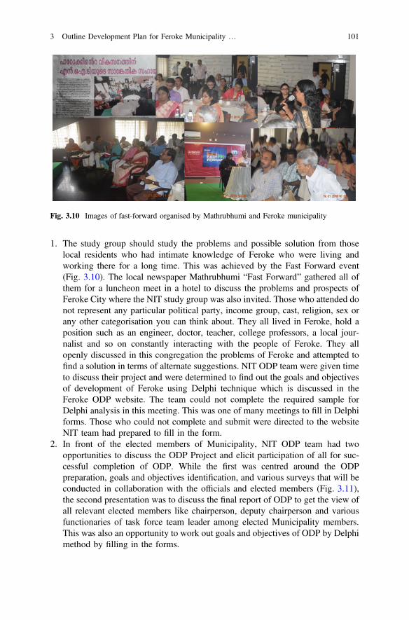
1. The study group should study the problems and possible solution from thoselocal residents who had intimate knowledge of Feroke who were living andworking there for a long time. This was achieved by the Fast Forward event(Fig. 3.10). The local newspaper Mathrubhumi “Fast Forward” gathered all ofthem for a luncheon meet in a hotel to discuss the problems and prospects ofFeroke City where the NIT study group was also invited. Those who attended donot represent any particular political party, income group, cast, religion, sex orany other categorisation you can think about. They all lived in Feroke, hold aposition such as an engineer, doctor, teacher, college professors, a local jour-nalist and so on constantly interacting with the people of Feroke. They allopenly discussed in this congregation the problems of Feroke and attempted tofind a solution in terms of alternate suggestions. NIT ODP team were given timeto discuss their project and were determined to find out the goals and objectivesof development of Feroke using Delphi technique which is discussed in theFeroke ODP website. The team could not complete the required sample forDelphi analysis in this meeting. This was one of many meetings to fill in Delphiforms. Those who could not complete and submit were directed to the websiteNIT team had prepared to fill in the form.
2. In front of the elected members of Municipality, NIT ODP team had twoopportunities to discuss the ODP Project and elicit participation of all for suc-cessful completion of ODP. While the first was centred around the ODPpreparation, goals and objectives identification, and various surveys that will beconducted in collaboration with the officials and elected members (Fig. 3.11),the second presentation was to discuss the final report of ODP to get the view ofall relevant elected members like chairperson, deputy chairperson and variousfunctionaries of task force team leader among elected Municipality members.This was also an opportunity to work out goals and objectives of ODP by Delphimethod by filling in the forms.
Fig. 3.10 Images of fast-forward organised by Mathrubhumi and Feroke municipality
3 Outline Development Plan for Feroke Municipality … 101
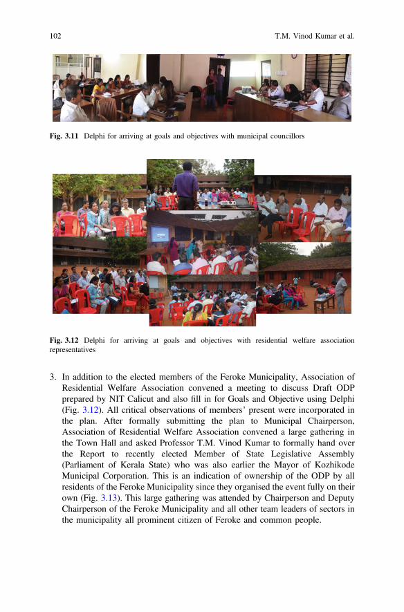
3. In addition to the elected members of the Feroke Municipality, Association ofResidential Welfare Association convened a meeting to discuss Draft ODPprepared by NIT Calicut and also fill in for Goals and Objective using Delphi(Fig. 3.12). All critical observations of members’ present were incorporated inthe plan. After formally submitting the plan to Municipal Chairperson,Association of Residential Welfare Association convened a large gathering inthe Town Hall and asked Professor T.M. Vinod Kumar to formally hand overthe Report to recently elected Member of State Legislative Assembly(Parliament of Kerala State) who was also earlier the Mayor of KozhikodeMunicipal Corporation. This is an indication of ownership of the ODP by allresidents of the Feroke Municipality since they organised the event fully on theirown (Fig. 3.13). This large gathering was attended by Chairperson and DeputyChairperson of the Feroke Municipality and all other team leaders of sectors inthe municipality all prominent citizen of Feroke and common people.
Fig. 3.12 Delphi for arriving at goals and objectives with residential welfare associationrepresentatives
Fig. 3.11 Delphi for arriving at goals and objectives with municipal councillors
102 T.M. Vinod Kumar et al.
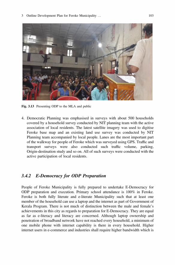
4. Democratic Planning was emphasised in surveys with about 500 householdscovered by a household survey conducted by NIT planning team with the activeassociation of local residents. The latest satellite imagery was used to digitiseFeroke base map and an existing land use survey was conducted by NITPlanning team accompanied by local people. Lanes are the most important partof the walkway for people of Feroke which was surveyed using GPS. Traffic andtransport surveys were also conducted such traffic volume, parking,Origin-destination study and so on. All of such surveys were conducted with theactive participation of local residents.
3.4.2 E-Democracy for ODP Preparation
People of Feroke Municipality is fully prepared to undertake E-Democracy forODP preparation and execution. Primary school attendance is 100% in Feroke.Feroke is both fully literate and e-literate Municipality such that at least onemember of the household can use a laptop and the internet as part of Government ofKerala Program. There is not much of distinction between the male and female’sachievements in this city as regards to preparation for E-Democracy. They are equalas far as e-literacy and literacy are concerned. Although laptop ownership andpenetration of broadband network have not reached every household, a minimum ofone mobile phone with internet capability is there in every household. Higherinternet users in e-commerce and industries shall require higher bandwidth which is
Fig. 3.13 Presenting ODP to the MLA and public
3 Outline Development Plan for Feroke Municipality … 103

not there. Although Akshaya Centres which actively participated in making peopleof Feroke fully e-literate, they do not have necessary software and training programin e-democratic implementation of ODP execution. Further mobile phone orientedapps are to be developed and made available and Internet of Things, Internet ofPeople and Internet of Governance of Feroke based on needs of Feroke to be inplace which can only be possible if centres of higher learning in and aroundKozhikode prepare and provide them. This means nearby Feroke College,University of Calicut, and National Institute of Technology Calicut have a greaterrole in the days to come for implementation of E-Democracy for ODP. This projectwill execute ODP of Feroke, leaving the mobile app developments and IOTdevelopment for the concerned coders and developers in NIT and CalicutUniversity.
Our approach to ODP preparation has been presented elsewhere in the chapter.These approaches will considerably change if we implement E-Democracy in thepreparation of ODP.
ODP conventionally has been based on once in 20 years’ data collection andresort to all sorts of projection of variables for benchmark years of five years. Theexperience shows that none of this projection and even population projection hasbeen correct in all the ODP and Mater Plans prepared all over Kerala over sixtyyears’ period as observed by authors of this chapter. E-Democratic ODP prepara-tion will be based on constantly updating the database of all variables of Feroke byelectronic means. Remote sensing data for the mapping of land use will be usedcontinuously depending on the next available remote sensing data within few days.People of Residential Welfare Association will be there who will be trained how toupdate land use data and incorporate in the constantly changing GIS database.Traffic data will be collected by sensors and will be available in Feroke data cloudfor accessing by everybody for all purposes with or without a fee for many apps tobe developed for Internet of Things, Internet of Governance or Internet of People.The household sample used in this project gets transformed to household censusannually. This will be filled in by households and uploaded to Feroke Web site forfurther processing and presentation in the web from time to time. This can trigger inFacebook media deliberation by local residents attached to the website of Ferokedesigned. Goals and Objectives of the development of Feroke shall be assessed byall households periodically and be the motivators to develop apps that attain thesegoals. Strong linkage of Feroke with centres of higher learning in Kozhikode willgive them the capability to analyse these data and provides them with apps that canbe used in conjunction with Internet of Things, Internet of People and Internet ofGovernance to deal with emerging issues in Feroke based on the constantlyupdating database of Feroke.
104 T.M. Vinod Kumar et al.
3.5 Development of ODP for Feroke City in IOT, IOG,and IOD for Achieving E-Democracy
The ODP for Feroke was intended to convert Feroke to a self-financing smart city.It is found that people of Feroke have all the potentials to transform themselves toSmart-People, which is the most important component in the building of the smartcity [4]. The economy of Feroke is in a transition mode and has all the indicationsthat it can be easily upgraded to a smart economy [5, 6] if there is a conduciveenvironment available. The ODP is intended to evolve this conducive environmentand form the six elements of the smart city namely Smart People, Smart Economy,Smart Mobility, Smart Environment, Smart living and Smart Governance. ODPenvisages to develop this conducive environment through a set of tools. These toolscan be classified to Internet of Things (IOT), Internet of Governance (IOG), Internetof Democracy (IOD). The following section briefly explains the solutions proposedfor each element of the smart city based on various surveys conducted in Ferokeand its participatory analysis and conclusions drawn.
3.5.1 Smart People
The ODP intends to upgrade the citizens to smart people by empowering eachindividual, by understanding his or her capabilities and limitations, and opening upopportunities to develop the skills required by them to fit in the community. It alsointends to make the public spaces and facilities accessible to all individuals espe-cially for marginalised communities in the present system. The strategies includeinclusive planning and design of streets, parks, public places, civic facilities, san-itation infrastructure and transport modes, starting women-centered industrial pro-jects, promoting women entrepreneurship and provide skills development training,the creation of geriatric/especially skilled/physically challenged care infrastructurein govt. The sector and preferential housing of the marginalised.
3.5.1.1 IOD Tools
A mobile application is proposed, as par of the survey and analysis to make thedifferently abled (blind) more independent and self-reliant. The application isexpected to be controlled by speech and communicated back to the user throughspeech synthesis. Helpline numbers with facilities of the speak-and-dial facility andthe app may avail facilities of hiring volunteers to guide them in malls (Calicut), busterminals, commercial centres of Feroke etc. Booking prepaid services fortransportation-taxi, auto-rickshaw, bus by E-banking facilities which can be doneby scanning thumb impression for the username and a pattern for a password.Booking an appointment with doctor or booking tickets can be done by opening the
3 Outline Development Plan for Feroke Municipality … 105
app, touch anywhere on the screen which can make the app start talking about thecategories, selection of Category can be done by repeating the name of the category.Similarly, the headings under each category can be selected in a similar way.
3.5.1.2 IOG for Safety
The IOG tools bring smartness to the governance. The application will have an SOSbutton to send pre-set messages to the defined contacts. In the same app, the usercan report incidents like crime, traffics, harassments, domestic violence, corruption,smoking in public areas, etc. There will be a provision to find nearby places like apolice station, bus station, ATM, hospital, etc. Apart from the obvious advantage tothe user, the application collects data regarding the incidents using the location andother sensors in the mobile. Such data, combined with other information availablewith the smart city ICT, can be effectively used in diagnosing the problems, pre-dicting safety hazards, and taking effective actions against such incidents.
3.5.2 Industry
The ODP proposes to encourage the existing industries through various strategiesand at the same time it recognises the need to revitalise the traditional industriesthrough innovations to enable to tap the potential of the global market. There ispromising potential in the active household based industries in Feroke. Tourismpotential is also remaining untapped. The ODP recognises that there is ampleopportunities for one side and skilled and technical workforce available on the otherside, but there is still an issue of a proper interface. The smart city expects people tobe more dynamic, and capable of learning new skillsets as the industries demandchanges.
3.5.2.1 IOD for Industries—Workforce Interaction and SkillDevelopment
The proposed IOD application for this purpose is expected to have capabilities tocollect the requirements for jobs from various industries, and subsequently, alert theindividuals with matching qualifications. It may also rely on available historical andreal-time data to propose a skill improvement programme for the individual jobseekers to improve their prospects. This will also help the proposed skill devel-opment centres to form new courses matching with the demand and disseminate thetraining sessions in custom made fashion to match with the requirements of thepublic. The schematic process is presented in Table 3.1 and Fig. 3.14.
106 T.M. Vinod Kumar et al.
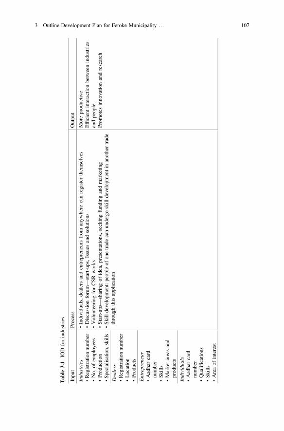
Tab
le3.1
IOD
forindu
stries
Inpu
tProcess
Outpu
t
Indu
stries
•Registrationnu
mber
•No.
ofem
ploy
ees
•Prod
uctio
n•Sp
ecialisation,skills
•Individu
als,dealersandentrepreneursfrom
anyw
here
canregister
them
selves
•Discussionforum—start-up
s,Issues
andsolutio
ns•Volun
teeringforCSR
works
•Start-up
s—sharingof
idea,presentatio
ns,seekingfund
ingandmarketin
g•Sk
illdevelopm
ent:peop
leof
onetradecanun
dergoskill
developm
entinanothertrade
throug
hthisapplication
Moreprod
uctiv
eEfficientinteractionbetweenindu
stries
andpeop
leProm
otes
inno
vatio
nandresearch
Dealers
•Registrationnu
mber
•Location
•Prod
ucts
Entrepreneur
•Aadharcard
number
•Sk
ills
•Marketareasand
prod
ucts
Individu
als
•Aadharcard
number
•Qualifi
catio
ns•Sk
ills
•Areaof
interest
3 Outline Development Plan for Feroke Municipality … 107
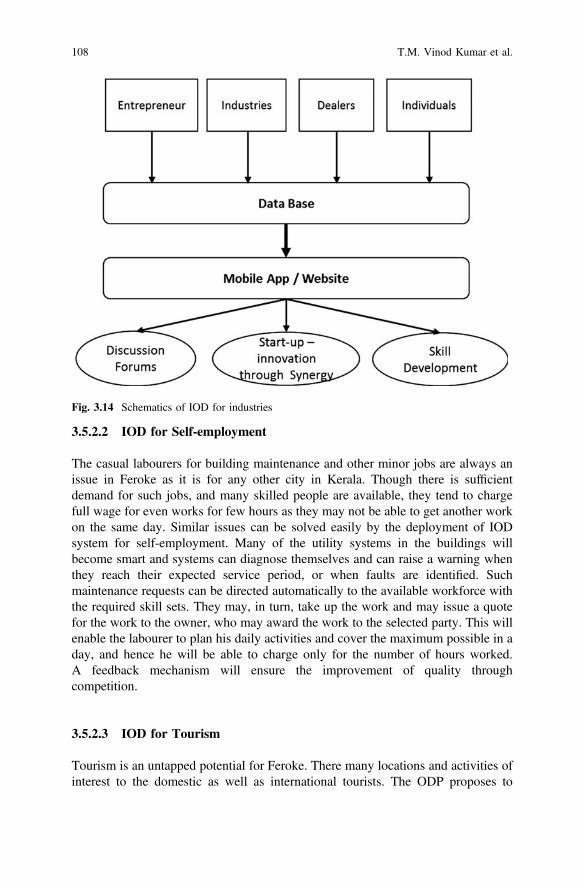
3.5.2.2 IOD for Self-employment
The casual labourers for building maintenance and other minor jobs are always anissue in Feroke as it is for any other city in Kerala. Though there is sufficientdemand for such jobs, and many skilled people are available, they tend to chargefull wage for even works for few hours as they may not be able to get another workon the same day. Similar issues can be solved easily by the deployment of IODsystem for self-employment. Many of the utility systems in the buildings willbecome smart and systems can diagnose themselves and can raise a warning whenthey reach their expected service period, or when faults are identified. Suchmaintenance requests can be directed automatically to the available workforce withthe required skill sets. They may, in turn, take up the work and may issue a quotefor the work to the owner, who may award the work to the selected party. This willenable the labourer to plan his daily activities and cover the maximum possible in aday, and hence he will be able to charge only for the number of hours worked.A feedback mechanism will ensure the improvement of quality throughcompetition.
3.5.2.3 IOD for Tourism
Tourism is an untapped potential for Feroke. There many locations and activities ofinterest to the domestic as well as international tourists. The ODP proposes to
Fig. 3.14 Schematics of IOD for industries
108 T.M. Vinod Kumar et al.
encourage the public to extend homestays and community events like local templefestivals, cultural programmes of youth clubs, Soccer tournaments, etc. for tourists.An IOD application is proposed to integrate such events and facilities. The appli-cation may assist tourists to plan their available time, by suggesting places they canvisit, suggest events they can attend and likely places to stay.
3.5.2.4 IOT for Tourism
This is an appropriate system of sensors employed at various tourist locations, andboating centres, which keep track of a number of users at any time. This count helpsin the management of disasters like boat capsize, drowning, etc. This count will alsoassist in judging advertisement potentials in such places.
3.5.2.5 IOT for Agriculture
The increased demand for residential land, high labour wages, segmentation ofagricultural land, and negative sentiment against mechanisation in the past bycertain political parties contributed to the vanishing of agricultural activity fromKerala. Kerala relies on nearby states for the agricultural supplies. However, therecent increase in incidents of cancer, diabetes, etc. were identified as effects ofindiscriminate use of pesticides and chemical fertilisers in these states. This hascreated a sentiment among people to start their cultivation of vegetables, whichresulted in rooftop cultivation etc. OPD identifies this as a positive move andpromotes urban agriculture, by proposing IOT and IOD tools for promoting agri-culture within the urban space. The solutions range from the automated irrigationsystem, which senses the need for irrigation through soil moisture sensors andcommunicates to the owner through the mobile. There are solutions proposed tomonitor nutrient requirements in the soil and suggest suitable bio fertilisers andsolutions market their surplus products easily. The marketing can be done for evensmall quantity. This helps residents to cultivate different vegetables, and exchangethem within the community so that everyone will get virtually any vegetables he orshe require. The transactions can be even barter, which will encourage everymember to produce some vegetables. The IOD app serves as a marketplace for suchtransactions and can keep a record of the barter system.
3.5.3 Smart Mobility
Many of the transportation related issues faced by Feroke can be traced to thedemand for vehicular traffic through the narrow roads. Most of the roads withinFeroke was formed by nominally widening erstwhile footpaths. These footpaths arevery efficient if a suitable mode of transport is used. Hence the ODP proposes to
3 Outline Development Plan for Feroke Municipality … 109
encourage the use of bicycles and promote walking. The strategies proposed toinclude identification of cycle tracks and promoting them to the major traffic routeby developing commercial land use along with this route.
3.5.3.1 IOT and IOD for Parking
ODP also propose to widen few selected roads and to develop dedicated parkingarea near to the central Feroke. Still, the parking will be a deficit, but ODP proposesto manage the parking through an IOD application which allows the users to reserveparking slots automatically and helps to find the nearest available parking places.To achieve this an IOT devices are to be deployed to monitor the parking placesautomatically.
3.5.3.2 IOD and IOG Tools for Efficient Bus Transportation
An IOD application is proposed for public to identify the availability of publicbuses to travel to a given destination. This application works by assimilatinglocation information from the running buses, and their designated routes. Theapplication will be capable of proposing itinerary of travel, to optimise either timeof travel, the cost of travel or distance of travel. This can also be extended to othermodes of transport like auto-rickshaws, taxi and trains. IOG tools are proposed tomanage bus route identification and assignment. Currently, the routes are decidedby the bureaucracy as required by the political powers. The data collected throughthe above mentioned IOD tools for bus travel can be used to decide the effec-tiveness of the present route assignments, and GIS models can be developed topropose alternate routes which are good for the larger public.
3.5.4 Smart Environment
Smart environment deals with the application of technology for responsible utili-sation of environmental resources and management of wastes produced by the city.This majorly involves utilisation of water, power, Green cover, and disposal ofwastewater, and solid waste. The city meets its larger part of the water demand byground water, from individual wells. This is augmented by the new JICA fundedlarge-scale water supply scheme that covers the whole district. OPD also promotesidentification of the responsible use of smaller water supply schemes. As the wateris consumed from multiple sources, it is important to monitor the quality of water.
110 T.M. Vinod Kumar et al.
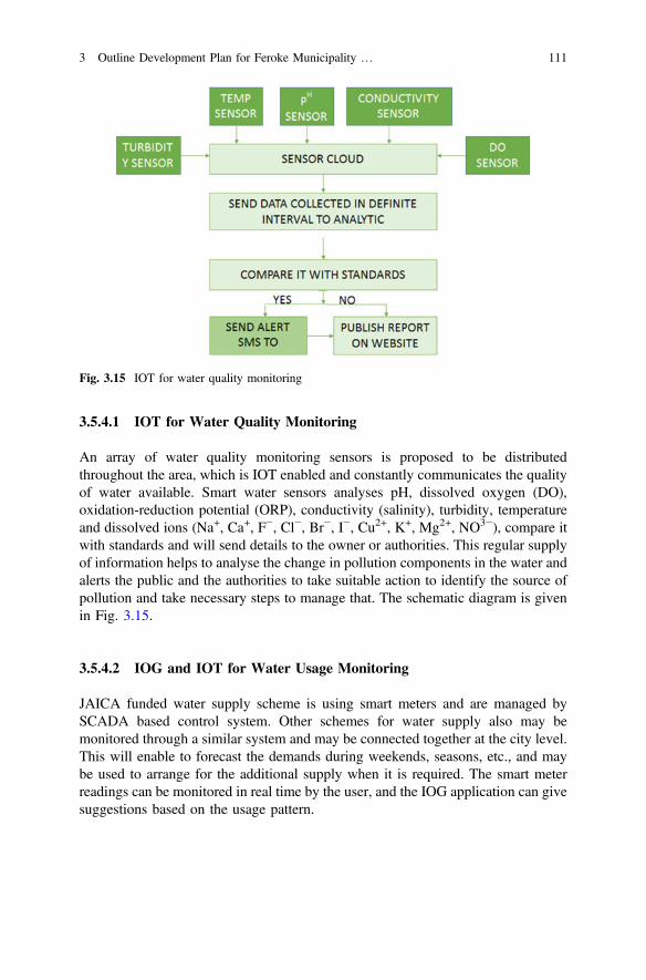
3.5.4.1 IOT for Water Quality Monitoring
An array of water quality monitoring sensors is proposed to be distributedthroughout the area, which is IOT enabled and constantly communicates the qualityof water available. Smart water sensors analyses pH, dissolved oxygen (DO),oxidation-reduction potential (ORP), conductivity (salinity), turbidity, temperatureand dissolved ions (Na+, Ca+, F−, Cl−, Br−, I−, Cu2+, K+, Mg2+, NO3−), compare itwith standards and will send details to the owner or authorities. This regular supplyof information helps to analyse the change in pollution components in the water andalerts the public and the authorities to take suitable action to identify the source ofpollution and take necessary steps to manage that. The schematic diagram is givenin Fig. 3.15.
3.5.4.2 IOG and IOT for Water Usage Monitoring
JAICA funded water supply scheme is using smart meters and are managed bySCADA based control system. Other schemes for water supply also may bemonitored through a similar system and may be connected together at the city level.This will enable to forecast the demands during weekends, seasons, etc., and maybe used to arrange for the additional supply when it is required. The smart meterreadings can be monitored in real time by the user, and the IOG application can givesuggestions based on the usage pattern.
Fig. 3.15 IOT for water quality monitoring
3 Outline Development Plan for Feroke Municipality … 111
3.5.4.3 IOT for Waste Management
Smart bins with small battery/solar powered wireless sensors that are attached to theunderside of the container lid can sense the volume of garbage in the bin. It can alsocommunicate this level through cellular/wireless networks. The alerts from variousplaces will be analysed by the fleet management system to determine the best routeto be taken by the collection vehicles.
3.5.4.4 Energy
Alternate sources of energy were explored, and solar power is found to be the mostsuitable for Feroke. However, the throughput is reduced considerably during themonsoon season in Kerala. Smart electricity meters are proposed to monitor theusage of electricity and also to account the electricity given back to the systemduring peak solar hours. This will reduce the need for storage facilities, and willalso reduce the usage of hydropower during day time.
3.5.5 Smart Living
Smart living details about the schemes and programmes proposed for improving theliving standard of citizens using smart technology. Community health managementschemes of Kerala were well known as they achieved very high standards with anominal budget outlay [7, 8]. Recently Govt. of Kerala has decided to revive its‘Family Doctor’ scheme under the brand name ‘Ardram’ [9, 10]. The schemeassigns the doctor in the primary health centre as the first point of contact for anyhealth related matter of the family within the limit of the primary health centres.There are many kinds of health trackers available in the market, which collects vitalhealth measurements like blood pressure, sugar level and activity of the user andtransfer the same to the mobile phone on a periodical base. If such devices can bemade available to the needy, the ‘Family Doctor’ will be able to get the full healthstatistics of the patient, and will be in a position to do the needful. An IODapplication can be designed to alert the doctor automatically if the patient hasunusual variation in the health statistics, and may automatically arrange for thenecessary first aid on the spot.
112 T.M. Vinod Kumar et al.
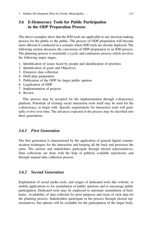
3.6 E-Democracy Tools for Public Participationin the ODP Preparation Process
The above examples show that the IOD tools are applicable to any decision-makingprocess for the public to the public. The process of ODP preparation will becomemore efficient if conducted in a scenario where IOD tools are already deployed. Thefollowing section discusses the conversion of ODP preparation to an IOD process.The planning process is essentially a cyclic and continuous process which involvesthe following major stages.
1. Identification of issues faced by people and identification of priorities2. Identification of goals and Objectives3. Extensive data collection4. Draft plan preparation5. Publication of the ODP for larger public opinion6. Legalisation of ODP7. Implementation of projects8. Review.
This process may be accepted for the implementation through e-democracyplatform. Potentials of existing social interaction tools itself may be used for thee-democracy, to begin with. Specific requirements for interaction tools will grad-ually evolve over time. The advances expected in the process may be classified intothree generations.
3.6.1 First Generation
The first generation is characterised by the application of general digital commu-nication techniques for the interaction and keeping all the back end processes thesame. The citizens and stakeholders participate through elected representatives.Data collections are done with the help of publicly available repositories andthrough manual data collection process.
3.6.2 Second Generation
Exploitation of social media tools, and usages of dedicated tools like website, ormobile applications to for assimilation of public opinions and to encourage publicparticipation. Dedicated tools may be employed to automate assimilation of feed-backs. Availability of data collected for prior purposes and reuse of such data forthe planning process. Stakeholders participate in the process through elected rep-resentatives, but options will be available for the participation of the larger body.
3 Outline Development Plan for Feroke Municipality … 113
Extensive application of technology to generate scenarios for illustrating the futureof current decisions taken.
3.6.3 Third Generation
The third generation will be characterised by extensive exploitation of social mediaalong with digital communication for the planning process. Most of the datarequirements of the ODP preparation will be satisfied by mining the huge repositoryof data generated by the galaxy of IOT sensors and other IOD and IOG applica-tions. Stakeholders are participated directly, without any elected representative.There will be automated backend processing tools for processing the feedbacksfrom the larger public through multiple sources to precipitate the general sentiment,similar to the methods used by large scale companies like Google, Microsoft andFacebook to judge the user satisfaction. Extensive use of simulation techniques togenerate alternate scenarios. Individual stakeholders will be able to try out alternatedecisions and figure out the end results themselves through simplified visualrepresentations.
The expected evolution of ODP process in an IOD framework is given inTable 3.2.
3.7 Conclusions
There are two E-Democracy Models; Consumer E-Democracy and ProsumerE-Democracy. In Consumer democracy people consumes the tax revenue fordevelopment expenditure of Feroke after all administrative and debt servicingexpenditure are paid for. The resulting funds are not sufficient to meet the growingdemand for public funds for urban development of Feroke. An analysis of figuresavailable in Sulekha website shows that Kerala by and large depends onGovernment funds for Urban Development as a full-fledged consumer democracy.Feroke shall strive for a Prosumer democracy. In a Prosumer democracy, thedemocratic capability is shared to bring about a better income generating economicactivities that are shared between a citizen of Feroke in addition to consuming taxrevenues for Government for urban development. Part of this income generatedshall form a complementary fund for urban development of Feroke by paying whatis consumed for to generate a self-reliant Feroke. This fund undoubtedly shall behigher than Government funds.
In addition to Government, there are at least two actors in the urban developmentof Feroke. They are Malabar Chamber of Commerce and Industries and Academialike National Institute of Technology, Calicut, other institutions of higher learningin Calicut and Calicut University. They are not recognised by Government ofKerala as partners of urban development. So much so Metropolitan Planning
114 T.M. Vinod Kumar et al.
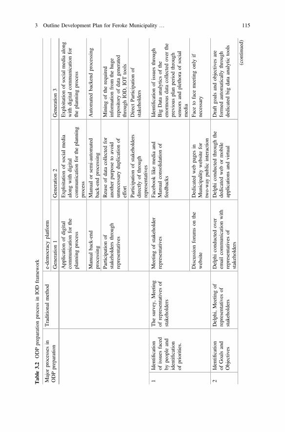
Tab
le3.2
ODPpreparationprocessin
IOD
fram
ework
Major
processesin
ODPpreparation
Traditio
nalmetho
de-democracy
platform
Generation1
Generation2
Generation3
App
licationof
digital
commun
icationforthe
planning
process
Exp
loitatio
nof
social
media
alon
gwith
digital
commun
icationfortheplanning
process
Exp
loitatio
nof
socialmediaalon
gwith
digitalcommun
icationfor
theplanning
process
Manualback-end
processing
Manualor
semi-automated
back-end
processing
Autom
ated
backendprocessing
Participationof
stakeholders
throug
hrepresentativ
es
Reuse
ofdata
collected
for
anotherpu
rposeto
avoid
unnecessarydu
plicationof
effort
Miningof
therequ
ired
inform
ationfrom
thehu
gerepo
sitory
ofdata
generated
throug
hIO
D,IO
Ttools
Participationof
stakeholders
directly
ofthroug
hrepresentativ
es
DirectParticipationof
stakeholders
1Identifi
catio
nof
issues
faced
bypeop
leand
identifi
catio
nof
priorities.
The
survey,Meetin
gof
representativ
esof
stakeholders
Meetin
gof
stakeholder
representativ
esFacebo
oklik
emedia
and
Manualconsolidationof
feedbacks
Identifi
catio
nof
issues
throug
hBig
Dataanalyticsof
the
enormou
sdata
collected
over
the
previous
plan
period
throug
hsensorsandpletho
raof
social
media
Discussionforumson
the
website
Dedicated
web
pagesin
Mun
icipality
website
for
two-way
public
interaction
Face
toface
meetin
gon
lyif
necessary
2Identifi
catio
nof
Goalsand
Objectiv
es
Delph
i,Meetin
gof
representativ
esof
stakeholders
Delph
icond
uctedov
erem
ailcommun
icationwith
representativ
esof
stakeholders
Delph
icond
uctedthroug
hthe
dedicatedweb
ormob
ileapplications
andvirtual
Draftgo
alsandob
jectives
are
form
edautomatically
throug
hdedicatedbigdata
analytic
tools
(con
tinued)
3 Outline Development Plan for Feroke Municipality … 115
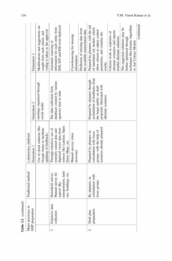
Tab
le3.2
(con
tinued)
Major
processesin
ODPpreparation
Traditio
nalmetho
de-democracy
platform
Generation1
Generation2
Generation3
meetin
gsorganisedthroug
hsocial
media
Use
ofclou
dsolutio
nslik
eGoo
gleform
sto
facilitate
updatin
gof
feedbacks
Mod
ificatio
nsandsugg
estio
nsare
soug
htfrom
each
citizen,and
votin
gistakenas
theapprov
al
3Extensive
data
collection
Hou
seho
ldsurvey,
Manualsurvey
for
aspectslik
etransportatio
n,land
use,
build
ings,etc.
Throu
ghextensiveuseof
remotelysensed
data
and
digitised
vector
data
from
sourceslik
eLandsat,Open
Street
Maps,etc.
The
data
collectionfrom
databasescreatedby
variou
sagencies
timeto
time
Autom
atic
sourcing
ofinform
ationforeach
entityfrom
IOD,IOTandIO
Gtoolsdeploy
ed
Manualsurveyswhen
necessary
Crowdsou
rcingformissing
inform
ation
Predictio
nof
missing
data
from
theavailableun
structured
data
4Draftplan
preparation
Byplanners,in
consultatio
nwith
focusgrou
ps
Prepared
byplanners
inconsultatio
nwith
focus
grou
ps,with
thehelp
ofscenariosalreadyprepared
Prepared
byplanners
throug
hassimilatio
nof
feedbacksfrom
thelarger
public
ondraft
prop
osals,illustrated
with
alternatescenarios
Prepared
byplanners,w
iththeaid
ofsimulated
city
mod
els,which
allow
citizensto
adjustcontrol
parameters,andvisualisethe
results
Citizens
workas
explorersof
alternatescenariosandrepo
rts
fruitful
alternatesolutio
ns
The
sugg
estedsolutio
nsmay
befurtherop
timised
throug
htechniqu
eslik
eGeneticAlgorith
mor
Ant
Colon
yMod
els(con
tinued)
116 T.M. Vinod Kumar et al.
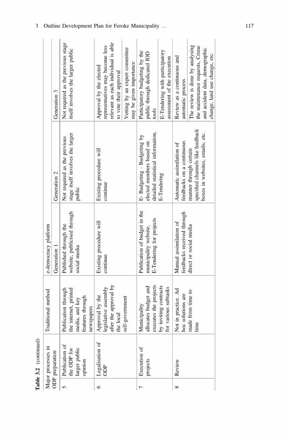
Tab
le3.2
(con
tinued)
Major
processesin
ODPpreparation
Traditio
nalmetho
de-democracy
platform
Generation1
Generation2
Generation3
5Pu
blicationof
theODPfor
larger
public
opinion
Publicationthroug
htheinternet,printed
media,andkey
features
throug
hnewspapers
Publishedthroug
hthe
website,pu
blicised
throug
hsocial
media
Not
requ
ired
astheprevious
stageitselfinvo
lves
thelarger
public
Not
requ
ired
astheprevious
stage
itselfinvo
lves
thelarger
public
6Legalisationof
ODP
App
rovalby
the
legislativeassembly
aftertheapprov
alby
thelocal
self-gov
ernm
ent
Existingprocedurewill
continue
Existingprocedurewill
continue
App
rovalby
theelected
representativ
esmay
becomeless
relevant
aseach
individu
alisable
tovo
tetheirapprov
al
Vettin
gby
anexpertcommittee
may
begivenim
portance
7Executio
nof
projects
Mun
icipality
allocatesbu
dget
and
executes
theprojects
byinvitin
gcontracts
forvariou
ssubtasks
Publicationof
budg
etin
the
mun
icipality
website,
E-Tendering
forprojects
E-Bud
getin
g-Bud
getin
gby
electedmem
bers
basedon
detailedstatistical
inform
ation,
E-Tendering
Participatorybu
dgetingby
the
public
throug
hdedicatedIO
Dtools
E-Tendering
with
participatory
assessmentof
theexecution
8Review
Not
inpractice.
Ad
hocsolutio
nsare
madefrom
timeto
time
Manualassimilatio
nof
feedbacksreceived
throug
hdirect
orsocial
media
Autom
atic
assimilatio
nof
feedbackson
acontinuo
usmannerthroug
hcertain
specified
channelslik
efeedback
boxesin
websites,em
ails,etc.
Review
asacontinuo
usand
automatic
process
The
review
isdo
neby
analysing
themaintenance
requ
ests,Crime
andaccident
data,demog
raph
icchange,land
usechange,etc.
3 Outline Development Plan for Feroke Municipality … 117
Committees, District Planning Committees, State Planning Board, Municipalitiesdo not have seats reserved for memberships of these executing committees. Theyserved in this project Feroke Municipality free of cost, unlike Government whereadministrative expenditure and debt servicing is deducted from the developmentalexpenditure. For example, the ODP prepared and presented to people of Feroke wasfree of cost since the Marginal cost of working on the ODP was zero to NationalInstitute of Technology, Calicut. This in no way belittles the role of Government ofKerala who has their unique constitutional responsibility for Tax collection and Taxsharing for Development which academia and the Chamber of Commerce andIndustries cannot perform but what Government of Kerala can allocate to Ferokethe aspiring Smart City is not at all sufficient.
The ODP preparation was executed by a nine-member study team and threemember faculty but largely assisted by people of Feroke in a very massive scale.People of Feroke was there with the team to collect information from 500 house-holds, conducting various other surveys such as traffic surveys. Without the activeparticipation of people of Feroke, the planning team cannot achieve what we havedone. All of them conducted with near zero marginal cost.
ODP generally prepare a spatial plan to implement through regulated develop-ment. Detailed spatial and non-spatial survey research opened up problems andpotential of development of Feroke Municipality. This resulted in a spatial plan anda set of priority action plans. Feroke ODP here makes a departure from conven-tional ODP. This departure is in the implementing framework.
Implementing Framework adopted by NIT Calicut for ODP is conceived as IOP,IOG and IOT. National Institute of Technology, Calicut or Calicut University isfully capable of deploying IOT, IOP and IOG. IOP and IOG essentially involve thedevelopment of mobile based apps to be used by people of Feroke. IOT involvesdeveloping one or more IOTs to perform the work stipulated for the activity asdiscussed in this chapter.
The Department of Planning and Architecture, NIT Calicut, had exhibitedcapabilities in this direction. The author of Chap. 16 Swapnil Shrivastav of thisbook is working in a start-up which produces drinking water simulating rainfall in aconfined space using a series of IOTs for drinking water supply.
The development of IOT, IOP and IOG for this project means for NationalInstitute of technology breaking open departmental walls and collecting a series ofteachers and students to produce the apps or IOT configurations. NIT Calicut is in aposition to perform this and present it to Feroke Municipality at the marginal cost ofnear zero at zero price. This approach is far superior to Government of CallingTenders and awarding contract for the lowest tender or calling foreign collaboratorsand foreign loans for Smart Cities.
Bimal. Aruna and I, the three authors of this chapter carefully selected severalteachers of other departments in the National Institute of Technology, Calicut suchas Electronic Department, Transport Engineering and Electrical EngineeringDepartment and made a presentation of this project. This is because of a requestfrom Professors Chen Feng and Zheng Liu of University of British Columbia,Canada and Authors of Chap. 17 of this book. The task was to compete for an
118 T.M. Vinod Kumar et al.
Indo-Canadian Project administered jointly by Government of India and Canada onthe development of IOTs for Smart Cities. During the presentation of study teams,those assembled came out with the design of many more IOTs and IOPs and IOGsdiscussed in our presentations. This documentation does not present all thesebecause our study teams did not discuss with the people of Feroke for theiragreement.
Acknowledgements The work explained in this chapter is based on one semester work of thesecond semester post graduate students of the Department of Architecture and Planning, NITCalicut during 2015–16. The authors would like to gratefully acknowledge the efforts of ourstudents, Ms. Anu Paul, Ms. Asha Devadas, Ms. Ashikha Raoof, Mrs. Fathim Rashna Kallingal,Ms. Maya K.P., Ms. Nunna Tagore Sai Priya, Mr. Prabhakar Uniyal, Mr. Sarath Chandran P., andMs. Shabana Yoonus. We are grateful to our faculty colleagues, Dr. Naseer M.A, Dr. Anilkumar P.P., Dr. Mohammed Firoz C., Ar. Chithra K., and Ar. Lakshmi Manohar for helping the studentswith special lectures on their respective expertise during the programme. We would alsoacknowledge the whole-hearted help extended by the Municipality of Feroke, represented by Mrs.T. Suhrabi (Chair Person), Mr. Asif (Standing Committee Chairman), Ms. Sabeena (Councillor)and Mrs. Sarada C.P. (Ward Member). We would also like to extend a special acknowledgement toMr. Mohanan master (Coordination Committee chairman of residential associations in Feroke)who was always ready to provide us any help we required throughout the project.
References
1. Oommen MA (2004) Deepening decentralised governance in rural India : lessons from thepeople’s plan initiative of Kerala. Centre for Socio-economic and Environmental Studies,India
2. Menon DM (1999) Houses by the sea—State-formation experiments in Malabar, 1760–1800.Econ Polit Wkly 34(29):1995–2003
3. Government of Kerala (1994) The Kerala municipality act. India4. Kumar TMV (2015) E-governance for smart cities5. Vinod Kumar TM, Bimal P, Mohammed Firoz C (2016) e-design of umami by smart people
for smart economy. In: Vinod Kumar TM (ed) EdSmart economy in smart cities: internationalcollaborative research: Ottawa, St.Louis, Stuttgart, Bologna, Cape Town, Nairobi, Dakar,Lagos, New Delhi, Varanasi, Vijayawada, Kozhikode, Hong Kong, Springer Singapore,Singapore, pp 391–442
6. Vinod Kumar TM (ed) (2016) Smart economy in smart cities. Springer Singapore, Singapore7. Nabae K (2003) The health care system in Kerala—Its past accomplishments and new
challenges. J Natl Inst Public Health 2(52):140–1458. Padmaja K (2005) An evaluation of primary health care system in Kerala. Cochin University
of Science and Technology, Kochi9. Government of Kerala (2016) Health, family welfare—government of Kerala, India. [Online].
Available https://kerala.gov.in/health-family-welfare. Accessed 25 Dec 201610. Kerala state to revive family doctor concept—medical dialogues. [Online]. Available: http://
medicaldialogues.in/kerala-state-to-revive-family-doctor-concept/. Accessed 25 Dec 2016
3 Outline Development Plan for Feroke Municipality … 119
Chapter 4E-Democracy in New Delhi MunicipalCouncil: A Case of Smart CityPlanning Processes
Ashok Kumar
Abstract New Delhi Municipal Council is one of the rare urban local bodies of theNational Capital Territory of Delhi, which is governed by Government of Indiathrough an organizational arrangement led by senior civil servants who are assistedby professionals like engineers, architects, city planners and others. Normaldemocratic regimes and routines such as elections and re-elections are non-existentin the working of the New Delhi Municipal Council. As is well known, in the restof the country, democratic processes are well and truly established since the early1950s hailing India as the world’s largest democracy. With the declaration of thearea under the jurisdiction of NDMC as the first smart city in Delhi, the highlyplanned and designed city by Edwin Lutyens aspires to become a benchmark for theglobal smart capitals. Covering the geographical area of 43.7 km2 (2.95% of thetotal area of Delhi), and population of only 0.3 million (1.79% of the entire citystate), NDMC expects to achieve the smart global capital status when one alsoconsiders that huge investments per person are being made year after year. The keyissue that I would like to answer in this chapter is: Can New Delhi MunicipalCouncil unleash e-governance including e-democracy, and pave the way fore-democratic governance in the future for its citizens. I would like to answer thiskey question by analysing three empirical cases apart from an examination of theNDMC Smart City Proposal with a view to assessing how far the smart cityprocesses have promoted democracy in general and e-democracy in particular(citizen engagement) in the NDMC area leading to transparency, accountability,and ease of doing business. All these are core pillars of Government of India’surban and economic policies. In the end some concluding are made.
Keywords E-Democracy E-governance Citizen engagement Buildingpermissions
A. Kumar (&)Department of Physical Planning, School of Planning and Architecture,4 Block B, I.p. Estate, New Delhi, Indiae-mail: [email protected]
© Springer Nature Singapore Pte Ltd. 2017T.M. Vinod Kumar (ed.), E-Democracy for Smart Cities, Advances in 21st CenturyHuman Settlements, DOI 10.1007/978-981-10-4035-1_4
121
4.1 Introduction: An Overview of the Smart City Proposalof NDMC
Flagships projects capture the imagination of the policy framers, private sectormultinational companies, anyone concerned with planetary urbanism, and policyscholars who critically examine such policies. India’s own smart city policy knownas the Smart Cities Mission is no different. It has become the talk of the townthroughout India. Indian capital city is abuzz with smart city talk. A large number ofseminars and conferences bear witness to the centrality of this flagship project in theurban debate. The Smart Cities Mission has become the mission of seminar andconference attendees. Even the BRICS conference held at Vishakhapatnam, AndhraPradesh hosted a special session on the smart cities. It appears the smart city ideahas caught the imagination of all concerned.
A State Level High Powered Steering Committee (HPSC) set up under thechairmanship of the Chief Secretary, Government of the National Capital Territoryof Delhi (GNCTD) recommended that New Delhi Municipal Council should bedeveloped as a smart city. On 27 August 2015, Ministry of Urban Development,Government of India, accepted the recommendation for participation of New DelhiMunicipal Council in the second stage of the Smart Cities Mission popularly knownas the City Challenge round.
Prior to this New Delhi Municipal Council hired KPMG Advisory ServicesPrivate Limited for the preparation of the Smart City Proposal. After deliberations,the Council of the NDMC approved the Smart City Proposal on 7 December 2015,which was supposed to be submitted to the Ministry of Urban Development on 15December 2015 for inclusion and consideration in the City Challenge competition.Once the NDMC cleared the City Challenge stage, the Ministry of UrbanDevelopment would allocate funds to the NDMC. But before this, the NDMCSmart City Proposal has to be approved by the State Level High Powered SteeringCommittee. So there is some role that the state government could play in shapingthe Smart City Proposal. However, as far as GNCTD is concerned, LieutenantGovernor is more powerful than the elected government as per law currently pro-vides, the fact that has been fully reinforced after the recent court judgment.
In May 2016 the second list of 13 smart cities announced by the Ministry ofUrban Development. On 29 January 2016, the same Ministry declared the list of 20cities, which would be funded under the Smart Cities Mission. New DelhiMunicipal Council, the only smart city of the GNCTD also found place in that listof 20 cities. These 20 cities were selected on the basis of the feasibility of theproposal, cost-effectiveness, result orientation, citizen participation, strategic plan,vision and goals, etc. Total funding amounting to Rs. 50,802 crore for 20 cities andtowns over five years is made available by central government. Out of this amountRs. 38,693 crore will be spent on area development and Rs. 12,109 crore on 56pan-city solutions [1]. Area level projects are preferred over city-wide projects.Now that NDMC has been selected as one of the smart cities in the GNCTD, the
122 A. Kumar
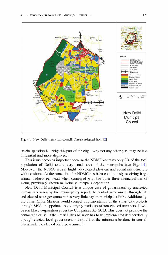
crucial question is—why this part of the city—why not any other part, may be lessinfluential and more deprived.
This issue becomes important because the NDMC contains only 3% of the totalpopulation of Delhi and a very small area of the metropolis (see Fig. 4.1).Moreover, the NDMC area is highly developed physical and social infrastructurewith no slums. At the same time the NDMC has been continuously receiving largeannual budgets per head when compared with the other three municipalities ofDelhi, previously known as Delhi Municipal Corporation.
New Delhi Municipal Council is a unique case of government by unelectedbureaucrats whereby the municipality reports to central government through LGand elected state government has very little say in municipal affairs. Additionally,the Smart Cities Mission would compel implementation of the smart city projectsthrough SPV, an appointed body largely made up of non-elected members. It willbe run like a corporation under the Companies Act 2013. This does not promote thedemocratic cause. If the Smart Cities Mission has to be implemented democraticallythrough elected local governments, it should at the minimum be done in consul-tation with the elected state government.
Fig. 4.1 New Delhi municipal council. Source Adapted from [2]
4 E-Democracy in New Delhi Municipal Council … 123
Before I move forward, it is important that the term e-democracy is brieflyexplained. In popular imagination e-democracy implies provision of various kindsof services through internet based electronic media. Municipalities claim to grad-uate from democracy to e-democracy when they are able to provide several of theirservices through electronic media. For example, New Delhi Municipal Council(NDMC) website reports 11 services that are provided online including smart cityrelated services, building approvals, and online payment of property taxes.Similarly other municipalities in Delhi and throughout the length and breadth ofcountry have resorted to online provision of services to their citizens. There is nodoubt that online provision of services makes life easier for the concerned citizensbut the key concern is does it also promote e-democracy. To answer this questionone needs to clearly define e-democracy. E-democracy like democracy should beviewed as a relationship between governments and citizens whereby desires andaspirations of citizens get reflected in policies and programmes. Electronic mediashould be treated as instruments for facilitation of deliberations and debates leadingto formulation of concrete decisions and polices reflective of the desires andaspirations of its citizens (see [3]). Whyte and Macintosh [4] reinforce this idea:“E-democracy relates electronic delivery of the processes of democratic represen-tation to practices of communication, consultation, and participation in publicdecision-making”. Citizens are situated at the heart of e-democracy while govern-ments and electronic media remain the vehicles for designing decision makingprocesses and policies soaked in democratic ethos leading to visible shift of powerfrom governments and machines to the citizens. Empowering the citizens could beregarded as the chief objective of e-democracy, only more effective than traditionaldemocratic processes and policies emerging out of these processes. Now I willanalyse whether ‘citizen engagement’,—a critical aspect of inclusive smart citybuilding process—promotes e-democracy.
4.2 Citizen Engagement
Public participation is not new to city planning and development. Sherry Arnstein isthe most cited and celebrated author of the classic paper titled ‘A Ladder of CitizenParticipation’. As one moves from bottom to top and traverses the ladder upwards,the degree of participation increases leading to the top of ladder called ‘citizencontrol’ where “have-not citizens obtain the majority of decision-making seats, orfull managerial power” [5]. More recently more complex understanding of publicparticipation has been developed by Fung [6] who argues that for effective publicparticipation we need to focus on the three dimension of participation. Firstdimension is a clear understanding of the participants who participate in a decisionmaking situation implying whether participation is voluntary to all citizens or byinvitation for selected elite. Second dimension of participation is about the nature ofparticipation i.e. whether participatory processes are discursive, deliberative or onlyinforming. Third dimension of public participation is how what gets decided
124 A. Kumar
through participatory processes (information receiving, discussions, and delibera-tions) links up with policy making and implementation.
At about the same time a well-known planning scholar Sandercock [7: 437]noted that public participation in planning has become critically important due tothe following reasons:
• The crisis of the expert knowledge• Failure of the city-building professionals• Crisis of the representative democracy• Issues of the neglected and marginalized citizens• Recognition of difference• Politics of difference.
Inness and Booher have argued that involvement of public in planning couldachieve a number of purposes. First, decision makers want to find out public’spreferences that can play a part in their decisions. Second, public participation canimprove decisions by incorporating citizens’ local knowledge into the calculus.Third, public input can also advance fairness and justice. Fourth, participation isused to secure legitimacy for public decisions. Fifth, participation is done becausethe law requires it [8: 422–423].
Complexities of effective citizen participation have been highlighted ever sincechallenges to rational planning began to emerge in 1960s. “The idea of citizenparticipation is a little like eating spinach: no one is against it in principle because itis good for you” [5]. Governments and power-holders drop this virtuosity whenpoor city dwellers begin to demand redistribution of decision making powers andthe myth of participation explodes. In spite of the fact that it does not take much forpublic participation to turn into pure tokenism, “public participation is usuallyconsidered an unalloyed good. This emphasis on the inherent desirability of publicinvolvement is part of a tradition which seeks to ‘open up’ planning processes todemocratic scrutiny and to expand the scope of public involvement as an integralpart of improvements in policy delivery” [9]. They also highlight two rationaliza-tions of public participation in environmental planning. First rationalization is about“the democratic right to be involved in the public policy process and the importanceof all barriers to such involvement being reduced or withdrawn. The emphasis hereis on enabling access to the policy process, encouraging the take-up of that accessand ensuring that such participation makes a difference to policy outcomes. Thepolicy process is seen as a locus for the articulation of values and preferences onpolicy options, and public participation is a means of bringing the pattern of valuesand preferences represented within the policy process closer to that existing withinsociety as a whole” [9]. “The second rationalisation focuses on the effectiveness ofpolicy delivery and considers how public participation can assist in producing a‘better’ policy outcome” [9].
Whatever its rationalizations, public participation implies ‘efforts to increasepublic input, oriented primarily to the content of programs and policies’. Inclusionmeans ‘continuously creating a community involved in coproducing processes,
4 E-Democracy in New Delhi Municipal Council … 125
policies, and programs for defining and addressing public issues’. Both aredimensions of ‘public engagement’ [10: 272]. Public engagement thereforeembraces both participation as well as inclusion widening the scope of peoples’involvement in planning and development of cities. Here public engagement isviewed as transformative and empowering in terms of its impact on policy makingand redistributive in nature, specifically for those located at the margins of decisionmaking regimes. But even before the term citizen engagement became common-place “participation without redistribution of power is an empty and frustratingprocess for the powerless. It allows the power holders to claim that all sides wereconsidered, but makes it possible for only some of those sides to benefit. Itmaintains the status quo” [5].
Today both in city planning and administration, we have moved beyond publicparticipation and engagement because policy making and implementation is seen asa collaborative work where “the coproduction approach assumes that service usersand their communities can—and often should—be part of service planning anddelivery” [11] (see [12] for similar arguments in city planning). Terming copro-duction as ‘we government’ Dennis Linders proposes three dimensions of copro-duction—citizen sourcing, government as a platform, and do-it-yourselfgovernment. I take ideas of [11], Quick and Feldman [10] and Linders [13] togetherand view public engagement as a situation where policy planning and implemen-tation processes, institutions, and outcomes are coproduced by public agencies andlocal communities.
Public engagement is centered on ten core principles. These include begin bylistening; attend to people’s leading concerns; reach beyond the “usual suspects”;frame issues for deliberation; provide the right type and amount of information atthe right time; help people move beyond wishful thinking; expect obstacles andresistances; create multiple, varied opportunities for deliberation and dialogue;respond thoughtfully and conscientiously to the public’s involvement; and buildlong-term capacity as you go [14] (see Table 4.1).
4.2.1 Smart City Led Public Engagement in India
Public participation in planning in the Indian cities is provided through statemandated planning laws. Generally statutory public participation takes place onlyafter a draft of a city plan is prepared by a planning agency without muchinvolvement of the citizens. Citizens come into view only when a draft planningagenda is already set by a planning agency largely led by politicians, bureaucratsand planners. But there are few exceptions to this trend. For example, the state ofGoa involves public in planning even before drafts of various kinds of plans areprepared. Kerala similarly engages public in the plan making processes prior to thepreparation of drafts of development plans. Whatever may be the degree of influ-ence the citizens are able to exert; public participation in plan making processes hasbeen designed as a city wide phenomenon covering all citizens. It is a different
126 A. Kumar
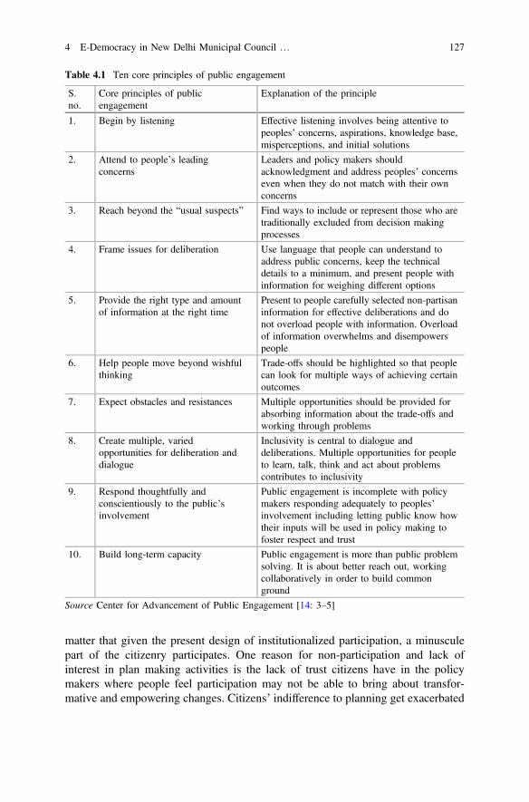
matter that given the present design of institutionalized participation, a minusculepart of the citizenry participates. One reason for non-participation and lack ofinterest in plan making activities is the lack of trust citizens have in the policymakers where people feel participation may not be able to bring about transfor-mative and empowering changes. Citizens’ indifference to planning get exacerbated
Table 4.1 Ten core principles of public engagement
S.no.
Core principles of publicengagement
Explanation of the principle
1. Begin by listening Effective listening involves being attentive topeoples’ concerns, aspirations, knowledge base,misperceptions, and initial solutions
2. Attend to people’s leadingconcerns
Leaders and policy makers shouldacknowledgment and address peoples’ concernseven when they do not match with their ownconcerns
3. Reach beyond the “usual suspects” Find ways to include or represent those who aretraditionally excluded from decision makingprocesses
4. Frame issues for deliberation Use language that people can understand toaddress public concerns, keep the technicaldetails to a minimum, and present people withinformation for weighing different options
5. Provide the right type and amountof information at the right time
Present to people carefully selected non-partisaninformation for effective deliberations and donot overload people with information. Overloadof information overwhelms and disempowerspeople
6. Help people move beyond wishfulthinking
Trade-offs should be highlighted so that peoplecan look for multiple ways of achieving certainoutcomes
7. Expect obstacles and resistances Multiple opportunities should be provided forabsorbing information about the trade-offs andworking through problems
8. Create multiple, variedopportunities for deliberation anddialogue
Inclusivity is central to dialogue anddeliberations. Multiple opportunities for peopleto learn, talk, think and act about problemscontributes to inclusivity
9. Respond thoughtfully andconscientiously to the public’sinvolvement
Public engagement is incomplete with policymakers responding adequately to peoples’involvement including letting public know howtheir inputs will be used in policy making tofoster respect and trust
10. Build long-term capacity Public engagement is more than public problemsolving. It is about better reach out, workingcollaboratively in order to build commonground
Source Center for Advancement of Public Engagement [14: 3–5]
4 E-Democracy in New Delhi Municipal Council … 127
when they see plans finalised and approved without citizens even getting a chanceto know how their inputs were considered before excluding them from approvedplans. So the existing arrangement of public participation in the draft of a city planis unlike public engagement as defined above.
Citizen engagement in the preparation of Smart Cities Proposals under the SmartCities Mission further restricts public participation and this has various dimensionswhich could be discussed as ‘citizen exclusion points’ from the public debate anddeliberations for influencing and delivery of public planning policies. Under theSmart Cities Mission citywide (pan-city) plans are given lesser importance asindicated through the award of scores than the Strategic Action Plans which includethree type of projects—retrofitting, renewal and greenfield development [15]. As C.Rammanohar Reddy has shown: “The focus is almost entirely on the area-basedplan. In fact as much as 81% of the total outlay in the proposals for the 33 cities ison area-based plans” [16]. This kind of citizen engagement excludes a vast majorityof the citizens from the participatory processes since projects are meant for specificgeographical areas, and it is increasingly becoming clear that all people living in asmart city project area may also not get a chance to participate in an area plan. Evenwhen citizen participation is solicited for a pan city proposal citizen engagement is“achieved through citizen consultations, including active participation of groups ofpeople, such as Resident Welfare Associations, Tax Payers Associations, SeniorCitizens and Slum Dwellers Associations” [15]. This indicates that citizens wouldbe participating indirectly through these organizations in identifying their needs andaspirations leading to probable misrepresentation of citizens’ desires.
Misrepresentation has resulted in much avoidable controversy that is generatedthrough a number of smart city proposals in various cities. For example, inDehradun people have been agitating because the state government plans to build asmart city over the existing tea estate measuring 1900 acres. Echoing the sentimentsof the public at large after Dehradun could not make it to the second list of smartcities, Mahesh Bhandari, President, Doon Residents’ Welfare Front noted: “Theauthorities did not do their homework and failed to realise that the citizens wantretrofitting for the whole city and not just of few parts. The proposal could havebeen made more innovative and eco-friendly like other cities but that was not done”[17]. In new Bhopal 333 acre area in Shivaji Nagar is slated to be redeveloped forultra-modern apartments and business centres. People have been asking whydevelop Shivaji Nagar which is already better developed than several other areas inthe city [18]. Citizens appear to view the smart city proposals as misplaced; notrepresentative of the needs and aspirations of the general public.
Another dimension of ‘citizen exclusion points’ is the setting up of the SpecialPurpose Vehicle. The Smart Cities Mission will be implemented by an organiza-tional arrangement dubbed as the Special Purpose Vehicle. The SPV is a limitedcompany incorporated under the Companies Act 2013, and will be promoted byequity share holding of 50% each by the state government and an urban local body.Private sector and financial institutions could hold equity shares in the SPV if equal
128 A. Kumar
share of equity shares between the state government and urban local body aremaintained. The SPV will perform several functions. “The SPV will plan, appraise,approve, release funds, implement, manage, operate, monitor and evaluate theSmart City development projects. Each Smart City will have a SPV which will beheaded by a full time CEO and have nominees of Central Government, StateGovernment and ULB on its Board” [15: 12 and 35–36]. The SPV must ensure thatit is a credit worthy organization in the market, which is able to raise resources fromthe market. The SPV is allowed to implement projects through joint ventures,subsidiaries, public-private partnerships, turnkey contracts, etc.
This kind of organizational arrangement is highly focussed on efficiency, pro-ductivity and profitability, which on its own terms is not to be derided. But after74th amendment to the Constitution of India enforced in 1993, elected munici-palities have a major role to play in city building and maintenance including landuse planning as listed in the Twelfth Schedule to the Constitution. However, in theSmart Cities Mission, the elected urban local government appears to have little orno role in the implementation of the Smart Cities Mission except some participationof selected mayors and municipal commissioners or chief executive of ULBs in theState Level High Powered Steering Committee and very limited participation ofsome ULBs in the Board of Directors of the SPV. Central government expects that“the rights and obligations of the municipal councils with respect to the Smart Cityproject [are delegated] to the SPV” [15]. If these organizational arrangements wereto be implemented, it will create a large ‘democratic deficit’ and even largerdemocratic deficit in cities like Delhi where municipalities directly report to centralgovernment and not to the state government.
On the other hand, national level Apex Committee headed by the Secretary,MoUD with representatives from related ministries and organisations will approveproposals for the Smart Cities Mission, monitor their progress and release funds.This Committee will consist of Secretary, Housing and Poverty Alleviation,Secretary (Expenditure), Joint Secretary, Finance, MoUD, Director NationalInstitute of Urban Affairs, Chief Planner, Town and Country Planning, selectPrincipal Secretaries of States and select CEOs of SPVs as members with MissionDirector as the Member Secretary. Further, the Representatives of organizationssuch as UN Habitat, World Bank, TERI, Centre for Development of AdvancedComputing, Centre for Smart Cities Bangalore and other bilateral and multilateralagencies and urban planning experts could be invited [15]. On similar lines statelevel committees headed by respective state Chief Secretaries would be establishedwith the exception that such committees would also include selected mayors andmunicipal commissioners or chief executive of ULBs, and heads of concerned linedepartments. This bureaucratic arrangement at central and state level may appearnecessary and interventionist, but it is appropriate for disbursal of funds andmonitoring of projects under the Smart Cities Mission. In this backdrop, now I turnto the case of New Delhi Municipal Council.
4 E-Democracy in New Delhi Municipal Council … 129
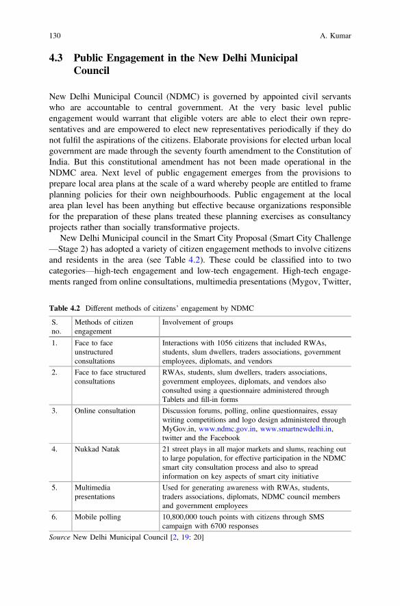
4.3 Public Engagement in the New Delhi MunicipalCouncil
New Delhi Municipal Council (NDMC) is governed by appointed civil servantswho are accountable to central government. At the very basic level publicengagement would warrant that eligible voters are able to elect their own repre-sentatives and are empowered to elect new representatives periodically if they donot fulfil the aspirations of the citizens. Elaborate provisions for elected urban localgovernment are made through the seventy fourth amendment to the Constitution ofIndia. But this constitutional amendment has not been made operational in theNDMC area. Next level of public engagement emerges from the provisions toprepare local area plans at the scale of a ward whereby people are entitled to frameplanning policies for their own neighbourhoods. Public engagement at the localarea plan level has been anything but effective because organizations responsiblefor the preparation of these plans treated these planning exercises as consultancyprojects rather than socially transformative projects.
New Delhi Municipal council in the Smart City Proposal (Smart City Challenge—Stage 2) has adopted a variety of citizen engagement methods to involve citizensand residents in the area (see Table 4.2). These could be classified into to twocategories—high-tech engagement and low-tech engagement. High-tech engage-ments ranged from online consultations, multimedia presentations (Mygov, Twitter,
Table 4.2 Different methods of citizens’ engagement by NDMC
S.no.
Methods of citizenengagement
Involvement of groups
1. Face to faceunstructuredconsultations
Interactions with 1056 citizens that included RWAs,students, slum dwellers, traders associations, governmentemployees, diplomats, and vendors
2. Face to face structuredconsultations
RWAs, students, slum dwellers, traders associations,government employees, diplomats, and vendors alsoconsulted using a questionnaire administered throughTablets and fill-in forms
3. Online consultation Discussion forums, polling, online questionnaires, essaywriting competitions and logo design administered throughMyGov.in, www.ndmc.gov.in, www.smartnewdelhi.in,twitter and the Facebook
4. Nukkad Natak 21 street plays in all major markets and slums, reaching outto large population, for effective participation in the NDMCsmart city consultation process and also to spreadinformation on key aspects of smart city initiative
5. Multimediapresentations
Used for generating awareness with RWAs, students,traders associations, diplomats, NDMC council membersand government employees
6. Mobile polling 10,800,000 touch points with citizens through SMScampaign with 6700 responses
Source New Delhi Municipal Council [2, 19: 20]
130 A. Kumar
Facebook, and its other websites) and mobile polling. Low-tech engagementsincluded unstructured face to face interactions of officials and various groups, andNukkad Natak or street plays. Impact of both high-tech and low-tech citizenengagements are unclear from the text of the Smart City Proposal (Smart CityChallenge—Stage 2) of the NDMC.
What is clear about citizen engagement in the Smart City Proposal (Smart CityChallenge—Stage 2) is the fact that the NDMC commits itself to the maximumpublic participation in setting up ‘the vision and goals’. NMDC claims to “achieveinformed high quality consultations, ensuring inclusion of diverse groups andcommunities in the city” [2: 19]. A number of key stakeholders have been involvedin the process of preparation of the Smart City Proposal for the NDMC area. Theseinclude hotel and traders association; diplomats—embassies and high commissions;economically weaker sections and slum dwellers; women; elected representatives;resident welfare associations; students from the schools and colleges located in theNDMC area; and the public at large. It is asserted that 95% of the residents havebeen contacted through resident welfare associations resulting in a total of 150 h offace to face consultations. Further 10,800,000 mobile SMS (also called touchpoints)were sent to 600,000 people but only 6700 plus responses received [2: 19].
A number of key points emerge about the citizen engagement exercises carriedout by the NDMC. First, even on an easy to access electronic platform like sendingSMS through mobiles, only 0.062% responses were received by the NDMC, whichis very low rate of citizens’ responses by any standards. Second, face to faceconsultations in NDMC were carried out through resident welfare associations,which are regarded as representatives of the middle classes and elite groups, ratherthan low income slum dwellers who are treated as a nuisance (see [20, 21]). What isstrange in the Stage 2 plan is the fact that NDMC has proposed a system ofvolunteers to ensure citizen engagement on a regular basis ignoring completely thatpeople in the present circumstances are unwilling to engage with the municipality inits smart city endeavors.
Further the NDMC claims that it has constructed its 24 smart city features on thebasis of the feedback provided by the residents of the areas through the processes ofcitizen engagement. In other words, citizen engagement has helped build vision andmission for the city, which in turn has helped NDMC in identifying 24 smart cityfeatures. These 24 smart city features of the NDMC Smart City Proposal reiteratenormal problems of any city with additional label of ‘smart’.
Another aspect of citizen engagement in the Smart Cities Mission is the divisionof marks in the second stage. Marks are awarded out of a total of 100 which arefurther sub-divided into three parts—city level (30), area based development (55),and pan-city solutions (15). Out of a total of 100 marks, a maximum of 16 markscould be awarded for citizen engagement. Marks decrease as one moves from citylevel (10), area based development (5), and pan-city solutions (1) [2: 6]. From thissort of marks distribution, it is apparent that more marks are awarded for citizenparticipation for city level planning and fewer marks are awarded for project levelplanning and engagement.
4 E-Democracy in New Delhi Municipal Council … 131
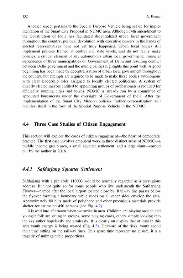
Another aspect pertains to the Special Purpose Vehicle being set up for imple-mentation of the Smart City Proposal in NDMC area. Although 74th amendment tothe Constitution of India has facilitated decentralized urban local governmentthroughout the country, political devolution with executive powers in the hands ofelected representatives have not yet truly happened. Urban local bodies stillimplement policies framed at central and state levels, and do not really makepolicies, a critical element of any autonomous urban local government. Financialdependence of three municipalities on Government of Delhi and resulting conflictbetween Delhi government and the municipalities highlights this point well. A goodbeginning has been made by decentralization of urban local government throughoutthe country, but attempts are required to be made to make these bodies autonomouswith clear leadership roles assigned to locally elected politicians. A system ofdirectly elected mayors entitled to appointing groups of professionals is required forefficiently running cities and towns. NDMC is already run by a committee ofappointed bureaucrats under the oversight of Government of India. After theimplementation of the Smart City Mission policies, further corporatization willmanifest itself in the form of the Special Purpose Vehicle in the NDMC.
4.4 Three Case Studies of Citizen Engagement
This section will explore the cases of citizen engagement—the heart of democraticpractice. The first case involves empirical work in three distinct areas of NDMC—amiddle income group area, a small squatter settlement, and a large slum—carriedout by the author in 2016.
4.4.1 Safdarjang Squatter Settlement
Safdarjang with a pin code 110003 would be normally regarded as a prestigiousaddress. But not quite so for some people who live underneath the SafdarjangFlyover—named after the local airport located close by. Railway line passes belowthe flyover forming a boundary while roads on all other sides envelop the area.Approximately 80 huts made of polythene and other precarious materials provideshelter for estimated 450 persons (see Fig. 4.2).
It is well into afternoon when we arrive in area. Children are playing around andyounger folk are sitting in groups, some playing cards, others simply looking intothe sky rather hopelessly and aimlessly. It is clearly on display that at least in thisarea youth energy is being wasted (Fig. 4.3). Unaware of the risks, youth spendtheir time sitting on the railway lines. This spare time represent no leisure, it is atragedy of unimaginable proportions.
132 A. Kumar
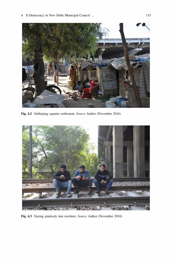
Fig. 4.2 Safdarjang squatter settlement. Source Author (November 2016)
Fig. 4.3 Gazing aimlessly into nowhere. Source Author (November 2016)
4 E-Democracy in New Delhi Municipal Council … 133
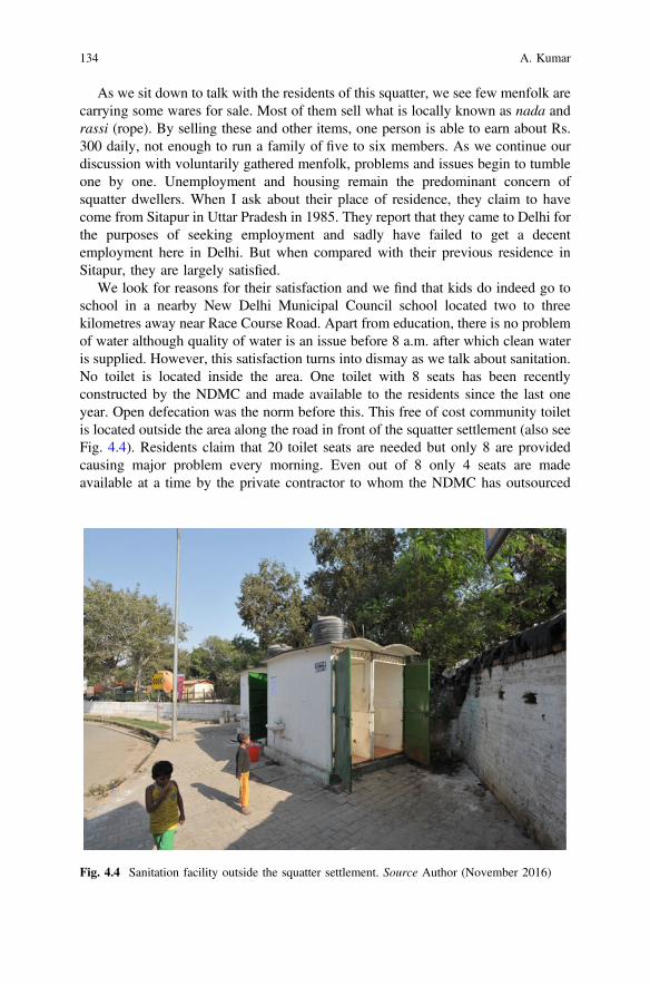
As we sit down to talk with the residents of this squatter, we see few menfolk arecarrying some wares for sale. Most of them sell what is locally known as nada andrassi (rope). By selling these and other items, one person is able to earn about Rs.300 daily, not enough to run a family of five to six members. As we continue ourdiscussion with voluntarily gathered menfolk, problems and issues begin to tumbleone by one. Unemployment and housing remain the predominant concern ofsquatter dwellers. When I ask about their place of residence, they claim to havecome from Sitapur in Uttar Pradesh in 1985. They report that they came to Delhi forthe purposes of seeking employment and sadly have failed to get a decentemployment here in Delhi. But when compared with their previous residence inSitapur, they are largely satisfied.
We look for reasons for their satisfaction and we find that kids do indeed go toschool in a nearby New Delhi Municipal Council school located two to threekilometres away near Race Course Road. Apart from education, there is no problemof water although quality of water is an issue before 8 a.m. after which clean wateris supplied. However, this satisfaction turns into dismay as we talk about sanitation.No toilet is located inside the area. One toilet with 8 seats has been recentlyconstructed by the NDMC and made available to the residents since the last oneyear. Open defecation was the norm before this. This free of cost community toiletis located outside the area along the road in front of the squatter settlement (also seeFig. 4.4). Residents claim that 20 toilet seats are needed but only 8 are providedcausing major problem every morning. Even out of 8 only 4 seats are madeavailable at a time by the private contractor to whom the NDMC has outsourced
Fig. 4.4 Sanitation facility outside the squatter settlement. Source Author (November 2016)
134 A. Kumar
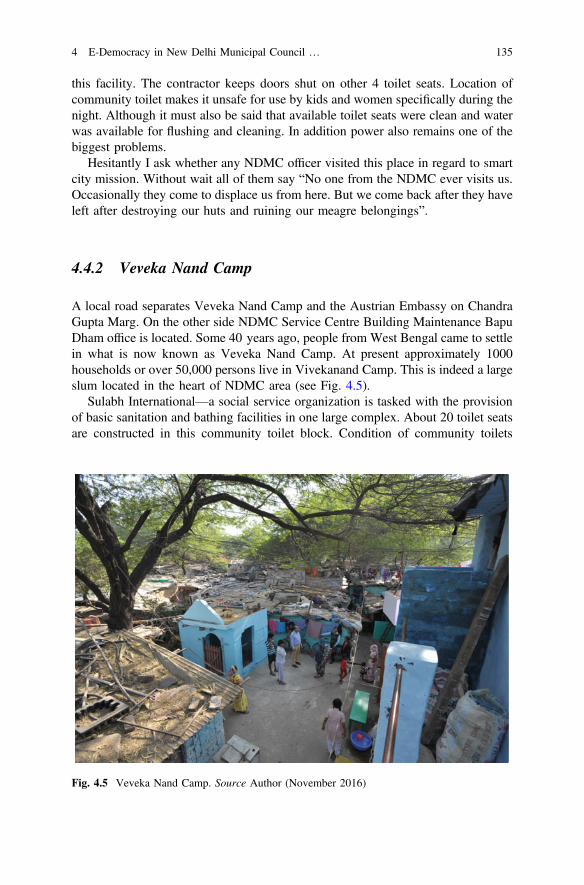
this facility. The contractor keeps doors shut on other 4 toilet seats. Location ofcommunity toilet makes it unsafe for use by kids and women specifically during thenight. Although it must also be said that available toilet seats were clean and waterwas available for flushing and cleaning. In addition power also remains one of thebiggest problems.
Hesitantly I ask whether any NDMC officer visited this place in regard to smartcity mission. Without wait all of them say “No one from the NDMC ever visits us.Occasionally they come to displace us from here. But we come back after they haveleft after destroying our huts and ruining our meagre belongings”.
4.4.2 Veveka Nand Camp
A local road separates Veveka Nand Camp and the Austrian Embassy on ChandraGupta Marg. On the other side NDMC Service Centre Building Maintenance BapuDham office is located. Some 40 years ago, people from West Bengal came to settlein what is now known as Veveka Nand Camp. At present approximately 1000households or over 50,000 persons live in Vivekanand Camp. This is indeed a largeslum located in the heart of NDMC area (see Fig. 4.5).
Sulabh International—a social service organization is tasked with the provisionof basic sanitation and bathing facilities in one large complex. About 20 toilet seatsare constructed in this community toilet block. Condition of community toilets
Fig. 4.5 Veveka Nand Camp. Source Author (November 2016)
4 E-Democracy in New Delhi Municipal Council … 135
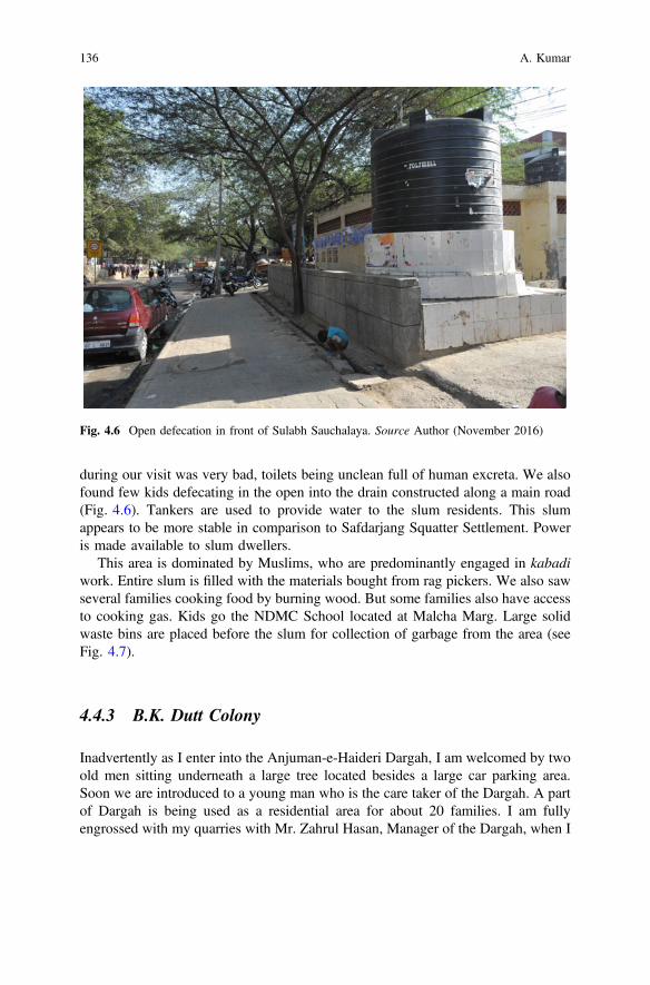
during our visit was very bad, toilets being unclean full of human excreta. We alsofound few kids defecating in the open into the drain constructed along a main road(Fig. 4.6). Tankers are used to provide water to the slum residents. This slumappears to be more stable in comparison to Safdarjang Squatter Settlement. Poweris made available to slum dwellers.
This area is dominated by Muslims, who are predominantly engaged in kabadiwork. Entire slum is filled with the materials bought from rag pickers. We also sawseveral families cooking food by burning wood. But some families also have accessto cooking gas. Kids go the NDMC School located at Malcha Marg. Large solidwaste bins are placed before the slum for collection of garbage from the area (seeFig. 4.7).
4.4.3 B.K. Dutt Colony
Inadvertently as I enter into the Anjuman-e-Haideri Dargah, I am welcomed by twoold men sitting underneath a large tree located besides a large car parking area.Soon we are introduced to a young man who is the care taker of the Dargah. A partof Dargah is being used as a residential area for about 20 families. I am fullyengrossed with my quarries with Mr. Zahrul Hasan, Manager of the Dargah, when I
Fig. 4.6 Open defecation in front of Sulabh Sauchalaya. Source Author (November 2016)
136 A. Kumar
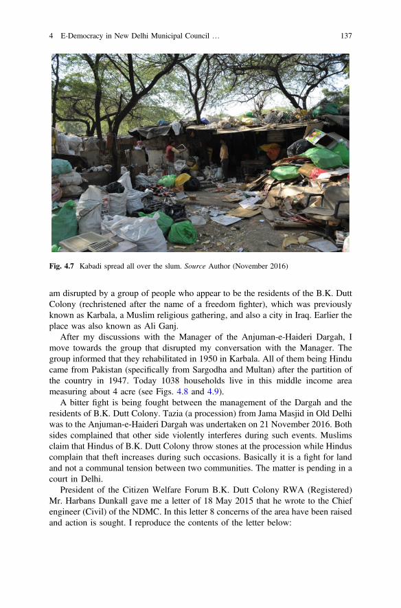
am disrupted by a group of people who appear to be the residents of the B.K. DuttColony (rechristened after the name of a freedom fighter), which was previouslyknown as Karbala, a Muslim religious gathering, and also a city in Iraq. Earlier theplace was also known as Ali Ganj.
After my discussions with the Manager of the Anjuman-e-Haideri Dargah, Imove towards the group that disrupted my conversation with the Manager. Thegroup informed that they rehabilitated in 1950 in Karbala. All of them being Hinducame from Pakistan (specifically from Sargodha and Multan) after the partition ofthe country in 1947. Today 1038 households live in this middle income areameasuring about 4 acre (see Figs. 4.8 and 4.9).
A bitter fight is being fought between the management of the Dargah and theresidents of B.K. Dutt Colony. Tazia (a procession) from Jama Masjid in Old Delhiwas to the Anjuman-e-Haideri Dargah was undertaken on 21 November 2016. Bothsides complained that other side violently interferes during such events. Muslimsclaim that Hindus of B.K. Dutt Colony throw stones at the procession while Hinduscomplain that theft increases during such occasions. Basically it is a fight for landand not a communal tension between two communities. The matter is pending in acourt in Delhi.
President of the Citizen Welfare Forum B.K. Dutt Colony RWA (Registered)Mr. Harbans Dunkall gave me a letter of 18 May 2015 that he wrote to the Chiefengineer (Civil) of the NDMC. In this letter 8 concerns of the area have been raisedand action is sought. I reproduce the contents of the letter below:
Fig. 4.7 Kabadi spread all over the slum. Source Author (November 2016)
4 E-Democracy in New Delhi Municipal Council … 137
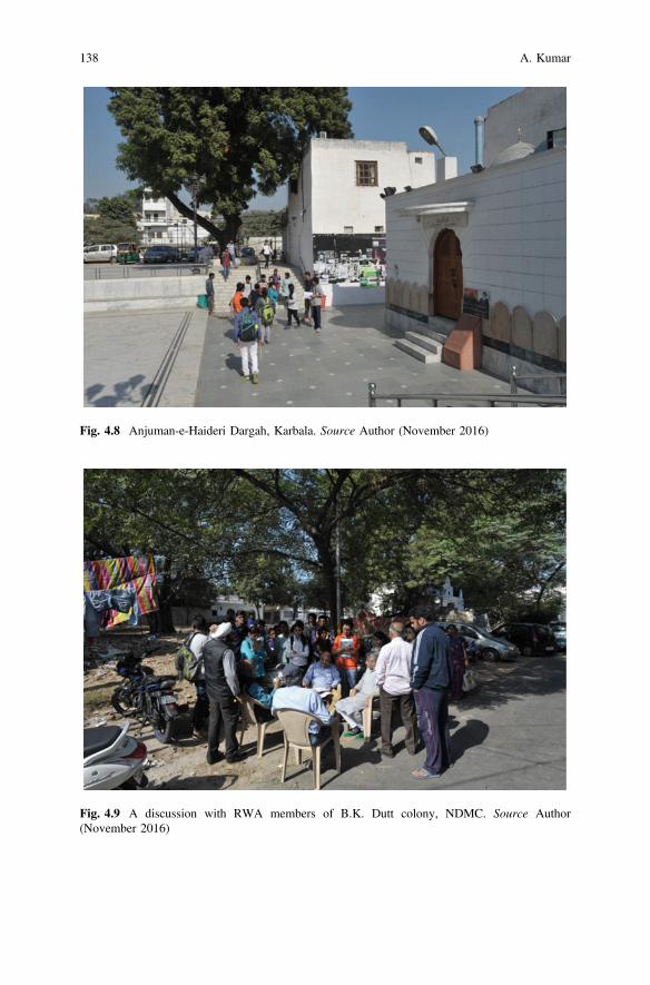
Fig. 4.8 Anjuman-e-Haideri Dargah, Karbala. Source Author (November 2016)
Fig. 4.9 A discussion with RWA members of B.K. Dutt colony, NDMC. Source Author(November 2016)
138 A. Kumar
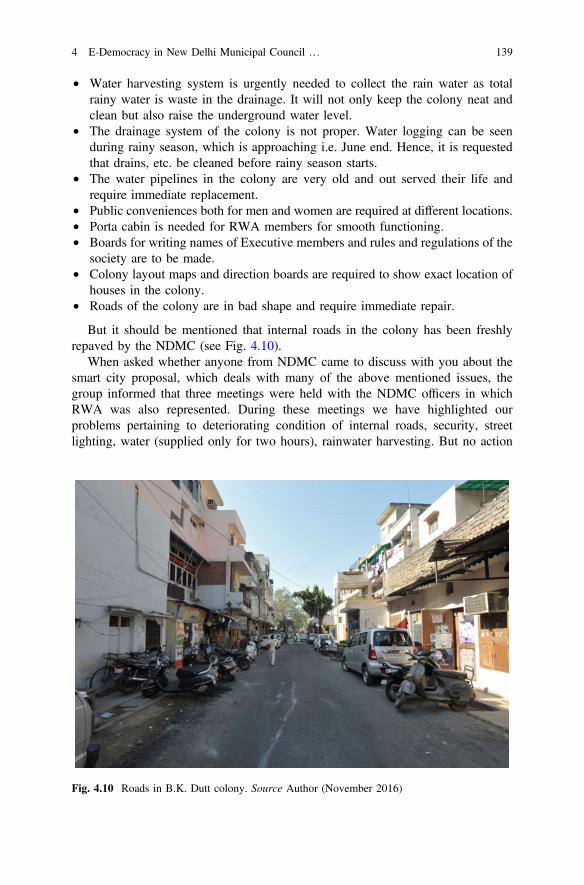
• Water harvesting system is urgently needed to collect the rain water as totalrainy water is waste in the drainage. It will not only keep the colony neat andclean but also raise the underground water level.
• The drainage system of the colony is not proper. Water logging can be seenduring rainy season, which is approaching i.e. June end. Hence, it is requestedthat drains, etc. be cleaned before rainy season starts.
• The water pipelines in the colony are very old and out served their life andrequire immediate replacement.
• Public conveniences both for men and women are required at different locations.• Porta cabin is needed for RWA members for smooth functioning.• Boards for writing names of Executive members and rules and regulations of the
society are to be made.• Colony layout maps and direction boards are required to show exact location of
houses in the colony.• Roads of the colony are in bad shape and require immediate repair.
But it should be mentioned that internal roads in the colony has been freshlyrepaved by the NDMC (see Fig. 4.10).
When asked whether anyone from NDMC came to discuss with you about thesmart city proposal, which deals with many of the above mentioned issues, thegroup informed that three meetings were held with the NDMC officers in whichRWA was also represented. During these meetings we have highlighted ourproblems pertaining to deteriorating condition of internal roads, security, streetlighting, water (supplied only for two hours), rainwater harvesting. But no action
Fig. 4.10 Roads in B.K. Dutt colony. Source Author (November 2016)
4 E-Democracy in New Delhi Municipal Council … 139
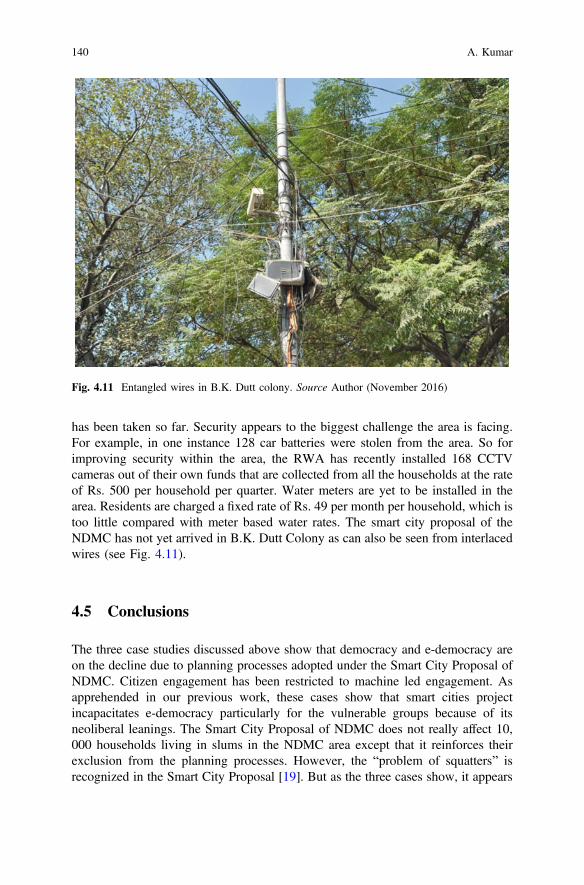
has been taken so far. Security appears to the biggest challenge the area is facing.For example, in one instance 128 car batteries were stolen from the area. So forimproving security within the area, the RWA has recently installed 168 CCTVcameras out of their own funds that are collected from all the households at the rateof Rs. 500 per household per quarter. Water meters are yet to be installed in thearea. Residents are charged a fixed rate of Rs. 49 per month per household, which istoo little compared with meter based water rates. The smart city proposal of theNDMC has not yet arrived in B.K. Dutt Colony as can also be seen from interlacedwires (see Fig. 4.11).
4.5 Conclusions
The three case studies discussed above show that democracy and e-democracy areon the decline due to planning processes adopted under the Smart City Proposal ofNDMC. Citizen engagement has been restricted to machine led engagement. Asapprehended in our previous work, these cases show that smart cities projectincapacitates e-democracy particularly for the vulnerable groups because of itsneoliberal leanings. The Smart City Proposal of NDMC does not really affect 10,000 households living in slums in the NDMC area except that it reinforces theirexclusion from the planning processes. However, the “problem of squatters” isrecognized in the Smart City Proposal [19]. But as the three cases show, it appears
Fig. 4.11 Entangled wires in B.K. Dutt colony. Source Author (November 2016)
140 A. Kumar
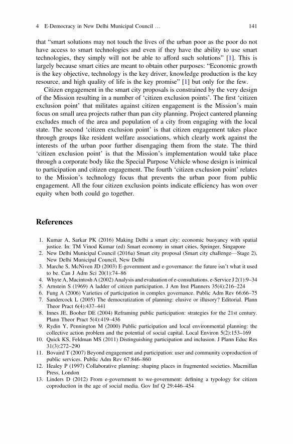
that “smart solutions may not touch the lives of the urban poor as the poor do nothave access to smart technologies and even if they have the ability to use smarttechnologies, they simply will not be able to afford such solutions” [1]. This islargely because smart cities are meant to obtain other purposes: “Economic growthis the key objective, technology is the key driver, knowledge production is the keyresource, and high quality of life is the key promise” [1] but only for the few.
Citizen engagement in the smart city proposals is constrained by the very designof the Mission resulting in a number of ‘citizen exclusion points’. The first ‘citizenexclusion point’ that militates against citizen engagement is the Mission’s mainfocus on small area projects rather than pan city planning. Project cantered planningexcludes much of the area and population of a city from engaging with the localstate. The second ‘citizen exclusion point’ is that citizen engagement takes placethrough groups like resident welfare associations, which clearly work against theinterests of the urban poor further disengaging them from the state. The third‘citizen exclusion point’ is that the Mission’s implementation would take placethrough a corporate body like the Special Purpose Vehicle whose design is inimicalto participation and citizen engagement. The fourth ‘citizen exclusion point’ relatesto the Mission’s technology focus that prevents the urban poor from publicengagement. All the four citizen exclusion points indicate efficiency has won overequity when both could go together.
References
1. Kumar A, Sarkar PK (2016) Making Delhi a smart city: economic buoyancy with spatialjustice. In: TM Vinod Kumar (ed) Smart economy in smart cities, Springer, Singapore
2. New Delhi Municipal Council (2016a) Smart city proposal (Smart city challenge—Stage 2),New Delhi Municipal Council, New Delhi
3. Marche S, McNiven JD (2003) E-government and e-governance: the future isn’t what it usedto be. Can J Adm Sci 20(1):74–86
4. WhyteA,MacintoshA (2002)Analysis and evaluation of e-consultations. e-Service J 2(1):9–345. Arnstein S (1969) A ladder of citizen participation. J Am Inst Planners 35(4):216–2246. Fung A (2006) Varieties of participation in complex governance. Public Adm Rev 66:66–757. Sandercock L (2005) The democratization of planning: elusive or illusory? Editorial. Plann
Theor Pract 6(4):437–4418. Innes JE, Booher DE (2004) Reframing public participation: strategies for the 21st century.
Plann Theor Pract 5(4):419–4369. Rydin Y, Pennington M (2000) Public participation and local environmental planning: the
collective action problem and the potential of social capital. Local Environ 5(2):153–16910. Quick KS, Feldman MS (2011) Distinguishing participation and inclusion. J Plann Educ Res
31(3):272–29011. Bovaird T (2007) Beyond engagement and participation: user and community coproduction of
public services. Public Adm Rev 67:846–86012. Healey P (1997) Collaborative planning: shaping places in fragmented societies. Macmillan
Press, London13. Linders D (2012) From e-government to we-government: defining a typology for citizen
coproduction in the age of social media. Gov Inf Q 29:446–454
4 E-Democracy in New Delhi Municipal Council … 141

14. Center for Advancement of Public Engagement (2008) Public engagement: a primer frompublic agenda. Public Agenda (1):1–10
15. Ministry of Urban Development (2015) Smart cities mission—transform-nation, missionstatement and guidelines. Ministry of Urban Development, New Delhi
16. Reddy CR (2016) To locate the scam, use GPS. Outlook LVI(33):80–8117. Budhwar Y (2016) Dehradun has yet again failed to make it to the smart city list. Time of
India (Dehradun City), 24 May 201618. Ghose D (2016) Why Shivaji Nagar, why not a less developed place? Ask Bhopal residents.
Firstpost. 30 Jan 201619. New Delhi Municipal Council (2016b) https://www.ndmc.gov.in/smart_city_proposal.aspx.
NDMC, New Delhi20. Ghertner AD (2011) Rule by aesthetics: world-class city making in Delhi. In: Roy Ananya,
Ong Aihwa (eds) Worlding cities: asian experiments and the art of being global. Blackwell,Oxford
21. Ghertner AD (2011b) Gentrifying the state, gentrifying participation: elite governanceprograms in Delhi. Int J Urban Reg Res 35(3): 504–532
142 A. Kumar

Chapter 5E-Engagement in Hong Kong
Sujata S. Govada, Frank Wong, Timothy Rodgers,Ho Yan Claudia Chow and Krista Busa
Abstract Citizen engagement has taken many centuries to evolve from its rootsduring the Greek period, developing along with the concept of democracy to itscurrent form as it is practiced today. Participation in the planning process emergedin Great Britain in the 1940s, and began to become institutionalized in 1960s. Thisparticipation increased in popularity during the 1980s and 1990s as it was seen toresult in better decision making, and eventually became known as participatoryplanning. Citizen involvement continues to evolve and varies with specific context,but is generally aimed to influence the policies and decision making process thatshapes the communities and cities of those citizens. More recently, the tools ofpublic engagement are transforming considerably with the advancement and use ofICTs during the digital age, which has led to the emergence of internet-enabledonline public engagement, also known as ‘e-engagement’. Planning in Hong Konghas evolved rapidly over the last two decades, transforming from a top downdecision making process to a more participatory process involving active citizenengagement that has become more pronounced since the handover from BritishRule in 1997. Since then, with a renewed sense of ownership, the citizens ofHong Kong have become more interested and involved with the planning andthe political processes. However, through more public engagement andincreased participatory planning, there can be seen positive changes in variousurban processes in Hong Kong such as urban renewal, heritage conservation,harbourfront development. In Hong Kong, information is readily available andaccessible both in English and Chinese and in printed and in online formats.
S.S. Govada (&) F. Wong T. Rodgers H.Y.C. Chow K. BusaUDP International, Institute for Sustainable Urbanisation, Chinese University of Hong Kong,Suite 9B, Queens Centre, 58 Queens Road, Wan Chai, Hong Konge-mail: [email protected]
F. Wonge-mail: [email protected]
H.Y.C. Chowe-mail: [email protected]
K. Busae-mail: [email protected]
© Springer Nature Singapore Pte Ltd. 2017T.M. Vinod Kumar (ed.), E-Democracy for Smart Cities, Advances in 21st CenturyHuman Settlements, DOI 10.1007/978-981-10-4035-1_5
143
In addition to participatory processes, the use of e-engagement is becoming moreprevalent for numerous development studies and projects in Hong Kong. The KaiTak Development Case Study demonstrates that although the planning process hasbeen underway for more than two decades, community involvement has beeninstrumental in its planning and development to date. There is now a considerableamount of e-engagement in the Hong Kong planning process and various tools arebeing used and developed to engage people in more creative ways during bothformal and informal engagement processes. With the emergence of the digital ageand through the use of ICT, e-engagement has become an integral part of citizenengagement. E-engagement has the potential to transform the public participatoryprocess through specific events such as workshops and forums, and the continuousengagement of the public over the internet. ICT also creates the opportunity to bemore open, transparent and inclusive by creating a platform for on-going engage-ment to develop greater trust between the community and NGOs with the publicand private sector. While much progress has been made, e-engagement in HongKong can be improved further through the use of various tools and social mediaavailable to more effectively engage the wider community rather than only hearingthe voices of the vocal minority. This will further remove barriers to the formationof public, private and community partnerships and will help develop Hong Konginto a more affordable, walkable, liveable, sustainable and resilient city for itscitizens, as well as become a model for other cities in Asia and the world.
Keywords Citizen engagement E-Engagement Participatory Planningprocess Digital age E-Engagement tools Hong Kong
5.1 Introduction
5.1.1 Evolution of Citizen Engagement
The roots of citizen participation can be traced back to ancient Greece wherecitizens gathered in Athens’s central square to share their opinions and vote forpublic matters. Therefore, the concept of citizen participation began to developtogether with the concept of democracy. Over time, the concept of participation hasevolved with a continuously expanding definition. However, it has taken manycenturies to develop into the bottom-up, early engagement approach to publicparticipation we see it today.
The 1940s in Great Britain saw planners engage the public in reconstructionefforts after World War II, creating new techniques to communicate with peopleincluding mobilizing publicity, measuring public opinion, and organizing exhibi-tions and forums while experimenting with new visual strategies [1].
Citizen participation started to emerge early on with a more enlightened dialoguebetween citizens and public governments [2, 3]. Arnstein’s critical view on existing
144 S.S. Govada et al.
public engagement worked as an enabler to change the traditional ways of how toengage the public in the decision-making process and increase citizen participation.However, striving for complete citizen control should not be the ultimate goal,rather it is the engagement of various stakeholders and creation of public, private,and community partnerships which ensures the development of better communitiesand cities that are more walkable, liveable and sustainable.
In the western world, citizen engagement began to become institutionalized inthe 1960s. During this time, political participation and civic participation weredistinguished as two separated things. Political participation was defined as avoluntary and lawful action of an individual which aimed to influence functioninggovernment officials and their political choices, or the decisions of the politicalsystem on different levels. Alternatively, political participation could also bedefined as citizen and non-governmental organizations (NGOs) active involvementin the policy-making processes to achieve a more favourable decision for a par-ticular social group. It is characterized by citizen participation in referendums andelections, as well as involvement in policy-making processes.
The greatest expansion of political participation can be linked to the 1980s and1990s. Civic engagement developed as the ability to cooperate and come together toachieve a common objective. The increasing number and role of voluntary asso-ciations displayed the ability of citizens to build a state of independent associationto defend its own interests; an important factor in the development of civil society.Therefore, civic engagement was (and still is) considered as the level of civilindividual self-organization where citizens gather in associations or interest groupsto express their views on the political aspect of life.
It should be noted that up to this period participation in voluntary organizationsand social activities were dealt with outside the structural framework of politicalparticipation. However, during the 1980s and 1990s boundaries between politicalparticipation and public participation started to weaken largely because of theincreasing role of those interest groups.
The differentiation between civic engagement and political engagement began toblur with the formulation of participatory understanding, and there was no attemptto set strict boundaries between political participation and civic participation, as itwas thought that the most important thing was participation itself [4]. Various formsof participation include: political participation (voting and membership of anorganization on the local committee); participation in voluntary associations (tradeunions, sports clubs, religious organizations, cooperatives, etc.); participation ininformal activities (card games, reading newspapers, social networks or singing inthe choir); and interpersonal trust.
Despite some existing opposition, civic participation is currently mostly studiedtogether with political participation. This approach does not seek to structure thepopulation activities by their very nature, indicating that there are no single, coherentindividual engagement features, and highlights the direct participation meaning.
It should be considered that in the current context it is hard to distinguishpolitical participation from civic participation. Often supposedly civic topicssuch as education, culture and other spheres of life become political issues.
5 E-Engagement in Hong Kong 145
Also, traditional political participation manifestations often result directly fromcivic participation.
The 1980s and 1990s proved a turning point for the urban planning field as well.Citizen involvement in the planning process started to gain more popularity,becoming known as Participatory Planning [5]. Based on the assumption that openparticipatory processes lead to better decisions, typically planners engaged directlywith various stakeholders to gain support, build consensus, and identify acceptablesolutions for the plan to be implemented.
5.1.1.1 Advancing Towards E-Engagement
In the last decade of the 20th century, we have witnessed the development of a newterm ‘E-democracy’. E-democracy is the use of information and communicationtechnologies (ICT) to support the democratic decision-making processes. ICTs playa major role in organizing and informing citizens in various forms of civicengagement. ICTs are used to enhance active participation of citizens and to supportthe collaboration between actors for policy-making purposes within the politicalprocesses of all stages of governance [6, 7].
E-democracy can exist in various forms by which to engage and interact withcitizens. Technologies such as electronic mailing lists, peer-to-peer networks, col-laborative software, web pages, Internet forums and blogs have allowed the publicto access information and engage in discussions regardless of their location. Afterthe 2000s, social media sites, such as Facebook, Twitter, LinkedIn, Instagram,WordPress and others, started to play an increasingly important role in communi-cating with the public and giving them a platform to be heard. Citizens began toinfluence policy making within government, by communicating and making theirvoices heard and also working together to develop solutions for improving theirown local communities.
Participatory Planning has been an integral part of community development inthe Western world, with the idea of citizen engagement in the planning processremaining the same. However, the methods and tools of how to engage the publicare evolving rapidly as a result of the coming of the digital age, this concept couldbe termed as ‘E-engagement’. In 2007, forms of informal communication betweenlocal governments and citizens began to emerge in conjunction with the traditionalformal and official forms of communication. The launch of a Facebook page by theReykjavik Metropolitan Police (Iceland) on January 1, 2007 demonstrates a turningpoint in the communication between government bodies and its citizens. With thisproject, police attempted to enhance the perception of safety within the city, andimprove interactions between citizens and the public body. Many cities, institutionsand governments have followed their example, as it is now a common practice forpublic bodies to have social media accounts to disseminate information and engagecitizens on current topics and issues. Equally important, these social media accountshave enabled and empowered citizens to ask questions and interact with the publicgovernment in an informal manner on issues they feel important or relevant.
146 S.S. Govada et al.
With the continued proliferation of ICT and social media into the 2010s,E-engagement has become self-evident. So, over time, awareness of public par-ticipation and its forms have evolved, ever-expanding the concept. The manner ofcommunication has changed from a highly bureaucratic, time consuming form ofengagement to a more democratic, informal two-way interactive communication.
It is noted that E-engagement should not be distinguished from CivicEngagement, as public participation includes E-engagement, especially in thisdigital age. However, E-engagement only gained popularity at the end of 1990s andbeginning of the 21st century. Furthermore, after the first decade of the digital age,public participation has transformed itself with other forms, models and techniques.
ICT creates the opportunity for a government to be more open, transparent andinclusive by creating open online communication and collaboration between thepublic sector, private sector, professionals, academia and the general public. Theresponsibility of gathering information and making decisions is shared betweenthose with technological expertise and those who are the decision-makers. Greaterpublic participation in the collaboration and development of ideas and policiesmakes decision-making more inclusive and democratic. Although ICT helps pro-mote the idea of pluralism within a democracy, bringing new issues and perspec-tives, it also encourages the younger generation to participate in city and politicalissues, but may be limited in engaging the elderly.
Technological tools have been increasingly available over the years, emergingwith the internet since mid-90s, and by the early 2000s almost everything has itsown website to disseminate information and interact with users. Some key tools thathave had a large impact on public and private decision-making processes include:
• Data analytics• Data visualization• Simulations such as agent-based social simulation• Open government—document digitisation• Internet• Social media
Civic engagement plays a more significant role after the digital age emerged. Withthe discovery of the internet and its increased speed, accessibility and availability, ithas further helped develop and improve the idea of how important it is to engagecitizens in decision making process. Although the aim of engagement remains thesame, the channels and tools of how to engage citizens have changed completely asICT changed the way people, communities and cities work and behave.
ICT plays a major role in organizing data and providing access to informationand real time displays informing citizens during various forms of civic engagement.ICTs are used to enhance interaction and active participation of citizens and tosupport the collaboration between actors for policy-making purposes within thepolitical processes of all stages of governance [6, 7].
ICT changed the understanding of an open public government principle, whichfalls under the freedom of information principle. Due to ICT, it is finally possible to
5 E-Engagement in Hong Kong 147
make the governance process more transparent and easily accessible by the pub-lic during planning processes. Digitizing and publishing public documents startingfrom land use plans to the minutes of last committee meetings on city web pageshas ensured that the information is easily accessible by the public.
It also changed the whole communication pattern as it facilitates more con-nections and allows interaction with many people in a very short amount of time. Itstarted with something simple such as an email and developed into various ways ofeasy communication such as mobile apps. ICT made the public government oneclick away from it’s citizens and allowed the world to become more efficient bysaving time and administrative resources. ICT also has the ability to cut downtraditional bureaucracy, as in the case of some public governments that have de-cided to alter their bureaucratic structure by cutting down several layers whiledigitizing the public documents, creating various communication channels, andoffering different public services with forms that are accessible online.
5.2 Public Participatory Processes in Hong Kong
5.2.1 Evolution of Public Participation in Hong Kong
Hong Kong is a compact and dense vertical city with a population of over 7 millionresiding in a land area of just over 1104 km2. Three decades ago there was littlecommunity engagement in Hong Kong, with a more top-down planning approachtaking precedent. In more recent years, however, a recognition of the importancethat community engagement plays in the planning process is prominent, yet stillevolving.
Following the handover of Hong Kong from British rule in 1997, there has beena renewed sense of ownership among Hong Kong people of their city, as up untilthen it was a borrowed place on borrowed time. This became more evident in 2006during the demolition of the Star Ferry Pier in Central to accommodate landreclamation along the Harbourfront. The demolition was met with public outcry anddemonstrations as it was evident that the Star Ferry Pier held significant culturaland historical value to the citizens of Hong Kong. However, having previouslymoved the Star Ferry Pier in Central once before back in 1957 to accommodate landreclamation, the Hong Kong Government did not expect the controversy it receivedfrom the public as they believed they had adequately indicated in the plans that theStar Ferry Pier in Central would need to be relocated. The backlash emerged morefrom the lack of public consultation on plans for the demolition, relocation orpreservation of the pier, and blocking of motions from the Legislative Council tosuspend demolition pending further consultation.
There is also a growing dissatisfaction among local people with the urbanrenewal process in Hong Kong. This began with the founding of the LandDevelopment Corporation (LDC) in 1989, a governmental body that acted similarly
148 S.S. Govada et al.
to a private developer, involved in the redevelopment of older buildings withgreater development potential to be replaced with high end luxury developments.The Urban Renewal Authority was formed to succeed the LDC with moreresumption powers and a four pronged approach of Redevelopment, Revitalization,Rehabilitation and Preservation. However, the dissatisfaction stemmed from theLDCs predominant focus on redevelopment while ignoring heritage conservation,leading to the transformation of the older historical urban districts and the dis-placement of many local people in Hong Kong. This was when public engagementin Hong Kong really began to emerge. Civil society groups such as the Central andWestern Concern Group and Designing Hong Kong have emerged to become activevoices in shaping public policy in Hong Kong.
The reclamation of the Victoria Harbour has also been a contentious issueamong the government, public, and conservation groups. Although reclamation ofVictoria Harbour has occured numerous times in the past century, the last20 years saw reclamation efforts become much more extensive. This led to thecreation of the Society for the Protection of the Harbour in 1995 and the enactmentof the Protection of the Harbour Ordinance in 1997 to formalise Victoria Harbour asa special public asset and natural heritage of Hong Kong. In 2003, the CitizenEnvisioning @ Harbour (CE@H) group was formed by sixteen academic, profes-sional and civic organizations who came together to approach the thenDevelopment Secretary to form a Harbour Roundtable to help improve the har-bourfront planning process in Hong Kong. As a result of the discussions, aHarbourfront Enhancement Committee was established in 2004, and was laterreplaced by the Harbour Commission in 2010, which aimed to work together withthe community and private sector to create a harbourfront that ensures the design,development and management are effectively integrated and consulted on by allparties and community stakeholders and is likely to become the HarbourfrontAuthority in the future. In 2012, discussions began about the proposed establish-ment of a Harbourfront Authority, “an independent statutory body with its ownfinancial resources and the mission to press ahead with enhancement of the har-bourfront in a holistic manner” [8] by “possessing an innovative mindset and amore flexible management approach to realise the long-term objective of aworld-class harbourfront that is attractive, vibrant, accessible and sustainable” [8].The development of a Harbourfront Authority process has incorporated a consul-tative approach to by holding two Public Engagement Exercises, in addition tomultiple public forums and a mini-movie competition.
On the one hand, information is quite readily available in Hong Kong in Englishand Chinese both in printed and on-line formats, providing easy access for the localpeople. Public participation is possible through various channels with multi-stagecommunity engagement, including E-engagement for various projects and policyinitiatives, but can be a lengthy process usually lasting from one to two years tocomplete. However on the other hand, although there are ample opportunities forpublic participation, it is not too clear whether the public opinion and input have
5 E-Engagement in Hong Kong 149
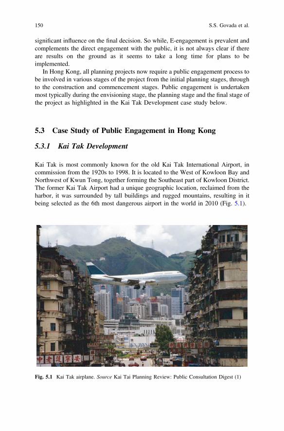
significant influence on the final decision. So while, E-engagement is prevalent andcomplements the direct engagement with the public, it is not always clear if thereare results on the ground as it seems to take a long time for plans to beimplemented.
In Hong Kong, all planning projects now require a public engagement process tobe involved in various stages of the project from the initial planning stages, throughto the construction and commencement stages. Public engagement is undertakenmost typically during the envisioning stage, the planning stage and the final stage ofthe project as highlighted in the Kai Tak Development case study below.
5.3 Case Study of Public Engagement in Hong Kong
5.3.1 Kai Tak Development
Kai Tak is most commonly known for the old Kai Tak International Airport, incommission from the 1920s to 1998. It is located to the West of Kowloon Bay andNorthwest of Kwun Tong, together forming the Southeast part of Kowloon District.The former Kai Tak Airport had a unique geographic location, reclaimed from theharbor, it was surrounded by tall buildings and rugged mountains, resulting in itbeing selected as the 6th most dangerous airport in the world in 2010 (Fig. 5.1).
Fig. 5.1 Kai Tak airplane. Source Kai Tai Planning Review: Public Consultation Digest (1)
150 S.S. Govada et al.
The Kai Tak Development was previously known as the South East KowloonDevelopment back in 1991, and over the past two decades various developmentschemes have been proposed, with one of the most controversial discussion pointsregarding future reclamation of the harbour. The Hong Kong Government started tocollect public views and considered public comments as important inputs towardsthe development. The planning process viewed the transition from no public par-ticipation at all to some public consultation as a major part of the developmentprocess. The public participation engagement successfully reduced proposedreclamation of the Kai Tak Development from about 299 hectares in 1998 totoday’s “zero reclamation”.
5.3.1.1 History of Kai Tak Development
The planning of Kai Tak began in the early 1990s, before the closure of the Kai TakAirport. The South East Kowloon Development (SEKD) planned to focus on theKai Tak Airport site and proposed land reclamation at Kowloon Bay, the Kai TakApproach and Channel, and the Kwun Tong Typhoon Shelter [9]. A wide range ofproposed land use and redevelopment frameworks were carried out focusing on thedevelopment of housing, commercial, open space and high-tech industrial com-ponents. In 1993, the South East Kowloon Development Statement Study (SEKDS)proposed reclamation at the adjacent water bodies and to develop more specificplanning principles for the Kai Tak Airport site, as well as to prepare an OutlineMaster Development Plan (OMDP) for the Feasibility Report for SEKD to furtherdiscuss the housing demand issue (Fig. 5.2).
The Feasibility Report was completed in 1998, advising to approach develop-ment in phases in order to integrate developments for the early developmentpackages. The scheme was published in the statutory Outline Zoning Plans (OZP),however, more than 800 objections from the public were received due to theproposed reclamation at the nearby water bodies [10]. It was at this time thatcitizens initially raised the concern of the top-down planning development process,encouraging the government to hold public consultation exercises throughout theentire planning process instead of only publishing one-way information on thewebpage to inform the public but not hear their views. Due to the significantamount of negative comments regarding the proposed reclamation, a reviseddevelopment scheme was created and in 2001, and a Comprehensive FeasibilityStudy of the Revised Scheme of South East Kowloon Development was prepared toaddress the opposition from the public by revising Outline Concept Plan andreducing the extent of reclamation (Fig. 5.3).
From the South East Kowloon Development in 1993 to the Kai TakDevelopment in 2007 and the ongoing Energizing Kowloon East Office, HongKong citizens are successfully getting more involved in the planning process tocomment on and influence future implementation through increased access toinformation, and availability of platforms to communicate and engage with allrelevant stakeholders.
5 E-Engagement in Hong Kong 151
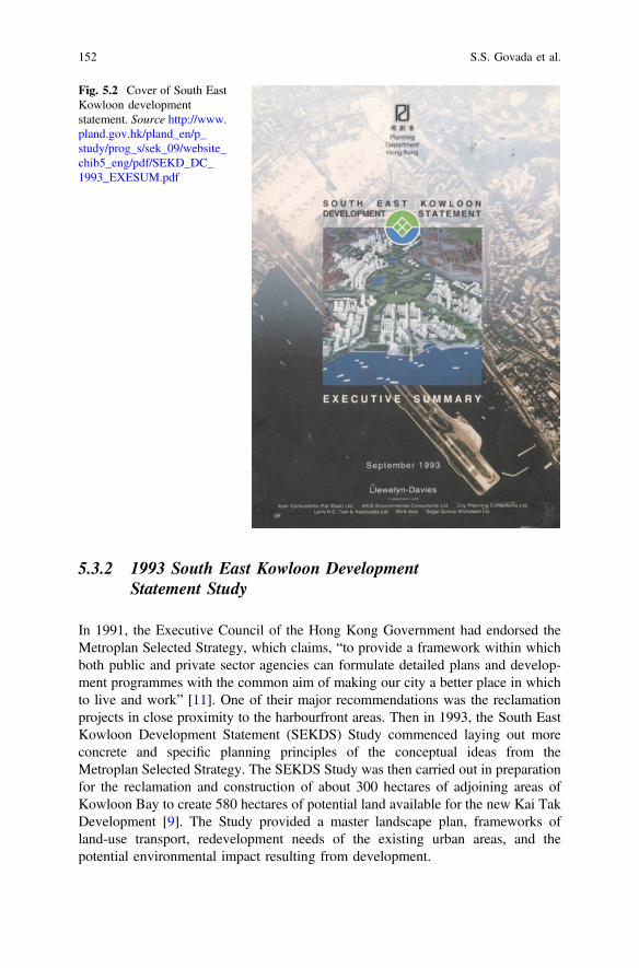
5.3.2 1993 South East Kowloon DevelopmentStatement Study
In 1991, the Executive Council of the Hong Kong Government had endorsed theMetroplan Selected Strategy, which claims, “to provide a framework within whichboth public and private sector agencies can formulate detailed plans and develop-ment programmes with the common aim of making our city a better place in whichto live and work” [11]. One of their major recommendations was the reclamationprojects in close proximity to the harbourfront areas. Then in 1993, the South EastKowloon Development Statement (SEKDS) Study commenced laying out moreconcrete and specific planning principles of the conceptual ideas from theMetroplan Selected Strategy. The SEKDS Study was then carried out in preparationfor the reclamation and construction of about 300 hectares of adjoining areas ofKowloon Bay to create 580 hectares of potential land available for the new Kai TakDevelopment [9]. The Study provided a master landscape plan, frameworks ofland-use transport, redevelopment needs of the existing urban areas, and thepotential environmental impact resulting from development.
Fig. 5.2 Cover of South EastKowloon developmentstatement. Source http://www.pland.gov.hk/pland_en/p_study/prog_s/sek_09/website_chib5_eng/pdf/SEKD_DC_1993_EXESUM.pdf
152 S.S. Govada et al.
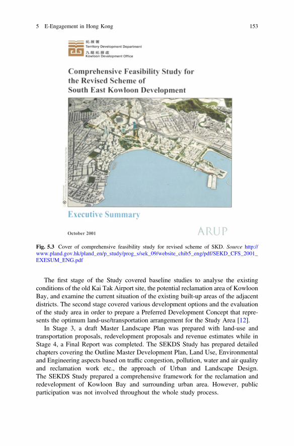
The first stage of the Study covered baseline studies to analyse the existingconditions of the old Kai Tak Airport site, the potential reclamation area of KowloonBay, and examine the current situation of the existing built-up areas of the adjacentdistricts. The second stage covered various development options and the evaluationof the study area in order to prepare a Preferred Development Concept that repre-sents the optimum land-use/transportation arrangement for the Study Area [12].
In Stage 3, a draft Master Landscape Plan was prepared with land-use andtransportation proposals, redevelopment proposals and revenue estimates while inStage 4, a Final Report was completed. The SEKDS Study has prepared detailedchapters covering the Outline Master Development Plan, Land Use, Environmentaland Engineering aspects based on traffic congestion, pollution, water and air qualityand reclamation work etc., the approach of Urban and Landscape Design.The SEKDS Study prepared a comprehensive framework for the reclamation andredevelopment of Kowloon Bay and surrounding urban area. However, publicparticipation was not involved throughout the whole study process.
Fig. 5.3 Cover of comprehensive feasibility study for revised scheme of SKD. Source http://www.pland.gov.hk/pland_en/p_study/prog_s/sek_09/website_chib5_eng/pdf/SEKD_CFS_2001_EXESUM_ENG.pdf
5 E-Engagement in Hong Kong 153
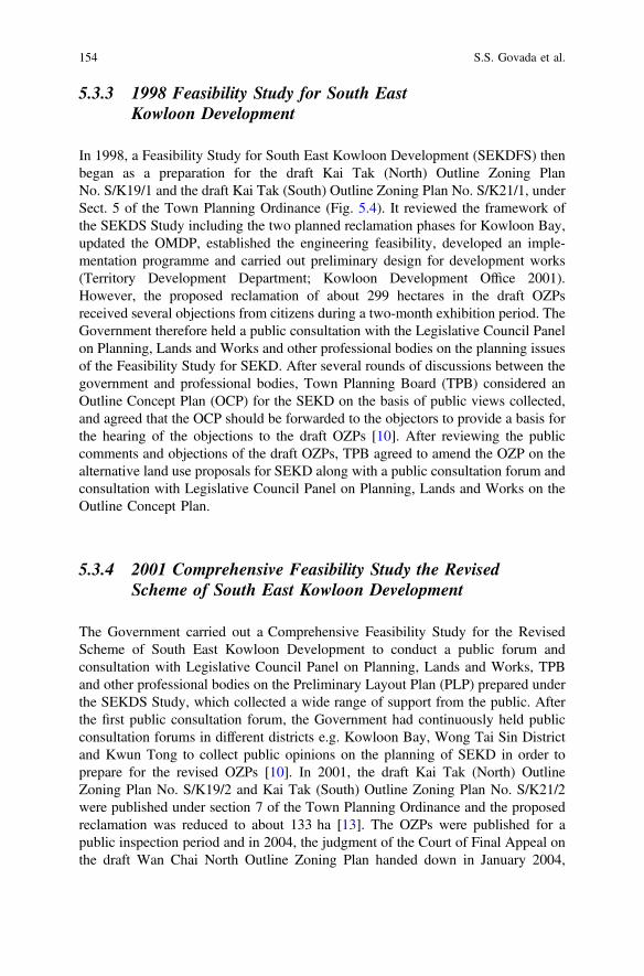
5.3.3 1998 Feasibility Study for South EastKowloon Development
In 1998, a Feasibility Study for South East Kowloon Development (SEKDFS) thenbegan as a preparation for the draft Kai Tak (North) Outline Zoning PlanNo. S/K19/1 and the draft Kai Tak (South) Outline Zoning Plan No. S/K21/1, underSect. 5 of the Town Planning Ordinance (Fig. 5.4). It reviewed the framework ofthe SEKDS Study including the two planned reclamation phases for Kowloon Bay,updated the OMDP, established the engineering feasibility, developed an imple-mentation programme and carried out preliminary design for development works(Territory Development Department; Kowloon Development Office 2001).However, the proposed reclamation of about 299 hectares in the draft OZPsreceived several objections from citizens during a two-month exhibition period. TheGovernment therefore held a public consultation with the Legislative Council Panelon Planning, Lands and Works and other professional bodies on the planning issuesof the Feasibility Study for SEKD. After several rounds of discussions between thegovernment and professional bodies, Town Planning Board (TPB) considered anOutline Concept Plan (OCP) for the SEKD on the basis of public views collected,and agreed that the OCP should be forwarded to the objectors to provide a basis forthe hearing of the objections to the draft OZPs [10]. After reviewing the publiccomments and objections of the draft OZPs, TPB agreed to amend the OZP on thealternative land use proposals for SEKD along with a public consultation forum andconsultation with Legislative Council Panel on Planning, Lands and Works on theOutline Concept Plan.
5.3.4 2001 Comprehensive Feasibility Study the RevisedScheme of South East Kowloon Development
The Government carried out a Comprehensive Feasibility Study for the RevisedScheme of South East Kowloon Development to conduct a public forum andconsultation with Legislative Council Panel on Planning, Lands and Works, TPBand other professional bodies on the Preliminary Layout Plan (PLP) prepared underthe SEKDS Study, which collected a wide range of support from the public. Afterthe first public consultation forum, the Government had continuously held publicconsultation forums in different districts e.g. Kowloon Bay, Wong Tai Sin Districtand Kwun Tong to collect public opinions on the planning of SEKD in order toprepare for the revised OZPs [10]. In 2001, the draft Kai Tak (North) OutlineZoning Plan No. S/K19/2 and Kai Tak (South) Outline Zoning Plan No. S/K21/2were published under section 7 of the Town Planning Ordinance and the proposedreclamation was reduced to about 133 ha [13]. The OZPs were published for apublic inspection period and in 2004, the judgment of the Court of Final Appeal onthe draft Wan Chai North Outline Zoning Plan handed down in January 2004,
154 S.S. Govada et al.
the presumption against harbour reclamation which can only be rebutted by meetingthe overriding public need test.
At this point of the SEKD, public consultation sessions were able to create aplatform for effective and productive discussions and communication betweenthe Government and local citizens for considering and realizing the public needs.
Fig. 5.4 Cover of feasibility study for South East Kowloon development. Source http://www.pland.gov.hk/pland_en/p_study/prog_s/sek_09/website_chib5_eng/pdf/FS_SEKD_ExeSum1998_Eng.pdf
5 E-Engagement in Hong Kong 155

Since then, public consultation forums and engagement activities have become amajor part of the planning and development process in Hong Kong (Fig. 5.5).
5.3.5 2004 Kai Tak Planning Review
The Kai Tak Planning Review was carried out in order to review the proposedplanning of the area in a comprehensive manner with “no reclamation” as thestarting point, in addition to examining the relevant interface and connectivityissues with nearby districts [11]. The Study area of the Kai Tak Planning Reviewcomprises the old Kai Tak Airport site, existing waterfront areas at To Kwa Wan,Ma Tau Kok, Kowloon Bay, Kwun Tong and Cha Kwo Ling. The objective of theKai Tak Planning Review was to conduct a comprehensive planning review of the“zero reclamation” concept and develop a new scheme for the old Airport site asguidance for its redevelopment. The Kai Tak Planning Review was divided intothree stages: Stage 1 Kai Tak Planning Review, Stage 2 Engineering Review, andStage 3 Statutory Planning Process where public engagement activities launched atthe first stage to collect the community’s aspirations regarding the conceptual visionof the future implementation for Kai Tak, and as a preparation for stages 2 and 3.
5.3.5.1 Public Engagement
Public engagement is important in town planning especially in the planning processas it allows citizens to voice their concerns and be part of the decision-making
Fig. 5.5 Public forum in stage 1 public engagement of Kai Tak development. Source http://www.pland.gov.hk/pland_en/p_study/prog_s/sek_09/website_chib5_eng/english/index_e.html
156 S.S. Govada et al.
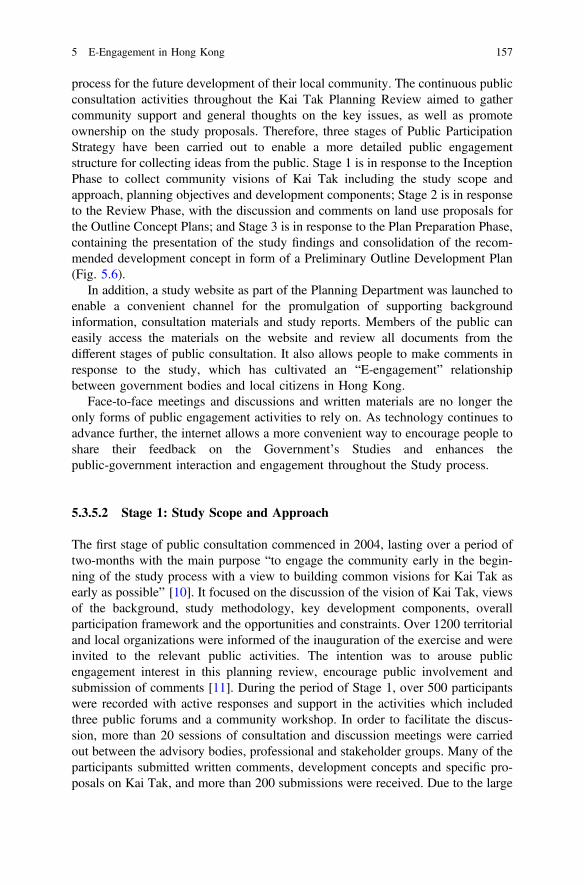
process for the future development of their local community. The continuous publicconsultation activities throughout the Kai Tak Planning Review aimed to gathercommunity support and general thoughts on the key issues, as well as promoteownership on the study proposals. Therefore, three stages of Public ParticipationStrategy have been carried out to enable a more detailed public engagementstructure for collecting ideas from the public. Stage 1 is in response to the InceptionPhase to collect community visions of Kai Tak including the study scope andapproach, planning objectives and development components; Stage 2 is in responseto the Review Phase, with the discussion and comments on land use proposals forthe Outline Concept Plans; and Stage 3 is in response to the Plan Preparation Phase,containing the presentation of the study findings and consolidation of the recom-mended development concept in form of a Preliminary Outline Development Plan(Fig. 5.6).
In addition, a study website as part of the Planning Department was launched toenable a convenient channel for the promulgation of supporting backgroundinformation, consultation materials and study reports. Members of the public caneasily access the materials on the website and review all documents from thedifferent stages of public consultation. It also allows people to make comments inresponse to the study, which has cultivated an “E-engagement” relationshipbetween government bodies and local citizens in Hong Kong.
Face-to-face meetings and discussions and written materials are no longer theonly forms of public engagement activities to rely on. As technology continues toadvance further, the internet allows a more convenient way to encourage people toshare their feedback on the Government’s Studies and enhances thepublic-government interaction and engagement throughout the Study process.
5.3.5.2 Stage 1: Study Scope and Approach
The first stage of public consultation commenced in 2004, lasting over a period oftwo-months with the main purpose “to engage the community early in the begin-ning of the study process with a view to building common visions for Kai Tak asearly as possible” [10]. It focused on the discussion of the vision of Kai Tak, viewsof the background, study methodology, key development components, overallparticipation framework and the opportunities and constraints. Over 1200 territorialand local organizations were informed of the inauguration of the exercise and wereinvited to the relevant public activities. The intention was to arouse publicengagement interest in this planning review, encourage public involvement andsubmission of comments [11]. During the period of Stage 1, over 500 participantswere recorded with active responses and support in the activities which includedthree public forums and a community workshop. In order to facilitate the discus-sion, more than 20 sessions of consultation and discussion meetings were carriedout between the advisory bodies, professional and stakeholder groups. Many of theparticipants submitted written comments, development concepts and specific pro-posals on Kai Tak, and more than 200 submissions were received. Due to the large
5 E-Engagement in Hong Kong 157
quantity of concerns on the harbourfront development, a sub-committee ofHarbourfront Enhancement Committee was created to address the community’saspiration for greater involvement in planning and design of the harbourfront area.It is responsible for providing further comments and advice on the SEKD Reviewbefore gathering the public feedback and the preparation of the Outline Concept
Fig. 5.6 Public participation strategy of Kai Tak development. Source http://www.pland.gov.hk/pland_en/p_study/prog_s/sek_09/website_chib5_eng/english/index_e.html
158 S.S. Govada et al.
Plans for the next stage of public participation. These processes of public partici-pation and engagement have allowed local citizens to express their thoughts on keyprinciples and issues of the Kai Tak Development as the plans themselves are beingdeveloped.
The fundamental idea was to enhance the waterfront developments whileretaining the heritage of the former airport operation at Kai Tak. People wanted tobring back the memory of landing at Kai Tak and the harbour to add to the socialvalue of the area and enhancing the quality of life. Other participants have sug-gested that Kai Tak could become a hub for sports, recreation, tourism andentertainment uses. Some of the planning principles brought up during theengagement forum related to the importance of a people-oriented planning approachin the Kai Tak Development, integration of new developments with the existingcommunities in surrounding areas, and an approach to achieve sustainable andwell-balanced developments and high-quality living [11]. Another key contentionissue was the idea of reclamation of the waterfront area. Residents nearby expressednot to pursue further reclamation in the Harbour Area or the Kowloon Bay area,which was taken into great consideration by the planning and development team.
The Kai Tak Forum has provided the opportunity for an engaging and mutuallybeneficial discussion between the community and government on the commentsand proposals received in the Stage 1 Public Participation, as well as the responsesfrom the Consultants and Government Bureaus/Departments [14]. The forumconcluded that the redevelopment of Kai Tak should focus on the strategic planningcontext in order to formulate a broad strategic framework for the planning of HongKong over the next 25 to 30 years [14].
The Kai Tak Development Stage 1 Public Participation has encouraged publicengagement activities to raise the general public’s awareness of the planning anddevelopment issues of Kai Tak. It has also enabled the community to visualize theirthoughts and opinions more formally, and more importantly to develop a soundbasis for a dialogue between the local citizens, grassroots organization and stake-holder groups on future implementation and growth of the Kai Tak Development.
5.3.5.3 Stage 2: Outline Concept Plan
In 2005, the Stage 2 Public Participation was carried out as the second publicconsultation to present the OCPs of land use themes developed in the Stage 1 PublicParticipation to the community. During Stage 2, three public forums were launchedto invite public comments on the development concepts for Kai Tak, which willserve as inputs for the Preliminary Outline Development Plan (PODP) for furtherdiscussion in the community [15]. Several public engagement activities were heldto conduct suggestions from the community including a public forum, three districtforums, and three topical forums on Multi-purpose Stadium, Cruise Terminal andKai Tak Approach Channel. Prior to the Forum, about 160 participants joined a sitevisit to Kai Tak to familiarize themselves with the opportunities and constraints ofKai Tak development.
5 E-Engagement in Hong Kong 159
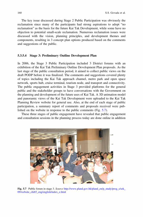
The key issue discussed during Stage 2 Public Participation was obviously thereclamation since many of the participants had strong aspirations to adopt “noreclamation” as the basis for the future Kai Tak Development, while some have noobjection to potential small-scale reclamation. Numerous reclamation issues werediscussed with the vision, planning principles, and development themes andcomponents, resulting in 3 concept plan options produced based on the commentsand suggestions of the public.
5.3.5.4 Stage 3: Preliminary Outline Development Plan
In 2006, the Stage 3 Public Participation included 3 District forums with anexhibition of the Kai Tak Preliminary Outline Development Plan proposals. As thelast stage of the public consultation period, it aimed to collect public views on thedraft PODP before it was finalized. The comments and suggestions covered plentyof topics including the Kai Tak approach channel, metro park and open spacenetwork, sports hub, cruise terminal, tourism node, and transport and connectivity.The public engagement activities in Stage 3 provided platforms for the generalpublic and the stakeholder groups to have conversations with the Government onthe planning and development of the future uses of Kai Tak. A 3D animation modeland panoramic views of the Kai Tak Development were uploaded to the Kai TakPlanning Review website for general use. Also, at the end of each stage of publicparticipation, a summary report of comments and proposals received were pub-lished on the website in response to the public comments (Fig. 5.7).
These three stages of public engagement have revealed that public engagementand consultation sessions in the planning process today are done online in addition
Fig. 5.7 Public forum in stage 3. Source http://www.pland.gov.hk/pland_en/p_study/prog_s/sek_09/website_chib5_eng/english/index_e.html
160 S.S. Govada et al.

to physical events such as exhibitions, workshops and forums since all the materialsand information can be uploaded to a website easily accessed by the general public,also providing an instant and interactive way for feedback and responses to com-ments relating to issues surrounding the planning and development of a majorinfrastructure project.
5.3.5.5 Kai Tak Office (KTO)
The KTO was set up to lead the coordination and implementation of KTD. TheHead of KTO, H(KTO) is formed by professional staff to monitor the progress ofKTD to fulfill public aspirations for the design. Moreover, the professional teamattempted to facilitate a smooth implementation in design development and providea coherent public interaction by enhancing green features in KTD, conservingheritage and surrounding old areas, and directing the design of KTD infrastructureworks to public consultation, while achieving the planning vision of KTD [16].
5.3.6 Energizing Kowloon East Office
Back in 20th Century, Kowloon East comprised the former Kai Tak Airport, KwunTong and Kowloon Bay Business Areas, and has since experienced rapid growthfrom the manufacturing industries of the industrial age in Hong Kong with thecreation of many jobs to drive Hong Kong’s prosperity during the 20th Century.However, after the relocation of the Airport from Kai Tak to Chek Lap Kok, and themigration of South China’s manufacturing base from Hong Kong to MainlandChina, the area has lost its past vibrancy, leaving a large stock of industrialbuildings not fully utilized. Also in the late 20th Century, Hong Kong started todevelop into an international financial city with emerging professional servicesectors. This evolution resulting in many multi-national companies choosing HongKong as the location for their Asia Pacific regional headquarters, boosting thedemand for prime office spaces, which is struggling to be supported by the tradi-tional Central Business District (CBD) of Central, Hong Kong.
Therefore, the Energizing Kowloon East Office (EKEO) was set up to targetcommunity engagement and public participation efforts in the visioning and plan-ning of the regeneration of Kowloon East into another premier CBD for Hong Kongto support the continued economic growth of the city’s financial and professionalservices in order strengthen and maintain the city’s global economic competitive-ness, This was achieved through numerous phases of public consultation, variouspublic engagement activities, and recreational events carried out to engage thecommunity and collect local citizens’ opinions. In addition, an informative websitecontaining all relevant materials such as the planning and feasibility studies, con-ceptual master plans, and outcomes of public engagement forums regarding
5 E-Engagement in Hong Kong 161
Kowloon East was created for people to access information about the progress ofthe project. Up until today, the public consultation for Kowloon East events are stillongoing as part of various studies to collect feedback from local people withdifferent expertise and experiences. Some have reflected that the government hasspent over two decades of planning process from the SEKD to the Kowloon EastDevelopment in response to public concerns, preparing concept plans for futureimplementation; however, progress on actual large-scale transformation has notbeen physically achieved as evidence that the public engagement efforts will berealized.
In conclusion, the government has worked effectively throughout the years interms of addressing the public opinion and suggestions regarding the Kai TakDevelopment, most successfully achieving the reduction of proposed reclamationfrom over 300 hectares to “zero reclamation”. However, some may consider it anineffective process due to the fact it has taken over two decades solely for theplanning and preparation for development. During the planning process of SEKD toEKEO, there is no doubt that public engagement has entered a digital world wherepeople can much more easily access the interest to find all the material andinformation related to the proposed project and location in question.“E-engagement” has altered the traditional concept of public consultation in cityplanning issues, and has established its own role in the future of all a short andlong-term planning processes.
KTD Timeline:
1991 Various reclamation projects in the Harbour areas recommended byMetroplan Selected Strategy
1992 The South East Kowloon Development Statement Study to translate theMetroplan concepts into more specific district planning objectives and planscommenced
1995 Feasibility Study for South East Kowloon Development commenced
September1998
The draft Kai Tak (North) Outline Zoning Plan No. S/K19/1 and the draftKai Tak (South) Outline Zoning Plan No. S/K21/1 were gazette. Theproposed reclamation was about 299 hectares. During the two-monthexhibition period, objections against the draft Outline Zoning Plans werereceived. Most of them objected to the extent of the proposed reclamation
November1998
Public consultation forum and consultation with Legislative Council Panel ofthe Feasibility Study for South East Kowloon Development were held
May 1999 Town Planning Board considered an Outline Concept Plan for the South EastKowloon Development on the basis of public views collected, and agreedthat the Outline Concept Plan should be forwarded to the objectors to providea basis for the hearing of the objections to the draft Outline Zoning Plans
June 1999 Town Planning Board heard the objections and collected views on theOutline Concept Plan from the objectors. The Board agreed to amend theOutline Zoning Plans pending the completion of a further study on thealternative land use proposals for South East Kowloon Development
(continued)
162 S.S. Govada et al.
(continued)
June–July1999
Government conducted a public consultation forum and consultation withLegislative Council Panel on Planning, Lands and Works on the OutlineConcept Plan
November1999
The Comprehensive Feasibility Study for the Revised Scheme of SouthEast Kowloon Development commenced
2000 Government conducted a public consultation forum and consultation withLegislative Council Panel on Planning, Lands and Works, Town PlanningBoard, Kwun Tong District Council, Wong Tai Sin District Council andKowloon City District Council on the Preliminary Layout Plan preparedunder the South East Kowloon Development Comprehensive FeasibilityStudy. The Preliminary Layout Plan was widely supported
June 2001 Government conducted consultation with Environmental Impact AssessmentSubcommittee of the Advisory Committee on Environment, Kwun TongDistrict Council, Wong Tai Sin District Council, and Kowloon City DistrictCouncil on the findings of South East Kowloon DevelopmentComprehensive Feasibility Study
July–August2001
Government conducted consultation with Wong Tai Sin District Council,Kwun Tong District Council and Kowloon City District Council on therevised draft Outline Zoning Plans
August 2001 The draft Kai Tak (North) Outline Zoning Plan No. S/K19/2 and Kai Tak(South) Outline Zoning Plan No. S/K21/2 were gazetted under section 7 ofthe Town Planning Ordinance. The proposed reclamation was reduced toabout 133 a
January 2004 The judgment of the Court of Final Appeal on the draft Wan Chai NorthOutline Zoning Plan handed down in January 2004, the presumption againstharbour reclamation can only be rebutted by meeting the overriding publicneed test
July 2004 Kai Tak Planning Review commenced. The focus of this study is to reviewthe planning of the area in a comprehensive manner with “no reclamation” asthe starting point
5.4 E-Engagement in the Hong Kong Planning Process
In Hong Kong, the town planning process and related matters are governed by TheTown Planning Board (TPB). The TPB is a statutory body that aims to promote thehealthy, safe, convenient and general welfare of the community through the sys-tematic preparation of plans for the layout of urban and rural areas in Hong Kong aswell as the suitable types of buildings to be developed.
Part of the planning process requires the TPB and Planning Department topublicise draft plans for public inspection and consultation, in order to receiverepresentations and comments from the general public. This allows for public inputand subsequent amendment of plans to align with overall community needs andgoals. In the 1960s before the use of technology, paper plans were presented to the
5 E-Engagement in Hong Kong 163
public. Paper plans are much less accessible to the general public due to the need tobe physically present, and in addition are significantly limited to those who have thetechnical expertise to understand such plans. With the evolution and adoption oftechnology in the late 20th Century, the TPB transitioned to digitized plans in the1990s, utilizing technologies such as Geographic Information Systems (GIS). Thesetechnological advancements and transition to digitalization have enabled theplanning process in Hong Kong to become much more accessible and readilyavailable to the general public, in forms that are simpler to understand from alayman’s perspective. Furthermore, digitizing the information as allowed the uti-lization of the Internet to disseminate the relevant information to the general publicto be retrieved at any time.
In the past 20 years, advancements in technology have enabled the evolutionfrom physical to digital models and now to 3D models and animations for publicengagement and consultation purposes. The use of 3D models and animations overphysical models allows for real-time imaginable land use scenarios for the public toclearly identify and visualize the potential future impact that a new developmentwill have on the area. Hong Kong is in fact, the first place in the world to introduce3D environmental impact assessment (EIA) models as a tool for public engagementand consultation. By developing a 3D visualization, it is easier for the generalpublic to understand complex projects and issues, as well as the effect of mitigationmeasures prior to construction and implementation. Previously, the use of 2Dhardcopy plans or text to describe and illustrate impact and mitigation options weresufficient for informing and engaging industry professionals and a technical audi-ence. However, it significantly limited the accessibility and knowledge of thisinformation for the general public, as it was difficult for the layman to adequatelyunderstand such technical plans and to give suitable comments or suggestions.These interactive 3D visualisations also allow for online demonstrations of fictitiousprojects as well as the ability for the public to try out the 3D process by themselvesto experience this higher level of engagement and the ability to make use of thetools to offer suggestions and alternative mitigation options [17].
5.4.1 Development of E-Engagement Tools in Hong Kong
Although technological advances in the digital age has made it easier for citizens tohave increased access, availability and understanding of different steps of theplanning process, the next step is to enable citizens to participate, contribute andshare their views and opinions during the planning process itself. Before the abilityto actively engage and participate in the planning and decision making processes,the Hong Kong Government was weak in providing suitable channels for citizens toprovide comments and voice their opinions on specific planning projects. The HongKong Government successfully uses social media and other channels to “inform,involve, and collect views” from the public, but is not seen to necessarily take theseviews into formal consideration, limiting the empowerment of citizens in public
164 S.S. Govada et al.
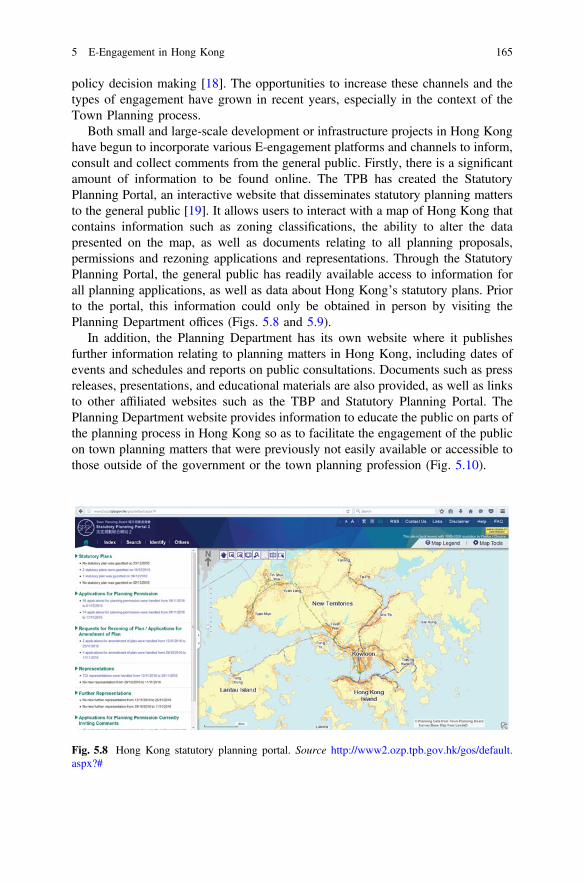
policy decision making [18]. The opportunities to increase these channels and thetypes of engagement have grown in recent years, especially in the context of theTown Planning process.
Both small and large-scale development or infrastructure projects in Hong Konghave begun to incorporate various E-engagement platforms and channels to inform,consult and collect comments from the general public. Firstly, there is a significantamount of information to be found online. The TPB has created the StatutoryPlanning Portal, an interactive website that disseminates statutory planning mattersto the general public [19]. It allows users to interact with a map of Hong Kong thatcontains information such as zoning classifications, the ability to alter the datapresented on the map, as well as documents relating to all planning proposals,permissions and rezoning applications and representations. Through the StatutoryPlanning Portal, the general public has readily available access to information forall planning applications, as well as data about Hong Kong’s statutory plans. Priorto the portal, this information could only be obtained in person by visiting thePlanning Department offices (Figs. 5.8 and 5.9).
In addition, the Planning Department has its own website where it publishesfurther information relating to planning matters in Hong Kong, including dates ofevents and schedules and reports on public consultations. Documents such as pressreleases, presentations, and educational materials are also provided, as well as linksto other affiliated websites such as the TBP and Statutory Planning Portal. ThePlanning Department website provides information to educate the public on parts ofthe planning process in Hong Kong so as to facilitate the engagement of the publicon town planning matters that were previously not easily available or accessible tothose outside of the government or the town planning profession (Fig. 5.10).
Fig. 5.8 Hong Kong statutory planning portal. Source http://www2.ozp.tpb.gov.hk/gos/default.aspx?#
5 E-Engagement in Hong Kong 165

Fig. 5.9 Detailed view of information provided by the statutory planning portal. Source http://www2.ozp.tpb.gov.hk/gos/default.aspx?#
Fig. 5.10 Hong Kong planning department homepage. Source http://www.pland.gov.hk/pland_en/index.html
166 S.S. Govada et al.
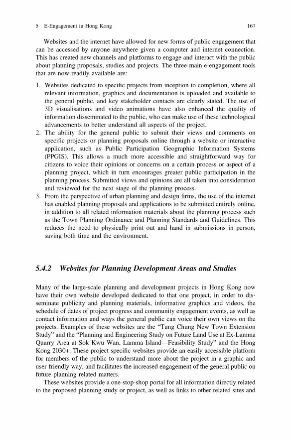
Websites and the internet have allowed for new forms of public engagement thatcan be accessed by anyone anywhere given a computer and internet connection.This has created new channels and platforms to engage and interact with the publicabout planning proposals, studies and projects. The three-main e-engagement toolsthat are now readily available are:
1. Websites dedicated to specific projects from inception to completion, where allrelevant information, graphics and documentation is uploaded and available tothe general public, and key stakeholder contacts are clearly stated. The use of3D visualisations and video animations have also enhanced the quality ofinformation disseminated to the public, who can make use of these technologicaladvancements to better understand all aspects of the project.
2. The ability for the general public to submit their views and comments onspecific projects or planning proposals online through a website or interactiveapplication, such as Public Participation Geographic Information Systems(PPGIS). This allows a much more accessible and straightforward way forcitizens to voice their opinions or concerns on a certain process or aspect of aplanning project, which in turn encourages greater public participation in theplanning process. Submitted views and opinions are all taken into considerationand reviewed for the next stage of the planning process.
3. From the perspective of urban planning and design firms, the use of the internethas enabled planning proposals and applications to be submitted entirely online,in addition to all related information materials about the planning process suchas the Town Planning Ordinance and Planning Standards and Guidelines. Thisreduces the need to physically print out and hand in submissions in person,saving both time and the environment.
5.4.2 Websites for Planning Development Areas and Studies
Many of the large-scale planning and development projects in Hong Kong nowhave their own website developed dedicated to that one project, in order to dis-seminate publicity and planning materials, informative graphics and videos, theschedule of dates of project progress and community engagement events, as well ascontact information and ways the general public can voice their own views on theprojects. Examples of these websites are the “Tung Chung New Town ExtensionStudy” and the “Planning and Engineering Study on Future Land Use at Ex-LammaQuarry Area at Sok Kwu Wan, Lamma Island—Feasibility Study” and the HongKong 2030+. These project specific websites provide an easily accessible platformfor members of the public to understand more about the project in a graphic anduser-friendly way, and facilitates the increased engagement of the general public onfuture planning related matters.
These websites provide a one-stop-shop portal for all information directly relatedto the proposed planning study or project, as well as links to other related sites and
5 E-Engagement in Hong Kong 167
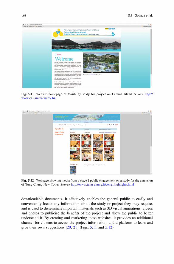
downloadable documents. It effectively enables the general public to easily andconveniently locate any information about the study or project they may require,and is used to disseminate important materials such as 3D visual animations, videosand photos to publicise the benefits of the project and allow the public to betterunderstand it. By creating and marketing these websites, it provides an additionalchannel for citizens to access the project information, and a platform to learn andgive their own suggestions [20, 21] (Figs. 5.11 and 5.12).
Fig. 5.11 Website homepage of feasibility study for project on Lamma Island. Source http://www.ex-lammaquarry.hk/
Fig. 5.12 Webpage showing media from a stage 1 public engagement on a study for the extensionof Tung Chung New Town. Source http://www.tung-chung.hk/eng_highlights.html
168 S.S. Govada et al.
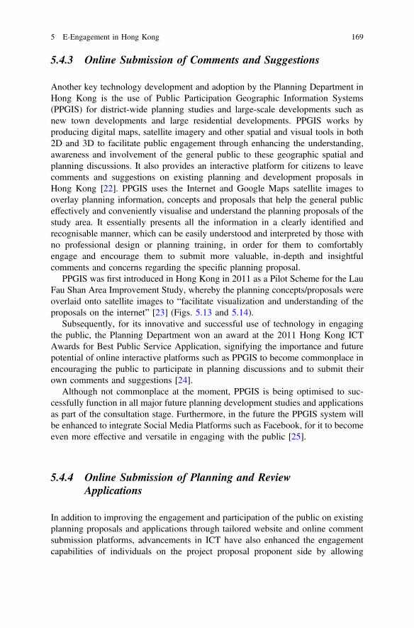
5.4.3 Online Submission of Comments and Suggestions
Another key technology development and adoption by the Planning Department inHong Kong is the use of Public Participation Geographic Information Systems(PPGIS) for district-wide planning studies and large-scale developments such asnew town developments and large residential developments. PPGIS works byproducing digital maps, satellite imagery and other spatial and visual tools in both2D and 3D to facilitate public engagement through enhancing the understanding,awareness and involvement of the general public to these geographic spatial andplanning discussions. It also provides an interactive platform for citizens to leavecomments and suggestions on existing planning and development proposals inHong Kong [22]. PPGIS uses the Internet and Google Maps satellite images tooverlay planning information, concepts and proposals that help the general publiceffectively and conveniently visualise and understand the planning proposals of thestudy area. It essentially presents all the information in a clearly identified andrecognisable manner, which can be easily understood and interpreted by those withno professional design or planning training, in order for them to comfortablyengage and encourage them to submit more valuable, in-depth and insightfulcomments and concerns regarding the specific planning proposal.
PPGIS was first introduced in Hong Kong in 2011 as a Pilot Scheme for the LauFau Shan Area Improvement Study, whereby the planning concepts/proposals wereoverlaid onto satellite images to “facilitate visualization and understanding of theproposals on the internet” [23] (Figs. 5.13 and 5.14).
Subsequently, for its innovative and successful use of technology in engagingthe public, the Planning Department won an award at the 2011 Hong Kong ICTAwards for Best Public Service Application, signifying the importance and futurepotential of online interactive platforms such as PPGIS to become commonplace inencouraging the public to participate in planning discussions and to submit theirown comments and suggestions [24].
Although not commonplace at the moment, PPGIS is being optimised to suc-cessfully function in all major future planning development studies and applicationsas part of the consultation stage. Furthermore, in the future the PPGIS system willbe enhanced to integrate Social Media Platforms such as Facebook, for it to becomeeven more effective and versatile in engaging with the public [25].
5.4.4 Online Submission of Planning and ReviewApplications
In addition to improving the engagement and participation of the public on existingplanning proposals and applications through tailored website and online commentsubmission platforms, advancements in ICT have also enhanced the engagementcapabilities of individuals on the project proposal proponent side by allowing
5 E-Engagement in Hong Kong 169
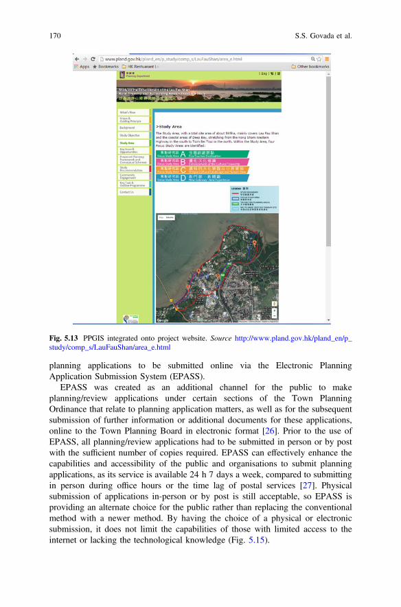
Fig. 5.13 PPGIS integrated onto project website. Source http://www.pland.gov.hk/pland_en/p_study/comp_s/LauFauShan/area_e.html
planning applications to be submitted online via the Electronic PlanningApplication Submission System (EPASS).
EPASS was created as an additional channel for the public to makeplanning/review applications under certain sections of the Town PlanningOrdinance that relate to planning application matters, as well as for the subsequentsubmission of further information or additional documents for these applications,online to the Town Planning Board in electronic format [26]. Prior to the use ofEPASS, all planning/review applications had to be submitted in person or by postwith the sufficient number of copies required. EPASS can effectively enhance thecapabilities and accessibility of the public and organisations to submit planningapplications, as its service is available 24 h 7 days a week, compared to submittingin person during office hours or the time lag of postal services [27]. Physicalsubmission of applications in-person or by post is still acceptable, so EPASS isproviding an alternate choice for the public rather than replacing the conventionalmethod with a newer method. By having the choice of a physical or electronicsubmission, it does not limit the capabilities of those with limited access to theinternet or lacking the technological knowledge (Fig. 5.15).
170 S.S. Govada et al.
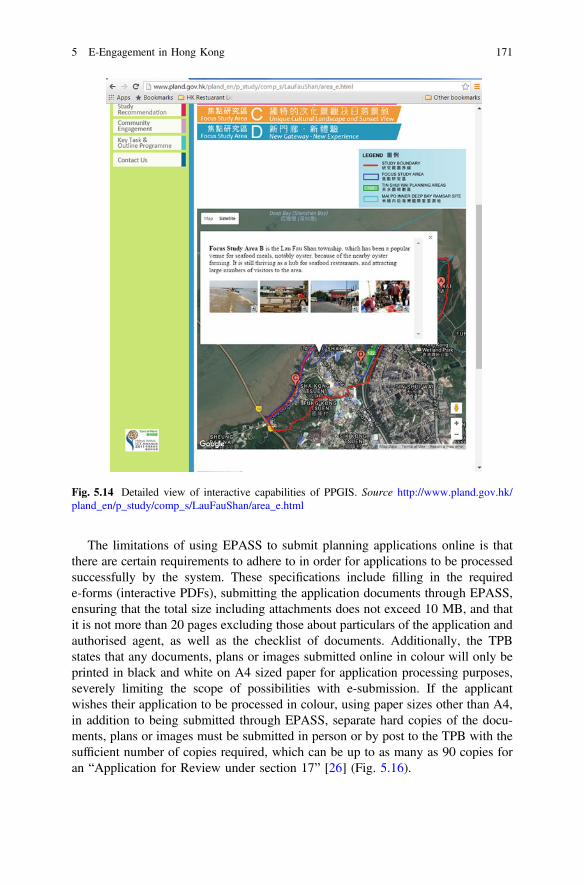
The limitations of using EPASS to submit planning applications online is thatthere are certain requirements to adhere to in order for applications to be processedsuccessfully by the system. These specifications include filling in the requirede-forms (interactive PDFs), submitting the application documents through EPASS,ensuring that the total size including attachments does not exceed 10 MB, and thatit is not more than 20 pages excluding those about particulars of the application andauthorised agent, as well as the checklist of documents. Additionally, the TPBstates that any documents, plans or images submitted online in colour will only beprinted in black and white on A4 sized paper for application processing purposes,severely limiting the scope of possibilities with e-submission. If the applicantwishes their application to be processed in colour, using paper sizes other than A4,in addition to being submitted through EPASS, separate hard copies of the docu-ments, plans or images must be submitted in person or by post to the TPB with thesufficient number of copies required, which can be up to as many as 90 copies foran “Application for Review under section 17” [26] (Fig. 5.16).
Fig. 5.14 Detailed view of interactive capabilities of PPGIS. Source http://www.pland.gov.hk/pland_en/p_study/comp_s/LauFauShan/area_e.html
5 E-Engagement in Hong Kong 171
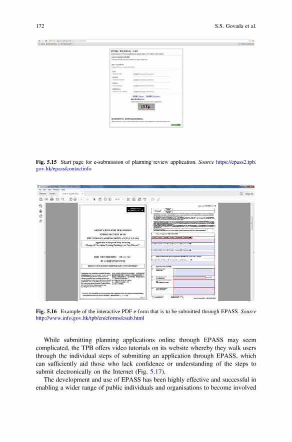
While submitting planning applications online through EPASS may seemcomplicated, the TPB offers video tutorials on its website whereby they walk usersthrough the individual steps of submitting an application through EPASS, whichcan sufficiently aid those who lack confidence or understanding of the steps tosubmit electronically on the Internet (Fig. 5.17).
The development and use of EPASS has been highly effective and successful inenabling a wider range of public individuals and organisations to become involved
Fig. 5.16 Example of the interactive PDF e-form that is to be submitted through EPASS. Sourcehttp://www.info.gov.hk/tpb/en/eforms/esub.html
Fig. 5.15 Start page for e-submission of planning review application. Source https://epass2.tpb.gov.hk/epass/contactinfo
172 S.S. Govada et al.
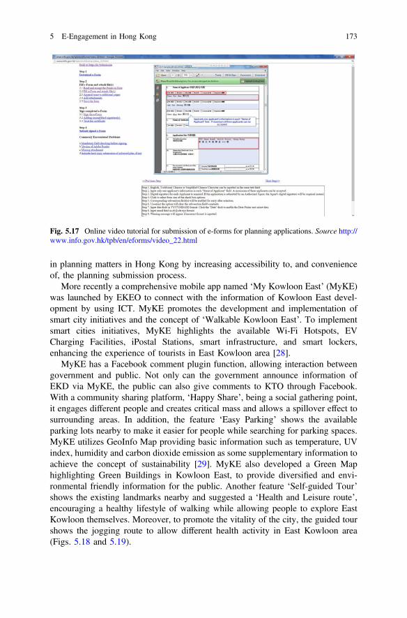
in planning matters in Hong Kong by increasing accessibility to, and convenienceof, the planning submission process.
More recently a comprehensive mobile app named ‘My Kowloon East’ (MyKE)was launched by EKEO to connect with the information of Kowloon East devel-opment by using ICT. MyKE promotes the development and implementation ofsmart city initiatives and the concept of ‘Walkable Kowloon East’. To implementsmart cities initiatives, MyKE highlights the available Wi-Fi Hotspots, EVCharging Facilities, iPostal Stations, smart infrastructure, and smart lockers,enhancing the experience of tourists in East Kowloon area [28].
MyKE has a Facebook comment plugin function, allowing interaction betweengovernment and public. Not only can the government announce information ofEKD via MyKE, the public can also give comments to KTO through Facebook.With a community sharing platform, ‘Happy Share’, being a social gathering point,it engages different people and creates critical mass and allows a spillover effect tosurrounding areas. In addition, the feature ‘Easy Parking’ shows the availableparking lots nearby to make it easier for people while searching for parking spaces.MyKE utilizes GeoInfo Map providing basic information such as temperature, UVindex, humidity and carbon dioxide emission as some supplementary information toachieve the concept of sustainability [29]. MyKE also developed a Green Maphighlighting Green Buildings in Kowloon East, to provide diversified and envi-ronmental friendly information for the public. Another feature ‘Self-guided Tour’shows the existing landmarks nearby and suggested a ‘Health and Leisure route’,encouraging a healthy lifestyle of walking while allowing people to explore EastKowloon themselves. Moreover, to promote the vitality of the city, the guided tourshows the jogging route to allow different health activity in East Kowloon area(Figs. 5.18 and 5.19).
Fig. 5.17 Online video tutorial for submission of e-forms for planning applications. Source http://www.info.gov.hk/tpb/en/eforms/video_22.html
5 E-Engagement in Hong Kong 173
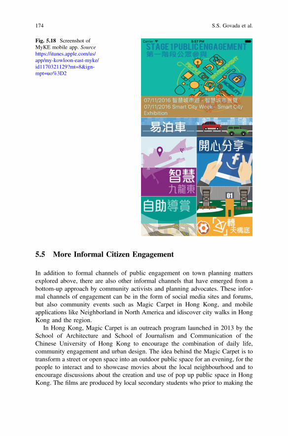
5.5 More Informal Citizen Engagement
In addition to formal channels of public engagement on town planning mattersexplored above, there are also other informal channels that have emerged from abottom-up approach by community activists and planning advocates. These infor-mal channels of engagement can be in the form of social media sites and forums,but also community events such as Magic Carpet in Hong Kong, and mobileapplications like Neighborland in North America and idiscover city walks in HongKong and the region.
In Hong Kong, Magic Carpet is an outreach program launched in 2013 by theSchool of Architecture and School of Journalism and Communication of theChinese University of Hong Kong to encourage the combination of daily life,community engagement and urban design. The idea behind the Magic Carpet is totransform a street or open space into an outdoor public space for an evening, for thepeople to interact and to showcase movies about the local neighbourhood and toencourage discussions about the creation and use of pop up public space in HongKong. The films are produced by local secondary students who prior to making the
Fig. 5.18 Screenshot ofMyKE mobile app. Sourcehttps://itunes.apple.com/us/app/my-kowloon-east-myke/id1170321129?mt=8&ign-mpt=uo%3D2
174 S.S. Govada et al.
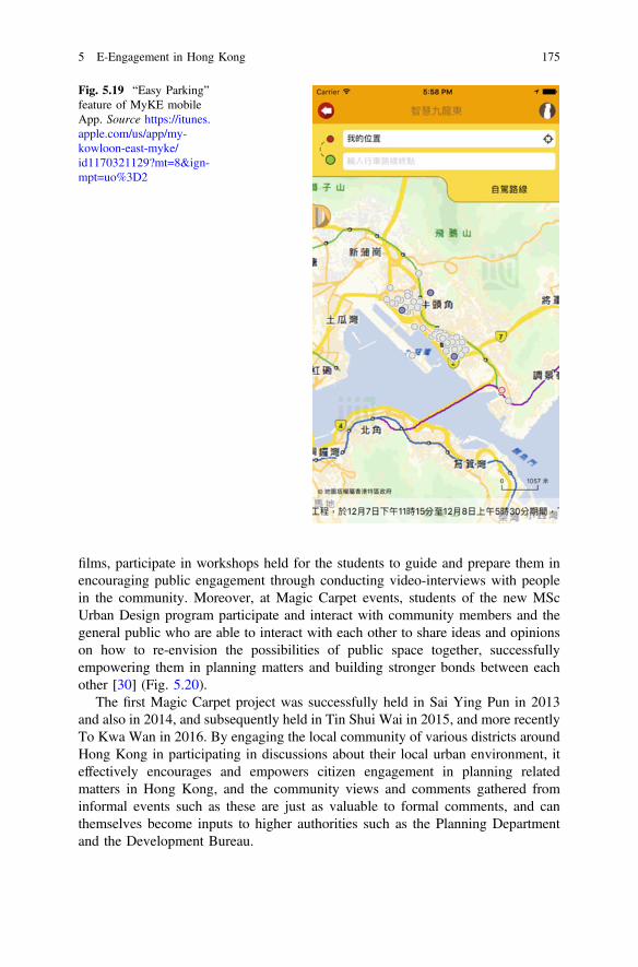
films, participate in workshops held for the students to guide and prepare them inencouraging public engagement through conducting video-interviews with peoplein the community. Moreover, at Magic Carpet events, students of the new MScUrban Design program participate and interact with community members and thegeneral public who are able to interact with each other to share ideas and opinionson how to re-envision the possibilities of public space together, successfullyempowering them in planning matters and building stronger bonds between eachother [30] (Fig. 5.20).
The first Magic Carpet project was successfully held in Sai Ying Pun in 2013and also in 2014, and subsequently held in Tin Shui Wai in 2015, and more recentlyTo Kwa Wan in 2016. By engaging the local community of various districts aroundHong Kong in participating in discussions about their local urban environment, iteffectively encourages and empowers citizen engagement in planning relatedmatters in Hong Kong, and the community views and comments gathered frominformal events such as these are just as valuable to formal comments, and canthemselves become inputs to higher authorities such as the Planning Departmentand the Development Bureau.
Fig. 5.19 “Easy Parking”feature of MyKE mobileApp. Source https://itunes.apple.com/us/app/my-kowloon-east-myke/id1170321129?mt=8&ign-mpt=uo%3D2
5 E-Engagement in Hong Kong 175
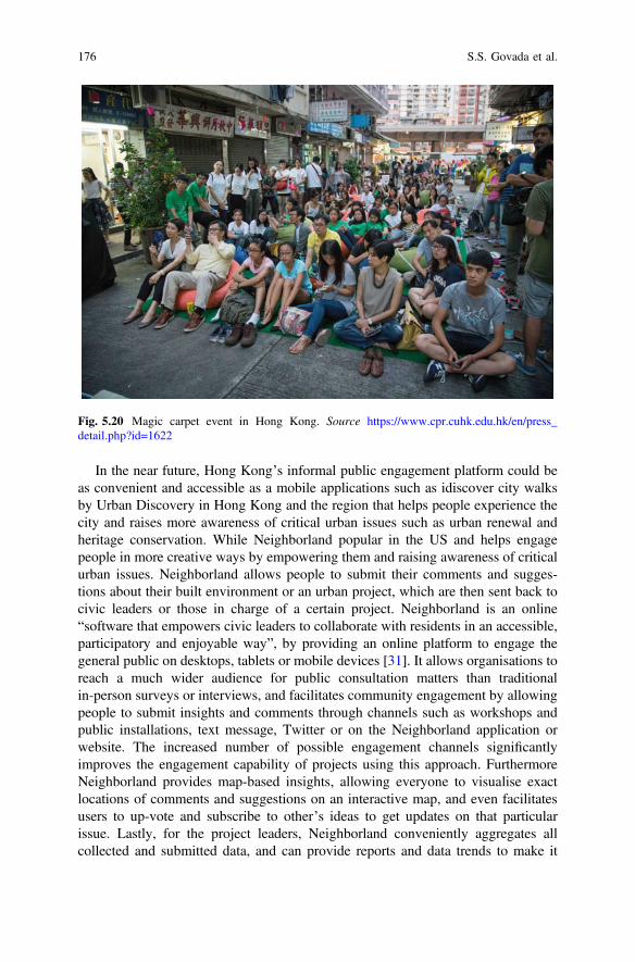
In the near future, Hong Kong’s informal public engagement platform could beas convenient and accessible as a mobile applications such as idiscover city walksby Urban Discovery in Hong Kong and the region that helps people experience thecity and raises more awareness of critical urban issues such as urban renewal andheritage conservation. While Neighborland popular in the US and helps engagepeople in more creative ways by empowering them and raising awareness of criticalurban issues. Neighborland allows people to submit their comments and sugges-tions about their built environment or an urban project, which are then sent back tocivic leaders or those in charge of a certain project. Neighborland is an online“software that empowers civic leaders to collaborate with residents in an accessible,participatory and enjoyable way”, by providing an online platform to engage thegeneral public on desktops, tablets or mobile devices [31]. It allows organisations toreach a much wider audience for public consultation matters than traditionalin-person surveys or interviews, and facilitates community engagement by allowingpeople to submit insights and comments through channels such as workshops andpublic installations, text message, Twitter or on the Neighborland application orwebsite. The increased number of possible engagement channels significantlyimproves the engagement capability of projects using this approach. FurthermoreNeighborland provides map-based insights, allowing everyone to visualise exactlocations of comments and suggestions on an interactive map, and even facilitatesusers to up-vote and subscribe to other’s ideas to get updates on that particularissue. Lastly, for the project leaders, Neighborland conveniently aggregates allcollected and submitted data, and can provide reports and data trends to make it
Fig. 5.20 Magic carpet event in Hong Kong. Source https://www.cpr.cuhk.edu.hk/en/press_detail.php?id=1622
176 S.S. Govada et al.
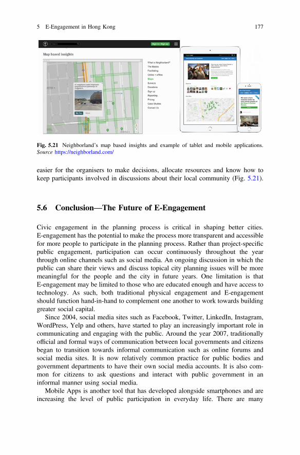
easier for the organisers to make decisions, allocate resources and know how tokeep participants involved in discussions about their local community (Fig. 5.21).
5.6 Conclusion—The Future of E-Engagement
Civic engagement in the planning process is critical in shaping better cities.E-engagement has the potential to make the process more transparent and accessiblefor more people to participate in the planning process. Rather than project-specificpublic engagement, participation can occur continuously throughout the yearthrough online channels such as social media. An ongoing discussion in which thepublic can share their views and discuss topical city planning issues will be moremeaningful for the people and the city in future years. One limitation is thatE-engagement may be limited to those who are educated enough and have access totechnology. As such, both traditional physical engagement and E-engagementshould function hand-in-hand to complement one another to work towards buildinggreater social capital.
Since 2004, social media sites such as Facebook, Twitter, LinkedIn, Instagram,WordPress, Yelp and others, have started to play an increasingly important role incommunicating and engaging with the public. Around the year 2007, traditionallyofficial and formal ways of communication between local governments and citizensbegan to transition towards informal communication such as online forums andsocial media sites. It is now relatively common practice for public bodies andgovernment departments to have their own social media accounts. It is also com-mon for citizens to ask questions and interact with public government in aninformal manner using social media.
Mobile Apps is another tool that has developed alongside smartphones and areincreasing the level of public participation in everyday life. There are many
Fig. 5.21 Neighborland’s map based insights and example of tablet and mobile applications.Source https://neighborland.com/
5 E-Engagement in Hong Kong 177

different mobile apps that enable the dissemination of public information directly tocitizen’s fingertips. For example, there are apps for public transportation schedules,leisure and recreational activities, healthcare, education, police, weather, homeaffairs and more, to make living easier. Together with them, different neighborhoodapps were discovered to help to engage public in place maintenance and planningprocess. Many cities have apps that work on a smart phone and allows citizens tomake a suggestion or a notice for maintenance/improvement needed in a real time.For example, if a citizen is walking on a sidewalk at the evening and notices thatone of the lantern lights are not working, he opens the app, puts on his location asthe app is connected with the GPS, and writes a comment that the light in this placeshould be replaced.
Social media sites became so popular because they allow the real time commu-nication. People can get their answers to questions fast and easy. A message in theSocial Media is delivered with a visible date and time tag. This allows citizens tokeep track on how up to date the information is. After the 2010s, E-engagementbecame self-evident to the point that public engagement encompasses e-engagement.
People tend to be more willing to use big platforms as a one stop shop for theirdaily services simply because they find it easier. This makes the e-engagementprocess more efficient, more accessible and less time consuming for citizens. In thisway, citizens would not only contribute to the government, but they would start tocommunicate and work together to develop solutions for improving their own localcommunities.
Going forward, it is important to improve current ICT models as to how their webpages function, interact with the public, and enable the engagement of more peoplefaster and easier. ICTs have to a certain extent increased the transparency in thedecision making process, yet challenges still remain. How do we make sure that thepeople who are engaged are actually participating in the decision making process forthe interest of the greater public and not solely their own private interests? How dowe make sure that those who are most actively engaged in the public participationprocess are actually the ones who will use the space the most? It is important to takeinto consideration that the population is diverse and well represented, to ensuredecisions are not influenced by a vocal minority, and to figure out how to engageother groups such as the elderly and younger generations, such as children.
Given that people in Hong Kong are very vocal in making their views heardthrough means such as protests and demonstrations even though Hong Kong is notas democratic as people would like it to be. The ever increasing cost of living, lowersalaries and lack of affordable housing being some of the critical issues as a result ofwhich there is a lot of dissent especially among the younger generations as there islack of hope for their future in Hong Kong. This led to the recent demonstrationswith regard to the “umbrella movement” which were also supported by ICT socialmedia was used as well.
It is also important to note that E-engagement in Hong Kong is still in its earlystages, where the information is available and accessible on the websites but the use ofsocial media for public engagement purposes by the public sector has not fullycaught on as yet. Although Hong Kong has a very active civil society, the whole
178 S.S. Govada et al.
engagement process needs to become less project based and more community based,and should be on-going with engagement occuring throughout all stages. One stopshops for all engagement needs of citizens will make the engagement process evenmore effective. The aim should be to try and engage people of all walks of life andages, but more importantly to see results on the ground that address the views,opinions and aspirations of the community. It is important to build greater trust amongthe public sector, the community and its people, with a more positive attitude andapproach towards Hong Kong which will require all sectors of society to cometogether to make Hong Kong an even greater global city.
References
1. Cowan SE (2010) Democracy, technocracy and publicity: public consultation and Britishplanning, 1939-1951. http://escholarship.org/uc/item/2jb4j9cz. Accessed 10 Dec 2016
2. Mesarovic MD (1960) Control of multivariable system. MIT Press, Cambridge and Wiley,New York
3. Arnstein SR (1969) A ladder of citizen participation. J Am Plann Assoc 35(4):216–224.doi:10.1080/01944366908977225
4. Putnam R (1995) Bowling alone. J Democracy 6(1):65–78. doi:10.1353/jod.1995.00025. Lang R (1986) Achieving integration in resource planning. In: Lang R (ed) Integrated
approaches to resource planning and management. The University of Calgary Press, Calgary,pp 35–39
6. Kubicek H (2007) Electronic democracy: achievements and challenges. Final Report on theESF Research Conference in Vadstena, Sweden, 21–25 Nov 2007
7. Macintosh A (2006) eParticipation in policy-making: the research and the challenges.Exploiting the knowledge economy: issues, applications and case studies. IOS Press,Amsterdam, pp 364–369
8. Hong Kong Harbourfront Commission (2016) Final report on the proposed establishment ofharbourfront authority in Hong Kong. In: http://www.hfc.org.hk/hape/doc/en/news/Report_to_CE_w_appendices.pdf. Accessed 30 Dec 2016
9. Planning Department (2004) Agreement No. CE 4/2004 (TP) South East KowloonDevelopment Comprehensive Planning and Engineering Review Stage 1: Planning Review(Feasibility Study). 3
10. Planning Department (2007) Planning history of Kai Tak. In: Kai Tak planning review. http://www.pland.gov.hk/pland_en/p_study/prog_s/sek_09/website_chib5_eng/english/index_e.html. Accessed 23 Dec 2016
11. Planning Department (2003) 3 review of metroplan form and function. In: Pland.gov.hk.http://www.pland.gov.hk/pland_en/p_study/comp_s/metroplan/metro_finalreport/ch3.htm.Accessed 23 Dec 2016
12. Planning Department (1993) South East Kowloon Development Statement ExecutiveSummary. 1–15
13. Planning Department (2007) Planning history of Kai Tak. In: Kai Tak planning review. http://www.pland.gov.hk/pland_en/p_study/prog_s/sek_09/website_chib5_eng/english/index_e.html. Accessed 23 Dec 2016
14. Planning Department (2005) KAI TAK Report of Stage 1 Public Participation: Community’svision for Kai Tak. 1–43
15. Planning Department (2006) KAI TAK Planning Review Report of stage 2 PublicParticipation: Outline Concept Plans. 1–46
16. (2008) Our Mission. In: Kai Tak Development. http://www.ktd.gov.hk/eng/index.html.Accessed 29 Dec 2016
5 E-Engagement in Hong Kong 179
17. (2016) HK pioneers 3D tools in environmental impact assessment. In: Info.gov.hk. http://www.info.gov.hk/gia/general/brandhk/171004e1.htm. Accessed 29 Dec 2016
18. Fung M (2011) Evaluation of the implementation of social media of Hong Kong Government.Thesis. doi:10.5353/th_b4678036
19. (2016) Statutory Planning Portal 2 (TKO). In: Www2.ozp.tpb.gov.hk. http://www2.ozp.tpb.gov.hk/gos/default.aspx?#. Accessed 29 Dec 2016
20. (2016)In: Ex-lammaquarry.hk. http://www.ex-lammaquarry.hk/. Accessed 29 Dec 201621. (2016) United we build Tung Chung: welcome. In: Tung-chung.hk. http://www.tung-chung.
hk/eng_index.html. Accessed 29 Dec 201622. Sieber R (2006) Public participation geographic information systems: a literature review and
framework. Ann Assoc Am Geogr 96(3):491–50723. (2011) Planning department annual report, 1st ed. 1–8624. (2011) The Hong Kong Institution of Engineers. In: Hong Kong ICT Awards 2011—best
public service application award. http://it.hkie.org.hk/en_it_news_details.aspx?ID=40&&TypeName=What%27s+new. Accessed 29 Dec 2016
25. (2012) Planning Department Annual Report, 1st ed. 1–8726. (2015) Electronic planning application submission system (EPASS). In: Town planning
board. http://www.info.gov.hk/tpb/en/eforms/esub.html. Accessed 29 Dec 201627. (2015) EPASS- FAQ. In: Town planning board. http://www.info.gov.hk/tpb/en/eforms/faq.
html#q1. Accessed 29 Dec 201628. (2016) Smart KE iPEMap. In: Mapping.arup.com. http://mapping.arup.com/smartke/en.
Accessed 30 Dec 201629. (MyKE) MRegion D (2016) My Kowloon East (MyKE) on the App Store. In: App Store.
https://itunes.apple.com/ph/app/my-kowloon-east-myke/id1170321129?mt=8. Accessed 30Dec 2016
30. (2013) CUHK Organized ‘Magic Carpet: Re-envisioning Community Space in Sai Ying Pun’.In: Communications and Public Relations Office. https://www.cpr.cuhk.edu.hk/en/press_detail.php?id=1622. Accessed 29 Dec 2016
31. (2016) Neighborland. In: Neighborland. https://neighborland.com. Accessed 29 Dec 2016
180 S.S. Govada et al.

Part IIE-Democracy Domain Studies
Chapter 6The Indian Theory of E-Democracyand E-Governance and Its Linkageswith the Smart Cities Mission
Ashok Kumar
Abstract A theory is a simplified cognitive construct of a certain aspect of thereality built for the purposes of explaining that reality in a reasonably simplifiedform. Internal coherence is a central feature of a structure of any theory. Onesignificant aspect of today’s city and urban planning in India is the reality of thesmart city. Government of India is steadfast in developing 100 smart cities. A largenumber of seminars, conferences, and panel discussions are held since the last twoyears in the major cities of India involving global and local policy makers, businesspeople, and academics examining and presenting policy elaborations, assessments,analyses and critiques. In view of this author, so far a theory of E-Governancespecifically in the context of the Indian Smart Cities Mission has not been built andthis paper is an attempt to fill this gap. One caveat however is necessary—a uniqueE-Governance theory for a smart city is necessary and possible for the Indian citygiven the special circumstances of Indian urbanization and its unique historical andcultural settings. The E-Governance theory for a smart city can be constructed in theform of a number of prominent nodes including use of information and commu-nication technologies for enabling economic, social and political transactions,selective commodification and intense development of places within cities, inten-sification of inequalities within the city as conceived and defined by census, anddevelopment to be carried out through projects disconnected from city plans. In theunderstanding of this author, E-Governance theory should prominently focus onissues such as fairness of decision making processes in governments, businesses,NGOs, and most importantly decisions taken by the private sector and decisionstaken by governments under the influence of the private sector. Second,E-Governance in Indian cities should focus on the nature of the technologicalagenda being pursued by governments and the private sector supported and pro-moted by big national and international think tanks. Third, the Indian E-Governance
A. Kumar (&)School of Planning and Architecture, 4 Block B, IP Estate, New Delhi, Indiae-mail: [email protected]
© Springer Nature Singapore Pte Ltd. 2017T.M. Vinod Kumar (ed.), E-Democracy for Smart Cities, Advances in 21st CenturyHuman Settlements, DOI 10.1007/978-981-10-4035-1_6
183
theory should also focus on reducing the material inequalities in the cities specif-ically related with access basic services such as clean drinking water, sanitation,education, health, and decent housing for all citizens. Fourth aspect ofE-Governance theory is that it should encourage and promote economic activitiesthat involve the city’s urban poor. No smart city can have an adequate theory ofE-Governance without simultaneously looking after its citizens becauseE-Governance theory in a smart city is essentially for citizens’ welfare.
Keywords E-Governance E-democracy E-government E-business E-arenas
6.1 What Is Theory?
Apart from innovating and developing new ideas, theories unearth unexploredrelationships by distilling patterns based on the analyses of social processesembedded in lived human experience. In his magnum opus ‘The Constitution ofSociety: Outline of the Theory of Structuration’, Anthony Giddens elaborates:“Social theory has the task of providing conceptions of the nature of human socialactivity and of the human agent which can be placed in the service of empiricalwork that of the social sciences in general: the illumination of concrete processes ofsocial life” [1: xvii].
John Friedmann argues about the omnipresence of some or the other theory. Hepoints out that “there is no planning practice without a theory about how it ought tobe practiced. That theory may or may not be named or present in consciousness, butit is there all the same. Thus, when we argue that planning ought to be in or reflect ageneral or public interest, we have in mind a theory of planning [2]. Eric Readeinsists that “… a theory is not a theory at all, until it has been used in practice over aconsiderable period of time” [3]. Inseparability of planning theory and planningpractice has been widely debated and accepted in planning literature. But morerecently Neil Brenner made an important intervention by outlining critical urbantheorist should believe in the following four elements [4]:
• they insist on the need for abstract, theoretical arguments regarding the nature ofurban processes under capitalism, while rejecting the conception of theory as a‘handmaiden’ to immediate, practical or instrumental concerns;
• they view knowledge of urban questions, including critical perspectives, asbeing historically specific and mediated through power relations;
• they reject instrumentalist, technocratic and market-driven forms of urbananalysis that promote the maintenance and reproduction of extant urban for-mations; and
• they are concerned to excavate possibilities for alternative, radically emanci-patory forms of urbanism that are latent, yet systemically suppressed, withincontemporary cities.
184 A. Kumar
Agreeing with Neil Brenner, I accept that planning theory is historically specificemancipatory project presently dominated by free markets where power relationsare made invisible and considered normal. My own attempt in this chapter willfocus around some of the issues raised by Neil Brenner.
Nonetheless, a diversity of views emerges about a definition and scope of theory.After reflecting upon these contested views, we can move forward to argue that atheory is a simplified cognitive construct of a certain aspect of reality built for thepurposes of explaining that reality in a reasonably simplified form. Internalcoherence is a central feature of a structure of a good theory.
Efficient working of cities has been a major concern of central, state and localgovernments in India. Introduction of E-Governance for effectively managing theIndian cities propelled by the internationalization of the economy and society in theearly 1990s has increasingly become popular in the public and policy discourses.Smart city policy was first included in a national political party’s election manifestoduring the national elections of 2014. In order to fulfill this political promise,central government initiated the Smart Cities Mission along with several other suchmissions for rejuvenating the Indian city.
So far 33 smart cities have been selected after a due process for funding bycentral government. Thus one significant aspect of today’s city planning in India isthe reality of the smart city mission. A large number of seminars, conferences, andpanel discussions are held since the last two years in the major cities of Indiainvolving global and local policy makers, business people, and academics exam-ining and presenting policy elaborations, assessments, analyses and critiques. Inspite of intellectual discourse, the idea of smart city remains under-theorized.Particularly in view of this author, so far a theory of E-Governance specifically inthe context of the Indian Smart Cities Mission has not been built and this paper is anattempt to fill this gap. One caveat however is necessary—a unique E-Governancetheory for a smart city is necessary and possible for the Indian city given the specialcircumstances of Indian urbanization and its unique historical and cultural setting.
Two kinds of theories could be developed for E-Governance in the context ofsmart cities. One possibility is that an E-Governance Theory for a smart city can beconstructed in the form of a number of prominent nodes including use of infor-mation and communication technologies for enabling economic, social and politicaltransactions, selective commodification of the city and intense development ofplaces within the city without prominently explaining entrenched social and spatialinequalities. Alternative planning theory, which this author develops, is by giving aplace of prominence to the challenges of Indian urbanization and building aplanning theory for meeting directly these challenges.
In the understanding of this author, E-Governance theory should majorly focuson issues such as fairness of decision making processes in governments, businesses,NGOs, and most importantly decisions taken by the private sector and decisionstaken by governments under the influence of the private sector. Second,E-Governance in Indian cities should focus on the nature of the technologicalagenda being pursued by governments and the private sector supported and pro-moted by big national and international think tanks. Third, the Indian E-Governance
6 The Indian Theory of E-Democracy and E-Governance … 185
theory should directly focus on reducing the material inequalities in the citiesspecifically related with access basic services such as clean drinking water, sani-tation, education, health, and decent housing for all citizens. Fourth aspect ofE-Governance theory is that it should encourage and promote economic activitiesthat involve the city’s urban poor. No smart city can have an adequate theory ofE-Governance without simultaneously looking after its citizens becauseE-Governance theory in a smart city is essentially for citizens’ welfare. As severalauthors in an edited volume ‘Cities for People, Not for Profit: Critical Urban Theoryand the Right to the City’ underscore that cities are meant for the general publicrather than few capitalists [5]. Before I provide the brief outline of theE-Governance theory for the Indian smart city, let me make a brief sketch of thestructure of the Indian planning practice.
6.2 Multiplicity in Indian Urban Planning
Urban planning is a critically significant function of the local government.However, many forms of organizations are involved in urban planning practiceincluding development authorities, municipalities, slum boards, state town andcountry planning departments, etc. with varying roles and jurisdictions. Forexample, development authorities like Delhi Development Authority is entrustedwith the task of bringing about orderly development of the entire area of theNational Capital Territory of Delhi, and is established under a central governmentplanning statute. State level development authorities also perform planning anddevelopment functions, and could be found, among others, in the states of Punjaband Haryana. City level development authorities exist as well in several parts of thecountry like Uttar Pradesh, Madhya Pradesh, Rajasthan, Karnataka, Odisha,Tamilnadu, Karnataka, Andhra Pradesh, etc. Then there are planning agencies thatfunction at the state level but have restricted functions domain, for example, Cityand Industrial Development Corporation tasked with urban and industrial devel-opment of the state of Maharashtra. State level town and country planningdepartments are those organizations, which expectedly work for the entire state butparticularly, prepare master plans for towns and cities where few or no plannersexist. Slum boards have been largely stripped of their bigger role that they playedearlier. Most slum boards now focus on housing for the urban poor including thelow income groups and the economically weaker sections.
More recently planning function is also being delivered by the private sector asprivate entities get involved in the process of building cities for the rich and middleclasses as well as elite neighborhoods. Colonization through the private sector iswidely practiced in the state of Haryana and other states are not very far behind. Forexample, role of the private sector in building entire cities has come to prominence.For instance, Lavasa, a planned hill city set in the Sahayadri Mountains, is beingbuilt by Hindustan Construction Company near Pune. Several private companiessuch as Ansals, DLF and others have built large townships in Gurugram (previously
186 A. Kumar

known as Gurgaon). Foreign players are also beginning to make an impact in urbandevelopment as Indian economy is further deregulated and opened to internationalmarkets.
It is abundantly clear that a multiplicity of public, private, and public-privatepartnership agencies have crucial roles to play in Indian urban planning anddevelopment. Public agencies of all hues and colors have not greatly succeeded indemocratizing planning processes. These agencies have not been able to encouragecity dwellers to participate in their decision making regimes. For example, duringthe preparation of the Master Plan for Delhi, 2021 when suggestions and objectionswere invited by the Delhi Development Authority from the public, only over 7000people participated out of the total population of nearly 17 million people, andliteracy rate being 86.21% as per 2011 census [6].
So far we have not even mentioned the highly influential role that centralgovernment and state governments play in urban planning by making policies andthrough funding various kinds of projects. So many mission programmes and otherplanning policies have been recently framed by central government including theSmart Cities Mission, Atal Mission for Rejuvenation and Urban Transformation(AMRUT), Swachh Bharat Mission, Heritage City Development and AugmentationYojana (HRIDAY), National Mission on Sustainable Development, and severalothers. While missions and policies made by higher levels of government promotecentralization, e-government could reduce the impact of centralization on localgovernments by making continual dialogue between local, state and central gov-ernments a common place.
6.3 Explaining the Five Es
Before I start building the prime features of the Indian Theory of E-Governance andstart establishing its relationships with city planning in general and the smart citiesin particular, it is crucially important that I define the central terms being used inthis paper and make my position clear about them.
(a) E-Government
Carrizales [7: 13–14] shows that e-government must have four functions. As out-lined below, these four functions include e-organization, e-services, e-partnering,and e-democracy.
• E-organization: “E-organization is defined here as the use of technology such ase-mail and intranets for internal government efficiency and effectiveness. It alsorefers to the integration of technologies for horizontal and vertical communi-cation between agencies and departments via the Internet”.
• E-services: E-services is defined here as the use of technology for externalgovernment efficiency and effectiveness in providing services.
6 The Indian Theory of E-Democracy and E-Governance … 187
• E-partnering: E-partnering is defined here as the use of technology for externalgovernment efficiency and effectiveness in working with public and privateorganizations, including businesses, other municipalities (horizontal relation-ships), schools, hospitals, and public and nonprofit entities.
• E-democracy: E-democracy seeks to increase participation in government.E-democracy is defined here as the use of technology for increasing citizenparticipation in government decision making.
(b) E-Democracy
According to Coleman and Norris [8: 7] “E-Democracy is not about payingspeeding fines over the Internet (that is e-government); it is about consulting onwhether the speed limit on a particular stretch of road should be raised, lowered orleft as it is. It may, one day, be used as a way of empowering citizens in the processof making major national decisions”. When it comes to e-democracy, people remainat the center of decision making processes. In this line of thinking Whyte andMacintosh [9] “E-democracy relates electronic delivery of the processes ofdemocratic representation to practices of communication, consultation, and par-ticipation in public decision-making”. Marche and McNiven [10] argue that“E-democracy is a technology—mediated relationship between citizens and theirgovernments from the perspective of potential electronic deliberation over civiccommunication, over policy evolution and in democratic expressions of citizenwill”.
E-democracy is a sub-set of E-Governance, which includes virtual interactionsamong the political classes, democratically elected governments (including urbanlocal bodies) on one hand, and the citizens on the other through electronic mediaincluding the ICT. These interactions could take a number of forms such ase-election, e-referenda, e-participation, e-deliberations, e-consultations,e-administration, e-petitions, and e-campaigning, etc.
(c) E-Business
This is a situation where most of the economic transactions are undertaken with thehelp of electronic and telecommunication media. Global cities are the frontrunnersin this direction where electronic and telecommunications play foundational role incontrol as well as coordination roles [11].
(d) E-Society
E-society refers to a society where citizens increasingly rely on digital technologiesfor day to day living, and society’s needs and aspirations are met by governmentsand businesses through the use of internet and web-based technologies. Buying andselling takes place through the in.
(e) E-Governance
E-Governance involves e-government, e-democracy, e-business, and e-society.E-Governance has the potential to improve decision making processes by linking
188 A. Kumar
governments, the private enterprises, and the civil society in an efficient mannerthrough participation enabled diverse electronic media. E-Governance couldpotentially liberate citizens from unaccountable and less transparent governments,large corporations and specifically from urban local bodies, where citizens have tointeract on a daily basis for the effective delivery of services. The solution is foundin the increased participation of the citizens in the affairs of the government, theprivate sector and the third sector through electronic media. E-Governance is usefulfrom the point of public, businesses, employees and government [12: 290–291].
In relation to public:
• Tax Payments• Paying Bills• Voter Information• Birth and Death Certificates• Reservations and Status Information• Complaint Tracking• Video on Demand• Public Information.
In relation to Business:
• Supplies• Procurement• Proposals and Bids• Data Sales• Permitting and Licenses• Inventory Management.
In relation to Employees:
• Intranet• Document Management• Executive Info System• Enterprise Resource Planning• Geographic Information Systems• Customer Relationship Management.
In relation to Government:
• Information Exchange• Reporting• Regional Planning• Transfer of funds• Joint Power Agreements.
6 The Indian Theory of E-Democracy and E-Governance … 189

6.4 E-Democracy and the Smart Cities Mission
Bringing about e-democracy in Indian cities generally is fraught with dangersbecause vested interests could easily manipulate digital technologies for their ownprivate ends. To develop e-democracy in a smart city is even more difficult becausetenants of the idea of smart city agitate against the very idea of democracy. Some ofthese are elaborated below.
6.4.1 Institutional Structures
The Smart Cities Mission is presented as an inclusive flagship programme. It isargued in the policy document that the Smart Cities Mission requires smart peoplewhere smart people would actively participate in governance and reforms.However, it appears that it is no more than a ceremonial participation in governancebecause the Smart Cities Mission of India requires that a smart city would beconstructed under the overall control and supervision of a newly created organi-zation called the Special Purpose Vehicle. Participation is expected in defining thesmart city, decisions on deploying smart solutions, implementing reforms, andoversight during implementing and designing post-project structures. States andurban local bodies will play key supportive role in the development of smart cities.Simultaneously the policy also provides that Special Purpose Vehicle (SPV) willenable participation through ICT and mobile based tools [13].
The SPV will be a limited company incorporated under the Companies Act,2013. The Special Purpose Vehicle will be headed by a full time CEO (subject tothe superintendence, control and direction of the Board of Directors under sec-tion 53 of the Act). The SPV board will have nominees of central, state, and urbanlocal government. The SPV will have state and urban local governments as pro-moters. Both promoters will have 50:50 equity. Private sector can have shares inthis company provided the state and ULB together to have a majority shareholdingand control [13]. The equity between governments can range from state governmentand urban local body with 25 plus 30% at the minimum level with private sectorwith equity of 45%.
Board of Directors of SPV will have representatives of central and state gov-ernments, ULB and independent directors, functional directors, and a CEO.Divisional Commissioner or Collector or Municipal Commissioner or ChiefExecutive of an Urban Development Authority will be a Chairperson. Centralgovernment representative will be a Director on the SPV Board. CEO of SPV willbe appointed with the approval of MOUD [13].
The SPV will plan, appraise, approve, release funds, implement, manage,operate, monitor, and evaluate the smart city development projects. Projects couldbe executed through joint ventures, PPP, turnkey contracts, etc. The SPV may
190 A. Kumar
appoint Project Management Consultants for designing, developing, managing andimplementing area based projects [13].
The Smart Cities Mission intends to make governance citizen friendly throughonline provision of services. It is also provided that urban local governments shouldform online e-groups to listen to people. Policy idea is that “… all the city residentsfeel there is something in it for them also” (Ministry of Urban Development [13: 7and 9]. The rhetoric of the Smart Cities Mission does not point towards citizeninvolvement in government’s decision making processes. To that extent,E-Governance is expected to be thwarted by this policy.
6.4.2 Projects Versus Plans
The Smart Cities Mission proposes pan-city programmes and area specific pro-grammes. Strategic Action Plans (retrofitting, renewal and greenfields) are givenmore scores than pan city programmes. My own research reveals that nearly 81% oftotal outlay is earmarked for area specific programmes in the proposals of 33 citiesthat are declared smart cities by Government of India so far.
This kind of asymmetrical arrangement of plans and projects certainly hastenslop-sided development in a city whereby certain areas could get more materialresources in the form of projects than others, and these areas could very well bethose which are already resource rich. Uneven development, which is a naturaloutcome of urbanization under capitalist conditions, is further perpetuated throughproject centered mission programmes.
6.5 Chief Characteristics of the Indian Theoryof E-Democracy for a Smart City
6.5.1 Fairness in the Decision Making Processes
Fairness of decision making in governments, businesses, NGOs, and most impor-tantly decisions taken by the private sector and decisions taken by governmentsunder the influence of the private sector and global players like the World Bank,IMF etc. should become the chief concern of the Indian theory of E-Democracy fora smart city. New Delhi Municipal Council is largely a settlement inhabited by theelite public servants and foreign missions. But there are several small and largeslums. All income groups live in other smart cities too. Income diversity makes theidea of fairness even more relevant and urgent. In this context we can think of atleast three dimensions of fairness:
6 The Indian Theory of E-Democracy and E-Governance … 191
(a) Procedural Fairness
It relates to the process by which decisions are made—the steps to be followedbefore, during and after decisions are made i.e. how decisions are made.
(b) Substantive Fairness
It relates to the fairness of the decision itself as spelt out by law or other institutions,e.g. promotes rights and avoids oppressions.
(c) Relational Fairness
It relates to how people are treated during decision making process, e.g. courteous,timely, clear communication, etc. [14].
We could also think of distributive justice as fairness as shown by Walzer. First,it is believed that the shared economic, social and cultural infrastructure shapes ourprivate lives and privatization takes us to least democratic government. Second, asystem of communal provision is promoted and it is argued that the welfare statemust meet needs of the people. Third, equality of opportunity means that the slopeof ambition and advantage has to be less steep so that even weaker persons are ableto reach their dreams. Fifth, strong democracy should be promoted where politicalpower is widely available to all citizens [15] also see [16]. So fairness in all itsforms and manifestations is the nerve center of the theory of E-Governance in smartcities.
6.5.2 Nature of the Technological Agenda
Second, E-Governance in Indian cities should focus on the nature of the techno-logical agenda being pursued by governments and the private sector supported andpromoted by big national and international think tanks. Smart Cities programme ofthe IBM larger initiative of the Smarter Planet and involvement of other privategiants such as Siemens, Cisco, etc. have been promoted certain technologies likesensors’ driven dashboards in order to instrumentalize cities. Smart cities them-selves are viewed as complex systems, which need to be controlled throughinformation technologies. Batty et al. [17] succinctly explain: “Cities however canonly be smart if there are intelligence functions that are able to integrate andsynthesise this data to some purpose, ways of improving the efficiency, equity,sustainability and quality of life in cities. In FuturICT, we will research smart citiesnot simply in terms of their instrumentation which is the domain of both large andsmall ICT companies who are providing the detailed hardware and software toprovide what some have called the operating system for the smart city, but in termsof the way this instrumentation is opening up dramatically different forms of socialorganisation” [17: 482].
192 A. Kumar
6.5.3 Reducing the Material Inequalitiesin Cities and Towns
Third, the Indian E-Governance theory should also focus on reducing the materialinequalities in the cities specifically related with access basic services such as cleandrinking water, sanitation, education, health, and decent housing for all citizens.Material inequalities are manifested in the form of five challenges of urbanizationthat we comprehensively discussed in our latest contribution [18]. These challengesare:
• The challenge of urban infrastructure with a sanitation focus• The environment Remonstrance• The mobility challenge• The governance challenge• The challenge of urban planning.
Radical substance and content of this theory should be assessed in terms of howfar the Indian Theory of E-Governance is able to explicate the above mentionedurban challenges.
6.5.4 Promoting Informal Economic Activitiesof City’s Poor
Fourth aspect of E-Governance theory is that it should encourage and promoteeconomic activities that involve the city’s urban poor. No smart city can have anadequate theory of E-Governance without simultaneously looking after its citizensbecause E-Governance theory in a smart city is for citizens’ welfare. The core issueis how strength of IT and ICT could be deployed to support informal sectorbusinesses. This may include use of information technologies for identification ofspaces for hosting informal sector businesses, grant of permissions or licenses forcarrying out such businesses, distribution of commodities and services for sale todesignated informal spaces, maintenance of hygienic environments in the informalpremises, payment of rents for hiring business spaces, facilitation of payment toworkers involved in the informal sector, and reduction in police harassment, whichis to be separated carefully from enforcement of genuine rule of law which is acritical part of e-democracy.
6.5.5 Inter-organizational Coordination
Given that the function of urban planning will be delivered by a multiplicity oforganizations as mentioned above, any Indian theory of E-Governance must also
6 The Indian Theory of E-Democracy and E-Governance … 193
take into account how coordination among the public, private, partnership agencies,and the third sector would be undertaken. This theoretical site becomes even moreimportant as we are aware about the lack of coordination within governmentplanning agencies. One development agency remains blissfully unaware of therelated activities being undertaken by the other agencies. This continuously happensbetween Delhi Development Authority on one hand and the Delhi MunicipalCorporation on the other (see [19]).
Countrywide this is a common problem as new organizations are created. Forexample, after 73 and 74 amendments to the Constitution of India several organi-zational entities came into existence that clearly affect delivery of the planningfunction. For example, in urban area three forms of municipalities were created. Inaddition, Metropolitan Planning Committees and District Planning Committeesunder the Seventy Fourth amendment to the Constitution of India were also set upnotwithstanding the fact that Metropolitan Planning Committees have not been setup in the country so far with exception of Kolkata Metropolitan PlanningCommittee. Add city level development authorities (for example in MadhyaPradesh and Uttar Pradesh) and state level development authorities (for example inPunjab and Haryana) further complicate the issue of inter-organizationalcoordination.
In this maze of organizations—elected and unelected—e-democracy wouldsuffer because there is no transparency of decision making processes, and issueslike policy framing and implementation that is reflective of citizens’ aspirations anddesires takes a back seat.
6.5.6 Deliberation and Debate
So far we have only seen electronic and communication interface between gov-ernments, citizens, businesses, partnerships of various forms, and the third sector.Mostly this is of informing kind whereby stakeholders are able to secure infor-mation from the governments and municipalities. We have also seen that govern-ments provide a large array of services to the citizens through electronic portalswhere citizens avail the services through the internet. Services like payment ofproperty tax, payment of water, cooking gas, and power bills, issuance of birth anddeath certificates, etc. to name just few of them can be done through the internet.Complaint mechanisms have also been set up through dedicated application basedarrangements whereby citizens can take a photograph, say, of a garbage pile, andsend that to the concerned authorities on a GIS enable application. For example,New Delhi Municipal Council has launched NDMC 311 app, which can helpcitizens to secure 11 sets of services. Indian e-democracy requires e-arenas fordiscussion, deliberations and debate, which are rare because to effective suchelectronic spaces must involve feedback mechanisms. As an OECD research reportinsists that “feedback on citizens’ input to e-consultation can, hopefully, contributeto the overall transparency, accountability and openness of government” [20].
194 A. Kumar
For this author even more crucial question is: how these electronically embeddedtechnologies can provide some sort of social, economic and spatial centrality to thepoor and marginalized citizens, who live in the peripheral places of our cities andtowns. If IT and ICT could achieve political ends of e-democracy of the urban poor,achieving other ends could be relatively easier. Achieving this goal will promotee-democracy because a majority of the people in Indian cities are either poor orlower income groups by any reasonable global income standards. Income povertyand e-democracy cannot be made bedfellows as both repel each other.
6.6 Concluding Remarks
Theories are useful tools and indeed play important instrumental role by makingcity planning endeavours effective and egalitarian. Planning theories also playtranscendental role by promoting certain kind of ethics and moralities.E-Democracy and E-Governance Theory for the Indian Smart City sketched in thischapter is also expected to play this double role. A majority of the citizenry living inpoor and desperate territorial circumstances deserve to be made part of any theo-retical movement because cities are built for people in general rather than com-modities manufactured for specific markets. Therefore a critical role played bydemocratically elected governments is required to be made central to any theory ofe-democracy and e-governance for the smart cities.
More significantly information technologies should be used to reduce spatialinequalities. E-democracy and e-governance is a good idea but should it be usedonly for collection of taxes and for issuing of certificates. This appears to be a thinidea of e-democracy and e-governance. Even it is a less appropriate use of tech-nology. Information technologies instead could be also used to meet ends of spatialjustice. For example, during the building o neighborhoods, roads and bus stops, etc.we could plan and design these places in multiple ways that these sensors andsophisticated cameras seamlessly collect data to reduce crimes against vulnerablesocial groups. Among other things, technology is a political tool and its use cannotbe left uncontested in the cities and towns of the country.
References
1. Giddens A (1984) The constitution of society: outline of the theory of structuration. PolityPress, Cambridge
2. Friedmann J (2003) Why do planning theory? Plan Theor 2(1):7–103. Reade EJ (1987) British town and country planning. The Open University, Milton Keynes4. Brenner N (2009) What is critical urban theory? City 13(2–3):198–2075. Brenner N, Marcuse P, Mayer M (eds) (2012) Cities for people, not for profit: critical urban
theory and the right to the city. Routledge, London
6 The Indian Theory of E-Democracy and E-Governance … 195

6. Census of India (2011) Provisional population tables, Census of India, Government of India,New Delhi
7. Carrizales T (2008) Functions of e-government: a study of municipal practices. State LocalGov Rev 40(1):12–26
8. Coleman S, Norris DF (2005) A new agenda for e-democracy, Forum discussion paper no. 4,Oxford Internet Institute, The University of Oxford, Oxford
9. Whyte A, Macintosh A (2002) Analysis and evaluation of e-consultations. E-Ser J 2(1):9–3410. Marche S, McNiven JD (2003) E-government and e-governance: the future isn’t what it used
to be. Can J Adm Sci 20(1):74–8611. Sassen S (2005) The global city: introducing a concept. Brown J World Aff XI(2):27–4312. Barthwal CP (2003) E-governance for good governance. Indian J Polit Sci 64(3/4):285–30813. Ministry of Urban Development (2015) The smart cities mission, Ministry of Urban
Development, Government of India, New Delhi14. Ombudsman M (2009) Achieving fairness: your guide to dealing with government. Manitoba
Ombudsman, Manitoba15. Walzer M (2007) Thinking Politically: essays in political theory. Yale University Press, New
Haven, CT16. Walzer M (1983) Spheres of justice. Basic Books, New York17. Batty M, Axhausen KW, Giannotti F, Pozdnoukhov A, Bazzani A, Wachowicz M,
Ouzounis G, Portugali Y (2012) Smart cities of the future. Eur Phys J Spec Topics 214:481–518
18. Kumar A, Sarkar PK (2016) Making Delhi a smart city: economic buoyancy with spatialjustice. In: Vinod Kumar TM (ed) Smart economy in smart cities. Springer, Singapore
19. Kumar A (2000) Some problems in the coordination of planning: managing interdependenciesin the planning of Delhi. India, Space Polity 4(2):167–185
20. OECD (2003) Promise and problems of e-democracy: challenges of online citizenengagement. OECD Publications Service, Paris
196 A. Kumar
Chapter 7SMART DUBAI: Accelerating Innovationand Leapfrogging E-Democracy
Ashmita Karmakar and Ummer Sahib
Abstract Democracy means a million-different transaction of information to amillion-different people, so does E-democracy with the help of information tech-nology system and social media. At present the world is experiencing a dramatic“E-democracy evolution.” In this evolution, the role and interests of the current andfuture activities of all sectors—government, public and citizen is undergoing animmense transformation. The transformation is rapid and continuous for manycities of the world and Dubai is one such city which is progressing steadily in thesector of online activities to achieve the greater goals of E-democracy. Innovationhas played a major role in the region. With immense support from the ruler and hisextremely progressive vision, Dubai residents has shown readiness and activenessthat has supported government smart strategies and in return, the government tookresponsibility by continuously creating jobs for the citizens. This chapter is apresentation of a framework which shows how UAE and Dubai has developed astrategy in many sectors including the field of non- oil sectors where smart tech-nologies and innovations of government and resident’s collaborative approach hasresulted in the strong bonding between the public and private sector and eventuallybecame responsible in the growth of the country. The chapter illustrates thepotential role of government in introducing smart technologies and letting the res-idents enable the transformation of traditional identities into state of the art-digitalidentities. Further, the chapter highlights the impact of oil prices and the govern-ment’s renewable energy initiatives to keep the pace of development unaffected andtransform the country into a green country through its effective policies and worldclass project development by the year 2030 using underline strong bonding ofgovernment and its people- setting a unique feature of democracy.
A. Karmakar (&)Villa 15, Street 2, Meadows 8, Emirates Hills, Dubai, UAEe-mail: [email protected]
U. Sahib (&)Informap Production LLC, Office 502, The Fairmont,Sh. Zayed Rd., Dubai, UAEe-mail: [email protected]
© Springer Nature Singapore Pte Ltd. 2017T.M. Vinod Kumar (ed.), E-Democracy for Smart Cities, Advances in 21st CenturyHuman Settlements, DOI 10.1007/978-981-10-4035-1_7
197
Keywords Smart dubai E-democracy Strategies Vision Innovation Smarttechnology Public private participation Renewable energy Expo 2020 Hyperloop
7.1 Introduction
E-democracy is the process where communication technologies and internet hasprovided opportunities to transform the ‘Government-Citizen’ relationship in a newway, contributing to the achievement of good governance goals. Informationtechnology has increased the involvement of citizens in the process of governanceat all levels through on-line discussion groups that enhanced the development andeffectiveness of the system. The government is able to provide better service in afast, efficient and effective manner at a significantly low cost and become moreaccessible to the public at large.
E-democracy refers to activities that increase citizen involvement includingvirtual town meeting, open meeting, cyber campaigns, feedback polls, public sur-veys and community forums such as e-voting. It is also the political dialogue inwhich citizens and the community in general, engage in the political process.
Typically, the kinds of enhancements sought by E-democracy proponents areframed in terms of [1]:
• Making processes more accessible• Making citizen participation in public policy decision-making more expansive
and direct to enable broader influence in policy outcomes• Increasing transparency and accountability• Keeping government closer to the consent of the governed.
The UAE has advanced from Rank 42 of 193 in 2005 to rank 29 according to the2016 UN E-Government Readiness Survey. This chapter will highlight those fieldsby which the country has achieved its status and focus on those government sectorsthat has revamped its websites by integrating information and services into a singlegateway where its services can be easily located. Dubai government has re-brandeditself and came up with the digital system for sharing its information with theresidents, visitors, citizens or the end users and enable them to make use of thewebsite for availing services or sending feedbacks. Furthermore, the governmenttook steps to provide participatory features on one of its ministry websites making itone of the few government sites in the Middle East that offer an open discussionforum.
The creation of smart government is further accentuated by inventing variousdigitization, introduction of applications and innovative processes for providingservices to the people. The chapter will discuss those innovations and applicationsas provided by the UAE government for residents to carry out business transactionson a daily basis.
198 A. Karmakar and U. Sahib
This chapter will also focus on the use of renewable energy and for the path tobecome a smart sustainable city. In this way the government of this countryalthough following monarchy is involving its people for participating with inno-vative and smart ideas and letting the country to set a unique example ofE-democracy.
The people of Dubai are blessed with a visionary leader armed with a great teamwith diverse leadership qualities and backed by highly motivated youth who aredared to scale the limits of human excellence. UAE is the one of the first Countriesthat has a Minister of Tolerance, Minister of Happiness and a Youth Minister.Being City Planners and long-time residents of Dubai, the authors are fortunateenough to witness Dubai becoming a smartest city and report the transformation asit unfolds. This chapter will delight the readers with Dubai’s smart innovations andE-democracy initiatives to serve as a model for any smart city.
This chapter is split into 5 sections;
Section 7.1, describes E-democracy and its implementation in DubaiSection 7.2, covers factors leading to the uniqueness of the CitySection 7.3, illustrates Dubai government’s smart innovationsSection 7.4, showcases Green City initiatives, and finallySection 7.5, reflects on how these innovations foster E-democracy.
7.2 Why Dubai Selected for Study?
All global rankings place Dubai at the top in the Arab world, known for itsinnovative smart city projects. Following sections give an overview of the city thatillustrates its unique position.
7.2.1 Political Set up
The UAE’s political system combines traditional and modern with a federal systemof government including the Supreme Council, the Council of Ministers (Cabinet),a parliamentary body-the Federal National Council (FNC) and the Federal SupremeCourt as an independent judiciary. The Supreme Council elects a president andvice-president from amongst them to serve for a renewable five-year term in office[2].
Unique federal government: Dubai is subject to the federal law of the UAE butretains the right to administer its own internal affairs and enjoys certain otherexclusive rights. There are federal codes of law applicable to civil, commercial,civil procedure, companies, intellectual property, immigration, maritime, industrial,banking and employment law. The laws enacted by the Ruler of Dubai relate tomatters which are more administrative in nature, such as the establishment and
7 SMART DUBAI: Accelerating Innovation and Leapfrogging … 199
operation of government affiliated entities. Dubai’s courts comprise a Court of FirstInstance, a Court of Appeal and a Court of Cassation.
7.2.2 Demographic Profile
Demography plays a dominant role for E-democracy since the target population isthe end users of innovation and ultimately the prime drivers for the country’sprogress. As Dubai stands out as the most progressive and smart city of the region,its mix of population can be seen as an opportunity and also a challenge for itsprogress and success. The factors given below summarises the character of Dubai’sdemographic pattern.
Highest concentration of population: Dubai being the hub of trade and com-mercial activities, hospitality, education, healthcare and unlimited events and lei-sure activities it has the highest concentration of population [3]. The highpopulation figure and mix of various nationalities make Dubai a unique city forexploration. As per the Dubai Statistical Center, the current resident population is2,655,819 (updated November 2016). The active day time population is about3,408,000. This population comprises of people working in Dubai but stayingoutside, tourists, sailors and other temporary residents [4].
Working population: The potential of the city is very well reflected by theyoung population between the age group of 25–35 years. Most of this population isunder working sector and with high affordability as well. The young population ismaking Dubai techno savvy and increasing the adaptability of smart techniques andinnovations [5]. The immigrant population belongs to Asia, Middle East and NorthAfrican (MENA) region and the white collar sector comprises of people from theUnited Kingdom, United States, Australia, Canada, various Western Europeancountries in the high-skilled sectors such as the oil and gas industry as well asbanking and finance.
High affordability: Dubai also ranked as the first leading city destination forinternational visitor spending—tourists spent over 40 billion U.S. dollars there in2016 with the average of AED 3000 spent by each tourist as per Dubai TourismStatistics and Trends [6].
Population mix: UAE’s population can be classified under three major sectors.They are the Emiratis/ the citizens, the expatriates- comprising of the workingpopulation and the visitors who come from all over the world for business ortourism purpose.
• The citizens: At present the Emirati population in the UAE is about 1.4 millionto 2.0 million which is 20% of total population of UAE. The citizens are blessedwith huge support from the government and their high affordability make themgadget savvy and acquire new and innovative products.
• Expatriates: white and blue collar: Owing to the increase of investment and jobopportunities in Dubai, there is a considerable number of expatriate population
200 A. Karmakar and U. Sahib
contributing to the total population of UAE with most the expatriates residing inDubai. In 2013, the total population of UAE was recorded to be 9.2 million with7.8 million of expatriates and 1.4 million Emiratis or Nationals [7].
• The visitors: The number of tourists in Dubai increased year-on-year between2010 and 2016, reaching over 15 million in 2016. This made Dubai thefourth most visited city destination worldwide after Bangkok, London, andParis according to the MasterCard Global Destination Cities Index. The esti-mated visitor’s population is expected to reach about 20million by 2020.
Political support: The existing political structures appear to suit the locals aswell as the expatriates. The distribution of huge revenues in the form of social andeconomic infrastructure, high salaries, a high standard of social services, such ashealth and education, has raised the standard of living for Dubai.
Dubai’s active participation in many regional and international associations suchas the Arab League, the United Nations, the Non-Aligned Movement, the Arab GulfCooperation Council, and the Organization of the Islamic Conference and its goodrelations with Western democratic countries, have been traditionally warm. Dubaihas enjoyed a political stability, resilient nature made this place more hospitable,organized and safe to live in.
7.2.3 Social and Human Resources
Investment in people: This is considered as the ‘wealth of the nation’ and has beena primary focus of the UAE Government. Efforts are being made to develop humanresources, empowerment of women and provide social welfare to the more vul-nerable in society. Despite the demographic imbalances brought about by urban-ization and immigration, UAE continues to be a tolerant, open, caring society thatcherishes its traditional roots.
UAE rose to ranked forty-first in the Human Development Index(HDI) compiled by the UN Human Development Report for 2005, compared to itsforty-ninth position in 2004. This progress was reflected by the rising income percapita, an increase in government expenditure on education and health services, ahigher percentage of women participating in the work force, a low rate of post-partum and infant mortality, and the elimination of dangerous diseases.
Secured employment for citizens: The UAE nationals account for a very smallpercentage of the total workforce especially in the private sectors. Therefore, thecreation of job opportunities for national graduates in the private sector is a situationthat the Federal Government is anxious to address.
The establishment in 2001 of the National Human Resource Development andEmployment Authority (Tanmia), an independent body was created whose mainobjectives are to create job opportunities for UAE nationals, especially in theprivate sector, reduce the unemployment ratio, enhance the skills and productivityof the national workforce through relevant training, undertake policy oriented
7 SMART DUBAI: Accelerating Innovation and Leapfrogging … 201
research on a multiplicity of labour-market issues and make recommendations tothe Government.
Involvement of citizens in trade unions: Labour Law authorizing the LabourMinistry to issue the necessary regulations facilitating the establishment of tradeunions was submitted to a ministerial advisory council. The memorandum sug-gested that membership of trade unions should be open to UAE nationals andexpatriates, but there should be full membership for citizens and associate mem-bership for expatriates.
Uplifting labour sector: The Labour Ministry has taken significant steps inimmediate processing of visas and cancelling of bank guarantees, to remedy dif-ficulties over the prompt payment of worker’s salaries, working and living condi-tions, and the regulation of labour agencies that recruit construction and othertemporary workers, especially those that illegally charged for visa applications,workers thereby incurring crippling loans.
The housing conditions, health and safety of labour accommodation camps aremonitored by an innovative technology that uses high-resolution satellite imagery.This is an effort to fill a big gap in the needs of an under-staffed inspectiondepartment.
The government is planning to construct specialized ‘workers cities’ for tem-porary workers to introduce the concept of affordable housing and low densityhousing and offer property ownership to the workers as well.
The Government of UAE has launched Retirement Pensions and Benefits Fundwebsite to provide a wide range of useful information and services to its memberscomprising insured individuals, pensioners and beneficiaries in the government,semi-government and the private sectors, throughout UAE.
Ministry of Labour and Social Affairs with the network of Ministry-supportedsocial centers of General Women’s Union along with the government supportedsocial welfare and rehabilitation centers assist the disabled citizens for free andprovide subsidized housing.
Rights for physically and economically weaker sector: The UAE RedCrescent (RCS) is the largest charitable organization in the country and a majorinternational relief agency created and their volunteers to contribute to socialwelfare services and development programs covering such areas as medical aid,student sponsorship, disability, special care, health care, the welfare of prisonersand lump-sum aid programs.
Free food and drinks are offered to the needy people at the kiosks in the publicplaces.
Believing that handicapped persons possess skills and capabilities that could beutilized in economic and social development, the Government has established carecenters for persons with special needs. It has also expanded and enhanced voca-tional training programs for the handicapped so that they can acquire professionalskills, build their self-confidence and facilitate their integration into society.
The draft of a ten-page law enshrining the rights of the disabled was preparedthat sets out general principles on the rights of all persons with special needs.
202 A. Karmakar and U. Sahib
Job guarantee through quota in the public and private sectors, increasingaccessibility to public buildings and residences and integrating people with specialneeds into public and private schools and even pension schemes after theirretirement.
Creation of a body called DTCM that works round the year to understand thesensitivities related to special needs tourism and constantly works towardsachieving those goals.
Care for the youth: Recognizing that the youth of today are the future of thecountry, the UAE has implemented child-centred programs, enacted laws andacceded to regional and international conventions protecting children’s rights,including the UN Convention on the Rights of the Child.
The UAE government has set up many health care centers, medical centers, childcare centers and centers for mother and child. Introduction of compulsory educationfor both sexes at primary level and free education for all stages from kindergarten touniversity.
New laws were enacted to ensure the safety and protection of children within thefamily or in national institutions that are concerned with providing care to orphansand abandoned children and to protect children from all forms of exploitation, thelatest of which is the law that specifies a minimum age of 18 years for jockeys incamel races.
The UAE has made significant contributions in cash and in kind to the UNagencies concerned with children, and extended direct assistance to developingcountries and countries affected by natural disasters and armed conflicts, wherechildren suffer from poverty, illiteracy, violence, displacement, sexual exploitation,trafficking and recruitment in wars, to assist these countries in improving theirsocial and economic conditions and creating a world fit for children.
Care for tourists/ visitors: Dubai’s Tourism Vision for 2020 is a strategicroadmap with the key objective of attracting 20 million visitors per year by 2020,doubling the number welcomed in 2012. The Vision was approved in May 2013 bythe ruler of Dubai. This strategy outlines what needs to be delivered for the city toeffectively drive and serve this visitor growth with multiple initiatives coveringregulatory policy, infrastructure development, product offering enhancement, anddestination marketing investments. The overall goal of these initiatives and thestrategy is to position Dubai as the ‘first choice’ for the international leisure andbusiness traveller [6].
Dubai has created a body called DTCM that empowered by the Government toissue legislations and instructions from time to time that govern Dubai’s tourismindustry. The focus of DTCM is to maintain the market share in existing source,increasing market share with high growth potential and increasing the number ofrepeat visits. The aim of DTCM is to ensure a high level of visitor and customerexperience across the full tourism value chain. It is responsible for the classificationhotels, hotel apartments and guest houses; issue, renew, amend and cancel licensesof all tourism related activities such as tours; issue permits, for entertainmentevents, conferences and exhibitions, among others.
7 SMART DUBAI: Accelerating Innovation and Leapfrogging … 203
DTCM is responsible for administrative tasks related to the issuance ofpermanent/temporary tourism activity permits, follow-ups and inspections of suchauthorized activities to ensure their compliance with the laws and regulationsimplemented in Dubai [8].
7.2.4 Expo 2020 Host
For Dubai and the UAE, hosting Expo 2020 is a high calibre exhibition that couldfuel the future pillars of the economy of the region with tourism, construction andhospitality sectors set to see monumental growth [9].
Expo 2020 will be a transformational event for Dubai and its neighbouringregion in terms of:
• An Economically-Driven, Technologically-Focused Vision of UAE/Dubai’sDevelopment and Diversification
• Building up multiple Opportunities and a greater role for the private sector• Signifying strategy of international integration and openness in the region• Becoming the hub of region’s young, growing population + Road into Africa
and SE Asia
Bringing “Mobility, Sustainability and Opportunities” with efficient resourceusage, greater connectivity between people and places, and broader opportunity forall [10].
7.3 E-Democracy Evolution in UAE
Unlike many other parts of the world, the Middle East Region has limited expe-rience with public participation in policymaking. Political stability, with widercultural and socio-economic conditions, varies greatly throughout the region—presenting each country with its own set of unique challenges in terms of fosteringenhanced citizen participation.
The UAE enjoys relative political stability, and is ranked among the top in theWorld Happiness Index. Rulers take strong care of the country’s more than amillion citizens, and there is an apparent equitable distribution of wealth. Therefore,political apathy is high. As the population grows, popular movements increasethroughout the region and around the world, it is important that all Emiratis, par-ticularly more socially excluded groups like the poor, illiterate and less abled, beincluded and have a greater voice in the running of the government. The challengefor the Government is to pave the way for democratic participation whilst avoidingthe type of massive social unrest that other Gulf States have recently witnessed.
204 A. Karmakar and U. Sahib
In other words, the challenge is to create a successful model of democratic nationbuilding in a region that is virtually lacking in democratic traditions.
It is within this context that the leadership of the UAE took the bold andconscious decision to embark upon a far-sighted initiative to establish democraticgovernance structures and foster enhanced public participation in decision-making.So far the following processes are implemented:
• Introduction of E Voting in FNC where citizens are registered with National IDCards
• E- Readiness approach by the Government• Open data (in digitized version) government information• E Participation or Citizen engagement• Public consultation• Public participation in Innovation.
Introduction of ID Cards and E Voting system in FNC Election:
Embracing this challenge as an opportunity, the leadership took the decision in2006 to introduce elections for citizens to sit on the FNC as the first step in a widereffort to embed democratic participation into a way of life for all Emirates. Thegovernment knew that the ultimate success of this long-term effort would dependupon the extent to which the Emirati population had a strong sense of confidenceand pride in the new democratic system. Thus, rather than replicating anoften-discredited paper-based system, it decided to use the country’s groundbreaking National ID Card as the cornerstone of an innovative new e Voting systemthat was tailor made to install transparency and trust.
At the time, the number of participants in the E-voting process though waslimited to 6596 citizens in a government selected ‘electoral college’. A numberwhich increased by 20-folds to 135,308 participants in the 2011 FNC electionprocess in the UAE.
E-readiness:
The United Arab Emirates (UAE) is one of the countries that have made tremen-dous strides in advancing its E-readiness global ranking from 2004 to 2005. Thegain is largely attributed to a revamped national site that integrates information andservices into a single gateway where its services can be easily located.
Introduction of open ended discussion forum:
Furthermore, the government took steps to provide participatory features on few ofits ministry websites, and offered an open-ended discussion forum. An interestingfeature on the UAE gateway is the organization of the site by topics that are gearedtowards addressing the needs of the end-users, integrating information, services,and transactions under separate sections for residents, business, visitors, and gov-ernment, thereby enhancing its interactive presence.
7 SMART DUBAI: Accelerating Innovation and Leapfrogging … 205
Introduction of open data:
Acknowledging the importance of government data availability in the age of openand big data, the UAE did manage to achieve several milestones in providingcitizens with public information and access to informational services, reaching forexample, a high score of 93% according to the UN’s ‘E-information’ indicator.
E-participation:
Until recently, there has never been a formal or even informal process in the UAEwhere the public was able to communicate directly and systematically with thegovernment—the government could take part alone in decision making, servicesdesign or delivery.
• Public rating of government services:
Today, citizen engagement and E-participation are strongly acknowledged as vitalprocesses enhancing government efficiency and sustainable development in thecountry. The UAE government has taken expedited steps towards engaging largersegments of the public by utilizing the ubiquitous ICT in the country. The impact ofthese public participation initiatives was clear on the levels of public satisfaction.A regional study conducted by MBRSG’s Governance and Innovation Programfound a clear co-relation between levels of citizen engagement on governmentservices and levels of satisfaction with the public services provided. Across allgovernment sectors, the research showed that service ratings submitted by cus-tomers who said that their governments regularly asked them for suggestions andinput into the service design process were considerably higher than those submittedby their counterparts who said that they were never asked for input.
Recently, the UAE ranked 13th globally in the UN “E-participation index”which measures the process of engaging citizens through ICTs in policy anddecision-making in order to make public administration and service provisionparticipatory, inclusive, collaborative and deliberative.
• Public interaction through social media:
The UAE society is widely recognized as ‘tech-savvy’ and the government in theUAE has traditionally been active in pursuing reform and modernization methodsthrough technological means, especially in terms of public service delivery. Thepositive public response here towards using social media for citizen engagement inpublic service in the UAE is not surprising. Earlier findings of multiple publicsurveys conducted by MBRSG’s Governance and Innovation Program confirm thepositive perception held by the public generally towards interacting with govern-ment entities through social media. Most respondents in that national researchproject agreed that the benefits presented by engagement through social media forservice delivery included: improved quality of services, increased service accessi-bility, inclusiveness and reduced costs.
206 A. Karmakar and U. Sahib
It is clear that people in the UAE have high expectations and positive views ofthe advantages of using social media for service delivery. The receptiveness ofUAE customers to social media driven citizen engagement efforts appeared to behigh.
Similarly, government employees in the UAE hold positive views towards uti-lizing technology and social networking technologies to enhance governmentoperation. The UAE’s public sector also indicates that government employees in theUAE have long realized the potential of social Web 2.0 tools. A majority ofrespondents in that study considered utilizing social networking tools a key tool forfostering collaboration and trust within and between government agencies. Thisperception continued to be evident that citizen engagement through technology, andspecifically social media, was viewed positively by government employees indi-vidually and institutionally.
The Ruler of Dubai, an active social media user himself, when he thanked his sixmillion followers on Twitter, Facebook, Instagram and Google + and called socialmedia channels an “open parliament that cannot be ignored or misled”. Theorganizing team realized this vision stating “the trend communities through SocialMedia. The UAE is well positioned to be the number one government when itcomes to social media interaction with its community.
E consultation:
Process evaluation aims to identify the main problems encountered, whether theconsultation reached the target group and the level of participant satisfaction.Evaluating the impact of consultation provides an estimation of whether partici-pants’ input had an identifiable impact on the content of the final policy decision.Through public feedback, the health and education sector was proved to be theweakest sectors of UAE, thus improvement of those sectors became the primaryaim of the government.
The targeted public for obtaining feedback was not limited to online participa-tions but also obtained from representatives of students, teachers, parents, schooladministrators, doctors, nurses and other specialists in the health and educationsectors were also invited to share their feedback in person during the Cabinetretreat. Evaluation results were well communicated to the Cabinet whose outcomeinitiated a number of projects.
Public participation in innovation:
UAE is widely recognized as a global leader in enhancing the quality, efficiencyand effectiveness of public sector services through creative approaches. Since itsinception in 1971, the United Arab Emirates has constantly been distinguished as anicon for innovation and creativity, enhancing its social and economic status andtransforming into a primary destination for talents and businesses in record time.
The government has managed to develop multiple innovations in public servicedelivery through taking advantage of the country’s high internet penetration ratesand the high level of technology acceptance in society. The population of the region
7 SMART DUBAI: Accelerating Innovation and Leapfrogging … 207
which comprises of mostly young people with high affordability has welcomed thechange and readily accepted the technological transformation.
The progress that has also been achieved by the UAE in this field resulted fromthe adoption of creativity and innovation methodology by government institutionsacross the country. The ‘Emirates Center for Strategic Studies and Research’(ECSSR) has played an important role in promoting the culture of creativity andinnovation through its various activities and events.
The later section will highlight the types and details of innovation that has takenplace in the UAE.
Views of UAE people on selection of leaders:
Many Emiratis were upbeat at what they called “a great leap” the UAE’s leadershiphas taken to extend political rights to nearly 25% of the citizens eligible to vote.They said they feel they are very close to free direct elections, hoping the nextparliamentary term in 2015 will see every citizen practising his or her full politicalright.
UAE to achieve better shape:
With the national elections including a large pool of citizens will contribute to thebuilding of a successful parliamentary experiment, paving the way to free, directelections and enhancing the democratic experience in the country. The electoralrolls, including more than 129,000, Emiratis eligible to vote in and run for theFederal National Council (FNC) elections makes almost 25% of citizens eligible byage going to vote in the elections, the UAE will certainly be in better shape.
Hope for a different future:
At present about 129,274 citizens can cast their vote to elect 20 members of the40-seat FNC, while the other half will be appointed by the nation’s Rulers. In futurethere is a hope of the upcoming parliamentary experiment involving the develop-ment of the election system, which will in turn lead to direct general elections.
Participation of all age:
The electoral rolls were mostly made up of the young generation, with 74%younger than 39 years of age. As many as 31,452 citizens or the biggest segment onthe rolls were of the age group 25–29 years.
Achievement of greater powers:
The citizens are hoping constitutional changes for greater powers for the FNC andelection law to “accommodate the evolution of the UAE as a democratic state.” Thesignificant increase in the number of Electoral College members in 2011 underlinesthe commitment of the UAE and its leadership to further promoting political par-ticipation in the UAE. Registration of nominations will be undertaken at 13–14polling stations across the country, compared to seven in 2006. About 46% ofcitizens on the rolls are women, almost three times the numbers in 2006 elections.
208 A. Karmakar and U. Sahib
Safe voting:
Voters with Emirates identity card can take part in the upcoming elections. E-votingis used to ensure a safe, effective and convenient election process.
7.3.1 Benefits of People-Government Participation
• Citizen Engagement: Involve the community in government decision-makingprocesses and contributing to government strategies
• Development: Encourage citizens to participate in developing health and edu-cation sectors in the country
• Ideation: Contribute to establishing a “Government Innovation Laboratory” inthe cabinet retreat, where members of the cabinet can review and discuss theideas submitted by the public
• Citizen Centricity: Encourage the citizens to participate in making positivechanges to their lives and contribute to improving the critical sectors such ashealth and education
• Collaboration: Utilize the possibilities offered by information and communica-tion technologies (ICT) to collaborate with the public for better services
• Partnership: Create a creative partnership between the public-sector agenciesand the citizens through modern communications modes especially, socialmedia
• Trust: Build a stronger level of trust between government and people betterinformation exchanges using social media, in a serious shift from the one-waycommunication flow [11].
7.3.2 Outcomes of the Participation
• New solutions for existing and identified public service problems: The publicproduced new solutions to solve identified problems in health and educationpublic services
• Identifying new problems in existing public service: Many new problems inexisting services were identified through public participations
• Identifying indirect negative impact of existing services: The brainstormingsession provided the government with invaluable insights and awareness aboutunintended negative impact of existing government services, which can bemitigated
• New public services: The process was an excellent platform for ideation of newgovernment services. Ideas for new services were provided by the public to bedeveloped by the government
7 SMART DUBAI: Accelerating Innovation and Leapfrogging … 209

• Doing things better: The public generated innovative ideas that can enhancegovernment functionality in certain services
• New communication channels between the government and the public: Thegovernment feels that it now enjoys a direct communication link with the UAEcommunity, unseen anywhere in the history.
7.4 Smart Dubai Framework for Innovation
Dubai started its path towards smart city transformation way back in 2000 bystarting the Dubai E-government initiatives. This matured gradually by 2007 tobringing E-governance to many of the government departments with many servicesgoing online led by the Smart Dubai Government (DSG).
In 2013, Dubai government set up a Smart Dubai vision and instituted a highercommittee consisting of various department stakeholders to layout a comprehensivestrategy for smart Dubai. In 2014 the Smart Dubai Executive committee wasformed that included all government department stakeholders and the private sectorto carry out the execution of smart Dubai city strategy. This culminated in 2015 togive a final legal and institutional framework for Smart Dubai.
The visionary leadership of Dubai recognized the need for a well-defined orga-nizational and legal framework to realize the vision of making and sustaining Dubaithe smartest city in the world. Furthermore, institutionalising and establishing afunding source to manage, sustain and provide fast innovative services in a smartcity has been the part of the vision. This section examines various organs of theframework, establishing strategic partners and their roles in achieving that vision.
7.4.1 Legal and Organization Framework
Dubai established a legal framework by issuing four new laws and two decrees [12]in December 2015 to establish Dubai Smart City Office, smart city establishment,formation of the Board of the Dubai Smart City Office with a renewable term ofthree years and appointing a Director General, Dy. Director General and CEO forthe Smart city office.
The Dubai Smart City Office is established to facilitate Dubai’s efforts totransform itself into a smart city with the responsibilities of:
(a) developing the overall policies and strategic plans with regard to ICT and smartgovernment
(b) supervising and providing guidance for the smart transformation process(c) Approving joint initiatives, projects and services that facilitate the smart
transformation in coordination with the concerned government entities.
210 A. Karmakar and U. Sahib

The Law also authorises the Dubai Smart City Office to enter into partnershipswith any organisation within and outside the emirate to implement best practices inthe field, approve relevant plans and budgets in coordination with the Departmentof Finance and other government departments and propose legislative amendmentsto encourage and empower the public and private sectors in the field of smarttransformations.
The new Law also authorises the Dubai Smart City Office to establish, developand manage a central database of all the information pertaining to smart transfor-mation initiatives as well as to establish a portal for smart applications and outliningkey performance indicators (KPIs) to assess the implementation of relevant policiesand procedures. It will also create innovative e-services and develop the necessaryinfrastructure that meets international quality standards and best practices.
7.4.2 Dubai Future Agenda
Dubai Future Agenda is a strategic framework for Dubai future Foundation and anintegrated plan to strengthen Dubai’s position of becoming the smartest city. It is inalignment with the FutureAgenda.org [13] that explores the key issues facingsociety over the next decade. Dubai Future Agenda will focus on supporting anddeveloping individuals, organizations and sectors that includes more than 20 ini-tiatives to enhance the leadership of Dubai and the UAE.
Dubai Future Agenda includes three main pillars: Individuals, Organizations andSectors:
(a) Individuals pillar aims to build the capacities in culture, knowledge and com-munities of individuals in making the future. A range of initiatives and trainingprogrammes will be launched targeting individuals in the government and theprivate sector within the UAE and abroad to prepare them for future leadershipand explore future in strategic sectors. Further, this pillar will develop initia-tives such as ‘Mostaqbal Portal’, which is a scientific platform to publishreports and visual material about developments in future science and the latestinnovations in strategic sectors. There will also be regular ‘Schools of theFuture’ reports that will highlights the future of the educational system in theshort and medium term.
(b) The Organizations pillar will enable organizations to drive innovation withintheir sectors. The future Agenda also aims to support and strengthen the role offuture sectors of the national economy. The Future Agenda will focus onengaging various organizations from the public and private sectors by estab-lishing ‘Future Teams’ to conduct research and apply the latest future tech-nologies. The agenda also includes the establishment of ‘Future Laboratories’specialized in the analysis of strategic challenges of the government sector andthe development of innovative solutions to solve these challenges in partnershipwith international companies and research institutions.
7 SMART DUBAI: Accelerating Innovation and Leapfrogging … 211
(c) Sectors Pillar: The third pillar of the future agenda will enhance the role of theexisting sectors of the future based on innovation, science and technology in thenational economy through four main programmes. The first programme isfuture of sectors that aims to organize interactive exhibitions inside and outsidethe UAE to explore of the future of sectors in the long term and develop theconcepts that will re-invent these sectors such as the annual Museum of theFuture during the World Government Summit. The second programme isFuture Partners programme which will be a network of global partners in theareas of innovation, research and development, and establishing specialisedcompanies in consulting, modelling and future design. The third programmecalled Future Cities will work in cooperation with government entities to launchspecialised strategies and pilot projects to achieve global leadership for theUAE within the main innovation sectors. The fourth programme is FutureMaking programme that will establish value-added new sectors economicallyand socially, through initiatives such as Future Incubators and FutureEndowment Fund.
7.4.3 Dubai Future Foundation (DFF)
The idea of Dubai ruler to institute DFF [14] is to revive the “House of Wisdom”established by the Arabs in the 9th century AD as a global model for sciences and aplatform for innovators from all over the world. The concept of recreating wisdomthrough Dubai Future Foundation has become relevant in the 21st century to keepup with the changes and shape the future to serve humanity. An endowment fund ofUS$272Million was allocated to invest in innovation and perceiving the future ofstrategic sectors in the UAE. DFF is constituted as a trust with a board of trusteesheaded by the crown prince followed by an MD and CEO.
DFF has launched many initiatives since its inception in August 2015. Museumof the Future is one of the most important projects that include laboratories ofinnovation in health, education, energy, smart cities, transportation and a Museumof Future Inventions. Other initiatives include the Observatory of the Future, theOffice of the Future and the Future Accelerators Programme. DFF has also signedseveral agreements with government entities, companies as well as academic andinternational organizations such as Mohammed bin Rashid Space Center, IEEE,Shenzhen Foundation for International Cooperation, UNESCO, IDA, GeneralElectric, and others.
The Foundation has also set up many awards at the international level, includingthe UAE Drones for Good, the UAE AI & Robotics Award for Good, as well as theworld’s first 3D printed office in Dubai. The Foundation has also established theWorld Federation of Future Sports as an organization to oversee the future sportssector and advance research and development in the field of future technologies.
212 A. Karmakar and U. Sahib
DFF also founded the Global Blockchain Council and has also been instrumental indeveloping future-focused strategies such as the Dubai Autonomous TransportationStrategy and Dubai 3D Printing Strategy.
7.4.4 Dubai Future Accelerators
This is an initiative of Dubai Future Foundation to attract the brightest and mostinnovative global minds to work on future challenges in seven key innovationsectors which are health, education, renewable energy, transportation, infrastruc-ture, safety and security and advanced technology.
This initiative aims to provide an integrated programme to accelerate thedevelopment of the work of local, regional and global emerging companies workingin the field of future technology within key innovation sectors. It also looks tocontribute in expanding and facilitating global cooperation in the field of innova-tion, as well as offering an original platform for emerging companies to work withthe relevant government entities and provide solutions to the toughest challenges intheir respective sectors.
The Dubai Future Accelerators [15] provides an intensive 12-week programpairing top companies and cutting-edge entrepreneurs backed by powerful Dubaipartners to jointly design and create breakthrough solutions and prototypes for rapiddeployment across Dubai. This is Dubai’s answer to the challenge innovators arefacing whereby Innovation is happening at a faster pace than ever before, but thecourage to test these ideas is not keeping pace. Real world applications are laggingand truly transformative and disruptive ideas often lack the political and financialsupport essential for testing and deploying at a larger scale. Dubai Acceleratorshave identified following 7 Key partners who have the area of knowledge toappreciate an innovative idea, the courage to realize them and the budget to roll out.
(a) Dubai Holding: Deploy digital solutions across hospitality, real estate andtelecommunications industries that reduce paperwork, increase transactionspeeds, and increase customer satisfaction by an order of magnitude(Blockchain, digital personalization, etc.)
(b) Dubai Electricity and Water Authority: Reduce water and energy consumptionin the home, in production and distribution, and/or in commercial application.
(c) Dubai Roads and Transport Authority: Prototype automated transport systemsthat could cut congestion in half and reduce transport-related CO2 emissionsacross all modes, but in particular focusing on freight and fleet mobility systemssuch as taxis and public transport.
(d) Dubai Municipality: Test automated, recycled, and nature-inspired buildingmaterials and solutions that use energy and CO2 including robotics, automation,bacteriological, mycology, algae, biomimicry, regenerative systems, sand-based3D printing materials, and others.
7 SMART DUBAI: Accelerating Innovation and Leapfrogging … 213
(e) Dubai Health Authority: Harness Dubai’s remarkable genetic diversity toenhance diagnostic speed and effectiveness using genomics, analytics, telep-resence and personalized medicine.
(f) Dubai Knowledge and Human Development Authority: Test 21st centuryassessment systems and personalized learning solutions that work across cur-riculums with an emphasis on Arabic language education, STEM(ScienceTechnology Engineering Maths), coding and other disciplines.
(g) Dubai Police: Test integrated behavioural, genetic and biological systems foridentifying, tracking and sharing information on criminals, in particular acrossborders and between jurisdictions.
This supportive platform provided by user agencies for R&D centres andinnovators from around the world to work on cutting-edge technologies like AI androbotics, genomics, 3D printing, distributed ledgers, bio mimicry and biotechnol-ogy to tap “21st century opportunities” is commendable and worth emulating forcities who are keen on promoting innovation.
7.4.5 Smart Dubai Strategy
Dubai Government has a well-articulated smart city strategy in line with the UAEstrategy for the future to be implemented in 3 phases; short, medium and long-term,each with clear benchmarks and performance indicators. As part of the strategy,future prototypes for sectors including healthcare, education, social developmentand the environment are under development. Every government department has a‘Director of the UAE Strategy for the Future,’ who is mandated with driving futureplanning. This makes the UAE the first government in the world to have such aposition within all its departments with a view to predict, analyse and implementhighly effective action plans for accelerated development.
The Dubai Smart Government Strategy 2014–2017 focuses on smart connectedservices, lean administration, an open government and an enabling environmentwith the vision to be a world class smart government for the 21st century. Togetherwith all Dubai Government entities and the private sector, the strategy aims toconnect systems, devices, services and customers in one connected, collaborativegovernment.
Building on a strong e-government foundation, the Dubai Smart Governmentdepartment is focusing its efforts to digitalise its services, creating greater efficiencyand better customer-centric service delivery. Over 95% of Dubai’s most importantgovernment services have been made available on mobile devices. Through a singleidentification number, citizens will be able to access all government services and apersonal account page with updates on transactions, pending procedures and
214 A. Karmakar and U. Sahib
outstanding payments. Transactions via the mPay platform have doubled in 2015 toreach Dh230.68m ($62.8m), according to Dubai Smart Government.
7.4.6 Smart Dubai: Strategic Partners
Smart Dubai has chosen 12 strategic partners [16] to achieve the smartest cityvision. These strategic partners are the true drivers of innovation. This partnershipensures inter-departmental cooperation, non-duplication of efforts and synergy torealize the goal with a collaborative approach.
(a) Dubai Electricity And Water Authority to create sustainable innovativeworld-class utilities
(b) The Executive Council to formulate strategic plans and enforcement of localand federal laws
(c) Dubai Health Authority to provide an accessible, effective and integratedhealthcare system
(d) Roads and Transport Authority to plan and provide an effective and integratedtransport system
(e) Dubai Tourism to plan, supervise, develop, and market Dubai’s tourismindustry
(f) Dubai Police to enforce the law and maintain security and safety of thecommunity
(g) Dubai Municipality to plan, design, build and manage city infrastructure,facilities and services
(h) Dubai Smart Government to provide government services to citizens, residentsand visitors
(i) Department of Economic Development to set and drive the economic agenda ofDubai
(j) Dubai Electronic Security Center to make Dubai the safest electronic city in theworld
(k) Dubai Silicon Oasis Authority to host advanced electronic innovation, designand development
(l) Dubai Design District to provide a regional ecosystem for creative designers.
7.4.7 Smart Dubai: Vision and Mission
The vision of smart Dubai resonates with the ultimate purpose of democracy statedby Plato and Aristotle. To make Dubai the happiest city on Earth. Happiness is thekeyword. Everything that smart Dubai does is centered on this ultimate goal ofachieving people’s happiness. Dubai recognizes people as Citizens, residents and
7 SMART DUBAI: Accelerating Innovation and Leapfrogging … 215
visitors. The visitors are emphasized in view of EXPO 2020 and the target of 30million visitors in the next 5 years.
To achieve the happiness vision, Dubai has outlined its mission to use tech-nology as the platform for solutions playing the role of enabler, rather than theprincipal goal. The path to achieve this is to embrace technology innovation formaking Dubai the most efficient, seamless, safe and impactful experience for itspeople. There is an aggressive drive to make Dubai the world’s leading Smart cityby 2021.
The Smart Dubai vision consists of 4 pillars, 6 dimensions, 100 initiatives and1000 e-services.
The four pillars are; Leadership, Readiness, Smart phone usage and Availabilityof Infrastructure.
The six dimensions are; Transport, Communication, Infrastructure, Electricity,Economic Services, and Urban Planning.
The smart city model is built upon six main pillars: Mobility, People, Economy,Environment, Living and Governance [17].
The targeted 100 smart Dubai initiatives are continuing to be rolled out one afteranother in quick succession with the completion date set Dec 2017.
Similarly, the target of 1000 e-services mainly by way of Apps is lined and beingrolled out before set date. Currently, the apps are deployed under 1 dashboard, 3login boards under 11 categories by 22 government entities.
7.4.8 Dubai—Smartest City Performance
UAE and the Dubai government carry out an on-going evaluation [18] using 52national key performance indicators to measure accomplishments with the baselineof UAE national agenda 2021. As of 2016, 62% has been achieved. In order to fulfilthe indicators, UAE government has set up a National Agenda Execution Team thatthat comprise 550 members of government across all sectors and departmentsresponsible for fulfilling the indicators. The teams are under the direct supervisionof the Prime Minister to intensify the efforts, mobilise assets and redouble the workin the coming period to achieve 100% by the year 2021.
In 2016, UAE maintains its number 1 position in e-services and m-servicesindices of the UN E-Government survey in the Arab world, 3rd in Asia and 8thglobally.
In a study on 10 gulf cities released by Huawei and Navigant in October 2016[19], Dubai is ranked first in the smart city index. The UAE leads the Arab world inthe United Nations’ e-services index [20] and the country also figures among top 10countries globally. The UAE has moved up four places in its position in the e-smartservices index of the E-Government Development Index, or EGDI, issued by theUnited Nations Department of Economics and Social Affairs.
216 A. Karmakar and U. Sahib
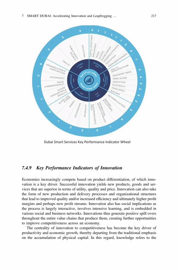
Dubai Smart Services Key Performance Indicator Wheel
7.4.9 Key Performance Indicators of Innovation
Economies increasingly compete based on product differentiation, of which inno-vation is a key driver. Successful innovation yields new products, goods and ser-vices that are superior in terms of utility, quality and price. Innovation can also takethe form of new production and delivery processes and organizational structuresthat lead to improved quality and/or increased efficiency and ultimately higher profitmargins and perhaps new profit streams. Innovation also has social implications asthe process is largely interactive, involves intensive learning, and is embedded invarious social and business networks. Innovations thus generate positive spill oversthroughout the entire value chains that produce them, creating further opportunitiesto improve competitiveness across an economy.
The centrality of innovation to competitiveness has become the key driver ofproductivity and economic growth, thereby departing from the traditional emphasison the accumulation of physical capital. In this regard, knowledge refers to the
7 SMART DUBAI: Accelerating Innovation and Leapfrogging … 217
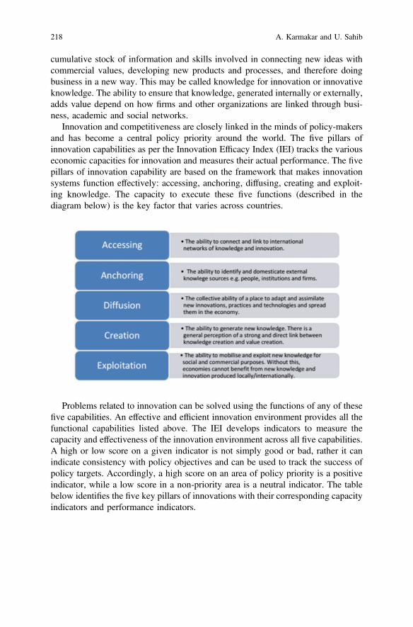
cumulative stock of information and skills involved in connecting new ideas withcommercial values, developing new products and processes, and therefore doingbusiness in a new way. This may be called knowledge for innovation or innovativeknowledge. The ability to ensure that knowledge, generated internally or externally,adds value depend on how firms and other organizations are linked through busi-ness, academic and social networks.
Innovation and competitiveness are closely linked in the minds of policy-makersand has become a central policy priority around the world. The five pillars ofinnovation capabilities as per the Innovation Efficacy Index (IEI) tracks the variouseconomic capacities for innovation and measures their actual performance. The fivepillars of innovation capability are based on the framework that makes innovationsystems function effectively: accessing, anchoring, diffusing, creating and exploit-ing knowledge. The capacity to execute these five functions (described in thediagram below) is the key factor that varies across countries.
Problems related to innovation can be solved using the functions of any of thesefive capabilities. An effective and efficient innovation environment provides all thefunctional capabilities listed above. The IEI develops indicators to measure thecapacity and effectiveness of the innovation environment across all five capabilities.A high or low score on a given indicator is not simply good or bad, rather it canindicate consistency with policy objectives and can be used to track the success ofpolicy targets. Accordingly, a high score on an area of policy priority is a positiveindicator, while a low score in a non-priority area is a neutral indicator. The tablebelow identifies the five key pillars of innovations with their corresponding capacityindicators and performance indicators.
218 A. Karmakar and U. Sahib
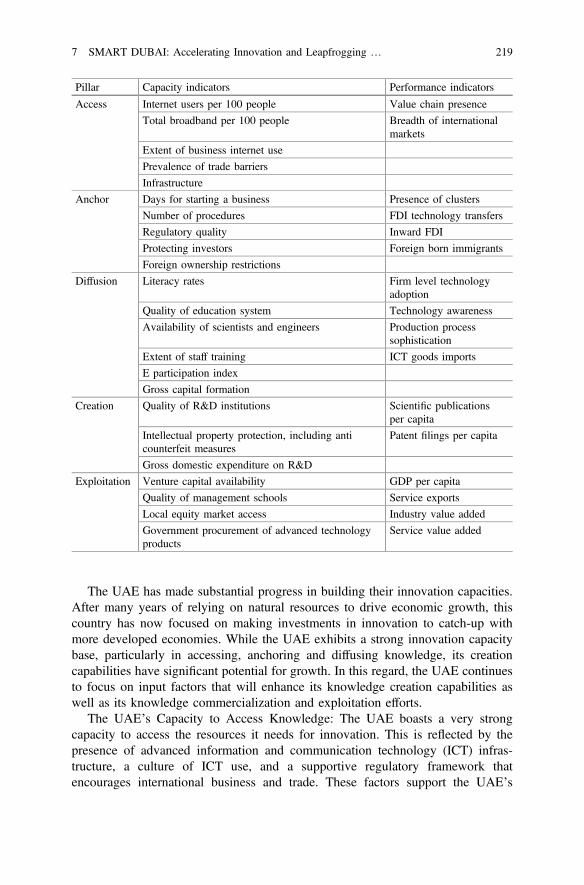
Pillar Capacity indicators Performance indicators
Access Internet users per 100 people Value chain presence
Total broadband per 100 people Breadth of internationalmarkets
Extent of business internet use
Prevalence of trade barriers
Infrastructure
Anchor Days for starting a business Presence of clusters
Number of procedures FDI technology transfers
Regulatory quality Inward FDI
Protecting investors Foreign born immigrants
Foreign ownership restrictions
Diffusion Literacy rates Firm level technologyadoption
Quality of education system Technology awareness
Availability of scientists and engineers Production processsophistication
Extent of staff training ICT goods imports
E participation index
Gross capital formation
Creation Quality of R&D institutions Scientific publicationsper capita
Intellectual property protection, including anticounterfeit measures
Patent filings per capita
Gross domestic expenditure on R&D
Exploitation Venture capital availability GDP per capita
Quality of management schools Service exports
Local equity market access Industry value added
Government procurement of advanced technologyproducts
Service value added
The UAE has made substantial progress in building their innovation capacities.After many years of relying on natural resources to drive economic growth, thiscountry has now focused on making investments in innovation to catch-up withmore developed economies. While the UAE exhibits a strong innovation capacitybase, particularly in accessing, anchoring and diffusing knowledge, its creationcapabilities have significant potential for growth. In this regard, the UAE continuesto focus on input factors that will enhance its knowledge creation capabilities aswell as its knowledge commercialization and exploitation efforts.
The UAE’s Capacity to Access Knowledge: The UAE boasts a very strongcapacity to access the resources it needs for innovation. This is reflected by thepresence of advanced information and communication technology (ICT) infras-tructure, a culture of ICT use, and a supportive regulatory framework thatencourages international business and trade. These factors support the UAE’s
7 SMART DUBAI: Accelerating Innovation and Leapfrogging … 219
so-called Accessing Capacity and enable the country to link to international net-works of knowledge and innovation, as well as to advanced markets. According tothe 2012 GII rankings, the UAE is ranked 37th internationally in total innovation.
The UAE’s Capacity to Anchor Value Creation Activities: The UAE hasdemonstrated a relatively strong anchoring capability despite its fairly youngeconomy. It is ranked 62nd internationally. Anchoring is an important indicator ofhow well a country is engaged in two-way flows of learning and investment.The UAE boasts favourable attributes such as reduced time and procedures forstarting a business; efficient government agencies that permit and promote privatesector development; and the strength of laws providing investor protection, as wellas a visa system that facilitates the inflow of necessary skills from overseas.
The UAE’s Capabilities in Diffusing Knowledge: For an economy to fullybenefit from the strengths of its accessing and anchoring capabilities, it needs apopulation and a workforce that are well educated and highly skilled. These areessential preconditions for the spread of learning from accessing and anchoringactivities. Diffusion capacity facilitates the spread of value creation activities usinginnovation. The UAE has made great strides in this area, especially if one comparescurrent education attainment levels with those of previous generations.
Investment in education has also helped close the gender gap as well as the gapbetween urban and rural areas. For example, the educational opportunities offeredrecently to Emirati women in the Emirate of Abu Dhabi, the ratio of female to malestudents, up to the secondary stage, increased from 95% in the academic year2000/2001 to 98.7% in 2009/2010. These levels have been accompanied by animprovement in the quality of the education and training on offer.
Another area, in which the UAE has achieved remarkable success, is the level oftechnology adoption. In the Global Information Technology Report, the UAE wasranked 30th (in 2012) in the Networked Readiness Index, which measures thedegree to which economies across the world leverage ICT for enhanced competi-tiveness. This positive result is largely attributable to a strong commitment on thepart of the UAE Government to developing a world-class ICT infrastructure.
The UAE’s Capabilities in New Knowledge Creation: The ECC indicates that, inthe last five years, the number of registered UAE patents has almost doubled.The UAE now generates the highest number of patents per capita in the GulfCooperation Council (GCC) region. This largely attributable to increased spendingon R&D and the launch of initiatives such as the UAE Offset Program (subse-quently the UAE’S Industrial Development Program). Such efforts are an integralpart of the UAE’s future development, as expressed in the national strategic policyof Vision 2021. Consequently, the UAE’s capacity to produce scientific andtechnological output has increased dramatically in recent years, as reflected by therise in the number of local and foreign scientists and researchers working in theUAE.
As per the latest Global Competitiveness Report, the UAE is ranked 15thinternationally in terms of the availability of scientists and engineers. There has alsobeen an increase in the number of programs, funds and awards geared towards
220 A. Karmakar and U. Sahib
scientific and technological activities. Examples of research and innovation awardsthat reward top-quality talent include the Young Emirati Innovators Prize, thePatent Filing Award, the University-Industry Research Collaboration and the ZayedFuture Energy Prize. The latter offers a USD 4 million prize the world’s largestaward for innovation in the development of sustainable energy solutions.
Amongst the GFCC countries considered in this report, the UAE is ranked 4th interms of its existing capacity to create new knowledge. The UAE has witnessed themushrooming of institutes of higher education over the last decade, some of whichhave a strong research component. Growing from only nine universities in 2000,the UAE is now home to more than seventy-five universities and institutions ofhigher education. As is the case with all countries, however, the UAE cannot affordto specialize across all scientific fields. Most its research and scientific activitieshave concentrated on key and strategic pockets of science and technology (S&T),such as renewable energy and health sciences.
The UAE’s Capacity to Generate New Economic Value: One major challengefacing governments and companies around the world is the valorisation ofknowledge. Several constraints on knowledge valorisation are often cited, notablythe lack of an entrepreneurial culture, a weak Venture Capital (VC) base and apunitive insolvency law, among others. The UAE, overall, performs above averagein its ability to exploit resources for the creation of new value. Two areas in whichthe UAE excels are the effective use of skilled international talent and governmentfinancial support for S&T activities.
Venture Capital activity has been increasing in the UAE, despite the facts that itsbusiness environment is a relatively young one, and that some businesses tend to belarge family-owned firms, which are less likely to seek investments from VC firms.Other factors that have traditionally limited the supply and demand of VC activityin the region are constraints on foreign ownership in certain sectors, and the absenceof preference shares frequently used in western VC finance. Therefore, compared toother asset classes of private equity and buy-outs, VC remains a less popularfunding option in the UAE.
Supporting Entrepreneurs in the UAE: Encouraging entrepreneurs is a mainplank for the UAE, and is well recorded in Abu Dhabi and Dubai. The work hasrecently been undertaken by government agencies to improve the climate for smallbusinesses. Moreover, many banks in the UAE now have dedicated centres forSmall and Medium-sized Enterprises (SMEs) and offer special loan packages.Government initiatives aimed at supporting entrepreneurs include the Khalifa Fundfor Enterprise Development in Abu Dhabi and the Mohammed Bin RashidEstablishment for Young Business Leaders in Dubai. The Mohammed Bin RashidEstablishment for Young Business Leaders offers office space, administration,incubation facilities, funding and training for Emirati businesses. Various funding,training and support services, the Khalifa Fund for Enterprise Development offers arange of programs that combine entrepreneurship and social development such aspublic programs rehabilitate prison inmates, providing them with an opportunity to
7 SMART DUBAI: Accelerating Innovation and Leapfrogging … 221
enter the business sector and be reintegrated into society. Other programs aim topreserve the local heritage.
7.5 Why Is Innovation Vital for E-Democracy?
Open government and smart city apps have disrupted the centuries old democraticnorms of people approaching government for availing its services, voicing theirconcerns and seeking redressel. Interaction in a smart city is switched whereby thegovernment has the opportunity of being ever present on people’s fingertipsthrough a smart phone app. The government’s main challenge therefore shifts toensuring people’s inclusive participation and helping them climb the participationladder from unawareness to impact participation across all age groups, abilities andcross sections.
To accomplish this feat using the state of the art Information andCommunication Technologies requires creative innovation. In all smart citiesaround the globe, innovation, co-creation and co-management has taken the centralstage for citizen engagement, particularly the youth. Innovation motivates people toengineer out of the box solutions for the various problems faced by the residents ina city. Innovation in a smart city is therefore not a luxury, but a critical means ofkeeping up with changing circumstances and opportunities. Making people smartand enabling them to co-create leads to perfection and to realize the full potential ofthe human resource leading to a happier city.
To sustain innovation, businesses attract and retain the most creative and pro-ductive minds. Innovative governments also need to attract talent, perform effi-ciently and continually upgrade their systems and services. They have to empowertheir citizens to develop their full potential and become drivers in transforming theircity to a smart city.
7.5.1 Smart Dubai: Accelerating Innovation
UAE recognizes innovation as a cornerstone of social and economic developmentand key to promoting economic growth, increasing competitiveness and providingnew job opportunities. Believing that innovation is the future of human investment,the UAE Leadership emphasizes its importance across all sectors through the UAEVision 2021: “Innovation, research, science and technology will form the pillars ofa knowledge-based, highly productive and competitive economy, driven byentrepreneurs in a business-friendly environment where public and private sectors
222 A. Karmakar and U. Sahib
form effective partnerships.” The Cabinet directed all federal government bodies toboost cooperation and to revise their policies to develop a nurturing environmentfor innovation. The following initiatives [21] have been taken to achieve theobjectives.
(a) Creation of a new job post—CIO of Innovation—for every governmentdepartment.
(b) Established Mohammed bin Rashid Centre for Government Innovation whichaims to develop government operations and enhance UAE’s competitiveness,making UAE one of the most innovative governments around the world.
(c) The UAE Cabinet approved the designation of 2015 as the Year of Innovation,in a plan to make the UAE a world innovative leader.
(d) In order to foster innovation, UAE launched the idea of innovation week andinnovation prizes to be held every year, starting November 2015. It is one of thelargest innovation initiatives in the world and a consolidated effort by gov-ernment, the private sector and individuals to help create a widespread cultureof innovation in the UAE and strengthen its position as a global hub forinnovation. The activities touch upon different themes such as exhibitions thatshowcase innovative products and services, the launch of new national initia-tives, hackathons and competitions, interactive programs such as labs andworkshops, engaging talk sessions and fun evening activities in public places.
Dr. Tim Jones, the programme director of Future Agenda [22], the world’slargest open foresight initiative, highlights 3 three business innovations for UAE[23].
(a) Education Revolution
Broader access to improved education is seen as a major catalyst for empowerment,sustained economic growth, overcoming inequality and reducing conflict. Many seethat we need an education system fit for the digital revolution, not one still based onpractices from a century or so ago. The idea of ‘teacher-less’ classrooms wherelearning comes from the likes of YouTube, Coursera.com and multiple ‘MOOC’s israpidly gaining traction and, with it, the shift in the role of the teacher from thesource of content and information to that of coach and curator. Implicit within thisis a change in standards and accreditation away from traditional exam bodies to aworld where knowledge and skills are gained from multiple sources. While manyare keen to accelerate this shift and help better prepare the next generation for theworld ahead, the challenge in some regions is in finding parents willing to let theirown children be the pioneers, and experiment with this new model. As governmentsseek to improve the human capital of their nation, balancing this is key.
(b) Energy Storage
Energy storage, and particularly electricity storage, is now seen as the missing piecein the renewables jigsaw. If solved, it can enable truly distributed solar energy aswell as accelerate the electrification of the transport industry. Core to this is the
7 SMART DUBAI: Accelerating Innovation and Leapfrogging … 223
overnight, localised storage most often associated with batteries and an area wherelithium-ion and air technology is rapidly improving performance. However, it is notjust batteries that are undergoing innovation as there are multiple other options foralternative energy storage including hydrogen, hydro, heat and momentum.Bringing to the market a low-cost, highly efficient solution that can be adopted inmany applications is a focus for many researchers and success will drive a majorchange across the whole energy landscape.
(c) Data Marketplaces
Many see that data is now becoming a currency. It has a value and a price, andtherefore requires a market place. An ecosystem for trading data is now emergingand several leaders see that anything that is information can be represented in newdata marketplaces. Especially as we shift from bi-lateral sharing of data to a moreopen and transparent approach, how a stock exchange for data would work is beingdebated around the world. The challenge is that unlike a simple time vs. valuemarket as exists for shares or commodities, a data market place would have an extratwo dimensions of variance. Many would only want to access data and not own itand the value that one party would place on a particular piece of information willnot necessarily be the same as another party. Solving this conundrum is no easytask, but if achieved it could change the way business and society interact.
All three of these are clearly major global opportunities but also areas withsignificant potential to help move things forward. Whether by proactively testingnew approaches to education, investing in the most promising energy storagetechnologies or even creating the supportive environment for a data marketplace.
7.5.2 Global Innovation Index (GII)
The UAE ranked first [24] among Arab countries and 41st worldwide in terms ofoverall performance on the index, up from second in the Arab World and 47thglobally in 2015.
The 2016 Global Innovation Index measured the performance of 128 countriesand economies in the area of innovation which represents the majority of the globalworkforce and global GDP. The index is based on 82 sub-indices which measureinnovation in detail and provide a clear understanding of how it drives economicgrowth and prosperity.
The index results attribute the outstanding progress of the UAE to its sustainableachievements in innovation inputs, especially the strengthening of institutions andmarket sophistication. The UAE has one of the best political and legislative envi-ronments in the world along with outstanding development in information tech-nology, communications, infrastructure, and innovation linkages.
224 A. Karmakar and U. Sahib
7.5.3 National Innovation Strategy
In 2014, UAE launched a National Innovation Strategy [25] with a seven year planthat aims to make the UAE among the most innovative nations in the world. Theobjective of the National Innovation Strategy is to stimulate innovation in sevensectors where innovation plays an essential and integral role in achieving eachsector’s key strategic objectives. These seven sectors are: Renewable energy,Transportation, Education, Health, Technology, Water and Space. The strategy willfulfil the demand for a constant flow of new ideas, as well as innovative leadershipusing different methods and tools to direct the change.
UAE’s National Innovation Strategy requires all government agencies to cutspending by 1% and dedicate the savings to research and innovation.
A new Dh2 billion (USD 544 Million) fund was recently announced to providefinancing for start-ups and to support them in transforming ideas into projects. TheMinistry of Finance will guarantee commercial loans to finance projects, and drawin support from commercial banks and investment funds.
3 distinct innovation types are identified: Business Innovation, TechnologyInnovation and Science Innovation. The goal of the UAE’s Science, Technologyand Innovation policy is to achieve robust science and technology-based innovationas described below.
7.5.4 Science, Technology and Innovation (STI) Policy
Framing the STI policy [26] is a turning point in UAE’s march towards progress,economic diversification and prosperity and aims to prepare UAE for a post oilworld. STI policy forms the roadmap to make UAE among the most innovativecountries in the world. It will allow UAE to transition into a knowledge andinnovation based economy and to enhance scientific and technological innovationsin its public, private and academic sectors. The STI policy identifies 24 focus areaswhich are chosen considering present and future national needs, aligning withinternational trends and UAE’s capabilities and unique assets.
24 selected focus areas are; Education Innovation and Technology, HealthInformation Technology and Bio-informatics, Public Health, Non-CommunicableDiseases and Wellness, Biotechnology and Genomics, Water Management andEconomics, Solar and Alternative Energy Technology Systems, Space Sciences,Cubesats and Nano satellites, Cyber security, Semiconductor Process Development,Robotics and Artificial Intelligence, Smart City Applications and Solutions,Architecture and Urban Design, Arabic Digital Technology, Financial ServicesTechnology, Petroleum Geosciences, Internet of Things and Big Data, AdditiveManufacturing (3D Printing) Advanced Building and Construction Materials, FoodSecurity, Transportation Logistics, Analytics and Security, Aerospace Advanced
7 SMART DUBAI: Accelerating Innovation and Leapfrogging … 225
Materials, Manufacturing, Maintenance and Testing, Commercial Unmanned AerialVehicles and Autonomous Vehicles.
7.5.5 Smart Dubai Innovations
Innovation is a key driver in a smart city to enable the youth, in particular, to findcreative ways to solve various challenges to improve the life experiences of itsresidents and visitors.
Since 2015, Dubai has accelerated the pace of Innovative projects and isexpected to continue. The following sections give an insight on these innovations.
7.5.5.1 Museum of the Future
To mark 2015 as the year of innovation, Museum of the Future [27] is built toshowcases how technology over the coming years will transform governmentservices. The museum’s motto “See the future, create the future” reflects a newapproach to government innovation. Rather than just displaying exhibits or pub-lishing reports, the new institution will use design, technology prototyping andforesight to create real examples of change. The Museum is the first of its kind, andrepresents a leading example of entrepreneurial governments embracing changeand creating futuristic visions for a better world. The Museum will host innovationlabs focusing on health, education, smart cities, energy and transport and a per-manent section on the greatest global innovations. It will provide a platform todemonstrate and test the latest inventions from world-leading tech giants andup-coming start-ups, as well as collaborations between companies and leadingresearch institutes and universities. The museum is set to open by the end of 2018.
7.5.5.2 Smart Dubai Platform
Announced in March 2016 [28], the Smart Dubai Platform is a digital backbonepowering the city in the near future, in partnership with Du, the telecom operator.The Smart Dubai Platform will be the central operating system for the city pro-viding access to city services and data for all individuals, private sector as well aspublic sector entities. This will facilitate:
(a) collecting data from thousands of new sensors to be installed across Dubai onroads, parking lots, building entrances, public parks, curbs etc. or in digitaldevices such as smartphones, analyse the information and then share it live inreal-time.
226 A. Karmakar and U. Sahib

(b) exchange of open and shared data between the public sector, private sector andindividuals, creating new opportunities for engagement in accordance with theDubai Data Law, contributing to the smart city future of Dubai.
(c) enhance synergies between government and private sector services, optimisingcost and delivering time saving benefits to both organisations and customersalike.
(d) augment real-time and data-driven decision making capabilities for the citygovernment, enabling city leaders to engage in community-wide dialogues andanalyse rich city data across multiple dimensions.
(e) leverage the latest technological innovation to facilitate the exchange anddelivery of city data and services, to make Dubai a more seamless, safe, effi-cient and impactful city experience for all residents and visitors.
Billed as the “digital backbone powering the city in the near future [29],” thenew Smart Dubai Platform will begin operation in the third quarter of 2016 and willhelp achieve smart city targets in six key pillars; smart life, smart transportation,smart society, smart economy, smart governance and smart environment. NeXgen’sYousef Khalili and Andrew Rippon outline the benefits and pitfalls [30] of Smartcity platform as follows:
Efficiency: The Smart City Platform brings the ability to make governmentsmore efficient in their growing need for technology systems. It provides a private orhybrid cloud environment where any number of government systems can be hostedand improve timelines to providing services. Cities need no longer invest in newdata centres and hardware as they can use the City cloud. The Smart City platform,enhanced with ubiquitous wireless networks, can create a true IoT environmentwhere sensors are automatically detected on the network and their data plugged intothe platform. By centralizing control functions into a city control centre, day to dayrunning of the city becomes more efficient and new enhanced capabilities arebrought forward, such as proactive management. This function adds agility to citygovernments, to the benefits of their stakeholders.
Interoperability: Most cities have a myriad of systems today, from road tolls tolicence registration to planning to financial management and beyond. The SmartCity Platform empowers cross system or entity workflows and data exchangethrough the use of controlled data stores, APIs and guaranteed messaging.
Data governance: As more of a city’s interactions become dependent on digitalsystems, data governance becomes essential. The Smart City Platform is thephysical implementation of data laws and guidelines that enables sharing databetween government entities and onwards to the private sector safely.
Entrepreneurship: The Smart City Platform is a technology incubation plat-form for encouraging start-ups and to help deliver services for the city throughcrowdsourcing. If the city has problems to solve, they can be offered to the marketby exposing data and technology infrastructure or tools that would enable any sizeof private entity to respond, down to the individual entrepreneur or developer.
Transparency: Through the sharing of data and interoperability of systems,cities gain efficiency and the ability to bring about new services for residents,
7 SMART DUBAI: Accelerating Innovation and Leapfrogging … 227
visitors and companies. Transparency is achieved through data dashboards, as wellas the release of catalogues of data and new applications that reduce barriers forpeople and create new opportunities. This is especially true where real time data isused to give more timely transparency when there is the case of emergency or eventmanagement.
Prediction of needs: Using Big Data analytics, cities are in the position to moreaccurately predict the resident’s needs and provide services even before the resi-dents know they need them.
New uses of data: New applications and uses of data can be discovered throughthe combination of data sets that were not previously intended to combine.Examples of this include the use of company registration data to predict CO2
creation and determining traffic impacts from event registration data.The potential security and budgetary issues are:Security: In effect a smart city platform becomes a honey pot for malfeasants as
the multiple systems they had to hack before are now wrapped up into one. This iswhy security has to be a key concern at every layer of the platform, whileempowering the open use of data.
Budgetary issues: Legacy thinking can result in a new platform built on oldprinciples that do very little to improve city resident’s lives and consumes largebudgets. A root and branch approach needs to be taken to adopt modern method-ologies as well as systems.
Ultimately the importance of a Smart City platform lies in the benefits that it canbring to residents, visitors and companies within a city. By making current servicesmore efficient and enabling new outcomes, the Smart City Platform becomes thecentral lever of execution for city government.
7.5.5.3 Driverless Vehicles
Masdar City in Abu Dhabi has been using autonomous vehicles for ferrying pas-sengers locally. Dubai implemented driverless vehicles in April 2016 on experi-mental basis in downtown Dubai carrying 10 passengers and has been extended tobusiness bay district over a 650 meters long track. Dubai targets 25% of cars to bedriverless on Dubai roads by 2030 and is framing rules and legislations forimplementing smart mobility strategy for deploying autonomous vehicle for the firstand the last mile transportation in residential, business centers and parks.
The car-booking service Careem and Next Future Transportation, part of Dubaismart government initiative, showcased driverless electric pods for the mass-transitsystems of the future. The pods can move individually or attaching themselves toother pods forming a modular bus that allows passengers to move freely from onepod to another. The pods can pick up passengers on demand and drop off todifferent locations as the pods can attach and detach according to passenger’sdestination selection. This driverless mass transportation system is efficient, safeand carbon friendly.
228 A. Karmakar and U. Sahib
7.5.5.4 Hyperloop
Dubai will be the first city in the world to implement fully operational high speedland transportation for goods and passenger transport by 2020. Hyperloop [31] is abroadband of transportation that uses pressurised capsules on air cushions in giantreduced pressure tubes, simulating an aeroplane. It can reach a speed of 1200 kmper hour, lesser (USD 40 Million per km2) than a metro, energy efficient,on-demand and safe, reducing travel time between 2 cities that are within 2–3 hoursof today’s automobile driving limits. Cities in the UAE are well poised to takeadvantage of this technology. Roads and Transport Authority, Dubai who isimplementing this project expects hyperloop to bring all UAE cities within10–12 min reach, thus enabling business and resident’s higher mobility and free-dom to live in any city. This can be further stretched by residents using smartphoneapp to order driverless self-driving pods that can provide door to door servicepicking passengers and connecting to hyperloop.
7.5.5.5 3D Printing and Smart Buildability Index
In line with international technology trends, Dubai is the first mover on embracing3D printing. The world’s first 3D printed office and first 3D-printed Smart Palms aredone in Dubai. The 3D-printed office provides valuable insights on the realapplication of 3D printing technology wherein a 3D-printer, equipped with anautomated robotic arm measuring 20 ft high, 120 ft long and 40 feet wide was usedto print a 2690 ft2 building with the labour cost reduced by more than 50% com-pared to conventional buildings of similar size. Benefits of 3D printing include 80%reduced construction costs, 70% lesser time to build, 50% man power, 25–30% ofcurrent emissions and 30–60% lesser construction waste.
UAE has standardised 3D printed buildings with a smart buildability index [32].It aims to standardise building designs that adopt modern building techniques suchas 3D printing and use locally manufactured steel structures, pre-fabricated pillarsand walls. The Index seeks to promote the use of techniques and materials thataccelerate construction processes, increase productivity and rationalise the use ofunskilled labour.
7.5.5.6 UAV—Drones
UAE has given a big thrust on UAV and has developed several applications onusing Drones for safety, security, environment monitoring and research. DubaiPolice and Roads and Transport Authority are using drones to monitor traffic, checktraffic accidents, survey condition of roads, structural analysis, event monitoring,monitoring projects and mapping. Sharjah police drone program called sakhab isused to prevent suicide from high rise building by using a camera and sim card totalk to suicide person and negotiate them to safety. Environmental protection
7 SMART DUBAI: Accelerating Innovation and Leapfrogging … 229
Agency, Abu Dhabi has used drones to monitor the high population of turtles inKalba’s (Eastern UAE) mangroves, which are notoriously difficult to count. UAEgovernment has instituted Drones for Good award with a prize pool of over onemillion USD to promote civilian drone technology to serve humanity. Security isthe main concern however in using drones and the UAE government is working onlegislative framework for commercial drone usage.
7.5.5.7 Robotics
In order to attract students and young scientists into innovation in robots, UAE hasintroduced a number of challenges and awards. The UAE National RoboticsChallenge is held by Abu Dhabi Education council every year to select teams toparticipate in World Robot Olympiad (WRO). In 2016 [33], 375 teams comprisedof 1,500 students participated in the challenge that aims to promote creativethinking, improve communication/cooperation skills and expose students to latesttrends in Science, Technology, Engineering and Mathematics (STEM).
The UAE AI & Robotics Award for Good with a prize of USD 2Millon aims toencourage research and development of innovative solutions in artificial intelli-gence and robotics to meet existing challenges in the categories of health, educationand social services.
7.5.5.8 The Global Blockchain Council
Dubai Museum of the Future Foundation has established the global blockchaincouncil [34] to promote using next generation of banking technologies to enhanceUAE’s position as a leading centre for innovation and knowledge economy. Thecouncil consists of 46 members drawn from government entities, internationalcompanies, leading UAE banks, free zones, and international Blockchain tech-nology firms. To promote blockchain and digital currencies, the council holds anannual conference hosting high-profile individuals, workshops, awareness sessions,hackathons, and start-up conferences.
Blockchain is defined as a digital protocol to carry out transactions and transfermoney using a wide network of computers around the world requiring digitalcurrencies, accurate documentation and absolute trust between all stakeholders.Known primarily as the public ledger of Bitcoin transactions, blockchain helpmaintain tamper-proof lists of all data records and enables secure value exchangesfor money, stocks or data access rights. Unlike traditional trading systems, nointermediary or central recording system is needed to track the exchange. Instead,all parties deal directly with each other. Blockchain can be both private and publicthat enables people to choose whether to share or withhold the personal details ofthe stakeholders. Transactions on Blockchain can go through only if all themembers approve thereby limiting the chances of fraud and money laundering.As the digital currency cannot be forged or damaged, it can be moved across
230 A. Karmakar and U. Sahib
borders with ease and also facilitates the shopping process across social media andwebsites.
Booz Allen in its report [35] highlights Blockchain as integral to smart cities anddigital economy. The main benefits are reduced cost of transfers and near real-timepayment, increased data integrity and efficiencies through automation, providetime-stamped verification and attribution, protection from hacktivism and cyber-crime, digitally transparent transaction systems, plays an important role in incu-bating regional start-up ecosystem and support for industries such as healthcare,transport and finance. Smart city governments can also extract tangible value fromvast amounts of data that can be used to meet changing consumer demands atminimal additional costs.
Dubai blockchain council has initiated a number of pilot projects [36] to promoteblockchain technology; ‘BitOasis’ that focuses on Bitcoin exchange to secure‘flexidesk’ contracts and registration processes using blockchain ledger. ‘TradeFlow’ will provide digital financial transaction services to reduce costs, increaseoperations security, unify transaction procedures and provide super-fast servicesround the clock. ‘Dubai Points’ which aims to incentivise tourism by awardingpoints to tourists when they visit a tourist destination. ‘Digital Wills’ to registerwills using blockchain links in order to enable clients transfer their properties tobeneficiaries using a fast and secure process while complying with local regula-tions. ‘Operation Kimberley’ that will modernise the verification process of dia-mond sources and their trade mechanisms and to issue global certificates related tothe diamond industry by coordinating the activities of its 81 member countries.‘Health Records’ that aims to create a unified digitised health records in hospitalsand clinics to provide a modernised record system that is fast and efficient andcapable of saving many lives.
7.5.5.9 Private Innovation and Incubation Centers
(a) Visa launches RIC: Visa in partnership with TECOM opens RegionalInnovation Center in Dubai [37] designed for technologists, financial institutionsand developers to co-create the next generation of payment and commerceapplications. This center will serve the Central and Eastern Europe, Middle Eastand Africa (CEMEA) regions and is part of a network of new innovation centers.Other flagship innovation centers are in San Francisco and in Singapore. Visaenvisions encouraging and fostering innovation, entrepreneurship and digitaladvancements. This will support the local start-ups and entrepreneur communitythrough mentorship and guidance programs, Leveraging each other’s networksfor the promotion of digitally advanced and innovation related solutions,Collaborating on pilot programs, tests and trials within the TECOM GroupCo-launching Design Thinking workshops and supporting local hackathons anddeveloper workshops.
7 SMART DUBAI: Accelerating Innovation and Leapfrogging … 231

TECOM has initiated in 5 Incubation arms in 2013 to support the growth ofentrepreneurs and start-ups across different verticals thus enforcing a solid entre-preneurial ecosystem in the region as well as the launch of the Innovation Hubwhich will see over 15,000 business professionals prosper to stimulate innovationand excellence across technology, new media, education and life sciences.
(b) The Emirates Group, along with co-founders GE and Etisalat are propellinga start-up incubator in the aviation travel-technology [38] field for youngentrepreneurs and university students in the UAE called “Intelak,” which means“taking off” in Arabic. The initiative will contribute to the country’s innovationecosystem and help develop local talent in high-tech fields. Structured as acompetition, the program is open to Emirati-led teams of 3–5 people whopropose innovative ideas that will make air travel simpler, better or moreexciting at any point along the travel experience—from the moment one leaveshome through the airport to flying in the aircraft.
(c) GE and the UAE Ministry of Economy have signed a cooperation agreement[39] to support the UAE government in embedding innovation into its orga-nizational culture. GE, whose cultural ethos and heritage is founded on inno-vation helps spark innovation through open innovation challenges targetinglocal issues, localized research facilities, regional innovation centers,region-specific white papers and locally held GE Garages workshops.
(d) Huawei and Dubai South has signed an MOU [40] to Collaborate on SmartCity Innovation for bringing future-city capabilities and services to DubaiSouth’s Business Park Free Zone. Huawei’s Smart City and Safe City Solutionswill provide enhanced services to residents and businesses in the Park. UsingNew ICT, governments can enable a properly connected safe city wherevisualization and collaboration are embedded into the city’s infrastructure tomaximize public safety. This enables the safe city to become a critical com-ponent in smart city development
(e) UN centre of excellence in Dubai [41]. This centre will provide trainingactivities, research analysis and publications that focus on education, technol-ogy and transport which can be compared with best practices around the world.
7.5.5.10 E-Democracy Innovations
There are a number of other innovations worth mentioning that directly benefitresidents.
(a) Unified Traffic Control [42] introduced by Dubai’s Roads and TransportAuthority (RTA) considering the doubling of vehicles from 2006 (0.7 M) to2016 (1.4 M). The unified Traffic control will connect 408 traffic signalswirelessly to optimize junction traffic light sequences based on traffic volume.Road users are now able to see traffic congestion, road works and accidents ontheir mobile in real-time in order to adjust the travel plans.
232 A. Karmakar and U. Sahib

(b) Al Raqeeb System from RTA is a smart system to detect exhaustion signals inbus drivers while sitting behind the wheels. Meant to provide added safety topublic transport riders, the Raqeeb system has reduced fatigue or exhaustionrelated cases among bus drivers by 88%.
(c) Real bus departure information from RTA provides 4 screens distributed inDSO show 4 lines of real bus departure information. This will be rolled out inother areas as well.
(d) Taxi Hailing company careem much like uber has tied up with Dubai Taxiagency to book taxi using a mobile app. User can either book the vehicle oftheir choice in advance or instantly and track the car in real-time. Payment canbe made either by cash or deducted from registered credit card.
(e) Smart Energy Grid [43] initiated by Dubai Energy and Water Authority(DEWA) plans to install 250,000 smart meters in residential, industrial andcommercial properties by 2018. Consumers are able to monitor electricity andwater consumption, tailor utility usage to their needs and reduce wastagethrough mobile apps. Residents are also motivated to install photovoltaic panelson their rooftops, collect solar energy and sell power back into the grid.
(f) First charging station for electric vehicles is introduced by Dubai SiliconOasis Authority (DSOA) [44] with the goal of Install Seven Additional Stationsby 2017.
(g) Smart Lamp Posts installed at Tech Park by DSOA in cooperation with Dubaicivil defense allows People to report emergencies. Using motion sensors, thesmart street lights will provide 25% visibility until triggered to full power byapproaching vehicles and pedestrians. This allows for less energy consumption,prolong the life of electric bulbs, and reduce operational costs and carbonimpact. Additional sensors can be added to the street lights for collecting andsharing information and data on the surrounding environment, such as pollutionand weather conditions or even relay CCTV, advertising messages and/orsafety warnings.
(h) Smart Waste Management System [45] from DSOA is achieved by installingsensors in garbage bins that would send alerts when the bin was full and neededemptying. With this new technology, garbage collection vehicles would taketrips to empty the bins only when full, thus reducing their total number ofoverall trips leading to lower operating costs and a reduction in CO2 emissionsresulting in a cleaner environment. In addition to measuring how full the bin is,the system also gives an overview of the total weight and volume of the waste.Using this data, DSO plans to implement further technologies on how to reduceoverall waste in the future. DSO today is monitoring 95 bins through the smartsystem and aims to increase the number to 120 by the end of 2016.
(i) CloudOne [46] announced by Dubai Smart Government offers anenterprise-grade, scalable, agile, multitenant infrastructure as a service (IaaS)cloud computing solution for government services. This service provides a fullyautomated environment for the approval and provision of on-demand ITresources, saving time and reducing the cost of IT management in governmentagencies.
7 SMART DUBAI: Accelerating Innovation and Leapfrogging … 233
(j) Media Cloud Services offered by Du is Middle East and North Africa’s firstmedia Cloud services aimed to simplify media management for broadcasters,content producers and providers.
(k) Smart City Diploma [47] Rochester Institute of Technology (RIT) Dubai, anon-profit global campus of the RIT in New York, started offering a Diplomacomprises of a series of modules related to the pillars of a smart city including:Economy, Governance, ICT, Environment, Health, Education, Security,Mobility and Infrastructure, and People.
(l) Master’s degree in Smart City [48] Offered by RIT Dubai with PolytechnicUniversity Spain. This unique and innovative master’s degree is the first of itskind in the region. With 1000 government services expected to go smart in2018, this course explores what cities are and what they can be. It goes beyondthe concept of a smart city to also cover important urban, social and sustain-ability issues to ensure a comprehensive and holistic approach to the cities oftoday and of tomorrow.
(m) Intel Jointly Set up Smart City Center of Excellence in the Middle East thatwill support the development of a smart city center of excellence and inno-vation within Dubai Technology Entrepreneurship center (DTECT). The centerimplemented the region’s first water saving subsurface irrigation system [49] inline with its tri-pillar CSR strategy. The initiative aims to reduce the currentirrigation water consumption levels and related operational costs by almost40%.
7.5.6 Dubai Design District (d3)
The d3 [50] is a greenfield benchmark for districts around the world, showcasingsmart initiatives designed to improve the experiences of its visitors, tenants andbusiness partners. An array of smart service initiatives including smart parkingmetres, smart energy metres and smart waste management combine to truly bring anew degree of sustainability, resource management and energy efficiency to life atd3. With additional security through smart access control and more innovative waysof utilising data through data virtualisation, d3 stays ahead of customer and markettrends and therefore enhances the experience of its commercial and retail businesspartners and better serves d3 as a community.
Since 90% of Middle East design market is driven by fashion, furniture andarchitecture, d3 hosts the in5 design business incubator. This will act as a catalystfor start-ups and students in design to prototype using 3D printers, electronics andmodern machinery working with metals, wood, plastics and textiles.
d3 will usher in a new wave of innovations in IoT and digitisation that arealready part of a smart city. D3 will serve as a smart city benchmark for the rest ofthe world’s emerging economies to follow. Through the 21 smart initiatives
234 A. Karmakar and U. Sahib
introduced at d3, Dubai wants to change the way business is conducted acrosssectors and to deliver a greater quality of life and experience for millions of people.
7.5.7 Building Smart Cities in Other Countries
In recognition of Dubai’s leadership in smart city experience, Dubai Holding wasawarded the multi-billion dollar project [51] to establish a Smart City in Seoul,South Korea. Covering an area of 51 million square feet, Smart City Korea will bestrategically located between the two cities of Seoul and Incheon, close to twointernational airports.
In February 2016, Dubai Holding inaugurated Phase 1 of Smart City Kochi’soperation in Kerala, India. It is a city that is designed to cater to knowledge servicesand information technology.
The company also inaugurated Smart City Malta in collaboration with theMaltese government in 2014.
7.6 Dubai’s Green City Initiatives
The global energy landscape is rapidly changing. Increased energy demand inemerging markets, uncertain energy prices and international pressure to reducecarbon emissions, mean governments and businesses see the economic and securitybenefits of shifting to clean energy. The unprecedented growth of energy demandduring Dubai’s infrastructure development has increased the need to find a prudentstrategy for the security of supply and the diversification of fuel sources.
The UAE has long been an important supplier of energy and is now becoming anincreasingly relevant consumer of energy as well. In its efforts to accelerate thedevelopment of additional hydrocarbon reserves and in its efforts to contribute tothe development and implementation of alternative energy sources, the UAE hopesto continue its long tradition of responsible energy stewardship.
Increased energy demand in emerging markets, uncertain energy prices andinternational pressure to reduce carbon emissions, mean governments and busi-nesses see the economic and security benefits of shifting to clean energy. TheUnited Arab Emirates (UAE) is at the heart of this shift—the same as it was at theheart of the last energy boom. And just as its massive oil reserves provided aspringboard for the incumbent energy revolution, its huge solar resources andcutting-edge technology development are shaping the region as a hub for the new,clean energy revolution.
The UAE government agencies are seeing the benefits of renewable energy, themost influential companies—looking to secure low cost power supply—are alsotaking advantage of the abundance of solar energy in the country.
7 SMART DUBAI: Accelerating Innovation and Leapfrogging … 235
Since the formation of the United Arab Emirates in 1971, energy and naturalresources have been closely linked to its growth. Today, sustainable energy hasbecome a key factor in our efforts to promote economic, environmental and socialgrowth, and the key driver for sustainable development and the preservation of theenvironment
The Dubai Supreme Council of Energy is tirelessly working to achieve theinitiative of HH Sheikh Mohammed bin Rashid Al Maktoum, Vice President andPrime Minister of the UAE and Ruler of Dubai, entitled ‘Green Economy forSustainable Development,’ to promote the use of renewable sources of energy.
The Supreme Council of Energy has formulated the Dubai Integrated EnergyStrategy 2030, with the purpose of diversifying sources of energy, so that by 2030,gas will provide 71% of Dubai’s total power output, nuclear energy will provide12%, Clean Coal 12%, and Solar Energy will provide 5%. We are also working toreduce energy demand by 30%. The Council organized the Dubai Global EnergyForum in 2011 and in 2013, to highlight the most prominent issues of energy,environment and sustainability
An annual State of Energy Report, Dubai 2014, which has been launched by theSupreme Council of Energy. This report is one of the key factors of continuousprogress to achieve the objectives of the Dubai Integrated Energy Strategy 2030.This report defines the key issues, required plans and important analysis of thesustainable energy sector in Dubai.
On January 15, 2012, HH Sheikh Mohammad bin Rashid Al Maktoum, theVice-President and Prime Minister of the UAE and Ruler of Dubai, announced thelaunch of a long-term national initiative to build a green economy in the UAE underthe slogan ‘A Green Economy for Sustainable Development’. This initiative aims atmaking the UAE one of the global pioneers on the green economy. HH SheikhMohammad bin Rashid Al Maktoum noted that “our goal from this national ini-tiative is clear, that is, to build an economy that protects the environment as well asan environment that supports the growth of the economy”. For growth to be ‘green’it must be based on a low-emissions development model and on more efficient useof energy and other natural resources; these are two key pillars of the UAE strategyfor achieving a Green Economy [52].
7.6.1 UAE Vision 2021
This vision specifically mentions the need to develop and promote sustainableenergy as one of the key challenges facing the UAE and an important opportunityfor the future. It notes that “we want the UAE to sustain its drive toward economicdiversification, as this is the nation’s surest path to sustainable development in afuture that is less reliant on oil.” In the face of climate change and its elects oncurrent and future generations, and with the vision for an economy based onsustainable energy, UAE Vision 2021 supports initiatives to catalyse more sus-tainable use of energy and to be instrumental in the battle against climate change.
236 A. Karmakar and U. Sahib
The UAE is committed to playing its part in developing and implementing solutionsto reduce its carbon footprint while leading new innovations to achieve the goals ofscaling-up sustainable energy solutions.
7.6.2 Dubai Strategic Plan 2015
To ensure proper focus on sustainable development in the context of Dubai’sconsiderable economic growth, Dubai Strategic Plan 2015 aims to integrate sus-tainable energy solutions into energy supply and demand, to meet the Emirate’sgrowing needs in a sustainable manner. It also highlights the concept of excellenceas a core to Dubai’s government policy to ensure that it leads by example onsustainable development initiatives.
7.6.3 Dubai Integrated Energy Strategy 2030
The Dubai Integrated Energy Strategy supports the vision of the Dubai SupremeCouncil of Energy to emerge as a global and regional best practice and role modelin development and use of sustainable energy. As per this strategy, improvingenergy demand efficiency in Dubai could close the energy supply gap by up to 40%in 2030. The most substantial efficiency improvement opportunity is in the build-ings, commercial and residential sector which is Dubai’s largest consumer ofenergy. In addition to improving the overall efficiency, Dubai is also pursuing anenergy supply diversification strategy. The Energy Diversification Strategy, part ofthe Dubai Integrated Energy Strategy 2030, has defined targets for renewableenergy to supply 1% of Dubai’s energy mix by 2020 and 5% by 2030. This hasrecently started with initial pilot solar initiatives which will serve as a base fordeveloping large-scale solar starting in 2020, once the technology has attainedcost-competitive levels.
(a) Creation of jobs
The government also recently launched its Green Growth Strategy to create160,000 new jobs by 2030, which aims to bring a total boost to the country’s GDPof up to 5%. The country’s low carbon efforts are also illustrated by the factrenewables projects worth a combined US$1 billion are currently being developed.
(b) Public private participation
The ruler and the Crown Prince of Dubai and Chairman of the Dubai ExecutiveCouncil, has launched the Dubai Green Economy Partnership to position Dubaifirmly amongst the global cities that are leading their transition to green economies.A group of committed public and private sector leaders convened to realise thevision of the Crown Prince of Dubai. Their aim was to identify how best to
7 SMART DUBAI: Accelerating Innovation and Leapfrogging … 237

encourage market leadership, innovation and investment in people, in a collabo-rative manner. A few months later, they formed a strategy framework and a clearroadmap to guide our actions through 2015.
This integrated strategic direction is driven by Dubai’s energy key-players, whohave shaped a common vision supported by a defined roadmap that will regulate themarket and draw investors in clean energy technologies. Dubai is promotingthe principles of Public Private Participation (PPP) and introduced laws to boost themarket dynamics for partnership on several projects, beginning with the solar andclean coal power generation.
In addition, the regulatory framework for district cooling and Energy ServiceCompanies (ESCO) is underway to ease implementation where the efficiency ofbuildings can be attained.
To make renewable energy more attractive, the Dubai Supreme Council ofEnergy and the Regulatory and Supervisory Bureau has developed theFeed-in-Tariff and Technical Codes for Independent Solar Power Producers andseek to have them ratified by the Government of Dubai before the end of 2013.
(c) Inclination towards the use of solar power
Solar power offers the strongest economic opportunity. Other technologies such asgeothermal and hydrogen power are viable complements in the UAE’s renewablesjourney, but due to falling costs coupled with the region’s vast resources, solar isnow accepted as the key competitive alternative to oil in the UAE.
The UAE has so far only set modest targets to increase renewable energy. Itsbiggest cities, Abu Dhabi and Dubai aim to provide just 7% by 2020 and 15% by2030, respectively, of their energy needs through renewables. But these relativelylow renewable targets should not be mistaken for a lack of ambition. Based on theincreasing capacity of renewables in the region, compared to other members of theGulf Cooperation Council (GCC) and even the MENA (Middle East & NorthAfrica) region as a whole, the UAE is in fact already leading the way.
7.6.4 Practice in the Field of Clean Energy
The government’s UAE Vision 2021 clearly sets out its goal to reduce the nation’sdependence on fossil fuels while increasing the use and development of renewableenergy. [53].
(a) Use of energy efficient lighting
Dubai has witnessed its first large efficient lighting initiative in 2014. Dubai Carbondistributed compact fluorescent lamps (CFL) along with information on energysavings in households throughout the Emirate. The awareness campaign was toprovide approximately 800,000 11 W and 23 W CFLs free of charge.
238 A. Karmakar and U. Sahib
• Use of LED lamps for outdoor commercial lighting such as advertising boards• Introduction of Bio-fuel technology in one of their vehicles (pilot study).• Introduction of Electric cars for in-compound transportation.• Introduction of Solar powered speed cameras by Dubai Police.• Emirates Energy Star to help Dubai Police calculate their footprint from elec-
tricity use, while monitoring and controlling their buildings more efficiently.
(b) Application of green building standards
Applied ‘Green Building’ standards and codes for all their new buildings that are tobe approved by the Dubai municipality to finalize the design/ planning process forconstruction. The Supreme Council of Energy’s strategy to reduce energy con-sumption in existing buildings by 30% [53].
(c) Use of solar power
Dubai Electricity and Water Authority (DEWA) and Saudi Arabian power companyACWA will build a 200-MW solar power plant providing electricity at 5.85 centsper kilowatt-hour—the lowest solar electricity price in history. Once complete, theMohammed bin Rashid Al Maktoum Solar Park will be the UAE’s biggest.Generation will be further boosted by Dubai’s recent announcement to invest US$3billion to increase capacity from 1 gigawatts (GW) to 3 GW. The park will also behome to a renewable technology research and development center, as part of thecity government’s aims to make Dubai a renewables hub.
The government’s future energy company Masdar—a huge investment which initself signals the UAE’s desire to be a leader in the clean technology market—recently opened one of the world’s largest concentrated solar power farms, calledShams 1. The facility has a 100 MW capacity, which will supply power to 20,000homes in the UAE. The project is a joint venture between Masdar, French Total andSpanish Abengoa Solar, and when fully constructed, will account for almost 68% ofthe region’s renewable energy capacity.
Masdar also has a joint venture with BP called Hydrogen Power Abu Dhabi, tobuild the world’s first hydrogen-fuelled power plant to run on natural gas, limitingemissions by using carbon capture and storage technology. The hydrogen powerplant will generate around 400 MW electricity, and could provide more than 5% ofall Abu Dhabi’s current power generation.
Another critical to the region is access to fresh water, so Masdar City is currentlytesting desalination plants powered by renewables, with a goal of having com-mercially viable desalination facilities throughout the UAE by 2020. Although thistechnology is crucial to the region, the UAE also recognizes its global importanceas climate change puts increasing pressure on current freshwater resources.
The City is also planning to build the Gulf’s first geothermal energy facility,with cooperation from Icelandic company Reykjavik Geothermal—another way toexplore the full range of renewable energy options available.
The major telecommunications companies ‘Du’ and ‘Etisalat’ are leading in thelocal commercial sector. Du has just completed its fifth solar site installation whichis well on its way to becoming 100% renewable, and joins four more sites in the
7 SMART DUBAI: Accelerating Innovation and Leapfrogging … 239
UAE that are already running on 100% solar energy. Etisalat has large solar stationsat 50 locations in the UAE, as well as solar and wind power in Egypt andAfghanistan.
Leading businesses from many other industries in the UAE are also beginning toinvest heavily in renewables. ICT-enabled services company, Pacific ControlsSystems is using solar PV systems in its Dubai headquarters that generate around50 kW of energy to power its own lighting.
Dubai Airports and DEWA have partnered to build 100 rooftop solar panels thatwill supply 48.8 MWh—about two thirds of the building’s power—to the airport [54].
(d) Dubai smart grid
In line with the Smart Dubai vision, the Dubai Electricity and Water Authority(DEWA) developed a comprehensive Smart Grid strategy with the aim to connectrenewable energy sources and promote environmental initiatives. DEWA has beena Strategic Partner of Smart Dubai since inception in 2014, and through the SmartGrid contributing to making Dubai a smart city.
The Smart Grid consists of three initiatives designed to ensure seamlesslyaccessible and nonstop connected water and electricity services that meet dailyliving requirements of supply while enabling monitoring to facilitate smart andenvironmentally friendly use of resources.
The first Smart Grid initiative aims to integrate renewable energy in form ofsolar power into houses and buildings. In supporting the leverage of given andforemost free, energy sources, DEWA encourages environmentally friendly whileeconomically driven behaviour within Dubai. While personal consumption can becovered autonomously through solar panels, DEWA enables to feed surpluses intothe common city-wide grid.
Within the second initiative Smart Meters will be installed into private andpublic spaces. These Meters provide automatic and detailed readings of individualconsumption enabling end users to better understand and manage their personalDEWA bills. 200,000 such Smart Meters will be installed and become fullyoperational by January 2016.
In another, third, initiative, DEWA commits to create an infrastructure forelectrically driven vehicles to be charged. Following the environmental initiative toincorporate solar energy into the Dubai grid, this initiative is another green goalDEWA realises.
Through the Smart Grid DEWA is supporting to turn His Highness’ vision intoreality by offering new smart initiatives and services to the community of Dubai[55].
(e) Solar park
The Mohammed bin Rashid Al Maktoum Solar Park was announced in January2012 in line with the vision and directives of His Highness Sheikh Mohammed binRashid Al Maktoum, Vice President and Prime Minister of the UAE, and Ruler ofDubai, to enhance the sustainable development of Dubai. It also supports the DubaiClean Energy Strategy 2050 to make Dubai a global centre of clean energy and
240 A. Karmakar and U. Sahib

green economy. The strategy also aims to provide 7% of Dubai’s energy from cleanenergy sources by 2020, 25% by 2030 and 75% by 2050. DEWA is managing theSolar Park, which is the largest renewable-energy project on a single plot in theworld with a planned production capacity of 5000 MW upon completion in 2030[56].
(f) Use of LED lights
The Roads and Transport Authority (RTA) has started replacing traffic lights inDubai with halogen bulbs by LED power-saving technology. This drive comes aspart of the RTA’s safety and environmental push to enhance the traffic safety leveland keep abreast of the green economy drive. The project will be carried out inphases and phase one is now under way. The bulbs will also save around USD236,000 a year in expenditure, of RTA’s Traffic and Roads Agency.
The new (Light Emitting Diode) lighting system will last longer (about tenyears) while using the least power. The low-maintenance bulbs are also morereliable and efficient than conventional lighting [57, 58].
(g) Use of solar power to light up Dubai parks and streets
Dubai Municipality aspires to construct public parks, neighbourhood gardens andpublic squares by relying entirely on the solar energy sources to operate all facilitiesof these parks as well as operating the lighting elements and irrigation systems fortrees and green spaces (Zero Energy parks). The General Projects Department atDubai Municipality has excelled, using environmentally friendly components andtechnologies aiming to create a suitable environment to help optimizing the use ofpower with innovative designs that take into consideration the use of solar energy.
The streets and roads of Dubai dazzle in the night are also considered for the useof solar powered lights and use of LED for the roads and traffic signals as anenvironment friendly drive.
(h) Becoming a sustainable city
For a city to be sustainable it needs to encompass the three main pillars of sus-tainability: Environmental, Economic and Social sustainability. Ultimately, the keygoal of any sustainable city should be to provide residents and workers with thehighest quality of life together with the lowest environmental footprint.
A good sustainable city is one where people want to live, work and visit.Dubai, also recently announced plans for additional sustainable projects such as
the Desert Rose, a 14,000-ha smart city expected to accommodate 20,000 plots forEmiratis and will cost 20 billion AED to build. There is a pattern emerging fromthese developments—the United Arab Emirates is already emerging as a globalleader in sustainability. This pattern became increasingly apparent, after Dubairecently set targets for itself to become one of the most sustainable cities by 2020.
The growing development boom is clearly going to set a challenge for Dubai toachieve its sustainability ambitions by 2020. A key challenge is educating privateand public stakeholders about the main principles of building sustainably, withoutincreasing the built cost. Cost is currently the main deterrent factor for most
7 SMART DUBAI: Accelerating Innovation and Leapfrogging … 241
developers, as it is a common belief that building sustainably means more cost, thusreducing profit margins, which for developers is understandably an outrightturn-off.
From the beginning of each project it is important for the client and consultantteam to develop a series of sustainable initiatives and targets. These targets will helpguide the design in the pursuit of the sustainability goals. They can be divided intocategories such as: Water, Health and Well-being, Energy, Materials, Pollution,Ecology, and Waste.
If we take water as an example, the ultimate design intent for any sustainableproject would be to minimise net water use by increasing efficiency and re‐use,which can be achieved by [59]:
• Recycling water and by encouraging the collection and re‐use of rainwater toreduce the demand for potable fresh water.
• Looking at highly efficient and smart irrigation systems and storm water design.• Installing smart water efficient fittings, water metres and appliances.• Maintaining and improving the quality of ground and surface water.• Low-water use landscaping.
7.7 Smart Dubai: E-Democracy Initiatives
E-democracy is the use of technology for strengthening the mechanisms ofdemocratic decision making. While E-voting achieves automation in the votingprocess, E-participation involves citizens in the policy process giving rise to twodifferent sets of relationship between citizens and policy makers. The first is avertical relationship in which policy makers use the speed and immediacy ofinformation technology networks to consult citizens on various policy issues. Thesecond is a more complex, horizontal and multi-directional interactivity in whichcitizens and groups will be able to make use of information available from multipleonline sources to bring pressure to bear on their government. The latter may alsotake the form of e-activism or the use of ICTs by civil society organisations toadvocate their view points and influence political or policy process.
Dubai has carried out a number of initiatives to foster E-democracy with thecentral theme of making residents and visitors happy.
7.7.1 Minister of Happiness, Youth and Tolerance
Happiness as a measurement first planted its seed in the public imagination in 1972when it was declared that Bhutan, a Buddhist kingdom on the Himalayas’ eastern
242 A. Karmakar and U. Sahib
edge with a population of just 790,890 [60], had created a Gross NationalHappiness index. Its principles were based on equitable social development, cul-tural preservation, conservation of the environment and promotion of good gov-ernance and the rest of the world were quick to sit up and take note.
Since then, four national governments [61] namely Bhutan, Ecuador, UAE andVenezuela have appointed ministers of happiness responsible for coordinating theirnational efforts.
UAE in its twelfth cabinet of 2016 [62] appointed Minister of Happiness,Minister of Tolerance, Youth Minister and Minister of The Future. This is a bigleap taken by the UAE President and Prime Minister of the UAE for nationaldevelopment based on core values, led by youth and focused on a future inwhich everyone achieves happiness. These new portfolios intend to empowerpeople and not hold power over them. Within a smart city framework, it willnurture an environment of E-democracy in which people create and enjoy theirown happiness. Through this, UAE also sets a precedent to governments in theregion for revising their role and creating an environment in which people canachieve their dreams and ambitions instead of the current environment wheregovernment is meant to control. Shaikha Lubna, the Minister of State forTolerance said [63] “Happiness and tolerance are values, not services, an integralpart of all of us”. “It doesn’t matter who you are, what you are, or where you’refrom. The UAE provides a common path for everyone. It is the land of dreamsand opportunities.” This is a very strong commitment where 85% expatriatesco-exist in harmony.
7.7.2 Tolerance Institute and Award
Dubai with 200+ nationalities and many languages, the spirit of tolerance hasgained lot of importance. Dubai launched [64] the International Institute of toler-ance and Shaikh Mohammed Bin Rashid Award for Tolerance in October 2016 as aglobal initiative with the aim of encouraging tolerance, co-existence and honourchampions of tolerance. The Tolerance award is categorized into Human thought,literary creativity, arts, youth projects and new media aimed to reinforce tolerancein the Arab region. The tolerance institute will offer expert views on policies forpromoting values of tolerance among nations, release studies on root cause offundamentalism and sectarianism. It will further work towards instilling principlesof tolerance among youth and nurture ground for tolerance and counteringextremism. To demonstrate its commitment to tolerance for the whole world, theyear 2017 has been dedicated as the year of tolerance by the UAE government.UAE stands 1st in Arab world for tolerance and 3rd in world.
7 SMART DUBAI: Accelerating Innovation and Leapfrogging … 243
7.7.3 Dubai Smart Cities and GovernmentExcellence Forum
Dubai Smart Cities Forum [65] is a series of thought leadership sessions orga-nized by Mohammed Bin Rashid School of Government (MBRSG) in cooperationwith Dubai Smart Cities Initiative. The initiative convenes experts, decision-makersand leaders from both public and private institutions in a creative and stimulatingenvironment to share experiences and best practices, debate challenges and workcollaboratively towards achieving Dubai’s smart city ambitions. The forum’s ses-sions highlight local and global smart city trends in sectors such as management,manpower, urban development, services, infrastructure and planning. Sinceinception in 2014, the forum has become a point of reference to public and privateorganizations in the UAE and beyond in relation to smart cities
The Dubai Government Excellence Forum (DGEF) [66] from DubaiExecutive council is the apex agency for tracking Government Best Practices and topromote the concepts and applications of excellence, innovation, quality, andknowledge transfer. The DGEF organizes a number of programmes enabling youthto undertake their active national role as well as support them as a key foundationfor the future. In October 2016, the DGEP organized the 9th Dubai Forum forGovernment Best Practice under the theme Government of Youth, Government ofthe Future.
The UAE cabinet in 2015 launched a National Programme for GovernmentCommunication [66] to address society issues and national priorities based on theresults of study of Knowledge, Attitudes and Practices (KAP) in the UAE. Thisprogramme aims to realise positive changes in the people’s behaviour and lifestyles.The NPGC, to be implemented over seven years till the Golden Jubilee of the UAEin 2021, will consist of seven pillars. Healthy Children, Cohesive Family, QualityEducation, Green Ideas, Sustainable Food, Prosperous Future and Diabetes-freeUAE.
7.7.4 Dubai Open Data Initiative
Real-time data is driver of IoT and smart city innovations. The Dubai Data Law,which has been in force since December 2015 aims to improve efficiency betweenand facilitate the integration of services provided by federal and local governmentalentities. It envisages the use of available data held by ‘data providers’ are utilized tohelp inform government decision making, strategic initiatives, and policies. The lawalso aims to support innovation, economic development, foster competition, andhelp Dubai achieve its vision of becoming a “smart city”.
244 A. Karmakar and U. Sahib
In the Digital Economy, how organizations use real-time data is the main driverfor business competitiveness. Data can help cars from crashing into one another,governments to collaborate better, make factory floors safer and more efficient, andhelp people and healthcare providers to analyse their personal health instantly.
The Dubai Open Data Law sets out the terms for increased sharing ofnon-confidential information between government agencies and the public. Thenew law will make the data accessible to researchers, investors and servicedevelopers via an integrated platform, and create opportunities for collaborationbetween the public and private sectors.
The new law will unify Dubai’s data and remove the last legal obstacles forthose interested in investing in the digital economy. It will help authorities toprepare policies, implement plans and initiatives efficiently and effectively. Mostimportantly, the data law will also enable the emirate to achieve its vision of makingDubai a city that can manage data according to a clear and specific methodologyconsistent with international best practices.
Led by the Dubai Data Establishment, the Dubai Data initiatives has set 11strategic objectives [67] towards creating a culture of data sharing and innovation,aligned with three core principles for data sharing and publication; data use andre-use; and privacy, confidential information and intellectual property:
(a) Enable Dubai to achieve its smart city vision of becoming the happiest city(b) Managed data based on clear guidelines aligned with international best
practices(c) Achieve integration and harmony between the services provided by federal
government agencies and local government bodies(d) Optimise use of data for data providers(e) Promote transparency and establish governance rules on the dissemination and
exchange of data(f) Increase efficiency of services provided by federal and local government
entities, in terms of: level of quality, speed of delivery, simplification of pro-cedures, and reduced operational costs
(g) Increase competitiveness of data providers and raise UAE standing on inter-national competitiveness indices
(h) Improve decision making at federal and local levels to enable agencies toeffectively process data, prepare policies, and implement strategic initiatives
(i) Encourage and nurture a culture of innovation that will lead to better quality oflife for residents and visitors
(j) Balance the dissemination and exchange of data with preservation of dataconfidentiality and privacy
(k) Provide the necessary data for non-governmental actors in order to support theeconomic and development plans of the emirate.
Under the Open data law, the federal statistics are published [68] in the federalcompetitiveness and statistics Authority.
7 SMART DUBAI: Accelerating Innovation and Leapfrogging … 245
7.7.5 People Engagement
This is at the heart of E-democracy. With 200+ nationalities and a targeted 30million tourist arrivals by 2020, scores of languages, a multitude of cultures, dif-ferent levels of literacy and majority of blue collar workers poses a real challengefor the government to engage, Citizens, residents and visitors in the spirit of what asmart city is expected of. This section looks at the number of E-democracy ini-tiatives that Dubai has carried out.
(a) From Majlis to Hashtag: [69] The UAE cabinet had a tradition of holdingcabinet retreats since 2007 for brainstorming key issues among all stakeholdersbefore the cabinet meeting. In December 2013 the Prime Minister launched anational brainstorming session through twitter urging both citizens and resi-dents to send innovative fresh ideas on education and health that will beconsidered in the cabinet. This initiative generated 82,000 crowdsourced ideascategorized into 5 most vital issues faced in education and health sector. Thisdemonstrates UAE government’s commitment to E-democracy and engagingcitizens in governance through social media.
(b) Smart Majlis [70] has always been a national cornerstone. People gathered toshare ideas and create solutions. Today, in the era of the smart city and thegrowing community of Dubai, an e-smart majlis has been established to con-tinue receiving ideas and comments through electronic means. Mohammed binRashid smart majlis is a platform that allows everyone to participate in buildingthe future of Dubai and to submit ideas directly to the ruler.
(c) Online Chat and Crowd sourcing: [71] Most of the government websites andapps has the facility to do an online chat to seek answers to an issue or tosubmit ideas and suggestions on government service. Prominent among them isthe Ministry of interior and Energy and Water Authority’s crowdsourcingplatform called Ebtikari to encourage inventors and designers from around theworld to present their innovations.
(d) Happiness Meter: To measure people’s satisfaction and level of happiness onthe service delivery, Dubai installed happiness meters in several touch pointsstarting from a service counter to an app and the website. People after availing aservice has to simply push a button to indicate satisfied, neutral or dissatisfied.The data thus generated is used to create a happiness index. Evaluation of9 months data consisting of 2 million customers of 38 public entities shows89% happiness.
(e) Start Rating System: In order to bring a culture of excellence in government,Dubai has implemented a 6-star rating system for all its departments throughwhich service delivery is rated, to provide exceptional experience for customerhappiness across all service channels.
(f) Have Your Say [72] launched by Dubai Municipality since 2012 is ane-complaint and e-suggestion system that makes room for its employees to sharecreative ideas and innovative thoughts. There is an annual award for best employeeengagement program constituted by International Quality & Productivity
246 A. Karmakar and U. Sahib
Centre Middle East. This platform provides a unified system for suggestions andcomplaints of Dubai Government.
(g) Smart Palm [73] is palm tree-shaped, solar-powered tech hub provided byDubai Municipality to offer free Wi-Fi service along with charging points forsmart gadgets, the first of its kind initiative in the Middle East. This is a bigboon for residents and visitors due to the relative high data bandwidth costs inthe UAE. There are eight charging points on each Smart Palm, offering extremerecharging capability, two and a half times faster than a regular plug. SmartPalms also issue weather warnings in Dubai beaches.
(h) Free Wi-Fi and Li-Fi is an initiative launched by Smart Dubai and Du telecomoperator to provide free Wi-Fi across the emirate by the end of 2017 under theWi-Fi UAE plan. Light Fidelity (Li-Fi), a visible Wi-Fi connection is also beingexplored and rolled out in phases to meet the exponential growth of wirelessdata traffic by 2025.
(i) 2016 declared as Year of Reading [74] to create a generation of book loversand consolidate UAE’s position as a global capital for culture and knowledge.To mark the year of reading, Mohammed bin Rashid Library is being builtdesigned to be the largest cultural center in the Middle East and North Africa(MENA) region with 2600 seats and smart applications for co-creation.
(j) Library Kiosks are provided by Dubai Municipality in beaches and in variouspoints where people can borrow books.
(k) Future Council: [75] The UAE government is set to establish a world councilto implement technologies of the fourth industrial revolution. This council willdraw 5000 experts from all over the world and collaborate with government,private and civil public society to establish a framework to focus on renewableenergy, water and food security.
7.7.6 Community Development Authority (CDA)
CDA was Established in 2008 [76] to develop frameworks for social developmentin Dubai. It aims to enhance social development and national identity in coopera-tion with concerned bodies and strengthen citizens and residents’ roles in thecommunity. CDA takes care of people with disabilities, elderly, family, childrenand youth and other vulnerable groups. CDA has established a number of smart cityinitiatives for an inclusive engagement with all target groups.
A Local Majlis is established within the community, as a direct line of com-munication with local residents. CDA works in coordination with official authoritiesto find solutions to different social issues raise awareness and promote societaldevelopment through consistent lectures and meetings, to preserve national identityand bridge the gap between generations.
7 SMART DUBAI: Accelerating Innovation and Leapfrogging … 247
CDA provides an APP to access all community services including SocialBenefits, Human Rights Complaints, Social Studies and Research, Media Centre,elderly services and CDA Events.
7.7.7 Community Inclusive Engagement
Smart Dubai has launched a campaign “A City for Everyone” [77] in order to makeDubai a disability-friendly city by the year 2020 through projects and initiatives thatpromote the participation and inclusion of persons with disabilities in the com-munity, eliminating all obstacles that may stand in the way of them positivelyengaging in their environments, as capable individuals of society.
The campaign aims to promote equal opportunities, maintaining social cohesion,Building social capital and Minimizing and eventually eliminating social exclusion.Dubai enacted the disability law in 2014 which is in line with the UAE disabilityAct with a higher Committee for the Rights of Persons with Disabilities in theEmirate of Dubai in 2016.
Four Apps specifically aimed for differentially challenged persons.Communication service App called Sanad Relay for enabling people with hearingdisability or speech difficulties to communicate with persons or entities in thecommunity to receive the service they need in their daily life. CDA Dubai App toaccess all services for community services, CDA Sanad RV is the third app fortrack CDA’s Remote Vehicles moving across Dubai that offers Speech & LanguageTherapy, Occupational Therapy, Physical Therapy and general consultation. The4th App is Dubai Volunteers who can register and offer their services for CDAactivities.
7.7.8 Dubai Now
Dubai Now [78] is the first unified service platform that brings through a simplemobile app, more than 55 Smart services by 24 government and private entities,creating a seamless and efficient user experience for the citizens, residents andvisitors of the emirate. The aim is to combine most of the daily government needson a single login for everyone to have an equal access to all apps and services.
The apps in Dubai Now have 1 dashboard, 3 login boards offered by 22 gov-ernment entities grouped under 11 categories. The apps under the 11 categories arelisted below:
248 A. Karmakar and U. Sahib

7.7.8.1 Utilities and Bills
Pay DEWA, Etisalat, du, Dubai Municipality bills, Dubai Police traffic fines, payfor salik road tolls, bus and metro card and Dubai Customs Accounts. There arealso apps to donate to Dubai Cares and Al Jalila Foundation.
7.7.8.2 Driving
The apps under this category allows renewing vehicle registration, top up parkingtime, see road speed limits, view road accident notifications and traffic, find nearestpetrol station and Tasjeel (vehicle registration and testing centers).
7.7.8.3 Public Transport
Track Dubai Airport flight departures and arrivals, call a Taxi, View the Road andTransport Authority (RTA) metro map, journey planning to and from any point andview best routes.
7.7.8.4 Weather, ATM, Post and Address
View Dubai Calendar and Dubai’s daily weather conditions, find nearest ATM,Track Emirates Post (Empost) shipments and view shipping rates, send feedback orreport complaints regarding any government department service in Dubai, accessMakani (10 digit building number) to locate specific buildings and addresses inDubai. Municipality also provide Alif app for pets and Taheel app for digital devicerecycling.
7.7.8.5 Islam
View daily prayer timings, find nearest mosque and select the fastest route to reach.
7.7.8.6 Health
Find all doctors, clinics and hospitals registered with Dubai Health Authority(DHA), create a vaccination plan for child and track it, Find nearest pharmacy andview 24 h pharmacies in Dubai.
7 SMART DUBAI: Accelerating Innovation and Leapfrogging … 249
7.7.8.7 Residency Visas
Track status of the General Directorate of Residency and Foreigners Affairs(GDRFA) visa applications and entry permits for residents and visitors, view allresidency visas and entry permits of dependents.
7.7.8.8 Housing
View the Rent Increase Calculator from RERA (Dubai Land Department - DLD),Citizens access to Mohammed Bin Rashid Housing Establishment (MRHE) loancalculator and application status, request maintenance, View Dubai LandDepartment (DLD) daily and monthly transactions, view electricity and waterconsumption details and view status of your Ejari (rent) contract.
7.7.8.9 Security and Justice
Report a violation to Dubai Police, Find nearest Dubai Police Station, Inquire aboutthe status of Dubai Court’s cases, Call emergency numbers like Dubai Police,Ambulance, Fire Department, and DEWA.
7.7.8.10 Education
Find KHDA registered schools and universities, find their rating, annual fees,curriculum, level, location and other details.
7.7.8.11 Business and Employment
Search for trade activity with the Department of Economic Development (DED),Track and renew trade licenses registered with the Department of EconomicDevelopment (DED), Reserve a trade name with the Department of EconomicDevelopment (DED).
7.7.8.12 Guard App
CityGuard is a mobile application offered for free to all Abu Dhabi residents, be itUAE nationals, working expatriates, or visitors to the Emirate. CityGuard allowsthe public to report incidents and submit complaints related to the Abu DhabiEmirate directly to the government. With its slogan “Your City, Your Community,Your App” CityGuard aims to increase civic participation and collaborationbetween the public and the government in order to improve the Emirate at all levels.
250 A. Karmakar and U. Sahib
The aim of the app is to improve government services and the city image withthe help of the public. Therefore, several incident types such as public safety,consumer protection and environmental issues have been identified. Participatinggovernment entities are the three Municipalities of the Abu Dhabi Emirate, AbuDhabi Police, Department of Transport, Abu Dhabi Food Control Authority andHealth Authority—Abu Dhabi amongst others. CityGuard is another cornerstone inthe Abu Dhabi Government’s drive to engage with its customers across multiplechannels in order to maximise their feedback and collaboration in the servicedelivery enhancement process.
Through Abu Dhabi City Guard, the customer can instantly report any incidentsaround the Emirate by taking a photo, movie or audio of the reported incident anduse an embedded interactive map to locate the exact geographic position of theincident. The application automatically creates a case with the Abu DhabiGovernment Contact Centre which promptly assigns the case to the appropriategovernment entity for resolution. From open to closed, the case can be monitoredby the customer within Abu Dhabi CityGuard or online on abudhabi.ae or bycontacting the Abu Dhabi Government Contact Centre. The customer can call theAbu Dhabi Government Contact Centre to report any technical issue that isencountered during the usage of CityGuard, or to provide any feedback regardingthe application, its features and potential enhancements.
7.8 Summary of Findings
Dubai City has the heart and soul open to welcome people from all over the world,provide world class facilities for a happy living and foster a culture of reading,innovation and excellence. Since 2015, Dubai leadership is going in full gear oninnovation hosting anyone who has an idea on its focus areas, particularly theyouth. With a national innovation strategy in place and having established thenecessary legal and organization framework to achieve, the run up to the expo 2020will unfold much advancement in smart city and particularly E-democracy withelectronic voting on every government service touch points. The city in its trans-formation to a knowledge society is aggressively devising a strategy on how tosustain once it achieves the title of smartest and happiest city on earth.
Following list draws summary of key takeaways.
(a) Dubai leadership is able to effectively lay and communicate the clear vision ofmaking Dubai ‘the happiest city on earth’ to its citizens, residents and thevisitors.
(b) Agility, resilience and flexibility of the leadership for restructuring governmentfunctions and bodies as needed, if they find something they set up does notwork.
7 SMART DUBAI: Accelerating Innovation and Leapfrogging … 251
(c) Appointing Minister of Future, Tolerance, Youth and Happiness reflects thecabinet’s will to promote unity in diversity and to engage people from 200+countries in its governance.
(d) Established Dubai government accelerator consisting of five core sectors;human resources, environment, security, economy and education. The idea isfor 5 ministries to work as a single entity in one location to find suitablesolutions that can achieve the aspirations of the people.
(e) Effective utilization of social media for 2-way communication and to solvesocietal challenges with citizen centred crowd sourcing, co-creation andtransparency leading to trust in government.
(f) Time bound goal setting with clear measurement criteria and alignment withglobal indicators and international standards and measures of evaluation.
(g) Establishing a clear legal framework and mandate for innovation. Apportioningsufficient funding source gave the stakeholders freedom to stretch their imag-ination on Prototyping and piloting. The innovation fee received on all gov-ernment transactions ensures that it is well funded.
(h) Dubai has laid the foundation for smart city early on in terms of ICT and astrong IT infrastructure. In certain cases it was a greenfield (ICT in design)approach, but in many cases it was a brownfield that required working with thelegacy IT platform. Smart phone penetration of 80% and societal readiness toaccept government’s smart city initiatives and apps are important successfactors.
(i) Break the silos by bringing together all government departments on onecommon arena and inculcating the idea of ‘our city’ from ‘our department’ gaveall the stakeholders a common agenda.
(j) Thrust on Innovation led to collaboration, cooperation and co-creation ofchallenges faced in service delivery.
(k) Empower the youth and provide employment opportunity for them, as 65% ofMiddle East belong to this age group. The 2016 innovation week hackathonfocused on social innovation projects.
(l) Forge public private partnership to nurture talent and host smart city incubationcenters for finding solutions to worlds greatest challenges along the themes ofopportunity, mobility and sustainability.
(m) Open to ideas from all over the world. Continuous and on-going meetings anddiscussions with other cities to learn and adapt best international practices andopen heart to share experience with other cities.
(n) Make the government open and transparent and capturing people’s satisfactionlevel at every touch points through happiness meters resulted in institutional-izing e-democracy at every touch points. Moving away customer centric‘meeting expectation’ to people centric happiness.
(o) Embracing inclusive engagement of citizens, residents and visitors throughsocial media and promoting a culture of tolerance, reading, experimentation andcreative innovation through establishing dedicated centers, awards, prizes andsocietal recognition.
252 A. Karmakar and U. Sahib
7.9 Conclusion
The government of UAE is engaged in developing a strategy that ensures allsectors’ readiness for the future’s variability. The ministry is working on employingthe relevant tools to shape the future, which helps governments in forecastingopportunities, trends, challenges and future implications, analyzing their impact,developing innovative solutions and providing alternatives. It is currently workingon building capacity for the future and long-term planning capabilities throughseries of workshops for “Shaping Future”, to support the government entities effortsin developing innovative models for future services and design pre-emptive flexiblestrategic plans adjustable to any variability. It also aims to promote the utilization offuture trends, foresights and challenges in favour of improving the future of gov-ernment, and constantly reinventing for customer’s expectations fulfilment andsatisfaction. The ministry of Cabinet Affairs and the Future is assigned with thepost-oil portfolio, and following-up on the programs and policies pertaining to thenecessary measures this for a better future for coming generations.
UAE’s strategy for future involves building future models for the health, edu-cational, developmental, and environmental sectors, the harmonization of the cur-rent governmental policies, in addition to building national capacities in the field offuture foresighting, establishing international partnership, laboratories and launch-ing research reports on the future of the various sectors in the country.
The strategy aims at setting governmental systems that make fore sighting thefuture a part of the strategic planning in the government, and at launching studiesand scenarios to forecast the future of all priority sectors in addition to setting plansand policies. Furthermore, it will work on entrenching the culture of the future ingovernment, as well as spreading awareness about its importance and buildingcapacities and reinforcing the position of the UAE as a global destination for thefutures.
On the other hand, the UAE Strategy for the future focuses on topics that includethe priority sectors of: the future of the human and the youth capital, the future oftechnology and smart systems, the future of sustainability, the environment and theclimate change, the future of the infrastructure and the transportations, the future ofhealth, the future of education, the future of sustainable development, the future ofpositive and happy life environment, the future of energy, the future of economyand economic and commercial security, the future of financial resources, the futureof the government and governmental services, the future of international andpolitical relations, the future of water and food safety and the future of E-Security.
In building the future capacities, the leadership has instructed the establishmentof a strong organizational and material infrastructure in order to build the future andinvest in national cadres. In this regards, the government will build capacities toachieve sustainability in the field of future foresight through the introduction offuture foresight principles in a simplified way in the school curricula, and throughnational capacity building scholarships to overseas schools and institutions, as wellas through launching tools designed specifically for UAE government and teaching
7 SMART DUBAI: Accelerating Innovation and Leapfrogging … 253
future foresight specializations in the national universities and in the public capacitybuilding programs, in order to fulfil the requirements of all sectors.
UAE as a ‘Future Destination’, the Ministers will transform their ministries intoa model of future ministries, as they will represent the country as ambassadors to thefuture, and they will exhibit its future leadership in the various fields.
Finally, UAE government will work on positioning UAE as a global destinationfor the sustainable future and through the future oriented initiatives and futureplatforms, such as the World Government Summit, as well as through hosting newglobal initiatives like the Annual Meetings of the Global Future Councils. Inaddition, UAE government will also work on developing strategic partnerships withforums and futures think tanks, experts, platforms and networks, as well as uni-versities inside and outside the country.
References
1. E-Democracy: Strengthening the Participation of Citizens in Government, by WaltrautKotschy, available @ http://26konferencja.giodo.gov.pl/data/resources/KotschyW_pres.pdf
2. Dubai’s Legal System- Creating Legal and Regulatory Framework for a Modern Society, by:Andrew Tarbuck & Chris Lester, Published by Motivate Publishing, available @ http://www.id.gov.ae/assets/kKbkN9NSOGI.pdf.aspx
3. Demography Migration and the Labour Market in the UAE, by Gulf Labour Markets andMigration, year 2015, available @ http://gulfmigration.eu/demography-migration-and-the-labour-market-in-the-uae/
4. Population of UAE, year 2006–2014, by Gulf trading Economics.com, World Bank,available @ http://www.tradingeconomics.com/united-arab-emirates/population
5. Population of Dubai, Dubai Statistical Center, available @ https://www.dsc.gov.ae/en-us6. Dubai Tourism Statistics and Trends, year 2015, available @ http://www.go-gulf.ae/blog/
dubai-tourism-statistics-trends/7. Population of three Emirates by Nationality, Gulf News, year 2014, available @ http://
gulfnews.com/multimedia/infographics/general/demographic-trends-expatriate-population-in-dubai-sharjah-and-ajman-1.1562565
8. Dubai Tourism, Department of Tourism and Commerce Marketing, available @ http://www.visitdubai.com/en/department-of-tourism/about-dtcm
9. Dubai Expophoria 2020: A Message from the Desert on Mobility, Sustainability &Opportunity, by Dr. Nasser Saidi, Publication: PMI Congress EMEA, year 2014, available@ http://nassersaidi.com/wp-content/uploads/2014/05/Dubai-Expo-phoria-2020-May-5-2014-PMI-EMEA-Congress.pdf
10. Highlights of the U.A.E. Government Strategy, Year 2011-2013, available @ http://planipolis.iiep.unesco.org/upload/United%20Arab%20Emirates/United%20Arab%20Emirates_Governement_strategy_2011-2013.pdf
11. Understanding E- Democracy- Government led Initiatives for Democratic Reform, by JuleeFreeman and Sharna Quirke, Published by Journal of E- Democracy, year 2013, available @http://www.jedem.org
12. http://www.wam.ae/en/news/emirates/1395288828473.html13. http://www.futureagenda.org/14. http://gulfnews.com/news/uae/government/dh1b-fund-to-shape-future-of-key-sectors-1.181053915. https://dubaifutureaccelerators.com/en16. http://www.smartdubai.ae
254 A. Karmakar and U. Sahib
17. http://www.smartdubai.ae/foundation_pillars.php18. http://www.khaleejtimes.com/nation/government/no-room-for-procastination-shaikh-
mohammed-says-on-governance19. http://www.khaleejtimes.com/technology/dubai-smartest-city-in-the-gulf20. http://www.khaleejtimes.com/business/economy/uae-leads-arab-world-in-un-e-services-index21. http://www.uaeinnovates.gov.ae/innovation-ecosystem22. http://www.futureagenda.org/23. http://www.futureagenda.org/news/whats-on-the-future-agenda-three-business-innovations-
for-uae24. https://www.globalinnovationindex.org/gii-2016-report25. http://www.uaeinnovates.gov.ae/docs/default-source/pdfs/national-innovation-strategy-en.pdf?
sfvrsn=226. http://www.uaeinnovates.gov.ae/docs/default-source/pdfs/science-technology-and-innovation-
policy.pdf27. http://motf.ae/28. http://www.smartdubai.ae/pdfs/PR_SmartDubaiPlatform_EN.pdf29. http://www.innovationandtech.ae/smart-dubai-platform-rolled/30. http://www.itp.net/608411-why-do-cities-need-a-smart-platform31. http://www.khaleejtimes.com/nation/dubai/in-focus-expect-a-hyperloop-in-dubai-under-5-
years32. http://www.khaleejtimes.com/business/real-estate/uae-to-standardise-3d-printed-buildings-
with-new-index33. https://www.adec.ac.ae/en/MediaCenter/News/Pages/The-2016-WRO-UAE-National-Robotics-
Challenge.aspx34. http://mediaoffice.ae/en/media-center/news/17/2/2016/dubai-museum-of-the-future-foundation-
announces-launch-of-global-blockchain-council.aspx35. http://www.khaleejtimes.com/business/local/blockchain-integral-to-regional-smart-cities-
digital-economy-booz-allen36. http://www.khaleejtimes.com/business/local/dubais-global-blockchain-council-welcomes-
new-members-adopt-pilot-projects37. http://www.innovationandtech.ae/visa-opens-regional-innovation-center-dubai/38. http://middleeast.geblogs.com/en/stories/ge-industrial/aviation-and-travel-tech-incubator-
takes-off-in-the-uae/?gclid=CjwKEAjwtNbABRCsqO7J0_uJxWYSJAAiVo5LCpRO2EWtQUSRM-EjrYpFbdiVqu8bDsw_9zkrhG679RoC3svw_wcB
39. http://middleeast.geblogs.com/en/stories/ge-industrial/the-uae-inspiring-everyday-innovation-during-uaes-year-of-innovation/
40. http://m.dubaiprnetwork.com/pr.asp?pr=11168641. http://www.khaleejtimes.com/un-to-have-centre-of-excellence-in-dubai42. http://www.enterpriseinnovation.net/article/look-dubais-smart-city-initiatives-114125426643. https://www.dewa.gov.ae/en/customer/innovation/smart-initiatives/smart-applications-via-
smart-meters-and-grids44. https://www.dsoa.ae/en/dubai-smart-city/45. http://smartdubai.ae/partner_story_0524.php46. http://cloudone.dubai.gov.ae/47. https://www.rit.edu/dubai/smartcity48. http://www.khaleejtimes.com/nation/education/a-master-s-degree-in-smart-city-anyone49. https://www.dsoa.ae/en/news/dubai-silicon-oasis-implements-regions-first-water-saving-
subsurface-irrigation-system/50. http://www.khaleejtimes.com/business/real-estate/dubai-design-district-goes-smarter-with-21-
new-initiatives. http://www.dubaidesigndistrict.com/innovation/smart-city-2/51. http://dubaiholding.com/en/media-hub/press-releases/uae-south-korea-sign-agreement-develop-
smartcity-korea/
7 SMART DUBAI: Accelerating Innovation and Leapfrogging … 255
52. Economic Diversification in the GCC, by: Tim Callen, Reda Cherif, Fuad Hasanov, AmgadHegazy, and Padamja Khandelwal, Publication: IMF Staff Discussion Note, year 2014,available @ http://www.imf.org/external/np/seminars/eng/2014/mcd/
53. State of Energy Report- Dubai, State of Energy Report, by: UNDP, year 2014, available @http://www.undp.org/content/dam/rbas/doc/Energy%20and%20Environment/The%20State%20of%20Dubai’s%20Energy%20and%20Its%20Path%20to%20Green%20Economy.pdf
54. The UAE Hub of Next Energy Revolution?, by: UAE Analysis, year 2015, available @https://www.theclimategroup.org/sites/default/files/archive/files/RE100-UAE-brief.pdf
55. Powering Dubai on a Smart Renewable Grid, year 2014, available @ http://www.smartdubai.ae/partner_story_two.php
56. Dubai Solar Park-Mohammad Bin Rashid Al Maktoum Solar Park, By Dubai Electricity andWater Authority, year 2016, available @ https://www.dewa.gov.ae/en/customer/innovation/renewable-energy/solar-park
57. Dubai Traffic Lights going Green, year 2014, available @ http://ems-int.com/blog/dubai-traffic-lights-going-green/
58. Dubai Municipality Uses Green Energy Sources to Implement the Public Parks Projects, by:A Magazine for the Environmental Center for Arab Towns, year 2012, available @ http://en.envirocitiesmag.com/articles/pdf/envirocities-article3.pdf
59. Measuring Health gains from Sustainable development- Sustainable cities • Food • Jobs •Water • Energy • Disaster management, by: Public Health & Environment Department(PHE) Health Security & Environment Cluster (HSE)-World Health Organization (WHO)-Geneva 27, Switzerland, year 2012, available @ http://www.who.int/hia/green_economy/en/index.html
60. http://countrymeters.info/en/Bhutan61. World Happiness Report 2016| Volume I62. http://uaecabinet.ae/en/cabinet-history63. http://gulfnews.com/news/uae/government/shaikha-lubna-tolerance-is-a-value-not-a-service-
1.167860164. http://www.thenational.ae/uae/20161008/sheikh-mohammed-bin-rashid-launches-award-and-
institute-for-tolerance65. http://www.mbrsg.ae/HOME/Events-and-Lectures/Dubai-Smart-Cities-Forum.aspx66. http://www.dgep.gov.ae/67. http://www.smartdubai.ae/dubai_data.php68. http://opendata.fcsa.gov.ae/69. From Majlis to Hashtag: Engaging Citizens through Social Media - The UAE National
Brainstorming Session. Uae Ministry Of Cabinet Affairs70. www.MBRMajlis.ae71. https://www.dewa.gov.ae/en/about-dewa/news-and-media/press-and-news/latest-news/2016/
11/dewa-invites-public-to-innovation-week-on-20-24-november-201672. https://portal.dm.gov.ae/suggestions/hys/index.html73. http://gulfnews.com/news/uae/tourism/free-wi-fi-smart-palms-sprouting-in-dubai-1.149698574. http://www.uaecabinet.ae/en/details/news/mohammed-bin-rashid-on-presidents-directives-
2016-is-uae-reading-year75. https://www.weforum.org/events/annual-meeting-of-global-future-councils-2016/76. https://www.cda.gov.ae/en/socialcare/SocialBenefits/Pages/default.aspx77. http://mycommunitydubai.com/78. http://ameinfo.com/technology/innovation/dubai-plan-2021-6-smart-city-moves-gitex-2016/
Bibliography
79. Brett G, Lauren D (2013) Beyond transparency: open data and the future of civic innovation.Code for America Press, San Francisco
256 A. Karmakar and U. Sahib

80. Department of Economic and Social Affairs, United Nations, United Nations E-GovernmentSurvey 2016: E-Government in Support of Sustainable Development, www.publicadminis-tration.un.org
81. Dubai Press Club & Mohammed Bin Rashid School of Government (2014) UAE Socialmedia outlook: increasing connectivity between government and citizen. Emirates MediaForum
82. Faisal A, Governance and innovation program, MBRSG, Dubai Smart Cities Forum Series,Session 6: Bringing Smart Cities To Life. Mohammed Bin Rashid School of Government,Smart Dubai
83. Government of Dubai, Dubai Plan 2021, Dubai Pulse 2016 Report84. John H, Richard L, Jeffrey S, World happiness report 2016, vol I85. KPMG International, Future State 2030: the global megatrends shaping governments www.
kpmg.com/government86. Law No. (26) of 2015 regulating data dissemination and exchange in the Emirate of Dubai.
The Supreme Legislation Committee in the Emirate of Dubai87. Mohammed Bin Rashid School of Government, Policy Council 6, Building an Inclusive
Society: Supporting Youth Employment and Development in the Innovation Economy,www.mbrsg.ae
88. Mohammed Bin Rashid Centre for Government Innovation, Edge of Government: Publicinnovation from across the globe. Prepared for the World Government Summit by PM’soffice UAE. www.edge.worldgovernmentsummit.org
89. Neeraj D, Dnyanesh N, Gopalakrishnan H, KPMG International (2015) Dubai—a newparadigm for smart cities, KPMG, KPMG LLP and KPMG Lower Gulf Limited
90. Peter P, Noella E (2016) CeDEM16. Proceedings of the international conference forE-democracy and open government 2016
91. Mohammed Bin Rashid School of Government, The Governance and Innovation Program.From Majlis to Hashtag: Engaging Citizens through Social Media—The UAE NationalBrainstorming Session. Uae Ministry of Cabinet Affairs
92. Salem F (2016) A smart city for public value: digital transformation through AgileGovernance—the case of “Smart Dubai”. Dubai: Governance and Innovation Program,Mohammed Bin Rashid School of Government, World Government Summit
93. Soumitra D, Bruno L, Sacha W-V. The global innovation index 2016: winning with globalinnovation, Cornell University, INSEAD and WIPO
94. The Economist Intelligence Unit Limited 2016, Advanced science and the future ofgovernment, World Government Summit Thought Leadership Series, Prepared for the WorldGovernment Summit
95. The Executive Council, Government of Dubai. 2021 Dubai Plan. www.dubaiplan2021.ae96. Tina N, Maxwell School of Citizenship and Public Affairs, Syracuse University.
A Manager’s Guide to Evaluating Citizen Participation. Fostering Transparency andDemocracy Series 2012, IBM Center for the Business of Government
97. UAE Government, Vision 2021 UAE; United in Ambition and Determination. www.vision2021.ae
98. UAE Government, Minister of State for Tolerance, Tolerance: Co-existence, Tolerance,Peace 2016
99. UAE Government, Science, Technology and Innovation Policy100. Victoria G, Western Kentucky University. Participatory Budgeting: Ten Actions to Engage
Citizens via Social Media, IBM Center for the Business of Government. website: www.businessofgovernment.org
7 SMART DUBAI: Accelerating Innovation and Leapfrogging … 257
Chapter 8Smart Water Managementand eDemocracy in India
Prabh Bedi and Neha Goel Tripathi
Abstract Water management has become a key issue in the 21st century, withincreasing population, economic growth and climatic variability. Water is a stressedresource in India. Annual per capita water availability is expected to decline to1140 m3 by 2050, from 1545 m3 in 2011 (Government of India in Water man-agement, [1]). With 45% of population living in urban areas by 2050 (Shukla inHow India earns, spends and saves: unmasking the real India. Sage Publications,India, [2]), the availability of water will become a paramount issue. The availabilityof water is fundamental element to human life, economy and political stability andhence, sustainable water management is critical for existence. Government of Indiahas launched a Smart City Mission for building 100 Smart Cities, in which 24 7availability of water is one of the major emphasis. Traditionally water allocationdecisions have been the exclusive domain of technical experts, public officials orpolitical interests, but now there is a shift towards participative involvement ofother stakeholders, namely citizens. Adequate water being the essential input inSmart City, calls for an inclusive and participatory management of this resourcewhich extends beyond the city limits. Smart Water management in cities seeks toaddress challenges in the urban water management through integration of ICT andeDemocracy. Hydro-Informatic approache that is data driven and is technologybased can form the basis of analyzing the complexities in water management,particularly in water scarce areas. This chapter looks into inclusive and eDemocraticmeasures for planning of water smart cities. The need is to develop eDemocracybased collaborative planning efforts to tackle pervading water issues.
Keywords Water Smart city HydroInformatics Smart water management eDemocracy IndiaP. Bedi (&)Geospatial Information Technology Consultant, Visiting Faculty,School of Planning and Architecture, 4, Block-B, I. P. Estate, New Delhi, Indiae-mail: [email protected]
N.G. TripathiSchool of Planning and Architecture, 4, Block-B, I. P. Estate, New Delhi, Indiae-mail: [email protected]
© Springer Nature Singapore Pte Ltd. 2017T.M. Vinod Kumar (ed.), E-Democracy for Smart Cities, Advances in 21st CenturyHuman Settlements, DOI 10.1007/978-981-10-4035-1_8
259
8.1 Introduction
Water is the lifeline of human civilization. Since time immemorial, access to waterhas been a defining factor in the location of settlements. Important civilizationshave developed on the banks of rivers like Indus, Ganga, Nile, Euphrates, as therivers have provided water for farming and led to the thriving of cities. Dynastieshave been setting up their capitals on the banks of rivers and even today, majorcities like New Delhi, Moscow, London and many others are on the banks of riversand lakes.
As the population of the settlements have grown, the need for management ofwater has been realised. Water has been ported through channels and disposed offthrough drains since the times of Indus Valley Civilization. The means have beenprovided by the various rulers for the consumption of water for various domesticand non-domestic uses. The emphasis has been a lot on its conservation as well. Inthe modern context, water became a prime concern in 1972 with it being identifiedin United Nations Conference on the Human Environment as one of the naturalresources that must be safeguarded. In 1977, in Argentina, a conference wasexclusively devoted to discuss emerging water resources problem, where, therewas a growing recognition that technology and infrastructure alone were notsufficient to address persistent water management concerns. Discourse about watergovernance began to emerge focusing on deliberative democracy, environmentalgovernance and multilateralism, during the Dublin Conference in 1992 [3].
Water management is the activity of planning, developing, distributing andoptimum use of water resources under defined water policies and regulations. Itincludes management of water resources, including for irrigation, flood protection,water treatment of drinking water, industrial waste and sewage and for maintainingthe water table.
The ideology of water management has evolved from provisioning water for usein an urban area to include sewerage and drainage to integrating it like a water cycleto the present-day inclusion of democratic governance technology. Water man-agement includes management of water resources systems, which are both naturaland man-made. While the natural water resource systems include watersheds, riverchannels, groundwater floodplains and sub-surface water, man-made systemsinclude conveyance channels, dams and reservoirs, storage facilities, wells andtanks, treatment plants and pumping stations.
When addressed specific to urban areas, water management involves watersupply for domestic, commercial and industrial uses, drainage, wastewater treat-ment and sludge handling. Urban water refers to all the water that occurs in anurban area, either naturally, from atmosphere or on surface through rivers, streams,wetlands and natural aquifers or below the surface as underground water or throughhuman intervention through piped networks and storage facilities.
The objective of urban water management is to build resilience in the urbancenters such that they become livable and sustainable. With the advancement intechnology and changing ideology, the need has arisen to manage the earth’s
260 P. Bedi and N.G. Tripathi
resources in an integrated manner, leading to Integrated Water ResourceManagement, which promotes the coordinated development and management ofwater, land and related resources to maximize economic and social welfare in anequitable manner without compromising the sustainability of vital ecosystem [4].
The chapter traces the water management practices in India since earliest timesto the water policies and schemes of the present day to bring to light the changesthat came about in management practices. The post-modern development likehydroinformatics and smart water management that are being adopted for thebetterment of the cities, citizens and the environment have been discussed andlearnings from historical management practices have been highlighted, which whenclubbed with the post-modern technological innovations may provide lastingsolution to the water problems.
8.2 Historical Perspective
Despite being crisscrossed by a complex network of rivers, some stretches of Indiahave neither river nor lake to depend on. The history of India tells us that floods,droughts or both have been a perennial occurrence. Depending on the agro-climaticconditions, over time and with experience, people developed varied water man-agement practices. Water management practices in India from historical perspectivewere largely in rural context, as those were the settlement types that existed mostlyin the country.
The most important aspect of water management was harvesting of water, whichdepended largely on the ecological region inhabited by the people. In arid andsemi-arid areas of Rajasthan, people developed covered wells for drinking waterpurposes. In the highlands, comprising of western Himalayas systems as Zings1 andKuls2 were built for carrying water from the glaciers to the villages and for storingwater melted water collected from the glaciers in small tanks. In the northern plains,Kuis,3 Johad4 and Baandh5 were constructed for harvesting the water to rechargethe groundwater. These water conservation structures were constructed in the urbansettlements as well like stepwells and water soak pits.
1Zing is a small storage tank for collecting water melted from glaciers.2Kul is channels for carrying water from glaciers to villages.3Kui is deep tanks 10-12 meters in depth used for collection of water.4Johad is an earthen checkdam used in the states of Haryana and Rajasthan, India, that collects andstores water throughout the year, to be used for the purpose of drinking by humans and cattle.5Baandh is a dam to contain the flow of water.
8 Smart Water Management and eDemocracy in India 261
Water management as it existed in pre-British period received patronage fromthe rulers in the form of construction of storage facilities for water supply to thecapital cities and important towns. The citizens were also encouraged to buildindependent as well as community facilities to meet the domestic needs as in theform of wells and storage tanks. All the aspects of management, from identificationof a suitable site to construction of the facility was based on experiential knowledgeof the people based on the necessities of the people’s daily livelihoods [5]. Embree[6] mentions that a thing of value was regarded as being part of aggregate ratherthan belonging to a single person and water was considered as a valuable resource,common to all for use and a basis of life. The close-knit structure of the commu-nities enabled in managing labor and materials needed for such facilities as waterwas a common resource and basis of life. As stated by Bhaduri and Singh,pre-British institutions in India were created on the principles of duties and obli-gations and the rights were overlapping in nature with a strong local fervor inmanagement of resources. There existed a high rate of participation by the people inactivities linked to the management of the community resources common to all. Itwas obligatory for the citizens to perform one’s duties towards the maintenance andupkeep of the common resources
During the pre-British period, all over the country traditional practices ofmanaging water were practiced and was decentralized [7]. Having a monarchialsystem of governance throughout its history, the rulers apparently gave full supportto the people and allowed the local communities to nurture the local knowledgebase. The use of common properties for developing water facilities was the practiceas people rarely owned any property in individual capacities.
Water has been traditionally perceived as a common resource and is the col-lective responsibility of the community for management. This entails conceptual-ization of the design based on the requirement of each fraction of the communitybased on sharing of knowledge and experience of the older people of the com-munity. As highlighted by Singh [8], the decisions by the members of the com-munity are based on collective choices made by mutual discussions under theleadership of senior men of the community, thereby informally following theconcept of community participation at the grassroots within the framework ofdemocracy.
Traditional water management practices declined during the British period dueto its imperialistic rule. Lack of local ecological knowledge and systems introducedby the British led to disruption of the existing social structure in the country [5].The traditional water management (harvesting) structures were de-legitimized bythe British. To make management easier for themselves and have a completecontrol over the basic needs of the people, the British made laws to govern thewater bodies under the ownership of state. This change gravely impacted theage-old water management practices as land, water and forest resources wereaddressed in an integrated manner traditionally.
262 P. Bedi and N.G. Tripathi

8.3 Post Independence
The Constitution of India does not explicitly address the citizen’s right to water.The Supreme Court of India has recognised the ‘right to water’ as part of the ‘rightto life’ through Article 21 of the Constitution [9] through interpretation of thefundamental right to life in a series of cases making right to safe drinking water as afundamental right. Further, during its review of the Constitution in 2002, NationalCommission recommended insertion of a new Article 30D as ‘Every person shallhave the right—(a) to safe drinking water…’
As per India’s constitutional setup, the authority to formulate, legislate andimplement policies on water that entails water supplies, irrigation, canals, drainage,water storage and water power lies at the state level [10, 11]. Water being a statesubject, it is the responsibility of the states to formulate policies, administer andimplement various schemes pertaining to water and this includes the developmentand maintenance of urban water supplies as well. At the national level, Ministry ofUrban Development and to some extent Ministry of Urban Employment andPoverty Alleviation are responsible for formulation of broad policies, their rolebeing limited to advisory rather than regulatory.
8.3.1 Water Management Through National Five YearPlans
The earliest efforts of the government were to increase accessibility to water, as perthe recommendations of the Bhore Committee in 1946 and Environmental HygieneCommittee in 1949, which was achieved by building large physical infrastructurelike dams and reservoirs to increase water supply to urban areas amongst its otheruses. At the time of independence, most of the towns lacked piped water supplyservices. To augment the situation systematic approach to provision of water supplycommenced in 1950 with the Five Year Plans. However, until the end of the FourthFive Plan drinking water supply programs were not given required precedence inthe national planning process. One of the first policy initiative was in 1954 in theform of ‘National Water Supply and Sanitation Policy’ under the Central Ministryof Health with the main intention to assist the states in the execution of the watersupply schemes. Later, the Fourth Five-Year Plan (1969–1974) stated that in urbanareas, water supply schemes should be looked upon as a service which had to bepaid for by the direct beneficiaries through capital contributions and water charges[12].
Until the Eighth Five Year Plan, the approach of the urban water schemes was toincrease the coverage and access to water supply and sanitation services, having
8 Smart Water Management and eDemocracy in India 263
unrealistic targets, like 100% coverage at the end of the plan period, havingachieved only 84%. The plan exemplified the problems mainly in the implemen-tation of the schemes as related to operation and maintenance of installations andinadequate sewerage systems polluting the ground water, rivers and other watersources. In the eighth Five Year Plan (1992–1997) as far as drinking water supplywas concerned, envisaged 3.85 percentage of total plan outlay on water supply,enlarging the coverage of drinking water to about 94 percentage of the urbanpopulation. However, the targets could not be achieved. The Planning Commissionat the Centre rarely infringed on the constitutional right of the states with respect towater sector and merely set targets for the states to achieve not making an effort toarticulate institutional or political difficulties, if any [13].
Ninth Five-Year Plan (1997–2002) recognised the integral link between rapideconomic growth and quality of life. It identified the key urban concern as thegrowing gap between demand and supply of basic services like drinking water. Itstated drinking water supply and sanitation facilities as being important and crucialfor achieving goal of health for all. In the Tenth Five-Year Plan (2002–2007) thedeteriorating level of urban infrastructure such as water supply and the low capacityon the part of city level administration to maintain it was recognized as a major areaof concern. The tenth plan put special emphasis on urban sector reforms andbringing private sector expertise and capital through Public Private Partnerships(PPP) for improving efficiency and better water service delivery.
In these plans, the focus had been on the role of Urban Local Bodies (ULBs) inimproving the development of water supply infrastructure, which changed insubsequent plans to demanding accountability from state governments for thedeficiencies of development schemes. This national level shift has been due to theconstitutional legitimacy attained by the ULBs under the 74th ConstitutionalAmendment Act (CAA), 1992. Urban planning, water supply and sanitationinfrastructure and public health are among the eighteen items of the 12thSchedule that, the 74th CAA prescribes to transfer to the ULBs [14]. Moreover,the shift was from the mere statistical achievement to achieving assurance of waterquality, high standards of operation and maintenance and accountability to cus-tomers. Reform based missions and schemes like Jawaharlal Nehru National UrbanRenewal Mission (JnNURM) attempted to bridge the gap in physical infrastructureas well as governance.
The Twelfth Plan (2012–2017) emphasis, as important as the quantum of waterto be supplied, is the problem of its management and equitable supply to all. Inmost cities, water supply is sourced from long distances. In this system of bringingwater from far and in distributing it within the city, the length of the pipelineincreases, as does the cost of infrastructure and its maintenance [15].
It needs to be highlighted that despite major programs and policies in India,today access to drinking water in remains a challenge despite massive outlays fordrinking water even after six decades of planning and development.
264 P. Bedi and N.G. Tripathi

8.3.2 Policies and Laws Governing Water Management
India adopted National Water Policy (NWP) in 1987 based on the recommenda-tions of National Water Resource Council constituted in 1983. The policy aimed atoptimum utilization of water resources, with the objective of sustainable develop-ment in harmony with the environment. The Policy gave foremost priority to theprovision of safe drinking water to every human being followed by irrigationfacilities, hydro-power, navigation and water for industrial use.
Subsequently, in 2002 National Water Policy was modified and reintroduced inresponse to the rapidly changing scenario in water sector to address the thenemerging issues and provided critical policy inputs. NWP 2002 laid emphasis forthe first time on ecological and environmental aspects of water allocation.
The policy was relooked into and in 2012 suggested an environmentally soundcommon integrated perspective to govern the planning and management of waterresources within the local, regional, and national contexts. The Policy [16] clearlystated that water needs to be managed as a common pool community resource thatis held by the State under the public trust doctrine to ensure equitable and sus-tainable development for all. NWP 2012 has done away with water allocationprioritization mentioned in NWP 1987 and 2002, but has emphasized on treatingwater, over and above the pre-emptive need for safe drinking water and sanitation,as an economic good. NWP 2012 also emphasized the fact that the service providerrole of the State must gradually shifted to that of a regulator of services andfacilitator for strengthening the relevant institutions.
The NWP 2012 recommended on aspects like enhancing water availability,water demand management through efficient water use practices, water pricing,conservation of river corridors, water bodies, and infrastructure, project planningand implementation, management of floods and droughts, water supply and sani-tation, institutional arrangements, trans-boundary rivers, database and informationsystem, capacity building, adapting to climate change and preparation of a plan ofaction by the National Water Board based on the National Water Policy.
The major guiding principles stated in the NWP 2012 [16] include:
• The principle of equity and social justice must inform the use and allocation ofwater resources.
• Planning, development, and management of water resources need to be gov-erned by common integrated perspectives considering local, regional, andnational context, having an environmentally sound basis, keeping in view thehuman, social, and economic needs.
• Safe drinking water and water for sanitation should be give utmost priorityfollowed other basic domestic needs, agricultural needs for ensuring foodsecurity and minimum ecosystem needs. After meeting the above-mentionedneeds, NWP mandates that water should be allocated in a manner to promote itsconservation and efficient use.
8 Smart Water Management and eDemocracy in India 265
• The focus in future needs to be on demand management particularly in view ofimpending impact of climate change by enhancing water use efficiency andminimizing water wastage.
• Water based activities need to be regulated in consonance with the localgeo-climatic and hydrological situations.
Need has been felt for a model law as stated by Kumar [17] which may functionas a guideline to the states for water governance. The Draft National WaterFramework Bill, 2016 mandates the right to sufficient quantity of safe water for lifewithin easy reach of the household making it the state’s responsibility to provisionwater services even if delegated to private agencies [18]. The implementation of theNational Water Framework if done in earnestness may bring in parity over spaceand time. The proposed law is not intended to centralize water management but, asclarified by the Sub-group on National Water Framework Law [19] set up by NITIAayog, is an umbrella statement of general principles governing the exercise oflegislative and/or executive (or devolved) powers by the Centre, the States and thelocal governance institutions.
In the recent years, many states have formulated State Water Policy documentsand endorsed reforms in the urban water sector. The reforms have been eitherinstitutional/governance or financial/economic. States like Karnataka and Goa haveformulated state policy documents specifically addressing urban water supply andsanitation. The institutional reforms pan the restructuring the roles and functions ofthe institutions involved, strengthening the ULBs, seeking participation of privateagencies [20], separating the functions of regulation from execution and transferringregulatory functions to newly created independent regulatory bodies [21]. Theeconomic reforms focused on cost recovery through rationalization of tariffs andmaintaining accounts and budgets separate from those of other operations of ULBsto strengthen the agencies financially. However, the implementation efforts are notin tandem and ground realities have shown few sporadic and unconnected efforts toimplement reform measures [22].
As stated by Ahluwalia [23], Groundwater use in India is currently governed bythe framework of British common law sanctified by the Indian Easement Act of 1882.The Act has empowered the landowner with absolute right to draw any amount ofground water from under the land owned by him. The attempt at legislative reform inthe past focused mostly on allocation and setting up a public regulatory authority forgroundwater regulation and management empowering the state government to takethe final decision. The government of India is currently working on a national waterframework bill and a model groundwater bill, which may be adapted by the stategovernments as per their requirement and context. The issues being addressed areequitable access and aquifer protection. The focus on diluting the link between landownership and control over groundwater. The intent is to treat groundwater as acommon pool resource to be exploited only for public good [23].
Water laws in India are largely state based, due to the constitutional scheme,which since the Government of India Act, 1935 has in principle given power to thestates to legislate in this sector. There are numerous water laws in the country [24],
266 P. Bedi and N.G. Tripathi
but water issues are addressed in response to emerging crises (not a proactiveapproach), resolving rights and settling disputes. No rational scientific framework isavailable to reconcile ambitious goals of economic prosperity and competitiveclaims for an increasingly scarce resource by different segments of the society.
8.3.3 Role Players
At the Central level, NITI Aayog (erstwhile Planning Commission) is responsiblefor allocation of financial resources to states and the ministry for various programsand schemes. Ministry of Water Resources is responsible for laying down policyguidelines and programs for development and regulation of country’s waterresources. Other than these, the Central Pollution Control Board under the Ministryof Environment, Forest and Climate Change (MoEFCC) deals with water qualitymonitoring and preparation and implementation of action plans to solve pollutionproblems. The Ministry of Urban Development is responsible for execution ofschemes launched by the government spatially falling in the urban space.
Even though, water is the legislative responsibility of state governments, in therecent years the process of water service delivery has been marked by top-downapproach from the center, where the schemes and missions (like JnNRUM) wereare launched by the center, to the states and from the state governments to themunicipalities or the local government. All the programs and the policies aredecided at the central or the state level and passed on to the local level agencies forimplementation.
The state level parastatals like Public Health Engineering Department (PHED)are responsible for water supply to urban areas despite the devolution of powers tothe ULBs under the 74th CAA in 1992. In some cases, the responsibility of urbanwater supply is fragmented between different agencies. Besides the PHED at thestate level, Water Supply and Sewerage or Drainage Boards at state levels and localgovernment levels, share the responsibilities. Multiplicity in responsibility sharingis one reason for non-accountability in performance.
Water supply in urban areas which is at local level in the hierarchy of gover-nance, is managed by state authorities or parastatal agencies. With increasingmismanagement and huge inefficiencies, the task of water management has nowbeen off-shored to private organisations, making water into a commodity.
8.3.4 Smart City Initiative
Government of India’s most recent initiative is of SMART Cities which defines aSmart City as one that provides core infrastructure and give a decent quality of life toits citizens, a clean and sustainable environment and application of ‘Smart’ Solutions[25]. It is suggested that through Smart City solutions, the government should bring
8 Smart Water Management and eDemocracy in India 267
in smart water management through smart urban planning using smart Informationand Communication Technology (ICT). As stated by Leinmiller and O’Mara [26]smart water system is designed to gather meaningful and actionable data about theflow, pressure and distribution of a city’s water. Smart water system not only con-siders reducing the losses and managing the distribution but addresses energy con-sumption issues and suggests measures for its optimal use. Water loss management isbecoming increasingly important as water supply agencies are stressed due to everincreasing population growth in urban areas clubbed with water scarcity.Incorporating smart water technologies allows water providers to minimizeNon-RevenueWater (NRW) by identifying leakages using technology. Such systemshelp in predicting possible leakages in the near future based on models and simu-lations using real-time Supervisory Control And Data Acquisition (SCADA) data.
Some Indian cities which are on path to becoming Smart Cities have adoptedsmart systems to reduce water losses and for efficient management of water supply.Bengaluru,6 which had maintained an average of 20 h of supply per day in the1980s, was able to sustain an average of just 2.5 h in 2000s. Bangalore WaterSupply and Sewerage Board (BWSSB), the agency that supplies water to Bengalurucity, launched a program designed to test the feasibility of providing meteredindividual water and sanitation connections to unauthorized slum households in thecity, departing from its traditional practice of servicing such communities via freeand shared public taps. For this purpose, it waived its requirement that onlyhouseholds with legal tenure could avail of an individual connection. As a result ofthis initiative, BWSSB succeeded in mobilizing 46 poor communities by early2005, accounting for 10% of the city’s slums [27].
Thiruvananthapuram city is using IBM Analytics and Mobility solutions toanalyze, monitor and manage water distribution [28]. The utility grid is installedwith smart sensors working in conjunction with the IBM Intelligent OperationsWater software which enables Kerala Water Authority (KWA) workers to receivealerts via smart devices about water leakage cases in near real time. In addition, thesensors installed throughout the treatment process allow KWA to measure waterturbidity, salinity, conductivity, PH and chlorine levels in real time. This smartsystem helps in monitoring and management of both quality and quantity. Thesmart system has helped to curb NRW losses due to leaking infrastructure andunauthorized use of water as well. The smart water system has helped KWA intracking its 210,000 water meters across the city on consumption, thereby reducingbilling anomalies and improving revenue collection by more than 10% [28].
Surat city, another budding Smart City, has taken control of its high-value andbulk consumers to check for water consumption especially the industrial userswhere each user has been metered using electromagnetic instruments and waterconsumption is carefully monitored. The city has adopted initiatives like imposing aleakage charge of 5% on industry. All newly developed areas are metered while in
6Bangalore city’s name was changed to Bengaluru in November 2014 (http://www.karnataka.com/govt/karnataka-city-name-changes/).
268 P. Bedi and N.G. Tripathi
the rest of the city, water bills are charged as a component of the property tax. Thecity has been mapped for leakage and old city area has been found to be the worst inthis regard for which the agency is in the process of taking remedial steps toimprove piping. With just one percentage of its area metered, the city has a costrecovery of 92% and its efficiency in collection of water charges is 94% [29].
Cities in India have started adopting technological solutions with the aim ofproviding better services to the citizens, though the initiative is not as widespreadThis can be attributed to the issues in water supply management which range fromhardcore technical water supply and management problems to those linked tofinancial constraints and governance issues as discussed below.
8.3.5 Emergent Issues
Urban India has been experiencing limited, irregular, unreliable, inequitable andpolluted water supply. The authorities responsible for supply of water are notresponsive to the maladies faced by the citizens. With growing urbanisation, thedemand for water is increasing as is the generation of wastewater. These issues canbe broadly categorized as those linked to quantity and quality.
There is a large spatial and temporal variation in the availability of freshwater.Per capita water supply grossly varies from 40 L per capita per day (lpcd) to 200lpcd. Only 62% of urban households have access to treated tap water and about50% are directly connected to a piped network. The average connected householdreceives water only for approximately 2 h per day [30].
In the near future, urban concentration is likely to be in small and medium sizedtowns which are ill-equipped in their infrastructure for water and sanitation.Moreover, these towns do not have the required mechanism for generating revenueto cope up with increasing infrastructure demands. Unplanned peri-urban growthtoo has a low pace of infrastructure development [31].
The issue of adequate quantity, quality and the distance of the nearest availablewater source is emerging to be the most contentious issue about urban watersupply. As the traditional water sources are all drying up, transporting water fromfar off places (100–400 km) is becoming a common feature and is thus becomingan expensive affair.
Leakage and inefficiencies in the water supply system causes wastage of nearly50% of usable water. The ground water level is declining at the rate of 10 cm peryear. Over 70% of surface water and ground water resources are contaminated [17].In the absence of strong regulation, industrial and domestic waste water is dis-charged in rivers, canals and underground water sources. About 70% of under-ground and surface water resources in India have been contaminated [17]. All this isleading towards a water scarce situation in most urban areas of the country.
8 Smart Water Management and eDemocracy in India 269
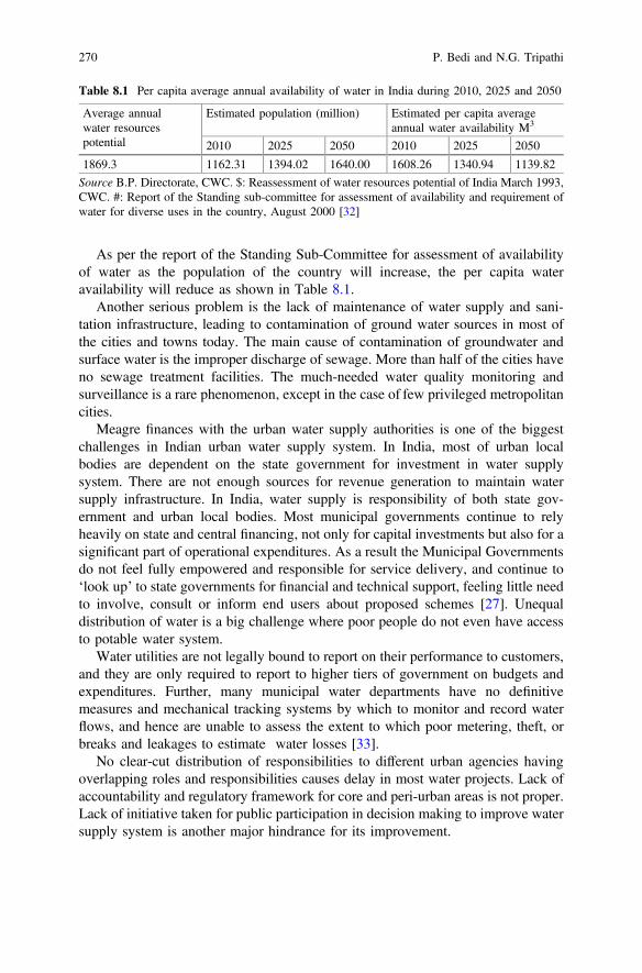
As per the report of the Standing Sub-Committee for assessment of availabilityof water as the population of the country will increase, the per capita wateravailability will reduce as shown in Table 8.1.
Another serious problem is the lack of maintenance of water supply and sani-tation infrastructure, leading to contamination of ground water sources in most ofthe cities and towns today. The main cause of contamination of groundwater andsurface water is the improper discharge of sewage. More than half of the cities haveno sewage treatment facilities. The much-needed water quality monitoring andsurveillance is a rare phenomenon, except in the case of few privileged metropolitancities.
Meagre finances with the urban water supply authorities is one of the biggestchallenges in Indian urban water supply system. In India, most of urban localbodies are dependent on the state government for investment in water supplysystem. There are not enough sources for revenue generation to maintain watersupply infrastructure. In India, water supply is responsibility of both state gov-ernment and urban local bodies. Most municipal governments continue to relyheavily on state and central financing, not only for capital investments but also for asignificant part of operational expenditures. As a result the Municipal Governmentsdo not feel fully empowered and responsible for service delivery, and continue to‘look up’ to state governments for financial and technical support, feeling little needto involve, consult or inform end users about proposed schemes [27]. Unequaldistribution of water is a big challenge where poor people do not even have accessto potable water system.
Water utilities are not legally bound to report on their performance to customers,and they are only required to report to higher tiers of government on budgets andexpenditures. Further, many municipal water departments have no definitivemeasures and mechanical tracking systems by which to monitor and record waterflows, and hence are unable to assess the extent to which poor metering, theft, orbreaks and leakages to estimate water losses [33].
No clear-cut distribution of responsibilities to different urban agencies havingoverlapping roles and responsibilities causes delay in most water projects. Lack ofaccountability and regulatory framework for core and peri-urban areas is not proper.Lack of initiative taken for public participation in decision making to improve watersupply system is another major hindrance for its improvement.
Table 8.1 Per capita average annual availability of water in India during 2010, 2025 and 2050
Average annualwater resourcespotential
Estimated population (million) Estimated per capita averageannual water availability M3
2010 2025 2050 2010 2025 2050
1869.3 1162.31 1394.02 1640.00 1608.26 1340.94 1139.82
Source B.P. Directorate, CWC. $: Reassessment of water resources potential of India March 1993,CWC. #: Report of the Standing sub-committee for assessment of availability and requirement ofwater for diverse uses in the country, August 2000 [32]
270 P. Bedi and N.G. Tripathi

The inability to provide citizens with the necessary infrastructure has causedproblems, including the growth of the informal supply of drinking water andimproper wastewater collection and disposal systems. These informal systemsoperate largely unregulated, posing major health risks to the population.
The urban water supply and sanitation sector which is suffering from inadequatelevels of service, an increasing demand-supply gap, poor sanitary conditions anddeteriorating financial and technical performance needs to be addressed on highestpriority. There is a growing realization that government alone cannot solve andmanage the water scarcity challenges faced by the country. The approach in watermanagement in urban areas in the near future is likely to focus on water conser-vation and efficiency, distributed storm water management which captures and usesrainfall, water reclamation and reuse and water treatment and reuse with theinvolvement and participation of citizens.
8.4 HydroInformatics
The current urban water sector scenario seeks just for technical quick-fixes that mayenslave the communities to technology. The high expenses of such technologiesmay bind the communities to funding agencies eventually alienating the localpopulation from its own resources. The solution to be sought needs to be a com-bination of technology and people’s involvement.
The solution to these problems lies in hydroinformatics based watereDemocracy, where the ultimate objective should be to increase the water tablethrough judicious use of water and conservation practices with emphasis on elec-tronically enabled citizen participation to contribute to decision-making and takeownership to any changes that may be sought in the water regime in their area.eDemocracy is the support and enhancement of democracy, democratic institutionsand democratic processes by means of technology [34].
There is an essential need for shift from water ‘management’ to water ‘gover-nance’. Whereas, water management is rooted in centralized decision-making withthe government as the prime stakeholder, water governance is the political, social,economic and administrative systems that influence water’s use and management.The key factor in water governance is citizen’s participation and should beessentially based on informatics approach.
Hydroinformatics is information about hydro, a Greek word meaning water,hence information about water. Hydroinformatics can be defined as a branch ofinformatics which concentrates on the application of information and communi-cations technologies (ICTs) in addressing the increasingly serious problems of theequitable and efficient use of water for many different purposes. As stated by Priceand Vojinovic [35] hydroinformatics which emerged in 1980s integrates the socialand technical knowledge to create solutions for the water problems of an area.Social dimension is important in hydroinformatics for understanding the impact oftechnological changes brought about by ICT. The objective of hydroinformatics is
8 Smart Water Management and eDemocracy in India 271
to bring in complete transparency in the decision-making process by involving allthe stakeholders. Some kind of information about water has existed since the timeman started using water for fulfilling his needs. This information or knowledge hasbeen passed on generation to generation and has been shared between communities.Hydroinformatics, as is understood today, can be said to have emerged largely dueto the advancements in the field of information technology.
Hydroinformatics has evolved from a stage where methods used by manualcalculation were programmed to run on a machine [36] followed by a period whensoftware codes began to be written initially in mainframes using paper tape andpunch cards and later using programming languages as PASCAL and FORTRAN.This period of writing codes for specific application developed into coding for moregeneric applications in 1970s [36] and grew into software modelling systems.During 1980s commercial modelling packages for personal computers began to bemarketed like MOUSE and MIKE 11 by Danish Hydraulic Institute andWALLRUS and WASSP from Wallingford Software. These software empoweredthe engineers with the ability to manage the water systems even without the coreknowledge of computational hydraulics. Modelling become the core of the softwarefor water management and gradually became available to a larger group of peopleother than water engineers and water management experts. In all the advancementthat took place in the water modelling and management software, the paralleldevelopments in computer hardware, software, programming, database manage-ment, Geographic Information System and Remote Sensing technologies haveplayed an important role.
Since 1980s till date, as stated by Price and Vojinovic [35], the advancement inhydroinformatics transformed the ‘performers of projects’ into ‘providers ofproducts’ and the society too transformed from that of ‘knowers’ to societies of‘consumers of knowledge’. Internet has played a vital role in this transformation. Ithas not only facilitated the communication of information but has facilitated accessto data and information stored in servers and websites by a large number of peoplethrough a wide range of devices from a computer to a mobile phone connectedthrough Internet anywhere in the world. With the information being availableonline, stakeholders can participate in the decision-making process. In the future,the option of accessing the information is likely to increase tremendously, whichwill bring in more transparency and bring a change in the society in social terms. AsAbbott and Vojinovic [37] state, the purpose of stakeholder participation is toinduce a change in the built environment that bring a positive change in the socialenvironment. The societal changes caused by hydroinformatics may lead to morestakeholders participating in decision-making in not a reactive manner to thedecisions of the government but in a positive manner [35].
The biggest benefit of hydroinformatics in water management is in the planning,design, construction, installation and operation of water assets [35]. It is necessaryto understand that hydroinformatics is not just automatic collection of data on waterconsumption but should allow for remote access of data on water flow, con-sumption, quality, pressure at a required resolution, so that the data details can beused to improve the operational decisions. Hence, hydroinformatics is not just
272 P. Bedi and N.G. Tripathi
collection of Big Data but essentially includes the intelligent processing of the samesuch that right decisions for the customers can be taken.
Hydroinformatics, which delivers smart water management, uses ICT to addresswater issues with extensive automation to increase the response time. It helps incapturing data in near real-time and has the ability to transmit the data to remotelocations for data processing, interpretation and modelling by the stakeholders [38].The smart water management tools can be categorized into data acquisition andintegration, where network sensors, smart pipes and smart meters are used; datadissemination, where Internet and radio transmitters are used; data processing,storage, modelling and analytics, where GIS and specialized software are put to use;management and control where SCADA and optimization tools are used; andvisualization and decision support where web-based communication is used.
There exist some challenges in the adoption of hydroinformatics as a smart watersolution. Lack of standardization in the relevant technologies like sensor networksand Internet of Things. Standardization is essential for the success of the solution asit brings in integrity. Organisation and agencies following the standards reduce theirrisks as there is compatibility and interoperability in the systems. Coherentcross-sector policies and a multi stakeholder formulated water resources manage-ment strategy are essential to the success and sustainability of smart water man-agement tools [39], which needs to be supported with appropriate ICT governanceas lack of investments in ICT can hamper the planning and implementation of thesmart solution. As stated by Boyle et al. [40], a number of factors need to beconsidered in implementation of smart water management system, amongst whichcustomer satisfaction needs to be the key. The water agency in India is in gov-ernment’s domain and the focus on customer satisfaction is the least. Adoption ofhydroinformatics is a re-engineering effort and not just adoption of technology. Theproblems of water supply and management that are faced by the urban areas can beovercome only by better understanding the customer problems which can beachieved by installing smart water solutions. By the installation of the smartsolutions, the water managers will be able to understand the water consumptionpatterns and trends for various uses and enable in better urban water planning. Asstated by Beal and Stewart [41], designs from environment, engineering and eco-nomic perspectives can be efficiently designed based on up-to-date and accuratedata collected through the smart solution. It will help the managers in proactivelyreduce water losses by reacting to leakages and alarms [42]. Smart management canlead to development of customized tariff systems as well which can further influ-ence the consumption pattern of the consumers.
The installation of a smart solution like SCADA by Pimpri Chinchwad, nearPune, Maharashtra, in 2008, has helped the municipal corporation is equitable watersupply in the city. The system provides information on raw water lifted from thePavana river, treated at the water treatment plants (WTPs), sent via the pipelines,and received at 85 elevated storage reservoirs. The department has set up bench-marks for the flow of water through the system and if there is any deviation, theofficial concerned is sent a message on his cell phone, after which he determines thereasons for the deviation and takes corrective action. The municipal corporation
8 Smart Water Management and eDemocracy in India 273
embarked on a pilot project to implement 24 7 water supply in a specified areawhich has reduced the water demand as now there is no need to store water withcorresponding wastage. Further electricity bills of residents have reduced as there isno need to pump water as the pressure is being maintained in the system [43].
Singapore embarked on a Smart Water project to overcome the challenges ofleakages and pipe bursts due to ageing infrastructure in collaboration with the waterutilities company, academia, ICT institutes and private agencies called WaterWise.The project has been successful in aiding event detection like leaks and bursts,provides real-time monitoring and decision support [39]. Two important compo-nents of WaterWise are the Integrated Data and Electronic Alerts System (IDEAS),and the Decision Support Tools Module (DSTM). Whereas, IDEAS is responsiblefor data stream management, analytics and alerts, DSTM uses the data aggregatedby IDEAS to provide decision support tools on a demand-zone basis. The systemcan be integrated to the existing GIS platform to display the data collected inreal-time spatially. The project has expanded from an eight-node network of inte-grated smart tools to a 50 nodes network spread over 80 Km2.
City of Seoul is another example of implementation of smart water solutionthrough which the city has been able to increase its revenue water to 94.3% in 2013from 64.1% in 1998 [44] This has been possible by maintaining a stable waterpressure despite the hilly terrain of the urban area, construction of reservoirs at thecorrect height, measurement of minimum night flow, leak detection and reorgani-zation of pipes not in use. This has been possible due to use of appropriate smartwater management tools clubbed with local knowledge.
Water security ensures the reliability and availability of water in terms ofquantity and quality. In present times security means protecting the water supplysystem from contamination as well, which may come in the form of pollution,accidents, and terrorist attacks. Ensuring the security of water has been the concernfor utility managers [39]. United States Environmental Protection Agency (EPA) isentrusted with the task of Water Security, which comprises of online water qualitymonitoring, consumer complaint surveillance, public health surveillance, routinesampling and analysis and enhanced security monitoring. Developed on ICT, thesmart solution is capable of providing timely detection of potential contamination.The system consists of Event Detection Systems (EDS) which is designed tomonitor water quality data in real time and produce an alert if water quality isdeemed anomalous [45].
Hydroinformatics supported smart water management helps in identifying andrapidly addressing the leakages and reducing the water losses in the distributionnetwork, understanding the consumption time during the day by residential andcommercial users to enhance water supply designs and management, enhancecustomer satisfaction by providing targeted services as leak alerts and takingfeedback from customers through web portals and mobile applications to knowabout changing consumption patterns so as to deliver better services.
274 P. Bedi and N.G. Tripathi
8.5 eDemocracy an Essential for Smart WaterManagement
As stated above, the true benefit of hydroinformatics is when not only are thestakeholders, which includes citizens, are benefited by the equitable distribution ofwater, reduction in water losses and by capping of the loopholes in appropriatetariff collection by the water utilities, but when the stakeholders are able to par-ticipate in the decision-making process linked to water supply in their area.
Thus, such a decision-making process is needed in which water managersinform the initial decision and participate in planning the appropriate responses,interacting with the principal actors, particularly citizens and with the managers ofother sectors. Thus increasingly, collective governance ‘beyond governments’ ispart of the solution, with state and non-state actors working together. In this rapidlychanging world, it is best to adapt in time to prevent crises rather than adapting inresponse to them. In the end achieving the goal is a political challenge. It involvesdetermining the distribution of power and resources within a given community wellas the interrelationship(s) between communities.
Canadian provinces have amended their laws and introduced new policies topromote delegated governance, which involves delegating decision-making overwater management to the local level. Initially, citizen participation in environmentalgovernance tended to emphasize citizen consultation, centered on project-reviewprocesses of mega-projects which developed into integration of citizens intodecision-making through either consensus-building consultation processes orshared decision-making processes [46]. The Netherlands is another example of thechanging policy paradigm for water management towards more integration andadaptiveness. Dutch governance system on water management emphasizes on newgovernance paradigm that is oriented towards more close collaboration betweenpublic, private and societal actors in interactive processes [47, 48].
During the pre-British period, water was managed in the country in a decentralizedmanner, where water was not considered a commodity, but a community resource.Tasks related to water were handled at a community level and were highly sanctified,which made the people follow the unsaid rules for judicious use and conservation ofwater. Considering the present-day situation of water crisis in nearly all urban centersin the country, the need is to take on the learning from the historic times by involvingthe people in the decision-making process. Making people aware about the issuesthrough dissemination workshops, holding relevant and age-appropriate seminarsand workshops in schools so as to educate the youth of tomorrow about the essentialsof water management and conservation may go a long way in establishing ademocratic water regime. Similar educative content needs to be readily availablethrough web portals, where the citizens should have an option of giving suggestionsand possible solutions to their problems. The final decision may rest with the relevantagency, but with citizen involvement, there will be better acceptability andimprovement in the water situation. With the adoption of hydroinformatics by theagencies, the benefit will incur not only in terms of preventing losses and better
8 Smart Water Management and eDemocracy in India 275
management. The benefits would accrue to and from the citizens when the infor-mation generated through hydroInformatics is shared and made accessible to thecitizens and other stakeholders. Once the information is crowd-sourced, there will bemany options and solutions that may be provided by the citizens, again the adoptionof which would finally rest with the water supply and management agency. However,that would entail eDemocracy in the true sense.
The democratic model of water governance entails delegation by relevantauthority of the government to a lower level, involvement of a wide variety ofnon-state actors, use of a hydrographic boundary as watershed rather than politicalboundaries, collaborative decision-making processes, often emphasizing consensusand trust-building, science-based decision-making, often requiring extensivefact-finding and use of hydroinformatics for decision making.
ICT based good governance and community participation in water managementare the essential building blocks for water sector reform. Only through a partnershipbetween people who are the users of water and water agencies who believe indemocratic functioning can safe, equitable and adequate water distribution beensured. Such systems and set-ups can understand the need for conservation ofresources and ensuring sustainable water systems.
8.6 Conclusions
Traditionally, water resources have been managed by the community as water hasbeen considered as a common resource and not a commodity or private property.The perception about water as a resource changed during the British rule with thegradual privatization of land and removal of water as a common resource. Thisbrought the change in water management practices as well from collectivelydeciding and building water infrastructure based on experiential knowledge of theolder generation to a science based approach which in many cases was not based onlocal knowledge.
The management of water became the responsibility of the government, whichmainly included provisioning and maintenance services for domestic andnon-domestic uses. This changed approach continued after independence. Withincrease in population and urbanisation, the stress on the water sector too increased.Centralised management of water has resulted in weakening of the water infras-tructure, depletion of water quality and quantity of water supplied. Disparities haveemerged in distribution of water supply. All these issues are primarily due tomismanagement and centralized approach of the government.
As growing scarcity of water is going to put more and more pressure on the wateravailability, the efficient and democratic governance of water is going to be neededmore than ever. Smart cities need to meet their water requirement through successfulwater management which in turn would depend on co-operation, the activeinvolvement of all water users in a city. There is an essential need of learning from thehistoric water management practices of involving all stakeholders concerned in the
276 P. Bedi and N.G. Tripathi
management of the water issues. There needs to be adoption of eDemocraticapproach in governance based on hydroinformatics. While eDemocracy will ensureaccountability and transparency, hydroinformatics will ensure that decisions takenare well informed. Since eDemocracy is based on electronically enabled citizen’sparticipation, it will entail inclusion of local knowledge and the availability ofdatabase from ICTwill lead to amalgamation of the localized expertise with scientificknowledge for a lasting solution to transform the urban areas as water sensitivecenters.
References
1. Government of India (2016) Water management. Accessed http://sscgj.in/water-management/,12 Sept 2016
2. Shukla Rajesh (2010) How India earns, spends and saves: unmasking the real India. SagePublications, India
3. World Meteorological Organisation (n.d.) The Dublin statement on water and sustainabledevelopment. Accessed http://www.wmo.int/pages/prog/hwrp/documents/english/icwedece.html on 03 Oct 2016
4. Global Water Partnership (2012). Accessed http://www.gwp.org/the-challenge/what-is-iwrm/on 03 Oct 2016
5. Bhaduri S, Singh A (n.d.) Decline of traditional water harvesting systems during British india:exploring the issues of ‘knowledge incompatibility’, ‘breaking down of commons’ and ‘freeridership’, Center for Studies in Science Policy, JNU
6. Embree AT (1969) Landholding in India and British Institutions. In: Frykenberg RE(ed) Land control and social structure in Indian history. The University of Wisconsin Press,London
7. Vani MS (2009) Community engagement in water governance. In: Iyer RR (ed) Water and thelaws in India. SAGE Publications, New Delhi
8. Singh, Nandita (2004). Water management traditions in rural India: Valuing the unvalued.KTH Royal Institute of Technology. Accessed at https://www.researchgate.net/publication/228435348_Water_management_traditions_in_rural_India_Valuing_the_unvalued
9. IDFC (2011) Water: policy and performance for sustainable development, India infrastructurereport-2011, Oxford, India
10. Narain V (2000) India’s water crisis: challenges of governance. Water Policy 2(6):433–44411. Government of India (1950) Constitution of India, seventh schedule, article 246. http://
lawmin.nic.in/olwing/coi/coi-english/Const.Pock%202Pg.Rom8Fsss(35).pdf. Accessed 01Dec 2016
12. Planning Commission (n. d.) Regional development, housing and water supply in fourth fiveyear plan. http://planningcommission.nic.in/plans/planrel/fiveyr/index4.html. Accessed on 10Oct 2016
13. Government of India (2007) Tenth five year plan. Planning Commission, New Delhi14. Government of India (1950) Constitution of India, seventh schedule, Article 246. http://
lawmin.nic.in/olwing/coi/coi-english/Const.Pock%202Pg.Rom8Fsss(35).pdf. Accessed 01Dec 2016
15. Sahu S (2009) Politics of access to drinking water in urban areas in India: state and marketinterventions a case study of Hyderabad, pp 46–80
16. Government of India (2012) National water policy-2012. http://wrmin.nic.in/writereaddata/NationalWaterPolicy/NWP2012Eng6495132651.pdf. Accessed 28 Nov 2016
8 Smart Water Management and eDemocracy in India 277

17. Kumar SV, Bharat GK (2014) Perspectives in water resources policy for India. TERI, NewDelhi
18. Government of India (2016) Draft national water framework bill 2016, Ministry of waterresources, river development and ganga rejuvenation. http://wrmin.nic.in/writereaddata/Water_Framework_May_2016.pdf. Accessed on 10 Nov 2016
19. Planning Commission (n.d.) The draft national water framework act: an explanatory note.http://www.planningcommission.nic.in/aboutus/committee/wrkgrp12/wr/wg_wtr_frame.pdf.Accessed on 09 Nov 2016
20. World Bank (2006) Indian water supply and sanitation: bridging the gap betweeninfrastructure and service, background paper. World Bank, New Delhi
21. Ehrhardt D, Groom E, Halpern J, Seini C (2007) Economic regulation of urban water sector:some practical lessons. Water sector board discussion series, paper no. 9, The World BankGroup, Washington, DC
22. Wagle et al. (2011) India infrastructure report 2011: policy and performance for sustainabledevelopment IDFC, New Delhi
23. Ahluwalia IJ (2016) Cities at crossroads: a looming crisis http://www.financialexpress.com/opinion/cities-at-crossroads-a-looming-crisis/329941/. Accessed 06 Dec 2016
24. Iyer RR (2007) Towards water wisdom. Sage Publications India25. Government of India (2015) Smart cities: mission statement & guidelines. http://smartcities.
gov.in/writereaddata/SmartCityGuidelines.pdf. Accessed on 15 Nov 201626. Leinmiller M, O’MaraM. (n.d.) Smart water: a key building block of the smart city of the future.
http://www.waterworld.com/articles/print/volume-29/issue-12/water-utility-management/smart-water-a-key-building-block-of-the-smart-city-of-the-future.html. Accessed on 29 Nov2016
27. Malick B (2004–05) Engaging with citizens to improve services: overview and key findings.The water and sanitation program funded research
28. Financial Express (2015) How analytic tools are helping in fixing water woes in Bengaluru,Kerala. http://www.financialexpress.com/economy/fixing-water-woes-with-data-analytics/169143/. Accessed on 15 Nov 2016
29. Shah M (2016) Urban water systems in India: a way forward, working paper 323: Indiancouncil for research on international economic relations
30. Anonymous (n.d.) http://shodhganga.inflibnet.ac.in/bitstream/10603/8807/9/09_chapter%201.pdf. Accessed on 15 Nov 2016
31. UN Habitat (2012) State of the world’s cities 2012/2013: prosperity of cities. https://sustainabledevelopment.un.org/content/documents/745habitat.pdf. Accessed on 24 Nov 2016
32. Central Water Commission (2000) Report of the standing sub-committee for assessment ofavailability and requirement of water for diverse uses in the country
33. McIntosh AC (2014) Urban water supply and sanitation in Southeast Asia: a guide to goodpractice, Asian Development Bank, Philippines
34. eParticipation.eu. (2016) E-Democracy. http://eparticipation.eu/information/e-democracy/.Accessed on 23 Dec 2016
35. Price Roland K, Vojinovic Zoran (2011) Urban hydroinformatics: data models and decisionsupport for integrated urban water management. IWA Publishing, London
36. Abbott MB (1988) Contirbutions of computational hydraulics to the foundation ofcomputational hydrology. In: Recent advances in the modelling of hydrological systems,vol 345. NATO ASI Series C. Kluwer Academic Pub, Sintra, Portugal
37. Abbott MB, Vojinovic Z (2010) Realising social justice in the water sector: 1. J Hydroinform12(1)
38. International Telecommunication Union (2014) Smart water management in cities, UnitedNations. https://www.itu.int/…/web-fg-ssc-0122-r7-smart_water_management_in_cities.docx.Accessed on 15 Dec 2016
39. International Telecommunication Union (2014) Partnering for solutions: ICTs in smart watermanagement, UNESCO
278 P. Bedi and N.G. Tripathi
40. Boyle T, Giurco D, Mukheibir P, Liu A, Moy C, White S, Stewart R (2013) Intelligentmetering for urban water: a review. Water 5:1052–1081
41. Beal C, Stewart RA (2013) Identifying residential water end uses underpinning peak day andhour demand. ASCE J Water Res Plan Manage. doi:10.1061/(ASCE)WR.1943-5452.0000357
42. Britton C, Stewart RA, O’Halloran KR (2013) Smart metering: enabler for rapid and effectivepost meter leakage identification and water loss management. J Clean Prod 54:166–176
43. India Water Portal (2011) PLC & SCADA based water quality, treatment and distributionmanagement system for 428 MLD PCMC water supply system. http://www.indiawaterportal.org/articles/plc-scada-based-water-quality-treatment-distribution-management-system-428-mld-pcmc-water. Accessed on 16 Nov 2016
44. Choi YJ, Ahn JC, Im HT, Koo A (2014) Best management practices for water loss control inSeoul. In: 16th conference on water distribution system analysis, WDSA
45. EPA (2013) Water quality event detection system challenge: methodology and findings. Officeof water (MC-140) EPA 817-R-13-002 April 2013. Retrieved from: http://water.epa.gov/infrastructure/watersecurity/lawsregs/upload/epa817r13002.pdf. Accessed on 30 Dec 2016
46. Paper for the BC Water Governance Project, a partnership of the Fraser Basin Council,Ministry of Environment, Fraser Salmon and Watershed Program, Georgia Basin LivingRivers Program and Fisheries and Oceans Canad, Linda Nowlan and Karen Bakker,November 2007
47. Tortajada C (2010) Water governance: a research agenda. Int J Water Res Dev 26(2):309–316. doi:10.1080/07900621003683322. (To link to this Article)
48. Biswas A, Tortajada C (2010) Future water governance: problems and perspectives. Int JWater Res 26(2):129–139
8 Smart Water Management and eDemocracy in India 279
Chapter 9Preparation of Town Planning Schemes—An E-Democracy Framework for CitizenCentric Planning
R.D. Desai, J.E.M. Macwan, Krupesh A. Chauhanand Partha Tripathy
Abstract Cities are for citizens and also ‘by & of’ its citizens. However, citizens’participation which is one of the key agenda of Good Governance is generally inconflict when it comes to urban planning process which is more technocratic with atop down approach. Citizens generally are more aware and concerned about privateinterest rather than city as whole when they participate about the Developmentplans and neighborhood when we consulted on the Town Planning Schemes (TPS).In the context of Urban Planning when the plans are laid out, regulations are draftedwhich is meant for the citizens ought to ensure the factor that these documents are“by” & “of” the citizens indicating proper consultation in the process. Gujarat hasbeen one of the progressive states of India so far as rate of urbanization is concernedand Town Planning schemes which have been practiced since early twentiethcentury has been a model for other cities. Practitioners state that the process forpreparing a TPS as prescribed in GTPUDA (Gujarat Town Planning and UrbanDevelopment Act, [3]), and its rules, seem to be a complex and long processinvolving over 50 steps that can take a maximum of four years and one month asprovisions of the GTPUDA, but in practice takes much longer. Administrators ofcentral government are leading to educate Indian citizens to practice the excellentplatform of E-Governance, which shall enable the citizens to express their thoughts
R.D. DesaiGujarat Regional Chapter of ITPI, GCPIA, Surat, Indiae-mail: [email protected]
R.D. DesaiSurat Centre, GCPIA, Surat, India
J.E.M. MacwanHead Civil Engineering Department, SVNIT, Surat, Indiae-mail: [email protected]
K.A. ChauhanUrban Planning Section, Civil Engineering Department, SVNIT, Surat, Indiae-mail: [email protected]
P. Tripathy (&)Urban Planning, Civil Engineering Department, SVNIT, Surat, Indiae-mail: [email protected]
© Springer Nature Singapore Pte Ltd. 2017T.M. Vinod Kumar (ed.), E-Democracy for Smart Cities, Advances in 21st CenturyHuman Settlements, DOI 10.1007/978-981-10-4035-1_9
281
and willingness in a more free way. The intention of this chapter is to throw light onICT, specifically the planning process adopted in a fast growing state of Gujarat.Apart from that, issues regarding E-Democracy initiatives are also addressed.Though the process of E-Governance is in its infant state from user’s point of view,but this will surely gain momentum in the days to come. This practice willinstil high-democratic values and plan implementation within desired time frame.
Keywords E democracy Urban planning Town planning schemes Citizenconsultation
9.1 Introduction
In this era, increased urbanization poses challenges before any local governments toprovide sustainable local services such as urban transport systems, waste man-agement systems, and urban water supply and sanitation. To meet these challenges,local governments often benefit if they are able to improve and strengthen demo-cratic urban governance, develop a more holistic planning system built on inte-grated environmental solutions, inclusive planning, social sustainability andeconomic growth. While the center of every activity by any Local government iswell being of the all its citizens, but while planning activities are undertaken, theyadopt a pseudo consultative approach, collating the statistics of the habitat andinhabitants, like area, typology, age, socio economic characteristics etc. Urbanspatial planning has been in the doldrums for many years. It has typically beenregarded as old-fashioned, technocratic, and bureaucratic, stifling development bywrapping it up with red tape [7].
There has been a transformation in the approach of City planning. The mostvisible change has been the expansion of the urban political system from ‘gov-ernment’ to ‘governance’, which in developed countries represents a response to thegrowing complexity of governing in a globalizing and multilevel context, as well asthe involvement of a range of non-state actors in the process of governing. Indeveloping countries, the concept of governance has been promoted as a policymeasure, along with decentralization and democratization.
One of the important messages which transpire from literature, even thoughurban planning has changed relatively little in most countries since its emergenceabout 100 years ago, a number of countries have adopted some innovativeapproaches in recent decades [8]. The approaches include, strategic spatial plan-ning, use of spatial planning to integrate public-sector functions, new land regu-larization and management approaches, participatory processes and partnerships atthe neighborhood level, etc. To ensure that participation is meaningful, sociallyinclusive and contributes to improving urban planning, certain conditions need tobe satisfied, including: a political system that allows and encourages active citizenparticipation; a legal basis for local politics and planning that specifies how theoutcomes of participatory processes will influence plan preparation and
282 R.D. Desai et al.
decision-making; and mechanisms for socially marginalized groups to have a voicein both representative politics and participatory planning processes. Citizen par-ticipation is now an integral component of ideas like “smart growth” and “NewUrbanism” in the field of urban planning.
Urban governance with its emphasis on stakeholder participation is oftenthought to be in conflict with the traditional urban planning which is technocraticand top down in its approach [4].
It is worth to understand the evolution of approaches to urban planning. Therehave been four broad phases in the evolution of approaches to urban planning andmanagement:
• Master planning,• Strategic or area planning,• Urban management and• Urban governance.
The advent of new paradigms of governance called for reinvention of urbanplanning. New planning practices around the world have incorporated participatoryapproaches as it has come to be recognized that the expert- driven decision makingprocesses of the past were quite unsuitable for effective planning. But the elementsof new urban planning are not yet fully formed [7].
Land being dealt and managed at the State level, with emergence of Planning,States during 1970s adopted to enact legislations to enable physical planning of theurban forms. Most of the States in India adopted legislations formats which pro-visioned for creation of Development Authorities, preparation of Macro level andMicro level plans in time bound manner and also clout to regulate the developmentthrough land use planning and height and bulk regulations for macro level planningas well as micro level planning. The legislation also provisioned for citizen par-ticipation through objections and suggestions. The legislations have also provi-sioned for the process to be followed including the manner in which the citizenengagement should be carried out.
Innovation in technology has brought about the changes in the processes andICT (Information Communication Technology) has played a robust role in anyprocess re-engineering. In the last few decades, availability of satellite images anddevelopment in the software tools have enabled planners to use these information,data and modern tools to put up the urban plans. Accordingly, professionals andexecutive bodies have procured new technologies, undergone capacity buildingprograms and at certain instances also legislations have warranted for improvisationin the processes. For instance the maximum time period provisioned in preparationof TP Schemes in the GTPUDA have undergone amendments and has beenshortened substantially.
Still the questions remain unanswered, if there been a conscious effort by thepolicy makers to improvise the processes and procedures for public participationand moreover if the City administrators, planners improved upon their practices to
9 Preparation of Town Planning Schemes—An E-Democracy Framework … 283
maximize citizen participation in the process to ensure an enhanced democraticframework.
Participation and public–private partnerships have become important elements inall of the innovative planning approaches. Participatory planning empowers com-munities and builds social capital, and also leads to a better design of urban projectsand can allow for participants’ concerns to be incorporated within strategies.Successful participation is, however, dependent upon certain preconditions relatingto the political context (a political system that encourages active citizenship and thatis committed to equity and redress), the legal basis for participation (processes andoutcomes are legally specified) and available resources (skilled and committedprofessionals, well-resourced and empowered local governments, and informed andorganized communities and stakeholders) [8].
In many countries of the developed world, master planning has now beenreplaced by strategic spatial planning which emphasizes only on inclusive stake-holder participation processes and key strategic elements of urban growth.
As Cities are known as engines of growth, urbanization offers significantopportunities to reduce poverty and gender inequality, as well as to promote sus-tainable development. Post-independence, one of the focused key agenda for theGovernment of India has been to build planned cities and strengthen the urbaninfrastructure, however, administrators have struggled to handle the menace ofslums, in-equality and economic disparity which is increasing and reasons could beinformation asymmetry within the citizens and regulatory capture by selectedstakeholders.
How can cities avoid calamity and make the most of their opportunities?Increasingly, it is hoped that improved urban governance will be the answer. Theterm “urban governance”, formerly equated with urban management, has come tobe understood as both government responsibility and civic engagement. Generally,it refers to the processes by which local urban governments—in partnership withother public agencies and different segments of civil society—respond effectively tolocal needs in a participatory, transparent and accountable manner.
India is a democratic republic and the philosophy of justice, equality, liberty andfraternity are enshrined in its constitution. The democratic principles of the countryflow from the Preamble of the Constitution itself. Governance was process andprocedure centric and generally a top down approach was used in policy making. Inaddition, the country, given its vast size, federal structure of governance with over240,000+ local governance institutions and large population coupled with its othercomplexities viz. multi-cultural, multi-ethnic, multi-religious and multi-lingualsociety, did not make itself amenable to large scale public consultation in policymaking.
Town planning in modern era is famous since end of 20th century. Since then,Development Plan concept is more or less been used by many cities. Developmentplan is a process of developing a city as per the proposed guideline within specifiedtime limit. E-Democracy is something which relates ICT with political participationof stakeholders in decision making. There are many misconceptions regardinge-governance and e-democracy. E-Governance is specifically related to give
284 R.D. Desai et al.
efficient information of government activities to public (like voting counts infor-mation, water quality information, online application of birth certificate etc.).E-Democracy is related with distributing control and decision making process.
E-Governance is about Transparency and E-Democracy is about Directness
In planning, government interventions include preparation of Development plan,Zonal plans, Town Planning schemes etc. All activities were done with citizenparticipation before ICT era also. But what else can ICT improve in Democraticprocess is major question of 21st century. Government centricity in E-Governmentpolicies and practices neglect civic inclusion in decision making. Citizens aregenerally excluded from the list of decision making that these all policies are goingto be implemented on and such decisions are generally through representativedemocratic.
E-Democracy is ‘vertical expression of horizontal policies’ (Meaning: policiesare made by only a handful of people can be improvised by adding more groups ofcitizens in a column). There are three kind of liberty (or say, process) given in anylocal bodies, Information, Consultation and Participation.
‘Information’ is a one-way relationship where governments produce and dis-tribute information to citizens, such as occurs through websites and e-newsletters.This includes active attempts by governments to increase information disseminationon particular issues and arbitrary citizen access to information available throughdigital means upon demand.
‘Consultation’ involves a limited two-way process through which citizens canprovide feedback to government; for instance, via online surveys and petitions. Thisrequires that citizens are provided with the information necessary to make informeddecisions, but feedback is restricted to topics predetermined by governments, whichmeans civic input has a limited capacity to shape political agendas and discourse.
‘Participation’ concerns the development of stronger relationships betweencitizens and governments, in which citizens are viewed as partners. It includesactive involvement of citizens in the policy-making process and may take placethrough the use of, for example, digital discussions and wikis, where citizens canpropose policy options and shape the direction of political dialogue.
9.2 Genesis of Town Planning Schemes in India
First excellent effort of developing today’s metro city Mumbai was in 1948. In1948, “Modak-Mayor Master Plan” was proposed for Mumbai’s overall develop-ment. History of development plan starts from immediately after independence ofthe nation India. In 1954, Bombay Town Planning Act was enacted which laiddown the concept of Town Planning Scheme. After Bombay was divided in twodifferent states (Maharashtra and Gujarat) in 1960, Gujarat legislated its own Actfor town planning in 1976, The Gujarat Town Planning and Urban Development
9 Preparation of Town Planning Schemes—An E-Democracy Framework … 285
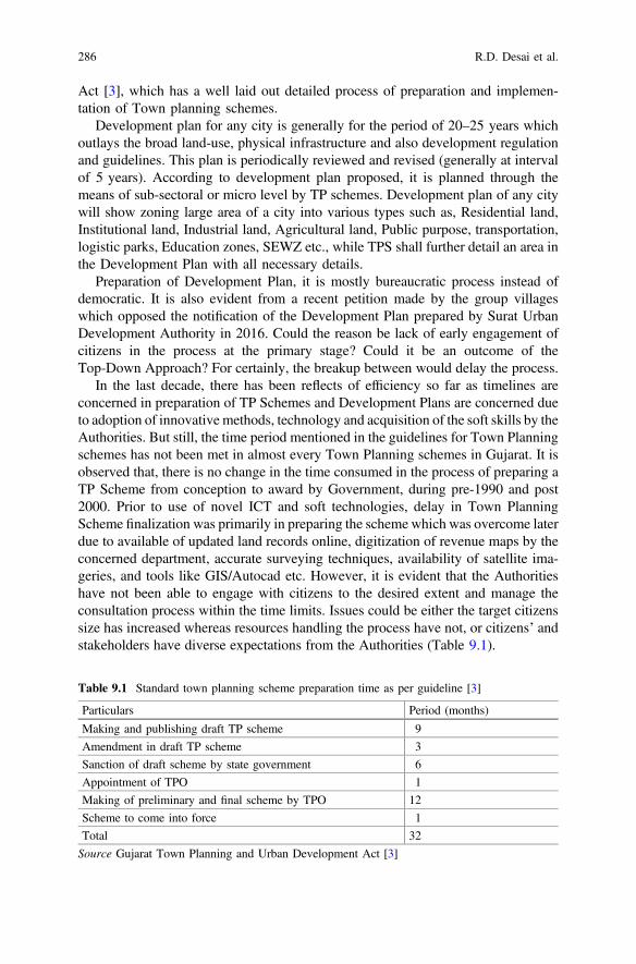
Act [3], which has a well laid out detailed process of preparation and implemen-tation of Town planning schemes.
Development plan for any city is generally for the period of 20–25 years whichoutlays the broad land-use, physical infrastructure and also development regulationand guidelines. This plan is periodically reviewed and revised (generally at intervalof 5 years). According to development plan proposed, it is planned through themeans of sub-sectoral or micro level by TP schemes. Development plan of any citywill show zoning large area of a city into various types such as, Residential land,Institutional land, Industrial land, Agricultural land, Public purpose, transportation,logistic parks, Education zones, SEWZ etc., while TPS shall further detail an area inthe Development Plan with all necessary details.
Preparation of Development Plan, it is mostly bureaucratic process instead ofdemocratic. It is also evident from a recent petition made by the group villageswhich opposed the notification of the Development Plan prepared by Surat UrbanDevelopment Authority in 2016. Could the reason be lack of early engagement ofcitizens in the process at the primary stage? Could it be an outcome of theTop-Down Approach? For certainly, the breakup between would delay the process.
In the last decade, there has been reflects of efficiency so far as timelines areconcerned in preparation of TP Schemes and Development Plans are concerned dueto adoption of innovative methods, technology and acquisition of the soft skills by theAuthorities. But still, the time period mentioned in the guidelines for Town Planningschemes has not been met in almost every Town Planning schemes in Gujarat. It isobserved that, there is no change in the time consumed in the process of preparing aTP Scheme from conception to award by Government, during pre-1990 and post2000. Prior to use of novel ICT and soft technologies, delay in Town PlanningScheme finalization was primarily in preparing the scheme which was overcome laterdue to available of updated land records online, digitization of revenue maps by theconcerned department, accurate surveying techniques, availability of satellite ima-geries, and tools like GIS/Autocad etc. However, it is evident that the Authoritieshave not been able to engage with citizens to the desired extent and manage theconsultation process within the time limits. Issues could be either the target citizenssize has increased whereas resources handling the process have not, or citizens’ andstakeholders have diverse expectations from the Authorities (Table 9.1).
Table 9.1 Standard town planning scheme preparation time as per guideline [3]
Particulars Period (months)
Making and publishing draft TP scheme 9
Amendment in draft TP scheme 3
Sanction of draft scheme by state government 6
Appointment of TPO 1
Making of preliminary and final scheme by TPO 12
Scheme to come into force 1
Total 32
Source Gujarat Town Planning and Urban Development Act [3]
286 R.D. Desai et al.
9.3 Town Planning Scheme Process
The Bombay Town Planning Act of 1915 first introduced Town Planning Schemesin India. This Colonial British Act incorporated not only the ‘betterment recovery’principle from the English Act but also the stratagem of ‘reconstitution’ of plots wasborrowed from the ‘Lex Adics’ procedure from a German Act [5].
The State of Gujarat which was a part of the Bombay State followed the BombayTown Planning Act of 1915. Local planning authorities adopted the town planningschemes approach for faster development of the City. As T P Schemes were typ-ically micro level plans, they were employed in parts of the city without consideringthe larger implications of these actions. To ensure planning at the macro scale aswell the subsequent Bombay Town Planning Act, 1954 came into force enablinglocal authorities to prepare Development Plans for cities and towns. This brought inthe DP–TP (Development Plan followed by Town Planning Scheme) mechanismwhich is how it is commonly referred to today. A spurt in use of this mechanismoccurred with several local agencies taking up this macro and micro planningexercise (TPVD). In 1960, the erstwhile State of Bombay was bifurcated to formthe States of Maharashtra and Gujarat. Both States hence continued to use the sameAct. The State of Gujarat eventually, contextualized the Act for their developmentalneeds and enacted the Gujarat Town Planning & Urban Development Act, 1976.Subsequently, further amendments over time in the Maharashtra Act and later on inthe Gujarat Act ensured that TP Schemes remained relevant and grew in imple-mentation efficiency.
TP Scheme model has been widely appreciated as one of successful citizencentric participative model in urban planning at micro level. TP Scheme has beenefficient to manage the new growth implies that the agricultural land at theperiphery of the cities and towns or smaller settlements that are not yet “urban” aretransformed to be made suitable for urban or non-agricultural uses. The TPScheme planning ensures that the irregular landholdings and plots are given regularshapes; each plot has access; infrastructure services such as water supply anddrainage are provided; land is appropriated for providing roads, parks, socialamenities, and low income housing. Development controls are prescribed to resultin a good quality-built form and development or betterment charges are levied tooffset the cost of developing the physical and social infrastructure. But mostimportantly, all of this must happen in a timely manner and such that it is acceptableto the “landowners” to avoid conflict in the growth management process [1].
The Gujarat Town Planning and Urban Development Act, 1976 is the Act (alongwith its Rules) that relates to the making and execution of Development Plans andTown Planning Schemes in the State of Gujarat. As discussed earlier, the land useoriented Development Plan serves as the macro plan post which TP Schemes aretaken up to enable implementation at a micro level. Details related to the TP
9 Preparation of Town Planning Schemes—An E-Democracy Framework … 287
Scheme process are described below and have been divided into 5 distinct stagesfrom Intention to prepare till the final TP Scheme is notified and Final TP Scheme isnotified by Government.
9.3.1 Stage-I: Inform and Engage with Citizens Aboutthe Intent
Declaration of Intention to make a Town Planning Scheme (Sec 41 and 42). Thefirst step of the process of preparation of the Town Planning Scheme (TPS) is todeclare intent for making a TPS. The authority in consultation with the Chief TownPlanner may, by resolution, declare its intention to make such a scheme in respectof such area as identified by the authority. Within 21 days from the declaration ofintention to make a scheme, the authority shall publish it in the prescribed mannerand shall dispatch a copy of the same along with a plan showing the area which itproposes to include in the TPS to the State Government. The publication and themanner in which citizens are informed and engaged is stated in the GTPUD Rules.
Publication of declaration under section 41: (GTPUD, Rules 1979section 16)
1. The declaration under sub-section (1) of section 41 shall be published inthe Official Gazette and shall also be published by means of an adver-tisement in one or more Local Language newspapers circulating withinthe jurisdiction of the appropriate authority.
2. Every advertisement published under sub-rule (1) shall contain the reso-lution of the appropriate authority in respect of the declaration undersection 41IDH_41 and shall announce that a copy of the plan of the areaproposed to be included in the town planning scheme and the surroundinglands is kept open for inspection of the public at the head office of theappropriate authority during office hours.
9.3.2 Stage II—Preparation and Publication of the DraftScheme (Sec 48-1)
In accordance with the GTPUDAct, 1976within Ninemonths from the declaration ofintention to prepare the scheme the authority shall prepare a draft scheme of the area
288 R.D. Desai et al.
and publish the same in the Official Gazette along with the draft regulations. Invitesuggestions on the draft scheme. After considering the suggestions/objectionsreceived within amonth of publication, draft scheme is sent to Govt. for sanctionu/s 48(1) within threemonths (these threemonths are required to incorporate thesuggestions and objections of citizens).
The GTPUD Rules 1979 prescribes the manner of public participation at theinitial stage of Draft TP scheme.
Meeting of owners and framing of tentative proposals (GTPUD Rules,1979, section 17) For the purpose of making the draft scheme under sec-tion 42 the appropriate authority shall call a meeting or meetings of theowners of the lands included in a town planning scheme by a public notice aswell as by individual notice to every owner whose address is known to theappropriate authority and explain in such meeting the tentative proposals ofthe draft scheme for eliciting public opinion and suggestions on the saidproposals. The appropriate authority may take into consideration all suchsuggestions made and objections raised on the proposals for making the draftscheme under section 42.
9.3.3 Stage III—Sanction of Draft TP Scheme
The Draft scheme is sanctioned by the state Government under section 48(2) of theGujarat Town and Country Planning Act, 1976. As per Act the Government maywithin six months, time sanction the Draft TP Scheme through a GovernmentNotification. The Act prohibits any development in the area falling in the Draft TPScheme area, by any person unless; the person has obtained necessary permissionfrom the Authority. The State Government takes steps to appoint Town PlanningOfficer (TPO) for preparing the Preliminary and Final TP schemes.
9.3.4 Stage IV—Preparation of Preliminary TPScheme by Government
Within one month of the sanction of the Draft Town Planning Scheme the TownPlanning Officer who is a quasi-judicial officer is appointed under section 50 of theGTPUD Act, 1976. The function of the TPO is to prepare the preliminary and thefinal town planning schemes. The TPO’s task is to deal with each landowner both onthe physical planning proposal—the shape and location of the Final Plot (FP) and thefinancial proposal—the compensation and betterment issues, and eventuallydemarcate the FP on ground and hand it over to the owner. The sanctioned draft TPS
9 Preparation of Town Planning Schemes—An E-Democracy Framework … 289
is divided in two parts to facilitate functioning of TPO: a preliminary TPS to deal withthe physical planning proposal and a final TPS to deal with the financial proposal.The Act provides for 12 months to prepare the Preliminary TP Scheme by the TPO.At this stage, citizen consultation is of utmost importance as the decision on FinalPlots, sizes, valuation of the plots etc. are undertaken. In this section the features andmanner in which the consultation is ought to be carried out as per the provisions ofGTPUDA and its Rules has been analyzed and presented.
9.3.4.1 One to One Hearings to Each Landowner on the PreliminaryTPS
The TPO gives individual hearings to each landowner and revises the preliminaryTPS if required. Inputs from the State Government and local authority and devel-opment authority are sought. The preliminary TPS may be modified if required,and the TPO gives a second round of hearings.
Consultation with Citizens by the TPO prior to his activities The TownPlanning Officer shall, before proceeding to preparation of Preliminary TPScheme, publish a notice in the Official Gazette and in one or more Localnewspapers circulating within the area of the appropriate authority. Suchnotice shall specify the matters which are proposed to be decided by theTown Planning Officer and State that all persons who are interested in theplots or are affected by any of the matters specified in the notice shallcommunicate in writing their objections to the Town Planning Officer withina period of twenty days from the publication of notice in the Official Gazette.Such notice shall also be pasted at the office of the Town Planning Officer andof the appropriate authority and the substance of such notice shall be pasted atconvenient places in the said locality.
Finalization of the Preliminary TPS and Its ApprovalThe preliminary TPS is again modified based on the second hearing. At this stage,demarcation of FPs commences. The TPO finalizes the preliminary TPS by writinghis or her decisions with regard to every plot. This is referred to as the award of thepreliminary TPS and is published in the local newspapers. At this stage, the pre-liminary TPS is sent to the State Government for sanction. The GTPUDA provi-sions for a timeframe of two months, for the Government to sanction thePreliminary Scheme. The preliminary TPS comes into effect from the date ofsanction and land for roads and plots appropriated for public purpose vest with thelocal authority or development authority.
290 R.D. Desai et al.

9.3.5 Stage V—Final TP Scheme
At this stage, the TPO prepares the financial proposals which are taken up with eachowner. All the owners are intimated about their compensation to be received orincremental contribution to be paid by them. These pertain to the compensation andincremental contribution. The TPS at this stage is called the final TPS. Once thehearings are done, the financial proposals may be modified and sent to the StateGovernment for opinion. There may be some modifications. The TPO then finalizesthe TPS and publishes it in the local newspapers. This is referred to as the “Awardof the Final TPS”. A Board of Appeals for further issues on valuation is constituted.Once all appeals are resolved and the final TPS is modified, it is sent to the StateGovernment for approval. The State Government is required to sanction it withinthree months.
The process for preparing a TPS is prescribed in GTPUDA, 1976, and its Rules.It is quite a complex and long process involving over 50 steps that can take a periodof four years and one month as provided by the act, but in practice takes muchlonger [1].
As shown in Fig. 9.1, Spider web diagram shown below will help to understandtime period elapsed in various phases of town planning scheme finalization. Itshows the total time taken as guided in Gujarat Town Planning and UrbanDevelopment Act [3]. That sum comes up as Three years.
In current practice of preparing final town planning scheme, total time taken tofinalize it is around 4.2 years with all extension periods in each stage. The processundertaken and the important stages for preparation TP Scheme as per the GTPUDAct 1976 and Rules, 1979 is presented in Fig. 9.2. The stages of preparation havebeen put in the boxes outlined rectangular boxes with dotted lines whereas theconsultation is presented in callouts format.
0.000.501.001.502.00
Prepara on of DraTP SCHEMES
Sanc on of Dra TPby Government
Publish of PreliminaryTP SCHEMES
Publica on of Final TPSCHEME
Fig. 9.1 Time periods in different stages for town planning scheme finalization
9 Preparation of Town Planning Schemes—An E-Democracy Framework … 291
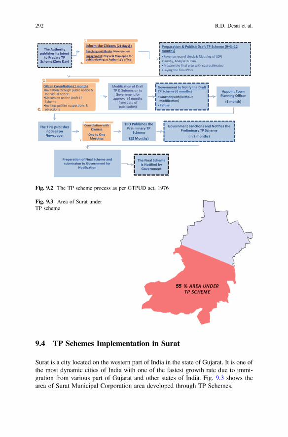
9.4 TP Schemes Implementation in Surat
Surat is a city located on the western part of India in the state of Gujarat. It is one ofthe most dynamic cities of India with one of the fastest growth rate due to immi-gration from various part of Gujarat and other states of India. Fig. 9.3 shows thearea of Surat Municipal Corporation area developed through TP Schemes.
The Authority publishes its Intent
to Prepare TP Scheme (Zero Day)
Inform the Ci zens (21 days) : Reaching out Media: News papers Engagement: Physical Map open for public viewing at Authority's office
Prepara on & Publish Dra TP Scheme (9+3=12 months) •Revenue record check & Mapping of (OP) •Survey, Analyse & Plan •Prepare the final plan with cost es imates •Laying the Final Plots
Ci zen Consulta on (1 month) •Invita on through public no ce & Individual no ce
•Discussion on the Dra TP Scheme
•Invi ng wri en sugges ons & objec ons
Modifica on of Dra TP & Submission to
Government for approval (4 months
from date of publica on)
Government to No fy the Dra TP Scheme (6 months) •Sanc on(with/without modifica on)
•Refusal
Appoint Town Planning Officer
(1 month)
The TPO publishes no ces on Newspaper
Consula on with Owners
One to One Mee ngs
TPO Publishes the Preliminary TP
Scheme (12 Months)
Government sanc ons and No fies the Preliminary TP Scheme
(in 2 months)
Prepara on of Final Scheme and submission to Government for
No fica on
The Final Scheme is No fied by Government
Fig. 9.2 The TP scheme process as per GTPUD act, 1976
Fig. 9.3 Area of Surat underTP scheme
292 R.D. Desai et al.

Surat is one of the cleanest city of India and is also known by several other nameslike “THE SILK CITY”, “THE DIAMOND CITY”, “THE GREEN CITY”, etc.
The City accounts for:
• 42% of the world’s total rough diamond cutting and polishing,• 70% of the nation’s total rough diamond cutting and polishing,• 40% of the nation’s total diamond exports,• 40% of the nation’s total man made fabric production,• 28% of the nation’s total manmade fiber production,• 18% of the nation’s total manmade fiber export, and• 12% of the nation’s total fabric production.
Out of 325 Km2 of area, total area of Surat city planned under TP scheme isaround 177.40 Km2. As per this data, half of Surat city area is planned under TPscheme. The first TP scheme of Surat was initiated on 26/02/51 (Source: https://suratmunicipal.gov.in/Departments/TownPlanningTPDetails). As per the latestrecords, 128 TPS have been taken up by the Government Authorities.
On the time consumed in preparation of TP Schemes, an analysis was made ofall the TP Schemes and the results are shown in the figure below. It isself-explanatory that, maximum time period has gone in Preliminary and Final townplanning scheme. These two steps include the major share of public participation. Itis clear that before the period of Internet, the total time taken for overall Town Timetaken in preparation of planning scheme preparation and finalization has beendecreased after Internet and communication came i.e. after the year 2000.
9.5 TP Scheme Is a Process Which Is Dynamic—ChangesAre Inevitable
Most of the literature suggests that, TP Scheme has been a successful framework forimplementation of planning proposals of any cities, which otherwise have struggled atearly stages in procurement of Land. TP Scheme as a planning tool and more of as aprocess has been tested, implemented, reviewed and improved in various cities inGujarat. It has been adopted as aMantra for implementation of Development Plans inalmost all large cities in Gujarat. The process has a long history—it was introduced in1915 by legislation, and since then the legislation has been continuously improved tomake the process more responsive to the changing context of development [1]. Therehave been amendments in the GTPUDA, 1976, almost five times i.e. in 1986, 1995,1999, 2000 and 2002, and the processes have beenmodified. Almost after 20 years ofimplementation of the Act, in the year 1995 the certain amendments weremade whichincludedmodification on process time stipulated for preparation and of Draft Plan andsubmission by the Authority which was reduced from 22 to 15 months includingextension and modification post citizen consultation and also the time stipulated byGovernment for sanction was reduced from 6 to 3 months. Therefore, for preparation
9 Preparation of Town Planning Schemes—An E-Democracy Framework … 293
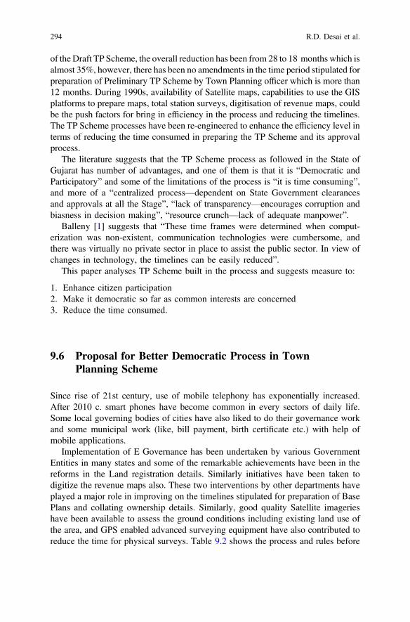
of the Draft TP Scheme, the overall reduction has been from 28 to 18 months which isalmost 35%, however, there has been no amendments in the time period stipulated forpreparation of Preliminary TP Scheme by Town Planning officer which is more than12 months. During 1990s, availability of Satellite maps, capabilities to use the GISplatforms to prepare maps, total station surveys, digitisation of revenue maps, couldbe the push factors for bring in efficiency in the process and reducing the timelines.The TP Scheme processes have been re-engineered to enhance the efficiency level interms of reducing the time consumed in preparing the TP Scheme and its approvalprocess.
The literature suggests that the TP Scheme process as followed in the State ofGujarat has number of advantages, and one of them is that it is “Democratic andParticipatory” and some of the limitations of the process is “it is time consuming”,and more of a “centralized process—dependent on State Government clearancesand approvals at all the Stage”, “lack of transparency—encourages corruption andbiasness in decision making”, “resource crunch—lack of adequate manpower”.
Balleny [1] suggests that “These time frames were determined when comput-erization was non-existent, communication technologies were cumbersome, andthere was virtually no private sector in place to assist the public sector. In view ofchanges in technology, the timelines can be easily reduced”.
This paper analyses TP Scheme built in the process and suggests measure to:
1. Enhance citizen participation2. Make it democratic so far as common interests are concerned3. Reduce the time consumed.
9.6 Proposal for Better Democratic Process in TownPlanning Scheme
Since rise of 21st century, use of mobile telephony has exponentially increased.After 2010 c. smart phones have become common in every sectors of daily life.Some local governing bodies of cities have also liked to do their governance workand some municipal work (like, bill payment, birth certificate etc.) with help ofmobile applications.
Implementation of E Governance has been undertaken by various GovernmentEntities in many states and some of the remarkable achievements have been in thereforms in the Land registration details. Similarly initiatives have been taken todigitize the revenue maps also. These two interventions by other departments haveplayed a major role in improving on the timelines stipulated for preparation of BasePlans and collating ownership details. Similarly, good quality Satellite imagerieshave been available to assess the ground conditions including existing land use ofthe area, and GPS enabled advanced surveying equipment have also contributed toreduce the time for physical surveys. Table 9.2 shows the process and rules before
294 R.D. Desai et al.

Information Technology and after Information Technology. However, so far ascitizen consultation processes, analysis of representations has been being done in aconventional process. There has been no improvisation made in the processeswhich could establish “to be democratic” so far (Tables 9.3 and 9.4).
It can be observed that, while technology has been used and adopted in many ofthe activities but the citizen engagement process, consultation mode, and approvalmechanism still remains unchanged. With increase in population and shortage inmanpower to handle TP schemes, the efficiency of the consultation process, col-lation of all the representations, analysis, and incorporating the suggestions in DraftPlan has been time consuming and a key area where delays have been unavoidable.Decisions are democratic or not is generally not established, as the process followeddoes not reveal such information.
An efficient citizen engagement is proposed which would improve the areas ofconcern for the Authority and also enhance the efficiency of the manpowerresources deployed to manage the process be it from Authority preparing theDraft TP or office of Town Planning Officer responsible for preparingPreliminary TP Schemes and Final TP Schemes.
Entire town planning scheme stages can be inserted in mobile app of MunicipalCorporation. There can be different stages in application like; Draft Town PlanningScheme suggestions, Preliminaries and final Town planning schemes suggestion etc.
Families which are covered under the geographic area of proposed TownPlanning schemes are informed beforehand with help of municipal corporationapplication. They can get application installed on their smart phones or access thesite through the computers. Now families under any particular Town Planning
Table 9.2 Details of Surat TP schemes
Sr.No.
TP scheme details No. ofschemes
Total area underschemes (Ha)
1 Sanctioned final schemes 39 4575.44
2 Sanctioned preliminary schemes 28 2964.98
3 Sanctioned draft TP schemes 58 9654.96
4 Draft TP scheme submitted to Govt. forsanction
03 542.83
Total 128 17,738.21
Table 9.3 Surat City profile
Area 326.515 km2
Population 4,466,826 (census 2011)
Density 13,680 persons/km2 (census 2011)
Location Latitude: 21.112 °NLongitude: 72.814 °E
Municipality established 1852 AD
Corporation established 1966 AD
9 Preparation of Town Planning Schemes—An E-Democracy Framework … 295
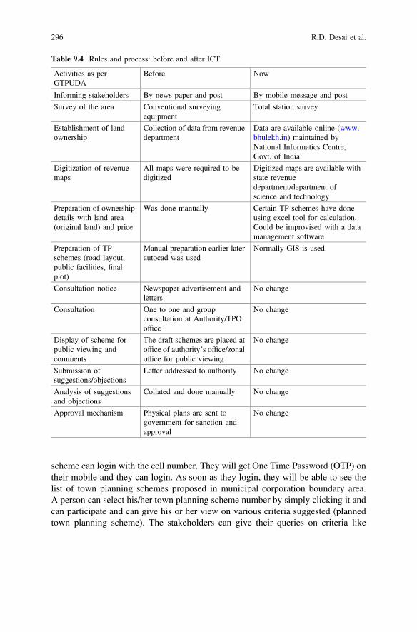
scheme can login with the cell number. They will get One Time Password (OTP) ontheir mobile and they can login. As soon as they login, they will be able to see thelist of town planning schemes proposed in municipal corporation boundary area.A person can select his/her town planning scheme number by simply clicking it andcan participate and can give his or her view on various criteria suggested (plannedtown planning scheme). The stakeholders can give their queries on criteria like
Table 9.4 Rules and process: before and after ICT
Activities as perGTPUDA
Before Now
Informing stakeholders By news paper and post By mobile message and post
Survey of the area Conventional surveyingequipment
Total station survey
Establishment of landownership
Collection of data from revenuedepartment
Data are available online (www.bhulekh.in) maintained byNational Informatics Centre,Govt. of India
Digitization of revenuemaps
All maps were required to bedigitized
Digitized maps are available withstate revenuedepartment/department ofscience and technology
Preparation of ownershipdetails with land area(original land) and price
Was done manually Certain TP schemes have doneusing excel tool for calculation.Could be improvised with a datamanagement software
Preparation of TPschemes (road layout,public facilities, finalplot)
Manual preparation earlier laterautocad was used
Normally GIS is used
Consultation notice Newspaper advertisement andletters
No change
Consultation One to one and groupconsultation at Authority/TPOoffice
No change
Display of scheme forpublic viewing andcomments
The draft schemes are placed atoffice of authority’s office/zonaloffice for public viewing
No change
Submission ofsuggestions/objections
Letter addressed to authority No change
Analysis of suggestionsand objections
Collated and done manually No change
Approval mechanism Physical plans are sent togovernment for sanction andapproval
No change
296 R.D. Desai et al.
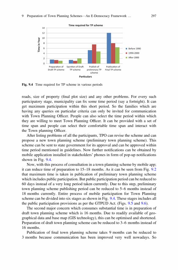
roads, size of property (final plot size) and any other problems. For every suchparticipatory stage, municipality can fix some time period (say a fortnight). It canget maximum participation within this short period. So the families which arehaving any queries on particular criteria can only be invited for communicationwith Town Planning Officer. People can also select the time period within whichthey are willing to meet Town Planning Officer. It can be provided with a set oftime span and people can select their comfortable time span and interact withthe Town planning Officer.
After listing problems of all the participants, TPO can revise the scheme and canpropose a new town planning scheme (preliminary town planning scheme). Thisscheme can be sent to state government for its approval and can be approved withintime period mentioned in guidelines. Now further notifications can be obtained bymobile application installed in stakeholders’ phones in form of pop-up notificationsshown in Fig. 9.4.
Now, with this process of consultation in a town planning scheme by mobile app;it can reduce time of preparation to 15–18 months. As it can be seen from Fig. 9.2that maximum time is taken in publication of preliminary town planning schemewhich includes public participation. But public participation period can be reduced to60 days instead of a very long period taken currently. Due to this step, preliminarytown planning scheme publishing period can be reduced to 5–6 months instead of18 months currently. Entire process of mobile participation for Town Planningscheme can be divided into six stages as shown in Fig. 9.4. These stages includes allthe public participation provisions as per the GTPUD Act. (Figs. 9.5 and 9.6).
The second major concern which consumes substantial time is in preparation ofdraft town planning scheme which is 16 months. Due to readily available of geo-graphical data and base map (GIS technology), this can be optimised and shortened.Preparation of draft town planning scheme can be reduced to 3–6 months instead of16 months.
Publication of final town planning scheme takes 9 months can be reduced to3 months because communication has been improved very well nowadays. So
0
2
4
6
8
10
12
14
Prepara on ofDra TP scheme
Sacn on of DraTP scheme
Publish ofpreliminary TP
scheme
Publica on ofFinal TP scheme
Tim
e in
Yea
r
Par culars
Time required for TP scheme
Before 1990
1990-2000
A er 2000
Fig. 9.4 Time required for TP scheme in various periods
9 Preparation of Town Planning Schemes—An E-Democracy Framework … 297
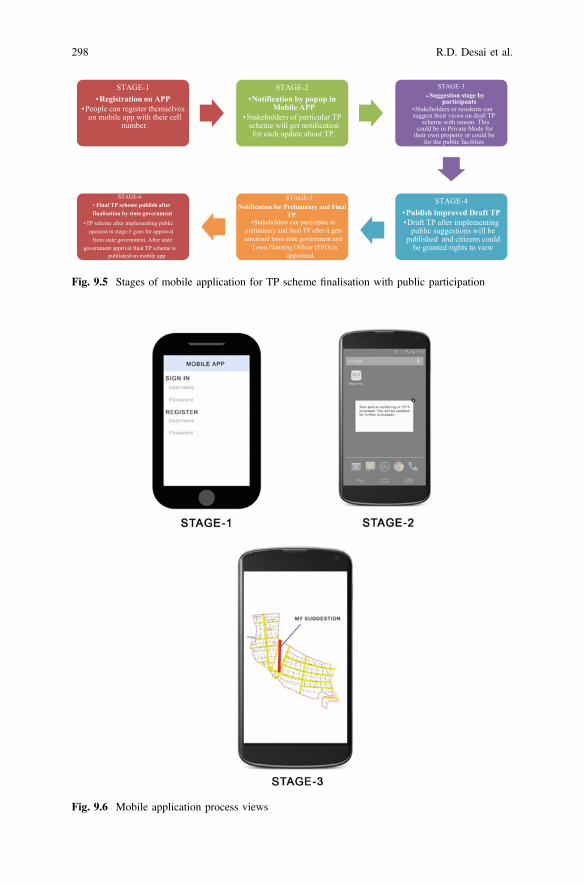
STAGE-1•Registration on APP
•People can register themselves on mobile app with their cell
number.
STAGE-2•Notification by popup in
Mobile APP•Stakeholders of particular TP
scheme will get notification for each update about TP.
STAGE-4•Publish improved Draft TP•Draft TP after implementing
public suggestions will be published and citizens could
be granted rights to view
•STAGE-6
Final TP scheme publish after finalisation by state government
•TP scheme after implementing public openion in stage-5 goes for approval
from state government. After state government apprival final TP scheme is
published on mobile app
•STAGE-5
Notification for Preliminary and Final TP
•Stakeholders can participate in preliminary and final TP after it gets sanctiond from state government and
Town Planning Officer (TPO) is appointed.
STAGE-3• Suggestion stage by
participants•Stakeholders or residents can suggest their views on draft TP
scheme with reason. This could be in Private Mode for
their own property or could be for the public facilities
Fig. 9.5 Stages of mobile application for TP scheme finalisation with public participation
Fig. 9.6 Mobile application process views
298 R.D. Desai et al.
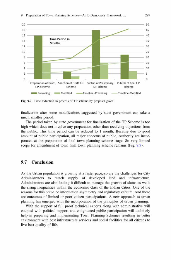
finalization after some modifications suggested by state government can take amuch smaller period.
The period taken by state government for finalization of the TP Scheme is toohigh which does not involve any preparation other than receiving objections fromthe public. This time period can be reduced to 1 month. Because due to goodamount of public participation, all major concerns of public, Authority are incor-porated at the preparation of final town planning scheme stage. So very limitedscope for amendment of town final town planning scheme remains (Fig. 9.7).
9.7 Conclusion
As the Urban population is growing at a faster pace, so are the challenges for CityAdministrators to match supply of developed land and infrastructure.Administrators are also finding it difficult to manage the growth of slums as wellsthe rising inequalities within the economic class of the Indian Cities. One of thereasons for this could be information asymmetry and regulatory capture. And theseare outcomes of limited or poor citizen participations. A new approach to urbanplanning has emerged with the incorporation of the principles of urban planning.
With the support of full proof technical experts along with administrative willcoupled with political support and enlightened public participation will definitelyhelp in preparing and implementing Town Planning Schemes resulting in betterenvironment with best infrastructure services and social facilities for all citizens tolive best quality of life.
0
5
10
15
20
25
30
35
40
45
50
0
2
4
6
8
10
12
14
16
18
20
Prepara on of DraT.P. scheme
Sanc on of Dra T.P.scheme
Publish of PreliminaryT.P. scheme
Publish of final T.P.scheme
Prevailing Modified Timeline -Prevailing Timeline-Modified
Time Period in Months
Fig. 9.7 Time reduction in process of TP scheme by proposal given
9 Preparation of Town Planning Schemes—An E-Democracy Framework … 299
Gujarat has been one of the progressive states of India and has a led in field ofUrban Planning. And Town Planning schemes has been one undisputed, wellproven model which has been tested, modified and improved with a processre-engineering approach. Still against stipulated time frame of 36–40 months,completion timeframe has been more than 70 months in the recent times even moreat earlier. When literature states of it’s participative and democratic approach,processes mentioned fails to assess these attributes or even they are not a part ofassessment either. This study of TP Schemes implemented by Surat MunicipalCorporation and Surat Urban Development Authority depicts that while Schemesimplemented prior to 1990 took more time to prepare draft TP Schemes, at laterstages there has been substantial reduction probably due to use of new technology,but still the overall time consumed in approval of TP Schemes more or less remainsunchanged as there has been no improvisation in the engagement of citizensincluding consultation and grievance handling.
As cities have now launched e-governance and m-governance mode to engagewith citizens, a new ICT framework for TP scheme process has been proposedwhich could be integrated on the existing ICT frame of the Cities and connect withthe citizens. Secondly, a backend analytical tool may be developed to assess theparticipation, suggestions, objections and guide decision making following thedemocratic methodology. The overarching GTPUD Act 1976 warrants for variousstatutory approvals including that of State Government, a suggestion is being madeif such approvals could be made online in a secured network. This would improveaccountability and transparency in the process which shall help in building trust.Similar approaches could also be made at a larger scale to engage with citizens forpreparing Development Plans for the City.
Acknowlegement The Authors acknowledge the valuable efforts of Mr. Devang Kapadia,Research Student, Urban Planning, Civil Engineering Department, SVNIT, Surat, Gujarat, Indiafor his contribution in analysis of TP Schemes process and suggestions on process re-engineering.
References
1. Ballaney S (2008) Town planning mechanism in Gujarat, India by Shirley Ballaney. WorldBank Institute. Retrieved from http://hcp.co.in/file_manager/publications/Town-Planning-of-Gujarat_Research-Paper.pdf
2. Freeman J, Quirke S (2013) Understanding E-democracy. JeDEM 5(2):141–1543. Gujarat Town Planning and Urban Development Act-19764. Mahendra B, Harikrishnan K, Krishne G (2010) Urban governance and master plan of
Bangalore City, pp 1–185. Panchal K, Salgaonkar J, Vyas DP, Mathews R (2016) Scaling up land readjustment for urban
and industrial development through the town planning scheme in Dholera, Gujarat, India6. Promises and Problems of E-Democracy, OECD-20037. Taylor P (2004) Planning for a better future. Habitat Debate 4(4):48. UN Habitat. (2009). Planning sustainable cities (2009th ed.). UN Habitat
300 R.D. Desai et al.

Web
9. https://www.researchgate.net/publication/22109688510. http://www.internetlivestats.com/internet-users/11. http://researchassessment.in/mumbai-before-development-plan-2/12. http://edemocracy.weebly.com/what-is-edemocracy.html13. https://suratmunicipal.gov.in/14. http://townplanning.gujarat.gov.in/dp-tps-information/town-planning-scheme.aspx
9 Preparation of Town Planning Schemes—An E-Democracy Framework … 301
Chapter 10Smart City Project Selection,Prioritization, Customizationand Implementation—Voice of SmartCitizens Case Study of Bhubaneswarand Surat
Partha Tripathy, Krupesh A. Chauhan and Anjali K. Khambete
Abstract The Smart City Mission launched by Government of India focuses on thecomprehensive development of physical, social, institutional and economicinfrastructure to enhance the quality of life, attract people and investments to a City,setting growth and development in motion and all these happening with a citizencentric approach. And moreover, the selection process of smart city mission trainedthe City Authorities to adopt a citizen participative approach. The cities whichscored high in the challenge were those which had adopted citizens identifying theproblems and democratic process for selection of solutions. And what was expectedto be smart, was the role of ICT in the entire consultation process be it the socialmedia, mobile telephony or the web based applications, citizens participation wasoverwhelming. Now the question is do we need to make of citizens smart to make acity smart or is it other way round, a smart city shall make the citizens smart? It isfelt that the former approach would yield constructive and sustainable results,where a citizen graduates to a netizen in a smart city. While Indian citizens arevocal and being a democratic set up each citizen have aspiration to be represented inthe decision of the Muhalla (vernacular term which means a place where a com-munity stays together), Ward, Zone, City, State or the Nation as the case may be.Smart City Mission guided ULBs to increase participation of citizens to all itsfunctions citing them as City’s Eyes and Ears. The National e-Governance plan of
P. Tripathy (&)Urban Planning, Civil Engineering Department, SVNIT, Surat, Indiae-mail: [email protected]
K.A. Chauhan A.K. KhambeteCivil Engineering Department, SVNIT, Surat, Indiae-mail: [email protected]
A.K. Khambetee-mail: [email protected]
© Springer Nature Singapore Pte Ltd. 2017T.M. Vinod Kumar (ed.), E-Democracy for Smart Cities, Advances in 21st CenturyHuman Settlements, DOI 10.1007/978-981-10-4035-1_10
303
Government of India, states that the citizen engagement has various stages startingfrom inform, consult, involve, collaborate and empower. Under the mandatoryreforms prescribed in earlier schemes under the aegis of Central government or theState government, Cities Authorities had undertaken certain e-governance andm-governance initiatives which were to the level of inform the citizens. After beingtagged as Smart Cities, many Indian Cities have strived to enhance their citizenengagement activities but to what extent in the engagement ladder is somethingrequires assessment. More importantly, does the system put in place by theAuthorities for engagement, provisions for citizens participation making decisionsdemocratic is what this paper has assessed for two Indian Cities, Bhubaneswar andSurat. It also suggests how these tools could be utilized further in engaging citizensfrom identification of issues, project conceptualization, budgeting, andimplementation.
Keywords e-Democracy Participatory project selection Citizen centricapproach and smart city
10.1 Introduction
India is a democratic republic and the principles of democracy flow from thepreamble of the Indian Constitution itself. Democracy is said to be the Governmentof the people, by the people and for the people. This expresses that the Governmentis elected by the people, it is responsible and accountable to the people and it’s alsoof the people. The most effective way to do that is to actively engage with the publicwhile making policy decisions that impact them directly. However, the publicparticipation in policy making is mostly through representative.
Governance has been a process and procedure centric and a top down approachin policy making. India has over 600,000 local governments and a very largepopulation of around 1.25 billion coupled with its other complexities under “Unityin Diversity” i.e. cultures, ethnicities, religions and languages which has not made iteasy for large scale public participation in policy decisions.
Post liberalization in 1990s, introduction of ICTs, internet technologies andGood Governance centric approach with increased participation of non-governmententities in delivery of public services has made a paradigm shift in Governance withpotential to connect every stake holder in real time. This was conceived asE-Governance which catered to citizen centric approach rather than process-centricapproach through increased ICT enabled public participation. Government of Indiahas taken the leap for the theme and has included them in schemes e.g. NeGP(National e-Governance Plan), JnNURM (Jawaharlal Nehru National UrbanRenewal Mission), AMRUT (Atal Mission for Rejuvenation and UrbanTransformation), by incentivizing the implementation of e-Governance by means ofmandatory reforms at the Urban Local Bodies (ULB). The focus on public par-ticipation has increased in the country and various initiatives have been taken by
304 P. Tripathy et al.
central as well as local governments to engage people with ultimate goal of betterservice delivery, transparency and accountability. Recently launched Smart CityMission (SCM) by Government of India, mandated ULBs to increase participationof citizens in all its functions citing them as City’s eyes and ears. The cities had tocompete and the selection process, mandated the City Authorities to adopt a citizenparticipative approach. The cities which scored high in the challenge were thosewhich had adopted citizens identifying the problems and democratic process forselection of solutions regarding the comprehensive development of physical, social,institutional and economic infrastructure to enhance the quality of life, attractpeople and investments to a City, setting growth & development in motion. Thesmart part in this was the role of ICT in the entire consultation process be it thesocial media, mobile telephony or the web based applications, citizens participationwas overwhelming in such a short time.
This shows that public participation and engagement are the rising steps towardsfor good governance which generally Government have adopted as a policy deci-sion. If in the same way the citizens can, not only participate and engage but also beempowered towards decision making, the democracy in real sense could beestablished. It can be a critical shift in delivery of public and essential services andto take policy decisions up to some extent using ICT based interfaces. Citizen canactually participate not only in the suggestions or feedback stage but from ProjectSelection in terms of setting up priority of the implementation of the project;Customization in terms of budget allocation, location selection, technology selec-tion; accountability identification and implementation in terms of continuousmonitoring and feedback.
Smart City Mission launched by GOI was a real step forward towardsE-democracy. The mission was announced in June, 2015 and state governmentsnominated cities by 31st July, 2015. The final list of 98 cities to submit a smart cityproposal (SCP) was announced on 27th August, 2015 and the last date to submitSCP was 15th December which meant around 90 days were provided to prepare theproposal. The major aspect of the selection criteria was that the extent of theengagement of people were given certain weightage. Extent up to which publicopinion is considered in the preparation of the final proposal was crucial for anyCity to rise in the competition. The results announced clearly showed that the citiesthat garnered most participation by citizens. It represents a culmination ofdemocracy in a right way.
The extent of participation each cities could manage in just the short duration of90 days during the Smart City Challenge, was mainly due smart use of ICTs toreach out to people. Cities generally utilized the Social Media e.g. Facebook,Twitter, Mobile Apps., websites, GOI created MyGov.in website etc. Competitionswere organized to get the results/proposal from within the people of the cities.Obviously the offline efforts such as face to face interviews, meetings etc. were alsoorganized but to achieve this level of participation via conventional method was justnot possible. These mediums were used to identify the key issues and drivers for thecities and proposal were also invited which were thoroughly examined by theauthorities and experts.
10 Smart City Project Selection, Prioritization, Customization … 305
The success of E-Democracy in Smart City Mission warrants for further iden-tification of avenues in the existing democratic setup of ULBs to improve upon. Ifsmart city projects could be identified via public participation, can this be venturedin decision making process of ULBs? Do we need to make of citizens smart tomake a city smart or is it other way round, a smart city shall make the citizenssmart? It is felt that the former approach would yield better and constructive andsustainable results, where a citizen graduates to a netizen in a smart city. If any-thing, SCM has profoundly shown that the citizen are and want to be informed andif given an acceptable platform to engage, the current system can be improved andcan be made more democratic. Unlike to the conventional way the E-Democraticset-up is quicker, more easily accessible and is not bound by time.
Various Cities have taken up the opportunity to involve the citizen using ICTsvia the social media, mobile telephony or the web based applications under theSCM. e.g. Bhubaneswar Smart City has My City My Pride application, Surat hasCitizen Connect SMC application, Hyderabad has My GHMC (Greater HyderabadMunicipal Corporation) application, Pune has Pune Connect App etc. This studywill focus on up to which extent the engagement has risen in the existing scenario intwo major city apps i.e. Bhubaneswar and Surat ULB apps and their services. Theservices will be compared against spectrum of citizen engagement.
To achieve the smart citizen based E-Democratic setup, creating awareness,training of and continuous engagement with both the service provider as well as theservice seeker to use new tools for better service and more effective interaction witheach other; a framework is proposed to identify the extent up to which citizens canparticipate and be empowered, objectives of the services, opportunities, techniquesand outcomes to realize the true sense of democracy using ICTs.
10.2 Existing Framework for E-Governance
According to framework for citizen engagement in E-Governance, CitizenEngagement is an interactive two way process that encourages participation,exchange of ideas and flow of conversation. It reflects willingness on part ofgovernment to share information and make citizens a partner in decision making[1].
In an ideal scenario, citizen engagement requires governments to:
• Permit participation in agenda-setting, and• Ensure that policy or project proposals that are generated as a result of this
engagement are taken into account while making a final decision.
Citizen engagement may be undertaken at all stages of the policy or projectdevelopment process and is an iterative process that continually infuses citizens’priorities in policy making/project implementation.
306 P. Tripathy et al.
In processes of citizen engagement, citizens may be represented themselves asindividuals and sometimes through interest groups such as civil society organiza-tions. Engagement has been understood and explained in a variety of ways.Engagement can be understood by following three aspects individually orcollaboratively.
• Contributor• Organization builder• Empowering process
However, mostly, citizens are often considered either as beneficiaries of gov-ernment welfare programmes or in Commercial terminology referred to as cus-tomers, neither of which truly reflects the government-citizen relationship.
Active engagement gives the right to hold others accountable, and accountabilityis the process of engaging in participation. It seeks greater accountability from theservice providers through increased dialogue, consultation and by monitoring andassessing performance externally and mutually.
Citizen engagement goes beyond conventional public consultation by enablingcitizens to do more than simply voice an opinion—it also allows them to participatein the deliberation process leading to decisions.
10.2.1 Ways of Citizen Engagement
• Information sharing• Consultation• Joint assessment• Shared decision-making and collaboration
10.2.2 Core Values for the Practice of Citizen Engagement
It is important to note that if care is not taken while identifying the groups andmechanisms for interaction, citizen involvement can lead to a sense of disem-powerment and a reduced sense of agency, and participation can be perceived asmeaningless, tokenistic or manipulated. Therefore, following must be kept in mindwhile undertaking citizen engagement [1]:
• Public participation is based on the belief that those who are affected by adecision have a right to be involved in the decision-making process.
• Public participation includes the promise that the public’s contribution willinfluence the decision.
• Public participation promotes sustainable decisions by recognizing and com-municating the needs and interests of all participants, including decision makers.
10 Smart City Project Selection, Prioritization, Customization … 307
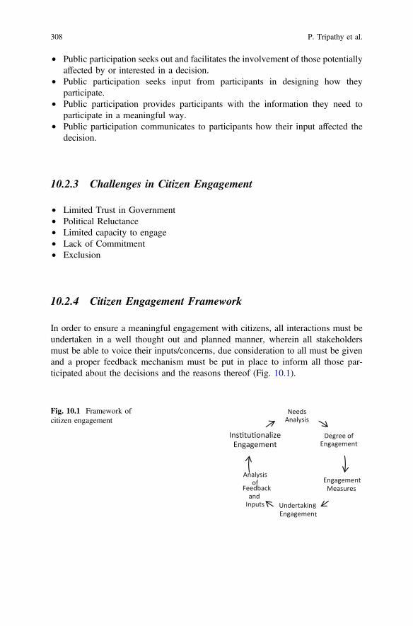
• Public participation seeks out and facilitates the involvement of those potentiallyaffected by or interested in a decision.
• Public participation seeks input from participants in designing how theyparticipate.
• Public participation provides participants with the information they need toparticipate in a meaningful way.
• Public participation communicates to participants how their input affected thedecision.
10.2.3 Challenges in Citizen Engagement
• Limited Trust in Government• Political Reluctance• Limited capacity to engage• Lack of Commitment• Exclusion
10.2.4 Citizen Engagement Framework
In order to ensure a meaningful engagement with citizens, all interactions must beundertaken in a well thought out and planned manner, wherein all stakeholdersmust be able to voice their inputs/concerns, due consideration to all must be givenand a proper feedback mechanism must be put in place to inform all those par-ticipated about the decisions and the reasons thereof (Fig. 10.1).
Needs Analysis
Degree of Engagement
Engagement Measures
Undertaking Engagement
Analysis of
Feedback and Inputs
Ins tu onalize Engagement
Fig. 10.1 Framework ofcitizen engagement
308 P. Tripathy et al.
• Needs Analysis
It is easy to identify need for engagement for a new project. However, for ongoingprojects, it is often difficult to determine such points of interventions. However,opportunities to engage with citizens exist at all stages of the project. For thepurposes of this Framework, a project life cycle has been broadly demarcated into 4stages namely Conceptualization and DPR preparation, Pilot and Roll Out, PostImplementation and Project Enhancement.
• Degree of Engagement
In an ideal scenario, the citizens may collaborate from conceptualization toimplementation of the project and may even be empowered to reject or alter theproject design at a later stage of the project. The spectrum of citizen engagementcan be represented visually as under (Fig. 10.2).
In Present Scenario. The extent of Engagement is limited up to involvement ofcitizen only, which is good but to achieve E-Democracy whole spectrum needs tobe followed. Citizen should actually be able to make decision in a democratic wayfor all stages.
• Engagement Measures
To effectively engage citizen a framework should be followed in which requiredmeasures are to be taken for Active Engagement. Those measures can be universalor project to project basis. The major aspects can be identified as (Fig. 10.3)
• Identifying the internal and external stake holders• Developing a detailed project information• Publicizing the information through various media including ICT• Designing benchmarks and criteria for evaluation• Selecting tools for citizen participation• Reporting the outcomes of the process• Making recommendations based on the outcomes
Inform
Consult
Involve Colloborate
EmpowerFig. 10.2 Spectrum ofcitizen engagement
10 Smart City Project Selection, Prioritization, Customization … 309
10.3 My City My Pride (Bhubaneswar Smart City)Application
Bhubaneswar Municipal Corporation has taken a positive step towards citizenengagement and created “My City My Pride App” a simple mobile app. It’s aplatform to empower the citizens to bring about transformation, mobilize the public,and connect with the government. This solution helps citizens to post complaintsalong with images of the issues and get desired results within stipulated time [2].
10.3.1 Functionality of MCMP
MCMP allows citizens to register certain complaints relating to civic amenities suchas
• sanitation,• street lighting• drinking water, and• sewerage
To take corrective actions for the same by the concerned officials while enablingthe aggrieved parties to track their grievances and complaints (Fig. 10.4).
Citizens/Netizens can report a complaint, the moment they see one through anyof these three modes: mobile app, web portal or through the call center. Once
•Pilot Outreach and Feedback
•Assessmemnt and Con nuous Feedbacks
•Baseline Surveys through Social Media, Web Applica ons
•Ci zen Forums, Cells, Online Consulta on
Project Enhancement
Conceptuali-za on and
DPR Prepara on
Pilot and Roll out
Post Implement
a on
Fig. 10.3 Citizen engagement methods vis-a-vis project stage
310 P. Tripathy et al.
citizens register complaints they turn into the Change Agents. Their complaint isthen escalated to the right officials who will work on fixing the issue.
MCMP is powered by m-office, a mobile app powered with a backend portal.M-Office is used by the officials who will take action. They are called Action Heroes.MCMP acts as a platform for the citizens to interact with the officials, whereasm-office allows the admin to set permission, map hierarchy, configure location andperform all administrative activities. Then the complaint is forwarded to the ActionTaking Authorities with specific escalation procedures for ensuring appropriate andquick remedial actions. Then the complainant is issued with a unique complaint IDto help the party track the complaint. Once the complaint is resolved, the status isuploaded immediately as Intimated/Resolved/Discarded/In Progress via any of themedia. And they start to become the “Action Heroes”. MCMP escalates unresolvedcomplaints to the next higher official in the hierarchy [2].
10.3.2 Components of MCMP
• Call on a toll-free number (1800-345-0061)• Register on the web portal (www.bmcsampark.in/ www.mycitymypride.org)
Citizens can also directly register their complaints through the web portal i.e.www.bmcsampark.in/ www.mycitymypride.org. Here citizens can login in threedifferent ways:
• Facebook• Scan from your My City My Pride mobile app• Register through the user log in id.
Fig. 10.4 Flowchart of MCMP app
10 Smart City Project Selection, Prioritization, Customization … 311
The functionalities of MCMP are:
• Share: Citizen can post photos, experiences, comment and participate intrending talks, discuss and support issues on just about anything inneighborhood.
• Affected: Network for civic action- mobilizes local civic community, connectwith like-minded citizens, get to know the government and engage with them.
• Clap: This feature shows the appreciation for the participation and success ofany efforts via MCMP.
For each participation effort citizen receives points and periodically they can beChampion of Change.
10.3.3 Modules
MCMP is the total solution to all civic issues which is achieved by structured andmodular components.
Trending Screen—This screen shows all the complaints along with the imagesand status posted by various citizen users in or outside the city. This page not onlyallows viewing complaints but also allows you to share, support or invite others toview, support, or vote your complaints (Fig. 10.5).
• Post a complaint—Citizens can here post a complaint by choosing the complainttype and upload the image to show the issue.
• My area—This screen allows you to see the complaints of your respective areason providing the user ward no and can choose I’m Affected, I Support or share.
• Resolved Screen—This screen shows the details of the complaints that arealready resolved by the department.
Fig. 10.5 Various screens of MCMP App—1
312 P. Tripathy et al.
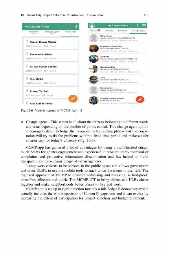
• Change agent—This screen is all about the citizens belonging to different wardsand areas depending on the number of points earned. This change agent optionencourages citizen to lodge their complaints by posting photos and the corpo-ration will try to fix the problems within a fixed time period and make a safersmarter city for today’s citizenry (Fig. 10.6).
MCMP app has garnered a lot of advantages by being a multi-faceted citizentouch points for greater engagement and experience to provide timely redressal ofcomplaints and pro-active information dissemination and has helped to buildtransparent and pro-citizen image of urban agencies.
It empowers citizens to be sensors in the public space and allows governmentand other ULB’s to use the mobile tools to track down the issues in the field. Thedigitized approach of MCMP to problem addressing and resolving, is fool-proof,error-free, effective and quick. The MCMP ICT to bring citizen and ULBs closertogether and make neighborhoods better places to live and work.
MCMP app is a step in right direction towards a full fledge E-democracy whichactually includes the whole spectrum of Citizen Engagement and it can evolve byincreasing the extent of participation for project selection and budget allotment.
Fig. 10.6 Various screens of MCMP App—2
10 Smart City Project Selection, Prioritization, Customization … 313

10.4 Citizen Connect (Surat Municipal Corporation)Application
Surat Municipal Corporation had created Citizen Connect App before the launch ofthe Smart City Mission, hence it focuses more on the Governance part rather thancitizen engagement. The objective of the development of the app was to make themost sought after information and services available to the citizens of Surat throughthe Citizen’s Connect—SMC Mobile App. It was thought to develop and offer acomprehensive mobile app that enabled availing of information and services any-time and anywhere. To create awareness regarding the service, various communi-cation channels such as, print and electronic media including radio and TV wereused. Social Media like Facebook, Twitter were also used to reach out the citizens.
10.4.1 Functionalities of Citizen Connect App
• To check Property Tax details with outstanding amount information.• To check Professional Tax (EC) details with outstanding amount information.• To check Water Meter connection details with outstanding amount information.• To check Birth Registration details.• To check Death Registration details.• To check Shops and Establishment Registration Certificate details.• Register Complaints.• To share Feedback regarding services.• Rainfall information (details of dam level, discharge, etc. during monsoon).• Location tracking using GPS technology which can find nearest zone or city
civic center to access services (Fig. 10.7).
Fig. 10.7 Various screens of citizen’s connect: SMC App
314 P. Tripathy et al.
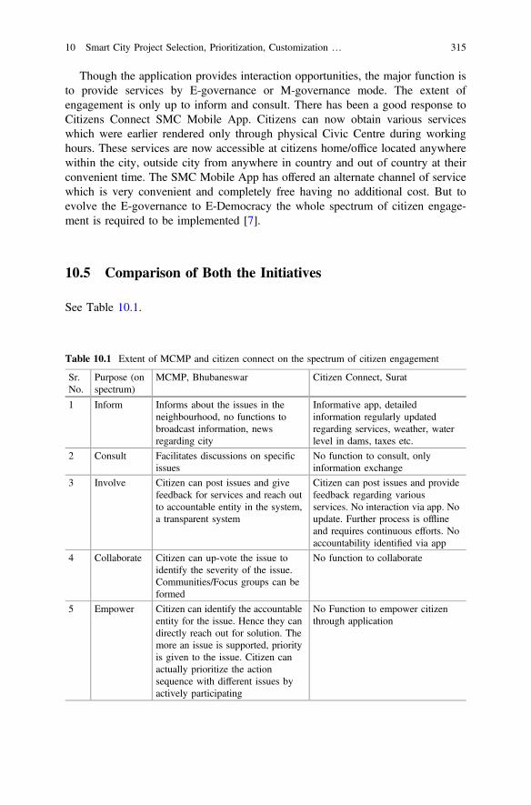
Though the application provides interaction opportunities, the major function isto provide services by E-governance or M-governance mode. The extent ofengagement is only up to inform and consult. There has been a good response toCitizens Connect SMC Mobile App. Citizens can now obtain various serviceswhich were earlier rendered only through physical Civic Centre during workinghours. These services are now accessible at citizens home/office located anywherewithin the city, outside city from anywhere in country and out of country at theirconvenient time. The SMC Mobile App has offered an alternate channel of servicewhich is very convenient and completely free having no additional cost. But toevolve the E-governance to E-Democracy the whole spectrum of citizen engage-ment is required to be implemented [7].
10.5 Comparison of Both the Initiatives
See Table 10.1.
Table 10.1 Extent of MCMP and citizen connect on the spectrum of citizen engagement
Sr.No.
Purpose (onspectrum)
MCMP, Bhubaneswar Citizen Connect, Surat
1 Inform Informs about the issues in theneighbourhood, no functions tobroadcast information, newsregarding city
Informative app, detailedinformation regularly updatedregarding services, weather, waterlevel in dams, taxes etc.
2 Consult Facilitates discussions on specificissues
No function to consult, onlyinformation exchange
3 Involve Citizen can post issues and givefeedback for services and reach outto accountable entity in the system,a transparent system
Citizen can post issues and providefeedback regarding variousservices. No interaction via app. Noupdate. Further process is offlineand requires continuous efforts. Noaccountability identified via app
4 Collaborate Citizen can up-vote the issue toidentify the severity of the issue.Communities/Focus groups can beformed
No function to collaborate
5 Empower Citizen can identify the accountableentity for the issue. Hence they candirectly reach out for solution. Themore an issue is supported, priorityis given to the issue. Citizen canactually prioritize the actionsequence with different issues byactively participating
No Function to empower citizenthrough application
10 Smart City Project Selection, Prioritization, Customization … 315

10.6 Initiatives by Surat Municipal Corporationfor Citizen Engagement
After the Smart City Challenge in December 2015, Surat Municipal Corporation,took up an initiative for Citizen’s engagement for opinion Beautification of SuratCity through web based application during April 2016. The poll was online for amonth, was also hosted in the www.mygov.in website where the Smart city pro-posals were hosted. However, the participation level were recorded abysmally lowwhich is less than 0.05% (294 opinions) of the total households in Surat. This posesa question, while the participation level in the Smart City Challenge was sub-stantially higher, was may be due to adequate marketing & promotion done by theauthority and there was a component of competition with other cities. The SmartCity Proposal was also prepared in consultation with many stakeholders and pro-moted through Facebook, Twitter and Whatsapp groups and word of mouth.
The low level of participation could be the platform of engagement, citizens aremore hooked to mobile internet than computer based internet, secondly, Surat beinga substantially populated by migrant from other states, language barrier may requireattention while designing the applications and most importantly, as this has notbeen a routine practice, adequate promotion and marketing to reach out to citizensto participate shall also be an factor of concern for all the cities in the initial years.
Has the citizen participation up to adequate level prior to accepting andimplementing a Policy been a conscious Operating Procedure needs to be under-stood and internalized by the city authorities? Recently, Surat MunicipalCorporation is preparing Parking Policy for the Surat City through a consultingfirm. However, if we look at the terms of reference of the assignment, stakeholderconsultation has been considered to be one of the routine consulting done to assessthe issues. Such consultation target interviews of academic institution, governmentfunctionaries, & business associations and conduct Stakeholder workshop ofselected groups to identify issues. There has been neither one to one consultationproposed during preparation stage or nor post preparation of draft parking policy.
10.7 e-Democracy Framework—Project Selectionto Commissioning
See Fig. 10.8.
316 P. Tripathy et al.
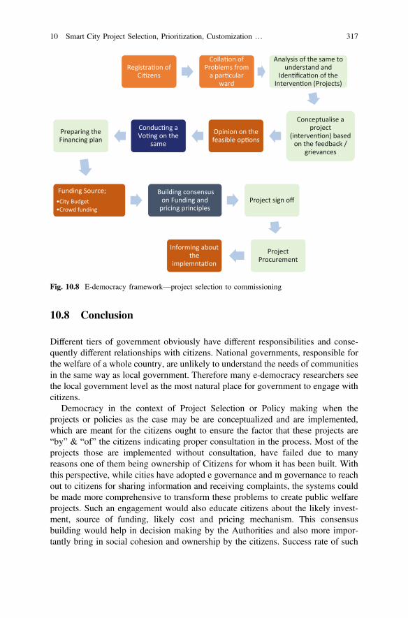
10.8 Conclusion
Different tiers of government obviously have different responsibilities and conse-quently different relationships with citizens. National governments, responsible forthe welfare of a whole country, are unlikely to understand the needs of communitiesin the same way as local government. Therefore many e-democracy researchers seethe local government level as the most natural place for government to engage withcitizens.
Democracy in the context of Project Selection or Policy making when theprojects or policies as the case may be are conceptualized and are implemented,which are meant for the citizens ought to ensure the factor that these projects are“by” & “of” the citizens indicating proper consultation in the process. Most of theprojects those are implemented without consultation, have failed due to manyreasons one of them being ownership of Citizens for whom it has been built. Withthis perspective, while cities have adopted e governance and m governance to reachout to citizens for sharing information and receiving complaints, the systems couldbe made more comprehensive to transform these problems to create public welfareprojects. Such an engagement would also educate citizens about the likely invest-ment, source of funding, likely cost and pricing mechanism. This consensusbuilding would help in decision making by the Authorities and also more impor-tantly bring in social cohesion and ownership by the citizens. Success rate of such
Registra on of Ci zens
Colla on of Problems from
a par cular ward
Analysis of the same to understand and
Iden fica on of the Interven on (Projects)
Conceptualise a project
(interven on) based on the feedback /
grievances
Opinion on the feasible op ons
Conduc ng a Vo ng on the
same
Preparing the Financing plan
Funding Source;•City Budget•Crowd funding
Building consensus on Funding and
pricing principlesProject sign off
Project Procurement
Informing about the
implemnta on
Fig. 10.8 E-democracy framework—project selection to commissioning
10 Smart City Project Selection, Prioritization, Customization … 317
project from the utility perspective would also be high. The analysis of Apps put inplace by Surat and Bhubaneswar gives an understanding about the degree of citizencentric approach adopted by the Authorities.
City Authorities need to take an informed decision to include, citizen partici-pation as a Standard Operating Procedure for any developmental work in the cities.In the project development activities right at the beginning of preparation of policyor projects, City Authorities should make citizen participation mandatory.
When country like India strive to build Smart Cities, one of the crucial buildingblocks would be Smart People who adapt to the change and accept the new way oflifestyle using ICT, be it travelling in metros with cash cards, be it undertakingonline classes, or be it surviving in a cashless economy, its people who would makeit a success. Exposure of citizens to such a transformed set up shall require CityAdministrators to build up engage and expose citizens to such systems. SmartPeople shall make cities Smart.
Acknowledgements The Authors acknowledge the valuable efforts of Mr. Harsh Desai, ResearchStudent, Urban Planning, Civil Engineering Department, SVNIT, Surat, Gujarat, India for hisanalysis of the engagement platforms of cities.
References
1. Concept Note on My City My Pride (MCMP) (2016) Concept note on my city my pride(MCMP). CSM Technologies, Bhubaneswar, Oodisha, India
2. Department of Electronics & Information Technology, M. o (2012) A framework for citizenengagement in e-governance. Government of India, New Delhi
3. Peixoto T (2008) e-participatory budgeting: e-democracy from theory to success?. WorldBank—Governance Global Practice, Washington
4. Tero Päivärinta ØS (2006) Models of e-democracy. Commun Assoc Inf Syst 17:818–839(Article 37)
Websites
5. https://bmc.gov.in/6. https://www.suratmunicipal.gov.in/7. https://socialapphub.com8. https://negp.gov.in/9. https://nextcity.org
10. http://wikipedia.org
318 P. Tripathy et al.

Chapter 11Smart Grid: Energy Backbone of SmartCity and e-Democracy
Jignesh G. Bhatt and Omkar K. Jani
Abstract In broad context, e-Governance is a functional subsystem undere-Democracy, since Governance and hence, entire Government itself is an impor-tant section of democracy itself. Hence, smart city development is in fact, thetransformation of approach in their futuristic contexts towards responsibilities,interests and rights of all its stakeholders; such as citizens, government, adminis-tration, services, utilities, etc. Globally, consistent focus for financial growth andquality of life has ultimately resulted into unprecedented rise in consumption ofelectrical energy. Electrical power management in India has become a critical issuewith rising population, increasing life expectancy, economic growth and, moreimportantly, due to vibrantly changing and difficult to predict weather. Electricalpower supply has always been a resource in deep scarcity in India, so 24 * 7electricity is an issue causing concern. Efficient decision-making at different levelsrely upon reliable availability of electricity, which has been an integral element ofcitizens’ life, therefore stable and sustainable power management, especially supplyreliability is a need of today. Government of India has launched a Smart CityMission for building 100 Smart Cities, in which 24 7 availability of electricityhas been one of the major focus. Historically, electricity generation, transmissionand distribution decisions have been the exclusive domain of utility companies,domain experts, bureaucrats or sometimes political interventions, but now a para-digm shift could be observed towards citizens’ participation and active involve-ment. Sufficient electricity being the mandatory element of a smart city necessitatesan inclusive and participatory management of this resource. Smart electricitymanagement in upcoming smart cities encounters challenges in the urban electricity
J.G. Bhatt (&)Department of Instrumentation and Control Engineering, Faculty of Technology,Dharmsinh Desai University, Nadiad 387 001, Gujarat, Indiae-mail: [email protected]
O.K. JaniSolar Energy Division, Gujarat Energy Research and Management Institute (GERMI),Pandit Deendayal Petroleum University (PDPU) Campus,Gandhinagar 382 007, Gujarat, Indiae-mail: [email protected]
© Springer Nature Singapore Pte Ltd. 2017T.M. Vinod Kumar (ed.), E-Democracy for Smart Cities, Advances in 21st CenturyHuman Settlements, DOI 10.1007/978-981-10-4035-1_11
319
management through smart grid via integration of ICT and e-Democracy. SmartGrid as an energy backbone of smart city is immensely vital and serving at the coreof Smart City realization. Evolving e-Democracy, smart grid includes highlyinteractive participation of citizens in energy consumption domain, based onhumanitarian and customer centric approach. Different types of prosumers (pro-ducers + consumers), their different energy requirements at different timings, dif-ferent types of energy resources and their switching feasibilities consideringdifferent aspects have been integrated. Under National Smart Grid Mission,Government of India has launched Restructured Accelerated Power Developmentand Reforms Programme for funding Smart Grid initiatives and Gujarat has beenone of the leading states of India as far as self-reliance and reforms like solar city,smart grid, etc. are concerned. Renewable Power Plants and Smart Grid PilotProjects implemented in Gujarat have been proved models and case studies forother locations. Moving ahead from our earlier contributed chapter “E-Governancefor Photovoltaic Powergrid: Solar City Gandhinagar, Gujarat, India”, in the book E-Governance of Smart Cities, in this chapter, we now present citizen-centricapproach of design-implementation of smart grid with case study of pilot project atNaroda, Ahmedabad.
Keywords e-Democracy Electricity Smart city Smart grid Smart electricitymanagement Collaborative planning Electricity scarcity Information andcommunication technologies (ICT) Internet of things (IoT)Abbreviations
2G 2nd generation3G 3rd generation4G 4th generationAMI Advanced metering infrastructureBAS Building automation systemCT Communication technologyDDU Dharmsinh Desai University, Nadiad, Gujarat, IndiaDISCOM/DisCom DIStribution COMpany/Distribution CompanyDR Demand responseEA 03 Electricity Act 2003GEB Gujarat Electricity BoardGEDA Gujarat Energy Development AuthorityGENCOM/GenCom GENeration COMpany/Generation CompanyGenCos Generation CompaniesGERC Gujarat Electricity Regulatory CommissionGERMI Gujarat Energy Research and Management Institute,
Gandhinagar, Gujarat, IndiaGIS Geographic information systemGoG Government of GujaratGoI Government of India
320 J.G. Bhatt and O.K. Jani
GPS Global positioning systemGPRS General packet radio serviceGSM Global system for mobile communicationGUI Graphical user interfaceHAN Home area network/home automation networkHTLS High temperature low sagICT Information and communication technologyIOT/IoT Internet Of Things/Internet of ThingsIPDS Integrated power development schemeISGF India Smart Grid ForumISGTF India Smart Grid Task ForceIT Information technologyJNNSM Jawaharlal Nehru National Solar MissionLTE Long-term evolutionMNRE Ministry of New and Renewable Energy, Government of
IndiaMoP Ministry of Power, Government of IndiaNLDC National Load Dispatch CenterNSGM National Smart Grid MissionPGCIL Power Grid Corporation of India LimitedPLC Programmable logic controllerPLCC Power line carrier communicationPMU Phasor measurement unitProsumer Producer + consumerPV Photo voltaicPXIL Power Exchange India LimitedRAPDRP/R-APDRP Restructured accelerated power development and reforms
programmeRE Renewable energyREMC Renewable Energy Monitoring CenterRET Renewable energy technologyRLDC Regional Load Dispatch CenterSCADA Supervisory control and data acquisitionSG Smart gridSGCT Smart Grid Communication TechnologySGKC Smart Grid Knowledge CenterSoS System of systemsSLDC State Load Dispatch CentreSLPMU State level project monitoring unitUGVCL Uttar Gujarat Vij Company LimitedUI Unscheduled interchangeVAR Volt-ampere reactiveWAMS Wide area monitoring systemWBAS Wireless building automation system
11 Smart Grid: Energy Backbone of Smart City … 321
11.1 Introduction [1–5]
One of the major and most significant changes observed globally in world devel-opment is ‘Urbanization’. Adil and Ko [1] have indicated that the growth ofDecentralized Energy Systems (DES) have been directing towards a new frontier inurban energy planning and design of local energy systems. As affordability of RET,particularly solar PVs and solar thermals, have been rising, cities and urban regionsare transforming into venues, not only for energy consumption, but also for energygeneration and distribution. This is clearly establishing a need for systemic andparadigmatic change in local energy infrastructure.
Focusing upon the importance of high quality, reliable, efficient and uninter-rupted electrical power and its importance for energizing core services of smartcities, Al-Ali [2] have outlined the need for IoT and cloud computing for inter-connecting and synchronizing basic application services of smart cities which havebeen now transforming from conceptual models to developmental stages. Whileobserving growing developments in AMI, Arasteh et al. [3] have noted that smartcities have now been getting equipped with IoT based electronic devices in order toincrease their smartness further.
Bansal et al. [4] have estimated that approximately 500 million people wouldhave been living in cities by 2030, which is around 60% of the world’s population.Cities contribute to economic growth by turnover of financial resources, workforce,etc. and have potential to provide higher opportunities of wealth creation, improvedhealth-medical supports, quality education and much better standard of living withenhanced infrastructure facilities. High-level integration of existing technologies todeliver a smart energy network, enhanced electricity transmission, energy efficienttransportation, and low carbon building footprints, will make it easier to manage theunfolding urbanization, and could have much positive impact on energy use andconsumption. Policy interventions and government investments are importantdetermining tools to its success.
Bhatt et al. [5] presented descriptions on “E-Governance for PhotovoltaicPowergrid: Solar City Gandhinagar, Gujarat, India”, in the book E-Governance ofSmart Cities. In this chapter, the authors presented technological development ande-Governance aspects of solar PV based electrical powergrid in the upcoming smartcity-solar city Gandhinagar, Gujarat state, India.
Proceeding further from earlier contribution, in this book chapter, the authorshave presented interesting descriptions on ‘Smart Grid’—the technological devel-opment serving as energy backbone of the upcoming smart city. Beginning withintroductory details including historical perspective and present situation, needanalysis has been included. Subsequent section describes the relationship amongelectricity, urbanization and human settlement with useful literature cited. In thenext section, by including conceptual details and salient features and merits of smartgrid, smart grid development in India has been discussed; wherein various gov-ernment initiatives and other information have also been included. In the samesection, smart grid developments in state of Gujarat have been discussed along with
322 J.G. Bhatt and O.K. Jani
UGVCL’s approach (as methodology) and case study of UGVCL’s smart grid pilotproject at Naroda, Ahmedabad has been included. Next section is based one-Democracy and citizens’ participation consisting subsections like internet basede-tools and mobile based M-tools, followed by separate sections on experiences andlessons learnt. Various relevant issues and challenges have been identified andmentioned in the subsequent section. Finally, sections like vision and roadmap,technological inputs and useful conclusions have been included to mark end of thechapter with acknowledgement and list of cited references.
11.1.1 Historical Perspective [6]
In India, electricity reforms started with the re-evaluation of Electricity Supply Act,1948 and the Indian Electricity Act, 1910, which led to the Electricity Act, 2003.The EA 2003 has been brought about to facilitate private sector participation and tohelp cash strapped state electricity boards to meet electricity demand. EA 2003envisages competition in electricity market, protection of consumer interests andprovision of power for all. The act recommends the provision for national electricitypolicy, rural electrification, open access in transmission, phased open access indistribution, mandatory SERCs, license free generation and distribution, powertrading, mandatory metering, and stringent penalties for theft of electricity. Onemore welcome step that the Indian electricity market has taken is the implemen-tation of ABT, which brought about the effective day-ahead scheduling and fre-quency sensitive charges for the deviation from the schedule for efficient real-timebalancing and grid discipline.
To promote power trading in a free power market, CERC approved the settingup of Indian Energy Exchange (IEX) which is the first power exchange in India, inJune 2008. IEX has been modeled based on the experience of one of the mostsuccessful international power exchanges, Nordpool. At present, two powerexchanges are operating in India, namely, IEX and Power Exchange India Limited(PXIL). These exchanges have been developed as market based institutions forproviding price discovery and price risk management to the electricity generators,distribution licensees, electricity traders, consumers and other stakeholders. Theparticipation in the exchange operations is voluntary. At present, exchanges offerday-ahead operations whose time line is set in accordance with the operations ofRLDCs. Power exchanges coordinate with the NLDC/RLDCs and SLDCs forscheduling of traded contracts’ to get up-to-date network conditions. Currently,about 96% of the market transactions in India are in the form of bilateral (long andshort terms) contracts. The rest is dealt by two power exchanges.
The Indian power sector has come a long way since the introductions of secondwave of reforms vide the EA 03. This gave a major boost to the power sector bycreating conducive environment for enhanced private sector participation, which
11 Smart Grid: Energy Backbone of Smart City … 323
resulted in a large increase in generation capacity as well as investments in T&D aswell as the introduction of a power market and power trading activities. In additionto this, the focus was shifted on reforms aimed at providing affordable, good qualityand reliable power to consumers, making the electricity industry commerciallyviable and promoting efficiency improvements.
11.1.1.1 Generation
Power Generation has gained the most due to the entry of private players. Themagnitude of capacity being added each year has increased manifold when com-pared to previous planning periods. Also, with the use of new and more advancedtechnologies, efficiencies of thermal power plants have been improving and emis-sion levels falling. Operational requirements related to scheduling and dispatchesare driving the implementation of automation across the power system and for thegenerators. All new plants now have sophisticated operational IT systems and theexisting generation fleet is slowly upgrading to match. RE based electricity gen-eration has gained prominence over the years. Several fiscal and policy measureshave been introduced to promote RE. On an average, over 3000 MW of REinstalled capacity has been added every year with major contribution from the windand solar energy segments. Solar energy is gaining momentum through the uniongovernment’s JNNSM and similar state level policies. Given the economics of coaland gas, fuel security issues and environmental concerns that are being faced,generation from RE is increasingly assuming a central role in the entire powersystem.
11.1.1.2 Transmission
The transmission sector in India is moving towards higher voltage levels of1200 kV and is introducing a higher level of automation and grid intelligence.PGCIL has already installed PMUs for WAMS on a pilot basis in select regions andis now pursuing a plan to install PMUs nationwide. Significant technologicaladvancements such as increasing the capacity of transmission corridors through theuse of Static VAR compensation and re-conductoring of lines using HTLS wires arealso being taken up. Power system operation is also under evaluation as a result ofthe disturbance in July 2012 and it is expected that policy reform will lead to moresystem control being given to the load dispatch centers and the phase out of thecurrent UI mechanism designed to discourage DisComs and GenCos from deviatingfrom published schedules. The UI mechanism is expected to be replaced by anancillary services market, which would be managed by the power exchanges, thusfurther liberalizing power markets and providing greater transparency on costs andprices of services. Managing these systems will require real-time monitoring andcontrol only possible with robust state-of-the-art information and communicationsystems.
324 J.G. Bhatt and O.K. Jani
11.1.1.3 Distribution
The electricity distribution sector in India is currently in the worst shape, plaguedby high network and financial losses in almost all states. There is an urgent need tobring in new technologies and systems to arrest these leaks. R-APDRP introducedby the GoI has been aimed at reducing the network losses to 15%. Part-A of theprogram is aimed at creating IT Infrastructure and automation systems within utilityoperations, which until its introduction was largely missing in most of the distri-bution utilities in the country. Part B is aimed at strengthening the physical network.The R-APDRP is still under implementation and completion is expected during the12th Five Year Plan. Once completely implemented, the program would provide astrong foundation for evolution to smart grids in the power distribution segment.
For the distribution sector, smart grids will mean the introduction of DR pro-grams, managing the expected introduction of electric vehicles and integratingdistributed energy resources in a way that can help the DisComs balance localsupply and demand and reduce peak time consumption. Building to Grid (B2G) ordevelopment of “Green Buildings” which could be incentivized to manage theirconsumption and even distributed energy resources to match grids conditions willalso play their part in helping DisComs to manage supply and demand. For real-izing all these changes, AMI as well as reliable communication technologyinfrastructure is essential.
11.1.2 Present Situation [7–9]
India is the 3rd largest producer of electricity in the world. Indian power system istoday one of the largest synchronous grids in the world with approximately250 GW capacity, >3 million km2 area covered and serving *240 million con-sumers. It is largely dominated by government owned utilities (central and states—29 states and 7 union territories own majority of power utilities); private sector roleis about 27% in generation, <1% in transmission and about 5% in distribution.Transmission Grid in India is one of the largest in the world, comprising*1,03,000 ckms lines of 765 kV/400 kV and *132,000 ckms lines of 220 kVcapacity, with 1200 kV AC and 800 kV HVDC networks being under development(Fig. 11.1).
India operates with very high T&D losses—about 26.5% nationally (>40% inmany states!). *400 million + people have no access to power. Large parts of thecountry experiences power cuts for several hours every day—customers keepstorage (invertors)/standby generation facilities. Power quality being poor, con-sumers require voltage stabilizers, UPS, inverters, etc. The world loses*$89.3 billion, while India loses *US$ 10–15 billion annually in power theft.
Over population in cities always create problems for the authorities such aselectricity shortage, supply breakdowns, etc. As per the studies, approximately
11 Smart Grid: Energy Backbone of Smart City … 325

2.5 billion Indians have either unreliable or no access to electricity. By 2035,energy consumption will increase by 35% (World Energy Council 2010).
Not only availability of energy, but the challenge of converting from its existingform to useful form in the form of electricity needs to be properly tackled, if Indiawishes to turn her dream “power for all” in a reality. Majority of Indians still live inrural areas utilizing traditional ways for cooking and live below poverty line. Solar,wind and hydro power resources are available and applicable; however, suitableand efficient technologies are required to make such small installations to servelocal striving due to insufficient and/or no power supply situations. While electricalpower generation from renewables keep fluctuating due to various reasonsincluding vibrant climatic situations, intermittent nature as well as difficulties topredict power production, the existing conventional electrical grid find it difficult tohandle such variability due to unbalance and instability in electrical networks.Therefore, a new grid which shall resolve such renewable interconnection issues aswell as ensure reliability, safety, security, profitability and public-private partici-pation is required. Smart grid is emerging as a novel concept to provide insight topolicies maker, grid operators and end users for sustainable energy efficiency.
11.1.3 Need Analysis [6, 10, 11]
The legacy conventional unidirectional power-only flowing electrical grid servedwell for over a century, now there are stringent requirements to upgrade, due toaging infrastructure as well as on account of upcoming challenges on technological,environmental and societal fronts. Therefore, not only Indian, but all nationalgovernments and relevant stakeholders have been planning substantial and signif-icant developments for futuristic smart grids.
The urgency for Smart Grids in India emerges from the key challenges beingcurrently faced. India operates the 3rd largest transmission and distribution networkin the world, yet faces a number of challenges such as: inadequate access to
Fig. 11.1 Scenario of Indian power sector [8]
326 J.G. Bhatt and O.K. Jani
electricity, supply shortfalls (peak and energy), huge network losses, poor qualityand reliability and rampant, theft. The evolution towards Smart Grid would addressthese issues and transform the existing grid into a more efficient, safe, reliable andless constrained grid that would help provide access to electricity to all.
According NIST, the following are anticipated benefits and requirements ofsmart grids:
(i) Improving power reliability and quality.(ii) Optimizing facility utilization and averting construction of back-up (peak
load) power plants.(iii) Enhancing capacity and efficiency of existing electric power networks.(iv) Improving resilience to disruption.(v) Enabling predictive maintenance and self-healing responses to system
disturbances.
Smart Grid Drivers
(i) Increase in electricity demand and supply shortfall: India’s increasingelectricity demand especially during peak hours continues to outpaceIndia’s power supply. So, managing growth and ensuring supply is a majordriver.
(ii) Loss reduction: In India, the AT&C losses are around 32% of installedgenerating capacity. Smart grid can make a substantial contribution inreducing these losses.
(iii) Increase in unit cost of electricity: With the increase in unit cost of elec-tricity, there is a need for utilities to replace and renew aging transmissionand distribution infrastructure with a pressure of using the assets wisely.
(iv) Managing human element: Human errors and deliberate errors can belowered by using smart instruments like smart meters.
(v) Reliability: The smart grid can improve outage management performanceby responding faster to repair equipment before it fails unexpectedly.
(vi) Efficiency: The smart grid can improve load factors and reduce systemlosses.
(vii) Renewable energy integration: In order to integrate renewable energyprojects into the grid.
(viii) Grid improvement: Electricity demand in India is growing much faster thanthe transmission system in tremendous strain. The smart grid will improvethe grid’s resilience and robustness.
(ix) Technological advances: The advances in computing and telecommunica-tions during the last half century have affected almost every facet of life.One reason the smart grid is taken seriously because advance computingand telecommunications made it possible.
11 Smart Grid: Energy Backbone of Smart City … 327
11.2 Urbanization, Electricity and HumanSettlement [1, 4, 12, 13]
Fistola and La Rocca [12] have outlined interesting relationship of technology andhuman settlement. The authors have stated that technology represents a basic ele-ment in the process of building up the urban artifact. Today the term “technology”is used to refer to ICT tools available. City and technology have very close rela-tionship, since the first human action could have been made to resist to naturalevents or produce a human settlement. Technology has to be considered like a basicand fundamental factor inside the evolution process of the human beings, which canextend human senses in order to have a best perception of the environment and todevelop capabilities to understand natural events, to carry on scientific developmentand to build common space for more people. Today, technology has a newacceleration, which can separate it from the human evolution process. The smartcity has to consider the adoption of the ICT inside its process of development andnot the addition of the technological equipment (like sensors) to the physical systemof the city.
Joshi et al. [13] have described “smart city” as a futuristic approach to alleviateobstacles triggered by ever-increasing population and fast urbanization, to benefitthe governments as well as the citizens. Smart cities are an endeavor to make citiesmore efficient, sustainable and livable by delivery of vital elements like quality oflife and socio-economic development, etc. In other words, a smart city is a city thatcan monitor, integrate and control various functionalities of all critical infrastruc-tures and can help in optimizing the resources maintaining security issues as well.The authors have identified six significant pillars for developing the framework as:Social, Management, Economic, Legal, Technology and Sustainability (SMELTS)to indicate how these factors can make the smart city initiative a successful project.
Bansal et al. [4] have mentioned that urbanization propelled by economicreforms is putting cities under perpetual pressure of population concentration andenergy intensive growth model. The cities are often confronted with a multitude ofkey problems like high urban densities, traffic congestion, energy inadequacy,unplanned development and lack of basic services. Due to high land values,migrants often have no choice but to settle in shantytowns and slums, where theylack access to decent housing and sanitation, health care and education; thus addingto urban poverty. Urbanization is also contributing significantly to climate changeas 20 largest cities consume 80% of the world’s energy and urban areas generate80% of greenhouse gas emissions worldwide. The challenges of rapid urbanizationare to deal with the social, economic and environment development through moreeffective and comprehensive land administration functions, supported by efficientper capita infrastructure supply, resolving issues such as climate change, disastermanagement, insecurity, energy scarcity, environmental pollution, and extremepoverty. Urbanization must be able to support urban planning to achieve sustainabledevelopment in order to meet the growing energy and housing demands, reliablepublic transportation systems and be able to meet essential urban services without
328 J.G. Bhatt and O.K. Jani

putting pressure on resources. Therefore, it needs to support innovative urbanplanning policies and strategies beyond traditional urban planning paradigms.Urbanization on the positive side provides an unparalleled urban planning oppor-tunity to pre-address social and environmental problems, including reduction ofgreenhouse gas emissions combined with the retrofitting and upgrading of facilitiesand networks in existing urban centers, as well as smart urban planning of cities canprovide better education, healthcare and high-quality energy services more effi-ciently and with less emissions because of their advantages of scale, proximity andlower geographic footprints. Thus “Smart Urbanization” is the key to safer cities oftomorrow. Building cities sustainably using smart growth principles, compactdevelopment planning form, using eco-city concepts, concept of low carbon elec-tricity ecosystem etc., provides an opportunity to avoid future sources of green-house emissions, while developing more livable and efficient urban centers. It couldalso alleviate population pressure on natural habitats and biodiversity thus reducingthe risks to natural disasters.
Bansal et al. [4] have mentioned that electricity is one the major energy con-suming sectors and need to be stratified for smart urbanization. To make electricityefficient, larger-scale use of smart grids and superconductors are needed fortransmission and distribution of electricity in dense urban settings. This wouldreduce their overall carbon footprints. Smart, information-rich energy network thatuses superconductors for enhanced electricity transmission capacity and allowstransportation needs to be met by multiple approaches not reliant on privatevehicles. Widespread adoption of such technologies will make it easier to managethe unfolding urbanization, and could have much positive impact on energy use andconsumption.
Adil and Ko [1] have suggested that centralized approaches to energy produc-tion, delivery and consumption constituted the original framework for provision ofmodern energy services. With the invention of high voltage AC power in late 19thcentury, electricity could to be transmitted over large distances through electriccables. Mass production, delivery and consumption of energy were expanded,stretched across the country through one nation-wide grid, designed as if to conveyelectricity perpetually to the energy-hungry masses of residential, commercial andindustrial consumers. In addition, increasing resource conflicts tied to fossil fuels,depletion of the fossil fuel reserves, and anthropogenic climate change offer amplereasons for designing an alternate energy system that enables weaning off ofcarbon-intensive fossil fuels in meeting the world’s current and future energy needs.The alternate approach is decentralized; it is predicated on recognition of thefiniteness of fossil fuels and their carbon-intensive character, deteriorating energyinfrastructure and growing demand for energy. DES suggests a paradigm shift inthe way energy is produced, delivered and consumed. DES conceived on the basisof RET offer a clean and inherently resilient approach towards reaching sustainabledevelopment goals. There are four major advantages of such DES over centralizedenergy systems: (i) the ability to offer low to zero-carbon emissions, (ii) offsetcapital-intensive investments for network upgrades, (iii) impart local energy inde-pendence and network security, and (iv) motivate social capital and cohesion.
11 Smart Grid: Energy Backbone of Smart City … 329
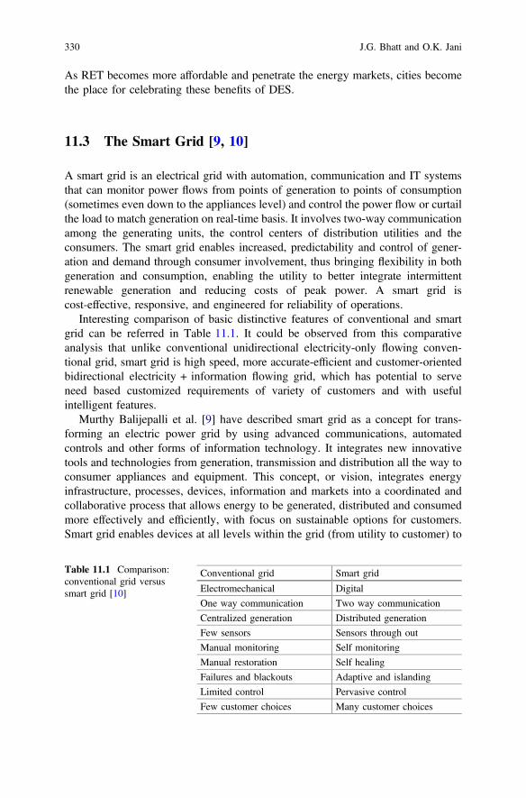
As RET becomes more affordable and penetrate the energy markets, cities becomethe place for celebrating these benefits of DES.
11.3 The Smart Grid [9, 10]
A smart grid is an electrical grid with automation, communication and IT systemsthat can monitor power flows from points of generation to points of consumption(sometimes even down to the appliances level) and control the power flow or curtailthe load to match generation on real-time basis. It involves two-way communicationamong the generating units, the control centers of distribution utilities and theconsumers. The smart grid enables increased, predictability and control of gener-ation and demand through consumer involvement, thus bringing flexibility in bothgeneration and consumption, enabling the utility to better integrate intermittentrenewable generation and reducing costs of peak power. A smart grid iscost-effective, responsive, and engineered for reliability of operations.
Interesting comparison of basic distinctive features of conventional and smartgrid can be referred in Table 11.1. It could be observed from this comparativeanalysis that unlike conventional unidirectional electricity-only flowing conven-tional grid, smart grid is high speed, more accurate-efficient and customer-orientedbidirectional electricity + information flowing grid, which has potential to serveneed based customized requirements of variety of customers and with usefulintelligent features.
Murthy Balijepalli et al. [9] have described smart grid as a concept for trans-forming an electric power grid by using advanced communications, automatedcontrols and other forms of information technology. It integrates new innovativetools and technologies from generation, transmission and distribution all the way toconsumer appliances and equipment. This concept, or vision, integrates energyinfrastructure, processes, devices, information and markets into a coordinated andcollaborative process that allows energy to be generated, distributed and consumedmore effectively and efficiently, with focus on sustainable options for customers.Smart grid enables devices at all levels within the grid (from utility to customer) to
Table 11.1 Comparison:conventional grid versussmart grid [10]
Conventional grid Smart grid
Electromechanical Digital
One way communication Two way communication
Centralized generation Distributed generation
Few sensors Sensors through out
Manual monitoring Self monitoring
Manual restoration Self healing
Failures and blackouts Adaptive and islanding
Limited control Pervasive control
Few customer choices Many customer choices
330 J.G. Bhatt and O.K. Jani
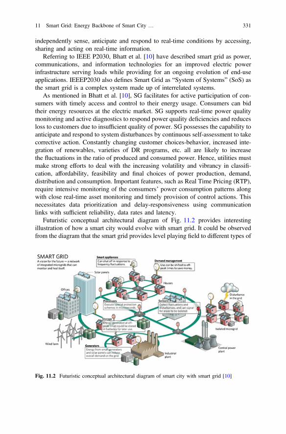
independently sense, anticipate and respond to real-time conditions by accessing,sharing and acting on real-time information.
Referring to IEEE P2030, Bhatt et al. [10] have described smart grid as power,communications, and information technologies for an improved electric powerinfrastructure serving loads while providing for an ongoing evolution of end-useapplications. IEEEP2030 also defines Smart Grid as “System of Systems” (SoS) asthe smart grid is a complex system made up of interrelated systems.
As mentioned in Bhatt et al. [10], SG facilitates for active participation of con-sumers with timely access and control to their energy usage. Consumers can bidtheir energy resources at the electric market. SG supports real-time power qualitymonitoring and active diagnostics to respond power quality deficiencies and reducesloss to customers due to insufficient quality of power. SG possesses the capability toanticipate and respond to system disturbances by continuous self-assessment to takecorrective action. Constantly changing customer choices-behavior, increased inte-gration of renewables, varieties of DR programs, etc. all are likely to increasethe fluctuations in the ratio of produced and consumed power. Hence, utilities mustmake strong efforts to deal with the increasing volatility and vibrancy in classifi-cation, affordability, feasibility and final choices of power production, demand,distribution and consumption. Important features, such as Real Time Pricing (RTP),require intensive monitoring of the consumers’ power consumption patterns alongwith close real-time asset monitoring and timely provision of control actions. Thisnecessitates data prioritization and delay-responsiveness using communicationlinks with sufficient reliability, data rates and latency.
Futuristic conceptual architectural diagram of Fig. 11.2 provides interestingillustration of how a smart city would evolve with smart grid. It could be observedfrom the diagram that the smart grid provides level playing field to different types of
Fig. 11.2 Futuristic conceptual architectural diagram of smart city with smart grid [10]
11 Smart Grid: Energy Backbone of Smart City … 331
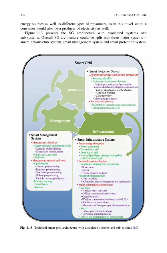
energy sources as well as different types of prosumers, as in this novel setup, aconsumer would also be a producer of electricity as well.
Figure 11.3 presents the SG architecture with associated systems andsub-systems. Overall SG architecture could be split into three major systems—smart infrastructure system, smart management system and smart protection system.
Fig. 11.3 Technical smart grid architecture with associated systems and sub-systems [10]
332 J.G. Bhatt and O.K. Jani
(a) Smart infrastructure system is the energy, information, and communicationinfrastructure underlying of the SG that supports (i) advanced electricity gen-eration, delivery, and consumption, (ii) advanced information metering, mon-itoring, and management and (iii) advanced communication technologies. Thesmart infrastructure system has been further split into three subsystems: smartenergy subsystem, smart information subsystem, and smart communicationsubsystem.
(b) Smart management system is the subsystem in SG that provides advancedmanagement and control services. The smart management system has also beensplit further into two subsystems: management objectives, and managementmethods and tools.
(c) Smart protection system is the subsystem in SG that provides advanced gridreliability analysis, failure protection, and security and privacy protection ser-vices. The smart protection system has also been split further into two sub-systems: system reliability and failure protection; and security and privacy.
11.3.1 Key Characteristics and Benefits [9, 11]
Key Characteristics:
(i) Superior citizen involvement in e-Governance:Involves consumers by engaging them as active prosumer (pro-ducer + consumer) participants in the electricity marketProvides timely information and control options to consumersReal time monitoring, automated outage management and faster restorationenables consumers to enjoy improved reliabilityIn-house displays, IoT based equipments, programmable control ther-mostats, portals and energy information tools like mobile apps enableconsumers to track and manage their energy usage and identify opportu-nities to reduce and conserve electricity
(ii) Improved power quality:Provides high quality of power and reduces the occurrence of distortions ofpower supplyRespond to local and system-wide inputs and have much more informationabout broader system problems
(iii) Enable demand response:Dynamic pricing mechanisms incentivize consumers to alter their usageduring different times of day based on pricing signals, enabling them tooptimize their electricity bills through better energy managementExtends within home, so that consumer appliances, devices, etc. can becontrolled remotely allowing for demand response
11 Smart Grid: Energy Backbone of Smart City … 333
(iv) Market empowerment:Provides greater transparency and availability of energy market informationEnables more efficient, automated management of market parametersProvides level playing opportunities to new market products
(v) Enhanced automation:Incorporate extensive measurements, rapid communication, centralizedadvanced diagnostics, and feedback control that quickly return the system toa stable state after interruptions or disturbances
(vi) Clean and green:The energy conservation and improvements in end-use efficiency enabledby the smart grid reduce half of the emissionsDeploy and integrate distributed resources and generation includingrenewable resourcesFacilitates distributed generation, especially the roof top solar generation,by allowing movement and measurement of energy in both directions
(vii) Self-healing and resilient:Performs real time self-assessment to detect, analyze and respond to sub-normal grid conditionsDetects and addresses emerging problems on the system before they affectservice
(viii) Asset optimization and operational efficiency:Enables better asset utilization from generation to the consumer end points
(ix) Integration of advance and low carbon technologies:Enables ‘Plug and Play” scalable and interoperable capabilitiesPermits higher transmission and distribution system penetration of renew-able generation, distributed generation and energy storageIntegrates “smart” appliances (IoT based) and consumer devices like hybridcars, electric vehicles, etc.
Benefits:
Benefits extended by smart grid to its various stakeholders have been included inTable 11.2. It could be observed that smart grid provides win-win situation for allthe stakeholders without many tradeoffs. Overall financial implications could bereduced by generation of renewable energy by consumers and thereby reaching thefinal break-even point easily.
11.3.2 Smart Grid in India [14–19]
Indian power sector is expanding at a fast pace. India has a power sector charac-terized by deficient generation and high distribution losses. The first powerexchange of India was introduced in June 2008. Smart grid activity has beenreported in some distribution pockets mostly by private players. Many utilities in
334 J.G. Bhatt and O.K. Jani
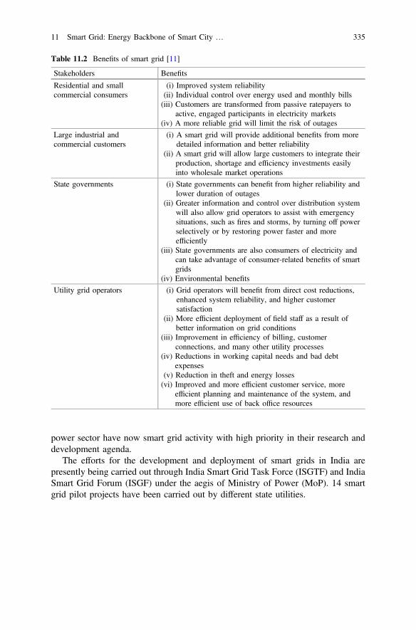
power sector have now smart grid activity with high priority in their research anddevelopment agenda.
The efforts for the development and deployment of smart grids in India arepresently being carried out through India Smart Grid Task Force (ISGTF) and IndiaSmart Grid Forum (ISGF) under the aegis of Ministry of Power (MoP). 14 smartgrid pilot projects have been carried out by different state utilities.
Table 11.2 Benefits of smart grid [11]
Stakeholders Benefits
Residential and smallcommercial consumers
(i) Improved system reliability(ii) Individual control over energy used and monthly bills(iii) Customers are transformed from passive ratepayers to
active, engaged participants in electricity markets(iv) A more reliable grid will limit the risk of outages
Large industrial andcommercial customers
(i) A smart grid will provide additional benefits from moredetailed information and better reliability
(ii) A smart grid will allow large customers to integrate theirproduction, shortage and efficiency investments easilyinto wholesale market operations
State governments (i) State governments can benefit from higher reliability andlower duration of outages
(ii) Greater information and control over distribution systemwill also allow grid operators to assist with emergencysituations, such as fires and storms, by turning off powerselectively or by restoring power faster and moreefficiently
(iii) State governments are also consumers of electricity andcan take advantage of consumer-related benefits of smartgrids
(iv) Environmental benefits
Utility grid operators (i) Grid operators will benefit from direct cost reductions,enhanced system reliability, and higher customersatisfaction
(ii) More efficient deployment of field staff as a result ofbetter information on grid conditions
(iii) Improvement in efficiency of billing, customerconnections, and many other utility processes
(iv) Reductions in working capital needs and bad debtexpenses
(v) Reduction in theft and energy losses(vi) Improved and more efficient customer service, more
efficient planning and maintenance of the system, andmore efficient use of back office resources
11 Smart Grid: Energy Backbone of Smart City … 335
11.3.2.1 Government Initiatives [11, 14–16]
(a) Smart Cities Mission [14]Smart Cities Mission is an urban renewal and retrofitting program by theGovernment of India with a mission to develop 100 smart cities all over thecountry making them citizen friendly and sustainable. Ministry of UrbanDevelopment is responsible for implementing the mission in collaboration withthe state governments of the respective cities. The government of India has avision of developing 100 smart cities as satellite towns of larger cities and bymodernizing the existing mid-sized cities. Smart cities are projected to beequipped with basic infrastructure to offer good quality of life through smartsolutions. Assured water and power supply, sanitation and solid waste man-agement, efficient urban mobility and public transport, robust IT connectivity,e-Governance and citizen participation along with safety-security of its citizensare some of the likely attributes of these smart cities.Smart Cities Mission of the Government is a bold, new initiative. It is meant toset examples that can be replicated both within and outside the Smart City,catalyzing the creation of similar Smart Cities in various regions and parts ofthe country. The core infrastructure elements in a smart city would include:
(i) adequate water supply(ii) assured electricity supply(iii) sanitation, including solid waste management(iv) efficient urban mobility and public transport(v) affordable housing, especially for the poor(vi) robust IT connectivity and digitalization(vii) good governance, especially e-Governance and citizen participation(viii) sustainable environment(ix) safety and security of citizens, particularly women, children and the
elderly(x) health and education
Solar PV and Smart Grid serve as essential subsystems of any smart city inform of “Reliable Energy Backbone” to supply continuous power and seamlessconnectivity for all smart applications conceived under a smart city.
(b) National Smart Grid Mission (NSGM) [15]Government has approved the National Smart Grid Mission (NSGM), aninstitutional mechanism for planning, monitoring and implementation of poli-cies and programs related to Smart Grid activities. Major activities envisagedunder NSGM are development of smart grid, development of micro grids,citizen engagements, training and capacity building, etc. NSGM entailsimplementation of a smart electrical grid based on state-of-the art technology inthe fields of automation, communication and IT systems to monitor and controlpower flows from points of generation to points of consumption.
336 J.G. Bhatt and O.K. Jani
A smart Grid Vision and Roadmap for India was approved by the Ministry ofPower in August 2013 which also envisaged the launch of National Smart GridMission (NSGM) having its own resources, authority, functional and financialauthority to plan and monitor implementation of the policies and programmesprescribed in the roadmap.
(c) India Smart Grid Task Force (ISGTF) [11]The Government of India formed the India Smart Grid Task Force in 2010 as aninter-ministerial group and will serve as the government focal point. It is a bodycomposed of officials from different government departments and is primarilymeant for understanding and advocating policies in smart grid technologies.Major functions of the ISGTF are:
(i) To ensure awareness, coordination, and integration of diverse activitiesrelated to smart grid technologies
(ii) To promote practices and services for R&D of smart grids(iii) To coordinate and integrate other relevant intergovernmental activities(iv) To collaborate on an interoperability framework(v) To review and validate recommendations from the ISGF
Corresponding to NSGM, each of the states also has a State Level Missionwhich is chaired by the Power Secretary of the state. The administrative/operation and maintenance expenses in this regard have been borne byrespective states. NSGM provides support for training and capacity building toState Level Project Monitoring Units (SLPMUs) for smart grid activities.
(d) India Smart Grid Forum (ISGF) [11]The Government of India also formulated the India Smart Grid Forum in 2010as a non-profit, voluntary consortium of public and private stakeholders withthe prime objective of accelerating development of smart grid technologies inthe Indian power sector. The ISGF has roles and responsibilities complemen-tary to the ISGTF.The goal of the forum is to help the Indian power sector to deploy Smart Gridtechnologies in an efficient, cost-effective, innovative and scalable manner bybringing together all the key stakeholders and enabling technologies.The India Smart Grid Forum will coordinate and cooperate with relevant globaland Indian bodies to leverage global experience and standards where everavailable or helpful, and will highlight any gaps in the same from an Indianperspective.India Smart Grid Forum (ISGF) is a public-private partnership initiative of theMinistry of Power (MoP), Government of India for accelerated developmentand deployment of smart grid technologies in the Indian power sector.
11 Smart Grid: Energy Backbone of Smart City … 337
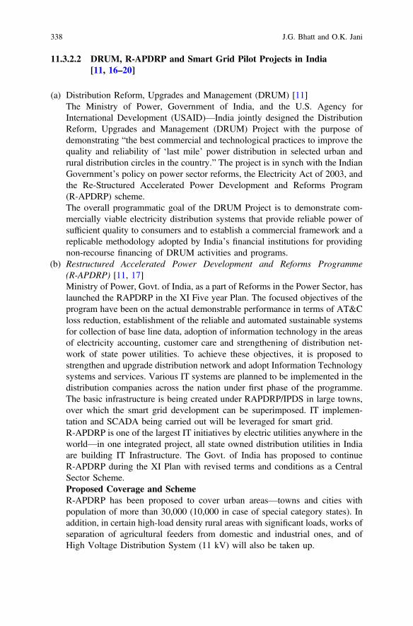
11.3.2.2 DRUM, R-APDRP and Smart Grid Pilot Projects in India[11, 16–20]
(a) Distribution Reform, Upgrades and Management (DRUM) [11]The Ministry of Power, Government of India, and the U.S. Agency forInternational Development (USAID)—India jointly designed the DistributionReform, Upgrades and Management (DRUM) Project with the purpose ofdemonstrating “the best commercial and technological practices to improve thequality and reliability of ‘last mile’ power distribution in selected urban andrural distribution circles in the country.” The project is in synch with the IndianGovernment’s policy on power sector reforms, the Electricity Act of 2003, andthe Re-Structured Accelerated Power Development and Reforms Program(R-APDRP) scheme.The overall programmatic goal of the DRUM Project is to demonstrate com-mercially viable electricity distribution systems that provide reliable power ofsufficient quality to consumers and to establish a commercial framework and areplicable methodology adopted by India’s financial institutions for providingnon-recourse financing of DRUM activities and programs.
(b) Restructured Accelerated Power Development and Reforms Programme(R-APDRP) [11, 17]Ministry of Power, Govt. of India, as a part of Reforms in the Power Sector, haslaunched the RAPDRP in the XI Five year Plan. The focused objectives of theprogram have been on the actual demonstrable performance in terms of AT&Closs reduction, establishment of the reliable and automated sustainable systemsfor collection of base line data, adoption of information technology in the areasof electricity accounting, customer care and strengthening of distribution net-work of state power utilities. To achieve these objectives, it is proposed tostrengthen and upgrade distribution network and adopt Information Technologysystems and services. Various IT systems are planned to be implemented in thedistribution companies across the nation under first phase of the programme.The basic infrastructure is being created under RAPDRP/IPDS in large towns,over which the smart grid development can be superimposed. IT implemen-tation and SCADA being carried out will be leveraged for smart grid.R-APDRP is one of the largest IT initiatives by electric utilities anywhere in theworld—in one integrated project, all state owned distribution utilities in Indiaare building IT Infrastructure. The Govt. of India has proposed to continueR-APDRP during the XI Plan with revised terms and conditions as a CentralSector Scheme.Proposed Coverage and SchemeR-APDRP has been proposed to cover urban areas—towns and cities withpopulation of more than 30,000 (10,000 in case of special category states). Inaddition, in certain high-load density rural areas with significant loads, works ofseparation of agricultural feeders from domestic and industrial ones, and ofHigh Voltage Distribution System (11 kV) will also be taken up.
338 J.G. Bhatt and O.K. Jani
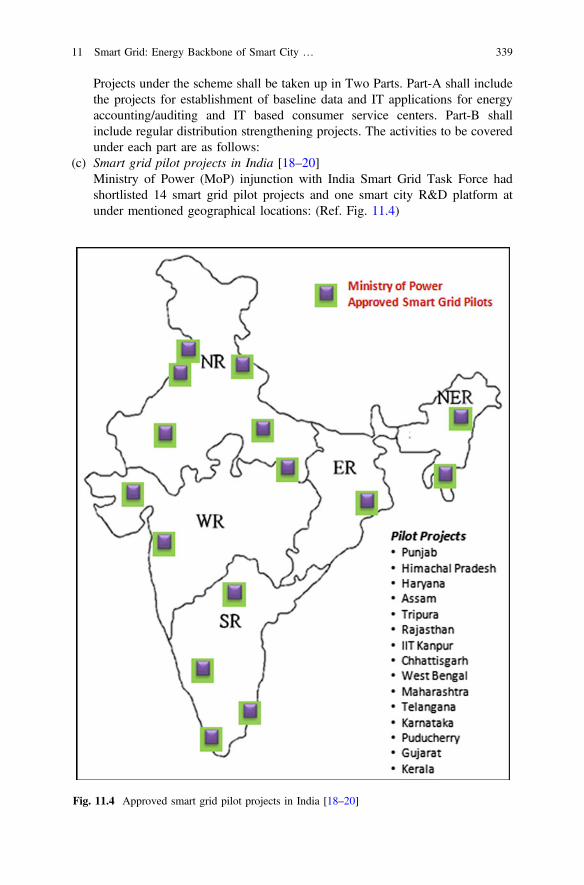
Projects under the scheme shall be taken up in Two Parts. Part-A shall includethe projects for establishment of baseline data and IT applications for energyaccounting/auditing and IT based consumer service centers. Part-B shallinclude regular distribution strengthening projects. The activities to be coveredunder each part are as follows:
(c) Smart grid pilot projects in India [18–20]Ministry of Power (MoP) injunction with India Smart Grid Task Force hadshortlisted 14 smart grid pilot projects and one smart city R&D platform atunder mentioned geographical locations: (Ref. Fig. 11.4)
Fig. 11.4 Approved smart grid pilot projects in India [18–20]
11 Smart Grid: Energy Backbone of Smart City … 339

(i) APDCL, Assam(ii) CESC, Mysore(iii) CSPDCL, Chhattisgarh(iv) HPSEB, Himachal Pradesh(v) JVVNL, Rajasthan(vi) KSEB, Kerala(vii) MSEDCL, Maharashtra(viii) PED, Pondicherry(ix) PSPCL, Punjab(x) TSECL, Tripura(xi) TSSPDCL, Telangana(xii) UHBVN, Haryana(xiii) UGVCL, Gujarat(xiv) WBSEDCL, West Bengal(xv) IIT Kanpur
Most of these projects have been part funded by MoP (50% project cost asgrant from GoI) with combined costs of approximately about US$ 80 million.Most of these projects have been either executed or on the verge of completionwith active involvement/participation of 20,000 or more citizens.
11.3.3 Smart Grid in Gujarat [20–22]
With duly implemented IT systems under ‘E-Urja’ program to manage their busi-ness functions, Gujarat DisComs have been leading among all utilities across thenation in terms of reduction of losses and IT systems implementation. To utilize theopportunity provided by Govt. of India under R-APDRP scheme, Gujarat DisComshave been further strengthening their distribution network and IT systems andintegrating them with existing ‘E-Urja’ systems Fig. 11.5.
11.3.3.1 Methodology: UGVCL’s Approach [23, 24]
Incorporated in 2003, as a part of power sector reforms pursuant to the unbundlingof erstwhile Gujarat Electricity Board (GEB), Uttar Gujarat Vij Company Limited(UGVCL) commenced its commercial operations in 2005, pursuant to notificationsof the Government of Gujarat as an independent distribution licensee engaged indistribution and retail supply of electricity. As shown in Fig. 11.6, northern districtsBanaskantha, Patan, Mehsana, Sabarkantha and central districts of Ahmedabad andGandhinagar are covered by UGVCL electrical supply.
340 J.G. Bhatt and O.K. Jani
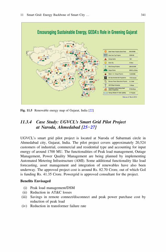
11.3.4 Case Study: UGVCL’s Smart Grid Pilot Projectat Naroda, Ahmedabad [25−27]
UGVCL’s smart grid pilot project is located at Naroda of Sabarmati circle inAhmedabad city, Gujarat, India. The pilot project covers approximately 20,524customers of industrial, commercial and residential type and accounting for inputenergy of around 1700 MU. The functionalities of Peak load management, OutageManagement, Power Quality Management are being planned by implementingAutomated Metering Infrastructure (AMI). Some additional functionality like loadforecasting, asset management and integration of renewables have also beenunderway. The approved project cost is around Rs. 82.70 Crore, out of which GoIis funding Rs. 41.35 Crore. Powergrid is approved consultant for the project.
Benefits Envisaged
(i) Peak load management/DSM(ii) Reduction in AT&C losses(iii) Savings in remote connect/disconnect and peak power purchase cost by
reduction of peak load(iv) Reduction in transformer failure rate
Fig. 11.5 Renewable energy map of Gujarat, India [22]
11 Smart Grid: Energy Backbone of Smart City … 341
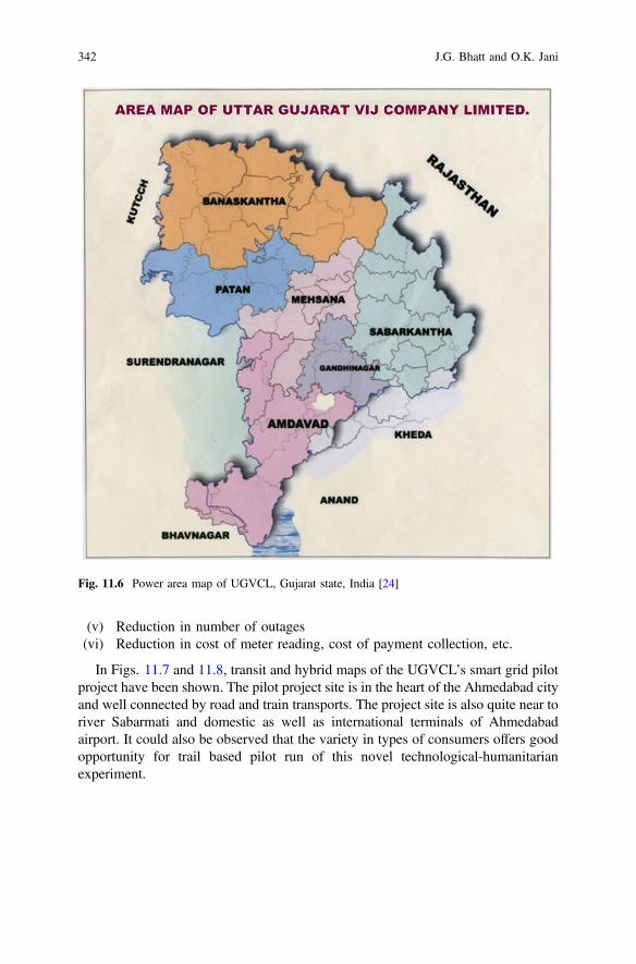
(v) Reduction in number of outages(vi) Reduction in cost of meter reading, cost of payment collection, etc.
In Figs. 11.7 and 11.8, transit and hybrid maps of the UGVCL’s smart grid pilotproject have been shown. The pilot project site is in the heart of the Ahmedabad cityand well connected by road and train transports. The project site is also quite near toriver Sabarmati and domestic as well as international terminals of Ahmedabadairport. It could also be observed that the variety in types of consumers offers goodopportunity for trail based pilot run of this novel technological-humanitarianexperiment.
Fig. 11.6 Power area map of UGVCL, Gujarat state, India [24]
342 J.G. Bhatt and O.K. Jani
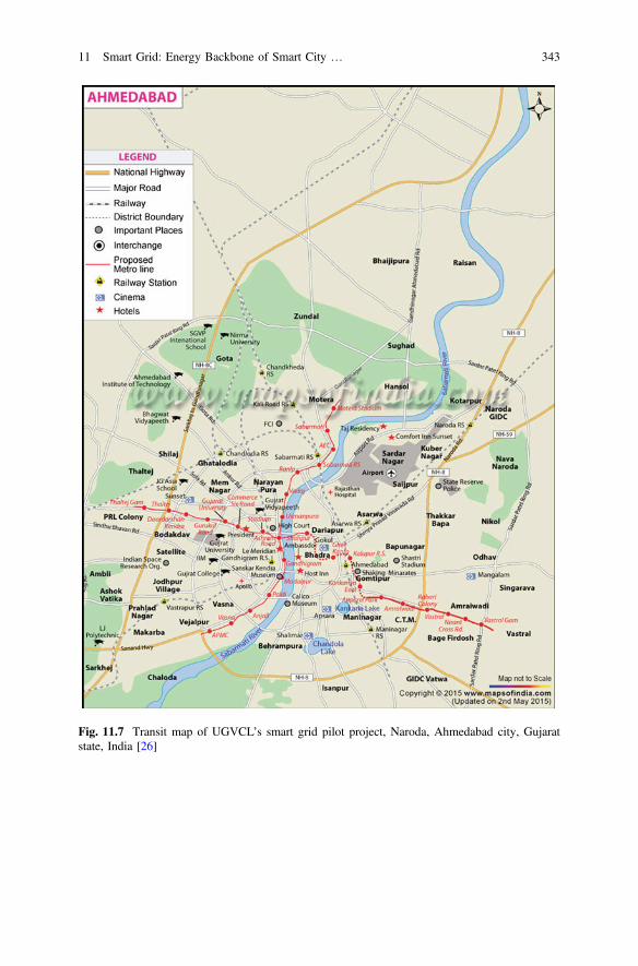
Fig. 11.7 Transit map of UGVCL’s smart grid pilot project, Naroda, Ahmedabad city, Gujaratstate, India [26]
11 Smart Grid: Energy Backbone of Smart City … 343

Fig. 11.8 Hybrid map of UGVCL’s smart grid pilot project, Naroda, Ahmedabad city, Gujarat,India [27]
344 J.G. Bhatt and O.K. Jani
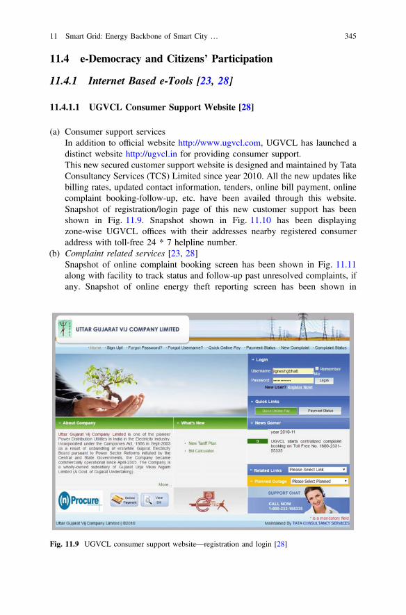
11.4 e-Democracy and Citizens’ Participation
11.4.1 Internet Based e-Tools [23, 28]
11.4.1.1 UGVCL Consumer Support Website [28]
(a) Consumer support servicesIn addition to official website http://www.ugvcl.com, UGVCL has launched adistinct website http://ugvcl.in for providing consumer support.This new secured customer support website is designed and maintained by TataConsultancy Services (TCS) Limited since year 2010. All the new updates likebilling rates, updated contact information, tenders, online bill payment, onlinecomplaint booking-follow-up, etc. have been availed through this website.Snapshot of registration/login page of this new customer support has beenshown in Fig. 11.9. Snapshot shown in Fig. 11.10 has been displayingzone-wise UGVCL offices with their addresses nearby registered consumeraddress with toll-free 24 * 7 helpline number.
(b) Complaint related services [23, 28]Snapshot of online complaint booking screen has been shown in Fig. 11.11along with facility to track status and follow-up past unresolved complaints, ifany. Snapshot of online energy theft reporting screen has been shown in
Fig. 11.9 UGVCL consumer support website—registration and login [28]
11 Smart Grid: Energy Backbone of Smart City … 345
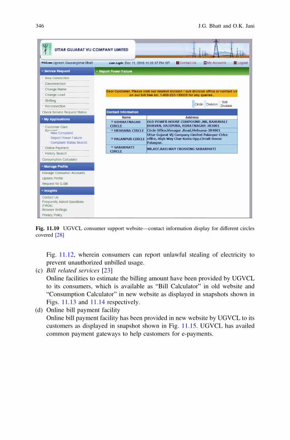
Fig. 11.12, wherein consumers can report unlawful stealing of electricity toprevent unauthorized unbilled usage.
(c) Bill related services [23]Online facilities to estimate the billing amount have been provided by UGVCLto its consumers, which is available as “Bill Calculator” in old website and“Consumption Calculator” in new website as displayed in snapshots shown inFigs. 11.13 and 11.14 respectively.
(d) Online bill payment facilityOnline bill payment facility has been provided in new website by UGVCL to itscustomers as displayed in snapshot shown in Fig. 11.15. UGVCL has availedcommon payment gateways to help customers for e-payments.
Fig. 11.10 UGVCL consumer support website—contact information display for different circlescovered [28]
346 J.G. Bhatt and O.K. Jani
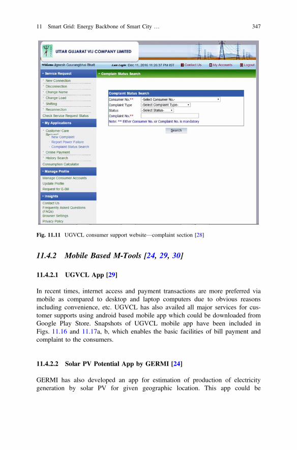
11.4.2 Mobile Based M-Tools [24, 29, 30]
11.4.2.1 UGVCL App [29]
In recent times, internet access and payment transactions are more preferred viamobile as compared to desktop and laptop computers due to obvious reasonsincluding convenience, etc. UGVCL has also availed all major services for cus-tomer supports using android based mobile app which could be downloaded fromGoogle Play Store. Snapshots of UGVCL mobile app have been included inFigs. 11.16 and 11.17a, b, which enables the basic facilities of bill payment andcomplaint to the consumers.
11.4.2.2 Solar PV Potential App by GERMI [24]
GERMI has also developed an app for estimation of production of electricitygeneration by solar PV for given geographic location. This app could be
Fig. 11.11 UGVCL consumer support website—complaint section [28]
11 Smart Grid: Energy Backbone of Smart City … 347
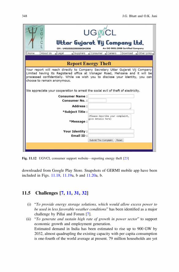
downloaded from Google Play Store. Snapshots of GERMI mobile app have beenincluded in Figs. 11.18, 11.19a, b and 11.20a, b.
11.5 Challenges [7, 11, 31, 32]
(i) “To provide energy storage solutions, which would allow excess power tobe used in less favorable weather conditions” has been identified as a majorchallenge by Pillai and Forum [7].
(ii) “To generate and sustain high rate of growth in power sector” to supporteconomic growth and employment generation.Estimated demand in India has been estimated to rise up to 900 GW by2032, almost quadrupling the existing capacity with per capita consumptionis one-fourth of the world average at present. 79 million households are yet
Fig. 11.12 UGVCL consumer support website—reporting energy theft [23]
348 J.G. Bhatt and O.K. Jani
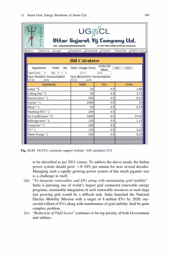
to be electrified as per 2011 census. To address the above needs, the Indianpower system should grow *8–10% per annum for next several decades.Managing such a rapidly growing power system of this much gigantic sizeis a challenge in itself.
(iii) “To integrate renewables and EVs along with maintaining grid stability”India is pursuing one of world’s largest grid connected renewable energyprograms, sustainable integration of such renewable resources to such largefast growing grid would be a difficult task. India launched the NationalElectric Mobility Mission with a target of 6 million EVs by 2020; suc-cessful rollout of EVs along with maintenance of grid stability shall be quitecomplex problem.
(iv) “Reduction of T&D losses” continues to be top priority of both Governmentand utilities.
Fig. 11.13 UGVCL consumer support website—bill calculator [23]
11 Smart Grid: Energy Backbone of Smart City … 349
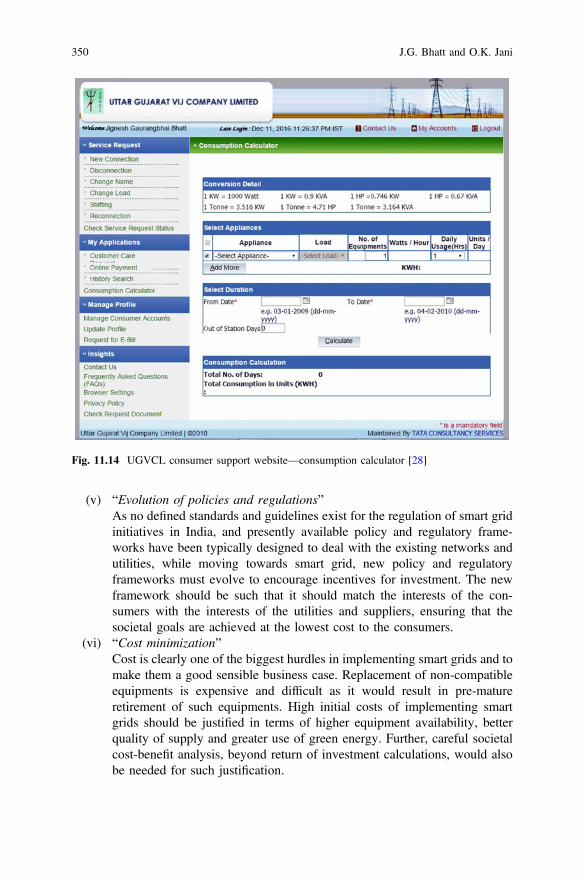
(v) “Evolution of policies and regulations”As no defined standards and guidelines exist for the regulation of smart gridinitiatives in India, and presently available policy and regulatory frame-works have been typically designed to deal with the existing networks andutilities, while moving towards smart grid, new policy and regulatoryframeworks must evolve to encourage incentives for investment. The newframework should be such that it should match the interests of the con-sumers with the interests of the utilities and suppliers, ensuring that thesocietal goals are achieved at the lowest cost to the consumers.
(vi) “Cost minimization”Cost is clearly one of the biggest hurdles in implementing smart grids and tomake them a good sensible business case. Replacement of non-compatibleequipments is expensive and difficult as it would result in pre-matureretirement of such equipments. High initial costs of implementing smartgrids should be justified in terms of higher equipment availability, betterquality of supply and greater use of green energy. Further, careful societalcost-benefit analysis, beyond return of investment calculations, would alsobe needed for such justification.
Fig. 11.14 UGVCL consumer support website—consumption calculator [28]
350 J.G. Bhatt and O.K. Jani
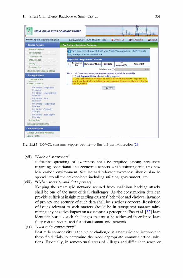
(vii) “Lack of awareness”Sufficient spreading of awareness shall be required among prosumersregarding operational and economic aspects while ushering into this newlow carbon environment. Similar and relevant awareness should also bespread into all the stakeholders including utilities, government, etc.
(viii) “Cyber security and data privacy”Keeping the smart grid network secured from malicious hacking attacksshall be one of the most critical challenges. As the consumption data canprovide sufficient insight regarding citizens’ behavior and choices, invasionof privacy and security of such data shall be a serious concern. Resolutionof issues relevant to such matters should be in transparent manner mini-mizing any negative impact on a customer’s perception. Fan et al. [32] haveidentified various such challenges that must be addressed in order to havefully robust, secure and functional smart grid network.
(ix) “Last mile connectivity”Last mile connectivity is the major challenge in smart grid applications andthese field trials to determine the most appropriate communication solu-tions. Especially, in remote-rural areas of villages and difficult to reach or
Fig. 11.15 UGVCL consumer support website—online bill payment section [28]
11 Smart Grid: Energy Backbone of Smart City … 351
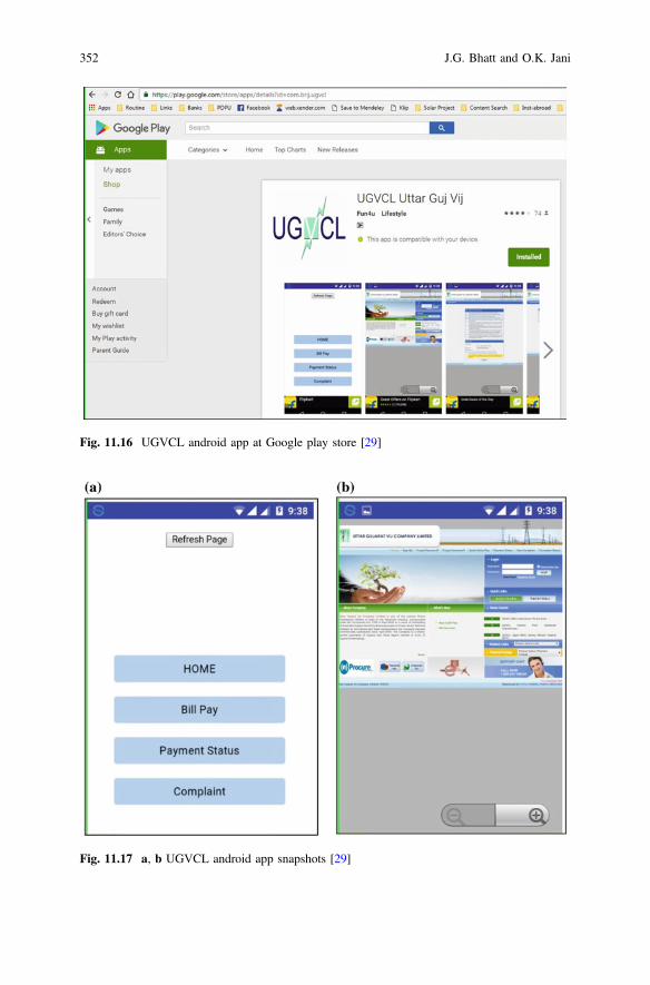
Fig. 11.16 UGVCL android app at Google play store [29]
Fig. 11.17 a, b UGVCL android app snapshots [29]
352 J.G. Bhatt and O.K. Jani
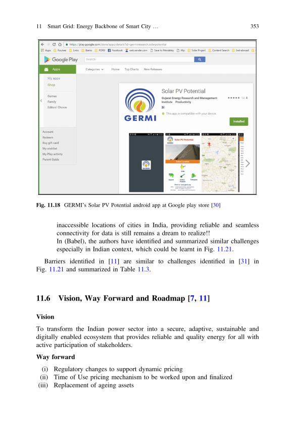
inaccessible locations of cities in India, providing reliable and seamlessconnectivity for data is still remains a dream to realize!!In (Babel), the authors have identified and summarized similar challengesespecially in Indian context, which could be learnt in Fig. 11.21.
Barriers identified in [11] are similar to challenges identified in [31] inFig. 11.21 and summarized in Table 11.3.
11.6 Vision, Way Forward and Roadmap [7, 11]
Vision
To transform the Indian power sector into a secure, adaptive, sustainable anddigitally enabled ecosystem that provides reliable and quality energy for all withactive participation of stakeholders.
Way forward
(i) Regulatory changes to support dynamic pricing(ii) Time of Use pricing mechanism to be worked upon and finalized(iii) Replacement of ageing assets
Fig. 11.18 GERMI’s Solar PV Potential android app at Google play store [30]
11 Smart Grid: Energy Backbone of Smart City … 353
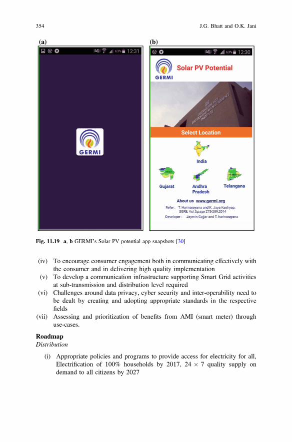
(iv) To encourage consumer engagement both in communicating effectively withthe consumer and in delivering high quality implementation
(v) To develop a communication infrastructure supporting Smart Grid activitiesat sub-transmission and distribution level required
(vi) Challenges around data privacy, cyber security and inter-operability need tobe dealt by creating and adopting appropriate standards in the respectivefields
(vii) Assessing and prioritization of benefits from AMI (smart meter) throughuse-cases.
RoadmapDistribution
(i) Appropriate policies and programs to provide access for electricity for all,Electrification of 100% households by 2017, 24 7 quality supply ondemand to all citizens by 2027
Fig. 11.19 a, b GERMI’s Solar PV potential app snapshots [30]
354 J.G. Bhatt and O.K. Jani
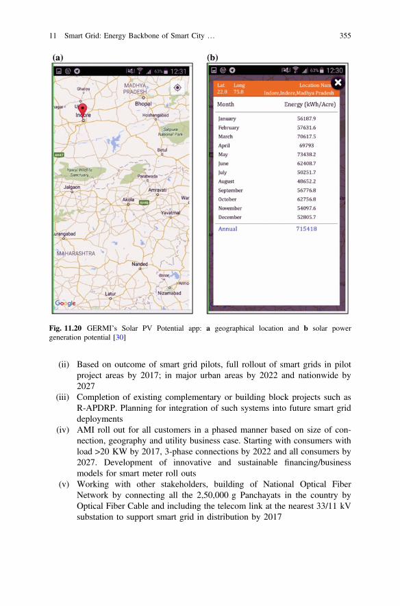
(ii) Based on outcome of smart grid pilots, full rollout of smart grids in pilotproject areas by 2017; in major urban areas by 2022 and nationwide by2027
(iii) Completion of existing complementary or building block projects such asR-APDRP. Planning for integration of such systems into future smart griddeployments
(iv) AMI roll out for all customers in a phased manner based on size of con-nection, geography and utility business case. Starting with consumers withload >20 KW by 2017, 3-phase connections by 2022 and all consumers by2027. Development of innovative and sustainable financing/businessmodels for smart meter roll outs
(v) Working with other stakeholders, building of National Optical FiberNetwork by connecting all the 2,50,000 g Panchayats in the country byOptical Fiber Cable and including the telecom link at the nearest 33/11 kVsubstation to support smart grid in distribution by 2017
Fig. 11.20 GERMI’s Solar PV Potential app: a geographical location and b solar powergeneration potential [30]
11 Smart Grid: Energy Backbone of Smart City … 355
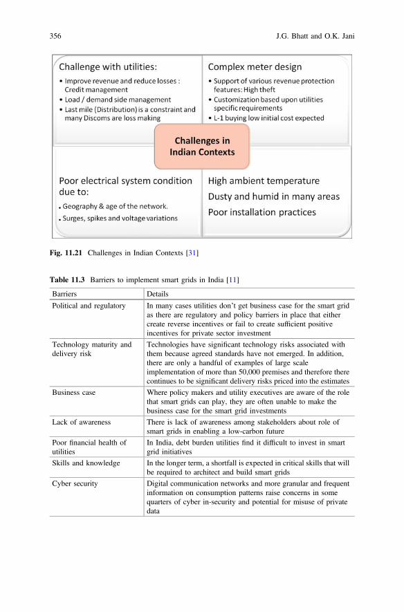
Fig. 11.21 Challenges in Indian Contexts [31]
Table 11.3 Barriers to implement smart grids in India [11]
Barriers Details
Political and regulatory In many cases utilities don’t get business case for the smart gridas there are regulatory and policy barriers in place that eithercreate reverse incentives or fail to create sufficient positiveincentives for private sector investment
Technology maturity anddelivery risk
Technologies have significant technology risks associated withthem because agreed standards have not emerged. In addition,there are only a handful of examples of large scaleimplementation of more than 50,000 premises and therefore therecontinues to be significant delivery risks priced into the estimates
Business case Where policy makers and utility executives are aware of the rolethat smart grids can play, they are often unable to make thebusiness case for the smart grid investments
Lack of awareness There is lack of awareness among stakeholders about role ofsmart grids in enabling a low-carbon future
Poor financial health ofutilities
In India, debt burden utilities find it difficult to invest in smartgrid initiatives
Skills and knowledge In the longer term, a shortfall is expected in critical skills that willbe required to architect and build smart grids
Cyber security Digital communication networks and more granular and frequentinformation on consumption patterns raise concerns in somequarters of cyber in-security and potential for misuse of privatedata
356 J.G. Bhatt and O.K. Jani
(vi) Enabling programs and projects in distribution utilities to reduce AT&Closses. Below 15% by 2017, below 12% by 2022, and below 10% by 2027
(vii) Conversion of existing EHV sub stations in all urban areas and sub trans-mission and medium voltage substations in metro cities to advanced (suchas) Gas Insulated Substations (GIS) in a phased manner through innovativefinancing models
(viii) Development of Microgrids, storage options, virtual power plants (VPP),vehicle to grid (V2G), solar to grid (PV2G), and building to grid (B2G)technologies in order to manage peak demand, optimally use installedcapacity and eliminate load shedding and black-outs
(ix) Push for mandated roof top solar power generation for large establishmentswith connected load >20 kW
(x) EV charging facilities to be created in all parking lots, institutional build-ings, apartment blocks etc.; and quick/fast charging facilities to be built infuel stations and at strategic locations on highways
(xi) Microgrids in 1000 villages/industrial parks/commercial hubs by 2017 and10,000 villages/industrial parks/commercial hubs by 2022. Islanding facilityfrom main grids during peak hours to be availed
(xii) Optimally balancing different sources of generation through efficientscheduling and dispatch of distributed energy resources (including captiveplants in the near term) with the goal of long term energy sustainability
(xiii) Improvement in power quality and quantum across the board
Transmission
(i) Development of a reliable, secure and resilient grid supported by a strongcommunication infrastructure that enables greater visibility and control ofefficient power flow between all sources of production and consumption by2027
(ii) Implementation of WAMS, using PMUs for the entire transmission system.Installation of a larger number of PMUs on the transmission network by2017 or sooner, as guided by the results of initial deployments.Indigenization of WAMS technology and PMU development and develop-ment of custom made analytics for synchrophasor data by 2017
(iii) Setting up of Renewable Energy Monitoring Centers (REMCs) and EnergyStorage Systems to facilitate grid integration of renewable generation
(iv) Installation of 50,000 km of optical fiber ground wire (OPGW) over trans-mission lines by the year 2017 to support implementation of smart gridtechnologies
(v) Enabling programs and projects in transmission utilities to reduce trans-mission losses to below 3.5% by 2017 and below 2.5% by 2022
11 Smart Grid: Energy Backbone of Smart City … 357
(vi) Implement power system enhancements to facilitate evacuation and inte-gration of 30 GW renewable capacity by 2017, 80 GW by 2022, and130 GW by 2027, or as mutually agreed between MoP and MNRE
Policy, standards and regulations
(i) Formulation of effective customer outreach and communication programs(ii) Development of state/utility specific strategic roadmap(s) for Smart Grid
deployments. Required business process reengineering, change manage-ment and capacity building programs
(iii) Policies for grid-interconnection of consumer generation facilities (includ-ing renewable) where feasible. Policies for roof-top solar,net-metering/feed-in tariff as well as peaking power
(iv) Policies supporting improved tariffs such as dynamic tariffs, variable tariffs,etc., including demand response programs. Bulk consumers; extending toall 3-phase (or otherwise defined) consumers by 2017
(v) Policies for implementing energy efficiency in public infrastructure and EVcharging facilities starting and Demand Response ready appliances by 2017.
(vi) Finalization of frameworks for cyber security assessment, audit and certi-fication of utilities
(vii) Development of business models to create alternate revenue streams byleveraging the Smart Grid infrastructure to offer other services (securitysolutions, water metering, traffic solutions etc.) to municipalities, stategovernments and other agencies.
(viii) Build upon the results of smart grid pilot projects and recommend appro-priate changes conducive to smart grid development in Acts/Plans/etc.
(ix) Development of Indian Smart Grid Standards. Active involvement of Indianexperts in international SG development bodies
Other initiatives
(i) Tariff mechanisms, new energy products, energy options and programs toencourage participation of customers in the energy markets that make them“prosumers”—producers and consumers—by 2017
(ii) Create an effective information exchange platform that can be shared by allmarket participants, including prosumers, in real time which will lead to thedevelopment of new and enhanced energy markets.
(iii) Investment in research and development, training and capacity buildingprograms for creation of adequate resource pools for developing andimplementing smart grid technologies in India—can also become a globalleader and exporter of smart grid knowhow, products and services
358 J.G. Bhatt and O.K. Jani
11.7 Technological Inputs
11.7.1 Hybrid Communication Technologies [32–35]
Fan et al. [32] have opined that optimization of energy consumption in futureintelligent energy networks (or Smart Grids) will be based on grid-integratednear-real-time communications between various grid elements in generation,transmission, distribution and loads.
Wired networking technologies such as RS485, Modbus, PLCC, BACnet,LonWorks, EIB/KNX, etc. and wireless networking technologies such as ZigBee,Wi-Fi, WiMax, GSM, GPRS, 3G-4G, LTE, etc. have been utilized for developmentof communication and integration of various smart grid applications.
Wired networking technologies are popular due to their superior reliability,security and latency performances. However, frequent rewiring of existing facilitiesmay be difficult and expensive, further it also affects the aesthetic of the building;hence in such cases power line and wireless networks have been preferred toenhance coverage and improve scalability. Bhatt [33] have suggested that wirelesstechnologies are demonstrating their relative strength as compared to wired tech-nologies on account of their salient features and obvious merits.
In Roy et al. [34], the authors could observe sufficient potential in pure wirelessas well as hybrid technology solutions (combined of wired and wireless) to servecritical need based applications of smart grid and therefore, those of a smart city.
Overall, need based customizable, mixed or hybrid technology solutions whichare effectively combining wired and/or wireless both type of technologies based onactual requirements could evolve the best and optimum solution(s) for given smartapplication(s).
Güngör et al. [35] have addressed critical issues on smart grid technologiesprimarily in terms of information and communication technology (ICT) issues andopportunities. Main objective of the authors is to provide a contemporary look atthe current state of the art in smart grid communications as well as to discuss thestill-open research issues in this field. The paper provides a better understanding ofthe technologies, potential advantages and research challenges of the smart grid toprovoke future research interests.
11.7.2 IoT, HAN and BAS [2, 3, 5, 36−44]
As described by Arasteh et al. [3], an IoT prototype is subject to smart andself-configuring objects that are connected to each other through a global networkinfrastructure. IoT is mostly considered as real objects, broadly scattered, with lowstorage capability and processing capacity, with the target of improving reliability,performance and security of the smart city and its infrastructures. In the IoT context,devices can be integrated based on the geographic location and evaluated by using
11 Smart Grid: Energy Backbone of Smart City … 359
an analyzing system. An IoT infrastructure could be utilized for the monitoring ofintended domains using sensor services for the collection of particular data. IoT isnot only likely to affect the various aspects of the smart city citizens’ life like health,security, and transportation, it could play an important role at the national level formaking policy decisions in important aspects such as energy saving policies, pol-lution control, economic considerations, reliability enhancement, etc.
Al-Ali [2] have suggested that the concept of Smart Cities is becoming a realityas it evolves from conceptual models to developmental stages. Resilient, reliable,efficient and seamless energy and electrical power flow are essential parts toenergize and power the services of smart cities such as smart hospitals, smartbuildings, smart factories, smart traffic and transportations. All of these smartservices are expected to run without interruptions by the use of smart energy andelectrical power grids which are considered among the most important pillars forsuch cities. To keep the services of smart cities interconnected and in sync, theInternet of Things (IoT) and cloud computing are key in such transfers.
The World Wide Web (WWW) is evolving from a traditional host that containstext, images, audios and videos to a physical host that enables users to controlphysical objects. Home appliances, remote CCTV cameras and factory floors can bemonitored and controlled using Internet of Things (IoT) using communicationmedia. The physical web concept is emerging nowadays. An IoT communicationnetwork is utilized in energy generations and consumptions in residential areas.
The world is becoming an integrated global community through multiple tech-nologies and numerous areas of applications and services. IoT concepts are leadingto a world where real, digital and virtual things are converging to make our citiessmarter and more intelligent. Nowadays, traditional web technologies areempowered by IoT to connect physical objects (things) such as home appliancesand smart grid devices with a unique address for each thing. This has been madepossible with the help of IPV6 protocol which has 2128 unique IP addressescompared to 232 addresses used by IPV4. Using IPV6, billions of objects can beconnected, monitored and controlled at the same time. In terms of communicationnetworks, the consumption domain is divided into three different networks: HomeArea Network (HAN), Business Area Network (BAN) and Industrial Area Network(IAN).
Many communication protocols are utilized in these networks, such as ZigBee,PLCC, Z-wave, Wi-Fi, WiMax, 3G/GSM and LET. Each renewable energyresource is considered as an object and it is assigned a unique IP address. Usingbidirectional communication, it becomes possible to monitor each object as controlis carried out via its unique IP address. Such IoT networks are scalable and moredevices and appliances such as local batteries storage, home appliances, smartmeters, etc. can also be included as objects to join the same network with func-tionalities of remote monitoring and control.
Shrihariprasath and Rathinasabapathy [36] have presented an effective imple-mentation of an intelligent remote monitoring system for solar Photovoltaic(PV) Power Conditioning Unit (PCU) for using in a greenhouse environment. Theproposed smart remote monitoring system is based on internet of things and its
360 J.G. Bhatt and O.K. Jani
GPRS based design could be installed to remotely monitor solar PV PCU in realtime and to solve management problems, maintenance and shortens MTTR.
Perera et al. [37] presented and interesting survey of one hundred IoT smartsolutions in the marketplace and examine them closely in order to identify thetechnologies used, functionalities, and applications. Based on the applicationdomain, the authors have classified and discussed those solutions under have dif-ferent categories such as (i) smart wearable; (ii) smart home; (iii) smart city;(iv) smart environment; and (v) smart enterprise. This survey is intended to serve asa guideline and a conceptual framework for future research in the IoT and tomotivate and inspire further developments. It also provides a systematic explorationof existing research and suggests a number of potentially significant researchdirections.
Domingues et al. [38] have presented that a BAS consists of a system installed inbuildings that controls and monitors building services responsible for heating,cooling, ventilation, air conditioning, lighting, shading, life safety, alarm securitysystems, and many more. A BAS aims at automating tasks in technologically-enabled environments, coordinating a number of electrical and mechanical devicesinterconnected in a distributed manner by means of underlying control networks.These systems may be deployed in industrial infrastructures such as factories, inenterprise buildings and malls, or even in the domestic domain. Buildingautomation has been receiving greater attention due to its potential for reducingenergy consumption and facilitating building operation, monitoring and mainte-nance, while improving occupants’ satisfaction.
Bhatt and Verma [39] have presented simple, user-friendly, re-usable and cus-tomizable design and implementation of wired security system and wired buildingautomation system. Indicating clear trend of legacy stand-alone security systemstransforming into intelligent-computerized-network based building automationsystems, the authors have developed web-based GUI for live run-time monitoringand control of a residential building as major outcome.
Bhatt and Verma [40] have presented the design of a three-layer BAS for aresidential building using PC based controller. GUIs for live remote monitoring viaCCTV camera, critical events alarm annunciation through SMS and distribution ofaudio-video entertainment using intranet/internet are some of the important featuresof the design.
In Patel et al. [41, 42] have presented an alternative design of ProgrammableLogic Controller (PLC) originally aimed at industrial safety and emergencyshutdown-trip systems, however its present commercially available modern andcost-effective versions could also be used in BAS as well as HAN with suitablecustomizations.
Bhatt [43], Bhatt and Verma [39] have described that building automationsystem (BAS) is a data acquisition and control system that incorporates variousfunctionalities provided by the control system of a building. In general, the BAS arealso known by other names such as: energy management control systems (EMCS),building management systems (BMS), building energy management systems(BEMS), facility management systems (FMS) and so on. Modern BAS is a
11 Smart Grid: Energy Backbone of Smart City … 361
computerized, intelligent network of electronic devices, designed to monitor andcontrol the lighting, internal climate and other systems in a building resulting inoptimized energy usage, safety, security, information, communication and enter-tainment facilities. BAS maintains the internal climate of building within a specifiedrange by regulating temperature and humidity regulates lighting based on param-eters like occupancy, ambient light and timing schedule, monitors system perfor-mance and device failures and generates audio-visual-email and/or text notificationsto building operation and maintenance (O&M) staff. The BAS reduces buildingenergy consumption and, thereby, reduces O&M costs as compared to an uncon-trolled building. A building controlled by a BAS is often referred to as an IntelligentBuilding. Home automation or domotics is possibly the system having the highestlevel of functional similarity to building automation. But the former has signifi-cantly different characteristics. While the BAS focuses on financial benefits, thedomotics focuses on comfort and mental peace. Domotics are of comparativelyquite smaller scale, with low costs of equipment as well as commissioning andmaintenance.
Bhatt and Verma [39] have described that Home area network (HAN) is thenetwork within the premises of a house or building enabling devices and loads tocommunicate with each other and dynamically respond to externally sent signals(i.e. price). This type of network, characterized by a low data rate requirement,provides the communication infrastructure behind the meter. As a result, smart gridapplications are extended into the home premises and energy management systems(EMS) capabilities are enabled. Further benefits derived from the realization of suchHANs are anticipated for customers, utilities and society as a whole. Overall,Energy savings and user satisfaction are two major design considerations formodern HAN systems. Interesting descriptions on useful developements of remotemonitoring and control applications of solar PV could be found in Bhatt et al. [5].
Ejaz et al. [44] have presented that the drastic increase in urbanization over thepast few years requires sustainable, efficient, and smart solutions for transportation,governance, environment, quality of life, and so on. The Internet of Things offersmany sophisticated and ubiquitous applications for smart cities. The energy demandof IoT applications is increased, while IoT devices continue to grow in bothnumbers and requirements. Therefore, smart city solutions must have the ability toefficiently utilize energy and handle the associated challenges. Energy managementis considered as a key paradigm for the realization of complex energy systems insmart cities. Along with a brief overview of energy management and challenges insmart cities, a unifying framework for energy-efficient optimization and schedulingof IoT-based smart cities has been presented in the article which is illustrated inFig. 11.22.
362 J.G. Bhatt and O.K. Jani
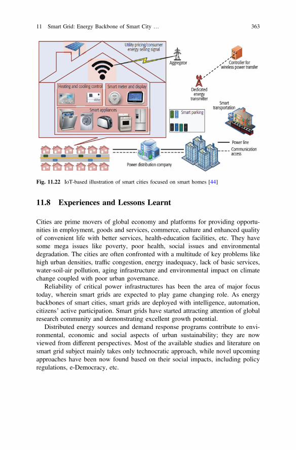
11.8 Experiences and Lessons Learnt
Cities are prime movers of global economy and platforms for providing opportu-nities in employment, goods and services, commerce, culture and enhanced qualityof convenient life with better services, health-education facilities, etc. They havesome mega issues like poverty, poor health, social issues and environmentaldegradation. The cities are often confronted with a multitude of key problems likehigh urban densities, traffic congestion, energy inadequacy, lack of basic services,water-soil-air pollution, aging infrastructure and environmental impact on climatechange coupled with poor urban governance.
Reliability of critical power infrastructures has been the area of major focustoday, wherein smart grids are expected to play game changing role. As energybackbones of smart cities, smart grids are deployed with intelligence, automation,citizens’ active participation. Smart grids have started attracting attention of globalresearch community and demonstrating excellent growth potential.
Distributed energy sources and demand response programs contribute to envi-ronmental, economic and social aspects of urban sustainability; they are nowviewed from different perspectives. Most of the available studies and literature onsmart grid subject mainly takes only technocratic approach, while novel upcomingapproaches have been now found based on their social impacts, including policyregulations, e-Democracy, etc.
Fig. 11.22 IoT-based illustration of smart cities focused on smart homes [44]
11 Smart Grid: Energy Backbone of Smart City … 363
11.9 Conclusions
Transformation from legacy conventional grid to smart grid is now necessity andreality by effective applications of ICT and e-Democracy. The role of smart grids asenergy backbones of smart cities, involving high interactive participation of citizensin energy management, based on humanitarian and customer centric approach hasbeen discussed. After presenting the historical perspectives and present situations ofelectrical power sector in India, interesting relationships of electricity, urbanizationand human settlement have been presented. An interesting case study of one of themost successful Indian smart grid pilot project by UGVCL at Naroda, Ahmedabad,Gujarat, India has been included with brief details regarding citizen participationtools based on internet and mobile. Experiences, issues, challenges along withvision and future roadmap have been shared to mark the end of the chapter.
Rapidly rising urbanization has led to many critical issues like scarcity ofelectricity. Developing countries like India have been aggressively invest in bothstrengthening their existing legacy electricity grids and also by building smart gridsand renewables.
Comprehensive study of renewables’ socio-technical co-assessment, theirresponses and combined impacts upon urban planning and energy policies—havebeen indeed interesting domains of research. Transition to smart grids necessitatesdetailed investigation and comprehensive evaluation regarding co-evolution ofrenewables and social responses together in cities and further how they could berelated to urban planning-policies and citizen-centric e-Governance.
Acknowledgements The authors thankfully acknowledges the support received with apprecia-tions to all the faculty members, Management and office bearers of Gujarat Energy Research andManagement Institute (GERMI), Gandhinagar—382 007, Gujarat, India, Pandit DeendayalPetroleum University (PDPU), Gandhinagar—382 007, Gujarat, India, and Dharmsinh DesaiUniversity (DDU), Nadiad—387 001, Gujarat, India for their kind cooperation, active support andtimely help in development of this book chapter. Useful contributions and cooperation receivedfrom UGVCL, GEDA, Govt. of Gujarat, Govt. of India and all the cited sources of references arealso hereby thankfully acknowledged.The authors also take this opportunity to express their sincere thanks to Editor Prof. TM Vinod
Kumar and his entire team including Springer staff for their valuable guidance, excellent coop-eration and timely help extended.
References
1. Adil AM, Ko Y (2016) Socio−technical evolution of decentralized energy systems: acritical review and implications for urban planning and policy. Renew Sustain Energy Rev57:1025−1037. doi:10.1016/j.rser.2015.12.079
2. Al-Ali AR (2016) Internet of things role in the renewable energy resources. Energy Procedia100:34−38. doi:10.1016/j.egypro.2016.10.144
364 J.G. Bhatt and O.K. Jani
3. Arasteh H, Hosseinnezhad V, Loia V et al (2016) Iot-based smart cities: a survey. EEEIC2016−Int conf environ electr eng. doi:10.1109/EEEIC.2016.7555867
4. Bansal N, Shrivastava V, Singh J (2015) Smart urbanization−key to sustainable cities. RealCorp 2015 2:551−560
5. Bhatt J, Jani O (2014) E−governance for photo voltaic powergrid: solar city Gandhinagar,Gujarat, India. In: E-governance of smart cities
6. ISGF (2013) India smart grid day. India Electr 2013:487. Pillai RK, Forum G (2015) Introduction to India smart grid forum, smart grid vision and
roadmap for India. Smart Grid Projects and India Smart Grid Week 2015 Overview of IndianPower Sector Smart Grids−Challenges for India, pp 1−13
8. Urvish Dave (2016) Year in review for renewable energy sector across India−a new dawn inRenewable Energy! https://urvishdave.wordpress.com/2016/12/19/2016-year-in-review-for-renewable-energy-sector-across-india-a-new-dawn-in-renewable-energy/. Accessed 23 Dec2016
9. Murthy Balijepalli VSK, Khaparde SA, Gupta RP, Pradeep Y (2010) SmartGrid initiativesand power market in India. IEEE PES Gen Meet PES 2010:1−7. doi:10.1109/PES.2010.5589947
10. Bhatt J, Shah V, Jani O (2014) An instrumentation engineer′s review on smart grid: criticalapplications and parameters. Renew Sustain Energy Rev 40:1217−1239
11. Smart Grid http://indianpowersector.com/wp-content/uploads/2013/04/Smart-Grid.pdf.Accessed on 09/01/2016
12. Fistola R, La Rocca RA (2014) New technologies for sustainable energy in the smart city: theWET theory. TeMA J L Use, Mobil Environ 7:29−42. doi:10.1007/s13398-014-0173-7.2
13. Joshi S, Saxena S, Godbole T, Shreya (2016) Developing smart cities: an integratedframework. Procedia Comput Sci 93:902−909. doi:10.1016/j.procs.2016.07.258
14. What is Smart City? http://smartcities.gov.in/writereaddata/What%20is%20Smart%20City.pdf. Accessed 12 Jan 2017
15. National Smart Grid Mission (NSGM). http://www.nsgm.gov.in/content/nsgm.php. Accessed23 Dec 2016
16. India Smart Grid Forum (ISGF)−Smart City Project, UGVCL, Gujarat. http://www.indiasmartgrid.org/ProjectsDesc.php?id=56. Accessed 23 Dec 2016
17. Restructured Accelerated Power Development & Reforms Programme (R−APDRP). http://ipds.co.in/Forms/Know_More.aspx. Accessed 23 Dec 2016
18. Smart Grid Pilots in India. http://www.nsgm.gov.in/content/sg_pilots.php. Accessed 23 Dec2016
19. Smart Grid Pilots−Snapshots. http://www.nsgm.gov.in/content/sg_snapshot.php. Accessed23 Dec 2016
20. Updates on execution of Smart Grid Pilot Projects in India−IV. http://www.desismartgrid.com/2014/06/updates-execution-smart-grid-pilot-projects-india-iv. Accessed 23 Dec 2016
21. Gujarat Energy Development Authority (GEDA) website. http://geda.gujarat.gov.in/index.php. Accessed 12 Jan 2017
22. Renewable energy map of Gujarat. http://geda.gujarat.gov.in/state_renewable_energy_maps.php. Accessed on 12 Jan 2017
23. UGVCL website. http://www.ugvcl.com. Accessed 23 Dec 201624. Power area map of UGVCL. http://www.ugvcl.com/cprofile/pau.htm. Accessed 12 Jan 2017
11 Smart Grid: Energy Backbone of Smart City … 365
25. Uttar Gujarat Vij Company Limited Smart Grid Pilot Project−PoC studies 23rd May 2016.http://www.ugvcl.com. Accessed 12 Jan 2017
26. Transit map of Naroda area, Ahmedabad city, Gujarat state, India. http://googlemap.com.Accessed 12 Jan 2017
27. Google map of Naroda area, Ahmedabad city, Gujarat state, India. http://googlemap.com.Accessed 12 Jan 2017
28. UGVCL Customer support website. http://www.ugvcl.in. Accessed 23 Dec 201629. UGVCL app in Google Play Store. https://play.google.com/store/apps/details?id=com.brij.
ugvcl. Accessed 23 Dec 201630. Solar PV Potential app by GERMI in Google Play Store. https://play.google.com/store/apps/
details?id=germiresearch.solarpotential. Accessed 23 Dec 201631. Babel BS, Smart metering : to help Indian utilities address the revenue challenge Ind′a’s
energy scenario, Accessed 02 Sept 201632. Fan Z, Kulkarni P, Gormus S et al (2013a) Smart grid communications: overview of research
challenges, solutions, and standardization activities. IEEE Commun Surv Tutorials 15:21−38.doi:10.1109/SURV.2011.122211.00021
33. Bhatt J (2010) “Wireless networking technologies for automation in oil and gas sector”. In:Yadav S (ed) Int Conf on Manag Pet Sect. Pandit Deendayal Petroleum University,Gandhinagar, India, p 25
34. Roy S, Jani O, Bhatt J (2013) A record note of workshop on smart meter and communicationtechnology solutions. Gandhinagar, India
35. Güngör VC, Sahin D, Kocak T et al. (2011) Smart grid technologies: communicationtechnologies and standards 7:529−539
36. Shrihariprasath B, Rathinasabapathy V (2016) A smart IoT system for monitoring solar PVpower conditioning unit. In: IEEE WCTFTR 2016−Proc 2016 world conf futur trends resinnov soc welf. doi:10.1109/STARTUP.2016.7583930
37. Perera C, Liu CH, Jayawardena S (2015) The emerging internet of things marketplace from anindustrial perspective: a survey. IEEE Trans Emerg Top Comput 3:585−598. doi:10.1109/TETC.2015.2390034
38. Domingues P, Carreira P, Vieira R, Kastner W (2016) Building automation systems: conceptsand technology review. Comput Stand Interfaces 45:1−12. doi:10.1016/j.csi.2015.11.005
39. Bhatt J, Verma H (2015) Design and development of wired building automation systems.Energy Build. doi:10.1016/j.enbuild.2015.02.054
40. Bhatt J, Verma H (2010) RS−485/MODBUS based intelligent building automation systemusing LabVIEW. In: 4th Int Conf Comput Appl Electr Eng Adv IIT Roorkee, Roorkee, India,p 5
41. Patel D, Bhatt J, Trivedi S (2015) Programmable logic controller performance enhancementby field programmable gate array based design. ISA Trans. doi:10.1016/j.isatra.2014.08.019
42. Patel D, Trivedi S, Bhatt J (2011) Design and implementation of field programmable gatearray based programmable logic controller. In: Soni HB (ed) 2nd Int Conf Signals, SystemAutom, Universal Publishers, USA−G.H. Patel College of Engineering & Technology,Vallabh Vidyanagar, India, pp 332−336
43. Bhatt J (2013) Building automation system: Design and Development. Ind Autom 16:1844. Ejaz W, Naeem M, Shahid A et al (2016) Efficient energy management for internet of things
in smart cities efficient energy management for internet of things in smart cities
366 J.G. Bhatt and O.K. Jani
Part IIIE-Democracy Tools and Issues
Chapter 12Integration of Existing InformationSystems as a Spatial eDemocracy Toolfor Smart Cities in India
Mahavir and Prabh Bedi
Abstract During the past couple of decades, advances in digital technology haveled to establishment of information systems at sectoral levels like urban, environ-ment, forest, demography (census) and more. The information system for urbanareas in India exists in the form of National Urban Information System (NUIS) withthe objective to facilitate planning, maintenance and governance of municipal areas.The use of NUIS for planning has been initiated in some urban centers by utilizingthe data for preparation of master plans. There are other sectors that play animportant role in an urban milieu. These sectors have their own existing systems inplace based on information technology. The call of the day is to use these systemsin tandem with each other so as to build a comprehensive plan for urban area whichis a step towards building smart cities. The authors advocate the integrated use ofthe information systems that exist in isolation. The approach being exhorted is toparticularly use the data in NUIS and data in ENVironmental Information System(ENVIS) as eDemocracy tools towards building smart cities. The available data inboth the information systems can be integrated with the perspective of preparationof a master plan as per the Urban and Regional Development Plans Formulationand Implementation (URDPFI) Guidelines. An emphasis is being laid out toincorporate the environmental aspect in mainstream master planning through asuggested framework so as to come up with environmentally sensitive master plansto build sustainable smart cities for posterity. The integration of the two systemswill bring in the spatial component into information based democracy and lead to aspatial eDemocratic society.
Keywords Spatial eDemocracy NUIS ENVIS Master planning Smart cities
MahavirSchool of Planning and Architecture, 4, Block-B, I. P. Estate, New Delhi, Indiae-mail: [email protected]
P. Bedi (&)Geospatial Information Technology Consultant, Visiting Faculty, School of Planningand Architecture, 4, Block-B, I. P. Estate, New Delhi, Indiae-mail: [email protected]
© Springer Nature Singapore Pte Ltd. 2017T.M. Vinod Kumar (ed.), E-Democracy for Smart Cities, Advances in 21st CenturyHuman Settlements, DOI 10.1007/978-981-10-4035-1_12
369
12.1 Introduction
Two important Information Systems for urban areas in India are National UrbanInformation System (NUIS) and ENVironmental Information System (ENVIS).National Urban Information System is a scheme for developing urban database tobuild an information system to enable planning, management and de-centralizedgovernance in the context of provision of scientific planning and implementation ofthe 74th CAA [1]. Though NUIS is a contributor to National Spatial DataInfrastructure (NSDI), Bedi [2] and hence is based on standards and proceduresdefined at the national level, ENVIS is not so. ENVIS is a decentralized system witha web-based distributed network of environment specific databases [3]. The basis ofNUIS is Geographic Information System. Government of India has recentlyembarked on building SMART Cities for its citizens. Conforming to the level ofdevelopment of the urban areas in the country, the level of smartness that is to beachieved varies when compared to the smart cities of more advanced countries.However, the prime basis remains the same that is to improve the quality of life ofthe citizens, thereby bringing in the concern for environment of the urban areas. Themeans of achieving smartness too has been cloned with Information Systems beingthe platform.
Two important Information Systems of the urban areas, however, exist in iso-lation to each other. It is imperative that these be integrated to build smart cities.This chapter discusses the framework that can bring together the two informationsystems and lead to building SMART Cities in the country by functioning as aspatial eDemocratic tool.
The chapter is broadly segregated into three sections. The first section discussesthe urban sector in the country ranging from ideological developments to thefunctionaries that have come to be. The second section focuses on InformationSystems and its evolution in India. The focus gradually moves to NUIS and ENVISand concludes with a suggested framework to integrate the two systems and using itas a spatial eDemocratic tool for better building smart cities.
12.2 Urban Domain in India
Census of India classifies those areas as urban that have aMunicipality or Corporationor Cantonment or Notified Town Area and satisfies the criteria of a minimum popu-lation of 5000, has more than 75% of male working population in non-agriculturalactivities and a population density of at least 400 persons per km2 [4]. Urban meansthose land areas which are characteristic of or belong to a town or a city [5].
Land, as per the Constitution of India, falls under the legislative competence ofstate legislature [6], with exception in some sectors like defense and railways etc.,where the main task is judicious use of land. The use of land in urban context isplanned and managed by organisations like Town and Country Planning
370 Mahavir and P. Bedi
Organisation/Departments (TCPO/Ds), Development Authorities (DAs), UrbanLocal Bodies (ULBs) and Parastatals. Planning and management of the urban areas,whether physical or urban or regional or all-encompassing spatial, fall within thepurview of the State. However, there is some bit of urban planning and manage-ment that is under the national level authorities like Ministry of Urban Development(MoUD). The National Land Utilization Policy 2013 (Draft) clearly states that landis required for development of essential infrastructure and for urbanisation, while atthe same time there is a need to protect land under environmentally sensitive zonesand land which provides ecosystem services.
12.2.1 Authoritarian to eDemocratic
Planning in India has been evolving from its pure physical state to spatial form. InIndia, it has not been evolutionary; planning has been either replicated from thewestern world or is ‘scientisation of politics’ [7] and [8]. With no national policy forurban areas and urban being a state subject, planning has remained economic andsectoral at higher levels of hierarchy lacking the spatial components much neededto diffuse its impact on the local levels. At the same time, at the local level, it haslacked the economic approach. The emphasis is now shifting towards spatialplanning which is all inclusive.
The advances in science and technology in 1960s and the advent of computersopened unlimited avenues of creating data which was being done manually tillrecent years. The data converted into information could now be used for creatingmultiple scenarios and in making prediction. The ever-growing complexity in therelations between nature, man and his creations, and the increasingly emergent andglaring imbalances could now be handled with sophisticated tools provided bycomputers like systems analysis and operations research. With all these inputs, inthe recent years the shift has been towards governance from the traditional gov-ernment. Governance is the process of horizontal and vertical coordination andcommunication between public and private sectors.
For the success of the urban spatial plans, the process needs to be collaborative.A carefully designed participation program with an open exchange of informationand ideas between the general public, decision makers, and planners needs to beincorporated into the planning and decision-making process.
Public participation, ‘voice of the people’, has become important in planningdecision-making process. The idea of public participation gained form in the UnitedStates of America from the advocacy planning movement during the 1960s. It hascontinued to be redefined by planners, politicians, developers, and citizens over thepast few decades. In its various forms, participatory planning has been instigated bydifferent institutions and within the context of many different agendas. Theseagendas range from political manipulation to consultation and ultimately to redis-tribution of power to marginalized communities.
12 Integration of Existing Information Systems … 371
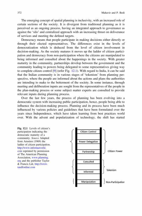
The emerging concept of spatial planning is inclusivity, with an increased role ofcertain sections of the society. It is divergent from traditional planning as it isperceived as an ongoing process, having an integrated approach to governance asagainst the ‘silo’ and centralized approach with an increasing thrust on deliveranceof services and meeting the defined targets.
Democracy means that people participate in making decisions either directly orthrough their elected representatives. The differences exist in the levels ofdemocratization which is deduced from the level of citizen involvement indecision-making. As the society matures it moves up the ladder of citizen partici-pation and democracy from non-participation where the citizens are manipulated tobeing informed and consulted about the happenings in the society. With greatermaturity in the community, partnerships develop between the government and thecommunity leading to powers being delegated to some representatives giving wayto complete citizen control [9] (refer Fig. 12.1). With regard to India, it can be saidthat the Indian community is in various stages of ‘tokenism’ from planning per-spective, where the people are informed about the actions and plans the authoritiesare intending to make to the betterment of the society. In some instance, throughmeeting and deliberation inputs are sought from the representatives of the people inthe plan-making process or some subject matter experts are consulted to providerelevant inputs during planning process.
Over the last few years, the process of planning has been evolving into ademocratic system with increasing public participation, hence, people being able toinfluence the decision-making process. Planning and its process have been muchinfluenced by various policies and guidelines that have been formulated over theyears since Independence, which have taken learning from best practices worldover. With the advent and popularization of technology, the shift has started
Fig. 12.1 Levels of citizen’sparticipation indicating thedemocratic maturity of acommunity. Source Adaptedfrom Arnstien (1969) theladder of citizen participation.http://www.informaworld.com reprinted by permissionof The American PlanningAssociation, www.planning.org and the publisher Taylor& Francis Ltd, http://www.tandfonline.com
372 Mahavir and P. Bedi

towards eDemocracy, where Information Systems and communication technologyis being used to support democratic decision-making process.
eDemocracy is not merely self-generation of utility bills and making paymentsonline or checking availability of parking spaces in real time. It is not just limited toonline registration and generation of birth and property certificates. eDemocracy isalso not merely developing Apps where citizens can report a choking sewer line oroverflowing waste dump. There are transactional activities that have been incor-porated as part of good governance adapting from emerging advancements ineCommerce and eBusiness solutions. eDemocracy is essentially the participation ofthe citizens in the decision-making process through an electronic medium, in pre-sent day age of web based technologies, through online services and applications.eDemocracy has to graduate to spatial eDemocracy, where the citizens can par-ticipate and make their voice heard in the spatial planning and monitoring process.With the coming in of spatial eDemocracy, the citizen will be able to participate indecision-making through spatially enabled tool, in simpler terms through interactivemaps available in the government’s enhanced geospatial portals like Bharat Mapsand BHUVAN and platform like data.gov.in which is largely non-spatial.
At the current stage eDemocracy is aspatial. It entails access to the informationfrom the government in the form of reports, tables and questionnaires, which are allnon-spatial. The access in spatial terms from master planning perspective is rare andif it exists is to some static maps either in print or on websites like on some DAwebsites. Government of India has guaranteed right to information through Right toInformation (RTI) Act, 2005 to bring in accountability and transparency in gov-ernance [10], perceived by the authors as a step towards eDemocracy. The provi-sions of the Act empower the citizens to know the number of trees that may havebeen cut. As of date this information is available to the citizen in non-spatial form.However, the Act does not abstain from accessing to spatial information, thus,ensuring spatial eDemocracy. Further, free and open access to spatial data wouldenhance the e-participation [11].
Things in spatial connotation are based on geospatial technology of whichGeographic Information System (GIS) is an important component. GeographicInformation System consists of hardware, software, data, users and procedures andgeo-spatial information is a derivate of GIS. With large amounts of data beingproduced in spatial context and available in public domain, Geospatial Informationand data, too is infrastructure [12] and a public good [13]. Spatial eDemocracy aswell as eDemocracy may be in danger considering the Geospatial Information Bill(Draft) 2016 [14] and may not be achievable.
eDemocracy takes place at different levels, ranging from local to regional to stateand national levels. The form of eDemocracy varies with the level at which it existstaking different forms of citizen’s participation. Information System has the abilityto greatly enhance the level of societal decision-making. The role of the planner isno longer top-down and centralized but has become that of one who attemptsconsensus building between the stakeholders, based on most viable options.Democracy and to a large extent eDemocracy is crucial to the success of smart
12 Integration of Existing Information Systems … 373
cities. Transforming the cities into smart entities has been taken on a mission modeby the government and now forms an important part of the urban milieu.
12.2.2 Smart Cities
Technologically, the concept of Smart Cities has grown from technopolis or scienceparks to Networked Cities to Digital Cities or Virtual Cities to Intelligent Cities tothe present day Smart City. At an ideological level, the concept can be traced backto the concept of Eco City of 1970s which grew into sustainable city to Green Cityand later to Inclusive City to the present-day concept of Smart City to tackle theissues of urbanisation [15].
In the Indian context, Government of India focuses on ‘sustainable and inclusivedevelopment in compact areas’ basing the Smart City concept on core infrastructureelements. These elements are adequate water supply, assured electricity supply,sanitation including solid waste management, efficient urban mobility and publictransport, affordable housing especially for the poor, robust IT connectivity anddigitization, good governance, sustainable environment, safety and security ofcitizens, health and education.
The smartness in the urban areas is to be brought about through smart solutionssuch that employment is generated, incomes are enhanced and overall quality of lifeis improved especially of the poor and disadvantaged people so as to build inclusivecities [16]. The identified Smart Solutions address e-Governance and citizen ser-vices, waste management, water management, energy management, urban mobilityand other segments like health, education and trade. Such cities should essentiallybe developed based on citizen-friendly governance. The government categoricallystated the use of geospatial technologies for building of Smart Cities so as to bestcapture real-time data. However, the proposed Geospatial Information RegulationBill (Draft) 2016, if enacted in its present form, may hugely and negatively affectthe mega initiatives of the Government as it would not only hamper the develop-ment of the SMART Cities that are based on technology and Information Systemsbut at the ideological level too, its implementation may not be possible as it would adeterrent to the basic democratic rights of the people and would further digress fromeDemocracy.
12.2.3 Urban Functionaries
Key activities of the urban areas planning, service provisioning and maintenanceare delivered by the planning authorities, ULBs and parastatals, which mainly existat the state and local levels. Among these, planning is largely guided by Urban andRegional Development Plans Formulation and Implementation (URDPFI)Guidelines, 2014.
374 Mahavir and P. Bedi
Planning that takes place at the national level is limited to formulating policies,guidelines, model laws and fund outlays for urban development and maintainingcentrally aided urban projects and research and training.
NITI Aayog (erstwhile Planning Commission) makes national five year plans,which have an economic approach. The Aayog addresses urban development as acomponent of its economic plans having the main function of ensuring a balancedand optimal utilization of country’s resources.
Other authorities at the national level directly responsible for activities in theurban areas are MoUD and Ministry of Housing and Urban Poverty Alleviation(MoHUPA). Other ministries too deal with the urban areas but have a sectoralapproach, like Ministry of Commerce and Industry, which is responsible forindustrial development in the country, which may be in urban or rural areas. Suchauthorities are thus, indirectly involved in the development of the urban arears.Moreover, at the ministerial level, the approach is generally aspatial and economicin nature.
Among the two ministries, MoUD at the center is the nodal authority for urbanplanning and management having a constitutional and legal control over the urbandevelopment activities in Delhi and Union Territories. It plays a decisive role onlyfor Delhi and the Union Territories. It plays a major role in territories cutting acrossmany states, like in the case of National Capital Region (NCR), through aBoard. For, rest of the States, it has an advisory role in policy and guidelineformulation regarding development, environment, transportation, land, water sup-ply and sanitation in urban areas. It is responsible for directing the growth of urbandevelopment in the country, which becomes a guideline for the states. Thoughsometimes, it is forced upon indirectly through controls associated with funding tointervene in urban development projects in the States.
Land, by and large, being a state subject, urban planning and management, fallsunder the purview of the state governments. The responsibilities are dischargedthrough different agencies at state, regional, district and local levels. The StatePlanning Board formulates the state five year plans and annual plans within theframework of the national five year plans. The focus of the Board is economicplanning [17] and like NITI Aayog, lacks spatial approach to planning.
In most of the states, a ministry in-charge of urban and regional developmentformulates the policies, strategies, priorities and programs, which are very similar inits role to that of Ministry of Urban Development except that the jurisdiction of thestate ministry is not beyond its respective states. There is no similarity or standard-ization in the structuring of the ministry across the states [17]. Hence, in some statesthe urban ministry is separate, whereas in some it is clubbed with other ministries,particularly in smaller states, like inMizoram reflecting the level of emphasis given tothe sector. The state ministry is supported by Town and Country PlanningDirectorate/Department and other specialized agencies for meeting their objectives.
At the district level, urban planning is limited to few states like Gujarat,Maharashtra, Kerala and Goa and there too the approach is economic in nature. Theplanning at this level has regional connotation and falls within the purview ofMetropolitan Planning Committee (MPC) and District Planning Committees
12 Integration of Existing Information Systems … 375
(DPC) catering to urban and rural areas under the 74th Constitutional AmendmentAct (CAA). The MPC and DPC are empowered with the authority to prepareDistrict Development Plan and Metropolitan Development Plan. Both need toincorporate the common interests of the plans prepared by the ULBs and pan-chayats, including spatio-economic planning [17].
ULBs in India exist as Municipal Corporation, Municipal Council, NagarPanchayat, Town Improvement Trust, Notified Area Committee, Town AreaCommittee, Cantonment Board and others. The variation among these is in terms oftheir function, power, status and area of jurisdiction. Similarity among these isbroadly in their near common purpose of provision and maintenance of facilitiesand amenities.
The core functions of the ULBs are providing water supply for domestic,industrial and commercial purposes, drainage and sewerage, solid waste manage-ment, preparation of plans for social and economic development and social justice,communication system including construction and maintenance of roads, footpaths,pedestrian pathways, transportation terminals, both for passengers and goods,bridges, over-bridges, subways, ferries and inland water transport system, transportsystem accessories including traffic engineering schemes, street furniture, streetlighting, parking areas and bus stops, community health and protection of envi-ronment including planting and caring of trees on road sides and elsewhere, marketsand slaughterhouses, promotion of educational, sports and cultural activities, recordof births and deaths and aesthetic environment.
As the size of urban areas increased due to influx of population, the governmentset up multiple agencies to address the growing needs of such areas. The UrbanDevelopment Authorities (UDAs) mainly address the planning function while theparastatal agencies largely address the infrastructure related aspects in the urbanareas and many a times have overlapping functions with the ULBs.
Moreover, the existence of UDAs came about to handle the incompetence of theexisting setups rather than enhancing the capabilities of those setups [18]. Thefunctions of UDAs are to promote and secure the development of the areas definedfor such purpose in the plan document. To fulfil the function, the DAs prepare themaster plan for the concerned area. For the development purpose the DA has thepower to acquire, manage and dispose off land and to carry out building, engi-neering and other operations, to execute work in connection of supply of water andelectricity, to dispose sewage and to provide other services and amenities, under-take maintenance and generally to do anything necessary to expedite for purpose ofsuch development.
The UDAs are backed by respective state town and country planning acts. Overtime, these authorities took over the task of maintaining of the newly developedurban areas, like Haryana Urban Development Authority in Haryana. In some stateslike Madhya Pradesh, there are Special Area Development Authorities (SADA)which perform the functions of planning and development in their jurisdiction.
Like in the case of ULBs, there is no uniformity in the setting up of theseorganisations across the states in the country. In some states these exist at the statelevel like in Haryana and Punjab. In other states, these bodies have been constituted
376 Mahavir and P. Bedi
at the city level, like Ahmedabad Development Authority, Kolkata MetropolitanDevelopment Authority and many more. As noted by Bedi [18] there has been noset criterion for constituting these, say on the basis on population or area. There aresome states that have the state level UDA as well as city/town level developmentauthorities, like in Punjab, where at the state level, Punjab Urban PlanningDevelopment Authority exists and there exist six authorities in the cities of S. A. S.Nagar (Mohali), Amritsar, Bhatinda, Jalandhar, Ludhiana and Patiala [19]. Thedevelopment authority in Delhi, known as Delhi Development Authority, is anexception as it exists under MoUD, a central government ministry. These author-ities have overlapping functions with TCPDs and ULBs. Even though the juris-diction with ULBs may differ but functions remain the same and there is a delayedtransfer of the functions and jurisdiction to the ULBs. The duality in function andjurisdiction has led to redundancy and duplicity in tasks including data collectionand creation within the individual IT setups of these organisations.
The 74th CAA has transferred the task of urban planning and development at thelocal level to the ULBs. At present, from urban spatial planning perspective theinvolvement of the ULBs is more in the implementation of the town planningschemes and in some instances in the enforcement of the master plans. The 74thConstitutional Amendment Act (1992) emphasised the role of ULBs in spatial andeconomic planning. It called for the integration of the town and city plans in theannual plans of the state and national level. Urban planning including town plan-ning has been declared as the urban local body function and ULBs as the planningand development agencies.
As of date the delivery of the functions of urban spatial planning is primarilydone by the TCPDs and by the development authorities, where these exist. Theother function of urban planning is preparation of the town planning schemes;implementation of the plan and monitoring the development is done by the DAs andin some instances by the ULBs. However, there is no interstate or intrastate con-sistency in these either. It must be noted that the implementation, monitoring andenforcement are a part of the planning process as well and form a weak link in thespatial planning process. The process of spatial planning, from planning decision tomonitoring has been split and assigned for operational purposes between differentorganisations. The split in the functions has led to the divergence of digital activitiesundertaken by these organisations as well as is made clear in sections below. Thisfurther iterates the need for a unified information system for the complete urbansegment in the country.
12.3 Information Systems
Valacich and Schneider [20] define Information Systems based on components ascombinations of hardware, software, and telecommunications networks that peoplebuild and use to collect, create, and distribute useful data, typically in organizationalsettings. Whereas, Laudon and Traver [21] have defined Information Systems based
12 Integration of Existing Information Systems … 377
on role as interrelated components working together to collect, process, store, anddisseminate information to support decision making, coordination, control, analy-sis, and visualization. Information Systems in present day world is networkedhardware and software that people and organizations use based on some standardsand defined procedures to create, collate, process and disseminate data. The termsInformation Systems and Information Technology are used interchangeably, thoughInformation System is an umbrella term which includes Information Technologywithin it. Information Technology comprises of essentially all the hardware, net-works and software and excludes the people who are the users and the proceduresthat the people follow.
The information systems have expanded significantly over the years from ‘dataprocessing’ in 1950s to 1960s, wherein the role of Information Systems was simple:transaction processing, record keeping, accounting, and other electronic data pro-cessing applications to ‘management reporting’ in 1960s to 1970s which consistedof processing of all the data into useful information reports, to help the manager inthe decision-making. From 1980s to 1990s, new phenomenon appeared called ‘enduser computing’, and it came as result of many factors such as the rapid devel-opment of microcomputer processing power, application software packages, andtelecommunication networks. From 1990s to 2000s, rapid growth of Internet,Intranet, Extranet, and other interconnected global networks dramatically changedthe capabilities of information systems. Internet-based and Web-enabled enterpriseand global electronic business (eBusiness) and commerce systems have becomecommonplace in the operations and management of today’s business enterprises.Now eGovernance and eDemocracy is taking over the traditional practices ofgovernance and democracy.
Till very recent times ‘Information Systems’ was understood more in terms ofmanagement of tabular information using computers, wherein the inputs were madein an out-of-the-box or customized dialog boxes and the outcomes or the resultswere in the form of either tabular reports, popularly known as the ManagementInformation System (MIS). Information System in urban planning and managementinitiated with MIS. Though every aspect of the management and planning of urbanarea has a spatial dimension, it has been largely lacking in day-to-day activities.With the change in perspective of the System from just tabular to a more holisticone to include the location aspect, GIS is becoming an integral part of theInformation System.
Evolution is an integral part of Information System. It is not a one-time activity.All the components of an Information System, be it hardware, software, networks,procedures, standards or users themselves need to be upgraded and updated with thechanges in technology. As the hardware and software would need updation overtime, so would the people who are the users in one form or other would need toupdate their skills through trainings and workshops. Hence, an Information Systemonce set up needs to be looked at as an infrastructure [12] like a road network whichis repaired and fixed and upgraded from time to time rather than discarding it andbuilding a new one from scratch. This act is in opposition to the premise of buildingan Information System as it brings in redundancy.
378 Mahavir and P. Bedi
In the urban context, based on the objectives being fulfilled, InformationSystems can be categorized into Land Information System, Planning InformationSystems, Cadastral Information Systems, Property Information System, DisasterInformation System and many more that are domain specific. Similarly based on thekind of data being used as a prime input, information system can be categorized intoMIS and GIS as well. Whereas GIS’s prime concern is with spatial data havingnon-spatial data linked to it in form of attributes, MIS concerns only withnon-spatial data. These can be broadly considered as Spatial Information Systemsas well. Other than these, in recent decades some such systems have developed thatare combinations of the information systems that have evolved since inception.These are the ones that incorporate information technology as the base, followprescribed standards, are built on vast data, both spatial and non-spatial, incorporateapplications for decision-making and are data dissemination nodes as well. Suchsystems and phenomena are called Spatial Database Infrastructure (SDI).
With the advancement in technology, many new concepts have come into play.The key among these that have come to be vital in the field of planning are crowdsourcing and cloud computing, Big Data and Internet of Things (IoT). Big Data isvery large quantity data which measures in units over an Exabyte and may soon goover units like a zettabyte and yottabyte. As succinctly defined by Batty [22], BigData is any data that cannot fit into an Excel spreadsheet. A human perspective overtime especially in planning terms ranges over long term up to 25–30 years. Theplannable human sense spread over space is rarely in minutes or hours. Whereas thedata collected in today’s world of everything and everybody connected and net-worked, falling under the regime of Big Data is measured and recorded in smallermeasures of time. There is no doubt that the outputs from Big Data and IoT willenable in setting up smart cities, as like these newly emergent technological con-cepts smart city concept too is based on functioning of urban systems in short time[22]. In order for the outputs of IoT and Big Data to be used within the existingplanning framework, time would play an important role, so that patterns over a yearor more at least can be obtained so as to base planning decisions on which maybecome an input towards GIS based master planning for Atal Mission forRejuvenation and Urban Transformation (AMRUT) Cities, which is aimed atproviding basic services to households and build amenities in cities to improve thequality of life, especially the poor and the disadvantaged. AMRUT focus is onensuring water supply, sewerage management, storm water drainage, urban trans-port and availability of green and open spaces, reform management and support,and capacity building [23].
12.4 Information Systems for Urban Areas
Information System is the use of systems, especially computers and telecommu-nication for gathering, retrieving, storing and sending information using some setprocedures and standards with or without human intervention. The development of
12 Integration of Existing Information Systems … 379
Information System in the country has been influenced by the political climate andgovernment policies. Computer age in India began in 1955 with the installation ofthe computer system in Indian Statistical Institute, Calcutta (now Kolkata) [24]. Inthe urban sector, the use of computers began mainly in two segments, namely inservice delivery and management by the ULBs like in billing and MIS applicationsand for land use interpretation from aerial photographs and satellite images by theplanning authorities, other than the routine tasks.
As stated by Rai and Kumar [25] aerial photographs have been long used forurban analysis. The photographs have been used for base map generation andcreating thematic maps, however were found to be expensive and restricted to usein smaller urban areas. The dependence on aerial photographs lessened after thelaunch of remote sensing satellite in 1988, which can be considered a landmarkyear. The restrictions that the use of aerial photographs had like in metropolitanregions were overcome with the coming in of the satellite images. The applicationof satellite images in urban and regional planning gained momentum. The imageswere used for broad land use, land cover and urban sprawl mapping of large urbanareas as well. Over the years with technological advancements, as the cost reducedand resolution of the satellite images improved from 90 m to sub meter, the use ofthe images spread to other divisions of planning, municipal and parastatal agencies.
The use and deployment of information technology be it computers, software,hardware peripherals, network or satellite images initiated as per the need clubbedwith availability of funds and willingness to adopt technology as against the tra-ditional planning and management practices. Hence, the development in adoptionof information technology was departmental. With the liberalisation policies of1991 and opening up of the private sector in this field, various proprietary tech-nologies were adopted by numerous planning authorities, ULBs and UDAs. Evenwithin the same municipal agency various departments and divisions made use ofdifferent technologies making it difficult for the departments to share their data.
The inclusion of information technology in other national level programs andmissions like Jawaharlal Nehru National Urban Renewal Mission (JNNRUM),Rajiv Awas Yojana (RAY) was emphasized and promoted. However, the use andapplication of same was separate from the NUIS Scheme.
In parallel, country had embarked on building NSDI and National GIS. NSDIcame into being through a cabinet legislation in June 2006 with the goal of beingall-inclusive. Existing spatial data producers pledged to contribute towards thecreation of national SDI [26]. NSDI addresses the critical need for acquiring,processing, storing, distribution and improving utilization of spatial data generatedby various agencies of the Government of India. This structure of Indian NSDI hasgiven it a sectoral character, very distinct from NSDIs in other countries, but verymuch in line with sectoral and segmented approach of national five year plans.
Geographic Information System is perceived as an effecting tool that can beintegrated in the national level developmental plans and programs and hencedecision-making [27] by the then Planning Commission, which has been the basisof the emergence of National GIS (NGIS). Planning Commission further iteratedthat GIS applications and decision support system addressing all the sectors is the
380 Mahavir and P. Bedi
key to the integration of NGIS within the framework and routine working of thegovernment machinery. National GIS is envisaged as a multi-participant systemavailable for government, public and business use. National GIS is essentiallyhaving a seamless GIS database, infrastructure, decision-support system with rel-evant applications and a single point access portal for the socio-economic devel-opment of the country so as to achieve inclusive growth. It is hence envisaged toenhance the decision-making capabilities of administrators [28]. In the most recentinitiatives of the government, like SMART Cities Mission and AMRUT, the use ofGIS based information systems is mandatory.
12.5 National Urban Information Systems
Internationally, Urban Information System does not exist at national level, but theinputs towards planning and management of the urban areas is provided by thenational level set ups like NSDI. NUIS scheme contributes data to atrans-disciplinary and multi-organizational national level initiative of Governmentof India—NSDI. It is a unique scheme which can become the backbone of theurban setup of the country [18].
12.5.1 Genesis of National Urban Information System
The realization for an integrated system in the form of an information system inurban and regional planning was felt as early as 1976 during the annual conferenceof Chief Town Planners of states and union territories. Same was iterated in 1977with a study and recommendation by United Nations (UN) experts on InformationSystems who visited India to study the feasibility of Urban and RegionalInformation System (URIS). The experts recommended the implementation ofcomputer-based spatial information system.
In pursuance to the UN experts recommendations, in a national seminar orga-nized by TCPO and School of Planning and Architecture (SPA), New Delhi in 1979deliberated upon the conceptual framework of URIS, information requirements andorganizational framework. It was decided to set up a steering group on URIS tooversee its progress and set up URIS in TCPO, New Delhi in collaboration withstate Town and Country Planning Departments (TCPD). In 1981 and 1983, thesteering group suggested in the form of two reports, Urban Information Systemsand Regional Information Systems, a minimum critical data to initiate URIS andsuggested action on Urban Information System (UIS). Three broad categories ofdata were suggested, namely, physical, socio-economic and basic infrastructure,services and amenities. This was for the first time that urban information systemwas a separate entity from the regional aspect. Emphasizing on the urban aspects,
12 Integration of Existing Information Systems … 381

the group recommended actions on Urban Information Systems, urban indicatorsand city data banks.
In 1984, National Natural Resources Management System (NNRMS) set up atask force on Urban and Rural Studies to study the existing system of informationcollection and management decision making in the area, ways to improve theexisting system using conventional techniques, extent to which modern RemoteSensing (RS) techniques can improve the existing system and evolve balanced andintegrated information and management system with an optimal mix of conven-tional and RS techniques. The task force identified the elements amenable toRemote Sensing and the areas where operational systems need to be put on prioritybasis.
However, none of these committees led to the setting up of an informationsystem for urban or regional areas. From time to time deliberations and recom-mendations were made to promote the use of computers, remote sensing and GIStechnologies. In 1988, National Commission on Urbanisation reiterated the need forURIS using GIS and Remote Sensing technologies. It laid importance on not justthe routine collection of data and analysis but stressed on the use of georeferenceddatabase for spatial planning. The Commission recognized that for developing suchan information system, basic data had to be organized at the national level alongwith the data on environment for urban areas. The Commission stated that thedesigning of appropriate information system be using GIS and remote sensingtechnology must receive high priority.
In early 1990s, the parliamentary Committee observed the inadequacy of theup-to-date base maps for large number of urban areas and suggested the need for aprogram to generate base maps for every urban center in the country. Subsequent tothis, in the eighth Five Year Plan (1992–97), Urban Mapping Scheme was taken upto map 50 urban centres in two phases from different states on a scale of 1: 2,000and 1:10,000 in TCPO, New Delhi. The objective was also to enhance the capacityof the TCPO and TCPDs. This was the first initiative that was a translation frommere recommendations to an actual working scheme.
The URDPFI Guidelines (2015) talk about the techniques for the preparation ofthe base maps and the scales of mapping for various plans at various planning arealevels. As a suggested action, the Guidelines spell out the need for URIS, withTown and Country Planning Organisation, New Delhi to be designated as the nodalagency.
As stated earlier, URDPFI Guidelines act as a foghorn for the planningauthorities. The key deliverable of planning is a master plan. The Guidelines pre-scribe the data content, methodology and techniques to be used in the preparation ofthe master plans. The emphasis is laid on environmental aspects as well, particularlyenergy efficiency, climate change, green buildings and city’s biodiversity status. Itis mandated that the plans be prepared within the binding framework of environ-mental laws like EIA Notification, 2016, Environmental Protection Act, 1986,Forest Conservation Act, 1980 and Environmental Guidelines for Industries,Eco-Fragile Zones including coastal zones and water bodies in urban areas. TheGuidelines provide specifications on data and procedures at macro level (regional)
382 Mahavir and P. Bedi
as well as micro (zonal) levels to include waste management, sewage treatment,solid waste management and rain water harvesting.
In 2006, Ministry of Urban Development, Government of India’s launchedNational Urban Information Systems (NUIS) scheme for developing urban databaseto build an information system to enable planning, management and de-centralizedgovernance in the context of provision of scientific planning and implementation ofthe 74th CAA. NUIS is a contributor of data to NSDI.
12.5.2 National Urban Information System
At the time of launch, the scheme envisaged covering all the 5161 (as per 2001census) urban agglomerations and towns in the country. Apart from the mappingand attribute data creation of the urban centers, the scheme also addresses theprerequisites of data creation that is design standards (for image, mapping, GISdatabase, output and quality), hardware and software, capacity enhancement, pro-cedures and identification of the urban areas [1].
The Scheme is being implemented in phases, primarily three. In the first phaseselect towns (152) have been taken up, for which the spatial as well as attribute data(GIS and Urban Data Bank) is being created. For 24 urban areas, detailed maps arebeing created from utility mapping perspective.
The scheme comprises of two components, Urban Spatial Information System(USIS) and National Urban Databank and Indicators (NUDB&I). USIS consists ofdevelopment of Geographic Information System (GIS) with application tools tosupport master/zonal plan preparation and for ULB administration and utilitiesmanagement. NUDB&I include designing and establishing a comprehensive databank and its integration to support planning and monitoring the health of urbansettlements and hence, caters to the attribute part of the spatial data. Both USIS andNUDB&I are built of a set of standards, procedures and parameters defined for GISdatabase, thematic mapping, applications, hardware and software, quality controland capacity enhancement. These standards find their basis in those of NationalSpatial Database Infrastructure (NSDI).
NUIS Scheme has been projected as an “integrated” tool that will support var-ious planning levels/scales for urban areas. NUIS Scheme is much more than basemaps and includes thematic maps (spatial), non-spatial data and should be devel-oped as a “one-stop” resource for urban planning and management for each urbanarea. The scheme details the standards to be used in mapping and data collation forboth USIS and NUDB&I. The layers required for mapping and its associatedattributes have also been detailed out in the guidelines. The mapping is being doneon 1:10,000 for the urban center and its demarcated periphery and 1: 2,000 scalesfor the urban core for all the centres. Since NUIS is based on the URDPFIGuidelines, it is built to incorporate the legal aspects and by-laws as well. The keyuse that NUIS has been put to is for master planning.
12 Integration of Existing Information Systems … 383
In the most recent scheme of government, Atal Mission for Rejuvenation andUrban Transformation (AMRUT), through deliberations, it was concluded that 1:10,000 scale database content and accuracy generated for master planning wasinadequate for the purpose. It was suggested that for the generation of compre-hensive GIS database for Master Plan formulation, very large scale maps on a scaleof 1: 4,000 should be prepared. This would entail revision of the design andstandards of the NUIS Scheme for generation of comprehensive GIS database tomeet the requirements of existing schemes as AMRUT [23], SMART Cities,Heritage City Development and Augmentation Yojana (HRIDAY) and other statelevel urban development projects.
NUIS is an Information System based on defined standards and procedures andnot just a scheme. NUIS is an evolutionary concept and is not static. It was con-ceptualized on the concept of periodic updates and evolution. Hence, the data gapsthat may be apparent in preparation of the master plan and in the management of theurban areas can be overcome by timely updates. The system is dynamic forinclusion of existing and new legal aspects as well.
12.6 ENVIS
As an information system exists for urban areas, environmental data exists at thenational level in the form of ENVironmental Information System, popularly knownas ENVIS. ENVIS Scheme was initiated by the central government in December1982 (Sixth Plan) as a decentralized system with a web-based distributed networkof subject specific databases under Ministry of Environment, Forest & ClimateChange (MoEF&CC) [3]. ENVIS is governed by its guideline document that detailsout its objectives and framework. It specifies the guidelines for establishment,management and monitoring of the centers. However, there is no specification onthe spatial component. The purpose of ENVIS is collection, collation, storage,retrieval and dissemination of information relating to a variety of themes associatedwith environment sector. The centers are mandated with providing referral servicewhere information is not readily available.
The network presently consists of sixty-nine centres, of which twenty-nineaddress “State of the Environment and Related Issues” and are hosted by theEnvironment/Forest Department of State Governments/UT Administrations.Remaining forty centres, hosted by environment-related governmental andnon-governmental organisations/institutes of professional excellence, have a the-matic mandate. These include toxic chemicals, human settlements, coastal states ofIndia, endemic and threatened plants, wildlife species, green planner, coastal dis-tricts of India, environment in Indian Parliament, Bibliography on forests, sacredcaves, mining environment, renewable energy, microorganisms and environmentalmanagement, hazardous waste, biodiversity of Western Ghats and environmentalnews. Amongst these thematic specializations, the one most relevant to urban areais human settlements [3].
384 Mahavir and P. Bedi
The key objectives of ENVIS is to build up a repository and disseminationcenters in Environmental Science and Engineering to provide national environ-mental information services relevant to present as well as future needs and tosupport and promote research, development and innovation in environmentalinformation technology. The State ENVIS centres are tasked with collecting datafrom line departments and other sources as required. ENVIS produces value-addedinformation products relating to environment, forest, wildlife and climate changewhich is in the form of reports, apps, database and thematic maps.
Within the framework of ENVIS is Indian State-Level Basic EnvironmentalInformation Database (ISBEID) [3]. ISBEID helps the State level centers to collect,compile and disseminate environmental information on a centralized server, par-ticularly covering the gaps on environmental related parameters like pollution,biodiversity and waste management amongst others. Its purpose is to provideinternet-based GIS application having interactive maps and querying ability otherthan being a one-stop information source to users. The environmental data is col-lated for parameters like general administrative profile, ecology, infrastructure,energy, agriculture, industries, tourism and heritage, natural resources, forestresources, water resources, ground water resources, water pollution, air pollution,biodiversity, disaster, waste and sanitation. Nearly all the parameters, exceptagriculture, forest resources and biodiversity, are directly linked to urban areas andthere is a necessity for their inclusion in the planning process of the city dependingon its environmental condition.
The centers and ISBEID, however, do not have any specific standards anddefined procedures for data creation or manipulation. As observed from the variousENVIS websites, the data is largely available in form of reports, tables and staticmaps, making the possibility of integration with other Information System a gar-gantuan task. The format in which the data is available refutes the purpose ofcreating an Information System as it leads to repetitiveness in data creation by theuser and hence build on redundancy. This adds to the hindrance in creating aneDemocratic society which is an essential for Smart Cities.
12.7 Framework for Integration of Information Systems
Both NUIS and ENVIS are independent systems. Over time both will be updatedand upgraded depending on the ideological and technological advancements in thefields of Information System as well as the domains of urban and environment.
ENVIS is an infrastructure base for the environmental aspects like NUIS is forurban sector. It must be noted that both the systems have been created with awell-defined purpose and objectives. The purpose of NUIS is to provide datatowards master plan preparation among other planning and management activitiesof urban areas by urban authorities. Since the focus of urban planning and man-agement is ensuring proper use of land and service delivery, NUIS creates data tomeet these requirements especially in terms of scale, detail and quality. ENVIS on
12 Integration of Existing Information Systems … 385
the other hand caters to the whole gamut of environmental issues and creates dataranging from terra, air to water; on, below over the land, be it natural or man-made.
As the need has been arising in the urban areas, the emphasis of the environ-mental aspects has been increasing. The environmental condition in the urban areashas been steadily deteriorating with increasing pressures of urbanisation. This maybe attributed to not so efficient spatial, economic and social planning, planimplementation and monitoring. With the global concerns for climate change andincreasing concern about its impact on humans, the need has arisen to look at theman-made environmental conditions at local levels. These levels are many times atsub-urban scale. In such cases the data gathered at the sub-urban micro levels needsto be aggregated at urban levels to be integrated within the planning framework.
With increasing environmental deterioration, it is imperative to include envi-ronmental aspects across the hierarchy of urban plans like the Coastal RegulationZone (CRZ) lines within the NUIS database. There have been studies proposing aninterface between NUIS and ENVIS [29], to overcome the gaps in both the systemsfrom the perspective of building climate change responsive cities.
The framework proposed here is a conceptual structure to serve as a support forbuilding an environmentally sensitive master plan. The prime objective ofproposing a framework for integration of the two systems is to enable the citizens intaking informed decisions about their urban areas entailing not only the physical,social and economic aspects but environmental as well. The integration wouldcontribute in achieving an environmentally sensitive spatial eDemocratic SmartCities.
For the integration of the two systems, the existing design, methods and pro-cedures of both the systems need to be assessed for conflict resolution. Theassessment may lead to some fuzzy areas for which conflict resolution may havesome underlying difficulties. In such the scenarios as suggested by Resnick et al.[30] and Breese et al. [31], pragmatic perspective may be used for simplifying thedesign rather than adopting a normative approach. A change that may be soughtwithin the ENVIS would be adoption of the standards laid down under NSDI, suchthat its integration with other systems becomes possible. On a spatial level, thiswould consist of bringing parity in data for integration. For example, the envi-ronmental data may be collected at point source, which should be available withrequired details for integration on a spatial dimension, like essentially may consistof location information not just consisting of the name of the location but its latitudeand longitude information other than other environmental data about the location.The framework for the integration of the two systems considers, other than thestandards and specification for data creation, the differential ability of the users inthe two existing systems and their existing methods as well as the urban func-tionaries who would be the prime users of the two systems with an intent to buildenvironmentally sensitive cities, based on the principle of high degree and level ofcitizen’s partnership.
Integration would be possible through the bringing together of the value-addeddata produced by the various ENVIS centers with the data produced under NUIS. Inorder for the users to be able to use the deliverables from both the Information
386 Mahavir and P. Bedi
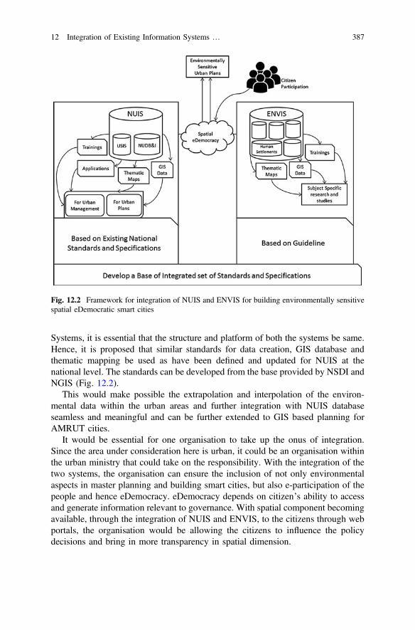
Systems, it is essential that the structure and platform of both the systems be same.Hence, it is proposed that similar standards for data creation, GIS database andthematic mapping be used as have been defined and updated for NUIS at thenational level. The standards can be developed from the base provided by NSDI andNGIS (Fig. 12.2).
This would make possible the extrapolation and interpolation of the environ-mental data within the urban areas and further integration with NUIS databaseseamless and meaningful and can be further extended to GIS based planning forAMRUT cities.
It would be essential for one organisation to take up the onus of integration.Since the area under consideration here is urban, it could be an organisation withinthe urban ministry that could take on the responsibility. With the integration of thetwo systems, the organisation can ensure the inclusion of not only environmentalaspects in master planning and building smart cities, but also e-participation of thepeople and hence eDemocracy. eDemocracy depends on citizen’s ability to accessand generate information relevant to governance. With spatial component becomingavailable, through the integration of NUIS and ENVIS, to the citizens through webportals, the organisation would be allowing the citizens to influence the policydecisions and bring in more transparency in spatial dimension.
Fig. 12.2 Framework for integration of NUIS and ENVIS for building environmentally sensitivespatial eDemocratic smart cities
12 Integration of Existing Information Systems … 387
The ulterior goal of the information system could be achieved by negatingrepetition and overcoming redundancy. This would help towards the nationalmission of SMART Cities by providing integrated systems, which can be used forbuilding environmentally sensitive master plans through a spatial eDemocraticapproach. This would be possible as the citizens would be able to access spatiallyenabled planning derivatives to voice their opinion about their cities and meet thecriteria of the geospatial data being a public good as suggested by Rao [9].
12.8 Conclusions
NUIS and ENVIS are two important information systems in the context of urbanarea, particularly pertaining to planning and environment. Since now, informationsystems has come to be understood as part of country’s infrastructure and is a publicgood, its updation and upgradation is imperative. This would entail inclusion ofnew schemes like AMRUT. The master planning has progressed from being acentralized activity to being participative.
Whereas, NUIS along with its newer avatar, AMRUT, is essentially spatial innature, having one of the objectives of easing the task of master plan preparation byproviding GIS based updated database of the urban areas based on the nationalstandards, ENVIS exists as an aspatial system, where data is collected by variousCenters and disseminated through the Web mainly in the form of reports.
As our urban areas are progressing to become Smart Cities in the near future, theprime focus is making these areas environmentally, socially and economicallyviable by providing a good quality of life. To achieve this, it is imperative thatspatial eDemocracy be made the basis of attaining the objectives of Smart City. Thecase of spatial eDemocracy is attainable when the platform is Information Systems,specially NUIS and ENVIS, the two existing systems relevant to urban areas. Thetwo systems that exist in isolation to each other need to be integrated for which theframework has been suggested.
Currently, though the progress has been from government to governance andeGovernance and from manipulative democracy to eDemocracy, both are stillnon-spatial. Integration of the systems will help transform the combined informa-tion systems into a spatial entity, as the non-spatial information would complementin the form of attribute data. Further open and free access to spatial informationwould enable citizens to e-participate on a spatial dimension, thus promoting spatialeDemocracy.
Once the standardization has been built into these existing systems, its inte-gration with others database that may be a part of NSDI and NGIS or may exist inisolation like Health Management Information System, could be achieved as afuture step.
388 Mahavir and P. Bedi

References
1. Town and Country Planning Organization (2006) National urban information systems—design and standards. Ministry of Urban Development, New Delhi
2. Bedi P, Mahavir (2013) Indian national urban information system as a decision making tool forurban planning. Geospatial World Forum, Rotterdam. Accessed 07 Dec 2016geospatialworldforum.org/2013/presentation/Prabh%20Bedi.pps
3. Ministry of Environment and Forest (2013) Guidelines for environmental information systemscheme. Government of India, New Delhi
4. Census of India—Census Terms. Census of India. http://censusindia.gov.in/Data_Products/Library/Indian_perceptive_link/Census_Terms_link/censusterms.html. Accessed 30 Sept2016
5. Kulshrestha SK (2006) Dictionary of urban and regional planning. Kalpaz Publications, Delhi6. Government of India (1950) Constitution of India, Seventh Schedule, Article 246. http://
lawmin.nic.in/olwing/coi/coi-english/Const.Pock%202Pg.Rom8Fsss(35).pdf. Accessed 13Sept 2016
7. Habermas J (1971) Towards a rational society. Heinemann, London8. Mcloughlin BJ (1985) The systems approach to planning. A critique, Victoria9. Arnstein SR (1969) A ladder of citizen participation. J Am Plan Assoc 35(4):216–224
10. Government of India (2011) Right to Information Act, 2005. http://righttoinformation.gov.in/rti-act.pdf. Accessed 15 Oct 2016
11. Gonzalez-Jaramillo VH (2015) Use of geographic information systems with open sourcesolutions, an approach to access edemocracy and egovernment. 2015 Second InternationalConference on eDemocracy & eGovernment (ICEDEG)
12. Mahavir, Bedi P (2012) A case for financing the ‘data’ as part of infrastructure’, CoordinatesJuly 2012
13. Rao M (2016) “Public Good” of geographic information. Mycoordinates.org. doi:06.201614. Mahavir (2016) The geospatial information regulation bill: the national development missions
would directly suffer setback. Mycoordinates.org. doi:06.201615. Bedi P, Mahavir (2016) Smart cities and not so smart geospatial information regulation bill
2016, in SPANDREL, Issue 12, December 201616. Ministry of Urban Development (2015) Smart city: mission statement and guidelines.
Government of India, New Delhi17. Kulshrestha SK (2012) Urban and regional planning in India: a handbook for professional
practice. Sage Publications, New Delhi18. Bedi P (2013) ‘Spatial technological initiatives in key central government urban develop-
ment initiatives’ spatio-economic development record 20(1):16–2119. Punjab Urban Planning and Development Authority 2011, Authorities, Government of Punjab
http://puda.nic.in/. Accessed 13 Sept 201620. Valacich J, Schneider C (2009) Information systems today—managing in the digital world,
4th ed. Prentice-Hall, Englewood Cliffs21. Laudon KC, Traver CG (2012) Management information systems, 12th ed. Prentice-Hall,
Englewood Cliffs22. Batty M (2013) Big data, smart cities and city planning. Dialogues in human geography. Sage
Publications, New Delhi. doi:10.1177/204382061351339023. Town and Country Planning Organization (2016) Formulation of GIS based master plan for
AMRUT cities. Ministry of Urban Development, New Delhi24. Rajaraman. Computer Age. http://www.cbi.umn.edu/hostedpublications/pdf/Rajaraman_
HistComputingIndia.pdf. Accessed 29 Sept 201625. Kumar VK, Rai PK (2011) Role of geoinformatics in urban planning. J Sci Res 55:11–2426. Kumar RS (ed) (2009) Indian NSDI: a passionate saga. NSDI, New Delhi27. Planning Commission (2011) Establishment of ‘National GIS’ under Indian National GIS
Organisation (INGO), Government of India, New Delhi
12 Integration of Existing Information Systems … 389

28. Nayak S, Rao M (2011) ‘National GIS: Shaping India’, Coordinates, vol. VII, issue 7, July2011. Available from: http://mycoordinates.org/national-gis-shaping-india-2/. 20 Sept 2016
29. Bandyopadhyay P, Mahavir (2016) Climate change responsive city planning: a case fordeveloping interface between ENVIS and NUIS. SPACE, vol 19. School of Planning andArchitecture, New Delhi
30. Resnick O, Iacovou I et al (1994) GroupLens: an open architecture for collaborative filteringof netnews. ACM Conference on Computer Supported Cooperative Work, pp 175–186
31. Breese J, Heckerman D et al (1998) Empirical analysis of predictive algorithms forcollaborative filtering. In: Proceedings of the fourteenth conference on uncertainty in artificialintelligence, Morgan Kaufmann. http://www.research.microsoft.com/users/breese/cfalgs.html.Accessed 12 Nov 2016
390 Mahavir and P. Bedi

Chapter 13Geo-enabled e-Democracy Toolsand Services for Smart Cities
Pramod Kumar, Kshama Gupta, Harish Chandra Karnatak,Asfa Siddiqui and A. Senthil Kumar
Abstract In the recent past, an overwhelming growth in geo-enabled open sourcedata and tools through web services and data repositories is witnessed. Internettechnology has significantly enhanced the utility of geo-enabled data and applica-tions by making them more accessible to a wider range of users, planners anddecision makers through geoportals, mobile Apps and Cloud GIS. The CloudComputing Architecture (CCA), Internet of Things (IoT) and Service OrientedArchitecture (SOA) represent new technological development which allow them tosend and receive data without requiring user interaction and enhance interoper-ability in data and information services. The geospatial information availablethrough geoportals and online data repositories have immense scope for its utili-sation in smart city planning with many success stories world over. Geo-enableddata and tools can go a long way in creating a range of smart city applicationswhere citizen participation is one of the key objectives. These tools and serviceshave immense application potential for public participation, grievance managementand to address many more aspects of e-democracy and e-governance such asTourism GIS, Municipal GIS and so on. These citizen-centric Apps and web ser-vices facilitate faster information dissemination and improve the efficiency and
P. Kumar K. Gupta (&) H.C. Karnatak A. Siddiqui A. Senthil KumarIndian Institute of Remote Sensing, 4, Kalidas Road, 248001 Dehradun, Indiae-mail: [email protected]
P. Kumare-mail: [email protected]
H.C. Karnatake-mail: [email protected]
A. Siddiquie-mail: [email protected]
A. Senthil Kumare-mail: [email protected]
© Springer Nature Singapore Pte Ltd. 2017T.M. Vinod Kumar (ed.), E-Democracy for Smart Cities, Advances in 21st CenturyHuman Settlements, DOI 10.1007/978-981-10-4035-1_13
391
management of infrastructure, which is essential to enhance the quality of life ofurban dwellers and one of the key objectives of the smart city movement. In India,the “Bhuvan” geoportal developed by the Indian Space Research Organisation(ISRO) provides a milieu of data sets which can be used for building smart cityapplications. Bhuvan portal hosts high-resolution data (*1 m resolution) of morethan 350 Indian cities till date and planning to cover other cities in near future. Italso offers thematic maps useful for Master Plan formulation for 152 towns pre-pared under National Urban Information System (NUIS). Effort is on to usehigh-resolution satellite images for the overlay and fine-tuning of Urban FrameworkSurvey. It also hosts many other data sets, e.g., land use/land cover, road network,soil, geomorphology, etc. which can be used to plan and manage the smartcities effectively.
Keywords Geospatial Geoportals Mobile apps Bhuvan Smart cities
13.1 Introduction
Globally, more than 54% of population now live in urban areas [1]. The urbani-sation is witnessed across the world but Asia and Africa continents are gettingurbanized more rapidly than other parts of the world. Asia has a low level ofurbanisation as compared to developed world yet comprise of 53% of the world’surban population. India is also one of the countries, where urbanisation has hap-pened slowly compared to other developing countries, yet the size of growing urbanpopulation in terms of absolute numbers is more due to its sheer population size.Besides, it is expected that in near future India will witness urbanisation at a speedwhich has never been seen before [2]. The growing urbanisation is expected tobring its own challenges in terms of urban population living in substandardhousing, overcrowding, congestion, deficient infrastructure, degraded environment,climate change and so on.
To address the issues faced by today’s urban areas and to make the citiesliveable and sustainable, the smart city concept is advocated. There is no univer-sally accepted definition of smart city, however, smart city is expected to improvequality of life of its citizen and to provide core infrastructure efficiently. The term‘Smart City’ has different connotations in different parts of the world. In general,planners always aspire to develop the entire urban ecosystem, which can be rep-resented by the four pillars of sustainable development—physical, social, economicand institutional infrastructure. This is definitely a long term goal and smart city canadd a layer of smartness to achieve these goals (http://smartcities.gov.in/writereaddata/smartcityguidelines.pdf).
392 P. Kumar et al.

Webster’s defines democracy as “a government in which the supreme power isvested in the people and exercised by them directly or indirectly through a systemof representation.” The core concept of democracy is to actively engage aninformed citizen in decision making process. Therefore, to achieve the goal ofcomprehensive smart city development, it is desirable that citizen ought to be madepart of planning process and decision making to empower the democratic reforms.E-Democracy is simply the utilisation of information technology to facilitate thegoal of achieving full democracy.
Geo-enablement of E-Democracy tools is a concept that adds location to existinginformation, thereby disseminating knowledge to stakeholders more efficiently inan interactive manner and assume an essential part in comprehension and tending tothe challenges that is confronted in an inexorably intricate and interconnectedworld. Geo-enablement of citizens are a need of the hour in order to have the righttools and information in hand to take the right decisions [3]. The informationprovision is the first step for enhancing citizen participation in e-democracy, wheregeo-enabled e-Democracy can play a major role. Geo-enabled e-Democracy isfacilitated by the Geospatial technologies which relates to the collection and pro-cessing of data that is associated with geographic location. It is a fusion of multipletechnologies and majorly comprises of Remote Sensing, Geographic InformationSystem (GIS) and Global Navigation Satellite System (GNSS). Remote Sensing is atechnology which is concerned with acquisition of information and data about anobject without coming in direct contact. The example includes photographs takenfrom GPS enabled smart phones, satellite images etc. which portray earth featureswith embedded location information. GNSS provide the satellite based geo-locationand is increasingly being used in day-to-day life for navigation and geo-location.The best example can be given in the form of navigation app that helps a commonman to locate the unknown address with precision. The remote sensing data andGNSS information is integrated with GIS to produce meaningful information andanalysis of data for host of applications in present scenario. The advancements inthis field from Desktop GIS to Geoweb 2.0 platforms have enabled hosting ofgeoportals for information dissemination and public participation. The populargeoportals such as Bing maps, Google maps, Bhuvan, OpenStreetMap, etc. arebeing used by international community and governments for providing datasets andinformation for facilitating collection of geographic information volunteered bypeople and for enhancing people participation in decision making. The Bhuvangeoportal hosted and developed by the Indian Space Research Organization (ISRO)is providing an integrated platform to decision makers and planners for accessingmultitude of geospatial datasets which can be utilized for the development of arange of smart city applications. Thus, Geo-enabled E-Democracy tools can providenecessary datasets, tools and mechanism for facilitating the citizen participation inimproving the liveability of urban areas. They provide better visualization oflocation specific data and improved dissemination of information and ideas.
13 Geo-enabled e-Democracy Tools and Services … 393
13.2 E-Democracy
E-democracy is a combination of the words—electronic and democracy, is alsoknown as digital democracy and it incorporates information and communicationtechnology to promote democracy (https://en.wikipedia.org/wiki/E-democracy). Inthis form of government, it is believed that all citizens are equal and they canparticipate equally in the process of decision making. The technological advance-ments in this century has enabled governments to connect with masses throughinternet media which provides a massive digital network with open standards,universal and inexpensive access.
The United Nations Economic Commission for Europe (UNECE) Conventionon Access to Information, Public Participation in Decision making and Access toJustice in Environmental Matters (Aarhus Convention) outlines three mainstays ofE-democracy as access to information, public participation and access to Justice [4].Access to information is the first step to ensure accountability, transparency andinvolvement of people, which is highly desirable for democratic systems. It enablespeople to be an active participant in decision-making process at all levels, which isessential to uphold democratic organizations. Similarly, E-democracy is intended toincrease the public participation in decision making. Effective public participationin decision making enables public to express their views, be a part of developmentprocess and also allows decision makers to address the opinions and concerns of thetarget groups, which are relevant to the issues in hand [5]. The process yields farbetter results as it minimizes the later unrest and can speed up the implementationprocess.
Gaining access to information and public participation in decision making is oneof the hallmark of smart city concept. A crucial objective of smart city concept is toempower urban citizens and groups by offering them necessary information andskills to bring changes in their own community. This places a new challenge infront of planners and policy makers to bridge the digital divide and coping withInformation and Communications Technology (ICT) illiteracy for effective partic-ipation. In this direction, geo-enabled tools and skills can be highly valuable as ithelps users relate to their immediate surroundings with locational dimension andvisualize the information in hand. It assist them in better comprehension of theinformation as well as to understand the corollaries of decisions taken.
13.3 The Need for Geo-enablement
Geo-enabled information has biggest advantage that it carries the location infor-mation. Location is considered as the fourth driver in decision-making other thanthe social, economic and environmental factors. Geo-enablement is not just aboutdeveloping and using GIS. It engages client to dissect data in its locational setting,which furthermore empowers them to comprehend different components having an
394 P. Kumar et al.
effect in decision making process. Directly or indirectly, the spatial information isused in every aspect of day to day life, be it identifying an address or a facility or aservice. For smart city to be truly smart, the planners need to analyse a host ofinformation pertaining to multifarious aspects in spatial context. In many Indiancities, the phenomenon of urban sprawl and haphazard unplanned growth is makinga colossal issue.
Many cities in the world are grappling with the issues of overpopulation, inef-ficient infrastructure and transport systems, pollution, congestions and environ-mental degradation. During the recent times, the pollution levels in Kanpur andDelhi in India, Xingtai in China, Al Jubail in Saudi Arabia, etc. has reached to itshighest level and that has caused serious health issues to the urban dwellers. Amongthe various reasons, poor availability of Transit Oriented Development (TOD) andmismanagement of available resources have caused the precarious situation.The TOD requires spatial distribution of land uses as one of the primary infor-mation. Hence, availability of comprehensive geo-information is the basis foroutlining the solutions to the multiple problems and the welfare of urban populace.
Mitigation and adaptation strategies for any disaster management calls formultitude of spatial information for delineating the hazardous zones, be it flood,earthquake or a fire disaster. Geospatial technologies especially remote sensing ishighly capable of providing geo-enabled information regarding slope, land use,building information, earthquake prone zones, etc., which is useful to identifyvulnerable areas. Even in post-disaster scenario, damages to property and infras-tructure could be assessed, if geo-enabled information is available and accessible tostakeholders. Provision of uniform and well-distributed urban green spaces to caterto the recreational and environmental needs of the population is envisaged in SmartCity mission [6]. Geo-enabled spatial data assist hugely in the assessment of dis-tribution of Urban Green Spaces [7]. Similarly, there are many needs and chal-lenges in front of planners which require geo-enabled spatial data. Although,geo-enabled data alone cannot provide the solutions but it is most crucial foraddressing the needs and forms the basis of urban planning and analysis.
13.4 Geospatial Technologies
Geospatial technologies are an amalgamation of various technologies, namelyRemote Sensing, GIS and GNSS. It provides unique datasets, techniques and toolsfor the geo-enablement of spatial information and also has a role to play in everyaspect of smart city planning be it smart living, smart environment, smart mobility,smart people, smart economy or smart governance, the pillars of smart city conceptcovering all facets of sustainable growth [8]. These technologies have been usedeffectively for addressing the various aspects of urban sustainable developmentsuch as urban sprawl and growth monitoring [9, 10], suitability analysis for urban
13 Geo-enabled e-Democracy Tools and Services … 395
development [11], evaluation and distribution of urban green spaces [8, 12], urbanhazard analysis and so on. The geospatial technologies provide multitudes ofdatasets and has immense capabilities for analysis, visualization and disseminationof spatial information.
13.4.1 Data Sources
The data acquired from remote sensors provides unique information about earthsystem and also provides innumerable benefits over conventional methods due to itssynoptic coverage, repetitive view and maps produced at multiple scales. Thistechnique has advanced notably in last few decades since the first remote sensingimage which was acquired from a hot air balloon in 1858 [13]. Today, a host ofremote sensing datasets are available ranging from 1 km spatial resolution forglobal coverage to a very high spatial sub-meter resolution which offers opportu-nities to study and monitor urban areas in great detail [14]. It does not only providesinformation in two-dimension (2D) but also in third-dimension (3D). The highresolution satellite stereo imageries and 3D point cloud generated from LightIntensity Detection and Ranging (LiDAR) data is being increasingly used forobtaining information on 3D profile of urban areas. These datasets provide a largevolume of information which can be harnessed for providing up-to-dategeo-enabled information to the citizens for decision making.
The Town and Country Planning (TCP) Departments in many cities across theworld have a few information in spatial or non-spatial framework to strengthensmart city applications. Most of these information in developing countries are inpaper form and need to be digitized. As the urban managers, typically lack capacityin developing countries, to digitalize the analogue maps often they hire specialiststo create digital database. Generally, the geospatial information for smart cityapplications could be derived from the following datasets:
– Satellite remote sensing: Satellite images of varied resolution are availableacross the globe, thus mostly obviate the need to freshly procure the data. Freshdata acquisition is necessary only for particular purposes or date of acquisitionfollowing some changes that necessitate the investment in remote sensing data.The stereo images can provide height information to define terrain and 3D citymodels.
– Aerial photograph: Traditionally, aerial photographs provided the efficientmeans of capturing information with greater details and scale of mapping.However, restrictions in some part of the world to capture details through aerialphotography imposed limitations and/or lengthy procedures (i.e., defenceclearance, etc.) for data acquisition. While traditional (nadir) aerial photographyoffers the most efficient form of image capture, oblique aerial photographyprovides images of building facades. This is especially helpful to build 3D citymodel, a vital element in smart city planning.
396 P. Kumar et al.
– Airborne LiDAR: LiDAR mounted on aircraft, can map building, tree, powerline, etc. and useful for terrain modeling (even under vegetation) and 3D citymodeling. Being aircraft based, it has the same benefits and limitations asoutlined for aerial photography. Aerial cameras are often co-mounted with theLiDAR sensors. The airborne LiDAR data is rare and by and large not availablefor the urban areas in developing countries.
– UAV: Unmanned Aerial Vehicles (UAV) offer a viable platform for capturingsmaller areas on earth surfaces. Current technology provide good quality 3Dphotographic solutions. However, the developing world is still groping with thesecurity provisions of UAV data.
– Terrestrial LiDAR: Terrestrial LiDAR is useful to generate point clouds frommultiple view angles to define building façade and interiors (or BuildingInformation Models—BIMs). Terrestrial LiDAR data can also be captured froma moving vehicle which is well suited to define the complex assets andinfrastructure along urban road corridors.
– Smart Phones: GPS mounted smart phones can easily engage citizens and helpin geo-tagged data and photographs collection. If the data is collected frommultiple viewpoints then it can also help to build 3D models based on pho-togrammetric principles. GPS mounted digital cameras or smart phones captureimages with multiple view points and following the image co-registration usingtie-points help to build point clouds and 3D models.
– Field survey: Field survey remains the traditional method for data collection orfor the validation of data collected through secondary means.
13.4.2 Decision Making through GIS
Geographic information system (GIS) or Geospatial Information Systems is anintegration of technologies that capture, store, analyse, manage, and present dataand information related to location(s). In the simplest terms, GIS is an integration ofcartography, statistical analysis, and database system with information technology.During the initial phases of development, GIS has been widely used for digital dataconversion known as digitization, storing and generating printed maps with littlefocus on spatial analysis (http://elearning.iirs.gov.in). Later, GIS emerged as a toolwhich integrates spatial and non-spatial data to solve the location- specific realworld problems through modeling. Modern GIS technologies uses digital infor-mation for which various digitized data creation methods are being used. The mostcommon method of data creation is digitization, where a hard copy map or surveyplan is transferred into a digital medium through the use of a Computer-AidedDesign (CAD) program or GIS software with geo-referencing capabilities. With theavailability of ortho-rectified images both from satellite and aerial sources, onscreen
13 Geo-enabled e-Democracy Tools and Services … 397
digitization is becoming the main avenue through which geographic data isextracted. On-screen digitization involves the tracing of geographic features directlyon top of the images by tracing the geographic form on a separate digitizing tablet.
13.4.3 Global Navigation Satellite System
Global Navigation Satellite System (GNSS) is also termed as positioning infras-tructure and it has gained widespread use for geodesy, surveying, navigation andfor capturing of geo-enabled data. GNSS has three main segments—(a) Spacesegment which consists of constellation of navigation satellites, (b) ControlSegment comprises of ground-based network of master control stations, datauploading stations and monitor stations for monitoring the satellites’ signals andstatus and (c) User segment which consist of equipment that processes receivedsignals from GNSS satellites to derive the location and time information (https://www.gsa.europa.eu/european-gnss/galileo/galileo-european-global-satellite-based-navigation-system). Hence, GNSS is considered to be one of the important tech-nologies for providing geo-enabled location data [15]. Major GNSS systems aroundthe world are as follows:
(a) Global Positioning System (United States)—It is the first operational GNSSsystem, launched by USA in 1970s. It has a constellation of 24 satellitesproviding global coverage (https://www.nasa.gov/directorates/heo/scan/communications/policy/GPS_History.html).
(b) GLONASS (Russia)—It is launched by Russian Government in 1982 forproviding weather positioning, velocity measuring and timing services any-where in the world and has constellation of 24 satellites distributed over threeorbital planes (https://www.glonass-iac.ru/en/guide/).
(c) Galileo (European Space Agency)—It is a GNSS system launched by ESAnamed after Italian astronomer Galileo Galilei launched in 2005. The basic aimof the system is to provide high-precision positioning services to Europeannations, independently. 14 satellites out of 30 satellites have been launchedunder this system by May 2016 and the system will be fully operational by2019 (http://www.navipedia.net/index.php/Galileo_Future_and_Evolutions).
(d) BeiDou (China)—It is the Chinese Navigation System which envisages tohave 35 satellites in its constellation to provide global coverage by 2020 (http://en.beidou.gov.cn/).
(e) Indian Regional Navigation Satellite System (India)—It is a regional navi-gation System, also known as NavIC, being developed by India. It has con-stellation of 7 fully operational satellites to provide high-precision positioningservices in Indian region covering primary service area of 1500 km from itsboundary. Its extended service area covers the area between primary servicearea and area from 30°S to 50°N latitude and 30°E to 130°E longitude (http://www.isro.gov.in/irnss-programme).
398 P. Kumar et al.
GNSS system provide high-precision positioning services with such a precisionthat could be envied by traditional surveyors. Presently, its application ranges fromTerrestrial, Aerial and Marine Navigation, Search and Rescue operations, DisasterManagement, Vehicle tracking and fleet management, Integration with mobilephones, Precise Timing, Mapping and Geodetic data capture, Terrestrial navigationaid for hikers and travelers, Visual and voice navigation for drivers (http://www.isro.gov.in/irnss-programme). Its use has been increasing exponentially in day today life with increasing use of navigation apps and services.
13.4.4 Benefits of Geospatial Technologies
The geospatial technologies have several benefits in smart city applications andthey generally fall into five basic categories:
(a) Time and cost saving: The remote sensing data provide repetitive and synopticview of urban areas at relatively greater efficiency. Using these datasets, mapscould be prepared with better accuracy and at relatively lesser time and cost.The traditional method of land use/land cover survey typically costs IndianRupees 100 per sq. km as compared to Indian Rupees 20 per sq. km usingremote sensing data [16].
(b) Data visualization: GIS-based maps and visualizations enormously help inbuilding scenarios and subsequent planning. It enhances communicationbetween various groups, divisions, disciplines, professionals, associations, andpeople in general.
(c) Data catalogue: GIS enables better data management. The GIS enabled datacould be easily retrieved, manipulated and distributed over variety of platforms.It becomes feasible due to data cataloguing.
(d) Informed decision making: The geospatial technologies enable the creation of“what-if” scenarios for informed decision making. Common examples includesite suitability analysis, route/corridor selection, zoning, planning, conserva-tion, natural resource extraction, etc.
13.5 Evolution of GIS
The advancements in geospatial technology is allied with high computing capa-bilities and advanced visualization systems using contemporary ICT solutions. GIShas quickly incorporated distributed systems and databases for interoperable solu-tions for effective decision making whereas microcomputer has allowed GIS to beapplied to new fields and has improved GIS education and awareness. Due toadvancements in ICT, the data creation and storage mechanism has drasticallychanged in recent past using online participatory approach known as crowdsourcing
13 Geo-enabled e-Democracy Tools and Services … 399
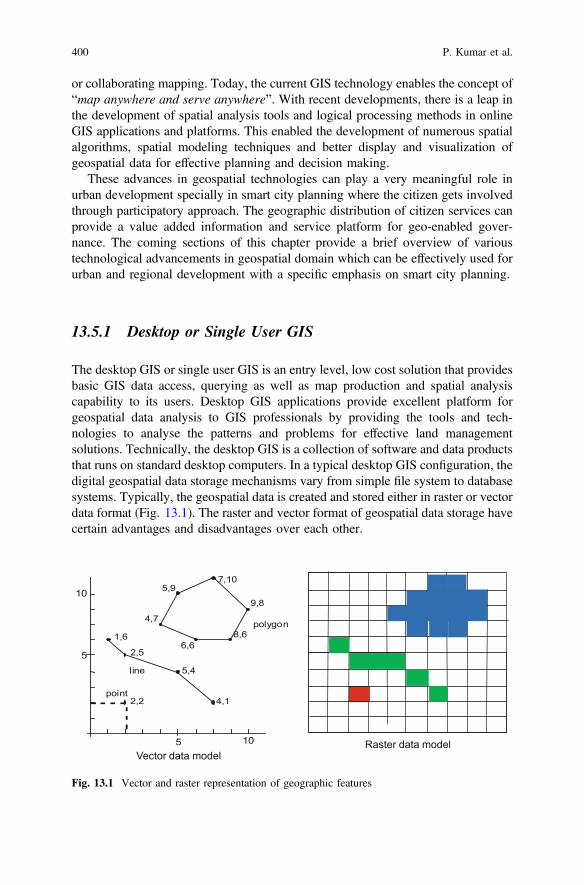
or collaborating mapping. Today, the current GIS technology enables the concept of“map anywhere and serve anywhere”. With recent developments, there is a leap inthe development of spatial analysis tools and logical processing methods in onlineGIS applications and platforms. This enabled the development of numerous spatialalgorithms, spatial modeling techniques and better display and visualization ofgeospatial data for effective planning and decision making.
These advances in geospatial technologies can play a very meaningful role inurban development specially in smart city planning where the citizen gets involvedthrough participatory approach. The geographic distribution of citizen services canprovide a value added information and service platform for geo-enabled gover-nance. The coming sections of this chapter provide a brief overview of varioustechnological advancements in geospatial domain which can be effectively used forurban and regional development with a specific emphasis on smart city planning.
13.5.1 Desktop or Single User GIS
The desktop GIS or single user GIS is an entry level, low cost solution that providesbasic GIS data access, querying as well as map production and spatial analysiscapability to its users. Desktop GIS applications provide excellent platform forgeospatial data analysis to GIS professionals by providing the tools and tech-nologies to analyse the patterns and problems for effective land managementsolutions. Technically, the desktop GIS is a collection of software and data productsthat runs on standard desktop computers. In a typical desktop GIS configuration, thedigital geospatial data storage mechanisms vary from simple file system to databasesystems. Typically, the geospatial data is created and stored either in raster or vectordata format (Fig. 13.1). The raster and vector format of geospatial data storage havecertain advantages and disadvantages over each other.
point
1,6
2,5
5,4
4,1
7,105,9
4,7
6,68,6
9,8
line
polygon
2,2
5 10
5
10
Vector data modelRaster data model
Fig. 13.1 Vector and raster representation of geographic features
400 P. Kumar et al.

The desktop GIS applications are build using specific GIS software and initially,data interoperability was a major issue. The maps produced in initial phases by thelocal agencies were not made accessible to the public as they need to install GISsoftware as well as has to have knowledge of GIS. However, with technologicaladvancements, now a host of user friendly interoperable desktop GIS software areavailable in proprietary commercial format as well as free and open source software[17]. Some of the popular desktop GIS software are listed in Table 13.1.
The desktop GIS can be used in smart city projects for GIS data creation,analysis and also for the preparation of GIS based plans. It fits well in offline modewhere the system network is not accessible. The handling of large size data sets willgive better performance in desktop based GIS. The major limitation in this GISplatform is synchronization of offline and online data sets and collaborations inmultiple stockholders, especially in participatory approach.
Table 13.1 Popular desktop GIS software
Name of thesoftware
Software type Description
GRASS GIS Free and opensource
Major tools available in the software includesgeospatial data management and analysis, imageprocessing, graphics and maps production, spatialmodeling, and visualization (http://grass.osgeo.org)
QGIS Free and opensource
QGIS is one of the most popular user friendly and opensource GIS software which provides extensive tools forvector data handling. It can be easily integrated withGRASS and R (http://www.qgis.org/en/)
gvSIG Free and opensource
Gvsig Desktop (gvSIG from this point forward) is afree GIS software and aims to represent, edit, analyseand manage information from the point of view ofspatial relations (http://www.gvsig.com/en)
RGeostats Free and opensource
RGeostats is the geostatistical package developed bythe Geostatistical Team of the Geosciences ResearchCenter of MINES ParisTech (http://rgeostats.free.fr/)
ILWIS Free and OpenSOURCE
ILWIS is popular GIS and image processing platformwhich provides various tools for raster and vector dataanalysis with special emphasis on water resourceapplications (http://www.ilwis.org/)
ArcGIS Commercial ArcGIS is a popular commercial desktop GIS softwarewhich provides vector and raster based GIS datacreation, processing and analysis tools with variousextensions especially in windows operating systemplatform. Vector data handling is major strength ofArcGIS (https://www.arcgis.com/)
ERDASImagine
Commercial ERDAS is a popular commercial image processingsoftware which provides various spatial data analysistools for raster data formats (http://www.hexagongeospatial.com)
ENVI Commercial ENVI is another popular image processing softwarewhich provides tools for LiDAR, SAR, multispectralor hyperspectral data sets (http://www.exelisvis.co.uk/)
13 Geo-enabled e-Democracy Tools and Services … 401
13.5.2 WebGIS and Geospatial Web 2.0
The recent advancements in Internet and related technologies has extended the useof geospatial data and information for variety of applications at different levels. Theintegration of GIS and Internet technology has emerged as one of the excitingtechnological advancement in geospatial domain known as Internet or Web basedGIS. The web enabled GIS facilitates decision making at the strategic, tactical, andoperational levels. It has enhanced the performance of administrative operations andserving as a gateway for decision-makers and general users to access the systemconveniently and effectively. Some of the popular web based spatial data andinformation services are Google Maps, Bhuvan geoportal, Bing Map,OpenStreetMap, etc. Today, Internet is emerging as a popular means of GIS dataaccessing, analyses and transmission and information services for various onlineapplications.
In Internet technology, the World Wide Web (www), File Transfer Protocol(FTP) and Hypertext Transfer Protocol (HTTP) make it convenient to access andtransfer data files across the globe. The Internet provides GIS users easy access toacquire GIS data from central server system to diverse data source in distributedenvironment. It is a means for users to exchange GIS data, conduct analysis andprepare outputs in the form of maps, report and web services. The users ofInternet GIS application can use advanced GIS tools for analysing their datawithout having any specific data or GIS software installed in their computer device[18]. The advent of web 2.0 in Internet technology has opened a new dimension forgeospatial data applications by introducing Geoweb 2.0 for GIS data and appli-cations. Geoweb 2.0 allows more interactive and latest GI system as a mashuparchitecture which is very effective for development of user defined geospatialapplications for planning and decision making [19]. The web GIS is more acces-sible than Desktop GIS to the public and hence is advantageous for viewing realtime data with dynamic queries. Geoweb 2.0 has high potential for enhancingpublic participation as it covers all aspects of participation starting from informationdissemination to collaboration to empowerment of citizens in decision making. Itempowers users to view, modify and provide alternatives to the solutions withoutextensive training [20–22].
The web based GIS applications are dynamic in nature, which is very importantfor its wider utilisation e.g. if any client(s)/user(s) or database administrator updatesthe data or information at server end, it will be available to all the users concur-rently. It can also link real time data and information such as satellite images,weather information, traffic movements and accident information, etc. by inte-grating online sensors and observatories. A typical GIS application usually includesthree essential elements: (a) presentation also known as ‘Graphical User Interface’(GUI), (b) logic or processing, and (c) data. The relationship between these threeelements is that one element sends the request to other element and the otherelements responses to the request through the same interface. This making andfulfilling of request is called client/server-computing model. The element that
402 P. Kumar et al.
makes request is called ‘client’ and the element that fulfills the request is called‘server’.
The client/server is a software defined system architecture of computing. Theclient/server environment is generally heterogeneous in nature where the hardwareplatform and operating system of the client and server are not generally the same. Insuch cases, the communications mechanism may be further extended through awell-defined set of standard i.e. Application Program Interfaces (APIs) and RemoteProcedure Calls (RPC) protocols. The client/server computing provides the capa-bility to use the most cost-effective user interface, data storage, connectivity, andapplication services. The web based GIS implementation requires configuration ofvarious server and client side components. In the coming section of this chapter,various server and client side components of web based GI systems have beenexplained. In the development of web based GIS, following four major servercomponents are required at host level: (a) Database server, (b) GIS server,(c) Application server, and (d) Web server.
13.5.2.1 Database Server
The database server may have a file based system or Relational DatabaseManagement System (RDBMS) or a combination of files and RDBMS. In a typicalweb GIS application, the spatial data is organized in RDBMS environment whichallows better performance, data security, data consistency and many more advan-tages of RDBMS for GIS data sets. Table 13.2 presents well known and famousdatabase server software solutions with RDBMS support available for geospatialdata sets.
13.5.2.2 GIS or Map Server
Map server or GIS server is a software package or program, which is responsible forrendering the GIS data into web browser. The standard web servers and browserssupport only standard image and data formats like .jpeg, .gif .txt, .html, .xml, etc.To represent or publish geospatial data in web compatible format, there is a need ofintermediate software components called as a map server or GIS server. Today,many of the map server products are available either as commercial product or as anopen source/freeware products for map publishing in internet environment [23].The important GIS/map server products available at present are shown inTable 13.3.
13.5.2.3 Application Server
An application server in a web GIS platform is a software which provides cus-tomized software applications with the services like query system, GIS analysis and
13 Geo-enabled e-Democracy Tools and Services … 403
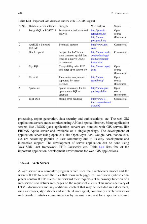
processing, report generation, data security and authorizations, etc. The web GISapplication servers are customized using API and spatial libraries. Many applicationservers like JBOSS (java application server) are bundled with GIS servers likeERDAS Apolo server and available as a single package. The development ofapplication server using open API like OpenLayer API, Google API, Yahoo API,etc. are becoming popular in user community due to its easy development andinteractive support. The development of server application can be done usingJava SDK, .net framework, PHP, Javascript etc. Table 13.4 lists few of theimportant application development environment for web GIS applications.
13.5.2.4 Web Server
A web server is a computer program which uses the client/server model and thewww’s HTTP to serve the files that form web pages for web users (whose com-puters contain HTTP clients that forward their requests). The primary function of aweb server is to deliver web pages on the request of clients. This means delivery ofHTML documents and any additional content that may be included in a document,such as images, style sheets and scripts. A user agent, commonly a web browser orweb crawler, initiates communication by making a request for a specific resource
Table 13.2 Important GIS database servers with RDBMS support
S. No. Database server software Strength Web address Status
1 PostgreSQL + POSTGIS Performance and advancedanalysis
http://postgis.refractions.nethttp://www.postgresql.org
Opensource(Freeware)
2 ArcSDE + SelectedRDBMS
Technical support http://www.esri.com
Commercial
3 Oracle Spatial Support for JAVA andstore common spatial datatypes in a native Oracleenvironment
http://www.oracle.com/technology/products/spatial/index.html
Commercial
4 My SQL Compatibility with PHPand other open source s/w
http://www.mysql.com
Opensource(Freeware)
5 TerraLib Time series analysis andsupported by manyRDBMS
http://www.terralib.org/
Opensource(Freeware)
6 SpatiaLite Spatial extensions for theopen source SQLitedatabase
http://www.gaia-gis.it/spatialite
Opensource(Freeware)
7 IBM DB2 Strong error handling http://www-01.ibm.com/software/data/db2
Commercial
404 P. Kumar et al.
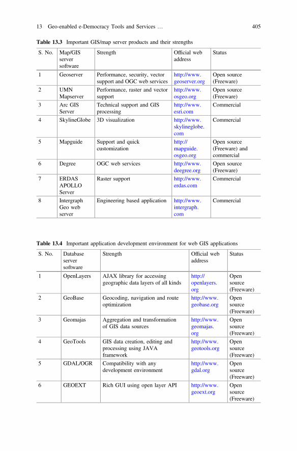
Table 13.3 Important GIS/map server products and their strengths
S. No. Map/GISserversoftware
Strength Official webaddress
Status
1 Geoserver Performance, security, vectorsupport and OGC web services
http://www.geoserver.org
Open source(Freeware)
2 UMNMapserver
Performance, raster and vectorsupport
http://www.osgeo.org
Open source(Freeware)
3 Arc GISServer
Technical support and GISprocessing
http://www.esri.com
Commercial
4 SkylineGlobe 3D visualization http://www.skylineglobe.com
Commercial
5 Mapguide Support and quickcustomization
http://mapguide.osgeo.org
Open source(Freeware) andcommercial
6 Degree OGC web services http://www.deegree.org
Open source(Freeware)
7 ERDASAPOLLOServer
Raster support http://www.erdas.com
Commercial
8 IntergraphGeo webserver
Engineering based application http://www.intergraph.com
Commercial
Table 13.4 Important application development environment for web GIS applications
S. No. Databaseserversoftware
Strength Official webaddress
Status
1 OpenLayers AJAX library for accessinggeographic data layers of all kinds
http://openlayers.org
Opensource(Freeware)
2 GeoBase Geocoding, navigation and routeoptimization
http://www.geobase.org
Opensource(Freeware)
3 Geomajas Aggregation and transformationof GIS data sources
http://www.geomajas.org
Opensource(Freeware)
4 GeoTools GIS data creation, editing andprocessing using JAVAframework
http://www.geotools.org
Opensource(Freeware)
5 GDAL/OGR Compatibility with anydevelopment environment
http://www.gdal.org
Opensource(Freeware)
6 GEOEXT Rich GUI using open layer API http://www.geoext.org
Opensource(Freeware)
13 Geo-enabled e-Democracy Tools and Services … 405

using HTTP and the server responds with the content of that resource or an errormessage if unable to do so. Table 13.5 lists popular web server products whichfacilitates the delivery of web pages to the user.
13.6 Service Oriented Architecture (SOA) and Geo-webServices
The technological trends in information technology has made possible the trans-formation towards Service Oriented Architectures (SOAs) and distributed com-puting to achieve high interoperability in data and information. In SOA, the servicesare intended to be independent building blocks that collectively represent a softwareapplications. These web services have many unique characteristics that allow themto participate as part of a SOA. One of the unique quality is complete autonomyfrom other services which is important for interoperability and also setting a rela-tionship and linkage between different services. This means that each service isresponsible for a specific task and represents a particular domain. The most widelyaccepted and successful implementation of web services are XML based. XMLstands for Extensible Markup Language which is a markup language similar toHTML and used for data definition while HTML is used for data presentationpurpose.
The web services architecture has three roles: a provider, a requestor and abroker as shown in Fig. 13.2. The provider creates the web service and makes itavailable to clients or users who want to use it. A requestor is a client applicationthat consumes the web service at other end. The broker, such as a service registry,provides a way for the provider and the requestor of a web service to interact as acatalogue. The provider, requestor, and broker interact with each other through thethree major operations viz. publish, find and bind. A typical example of web serviceimplementation in Internet domain could be online airline ticket booking systemthrough travel agency or third party service providers such as MakeMytrip,Yatra.com, etc. The airline operator publish their web service to the service registryof these ticket booking agencies. The customer search for best price or most suited
Table 13.5 Popular webserver products
Product Developer
Apache and Tomcat Apache
IIS Microsoft
Nginx Igor Sysoev
GWS Google
Resin Caucho Technology
Lighttpd Lighttpd
Sun Java System Web Server Oracle
406 P. Kumar et al.
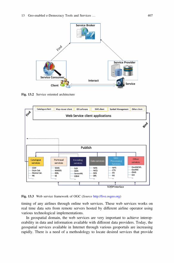
timing of any airlines through online web services. These web services works onreal time data sets from remote servers hosted by different airline operator usingvarious technological implementations.
In geospatial domain, the web services are very important to achieve interop-erability in data and information available with different data providers. Today, thegeospatial services available in Internet through various geoportals are increasingrapidly. There is a need of a methodology to locate desired services that provide
Service Broker
Service Provider
Service Consumer
Client ServiceInteract
Fig. 13.2 Service oriented architecture
Fig. 13.3 Web service framework of OGC (Source http://live.osgeo.org)
13 Geo-enabled e-Democracy Tools and Services … 407
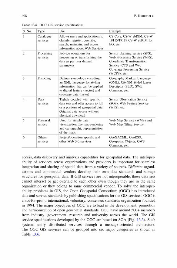
access, data discovery and analysis capabilities for geospatial data. The interoper-ability of services across organizations and providers is important for seamlessintegration and sharing of spatial data from a variety of sources. Different organi-zations and commercial vendors develop their own data standards and storagestructures for geospatial data. If GIS services are not interoperable, these data setscannot interact or get overlaid to each other even though they are in the sameorganization or they belong to same commercial vendor. To solve the interoper-ability problems in GIS, the Open Geospatial Consortium (OGC) has introduceddata and service standards by publishing specifications for the GIS services. OGC isa not-for-profit, international, voluntary, consensus standards organization foundedin 1994. The major objectives of OGC are to lead in the development, promotionand harmonization of open geospatial standards. OGC have around 500+ membersfrom industry, government, research and university across the world. The GISservice specifications developed by the OGC are based on SOA (Fig. 13.3). Suchsystems unify distributed services through a message-oriented architecture.The OGC GIS services can be grouped into six major categories as shown inTable 13.6.
Table 13.6 OGC GIS service specifications
S. No. Type Use Example
1 Catalogueservices
Allows users and applications toclassify, register, describe,search, maintain, and accessinformation about Web Services
CS Core, CS-W ebRIM, CS-W19115/19119 CS-W ebRIM forEO, etc.
2 Processingservices
Provide operations forprocessing or transforming thedata as per user definedparameters
Sensor planning service (SPS),Web Processing Service (WPS),Coordinate TransformationService (CTS and WebCoverage Processing Service(WCPS), etc.
3 Encoding Defines symbology encoding,an XML language for stylinginformation that can be appliedto digital feature (vector) andcoverage data (raster)
Geography Markup Language(GML), CityGM Styled LayerDescriptor (SLD), SWECommon, etc.
4 Dataservices
Tightly coupled with specificdata sets and offer access to fullor a portions of geospatial data.Original data access withoutphysical download
Sensor Observation Service(SOS), Web Feature Service(WFS), etc.
5 Portrayalservice
Used for simple datavisualization like map renderingand cartographic representationof the maps
Web Map Service (WMS) andWeb Map Tiling Service
6 Othersservices
Project/operation specific andother Web 3.0 services
GeoXACML, GeoRSS,Geospatial Objects, OWSCommon, etc.
408 P. Kumar et al.
13.7 Mobile and Participatory GIS
The mobile GIS is a new technological advancement in geospatial domain and ithas the strength not only to deliver the geospatial data to the mobile users every-where and anytime, but also it can be used as an effective mode of geographic datacreation and collection using participatory approach. Mobile GIS is an extension ofInternet or web based GIS which provides GIS functionalities in a portable devicessuch as mobile, PDA, tablet etc. Mobile GIS is an integration of various tech-nologies viz. Mobile technology, GIS, GNSS, wireless communications, etc. [24].Mobile GIS is a cost effective solution for data collection and creation directly fromfields. Some of the exciting applications of mobile GIS include Location BasedServices (LBS), crowdsourcing/Voluntary Geographic Information (VGI) andparticipatory GIS. Today, the mobile devices are embedded with GNSS which addsa location tag with the information transmitted by the device. The communicationchannels (like General Packet Radio Service (GPRS), Code division multiple access(CDMA), Worldwide Interoperability for Microwave Access (WiMAX), etc.) arerequired to transmit the information from mobile device to the receiver. Thesecond-and-half generation and above (2.5G, 3G and 4G etc.) networks provide thepossibilities of a mobile Internet with high-speed data transfer at a rate up to256 kbps or better. Two of the leading network protocols used in high-speedmobile applications are GPRS and CDMA20001x.
The mobile GIS architecture is a combination of client at mobile and host atserver level. The data and information is published at server end for mobile usersimilar to web based GIS application. The only major configuration required atserver end is to tune the data size for low storage and limited computation deviceslike mobile and PDA. The mobile GIS applications are best suited for smartphonedevices where the multimedia components with GPS facility are available for theusers. GIS operations in smart mobile phones are through the ICT evolution whichhas many exciting new applications of GIS. The mobile users are moving in ageographic space and they know their positions and they have access to the widelyavailable geographic data and information from variety of servers. The mobility is“key” for mobile GIS applications. The theme specific GIS applications like mobileGIS for mapping, field data collection, spatial analysis and Location Based Services(LBS) etc. have become very popular among user communities.
The mobile GIS requires GIS applications and software to be installed on thesmart mobile devices where the communication part can be online or offlinedepending upon requirements and availability. The GPS is one of importantcomponent of Mobile GIS where the location of the geography feature will bepresented using coordinates recorded using GPS. The accuracy of the locationvaries from kilometer to a meter level.
13 Geo-enabled e-Democracy Tools and Services … 409
13.8 Cloud Computing GIS
Cloud computing is one of most recent advancement in technology which hasdirectly influenced the involvement of IT and related technologies in variousbusiness sectors. Cloud computing platform offers various services in virtualenvironment such as Software as Service (SaS), Infrastructure as Service (IaS) andPlatform as Services (PaS). Here, Infrastructure refers to IT infrastructure andPlatform refers to computer platform which are required to run any softwareapplication(s). The cloud computing technology has revolutionized the functioningand operations of IT services in Internet platform. Typically, the cloud computing isan integration of hardware, software, peoples (users), data and applications. GIS hasadopted the cloud computing technology to enhance its uses and outreach byshifting various geospatial tools and functionalities to the cloud. Cloud-based toolsare accessed for web-based GIS as geo-web services.
The cloud GIS can be considered as next generation GIS which offer ‘GIS onDemand’ based on user(s’) or organization(s’) requirements. The GIS software,data (spatial and non-spatial), computation infrastructure and platforms require-ments are available for hire with a full scalability options. Various public andprivate clouds are getting popular such as ArcGIS Online, Cloud GIS (www.giscloud.com), Amazon web service, ThunderMaps, etc. In India, two major ini-tiatives from Government namely, MEGHDOOT from Center for Development ofAdvanced Computing (CDAC) and National Informatics Centre (NIC) Cloud(http://cen.gisserver.nic.in) are getting popular among the users.
GIS in Cloud computing provide shared resource pooling such as hardware,software, data, networks, etc. among user organizations for effective utilisation andcollaboration with common or shared goals. The cloud GIS offers on demandservices in GIS such as online mapping, sharing of geospatial data (raster as well asvector), GIS data analysis and processing. It also supports viewing, creating,monitoring, managing, analysing and sharing maps and data with other users. Itfacilitates inputs, validation and collaboration by a global mobile workforce in realtime using mobile GIS technology. Some of the possible applications of Cloud GISin smart city planning could be citizen and social science services, road infras-tructure projects, mobile data collection and integration, traffic management,e-commerce and geo-targeted marketing and awareness, geo-referenced weatherservices, web collaborative mapping and public safety and emergency response.
13.9 Internet of Things
The Internet of Things (IoT) is a system of interrelated computing devices,mechanical and digital machines, objects, animals or people that are provided withunique identifiers and the ability to transfer data over a network without requiring
410 P. Kumar et al.
human-to-human or human-to-computer interaction (http://Internetofthingsagenda.techtarget.com). In the concept of IoT, all the objects (static or movable) will haveone IP address (Internet Protocol) with a live interconnectivity with other objects.IoT has evolved from the convergence of wireless technologies, micro-electromechanical systems (MEMS), micro-services and the Internet with IPv6.The inclusion of IP version 6 or IPv6 in Internet domain has increased the Internetaddress space drastically which is an important factor in the development of IoT.The present form of data and information in Internet is being generated by variousmeans such as typing, pressing a record button, taking a digital picture or scanninga bar code. Sometimes, the data and information is also being generated using someonboard sensors and auto detective devices. Most of the time, the involvement ofperson is required in all these data and information collection systems and it mayhave limitations of time, attention and accuracy. This can be addressed with IoTwhere the computation devices will generate and communicate the data andinformation required for their operations and maintenance. If the connected devicesare having embedded with location sensors such as GPS in IoT then it will beknown as GIoT or geo-enabled IoT.
The concept of IoT can play a significant role in smart city planning where thegeo-embedded sensors of various interconnected computer devices will generate lotof meaningful data and information for smart planning. Some of the possibleapplications of IoT in smart city planning could be smart garbage collection systemin the city, smart traffic management system, emergency services, public distribu-tion system, etc.
13.10 Open Geo-data Sources and Repositories
Geospatial data sharing and dissemination is made easy with the advent of Internetbased geoportals and web services. The WWW and high speed network access hasgiven a new dimension to geospatial domain where larger data sets may be sharedand processed, more complex models can be established, computation intensiveanalysis for decision-making can be performed and better methods of display andvisualization for virtual reality can be achieved. Today, many organizations andindividuals are hosting their data sets online as an open geo-data through onlinedata repositories. This approach is enhancing the outreach of geospatial data for itsbetter utilisation. These open geo-data sets can be used for various thematicapplications either as a geo-web services or as a data product. The coming sectionsof this chapter presents a status of various online open data repositories which canbe used for smart city planning and other urban and regional studies. The onlinedata repositories are presented in two forms i.e. online geoportals and datarepositories.
13 Geo-enabled e-Democracy Tools and Services … 411
13.10.1 Geoportals
Website or websites are modern ways of sharing information using Internet tech-nology. Typically, the website use Hyper Text Markup Language i.e. HTML topresent the information in web browser environment. HTML is a markup languagewhich is used for data presentation purpose. Generally, the HTML based websitesare static in nature which present the predefined data and information to its usersthrough web server. If database systems such as DBMS, RDBMS or ORDBMS areused for data storage and management purpose for online web application, then itwill be known as web portal. In this approach, the data is accessed and processedusing an additional middle tier at server end using any web programming languagesuch as PHP, C#, JAVA, Python, etc. This middle tier is also known as businesslogic or application server. In case of GIS data, the database servers hosts the rasterand vector data in addition to non-spatial data sets. To access geospatial data fromdatabase servers, the middle tier needs to be modified/customized to understand theGIS data types from geo-data servers. The modified application server for geo-datais known as GIS or Map server which converts geospatial data in web compatibleformats. The web portals with geo-data are known as Geoportal. Some of thepopular geoportals are Google Maps, Bing Map, ISRO Bhuvan, MapMyIndia,Rediff Map, etc. In Table 13.7, the popular geoportals with their unique capabilitiesare listed.
The GIS based web portals provides a centralized and uniform interface toaccess the distributed and heterogeneous resources and data services. Most of theweb GIS based portals available in internet are designed for specific theme and aretargeted to specific class of users.
13.10.2 Geo-data Repositories
The online geo-data repositories offers variety of data for different application.They differ from geoportals as they allow users to download the data either freely oron payment. URLs and status of some of the popular geo-data repositories areshown in Table 13.8. These datasets are available at multiple scales catering todiffering requirements ranging from global scales to urban or local scales (http://freegisdata.rtwilson.com/). However, there is still a long way to go for creatingnecessary datasets for addressing multiple requirements of urban areas.
The above list is just an indicative list which tries to summarize the plenty ofdatasets which are now available freely on web for the use by international com-munity and urban planners.
412 P. Kumar et al.
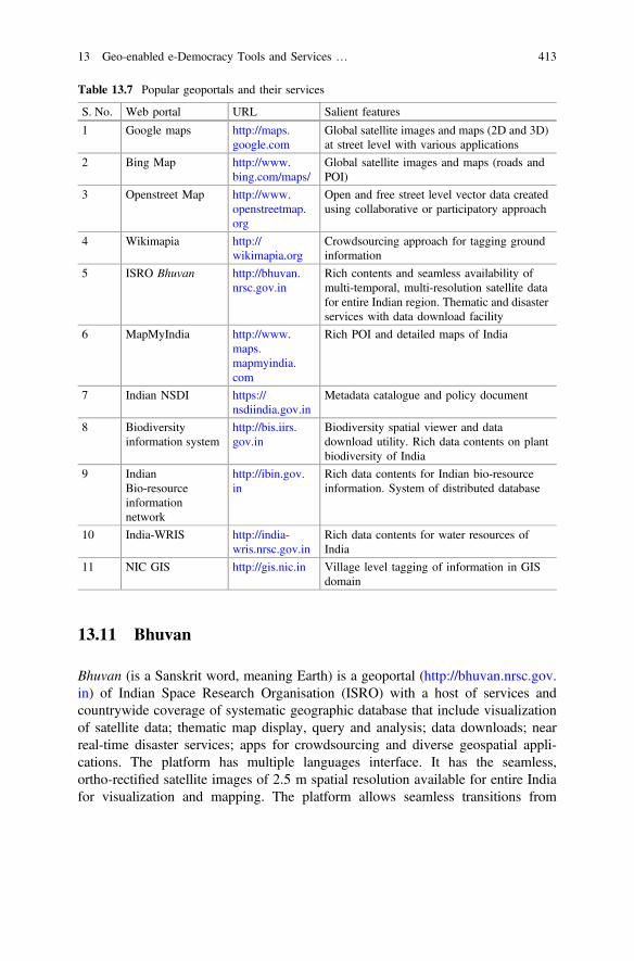
13.11 Bhuvan
Bhuvan (is a Sanskrit word, meaning Earth) is a geoportal (http://bhuvan.nrsc.gov.in) of Indian Space Research Organisation (ISRO) with a host of services andcountrywide coverage of systematic geographic database that include visualizationof satellite data; thematic map display, query and analysis; data downloads; nearreal-time disaster services; apps for crowdsourcing and diverse geospatial appli-cations. The platform has multiple languages interface. It has the seamless,ortho-rectified satellite images of 2.5 m spatial resolution available for entire Indiafor visualization and mapping. The platform allows seamless transitions from
Table 13.7 Popular geoportals and their services
S. No. Web portal URL Salient features
1 Google maps http://maps.google.com
Global satellite images and maps (2D and 3D)at street level with various applications
2 Bing Map http://www.bing.com/maps/
Global satellite images and maps (roads andPOI)
3 Openstreet Map http://www.openstreetmap.org
Open and free street level vector data createdusing collaborative or participatory approach
4 Wikimapia http://wikimapia.org
Crowdsourcing approach for tagging groundinformation
5 ISRO Bhuvan http://bhuvan.nrsc.gov.in
Rich contents and seamless availability ofmulti-temporal, multi-resolution satellite datafor entire Indian region. Thematic and disasterservices with data download facility
6 MapMyIndia http://www.maps.mapmyindia.com
Rich POI and detailed maps of India
7 Indian NSDI https://nsdiindia.gov.in
Metadata catalogue and policy document
8 Biodiversityinformation system
http://bis.iirs.gov.in
Biodiversity spatial viewer and datadownload utility. Rich data contents on plantbiodiversity of India
9 IndianBio-resourceinformationnetwork
http://ibin.gov.in
Rich data contents for Indian bio-resourceinformation. System of distributed database
10 India-WRIS http://india-wris.nrsc.gov.in
Rich data contents for water resources ofIndia
11 NIC GIS http://gis.nic.in Village level tagging of information in GISdomain
13 Geo-enabled e-Democracy Tools and Services … 413
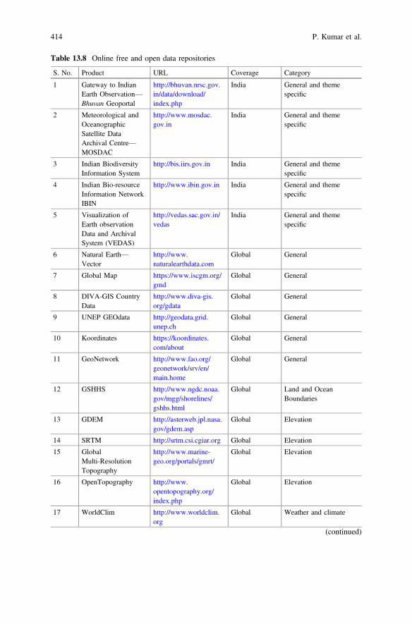
Table 13.8 Online free and open data repositories
S. No. Product URL Coverage Category
1 Gateway to IndianEarth Observation—Bhuvan Geoportal
http://bhuvan.nrsc.gov.in/data/download/index.php
India General and themespecific
2 Meteorological andOceanographicSatellite DataArchival Centre—MOSDAC
http://www.mosdac.gov.in
India General and themespecific
3 Indian BiodiversityInformation System
http://bis.iirs.gov.in India General and themespecific
4 Indian Bio-resourceInformation NetworkIBIN
http://www.ibin.gov.in India General and themespecific
5 Visualization ofEarth observationData and ArchivalSystem (VEDAS)
http://vedas.sac.gov.in/vedas
India General and themespecific
6 Natural Earth—Vector
http://www.naturalearthdata.com
Global General
7 Global Map https://www.iscgm.org/gmd
Global General
8 DIVA-GIS CountryData
http://www.diva-gis.org/gdata
Global General
9 UNEP GEOdata http://geodata.grid.unep.ch
Global General
10 Koordinates https://koordinates.com/about
Global General
11 GeoNetwork http://www.fao.org/geonetwork/srv/en/main.home
Global General
12 GSHHS http://www.ngdc.noaa.gov/mgg/shorelines/gshhs.html
Global Land and OceanBoundaries
13 GDEM http://asterweb.jpl.nasa.gov/gdem.asp
Global Elevation
14 SRTM http://srtm.csi.cgiar.org Global Elevation
15 GlobalMulti-ResolutionTopography
http://www.marine-geo.org/portals/gmrt/
Global Elevation
16 OpenTopography http://www.opentopography.org/index.php
Global Elevation
17 WorldClim http://www.worldclim.org
Global Weather and climate
(continued)
414 P. Kumar et al.
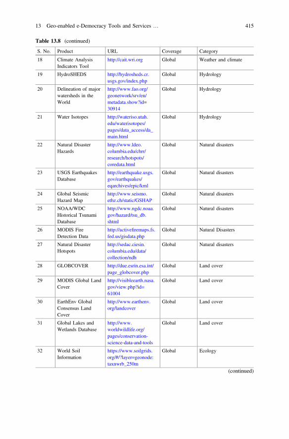
Table 13.8 (continued)
S. No. Product URL Coverage Category
18 Climate AnalysisIndicators Tool
http://cait.wri.org Global Weather and climate
19 HydroSHEDS http://hydrosheds.cr.usgs.gov/index.php
Global Hydrology
20 Delineation of majorwatersheds in theWorld
http://www.fao.org/geonetwork/srv/en/metadata.show?id=30914
Global Hydrology
21 Water Isotopes http://wateriso.utah.edu/waterisotopes/pages/data_access/da_main.html
Global Hydrology
22 Natural DisasterHazards
http://www.ldeo.columbia.edu/chrr/research/hotspots/coredata.html
Global Natural disasters
23 USGS EarthquakesDatabase
http://earthquake.usgs.gov/earthquakes/eqarchives/epic/kml
Global Natural disasters
24 Global SeismicHazard Map
http://www.seismo.ethz.ch/static/GSHAP
Global Natural disasters
25 NOAA/WDCHistorical TsunamiDatabase
http://www.ngdc.noaa.gov/hazard/tsu_db.shtml
Global Natural disasters
26 MODIS FireDetection Data
http://activefiremaps.fs.fed.us/gisdata.php
Global Natural Disasters
27 Natural DisasterHotspots
http://sedac.ciesin.columbia.edu/data/collection/ndh
Global Natural disasters
28 GLOBCOVER http://due.esrin.esa.int/page_globcover.php
Global Land cover
29 MODIS Global LandCover
http://visibleearth.nasa.gov/view.php?id=61004
Global Land cover
30 EarthEnv GlobalConsensus LandCover
http://www.earthenv.org/landcover
Global Land cover
31 Global Lakes andWetlands Database
http://www.worldwildlife.org/pages/conservation-science-data-and-tools
Global Land cover
32 World SoilInformation
https://www.soilgrids.org/#/?layer=geonode:taxnwrb_250m
Global Ecology
(continued)
13 Geo-enabled e-Democracy Tools and Services … 415
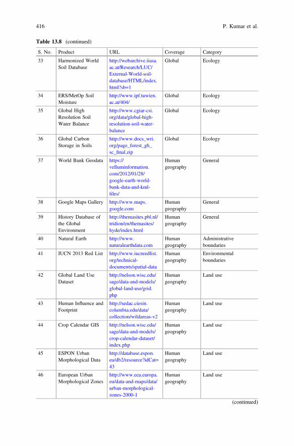
Table 13.8 (continued)
S. No. Product URL Coverage Category
33 Harmonized WorldSoil Database
http://webarchive.iiasa.ac.at/Research/LUC/External-World-soil-database/HTML/index.html?sb=1
Global Ecology
34 ERS/MetOp SoilMoisture
http://www.ipf.tuwien.ac.at/404/
Global Ecology
35 Global HighResolution SoilWater Balance
http://www.cgiar-csi.org/data/global-high-resolution-soil-water-balance
Global Ecology
36 Global CarbonStorage in Soils
http://www.docs_wri.org/page_forest_gh_sc_final.zip
Global Ecology
37 World Bank Geodata https://velluminformation.com/2012/01/28/google-earth-world-bank-data-and-kml-files/
Humangeography
General
38 Google Maps Gallery http://www.maps.google.com
Humangeography
General
39 History Database ofthe GlobalEnvironment
http://themasites.pbl.nl/tridion/en/themasites/hyde/index.html
Humangeography
General
40 Natural Earth http://www.naturalearthdata.com
Humangeography
Administrativeboundaries
41 IUCN 2013 Red List http://www.iucnredlist.org/technical-documents/spatial-data
Humangeography
Environmentalboundaries
42 Global Land UseDataset
http://nelson.wisc.edu/sage/data-and-models/global-land-use/grid.php
Humangeography
Land use
43 Human Influence andFootprint
http://sedac.ciesin.columbia.edu/data/collection/wildareas-v2
Humangeography
Land use
44 Crop Calendar GIS http://nelson.wisc.edu/sage/data-and-models/crop-calendar-dataset/index.php
Humangeography
Land use
45 ESPON UrbanMorphological Data
http://database.espon.eu/db2/resource?idCat=43
Humangeography
Land use
46 European UrbanMorphological Zones
http://www.eea.europa.eu/data-and-maps/data/urban-morphological-zones-2000-1
Humangeography
Land use
(continued)
416 P. Kumar et al.
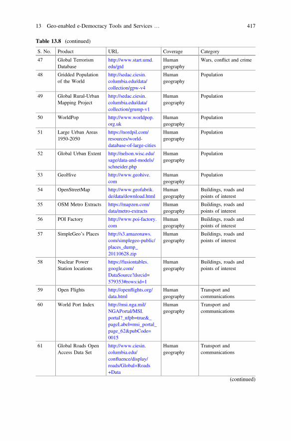
Table 13.8 (continued)
S. No. Product URL Coverage Category
47 Global TerrorismDatabase
http://www.start.umd.edu/gtd
Humangeography
Wars, conflict and crime
48 Gridded Populationof the World
http://sedac.ciesin.columbia.edu/data/collection/gpw-v4
Humangeography
Population
49 Global Rural-UrbanMapping Project
http://sedac.ciesin.columbia.edu/data/collection/grump-v1
Humangeography
Population
50 WorldPop http://www.worldpop.org.uk
Humangeography
Population
51 Large Urban Areas1950-2050
https://nordpil.com/resources/world-database-of-large-cities
Humangeography
Population
52 Global Urban Extent http://nelson.wisc.edu/sage/data-and-models/schneider.php
Humangeography
Population
53 GeoHive http://www.geohive.com
Humangeography
Population
54 OpenStreetMap http://www.geofabrik.de/data/download.html
Humangeography
Buildings, roads andpoints of interest
55 OSM Metro Extracts https://mapzen.com/data/metro-extracts
Humangeography
Buildings, roads andpoints of interest
56 POI Factory http://www.poi-factory.com
Humangeography
Buildings, roads andpoints of interest
57 SimpleGeo’s Places http://s3.amazonaws.com/simplegeo-public/places_dump_20110628.zip
Humangeography
Buildings, roads andpoints of interest
58 Nuclear PowerStation locations
https://fusiontables.google.com/DataSource?dsrcid=579353#rows:id=1
Humangeography
Buildings, roads andpoints of interest
59 Open Flights http://openflights.org/data.html
Humangeography
Transport andcommunications
60 World Port Index http://msi.nga.mil/NGAPortal/MSI.portal?_nfpb=true&_pageLabel=msi_portal_page_62&pubCode=0015
Humangeography
Transport andcommunications
61 Global Roads OpenAccess Data Set
http://www.ciesin.columbia.edu/confluence/display/roads/Global+Roads+Data
Humangeography
Transport andcommunications
(continued)
13 Geo-enabled e-Democracy Tools and Services … 417
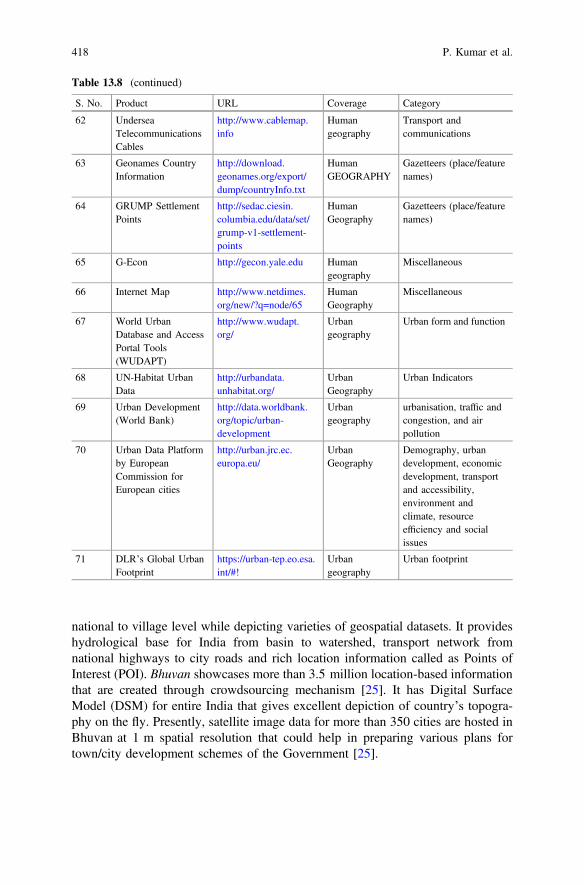
national to village level while depicting varieties of geospatial datasets. It provideshydrological base for India from basin to watershed, transport network fromnational highways to city roads and rich location information called as Points ofInterest (POI). Bhuvan showcases more than 3.5 million location-based informationthat are created through crowdsourcing mechanism [25]. It has Digital SurfaceModel (DSM) for entire India that gives excellent depiction of country’s topogra-phy on the fly. Presently, satellite image data for more than 350 cities are hosted inBhuvan at 1 m spatial resolution that could help in preparing various plans fortown/city development schemes of the Government [25].
Table 13.8 (continued)
S. No. Product URL Coverage Category
62 UnderseaTelecommunicationsCables
http://www.cablemap.info
Humangeography
Transport andcommunications
63 Geonames CountryInformation
http://download.geonames.org/export/dump/countryInfo.txt
HumanGEOGRAPHY
Gazetteers (place/featurenames)
64 GRUMP SettlementPoints
http://sedac.ciesin.columbia.edu/data/set/grump-v1-settlement-points
HumanGeography
Gazetteers (place/featurenames)
65 G-Econ http://gecon.yale.edu Humangeography
Miscellaneous
66 Internet Map http://www.netdimes.org/new/?q=node/65
HumanGeography
Miscellaneous
67 World UrbanDatabase and AccessPortal Tools(WUDAPT)
http://www.wudapt.org/
Urbangeography
Urban form and function
68 UN-Habitat UrbanData
http://urbandata.unhabitat.org/
UrbanGeography
Urban Indicators
69 Urban Development(World Bank)
http://data.worldbank.org/topic/urban-development
Urbangeography
urbanisation, traffic andcongestion, and airpollution
70 Urban Data Platformby EuropeanCommission forEuropean cities
http://urban.jrc.ec.europa.eu/
UrbanGeography
Demography, urbandevelopment, economicdevelopment, transportand accessibility,environment andclimate, resourceefficiency and socialissues
71 DLR’s Global UrbanFootprint
https://urban-tep.eo.esa.int/#!
Urbangeography
Urban footprint
418 P. Kumar et al.
Bhuvan, as a platform, is open and being used by diverse users community. TheGovernment agencies use this platform to share and host their data, as per theirrequirements, enabling specific applications of their choice. It presently hosts 30state geoportals. A number of collaborative geospatial applications involving 22ministries of Govt. of India have been integrated into Bhuvan platform for specificuse related to g-Governance programme. There are more than 6000 services offeredby Bhuvan. It provides support to disaster like cyclone, floods, landslides, earth-quakes, forest fire and drought, which is useful for various phases of disasterincluding preparedness and response. The disaster that struck in Uttarakhand, Indiaduring 2013, floods and Hudhud cyclone during 2014 in India, and NepalEarthquake in 2015 are some of the recent examples where Bhuvan providedunique services in terms of online disaster information update, forecasts andpost-disaster scenario. Bhuvan is also acting as a clearing house for satellite dataand satellite data derived products. They are effectively used for scientific studies asresearchers are utilizing the data for applied research as more than 3.5 lakh prod-ucts have been downloaded by the users in last 3 years. Bhuvan-2D visualizationinterface is designed to provide map view, satellite image view and hybrid of both.In addition, terrain view is also provided in a single integrated viewer [25]. TheTable 13.9 presents the various data sets which are available on Bhuvan for visu-alization, use and download.
13.11.1 EKTA
Embedding Knowledge with Technology and Association (EKTA) on Bhuvanplatform is a universal Mapper (http://bhuvan.nrsc.gov.in/updates/bhuvan_may2014.html). It provides interactive and user-friendly tools for adding, modi-fying and updating points, lines and polygons with data versioning. The opensource libraries at the backend provide a robust system for map making pro-cess and data collection. Following applications are realized and in operation usingBhuvan Mapper—(a) Crowd sourcing of location (point type) data, curvilinearfeature (line) and area (area) data along with the rich customized attributes for eachfeature, Implemented in Generic BhuvanMapper for mapping cities and other areas,(b) Mapping the neighbourhood of Uttarakhand to assess the damage,(c) Watershed development activity mapping/monitoring with hierarchical cus-tomized attributes in Integrated Watershed Management Programme (IWMP)application, (d) Mapping of forest assets in Karnataka Forest application,(e) Mapping of reservoir/tanks with detail list of attributes for Maharashtra,(f) Water Resources Development System of Maharashtra Engineering ResearchInstitute (MERI), (g) Neighbourhood mapping for School Kids, and (h) Onlineshapefile creation and downloading with user wise privileges.
13 Geo-enabled e-Democracy Tools and Services … 419
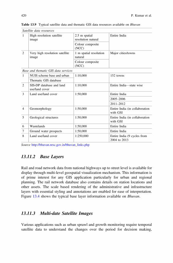
13.11.2 Base Layers
Rail and road network data from national highways up to street level is available fordisplay through multi-level geospatial visualization mechanism. This information isof prime interest for any GIS application particularly for urban and regionalplanning. The rail network database also contains details on station locations andother assets. The scale based rendering of the administrative and infrastructurelayers with essential styling and annotations are enabled for ease of interpretation.Figure 13.4 shows the typical base layer information available on Bhuvan.
13.11.3 Multi-date Satellite Images
Various applications such as urban sprawl and growth monitoring require temporalsatellite data to understand the changes over the period for decision making,
Table 13.9 Typical satellite data and thematic GIS data resources available on Bhuvan
Satellite data resources
1 High resolution satelliteimage
2.5 m spatialresolution natural
Entire India
Colour composite(NCC)
2 Very high resolution satelliteimage
1 m spatial resolutionnatural
Major cities/towns
Colour composite(NCC)
Base and thematic GIS data services
1 NUIS scheme base and urban 1:10,000 152 towns
Thematic GIS database
2 SIS‐DP database and landuse/land cover
1:10,000 Entire India—state wise
3 Land use/land cover 1:50,000 Entire India
2005–2006
2011–2012
4 Geomorphology 1:50,000 Entire India (in collaborationwith GSI
5 Geological structures 1:50,000 Entire India (in collaborationwith GSI
6 Wastelands 1:50,000 Entire India
7 Ground water prospects 1:50,000 Entire India
8 Land use/land cover 1:250,000 Entire India (9 cycles from2004 to 2013
Source http://bhuvan.nrsc.gov.in/bhuvan_links.php
420 P. Kumar et al.
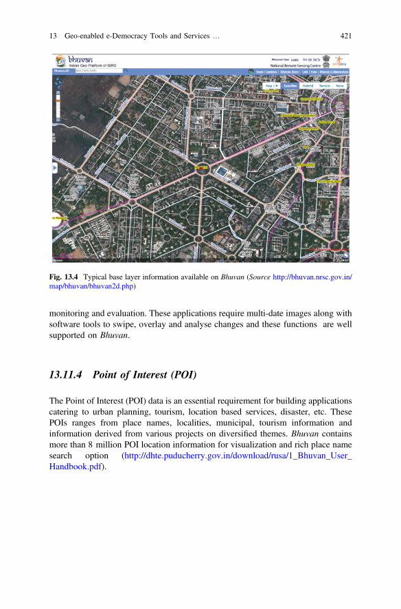
monitoring and evaluation. These applications require multi-date images along withsoftware tools to swipe, overlay and analyse changes and these functions are wellsupported on Bhuvan.
13.11.4 Point of Interest (POI)
The Point of Interest (POI) data is an essential requirement for building applicationscatering to urban planning, tourism, location based services, disaster, etc. ThesePOIs ranges from place names, localities, municipal, tourism information andinformation derived from various projects on diversified themes. Bhuvan containsmore than 8 million POI location information for visualization and rich place namesearch option (http://dhte.puducherry.gov.in/download/rusa/1_Bhuvan_User_Handbook.pdf).
Fig. 13.4 Typical base layer information available on Bhuvan (Source http://bhuvan.nrsc.gov.in/map/bhuvan/bhuvan2d.php)
13 Geo-enabled e-Democracy Tools and Services … 421
13.11.5 Crowdsourcing
Bhuvan contains various tools and applications for crowdsourcing the data fromcommunity. Exclusive mapper application for creating detailed maps, add contentoption to contribute POI data, customized Android applications for field data col-lection are available on Bhuvan. The primary challenge for the crowdsourced datathrough community participation is robust architecture to handle large volumes ofdata received and moderation. Bhuvan with its proven platform and architecturecontains more than 3.5 million crowdsourced data.
13.11.6 G-Governance Dashboard for Ministries
Geospatial governance dashboard developed for Ministries of Govt. of India allowsthe users including administrators to directly reach the specific programmes/projectsaccording to their interest in alphabetical order. This framework is also developedusing responsive design to access the applications in mobile phones or tabs. It hosts64 developed applications till date [25].
13.12 Geo-applications on Bhuvan
13.12.1 Census GIS
Bhuvan has Census 2011 information integrated at village level for the users tomake necessary visual analysis. Users can interactively generate choropleth mapsbased on equal interval classification and unique values by providing Census 2011code or name. Point maps can be generated by providing longitude and latitudeinformation. Specific features like village boundaries with Census 2011 attributesare also integrated in a ready-to-use query form (Fig. 13.5).
13.12.2 Municipal GIS
Municipal GIS in Bhuvan enables the citizens to know about wards and facilitiesavailable, various schemes executed by the government, grievances redressal sys-tem besides facilitating administrators/planners to have an online planning tool forbetter governance. The municipal corporation can utilize the data for urban plan-ning and also in the effective implementation of developmental schemes by pro-viding information on street layout, size and location of buildings. It will help inidentifying illegal encroachments and similar other violations, along with to
422 P. Kumar et al.

calculate property tax. The database for Ludhiana town on Bhuvan has been pre-pared with the help of Punjab Remote Sensing Centre (PRSC), Ludhiana, Punjab,India for Ludhiana Municipal Corporation (http://main.mcludhiana.gov.in/pdf/MCL_Blocks_gismap.pdf). The process of allotting a unique identity to the prop-erty would help city dwellers to avail services from municipal body ranging fromwater-related issues to property tax. The 18-digit UID number contains city, block,locality and property codes. The UID is ‘geo-tagged’ with the exact spatialdimensions of every property and has the latest photograph attached with eachproperty. The integration of existing municipal database like water/sewage ID no.,house tax property no. with the UID helps to maintain a single number for eachproperty and useful to generate online bills for all the municipal services. With thehelp of door-to-door survey, approximately 4.5 lakh properties in the city areallotted the UIDs. Similar activity is also scheduled for the area under MunicipalCorporation of Bathinda town, Punjab state, India (Fig. 13.6).
13.12.3 Management Plans for Heritage Sitesand Monuments
India has a rich cultural heritage and whole country is dotted with architecture andheritage sites. Some of these heritage sites receive enormous global and nationalattention. However, many of these heritage sites face increasing risk from urbani-sation, economic development and implications of unanticipated changes. Theconservation of world heritage sites, ancient monuments and archaeological sites isof national importance and also helps in development and promotion of tourism,which is one of the major engines of economic growth. Ministry of Culture, Govt.of India has taken up a national project for inventory and monitoring of
Fig. 13.5 Census data visualization on Bhuvan (Source http://bhuvan.nrsc.gov.in/governance/socialjustice_census)
13 Geo-enabled e-Democracy Tools and Services … 423

archaeological sites of the country in collaboration with ISRO. The systematicdatabase of heritage sites and site management plans generated using space tech-nology will help to take appropriate measures in conserving, preserving andmonitoring of heritage sites (https://www.geospatialworld.net/news-posts/isro-to-create-3d-visualisations-of-indian-heritage-sites/). A Standard Operating Procedure(SOP) using high resolution satellite data as primary data source and employingstate-of-the-art geospatial technology and open source tools has been developed foroperational use by Archaeological Survey of India (ASI). The remote sensing datafrom Cartosat-1, Cartosat-2 and Resourcesat LISS-IV are used for creating thedatabase on heritage sites and monuments. Three management zones (protected,prohibited and regulated) around the heritage site are delineated using GIS tool afterlocating the site/monument on the satellite image. All the land use features withineach zone are precisely mapped. The collateral data e.g., total station survey data,revenue village, cadastral maps and other maps/attributes related to the inventory,plans etc. are geo-referenced and integrated with the satellite data and form part ofthe geo-database. Other data like ground photographs, different views of themonuments, type of buildings and their heights, street view of the buildings andlanes, open spaces are also part of the database. Smart phone based applications aredeveloped for geo-tagging and uploading by different stake holders and citizens aspart of crowd sourcing. The 3D digital models of the sites and monuments are
Fig. 13.6 Database prepared under Municipal GIS for Ludhiana city and hosted on Bhuvan(http://main.mcludhiana.gov.in/pdf/MCL_Blocks_gismap.pdf)
424 P. Kumar et al.
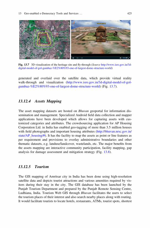
generated and overlaid over the satellite data, which provide virtual realitywalk-through and visualization (http://www.isro.gov.in/3d-digital-model-of-gol-gumbaz-%E2%80%93-one-of-largest-dome-structure-world) (Fig. 13.7).
13.12.4 Assets Mapping
The asset mapping datasets are hosted on Bhuvan geoportal for information dis-semination and management. Specialized Android field data collection and mapperapplications have been developed which allows for capturing assets with cus-tomized categories and attributes. The crowdsourcing application for AP HousingCorporation Ltd. in India has enabled geo-tagging of more than 3.5 million houseswith field photographs and important housing attributes (http://bhuvan.nrsc.gov.in/state/AP_housing/#). It has the facility to map the assets as point or line features asper requirement and provisions to overlay administrative boundaries and otherthematic datasets, e.g. landuse/landcover, wastelands, etc. The major benefits fromthe assets mapping are interactive community participation, facility mapping, gapanalysis for damage assessment and mitigation strategy (Fig. 13.8).
13.12.5 Tourism
The GIS mapping of Amritsar city in India has been done using high-resolutionsatellite data and depicts tourist attractions and various amenities required by vis-itors during their stay in the city. The GIS database has been launched by thePunjab Tourism Department and prepared by the Punjab Remote Sensing Centre,Ludhiana, India. Tourism Web GIS through Bhuvan facilitates the users to selectthe tourism places of their interest and also search nearby places along with routing.It would facilitate tourists to locate hotels, restaurants, ATMs, tourist spots, shortest
Fig. 13.7 3D visualization of the heritage site and fly-through (Source http://www.isro.gov.in/3d-digital-model-of-gol-gumbaz-%E2%80%93-one-of-largest-dome-structure-world)
13 Geo-enabled e-Democracy Tools and Services … 425
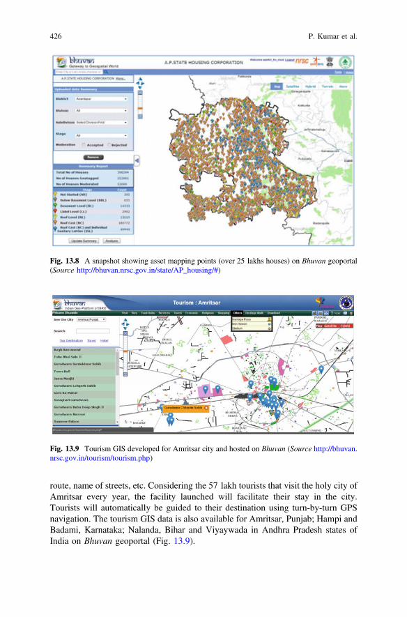
route, name of streets, etc. Considering the 57 lakh tourists that visit the holy city ofAmritsar every year, the facility launched will facilitate their stay in the city.Tourists will automatically be guided to their destination using turn-by-turn GPSnavigation. The tourism GIS data is also available for Amritsar, Punjab; Hampi andBadami, Karnataka; Nalanda, Bihar and Viyaywada in Andhra Pradesh states ofIndia on Bhuvan geoportal (Fig. 13.9).
Fig. 13.8 A snapshot showing asset mapping points (over 25 lakhs houses) on Bhuvan geoportal(Source http://bhuvan.nrsc.gov.in/state/AP_housing/#)
Fig. 13.9 Tourism GIS developed for Amritsar city and hosted on Bhuvan (Source http://bhuvan.nrsc.gov.in/tourism/tourism.php)
426 P. Kumar et al.

13.12.6 Urban Growth
Urban growth refers to the extent of urbanisation, which is a global phenomenonmainly driven by population growth and large scale migration. Urban growthcharacterization and monitoring using temporal and multi-spectral satellite data isavailable on Bhuvan platform for the period from 1991 to 2014 for 82 cities ofIndia. The salient features of this database are incremental view of urban growthand provision for animated view to visualize growth monitoring of urban areas(Fig. 13.10).
13.12.7 Urban Framework Survey
The Ministry of Statistics and Programme Implementation (MoSPI), Govt. of Indiais the nodal agency for planning and facilitating the integrated development ofstatistical system in the country. It collects statistics at local level and lateraggregates systematically at higher level of governance and planning. In case ofdata gaps, sample surveys are carried out at national/state level. Two systems are invogue, the enumeration blocks of Census of India and the urban blocks of theNational Sample Survey Office. The Urban framework survey (UFS) providescomplete, updated, identifiable, operationally convenient and readily accessiblesampling frame for the urban area. Under the UFS, towns are physically surveyedand updated over a five year period. Supplementary information on type of areasuch as slum area, residential area, industrial area, education, hospital, commercialarea, prohibited area etc. are collected during the survey/updation and some aux-iliary information/landmarks such as school, post office, bus stand, clinic etc. are
Fig. 13.10 Urban growth monitoring for Delhi city on Bhuvan geoportal (Source http://bhuvan.nrsc.gov.in/urban/sprawl/urbangrowth.php)
13 Geo-enabled e-Democracy Tools and Services … 427
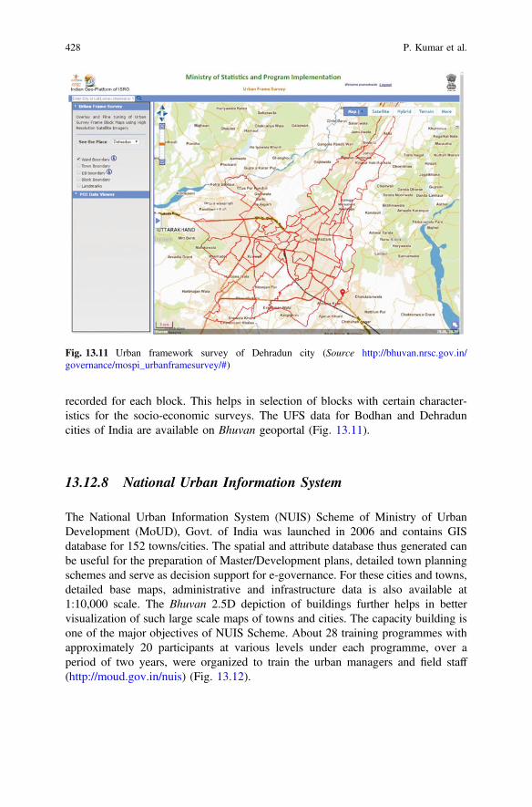
recorded for each block. This helps in selection of blocks with certain character-istics for the socio-economic surveys. The UFS data for Bodhan and Dehraduncities of India are available on Bhuvan geoportal (Fig. 13.11).
13.12.8 National Urban Information System
The National Urban Information System (NUIS) Scheme of Ministry of UrbanDevelopment (MoUD), Govt. of India was launched in 2006 and contains GISdatabase for 152 towns/cities. The spatial and attribute database thus generated canbe useful for the preparation of Master/Development plans, detailed town planningschemes and serve as decision support for e-governance. For these cities and towns,detailed base maps, administrative and infrastructure data is also available at1:10,000 scale. The Bhuvan 2.5D depiction of buildings further helps in bettervisualization of such large scale maps of towns and cities. The capacity building isone of the major objectives of NUIS Scheme. About 28 training programmes withapproximately 20 participants at various levels under each programme, over aperiod of two years, were organized to train the urban managers and field staff(http://moud.gov.in/nuis) (Fig. 13.12).
Fig. 13.11 Urban framework survey of Dehradun city (Source http://bhuvan.nrsc.gov.in/governance/mospi_urbanframesurvey/#)
428 P. Kumar et al.
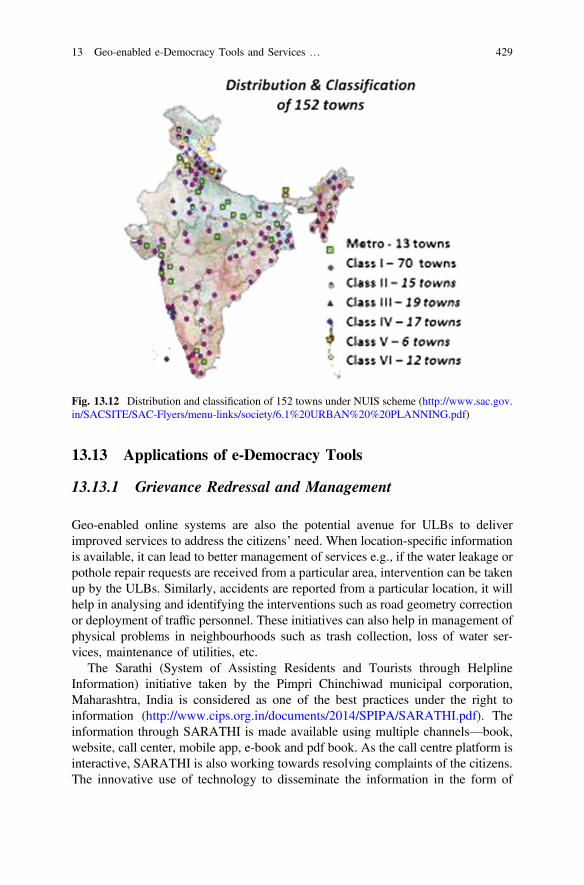
13.13 Applications of e-Democracy Tools
13.13.1 Grievance Redressal and Management
Geo-enabled online systems are also the potential avenue for ULBs to deliverimproved services to address the citizens’ need. When location-specific informationis available, it can lead to better management of services e.g., if the water leakage orpothole repair requests are received from a particular area, intervention can be takenup by the ULBs. Similarly, accidents are reported from a particular location, it willhelp in analysing and identifying the interventions such as road geometry correctionor deployment of traffic personnel. These initiatives can also help in management ofphysical problems in neighbourhoods such as trash collection, loss of water ser-vices, maintenance of utilities, etc.
The Sarathi (System of Assisting Residents and Tourists through HelplineInformation) initiative taken by the Pimpri Chinchiwad municipal corporation,Maharashtra, India is considered as one of the best practices under the right toinformation (http://www.cips.org.in/documents/2014/SPIPA/SARATHI.pdf). Theinformation through SARATHI is made available using multiple channels—book,website, call center, mobile app, e-book and pdf book. As the call centre platform isinteractive, SARATHI is also working towards resolving complaints of the citizens.The innovative use of technology to disseminate the information in the form of
Fig. 13.12 Distribution and classification of 152 towns under NUIS scheme (http://www.sac.gov.in/SACSITE/SAC-Flyers/menu-links/society/6.1%20URBAN%20%20PLANNING.pdf)
13 Geo-enabled e-Democracy Tools and Services … 429
Frequently Asked Questions (FAQs) as well as grievance redressal has becomeimmensely popular with the citizens of Pimpri Chinchwad.
Similarly, the Virtual Charlotte (VC) system developed for the city of Charllotte,USA is one of the finest example of integration of Geospatial web 2.0 platform forcitizen-centric services [26]. The system was developed to coordinate and manageservice delivery seamlessly by city staff. It receives and records informationregarding traffic accidents, construction projects, street maintenance services,vehicle location tracking, etc. The system provides an interface on Google maps toallow non-GIS specialists to use the system without training in a user friendlymanner. All the city departments are integrated within this system that allowscoordination among departments and enhances service delivery.
The initiative taken by the Hubli-Dharwad Municipal Corporation, Karnataka,India to set up 24-h control rooms for public grievance redressal is also listed asbest practices by Ministry of Housing and Urban Poverty Alleviation (MoHUPA),Government of India (http://fincomindia.nic.in/writereaddata%5Chtml_en_files%5Coldcommission_html/fincom13/discussion/report08.pdf). A 24-h grievanceredressal control room have been set up by the corporation for attending the publicgrievances like, road repairs, underground drainage cleaning, maintenance ofstreet-lights, removal of garbage and carcass of dead animals. The status of thecomplaint can be checked online. However, if the system is made geo-enabled onGeoweb 2.0 platform, it can provide better results with location information and canassist in monitoring of complaints.
13.13.2 Location Based Services (LBS)
The Location Based Services (LBS) are software-level information service that usescoordinates of a location to serve specific service requirements of the users.Typically, the coordinates are acquired through GNSS and the LBS services areaccessed through mobile devices which have embedded GPS location receiver.With the availability of high speed Internet connectivity in mobile devices, thelocation information can also be retrieved using geo-tagged IP address and trian-gulation network of Internet such as GPRS. LBS facilitates the services to identify alocation of a person or object, such as finding out the nearest banking cash machine(ATM), nearest location of hospitals, parcel tracking, vehicle tracking service, etc.Under LBS, the personalized weather services and even location-based marketing,awareness and delivery of best services are possible.
LBS can be very effective tool for smart city planning where the citizen servicescan be delivered based on location of the citizen. The geo-enabled citizen-centricservices will be the true implementation of smart city planning where thegeo-location of available services and consumers will be automatically detected.
430 P. Kumar et al.
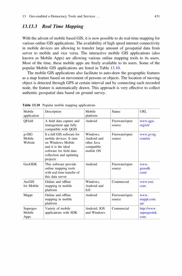
13.13.3 Real Time Mapping
With the advent of mobile based GIS, it is now possible to do real-time mapping forvarious online GIS applications. The availability of high speed internet connectivityin mobile devices are allowing to transfer large amount of geospatial data fromserver to mobile and vice versa. The interactive mobile GIS applications (alsoknown as Mobile Apps) are allowing various online mapping tools to its users.Most of the time, these mobile apps are freely available to its users. Some of thepopular Mobile GIS applications are listed in Table 13.10.
The mobile GIS applications also facilitate to auto-draw the geographic featuresas a map feature based on movement of persons or objects. The location of movingobject is detected through GPS at certain interval and by connecting each recordednode, the feature is automatically drawn. This approach is very effective to collectauthentic geospatial data based on ground survey.
Table 13.10 Popular mobile mapping applications
Mobileapplication
Description Mobileplatform
Status URL
QField A field data capture andmanagement app fullycompatible with QGIS
Android Freeware/opensource
www.qgis.org/en/
gvSIGMobileWebsite
It a full GIS software formobile devices. It runson Windows Mobileand it is the idealsoftware for field datacollection and updatingprojects
Windows,Android andother Javacompatiblemobile OS
Freeware/opensource
www.gvsig.com/en
GeoODK This software provideonline mapping toolswith real time transfer ofthis data server
Android Freeware/opensource
www.geoodk.com/
ArcGISfor Mobile
Online and offlinemapping in mobileplatform
Windows,Android andIoS
Commercial www.esri.com
Mappt Online and offlinemapping in mobileplatform
Android Freeware/opensource
www.mappt.com.au/
SupergeoMobileApps
Variety of mobileapplications with SDK
Android, IOSand Windows
Commercial http://www.supergeotek.com
13 Geo-enabled e-Democracy Tools and Services … 431
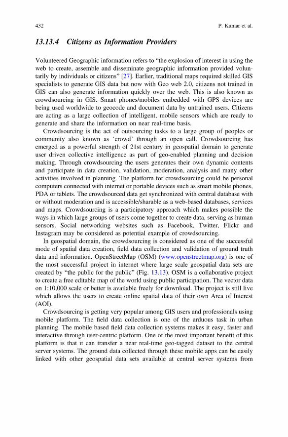
13.13.4 Citizens as Information Providers
Volunteered Geographic information refers to “the explosion of interest in using theweb to create, assemble and disseminate geographic information provided volun-tarily by individuals or citizens” [27]. Earlier, traditional maps required skilled GISspecialists to generate GIS data but now with Geo web 2.0, citizens not trained inGIS can also generate information quickly over the web. This is also known ascrowdsourcing in GIS. Smart phones/mobiles embedded with GPS devices arebeing used worldwide to geocode and document data by untrained users. Citizensare acting as a large collection of intelligent, mobile sensors which are ready togenerate and share the information on near real-time basis.
Crowdsourcing is the act of outsourcing tasks to a large group of peoples orcommunity also known as ‘crowd’ through an open call. Crowdsourcing hasemerged as a powerful strength of 21st century in geospatial domain to generateuser driven collective intelligence as part of geo-enabled planning and decisionmaking. Through crowdsourcing the users generates their own dynamic contentsand participate in data creation, validation, moderation, analysis and many otheractivities involved in planning. The platform for crowdsourcing could be personalcomputers connected with internet or portable devices such as smart mobile phones,PDA or tablets. The crowdsourced data get synchronized with central database withor without moderation and is accessible/sharable as a web-based databases, servicesand maps. Crowdsourcing is a participatory approach which makes possible theways in which large groups of users come together to create data, serving as humansensors. Social networking websites such as Facebook, Twitter, Flickr andInstagram may be considered as potential example of crowdsourcing.
In geospatial domain, the crowdsourcing is considered as one of the successfulmode of spatial data creation, field data collection and validation of ground truthdata and information. OpenStreetMap (OSM) (www.openstreetmap.org) is one ofthe most successful project in internet where large scale geospatial data sets arecreated by “the public for the public” (Fig. 13.13). OSM is a collaborative projectto create a free editable map of the world using public participation. The vector dataon 1:10,000 scale or better is available freely for download. The project is still livewhich allows the users to create online spatial data of their own Area of Interest(AOI).
Crowdsourcing is getting very popular among GIS users and professionals usingmobile platform. The field data collection is one of the arduous task in urbanplanning. The mobile based field data collection systems makes it easy, faster andinteractive through user-centric platform. One of the most important benefit of thisplatform is that it can transfer a near real-time geo-tagged dataset to the centralserver systems. The ground data collected through these mobile apps can be easilylinked with other geospatial data sets available at central server systems from
432 P. Kumar et al.
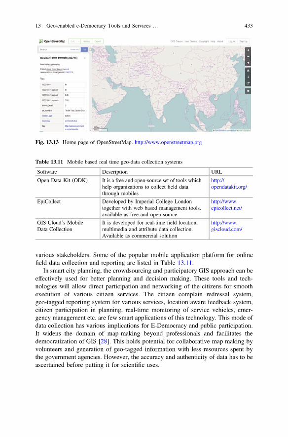
various stakeholders. Some of the popular mobile application platform for onlinefield data collection and reporting are listed in Table 13.11.
In smart city planning, the crowdsourcing and participatory GIS approach can beeffectively used for better planning and decision making. These tools and tech-nologies will allow direct participation and networking of the citizens for smoothexecution of various citizen services. The citizen complain redressal system,geo-tagged reporting system for various services, location aware feedback system,citizen participation in planning, real-time monitoring of service vehicles, emer-gency management etc. are few smart applications of this technology. This mode ofdata collection has various implications for E-Democracy and public participation.It widens the domain of map making beyond professionals and facilitates thedemocratization of GIS [28]. This holds potential for collaborative map making byvolunteers and generation of geo-tagged information with less resources spent bythe government agencies. However, the accuracy and authenticity of data has to beascertained before putting it for scientific uses.
Fig. 13.13 Home page of OpenStreetMap. http://www.openstreetmap.org
Table 13.11 Mobile based real time geo-data collection systems
Software Description URL
Open Data Kit (ODK) It is a free and open-source set of tools whichhelp organizations to collect field datathrough mobiles
http://opendatakit.org/
EpiCollect Developed by Imperial College Londontogether with web based management tools.available as free and open source
http://www.epicollect.net/
GIS Cloud’s MobileData Collection
It is developed for real-time field location,multimedia and attribute data collection.Available as commercial solution
http://www.giscloud.com/
13 Geo-enabled e-Democracy Tools and Services … 433

13.13.5 Public Participation for Decision Making
E-democracy can be truly democratic only when citizen will participate in thedecision making process. There is a significant developments in making dataavailable to the users through geoportals and geo-data repositories. With VGI,citizens are empowered to create information and act on it, but still it is a long wayto go for active participation in decision making through online geo-enabled tools.The higher levels of democratic process requires active involvement of citizens inmaking an impact on planning and decision making processes. The use of GIS andgeo-enabled web tools have great potential for enhancing the public participation inplanning process.
Using Geospatial web 2.0, it is possible to deliver complex geographical modelsof simulations of future growth, impact of development projects, alternative sce-narios in simplified visual form that could be understood by the citizens. Untilrecently, most of the participatory approaches were either employed without the useof technology or if GIS technology was used then it was limited only to thefeedback from participants. However, the technology has capabilities to provideinformation to the users in interactive manner in such a way that they could performtheir own analysis, can interpret the results and make policy suggestions. Hence, theadoption of e-democracy tools for effective public participation is not a techno-logical issue but more of institutional and political issue.
13.14 Geo-enabled E-Democracy: Challenges
The smart city programme is happening worldwide. The geo-enabling of databaseis the challenge for urban managers as they have to organize their infrastructuralassets in such a manner that they are ‘GIS ready’. It will create a single GIS datawarehouse of available survey data, maps, images, tabular geo-tagged developmentdata, cadastral data, etc. Another important component involves periodical updationof information. The biggest challenge faced today is the lack of technical capacityto plan, implement and monitor IT-driven or embedded projects. As the cities todayare entering the realm of big data management, the urban managers need to addressfollowing major challenges:
• Data integration: The institutional labyrinth especially in developing world andcoordinating information from different agencies often hinders the urban plan-ning and reform process. The data required for urban planning lies with severalurban local bodies. Therefore, the data integration holds the key towards thesuccess of smart city mission. Large datasets are still in analogue format andneed to be digitized whereas the data prepared through CAD software need to bealigned to GIS platform. The adoption of open standards for geospatial datasetshas reduced the technical barriers, but political and organizational ones are hardto be addressed.
434 P. Kumar et al.
• Privacy and security: During the recent years, data availability especially fromopen sources has eased the process of urban planning. However, the datasetsavailable at urban local bodies whether in analogue or digital format should beused by urban managers with precaution. Data security is even more of achallenge and should be adequately addressed under smart city programme.
• Capacity building: The viable utilisation of huge information by city managersfor urban planning also calls for the need for capacity building. Lack of skill setsmay well be the biggest barrier for the effective use of data by city managers.Managing and analysing large data sets and developing insights for effectivepolicy making and overall improvement requires skills which are often deficient,particularly in the public sector. Cloud-based services, public-private partner-ships, and open data strategies could help by providing access to a broader skillsbase. Cities can also build deeper relationships with academia. Many cities areworking with local universities to establish smart city and urban informaticsresearch programs.
• Financing for Urban Infrastructure: The smart city programme is investmentintensive. It needs huge investment for realizing the goals of infrastructurecreation and better planning. Basically, the investment need falls in two cate-gories, firstly the capital and secondly the operational expenses. The urbanmanagers should primarily think towards reducing/rationalizing the tax ratesthan raising the taxes. The increase in revenues after the realization of smart citymission may be expected while levying betterment tax, review of land use andfloor area ratio (FAR), sale of recycled waste and user charges, etc.
13.15 Conclusions
Urbanisation is synonymous with growth and development as well as associatedenvironmental deterioration. For sustainable growth of urban areas, smart cityconcept is supported, which aims to achieve overall and long term development ofurban areas. This goal can only be achieved if the citizens are actively involved indecision making and planning process by the geo-enablement of e-democracy toolsand services. Geo-enablement brings numerous advantages as it adds location to theexisting information, which makes it easily comprehendible by the common citizen.The Google maps, Bing maps, Bhuvan Geoportals are some examples of the use oflocation based information by the masses. The latest developments in geospatialtechnologies and web GIS domain provides the necessary technologies and plat-forms for implementation of geo-enabled e-democracy tools. Now a variety ofremote sensing datasets ranging from coarse to fine resolution as well as number ofground based sensors are providing multitude of datasets which enable generationof vast information for urban areas.
The advancements in GIS, web GIS and Geoweb 2.0 provides necessary plat-forms for integrating the remote sensing and ground based information on
13 Geo-enabled e-Democracy Tools and Services … 435
geo-tagged and interactive virtual environments. The availability of information onthese platforms has brought paradigm shift in the usage of geographic informationas now even an unexperienced, untrained user can understand, modify and analysethe geo-information. It enables to support three main components of any democraticprocess—information to collaboration and participation. At present, many geo-portals and geo-data repositories are available from where geographic datasets canbe freely downloaded and can be used for the development of a range of smart cityapplications. These data sets are available at varied scales from global to local.However, still a lot need to be done for the creation of necessary datasets formultiple requirements of upcoming smart cities.
Bhuvan geoportal, developed and hosted by ISRO is one such portal whichprovides datasets, tools and applications for visualization, use and development ofapplications by urban managers in India. NUIS, municipal GIS, tourism GIS, Urbanframework survey, etc. are few of the examples of the geo-applications available onBhuvan. This portal also hosts very high resolution satellite data of Indian cities,which can be used for creation of a range of thematic information to be used forsmart city applications. Similarly, the geo-enabled e-democracy tools is being usedfor grievance redressal, involving citizens in collection of information throughvolunteered interventions or crowd sourcing, provision of location based services,real-time mapping and participatory GIS. However, its role has been limited till nowup to the dissemination or collection of information to and from the public. Thecollection and use of information in truly democratic way would be possible throughthe active involvement of citizens in the decision making and planning processes.
Smart cities focuses on integrated urban development through citizen partici-pation by the use of technology, hence the geo-enabled e-Democracy tools defi-nitely have potentials to enhance citizen participation and strengthen the democraticprocesses in local governance. Aspirations are high to achieve this goal throughsmart city mission, and geo-web tools and services have immense capabilities toprovide information to the citizens in an interactive manner and easily compre-hendible form so that they could participate in planning and decision making. Thelimitations is more of institutional and political rather than technological. There arevarious issues which need to be addressed such as data integration, privacy andsecurity, skills gap and capacity building, and therefore, institutional setup andpolitical will is necessary for the true implementation of these tools and services.
References
1. UN (2014) World urbanisation prospects, Department of Economic and Social Affairs,United Nations, https://esa.un.org/unpd/wup/Publications/Files/WUP2014-Highlights.pdf.Last accessed in Nov 2016
2. Mckinsey (2010) India’s urbanisation: a closer look. http://www.mckinsey.com/global-themes/urbanisation/indias-urbanisation-a-closer-look. Last accessed in November 2016
3. Steudler D, Rajabifard A (2012) Spatially enabled society, the International Federation ofSurveyors (FIG) and the Global Spatial Data Infrastructure Association (GSDI)
436 P. Kumar et al.
4. Nagy M, Legat R, Hřebíček J (2007) Electronic access to environmental information—animportant fundament for eDemocracy and environmental protection
5. Anon (2016) India Smart City mission. http://smartcities.gov.in/writereaddata/winningcity/BHUBANESWAR_SCP.pdf. Last accessed in Nov 2016
6. Hai J, Ibrahim C (2007) Fundamental of development administration. Scholar press,Selangor. ISBN 978-967-5-04508-0, 2008, pp. 125–130
7. Gupta K, Roy A, Luthra K, Maithani S, Mahavir (2016) GIS based analysis for assessing theaccessibility at hierarchical levels of urban green spaces. Urban Forestry and UrbanGreening 18:198–211
8. Mahavir, Bedi P (2014) GIS for smart urbanisation. In: Vinod Kumar TM (ed) Geographicinformation system for smart cities. Copal publishing, Delhi
9. Jat MK, Garg PK, Khare D (2008) Monitoring and modelling of urban sprawl using remotesensing and GIS techniques. Int J Appl Earth Obs Geoinf 10(1):26–43
10. Gupta K (2013) Unprecedented growth of Dehradun Urban area: a spatio-temporal analysis.Int J Adv Remote Sens GIS Geogr 1(2):6–15
11. Bodhankar S, Gupta K, Kumar P (2015) Smart planning through geo-enabling of digitaldatabase for planning authorities: a case study of regional park zone (RPZ) pockets in NaviMumbai notified area. In: ISG 2015 Conference at Jaipur, 16–18 Dec 2015
12. Gupta K, Kumar P, Pathan SK, Sharma KP (2012) Urban neighborhood green index—ameasure of green spaces in urban areas. Landsc Urban Plann 105(3):325–335
13. Jensen JR (2007) Remote sensing of the environment: an earth resource perspective, 2ndedn. Upper Saddle River, NJ, USA, Pearson Prentice Hall
14. Bhaskaran S, Paramananda S, Ramnarayan M (2010) Per-pixel and object-orientedclassification methods for mapping urban features using Ikonos satellite data. Appl Geogr30:650–665
15. Jeffery C (2010) An introduction to GNSS, Novatel Inc., Canada. http://www.borealisprecision.com/pdf/An_Introduction_to_GNSS.pdf. Last accessed in Nov 2016
16. Rashid SM (1996) Economics of remote sensing. Manak Publications Pvt. Ltd. https://books.google.co.in/books?id=kpRNAQAAIAAJ
17. Steiniger S, Bocher E (2009) An overview on current free and open source desktop GISdevelopments. Int J Geogr Inf Sci 23(10):1345–1370
18. Peng ZR, Tsou MH (2003) Internet GIS: distributed geographic information services for theinternet and wireless networks. ISBN: 0-471-35923-8, Mar 2003
19. Karnatak HC, Shukla R, Sharma VK, Murthy YVS, Bhanumurthy V (2012) Spatial mashuptechnology and real time data integration in geo-web application using open source GIS—acase study for disaster management. Geocarto Int 27(6):499–514
20. Karnatak HC, Saran S, Bhatia K, Roy PS (2007) Multicriteria spatial decision analysis inweb GIS environment. Geoinformatica 11(4):407–429
21. Karnatak HC, Bhatia K, Saran S (2008) Multi-criteria decision analysis using spatialcompromise programming. In: Proceedings of the 2nd national conference—INDIACom-2008, on computing for nation development, New Delhi, India. ISBNNo-ISSN 0973-7529, ISBN 978-81-904526-2-5, pp 77–62, 08–09 Feb 2008
22. Karnatak HC, Saran S, Roy PS (2005) Spatial services, a click away. Geospatial Today5:42–46 (2005)
23. Sayar A, Aktas M, Aydin G, Pierce M, Fox G (2005) Developing a web service-compatiblemap server for geophysical applications technical report. Indiana University, Indiana
24. ESRI (2004) Best practices: mobile GIS. http://www.esri.com/library/bestpractices/mobile-gis.pdf
25. Bhuvan User Hand Book (2015) National Remote Sensing Centre, Indian Space ResearchOrganisation, Hyderabad
26. Ganapati S (2010) Using geographic information systems to increase citizen engagement.IBM Center for The Business of Government, Washington, DC, http://www.businessofgovernment.org/, Last Accessed in November 2016
13 Geo-enabled e-Democracy Tools and Services … 437
27. Goodchild MF (2007) Citizens as sensors: the world of volunteered geography. GeoJournal69:211. doi:10.1007/s10708-007-9111-y
28. Dunn CE (2007) Participatory GIS—a people’s GIS? Prog Hum Geogr 31(5):616–637
URLs
29. http://activefiremaps.fs.fed.us/gisdata.php30. http://aphousing.cgg.gov.in/Map.do31. http://asterweb.jpl.nasa.gov/gdem.asp32. http://bhuvan.nrsc.gov.in33. http://bhuvan.nrsc.gov.in/bhuvan_links.php34. http://bhuvan.nrsc.gov.in/data/download/index.php35. http://bhuvan.nrsc.gov.in/governance/mospi_urbanframesurvey/#36. http://bhuvan.nrsc.gov.in/governance/socialjustice_census37. http://bhuvan.nrsc.gov.in/map/bhuvan/bhuvan2d.php38. http://bhuvan.nrsc.gov.in/tourism/tourism.php39. http://bhuvan.nrsc.gov.in/urban/sprawl/urbangrowth.php40. http://bis.iirs.gov.in41. http://cait.wri.org42. http://cen.gisserver.nic.in43. http://data.worldbank.org/topic/urban-development44. http://database.espon.eu/db2/resource?idCat=4345. http://dhte.puducherry.gov.in/download/rusa/1_Bhuvan_User_Handbook.pdf46. http://download.geonames.org/export/dump/countryInfo.txt47. http://due.esrin.esa.int/page_globcover.php48. http://earthquake.usgs.gov/earthquakes/eqarchives/epic/kml49. http://elearning.iirs.gov.in50. http://en.beidou.gov.cn/51. http://fincomindia.nic.in/writereaddata%5Chtml_en_files%5Coldcommission_html/
fincom13/discussion/report08.pdf52. http://freegisdata.rtwilson.com/53. http://gecon.yale.edu54. http://geodata.grid.unep.ch55. http://geospatialworld.net/News/View.aspx?id=32320_Article#sthash.1dYjLUXc.dpuf56. http://gis.nic.in57. http://grass.osgeo.org58. http://hydrosheds.cr.usgs.gov/index.php59. http://ibin.gov.in60. http://india-wris.nrsc.gov.in61. http://Internetofthingsagenda.techtarget.com62. http://live.osgeo.org63. http://main.mcludhiana.gov.in/pdf/MCL_Blocks_gismap.pdf64. http://mapguide.osgeo.org65. http://maps.google.com66. http://maps.mapmyindia.com67. http://moud.gov.in/nuis68. http://msi.nga.mil/NGAPortal/MSI.portal?_nfpb=true&_pageLabel=msi_portal_page_
62&pubCode=001569. http://nelson.wisc.edu/sage/data-and-models/crop-calendar-dataset/index.php70. http://nelson.wisc.edu/sage/data-and-models/global-land-use/grid.php71. http://nelson.wisc.edu/sage/data-and-models/schneider.php72. http://opendatakit.org/
438 P. Kumar et al.
73. http://openflights.org/data.html74. http://openlayers.org75. http://postgis.refractions.net76. http://rgeostats.free.fr/77. http://s3.amazonaws.com/simplegeo-public/places_dump_20110628.zip78. http://sedac.ciesin.columbia.edu/data/collection/gpw-v479. http://sedac.ciesin.columbia.edu/data/collection/grump-v180. http://sedac.ciesin.columbia.edu/data/collection/ndh81. http://sedac.ciesin.columbia.edu/data/collection/wildareas-v282. http://sedac.ciesin.columbia.edu/data/set/grump-v1-settlement-points83. http://smartcities.gov.in/writereaddata/smartcityguidelines.pdf84. http://srtm.csi.cgiar.org85. http://themasites.pbl.nl/tridion/en/themasites/hyde/index.html86. http://urban.jrc.ec.europa.eu/87. http://urbandata.unhabitat.org/88. http://vedas.sac.gov.in/vedas89. http://visibleearth.nasa.gov/view.php?id=6100490. http://wateriso.utah.edu/waterisotopes/pages/data_access/da_main.html91. http://webarchive.iiasa.ac.at/Research/LUC/External-World-soil-database/HTML/index.
html?sb=192. http://wikimapia.org93. http://www.bhuvan.nrsc.gov.in94. http://www.bing.com/maps/95. http://www.cablemap.info96. http://www.cgiar-csi.org/data/global-high-resolution-soil-water-balance97. http://www.ciesin.columbia.edu/confluence/display/roads/Global+Roads+Data98. http://www.cips.org.in/documents/2014/SPIPA/SARATHI.pdf99. http://www.deegree.org100. http://www.diva-gis.org/gdata101. http://www.docs_wri.org/page_forest_gh_sc_final.zip102. http://www.earthenv.org/landcover103. http://www.eea.europa.eu/data-and-maps/data/urban-morphological-zones-2000-1104. http://www.epicollect.net/105. http://www.erdas.com106. http://www.esri.com107. http://www.exelisvis.co.uk/108. http://www.fao.org/geonetwork/srv/en/main.home109. http://www.fao.org/geonetwork/srv/en/metadata.show?id=30914110. http://www.gaia-gis.it/spatialite111. http://www.gdal.org112. http://www.geobase.org113. http://www.geoext.org114. http://www.geofabrik.de/data/download.html115. http://www.geohive.com116. http://www.geomajas.org117. http://www.geoodk.com/118. http://www.geoserver.org119. http://www.geotools.org120. http://www.giscloud.com/121. http://www.gvsig.com/en122. http://www.hexagongeospatial.com123. http://www.ibin.gov.in124. http://www.ilwis.org/125. http://www.intergraph.com
13 Geo-enabled e-Democracy Tools and Services … 439
126. http://www.ipf.tuwien.ac.at/404/127. http://www.isro.gov.in/3d-digital-model-of-gol-gumbaz-%E2%80%93-one-of-largest-dome-
structure-world128. http://www.isro.gov.in/irnss-programme129. http://www.iucnredlist.org/technical-documents/spatial-data130. http://www.ldeo.columbia.edu/chrr/research/hotspots/coredata.html131. http://www.mappt.com.au/132. http://www.maps.google.com133. http://www.maps.mapmyindia.com134. http://www.marine-geo.org/portals/gmrt/135. http://www.mosdac.gov.in136. http://www.mysql.com137. http://www.naturalearthdata.com138. http://www.navipedia.net/index.php/Galileo_Future_and_Evolutions139. http://www.netdimes.org/new/?q=node/65140. http://www.ngdc.noaa.gov/hazard/tsu_db.shtml141. http://www.ngdc.noaa.gov/mgg/shorelines/gshhs.html142. http://www.openstreetmap.org143. http://www.opentopography.org/index.php144. http://www.oracle.com/technology/products/spatial/index.html145. http://www.osgeo.org146. http://www.poi-factory.com147. http://www.postgresql.org148. http://www.qgis.org/en/149. http://www.sac.gov.in/SACSITE/SAC-Flyers/menu-links/society/6.1%20URBAN%20%
20PLANNING.pdf150. http://www.seismo.ethz.ch/static/GSHAP151. http://www.skylineglobe.com152. http://www.start.umd.edu/gtd153. http://www.supergeotek.com154. http://www.terralib.org/155. http://www.worldclim.org156. http://www.worldpop.org.uk157. http://www.worldwildlife.org/pages/conservation-science-data-and-tools158. http://www.wudapt.org/159. http://www-01.ibm.com/software/data/db2160. https://en.wikipedia.org/wiki/E-democracy161. https://fusiontables.google.com/DataSource?dsrcid=579353#rows:id=1162. https://koordinates.com/about163. https://mapzen.com/data/metro-extracts164. https://nordpil.com/resources/world-database-of-large-cities165. https://nsdiindia.gov.in166. https://urban-tep.eo.esa.int/#!167. https://velluminformation.com/2012/01/28/google-earth-world-bank-data-and-kml-files/168. https://www.arcgis.com/169. https://www.glonass-iac.ru/en/guide/170. https://www.gsa.europa.eu/european-gnss/galileo/galileo-european-global-satellite-based-
navigation-system171. https://www.iscgm.org/gmd172. https://www.nasa.gov/directorates/heo/scan/communications/policy/GPS_History.html173. https://www.soilgrids.org/#/?layer=geonode:taxnwrb_250m
440 P. Kumar et al.

Chapter 14Attaining E-Democracy Through DigitalPlatforms in Kenya
Romanus Opiyo, Baraka Mwau, Keziah Mwang’aand Dennis Mwaniki
Abstract The role of responsible citizens in any country—whether in a city or avillage–is to actively participate in the development of their areas. This is a keypre-condition for the attainment of sustainable development, and is deeplyentrenched in the sustainable development goals. While the citizens’ right to thecity and to actively contribute to a sustainable world cuts across the 17 goals, theprovisions of goal 16, to “promote peaceful and inclusive societies for sustainabledevelopment, provide access to justice for all and build effective, accountable andinclusive institutions at all levels” clearly spells out the need for inclusiveness,participation, and access to information at all governance levels; which wouldpromote a sustainable, inclusive and prosperous world (Kimani in Overview ofSDGs in Kenya. Paper presented during the County Capacity Forum at Hill Park,Diani on 20 June 2016, [1]). These are central elements of democratic spaces,which are greatly being enhanced by today’s advances in information and com-munication technologies (ICTs). Kenya has over the recent past made huge stridesin the area of promoting e-government services, which has resulted in increasede-democracy alternatives. This has particularly been the case since the creation ofthe e-government strategy in 2004 (Government of Kenya in e-government strategy2004. Government Press, Kenya, 2004, [2]), as well as the review of variousnational laws and policies including a change in the country’s constitution in 2010.
R. Opiyo (&) B. MwauUrban Planning & Design Branch, United Nations Human Settlement Programme(UN Habitat), Nairobi, Kenyae-mail: [email protected]
B. Mwaue-mail: [email protected]
K. Mwang’aGran Sasso Science Institute, L’Aquila, Italye-mail: [email protected]
D. MwanikiUrban Planning and GIS, Global Observatory Linking Researchto Action (GORA) Corp, New York, USAe-mail: [email protected]
© Springer Nature Singapore Pte Ltd. 2017T.M. Vinod Kumar (ed.), E-Democracy for Smart Cities, Advances in 21st CenturyHuman Settlements, DOI 10.1007/978-981-10-4035-1_14
441
These reforms have expanded opportunities for citizens to participate in develop-ment processes, including governance. The advances in ICT in the country, whichhas seen mobile phone penetration rise from less than one percent to 88.1% in just15 years (2000–2015), and broadband increase from a mere 28 Megabits per sec-ond in 2004 to 193.58 Gigabytes per second in 2015 (Export Processing ZonesAuthority in Kenya’s information and communications technology sector 2005,2005, [3]; International Telecommunication Union—ITU, 2016, [4];Communications Authority of Kenya in First quarter sector statistics report for thefinancial year 2015/2016, 2015, [5]) has further expanded the options for citizenengagement in shaping the country’s smart growth. As a result of these changes,more Kenyans today can easily access information on, and participate in variousprocesses such as national and local budget preparation and plan formulationprocesses; demand for accountability from the political class on resource utilization;or even submit complaints on poor governance and service delivery through adiversity of platforms. Equally, citizens are able to easily and quickly access ser-vices through a few clicks on their phones or computers, services that traditionallytook months to acquire through bureaucratic processes. This chapter outlines howKenya has in the recent past adopted ICT tools and methods in a bid to attaininclusive, transparent, effective and efficient governance. It discusses how thecountry is utilizing various ICT avenues to promote access to information by thecitizens and through which governance structures get feedback on issues. It furtherillustrates the existing avenues for active citizen engagement in democratic andgovernance processes and analyzes how effective the adopted ICT systems are inpromoting inclusive and smart growth.
Keywords E-democracy E-government/nce Public engagement ICT Smartcity One-stop centres Kenya Nairobi
14.1 Introduction
Digital platforms are creating the next wave of participation, disruption, growth andbreakthrough innovation. Information and communication technologies (ICTs) areoften seen as catalysts for democratic processes, freedom of speech and fraudsolution, while e-governance has been identified as having the potential to establishan environment for improved service delivery, increased transparency andaccountability [6]. Responsive governments have the potential to translatee-government (implementing decisions with the help of ICT) to e-governance(using ICT to help make decisions), a situation that may lead to e-democracy ifcitizens are meaningfully engaged in the process.
While there is no single universally agreed definition of e-democracy, there arebasic widely used concepts to describe the phenomenon. E-democracy has beenviewed broadly as the use of ICTs to increase and enhance citizens’ engagement indemocratic processes [7]. Other writings have noted that prospects of e-government
442 R. Opiyo et al.
have been idealized as heralding in a new era of democratic involvement, withopportunities for unmediated discussions, direct participation and representation,and greater transparency and accountability through political openness [8]. Otherscholars like Coleman and Norris [9] view e-democracy as a concept that includesall processes where ICT is used by those in power and the citizens they serve tointeract with each other in order to inform and determine the way that power isutilized. Generally thus, e-democracy can simply be defined as the use of ICTs tofacilitate democratic activities and processes such as citizen engagement andenhancing public awareness.
While in some instances e-democracy initiatives are people driven, many gov-ernments are now using ICTs to expand democratic spaces as well as enhance howthey serve and relate with their citizens. The record of government-led ICT initiativesand experiments is as diverse as there are many governments. Projects range from oneoff single-issue activities to long-term and institutionalized initiatives at differentlevels of government/governance. An example of a government led e-democraticinitiative can be drawn from the city of Santa Monica, California, which had adoptedICT to broaden citizen participation in public policy making in 1986 [10]. Though theplatform used then, the Public Electronic Network (PEN) is no longer active, itprovided an avenue for citizens to engage with the city, access information about cityservices, participate in city processes as well as bring to the attention of the citygovernment community issues that needed to be addressed. One outcome of thecitizen engagement was the SHWASHLOCK project which sought to providehomeless people with shower facilities. The SHWASHLOCK project was conceivedby private citizens who then shared it with the city, though the PEN citizen forum.
Other examples of government-led e-democracy initiatives include the FinishMinistry of Finance ‘Share your view with us’ forum started as a pilot projectbetween 2000-03, which has now become institutionalized. The forum is intendedto provide an open space where citizens could freely share their opinions andcomment on government projects underway [11, 12]. A similar example is theREACH project by the government of Singapore which provides an online platformwhere citizens can give their views on national policies ranging from housing,education to annual national financial budget [13, 14].
While similar innovations and processes by governments are taking place in thedeveloping world and particularly in Africa, there lacks extensive literature on theimpact of these initiatives. However, part of the literature that exists demonstratesthat there is increasing uptake of ICTs within the public sector, private sector, civilsociety and by the citizens themselves, largely expanding the arena for cross-cuttingengagement. Indeed, digital platforms have been attributed to reversing a growingtrend of disengagement between governments, political leadership and citizens [15].This chapter seeks to fill the existing gap in literature by highlightinggovernment-led or top-down e-democracy initiatives in the Kenyan context. Thechapter uses case examples to highlight how ICT is being used to create democraticspaces in which citizens can easily and seamlessly enjoy and/or lobby for theirrights to space and to engage in policy formulation processes. Case examplesinclude the analysis of ICT based tools such as e-government platforms and one
14 Attaining E-Democracy Through Digital Platforms in Kenya 443
stop centres (virtual and physical spaces which are themselves highly ICT con-nected systems linking a multiplicity of government agencies) for enhanced servicedelivery and citizen engagement—and their associated legislative backings andstanding.
14.2 E-Democracy in Kenya, a Conceptual Overview
E-democracy is a relatively new concept in Kenya, often appearing in the limelightin the last decade with the country’s increased adoption of ICTs. Democracy, whichis often related to the promotion of a people’s right to “belong”, to “place” and toinfluence decision making in their areas has deeply been entrenched in the con-stitution of Kenya since independence. The use of the term through the 1990s washowever largely to push a political agenda, an agenda that would culminate in ashift from the then “oppressive” political regime. In respect, the term was broadlyused to promote such aspects as the right to vote and freedom of expression. Sincethe turn of the century, the democratic setting in Kenya has been broadly shiftingtowards public participation, the right to space and place, the right to serviceprovision, and citizen platforms pushing for accountability and action from those inpower.
While the push for attainment of democracy through the 1990s was morephysical (exhibited largely through mass protests and strikes), the modus operandithrough the 2000s has been shifting towards more digital platforms and virtualcampaigns. This can largely be attributed to an increase in the number of tech-nology compliant citizens, and a growth in the national broadband and connectivitythrough mobile phones. These shifts, which are at tandem with global transitionstowards use of digital platforms for efficient service delivery are already bearingfruits for various sectors in Kenya, and greatly improving citizen engagement,efficiency of service delivery and in turn enhancing the national productivity. Forexample, adoption of digital information sharing platforms such as websites andsocial media alternatives by various governmental and non-governmental institu-tions today form the core of mass information sharing in the country, and create aloop for getting feedback on efficiency of services, with the collective implicationof enhanced performance by various institutions/levels of government. In addition,the high internet and mobile phone penetration in the country (estimated at 82.6 and88.1% respectively in 2016 as noted by Communication Authority of Kenya),coupled with growth in social media platforms have expanded social, economic andpolitical growth opportunities and also created unique avenues for citizen partici-pation as well as platforms for mobilization and lobbying for various services byvarious arms of the government. This is notably achieved through various blogs andsocial media forums, which enable citizens to ventilate on various multi-sectoralissues, including discussing candidates for various positions, on-going or proposedactivities and projects or opinion about a policy or any legal document. The col-lective outcome has been better visibility of complains on poor service delivery and
444 R. Opiyo et al.
in turn improved service delivery in some areas. There has also been a generalimprovement in citizen participation in decision-making. These are keypre-requisites for attainment of democracy.
In the subsequent sections, we discuss some key examples through which ICTsare being used to promote creation of democratic spaces in Kenya for citizens, andhow this is in turn shaping the country’s transition towards effective democracy.
14.3 Using ICTs to Attain E-Democracy and SmartGrowth in Kenya, Some Emerging Approaches
In appreciation of the role and potentiality of ICT in attaining of e-democracy, it isimportant to understand the requisite for any country to reap the benefits associatedwith digital platforms. The basic requirement is to map the penetration and access tothese tools.
Kenya is a country in transition from an analog to a digital nation. Over the lastone and half decade, all the ICT indicators in the country have grown tremendously,making the country one of the fastest ICT adopting countries in the world, andputting it as an African leader in ICT adoption, innovation and use for creation ofsocio-economic opportunities. For example, the national mobile phone penetrationhas risen from less than one percent in 2000 to 88.1% in 2015, creating a highlyconnected and informed population. In just about 10 years, the country’s broadbandhas increased from a mere 28 Megabits per second in 2004 to 193.58 GB persecond in 2015 [3–5], creating a web of highly connected human settlements bothlocally and globally. In addition, the proportion of the Kenyan population accessinginternet services reached 74.2 per 100 inhabitants in 2016 up from 69.0% per 100inhabitants in 2015 [16].
This growth coupled with government openness to embrace the use of ICT hasbrought forth varied and positive changes to the country’s democratic space, withnew avenues for information dissemination, knowledge sharing, citizen engage-ment and enhanced service delivery. The bulk of ICT driven democratic channels inthe country can be traced to the last decade, particularly after the creation of theE-government strategy in 2004. The major manifestations of the emerging spaces,particularly from the public sector (which is the major service delivering body andfrom which citizens demand the highest level of engagement in decision making)have included, but are not limited to;
• creation of rapid information dissemination platforms, largely through websitesand social media applications
• creation of online and offline service delivery centres aimed at enhanced effi-ciency of the public sector
• consumer feedback systems for enhanced democracy and productivity
14 Attaining E-Democracy Through Digital Platforms in Kenya 445

• creation of dedicated and exclusive online based channels for civic engagementand public participation
• creation of reporting mechanisms on public service achievement and for whichthe citizens have their say. Examples include state of the nation reports, citizenreport cards, and various accounting systems promoted by the government
14.3.1 Websites and Social Media Platformsfor Information Dissemination and CitizenEngagement
All government ministries and agencies have websites showing the various activ-ities they are undertaking and a news segment which keeps the public informedabout ministry specific current affairs. There are also provisions through whichcitizens can send emails, ask questions or comment in the website and wait forfeedback from the agencies. This has enhanced interaction between citizens andtheir government in many ways including informing the public on various legal andpolicy frameworks guiding the agencies and the service charters related to provisionof certain services. In addition to websites, social media platforms such as Twitterand Facebook form key tools used by government agencies and citizens to interact.Recent research shows that there are more than 5million and about 2 millionFacebook and Twitter users in Kenya respectively. Kenya ranks fourth in Africa inthe use of Twitter after Egypt, Nigeria and South Africa, with 10% of the tweetsbeing politically oriented as compared to only 2% in the United Kingdom and theUSA [17]. This shows the potential for social media use for political engagement.Significant and active social media channels include the president and deputypresident’s Twitter handles and Facebook pages; and the Inspector General ofPolice Twitter handle specifically dedicated to reporting crime and corruptionrelated cases [18]. The current president has the highest Twitter followers in thecountry, making him accessible to majority of Twitter users.
Websites and social media platforms work in two ways. First they make thegovernment visible and easily accessible to communities. The online presence ofthe government provides an opportunity for citizens to post their opinions orexpress distaste regarding diverse issues whether solicited or not. For responsiblecitizenry, social media in Kenya have been used as a tool for whistle-blowing andengaging government, non-government organizations officials and individuals onvarious issues of public interest, which some have ended up being acted upon bythe respective offices. Notable examples include the online based petitioning anddismissal of public officials by the president, such as a 2014 dismissal of the thenCabinet Secretary for Interior based on online public petitioning and outcry againsttheir handling of national security issues.
446 R. Opiyo et al.
In another scenario, public outrage through social media and physical demon-strations led to the establishment of ‘Anti Stripping Police squad’ in 2014 to helpcurb rising cases of women stripping in Nairobi. The establishment of the unit waselicited by public pressure on the government to arrest the perpetrators of the crimethat had gone unchecked. Using social media to organize a campaign under thehashtag #MyDressMyChoice, different groups came together, marched on thestreets of Nairobi and pressured the government to take action- leading tothe establishment of the police unit, and the arrest and charge of those involved instripping cases. The movement and the cause drew support from other quarters suchas the Law Society of Kenya that demanded they be accorded the permission toprosecute people caught harassing and stripping women.
Electronic participation, or e-Participation including web- streaming, socialmedia (especially Facebook and Twitter), various blogs, discussion forums anddecision support systems are gaining currency in Kenya. It is the use of ICT tofacilitate political participation by enabling citizens to communicate with eachother, civil society, their elected representatives and their government, which haschanged the perception of the leaders and how they relate with the highly informedcitizens. Previous studies show that stronger online participation through technol-ogy has the potential to improve the quality of political decisions and to increase theperceived legitimacy of the decisions taken. This aspect of e-Government is seen asushering in a new era of democratic involvement, greater transparency andaccountability. Other researchers note that governments have given little priority totechnologies that enable citizens to contribute to decision-making, with some goingso far as to call digital democracy and e-Participation the ‘myths of e-government’[19].
The above examples show the potential for the use of social media and stateonline contacts by citizens to influence key decisions. However, there are complainsthat some of the websites and contact information provided by government officialsare rarely active and in most cases even when active don’t respond to publiccomplaints [20]. On the other hand, public officials claim that citizens do not fullyengage with the state in the platforms provided, and when they do, they result tounconstructive criticism or meaningless discussions [18, 20]. This highlights theneed to not only provide avenues for engagement but to also ensure that the publicand state officials can constructively use ICT tools for effective engagement.Indeed, the use of digital platforms to actively engage consumers of servicesamounts to e-participation rather than just using digital platforms to improve effi-ciency of operations and services. According to the OECD [21], there is need to paymore attention to quality and effectiveness of moderation of online consultations,and go further to integrate online and traditional methods of citizen engagementconsidering that there exits cultural and organizational barriers within the society;hence, attempts to reach every segment should be a priority.
14 Attaining E-Democracy Through Digital Platforms in Kenya 447
14.3.2 Consumer Reporting and Feedback Systemsfor Enhanced Democracy and Productivity
In addition to the use of websites and social media platforms, some agencies havegone a step further to design flow-back chain systems specifically meant to promoteinteraction between users and service providers. This has mainly been in the form ofshort code services and other two-way communication channels through whichconsumers launch complains or queries and get assistance from the relevantauthorities. Case examples include: MajiVoice by Nairobi water; Power Alert byKenya Power, and the short message service (SMS) based voter verificationby Independent Electoral and Boundary Commission. The MajiVoice, an initiativeby the Water Services Regulatory Board (WASREB), the Water Sector Regulator inKenya, provides a two-way communication between consumers and water provi-ders through text messages (SMS) and/or through the internet. Using their mobilephones or computers, consumers use MajiVoice to communicate their concerns,provide feedback and complaints on service delivery, and where necessary, receivefeedback on how issues raised are being addressed by the service provider.According to the water services board, the aim of the platform is to enhanceefficiency, accountability, responsiveness and transparency of urban water serviceproviders in Kenya, aspects that are critical in a democracy [22].
The Kenya power company on the other hand has created a special websitereferred to as PowerAlert that provides real-time power blackouts and status acrossthe country. The PowerAlert amalgamates all planned outages in a central portaland users can access the PowerAlert portal by signing in Via Google, Twitter andFacebook. By providing location, consumers can also receive notifications viaemail, Twitter or SMS when an outage happens in their location. The website alsoprovides a comments section where customers can report or check on the status.The power company also provides customers with an E-bill SMS service thatallows clients to query their account balance by sending a short service via theirmobile phones.
The Independent Electoral and Boundaries Commission (IEBC), the body incharge of all electoral processes and related boundary delineations, is movingtowards digital voter registration and voting structures, which also allow instanttransmission of electoral results. In built in the system is an SMS service thatenables citizens to verify their voter registration details instantly using their mobilephones regardless of their location. This is an upgrade from the previous systemthat required citizens to walk to the IEBC county headquarters or wait until thecommission specifically opens registration window period in local centres for votersto confirm their registration details. The registration period happens mostly onceevery 5 years, just before the general elections. This has largely enhanced thecitizens right to vote, and in turn improved democracy in the country. The use ofemerging technologies in these processes is rapidly creating many alternatives fore-democracy.
448 R. Opiyo et al.
14.3.2.1 Service Delivery Centres and E-Democracy
In Kenya, various service delivery centres have emerged over the last decade, thekey ones being the Huduma Kenya Programme, the E-citizen portal and variousE-procurement systems. These platforms combine online and offline servicedelivery structures, and are all aimed at enhancing effective delivery of governmentsystems to the citizens.
14.3.2.2 Huduma Kenya Programme—Online and Offline ServiceDelivery System
The Huduma Kenya programme is a government driven initiative that seeks tofacilitate efficiency and transparency in the provision of Public Services by pro-viding citizens access to various Public Services and information using an inte-grated service delivery mechanism. Established in 2013, the programme is builtaround 5 channels, which include [23]:
– Huduma Centres—which are one-Stop Shop physical locations offering over20 national and county government services under one roof. There are now over40 Huduma centres spread across the county.
– Huduma Web portal—which is an online platform where citizens can accessgovernment services by login in online regardless of their location.
– m-Huduma—a mobile Platform set to offer government services and infor-mation through mobile phones.
– Huduma Call/Contact centre—which allows citizens to enquire about ser-vices, offered by various government agencies using a single dialing prefix.
– Huduma payment gateway facilitates—a platform for payment for govern-ment services using a variety of both online and mobile money services.
Specific services offered under the Huduma Programme include among others,application of National Identity cards, birth certificates, renewal of drivers licences,assessment and payment of stamp duty, Search and registration of business names,National Health Insurance Fund (NHIF) registration and claims, Higher EducationLoans Board (HELB) application and repayment, National Social Security Fund(NSSF) member statements and benefits, reporting corruption, police abstracts andpublic complains though the Commission on Administrative Justice. Tenders andpublic service vacancies can also be accessed through the Huduma Channels.
The establishment of the Huduma Programme was in response to the delays andred tape experienced in the delivery of public services that bred vices such ascorruption and abuse of office by public officials. The initiative seems to haveachieved its objectives of improving access to government services, by minimizingtime taken to access service as well as elimination of bureaucracy and corruptionloopholes in the delivery of public service. A 2015 study [24] at one of the HudumaCenters in Mombasa indicates that, overall, the one stop shop Huduma centres have
14 Attaining E-Democracy Through Digital Platforms in Kenya 449

greatly enhanced transparency and improved citizen satisfaction with public servicedelivery. Over 65% of those interviewed expressed satisfaction with the time takento access services with 70% indicating that services offered met the expectedstandards. The initiative has also received various global awards and recognitionssuch as the United Nations Service Award for public service excellence; the AfricanGold Award on Innovative Management by the Association of African PublicAdministration and Management; the Best customer service award by the Instituteof Customer Service Kenya and the Best Use of ICT award by the ICT associationof Kenya [25].
The Huduma programme though more inclined to the improvement of publicservice, enhances e-democracy in several ways. One, in addition to bringing ser-vices closer to consumers, the program allows citizens to participate in the evalu-ation and monitoring of government agencies since all government agencies arenow operating under performance contract and more importantly all of them have aservice charter indicating how long someone should wait for a particular serviceand the cost for such services. This information is placed in strategic locationswhere those seeking services can easily access it. Access to information is a criticalelement in bolstering of democracy. Additionally, the Huduma programme pro-vides platforms such as the call centres and citizen feedback mechanisms that allowcitizens to post their comments and complaints concerning government services.
However the main challenges facing the programme is the limited humanresource capacity in some of the centres and limited infrastructure development inthe remote parts of the county, hence forcing citizen to travel long distances toaccess services in the available centres. Majority of the physical one-stop shops arelocated at the county headquarters while only a few people in the rural areas haveaccess to internet connection that can allow them access the online web portal.
14.3.2.3 E-Citizen Portal—Online Based Service Delivery Platform
The E-citizen portal is an online portal launched in 2014 by the ICT Authority ofKenya to provide cross-agency, citizen-centric information and services, and to helpcitizens complete their transactions conveniently with ONE government regardlessof their physical location [26]. The E-Citizen portal offers various services similarto those offered through the Huduma Programme which include: ProvisionalDriving License, Business Name Registration, Business Name Search, Notice ofMarriage, Issuance of a registrar’s certificate, Solemnization of marriage,Commissioning of affidavits, Special licenses for marriage, Driving Test Booking,Interim Driving License, Driving License Renewal, Driving Class Endorsement,Duplicate Driving License, Driving License Information Corrections, OfficialSearch (Nairobi Blocks), Land Rent Clearance Certificate, Application for Passportand Application for Kenyan Visa. The portal works by allowing both internationaland local persons create an online account that they can use to access services fromgovernment agencies. For Kenyan citizens the portal is linked to the IntegratedPopulation Registration Service.
450 R. Opiyo et al.
The portal has not only made it easier for Kenyans to access services, but foreignnationals can apply for a Kenyan Visa online reducing the time taken going toKenyan embassies abroad or waiting for clearance at customs.
14.3.2.4 E-Procurement Systems
In 2014, Kenya government launched an online system for submitting and evalu-ating government related procurement applications. The e-procurement systemwhich is part of the Integrated Financial Management System (IFMS) under theNational Treasury is set to reduce corruption in government tendering, reducegovernment spending and speed procurement processes. The initiative hopes toimprove transparency and accountability in government procurement by ensuringthat all applications submitted are recorded. The system also contains a in-builtprice referencing for all tenders that ensures that bids above a certain amount cannotbe submitted, thus reducing the risk of consultants over quoting and over chargingthe government, a situation that has plagued government tenders [27].
The system has been successful but has nevertheless met several challenges. In2015 the Kenya Council of Governors (CoG) requested for the suspension of theprocurement system in County1 related tenders. The reasons cited was the constantbreakdown thus hampering county processes; limited technical infrastructure insome of the counties; limited access to internet for local contractors which the CoGclaimed were being marginalized and the feeling the national government wasrecentralizing county services by requiring counties to use a national governmenthosted system [28, 29]. In the recent past, the IFMIS system is also being linked tomajor public funds mismanagement scandals, indicating its limitation to enhancedtransparency and governance.
Although majority of the above initiatives can be broadly categorized ase-government and e-administration, they also provide avenues for citizens to easilyaccess information, provide feedback and voice their opinions regarding variedissues thus contributing to decision-making processes in the respective governmentagencies.
14.4 The Future of E-Democracy in Kenya—A Legal,Political or Citizen Driven Agenda?
The Kenyan scenario shows both strong cases of bottom-up and top-down drivene-democracy initiatives. Government driven efforts have however been labeled aspublic relation stints and in some instances have been identified as been grossly
1A county is the second level of administration in Kenya, and is the highest level of devolution.There are 47 counties in the country and each county is headed by a governor.
14 Attaining E-Democracy Through Digital Platforms in Kenya 451
wanting in meeting the purposes for which they were established, such as elimi-nating corruption, ensuring efficient delivery of services or providing a platform forcommunities to be heard. Going forward thus, it is imperative that the governmentputs into place mechanisms to ensure successful implementation of e-governmentthat is built not only on the need to provide services and eliminate corruption butthat seeks to loop in feedback from the citizens to improve service delivery as wellas promote democracy by factoring in citizens voices in government practices anddecision making, or simply translating e-government to e-governance.
Some of the key steps to consider include: the need to hinge e-government ande-administrative practices on law. For example, a reason cited by the CoG whenthey demanded the suspension of the requirement to use e-procurement was thatsuch requirement was not envisaged in the Public Procurement and Disposal Act of2005 which is the law governing procurement in Kenya [30].
Second, ensuring capacity and capability among staff and the publiccitizens/clients to understand and deal with ICT related systems. The setting up ofelectronic systems while necessary for the effective delivery and involvement ofcitizens is not sufficient. Such should be accompanied by investing in proper ICTinfrastructure across the country, ensuring Internet access for all, and enhancingICT literacy among government staff and the general public. Again using the caseexample of suspension of e-procurement system by the CoG, another reason citedwas its inaccessibility by local consultants who did not have the required knowl-edge, equipment and resources such as Internet to access the system [29].
Third, there is need to consider stakeholder buy-in for services and systems thatrequire multi-agency and multi-level systems of government to implement suchprogrammes as the Huduma Programme, E-Citizen and e-procurement system.
Fourth, there needs to be genuine commitment to feedback and response toclients and public concerns. Although most government websites provide feedbackforums, there is limited proof that such feedback is taken into consideration or eventhe feedback sites are monitored. A study monitoring the use of Twitter by gov-ernment agencies and officials showed that while citizens posted comments andopinions, there was no feedback loop and most citizens felt that the government’sonline presence was only for public relations reasons and that they didn’t care aboutreports, feedback and complaints from the public [18]. A similar study by ICT4Dthat randomly send emails to four government emails registered on governmentwebsites found that such emails weren’t active as none of the emails receivedresponse [20].
While the government has a key responsibility in promoting e-governance, theKenyan citizen too has a role to play in holding the government accountable,demanding representation in e-governance structures as well as utilizing theopportunities provided to participate and influence government decision making.A study by ICT4D [20] looking at the extent to which Kenya’s ICT revolution hastransformed e-government to e-governance found that ICT has not necessarilytranslated to better governance. The study carried out in Nairobi, the country’s ICThub found that State actors do not differentiate between e-government ande-governance, and that they were not attentive to citizens need for ‘more public
452 R. Opiyo et al.
participation’. Similarly, despite the multiplicity of e-government tools and plat-forms provided by the government, only a handful of Nairobi residents utilize ICTto interact with government actors. Hence, this calls for concerted efforts both fromthe state and citizens to engage each other in the available channels and to createnews ones to enhance government and citizens interaction.
Studies show that there is a growing number of citizens and civil societyorganizations using ICT platforms and social media channels such as Facebook andTwitter to raise critical issues and engage with the government. These includegroups such as PAWA254, Ushahidi, several blogging platforms and Kenyans onTwitter (#KOT) online campaigns. These channels provide avenues for citizenengagement with the government and thus need to be fully harnessed and supportednot only to bolster the voice of communities but also be used in a constructive waythat reaches public leaders and state bureaucrats.
14.5 Review of Legal Setup for E-Democracy in Kenya
14.5.1 The Role of Political Setup, Legal and PolicyFramework in Attaining E-Democracy in Kenya—AHistorical Chronology
The evolution and use of ICT in Kenyan government related processes is highlyentwined with the nations’ political and legal policy framework, with variousgovernments embracing technology driven democracy differently. Although thepresence of internet and mobile phones started to be felt in late 1990’s duringPresident Moi’s era,2 Kenya’s adoption of e-governance gained momentum in early2000s under president Kibaki’s regime.3 The only notable implementation of anE-Government infrastructure project in Kenya under President Moi was in late1990s under the Ministry of Local Government (MoLG) dubbed Local AuthoritiesInformation and Financial Operations Management System (LAIFOMS), whichwas part of the Kenya Local Government Reforms Programmes (KLGRP) partlyfunded by the World Bank [31]. LAIFOMS were supposed to improve account-ability and service delivery in local authorities.
President Mwai Kibaki’s regime is given credit for laying the foundation fore-governance in Kenya. In 2002 Kibaki’s government established theE-government Secretariat to spearhead the computerization of government services[20]. Subsequently, the e-government strategy was created in 2004. In 2006, thegovernment adopted the National Information and Communication Technology
2President Moi was Kenya’s second president with a tenure running 24 years, from 1978 and2002.3President Kibaki was Kenya’s third president with a tenure running for 10 years between 2002and 2012.
14 Attaining E-Democracy Through Digital Platforms in Kenya 453
(ICT) that spelt out the steps to be taken by the state to effectively implement thee-government strategy. Since then, the government embarked on the implementa-tion of various e-government systems aimed at promoting efficiency, transparencyand accountability within the public service administration [32]. The recentenactment of the 2010 constitution that requires citizen participation and access topublic information has also bolstered the use of ICT in public engagement. It wasalso during Kibaki’s era when Kenyan government launched the open data websitein 2011 releasing several large datasets, including statistics on governmentspending at the national and county level, to enhance transparency in governanceand access to information.
The current government headed by President Uhuru Kenyatta won the 2013election on a campaign built around the promise to deliver a digital tech savvygovernment. The government has sought to make its promise true by building onthe ICT gains achieved during Kibaki’s regime as well as creating new ICT sys-tems. Notable examples include the E-citizen initiative, the Huduma Kenya pro-gram and the efforts to enhance the penetration of digital platforms and ICT to allareas including plans to promote e-learning by equipping all public primary schoolswith ICT infrastructure. These reforms have expanded opportunities for citizens toparticipate in development processes, including governance.
On analysis of the political drivers of adoption of e-technology and provision ofparticipation space to citizens, it is important to note that President Moi’s regimewas composed of mainly old and conservative leaders whose interest was orientedtowards service delivery and not citizen participation, with most reforms being partof donor conditionality. It is also prudent to note that President Moi oversaw the lastsingle party politics regime in Kenya, which did not give room for dissent voicesand citizens choices were politically guided. President Mwai Kibaki’s regime on theother hand had a hybrid composition of those in leadership, where young profes-sionals left the private sector to join the Government to bring in new ways of doingthings, hence fast tracking the process of e-governance. Kibaki’s presidency wasalso buoyed by the promulgation of Kenya’s constitution in 2010, where issues ofparticipation and citizen rights are given prominence. Finally, Uhuru Kenyatta’sgovernment is composed of young leaders, and the presidency as a whole has beenbuilding on the momentum created by President Kibaki’s regime to ensure thatplatforms such as the e-citizen digital platform operate optimally.
In the Kenyan context, like in many other countries, participatory developmentbegan with and was for a long time confined to community development projects[33]. A landmark event in the evolution of participatory development and law inKenya was the enactment of the Physical Planning Act in 1996. The Statute doesprovide for community participation in the preparation and implementation ofphysical and development plans. Traditionally, government transactions have beenprovided face to face in office settings, but governments are increasingly adoptingthe use of ICTs to provide public information and services [34]. Policy-makers andresearchers have argued that e-government has the potential to enhance governmentaccountability and transparency, increase free flow of public information, andimprove citizens’ participation in the public policy process [35]. Public service
454 R. Opiyo et al.

oriented deliverables such as getting national identity cards, passports etc. for a longtime was done in secrecy and it was very hard for citizens to make applications do afollow up. This has been solved by the e-Citizen, which is the first-stop portal forGovernment information and services, organized with citizen needs in mind.
14.5.2 Legal and Policy Framework SupportingE-Democracy Through Digital Platforms
(a) National Information and Communication Technology (ICT) Policy (2006)
The National ICT policy of 2006 is based on four guiding principles, namely;
(i) infrastructure development(ii) human resource development(iii) stakeholder participation and(iv) appropriate policy and regulatory framework.
According to this policy document, the overall goal of e-Government is to makethe Government more result oriented, efficient and citizen centered. Thee-Government strategy focuses on redefining the relationship between Governmentand citizens with the objective of empowering them through increased and betteraccess to government services. The broad objectives of e-Government is to:(a) Improve collaboration between Government agencies and enhance efficiencyand effectiveness of resource utilization; 12 (b) Improve Kenya’s competitivenessby providing timely information and delivery of Government services; (c) Reducetransaction costs for the Government, citizens and the private sector through theprovision of products and services electronically; and (d) Provide a forum forcitizens’ participation in Government activities. The e-Government initiative aimsto be a shared vision amongst the Government, private sector and civil society withits implementation process involving all stakeholders [36].
(b) The Kenya Communication Act of 1998
The Kenya Communication Act, which repealed the Kenya Posts andTelecommunications Act, provides the current framework for regulating the com-munications sector in Kenya. The Act unbundled the former Kenya Post andTelecommunication into five separate entities: Telkom, the fixed-line operator; thePostal Corporation of Kenya (Posta); the Communications Commission of Kenya(CCK), the sector regulator; the National Communications Secretariat (NCS) toadvise the government on the adoption of a communication policy; and an AppealsTribunal for the purposes of arbitration in cases where disputes arise betweenparties. It was the most influential document regarding ICT legislation and regu-lation in Kenya [37].
14 Attaining E-Democracy Through Digital Platforms in Kenya 455
(c) The Kenya Information and Communications Act Cap. 411A of 2011
The Information and Communications Act 411A is an Act of Parliament to providefor the establishment of the Communications Commission of Kenya, to facilitatethe development of the information and communications sector (including broad-casting, multimedia, telecommunications and postal services) and electronic com-merce to provide for the transfer of the functions, powers, assets and liabilities ofthe Kenya Posts and Telecommunication Corporation to the Commission, theTelcom Kenya Limited and the Postal Corporation of Kenya, and for connectedpurposes. It seeks to address some of the challenges cited in the national ICT policydocument. One of the key sections of the Information Communication Act isPart VII, on electronic transactions (e-transactions). In this part, the new Act, interalia, gives legal recognition to electronic records; recognizes electronic messages asvalid for the formation of contracts; and supports the use of electronic records andelectronic signatures in government and its agencies.
(d) The Constitution of Kenya, 2010 and related regulatory framework
The promulgation of the Constitution of Kenya in August 2010 provided a stronglegal foundation for the enhancement of participatory governance. The right toaccess information held by governmental authorities often referred to as Freedom ofInformation is a fundamental human right recognized in International Law. Mostrecently, Kenya has taken crucial steps towards recognition of this right in the NewConstitution. Article 35(1) states that every citizen has the right to access infor-mation held by the State. Further, article 35(3) states that the State shall publish andpublicize any important information affecting the nation [38].
In 2010, the government issued the following regulations specific to informationand communications:
(i) Kenya Information and Communications (dispute resolution) Regulations,2010, which stipulate the dispute resolution powers of the CCK and theprocesses of resolving disputes between consumers and service providers.
(ii) Kenya Information and Communications (tariff) Regulations, 2010, whichprovide a framework for the determination of tariffs and tariff structures, andseek: to ensure licensees maintain financial integrity and attract capital; toprotect the interests of investors, consumers, and other stakeholders; toprovide market incentives for licensees to operate efficiently; and to pro-mote fair competition.
(iii) Kenya Information and Communications (compliance monitoring, inspec-tions, and enforcement) Regulations, 2010, which stipulate the CCK’spower in monitoring and enforcement of installations and maintenance ofcommunication infrastructure.
(iv) Kenya Information and Communications (fair competition and equality oftreatment) Regulations, 2010, whose purposes are: to provide a regulatoryframework for the promotion of fair competition and equal treatment in the
456 R. Opiyo et al.
communications sector; and protect against the abuse of market power orother anticompetitive practices within the communications sector.
(v) Kenya Information and Communications (interconnection and provision offixed links, access and facilities) Regulations, 2010, which provide guide-lines on interconnection.
(vi) Kenya Information and Communications (Universal Access and Service)Regulations, 2010.
(vii) Kenya Information and Communications (Radio Communications andFrequency) Regulations, 2010.
(viii) Kenya Information and Communications (Numbering) Regulations, 2010.(ix) Kenya Information and Communications (Licensing and Quality of Service)
Regulations, 2010.(x) Kenya Information and Communications (Importation, Type approval, and
Distribution of Communications Equipment) Regulations, 2010.(xi) Kenya Information and Communications (Electronic Certification and
Domain Name Administration) Regulations, 2010.(xii) Kenya Information and Communications (Consumer Protection)
Regulations, 2010.
14.6 Conclusion
Just like many developing countries, Kenya government is making good efforts inembracing digital platforms as a way and basis for sharing information, consultationand inducing citizen participation which is noted to be critical in creating andenhancing democratic space. The Kenya’s constitution is likely to catalyze the roleand adoption of ICT related tools, as it is a requirement that all policies and legaldocuments must be endorsed by citizens and experts before adoption. Today’sadvances in technology, and its rapid adoption and utilization in the country hasmade it a common platform for engagement among citizens and the government inKenya. Various digital platforms are for example now commonly used by allgovernment agencies in reaching out to citizens, and are also acting as a basis forstakeholder consultations in which citizen views on issues of public importance andinterest are discussed. This has largely been empowering citizens through infor-mation and creating avenues for participation which is an asset in assessing Kenya’sdemocratic gains. Thanks to the adoption of ICTs across various governmentsectors as well as rapid adoption and absorption of technology by Kenyans, majorstrides have already been made towards promoting citizen participation in gover-nance, both through creating avenues for them to be heard and also promoting theirdemocratic rights such as that to vote and participate in policy formulation. Whilethe country is still struggling to attain optimal levels of e-governance ande-democracy which would positively contribute to enhanced socio-economic status,the next decade looks promising and is going to benefit from a consistently
14 Attaining E-Democracy Through Digital Platforms in Kenya 457
evolving policy framework and infrastructure development that favours electronicforms of interactions.
References
1. Kimani B (2016) Overview of SDGs in Kenya. Paper presented during the County CapacityForum at Hill Park, Diani on 20 June 2016. http://www.devolutionplanning.go.ke/images/Overview%20of%20the%20SDGs%20%20in%20Kenya.%20Diani.pdf
2. Government of Kenya (2004) e-government strategy 2004. Government Press, Kenya3. Export Processing Zones Authority (2005) Kenya’s information and communications
technology sector 20054. International Telecommunication Union—ITU. [Online]. Available: http://www.itu.int/net4/
itu-d/icteye/. Accessed 27 Sept 2016. [Online]. Available: http://www.itu.int/net4/itu-d/icteye/.Accessed 15 Feb 2016
5. Communications Authority of Kenya (2015) First quarter sector statistics report for thefinancial year 2015/2016
6. Klopp J, Marcello E, Kirui G, Mwangi H (2013) Can the Internet Improve Local Governance?The Case of Ruiru, Kenya. Inf Polity 18(1): 21–42
7. Postnote (2009) E-democracy. Parliamentary Office of Science and Technology. www.parliament.uk/parliamentary_offices/post/pubs2009.cfm
8. Freeman J, Quirke S (2013) Understanding e-democracy: government-led initiatives fordemocratic reform. JeDem 5(2):141–154
9. Coleman S, Norris DF (2005) A new agenda for e-democracy. Oxford Internet Institute,Forum Discussion Paper No. 4, The University of Oxford for the Oxford Internet Institute, Jan2005
10. Wittig M (1991) Electronic city hall11. Macintosh A, Coleman S (2003) Promise and problems of e-democracy: challenges of online
citizen engagement. Organisation for Economic Co-operation and Development12. Khosrow-Pour M (2008) E-government diffusion, policy, and impact: advanced issues and
practices: advanced issues and practices. IGI Global13. Ke W, Wei KK (2004) Successful e-government in Singapore. Commun ACM 47(6):95–9914. Singapore Government (2016) Reach, reaching evryone for Active Citinery@home15. United Nations Development Programme and Panos Institute of West Africa (n.d)
E-governance and citizen participation in West Africa: challenges and Opportunities.UNDP & PIWA
16. Communications Authority of Kenya (2016) Kenya’s mobile penetration hits 88 per cent.http://www.ca.go.ke/index.php/what-we-do/94-news/366-kenya-s-mobile-penetration-hits-88-per-cent. Accessed on 10 Oct 2016
17. Portland (2016) How Africa tweets. Portland Communications. January 2012. http://www.portland-communications.com/publications/how-africa-tweets-2015/
18. Alfred Z (2014) Tweeting against corruption: fighting police bribery through online collectiveaction, UPPSALA UNIVERSITET. Master of Social Science (Digital Media and Society)
19. Bekkers V, Homburg V (2007) The myths of e-government: looking beyond the assumptionsof a new and better government. Inf Soc 23(5)
20. Salome N (2016) Has Kenya’s ICT revolution triggered more citizen participation?ICT4Democracy. Naiorbi, Institute of Development Studies (IDS)
458 R. Opiyo et al.
21. Organisation for Economic Co-operation and Development (OECD) (2003) Promise andproblems of e-democracy. ISBN 92-64-01948-0. Accessed on 17 Nov 2016. http://www.oecd.org/gov/digital-government/35176328.pdf
22. Majivoice Website (2016) http://www.majivoice.com/?page=Introduction%20to%20MajiVoice.Accessed on 11 Oct 2016
23. Wanzala J (2016) There will be Huduma centres in all the 47 counties by end of year, sayssecretariat head. Standard Digital. Nairobi, Standard Group
24. Abdalla AG et al (2015) Effect of Huduma centers (one stop shops) in service delivery—acase study of Mombasa Huduma Centre. Int J Acad Res Bus Soc Sci 5(6)
25. Ochieng A (2015) Huduma centres win award. Daily Nation Nairobi, Nation Media Group26. Mugendi E (2016) Kenya’s ECitizen portal is saving the government a ton of money.
Techcabal. Lagos, Techcabal27. Matinde V (2014) Kenyan government launches e-procurement system. WebAfrica28. Ndonga S (2015) Governors want e-procurement suspended in counties. Capital News,
CapitalFM29. Smith P (2015) Implementing eProcurement—Kenya runs into problems. Pubic Spend Forum
from http://publicspendforumeurope.com/2015/09/25/implementing-eprocurement-kenya-runs-into-problems/
30. Sanga B (2015) Kenya: governors now drop e-procurement system. Standard Digital31. Muganda-Ochara N, Jean-Paul VB (2008) Managing the e-government adoption process in
Kenya’s local authorities. Communications of the IBIMA 132. Wamoto FO (2015) E-government implementation in Kenya, an evaluation of Factors
hindering or promoting e-government successful implementation. Int J Comput Appl TechnolRes 4(12):906–915
33. Wakwabubi E, Shiverenje H (2003) Guidelines on participatory development in Kenya:critical reflection on training, policy & scaling up
34. Heeks R (2002) Information systems and developing countries: failure, success, and localimprovisations. Inf Soc 18:101–112. http://www.elearning.jo/datapool/books/824/6705439.pdf
35. World Bank (2004) Building blocks of e-government: lessons from developing countries.August 2004. PremNotes No. 91. http://www1.worldbank.org/prem/PREMNotes/premnote91.pdf
36. Government of Kenya (2006) National information and communication technology policy.Government Printers, Nairobi
37. Waema T, Ndung’u M (2012) What is happening in ICT in Kenya. A Supply-anddemand-side of the ICT sector
38. Omolo A (2011) Policy proposals on citizen participation in devolved governance in Kenya.The Institute for Social Accountability (TISA). http://www.tisa.or.ke/images/uploads/Policy_Recommendations_on_Citizen_Participation-TISA_2011.pdf
14 Attaining E-Democracy Through Digital Platforms in Kenya 459
Chapter 15Politics of Open Data in Russia:Regional and Municipal Perspectives
Yury Kabanov, Mikhail Karyagin and Viacheslav Romanov
Abstract The study is devoted to the development of open government data(OGD) policy in Russia, its regions and cities. We argue that although OGD are apotential driver of citizen participation and smart city innovations, these effects canbe interfered with by political, institutional, socio-economic (structural) factors, aswell as by agency. We use a mixed quantitative—qualitative methodology, and datagathered within the Infometer project, to unveil the determinants of OGD successand failure. Our findings suggest that although some general patterns can be traced,agency as a motivation to innovate plays a crucial role.
Keywords Open data E-democracy Online engagement E-participation Smart city Russia Regions of Russia Comparative analysis Neoinstitutionalism
15.1 Introduction
There is a growing number of studies that link the future of democracy and civicengagement to the development of the Internet-based tools [1, 2]. The recentinnovation is the open government concept aiming at making public policy processmore participatory, transparent and, eventually, democratic. Actively promoted byObama’s US administration, open government policies have diffused throughoutthe globe, creating different meanings in various countries and institutional settings[3].
Y. Kabanov (&) M. KaryaginNational Research University Higher School of Economics, St. Petersburg, Russiae-mail: [email protected]
M. Karyagine-mail: [email protected]
V. RomanovInfometer, St. Petersburg, Russiae-mail: [email protected]
© Springer Nature Singapore Pte Ltd. 2017T.M. Vinod Kumar (ed.), E-Democracy for Smart Cities, Advances in 21st CenturyHuman Settlements, DOI 10.1007/978-981-10-4035-1_15
461
As argued by Meijer et al. [4] open government is a combination of twointerconnected elements—vision, i.e. access to government information andopportunities to use it for engagement and control, and voice, i.e. public partici-pation. In fact, both sides are crucial for effective open government performance:both the uninformed participation and information for the sake of informing cannotcontribute to making governments more accountable. In this respect, open gov-ernment data (OGD), as a means of informing citizens, are becoming an importantpart of public policy development [5]. OGD can be defined as data, produced bypublic agencies and free to be “used, re-used and distributed” [6: 6]. To be calledopen in that sense, the data need to meet several principles: be “complete, primary,timely, accessible, machine readable, non-discriminatory, non-proprietary, licensefree”.1 In these principles we see the philosophy and the technology of openness tobe implemented.
OGD are now considered a cornerstone of smart city development, as big dataapproach helps to tackle urban problems and raise the quality of life [7], e.g. solvingenergy or traffic issues [8], boosting innovations in economy or civic education [9].In terms of e-democracy discourse, OGD help to eliminate knowledge asymmetries,“facilitate joint fact finding” and maintain trust, hence provide a collaborative smartcities’ governance [10]. As Davies puts it, “exploring OGD can give individualsgreater understanding of the state, and direct access to facts and information canempower individuals in their interactions with the state” [11: 38]. In other words,OGD facilitate information provision, giving citizens a strong argument in favor oftheir citizen-expert position [12].
However, this optimistic view often confronts a more moderate reality. First,there are considerable doubts that OGD can resolve the problem of inequality inaccess to data between the rich and the marginalized. The technological elabo-rateness of OGD may in fact deepen the digital divide and worsen the asymmetry[13]. Secondly, there is ambiguous evidence on whether OGD have a real impact onsocioeconomic and political processes, which is dependent upon the policy goalsand strategy [14]. This makes the academia think of why OGD policies fail andwhat the success factors are.
Although this domain of research remains relatively new and undertheorized,several works have been published to address this issue. For instance, Susha et al.and Janssen et al. present comprehensive sets of success factors and barrierstowards successful OGD policy implementation. The basic areas of study areregulations and legislation, political and managerial factors, technology, processes,stakeholders’ communication etc. [5, 15]. As Susha et al. [15] have applied theframework to cases, they argue that the set of success factors depend largely on thecontext of OGD initiative implementation. It somehow resonates with the under-standing perspective of e-government research, coined by Bekkers and Meijer [16],when we are trying to study the process within a context. Likewise, Conradie and
1Open Government Data Principles, https://public.resource.org/8_principles.html (2007).
462 Y. Kabanov et al.
Choenni [17] emphasize the importance of internal bureaucratic process in OGDrelease by local governments.
On the contrary, an outer perspective—explaining in Bekkers and Meiker’sterms, aims at finding some general, one-fits-it-all patterns and factors. Thisapproach is not so widely used in OGD research, but is quite popular in explaininge-government and e-participation performance. These are usually large-N studiesusing quantitative methods that underline primarily the importance of politicalvariables (like regime), institutional factors (quality of government and bureau-cracy), socioeconomic and technological development [18–20].
We argue that the synthesis of two approaches will be valuable in finding theanswer to the question why OGD policy is a success or failure. In our view, OGDimplementation is a process of actors’ interaction that is run within a certaininstitutional and recourse constrains. The constellation of actors is definitely dif-ferent across countries, and even across regions and cities within a state. And sovary the technological readiness, human capital or the level of democracy. Then wefirst need to find some basic factors (or structures) that influence OGD dynamicacross polities and then look deeper to understand how agency moderate this effect.
15.1.1 What is Political about Open Government Data?
Unlike the view that OGD implementation is mainly about bureaucratic and man-agerial issues, we also take a political perspective. As OGD policy is normativelyassociated with the shifts in political sphere, it cannot escape the politics—that is, thecompetition and bargaining between politicians, bureaucracy and citizens.
There are several dimensions of the political in OGD release. First, it is the inputmeaning the publication of OGD. As Davies argues, “… datasets themselves arepolitical objects, and policies to open up datasets are the product of politics. If youlook beyond the binary fight over whether government data should be open or not,then you will find a far more subtle set of political questions over the what and thehow of opening data” [21]. Second, it is the output, when we encounter the politicsof OGD use and interpretation, as “[t]he political element enters when questionsemerge about what the data tells us or means” [22].
But the black box of OGD release is also political in nature, at least for thefollowing reasons:
• OGD release is a process of resource allocation. It implies, first, that OGD shiftfrom government-owned to free resource, which deprives public bodies from anexclusive rent from it [23]. Secondly, OGD projects require budget funds orprivate investments, which need to be redistributed according to some criteria oras a result of political bargaining.
• OGD release implies the politics of control over bureaucracies. OGD policy isan intervention into the existing and stable behavior patterns of bureaucracy,provoking an institutional adaptation and resistance from the latter [24].
15 Politics of Open Data in Russia … 463
• OGD release is normatively a process of empowering citizens vis-à-vis thegovernment. It might be a problem, especially in non-democratic politicalsettings.
• OGD release, especially on the local and regional levels, encompasses the po-litical bargaining between the national government and the subnational units.When the diffusion of OGD is not horizontal but pushed through the verticalinfluence patterns, there might be a sufficient resistance from below that hindernational initiatives. On the contrary, the subnational or municipal governmentsmay face blocks from the center towards the further development ofinnovations.
In sum, from a political perspective, success or failure of OGD is mainly theresult of the abovementioned interactions occurring in a certain institutional set-tings. To study OGD from this viewpoint, we should distinguish the key structuralvariables and the main actors involve and investigate how they shape OGD policy.
15.1.2 Research Question
To put simple, the research question of the paper is what factors determine thesuccess of OGD policy on the regional and municipal level? We take OGD policiesin Russian regions and cities as cases. Russia represents an interesting andunderstudied example of Open Government policy implementation. First, it is thecase when normatively democratic innovation has diffused into a non-democraticpolity. Secondly, Russia has a peculiar system of government, when the proclaimedfederalism coexists with political centralization known as the power vertical, and itseems to influence the implementation of OGD. Thirdly, despite the overall stag-nation of OGD policy fixed by international rankings, regions and municipalitiesrepresent different degrees of failure and success.
Taking our political perspective, we apply several analytical strategies to answerthe research question. First, we use large-N analysis and quantitative methods ofstudy to reveal some general factors that might influence the OGD dynamics on theregional level. Secondly, we take four representative cases and qualitatively analyzethe politics of OGD that shape the outcomes of the policy. The data has beengathered by the Infometer project, an expert community analyzing Russian opengovernment performance we cooperate with during our study.
The remainder of the paper is as follows. First, we outline the peculiarities ofOGD policy in Russia in its national, regional and municipal dimensions. Secondly,we use Infometer data to reveal patterns of regional/municipal OGD performance,explaining the methodology of the project. Thirdly, we run quantitative study offactors determining OGD development on the regional level. Fourthly, we conductcase—studies to reveal other factors that may matter. Finally, we sum ourfindings up.
464 Y. Kabanov et al.
15.2 Authoritarian Modernization, Power Verticaland OGD Policy in Russia: A Review
The first elements of OGD policy in Russia started to be implemented in 2011, as apart of a broader Open Government concept. The latter moved from two directionsand was related to the presidential and parliamentary elections period. The first linewas associated with then President Dmitry Medvedev, who was to take the positionof Prime Minister after the elections. He initiated the so-called Big Governmentinitiative—an idea to create a kind of a consultative body operating along with thereal government. Later on the idea transformed into the Open Government initia-tive, which encompassed measures to revive the existing consultative structures atpublic agencies, but also included some new technologies like OGD. The ideastarted to develop within a high-level Working Group, the deputy head of which—Mikhail Abyzov, became a minister in charge of the Open Government after thepresidential elections. Another dimension is associated with Vladimir Putin, anominal Prime Minister to be elected President. In his article Democracy andQuality of Government he pledged to transform government by means of newtechnologies. In particular, he initiated the e-petitions portal Russian PublicInitiative, a cornerstone of the contemporary Russian e-participation.2 After Putinwas elected President, in May 2012 he signed a number of program decrees, knownas May Decrees, to outline the key issues of his policy. One of them combinedMedvedev’s and Putin’s initiatives related to open government and e-participationin one. Public consultations and OGD publication became then a priority task forRussian authorities.3
Soon the legal and institutional basis for OGD policy was created. TheGovernmental Commission led by Minister M. Abyzov coordinates the overallopen government policy, including OGD through the Council on Open Data.4 Theconceptual document is the Standard of Openness, where OGD release as a measureto achieve public agencies’ transparency and accountability.5 A more practicaldocument is the Guideline for Open Data Release. It is a legal document approvedby the Russian Government that provides basic requirements, procedures andtechnicalities of OGD release, imposing obligations on federal, regional andmunicipal executive agencies. The current 3.0 version of the Guideline (2014)
2Putin, V.V.: Democracy and Quality of Government [in Russian]. Kommersant, 6.02.2012, http://www.kommersant.ru/doc/1866753.3Decree No 601 of President of the Russian Federation On Basic Directions of PublicAdministration System Improvement. Adopted 7.05.2012, http://www.rg.ru/2012/05/09/gosupravlenie-dok.html [in Russian].4What is Open Data//Open Government of Russia http://opendata.open.gov.ru/event/5598184/ [inRussian].5Concept of Openness of the Federal Agencies. Adopted by the Government of the RussianFederation 30.01.2014, http://open.gov.ru/upload/iblock/37a/37a15dc7026ed84ae9a886bed7eab8a1.pdf [in Russian].
15 Politics of Open Data in Russia … 465
presumes that the publication of a certain dataset should be based on its demand, itsreadiness and cost-benefit analysis. OGD must be published in one of the threeways: on a special page of an agency’s website, on a regional or the federal OGDportal, and voluntarily by alternative means (like FTP-server).6
In general, OGD policy in Russia organized somewhat in the middle between ahierarchy and a network. On the one hand, public agencies posses a certain portionof discretion in choosing the way and format they publish the data, although thereare some obligatory datasets. As a result, we have a mosaic picture of differentportals and webpages containing OGD of various formats and structures that arehard to link.7 On the other hand, the federal government largely controls thisprocess, with key decision-making concentrated in the governmental Commission.
The results of OGD policy on the federal level seem contradictory as well. First,from the governmental viewpoint, the policy is quite successfully implemented, andin fact, the costly and necessary infrastructure of OGD was created (like the federalOpen Data portal).8 As of the end of 2015 the government had released more than12,000 datasets, 17 regional data portals and 56 regional OGD pages werelaunched.9
However, according to the international indices, the tempo and quality of OGDpolicy is declining. According to the Open Data Index, the country’s rank declinedfrom 32 in 2013 to 61 in 2015, as it still lacks some crucial datasets like ongovernment budget, spending and geodata.10 The Open Data Barometer indicatesfurther a decline in 15 positions in 2015, as well as a low impact of OGD onpolitical, social or economic transformations.11 It means that OGD have littlepractical effect, do not contribute to democracy, institutional quality or economicgrowth.
Russia being an electoral authoritarianism [25], we may expect that OGD arebecoming nothing more that a façade structure for building-up international orinternal legitimacy. Plenty of works are devoted to this phenomenon, when nopractical effects on democracy were expected at the moment of designinge-participation, e-government or open government in autocracies [26, 27]. And, infact, we cannot expect democratization by means of OGD that are not used, in timesof hardening Internet control and repression on the Web [28].
This is a part of the story, though. Legitimacy cannot be the only reason forinnovations. At least, we can enumerate three, based on democratic authoritari-anism concept. First, it might be rent seeking, when resources to create
6Methodological Recommendations on Open Data Publication, Vol. 3.0, http://data.gov.ru/metodicheskie-rekomendacii-po-publikacii-otkrytyh-dannyh-versiya-30 [in Russian].7Unified Standard is Possible. Interview with A. Petrachenko, responsible for OGD release in theSakhalin region//Infometer, http://read.infometer.org/sakhalin-interview [in Russian].8http://data.gov.ru.9Open Data//Administrative Reform in Russia, http://ar.gov.ru/ru/inform_otkritost_05_otkritii_dannie/index.html [in Russian].10Global Open Data Index//Open Knowledge International, http://index.okfn.org/.11Open Data Barometer//WWW Foundation, http://opendatabarometer.org/.
466 Y. Kabanov et al.
infrastructure and applications are re-allocated to certain groups. Secondly,requirements for OGD may be used to control elites and bureaucracies of differentlevels. Thirdly, credible commitment and a goal to make a pocket of effectivenessmay also be the case [29].
We can think of whether e-democracy in Russia can be comparable to theso-called authoritarian deliberation practices (like in China), when online mech-anisms are used for consultation and deliberation, making the voice of people heard,but no power shifts can be traced [30]. In fact, there are signs that the government toget new ideas and shape public policy agenda uses e-participation, but theseattempts are rare and are more pertinent to regions and municipalities [31].However, OGD play some role in fostering online engagement.
The key consumers of OGD in Russia can be divided into three main groups:
– Software and applications developers. OGD allow making an interesting pro-duct, both for commercial and non-commercial use. As a rule, commercialproducts are produced not solely on the basis of OGD. The clearest example isthe number of applications developed to analyze public procurement. The PublicProcurement portal12 contains some open data, but it needs to be additionallyre-arranged to use in apps. Some businesses use this situation to process the dataand sell it to those working with governmental procurement system. We can alsorecall the non-commercial resource GosZatraty (State Spending)13 that aims atraising public awareness in the sphere of state budgeting. Also there are severalprojects that use OGD for social welfare. For instance, there is the Smooth.city, aproject that help to create routes for people with disabilities.
– Civic activists. Civil projects also use OGD. They are usually developed duringhackatons and rarely lead to economic benefits. For instance, there is ananti-corruption hackaton, where developers look for the ways to use OGD tocombat bribery, corruption and budget mismanagement.14
– Researchers. Social scientists usually use statistical data and information pro-vided by the government. Machine—readable data largely facilitate the research.
International rankings rarely grasp the subnational dynamics of policies, andRussia demonstrates here a new mosaic of outcomes. That is why regional andmunicipal dynamics can be more useful to analyze the preliminary results of OGDpolicy in Russia. Before we turn to its analysis, several points regarding Russia’ssystem of governance should be explained.
Although formally Russia is a federal state, its federalism is seriously diminishedby the so-called power vertical, in fact a system of centralization of governance onthe federal authorities [32]. It is an elaborate technique of redistributing budget andresponsibilities that, put simply, impose constraints on regional policy choices andbudgeting, making them comply with federal policies. As regions are unequal in
12http://zakupki.gov.ru/epz/main/public/home.html.13https://clearspending.ru.14http://hack.declarator.org/.
15 Politics of Open Data in Russia … 467
their economic, social and political development, they all need to meet at least someminimum federal standards of performance in various areas. Hence the gap betweenthe most developed units (like Moscow or St. Petersburg) and laggards can beextremely broad. That is actually what happened in case of OGD. First, the regionsand municipalities were just invited to join this innovation on a pilot basis as beinga part of the Open Region and Open Municipality initiatives.15 Also, some regions,like Moscow, had implemented some OGD policies before the national one cameofficially into force. These first regions and municipalities, regardless their genuinereadiness, showed some motivation to innovate (be it sustaining legitimacy,boosting economy or other). Other regions and cities were then forced to complywith federal standards, and for many of them the need to report on the results to thehigher levels of government has become the major, if not only, motivation torelease OGD [33]. In other words, the power vertical, on the one hand, helps toforce innovation by vertical coercion of regions and cities. The other side of thecoin is the lack of motivation and growing disparities among entities.
15.2.1 Problems of Normative Regulation
The term open data was introduced to the legal field of Russia within thePresidential Decree demanding “to enable access in the Internet network to opendata contained in informational systems of government bodies of the RussianFederation—up to July 15, 2013”.16 The idea of necessity to develop OGD segmentin the Russian Federation fixed in the Presidential Decrees of May 2013 wasreflected in the Federal Law #112-FZ dated June 7, 2013.17 Thus, the obligation topublish governmental information in open data format was fixed by the FederalLaw #8-FZ from February 9, 200918 while more detailed requirements were for-mulated in the Federal Law #149-FZ from July 27, 2006.19
In 2013, there was a problem of normative regulation since while necessity ofinformation publication in open data format was declared, two questions of mostimportance were unanswered:
15Open Region//Open Government in Russia, http://open.gov.ru/openregion/ [in Russian].16Decree No 601 of President of the Russian Federation On Basic Directions of PublicAdministration System Improvement. Adopted 7.05.2012, http://www.rg.ru/2012/05/09/gosupravlenie-dok.html [in Russian].17Federal Law of the Russian Federation 112, http://www.consultant.ru/law/hotdocs/26119.html [in Russian].18Federal Law of the Russian Federation 8 On Access to Public Information of State andMunicipal Authorities, http://www.consultant.ru/document/cons_doc_LAW_84602/ [in Russian].19Federal Law of the Russian Federation 149 On Information, Information Technologies andInformation Protection, http://www.consultant.ru/document/cons_doc_LAW_61798/ [in Russian].
468 Y. Kabanov et al.

• What information exactly should be published in open data format. Oneunderstands that it was impossible to transform the whole volume of govern-mental data to open data format in one moment (some of the data not evendigitalized yet). The pool of topics was fixed by the Governmental Order#1187-r from July 10, 2013.20
• How to publish open data. Up to 2013, the community of developers andsoftware programmers already formulated their requirements to OGD (formats,attributes, etc.) however there was no single correct way governmental officialscould follow. The requirements to quality of open datasets should be formalized;that was made by the Methodical Guidelines21 (actual version is now 3.0).
Such an extended large legal introduction is necessary in order to explain fun-damental basic problems for regional OGD in the Russian Federation: legal regu-lation and technological divergence of regions.
While at federal level, the pool of OGD topics has been significantly extendedby means of the Open Data Publication Roadmap, only datasets fixed by Order#1187-p remain obligatory for publication at regional level. Those 16 topics haveno real practical significance or invest potential for software product and applicationdevelopment.
Thus, the first question remains unanswered at regional level since the list oftopics is not much sound from its inception and has not been extended. Forselection of OGD topics, regions are now left for their own resources and not all ofthem can soundly solve this problem by themselves.
Requirements defined in the Methodical Guidelines are comprehensive and takeinto account opinions of the professional community (the documents was developedby means of Google Docs and counted a large number of expert comments) butthanks to divergence in technological development level of the Russian Federationsubjects, not all of them are able to follow those complex requirements due to eithertechnological reasons (not all regions have resources enabling sound work withopen data) or to lack of qualified personnel able to work with machine-readabledata. When interviewing officials in charge of informatization in top executivegovernment bodies of the Russian Federation subjects, the author sometimes couldnot find an official in charge of OGD development (Sevastopol); some otherregional governments have no idea what OGD is (Dagestan, Ingushetia, ChechenRepublics).
Thanks to such technological divergence, 18 regions of the Russian Federationhave not published any open dataset up to now22 while only six regions fulfill theactual OGD legislation fully.
20List of Publicly Available Information, Possessed by Federal Government and to be Released asOpen Data, http://www.rg.ru/2013/07/29/info-site-dok.html [in Russian].21Approved by Minutes of the Meeting of the Governmental Commission for Coordination ofOpen Government, #4, May 29, 2014.22Results of OGD study in Russian regions with the author’s direct involvement//Infometer sys-tem: http://system.infometer.org/ru/monitoring/371/rating/.
15 Politics of Open Data in Russia … 469
For municipalities, the situation is still more complicated: at municipal level,there is similar deficiency of normative regulation for dataset topics and still moretechnological divergence. Cities populated over a million have much moreresources then smaller cities. This is why the study has fixed such difference indevelopment of regions and municipal units.
15.3 Open Government Data Performance in RussianRegions and Cities: An Overview
15.3.1 Methodology of the Infometer Approach
To perform this study, we implemented a set of quantitative and qualitative methodsand used software packages for processing large volumes of data. We performedqualitative content analysis of normative legal acts regulating the process of opengovernmental data publication. The methodology for monitoring governmentbodies’ official websites of (hereinafter referred to as the Monitoring) involvesstudying and assessing the information content and technical features of the gov-ernment bodies’ official websites, calculating the coefficient that characterizes theinformation accessibility of each official websites, forming information accessibilityrating of the official websites, and making recommendations to the governmentbodies with regard to maintaining their official websites.
To range formed analytical units (parameters) of quantitative contentanalysis (criterion: Availability) and of qualitative evaluation (Actuality,Comprehensiveness, Navigation, 3 format accessibility criterion) of datasets pub-lished, as well as to form a unified rating of open data development level in thecities, we used the Infometer project center’s methodology.23
Final evaluation scores and rating were calculated by means of the Infometerautomated informational system in accordance to the formula designed by theInfometer research team (1), where:
– IACoef—informational accessibility rate (in this case, for open datasets);– i—parameter ordinal number (from 1 to n);– j—criterion ordinal number (from 1 to 7);– Kij—Coefficient for the jth criterion, the ith parameter– CRCoefij—Criterion Relevance Coefficient for the jth criterion, the ith
parameter;– PRCoefi—Parameter Relevance Coefficient for the ith parameter;– SSCoefi—Social Significance Coefficient for the ith parameter.
23Methodology//Informeter, http://en.infometer.org/monitoring/Methodology-for-the-Monitoring-of-Government-Bodies%E2%80%99-Official-Websites/1.-opisanie-metodologii-monitoringa.
470 Y. Kabanov et al.
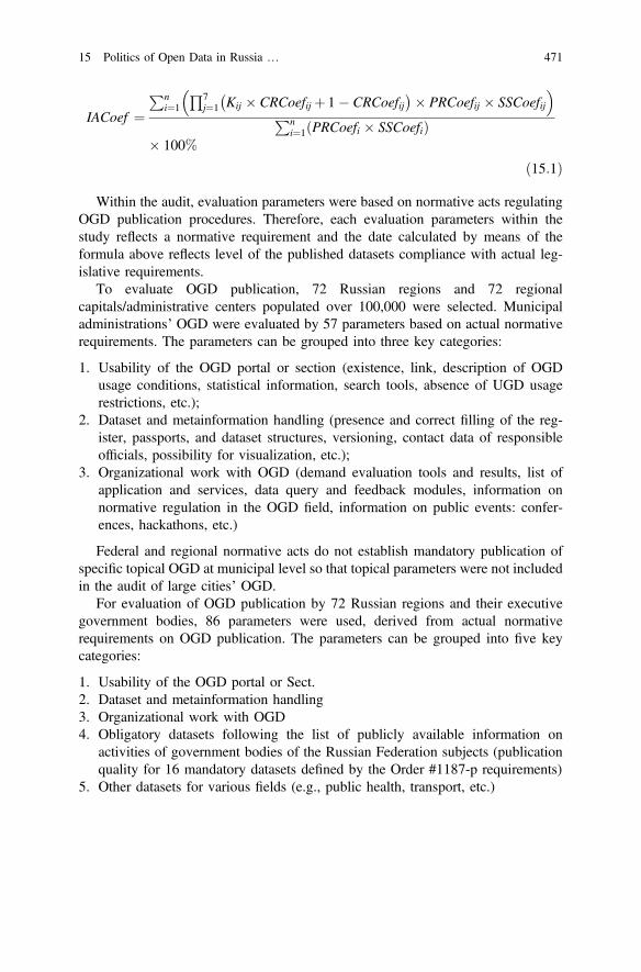
IACoef ¼Pn
i¼1
Q7j¼1 Kij CRCoefij þ 1 CRCoefij
PRCoefij SSCoefij
Pni¼1 PRCoefi SSCoefið Þ
100%
ð15:1Þ
Within the audit, evaluation parameters were based on normative acts regulatingOGD publication procedures. Therefore, each evaluation parameters within thestudy reflects a normative requirement and the date calculated by means of theformula above reflects level of the published datasets compliance with actual leg-islative requirements.
To evaluate OGD publication, 72 Russian regions and 72 regionalcapitals/administrative centers populated over 100,000 were selected. Municipaladministrations’ OGD were evaluated by 57 parameters based on actual normativerequirements. The parameters can be grouped into three key categories:
1. Usability of the OGD portal or section (existence, link, description of OGDusage conditions, statistical information, search tools, absence of UGD usagerestrictions, etc.);
2. Dataset and metainformation handling (presence and correct filling of the reg-ister, passports, and dataset structures, versioning, contact data of responsibleofficials, possibility for visualization, etc.);
3. Organizational work with OGD (demand evaluation tools and results, list ofapplication and services, data query and feedback modules, information onnormative regulation in the OGD field, information on public events: confer-ences, hackathons, etc.)
Federal and regional normative acts do not establish mandatory publication ofspecific topical OGD at municipal level so that topical parameters were not includedin the audit of large cities’ OGD.
For evaluation of OGD publication by 72 Russian regions and their executivegovernment bodies, 86 parameters were used, derived from actual normativerequirements on OGD publication. The parameters can be grouped into five keycategories:
1. Usability of the OGD portal or Sect.2. Dataset and metainformation handling3. Organizational work with OGD4. Obligatory datasets following the list of publicly available information on
activities of government bodies of the Russian Federation subjects (publicationquality for 16 mandatory datasets defined by the Order #1187-p requirements)
5. Other datasets for various fields (e.g., public health, transport, etc.)
15 Politics of Open Data in Russia … 471
The first three evaluation categories are the same for regions and large cities. Thefourth category and the fifth one evaluate filling of regional portals with obligatoryand other datasets.
15.3.2 Evaluation Results
Final results of the audit show that cities fulfill OGD publication requirements by22% at average24 while regional authorities do that more than twice better, by47.8%.25 OGD development divergence is expressed at municipal level much morethan at regional one. 36 city administrations (50%) publish no OGD and do notlaunch website sections for their publication while only two regional governmentshave got zero evaluation scores. Analysis of compliance (Table 15.1) with OGDpublication requirements by separate categories of the parameters reveals more thandouble advantage of regional OGD portals and sections. At the same time, resultsfor first three categories are similar for municipal and regional level: rate of tech-nological requirement observance (usability and dataset handling) is much betterthan that for organizational work with OGD.
There is also divergence in numbers of datasets published by city and regionaladministrations: only two leading cities, Kazan and Krasnodar, publish more that100 datasets (and five more cities, more than 20) while leading regions, PermTerritory and Tula Region, have published more than 800 datasets (and seven moreregions, more than 200).
All datasets obligatory for publication are placed by 11 regions studied(Fig. 15.1). However, it is difficult to use the datasets published for developinginterregional software application since there are no unified requirements forstructure of those datasets. For instance, datasets named “Names of Civil RegistryOffices” at OGD portals of the Bryansk Region26 and of the Vologda Region27
differ not only by number of structure elements but also by their filling (addresses,contact data, work schedules). We should point that the Tula city administration,the leader among municipal administrations, places its OGD at the portal of theTula Region (Table 15.2).
Both regional and municipal authorities prefer to publish OGD at their officialwebsites’ sections. On the one hand, this requires no special resources, on the otherhand, quality of such a technological site is poorer than that of OGD portals.Regional governments often combine various ways of OGD publication: they mayuse both regional and federal portals (5 cases), federal portal and regional website
24http://system.infometer.org/ru/monitoring/344/rating/ (for 72 regional administrative centers).25http://system.infometer.org/ru/monitoring/371/rating/ (for 72 regions with administrative centerspopulated over 100,000).26http://www.bryanskobl.ru/opendata/3234048116-civilreg/table.27http://opendata.gov35.ru/datasets/3525082633-RegistryOfficesList.
472 Y. Kabanov et al.
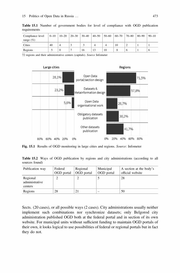
Sects. (20 cases), or all possible ways (2 cases). City administrations usually neitherimplement such combinations nor synchronize datasets; only Belgorod cityadministration published OGD both at the federal portal and in section of its ownwebsite. For municipal units without sufficient funding to maintain OGD portals oftheir own, it looks logical to use possibilities of federal or regional portals but in factthey do not.
Table 15.1 Number of government bodies for level of compliance with OGD publicationrequirements
Compliance levelrange (%)
0–10 10–20 20–30 30–40 40–50 50–60 60–70 70–80 80–90 90–10
Cities 40 4 3 3 4 4 10 2 1 1
Regions 5 0 7 16 13 10 8 6 1 6
72 regions and their administrative centers (capitals). Source Infometer
Fig. 15.1 Results of OGD monitoring in large cities and regions. Source: Infometer
Table 15.2 Ways of OGD publication by regions and city administrations (according to allsources found)
Publication way FederalOGD portal
RegionalOGD portal
MunicipalOGD portal
A section at the body’sofficial website
Regionaladministrativecenters
2 2 5 28
Regions 28 21 – 50
15 Politics of Open Data in Russia … 473
Poor participation of city authorities in OGD publication may also be caused byabsence of clear normative regulation and of any federal, regional, or public controlas well as by lack of interest to and trust in the OGD published from the business.While regional governmental officials attend largest all-Russian OGD events suchas “Open Data—2015” summit, hold hackathons, and share their own best OGDpractices, city administration officials lack attention of government entities incharge of project initiatives in the OGD field (such as the Open Government of theAnalytical Center under the Government of the Russian Federation).
15.4 Explaining OGD Performance in Russian Regions:Quantitative Perspective
The first perspective we take to approach the development of OGD in Russia isquantitative. We attempt to reveal some structural factors that may influence thelevel of OGD performance, and here we continue a plethora of efforts conducted inmany comparative works. One of the pioneering studies is one by Norris, whoanalyzed the level of e-government and e-democracy across nations, testing theimportance of political, human and technological development. Her findings sug-gested that all three factors matter, although differently regarding various element ofelectronic political systems [34]. More recent studies expanded the number ofhypotheses, e.g. including the quality of institutions, globalization, wealth, inter-national contacts etc. [19, 35, 36]. They proved to be applicable and plausible evento the subnational level [37]. In case of Russian e-government, for instance,political regime, human capital, Internet access and the quality of bureaucracy wererevealed as determiners of success [38].
Taking Norris’ framework as a basis, we suggest that such structural factorsmight work in case of OGD. As a costly, technologically elaborate and politicallysensitive issue, OGD release may be the function of more democratic governance,better technologies and the abundance of resources. However, we add some otherfactors. First, it is the level of bureaucratic efficiency, as public officials are thoseimplementing OGD policy. Secondly, we hypothesize the link between OGDperformance and the level of e-government development. We suppose that when aregion demonstrates high commitment to e-services advancement, it providesinstitutional learning, as bureaucracies and politicians get accustomed to newtechnologies and acquire necessary competences. Moreover, better e-governmentcreates demand for e-services among citizens, and the latter may be more interestedin innovations, providing incentives for regional governments to provide betterOGD policies.
There are several important limitations to the study we conducted. First, there isa problem of data access. That is why we use the average values for the periods
474 Y. Kabanov et al.
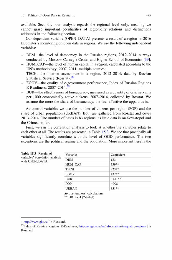
available. Secondly, our analysis regards the regional level only, meaning wecannot grasp important peculiarities of region-city relations and distinctionsaddresses in the following section.
Our dependent variable (OPEN_DATA) presents a result of a region in 2016Infometer’s monitoring on open data in regions. We use the following independentvariables:
– DEM—the level of democracy in the Russian regions, 2012–2014, surveysconducted by Moscow Carnegie Center and Higher School of Economics [39];
– HUM_CAP—the level of human capital in a region, calculated according to theUN’s methodology, 2007–2011, multiple sources;
– TECH—the Internet access rate in a region, 2012–2014, data by RussianStatistical Service (Rosstat);28
– EGOV—the quality of e-government performance, Index of Russian RegionsE-Readiness, 2007–2014;29
– BUR—the effectiveness of bureaucracy, measured as a quantity of civil servantsper 1000 economically active citizens, 2007–2014, collected by Rosstat. Weassume the more the share of bureaucracy, the less effective the apparatus is.
As control variables we use the number of citizens per region (POP) and theshare of urban population (URBAN). Both are gathered from Rosstat and cover2013–2014. The number of cases is 83 regions, as little data is on Sevastopol andthe Crimea so far.
First, we ran the correlation analysis to look at whether the variables relate toeach other at all. The results are presented in Table 15.3. We see that practically allvariables significantly correlate with the level of OGD performance. The twoexceptions are the political regime and the population. More important here is the
Table 15.3 Results ofvariables’ correlation analysiswith OPEN_DATA
Variable Coefficient
DEM 183
HUM_CAP 339**
TECH 323**
EGOV 432**
BUR −411**
POP −098
URBAN 351**
Source Authors’ calculations**0.01 level (2-tailed)
28http://www.gks.ru [in Russian].29Index of Russian Regions E-Readiness, http://eregion.ru/en/information-inequality-regions [inRussian].
15 Politics of Open Data in Russia … 475

former, as it seems that OGD can develop in different institutional settings.Although it is hard to say that some regions are democracies in a generallyauthoritarian state, a relatively more democratic system is not an advantage. On theother hand, better OGD performance is associated with higher human capital,broader Internet access, e-government development, bureaucratic efficiency andurbanization. However, the coefficients are not so high to say that these factorsheavily influence OGD development.
This is proved by the linear regression analysis, the results of which are shown atTables 15.4 and 15.5. The best one is Model 6 including the level of e-governmentdevelopment and bureaucracy efficiency. All other factors proved insignificantwhen taken in interrelationship. The R-square remains low, and we actually canexplain about 20% of the variance by the model (about 17 regions).
However, what the analysis shows is that in case of regional OGD the traditionalvariables, as democracy, human capital and technological development do not workwell. Although the latter two accompany OGD advancement, forming a kind of aportrait of a successful region, they are not the drivers of innovation. What canmatter are the factors that can be called policy-related ones. The development ofe-government in a region may create a basis for further steps, and effectivebureaucracy provides its success.
But again, explaining perspective seems to fall short to unveil the reasons forOGD disparities among regions, not mentioning the problem of city—region gaps.Structural explanations need to be supported by agency-based evidence from thecase studies that are presenting in the next section.
Table 15.4 Results of regression analysis, dependent variable—OPEN_DATA models
Modelno.
Variables included AdjustedR-square
St. Error ofestimation
1 BUR, POP, TECH, DEM, HUM_CAP,URBAN, EGOV
197 23.88
2 BUR, POP, TECH DEM, URBAN, EGOV 209 23.7
3 BUR, TECH, DEM, URBAN, EGOV 218 23.57
4 BUR, TECH, URBAN, EGOV 225 23.46
5 BUR, URBAN, EGOV 232 23.35
6 BUR, EGOV 230 23.39
Source Authors’ calculations
Table 15.5 Coefficients ofmodel 6
Variables Standardizedbeta-coefficients
Significance
BUR 300 012
EGOV −284 017
Source Authors’ calculations
476 Y. Kabanov et al.
15.5 Politics of Open Government Data: Four Cases
15.5.1 Approach
To describe specific cases within our study, we chose method of case studiesallowing to reveal dominating factors for OGD development at regional andmunicipal governance levels. We formed four groups of development relations(Table 15.6).
Such a relation often appears to result from difference between policies imple-mented by regional and city administrations. General distribution of “region/municipality” relations is presented at the bar chart (Fig. 15.2). To describe eachgroup in more details, we have analyzed four cases of different relations betweenthe region and the municipality of its administrative center/capital (Table 15.7).
15.5.2 Tula city/Tula Region: An Exampleof Authoritarian Modernization
The first case is an illustrative example of “soft” authoritarian modernization whena regional government, having more administrative resource and being interested inthe region branding, “pulls” the regional center up to its own high developmentlevel.
In Tula Region, OGD were initially developed at regional level. This region wasthe first to achieve 100% rate level in the Infometer rating.30 Within a semi-formalized interview, Andrey Kolesnikov, Referent of the Mass CommunicationDepartment in the Tula Region Ministry for Informatization, Communications, andOpen Governance Issues, stated that OGD appeared initially at regional level andthen technologies, knowledge, and skills were transferred also to executive gov-ernment bodies and municipalities of the region: “We started to develop an OGDportal in 2013; for us, it was a part of the open governance idea. It was an internalinitiative of ours. Initially, we planned to launch our OGD portal in 2014 butrealized in 2013 that it was possible to start it earlier. We were explaining toregional executive bodies and municipal officials why it was necessary to developthis direction so that the process began to establish. Today, in each body there areofficials in charge of open datasets that body publishes. We have enabled
Table 15.6 Matrix of region—municipality OGDperformance
Region
Municipality High/high Low/low
High/low Low/high
30Openness rating (spring 2015) http://system.infometer.org/ru/monitoring/259/rating/.
15 Politics of Open Data in Russia … 477
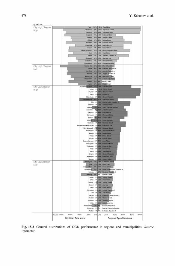
Fig. 15.2 General distributions of OGD performance in regions and municipalities. SourceInfometer
478 Y. Kabanov et al.
development of departmental normative acts assigning officials in charge anddefining data actualization deadlines. Now, everything is much easier”.
Top officials of the region support openness ideas actively so there are noconflicts within involvement of municipalities in OGD development; also, neces-sary funding is assigned. It is important to point that Tula Region implements soundproduct at relatively low expenses thanks to efficient work:
“If I remember correctly, the first version of the portal launched in 2013 cost usabout 180,000 rubles,” Kolesnikov commented. “We wrote a technical enquiry,announced an invitation to tender, and held all procurement procedures to get thisamount as a result. The Center for Information Technologies, our subordinateorganization, has its own professional developers. We had also a designer of oursown who helped us to create a layout for the new versions of the portal. Wediscussed some technological requirements and methodical guidelines amongourselves, wrote a small additional technical enquiry for upgrade of our portal andupgraded it. Costs are not large. Maintenance, upgrade, and introduction of newfunctionalities cost at average about 200,000–250,000 rubles per year”.
Such an approach allows to introduce modern formats and to develop OGD-basesoftware as well as to hold topical events.
15.5.3 Ivanovo city/Ivanovo Region
This case is possibly the most curious one. In all other cases, the region plays keyrole, impacting OGD level in its administrative center by means of influence, strongor weak, upon the city administration. In this case, the situation is opposite: at thecity level, OGD are for whatever reason developed much better that at the regionallevel.
The Ivanovo Region portal has a section for open data31 but only graphical PDFfiles are published there as “open data”. If the publishers use CSV, a correct format,then a dataset contains a single string, causing questions whether such transfor-mation of data into machine-readable format is feasible.
Table 15.7 Cases selection Relation City/Region
City high/Region high Tula/Tula Region100/100
City high/Region low Ivanovo/Ivanovo Region64/9
City low/Region high Bryansk/Bryansk Region0/100
City low/Region low Makhachkala/Republic of Dagestan13/6
31http://www.ivzan.ru/opendata.
15 Politics of Open Data in Russia … 479

The city portal publishes not very much OGD (20 datasets) but they fully meetrequirements of the methodical guidelines and can be used in services and appli-cations. Larisa Kosterina, Head of the Department for Informational Resources inthe Ivanovo City District, says that OGD started developing in the city of Ivanovoimmediately upon issuance of the Presidential Decrees of May 2013 and subsequentnormative amendments. However, besides the normative regulations, there was onemore motivation factor: Ms. Kosterina’s personal interest to OGD and her beliefthat OGD can being profit to the city. The city administration began to participate inall pilot informatization projects and to initiate development of new directions.Kosterina pointed, as one more positive factor, the fact that the city top officials areyoung (the new head of the city is 32) and that they support innovative solutions.Students of local universities also are involved in processes of data transformationinto machine-readable formats and in development of OGD-based software prod-ucts, therefore increasing practical significance of OGD. The city plans to launch onJanuary 1, 2017, a new portal that will enable better data processing but there arenot much resources for this: only two employees of the Department deal with opendata.
The model for work with OGD in the Ivanovo city administration is similar inthat of the Bryansk Region: structure units provide information to the Departmentfor Informatization where it is transformed into machine-readable format.
In her interview, Larisa Kosterina several times called the region “depressive”and at the same time expressed belief that the OGD could provide possibilities fordevelopment. She did not answer why OGD are not developed at the regional level.In our opinion, the key reason if lack of motivation for officials of the Governmentof Ivanovo Region.
15.5.4 Bryansk City/Bryansk Region:Change of Management
The OGD section at the Bryansk Region portal32 is an example how individualofficials can promote openness policy within a government body when resourcesare limited. In the early 2015, when we studied regional OGD for the first time,Bryansk Region held the last position in the rating with the zero rate since they hadno OGD web page, no datasets, and so on. Within our first remote online interactionwith officials of regional government on OGD, the region improved its rate from 0to 41% and held the 29th position (of 85) in the final rating.33 A year later, BryanskRegion achieved the rate of 78% in the new similar audit and took the 8th position.For the latest audit, it leads the rating with 100%.34
32Open data portal http://www.bryanskobl.ru/opendata.33http://system.infometer.org/ru/monitoring/259/rating/.34http://system.infometer.org/ru/monitoring/371/rating/.
480 Y. Kabanov et al.
However, more detailed analysis of the Bryansk Region OGD web sectionshows that from the technological point of view, it lies behind OGD resources ofother regions leading the rating. Datasets have rather simple structures and all dataare presented in CSV and not in more complex form. Features of the datasetspublished makes one to conclude that they have been converted manually fromExcel spreadsheets. The web section has neither any API (application programminginterface) nor any innovative findings in the OGD field.
Alexey Podyapolsky, Head of the Section for Internet Projects and for Activitiesin Social Networks in the Department for Informational Supply of Activities of theBryansk Region Governor and Government, is in charge of OGD in the region. Inhis interview, he pointed that only one more staff member helps him within OGDdevelopment and publication processes. Such is a small team is surely not enoughfor any serious development. He also told that they obtain raw data (in the best case,arranged in a table) from executive bodies and convert them into machine-readableformat by themselves, also enriching them by addition new structural elements, e.g.geodata. According to him, officials from the Bryansk city administration had notasked them for any assistance and they had not resources to offer it by themselves.
Due to lack of resources, Bryansk Region is not able to follow the way of TulaRegion and to “pull” its central city up to its OGD development level. They coulddevelop only the website of their own up to certain quality level, having noresources to introduce serious software solutions and modern data formats.
Podyapolsky also pointed that in the work plan of the regional government up to2017, there were no activities on OGD consulting for the Bryansk cityadministration.
15.5.5 Makhachkala City/Republic of Dagestan:What is Dead May Never Die?
Regions and municipalities fully or almost fully ignoring legislative requirementson OGD form a separate group in our rating. It is interesting that at the last time,public prosecution bodies actively initiate proceedings on administrative offense(Administrative Offense Code of Russia, Article 13.27 p. 2) for lack of onlineplacement of information on activities of local self-government bodies if obligationto place such information is stated by federal law.35 However, some regions,especially national republics, continue to ignore law requirements due to a numberof reasons.
Low technological level. Paying attention to general level of informatization innational republic, one can notice that Internet implementation level is there muchlower than in central regions of Russia; so is level of information knowledge of the
35Example: https://rospravosudie.com/court-sudebnyj-uchastok-po-buzdyakskomu-rajonu-respubliki-bashkortostan-s/act-200750130/.
15 Politics of Open Data in Russia … 481
public while republican informational resources of all power branches (legislative,executive, and judicial) usually hold last positions in openness ratings.
Lack of demand from civil society. For instance, no OGD event (e.g. hackathon)was held in the republic of the North Caucasus for 2016.36
Lack of republican authorities’ interest in region branding on openness theme.For instance, the Republic of Tatarstan decided to make information and commu-nications as a landmark for the region brand development; no republic of the NorthCaucasus make accents of that kind.
Lack of resources for building OGD portals and applications. Launch of an OGDportal and its actuality maintenance needs financial and human resources availablenot for all regions. Within growing economical crisis, some regional budgets havedeficit not allowing to assign any additional funding for informatization. If there is anecessity to reduce budget, it is informatization expenses budget lines to be cut.
Therefore, a “perfect storm” appears, not allowing to develop OGD in the regionin question. Regional authorities are unable to pull their subordinate municipalitiesto high OGD development level as they have done in Tula Region. Municipalauthorities, meeting serious resource limitation and motivation vacuum, are not ableto act as they do in Ivanovo. In such a case, only some changes at federal level orchange of political climate in a region itself could make that region to work onOGD more actively.
15.6 Conclusions
This chapter is our effort to combine different levels (federal, regional andmunicipal) and various techniques of research to analyze factors affecting OGDsuccess. Generally, our findings can be summarized as follows.
Although OGD normatively associate with democracy and can potentially leadto smart city development, reality shapes these causal links and may well interferewith them. Since OGD release is a complicated process involving political andmanagerial issues, plenty of factors need to be taken into account, and, what ourstudy has also shown, there is always a variety of outcomes even in one and thesame entity, be it country, region or city. Even if Russian OGD policy might seem afailure from the international perspective, the country is extremely disproportionatein policy performance, and even municipal and regional levels of the same regionusually show different outcomes.
Our study has taken different perspectives to analyze OGD policy, its effec-tiveness and impact. From the quantitative, explaining, perspective, it seems that nosingle determinant can explain the patterns of OGD performance in Russianregions. The level of e-government development and bureaucracy effectiveness arethe most significant factors in the regression models, and both generally relate to the
36Hackathon map of Russia: http://read.infometer.org/foiv2016_digest3.
482 Y. Kabanov et al.
ability of public agencies to adapt to new technologies of government. However, ascorrelation analysis shows, other factors, like human capital, urbanization and theInternet, are positively associated with OGD success.
But, generally, explaining perspective has many problems when applied toRussian regions. The qualitative, understanding, technique, seems to be the way toexplain more about region—and city-specific issues. The interviews we have takenrevealed that usually the success is not a result of good governance or democracy,but is agency—driven. The motivation of the low-level bureaucracy who aredirectly involved in OGD release, might be the only reason the policy is successfulregardless the unfriendly environment he or she operates in. Another issue is thelaw implementation and enforcement, which is usually a problem for traditionalistregions. Thirdly, the deficit of financial resource can also be an obstacle. And,finally, it is an almost total lack of public involvement in OGD release. The demandon OGD is explicit only in the large cities—the absence of it may turn OGD processinto a purely routine of meeting federal requirements.
Still a lot to be done in this area to get a solid understanding of political andbureaucratic processes, and in this regard our mixed quantitative—qualitativemethodology seem a suitable and promising lens for the analysis.
Acknowledgements The paper was prepared within the framework of the Academic FundProgram at the National Research University Higher School of Economics (HSE) in 2016 (grant16-05-0059) and supported within the framework of a subsidy granted to the HSE by theGovernment of the Russian Federation for the implementation of the Global CompetitivenessProgram.
References
1. Effing R, van Hillegersberg J, Huibers T (2011) Social media and political participation: areFacebook, Twitter and YouTube democratizing our political systems? In: Macintosh A,Tambouris E, de Bruijn H (eds) Electronic participation: third IFIP WG 8.5 internationalconference, EPart 2011, Delft, The Netherlands, August 29–September 1, 2011. Springer,Berlin, pp 25–35. doi:10.1007/978-3-642-23333-3_3
2. Gil de Zúñiga H, Jung N, Valenzuela S (2012) Social media use for news and individuals’social capital, civic engagement and political participation. J Comput Mediated Commun 3(17):319–336. doi:10.1111/j.1083-6101.2012.01574.x
3. Coglianese C (2009) The transparency president? The Obama administration and opengovernment. Governance 4(22):529–544. doi:10.1111/j.1468-0491.2009.01451.x
4. Meijer AJ, Curtin D, Hillebrandt M (2012) Open government: connecting vision and voice.Int Rev Adm Sci 1(78):10–29. doi:10.1177/0020852311429533
5. Janssen M, Charalabidis Y, Zuiderwijk A (2012) Benefits, adoption barriers and myths ofopen data and open government. Inf Syst Manage 4(29):258–268. doi:10.1080/10580530.2012.716740
6. Ubaldi B (2013) Open Government Data. OECD, 20137. Balch O (2013) Can open data power a smart city revolution? The guardian. https://www.
theguardian.com/sustainable-business/open-data-power-smart-city8. Hinssen P (Ed.) (2013) Open data power smart cities. Across Technology, Kankarbagh
15 Politics of Open Data in Russia … 483

9. Tauberer J (2009) Open data is civic capital: best practices for “open government data”.https://razor.occams.info/pubdocs/opendataciviccapital.html
10. Bartenberger M, Grubmüller-Régent V (2014) The enabling effects of open government dataon collaborative governance in smart city contexts. eJournal eDemocracy Open Gov1(6):36–48
11. Davies T (2010) Open data, democracy and public sector reform. A look at open governmentdata use from data.gov.uk. http://www.opendataimpacts.net/report/wp-content/uploads/2010/08/How-is-open-government-data-being-used-in-practice.pdf
12. Noveck B (2016) The rise of citizen expert. Policy Netw. http://www.policy-network.net/pno_detail.aspx?ID=5056&title=The+rise+of+the+citizen+expert
13. Gurstein MB (2011) Open data: empowering the empowered or effective data use foreveryone? First Monday. 2(16). http://firstmonday.org/article/view/3316/2764
14. Davies T (2014) Open data policies and practice: an international comparison. Available atSSRN, https://ssrn.com/abstract=2492520 or doi:10.2139/ssrn.2492520
15. Susha I et al (2015) Critical factors for open data publication and use: a comparison ofcity-level, regional, and transnational cases. JeDEM-eJournal eDemocracy Open Gov2(7):94–115
16. Meijer A, Bekkers V (2015) A metatheory of e-government: creating some order in afragmented research field. Gov Inf Q 3(32):237–245. doi:10.1016/j.giq.2015.05.004
17. Conradie P, Choenni S (2014) On the barriers for local government releasing open data. GovInf Q 31:S10–S17. doi:10.1016/j.giq.2014.01.003
18. Jho W, Song KJ (2015) Institutional and technological determinants of civil e-Participation:solo or duet? Gov Inf Q 4(32):488–495. doi:10.1016/j.giq.2015.09.003
19. Lee C, Chang K, Berry FS (2011) Testing the development and diffusion of e-government ande-democracy: a global perspective. Public Adm Rev 3(71):444–544. doi:10.1111/j.1540-6210.2011.02228.x
20. Stier S (2015) Political determinants of e-government performance revisited: comparingdemocracies and autocracies. Gov Inf Q 3(32):270–278. doi:10.1016/j.giq.2015.05.004
21. Davies T (2013) The messy reality of open data and politics. The Guardian. https://www.theguardian.com/public-leaders-network/2013/apr/08/messy-reality-open-data-politics
22. Serewicz L (2011) The dark side of open data: politicized data. https://lawrenceserewicz.wordpress.com/2011/09/21/the-dark-side-of-open-data-politicized-data/
23. Peled A (2011) When transparency and collaboration collide: the USA open data program.J Am Soc Inf Sci Technol 11(62):2085–2094. doi:10.1002/asi.21622
24. Fountain JE (2004) Building the virtual state: information technology and institutionalchange. Brookings Institution Press, Washington, DC (2004)
25. Gel’man V (2014) The rise and decline of electoral authoritarianism in Russia.Demokratizatsiya 4(22):503–522
26. Katchanovski I, La Porte T (2005) Cyberdemocracy or Potemkin e-villages? Electronicgovernments in OECD and post-communist countries. Int J Public Adm 7–8(28):665–681.doi:10.1081/PAD-200064228
27. Linde J, Karlsson M (2013) The dictator’s new clothes: the relationship betweene-participation and quality of government in non-democratic regimes. Int J Public Adm4(36):269–281. doi:10.1080/01900692.2012.757619
28. Karlsson M (2013) Carrots and sticks: internet governance in non–democratic regimes. Int JElectron Gov 3(6):179–186. doi:10.1504/IJEG.2013.058405
29. Brancati D (2014) Democratic authoritarianism: origins and effects. Annu Rev Polit Sci17:313–326. doi:10.1146/annurev-polisci-052013-115248
30. He B, Warren ME (2011) Authoritarian deliberation: the deliberative turn in Chinese politicaldevelopment. Perspect polit 9(02):269–289. doi:10.1017/S1537592711000892
31. Chugunov AV, Kabanov Y, Zenchenkova K (2016) Russian e-Petitions portal: exploringregional variance in use. In international conference on electronic participation. SpringerInternational Publishing, pp 109–122. doi:10.1007/978-3-319-45074-2_9
484 Y. Kabanov et al.
32. Gel’man V, Ryzhenkov S (2011) Local regimes, sub-national governance and the “powervertical” in contemporary Russia. Eur-Asia Stud 3(63):449–465. doi:10.1080/09668136.2011.557538
33. Kabanov Y, Karyagin M (2015) Deserted Islands of openness: problems of open data inRussia. Politex 4:38–51 [in Russian]
34. Norris P (2001) Digital divide: civic engagement, information poverty, and the Internetworld-wide. Cambridge University Press, Cambridge
35. Gulati G, Williams C, Yates D (2014) Predictors of on-line services and e-participation: across-national comparison. Gov Inf Q 31(4):526–533. doi:10.1016/j.giq.2014.07.005
36. Zhang H, Xu X, Xiao J (2014) Diffusion of e-government: a literature review and directionsfor future directions. Gov Inf Q 31(4):631–636. doi:10.1016/j.giq.2013.10.013
37. Yun HJ, Opheim C (2010) Building on success: the diffusion of e-Government in theAmerican States. Electron J E-Government 8(1):71–82
38. Kabanov Y, Sungurov A (2016) E-Government development factors: evidence from therussian regions. In: Chugunov AV, Bolgov R, Kabanov Y, Wimmer M, Kampis G(eds) Digital transformation and global society: first international conference, DTGS 2016,St. Petersburg, Russia, June 22–24, 2016, Revised Selected Papers, 85–95, SpringerInternational Publishing (2016). doi:10.1007/978-3-319-49700-6_10
39. Petrov N, Titkov A (2014) Rating of democracy by Moscow Carnegie Center: 10 years inservice. Moscow Carnegie Center, Moscow [in Russian]
15 Politics of Open Data in Russia … 485
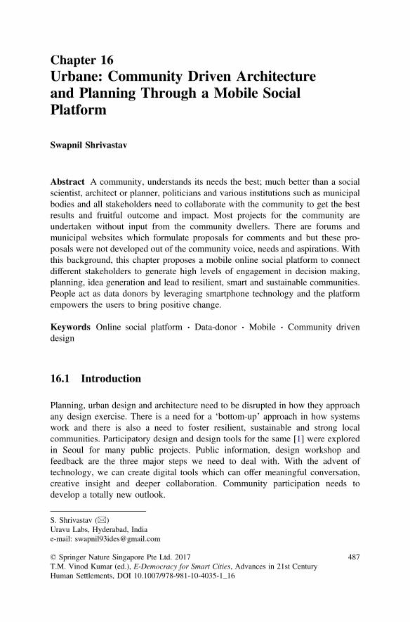
Chapter 16Urbane: Community Driven Architectureand Planning Through a Mobile SocialPlatform
Swapnil Shrivastav
Abstract A community, understands its needs the best; much better than a socialscientist, architect or planner, politicians and various institutions such as municipalbodies and all stakeholders need to collaborate with the community to get the bestresults and fruitful outcome and impact. Most projects for the community areundertaken without input from the community dwellers. There are forums andmunicipal websites which formulate proposals for comments and but these pro-posals were not developed out of the community voice, needs and aspirations. Withthis background, this chapter proposes a mobile online social platform to connectdifferent stakeholders to generate high levels of engagement in decision making,planning, idea generation and lead to resilient, smart and sustainable communities.People act as data donors by leveraging smartphone technology and the platformempowers the users to bring positive change.
Keywords Online social platform Data-donor Mobile Community drivendesign
16.1 Introduction
Planning, urban design and architecture need to be disrupted in how they approachany design exercise. There is a need for a ‘bottom-up’ approach in how systemswork and there is also a need to foster resilient, sustainable and strong localcommunities. Participatory design and design tools for the same [1] were exploredin Seoul for many public projects. Public information, design workshop andfeedback are the three major steps we need to deal with. With the advent oftechnology, we can create digital tools which can offer meaningful conversation,creative insight and deeper collaboration. Community participation needs todevelop a totally new outlook.
S. Shrivastav (&)Uravu Labs, Hyderabad, Indiae-mail: [email protected]
© Springer Nature Singapore Pte Ltd. 2017T.M. Vinod Kumar (ed.), E-Democracy for Smart Cities, Advances in 21st CenturyHuman Settlements, DOI 10.1007/978-981-10-4035-1_16
487
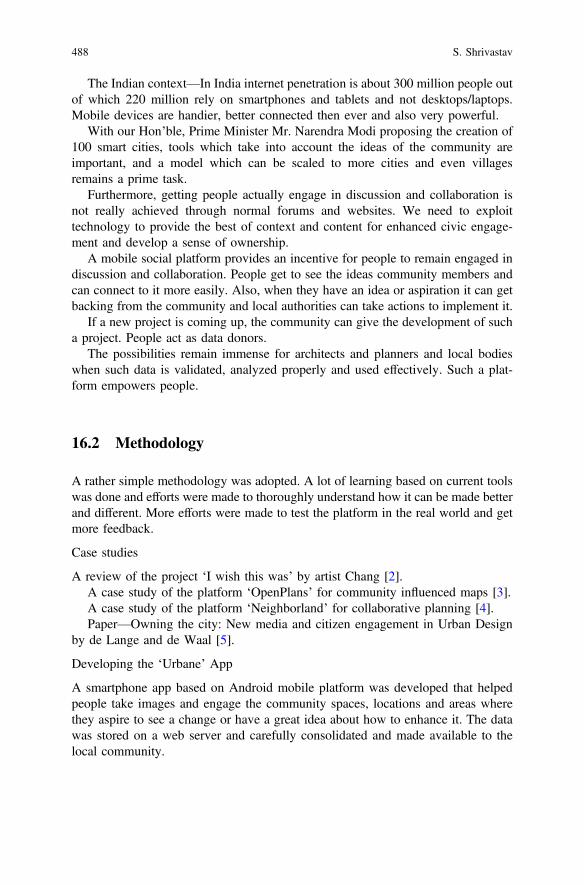
The Indian context—In India internet penetration is about 300 million people outof which 220 million rely on smartphones and tablets and not desktops/laptops.Mobile devices are handier, better connected then ever and also very powerful.
With our Hon’ble, Prime Minister Mr. Narendra Modi proposing the creation of100 smart cities, tools which take into account the ideas of the community areimportant, and a model which can be scaled to more cities and even villagesremains a prime task.
Furthermore, getting people actually engage in discussion and collaboration isnot really achieved through normal forums and websites. We need to exploittechnology to provide the best of context and content for enhanced civic engage-ment and develop a sense of ownership.
A mobile social platform provides an incentive for people to remain engaged indiscussion and collaboration. People get to see the ideas community members andcan connect to it more easily. Also, when they have an idea or aspiration it can getbacking from the community and local authorities can take actions to implement it.
If a new project is coming up, the community can give the development of sucha project. People act as data donors.
The possibilities remain immense for architects and planners and local bodieswhen such data is validated, analyzed properly and used effectively. Such a plat-form empowers people.
16.2 Methodology
A rather simple methodology was adopted. A lot of learning based on current toolswas done and efforts were made to thoroughly understand how it can be made betterand different. More efforts were made to test the platform in the real world and getmore feedback.
Case studies
A review of the project ‘I wish this was’ by artist Chang [2].A case study of the platform ‘OpenPlans’ for community influenced maps [3].A case study of the platform ‘Neighborland’ for collaborative planning [4].Paper—Owning the city: New media and citizen engagement in Urban Design
by de Lange and de Waal [5].
Developing the ‘Urbane’ App
A smartphone app based on Android mobile platform was developed that helpedpeople take images and engage the community spaces, locations and areas wherethey aspire to see a change or have a great idea about how to enhance it. The datawas stored on a web server and carefully consolidated and made available to thelocal community.
488 S. Shrivastav

Data Collection
A simulated model for the process was carried out at NITC campus by drawingcomparisons between city planning procedure and campus planning where we havethe student body as the local community and hierarchical authorities who carry outthe process.
Analysis
The collected geo-tagged data was laid on the location map and classified accordingto the type of data feed (planning, urban design, management etc.), was consoli-dated and was further validated so as to give a thorough understanding. The ana-lyzed data was used in enhancing the ideas and wishes, for development efforts andpredicting future trends.
16.3 Literature Case Studies
16.3.1 ‘I Wish This Was’
This was an interactive art project by artist Candy Chang conducted at NewOrleans, USA in 2010. The aim was to strike a casual conversation in the city andusing public art to garner interest and getting community involved in the designprocess. She had put up stickers with the line ‘i wish this was’ and a blank space, onvarious buildings and objects and citizens passing by filled in their ideas and wisheson the sticker. It provided a platform to engage community members in thatneighborhood (Figs. 16.1, 16.2 and 16.3).
The whole project was amazing and simple enough to engage citizens in aneffective manner.
What did the project miss?
– Data inputs from the community wasn’t available for consolidation and furtheranalysis and deliberation.
– As a public art project, it wasn’t able to get into the mainstream process of urbandesign and planning.
– Scale of the project was limited.– Feedback and dialogue between community and the experts was lacking.
Lessons learned
– Smart technologies need to be incorporated to improve community-expertcommunication.
– Public visualization techniques play a crucial role and has better effects than anonline static website or discussion forum.
– Data gathered needs to be properly consolidated, filtered and analyzed.– Social incentive is needed to engage people.
16 Urbane: Community Driven Architecture and Planning … 489

Fig. 16.2 Community members giving their inputs
Fig. 16.1 ‘I wish this was’ stickers
490 S. Shrivastav
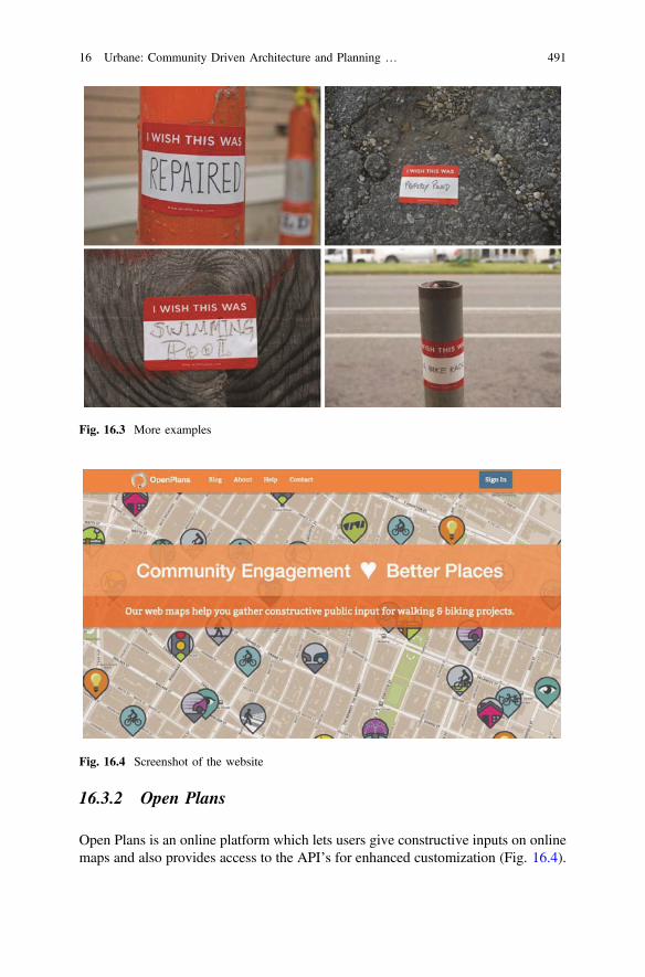
16.3.2 Open Plans
Open Plans is an online platform which lets users give constructive inputs on onlinemaps and also provides access to the API’s for enhanced customization (Fig. 16.4).
Fig. 16.3 More examples
Fig. 16.4 Screenshot of the website
16 Urbane: Community Driven Architecture and Planning … 491
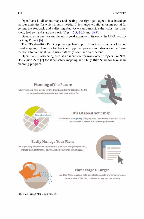
OpenPlans is all about maps and getting the right geo-tagged data based onvarious activities for which input is needed. It lets anyone build an online portal forgetting the feedback and collecting data. One can customize the looks, the inputtools, feel etc. and start the work (Figs. 16.5, 16.6 and 16.7).
Open Plans is pretty versatile and a good example of its use is the CDOT—BikeParking Project [6].
The CDOT—Bike Parking project gathers inputs from the citizens via locationbased mapping. There is a feedback and approval process and also an online forumfor users to comment. As a whole its very open and transparent.
Open Plans is also being used as an input tool for many other projects like NYCDot Vision Zero [7] for street safety mapping and Philly Bike Share for bike shareplanning program.
Fig. 16.5 Open plans in a nutshell
492 S. Shrivastav
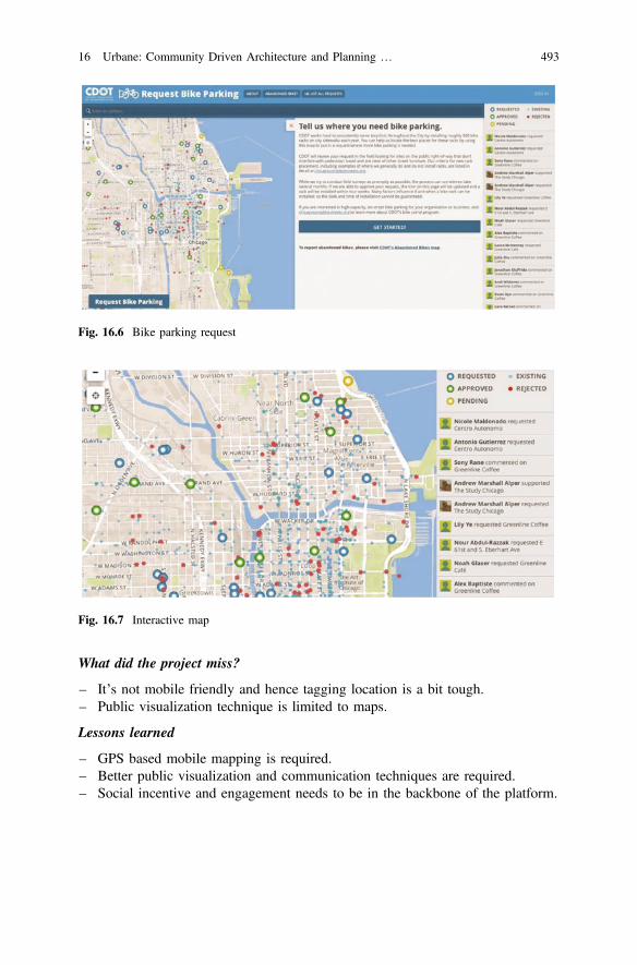
What did the project miss?
– It’s not mobile friendly and hence tagging location is a bit tough.– Public visualization technique is limited to maps.
Lessons learned
– GPS based mobile mapping is required.– Better public visualization and communication techniques are required.– Social incentive and engagement needs to be in the backbone of the platform.
Fig. 16.6 Bike parking request
Fig. 16.7 Interactive map
16 Urbane: Community Driven Architecture and Planning … 493
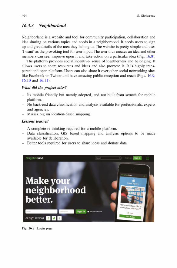
16.3.3 Neighborland
Neighborland is a website and tool for community participation, collaboration andidea sharing on various topics and needs in a neighborhood. It needs users to signup and give details of the area they belong to. The website is pretty simple and uses‘I want’ as the provoking tool for user input. The user thus creates an idea and othermembers can see, improve upon it and take action on a particular idea (Fig. 16.8).
The platform provides social incentive- sense of togetherness and belonging. Itallows users to share resources and ideas and also promote it. It is highly trans-parent and open platform. Users can also share it over other social networking siteslike Facebook or Twitter and have amazing public reception and reach (Figs. 16.9,16.10 and 16.11).
What did the project miss?
– Its mobile friendly but merely adopted, and not built from scratch for mobileplatform.
– No back-end data classification and analysis available for professionals, expertsand agencies.
– Misses big on location-based mapping.
Lessons learned
– A complete re-thinking required for a mobile platform.– Data classification, GIS based mapping and analysis options to be made
available for deliberation.– Better tools required for users to share ideas and donate data.
Fig. 16.8 Login page
494 S. Shrivastav
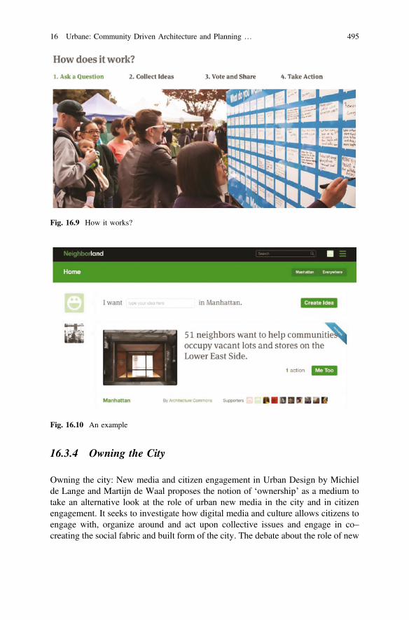
16.3.4 Owning the City
Owning the city: New media and citizen engagement in Urban Design by Michielde Lange and Martijn de Waal proposes the notion of ‘ownership’ as a medium totake an alternative look at the role of urban new media in the city and in citizenengagement. It seeks to investigate how digital media and culture allows citizens toengage with, organize around and act upon collective issues and engage in co–creating the social fabric and built form of the city. The debate about the role of new
Fig. 16.9 How it works?
Fig. 16.10 An example
16 Urbane: Community Driven Architecture and Planning … 495
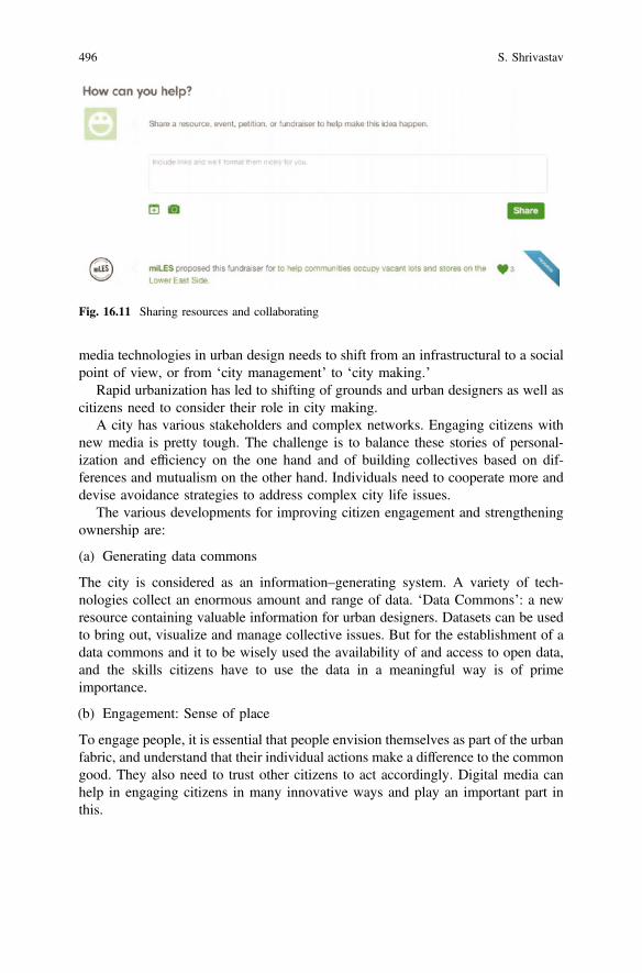
media technologies in urban design needs to shift from an infrastructural to a socialpoint of view, or from ‘city management’ to ‘city making.’
Rapid urbanization has led to shifting of grounds and urban designers as well ascitizens need to consider their role in city making.
A city has various stakeholders and complex networks. Engaging citizens withnew media is pretty tough. The challenge is to balance these stories of personal-ization and efficiency on the one hand and of building collectives based on dif-ferences and mutualism on the other hand. Individuals need to cooperate more anddevise avoidance strategies to address complex city life issues.
The various developments for improving citizen engagement and strengtheningownership are:
(a) Generating data commons
The city is considered as an information–generating system. A variety of tech-nologies collect an enormous amount and range of data. ‘Data Commons’: a newresource containing valuable information for urban designers. Datasets can be usedto bring out, visualize and manage collective issues. But for the establishment of adata commons and it to be wisely used the availability of and access to open data,and the skills citizens have to use the data in a meaningful way is of primeimportance.
(b) Engagement: Sense of place
To engage people, it is essential that people envision themselves as part of the urbanfabric, and understand that their individual actions make a difference to the commongood. They also need to trust other citizens to act accordingly. Digital media canhelp in engaging citizens in many innovative ways and play an important part inthis.
Fig. 16.11 Sharing resources and collaborating
496 S. Shrivastav
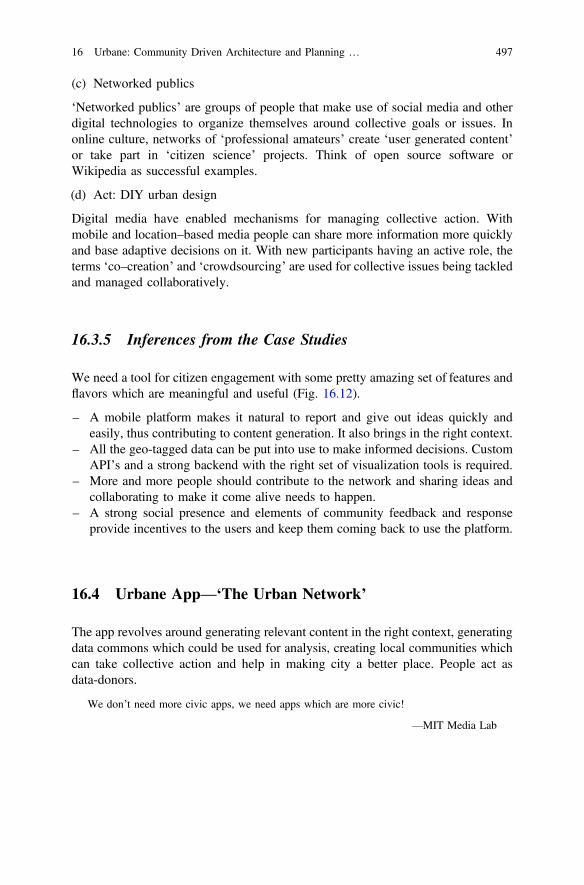
(c) Networked publics
‘Networked publics’ are groups of people that make use of social media and otherdigital technologies to organize themselves around collective goals or issues. Inonline culture, networks of ‘professional amateurs’ create ‘user generated content’or take part in ‘citizen science’ projects. Think of open source software orWikipedia as successful examples.
(d) Act: DIY urban design
Digital media have enabled mechanisms for managing collective action. Withmobile and location–based media people can share more information more quicklyand base adaptive decisions on it. With new participants having an active role, theterms ‘co–creation’ and ‘crowdsourcing’ are used for collective issues being tackledand managed collaboratively.
16.3.5 Inferences from the Case Studies
We need a tool for citizen engagement with some pretty amazing set of features andflavors which are meaningful and useful (Fig. 16.12).
– A mobile platform makes it natural to report and give out ideas quickly andeasily, thus contributing to content generation. It also brings in the right context.
– All the geo-tagged data can be put into use to make informed decisions. CustomAPI’s and a strong backend with the right set of visualization tools is required.
– More and more people should contribute to the network and sharing ideas andcollaborating to make it come alive needs to happen.
– A strong social presence and elements of community feedback and responseprovide incentives to the users and keep them coming back to use the platform.
16.4 Urbane App—‘The Urban Network’
The app revolves around generating relevant content in the right context, generatingdata commons which could be used for analysis, creating local communities whichcan take collective action and help in making city a better place. People act asdata-donors.
We don’t need more civic apps, we need apps which are more civic!
—MIT Media Lab
16 Urbane: Community Driven Architecture and Planning … 497
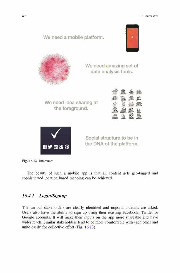
The beauty of such a mobile app is that all content gets geo-tagged andsophisticated location based mapping can be achieved.
16.4.1 Login/Signup
The various stakeholders are clearly identified and important details are asked.Users also have the ability to sign up using their existing Facebook, Twitter orGoogle accounts. It will make their inputs on the app more shareable and havewider reach. Similar stakeholders tend to be more comfortable with each other andunite easily for collective effort (Fig. 16.13).
Fig. 16.12 Inferences
498 S. Shrivastav
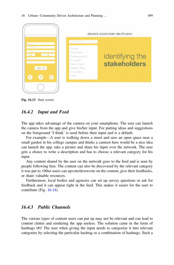
16.4.2 Input and Feed
The app takes advantage of the camera on your smartphone. The user can launchthe camera from the app and give his/her input. For putting ideas and suggestionson the foreground ‘I think’ is used before their input and is a default.
For example—A user is walking down a street and sees an open space near asmall garden in his college campus and thinks a canteen here would be a nice ideacan launch the app, take a picture and share his input over the network. The usergets a choice to write a description and has to choose a relevant category for hisinput.
Any content shared by the user on the network goes to the feed and is seen bypeople following him. The content can also be discovered by the relevant categoryit was put to. Other users can upvote/downvote on the content, give their feedbacks,or share valuable resources.
Furthermore, local bodies and agencies can set up survey questions or ask forfeedback and it can appear right in the feed. This makes it easier for the user tocontribute (Fig. 16.14).
16.4.3 Public Channels
The various types of content users can put up may not be relevant and can lead tocontent clutter and rendering the app useless. The solution came in the form ofhashtags (#)! The user when giving the input needs to categorize it into relevantcategories by selecting the particular hashtag or a combination of hashtags. Such a
Fig. 16.13 Start screen
16 Urbane: Community Driven Architecture and Planning … 499
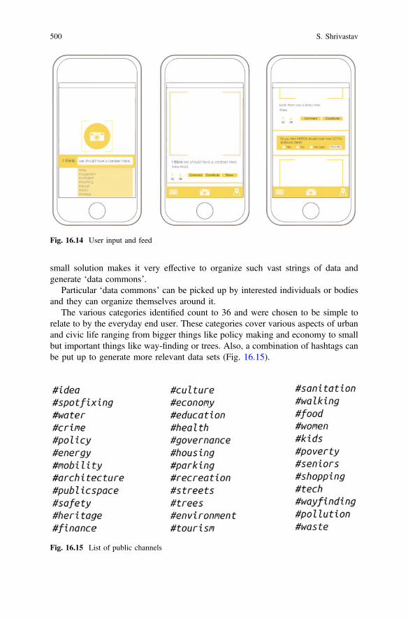
small solution makes it very effective to organize such vast strings of data andgenerate ‘data commons’.
Particular ‘data commons’ can be picked up by interested individuals or bodiesand they can organize themselves around it.
The various categories identified count to 36 and were chosen to be simple torelate to by the everyday end user. These categories cover various aspects of urbanand civic life ranging from bigger things like policy making and economy to smallbut important things like way-finding or trees. Also, a combination of hashtags canbe put up to generate more relevant data sets (Fig. 16.15).
Fig. 16.14 User input and feed
Fig. 16.15 List of public channels
500 S. Shrivastav
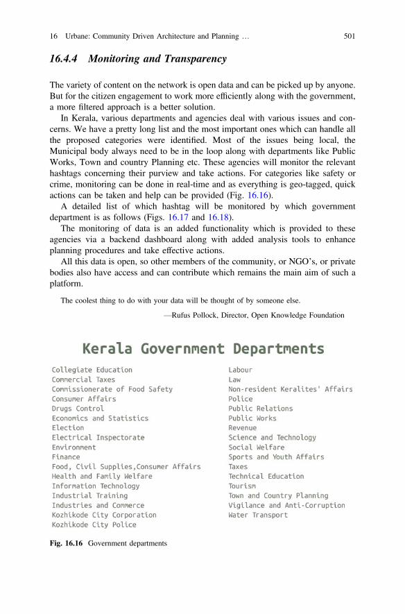
16.4.4 Monitoring and Transparency
The variety of content on the network is open data and can be picked up by anyone.But for the citizen engagement to work more efficiently along with the government,a more filtered approach is a better solution.
In Kerala, various departments and agencies deal with various issues and con-cerns. We have a pretty long list and the most important ones which can handle allthe proposed categories were identified. Most of the issues being local, theMunicipal body always need to be in the loop along with departments like PublicWorks, Town and country Planning etc. These agencies will monitor the relevanthashtags concerning their purview and take actions. For categories like safety orcrime, monitoring can be done in real-time and as everything is geo-tagged, quickactions can be taken and help can be provided (Fig. 16.16).
A detailed list of which hashtag will be monitored by which governmentdepartment is as follows (Figs. 16.17 and 16.18).
The monitoring of data is an added functionality which is provided to theseagencies via a backend dashboard along with added analysis tools to enhanceplanning procedures and take effective actions.
All this data is open, so other members of the community, or NGO’s, or privatebodies also have access and can contribute which remains the main aim of such aplatform.
The coolest thing to do with your data will be thought of by someone else.
—Rufus Pollock, Director, Open Knowledge Foundation
Fig. 16.16 Government departments
16 Urbane: Community Driven Architecture and Planning … 501
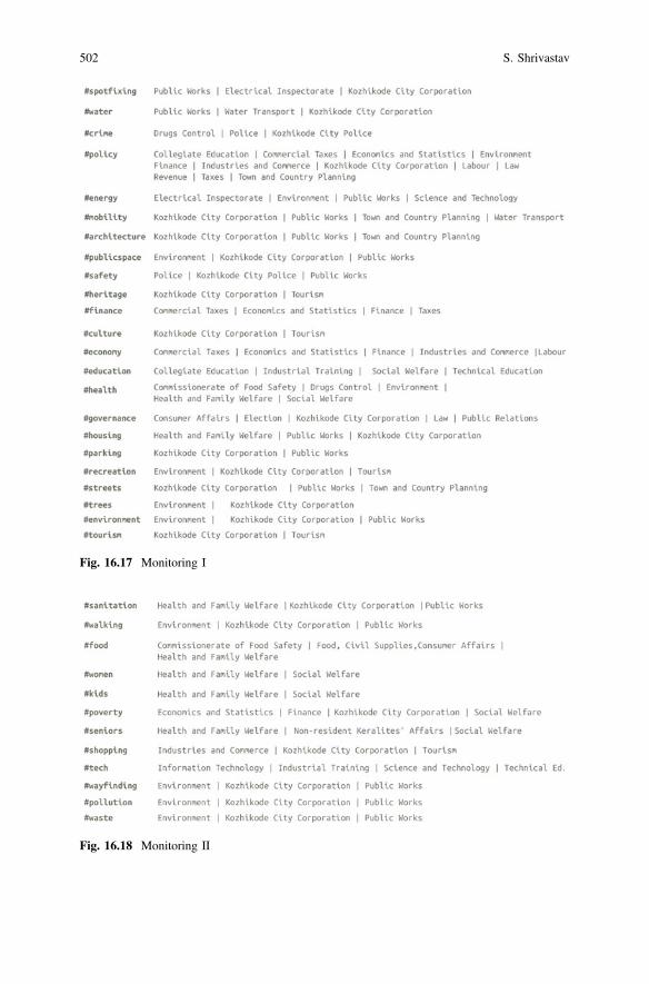
Fig. 16.17 Monitoring I
Fig. 16.18 Monitoring II
502 S. Shrivastav
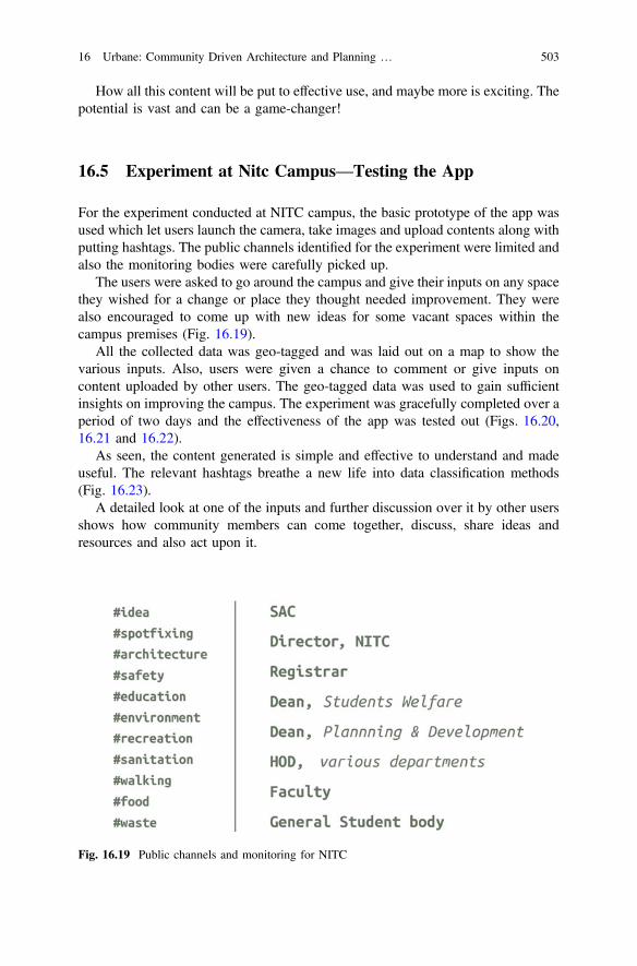
How all this content will be put to effective use, and maybe more is exciting. Thepotential is vast and can be a game-changer!
16.5 Experiment at Nitc Campus—Testing the App
For the experiment conducted at NITC campus, the basic prototype of the app wasused which let users launch the camera, take images and upload contents along withputting hashtags. The public channels identified for the experiment were limited andalso the monitoring bodies were carefully picked up.
The users were asked to go around the campus and give their inputs on any spacethey wished for a change or place they thought needed improvement. They werealso encouraged to come up with new ideas for some vacant spaces within thecampus premises (Fig. 16.19).
All the collected data was geo-tagged and was laid out on a map to show thevarious inputs. Also, users were given a chance to comment or give inputs oncontent uploaded by other users. The geo-tagged data was used to gain sufficientinsights on improving the campus. The experiment was gracefully completed over aperiod of two days and the effectiveness of the app was tested out (Figs. 16.20,16.21 and 16.22).
As seen, the content generated is simple and effective to understand and madeuseful. The relevant hashtags breathe a new life into data classification methods(Fig. 16.23).
A detailed look at one of the inputs and further discussion over it by other usersshows how community members can come together, discuss, share ideas andresources and also act upon it.
Fig. 16.19 Public channels and monitoring for NITC
16 Urbane: Community Driven Architecture and Planning … 503
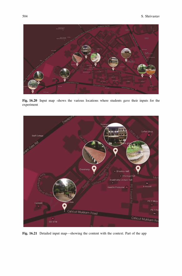
Fig. 16.20 Input map -shows the various locations where students gave their inputs for theexperiment
Fig. 16.21 Detailed input map—showing the content with the context. Part of the app
504 S. Shrivastav

Such level of engagement at city scale will not only be amazing but also useful,will spark new levels of ownership and lead to stronger communities with effectivegovernance and planning too.
16.6 Urbane Platform—Working and Scaling up
The app was found to be quite useful and it simply works. The process flow ispretty rational and easy to comprehend to. Users tend to enjoy it, it provides a socialincentive. The idea sharing and content generation is made intuitive and profound.Users also get feedback and help from other members on the network. Monitoringby various agencies and open data for the city provides various opportunities andinsights.
Fig. 16.22 User inputs
16 Urbane: Community Driven Architecture and Planning … 505
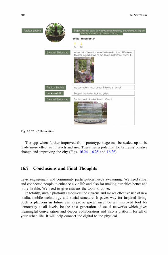
The app when further improved from prototype stage can be scaled up to bemade more effective in reach and use. There lies a potential for bringing positivechange and improving the city (Figs. 16.24, 16.25 and 16.26).
16.7 Conclusions and Final Thoughts
Civic engagement and community participation needs awakening. We need smartand connected people to enhance civic life and also for making our cities better andmore livable. We need to give citizens the tools to do so.
In totality, such a platform empowers the citizens and makes effective use of newmedia, mobile technology and social structure. It paves way for inspired living.Such a platform in future can improve governance, be an improved tool fordemocracy at all levels, be the next generation of social networks which givesmeaningful conversation and deeper collaboration and also a platform for all ofyour urban life. It will help connect the digital to the physical.
Fig. 16.23 Collaboration
506 S. Shrivastav
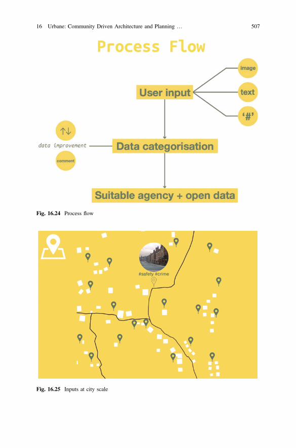
Fig. 16.24 Process flow
Fig. 16.25 Inputs at city scale
16 Urbane: Community Driven Architecture and Planning … 507

You never change things by fighting the existing reality. To change something, build a newmodel that makes the existing model obsolete.
—Buckminster Fuller
References
1. Ahn H-C (2007) Design tools and three steps in participatory design processes: a proposal forbetter communications among residents and experts, based on a case project of neighborhoodpark in Seoul, Korea. In: 6th conference of the Pacific Rim Community design network
2. Candy C (2016) I wish this was. Candychang.com. [Online]. Available http://www.candychang.com/i-wish-this-was/. Accessed 12 Feb 2015
3. Openplans.org (2016) [Online]. Available http://openplans.org/. Accessed 23 Feb 20154. Neighborland (2015) [Online]. Available https://neighborland.com/. Accessed 23 Feb 20155. de Lange M, de Waal M (2013) Owning the city: new media and citizen engagement in urban
design. First Monday, 18 Nov 20136. C. Transportation (2015) Request bike parking. [Online]. Available http://bikeparking.
chicagocompletestreets.org/. Accessed 23 Feb 20157. Vision Zero Community Safety Map (2015) [Online]. Available http://www.nyc.gov/html/
visionzero/pages/maps-and-data/vz-input-map.shtml. Accessed 23 Feb 2015
Fig. 16.26 Working at city scale
508 S. Shrivastav

Chapter 17Blockchain-Powered Internet of Things,E-Governance and E-Democracy
Renming Qi, Chen Feng, Zheng Liu and Nezih Mrad
Abstract Digital technologies have dramatically changed people’s daily life andmade our life components much smarter. Nowadays, all users, including bothhuman beings and devices, are connected to centralized servers. These servers actas the authorities, which are trusted by all users, making it possible to exchangecritical information and money between untrusted users. However, maintaininglarge servers is costly and it’s not affordable if such digital systems for cities’critical infrastructures are hacked. Blockchain, a technology revolution startingfrom 2014, offer the potential to solve these problems. It is essentially a tool thatrecords every single transaction and digital event that happen in the virtual world.All the records are open to every user and the information asymmetries betweentwo users are minimized. Thus, it’s not possible for one user to cheat or hideinformation from another user. In other words, two strangers do not need to worryabout being cheated by each other. They are allowed, for the first time in history, todo business without a centralized authority. Since a centralized authority is nolonger a necessity, these two problems disappear naturally. This survey firstexplains how blockchain makes this magic happen and then introduces theblockchain’s powerful applications in Internet of Things, E-governance, andE-democracy.
Keywords Blockchain Internet of Things E-governance E-democracy
R. QiSchool of Engineering, EME1240-1137 Alumni Ave, Kelowna, BC V1V 1V7, Canada
C. Feng (&)School of Engineering, EME4285-1137 Alumni Ave, Kelowna, BC V1V 1V7, Canadae-mail: [email protected]
Z. LiuSchool of Engineering, EME4205-1137 Alumni Ave, Kelowna, BC V1V 1V7, Canada
N. MradDefence Research and Development Canada (DRDC), Department of National Defence,National Defence Headquarters, Major-General George R. Pearkes Building, 101 Colonel byDrive Ottawa, Ottawa, ON K1A 0K2, Canada
© Springer Nature Singapore Pte Ltd. 2017T.M. Vinod Kumar (ed.), E-Democracy for Smart Cities, Advances in 21st CenturyHuman Settlements, DOI 10.1007/978-981-10-4035-1_17
509
17.1 Introduction
Our cities are getting smarter by utilizing digital technologies, such as online videomeeting, self-driving cars, online medical insurance payment, and electronic votingetc. The application of digital technologies to smart cities can be, in general, dividedinto three categories: Internet of Things (IoT), E-governance, and E-democracy.The IoT refers to a network of connected devices (such as smartphones and sensors)where the network connectivity allows these devices to collect relevant informationand take corresponding actions. For example, Apple Inc. can help its iPhone usersto locate their missing phones by connecting every iPhone to iCloud andcollecting GPS information from missing iPhones.
E-governance utilizes digital technologies to provide public services in an effi-cient and user-satisfactory way. For instance, in- stead of driving to a governmentbuilding to file their taxes, nowadays citizens can choose to fill in and submit taxforms online, saving hours of unnecessary waiting time. E-democracy leveragesdigital technologies to facilitate citizens’ participation in government’s events anddecision-making processes, holding political power running in an accountable way.For example, electronic voting provides voters a fast and convenient votingexperience, attracting more citizens to vote.
Despite these great benefits, the application of digital technologies to smart citiesstill suffers from two major issues: high costs and insufficient security. For instance,with respect to IoT, it may incur a huge amount of operational expenditure (Opex)to build and maintain a large-scale centralized cloud platform (such as Apple’siCloud) to connect all devices. In addition, current cloud service providers are stillnot compatible with each other, leading to a high cost of labor to implement aninformation exchange hub working across different cloud providers. As for security,with an increasing number of connected devices embedded in cities’ criticalinfrastructure (such as railways, tunnels and energy distributions), people cannotafford to under-estimate the risk of a cyber attack to a critical infrastructure that maycause severe damages to city properties and human life. Similarly, there is no proofor protection that our private information, such as bank statements and medicalrecords, collected by E-governance will not be abused by incompetent management(perhaps due to corruption).
In this survey, we investigate a promising solution to all the existing issues: atechnology revolution called “blockchain”. The blockchain was first introduced byNakamoto [1] as the ledger of Bitcoin, which is the first widely-deployed digitalcash, very similar to the old American “gold-standard” currency. The blockchaincan hold a record of every transaction made by Bitcoin users and provides adecentralized manner to process these transactions. Unlike traditional financialservices hiring a bank to validate each transaction, there is no need for a centralizedauthority in blockchain. Many participants of blockchain volunteer to verify eachtransaction, leading to much lower Opex. To ensure the proper performance, thesevolunteers will be awarded for their correct work on validation and will, sometimes,be penalized for their incorrect work. In this way, blockchain participants only rely
510 R. Qi et al.
on trustable volunteers rather than a centralized authority like banks. On the otherhand, if one participant wants to tamper with previous transactions, he has topersuade all the other users agreeing on him to do so, which is proven to be anextremely difficult task. Because of its low cost and high-level security, blockchainhas emerged as an ideal technology to store records persistently, including con-tracts, diplomas, and certificates etc.
The application of blockchain is not limited to financial services. The industryextends the concept of transactions to smart contracts [2]. In order to distinguishblockchain of smart contracts from the previous blockchain of money, we call thisstage blockchain 2.0 and the previous stage blockchain 1.0. A smart contract is acontract whose items are self-executing computer programs. Once two willingparties make a smart contract and publish it on blockchain, the associated computerprograms will run without any human intervention. Since records in blockchaincannot be altered and the programs will run automatically, both parties have to obeyrules in this contract and have no methods to break them. This enables, for the firsttime in history, untrusted parties to do business with each other without a cen-tralized authority.
Blockchain is envisioned to transform the application of digital technologies tosmart cities from two aspects: automation and security. For IoT applications,transactions and coordination between devices can be facilitated by blockchain.Instead of relying on a centralized cloud, devices are empowered to autonomouslyexecute digital contracts, including buying electricity, selling collected informationto peer devices and etc. For E-governance applications, the way of enforcingregulations is going to change. Traditionally, regulations are enforced by agenciessuch as food-safety agency and fiscal agency. With a smart contract in play, reg-ulations can be translated into computer programs, which will be run by blockchainautomatically. The human intervention will be taken out of the loop in the entireprocess, leaving no room for corruption. Security comes directly from the fact thatthere is no central point in blockchain. Hacking applications on blockchain requireshacking every single user, which is much harder than hacking a single central point.More details of applying blockchain to IoT, E-governance and E-democracy will bediscussed in Sects. 17.3, 17.4 and 17.5.
17.2 Blockchain 1.0
Digital cash is infinitely copiable (like copying a file on computer for many times).If someone received a unit of digital cash, he/she can make several copies of it andpass them on to other people, which will definitely disturb the financial system.This problem is called double-spend problem. Previously people hire centralizedintermediaries such as banks to solve this problem. When consumers do onlinepayments, the bank will check whether the consumers have enough balance in theiraccounts and only after confirming that, it will send sellers the money and informthe seller to send consumers the goods. However, blockchain, as a breakthrough in
17 Blockchain-Powered Internet of Things, E-Governance … 511
digital cash research, solved the double-spend problem and avoids the centralizedthird party at the mean time. To explain how blockchain achieves this, we willdescribe the basic concept of blockchain, including transaction, block and dis-tributed consensus algorithm over the peer-to-peer network.
A transaction in blockchain includes four components: (1) input: spender’saddress (or user account); (2) output: receiver’s address; (3) amount: quantity ofunits transacted; and (4) metadata: additional information stored with each trans-action [3]. Each transaction is signed by its creator with a digital signature,broadcasted to every node in the blockchain network and then recorded in publicledger after validation. Before recording any transaction, the verifying node mustensure two things: (1) the spender owns the money by verifying the digital sig-natures on the transaction; (2) the spender has enough money on his account bychecking every transaction against spender’s account in the ledger to make sure hehas sufficient balance.
Transactions are passed node by node in the peer-to-peer network, so there is noguarantee that transactions will be received at a certain node or be received in orderas they are generated. Here comes the problem of double-spend. Even thoughmalicious user only owns ten dollars, he/she could broadcast two transactionscontaining 10 dollars to the network simultaneously. Nodes that only receive onetransaction judge the received one as verifiable while nodes that receive both onlyadmit the first one. This means that there is demand for a mechanism that enablesthe whole network to agree on the order of transactions. The mechanism is knownas distributed consensus algorithm.
The distributed consensus on blockchain is a two-step process. At first, eachnode orders the transactions it received by placing them in a linear sequence ofblocks. Each block consists of 4 components: (1) transactions collected in a certainperiod of time; (2) a reference to the block that comes immediately before it; (3) ananswer to a hard-to-solve mathematical puzzle. The puzzle is unique for everyblock and it will be introduced in the following paragraph. The correctness ofanswer in a block is easy to verify; (4) a timestamp which indicates when the blockis built [4]. The transactions in one block are regarded to be created at the sametime. Every node can collect unconfirmed transactions into a block and broadcastthe block to network as their suggestions on what should be added to the currentsequences of blocks. In the second step, blockchain needs to decide which blockamong these suggestions should really be the next block and make every participantagree with this block. This turns out to be a hard problem since there is no cen-tralized server which is responsible for collecting everyone’s suggestions, makingthe final decision and forcing everyone to agree with the decision.
Blockchain solves this problem elegantly by using a race of solving a hardmathematical puzzle as mentioned above. The first one who solves the puzzle willmake the next block. This is also known as “proof of work” [1], because by solvingthis puzzle, a node can prove that it does use lots of resources to win the race. Forexample, in Bitcoin, the puzzle is to find a number that makes the hash of theconcatenation of this number, transactions contained in this block and the hash ofprevious block start with a certain number of zeros. The average efforts required to
512 R. Qi et al.
find the answer is exponential with the number of zeros. Bitcoin system will adjustthe number of zeros according to the computing power of the network so thataverage time to find a required number is constant and nearly 10 min [5].
After receiving and verifying the block proposed by the node who first solvedthe puzzle, other nodes can show their agreement on this block by working on thenew puzzle that contains the hash of this block. The block builder is usually called“miner”. Miners receive financial awards for spending resources to make a block. InBitcoin, after building a block, the builder will be awarded a certain number ofbitcoins by Bitcoin protocol and each starter of transactions in the block have toleave him a tip. The awards can ensure miners work uprightly since if they conductmalicious behaviors, the blockchain is no longer trustable and then assets of minerson blockchain will become valueless. Besides, the network accepts only the longestsequences. As long as the majority of resources is controlled by miners who don’tcooperate to attack blockchain, they will generate the longest sequence and theattacker will be outpaced. As a result, for the first time in history, untrusted partiesto do business with each other without a centralized authority.
17.3 Blockchain 2.0
Blockchain 2.0 decentralizes more complicated agreements, i.e. contracts beyondfinancial systems. Techniques used to decentralize functionality of a ledger inblockchain 1.0 can be adopted to register, confirm and transfer all kinds of contractand assets in blockchain 2.0.
17.3.1 Smart Contract
Simply speaking, smart contracts are published computer programs agreed by bothparties on blockchain [6]. A contract in a traditional sense is specific terms betweentwo or more parties in which there is a promise to do something in return for somebenefits. Each party must trust the other party to fulfill its obligations. If there is anydisputation, they need to resort to courts for resolution. The contract on blockchainis smart in the sense that it allows contractors to solve common problems in a waythat minimizes trust. Minimizing trust makes things easier by allowing humanintervention to be taken out of the loop, thus allowing complete automation. Theautomation here means two things. One is after the contract is launched, it will beself-executing and there is no need for contact between contractors. The other is thatthe contract is able to arrange resources on its own behalf. This ability requiressmart property which will be introduced later.
The main difficulty for smart contracts is that computer programs cannot easilyand reliably tell what’s happening in the physical world or who is telling the truth.Checking whether a financial payment is made is easy for computer programs, but
17 Blockchain-Powered Internet of Things, E-Governance … 513
real-world situations like whether one’s work achieves the company’s standard arehard for computer programs to evaluate. One solution is to use oracles—onlineservice providers who broadcast data which can be used by users as input to smartcontracts [7]. A good example is the inheritance gift. An old man leaves aninheritance gift to his grandson and sets the condition that the gift can be receivedafter he passes away. The old man can make the contract and publishes it ontoblockchain. An oracle can broadcast new entries in government registry of death.The contract receives this as an input and once the death is confirmed, the gift willbe sent automatically.
17.3.2 Smart Property
Smart properties are properties whose ownership are controlled by blockchain usingsmart contracts [8]. The asset includes physical property (such as a house or a car)and intangible asset (such as votes, ideas, reputation, health data, rights, and sharesin a company). The key idea of smart properties is that ownership of these prop-erties is represented by a private key on blockchain. The owner can prove hisownership by showing having access to the certain private key. A good example isbuying a car via blockchain. The car’s computer requires authentication by using anowner key. Additionally, the car has a token from its manufacturer that has beenpublished on blockchain to prove its existence. This token can also be used toidentify its age, mileage and maintenance recording, giving enough information forthe buyer to make the decision. In order to buy the car, the buyer makes a smartcontract with the original owner with the following item, if the buyer pays themoney, the token must be transferred to the buyer’s account. The car’s computerwill be aware of this via blockchain and then the buyer can use its private key toopen the car. No third party including government is necessary for this process.
17.4 Blockchain and IoT
Current IoT systems rely on centralized communication models. All devices areidentified, authenticated and connected through various cloud servers that supporthuge processing and storage capacities. However, there is no single unified platformthat connects all devices and no guarantee that cloud services offered by differentmanufacturers are interoperable and compatible. For instance, the field of logisticsinformation support systems is fragmented and diverse. Every logistics companyuses their own software products and very few of them can communicate mean-ingfully with each other. System integrations on any level are almost always built asone-on-one relationship between operational ERPs and their databases and are thusvery much costly and tailored work. Human component as the informationexchange hub is rather the norm than the exception. Actually, operational
514 R. Qi et al.
information is routinely passed over phone, email and even old-fashioned faxmachine by human.
Blockchain works well for this problem. Blockchain achieves trustless con-nection without sacrificing data integrity, which is what supply chain business isvirtually all about. Following this thought, a project named SmartLog is launched[9]. SmartLog is trying to introduce a scenario where all kinds and sizes of logisticscompanies are able to share and tap into a common blockchain, which will consistof all the relevant information pertaining to the movement of intermodal containersthroughout the European Union transport corridors. Information will be gatheredfrom companies’ own information management system and then shared among allparticipants after being anonymized and filtered. There will also be a simple deviceattached to some of the containers, so companies can validate actual movements ofcontainers in the corridors against the information which they see flowing into theblockchain. The data will serve several different purposes: the participating com-panies will have immediate access to it and can use it to greatly enhance theiroperations, resource management, and route optimization planning.
Another downside of current centralized communication model is that costs ofinstalling and maintaining large centralized clouds are high. As the scale of IoTdevices tends to grow explosively, these costs will grow substantially and cloudservers will become a bottleneck and a point of failure that can disrupt the entirenetwork. Adopting a standardized peer-to-peer communication model betweendevices via blockchain will significantly reduce the costs associated with installingand maintaining large centralized data centers. It will also distribute computationand storage needs across the billions of devices from central servers to devices inIoT networks. This will prevent failure in any single node in a network frombringing the entire network to a halting collapse. However, the prospects of thedecentralized model are beyond this. Without centralized management, each devicemanages its own roles and behaviors, resulting in an “Internet of Decentralized,Autonomous Things” [10]. We use the blockchain-powered self-driving car toshow this idea. After taking a ride, people can pay directly to the car instead of thedriver or the company it belongs to. The car can use these payments to maintainitself and the remaining money becomes the profit of the taxi company. If the carruns out of gas, it drives itself to a nearby gas station and pays the gas dump to getfilled. When there are too many passengers for a car, the car can call its peer cars viablockchain to make every passenger served.
Here we present blockchain as “language” used by self-driving cars to com-municate with the physical world (passengers) and peer devices (peer cars and thegas dump). We can be more aggressive. Blockchain can be used as general com-munication tools for artificial intelligence. The artificial intelligence found in Siriand Watson currently is a singular artificial intelligence, which is far from humanbeings. In contrast, human’s society is a form of a multi-agent system, where eachagent is independent and intelligent. The society is formed through communicationand co-operation between human beings. Blockchain’s mechanism of achievingpersisting consensus in trustless peer environment makes a multi-agent system ofintelligent devices possible. The consensus among devices makes each device get
17 Blockchain-Powered Internet of Things, E-Governance … 515
the same sense of a signal as others. These senses act like words in human’slanguage, making device-to-device communication possible. Persistence means thatthe sense will not diminish with time. For humans, persistence means that we seefurther by standing on giant’s shoulders. There is no necessity to invent calculusagain when we use it. For devices, persistence means device-readable knowledge,making devices evolve their functionality automatically. There have already beensome primitive discussions in this field, see details in [11, 12].
17.5 Blockchain and E-Governance
A key role of a democratic government is the appropriate distribution of resourceamong its citizens, both individual and corporate. This goes beyond the distributionof monetary resource and includes social intangibles such as security, the conditionsfor the maintenance of the rule of law. However, as we have witnessed, govern-ments have become larger, more centralized and more remote from the individualcitizens. Centralized model provides poor customer service and is no longer eco-nomic. Citizens’ queries and needs cannot be responded in time. Governments havestarted to provide e-governance service, which uses information technology toimprove service quality and efficiency. Though a prodigious amount of money hasbeen invested to e-governance to improve service quality and governance effi-ciency, what is achieved by e-governance is trivial. Blockchain is about to changethis by enabling governments to provide service and carry out governance in adetailed way.
A good example is the food safety issue. Consumers surprisingly know littleabout most of the products they use daily. A complex network of retailers, dis-tributors, transporters, storage facilities and suppliers stand between consumers andthe products they use. Governments set up food safety agencies to enforce everycomponent of this chain to comply with standards but the recent Chipotle foodcontamination crisis [13], Chinese tainted milk scandal [14] show that governmentsfailed.
Blockchain-powered food supply chain management may be a solution.Walmart, IBM and Tsinghua University just started to collaborate together toprovide quality assurance for providers and consumers [15]. With blockchain, foodproducts can be digitally tracked from an ecosystem of suppliers to store shelvesand ultimately to consumers. Digital product information such as farm originationdetails, batch numbers, factory and processing data, expiration dates, storagetemperatures and shipping detail are digitally connected to food items and theinformation is entered into blockchain along every step of the process.Governments can use each piece of information to detect critical data points thatcould potentially reveal food safety issues with the product. Since information onblockchain cannot be altered, this ensures all the information is accurate and that noinvolver can cheat.
516 R. Qi et al.
Another example is the regulation in financial systems. Financial institutionsneed to submit digital reports to regulators to prove that they did not break theregulations. One of the main challenges is that they need to comply with existingregulations: EMIR in EU and Dodd-Frank in US [16]. Due to the myriad of reg-ulatory obligations, the reporting process currently is rather complex. Moreover,regulations in EU and those in the US are not necessarily consistent with each other.This puts a heavy burden on industry and consumes substantial resources. Forgovernments, validating these reports requires much human labor and time. Thelong delay of this process also enables bank managers to conceal their wrongdoingsas they did in the crisis of 2008. And these reports often use different methodologiesbehind the calculations. This enables companies to take advantage of loopholes toavoid un-profitable regulation and sometimes leads to confusion. Blockchain canbenefit both financial institutions and regulators. The regulations in legal files canbe translated into smart contracts and then packaged to software. This softwaredefines whether an action is permissible or not so that financial institutions can obeyregulations by using API of this software instead of reporting to governments. Sincetransactions are stored in blockchain, access for regulators to them is easier andfaster. Validation can be helped by the consensus mechanism of blockchain:impermissible behaviors cannot be admitted by the network and thus cannot beconducted.
The security of digital resources is also a headache of both governments andcitizens. For governments, all information is stored on centralized servers. If oneserver is attacked, most of the confidential information will be leaked. For users,there is no proof or protection that their privacy collected by governments will notbe abused. Even worse, the software used by governments and citizens may be builtwith backdoors, which can be used to conduct malicious behaviors without beingdetected. Blockchain provides elegant solutions to these security problems. We firstintroduce MIT’s Enigma, a privacy-preserved blockchain platform [17]. Data isencrypted and stored in distributed nodes. Rather than hacking a centralized serverto steal information, hackers need to hack the whole network. Moreover, any smartcontract can directly run on encrypted data by using homomorphic encryption [18].Thus, data on Enigma can be stored, shared and analyzed without revealed to thethird party including the government itself, enabling trustless sharing of data anddistributed computation without leaking users’ privacy. If one wants to useback-doors to conduct malicious behavior, he will not succeed because other userson blockchain will reject his action. Moreover, every action is recorded onblockchain.
Big-data analysis on these records can be adopted to detect abnormal behaviors,prevent new frauds before they happen and even find the source of frauds.Block-Cypher has started to work on this idea [19]. It aims at building ablockchain-based platform on which every action will be given a risk scoreaccording to the user’s history, behavior pattern, location and etc. The high-scoredaction which may be a fraud with high possibility will be rejected.
17 Blockchain-Powered Internet of Things, E-Governance … 517
17.6 Blockchain and E-Democracy
Voting is the basic approach to democracy, but current voting system haves beenplagued with voting frauds. According to [20], at least 7 billion Americans votemultiple times in federal elections. This duplicity can be used by any special interestgroups who seek to gain advantage for the candidates they support. There is also noway for voters to assure that their votes will be accurately recorded and counted. It’snot who votes but who counts the votes decides the winner. The voting fraudfrustrates people from believing that their votes matter, so most people choose notto vote. In the American federal election of 2012, only 58% of people who areeligible to vote actually voted. Many governments became interested in the elec-tronic voting machine, which could increase the transparency of voting to preventfrauds. However, this interest comes with security warnings. In [21], the authorsrevealed that one who gained physical access to the Diebold AccuVote-TS votingmachine or its removable memory card could install malicious code capable ofstealing votes without being detected. Many people will use the same votingmachine so this single point failure has enormous impacts on results. Moreover, thevoting machine is usually designed, produced and maintained by a single company.There is no proof that this company will not install malicious codes in the machineat the beginning.
Blockchain is an effective solution to problems in the voting system. Theblockchain-powered voting runs as follows: (1) Before voting, a user sends his legalIdentification and username on blockchain to an identity verifier. After beingapproved, the user will receive his unique ballot. The verifier is not necessarily thegovernment. The task of verification can be undertaken by miners, who has theincentive to behave uprightly. And by using homomorphic encryption, the verifi-cation process can directly run on encrypted data, without leaking the user’sidentity; (2) During the election, the user completes his ballot and sends it to theblockchain-based ballot box. Each user uses a different device as the entrance pointto voting so hacking single device has little effect on the voting results; (3) After theelection, each user is allowed to audit the vote results because each user can accessthe open data on blockchain. In addition, a user’s decision will not be known toother voters since users use their pseudo name on blockchain when voting. Manyprojects of blockchain-based voting have been launched already, such asBitCongress [22], AgoraVoting [23] and FollowMyVote [24].
The other impact of blockchain on democracy is the high-resolution information.Democracy government cannot avoid the wrong choices of public servants. Notevery citizen in the city is aware of the city’s political, economic and social cir-cumstances. People may vote for a proposal based on other factors rather than itspotential effect. IoT devices that are spread all over the city collect unbiased dataabout every aspect of the city, including the traffic situation, the road status, thewater quality and etc. The collected data is published on blockchain and can revealimportant factors about the circumstances of the city by adopting big-data analysistools. When governments want to increase budget, say on municipal construction,
518 R. Qi et al.
citizens have extra facts to judge whether it’s reasonable or not. During the election,citizens can turn to the quantized effect of their past work and choose the one withthe critical capability, instead of listening to their debates and watching theirimmoral practices like tarnishing their opponent’s reputation on the Internet. Theintelligent devices themselves may also have a fair weight in voting. Since theymonitor the runtime of city continuously, they are more knowledgeable of the citythan citizens. They are also neutral inherently because they are controlled by smartcontracts which are feasible only after being agreed by the majority of the network.As a result, their opinion provides great hints for making the right choice. Includingthem in the democratic system is not impossible in the future. At this point,E-democracy does include e-lives as its name implies.
17.7 Summary
In this survey, we investigate a novel technology named blockchain. We firstexplain the mechanism of blockchain which enables untrusted parties to do businesswith each other in a decentralized way. We then use concrete examples to explainthe powerful applications of blockchain in Internet of Things, E-governance, andE-democracy. When introducing these examples, we focus on two aspects ofblockchain:
1. Automation: by using smart contract, devices become self-serving and thus moreintelligent. For governments, routine work can also be processed automatically,thus enable governments to provide services more efficiently. Less humanintervention in the entire process also lowers the cost.
2. Security: one user being hacked is minimized. Besides, every action onblockchain is recorded and transparent to every user. Under such masssurveillance, conducting malicious behaviors without being detected is notpossible.
References
1. Nakamoto S (2009) Bitcoin: a peer-to-peer electronic cash system. http://www.bitcoin.org/bitcoin.pdfhttp://www.bitcoin.org/bitcoin.pdf
2. Wood G (2016) Smart contract yellow paper3. BitcoinWiki (2016) Transaction. https://en.bitcoin.it/wiki/Transaction4. BitcoinWiki (2016) Block. https://en.bitcoin.it/wiki/Block5. Croman K, Decker C, Eyal I, Gencer AE (2016) On scaling decentralized blockchains.
Bitcoin and Blockchain6. BitcoinWiki (2016) Contract. https://en.bitcoin.it/wiki/Contract7. BitcoinWiki (2014) Oracle. https://en.bitcoin.it/wiki/Oracle8. BitcoinWiki (2016) Property. https://en.bitcoin.it/wiki/Smart Property
17 Blockchain-Powered Internet of Things, E-Governance … 519
9. SmartLog (2016) https://smartlog.kinno.fi/10. Brody P, Pureswaran V (2014) Device democracy: saving the future of the internet of things.
IBM11. Maxim O (2016) How blockchain relates to artificial intelligence?—BICA Labs. https://
medium.com/bica-labs/how-blockchain-relates-to-artificial-intelligence-f0111f39afc912. Worner D, Bomhard T (2014) When your sensor earns money: exchanging data for cash with
Bitcoin. Exchanging data for cash with Bitcoin, ACM, New York, USA13. Businessweek B (2016) Inside Chipotle’s contamination crisis. http://www.bloomberg.com/
features/2015-chipotle-food-safety-crisis/14. Langman CB (2009) Melamine, powdered milk, and nephrolithiasis in Chinese infants.
N Engl J Med 360(11):1139–114115. IBM (2016) How blockchain can help bring safer food to China. https://www-03.ibm.com/
press/us/en/pressrelease/50816.wss16. Carlo M (2016) Blockchain, financial regulatory reporting and challenges. https://www.
finextra.com/blogposting/13102/blockchain-financial-regulatory-reporting-and-challenges17. Zyskind G, Nathan O, Pentland A (2015) Enigma: decentralized computation platform with
guaranteed privacy. arXiv preprint arXiv:15060347118. Gentry C (2009) A fully homomorphic encryption scheme. Ph.D. thesis, Stanford University19. BlockCypher (2016) blockcypher.com. https://www.blockcypher.com/20. Watchdog (2014) http://watchdog.wpengine.netdna-cdn.com/wp-content/blogs.dir/1/files/
2014/06/CrossStateCheckStatistics.pdf21. Feldman AJ, Halderman JA, Felten EW (2006) Security analysis of the diebold Accuvote-Ts
voting machine22. BitCongress (2016) www.bitcongress.com. http://www.bitcongress.com/23. AgoraVoting (2016) agoravoting.com. https://agoravoting.com/24. FollowMyVote (2016) https://followmyvote.com/
520 R. Qi et al.

Part IVConclusions
Chapter 18E-Democracy for Smart Cities:Conclusion and Path Ahead
T.M. Vinod Kumar
Abstract The concluding Chapter attempts to put together various conclusionsderived out of seventeen chapters of this book at one place. This work is accom-plished in collaboration with the 42 authors editor of this book. This chapter thenend with general conclusions and way ahead.
Keywords E-Democracy for smart cities City studies Domain studies Issueand tools of E-Democracy
18.1 Introduction
This collaborative work of international scholars on “E-Democracy for SmartCities” dwells more on the possibilities than based on current state of practice. Nosmart city today can boast that they have the best E-Democratic system in place.The reality is far away from that as can be seen in the city studies in Sect. 18.2. Theobjective of E-Democracy is accepted but miles to go to attain it. Therefore, thebook title is “E-Democracy for Smart Cities” and not “E-Democracy in SmartCities”. The state of the art of democracy that was articulated in many republics hasprogressed considerably from ancient world to today but the state of E-Democracyis still in a nascent stage in most of the listed Smart Cities by leaned societies. Muchwork needs to done. The objective of this book is to show the way forward.Democracy in Republics is as old as the oldest written literature such as Veda butextending E-Democracy through wider applications into a smart city is a newopportunity which came into being with the explosive development of applicationsof Information and Communication Technologies in Smart Cities.
T.M. Vinod Kumar (&)School of Planning and Architecture, New Delhi, Indiae-mail: [email protected]
© Springer Nature Singapore Pte Ltd. 2017T.M. Vinod Kumar (ed.), E-Democracy for Smart Cities, Advances in 21st CenturyHuman Settlements, DOI 10.1007/978-981-10-4035-1_18
523
The introduction of digital ICT technologies and its diffusion in a massive andrapid scales such as ownership of smartphones, participation in Facebook, twitterand Instagram created a fertile ground for all democracies world over to transit toE-Democracy, but an achievement to this transition which is less costly and easy toimplement has not been very impressive and widespread. Those who started usingE-Democracy effectively in elections won the election leaving behind those whoused less effectively in their election campaigns. Specialists in ICT relatedE-Democracy were selected by political parties to manage E-democracy inmunicipal and general elections. There was no Government policy to supportE-Democracy in these countries and none was against the use of E-Democracysince it is an effective approach to further strengthen democracy. There are manysets of policy reforms to strengthen Governance through E-Governance in severalcountries but there is practically none for E-Democracy barring a few countriesmentioned in the first chapter.
The introduction of ICT was welcomed by all countries and ICT is the foun-dation of smart cities. Smart City functions only in a city with a high level ofdeployment of ICT and its effective use in all walks of life. However, Smart Citiesare emerging in the world urban-scape in very limited numbers. There is no scopethat it will spread as fast as the spread of Smart Phones. The main reason is thecreation of smart cities is only by design and takes all aspects of city functioning toa very efficient level, unknown today by people.
Smart cities creation happens only with the local people and no amount of publicinvestment in smart technologies can create a smart city. To transform local peopleto smart cities they should embrace ICT in all walks of their life and leverage itsstrength for Smart Economy, Smart Living, Smart Governance, Smart Mobility andSmart Environment. This transformation is achieved by the active collaboration ofSmart People. These aspects are covered extensively by Vinod Kumar [1–3]. Smartcities require an infusion of rapidly changing innovations in all these aspects dis-cussed above. Smart people identifies such innovative possibilities and see thatthese innovations are implemented by collaborations of common people who livethere. This process is achieved by E-Democracy while E-Governance only regulatethese developments to see whether it is based on the principles postulated in theconstitution. Constitutions postulates the rights and responsibilities of differentsections of society such as Executives, Judiciary, Citizen, print and visual media,religious group, caste groups and so on. Although E-Democracy and E-Governancelook like one and the same or at most inseparable twins but they are different in somany ways. E-Governance regulates but E-Democracy creates a plan, policy,strategies, tactics and so on within the framework of the constitution of that country.Smarter the city more innovative will be such creation. This establishes the role andimportance of E-Democracy in Smart Cities.
This book is an attempt to throw more lights on E-Democracy for Smart Citiesby scholars from many countries across the world both from East and the west andsouth and north. The book opens up in it’ first chapter with “State of the Art ofE-Democracy in Smart Cities”. The book is divided into five sections. They are;
524 T.M. Vinod Kumar
1. Introduction2. E-Democracy State of the Art City studies3. E-Democracy Domain Studies4. E-Democracy Issues and Tools and5. Conclusions.
There is no smart city in the world where E-Democracy is practised in its fullpotential in spite of the fact the driving force behind any smart city is theE-Democracy. Therefore, the underlying momentum of smart city functioning willbe lost sooner unless E-Democracy is developed in a massive scale in Smart Cities.However, there are many instances of very rudimentary to the partial deployment ofE-Democracy in many smart cities as well as non-smart cities. However, we do nothave one smart city which is a smart user of E-Democracy in all six components ofthe smart city discussed earlier. The 100 Smart Cities Program of Government ofIndia looks only at a very small part of the city and have no subprogram to developE-Democracy but undoubtedly participation is highlighted as a prime requirementfor selection of the candidate smart city for this project. Therefore, one can saysmart cities are evolving the world over in limited numbers so also E-Democracybut at a much slower pace than smart cities than that is required.
The Introductory chapter deals with the State of the Art Survey E-Democracy forSmart Cities whose conclusion will be discussed later.
Section 18.2 deals with the state of the art studies of E-Democracy in selectedcities. Selected cities are Lagos in Nigeria Africa, Feroke and New Delhi in Indiaand Hong Kong in China. Each study looks at a different perspective ofE-Democracy in practice or potential in these cities. Nigerian study is a study ofstatus in all walks of life in Lagos. The Feroke study deals with the E-Democracypotential in the preparation of Outline Development Plan of Feroke. In Feroke ademocratic way of preparing the Outline Development Plan was conducted by thestudy team of this book and then think about its potential transformation toE-Democracy. New Delhi study looks at E-Democracy as Smart City PlanningProcess. Finally, Hong Kong Study in China describe the existing E-Engagement inHong Kong in urban development through case studies.
Section 18.3 deals with E-Democracy in Domain Studies. To starts with anIndian study links up the domain of E-Governance to E-Democracy and postulatean Indian theory of domain linkages to the city. Dubai study considers urbaninnovation as a domain and investigates how it leapfrog E-Democracy through theexperiences of Dubai. Another study from India investigates smart water man-agement domain in the E-Democracy. From a successful background of urban landmanagement and city planning in Surat, the study extrapolates into the Preparationof Town Planning Scheme in an E-Democracy Framework for Citizen-CentricPlanning. Another study from Surat looks at how E-Democracy can effectivelyexploit the domain of “Smart Project Selection, Prioritisation, Customisation andImplementation”. Renewable energy backbone in a smart grid often assumesimportance in smart cities. This aspect is explored from E-Democracy point of view
18 E-Democracy for Smart Cities: Conclusion and Path Ahead 525
in the chapter Smart Grid Evolution: e-Democracy and Citizens’ Participation ine-Governance of Energy Backbone of Smart City.
Section 18.4 consists of six chapters on issues and tools. Each chapter identifiesa dominant issue in the practice of E-Democracy and explores appropriate tools. InIndia, there are well designed urban information system some concentrate on theenvironment and yet another on urban planning but seems not integrated. Thedepartmental nature of this information system is exhibited in this specialisedemphasis. However, urban planning cannot ignore environment even though urbanplanning comes under Ministry of Urban development and Environmental planningunder Ministry of Environment and Forest of Government of India. An Indian studylooks at this issue and proposes an Integration of Existing Information Systems andintegrate to a Spatial E-Democracy Tool for Smart Cities. Another Indian studymakes an inventory of geospatial tools available and postulate with case studieshow it can be of service to Smart Cities by further strengthening E-Democracy. InKenya, Africa ICT penetration is taking place in a rapid phase in cities. Kenyanstudy investigates, how Kenyan cities can attain E-Democracy through a DigitalPlatform. Open Government Data which strengthen E-Democracy, has been prac-tising in the city and regional governments in Russia recently. A Russian studylooks at the Politics of Open Data in Russia in Regional and MunicipalPerspectives. Another Indian study called “Urbane” investigate by an experimenthow a community drove architecture and planning can be accomplished through amobile social platform. A Canadian study investigate the tool Blockchain-PoweredInternet of Things in E-Democracy and E-Government.
18.2 State of the Art of E-Democracy in Smart Cities
The theoretical foundation for “E-Democracy for Smart Cities” is presented in thischapter to form a backdrop for the book. This chapter describes first the state of theart of Democracy before discussing E-Democracy which is the ICT enrichment andtransformation of Democracy. This chapter in detail studies the relationship ofsmart cities and e-democracy. The basic democratic principles are stated and thenthe culture of democracy that evolved through many centuries were studied. Thepresent constitutional provision and ancient Greek and Indian models of Republicandemocracy were discussed and democracy in panchayat system was also studied.Advantages and disadvantages of democracy were discussed. E-democracy wasdefined, E-democratic models investigated and E-democracy typologies werepostulated as well as ten models of E-Democracy. Finally, several tools used inE-democracy were enumerated. The chapter concluded with a vision ofe-democracy in large urban agglomeration.
Although it is desirable to convert as many cities in India to smart cities, it is notsimply possible. There should be potential for smart cities in states and unionterritories. Smart people and smart communities are primary requirements to triggerthe development of smart cities. It is not that easy to convert all smart city citizen
526 T.M. Vinod Kumar
and communities to smart. This can only be achieved by instituting E-Democracy insmart cities. Smart cities function within the framework of E-democracy,E-governance, and E-government. They are there wherever there is high HumanDevelopment Index. It is only smart people who can create smart communities andtherefore smart cities. Evidence of emerging urban economy is indicated by thehigh urban content (%) of the states geographically spread contiguously. The largeimpact of the smart economy can be there only in million-plus urban agglomera-tion. When one combines all these requirements, not all 53 million-plus cities inIndia that appeared in 2011 census in India can be potential candidates for smartcities. Even if few of this million-plus agglomeration or cities are shortlisted ascandidates, they can never be smart cities unless they are having an appropriateinstitutional framework which can shape them to smart cities such as E-democracy,E-government, and E-governance. Seventy-fourth constitutional amendments ofIndia provide for the metropolitan planning committees which need to be legislatedby the respective states. Triple Helix Model is the only dynamic framework that canshape smart cities. It presupposes that members of this constitutional body, themetropolitan committee shall have representatives of democratically elected rep-resentatives such as mayor, chairman/president municipality, and panchayat in themetropolitan region. The legislative framework of many states in India do notfollow this to play the Triple Helix Model in Metropolitan Development. Therigidity of the procedure driven legislations and lack of understanding of thedynamic of the Triple Helix Model are the main reasons. Members should be therefrom industrial sector or its representative bodies such as the chamber of commerceand industries. There shall be academicians such as vice chancellors, directors ofhigher educational institutions, directors of public research institutions, and eminentprofessors in metropolitan committee. This committee shall have an implementingauthority with senior administrator heading implementing body whose mainfunction is to implement the decisions of the metropolitan committee. Theadministrator shall be assisted by three wings namely metropolitan planning wingwith highest level of capability for metropolitan regional development planning andcapability to manage the modern centre for metropolitan geographic informationsystem using E-democracy for E-government and E-governance; an engineeringwing with senior engineer managing it and a finance wing whose main capabilityshall be the mobilisation of large-scale finances from national and internationalsources for implementing large-scale infrastructure and other development tasks inaddition to traditional account keeping. All these wings shall have provision toemploy the highest level of expert consultants to accomplish tasks which normallythey cannot perform at market rate.
A global alliance of smart cities shall be formed where Indian smart cities shallbe members to exchange experience and share software development as related toE-Democracy. Metropolitan planning committee shall have 20-year spatial andinfrastructure development plan, 5-year metropolitan social and economic devel-opment plans in tune with state and national five-year plans and annual plans forimplementation of the plan as per annual budget. A share of annual budget shallcome from state government, and another central government and metropolitan
18 E-Democracy for Smart Cities: Conclusion and Path Ahead 527
planning committee shall have their own financial resources from enteringcommercial developments such as land development and leasing of land forindustries, development of infrastructure to potential entrepreneurs or runningmajor transport networks for smart mobility. Institute of Town Planners India canhave a positive role in formulating model metropolitan planning committee legis-lation and model organisation framework for the smart city metropolitan committeeand its implementing authority. This will considerably help the state government toformulate legislations for the creation of metropolitan planning committee. India’sexperience in the direction of the metropolitan planning committee is very meagreor one can say almost non-existent.
There are specialised hardware and software required for the functioning ofE-Democracy In smart cities and smart communities. Many of these technologiesare not implemented in Indian cities. Most of them aim at resource conservingmetropolitan functioning of smart cities whether it is of energy or water use or ontransportation. Outright purchase of technology and licence for local manufactureand commercial production is one approach for large-scale deployment of thesetechnologies in emerging Indian smart cities. Another approach is collaborativeresearch and joint production. Still another approach is to develop appropriate smartcity technologies in Indian research centres based on specific needs. There is a needto appraise globally available smart city technologies and formulate appropriateIndian standards. Indian Standard Institution is competent to develop such stan-dards, and Ministry of Science and Technology can conduct a global smart cityurban technologies assessment.
There are no smart city policies for India or states of India. There is a need toconduct basic research leading towards the formulation of policies. This policyformulation can be from the study of other countries such as for example Europeancommunity who is taking many steps in this direction. Another approach is toevaluate the existing smart cities to learn the experience and transfer it to Indiancondition.
There are few experiences such as E-governance and E-commerce available inIndia. There are also resources conserving technologies being developed in Indiawhich can be used in smart cities. These needs to be studied and expanded in scope.
Smart cities open to an information or knowledge society. It is likely thatinformation society may trespass in the privacy of a citizen. These needs to bestudied and appropriate norms need to be applied to smart cities 1. E-Democracy forSmart Cities.
18.3 E-Democracy for Smart Lagos
Information and Communication Technologies (ICTs) have strengthened thedemocratic processes of most democracies in the world. The adoption ofe-democracy is to encourage good governance and to properly monitor thedemocratic processes for the benefits of residents. Lagos has the fastest and most
528 T.M. Vinod Kumar
lucrative ICT market in Nigeria and Africa, yet despite this obvious and significantprogress, little is known about its E-democracy adoption. Chapter 2 provides acomprehensive review of E-democracy to assess the levels of E-democracyimplementation, evaluate critical success factors of E-democracy implementationand discusses the successes and failures of E-democracy. The analysis of the impactof E-democracy on service delivery in Nigeria is also provided. It notes that Nigeriais facing several challenges in the introduction of E-democracy. Given theimportance of the successful implementation of electronic democratic services andfrom a practical perspective, the paper suggests that government should take apositive position towards the factors which will bring about effective and efficientE-democracy in Nigeria. The government should widen access to ICT services andguarantee an enabling environment for attracting the right level of investments. Thechapter concludes that there is a lot of hope on the potential of E-democracy totransform the internal efficiency of government and the relationship of governmentwith citizens.
From the foregoing, E-democracy is thriving in another aspect of the election-eering processes such as E-campaign and the screening of eligible voters. Anothercritical area where E-democracy is contributing positively is in E-monitoring ofprojects. This has largely been helpful in the provision of critical social infras-tructure in Lagos metropolis. Therefore, the potential of E-democracy to transformthe internal efficiency of government and the relationship of government withcitizens is one of the ultimate panaceas that would place Nigeria’s democracy onthe global democratic map. However, E-democracy in Lagos is currently marked bysome level of apathy arising from the constitutional framework and the history ofelections in Nigeria. The history of elections in Nigeria has shown that Nigerianscannot rely on the technology as veritable means of installing the kind of leadersthey want and by implication in changing the material conditions of their existence.The overarching implication is the need for government to sensitise Nigerians onthe imperative of genuine transparency in the electoral process.
18.4 Outline Development Plan for Feroke Municipalityin Execution Framework of Internet of People,Internet of Government, and Internet of Things
This chapter discusses an attempt made by National Institute of TechnologyCalicut, to explore possibilities of transforming the present democratic process to anE-democracy in the framework of a smart city. Feroke which is a newly formedmunicipality in the northern Kerala was selected for the case study and thepreparation of Outline Development Plan (ODP) is selected as an example processto visualise the application of E-democracy. The ODP was intended to convertFeroke to a self-financing Smart City. The chapter discusses how the traditional
18 E-Democracy for Smart Cities: Conclusion and Path Ahead 529
approach to ODP or master plan preparation can get transformed to anE-Democratic process in a smart city.
The chapter explores the state of the art of participatory planning in Kerala, andalso discuss the initiatives already made to modernise the planning process. Variousforms of participatory planning exist in different parts of India, and adaptation of73rd and 74th amendments by Federal State Government to the constitutioninstitutionalised the process. Kerala has made advances in the participatory plan-ning process in the past. However, when the pace of this process increased con-sequent to the adoption of globalisation in the 90 s, people were not able to spendmuch time for meetings and similar interactions. Hence the participation in suchtraditional methods of interaction has reduced progressively in Kerala. The wardcommittee meetings were consistently run with very low attendance in Feroke.Advances in digital communication can be of use in this case. All governmentorganisations started publishing all the necessary information on the websites.Many of the governance processes have been automated. ‘Sulekha’ is an e-platformfor facilitating planning and execution of projects in the three-tier localself-government. The chapter extensively discusses various processes facilitated bythis platform.
The ODP preparation for Feroke was initiated with a meeting of all stakeholdersof Feroke organised with the help of one of the most popular newspaper in Kerala.The meeting was intended to get a comprehensive view of all stakeholders about themajor issues faced by them, and suggestions for a better future. The NIT Calicutteam were given an opportunity to embark on this E-Democracy Project there.Secondly, the team conducted two sessions to identify major goals and objectivesfor preparing the ODP for Feroke. This was done by Delphi process, to system-atically arrive at the most critical set of goals and objectives. Then a series ofsample surveys were conducted to collect data for the ODP. These surveys wereconducted with the help of public and people’s representatives. The survey findingsand various draft stages of ODP preparation were uploaded on a dedicated websitefor ODP. Suggestions from the public were invited through this website. The firstdraft of the ODP was presented to representatives of residential association andinvited their suggestions on the proposal. These suggestions were incorporated intothe second draft and presented to the municipal council. Their suggestions andconcerns were recorded and were incorporated in the ODP. Final ODP was againpresented to the councillors and was presented later to the public and the localMember of Legislative Assembly (MLA). The ODP was prepared with the maxi-mum public participation possible with the existing infrastructure.
The chapter then looks at the significant proposals made by ODP to upgrade thedemocracy to E-Democracy. It discusses various Internet of Democracy (IOD),Internet of Government (IOG) and Internet of Things (IOT) tools proposed undersix components of the smart city. These tools are intended to enhance publicparticipation in every decision-making process that concerns the public in a day today basis than occasionally. Many of such important decision can be systematicallyarrived at by the public through the proposed set of tools.
530 T.M. Vinod Kumar

Once such tools are implemented and operational in the framework of a smartcity, the democratic decision can become an easy process, and will be able toeliminate the need for elected representatives, and will allow each individual to takepart in the decision-making process without sacrificing much of precious time toattend physical meetings. The chapter then discusses the change in the process ofODP preparation that will occur in three generations. The first generation ofE-democracy will be an extension of available digital tools for ODP preparation.The stakeholders will be represented by the respective representatives, and theplanners will be preparing the plan and stakeholders involvement will be limited tocommenting on the proposals. The second generation will have dedicated toolsdeveloped for ODP preparation and will be able to assimilate the spirit of a largenumber of feedbacks received about the proposals through dedicated social mediatools. Still participation of stakeholders will be through representatives, but theiractions will be closely monitored by each member of the stakeholder community.The planners will prepare alternate scenarios for major decisions with the help ofadvanced tools and will leave the choice to the stakeholders. The third generationwill have less obtrusive tools for the democratic process, where the system will relymore on the data generated by a plethora of sensors, IOT, IOD and IOG tools. Therewill be automated tools to gather public opinions from social media and activitypattern of individuals. Decision making will be done by individuals than the rep-resentatives. Planners will provide simulation tools to the public to try out com-binations of alternatives solutions for various points of decision making in theplanning. So E-Democracy in ODP is all about moving from exclusive andrestrictive representative democracy to mass and totally inclusive participatoryE-democracy using IOG, IOP and IOT.
18.5 E-Democracy in New Delhi Municipal Council:A Case of Smart City Planning Processes
A wave of democracy and more recently E-democracy has gripped South East Asialeading to decentralisation of political and financial authority to local governments.A similar movement is also being experienced in India since 1992 after thedevolution of powers to urban local bodies. This chapter examines a unique casewhere various historical and current political forces have made a part of Delhi lessrather than more democratic. New Delhi Municipal Council is one of those rareurban local bodies of the National Capital Territory of Delhi, which is governed byGovernment of India through an organisational arrangement led by senior civilservants who are assisted by professionals like engineers, architects, city plannersand others. Normal democratic regimes and routines such as regular elections andre-elections are non-existent in the working of the New Delhi Municipal Council.As is well known, in the rest of the country, democratic processes are well and trulyestablished since the early 1950s hailing India as the world’s largest democracy.
18 E-Democracy for Smart Cities: Conclusion and Path Ahead 531
With the declaration of the area under the jurisdiction of NDMC as the first smartcity in Delhi, the highly planned and designed city by Edwin Lutyens aspires tobecome a benchmark for the global smart capitals. Covering the geographical areaof 43.7 km2 (2.95% of the total area of Delhi), and a population of only 0.3 million(1.79% of the entire city-state), NDMC expects to achieve the smart global capitalstatus when one also considers that huge investments per person are being madeyear after year. The key issue that the answers in this chapter are: Can New DelhiMunicipal Council un-leash E-Governance including E-Democracy, and pave theway for E-Democratic governance in the future for its citizens? Answers to this keyquestion is arrived by looking at three cases apart from an analysis of the NDMCSmart City Proposal with a view to assessing how far the smart city processes havepromoted democracy in general and E-democracy in particular (citizen engage-ment) in the NDMC area leading to transparency, accountability, and ease of doingbusiness.
18.6 E-Engagement in Hong Kong
Citizen engagement has taken many centuries to evolve from its roots during theGreek period developing the concept of democracy to its current form as it ispractised today. Participation in the planning process started in Great Britain in1940s and began to be institutionalised in 60s, and became more popular during the80s and 90s becoming known as participatory planning assumed to result in betterdecisions. Citizen involvement continues to evolve and varies with specific contextand is generally aimed to influence the policies to shape better communities andcities that are more walkable, livable, sustainable and resilient. However, the toolsof public engagement are transforming considerably with the use of ICTs during thedigital age with very little differentiation between civic and political participation.
Planning in Hong Kong has evolved rapidly over the last two decades, trans-forming from top-down process to a more participatory process with active citizenengagement, more pronounced since 1997 after the handover from British Rule.Since then with a renewed sense of ownership, there is more involvement of HongKong people as there seems to be growing dissatisfaction with the planning and thepolitical processes. However, through more engagement and participatory pro-cesses, there is a change for the better in various urban processes such as urbanrenewal, heritage conservation, harbourfront development in Hong Kong. In HongKong, information is readily available and accessible in Hong Kong both in Englishand Chinese both in printed and in on-line formats. In addition to participatoryprocesses, e-engagement is becoming more prevalent for various projects in HongKong. However, it is not always clear that active participation is effective in leadingto better results, but it is evident that citizen engagement is evolving in Hong Kong.The importance of community participation and involvement is recognised and withmore e-engagement it will be possible to ensure better decision-making in theplanning process.
532 T.M. Vinod Kumar
The Kai Tak Development Case Study demonstrates that although the planningprocess has been underway for more than two decades, community involvement hasbeen instrumental in its planning and development to date. There was extensivepublic and e-engagement starting with the South East Kowloon Development(SEKD) Statement Study in 1993, Feasibility Study for SEKD in 1998,Comprehensive Feasibility Study of the Revised Scheme of SEKD in 2001, KaiTak Planning Review in 2004, to the more recent densification studies and thecurrent Kai Tak Development Office and the Energizing Kowloon East Office. Thispublic and e-engagement process have led to zero reclamation and the recent effortsfor heritage conservation and environmental improvements of the area. Currentplanning of the Kai Tak area involves the transformation of the old airport and thesurrounding area into the second CBD with office, hotels and mixed-use devel-opment including sports, leisure, recreation with transit and pedestrian-orienteddevelopment that is environmentally friendly.
In Hong Kong various Government Departments and Bureaus have websiteswhere people in Hong Kong and around the world can get up to date information onvarious studies, under planning and development. The Town Planning Boardtransformed to digital Outline Zoning Plans and Outline Development Plans in the1990s using GIS and other technologies and through its, Portal allows for easyaccess to information about draft plans for public inspection and consultation.Public input is secured through traditional means by mail but also through emailsand online submissions providing more and easy access and also speeding up theprocess further. Also with the use of interactive 3D models and walk throughanimation allows the general public to visualise planned development much betterthan the printed plans before. More recently the use of Public ParticipationGeographic Information System (PPGIS) in district-wide studies is being used toenhance community participation through e-engagement. Even the private sector,NGOs, academia and community groups use ICT and social media to disseminateinformation and actively engage people. More informal forms of engagement suchas the Magic Carpet and Public Space events in Hong Kong also use ICT and thesocial media to publicise the events but also encourage on-going e-engagement withthe community.
With the emergence of the digital age and through the use of ICT e-engagementhas become an integral part of citizen engagement. Through data analytics, datavisualisation, simulations, open government, digital documentation, e-submissions,Internet of Things and social media more people can be engaged throughout theplanning process. E-engagement has the potential to transform engagement throughspecific events such as workshops and forums to continuous engagement of thepublic. ICT also creates the opportunity to be more open, transparent and inclusiveby creating a platform for on-going engagement and develop more trust between thecommunity and the NGOs with the public and private sector. People in Hong Kongare very vocal and actively involved and engaged in getting their points across eventhough Hong Kong is not as democratic as they would like Hong Kong to be. HongKong needs to improve e-engagement and be more effective through the use ofvarious tools and social media available to engage the wider community more
18 E-Democracy for Smart Cities: Conclusion and Path Ahead 533
effectively rather than hearing the voices of the vocal minority. This will furtherremove barriers to the formation of public, private and community partnerships tohelp develop Hong Kong into a more affordable, walkable, livable, sustainable andresilient city to become a model for other cities in Asia and the world.
18.7 The Indian Theory of E-Democracyand E-Governance and Their Linkagewith the Smart Cities Mission
A theory is a simplified cognitive construct of a certain aspect of the reality built forthe purposes of explaining that reality in a reasonably simplified form. Internalcoherence is a central feature of a structure of any theory. One significant aspect oftoday’s city and urban planning in India is the reality of the smart city. The gov-ernment of India is steadfast in developing 100 smart cities. A large number ofseminars, conferences, and panel discussions are held since the last two years in themajor cities of India involving global and local policy makers, business people, andacademics examining and presenting policy elaborations, assessment, analyses andcritiques. So far a theory of E-Governance specifically in the context of the IndianSmart Cities Mission has not been built and this chapter is an attempt to fill thisgap. One caveat, however, is necessary—a unique E-Governance theory for a smartcity is necessary and possible for the Indian city given the special circumstances ofIndian urbanisation and its unique historical and cultural settings. TheE-Governance theory for a smart city can be constructed in the form of a number ofprominent nodes including use of information and communication technologies forenabling economic, social and political transactions, selective commodification andintense development of places within cities, intensification of inequalities within thecity as conceived and defined by census, and development to be carried out throughprojects disconnected from city plans. In the understanding of this author,E-Governance theory should prominently focus on issues such as fairness ofdecision-making processes in governments, businesses, NGOs, and most impor-tantly decisions taken by the private sector and decisions taken by governmentsunder the influence of the private sector. Second, E-Governance in Indian citiesshould focus on the nature of the technological agenda being pursued by govern-ments and the private sector supported and promoted by big national and interna-tional think tanks. Third, the Indian E-Governance theory should also focus onreducing the material inequalities in the cities specifically related to access basicservices such as clean drinking water, sanitation, education, health, and decenthousing for all citizens. The fourth aspect of E-Governance theory is that it shouldencourage and promote economic activities that involve the city’s urban poor. Nosmart city can have an adequate theory of E-Governance without simultaneouslylooking after its citizens because E-Governance theory in a smart city is essentiallyfor citizens’ welfare.
534 T.M. Vinod Kumar
18.8 Smart Dubai: Accelerating Innovationand Leapfrogging E-Democracy
Electronic participation approaches in general and applications of the social webhave played a crucial role in decreasing information asymmetry between the gov-ernment and its citizenry. Dubai presents an in-depth view of the success factors,challenges and extracted lessons. The impact of public trust in the government andthe societal readiness for utilising the social web to engage with residents hashelped to make the public service design process more transparent and inclusive.This has led to greater citizens’ satisfaction and participation in the co-production ofpublic services, setting an example of good governance in the Arab Wold. Theinclusive process has embraced as a modus operandi in the government, contri-bution to enhancing levels of trust in government, paving the way for a strongerpartnership between the public and the government as well as smoother sustainabledevelopment efforts.
Since its inception in 1971, the United Arab Emirates has constantly been dis-tinguished as an icon for innovation and creativity, enhancing its social and eco-nomic status and transforming into a primary destination for talents and businessesin record time. Believing that innovation is the future of human investment, theUAE Leadership emphasizes its importance across all sectors through the UAEVision 2021: Innovation, research, science and technology will form the pillars of aknowledge-based, highly productive and competitive economy, driven by entre-preneurs in a business-friendly environment where public and private sectors formeffective partnerships.
The emirate has quickly understood the value of becoming a smart city. Between2003 and 2015 it saved AED 4.3 billion ($1.2 billion) due to the adoption of smarttechnology in government services. In December 2016, a social survey on the levelof happiness on a scale of 0–10, happiness has increased from 7.9 in 2011 to 8.2 in2016. The survey reflects 98% safety and security against 91% in Hong Kong andSingapore. Thus, the 2017 Dubai budget focus on innovation and increasing hap-piness levels of residents further.
From adopting an automated metro system in 2009 to monitoring solar panels inthe desert to Hyperloop connection are the important aspects that are efficientlybeing implemented via smart technology. Dubai’s goal to ensure 25% of alltransport is driverless by 2030 will not only provide an economic boost but sig-nificantly reduce carbon emissions that is one of the world’s biggest dilemmasgoing forward. Dubai’s business friendly rating also will improve the field com-puting service for business licensing and registration process. Use of artificialintelligence software will also help in the analysis of many data will help the cityescalate further. By keeping the doors open and inviting innovators from amateursto entrepreneurs, Dubai is embracing one the key elements to any success. Theemirate’s experience and passion for the sector also are paying off in the form ofrelationships with other emerging cities wanting to take the knowledge path.
18 E-Democracy for Smart Cities: Conclusion and Path Ahead 535
“The source of innovation and ideas, whether from citizens, employees orspecialists, has not depleted and has formed one of the principles of action of Dubaigovernment.” In other words, engaging the citizens for better governance withstrong adoption of digital governance and smart city initiatives with technicalinnovation enables a seamless inclusive engagement process. The UAE may nothave a fully developed system of participatory governance in place yet, butengaging a tech-savvy society through digital means in an environment of trust,coupled with systematic ‘big data’ approaches may prove as inclusive as traditionalparticipatory models.
The next 4 years of the run to Expo 2020 will take Dubai on an accelerated pathof innovation and digitalization of government services as it prepares to host 30million visitors, almost 10 times of its current population. Dubai’s smart city rev-olution is in top gear and achieving its dream of becoming the smartest, healthiestand happiest city on earth is not very far!
18.9 Smart Water Managementand E-Democracy in India
Water, the lifeline of human civilisation has become scarce for consumption due tooveruse, misuse and mismanagement. The ideology of water management hasevolved from provisioning water for use in an urban area to include sewer anddrainage to integrating it like a water cycle to the present-day inclusion of demo-cratic governance using technology. Water management is the activity of planning,developing, distributing and optimum use of water resources under defined waterpolicies and regulations.
Water management practices have been prevalent since earliest times and havereceived patronage from the rulers in the form of construction of storage facilitiesfor water supply to the capital cities and important towns. The citizens were alsoencouraged to build independent as well as community facilities to meet thedomestic needs as in the form of wells and storage tanks. The citizens wereresponsible for construction and management of such facilities as the pre-Britishinstitutions were created on the principles of duties and obligations and the rightswere overlapping in nature with a strong local fervour in the management ofresources. Such decentralised traditional practices of managing water were prac-tised all over the country. Traditional water management practices declined duringthe British period due to its imperialistic rule, lack of local ecological knowledgeand systems introduced by the British that led to the disruption of the socialstructure in the country.
As per India’s constitutional setup, the authority to formulate, legislate andimplement policies on the water that entails water supplies, irrigation, canals,drainage, water storage and water power lies at the state level. There have beenmajor efforts by the government to increase the accessibility of water for human
536 T.M. Vinod Kumar
consumption. Despite major programs and policies in India today access to drinkingwater in India remains a challenge even after six decades of planning and devel-opment and despite massive outlays for drinking water supply and management.The most recent initiative of Government of India, Smart Cities Mission, whichcalls for providing core infrastructure so as to provide a decent quality of life to itscitizens, lays emphasis on water supply and infrastructure. Through Smart Citysolutions, the government intends to bring in smart water and waste managementpractices, encourage building of smart buildings, smart grid, smart environment andsmart security and safety through smart urban planning using smart Information andCommunication Technology.
Even though, water is the legislative responsibility of state governments, theprocess of water service delivery is marked by a top-down approach from the centre(Government in India), where the schemes are launched by the centre, to the statesand from the state governments to the municipalities or the local government. Allthe programs and the policies are decided at the central or the state level and passedon to the local level agencies for implementation.
Presently, urban India is experiencing limited, irregular, unreliable, inequitableand polluted water supply. With growing urbanisation, the demand for water isincreasing as is the generation of wastewater. Leakage and inefficiencies in thewater supply system waste nearly 50% of usable water. The ground water level isdeclining at the rate of 10 cm per year. Over 70 per cent of surface water andgroundwater resources are contaminated. In the absence of strong regulation,industrial and domestic wastewater is discharged into rivers, canals and under-ground water sources. About 70% of underground and surface water resources inIndia have been contaminated. All this is leading towards a water-scarce situation inmost urban areas of the country.
In order to overcome the present water-scarce situation in the country, it isessential to shift from water management to water governance based onhydro-informatics in which information and communications technologies (ICTs) isapplied in addressing the problems of the inequitable and inefficient use of water fordifferent purposes. The smart water management practices that need to be adoptedby the agencies will not only enable them in providing better services but will bringin transparency in the system. While E-Democracy will ensure accountability andtransparency, hydro-informatics will ensure that decisions taken are well informed,thus providing smart water management solutions. Agencies like Kerala WaterAuthority, Bangalore Water Supply and Sewerage Board and Nagpur MunicipalCorporation have made use of ICT in reducing non-revenue water losses, providingmetered water to slums and outsourcing water supply for 24 h’ water supplyrespectively.
Over and above community participation using ICT is an essential buildingblock in water reforms. Only through a partnership between people who havesuffered for want of water and water agencies who believe in democratic func-tioning can we ensure safe, equitable and adequate water and understand the needfor conservation of resources and ensuring sustainable water systems.
18 E-Democracy for Smart Cities: Conclusion and Path Ahead 537
18.10 Preparation of Town PlanningScheme and E-Democracy Frameworkfor Citizen-Centric Planning
The chapter elaborates on the importance citizen participation framework in CityPlanning and details out the process of preparation of Town Planning schemes inGujarat State in India. It focuses on the citizen participation mechanism provisionedin the legislation of Gujarat, the process followed and proposes ICT basedframework.
Gujarat has been one of the progressive states of India so far as rate of urban-isation is concerned, more importantly, urban reforms are concerned, and TownPlanning schemes which have been practised since early Twentieth Century inUrban Gujarat has been a model for other cities. The preparation of TP Scheme hasprovisions of public consultation at all the stages during the preparation of the TPSchemes and also stipulates timelines for the TP Schemes
Gujarat has pioneered in the field of Urban Planning, and have taken up morethan 600 Town Planning schemes, which has been tested, modified and improvedwith a process re-engineering approach. Still, against stipulated time frame of36–40 months, completion timeframe has been more than 70 months in the recenttimes. When literature states of it’s a participative and democratic approach, pro-cesses mentioned fails to assess these attributes or even they are not a part ofassessment either. This chapter has analysed the 128 TP Schemes implemented bySurat Municipal Corporation and Surat Urban Development Authority whichdepicts that while Schemes implemented prior to 1990 took more time to preparedraft TP Schemes, and the recent TP scheme preparation consumed less timeprobably due to use of new technology, but still the overall time consumed inapproval of TP Schemes more or less remains unchanged as there has been noimprovisation or re-engineering in the engagement of citizens including consulta-tion and grievance handling.
As cities have now launched e-governance and m-governance mode to engagewith citizens, a new ICT framework for TP scheme process has been proposedwhich could be integrated on the existing ICT frame of the Cities and connect withthe citizens. Secondly, a backend analytical tool may be developed to assess theparticipation, suggestions, objections and guide decision making following thedemocratic methodology. The overarching GTPUD Act 1976 warrants for variousstatutory approvals including that of State Government, a suggestions is being madeif such internal Government approvals and processes could be made online in asecured network. This would improve accountability and transparency in the pro-cess. A consultation framework compatible with the existing platform of SuratMunicipal Corporation is proposed, and it is anticipated that the time required forpreparation of TP Schemes can be reduced and would resource efficient as well sofar as consumption of government manpower resource is concerned.
As the Urban population is growing at a faster pace, so are the challenges forCity Administrators to match the supply of developed land and infrastructure.
538 T.M. Vinod Kumar
Administrators are also finding it difficult to manage the growth of slums as wellsthe rising inequalities within the economic class of the Indian Cities. One of thereasons for this could be information asymmetry and regulatory capture. And theseare outcomes of limited or poor citizen participations. A new approach to urbanplanning has emerged with the incorporation of the principles of urban planning.
Administrators of the central government are on the move to educate Indiancitizens to practice the excellent platform of E-Governance. This will enable thelarge Indian mass to express their thoughts and willingness in a more free way.Therefore, the intention of this chapter is to throw light on ICT, specifically, theplanning process adopted in a fast growing state of Gujarat. Apart from that, issuesregarding E-Democracy initiatives are also addressed. Though the process ofE-Governance is in its infant state from user’s point of view, but this will surelygain momentum in the days to come. This practice will surely displayhigh-Democratic values and plan implementation within desired time frame.
18.11 Smart City Project Selection, Prioritization,Customization and Implementation-Voice of SmartCitizens Case Study of Bhubaneswar and Surat
The selection process of Indian cities to be empanelled as smart cities under theSmart City Mission by Government of India trained the City Authorities to adopt acitizen participative approach for the first time in India a mega scale Citizen par-ticipation program were conducted. Considering, the threshold consultationsrequirement stipulated under the mission and the limited time for submission ofproposals, cities adopted various innovative approaches to reach out to their citizensand get them engaged in the process and mostly were through online platforms.Moreover, the cities those scored high in the challenge were the ones which hadadopted citizens identifying the problems and democratic process for selection ofsolutions.
Smart City Mission guided ULBs to increase participation of citizens andprobably set the practice for city authorities to adopt citizen engagement for theirendeavours be it in policy or in infrastructure development.
This chapter also assesses the stages identified for citizen engagement frame-work as suggested by the Department of Electronics and Information Technologyunder the National E-Government Program (NeGP) of Government of India andindicates about the stage where both Bhubaneswar and Surat stand. There are fivedistinct stages, Inform, consult, involve, collaborate and empower citizens in thecitizen engagement framework. The chapter analyses the existing citizen engage-ment App by Bhubaneswar (My City My Pride-MCMP) and Surat (CitizenConnect, Surat) on the basis of principles for E-democracy, and suggests that howthese tools could be utilised further in engaging citizens from identification ofissues, project conceptualization, budgeting, and implementation. It is observed that
18 E-Democracy for Smart Cities: Conclusion and Path Ahead 539
while the Citizen Connect of Surat provisions for more number of functionalitiesand comprehensive in the e-mode the MCMP App by Bhubaneswar Municipalcorporation engagement is more advanced so far as the engagement spectrum isconcerned.
This paper also suggests that for all Smart Cities, such initiatives would becrucial and much needed to educate citizens to transform into Smart People. Whilethe country has taken a strong step to promote cashless economy, the role of Citiesbeing at the bottom of the pyramid shall be crucial. Different tiers of governmentobviously have different responsibilities and consequently different relationshipswith citizens. National governments, responsible for the welfare of a whole country,are unlikely to understand the needs of communities in the same way as localgovernment. Therefore, many e-democracy researchers see the local governmentlevel as the most natural place for government to engage with citizens.
Democracy in the context of Project Selection or Policymaking when the pro-jects or policies are conceptualised and are implemented, which are meant for thecitizens ought to ensure the factor that these projects are “by” and “of” the citizensindicating proper consultation in the process. Most of the projects those areimplemented without consultation, have failed due to many reasons one of thembeing ownership of Citizens. With this perspective, while cities have adoptede-governance and m governance to reach out to citizens for sharing information andreceiving complaints, the systems could be made more comprehensive to transformthese problems to create public welfare projects. Such an engagement would alsoeducate citizens about the likely investment, source of funding, likely cost andpricing mechanism. This consensus building would help in decision making by theAuthorities and also, more importantly, bring in social cohesion and ownership bythe citizens. The success rate of such project from the utility perspective would alsobe high. The analysis of Apps put in place by Surat and Bhubaneswar gives anunderstanding about the degree of the citizen-centric approach adopted by theAuthorities.
An analysis of a web-based citizen engagement activity undertaken by SuratMunicipal Corporation for collaborating with citizens to assess the opinion on citybeautification but the participation level is abysmally low which was below 300 in acity with more than 1 million households. One of the reasons for poor participationcould be improper positioning and inadequate marketing or could be the interest ofcitizens to discuss or citizens are not habituated to participate and have accepted therepresentative democracy as a way of life.
When country like India strive to build Smart Cities, one of the crucial buildingblocks would be Smart People who adapt to the change and accept the new way oflifestyle using ICT, be it travelling in metros with cash cards, be it undertakingonline classes, or be it surviving in a cashless economy, its people who would makeit a success. Exposure of citizens to such a transformed set up shall require CityAdministrators to build up engage and expose citizens to such systems. SmartPeople shall make cities Smart.
540 T.M. Vinod Kumar
18.12 Smart Grid Evolution: E-Democracy and Citizens’Participation in E-Governance of Energy Backboneof Smart City
India is transforming into a new democracy with novel and creative innovations inall sectors. The government is focusing on improving the quality of life of citizensby urban renewal and infrastructure development vide ambitious smart cities pro-ject. Energy, the electrical power has been the most crucial and the resource alwaysin scarcity in India. Electricity has been proving itself as a major bottleneck for thegrowth of the country, because of its role in GDP, rapidly growing requirementsand difficult to predict vibrant climatic situations. To fulfil the commitments of24 7 availability of electricity, not only for smart cities but for everyone in Indianecessitates smart, inclusive and participatory management. Therefore, India hasbeen transforming legacy conventional India is transforming into a new democracywith novel and creative innovations in all sectors. The government is focusing onimproving the quality of life of citizens by urban renewal and infrastructuredevelopment vide ambitious smart cities project. Energy, the electrical power hasbeen the most crucial and the resource always in scarcity in India. Electricity hasbeen proving itself as a major bottleneck for the growth of the country, because ofits role in GDP, rapidly growing requirements and difficult to predict vibrant cli-matic situations. To fulfil the commitments of 24 7 availability of electricity, notonly for smart cities but for everyone in India necessitates smart, inclusive andparticipatory management. Therefore, India has been transforming legacy con-ventional non-smart non-intelligent unidirectional electrical power grids intomodern smart grids which are bidirectional and intelligent in nature by leveragingICT and e-Democracy. Smart grids shall serve as energy backbones of smart citiesand involve the high interactive participation of citizens in energy management,based on humanitarian and customer centric approach. Different types of prosumers(producers + consumers), their different energy requirements at different timings,different types of energy resources and their switching feasibilities consideringdifferent aspects have been integrated.
Moving ahead from their earlier contributed chapter on E-Governance of thesolar photovoltaic power grid, in an earlier book in this book series, in this chapter,presents an interesting description of smart grid development in India, Gujarat stateand in upcoming smart city Ahmedabad. After presenting the historical perspectivesand present situations of electrical power sector in India, interesting relationships ofelectricity, urbanisation and human settlement have been presented. An interestingcase study of one of the most successful Indian smart grid pilot project by UGVCLat Naroda, Ahmedabad, Gujarat, India has been included with brief detailsregarding citizen participation tools based on internet and mobile. Experiences,issues, challenges along with vision and future roadmap have been shared to markthe end of the chapter.
18 E-Democracy for Smart Cities: Conclusion and Path Ahead 541
18.13 Integration of Existing Information Systemsas a Spatial E-Democracy Tool for SmartCities in India
In the Indian context, Government of India focuses on ‘sustainable and inclusivedevelopment in compact areas’ basing the Smart City concept on core infrastructureelements. The smartness in the urban areas is to be brought about through smartsolutions. The Smart Cities should essentially be developed based oncitizen-friendly governance. The government has categorically stated the use ofgeospatial technologies for the building of Smart Cities to best capture real-timedata.
Two important Information Systems for urban areas in India are National UrbanInformation System (NUIS) and Environmental Information System (ENVIS).National Urban Information System is a scheme for developing an urban databaseto build an information system to enable planning, management and decentralisedgovernance in the context of the provision of scientific planning and implementa-tion of the 74th CAA. While NUIS is based on standards and procedures defined atthe national level, ENVIS is not so. ENVIS is a decentralised system with aweb-based distributed network of environment specific databases. The basis ofNUIS is Geographic Information System and it provides data towards master planpreparation among other planning and management activities of urban areas byurban authorities.
Over the last few years, the process of planning has been evolving into ademocratic system with increasing public participation, hence, people being able toinfluence the decision-making process. Planning and its process have been muchinfluenced by various policies and guidelines that have been formulated over theyears since Independence, which have taken learning from best practices worldover. With the advent and popularisation of technology, the shift has startedtowards E-Democracy, where Information Systems and communication technologyis being used to support the democratic decision-making process.
These two important Information Systems of the urban areas, however, exist inisolation to each other. It is imperative that these be integrated to build smart cities.The framework proposed here is a conceptual structure to serve as a support forbuilding an environmentally sensitive master plan. For the integration of the twosystems, the existing design, methods and procedures of both the systems need tobe assessed for conflict resolution and be built on the national standards. It would beessential for one organisation to take up the onus of integration. Since the areaunder consideration here is urban, it could be an organisation within the urbanministry that could take on the responsibility. With the integration of the twosystems, the organisation can ensure the inclusion of not only environmentalaspects in master planning and building smart cities but also e-participation of thepeople and hence spatial E-Democracy.
542 T.M. Vinod Kumar
18.14 Geo-Enabled E-Democracy Toolsand Services for Smart Cities
With growing urbanisation in different parts of the world, especially in Asian andAfrican regions, there is a great need to plan, manage and monitor our urban areasefficiently. The most advocated concept of recent times for urban areas, the SmartCity concept, aims to enhance the quality of life of its citizen, to improve theprovision of infrastructure along with clean and sustainable environment throughthe applications of smart solutions. Gaining access to information and public par-ticipation in decision-making is one of the hallmarks of Smart City concept. Itemphasises the importance of public participation through the use of technology ordigital media to achieve this long-term goal and for identification of sustainablesolutions. The E-democracy tools enable citizens to access the information, tocollaborate and to actively participate in decision making. The participation of thecitizen in decision making and planning process helps planners to address theconcerns of target groups in advance which reduces later unrest and can speed upthe implementation process.
The geo-enablement of e-Democracy tools has the advantage that it addsgeo-location information to the data delivered to the public, which makes it easilycomprehensible. The location information is used in everyday life directly orindirectly, be it identifying an address, location, facility or group of services.Geo-enablement is not only about developing Geographic Information System(GIS) data but it also emphasises the access to GIS-enabled data, which certainlycarries geo-location information to the public. It empowers the public or citizen tocomprehend the information in its locational setting as well as enables them tounderstand the impact of different components on decision making. For example,availability of geo-location information on a group of closely located unpacked binscan help planners to plan resources, which may be later targeted for finding acomprehensive solution. For geo-enablement of e-democracy tools, Geospatialtechnologies namely Remote Sensing, GIS and Global Navigation Satellite System(GNSS) can play a significant role as it is one of the major providers of geo-enableddata. The data acquired from remote sensors namely Satellite Images, AerialPhotographs, Airborne and Terrestrial LiDAR, UAV, smartphones andground-based devices, today offer the data ranging from mm to km resolutionpertaining to micro scales to global scales. It provides unique information on urbanareas due to its capabilities of synoptic view, repetitive coverage and at present isone of the major sources of geo-enabled data. The advancements in GIS has taken aleap from single desktop user to the advent of geospatial web 2.0 to the cloudcomputing, Internet of Things and Service Oriented Architecture. These techno-logical advancements provide the necessary platform for integrating the remotesensing and ground-based information on geo-tagged and interactive virtual envi-ronment. The availability of information on these platforms has brought a paradigmshift in the usage of geographic information as now even an inexperienced,untrained user can understand, modify and analyse the geo-information. It enables
18 E-Democracy for Smart Cities: Conclusion and Path Ahead 543
to support three main components of any democratic process—information tocollaboration and participation. Similarly, the Global Navigation Satellite System orGNSS is also known as positioning infrastructure and provides high precisionpositioning services for a range of location-based applications search and rescue,vehicle tracking, fleet management, etc. With the availability of GPS-enabledSmartphones, this technology is emerging as one of the leading technology for thegeneration of geo-enabled data for use by planners and decision makers. Thealliance of geospatial web 2.0 and GNSS technology has made it possible for anycitizen whether trained in GIS or not, to gather locational data and share it with theworld. The Google maps, Bing Maps and Open Street Maps are the biggestexamples of the mass application of these technologies.
The latest advancements in geospatial technologies also made it possible to hostGeo-enabled data to be made available in public domain, hence improving theaccess to information tremendously. A list of geo-portals and geo-data onlinerepositories such as Google, Bhuvan, Wudapt, BIS, IBIN, etc. have been providedin this chapter from where geographic datasets can be freely downloaded and can beused for the development of a range of Smart City applications. These data sets areavailable at varied scales from global to local, however, still a lot need to be donefor the creation of necessary datasets for multiple requirements of upcoming SmartCities. The Bhuvan portal which is developed and hosted by the Indian SpaceResearch Organisation (ISRO), provides multitude of datasets, tools, informationon applications and very high resolution datasets of Indian cities, which are highlyuseful for developing base data as well as a range of applications for upcomingSmart City and Atal Mission for Rejuvenation and Urban Transformation(AMRUT) mission launched by Government of India. The portal also portrays fewof the applications for urban managers such as municipal GIS, urban growthmonitoring, urban framework survey, etc. which provide examples for developingsimilar systems for enhancing democratic participation of urban populace.
The geo-enabled e-democracy tools have been used in many aspects of urbangovernance and management from grievance redressal to involvement of citizens inthe generation of information, tracking of vehicle fleet for service deliveryenhancement, location-based services, real-time mapping and participatory GIS.However, still, its applications and use have been limited only to informationdissemination to public and collection of data by involving citizen in data gener-ation process. The collection and use of information in the truly democratic waywould be possible through the active involvement of citizens in thedecision-making and planning processes.
Smart cities focus on integrated urban development through citizen participationby the use of technology, hence the geo-enabled e-Democracy tools definitely havepotentials to enhance citizen participation and strengthen the democratic processesin local governance. Aspirations are high to achieve this goal through Smart Citymission, and Geo-web tools and services have immense capabilities to provideinformation to the citizens in an interactive manner and easily comprehensible formso that they could participate in planning and decision-making. The limitations aremore of institutional and political rather than technological. There are various issues
544 T.M. Vinod Kumar
which need to be addressed such as data integration, privacy and security, the skillsgap and capacity building, and therefore, institutional setup and political will arenecessary for the true implementation of these tools and services.
18.15 Attaining E-Democracy Through DigitalPlatform in Kenya
The role of responsible citizens in any country—whether in a city or a village—is toactively participate in the development of their areas. This is a key pre-condition forthe attainment of sustainable development, and is deeply entrenched in the sus-tainable development goals. While the citizens’ right to the city and to activelycontribute to a sustainable world cuts across the 17 goals, the provisions of goal 16,to “promote peaceful and inclusive societies for sustainable development, provideaccess to justice for all and build effective, accountable and inclusive institutions atall levels” clearly spells out the need for inclusiveness, participation, and access toinformation at all governance levels; which would promote a sustainable, inclusiveand prosperous world. These are central elements of democratic spaces, which aregreatly being enhanced by today’s advances in information and communicationtechnologies (ICTs).
Kenya has over the recent past made huge strides in the area of promotinge-government services which has resulted in increased e-democracy alternatives.This has particularly been the case since the creation of the e-government strategyin 2004, as well as the roll out of reforms such as the Kenya Local GovernmentReform Programme (KLGRP) in early 2000s and a review of the constitution in2010. These reforms have expanded opportunities for citizens to participate indevelopment processes, including governance. The advances in ICT in the country,which has seen mobile phone penetration rise from less than one percent to 88.1%in just 15 years (2000–2015), and broadband increase from a mere 28 Megabits persecond in 2004 to 193.58 Gigabytes per second in 2015 has further expanded theoptions for citizen engagement in shaping the country’s smart growth. As a result ofthese changes, more Kenyans today can easily access information on, and partic-ipate in various processes such as national and local budget preparation and planformulation processes; demand for accountability from the political class onresource utilization; or even submit complaints on poor governance and servicedelivery through a diversity of platforms. Equally, citizens are able to easily andquickly access services through a few clicks on their phones or computers, servicesthat traditionally took months to acquire through bureaucratic processes.
This chapter outlines how Kenya has in the recent past adopted ICT tools andmethods in a bid to attain inclusive, transparent, effective and efficient governance.
18 E-Democracy for Smart Cities: Conclusion and Path Ahead 545
It discusses how the country is utilizing various ICT avenues to promote access toinformation by the citizens and through which governance structures get feedbackon issues. It further illustrates the existing avenues for active citizen engagement indemocratic and governance processes and analyzes how effective the adopted ICTsystems are in promoting inclusive and smart growth.
18.16 Politics of Open Data in Russia: Regionaland Municipal Perspectives
A promising path to the development of electronic democracy in smart cities isbased on the usage of the Open Government Data (OGD), i.e. data that is stored inmachine-readable, non-proprietary formats that allow its processing without addi-tional changes. OGD is becoming a part of a broader concept of Open Government,a philosophy of governance based on providing citizens with information and toolsto control the government, as well as to set policy agendas. Despite the democraticconnotations, OGD may advance economy as well as raise the quality of life. It isnow widely used in urban planning and smart cities’ development.
However, there are challenges governments need to tackle before OGD willstrongly impact political and socio-economic life. There is evidence that OGD fallsshort of overcoming digital divides, and that the process of opening data impliespolitics, i.e. power relations and resources allocation. Hence, the existing politicaland institutional context strongly affects the outcomes of OGD policy on differentlevels.
The policy of OGD in Russia, taking into account the federal, regional andmunicipal level has been studied in this chapter. Although the federal policy has itsdrawbacks, and the authoritarian regime and the lack of political leadership gen-erally negatively affect the results of the policy, other levels of government showvarious, if not polar, results. The authors have taken various research techniques tofind out what determines the success in OGD development. Having appliedquantitative analysis dealing with structural factors, they revealed that no singlefactor could explain the regional OGD performance. The most significant deter-minants are related to the ability of public agencies to adapt to new technologies,namely the effectiveness of bureaucracy and e-government development. However,agency, not structure, as argued by the authors, matters more. For instance, lowlevel of motivation and skills of those public servants involved in OGD policy isusually the key obstacle to the policy success. The second problem is derived fromthe institutional environment and is related to the lack of legal and enforcementbasis. Finally, it is the lack of public involvement in OGD release.
546 T.M. Vinod Kumar
18.17 Urbane: Community Driven Architectureand Planning Through a Mobile Social Platform
Most projects for the community are undertaken without input from the communitydwellers. There are forums and municipal websites which formulate proposals forcomments, but these proposals were not developed out of the community voice,needs and aspirations. A community, understands its needs the best; much betterthan a social scientist, architect, planner, politicians and various institutions such asmunicipal bodies. All stakeholders must collaborate with the community to get thebest results and fruitful outcome and impact. With this background, this chapterproposes a mobile online social platform to connect different stakeholders to gen-erate high levels of engagement in decision making, planning, idea generation andlead to resilient, smart and sustainable communities. People act as data donors byleveraging smartphone technology and the platform empowers the users to bringpositive change. An illustrative experiment is reported. Civic engagement andcommunity participation need an awakening. We need smart and connected peopleto enhance civic life and for making our cities better and more liveable. We need togive citizens the tools to do so.
The reality is the world is highly-connected. One should not miss out on theopportunity to take into account the human element while planning or developingcities, especially smart ones. Mobile technologies, especially in developing coun-tries like India, have a crucial role to play to aid in smarter planning. But for this tohappen we need the right tools and the right approach.
With “Urbane” app the whole idea was to streamline the process of data col-lection and citizen engagement. The valuable data collected when fed into thesystem will be able to give insights and help in making key decisions about theplanning and development of the city. The most important thing being, all this datais a log of actual desires and aspirations of people who reside in these cities andcommunities and who are the best judge of their needs and requirements. Thisbottom-up approach makes not only the process more inclusive but also respon-sible. With data-analytics taken into account, we can know how every department isbeing responsive in addressing the issues and suggestions. Such measures makesure there is accountability. Thus, we can create a robust system where truedemocracy in the digital age starts taking shape, a system which is responsive andresponsible.
Furthermore, when datasets are made public and openly available, that is when amore evolved democratic platform starts taking shape. Not only transparencyincreases but third parties can also come in and start fulfilling the needs of thecitizens. Governance can become more fluid and open. Other members of thecommunity can start responding and collaborating in the true sense. The time takento get things done will shorten. Feedback will be quick. New ideas will beappreciated and reach more people. Communities and citizens will start organisingthemselves around collective goals they want to achieve and will strive hard toachieve it by working with other members and government departments.
18 E-Democracy for Smart Cities: Conclusion and Path Ahead 547
Democracy will not just be about elections every 4–5 years, it will be updatingin real-time and moulding itself according to what citizens really desire and aspirefor, what the majority wants. It definitely will not be a one-way street where onlycitizens’ voice matters but even leaders can strike up a conversation with anyoneand have a dialogue. Policies they want to implement or key decisions they want totake could be taken into voting before it’s finalised. Amendments and suggestionson improving the policy or decision can be taken into account almost instantly andhave a much faster roll-out.
The value of such a platform is having an opinion and acting towards an out-come. We can connect the right minds together like never before to solve ourgreatest challenges and build better communities and cities. The implementationwill be tough and there will be a lot of learning to do but it will be for the better!
This open the floodgates to the human mind and spirit and let democracy worktowards making our lives better in a way that it was always sought to be. This is notjust limited to smart cities, any community or organisation can opt for such amanner.
“Urbane” platform empowers the citizens and makes effective use of new media,mobile technology and social structure. It paves way for inspired living. Such aplatform in future can improve governance, be an improved tool for democracy atall levels, be the next generation of social networks which gives meaningful con-versation and deeper collaboration and a platform for all of your urban life. It willhelp connect the digital to the physical.
18.18 Blockchain-Powered Internet of Things-Governanceand E-Democracy
The goal of democracy is to offer every citizen freedom. Freedom is a stage whereevery citizen acts under his own will without any coercion from others. Currently,two dilemmas forbid us to attain this ideal stage: (1) the government is overpow-ered; (2) our limited knowledge stops us from making the most rational decisions.Our chapter has tried to demonstrate that blockchain’s many concepts and featureshave been or will be extended to a wide variety of situations. These features willapply not only to the immediate context of currency and payments (blockchain 1.0)but also to all kinds of contracts in our contract-based society (blockchain 2.0). Wepaid special attentions to the current applications of blockchain which might affectthe government and the democracy, including the use of blockchain to collectinformation; to make devices intelligent; to automate routine work and to enhancevoting systems. We believe that, when blockchain is mature in the future, it willimpact the government and the democracy as significantly as what the Internet hasdone.
In the famous book Denationalisation of Money, Hayek wrote, history is largelyinflation engineered by governments. The individual’s life quality subjects to the
548 T.M. Vinod Kumar
inflation rate and thus subjects to the government’s behaviour. He calls for acompletely free market in the production, distribution and management of money.When blockchain becomes common, this may be realistic soon. With a blockchainin place, Commercial banks can issue their own currencies, like Bitcoin and Litecoin, instead of a central bank issuing the national currency. The individual’seconomic life then is not subjected to the government’s behaviours directly, so thepower of government is greatly restricted without disrupting the social order.Blockchain also makes the democracy of the future society more “reliable”. Most ofthe modern governments separate the three powers: the executive power, the leg-islative power, and judicial power, with a hope that each branch will check thebehaviours of the other two branches. However, it gives us a false sense of safety.The three powers can collide if their interests happen to align. For instance, thePresident of United States can nominate the Chief Judges. If the political partywhich the president belongs to wins most seats in the congress, the nomination willbe agreed without doubts. In this situation, the three powers are no longer separatedbut citizens still have a false sense that political powers are not controlled by anysmall group. The problem is that citizens cannot participant political affairs directly.For the consideration of efficiency, people are required to select representatives torepresent them in most affairs. We have mentioned that the blockchain-based votingsystem is costless and convenient and that blockchain itself is a tool of consensus.So in the future, people can join political affairs more directly. Instead of watchingnews about whether a legislation is passed or not, they can take out their phones andvote for it. In the meantime, the legislation that citizens agree on can be enforced bysmart contracts without human intervention. The executive power is controlled byall citizens instead of special agencies.
Despite limiting the power of government, blockchain also provideshigh-resolution information, which can change the way the government makesdecisions. Every piece of information on blockchain is a consensus betweenintelligent agents including both human beings and intelligent devices, as we havementioned in our chapter, so the information is of high resolution and provides theground truth about the situations in the real world. Instead of sophisms and biasedviewpoints, members of parliaments can directly use the facts on blockchain toreason about the legislations. Less time and efforts are devoted to meaninglessdebates so governments can react faster to fast-moving crises. Moreover, nowadayscitizens are required to select representatives to represent them in most of thepolitical affairs for the consideration of efficiency. We have mentioned in ourchapter that adopting blockchain on a large scale is costless and that the consensuson blockchain is fast, usually every 10 min every user will achieve a consensus.Citizens might take out their phones to vote for a legislation instead of waiting forthe results on TVs. The democratic government is no longer an elite group or ablack box but a service provider that every citizen has access to.
However, we have to admit that blockchain currently is not ready to boardmillions of applications. The barriers come mainly from scandals and governmentregulations. Since blockchain was born, blockchain has started to be used formoney laundering, drug-related, and other illicit activity—for example, the Silk
18 E-Democracy for Smart Cities: Conclusion and Path Ahead 549
Road, which used to be the largest online platform for trading drugs. Blockchain isneutral as a technology and can be used for good or evil, but it is extremelypowerful for malicious aims. Governments might impose strong regulations on theblockchain, which could make blockchain not comparable with otherwell-perceived technologies like cloud computing. Adopting blockchain on a largescale also hurts governments’ interests. It’s impossible for governments to carry outtraditional taxation on transactions on the blockchain. Every transaction onblockchain is anonymous and paid by digital currencies. It’ hard to trace the con-sumption of goods and services as before. Blockchain also threatens the powers ofgovernment officials since it can take over part of the government’s duties withouthuman intervention. The threatened officials might be invisible obstacles foradopting blockchain in the future.
Despite these potential limitations, there are no doubts that blockchain is still adisruptive force and that it will have significant impacts on the government and thedemocracy. Centralization is a good idea. By bringing banks and powerful gov-ernments, it greatly improved our civilisation. However, as human activitiesbecome more and more complex, the time of decentralisation has come. Blockchainis just the first large-scale implementation of decentralised models. Even if it fails,there would be something else that implements the decentralised the model andreshape the government and the democracy.
18.19 Conclusion
There is a widespread belief that E-Democracy is the driving force of Smart Cityfunctioning. While the models of republican democracy in ancient world wasfashioned out of full people’s participation in smaller settlement, the present realityis different. With increase rate of urbanization, the large size urban agglomerationsare growing in a fester rat and very small size settlements are disappearing ormerging with urban agglomeration. These larger settlements require democracy asmuch as the smaller settlements in yester years. This can be only achieved byE-Democracy. Representative democracy was only a solution to the increasing sizeof the country or settlements in an era of no or limited development of ICT.The ICT technologies accelerated in the 21st centaury and now it is possible for allcitizen to actively involved in all democratic process of Governance using Smartphones. The access to smart phones is accelerating day by day and internet id ispenetrating in a big way in democratic functioning of cities and nations. Thesedevelopment is making democracy move away from representative democracy todirect democracy of people.
This book shows that through few examples of city studies that E-Democracy inSmart Cities are showing only a beginning. There are miles to go but acceptance ofE-Democracy is very much there. Whatever that is existing can influence theplanning and implementing decisions based on the opinions and real needs of the
550 T.M. Vinod Kumar
people. However, policies that encourage rapid development of E-Democracy is notvisible in many cities studied in this book.
While cities have been slower in adaptation of E-Democracies, many domainssuch as energy, and water for example showed rapid strides in adoptingE-Democracy. This is well illustrated in many chapters of the book.
The major development of E-Democracy came from scientific and technologicalcommunities who build robust E-Democracy tools after carefully considering issuescentered around the implementation of E-Democracy. This book discusses this inmany chapters and there are more chanters in this section than other two aspectscovered in the book. These technological innovations are awaiting to be used inmany smart cities. This shows future of E-Democracy in Smart Cities is promising.
References
1. Vinod Kumar TM, Associates Editor (2014) Geographic information system for smart cities.Copal Publishing Group, New Delhi
2. Vinod Kumar TM (ed) (2015) E-governance for smart cities. Springer, Singapore3. Vinod Kumar TM (ed) (2016) Smart economy in smart cities. Springer-Nature, Singapore
18 E-Democracy for Smart Cities: Conclusion and Path Ahead 551


