Embed Size (px)
Citation preview
UNCORRECTEDPR
OOF
UNCORRECTEDPR
OOF
RESEARCH ARTICLE1
2 The Pan European Ecological Network: PEEN
3 Rob H. G. Jongman • Irene M. Bouwma •
4 Arjan Griffioen • Lawrence Jones-Walters •
5 Anne M. Van Doorn
6 Received: 22 March 2010 / Accepted: 23 December 20107 � Springer Science+Business Media B.V. 2010
8 Abstract The pan European biological and land-
9 scape diversity strategy (PEBDLS) was developed
10 under the auspices of the Council of Europe in order
11 to achieve the effective implementation of the
12 convention of biological diversity (CBD) at the
13 European level. A key element of PEBLDS has been
14 the development of the Pan European Ecological
15 Network (PEEN) as a guiding vision for coherence in
16 biodiversity conservation. PEEN has been developed
17 in three subprojects: Central and Eastern Europe,
18 completed in 2002; South-eastern Europe, completed
19 in 2006; and Western Europe, also completed in
20 2006. The methodology of the development of the
21 three maps has been broadly comparable but data
22 availability, differences in national databases, tech-
23 nical developments and geographical differences
24 caused variations in the detailed approach. One of
25 the challenges was to find common denominators for
26 the habitat data in Europe; this was solved differently
27 for the subprojects. The project has resulted in three
28 maps that together constitute the PEEN. They differ
29 in terms of ecological coherence and the need for
30ecological corridors; for example, in Central and
31Western Europe corridors are essential to provide
32connectivity, while in Northern, Eastern and South-
33eastern Europe larger, coherent natural areas still
34exist. The future steps in developing PEEN should
35include the implementation of national ecological
36networks and, in particular, the pursuit of interna-
37tional coherence through the development of trans-
38European ecological corridors. The big challenge is
39to develop a common approach among the over 100
40European-wide agencies that are responsible for
41biodiversity conservation.
42Keywords Ecological network � Europe �
43Ecological corridors � Indicator species � Habitat
44suitability � Ecological data
45
46
47Introduction
48The concept of ecological networks is not new.
49Ecological networks have been developed over a
50number of decades in several European countries;
51beginning in Estonia and former Czechoslovakia in
52the 1980s and in The Netherlands in 1989 (Jongman
53et al. 2004). In these countries a strong land use
54planning tradition created the institutional environ-
55ment for allocating functions, including the recogni-
56tion of nature as a designation with its own value.
A1 R. H. G. Jongman (&) � I. M. Bouwma �
A2 A. Griffioen � A. M. Van Doorn
A3 Alterra, Wageningen UR, PO Box 47, 6700 AA
A4 Wageningen, The Netherlands
A5 e-mail: [email protected]
A6 L. Jones-Walters
A7 European Centre for Nature Conservation (ECNC),
A8 PO Box 90154, 5000 LG Tilburg, The Netherlands
123
Journal : Medium 10980 Dispatch : 31-12-2010 Pages : 16
Article No. : 9567 h LE h TYPESET
MS Code : LAND-10-2347 h CP h DISK4 4
Landscape Ecol
DOI 10.1007/s10980-010-9567-x
Au
tho
r P
ro
of
UNCORRECTEDPR
OOF
UNCORRECTEDPR
OOF
57 One of the main drivers for the development of
58 ecological networks is that biodiversity in Europe
59 was continuing to decline due to a decrease of habitat
60 quality, habitat extent and increase in fragmentation.
61 The ecological consequences of these processes are
62 the destabilisation of landscape level processes,
63 diminishing ecosystem functions, declining popula-
64 tions of natural species and a threat to their collective
65 sustainability (Rodoman 1974; Jongman 2002; Man-
66 der et al. 2003). There was therefore a realisation that
67 for many natural species the existing area and
68 distribution of nature reserves and national parks
69 was too small and fragmented (Somma et al. 2004;
70 Hepcan et al. 2009).
71 The concept of ecological connectivity is implicit
72 in several international conventions such as the
73 Ramsar convention and the Bern convention, Euro-
74 pean agreements (habitats and species directive) and
75 related EU policy implementation (Natura 2000). It
76 has become operational in national strategies
77 (national ecological networks) and at European level
78 through the pan European biological and landscape
79 diversity strategy (PEBLDS), Council of Europe
80 1996). The PEBLDS was Europe’s response to the
81 need for effective implementation of the convention
82 of biological diversity (CBD) at the European level;
83 the Pan European Ecological Network—PEEN
84 formed one of its central delivery mechanisms. The
85 indicative map of the pan-European ecological net-
86 work was developed in the context of the following
87 aim (Council of Europe 1996): ‘The pan-European
88 ecological network addresses the development of an
89 ecological network at a European level. It will consist
90 of core areas, corridors and buffer zones. Restoration
91 areas will be identified where they are considered
92 necessary. The pan-European ecological network
93 aims to conserve the full range of ecosystems,
94 habitats, species and landscapes of European impor-
95 tance and to counteract the main causes for decline
96 by creating the right spatial and environmental
97 conditions’.
98 The aim of establishing ecological networks is
99 therefore the protection of nature and biodiversity.
100 Their development has been stimulated by a combi-
101 nation of science and nature management practice.
102 In the USA and some European countries (e.g.
103 Portugal), the ecological network is termed ‘Green-
104 way’ (Ahern 2004) and it attempts to integrate wider
105 societal interests with biodiversity conservation such
106as outdoor recreation and builds on the tradition of
107greenbelt planning and parkway planning (Jongman
108and Pungetti 2004). Bennet and Wit (2001) and
109Bennett (2004) define an ecological network as,
110‘‘A coherent system of natural and/or semi-natural
111landscape elements that is configured and managed
112with the objective of maintaining or restoring
113ecological functions as a means to conserve biodi-
114versity while also providing appropriate opportunities
115for the sustainable use of natural resources’’. The
116aims of the pan-European ecological network were
117further elaborated to ensure that (Rientjes and
118Roumelioti 2003):
119– a full range of good quality ecosystems, habitats,
120species and landscapes of European importance is
121conserved;
122– habitats are large enough to guarantee key species
123a favourable conservation status;
124– sufficient opportunities exist for dispersal and
125migration of species;
126– damaged parts of the key environmental systems
127are restored; and
128– the key environmental systems are buffered from
129threats.
130The Pan European Ecological Network presents a
131vision for the development of coherency in ecological
132networks throughout Europe and its implementation
133by national and regional governments. A method was
134therefore developed to take into consideration both a
135European perspective and national ecological net-
136works and, when applicable, to include regional
137networks developed within countries.
138The Pan European Ecological Network project
139was developed in three stages. The first PEEN
140subproject was carried out for Central and Eastern
141Europe (Bouwma et al. 2002) and had to deal with
142restricted data availability. This was also the case for
143the second subproject in South-eastern Europe that
144covers the Balkan, Greece and Turkey (Biro and
145Grobelnik 2006). Although there was not a perfect set
146of data for the third subproject in Western Europe,
147this subproject was able to make use of developments
148in data availability and new ancillary data (Jongman
149et al. 2006a).
150The indicative map of the pan-European ecolog-
151ical network in Central and Eastern Europe (PEEN-
152CEE) was presented at the fifth ‘Environment for
153Europe’ ministerial conference in Kyiv, in May 2003,
Landscape Ecol
123
Journal : Medium 10980 Dispatch : 31-12-2010 Pages : 16
Article No. : 9567 h LE h TYPESET
MS Code : LAND-10-2347 h CP h DISK4 4
Au
tho
r P
ro
of
UNCORRECTEDPR
OOF
UNCORRECTEDPR
OOF
154 where the results were received as an important
155 contribution to the establishment of PEEN and the
156 promotion of ecological networks in general. At the
157 Belgrade ministerial conference in 2007 the whole
158 process and all three maps were reported (Bonnin
159 et al. 2007).
160 This paper presents the common approach and
161 regional differences in relation to the PEEN project
162 for the development of the PEEN vision and maps for
163 Central and Eastern Europe (PEEN-CEE), South-
164 eastern Europe (PEEN-SEE) and Western Europe
165 (PEEN-WE). It presents the results and discusses the
166 differences.
167 Data and methods
168 All three of the pan European networks maps were
169 developed at a scale of 1:3,000,000. For the design of
170 the map data were used that were consistently
171 available for Europe or the project area. Species
172 with a widespread occurrence in Europe, but for
173 which data were not available for all Europe or at
174 least for the project area, were not used. They would
175 have been confused with species or habitats with a
176 regionally specific distribution. In the development of
177 the maps two lines of analysis were followed: (1) the
178 analysis of habitats; and (2) the analysis of species
179 requirements in relation to habitat size, quality and
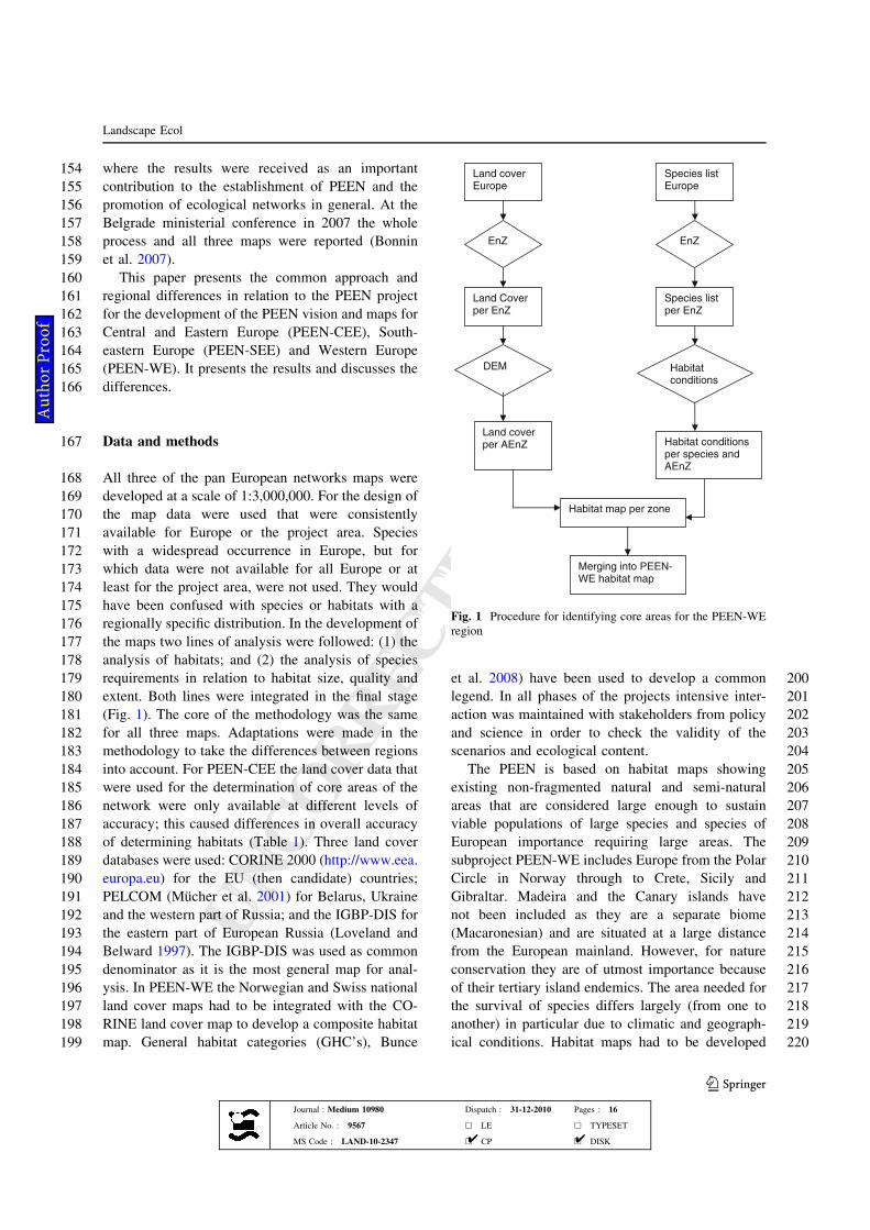
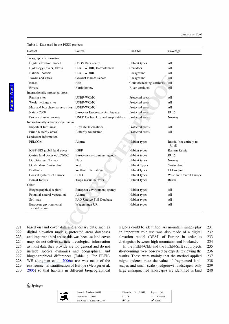
180 extent. Both lines were integrated in the final stage
181 (Fig. 1). The core of the methodology was the same
182 for all three maps. Adaptations were made in the
183 methodology to take the differences between regions
184 into account. For PEEN-CEE the land cover data that
185 were used for the determination of core areas of the
186 network were only available at different levels of
187 accuracy; this caused differences in overall accuracy
188 of determining habitats (Table 1). Three land cover
189 databases were used: CORINE 2000 (http://www.eea.
190 europa.eu) for the EU (then candidate) countries;
191 PELCOM (Mucher et al. 2001) for Belarus, Ukraine
192 and the western part of Russia; and the IGBP-DIS for
193 the eastern part of European Russia (Loveland and
194 Belward 1997). The IGBP-DIS was used as common
195 denominator as it is the most general map for anal-
196 ysis. In PEEN-WE the Norwegian and Swiss national
197 land cover maps had to be integrated with the CO-
198 RINE land cover map to develop a composite habitat
199 map. General habitat categories (GHC’s), Bunce
200et al. 2008) have been used to develop a common
201legend. In all phases of the projects intensive inter-
202action was maintained with stakeholders from policy
203and science in order to check the validity of the
204scenarios and ecological content.
205The PEEN is based on habitat maps showing
206existing non-fragmented natural and semi-natural
207areas that are considered large enough to sustain
208viable populations of large species and species of
209European importance requiring large areas. The
210subproject PEEN-WE includes Europe from the Polar
211Circle in Norway through to Crete, Sicily and
212Gibraltar. Madeira and the Canary islands have
213not been included as they are a separate biome
214(Macaronesian) and are situated at a large distance
215from the European mainland. However, for nature
216conservation they are of utmost importance because
217of their tertiary island endemics. The area needed for
218the survival of species differs largely (from one to
219another) in particular due to climatic and geograph-
220ical conditions. Habitat maps had to be developed
Land cover Europe
EnZ
Land Cover per EnZ
DEM
Land cover per AEnZ
Species list Europe
EnZ
Species list per EnZ
Habitatconditions
Habitat conditions per species and AEnZ
Habitat map per zone
Merging into PEEN-WE habitat map
Fig. 1 Procedure for identifying core areas for the PEEN-WE
region
Landscape Ecol
123
Journal : Medium 10980 Dispatch : 31-12-2010 Pages : 16
Article No. : 9567 h LE h TYPESET
MS Code : LAND-10-2347 h CP h DISK4 4
Au
tho
r P
ro
of
UNCORRECTEDPR
OOF
UNCORRECTEDPR
OOF
221 based on land cover data and ancillary data, such as
222 digital elevation models, protected areas databases
223 and important bird areas; this was because land cover
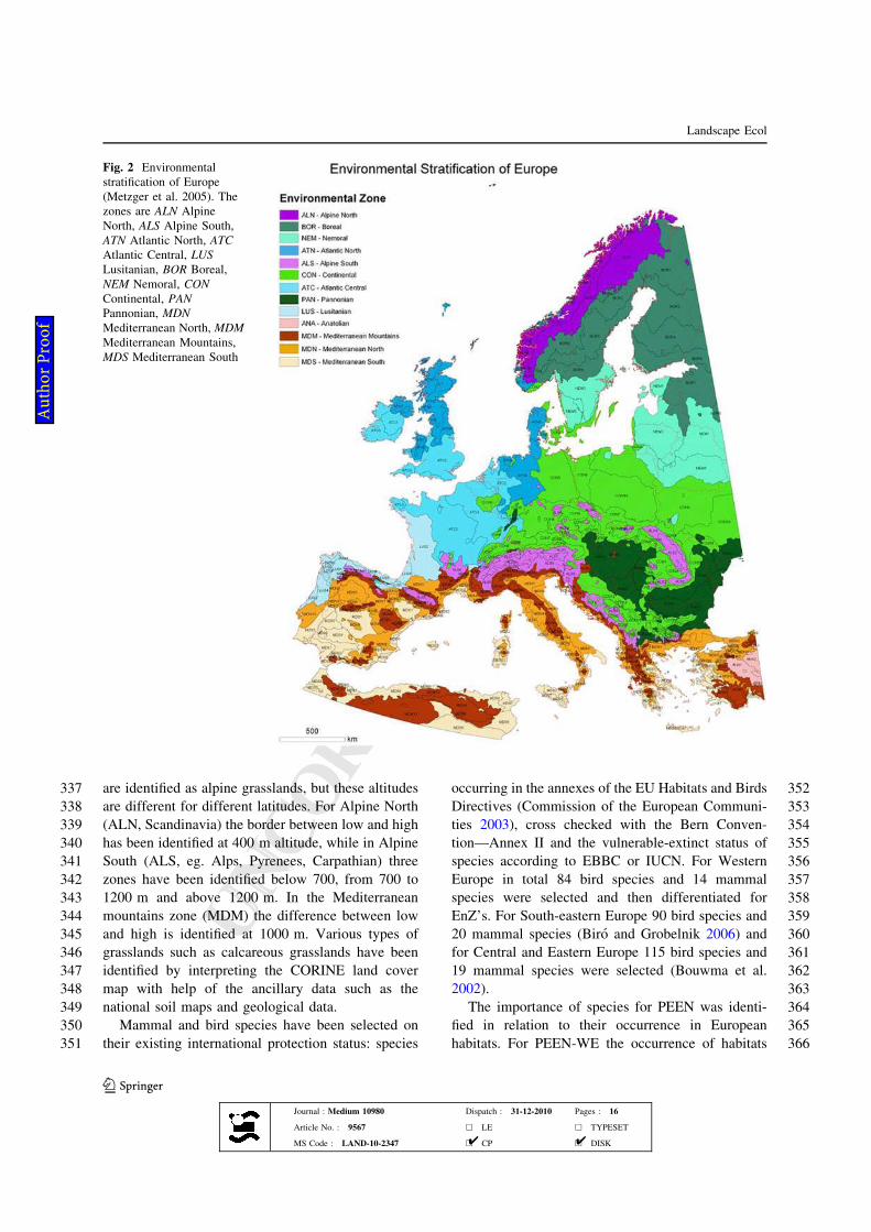
224 maps do not deliver sufficient ecological information
225 as most data they provide are too general and do not
226 include species dynamics and geographical and
227 biogeographical differences (Table 1). For PEEN-
228 WE (Jongman et al. 2006a) use was made of the
229 environmental stratification of Europe (Metzger et al.
230 2005) so that habitats in different biogeographical
231regions could be identified. As mountain ranges play
232an important role use was also made of a digital
233elevation model (DEM) of Europe in order to
234distinguish between high mountains and lowlands.
235In the PEEN-CEE and the PEEN-SEE subprojects
236shortcomings were observed by experts reviewing the
237results. These were mainly that the method applied
238might underestimate the value of fragmented land-
239scapes and small scale (hedgerow) landscapes; only
240large unfragmented landscapes are identified in land
Table 1 Data used in the PEEN projects
Dataset Source Used for Coverage
Topographic information
Digital elevation model USGS Data centre Habitat types All
Hydrology (rivers, lakes) ESRI, WDBII, Bartholomew Corridors All
National borders ESRI, WDBII Background All
Towns and cities GEOnet Names Server Background All
Roads ESRI Counterchecking corridors All
Rivers Bartholomew River corridors All
Internationally protected areas
Ramsar sites UNEP-WCMC Protected areas All
World heritage sites UNEP-WCMC Protected areas All
Man and biosphere reserve sites UNEP-WCMC Protected areas All
Natura 2000 European Environmental Agency Protected areas EU15
Protected areas norway UNEP On line GIS and map database Protected areas Norway
Internationally acknowledged areas
Important bird areas BirdLife International Protected areas All
Prime butterfly areas Butterfly foundation Protected areas All
Landcover information
PELCOM Alterra Habitat types Russia (not entirely to
Ural)
IGBP-DIS global land cover IGBP Habitat types Eastern Russia
Corine land cover (CLC2000) European environment agency Habitat types EU15
LC Database Norway Nijos Habitat types Norway
LC database Switzerland WSL Habitat Types Switzerland
Peatlands Wetland International Habitat types CEE-region
Coastal systems of Europe EUCC Habitat types West and Central Europe
Boreal forests Taiga rescue network Habitat types Russia
Other
Biogeographical regions European environment agency Habitat types All
Potential natural vegetation Alterra Habitat types All
Soil map FAO-Unesco Soil Database Habitat types All
European environmental
stratification
Wageningen UR Habitat types All
Landscape Ecol
123
Journal : Medium 10980 Dispatch : 31-12-2010 Pages : 16
Article No. : 9567 h LE h TYPESET
MS Code : LAND-10-2347 h CP h DISK4 4
Au
tho
r P
ro
of
UNCORRECTEDPR
OOF
UNCORRECTEDPR
OOF
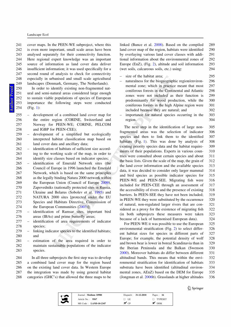
241 cover maps. In the PEEN-WE subproject, where this
242 is even more important, small scale areas have been
243 analysed separately for their connectivity function.
244 Here regional expert knowledge was an important
245 source of information as land cover data deliver
246 insufficient information; it was used specifically for a
247 second round of analysis to check for connectivity
248 especially in urbanised and small scale agricultural
249 landscapes (Denmark, Germany, The Netherlands).
250 In order to identify existing non-fragmented nat-
251 ural and semi-natural areas considered large enough
252 to sustain viable populations of species of European
253 importance the following steps were conducted
254 (Fig. 1):
255 – development of a combined land cover map for
256 the entire region (CORINE, Switzerland and
257 Norway for PEEN-WE; CORINE, PELCOM
258 and IGBP for PEEN-CEE);
259 – development of a simplified but ecologically
260 interpreted habitat classification map based on
261 land cover data and ancillary data;
262 – identification of habitats of sufficient size accord-
263 ing to the working scale of the map, in order to
264 identify size classes based on indicator species;
265 – identification of Emerald Network sites (the
266 Council of Europe in 1996 launched the Emerald
267 Network, which is based on the same principles
268 as the legally binding Natura 2000 network within
269 the European Union (Council of Europe 2009),
270 Zapovedniks (nationally protected sites in Russia,
271 Ukraine and Belarus (Sobolev et al. 1995) and
272 NATURA 2000 sites [protected under the EU
273 Species and Habitats Directive, Commission of
274 the European Communities (2003)];
275 – identification of Ramsar sites, important bird
276 areas (IBAs) and prime butterfly areas;
277 – identification of area requirements of indicator
278 species;
279 – linking indicator species to the identified habitats;
280 and
281 – estimation of the area required in order to
282 maintain sustainable populations of the indicator
283 species.
284 In all three subprojects the first step was to develop
285 a combined land cover map for the region based
286 on the existing land cover data. In Western Europe
287 the integration was made by using general habitat
288 categories (GHC’s) that allowed the three maps to be
289linked (Bunce et al. 2008). Based on the compiled
290land cover map of the region, habitats were identified
291by overlaying various land cover classes with addi-
292tional information about the environmental zones of
293Europe (EnZ), (Fig. 2), altitude and soil information
294(wet soils, calcareous soils, etc.) using:
295– size of the habitat area;
296– naturalness for the biogeographic region/environ-
297mental zone; which in practice meant that most
298coniferous forests in the Continental and Atlantic
299zones were not included as their function is
300predominantly for wood production, while the
301coniferous forests in the high Alpine region were
302included because they are natural; and
303– importance for natural species occurring in the
304region.
305The next step in the identification of large non-
306fragmented areas was the selection of indicator
307species and then to link them to the identified
308habitats (Fig. 1). This was done by analysis of
309existing priority species data and the habitat require-
310ments of their populations. Experts in various coun-
311tries were consulted about certain species and about
312the basic lists. Given the scale of the map, the grain of
313the land cover information and the available species
314data, it was decided to consider only larger mammal
315and bird species as possible indicator species for
316PEEN-WE and PEEN-SEE. Migrating fish were
317included for PEEN-CEE through an assessment of
318the accessibility of rivers and the presence of existing
319barriers. In PEEN-SEE they have not been included;
320in PEEN-WE they were substituted by the occurrence
321of natural, non-regulated larger rivers that are con-
322sidered as a proxy for the existence of migrating fish
323(in both subprojects these measures were taken
324because of a lack of harmonised European data).
325For PEEN-WE it was possible to use the European
326environmental stratification (Fig. 2) to select differ-
327ent habitat sizes for species in different parts of
328Europe; for example, the potential density of wolf
329and brown bear is lower in boreal Scandinavia than in
330the Iberian Peninsula and the Balkan (Swenson
3312000). Moreover habitats do differ between different
332altitudinal bands. This means that within the envi-
333ronmental stratification for identification of habitats
334substrata have been identified (altitudinal environ-
335mental zones, AEnZ) based on the DEM for Europe
336(Jongman et al. 2006b). Grasslands at higher altitudes
Landscape Ecol
123
Journal : Medium 10980 Dispatch : 31-12-2010 Pages : 16
Article No. : 9567 h LE h TYPESET
MS Code : LAND-10-2347 h CP h DISK4 4
Au
tho
r P
ro
of
UNCORRECTEDPR
OOF
UNCORRECTEDPR
OOF
337 are identified as alpine grasslands, but these altitudes
338 are different for different latitudes. For Alpine North
339 (ALN, Scandinavia) the border between low and high
340 has been identified at 400 m altitude, while in Alpine
341 South (ALS, eg. Alps, Pyrenees, Carpathian) three
342 zones have been identified below 700, from 700 to
343 1200 m and above 1200 m. In the Mediterranean
344 mountains zone (MDM) the difference between low
345 and high is identified at 1000 m. Various types of
346 grasslands such as calcareous grasslands have been
347 identified by interpreting the CORINE land cover
348 map with help of the ancillary data such as the
349 national soil maps and geological data.
350 Mammal and bird species have been selected on
351 their existing international protection status: species
352occurring in the annexes of the EU Habitats and Birds
353Directives (Commission of the European Communi-
354ties 2003), cross checked with the Bern Conven-
355tion—Annex II and the vulnerable-extinct status of
356species according to EBBC or IUCN. For Western
357Europe in total 84 bird species and 14 mammal
358species were selected and then differentiated for
359EnZ’s. For South-eastern Europe 90 bird species and
36020 mammal species (Biro and Grobelnik 2006) and
361for Central and Eastern Europe 115 bird species and
36219 mammal species were selected (Bouwma et al.
3632002).
364The importance of species for PEEN was identi-
365fied in relation to their occurrence in European
366habitats. For PEEN-WE the occurrence of habitats
Fig. 2 Environmental
stratification of Europe
(Metzger et al. 2005). The
zones are ALN Alpine
North, ALS Alpine South,
ATN Atlantic North, ATC
Atlantic Central, LUS
Lusitanian, BOR Boreal,
NEM Nemoral, CON
Continental, PAN
Pannonian, MDN
Mediterranean North, MDM
Mediterranean Mountains,
MDS Mediterranean South
Landscape Ecol
123
Journal : Medium 10980 Dispatch : 31-12-2010 Pages : 16
Article No. : 9567 h LE h TYPESET
MS Code : LAND-10-2347 h CP h DISK4 4
Au
tho
r P
ro
of
UNCORRECTEDPR
OOF
UNCORRECTEDPR
OOF
367 was specified for EnZ’s (Table 2). Within these zones
368 species were linked to habitat types including the
369 threshold estimated for survival of a population per
370 region (Table 3). All the threshold areas were iden-
371 tified for the environmental zones and later merged
372 into the joint legend for European habitats as there
373 are differences in carrying capacity between boreal
374 and mediterranean regions.
375 The size thresholds for different habitat areas were
376 determined to support sustainable populations accord-
377 ing to a number of steps. First species were linked to
378 the identified habitat type and habitat types were
379 identified for each EnZ. Then standards were assigned
380 to each species based on the minimum population size
381 considered large enough to be sustainable in the long-
382 term. This allowed the minimum size of the areas
383 needed to support viable populations of all selected
384 species, per habitat type, to be estimated (Table 3).
385 For determining the viability of species different
386 thresholds in area size per habitat type were set,
387 related to estimated population size. ‘Very large
388 areas’ are defined as: ‘‘greater than five times the
389 minimum area required to make the long-term
390 survival of all populations of the selected species
391 quite probable’’. ‘Large areas’ (defined as: ‘‘two times
392the minimum area required to make the long-term
393survival of all populations of the selected species quite
394probable’’) make it possible for the present population
395of the selected species to occur in that location.
396However, when isolated, these areas may suffer
397the loss of some species and immigration might be
398required; connection to other areas or area enlarge-
399ment is therefore recommended. Areas with a sub-
400optimal size were estimated to maintain a maximum
401of 70% of the selected species populations; the most
402demanding species can only be maintained or restored
403by either enlarging habitat size or by making con-
404nections with comparable habitats by corridors,
405or both.
406The required minimum area sizes (considered as
407sub-optimal for the various habitats) range from:
40850 km2 for wetlands, peat lands and grasslands; to
409300 km2 for different types of forests. Habitat area
410size has been calculated in three classes. The spatial
411patterns of habitat types that exceed each of the
412thresholds were assessed in a GIS analysis.
413The identification of corridors for the pan-Euro-
414pean ecological network in PEEN-CEE was based on
415the location of forested landscapes, known bird
416migration routes, mountain ranges and river related
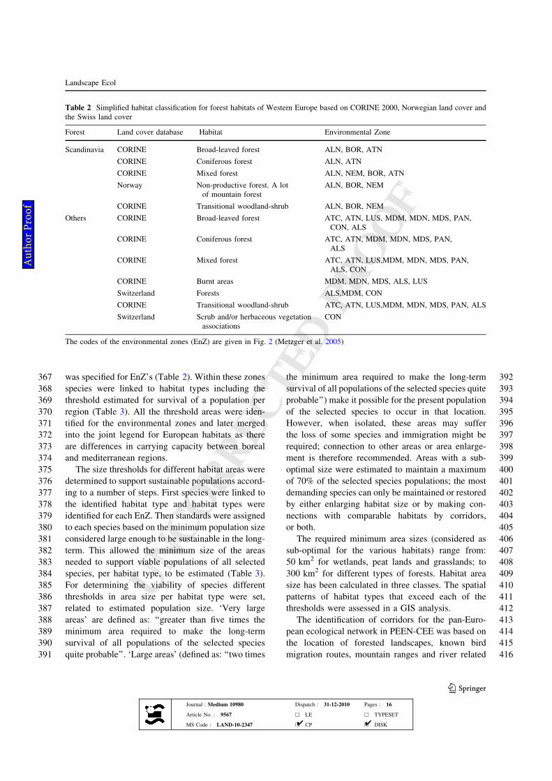
Table 2 Simplified habitat classification for forest habitats of Western Europe based on CORINE 2000, Norwegian land cover and
the Swiss land cover
Forest Land cover database Habitat Environmental Zone
Scandinavia CORINE Broad-leaved forest ALN, BOR, ATN
CORINE Coniferous forest ALN, ATN
CORINE Mixed forest ALN, NEM, BOR, ATN
Norway Non-productive forest. A lot
of mountain forest
ALN, BOR, NEM
CORINE Transitional woodland-shrub ALN, BOR, NEM
Others CORINE Broad-leaved forest ATC, ATN, LUS, MDM, MDN, MDS, PAN,
CON, ALS
CORINE Coniferous forest ATC, ATN, MDM, MDN, MDS, PAN,
ALS
CORINE Mixed forest ATC, ATN, LUS,MDM, MDN, MDS, PAN,
ALS, CON
CORINE Burnt areas MDM, MDN, MDS, ALS, LUS
Switzerland Forests ALS,MDM, CON
CORINE Transitional woodland-shrub ATC, ATN, LUS,MDM, MDN, MDS, PAN, ALS
Switzerland Scrub and/or herbaceous vegetation
associations
CON
The codes of the environmental zones (EnZ) are given in Fig. 2 (Metzger et al. 2005)
Landscape Ecol
123
Journal : Medium 10980 Dispatch : 31-12-2010 Pages : 16
Article No. : 9567 h LE h TYPESET
MS Code : LAND-10-2347 h CP h DISK4 4
Au
tho
r P
ro
of
UNCORRECTEDPR
OOF
UNCORRECTEDPR
OOF
417 wetlands. All corridors were discussed with regional
418 experts. For PEEN-WE corridors were based on:
419 – bird migration routes;
420 – the need for connectivity between core areas,
421 based on their size required to support the
422 connectivity needs of mobile species that had
423 been identified as related to the habitat;
424 – relative forest density per km2 in areas between
425 large habitat blocks and smaller areas and
426 between small habitat blocks based on forest
427 presence in the land cover map;
428 – location of hedgerow landscapes (small scale farm-
429 ing areas) based on expert information and situated
430 mainly in CORINE land cover classes 20, 21, 22—
431 that include small scale agricultural landscapes
432 potentially functioning as corridors between core
433 areas;
434 – location of mountain ranges (part of habitat
435 classes);
436 – location of natural or semi-natural rivers;
437– expert judgment (project members and consulted
438experts); and
439– comparison with existing national networks (core
440areas and corridors).
441Results
442PEEN project has resulted in three maps: the map for
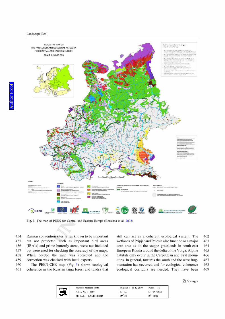
443Central and Eastern Europe (PEEN-CEE), (Fig. 3);
444the map of South-eastern Europe (PEEN-SEE),
445(Fig. 4); and the map of Western Europe (PEEN-
446WE), (Fig. 5). All three maps have a comparable
447legend showing the three categories for habitat size
448needed for population survival (marginal, 100%,
449greater than five times population size). In all three
450maps existing protected areas have been included
451such as: Zapovedniks in Russia, Belarus and Ukraine;
452Natura 2000 (European Union); and Emerald sites
453(Berne Convention outside European Union); official
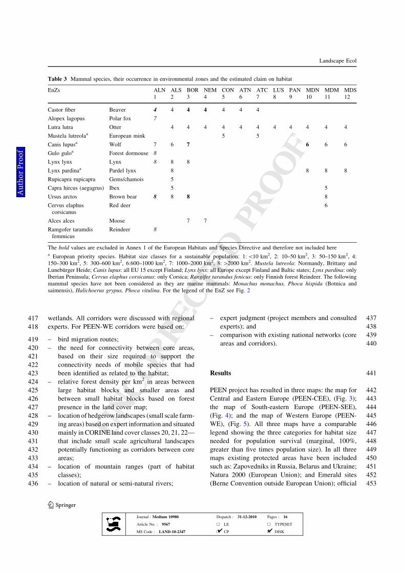
Table 3 Mammal species, their occurrence in environmental zones and the estimated claim on habitat
EnZs ALN ALS BOR NEM CON ATN ATC LUS PAN MDN MDM MDS
1 2 3 4 5 6 7 8 9 10 11 12
Castor fiber Beaver 4 4 4 4 4 4 4
Alopex lagopus Polar fox 7
Lutra lutra Otter 4 4 4 4 4 4 4 4 4 4 4
Mustela lutreolaa European mink 5 5
Canis lupusa Wolf 7 6 7 6 6 6
Gulo guloa Forest dormouse 8
Lynx lynx Lynx 8 8 8
Lynx pardinaa Pardel lynx 8 8 8 8
Rupicapra rupicapra Gems/chamois 5
Capra hircus (aegagrus) Ibex 5 5
Ursus arctos Brown bear 8 8 8 8
Cervus elaphus
corsicanus
Red deer 6
Alces alces Moose 7 7
Ramgofer taramdis
femmicus
Reindeer 8
The bold values are excluded in Annex 1 of the European Habitats and Species Directive and therefore not included herea European priority species. Habitat size classes for a sustainable population: 1:\10 km2, 2: 10–50 km2, 3: 50–150 km2, 4:
150–300 km2, 5: 300–600 km2, 6:600–1000 km2, 7: 1000–2000 km2, 8:[2000 km2. Mustela lutreola: Normandy, Brittany and
Luneburger Heide; Canis lupus: all EU 15 except Finland; Lynx lynx: all Europe except Finland and Baltic states; Lynx pardina: only
Iberian Peninsula; Cervus elaphus corsicanus: only Corsica; Rangifer tarandus fenicus: only Finnish forest Reindeer. The following
mammal species have not been considered as they are marine mammals: Monachus monachus, Phoca hispida (Botnica and
saimensis), Halichoerus grypus, Phoca vitulina. For the legend of the EnZ see Fig. 2
Landscape Ecol
123
Journal : Medium 10980 Dispatch : 31-12-2010 Pages : 16
Article No. : 9567 h LE h TYPESET
MS Code : LAND-10-2347 h CP h DISK4 4
Au
tho
r P
ro
of
UNCORRECTEDPR
OOF
UNCORRECTEDPR
OOF
454 Ramsar convention sites. Sites known to be important
455 but not protected, such as important bird areas
456 (IBA’s) and prime butterfly areas, were not included
457 but were used for checking the accuracy of the maps.
458 When needed the map was corrected and the
459 correction was checked with local experts.
460 The PEEN-CEE map (Fig. 3) shows ecological
461 coherence in the Russian taiga forest and tundra that
462still can act as a coherent ecological system. The
463wetlands of Pripjat and Polesia also function as amajor
464core area as do the steppe grasslands in south-east
465European Russia around the delta of the Volga. Alpine
466habitats only occur in the Carpathian and Ural moun-
467tains. In general, towards the south and the west frag-
468mentation has occurred and for ecological coherence
469ecological corridors are needed. They have been
Fig. 3 The map of PEEN for Central and Eastern Europe (Bouwma et al. 2002)
Landscape Ecol
123
Journal : Medium 10980 Dispatch : 31-12-2010 Pages : 16
Article No. : 9567 h LE h TYPESET
MS Code : LAND-10-2347 h CP h DISK4 4
Au
tho
r P
ro
of
UNCORRECTEDPR
OOF
UNCORRECTEDPR
OOF
470 indicated on the map by lines. Two types of corridors
471 are indicated: forested corridors; and river and wetland
472 corridors.
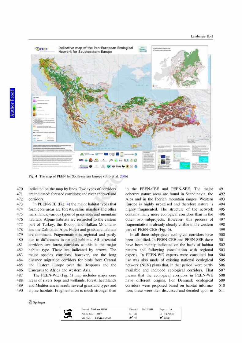
473 In PEEN-SEE (Fig. 4) the major habitat types that
474 form core areas are forests, saline marshes and other
475 marshlands, various types of grasslands and mountain
476 habitats. Alpine habitats are restricted to the eastern
477 part of Turkey, the Rodopi and Balkan Mountains
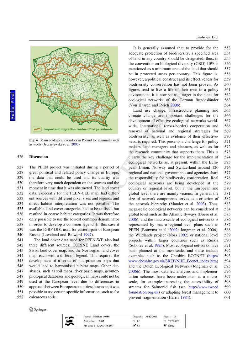
478 and the Dalmatian Alps. Forest and grassland habitats
479 are dominant. Fragmentation is regional and partly
480 due to differences in natural habitats. All terrestrial
481 corridors are forest corridors as this is the major
482 habitat type. These are indicated by arrows. The
483 major species corridors, however, are the long
484 distance migration corridors for birds from Central
485 and Eastern Europe over the Bosporus and the
486 Caucasus to Africa and western Asia.
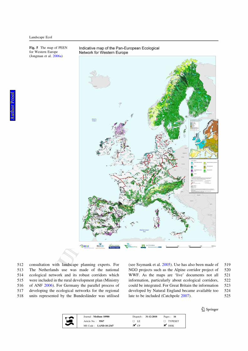
487 The PEEN-WE (Fig. 5) map includes major core
488 areas of rivers bogs and wetlands, forest, heathlands
489 and Mediterranean scrub, several grassland types and
490 alpine habitats. Fragmentation is much stronger than
491in the PEEN-CEE and PEEN-SEE. The major
492coherent nature areas are found in Scandinavia, the
493Alps and in the Iberian mountain ranges. Western
494Europe is highly urbanised and therefore nature is
495highly fragmented. The structure of the network
496contains many more ecological corridors than in the
497other two subprojects. However, this process of
498fragmentation is already clearly visible in the western
499part of PEEN-CEE (Fig. 6).
500In all three subprojects ecological corridors have
501been identified. In PEEN-CEE and PEEN-SEE these
502have been mainly indicated on the basis of habitat
503pattern and following consultation with regional
504experts. In PEEN-WE experts were consulted but
505use was also made of existing national ecological
506network (NEN) plans that, in that period, were partly
507available and included ecological corridors. That
508means that the ecological corridors in PEEN-WE
509have different origins. For Denmark ecological
510corridors were proposed based on habitat informa-
511tion; these were then discussed and decided upon in
Fig. 4 The map of PEEN for South-eastern Europe (Biro et al. 2006)
Landscape Ecol
123
Journal : Medium 10980 Dispatch : 31-12-2010 Pages : 16
Article No. : 9567 h LE h TYPESET
MS Code : LAND-10-2347 h CP h DISK4 4
Au
tho
r P
ro
of
UNCORRECTEDPR
OOF
UNCORRECTEDPR
OOF
512 consultation with landscape planning experts. For
513 The Netherlands use was made of the national
514 ecological network and its robust corridors which
515 were included in the rural development plan (Ministry
516 of ANF 2006). For Germany the parallel process of
517 developing the ecological networks for the regional
518 units represented by the Bundeslander was utilised
519(see Ssymank et al. 2005). Use has also been made of
520NGO projects such as the Alpine corridor project of
521WWF. As the maps are ‘live’ documents not all
522information, particularly about ecological corridors,
523could be integrated. For Great Britain the information
524developed by Natural England became available too
525late to be included (Catchpole 2007).
Fig. 5 The map of PEEN
for Western Europe
(Jongman et al. 2006a)
Landscape Ecol
123
Journal : Medium 10980 Dispatch : 31-12-2010 Pages : 16
Article No. : 9567 h LE h TYPESET
MS Code : LAND-10-2347 h CP h DISK4 4
Au
tho
r P
ro
of
UNCORRECTEDPR
OOF
UNCORRECTEDPR
OOF
526 Discussion
527 The PEEN project was initiated during a period of
528 great political and related policy change in Europe;
529 the data that could be used and its quality was
530 therefore very much dependent on the sources and the
531 moment in time that it was abstracted. The land cover
532 data, especially for the PEEN-CEE map, had differ-
533 ent sources with different pixel sizes and legends and
534 direct habitat interpretation was not possible. The
535 available land cover categories had to be utilised, but
536 resulted in coarse habitat categories. It was therefore
537 only possible to use the lowest common denominator
538 in order to develop a common legend. In this case it
539 was the IGBP-DIS, used for eastern part of European
540 Russia (Loveland and Belward 1997).
541 The land cover data used for PEEN-WE also had
542 three different sources: CORINE Land cover; the
543 Swiss land cover map; and the Norwegian land cover
544 map, each with a different legend. This required the
545 development of a series of interpretation steps that
546 would lead to harmonised habitat maps. Other dat-
547 abases, such as soil maps, river basin maps, geomor-
548 phological databases and geological maps could not be
549 used at the European level due to differences in
550 approach betweenEuropean countries; however, it was
551 possible to use certain specific information, such as for
552 calcareous soils.
553It is generally assumed that to provide for the
554adequate protection of biodiversity, a specified area
555of land in any country should be designated; thus, in
556the convention on biological diversity (CBD) 10% is
557mentioned as a minimum area of the land that should
558be in protected areas per country. This figure is,
559however, a political construct and its effectiveness for
560biodiversity conservation has not been proven. As
561figures tend to live a life of their own in a policy
562environment, it is now set as a target in the plans for
563ecological networks of the German Bundeslander
564(Von Haaren and Reich 2006).
565Land use change, infrastructure planning and
566climate change are important challenges for the
567development of effective ecological networks world-
568wide. International (cross-border) cooperation and
569renewal of national and regional strategies for
570biodiversity, as well as evidence of their effective-
571ness, is required. This presents a challenge for policy
572makers, land managers and planners, as well as for
573the research community that supports them. This is
574clearly the key challenge for the implementation of
575ecological networks as, at present, within the Euro-
576pean Union, Norway and Switzerland around 120
577regional and national governments and agencies share
578the responsibility for biodiversity conservation. Real
579ecological networks are being developed at the
580country or regional level, but at the European and
581global level there are mainly visions. In general the
582size of network components serves as a criterion of
583the network hierarchy (Mander et al. 2003). Thus,
584mega-scale ecological networks can be considered at
585global level such as the Atlantic flyways (Boere et al.
5862006); and the macro-scale of ecological networks is
587represented by macro-regional-level plans such as
588PEEN (Bouwma et al. 2002; Jongman et al. 2006),
589the Wildlands project (Noss 1992) or national level
590projects within larger countries such as Russia
591(Sobolev et al. 1995). Most ecological networks have
592been planned at the mesoscale, and these include
593examples such as the Cheshire ECONET (http://
594www.cheshire.gov.uk/SREP/NHE_Econet_index.htm)
595and the Dutch Ecological Network (Jongman et al.
5962006b). The most detailed analyses and implemen-
597tation schemes have been undertaken at a micro-
598scale, for example increasing the accessibility of
599streams for Salmonid fish (see http://www.tweed
600foundation.org.uk) or adapting forest management to
601prevent fragmentation (Harris 1984).
Fig. 6 Main ecological corridors in Poland for mammals such
as wolfs (Jedrzejewski et al. 2005)
Landscape Ecol
123
Journal : Medium 10980 Dispatch : 31-12-2010 Pages : 16
Article No. : 9567 h LE h TYPESET
MS Code : LAND-10-2347 h CP h DISK4 4
Au
tho
r P
ro
of
UNCORRECTEDPR
OOF
UNCORRECTEDPR
OOF
602 PEEN does fulfil a role in developing a vision for
603 coherence in natural habitats for Europe, The Con-
604 vention on Migratory Species (CMS) aims to con-
605 serve migratory species throughout their range. One
606 of the agreements under the aegis of the CMS focuses
607 on ‘African–Eurasian Migrant Waterbirds’. The fly-
608 ways of birds as a whole must be considered as
609 ecological networks linking Siberian, European and
610 African wetlands. Flyways are defined as: the entire
611 range of a migratory bird species (or groups of related
612 species or distinct populations of a single species)
613 through which it moves on an annual basis from the
614 breeding grounds to non-breeding areas, including
615 intermediate resting and feeding places as well as the
616 area within which the birds migrate (Boere et al.
617 2006). This links Siberian and Greenland habitats to
618 those in Western Europe and Africa and, in this way,
619 emphasizes the importance of coherency in European
620 nature. PEEN gives that coherency a territorial basis.
621 At the pan-European level, the convention on the
622 conservation of European wildlife and natural habi-
623 tats (Bern convention, adopted in 1979) binds con-
624 tracting parties to the protection of habitats and
625 species of European concern and promotes cooper-
626 ation between countries for the protection of migra-
627 tory species. The recommendation, adopted within
628 the convention, on the conservation of natural areas
629 outside protected areas specifically addresses these
630 issues (Recommendation 25, adopted in 1991). It
631 encourages the conservation and, where necessary,
632 the restoration of ecological corridors, habitat types
633 and landscape features that are important for wildlife
634 conservation.
635 Connectivity can have several forms. It can be
636 flyways as for migratory birds including stepping
637 stones, but also terrestrial or river corridors. The most
638 obvious terrestrial corridors are forest corridors, but
639 they can also exist as wetland/river related corridors
640 or mountain corridors.
641 The Species and Habitats Directive and the Birds
642 Directive form the main legal framework for pro-
643 tecting nature and biodiversity in the EU; together
644 they implement some of the international require-
645 ments outlined above, including the Bern convention
646 (Commission of the European Communities 2007).
647 Article 3 of the Habitats Directive states that ‘‘where
648 they consider it necessary, member states shall
649 endeavour to improve the ecological coherence of
650 Natura 2000 by maintaining, and where appropriate
651developing, features of the landscape which are of
652major importance for wild fauna and flora, as referred
653to in Article 10’’.
654Connectivity is considered a task of national or
655regional competent authorities. It is recognised that
656the implementation of connectivity measures may be
657constrained by the lack of detailed knowledge of the
658ecological requirements of species and habitats.
659Article 18 of the Habitats Directive therefore calls
660for research and exchange of information. It specif-
661ically states that: ‘‘Particular attention shall be paid to
662scientific work necessary for the implementation of
663Articles 3 and 10, and transboundary co-operative
664research between member states shall be encour-
665aged’’. Conservation actions under other EU legisla-
666tion may also help to deliver connectivity measures
667required under the Birds and Habitats Directives. In
668particular, the Water Framework Directive (WFD)
669includes measures, such as the development of river
670basin management plans that will help to maintain and
671restore connectivity in the wider environment (Com-
672mission of the European Communities 2007). How-
673ever, this also means that no authority has the
674responsibility for continental European corridors.
675Their development depends solely on the willingness
676of countries and regions to cooperate. This is not an
677effective approach as countries have an inside focus
678and there is no incentive for European cooperation.
679National and regional ecological networks are always
680defined and constructed within a complex interaction
681of specific political, social, economic, and natural
682conditions resulting in specific cultural traditions.
683Thus, perceptions of nature and interpretations of the
684same words differ across borders. The key is therefore
685to focus on interactions that might occur between
686regions, levels, hierarchies, organisations, NGOs, and
687departments. A European initiative is needed for the
688implementation ecological connectivity at the Euro-
689pean level as national initiatives will only cross one
690border and do not have a European view.
691A further complication of present conservation
692policy is that, although the EU Habitats Directive
693recognises that priority habitats and species need to
694be conserved, it does not provide any accommodation
695for the changes that can take place to ecosystems over
696time, through succession and inherent ecosystem
697dynamics (Evans 2006), and does not give guidelines
698for the design of ecological corridors. Some research
699has been done on how species respond to the
Landscape Ecol
123
Journal : Medium 10980 Dispatch : 31-12-2010 Pages : 16
Article No. : 9567 h LE h TYPESET
MS Code : LAND-10-2347 h CP h DISK4 4
Au
tho
r P
ro
of
UNCORRECTEDPR
OOF
UNCORRECTEDPR
OOF
700 cumulative effects of land use and climate change
701 (Devictor et al. 2008). Site-based conservation strat-
702 egies, whether local or linked to the Natura 2000
703 network, may not be written to provide a response to
704 such challenges. A shifting climate could result in
705 species extinctions within designated areas or move-
706 ment of species populations towards sites not opti-
707 mally designed for the delivery of conservation
708 objectives or within other countries. Well designed
709 ecological corridors are therefore also required for
710 the ecological network of Europe and the first studies
711 have been carried out (Vos et al. 2008).
712 Ecological corridors can be designed or make use
713 of existing landscape structures. However, proof is
714 needed that these structures might function as such.
715 For many centuries transhumance has existed in
716 Europe as part of the agricultural system (Bunce et al.
717 2004). For Spain this has resulted in a network of
718 north–south drove roads (Canadas), hundreds of
719 kilometres in length, which have been functioning
720 as corridors for species and propagules (Manzano
721 et al. 2005). In the framework of the PEEN-WE
722 project a study has been carried out on the role of the
723 Canadas as north–south corridors, but so far no
724 conclusions could be drawn in relation to their actual
725 function as their condition is unknown (Bunce et al.
726 2006). Part are still functioning, part have changed
727 their function. They have therefore not been included.
728 Corridors are being developed at the national level
729 and terrestrial ecological corridors at the European
730 level only exist at the conceptual level of PEEN.
731 Ecological corridors are being developed for national
732 purposes (Fig. 7). Initiatives however do exist to
733 coordinate within countries (between regions) and
734 between countries; as is evident from the outcomes of
735 the Vilm meeting (Ssymank et al. 2005) and the
736 Bialowieza meeting (Jedrzejewski and Jedrzejewski
737 2008) which convened in order to explore such
738 issues.
739 The different levels of implementation of ecolog-
740 ical networks imply that data requirements are
741 different and that different parties are involved as
742 stakeholders. For ecological networks to be imple-
743 mented the inclusion of the right stakeholders at the
744 right level is therefore essential. For the international,
745 European level agreements equivalent to those for
746 flyways do not yet exist, but they are needed. Success
747 in biodiversity conservation and sustainable develop-
748 ment requires not only that a diverse range of
749planning initiatives should be developed for the
750design and management, in this case specifically of
751ecological networks, but also that a range of stake-
752holders and land use and management interests
753should be involved.
754Conclusion
755The PEEN project was successful in reaching its goal
756to promote the idea of a pan-European vision of
757biodiversity conservation through a European eco-
758logical network. However, there are three important
759challenges for the further development of a coherent
760ecological network. Knowledge transfer is needed as
761well as new knowledge especially in relation to the
762impact of changing environmental and land use
763conditions on species and habitats in the wider
764countryside. Climate and global change will affect
765the patterns of many ecological and other relation-
766ships in the landscape, potentially leading to a level
767of complexity that may prove intractable and difficult
768to resolve. Research on changing population patterns
769in relation to landscape permeability should be
770directed towards the provision of essential knowledge
771needed for the limitation and prevention of irrevers-
772ible damage, adaptation and mitigation measures. In
773the present situation, where countries are pursuing
774national initiatives at the expense of international and
775cross boundary cooperation, the major problem is that
776European ecological corridors are not being devel-
777oped; a situation that is only exacerbated because
778there is presently no responsible institution or coor-
779dination mechanism in place. That means that
780coherence between countries and regions is hard to
781realise in practice.
782Developing connectivity is one of the recommen-
783dations of the CBD Conference of Parties in Nagoya
784(Japan) in October 2010. Ecological networks need to
785be developed at the field and regional scales, and at
786the national and trans-national scales. Monitoring
787habitat diversity, and not just connectivity, is a key
788element in any biodiversity strategy for agricultural
789landscapes. Quantifying the economic benefits of
790ecological networks and making them explicit
791through interdisciplinary research and integrated
792long-term research on the social, economic and
793ecological mechanisms that maintain biodiversity
794and its ecological services is a clear necessity.
Landscape Ecol
123
Journal : Medium 10980 Dispatch : 31-12-2010 Pages : 16
Article No. : 9567 h LE h TYPESET
MS Code : LAND-10-2347 h CP h DISK4 4
Au
tho
r P
ro
of
UNCORRECTEDPR
OOF
UNCORRECTEDPR
OOF
795 Acknowledgments The preparation of an indicative PEEN796 maps started in 1999, was finalised in 2006 and reported to the797 European Ministers of Environment in 2007. We acknowledge798 all those who made the work possible by funding it, the799 Ministry of Agriculture Nature and Food Quality of The800 Netherlands through its Policy Supporting Research801 Instrument, the Dutch BBI-MATRA fund, the Council of802 Europe and the Swiss Government. We also acknowledge the803 Walloon Government for their support as well as the national804 and international data providers that made the technical805 development of the maps possible, the Committee of Experts806 for the development of the Pan-European Ecological Network807 that supported the process from its inception, and the hundreds808 of policy advisors who have been consulted. We are also809 grateful to the stakeholders who made their knowledge and810 data available for this project. Without their willingness to811 support and contribute the project would have been impossible812 in the context of the complex situation in Europe that has813 prevailed throughout this decade.
814 References
815 Ahern JF (2004) Greenways in the USA, theory, trends and816 prospects. In: Jongman RHG, Pungetti GP (eds) Ecolog-817 ical networks and greenways, concept, design and818 implementation. Cambridge University Press, Cambridge,819 pp 34–55820 Bennett G (2004) Integrating biodiversity conservation and821 sustainable use, lessons learnt from ecological networks.822 IUCN Gland, Switzerland823 Bennet G, Wit P (2001) The development and application of824 ecological networks, a review of proposals. Lessons learnt825 from ecological networks. IUCN/AIDEnvironment,826 Amsterdam827 Biro E, Bouwma I, Grobelnik V (2006) Indicative map of the828 Pan European Ecological Network in South-eastern Eur-829 ope. Technical Background document, Tilburg, ECNC-830 European Centre for Nature Conservation, ECNC Tech-831 nical Report series832 Boere GC, Galbraith CA, Stroud DA (eds) (2006) Waterbirds833 around the world. The stationery office, Edinburgh, p 960834 Bonnin M, Bruszik A, Delbaere B, Lethier H, Richard D, Ri-835 entjes S, Van Uden G, Terry A (2007) The Pan European836 Ecological Network: taking stock. Counc Europe nat837 environ 146:116838 Bouwma IM, Jongman RHG Butovsky RO (2002) Indicative839 map of the pan-European ecological network for central840 and Eastern Europe. Technical background document.841 ECNC, Technical report series, Tilburg/Budapest, p 101842 Bunce RGH, Perez-Soba M, Jongman RHG, Gomez-Sal A,843 Herzog F Austad I (2004) Transhumance and biodiversity844 in European mountains. Report of the EU FP5 project845 Transhumount. IALE publication series nr 1. p 321846 Bunce RHG, De Aranzabal I, Schmitz MF, Pineda FD (2006)847 A review of the role of Drove Roads (Canadas) as eco-848 logical corridors. Alterra-report 1428849 Bunce RHG, Metzger MJ, Jongman RHG, Brandt J, de Blust850 G, Elena Rossello R, Groom GB, Halada L, Hofer G,851 Howard DC, Kovar P, Mucher CM, Padoa-Schioppa E,
852Paelinx D, Palo A, Perez-Soba M, Ramos IL, Roche P,853Skanes H, Wrbka T (2008) A standardized procedure for854surveillance and monitoring European habitats and pro-855vision of spatial data. Landscape Ecol 23:11–25856Catchpole R (2007) England Habitat Network Briefing Note,857Natural England, p 23858Commission of the European Communities (2003) Council859directive 92/43/EEC of 21 May 1992 on the conservation860of natural habitats and of wild fauna and flora. As861amended by the Accession Act of Austria, Finland and862Sweden (1995); Accession Act of the Czech Republic, the863Republic of Estonia, the Republic of Cyprus, the Republic864of Latvia, the Republic of Lithuania, the Republic of865Hungary, the Republic of Malta, the Republic of Poland,866the Republic of Slovenia and the Slovak Republic (2003)867and Council Directive 2006/105/EC 20 November 2006868adapting Directives 73/239/EEC, 74/557/EEC and 2002/86983/EC in the field of environment, by reason of the870accession of Bulgaria and Romania. http://eur-lex.871europa.eu/LexUriServ/LexUriServ.do?uri=CONSLEG:8721992L0043:20070101:EN:HTM873Commission of the European Communities (2007) Guidance874document on Article 6 (4) of the Habitat Directive’ 92/43/875EEC: Clarification of the concepts of: alternative solu-876tions, imperative reasons of overriding public interest,877compensatory measures, overall coherence, opinion of the878Commission. European Commission, Brussels879Council of Europe (1996) Pan-European biological and land-880scape diversity strategy. Nature and environment No 74.881Council of Europe Press, Strasbourg, p 50882Council of Europe (2009) The Emerald Network. Network of883areas of special conservation interest. Council of Europe,884Strasbourg. http://www.coe.int/t/dg4/cultureheritage/nature/885econetworks/Presentation_en.asp886Devictor V, Julliard R, Couvet D, Jiguet F (2008) Birds are887tracking climate warming, but not fast enough. Proc R Soc888B 275:2743–2748889Evans D (2006) The habitats of the European Union Habitats890Directive. Biol Env: Proc Royal Irish Acad 106b:167–891173892Harris LD (1984) The fragmented forest: island biogeography893theory and the preservation of biotic diversity. University894of Chicago Press, Chicago, p 229895Hepcan S, Coskun Hepkan C, Bouwma IM, Jongman RHG,896Ozkan B (2009) Ecological networks as a new way to897nature conservation in Turkey; a case study for Izmir898province. Landsc Urban Plan 90(3/4):143–155899Jedrzejewski B, Jedrzejewski W (2008) The influence of the900fragmentation of nature on populations of animals. Con-901ference proceedings: implementation of the concept of902ecological networks in Poland903Jedrzejewski W, Nowak S, Stachura K, Skierczynski M,904Mysłajek RW, Niedziałkowski K, Jedrzejewska B,905Wojcik JM, Zalewska H, Pilot M (2005) Projekt korytarzy906ekologicznych łaczacych Europejska Siec Natura 2000 w907Polsce. (Proprosal for ecological corridors linking Natura9082000). Phare Project PL0105.02 Implementation of the909European Ecological Network in Poland, p 86910Jongman RHG (2002) Homogenisation and fragmentation of911the European landscape: ecological consequences and912solutions. Landsc Urban Plan 58:211–221
Landscape Ecol
123
Journal : Medium 10980 Dispatch : 31-12-2010 Pages : 16
Article No. : 9567 h LE h TYPESET
MS Code : LAND-10-2347 h CP h DISK4 4
Au
tho
r P
ro
of
UNCORRECTEDPR
OOF
UNCORRECTEDPR
OOF
913 Jongman RHG, Pungetti GP (2004) Ecological networks and914 greenways, concept, design and implementation. Cam-915 bridge University Press, Cambridge916 Jongman RHG, Kulvik M, Kristiansen I (2004) European917 ecological networks and greenways. Landsc Urban Plan918 68:305–319919 Jongman RHG, Bouwma IM, Van Doorn A (2006a) Indicative920 map of the pan-European ecological network in Western921 Europe. Technical Background Document. Alterra Report922 1429, p 103923 Jongman RHG, Bunce RGH, Metzger MJ, Mucher CA,924 Howard DC, Mateus VL (2006b) A statistical environ-925 mental stratification of Europe: objectives and applica-926 tions. Landscape Ecol 21:409–419927 Kettunen M, Terry A, Tucker G, Jones A (2007) Guidance on928 the maintenance of landscape features of major impor-929 tance for wild flora and fauna—Guidance on the imple-930 mentation of Article 3 of the Birds Directive (79/409/931 EEC) and Article 10 of the Habitats Directive (92/43/932 EEC). Institute for European Environmental Policy933 (IEEP), London934 Loveland TR, Belward AS (1997) The IGBP-DIS global 1 km935 land cover data set, DISCover first results. Int J Remote936 Sens 18(5):3289–3295937 Mander U, Kulvik M, Jongman RHG (2003) Scaling in terri-938 torial ecological networks. Landschap 20(2):113–127939 Manzano P, Malo JE, Peco B (2005) Sheep gut passage and940 survival of Mediterranean shrub seeds. Seed Sci Res941 15(1):21–28942 Metzger MJ, Bunce RGH, Jongman RHG,Mucher CA,Watkins943 JW (2005) A statistical stratification of the environment of944 Europe. J Glob Ecol Biogeogr 14:549–563945 Ministry of Agriculture, Nature and Food Quality (2006)946 Agenda voor een vitaal platteland, Meerjarenprogramma947 2007–2013. Government document presented to the Par-948 liament, p 156949 Mucher CA, Champeaux JL, Steinnocher KT, Griguolo S,950 Wester K, Heunks C, Winiwater W, Kressler P, Goutorbe951 JP, ten Brink B, van Katwijk VF, Furberg O, Perdigao V,952 Nieuwenhuis GJA (2001) Development of a consistent
953methodology to derive land cover information on a954European scale from remote sensing for environmental955monitoring. The PELCOM report, p 160956Noss RF (1992) The wildlands project: land conservation957strategy. Wild Earth (Special Issue), 10–25958Phillips A (2003) Turning ideas on their head, the new para-959digm for protected areas. George Wright Forum 20:8–32960Rientjes S, Roumelioti K (2003) Support for ecological net-961works in European nature conservation, an indicative962social map. ECNC Technical report series, p 55963Rodoman BB (1974) Polarization of landscape as a manage964agent in protection of biosphere and recreational resour-965ces. In: Resursy, Sreda, Rasselenije Moscow, Nauka,966pp 150–162 (in Russian)967Scott DA, Rose PM (1996) Atlas of Anatidae populations in968Africa and Western Eurasia. Wetlands International Pub-969lication, Wageningen, p 41970Sobolev NA, Shvarts EA, Kreindlin ML, Mokievsky VO,971Zubakin VA (1995) Russia’s protected areas: a survey and972identification of development problems. Biodivers Con-973serv 4:964–983974Somma D, Aued MB, Bachman L (2004) The ecological975Networks development in the Yungas, Argentina: plan-976ning, economic and social aspects. In: Jongman RHG,977Pungetti G (eds) Ecological networks and greenways,978concept, design and implementation. Cambridge Univer-979sity Press, Cambridge, pp 251–269980Ssymank A, Balzer S, Ulrich K (2005) Biotopverbund und981Koharenz nach Artikel 10 der flora-fauna-habitat richtli-982nie; ergebnisse eines internationalen workshops auf der983Insel Vilm. Natursch Landsch 38(2):45–49984Swenson JE (2000) Action plan for the conservation of the985Brown Bear (Ursus arctos) in Europe group of experts on986conservation of large Carnivores, Oslo, p 9987Von Haaren C, Reich M (2006) The German way to greenways988and habitat networks. Landsc Urban Plan 76:7–22989Vos CC, Berry P, Opdam P, Baveco H, Nijhof B, O’Hanley J,990Bell C, Kuipers H (2008) Adapting landscapes to climate991change: examples of climate-proof ecosystem networks992and priority adaptation zones. J Appl Ecol 45:1722–1731
993
Landscape Ecol
123
Journal : Medium 10980 Dispatch : 31-12-2010 Pages : 16
Article No. : 9567 h LE h TYPESET
MS Code : LAND-10-2347 h CP h DISK4 4
Au
tho
r P
ro
of


