Embed Size (px)
Citation preview

AUTHORS
Yannick Callec � Institut Français du Pétrole,Direction Géologie-Géochimie-Géophysique,1-4 avenue du Bois Préau, F-92852 Rueil-Malmaison Cedex, France; present address:Bureau de Recherches Géologiques et Minières,Service GEO/GSO, 3 av. Claude Guillemin,45060 Orléans Cedex 2, France
Yannick Callec received an M.Sc. degree in geo-sciences from the University d’Orsay, Paris XI
The Orinoco turbidite system:Tectonic controls on sea-floormorphology and sedimentationYannick Callec, Eric Deville, Guy Desaubliaux, RogerGriboulard, Pascale Huyghe, Alain Mascle, GeorgesMascle, Mark Noble, Crelia Padron de Carillo, andJulien Schmitz
in 1996 and a Ph.D. from the Paris School of Minesin 2001. He joined the Institut Français duPétrole in 2002 doing research on the CARAMBAproject. Since 2003, he has worked as a sedi-mentologist in the Bureau de Recherche Géolo-gique et Minière for mapping projects and pe-troleum exploration in west Africa.
Eric Deville � Institut Français du Pétrole,Direction Géologie-Géochimie-Géophysique,1-4 avenue du Bois Préau, F-92852 Rueil-Malmaison Cedex, France; [email protected]
Eric Deville received an M.Sc. degree in geo-sciences from the Pierre and Marie Curie Uni-versity, Paris VI in 1983 and a Ph.D. from theUniversity of Chambery, France, in 1987. Hejoined Institut Français du Pétrole in 1990 doingresearch on a wide range of sedimentary basins,notably in the Alps. His main research interestsinclude deformation processes, thermicity, andfluid dynamics in convergent orogens and mudvolcanism and shale mobilization processes.
Guy Desaubliaux � Institut Français du Pét-role, Direction Géologie-Géochimie-Géophysique,1-4 avenue du Bois Préau, F-92852 Rueil-Malmaison Cedex, France; present address: Gazde France-Suez, 361, avenue du PresidentWilson, BP33, Saint Denis, France
Guy Desaubliaux worked for two decades atthe Institut Français du Pétrole as a sedimen-tologist. He joined Gaz de France in 2008 wherehe is now in charge of the coordination of re-search programs.
Roger Griboulard � Département de Géol-
ABSTRACT
Because of its location in an active margin context, the sand-rich Orinoco turbidite system is controlled morphologicallyand tectonically by the compressional structures of theBarbadosprism, and as a consequence, the sedimentation system doesnot exhibit a classic fan geometry. The sea-floor geometry be-tween the slope of the front of the Barbados prism and the slopeof the Guyanamargin induces the convergence of the turbiditechannels toward the abyssal plain at the front of the Barbadosaccretionary prism. Also, whereas in most passive margins theturbidite systems are commonly organized upstream to down-streamas canyon, then channel levee, then lobes, here, becauseof the control by active tectonics, the sedimentary system is or-ganized as channel levee, then canyons, then channelized lobes.In shallowwater, landward of the prism, the system has multi-ple sourceswith several distributaries, and progressively down-ward, the channel courses are more complex with frequentconvergences or divergences that are emphasized by the effectsof the undulating sea-floor morphologies. Erosional processesare almost absent in the upper part of the turbidite system shal-lower than 1500 m (4921 ft). Erosion along channels developsmostly between 2000 and 4000 m (6562 and 13,123 ft) ofwater depth, above the compressional structures of the Barba-dos prism. Incisions show irregular meandering and sinuouscourses in the low-relief segments and less sinuous courseswhere channels incise the structures. Larger incisions (canyons)are 3 km (1.9 mi) wide and 300 m (984 ft) deep. The occur-rence of different phases of successive incisions is responsible
ogie et Océanographie, URA CNRS 197, Uni-versité de Bordeaux-I, F-33000 Bordeaux Cedex,France
Roger Griboulard is a researcher and teacher atthe Bordeaux 1 University. His field of investiga-tion concerns sedimentology andmorphotectonics.
Copyright ©2010. The American Association of Petroleum Geologists. All rights reserved.
Manuscript received February 13, 2009; provisional acceptance April 2, 2009; revised manuscriptreceived May 30, 2009; 2nd revised manuscript received September 28, 2009; final acceptanceNovember 2, 2009.DOI:10.1306/11020909021
AAPG Bulletin, v. 94, no. 6 (June 2010), pp. 869–887 869
He participated in several studies about thesouth Barbados accretionary prism and the deepOrinoco turbidite system. He was the initiatorof the CARAMBA project.
Pascale Huyghe � Laboratoire de Géody-namique des Chaînes Alpines, UMR 5025,Université Joseph Fourier, F-38041 GrenobleCedex, France
Pascale Huyghe is a researcher and teacher atthe Grenoble 1 University. Her field of inves-tigation concerns tectonics and sedimentationon either onshore or offshore. She participatedon several studies about the south Barbadosaccretionary prism and its relationship with thedeep Orinoco turbidite system.
Alain Mascle � Institut Français du Pétrole,Direction Géologie-Géochimie-Géophysique,1-4 avenue du Bois Préau, F-92852 Rueil-Malmaison Cedex, France
Alain Mascle received his M.Sc. degree in ap-plied geophysics from the University of Paris VIin 1973, and his “Habilitation à Diriger desRecherches” from the University of Chambery-Savoie in 1998. He joined the Institut Françaisdu Pétrole (IFP) in 1973 as a geologist in chargeof the exploration of continental margins incollaboration with French oil companies. He movedto IFP in 1996 where he has been in chargeof different M.Sc. programs in both petroleumgeoscience and reservoir geoscience andengineering.
Georges Mascle � Département de Géolo-gie et Océanographie, URA CNRS 197, Uni-versité de Bordeaux-I, F-33000 Bordeaux Cedex,France
George Mascle is a professor at Joseph FourierGrenoble I University. He worked in many partsof the world, especially in Sicily and the Hima-layas, and he participated in many marinesurveys, notably in the Mediterranean Sea.
Mark Noble � Centre de Géosciences, UMR7619 Sisyphe, Mines ParisTech, Fontainebleau,France
Mark Noble received an M.Sc. degree in geo-physics from the University of Paris Diderot(Paris VII) in 1986 and a Ph.D. from the Institutde Physique du Globe de Paris in 1992. Hejoined the geophysics research team of MinesParisTech in 1992. His current research interestsinclude theoretical seismology, seismic wave
870 The Orinoco Turbidite System
for the development of morphologically correlative terraces inboth flanks of the canyons. This might be the consequence oftwomechanisms: the tectonic activity of the deformation frontcharacterized by progressive uplift and thrusting of recent sedi-ments, and the superimposition of the cycles of the Orinocoturbidite system. Piston-core surveys have demonstrated thatturbidite sediments moving through the channel and canyonsystemanddeposited in the abyssal plain aremostly coarse sandydeposits covered by recent pelagic planktonic-rich sedimenta-tion, which indicates that sand deposition slowed down duringthe postglacial sea level rise.
INTRODUCTION
The Orinoco turbidite system develops from the east Vene-zuela and Trinidad continental slope down to the Atlanticabyssal plain (Embley and Langseth, 1977; Belderson et al.,1984; Ercilla et al., 1998). Most of the recent sediments of thedeep Orinoco delta and the southern Barbados ridge complexoriginate from the South American continent and are sourcedby the Orinoco River (Herrera et al., 1981; Milliman et al.,1982;Meade, 1990;Warne et al., 2002; Aslan et al., 2003), plussome finematerial from the rivers of theGuyanamargin and theAmazon transported northwestward by the Guyana currentalong the South American shoreline. The Orinoco River con-tributed to turbidite sedimentation in the Atlantic abyssalplain during the late Miocene and has possibly contributedsince the Eocene (Wright, 1984; Beck et al., 1990; Diaz deGamero, 1996; Di Crocce et al., 1999). Early multibeam andseismic acquisitions imaged canyon incisions along the deepturbidite systemwhere the channels cross cut the frontal struc-tures of the southern Barbados accretionary prism (Biju-Duvalet al., 1982;Mascle et al., 1990).Coring surveys have evidencedthe sand-rich nature of this turbidite system, notably in the abys-sal plain in front of the Barbados tectonic prism and in somepiggyback basins above the prism (Faugères et al., 1991, 1993).
Geophysical data acquired during theCARAMBA (Carib-bean America Bathymetry) survey, with the French scientificO/V Atalante (65,000 km2 [25,097 mi2] of multibeam dataand backscattering imagery, 5300 km [3293 mi] of 6-tracetwo-dimensional seismic lines, and 3.5 kHz profiles), provideda wide coverage of the Orinoco turbidite system with the ex-ception of the very upper continental slope and themore distalzones in the Atlantic abyssal plain (Figure 1). These datacoupled with the sampling of new Kullenberg piston cores(Figure 2) allow a better understanding of the whole recent
propagation, and tomography to characterize thenear subsurface.
Crelia Padron de Carillo � Institut Fran-çais du Pétrole, Direction Géologie-Géochimie-Géophysique, 1-4 avenue du Bois Préau, F-92852Rueil-Malmaison Cedex, France; Laboratoirede Géodynamique des Chaînes Alpines, UMR5025, Université Joseph Fourier, F-38041 Gre-noble Cedex, France; present address: Departa-
depositional system and of the structure of the area.We presenthere themain results illustrating how the tectonic activity of theBarbados accretionary prism controlled the sea-floor morphol-ogy and hence the turbidite sedimentation. This example of arecent deep-water tectonically controlled turbidite systemcan be used as an analog for the study of ancient and buriedsystems developed in active tectonic areas, including passivemargins with mobile substrata.
mento de Ciencias de la Tierra, UniversidadSimón Bolívar (USB), Apartado 89000, Valle deSartenejas, Baruta. Edo. Miranda, Venezuela
Crelia Padrón de Carrillo received her B.Sc.degree in geophysics engineering from the Cen-tral University of Venezuela in 1997, an M.Sc.degree in science of the Earth from the CentralUniversity of Venezuela in 2002, and a Ph.D.from Joseph Fourier Grenoble 1 University, France,in 2007. She worked in PDVSA Explorationfrom 1996 to 2002. Her experience is in seismicinterpretation focusing on exploration projectsfor the oil and gas industry, and her main re-search interests include tectonics and sedi-mentation and integration geophysics data. Since2006, she has been a professor of geophysicsand seismic interpretation for undergraduate andgraduate students at Simon Bolivar University.
Julien Schmitz � Institut Français du Pétrole,Direction Géologie-Géochimie-Géophysique,1-4 avenue du Bois Préau, F-92852 Rueil-Malmaison Cedex, France
Julien Schmitz joined the Institut Français duPétrole in 1996. He participated in many ma-rine surveys. His expertise during the CARAMBAproject was in multibeam data processing andinterpretation.
ACKNOWLEDGEMENTS
The AAPG editor thanks the following reviewersfor their work on this paper: John M. Armentrout,Bradford E. Prather, and Gabor C. Tari.
GEODYNAMIC CONTEXT
In the southeastern Caribbean area, the Caribbean plate cur-rently has an eastward relative movement of about 2 cm/yr(0.8 in./yr) with respect to the South American plate. Thismovement is responsible for the frontal convergence betweenthe Atlantic oceanic lithosphere and dextral relative movementbetween the Caribbean plate and the South American conti-nent (DeMets et al., 2000; Jansma et al., 2000; Weber et al.,2000; Calais et al., 2002; Mann et al., 2002). In Trinidad, re-cent Global Positioning System calculations and a historicalcomparison of geodesic measurements onshore Trinidad haveshown that the present-day tectonic movements of the plateboundary are concentrated mostly in the southern part of theisland (Saleh et al., 2004). The compressional deformationfront of the Barbados prism is transferred across the Orinocodelta toward thewest to the southern area of Trinidad, theCo-lumbus Channel, and eastern Venezuela where marine LateCretaceous to Pliocene sediments are severely deformed with-in a south-verging fold and thrust belt facing the South Amer-ican shield (Jacome et al., 2003).
The turbidite system of the Orinoco delta develops at thesouthern edge of the Lesser Antilles active margin above thesouthern part of the large Barbados accretionary prism anddownslope at the front of this prism within the Atlantic abyssalplain (Biju-Duval et al., 1982; Brown and Westbrook, 1987;Deville et al., 2003b; Deville and Mascle, in press) (Figure 1).
Downslope of the proximal turbidite system of theOrino-co delta, the deformation zone at the boundary between theCaribbean plate and the South America plate is diffuse andshows a high diversity of tectonic features (Deville et al., 2006).In the shelfal area south and east of Trinidad, the recent defor-mation is mainly characterized by strike-slip faulting (Mannand Wood, 2003), whereas shallow extension tectonics havefavored the development of large accommodation areas forrecent sediments in the Columbus Basin, southeast of Trini-dad, and in the Orinoco platform (plataforma deltana) in the
Callec et al. 871

Figure 1. (A) Sketch map of the Orinoco drainage area (black lines are the main channels; dotted lines are the supposed location ofmain channels). (B) Map of the Orinoco turbidite system (white represents the emergent structures of the Barbados accretionary prism)with the location of the cores of Figure 2 and the location of Figures 3–10. ODFZ = Orinoco delta fault zone. White arrows are pointingtoward the upstream part of the main channels.
872 The Orinoco Turbidite System

offshore of Venezuela (Galbraith and Brown,1999; Gersztenkorn et al., 1999; Heppard et al.,1998; Gibson and Bentham, 2003).
In the area of the southern Barbados accretion-ary prism, the Orinoco turbidite sedimentation iswidely influenced by the sea-floor topography. Syn-tectonic sedimentation in the southern area of theBarbados accretionary prism and in the deep At-lantic Plain contributes both to the growth of theBarbados tectonic prism, respectively, by piggy-back basin development above the prism and byfrontal accretion at the convergent front. Upslopein the tectonic prism, the clastic sediment fluxesare characterized by gravity flows (turbidites, grainflows, debris flows,…). This area is also character-ized by hemipelagic sedimentation and recycling ofthe sediments within the prism by superficial flowsfrommud volcanoes and gravity mass flows slidingon topographic slopes and resedimentation in thepiggyback basins (in-situ source) (Faugères et al.,1993).
Because of its location within an active margin(east Caribbean or Lesser Antilles active margin),theOrinoco turbidite system is not a passive-margindelta-fed deep-sea fan. The transport and deposi-tional system are controlled by the compressionalstructures of the Barbados prism.One consequenceis that this turbidite systemdoes not exhibit a classicfan geometry. The sea floor low between the Bar-bados ridge and the continental slope of the Guy-anamargin induces the convergence of the turbiditechannels toward the abyssal plain at the front of theaccretionary prism (Figure 1). In the upper slope(above 1500 m [4921 ft] of water depth), the sys-tem has multiple sources with several distribu-taries. Downward (between 1500 m [4921 ft] andthe front of the accretionary wedge), the channelcourses are more complex with frequent conver-gences or divergences, which are emphasized bythe effects of the undulating sea-floormorphologies.
The geometry of the sea floor of the southernBarbados area highlights the complexity of the struc-tures of the accretionary prism (Biju-Duval et al.,1982; Mascle et al., 1990; Gonthier et al., 1994;Huyghe et al., 1996, 1999) where tectonics andmud volcanism force the sea floormorphology, gen-erating local highs and confined piggyback basins,
which control the channels courses (Griboulardet al., 1991, 1996; Faugères et al., 1993; Huygheet al., 1996, 1999, 2004). In some areas, the devel-opment of ramp anticlines has formed closed basinsdisconnected from the turbidite sources. Thesestarved basins show relatively deep sea floor ba-thymetry compared to the surrounding basins par-tially filled by the recent turbidite sedimentation(Figure 1).
CHANNEL PATTERN
Because of its active tectonic setting, the recent Ori-noco turbidite system presents an atypical evolutionof the channel architecture from the upper slope tothe abyssal plain (Huyghe et al., 2004), and chan-nels courses show a broad range of highly variablesinuosity (Figures 1, 3–8) showing similarities withequivalent systems (Saller et al., 2004).
Upslope, close to theTrinidad-Venezuelan con-tinental platform, the sea floor is generally regularand is only locally disturbed by the edifices of iso-lated mud volcanoes (Brami et al., 2000; RutledgeandLeonard, 2001;Deville et al., 2003a, b, c; 2004,2006; Sullivan et al., 2004;Moscardelli et al., 2006;Deville and Mascle, in press). In the upslope area,sedimentation processes show a multiple-sourcesystem with highly sinuous and meandering sub-parallel channel-levee systems. Courses of the chan-nels become irregularly sinuous where folds andmud volcanoes of the tectonic prism influence thetopography of the sea floor. In several locations,avulsion processes can be observed (see examplein Figure 8), probably because of changes of thechannel course related to the progressive deforma-tion of the sea floor associated with tectonic move-ments below.
Downslope, channels develop in the piggybackbasins above the accretionary prism (Figure 9) andare characterized by well-developed aggradingchannel-levee complexes with highly sinuous andmeandering geometries (Figures 5, 7). As illustratedon the seismic data, the channels are filling the syn-tectonic piggyback basins of the prism, and in somelocations, they are covering early deformation (foldand thrust structures, Figure 9). The general course
Callec et al. 873
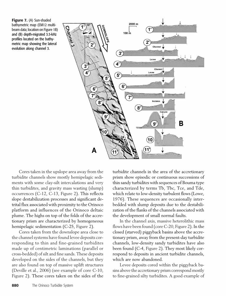
of the channels is controlled by the orientation of theelongated piggyback basins. Severe inflections to-ward the east or the southeast are observedwhen thechannels incise the northeast-southwest–trendingramp anticlines of the tectonic prism, notably in thefrontal part of the accretionary wedge (Figures 5, 7).
In the proximal downslope area above the com-pressional structure of theBarbados prism, the drain-age network shows a complex architecture with
874 The Orinoco Turbidite System
convergence and divergence of the channel coursesrelated to the tectonic control of themorphology ofthe sea floor (Figure 1B). Local tectonic and mudvolcanism processes induce frequent and massivegravity deposits and control themorphology of thechannels from narrow channel levees with locallyconfined levees in the piggyback basins to erosionalchannels and canyon geometries where they cutthrough the structures (Figures 5, 7).
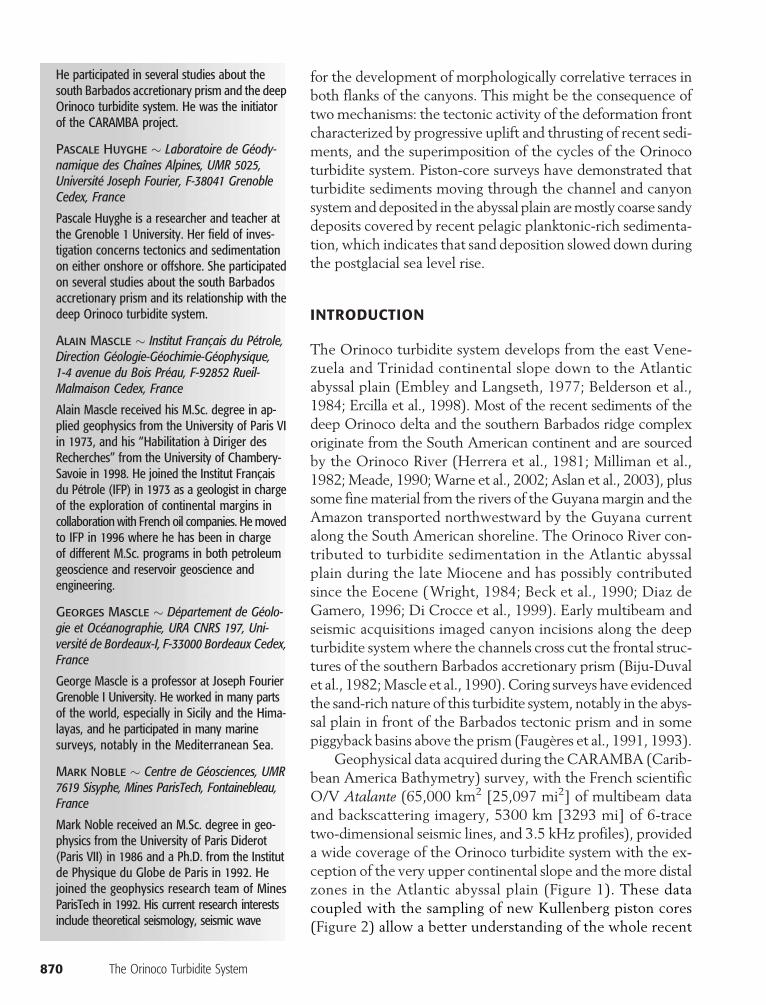
Figure 2. Example of corescollected during the CARAMBAcruise of the O/V Atalante inthe Orinoco turbidite system. Thecorrelation line is the base ofthe uppermost hemipelagicsediments.

Figure 2. Continued.
Callec et al. 875

Active thrust structures, aswell asmud volcanoedifices control channel courses. Levee deposits arelocally pinched out toward the folds and the mudvolcano edifices. Also, tectonics andmud volcanismprocesses induce frequentmassive gravity-flow de-posits, which also contribute to control the mor-phology of the channels fromnarrow channel-leveecomplexeswith locally confined levees in the piggy-back basins to erosional channels and canyon geom-etrieswhere they cut through the growing structures(Figures 5, 7).
In the frontal zone of the tectonic prism, chan-nel courses are mostly controlled by the complexmorphology of the sea floor, and their geometriesevolve systematically to deep incisions (canyons).Notably, four recent canyons with several terracesdeeply incise the frontal anticlines related to activethrusting. Even themore erosive canyons haveme-andering courses (Figure 3). In the abyssal plain, the
876 The Orinoco Turbidite System
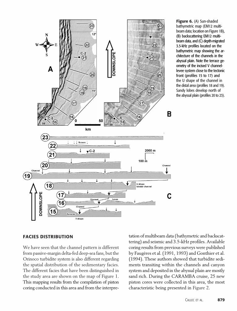
course of the channels is much straighter. North-ward, an older canyon is deformed by thrust tec-tonics (folded channel 1 in Figure 3). In front ofthe tectonic wedge, V-shaped erosional channelswith numerous terraces characterize the transitionzone toward the abyssal plain where several smaller,commonly unleveed channels are dominant. Oldminor braided channels run along the front of thewedge, and a major meandering channel runs to-ward the abyssal plain where sandy distal lobes areobserved (Figure 6).
In the upper abyssal plain, east of the front ofthe tectonicwedge, channels areV shapedwith sev-eral terraces.Northward, in the abyssal plain, a largeultradeep sand-rich braided deep-sea fan devel-oped (Belderson et al., 1984; Ercilla et al., 1998)with a main low-sinuosity channel, which presentsa broad geometrywith low-relief aggrading channel-levee architecture.Northward, the channel-to-lobe
Figure 3. Block diagram from the EM12multibeam acquisition showing the ge-ometry of the canyons within the tectonicfront of the Barbados prism. The channelsare converging at the front of the prismwithin the abyssal plain.

transition is observed with plane-convex elemen-tary bodies, which are characteristic of sandy turbi-dite lobes. Themain channel extendsmostly north-eastward and probably joins the Vidal mid-oceanchannel (Baraza et al., 1997; Ercilla et al., 1998).
DEEP-WATER EROSION
The peculiarity of theOrinoco system is that no sig-nificant recent canyon developed on the Guyana-Orinocomargin shelf. This is confirmedby intensiveoil and gas exploration in the offshore of Trinidadand in the Orinoco platform (plataforma deltana)in the offshore of eastern Venezuela (Erlich, 1992;Di Crocce et al., 1999; Brami et al., 2000; Wood,2000;Moscardelli et al., 2006). Also, no significanterosion along the present shelf break and in the up-per slope is observed as noticed by Mascle et al.(1990) and Brami et al. (2000). Whereas erosionalprocesses are mostly absent in the upper part ofthe turbiditic system, they develop in the deep-water area between 2000 and 4000 m (6562 and13,123 ft) of water depth above the compressionalstructures of the Barbados prism as evidenced bymultibeam data (Mascle et al., 1990; Deville et al.,2003d; Huyghe et al., 2004) (Figures 3, 5). In theerosional area, ramp anticlines and abundant sedi-mentary mobilization (mud volcanoes) control the
channel courses by confining the turbidite flows.Incised channels show irregular meandering andhighly sinuous courses in the low-relief segments.Where channels cut high-relief structures, they aremore confined without levee or with asymmetricallevee deposits and are deeply incised with a charac-teristic U shape (Figures 5–7). Downslope, channelcourses are controlled by the successive anticlinesand evolve systematically to canyon-scale geome-tries with a progressively increasing depth of inci-sion. In the thrust front zone, low-sinuosity mean-dering canyons cut the anticlinal ridges (Figure 3).
To clearly illustrate the geometry of the inci-sions, we present depth-migrated 3.5-kHz profiles(Figures 5–7). Larger canyons show a maximumwidth of 3 km (1.9 mi) and depth of 300 m. Meandips of slope of canyon walls are steep, locallyhigher than 15° (Figure 4). In the frontal folds ofthe accretionary prism, the channel course probablypreexisted the development of the final structureof the fold (syntectonic erosion). Immediately eastof the tectonic front, the main channel is also char-acterized by sinuous anatomy and also presentscanyon geometry with asymmetric levee deposits.A progressive downward transition from U-shapedto V-shaped incision is observed, and several inter-nal terraces appear in both flanks of the main chan-nel. The occurrence of similar terraces in bothflanks highlights obviously that erosion occurred in
Figure 4. Dip map deduced from the EM12 multibeam acquisition. Note the high values in the flanks of the canyon when they crosscutthe fold and thrust system of the Barbados prism.
Callec et al. 877
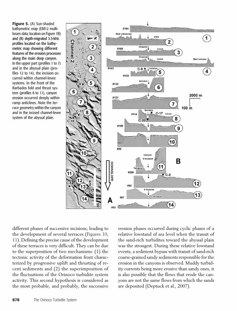
different phases of successive incisions, leading tothe development of several terraces (Figures 10,11). Defining the precise cause of the developmentof these terraces is very difficult. They can be dueto the superposition of two mechanisms: (1) thetectonic activity of the deformation front charac-terized by progressive uplift and thrusting of re-cent sediments and (2) the superimposition ofthe fluctuations of the Orinoco turbidite systemactivity. This second hypothesis is considered asthe most probable, and probably, the successive
878 The Orinoco Turbidite System
erosion phases occurred during cyclic phases of arelative lowstand of sea level when the transit ofthe sand-rich turbidites toward the abyssal plainwas the strongest. During these relative lowstandevents, a sediment bypass with transit of sand-richcoarse-grained sandy sediments responsible for theerosion in the canyons is observed. Muddy turbid-ity currents being more erosive than sandy ones, itis also possible that the flows that erode the can-yons are not the same flows from which the sandsare deposited (Deptuck et al., 2007).
Figure 5. (A) Sun-shadedbathymetric map (EM12 multi-beam data; location on Figure 1B)and (B) depth-migrated 3.5-kHzprofiles located on the bathy-metric map showing differentfeatures of the erosion processesalong the main deep canyon.In the upper part (profiles 1 to 7)and in the abyssal plain (pro-files 12 to 14), the incision oc-curred within channel-leveesystems. In the front of theBarbados fold and thrust sys-tem (profiles 8 to 11), canyonerosion occurred deeply withinramp anticlines. Note the ter-race geometry within the canyonand in the incised channel-leveesystem of the abyssal plain.
FACIES DISTRIBUTION
We have seen that the channel pattern is differentfrompassive-margin delta-fed deep-sea fans, but theOrinoco turbidite system is also different regardingthe spatial distribution of the sedimentary facies.The different facies that have been distinguished inthe study area are shown on the map of Figure 1.This mapping results from the compilation of pistoncoring conducted in this area and from the interpre-
tation ofmultibeam data (bathymetric and backscat-tering) and seismic and 3.5-kHz profiles. Availablecoring results from previous surveys were publishedby Faugères et al. (1991, 1993) and Gonthier et al.(1994). These authors showed that turbidite sedi-ments transiting within the channels and canyonsystem and deposited in the abyssal plain aremostlysand rich. During the CARAMBA cruise, 25 newpiston cores were collected in this area, the mostcharacteristic being presented in Figure 2.
Figure 6. (A) Sun-shadedbathymetric map (EM12 multi-beam data; location on Figure 1B),(B) backscattering EM12 multi-beam data, and (C) depth-migrated3.5-kHz profiles located on thebathymetric map showing the ar-chitecture of the channels in theabyssal plain. Note the terrace ge-ometry of the incised V channel-levee system close to the tectonicfront (profiles 15 to 17) andthe U shape of the channel inthe distal area (profiles 18 and 19).Sandy lobes develop north ofthe abyssal plain (profiles 20 to 23).
Callec et al. 879
Cores taken in the upslope area away from theturbidite channels show mostly hemipelagic sedi-ments with some clay-silt intercalations and verythin turbidites, and gravity mass wasting (slump)occurrences (C-12, C-13, Figure 2). This reflectsslope destabilization processes and significant de-trital flux associated with proximity to theOrinocoplatform and influences of the Orinoco deltaicplume. The highs on top of the folds of the accre-tionary prism are characterized by homogeneoushemipelagic sedimentation (C-25, Figure 2).
Cores taken from the downslope area close tothe channel systems have found levee deposits cor-responding to thin and fine-grained turbiditesmade up of centimetric laminations (parallel orcross-bedded) of silt and fine sands. These depositsdeveloped on the sides of the channels, but theyare also found on top of massive uplift structures(Deville et al., 2006) (see example of core C-10,Figure 2). These cores taken on the sides of the
880 The Orinoco Turbidite System
turbidite channels in the area of the accretionaryprism show episodic or continuous successions ofthin sandy turbidites with sequences of Bouma typecharacterized by terms Tb, Tbc, Tce, and Tde,which relate to low-density turbulent flows (Lowe,1976). These sequences are occasionally inter-bedded with slump deposits due to the destabili-zation of the flanks of the channels associated withthe development of small normal faults.
In the channel axis, massive heterolithic massflows have been found (coreC-20, Figure 2). In theclosed (starved) piggyback basins above the accre-tionary prism, away from the present-day turbiditechannels, low-density sandy turbidites have alsobeen found (C-4, Figure 2). They most likely cor-respond to deposits in ancient turbidite channels,which are now abandoned.
Levee deposits cored within the piggyback ba-sins above the accretionary prism correspondmostlyto fine-grained silty turbidites. A good example of
Figure 7. (A) Sun-shadedbathymetric map (EM12 multi-beam data; location on Figure 1B)and (B) depth-migrated 3.5-kHzprofiles located on the bathy-metric map showing the lateralevolution along channel 3.

this type of deposit is given by coreC-17 in Figure 2.Coring inside the channel course was very difficultbecause of very hard grounds, and the only sedi-ments recovered correspond to heterolithic massflows resulting from levee collapse within thechannel (see example of core C-20, Figure 2).
In the abyssal plain, immediately east of thethrust front, the levee deposits correspond to fine-to medium-grained sandy turbidites (see core C-5,Figure 2). Downstream, all the recovered cores inthe abyssal plain were made of massive sandy tur-bidites with debrite intercalations (see example ofcore C-2, Figure 2). The new piston cores takenduring the CARAMBA cruise confirmed the pre-vious results that well-developed massive sandyturbidites are found on the abyssal plain east ofthe Barbados accretionary front (Faugères et al.,1991, 1993). Sediments found in the abyssal plaincorrespond to high-density massive sandy turbi-dites characterized by sand-clay mixing intervals(slurry bed), reflecting abrasion processes of thesea floor (C-02, Figure 2). Finally, note that all theavailable piston-core surveys have demonstrated
that turbidite sediments moving through thechannel and canyon system and that are depositedin the abyssal plain are indeedmostly coarse-grainedsandy deposits (Faugères et al., 1993) (Figure 2).
Also note that fine-grained sandy deposits arestoredon the outer shelf (VanAndel, 1967;Alfonsoet al., 2006), and in the slope close to the shelf edge,the channels are currently overlapped by recent de-posits,mostly bymass flows on the upper continen-tal slope (Brami et al., 2000; Moscardelli et al.,2006) (Figure 1). As such, the traces of the chan-nels in the upper slope are commonly draped byrecent sediments. The relative absence or thinnessof this drape facies in channels farther downslopesupports low sedimentation rates in the turbiditechannel system related to the rise of sea level sincethe last glacial lowstand. Also, the sand-rich sedi-ments deposited in the tectonic prism area and inthe abyssal plain are systematically covered by a fewtens of centimeters of recent pelagic planktonic-rich sedimentation, which indicates that sand de-position has stopped since the last glacial event(Figure 2).
Figure 8. Avulsion example in the east-ern offshore of Trinidad.
Callec et al. 881
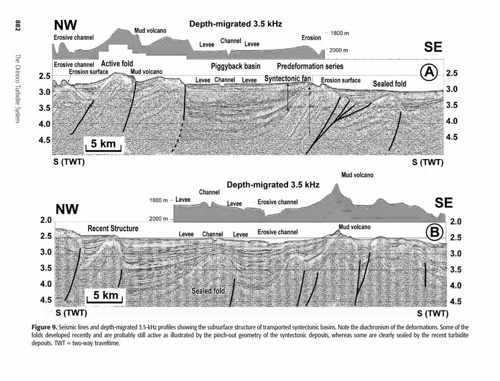
Figure 9. Seismic lines and depth-migrated 3.5-kHz profiles showing the subsurface structure of transported syntectonic basins. Note the diachronism of the deformations. Some of thefolds developed recently and are probably still active as illustrated by the pinch-out geometry of the syntectonic deposits, whereas some are clearly sealed by the recent turbiditedeposits. TWT = two-way traveltime.
882The
Orinoco
TurbiditeSystem
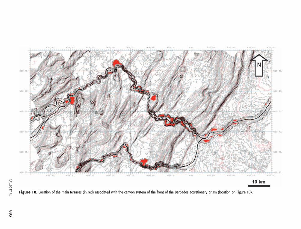
Figure 10. Location of the main terraces (in red) associated with the canyon system of the front of the Barbados accretionary prism (location on Figure 1B).
Callecetal.
883

CONCLUSION
Whereas inmost of the passivemargin the turbiditesystem is classically organized upstream to down-stream as canyon, then channel levee, then lobes,due to the control by active tectonics, the Orinocoturbidite system is organized as channel levee, thencanyons, then channelized lobes. Upslope, the sedi-ment input is a mutiple-source sand-rich system. Itshows a relatively complex geometry with channeldivergences in flat-floor syntectonic piggyback ba-sins and convergences in front of the prism. Sinuos-ity of the channels is highly variable because of the
884 The Orinoco Turbidite System
tectonic control of themorphology of the sea floor.The architecture of the channels shows high vari-ability from channel levee to canyon, controlled bythemorphology of the basement. Themain erosionis not located close to the present-day shelf edge, butit is spectacular in the deep-water areas (between2000 and 4000 m [6562 and 13,123 ft] of waterdepth). A wide zone of predominantly sedimenttransport (bypass) leaving only channel-levee de-posits develops from above the 1000-m (3281-ft)isobath down to the abyssal plain. In the abyssalplain, the sedimentation is dominantly sandy. Amajor recent straight channel is observed trending
Figure 11. Synthesis of evolu-tion of the architecture of theturbidite channels along the Ori-noco turbidite system.

northeastward toward the deep Atlantic plain.Stacked sinuous channels are found trending north–south, parallel to the front of the accretionaryprism.Detached sand-rich depositional lobes have beenfound in the flattest areas of the abyssal plainwherethe lowest sea-floor gradient results in depositionof the remaining sand.
This system is currently in a low phase of activ-ity since the recentHolocene rise of sea level. Now-adays, the sedimentation is mostly located on theOrinoco delta platform and on the upper slope, al-though some hyperpycnal events have probablybeen active recently and would be responsiblefor sedimentation in deep-water areas. The turbi-dite system was most active during the last glaciallowstand.
REFERENCES CITED
Alfonso, J. A., M. Martinez, S. Flores, and Z. Benzo, 2006,Distribution of trace elements in offshore sediments ofthe Orinoco delta: Journal of Coastal Research, v. 22,no. 3, p. 502–510, doi:10.2112/03-0142.1.
Aslan, A., W. White, A. Warne, and E. H. Guevara, 2003,Holocene evolution of the western Orinoco delta, Vene-zuela: Geological Society of America Bulletin, v. 115,p. 479–498, doi:10.1130/0016-7606(2003)115<0479:HEOTWO>2.0.CO;2.
Baraza, J., G. Ercilla, and the CAMEL shipboard party, 1997,The equatorial Atlanticmid-ocean channel:Anultra high-resolution image of its burial history based on TOPASprofiles: Marine Geophysical Researches, v. 19, no. 2,p. 115–135, doi:10.1023/A:1004273902719.
Beck, C., Y. Ogawa, and J. Dolan, 1990, Eocene paleogeogra-phy of the southeastern Caribbean: Relations betweensedimentation on the Atlantic abyssal plain at site 672and evolution on the South America margin, in A. Mascle,J. C. Moore, E. Taylor, and M. B. Underwood, eds., Pro-ceeding of the Ocean Drilling Program, Scientific Re-sults, v. 110, p. 7–15.
Belderson, R.H.,N.H.Kenyon,A.H. Stride, andC.D. Pelton,1984, A “braided” distributary system on the Orinocodeep-sea fan: Marine Geology, v. 56, no. 1–4, p. 195–206, doi:10.1016/0025-3227(84)90013-6.
Biju-Duval, B., P. Le Quellec, A. Mascle, V. Renard, and P.Valery, 1982, Multi-beam bathymetric survey and highresolution seismic investigations on the Barbados ridgecomplex eastern Caribbean: A key to the knowledgeand interpretation of an accretionary wedge: Tectono-physics, v. 80, p. 275–304, doi:10.1016/0040-1951(82)90070-1.
Brami, T. R., C. Pirmez, C. Archie, S. Heeralal, and K. L.Holman, 2000, Late Pleistocene deep-water stratigraphy
and depositional processes: Gulf Coast Section SEPMMemoir 20, p. 104–115.
Brown, K. M., and G. K. Westbrook, 1987, The tectonic fab-ric of the Barbados ridge accretionary complex: Marineand Petroleum Geology, v. 4, p. 71–81, doi:10.1016/0264-8172(87)90022-5.
Calais, E., Y. Mazabraund, B. Mercier de Lepinay, P. Mann,G. Mattioli, and P. Jansma, 2002, Strain partitioning andfault slip rates in the northeastern Caribbean from GPSmeasurements: Geophysical Research Letters, v. 29,no. 18, p. 1856, doi:10:1029/2002GL015397.
DeMets,C., P. E. Jansma,G. S.Mattioli, T.H.Dixon, F. Farina,R. Bilham, E. Calais, and P. Mann, 2000, GPS geodeticconstraints on Caribbean-North American plate motion:Geophysical Research Letters, v. 27, p. 437–440.
Deptuck, M. E., Z. Sylvester, C. Pirmez, and C. O’Byrne,2007, Migration-aggradation history and 3-D seismicgeomorphology of submarine channels in the PleistoceneBenin-major Canyon, western Niger Delta slope: Marineand Petroleum Geology, v. 24, p. 406–433, doi:10.1016/j.marpetgeo.2007.01.005.
Deville, E., and A. Mascle, in press, The Barbados ridge: A ma-ture accretionarywedge in front of the LesserAntilles activemargin, inA.W. Bally andD.G. Roberts, eds., Phanerozoicregional geology of the world: Elsevier, special volume.
Deville, E., A. Battani, R. Griboulard, S. H. Guerlais, J. P.Herbin, J. P. Houzay, C. Muller, and A. Prinzhofer,2003a, Mud volcanism origin and processes: New in-sights from Trinidad and the Barbados prism, in P. VanRensbergen, R. R.Hillis, A. J. Maltman, and C. K.Morley,eds., Surface sediment mobilization: Geological Society(London) Special Publication 217, p. 477–492.
Deville, E.,A.Mascle, S.H.Guerlais,C.Decalf, andB.Colletta,2003b, Lateral changes of frontal accretion and mud vol-canism processes in the Barbados accretionary prism andsome implications, in C. Bartolini, T. Buffler, and J. F.Blickwede, eds., The circum-Gulf of Mexico and theCaribbean: Mexico and the Caribbean region: Hydrocar-bon habitats, basin formation, plate tectonics: AAPGMemoir 79, p. 1–19.
Deville, E., A. Mascle, R. Griboulard , P. Huyghe, C. PadronDe Carillo, and J.-F. Lebrun, 2003c, From frontal sub-duction to a compressional transform system: New geo-physical data on the structure of the Caribbean-SouthAmerica plate boundary in southeasternCaribbean:Mem-oir of the VIII Simposio Bolivariano, Paper No. 6, 5 p.
Deville, E., Y. Callec, G. Desaubliaux, A. Mascle, P. Huyghe,R. Griboulard, and M. Noble, 2003d, Deep-water ero-sion processes in the Orinoco turbidite system: Offshore,v. 63, no. 10, p. 92–96.
Deville, E., A. Battani, R. Griboulard, S. H. Guerlais, S.Lallemant, A. Mascle, A. Prinzhofer, and J. Schmitz,2004, Processes of shale diapirism and mud volcanismin the Barbados-Trinidad compressional system: Inte-grated structural, thermal and geochemical approach:Gulf Coast Section of the Society for Sedimentary Geol-ogy (GCSSEPM), Memoir 24, p. 514–527.
Deville, E., S.-H. Guerlais, Y. Callec, R. Griboulard, P.Huyghe, S. Lallemant, A. Mascle, M. Noble, J. Schmitz,and the Caramba working group, 2006, Liquefied vs.
Callec et al. 885
stratified sediment mobilization processes: Insight fromthe south of the Barbados accretionary prism: Tectono-physics, v. 428, p. 33–47, doi:10.1016/j.tecto.2006.08.011.
Diaz deGamero,M. L., 1996, The changing course of theOri-noco River during the Neogene: A review: Palaeogeogra-phy, Palaeoclimatology, Palaeoecology, v. 123, p. 385–402, doi:10.1016/0031-0182(96)00115-0.
Di Crocce, J., A. W. Bally, and P. Vail, 1999, Sequence stra-tigraphy of the eastern Venezuelan Basin, Caribbean ba-sins, in P. Mann and K. J. Hsu, eds., Sedimentary basinsof the world: Amsterdam, Elsevier, p. 419–476.
Embley, R. W., and M. Langseth, 1977, Sedimentation pro-cesses on the continental rise of northeastern SouthAmer-ica: Marine Geology, v. 25, p. 279–297, doi:10.1016/0025-3227(77)90058-5.
Ercilla, G., et al., 1998, New high-resolution acoustic datafrom the “braided system” of the Orinoco deep-sea fan:Marine Geology, v. 146, no. 1–4, p. 243–250, doi:10.1016/S0025-3227(97)00134-5.
Erlich, B., 1992, Petroleum geology of the eastern Venezuelaforeland basins, in L. McQueen, ed., Foreland basins andfold belts: AAPG Memoir 55, p. 341–362.
Faugères, J. C., E. Gonthier, L. Masse, M. Parra, J. C. Pons,and C. Pujol, 1991, Quaternary deposits and canyons onthe south Barbados accretionary prism: Marine Geology,v. 96, p. 247–267, doi:10.1016/0025-3227(91)90150-3.
Faugères, J. C., E. Gonthier, R. Griboulard, and L. Masse,1993,Quaternary sandydeposits and canyons on theVene-zuelan margin and South Barbados accretionary prism:Marine Geology, v. 110, no. 1–2, p. 115–142.
Galbraith, R. M., and A. R. Brown, 1999, Field appraisal withthree-dimensional seismic surveys offshore Trinidad, inA. R. Brown, ed., Interpretation of three-dimensionalseismic data: AAPG Memoir 42, p. 318–323.
Gersztenkorn, A., J. Sharp, and K. Marfurt, 1999, Delinea-tion of tectonic features offshore Trinidad using 3-D seis-mic coherence: Society of Exploration Geophysicists:The Leading Edge, v. 18, no. 9, p. 1004–1008, doi:10.1190/1.1438422.
Gibson, R. G., and P. A. Bentham, 2003, Use of fault-sealanalysis in understanding petroleum migration in a com-plexly faulted anticlinal trap, Columbus Basin, offshoreTrinidad, in R. K. Davies and J. W. Handschy, eds., Faultseals: AAPG Bulletin, v. 87, no. 3, p. 465–478, doi:10.1306/08010201132.
Gonthier, E., J. C. Faugères, C. Bobier, R. Griboulard, P.Huyghe, L.Massé, andC. Pujol, 1994, Le prisme d’accré-tion tectonique Sud-Barbade: Revue Aquitaine Océan,no. 1, 105 p.
Granjeon, D., and P. Joseph, 1999, Concepts and applicationsof a 3Dmultiple lithology, diffusivemodel in stratigraphicmodeling, in J.W.Harbaugh,W. LynnWatney, E. Rankey,R. Slingerland, R. Goldstein, and E. Franseen, eds., Nu-merical experiments in stratigraphy: SEPM Special Pub-lication 62, p. 197–210.
Griboulard, R., C. Bobier, J. C. Faugères, and G. Vernette,1991, Clay diapiric structures within the strike-slipmarginof the southern Barbados prism: Tectonophysics, v. 192,p. 383–400, doi:10.1016/0040-1951(91)90111-5.
Heppard, P. D., H. S. Cander, and E. B. Eggertson, 1998,
886 The Orinoco Turbidite System
Abnormal pressure and the occurrence of hydrocarbonsin offshore eastern Trinidad, west Indies: AAPG Mem-oir 70, p. 215–246.
Herrera, L., G. Febres, and R. Avila, 1981, Las mareas enaguas Venezolanas y su amplificacio´n en la regio´n deldelta del Orinoco: Acta Cientifica Venezolana, v. 32,p. 299–306.
Huyghe, P., R. Griboulard, J. C. Faugères, E. Gonthier, andC. Bobier, 1996, Géométries des bassins du prisme SudBarbade: Bulletin de la Société Géologique de France,v. 167, no. 3, p. 345–359.
Huyghe, P., J. L. Mugnier, R. Griboulard, Y. Deniaud, E.Gonthier, and J. C. Faugères, 1999, Review of the tec-tonic control and sedimentary patterns in late Neogenepiggyback basins on the Barbados ridge complex, in P.Mann and K. J. Hsu, eds., Caribbean basins: Sedimen-tary basins of the world: Amsterdam, Elsevier, v. 4,p. 369–388.
Huyghe, P.,M. Foata, E. Deville, G.Mascle, and the CarambaWorking Group, 2004, Channel profiles through the ac-tive thrust front of the southern Barbados prism: Geol-ogy, v. 32, no. 5, p. 429–432.
Jacome, M. I., N. Kuznir, F. Audemard, and S. Flint, 2003,Formation of the Maturin foreland basin, eastern Vene-zuela: Thrust sheet loading or subduction dynamic to-pography: Tectonics, v. 22, no. 5, p. 1046, doi:10.1029/2002TC001381.
Jansma, P., A. Lopez, G. Mattioli, C. DeMets, T. Dixon, P.Mann, and E. Calais, 2000, Microplate tectonics in thenortheastern Caribbean as constrained by Global Posi-tioning (GPS) geodesy: Tectonics, v. 19, p. 1021–1037.
Lowe, D. R., 1976, Subaqueous liquefied and fluidized sedi-ment flows and their deposits: Sedimentology, v. 23,p. 285–308, doi:10.1111/j.1365-3091.1976.tb00051.x.
Mann, P., and L. Wood, 2003, Late Quaternary transpres-sional deformation along the submarine extension ofthe Warm Springs-Central Range fault zone, eastern off-shore Trinidad: AAPG Annual Meeting, Abstracts,v. 12, p. A112.
Mann, P., E. Calais, J.-C. Ruegg, C. DeMets, P. Jansma, andG. Mattioli, 2002, Oblique collision in the northeasternCaribbean from GPS measurements and geological obser-vations: Tectonics, v. 21, no. 6, p. 1057, doi:10.1029?2001TC001304.
Mascle, A., L. Endignoux, and T. Chennouf, 1990, Frontalaccretion and piggyback basin development at the south-ern edge of the Barbados Ridge accretionary complex,inA.Mascle, J. C.Moore, E. Taylor, andM. B.Underwood,eds., Proceedings of the ODP, Scientific Results 110,p. 409–422.
Meade, R. H., 1990, Suspended sediments of the modernAmazon and Orinoco rivers, in M. Iriondo, ed., Quater-nary of South America: Quaternary International, v. 21,p. 29–39.
Milliman, J. D., J. Butenko, J. P. Barbot, and I. Hedberg,1982, Depositional patterns of modern Orinoco/Amazonmuds on the northern Venezuelan shelf: Journal of Ma-rine Research, v. 40, no. 3, p. 643–657.
Moscardelli, L., L.Wood, and P. Mann, 2006, Mass-transport

complexes and associated processes in the offshore areaof Trinidad and Venezuela: AAPG Bulletin, v. 90, no. 7,p. 1059–1088, doi:10.1306/02210605052.
Rutledge, A. K., and D. S. Leonard, 2001, Role of multibeamsonar in oil and gas exploration and development: Off-shore Technology Conference 12956, 12 p.
Saleh, J., K. Edwards, J. Barbate, S. Balkaransingh, D. Grant,J. Weber, and T. Leong, 2004, On some improvementsin the geodetic framework of Trinidad and Tobago: Sur-vey Reviews, v. 37, no. 294, p. 604–625.
Saller, A. H., J. T. Noah, A. P. Ruzuar, and R. Schneider,2004, Linked lowstand delta to basin-floor fan deposi-tion, offshore Indonesia: An analog for deep-water reser-voir systems: AAPG Bulletin, v. 88, p. 21–46, doi:10.1306/09030303003.
Sullivan, S., L. J. Wood, and P. Mann, 2004, Distribution,nature and origin of mobile mud feature offshore Trini-dad: Gulf Coast Section of the Society for SedimentaryGeology (GCSSEPM), Memoir 24, p. 498–513.
Van Andel, T. J., 1967, The Orinoco River: Journal of Sedi-mentary Petrology, v. 37 no. 2, p. 297–310.
Warne, A. G., R. H. Meade, W. A. White, E. H. Guevara, J.Gibeaut, R. C. Smyth, A. Aslan, and T. Tremblay, 2002,Regional controls on geomorphology, hydrology, andecosystem integrity in the Orinoco delta, Venezuela:Geomorphology, v. 44, p. 273–307, doi:10.1016/S0169-555X(01)00179-9.
Weber, J. C., T. H. Dixon, C. De Mets, W. B. Ambeth, P.Jansma, G. Mattioli, J. Saleh, G. Sella, R. Bilham, andO. Perez, 2000, GPS estimate of relative motion be-tween the Caribbean and South American plates, andgeologic implications for Trinidad and Venezuela: Geol-ogy, v. 29, no. 1, p. 75–78, doi:10.1130/0091-7613(2001)029<0075:GEORMB>2.0.CO;2.
Wood, L. J., 2000, Chronostratigraphy and tectonostratigra-phy of the Columbus Basin, eastern offshore Trinidad:AAPG Bulletin, v. 84, no. 12, p. 1905–1928.
Wright, A., 1984, Sediment distribution and depositionalprocesses operating in the Lesser Antilles intraoceanic is-land arc, eastern Caribbean, in B. Biju-Duval et al., eds.,Initial report of the Deep Sea Drilling Project: Washing-ton, U.S. Printing Office, v. 78A, p. 23–38.
Callec et al. 887


