Embed Size (px)
Citation preview

The Historical Vignettes in the Vatican
Galleria delle Carte Geografiche
Candidate Number: R2201
Word Count: 14,984
Supervisor: Dr Paul Taylor
MA Art History, Curatorship, and Renaissance Culture

i
CONTENTS
List of Illustrations …………………………………………………………………… ii
The Historical Vignettes in the Vatican Galleria delle Carte Geografiche
Review of Secondary Literature ……………………………………………………… 3
Sources for the Gallery’s Design …………………………………………………… 9
Purpose of the Historical Vignettes …………………………………………………… 16
Restorations of the Gallery …………………………………………………………… 21
The Historical Vignettes …………………………………………………………… 24
Literature on Military Art from Ancient Rome to Italy in the Sixteenth century …… 25
The Artistic Styles of the Vignettes …………………………………………………… 27
Who Painted the Vignettes …………………………………………………………… 31
The Vignettes’ Attitude towards History …………………………………………… 35
Conclusions …………………………………………………………………………… 48
Appendix One …………………………………………………………………………. 53
Appendix Two ……………………………………………………………………. 55
Bibliography …………………………………………………………………………. 56

ii
LIST OF ILLUSTRATIONS
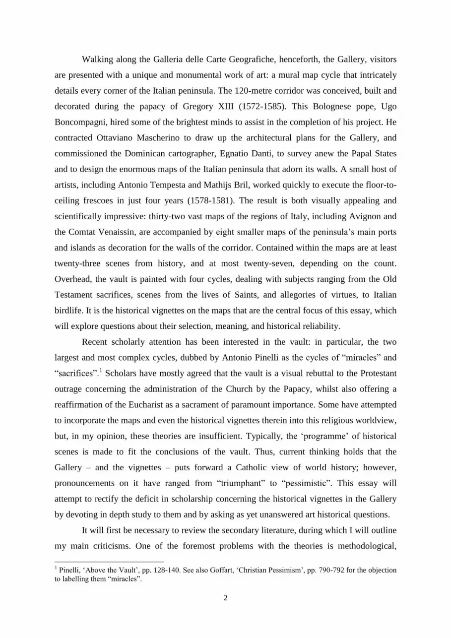
Figure 1: The Gallery of Maps, Vatican City. Image Credit: Franco Cosimo Panini.
Figure 2: S. Leo Pont. Max. Attilam furentem reprimit, Gallery of Maps, Vatican City. Image
Credit: Franco Cosimo Panini.
Figure 3: Matthijs Bril, Pope Leo I halts the army of Attila, map of Mantuae Ducatus, Gallery
of Maps, Vatican City. Image Credit: Franco Cosimo Panini.
Figure 4: Inscription over the north door, Gallery of Maps, Vatican City. Image Credit:
Franco Cosimo Panini.
Figure 5: Cartouche for the map of Avenionensis Ditio et Venaisinus Comitatus, Gallery of
Maps, Vatican City. Image Credit: Franco Cosimo Panini.
Figure 6: Detail of scroll on the map of Sallentina Hydrunti Terra, Gallery of Maps, Vatican
City. Image Credit: Franco Cosimo Panini.
Figure 7: Inscription over the south door, Gallery of Maps, Vatican City. Image Credit:
Franco Cosimo Panini.
Figure 8: Detail of scroll on the map of Flaminia, Gallery of Maps, Vatican City. Image
Credit: Franco Cosimo Panini.
Figure 9: Matthijs Bril, The army sent to Rome by the Marches, map of Picenum, Gallery of
Maps, Vatican City. Image Credit: Franco Cosimo Panini.
Figure 10: Landscape detail in the map of Avenionensis Ditio et Venaisinus Comitatus,
Gallery of Maps, Vatican City. Image Credit: Author’s photograph.
Figure 11: Jerome Commelin, The Battle of Tournhout, 1597, in Life of Maurice of Nassau.
Image Credit: The Archaeological Journal.
Figure 12: Matthijs Bril, Julius Caesar’s army crossing the Rubicon, map of Flaminia,
Gallery of Maps, Vatican City. Image Credit: Franco Cosimo Panini.
Figure 13: Marcus Marcellus dies in a skirmish with the Carthaginians, map of Lucania,
Gallery of Maps, Vatican City. Image Credit: Franco Cosimo Panini.
Figure 14: Antonio Tempesta (?), Rainulphus S. Bernardi precibus hostes vincit, Gallery of
Maps, Vatican City. Image Credit: Franco Cosimo Panini.
Figure 15: Matthijs Bril, Deborah prays at the Victory of Baracover Sisara, Room of Old
Testament Women, Tower of the Winds.
Figure 16: Antonio Tempesta, Abraham Loth ab hostibus eripit, c. 1613, engraving from the
series: Imagines acierum ac pr[a]eliorum veteris Testamenti a me pictur[a]e artificio
repr[a]esentatas Tibi Magne Dux Cosme dedico..., Rome: Nicolaus van Aelst formis.

iii
Figure 17: Hans Sebald Beham, Siege of Vienna, 1529, published 1530 by Niclas
Meldemann, original 81.2x85.6cm, Albertina Vienna.
Figure 18: Matthijs Bril (?), Siege of Valletta, map of Melita, Gallery of Maps, Vatican City.
Image Credit: Franco Cosimo Panini.
Figure 19: Matthijs Bril, Battle of Cannae, map of Apulia, Gallery of Maps, Vatican City.
Image Credit: Franco Cosimo Panini.
Figure 20: Matthijs Bril, Battle of Fornovo, map of Placentiae et Parmae Ducatus, Gallery of
Maps, Vatican City. Image Credit: Franco Cosimo Panini.
Figure 21: Matthijs Bril, Battle of Ravenna, map of Flaminia, Gallery of Maps, Vatican City.
Image Credit: Franco Cosimo Panini.
Figure 22: Charlemagne defeats the Lombards near Piacenza, map of Mediolanensis
Ducatus, Gallery of Maps, Vatican City. Image Credit: Franco Cosimo Panini.
Figure 23: Battle of Pavia, map of Mediolanensis Ducatus, Gallery of Maps, Vatican City.
Image Credit: Franco Cosimo Panini.
Figure 24: Pietro Oldrado, Battle of Lake Trasimene, map of Perusinus ac Tifernas, Gallery
of Maps, Vatican City. Image Credit: Franco Cosimo Panini.
Figure 25: trompe l’oeil depicting the murder of Archimedes, map of Apulia, Gallery of
Maps, Vatican City. Image Credit: Franco Cosimo Panini.
Figure 26: Matthijs Bril, Battle of Pandosia, map of Calabria Citerior, Gallery of Maps,
Vatican City. Image Credit: Franco Cosimo Panini.

1
The Historical Vignettes in the Vatican Galleria
delle Carte Geografiche
Figure 1: The Gallery of Maps
2
Walking along the Galleria delle Carte Geografiche, henceforth, the Gallery, visitors
are presented with a unique and monumental work of art: a mural map cycle that intricately
details every corner of the Italian peninsula. The 120-metre corridor was conceived, built and
decorated during the papacy of Gregory XIII (1572-1585). This Bolognese pope, Ugo
Boncompagni, hired some of the brightest minds to assist in the completion of his project. He
contracted Ottaviano Mascherino to draw up the architectural plans for the Gallery, and
commissioned the Dominican cartographer, Egnatio Danti, to survey anew the Papal States
and to design the enormous maps of the Italian peninsula that adorn its walls. A small host of
artists, including Antonio Tempesta and Mathijs Bril, worked quickly to execute the floor-to-
ceiling frescoes in just four years (1578-1581). The result is both visually appealing and
scientifically impressive: thirty-two vast maps of the regions of Italy, including Avignon and
the Comtat Venaissin, are accompanied by eight smaller maps of the peninsula’s main ports
and islands as decoration for the walls of the corridor. Contained within the maps are at least
twenty-three scenes from history, and at most twenty-seven, depending on the count.
Overhead, the vault is painted with four cycles, dealing with subjects ranging from the Old
Testament sacrifices, scenes from the lives of Saints, and allegories of virtues, to Italian
birdlife. It is the historical vignettes on the maps that are the central focus of this essay, which
will explore questions about their selection, meaning, and historical reliability.
Recent scholarly attention has been interested in the vault: in particular, the two
largest and most complex cycles, dubbed by Antonio Pinelli as the cycles of “miracles” and
“sacrifices”.1 Scholars have mostly agreed that the vault is a visual rebuttal to the Protestant
outrage concerning the administration of the Church by the Papacy, whilst also offering a
reaffirmation of the Eucharist as a sacrament of paramount importance. Some have attempted
to incorporate the maps and even the historical vignettes therein into this religious worldview,
but, in my opinion, these theories are insufficient. Typically, the ‘programme’ of historical
scenes is made to fit the conclusions of the vault. Thus, current thinking holds that the
Gallery – and the vignettes – puts forward a Catholic view of world history; however,
pronouncements on it have ranged from “triumphant” to “pessimistic”. This essay will
attempt to rectify the deficit in scholarship concerning the historical vignettes in the Gallery
by devoting in depth study to them and by asking as yet unanswered art historical questions.
It will first be necessary to review the secondary literature, during which I will outline
my main criticisms. One of the foremost problems with the theories is methodological,
1 Pinelli, ‘Above the Vault’, pp. 128-140. See also Goffart, ‘Christian Pessimism’, pp. 790-792 for the objection
to labelling them “miracles”.

3
namely that historians of the Gallery have neglected to consider what can be learned from a
visual analysis. In addition, many are too enthusiastic in applying the post-Tridentine
Catholic iconography of the vault to the historical scenes below. This survey will be followed
by an examination of the contemporary documents that can inform us vis-à-vis the Gallery’s
design and purpose. These range from personal letters and inscriptions found within the maps
themselves, to a dedicatory poem written shortly after its completion. I also examine
literature concerning the reception of the Italian wars. Contemporary art theory and a review
of the restorations are important to my approach because they help inform my reading of the
images.
The main focus of this essay will be an aesthetic evaluation of the historical episodes
themselves. This is followed by a brief investigation into the principal artist. Not being able
to draw on every episode, owing to their number and to their diverse nature resultant from the
restorations, I will draw upon a balanced selection. Principally, I will be concerned with the
stylistic choices of the artists, their sources and intentions, and their attitude towards
representing history.
Furthermore, throughout this essay, I will be considering what is really being
depicted, and why: are the vignettes intended to be decorative, historically accurate, or
propagandistic? With the Gallery’s self-proclaimed ‘instructive’ purpose in mind, I will
speculate as to what viewers were able to learn from these depictions of history. After
applying these image-focused analyses on the maps, it is difficult not to conclude that the
Gallery does not have a historical programme. Apart from a minority of more detailed scenes,
very little about the history of the events depicted can be learned from the images themselves.
Instead, our reading is informed by the geography and the informative cartelli. They amount
to an erudite decorative system that functioned as an administrative aid.
Review of Secondary Literature
Most modern interpretations look at the vault paintings, which are primarily
concerned with the Eucharist and stand as a reassertion of authority on the part of the
Catholic Church following the Reformation. Accordingly, historians of the Gallery have
attempted to fit the historical vignettes into this scheme, but they do not match. One third are
Roman, mostly about the Hannibalic Wars, some later scenes do not involve the Church at
4
all, and the majority are large or famous battles in which there was vast loss of life. I argue
that the logic of these theories is not sound, and that any art historian who looks in depth at
what is being depicted cannot reach the conclusion that the scenes are part of a providential
world history. To date, there has been no visual analysis of the historical vignettes and their
attitude towards representing history.
The first conclusions about the artwork were tentative. Confronted with the immense
nature of the corridor, Ludwig von Pastor, in his expansive history of the Popes, refrained
from making an analysis of the Gallery: ‘The restless impression of the whole is increased by
the fact that at first the spectator cannot understand the connexion between the pictures’.2
Moving forward, we again find little artistic analysis in Roberto Almagià’s seminal work, Le
pitture murali della galleria delle carte geografiche, which was instead concerned with the
technical aspects of the maps.3 However, his position on the historical scenes in the maps can
be inferred: ‘The three groups of combatants and the other decorative elements (trees etc.) are
meant to fill up empty space or to mask gaps in the true and proper cartographical
representation’.4 Whilst I agree with the decorative aspect, I do not believe they were added
simply to cover lacunae.
Almagià’s work stood as the fundamental study of the Gallery for over thirty years,
until recent analyses began to propose that the maps ‘are actually ideological fictions
intended to promulgate a particular version of providential history’.5 The discussions
concentrated on the meaning of the images in the vault in terms of the Eucharist, and
attempted to link it to the maps and historical scenes below. Connecting the historical-
religious imagery of the vault to the depiction of temporal, secular space in the maps, these
variable theories assert that Italy is central to world history, that Italy is a new Holy Land, or
that the battles painted in the maps demonstrate ‘trials overcome’ by the Church and thus a
guiding Divine Will. It is my opinion that any theory propagating a ‘providential’ view of
history has gone too far in its creativity, and is not supported by visual analysis. Considering
the allegorical implications of the fresco of the Repulse of Attila by Raphael, made elsewhere
in the Vatican during a particularly turbulent period in Italian history, John Hale observed:
‘Such deliberate historical allusions to contemporary military crises have led to some perhaps
2 Pastor, The History of the Popes, p. 217.
3 Milanesi, ‘The Historical Background’, p. 118.
4 Almagià, Le pitture murali, p. 21: ‘Le tre figurazioni di fatti d’arme ed altri elementi decorativi (alberi ecc.)
sono intese a riempire spazi vuoti o mascherare lacune della rappresentazione cartografica vera e propria’. 5 Watts, ‘The European Religious Worldview’, p. 397.

5
overimaginative parallels-spotting’.6 I am proposing that, on the whole, historians of the
Gallery have suffered from such over-imagination in relation to the historical scenes within
the maps.
The tone and direction of the most recent interpretations was laid out by Jürgen
Schulz and Iris Cheney in the 1980s. Both decided that the Gallery presented a progressive
view of world history from the viewpoint of the Catholic Church. In his survey of mural map
cycles in sixteenth-century Italy, Schulz states: ‘The gallery presents us with a digest of
world history’.7 For her part, Cheney attempts to tie the cycle of saintly “miracles” on the
vault to the historical vignettes on the maps. Noticing the vignettes’ focus on military
activity, she concludes that the suffering therein must represent an ‘epic and militantly
Catholic concept of an Italy forged through centuries of unceasing conflict as the predestined
home of the Church’.8 This argument falls down for a number of the scenes, but in particular
the Hannibalic scenes, as most of the Roman gains during the Second Punic War came
outside of Italy in Spain or in Africa.
The monumental work by Gambi and Pinelli remains broadly in agreement with
Cheney. In the introduction to the three-part series, the editors clearly state their views on the
historical vignettes: ‘These events were chosen from amongst the most hazardous of the
dangers braved by the country in Roman times, or the various trials faced by Christian Italy
as it struggled to overcome internal and external enemies’.9 In their opinion, the historical
vignettes are a catalogue of perils faced and overcome – triumphant even. The fallacy of this
argument is plainly revealed in an essay by Pinelli: while discussing the Christian victories
over the Turks in Malta and at Lepanto, he claims that the ‘emphasis on the threatened danger
also serves to enhance the Church’s victorious reaction to it’.10
While this may be true for the
most recent of the depicted historical events, it disregards many others. The Battles of Pavia
and Ceresole can hardly be classified as ‘Christian victories’, since they were fought between
two Christian powers they simultaneously Christian victories and defeats. Therefore, not only
do these theories take a selective eye to the scenes, but in fact ignore the contemporary
literature surrounding the Italian Wars.
Among general agreement, there has been one dissenting view: that of Walter Goffart.
Disagreeing with previous ideas, Goffart sees in each of the three periods a decidedly
6 Hale, Artists and Warfare, p. 145.
7 Schulz, ‘Maps as Metaphors’, p. 108.
8 Cheney, ‘The Galleria delle Carte Geografiche’, p. 37.
9 Gambi and Pinelli, ‘The Gallery of Maps’, p. 13.
10 Pinelli, ‘Above the Earth’, p. 127.

6
miserable tone. Drawing on his expertise in the study of the Late Roman Empire, he
concludes that both the ancient scenes and later episodes were ‘wholly Orosian in spirit’,
believing that they adopted a similar tone to the Church historian Orosius, who held that the
human condition was suffering and emphasised the gloomy nature of the past, particularly the
pagan past.11
However, he claims that the perception of the Italian Wars between 1494 and
1559 is ‘not easily known’.12
On the contrary, we are able to discern the mood in Italy during
these years: the contemporary literature exhibits a similarly morose disposition, especially
after the sack of Rome in 1527.13
My principal criticism of Goffart’s essay is that since the
inscriptions written by Danti display no linguistic similarity to Orosius, there is thus no
provable connection to him. Nevertheless, I agree with him that the tone of the episodes is not
triumphant, and that these works of art were not intended as instructive, but decorative, in
line with Almagià.14
Additionally, Goffart conducts no analysis of the episodes as works of
art, simply viewing them as events in time.
The same lack of aesthetic analysis is evident in Francesca Fiorani’s otherwise well-
researched work, The Marvel of Maps. Following Cheney and Schulz, she believes firstly that
the Gallery’s vault and its maps ‘placed Italy at the center of world history’ and emphasised
‘papal primacy in ecclesiastical matters’ throughout the peninsula.15
Secondly, she claims
they are a unique symptom of Danti’s attitude towards cartography: ‘The historical vignettes
primarily illustrated the participation of a locale, a region, a city or an area in historical
events’.16
Following this train of thought, Fiorani speculates a third meaning, namely that the
illustration of the maps with historical scenes might be the fulfilment of two failed bids to
provide illustrations for Leandro Alberti’s chorographic work, Descrittione di tutta l’Italia.17
Fourthly, Fiorani agrees that the maps had some administrative purpose.18
Desirous of
presenting an all-encompassing theory, her conclusions require the historical vignettes to
operate on too many levels. Artistic analysis confirms only her argument about Danti’s
attitude towards Chorography and the visual aspect of description.
11
Goffart, ‘Christian Pessimism’, p. 809. For a short introduction on Orosius, see Wallace-Hadrill, Early
Germanic Kingship, p. 145. 12
Goffart, ‘Christian Pessimism’, p. 809. 13
Chastel, The Sack of Rome, pp. 119-126. 14
Goffart, ‘Christian Pessimism’, p. 820. 15
Fiorani, The Marvel of Maps, p. 209. See also p. 202. 16
Idem, pp. 195-198. 17
Idem, p. 192. 18
Idem, p. 182.

7
Figure 2: Pope Leo I and Attila, vault scene above Mantuae Ducatus
This administrative aspect has been highlighted throughout the literature, particularly
by Pauline Watts, who believes that the corridor acted as space in which Gregory could
reflect upon how best to govern the Papal States, both as a temporal ruler and as a religious
figurehead.19
In her scheme, the vignettes are there to reinforce the responsibilities of
leadership upon the observing pope, but she does not explain why these events in particular
would help his ruminations. In support of her view, she adduces the inscriptions within the
Gallery itself and also Giovanni Battista Stella’s poem dedicated to Gregory XIII and his
corridor, entitled the Ambulatio gregoriana.
19
Watts, ‘A Mirror for the Pope’.
8
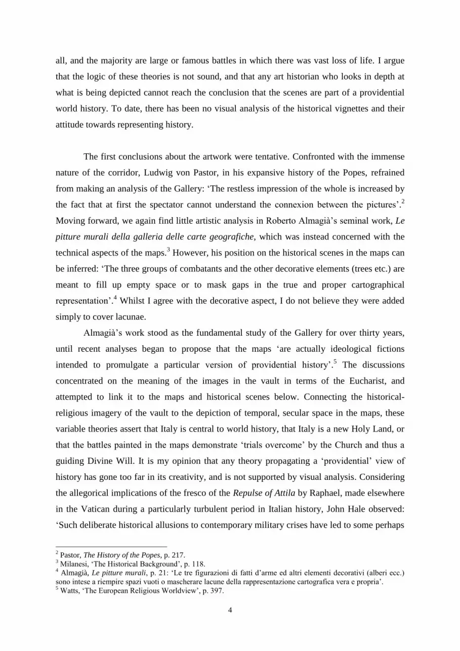
The conclusions concerning the religious iconography of the vault are understandable
within context of the vault, but I do not believe that they are applicable to the secular
vignettes on the walls. The distinction between the two is made clear by the only comparable
couplet between ceiling and the wall: the repulse of Attila by Leo I the Great (figs 2 and 3).
Whilst the vault propagates a divine causation, visualised through Attila’s revelatory vision
of saints Peter and Paul, the wall scene is divorced from the religion.20
We can discern this by
the map’s cartello, which states that Attila turned back because of the ‘the force of [Leo’s]
speech’.21
We have also seen that, despite repeated assertions by modern critics, the scenes
are not all triumphant displays of Italian or papal power. Indeed, the two more relevant issues
to be explored in detail are Danti’s views on cartography and topography, and the
administrative function of the Gallery.
20
Vicenzi, La Galleria, p. 91. 21
‘Vi sermonis’.
Figure 3: Matthijs Bril, Pope Leo I and Attila, map of Mantuae Ducatus

9
Sources for the Gallery’s Design
I will now examine some of the primary documents from which we can learn about
the design of the Gallery, principally concerning the cartographer Egnatio Danti. Three main
points emerge: firstly, that the primary sources do not mention the inclusion of historical
scenes. Instead, they focus on the mapping of Italy to the corridor’s space and the inclusion of
Avignon. Secondly, Danti’s scholarly view on Chorography is paramount to our reading of
the Gallery. He valued and read ancient literature on places, and the combination of historical
vignettes and informative cartelli add to the holistic description of the regions of Italy.
Finally, the Gallery was used both as an administrative tool and as a personal space for
reflection by Gregory XIII and later Popes.
During the construction period, Danti wrote a letter to Abraham Ortelius explaining
the guiding principle behind the project:
[The Pope] brought me to Rome in order to make a description of Italy in a gallery
which His Holiness has had made. After splitting Italy into halves along the Apennine
Mountains, I have placed that part which is washed by the Ligurian and Tyrrhenian Seas
on one side, and on the other, that which is bound by the Adriatic Sea and the Alps. Then
I divided the whole into 40 panels according to the States and Prefectures.22
In this letter, Danti’s brilliance is clear. The novelty with which he planned the
Gallery, making the corridor’s central axis act as the Apennine mountains, forces the physical
space both to conform to and to interact with the maps of Italy depicted on the walls. The
viewer must take a figurative walk along the spine of the Apennines as he observes the Italian
regions laid in geographical order to either side of him. The maps follow an imaginary route
through Italy, tracing a path from Liguria down the Tyrrhenian coastline, through the islands
of Corsica, Sardinia and Sicily, and then up north from Puglia along the Adriatic before
finishing in Piedmont. This principle of division is also found in the Gallery itself, above the
north door there is a dedicatory marble stone (fig. 4), part of the inscription of which states:
22
Hessels, Abrahami Ortelii, pp. 240-242. (letter 100): ‘[Il Papa] mi ha poi condotto in Roma a fare una
descrittione d’Italia in una Galleria che S. Santità ha fatta, ove havendo divisa l’Italia per il mezzo del monte
apennino ò posta da una banda della Galleria quella parte che è bagnata dal Mare Ligustico, et Tirreno, et
dall’altra, quella che è cinta dall’Adreatico, e dall’Alpi, dividendola poi secondo gli stati et le prefetture de
governi in quaranta parti, secondo che la Galleria è divisa in 40 quadri’.

10
‘Just as Italy is split by the Apennines in nature, so again here it is divided into two parts’.23
The wording of this inscription follows Danti’s explanation to Ortelius very closely, proving
both his authorship of the plaque and his direct involvement in the planning.
Figure 4: Inscription above north door
Given Danti’s explanation above, it is strange, at first glance, that there is a map of
Avenionensis ditio et Venaisinus Comitatus. However, its existence is explained by the
cartouche alongside it. The Catholic Church claims spiritual possession over the territory,
owing to the papacy’s withdrawal to France in the Fourteenth century. This much is made
clear in the cartouche (fig. 5): ‘The ancient city of Avignon, the Comtat of Venaissin and its
capital, Carpentras, the other cities and towns relate very little to Italy, however, because they
truly belong to the Roman Church, for this reason they are depicted here’.24
Therefore, we
must slightly modify our position on the cartographical content of the Gallery: it is not simply
the mapping of the Italian peninsula as achieved in writing by Alberti, nor is it any making
any claim to some political unity. Instead, it is the mapping of the territories over which the
Pope considered he had spiritual dominion, what Fiorani calls a ‘utopian construction of a
place under the ecclesiastical authority of the papacy’.25
23
‘Italia… ut natura ab Apennino secta est hoc itidem in duas partes… dividitur’. 24
‘Avenio urbs antiqua Venaisinus item Comitatus eiusq[ue] caput Carpentorace atq[ue] aliae urbes et oppida
etsi ad Italiam minime pertinent tamen quia Ecclesiae Roman[ae] sunt propria ideo hic describuntur’. 25
Fiorani, The Marvel of Maps, p. 182.

11
Figure 5: Cartouche for the map of Avenionensis Ditio et Venaisinus Comitatus
Another cartello in the Gallery further reaffirms Danti as the creator of the
cartographic elements in the Gallery. It is a trompe l’oeil, taking the form of a piece of white
paper pinned onto the map of Sallentina Hydrunti Terra (fig. 6). Scholars have taken this to
be his “signature”, for it states: ‘We have taken care, however, that the degrees and minutes
of the more famous places correspond exactly [to their actual location] (as far as it is possible
in chorography). This the Perugian Egnatio Danti, Brother of the Dominican Order, wished to
be understood’.26
The mention of chorography in this cartello leads to one of Danti’s
previously published works on mathematics, Le scienze matematiche ridotte in tavole (1577),
26
‘Curabamus tamen, ut longitudinum, latitudinumq[ue] gradus et minuta insignioribus loci (quoad
Chorographia ferre poterat) exacte responderent. Atque id F[rater] Egnatius Dantes Perusinus ord[inis]
Praed[icatorum] admonitum esse volebat’.

12
in which he provides us with his own definition of Chorography. From this he developed his
own cartographic language that included many elements from the tradition of written
chorography.27
Fiorani’s argument is persuasive in that we find many of Danti’s idiosyncratic
approaches to geographic science visualised in the maps of the Gallery. In the section
defining the various geographical sciences, we read that Danti defines both sciences as ones
that describe particular places.28
Crucially, however, he states that, while geometry is
necessary knowledge for chorography, ‘it can also be achieved as a mechanical art by a mere
painter’, whereas Topography, ‘making such a description with words, has no need of
Geometry or drawing’.29
Interestingly, he offers two exemplars of written descriptions of
places that appear on the walls of the Gallery: Polybius’s description of the Battle of Lake
Trasimene, and Livy’s account of the Battle of Cannae. Evidently, he was aware and admired
these descriptions, and later I will investigate how these scenes were translated visually onto
the maps.
Figure 6: trompe l'oeil scroll on the map of Sallentina Hydrunti Terra
27
Fiorani, The Marvel of Maps, pp. 194-199. 28
Danti, Le scienze, p. 44: Chorography: ‘che suona in lingua nostra descrittione di luogo particulare’;
Topography: ‘che anco essa descrive i luoghi particulari’. 29
Ibid.: ‘Può anco essere come arte mecanica esercitata dal semplice Pittore’; ‘Facendo cotale descrittione con
parole, non ha bisogno ne della Geometra, ne del disegno’.
13
Although the division of Italy into maps such as these was novel, it did have literary
precedents. Chorography is a sub-science of Geography harking back to Ptolemy, who
defined it through an artistic analogy as ‘an impression of a part’: Chorography is the
drawing of an ear or an eye if Geography relates to the whole head.30
During the Renaissance,
Chorography regained popularity as a form of literature, coming to the fore in Italy with
Flavio Biondo’s Italia Illustrata. All these works aimed at a deeper description of place, far
beyond mathematical coordinates on a Cartesian plane. Particularly relevant is the
Descrittione di tutta l’Italia (wording that Danti echoes in his letter to Ortelius, above) by
Leandro Alberti, not only because of its near-contemporaneous publication (first published in
1550, but republished multiple times, including in 1577), but also its peculiar layout.
Diverging from his predecessors, Alberti’s work circumnavigates Italy starting from the
Tyrrhenian Sea. The similar geographic programme between the book and the maps strongly
suggests that Alberti’s work had an influence on Danti, especially given his scholarly interest
in this field. Moreover, Fiorani argues that Alberti’s book was also innovative through its
meticulous sourcing of information about the people, places and events – military, religious,
and otherwise – that constituted the various regions of Italy.31
A common feature of Renaissance cartography, all of the maps include reference
cartouches that briefly inform us about the main historical and geographical features of the
region. Often, an ordinary map was transformed into a ‘historical’ map by way of a
contextual title and an inscription lifted from the particular text that the map was
illustrating.32
For example, in illustrated Bibles, maps modelled on the Ptolemaic projection
of the Eastern Mediterranean were recycled by including the title, ‘The Travels of Saint
Paul’, in order to alter their concept fundamentally.33
Whilst there were clearly literary
influences on the cartographic programme of the Gallery, most of all Alberti’s Descrittione,
the inscriptions were not lifted from any text – Danti concocted them himself. In the letter to
Ortelius previously quoted, Danti makes reference to ‘the inscriptions, which I made in that
Gallery’.34
Whilst Danti does not elude to the vignettes in the maps, we can recognise the
ordering scheme of the “miracles” through the marble stone inscription above the north door.
30
Berggren and Jones, Ptolemy’s Geography, pp. 57-59. 31
Fiorani, The Marvel of Maps, pp. 188-194, for a general survey of Italian chorography. 32
For the distinction, see Goffart, Historical Atlases, pp. 1-25. 33
Delano-Smith and Ingram, Maps in Bibles, pp. 99-120. 34
Hessels, Abrahami Ortelii, pp. 240-242 (letter 100): ‘Le inscrittioni che in essa Galleria io ho fatte’.
14
The vault displays ‘the deeds of saintly men in the places which they were done’.35
Moreover, this is corroborated by Danti, who writes to Ortelius: the images ‘represent some
noteworthy miracle that happened in that province’.36
Thus, the religious imagery of the vault
is arranged geographically according to the order of the maps, which explains the temporal
disconnection between the scenes. This system also applies for the historical vignettes: the
most important guiding principle of the scenes is geographical because they were arranged by
the region in which they took place. No reason of chronology or of theme – triumphant or
Catholic – ranks higher.
Figure 7: Inscription over south door
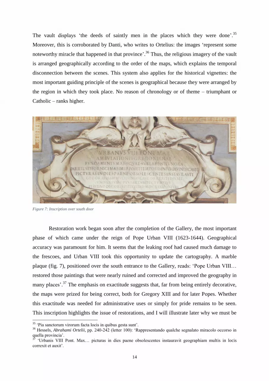
Restoration work began soon after the completion of the Gallery, the most important
phase of which came under the reign of Pope Urban VIII (1623-1644). Geographical
accuracy was paramount for him. It seems that the leaking roof had caused much damage to
the frescoes, and Urban VIII took this opportunity to update the cartography. A marble
plaque (fig. 7), positioned over the south entrance to the Gallery, reads: ‘Pope Urban VIII…
restored those paintings that were nearly ruined and corrected and improved the geography in
many places’.37
The emphasis on exactitude suggests that, far from being entirely decorative,
the maps were prized for being correct, both for Gregory XIII and for later Popes. Whether
this exactitude was needed for administrative uses or simply for pride remains to be seen.
This inscription highlights the issue of restorations, and I will illustrate later why we must be
35
‘Pia sanctorum virorum facta locis in quibus gesta sunt’. 36
Hessels, Abrahami Ortelii, pp. 240-242 (letter 100): ‘Rappresentando qualche segnalato miracolo occorso in
quella provincia’. 37
‘Urbanis VIII Pont. Max… picturas in dies paene obsolescentes instauravit geographiam multis in locis
correxit et auxit’.

15
cautious in assigning a predetermined programme to the Gallery given the extensive and
repeated work that has been conducted on it.
Administration and pride of ownership are both factors governing the initial purpose
and subsequent restoration of the Gallery. Scattered across the maps of the Papal States are
the heraldic crests of not only Gregory XIII but also the Borghese pope, Paul V, and the
Barberini pope, Urban VIII. Their presence is explained by a scroll painted onto the map of
Flaminia (fig. 8). With an inscription following a copy of the golden dragon, it states: ‘I
wanted you to know that those locations on the maps painted here that show the image of a
gold dragon, like this one, were returned to papal jurisdiction by Pope Gregory XIII’.38
It is
logical to extend this to the later popes’ crests as well. Why, then, did these popes feel it
necessary to add their crests to the map murals? The answer must surely be twofold. There is
no doubt that the exhibition of their family crest had a self-aggrandising effect, but more
importantly, it indicates that the maps had an active function. The constant updating of the
panels, testified by archival evidence, as State borders changed adds an administrative level
to their function.39
It has been shown that States were using maps as governing aids
throughout Europe more and more in this period.40
Figure 8: trompe l'oeil scroll in the map of Flaminia
38
‘Quae loca in depi[c]tis tabul[is] draconis aurei signum huic simile ostendunt ea Gregorius XIII P. O. M.
Apostolicae ditioni recuperavit id volui ne nescius ne esses’. 39
See n. 51 in Fiorani, ‘Post-Tridentine Geographia Sacra’, p. 146. 40
Kagan and Schmidt, ‘Maps and the Early Modern State’.

16
To recap our stance, we have established that the creator of the maps was Danti, who
designed them to reflect the Church’s spiritual dominion, which explains the inclusion of the
map of Avignon. Whilst there is no explicit mention of the vignettes in primary
documentation, we know that Danti drew on ancient authors’ descriptions of places from his
discussion in Le Scienze on the topic of topography. This provides us with some clue as to
how he conceptualised the historical scenes within the scheme of the maps, and we have good
reason to believe that he wrote the Latin inscriptions accompanying them. Moreover, the
administrative function of the maps is certainly interesting, but the scenes do not help this on
a practical level, as they block the view of the map.
Purpose of the Historical Vignettes
Let us now consider the purpose of the Gallery and its decoration, and, in doing so,
examine closer some modern theories. As we have already established that the Gallery was
used in both and an administrative and a recreational way by Gregory XIII and later popes,
we must now investigate if the historical vignettes fit into this idea. Watts and Pinelli both
believe that the overriding message is positive, but I refute these arguments since they do not
logically follow the evidence of the Gallery. The negativity perceived by Goffart reminded
him of Orosius’s view of Roman history, and, despite his asserting its unfeasibility, I
investigate how contemporaries viewed the Italian Wars. I find that they had a similarly
morose perception, but instead of concluding that the lessons of the Gallery must be the
futility of human endeavour (following Orosius), I argue instead that this led them to portray
the images in a manner divorced from the distressing reality.
Watts argues that the corridor acted as a space for Gregory XIII to contemplate the
dual nature of his persona: namely, as temporal ruler of the Papal States and as spiritual
leader of the Catholic Church.41
She theorises that the twelfth-century treatise De
consideratione ad Eugenium papam tertiam libri quinque by Bernard de Clairvaux was
instrumental in developing this attitude towards the pope’s dual persona. As evidence for the
use of the Gallery in this way, she notes firstly the inscription above the north door, which
claims that Gregory XIII desired the Gallery to be created with great skill ‘so that the
41
Watts, ‘Mirror for the Pope’, pp. 177-179.

17
advantage of considering things and places might not lose any of its pleasure’.42
It appears,
then, that Gregory XIII wanted a space not only in which he could reflect upon the business
of state (rerum) and geographical knowledge, but also one in which he could enjoy this
activity. In order to clarify the meaning of this inscription, Watts cites Stella’s Ambulatio
gregoriana.
The Ambulatio gregoriana, a poem in hexameter dedicated to the Gallery, styles
Gregory as a new Augustus, a bringer of the Golden Age, and reflects glory on its creator for
his good government.43
Regarding the purpose of the Gallery, it claims firstly that catching a
breeze whilst walking up and down the corridor considering the paintings revitalised
Gregory: ‘A healthy breeze is almost enough to restore him, and if weary he secretly snatches
the odd hour for a walk, it is reward for his services’.44
Secondly, the maps were designed to
aid him in the contemplation of ruling: ‘The two rows of paintings, which he can gaze on
again and again, depict the whole of Italy. He can consider how best to administer and govern
it, how to resolve civil discord and maintain lasting peace for his people’.45
Whether or not
this was the original intention, and it is very plausible that it was, the Ambulatio gregoriana
gives strong evidence that this was how specifically the maps were used, but not the
vignettes.
Contrary to Watts, I do not agree that the historical scenes were there ‘to remind the
papal prince of actual historical moments when his territories were threatened from without
and defended at great cost’.46
Watts does not fully explain why the Pope would want to be
reminded of these incidents in particular. Furthermore, for those scenes that do not directly
relate to the papacy, we are left to wonder how he would have reacted. This is expressly so
for the Roman defeats at the hands of the Carthaginians during the Second Punic War that are
displayed on the walls, such as the Battle of Lake Trasimene or of Cannae, and I am not
convinced that they were employed in order to stir the pope’s consideratio.
The prevailing opinion amongst academics is that, considered as a whole, the Gallery
represents ‘Italy’s proud claim to the continuous trust placed in her by Divine Will. Central to
this theme are the twenty or more tiny episodes from history which are occasionally included
in the Maps’.47
My principal thesis is a reaction against claims of this sort; despite being
frequently repeated in the secondary literature, they do not follow logically. In fact, very little
42
‘Ne iucunditati deesset ex rerum et locorum cognitione utilitas’. 43
Ferri, ‘A “Walk through Italy”’, p. 74. 44
Idem, p. 78. 45
Ibid. 46
Watts, ‘A Mirror for the Pope’, pp. 183-184. 47
Pinelli, ‘Above the Earth’, p. 127.

18
points directly to a “providential” view of history: neither the portrayal of the event, nor the
informative cartelli, nor their position in an overarching programme.
It is difficult to understand – and left unexplained – how the vast loss of life between
two non-Christian armies at Cannae or even between the two Christian armies at Ravenna
contributes towards a progressive Christian worldview. The first few years of the Second
Punic War were unambiguously disastrous for the Romans, and one of the lowest points in
Italian history. Although the first significant victory won by the Romans was the First Battle
of Beneventum in 214 BC, the first depicted Roman victory was decade later at Metauro in
207 BC. The weighting of the Hannibalic episodes is clearly one-sided: they are not so much
a catalogue of ‘threats overcome’ as one of catastrophic Roman defeats with only a vague
reference to the eventual outcome of the war. This disproportion suggests another aspect of
the episodes, namely that there was a disinterested in recounting an accurate and balanced
history.
It does not make sense, either, that all the episodes are exercises in papal propaganda.
Although clearly a degree of pride influenced the addition of heraldic crests, many maps
display unfavourable defeats or do not even involve Rome or the papacy. What’s more, the
battles between Christians and Muslims or pagans are in the minority. It is true that to a
certain extent Gregory is promoted, given the emphasis on Bologna, his birthplace, and
inclusion of his namesakes. However, this is to be expected: he had already shown a
predisposition towards self-promotion in the commission of the Sala Bologna, and the
elevation of the patron’s status was commonplace in glorifying works of art such as these.48
It
was extremely rare for a Renaissance artist to exhibit the defeat of his patron in a decorative
battle painting.49
In fact, the level of bias shown towards one side in military art could be so
extreme that it turned reversals into victories. Despite the losing the Kingdom of Naples and
northern Italy as a result, only three months after the Battle of Fornovo the outcome was
manipulated in France to be ‘a triumphant feat of extrication from a hazardous situation’.50
Nevertheless, it is clearly not the case with the Gallery of Maps that the painting is operating
on a solely propagandistic level, so we must turn to other modes of thought.
The feeling in the Sixteenth century towards the Italians Wars is discernible through a
large body of literature and it does not accord with the triumphant rhetoric of most modern
scholars. At first, there is an understandable indignation to recent events: chapter XXVI of
48
Fiorani, ‘Cycles of Painted Maps’, pp. 811-812. 49
Oman, ‘Early Military Pictures’, p. 342. 50
Hale, Artists and Warfare, p. 145.

19
Machiavelli’s The Prince is famously titled ‘An exhortation to liberate Italy from the
barbarian yoke’, in which he wrote, ‘This foreign domination stinks in the nostrils of
everyone.51
Following the Sack of Rome in 1527, a common trope, called the lamento di
Roma by André Chastel, affected Italian, and particularly Roman, writing, which was namely
a melancholic defeatism.52
It is typified in the anonymous sonnet La presa di Roma, written
shortly after the sacking: ‘Wretched Italy, subjected to the fate which you so often fought off,
where have you been led? Glory, virtue, and vitality, all of which had previously been
granted to you by the highest gods, are no more’.53
Moreover, this attitude can also be
detected later in the century. Guicciardini’s La Storia d’Italia has been characterised as an in
depth and tragic analysis of Italy’s terrible decline since the Italian Wars, and that what it
‘most strongly and repeatedly impresses upon us is the weakness and impotence of humanity
in the face of destiny’.54
Published in 1558, Giovanni della Casa’s Galateo, a book on
manners, still displays a similar sentiment of despair to recent events. Discussing a new
ceremony, della Casa bemoans what has happened to Italy and how it has been changed, for
the worse in his opinion, by the invasions:
It is not native, but foreign and barbaric, and recently crossed into Italy
from where it originates. Our poor country, it has been debased and
humiliated both by what has happened and by the consequences; it has only
gotten worse and now is given honours of empty words and meaningless
titles.55
In short, the events of the Italian Wars, and in particular the Sack of Rome, were
catastrophic on the morale of Italian writers, and Chastel believes that this moroseness and
defeatism persisted until the Risorgimento.56
Hale is surely perceiving the same phenomenon
when he notes that only three direct images of battles from the Italian Wars (1494-1529) were
created by Italians for the Italian market, whereas such depictions proliferated north of the
51
Machiavelli, The Prince, p. 91, tr. by Skinner and Price: ‘Ad ognuno puzza questo barbaro dominio’. 52
Chastel, The Sack of Rome, p. 22. 53
Mango, La Guerra di Camollia, p. 173:
‘Misera Italia, a che condotta sei,
Suggetta al nome che più fiate hai vinto;
La gloria, il pregio e quel vigore è estinto
Che già dato ti fu da’ sommi Dei’. 54
Gilbert, Machiavelli and Guicciardini, p. 128. 55
Giovanni della Casa, Galateo, p.82: ‘Non è originale, ma forestiera e barbara; e da poco tempo in qua, onde
che sia, trapassata in Italia; la quale misera, con le opere e con gli effetti è abbassata ed avvilita, è cresciuta
solamente ed onorata nelle parole vane e ne’ superflui titoli’. 56
Chastel, The Sack of Rome, pp. 122-123.

20
Alps.57
There was an evident reticence on the part of Italian patrons and artists towards
portraying the battles, which stemmed from the devastation and distress that they caused. The
events pictured in the Gallery, being somewhat removed in time, cannot be classified as
“direct” images of the battles in the Italian Wars. In any case, the near constant warring in the
first half of the Sixteenth century would have had a large effect on the following generations
of artists and thinkers, including those men who worked in and around the Gallery of Maps.
Thus, we see a very similar tone in Italian literature to that perceived by Goffart, who
for his part argues that the planned lesson (recalling the inscription over the north door: ‘ex
rerum et locorum cognitione utilitas’) of the Gallery is derived from Orosius. So, aside from a
perceived likeness in tone, there is no documentary evidence to suggest that Orosius was
consulted. Although often highlighting the dire consequences of the battles with words such
as clades (disaster), the inscriptions themselves are not directly influenced by Orosius.
Neither is the depiction of the battles particularly suggestive of suffering, in spite of the
subject of war: for the amount of battles there are, very few corpses are on display.
Historicity is another problem highlighted by Goffart: the selection of scenes is
extremely disproportionate and very unrepresentative of “world history”.58
There is a
concentration of scenes relating to the Second Punic War, and to the most recent battles
(post-1494) in the northern half of Italy. On the one hand, there are some of the most
important battles on Italian soil included; on the other, many more are not present. For every
Battle of Pavia, there is a Marignano not included. And where is the Battle of the Allia,
considered ‘a disaster equal in renown to the Battle of Cannae’ by Livy?59
Critics asserting
that the Gallery showcases the most famous battle on Italian soil have yet to tackle this
problem. Therefore, it must be said that if the Gallery’s historical scenes are meant to be
instructive, they are not effective in teaching a balanced view of history. Moreover, because
they have not conducted a visual analysis of the paintings, historians of the Gallery have not
yet pointed out that many of the images are ineffective without the inscriptions. Take for
instance the depiction of the army sent by the Marche in defence of the Pope at the time of
the Sack of Rome (fig. 9); without the informative cartello, this scene would be practically
impossible to identify. There are only the three cannons to indicate that this was a near-recent
event; the standards carried by the troops are various and fictive, but in other respects the
depiction is highly conventional and visually similar to many other scenes.
57
Hale, Artists and Warfare, pp. 140-145. 58
Goffart, ‘Christian Pessimism’, pp. 807-808. 59
Livy, Ab urbe condita, XXII.l.1: ‘haec est pugna Cannensis, Alliensi cladi nobilitate par’.

21
Figure 9: Matthijs Bril, The army sent to Rome by The Marches, map of Picenum
The lessons that we derive from the Gallery depend upon how we view its tone.
Although most modern scholarship has emphasised a triumphant, progressive attitude
towards Italian history, Goffart perceives a pessimistic, “Orosian” outlook. Whilst I do not
agree that the Gallery presents itself in a positive manner, I am not convinced by Goffart’s
reasoning for pessimism; Italians were understandably downcast about the near-constant
invasions into Italy by both French and Spanish-Imperial forces since 1494, and this is a more
likely cause than the fourth-century Church historian Orosius. This led the artists to portray
the historical scenes in the rather distant, emotionless manner. Indeed, the depiction of so
many defeats and seemingly irrelevant events would be a strange and historically
unprecedented way of forming a progressive world history concerning the Catholic Church.
For these reasons, I do not believe that the Gallery was attempting to create a Christian view
of history through the vignettes or that they might aid the Pope in his reflections.
Restorations of the Gallery
Understanding the various restoration works that have been undertaken in the Gallery
is vitally important to our reading of the vignettes, as many changes to the frescoes have

22
taken place. We must be very cautious when constructing programmes because it is clear
from visual and archival testimony that the historical vignettes were not painted
simultaneously or by the same artists, nor has the full set survived.
Almost immediately upon completion, the Gallery went through restoration during the
papacy of Sixtus V (1585-1590).60
However, the most important and extensive works were
carried out under Urban VIII, as indicated by the dedicatory inscription above the southern
entrance. The corridor was restored to its foundations to stop damp, and the ruined frescoes
were redone with the intention of updating the scientific accuracy of the maps. Lukas Holste
was the main artist responsible for these works, and some lasting touches of his are
noticeable. Almagià maintained that Holste added some of the classical names to some maps,
arguing, for example, that the ‘Vestigi di Recina’ in Picenum were added because Holste had
visited the site himself.61
The restoration work most relevant to this essay was conducted under Clement VIII
(1592-1605). Pietro Oldrado, considered a ‘generally scrupulous artist’ by Almagià, repainted
a number of the damaged maps, some of which contained historical scenes.62
Archival
records of conti detail that Oldrado worked on four scenes. Firstly, in Perusinus ac Tifernas
‘a little history was made, called Consul Hannibal’, which must relate to the scene of the
Battle of Lake Trasimene.63
The wording of the document suggests that it was not there
before; indeed, Danti’s original drawing only featured the caption ‘Rotta de’ Romani’ but no
scene.64
Secondly, in Pedemontium et Monsferratus, he redid the top half of the panel,
including painting the scene, Hannibal on the promontory – for which no scene exists – and
retouching The fierce Battle of Ceresole.65
Finally, for the map of Mediolanensis Ducatus, he
repainted the bottom half a secco and, in the process, retouched the vignette called Marcellus
and Priomato.66
There is no identifiable scene on the map for this last item, although there is
a cartello celebrating Marcellus’s victory over the Insubres at Clastidium in 222 BC. During
the battle, Marcellus defeated in single combat the enemy general called Virdomaro by the
60
On the various phases of restoration, see Schütte, Die Galleria delle Carte Geografiche im Vatikan, pp. 22-27,
and Franzoni, ‘The Restoration of the Gallery of Maps’, pp. 169-174. 61
Almagià, Le pitture murali, p. 35. 62
Idem, p. 38: ‘era pittore assai scrupoloso’. 63
Bertolotti, ‘Autografi di Artisti’, p. 193: ‘In detto quadro ci si è fatto … una Historietta che si chiama Anibale
Consule’. 64
Vicenzi, La Galleria, p. 116. 65
Idem, p. 194: ‘Il quale prima si è incollato dalla metà in sù a fresco e poi si è ritocco a secco insieme con tutto
il quadro… et una historietta che dice Anibal ac in promontorio et si è ritocco la historietta che dice accerimus
ad Ceresolam conflictus’. 66
Idem, p. 195: ‘Il quale prima si è rifatto dalla metà in giù tutto a secco… nell’istesso quadro si è rittocco la
historietta di Marcello et Priomato’.
23
cartello.67
This Insubrian leader’s name varies in the ancient histories, but this event must be
the one mentioned in the conto. His name is closest to the document’s ‘Priomato’ in
Plutarch’s Life of Marcellus, where it appears as ‘King Britomatos’.68
Florus, who generally
followed Livy, uses both ‘Viridomarus’ and ‘Brittomarus’ in his Epitome of Roman History,
though the former is the one killed at Clastidium. Livy, however, calls him ‘Vertomarus’.69
We can therefore conclude that ‘Priomato’ is an Italianised version of the Insubrian leader’s
name, Britomatos from Plutarch. Incidentally, Alberti calls him ‘Viridomaro’, and cites as
sources for the battle, Polybius, Plutarch, and Florus.70
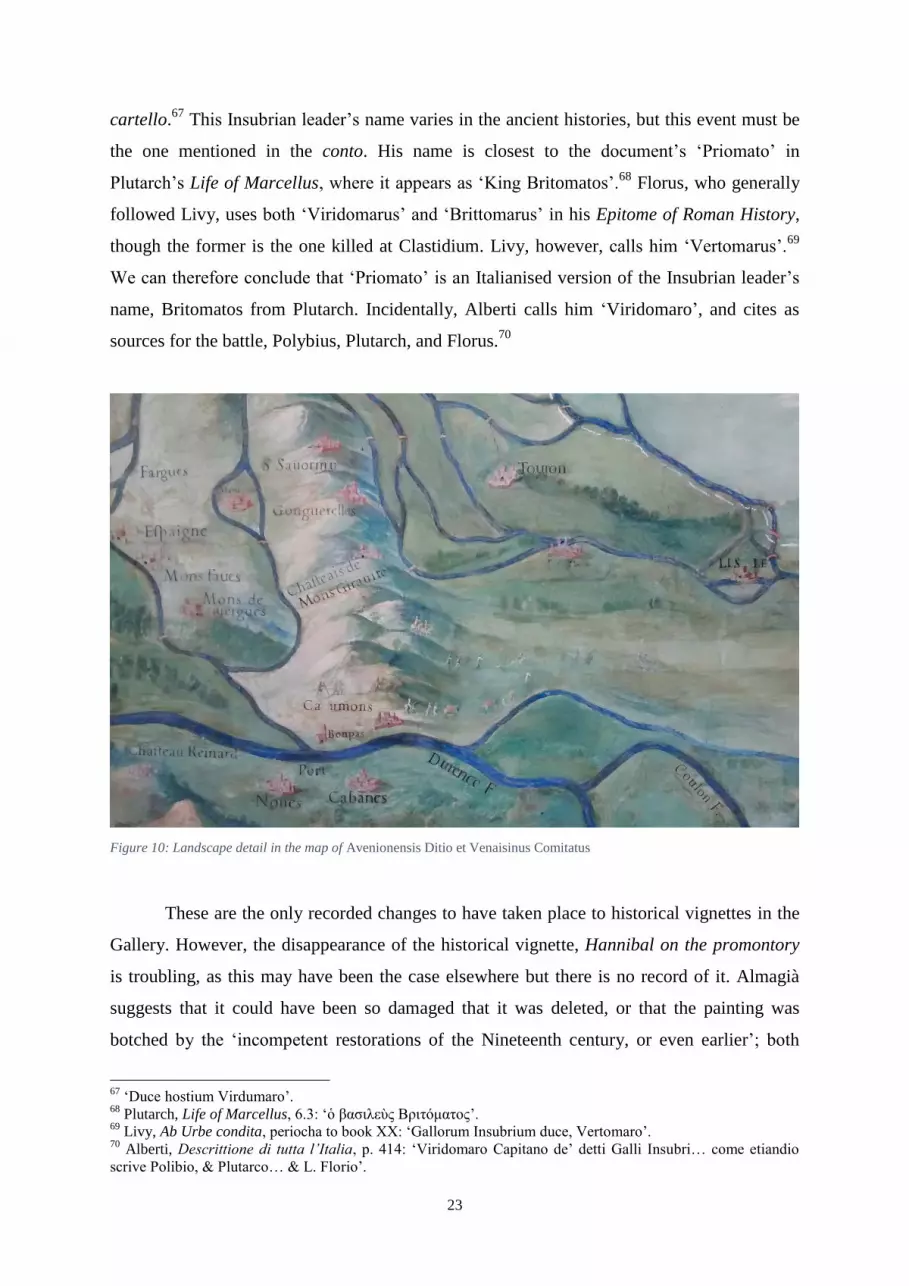
Figure 10: Landscape detail in the map of Avenionensis Ditio et Venaisinus Comitatus
These are the only recorded changes to have taken place to historical vignettes in the
Gallery. However, the disappearance of the historical vignette, Hannibal on the promontory
is troubling, as this may have been the case elsewhere but there is no record of it. Almagià
suggests that it could have been so damaged that it was deleted, or that the painting was
botched by the ‘incompetent restorations of the Nineteenth century, or even earlier’; both
67
‘Duce hostium Virdumaro’. 68
Plutarch, Life of Marcellus, 6.3: ‘ὁ βασιλεὺς Βριτόματος’. 69
Livy, Ab Urbe condita, periocha to book XX: ‘Gallorum Insubrium duce, Vertomaro’. 70
Alberti, Descrittione di tutta l’Italia, p. 414: ‘Viridomaro Capitano de’ detti Galli Insubri… come etiandio
scrive Polibio, & Plutarco… & L. Florio’.

24
events could apply to many other maps and vignettes in the Gallery.71
He also notes that,
although the cartello of the scene no longer exists, there are faded letters of a regional name
between Crescentino and Palazzo just above the River Po in the centre right of Pedemontium
et Monsferratus.72
Potentially the scene was nearby to these faded or cancelled letters. This is
another reason why I am cautious about drawing conclusions about an iconographic
programme: clearly at least one vignette has been painted over and maybe more, so we do not
have all the evidence to form a judgement. There are some figures – horsemen, footmen, and
pack animals – in the map of Avenionensis Ditio et Venaisinus Comitatus (fig. 10); are these
the remnants of a lost historical vignette or is it a generic hunt scene in the landscape?
Certainly, it is possible that other episodes have not survived to our time. Bearing this
possibility in mind, I will now turn to an analysis of the historical vignettes.
The Historical Vignettes
The historical vignettes that enliven the cartography within the Gallery are unequally
distributed both in terms of geography and in terms of chronology. The panel for
Mediolanensis Ducatus, for instance, contains four episodes, whereas twenty-five out of forty
maps have none; except the Battle of Lepanto and the Siege of Valletta, which are roughly
130x139cm, all of the scenes take up no more than one metre squared. The episodes range
from the ancient Battle of Pandosia in 330 BC, right up to the very recent Battle of Lepanto
in 1571 AD, only ten years prior to the Gallery’s completion. Most are battles or include an
army in some capacity. For ease of reference, I include a table of all twenty-seven historical
vignettes, listed chronologically in Appendix One.
I will conduct a visual analysis of the vignettes and principally I will be looking at
what these images tell us about history. The reason for this approach is due to their
appearance: modern classifications designed to aid our reading of military art would class
them as ‘documentary’ rather than ‘heroic’ art, which aims at aggrandising a central character
or the patron. Before exploring the historical vignettes in detail, I will first examine art
literature from the Sixteenth century so that my analysis of the paintings can be informed by
contemporary practice and custom. What we find is that in the genre of battle painting, the
recommendation is very much to tailor the composition to the subject.
71
Almagia, Le pitture murali, p. 17: ‘Forse fu cancellata dagli inabili restauri del secolo XIX, o ancora prima’. 72
Ibid. and n. 5.

25
Literature on Military Art from Ancient Rome to Italy in the Sixteenth
century
The precedents for military art and writing thereof hark back to at least the Third
century BC at Rome, although very few works of art of this kind have survived to our
times.73
Firstly, Pliny notes that the first publicly displayed painting was a battle scene from
the First Punic War: ‘[M. Valerius Maximus Messala] was the first man to exhibit a painting
of a battle, in which he had beaten the Carthaginians and Hiero in Sicily, on the side of the
Curia Hostilia in 264 BC’.74
Additionally, regarding how Tiberius Sempronius Gracchus
commemorated a victory, Livy writes: ‘And so, because of his accomplishment he gave a
panel as a gift to Jupiter. It was a painting of the island of Sicily, and on it were depicted
representations of battles’.75
It bears a remarkable similarity to some of the maps in the
Gallery.
Unfortunately, sixteenth-century Italian theorists did not focus on the type of battle
painting mentioned by Livy. Instead, they address monumental, glorifying military art, such
as the Battle of the Milvian Bridge by Giulio Romano. Leonardo’s instructions in the chapter,
‘Come si deve figurare una battaglia’, in his Trattato della pittura are concerned artistic
considerations such as colour, the depiction of smoke and dust, light and air. Though the
papers were not published until 1651, Leonardo’s style did have an influence on his
contemporaries, as evidenced by the considerable interest in his lost Battle of Anghiari.76
Two other important art theorists of the Sixteenth century who considered battle
scenes were Lodovico Dolce and Giovanni Paolo Lomazzo. Dolce advises the artist to take
into consideration the time at which the event took place and the nations involved, and to
adjust the dress, weapons and equipment accordingly, as seen in this extract from his Aretino
(1557):
The painter should always pay attention to the quality of the persons, and
no less to the nations, the costumes, the places and the period; such that if
73
The most famous exception is the Alexander Mosaic from the House of the Faun in Pompeii, which is
believed to be based on a lost Greek original. Post-Republican military art is largely triumphal, such as Trajan’s
column or the Arch of Septimius Severus. 74
Pliny, Naturalis Historia, XXXV.22-25: ‘[M. Valerius Maximus Messala] princeps tabulam picturam proelii,
quo carthaginienses et Hieronem in Sicilia vicerat, proposuit in latere curiae hostiliae anno ab urbe condita
CCCCXC’. 75
Livy, Ab Urbe Condita, XLI.xxviii.10: ‘Cuius rei ergo hanc tabulam donum Iovi dedit. Sardiniae insulae
forma erat, atque in ea simulacra pugnarum picta’. 76
Wilson, ‘Military Science’, pp. 26-28; Hale, Artists and Warfare, pp. 163-164.
26
he were to depict a military action of Caesar or Alexander the Great, it
would not be right if he armed the soldiers in the way in which we dress
nowadays. Moreover, he should make one style of equipment for the
Macedonians and another for the Romans, and if he was commissioned to
represent a modern battle, we should not find that he has devised it like an
ancient one.77
Although his work was published after the completion of the Gallery, in 1584, and we
cannot, therefore, regard it as a direct influence, Lomazzo expounds a similar view to
Dolce.78
Nevertheless, the sixteenth-century theoretical attitude aimed at culture and period
appropriate costume and equipment. Despite the clear instructions in these two works of art
literature, in reality not all artistic production achieved historical authenticity for a variety of
reasons. Far more typical in the Renaissance Italy was the glorifying battle painting, in which
the patron or central figure would be made to look heroic at the sacrifice of historical truth.
The documentary, as opposed to the glorifying, battle painting are modern interpretations of
this ancient theme created in order to understand better the meanings of battle art.79
The
distinction between the two pertains to whether art attempts to portray historical truth or not.
The topographical battle scene with figures in the foreground was developed in the north
under Sebastian Vrancx and his pupil Pieter Snayers, and in general northern artists were
more concerned with portraying historical fact than Italians.80
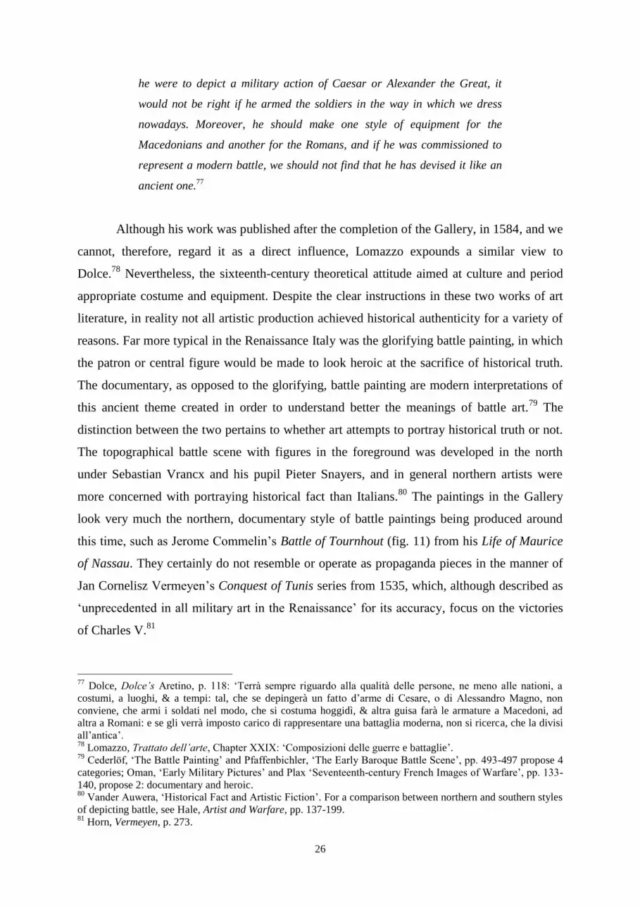
The paintings in the Gallery
look very much the northern, documentary style of battle paintings being produced around
this time, such as Jerome Commelin’s Battle of Tournhout (fig. 11) from his Life of Maurice
of Nassau. They certainly do not resemble or operate as propaganda pieces in the manner of
Jan Cornelisz Vermeyen’s Conquest of Tunis series from 1535, which, although described as
‘unprecedented in all military art in the Renaissance’ for its accuracy, focus on the victories
of Charles V.81
77
Dolce, Dolce’s Aretino, p. 118: ‘Terrà sempre riguardo alla qualità delle persone, ne meno alle nationi, a
costumi, a luoghi, & a tempi: tal, che se depingerà un fatto d’arme di Cesare, o di Alessandro Magno, non
conviene, che armi i soldati nel modo, che si costuma hoggidì, & altra guisa farà le armature a Macedoni, ad
altra a Romani: e se gli verrà imposto carico di rappresentare una battaglia moderna, non si ricerca, che la divisi
all’antica’. 78
Lomazzo, Trattato dell’arte, Chapter XXIX: ‘Composizioni delle guerre e battaglie’. 79
Cederlöf, ‘The Battle Painting’ and Pfaffenbichler, ‘The Early Baroque Battle Scene’, pp. 493-497 propose 4
categories; Oman, ‘Early Military Pictures’ and Plax ‘Seventeenth-century French Images of Warfare’, pp. 133-
140, propose 2: documentary and heroic. 80
Vander Auwera, ‘Historical Fact and Artistic Fiction’. For a comparison between northern and southern styles
of depicting battle, see Hale, Artist and Warfare, pp. 137-199. 81
Horn, Vermeyen, p. 273.
27
Figure 11: Jerome Commelin, The Battle of Tournhout, Life of Maurice of Nassau, 1597
The Artistic Styles of the Vignettes
Visual analysis of the historical vignettes quickly points to a plurality of artists at
work in the Gallery. Having examined the evidence for some of the restorations in the
Gallery above, and found that it points to a number of additions and alteration, it is simple to
understand why this is the case. We know most about the restorations undertaken by Oldrado,
who added one episode and repainted three others, one of which is now lost. This goes some
way to accounting for differences in appearance between episodes. Despite this, I have
identified one predominating hand that was responsible for at least thirteen of the vignettes.
As there have been later additions and re-paintings in the Gallery, categorising the other
scenes is a challenging task, the basis for which is laid in Appendix Two.
I will now proceed to lay out the fundamental characteristics of this principal style,
which apply generally to the rest, by looking at one example: Julius Caesar’s army crossing
the Rubicon (fig. 12) in the map of Flaminia. Although there is no title or visual indication,

28
such as recognisable portrait of Caesar, marking out this scene, we can be certain of the
subject from two details. Firstly, at the Rubicon, there are the words ‘IACTA EST ALEA’,
alluding to his gamble.82
Secondly, there is a reproduction of the pseudo-classical cippus of
the Fifteenth century that forbids the crossing of the Rubicon in arms by order of the Roman
Senate on the side of the map.
Figure 12: Matthijs Bril, Julius Caesar's army crossing the Rubicon, map of Flaminia
While the maps are seen from a bird’s-eye view, the historical vignettes are always
depicted as though from an imaginary, high vantage point at the bottom of the map, which
one can equate to the Apennines. As such, not only do the figures decrease in size the further
away they are (that is, higher up the wall), but also the angle of sight changes so that less of 82
‘The die is cast’, a phrase attributed to Caesar by Suetonius in Divus Julius, 32.

29
the tops of the figures are visible. Interacting with and blending into the map with its varied
geographical features, they are seen walking along the Via Emilia, passing through the
countryside with trees and hills, and crossing the rivers in their path. In this way, they
transform the cartographic space into a topographical view. Regarding the figures
themselves, the artist has a uniform manner and a small range of standard military subjects.
First, a background layer of blue was put over the map’s green terrain; then onto this layer,
the detail of the figures or paraphernalia was added in other colours. The main colours used
were principally white and yellow, and to a lesser extent browns, blues, reds, and greys. Most
noticeable throughout the Gallery are the numerous compact regiments of pikemen and
lancers, which are also depicted singly or in small groups, but he also painted horses with
carts, pack animals, army tents, and artillery. Except the cannon, all of these are to be found
in the scene of Julius Caesar’s army crossing the Rubicon. It must be noted that all of the
figures are portrayed in the same manner and costume regardless of the time period relevant
to the scene – except the artillery, which is reserved for modern battles, going against not
only the recommendations of Dolce and Lomazzo, but also of historical realism. This is true
of all the scenes, regardless of artist.
Much in the historical vignettes is thus depicted conventionally. In particular, the
distinctive style of portraying soldiers and horsemen follows the contemporary fashion. Hale
notes that for Italian military art during this period: ‘Whether the battle was ancient,
medieval, or recent, the contemporary reliance on a majority of infantry brought the
reinvention of a shorthand device, the “forest of pikes”’.83
Looking at the depiction of
Caesar’s army, we can see two bands of pikemen and two of horse painted in this way. The
first row of the regiment is painted fully, while a few disembodied heads suggest a greater
depth than there really is; on top of these figures are straight yellow lines for the spear shafts;
the crowning feature is a band of blue that is flecked with many small white strokes, made to
represent the multitude of spearheads. The inclusion of these spearheads is central to the
success of this device, since it enables the artist to imply a far greater number of soldiers than
the space occupied could allow. Just as the infantry are standardised, the banners seen here
are white and non-specific; elsewhere, they appear variably as coloured with generic patterns
and seldom are historical flags attempted.
While this style is the most common, a brief contrast will demonstrate the variation
within the Gallery. The most dramatic departure from this manner is the scene from Lucania,
83
Hale, Artists and Warfare, p. 138.

30
in which the Roman consul, Marcellus, dies in a skirmish with Carthaginian outriders (fig.
13). Because of the difference, I believe that this scene was either added later, or it has been
significantly repainted a secco, as the paint of some of the tents has faded significantly. To
begin with, that the vignette has been inexpertly merged with the surrounding geography
suggests ad hoc painting: the ground that forms the camps is flat but is uncomfortably
situated on hilly terrain – the camp to the bottom right even overlaps with some trees. The
appearance of the camps themselves is unique: the highly regimented olive-green barracks
and the central tepees diverge vastly from other tents painted in the Gallery. In addition, the
figures are painted differently; there is no characteristic “forest of pikes” for the infantry, and
most of the horses are at a gallop and have longer forms. Furthermore, the italic script
employed in the cartello is not found anywhere else in the Gallery.
Figure 13:Marcus Marcellus dies in a skirmish with the Carthaginians, map of Lucania

31
Who Painted the Vignettes?
Identifying individual artists’ work in the Gallery’s painting is a difficult job: there
are no signatures and it is likely that a number of artists worked on the same panel at the
same time. All we have to go on are references in artistic biographies, such as those by
Giovanni Baglione and Agostino Taja, and stylistic comparisons between the frescoes. As I
have argued, I believe that a large proportion of the historical vignettes, at the very least
thirteen, were painted by the same hand under the direction of Danti, and now it remains to
investigate who this artist was. Of the nineteen artists mentioned by Baglione in connection
with the Gallery’s initial decoration, I believe that there are two prime candidates: Antonio
Tempesta and Matthijs Bril, with other scenes by lesser masters or altered in later
restorations.
Baglione records that Tempesta not only ‘worked in the Gallery’, but also
‘demonstrated his skill in the small figures painted a fresco’ there.84
Fiorani tentatively
suggests that Tempesta was the one responsible for the battle scenes, on the basis that
Baglione described him as being famous for ‘his paintings of cavalcades, of hunts and of
battles’.85
Indeed, Tempesta had a successful career in specialising in battle scenes, as can be
seen in his accomplished later work (fig. 16). The manner in which Tempesta depicts large
bodies of troops in the middle-ground certainly recalls the Gallery’s scenes. First there is a
row or two of soldiers to indicate a cohort, followed by the “forest of pikes”, which is topped
with empty space and flecked with small strokes to symbolise spearheads, finally standards
rise like sails above the spears. It should be remembered, however, that this had become a
conventional manner of depicting large bodies of troops. Although artistic licence like this is
far more understandable in this series of battles from the Old Testament, Tempesta still
included these flourishes in his works on recent battles.86
Moreover, Taja asserts that
Tempesta painted the majority of the religious history scenes on the vault, and throughout his
account does not mention the vignettes in the maps.87
A key difference in Tempesta’s work is
his employment of dominating, dramatic and heroising foreground subjects, but this is a trait
84
Baglione, Le vite de’ pittori, p. 314 [recte 214]: ‘Operò nella Galleria… e mostrò il suo valore in quelle
figurine piccole a fresco’. 85
Fiorani, The Marvel of Maps, p. 181. Baglione, Le vite de’ pittori, p. 315 [recte 215]: ‘Le sue opere di
cavalcate, di caccie, e di battaglie’. 86
Cederlöf, ‘The Battle Painting’, p. 139. 87
Taja, Descrizione del Palazzo Apostolico, p. 293: ‘Il Tempesta dipinse, come si può risconoscere, gran parte
delle innumerabile istorie, si ammirano per tutta la volta di questa gran Galleria’.

32
much closer in likeness to the vault scenes, such as Rainulph defeats his enemies with the
prayers of Saint Bernard (fig. 14).
Figure 14: Antonio Tempesta (?), Rainulph defeats his enemies with the prayers of S. Bernard, vault
The other candidate, Matthijs Bril, was known to have been working in Rome from at
least 1576, and he collaborated in a number of projects initiated by Gregory XIII, and even
worked under Danti in Gregory’s Tower of the Winds too.88
Courtright attributes all of the
frescoes in the six rooms of the rear block of the Tower of the Winds solely to Bril, whose
Flemish manner of painting landscapes, she argues, was considered capable of achieving
greater spirituality.89
She also maintains that there are noticeable differences between Bril’s
landscape figures and other artists’ who worked there, such as Antonio Circignani.90
Stylistically, I believe that these figures are in fact very similar to those seen in the Gallery of
88
Courtright, The Papacy and the Art of Reform, pp. 105-108; pp. 28-32. See Baglione, pp. 296-297 [recte 196-
197]. 89
Courtright, The Papacy and the Art of Reform, p. 107. 90
Idem, p. 107 and n. 15.
33
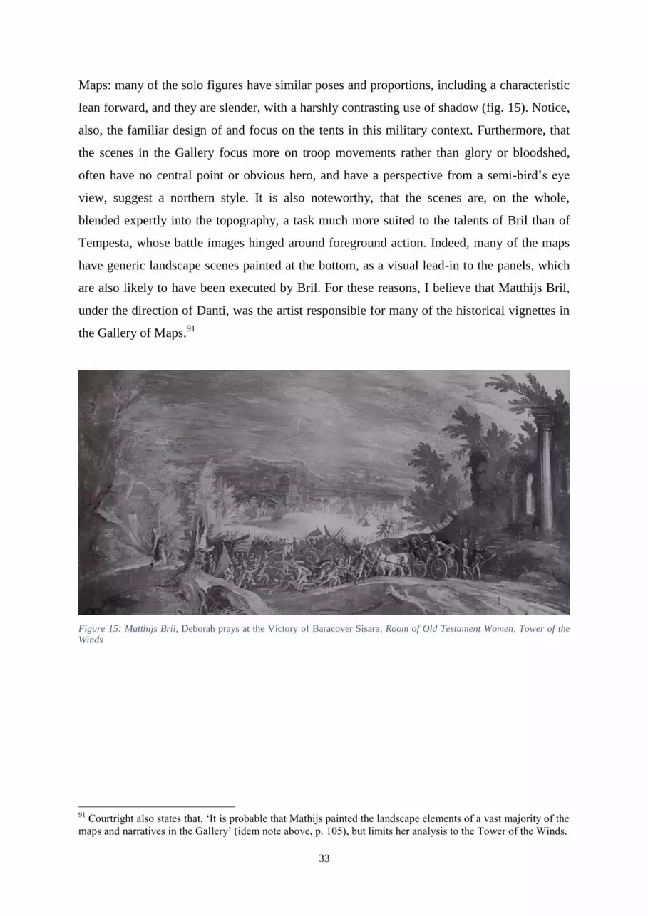
Maps: many of the solo figures have similar poses and proportions, including a characteristic
lean forward, and they are slender, with a harshly contrasting use of shadow (fig. 15). Notice,
also, the familiar design of and focus on the tents in this military context. Furthermore, that
the scenes in the Gallery focus more on troop movements rather than glory or bloodshed,
often have no central point or obvious hero, and have a perspective from a semi-bird’s eye
view, suggest a northern style. It is also noteworthy, that the scenes are, on the whole,
blended expertly into the topography, a task much more suited to the talents of Bril than of
Tempesta, whose battle images hinged around foreground action. Indeed, many of the maps
have generic landscape scenes painted at the bottom, as a visual lead-in to the panels, which
are also likely to have been executed by Bril. For these reasons, I believe that Matthijs Bril,
under the direction of Danti, was the artist responsible for many of the historical vignettes in
the Gallery of Maps.91
Figure 15: Matthijs Bril, Deborah prays at the Victory of Baracover Sisara, Room of Old Testament Women, Tower of the
Winds
91
Courtright also states that, ‘It is probable that Mathijs painted the landscape elements of a vast majority of the
maps and narratives in the Gallery’ (idem note above, p. 105), but limits her analysis to the Tower of the Winds.
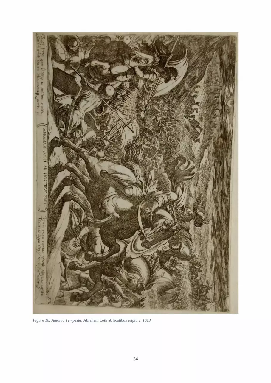
34
Figure 16: Antonio Tempesta, Abraham Loth ab hostibus eripit, c. 1613

35
The Vignettes’ Attitude towards History
Having established the identity of the principal artist and his style, which is imitated
in the other vignettes, I will now turn my attention to exploring the way in which the artists
represented these historical events. To form my conclusions, I will look not only at the formal
aspect of the images, but also the information supplied in the cartelli and also some
extraneous literary sources.
Figure 17: Hans Sebald Beham, Siege of Vienna, 1530
As we explored in the section on military literature above, by modern classifications
these images fall into the documentary type of battle painting. They are not preoccupied with
artistic concerns such as colour and movement, nor do they focus on a central figure or hero,
36
but rather attempt to give an overview of the event that is holistically understandable. As
Hale has explained, when considering the historical element to the visual documentation of
war in the Sixteenth century, we must be mindful of the confluence of two traditions
surrounding topographical maps, that of the land surveyor and the artist.92
Hans Sebald
Beham’s panoramic view of the Siege of Vienna drawn from atop a church spire in 1529 is a
perfect example of the merging of these two traditions (fig. 17). In order to attain the highest
level of accuracy in making a visual record of events, ideally the artist should be present
when it happens, as was Beham, so that he can accurately sketch what is taking place. That
being said, none of the artists working in the Gallery was present at any of the scenes since
most took place before their time. Therefore, if they were interested in portraying the action
with any degree of accuracy, they must have turned to other sources.
As the Sixteenth century progressed, the desire for printed news increased. Often,
consumers of broadsheets clamoured not only for descriptions of events, but images as well.
Reviewing the developments in France, Philip Benedict has shown that by the end of the
1550s, visual reports of current events were sold as single item broadsheets in Paris.93
This
developed concurrently with the innovation of illustrated bibles in the middle of the century.
Both bible and news prints frequently incorporated maps so that their readers could follow
events as they moved across the world.94
For the events depicted in the Gallery, the best-
documented battles were the most recent ones in the maps of Corfu and Malta. Considering
first the Siege of Valletta of 1565 (fig. 18), Benedict has discovered that twenty-nine separate
prints of the events were made in the same year. Moreover, this figure rises to fifty-five if one
counts the multiple editions (for example, Niccolò Nelli planned weekly updates for his
series) by the same printmakers as the four-month-long siege progressed.95
Comparing the
two versions, we discover from the positions of the Turkish camps and batteries surrounding
St Elmo and Valletta that the date of the action taking place in the Gallery is mid-August. The
artists working in the Gallery certainly used such printed map avvisi as models and Nelli’s
series is a prime candidate; Marica Milanesi argues that Antonio Lafréry’s map of Malta from
1565 was the cartographical basis for the island.96
Similarly, it is believed the Battle of
92
Hale, Warfare and Cartography, p. 734. 93
Benedict, Graphic History, pp. 85-95. 94
Delano-Smith and Ingram, Maps in Bibles; Woodward, Maps as Prints, p. 93. 95
Benedict, Graphic History, p. 97. See Woodward, Maps as Prints, pp. 94-97, for Niccolò Nelli’s maps. 96
Milanesi, n. 438, La Galleria delle Carte geografiche II, p. 381.
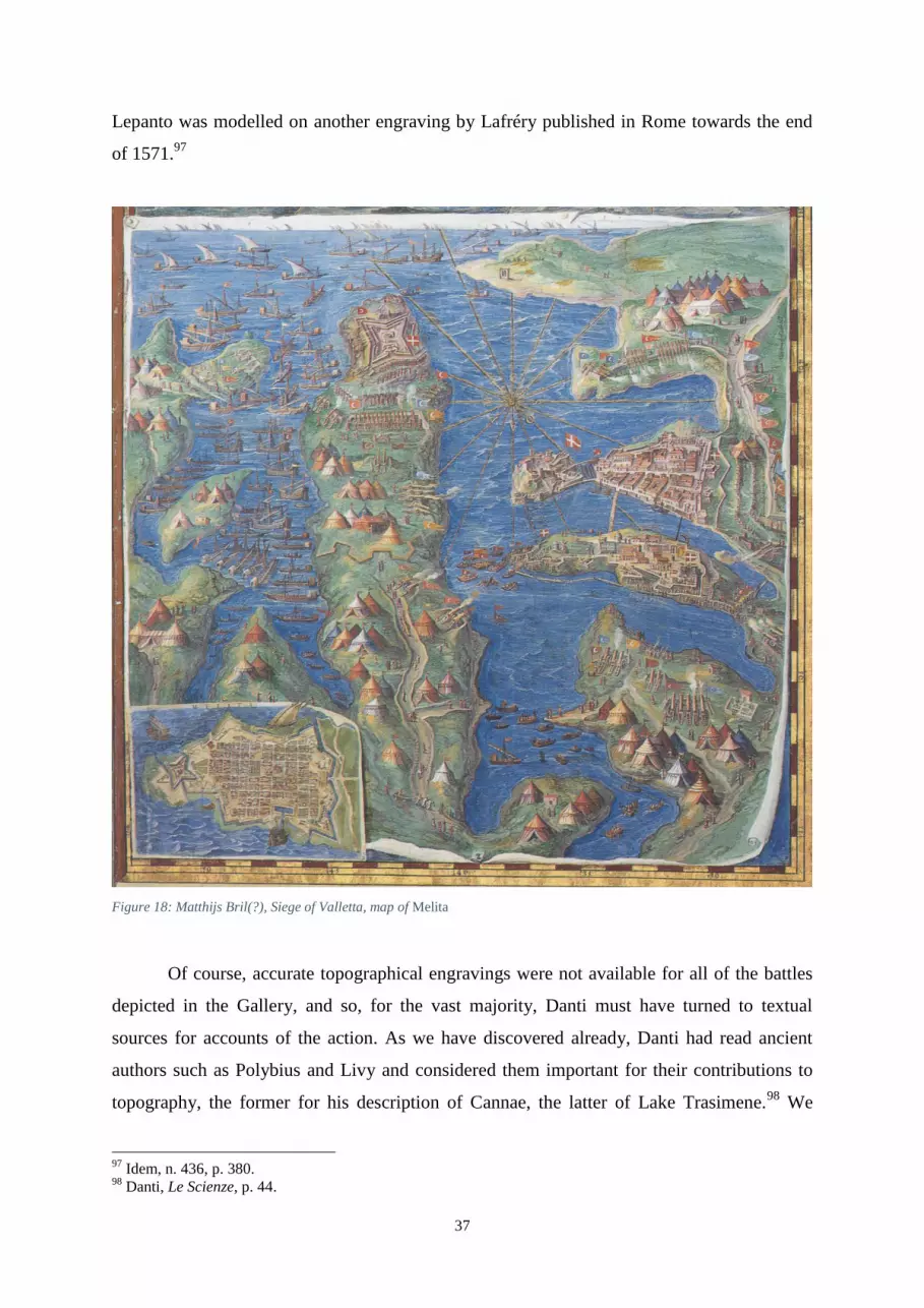
37
Lepanto was modelled on another engraving by Lafréry published in Rome towards the end
of 1571.97
Figure 18: Matthijs Bril(?), Siege of Valletta, map of Melita
Of course, accurate topographical engravings were not available for all of the battles
depicted in the Gallery, and so, for the vast majority, Danti must have turned to textual
sources for accounts of the action. As we have discovered already, Danti had read ancient
authors such as Polybius and Livy and considered them important for their contributions to
topography, the former for his description of Cannae, the latter of Lake Trasimene.98
We
97
Idem, n. 436, p. 380. 98
Danti, Le Scienze, p. 44.

38
have also established that Danti wrote new text for the cartouches adjoining every region
compiled from multiple sources, and this also extends to the cartelli that accompany the
historical vignettes. However, it remains to be seen whether the artists painting the frescoes
followed these historical accounts under Danti’s direction. An interesting case emerges if we
cross-reference Livy’s description of the Battle of Cannae with the painting in the Gallery.
Figure 19: Matthijs Bril, Battle of Cannae, map of Apulia
The clades Cannensis (fig. 19) is the most detailed example in the Gallery of a battle
scene that follows a historical text directly. It is also the only vignette on land that has
annotations on the map itself, and it would be a reasonable presumption to think that these
were based on a text, which upon further examination proves to be Livy. The map of Apulia

39
bears witness to the moment immediately before the battle, after the generals have drawn up
their troops. Livy gives a comprehensive description of the Roman formation:
On the right flank – the one nearest the river – were stationed the Roman
horsemen, then the infantry; the cavalry of the allies held the extreme right
wing, whilst foot-soldiers were in between, close to the middle where the
Roman legions were; darters and other lightly-armed auxiliaries were
formed up at the front of the line. The Consuls held the wings – Terentius on
the left, Aemilius on the right – and Geminus Servilius was entrusted with
safeguarding the centre of the battle.99
As we can see in the map, not only are the troops positioned correctly, but they are
also labelled with the same Latin words (‘Equites sociorum’; ‘legiones, pedites, iaculatores’)
used by Livy. The formation of the Carthaginians is also noted fully:
The Gallic and Iberian horsemen were nearer the river on the left wing,
facing the Roman cavalry; the right wing was given to the Numidian
horsemen; the centre of the battle line was shored up with infantry, such
that on the sides were the Africans, while the Gauls and the Iberians were
placed in between… The generals leading the wings were Hasdrubal on the
left, Maharbal on the right, while Hannibal himself and his brother Mago
held the centre of the line.100
The annotations for the Carthaginian army and generals are again in perfect accord
with Livy. However, we can tell that Danti actually based the information for the cartello on
Alberti, since the numbers of casualties match up to his and not Livy’s estimation. Danti
rejected the highest estimate of Polybius at ‘seventy thousand’, and instead chose the forty
thousand figure that was given by Alberti, either because it reflects better on the Romans or
because he trusted the Descrittione as a compendium of sources.101
The cartello states that
‘forty thousand foot-soldiers and two thousand seven hundred Roman cavalry’ died, which is
the same as Alberti.102
On the other hand, Livy numbers the casualties at ‘forty-five thousand
99
Livy, Ab urbe condita, XXII.xlv.6-8: ‘In dextro cornu – id erat flumini propius – Romanos equites locunt,
deinde pedites; laevum cornu extremi equites sociorum, intra pedites, ad medium iuncti legionibus Romanis,
tenuerunt; iaculatores cum ceteris levium armorum auxiliis prima acies facta. Consules cornua tunere, Terentius
laevum, Aemilius dextrum, Gemino Servilio media pugna tuenda data’. 100
Idem, XXII.xlvi.2-3… XXII.xlvi.7: ‘Gallos Hispanosque equites prope ripam laevo in cornu adversus
Romanum equitatum; dextrum cornu Numidis equitibus datum; media acies peditibus firmata, ita ut Afrorum
utraque cornua essent, interponerentur his medii Galli atque Hispani… Duces cornibus praeerant, sinistro
Hasdrubal, dextro Maharbal, mediam aciem Hannibal ipse cum fratre Magone tenuit’. 101
Polybius, Histories, III.117: ‘ἑπτὰ μυριάδας ἀπέθανον’. 102
‘Quadraginta millia peditum duo millia septinginta equitum Romanorum’. Alberti, Descrittione, p. 246:
‘Furono uccisi in tanta rovina circa quaranta mila pedoni, & 2700 cavalieri Romani’.

40
five hundred foot and two thousand seven hundred horse’, but makes a point of saying that
the deaths among the cavalry were divided equally between allied states and Romans, not
reflected in the cartello.103
Whilst there was an effort to remain true to history through textual annotations, no
such scruple exists for portraying troops in an accurate manner. If it were not for the labels,
one would not be able to tell the two sides apart, because they are painted with no distinction
in dress, heraldry or formation. The “forest of pikes” shorthand device that had developed to
portray the Swiss-German landsknechts is employed universally. Ignorance cannot be an
explanation since many Roman monuments such as Trajan’s column portray the equipment
of the standard Roman soldier. I highlight this because now we must ask what the intentions
of the artists in the Gallery were – whether they were aiming at historical accuracy, at papal
propaganda, or at cultured decoration. Nevertheless, the Battles of Cannae and Lepanto, and
the Siege of Valletta have demonstrated that Danti was willing to adhere to the information
provided by source material.
For those scenes less rigidly grounded in documentation, we must be cautious about
treating them as historical sources. Pia Cuneo outlines the two extremes of this method: at
one extreme, the images are a transparent window into the past, with no artistic licence on the
part of the painter or patron. At the other, they form a mirror of the artist’s conscious
decisions and manipulations of his medium, and do not reflect at all on the actual event,
simply existing within an aesthetic and formal realm.104
We may lapse into thinking that
these images, being so far from the kind of visual realism attained by photography, could
never even be considered accurate depictions of events. However, it must be remembered
firstly that the camera lens can be distorted by the human touch, especially when one starts
adding labels to the results, but also that all images, taken as they are, have their own truth.105
Although the potential accuracy of these painted representations of battles was constrained
from the outset by a number of factors – the medium, the artist’s tools and his skill, the
reliability of the source – there is still much to learn from them if we can read them correctly.
In order to create images that were both realistic and readable, artists had to adopt the visual
‘language’ of the times, by adapting familiar stereotypes to the particular of the thing being
represented.106
The historical vignettes therefore operate in the middle ground between the
103
Livy, Ab Urbe condita, XXII.xl.15: ‘quadraginta quinque milia quingenti pedites, duo milia septingenti
equites, et tantadem prope civium sociorumque pars caesi dicuntur’. 104
Cuneo, ‘Introduction’, pp. 4-5. 105
Burke, Eyewitnessing, pp. 21-25. 106
Gombrich, Art and Illusion, pp. 55-78.
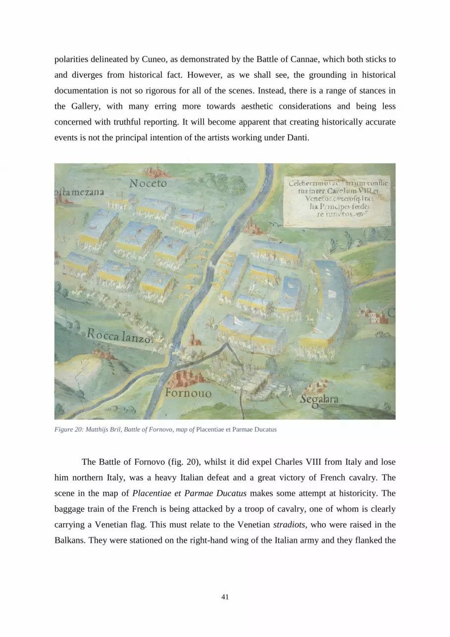
41
polarities delineated by Cuneo, as demonstrated by the Battle of Cannae, which both sticks to
and diverges from historical fact. However, as we shall see, the grounding in historical
documentation is not so rigorous for all of the scenes. Instead, there is a range of stances in
the Gallery, with many erring more towards aesthetic considerations and being less
concerned with truthful reporting. It will become apparent that creating historically accurate
events is not the principal intention of the artists working under Danti.
Figure 20: Matthijs Bril, Battle of Fornovo, map of Placentiae et Parmae Ducatus
The Battle of Fornovo (fig. 20), whilst it did expel Charles VIII from Italy and lose
him northern Italy, was a heavy Italian defeat and a great victory of French cavalry. The
scene in the map of Placentiae et Parmae Ducatus makes some attempt at historicity. The
baggage train of the French is being attacked by a troop of cavalry, one of whom is clearly
carrying a Venetian flag. This must relate to the Venetian stradiots, who were raised in the
Balkans. They were stationed on the right-hand wing of the Italian army and they flanked the

42
enemy in order to harass, against orders, the French baggage train.107
Perhaps, also, we can
assume that the figure in all white, stationed in the middle of the right army (French) is King
Charles VIII and the single horseman leading the rear-guard below is the celebrated general
Gaston de Foix.108
However, identifying the French on the eastern bank of the Fornovo
means that the orientation of the battle is incorrect – Bril has painted the armies on the wrong
sides of the river.109
In fact, the scene falls foul of historical fact on a number of other counts.
For instance, the Italian artillery is stationed by the river, when in fact it was on the higher
ground to the northeast.110
Moreover, although here emblazoned with two more Venetian
banners, the centre of the Italian army was in fact composed of Milanese troops and headed
by the Marquis of Mantua, Francesco Gonzaga; there is no depiction of a Milanese or
Mantuan flag.111
In this scene, therefore, we find a coexistence of fact and fiction, in which
historical realism is not the primary concern but is a supplement that strengthens the visual
narrative.
We find a similar ambiguity in the representation of history in the Battle of Ravenna
(fig. 21) in the map of Flaminia. In general terms, the location of the battle is correct, with
the forces to the west of Ravenna, aligned correctly Since the standards are non-specific, we
are left to presume that the French-Ferrarese forces are to the right of the river Ronco, and the
Spanish-Imperial forces are on the left with their Papal allies, as testified by accounts.112
The
flags of the right-hand army feature a white cross within a blue background, which relates
neither to the French forces under Gaston de Foix nor his ally Alfonso d’Este of Ferrara. At
the bottom of the battle, on what should be the Spanish-Imperial side, there is a regiment of
reinforcements carrying a flag that depicts a white eagle on a blue background, again, not
applicable to the Spanish or Papal forces. Otherwise, the flags are left blank. We see the
artillery squaring off in the centre of the battle, firing at each other over the river. This belies
an ignorance both of military affairs in general – the artists regularly place the artillery in
medias res throughout the Gallery – but also of this battle in particular. All around, the empty
space between the rivers around Ravenna is filled almost randomly with bands of pikeman or
lancers in the shorthand style that we have seen before, and they do not adopt the crescent
shape in which Gaston arrayed his troops.113
Nevertheless, perhaps we can tolerate these
107
Oman, A History of the Art of War in the Sixteenth Century, p. 108. 108
Idem, pp. 109-110. 109
Idem, pp. 107-109. 110
Idem, p. 108. 111
Idem, p. 110. 112
Idem, pp. 134-143. 113
Idem, p. 135.

43
oversights since the artist was constrained by the scale of the map. In any case, I would argue
that there was reason behind these decisions, and that the cannons adopt their central position
because of their central part in the battle. Both sides suffered considerable casualties, which
has been portrayed with a number of corpses littering the field in a manner rarely seen in the
Gallery, because Gaston and Alfonso, who was famed for his appreciation of the cannon,
bombarded the Spanish for more than two hours.114
Therefore, aside from the deficiencies,
the painting’s relationship to historical truth is defined by its narrative rather than
documentary style.
Figure 21: Matthijs Bril, Battle of Ravenna, map of Flaminia
114
Idem, pp. 138-140.

44
Figure 22: Charlemagne defeats the Lombards near Piacenza, map of Mediolanensis Ducatus
Turning now to the representation of Charlemagne’s victory over the Lombards in
774 (fig. 22), we see that the distinctive composition is guided by an overriding concern with
the narrative sense emphasised in the literature. Of the Lombard King, Desiderius, the
cartello states: ‘Charlemagne defeated King Desiderius of the Lombards in war and reduced
him to slavery’.115
Similarly, Alberti only describes the consequences of the battle, writing
that ‘the Lombards were subjugated and their king Desiderius was put in prison by
Charlemagne’.116
Just as the incarceration of Desiderius is emphasised in the literature
surrounding the battle, so too is it symbolised through its visual form. Closing in upon each
other, the armies form a middle ground that is cut off from the outside, from which King
Desiderius will not escape. Despite there being no description of the battle, the artist has still
relied on source material in order to aid the reading of the battle’s narrative. In terms of their
style, I believe that this and the other two episodes in the panel for Mediolanensis Ducatus
were painted by a different artist to the scenes covered so far, which are Bril’s work. These
115
‘Carolus Magnus… Desderiu[m] Longobardoru[m] Regem bello vicit & in servitutem redegit’. 116
Alberti, Descrittione, p. 422v: ‘Soggiugati i Longobardi, & fatto prigione Desiderio loro Re da Carlo
Magno’.

45
figures have straight legs and distinctly wide, flat crotches; a more varied colour scheme is
utilised as well. Perhaps this contributed to the rather unique design of the scene, which
features the two armies meeting each other with curved chevron formations that culminates in
one of the busiest and most attractive vignettes. In the middle, the most eager horsemen break
rank to charge each other. Although the soldiers are designed in the familiar manner of
yellow pikes with blue-topped and white-flecked spearheads, there are far more figures
represented around the massed ranks of spearmen. However, this departs from historical
representation, since Oman emphasises firstly the increased dependence on cavalry in warfare
as the Middle Ages progressed, particularly the heavily armoured sort under Charlemagne,
secondly that the Lombards in particular had a lot of knights at their disposal.117
Therefore,
the depiction of these soldiers as landsknechts even though cavalry was the more important
troop demonstrates a preference towards conventional forms as opposed to historical realism.
Figure 23: Battle of Pavia, map of Mediolanensis Ducatus
The majority of the historical scenes are not based on sources in regard to their
composition and are simply designed using conventional forms and artistic invention. The
Battle of Pavia in 1525 (fig. 23) is the epitome of this method. Completed by the same artist
117
Oman, A History of the Art of War: the Middle Ages, pp. 10-21 and 73-88.
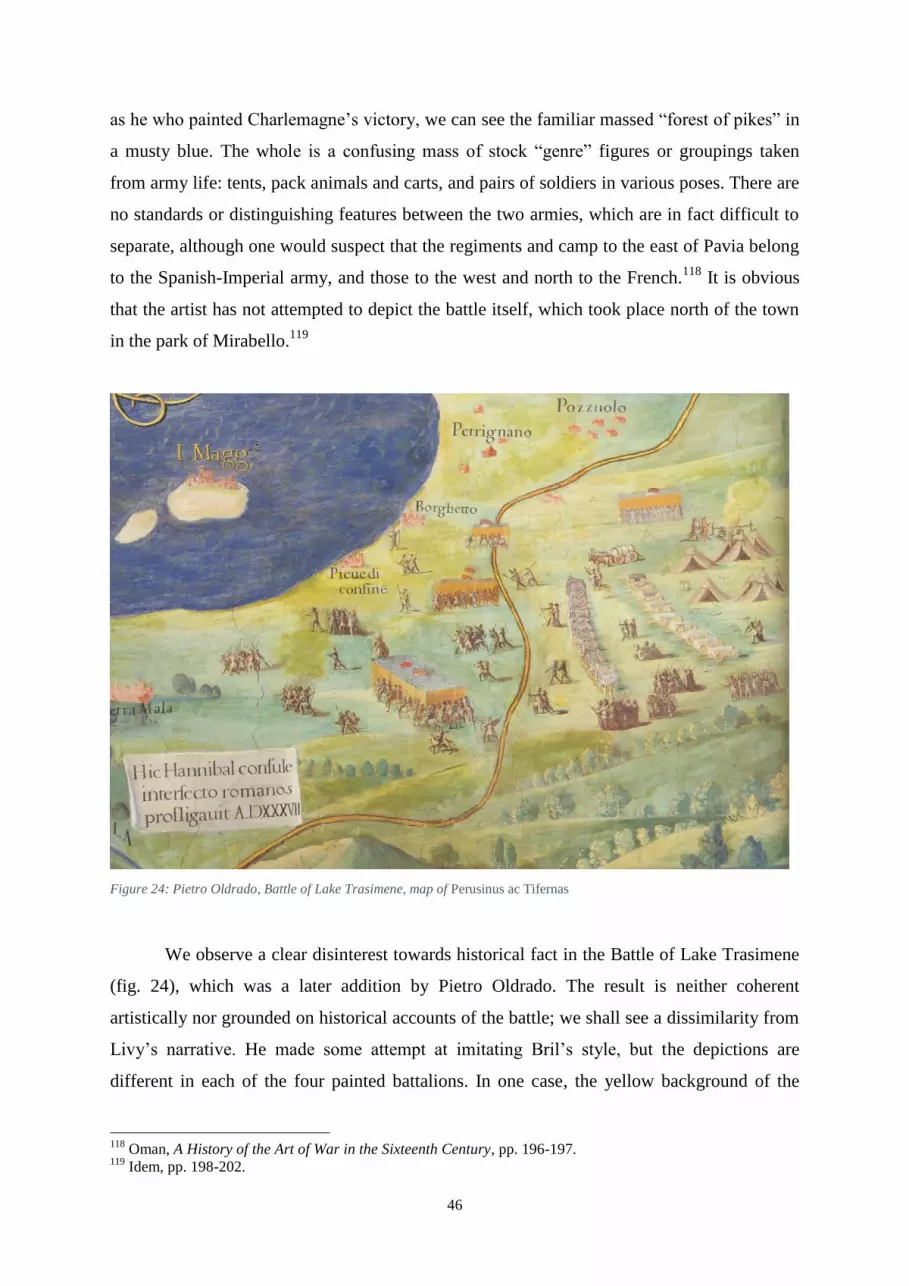
46
as he who painted Charlemagne’s victory, we can see the familiar massed “forest of pikes” in
a musty blue. The whole is a confusing mass of stock “genre” figures or groupings taken
from army life: tents, pack animals and carts, and pairs of soldiers in various poses. There are
no standards or distinguishing features between the two armies, which are in fact difficult to
separate, although one would suspect that the regiments and camp to the east of Pavia belong
to the Spanish-Imperial army, and those to the west and north to the French.118
It is obvious
that the artist has not attempted to depict the battle itself, which took place north of the town
in the park of Mirabello.119
Figure 24: Pietro Oldrado, Battle of Lake Trasimene, map of Perusinus ac Tifernas
We observe a clear disinterest towards historical fact in the Battle of Lake Trasimene
(fig. 24), which was a later addition by Pietro Oldrado. The result is neither coherent
artistically nor grounded on historical accounts of the battle; we shall see a dissimilarity from
Livy’s narrative. He made some attempt at imitating Bril’s style, but the depictions are
different in each of the four painted battalions. In one case, the yellow background of the
118
Oman, A History of the Art of War in the Sixteenth Century, pp. 196-197. 119
Idem, pp. 198-202.

47
spear-shafts extends behind the soldiers bodies; once there is no background wash behind the
bodies; once there is a dark grey backing; and in the most prominent example, the horsemen
on the sides and back are painted half over the yellow and half over the landscape green.
Once again, the artist relies upon the image of the landsknecht as the stereotypical soldier that
developed in the Sixteenth century, despite its being anachronistic.120
Oldrado evidently did
not follow Livy, who describes the Romans as ambushed and hemmed in by the
Carthaginians: ‘The Phoenician had his enemy caught between the lake and the mountains
and surrounded by his own forces’.121
This is not reflected at all in the vignette. Perhaps
Oldrado was echoing the confusion evoked in Livy’s account in passages such as this: ‘It was
not an ordered battle with lines of principes, hastati and triarii… nor did any soldier keep to
his legion, cohort, or maniple: rather it was chance that grouped them together’.122
However,
it seems most likely that the battle is simply a hodgepodge of troops and stock military scenes
following no real order. It is my opinion that Oldrado was not basing his composition on Livy
because he did not have historical accuracy in mind; his intention was surely to give a
decorative visual form to Danti’s deleted caption, “Rotta de’ Rotti”. Given these facts, we
cannot draw much from the image in terms of its representation of history, and, in relation to
other scenes, I have grave doubts about its place within any predetermined iconographic
programme.
In addition to the painted scenes, there are numerous small historical references that
provide supplementary detail to the chorography of the region, demonstrating Danti’s interest
in the connection between local history and place. They are not the same design as the
vignettes, but do add to the overall antiquarian impression of the Gallery. For instance, in the
map of Calabria Ulterior, the ‘Castra Annibalis’ (Hannibal’s Camp) is marked near Crotone,
recalling the three years (206-203 BC) that Hannibal spent in that region.. This can be further
demonstrated by another minor reference: the ‘Grotta della Sibilla’ in the map of Umbria.
Giving her name to the Monti Sibillini, the Sibyl who occupied this cave had an
inconsequential classical presence and only really came to prominence in the Fifteenth
century, when Antoine de la Sale made the Sibyl’s grotto the focus of a chapter in his La
Salade (c. 1440). After this, however, the cavern enjoyed considerable interest from a
120
Hale, Artists and Warfare, p. 84. 121
Livy, Ab urbe condita, XXII.iv.5: ‘Poenus… clausum lacu ac montibus et circumfusum suis copiis habuit
hostem’. 122
Idem, XXII.v.7-8: ‘non illa ordinate per principes hastatosque ac triarios… nec ut in sua legione miles aut
cohorte aut manipulo esset: fors conglobabat’.

48
chorographic perspective, as is demonstrated by the full-page discussion in Alberti.123
Whilst
I have only adduced two examples here, they are indicative of the many other historical
details that litter the maps. Enriching the landscape both intellectually and visually, these
little details need not be thought of as contributing to a pre-determined, providential
programme. I would argue, instead, that they were added in the spirit of enjoyment,
highlighting places of interest for the viewer’s delight, and this will be demonstrated through
visual analysis.
We have seen a variety of approaches to history in the Gallery’s vignettes, from
detailed annotation to complete disinterest. What remains true for all of the vignettes, despite
any visual flaws, is the relationship to the geography of the place and the scholarly effort of
the cartelli. Thus, I would argue that the Gallery’s designers were not primarily concerned
with truthful reporting, but rather desired to make an erudite, decorative scheme that appealed
both to historians and to geographers. For some of the episodes, we would be in the dark if
we did not have the combined clues of the informative cartelli or were not able to locate the
action. One rarely finds any form of propaganda espoused either in the cartelli or visually in
the histories.
Conclusions
We started by reviewing the secondary literature on the Gallery. Recently, much
effort has been devoted to elucidating the meaning of the religious iconography of the vault’s
series of “sacrifices” and “miracles”. Having established that it is a Counter-Reformation
assertion of authority, many scholars believe that the historical vignettes must operate as a
providential view of history because of the Post-Tridentine argument of the vault. I have
argued that this Catholic element does not match up with the historical vignettes on the walls
of the Gallery. One major factor for this is the neglect by historians of an art historical
method, which I conducted in the latter part of this essay. My aim was to address this deficit
and to demonstrate what can be learned from such an approach both about the decorative
scheme and from the paintings in isolation.
123
Alberti, Descrittione di tutta l’Italia, pp. 278-278v.
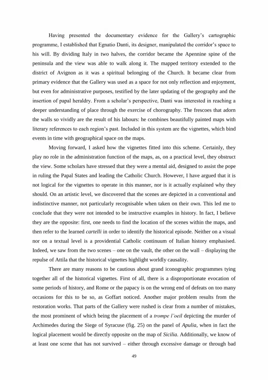
49
Having presented the documentary evidence for the Gallery’s cartographic
programme, I established that Egnatio Danti, its designer, manipulated the corridor’s space to
his will. By dividing Italy in two halves, the corridor became the Apennine spine of the
peninsula and the view was able to walk along it. The mapped territory extended to the
district of Avignon as it was a spiritual belonging of the Church. It became clear from
primary evidence that the Gallery was used as a space for not only reflection and enjoyment,
but even for administrative purposes, testified by the later updating of the geography and the
insertion of papal heraldry. From a scholar’s perspective, Danti was interested in reaching a
deeper understanding of place through the exercise of chorography. The frescoes that adorn
the walls so vividly are the result of his labours: he combines beautifully painted maps with
literary references to each region’s past. Included in this system are the vignettes, which bind
events in time with geographical space on the maps.
Moving forward, I asked how the vignettes fitted into this scheme. Certainly, they
play no role in the administration function of the maps, as, on a practical level, they obstruct
the view. Some scholars have stressed that they were a mental aid, designed to assist the pope
in ruling the Papal States and leading the Catholic Church. However, I have argued that it is
not logical for the vignettes to operate in this manner, nor is it actually explained why they
should. On an artistic level, we discovered that the scenes are depicted in a conventional and
indistinctive manner, not particularly recognisable when taken on their own. This led me to
conclude that they were not intended to be instructive examples in history. In fact, I believe
they are the opposite: first, one needs to find the location of the scenes within the maps, and
then refer to the learned cartelli in order to identify the historical episode. Neither on a visual
nor on a textual level is a providential Catholic continuum of Italian history emphasised.
Indeed, we saw from the two scenes – one on the vault, the other on the wall – displaying the
repulse of Attila that the historical vignettes highlight worldly causality.
There are many reasons to be cautious about grand iconographic programmes tying
together all of the historical vignettes. First of all, there is a disproportionate evocation of
some periods of history, and Rome or the papacy is on the wrong end of defeats on too many
occasions for this to be so, as Goffart noticed. Another major problem results from the
restoration works. That parts of the Gallery were rushed is clear from a number of mistakes,
the most prominent of which being the placement of a trompe l’oeil depicting the murder of
Archimedes during the Siege of Syracuse (fig. 25) on the panel of Apulia, when in fact the
logical placement would be directly opposite on the map of Sicilia. Additionally, we know of
at least one scene that has not survived – either through excessive damage or through bad
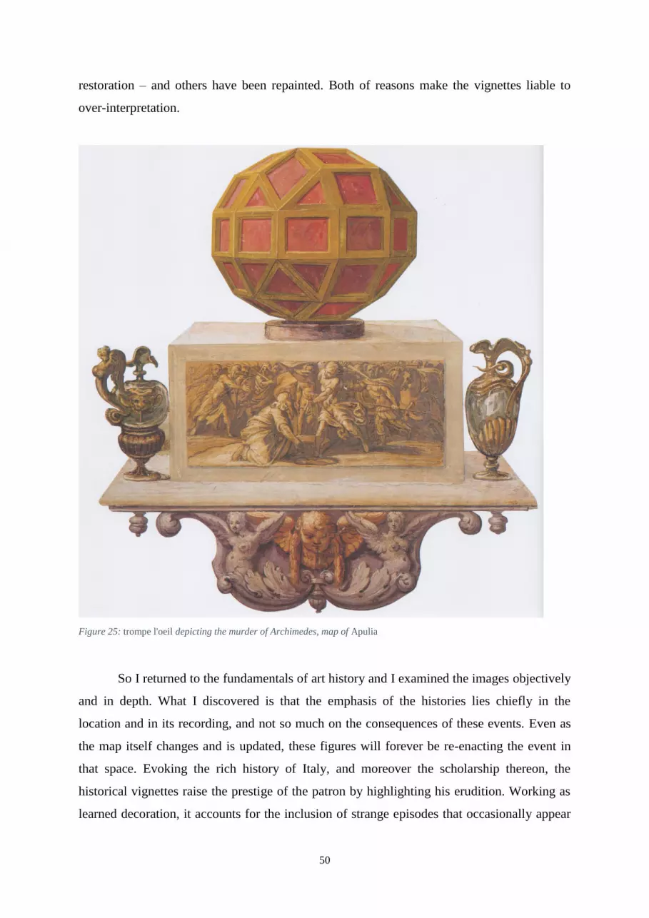
50
restoration – and others have been repainted. Both of reasons make the vignettes liable to
over-interpretation.
Figure 25: trompe l'oeil depicting the murder of Archimedes, map of Apulia
So I returned to the fundamentals of art history and I examined the images objectively
and in depth. What I discovered is that the emphasis of the histories lies chiefly in the
location and in its recording, and not so much on the consequences of these events. Even as
the map itself changes and is updated, these figures will forever be re-enacting the event in
that space. Evoking the rich history of Italy, and moreover the scholarship thereon, the
historical vignettes raise the prestige of the patron by highlighting his erudition. Working as
learned decoration, it accounts for the inclusion of strange episodes that occasionally appear

51
on the walls: the Battle of Pandosia (fig. 26), insignificant to Italian history, relates more to
its status as a topographical digression. Alexander of Epirus was warned via an oracle that he
should avoid the river Acheron and the city of Pandosia, which he mistakenly assumed to be
the likewise-named pair in Epirus.124
Artistically, one would not be able to identify this event
because there are no visual clues to clarify its obscure nature. Importantly, the cartouche for
Calabria Citerior states: ‘There was great cause for writing among historians with regard to
the death of King Alexander of Epirus at Pandosia’.125
Figure 26: Matthijs Bril, Battle of Pandosia, map of Calabria Citerior
124
Alberti, Descrittione, pp. 201 and particularly 209v. 125
‘Haec ob Alexandrum Epirotarum regem apud Pandosiam trucidatum magnam scribendi ansam historicis
praebuit’.
52
Artistically, as we have seen, there was a growing trend for maps or views of battles
in the Sixteenth Century. For instance, during the forty years of Spanish campaigning in the
Netherlands in the later Sixteenth and early Seventeenth Centuries, there were maps with
military scenes produced with annotations in order ‘to enable its owner to follow military
events’.126
Now this is not the case in the Gallery, since it is not attempting a true reporting:
the high level of informed detail at the Battle of Cannae, or of detailed copying of printed
maps for the scenes in Malta and Corfu, is notable if only for its rarity within the Gallery.
Most other scenes do not have the same attention to historical detail, but instead focus either
on portraying the narrative of the event, or simply on decoration. Rather it is both utilising
and progressing the fashion. Just as Wolfgang Lazius appealed to history through
decoratively old names such as ‘Boiorum regnum’ and ‘Rhaetia alpestris’ in his eleven-map
circuit of the Austrian (Hapsburg) kingdoms known as Typi chorographici provinciarum
Austriae from 1561, so do the manifold references to history in the Gallery.127
As a man interested in history and geography, having historical vignettes painted onto
the walls would be a natural choice in decoration, especially given its fashionable status as a
palace decoration during the Sixteenth Century.128
The literary allusions both to current
topographical works and also to classical histories visualised playfully on the maps
demonstrates the sophistication and worldliness of the patron, as well as satisfying a highly
personalised decorative scheme. Whilst we may not take away with us important lessons
about warfare or history away from the walls, this Gallery gives us an unprecedented insight
into the taste of Gregory XIII and rising status and versatile applications of maps among
Renaissance patrons.
126
Hale, ‘Warfare and Cartography’, p. 735. 127
Goffart, Historical Atlases, pp. 26-27 and 64-66. 128
Bourne, ‘Francesco II Gonzaga and Maps as Palace Decoration’; Schulz, ‘Maps as Metaphors’.
53
APPENDIX 1
Table of historical vignettes in the Gallery of Maps, ordered chronologically:
Historical Vignettes Region Date Plate
No.129
The Battle of Pandosia between Alexander I
of Epirus and an army of Bruttians,
Lucanians, and Samnites
Calabria Citerior 330 BC 139
The Battle of Clastidium between the
Romans under Marcus Marcellus and the
Insubrian Gauls
Mediolanensis
Ducatus 222 BC 219
The Battle of the Ticinus between Hannibal
and the Romans under Publius Cornelius
Scipio
Mediolanensis
Ducatus 218 BC 218
The Battle of the Trebia between Hannibal
and the Romans under Tiberius Sempronius
Longus
Placentia et Parmae
Ducatus 218 BC 252
The Battle of Lake Trasimene between
Hannibal and the Romans under Gaius
Flaminius
Perusinus ac Tifernas 217 BC 65
Siege of Spoleto by Hannibal Umbria 217 BC 91
The Battle of Cannae between Hannibal and
the Romans under Gaius Terentius Varro and
Lucius Aemilius Paullus
Apulia 216 BC 375
The Roman Consul Marcus Marcellus is
slain in a skirmish with Hannibal's cavalry Lucania 208 BC 127
The Battle of the Metauro between Hasdrubal
and the Romans under Marcus Livius and
Gaius Claudius Nero
Urbini Ducatus 207 BC 322
Julius Caesar's army crosses the Rubicon Flaminia 49 BC 308
The formation of the Second Triumvirate
between Octavian, Mark Anthony and
Lepidus
Bononiensis Ditio 43 BC 295
Pope Leo the Great halts the advance of
Attila's army Mantuae Ducatus 452 264
Charlemagne defeats the Lombards near
Piacenza
Mediolanensis
Ducatus 774 220
Duke Vinichisius (Winiges) leads Pope Leo
III to Spoleto Umbria C. 795 92
The Battle of the Garigliano between
Christian forces and the Saracens Campania 915 106
The Battle of San Ruffillo between Papal
forces and the Visconti of Bologna Bononiensis Ditio 1361 297
129
These are the plate numbers given in Gambi and Pinelli, La Galleria delle Carte geografiche II, which
supplies high quality photography.

54
The return of the Papal Court from Avignon
to Rome
Avenionensis Ditio et
Venaisinus Comitatus 1377 194
Allegory of Christopher Columbus
commemorating his discovery of the New
World130
Liguria 1492 41
The Battle of Fornovo between Charles VIII
of France and the Italian Princes
Placentia et Parmae
Ducatus 1495 253
Pope Julius II lays siege to and enters the city
of Mirandola Ferrariae Ducatus 1511 275
The Battle of Ravenna between the French
and the Holy League Flaminia 1512 307
The Battle of Pavia between Francis I of
France and a Spanish-Imperial army
Mediolanensis
Ducatus 1525 219
The army sent by the Marche in defence of
the Pope at the time of the Sack of Rome Picenum 1527 337
The Battle of Ceresole between Francis I and
Charles V
Pedemontium et
Monsferratus 1544 206
Andrea Doria's brigantine131
Liguria C. 1550 38
The Siege of Valletta by the Ottoman fleet132
Malta 1565 442
The Battle of Lepanto between Christian
forces and the Turks132
Corfu 1571 436
130
Not strictly historical. Nonetheless, I include it as it differs from the other marine details in that it refers to a
specific person and event. 131
This scene is not listed by Goffart. Presumably, he did not consider it noteworthy because it does not occur
on land. It could indeed be mistaken for one of the many generic ships painted in the Gallery, however, it is
singled out by an inscription in the sail: ‘Andreas Aureas piratarum acerrimus hostis’ (Andrea Doria, the fiercest
foe of pirates). I list it here as, like above n. 81, it refers to a specific person and campaign. 132
Goffart (‘Christian Pessimism’, pp. 803-804) argues that the maps of the ports and islands should be thought
of as appendices to the overall scheme of the maps, and therefore he discards these two scenes. Whilst he is
correct in separating these maps from the main cartographic programme, I believe the principal behind their
decoration remains the same.

55
APPENDIX 2
Attribution of historical vignettes
Matthijs Bril:
Siege of Spoleto (Umbria)
Duke Vinichisius (Winiges) leads Pope Leo III to Spoleto (Umbria)
The Battle of Pandosia (Calabria Citerior)
The Battle of Fornovo (Placentiae et Parmae Ducatus)
Pope Leo I halts the army of Attila (Mantuae Ducatus)
Pope Julius II enters the city of Mirandola (Ferrariae Ducatus)
The formation of the Second Triumvirate (Bononiensis Ditio)
The Battle of San Ruffillo (Bononiensis Ditio)
Julius Caesar’s army crosses the Rubicon (Flaminia)
The Battle of Ravenna (Flaminia)
The Battle of the Metauro (Urbini Ducatus)
The army sent by the Marche to defend Rome in 1527 (Picenum)
The Battle of Cannae (Apulia)
Artist of the islands (Matthijs Bril?):
The Battle of Lepanto (Corfu)
The Siege of Valletta (Malta)
Artist of Mediolanensis Ducatus:
The Battle of the Ticinus (Mediolanensis Ducatus)
Charlemagne defeats the Lombars near Piacenza (Mediolanensis Ducatus)
The Battle of Pavia (Mediolanensis Ducatus)
Artist of the sea scenes:
Allegory of Christopher Columbus (Liguria)
Andrea Doria’s brigantine (Liguria)
Pietro Oldrado
The Battle of Lake Trasimene (Perusinus ac Tifernas)
The Battle of Ceresole – retouched (Pedemontium et Monsferratus)
The Battle of Clastidium – retouched (Mediolanensis Ducatus)
Unattributed vignettes:
The Battle of the Garigliano, 915 (Campania)
The Roman Consul Marcus Marcellus is slain in a skirmish with the Carthaginians (Lucania)
The Papal court return to Rome from Avignon (Avenionensis Ditio et Venaisinus Comitatus)
The Battle of Trebia (Placentiae et Parmae Ducatus)
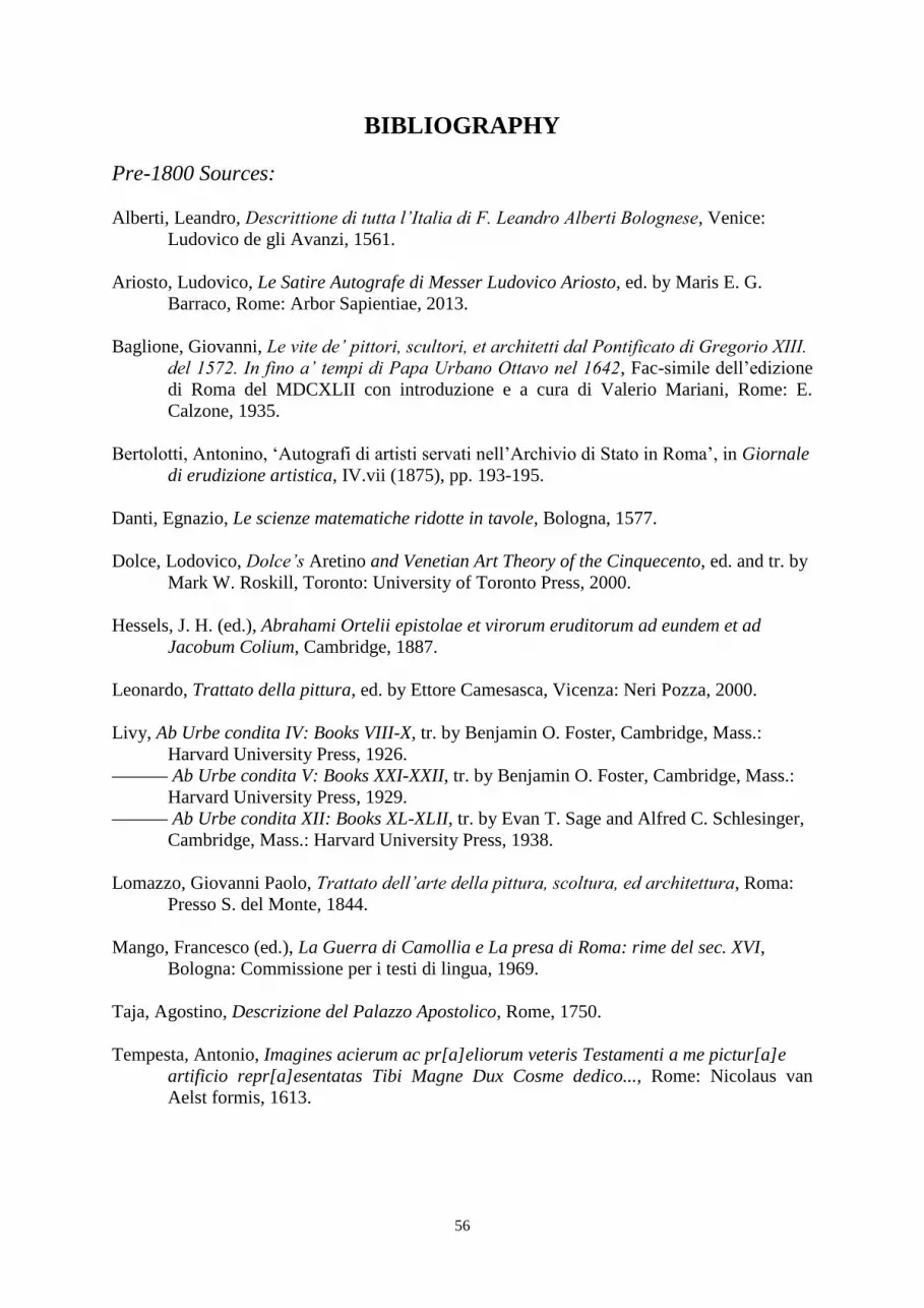
56
BIBLIOGRAPHY
Pre-1800 Sources:
Alberti, Leandro, Descrittione di tutta l’Italia di F. Leandro Alberti Bolognese, Venice:
Ludovico de gli Avanzi, 1561.
Ariosto, Ludovico, Le Satire Autografe di Messer Ludovico Ariosto, ed. by Maris E. G.
Barraco, Rome: Arbor Sapientiae, 2013.
Baglione, Giovanni, Le vite de’ pittori, scultori, et architetti dal Pontificato di Gregorio XIII.
del 1572. In fino a’ tempi di Papa Urbano Ottavo nel 1642, Fac-simile dell’edizione
di Roma del MDCXLII con introduzione e a cura di Valerio Mariani, Rome: E.
Calzone, 1935.
Bertolotti, Antonino, ‘Autografi di artisti servati nell’Archivio di Stato in Roma’, in Giornale
di erudizione artistica, IV.vii (1875), pp. 193-195.
Danti, Egnazio, Le scienze matematiche ridotte in tavole, Bologna, 1577.
Dolce, Lodovico, Dolce’s Aretino and Venetian Art Theory of the Cinquecento, ed. and tr. by
Mark W. Roskill, Toronto: University of Toronto Press, 2000.
Hessels, J. H. (ed.), Abrahami Ortelii epistolae et virorum eruditorum ad eundem et ad
Jacobum Colium, Cambridge, 1887.
Leonardo, Trattato della pittura, ed. by Ettore Camesasca, Vicenza: Neri Pozza, 2000.
Livy, Ab Urbe condita IV: Books VIII-X, tr. by Benjamin O. Foster, Cambridge, Mass.:
Harvard University Press, 1926.
Ab Urbe condita V: Books XXI-XXII, tr. by Benjamin O. Foster, Cambridge, Mass.:
Harvard University Press, 1929.
Ab Urbe condita XII: Books XL-XLII, tr. by Evan T. Sage and Alfred C. Schlesinger,
Cambridge, Mass.: Harvard University Press, 1938.
Lomazzo, Giovanni Paolo, Trattato dell’arte della pittura, scoltura, ed architettura, Roma:
Presso S. del Monte, 1844.
Mango, Francesco (ed.), La Guerra di Camollia e La presa di Roma: rime del sec. XVI,
Bologna: Commissione per i testi di lingua, 1969.
Taja, Agostino, Descrizione del Palazzo Apostolico, Rome, 1750.
Tempesta, Antonio, Imagines acierum ac pr[a]eliorum veteris Testamenti a me pictur[a]e
artificio repr[a]esentatas Tibi Magne Dux Cosme dedico..., Rome: Nicolaus van
Aelst formis, 1613.
57
Post-1800 Sources:
Ackerman, James S., The Cortile del Belvedere, Vatican: Biblioteca Apostolica Vaticana,
1954.
Almagià, Roberto, Le pitture murali della galleria delle carte geografiche, Vatican:
Biblioteca Apostolica Vaticana, 1952.
Benedict, Philip, Graphic History: The Wars, Massacres and Troubles of Tortorel and
Perrissin, Geneva: Libraire Droz, 2007.
Berggren, J. Lennart and Alexander Jones, Ptolemy’s Geography: An Annotated Translation
of the Theoretical Chapters, Princeton: Princeton University Press, 2000.
Bourne, Molly, ‘Francesco II Gonzaga and Maps as Palace Decorations in Renaissance
Mantua’, in Imago Mundi, LI (1999), pp. 51-82.
Burke, Peter, Eyewitnessing: The Use of Images as Historical Evidence, London: Reaktion
Books, 2001.
Bussmann, Klaus and Heinz Schilling (eds), 1648: War and Peace in Europe II, Munich,
1998.
Camilli, E. Michael, ‘Six Dialogues, 1566: Initial Response to the Magdeburg Centuries’, in
Archiv für Reformationsgeschichte, LXXXVI (1995), pp. 141-152.
Cederlöf, Olle, ‘The Battle Painting as a Historical Source’, in Revue Internationale
d’Histoire Militaire, XXVI (1967), pp. 119-144.
Chastel, André, The Sack of Rome, 1527, tr. by Beth Archer, Washington D.C.: National
Gallery of Art, 1983.
Cheney, Iris, ‘The Galleria delle Carte Geografiche at the Vatican and the Roman Church’s
View of the History of Christianity’, in Renaissance Papers (1989), pp. 21-37.
Courtright, Nicola, ‘The Transformation of Ancient Landscapes through the Ideology of
Christian Reform in Gregory XIII’s Tower of the Winds’, in Zeitschrift für
Kunstgeschichte, LVIII (1995), pp. 526-541.
The Papacy and the Art of Reform in Sixteenth-century Rome: Gregory
XIII’s Tower of the Winds in the Vatican, Cambridge: Cambridge University Press,
2003.
Cuneo, Pia, Art and Politics in Early Modern Germany: Jörg Breu the Elder and the
Fashioning of Political Identity ca. 1475-1536, Brill: Leiden, 1998.
(ed.) Artful Armies, Beautiful Battles: Art and Warfare in Early Modern Europe,
Brill: Leiden, 2002.
‘Introduction’ in Artful Armies, Beautiful Battles: Art and Warfare in Early Modern
Europe, pp. 3-11.
Delano-Smith, Catherine, ‘Maps as Art and Science: Maps in Sixteenth Century Bibles’, in

58
Imago Mundi, XXXXII (1990), pp. 65-83.
‘Why Theory in the History of Cartography?’, in Imago Mundi, XXXXVIII (1996),
pp. 198-203.
Delano-Smith, Catherine, and Alessandro Scafi, ‘Sacred Geography’, in Sacred places on
maps: a cartographic exhibition from the collections of Pannonhalma (Hungary) and
Schottenstift (Vienna), Hungary: Pannonhalma, 2005, pp. 122-140.
Delano-Smith, Catherine, and Elizabeth Morley Ingram, Maps in Bibles, 1500-1600, Geneva:
Libraire Droz, 1991.
Ferri, Rolando, ‘A “Walk through Italy”. The anonymous Ambulatio gregoriana’, in La
Galleria delle Carte geografiche in Vaticano II, pp. 73-81.
Fiorani, Francesca, ‘Post-Tridentine “Geographia Sacra”. The Galleria delle Carte
Geografiche in the Vatican Palace’ in Imago Mundi, XXXXVIII (1996), pp. 124-148.
The Marvel of Maps: Art, Cartography, and Politics in Renaissance Italy, New
Haven: Yale University Press, 2005.
‘Cycles of Painted Maps in the Renaissance’, in The History of Cartography Volume
Three: Cartography in the European Renaissance I, pp. 804-827.
Franzoni, Claudio, ‘The restorations of the Gallery of Maps’, in La Galleria delle Carte
geografiche in Vaticano II, pp. 169-174.
Freiburg, Jack, ‘The Lateran Patronage of Gregory XIII and the Holy Year 1575’, in
Zeitschrift für Kunstgeschichte, LIV (1991), pp. 66-87.
Gambi, Lucio and Antonio Pinelli (eds.), La Galleria delle Carte geografiche in Vaticano I,
Modena: Franco Cosimo Panini, 1994.
(eds.) La Galleria delle Carte geografiche in Vaticano II, Modena: Franco Cosimo
Panini, 1994.
‘The Gallery of Maps’, in La Galleria delle Carte geografiche in Vaticano I, pp. 11-
18.
Gilbert, Felix, Machiavelli and Guicciardini: Politics and History in Sixteenth-century
Florence, Princeton: Princeton University Press, 1965.
Goffart, Walter, ‘Christian Pessimism on the Walls of the Vatican Galleria delle carte
geografiche’, in Renaissance Quarterly, LI (1998), pp. 788-827.
Historical Atlases: The First Three Hundred Years, 1570-1870, Chicago: University
of Chicago Press, 2003.
Gombrich, Ernst H., Art and Illusion: A Study in the Psychology of Pictorial Representation,
London: Phaidon, 1968.
Hale, John Rigby, Artists and Warfare in the Renaissance, New Haven: Yale University
Press, 1990.
‘Warfare and Cartography, ca. 1450 to ca. 1640’, in The History of Cartography
Volume Three: Cartography in the European Renaissance I, pp. 719-737.
59
Horn, Hendrik J., Jan Cornelisz Vermeyen, painter of Charles V and his conquest of Tunis:
paintings, etchings, drawings, cartoons & tapestries, Doornspijk: Davaco, 1989.
Kagan, Richard L. and Benjamin Schmidt, ‘Maps and the Early Modern State: Official
Cartography’, in The History of Cartography Volume Three: Cartography in the
European Renaissance I, pp. 661-679.
Milanesi, Marica, ‘The Historical Background to the Cycle in the Gallery of Maps’, in La
Galleria delle Carte geografiche in Vaticano II, pp. 97-123.
Oman, Charles C., A History of the Art of War: the Middle Ages from the Fourth to the
Fourteenth Century, London: Methuen & Co. Ltd., 1898.
A History of the Art of War in the Sixteenth Century, London: Methuen & Co. Ltd.,
1937.
‘Early Military Pictures’, in The Archaeological Journal, XCV (1938), pp. 337-354.
Pastor, Ludwig von, The History of the Popes from the Close of the Middle Ages. Drawn
from the secret archives of the Vatican and other original sources, from the German
of Ludwig, Freiherr von Pastor, edited by Ralph Francis Kerr of the London Oratory,
Volume XX: Gregory XIII (1572-1585), London: Kegan Paul, Trench, Trubner & Co.
Ltd., 1930.
Pinelli, Antonio, ‘The “bellissimo spasseggio” of Pope Gregory XIII Boncompagni’, in La
Galleria delle Carte geografiche in Vaticano II, pp. 9-71.
‘Above the earth, the heavens: Geography, history and theology: the iconography of
the Vault’ in La Galleria delle Carte geografiche in Vaticano II, pp. 125-154.
Pfaffenbichler, Matthias, ‘The Early Baroque Battle Scene: From the Depiction of Historical
Events to Military Genre Painting’, in 1648: War and Peace in Europe, pp. 493-500.
Plax, Julie A., ‘Seventeenth-Century French Images of Warfare’, in Artful Armies, Beautiful
Battles: Art and Warfare in Early Modern Europe, pp. 131-155.
Pollitt, Jerome J., The Art of Rome, Englewood Cliffs, New Jersey: Prentice Hall Inc., 1966.
Pullipally, Cyriac K., Caesar Baronius: Counter-Reformation Historian, Notre Dame:
University of Notre Dame, 1975.
Schulz, Juergen, ‘Jacopo de’ Barbari’s View of Venice: Map Making, City Views, and
Moralized Geography before 1500’, in The Art Bulletin, LX (1978), pp. 425-474.
‘Maps as Metaphors: Mural Map Cycles of the Italian Renaissance’, in Art and
Cartography: Six Historical Essays, ed. by D. Woodward, Chicago: University of
Chicago Press, 1987, pp. 97-122.
Schütte, Margret, Die Galleria delle Carte Geografiche im Vatikan: eine ikonologische
Betrachtung des Gewolbeprogramms, Hildesheim: G. Olms, 1993.
Vander Auwera, Joost, ‘Historical Fact and Artistic Fiction: The face of the Eighty Years’
60
War in Southern Netherlandish paintings, in particular those of Sebastiaen Vrancx
(1573-1647) and Pieter Snayers (1592-1667)’, in 1648: War and Peace in Europe, pp.
461-468.
Vicenzi, Alessandro, La Galleria delle Carte Geografiche in Vaticano, Modena: Franco
Cosimo Panini, 2012.
Wallace-Hadrill, John M., Early Germanic Kingship in England and on the Continent: The
Ford Lectures delivered in the University of Oxford in Hilary Term 1970, Oxford:
Clarendon Press, 1971.
Watts, Pauline Moffitt, ‘A Mirror for the Pope: Mapping the “Corpus Christi” in the Galleria
delle Carte Geografiche’, in I Tatti Studies in the Italian Renaissance, X (2005),
pp. 173-192.
‘The European Religious Worldview and its Influence on Mapping’, in
The History of Cartography Volume Three: Cartography in the European
Renaissance I, pp. 382-400.
Wilson, Guy, ‘Military Science, History, and Art’ in Artful Armies, Beautiful Battles: Art and
Warfare in Early Modern Europe, pp. 13-33.
Woodward, David, ‘Reality, Symbolism, Time, and Space in Medieval World Maps’, in
Annals of the Association of American Geographers, LXXV (1985), pp. 510-521.
Maps as Prints in the Italian Renaissance: Makers, Distributors & Consumers,
London: The British Library, 1996.
(ed.) The History of Cartography Volume Three: Cartography in the European
Renaissance I, Chicago: University of Chicago Press, 2007.


