Embed Size (px)
Citation preview

This article appeared in a journal published by Elsevier. The attachedcopy is furnished to the author for internal non-commercial researchand education use, including for instruction at the authors institution
and sharing with colleagues.
Other uses, including reproduction and distribution, or selling orlicensing copies, or posting to personal, institutional or third party
websites are prohibited.
In most cases authors are permitted to post their version of thearticle (e.g. in Word or Tex form) to their personal website orinstitutional repository. Authors requiring further information
regarding Elsevier’s archiving and manuscript policies areencouraged to visit:
http://www.elsevier.com/copyright

Author's personal copy
The desert and the sown: Nomadefarmer interactions in the Wadi Faynan,southern Jordan
G. Barker*
McDonald Institute for Archaeological Research, University of Cambridge, Downing Street, Cambridge CB2 3ER, UK
a r t i c l e i n f o
Article history:Received 4 February 2011Received in revised form26 October 2011Accepted 24 November 2011Available online 14 December 2011
Keywords:PastoralismFarming
a b s t r a c t
The paper discusses the changing relationship between pastoral nomads and farmers, one of therecurring themes in the history of the arid Near East. In many parts of this region that history has oftenbeen characterized in terms of changing cycles of sedentary farming and pastoralism, linked respectivelyto notions of cultural florescence and collapse. The paper reviews the complex history of cultivation,herding, and industrial activity (copper mining and processing) that has been established for the WadiFaynan in southern Jordan, a desertic region used today largely by Bedouin herding groups, from theEarly Bronze Age to the present day. As recent studies indicate for the Negev region as a whole, itconcludes that notions of simplistic cycles in nomadesedentary relations are unhelpful: historicalcontingency played a far more important role than the physical landscape and the changes effected to itby climatic shifts over the past 6000 years.
� 2011 Published by Elsevier Ltd.
1. Introduction
One of the enduring themes of archaeological research in theNear East is the changing relationship between ‘the desert and thesown’ (Bell, 1907), between mobile pastoralists and sedentaryagricultural communities (e.g. Avni, 1996; Bar-Yosef and Khazanov,1992; Bruins, 1986; Haiman, 1995). Scholars have long debatedwhether nomadic pastoralism was a ‘natural’ mode of existence ofgreat antiquity, or a lifeway that developed only in close symbiosiswith settled agricultural populations in relationships of mutualdependence. The other major focus of debate has been on the likelycause or causes of the settlement cycles that can be observed inmany of the arid and semi-arid regions of the Near East, whereperiods with abundant archaeological evidence for settlement arecommonly punctuated by periods with an absence of suchevidence, with causation commonly ascribed to climatic change orhuman activities, or an ill-defined combination of both (e.g. Cohen,1999; Evenari et al., 1971; Finkelstein, 1995; Issar and Brown, 1998;Issar and Zohar, 2009; Philip, 2003; Raikes, 1967; Rosen, 2007;Rosen, 2009; Spooner, 1989; Weiss, 1997; Wilkinson, 2003). Werephases of intensive settlement essentially a matter of new know-how, of the introduction of sophisticated technologies and crop-ping systems? Or was climatic change the key factor, with moreabundant rainfall than today allowing crops to be grown by farmers
in areas where this is presently impossible? Did sedentary agri-culture give way to nomadic pastoralism because of a worsening(drying) climate, or because of landscape degradation caused by,say, salinization as a result of unsuitable irrigation systems, or byovergrazing? Were pastoral-dominated phases inevitably synony-mous with cultural and/or economic collapse?.
The likely over-simplicity of such theorizing regarding cycles ofintensive and extensive land use in the past in dryland regions ishighlighted by the emphasis of modern ecological theory on thecomplexity of drylands today (Beaumont, 1993; Mortimore, 1998;Thomas and Allison, 1993; Thomas and Middleton, 1994; Tiffenet al., 1994). Drylands are not homogeneous entities with broadlysimilar environments: the processes maintaining or transformingthem “involve synergies and subtleties at a variety of time andspatial scales” (Spellman, 2000, 38). Such a perspective chimeswith Rosen’s (2009) review of long-term land-use history in theNegev desert of southern Israel, from which he concludes that wehave to be wary of simplistic generalizations about the nature ofnomadic and sedentary societies in the arid zone, and about cyclesin nomadesedentary relations. This paper is a further contributionto our understanding of the history of farmerenomad relationshipsin the southern Levant, by taking a similarly Braudelian approach toRosen, in the sense of evaluating the effects of, and linkagesbetween, short-term, medium-term and long-term processes(evénéments, conjunctures and the longue durée in Braudel’sscheme: Braudel 1972), but in this case observing how the farm-erenomad relationship articulated within a single landscape, theWadi Faynan in southern Jordan (Fig. 1). Can we discern repeating
* Tel.: þ44 (0) 1223333538.E-mail address: [email protected].
Contents lists available at SciVerse ScienceDirect
Journal of Arid Environments
journal homepage: www.elsevier .com/locate/ jar idenv
0140-1963/$ e see front matter � 2011 Published by Elsevier Ltd.doi:10.1016/j.jaridenv.2011.11.023
Journal of Arid Environments 86 (2012) 82e96

Author's personal copy
causative factors in the various cycles of land use that can be dis-cerned there, or should we emphasize instead the uniqueness andhistorical contingency of each major phase of the agricultural/pastoral story?.
2. The Wadi Faynan: landscape and archaeology
The Wadi Faynan is one of a series of major wadi systems thatdissect the western escarpment of the Jordanian plateau and flowwestwards down into theWadi Arabah rift valley south of the DeadSea (Fig. 2). The present-day climate on top of the escarpment issemi-arid, with an annual rainfall of some 200 mm a year (Rabb’a,1994), so the villages there practise Mediterranean-style farming,growing cereals, olives, vines and so on, integrated with stock-keeping. In contrast, the Wadi Faynan, only a few hours’ walkdown the escarpment, is rainless for most of the year and verysparsely vegetated. The wadi today is used entirely for seasonalgrazing by sheep and especially goats, partly by transhumantBedouin who bring their livestock down into the wadi from theplateau settlements on a seasonal basis, and partly by nomadicBedouin pastoralists who stay in the Wadi Arabah all year, thoughemployment as guides for ‘green tourism’ is increasingly changingthe lifeways of the Faynan pastoralists (Palmer et al., 2007a).
At the centre of the wadi, where a series of tributaries joins toform the main channel of the Faynan, there is a major settlement
called Khirbat Faynan, the ‘Ruin of Faynan’, of Nabataean, Romanand Byzantine date, occupied from about 300 BC to about AD 650.Adjacent to the settlement is an aqueduct, reservoir, water mill andgreat mounds of slag, mostly Roman/Byzantine in date (Fig. 3).Khirbat Faynan is commonly identified as the settlement or town ofPhainomentioned in classical sources as the regional control centrefor copper and lead extraction in Roman times (Lagrange, 1898;Sartre, 1993, 139e42), and the surrounding hills are honey-combedwith ancient mineshafts of Roman date. There is a reference toChristian slaves from Palestine and Egypt being consigned to workin the mines. Extending for some 5 km to the west of KhirbatFaynan is a substantial field system demarcated by hundreds ofdrystone walls, its surface pottery indicating that its primary usewas contemporary with the settlement. It is interpreted as theagricultural estate that produced the food for the garrison andindustrial workers of Phaino (Mattingly et al., 2007b).
Reconnaissance survey in the early 1990s by a team from theBritish Institute in Amman (now part of the Council for BritishResearch in the Levant) indicated that there were also numerousarchaeological structures and surface pottery of other periods bothwithin and outside the field system, especially dating to the BronzeAge (Ruben et al., 1997). There had also been excavations at a lateNeolithic settlement on the edge of the main field system (al-Najjaret al., 1990), and an early (PPNB) Neolithic settlement east ofKhirbat Faynan at the foot of the escarpment (Simmons and al-Najjar, 1996). It was clear that there was a complex long-termhistory of settlement and land use, so between 1996 and 2000the wadi was the focus of the multi-period Wadi Faynan LandscapeSurvey, a project conceived and undertaken as a contribution tocurrent debates about processes and causes of desertification inpresent-day arid lands (Barker et al., 2007a).
The first component of the project was systematic archaeolog-ical survey of all visible archaeological remains. A detailed analysiswas undertaken of the field systems flooring the wadi, involvingthe collection of the surface artefacts from its c.1000 fields and therecording and classification of its c.4000 walls in terms of details ofchronology and structure, including water-control features such assluices and floodwater-guide channels (Newson et al., 2007a). Thesurvey was extended to the surrounding hills of the catchment,recording all surface archaeology within 500 � 500 m units(Creighton et al., 2007). Over 1000 ‘sites’ were recorded in thisexercise, from major buildings and cemeteries to isolated huts andgraves, and pictographs and artefact concentrations not associatedwith structures. Small-scale excavations were also undertaken ofa representative sample of the archaeological features located, forexample stratified field walls, smelting sites and water channels, toobtain material for 14C dates and for sedimentary analysis.
Another component of the project was a programme ofgeomorphological survey and palynological analysis, to establishthe climatic and environmental frameworks of human settlementfrom the late Pleistocene to the present day, and also to provideinsights into the nature and scale of human impacts at differenttimes in the past (el-Rishi et al., 2007). Geochemical analysis wasemployed to measure the nature and scale of environmentalpollution caused by copper and lead smelting on the theory thatmining waste would have produced pollutants that might havewashed out into the landscape, and smelting would have thrownpollutants into the atmosphere that in due course would have beenincorporated into sediments.
The third major component of the project was an ethnographicand ethnoarchaeological study of the present-day societies usingthe Wadi Faynan (Palmer et al., 2007b). These include landless goatherders, 1940s refugees from Israel who live all-year-round in theFaynan and Arabah lowlands; various transhumant Bedouin groupswho spend part of the year on the plateau and part of the year in the
Fig. 1. The southern Levant, showing the Wadi Faynan in its regional context.
G. Barker / Journal of Arid Environments 86 (2012) 82e96 83

Author's personal copy
Wadi Faynan; and groups who farm on the plateau but who grazeflocks in the Wadi Faynan on a seasonal basis. This ethnographicresearch was designed to establish insights into present-day linksbetween social forms and subsistence activities in the survey area.In addition, detailed ethnoarchaeological surveys were undertakenof abandoned campsites, interviews with the former inhabitants ofthe more recently abandoned examples, and a programme ofgeoarchaeological analysis of sediments from new and old aban-doned campsites, to try to establish the ‘archaeological signatures’of arable and pastoral activities, and of different seasonal or all-year-round occupations.
3. Neolithic agropastoralism
The earliest evidence for agropastoralism has been found by thesprings in the tributary wadis that form the Faynan (the Ghuwayrand Dana), at the foot of the escarpment. The development ofa moister climate at the beginning of the Holocene resulted ina more steppic and forested landscape in the wadi than in theTerminal Pleistocene (Barker et al., 2007b, 202e208; Hunt et al.,2004). A major Pre-Pottery Neolithic A (PPNA) site dating to thevery beginning of the Holocene (c.9500e8500 BC), WF16, hasproduced evidence of what appears to have been a ceremonialcentral space, circular rubble shelters and burials, and evidence forthe gathering of a variety of wild grasses, fruits and vegetables, ibexhunting and (possibly) goat herding (Finlayson and Mithen, 2007).As in the case of other PPNA sites (Finlayson and Warren, 2010), itappears that it was more a ritual centre for mobile forager/herdersliving around it than a settlement; in addition to the ceremonial
centre, much of the subsistence evidence is associated with highlyritualized contexts. A couple of hundred metres away and dating toa thousand years later is the major Pre-Pottery Neolithic B (PPNB)settlement ofWadi Ghuwayr 1, which is typical of PPNB agriculturalsettlements in the Levant in having well-built stone-houses, ritualbuildings, and a fully-developed regime of mixed farming(Simmons and al-Najjar, 1996, 2006). Another substantial PPNBagropastoral settlement, Wadi Fidan 1, has been found at thewestern end of the Wadi Faynan system, on the edge of the WadiArabah, and traces of similar settlements have been found bysprings in the upper Wadi Dana. All the locations indicate spring-fed agriculture, the form of initial farming widely practised in theNear East (Simmons, 2007).
By the sixth and fifth millennia BC, the zone of principal arablesettlement had expanded out from the springs into the main wadi.At this time the climate of the southern Levant and the Arabianpeninsula was notably moister than today (Bar-Matthews et al.,1997; Fleitmann et al., 2003; Migowski et al., 2006). Thus theLate Neolithic settlement at Tell Wadi Faynan (al-Najjar et al.,1990), on what is now the arid floor of the Faynan a kilometrewest of Khirbat Faynan, was located then by a perennial stream e
the crop residues from the excavations were mixed with seeds ofmarsh plants (el-Rishi et al., 2007). The limited excavations at thesite yielded evidence for cereal cultivation and stock managementdominated by sheep and goat husbandry (Richardson, 1997). It ispossible that milk products were a regular feature of animalhusbandry now on the evidence of milk residues in ceramics fromthe Late Neolithic settlement of al-Basatin in northern Jordan(Gregg et al., 2009).
Fig. 2. Wadi Faynan, southern Jordan, showing the location of the WFLS geomorphological and archaeological survey zones and of the other main wadis, together with some of themain archaeological sites.
G. Barker / Journal of Arid Environments 86 (2012) 82e9684

Author's personal copy
Numerous pictographs or rock engravings have been found inthe study area, the most common motif being a goat-like four-legged animal with an elongated body, four legs drawn as verticallines, and curving swept-back horns. The animals are most remi-niscent of the Nubian ibex, Capra ibex nubiana, but could alsorepresent thewild goat, Capra aegagrus (Uerpmann,1987). Both canbe termed ‘ibex’ for our purposes. Other carvings appear to showhorses and camels, and people associated with them. Superimpo-sitions associated with different degrees of patination indicate thatthe oldest motifs are isolated ibex drawn as highly stylized stick
figures, both vertically and horizontally (Fig. 4a). Associations withdated archaeological sites in the wadi, as well as regionalcomparisons (Betts, 1998; Henry, 1995; Tyrácek and Amin, 1981),indicate that some of the ‘scenes’ of people with camels and equids,often hunting ibex, are likely to date very broadly to the Bronze Age(c.3600e1200 BC) and the isolated ibex likely to be Neolithic,though whereabouts within the c.5000 years of the latter isimpossible to say. We can at least tentatively link the early ibeximages to a Neolithic worldview of hunting and herding, but nomore than that. Images of hunting in several PPNB and Pottery
Fig. 3. Aerial photograph of the eastern section of the wide braid-plain of the Wadi Faynan, looking east, showing the major archaeological site of Khirbat Faynan and other majorassociated archaeological features. (Adapted from Kennedy and Bewley, 2004, 214, Fig. 11.10A, APA98/SL38.22, 20 May 1998, reproduced with their permission.)
G. Barker / Journal of Arid Environments 86 (2012) 82e96 85

Author's personal copy
Neolithic villages in the Near East have been taken as evidence fora male-dominated ideology “emphasising men in groups, virility,domination, and initiation of young men into adulthood” (Wright,2000, 116).
4. Floodwater farming and pastoralism in the Early BronzeAge
The beginnings of climatic aridification in the southern Levant(Bar-Matthews et al., 1997; Migowski et al., 2006) coincided moreor less with the development of the Chalcolithic or Copper Age,which is dated to c.5000e3600 BC. In theWadi Faynan, the climatictrend is represented in sedimentary and palynological evidence ingeomorphological exposures, at Tell Wadi Faynan, for example,indicating changes in stream behaviour, increasingly open envi-ronments, and a frequency of wind-blown material (Barker et al.,2007c: 230e231; Hunt et al., 2004). The Chalcolithic in thesouthern Levant was characterized by the development of hierar-chical societies, typified by the settlement of Shiqmim in the Negev(Levy, 1987, 1995), and it has been argued that floodwater farmingprobably began at this time as a response to aridification (Rosenand Weiner, 1994). This farming included the cultivation of olivesand dates as well as the cereals and legumes of Neolithic agricul-ture, animal husbandry was increasingly dominated by sheep andgoats, donkeys are also evidenced at sites such as Shiqmim (Ovadio,1992), and a potsherd from Tol-e Nurabad in highland Iran with animage of a donkey wearing a blanket hints at the use of the donkeyfor transport in the early fifth millennium BC (Potts, 2011). Micro-morphological studies of floors at Tel Tsaf indicate that livestock aswell as grain were probably accumulated as wealth at the mainsettlements (Hubbard, 2010). No evidence has been found for majorChalcolithic settlements in the Wadi Faynan, however, and it hasgenerally been assumed that people from sites such as Shiqmin,
where Faynan copper was being worked (Shalev and Northover,1987), came to Faynan to collect suitable ores. Our geochemicalstudies of sediment cores, and radiocarbon dates of charcoalsmixed in with slags, indicate that copper was certainly beingsmelted in the Wadi Faynan at this time (Barker et al., 2007c, 232),though whether by locals or incomers is not clear. We have noinformation about the nature of crop cultivation and/or pastoralismin the wadi at this time.
The Early Bronze Age in the Levant, dated to c.3600e2200 BC,witnessed the development of complex ranked societies inPalestine characterized by many of the indicators of urbanismexcept writing (Philip, 2001). Dever (1992) summarized these as:densely nucleated populations, a distinct settlement hierarchy,a stable and productive agricultural system, a differentiated socialsystem, centralized political administration, advanced technology,monumental art and architecture, and long-distance trade, thoughPhilip (2003) prefers to classify them as prosperous kinship-basedvillage communities, with ambiguous and often contradictoryorganizational structures e heterarchical rather than hierarchical.The largest settlements such as Megiddo and Arad have evidencefor turreted fortifications, internal planning, substantial facilitiesfor storage, and craft specialists working clay, stone and metal(Finkelstein et al., 2000). There is evidence for inter-communitycompetition and violence (Ortner, 1979). The major fortifiedsettlements have been interpreted as centres for agrarian elitesrather than specialized administrators, and for agricultural workersand for the storage of their produce, but elsewhere some rural siteshave been identified as the settlements of elite groups. It has alsobeen argued that there were pastoral communities on the southernfringes of the urbanized areas, for example in the southern Negev(Haiman, 1992).
In the Wadi Faynan, the reconnaissance survey by the BritishInstitute identified a dense and extensive concentration of Early
a b
Fig. 4. Tracings of pictographs on boulders in the Wadi Faynan, showing (a) ‘ibex’ and what appear to be armed people on the backs of equids and possible corrals or pens, and (b)what appear to be camels, including being ridden, and ibex. (Drawings: Lucy Farr.)
G. Barker / Journal of Arid Environments 86 (2012) 82e9686

Author's personal copy
Bronze Age material within the main field system. This locality,designated as site WF100, was the focus of survey and excavationwork in 1996 and 1997 by a team from University College London(Wright et al., 1998). The excavations suggest that WF100 was theprincipal EBA settlement in theWadi Faynan, occupied especially inEB1 (3600e3000 BC). A roughly trapezoidal shape is demarcated bya substantial wall with indications of semi-circular structuresreminiscent of the Arad turrets, associated with several large burialmounds and midden heaps dominated by fragments of storageamphorae. Inside the enclosed area were traces of substantialboulder-built structures associated with yards, several associatedwith evidence formetal-working in the form of copper ore, slag andmoulds (Fig. 5). Our survey found extensive traces of half-buriedboulder-built walls marking further buildings, yards andpaddocks, indicating a substantial and rather dense settlement, anda series of associated catchment structures for trapping and (on theevidence of their sediments and palynology) storing water (Barkeret al., 2007c, 240e242). The site was a focus for craft production (ofpottery and stone as well as metal) and, on the evidence of sickleblades, grindstones, spindle whorls, faunal and botanical evidence,and the midden piles, for the production, processing, storage, andconsumption of agricultural products that included cereals,legumes, livestock and olives.
The low hills south of the WF100 settlement are covered incemeteries and isolated cairns of the same date as the mainsettlement (Fig. 6). The most impressive graves consist of largesquare or rectangular structures set within circular enclosures.Built into one of these enclosure walls is a boulder with a picto-graph or carving showing what appears to be a domestic multi-roomed structure attached to a pen, and there is in fact a seriesof such sites in the intervening space between theWF00 settlementand the cemetery zone. They appear to be domestic sites where
agricultural activities were undertaken as at WF100 (there aresimilar ceramics, lithics, numerous stone mortars and rubbers, andsickle blades), but unlike at WF100 there is no evidence of metal-working. Associated with these sites, or in the vicinity of them,are circular structures which our excavations indicate were water-storage catchments like those at WF100 (Fig. 7). As well asboundary walls separating the settlement and funerary zones,there are also walls that appear to have been constructed to guidepeople and animals from the settlements past the graves towardsthe open terrain beyond.
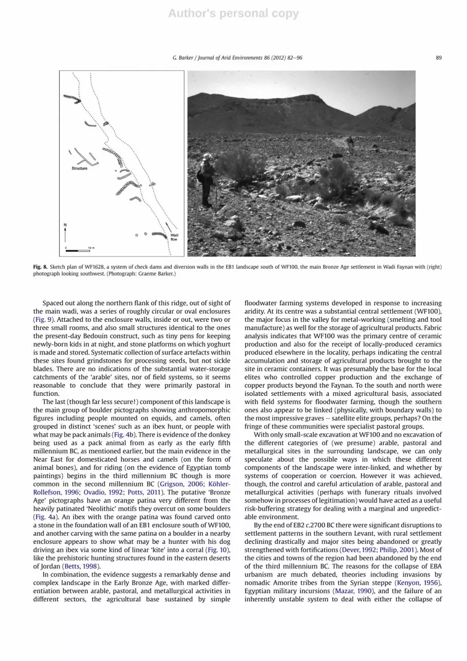
Beside one group of domestic sites there is also a small fieldsystem consisting of simply-constructed check-dams built acrossthe channels of tributary wadis, connected to diversion wallsconstructed at an angle to the water flow in the wadi to fan thefloodwaters out onto the surrounding terrain (Fig. 8). Theconstruction techniques employed in these walls, together withtheir clear association with dated Early Bronze Age structures,provides the strongest evidence in Wadi Faynan for floodwaterfarming techniques being practised from early in the EarlyBronze Age, that is, by the late fourth millennium BC, comparablein age to the few early well-dated check-dam systems in theregion such as those of the Wadi Sana in the Yemen (Harrower,2008a, 2008b).
On the northern side of the wadi was a series of small settle-ments of EB1 date associated with the same kind of small cross-wadi check-dams as in the system south of WF100. These settle-ments consisted of multi-roomed complexes with attached pens,with evidence for crop-processing and stock-keeping but notmetal-working. Above them, on the prominent ridge forming thenorthern boundary of the main wadi, were occasional Early BronzeAge copper-smelting furnaces, simple structures built to use thewind as their main draught (Barker et al., 2007c, Fig. 8.36).
Fig. 5. Plan of the major Early Bronze Age settlement of WF100, and the location of the excavation trenches (‘Operations’), with (inset) view looking northeast over the structuresrevealed by Operation 4. (Plan after Wright et al., 1998; photograph: Graeme Barker.)
G. Barker / Journal of Arid Environments 86 (2012) 82e96 87

Author's personal copy
Fig. 6. An example of the domestic, funerary, and hydraulic structures of the EB1 landscape, as mapped south of the eastern sector of WF100 (illustrated in Fig. 5). The funerary sitesare mainly on the hills to the south. The landscape to the north of them, immediately south of the WF100 perimeter wall, consists of settlement enclosures; circular watercatchments (see Fig. 7); walls of various functions including probably animal herding; and a floodwater farming system at WF1628 (shown in detail as Fig. 8). Inset: pictographWF1520, probably a representation of a domestic structure and enclosure, found on a boulder built into one of the grave enclosure walls.
Fig. 7. One of the water-catchment structures (WF24) in the EB1 landscape south of WF100. (Photograph: Graeme Barker.)
G. Barker / Journal of Arid Environments 86 (2012) 82e9688
Author's personal copy
Spaced out along the northern flank of this ridge, out of sight ofthe main wadi, was a series of roughly circular or oval enclosures(Fig. 9). Attached to the enclosure walls, inside or out, were two orthree small rooms, and also small structures identical to the onesthe present-day Bedouin construct, such as tiny pens for keepingnewly-born kids in at night, and stone platforms on which yoghurtis made and stored. Systematic collection of surface artefacts withinthese sites found grindstones for processing seeds, but not sickleblades. There are no indications of the substantial water-storagecatchments of the ‘arable’ sites, nor of field systems, so it seemsreasonable to conclude that they were primarily pastoral infunction.
The last (though far less secure!) component of this landscape isthe main group of boulder pictographs showing anthropomorphicfigures including people mounted on equids, and camels, oftengrouped in distinct ‘scenes’ such as an ibex hunt, or people withwhatmay be pack animals (Fig. 4b). There is evidence of the donkeybeing used as a pack animal from as early as the early fifthmillennium BC, as mentioned earlier, but the main evidence in theNear East for domesticated horses and camels (on the form ofanimal bones), and for riding (on the evidence of Egyptian tombpaintings) begins in the third millennium BC though is morecommon in the second millennium BC (Grigson, 2006; Köhler-Rollefson, 1996; Ovadio, 1992; Potts, 2011). The putative ‘BronzeAge’ pictographs have an orange patina very different from theheavily patinated ‘Neolithic’ motifs they overcut on some boulders(Fig. 4a). An ibex with the orange patina was found carved ontoa stone in the foundation wall of an EB1 enclosure south of WF100,and another carving with the same patina on a boulder in a nearbyenclosure appears to show what may be a hunter with his dogdriving an ibex via some kind of linear ‘kite’ into a corral (Fig. 10),like the prehistoric hunting structures found in the eastern desertsof Jordan (Betts, 1998).
In combination, the evidence suggests a remarkably dense andcomplex landscape in the Early Bronze Age, with marked differ-entiation between arable, pastoral, and metallurgical activities indifferent sectors, the agricultural base sustained by simple
floodwater farming systems developed in response to increasingaridity. At its centre was a substantial central settlement (WF100),the major focus in the valley for metal-working (smelting and toolmanufacture) as well for the storage of agricultural products. Fabricanalysis indicates that WF100 was the primary centre of ceramicproduction and also for the receipt of locally-produced ceramicsproduced elsewhere in the locality, perhaps indicating the centralaccumulation and storage of agricultural products brought to thesite in ceramic containers. It was presumably the base for the localelites who controlled copper production and the exchange ofcopper products beyond the Faynan. To the south and north wereisolated settlements with a mixed agricultural basis, associatedwith field systems for floodwater farming, though the southernones also appear to be linked (physically, with boundary walls) tothemost impressive gravese satellite elite groups, perhaps? On thefringe of these communities were specialist pastoral groups.
With only small-scale excavation atWF100 and no excavation ofthe different categories of (we presume) arable, pastoral andmetallurgical sites in the surrounding landscape, we can onlyspeculate about the possible ways in which these differentcomponents of the landscape were inter-linked, and whether bysystems of cooperation or coercion. However it was achieved,though, the control and careful articulation of arable, pastoral andmetallurgical activities (perhaps with funerary rituals involvedsomehow in processes of legitimation) would have acted as a usefulrisk-buffering strategy for dealing with a marginal and unpredict-able environment.
By the end of EB2 c.2700 BC therewere significant disruptions tosettlement patterns in the southern Levant, with rural settlementdeclining drastically and major sites being abandoned or greatlystrengthenedwith fortifications (Dever, 1992; Philip, 2001). Most ofthe cities and towns of the region had been abandoned by the endof the third millennium BC. The reasons for the collapse of EBAurbanism are much debated, theories including invasions bynomadic Amorite tribes from the Syrian steppe (Kenyon, 1956),Egyptian military incursions (Mazar, 1990), and the failure of aninherently unstable system to deal with either the collapse of
Fig. 8. Sketch plan of WF1628, a system of check dams and diversion walls in the EB1 landscape south of WF100, the main Bronze Age settlement in Wadi Faynan with (right)photograph looking southwest. (Photograph: Graeme Barker.)
G. Barker / Journal of Arid Environments 86 (2012) 82e96 89

Author's personal copy
international trade (Dever, 1989) or with the major drought eventat this time for which there is very strong palaeoenvironmentalevidence in the region (Migowski et al., 2006; Rosen, 1989) thoughnot picked up in the discontinuous geomorphological, sedimento-logical and palynological records collected in the Wadi Faynan (el-Rishi et al., 2007). Whatever the reasons, the consensus of scholarlyopinion is that by the end of the third millennium BC the inhabi-tants of the urbanized regions of the southern Levant increasinglyreverted to small-scale subsistence farming and/or pastoralism.
In the Wadi Faynan the structured agro-pastoraleindustriallandscape of the EB1 phase continued into EB2 (3000e2700 BC) ona much reduced scale, and through the rest of the third millenniumthe wadi was characterized by predominantly pastoral forms ofsettlement. However, the story is not one of a ‘simple collapse’ topastoralism. In EB2, in fact, metal production appears to haveintensified, with more stable and productive copper being minedand processed in powerful wind-powered furnaces (Hauptmannand Weisgerber, 1987, 432e433). Faynan copper continued to be
Fig. 9. WF660, an EB1 and EB2e3 ‘pastoral’ site with several buildings and pens: (above) plan, (below) photograph, looking north. (Illustration: David Mattingly, Mike Hawkes;photograph: Graeme Barker.)
G. Barker / Journal of Arid Environments 86 (2012) 82e9690

Author's personal copy
processed and traded out of the region bywhat appear to have beenpredominantly pastoral communities. It has been identified, forexample, in a series of axes and spearheads in an EB2 destructiondeposit at the major settlement of Pella in northern Jordan,alongside an axe of Cypriot copper and a chisel of Anatolian copper,evidence for the range of trade networks competing to supply theregion’s urban centres (Philip et al., 2003). The focus of sedentarysettlement shifted to theWadi Fidan at thewestern end of theWadiFaynan where it debouches into the Wadi Arabah trench, the keylocation for access to trade up and down the Arabah. KhirbatHamrat Ifdan here was a substantial EB3 defended settlementwhere a variety of metallurgical processes were practised ona significant scale (Levy et al., 2002). Metallurgical activity finallydeclined drastically by 2000 BC, in part because of regional shifts inEgyptian trade links to Byblos and Cyprus, although markedclimatic deterioration at this time might have been a contributoryfactor (Arz et al., 2006).
5. The second and first millennia BC
In the Middle Bronze Age (2000e1550 BC) sophisticated polit-ical structures developed in the better-watered regions of thesouthern Levant, followed in the Late Bronze Age (1550e1200 BC)by settlement contraction and economic decline, variouslyexplained by scholars in terms of Egyptian military incursions orinternal structural changes (Bienkowski, 1989). What happened inthe adjacent desertic regions is particularly contested. Finkelstein(1995), for example, suggested that they continued to be occu-pied by small-scale mobile pastoral populations who created anephemeral archaeology that is difficult to recognize. Rosen et al.(2005), on the other hand, argue that, given their successfulrecognition of ‘pastoral archaeologies’ in the Negev in other periodssuch as the Early Bronze Age and the Iron Age (on the evidence ofstabling deposits identified from micromorphology and phytolithanalysis), the absence of such evidence in the second millenniumBC signifies a real decline in pastoral populations and the virtualabandonment of the arid zone. Further micromorphological andphytolith evidence for Iron Age pastoralism in the Negev (Shahack-Gross and Finkelstein, 2008) tends to support the latter thesis.
Wadi Faynan is typical in producing virtually no evidence forhabitation at this time, though the basal sediments of a trench we
excavated beside Khirbat Faynan yielded geochemical signaturesfor the processing of lead-rich copper ores during the ‘empty’second millennium BC (Grattan et al., 2007) and copper productionis attested at Khirbat an-Nahas and Khirbat al-Jariya, to the north ofthe main wadi (Fig. 2), towards the end of the second millenniumBC (Ben-Yosef et al., 2010). Also, graves of aceramic people equip-ped with wooden bowls have been found in an Iron Age cemeteryin Wadi Fidan (Levy et al., 1999), so the absence of pottery in theWadi Faynan may not necessarily be evidence for the absence ofpeople. On balance the evidence suggests that theWadi Faynanwasthe base for predominantly pastoral use through much of thesecond millennium BC, though people continued to extract andprocess copper ores. The discovery of copper objects, prills andcasting discards at remote EBA campsites in the central Negev(Rosen, 2009) is an important reminder that small-scale engage-ment in metallurgy can be part and parcel of the pastoral nomadiclifestyle. The palynology indicates an increasingly degraded steppicenvironment at this time (Hunt et al., 2004).
With the development of the Iron Age proto-states of Edom,Moab and Ammon in the southern Levant in the early firstmillennium BC (Bartlett, 1989), copper mining and production inthe Faynan region were organized on an industrial scale (Ben-Yosefet al., 2010; Levy et al., 2008). The large fort at Khirbat an-Nahassuggests that the production was protected by military force(Mattingly et al., 2007a, 275e277). It appears increasingly likelythat copper production was an important driver in Edomite stateformation, rather than the creation of the kingdom leading to thereopening of the mines (Levy et al., 2004). The archaeologicalrecord of later Nabataean civilization, traditionally viewed asa desert nomadic culture, reveals instead a complex, literate,society ruled by coin-issuing kings, with some substantial urbansettlements such as Petra. Faynan copper continued to be mined,albeit on a smaller scale than in the earlier Iron Age. There werenumerous farms and farmsteads in the valley, now, associated withsophisticated small-scale floodwater farming systems (Fig. 11). Asubstantial nucleated settlement at Khirbat Faynan and a secondary(intervisible) hill-top fort, Tell al-Mirad, indicate that these, like themining operations, were under direct political control by theauthorities at Petra.
6. Roman imperialism and its aftermath
With the imposition of Roman control on the region at thebeginning of the second century AD, Khirbat Faynan, ancientPhaino, developed as the control site for an imperial mining oper-ation (metalla) (Mattingly et al., 2007b). The selection of the WadiFaynan as the Roman mining centre was undoubtedly connectedwith the fact that there was a good water supply in the WadiGhuwayr and the largest expanse of potentially cultivable land inthe Wadi ‘Arabah region. The whole floor of the wadi was nowmanaged as a single estate, in order to feed the Phaino communityand its industrial workforce (Fig. 11, stage 2; Fig. 12). Floodwaterswere transported considerable distances from one set of fields toanother by ingenious systems of parallel walls which excavationhas shown are the above-ground evidence of well-built channels(Fig. 13). Floodwaters egressing from a channel into a farmed zonewere distributed from field to field by means of carefully sitedsluices and slipways. A somewhat wetter climate can be inferredfrom the geomorphological and sedimentological studies of theproject but not from the palynology (el-Rishi et al., 2007, 92e93), sowhether this expansion and intensification in agricultural activitywere facilitated by climatic amelioration is unclear. A few frag-mentary stone lines, reminiscent of tent footings rather than ofwalled structures, associated with occasional Roman/Byzantinecoarse ware sherds and in some instances with small check dams,
Fig. 10. Pictograph WF1444, by the EB1 enclosure WF1512. There are two ibex oneabove the other, a rough oval to their right, a small anthropomorphic figure and a four-legged animal to the left of the upper ibex, and a half rectangle to the left of the loweribex, all possible components of an ibex hunt (hunter, dog, linear ‘kite’, oval corral).Scale: 10 cm (Photograph: Graeme Barker.)
G. Barker / Journal of Arid Environments 86 (2012) 82e96 91

Author's personal copy
might be campsites of pastoral groups. They all occur well awayfrom the main wadi fields, and at a distance from the mining andsmelting sites, suggesting that local pastoral groups may have beenpermitted access to the outlying parts of the Faynan ‘estate’ by themining authorities.
The system seems to have first contracted and then collapsedmore or less in its entirety by the closing centuries of the RomanEmpire (Fig. 11, stage 3), its demise almost certainly related tothe intensity of the Roman exploitation of the locality. Thepollution signatures in the sediment geochemistry at Tell WadiFaynan indicate a scale of industrial activity many times greaterthan before, which accords with the surface evidence of vastspreads of slag around Khirbat Faynan (Fig. 3). The pollen recordfrom sediments behind a water barrage at Khirbat Faynan showsthat the Roman landscape rapidly developed into the extremelydegraded and desertic environment of Wadi Faynan today (Huntet al., 2007). The charcoal residues around the Roman mines
demonstrate that fuelwood had to be brought down from theplateau because the Faynan landscape had been stripped bare oftimber (Engel, 1993; Engel and Frey, 1996). The geochemicalstudies indicate extraordinarily high levels of heavy metalpollutants in the Khirbat Faynan barrage sediments in theRoman and Byzantine centuries, many times higher thanmodern safe limits (Grattan et al., 2007), and in the skeletons ofpeople buried around Khirbat Faynan at this time (Grattan et al.,2005). The intense smelting activity around Khirbat Faynanproduced a dense pall of airborne pollution that affected plants,animals and people. Fertilizing the fields with domestic andhousehold waste from Khirbat Faynan exacerbated the situation,increasing the pollutants in the soil and thus in the crops grownon the land.
Whether or not copper production continued right up to themid-seventh-century Arab conquest, it certainly did not endure inthe subsequent centuries on any significant scale. The absence of
l l l
l l
l
l
l
l
Fig. 11. A model of land-use development in the Wadi Faynan in Nabataean, Roman, and Byzantine times. Nabataean: individual farmsteads, with collections of adjacent fields fedby simple run-off methods and short channels to distribute water flow. Late Roman/Byzantine: a large integrated field system fed by comprehensive networks of channelsdistributing water across large areas of fields. Late Byzantine: less-extensive channel systems feeding smaller remodelled field systems, with some areas abandoned.
G. Barker / Journal of Arid Environments 86 (2012) 82e9692

Author's personal copy
any coins relating to the period AD 668e1210 (covering theUmmayad, Abbasid, Fatamid, early Seljuq and Frankish phases:Kind et al., 2005) and the general absence of diagnostic pottery(King et al., 1989) are consistent with a shift to the use of the valleyby pastoral groups, leaving behind a materially-impoverished andvestigial archaeological record (Newson et al., 2007b). There wasa brief period of renewed interest in the Faynan ores during theMamluk period (Hauptmann, 2000, 86e87; Hauptmann andWeisgerber, 1992), though is not certain whether this activityinvolved renewed mining or simply the reprocessing of the abun-dant slag deposits left behind by earlier phases of copper exploi-tation. This brief interlude was followed by centuries of pastoral-dominated land use in the Ottoman period, as the Faynan areareturned to a ‘default setting’ of a marginal environment at theperiphery of the core Islamic state.
One of the most surprising discoveries of the project was thatthere are significant levels of copper pollution in the milk, bread,hearth ash and animal dung of the local Bedouin people grazinganimals and growing crops in the wadi today (Grattan et al., 2003).Wadi Faynan’s beautiful desertic landscape masks the fact thatmuch of it is a polluted brownfield site created by Roman mining.
7. Conclusion
Tracing the history of the nomadefarmer relationship in theNegev from its origins in the Late Neolithic to classical and recenttimes, S. Rosen (2009, 58) argues that each major phase reflects “aspecific package of social, economic, technological, and ecologicaladaptations..socially and culturally, demographic growth, the riseof markets and trade systems, the evolution of tribal organization,the expansion of empires, and the rise of trans-tribal ideologiessuch as Islam, all had major and unique effects on desert societies”.Though the metal resources of the Wadi Faynan make it atypical ofmuch of the southern Levant, the landscape history of the wadipresents in microcosm a similarly complicated relationshipbetween farming and pastoralism through their c.10,000-year-longhistory, and between these and industrial activity through theirc.7000-year-long history.
Neolithic agropastoralism was focussed on spring-side cultiva-tion, in an environment that was for the most part significantlybetter-watered than today’s. Pastoralism as a specialist activity
Fig. 12. The imperial agricultural estate of Roman and Byzantine Phaino.
Fig. 13. Excavation of a Roman-period parallel wall system in the Wadi Faynan.Floodwaters were channelled long distances along such channels and then let intofields through carefully managed sluices. Scale: 2 m (Photograph: Graeme Barker.)
G. Barker / Journal of Arid Environments 86 (2012) 82e96 93

Author's personal copy
probably has a history of some 6000 years, as does floodwaterfarming, the first clear evidence for both dating to the Early BronzeAge at a time of significant aridification. The two activities appear tohave been practised side by side at this time within a complicatedeconomic structure controlled in some form by elite groups whowere also engaged significantly in the extraction, processing andtrade in metal ores. During the third millennium BC these struc-tures appear to have broken down or significantly loosened, withpastoralism and (for a time) metal production expanding at theexpense of sedentary agricultural settlement. The absence ofhabitation evidence dating to the second millennium BC (aphenomenon observed elsewhere in the region) would appear tobe prima facie evidence for the abandonment of the valley duringtheMiddle and Late Bronze Age, but graveswith wooden bowls andgeochemical evidence for smelting activities suggest that peoplewithout durable material culture continued to inhabit the WadiFaynane or at least visit it on a seasonal basise for pastoralism (weassume) and metal-working. Working the Faynan copper ores wasan important activity for the Iron Age and Nabataean state-levelsocieties of the first millennium BC, whose primary power basewas the better-watered uplands to the east of the Wadi Faynan. Asystem of small farms sustained by floodwater farming, probablypractisingmixed agropastoralism, was also established in the valleyin the Nabataean period, like the mines within a system ofsurveillance and control. During the Roman and Byzantine centu-ries the mines were exploited on an industrial scale within animperial estate, and the arable land on the floor of the wadi wasorganized into a single irrigation unit to produce maximum yieldsfor feeding the large workforce of slaves and paid workers workingthe mines and smelting the ores; whether pastoral groups wereallowed to operate on the margins of this imperial estate is unclear.With the collapse of the mining operation in the Byzantine period,and the landscape devastation associated with it, the valley becameonce more the home of seasonal pastoral groups, a way of life thatendures today.
The Wadi Faynan Landscape Survey concentrated on mappingsurface archaeology, palaeoenvironmental reconstruction, andusing geochemistry to investigate the nature and scale of miningand smelting at different times in the past. Clearly many questionsremain about the precise nature of cultivation and herding systems,and about the social and economic structures in which they werepractised, through the various phases of occupation summarizedhere, which only excavations can address. Nevertheless, it isapparent from the data collected by the project, and the findings ofother teams working in the study area, that the floodwater farmingand water catchment and storage techniques developed by BronzeAge, Iron Age, Nabataean, Roman/Byzantine and Arab farmersliving in the valley do not demonstrate some kind of unidirectionalsequence of increasing efficiencies: they varied significantly,related in part to environmental conditions and available technol-ogies but especially to the social and economic structures in whichthey were embedded (and which indeed they helped to sustain).The same is true of pastoralism: it appears to have varied signifi-cantly through time e again, not in any unidirectional trajectory e
in terms of its archaeological visibility (the amount of durablematerial culture associated with it), the degree to which it was thedominant activity or practised alongside arable and/or metallur-gical activities, and in the latter case the extent to which it wasclosely or loosely articulated with them. The long-term history ofagriculture and pastoralism in the Negev reveals a very similarstory, “the superposition of.complex cumulative changes ontoa fixed geography” that Rosen characterized as “a classic Braudeliancase study” (Rosen, 2009, 69). The ‘archaeological history’ of theWadi Faynan similarly chimes with Braudel’s model of history assets of different kinds of historical processes (short-, medium- and
long-term) interacting with each other and with the physicallandscape, in this case a changing physical landscape.
I began this paper by asking whether we can discern repeatedtrends in farmerenomad relations in the Wadi Faynan, andcommon explanations such as climate forcing and environmentalchange, or whether we need to emphasize the importance ofhistorical contingency. The geomorphological sequence that theproject established in the study area is interpreted as suggesting“the overall dominance of climatic as opposed to human factors indetermining local geomorphic activity over the last 8000 years” (el-Rishi et al., 2007, 71). At the same time, the conclusion from thearchaeological studies is that in this particular wadi, as in the widerdesert region considered by Rosen, the networks of social relationsand economic structures in which the Faynan farmers, shepherdsand miners were embedded e relations and structures that oper-ated at a variety of scales from the very local to at times the supra-regional e were critical in shaping people’s responses to thephysical landscape and the changes effected to it by climatic shiftsover the past 6000 years.
Acknowledgements
The Wadi Faynan Landscape Survey was a collaborative projectinvolving some 25 archaeologists and geographers in the analysisand interpretation of the data collected by the 1996e2000 fieldteams. The full acknowledgements are set out in Barker et al.(2007a), xxiiiexxiv. Particular thanks are due to David Gilbertsonand David Mattingly, the project co-directors with Graeme Barker;to the Jordanian Department of Antiquities which authorized theproject and to the Council for British Research in the Levant whichsponsored it; and to the principal funding institutions: the Arts andHumanities Research Board (now Council), the British Academy, theCouncil for British Research in the Levant, the Society of Antiquariesof London, and the Universities of Aberystwyth and Leicester.
References
al-Najjar, M., Abu Dayyeh, A., es-, S., Suleiman, E., Weisgerber, G., Hauptmann, A.,1990. Tell wadi Feinan: a new pottery Neolithic tell in southern Jordan. Annualof the Department of Antiquities of Jordan 34, 27e56.
Arz, H.W., Lamy, F., Patzold, J., 2006. A pronounced dry event recorded around 4.2 kain brine sediments from the northern Red Sea. Quaternary Research 66,432e441.
Avni, G., 1996. Nomads, farmers and town-Dwellers: PastoralisteSedentist Inter-action in the Negev highlands, SixtheEighth Centuries CE. Israel AntiquitiesAuthority, Jerusalem.
Barker, G., Gilbertson, D., Mattingly, D. (Eds.), 2007a. Archaeology and Desertifica-tion: The Wadi Faynan Landscape Survey, Southern Jordan. Council for BritishResearch in the Levant, London.
Barker, G., Hunt, C., McLaren, S., Reynolds, T., el-Rishi, H., Gilbertson, D., Grattan, J.,2007b. Early Holocene environments and early farming c.11,000e7000 cal. BP,c.9500e5000 cal. BC. In: Barker, G., Gilbertson, D., Mattingly, D. (Eds.),Archaeology and Desertification: The Wadi Faynan Landscape Survey, SouthernJordan. Council for British Research in the Levant, London, pp. 199e225.
Barker, G., Adams, R., Creighton, O., el-Rishi, H., Gilbertson, D., Grattan, J., Hunt, C.,Newson, P., Pyatt, B., Reynolds, T., 2007c. Chalcolithic (c.5000e3600 cal. BC) andBronze Age (c.3600e1200 cal. BC) settlement in Wadi Faynan: metallurgy andsocial complexity. In: Barker, G., Gilbertson, D., Mattingly, D. (Eds.), Archaeologyand Desertification: The Wadi Faynan Landscape Survey, Southern Jordan.Council for British Research in the Levant, London, pp. 227e270.
Bar-Matthews, M., Ayalon, A., Kaufman, A., 1997. Late Quaternary palaeoclimate inthe eastern Mediterranean region from stable isotope analysis of speleothemsfrom Soreq Cave, Israel. Quaternary Research 47, 155e168.
Bartlett, J.R., 1989. Edom and the Edomites. JSOT Press, Sheffield.Bar-Yosef, O., Khazanov, A., 1992. Pastoralism in the Levant: Archaeological Mate-
rials in Anthropological Perspective. Prehistory Press, Madison (WI).Beaumont, P., 1993. Drylands: Environmental Management and Development.
Routledge, London.Bell, G., 1907. Syria: The Desert and the Sown. William Heinemann, London.Ben-Yosef, E., Levy, T.E., Higham, T., Najjar, M., Tauxe, L., 2010. The beginning of Iron
Age copper production in the southern Levant: new evidence from Khirbat al-Jariya, Faynan, Jordan. Antiquity 84, 724e746.
G. Barker / Journal of Arid Environments 86 (2012) 82e9694

Author's personal copy
Betts, A., 1998. The Harra and the Hamad: Excavations and Explorations in EasternJordan. Sheffield University (Sheffield Archaeological Monographs 9), Sheffield.
Bienkowski, P., 1989. Prosperity and decline in LBA Canaan: a reply to Leibowitz andKnapp. Bulletin of the American Schools of Oriental Research 275, 59e61.
Braudel, F., 1972. The Mediterranean and the Mediterranean World in the Age ofPhillip II Fontana, London.
Bruins, H.J., 1986. Desert Environment and Agriculture in the Central Negev andKadesh Barnea During Historical Times. Midbar Foundation, Nijkerk(Netherlands).
Cohen, R., 1999. Ancient Settlements of the Negev Highlands I: The ChalcolithicPeriod, the Early Bronze Age, and the Middle Bronze Age. Israel AntiquitiesAuthority, Jerusalem.
Creighton, O., Barker, G., Mattingly, D., 2007. Recording and classifying thearchaeological record. In: Barker, G., Gilbertson, D., Mattingly, D. (Eds.),Archaeology and Desertification: The Wadi Faynan Landscape Survey, SouthernJordan. Council for British Research in the Levant, London, pp. 97e140.
Dever, W.G., 1989. The collapse of the urban Early Bronze Age in Palestine: towardsa systematic analysis. In: de Miroschedji, P. (Ed.), L’Urbanisation de la Palestineà l’Age du Bronze Ancien. International Series 527. British ArchaeologicalReports, Oxford, pp. 225e246.
Dever, G., 1992. Pastoralism and the end of the urban Early Bronze Age in Palestine.In: Bar-Yosef, O., Khazanov, A. (Eds.), Pastoralism in the Levant: ArchaeologicalMaterials in Anthropological Perspective. Prehistory Press, Madison (WI),pp. 83e92.
el-Rishi, H., Hunt, C., Gilbertson, D., Grattan, J., McLaren, S., Pyatt, B., Duller, G.,Gillmore, G., Phillips, P., 2007. The past and present landscapes of the WadiFaynan: geoarchaeological approaches and frameworks. In: Barker, G.,Gilbertson, D., Mattingly, D. (Eds.), Archaeology and Desertification: The WadiFaynan Landscape Survey, Southern Jordan. Council for British Research in theLevant, London, pp. 59e95.
Engel, T., Frey, W., 1996. Fuel resources for copper smelting in antiquity in selectedwoodlands in the Edom highlands to the Wadi Araba, Jordan. Flora 191, 29e39.
Engel, T., 1993. Charcoal remains from an Iron age copper smelting slag heap atFeinan, wadi Arabah, Jordan. Vegetation History and Archaeobotany 2, 205e211.
Evenari, M., Shanan, L., Tadmor, N., 1971. The Negev: The Challenge of a Desert.Harvard University Press, Cambridge (MA).
Finkelstein, I., Ussishkin, D., Halpern, B. (Eds.), 2000. Megiddo III: The 1992e1996Seasons. Institute of Archaeology, Tell Aviv University, Tell Aviv.
Finkelstein, I., 1995. Living on the Fringe: The Archaeology and History of the Negev,Sinai and Neighbouring Regions in the Bronze and Iron Ages. SheffieldUniversity (Monographs in Mediterranean Archaeology 6), Sheffield.
Finlayson, B., Mithen, S., 2007. The Early Prehistory of Wadi Faynan, SouthernJordan: Archaeological Survey of Wadis Faynan, Ghuwayr, and al-Bustan, andEvaluation of the Pre-Pottery Neolithic Site of WF16. Council for BritishResearch in the Levant, London.
Finlayson, B., Warren, G. (Eds.), 2010. Landscapes in Transition. Oxbow Books,Oxford.
Fleitmann, D., Burns, S.J., Mudelsee, M., Neff, U., Kramers, J., Mangini, A., Matter, A.,2003. Holocene forcing of the Indian monsoon recorded in a stalagmite fromSouthern Oman. Science 300, 1737e1739.
Grattan, J., Huxley, S., Pyatt, F.B., 2003. Modern bedouin exposures to coppercontamination: an Imperial legacy? Ecotoxicology and Environmental Safety55, 108e115.
Grattan, J., Karaki, L.A., Hine, D., Toland, H., Gilbertson, D., al-Saad, Z., Pyatt, F.B.,2005. Analyses of patterns of copper and lead mineralization in human skele-tons excavated from an ancient mining and smelting centre in the Jordaniandesert: a reconnaissance study. Mineralogical Magazine 69 (5), 653e666.
Grattan, J., Gilbertson, D., Hunt, C.O., 2007. The local and global dimensions ofmetalliferous air pollution derived from a reconstruction of an eight thousandyear record of copper smelting and mining at a desert-mountain frontier insouthern Jordan. Journal of Archaeological Science 34, 83e110.
Gregg, M.W., Bannng, E.R., Gibbs, K., Slater, G.W., 2009. Subsistence practices andpottery use in Neolithic Jordan: molecular and isotopic evidence. Journal ofArchaeological Science 36, 937e946.
Grigson, C., 2006. Farming? Feasting? Herding? Large mammals from the Chalco-lithic of Gilat. In: Levy, T.E. (Ed.), Archaeology, Anthropology and Cult: TheSanctuary at Gilat, Israel. Equinox, London, pp. 215e319.
Haiman, M., 1992. Sedentarism and pastoralism in the Negev Highlands in the EarlyBronze Age: results of the Western Negev Highlands Emergency Survey. In: Bar-Yosef, O., Khazanov, A. (Eds.), Pastoralism in the Levant: Archaeological Mate-rials in Anthropological Perspectives. Prehistory Press, Monographs in WorldArchaeology 10, Madison (WI), pp. 93e104.
Haiman, M., 1995. Agriculture and nomad-state relations in the Byzantine and EarlyIslamic Periods. Bulletin of the American School of Oriental Research 297,29e53.
Harrower, M., 2008a. Mapping and dating incipient irrigation in Wadi Sana, Hadra-mawt (Yemen). Proceedings of the Seminar for Arabian Studies 38, 187e202.
Harrower, M., 2008b. Hydrology, ideology, and the origins of irrigation in ancientSouthwest Arabia. Current Anthropology 49 (3), 497e510.
Hauptmann, A., Weisgerber, G., 1987. Archaeometallurgical and mining-archaeological investigations in the area of Fainan, Wadi ‘Arabah (Jordan).Annual of the Department of Antiquities of Jordan 31, 419e437.
Hauptmann, A., Weisgerber, G., 1992. Periods of ore exploitation and metalproduction in the area of Feinan, Wadi ‘Arabah, Jordan. In: Zaghloul, M.,Hadidi, A. (Eds.), 1992. Studies in the History and Archaeology of Jordan, vol. IV.
Department of Antiquities of the Hashemite Kingdom of Jordan, Amman, andRoutledge and Kegan Paul, London, pp. 61e66.
Hauptmann, A., 2000. Zur frühen Metallurgie des Kupfers in Fenan/Jordanien (DerAnschnitt 1.) Deutsche Bergbau-Museum, Bochum.
Henry, D.O. (Ed.), 1995. Prehistoric Cultural Ecology and Evolution: Insights fromSouthern Jordan. Plenum Press, New York.
Hubbard, E.M., 2010. Livestock and people in a Middle Chalcolithic settlement:a micromorphological investigation from Tel Tsaf, Israel. Antiquity 84,1123e1134.
Hunt, C.O., el-Rishi, H.A., Gilbertson, D.D., Grattan, J., McLaren, S., Pyatt, F.B.,Rushworth, G., Barker, G.W., 2004. Early Holocene environments in the WadiFaynan, Jordan. The Holocene 14, 921e930.
Hunt, C.O., el-Rishi, H., Gilbertson, D., 2007. An 8000-year history of landscape,climate, and copper exploitation in the Middle East: the Wadi Faynan and theWadi Dama National Reserve in southern Jordan. Journal of ArchaeologicalScience 34, 1306e1338.
Issar, A., Brown, N., 1998. Water, Environment and Society in Times of ClimaticChange. Springer, Berlin.
Issar, A., Zohar, M., 2009. Climate Change: Impacts on the Environment and Civi-lization of the Near East. Springer, Berlin.
Kennedy, D., Bewley, R., 2004. Ancient Jordan from the Air. Batsford, London.Kenyon, K.M., 1956. Tombs of the Intermediate EarlyeMiddle Bronze Age at Tell el-
Ajjul. Annual of the Department of Antiquities of Jordan 3, 41e45.Kind, H.D., Gilles, K.J., Hauptmann, A., Weisberger, G., 2005. Coins from Faynan,
Jordan. Levant 37, 169e195.King, G.D., Lenzen, C.J., Newhall, A., King, J.L., Deemer, J.D., Rollefson, G.O., 1989.
Survey of Byzantine and Islamic sites in Jordan: third preliminary report 1982.The Wadi ‘Arabah (part 2). Annual of the Department of Antiquities of Jordan33, 199e215.
Köhler-Rollefson, I., 1996. The one-humped camel in Asia: origin, utilization, andmechanisms of dispersal. In: Harris, D.R. (Ed.), The Origins and Spread ofAgriculture and Pastoralism in Eurasia. University College London Press, Lon-don, pp. 282e294.
Lagrange, M.-J., 1898. Phounoun. Révue Biblique 7, 112e115.Levy, T.E., Adams, R.B., Shafiq, R., 1999. The Jabal Hamrat Fidan project: excavation at
the Wadi Fidan 40 cemetery, Jordan (1997). Levant 31, 293e308.Levy, T., Adams, R.B., Hauptmann, A., Prange, M., Schmittt-Strecker, S., Najjar, M.,
2002. Early Bronze Age metallurgy: a newly discovered copper manufactory insouthern Jordan. Antiquity 76, 425e437.
Levy, T., Adams, R., Najjar, M., Hauptmann, A., Anderson, J.A., Brandl, B., Robinson, M.,Higham, T., 2004. Reassessing the chronology of Biblical Edom: new excavationsand 14C dates from Khirbat en-Nahas (Jordan). Antiquity 78, 865e879.
Levy, T.E., Higham, T., Bronk Ramsey, C., Smith, N.G., Ben-Yosef, B., Robinson, M.,Münger, S., Knabb, K., Schulze, J.P., Najjar, M., Tauxe, L., 2008. High-precisionradiocarbon dating and historical biblical archaeology in southern Jordan.Proceedings of the National Academy of Sciences 105, 16460e16465.
Levy, T. (Ed.), 1987. Shiqmim I: Studies Concerning Chalcolithic Societies in theNorthern Negev. British Archaeological Reports (International Series 356),Oxford.
Levy, T., 1995. Cult, metallurgy and rank societies. In: Levy, T. (Ed.), The Archaeologyof Society in the Holy Land. Leicester University Press, London, pp. 226e243.
Mattingly, D., Newson, P., Creighton, O., Tomber, R., Barker, G., Gilbertson, D.,Hunt, C., 2007a. The making of early states: the Iron Age and Nabataean periods.In: Barker, G., Gilbertson, D., Mattingly, D. (Eds.), Archaeology and Desertifica-tion: The Wadi Faynan Landscape Survey, Southern Jordan. Council for BritishResearch in the Levant, London, pp. 271e303.
Mattingly, D., Newson, P., Creighton, O., Tomber, R., Grattan, J., Hunt, C.,Gilbertson, D., el-Rishi, H., Pyatt, R., 2007b. A landscape of imperial power:Roman and Byzantine Phaino. In: Barker, G., Gilbertson, D., Mattingly, D. (Eds.),Archaeology and Desertification: The Wadi Faynan Landscape Survey, SouthernJordan. Council for British Research in the Levant, London, pp. 305e348.
Mazar, A., 1990. Archaeology of the Land of the Bible: 10,000e586 BCE. Doubleday,New York.
Migowski, C., Stein, M., Prasad, S., Negendank, J.F.W., Agnon, A., 2006. Holoceneclimate variability and cultural evolution in the Near East from the Dead Seasedimentary record. Quaternary Research 6, 421e431.
Mortimore, M., 1998. Roots in the African Dust: Sustaining the Drylands. CambridgeUniversity Press, Cambridge.
Newson, P., Barker, G., Daly, P., Mattingly, D., Gilbertson, D., 2007a. The Wadi Faynanfield systems. In: Barker, G., Gilbertson, D., Mattingly, D. (Eds.), Archaeology andDesertification: The Wadi Faynan Landscape Survey, Southern Jordan. Councilfor British Research in the Levant, London, pp. 141e174.
Newson, P., Mattingly, D., Daly, P., Tomber, R., el-Rishi, H., Gilbertson, D., Grattan, J.,Hunt, C., McLaren, S., Pyatt, B., 2007b. The Islamic and Ottoman periods. In:Barker, G., Gilbertson, D., Mattingly, D. (Eds.), Archaeology and Desertification:The Wadi Faynan Landscape Survey, Southern Jordan. Council for BritishResearch in the Levant, London, pp. 349e368.
Ortner, D.J., 1979. Disease and mortality in the Early Bronze Age people of Bab edh-Dhra’, Jordan. American Journal of Physical Anthropology 51, 589e598.
Ovadio, E., 1992. The domestication of the ass and pack transport by animals: a caseof technological change. In: Bar-Yosef, O., Khazanov, A. (Eds.), Pastoralism in theLevant: Archaeological Materials in Anthropological Perspective. PrehistoryPress, Madison (WI), pp. 19e28.
Palmer, C., Gilbertson, D., el-Rishi, H., Hunt, C., Grattan, J., McLaren, S., Pyatt, B.,2007a. The Wadi Faynan today: landscape, environment, people. In: Barker, G.,
G. Barker / Journal of Arid Environments 86 (2012) 82e96 95

Author's personal copy
Gilbertson, D., Mattingly, D. (Eds.), Archaeology and Desertification: The WadiFaynan Landscape Survey, Southern Jordan. Council for British Research in theLevant, London, pp. 25e57.
Palmer, C., Smith, H., Daly, P., 2007b. Ethnoarchaeology. In: Barker, G., Gilbertson, D.,Mattingly, D. (Eds.), Archaeology and Desertification: The Wadi Faynan Land-scape Survey, Southern Jordan. Council for British Research in the Levant,London, pp. 369e395.
Philip, G., Clogg, P.W., Dungworth, D., 2003. Copper metallurgy in the Jordan Valleyfrom the third to the first millennia BC: chemical, metallographic, and leadisotope analyses of artifacts from Pella. Antiquity 35, 71e100.
Philip, G., 2001. The Early Bronze Age IeIII ages. In: McDonald, B., Adams, R.,Bienkowski, P. (Eds.), The Archaeology of Jordan. Sheffield Academic Press(Levantine Archaeology 1), Sheffield, pp. 163e232.
Philip, G., 2003. The Early Bronze Age of the southern Levant: a landscape approach.Journal of Mediterranean Archaeology 16.1, 103e132.
Potts, D., 2011. Equus asinus in highland Iran: evidence old and new. In:Conard, N.J., Drechster, P., Morales, A. (Eds.), Between Sand and Sea: TheArchaeology and Human Ecology of Southwestern Asia. Kerns Verlag,Tübingen, pp. 167e175.
Rabb’a, I., 1994. The Geology of the Al Qurayqira (Jabal Hamra Faddan). Map Sheet3051 II. Bulletin 28. Geological Mapping Division, Geology Directorate, Amman.
Raikes, R., 1967. Water, Weather and Prehistory. John Baker, London.Richardson, J.E., 1997. An analysis of the faunal assemblages from two Pre-Pottery
Neolithic sites in the Wadi Fidan, Jordan. In: Gebel, H.G., Kafafi, Z.,Rollefson, G.O. (Eds.), The Prehistory of Jordan. Perspectives from 1997, vol. II. ExOriente, Berlin, pp. 495e509.
Rosen, A., Weiner, S., 1994. Identifying ancient irrigation: a new method usingopaline phytoliths from emmer wheat. Journal of Archaeological Science 21,125e132.
Rosen, S., Savinetsky, A.B., Plakht, Y., Kisseleva, N.K., Khassanov, B.K.,Pereladov, A.M., Haiman, M., 2005. Dung in the desert: preliminary results ofthe Negev Holocene Ecology project. Current Anthropology 46 (2), 317e327.
Rosen, A., 1989. Environmental change at the end of the Early Bronze Age inPalestine. In: de Miroschedji, P. (Ed.), L’Urbanisation de la Palestine à l’Age duBronze Ancien. International Series 527, British Archaeological Reports, Oxford,pp. 247e255.
Rosen, A., 2007. Civilizing Climate: Social Responses to Climate Change in theAncient Near East. Rowman Altamira, Lanham.
Rosen, S., 2009. History does not repeat itself: cyclicity and particularism in nomad-sedentary relations in the Negev in the long term. In: Szuchman, J. (Ed.),Nomads, Tribes, and the State in the Ancient Near East: Cross-DisciplinaryPerspectives. Oriental Institute of the University of Chicago, Chicago, pp. 57e86.
Ruben, I., Barnes, R.H., Kana’an, R., 1997. Mapping and preliminary survey in WadiFaynan, south Jordan. Annual of the Department of Antiquities of Jordan 41,433e452.
Sartre, M., 1993. Inscriptions de la Jordanie. In: Petra et la Nabatène méridionale, duwadi el-Hasa au golfe d’Aqaba. Bibliotèque Archéologique et Historique 115, P,vol. IV. Geuthner, Paris.
Shahack-Gross, R., Finkelstein, I., 2008. Subsistence practices in an arid environ-ment: a geoarchaeological investigation in an Iron Age site, the Negev High-lands. Journal of Archaological Science 35, 965e982.
Shalev, S., Northover, P., 1987. Chalcolithic metal and metalworking at Shiqmim. In:Levy, T. (Ed.), Shiqmim I: Studies Concerning Chalcolithic Societies in theNorthern Negev Desert, Israel. International Series 356, British ArchaeologicalReports, Oxford, pp. 357e371.
Simmons, A.H., al-Najjar, M., 1996. Test excavations at Ghwair I, a Neolithic settle-ment in the Wadi Feinan. American Center of Oriental Research Newsletter 8.2,7e8.
Simmons, A.H., Najjar, M., 2006. Ghwair I: a small, complex Neolithic community insouthern Jordan. Journal of Field Archaeology 31, 7e95.
Simmons, A.H., 2007. The Neolithic Revolution in the Near East. University of Ari-zona Press, Tucson.
Spellman, G., 2000. The dynamic climatology of drylands. In: Barker, G.,Gilbertson, D. (Eds.), The Archaeology of Drylands: Living at the Margin.Routledge (One World Archaeology 39), London, pp. 19e41.
Spooner, B., 1989. Desertification: the historical significance. In: Huss-Ashmore, R.,Katz, S.H. (Eds.), African Food Systems in Crisis. Part One: Micro-Perspectives.Gordon and Breach, New York, pp. 111e162.
Thomas, D.S.G., Allison, R.J. (Eds.), 1993. Landscape Sensitivity. John Wiley and Sons,Chichester.
Thomas, D.S.G., Middleton, N.J., 1994. Desertification: Exploding the Myth. JohnWiley and Sons, Chichester.
Tiffen, M., Mortimore, M., Gichuki, F., 1994. More People, Less Erosion: Environ-mental Recovery in Kenya. John Wiley and Sons, Chichester.
Tyrácek, J., Amin, R.M., 1981. Rock pictures (petroglyphs) near Qasr Muhaiwir, Iraqiwestern desert. Sumer 37, 145e148.
Uerpmann, H.-P., 1987. The Ancient Distribution of Ungulate Mammals in the NearEast. Ludwig Reichert Verlag, Wiesbaden.
Weiss, H., 1997. Late third millennium abrupt climatic change and social collapsein West Asia and Egypt. In: Dalfes, H.N., Kukla, G., Weiss, H. (Eds.), ThirdMillennium BC Climatic Change and Old World Collapse. Springer, Berlin,pp. 711e723.
Wilkinson, T.J., 2003. Archaeological Landscapes of the Near East. University ofArizona Press, Tucson.
Wright, K., Najjar, M., Last, J., Maloney, N., Flender, M., Gower, J., Jackson, N.,Kennedy, A., Shafiq, R., 1998. The wadi Faynan fourth and third millenniaproject, 1997: report on the first season of test excavations at Wadi Faynan 100.Levant 30, 33e60.
Wright, K., 2000. The social origins of cooking and dining in the early villages ofwestern Asia. Proceedings of the Prehistoric Society 66, 89e121.
G. Barker / Journal of Arid Environments 86 (2012) 82e9696


