Embed Size (px)
Citation preview
113
Abstract
The paper reports on the sixth season of fieldwork of the
Cyrenaican Prehistory Project (CPP) undertaken in Sep-
tember 2012. As in the spring 2012 season, work focussed
on the Haua Fteah cave and on studies of materials exca-
vated in previous seasons, with no fieldwork undertaken
elsewhere in the Gebel Akhdar. An important discovery, in
a sounding excavated below the base of McBurney’s 1955
Deep Sounding (Trench S), is of a rockfall or roof collapse
conceivably dating to the cold climatic regime of Marine
Isotope Stage (MIS) 6 (globally dated to c. 190–130 ka) but
more likely the result of a seismic event within MIS 5 (glob-
ally dated to c. 130–80 ka). The sediments and associated
molluscan fauna in Trench S and in Trench D, a trench being
cut down the side of the Deep Sounding, indicate that this
part of the cave was at least seasonally waterlogged during
the accumulation, probably during MIS 5, of the ~6.5 m of
sediment cut through by the Deep Sounding. Evidence for
human frequentation of the cave in this period is more or
less visible depending on how close the trench area was
to standing water as it fluctuated through time. Trench M,
the trench being cut down the side of McBurney’s Middle
Trench, has now reached the depth of the latest Middle
Stone Age or Middle Palaeolithic (Levalloiso-Mousterian)
industries. The preliminary indications from its excava-
tion are that the transition from the Levalloiso-Mousterian
to the blade-based Upper Palaeolithic or Late Stone Age
Dabban industry was complex and perhaps protracted, at
a time when the climate was oscillating between warm-
stage stable environmental conditions and colder and more
arid environments. The estimated age of the sediments,
c. 50–40 ka, places these oscillations within the earlier part
of MIS 3 (globally dated to 60–24 ka), when global climates
experienced rapid fluctuations as part of an overall trend to
increasing aridity and cold.
Introduction The Cyrenaican Prehistory Project conducted two campaigns of excavation in the Haua Fteah cave in 2012, one in March/April reported by Barker et al.
(2012) and a second one in September 2012 that is reported here. As the previous reports (Barker et al. 2007, 2008, 2009, 2010, 2012) have described, the project is investigating the history of climate, envi-ronment and human settlement in the Gebel Akhdar massif over the past c. 150,000 years (150 ka), which is the approximate length of time that modern humans (Homo sapiens) are thought to have been present in North Africa (Garcea 2010; Hublin and McPherron 2011).
The Gebel Akhdar massif measures some 300 km west/east by 75 km north/south, and represents an island of better-watered terrain with Mediterra-nean-style vegetation, enclosed by desert to the west, south, and east. The CPP is combining a programme of archaeological and geomorphological survey across the massif with the re-investigation of the Haua Fteah cave, which is situated on the coast approximately two-thirds along the Gebel Akhdar from the city of Benghazi at its western edge. The cave is a large dry shelter measuring ~80 m wide by ~50 m deep, facing north towards the sea. Between 1951 and 1955 the Cambridge archaeologist Charles McBurney exca-vated a deep (~14 m) trench in the centre of the cave, finding a long sequence of human occupation that remains unique for North Africa east of the Maghreb (McBurney 1967). The study of North African prehis-tory is dominated by three main areas of debate: (1) the timing and character of initial dispersals into the region by anatomically modern humans – current theorising emphasises the likelihood of their expan-sion across the Sahara during humid climatic phases such as those within Marine Isotope Stage 5 (MIS 5, dated to c. 130–80 ka); (2) the success or otherwise of their behavioural adaptations to the effects of global climatic change in the Late Pleistocene, in particular increasing aridity after 80 ka, culminating in the peak of Last Glacial Maximum conditions c. 20 ka; and (3) the timing and routes of dispersal of ‘Neolithic’ plant and animal domesticates in the Early Holocene (after c. 11 ka) and the contexts of their use (i.e. whether they were introduced by immigrant farmers from the eastern Mediterranean and/or adopted by local pop-ulations of hunter-gatherers). The Haua Fteah has remained central to all three areas of debate because the sequence discovered by McBurney spanned the
The Cyrenaican Prehistory Project 2012: the sixth season of excavations in the Haua Fteah cave
By Ryan Rabett,1 Lucy Farr,1 Evan Hill,2 Chris Hunt,2 Ross Lane,3 Hazel Moseley,3 Christopher Stimpson1 and Graeme Barker1
1 McDonald Institute for Archaeological research, University of Cambridge, UK.2 School of Geography, Archaeology and Palaeoecology, Queen’s University Belfast, UK.3 Canterbury Archaeological Trust, UK.
Libyan Studies 44 (2013)
LSJ44-113-126-BARKER-final.indd 113 05/09/2013 14:25
R. Rabett et al.
114
Middle and Late Stone Ages (or Middle and Upper Palaeolithic in European terminology), Mesolithic and Neolithic periods. Using radiocarbon (14C) dating on charcoal McBurney was able to date the upper 7 m of the sequence to the past 40,000 years but the latter represented the extreme range of the method at that time and he had to estimate the age of the lower 7 m by estimating rates of sediment accumula-tion and correlating sedimentary changes in the cave with the oxygen isotope palaeoclimate record that was emerging from marine sediment cores. These calculations suggested that the lower sediments most likely belonged to the Last Interglacial and were per-haps 80,000–100,000 years old.
The main aim of the new project is to establish the long-term relationship between climate, environ-ment and people in the Gebel Akhdar through the Late Pleistocene and Holocene: to what extent can changes in hominin behaviour through this long period be understood in terms of climate forcing or in terms of other factors such as migration or long-dis-tance cultural contact? The principal approaches taken by the project consist of the reinvestigation of
the Haua Fteah stratigraphy; a programme of geo-morphological and archaeological survey along the coast (where Pleistocene deposits such as raised beaches are well preserved, sometimes with asso-ciated archaeology) and across the Gebel Akhdar from the coast southwards to the edge of the Sahara desert; and the re-study of the prolific finds from the 1950s excavations curated in Cambridge University’s Museum of Archaeology and Anthropology. In the case of the Haua Fteah, the objectives are to: re-ex-pose the faces of the McBurney trench backfilled in 1955; clean and record the layers using the modern single context recording system and correlate them with the excavation units used by McBurney, in order to provide a robust framework for the archive stud-ies; undertake a comprehensive programme of sam-pling for radiometric dating (charcoal, shell and bone for 14C, quartz grains for OSL dating, bone for OSL dating, shell for AAR dating, tephra for tephrochro-nology) and for palaeoenvironmental reconstruction (e.g. pollen, palynofacies, phytoliths, microfauna); and excavate stratigraphically a small trench down the side of the McBurney trench in order especially
Back of cave
SOUTH
Upper Trench
Middle Trench
Deep Sounding
Tr. M
Tr. S
Tr. D
WESTEAST
Cave surface
Upper Trench~2 m
Middle Trench~5.5 m
Deep Sounding~6.5 m
Trench S~0.75 m
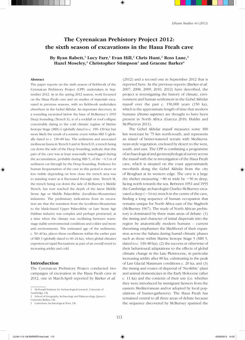
Figure 1. Schematic illustration of the McBurney trench in the Haua Fteah, illustrating the positions of CPP Trenches M, D and S (drawing: S. Jones).
LSJ44-113-126-BARKER-final.indd 114 05/09/2013 14:25
THE CYRENAICAN PREHISTORY PROJECT: THE SIXTH SEASON
115
to collect high quality samples of artefacts and ‘eco-facts’ (animal bones, plant remains, terrestrial shells, marine shells) to investigate the validity of the suc-cession of lithic industries defined by McBurney, the transitions between them, and associated evidence for subsistence activities such as gathering and, in the upper layers, herding and cultivation.
The McBurney trench consisted of an Upper Trench (our term, not his) measuring approximately 10 × 10 × 2 m deep; a Middle Trench measuring approximately 7 × 6 × 5.5 m; and a Deep Sounding measuring approximately 3.8 × 1.6 × 6.5 m. As we described in our previous report (Barker et al. 2012), by the end of the spring 2012 season we had emp-tied the last remaining backfill from the Deep Sound-ing; excavated Trench M, the new trench (2 m × 1 m, reduced after 40 cm to ~1.5 m × 0.5 m) down the side of the Middle Trench, to a depth of ~2 m; and cut a small (50 × 50 cm) sondage (Trench S) at the base of the Deep Sounding that established the presence of archaeological materials there (whereas McBurney thought he had reached the base of the cultural deposit when he ceased excavation, finding bedrock or a massive boulder covering the western side of the trench floor). The excavation of Trench M prior to the 2012 fieldwork had investigated occupa-tion layers with ‘Oranian’ Late Palaeolithic industries dating from c. 18 ka, just after the climax of the Last Glacial Maximum, to the transition with the more microlithic ‘Capsian’ industry c. 12.5 ka. In the spring 2012 season we excavated layers underlying the Ora-nian with an industry characterised by the preferen-tial selection of blanks for the production of blades which McBurney had likened to the European Upper Palaeolithic Gravettian and termed the Dabban after the cave of Hafget el-Dabba in Wadi Kuf ~50 km to the west of the Haua Fteah where he had discov-ered similar material (McBurney 1960). McBurney’s 14C dates, and our own including the occurrence of tephra (volcanic ash) from the Campanian Ignimbrite eruption in the Bay of Naples accurately dated to c. 39 ka (De Vivo et al. 2001; Lowe et al. 2011), indicate that these industries began c. 40 ka. The objectives of the September 2012 field season were: to continue the excavation of Trench M down the side of the Middle Trench into the underlying Levalloiso-Mouste-rian (Middle Palaeolithic or Middle Stone Age) occu-pation; to re-open a 2 × 1 m trench begun in 2010, Trench D, located at the top of the Deep Sounding and extending ~80 cm down into it, the eventual intention being to continue it down the full length of the Deep Sounding; and to expand the Trench S sondage to continue to characterise the basal archae-ology of the site (Fig. 1).
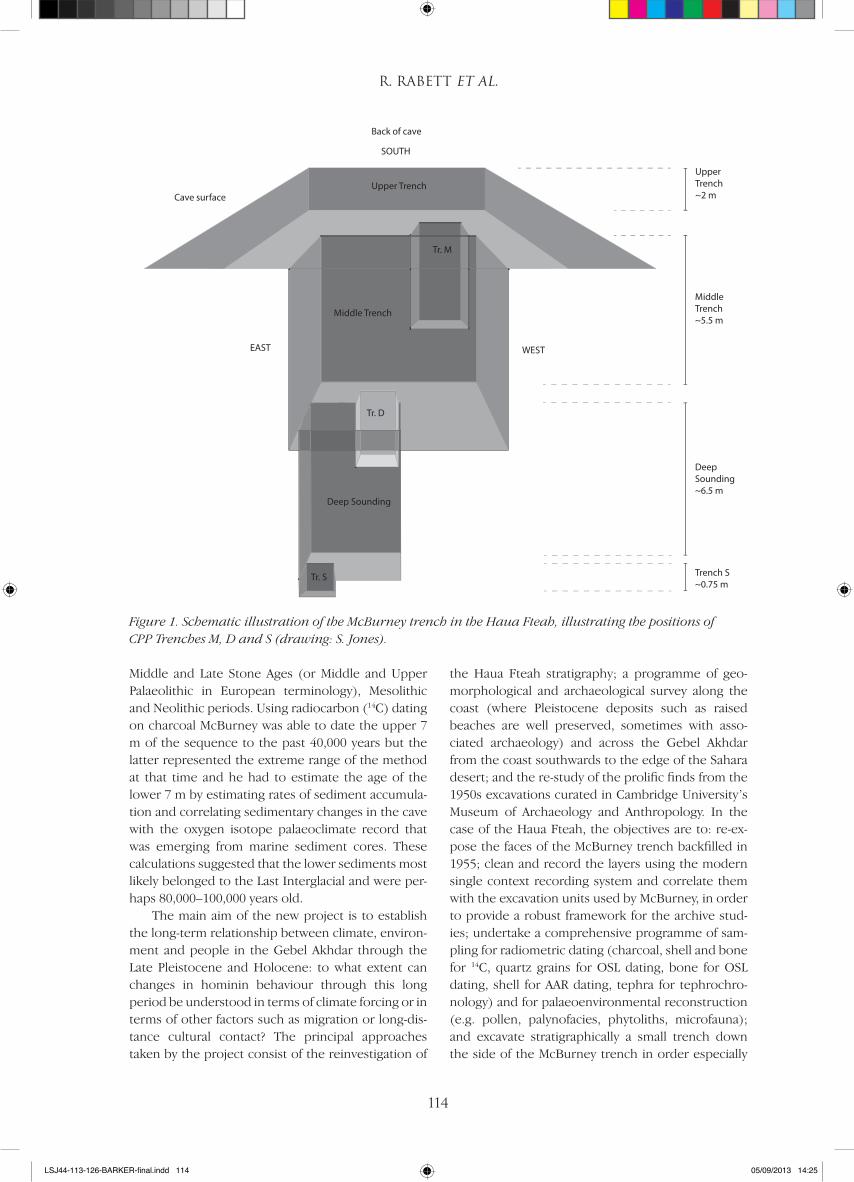
The excavationsIn order to ensure that we could get the most out of the short field season, we aimed to run all three trenches simultaneously. While excavation of Trench M could continue from an independent scaffold in the south-west corner of the Middle Trench (Fig. 2), greater organisation was required to get two teams working in the confined space of the Deep Sound-ing. One team began by drawing the east-facing sec-tion of the Deep Sounding and marrying this to the south-facing section drawn in the spring (Barker et al. 2012, fig.7). Although important in its own right, the added benefits of drawing this section were that it provided a crucial bridge to drawing the portion of McBurney’s north-facing section down which Trench D would progress once digging commenced; it also meant that this link could be achieved without com-promising excavations in Trench S, at the eastern end of the Deep Sounding. Trench S was protected from above by a closed-slat platform, to reduce contamina-tion from debris first from section cleaning and later from excavation in Trench D. A kick board and screen partition were put in place at the western margin of the expanded area of Trench S, a fan was installed to ensure good air circulation and humidity control in
Figure 2. Looking south-west across the McBurney Middle Trench to CPP Trench M. The wooden baffle protecting Trench D from falling debris is visible to the lower left (photo: G. Barker).
LSJ44-113-126-BARKER-final.indd 115 05/09/2013 14:25
R. Rabett et al.
116
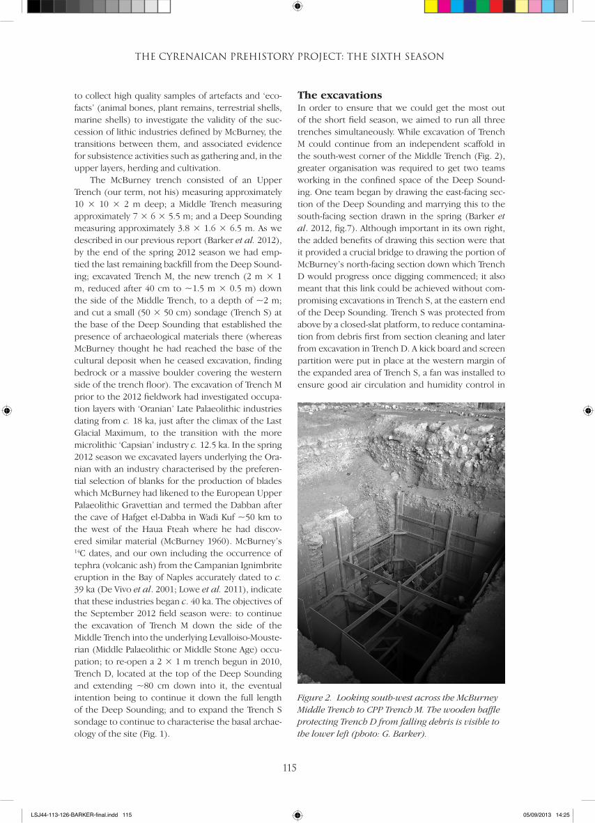
this confined space, and a series of moveable wooden platforms that rested within the shoring we had erected in the Deep Sound-ing created safe access for clean-ing and drawing the ~8.6 m2 of the west-facing section and the ~10 m2 of the north-facing sec-tion (Fig. 3).
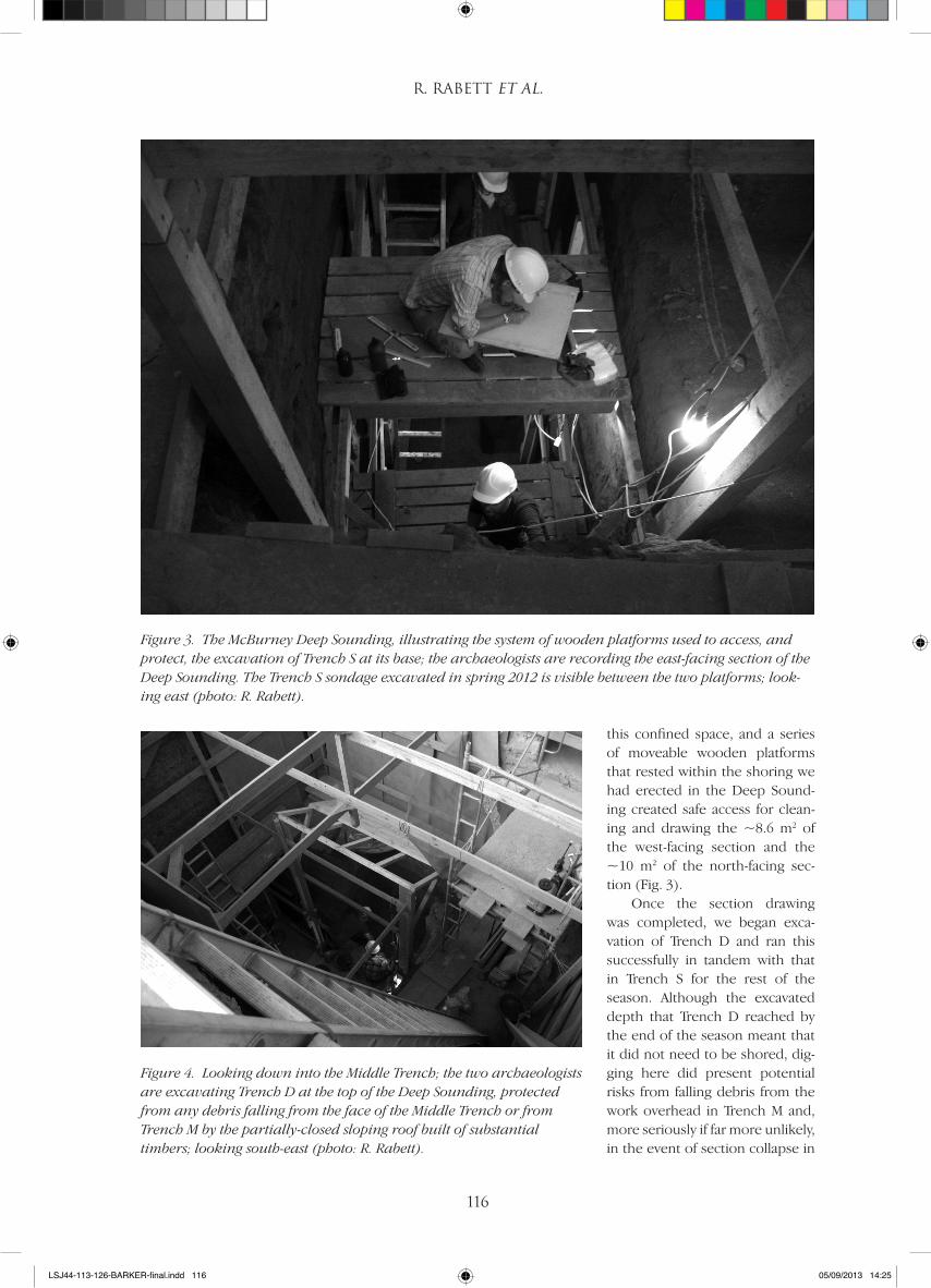
Once the section drawing was completed, we began exca-vation of Trench D and ran this successfully in tandem with that in Trench S for the rest of the season. Although the excavated depth that Trench D reached by the end of the season meant that it did not need to be shored, dig-ging here did present potential risks from falling debris from the work overhead in Trench M and, more seriously if far more unlikely, in the event of section collapse in
Figure 3. The McBurney Deep Sounding, illustrating the system of wooden platforms used to access, and protect, the excavation of Trench S at its base; the archaeologists are recording the east-facing section of the Deep Sounding. The Trench S sondage excavated in spring 2012 is visible between the two platforms; look-ing east (photo: R. Rabett).
Figure 4. Looking down into the Middle Trench; the two archaeologists are excavating Trench D at the top of the Deep Sounding, protected from any debris falling from the face of the Middle Trench or from Trench M by the partially-closed sloping roof built of substantial timbers; looking south-east (photo: R. Rabett).
LSJ44-113-126-BARKER-final.indd 116 05/09/2013 14:25
THE CYRENAICAN PREHISTORY PROJECT: THE SIXTH SEASON
117
the Middle Trench. An inclined wooden baffle to part cover Trench D was secured into the Deep Sound-ing shoring, strong enough to deflect into the Deep Sounding and toward the north-facing section wall any material that might fall from above (Fig. 4). With space at a premium at the bottom of the Deep Sound-ing, work in Trench S was carried out by a team of two experienced field archaeologists. The excavations of Trenches D and M were undertaken by members of the CPP team and the Libyan Department of Antiq-uities.
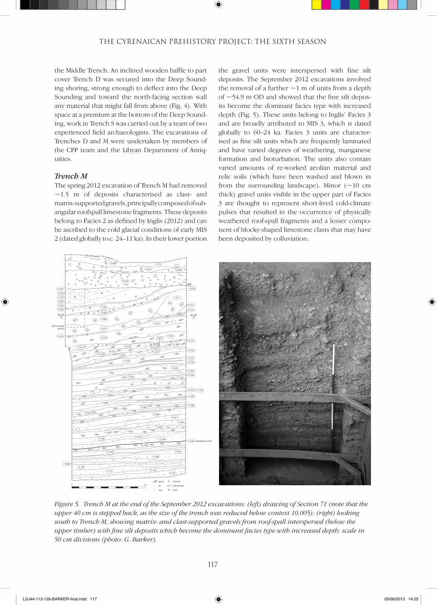
Trench MThe spring 2012 excavation of Trench M had removed ~1.5 m of deposits characterised as clast- and matrix-supported gravels, principally composed of sub- angular roofspall limestone fragments. These deposits belong to Facies 2 as defined by Inglis (2012) and can be ascribed to the cold glacial conditions of early MIS 2 (dated globally to c. 24–11 ka). In their lower portion
the gravel units were interspersed with fine silt deposits. The September 2012 excavations involved the removal of a further ~1 m of units from a depth of ~54.9 m OD and showed that the fine silt depos-its become the dominant facies type with increased depth (Fig. 5). These units belong to Inglis’ Facies 3 and are broadly attributed to MIS 3, which is dated globally to 60–24 ka. Facies 3 units are character-ised as fine silt units which are frequently laminated and have varied degrees of weathering, manganese formation and bioturbation. The units also contain varied amounts of re-worked aeolian material and relic soils (which have been washed and blown in from the surrounding landscape). Minor (~10 cm thick) gravel units visible in the upper part of Facies 3 are thought to represent short-lived cold-climate pulses that resulted in the occurrence of physically weathered roof-spall fragments and a lesser compo-nent of blocky-shaped limestone clasts that may have been deposited by colluviation.
0 1 m
11077
11,078
56.19556.195
11,007
11,008
11,009
11,010
11,013
11,01511,014
11,001
11,002
11,003
11,004
11,005
11,006
240
11,016
11,019
11,017 11,01811,020
11,022
11,02511,034
11,036
11,024
11,033
11,028
11,011
11,012
10,005
10,000
10,001 10,002
2012 sample column
step
11,037
11,038
11,04211,043
11,04511,044
11,052 11,053
11,055
11,06811,066
11,080
11,081
11,082
11,08811,087
11,086
11,095
11,096
11,098
11,100
11,101 11,10211,103
11,093
11,046
11,089
11,084
11,090
11,067
11,083
manganese crust
gravel
silt
clay
charcoal
bioturbation
shell
Figure 5. Trench M at the end of the September 2012 excavations: (left) drawing of Section 71 (note that the upper 40 cm is stepped back, as the size of the trench was reduced below context 10,005); (right) looking south to Trench M, showing matrix- and clast-supported gravels from roof-spall interspersed (below the upper timber) with fine silt deposits which become the dominant facies type with increased depth; scale in 50 cm divisions (photo: G. Barker).
LSJ44-113-126-BARKER-final.indd 117 05/09/2013 14:25

R. Rabett et al.
118
The uppermost contexts or units removed in the September 2012 excavation (11,080–11,082) were predominately silt-rich with varied degrees of compaction, clay content and reddened colour. Some manganese precipitation and laminations were visible within context 11,082 (Fig. 6). The units contained very occasional sub-angular clasts of lime-stone, lithic material and fragments of animal bone. The interface between 11,080 and 11,081 was char-acterised by horizontally-positioned clasts of angular limestone roofspall, suggesting some kind of discon-tinuity in sediment deposition at least in this part of the cave. Uneven and mottled interfaces separating units 11,080 and 11,082 are likely to be attributed to mixing or ‘load-casting’ caused by the deposition of sediments onto wet underlying substrates, without a significant temporal hiatus. Units 11,079 and 11,082 are interpreted as very low-energy mudflow events depositing re-worked aeolian and relic soils into the cave.
The frequency of sub-angular to sub-rounded limestone clasts increased in the underlying units 11,083 and 11,084, the latter being defined as matrix- supported gravel containing both roofspall-type clasts and sub-rounded stones. The larger gravel clasts were observed to be broadly orientated with
their long axis in a north–south direction, possibly sug-gesting deposition in a directional trend from the cave mouth. Unit 11,084 may represent a small-scale collu-vial deposition event which reworked locally-sourced sediment and coarse components. The overlying unit 11,083 has fewer coarse components which are also smaller in size, and its indistinct boundary with 11,084 might suggest a fining-upwards sequence typical of a flood-type event with weakening velocity.
Units 11,086–11,088 are characterised as orange-red silts with varied clay contents and frequent small clasts of degraded limestone. Units 11,087 and 11,088 are dark red, very compact, and have frequent man-ganese formation both along horizontal laminations within the sediment and in vertical planar voids, sug-gesting a very low-velocity deposition of sediments from a mudflow or ponding which has been subject to considerable wetting and drying, causing organic material to infill weathered cracks in the sediment. Unit 11,088 lifted on excavation as discrete blocks of sediment, revealing a distinct manganese crust possibly formed from algal activity within a seasonal pond environment. Underneath this crust was a pale yellowish-brown matrix-supported gravel (11,090) containing sub-angular limestone clasts of roofspall together with bone and lithic material (Fig. 7).
Figure 6. Trench M, showing orange-red silts with small limestone clasts suggesting low energy mudflow events interleaved with clast-dominated units likely to represent phases of increased physical weathering of the cave roof; looking south. Scale in 10 cm divisions (photo: G. Barker).
LSJ44-113-126-BARKER-final.indd 118 05/09/2013 14:25
THE CYRENAICAN PREHISTORY PROJECT: THE SIXTH SEASON
119
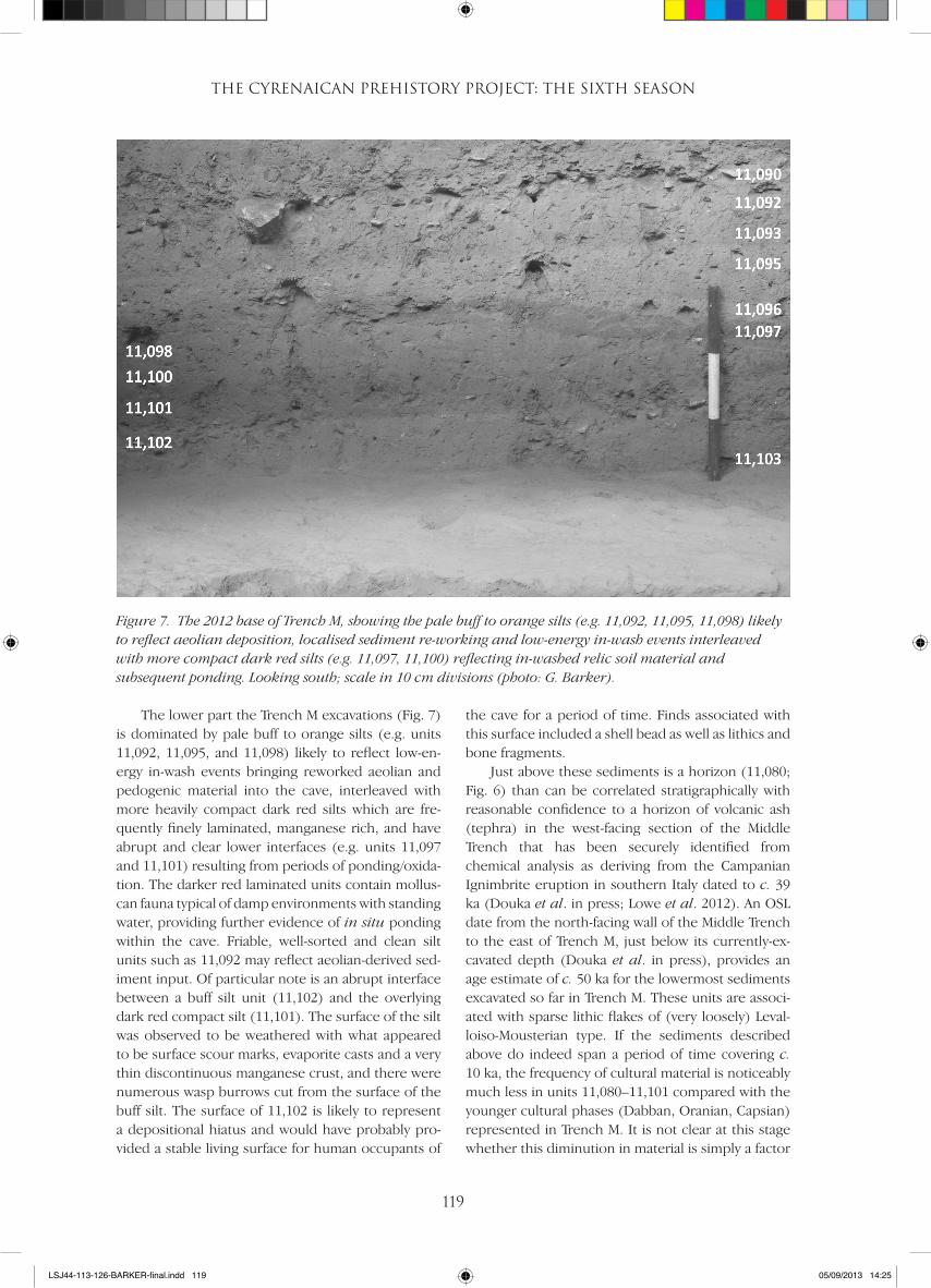
The lower part the Trench M excavations (Fig. 7) is dominated by pale buff to orange silts (e.g. units 11,092, 11,095, and 11,098) likely to reflect low-en-ergy in-wash events bringing reworked aeolian and pedogenic material into the cave, interleaved with more heavily compact dark red silts which are fre-quently finely laminated, manganese rich, and have abrupt and clear lower interfaces (e.g. units 11,097 and 11,101) resulting from periods of ponding/oxida-tion. The darker red laminated units contain mollus-can fauna typical of damp environments with standing water, providing further evidence of in situ ponding within the cave. Friable, well-sorted and clean silt units such as 11,092 may reflect aeolian-derived sed-iment input. Of particular note is an abrupt interface between a buff silt unit (11,102) and the overlying dark red compact silt (11,101). The surface of the silt was observed to be weathered with what appeared to be surface scour marks, evaporite casts and a very thin discontinuous manganese crust, and there were numerous wasp burrows cut from the surface of the buff silt. The surface of 11,102 is likely to represent a depositional hiatus and would have probably pro-vided a stable living surface for human occupants of
the cave for a period of time. Finds associated with this surface included a shell bead as well as lithics and bone fragments.
Just above these sediments is a horizon (11,080; Fig. 6) than can be correlated stratigraphically with reasonable confidence to a horizon of volcanic ash (tephra) in the west-facing section of the Middle Trench that has been securely identified from chemical analysis as deriving from the Campanian Ignimbrite eruption in southern Italy dated to c. 39 ka (Douka et al. in press; Lowe et al. 2012). An OSL date from the north-facing wall of the Middle Trench to the east of Trench M, just below its currently-ex-cavated depth (Douka et al. in press), provides an age estimate of c. 50 ka for the lowermost sediments excavated so far in Trench M. These units are associ-ated with sparse lithic flakes of (very loosely) Leval-loiso-Mousterian type. If the sediments described above do indeed span a period of time covering c. 10 ka, the frequency of cultural material is noticeably much less in units 11,080–11,101 compared with the younger cultural phases (Dabban, Oranian, Capsian) represented in Trench M. It is not clear at this stage whether this diminution in material is simply a factor
Figure 7. The 2012 base of Trench M, showing the pale buff to orange silts (e.g. 11,092, 11,095, 11,098) likely to reflect aeolian deposition, localised sediment re-working and low-energy in-wash events interleaved with more compact dark red silts (e.g. 11,097, 11,100) reflecting in-washed relic soil material and subsequent ponding. Looking south; scale in 10 cm divisions (photo: G. Barker).
LSJ44-113-126-BARKER-final.indd 119 05/09/2013 14:25
R. Rabett et al.
120
of sampling, with different types of human behaviour occurring in different parts of the cave, or a genuine indicator of the infrequency of human occupation in the cave in the period c. 50–40 ka linked to region-wide climatic fluctuations during MIS 3 (e.g. Drake et al. 2011).
The other major observation during the exca-vation was the apparent occurrence of occasional flakes of Levalloiso-Mousterian type and Dabban blades in units overlying the presumed tephra hori-zon, whereas McBurney identified the transition from the Levalloiso-Mousterian to the Dabban in Layer XXV, which predates the Campanian Ignimbrite tephra (Douka et al. in press). He also observed that the transition appeared to be gradual, with Levalloi-so-Mousterian material more common in the lower part of Layer XXV and Dabban more common in the upper part. Though the CPP samples are extremely small and have not yet been studied in detail, the pre-liminary observation from the Trench M excavation is that the transition from the Levalloiso-Mousterian to the Dabban was complex and not sudden.
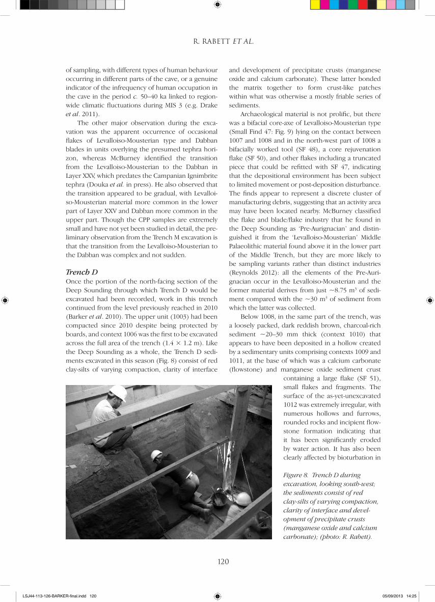
Trench DOnce the portion of the north-facing section of the Deep Sounding through which Trench D would be excavated had been recorded, work in this trench continued from the level previously reached in 2010 (Barker et al. 2010). The upper unit (1003) had been compacted since 2010 despite being protected by boards, and context 1006 was the first to be excavated across the full area of the trench (1.4 × 1.2 m). Like the Deep Sounding as a whole, the Trench D sedi-ments excavated in this season (Fig. 8) consist of red clay-silts of varying compaction, clarity of interface
and development of precipitate crusts (manganese oxide and calcium carbonate). These latter bonded the matrix together to form crust-like patches within what was otherwise a mostly friable series of sediments.
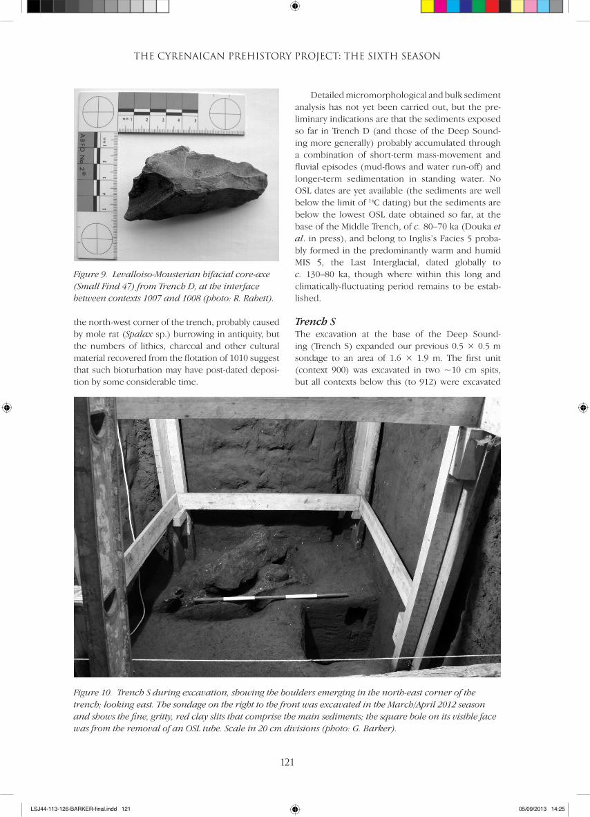
Archaeological material is not prolific, but there was a bifacial core-axe of Levalloiso-Mousterian type (Small Find 47: Fig. 9) lying on the contact between 1007 and 1008 and in the north-west part of 1008 a bifacially worked tool (SF 48), a core rejuvenation flake (SF 50), and other flakes including a truncated piece that could be refitted with SF 47, indicating that the depositional environment has been subject to limited movement or post-deposition disturbance. The finds appear to represent a discrete cluster of manufacturing debris, suggesting that an activity area may have been located nearby. McBurney classified the flake and blade/flake industry that he found in the Deep Sounding as ‘Pre-Aurignacian’ and distin-guished it from the ‘Levalloiso-Mousterian’ Middle Palaeolithic material found above it in the lower part of the Middle Trench, but they are more likely to be sampling variants rather than distinct industries (Reynolds 2012): all the elements of the Pre-Auri-gnacian occur in the Levalloiso-Mousterian and the former material derives from just ~8.75 m3 of sedi-ment compared with the ~30 m3 of sediment from which the latter was collected.
Below 1008, in the same part of the trench, was a loosely packed, dark reddish brown, charcoal-rich sediment ~20–30 mm thick (context 1010) that appears to have been deposited in a hollow created by a sedimentary units comprising contexts 1009 and 1011, at the base of which was a calcium carbonate (flowstone) and manganese oxide sediment crust
containing a large flake (SF 51), small flakes and fragments. The surface of the as-yet-unexcavated 1012 was extremely irregular, with numerous hollows and furrows, rounded rocks and incipient flow-stone formation indicating that it has been significantly eroded by water action. It has also been clearly affected by bioturbation in
Figure 8. Trench D during excavation, looking south-west; the sediments consist of red clay-silts of varying compaction, clarity of interface and devel-opment of precipitate crusts (manganese oxide and calcium carbonate); (photo: R. Rabett).
LSJ44-113-126-BARKER-final.indd 120 05/09/2013 14:25
THE CYRENAICAN PREHISTORY PROJECT: THE SIXTH SEASON
121
the north-west corner of the trench, probably caused by mole rat (Spalax sp.) burrowing in antiquity, but the numbers of lithics, charcoal and other cultural material recovered from the flotation of 1010 suggest that such bioturbation may have post-dated deposi-tion by some considerable time.
Detailed micromorphological and bulk sediment analysis has not yet been carried out, but the pre-liminary indications are that the sediments exposed so far in Trench D (and those of the Deep Sound-ing more generally) probably accumulated through a combination of short-term mass-movement and fluvial episodes (mud-flows and water run-off) and longer-term sedimentation in standing water. No OSL dates are yet available (the sediments are well below the limit of 14C dating) but the sediments are below the lowest OSL date obtained so far, at the base of the Middle Trench, of c. 80–70 ka (Douka et al. in press), and belong to Inglis’s Facies 5 proba-bly formed in the predominantly warm and humid MIS 5, the Last Interglacial, dated globally to c. 130–80 ka, though where within this long and climatically-fluctuating period remains to be estab-lished.
Trench SThe excavation at the base of the Deep Sound-ing (Trench S) expanded our previous 0.5 × 0.5 m sondage to an area of 1.6 × 1.9 m. The first unit (context 900) was excavated in two ~10 cm spits, but all contexts below this (to 912) were excavated
Figure 9. Levalloiso-Mousterian bifacial core-axe (Small Find 47) from Trench D, at the interface between contexts 1007 and 1008 (photo: R. Rabett).
Figure 10. Trench S during excavation, showing the boulders emerging in the north-east corner of the trench; looking east. The sondage on the right to the front was excavated in the March/April 2012 season and shows the fine, gritty, red clay slits that comprise the main sediments; the square hole on its visible face was from the removal of an OSL tube. Scale in 20 cm divisions (photo: G. Barker).
LSJ44-113-126-BARKER-final.indd 121 05/09/2013 14:25
R. Rabett et al.
122
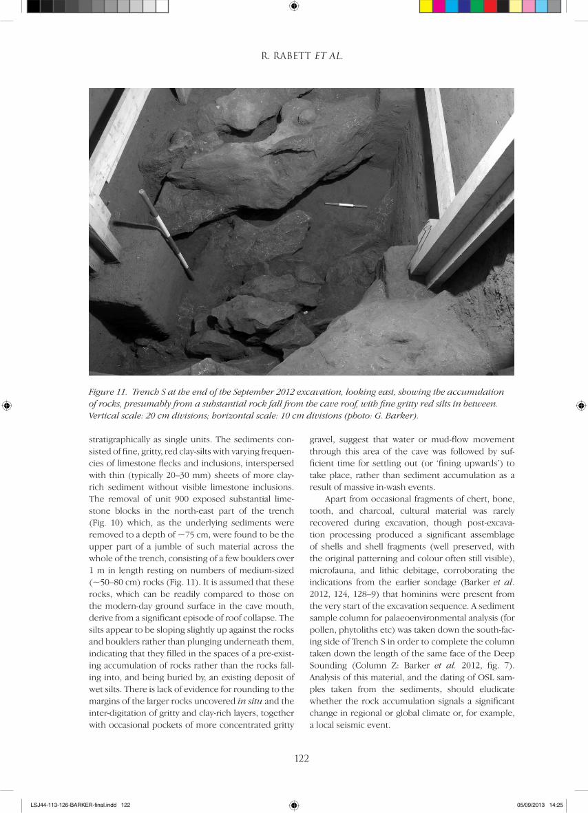
stratigraphically as single units. The sediments con-sisted of fine, gritty, red clay-silts with varying frequen-cies of limestone flecks and inclusions, interspersed with thin (typically 20–30 mm) sheets of more clay-rich sediment without visible limestone inclusions. The removal of unit 900 exposed substantial lime-stone blocks in the north-east part of the trench (Fig. 10) which, as the underlying sediments were removed to a depth of ~75 cm, were found to be the upper part of a jumble of such material across the whole of the trench, consisting of a few boulders over 1 m in length resting on numbers of medium-sized (~50–80 cm) rocks (Fig. 11). It is assumed that these rocks, which can be readily compared to those on the modern-day ground surface in the cave mouth, derive from a significant episode of roof collapse. The silts appear to be sloping slightly up against the rocks and boulders rather than plunging underneath them, indicating that they filled in the spaces of a pre-exist-ing accumulation of rocks rather than the rocks fall-ing into, and being buried by, an existing deposit of wet silts. There is lack of evidence for rounding to the margins of the larger rocks uncovered in situ and the inter-digitation of gritty and clay-rich layers, together with occasional pockets of more concentrated gritty
gravel, suggest that water or mud-flow movement through this area of the cave was followed by suf-ficient time for settling out (or ‘fining upwards’) to take place, rather than sediment accumulation as a result of massive in-wash events.
Apart from occasional fragments of chert, bone, tooth, and charcoal, cultural material was rarely recovered during excavation, though post-excava-tion processing produced a significant assemblage of shells and shell fragments (well preserved, with the original patterning and colour often still visible), microfauna, and lithic debitage, corroborating the indications from the earlier sondage (Barker et al. 2012, 124, 128–9) that hominins were present from the very start of the excavation sequence. A sediment sample column for palaeoenvironmental analysis (for pollen, phytoliths etc) was taken down the south-fac-ing side of Trench S in order to complete the column taken down the length of the same face of the Deep Sounding (Column Z: Barker et al. 2012, fig. 7). Analysis of this material, and the dating of OSL sam-ples taken from the sediments, should eludicate whether the rock accumulation signals a significant change in regional or global climate or, for example, a local seismic event.
Figure 11. Trench S at the end of the September 2012 excavation, looking east, showing the accumulation of rocks, presumably from a substantial rock fall from the cave roof, with fine gritty red silts in between. Vertical scale: 20 cm divisions; horizontal scale: 10 cm divisions (photo: G. Barker).
LSJ44-113-126-BARKER-final.indd 122 05/09/2013 14:25
THE CYRENAICAN PREHISTORY PROJECT: THE SIXTH SEASON
123
DiscussionThe most significant feature located below the base of the McBurney Deep Sounding, from Trench S, is a major rock-fall episode. No similar rock accumu-lation has been observed in the cleaned sections higher up the Deep Sounding. The rockfall could potentially mark the shift in climate from the glacial conditions of MIS 6 (dated globally to c. 190–130 ka) to the interglacial conditions of MIS 5, or one of the major climatic oscillations within MIS 5 to the glacial of MIS 6. Perhaps more likely is that it is the result of a sudden event like an earthquake, particularly as there is none of the freeze-thaw rock-shatter associ-ated with the rockfall that is so abundant in the upper portion of Trench M dating to MIS 2, the peak of gla-cial conditions. This hypothesis implies that the sedi-ment column goes deeper than McBurney reached or we have reached, and the survival of organic remains at depth is very promising, but further excavation would require significant engineering work in a con-fined space to clear the Trench S rockfall.
The Trench D excavation beside the top of the Deep Sounding has indicated that this part of the cave was significantly waterlogged during, we suspect, the latter part of MIS 5. At least some of the time this waterlogging probably included the development of a body of standing water that would have attracted plant growth, animals, and hominins. The principal evidence for human activity in the Deep Sounding, as noted by McBurney and re-identified by our project, is approximately a metre above the base of the trench, equivalent to our contexts 823–828 recorded on the south-facing Section 78 (Barker et al. 2012, fig.7), but the amount of small-sized cultural material recov-ered in the post-excavation processing of the Trench D and Trench S sediments suggests that evidence of human frequentation probably extends throughout the Deep Sounding sequence, with greater or lesser archaeological visibility dependent upon how close the trench area was to either the centre or the margin of the water body as it fluctuated through time. The Levalloiso-Mousterian lithics found in Trench D, including the refitted flake, likely to relate to knap-ping activities undertaken nearby, lend credence to this theory. Without radiometric dates the earliest antiquity of hominin presence in the cave remains speculative, but the accumulating evidence sug-gests that hominins – very probably modern humans – were established in the Gebel Akhdar during the last interglacial and were probably visiting the cave repeatedly rather than just during one main phase as McBurney suggested in the light of the accumulation of ‘Pre-Aurignacian’ material he found near the base of the Deep Sounding.
The preliminary studies of the sparse lithic mate-rial excavated from Trench M in this season hint at a complex and perhaps protracted transition between the uppermost Middle Stone Age or Middle Palaeo-lithic Levalloiso-Mousterian industry and the earliest Late Stone or Upper Palaeolithic blade-based Dabban industry. Whilst the nature of the transition is not yet clear, it appears to have taken place at a time of oscil-lating climate. The sediments excavated in the lower part of Trench M include a combination of ponding sediments indicative of stable environmental condi-tions and low-velocity mudflow events (which have incorporated relic soils from the landscape) possibly reflecting periodic landscape destabilisation, pro-cesses typical of a humid warm-stage palaeoclimate. Higher up are two matrix-supported gravel units appearing to indicate temporary climatic oscilla-tions to colder and more arid environments, causing increased physical weathering of the cave roof and possible small-scale mass-movement of sediment. The estimated age of the sediments places these oscillations within the earlier part of MIS 3, when global climates experienced rapid fluctuations as part of an overall trend to increasing aridity and cold (North Greenland Ice Core Project members 2004).
ConclusionThe September 2012 season significantly advanced the excavation of the new trenches in the Haua Fteah, one of the primary objectives of the CPP and, whilst the analysis of the sediments and associated archae-ological materials is incomplete, it has provided fur-ther important insights into the depositional and occupational history of the cave. The CPP studies of the materials in the McBurney archive and from the new excavations have broadly confirmed that the seven major cultural units he recognised in the cave sequence (PreAurignacian, Levalloiso-Mousterian, Dabban, Oranian, Capsian, Neolithic, Historic) are appropriate except that the first two may be sampling variants of a broadly similar Middle Stone Age tech-nology. As reported elsewhere (Douka et al. in press), the project’s comprehensive multi-method dating programme (14C dating of charcoal, landsnails and marine shell; tephra identification; OSL dating of sed-iments; ESR dating of tooth enamel), using materials taken from the cleaned and newly recorded faces of the McBurney trench, has established a robust chro-nostratigraphy for the site with a precision unavail-able to McBurney, dating the age spans of the seven major cultural units that he defined and of the five major sedimentary facies identified by Inglis (2012). The priority of future work is to extend Trenches M and D to give us a continuous sequence of new
LSJ44-113-126-BARKER-final.indd 123 05/09/2013 14:25
R. Rabett et al.
124
palaeoenvironmental and archaeological data through the Pleistocene-age sediments, and to use them to refine the chronostratigraphy, the nature of transitions between cultural phases, the activities practised by the people using the cave at different times in its long history of use, and the environmental and climatic frameworks in which they were located. By combining the Haua Fteah work with the archae-ological and geomorphological data collected by the project team from the wider landscape, we hope to establish in particular whether the Gebel Akhdar acted as a refugium for human populations through-out the 100,000+ years that the cave has evidence of human use, and if so what adaptations were made by human populations to deal with the significant cli-mate fluctuations during and since the last intergla-cial, or whether climate forcing resulted in significant periods of abandonment of this part of North Africa.
Acknowledgements
We would like to acknowledge in particular the permis-
sion of the Department of Antiquities of Libya to under-
take the project; the financial support of the European
Research Council (Advanced Investigator Grant 230421:
TRANS-NAP: Cultural Transformations and Environmental
Transitions in North African Prehistory) and the Society
for Libyan Studies for the fieldwork; the invaluable logis-
tical support provided by the staff of the Department of
Antiquities in Tripoli, Shahat, and Susah; and the personal
support of the President of the Department of Antiquities
Dr Salah Aghab, the Controller of Antiquities for Cyrene
Nasser Abdel-Jaleel and the Inspector of Antiquities for
Susah Ibreike Quinhe. The September 2012 team con-
sisted of: Graeme Barker, Paul Bennett, Lucy Farr, Sara
Harrop, Evan Hill, Chris Hunt, Hayley Jedrzejewski, Mas-
soud al-Hasi, Ross Lane, Giulio Lucarini, Amin Massoud,
Hazel Moseley, Giuseppina Mutri, Alex Pryor, Ryan Rabett,
Daisy Spencer, Chris Stimpson, Alex Vokes, Akram al-War-
fali, Amran al-Zweyi, and Mtaz al-Zweyi. The field season
took place between 1 and 23 September. Contributor
roles in this paper: excavation coordination – RR; Trench
M excavation – LF; Trench D excavation – CS; Trench S
excavation – RL, HM; molluscan analysis – EH, CH; project
coordination – GB, CH.
References
Barker, G., Hunt, C., Reynolds, T. 2007. The Haua Fteah, Cyrenaica (northeast Libya): renewed investigations of the cave and its landscape, 2007. Libyan Studies 38: 93–114.
Barker, G., Basell, L., Brooks, I., Burn, L., Cartwright, C., Cole, F., Davison, J., Farr, L., Hamilton, R., Hunt, C. Inglis, R., Jacobs, Z., Leitch, V., Morales, J., Morley, I., Morley, M., Pawley, S., Pryor, A., Rabett, R., Reynolds, T., Roberts, R., Simpson, D., Stimpson, C., Touati, M., van der Veen, M. 2008. The Cyrenaican Prehistory Project 2008: the second season of investigations of the Haua Fteah cave and its landscape, and further results from the initial 2007 fieldwork. Libyan Stud-ies 39: 175–222.
Barker, G., Antoniadou, A., Barton, H., Brooks, I., Candy, I., Drake, N., Farr, L., Hunt, C., Ibrahim, A.A., Inglis, R., Jones, S., Morales, J., Morley, I., Mutri, G., Rabett, R., Reynolds, T., Simpson, D., Twati, M., White, K. 2009. The Cyrenaican Prehistory Project 2009: the third season of investigations of the Haua Fteah cave and its landscape, and further results from the 2007–2008 fieldwork. Libyan Studies 40: 1–41.
Barker, G., Antoniadou, A., Armitage, S., Brooks, I., Candy, I., Connell, K., Douka, K., Drake, N., Farr, L., Hill, E., Hunt, C., Inglis, R., Jones, S., Lane, C., Luca-rini, G., Meneely, J., Morales, J., Mutri, G., Prender-gast, A., Rabett, R., Reade, H., Reynolds, T., Russell,
N., Simpson, D., Smith, B., Stimpson, C., Twati, M., White, K. 2010. The Cyrenaican Prehistory Project 2010: the fourth season of investigations of the Haua Fteah cave and its landscape, and further results from the 2007–2000 fieldwork. Libyan Studies 41: 63–88.
Barker, G., Bennett, P., Farr, L., Hill, E., Hunt, C., Lucarini, G., Morales, J., Mutri, G., Prendergast, A., Pryor, A., Rabett, R., Reynolds, T., Twati, M. 2012. The Cyrenai-can Prehistory Project 2012: the fifth season of inves-tigations of the Haua Fteah cave. Libyan Studies 43: 115–36.
De Vivo, B., Rolandi, G., Gans, P.B., Calvert, A., Bohrson, W.A., Spera, F.J., Belkin, H.E., 2001. New constraints on the pyroclastic eruptive history of the Campanian volcanic Plain (Italy). Mineralogy and Petrology 73: 47–65.
Douka, K., Jacobs, Z., Lane, C., Grün, R., Farr, L., Hunt, C., Inglis, R., Reynolds, T., Albert, P., Aubert, M., Cullen, V., Hill, E., Kinsley, L., Roberts, R.G., Tomlinson, E.L., Wulf, S., Barker, G., in press. The chronostratigraphy of the Haua Fteah cave (Cyrenaica, northwest Libya). Journal of Human Evolution.
Drake, N.A., Blench, R.M., Armitage, S.J., Bristow, C.S., White, K.H. 2011. Ancient watercourses and bio-geography of the Sahara explain the peopling of the desert. Proceedings of the National Academy of Sciences of the United States of America 108: 458–62.
LSJ44-113-126-BARKER-final.indd 124 05/09/2013 14:25
THE CYRENAICAN PREHISTORY PROJECT: THE SIXTH SEASON
125
Garcea, E.A.A. (ed.) 2010. South-Eastern Mediterra-nean Peoples Between 130,000 and 10,000 Years Ago. Oxbow Books, Oxford.
Hublin, J.-J. and McPherron, S. (eds) 2011. Modern Ori-gins: a North African Perspective. Springer, Berlin.
Inglis, R. H., 2012. Human Occupation and Changing Environments during the Middle to Later Stone Age: Soil Micromorphology at the Haua Fteah, Libya.
University of Cambridge, unpublished PhD thesis.Lowe, J., Barton, R.N.E., Blockley, S.P.E., Ramsey, C.B.,
Cullen, V.L., Davies, W., Gamble, C., Grant, K., Hardi-man, M., Housley, R., Lane, C.S., Lee, S., Lewis, M., MacLeod, A., Menzies, M., Müller., W, Pollard, A.M., Price, C., Roberts, A.P., Rohling, E.J., Satow, C., Smith, V.C., Stringer, C.B., Tomlinson, E.L., White, D., Albert, P., Arienzo, I., Barker, G., Carandente, A., Civetta, L., Ferrier, C, Guadelli, J.-L., Karkanas, P., Koumouzelis, M., Müller, U.C., Orsi, G., Pross, J., Rosi, M., Shalamanov-
Korobar, L., Sirakov, N., Tzedakis, P.C., and Boric, D. 2012. Volcanic ash layers illuminate the resilience of Neanderthals and early Modern Humans to natural hazards. Proceedings of the National Academy of Sciences 109(34): 13522–37.
McBurney, C.B.M., 1960. The Stone Age of Northern Africa. Penguin Books, London.
McBurney, C.B.M., 1967. The Haua Fteah in Cyrenaica and the Stone Age of the South-East Mediterranean. Cambridge University Press, Cambridge.
North Greenland Ice Core Project members, 2004. High-resolution record of Northern Hemisphere climate extending into the last interglacial period. Nature 431 (7005): 147–51.
Reynolds, T., 2012. The Middle Palaeolithic of Cyrena-ica: is there an Aterian at the Haua Fteah and does it matter? Quaternary International DOI 10.1016/j.quaint.2012.09.025.
LSJ44-113-126-BARKER-final.indd 125 05/09/2013 14:25

LSJ44-113-126-BARKER-final.indd 126 05/09/2013 14:25


