Embed Size (px)
Citation preview

Northern Australia Land and Water Science Review full report October 2009
04 Terrestrial ecosystems of northern Australia Alex Kutt, CSIRO Sustainable Ecosystems [email protected] Leasie Felderhof, Firescape Science, [email protected] Jeremy VanDerWal, Centre for Tropical Biodiversity and Climate Change [email protected] Peter Stone, CSIRO Sustainable Ecosystems [email protected] Genevieve Perkins, CSIRO Sustainable Ecosystems [email protected]
Storms roll in over the Gulf Plains. The high seasonal variability of the rainfall in northern Australia is one of the distinctive biophysical characteristics of the region. This has a significant influence on its biodiversity pattern. Photo: Eric Vanderduys, CSIRO Sustainable Ecosystems
Terrestrial ecosystems of northern Australia Chapter 4 ‐ 1

Northern Australia Land and Water Science Review full report October 2009
CONTENTS
1. KEY POINTS..........................................................................................................................4
2. PRESENT STATUS OF TERRESTRIAL ECOSYSTEMS ...............................................................5
2.1 Major features of northern terrestrial ecosystems ..................................................5
3. VALUES OF NORTHERN ECOSYSTEMS AND BIODIVERSITY..................................................7
4. CONDITION AND TREND OF TROPICAL SAVANNA BIODIVERSITY .......................................9
4.1 Condition and trend..................................................................................................9
4.2 Bird and mammal declines in northern Australia ...................................................13
5. CONSERVATION LAND MANAGEMENT IN NORTHERN AUSTRALIA ..................................14
5.1 Impact of land tenure .............................................................................................14
5.2 Impact of conservation planning ............................................................................15
6. THREATS AND DRIVERS OF TERRESTRIAL ECOSYSTEM VALUE IN NORTHERN AUSTRALIA16
6.1 Fire ..........................................................................................................................17
6.2 Pastoralism .............................................................................................................19
6.3 Mining .....................................................................................................................21
6.4 Intensive land use change.......................................................................................22
6.5 Water capture and diversion ..................................................................................23
6.6 Climate change .......................................................................................................27
6.7 Carbon industry ......................................................................................................30
6.7.1 Opportunities for conservation associated with the carbon industry ....31
7. PRINCIPLES, PRACTICES AND POLICIES TO IMPROVE TERRESTRIAL CONSERVATION.......32
7.1 Planning and co‐ordination.....................................................................................32
7.2 Consultation............................................................................................................33
7.3 Continuity of conservation programs .....................................................................33
7.4 Best practice ...........................................................................................................33
8. KNOWLEDGE GAPS THAT IMPEDE APPLICATION OF BEST PRACTICE LAND MANAGEMENT FOR CONSERVATION.................................................................................................................34
8.1 Fire ..........................................................................................................................34
8.2 Carbon.....................................................................................................................34
8.3 Mining .....................................................................................................................35
8.4 Intensive land use change, pastoral intensification, water capture and diversion 35
9. SUMMARY.........................................................................................................................36
10. REFERENCES ......................................................................................................................37
Terrestrial ecosystems of northern Australia Chapter 4 ‐ 2
Northern Australia Land and Water Science Review full report October 2009
Terrestrial ecosystems of northern Australia Chapter 4 ‐ 3
LIST OF FIGURES
Figure 1 Global savanna condition. Green indicates high integrity and red indicates low integrity. Australian savanna are clearly of world significance. Reproduced from Woinarski et al. (2007) with permission from ANUepress. 7
Figure 2 Landscape stress evaluation for the extensive rangelands of Northern Australia. Adapted from Morgan (2001), which also includes the methodology for the assessment. 10
Figure 3 Fire frequency in Northern Australia from 1997 to 2005. Yellow to red indicates burning once every two years, to yearly burning. 13
Figure 4 Proliferation of water points on a central Australian property from 1900 to 2004. Areas remaining distant from water in 2004 are almost non‐existent. Used with permission from Bastin and ACRIS Management Committee (2008). 26
Figure 5 Scenarios of mammal decline under averaged climate change predictions for 2030, 2050 and 2070. The first indicates predicted potential environmental space for Conilurus penicillatus, the second for Mesembiomys gouldi and the last for Rattus tunneyi. 30
LIST OF TABLES
Table 1. Species richness for selected tropical savanna bioregions in northern Queensland and the Northern Territory. Data indicates total species richness and in parenthesis the number of species uniquely recorded in that bioregion in comparison with other bioregions in the table..... 8
Table 2 Distribution of dominant broad vegetation groups in key bioregions across northern Australia. .......................................................................................................................................... 8
Table 3 The number of threatened and extinct species for selected bioregion in northern and southern Australia.......................................................................................................................... 11
Table 4 Area of bioregion burnt on an annual basis for selected bioregions in northern and southern Australia. ........................................................................................................................................ 12
Table 5 Percent decline in distribution for ten northern Australian mammal species under 2030, 2050 and 2070 climate change scenarios. .............................................................................................. 29

Northern Australia Land and Water Science Review full report October 2009
1. KEY POINTS
Australia’s northern tropical savannas are the best preserved tropical savannas in the world and
thus are a national and international biodiversity asset. In addition to supporting a significant
tourist industry, they sustain large populations of Indigenous Australians (who live on and
manage country, and who have direct spiritual connection to the land and water) and pastoralists
(who have a recent strong connection to sustainable land management). Northern Australia
needs people on the land to manage its resources sustainably.
Despite its large and seemingly intact landscapes, many populations of native wildlife (especially
mammals and birds) seems to be undergoing substantial and pervasive decline, linked to existing
extensive grazing land management, poor fire management and feral predation (e.g. cats).
Increasing development pressures will exacerbate this decline, as will climate change. Against
these pressures, the landscape needs to be actively managed to maintain ecological function.
Poor and inappropriate fire management is one of the biggest threats to northern Australian
wildlife and ecosystems; though it is a problem that can be readily overcome with careful
planning and annual implementation (e.g. Western Arnhem Land Fire Abatement project). There
are large biodiversity benefits in managing fire, as well as strong carbon pollution reduction
benefits.
These land management issues must be taken into account via innovative and integrated
conservation planning, when assessing development proposals for northern Australia. Land use
planning needs to work within the framework of the limited opportunities for development, and
recognise that in key areas there will be conservation conflicts. Innovative multi‐tenure
institutional arrangements that promote landscape scale biodiversity conservation need to be
more widely applied and this includes land stewardship programs, land off‐sets and land free
from development.
Opportunities for intensive agricultural development in northern Australia are limited to small
but key areas of quality, arable soils with adequate water availability. These productive ‘hotspots’
will also be significant areas of productivity for wildlife, and this means there will be some
conflict between development opportunities and terrestrial biodiversity conservation.
Water extraction and diversion affect surface and ground water levels and natural annual
flooding events, which can significantly affect riparian, wetland and floodplain ecosystems. These
provide key biodiversity refuges in tropical savannas which, due to the protracted dry season, are
particularly dependent on water resources. Increasing artificial water points for cattle grazing
increases grazing pressure across the landscape, affecting terrestrial ecosystems and species.
In the event that there is invasive development of the north, it is important that it occurs within a
culture of adaptive management using staged development. This will enable changes that occur
in response to development to be monitored and understood. Subsequent development stages
can, by this means, proceed with improved practices that better support development goals and
minimise ecosystem impacts.
Terrestrial ecosystems of northern Australia Chapter 4 ‐ 4

Northern Australia Land and Water Science Review full report October 2009
2. PRESENT STATUS OF TERRESTRIAL ECOSYSTEMS
2.1 Major features of northern terrestrial ecosystems
The tropical savannas of northern Australia are the most intact tropical savannas in the world and
thus are a national and international biological (biodiversity) asset. This biome in Australia covers
almost 25% of the continental land mass and stretches from Broome in the west to near Townsville in
the east. Apart from its large size, the tropical savannas are of conservation significance for: the
intact nature of the vegetation cover, representing the largest continuous Eucalyptus woodlands in
the world; the wide, dispersed and species‐rich biota; the extensive coastal wetlands and riverine
plains that are largely undisturbed and important breeding and staging sites for aquatic fauna; and
the pan‐tropical nature of the biota with historical and current linkages through south‐east Asia.
Though the majority of the region is monsoonal, in the south and east the tropical savannas include
portions of temperate and arid biota.
The geographical pattern of the biota is largely derived and driven by three landscape processes:
1. the distinctly wet/dry seasonal climate; 2. the legacy of land management by Aboriginal people; and 3. the subtle but significant topographic and rainfall variation from east to west and north to
south.
The first two of these influences are affected by regional development, whereas the latter is sensitive
mainly to global forces (e.g. climate change) or largely immovable objects (topography). While all
three processes are considered in this report, particular emphasis is given to management of the
wet/dry and Indigenous influences on terrestrial ecology, because these are most sensitive to
management intervention.
The distinctly wet/dry seasonal climate
The north’s rainfall seasonality (about 3 months of rain followed by about 9 months without rain)
controls the ecology of most of the region’s plant and animal species (1). Everything that relies on
water has adapted to this stringency. Amongst plants, patterns of fruiting, seeding and flowering are
synchronised with this highly seasonal pattern of rainfall. This influences the availability of food and
shelter for animals of all types (2), many of which respond to the temporally and spatially shifting
availability of food by moving across the north’s vast and varied landscape (1, 3‐5). This requirement
to move to follow food and shelter makes landscape connectivity much more important in northern
than in southern Australia. As a consequence, a given amount of fragmentation or disturbance in the
north will have a much greater impact on species survival than in the south. Similarly, disturbance of
water resources places a dispersed and mobile faunal population at risk.
The legacy of land management by Aboriginal people
Northern Australia has been under Indigenous stewardship for up to 60,000 years. While the details
of landscape modification through hunting, trade, dispersal of plant and animal material and use of
fire are debated, the major implications are clear (6). There has been reciprocal adaptation of the
landscape to Indigenous intervention. Indigenous people have a complex and intimate ecological,
cultural and spiritual relationship with northern landscapes, and their understanding of the
environment was fundamental to survival. Their use of fire has significant effects on vegetation
dynamics (7). The social disintegration of Aboriginal communities in the north, and the dominance of
Terrestrial ecosystems of northern Australia Chapter 4 ‐ 5

Northern Australia Land and Water Science Review full report October 2009
pastoral land uses since European settlement, has disrupted this relationship. This has, in turn,
significantly changed vegetation and consequently the security of much of the north’s fauna. This
situation is recoverable because, unlike in southern Australia, the ecosystems of the north are
relatively intact and the landscape is often populated with people with a desire to undertake
conservation land management.
The topographic and rainfall variation
Overlying the obvious influences of a highly seasonal wet/dry rainfall regime and long‐standing
Indigenous land management is a more subtle ecological influence. Rainfall gradients occurring
across northern Australia provide the often apparently homogeneous landscape with a wide range of
varied environments. Consequently, throughout much of northern Australia species richness and
composition changes by degrees, most noticeably from the coast to the drier hinterland (8, 9), but
also where topography (e.g. mountains, basalt intrusions, etc) results in varied temperature and
rainfall. Northern Australia’s ecology is therefore characterised by a high degree of connectivity and
variability, both of which are essential to the distribution and survival of its unique wildlife that
includes rare endemic, relict and disjunct species (10).
Much of the wildlife of Australia’s tropical savannas is largely unchanged from 60,000 years ago,
though there is evidence, preserved in Indigenous rock art, that the thylacine Thylacinus
cynocephalus and Tasmanian devil Sarcophilus harrisi, persisted in northern Australia until a few
thousand years ago (11, 12). With these exceptions, northern Australian landscapes retain secure
populations of many species that have disappeared or declined drastically from elsewhere in
Australia including the magpie goose Anseranas semipalmata, bush stone‐curlew Burhinus grallarius,
red‐tailed black‐cockatoo Calyptorhynchus banksii, grey‐crowned babbler Pomatostomus temporalis,
brown treecreeper Climacteris picumnus, desert mouse Pseudomys desertor, pale field‐rat Rattus
tunneyi and spectacled hare‐wallaby Lagorchestes conspicillatus (13).
Many northern Australian landscapes, however, are susceptible to decline caused by changed land
management, feral species and in some cases, uncertain causes (14‐21). Of particular concern is
recent evidence of broad‐scale ongoing decline of granivorous birds, mammals such as bandicoots,
possums, larger rodents and larger dasyurids (e.g. quolls) and fire‐sensitive plants (14‐17, 20, 22). As
a consequence of this decline, the following elements of the savanna rangelands of the Northern
Territory are vulnerable to critically endangered: 53 plants, 11 invertebrates, 8 freshwater and
estuarine fish, 1 amphibian, 5 terrestrial reptile, 15 birds and 14 terrestrial mammal species. It is
worrying that the cause of much of this decline is so poorly understood. The fact that decline occurs
in a relatively intact landscape suggests that the ecosystems of the north are likely to be highly (and
unpredictably) sensitive to changes caused by development that leads to land use change or
intensification.
Australia’s tropical savannas are important not only for the unique indigenous flora and fauna that
they support but also because they comprise, in both area and quality, the most significant savanna
region in the world (23). Over 70% of the world’s savannas have been cleared or extensively
modified. Only ca 20% of that remaining is in good condition, and the majority of that exists in
northern Australia. Australia is the custodian of a unique and increasingly rare global resource (Fig.
1).
Terrestrial ecosystems of northern Australia Chapter 4 ‐ 6

Northern Australia Land and Water Science Review full report October 2009
Figure 1 Global savanna condition. Green indicates high integrity and red indicates low integrity. Australian savanna are
clearly of world significance (23).
Source: Reproduced with permission from ANUepress, (Nature of Northern Australia, Woinarski et al)
3. VALUES OF NORTHERN ECOSYSTEMS AND BIODIVERSITY
Northern Australia is a significant landscape in the psyche of the nation as it represents the last great,
wild frontier of the continent. Tourism and recreation is the second largest value industry for
northern Australia with tens of thousands of people visiting the region each year. Many visitors are
attracted to the north’s iconic landscapes, vast remote distances and low population base, the
experience of Aboriginal culture and the sense that the country represents the last natural area of
Australia.
The biodiversity and terrestrial ecosystems of the north are the fundamental reason why people hold
the north in high esteem as a tourist destination (24). Notable areas include; Cape York Peninsula
with its contrasting isolated rainforests and vast areas of Eucalyptus woodland rich in endemic
species and with a distinct New Guinean influence; the Gulf Plains for its extensive floodplains and
wetlands renowned for its birdlife and aquatic fauna; the Mitchell Grass Downs with its big sky
landscapes of endless rolling grasslands; Arnhem Land for its wetlands and significant sandstone
gorges and plateaus, best represented by Kakadu and Litchfield National Parks; and the Kimberley
similarly for its ranges, plateaus and gorges that are extremely remote and also high in biotic and
cultural values.
Northern Australia is also extremely biodiverse, superior in species richness to southern Australia and
comparable even with regions considered mega‐diverese such as the Queensland wet tropics.
Northern Australia is home to more than half (>460) of Australia’s bird species, more than a third of
its mammals (110 species), about 40% of its reptile species and as much as 75% of its freshwater fish
species (23). The invertebrate fauna is also highly diverse; about 1500 ant species have been
recorded, with approximately 100 different species occurring in a 1 hectare area (25). Plant species
richness is also extremely high. For example, the Kimberley has over 2000 recorded species of native
Terrestrial ecosystems of northern Australia Chapter 4 ‐ 7

Northern Australia Land and Water Science Review full report October 2009
plants, of which 300 are endemic. Cape York has about 3000 species with 260 endemics (23). Cape
York Peninsula and the Kimberley are also significant regions for biogeographically important
vertebrate fauna, each supporting 15 and 9 endemic species respectively. Northern Australia is a
treasure trove of biodiversity.
A brief review of the comparative species richness in a selection of bioregions from the NT and Qld in
the study area identified that each region supports between 30‐50% of the total diversity of the
entire northern Australian region (26). A total of 883 species (excluding wetland birds, marine
mammals, bats and introduced species) were recorded from all bioregions combined, comprising 91
amphibians, 356 birds, 97 mammals and 339 reptiles (Table 1). On a bioregion level, the maximum
species richness was recorded for the Einasleigh Uplands with the remainder having between 250
and 350 species. Even the areas dominated by grasslands, the Mitchell Grass Downs, was moderately
species rich with 308.
Table 1. Species richness for selected tropical savanna bioregions in northern Queensland and the
Northern Territory. Data indicates total species richness and in parenthesis the number of species
uniquely recorded in that bioregion in comparison with other bioregions in the table.
Bioregion Vertebrate Amphibians Birds Reptiles Mammals
Daly Basin 311 (9) 24 (1) 174 94 (6) 19 Desert Uplands 324 (4) 22 161 111 (4) 30 Einasleigh Uplands 478 (16) 37 (2) 249 (2) 135 (9) 57 (1) Gulf Coastal 260 (5) 19 156 (3) 67 (2) 18 Gulf Fall Uplands 344 (5) 27 (1) 187 (1) 105 (3) 25 Mitchell Grass Downs 308 (10) 19 (1) 133 132 (9) 24 Ord‐Victoria Plain 284 (10) 20 154 (1) 89 (6) 21 Sturt Plateau 281 (4) 20 155 (1) 87 (3) 19
Data from (26)
The foundation for the integrity of the landscapes and biodiversity of northern Australia is the
extensive, continuous and largely intact vegetation communities. In southern Australia, most of the
temperate woodlands are >80% cleared, and as such the security and condition of the remaining
biota is severely depleted (23). In contrast within the bioregions of northern Australia in the study
area, the vegetation is almost 100% intact apart from urban and peri‐urban areas, and fringes of
development within Desert Uplands, Einasleigh Uplands, Cape York Peninsula, Darwin Coastal, Daly
Basin, Ord‐Victoria and the Kimberley. The vegetation of the north is predominantly Eucalyptus
woodland, which is the last and largest remaining Eucalyptus woodlands remaining in the world (27).
There is variation across different regions of the north, with grasslands a significant component of
the vegetation in the Mitchell grass Downs (naturally) but also the Mt Isa, Einasleigh, Ord‐Victoria
and Gulf Plains (Table 2). Melaleuca dominated vegetation occurs in large areas of the Gulf Plains,
Cape York and the Einsaleigh, and pockets of monsoon forest are scattered in north‐eastern
bioregions, Arnhem Land and the Kimberley (28).
Table 2 Distribution of dominant broad vegetation groups in key bioregions across northern
Australia.
Bioregion Acacia Closed‐forest Eucalyptus Grasslands Melaleuca
Arnhem Plateau 1% 98% 1% Cape York Peninsula 3% 78% 2% 9% Central Kimberley 81% 17%
Terrestrial ecosystems of northern Australia Chapter 4 ‐ 8

Northern Australia Land and Water Science Review full report October 2009
Daly Basin 6% 99% 1% Einasleigh Uplands 4% 1% 76% 3% 16% Gulf Plains 3% 47% 28% 15% Mitchell Grass Downs 3% 12% 84% Mount Isa Inlier 35% 65% Northern Kimberley 94% 3% 1% Ord Victoria Plain 6% 58% 33%
Data from (28)
Much of this biodiversity is supported by northern Australia’s wetlands, 7 of which are Ramsar listed
(of national environmental significance, and protected under the Environment Protection and
Biodiversity Conservation Act 1999 (EPBC)). These are spread across much of the coastal and near‐
coastal north and include Cobourg Peninsula (NT), Roebuck Bay (WA), Kakadu National Park (Stage 2)
(NT), Lakes Argyle and Kununurra, (WA), Eighty‐mile Beach (WA), Kakadu National Park (Stage 1) (NT)
and the Ord River Floodplain (WA). These wetlands range in size from 30,000 to over 600,000
hectares, and provide feeding, breeding and staging sites for up to 80 migratory and endemic
waterbird species in total populations ranging from between many thousands, to many millions of
individuals.
4. CONDITION AND TREND OF TROPICAL SAVANNA BIODIVERSITY
4.1 Condition and trend
Understanding and quantifying the condition and trend of biota and landscapes across large areas
such as northern Australia is a challenging task. There are a number of ways to track change in
condition and trend of biodiversity ranging from the detailed (e.g. direct survey repeated over time)
to the more prosaic (e.g. landscape‐scale or threat‐based indicators for biodiversity such as fire
extent) (29). A global assessment of the integrity of Australia’s northern savannas was illustrated in
section 2, and the prognosis was positive. In Australia there have been a number of attempts to
report the regional and national condition and trend of our natural resources, including biodiversity
such as the National Land and Water Resources Audit Terrestrial Biodiversity Assessments (30) and
State of the Environment reporting (31‐33).
In general the extensive rangelands of northern Australia is considered to be of superior condition (as
measured by stress attributes such as extent of clearing, hydrological integrity, and threat pressures
such as grazing, fire, distribution of threatened species) to the intensive land use zone of eastern and
southern Australia (34). However there are key regions that are considered under a high level of
stress and vulnerable to decreasing landscape condition; Cape York Peninsula (especially western
Cape York), the Gulf Plains and Mt Isa Inlier; and the Daly Basin, Victoria‐Bonaparte and Darwin
Coastal regions (Fig. 2) (34). These areas are also those where land and water development options
for northern Australia are being considered and therefore areas of potential terrestrial conservation
conflict.
Terrestrial ecosystems of northern Australia Chapter 4 ‐ 9

Northern Australia Land and Water Science Review full report October 2009
Figure 2 Landscape stress evaluation for the extensive rangelands of Northern Australia.
Source: Adapted from (34), which also includes the methodology for the assessment.
Most recently the Australian Collaborative Rangeland Information System (ACRIS) has undertaken
projects that attempt to understand the biophysical, economic and social changes occurring in
rangelands (35). It shows that despite their relative intactness, the tropical savannas are under
significant ecosystem pressure:
there have been substantial declines in rangeland biodiversity and there is no reason to believe
that these declines have ceased, given current land uses and the time lags in the biological
responses;
the collaborative Australian Protected Areas Database (1997‐2004) documents significant
changes in management intent for some areas, most notably bioregions where Indigenous
communities have agreed to manage very large areas for biodiversity conservation;
there has been a significant reduction in the extent of woody cover due to broad‐scale
clearing;
in many pastorally productive regions, increased numbers of water points have reduced the
area that is remote from water. Water‐remote areas, where appropriately managed, could
make a contribution to biodiversity conservation, by providing refugia for biodiversity.
At the fine scale required to support decisions about land use change or development, the condition
of much of the northern landscape is unknown. In the Northern Gulf natural resource management
Terrestrial ecosystems of northern Australia Chapter 4 ‐ 10

Northern Australia Land and Water Science Review full report October 2009
(NRM) region (comprising the vast Mitchell, Gilbert and Norman Rivers), for example, 75% of the area
has no amphibian data, 40% has no bird data, 65% has no mammal data, 56% has no reptile data and
24% has no plant data (36). Similarly a review of the availability of data for understanding the
conservation values, reservation status and information availability for bioregional conservation
planning in the Northern Territory identified only a very sparse 0.6 records per square kilometre (37).
Clearly, this makes it difficult to objectively assess development impacts or to reliably prioritise
conservation planning needs (38).
Threatened native species and ecological communities are a key indicator of NRM success (29). As
part of the EPBC, State/Territory agencies have identified threatened species and ecological
communities for their bioregions and have obligations under this legislation to manage species listed
under this Act. Threatened species also provide a useful indicator of the condition of biodiversity;
that is the number of threatened species are a surrogate for the condition of a region (29). A brief
comparison of the quantity of threatened species in northern and southern Australia bioregions
indicates a degree of parity in the number of listed species (Table 3). However a key difference is the
number of extinct species in southern regions compared to the north, suggesting that northern
Australia still retains biodiversity integrity superior to southern Australia, and one that requires
protection. Most significant is that the boundary between the zone of substantial fauna extinction
(e.g. Tanami Desert, the Channel Country and Gibson Desert) abuts directly onto the northern
tropical savannas (39), which suggest that there is an environmental and ecological proximity to the
threats that caused the declines in southern Australia. In fact there is evidence that a slow
momentum in extinction prospect for northern Australia is already underway (see Section 4.2).
Table 3 The number of threatened and extinct species for selected bioregion in northern and southern Australia.
Bioregion Plants Amphibians Birds Reptiles Mammals Extinctions
Northern Australia Arnhem Plateau 4 5 1 5 Daly Basin 3 1 Cape York Peninsula 45 8 2 7 Central Kimberley 1 3 Einasleigh Uplands 27 2 9 3 7 Gulf Coastal 2 3 6 4 Mitchell Grass Downs 12 9 8 Ord‐Victoria Plain 1 4 3 Sturt Plateau 5 5 4 Southern Australia Darling Riverine Plains 3 3 7 Murray Darling Depression 2 4 1 1 27 Mulga Lands 9 7 2 5 6 Murchison 2 2 3 7 6 Nullarbor 3 3 8 11
Data from (35, 40)
Fire is an integral part of northern Australia tropical savannas, though the incidence of fire varies
naturally in different vegetation types due to their degree of fire tolerance or promotion (e.g. vine
thickets versus Spinifex grasslands). Fire also varies unnaturally across the landscape due to land
management practice, either being excluded to protect feed for livestock or unmanaged due to the
lack of adequate planning or resources for control.
Terrestrial ecosystems of northern Australia Chapter 4 ‐ 11
Northern Australia Land and Water Science Review full report October 2009
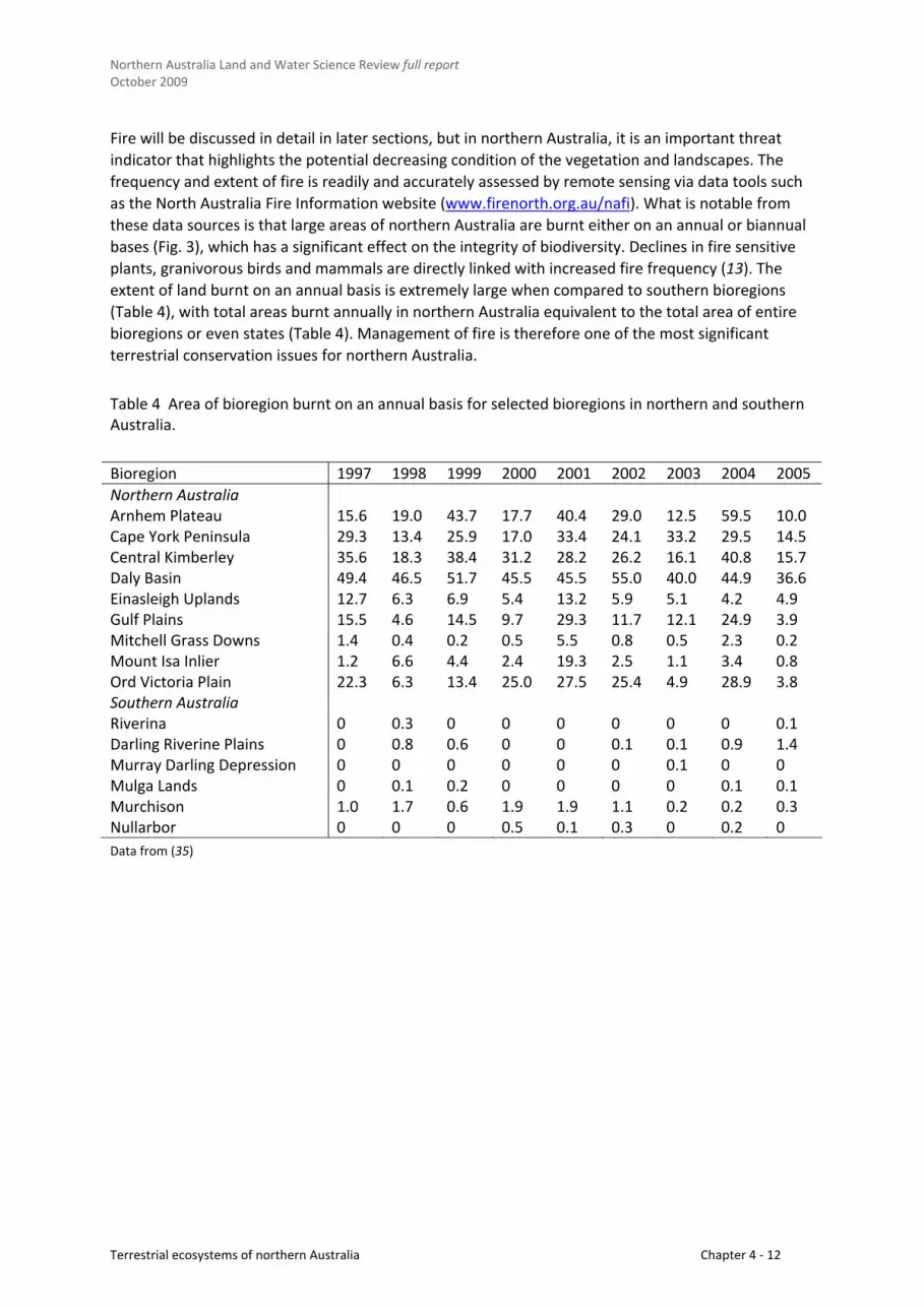
Fire will be discussed in detail in later sections, but in northern Australia, it is an important threat
indicator that highlights the potential decreasing condition of the vegetation and landscapes. The
frequency and extent of fire is readily and accurately assessed by remote sensing via data tools such
as the North Australia Fire Information website (www.firenorth.org.au/nafi). What is notable from
these data sources is that large areas of northern Australia are burnt either on an annual or biannual
bases (Fig. 3), which has a significant effect on the integrity of biodiversity. Declines in fire sensitive
plants, granivorous birds and mammals are directly linked with increased fire frequency (13). The
extent of land burnt on an annual basis is extremely large when compared to southern bioregions
(Table 4), with total areas burnt annually in northern Australia equivalent to the total area of entire
bioregions or even states (Table 4). Management of fire is therefore one of the most significant
terrestrial conservation issues for northern Australia.
Table 4 Area of bioregion burnt on an annual basis for selected bioregions in northern and southern Australia.
Bioregion 1997 1998 1999 2000 2001 2002 2003 2004 2005
Northern Australia Arnhem Plateau 15.6 19.0 43.7 17.7 40.4 29.0 12.5 59.5 10.0 Cape York Peninsula 29.3 13.4 25.9 17.0 33.4 24.1 33.2 29.5 14.5 Central Kimberley 35.6 18.3 38.4 31.2 28.2 26.2 16.1 40.8 15.7 Daly Basin 49.4 46.5 51.7 45.5 45.5 55.0 40.0 44.9 36.6 Einasleigh Uplands 12.7 6.3 6.9 5.4 13.2 5.9 5.1 4.2 4.9 Gulf Plains 15.5 4.6 14.5 9.7 29.3 11.7 12.1 24.9 3.9 Mitchell Grass Downs 1.4 0.4 0.2 0.5 5.5 0.8 0.5 2.3 0.2 Mount Isa Inlier 1.2 6.6 4.4 2.4 19.3 2.5 1.1 3.4 0.8 Ord Victoria Plain 22.3 6.3 13.4 25.0 27.5 25.4 4.9 28.9 3.8 Southern Australia Riverina 0 0.3 0 0 0 0 0 0 0.1 Darling Riverine Plains 0 0.8 0.6 0 0 0.1 0.1 0.9 1.4 Murray Darling Depression 0 0 0 0 0 0 0.1 0 0 Mulga Lands 0 0.1 0.2 0 0 0 0 0.1 0.1 Murchison 1.0 1.7 0.6 1.9 1.9 1.1 0.2 0.2 0.3 Nullarbor 0 0 0 0.5 0.1 0.3 0 0.2 0
Data from (35)
Terrestrial ecosystems of northern Australia Chapter 4 ‐ 12

Northern Australia Land and Water Science Review full report October 2009
Figure 3 Fire frequency in Northern Australia from 1997 to 2008. Green to yellow indicates infrequently burnt (0‐5 times
over past 11 years), red to black indicates frequent burning (every 1‐2 years).
Source: data from www.firenorth.org.au/nafi.
4.2 Bird and mammal declines in northern Australia
Describing the effect of land management on the condition and trend of species and landscapes is
difficult to do at a scale that does justice to northern Australia’s size and diversity. Instead, we seek
to illustrate the interaction of land management on the pattern of two key fauna groups; mammals
and birds.
Unlike much of the rest of Australia, the north has been regarded as a stronghold for mammals, due
to its relatively intact environment. Nevertheless, attrition of the mammal fauna has been reported
around the drier margin of the Kimberley (41) and in comparable areas of the Top End of the
Northern Territory (42). A number of recent studies and some historical evidence also suggest an
emerging pattern of regional decline (30, 41), evidence of which has arisen from long term
monitoring at Kakadu National Park (43), and from other regions such as Cape York Peninsula (44).
Encouragingly, in other regions mammal recovery has been reported after the removal of cattle
grazing and the reintroduction of mosaic burning (mammal species tend to decline in more
frequently burned areas) (45), but other factors are implicated in mammal decline. Predation by feral
carnivores (cats Felis catus and foxes Vulpes vulpes) certainly contributes to the decline in mammal
fauna across Australia (6). There is compelling evidence that the persecution of the dingo by
pastoralists due to perceived stock losses has allowed smaller non‐native predators (cat and fox
again) to proliferate and exact a devastating toll of native species (46). Grazing changes ground cover
Terrestrial ecosystems of northern Australia Chapter 4 ‐ 13

Northern Australia Land and Water Science Review full report October 2009
(47), which not only reduces shelter and food resources, and increases predation success, but it
changes the nature of fire regimes, further pressuring mammal populations (48). Grazing constitutes
about 75% of the northern landscape ‐ this has serious consequences for mammal populations.
Seed eating birds (quails, finches, parrots and pigeons) have suffered substantially due to changes in
land management across northern Australia (49, 50). In search of the two resources critical to their
survival (a regular supply of drinking water and continuous 12‐month grass seed availability)
granivorous birds often spread widely, ranging nomadically across large areas of the landscape,
settling only to breed.
The causes of their decline are not immediately clear, which is in itself a cause for concern. The main
contributing factor is believed to be changes in fire regime and grazing. Both disrupt patterns of grass
composition and grass seed‐fall (1, 51), which determine food supply and distribution. Gouldian
Fiches, for example, depend on a range of fallen perennial grass seeds such as Sorghum, but need
small pockets of other grass species to supply food once the Sorghum source is depleted (52).
Increases in the number and health of Gouldian Finches followed the removal of cattle from
Mornington Station (53). A slightly different set of management circumstances are at play with
respect to the endangered Golden‐shouldered Parrot, a termite‐mound nesting species on Cape York
Peninsula. With the shift from Aboriginal land management to pastoral land management, the fire
regimes were disrupted, either by complete removal (to protect the grass cover), or through lack of
management (allowing hot extensive late season burns to flourish). As a consequence, open
woodlands and grasslands were invaded by native woody vegetation (generally Melaleuca), which
allowed predatory birds to proliferate, perch and hunt more readily on fledgling parrots (54, 55).
Clearly, even minor land management decisions have major implications for the persistence of
wildlife. Unfortunately, threatening processes are rarely obvious and often become apparent only
after a threat has been mitigated (by chance). Furthermore, it is obvious that even though the
northern landscape is often described as ‘intact’ and in ‘good condition’, it is a finely tuned system
that is sensitive to small changes in resource availability. This has significant but not always readily
apparent implications for land use change, intensification or development.
5. CONSERVATION LAND MANAGEMENT IN NORTHERN AUSTRALIA
5.1 Impact of land tenure
Land tenure is a significant determinant of conservation status and land management in northern
Australia. Pastoral leases (cattle and sheep production) cover more than 70% of northern Australia,
with a majority owned by government and leased to families and companies for periods ranging from
a few decades to perpetuity (13). Historically leases were granted with the expectation that the land
would be improved (cleared, sown with pasture, provided with additional watering points) (56).
There is continued pressure to intensify grazing within the generally conservatively managed
properties of northern Australia, driven by a persistent cost‐price squeeze and the significant capital
gains possible on large pastoral stations (57). Leasehold conditions generally include some provision
for land management ‘duty of care’. This provision is now often used by government as an
inexpensive means of adding to the conservation estate by requiring inclusion of areas to be
managed for their conservation values (58). There is, however, an argument that despite long
standing land management legislation, governments are soft on pastoralists with respect to their
Terrestrial ecosystems of northern Australia Chapter 4 ‐ 14

Northern Australia Land and Water Science Review full report October 2009
environmental impact across large land areas, whereas mining is heavily regulated despite its
relatively smaller impact (59).
Land held, managed or owned by Indigenous people under collective title covers between 15‐20% of
northern Australia and these lands might include some areas of forestry, mining and grazing which
generally provides a negotiated economic benefit to the multiple owners (13). There are strong
cultural reasons for Aboriginal people to want to continue to live on country and to practise and
maintain traditional ways of life and land management. There are social and health benefits, and
living on country helps prevent loss of traditional knowledge regarding land management for future
generations (23). These cultural drivers do not often coincide with employment opportunities, or the
existence of amenities to support health and education (for example). As a consequence, there is
pressure to move off country and into regional centres, which reduces the pool of expertise available
for land management (23). Partnerships between Indigenous owners and (for example) mining
companies provide a method for supporting ‘on‐country’ livelihoods and continued land
management, with benefits through fire management for biodiversity and carbon emission
abatement (7). Programs of this type present a significant opportunity to improve land management
for conservation and Indigenous livelihoods in northern Australia (60).
Conservation lands make up approximately 6% of the landscape and, because of their small area and
geographic dispersion, do not adequately capture the range and diversity of northern ecosystems. As
is often the case, most of the land designated National Park is more rugged and less fertile than areas
that are commercially exploited. From a bioregional perspective the distribution of conservation land
is uneven, ranging from no conservation reserves (Sturt Plateau) to reasonable coverage (23%
Arnhem plateau). Reserve coverage is generally <10% of the land area in most bioregions. Most
conservation lands are managed by government agencies but there is increasing growth in reserve
ownership by charitable trusts (Australian Wildlife Conservancy, Australian Bush Heritage). Though
the aim of conservation lands is to rehabilitate and protect habitats in a pre‐European condition,
funding is more often diverted to infrastructure and tourist development (13). There has also been a
distinct shift to “de‐ranger” National Parks in Queensland and centralise their management into
regional townships.
Military land constitutes almost 1% of northern Australia and because of the substantial resources
provided for land management, the large size of military training areas, the limited areal impact of
defence force activities, and legislated requirements to provide environmental management, there
are significant conservation benefits of having land under military tenure in the north (61).
Mining tenures occupy less than 0.5% of the northern landscape, most of which is bauxite leases on
Cape York Peninsula in Queensland. Mines can create localised environmental effects such as dust
plumes (62) and river degradation (63) but current legislative environmental management
requirements are stringent and often mining companies invest in programs with significant
conservation outcomes, which is not characteristic of the grazing industry (64).
5.2 Impact of conservation planning
The conservation planning methods most widely used in Australia are not well‐suited to the north.
Much of Australian conservation planning uses the ‘CAR’ concept , whereby a system of nature
reserves is designed to be Comprehensive (including each of the ecosystems present within an area),
Adequate (able to support viable ecosystems) and Representative (captures the diversity of
Terrestrial ecosystems of northern Australia Chapter 4 ‐ 15

Northern Australia Land and Water Science Review full report October 2009
ecosystems within an area) (65). This approach is best suited to landscapes that have already been
substantially fragmented, such as those in southern Australia (66), as it essentially attempts to cobble
together a functional landscape from dispersed remnants.
The CAR approach of explicit target setting and conservation planning is inappropriate for the large
and relatively intact ecosystems of northern Australia (13). This has been recognised by the
enactment of legislation preventing further broad‐scale tree‐clearing in Queensland (67) and in the
Northern Territory, where clearing targets of ca 20% have been set in the Daly Basin with strict rules
that seek to preserve a balance of vegetation types (68).
As described previously, the north’s highly seasonal climate and spatial and temporal shifts of food
and shelter require fauna to range over large distances if they are to survive (69, 70). This requires
large interconnected ecosystems, rather than small pockets of highly dispersed reserves, such as
those arising from conservation planning methods appropriate to the south. The latter approach,
which generally seeks to preserve 10‐30% of the landscape, would, if applied in the north, lead to
significant land degradation, resource depletion and biodiversity impacts such as extinction.
So it is clear that the conservation of northern Australian landscapes will not be secured through
traditional methods of planning and incremental, small additions to the conservation estate. These
lands will be an important cornerstone for protection of biota, but must only be a part of a broader,
spatially extensive approach that captures the entirety of landscapes under different tenures.
Strategies required to secure this might include a range of approaches such as stewardship payments
or incentives for protection of ecosystem services (24), punitive or coercive action through legislation
(71), regulation of infrastructure development for water use (72), joint management of land for
conservation purposes between government and Aboriginal land owners (73), partnerships with
industry to manage land under carbon pollution reduction schemes (7) and community partnerships
to jointly manage grazing lands for conservation goals (74, 75).
Because northern Australia falls under the jurisdiction of two Australian States and one Territory,
complementary institutional arrangements are required. Migrating or nomadic species following
rainfall‐driven resource booms, or shifting core habitat areas due to changing climate, do not
recognise political boundaries.
6. THREATS AND DRIVERS OF TERRESTRIAL ECOSYSTEM VALUE IN NORTHERN AUSTRALIA
Reviewing and sometimes, agonising over the impacts and legitimacy of developing northern
Australia’s natural resources is a pastime of some antiquity (e.g. 76, 77). Few have paid particular
attention to the consequences for biodiversity conservation, though the review by Woinarski and
Dawson is the most thorough (27). These authors neatly summarise a number of misconceptions that
continue to influence the exploitation of resources, which could have impacts on terrestrial
ecosystems:
The tropical savanna is vast, monotonous and undifferentiated. This misconception leads to it
being misunderstood, undervalued and therefore mismanaged, particularly by development
interests from the south to whom it is often completely foreign. Interestingly, even biologists in
northern Australia have historically dismissed the savanna environment as uniform and
insignificant (78).
Terrestrial ecosystems of northern Australia Chapter 4 ‐ 16

Northern Australia Land and Water Science Review full report October 2009
The landscape is large in scale, therefore: i) development should be correspondingly large or; ii)
the expanse reduces the need for the safeguards of protection and planning. This misconception
suggests that the need for preparatory study, resource assessment or rehabilitation is not
necessary.
The land is marginally productive; successful development can only occur through transformation
at a large scale. This misconception encourages a general recklessness that can have negative
consequences for both the environment and the business that it is intended to support.
The economics of development is tenuous and therefore it should not be burdened by imposition
of excessive regulation (e.g. conservation of natural resources), which would affect profitability.
The separation of investment rewards and responsibilities can distort rational decision making
and may encourage a degree of recklessness.
Having identified some generic behavioural influences that may affect terrestrial ecosystems, we
now review a set of their key biophysical impacts and drivers.
6.1 Fire
Fire is instrumental in shaping the Australian environment (79‐81) and appropriate fire management
is critical for maintaining biological diversity (82‐84). Changed burning practices since European
settlement have resulted in vegetation change and species loss across broad geographic areas (84,
85), but the fire regime requirements of most species are not well known. The contemporary pattern
in much of northern Australia is for areas to be burnt frequently by extensive and intense fires, or
seldom burnt. Ecological opinion is that conservation‐orientated fire management should aim to
develop and maintain fine‐grained landscape patchiness using fire. Numerous small fires, with variety
in fire timing, frequency and intensity are thought to reflect Aboriginal burning practices, which
tended to be highly patchy (86). Too much fire or too little fire both result in homogenization of the
landscape.
Present day fire operations are tempered by divergent public opinion. Fire is typically used to protect
life and property by reducing fuel loads in hazardous areas. Conservation agencies burn for ecological
purposes; pastoralists burn to improve the vigour and quality of pasture, to manipulate pasture
composition, to assist weed control, and for managing the tree/grass balance (87). Other people
oppose the use of fire. Concerns are expressed about safety, the survivorship of individual animals,
and the effects of smoke on people’s health and the atmosphere. These diverse viewpoints lead to
inconsistent fire management across the landscape.
Attempts at fire exclusion have resulted in large areas being burnt by late dry‐season wildfires, with
poor conservation outcomes (88). Restricting fires to low intensity fuel reduction burns is also
unrealistic. Repeated burning of the grassy understory allows trees and shrubs to out‐compete the
herbs and grasses, leading to loss of diversity and structural change in the vegetation (89). In some
areas, the grass layer has been reduced to the extent that fire can no longer be sustained. Similarly,
areas where over‐grazing has occurred, the ‘woody thickening’ is irreversible. Given the importance
of fire management to species conservation, addressing the currently inappropriate fire regimes is
essential for achieving ecologically sustainable development.
Existing fire regimes across much of the north are not appropriate for species conservation (86). If no
changes are made, the current trajectory of declining terrestrial biodiversity will continue. A number
of overriding and interacting issues are operating:
Terrestrial ecosystems of northern Australia Chapter 4 ‐ 17

Northern Australia Land and Water Science Review full report October 2009
Ecological outcomes depend on a fine scale mosaic of time‐since‐fire and fire regime
heterogeneity (90). This involves lighting many small fires over time, as the country dries out
after each wet season. Such landscape‐scale fire management requires people to be living and
interacting with the land, in order to respond quickly when weather conditions are suitable and
because it develops an intimate knowledge of local geography, fire characteristics and patterns.
The pastoral population in northern Australia has been in long‐term decline (91) as helicopters
have replaced horses for mustering, people have moved to urban areas or are attracted to more
highly paid jobs in the mining industry. Indigenous people, acknowledged as skilled and active
fire managers, have variable access to country, depending on history, jurisdiction and tenure.
The current focus of fire management is on fuel reduction burning to reduce the risk of wildfire,
or fire exclusion. Fire exclusion is not an option in the fire‐prone savannas and results in
widespread wildfires. This is because wet season rainfall is reliable and the grassy fuel load grows
every year. The dry season invariably follows, which cures the fuel to a combustible state (92).
Even if there was no ignition by humans, ignition by lightning strike is possible in the ‘storm
season’ in October‐November.
Proactive fire management is an annually iterative process. It needs to be tailored each year to
meet local climate and fuel load conditions. However there is an associated economic cost (93)
and the priorities of land managers can change from year to year.
Grazing practices have changed over time. In some areas this has resulted in changed attitudes
towards fire or has reduced fuel loads to the extent that fires will no longer spread, leading to
structural changes in the vegetation (increasing tree cover) (89).
Political pressure from an urban‐dominated population can affect practices in more natural
landscapes, even when climate, vegetation and social conditions are vastly different.
Current difficulties in achieving conservation‐orientated fire management are likely to be
exacerbated by climate change (94). Fluctuations between El Nino’ and La Nina weather patterns
are predicted to occur over shorter timeframes (95) and the resulting variability will make it
difficult to apply standard land management practices. Fires of greater intensity are
foreshadowed; predictions are for windier summers, generally drier conditions, and more days of
high and extreme fire danger.
Although terrestrial biodiversity in northern Australia is threatened by inappropriate fire regimes,
a number of exemplary projects have been implemented that demonstrate the potential for
improvement. For example, the West Arnhem Land Fire Abatement (WALFA) project (96) has
enabled Indigenous people to return to country and rekindled interest in traditional knowledge.
However there are recurrent issues: short term projects leading to loss of continuity, lack of
resources and support to maintain existing capacity let alone take on new opportunities, loss of
Indigenous ecological knowledge with the passing of Elders and loss of interest among young
people. It is anticipated that isolated good projects would continue with the present enterprise
mix and level of development, but not to extent required for conserving biodiversity.
Many pastoralists have ‘corporate knowledge’ relating to fire management (97). This is in danger
of being lost, given the trend for large, company‐owned pastoral properties and more transient
managers than in the family‐run properties of the past.
Increasing the level of development in the north could have positive or negative implications for fire
and biodiversity management. Further development implies an increase in the number of people and
their associated activities. This may increase the risk of wildfire through accidental ignitions or arson.
Terrestrial ecosystems of northern Australia Chapter 4 ‐ 18

Northern Australia Land and Water Science Review full report October 2009
With population increase, the risk to life and property from fire increases, thus the greater need for
public understanding and co‐ordinated fire management. In the positive sense, development can
provide resources to assist with implementing proactive burning programs, which would significantly
benefit biodiversity conservation.
Development that enables over‐grazing or the introduction of non‐native pasture species can
detrimentally affect burning practices and species conservation. Supplementary feeding and
increasing the number of watering points can increase grazing pressure on native grasses, thereby
reducing fuel loads and lead to ‘woody thickening’ and loss of grasslands (89). Conversely, introduced
pasture grasses may out‐compete native species and accumulate a substantial biomass, leading to
intense fires (e.g. Gamba grass) (98).
Terrestrial biodiversity stands to benefit from development if economic outcomes are positive and
money is directed back to managing the environment. Examples of this are the successful WALFA
project, funded by the sale of carbon credits, and biodiversity offset projects funded by the mining
industry (99).
6.2 Pastoralism
Pastoralism is the dominant land use (and one of the most significant threats to biodiversity) in
northern Australia, despite it being only the third largest contributor to northern Australian regional
economies (behind tourism and mining) (13). The effects of pastoralism on terrestrial ecosystems on
northern Australia are both direct (through the removal of ground cover cattle grazing) and indirect
(by management of water, fire, clearing, the spread of exotic pastures and native animal control).
Cattle grazing began in the 1860’s with land sold sight‐unseen based on glowing descriptions of the
potential of the savannas for growing sheep and beef (77). English breeds of cattle generally did very
poorly especially in the wet, and were often only stocked in the dry season. Recognition that many of
the landscapes had limited potential for grazing was overlooked, probably due to the seductive
potential of such seemingly limitless landscapes, and the desire not to leave lands “empty” (27, 100).
Especially in the less capable parts of the landscape, early changes occurred in pasture species
erosion and water degradation. In 1944 there were reports that 10% of the Ord River catchment was
degraded by erosion (Metcalf in 27) and by 1976, 30% of the Fitzroy catchment was considered to be
in poor to very poor condition (101). Overgrazing led to 24 million tonnes of sediment deposition into
the Ord River, forcing destocking of the Dam area (102).
From the 1970s, drought and disease resistant Brahman cattle B. indicus (and their hybrids) were
introduced; and coupled with vaccinations, improved husbandry, dietary and hormone supplements,
and intensification of stocking rates, instigated a wave of increased land utilisation, grazing pressure
and land degradation (57). The consequences of this has been the replacement or supplementation
of native grasses with exotic grasses and legumes, increased provision of artificial water sources,
clearance of native vegetation, decreasing paddock size to better manage stock and overgrazing
during dry years (13). The secondary effects of this intensification are changes to soil hydrological
function, and shifting fire regimes and vegetation dynamics, all of which have consequences for
rangeland biodiversity (103). In Queensland this intensification has continued over the last twenty
years (104).
Terrestrial ecosystems of northern Australia Chapter 4 ‐ 19

Northern Australia Land and Water Science Review full report October 2009
Despite grazing being the dominant land use in northern Australia, there are surprisingly few studies
of the influence of grazing effects alone. In the most general sense, grazing can rapidly remove native
palatable plants species (105), with a gradual change through selective feeding until only annual
species and weeds remain (106). This change in groundcover can influence the abundance and
composition of species also reliant on perennial grass seed. The decline in granivorous birds is the
most compelling evidence of this, though there is also a correlation with fire pattern too (49).
Historical evidence exists from a grazing property in central Queensland, indicating that between
1870‐1930, 14 resident bird species disappeared after the introduction of grazing (107, 108). More
recent surveys using grazed and ungrazed contrasts identified that between 15‐40% of plant and
vertebrate species are likely to decrease with increasing grazing pressure (see review in 109).
Conservative (low stocking rates) grazing regimes have been shown to have a positive benefit for
grass cover, composition and vertebrate species, without any economic cost to the grazing enterprise
(110).
In northern savanna landscapes, grazing can have a direct effect on fire regimes, either through the
suppression of fire, or through the poor use of fire. Grazing directly after fire (to take advantage of
the green pick) can have a compounding effect on the vegetation and fauna, causing a shift from
hummock and tussock grasses to tussock grasses and annuals, which then causes declines in larger
mammals and reptiles (48). Removal of grazing and the reintroduction of mosaic burning in the
Kimberley caused the small mammal population to recover in diversity and abundance (45). Livestock
grazing can reduces fuel loads, particularly in areas that remain damp well into the dry season, which
can alter the fire pattern to favouring shrub invasion (111). There is debate regarding the biodiversity
effects of woody thickening, but apart from some notable examples such as the Golden‐shouldered
Parrot (54), change to a more woody vegetation structure confer advantages to a wide variety of
native species (112, 113).
A review of the history of experimental pasture introduction in Australia over the past 100 years
identified attempts to trial and introduce more than 8200 species to Australia, including more than
2600 grass and 2200 legume species (114). A retrospective review of the fate of over 450 introduced
pasture species found that only four were useful and did not become weeds whereas 60 became
weeds and 17 were both useful and considered weeds (115). Perversely there are many examples
where one arm of government has promoted the use of exotic plants while another funds the
eradication or control of those same species (116). At the same time the spread of exotics continues
apace in Australia, either via direct seeding or through continued invasion through fire and grazing
(117).
The invasion and replacement of native species with exotics causes landscape change akin to
fragmentation, by creating patchiness in the native groundcover, loss of plant species diversity and
monocultures (117, 118). Invasion of exotic pastures also causes changes in ecosystem function,
depletion of soil nutrients, altered hydrology and changes in fire pattern (119). Examples of the
impact of exotic pastures on biodiversity include tropical savanna woodlands (47), seasonal wetlands
(120), arid rangelands (121‐123) and temperate grasslands (124). Most recently even when cover is
low, buffel grass can have a detectable influence on some aspects of plant and animal dynamics
(123).
The dingo and hybrid wild dogs cost the livestock industry an estimated $66 million per annum, (125)
and as a consequence are the target of government‐sponsored baiting and bounty programs. There is
a view now that dingoes may be having a net benefit on native biodiversity, with recent work
suggesting that dingoes may regulate cat and fox populations (by protecting their territories from
Terrestrial ecosystems of northern Australia Chapter 4 ‐ 20

Northern Australia Land and Water Science Review full report October 2009
smaller or meso‐predators) (46), particularly around livestock water points (126). As feral cat and
foxes are heavily implicated in native mammal declines across Australia (6), this natural control by
dingoes has a significant biodiversity benefit. There are also arguments that as dingos are more likely
to prey on larger animals this will confer some advantage in managing kangaroo and pig populations
on grazing properties. The value of dingoes in the landscape is therefore a bone of contention
between pastoralists and conservationists.
6.3 Mining
Early settlement of northern Australia by Europeans was largely driven by mining (e.g. Argyle,
Jabiluka, Rum Jungle, Mary Kathleen), and imposed environmental impacts of varying scales. Effects
were largely ignored until the 1970s when growing public awareness led to policy changes and
increased environmental regulation. Governments enacted legislation requiring environmental
impact assessment prior to resource extraction and for lodging ‘securities’ to fund site clean‐up
should an enterprise fail. Specific agreements were made with large mining companies to address
existing operations and issues, thus establishing a framework for environmental monitoring and
reporting. Environmental legislation was substantially reviewed in the 1990s and now includes the
need to address biodiversity conservation. Consistent requirements are now in place across the
sector; the industry is highly regulated with stringent legislative requirements that benefit species
conservation. Mining companies also responded independently to public pressure and share‐holder
views by agreeing to industry standards and best practice (e.g. www.icmm.com/sd_framework.php)
and by open‐mindedly considering more innovative approaches, such as Biodiversity Offsets
(www.icmm.com), to further reduce their impacts.
The boom‐bust cycle typical of the mining industry was previously characterized by a mobile
population moving from ‘field to field’ and establishing small, temporary townships. In the 1990s and
early 2000s this was replaced by a ‘fly‐in, fly‐out’ culture. From a land management perspective, both
arrangements bring people‐pressure to previously remote areas with flow‐on effects for biodiversity
conservation. On the other hand, locally‐based employees make for a ‘peopled’ landscape and
provide a potential workforce to undertake hands‐on activities such as those relating to fire
management.
Further developing the mining industry can have a net benefit if environmental management systems
are well founded, well funded, implemented and enforced. This minimises the immediate industrial
affects and allows profits to be generated. By funding off‐site projects that benefit the environment,
there can be conservation gains that otherwise would not occur. An example is the Roxby Downs Arid
Recovery project, which is a successful partnership between mining, government and graziers, in
creating a predator proof enclosure for the reintroduction of extinct mainland mammals (Greater
Stick Nest Rat, Leporillus conditor, Burrowing Bettong, Bettongia lesueur, Greater Bilby, Macrotis
lagotis, Western Barred Bandicoot, Perameles bougainville) (59). Similarly the Supervising Scientist
Division for the Alligator Rivers Region was established following the Australian Government's
decision to approve uranium mining at the Ranger Uranium Mine within the Kakadu region. On‐going
funding is provided to undertake environmental reviews of the environmental performance of
uranium mines and to undertake research with respect to tropical wetlands conservation and
management; and conducting more broadly based environmental research on issues of national
significance. The benefit of the latter research has been the on‐going monitoring and subsequent
documentation of the decline of small mammal populations at Kakadu, which has provided
significant information on a potential biodiversity crisis for northern Australia (43).
Terrestrial ecosystems of northern Australia Chapter 4 ‐ 21

Northern Australia Land and Water Science Review full report October 2009
6.4 Intensive land use change
There is currently limited extensive agricultural development in northern Australia, much of it
confined to the Ord River Irrigation schemes, experimental crop trials at Lakeland Downs on southern
Cape York Peninsula, horticultural development around Darwin and the burgeoning land
development in the Daly River Basin (27, 77, 127). The land clearing associated with these
developments has been limited to targeted areas and often with a scope reduced from the original
plans of many thousands of hectares, to only a few thousand (76).
Agricultural and horticultural development will have three major effects on terrestrial ecosystems
and biodiversity in northern Australia:
1. the direct clearing and fragmentation of existing habitat; 2. the introduction and spread of feral animals and plants; and 3. possible increase in some native species as agricultural pests.
The effects of fragmentation and clearing on native species and ecosystems has been extensively
studied in Australia and world‐wide as it is probably the most significant single impact on biodiversity
(128). Broad‐scale tree clearing has ceased in Queensland, though areas in the Northern Territory
such as the Daly Basin have planned clearing for development (68). The effects of clearing depend on
the extent and configuration of the remaining habitat, with a general rule of thumb being that larger
patches with connectivity support more species and at greater abundances than small patches (129,
130). Loss of species from a fragmented landscape can also be gradual over time (a phenomena
called an extinction debt), but can decline rapidly if a critical threshold is met, nominally identified as
30% (130). Clearing can also cause an increase in native species that prefer open and disturbed
habitats, though in some cases they can be aggressive and dominant competitors that result in
declines in remaining species (131). Small habitat patches are also susceptible to further disturbance
and degradation through fire, weed invasion and feral animal predation (132, 133). Infrastructure
development through the landscape can increase the spread of weeds and feral animals through the
landscape and into the remnant vegetation via edge effects (134‐136).
As the extent of tree clearing in northern Australia is limited, there are very few studies that have
directly examined the effect of fragmentation in savanna woodlands. A study in central Queensland
in the southern Desert Uplands investigated patterns of bird assemblage in cleared, large patch, small
patch and intact Eucalyptus woodlands (137). Bird species richness was least in cleared areas (8
species per hectare), intermediate in regrowth patches (14 species) and highest in uncleared
woodland (20 species). The effect of landscape fragmentation was also examined in the Litchfield
Shire and Tipperary Station in the Northern Territory (138). Of 75 species of birds, mammal, reptile
and amphibian studies, only 25% used cleared land, while 69% used corridors. Size of fragment,
extent of woodland in a 4km radius and connectivity were the best predictors of native fauna
abundance (138).
One unintended consequence of land‐clearing is the potential increase in disturbance tolerant native
animals, that then become pests of the subsequent agriculture. Early cropping development in the
Northern Territory found species such as Magpie Geese and Dusky Rats (Rattus sordidus now R.
colleti) proliferated in sown grain crops (77, 139). Similarly in Queensland the discovery and
description of a new species of native rodent Leggadina lakedownensis was a direct result of it
plaguing in sorghum crops near Lakeland Downs (140). Many native species, including long‐lived
iconic species such as cockatoos and kangaroos, can be culled under damage mitigation permits for
agricultural crops, an unwelcome perverse result.
Terrestrial ecosystems of northern Australia Chapter 4 ‐ 22

Northern Australia Land and Water Science Review full report October 2009
The most probable scenario and projection for agricultural development in northern Australia is
targeted intermediate intensification through mosaic or pivot agriculture. In this case small areas
(generally 30 ha circles) are cleared and planted for crops, and irrigated via extraction from ground
water aquifers or small scale water diversion. The footprint on face value is small, and often
restricted to about 10‐20% of the andscape available, though local scale changes to hydrology can
effect native vegetation surrounding the pivot circle, often up to a further 1 km in diameter. There
are three key issues that can be associated with this level of development, which are in part smaller
scale versions of the effects on terrestrial conservation associated with large‐scale water capture and
diversion (see Section 6.5). In summary these are;
Conflict in key productive areas. Though the potential extent of pivot agriculture is small, it is
likely to target sites in the landscape that have naturally productive soils (e.g. alluvial, basalt), and
appropriate drainage, both of which are fairly limited in northern Australia. These areas are also
likely to be significant areas for biodiversity, as there is a clear association between more
productive pockets of the landscape and high biotic values (141, 142). Concentration of
agricultural development in productive alluvial floodplains has resulted in extinction of mammal
fauna (e.g. Fitzroy and Dawson Valleys, Queensland) (143, 144), and declines in bird and mammal
species (145, 146).
Fragmentation and edge effects. Even though the area of vegetation removal is small, the
progressive clearing of small pockets of vegetation for agriculture removes habitat for fauna
species, and increases the potential for degradation of surrounding intact native vegetation. The
removal of native vegetation will have limited effect until it reaches a threshold where remaining
habitat is insufficient to support species in natural abundances. Present indications suggest that
no more than 10‐20% of native vegetation would be cleared for pivot agriculture, and at this level
the prospect of a strong effect on native species populations seems unlikely (138). However
there is little supporting data to identify what thresholds of tree clearing are sustainable in
tropical savanna environments. Of more concern are the secondary and edge effects that
clearing imposes, such as increased weeds and feral animals, and pest native animals (e.g.
yellow‐throated miner), which will increase the degradation of the adjacent native vegetation
(137, 147).
Ground water overdraft. This occurs when ground water extraction exceeds aquifer recharge and
can result in declining aquifer storage, declines in surface water and stream flows, land
subsistence and reduction or degradation in terrestrial vegetation (148). Significant biodiversity
localities such as springs can dry up (149) and groundwater dependent ecological communities
such as wetlands, alkaline grasslands (e.g. Sporobolus) (150), riparian and floodplain vegetation
(151) can be severely effected (e.g. decline in condition or lost completely) due to the reduction
of water availability. Tropical regions in Australia have more groundwater dependent ecosystems
than temperate areas (152). Though the prospect of excessive ground water extraction can be
limited by regulation, (e.g. draft water plans for the Daly Basin) the long term consequences on
native vegetation on limited extraction are unknown.
6.5 Water capture and diversion
The construction of large dams in northern Australia is currently limited when compared to southern
and eastern Australia. Within the Timor Sea and Gulf of Carpentaria Basins there are nine dams with
a crest height of over 10 m, of which between 1‐9% is divertible flow for human use, the remainder
Terrestrial ecosystems of northern Australia Chapter 4 ‐ 23

Northern Australia Land and Water Science Review full report October 2009
being available for agricultural and extractive mineral industries (153). Other forms of water capture
and diversion can be via the pumping of groundwater aquifers for irrigation or water points for
grazing stock, and the diversion of natural overland flows into small artificial water points, again for
grazing stock. The consequences of this for terrestrial ecosystems are generally indirect (ie.
secondary) and can be broadly categorised as: flooding of habitat via dams; changes in flooding
regimes (increase or decrease); changes in natural water balances for riparian or other specific
ecosystem associations such as spring; and increased grazing pressure due to increase of surface
water. The effect of intensive land use change as a result of impoundment was discussed in the
previous section.
Changes to flooding regimes and water flows (environmental flows) are probably the most significant
effect of large water impoundment on biodiversity. Flooding of wetlands and alluvial plains
stimulates the breeding of aquatic fauna and aquatic vegetation, which in turn allows large breeding
events in waterbirds (141, 154). Reduced flooding events can reduce the long‐term survival ability of
aquatic annual plants, trees that rely on flood events, aquatic breeding terrestrial fauna such as frogs,
and waterbirds (141). If reduced flooding is prolonged, there can be an eventual shift from aquatic to
savanna ecosystems (141). In northern Australia, there are tightly linked patterns between predator
and prey species reliant on flood events, the most notable being the strong relationship between the
Dusky Rat and the Water Python (155, 156). Changes in floodplain dynamics not only affect local and
regional populations of species, but can markedly affect continental‐scale distributions and
abundance of waterbirds (157). Some of these, such as the Magpie‐goose, are a significant food and
cultural species for Aboriginal people and are an iconic wetland species in the north (158). Dams can
also effect terrestrial ecosystem dynamics by increasing water flows to certain areas, or imposing
stable water environments in systems used to cycles of drying out (157, 159). Prolonged flooding can
change vegetation by simply drowning the landscape, prevention of natural seeding cycles, and
change the bird assemblage to one that is dominated by deep‐water species, as opposed to shallow
water feeding species (159, 160).
Riparian habitat and vegetation are highly significant mesic (requiring moderate amounts of water)
ribbons of high biodiversity value, especially in highly seasonal tropical savanna environments.
Riparian vegetation supports a greater abundance and diversity of savanna bird species than
surrounding savanna (161). Changes or degradation in riparian vegetation have been directly linked
to reduced mammal distributions (146). Establishment, maintenance and reproduction of riparian
vegetation is directly related to existing hydrological regimes. Data from the Ord River indicates that
riparian vegetation had changed significantly between the unregulated and regulated portions of the
river (162). Natural springs fed from ground water aquifers are also important biodiversity hotpots in
northern Australia, with many springs containing endemic vertebrates and plants (163). The
extraction of groundwater for stock watering points has been directly linked with degradation and
destruction of these important wetlands, including the possible extinction of endemic species (149,
164).
The effect of artificial water points on biodiversity has been discussed in the previous section, but is
worth reemphasising here, as it is a significant but often overlooked aspect of water diversion that is
unregulated and unmeasured. Grazing pressure decreases with distance from water, creating
concentric rings of grazing effects; the vegetation structure, composition and habitat quality changes,
with disturbance tolerant species becoming more dominant near water (103). Data on the
distribution and number of water‐points, and therefore water‐remoteness, is sparse for northern
Australia. Examination of the increase in water point density around Alice Springs indicated that due
to a concerted effort to “drought‐proof” the country and create smaller paddock for stock disease
Terrestrial ecosystems of northern Australia Chapter 4 ‐ 24

Northern Australia Land and Water Science Review full report October 2009
control resulted in the area of land >8km from water reduced from 80‐100% to <20% (35) (Fig. 4). In
much of Australia now the prospect of creating “grazing relief” environments for conservation means
de‐stocking and water‐point closure over large areas (165). There is a now a concerted push in
northern Australia to evenly spread grazing via increasing water points into areas currently
unwatered (166). Though it might be a means of sustainable grazing management, it will have
significant biodiversity conservation consequences (167).
Terrestrial ecosystems of northern Australia Chapter 4 ‐ 25

Northern Australia Land and Water Science Review full report October 2009
Figure 4 Proliferation of water points on a central Australian property from 1900 to 2004. Areas remaining distant from
water in 2004 are almost non‐existent.
Source: data (used with permission) (35).
The largest impacts of changes to water regimes are indirect, as outlined above. Nevertheless, direct
impacts can also be important. Creation of large water storages obviously leads to the loss of habitat
through flooding. The nature of the topography required for efficient water capture and storage
often requires that fertile riparian zones are inundated, which are important locations of high
productivity and value for biodiversity, especially in highly seasonal environments. However, the
Terrestrial ecosystems of northern Australia Chapter 4 ‐ 26

Northern Australia Land and Water Science Review full report October 2009
areal impacts of such inundations are minor compared with those on the habitat in the surrounding
landscape. Despite this, there seems to be some societal aversion to the concept of flooding land. In
the case of the Ord River development there was a concerted public relations exercise by the
Western Australia government to fund the rescue of fauna being flooded by the filling of the dam
through a program called Operation Ord Noah (168). The articles make for amusing reading, as they
account the exploits of a team shooting rogue bulls and capturing mainly kangaroos, wallabies,
snakes and goannas from the islands created by the inundation. The biodiversity benefit of such an
exercise would be ineffectual and pointless.
An unintended positive outcome of the damming of the Ord River and creation of Lake Kununurra in
1963 and Lake Argyle in 1972, is the creation of two large water impoundments, and the creation of
permanent wetlands from many that were only seasonally inundated prior to damming. These
wetland complexes are now recognised as a Ramsar listed wetland (that is of international
significance under the Convention on Wetlands of International Importance treaty). The key features
of the lakes and associated wetlands are as a dry‐season refuge for waterbirds, and an occasional
breeding site for 18 species. Very large numbers of waterbirds occur in the system, which regularly
supports more than 20 000 waterbirds. Lake Kununurra and surrounding wetlands contained about
12 000 waterbirds in September 1978 and October 1979 and about 7 000 in November 1980. Lake
Argyle contains some of the largest aggregations of waterbirds in northern Australia; 181 400 were
counted in August 1986.
6.6 Climate change
The specific local and regional predictions for climate change across northern Australia are not
entirely clear, making an assessment of the impacts on terrestrial ecosystems difficult to identify.
Anthropogenic (human) changes in climate are variably predicted to affect sea level, temperature,
rainfall, cyclones and atmospheric carbon dioxide fertilization (13). The current predicted outcomes
on the northern landscapes include (i) an increase in temperature and, hence, evapotranspiration; (ii)
a wide range of possible rainfall changes; and (iii) an increase in the intensity of events such as
storms and cyclones (169).
The climate change projections for northern Australia have been identified in the IPCC 4th Assessment
Report via climate models based on three greenhouse gas emissions scenarios simulations for 2030
and 2070. Temperature is expected to increase over the Australian continent with the effect being
more pronounced in inland versus coastal regions (170). The range of predicted annual mean change
in temperature across the savannas is from 0.5oC to 2oC by 2030 and up to 2‐4oC by 2070 using worst
case scenarios. Critically, the number of extreme temperature days (above 35oC and 40oC) is
expected to increase in the savannas. Higher temperatures and more intense hot spells will affect the
thermal tolerance of many species (making them prone to desiccation or death), change flowering
and fruiting events of plants, which will in turn effect migration and breeding events of many species.
Rainfall projections are more complex. Rainfall projections to 2030 show a slight increase (+5‐10%) in
rainfall during the wet season with no predicted change in dry season rainfall (where little or no rain
falls) except for parts of north Queensland where a decline of 10 percent in winter rainfall is
predicted. The variability of the rainfall is likely to increase in the southern portions of northern
Australia, and in the eastern rangeland areas. Rain will fall more intensely in shorter periods of time
which might potentially cause increased flooding events. These rain events may also result in
Terrestrial ecosystems of northern Australia Chapter 4 ‐ 27

Northern Australia Land and Water Science Review full report October 2009
increase fuel loads by rapid growth of annual grasses that subsequently cure quickly and cause more
intense wildfire.
Given the strong association of northern Australian biodiversity with rainfall and temperature
seasonality, climate change may have a significant effect on many species. Widespread generalist
species may benefit (50), overall populations might decrease due to a magnification of current
threatening processes (e.g. fire regimes, amplified impact of grazing) and reduced productivity of the
landscapes. For example, fire frequency may potentially increase from the current annual/biennial
frequency, compounded by the reduction in the number of days where prescribed burning is possible
(increased extreme fire weather days) resulting in late dry‐season, uncontrolled fires (169).
Increased drought periods may lead to a reduced bird assemblage, as bird species richness has been
shown to decline down rainfall gradients for tropical savannas (171). The decline of granivorous birds
in Australian savannas is correlated with greater rainfall variability (49). In particular, bird
abundances may decline as a result of longer, harsher dry seasons creating a resource bottleneck
(172). Geographic ranges and phenological timings are likely to shift, as has occurred for bird species
in other habitats (173, 174). This may be particularly pronounced for honeyeaters, whose
movements are tightly linked to flowering events (175). Ranges of species may also contract as
suitable habitat becomes less available, and individual survival may decrease due to hotter, drier
periods (176). The highly productive coastal floodplains systems in northern Australia might also be
under threat through inundation (177). This is likely to have a substantial effect on northern
Australian biodiversity; affecting the concentrations of waterbirds, fish, and other aquatic
vertebrates that congregate and use these coastal floodplains for feeding, breeding and nesting
(178).
Elevated atmospheric levels of CO2 may, via a ‘fertilisation effect’ increase the growth of woody
species over that of grasses (179). This can potentially facilitate the conversion of grassland to
shrubland, disadvantaging species that rely on open savanna woodlands (55, 180). The interaction of
increased shrubby growth, cattle grazing and fire, will make management increasingly difficult where
cattle grazing is reducing grass biomass that both competes with woody vegetation and provides the
main fuel for fires (13). The biodiversity effects of increasing woody growth are not necessarily
negative for a vast majority of species (112), but high profile endangered species impacts tend to
receive more focus (181). In some places the thickening is a consequence of natural climatic
fluctuation causing mass recruitment followed some years later by drought‐driven dieback (182).
Increasing CO2 will also decrease the nitrogen content of forage and this might have an impact on the
nutritional value of forage for native herbivores as well as livestock (183).
Finally the predicted increase in intensity of cyclones may affect the biodiversity of northern Australia
(184). Between 2005 and 2006 three high intensity cyclones (Ingrid, Larry and Monica) passed
through northern Australia, resulting in heavy destruction of canopy trees (185). Such damage can
cause direct mortality of species, remove limbs or old tress with tree hollow habitat, impact on
isolated or small population of significant species (e.g. island mammal populations) or increase the
incursion of fire or weeds into discrete vegetation patches (e.g. monsoon forest) or undisturbed
woodlands.
Northern Australia’s ecosystems are likely to become increasingly fragile and vulnerable as a result of
climate change, a situation that will also make them increasingly vulnerable to the negative impacts
of development. As a simple test of what might be the consequences of climate change on the
particularly vulnerable component of fauna ( already undergoing some degree of existing depletion)
(43), we examined the possible future distribution of 10 mammal species under IPCC climate change
Terrestrial ecosystems of northern Australia Chapter 4 ‐ 28

Northern Australia Land and Water Science Review full report October 2009
scenarios. Distribution models were created using known occurrences of species recorded since 1980
and a presence‐only species distribution modelling algorithm, Maxent (186).
Distribution models utilised temperature and rainfall variables, and future projections (2030, 2050,
2070) provided by Global Climate Models and emission scenarios from the IPPC 4th assessment. Of
the 10 species modelled all species indicated a decline in future distribution (Table 5, Fig. 5), the most
significant being Brush‐tailed rabbit‐rat, Black wallaroo, Northern phascogale and Carpentaria rock‐
rat, which all declined to virtual extinction by 2030. More widespread species (e.g. Common
planigale, Pale field rat) declined to a lesser degree, but species such as the Pale field rat are already
undergoing substantial decline in distribution due to existing land management regimes (146). These
projections suggest that climate change might have a catastrophic effect on northern Australian
mammals.
Table 5 Percent decline in distribution for ten northern Australian mammal species under 2030, 2050 and 2070 climate change scenarios.
Species Common name Change to 2030
Change to 2050
Change to 2070
Conilurus penicillatus Brush‐tailed rabbit‐rat ‐90% ‐90% ‐90% Leggadina lakedownensis Tropical short‐tailed mouse ‐60% ‐60% ‐60% Macropus bernardus Black wallaroo ‐90% ‐90% ‐90% Mesembriomys gouldii Black‐footed tree‐rat ‐60% ‐60% ‐70% Petaurus norfolcensis Squirrel glider ‐50% ‐50% ‐50% Phascogale pirata Northern phascogale ‐90% ‐90% ‐90% Phascogale tapoatafa Eastern phascogale ‐50% ‐50% ‐50% Planigale maculata Common planigale ‐30% ‐30% ‐30% Rattus tunneyi Pale field rat ‐20% ‐20% ‐20% Zyzomys maini Carpentaria rock‐rat ‐90% ‐90% ‐100%
Terrestrial ecosystems of northern Australia Chapter 4 ‐ 29

Northern Australia Land and Water Science Review full report October 2009
Figure 5 Scenarios of mammal decline under averaged climate change predictions for 2030, 2050 and 2070. The first
indicates predicted potential environmental space for Conilurus penicillatus, the second for Mesembiomys gouldi and the
last for Rattus tunneyi.
Source: VanDerWal and Kutt unpublished
6.7 Carbon industry
The carbon economy is increasingly being seen as an emerging development opportunity for
northern Australia. Whether or not the impacts on terrestrial conservation are positive or negative
will depend on the specific policies and operational frameworks established. Only a few of the
greenhouse gas reduction strategies being developed are suitable for the social, cultural and
environmental conditions in northern Australia (187). Options might include changed savanna
burning practices (such as those currently being investigated on Indigenous lands), reducing the
number of feral ruminants, producing BioChar, or undertaking forestry projects specifically aimed at
sequestration. Excluding fire to reduce emissions, establishing tree plantations, or promoting
woodlands over grasslands (with potential loss of grassland species), all have significant biodiversity
implications, most of which have not been evaluated.
Agreed trading mechanisms are currently ill‐defined. Clear links between regulated carbon credits,
voluntary carbon credits, verification processes, carbon registers and accounting, and market
interfaces need to be established. The voluntary market has fewer regulatory drivers, but there is
strong interest due to increasing demand from companies, organisations and individuals seeking to
mitigate the consequences of their greenhouse gas emissions (188).
As a result of the great deal of regulatory uncertainty, the potential effects of the carbon economy on
biodiversity conservation can be no more than speculative. The Carbon Pollution Reduction Scheme
(CPRS) is still under development and current emphasis is on sectors other than agriculture (187). The
viability of carbon trading as an alternative land‐use in rangelands is yet to be demonstrated and no
single path will clearly benefit species conservation. Ecological benefits have been associated with
changed savanna burning practices and the sale of carbon credits (99), but detrimental effects could
Terrestrial ecosystems of northern Australia Chapter 4 ‐ 30

Northern Australia Land and Water Science Review full report October 2009
result if woodlands are always promoted over grasslands. The grasslands on Cape York Peninsula, for
example, now occupy less than10% of their extent in1960. Their major threat is structural changes in
the vegetation in the absence of intense fires (89). Promoting tree growth for sequestering carbon
will affect species that depend on grasslands. Conversely, discouraging fire may help to provide areas
in the landscape with a long fire‐free interval, also considered important for species conservation
(189). Plantations of non‐native or non‐endemic tree species will also have consequences for
biodiversity.
The carbon economy provides an opportunity to fund land management practices that benefit
biodiversity. However requirements are similar to any new business venture, so business acumen,
expertise in negotiation and communication, and legal and regulatory frameworks are relevant (187).
There are potential gains for biodiversity if market development embraces ‘triple bottom line
accounting’ from its inception.
6.7.1 Opportunities for conservation associated with the carbon industry
If soil carbon can be legitimately traded, and is economically viable, it may preclude intensification of
the grazing industry or encourage restoration of degraded areas, with concomitant biodiversity
benefits. Engaging with the carbon trading market presents opportunities to develop innovative,
environmentally friendly projects (187) that bring external funds to regional areas.
Savanna burning accounts for approximately 1 ‐ 3% of Australia’s annual greenhouse gas emissions, a
figure that can be reduced by proactive fire (land) management. Here is the synopsis: monsoonal rain
falls in northern Australia each year and warm temperatures promote rapid plant growth; a
prolonged dry season invariably follows, which cures the grassy fuel load making it easy to ignite,
either by people or lightning. Wildfires commonly occur late in the dry season, burning vast areas,
diminishing biodiversity and releasing greenhouse gases. Fires lit early in the dry season are less
intense. Combustion is less complete: plants are not entirely consumed by fire; more coarse woody
material remains; and less methane and nitrous oxide is released. Early dry season fires also create
‘burnt breaks’. These areas of reduced fuel can stop late season fires, further reducing emissions.
Fire has been considered neutral from a carbon perspective, assuming that the carbon released from
burning biomass is reabsorbed by actively growing plants soon after. Methane and nitrous oxide are
not rapidly absorbed or removed from the atmosphere however, so changed burning practices are a
valid means of reducing emissions. The ‘savings’ can be converted to ‘carbon dioxide equivalents’
(CO2‐e) and traded on the carbon market.
The emerging carbon market provides an opportunity for solving another problem. Data from
satellites showed that extensive areas of West Arnhem Land (NT) were being burnt in late season
wildfires. The Aboriginal owners of the land did not have the capacity to conduct early season burns
but could potentially secure revenue by selling emission reductions on the voluntary carbon market.
Traditional Owners, researchers, industry and government worked together to explore options.
Industry needed proof, security of investment and accountability. Changes in government policy
were required for transactions to proceed, and Aboriginal people needed access to country at
appropriate times. The initial project stages had a strong research focus to provide the science: how
much reduction in CO2‐e was likely and how could it be measured? The pieces eventually fell into
place. Darwin Liquefied Natural Gas (DNLG) now pays Indigenous fire managers around $1Million a
year to implement strategic fire management across 28,000 km2 of Western Arnhem Land.
Helicopters are used for early season access, there has been a reduction in late season wildfires and
Terrestrial ecosystems of northern Australia Chapter 4 ‐ 31

Northern Australia Land and Water Science Review full report October 2009
around 122,000 tonnes of CO2‐e a year have been abated – more than the 100,000 tonnes
contracted to DNLG for offsetting their industrial greenhouse gas emissions.
This initiative has provided employment for Indigenous Rangers, created educational opportunities
and is helping to revive and protect Indigenous culture. Biodiversity benefits have also accrued – a
reduction in fire frequency and fire severity safeguards habitats for a rich assemblage of species.
The West Arnhem Land Fire Abatement project provides a model where Traditional Owners can
engage with the broader community to reduce greenhouse gas emissions, protect culture and
biodiversity on their country, and bring social and economic benefits to their communities. The
model applies to other fire‐prone tropical savannas and is currently being expanded to four other
regions in northern Australia. The long term aim is for Traditional Owner engagement in the carbon
market and self determination.
Optimism exists that emerging emission trading schemes and biodiversity offset projects could
provide opportunities and income streams for land managers to retain, conserve or restore native
vegetation. However the associated risk is that biodiversity conservation will remain dependent on
market forces and potentially suffer economic downturns. Mechanisms to insure against this risk
should be considered.
7. PRINCIPLES, PRACTICES AND POLICIES TO IMPROVE TERRESTRIAL CONSERVATION
Despite the large and seemingly intact landscapes of the north, the substantial and pervasive decline
in many of its native wildlife populations shows that the north is more fragile than its rugged visage
would suggest. The north must be actively managed to maintain sound ecological function. The
following principles, practices and policies are suggested, in addition to the many specific ‘enterprise’
level suggestions made above.
7.1 Planning and coordination
Conservation planning is the key to the long term survival of species. Significant biophysical and
ecological information has been gathered at the bioregional level and provides a starting point for
planning. This independent bioregion approach should be continued as the basis for impact
assessment. Generic predictions regarding development impacts are difficult to make due to the
climatic and landscape variation across northern Australia, as well as site‐specific differences. Indeed,
some aspects of conservation planning, such as fire management, water extraction and clearing of
vegetation are best undertaken at the property and sub‐regional levels. Some impacts occur
irrespective of land tenure or ownership and cannot always be contained. Their effects can be
broader than those immediately visible, so careful planning and co‐ordination of activities is required
at the local scale.
Improved fire management, in particular, is critical to terrestrial conservation. This aspect needs to
be considered in all development proposals, as well as communicated to the general public to
engender support for addressing ecological objectives.
Terrestrial ecosystems of northern Australia Chapter 4 ‐ 32

Northern Australia Land and Water Science Review full report October 2009
7.2 Consultation
General landscape patterns and ecological functioning are broadly understood for northern Australia
but detailed biodiversity knowledge is scant. Local residents are therefore an important source of
detailed local‐scale information and knowledge that is required to inform scientists and policy
makers. In addition to acquiring much‐needed information, consultation has the capacity to engage
landholders and Traditional Owners in decision making and land management action. Strong working
relationships with local people will provide insights on the responses of different land types and
species to different land management practices. This will enable conservation programs to draw on,
and develop on‐ground experience and skills. For fire management in particular, the current
knowledge‐base and skills need to be retained and expanded.
Clearly, consultation methods need to be tailored to the target audience and local operating
conditions (e.g. politics, group dynamics, seasonal activities). For best results, administrative systems
need to recognise the legitimate differences between regions and cultures.
7.3 Continuity of conservation programs
A major inhibitor for achieving conservation outcomes is the cost associated with identifying and
remediating the environmental damage caused by European settlement. Due consideration has been
given to biodiversity only in relatively recent years, with funding usually restricted to short‐term
projects. Discontinuity and lack of long term commitment has significantly hampered progress. In
terms of threatened species and weed or feral control, the task is enormous and will not be solved by
once‐off activities reliant on a few key individuals. Using fire management as an example: grass (fuel)
grows each wet season, so establishing and maintaining a mosaic of ‘time‐since fire’ requires regular
attention and action. It is the on‐going fire regime rather than a single fire that determines
biodiversity outcomes. Short‐term projects or processes cannot take this into account and are largely
ineffective. In addition, projects and processes need to be supported long enough for changes to be
consolidated into long term management practices.
7.4 Best practice
‘Best Practice’ should be an over‐riding principle for all conservation management activities and for
evaluating development options. It implies that the best information available will be used to guide
on‐ground practices and activities. The overall concept is that there is a technique or method that is
more effective at delivering a particular outcome than any other technique or method. However it is
also adaptive, specifying the need for monitoring and review so improvements can be made or new
ideas developed.
There are many examples of ‘best practice’ activities being undertaken across northern Australia, but
uptake is restricted, either through lack of awareness, lack of skills to access and apply the
information, or limited resources. Advances in information technology can lessen these gaps, but
education, extension, training and on‐going support is required to embed this cultural change in
regional areas. “InfoNet” (www.infonet.cdu.edu.au/nrm) is a web‐based mapping tool developed in
the Northern Territory for property‐scale and regional‐scale biodiversity planning and is an example
of centrally stored information widely available for land managers. It would be advantageous if such
Terrestrial ecosystems of northern Australia Chapter 4 ‐ 33
Northern Australia Land and Water Science Review full report October 2009
proven applications were expanded across jurisdictions and promoted, with the supporting datasets
appropriately maintained.
8. KNOWLEDGE GAPS THAT IMPEDE APPLICATION OF BEST PRACTICE LAND MANAGEMENT FOR CONSERVATION
8.1 Fire
Knowledge gaps retarding appropriate fire management for biodiversity conservation include:
The response of terrestrial vertebrates to different fire regimes is largely unknown. What scale of
landscape patchiness, with burnt and unburnt country and intermediate stages of vegetation
recovery, is acceptable?
Different tenure types, land use objectives and landholder attitudes confound the capacity to
implement ecological fire management at the bioregional level. Local, social and cultural settings
need to be understood to effectively apply science to management. Social and systems analysis
research would help to move research findings to social reality (190).
Research is required to record traditional knowledge of fire management and fire pattern for
different areas and to canvass the views of the Traditional Owners regarding the best means of
using fire for the ecological management of country. Different models for integrating this
knowledge with other land management objectives, involving Indigenous people in day to day
fire management practices can then be formulated and assessed. A positive outcome could
address the dual goals of maintaining biodiversity and conserving cultural heritage.
8.2 Carbon
To establish viable regional enterprises based on carbon reduction activities, better information on
the links between carbon accounting, biodiversity conservation and suitable reduction techniques is
required. Priorities include:
Measuring differences in carbon stocks in vegetation and soils under different land uses and fire
regimes, and carbon movement between vegetation and the atmosphere;
Comparing greenhouse gas emissions under different fire regimes in different locations, soil
types and land use;
Evaluating the economic, biophysical and social costs and benefits of adopting Indigenous fire
management strategies;
Identifying the business, policy, accounting and legal frameworks required to set up ventures that
receive funding for emission reductions from changed land management practices;
Clearly understanding the trade‐offs, synergies and enhancements involved with participating in
the carbon market as well as conserving biodiversity and how results can be accommodated in
regional conservation planning.
Terrestrial ecosystems of northern Australia Chapter 4 ‐ 34

Northern Australia Land and Water Science Review full report October 2009
8.3 Mining
The mining industry recognizes that proactive conservation actions are needed to compensate for
the unavoidable harm to biodiversity caused by development projects. There is willingness to
participate in ‘biodiversity offset’ programs (191), but better information would help to validate this
concept:
Can a common currency be devised so offsets are appropriate, acceptable and comparable for
linking to business impacts on biodiversity? What is required to ensure offsets are properly
managed and are financially and ecologically sustainable?
How and when should biodiversity offsets be integrated into mining projects? There are issues of
time, scale and equity.
What improvements can be made to the current EIA system, especially in terms of evaluating the
impacts and risks associated with large mining projects (e.g. habitat fragmentation, flooding of
tailings dams, toxic chemical spills, oil spills, emissions)?
8.4 Intensive land use change, pastoral intensification, water capture and diversion
Changes to land use intensity or purpose via increased agricultural development, pastoral
intensification and more generally water capture and diversion from its natural hydrological regimes,
are broadly understood will all have significant and negative effects on the biodiversity of northern
Australia. Interruptions to resource availability (e.g. vegetation and water), habitat loss and
fragmentation will decrease ecosystem function and values, and place flora and fauna at risk. This is
scientifically indisputable, but detailed information regarding the exact thresholds and consequences
of increased development with specific reference to tropical savannas is sparse; thus for designing or
assessing development proposals, inadequate tools exist and a strong precautionary approach should
be invoked. Three key knowledge gaps can be highlighted:
Thresholds of change. A more balanced approach to development design, assessment and
management would be based on knowledge of thresholds: what type and how much habitat
modification can occur before an unacceptable or irreversible negative conservation impact
occurs? Currently, this can only be estimated in very approximate terms. A much more
detailed understanding of the functional ecology of northern Australia is required before it will
be possible to adequately determine development trade‐offs and thresholds.
Scale of knowledge. We have a good understanding of the broad patterns of tropical savanna
biota, and the large scale influences that control the assemblage and abundance of species
across the landscape. However the accumulating evidence that many species, in particular
birds and mammals, are declining in distribution across seemingly intact landscapes, suggests
our knowledge of fine scale drivers of change is still poor. Until we comprehensively
understand the cause of species decline, negative impact will continue to occur. The
development of northern Australia must be prescient of these knowledge limitations.
Application of knowledge. The mitigation and management of development effects on the
landscapes and species requires the application of best practice knowledge. This also requires
people to be on country as land managers, and resources to be available to fund conservation
management. How many people, how much funding, priority regions and the scope of
management for ecologically sustainable outcomes, is still somewhat unknown.
Terrestrial ecosystems of northern Australia Chapter 4 ‐ 35

Northern Australia Land and Water Science Review full report October 2009
9. SUMMARY
It is clear from this review that northern Australia is perhaps one of the most precious biodiversity
and conservation assets remaining on this continent. It is also of high global biological significance.
However the region provides somewhat of a paradox; on one hand the biological values are without
peer in Australia – vast, interconnected tracts of tropical savannas. On the other hand there are clear,
unambiguous signals that the security of its biodiversity is under severe threat. This is a function of
the extreme climatic variability, extensive land use change since European settlement, and the
general fragility of Australian landscapes to disturbance as evidenced by the embarrassing extinction
rate of native mammals.
Any development in the north needs to be circumspect and recognise that without careful planning,
there is a great risk for irreparable damage to its terrestrial ecosystems. Climate change looms as a
catalyst for accentuating future development effects on biodiversity. Fire management is particularly
important in northern Australia, and with a current focus on carbon pollution reduction by
government, there are innovative opportunities for conservation stewardship. These opportunities
will be most significant for Aboriginal people and could redress the social and economic inequity that
characterises previous avaricious development of the south. Any agricultural or pastoral
development that results in water diversion, extraction and use, will have an overall negative effect
on native biota; the scale of development will dictate the scope of the impact. It will compound an
already delicately balanced system.
The most important dictum for development with respect to terrestrial ecosystem conservation
would be the need, for slow, very limited, staged development. This must include learning from
careful monitoring of changes in natural resource use, and adaptive management to mitigate any
missteps or miscalculations in the development trajectory.
Terrestrial ecosystems of northern Australia Chapter 4 ‐ 36

Northern Australia Land and Water Science Review full report October 2009
10. REFERENCES
1. J. C. Z. Woinarski, R. J. Williams, O. Price, B. Rankmore, Wildlife Research 32, 377 (2005). 2. R. J. Williams, B. A. Myers, D. Eamus, G. A. Duff, Biotropica 31, 626 (1999). 3. E. Madden, R. Shine, Ecology 77, 149 (1996). 4. O. F. Price, J. C. Z. Woinarski, D. Robinson, Biological Conservation 91, 169 (1999). 5. J. C. Z. Woinarski, G. Connors, D. C. Franklin, Pacific Conservation Biology 6, 61 (2000). 6. C. N. Johnson, Australia's Mammal Extinctions. A 50 000 year History. (Cambridge University
Press, Port Melbourne, 2006). 7. D. Yibarbuk et al., Journal of Biogeography 28, 325 (Mar, 2001). 8. D. M. J. S. Bowman, Australian Journal of Botany 44, 571 (1996). 9. J. C. Z. Woinarski, A. Fisher, D. Milne, Journal of Tropical Ecology 15, 381 (1999). 10. J. Russell‐Smith, Journal of Vegetation Science 2, 259 (1991). 11. J. H. Calaby, C. White, Australian Journal of Science 29, 473 (1967). 12. P. Murray, G. Chaloupka, Archaeology in Oceania 19, 105 (1984). 13. S. Garnett, J. Woinarski, G. Crowley, A. Kutt, in Can Rangelands be Wildlands? Wildlife and
Livestock in Semi‐arid Ecosystems, J. D. Toit, R. Kock, J. Deutsch, Eds. (Blackwell Scientific, London, 2009).
14. D. M. J. S. Bowman, W. J. Panton, Journal of Biogeography 20, 373 (1993). 15. J. Russell‐Smith, P. G. Ryan, D. Klessa, G. Waight, R. Harwood, Journal of Applied Ecology 35,
829 (1998). 16. D. C. Franklin, Biological Conservation 90, 53 (1999). 17. J. C. Z. Woinarski, D. J. Milne, G. Wanganeen, Austral Ecology 26, 360 (2001). 18. J. C. Z. Woinarski, A. Fisher, The Rangeland Journal 25, 157 (2003). 19. J. C. Z. Woinarski, C. P. Catterall, Biological Conservation 116, 379 (2005). 20. D. C. Franklin et al., Wildlife Research 32, 399 (2005). 21. D. Hannah et al., Austral Ecology, (2006). 22. J. C. Z. Woinarski et al., Wildlife Research in press, (2006). 23. J. Woinarski, B. Mackey, H. Nix, B. Traill, The Nature of Northern Australia:Natural values,
ecological processes and future prospects. (ANU E Press, Canberra, 2007). 24. R. Greiner, I. Gordon, C. Cocklin, Rangel. J. 31, 51 (2009). 25. A. N. Andersen, J. D. Major, Eds., The Australian rainforest ant fauna: a biogeographic
overview., (Curtin University of technology school of environmental biology, Perth, 2000), pp. 51‐58.
26. A. S. Kutt, Phd, James Cook University (2004). 27. J. C. Z. Woinarski, F. Dawson, in Ecology, uncertainty and policy: managing ecosystems for
sustainability, T. W. Norton, J. W. Handmer, S. R. Dovers, Eds. (Longmans, London, 2001), pp. 83‐115.
28. I. D. Fox, V. J. Neldner, G. W. Wilson, P. J. Bannink, The vegetation of the Australian tropical savannas. (Environmental Protection Agency, Brisbane, 2001).
29. A. S. Kutt, T. Eyre, A. Fisher, L. Hunt, “A Biodiversity Monitoring Program for Australian Rangelands” (Department of the Environment, Water, Heritage and the Arts, 2009).
30. NLWRA. (Commonwealth of Australia, 2001), vol. 2005. 31. Beeton RJS (Bob) et al., “Australia State of the Environment 2001. Independent report to the
Australian Government Minister for the Environment and Heritage. ” (2006). 32. State of the Environment Advisory Council, “Australia State of the Environment 1996.”
Independent Report to the Commonwealth Minister for the Environment (CSIRO Publishing, 1996).
Terrestrial ecosystems of northern Australia Chapter 4 ‐ 37

Northern Australia Land and Water Science Review full report October 2009
33. Australian State of the Environment Committee, “Australia State of the Environment 2001. Independent Report to the Commonwealth Minister for the Environment and Heritage” (CSIRO Publishing on behalf of the Department of the Environment and Heritage, 2001).
34. G. Morgan, “Landscape Health In Australia” (Environment Australia and the National land and Water Aesources Audit, 2001).
35. G. N. Bastin, Rangelands 2008 ‐ Taking the Pulse. (ACRIS Management Committee and National Land and Water Resources Audit, Canberra, 2008), pp. 233.
36. A. S. Kutt, in Northern Gulf Region: Natural Resource Management Plan 2008–2013. (Northern Gulf Resource Management Group, Georgetown 2008), pp. 28‐36.
37. G. Connors, B. Oliver, J. C. Z. Woinarski, “Bioregions in the Northern Territory: Conservation Values, Reservation Status and Information Gaps.” (Parks and Wildlife Commission of the Northern Territory, 1996).
38. H. Marsh et al., conservation biology 21, 387 (2007). 39. B. Beeton et al., “Australia State of the Environment 2001. Independent report to the
Australian Government Minister for the Environment and Heritage. ” (2006). 40. P. Whitehead, J. C. Z. Woinarski, A. Fisher, R. Fensham, K. Beggs, Developing an analytical
framework for monitoring biodiversity in Australia's rangelands. Report to the National Land and Water Resources Audit., (Tropical Savannas CRC, Darwin, 2001).
41. A. A. Burbidge et al., Australian Journal of Zoology 56, 411 (2009). 42. K. A. Johnson, R. I. Southgate, in Bandicoots and Bilbies, B. P. Seebeck J, Wallis R & Kemper C,
Ed. (Surrey Beatty & Sons, Sydney, 1990), pp. 85‐92. 43. J. C. Z. Woinarski, D. J. Milne, G. Wanganeen, Austral Ecology 26, 360 (Aug, 2001). 44. A. S. Kutt, E. E. Bolitho, R. W. R. Retallick, J. E. Kemp, in Gulf of Carpentaria Scientific Study
Report, Geography Monograph Series No. 10. (Royal Geographical Society of Queensland Inc, Brisbane, 2005), pp. 261‐300.
45. S. Legge et al., Wildlife Research 35, 33 (2008). 46. C. N. Johnson, J. VanDerWal, Journal of Applied Ecology 46, 641 (Jun, 2009). 47. J. C. Z. Woinarski, A. J. Ash, Austral Ecology 27, 311 (2002). 48. A. S. Kutt, J. C. Z. Woinarski, Journal of Tropical Ecology 23, 95 (Jan, 2007). 49. D. Franklin et al., Wildlife Research 32, 399 (2005). 50. D. C. Franklin, Biological Conservation 90, 53 (1999). 51. G. M. Crowley, S. T. Garnett, Aust. J. Bot. 49, 735 (2001). 52. P. Dostine, G. C. Johnson, D. C. Franklin, Y. Zhang, C. Hempel, Wildlife Research 28, 445
(2001). 53. S. Legge, A. Fleming, Wingspan Supplement (The State of Australian Birds). 18, (2008). 54. G. M. Crowley, S. T. Garnett, Pacific Conservation Biology 4, 132 (1998). 55. S. T. Garnett, G. M. Crowley, Recovery plan for the Golden‐shouldered Parrot. (Queensland
Department of Environment and Heritage, Cairns, 1995). 56. A. Smith, This El Dorado of Australia. Studies in North Queensland History (James Cook
University of Queensland, Department of History and Politics, 1994). 57. A. Ash, D. M. Stafford Smith, Rangeland Journal 25, 113 (2003). 58. DRNW, “Delbessie Agreement (State Rural Leasehold Land Strategy)” (Queensland
Government, 2007). 59. J. L. Read, Rangeland Journal 25, 172 (2003). 60. R. J. Williams et al., Australian Journal of Botany 53, 583 (2005). 61. A. L. Barton, M. J. N. McDonald, in The Future of Tropical Savannas: an Australian Perspective,
A. Ash, Ed. (CSIRO, Townsville, 1996), pp. 68‐79. 62. A. D. Griffiths, “Impact of Sulphur Dioxide Emissions on Savanna Biodiversity at Mt Isa,
Queensland. Unpublished final report to Mt Isa Mines” (CSIRO and Tropical Savannas CRC, 1998).
63. S. J. Markich, R. A. Jeffree, P. T. Burke, Environmental Science and Technology 36, 821 (2002).
Terrestrial ecosystems of northern Australia Chapter 4 ‐ 38

Northern Australia Land and Water Science Review full report October 2009
64. J. L. Read, Rangeland Journal 25, 172 (2003). 65. JANIS, Nationally agreed criteria for the establishment of a comprehensive, adequate and
representative reserve system for forests in Australia. (Commonwealth of Australia, Canberra, 1997).
66. S. Ferrier, G. Watson, An Evaluation of the Effectiveness of Environmental Surrogates and Modelling Techniques in Predicting the Distribution of Biological Diversity. (Environment Australia, Canberra, 1997).
67. Queensland‐Government, “Vegetation Management Act 1999” (Queensland Government, 1999).
68. NRETAS, “Land Clearing Guidelines” (The Department of Natural Resources Environment Arts and Sport, 2009).
69. P. J. Whitehead, D. Bowman, S. C. Tidemann, Journal of Biogeography 19, 151 (Mar, 1992). 70. M. Ziembicki, J. Woinarski, Pacific Conservation Biology 13, 128 (2007). 71. DNRW, “Delbessie Agreement ‐ State Rural Leasehold Land Strategy” (Queensland
Government, 2007). 72. DNRW, “Burdekin Draft Resource Operations Plan” (Queensland Government, 2008). 73. T. Corbett, M. Lane, C. Clifford, “Achieving Indigenous Involvement in Management of
Protected Areas: Lessons from Recent Australian Experience” (Centre for Australian Public Sector Management, Griffith University, 1998).
74. G. M. Crowley, in North Australian Land Manager. (Tropical Savanna CRC, Darwin, 2007). 75. G. M. Crowley, in North Australian Land Manager. (Tropical Savanna CRC, Darwin, 2007). 76. B. R. Davidson, The Northern Myth: Limits to Agricultural and Pastoral Development in
Tropical Australia. (Melbourne University Press, Melbourne, 1972). 77. F. H. Bauer, Ed., Cropping in North Australia: anatomy of success and failure, (North Australia
Research Unit, Australian National University, Canberra, 1977). 78. T. H. Kirkpatrick, H. J. Lavery, Queensland Journal of Agriculture and Animal Science 36, 181
(1979). 79. J. C. Z. Woinarski, in Australia's Biodiversity ‐ Responses to Fire, A. M. Gill, J. C. Z. Woinarski,
A. York, Eds. (Environment Australia, Canberra, 1999), vol. Technical Paper Number 1, pp. 55‐112.
80. J. S. Clark, A. M. Gill, P. A. Kershaw, in Flammable Australia ‐ The Fire Regimes and Biodiversity of a Continent, R. A. Bradstock, J. E. Williams, M. A. Gill, Eds. (Cambridge University Press, Cambridge, UK, 2002), pp. 125‐141.
81. R. J. Whelan, Conservation Biology 16, 1659 (2002). 82. R. J. Fensham, R. J. Fairfax, D. W. Butler, D. Bowman, Journal of Biogeography 30, 1405
(2003). 83. J. Russell‐Smith, P. G. Ryan, D. C. Cheal, Biological Conservation 104, 91 (2002). 84. D. M. J. S. Bowman, P. K. Latz, Australian Journal of Botany 41, 217 (1993). 85. J. Russell‐Smith, “Pre‐contact Aboriginal, and contemporary fire regimes of the savanna
landscapes of northern Australia: patterns, changes and ecological processes” (Department of Environment and Heritage, 2002).
86. J. Russell‐Smith, R. Craig, A. M. Gill, R. Smith, J. Williams, Australian fire regimes: contemporary patterns (April 1998‐March 2000) and changes since European settlement. Australia: State of the Environment Second Technical paper Series (Biodiversity), Series 2 (Department of the Environment and Heritage, Canberra, 2002).
87. I. Partridge, Managing native pastures: a graziers guide. (Queensland Department of Primary Industries, Brisbane, 1992).
88. J. Russell‐Smith, P. G. Ryan, D. Klessa, G. Waight, R. Harwood, Journal of Applied Ecology 35, 829 (1998).
89. G. Crowley, S. Garnett, S. Shephard, Austral Ecology 34, 196 (2009). 90. R. A. Bradstock, M. Bedward, A. M. Gill, J. S. Cohn, Wildlife Research 32, 409 (2005).
Terrestrial ecosystems of northern Australia Chapter 4 ‐ 39

Northern Australia Land and Water Science Review full report October 2009
91. L. P. Hunt, Rangeland Journal 25, 183 (2003). 92. R. J. Williams, G. D. Cook, A. M. Gill, P. H. R. Moore, Australian Journal of Ecology 24, 50
(1999). 93. G. M. Crowley, S. T. Garnett, Journal of Biogeography, 1 (1996). 94. R. J. Williams et al., “Climate Change, Fire Regimes and Biodiversity in Australia: Complex
Interactions and Effects” (Department of Climate Change, 2009). 95. M. Letnic, C. R. Dickman, Biodiversity and Conservation 15, 3847 (Nov, 2006). 96. J. Russell‐Smith, D. Lucas, M. Gapindi, B. Gunbunka, N. Kapirigi, Human Ecology 25, 1572
(1997). 97. G. M. Crowley, P. Thompson, Wingspan 15, S12 (2005). 98. N. A. Rossiter‐Rachor, S. A. Setterfield, M. M. Douglas, L. B. Hutley, G. D. Cook, Ecosystems
11, 77 (2008). 99. S. Heckbert et al., “Land management for emissions offsets on Indigenous lands” (CSIRO
Sustainable Ecosystems, 2008). 100. F. H. Bauer, in Agro‐research for the semi‐arid tropics: North‐west Australia, R. C. Muchow,
Ed. (University of Queensland Press, St Lucia, 1985), pp. 12‐28. 101. A. L. Payne, D. G. Kubicki, D. G. Wilcox, L. C. Short, “A report on the erosion and range
condition in the Kimberly area of Western Australia.” Technical Bulletin number 24 (Western Australian Department of Agriculture, 1979).
102. W. H. Winter, Journal of Biogeography 17, 525 (1990). 103. C. D. James, J. Landsberg, S. R. Morton, Journal of Arid Environments 41, 87 (Jan, 1999). 104. C. J. Stokes, R. R. J. McAllister, A. J. Ash, Rangeland Journal 28, 83 (2006). 105. J. Landsberg et al., “The effects of artificial sources of water on rangeland biodiversity”
(Report to Environment Australia, 1997). 106. A. J. Ash, J. P. Corfield, Tropical Grasslands 32, (1998). 107. C. A. Barnard, B. Greensill, Birds of Coomooboolaroo. 24, 252 (1925). 108. H. G. Barnard, Queensland Naturalist 9, 3 (1934). 109. J. C. Z. Woinarski, A. Fisher, Rangeland Journal 25, 157 (2003). 110. P. O'Reagain, J. Bushell, paper presented at the VIth International Rangeland Congress,
Townsville, Australia, Jul 19‐23 1999. 111. B. R. Sharp, R. J. Whittaker, Journal of Biogeography 30, 783 (May, 2003). 112. A. L. Tassicker, A. S. Kutt, E. Vanderduys, S. Mangru, Rangeland Journal 28, 139 (2006). 113. J. Woinarski, J. Risler, L. Kean, Austral Ecology 29, 156 (2004). 114. G. D. Cook, L. Dias, Australian Journal of Botany 54, in press (2006). 115. W. M. Lonsdale, Australian Journal of Ecology 19, 345 (1994). 116. CRC Australian Weed Management, “Weed Management Guide: Hymenachne or Olive
Hymenachne Hymenachne amplexicaulis” (Department of Environment and Heritage, 2003). 117. D. W. Butler, R. J. Fairfax, Ecological Management & Restoration 4, 120 (2003). 118. J. Jackson, Austral Ecology 30, 505 (2005). 119. D. G. Williams, Z. Baruch, Biological Invasions 2, 123 (2000). 120. P. J. Whitehead, B. A. Wilson, D. M. J. S. Bowman, Biological Conservation 52, 85 (1990). 121. H. Puckey, D. Albrecht, Plant Protection Quarterly 19, 69 (2004). 122. T. J. Eyre, J. Wang, M. F. Venz, C. Chilcott, G. Whish, Rangel. J. 31, 293 (2009). 123. A. Smyth, M. Friedel, C. O'Malley, Rangel. J. 31, 307 (2009). 124. I. D. Lunt, Restoration Ecology 11, 223 (Jun, 2003). 125. R. McLeod, “Counting the cost: Impacts of Invasive animals in Australia, 2004.” (CRC for Pest
Animal Control, 2004). 126. A. Robley, B. Reddiex, T. Arthur, R. Pech, D. Forsyth, “Interactions between feral cats, foxes,
native carnivores, and rabbits in Australia” (Arthur Rylah Institute for Environmental Research, Department of Sustainability and Environment, 2004).
Terrestrial ecosystems of northern Australia Chapter 4 ‐ 40

Northern Australia Land and Water Science Review full report October 2009
127. O. Price et al., A conservation plan for the Daly Basin Bioregion., (Parks and Wildlife Commission of the Northern Territory, Darwin, 2003).
128. D. B. Lindenmayer, J. Fischer, Habitat Fragmentation and Landscape Change. (CSIRO Publishing, Collingwood, Australia, 2006), pp. 329.
129. H. Andren, Oikos 71, 355 (1994). 130. L. Fahrig, Biological Conservation 100, 65 (Jul, 2001). 131. M. Maron, Biological Conservation 136, 100 (2007). 132. S. Harrison, K. Rice, J. Maron, Biological Conservation 100, 45 (2001). 133. M. Maron, J. A. Fitzsimons, Biological Conservation 135, 587 (2007). 134. J. Beer, M. Fox, Weed invasion in rural eucalypt forest remnants in eastern Australia., Nature
Conservation 5: Nature Conservation in Production Environments: Managing the Matrix. (2000), vol. Chapter 11, pp. 103‐110.
135. J. Fischer, D. B. Lindenmayer, Global Ecology and Biogeography 16, 265 (May 2007, 2007). 136. K. A. Harper et al., Conservation Biology 19, 768 (2005). 137. D. Hannah et al., Austral Ecology 32, 261 (2007). 138. B. R. Rankmore, O. Price, in Conservation of Australia's Forest Fauna. (Surrey, Beatty and
Sons, Chipping Norton, 2004), pp. 452‐473. 139. T. D. Redhead, Australian Journal of Ecology 4, 115 (1979). 140. D. Moro, A. S. Kutt, in The Mammals of Australia, S. V. Dyck, R. Strahan, Eds. (Reed New
Holland, Sydney, 2008), pp. 583‐584. 141. R. T. Kingsford, Austral Ecology 25, 109 (Apr, 2000). 142. J. C. Z. Woinarski et al., Journal of Biogeography 27, 843 (Jul, 2000). 143. H. H. Finlayson, Transactions and Proceedings of the Royal Society of South Australia, 67
(1931). 144. H. H. Finlayson, Transactions and Proceedings of the Royal Society of South Australia, 218
(1934). 145. J. C. Z. Woinarski, in Birds and their habitats: status and conservation in Queensland, C. P.
Catterall, P. V. Driscoll, K. Hulsman, D. Muir, A. Taplin, Eds. (Queensland Ornithological Society, Brisbane, 1993), pp. 45‐63.
146. R. W. Braithwaite, A. D. Griffiths, Wildlife Research 23, 1 (1996). 147. T. G. Martin, S. McIntye, Conservation Biology 21, 504 (Apr, 2007). 148. S. Zektser, H. A. Loaiciga, J. T. Wolf, Environ. Geol. 47, 396 (Feb, 2005). 149. R. J. Fensham, R. J. Fairfax, P. R. Sharpe, Australian Journal of Botany 52, 583 (2004). 150. D. W. Pritchett, S. J. Manning, Mandrono 56, 89 (2009). 151. DNRW, “Far North Queensland Draft Regional Water Supply Strategy Technical Document
No. 6: Far North Queensland water strategy groundwater aspects” (Department of Natural Waters and Resources, 2007).
152. T. J. Hatton, R. Evans, “Dependence of ecosystems on groundwater and its significance to Australia” (LWRRDC, 1998).
153. R. T. Kingsford, Austral Ecology 25, 109 (2000). 154. D. A. Roshier, A. I. Robertson, R. T. Kingsford, Biological Conservation 106, 309 (2002). 155. T. Madsen, B. Ujvari, R. Shine, M. Olsson, Austral Ecology 31, 30 (2006). 156. T. Madsen, B. Ujvari, R. shine, W. Buttemier, M. Olsson, Austral Ecology 31, 361 (2006). 157. R. T. Kingsford, R. F. Thomas, Environmental Management 34, 383 (Sep, 2004). 158. P. J. Whitehead, Emu 99, 121 (1999). 159. R. T. Kingsford, K. M. Jenkins, J. L. Porter, Ecology 85, 2478 (Sep, 2004). 160. R. T. Kingsford, K. M. Auld, paper presented at the 9th International Symposium on Regulated
Streams, Albury, AUSTRALIA, Jul 06‐11 2003. 161. J. C. Z. Woinarski et al., Journal of Biogeography 27, 843 (2000). 162. R. G. Doupe, N. E. Pettit, River Research and Applications 18, 307 (May‐Jun, 2002). 163. R. J. Fensham, R. J. Fairfax, Wetlands Ecology and Management 11, 343 (2003).
Terrestrial ecosystems of northern Australia Chapter 4 ‐ 41
Northern Australia Land and Water Science Review full report October 2009
Terrestrial ecosystems of northern Australia Chapter 4 ‐ 42
164. R. J. Fensham, R. J. Price, Biological Conservation 119, 41 (2004). 165. R. J. Fensham, R. J. Fairfax, Biological Conservation 141, 1447 (Jun, 2008). 166. G. M. Crowley, in Northern Australia Land Manager. (2007). 167. J. Landsberg et al., “The effects of artificial sources of water on rangeland biodiversity”
(Environment Australia and CSIRO Division of Wildlife and Ecology, 1997). 168. Anonymous, Sate Wildlife Advisory News 2‐4, 66 (1971‐1973). 169. A. C. Liedloff, “The Tropical Savanna Biome” (Climate Adaptation Flagship, CSIRO, 2009). 170. R. Suppiah et al., Australian Meteorological Magazine 56, 131 (Sep, 2007). 171. J. C. Z. Woinarski, A. Fisher, D. Milne, Journal of Tropical Ecology 15, 381 (1999). 172. S. E. Williams, J. Middleton, Diversity and Distributions 14, 69 (Jan, 2008). 173. L. J. Beaumont, I. A. W. McAllan, L. Hughes, Global Change Biology 12, 1339 (Jul, 2006). 174. L. E. Chambers, L. Hughes, M. A. Weston, Emu 105, 1 (2005). 175. J. C. Woinarski, G. Connors, D. C. Franklin, Pacific Conservation Biology 6, 61 (2000). 176. K. Walsh et al., “Climate Change in Queensland under Enhanced Greenhouse Conditions,
Third Annual Report 1999‐2000” (CSIRO, 2001). 177. T. Madsen, B. Ujvari, R. Shine, W. Buttemer, M. Olsson, Austral Ecology 31, (2006). 178. I. Eliot, C. M. Finlayson, P. Waterman, Wetlands Ecology and Management 7, 63 (1999). 179. C. Stokes, A. Ash, M. Tibbett, J. Holtum, Australian Journal of Botany 53, 677 (2005/01/01,
2005). 180. S. T. Garnett, G. M. Crowley, Emu 95, 66 (1995). 181. S. T. Garnett, G. M. Crowley, “Recovery Plan for the Golden‐shouldered Parrot (Psephotus
chrysopterygius) 2003‐2007” Report to Environment Australia, Canberra (Queensland Parks and Wildlife Service, 2004).
182. R. J. Fensham, J. E. Holman, Journal of Applied Ecology 36, 1035 (1999). 183. J. Y. King et al., Ecosystems 7, 147 (Mar, 2004). 184. N. Nicholls, C. Landsea, J. Gill, Meteorology and Atmospheric Physics 65, 197 (1998). 185. G. D. Cook, C. Goyens, Austral Ecology 33, 462 (Jun, 2008). 186. S. J. Phillips, M. Dudík, Ecography 31, 161 (2008). 187. L. Felderhof, R. Blanche, “Carbon Markets and Related Incentives to Reduce Adverse
Environmental Impacts of Humans” (Northern Ventures CRC, 2009). 188. K. Hamilton, M. Sjardin, T. Marcello, G. Xu, “State of the voluntary carbon markets : Forging a
frontier” (Ecosystem Marketplace & New Carbon Finance, 2008). 189. J. C. Z. Woinarski, J. Risler, L. Kean, Austral Ecology 29, 156 (Apr, 2004). 190. C. Smith, L. Felderhof, O. J. H. Bosch, Systems Research and Behavioral Science, (in press). 191. D. Brereton, J. Parmenter, Journal of Energy and Natural Resources Law 26, 66 (2008).


![Nyidinghu Rail - Terrestrial Vertebrate Fauna and Fauna Habitat Assessment [Pilbara, Western Australia]](https://img.dokumen.tips/doc/110x75/6317a634bc8291e22e0e5aab/nyidinghu-rail-terrestrial-vertebrate-fauna-and-fauna-habitat-assessment-pilbara.jpg)


