Embed Size (px)
Citation preview
Structure and Detailed Syllabus
NEP-2020 and CBCS
Tumkur University
Effective from 2021-2022
B.A./ B.Sc. Geography Degree (Basic/Honors)
Structure and Detailed Syllabus
NEP-2020 and CBCS
1
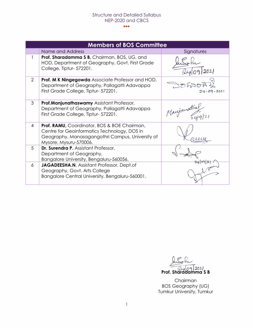
Members of BOS Committee Name and Address Signatures
1 Prof. Sharadamma S B, Chairman, BOS, UG, and
HOD, Department of Geography, Govt. First Grade
College, Tiptur- 572201.
2 Prof. M K Ningegowda Associate Professor and HOD,
Department of Geography, Pallagatti Adavappa
First Grade College, Tiptur- 572201.
3 Prof.Manjunathaswamy Assistant Professor,
Department of Geography, Pallagatti Adavappa
First Grade College, Tiptur- 572201.
4 Prof. RAMU, Coordinator, BOS & BOE Chairman,
Centre for Geoinformatics Technology, DOS in
Geography, Manasagangothri Campus, University of
Mysore, Mysuru-570006.
5 Dr. Surendra P. Assistant Professor,
Department of Geography,
Bangalore University, Bengaluru-560056.
6 JAGADEESHA.N, Assistant Professor, Dept.of
Geography, Govt. Arts College
Bangalore Central University, Bengaluru-560001.
Prof. Sharadamma S B
Chairman
BOS Geography (UG)
Tumkur University, Tumkur
Structure and Detailed Syllabus
NEP-2020 and CBCS
2
Model Curriculum Name of the Degree Program: B.A. /B.Sc. (Basic/Honors) Degree in Geography
Discipline Core: Geography
Starting year of implementation: 2021-2022
Programme Outcomes
By the end of the program the students will be able to:
(Refer to literature on outcome-based education (OBE) for details on Program Outcomes)
PO 1: Relating to Knowledge
By the end of the program the students will be able to:
1.1 Give explanation of relevant terms and concept of geography including definitions.
1.2 Give better explanation about relevant principles, theories and models in geography.
1.3 Show clear knowledge relating to man and environmental process and factors.
PO 2: Understanding and application
By the end of the program the students will be able to:
2.1 Identify the importance of spatial scale and time scale.
2.2 Know the complex and interactive nature of physical and human environments.
2.3 Identify the importance of the resemblances and variance between places,
environments and people.
2.4 Comprehend how processes bring changes in systems, distributions and
environments.
PO 3: Students Skills
By the end of the program the students will be able to:
3.1 Interpret a variety of types of geographical data and sources and recognize their
limitations.
3.2 Communicate geographical evidence, ideas and arguments.
3.3 Use geographical data to identify trends and patterns.
Structure and Detailed Syllabus
NEP-2020 and CBCS
3
3.4 Use diagrams and sketch maps to demonstrate geographical aspects.
3.5 Demonstrate skill of analysis and synthesis of geographical information.
PO 4: Students Evaluation
By the end of the program the students will be able to:
4.1 Critically evaluate geographical principles, theories and models
4.2 Assess the effects of geographical processes and change on physical and human
environments.
4.3 Assess how the viewpoints of different groups of people, potential conflicts of interest
and other factors interact in the management of physical and human
environments.
4.4 Evaluate the relative success of failure of initiatives.
Syllabus Aims
The aims of the syllabus describe the B.A. / B. Sc program in Geography at 5th, 6th, 7th & 8th
Level. These aims outline the educational context in which syllabus content should be viewed.
Many of these aims may be delivered by the use of suitable case-studies, through application
of geographical skills and through practical field visits. The B.A. /B. Sc Geography syllabus aims
to enable students to:
• Know the significance of scale in studying geography
• Know the processes functioning at various scales within physical and human environments
• Improve a sense of space, place and location
• Develop consciousness of the relevance of geography to understanding and solving
contemporary environmental problems
• Realization of the main fundamentals of physical geography and human geography and
the interconnectedness between them
• Explain the causes and effects of change over space and time on physical and human
environments
• Develop a gratefulness of the nature, value, limitations and importance of different
approaches to analyze and explanation in geography
• Increase the knowledge of, and ability to use and apply, appropriate skills and techniques
including fieldwork
• Improve a logical approach in order to present a structured, coherent and evidence-
based argument
• Develop a concern for accuracy and objectivity in extracting, recording, processing,
presenting, analyzing and interpreting geographical data.
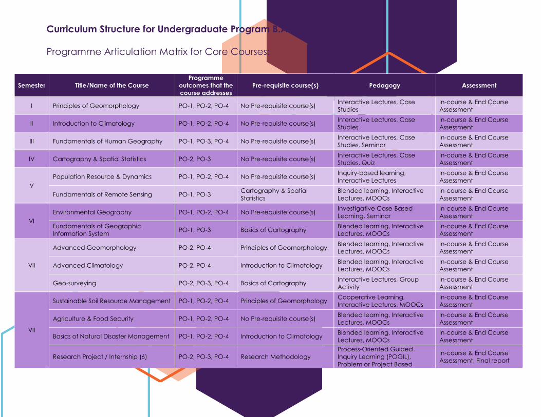
Semester Title/Name of the Course
Programme
outcomes that the
course addresses
Pre-requisite course(s) Pedagogy Assessment
I Principles of Geomorphology PO-1, PO-2, PO-4 No Pre-requisite course(s) Interactive Lectures, Case
Studies
In-course & End Course
Assessment
II Introduction to Climatology PO-1, PO-2, PO-4 No Pre-requisite course(s) Interactive Lectures, Case
Studies
In-course & End Course
Assessment
III Fundamentals of Human Geography PO-1, PO-3, PO-4 No Pre-requisite course(s) Interactive Lectures, Case
Studies, Seminar
In-course & End Course
Assessment
IV Cartography & Spatial Statistics PO-2, PO-3 No Pre-requisite course(s) Interactive Lectures, Case
Studies, Quiz
In-course & End Course
Assessment
V
Population Resource & Dynamics PO-1, PO-2, PO-4 No Pre-requisite course(s) Inquiry-based learning,
Interactive Lectures
In-course & End Course
Assessment
Fundamentals of Remote Sensing PO-1, PO-3 Cartography & Spatial
Statistics
Blended learning, Interactive
Lectures, MOOCs
In-course & End Course
Assessment
VI
Environmental Geography PO-1, PO-2, PO-4 No Pre-requisite course(s) Investigative Case-Based
Learning, Seminar
In-course & End Course
Assessment
Fundamentals of Geographic
Information System PO-1, PO-3 Basics of Cartography
Blended learning, Interactive
Lectures, MOOCs
In-course & End Course
Assessment
VII
Advanced Geomorphology PO-2, PO-4 Principles of Geomorphology Blended learning, Interactive
Lectures, MOOCs
In-course & End Course
Assessment
Advanced Climatology PO-2, PO-4 Introduction to Climatology Blended learning, Interactive
Lectures, MOOCs
In-course & End Course
Assessment
Geo-surveying PO-2, PO-3, PO-4 Basics of Cartography Interactive Lectures, Group
Activity
In-course & End Course
Assessment
VII
Sustainable Soil Resource Management PO-1, PO-2, PO-4 Principles of Geomorphology Cooperative Learning,
Interactive Lectures, MOOCs
In-course & End Course
Assessment
Agriculture & Food Security PO-1, PO-2, PO-4 No Pre-requisite course(s) Blended learning, Interactive
Lectures, MOOCs
In-course & End Course
Assessment
Basics of Natural Disaster Management PO-1, PO-2, PO-4 Introduction to Climatology Blended learning, Interactive
Lectures, MOOCs
In-course & End Course
Assessment
Research Project / Internship (6) PO-2, PO-3, PO-4 Research Methodology
Process-Oriented Guided
Inquiry Learning (POGIL),
Problem or Project Based
In-course & End Course
Assessment, Final report
Curriculum Structure for Undergraduate Program B.A. / B.Sc. Geography
Programme Articulation Matrix for Core Courses:
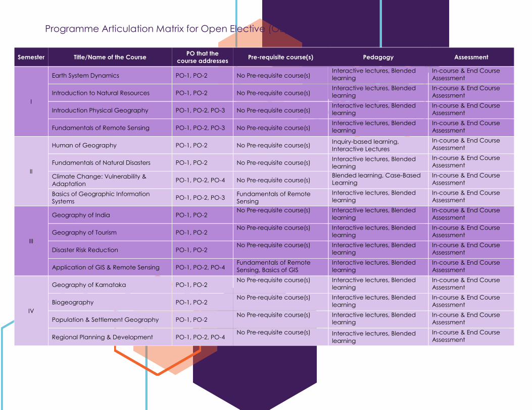
Programme Articulation Matrix for Open Elective (OE)
Semester Title/Name of the Course PO that the
course addresses Pre-requisite course(s) Pedagogy Assessment
I
Earth System Dynamics PO-1, PO-2 No Pre-requisite course(s) Interactive lectures, Blended
learning
In-course & End Course
Assessment
Introduction to Natural Resources PO-1, PO-2 No Pre-requisite course(s) Interactive lectures, Blended
learning
In-course & End Course
Assessment
Introduction Physical Geography PO-1, PO-2, PO-3 No Pre-requisite course(s) Interactive lectures, Blended
learning
In-course & End Course
Assessment
Fundamentals of Remote Sensing PO-1, PO-2, PO-3 No Pre-requisite course(s) Interactive lectures, Blended
learning
In-course & End Course
Assessment
II
Human of Geography PO-1, PO-2 No Pre-requisite course(s) Inquiry-based learning,
Interactive Lectures
In-course & End Course
Assessment
Fundamentals of Natural Disasters PO-1, PO-2 No Pre-requisite course(s) Interactive lectures, Blended
learning
In-course & End Course
Assessment
Climate Change: Vulnerability &
Adaptation PO-1, PO-2, PO-4 No Pre-requisite course(s)
Blended learning, Case-Based
Learning
In-course & End Course
Assessment
Basics of Geographic Information
Systems PO-1, PO-2, PO-3
Fundamentals of Remote
Sensing
Interactive lectures, Blended
learning
In-course & End Course
Assessment
III
Geography of India PO-1, PO-2 No Pre-requisite course(s) Interactive lectures, Blended
learning
In-course & End Course
Assessment
Geography of Tourism PO-1, PO-2 No Pre-requisite course(s) Interactive lectures, Blended
learning
In-course & End Course
Assessment
Disaster Risk Reduction PO-1, PO-2 No Pre-requisite course(s) Interactive lectures, Blended
learning
In-course & End Course
Assessment
Application of GIS & Remote Sensing PO-1, PO-2, PO-4 Fundamentals of Remote
Sensing, Basics of GIS
Interactive lectures, Blended
learning
In-course & End Course
Assessment
IV
Geography of Karnataka PO-1, PO-2 No Pre-requisite course(s) Interactive lectures, Blended
learning
In-course & End Course
Assessment
Biogeography PO-1, PO-2 No Pre-requisite course(s) Interactive lectures, Blended
learning
In-course & End Course
Assessment
Population & Settlement Geography PO-1, PO-2 No Pre-requisite course(s) Interactive lectures, Blended
learning
In-course & End Course
Assessment
Regional Planning & Development PO-1, PO-2, PO-4 No Pre-requisite course(s) Interactive lectures, Blended
learning
In-course & End Course
Assessment
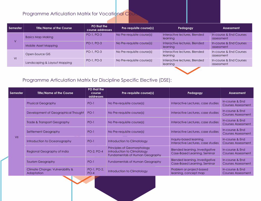
Programme Articulation Matrix for Discipline Specific Elective (DSE):
Programme Articulation Matrix for Vocational Courses:
Semester Title/Name of the Course PO that the
course addresses Pre-requisite course(s) Pedagogy Assessment
V
Basics Map Making PO-1, PO-3 No Pre-requisite course(s) Interactive lectures, Blended
learning
In-course & End Courses
assessment
Mobile Asset Mapping PO-1, PO-3 No Pre-requisite course(s) Interactive lectures, Blended
learning
In-course & End Courses
assessment
VI
Open-Source GIS PO-1, PO-3 No Pre-requisite course(s) Interactive lectures, Blended
learning
In-course & End Courses
assessment
Landscaping & Layout Mapping PO-1, PO-3 No Pre-requisite course(s) Interactive lectures, Blended
learning
In-course & End Courses
assessment
Semester Title/Name of the Course
PO that the
course
addresses
Pre-requisite course(s) Pedagogy Assessment
VII
Physical Geography PO-1 No Pre-requisite course(s) Interactive Lectures, case studies In-course & End
Courses Assessment
Development of Geographical Thought PO-1 No Pre-requisite course(s) Interactive Lectures, case studies In-course & End
Courses Assessment
Trade & Transport Geography PO-1 No Pre-requisite course(s) Interactive Lectures, case studies In-course & End
Courses Assessment
Settlement Geography PO-1 No Pre-requisite course(s) Interactive Lectures, case studies In-course & End
Courses Assessment
Introduction to Oceanography PO-1 Introduction to Climatology Inquiry-based learning,
Interactive Lectures, case studies
In-course & End
Courses Assessment
Regional Geography of India PO-2, PO-4
Principles of Geomorphology
Introduction to Climatology
Fundamentals of Human Geography
Blended learning, Investigative
Case-Based Learning, Seminar
In-course & End
Courses Assessment
Tourism Geography PO-1 Fundamentals of Human Geography Blended learning, Investigative
Case-Based Learning, Seminar
In-course & End
Courses Assessment
Climate Change: Vulnerability &
Adaptation
PO-1, PO-2,
PO-4 Introduction to Climatology
Problem or project-based
learning, concept map
In-course & End
Courses Assessment
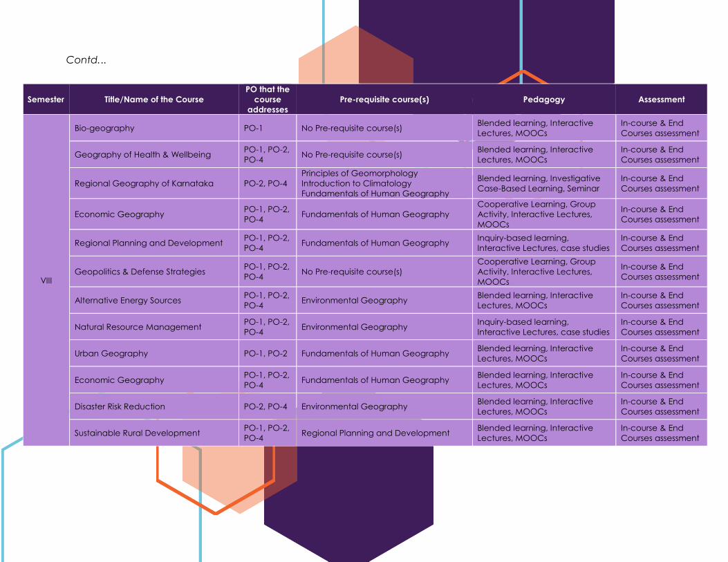
Contd...
Semester Title/Name of the Course
PO that the
course
addresses
Pre-requisite course(s) Pedagogy Assessment
VIII
Bio-geography PO-1 No Pre-requisite course(s) Blended learning, Interactive
Lectures, MOOCs
In-course & End
Courses assessment
Geography of Health & Wellbeing PO-1, PO-2,
PO-4 No Pre-requisite course(s)
Blended learning, Interactive
Lectures, MOOCs
In-course & End
Courses assessment
Regional Geography of Karnataka PO-2, PO-4
Principles of Geomorphology
Introduction to Climatology
Fundamentals of Human Geography
Blended learning, Investigative
Case-Based Learning, Seminar
In-course & End
Courses assessment
Economic Geography PO-1, PO-2,
PO-4 Fundamentals of Human Geography
Cooperative Learning, Group
Activity, Interactive Lectures,
MOOCs
In-course & End
Courses assessment
Regional Planning and Development PO-1, PO-2,
PO-4 Fundamentals of Human Geography
Inquiry-based learning,
Interactive Lectures, case studies
In-course & End
Courses assessment
Geopolitics & Defense Strategies PO-1, PO-2,
PO-4 No Pre-requisite course(s)
Cooperative Learning, Group
Activity, Interactive Lectures,
MOOCs
In-course & End
Courses assessment
Alternative Energy Sources PO-1, PO-2,
PO-4 Environmental Geography
Blended learning, Interactive
Lectures, MOOCs
In-course & End
Courses assessment
Natural Resource Management PO-1, PO-2,
PO-4 Environmental Geography
Inquiry-based learning,
Interactive Lectures, case studies
In-course & End
Courses assessment
Urban Geography PO-1, PO-2 Fundamentals of Human Geography Blended learning, Interactive
Lectures, MOOCs
In-course & End
Courses assessment
Economic Geography PO-1, PO-2,
PO-4 Fundamentals of Human Geography
Blended learning, Interactive
Lectures, MOOCs
In-course & End
Courses assessment
Disaster Risk Reduction PO-2, PO-4 Environmental Geography Blended learning, Interactive
Lectures, MOOCs
In-course & End
Courses assessment
Sustainable Rural Development PO-1, PO-2,
PO-4 Regional Planning and Development
Blended learning, Interactive
Lectures, MOOCs
In-course & End
Courses assessment
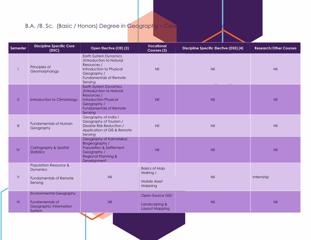
B.A. /B. Sc. (Basic / Honors) Degree in Geography – Course Types in the Programme
Semester Discipline Specific Core
(DSC) Open Elective (OE) (3)
Vocational
Courses (3) Discipline Specific Elective (DSE) (4) Research/Other Courses
I Principles of
Geomorphology
Earth System Dynamics
/Introduction to Natural
Resources /
Introduction to Physical
Geography /
Fundamentals of Remote
Sensing
Nil Nil Nil
II Introduction to Climatology
Earth System Dynamics
/Introduction to Natural
Resources /
Introduction Physical
Geography /
Fundamentals of Remote
Sensing
Nil Nil Nil
III Fundamentals of Human
Geography
Geography of India /
Geography of Tourism /
Disaster Risk Reduction /
Application of GIS & Remote
Sensing
Nil Nil Nil
IV Cartography & Spatial
Statistics
Geography of Karnataka/
Biogeography /
Population & Settlement
Geography /
Regional Planning &
Development
Nil Nil Nil
V
Population Resource &
Dynamics
Fundamentals of Remote
Sensing
Nil
Basics of Map
Making /
Mobile Asset
Mapping
Nil Internship
VI
Environmental Geography
Fundamentals of
Geographic Information
System
Nil
Open-Source GIS/
Landscaping &
Layout Mapping
Nil Nil
Structure and Detailed Syllabus
NEP-2020 and CBCS
1
VII
Advanced
Geomorphology
Advanced Climatology
Geo-surveying
Nil Nil
Physical Geography /
Development of Geographical Thought /
Trade & Transport Geography /
Settlement Geography
Introduction to Oceanography /
Regional Geography of India /
Tourism Geography /
Climate Change: Vulnerability &
Adaptation
Research
Methodology
VIII
Sustainable Soil Resource
Management
Agriculture & Food Security
Basics of Natural Disaster
Management
Nil Nil
Bio-geography /
Geography of Health & Wellbeing /
Regional Geography of Karnataka /
Economic Geography
Regional Planning and Development /
Geopolitics & Defense Strategies /
Alternative Energy Sources /
Natural Resource Management
Urban Geography /
Economic Geography /
Disaster Risk Reduction / Sustainable
Rural Development
Research Project /
Internship
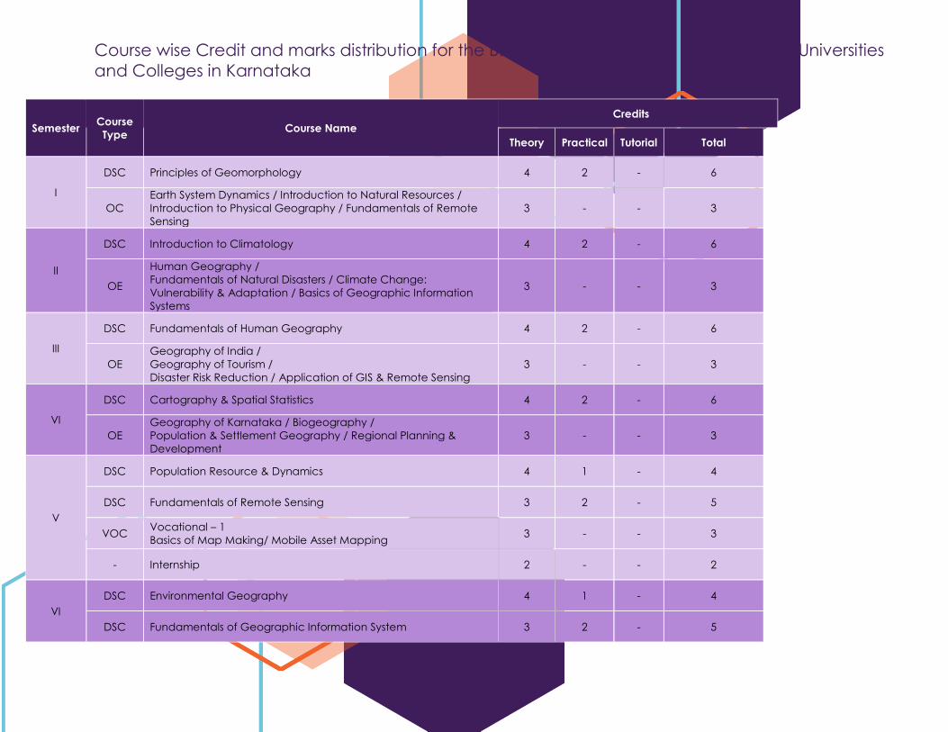
Course wise Credit and marks distribution for the B.A./B. Sc. (Basic/Hons) Geography in Universities
and Colleges in Karnataka
Semester Course
Type Course Name
Credits
Theory Practical Tutorial Total
I
DSC Principles of Geomorphology 4 2 - 6
OC
Earth System Dynamics / Introduction to Natural Resources /
Introduction to Physical Geography / Fundamentals of Remote
Sensing
3 - - 3
II
DSC Introduction to Climatology 4 2 - 6
OE
Human Geography /
Fundamentals of Natural Disasters / Climate Change:
Vulnerability & Adaptation / Basics of Geographic Information
Systems
3 - - 3
III
DSC Fundamentals of Human Geography 4 2 - 6
OE
Geography of India /
Geography of Tourism /
Disaster Risk Reduction / Application of GIS & Remote Sensing
3 - - 3
VI
DSC Cartography & Spatial Statistics 4 2 - 6
OE
Geography of Karnataka / Biogeography /
Population & Settlement Geography / Regional Planning &
Development
3 - - 3
V
DSC Population Resource & Dynamics 4 1 - 4
DSC Fundamentals of Remote Sensing 3 2 - 5
VOC Vocational – 1
Basics of Map Making/ Mobile Asset Mapping 3 - - 3
- Internship 2 - - 2
VI
DSC Environmental Geography 4 1 - 4
DSC Fundamentals of Geographic Information System 3 2 - 5
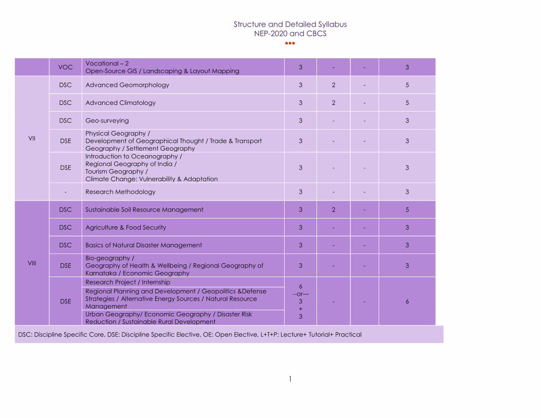
Structure and Detailed Syllabus
NEP-2020 and CBCS
1
VOC
Vocational – 2
Open-Source GIS / Landscaping & Layout Mapping 3 - - 3
VII
DSC Advanced Geomorphology 3 2 - 5
DSC Advanced Climatology 3 2 - 5
DSC Geo-surveying 3 - - 3
DSE
Physical Geography /
Development of Geographical Thought / Trade & Transport
Geography / Settlement Geography
3 - - 3
DSE
Introduction to Oceanography /
Regional Geography of India /
Tourism Geography /
Climate Change: Vulnerability & Adaptation
3 - - 3
- Research Methodology 3 - - 3
VIII
DSC Sustainable Soil Resource Management 3 2 - 5
DSC Agriculture & Food Security 3 - - 3
DSC Basics of Natural Disaster Management 3 - - 3
DSE
Bio-geography /
Geography of Health & Wellbeing / Regional Geography of
Karnataka / Economic Geography
3 - - 3
DSE
Research Project / Internship 6
--or—
3
+
3
- - 6
Regional Planning and Development / Geopolitics &Defense
Strategies / Alternative Energy Sources / Natural Resource
Management
Urban Geography/ Economic Geography / Disaster Risk
Reduction / Sustainable Rural Development
DSC: Discipline Specific Core, DSE: Discipline Specific Elective, OE: Open Elective, L+T+P: Lecture+ Tutorial+ Practical
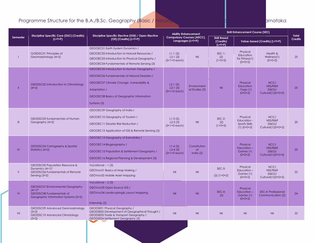
Programme Structure for the B.A./B.Sc. Geography (Basic / Honors) Degree in Universities and Colleges of Karnataka
Semester Discipline Specific Core (DSC) (Credits)
(L+T+P)
Discipline Specific Elective (DSE) / Open Elective
(OE) (Credits) (L+T+P)
Ability Enhancement
Compulsory Courses (AECC),
Languages (L+T+P)
Skill Enhancement Course (SEC)
Total
Credits Skill Based
(Credits)
(L+T+P)
Value-based (Credits) (L+T+P)
I
GOEDSC01 Principles of
Geomorphology (4+2)
GEOOEC01 Earth System Dynamics /
GEOOEC02 Introduction to Natural Resources /
GEOOEC03 Introduction to Physical Geography /
GEOOEC04 Fundamentals of Remote Sensing (3)
L1-1 (3),
L2-1 (3)
(3+1+0 each)
Nil
SEC-1:
(2)
(1+0+2)
Physical
Education
for Fitness(1)
(0+0+2)
Health &
Wellness(1)
(0+0+2)
25
II
GEODSC02 Introduction to Climatology
(4+2)
GEOOEC05 Introduction to Human Geography /
GEOOEC06 Fundamentals of Natural Disasters /
GEOOEC07 Climate Change: Vulnerability &
Adaptation /
GEOOEC08 Basics of Geographic Information
Systems (3)
L2-1 (3),
L2-1 (3)
(3+1+0 each)
Environment
al Studies (2) Nil
Physical
Education
- Yoga (1)
(0+0+2)
NCC/
NSS/R&R
(S&G)/
Cultural(1)(0+0+2)
25
III
GEODSC03 fundamentals of Human
Geography (4+2)
GEOOEC09 Geography of India /
GEOOEC10 Geography of Tourism /
GEOOEC11 Disaster Risk Reduction /
GEOOEC12 Application of GIS & Remote Sensing (3)
L1-3 (3),
L2-3 (3)
(3+1+0 each)
Nil
SEC-2:
(2)
(1+0+2)
Physical
Education -
Sports Skills
(1) (0+0+2)
NCC/
NSS/R&R
(S&G)/
Cultural(1)(0+0+2)
25
IV
GEODSC04 Cartography & Spatial
Statistics (4+2)
GEOOEC13 Geography of Karnataka /
GEOOEC14 Biogeography /
GEOOEC15 Population & Settlement Geography /
GEOOEC16 Regional Planning & Development (3)
L1-4 (3),
L2-4 (3)
(3+1+0 each)
Constitution
of
India (2)
Physical
Education –
Games (1)
(0+0+2)
NCC/
NSS/R&R
(S&G)/
Cultural(1)(0+0+2)
25
V
GEODSC05 Population Resource &
Dynamics (4+1)*
GEODSC06 Fundamentals of Remote
Sensing (3+2)
Vocational – 1 (3)
GEOVoc01 Basics of Map Making /
GEOVoc02 Mobile Asset Mapping
Nil Nil
SEC-3:
(2) (1+0+2)
Physical
Education –
Games (1)
(0+0+2)
NCC/
NSS/R&R
(S&G)/
Cultural(1)(0+0+2)
22
VI
GEODSC07 Environmental Geography
(4+1)*
GEODSC08 Fundamentals of
Geographic Information Systems (3+2)
Vocational – 2 (3)
GEOVoc03 Open-Source GIS /
GEOVoc04 Landscaping& Layout Mapping
Internship (2)
Nil Nil SEC-4:
(2)
Physical
Education –
Games (1)
(0+0+2)
SEC-4: Professional
Communication (2) 24
VII
GEODSC09 Advanced Geomorphology
(3+2)
GEODSC10 Advanced Climatology
(3+2)
GEODSE01 Physical Geography /
GEODSE02 Development of Geographical Thought /
GEODSE03 Trade & Transport Geography /
GEODSE04 Settlement Geography (3)
Nil Nil Nil Nil Nil 22
Structure and Detailed Syllabus
NEP-2020 and CBCS
1
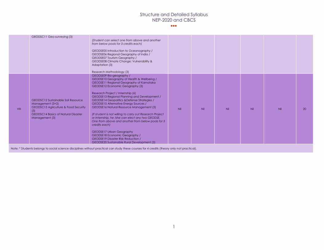
GEODSC11 Geo-surveying (3)
(Student can select one from above and another
from below pools for 3 credits each)
GEODSE05 Introduction to Oceanography /
GEODSE06 Regional Geography of India /
GEODSE07 Tourism Geography /
GEODSE08 Climate Change: Vulnerability &
Adaptation (3)
Research Methodology (3)
VIII
GEODSC12 Sustainable Soil Resource
Management (3+2)
GEODSC13 Agriculture & Food Security
(3)
GEODSC14 Basics of Natural Disaster
Management (3)
GEODSE09 Bio-geography /
GEODSE10 Geography of Health & Wellbeing /
GEODSE11 Regional Geography of Karnataka
GEODSE12 Economic Geography (3)
Research Project / Internship (6)
GEODSE13 Regional Planning and Development /
GEODSE14 Geopolitics &Defense Strategies /
GEODSE15 Alternative Energy Sources /
GEODSE16 Natural Resource Management (3)
(If student is not willing to carry out Research Project
or Internship, he /she can elect any two GEODSE.
One from above and another from below pools for 3
credits each)
GEODSE17 Urban Geography
GEODSE18 Economic Geography /
GEODSE19 Disaster Risk Reduction /
GEODSE20 Sustainable Rural Development (3)
Nil Nil Nil Nil Nil 20
Note: * Students belongs to social science disciplines without practical can study these courses for 4 credits (theory only not practical).
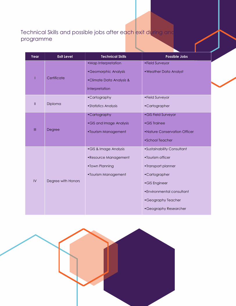
Technical Skills and possible jobs after each exit during and after the
programme
Year Exit Level Technical Skills Possible Jobs
I Certificate
•Map Interpretation
•Geomorphic Analysis
•Climate Data Analysis &
Interpretation
•Field Surveyor
•Weather Data Analyst
II Diploma
•Cartography
•Statistics Analysis
•Field Surveyor
•Cartographer
III Degree
•Cartography
•GIS and Image Analysis
•Tourism Management
•GIS Field Surveyor
•GIS Trainee
•Nature Conservation Officer
•School Teacher
IV Degree with Honors
•GIS & Image Analysis
•Resource Management
•Town Planning
•Tourism Management
•Sustainability Consultant
•Tourism officer
•Transport planner
•Cartographer
•GIS Engineer
•Environmental consultant
•Geography Teacher
•Geography Researcher
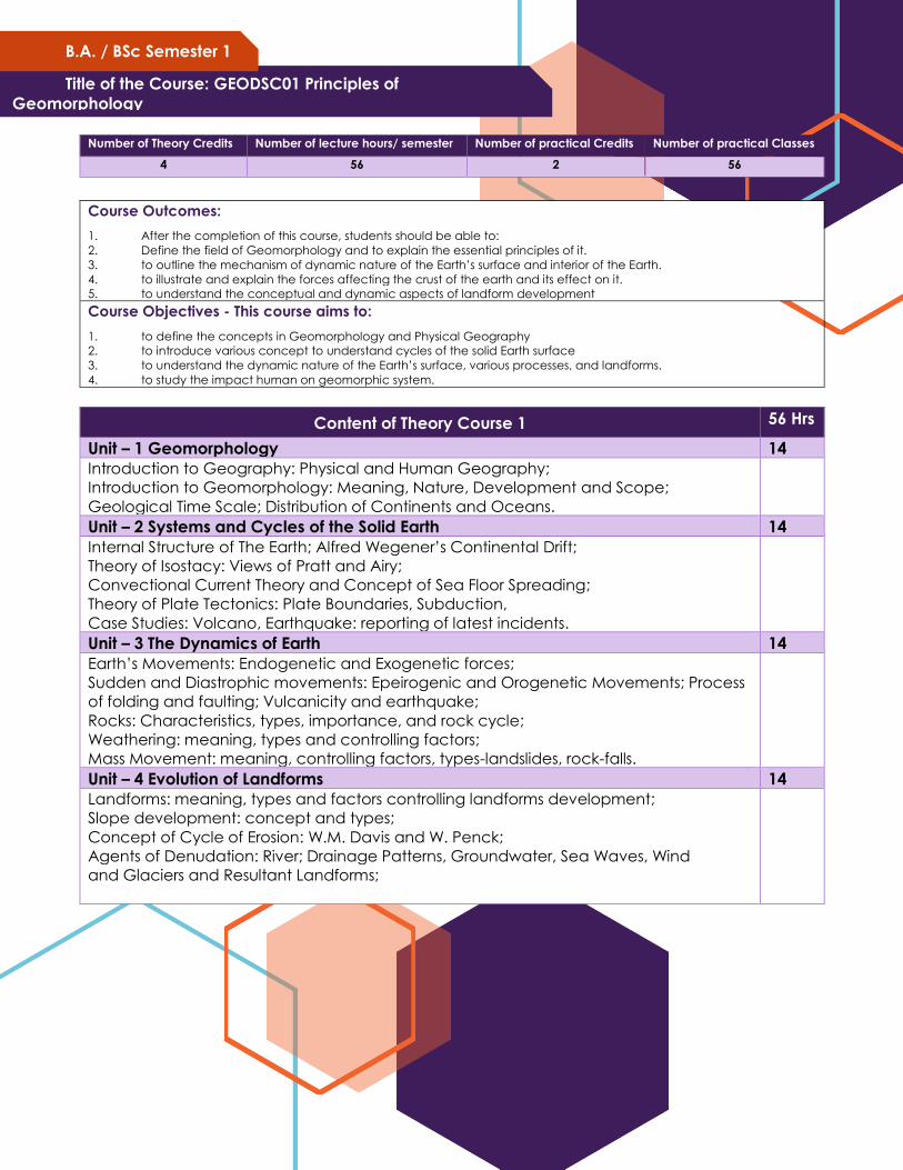
Title of the Course: GEODSC01 Principles of
Geomorphology
B.A. / BSc Semester 1
Number of Theory Credits Number of lecture hours/ semester Number of practical Credits Number of practical Classes
4 56 2 56
Course Outcomes:
1. After the completion of this course, students should be able to:
2. Define the field of Geomorphology and to explain the essential principles of it.
3. to outline the mechanism of dynamic nature of the Earth’s surface and interior of the Earth.
4. to illustrate and explain the forces affecting the crust of the earth and its effect on it.
5. to understand the conceptual and dynamic aspects of landform development Course Objectives - This course aims to:
1. to define the concepts in Geomorphology and Physical Geography
2. to introduce various concept to understand cycles of the solid Earth surface
3. to understand the dynamic nature of the Earth’s surface, various processes, and landforms.
4. to study the impact human on geomorphic system.
Content of Theory Course 1 56 Hrs
Unit – 1 Geomorphology 14
Introduction to Geography: Physical and Human Geography;
Introduction to Geomorphology: Meaning, Nature, Development and Scope;
Geological Time Scale; Distribution of Continents and Oceans.
Unit – 2 Systems and Cycles of the Solid Earth 14
Internal Structure of The Earth; Alfred Wegener’s Continental Drift;
Theory of Isostacy: Views of Pratt and Airy;
Convectional Current Theory and Concept of Sea Floor Spreading;
Theory of Plate Tectonics: Plate Boundaries, Subduction,
Case Studies: Volcano, Earthquake: reporting of latest incidents.
Unit – 3 The Dynamics of Earth 14
Earth’s Movements: Endogenetic and Exogenetic forces;
Sudden and Diastrophic movements: Epeirogenic and Orogenetic Movements; Process
of folding and faulting; Vulcanicity and earthquake;
Rocks: Characteristics, types, importance, and rock cycle;
Weathering: meaning, types and controlling factors;
Mass Movement: meaning, controlling factors, types-landslides, rock-falls.
Unit – 4 Evolution of Landforms 14
Landforms: meaning, types and factors controlling landforms development;
Slope development: concept and types;
Concept of Cycle of Erosion: W.M. Davis and W. Penck;
Agents of Denudation: River; Drainage Patterns, Groundwater, Sea Waves, Wind
and Glaciers and Resultant Landforms;
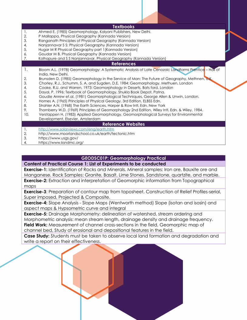
Textbooks 1. Ahmed E. (1985) Geomorphology, Kalyani Publishers, New Delhi.
2. P Mallappa, Physical Geography (Kannada Version)
3. Ranganath Principles of Physical Geography (Kannada Version)
4. Nanjannavar S S: Physical Geography (Kannada Version)
5. Hugar M R Physical Geography part 1(Kannada Version)
6. Goudar M B, Physical Geography (Kannada Version)
7. Kolhapure and S S Nanjannavar, Physical Geography (Kannada Version)
References
1. Bloom A.L. (1978) Geomorphology: A Systematic Analysis of Late Cenozoic Landforms Prentice – Hall of
India, New Delhi.
2. Brunsden D. (1985) Geomorphology in the Service of Man: The Future of Geography, Methnen, U.K.
3. Chorley, R.J., Schumm, S. A. and Sugden, D.E. 1984: Geomorphology, Methuen, London
4. Cooke, R.U. and Warren, 1973: Geomorphology in Deserts, Bats ford, London
5. Dayal, P. 1996: Textbook of Geomorphology, Shukla Book Depot, Patna.
6. Goudie Anrew et.al. (1981) Geomorphological Techniques, George Allen & Unwin, London.
7. Homes A. (1965) Principles of Physical Geology, 3rd Edition, ELBSS Edn.
8. Strahler A.N. (1968) The Earth Sciences, Harper & Row Intl. Edn, New York
9. Thornberry W.D. (1969) Principles of Geomorphology 2nd Edition, Wiley Intl. Edn. & Wiley, 1984.
10. Verstappen H. (1983) Applied Geomorphology, Geomorphological Surveys for Environmental
Development, Elsevier, Amsterdam
Reference Websites 1. http://www.solarviews.com/eng/earth.htm
2. http://www.moorlandschool.co.uk/earth/tectonic.htm
3. https://www.usgs.gov/
4. https://www.ksndmc.org/
GEODSC01P: Geomorphology Practical
Content of Practical Course 1: List of Experiments to be conducted
Exercise-1: Identification of Rocks and Minerals. Mineral samples: Iron ore, Bauxite ore and
Manganese. Rock Samples: Granite, Basalt, Lime Stones, Sandstone, quartzite, and marble.
Exercise-2: Extraction and interpretation of Geomorphic information from Topographical
maps
Exercise-3: Preparation of contour map from toposheet, Construction of Relief Profiles-serial,
Super imposed, Projected & Composite.
Exercise-4: Slope Analysis - Slope Maps (Wentworth method) Slope (isotan and isosin) and
aspect maps & Hypsometric curve and integral
Exercise-5: Drainage Morphometry: delineation of watershed, stream ordering and
Morphometric analysis: mean stream length, drainage density and drainage frequency.
Field Work: Measurement of channel cross-sections in the field, Geomorphic map of
channel bed, Study of erosional and depositional features in the field.
Case Study: Students must be taken to observe local land formation and degradation and
write a report on their effectiveness.
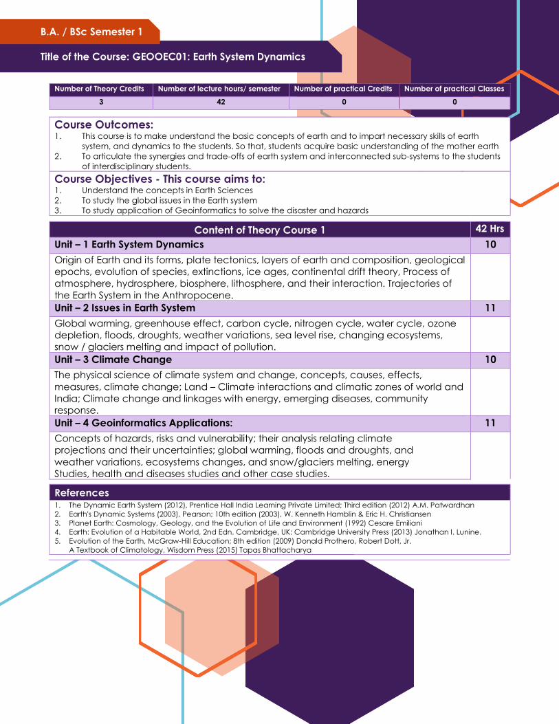
Title of the Course: GEOOEC01: Earth System Dynamics
B.A. / BSc Semester 1
Number of Theory Credits Number of lecture hours/ semester Number of practical Credits Number of practical Classes
3 42 0 0
Course Outcomes: 1. This course is to make understand the basic concepts of earth and to impart necessary skills of earth
system, and dynamics to the students. So that, students acquire basic understanding of the mother earth
2. To articulate the synergies and trade-offs of earth system and interconnected sub-systems to the students
of interdisciplinary students.
Course Objectives - This course aims to: 1. Understand the concepts in Earth Sciences
2. To study the global issues in the Earth system
3. To study application of Geoinformatics to solve the disaster and hazards
Content of Theory Course 1 42 Hrs
Unit – 1 Earth System Dynamics 10
Origin of Earth and its forms, plate tectonics, layers of earth and composition, geological
epochs, evolution of species, extinctions, ice ages, continental drift theory, Process of
atmosphere, hydrosphere, biosphere, lithosphere, and their interaction. Trajectories of
the Earth System in the Anthropocene.
Unit – 2 Issues in Earth System 11
Global warming, greenhouse effect, carbon cycle, nitrogen cycle, water cycle, ozone
depletion, floods, droughts, weather variations, sea level rise, changing ecosystems,
snow / glaciers melting and impact of pollution.
Unit – 3 Climate Change 10
The physical science of climate system and change, concepts, causes, effects,
measures, climate change; Land – Climate interactions and climatic zones of world and
India; Climate change and linkages with energy, emerging diseases, community
response.
Unit – 4 Geoinformatics Applications: 11
Concepts of hazards, risks and vulnerability; their analysis relating climate
projections and their uncertainties; global warming, floods and droughts, and
weather variations, ecosystems changes, and snow/glaciers melting, energy
Studies, health and diseases studies and other case studies.
References 1. The Dynamic Earth System (2012), Prentice Hall India Learning Private Limited; Third edition (2012) A.M. Patwardhan
2. Earth's Dynamic Systems (2003), Pearson; 10th edition (2003), W. Kenneth Hamblin & Eric H. Christiansen
3. Planet Earth: Cosmology, Geology, and the Evolution of Life and Environment (1992) Cesare Emiliani
4. Earth: Evolution of a Habitable World, 2nd Edn. Cambridge, UK: Cambridge University Press (2013) Jonathan I. Lunine.
5. Evolution of the Earth, McGraw-Hill Education; 8th edition (2009) Donald Prothero, Robert Dott, Jr.
A Textbook of Climatology, Wisdom Press (2015) Tapas Bhattacharya
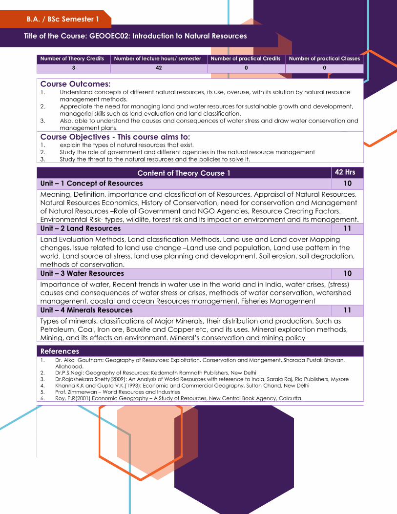
Title of the Course: GEOOEC02: Introduction to Natural Resources
B.A. / BSc Semester 1
Number of Theory Credits Number of lecture hours/ semester Number of practical Credits Number of practical Classes
3 42 0 0
Course Outcomes: 1. Understand concepts of different natural resources, its use, overuse, with its solution by natural resource
management methods.
2. Appreciate the need for managing land and water resources for sustainable growth and development,
managerial skills such as land evaluation and land classification.
3. Also, able to understand the causes and consequences of water stress and draw water conservation and
management plans.
Course Objectives - This course aims to: 1. explain the types of natural resources that exist.
2. Study the role of government and different agencies in the natural resource management
3. Study the threat to the natural resources and the policies to solve it.
Content of Theory Course 1 42 Hrs
Unit – 1 Concept of Resources 10
Meaning, Definition, importance and classification of Resources, Appraisal of Natural Resources,
Natural Resources Economics, History of Conservation, need for conservation and Management
of Natural Resources –Role of Government and NGO Agencies, Resource Creating Factors.
Environmental Risk- types, wildlife, forest risk and its impact on environment and its management.
Unit – 2 Land Resources 11
Land Evaluation Methods, Land classification Methods, Land use and Land cover Mapping
changes. Issue related to land use change –Land use and population, Land use pattern in the
world. Land source at stress, land use planning and development. Soil erosion, soil degradation,
methods of conservation.
Unit – 3 Water Resources 10
Importance of water, Recent trends in water use in the world and in India, water crises, (stress)
causes and consequences of water stress or crises, methods of water conservation, watershed
management, coastal and ocean Resources management, Fisheries Management
Unit – 4 Minerals Resources 11
Types of minerals, classifications of Major Minerals, their distribution and production. Such as
Petroleum, Coal, Iron ore, Bauxite and Copper etc, and its uses. Mineral exploration methods,
Mining, and its effects on environment. Mineral’s conservation and mining policy
References
1. Dr. Alka Gautham: Geography of Resources: Exploitation, Conservation and Mangement, Sharada Pustak Bhavan,
Allahabad.
2. Dr.P.S.Negi: Geography of Resources: Kedarnath Ramnath Publishers, New Delhi
3. Dr.Rajashekara Shetty(2009): An Analysis of World Resources with reference to India, Sarala Raj, Ria Publishers, Mysore
4. Khanna K.K and Gupta V.K.(1993): Economic and Commercial Geography, Sultan Chand, New Delhi
5. Prof. Zimmerwan – World Resources and Industries
6. Roy, P.R(2001) Economic Geography – A Study of Resources, New Central Book Agency, Calcutta.
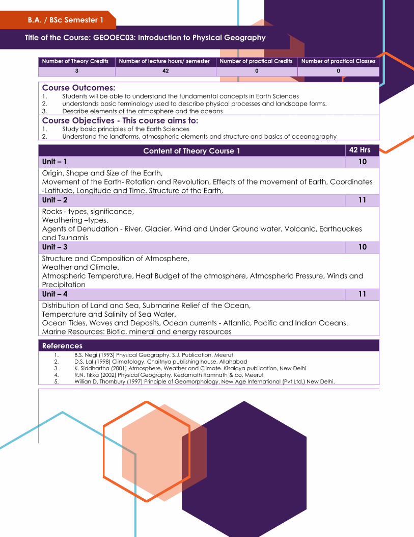
Title of the Course: GEOOEC03: Introduction to Physical Geography
B.A. / BSc Semester 1
Number of Theory Credits Number of lecture hours/ semester Number of practical Credits Number of practical Classes
3 42 0 0
Course Outcomes: 1. Students will be able to understand the fundamental concepts in Earth Sciences
2. understands basic terminology used to describe physical processes and landscape forms.
3. Describe elements of the atmosphere and the oceans
Course Objectives - This course aims to: 1. Study basic principles of the Earth Sciences
2. Understand the landforms, atmospheric elements and structure and basics of oceanography
Content of Theory Course 1 42 Hrs
Unit – 1 10
Origin, Shape and Size of the Earth,
Movement of the Earth- Rotation and Revolution, Effects of the movement of Earth, Coordinates
-Latitude, Longitude and Time. Structure of the Earth,
Unit – 2 11
Rocks - types, significance,
Weathering –types.
Agents of Denudation - River, Glacier, Wind and Under Ground water. Volcanic, Earthquakes
and Tsunamis
Unit – 3 10
Structure and Composition of Atmosphere,
Weather and Climate.
Atmospheric Temperature, Heat Budget of the atmosphere, Atmospheric Pressure, Winds and
Precipitation
Unit – 4 11
Distribution of Land and Sea, Submarine Relief of the Ocean,
Temperature and Salinity of Sea Water.
Ocean Tides, Waves and Deposits, Ocean currents - Atlantic, Pacific and Indian Oceans.
Marine Resources: Biotic, mineral and energy resources
References
1. B.S. Negi (1993) Physical Geography. S.J. Publication, Meerut
2. D.S. Lal (1998) Climatology. Chaitnya publishing house, Allahabad
3. K. Siddhartha (2001) Atmosphere, Weather and Climate. Kisalaya publication, New Delhi
4. R.N. Tikka (2002) Physical Geography. Kedarnath Ramnath & co, Meerut
5. Willian D. Thornbury (1997) Principle of Geomorphology. New Age International (Pvt Ltd.) New Delhi.
Title of the Course: GEOOEC04: Fundamentals of Remote Sensing
B.A. / BSc Semester 1
Number of Theory Credits Number of lecture hours/ semester Number of practical Credits Number of practical Classes
3 42 0 0
Course Outcomes: 1. This course is to make understand the basic concepts of Remote Sensing and to impart necessary skills of
remote sensing analysis, and image interpretation to the students. So that, students acquire employable
skills in remote sensing.
2. Students will learn how to handle and process the satellite images for understanding of biophysical
phenomena of the earth system.
Course Objectives - This course aims to: 1. To congregate the basic concepts and fundamentals of physical principles of remote sensing
2. To create a firm basis for successful integration of remote sensing in any field of application.
3. To study basics of digital image processing and image interpretation techniques.
4. To study the applications of the remote sensing to solve the real-world problems.
Content of Theory Course 1 42 Hrs
Unit – 1 Introduction 10
Definition of Remote Sensing, developmental stages, Laws of Physics, electromagnetic waves,
spectrum, regions, wavelength, frequencies, and applications. Types-Satellites, Sensors,
Payloads, Orbits, telemetry of satellites.
Unit – 2 Process and types of Remote Sensing 11
Process of remote sensing, interaction of radiation with atmosphere and targets, atmospheric
noises, attenuation in radiance, resolutions of remote sensing, optical remote sensing, visible
region of the spectrum, thermal remote sensing, microwave remote sensing, Hyper spectral
remote sensing, LADAR, and other Remote sensing platforms.
Unit – 3 Image Classification and Interpretation 10
Satellite products and its spectral characteristics, composite images, band ratios; Land use land
cover classification schemes-Anderson and NRSC; Visual image interpretation, elements, stages
of interpretation and interpretation keys. Image classification- supervised, unsupervised, and
principal component analysis (PCA) and accuracy assessment.
Unit – 4 Applications of Remote Sensing 11
Disaster Management, Meteorological Studies, Agricultural and Irrigation Studies,
Forestry Studies, Hydrological Studies, Natural Resource, Oceanic and Coastal
Mapping, Soil resource mapping, Urban and Rural Mapping and Management.
References 1. Remote Sensing of the Environment: An Earth Resource Perspective (Prentice Hall Series in Geographic
Information Science) - Second Edition (2006), John Jensen
2. Remote Sensing and GIS, Second Edition (2011), Bhatta, B.
3. Introduction to Remote Sensing and Image Interpretation (2003); Lille sand T.M.
4. Remote sensing and image interpretation (2015); Chipman, Jonathan W., Kiefer, RalphW., Lille sand
5. Introduction to Remote Sensing, Fifth Edition (2011); James B. Campbell, Randolph H.Wynne
6. Practical handbook of remote sensing, First Edition (2016) - Lavender, Andrew, Lavender, Samantha
7. Introductory Digital Image Processing: A Remote Sensing Perspective, Fourth Edition(2015) - John R. Jensen
8. Image processing and GIS for remote sensing: techniques and applications; Second Edition (2016) - Liu, Jian-
Guo, Mason, Philippe J
9. https://onlinecourses.nptel.ac.in/noc19_ce41/preview
Number of Theory Credits Number of lecture hours/ semester Number of practical Credits Number of practical Classes
4 56 2 56
Course Outcomes: After the completion of this course, students should be able to
1. Define the field of climatology and to understand the atmospheric composition and structure.
2. To outline the mechanism and process of solar radiation transfer to earth surface and to ex- plain the
temperature distribution and variation according to time and space.
3. To illustrate and explain the air pressure system, wind regulating forces and the formation of the
Atmospheric Disturbance.
4. To understand and compute the air humidity as well as to explain the process of Condensation and
formation of precipitation and its types.
Course Objectives - This course aims to: 1. To define the field of climatology and components of the climate system
2. To introduce various dimensions of climatology like structure and composition.
3. To understand the global atmospheric pressure, temperature, and wind system.
4. To study the concept of atmospheric moisture and its types
Content of Theory Course 1 56 Hrs
Unit – 1 Composition and Structure of the Atmosphere 14
Nature and Scope of Climatology,
Atmospheric Sciences; Climatology and Meteorology
Origin and structure of the Atmosphere: Troposphere, Stratosphere, Mesosphere, Ionosphere,
Exosphere and their characteristics. Composition of the atmosphere
Weather and Climate
Unit – 2 Atmospheric Temperature 14
Insolation: Definition, Mechanism, Solar Constant.
Factors affecting the Insolation: Angle of incidence, length of the day, Sunspots, Distance
between the earth and the sun, effect of the atmosphere.
Heating and cooling process of the atmosphere-Radiation, Conduction, convection, and
advection.
Temperature: meaning and Influencing Factors on the Distribution of Temperature
Distribution of the temperature: Vertical, Horizontal, and Inversion of temperature.
Global Energy Budget: Incoming shortwave solar radiation, Outgoing Long wave Terrestrial
radiation, Albedo. Net Radiation and Latitudinal Heat Balances.
Unit – 3 Atmospheric Pressure and Winds 14
Atmospheric Pressure: Influencing factors on atmospheric pressure. Vertical and Horizontal
Distribution of the atmospheric pressure and Pressure Belts, Pressure Gradient.
Tri-cellular-Hadley, Ferrel’s and Polar Cells.
Winds: influencing factors, Types - planetary, seasonal, local wind Variable winds-Cyclones and
anti-cyclones.
Air-Masses and Fronts: Definition, Nature, Source Regions, Classification.
Unit – 4 Atmospheric Moisture 14
Humidity: Sources, influencing factors and types-Absolute, Relative and Specific.
Hydrological cycle: process of evaporation, condensation. Clouds and its types Precipitation
and its forms.
Climate Change: Causes and consequences, recent issues-floods, drought,
Title of the Course: GEODSC02: Introduction to Climatology
B.A. / BSc Semester 2
Structure and Detailed Syllabus
NEP-2020 and CBCS
1
Textbooks
1. Lal, D. S. (1998). Climatology. Allahabad: Chaitanya Publishing House.
2. P Mallappa, Physical Geography (Kannada Version)
3. Ranganath Principles of Physical Geography (Kannada Version)
4. Nanjannavar S S: Physical Geography (Kannada Version)
5. Hugar M R Physical Geography part 1(Kannada Version)
6. Goudar M B, Physical Geography (Kannada Version)
7. Kolhapure and S S Nanjan, Physical Geography (Kannada Version)
References
8. Lutgens, Frederic K. & Tarbuck, Edward J. (2010). The Atmosphere: An Introduction to Meteorology. New Jersey:
Pearson Prentice Hall.
9. Oliver, John E. & Hidore, John J. (2003). Climatology: An Atmospheric Science. Delhi: Pearson Education.
10. Singh, S. (2005). Climatology. Allahabad: Prayag Pustak Bhawan.
11. Barry, R.G. and Chorley, R.J. (2003): Atmosphere, Weather and Climate; Psychology Press, Hove; East Sussex.
12. Critchfield, H.J., (1975): general Climatology, Prentice Hall, New Jersey.
13. Mather,J.R.(1974): Climatology: Fundamentals and Applications; Mc Craw Hill Book Co., U.S.A.
14. Rumney, G.R. (1968): Climatology and the World Climates, Macmillan, London.
15. Trewartha, G.T. (1980): An Introduction to Climate; McGraw Hill, New York, 5th edition, (International Student Edition)
Reference Websites
1. https://earthobservatory.nasa.gov/
2. https://mausam.imd.gov.in/
3. https://www.weatheronline.in/
4. https://earthexplorer.usgs.gov/
5. https://www.nhc.noaa.gov/satellite.php
GEODSC02P: Climatology Practical
Content of Practical Course 1: List of Experiments to be conducted
Conduct all exercises with Goal, Procedure, devices, and findings.
Exercise 1: Structure and functions of the Indian Meteorological Department (IMD).
Exercise 2: Collection of temperature data from IMD website.
Exercise 3: Plotting of downloaded temperature data using graphical methods-line graph.
Exercise 4: Centigrade and Fahrenheit thermometer for measuring temperature.
Exercise 5: Mercurial Barometer and Aneroid Barometer for measuring atmospheric pressure
Exercise 6: Wind Vane and cup-anemometer.
Exercise 7: Wet and Dry bulb thermometer for measuring humidity
Exercise 8: Rainguage- Dial type for measuring rainfall
Exercise 9:Rainfall Trend Analysis (monthly and annual)
Exercise 10: Interpretation of Indian Daily Weather charts.
Note: Students are expected to download weather charts of the four seasons.
Title of the Course: GEOOEC05: Introduction to Human Geography
B.A. / BSc Semester 2
Number of Theory Credits Number of lecture hours/ semester Number of practical Credits Number of practical Classes
3 42 0 0
Course Outcomes: 1. Students will learn how human, physical, and environmental components of the world interact.
2. Students will be familiarized with economic processes such as globalization, trade and their impacts on
economic, cultural and social activities.
3. the student will Describe what geography and human geography are.
4. Understand population dynamics and migration.
Course Objectives - This course aims to: 1. Understand the basics concepts of human geography
2. Study population attributes and dynamic nature of it
3. Introduce economic, cultural, and trade activities and their impact on the development of the region
Content of Theory Course 1 42 Hrs
Unit – 1 Introduction to Human Geography 10
Nature and scope, Development;
Environmental Determinism and Possibilism, Neo determinism (stop and go determinism),
Approaches to human geography: Exploration and Descriptive approach, regional analysis
Approach, Areal Differentiation Approach, Spatial organization Approach.
Modern approaches: Welfare or Humanistic Approach, Radical Approach, Behavioural
Approach, Post Modernism in geography;
Fields and sub fields in Human geography
Unit – 2 Geographical Analysis of Population 11
Distribution and Growth of Population;
Density of Population: meaning and Types: Arithmetic Density and Physiological Density.
Regional Distribution of Density of Population. Carrying capacity and sustainability, population
Pyramid;
Population Theories: Malthus Theory of Population, Demographic Transition Theory;
Population Movement: Migration, Raven stein’s Law of Migration, Factors of population
Migration, Economic Push and Pull factors, Cultural Push and Pull Factors, Environmental Push
and Pull Factors; Migration Types: Immigration and Emigration, Internal and International
Migration
Unit – 3 Cultural Patterns and Processes 10
Concept of Culture, Material and Non material culture;
Cultural Regions, Cultural Traits and Complexes, cultural Hearths, cultural Diffusion;
Languages of the World: Types, Classification and Distribution, Language Extinction;
Religions: Types and Classification, Distribution.
Universalizing Religions: Christianity, Islam, Buddhism. Ethnic Religions: Hinduism, the Chinese
religion, Shintoism, Judaism.
The Major tribal population of the world.
Unit – 4 Human Economic Activities, Development and Settlements 11
Primary Economic Activities – Agriculture, Types - Primitive Subsistence, Intensive subsistence,
Plantation Agriculture, Extensive Commercial grain cultivation, Mixed Farming, Dairy Farming;
Structure and Detailed Syllabus
NEP-2020 and CBCS
1
Secondary and Tertiary Activities: Manufacturing, classification – based on size – Small Scale and
Large scale. Based on Raw material – Argo-based, Mineral based, Chemical Based and Forest
based. Industrial Regions of the world;
Tertiary Activities: Types: Trade and commerce, Retail Trading services, Wholesale trading.
Transport and communications: Factors, communication services – Telecommunication.
Services: Informal and Non formal sector. Information technology and service; Human
Settlements: Factors, Classification, Types and Patterns: Rural, Urban. Compact or Nucleated
and Dispersed settlements. Rural settlement Patterns: linear, rectangular, circular, star shaped, T
shaped;
Urban settlements: urbanism, classification – population size, occupation structure,
Administration. Functional classification of urban centres, types of urban settlements: towns, city,
conurbation, Megalopolis, Million cities.
References 1. Hartshorne, T. A., & Alexander, J. W. (2010). Economic Geography. New Delhi: PHI Learning.
2. Knox, P., Agnew, J., & McCarthy, L. (2008). The Geography of the World Economy. London: Hodder Arnold.
3. Lloyd, P., & Dicken, B. (1972). Location in Space: A Theoretical Approach to Economic Geography. New
York: Harper and Row.
4. Siddhartha, K. (2000). Economic Geography: Theories, Process and Patterns, New Delhi: Kisalaya
Publications.
5. Smith, D. M. (1971). Industrial Location: An Economic Geographical Analysis, New York: John Wiley and
Sons.
Title of the Course: GEOOEC06: Fundamentals of Natural
disasters
B.A. / BSc Semester 2
Number of Theory Credits Number of lecture hours/ semester Number of practical Credits Number of practical Classes
3 42 0 0
Course Outcomes: 1. Understand the basics concepts in natural disasters
2. Study types of natural disasters and their effects
Course Objectives - This course aims to: 1. The paper is intended to provide a general concept in the dimensions of disasters caused by nature
beyond the human control.
2. Introduce a holistic classification of natural disasters considering the Earth Sciences
3. Demonstrate the devastating effect of natural disasters to society;
Content of Theory Course 1 42 Hrs.
Unit – 1 Introduction to Natural Disaster 10
Meaning, Definition, and Scope.
Lithosphere and Natural Disasters
Earthquakes and Volcanoes,
Landslides And Avalanches
Unit – 2 Atmosphere and Natural Disasters 11
Heat wave and wildfire
Cloud burst, hailstorm,
Drought and famines
Hydrosphere and Natural Disaster 10
Tsunami
Hurricanes and cyclones
Floods and flash floods
Biosphere and Natural Disasters 11
Epidemics and pandemics
Covid -19 and its effects
Techniques and technology to mitigate natural disasters
References 1. Dr. Mrinalini Pandey Disaster Management Wiley India Pvt. Ltd.
2. Tushar Bhattacharya Disaster Science and Management McGraw Hill Education (India) Pvt. Ltd.
3. Jagbir Singh Disaster Management: Future Challenges and Opportunities K W Publishers Pvt. Ltd.
4. J. P. Singhal Disaster Management Laxmi Publications.
5. Shailesh Shukla, Shamna Hussain Biodiversity, Environment and Disaster Management Unique
Publications
6. C. K. Rajan, Navale Pandharinath Earth and Atmospheric Disaster Management: Nature and Manmade
B S Publication
Title of the Course: GEOOEC07: Climate Change: Vulnerability and
Adaptation
B.A. / BSc Semester 2
Number of Theory Credits Number of lecture hours/ semester Number of practical Credits Number of practical Classes
3 42 0 0
Course Outcomes: 1. This course is to make understand the basic concepts of Climate-Weather systems and to impart necessary skills of
Climate change, and its impact on earth systems to the students. So that, students acquire basic understanding of
the climate systems of the earth and to study the applications of the Geoinformatics to study the climate change.
Course Objectives - This course aims to: 1. to provide a sound understanding of the economics of climate change from multiple viewpoints
2. Demonstrate knowledge of the projected impacts of climate change and potential strategies
3. for alleviating their negative impacts.
4. Define key terms (e.g., adaptation, resilience, vulnerability, mainstreaming)
5. Study application of the Geoinformatics in the Climate Change and Adaptation
Content of Theory Course 1 42 Hrs
Unit – 1 Introduction to Climate Change 10
Meaning and concept of climate change.
Origin of atmosphere. Concepts of weather and climate.
Evidence of Climate Change: Historical and current weather and climate events: Meteorological,
Lithogenic and biological, Greenhouse effect, Greenhouse Gases, Global Warming.
Extreme weather and climate event: Drought, Extreme Heat, Extreme precipitation, Hurricanes,
Tornadoes and Wildfire.
Unit – 2 Causes and Effects of climate change 11
Natural cause: Solar variation, Volcanic eruption, ocean currents, Earth orbital change and internal
variability
Human causes: Burning fossil fuel, Deforestation, Intensive Agriculture, and industries.
Impacts of climate change: Water resources, agriculture, human health, vegetation, economy and El-
Nino, La-Nina and Arctic Oscillation
International efforts to control the climate change: UNFCC its policy framework and provisions, Earth
Summit Rio-de-Janeiro, World summit, Kyoto Protocol, Copenhagen summit and Doha Conference
Unit – 3 Climate change Vulnerability and Adaptation 10
Meaning and type of vulnerability
Meaning, Definition, and types of adaptation Approaches of adaptation and Adaptation Strategies.
Adaptation in different sectors: Agriculture, Forest, Water resources, Biodiversity, Disaster Risk
Management
Unit – 4 Vulnerability Assessment and climate change mitigation 11
Climate change vulnerability assessment
Global Initiatives to climate change mitigation: Kyoto Protocol, carbon trading, clean development
mechanism, COP.
Indian initiative to support climate change mitigation: Improving energy efficiency, Diversification of
energy sources, Modifying industrial processes, a multipronged strategy for sustainable development
and Clean Development Mechanism (CDM) in India.
Case studies: MGNREGA (Mahatma Gandhi National Rural Employment 16 Guarantee Act) potential of
generating co-benefits, Vertical Shaft Brick Kiln (VSBK) or Ecokiln
References 1. Earth: Evolution of a Habitable World, 2nd edn., Cambridge, UK: Cambridge University Press (2013) Jonathan I. Lunine.
2. Evolution of the Earth, McGraw-Hill Education; 8th edition (2009) Donald Prothero, Robert Dott, Jr.
3. A Textbook of Climatology, Wisdom Press (2015) Tapas Bhattacharya
4. Global Warming: The Complete Briefing, Cambridge University Press; 4th edition(2009), John Houghton
5. K. Siddhartha (2020): Climatology, Atmosphere, Weather and Climate. Kitaba Mahal Publication, New Delhi.
Structure and Detailed Syllabus
NEP-2020 and CBCS
1
6. K. Siddhartha and others (2014): Basic Physical Geography Kishalaya Publications Pvt, Publication, New Delhi.
7. Satapathy. S: Adaptation to Climate Change with a Focus on Rural Areas and India. Indian Ministry of Environment
and Forests, Director of the Climate Change Division.
8. IPCC – Intergovernmental Panel on Climate Change 2007b: Food, fibre and forest products. In: Parry, M.L.; Canziani,
O.F.; Palutikof, J.P.; van der Linden, P.J.; Hanson, C.E.: Climate Change 2007: Impacts, Adaptation and Vulnerability.
Contribution of Working Group II to the Fourth Assessment Report of the Intergovernmental Panel on Climate Change.
9. Patricia Butler, Chris Swanston, Maria Janowiak, Linda Parker, Matt St. Pierre, and Leslie Brandt: Adaptation strategies
and Approaches.
10. Ministry of Environment and Forest Government of India: Adaptation to Climate Change with a Focus on Rural Areas
and India
11. Neelam Rana, Anand Kumar, Kavita Syal and Mustafa Ali Khan: Climate Change Mitigation in India
Web Resourses
1. IEA Training Material: Vulnerability and Climate Change Impact Assessment for Adaptation.
2. http://www.iisd.org/pdf/2010/iea_training_vol_2_via.pdf
3. Guidance on Integrating Climate Change Adaptation into Development Co-operation.
4. http://www.oecd.org/dac/43652123.pdf
5. Mainstreaming Climate Change Adaptation into Development Planning: A Guide for Practitioners.
6. http://www.unep.org/pdf/mainstreaming-cc-adaptation-web.pdf
7. CGE Climate Change Training Materials.
8. http://unfccc.int/national_reports/nonannex_i_natcom/training_material/methodological_documents/items/349.php
9. Compendium on Methods and Tools to Evaluate Impacts of, and Vulnerability and Adaptation to, Climate Change.
10. http://unfccc.int/adaptation/nairobi_work_programme/knowledge_resources_and_pub lications/items/5457.php
11. Centre for climate and Energy solutions. https://www.c2es.org/content/extreme-weather-and-climate-change/
12. https://www.history.com/topics/natural-disasters-and-environment/history-of-climate-change
13. ghttp://www.ozcoasts.org.au/glossary/images/VulnerabilityDiag_AllenConsulting.jpg
14. ghttp://ccafs.cgiar.org/news/media-centre/climatehotspots
15. ghttp://www.oecd.org/document/24/0,3746,en_2649_34421_45619928_1_1_1_1,00. html
16. ghttp://pmindia.nic.in/Pg01-52.pdf
17. https://www.checinternational.org/climate-change-mitigation-adaptation-resilience/
Title of the Course: GEOOEC08: Basics of Geographic Information Systems
(GIS)
B.A. / BSc Semester 2
Number of Theory Credits Number of lecture hours/ semester Number of practical Credits Number of practical Classes
3 42 0 0
Course Outcomes: 1. Students are trained to adapt the theoretical concepts in a practical way through the mathematical
models of geography.
2. Students will have the hands-on training on various modes of spatial and non-spatial data collection, data
storage, data analytics, data interpretation and data display through the thematic maps.
3. Students are exposed on spatial thinking to solve the geographical problems with range of proven
mathematical and statistical models.
4. Students can employ in various corporate and government organization where they deal to solve
geographical problems.
Course Objectives - This course aims to: 1. Understand the concept and techniques of the Geographic Information Systems.
2. Define the GIS data types and structures.
3. Study geo processing and visualization concepts and techniques in GIS.
Content of Theory Course 1 42 Hrs
Unit – 1 Introduction 10
Emergence of GI Science, Milestone and Developmental stages in GIS, Definition, scope, role of
GIS in digital world; Components, functionalities, merits and demerits, global market,
interdisciplinary domains, and its integration with GIS.
Unit – 2 Geodesy and Spatial Mathematics 11
Cartesian coordinates, latitude, longitudes, formats of angular units, geographical coordinates,
Datum: WGS84, vs NAD32. UTM, Aerial Distance measurement using Geographic and projected
coordinates, Area, Perimeter, length by coordinates and various international measures.
Unit – 3 GIS Data and Scale 10
Spatial Data and its structures; sources and types of data collection; data errors, topology of
data and relationship. Large Scale vs Small Scale, generalization; precision and accuracy of
data-logical consistency and non-spatial data integration
Unit – 4 Geo-processing and Visualization 11
Spatial and Non-Spatial Queries, proximity analysis, Preparation of Terrain and Surface models.
Hotspot and density mapping. Types of maps, thematic maps and its types, relief maps, flow
maps and cartograms. Tabulations: Graphs and Pivot tables.
References 1. An Introduction to Geographical Information Systems - Ian Heywood (2011)
2. Geographic Information Systems: A Management Perspective - Aronoff, S. (1989)
3. GIS - Fundamentals, Applications, and Implementations - Elangovan, K. (2006)
4. Introduction to Geographical Information Systems - Chang, Kang-Tsung (2015)
5. Remote Sensing and GIS - Bhatta, B. (2011)
6. Mathematical Modelling in Geographical Information System, Global Positioning System and Digital
Cartography - Sharma, H.S. (2006)
7. Spatial analysis and Location-Allocation Models - Ghosh, A. and G. Rushton (1987)
8. Geographic Information Systems and Cartographic Modelling - Tomlin, C.D. (1990)
9. Geographic Information Systems and Science - Paul A. Longley, et. al. (2015)
10. Geographic Information Systems and Environmental Modelling - Clarke, C., K. (2002)

Structure and Detailed Syllabus
NEP-2020 and CBCS
1
Web Resourses
1. IIRS MOOC programme: https://isat.iirs.gov.in/mooc.php
2. ITC Netherlands, Principles of GIS
3. https://webapps.itc.utwente.nl/librarywww/papers_2009/general/principlesgis.pdf
4. Geographical Information Systems: Principles, Techniques, Management and Applications
https://www.geos.ed.ac.uk/~gisteac/gis_book_abridged/


