Embed Size (px)
Citation preview
Structural patterns in river network organization 369
Copyright © 2005 John Wiley & Sons, Ltd. Earth Surf. Process. Landforms 31, 369–381 (2006)
Earth Surface Processes and LandformsEarth Surf. Process. Landforms 31, 369–381 (2006)Published online 17 November 2005 in Wiley InterScience (www.interscience.wiley.com). DOI: 10.1002/esp.1275
Structural patterns in river network organization atboth infra- and supra-basin levels: the case of agranitic reliefChristophe Cudennec1,2,* and Youssef Fouad2
1 UMR G-EAU, CEMAGREF-CIRAD-ENGREF-IRD IRD, BP 434, 1004 El Menzah, Tunis, Tunisia2 UMR SAS, Agrocampus Rennes-INRA, 65 rue de Saint Brieuc, CS 84215, 35042 Rennes Cedex, France
AbstractWithin a landform, the channelized water path from any point to the corresponding outlet issplit into successive components within the Strahler ordering scheme. The probability densityfunctions (pdf ) of the length L of the whole channelized path and of the lengths of the com-ponents are studied as multi-level structural functions. We have considered a granitic area andstudied both its main basin and the set of its 48 constituent basins. With respect to the mainbasin, the pdf of the component lengths exhibit a strong scaling property, except for the highestorders, due to a hierarchical constraint; hence, the pdf of sum L has no particular shape. Wehave nevertheless identified an underlying structural pattern at particular infra- and supra-basin levels, where the hierarchical constraint is weaker. This identification process entailsnoting structurally emerging patterns based on multi-level variables and distributions, whichsatisfy the general self-similarity of networks. The fairly good fit of an analytical gamma lawwith most of these emerging patterns can prove to be a positive step towards both a generalmodelling approach to the geomorphometric functions and a stronger geomorphologicalbasement of hydrological transfer functions. Copyright © 2005 John Wiley & Sons, Ltd.
Keywords: network; emergence; hydrology; scaling; morphometry
Received 19 July 2004;Revised 25 March 2005;Accepted 24 May 2005
*Correspondence to:C. Cudennec, UMR G-EAU,CEMAGREF-CIRAD-ENGREF-IRDIRD, BP 434, 1004 El Menzah,Tunis, Tunisia. E-mail:[email protected]
Introduction
The river network can be considered as a good substitute indicator of a landform organization because it isembedded into the topological network of all points of lowest altitude. Moreover, it is closely related to the landformgeomorphological and hydrological dynamics as a result of many processes and as the structural cause of many others(see de Boer, 1992). As Rodriguez-Iturbe and Rinaldo (1997) indicated: ‘the infinite variety of patterns in natural riverbasins, with an underlying unity with the fractal geometry that describes them, suggests the existence of a basicunifying evolutionary dynamic that is responsible for pattern formation’. Many research efforts have pursued thisgeneral purpose through various points of view, such as the search for distribution and scaling laws of morphologicalfeatures, the structural analysis of hydro-geomorphological functions, and the identification of principles and rulesgoverning river network genesis and evolution over time.
River networks are organized complex systems which present coherent behaviours and structures in relation toscales and topological levels, corresponding to emerging properties. The persistency of patterns is in itself a reason foridentifying them and exploring both their causality and consequences. Focusing on the static organization of rivernetworks, and not on temporal organization, we will review milestones of the literature regarding emergents, boththrough scaled hierarchical levels and at the basin level. We then propose the studied geomorphological level-basedobjects and related variables and patterns, which leads to the identification of an underlying multi-level structure.
Topological and Metric Emergence in the Organization of River Networks
Branched river networks are hierarchical objects. Analysis of the related features through the levels lead to theidentification of scaling laws that attest to a multi-level static organization. Moreover certain system-level features

370 C. Cudennec and Y. Fouad
Copyright © 2005 John Wiley & Sons, Ltd. Earth Surf. Process. Landforms 31, 369–381 (2006)
Figure 1. Strahler ordering scheme and related objects shown on a hypothetical basin of order n = 3. (a) Ordering links. (b)Streams of order 1, order 2, and order 3. (c) Hydraulic paths and components: lh is the length of the path through the hillslope,l1, l2 and l3 are the lengths of first, second and third order components, respectively.
(i.e. applicable at the level of an entire river network) have been studied, and in particular geomorphological functionsthat may be linked with the basin-level hydrological processes. The main results from this research work appear to bevery general throughout the great variability in river networks, especially as regards their sizes and geographicalconstraints.
Branched hierarchical topology and scalingThe geographic unit at the scale corresponding to river network organization is the basin. More generally speaking,the river network of a landform is the set of networks of the constituting basins or basin parts. In a basin, besides theoutlet which is the only downstream extremity, the river network is made up of special points: upstream extremities,called sources, and junctions between branches (generally two in number). What connects two such successive specialpoints is called a link. In order to describe a link position within a river network, some authors have proposed orderingschemes (Gravelius, 1914; Horton, 1945; Strahler, 1952; Shreve, 1966). Among these schemes, Strahler’s order andShreve’s magnitude are based on topology and propose dimensionless measures of the size of related drainage basins.More specifically, Strahler’s ordering spectrum of a given network can be seen as a characterization of its hierarchy,thereby proposing a scale – or a cascade in the sense of Mandelbrot (1977) – of ordered levels (see Figure 1a). For thisreason, Strahler’s ordering spectrum has been heavily used in subsequent developments.
As basic component objects and in accordance with this ordering characterization of their respective position in thenetwork, links have been studied in terms of both distributions and geometric measurements (Schumm, 1956; Smart,1968; Abrahams and Miller, 1982; Crave and Davy, 1997). Conversely however, Strahler’s ordering, seen as a multi-level scaling factor, allows the definition of level-based objects such as streams, with a stream being considered a setof equal-order consecutive whole links from upstream to downstream (Figure 1b). From this identification of levelsand level-based objects, numerous organizational patterns of characteristic features through the topological levels havebeen identified. In particular, the first two so-called Horton’s laws (Horton, 1945; Schumm, 1956) state that thebifurcation ratio RB = Ni−1/Ni and the length ratio RL = 2i/2i−1, where Ni is the number and 2i the mean length of i-orderstreams, are statistically constant for a given river network. The notion of fractality has been rapidly applied to rivernetworks (La Barbera and Rosso, 1987; Tarboton et al., 1988, 1990), embracing numerous evidences of scaling. Thistopic has served to incite a sizable amount of work, which has been well synthesized by Rodriguez-Iturbe and Rinaldo(1997) and Dodds and Rothman (1999, 2000).
Most of the level-based features considered herein are counts and averaged metric measurements from the sets ofobjects characterizing levels. However, since we are considering branched hierarchical multi-level scales, upper levels(the highest orders, i.e. downstream) necessarily display smaller sets of objects, which means that the relevance ofthese scaling laws encounters problems of statistical significance and case-dependence for the downstream side of thelevel scheme. Furthermore, it has been shown that such topological measures are too lenient to properly characterizeand compare river networks. Indeed, they lead to almost inevitable statistics (Kirchner, 1993) in such a way that verydifferent networks can have exactly the same topological characteristics (Rinaldo et al., 1998). Thus, it appears thathierarchical topology is a necessary, but not sufficient, condition of similarity of network structure.
Identification of these topology-based patterns has been enabled by considering the river network structure througha particular point of view, extracting some counts and averages from every level and then linking them through the
Structural patterns in river network organization 371
Copyright © 2005 John Wiley & Sons, Ltd. Earth Surf. Process. Landforms 31, 369–381 (2006)
corresponding scaling factor. Other points of view, and corresponding observations and variables, can also help inidentifying emerging patterns, such as at the level of the entire basin.
Basin-level geomorphometric functionsWith the aim of identifying geomorphometric functions of hydrological interest, both the area function and widthfunction have been introduced (Kirkby, 1976; Foroud and Broughton, 1981; Snell and Sivapalan, 1994). Thesefunctions are the frequency distributions of respectively the contributing area in the drainage basin and the link countin the network, with respect to flow distance from the outlet; the former is often approximated by the latter inDEM-use contexts.
These functions have been considered extensively since they easily characterize the overall organization of the rivernetwork, which is seen as a collection of topological and hydrological paths down to the sole outlet. Any eventualregular pattern observable through these functions would thus be a useful network-level geomorphological emergence,in addition to being linked with the emergence of basin-level hydrological processes and features. Rodriguez-Iturbeand Rinaldo (1997) state that the width function ‘incorporates the essential characters of the hydrologic responsethrough its linkage with residence time distributions’. The focus then consists of: identifying these so-called essentialcharacteristics, identifying their patterns and, eventually, linking these patterns with the constituents of lower levels.
These functions themselves are meaningful in terms of hydrology, and considerable work has been proposed usingone of them as the basis of the transfer function for rainfall–runoff modelling (see Beven, 2001). Moreover, two mainproperties, which are capable of revealing patterns, have been identified: the functions always appear positivelyskewed, and themselves prove to be fractal (Kirkby, 1993; Robinson et al., 1995; Rodriguez-Iturbe and Rinaldo,1997). Knowledge and theoretical background are obviously poorer regarding these two geomorphometric functions,considered as relevant hydro-geomorphological system-level emergent features, than they are regarding topologicalsimilarity through the Strahler level scheme. Nevertheless, these two means of describing the static organization ofriver networks could be combined in order to look for metric structural patterns emerging through topology. Up tonow, a few proposals concerning their observational and theoretical deduction as emerging trends from lower-levelfeatures have been derived yet remain far from applicable (e.g. Troutman and Karlinger, 1984).
Alternative Geomorphological Objects, Variables and Patterns
Cudennec et al. (2004) proposed considering a basin-level geomorphometric function, slightly different from thewidth and area functions, in order to focus on the river network topology-related geometry. These authors alsoproposed a theoretical reasoning for assessing this function, based on the distribution of isolated Strahler levelcharacteristics, built on an analogy with statistical physics, and accounting for network scaling. Cudennec et al. (2004)faced the major problem of opposite skewness between the actual and theoretical functions, thereby demonstrating thevalidity limits of the reasoning assumptions at the considered level of a single whole basin. Nevertheless, thisgeomorphometric function remains interesting in and of itself and we will show that: (1) it may be adapted to otherinfra- and supra-basin levels; (2) it actually presents regular patterns at most of these levels; (3) these multi-levelpatterns are interrelated; and (4) the theoretical functions proposed by Cudennec et al. (2004) apply to some levels.
The considered objectsFrom the flow path of a given point of the basin, which is the path followed by a water drop to reach the outlet,Cudennec et al. (2004) considered separately the hillslope path and the channelized path through the river network(see Figure 1c). They then focused on the length of the channelized path, called the hydraulic length L. The probabilitydensity function ( pdf ) of this hydraulic length is the area–hydraulic length function of the basin, which is derived fromthe area function concept, confined to the network structure but still different from the width function. Furthermore, asplitting of the hydraulic path through the Strahler levels leads to the identification of new level-based objects. Thehydraulic path can indeed be seen as the set of links (or link part for the former) of successive orders that are rundownstream to the outlet. For a given hydraulic path, therefore, the ith-order component is said to be the set of links,and eventually link part, having the same order i. Every path then contains n components, but due to the branchingcombinations, some components may be empty. In terms of geometric features, for any geographic point of the basin,the hydraulic length is thus the sum: L = ∑ =i
n1li, where n is the basin order and li the length of the ith-order component.
Furthermore, one can presume that the network-scaling property applies to these components, and not just to theirmean lengths, but more generally to their probability density functions pdf(li). In parallel with Horton’s stream length

372 C. Cudennec and Y. Fouad
Copyright © 2005 John Wiley & Sons, Ltd. Earth Surf. Process. Landforms 31, 369–381 (2006)
ratio RL used together with the Strahler ordering scheme (Schumm, 1956), one can then define the component lengthratio: rl = 3i/3i−1, where 3i is the mean length of the ith-order components.
The function pdf(L) appears to be a whole network-level emergent pattern to be linked with characteristic functionsof each level i. For the entire basin, Cudennec et al. (2004) considered the probability density functions of the lengthsof the components, reduced by the ratio rl used as a scaling factor: pdf(li/rl
i−1). These probability density functionswere assumed to be independent and isotropic. As with these assumptions, a statistical physics reasoning (similar toMaxwell’s reasoning) was proposed that considers a hydraulic length symbolic space, built on the self-similar lengthsof the components. Theoretical expressions of the probability density functions of the hydraulic length as well as ofthe lengths of all the components were derived. These expressions are gamma laws expressed in terms of simplegeomorphological parameters:
pdf Ln
nL e
nn nL
( ) =
− −
2
1
2
22
12
22
Γ(1)
pdfl
r l
r
ei
li
i
li
l
ri
li
−
−
−
= −
1
1
1 1
λπ
λ(2)
where 2 is the mean hydraulic length of the basin, n is the Strahler order of the basin, Γ symbolizes the gammafunction, and λ is a constant such that:
λ ( – )
( )=
−1
2
1
12
r
rln
l
Cudennec et al. (2004) applied these theoretical proposals to two actual river basins. The comparisons of theoreticaland experimental results showed a gradient of decreasing relevance of the theoretical proposals through the Strahlerordering scheme, from upstream to downstream, which was interpreted as a consequence of a phenomenon called‘hierarchy constraint’. This led to the observation that the relevance of the independence and isotropy hypotheses isstrengthened when the highest constraining orders are disregarded.
Nevertheless, this allowed the suggestion that structural patterns are underlying the river network organization.Indeed, beyond this focus on the whole network level, corresponding to the basin level, one can also consider that thecombination of components can characterize other infra- and supra-basin levels. For this reason, one can define thesums L′ = ∑ =
<im n
1 li of any hydraulic path within the basin and then study their distributions. These truncated lengths anddistributions may indeed be worthwhile emerging trends at the m levels. Moreover, one can consider the studied basinalong with others as a sort of population with a particular coherence. The corresponding area is then composed of acertain number of basins, each having its own outlet and exhibiting its own hydraulic length distribution. The distribu-tions of both hydraulic length Λ and truncated hydraulic length Λ′, for the whole area, can thus be studied independ-ently and in terms of components, Λ = ∑ =i
v1li and Λ′ = ∑ =
<i
v1
µ li, where ν is the maximum Strahler order of the basin set.
A GIS-based analysisA geo-referenced vector image of the river network is obtained from a human interpretation of topographical mapsusing the ERDAS™ software. This process leads to realistic rounded meanders and conjunctions, which are crucialfor our purposes herein. For a given basin, a topological analysis of the relationships between vectors then allows abinary branched-out tree to be built. The interpretation of this tree leads to identification of the links and their Strahlerorders, along with the streams, and then to estimating the statistics of these constituents (Cudennec, 2000). Further-more, a square grid is used as a set of points in order to sample the basin territory; for each of these points, thehydraulic path is identified across both the hillslope and the network, which also implies across successive objects ofincreasing Strahler order. One can then evaluate the lengths of all components li for each point and build georeferencedraster images of the obtained values: one image for each value 1 ≤ i ≤ n. This multi-layer raster mapping of allcomponent lengths then allows, by means of image processing, extraction of actual statistics and pdf of componentlengths li, and enables the study of the sums of component lengths, L = ∑ =i
n1li and L′ = ∑ =
≤im n
1 li, by combining rasterimages. Since the grid is square and represents a sampling of the basin surface, the actual normalized distribution of

Structural patterns in river network organization 373
Copyright © 2005 John Wiley & Sons, Ltd. Earth Surf. Process. Landforms 31, 369–381 (2006)
the hydraulic length is recognized as the area–hydraulic length function of the basin (as defined above). In addition,the production of such raster images for each basin of a given set and their merging allows the study of the distribu-tions of Λ = ∑ =i
v1li and Λ′ = ∑ =
<i
v1
µ li for a more general area.
Identification of a Multi-level Structure: Case Study of a Granitic Relief
We have studied the river network (see Figure 2) of a granitic area A located in Brittany (northwest France), whichmay be roughly inscribed within a 28 × 20 km rectangle (between longitude 2·98° E and 3·35° E, and between latitude48·3° N and 48·47° N) with a surface area of 377 km2. Area A is bordered to both the north and south by the limits ofa granitic massif and to the east and west by arbitrary straight limits, within the massif. With such limits, the studiedarea is broadly homogeneous in terms of forcing influences of the geological structure on the topography and on theriver network organization (see Wilson and Dominic, 1998). This relief is mature and stationary, and the localtemperate oceanic climate generates permanent flows in streams. Thus, stream heads and stream courses are wellinscribed and defined in the landscape.
This area consists of 48 basins whose limits and river networks have been observed from a 1/100 000 topographicalmap (IGN, No. 14, St Brieuc-Morlaix, 1984). Three basins are order five, six order four, 10 order three, 13 order twoand 16 order one. Among these, we have studied in greater detail basin B, as identified in Figure 2, which representsthe main basin of area A, with a surface area of 109·8 km2. The results obtained through this analysis are interesting inthat they are representative of all the other basins; more precisely, they reveal as many Strahler levels as area Abecause the order n equals five. Concerning the GIS-based analysis, we have applied a 50-m spaced square grid thataccounts for 150 514 points, i.e. 150 514 values of hydraulic length and each component length, for the entire area Aand 43 672 points for basin B.
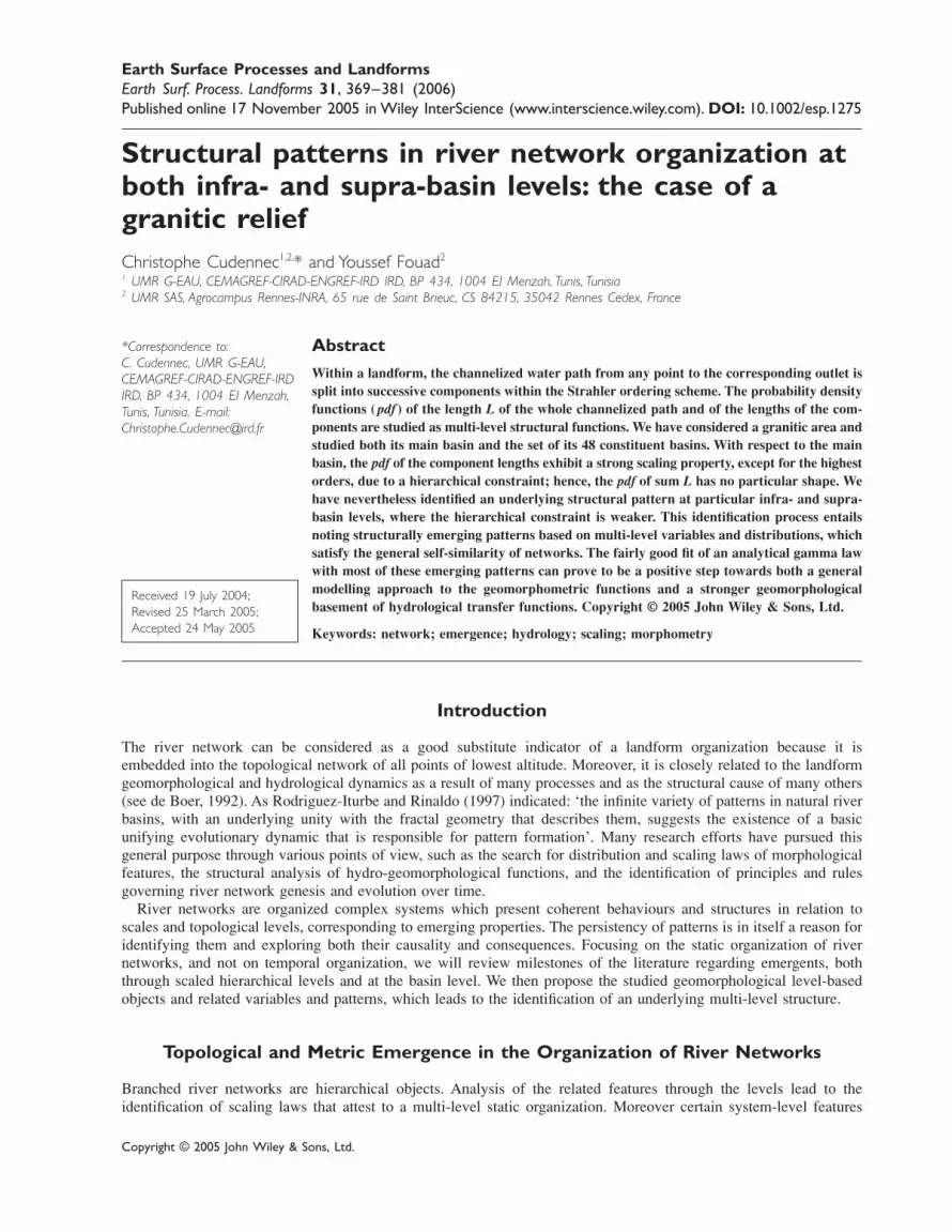
Evidence of a hierarchical constraint at the basin levelFigure 3 shows the pdf of the hydraulic length L of the whole basin B. This pdf appears to be irregular and ratherpositively skewed, which is relevant given the systematic skewness of width functions (Kirkby, 1993; Robinson et al.,1995; Rodriguez-Iturbe and Rinaldo, 1997). Figure 3 also presents the theoretical pdf of L proposed in Equation 1,which does not display any fit with the experimental pdf, as Cudennec et al. (2004) noted. Nevertheless, we are able
Figure 2. River map of the granitic area A and identification of basin B.
374 C. Cudennec and Y. Fouad
Copyright © 2005 John Wiley & Sons, Ltd. Earth Surf. Process. Landforms 31, 369–381 (2006)
to observe how this pdf of the basin hydraulic length is structured and organized in terms of components. Table I liststhe observed values of the Horton bifurcation and length ratios, along with the values of the newly defined componentlength ratio rl. The global values are obtained by logarithmic regressions, whose R2 coefficients have also beenindicated: it appears that the first two ratios are steady. The third ratio (rl) presents a value close to the second one(RL), yet with a lower level of steadiness. Nonetheless, the results reveal that this particular basin exhibits a strongself-similarity of streams identified within the Strahler ordering scheme and that this self-similarity is broadly verifiedwith components.
Figure 4 shows the pdf of (li/rli−1), the lengths of the five components reduced by the scaling factor rl identified in
Table I. The first four curves (orders one to four) are all convex and rapidly decreasing. Moreover, they lie closetogether, despite their variabilities. This finding indicates that the scaling of components is not only verified in termsof geometric averages but also in terms of distributions. Figure 4 also presents the theoretical pdf gamma law proposedin Equation 2, which appears to be fairly well inscribed within the envelope of the first four experimental curves.
The last curve is different since it is both non-decreasing and outside the envelope of the other curves, whichreflects a difference in the role and representativeness of the highest-order component due to its particular hierarchicalposition. The last order n is indeed unavoidable, from anywhere in the basin to the single outlet, and is supported by
Figure 3. Actual and theoretical (Equation 1) pdf(L) of basin B: n = 5, ! = 11 928·7 m.
Table I. Horton’s ratios and component length ratio of basin B
Order i
2 3 4 5 Global R2
R
N
NBi
i
= −1 3·48 5·15 4·33 3 4·04 0·996
RL
i
i
=−
Ò
Ò 1
1·69 3·13 1·05 4·24 2·06 0·939
rl
i
i
=−
¬
¬ 1
2·26 3·29 0·53 7·9 2·13 0·82

Structural patterns in river network organization 375
Copyright © 2005 John Wiley & Sons, Ltd. Earth Surf. Process. Landforms 31, 369–381 (2006)
Figure 4. Actual and theoretical (Equation 2) pdf(li/rli−1) of basin B: rl = 2·13.
a single stream. Thus, pdf(ln/rln−1) may not necessarily be decreasing, which would imply that avoidance is a majority
occurrence. Moreover, the variability of pdf(li/rli−1) for i = 4 and i = 3 around the self-similarity tendency stems from
the fact that orders n − 1, n − 2 . . . are increasingly harder to avoid and supported by fewer streams. This particularrole of higher-order objects represents a ‘hierarchical constraint’ exerting strong influence on the shape of the wholegeomorphometric functions.
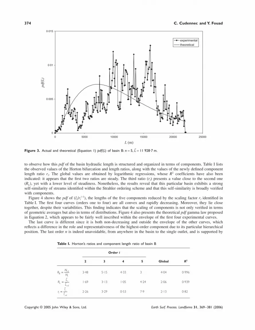
Emergence at infra-basin levelsThe identification of this hierarchical constraint leads us to consider the subsystem of the first m (m < n) Strahlerlevels, with the sum L′ = ∑ =
<im n
1 li used as the relevant characteristic variable, which corresponds to the truncation of thehighest-order components. The experimental pdf of L′, for any value of m, can be obtained through the GIS-basedanalysis. Figure 5a and b show the actual pdf of L′ for decreasing values of m, four and three respectively. It appearsthat the skewness becomes negative and a regular shape can be detected. Moreover, Figures 5a and b show how thegamma law proposed in Equation 1 and limited to L′
pdf Lm
mL e
mm mL
( ) ′ =
′− − ′
2
1
2
22
12
55
Γ(3)
fits more accurately with the actual pdf of L′ for decreasing values of m.These observations confirm the identification of the hierarchical constraint and demonstrate that a regular pattern
underlies the structural organization of the considered river network. Furthermore, the good fit of the analytical pdfprovided by Equation 3 shows that this regular pattern may be described by a gamma law expressed in terms of simplegeomorphological features, even though we experienced a poor fit of Equation 1 at the level of the whole basin(see Figure 3).
376 C. Cudennec and Y. Fouad
Copyright © 2005 John Wiley & Sons, Ltd. Earth Surf. Process. Landforms 31, 369–381 (2006)
Figure 5. Actual and theoretical (Equation 3) pdf (L′) of basin B: (a) m = 4, !′ = 4516 m; (b) m = 3, !′ = 2455·1 m.

Structural patterns in river network organization 377
Copyright © 2005 John Wiley & Sons, Ltd. Earth Surf. Process. Landforms 31, 369–381 (2006)
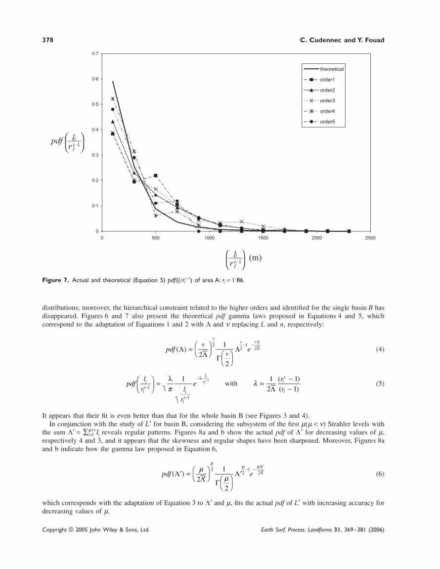
Emergence at supra-basin levelsIn order to study area A, we can observe streams, paths and component statistics of the whole by merging thecharacteristics of each constituting basin through the GIS-based analysis. Figure 6 thereby shows the pdf of thehydraulic length Λ = ∑ =i
vil1 of the whole area A, whose maximum Strahler order is ν = 5. It would obviously appear to
be negatively skewed and much more regular than the pdf of the hydraulic length L of the whole basin B shown inFigure 3. The RB, RL and rl ratio values shown in Table II have been calculated from all the area’s streams (for RB andRL) and components (for rl). We can note that the stability of RB is excellent; RL is a little more variable, as is often thecase for single basins (Horton, 1945; Schumm, 1956; Shreve, 1966); and rl is equal to RL, with better stability than inthe case of the single basin B. Figure 7 presents the pdf of the lengths of the five components, reduced by the scalingfactor rl identified in Table II. All five curves are very close to one another, convex and rapidly decreasing. Theseobservations reveal that the component scaling is not only verified in terms of geometric averages but also in terms of
Table II. Horton’s ratios and component length ratio of area A
Order i
2 3 4 5 Global R2
R
N
NBi
i
= −1 3·71 4·11 4·15 4·33 4·14 0·999
RL
i
i
=−
Ò
Ò 1
1·67 2·42 1·39 2·18 1·86 0·986
rl
i
i
=−
¬
¬ 1
1·95 2·7 0·98 2·19 1·86 0·935
Figure 6. Actual and theoretical (Equation 4) pdf (Λ) of area A: ν = 5, 6 = 6966·2 m.
378 C. Cudennec and Y. Fouad
Copyright © 2005 John Wiley & Sons, Ltd. Earth Surf. Process. Landforms 31, 369–381 (2006)
Figure 7. Actual and theoretical (Equation 5) pdf(li/rli−1) of area A: rl = 1·86.
distributions; moreover, the hierarchical constraint related to the higher orders and identified for the single basin B hasdisappeared. Figures 6 and 7 also present the theoretical pdf gamma laws proposed in Equations 4 and 5, whichcorrespond to the adaptation of Equations 1 and 2 with Λ and ν replacing L and n, respectively:
pdfv
ve
vv v
( ) Λ ΛΛ
=
− −
2
1
2
22
12
66
Γ(4)
pdfl
r l
r
ei
li
i
li
l
ri
li
−
−
−
= −
1
1
1 1
λ λ
πwith
λ ( )
( )=
−−
1
2
1
16
r
rlv
l
(5)
It appears that their fit is even better than that for the whole basin B (see Figures 3 and 4).In conjunction with the study of L′ for basin B, considering the subsystem of the first µ(µ < ν) Strahler levels with
the sum Λ′ = ∑ =<
iv
il1µ reveals regular patterns. Figures 8a and b show the actual pdf of Λ′ for decreasing values of µ,
respectively 4 and 3, and it appears that the skewness and regular shapes have been sharpened. Moreover, Figures 8aand b indicate how the gamma law proposed in Equation 6,
pdf e( ) ′ =
′− − ′
Λ ΛΛµ
µ
µµ µ
2
1
2
22
12
77
Γ(6)
which corresponds with the adaptation of Equation 3 to Λ′ and µ, fits the actual pdf of L′ with increasing accuracy fordecreasing values of µ.

Structural patterns in river network organization 379
Copyright © 2005 John Wiley & Sons, Ltd. Earth Surf. Process. Landforms 31, 369–381 (2006)
Figure 8. Actual and theoretical (Equation 6) pdf (Λ′) of area A: (a) µ = 4, 7 = 3780·4 m; (b) µ = 3, 7 = 2326·8 m.
380 C. Cudennec and Y. Fouad
Copyright © 2005 John Wiley & Sons, Ltd. Earth Surf. Process. Landforms 31, 369–381 (2006)
Discussion
In considering basin B, it appears that the pdf of li follow convex and rapidly decreasing shapes and display a strongscaling property, except for the highest orders. This scaling is consistent with river network fractality and its upperlimit can be explained by the branched-out topology. For a single basin, the highest order component ln may notnecessarily exhibit a decreasing pdf; this phenomenon is due to its particular position within the Strahler hierarchicalnetwork organization. For similar reasons, the pdf of ln−1, ln−2 . . . present a weaker scaling than those of l1, l2 . . . As aconsequence, the pdf of the truncated hydraulic lengths L′ are negatively skewed and some can be described by agamma law, whereas the pdf of L is positively skewed.
Furthermore, considering a consistent set of basins within geographical area A produces stronger statistical andstructural data. The hierarchical constraint actually no longer exerts any influence and all pdf of li follow convex andrapidly decreasing shapes in addition to showing a strong scaling property. In comparison, the pdf of the hydrauliclength L is itself negatively skewed and may be described by a gamma law, as is the case for the pdf of the truncatedhydraulic lengths L′ as well.
These findings demonstrate how a multi-level pattern underlies the self-similar river network organization, eventhough the shape obviously does not appear in basin-level geomorphometric functions due to hierarchical constraints.The benefit of considering variables li, L′, Λ and Λ′ is to make this pattern emerge.
Conclusion
We have considered herein geomorphological objects within the river network of a basin, based on the Strahlerordering scheme: the hydraulic path and its components. It appears that components respect network self-similaritywithin the Strahler ordering scheme (which is seen as a levelling cascade) in terms of statistics and even more in termsof distribution, with the exception of the nth one in the case of a single basin. This point and the relatively weakerstability of higher-component distributions (such as (n − 1)th and (n − 2)th) are related to the particular position of thesupporting streams within the drainage network hierarchy, which makes them less numerous and harder to avoid. Thiseffect, which we have called ‘hierarchical constraint’, disappears when considering either infra-basin levels throughtruncation or supra-basin levels through a set of several basins.
Due to the disappearance of this constraint, the pdf of the aggregative variables L′, Λ and Λ′ present obvious regularpatterns, whereas nothing is particularly noteworthy for pdf(L). Since variable L characterizes the entire network level,with a strong implication in hydrology, this multi-level structure generally remains underlying; bringing it to the forerequires relevant variables at each level (li) and for the cascade upstream of each level ∑ =j
ijl1 .
The actual appearance of such patterns through most Strahler levels, based on the identification of topology-relatedgeomorphological variables, constitutes a kind of multi-level emergence, i.e. a hyperstructure. The fairly good fitof the theoretical proposals derived by Cudennec et al. (2004) at the very least represents a means for quantifyingthe observed patterns and, maybe beyond, a perspective for building a deducible emergence reasoning. Furtherthan characterizing the static organization of river networks, this multi-level emergence may be linked with theevolution of networks through time either in terms of morphogenic maturation, or in some circumstances in terms ofseasonal variability and migration. Checking the appearance, through network morphogenesis, of this organizationalemerging trend may even be considered in the investigation of the temporal emergence of actual and simulated rivernetworks. It could indeed help, together with other measures, in checking the result of self-organization and ofoptimality (see Rigon et al., 1993; Rinaldo et al., 1993) and in proposing likelihood and plausibility milestones andtests for simulations.
Furthermore, this approach may be valuable for characterizing hydrological features and behaviour emerging froma drainage basin, out of its own underlying pattern. In particular, the geomorphological results can be translated intohydrological characteristic times, through various hydraulic hypotheses. For instance, as a first approach, one cannotice that the linear assumption of a mean velocity leads to the direct translation of the pdf of L and li into the pdf ofresidence times, respectively t in the whole network and ti in the Strahler level i. This simple translation may providedeterministic explanations of some famous a priori assumptions of the unit hydrograph and the geomorphological unithydrograph theories, such as the gamma law general shape (Nash, 1957) and the exponential distribution of residencetime in Strahler states (Rodriguez-Iturbe and Valdès, 1979; Gupta et al., 1980). It may also open the perspective of aunit hydrograph proposal, explicitly based on observable geomorphological parameters and coherent with other trans-fer functions (Nasri et al., 2004; Rodriguez et al., 2005).

Structural patterns in river network organization 381
Copyright © 2005 John Wiley & Sons, Ltd. Earth Surf. Process. Landforms 31, 369–381 (2006)
AcknowledgementWe are indebted to M. Kirkby and to an anonymous reviewer for their helpful and constructive comments.
References
Abrahams AD, Miller AJ. 1982. The mixed gamma model for channel link lengths. Water Resources Research 18(4): 1126–1136.Beven KJ. 2001. Rainfall–Runoff Modelling. The Primer. Wiley: Chichester.Crave A, Davy P. 1997. Scaling relationships of channel networks at large scales: examples from two large-magnitude watersheds in
Brittany, France. Tectonophysics 269(1–2): 91–111.Cudennec C. 2000. Description mathématique de l’organisation du réseau hydrographique et modélisation hydrologique. PhD dissertation,
ENSAR, Rennes.Cudennec C, Fouad Y, Sumarjo Gatot I, Duchesne J. 2004. A geomorphological explanation of the unit hydrograph concept. Hydrological
Processes 17(4): 603–621.De Boer DH. 1992. Hierarchies and spatial scale in process geomorphology: a review. Geomorphology 4(5): 303–318.Dodds PS, Rothman DH. 1999. Unified view of scaling laws for river networks. Physical Review E 59(5): 4865–4877.Dodds PS, Rothman DH. 2000. Scaling, universality and geomorphology. Annual Review of Earth and Planetary Sciences 28: 571–610.Foroud N, Broughton RS. 1981. Flood hydrograph simulation model. Journal of Hydrology 49(1–2): 139–172.Gravelius H. 1914. Flusskunde. Goschen’sche Verlagshandlung: Berlin.Gupta VK, Waymire E, Wang CT. 1980. Representation of an instantaneous unit hydrograph from geomorphology. Water Resources
Research 16: 855–862.Horton RE. 1945. Erosional development of streams and their drainage basins; hydrophysical approach to quantitative morphology. Bulletin
of the Geological Society of America 56: 275–370.Kirchner JW. 1993. Statistical inevitability of Horton’s laws and the apparent randomness of stream channel networks. Geology 21: 591–
594.Kirkby MJ. 1976. Tests of the random network model and its application to basin hydrology. Earth Surface Processes and Landforms 1:
197–212.Kirkby MJ. 1993. Network hydrology and geomorphology. In Channel Network Hydrology, Beven K, Kirkby MJ (eds). Wiley: Chichester;
1–11.La Barbera P, Rosso R. 1987. Fractal geometry of river networks. Eos Transactions AGU 68(44): 1276.Mandelbrot BB. 1977. Fractals: Form, Chance and Dimension. WH Freeman: San Francisco.Nash JE. 1957. The form of the instantaneous unit hydrograph. In C.R. et Rapports Toronto, 3–14 sept. 1957. IASH-IUGG: 114–118.Nasri S, Cudennec C, Albergel J, Berndtdson R, 2004. Use of a geomorphological transfer function to model design floods in small hillside
catchments in semiarid Tunisia. Journal of Hydrology 287(1–4): 197–213.Rigon R, Rinaldo A, Rodriguez-Iturbe I, Bras RL, IIjjasz-Vasquez E. 1993. Optimal channel networks: a framework for the study of river
basin morphology. Water Resources Research 29(6): 1635–1646.Rinaldo A, Rodriguez-Iturbe I, Rigon R, Ijjasz-Vasquez E, Bras RL. 1993. Self-organized fractal river networks. Physical Review Letters
70(6): 822–825.Rinaldo A, Rodriguez-Iturbe I, Rigon R. 1998. Channel networks. Annual Review of Earth and Planetary Sciences 26: 289–327.Robinson JS, Sivapalan M, Snell JD. 1995. On the relative roles of hillslope processes, channel routing, and network geomorphology in the
hydrologic response of natural catchments. Water Resources Research 31(12): 3089–3101.Rodriguez F, Cudennec C, Andrieu H. 2005. Application of morphological approaches to determine unit hydrographs of urban catchments.
Hydrological Processes 19: 1021–1035.Rodriguez-Iturbe I, Rinaldo A. 1997. Fractal River Basins; Chance and Self-organization. Cambridge University Press: Cambridge.Rodriguez-Iturbe I, Valdès JB. 1979. The geomorphologic structure of hydrologic response. Water Resources Research 15: 1409–1420.Schumm SA. 1956. Evolution of drainage systems and slopes in badlands at Perth Amboy, N.J. Bulletin of the Geological Society of
America 87: 597–646.Shreve RL. 1966. Statistical law of stream numbers. Journal of Geology 74: 17–37.Smart JS. 1968. Statistical properties of stream lengths. Water Resources Research 4: 1001–1014.Snell JD, Sivapalan M. 1994. On geomorphological dispersion in natural catchments and the geomorphological unit hydrograph. Water
Resources Research 30(7): 2311–2323.Strahler AN. 1952. Hypsometric (area altitude) analysis of erosional topography. Bulletin of the Geological Society of America 63: 117–142.Tarboton DG, Bras RL, Rodriguez-Iturbe I. 1988. The fractal nature of river networks. Water Resources Research 24(8): 1317–1322.Tarboton DG, Bras RL, Rodriguez-Iturbe I. 1990. Comment on « On the fractal dimension of stream networks » by Paolo La Barbera and
Renzo Rosso. Water Resources Research 26(9): 2243–2244.Troutman BM, Karlinger MR. 1984. On the expected width function for topologically random channel networks. Journal of Applied
Probability 22: 836–849.Wilson TH, Dominic J. 1998. Fractal interrelationships between topography and structure. Earth Surface Processes and Landforms 23(6):
509–525.