Embed Size (px)
Citation preview
Structural architecture of the central Apennines: Interpretation of
the CROP 11 seismic profile from the Adriatic coast to the
orographic divide
Etta Patacca,1 Paolo Scandone,1 Emiliano Di Luzio,2 Gian Paolo Cavinato,2
and Maurizio Parotto3
Received 1 November 2005; revised 11 May 2007; accepted 19 November 2007; published 23 May 2008.
[1] We present an interpretation of the eastern halfportion of the CROP 11 line, a deep reflection seismicprofile 265 km long that cuts across the centralApennines from the Tyrrhenian coast to the Adriaticcoast. In the study area the line cuts across a pile ofthrust sheets that underwent tectonic transport betweenthe Messinian and the Pleistocene. In its easternmostpart, the line runs through the Plio-Pleistocene depositsof the Adriatic foredeep. In the foreland region theCROP 11 line integrates previous information on thecrustal structure derived from petroleum explorationand from deep seismic sounding refraction experiments.In particular, the CROP 11 line confirms the existenceof a very thick sedimentary sequence underlying theMesozoic-Tertiary carbonates of the Apulia Platforminterpreted as the Paleozoic-Triassic sedimentary coverof a pre-Cambrian crystalline basement. In the mountainchain, where the base thrust of the orogenicwedge reachesa depth of about 25 km, this sedimentary sequence appearsto be the deepest geological unit incorporated in the thrustsystem. This interpretation of the CROP 11 profilesuggests an unusual thin-skin tectonic style implyingthe detachment from the original basement and theincorporation in the post-Tortonian tectonic wedge of avery thick Paleozoic-Triassic sedimentary sequencepossibly affected by low-grade metamorphism in thelower part. Other new suggestions from the CROP 11seismic data concern the origin of the Fucino basin, oneof the most remarkable Plio-Pleistocene intramontanebasins. The normal faults bordering this structuraldepression, as other important normal faults present inthe central Apennines (e.g., the Caramanico fault systemin the Majella region), seem to have been controlled bygravitational-collapse processes driven by uplift duringcrustal shortening rather than by a generalized extensionsubsequent to the Apennine compression, as usuallyreported in the geological literature. If this interpretation
is correct, the strong seismic activity in correspondenceto the Apennine watershed may be related to the veryrecent increase in the structural relief caused by an out-of-sequence propagation of the active thrusts.Citation: Patacca, E., P. Scandone, E. Di Luzio, G. P. Cavinato,
and M. Parotto (2008), Structural architecture of the central
Apennines: Interpretation of the CROP 11 seismic profile from the
Adriatic coast to the orographic divide, Tectonics, 27, TC3006,
doi:10.1029/2005TC001917.
1. Introduction
[2] The CROP 11 line is a deep reflection seismic profile265 km long that cuts across the whole central Apennines(southern portion of the Northern Apenninic Arc in Figure 1)from the Tyrrhenian coast near Civitavecchia to the Adriaticcoast near Vasto. The CROP 11 Sub-project [Cavinato et al.,1994b; Parotto et al., 1996, 2003] was a task of a nationalresearch project called the CROP Project (CROsta ProfondaProject, i.e., Deep Crust Project). The CROP Project startedin 1984 in the wake of the successful results of theCOCORP-Consortium for Continental Reflection Profilingin USA (see, among many others, Brown et al. [1986] andHauser and Oliver [1987]) as a joint venture between CNR(National Research Council), AGIP (major Italian Oil Com-pany) and ENEL (Electric Power National Company). Themajor aim of the Project was the investigation of the deepcrustal structure of the Italian Peninsula and surroundingoffshore areas by means of reflection seismic profiles andassociated deep seismic sounding (DSS) refraction experi-ments [see Scrocca et al., 2003, and references therein].Besides the Italian CROP Project, several analogous re-search ventures flourished in the eighteen in Europe (e.g.,BIRPS in UK, CZESLOCORP in Czechoslovakia, DER-KORP in West Germany, ECORS in France and NRP20 inSwitzerland; see, among many others, BIRPS and ECORS[1986], Bois et al. [1988], Blundell [1988],Matthews [1988],Meissner and Bortfeld [1990], Matthews and BIRPS Group[1990], Roure et al. [1990],Meissner et al. [1991], Pfiffner etal. [1997], and Meissner and Rabbel [1999]), as well as innon-European countries, among which Australia, Canada,China, India, Japan, New Zealand and USA [see Blundelland Wright, 1989].[3] The acquisition of the CROP 11 seismic line post-
dates the acquisition of all other lines of the CROP Project.The western half portion of the profile, from the Tyrrhenian
TECTONICS, VOL. 27, TC3006, doi:10.1029/2005TC001917, 2008ClickHere
for
FullArticle
1Dipartimento di Scienze della Terra, Universita di Pisa, Pisa, Italy.2Istituto di Geologia Ambientale e Geoingegneria, CNR, Rome, Italy.3Dipartimento di Scienze Geologiche, Universita di Roma ‘‘Roma 3,’’
Rome, Italy.
Copyright 2008 by the American Geophysical Union.0278-7407/08/2005TC001917$12.00
TC3006 1 of 36
coast to the Apennine watershed (CROP11/CNR/ENEL 96segment in Figure 2, 109 km long), was completed in 1996.Subsequently, near the end of 1999, the field acquisitionwas extended eastward as far as the Adriatic coast and about156 km of reflection data were gathered (CROP11/DSTN99 and CROP11/COGEPRO 99 segments in Figure 2). In
the whole profile, the seismic signal was acquired usingdynamite (30 kilograms per shot, depth of source 30 m, shotinterval 160–180 m, station interval 40–60 m) with cover-age 24–32. The data were recorded for 25 s TWT at asample rate of 2 ms.
Figure 1
TC3006 PATACCA ET AL.: CROP 11 SEISMIC PROFILE
2 of 36
TC3006
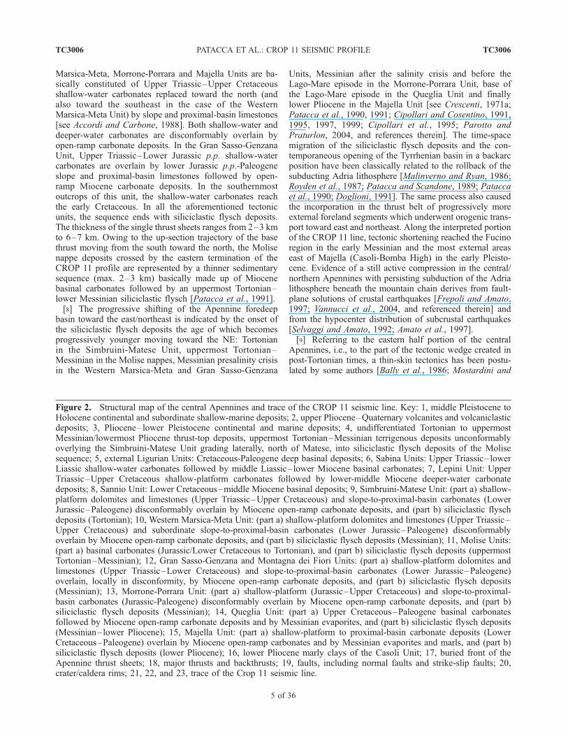
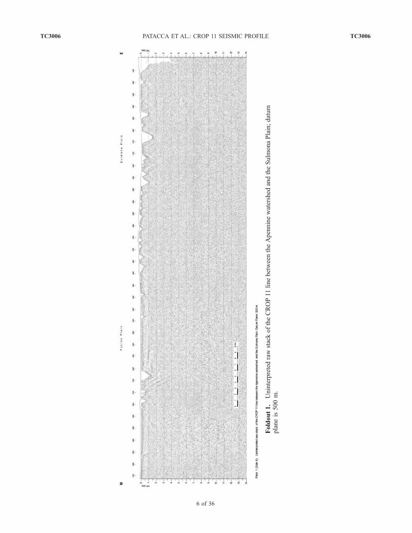
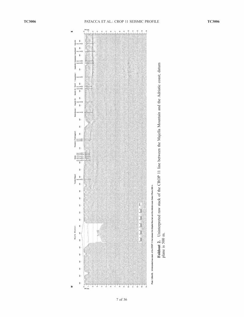
[4] In this paper, we will discuss the deep structuralarchitecture of the central Apennines deduced from theinterpretation of the eastern half portion of the CROP 11profile from the Fucino Plain to the Adriatic coast, i.e., fromthe orographic divide of the mountain chain to the front ofthe Apennine thrust sheets. The profile employed in ourinterpretation was a raw stack section with horizontal scale1:50.000 and vertical scale 1 s = 2.5 cm (see Foldouts 1–4,showing a reduced copy at the scale 1:100.000). Severalcommercial lines available in the study area, some of whichstratigraphically linked to detailed information coming fromexploration wells, were useful for the geological identifica-tion of the shallow seismic units and for the structuralinterpretation of the tectonic features recognizable in theCROP 11 profile between 0 and 5 s TWT. Refractionseismic experiments in the area (see traces of the principalDSS profiles in the lower left insert of Figure 1) providedimportant information on the P-wave velocities in the crustand established some constraints on the interpretation of thedeep structures along the trace of the CROP 11 profile. Theabsence of seismic information at shallow depths in corre-spondence to the Majella Mountain, due to a gap in the dataacquisition, has been partly replaced with the informationderiving from a commercial line that cuts across the massifin its central part in correspondence to the maximumelevations (line A in Figure 3).[5] The portion of mountain chain that extends from
the Apennine orographic divide to the nappe front is formedby a pile of Adriatic-verging thrust sheets composed ofMesozoic-Tertiary sedimentary sequences which have un-dergone orogenic transport in post-Tortonian times. The lateTortonian represents a critical moment in the Apenninemountain building since a sudden increase in the flexurehinge retreat of the subducting Adria lithosphere producedin that time a decoupling between the upper plate (Corsica-Sardinia) and the lower plate with the consequent openingof the Tyrrhenian Basin driven by rollback mechanisms[Malinverno and Ryan, 1986; Patacca and Scandone, 1989](see rates of the Adria flexure hinge retreat in work byPatacca et al. [1990] and Patacca and Scandone [2001]). Along-lasting debate among geologists concerns the tectonicstyle, thin-skinned or thick-skinned thrust tectonics, of thepost-Tortonian Apennine wedge (see discussion in work byTozer et al. [2002] and Scrocca et al. [2005]). At the state of
the art, we do not know whether slices of crystallinebasement have been or not been detached from the subduct-ing lower plate and incorporated in the thrust belt during theof Tyrrhenian opening. The debate about thin-skin or thick-skin tectonics in the post-Tortonian mountain chain hasrecently weakened because of the success obtained byinversion models postulating basement involvement byreverse-sense reactivation of Mesozoic (mostly Jurassic)extensional faults [e.g., Tavarnelli, 1997; Calamita et al.,2003; Tavarnelli et al., 2003, 2004; Butler et al., 2004].However, it should be stressed that no seismic evidence ofsyn-rift Mesozoic deposits reactivated by the late Neogenecompressional tectonics has been provided until now in theApennines. The CROP 11 line was expected to shed light onthe deep structure of the mountain chain and on the involve-ment/non-involvement of the crystalline basement in thetectonic shortening. We will see in the next pages that therecognition of a thick pile of Paleozoic-Triassic depositsbeneath the upper Triassic dolomites and anhydrites of theApulia Platform provided an important contribution to deci-pher the tectonic style of the central Apennines since thissedimentary unit seems to represent the deepest unit of Adriacrust involved in the post-Tortonian orogenic transport.
2. Stratigraphic-Structural Lineaments of
the Central Apennines and Adriatic Foreland
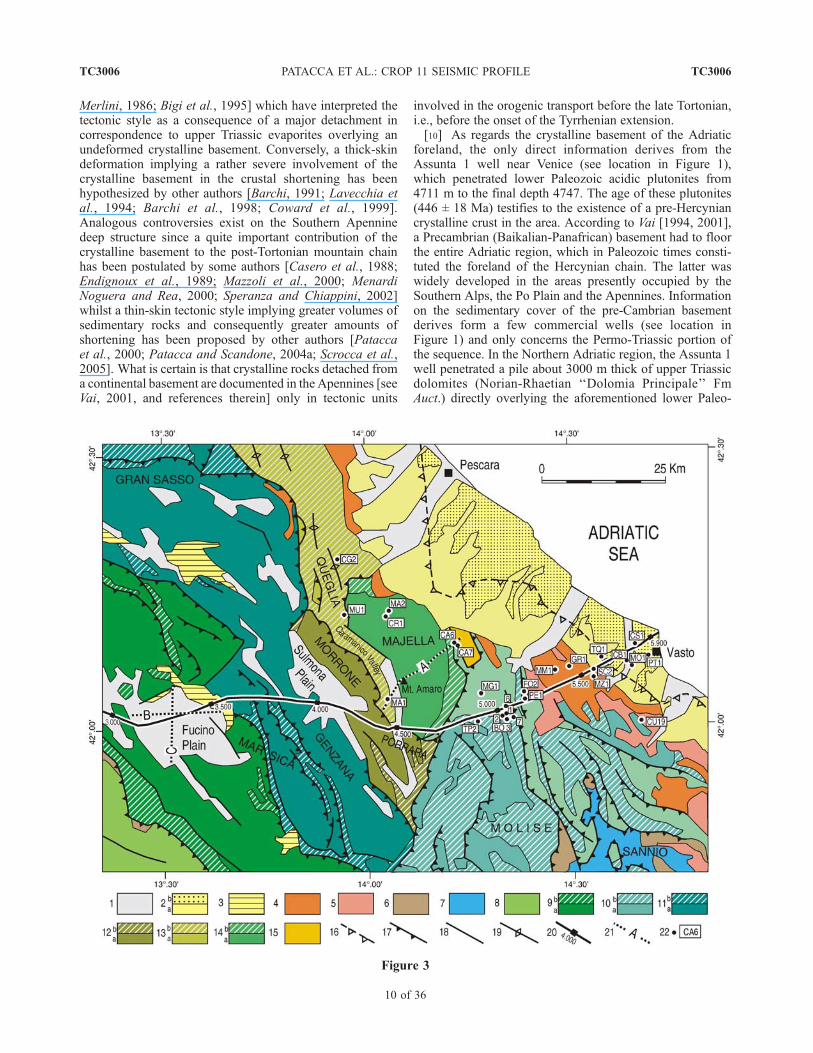
[6] The CROP 11 line crosses the central Apennines incorrespondence to the southern termination of the NorthernApenninic Arc (see Figure 1) in a region in which the trendof the major tectonic structures changes from a NW-SEdirection into a N-S direction. In its westernmost portion(see Figure 2) the seismic line runs through the so-calledRoman magmatic district [Serri et al., 2001, and referencestherein], a first-order half-Graben feature trending NW-SE,characterized by a widespread Quaternary volcanism relatedto the extensional and transtensional faulting of the Apen-nine Tyrrhenian margin [Funiciello and Parotto, 1978;Faccenna et al., 1994]. Positive Bouguer gravity anomalies[Carrozzo et al., 1991] related to the presence of a softmantle at shallow depths (22–25 km, see ‘‘TyrrhenianMoho’’ in work by Locardi and Nicolich [1988], Nicolichand Dal Piaz [1990], Ponziani et al. [1998], and Scarasciaet al. [1998]) represent the most relevant geophysical
Figure 1. Structural sketch of the Italian Peninsula (modified after Patacca et al. [1993]) with the location of the CROP11 seismic line and other CROP profiles that have cut across the Apennine thrust belt (CROP 03 and CROP 04). In thelower left insert, subtle lines indicate the traces of selected refraction seismic profiles providing information on the crustalcharacteristics of central-southern Italy. Key: 1, pre-Pliocene carbonates and minor volcanites exposed in the forelandregions; 2, isobaths (in km) of the base of the PIio-Pleistocene deposits in the foredeep basins; 3, major subaerialQuaternary volcanoes; 4, buried front of the thrust sheets in the Apennines, Calabrian Arc and Sicily; 5; conventionalboundary between the Northern Apenninic Arc and the Southern Apenninic Arc; 6, front of the thrust sheets in the SouthernAlps and Dinarides, major internal thrusts in the Apennines, Calabrian Arc, and Sicily; 7, normal faults; 8, strike-slip faults;9, anticline axis; 10, syncline axis; 11, Wadati-Benioff zone in the Southern Tyrrhenian region (depths in kilometers); 12,Tyrrhenian area floored by oceanic crust and thinned continental crust, with positive Bouguer gravity anomalies exceeding200 mgals; 13, CROP profiles cutting across the Apennine mountain chain; 14, commercial wells quoted in the text thathave reached Triassic or older deposits. Abbreviations: AL1, Alessandra 1; AM1, Amanda 1; AS1, Assunta 1; FU1, ForestaUmbra 1; GA1, Gargano 1; PG2, Perugia 2; PU1, Puglia 1; SD1, San Donato 1.
TC3006 PATACCA ET AL.: CROP 11 SEISMIC PROFILE
3 of 36
TC3006
characteristics of this extensional area. East of the Romanmagmatic district, the CROP 11 line crosses a N-S trendingfold-and-thrust system made up of Upper Triassic–lowerLiassic shallow-water dolomites and limestones and middleLiassic–lower Miocene deeper-water carbonate depositsreferred to the Sabina domain (southwestern portion of theUmbria-Marche paleogeographic realm). Moving eastward,toward the Abruzzi region, the line cuts across a N-Strending thrust system known in the current geologicalliterature as the Olevano-Antrodoco Line [Cipollari andCosentino, 1991, and references therein] and finally runs inthe Mesozoic-Tertiary deposits of the Western Marsica-Meta Unit until it reaches the Apennine watershed incorrespondence to the Fucino Plain. Starting from the TiberValley, the entire mountain chain is characterized by nega-tive Bouguer gravity anomalies. The minimum values arereached in correspondence to the Fucino area. Along thetrace of the seismic profile, the ‘‘Tyrrhenian Moho’’ (i.e.,the tip of the Tyrrhenian soft-mantle wedge) would over-thrust the ‘‘Adriatic Moho’’ (i.e., the crust-mantle boundaryin the subducting lower plate) roughly in correspondence tothe Olevano-Antrodoco Line [Scarascia et al., 1994, 1998;Cassinis et al., 2003]. According to the aforementioned
authors, the ‘‘TyrrhenianMoho’’woulddeepen from22–24kmto 25–26 km moving from the Roman volcanic region tothe Olevano-Antrodoco Line. Conversely, the ‘‘AdriaticMoho’’ would rise from 40 km to less than 30 km movingfrom the Olevano-Antrodoco Line to the Fucino Plain. Notethat the depth of the Moho deduced from the DSS experi-ments is quite poorly constrained in correspondence to theFucino Plain. A deeper and probably more realistic crust-mantle boundary has been suggested in the same area byTiberti and Orlando [2006] on the base of a 2D gravimetrymodelling. East of the orographic divide, the CROP 11profile cuts across an imbricate fan of thrust sheetsreferred to the Western Marsica-Meta, Gran Sasso-Genzana,Morrone-Porrara, Queglia and Majella Units. In correspon-dence to the eastern foot of the Majella Mountain, theseismic line intersects the Molise nappes and finally reachesthe Plio-Pleistocene terrigenous deposits of the Adriaticforedeep. In the Vasto area, where the gravimetric mapshows weak negative values of the Bouguer anomalies, thecrust-mantle boundary lies at a depth of 32 km according toScarascia et al. [1994, 1998] and Cassinis et al. [2003].[7] In the interpreted portion of the CROP 11 line (see
Figure 3), the thrust sheets belonging to the Western
Figure 2
TC3006 PATACCA ET AL.: CROP 11 SEISMIC PROFILE
4 of 36
TC3006
Marsica-Meta, Morrone-Porrara and Majella Units are ba-sically constituted of Upper Triassic–Upper Cretaceousshallow-water carbonates replaced toward the north (andalso toward the southeast in the case of the WesternMarsica-Meta Unit) by slope and proximal-basin limestones[see Accordi and Carbone, 1988]. Both shallow-water anddeeper-water carbonates are disconformably overlain byopen-ramp carbonate deposits. In the Gran Sasso-GenzanaUnit, Upper Triassic–Lower Jurassic p.p. shallow-watercarbonates are overlain by lower Jurassic p.p.-Paleogeneslope and proximal-basin limestones followed by open-ramp Miocene carbonate deposits. In the southernmostoutcrops of this unit, the shallow-water carbonates reachthe early Cretaceous. In all the aforementioned tectonicunits, the sequence ends with siliciclastic flysch deposits.The thickness of the single thrust sheets ranges from 2–3 kmto 6–7 km. Owing to the up-section trajectory of the basethrust moving from the south toward the north, the Molisenappe deposits crossed by the eastern termination of theCROP 11 profile are represented by a thinner sedimentarysequence (max. 2–3 km) basically made up of Miocenebasinal carbonates followed by an uppermost Tortonian–lower Messinian siliciclastic flysch [Patacca et al., 1991].[8] The progressive shifting of the Apennine foredeep
basin toward the east/northeast is indicated by the onset ofthe siliciclastic flysch deposits the age of which becomesprogressively younger moving toward the NE: Tortonianin the Simbruini-Matese Unit, uppermost Tortonian–Messinian in the Molise nappes, Messinian presalinity crisisin the Western Marsica-Meta and Gran Sasso-Genzana
Units, Messinian after the salinity crisis and before theLago-Mare episode in the Morrone-Porrara Unit, base ofthe Lago-Mare episode in the Queglia Unit and finallylower Pliocene in the Majella Unit [see Crescenti, 1971a;Patacca et al., 1990, 1991; Cipollari and Cosentino, 1991,1995, 1997, 1999; Cipollari et al., 1995; Parotto andPraturlon, 2004, and references therein]. The time-spacemigration of the siliciclastic flysch deposits and the con-temporaneous opening of the Tyrrhenian basin in a backarcposition have been classically related to the rollback of thesubducting Adria lithosphere [Malinverno and Ryan, 1986;Royden et al., 1987; Patacca and Scandone, 1989; Pataccaet al., 1990; Doglioni, 1991]. The same process also causedthe incorporation in the thrust belt of progressively moreexternal foreland segments which underwent orogenic trans-port toward east and northeast. Along the interpreted portionof the CROP 11 line, tectonic shortening reached the Fucinoregion in the early Messinian and the most external areaseast of Majella (Casoli-Bomba High) in the early Pleisto-cene. Evidence of a still active compression in the central/northern Apennines with persisting subduction of the Adrialithosphere beneath the mountain chain derives from fault-plane solutions of crustal earthquakes [Frepoli and Amato,1997; Vannucci et al., 2004, and referenced therein] andfrom the hypocenter distribution of subcrustal earthquakes[Selvaggi and Amato, 1992; Amato et al., 1997].[9] Referring to the eastern half portion of the central
Apennines, i.e., to the part of the tectonic wedge created inpost-Tortonian times, a thin-skin tectonics has been postu-lated by some authors [Bally et al., 1986; Mostardini and
Figure 2. Structural map of the central Apennines and trace of the CROP 11 seismic line. Key: 1, middle Pleistocene toHolocene continental and subordinate shallow-marine deposits; 2, upper Pliocene–Quaternary volcanites and volcaniclasticdeposits; 3, Pliocene–lower Pleistocene continental and marine deposits; 4, undifferentiated Tortonian to uppermostMessinian/lowermost Pliocene thrust-top deposits, uppermost Tortonian–Messinian terrigenous deposits unconformablyoverlying the Simbruini-Matese Unit grading laterally, north of Matese, into siliciclastic flysch deposits of the Molisesequence; 5, external Ligurian Units: Cretaceous-Paleogene deep basinal deposits; 6, Sabina Units: Upper Triassic–lowerLiassic shallow-water carbonates followed by middle Liassic–lower Miocene basinal carbonates; 7, Lepini Unit: UpperTriassic–Upper Cretaceous shallow-platform carbonates followed by lower-middle Miocene deeper-water carbonatedeposits; 8, Sannio Unit: Lower Cretaceous–middle Miocene basinal deposits; 9, Simbruini-Matese Unit: (part a) shallow-platform dolomites and limestones (Upper Triassic–Upper Cretaceous) and slope-to-proximal-basin carbonates (LowerJurassic–Paleogene) disconformably overlain by Miocene open-ramp carbonate deposits, and (part b) siliciclastic flyschdeposits (Tortonian); 10, Western Marsica-Meta Unit: (part a) shallow-platform dolomites and limestones (Upper Triassic–Upper Cretaceous) and subordinate slope-to-proximal-basin carbonates (Lower Jurassic–Paleogene) disconformablyoverlain by Miocene open-ramp carbonate deposits, and (part b) siliciclastic flysch deposits (Messinian); 11, Molise Units:(part a) basinal carbonates (Jurassic/Lower Cretaceous to Tortonian), and (part b) siliciclastic flysch deposits (uppermostTortonian–Messinian); 12, Gran Sasso-Genzana and Montagna dei Fiori Units: (part a) shallow-platform dolomites andlimestones (Upper Triassic–Lower Cretaceous) and slope-to-proximal-basin carbonates (Lower Jurassic–Paleogene)overlain, locally in disconformity, by Miocene open-ramp carbonate deposits, and (part b) siliciclastic flysch deposits(Messinian); 13, Morrone-Porrara Unit: (part a) shallow-platform (Jurassic–Upper Cretaceous) and slope-to-proximal-basin carbonates (Jurassic-Paleogene) disconformably overlain by Miocene open-ramp carbonate deposits, and (part b)siliciclastic flysch deposits (Messinian); 14, Queglia Unit: (part a) Upper Cretaceous–Paleogene basinal carbonatesfollowed by Miocene open-ramp carbonate deposits and by Messinian evaporites, and (part b) siliciclastic flysch deposits(Messinian–lower Pliocene); 15, Majella Unit: (part a) shallow-platform to proximal-basin carbonate deposits (LowerCretaceous–Paleogene) overlain by Miocene open-ramp carbonates and by Messinian evaporites and marls, and (part b)siliciclastic flysch deposits (lower Pliocene); 16, lower Pliocene marly clays of the Casoli Unit; 17, buried front of theApennine thrust sheets; 18, major thrusts and backthrusts; 19, faults, including normal faults and strike-slip faults; 20,crater/caldera rims; 21, 22, and 23, trace of the Crop 11 seismic line.
TC3006 PATACCA ET AL.: CROP 11 SEISMIC PROFILE
5 of 36
TC3006
Foldout1.
UninterpretedrawstackoftheCROP11
linebetweentheApenninewatershed
andtheSulm
onaPlain;datum
planeis500m.
TC3006 PATACCA ET AL.: CROP 11 SEISMIC PROFILE
6 of 36
TC3006
Foldout2.
Uninterpretedraw
stackoftheCROP11linebetweentheMajella
Mountain
andtheAdriatic
coast;datum
planeis500m.
TC3006 PATACCA ET AL.: CROP 11 SEISMIC PROFILE
7 of 36
TC3006
Foldout3.
Geological
interpretationoftheCROP11linebetweentheApenninewatershed
andtheSulm
onaPlain;
datum
planeis500m.
TC3006 PATACCA ET AL.: CROP 11 SEISMIC PROFILE
8 of 36
TC3006
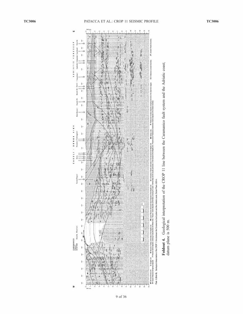
Foldout4.
Geological
interpretationoftheCROP11
linebetweentheCaram
anicofaultsystem
andtheAdriatic
coast;
datum
planeis500m.
TC3006 PATACCA ET AL.: CROP 11 SEISMIC PROFILE
9 of 36
TC3006
Merlini, 1986; Bigi et al., 1995] which have interpreted thetectonic style as a consequence of a major detachment incorrespondence to upper Triassic evaporites overlying anundeformed crystalline basement. Conversely, a thick-skindeformation implying a rather severe involvement of thecrystalline basement in the crustal shortening has beenhypothesized by other authors [Barchi, 1991; Lavecchia etal., 1994; Barchi et al., 1998; Coward et al., 1999].Analogous controversies exist on the Southern Apenninedeep structure since a quite important contribution of thecrystalline basement to the post-Tortonian mountain chainhas been postulated by some authors [Casero et al., 1988;Endignoux et al., 1989; Mazzoli et al., 2000; MenardiNoguera and Rea, 2000; Speranza and Chiappini, 2002]whilst a thin-skin tectonic style implying greater volumes ofsedimentary rocks and consequently greater amounts ofshortening has been proposed by other authors [Pataccaet al., 2000; Patacca and Scandone, 2004a; Scrocca et al.,2005]. What is certain is that crystalline rocks detached froma continental basement are documented in the Apennines [seeVai, 2001, and references therein] only in tectonic units
involved in the orogenic transport before the late Tortonian,i.e., before the onset of the Tyrrhenian extension.[10] As regards the crystalline basement of the Adriatic
foreland, the only direct information derives from theAssunta 1 well near Venice (see location in Figure 1),which penetrated lower Paleozoic acidic plutonites from4711 m to the final depth 4747. The age of these plutonites(446 ± 18 Ma) testifies to the existence of a pre-Hercyniancrystalline crust in the area. According to Vai [1994, 2001],a Precambrian (Baikalian-Panafrican) basement had to floorthe entire Adriatic region, which in Paleozoic times consti-tuted the foreland of the Hercynian chain. The latter waswidely developed in the areas presently occupied by theSouthern Alps, the Po Plain and the Apennines. Informationon the sedimentary cover of the pre-Cambrian basementderives form a few commercial wells (see location inFigure 1) and only concerns the Permo-Triassic portion ofthe sequence. In the Northern Adriatic region, the Assunta 1well penetrated a pile about 3000 m thick of upper Triassicdolomites (Norian-Rhaetian ‘‘Dolomia Principale’’ FmAuct.) directly overlying the aforementioned lower Paleo-
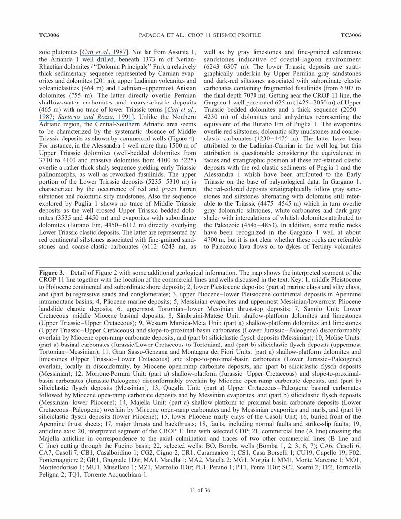
Figure 3
TC3006 PATACCA ET AL.: CROP 11 SEISMIC PROFILE
10 of 36
TC3006
zoic plutonites [Cati et al., 1987]. Not far from Assunta 1,the Amanda 1 well drilled, beneath 1373 m of Norian-Rhaetian dolomites (‘‘Dolomia Principale’’ Fm), a relativelythick sedimentary sequence represented by Carnian evap-orites and dolomites (201 m), upper Ladinian volcanites andvolcaniclastites (464 m) and Ladinian–uppermost Anisiandolomites (755 m). The latter directly overlie Permianshallow-water carbonates and coarse-clastic deposits(465 m) with no trace of lower Triassic terms [Cati et al.,1987; Sartorio and Rozza, 1991]. Unlike the NorthernAdriatic region, the Central-Southern Adriatic area seemsto be characterized by the systematic absence of MiddleTriassic deposits as shown by commercial wells (Figure 4).For instance, in the Alessandra 1 well more than 1500 m ofUpper Triassic dolomites (well-bedded dolomites from3710 to 4100 and massive dolomites from 4100 to 5225)overlie a rather thick shaly sequence yielding early Triassicpalinomorphs, as well as reworked fusulinids. The upperportion of the Lower Triassic deposits (5235–5310 m) ischaracterized by the occurrence of red and green barrensiltstones and dolomitic silty mudstones. Also the sequenceexplored by Puglia 1 shows no trace of Middle Triassicdeposits as the well crossed Upper Triassic bedded dolo-mites (3535 and 4450 m) and evaporites with subordinatedolomites (Burano Fm, 4450–6112 m) directly overlyingLower Triassic clastic deposits. The latter are represented byred continental siltstones associated with fine-grained sand-stones and coarse-clastic carbonates (6112–6243 m), as
well as by gray limestones and fine-grained calcareoussandstones indicative of coastal-lagoon environment(6243–6307 m). The lower Triassic deposits are strati-graphically underlain by Upper Permian gray sandstonesand dark-red siltstones associated with subordinate clasticcarbonates containing fragmented fusulinids (from 6307 tothe final depth 7070 m). Getting near the CROP 11 line, theGargano 1 well penetrated 625 m (1425–2050 m) of UpperTriassic bedded dolomites and a thick sequence (2050–4230 m) of dolomites and anhydrites representing theequivalent of the Burano Fm of Puglia 1. The evaporitesoverlie red siltstones, dolomitic silty mudstones and coarse-clastic carbonates (4230–4475 m). The latter have beenattributed to the Ladinian-Carnian in the well log but thisattribution is questionable considering the equivalence infacies and stratigraphic position of these red-stained clasticdeposits with the red clastic sediments of Puglia 1 and theAlessandra 1 which have been attributed to the EarlyTriassic on the base of palynological data. In Gargano 1,the red-colored deposits stratigraphically follow gray sand-stones and siltstones alternating with dolomites still refer-able to the Triassic (4475–4545 m) which in turn overliegray dolomitic siltstones, white carbonates and dark-grayshales with intercalations of whitish dolomites attributed tothe Paleozoic (4545–4853). In addition, some mafic rockshave been recognized in the Gargano 1 well at about4700 m, but it is not clear whether these rocks are referableto Paleozoic lava flows or to dykes of Tertiary volcanites
Figure 3. Detail of Figure 2 with some additional geological information. The map shows the interpreted segment of theCROP 11 line together with the location of the commercial lines and wells discussed in the text. Key: 1, middle Pleistoceneto Holocene continental and subordinate shore deposits; 2, lower Pleistocene deposits: (part a) marine clays and silty clays,and (part b) regressive sands and conglomerates; 3, upper Pliocene–lower Pleistocene continental deposits in Apennineintramontane basins; 4, Pliocene marine deposits; 5, Messinian evaporites and uppermost Messinian/lowermost Pliocenelandslide chaotic deposits; 6, uppermost Tortonian–lower Messinian thrust-top deposits; 7, Sannio Unit: LowerCretaceous–middle Miocene basinal deposits; 8, Simbruini-Matese Unit: shallow-platform dolomites and limestones(Upper Triassic–Upper Cretaceous); 9, Western Marsica-Meta Unit: (part a) shallow-platform dolomites and limestones(Upper Triassic–Upper Cretaceous) and slope-to-proximal-basin carbonates (Lower Jurassic–Paleogene) disconformablyoverlain by Miocene open-ramp carbonate deposits, and (part b) siliciclastic flysch deposits (Messinian); 10, Molise Units:(part a) basinal carbonates (Jurassic/Lower Cretaceous to Tortonian), and (part b) siliciclastic flysch deposits (uppermostTortonian–Messinian); 11, Gran Sasso-Genzana and Montagna dei Fiori Units: (part a) shallow-platform dolomites andlimestones (Upper Triassic–Lower Cretaceous) and slope-to-proximal-basin carbonates (Lower Jurassic–Paleogene)overlain, locally in disconformity, by Miocene open-ramp carbonate deposits, and (part b) siliciclastic flysch deposits(Messinian); 12, Morrone-Porrara Unit: (part a) shallow-platform (Jurassic–Upper Cretaceous) and slope-to-proximal-basin carbonates (Jurassic-Paleogene) disconformably overlain by Miocene open-ramp carbonate deposits, and (part b)siliciclastic flysch deposits (Messinian); 13, Queglia Unit: (part a) Upper Cretaceous–Paleogene basinal carbonatesfollowed by Miocene open-ramp carbonate deposits and by Messinian evaporites, and (part b) siliciclastic flysch deposits(Messinian–lower Pliocene); 14, Majella Unit: (part a) shallow-platform to proximal-basin carbonate deposits (LowerCretaceous–Paleogene) overlain by Miocene open-ramp carbonates and by Messinian evaporites and marls, and (part b)siliciclastic flysch deposits (lower Pliocene); 15, lower Pliocene marly clays of the Casoli Unit; 16, buried front of theApennine thrust sheets; 17, major thrusts and backthrusts; 18, faults, including normal faults and strike-slip faults; 19,anticline axis; 20, interpreted segment of the CROP 11 line with selected CDP; 21, commercial line (A line) crossing theMajella anticline in correspondence to the axial culmination and traces of two other commercial lines (B line andC line) cutting through the Fucino basin; 22, selected wells: BO, Bomba wells (Bomba 1, 2, 3, 6, 7); CA6, Casoli 6;CA7, Casoli 7; CB1, Casalbordino 1; CG2, Cigno 2; CR1, Caramanico 1; CS1, Casa Borselli 1; CU19, Cupello 19; F02,Fontemaggiore 2; GR1, Grugnale 1Dir; MA1, Maiella 1; MA2, Maiella 2; MG1, Morgia 1; MM1, Monte Marcone 1; MO1,Monteodorisio 1; MU1, Musellaro 1; MZ1, Marzollo 1Dir; PE1, Perano 1; PT1, Ponte 1Dir; SC2, Scerni 2; TP2, TorricellaPeligna 2; TQ1, Torrente Acquachiara 1.
TC3006 PATACCA ET AL.: CROP 11 SEISMIC PROFILE
11 of 36
TC3006
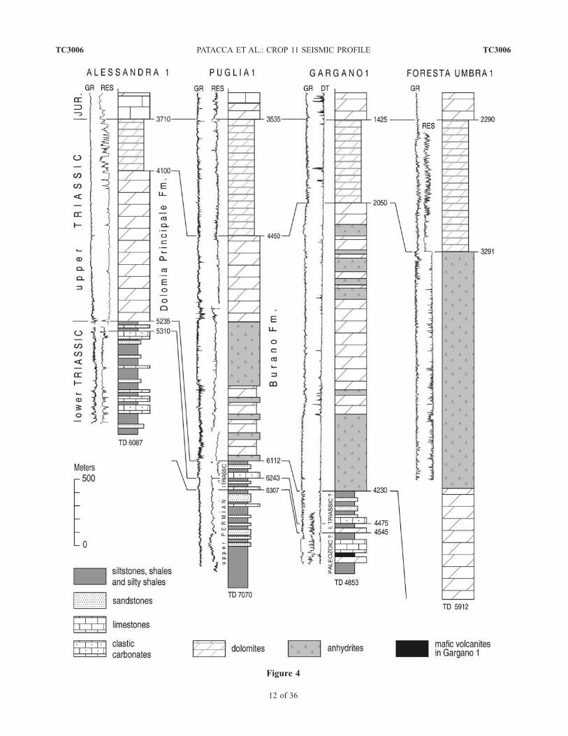
Figure 4
TC3006 PATACCA ET AL.: CROP 11 SEISMIC PROFILE
12 of 36
TC3006
analogous to those cropping out at Punta delle Pietre Nereabout 12 km west of Gargano 1 [Boni et al., 1969]. In thislocality, a dyke of Paleogene mafic volcanites [De Fino etal., 1981; Bigazzi et al., 1996] associated with UpperTriassic dark-gray marls [Di Stefano, 1895] is exposed,pushed up by a diapir of Triassic evaporites [Cotecchiaand Canitano, 1955; Martinis and Pieri, 1963]. Diapirs ofTriassic salts are quite common features in the Adriaticregion [De Alteriis, 1995]. Not far from Gargano 1, finally,the Foresta Umbra 1 well penetrated Upper Triassic depositsrepresented by 1000 m of well-bedded dolomites (2290–3291 m), more than 1700 m (3291–5071 m) of anhydrites(Burano Formation from Martinis and Pieri [1963]) andabout 800 m of dolomites (5071–5912 m) without reachingthe Permo-Triassic deposits.[11] In the following pages, we will describe the geolog-
ical features recognized in the CROP 11 seismic profile
moving along the trace of the line from the east to the west,i.e., from the gently deformed foreland areas reached by theApennine compression during the Pleistocene toward moreand more complex internal sectors of the thrust belt incorpo-rated in the tectonic wedge during Pliocene and Messiniantimes.
3. Crustal Structure of the Adriatic Foreland
in the Region Crossed by the CROP 11
Seismic Line
[12] Geological information on the uppermost portion ofthe Adriatic crust in the area crossed by the CROP 11 linemostly derives from the extensive petroleum exploration.The investigated sedimentary sequence consists of a pilearound 7 km thick of upper Triassic dolomites and anhy-drites and of Jurassic–Upper Cretaceous shallow-water
Figure 4. Stratigraphic correlation of some key wells exploring the Triassic and Permian deposits of the Adriatic foreland(well location in Figure 1). The basic stratigraphic information derives from the public composite logs and, as concernsForesta Umbra 1, from Martinis and Pieri [1963]. The wireline-logs evidence the overall serrated cylinder-shaped profilecharacterizing the Upper Triassic anhydrites. Alessandra 1 and Gargano 1, as well as to some extent Puglia 1, show anabrupt change of the electrofacies in correspondence to the Permo-Triassic clastic deposits.
Figure 5. Easternmost portion of the CROP 11 profile showing in some details the seismic signatures inthe foreland area at relatively shallow depths. The reflection data highlight the seismic faciesconfiguration of the Apulia carbonates and overlying Plio-Pleistocene foredeep deposits. Well-logexpressions of the Mesozoic-Tertiary carbonates and of the overlying Plio-Pleistocene deposits are shownin Figures 6 and 10, respectively. Arabian numbers with associated small letters a, b, and c refer to theintervals illustrated in Figure 10. The datum plane of the seismic line is 400 m above sea level. Rotarytable elevations and total depths of the projected wells are indicated in Figure 10.
TC3006 PATACCA ET AL.: CROP 11 SEISMIC PROFILE
13 of 36
TC3006
carbonates (Apulia Platform of the geological literature)stratigraphically overlying the Permo-Triassic continental toshallow-marine clastic deposits described in the previoussession. The Jurassic-Cretaceous shallow-marine carbonatesare disconformably covered by Miocene open-ramp carbon-ate deposits (Bolognano Formation) followed by Messinianevaporites (‘‘Gessoso-Solfifera’’ Formation). The Miocenedeposits, never exceeding a few hundred meters in thick-ness, are in turn overlain by Plio-Pleistocene siliciclasticflysch deposits up to 1800 m thick. The composite logs ofseveral wells close to the CROP 11 line that have reachedthe Mesozoic carbonates (Fontemaggiore 2, Grugnale 1Dir,Marzollo 1Dir, Casalbordino 1, Monteodorisio 1, CasaBorselli 1 and Ponte 1Dir; see Figure 5) and the accuratestratigraphic analysis of the Cupello 19 well (see location inFigure 3) carried out by Dondi et al. [1966] provide quitedetailed information on the Jurassic-Miocene portion of theforeland sequence.[13] In the CROP 11 profile, as in several commercial
lines available in the area, the top of the Apulia Platform is aprominent feature easily identifiable because of the strongacoustic impedance between the well-lithified Mesozoic-Tertiary limestones and the overlying Plio-Pleistocene softsediments. The Messinian evaporites of the ‘‘Gessoso-Solfifera’’ Fm and the Miocene limestones of the Bolog-nano Fm at the top of the Apulia Platform are physicallyimaged by a characteristic and fairly continuous couple ofstrong reflectors that can be followed through the wholeprofile of Figure 5. Between Ponte 1Dir and TorrenteAcquachiara 1, at about 1.8 s TWT, this couple overlies apackage of very high amplitude reflectors with subparallelto hummocky configuration identified in several wells (seeFigure 6) as the Turonian-Senonian portion of the CupelloLimestone of petroleum geologists (Ponte 1Dir, CasaBorselli 1, Monteodorisio 1 and Casalbordino 1). Thisportion of the Cupello Limestone is the subsurface equiv-alent of the Altamura Limestone, a shelf-lagoon carbonatedeposit widely exposed in Apulia. In the aforementionedwells, the Turonian-Senonian carbonates lie in disconfor-mity over the Cenomanian p.p.-Neocomian portion of theCupello Limestone made up of restricted-platform carbo-nates and known in surface sections as the Bari Limestone.In correspondence to the contact between the AltamuraLimestone and the Bari Limestone equivalents, a sharpdeflection of both SP and resistivity curves evidences a ‘‘terrarossa’’ layer associated with karstic breccias. This character-istic key bed, corresponding to the well-known bauxitehorizon developed at a regional scale in the peri-Adriaticcarbonate platforms, testifies to a prolonged (Cenomanian toearly Turonian) episode of subaerial exposure. A second keybed is represented by a layer of green nodular marls rich inOrbitolina (Orbitolina Marl horizon in Figure 5). In theanalyzed wireline logs, this horizon is easily recognizableas it is systematically marked by a strong deflection of the SP(or an increase in the GR values) and a concomitant strongdeflection of the resistivity curve.[14] In the CROP 11 profile (see Figure 5), the bauxite
layer divides the Cupello Limestone into a rather well-
layered upper unit, coinciding with the Altamura Lime-stone, and a lower unit characterized by discontinuousreflectors with variable amplitude and frequency, whichcoincides with the Bari Limestone. Just in the east ofTorrente Acquachiara 1, the layered upper Cretaceousportion of the Cupello Limestone terminates abruptlyagainst a paleofault. West of this fault, the Miocene Bolog-nano and ‘‘Gessoso-Solfifera’’ formations lie in disconfor-mity above the lower Cretaceous portion of the CupelloLimestone, as indicated by Grugnale 1Dir, Marzollo 1Dirand Fontemaggiore 1 wells (see Figure 6). Jurassic shallow-water carbonates have been reached in the study area by theCasa Borselli 1 well, as well as by Cupello 19. In thewireline logs, these carbonates are represented by a rathermassive unit showing a low degree of serration of the SPcurve compared with the overlying Cretaceous limestones(see Casa Borselli 1 in Figure 6). In the CROP 11 profile,the Jurassic carbonates are seismically expressed by a rathermassive reflection-free unit with discontinuous zones ofweak and disorganized reflections having a thickness ofabout 1.2 s TWT, which corresponds to a value of 3300–3500 m if we assume for the dense, scarcely fracturedplatform carbonates of the foreland a velocity range be-tween 5.5 km/s and 5.8 km/s. The calculated value does notcontrast with Cupello 19 that penetrated 2446 m of Jurassiccarbonates without reaching the Jurassic-Triassic boundary.[15] In correspondence to the eastern termination of the
CROP 11 line, a broadly layered seismic unit 0.4–0.5 sTWT thick recognizable between 3.5 and 4 s separates themassive Jurassic interval from another poorly reflective unitshowing only weak and rather chaotic reflections. We thinkthat the broadly layered unit, characterized by discontinuouspackages of low-frequency and moderate to high-amplitudeparallel reflectors, corresponds to the well-bedded Rhaetiandolomites crossed by the wells Gargano 1 (1425-205),Foresta Umbra 1 (2290-3291) and Puglia 1 (3535-4450),while the seismically disorganized unit should represent thebulk of the Upper Triassic anhydrites.[16] Below 4.4 s TWT, the massive unit attributed to the
Upper Triassic anhydrites is underlain by an irregularlylayered seismic interval imaged by discontinuous packagesof subtle parallel reflectors with variable amplitude andfrequency (see Foldouts 3 and 4). This new unit correspondsto the Permo-Triassic clastic deposits documented by theGargano 1 and Puglia 1 wells, as well as by Alessandra 1 inthe Central Adriatic area. The strong seismic impedance atthe top of the layered unit coincides with the abrupt changein the log profiles at the top of the Permo-Triassic depositsoutlined by a sudden increase in the GR values and by aconcomitant pronounced deflection of the resistivity and Dtvalues (see Figure 4). A relatively smooth cylinder-shapedprofile characterizes the upper Triassic massive dolomitesand anhydrites while a strongly ragged signature identifiesthe underlying clastic deposits. It is important to stress thatcommercial lines located a few tens of kilometers south ofthe CROP 11 profile show that the 958 m of Permo-Triassicdeposits drilled by Puglia 1 from 6112 m to the final depth7070 m represent only the upper portion of a layered
TC3006 PATACCA ET AL.: CROP 11 SEISMIC PROFILE
14 of 36
TC3006
Figure
6.
Stratigraphic
correlationandwell-logsignaturesofthepre-Pliocenedeposits
oftheApuliaPlatform
inthe
easternmostportionoftheCROP11
line(w
elllocationin
Figure
3).Thelogcorrelationevidencesin
theFontemaggiore-
Grugnale-Marzolloarea
anim
portantdisconform
ityat
thebaseoftheMioceneBolognanoForm
ationtestifiedbythe
absence
ofasignificantportionoftheCupello
Lim
estone(theentire
upper
Cretaceousandapartofthelower
Cretaceous).
Thewireline-logdataevidence
thewidearealextentofthetwoCretaceouskey
horizonsdiscussed
inthetext.
TC3006 PATACCA ET AL.: CROP 11 SEISMIC PROFILE
15 of 36
TC3006
seismic unit that in some cases has been recorded for 3.0 sTWT without reaching the base. 3 s TWT correspond to athickness not smaller than 7000–7500 m assuming a P-wavevelocity not lower than 4.5–5.0 km/s, in agreement with thepronounced Dt curve deflection recognizable in the soniclog of Puglia 1. Higher velocities would obviously implygreater thicknesses. Figure 7 provides a detail of a com-mercial seismic profile imaging a columnar section with theentire Apulia Platform and with the thick sedimentary
sequence underlying the upper Triassic dolomites andanhydrites. The line is located about half way between theCROP 11 line and the Puglia 1 well, in a region in whichcommercial lines suggest that the Apulia Platform mayreach a thickness slightly greater than in Puglia 1.We donot know the downward chronological extent of this thicksedimentary sequence that in the upper portion reaches thePermian and the Early Triassic. A thick carboniferousterrigenous sequence possibly comparable with the Paleo-zoic cover of the Adriatic-Apulia basement, which exceeds11,000 m in thickness, has been imaged by NVR experi-ments in Eastern Europe (EUROPROBE [see Stovba et al.,1996]). In the CROP 11 profile, the layered sequencevanishes below 5 s TWT into a seismically weak zone withhighly discontinuous reflections. However, starting from 6.4s TWT the occurrence of a subhorizontal, rather continuousband of bumpy to gently dipping packages of reflectorssuggests the persistence of the sedimentary sequence (likelyaffected by low-grade metamorphism at that considerabledepth) down to 7.8–7.9 s TWT. The total thickness of thissedimentary sequence would thus reach in times a value of3.4–3.5 s TWT, about 0.5 s greater than the maximumvalues observed in commercial lines where, in any case, thebase of the reflective unit has never been observed.[17] Between 7.8 and 9.7 s TWT, a massive, rather
transparent seismic unit with scattered and fairly weaksingle reflectors possibly represents a crystalline basementconstituting the deepest portion of the upper crust.[18] Between 9.7 and 12 s TWT, a thick band of
dominantly subhorizontal reflectors corresponds, in ouropinion, to the lower crust. The upper portion of this unit,between 9.7 and 10.6–10.7 s TWT, shows a distinctivelylayered seismic fabric evidenced by very strong, continuoussubhorizontal reflectors. The lower portion, on the contrary,displays scattered sets of parallel reflectors with variableamplitude and frequency. At 12.0–12.5 s TWT, finally, anarrower band of reflectors indicates the crust-mantleboundary.[19] Refraction seismic experiments carried out in the late
seventies some tens of kilometers north of the Crop 11 lineevidenced in the Pescara area a layered continental crust32 km thick [Scarascia et al., 1994, and references therein;Cassinis et al., 2003]. Four seismic layers were identifiedabove the Moho discontinuity: (1) Layer 1, with velocityvalues lower than 6 km/s, extending from the surface downto a depth of about 7 km; (2) Layer 2, with increasingvelocity values that reach a maximum of 6.7 km/s at a depthof about 12 km; (3) Layer 3, a low-velocity layer extendingfrom about 12 to 22 km with an average velocity of 6.2 km/s;(4) Layer 4, extending from 22 to 32 km with an averagevelocity of 7.0 km/s, interpreted as a typical lower crust. Atthe base of this layer, a sudden velocity increase up to 8 km/s evidences the Moho discontinuity.[20] Figure 8 shows the correspondences between the
velocity units recognized in the refraction experiments andthe seismic units recognized in the CROP 11 profile. Theanhydrite layer recognized in the CROP 11 profile between3.8 and 4.4 s TWT (i.e., between 7.3 and 9.3 km) shouldcorrespond to the lower part of the layer 2 identified in the
Figure 7. Detail of a commercial line showing the entireApulia Platform and the thick sedimentary sequenceunderlying the Upper Triassic dolomites and anhydrites.The Puglia 1 well penetrated only the uppermost portion ofthis sequence. The gamma ray and resistivity curves ofPuglia 1 have been converted from meters into millisecondsin order to allow the correlation between the electrofaciesand the seismofacies.
TC3006 PATACCA ET AL.: CROP 11 SEISMIC PROFILE
16 of 36
TC3006
refraction seismic experiments (see easternmost part of thecross section D-D in Figure 5 of Scarascia et al. [1994] andcross section 8-8 in Figure 6 of Cassinis et al. [2003]).Massive thick anhydrites may account for the maximumvelocity values (up to 6.7 km/s) recorded in the lower partof the DSS layer 2. The different depth values attributed tothe bottom of the anhydrites in the CROP profile (around9.3 km according to our calculations) and to the bottom ofthe layer 2 in the Pescara area (12 km according toScarascia et al. [1994] and Cassinis et al. [2003]) is likelyrelated to the relevant increase in the thickness of the Plio-Pleistocene deposits moving from the CROP 11 region tothe area investigated by the refraction seismic experiments.The depth of the base-of-Pliocene deposits, in fact, lies atless than 2 km in correspondence to the CROP 11 line andreaches about 5 km in the Pescara region [see Bigi et al.,1991]. The underlying low-velocity layer (indicated bydashed lines in the D-D section of Scarascia et al. [1994]and in the 8-8 section of Cassinis et al. [2003]) roughlycorresponds to the seismically heterogeneous zone between
the upper Triassic anhydrites and the well-layered deepcrust that in our interpretation is representative of a ticksedimentary unit (possibly affected by low-grade metamor-phism) plus a crystalline basement making up the deepestpart of the upper crust. The last seismic unit recognized inthe CROP 11 line, featured by subparallel high-amplitudereflection fabric and interpreted as a layered lower crust,closely corresponds to the layer 4 of the refraction seismicexperiments. The high P-wave velocity (7.0 km/s) charac-terizing this layer supports our interpretation. The Mohodiscontinuity at a depth of about 31 km (time depth = 12 sTWT) in correspondence to the Adriatic coast is not farfrom the Moho discontinuity at 32 km of the refractionexperiments.
4. Apennine Nappe Front and the
Casoli-Bomba Positive Structure
[21] The region that extends from the eastern foot of theMajella anticline to the front of the Apennine chain isoccupied by the Molise nappes, a complex stack of allochth-onous sheets made up of well-bedded Mesozoic-Tertiarybasinal deposits overlain in angular unconformity by Mes-sinian to upper Pliocene thrust-top deposits (see Figure 3).The Molise nappes, formally established by Selli [1962] andstratigraphically defined by Clermonte [1977], have beensubdivided into several tectonic units by Patacca et al.[1991]. The more internal units (Frosolone and AgnoneUnits) are represented by Upper Jurassic/Lower Cretaceousto Tortonian basinal carbonates containing recurrent andvolumetrically important layers of coarse-grained resedi-ments rich in penecontemporaneous shelf materials. Thesecoarse resediments, mainly carbonate debrites, grade later-ally northward and eastward into distal calciturbiditesintercalated with pelagic deposits. No Mesozoic terms havebeen documented until now in the more external units(Tufillo and Daunia Units) which are typified by thewidespread occurrence of Paleogene red shales absent inthe more internal units. These red shales represent the basallevel above a detachment surface. In all Molise Units, theTortonian basinal carbonates are conformably overlain byuppermost Tortonian-Messinian siliciclastic flysch depositsdisplaying, as the underlying carbonate deposits, a generaldecrease in the grain size and bedding thickness toward thenorth and the east.[22] Along the trace of the CROP 11 profile, the Molise
nappes have been cut across by a series of backthrustsresponsible for quite complex imbricated structures. Somethrust surfaces are rooted in the buried Apulia carbonates.Other thrusts, on the contrary (e.g., important backthrustreaching the surface between Bomba 1 and Bomba 6 inFoldouts 3 and 4), have no continuation in the carbonatesubstratum and surely pre-date the growth of the Casoli-Bomba High. The latter represents the most striking tectonicfeature in the foreland carbonates. The top of the Casoli-Bomba positive structure is exposed in a small tectonicwindow at the eastern foot of the Majella anticline (seeFigures 2 and 3). In this window, the Molise nappestectonically overlie a lower Pliocene clayey sequence that
Figure 8. Correlation between the results of deep-seismic-sounding (DSS) refraction experiments in the Pescara area(about 50 km NW of Vasto) and the results of the CROP 11reflection seismic profile in the Vasto area.
TC3006 PATACCA ET AL.: CROP 11 SEISMIC PROFILE
17 of 36
TC3006
conformably covers Mesozoic-Tertiary carbonates (plusMessinian evaporites) of the Apulia Platform reached byseveral commercial wells at shallow depths. The CROP 11seismic profile intersects the Casoli-Bomba structure be-tween the Torricella Peligna 2 and Monte Marcone 1 wells.The top of the Apulia carbonates, outlined by the charac-teristic strong reflectors of the ‘‘Gessoso-Solfifera’’ andBolognano Formations, rises from about 2 s TWT incorrespondence to the foot of the foreland homocline to amaximum of 1 s TWT in correspondence to the Bomba 1and Bomba 3 wells. West of this positive structure, the topcarbonates abruptly deepens to a depth of about 3.5 s TWT,evidencing in this way a vertical displacement of 2.5 sTWT. Moving westward, in the direction of the MajellaMountain, the top of the carbonates progressively ramps atshallow depths until it emerges in correspondence to theeastern foot of the Majella anticline.[23] On the basis of a seismic line that crosses the Casoli-
Bomba High a few kilometers north of the CROP 11 line incorrespondence to the Morgia 1 well (see well location inFigure 3), Scisciani et al. [2001] have interpreted thedisplacement of the Apulia carbonates in correspondenceto the western flank of the Casoli-Bomba High as a normalfault active in early Pliocene times, before the transport ofthe Molise nappes in the area. Figures 9a and 9b shows amute section of the aforementioned commercial line and therelative seismic interpretation proposed by Scisciani et al.[2001]. The CROP 11 line, tied in this area to several wells,suggests a different tectonic configuration (see Foldouts 1–4). The profile, in fact, shows that the western terminationof the shallow strong reflector marking the top of the Apuliacarbonates in the structural high (reached by Bomba 2 at adepth slightly exceeding 1 s TWT) overlaps a deeperhorizon still referable to the top carbonates recognizablebetween Torricella Peligna 2 and Bomba 2 at 3.0–3.5 sTWT. The geometric relationships between these reflectorssuggest that the deeper Apulia carbonates belong to thefootwall of NE-dipping reverse fault rather than to thehangingwall of a SW-dipping normal fault, as it would beexpected from the interpretation of the Casoli-Bomba Highof Scisciani et al. [2001]. In addition, a careful examinationof the seismic line published by these authors shows that thegeometric array of some strong reflectors is comparablewith the array observed 5 km southward in the CROP 11line. Figure 9c provides the alternative interpretation, fea-tured by a backthrust structure in agreement with thereading of the CROP 11 profile.[24] In the CROP 11 profile, the top of the Apulia
carbonates at the rear of the Casoli-Bomba structure liesat a depth of 3.5 s TWT, which is 1.0–1.5 s TWT deeperthan the depth expected just considering the gentle regionaldip of the foreland homocline depicted by the top of theApulia carbonates between the eastern termination of theCROP 11 line and the Monte Marcone 1 well (see Foldouts 3and 4). Therefore, an important westward-dipping normalfault is required west of Monte Marcone 1 in order to justifythe displacement of the top-carbonate horizon from about 2 sTWT in correspondence to Monte Marcone 2 to about 3.5 sTWT west of Bomba 2, over a distance of only 10–11 km.
Consequently, we have interpreted the Casoli-Bomba Highas an inverted structure created by the reactivation of animportant normal fault as a reverse fault, with the contem-poraneous activation of backthrusts nucleated from a trian-gle zone. The absence of growth strata that would beexpected in the hangingwall block may be justified bysubsequent erosional processes, considering that in corre-spondence to the eastern termination of the structural highthe vertical component of the slip related to the shorteningroughly equalled the accommodation space created by theextension. High-relief, double-vergence popup-like struc-tures similar to the Casoli-Bomba High and occupying thesame structural position close to the front of the allochth-onous sheets have been recognized also in the SouthernApennines. The most striking one is the Tempa Rossa oilfield in Basilicata [see D’Andrea et al., 1993] recentlyinterpreted as an inversion thrust fold [Casero, 2004].[25] As concerns the time relations between the transport
of the allochthonous sheets over the foreland margin and thegrowth of the Casoli-Bomba High, the CROP 11 linesuggests that the structural high formed after and not beforethe final transport of the Molise nappes in the area as it hasbeen suggested by Scisciani et al. [2001]. The majorevidence is provided by the bumped geometry of the Molisebase thrust that has accommodated the growth of theunderlying structural high. Along the trace of the CROP11 profile, the base thrust of the Molise nappes lies at 700–800 m b.s.l. in correspondence to the Casoli-Bomba culmi-nation and deepens to more than 2000 m b.s.l. in corre-spondence to the eastern foot of the structure (MonteMarcone 1 well). West of the Casoli-Bomba structure, thebase thrust of the Molise nappes must lie at depths largelyexceeding 2000 m b.s.l. since Torricella Peligna 2 wasstopped at a depth of 1997 m b.s.l. quite far from thedeepest reflectors still referable to the allochthonous sheets(see Foldouts 3 and 4). In addition, the overall reflectorgeometry shows that the lower part of the allochthonoussheets explored by Torricella Peligna 2 deepens againtoward the east before being overthrust by the Apuliacarbonates of Bomba 2.[26] No stratigraphic constraints for dating the described
tectonic structures are available in the Casoli-Bomba area.However, important pieces of information can be derivedfrom the Plio-Pleistocene autochthonous deposits of theAdriatic foredeep the internal architecture of which appearsto have been closely controlled by the kinematic history ofthe nappe front. As everywhere along the outer margin ofthe Apennines, the Plio-Pleistocene foredeep deposits canbe divided into three intervals (preramp, synramp andpostramp intervals in Figures 5 and 10), each interval beingcharacterized by specific stratigraphic signatures imprintedby the active thrust propagation in the mountain chain. Agesand biozone definition of the Plio-Pleistocene deposits inthe study area derive from the composite logs of Monteo-dorisio 1 and Ponte 1Dir. Biostratigraphic data have beenobviously integrated with lithology and wireline-log corre-lations. Figure 11 provides a biostratigraphic scheme of thePliocene and Pleistocene with the foraminiferal zonesquoted in the text.
TC3006 PATACCA ET AL.: CROP 11 SEISMIC PROFILE
18 of 36
TC3006
Figure 9. Different structural interpretations of the western flank of the Casoli-Bomba High. (a)Uninterpreted segment of a commercial line parallel to the CROP 11 line located a few kilometers towardthe north. (b) Interpretation according to Scisciani et al. [2001]. (c) Alternative interpretation proposed inthis paper. See in Figure 3 the location of Morgia 1.
TC3006 PATACCA ET AL.: CROP 11 SEISMIC PROFILE
19 of 36
TC3006
Figure
10.
Well-logcorrelationofthePlio-Pleistoceneforedeepdepositscrossed
bytheCROP11line.
Bold
numbers1,2,and3indicatethe
preramp,synrampandpostrampdeposits,respectively.Geometry
andmutualrelationshipsoftheforedeepdepositshavederived
from
theseismic
interpretation.Ages
andbiozoneattributionshavederived
from
Ponte
1Diras
concernsthePlioceneandfrom
Monteodorisio1as
concernsthe
Pleistocene.
TC3006 PATACCA ET AL.: CROP 11 SEISMIC PROFILE
20 of 36
TC3006
4.1. Preramp Interval (Interval 1 in Figures 5 and 10)
[27] This interval is expressed by a reflection-free seismicfacies (1a) upward followed by a faintly layered unit witheven parallel, rather weak reflectors (1b). In commerciallines, these bedded deposits are usually marked by strongerand more continuous reflectors. Lithologically, the sequenceconsists of a basal clayey unit some hundred meters thick(1a) upward followed by a stack of aggrading well-beddedsandstones and shales displaying a broad blocky well-logprofile (1b). The basal clayey unit, forming a widespread
pelagic sheet on top of the Apulia carbonates, yieldedplanktonic-foram associations (e.g., Ponte 1Dir) indicativeof the Gt. margaritae zone (early Pliocene) up to the Gt.inflata zone (late Pliocene, see Figure 11). The overlyingsandy packages still belong to the late Pliocene (Gt. inflatazone).
4.2. Synramp Interval (Interval 2 in Figures 5 and 10)
[28] The synramp interval is represented by a clasticwedge thinning toward the east, landward (westward)truncated upsection by the Apennine frontal ramp. Incorrespondence to Ponte 1Dir, the synramp deposits thinout into a relatively transparent seismic facies representedby claystones with minor intercalations of very thin-beddedsandstones (see ragged well-log profile of Ponte 1Dir inFigure 10). Well logs and commercial profiles, obviouslyproviding a vertical resolution higher than the resolutionobtained from the CROP 11 seismic data, show a quitecomplex depositional architecture. Three portions may bebroadly identified. The thin lower portion (2a) is pictured bya shaly linear log profile and is seismically poorly resolvedin the CROP 11 line. The thicker middle portion (2b) is awell distinct seismic unit characterized by rather continu-ous, even-parallel strong reflectors. The fairly good qualityof the log data allows the recognition of two superimposedthinning- and fining-upward sequences of bedded turbiditeswith a broad bell-shaped well-log profile particularly wellevident in Casalbordino 1. The upper portion of the syn-ramp interval (2c) consists of a muddier sedimentary unitseismically featured by a chaotic to reflection-free internalconfiguration laterally substituted by a package of contin-uous parallel reflectors with a very gently mounded externalprofile. The change in the seismic facies reflects a changefrom slumped massive clays (e.g., Torrente Acquachiara 1)to well-bedded fine-grained sandy turbidites (e.g., Casal-bordino 1). According to the biostratigraphic data reportedin the composite log of Ponte 1Dir, the entire synrampinterval should belong to the late Pliocene. However, theoccurrence of H. baltica (Emilian, see Figure 11) in theimmediately overlying postramp deposits suggests a San-ternian age (early Pleistocene before the first occurrence ofH. baltica) of the synramp muddier deposits distinguishedas interval 2c in Figure 10.
4.3. Postramp Interval (Interval 3 in Figures 5 and 10)
[29] This interval is imaged in its lower part by fairlycontinuous horizontal reflectors corresponding to fine-grained sandy turbidites and mudstones, locally interruptedby concave-up reflections featuring channels that may havebeen filled with pebbly conglomerates (e.g., TorrenteAcquachiara 1 and Casa Borselli 1). Landward (westward),the even-parallel reflectors seal the frontal ramp of theallochthonous sheets with an evident marine onlap termi-nation. The occurrence of Hyalinea baltica in Monteodor-isio 1 and Ponte 1Dir at the base of the postramp intervalfixes the age of deactivation of the frontal ramp around theSanternian-Emilian boundary, i.e., around 1.5 Ma. Theupper portion of the lower Pleistocene sequence, notdetected by the CROP 11 profile but well exposed in the
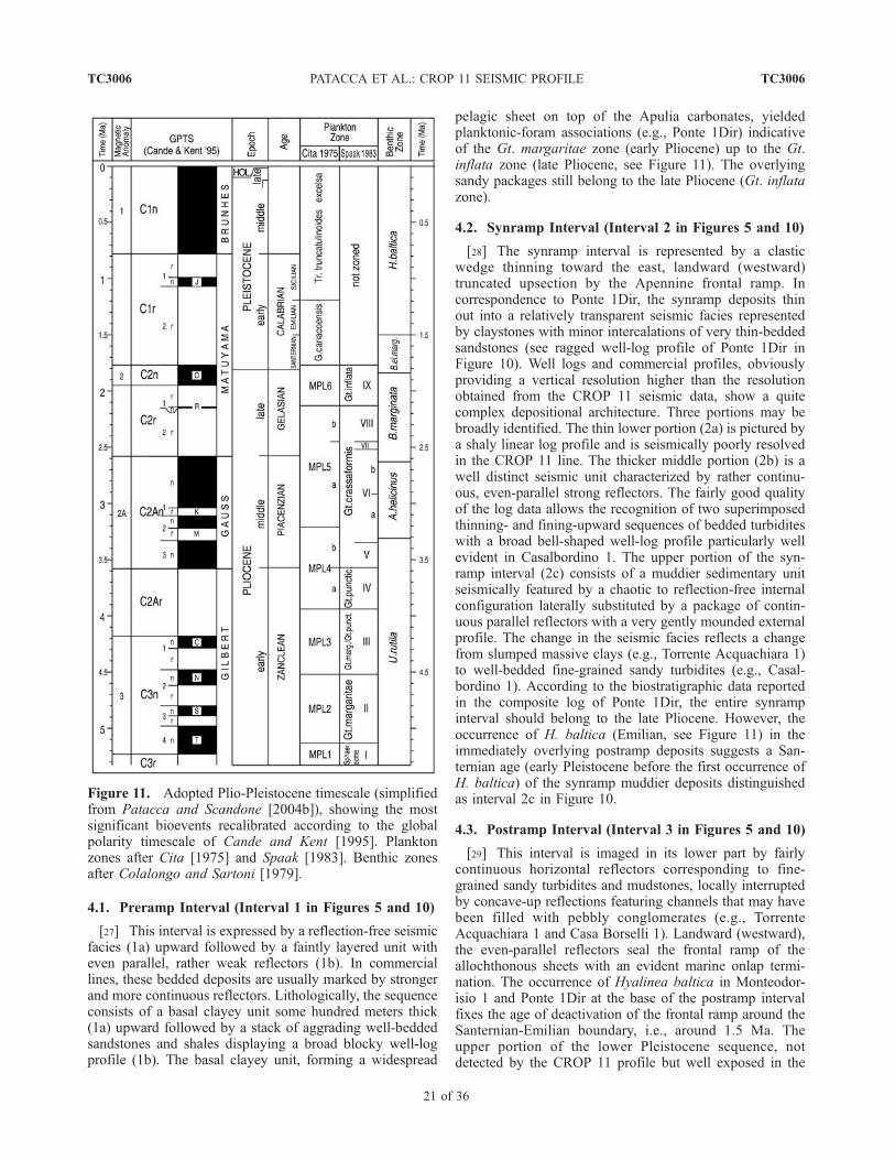
Figure 11. Adopted Plio-Pleistocene timescale (simplifiedfrom Patacca and Scandone [2004b]), showing the mostsignificant bioevents recalibrated according to the globalpolarity timescale of Cande and Kent [1995]. Planktonzones after Cita [1975] and Spaak [1983]. Benthic zonesafter Colalongo and Sartoni [1979].
TC3006 PATACCA ET AL.: CROP 11 SEISMIC PROFILE
21 of 36
TC3006
area (see Figure 3), is represented by a transgressive-regressive cycle topped by a thin veneer of reddish conti-nental sandstones. The latter laterally evolve, in the AdriaticSea, into a prograding shelf-margin system seismicallyimaged by sigmoid reflectors with clear offlapping geome-try (see CROP M13, M14 and M15 lines, located in theoffshore not far from the CROP 11 line, inwork by Scroccaet al. [2003]).[30] The described Plio-Pleistocene foredeep deposits
provide important constraints on the timing of the tectonicevolution of the area east of Majella. Moving over a longthrust flat acting as a conveyor belt for forward nappetransport, the Molise nappes approached their present-dayposition around the Pliocene-Pleistocene boundary, after thedeposition of the Gt. inflata turbidites and before the onsetof the synramp clastic wedge. Consequently, the Casoli-Bomba structural high, the growth of which bumped theMolise base thrust, did not exist in that time and thecorresponding paleogeographic realm had to be part ofthe foreland homocline. The Majella Unit, on the contrary,had already been incorporated in the Apennine thrust beltwhen the Molise nappes underwent the last tectonic trans-port over the foreland margin. This constraint is establishedby the occurrence of upper Pliocene thrust-top depositsunconformably overlying the northeastern margin of theMajella anticline [Crescenti, 1971b]. The Casoli-Bombapositive structure began to grow after the forward transportof the allochthonous sheets, i.e., after the deposition of theupper Pliocene Gt. inflata turbidites of the Adriatic foredeepbasin. However, the stratigraphic constraints established bythe Plio-Pleistocene foredeep deposits do not allow us toestablish whether the growth of the Casoli-Bomba Highpredates (as suggested in our seismic interpretation) or iscoeval with the backthrust responsible for the positivestructure on top of which the Majella Mountain waspassively uplifted. We will return to this subject in the nextsession after having discussed the deep structure of theMajella massif.
5. Deep Structure of the Majella Massif
[31] A few tens of kilometers far from the Adriatic coast,the Majella Mountain features a box-shaped anticline thatdescribes an arc about 35 km long, convex toward thenortheast, and reaches the remarkable elevation of 2793 ma.s.l. (Monte Amaro) in correspondence to the axial culmi-nation. The fold has a gentle axial plunging toward the northand a steeper plunging toward the south (see Figures 2 and3). Along the eastern margin of the structure, the forelimb ofthe anticline is tectonically overlain by the Molise nappesthat in this area are westward limited by a lateral ramp. Atthe western margin of Majella, the backlimb of the fold ismissing, cut across and downthrown by an importantnormal fault system known in the geological literature asthe Caramanico Fault [Ghisetti and Vezzani, 2002]. Incorrespondence to the axial culmination of the fold, thefault system has produced a cumulative downthrow of thehangingwall block exceeding 3500 m. A narrow tectonicdepression parallel to the fault system (Caramanico depres-
sion) separates the western edge of the Majella Massif fromthe Morrone Ridge (see Figure 3).[32] The sedimentary sequence of the Majella Unit is
represented by upper Triassic to upper Miocene carbonatesfollowed by Messinian evaporites and marls conformablyoverlain by lower Pliocene siliciclastic flysch deposits. Theupper Triassic-Jurassic portion of the sequence is knownonly in the subsurface, explored by the wells Cigno 2,Musellaro 1, Maiella 2 and Caramanico 1 (see location inFigure 3). These wells testify to the drowning of an upperTriassic-lower Jurassic carbonate shelf and to the establish-ment of a Jurassic p.p.-Cretaceous basin in northernMajella. A very well preserved transition between theCretaceous platform and the adjacent basin is spectacularlyexposed in central Majella, with isopic facies distributionfollowing a W-E direction roughly perpendicular to thePliocene fold axis. The sedimentary sequence and thestratigraphic evolution of Majella are well known owingto the existence of several biostratigraphic and sedimento-logical studies, in some cases accompanied by detailed fieldsurveys (see, among many others, Crescenti et al. [1969],Donzelli [1969], Accarie [1988], Vecsei [1991], and Vecseiet al. [1998]).[33] The CROP 11 line crosses the Majella Massif in
correspondence to the southern termination of the anticline,where the Majella Unit disappears beneath the Morrone-Porrara Unit (Figure 3). In this part of the profile there is agap of information on the shallow structure because theacquisition of seismic data in the region was precluded inthe early nineties after the institution of the Majella NationalPark. However, well organized sets of reflectors east ofMajella between the CDP 4700 and 5000 suggest theexistence of an important westward-climbing structure inthe footwall of Majella that we have interpreted as a blindbackthrust nucleated at the rear of the Casoli-Bomba Highat a depth exceeding 7 s TWT (see Foldouts 3 and 4).According to this interpretation, the Majella Massif hasbeen passively uplifted on top of the growing backthruststructure. The package of westward dipping reflectors incorrespondence to the Caramanico fault system between 3and 6 s TWT (CDP 4150–4450) has been consideredrepresentative of the Paleozoic-Triassic deposits underlyingthe Mesozoic carbonates that in our interpretation are part ofthe Majella Unit.[34] In order to check the proposed tectonic reconstruc-
tion and to fill the gap of information of the CROP 11 line atshallow depths, we have analyzed a commercial line (line Ain Figure 3) that crosses the Majella anticline. The lineextends from the Caramanico depression to the Casoli-Bomba High intersecting the highest peaks of Majella(Monte Amaro and Monte Acquaviva) and is stratigraphi-cally linked to the Maiella 1 well in correspondence to thewestern termination and to the Casoli 6 and Casoli 7 wells incorrespondence to the eastern termination (see Figure 12).The Maiella 1 well, located in the hangingwall of theCaramanico fault, crossed 2160 m of upper Messinian-lower Pliocene siliciclastic flysch deposits of the QuegliaUnit and reached Upper Jurassic/Lower Cretaceous shallow-water limestones referable to the Majella Unit at 2160 m
TC3006 PATACCA ET AL.: CROP 11 SEISMIC PROFILE
22 of 36
TC3006
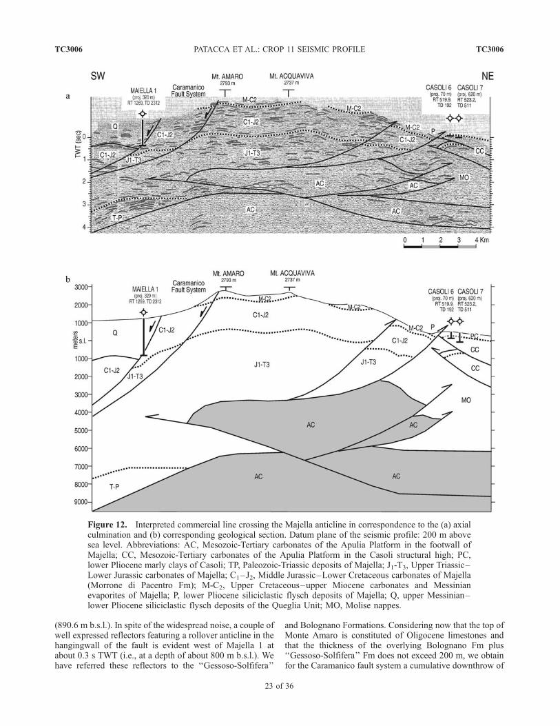
(890.6 m b.s.l.). In spite of the widespread noise, a couple ofwell expressed reflectors featuring a rollover anticline in thehangingwall of the fault is evident west of Majella 1 atabout 0.3 s TWT (i.e., at a depth of about 800 m b.s.l.). Wehave referred these reflectors to the ‘‘Gessoso-Solfifera’’
and Bolognano Formations. Considering now that the top ofMonte Amaro is constituted of Oligocene limestones andthat the thickness of the overlying Bolognano Fm plus‘‘Gessoso-Solfifera’’ Fm does not exceed 200 m, we obtainfor the Caramanico fault system a cumulative downthrow of
Figure 12. Interpreted commercial line crossing the Majella anticline in correspondence to the (a) axialculmination and (b) corresponding geological section. Datum plane of the seismic profile: 200 m abovesea level. Abbreviations: AC, Mesozoic-Tertiary carbonates of the Apulia Platform in the footwall ofMajella; CC, Mesozoic-Tertiary carbonates of the Apulia Platform in the Casoli structural high; PC,lower Pliocene marly clays of Casoli; TP, Paleozoic-Triassic deposits of Majella; J1-T3, Upper Triassic–Lower Jurassic carbonates of Majella; C1–J2, Middle Jurassic–Lower Cretaceous carbonates of Majella(Morrone di Pacentro Fm); M-C2, Upper Cretaceous–upper Miocene carbonates and Messinianevaporites of Majella; P, lower Pliocene siliciclastic flysch deposits of Majella; Q, upper Messinian–lower Pliocene siliciclastic flysch deposits of the Queglia Unit; MO, Molise nappes.
TC3006 PATACCA ET AL.: CROP 11 SEISMIC PROFILE
23 of 36
TC3006
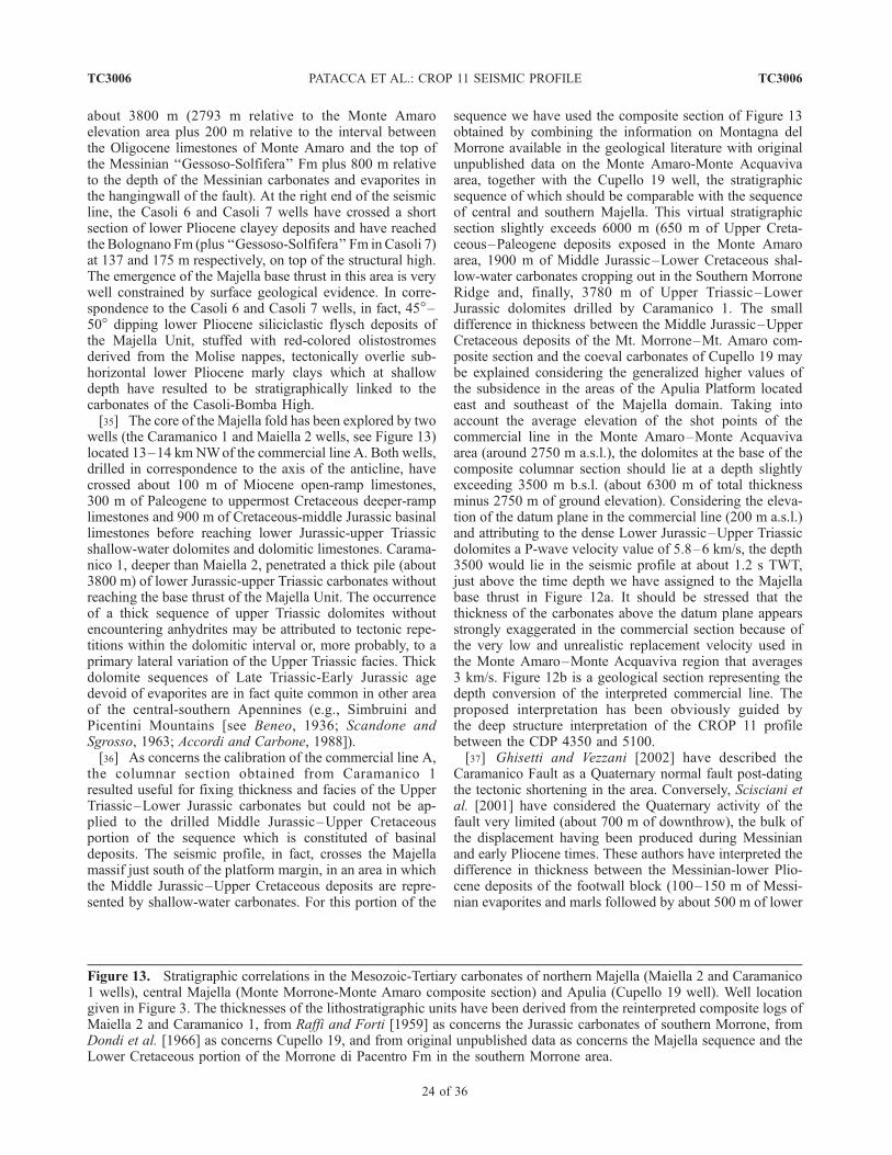
about 3800 m (2793 m relative to the Monte Amaroelevation area plus 200 m relative to the interval betweenthe Oligocene limestones of Monte Amaro and the top ofthe Messinian ‘‘Gessoso-Solfifera’’ Fm plus 800 m relativeto the depth of the Messinian carbonates and evaporites inthe hangingwall of the fault). At the right end of the seismicline, the Casoli 6 and Casoli 7 wells have crossed a shortsection of lower Pliocene clayey deposits and have reachedthe Bolognano Fm (plus ‘‘Gessoso-Solfifera’’ Fm in Casoli 7)at 137 and 175 m respectively, on top of the structural high.The emergence of the Majella base thrust in this area is verywell constrained by surface geological evidence. In corre-spondence to the Casoli 6 and Casoli 7 wells, in fact, 45�–50� dipping lower Pliocene siliciclastic flysch deposits ofthe Majella Unit, stuffed with red-colored olistostromesderived from the Molise nappes, tectonically overlie sub-horizontal lower Pliocene marly clays which at shallowdepth have resulted to be stratigraphically linked to thecarbonates of the Casoli-Bomba High.[35] The core of the Majella fold has been explored by two
wells (the Caramanico 1 and Maiella 2 wells, see Figure 13)located 13–14 km NWof the commercial line A. Both wells,drilled in correspondence to the axis of the anticline, havecrossed about 100 m of Miocene open-ramp limestones,300 m of Paleogene to uppermost Cretaceous deeper-ramplimestones and 900 m of Cretaceous-middle Jurassic basinallimestones before reaching lower Jurassic-upper Triassicshallow-water dolomites and dolomitic limestones. Carama-nico 1, deeper than Maiella 2, penetrated a thick pile (about3800 m) of lower Jurassic-upper Triassic carbonates withoutreaching the base thrust of the Majella Unit. The occurrenceof a thick sequence of upper Triassic dolomites withoutencountering anhydrites may be attributed to tectonic repe-titions within the dolomitic interval or, more probably, to aprimary lateral variation of the Upper Triassic facies. Thickdolomite sequences of Late Triassic-Early Jurassic agedevoid of evaporites are in fact quite common in other areaof the central-southern Apennines (e.g., Simbruini andPicentini Mountains [see Beneo, 1936; Scandone andSgrosso, 1963; Accordi and Carbone, 1988]).[36] As concerns the calibration of the commercial line A,
the columnar section obtained from Caramanico 1resulted useful for fixing thickness and facies of the UpperTriassic–Lower Jurassic carbonates but could not be ap-plied to the drilled Middle Jurassic–Upper Cretaceousportion of the sequence which is constituted of basinaldeposits. The seismic profile, in fact, crosses the Majellamassif just south of the platform margin, in an area in whichthe Middle Jurassic–Upper Cretaceous deposits are repre-sented by shallow-water carbonates. For this portion of the
sequence we have used the composite section of Figure 13obtained by combining the information on Montagna delMorrone available in the geological literature with originalunpublished data on the Monte Amaro-Monte Acquavivaarea, together with the Cupello 19 well, the stratigraphicsequence of which should be comparable with the sequenceof central and southern Majella. This virtual stratigraphicsection slightly exceeds 6000 m (650 m of Upper Creta-ceous–Paleogene deposits exposed in the Monte Amaroarea, 1900 m of Middle Jurassic–Lower Cretaceous shal-low-water carbonates cropping out in the Southern MorroneRidge and, finally, 3780 m of Upper Triassic–LowerJurassic dolomites drilled by Caramanico 1. The smalldifference in thickness between the Middle Jurassic–UpperCretaceous deposits of the Mt. Morrone–Mt. Amaro com-posite section and the coeval carbonates of Cupello 19 maybe explained considering the generalized higher values ofthe subsidence in the areas of the Apulia Platform locatedeast and southeast of the Majella domain. Taking intoaccount the average elevation of the shot points of thecommercial line in the Monte Amaro–Monte Acquavivaarea (around 2750 m a.s.l.), the dolomites at the base of thecomposite columnar section should lie at a depth slightlyexceeding 3500 m b.s.l. (about 6300 m of total thicknessminus 2750 m of ground elevation). Considering the eleva-tion of the datum plane in the commercial line (200 m a.s.l.)and attributing to the dense Lower Jurassic–Upper Triassicdolomites a P-wave velocity value of 5.8–6 km/s, the depth3500 would lie in the seismic profile at about 1.2 s TWT,just above the time depth we have assigned to the Majellabase thrust in Figure 12a. It should be stressed that thethickness of the carbonates above the datum plane appearsstrongly exaggerated in the commercial section because ofthe very low and unrealistic replacement velocity used inthe Monte Amaro–Monte Acquaviva region that averages3 km/s. Figure 12b is a geological section representing thedepth conversion of the interpreted commercial line. Theproposed interpretation has been obviously guided bythe deep structure interpretation of the CROP 11 profilebetween the CDP 4350 and 5100.[37] Ghisetti and Vezzani [2002] have described the
Caramanico Fault as a Quaternary normal fault post-datingthe tectonic shortening in the area. Conversely, Scisciani etal. [2001] have considered the Quaternary activity of thefault very limited (about 700 m of downthrow), the bulk ofthe displacement having been produced during Messinianand early Pliocene times. These authors have interpreted thedifference in thickness between the Messinian-lower Plio-cene deposits of the footwall block (100–150 m of Messi-nian evaporites and marls followed by about 500 m of lower
Figure 13. Stratigraphic correlations in the Mesozoic-Tertiary carbonates of northern Majella (Maiella 2 and Caramanico1 wells), central Majella (Monte Morrone-Monte Amaro composite section) and Apulia (Cupello 19 well). Well locationgiven in Figure 3. The thicknesses of the lithostratigraphic units have been derived from the reinterpreted composite logs ofMaiella 2 and Caramanico 1, from Raffi and Forti [1959] as concerns the Jurassic carbonates of southern Morrone, fromDondi et al. [1966] as concerns Cupello 19, and from original unpublished data as concerns the Majella sequence and theLower Cretaceous portion of the Morrone di Pacentro Fm in the southern Morrone area.
TC3006 PATACCA ET AL.: CROP 11 SEISMIC PROFILE
24 of 36
TC3006
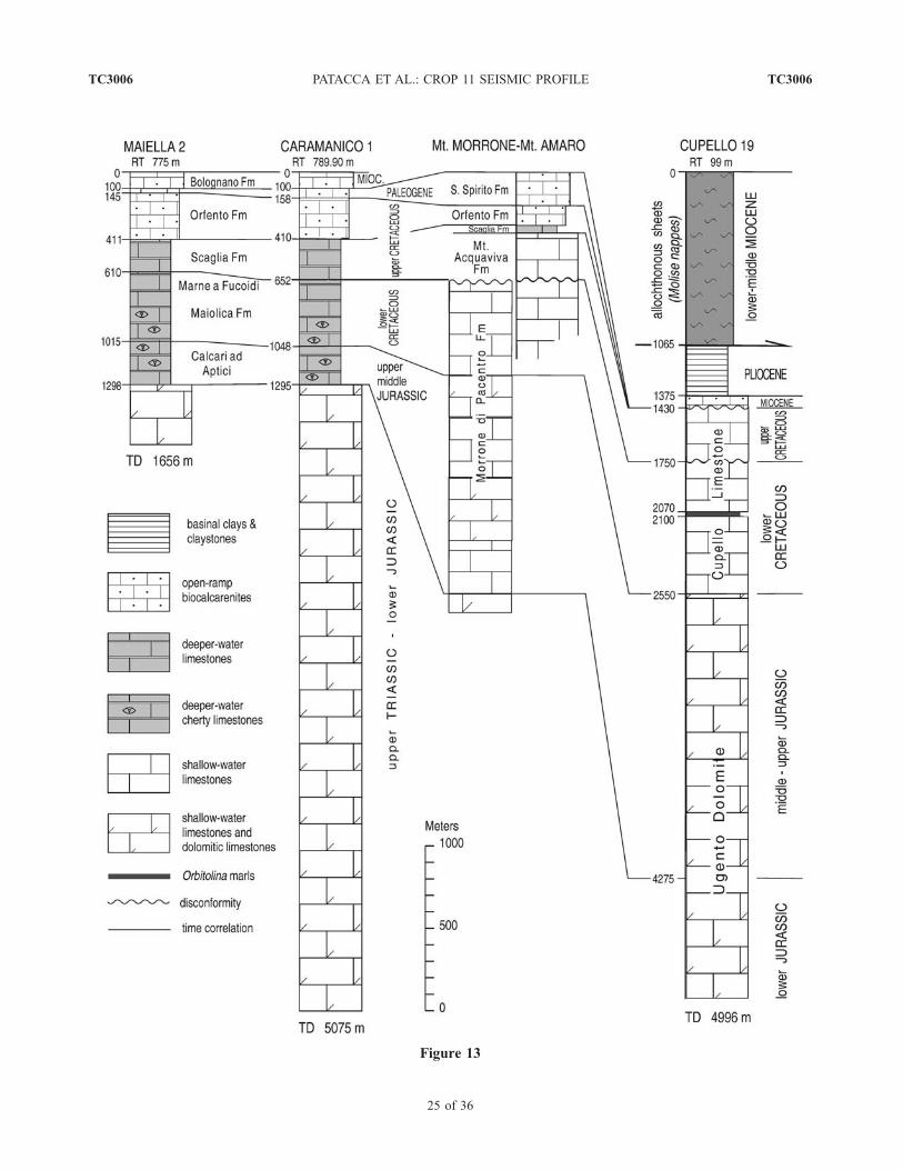
Figure 13
TC3006 PATACCA ET AL.: CROP 11 SEISMIC PROFILE
25 of 36
TC3006
Pliocene siliciclastic deposits) and the coeval deposits of thehangingwall block (exceeding 2100 m in the Maiella 1 well)as the evidence for a syntectonic sedimentary wedge grownduring the activity of the fault. In reality, the thick section ofMessinian–lower Pliocene siliciclastic deposits crossed byMaiella 1 does not belong to the Majella Unit, where thebase of the siliciclastic flysch deposits has an early Plioceneage, but to the more internal Queglia Unit where the base ofthe siliciclastic flysch deposits dates back to the Messinian.Therefore, the Caramanico Fault cannot be interpreted as agrowth fault active in Messinian and early Pliocene timessince its activation post-dates the tectonic transport of theQueglia Unit over the Majella domain (Zanclean, Globor-otalia margaritae/Gt. puncticulata concurrent range zone,see time table in Figure 11). The CROP 11 line suggests thatthe Majella anticline overlies a popup structure in theMesozoic-Tertiary carbonates of the Apulia Platform relatedto an important blind backthrust. In such a structural frame-work, we have interpreted the Caramanico Fault as a gravity-collapse feature developed in the roof of the tectonic edificeat the front of a growing ridge. This fault may haveprogressively accommodated with a listric geometry theincrease in the structural elevation created by the backthruststructure grown in the footwall of the Majella anticline. Ourinterpretation implies the existence of close relationshipsbetween structural elevation and amount of displacementacross the fault. We have seen that the cumulative verticaldownthrow across the Caramanico fault system averages3800 m in correspondence to Monte Amaro, i.e., in corre-spondence to the axial culmination of the anticline. Movingnorthward in the direction of the Pescara River, the elevationof the Majella Mountain gradually decreases as a conse-quence of the gentle plunging of the fold axis. Referring tothe base of the Bolognano Fm, the elevation decreases fromabout 2750 m a.s.l. in the Monte Acquaviva area to a fewhundreds of meters in correspondence to the Pescara Valley.The gradual decrease in the structural elevation is accompa-nied by a simultaneous decrease in the fault displacementuntil zero displacement is reached in correspondence to thePescara Valley where the Majella Unit disappears beneaththe Messinian–lower Pliocene terrigenous deposits of theQueglia Unit [Patacca et al., 1991], the base thrust of thisunit being here represented by a long thrust flat gently foldedby the northward-plunging Majella anticline.[38] In the Majella area, no stratigraphic constraint exists
for establishing the age of the Caramanico fault activity.Some information on the age of the backthrust developed inthe footwall of Majella, and consequently on the age of thegravity collapse at the front of the growing ridge, is providedby the Pliocene-Pleistocene deposits of the Adriatic Apen-nine margin (see Figures 3 and 10). Uppermost Pliocenethrust-top deposits unconformably overlying Majella (lateGelasian [see Crescenti, 1971b]) and sealing the tectoniccontact between the Majella and Queglia Units establish anupper chronological boundary for the incorporation of theMajella domain in the Apennine thrust belt (the lowerboundary is fixed by the age of the uppermost portion ofthe siliciclastic flysch deposits of Majella: Zanclean, Glo-borotalia margaritae/Gt. puncticulata concurrent range
zone). During the late Pliocene, however, the elevation ofMajella had to be very modest since no lithotypes derivedfrom the Majella sequence are present in the coarse-grainedlayers (pebble conglomerates) of the aforementioned thrust-top deposits. Elevation had still to be modest in the lowerpart of the early Pleistocene, as testified by the generalizedEmilian transgression along the eastern margin of Majella(see transgressive postramp interval of the Plio-Pleistocenedeposits of Figure 10) suggesting tectonic subsidence ratherthan uplift. Finally, in a still undefined moment of the earlyPleistocene (late Emilian? Sicilian?) the open-marine con-ditions east of Majella were suddenly replaced by near-shoreconditions so that sands and conglomerates were depositedforming as a whole a shallowing-upward and coarsening-upward prograding system. The occurrence of Elephasmeridionalis remains in paralic deposits a few kilometersnorth of Majella [D’Erasmo, 1931] confines the regressiveevent in the early Pleistocene before the extinction of thisspecies and thus before the last magnetic inversion. Theupper portion of the regressive sequence, well exposed atabout 600 m a.s.l. in correspondence to the northeasternmargin of the Majella anticline, is characterized by con-glomerates with clasts surely derived from the Mesozoiccarbonates of Majella. The sudden, deep erosion of theMajella anticline after the Emilian generalized transgressiontestifies to an energetic tectonic uplift of the structure withinthe early Pleistocene. A downthrow of 3800 m across theCaramanico fault system may appear surprisingly highcompared with the short time interval in which was com-pleted if we interpret this fault as a normal fault related to ayoung extensional regime subsequent to the compression inthe region. Conversely, if we interpret the Caramanico faultsystem as a gravity-collapse feature, a displacement of 4 kmdoes not sound strange since it can have been completed in afew hundreds of kyears considering that the tectonic uplift(and consequently the amount of the gravity collapse)represents the vertical component of the active-thrust slipvectors the rate of which in the central-southern Apenninesaveraged some centimeters per year during the early Pleis-tocene [Patacca and Scandone, 2001, 2004b].
6. Structural Architecture of the Abruzzi
Region Between the Majella Massif and the
Fucino Region
[39] Between the southwestern margin of the Majellaanticline and the Fucino area, the CROP 11 line cuts acrossa stack of carbonate units constituted of shallow-water-platform and adjacent slope-to-basin deposits [Accordi andCarbone, 1988, D’Andrea et al., 1991; Piacentini, 2000;Parotto and Praturlon, 2004, and references therein]. Theseismic resolution of the CROP profile in this part is quitepoor, with a few sets of organized reflectors several of whichrecognizable only at depths exceeding 4 s TWT. In addition,the absence of commercial wells in the area did not allowany link between stratigraphic/tectonic units known on thesurface and reflection events identifiable in the subsurface atshallow depths. Consequently, the interpretation of theCROP 11 profile in this segment is rather speculative.
TC3006 PATACCA ET AL.: CROP 11 SEISMIC PROFILE
26 of 36
TC3006
[40] Starting from the Caramanico fault system, theseismic line runs through a stack of thrust sheets referableto the Morrone-Porrara, Gran Sasso-Genzana and WesternMarsica Units (see Figure 3). A first problem is representedby the Queglia Unit, not intersected on the surface by theCROP 11 profile but cropping out one kilometer in the northtectonically sandwiched between the Majella and Morrone-Porrara Units. The bulk of the sedimentary sequence makingup the Queglia Unit consists of uppermost Messinian–lowerPliocene siliciclastic flysch deposits reaching more than2500 m in thickness north of the study area [Casnedi,1983; Patacca et al., 1991]. In a few outcrops, these flyschdeposits conformably overlie 100–150 m of Upper Creta-ceous–upper Miocene carbonates topped by a few meters ofMessinian evaporites and marls. In the central Apennines theQueglia Unit forms a thrust sheet that extends uninterrupt-edly for about 50 km in length and 20–25 km in width. Westof Majella, the unit occupies the narrow structural corridor ofthe Caramanico depression, in the footwall of the Morronethrust. Moving from the Pescara Valley toward the south, thecorridor becomes progressively narrower, until the QuegliaUnit disappears beneath the Morrone carbonates. Moving inthe same direction, the thickness of the Queglia depositsappears to become progressively smaller. We do not knowwhether the Queglia Unit is still represented in the subsur-face along the trace of the CROP 11 line (as suggested by astrike commercial line running along the Caramanico corri-dor) or it ends somewhere in the north limited by a lateral/oblique ramp. In such a case, the deposits we have attributedto the Queglia Unit should be part of the Morrone-PorraraUnit. Everywhere the sequence of the Queglia Unit isexposed, the structural architecture is characterized by atight system of short-wavelength folds, frequently reversefolds, systematically trending N-S also in the areas in whichthe contact with the overlying tectonic units suddenlychanges from a N-S direction (Montagna dei Fiori plus GranSasso in the hangingwall) to a NW-SE direction (Morrone-Porrara in the hangingwall). These geometric relationships(see Figure 3) suggest an undisturbed continuation of theQueglia Unit in the footwall of the Gran Sasso and Morrone-Porrara thrust sheets. In our interpretation of the CROP 11line, we have postulated the persistence of a thin section ofQueglia Unit sandwiched between the Morrone-Porrara andthe Majella Units and have assumed a distance between thefront of the Queglia Unit and its trailing edge not smallerthan 25–30 km, which corresponds to the minimumwidth ofthe Queglia Unit in the north. The front of the Queglia Unithas been easily traced by projecting on the CROP 11 line theclosest outcrop. The position of the trailing edge, on thecontrary, is not constrained by any reliable seismic imaging.A volume-balancing approach suggested the termination ofthe unit east of the Fucino Plain in correspondence to theCDP 3800. Once the position of the Queglia Unit at the rearof Majella was fixed, we have tried to reconstruct the overallstructural architecture of the area by projecting to thesubsurface the geometric array of the major surface struc-tures, obviously using the few seismic features showing acoherently layered signature.
[41] Along the trace of the CROP 11 line, the Morrone-Porrara carbonates disappear beneath the Gran Sasso-GenzanaUnit. The contact is covered by the continental Quaternarydeposits of the Sulmona Plain, but it is well exposed at thenorthern and southern terminations of the intramontanebasin (see Figure 3). In the seismic profile, we havetentatively followed the trend of badly defined parallelreflectors which appear to characterize the basinal uppersequence. The vaguely layered seismic fabric attributed tothe Gran Sasso-Genzana Unit has been recognized as far asto the western termination of the interpreted profile. Theexistence of deposits referable to the Gran Sasso-GenzanaUnit at shallow depths in this area would account for theoccurrence of small and scattered outcrops of Jurassicbasinal limestones just north of the Fucino Plain [seeAccordi and Carbone, 1988], in an area entirely dominatedby shallow-marine Mesozoic-Tertiary carbonates surelybelonging to the Western Marsica-Meta Unit. West of theFucino Plain, the seismic facies attributed to the GranSasso-Genzana Unit are tectonically sandwiched betweenthe carbonates of the Western Marsica-Meta Unit and adeeper quite massive unit (Q1 in Foldouts 3 and 4) that hasbeen dubitatively referred to the Upper Triassic–Cretaceousp.p. original carbonate substratum from which the upperCretaceous to lower Pliocene deposits of the Queglia Unithave been detached.[42] As concerns the deep structure of the area between
the Majella anticline and the Fucino Plain, a relevantseismic datum coming from the CROP 11 line is theoccurrence of a layered seismic zone well expressed from4 s TWT to 7–8 s TWT between the CDP 3500 and 3800.This layered zone, pointing to a deep-seated sedimentarysequence, seems to link with the eastward-climbing reflec-tive interval recognizable between 4000 and 4450 attributedto the Paleozoic-Triassic deposits of the Majella Unit. Wehave interpreted the layered zone as an antiformal imbri-cated structure of Paleozoic-Triassic terrigenous depositsdubitatively attributed to the Majella Unit. Between theCDP 3550 and 3800, well organized sets of reflectorsfeature a ramp anticline that appears to have been breachedby a foreland-dipping backthrust. The amount of forwardtransport of the terrigenous deposits in the hangingwall of ahinterland-dipping thrust surface has been balanced by atectonic doubling of the overlying Mesozoic-Tertiary car-bonates caused by a backthrust nucleated from an intracu-taneous triangle zone. The younger and deeper backthrustthat cuts across the ramp anticline contributed to the growthof the antiformal structure and consequently to the increasein the structural relief east of the Fucino Plain. Thisinterpretation is obviously highly speculative. However,the occurrence at considerable depths of a reflective unitlikely representative of a thick sedimentary sequence rep-resents in any case an indisputable fact well documented bythe CROP 11 seismic data.[43] Calamita et al. [2004] have recently proposed a
structural interpretation of the central Apennines accordingto which the crystalline basement, severely involved in thecompressional deformation, should lie at very shallow
TC3006 PATACCA ET AL.: CROP 11 SEISMIC PROFILE
27 of 36
TC3006
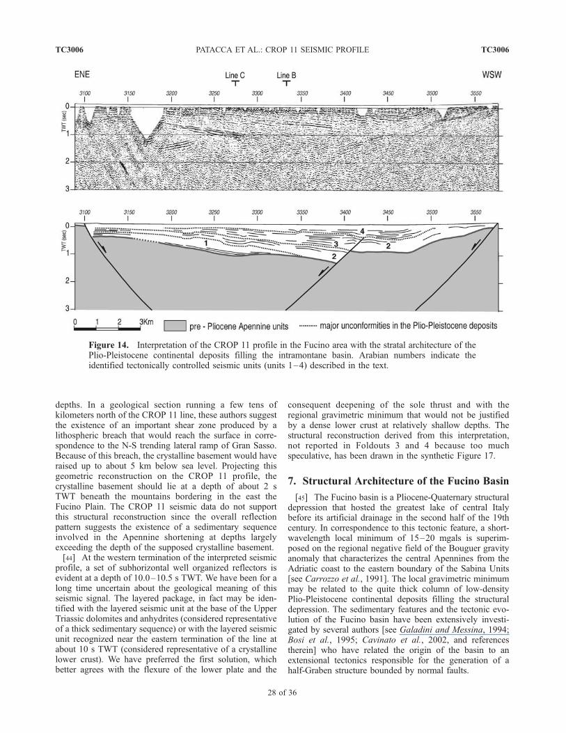
depths. In a geological section running a few tens ofkilometers north of the CROP 11 line, these authors suggestthe existence of an important shear zone produced by alithospheric breach that would reach the surface in corre-spondence to the N-S trending lateral ramp of Gran Sasso.Because of this breach, the crystalline basement would haveraised up to about 5 km below sea level. Projecting thisgeometric reconstruction on the CROP 11 profile, thecrystalline basement should lie at a depth of about 2 sTWT beneath the mountains bordering in the east theFucino Plain. The CROP 11 seismic data do not supportthis structural reconstruction since the overall reflectionpattern suggests the existence of a sedimentary sequenceinvolved in the Apennine shortening at depths largelyexceeding the depth of the supposed crystalline basement.[44] At the western termination of the interpreted seismic
profile, a set of subhorizontal well organized reflectors isevident at a depth of 10.0–10.5 s TWT. We have been for along time uncertain about the geological meaning of thisseismic signal. The layered package, in fact may be iden-tified with the layered seismic unit at the base of the UpperTriassic dolomites and anhydrites (considered representativeof a thick sedimentary sequence) or with the layered seismicunit recognized near the eastern termination of the line atabout 10 s TWT (considered representative of a crystallinelower crust). We have preferred the first solution, whichbetter agrees with the flexure of the lower plate and the
consequent deepening of the sole thrust and with theregional gravimetric minimum that would not be justifiedby a dense lower crust at relatively shallow depths. Thestructural reconstruction derived from this interpretation,not reported in Foldouts 3 and 4 because too muchspeculative, has been drawn in the synthetic Figure 17.
7. Structural Architecture of the Fucino Basin
[45] The Fucino basin is a Pliocene-Quaternary structuraldepression that hosted the greatest lake of central Italybefore its artificial drainage in the second half of the 19thcentury. In correspondence to this tectonic feature, a short-wavelength local minimum of 15–20 mgals is superim-posed on the regional negative field of the Bouguer gravityanomaly that characterizes the central Apennines from theAdriatic coast to the eastern boundary of the Sabina Units[see Carrozzo et al., 1991]. The local gravimetric minimummay be related to the quite thick column of low-densityPlio-Pleistocene continental deposits filling the structuraldepression. The sedimentary features and the tectonic evo-lution of the Fucino basin have been extensively investi-gated by several authors [see Galadini and Messina, 1994;Bosi et al., 1995; Cavinato et al., 2002, and referencestherein] who have related the origin of the basin to anextensional tectonics responsible for the generation of ahalf-Graben structure bounded by normal faults.
Figure 14. Interpretation of the CROP 11 profile in the Fucino area with the stratal architecture of thePlio-Pleistocene continental deposits filling the intramontane basin. Arabian numbers indicate theidentified tectonically controlled seismic units (units 1–4) described in the text.
TC3006 PATACCA ET AL.: CROP 11 SEISMIC PROFILE
28 of 36
TC3006
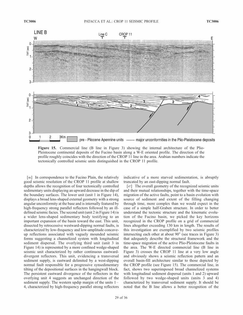
[46] In correspondence to the Fucino Plain, the relativelygood seismic resolution of the CROP 11 profile at shallowdepths allows the recognition of four tectonically controlledsedimentary units displaying an upward decrease in the dip ofthe boundary surfaces. The lower unit (unit 1 in Figure 14),displays a broad lens-shaped external geometry with a strongangular unconformity at the base and is internally featured byhigh-frequency strong parallel reflectors followed by an ill-defined seismic facies. The second unit (unit 2 in Figure 14) isa wider lens-shaped sedimentary body testifying to animportant expansion of the basin toward the east. This unit,dissected by retrocessive westward-dipping normal faults, ischaracterized by low-frequency and low-amplitude concave-up reflections associated with vaguely mounded seismicforms suggesting a channelized system with longitudinalsediment dispersal. The overlying third unit (unit 3 inFigure 14) is represented by a more confined wedge-shapedseismic unit characterized by rather continuous eastward-divergent reflectors. This unit, evidencing a transversalsediment supply, is eastward delimited by a west-dippingnormal fault responsible for a progressive synsedimentarytilting of the depositional surfaces in the hangingwall block.The persistent eastward divergence of the reflectors in theoverlying unit 4 suggests an unchanged direction of thesediment supply. The western updip margin of the units 1–4, characterized by high-frequency parallel strong reflectors
indicative of a more starved sedimentation, is abruptlytruncated by an east-dipping normal fault.[47] The overall geometry of the recognized seismic units
and their mutual relationships, together with the time-spacemigration of the active faults, point to a basin evolution withsource of sediment and extent of the filling changingthrough time, more complex than we would expect in thecase of a simple half-Graben structure. In order to betterunderstand the tectonic structure and the kinematic evolu-tion of the Fucino basin, we picked the key horizonsrecognized in the CROP profile on a grid of commerciallines altogether exceeding 130 km in length. The results ofthis investigation are exemplified by two seismic profilesintersecting each other at about 90� (see traces in Figure 3)that adequately describe the structural framework and thetime-space migration of the active Plio-Pleistocene faults inthe area. The W-E directed commercial line (B line inFigure 3) crosses the CROP 11 line at a very low angleand obviously shows a seismic reflection pattern and anoverall basin-fill architecture similar to those depicted bythe CROP profile (see Figure 15). The commercial line, infact, shows two superimposed broad channelized systemswith longitudinal sediment dispersal (units 1 and 2) upwardfollowed by two wedge-shaped units (units 3 and 4)characterized by transversal sediment supply. It should benoted that the B line allows a better recognition of the
Figure 15. Commercial line (B line in Figure 3) showing the internal architecture of the Plio-Pleistocene continental deposits of the Fucino basin along a W-E oriented profile. The direction of theprofile roughly coincides with the direction of the CROP 11 line in the area. Arabian numbers indicate thetectonically controlled seismic units distinguished in the CROP 11 profile.
TC3006 PATACCA ET AL.: CROP 11 SEISMIC PROFILE
29 of 36
TC3006
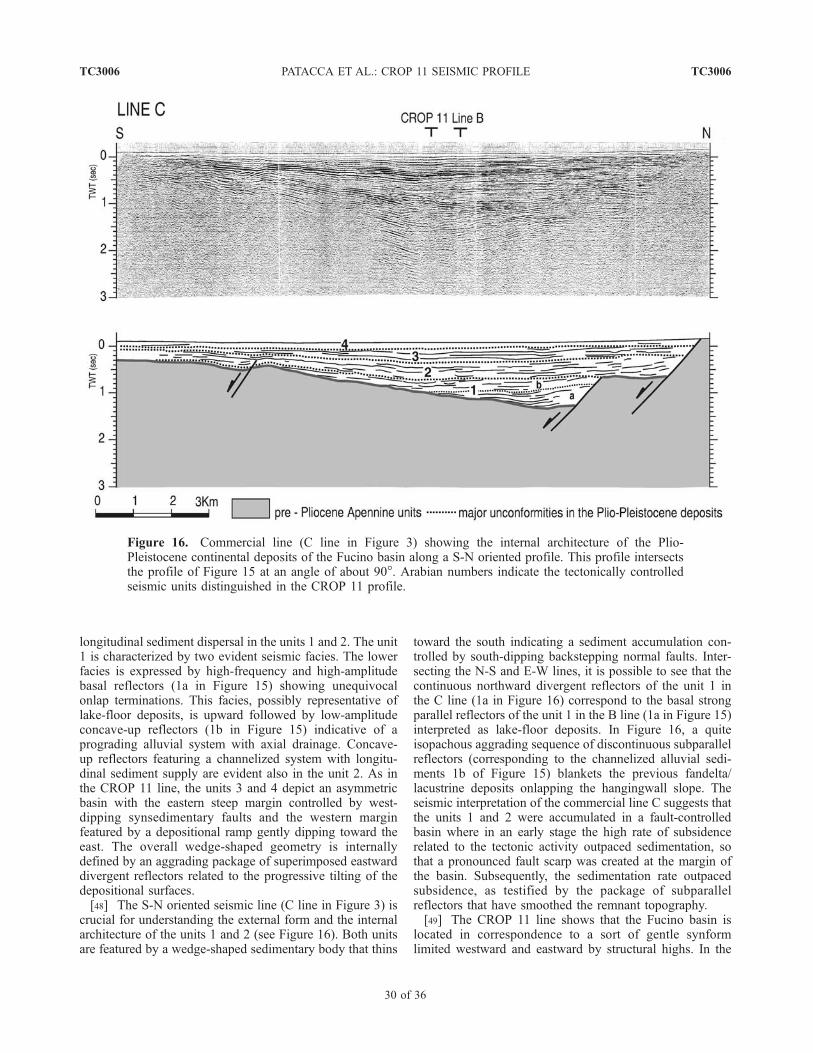
longitudinal sediment dispersal in the units 1 and 2. The unit1 is characterized by two evident seismic facies. The lowerfacies is expressed by high-frequency and high-amplitudebasal reflectors (1a in Figure 15) showing unequivocalonlap terminations. This facies, possibly representative oflake-floor deposits, is upward followed by low-amplitudeconcave-up reflectors (1b in Figure 15) indicative of aprograding alluvial system with axial drainage. Concave-up reflectors featuring a channelized system with longitu-dinal sediment supply are evident also in the unit 2. As inthe CROP 11 line, the units 3 and 4 depict an asymmetricbasin with the eastern steep margin controlled by west-dipping synsedimentary faults and the western marginfeatured by a depositional ramp gently dipping toward theeast. The overall wedge-shaped geometry is internallydefined by an aggrading package of superimposed eastwarddivergent reflectors related to the progressive tilting of thedepositional surfaces.[48] The S-N oriented seismic line (C line in Figure 3) is
crucial for understanding the external form and the internalarchitecture of the units 1 and 2 (see Figure 16). Both unitsare featured by a wedge-shaped sedimentary body that thins
toward the south indicating a sediment accumulation con-trolled by south-dipping backstepping normal faults. Inter-secting the N-S and E-W lines, it is possible to see that thecontinuous northward divergent reflectors of the unit 1 inthe C line (1a in Figure 16) correspond to the basal strongparallel reflectors of the unit 1 in the B line (1a in Figure 15)interpreted as lake-floor deposits. In Figure 16, a quiteisopachous aggrading sequence of discontinuous subparallelreflectors (corresponding to the channelized alluvial sedi-ments 1b of Figure 15) blankets the previous fandelta/lacustrine deposits onlapping the hangingwall slope. Theseismic interpretation of the commercial line C suggests thatthe units 1 and 2 were accumulated in a fault-controlledbasin where in an early stage the high rate of subsidencerelated to the tectonic activity outpaced sedimentation, sothat a pronounced fault scarp was created at the margin ofthe basin. Subsequently, the sedimentation rate outpacedsubsidence, as testified by the package of subparallelreflectors that have smoothed the remnant topography.[49] The CROP 11 line shows that the Fucino basin is
located in correspondence to a sort of gentle synformlimited westward and eastward by structural highs. In the
Figure 16. Commercial line (C line in Figure 3) showing the internal architecture of the Plio-Pleistocene continental deposits of the Fucino basin along a S-N oriented profile. This profile intersectsthe profile of Figure 15 at an angle of about 90�. Arabian numbers indicate the tectonically controlledseismic units distinguished in the CROP 11 profile.
TC3006 PATACCA ET AL.: CROP 11 SEISMIC PROFILE
30 of 36
TC3006
interpretation proposed in Foldouts 3 and 4, we suggest thatthe westward-dipping fault system bordering in the east theFucino Plain and controlling the deposition of the units 3and 4 represents, as in the case of the Caramanico faultsystem, a gravity-collapse feature accommodating the in-crease in the structural relief produced by a growingcontractional ridge. We have accommodated the listricgeometry of these faults on the inactive thrust flat at thebase of the Paleozoic-Triassic deposits of the Quegliasubstratum, The eastward-dipping faults delimiting in thewest the Fucino Plain have been interpreted as antitheticfeatures of the westward-dipping master fault. The W-Eoriented and southward-dipping normal faults controllingthe deposition of the units 1 and 2 might represent gravi-tational collapses too related to the occurrence of previouslyactive lateral/oblique ramps. If our interpretation is correct,the existence of the Fucino basin, as well as the existence ofother important intramontane basins in the central Apen-nines, is not necessarily related to a generalized changefrom a compressional tectonic regime to an extensional one,as commonly reported in the current geological literature.The recent fault activity and the associated seismicity[Galadini and Galli, 1999; Galadini and Messina, 2004,and references therein] can be seen as expressions of normalfaulting by gravity collapse driven by tectonic uplift duringcrustal shortening and not during extension. The recentuplift in the Fucino area could be explained by admittinga temporary out-of-sequence migration of the active thrustsfrom the Majella area toward the present Apennine water-shed. True extensional areas, in which the compressionalregime has been definitively substituted by an extensionalone because of the forward migration of the backarc-arcsystem, are located farther in the west, between the easternboundary of the Sabina Units and the Tiber Valley, in thehalf portion of the CROP 11 line that has not beeninterpreted as yet. In these areas, characterized by theoccurrence of middle-late Pleistocene volcanic manifesta-tions indicative of widespread extensional processes[Cavinato et al., 1994a; Stoppa and Woolley, 1997;Lavecchia and Boncio, 2000], we would expect to observethe transition between the flexured Moho of the subductinglower plate and the shallower Moho of the backarc region,as deep seismic profiles have shown in other regions of theworld characterized by similar tectonic structure and com-parable kinematic evolution (e.g., Carpathians and Panno-nian Basin [see Tomek et al., 1987; Tomek, 1988]).
8. Summary of Results and Concluding
Remarks
[50] The analyzed segment of the CROP 11 seismicprofile extends from the Apennine watershed to the Adriaticcoast cutting across a pile of thrust sheets referred to fivemajor tectonic units: the Western Marsica-Meta, GranSasso-Genzana, Morrone-Porrara, Queglia and MajellaUnits. East of the Majella anticline, the profile runs in theMolise nappes and finally, in the proximity of the coast, inthe autochthonous Pliocene-Pleistocene deposits of the
foredeep basin. Figure 17 shows a roughly balanced geo-logical section derived from the depth conversion of Fold-outs 3 and 4, together with a synthetic representation of theinterpreted time section. We are conscious that differentinterpretations were possible, in particular between theSulmona Plain and the Fucino Plain where the signal atshallow depths is quite poor and the geological constraintsare very weak. In these areas we have made full use theregional geological knowledge, obviously paying closeattention to the geometry of the reflectors where they werepresent, but interpretation remains highly speculative. Be-cause of the increasing complexity of the tectonic structuresmoving from the foreland region toward the hinterlandareas, we have chosen to summarize the results startingfrom the slightly deformed Adriatic coastal region.[51] In correspondence to the eastern termination of the
CROP 11 seismic profile, a pile of Mesozoic-Tertiarycarbonates 6–7 km thick (Apulia Platform of the geologicalliterature) overlies a well layered reflective unit the upper-most portion of which, reached by a few exploratory wells,has resulted to be constituted of Permo-Triassic terrigenousdeposits with subordinate intercalations of clastic carbo-nates. In agreement with commercial lines available in thearea, the CROP profile shows that the seismic record of thelayered sedimentary sequence underlying the upper Triassicdolomites and anhydrites exceeds 3 s TWT, correspondingto a thickness not smaller that 7000–7500 m if we assumeP-wave velocity values not lower than 4.5–5.0 km/s. Thissequence, possibly affected by low-grade metamorphism inits lower part, is supposed to represent the Paleozoic-Triassic sedimentary cover of a pre-Cambrian (Baikalian-Panafrican) continental crust. A possible crystalline base-ment is imaged by a massive, rather transparent unitrecognizable between 7.8 and 9.7 s TWT. A layered lowercrust is evident between 9.7 and 10.7 s TWT. Reflectorsreferable to the Moho discontinuity have been recognized at12.0–12.5 s TWT. The total thickness of the crust calcu-lated in the foreland area averages 31 km.[52] Moving toward the west, the first important tectonic
feature is represented by the Casoli-Bomba High, a popupstructure interpreted as an inverted structure limited west-ward by a system of backthrusts and eastward by a high-anglereverse fault reactivating a lower Pleistocene west-dippingnormal fault. The Casoli-Bomba High, previously interpretedas the footwall of a westward-dipping Pliocene normal faultpre-dating the arrival of the Molise nappes in the region,began to grow in the early Pleistocene after the tectonictransport of the allochthonous sheets on the upper PlioceneGt. inflata turbidites of the foredeep basin.[53] West of the Casoli-Bomba High, the Majella Moun-
tain is the most prominent physiographic feature in thestudy region. We have interpreted the Majella Mountain as aPliocene ramp anticline passively uplifted during the earlyPleistocene by a positive structure of Apulia carbonatesdeveloped in the hangingwall of a blind backthrust. Thewest-dipping normal-fault system downthrowing the back-limb of the Majella fold with a maximum vertical displace-ment of about 3800 m in correspondence to the axial
TC3006 PATACCA ET AL.: CROP 11 SEISMIC PROFILE
31 of 36
TC3006
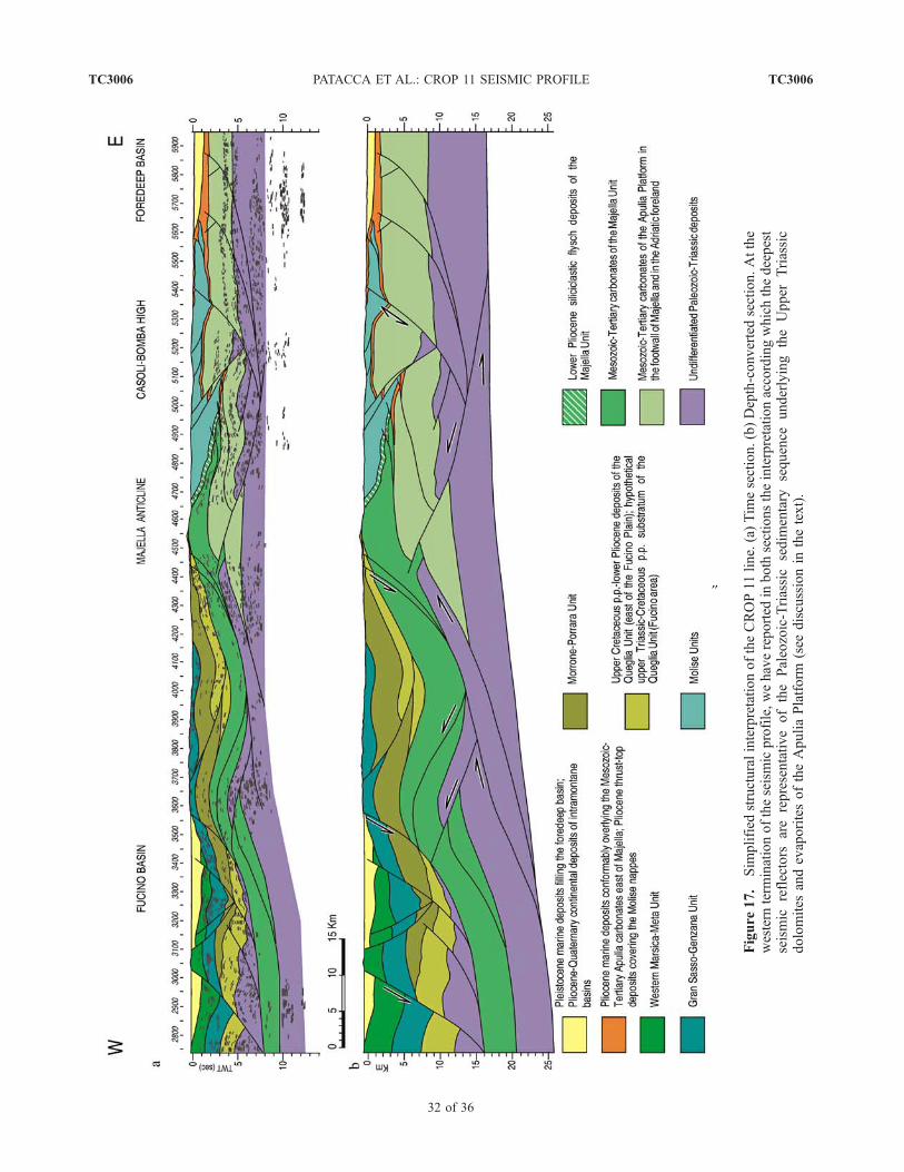
}
Figure
17.
Sim
plified
structuralinterpretationoftheCROP11line.(a)Tim
esection.(b)Depth-convertedsection.Atthe
western
term
inationoftheseismicprofile,wehavereported
inboth
sectionstheinterpretationaccordingwhichthedeepest
seismic
reflectors
arerepresentativeofthePaleozoic-Triassicsedim
entary
sequence
underlying
theUpper
Triassic
dolomites
andevaporitesoftheApuliaPlatform
(see
discussionin
thetext).
TC3006 PATACCA ET AL.: CROP 11 SEISMIC PROFILE
32 of 36
TC3006
culmination, has been interpreted as a gravity-collapse ac-commodation at the front of the backthrust. This interpreta-tion, which implies a causal relation between structuralelevation and fault displacement, can explain the progressivedownthrow decrease from 3800 m to 0 m over a distance ofonly 25 km moving from the axial culmination toward thenorth, in the direction of the downhill fold plunge.[54] Between the Caramanico depression and the Fucino
region, the absence of well-derived stratigraphic constraintsand the poor seismic resolution of the CROP 11 profile atshallow-medium depths prevented a fully reliable structuralinterpretation. The most relevant seismic feature is repre-sented by a thick reflective unit, well evident east of theFucino Plain, which has been attributed to the Paleozoic-Triassic deposits forming locally a quite complex imbricatedstructure. In the proposed interpretation, the bulk of theforward displacement of the Paleozoic-Triassic deposits ontop of a hinterland-dipping thrust surface has been compen-sated by a tectonic doubling of the Mesozoic-Tertiarycarbonates related to a backthrust nucleated from an intra-cutaneous triangle zone. A subsequent deeper backthrustcontributed to the increase in the structural relief andconsequently to the activation of deep-seated gravity-collapse normal faults along the eastern border of the FucinoPlain. According to our interpretation, the opening of theFucino basin, as well as the opening of other intramontanebasins of the central Apennines, was not related to a changeof the tectonic regime from a generalized compressionalstress field to a generalized extensional field, as usuallyreported in the geological literature. Opening was likelyproduced by gravity-collapse normal faults driven bytectonic uplift caused by crustal shortening. We also believethat the seismic activity associated with the younger, NW-SEtrending faults bordering the Fucino basin in the eastrepresents a consequence of the out-of-sequence migrationof the active thrusts from the Majella area toward theApennine watershed.[55] Recent geological works hypothesize in the central
Apennines the occurrence of a lithospheric breach causing aremarkable uplift of the basement. The CROP 11 seismicdata do not support such a hypothesis since the layeredseismic unit attributed to the Paleozoic-Triassic sedimentarysequence is present, and very well recognizable, at depthslargely exceeding the depth at which a massive crystallinebasement had been postulated. The belief that the crystallinebasement has been incorporated in the post-TortonianApennine wedge basically derives from a geophysicalmodeling of the so-called ‘‘magnetic basement’’ in Italyand surrounding offshore areas proposed in the eighties byBolis et al. [1981], Arisi Rota and Fichera [1985] andCassano et al. [1986], and recently re-presented in the sameform by Cassano et al. [2001]. According to these authors,the ‘‘magnetic basement’’ is the deepest level evidenced bymagnetometry, below which no sedimentary rock shouldexist. In the Apennine mountain chain and in the Padan-Adriatic foreland, the top of the ‘‘magnetic basement’’ hasbeen identified with the base of the Alpine sedimentarycover on top of a Hercynian or pre-Hercynian crystallinebasement. Contour maps of the ‘‘magnetic basement’’ with
ridges and grooves indicating structural highs and structuraldepressions of the basement were acritically adopted asgeometric constraints for constructing and balancing deepgeological sections. The CROP 11 line demonstrates theinconsistency of such an assumption. In correspondence tothe Vasto area, for example, the top of the ‘‘magneticbasement’’ should lie at a depth of 8–9 km [Cassano etal., 1986]. The seismic profile shows that this depth roughlycorresponds to the base of the upper Triassic evaporites, i.e.,to the top of the Paleozoic-Triassic deposits. Someonemight suppose that these clastic deposits represent thesource of the magnetic anomaly because of a high contentin detrital magnetic minerals and could be consequentlytempted to identify the top of the ‘‘magnetic basement’’with the top of the Paleozoic-Triassic sedimentary sequence.This identification would agree with the ‘‘magnetic base-ment’’ in the Pescara area, where it lies at a depth of about12 km coinciding with the base of the Upper Triassicanhydrites. In the Gargano 1 area, however, where the topof the ‘‘magnetic basement’’ was expected at about 8 km[Cassano et al., 1986], the top of the Paleozoic-Triassicdeposits lies at a depth shallower than 4500 m. In thePuglia 1 area, in addition, the contour map predicts the‘‘magnetic basement’’ at a depth of 12000–13000 m whilstthe Permo-Triassic deposits have been encountered at5568 m below sea level. We think that the ‘‘magnetic base-ment’’ of the current geophysical literature is an artifactderiving from different anomaly sources and thus includingdifferent geological objects. We also believe that the afore-mentioned contour maps of the ‘‘magnetic basement’’ haveno clear geological meaning and cannot be used in any casefor reconstructing the geometry of the sedimentary-cover/crystalline-basement boundary.[56] In conclusion, the CROP 11 seismic data do not
provide evidence for the involvement of a crystallinebasement in the post-Tortonian crustal shortening, thoughdo not exclude the occurrence of reverse-sense reactivationsof Paleozoic normal faults. As already observed in the lineCROP 04-Southern Apennines [Mazzotti et al., 2000;Patacca et al., 2000; Patacca and Scandone, 2004a], thelayered seismic unit underlying the upper Triassic dolomitesand anhydrites of the Apulia Platform, considered represen-tative of the Paleozoic-Triassic sedimentary cover of theAdriatic pre-Cambrian crystalline basement, appears to bethe deepest level involved in the compressional deforma-tion. These data suggest for the post-Tortonian compres-sional deformation an unusual thin-skin tectonic styleaccording to which a very thick sedimentary sequence,possibly affected by low-grade metamorphism in its lowerpart, has been detached from the original substratum andhas been incorporated in the tectonic wedge.
[57] Acknowledgments. The authors are indebted to ENI, BG ItaliaS.p.A. and Edison S.p.A. for permission to publish the commercial linecutting through the Majella massif and the two lines crossing the Fucinobasin. A warm acknowledgment, in particular, is directed to Janpieter VanDijk (ENI), general coordinator of the Project Task Force Majella, for theaccess to additional subsurface data not to public domain. The authorssincerely thank the two anonymous reviewers whose constructive criticismstrongly contributed to improve the quality of this paper. Figures andfoldouts have been prepared by Barbara Taccini.
TC3006 PATACCA ET AL.: CROP 11 SEISMIC PROFILE
33 of 36
TC3006
ReferencesAccarie, H. (1988), Dynamique sedimentaire et struc-
turale au passage plate-forme/bassin. Les facies car-bonates cretaces et tertiaires du Massif de la Maiella(Abruzzes, Italie), Mem. Sci. Terre, 5, 162 pp.
Accordi, G., and F. Carbone (Eds.) (1988), Lithofaciesmap of Latium-Abruzzi and neighbouring areas,scale 1:500,000, Quad. Ric. Sci., 114(5), 223 pp.
Amato, A., C. Chiarabba, and G. Selvaggi (1997),Crustal and deep seismicity in Italy (30 years after),Ann. Geofis., 40, 981–993.
Arisi Rota, F., and R. Fichera (1985), Magnetic in-terpretation connected to ‘‘geo-magnetic pro-vinces’’: The Italian case history, paperpresented at 47th Meeting, Eur. Assoc. of Explor.Geophys., Budapest.
Bally, A. W., L. Burbi, C. Cooper, and R. Ghelardoni(1986), Balanced sections and seismic reflectionprofiles across the central Apennines, Mem. Soc.Geol. Ital., 35, 257–310.
Barchi, M. N. (1991), Integration of a seismic profile withsurface and subsurface geology in a cross-sectionthrough the Umbria-Marche Apennines, Boll. Soc.Geol. Ital., 110, 469–479.
Barchi, M. R., G. Minelli, and G. Pialli (1998), TheCROP 03 profile: A synthesis of results on deepstructures of the Northern Apennines, Mem. Soc.
Geol. Ital., 52, 383–400.Beneo, E. (1936), La formazione mesozoica di Filettino
e Collepardo (Monti Simbruini ed Ernici), Boll. R.Uff. Geol. Ital., 61, 1 –8.
Bigazzi, G.,M. A. Laurenzi, C. Principe, and D. Brocchini(1996), New geochronological data on igneousrocks and evaporites of the Pietre Nere Point(Gargano Peninsula, Southern Italy), Boll. Soc.Geol. Ital., 115, 439–448.
Bigi, G., A. Castellarin, M. Coli, G. V. dal Piaz,R. Sartori, P. Scandone, and G. B. Vai (1991),Structural model of Italy, scale 1:500,000, QuadRic. Sci., 114(3), 1 – 7.
Bigi, S., F. Calamita, and W. Paltrinieri (1995), Modie tempi della strutturazione della catena centro-appeninica abruzzese dal Gran Sasso alla costa adria-tica, Stud. Geol. Camerti, Spec., Vol. 2, 77– 85.
BIRPS and ECORS (1986), Deep seismic reflectionprofiling between England, Ireland and France(SWAT), J. Geol. Soc., 143, 45 –52.
Blundell, D. J. (1988), A proposal for a coordinatedprogramme of deep seismic reflection profilesacross Europe, Ann. Soc. Geol. Belg., 111, 243–256.
Blundell, D. J., and C. Wright (1989), Deep seismicreflection studies, Newsl., 3, 34 pp., WorkingGroup 3 (Intra-Plate Phenomena), Inter-UnionComm. on the Lithosphere, Basel, Switzerland.
Bois, C., M. Cazes, A. Hirn, A. Mascle, P. Matte,L. Montadert, and B. Pinet (1988), Contributionof deep seismic profiling to the knowledge ofthe lower crust in France and neighbouringareas, Tectonophysics, 145, 253–275.
Bolis, G., V. Cappelli, and M. Marinelli (1981), Aero-magnetic data of the Italian area: instrumental to abetter comprehension of the basement main charac-teristics in Italy, paper presented at 43rd Meeting,Eur. Assoc. of Explor. Geophys., Venice.
Boni, A., R. Casnedi, E. Centamore, P. Colantoni,G. Cremonini, C. Elmi, A. Monesi, R. Selli, andM. Valletta (1969), Servizio Geologico d’Italia,Note illustrative della Carta Geologica d’Italia,Foglio 155 San Severo, 1:100.000, Poligr. andCartevalori, Ercolano, Italy.
Bosi, C., F. Galadini, and P. Messina (1995), Stratigra-fia plio-pleistocenica della conca del Fucino, Qua-ternario, 8, 83– 94.
Brown, L., M. Barazangi, S. Kaufman, and J. Oliver(1986), The first decade of COCORP: 1974–1984,in Reflection Seismology: A Global Perspective, Geo-dyn. Ser., vol. 13, edited byL. Brown andM.Barazangi,pp. 107–120, AGU, Washington, D. C.
Butler, R. W. H., et al. (2004), Applying thick-skinnedtectonic model to the Apennine thrust belt of
Italy—Limitations and implications, in Thrust Tec-tonics and Hydrocarbon Systems, edited by K. R.McClay, AAPG Mem., 82, 647–667.
Calamita, F., W. Paltrinieri, M. Pelorosso, V. Scisciani,and E. Tavarnelli (2003), Inherited Mesozoic archi-tecture of the Adria continental paleomargin in theNeogene central Apennines orogenic system, Italy,Boll. Soc. Geol. Ital., 122, 307–318.
Calamita, F., M. G. Viandante, and K. Hegarty (2004),Pliocene-Quaternary burial/exhumation paths of thecentral Apennines (Italy): Implications for the defi-nition of the deep structure of the belt, Boll. Soc.Geol. Ital., 123, 503–512.
Cande, S. C., and D. V. Kent (1995), Revised calibra-tion of the geomagnetic polarity timescale for theLate Cretaceous and Cenozoic, J. Geophys. Res.,100(B4), 6093–6095.
Carrozzo, M. T., D. Luzio, C. Margiotta, and T. Quarta(1991), Gravity map, scale 1:500,000, Quad. Ric.Sci., 114(3), 591–593.
Casero, P. (2004), Structural setting of petroleum ex-ploration plays in Italy, in Geology of Italy, editedby U. Crescenti et al., pp. 189–199,Ital. Geol. Soc.,Florence, Italy.
Casero, P., F. Roure, L. Endignoux, I. Moretti, C. Muller,L. Sage, and R. Vially (1988), Neogene geodynamicevolution of southern Apennines, Mem. Soc. Geol.Ital., 41, 109–120.
Casnedi, R. (1983), Hydrocarbon-bearing submarinefan system of Cellino Formation, central Italy, Bull.Am. Assoc. Pet. Geol., 67, 359–370.
Cassano, E., R. Fichera, and F. Arisi Rota (1986), Aero-magnetic survey of Italy: A few interpretative re-sults, Dir. Serv. Cent. per l’Esplorazione-Studi eMetodologie Geofis., 13 pp., San Donato Milanese,Italy.
Cassano, E., L. Anelli, V. Cappelli, and P. La Torre(2001), Magnetic and gravity analysis of Italy, inAnatomy of an Orogen: The Apennines and Adja-cent Mediterranean Basins, edited by G. B. Vai andI. P. Martini, pp. 53 –64, Kluwer Acad., Norwell,Mass.
Cassinis, R., S. Scarascia, and A. Lozej (2003), Thedeep crustal structure of Italy and surrounding areasfrom seismic refraction data, Boll. Soc. Geol. Ital.,122, 365–376.
Cati, A., D. Sartorio, and S. Venturini (1987), Carbo-nate platforms in the subsurface of the northernAdriatic area, Mem. Soc. Geol. Ital., 40, 295–308.
Cavinato, G. P., D. Cosentino, D. De Rita, R. Funiciello,and M. Parotto (1994a), Tectonic-sedimentary evo-lution of intraapenninic basins and correlation withthe volcano-tectonic activity in central Italy, Mem.Descr. Carta Geol. Ital., 49, 63 –76.
Cavinato, G. P., D. Cosentino, R. Funiciello,M. Parotto, F. Salvini, and M. Tozzi (1994b), Con-straints and new problems for geodynamical model-ling of central Italy (CROP 11 Civitavecchia-Vastodeep seismic line), Boll. Geofis. Teor. Appl., 36,158–174.
Cavinato, G. P., C. Carusi, M. Dall’Asta, E. Miccadei,and T. Piacentini (2002), Sedimentary and tectonicevolution of Plio-Pleistocene alluvial and lacustrinedeposits of Fucino Basin (central Italy), Sediment.Geol., 148, 29 –59.
Cipollari, P., and D. Cosentino (1991), La linea Olevano-Antrodoco: Contributo della biostratigrafia alla suacaratterizzazione cinematica, in Studi Preliminari al-l’acquisizione Dati del Profilo CROP 11 Civitavec-chia-Vasto, edited by M. Tozzi, G. P. Cavinato, andM. Parotto, Stud. Geol. Camerti Spec. Vol., 1991/2,143–149.
Cipollari, P., and D. Cosentino (1995), Miocene uncon-formities in the central Apennines: Geodynamicsignificance and sedimentary basin evolution, Tec-tonophysics, 252, 375–389.
Cipollari, P., and D. Cosentino (1997), Il sistema Tirre-no-Appennino: segmentazione litosferica e propa-gazione del fronte compressivo, Stud. Geol.
Camerti, Spec. Vol., 1997/2, 125 –134.
Cipollari, P., and D. Cosentino (1999), Cronostratigrafiadei depositi neogenici del settore ernico-simbruino,Appennino centrale, Boll. Soc. Geol. Ital., 118, 439–459.
Cipollari, P., D. Cosentino, and M. Parotto (1995),Modello cinematico-strutturale dell’Italia centrale,Stud. Geol. Camerti, Spec. Vol., 1995/2, 135–143.
Cita, M. B. (1975), Planktonic foraminiferal biozona-tion of the mediterranean Pliocene deep sea record:A revision, Riv. Ital. Paleontol. Stratigr., 81, 527–544.
Clermonte, J. (1977), La bordure abruzzaise sud-orientale et le haut Molise: histoire sedimentaireet tectonique comparee, Riv. Ital. Paleontol.Stratigr., 83, 21– 102.
Colalongo, M. L., and S. Sartoni (1979), Schema bios-tratigrafico per il Pliocene e il basso Pleistocene inItalia, Note Prelim. alla Carta Neotettonica d’Italia251, pp. 645 –654, CNR Progetto Finalizzato Geo-din., Rome.
Cotecchia, V., and A. Canitano (1955), Sull’affiora-mento delle ‘‘Pietre Nere’’ al Lago di Lesina, Boll.Soc. Geol. Ital., 73, 3 –18.
Coward, M. P., M. De Donatis, S. Mazzoli, W. Patrinieri,and F. C. Wezel (1999), Frontal part of the northernApennines fold and thrust belt in Romagna-Marchearea (Italy): Shallow and deep structural styles, Tec-tonics, 18(3), 559–574.
Crescenti, U. (1971a), Sul limite Mio-Pliocene in Italia,Geol. Rom., 10, 1 –21.
Crescenti, U. (1971b), Osservazioni sul Pliocene degliAbruzzi settentrionali: la trasgressione del Pliocenemedio e superiore, Boll. Soc. Geol. Ital., 90, 3 – 21.
Crescenti, U., A. Crostella, G. Donzelli, and G. Raffi(1969), Stratigrafia della serie calcarea dal Lias alMiocene nella regione marchigiano-abruzzese.Parte Il. Litostratigrafia, Biostratigrafia, Paleogeo-grafia, Mem. Soc. Geol. Ital., 8, 343–420.
D’Andrea, M., E. Miccadei, and A. Praturlon (1991),Rapporti tra il margine orientale della piattaformalaziale-abruzzese ed il margine occidentale dellapiattaforma Morrone-Pizzalto-Rotella, in Studi Pre-liminari All’acquisizione Dati del Profilo CROP 11Civitavecchia-Vasto, edited by M. Tozzi, G. P.Cavinato, and M. Parotto, Stud. Geol. Camerti,Spec. Vol., 1991/2, 389 –395.
D’Andrea, S., R. Pasi, G. Bertozzi, and P. Dattilo(1993), Geological model, advanced methods helpunlock oil in Italy’s Apennines, Oil Gas J., 91, 53–57.
De Alteriis, G. (1995), Different foreland basins inItaly: Examples from the central and southernAdriatic Sea, Tectonophysics, 252, 349–373.
De Fino, M., L. La Volpe, and G. Piccarreta (1981),Geochemistry and petrogenesis of the Paleoceneplatform magmatism at Punta delle Pietre Nere(Southeastern Italy), N. Jb. Miner. Abh., 142,161 –177.
D’Erasmo, G. (1931), L’Elephas meridionalis nell’Ab-ruzzo e nella Lucania, Atti R. Accad. Sci. Fis. Mat.Napoli, Ser. 2a, 18, 1 –25.
Di Stefano, G. (1895), Lo scisto marnoso a ‘‘Myophor-ia vestita’’ della Punta delle Pietre Nere in provinciadi Foggia, Boll. Com. Geol. Ital., 26, 4 – 51.
Doglioni, C. (1991), A proposal of kinematic modelingfor W-dipping subductions—Possible applicationsto the Tyrrhenian-Apennines system, Terra Nova,3, 42.
Dondi, L., I. Papetti, and D. Tedeschi (1966), Contri-buto alle conoscenze del Mesozoico del sottosuoloabruzzese, Geol. Rom., 5, 69 –98.
Donzelli, G. (1969), Studio geologico della Maiella,edited by U. Crescenti, report, 49 pp., Univ. degliStud. G. D’Annunzio, Chieti, Italy.
Endignoux, L., I. Moretti, and F. Roure (1989), For-ward modeling of the southern Apennines, Tec-tonics, 8(5), 1095–1104.
Faccenna, C., R. Funiciello, and M. Mattei (1994), LatePleistocene N-S shear zones along the Latium Tyr-rhenian margin: Structural characters and volcano-
TC3006 PATACCA ET AL.: CROP 11 SEISMIC PROFILE
34 of 36
TC3006
logical implications, Boll. Geofis. Teor. Appl., 36,507–523.
Frepoli, A., and A. Amato (1997), Contemporaneousextension and compression in the northern Apen-nines from earthquake fault pIane solutions, Geo-phys. J. Int., 125, 879–891.
Funiciello, R., and M. Parotto (1978), Il substrato sedi-mentario nell’area dei Colli Albani: considerazionigeodinamiche e paleogeografiche sul margine tirre-nico dell’Appennino centrale, Geol. Rom., 17,233–287.
Galadini, F., and P. Galli (1999), The Holocenepaleoearthquakes on the 1915 Avezzano earthquakefaults (central Italy): Implications for activetectonics in central ltaly, Tectonophysics, 308,143–170.
Galadini, F., and P. Messina (1994), Plio-Quaternarytectonics of the Fucino basin and surrounding areas(central Italy), G. Geol., Ser. 3a, 56(2), 73– 99.
Galadini, F., and P. Messina (2004), Early-MiddlePleistocene eastward migration of the AbruzziApennine (central Italy) extensional domain,J. Geodyn., 37, 57–81.
Ghisetti, F., and L. Vezzani (2002), Normal faulting,extension and uplift in the outer thrust belt of thecentral Apennines (Italy): Role of the Caramanicofault, Basin Res., 14, 225–236.
Hauser, E. C., and J. E. Oliver (1987), A new era inunderstanding the continental basement: The im-pact of seismic reflection profiling, in Composition,Structure and Dynamics of the Lithosphere-Asthe-nosphere System, Geodyn. Ser., vol. 16, edited byK. Fuchs and C. Froidevaux, pp. 1 –32, AGU, Wa-shington, D. C
Lavecchia, G., and P. Boncio (2000), Tectonic setting ofthe carbonatite-melilite association of Italy, Min.Mag., 64(4), 583–592.
Lavecchia, G., E. Brozzetti, M. Barchi, M. Menichetti,and J. V. A. KelIer (1994), Seismotectonic zoningin east-central Italy deduced from an analysis of theNeogene to present deformations and related stressfield, Geol. Soc. Am. Bull., 106, 1107 –1120.
Locardi, E., and R. Nicolich (1988), Geodinamica delTirreno e dell’Appennino centro-meridionale: lanuova carta della Moho, Mem. Soc. Geol. Ital.,41, 121–140.
Malinverno, A., and W. B. F. Ryan (1986), Extension inthe Tyrrhenian Sea and shortening in the Apenninesas a result of the arc migration driven by sinking ofthe lithosphere, Tectonics, 5(2), 227–245.
Martinis, B., and M. Pieri (1963), Alcune notizie sullaformazione evaporitica del Triassico superiore nel-l’Italia centrale e meridionale, Mem. Soc. Geol.
Ital., 4, 649–678.Matthews, D. H. (1988), Deep seismic investigations in
the UK: BIRPS 1981–1987, Ann. Soc. Geol. Belg.,111, 311 –395.
Matthews, D. H., and the BIRPS Group (1990), Pro-gress in BIRPS Deep Seismic Profiling around theBritish Isles, Tectonophysics, 173, 387–396.
Mazzoli, S., S. Corrado, M. De Donatis, D. Scrocca,R. W. H. Butler, D. Di Bucci, G. Naso, C. Nicolai,and V. Zucconi (2000), Time and space variabilityof ‘‘thin-skinned’’ and ‘‘thick-skinned’’ thrust tec-tonics in the Apennines (Italy), Rend. Fis. Acc. Lin-cei, 11, 5 –39.
Mazzotti, A., E. Stucchi, G. L. Fradelizio, L. Zanzi, andP. Scandone (2000), Seismic exploration in com-plex terrains: A processing experience in the South-ern Apennines, Geophysics, 65(5), 1402–1417.
Meissner, R., and R. K. Bortfeld (Eds.) (1990), TheDEKORP Atlas (80 Seismic Sections), Springer,Berlin.
Meissner, R., and W. Rabbel (1999), Nature of crustalreflectivity along the DEKORP profiles in Germanyin comparison with reflection patterns from differ-ent tectonic units worldwide: A review, Pure Appl.Geophys., 156(1/2), 7 – 28.
Meissner, R., , L. Brown, H. J. Duerbaum, W. Franke,K. Fuchs, and F. Seifert (Eds.) (1991), ContinentalLithosphere: Deep Seismic Reflections, Geodyn.
Ser., vol. 22, 450 pp., AGU, Washington, D. C.
Menardi Noguera, A., and D. Rea (2000), Deep struc-ture of the Campanian-Lucanian Arc (southernApennine, ltaly), Tectonophysics, 32, 239–265.
Mostardini, E., and S. Merlini (1986), Appennino cen-tro-meridionale. Sezioni geologiche e proposta dimodello strutturale, Mem. Soc. Geol. Ital., 35,177–202.
Nicolich, R., and G. V. Dal Piaz (1990), Moho isobaths,in Progetto Finalizzato Geodinamica: StructuralModel of Italy, edited by G. Bigi et al., Quad. deLa Ric. Sci. 114(3), scale 1:500,000, Cons. Naz.delle Ric., Rome.
Parotto, M., and A. Praturlon (2004), The SouthernApennine Arc, in Geology of Italy, edited byU. Crescenti et al., pp. 33–58, Ital. Geol. Soc.,Florence, Italy.
Parotto, M., F. Salvini, and M. Tozzi (1996), Geologia disuperficie e geometrie profonde nell’Italia centrale:per un profilo di revisione CROP11 da Civitavecchiaa Vasto, Mem. Soc. Geol. Ital., 51, 63– 70.
Parotto, M., G. P. Cavinato, E. Miccadei, and M. Tozzi(2003), Line CROP 11: Central Apennines, inCROP Atlas: Deep Seismic Reflection Profiles ofthe Italian Crust, edited by D. Scrocca et al.,Mem. Descr. Carta Geol. Ital., 62, 145–154.
Patacca, E., and P. Scandone (1989), Post-Tortonianmountain building in the Apennines: The role ofthe passive sinking of a relic lithospheric slab, inThe Lithosphere in Italy, edited by A. Boriani et al.,Atti Conv. Lincei, 80, 157–176.
Patacca, E., and P. Scandone (2001), Late thrust propa-gation and sedimentary response in the thrust belt-foredeep system of the Southern Apennines (Plio-cene-Pleistocene), in Anatomy of an Orogen: TheApennines and Adjacent Mediterranean Basins,edited by G. B. Vai and I. P. Martini, pp. 401–440, Kluwer Acad., Norwell, Mass.
Patacca, E., and P. Scandone (2004a), A geologicaltransect across the Southern Apennines along theseismic line CROP 04, Field Trip Guide BookP20, 25 pp., 32nd Intern. Geol. Congr., APAT-Ita-l.Agency for the Environ. Prot. and Tech. Serv.,Rome.
Patacca, E., and P. Scandone (2004b), The Plio-Pleis-tocene thrust belt-foredeep system in the SouthernApennines and Sicily (Italy), in Geology of Italy,edited by U. Crescenti et al., pp. 93 – 129, Ital.Geol. Soc., Florence, Italy.
Patacca, E., R. Sartori, and P. Scandone (1990), Tyr-rhenian basin and Apenninic arc: Kinematic rela-tions since Late Tortonian times, Mem. Soc. Geol.Ital., 45, 425–451.
Patacca, E., P. Scandone, M. Bellatalla, N. Perilli, andU. Santini (1991), La zona di giunzione tra l’arcoappenninico settentrionale e l’arco appenninicomeridionale nell’Abruzzo e nel Molise, in StudiPreliminari all’acquisizione Dati del Profilo CROP
11 Civitavecchia-Vasto, edited by M. Tozzi, G. P.Cavinato, and M. Parotto, Stud. Geol. Camerti,Spec. Vol., 1991/2, 417–441.
Patacca, E., R. Sartori, and P. Scandone (1993), Tyr-rhenian basin and Apennines: Kinematic evolutionand related dynamic constraints, in Recent Evolu-tion and Seismicity of the Mediterranean Region,edited by E. Boschi, E. Mantovani, and A. Morelli,pp. 161–171, Kluwer Acad., Norwell, Mass.
Patacca, E., P. Scandone, and M. Tozzi (2000), Il Pro-filo CROP-04, Protecta, 10–12, 49– 52.
Pfiffner, A. O., P. Lehner, P. Heitzmann, S. Mueller, andA. Stek (Eds.) (1997), Deep Structure of the SwissAlps: Results of NRP 20, 380 pp., Birkhauser,Basel, Switzerland.
Piacentini, T. (2000), Evoluzione neogenico-quaternar-ia dell’area tra la Marsica nordorientale e la regionePeligna (Abruzzo): analisi paleogeografica e carat-terizzazione strutturale. Diss. Finale, Dottorato diRicerca in Geodin., 277 pp., Univ. degli Studi diRoma 3, Rome.
Ponziani, F., R. De Franco, and G. Biella (1998), Geo-physical reinterpretation of 1974 and 1978 DSSexperiments along CROP 03 profile, Boll. Soc.Geol. Ital., 52, 193–203.
Raffi, G., and A. Forti (1959), Micropaleontologicaland stratigraphical investigations in ‘‘Montagnadel Morrone’’ (Abruzzi, Italy), Rev. Micropaleon-tol., 2, 8 –20.
Roure, F., P. Heitzmann, and R. Polino (1990), Deepstructure of the Alps, Mem. Soc. Geol. Fr., 156,350.
Royden, L. H., E. Patacca, and P. Scandone (1987), Seg-mentation and configuration of subducted lithospherein Italy: An important control on thrust-belt and fore-deep-basin evolution, Geology, 15, 714–717.
Sartorio, D., and R. Rozza (1991), The Permian ofAmanda I bis well (Northern Adriatic Sea),G. Geol., 53, 187–196.
Scandone, P., and I. Sgrosso (1963), Il Mesozoiconel gruppo montuoso dell’Acellica (M. Picentini-Salerno), Mem. Soc. Geol. Ital., 4, 1 –8.
Scarascia, S., A. Lozej, and R. Cassinis (1994), Crustalstructures of the Ligurian, Tyrrhenian and lonianseas and adjacent onshore areas interpreted fromwide angle seismic profiles, Boll. Geofis. Teor.Appl., 36, 5 –19.
Scarascia, S., R. Cassinis, and F. Federici (1998), Grav-ity modelling of deep structures in the northern-central Apennines, Mem. Soc. Geol. Ital., 52,231 –246.
Scisciani, V., F. Calamita, S. Bigi, C. De Girolamo, andW. Paitrinieri (2001), The influence of syn-orogenicnormal faults on Pliocene thrust system develop-ment: the Maiella structure (central Apennines,Italy), Mem Soc. Geol. Ital., 55, 193–204.
Scrocca, D., C. Doglioni, F. Innocenti, P. Manetti,A. Mazzotti, L. Bertelli, L. Burbi, and S. D’Offizi(Eds.) (2003), CROPAtlas: Deep Seismic ReflectionProfiles of the Italian Crust,Mem. Descr. Carta Geol.
Ital., 62, 194 pp.Scrocca, D., E. Carminati, and C. Doglioni (2005),
Deep structure of the Southern Apennines, Italy:Thin-skinned or thick-skinned?, Tectonics, 24,TC3005, doi:10.1029/2004TC001634.
Selli, R. (1962), lI Paleogene nel quadro della geologiadell’Italia Meridionale, Mem. Soc. Geol. Ital., 3,733 –789.
Selvaggi, G., and A. Amato (1992), Subcrustal earth-quakes in the northern Apennines (Italy): Evidencefor a still active subduction?, Geophys. Res. Lett.,19, 2127–2130.
Serri, G., F. Innocenti, and P. Manetti (2001), Magma-tism from Mesozoic to Present: Petrogenesis, time-space distribution and geodynamic implications, inAnatomy of an Orogen: The Apennines and Adja-cent Mediterranean Basins, edited by G. B. Vai andI. P. Martini, pp. 77–103, Kluwer Acad., Norwell,Mass.
Spaak, P. (1983), Accuracy in correlation and ecologi-cal aspects of the planktonic foraminiferal zonationof the mediterranean Pliocene, Utrecht Micropa-
leontol. Bull., 28, 158 pp.Speranza, F., and M. Chiappini (2002), Thick-skinned
tectonics in the external Apennines (Italy): Newevidence from magnetic anomaly analyses, J. Geo-phys. Res. , 107 (B11), 2290, doi:10.1029/2000JB000027.
Stoppa, F., and A. R. Woolley (1997), The Italian car-bonatites: Field occurrence, petrology and regionalsignificance, Mineral. Petrol., 59, 43 –67.
Stovba, S., R. A. Stephenson, and M. Kivshik (1996),Structural features and evolution of the Dniepr-Donets Basin, Ukraine, from regional reflectionprofiles, Tectonophysics, 268, 127 –147.
Tavarnelli, E. (1997), Structural evolution of a forelandfold-and-thrust belt: The Umbria-Marche Apen-nines, Italy, J. Struct. Geol., 19, 523–534.
Tavarnelli, E., F. Calamita, and W. Paltrinieri (2003),Inversion tectonics in Italy, Boll. Soc. Geol. Ital.,122, 220–222.
Tavarnelli, E., R.W.H. Butler, F. A.Decandia, F. Calamita,M. Grasso, W. Alvarez, and P. Renda (2004), Implica-tions of fault reactivation and structural inheritance inthe Cenozoic tectonic evolution of Italy, in Geology ofItaly, edited by U. Crescenti et al., pp. 209–222, Ital.Geol. Soc., Florence, Italy.
TC3006 PATACCA ET AL.: CROP 11 SEISMIC PROFILE
35 of 36
TC3006
Tiberti, M. M., and L. Orlando (2006), 2D gravity mod-eling along the CROP11 seismic profile, Boll. Geo-fis. Teor. Appl., 47, 447 –454.
Tomek, C. (1988), Geophysical investigation of theAlpine-Carpathian arc, in History of the NorthernMargin of Tethys, edited by A. Nairn, Mem. Soc.Geol. Fr., 154, 167 –199.
Tomek, C., L. Dvorakova, J. Ibrmayer, R. Jiricek, andT. Korab (1987), Crustal profiles of active continen-tal collisional belt: Czecho-Slovak deep seismicreflection profiling in the Western Carpathians,Geophys. J. R. Astron. Soc., 89, 383–388.
Tozer, R. S. J., R. W. H. Butler, and S. Corrado (2002),Comparing Thin- and Thick-Skinned thrust tectonicmodels of the central Apennines, Italy, in ContinentalCollision and the Tectono-Sedimentary Evolution ofForelands, Stephan Mueller Spec. Publ. Ser., vol. 1,pp. 181–194, Eur. Geosci. Union, Strasbourg, France.
Vai, G. B. (1994), Crustal evolution and basementelements in the Italian area: Paleogeography and
characterization, Boll. Geofis. Teor. Appl., 36,411–434.
Vai, G. B. (2001), Basement and early (pre-Alpine)history, in Anatomy of an Orogen: The Apennines
and Adjacent Mediterranean Basins, edited by G. B.Vai and I. P. Martini, pp. 121–150, Kluwer Acad.,Norwell, Mass.
Vannucci, G., S. Pondrelli, A. Argnani, A. Morelli,P. Gasperini, and E. Boschi (2004), An atlas ofMediterranean seismicity, Ann. Geophys., 47(1),247–306, suppl.
Vecsei, A. (1991), Aggradation und Progradation einesKarbonatplattform-Randes: Kreide bis MittleresTertiar der Montagna della Maiella, Abruzzen. Mitt.
Geol. Inst. Eidg. Tech. Hochsch. Univ. Zurich, 294,169 pp.
Vecsei, A., D. Sanders, D. Bernoulli, G. P. Eberli, andJ. S. Pignatti (1998), Cretaceous to Miocene se-quence stratigraphy and evolution of the Maiellacarbonate platform margin, Italy, in Mesozoic and
Cenozoic Sequence Stratigraphy of European Ba-sins, Spec. Publ. Soc. Econ. Paleontol. Mineral.,60, 53 –74.
���������G. P. Cavinato and E. Di Luzio, Istituto di Geologia
Ambientale e Geoingegneria, CNR Roma, c/o Diparti-mento di Scienze della Terra, Universita di Roma ‘‘LaSapienza,’’ Piazzale Aldo Moro, 5, I-00185 Rome,Italy. ([email protected]; [email protected])
M. Parotto, Dipartimento di Scienze Geologiche,Universita di Roma ‘‘Roma 3,’’ Largo San LeonardoMurialdo, 1, I-00146 Rome, Italy. ([email protected])
E. Patacca and P. Scandone, Dipartimento diScienze della Terra, Universita di Pisa, Via SantaMaria, 53, I-56126 Pisa, Italy. ([email protected];[email protected])
TC3006 PATACCA ET AL.: CROP 11 SEISMIC PROFILE
36 of 36
TC3006

![Internet für alle? Die Diskussion des »digital divide« revisited [Internet for all? The Discussion on the \"digital divide\" revisited]](https://img.dokumen.tips/doc/110x75/6357533a3fe58b1a61065b0c/internet-fuer-alle-die-diskussion-des-digital-divide-revisited-internet-for.jpg)


