Embed Size (px)
Citation preview

SIXTH FIVE-YEAR REVIEW REPORT FOR A. L. TAYLOR (VALLEY OF THE DRUMS) SUPERFUND SITE
BROOKS, BULLITT COUNTY, KENTUCKY
a€0 ST4j
S\ I
SEPTEMBER 2018
Prepared by
U.S. Environmental Protection Agency Region 4
Atlanta, Georgia
Franklin E. Hill, Director Superfund Division
Date
I..111974

Table of ContentsLIST OF ABBREVIATIONS & ACRONYMS...................................................................... . ivI. INTRODUCTION.................. 1
Site Background.......................................................................................................................... ^FIVE-YEAR REVIEW SUMMARY FORM.................................... 2
II. RESPONSE ACTION SUMMARY.......................................................................................... 3Basis for Taking Action..............................................................................................................2Response Actions........................................................................................................................ 3Status of Implementation............................................................................................................ ^Systems Operations/Operation & Maintenance (O&M)............................. 7
III. PROGRESS SINCE THE LAST REVIEW.............................................................................9IV. FIVE-YEAR REVIEW PROCESS........................................................................................ 10
Community Notification, Involvement & Site Interviews........................................ 10Data Review.............................................................................................................................. 11Site Inspection........................................................................................................................... 12
V. TECHNICAL ASSESSMENT......... .................................... ..................................................14QUESTION A: Is the remedy functioning as intended by the decision documents?...... ........14QUESTION B: Are the exposure assumptions, toxicity data, cleanup levels, and remedialaction objectives (RAOs) used at the time of the remedy selection still valid?....................... 15QUESTION C: Has any other information come to light that could call into question the protectiveness of the remedy?................................................................................................... 13
VI. ISSUES/RECOMMENDATIONS..........................................................................................16OTHER FINDINGS.................................................................................................................. 17
VII. PROTECTIVENESS STATEMENT.....................................................................................18VIII. NEXT REVIEW............................................................................................................. 18APPENDIX A - REFERENCE LIST........................................... A-1APPENDIX B - CURRENT SITE STATUS.................................................................................... B-IAPPENDIX C - SITE CHRONOLOGY..........................................................................................C-1APPENDIX D - SITE BACKGROUND..........................................................................................D-1APPENDIX E - SITE MAPS.......................................................................................................... E-1APPENDIX F - PRESS NOTICE....................................................................................................F-1APPENDIX G - APPLICABLE OR RELEVANT AND APPROPRIATE REQUIREMENTS(ARARs) REVIEW.......................................................................................................................G’lAPPENDIX H - DATA TABLES........................................................ H-1APPENDIX I - SITE INSPECTION CHECKLIST..........................................................................I-lAPPENDIX J - SITE INSPECTION PHOTOS.................................................................... J-1
TablesTable I: Parameters for Groundwater and Surface Water Monitoring................................. ..........6Table 2: Summary of Planned and/or Implemented Institutional Controls (ICs)............................ 8Table 3: O&M Costs over the FYR Period................................................................................... 10Table 4: Protectiveness Determinations/Statements from the 2013 FYR..................................... 10Table 5; Status of Recommendations from the 2013 FYR............................................................ 11Table 6: Site Deed Documents....................................................................................................13

Table C-1: Chronology of Site Events.................................................................................C-1Table H-1: Summary of Detected Constituents in Groimdwater Monitoring Wells (2013-2017)........................................................................................................................................ H-1Table H-2: Summary of Detected Constituents in Surface Water Samples at Wilson Creek (2017)........................................... H-2Table H-3: Summary of Detected Constituents in Sediment Samples at Wilson Creek (2017) .................. H-3
FiguresFigure E-1 :• Site Location Map.............................................................................................E-1Figure E-2: Site Detail Map.................. E-2Figure E-3: Site and Surrounding Properties Potentially Impacted by IC Implementation....... E-3Figure E-4: Wilson Creek Paint Waste Cleanup Area........... ................................................ E-4Figure E-5: Area Impacted by Ponding and Runoff from the Drainage Ditch..........................E-5

LIST OF ABBREVIATIONS AND ACRONYMS
ARAR Applicable or Relevant and Appropriate RequirementATV All-terrain VehicleCERCLA Comprehensive Environmental Response, Compensation, and Liability ActCD Consent DecreeCFR Code of Federal RegulationsCIC Community Involvement CoordinatorCOC Contaminant of ConcernEPA United States Environmental Protection AgencyFYR Five-Year ReviewICs Institutional ControlsKDEP Kentucky Department for Environmental ProtectionKNREPC Kentucky Natural Resources and Enviroiunental Protection CabinetMCE Maximum Contaminant LevelNA Not ApplicableNCP National Contingency PlanNPL National Priorities ListO&M Operation and MaintenanceOU Operable UnitPCB Polychlorinated BiphenylsPAH Poly Aromatic HydrocarbonsPRP Potentially Responsible PartyRAO Remedial Action ObjectivesRCRA Resource Conservation and Recovery ActRI/FS Remedial Investigation/Feasibility StudyROD Record of DecisionRPM Remedial Project ManagerRSL Regional Screening LevelSVOC Semi Volatile Organic CompoundsTBC To Be ConsideredTCLP Toxicity Characteristic Leaching ProcedureVOC Volatile Organic CompoundsUU/UE Unlimited Use and Unrestricted Exposure

I. INTRODUCTION
The purpose of a Five-Year Review (FYR) is to evaluate the implementation and performance of a remedy to determine if the remedy is and will continue to be protective of human health and the environment. The methods, findings, and conclusions of reviews are documented in five-year review reports such as this one. In addition, FYR reports identify issues found during the review, if any, and document recommendations to address them.
The United States Environmental Protection Agency is preparing this FYR pursuant to the Comprehensive Environmental Response, Compensation, and Liability Act (CERCLA) Section 121, consistent with the National Contingency Plan (NCP) (40 Code of Federal Regulations (CFR) Section 300.430(f)(4)(ii)), and considering EPA policy.
This is the sixth FYR for the A. L. Taylor Superfund site (the Site). The triggering action for this statutory review is the completion date of the previous FYR. The FYR has been prepared because hazardous substances, pollutants, or contaminants remain at the Site above levels that allow for unlimited use and unrestricted exposure (UU/UE).
The Site consists of one Operable Unit (OU), OU1, which is addressed in this FYR.
EPA remedial project manager (RPM) Yvonne Jones led the FYR. Participants included EPA community involvement coordinator (CIC) Angela Miller, EPA site attorney Stedman Southall, EPA Hydrologist Noman Ahsanuzzaman, EPA toxicologist Kevin Koporec, EPA ecological risk assessor Brett Thomas, EPA IC Legal Coordinator Bilal Harris and the Kentucky Department for Environmental Protection (KDEP) Project Manager Shital Jiwane. KDEP conducted the FYR and prepared this report regarding the remedy implemented at the Site. The review began on November 13, 2017. A list of documents reviewed as part of this FYR is included in Appendix A. A summary of the current site status is included in Appendix B.
Site Background
The A.L. Taylor site is a 23-acre site located on Letts Road, directly off Highway 1020, in Brooks, Bullitt County, Kentucky just south of the Jefferson County line (Figure E-1). The Site has 17 acres of wooded, grassy areas and a 6-acre capped landfill enclosed by a security fence. Woods border the Site to the north and west. Several private rural residences and a golf course are located to the south and east of the Site. Wilson Creek is a small stream which runs along the eastern edge of the Site and flows northward into Pond Creek. Pond Creek eventually drains into the Salt River just before the Salt River's confluence with the Ohio River (Figure E-2).
The owner operated an unpermitted waste disposal and drum storage facility at the Site from 1967 until 1977. The exposed drums and hazardous materials buried at the Site leached contaminants into soil and groundwater. Surface water runoff carried the contamination towards Wilson Creek. The Kentucky Natural Resources and Environmental Protection Cabinet (KNREPC) became involved in 1975, when several complaints were received regarding multicolored chemical spills and an oily sheen in Wilson Creek. In 1979, the EPA responded to a surface water pollution emergency and began initial cleanup of the Site. During the emergency response actions, the EPA constructed a temporary runoff collection and treatment system and removed the drums from the Site. However, contaminated soils were left on site which needed remedial action. The EPA conducted a remedial investigation/feasibility study (RI/FS) and placed the Site on National Priorities List (NPL). The remedial measures for the Site included
1

installation of a clay cap, a perimeter drainage system, groundwater monitoring wells and a security fence. The Site was deleted from the NPL in 1996. The Site is currently not in use but KDEP performs routine operation and maintenance (O&M). Additional background information about the Site such as a site chronology is provided in Appendix C (Table C-1) whereas Appendix D includes site history, physical characteristics and land use at the Site. Appendix E includes site maps and figures.
FIVE-YEAR REVIEW SUMMARY FORM
SITE IDENTIFICATION
Site Name: A. L. Taylor (Valley of the Drums)EPAID: KYD980500961Region: 4 State: KY City/County: Brooks, Bullitt County
NPL Status: DeletedMultiple OUs?No
Has the site achieved construction completion?Yes
SITE STATES
REVIEW STATUS
Lead agency: EPAAuthor name: Yvonne Jones (EPA) and Shital Jiwane, P.E. (KDEP)Author affiliation: EPA and KDEPReview period: 11/13/2017 - 9/26/2018Date of site inspection: 11/29/2017
Type of review: Statutory
Review number: 6
Triggering action date: 9/26/2013
Due date (fiveyears after triggering action date)'. 9/26/2018
II. RESPONSE ACTION SUMMARY
Basis for Taking Action
KNREPC discovered the Site as early as 1967 when fire burning for a week at the Site was reported. The State identified the Site as a waste disposal site and informed the owner, Mr. Taylor that he could operate an approved sanitary landfill at the Site with proper permits. Mr. Taylor never applied for any permits and continued receiving and disposing waste illegally at the Site. The paint and coating
2

industries of the Louisville area were the primary waste generators using the Site. Solvent waste from drums was dumped into excavated pits and burned off. The wastes were buried in trenches and thousands of drums were stored on the ground surface during later years of operation. These activities had greatly disturbed the surface features of the Site and resulted in substantial pollution of groundwater, surface water, soils and sediment. The Site caught attention of the KNREPC again in 1975. This was the first time state officials documented releases of hazardous substances from the Site into nearby Wilson Creek. From 1979 till 1981, the EPA and KNREPC conducted emergency removal actions to prevent further releases of oil and hazardous substances. However, a site inspection in 1981 revealed that deteriorating and leaking drums were still discharging contaminants into Wilson Creek. In 1982, erosion at the Site partially exposed a buried drum which indicated that contamination still existed in surface soils.
Between 1979 and 1984, numerous investigations were carried out and analytical data was collected to determine the extent of contamination. Over the course of these investigations, 140 contaminants were identified. The 1984 Feasibility Study Addendum and Endangerment Assessment identified the contaminants found most often and in highest concentrations. These contaminants included: xylene, phthalates, toluene, alkyl benzenes, methyl ethyl ketone, methylene chloride, acetone, anthracene, vinyl chloride, trans-1,2 dichloroethylene, fluoranthene and aliphatic acids. Polychlorinated Biphenyls (PCBs) were found in low concentrations in surface soils and sediments in Wilson Creek. Several metals, including barium, lead, zinc, copper, strontium, magnesium and chromium were detected in soils, surface water and groundwater in concentrations exceeding natural background levels for groundwater but were below National Drinking Water Standards.
The 1984 Feasibility Study Addendum and Endangerment Assessment also discussed human health risk scenarios and evaluated groundwater and surface water as potential routes of exposure to hazardous substances released from the Site. However, neither type of water source appeared to be a likely route of exposure to populations located downstream of surface water routes or downgradient of groundwater movement from the Site. There was little potential for exposure to contaminants in groundwater because most nearby properties were connected to the public water supply. Additionally, the aquifer produced low yields of poor water quality. Surface water, like groundwater was not considered a potential exposure route because it was not a source of drinking water for populations downstream of Wilson Creek. Recreational use of the streams leading from the Site was not documented. However, it was believed to be low or infrequent above the Ohio-Salt river confluence. Another factor limiting future human exposure risks was the limited population growth projected in the vicinity of the Site. Topographic features of the area surrounding the Site made it largely imsuitable for development.The principal environmental impact from the Site was considered to be the discharge of contaminated surface water runoff to Wilson Creek and subsequently downstream. However, the greatest risk of adverse health effects was present for persons entering the Site because of the ease of access to the Site and the high levels of organic chemicals and metals remaining in surface soil, runoff water and in burial pits. Therefore, an effective remedial plan was warranted to mitigate potential adverse impacts on human health, welfare and environment.
Response Actions
At the request of KNREPC, the EPA began the first emergency response action for the Site in 1979. Under the authority of Section 311 of the Clean Water Act, EPA prevented further releases of pollutants into nearby Wilson Creek by constructing interceptor trenches and a temporary water treatment system, securing leaking drums and segregating and organizing drums on site. Approximately 17,000 drums

were reportedly stored on the ground surface at the Site. In 1980, KNREPC contacted six responsible parties who identified and removed approximately 30 percent of the drums. In 1981, during a site inspection, it was discovered that the remaining drums were deteriorating and leaking contaminants. The EPA responded again under the emergency provisions of CERCLA. The existing treatment system was upgraded and the remaining 4,200 drums were removed. However, substantial amounts of waste remained buried on site. EPA added the Site to the Superfund Program’s NPL in 1983. In April 1986, the United States filed a cost recovery action pursuant to section 107 of CERCLA, Section 311 of the Clean Water Act and Section 7003 of the Resource Conservation and Recovery Act (RCRA) for emergency and other response costs incurred at the Site since 1979.
Between 1981 and 1986, a RI/FS was conducted to evaluate the possible remedial alternatives for the Site. The RI/FS phase included site sampling, hydrogeologic studies, human risk assessment, remedial design, cost analysis etc. During this period, public meetings were held to discuss alternatives. The alternatives were compared using evaluation criteria of reliability, implementability, RCRA conformance, environmental concern, and safety and O&M efforts. Following the RI/FS, EPA issued a Record of Decision (ROD) for the Site in 1986.
The remedial alternatives evaluated at the Site represented source control measures. The objectives of the remedial action broadly covered all routes of release, but focused on areas displaying the greatest potential for adverse effects on human health and the environment. The remedial action objectives (RAOs) discussed in the ROD include:
• The air quality will be protected by the control of emissions of particulate matter and toxic gases.• The recreational users and biota of downstream surface waters will be protected from leachate and
contaminated runoff• Groundwater contributions to surface water will be protected by reducing aquifer recharge.• Local populations will be protected from direct contact with contaminated soils.
The ROD selected the onsite containment alternative as the final remedy for the Site. The selected remedy included:
• Removal of ponded water from the Site.• Securing pond sediments, sludge and materials from low-lying areas beneath the cap.• Installing final cap cover for containment of waste materials.• Constructing a surface water drainage diversion to route surface water around the cap area and
accommodate a 25-year/24-hour storm.• Implementing a performance-monitoring program on Wilson Creek (the only potential receptor of
chemical migration) to evaluate the effectiveness of the clay cap in mitigating surface contaminant migration.
• Monitoring groundwater quality using eight newly installed nested wells placed along the creek valley at four locations, to monitor both the shallow and the deeper ground waters. In addition, these wells would provide an early warning of any contaminant migration toward Wilson Creek via groundwater.
• Following the completion of the remedial construction, securing the Site with the installation of a six-foot-high chain link fence with appropriate gates.

• Conducting regular inspection and maintenance program for a period of 30 years following completion of remedial construction.
• The cover would consist of a 30-inch thick layer of clay to attain a permeability of 1 X 10'^ cm/sec. followed by an 18-inch layer of material with a permeability between 10'^ and 10'^ cm/sec. A 6-inch
layer of topsoil would be placed as final cover and vegetated with cover plants having root systems that would stabilize the topsoil and loam against erosion without penetrating the clay material of the
cap.
The ROD did not discuss institutional controls (ICs) as part of the remedy. The ROD listed the contaminants found most often and in highest concentrations at the Site but did not specify any contaminants of concern (COCs) or any cleanup levels associated with the COCs. However, monitoring of groundwater and surface water was required. Air quality monitoring also occurred until the cap was placed over the landfill. No airborne contaminants were detected during monitoring. The 1986 Performance Monitoring plan and final O&M plan developed in May 1988 and revised in November 1989 provides details regarding the groundwater and surface water monitoring at the Site. For the first three years after remedy implementation, groundwater sampling was to occur quarterly. Between the years 4 and 30, the groundwater was to be sampled armually.
The ROD also required a performance monitoring program for Wilson Creek. The monitoring program functions to ensure the effectiveness of the cap in mitigating the migration of contaminants into Wilson Creek. The monitoring plan requires two surface water samples from Wilson Creek following the same sampling schedule as the groundwater. If there is not sufficient surface water available for analysis, sediment samples are required instead. Sampling should occur upstream of any runoff or shallow seepage from the landfill and downstream of any area providing surface runoff to Wilson Creek.The final O&M plan presented a list of contaminants, including Volatile Organic Compounds (VOCs), other organic compounds and PCBs, for analysis during groundwater and surface water monitoring. Monitoring includes these contaminants because the RI/FS initially identified these compounds as high priority pollutants. Table 1 lists these contaminants.
Table 1: Parameters for Groundwater and Surface Water Monitoring
Volatile Organic Compounds
(VOCs)
Other Organic Compounds
PolychlorinatedBiphenyls
(PCBs)Chloroethane Naphthalene PCB - 12421,1 -dichloroethane Phthalates PCB - 12481,1 -dichloroethylene Anthracene PCB - 1254Toluene 3,3-dichlorobenzidine PCB - 1260Ethylbenzene FluoreneBenzene Hexachlorobenzene1,1,1 -trichloroethane PhenanthreneVinyl Chloride PentachlorophenolXylene PhenolTrichloroethylene IsophoroneTetrachloroethylene Acenaphthene1,2-trans-dichloroethylene Pyrene
Status of Implementation
Remedial design for the Site began in May 1986 and focused on designing components for the onsite containment remedy. The active contaminant migration pathway at the Site was determined to be by surface water runoff coming into contact with contaminated soils. A landfill cap was proposed as a method of containing waste materials and preventing contact between surface water and waste.Remedial action activities began at the Site on April 20, 1987. Remedial measures included installation of a clay cap, a perimeter drainage system, groundwater monitoring wells and security fence. Activities prior to the installation of the cap included clearing the vegetation and structures from the Site and draining the contents of a runoff control pond built by EPA in 1981 during the initial emergency response actions. Pond sediments were stabilized and the pond was refilled with water. Areas with suspected buried waste which were outside of the intended cap were excavated and any waste found was reburied in the cap area. Site borrow material was used in all depressions and low spots to prepare the Site for capping. The cap consisted of an impervious layer with a minimum of 36 inches of clay, an 18- inch pervious drainage layer (gravel), and a 12- inch topsoil layer with grass vegetative cover. Perimeter surface diversion ditches were constructed around the cap primarily to reduce erosion of the cap by runoff. The ditches were lined with riprap, seeded with a mixture of grasses and mulched with straw. Two culverts were installed at the northern and southern ends of the Site under the main access road. Construction of the cap and drainage ditches was completed in July 1987. A six-foot high chain link security fence with appropriate gates was installed outside the cap area in an effort to limit unauthorized entry onto the Site. The security fence encloses approximately six acres of the Site. The remaining 17 acres is a wooded and grassy area. Twelve groundwater monitoring wells were placed around the landfill to detect movement if any, of contaminants migrating off site towards Wilson Creek.
Reseeding and regrading was performed around the cap in the fall of 1988 due to erosion problems. Larger drainage ditches and culverts were constructed to withstand a 25-year/24-hour rainfall. Remedial construction was officially completed in March 1989 and a close out report was published on August 10, 1990.
The EPA performed O&M activities from September 1988 through February 1990. In July 1989, the EPA and KNREPC (now KDEP) signed the Superfuiid State Contract for O&M activities. The contract stated that KNREPC would perform the Site's O&M activities and identified the specific responsibilities of both agencies. The EPA and site PRPs signed a Consent Decree (CD) in October 1991. In the CD, the PRPs agreed to repay costs incurred by the EPA during the initial response actions to clean up the Site. The PRPs also agreed to provide funding to perform monitoring and O&M activities at the Site. The Superfimd State Contract required that EPA provide KNREPC with this funding from the PRPs to conduct O&M activities and repair on-site utility poles as needed. However, the contract required that KNREPC provide all necessary personnel, equipment and services to carry out required O&M activities. In May 1996, the EPA deleted the Site from the NPL. This deletion does not preclude future action under Superfimd.
As a matter of EPA’s policy, a review of the Site has been conducted at least every five years after the initiation of the remedial action at the Site to ensure that the remedy remains protective of human health and the environment. The First FYR report was published in 1992 and subsequent FYRs have been published since.
During a site inspection in 2007, the EPA found drum carcasses and hardened paint sludges resembling rocks at various locations near Wilson Creek. The investigations of the paint sludges began in 2010

continuing into 2011 which included identilying the areas containing paint waste, soil and sediment sampling and waste characterization. The paint waste was found to be non-hazardous and was cleaned up in March 2017.
Institutional Controls
The ROD did not call for ICs. There are no restrictions in place to protect the integrity of the remedy and prevent exposure to contaminated groundwater at the Site. According to the ROD, groundwater is not a source of drinking water near the Site because the aquifers produce low yields of poor quality. The residences and businesses near the Site obtain their drinking water from the public water supply. Options for ICs restricting groundwater and land use at the Site need to be evaluated to ensure that fiiture use will remain protective of human health and the environment.
Table 2 lists the potential ICs associated with the Site. Figure E-3 shows the location of the Site parcel requiring ICs.
Table 2: Summary of Planned and/or Implemented Institutional Controls (ICs)
Media, Engineered Controls, and Areas That Do Not Support UU/UE Based on Current
Conditions
ICsNeeded
ICs Called for in the
Decision Documents
ImpactedParcel(s)
ICObjective
Title ofIC Instrument
Implemented and Date (or planned)
Groundwater Yes No 034-000-00-011 Restrict use of groundwater NA
Soil Yes No 034-000-00-011Restrict
inappropriate land use
NA
Systems Onerations/Operation & Maintenance (O&lVn
The final O&M plan for the Site was developed in May 1988 and revised in November 1989. The O&M plan provided the procedures to be followed during the closure and 30-year post closure period for maintaining the cap, drainage ditches, security fence, and the site access road and monitoring groundwater and surface water at the Site. The revised Final O&M plan estimated long-term O&M costs for a post-closure period of 30 years to be $998,875.
According to the revised Final O&M plan, regularly scheduled observation and maintenance activities at the Site include;
' • Performing field observations each year during January and during April through October.• Observing the topsoil and grass cover regularly identifying potential erosional areas.• Conducting regular observations including topographic surveys for settlement of the cover and
the landfill.• Inspecting the cap and surrounding area for leachate seepage.• Ensuring adequate growth of grass cover to prevent erosion.• Performing regular observations for areas with ponded water.• Regularly mowing the cover and areas adjacent to the riprap slopes, monitoring wells, access
roads, ash seepage barrier and security fences.

• Inspecting and maintaining the perimeter drainage system including control of vegetation in the ditch to ensure proper functioning.
• Checking if monitoring wells, security fence, access road are maintained properly.• Sampling and analysis of groundwater from the monitoring wells to check water quality.• Sampling and analysis of surface water upstream and downstream of any areas contributing to
Wilson Creek.
EPA performed the O&M activities from September 1988 through February 1990. In July 1989, EPA and KNREPC (now KDEP) signed a Superfimd State Contract in which EPA transferred the responsibility of conducting the O&M activities to KDEP for 29 years. Since 1990, KDEP has conducted O&M activities at the Site except for a period from 2003 to 2007 when regular O&M did not occur. Since 2008, O&M activities have taken place on a more regular basis. Since the last FYR in 2013, periodic field observations have been performed regularly to ensure that the cap, fence and monitoring wells are maintained properly and to identify if potential problem areas exist at the Site. The other O&M activities at the Site included mowing, maintaining security fence, weeds and vegetation control on a semi-annual basis. Starting in 2016, mowing and herbicide application activities have been conducted three times a year, in spring, summer and fall. Annual groimdwater sampling activities were conducted regularly each year except in 2014. All twelve groundwater monitoring wells were purged and sampled using low flow sampling methodology. Surface water and sediment samples at Wilson Creek have not been collected regularly. KDEP collected the samples only once in December 2017.
In September 2015, during a routine site visit, a depression of approximately 15 feet in diameter and 4 inches in depth was observed on the cap. According to the final O&M Manual Section 3.1.1 this was considered a minor settlement. It was filled in, compacted and reseeded in November 2015. Subsequent inspections have noted vegetation growth and no additional erosion.
On multiple site visits it was noted that excessive erosion was occurring outside the fenced area due to off-road all-terrain vehicle and motorcycle activity. The fence in this area was also showing excessive wear and numerous posts were bent or broken. KDEP consulted with EPA and it was decided that the lower section of fence nearest to Wilson Creek should be replaced. Accordingly, in 2015, KDEP extended the fence by 10 feet encompassing the area of trespass within the restricted zone. This has greatly reduced trespassing in this area. During the fence replacement the front gates were also replaced due to vandalism and poor condition.
In September 2016, a topographic survey was conducted to evaluate the settling of the cap. No settling of the cap was documented based on the elevations of survey monuments installed during the initial cap installation. These survey monuments are surveyed every five years to determine if any settling of the capped area has occurred.
The presence of solidified paint and drum carcasses in surface water and sediments along the Wilson Creek was first noted during the 2008 FYR. Since then, KDEP and EPA did numerous investigations to identify and characterize the waste. During March 2017, hand tools were utilized to remove visible accessible solidified paint (Figure E-4). Four 55-gallon drums worth of paint debris were collected from along the stream banks and from the channel. These drums were transported for disposal in a landfill as a non-hazardous special waste.
The southeastern area of the Site (Figure E-5) has been impacted from water flowing off the cap via letdown channels. To address the ponding in this area, as a short-term measure, KDEP contractor
8
installed berms, seeded with straw and mat and added class II riprap. This has temporarily reduced the flow of water but more permanent solution is needed. A professional engineer with KDEP evaluated the area and determined a swale should be installed along the eastern edge of the fence to allow for water to flow under the fence into Wilson Creek without disturbing the cap. The EPA and KDEP should evaluate options to resolve this issue.
Table 3 presents the annual O&M costs incurred during the current FYR period. These costs represent the total O&M funds used during a calendar year. The higher costs in 2016 and 2017 are associated with the topographic survey of the Site, grade and drainage improvement work in the southeastern portion of the Site and paint waste cleanup at Wilson Creek in addition to the routine O&M activities. As of January 2018, the current balance of the O&M fund is approximately $1.2 million. The SSC signed between EPA and KDEP for O&M activities is set to expire on December 18, 2020.
Table 3: O&M Costs over the FYR Period
Year Total O&M Cost (rounded to the nearest
_____ hundred)2013 $13,5002014 $7,5002015 $18,4002016 $23,5002017 $44,500
III. PROGRESS SINCE THE LAST REVIEW
Table 4 summarizes the protectiveness determination and statement from the 2013 FYR Report. Table 5 summarizes the issues and recommendations from the 2013 FYR Report.
Table 4: Protectiveness Determinations/Statements from the 2013 FYR
ou# ProtectivenessDetermination
Protectiveness Statement
Sitewide Short-TermProtective
The remedy at the Site currently protects human health and the environment in the short term. The landfill cap is effectively containing and preventing migration and contact with contaminants. For the remedy to be protective in the long term, the EPA and KDEP should take following actions:
• KDEP should conduct regular O&M and monitoring activities.• Select and implement institutional controls to restrict groundwater use at the
Site, land use on the landfill cap, and land use in other areas, as appropriate.• Evaluate the heed to conduct further investigations using updated sampling
and analysis techniques in accordance with EPA standard operating procedures to evaluate if dioxin and PCB congeners are present on the Site.
Table 5: Status of Recommendations from the 2013 FYR
Sitewide
Issue
Required O&M activities have not taken place on a regular basis. Lack of required O&M activities has resulted in overgrowth of vegetation in the letdown channels on the cap. Overgrowth may impede water from moving off the cap as designed and may contribute to the ponding of water near the fence line on the southeast side of the Site.
Institutional controls restricting groundwater use at the Site, land use on the landfill cap, and land use in other areas, as appropriate, are needed to ensure protectiveness, but are not required by the Site's decision documents. No institutional controls have been put in place.
The EPA has not tested to determine whether dioxin and PCB congeners are present at the Site. Further testing has not been conducted to determine whether historical burning of chlorinated contaminants on site has resulted in the creation of dioxin and weathered PCB congeners.
Recommendations
KDEP should conduct regular O&M and monitoring activities.
Select and implement institutional controls to restrict groundwater use at the Site, land use on the landfill cap, and land use in other areas, as appropriate.
Evaluate the need to conduct further investigations using updated sampling and analysis techniques in accordance with EPA standard operating procedures to evaluate if dioxin and PCB congeners are present on the Site.
CurrentStatus
Ongoing
UnderDiscussion
Address in next FYR
Current Implementation
Status DescriptionKDEP has routinely
conducted O&M and monitoring
activities since the last FYR
None
None
Completion Date (if
applicable)3/23/2013
N/A
N/A
IV. FIVE-YEAR REVIEW PROCESS
Community Notification, Involvement & Site Interviews
A public notice was made available by a newspaper posting in the Pioneer News newspaper, on 7/23/2018 (Appendix G). It stated that the FYR was underway and invited the public to submit any comments to the EPA. No one contacted the EPA as a result of the advertisement. The results of the review and the report will be made available at the Site’s information repository, the Ridgway Memorial
Library, located at 127 North Walnut Street, Shepherdsville, Kentucky 40165; and, on the EPA website: https ://www.epa. eov/superfiind/ search-sunerfund-fi ve-year-reviews.
Data Review
As per the requirements in the ROD, groundwater, surface water and/or sediments have to be sampled and analyzed annually. KDEP collected groundwater samples annually between 2013 and 2017 except in 2014. However, sirface water and sediment samples were collected only once in December 2017. The sampling data was reviewed to determine if pattern or trends of exceedances within certain media exist. The ROD did not mention any COCs or any clean-up levels associated with the COCs such as Applicable or Relevant and Appropriate Requirements (ARARs), therefore To Be Considered (TBCs) criteria was used to compare the results. AFLARs review can be foimd in Appendix H. Data tables (Table I-l, 1-2 and 1-3) from KDEP’s sampling events are presented in Appendix I. Sampling results by the media are summarized below.
Groundwater
Groundwater samples were collected from existing monitoring wells, ALT-1 through ALT-12 in November 2013, October 2015, October 2016 and December 2017. An additional well ALDW-2 was sampled once in 2013. This well has not been sampled since 2013. The samples were analyzed for metds, VOCs, Semi Volatile Organic Compounds (SVOCs), Pesticides and PCBs except in 2013, they were only analyzed for VOCs and SVOCs. In 2016, pesticides were not analyzed.
The results were compared to the most stringent drinking water Maximum Contaminant Levels (MCLs). In the absence of MCLs, comparison was made with tap water Regional Screening Levels (RSLs). The analysis of the groundwater data from the sampling events indicate that SVOCs, PCBs and pesticides were not detected in any of the events. Among metals, barium was detected in most wells but was below the regulatory limit. Chromium was detected in few wells but in trace amounts. The only metal which exceeded the MCL was Lead in well ALT-2 but only once in 2015. For Arsenic, the laboratory used a detection limit of 25 pg/L in 2015 and 2016 sampling events, which is higher than the MCL of 10 pg/L. Therefore, arsenic exceedance could not be determined for those events. In 2017, the laboratory detection limits were modified and Arsenic was detected below the MCL but above the RSL in well ALT-7. As for the VOCs, only two were detected, 1-1 dichloroethane and cis-1,2-dichloroethene in wells ALT-9 and ALT-6 respectively. 1-1 dichloroethane in ALT-9 exceeded the RSL in three of the four sampling events whereas cis-1,2-dichloroethene in well ALT-6 exceeded only once in 2015.
Surface Water and Sediments
Two surface water samples were collected in Wilson Creek, one downstream and one upstream during the annual sampling event in December 2017. Only metals were detected in surface water but were well below the regulatory limits. KDEP collected two sediment samples at the same location where surface water samples were collected in Wilson Creek. The results were compared to the most recent regional screening levels for residential and industrial soils and Region 4 Ecological Screening Values for Sediments. The contaminants detected were metals. Polycyclic Aromatic Hydrocarbons (PAHs) and PCBs but the concentrations were low. The only exception being Aroclor 1260 which exceeded the residential soil level in the downstream sample.

In addition to KDEP’s annual sampling events, as a part of the dried paint waste investigation and characterization activities at Wilson Creek, a private contractor, Linebach Funkhouser Inc., performed soil, sediment and paint sludge sampling in 2010 and 2011. The sampling was performed to assess the impact of waste paint sludge and empty drums on underlying natural soil/sediments. During the investigation, the contractor collected and analyzed: 29 surficial soil and sediment samples (0 to 0.5 feet deep) including 20 sediment samples from Wilson Creek, 53 shallow subsurface soil samples (0.5 to 2 feet deep) and 90 deeper subsurface soil samples (2 to 10 feet deep). The results of the investigation were published in Areas of Concern Characterization Report submitted to KDEP dated August 5, 2011 and summarized below.
Soil and Sediments
The soil samples were collected immediately below the observed waste material from the southern portion near well ALT-6, northern portion outside the cap and adjacent to the bed of Wilson Creek. Sediment samples were collected directly from the bed of Wilson Creek. The samples were analyzed for RCRA Metals, VOCs, PAHs, and PCBs. Benzo(a) pyrene and arsenic were detected slightly in excess of its risk based screening level for residential soil in some samples in 2010 whereas Aroclor 1254 and/or 1260 were detected above risk based screening levels for non-restricted site use in some samples collected near Wilson Creek in both 2010 and 2011. The sediment sampling results were consistent with the soil sampling results. The sediments in Wilson Creek bed had been affected by the PCBs, Aroclor 1254 and 1260 at concentrations exceeding KDEP’s default risk-based screening levels for non- restricted use property. The levels of PCBs were significant and covered a stretch of Wilson Creek extending approximately 1,600 linear feet.
Waste Characterization/Paint Sludge Sampling
Five composite samples of hardened waste material were collected during the 2010/2011 investigation. The samples were collected again in 2016 and evaluated for the same parameters as soil and sediments but using the toxicity characteristic leaching procedure (TCLP). During both events, the analyses indicated that the material did not constitute a regulatory designation as a characteristic waste. Subsequently, the waste was cleaned up and disposed of as a special waste at a permitted Subtitle D landfill in 2017.
Overall, all the sampling events conducted over the FYR period indicate that apart from metals and VOCs, contamination has been minimal in groundwater and almost nonexistent in surface water. However, PCBs in Wilson Creek sediments are still a cause for concern. The PCBs were found in Wilson Creek at elevated concentrations even after the paint waste was cleaned up in early 2017. Therefore, a thorough investigation of the source of PCB contamination is warranted.
Site Inspection
The FYR inspection of the Site was conducted on November 29, 2017. In attendance were EPA RPM, Yvonne Jones, KDEP representatives Christoph Uhlenbruch, Frank Whitney and Shital Jiwane, and KDEP’s site maintenance contractor, Eddie Taylor (no relation to A.L. Taylor). The purpose of the inspection was to assess the protectiveness of the remedy. The participants walked the Site, assessed the condition of the landfill cap, inspected the groundwater monitoring wells, drainage ditches and Wilson creek and met with a neighboring property owner.
During previous site virits, KDEP had noticed signs of ATV traffic around the Site. KDEP informed Ms. Jones that the fence was extended by about 10 feet in 2015 to deter ATV traffic and trespassing. No signs of ATV traffic were visible during this site visit. There was no “No Trespassing” sign at the front gate.
Ms. Jones noted that the routine monitoring seemed adequate and the Site looked in good shape. The cap looked regularly mowed and well maintained. There were no signs of erosion. The riprap slopes of the letdown channels were intact and the channels were free of vegetation. However, Mr. Taylor stated that he had observed the cap settling at few places. He showed the areas where it had started to settle. He mentioned that he had fixed an area of minor settlement around 3 years ago. The group noticed that the cap had started to settle in the central portion near the utility poles and access road leading to the back gate.
The fence around the cap was in good condition overall, although it was slightly broken near the vicinity of well ALT-10. The fence was extended in the eastern portion of the Site starting near well ALT-4 and all the way till well ALT-8. The riprap in this area was still at the same location where the original fence had been and the drainage ditch seemed to lose its boundary and direction near the fence extension. Ponding was observed near the area and berms were seen to control the runoff from the drainage ditch. Mr. Taylor indicated the area is prone to flooding during heavy rains as the area gets water from both the drainage ditch as well as overflow from the pond. Mr. Taylor shared a photograph taken during heavy rains in 2015 which showed the area under water due to nmoff. Ms. Jones was concerned about the issue and noted that she did not observe such level of ponded water during previous site visits.
The drainage ditch was mostly clear of excessive vegetation except in the northern portion outside the cap, trees and shrubs had started to grow. All the groundwater monitoring wells were clearly marked and locked. Some of the locks were rusty and could not be opened. The padding around the wells was good except ALT-1 where the padding was buried under a soil layer. Casing had become loose on ALT-4.One of the wells had marks of being hit by a mower or a similar object. There was an unmarked pipe near ALT-10 and unlocked wells named ALT-DW along the northern portion of the Site which were not in use.
KDEP informed Ms. Jones that the paint waste and drum carcasses in Wilson creek were removed earlier in 2017. Ms. Jones wanted to confirm whether the paint waste removal was done satisfactorily or not. The creek was mostly clear and no waste was observed in the creek except at few places small remnants of paint waste were still noticeable.
The EPA and KDEP representatives also met with the neighboring property owner. He reiterated his concern, which he had also stated to KDEP during a site inspection in August 2017, that the routing of the drainage ditch towards the pond is the source for overloading the pond with sediment. This issue was also mentioned in the previous FYR interview when he claimed that the structural integrity of the pond had been affected. Ms. Jones informed him that EPA was doing a title search for the A. L. Taylor property to confirm the property boundaries. Depending on the outcome of the title search, EPA will take steps to resolve the issue.
On December 7, 2017, KDEP’s Shital Jiwane and Daniel Phelps, Geologist, visited the designated site repository, Ridgway Memorial Library, located at 127 Walnut Street, Shepherdsville, Kentucky 40165.
( The library only had paper records for the Site. Cheryl Harris, KDEP, delivered a compact disc containing current site records to the library on February 7, 2018.

KDEP staff also conducted research at Bullitt County Public Records Office located at 149 North Walnut Street, Shepherdsville, Kentucky 40165. Property maps and deed records for the Site were obtained. The deed records pertaining to the Site are listed in Table 6. No documents were found regarding environmental covenant or institutional controls to restrict groundwater and land use at the Site.
Table 6: Site Deed Documents
Parcel Number Date Type of Document Book# Page#034-000-00-011 03/05/1976 Deed 195 740-742034-000-00-011 04/22/1985 Commissioner’s Deed 272 318-320
KDEP also obtained a copy of deed for the neighboring property owner’s property in order to verify the property boundaries. The Site inspection checklist and photographs are included in Appendix J and Appendix K respectively.
V. TECHNICAL ASSESSMENT
QUESTION A: Is the remedy functioning as intended by the decision documents?
The components of the remedy selected in the ROD such as the landfill cap, drainage diversion ditch, groundwater monitoring system and security fence have been properly maintained and functioning as intended with some exceptions.
Since the last FYR, KDEP has conducted regular site inspection and monitoring of the landfill cap.Apart from a few instances where the settling of the cap was observed and corrected, the landfill cap has been in good condition and functioning as intended. The cap is effectively holding the contaminants in place and preventing contact between surface water and the waste.
The security fence has limited the public access to the cap but the rest of the Site remains accessible.The groundwater at or near the Site is not used for potable purposes; human health and environment are protected in the short term. However more stringent requirements such as institutional controls are needed to restrict groundwater and land use activities at the Site. Although the remedy in the ROD did not call for ICs, they should be implemented to ensure that the Site remains protective in the long term.
Efforts have been made to keep the drainage diversion ditch free of vegetation and growth but additional work is warranted to prevent uncontrolled growth. During the current FYR site inspection, the ditch seemed to have excessive vegetation in the northern portion of the Site which could obstruct the proper drainage of water towards Wilson Creek. The ditch should be cleaned up periodically to ensure proper functioning.
The ROD specified that the groundwater was to be sampled annually. There is no requirement to treat the groundwater. KDEP sampling over the FYR period indicates that the contaminants in groundwater have been degrading slowly over the years.
PCBs were found in Wilson Creek since the beginning of site investigations. It was established that surface water runoff that occurred during historical site disposal activities was carrying the contaminants towards Wilson Creek. After landfill cap construction, contamination in Wilson Creek was reduced
14

significantly. However, the levels of PCBs in the Creek remain elevated. Dried paint waste and drum carcasses were found in Wilson Creek in 2007. PCBs were found to be a component of the paint waste samples. It was assumed that the paint waste could be a potential source of PCB contamination in the Creek. The waste was cleaned up in January 2017 but the sediment samples collected during an annual sampling event in December 2017 indicated that PCBs are still present above regulatory limits in Wilson Creek. This has raised concerns as to the source of contamination in Wilson Creek.
QUESTION B: Are the exposure assumptions, toxicity data, cleanup levels, and remedial action objectives (RAOs) used at the time of the remedy selection still valid?
The groundwater and surface water were evaluated as the potential routes of exposure to hazardous substances from the Site in the 1984 Feasibility study addendum and endangerment assessment. The major exposure pathway was runoff of contaminated surface water into Wilson Creek. The landfill cap and public water supply for nearby residents have significantly reduced the direct exposure to surface water runoff and groundwater respectively in the vicinity of the Site. However, in the absence of groundwater and land use restrictions, the risk of contamination is not completely eliminated. There have been no changes in site conditions that would suggest new exposure pathways.
The ROD did not establish any COCs,or any action levels associated with the COCs. However, the ROD provided the list of contaminants detected at highest concentrations or above background levels at the Site. The 1989 revised Final O&M plan established a list of contaminants including VOCs, other organic compounds and PCBs for analysis during groundwater and surface water monitoring. There are not any new or additional contaminant sources at the Site. ARARs were not defined for the Site in the ROD. Therefore, contaminant concentrations in groundwater monitoring wells and surface waters of Wilson Creek are compared to the current Federal Drinking Water standards (MCLs) and, in the absence of MCLs, to EPA Region 3 Regional Screening Levels (RSLs) for Tap Water. Sediment samples are compared to Regional Screening Levels for Residential and Industrial Soils and the Region 4 Ecological Screening levels for Sediments.
The comparison of surface water samples to regulatory standards since the previous FYR and current FYR period indicate that surface water samples in Wilson Creek did not have any exceedances since 2007 which proves that the remedy has been effective in preventing migration of contaminants by rrmoff. Groundwater contamination has been persistent during the last 10 years and still shows some metals and VOCs slightly above regulatory limits. Groundwater is not used as a drinking water source in the vicinity of the Site. Similarly, sediment samples continue to show elevated concentrations for the same PCB constituents namely Aroclor 1254 and 1260. Although these PCB constituents are not volatile and have very low solubility, direct contact with soil and sediments in Wilson Creek are a potential risk factor.
The RAOs in place at the time of remedy selection and described in the decision document remain valid. The remedy continues to work towards meeting RAOs. The objective of preventing direct contact or ingestion of contaminated soils and groundwater is achieved by a well maintained and secured landfill cap. The annual groundwater monitoring serves to indicate groundwater contaminant concentrations in the landfill and provides an early warning of potential releases to surface water in the Wilson Creek.
QUESTION C: Has any other information come to light that could call into question the protectiveness of the remedy?

As has been noted in the previous FYRs, the southeastern portion of the cap near the fence line has been vulnerable to ponding but it has become worse in recent times. The natural topography of the area is such that the surface water/runoff flows eastward in this direction and moves towards Wilson Creek. During the current FYR site inspection in November 2017, it was observed that the area had a substantial amount of standing water. KDEP had installed berms to improve surface drainage and contain the runoff but they were not sufficient to stop the ponding of water. The drainage ditch does not have enough riprap to reduce the flow rate of water. This area including the fence were under water due to flooding in 2015. The water overflowed near the fence line due to flooding of the drainage ditch as well as overflow from the pond before moving toward Wilson Creek. If corrective measures are not taken, the integrity of the southeastern portion of the cap may be compromised. Therefore, EPA and KDEP should initiate steps to avoid ponding in the future.
VI. ISSUES/RECOMMENDATIONS
I Issues and Recommendations Identified in the Five-Year Review:
OU(s): Sitewide Issue Category: Changed Site ConditionsIssue: The ponding of water in the southeastern portion of the cap has reached problematic levels. It was noted that the area became flooded during heavy rains. The drainage ditch does not have enough riprap to manage the runoff.Recommendation: Implement proper measures to address ponding.
Affect Current Protectiveness
Affect Future Protectiveness
PartyResponsible
Oversight Party Milestone Date
No Yes EP A/State State/EPA 8/30/2019
OU(s): Sitewide Issue Category: MonitoringIssue: The dried paint waste and drum carcasses along the banks of Wilson Creek were cleaned up in January 2017, but the sediment samples collected in December 2017 showed that PCBs continue to exist in the creek.
Recommendation: Investigate the source of PCB contamination in Wilson Creek.
Affect Current Protectiveness
Affect Future Protectiveness
PartyResponsible
Oversight Party Milestone Date
No Yes EPA/State EPA/State 3/31/2020 ,

OU(s): Sitewide Issue Category: Institutional ControlsIssue: Institutional controls restricting groundwater and land use were not required by the ROD but are necessaiy to ensure the Site remains protective.Recommendation; Modify the decision document to include ICs and implement institutional controls for groundwater and land use restrictions.
Affect Current ■ Protectiveness
Affect Future Protectiveness
PartyResponsible
Oversight Party Milestone Date
No EPA/State EPA/State 10/31/2019
OTHER FINDINGS
In addition, the following are recommendations that were identified during the 2018 FYR, but do not affect current and/or future protectiveness:
• The padding around the well ALT-1 is buried under a sediment layer requiring maintenance.• The chain link fence in the vicinity of well ALT-10 is damaged and needs to be repaired.• The surface water drainage ditch outside the cap in the northern portion of the Site shows
overgrowth of trees and shrubs, potentially damaging the riprap lining of the ditch. The excessive vegetation should be removed periodically to ensure proper flow of surface water towards Wilson Creek.
• For many years, the neighboring property owner has been complaining regarding damage to the pond near the Site boundary. This issue needs to be resolved.
• An umnarked pipe near well ALT-10 and two wells, both marked as ALT-DW along the northern portion of the Site, should be locked and/or properly abandoned.
• Surface water and sediment sampling of Wilson Creek has not been performed annually. The surface water/sedirrient sampling should follow the same schedule as groundwater sampling.
• The current schedule for visual site inspections, mowing and herbicide application at the Site has yielded good results and should be continued.
• Contaminant concentrations in groundwater have been relatively stable over the past years. Groundwater sampling frequency may be reduced from annual to biennial.
• Signage identifying the Site as a Superfund site at the entrance road. There should be signs placed on the security fence.
• Within 12-14 months of this FYR, the EPA and KDEP should initiate negotiations toward renewing the Superfimd State Contract which expires in December 2020.

VII. PROTECTIVENESS STATEMENT
Sitcwitic ProtectiN eness Statement
Protectiveness Determination: Short-term ProtectiveProtectiveness Statement: The remedy at the Site currently protects human health and the environment in the short term due to regular O&M and the landfill cap being in good condition. However, for the remedy to be protective in the long term, the following actions should be taken: implement measures to avoid ponding near the southeastern portion of the Site and improve drainage towards Wilson Creek; conduct additional investigation of Wilson Creek to determine source of PCBs; modify the decision document to include ICs, and implement ICs to restrict groundwater and land use at the Site.
VIII. NEXT REVIEW
The next five-year review report for the A. L. Taylor Superfund Site is required five years from the completion date of this review.

APPENDIX A -REFERENCE LIST
Record of Decision. A.L. Taylor (Valley of Drums). EPA ID; KYD980500961. OU 01. Brooks, KY. Prepared by EPA. June 18, 1986.
First Five-Year Review Report: A.L. Taylor Site, Brooks, Kentucky. Prepared by Resource Applications, Inc. for EPA Region 4, June 1992.
Second Five-Year Review Report: A. L. Taylor (Valley of the Drums) Site, Brooks, Kentucky. Prepared by Roy F. Weston, Inc. for EPA Region 4, November 1997.
Third Five-Year Review Report: A.L. Taylor (Valley of Drums) Superfund Site, Brooks, Kentucky. Prepared by US Army Corps of Engineers, Louisville District for EPA Region 4, February 2003.
Fourth FiverYear Review Report: A.L. Taylor (Valley of Drums) Superfimd Site, Brooks, Kentucky. Prepared by E2 Inc. for EPA Region 4, May 2008.
Fifth Five-Year Review Report: A. L. Taylor (Valley of Drums) Superfund Site, Brooks, Kentucky. Prepared by EPA. September 2013.
t .
Consent Decree Agreement. Civil Action No. C86-0310-L (A). United States of America, Plaintiff v. Nell Taylor (individually and as the executrix of the Estate of Arthur L. Taylor); et al. Defendants. October 30, 1991.
Feasibility Study Addendum and Endangerment Assessment. Final Report. A.L. Taylor Site, Brooks, Kentucky. September 1984. Prepared by Metcalf & Eddy, Inc. Prepared for the U.S. Environmental Protection Agency.
Hydrologic Investigation. A.L. Taylor Site, Bullitt County, Kentucky. May 1984. Prepared by Geosciences Research Associates, Inc. Prepared for the U.S. EPA.
Final Design Report. A.L. Taylor Hazardous Waste Disposal Site. September 1983. Prepared by Tenech Environmental Engineers, Inc. Prepared for the U.S. EPA.
Performance Monitoring Plan. A.L. Taylor Site, Bullitt County, Kentucky. October 1986. Prepared by Ebasco Services Incorporated (EBASCO). Prepared for the U.S. EPA.
Final Operation and Maintenance Plan. A.L. Taylor Site, Bullitt County, Kentucky. May 1988. Revised 11/13/89. Prepared by Ebasco Services Incorporated (EBASCO). Prepared for the U.S. EPA.
I
Superftond Site Close Out Report. A.L. Taylor "Valley of the Drums" Superfund Site, Shepherdsville, Kentueky. August 10, 1990.
A-1

Superfund State Contract for Operations and Maintenance Activities at A.L. Taylor, Commonwealth of Kentucky and the U.S. Environmental Protection Agency, Region IV. Prepared by the EPA and KNREPC. July 1989.
Letter report. Re: Calendar Year 2013 Activities. From: Wesley Turner, Geologist 111, Superfund Branch, Federal Section, Division of Waste Management. To Yvonne Jones, Remedial Project Manager, U.S. Environmental Protection Agency, Region IV, Superfund Division. May 28,2014.
Letter report. Re: Calendar Year 2015 Activities. From: Wesley Turner, Geologist III, Superfund Branch, Federal Section, Division of Waste Management. To Yvonne Jones, Remedial Project Manager, U.S. Environmental Protection Agency, Region IV, Superfund Division. April 4, 2016.
Letter report. Re: Calendar Year 2016 Activities. From: Wesley Turner, Geologist III, Superfund Branch, Federal Section, Division of Waste Management. To Yvonne Jones, Remedial Project Manager, U.S. Environmental Protection Agency, Region IV , Superfund Division. February 8, 2017.
Areas of Concern Characterization Report. A. L. Taylor Site, Brooks, Kentucky. Prepared by Linebach Funkhouser, Inc. August 5, 2011.
Letter report. Re: Evaluation of Solidified Paint, A. L. Taylor Site, Prepared by Linebach Funkhouser, Inc. Submitted to Mr. Wesley Turner, Kentucky Department for Environmental Protection, Division of Waste Management, Superfund Federal Section, January 20, 2017.
Letter report. Re: Disposal of Solidified Paint Waste, A. L. Taylor Site, Prepared by Linebach Funkhouser, Inc. Submitted to Mr. Wesley Turner, Kentucky Department for Environmental Protection, Division of Waste Management, Superfund Federal Section, March 10, 2017.

APPENDIX B - CURRENT SITE STATUS
Environmental Indicators
Current human exposures at the Site are under control. Current groundwater migration is under control.
Arc N'cccssarv Institutional Controls in Place?
□All □ Some Kl NoneThe ROD does not require institutional controls. However, institutional controls restricting groundwater and land use at the Site are needed to ensure that future use of the Site will remain protective of human health and the environment.
Has EPA Designated the Site as Siteuide Ready for Anticipated Esc?
I □ Yes M No
□ Yes IS! No
Has the Site Been Put into Reuse?
B-1

APPENDIX C -SITE CHRONOLOGY
Table C-1: Chronology of Site Events
Event DateFire lasting over a week occurred at the Site November 1967The Kentucky Natural Resources and Environmental Protection Cabinet (KNREPC, now KDEP) responded to reports of fire and identified the Site as a waste disposal site for the first time
December 1967
KNREPC first documented release of hazardous substances 1975EPA responded to releases of oil and hazardous substances at the Site and began emergency response actions
January 1979
Potentially Responsible Parties (PRPs) performed voluntary cleanup actions 1980EPA conducted site investigation and began another emergency removal action
1981
EPA completed all emergency response and removal actions 1981EPA began the Site's remedial investigation/feasibility study (Rl/FS) September 30, 1981EPA proposed the Site for listing on the National Priorities List (NPL) December 30, 1982EPA finalized the Site on the NPL September 8, 1983EPA began the Site's remedial design May 30, 1986EPA completed the Site's Remedial Investigation /FSEPA signed the Site's Record of Decision (ROD)
June 18, 1986
EPA began remedial action April 20, 1987EPA completed remedial design September 30, 1987EPA completed remedial action March 1989EPA and KNREPC signed a Superfund State Contract for O&M activities July 19, 1989Site achieved EPA Construction Complete designationEPA issued the Site's Close-Out Report
August 10, 1990
EPA and PRPs signed Consent Decree (CD) October 30, 1991EPA signed first FYR July 16, 1992EPA issued notice of intent to delete the Site from the NPL March 8, 1996EPA deleted the Site from the NPL May 17. 1996EPA signed second FYR March 6, 1998EPA signed third FYR March 28, 2003EPA discovered hardened paint sludge and drum carcasses in Wilson Creek December 2007EPA signed fourth FYR June 26, 2008EPA approved KDEP's use of O&M funds for further investigations of Wilson Creek
July 2009
KDEP began investigations of Wilson Creek 2010EPA signed fifth FYR September 26, 2013KDEP completed investigations of Wilson Creek and cleaned up paint waste and drum carcasses
March 2017
C-l

APPENDIX D - SITE BACKGROUND
D-1: Site Description
The A. L. Taylor is an industrial waste disposal site also known as” Valley of the Drums”. The 23-acre site is situated in a small valley in northern Bullitt County, just south of the Jefferson county line and approximately 10 miles south of the City of Louisville. The Site is approximately 1.3 miles west of interstate 65 and 1.7 miles northwest of Brooks, Kentucky off of State Highway 1020. The Site does not have a numbered street address but is located at the end of an uimamed road-36. The approximate site location is 38°04’55” north latitude and 85°42’56” west longitude. Although the Site is not located in a heavily populated area, several residences border the Site to the south and east. The nearest residence is within a few thousand feet of the Site. The Crossings golf course is located immediately south of the Site. Woods border the north and west of the Site.
The Site is located in the Salt River drainage basin. Wilson Creek is a small tributary originating from a spring (or relic farm pond), south of the Site and runs along the eastern edge of the Site. The creek initially flows northward about 2.5 miles into Pond Creek. Pond Creek flows for approximately 14 miles before it drains into Salt River just above the Salt River’s confluence with the Ohio River. Wilson Creek is subject to seasonal flow conditions and is classified for recreational use. There are riprap lined ditches around the perimeter of the Site which transport runoff from the Site into Wilson Creek. EPA considers Wilson Creek as an environmentally sensitive area.
D-2: Physical Site Characteristics
The topography of the north-central portion of Bullitt County is characterized by steep slopes, particularly in the portion of the Bullitt County bordering Jefferson County. The A.L. Taylor site falls within this general characterization having 20 to 30 percent slopes on the western and northern sides of the Site and 10 percent on the southern and eastern sides. Most of the surface area of the Site has been graded, causing the land to slope gradually eastward toward Wilson Creek. The Site is not within any 100 year floodplain.
The Site is located in the Knobs physiographic region, which is characterized by a series of erosional remnants formed of Mississippian and Pennsylvanian rocks overlying Silurian and Devonian rocks. The Mississippian rocks include limestone and siltstone with some shale beds, while the Pennsylvanian rocks include sandy limestone and sandstone, which form the cap rocks in the Knobs.
The Knobs province is on the western edge of the Jessamine Dome, a structural dome, which lies along the axis of the Cincinnati Arch. The regioiial dip of the formations in the vicinity of the Site, is gentle at 2 to 4 degrees to the southwest. The New Providence Shale, the New Albany Shale, the Louisville Limestone, and the Waldron Shale underlie the Site, in descending stratigraphic order. The New Providence Shale begins as shallow as 3 feet and is weathered to a depth of 12 to 13 feet. Joints and fractures in the New Providence Shale are numerous and are 2

to 5 feet long. It is not known how open the fractures are, how continuous they are, or if there is significant intersecting of openings.
Groundwater at the Site occurs in two aquifers. A shallow unconfined perched aquifer and a deeper confined limestone aquifer. The shallow aquifer is between 3 and 25 feet thick in the Site area and has water levels that range from 2.4 to 6.4 feet below the land surface. The groimdwater flow in this shallow aquifer is southeasterly toward the valley of Wilson Creek. A deep aquifer occurs in the limestone under the shale. The shale comprises the uppermost geologic formations closest to the surface in the Site area. Most of the water in the deep aquifer is pumped from consolidated rocks and moves along interconnected fractures and solution channels. Vertical groundwater flow direction has not been defined, flow is related to the interconnection of fractures or joints within rocks and the hydraulic gradient. Although movement of groundwater from the shallow aquifer to the deep aquifer cannot be precluded, it is unlikely.
D-3: Land and Resource Use
Land use near the Site primarily consists of agricultural, residential and commercial uses. Rural homes and the Crossing golf course border the Site to the south and east. Letts Road provides access to the golf course just before the access road to the Site. The Site features 17 acres of wooded grassy areas and 6-acre capped landfill secured by a six foot chain link fence. Wilson Creek runs along the eastern edge of the Site. The Site is currently zoned for agricultural use and Wilson Creek is classified for recreational use. The wooded area and Wilson Creek are not protected by a fence and are accessible. However, no evidence of any activity, recreational or otherwise has been observed in the area in recent times.
The Site owner, Mr. A. L. Taylor passed away in 1977 but is still listed as the owner on the deed for the property. The Site property was subject to a bank foreclosure in 1985 when Citizens Federal Bank (now Fifth Third Bank) took possession of it. Bullitt County has made efforts in recent years to sell the property to collect delinquent taxes. No sale has taken place.
The two groundwater aquifers beneath the Site are assumed to be classified as Class III aquifers, or undrinkable. This might be based on several factors such as naturally occurring high levels of iron and manganese have an adverse effect on the aesthetic quality of water. Secondly, low yield makes it difficult to obtain a good supply; As a result, they are not major groundwater sources. Groundwater flows in a down slope, downgradient direction toward Wilson Creek. According to the Site's 1986 ROD, groundwater is not a source of drinking water near the Site. Residences and businesses near the Site are on cisterns or use the public water supply. In April 2013, water supply information for the properties surrounding the Site was obtained from the Louisville Water Supply Company. Public water supply service is active for most of the properties surrounding the Site. The two properties with no active service do not appear to be residences.
The Site is located in Salt River drainage basin which ultimately flows into the Ohio River. The Site initially drains into Wilson Creek. The normal stream flow of the creek is low and subject to fluctuation from seasonal rains and snowmelt. Like groundwater, surface water is not used as a drinking water source downstream of Wilson Creek and the Site. The Ohio River is a source of public drinking water for some communities downstream from the Salt River Confluence.

However, the low flow of the creek combined with high flow in the Ohio River greatly dilutes any drinking water intake on the Ohio River downstream of the Salt River.
D-4: Site History and Operations
The Site was used by Mr. A. L. Taylor as a municipal refuse dump, a drum recycling center and an industrial chemical dump from 1967 to 1977. Kentucky Natural Resources and Environmental Protection Cabinet (KNREPC) first became involved with the Site in 1967. State persormel visited the Site after open burning regulations had become effective and reports were made about a fire on the Site that had been burning for at least one week. The state noted that an approved sanitary landfill could be operated by Mr. Taylor at this location with proper permitting. Mr. Taylor did not apply for a sanitary landfill permit, but continued receiving and disposing of wastes at the Site under the business name of the A. L. Taylor Drum Cleaning Service, until November 1977.
The paint and coatings industries in the Louisville area were the primary waste generators using the Site. Some of the drums received at the Site were dumped, cleaned, and recycled while others were piled on the Site, particularly in the later years of operation. As a result, substantial pollution of the Site soils, surface water, groundwater and air had occurred.
In 1975, the Kentucky Division of Water Quality responded to complaints of an oily sheen that existed in nearby Wilson Creek. KDNREPC documented releases of hazardous substances from the Site for the first time and pursued legal actions against Mr. Taylor until his death in late 1977. In January 1979, at the request of KDNREPC, EPA responded to releases of oil and hazardous substances at the Site. Under the authority of section 311 of the Clean Water Act, the EPA Emergency Response and Removal Branch prevented further releases of pollutants into Wilson Creek by constructing interceptor trenches, constructing a temporary water treatment system, securing leaking drums, and segregating and organizing drums on site. The EPA’s final count of drums located on the Site after the 1979 emergency response action was 17,051 drums of which 11,629 were empty.
In 1980, KDNREPC contacted five principal responsible parties, who identified and removed approximately 20 percent drummed waste remaining on the surface. The five generators contacted included: Ford Motor Co.; Reliance Universal, Inc.; Louisville Varnish Co.; George W. Whitesides Co.; and Kurfee’s Coating, Inc. Following this removal, an estimated 4,200 drums remained.
In 1981, an EPA inspection revealed deteriorated and leaking drums were again discharging pollutants into Wilson Creek. EPA, responding under the emergency provisions of CERCLA, upgraded the existing treatment system and moved the remaining 4,200 drums from the Site for recycling or disposal. The Site was then regraded to promote positive drainage towards Wilson Creek, thus reducing the amoimt of ponded water and minimizing surface erosion. These measures eliminated the drummed waste from the surface but left contaminated soils and buried drums on site.
The next step was to establish an aceeptable method for achieving closure of the Site according to the Superflind Act. The feasibility study to compare remedial action alternatives was completed in 1982 and EPA listed the Site on NPL in 1983. In 1984, PRPs voluntarily conducted remedial investigations and developed conceptual designs for remedy at the Site. The ROD was finalized by EPA in June 1986 which identified groundwater and surface water (Wilson Creek) as potential routes of exposure to hazardous substances and presented on-site containment alternative as the most cost effective remedy for the Site.
In April 1987, remedial action activities commenced with the installation of clay cap, a perimeter drainage system, monitoring wells, and a security fence. In the fall of 1988, reseeding and regrading of the cap was found to be necessary due to erosion problems. In March 1989, all remedial construction was completed.
EPA performed the O&M activities at the Site till 1990 after which KDNREPC assumed the responsibility as per the superfund state contract for O&M activities signed between EPA and Commonwealth of Kentucky in 1989. The consent decree for the Site was signed in 1991 which enabled Commonwealth of Kentucky to receive funds from the cost recovery settlement with the PRPs for 29 years of routine operation and maintenance. EPA deleted the Site from the NPL in May 1996.
In 2007, The EPA found hardened paint sludge and drum eareasses in Wilson Creek. The solidified paint waste was identified as non-hazardous and disposed of in a solid waste landfill in 2017.

APPENDIX E - SITE MAPS
Figure E-1: Site Location Map
Lou iv eB Brooks, KY
JEFFERS )N
^ - jir'v'
ggp ?t:.
wm
- .A"-,®
^ ■sif «'■'
« r-,-^A ^■
' ^- -4 ^
fe.!«esw'N
W^E
S
]Miles
A. L. Taylor Superfund Site Brooks, Bullitt County, Kentucky
Date: August 28, 2018 Source : USGS, KDEP
Disclaimer: The information on this map is from digital databases. The data is representative of the information available as of the creation date.
E-1

Figure E-2: Site Detail Map
ALT-10
11 ■?ALT-3
ALT-4r ? -'-4M
I»'?! Crossings Golf Course j
V ^
] Site Boundary Fence Monitoring Wells Wilson Creek
. Road f'*"! County Boundary -*—'—R^il Road
NV^E
A. L. Taylor Superfund Site □Miles Brooks, Bullitt County, Kentucky
0.065 0.13 0.195 0.26 Date: August 28, 2018 Source : USGS, KDEP
Disclaimer: The information on this map is from digital databases. The data is representative of the information avaiiable as of the creation date. The boundary lines within the map are approximate and subject to change.
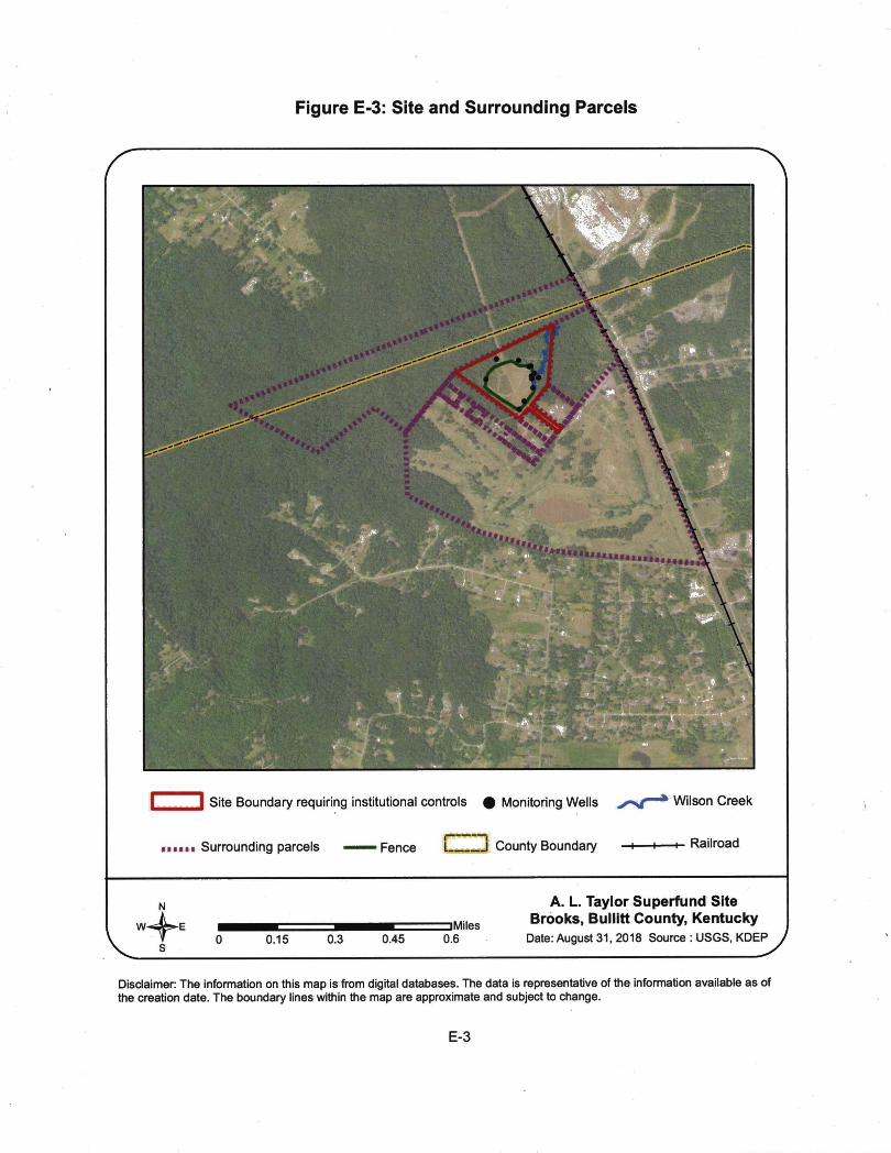
Figure E-3: Site and Surrounding Parcels
mm-y-
Wmm-AS;
“?* ■y V <*‘^^■•1,
I i Site Boundary requiring institutional controls # Monitoring Wells
••■■■• Surrounding parcels Fence L J County Boundary
Wilson Creek
-I- Railroad
NW^EDMiles
0.15 0.45 0.6
A. L. Taylor Superfund Site Brooks, Bullitt County, Kentucky
Date: August 31, 2018 Source : USGS, KDEP
Disclaimer: The information on this map is from digital databases. The data is representative of the information available as of the creation date. The boundary lines within the map are approximate and subject to change.
E-3

Figure E-4: Wilson Creek Paint Waste Cleanup Area
1
m ' ‘vw
I I Site Boundary — Fence
—Paint Waste Cleanup Area
Monitoring Wells Wilson Creek
N
jMiles0.03 0.06 0.09 0.12
A. L. Taylor Superfund Site Brooks, Bullitt County, Kentucky
Date: August 30. 2018 Source : USGS, KDEP
Disclaimer: The information on this map is from digitai databases. The data is representative of the infbnnaUon avaiiabie as of the creation date. The boundary iines within the map are approximate and subject to change.

Figure E-5: Area Impacted by Ponding and Runoff from the Drainage Ditch
iX\mm
w■ .CSBB
ALT-2
i I
ALT-4
ALT-5
ALT-a
Fence ——« Old Fence
Impacted Area
-0- Monitoring Wells Wilson Creek
W^E DMiles0.02 0.04 0.06 0.08
A. L. Taylor Superfund Site Brooks, Bullitt County, Kentucky
Date: August 30, 2018 Source : USGS, KDBP^
Disclaimer: The information on this map is from digital databases. The data is representative of the information available as of the creation date. The boundary lines within the map are approximate and subject to change.
E-5

APPENDIX F - PRESS NOTICE
www.pioneemew8.net MONDAY. JULY 23.2018 The Pioneek News A-1 3
HMTrmtjfl• •n*rY«vR«*tevf»r«C—tMCiianH
4 all (iw SM* awtaNmlt, XtMMfey nt «< *• Am-YwIw<w«« »
*imftufcwifcmtk.MhHC—»■ Kwaatlg »«mnm<40S
r« mip K«kw. wM«« <tt*tk*gm»4«ife*Si«i WaM«ip«Mt
>4 a lMrt(W9 Itnoml A(MB «• iMpMU* w'IMi r<r i a4 tow*t4 490 •«««« «f CNO b«M4 a ««u « Mlw Hr*
a4Mtltt**9K»liimVA
pt«*«a4*« ite IW iuNM « *• tM(*M LM ML) a litt •« Ite a *• MR. to IW MU*■ tU at»..4.ia<>Mat. «»au Map«aA {VOCk>a>4«»y< <Wa4i
•4«Ma«Wiai«i(004»a4*M«**tM»'t Ml.r4 ftf SMt * Om laad «r Daaa a A>«M( >991. HiKaa a nat# a ««*a« aaa4
> TfctanortaaiiaawifctOWtaiX>ado4MHtTMaat«fwawa^X*.rwAiaawa««da4a MWii« M mtm* waw. aAaa»a4ya»i wMa. >rawia laiaw If lalan. a4• ITAa^»4iA*Si*'.00>MOaU«a 19H.
wia>^^ftalraM%fa»toa4waar aaiactaaMMiiawwaw*. wwaiaawatror wjaaiaitaoaaaiw PwdMTActM M>A aHauM4«K ai«ma«y t>»«a a4<tta< «a»ir Wat U4 4ana4>A« a»4f*f OHiaM«aaaife«3M»
e IW Ma«M Cuai^acy Hawaw aa rawAM Kttatrtafiiata ay iaaiha ataaia. "^■ataA«ate»atta«b«>a<kafa»aiaa4a»a<aiiainwlfiwnWi»w*4ain ^ ----- ---------------------------- ntUfc||r«.y«rlLf«Mwfi(**ait««Waa9l(ii4^g«fMi4lwa6!8a4>««ry
l37«4Mi SkMi • SlM^M^mSi.Kaa^
4r«w«M.rar»a«Hw.Ywla(wTraaB PAu rai^rau ^ Ka-T^aKawwa a4WM
w of»»aitt'triat»a4a«»at9nt Att—mfwaatw«fh— ■ halAa4>eawraaai AipaiA «B aa*te w aimr ait •
M ^ Ite « ^ Ha-Tw Sana paaM,« •aMSka ar<
T*aaIaa.PAftiat«il ftatoMwaa flMr(4a«M24m >«>* MMSBMMAMJai liMH«A4*a» 09 PAlHfM4,<)F«flV**n A4*ka4 irf^aa •• atri^ 4 ^
«^*Mlla.PACiM
Ifca* <«M) X2494II (ITT) mSTU •.SW. I^PlM(.A«aa.OA30lO»4M
a 4»waat Iec4«l4 Ri%Ma Maia4 Uk*wr. >77 Y
lanr^YtvBcvInvftr
cr (PA)«( ca4KMg • KaYwr Caav <4 ite naair IW la Ai.
i9tan«*»9l» 9iM<
<a|wa4iMW< ti»a4aTk>]
lM«a»ati4<MrL)a 1N2;PA1
(00}aa4da»a«aa-iPA <«M4a* sa • Ka«4 «frhaa >»>iwa E9A
4b»qp.tatKgw4aa4»i9adaar.«MhBB<t
Hw «a flaarar taMvfa *« S» ao a Ma»lMi4a S8faa»« ait»a4» car ia«t alt b« |(«d a a* iMri 1
.PAag—i
■ *ca Be Sk a •« nn>XM IUM» »naa.« «ko «aM kfei apMcaat ’fm^Mthr gTVjf-aM-airln-TtnTiat^— MaA (4W M243I1 a MA iEM arr>71f-nfiRMa (PA 504993
1A*^A4Am DS
ick9.40t«5a4ala*K,
BID NOTICETHE aULUn COUNTY SHERFF IS SOUCITING t WiaACCB>T
BIOS VW OOVDEAIS FOB THE SALE OF THE FOLLOWING:M FORD RANGER 1PTCR14Aeni>A33M1 a OOOQ DURANGO 1B4H83BNaSFt(M0M
97FOHDF1W 1FTOX10WXVKC44777 79 FOK) FEED FEBSUDGlEa
»FORO RAN9011FTYR1«MXMaEa»04 FORD CRWNVIC 2FAFPT4Wa4X II2S21
FOR QUESTIONS. TO MAKE A BID, OR VIEW PAYMENT INSTRUCTIONS A PICK-UP INFO VISIT WWW.GOVDEAL5.COM
FuaeNotiMNoiioa ki iMntw gtan »iM SIwOmouM AutoSiM 370 OW
torMrollh* MIoeaMalZTD
&iWonnMnre5M to ad • at4TadHanaau MMkia Tlw impay
____ ZTDOMnalontMMMwS..StnphwdwdM. KY40ian«r9tert»Yei adMRlw AnyeaimMooreUKaemi oonowning this oiatan NM a dacud to: Ksnhjeky Dlvl£n of WNHr. Surtsos WSIsr Pan* Brsnoh. Floa Pttki MtnagsnMnt SscHcn 300 Boar Boulsmrd Frankta. Ksntucky 40601 Phons: (500 564-3410.
Kna Crsak StorassLocsia « 4860 Knob Citak Rd - Gookt. KY «1 W a IMM a PuHe AuoMo Batwday. July 28 at lOW AM. a unBa WaiMtoia Cill tot addHonal dstiM SOeasaH
Stampar-UnttZS
Salsr rsaarvaa lha iIqM to aocapt Of dsdna ay or al bMt. Unb owM te addad or Mata pitci to aala data.
Public Nodoa NGloe is hereby giva that Sham Bua. 438 Waatalds Or.. SiaphantsWM KY 40185.
has Mad a anileadon alb Bis Enansf Hi EnvtronnM CabkMt to buM a awrm bul^ Tha prepany la loeata « 4V Mlaids&. ShapherdNllai KY 40185. naa
H«y 445 WaaMdaDr. pantlal toSak Rhrar. ayeommantaorctiiaalenaoonoanilnglhla oioMtai Null to dbactad to: Ksm^ KMdnol WMtr. Sudaoa Water PaiNC
Branch. Flood FWn Menagement Sactlan 300 OoulaeettI ftanktat Ketducky 40801.
Phone: <802) 584-3410.
Moa Is hanby||lvai^« maadan^nad aw M ^s«H^ la t^am^’aMwId etoragSatoiraaoOT^atoawfceSiS starting July 23rd. The oontalsliiw unis at Mkd^ U-StuR-k Sad SWngs. 4^ Summit Dr. Loiiavkla. KY. batoning to lha foBewing paepis eitt be up lor auction.Jama Smkh( 2 links) MakaaCunnimhain JonaOaabrooka LeuraAela JaanatoCoukw MerkBannln(Rald Tammy Boston Sanuedha Hudson (2 uniW Halan MaBord-tapaon (Eunka)Demon Jonas Shaama Anderson OaMdMNoyas CharaOuMtolEuniia)John W. bigram Brandon Ainony Karan Johnson GhdaUidMg Craig Jacobs (amital Maliaaa Johnson Joshua ThompsonSoma imka may to added or delatad. Sa
Ricky Pollard Malania Flanar Gian E Gram Darrin Malona (2 unlla) David Rougaux KakhBomr Steven LaMna Chris Obiisn Chailana PhIMps Maliaaa Flaenar Jamas Munay ChaniallaCaaire PaulSbeng Travis Bullar Janmiar Warren ChartaeJones Andraai Schmied Bonnie Roadss Mary Vinca
atharighllobld

APPENDIX G - APPLICABLE OR RELEVANT AND APPROPRIATE
REQUIREMENTS (ARARs) REVIEWCERCLA Section 121(d)(1) requires that Superfund remedial actions attain "a degree of cleanup of hazardous substance, pollutants, and contaminants released into the environment and of control of further release at a minimum which assures protection of human health and the environment." The remedial action must achieve a level of cleanup that at least attains those requirements that are legally applicable or relevant and appropriate.
Applicable requirements are those cleanup standards, standards of control, and other substantive requirements, criteria, or limitations promulgated under federal environmental or state environmental or facility siting laws that specifically address a hazardous substance, remedial action, location or other circumstance found at a CERCLA site.
Relevant and appropriate requirements are those standards that, while not "applicable," address problems or situations sufficiently similar to those encountered at the CERCLA site that their use is well suited to the particular site. Only those state standards more stringent than federal requirements may be applicable or relevant and appropriate.
To-be-considered (TBC) criteria are non-promulgated advisories and guidance that are not legally binding but should be considered in determining the necessary remedial action. For example, TBCs may be particularly useful in determining health-based levels where no ARARs exist or in developing the-appropriate method for conducting a remedial action. The TBCs are evaluated to determine if the selected remedy established in the ROD remains protective.
ARARs were not defined for the Site in the June 1986 ROD because the Superfund Amendments and Reauthorization Act (SARA) was enacted in September 1986, and pre-SARA RODs were not required to identify ARARs within the remedy selection discussions. In addition, the 1986 ROD did not establish specific COCs nor any action levels associated with those COCs, such as Safe Drinking Water Act Maximum Contaminant Levels (MCLs). Therefore, changes in these standards cannot be evaluated at this time.
G-1

APPENDIX H - DATA TABLES
Table H-1Summary of Detected Constituents in Groundwater Monitoring Wells (2013-2017)
A. L. Taylor Superfund Site Brooks, Kentucky
Constituent RSL MCLGroundwater Monitoring Wells
ALT-1 ALT-22013 2015 2016 2017 2013 2015 2016 2017
MetalsArsenic 0.052 10 NT <25 <25 < 10 NT <25 <25 < 1Barium 3,800 2,000 NT 18 17 14 NT 24 20 29Calcium NA NA NT NT NT 340,000 NT NT NT 120,000Chromium NA 100 NT <5 <5 <5 NT 12 <5 <5Lead NA 15 NT <5 <5 <5 NT 37 <5 <5Magnesium NA NA NT NT NT 820,000 NT NT NT 75,000Selenium 100 50 NT <25 <25 <25 NT <25 <25 <25Strontium NA NA NT- NT NT 9,400 NT NA NA 820Zinc NA NA NT NT NT . <5 NT NT NT <5Volatile Organic Compounds (VOCs)1,1-Dichloroethane 2.8 NA <5 <5 <5 <5 <5 <5 <5 <5Cis-1,2-Dichloroethene 36 70 <5 <5 <5 <5 <5 <5 <5 <5
Notes:All values are in microgram per liter (pg/L)RSL= USEPA Region III Regional Screening Level for tap water dated November 2017 MCL = Maximum Contaminant Level fordrinking water J= Lab Qualifier (Estimated Value)NA .= Not available NT = Not tested NC = Not collected Bold indicates RSL exceedance
^sMdingMndicates MCL exceedance1. Only VOCs and Semi VOCs were analyzed in 2013.2. Well ALDW-2 was sampled in 2013. It was not sampled after that. Currently this well is not in use.3. No samples were collected in 2014.4. ALT- 4D is a duplicate sample collected in 2017.5. In 2015 and 2016 sampling event, the laboratory used detection limit of 25 pg/L for arsenic analysis which is higher than the MCL of 10 pg/L.6. The laboratory used detection limit of 5 pg/L for 1,1-Dichloroethane which is higher than the RSL of 2.8 pg/L.
H-1

Table H-1Summary of Detected Constituents in Groundwater Monitoring Wells (2013-2017)
A. L. Taylor Superfund Site Brooks, Kentucky
Groundwater Monitoring WellsConstituent RSL MCL ALT-3 ALT-4
2013 2015 2016 2017 2013 2015 2016 2017MetalsArsenic 0.052 10 NT <25 <25 <5 NT <25 <25 <5Barium 3,800 2,000 NT 84 30 32 NT <5 <5 <5Calcium NA NA NT NT NT 130,000 NT NT NT 110,000Chromium NA 100 NT . <5 <5 19 NT <5 <5 24Lead NA 15 NT <5 <5 <5 NT <5 <5 <5Magnesium NA NA NT NT NT 88,000 NT NT NT 150,000Selenium 100 50 NT <25 < 25 <25 NT <25 <25 <25Strontium NA NA NT NT NT 1,200 NT NT NT 1,100Zinc NA NA . NT NT NT 20 NT NT NT <5Volatile Organic Compounds (VOCs)1,1-Dichloroethane 2.8 NA <5 <5 <5 <5 <5 <5 <5 <5Cis-1,2-Dichloroethene 36 70 <5 <5 <5 <5 <5 <5 <5 <5
Notes:All values are in microgram per liter (pg/L)RSL= USEPA Region III Regional Screening Level for tap water dated November 2017 MCE = Maximum Conttiminant Level fordrinking water J= Lab Qualifier (Estimated Value)NA = Not available NT = Not tested NC = Not collected Bold indicates RSL exceedance
i'Sbadjngjindicates MCL exceedance1. Only VOCs and Semi VOCs were analyzed in 2013.2. Well ALDW-2 was sampled in 2013. It was not sampled after that. Currently this well is not in use.3. No samples were collected in 2014.4. ALT- 4D is a duplicate sample collected in 2017.5. In 2015 and 2016 sampling event, the laboratory used detection limit of 25 pg/L for arsenic analysis which is higher than the MCL of 10 pg/L.6. The laboratory used detection limit of 5 pg/L for 1.1-Dichloroethane which is higher than the RSL of 2.8 pg/L.

Table H-1Summary of Detected Constituents in Groundwater Monitoring Wells (2013-2017)
A. L. Taylor Superfund Site Brooks, Kentucky
Groundwater Monitoring WellsConstituent RSL MCL ALT-5 ALT-6
2013 2015 2016 2017 2013 2015 2016 2017MetalsArsenic 0.052 10 NT <25 <25 <0.9 NT <25 <25 < 10Barium 3,800 2,000 NT 9 10 8.4 NT 16 27 21Calcium NA NA NT NT NT 290,000 NT NT NT 180,000Chromium NA 100 NT 19 15 11 NT <5 <5 <5Lead NA 15 NT <5 <5 <5 NT <5 <5 <5Magnesium NA NA NT NT NT 340,000 NT NT NT 240,000Selenium 100 50 NT <25 <25 <25 NT <25 <25 <25Strontium NA NA NT NT NT 2,900 NT NT NT 3,500Zinc NA NA NT NT NT <5 NT NT NT <5Volatile Organic Compounds (VOCs)1,1-Dichloroethane 2.8 NA <5 <5 <5 <5 <5 <5 <5 <5Cis-1,2-Dichloroethene 36 70 <5 <5 <5 <5 9.7 45 16 30
Notes:All values are in microgram per liter (pg/L)RSL= USEPA Region III Regional Screening Level for tap water dated November 2017 MCL = Maximum Contaminant Level fordrinking water J= Lab Qualifier (Estimated Value)NA = Not available NT = Not tested NC = Not collected Bold indicates RSL exceedance
fSKading^indicates MCL exceedance1. Only yOCs and Semi VOCs were analyzed in 2013.2. Well ALDW-2 was sampled in 2013. It was not sampled after that. Currently this well is not in use.3. No samples were collected in 2014.4. ALT-4D is a duplicate sample collected in 2017.5. In 2015 and 2016 sampling event, the laboratory used detection limit of 25 pg/L for arsenic analysis which is higher than the MCL of 10 pg/L.6. The laboratory used detection limit of 5 pg/L for 1,1-Dichloroethane which is higher than the RSL of 2.8 pg/L.

Table H-1Summary of Detected Constituents in Groundwater Monitoring Wells (2013-2017)
A. L. Taylor Superfund Site Brooks, Kentucky
Groundwater Monitoring WellsConstituent RSL MCL ALT-7 ALT-8
2013 2015 2016 2017 2013 2015 2016 2017MetalsArsenic 0.052 10 NT <25 <25 2.4 J NT <25 <25 < 1Barium 3,800 , 2,000 NT 13 12 12 NT 23 23 38Calcium NA NA NT NT NT 69,000 NT NT NT 97,000Chromium NA 100 NT <5 22 ,<5 NT <5 <5 <5Lead NA 15 NT <5 <5 <5 NT 5.4 <5 <5Magnesium NA NA NT . NT NT 54,000 NT NT NT 73,000Selenium 100 50 NT <25 <25 <25 NT <25 <25 <25Strontium NA NA NT NT NT 4,000 NT NT NT 560Zinc NA NA NT NT NT <5 NT NT NT 6Volatile Organic Compounds (VOCs)1,1-Dichloroethane 2.8 NA <5 <5 <5 <5 <5 <5 <5 <5Cis-1,2-Dichloroethene 36 70 <5 <5 <5 <5 <5 <5 <5 <5
Notes:All values are in microgram per liter (pg/L)RSL= USEPA Region 111 Regional Screening Level for tap water dated November 2017 MCL = Maximum Contaminant Level fordrinking water J= Lab Qualifier (Estimated Value)NA = Not available NT = Not tested NC = Not collected Bold indicates RSL exceedance
rSha^ing'indicates MCL exceedance1. Only VOCs and Semi VOCs were analyzed in 2013.2. Well ALDW-2 was sampled in 2013. It was not sampled after that. Currently this well is not in use.3. No samples were collected in 2014.4. ALT-4D is a duplicate sample collected in 2017.5. In 2015 and 2016 sampling event, the laboratory used detection limit of 25 pg/L for arsenic analysis which is higher than the MCL of 10 pg/L.6. The laboratory used detection limit of 5 pg/L for 1,1 -Dichloroethane which is higher than the RSL of 2.8 pg/L.

Table H-1Summary of Detected Constituents in Groundwater Monitoring Wells (2013-2017)
A. L. Taylor Superfund Site Brooks, Kentucky
Constituent RSL MCLGroundwater Monitoring Wells
ALT-9 ALT-102013 2015 2016 2017 2013 1 2015 2016 2017
MetalsArsenic 0.052 10 NT <25 <25 <5 NT <25 <25 < 10Barium 3,800 2,000 NT 22 19 11 NT 30 19 23Calcium NA NA NT NT NT 390,000 NT NT NT 180,000Chromium NA 100 NT <5 <5 <5 NT <5 <5 <5Lead NA 15 NT <5 <5 <5 NT <5 <5 <5Magnesium NA NA NT NT NT 470,000 NT NT NT 250,000Selenium 100 50 NT 26 <25 <25 NT <25 <25 <25Strontium NA NA NT NT NT 3,400 NT NT NT 5,700Zinc NA NA NT NT NT <5 NT NT NT <5Volatile Organic Compounds (VOCs)1,1-Dichloroethane 2.8 NA 5.5 <5 7.9 9.5 <5 <5 <5 <5Cis-1,2-Dichloroethene 36 70 <5 <5 8.4 7.9 <5 <5 <5 <5
Notes:All values are in microgram per liter (pg/L)RSL= USEPA Region 111 Regional Screening Level for tap water dated November 2017 MCL = Maximum Contaminant Level fordrinking water J= Lab Qualifier (Estimated Value)NA = Not available NT = Not tested NC = Not collected Bold indicates RSL exceedance
i StiadingMndicates MCL exceedance1. Only VOCs and Semi VOCs were analyzed in 2013.2. Well ALDW-2 was sampled in 2013. It was not sampled after that. Currently this well is not in use.3. No samples were collected in 2014.4. ALT-4D is a duplicate sample collected in 2017.5. In 2015 and 2016 sampling event, the laboratory used detection limit of 25 pg/L for arsenic analysis which is higher than the MCL of 10 pg/L.6. The laboratory used detection limit of 5 pg/L for 1,1-Dichloroethane which is higher than the RSL of 2.8 pg/L.

Table H-1Summary of Detected Constituents in Groundwater Monitoring Wells (2013-2017)
A. L. Taylor Superfund Site Brooks, Kentucky
Groundwater Monitoring WellsConstituent RSL MCL ALT-11 ALT-12
2013 2015 2016 2017 2013 2015 2016 2017MetalsArsenic 0.052 10 NT <25 <25 < 10 NT <25 <25 < 10Barium 3,800 2,000 NT 28 21 12 NT 35 44 38Calcium NA NA NT NT NT 340,000 NT NT NT 93,000Chromium NA 100 NT <5 <5 <5 NT <5 <5 7.8Lead NA 15 NT <5 <5 <5 NT <5 <5 <5Magnesium NA NA NT NT NT 390,000 NT NT NT 53,000Selenium 100 50 NT <25 <25 <25 NT <25 <25 <25Strontium NA NA NT NT NT 6,300 NT NT NT 1,900Zinc NA NA NT NT NT <5 NT NT NT <5Volatile Organic Compounds (VOCs)1,1-Dichloroethane 2.8 NA <5 • <5 <5 <5 <5 <5 <5 <5Cis-1,2-Dichloroethene 36 70 <5 <5 <5 <5 <5 <5 <5 <5
Notes:All values are in microgram per liter (pg/L)RSL= USEPA Region III Regional Screening Level for tap water dated November 2017 MCL = Maximum Contaminant Level fordrinking water J= Lab Qualifier (Estimated Value)NA = Not available NT = Not tested NC = Not collected Bold indicates RSL exceedance
•^liadingjindicates MCL exceedance1. Only VOCs and Semi VOCs were analyzed in 2013.2. Well ALDW-2 was sampled in 2013. It was not sampled after that. Currently this well is not in use.3. No samples were collected in 2014.4. ALT- 4D is a duplicate sample collected in 2017.5. In 2015 and 2016 sampling event, the laboratory used detection limit of 25 pg/L for arsenic analysis which is higher than the MCL of 10 pg/L.6. The laboratory used detection limit of 5 pg/L for 1,1-Dichloroethane which is higher than the RSL of 2.8 pg/L.
H-6

Table H-1Summary of Detected Constituents in Groundwater Monitoring Wells (2013-2017)
A. L. Taylor Superfund Site Brooks, Kentucky
Constituent RSL MCLDuplicate Sample
ALT^D2013 2015 2016 2017
MetalsArsenic 0.052 10 NC NC NC <5Barium 3,800 2,000 NC NC NC <5Calcium NA NA NC NC NC 110,000Chromium NA 100 NC NC NC 21Lead NA 15 NC NC NC <5Magnesium NA . NA NC NC NC 150,000Selenium 100 50 NC NC NC <25Strontium NA. NA NC NC NC 1,100Zinc NA NA NC NC NC <5Volatile Organic Compounds (VOCs)1,1-Dichloroethane 2.8 NA NC NC NC <5Cis-1,2-Dichloroethene 36 70 NC NC NC <5
Notes:All values are in microgram per liter (pg/L)RSL= USEPA Region 111 Regional Screening Level for tap water dated November 2017 MCL = Maximum Contaminant Level fordrinking water J= Lab Qualifier (Estimated Value)NA = Not available NT = Not tested NC = Not collected Bold indicates RSL exceedance
■§itafling1indicates MCL exceedance1. Only VOCs and Semi VOCs were analyzed in 2013.2. Well ALDW-2 was sampled in 2013. It was not sampled after that. Currently this well is not in use.3. No samples were collected in 2014.4. ALT- 4D is a duplicate sample collected in 2017.5. In 2015 and 2016 sampling event, the laboratory used detection limit of 25 pg/L for arsenic analysis which is higher than the MCL of 10 pg/L.6. The laboratory used detection limit of 5 pg/L for 1,1-Dichloroethane which is higher than the RSL of 2.8 pg/L.
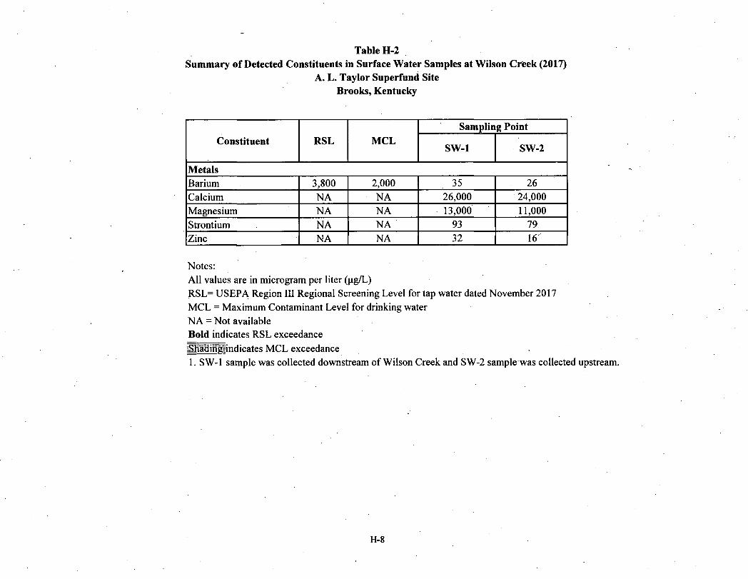
Table H-2Summary of Detected Constituents in Surface Water Samples at Wilson Creek (2017)
A. L. Taylor Snperfund Site Brooks, Kentucky
Constituent RSL MCLSampling Point
SW-1 SW-2
MetalsBarium 3,800 2,000 35 26Calcium NA • NA 26,000 24,000Magnesium NA NA 13,000 11,000Strontium NA NA 93 79Zinc NA NA 32 16
Notes:All values are in microgram per liter (pg/L)RSL= USEPA Region III Regional Screening Level for tap water dated November 2017 MCL = Maximum Contaminant Level for drinking water NA = Not available Bold indicates RSL exceedanceSRldin^indicates MCL exceedance .1. SW-1 sample was collected downstream of Wilson Creek and SW-2 sample was collected upstream.
H-8

Table H-3Summary of Detected Constituents in Sediment Samples at Wilson Creek (2017)
A. L. Taylor Superfund Site Brooks, Kentucky
ConstituentResidential Soil Level ‘
Industrial Soil Level ’
EcologicalScreening
Values^
Sampling Point
Sediment-1 Sediment-2
MetalsBarium 15,000 22,00,000 20^ 1.7 29Calcium NA NA NA 33* 700Chromium NA NA 43.4^ 0.31 10Copper 3,100 47,000 31.6^ 0.41 8.8Lead 400 800 35.8^ 0.72 8.3Magnesium NA NA NA 65* 2,100Strontium 47,000 700,000 NA 0.27 <6.9Zinc 23,000 350,000 121^ 3.5* 51
Notes;All values are in miligram per kilogram (mg/kg)NA = Not available1 = USEPA Region III Soil Screening Level dated November 20172 = Region 4 Sediment Screening Values dated August 20153 = Sediment Screening Values, Non -Narcotic Modes of Action - Table 2a4 = Sediment Screening Values for PAHs - Table 3a* = The laboratory gave M3 qualifier for these results because high bias was identified for these chemicals.
|Sl®mgindicates Residential Soil Level exceedance Bold indicates Industrial Soil Level exceedance Italics indicates Ecological Value exceedance1. Sediment-1 sample was collected downstream of Wilson Creek and Sediment-2 sample was collected upstream.2. The sediment samples were collected at the same location as surface water samples.
H-9

Table H-3Summary of Detected Constituents in Sediment Samples at Wilson Creek (2017)
A. L. Taylor Superfund Site Brooks, Kentucky
ConstituentResidential Soil Level ‘
Industrial Soil Level *
EcologicalScreening
Values^
Sampling Point
Sediment-1 Sediment-2
Polyaromatic Hydrocarbons i(PAHs)Benzo(b)fluoranthene 1.1 21 0.979 0.058 <0.05Bis(2-ethylhexyl) phthalate 39 160 0.182^ 0.36 <0.33Fluoranthene 2,400 30,000 0.707'' 0.058 <0.05Pyrene 1,800 23,000 0.697 '• 0.057 . <0.05Polychlorinated Biphenyls (PCBs)Aroclor 1260 0.24 1 0.99 . NA 1 0.67 < 0.033
Notes:All values are in miligram per kilogram (mg/kg)NA = Not available1 = USEPA Region III Soil Screening Level dated November 20172 = Region 4 Sediment Screening Values dated August 20153 = Sediment Screening Values, Non -Narcotic Modes of Action - Table 2a4 = Sediment Screening Values for PAHs - Table 3a* = The laboratory gave M3 qualifier for these results because high bias was identified for these chemicals.
ISSyggIindicates Residential Soil Level exceedance Bold indicates Industrial Soil Level exceedance Italics indicates Ecological Value exceedance1. Sediment-1 sample was collected downstream of Wilson Creek and Sediment-2 sample was collected upstream.2. The sediment samples were collected at the same location as surface water samples.
H-10

APPENDIX I- SITE INSPECTION CHECKLIST
FIVE-YEAR REVIEW SITE INSPECTION CHECKLISTI. SITE INFORMATION
Site name: A. L. Taylor (Valley of the Drums)Location and Region: Brooks, Bullitt County, Kentucky, Region 4Agency, office, or company leading the five-year review: EPA Region 4
Date of inspection: 11/29/2017EPA ID: KYD980500961
Weather/temperature:Cloudy, 60» F
Remedy Includes: (Check all that apply) la Landfill cover/containment B Access controls□ Institutional controls□ Groundwater pump and treatment□ Surface water collection and treatment
la Monitored natural attenuation□ Groundwater containment□ Vertical barrier walls
B Other Perimeter drainage ditch outside the can
Attachments: □ Inspection team roster attached □ Site map attached
II. INTERVIEWS (Check aU that apply)
1. O&M site managerName
Interviewed □ at site □ at office □ by phone Phone no. Problems, suggestions; □ Report attached___________
Title Date
2. O&M staff O&M Contractor Eddie Taylor Title DateName
InterviewedO at site □ at office □ by phone Phone no. Environmental Repair Service Company,502-817-1270
Problems, suggestions; □ Report attached

3. Local regulatory authorities and response agencies (i.e., State and Tribal offices, emergency response office, police department, office of public health or environmental health, zoning office, recorder of deeds, or other city and county offices, etc.) Fill in all that apply.
Agency_________________ •Contact
NameProblems; suggestions; □ Report attached
Title
AgencyContact
NameProblems; suggestions; □ Report attached
Title
Agency______ _Contact
NameProblems; suggestions; □ Report attached
Title
AgencyContact
NameProblems; suggestions; □ Report attached
Title
Date Phone no.
Date Phone no.
Date Phone no.
Date Phone no.
4. Other interviews (optional) □ Report attached.

1. O&M Documents□ O&M manual□ As-built drawings□ Maintenance logsRemarks
□ Readily available□ Readily available□ Readily available
□ Up to date□ Up to date□ Up to date
ISN/ASN/A0N/A
2. Site-Specific Health and Safety Plan □ Readily available□ Contingency plan/emergency response plan □ Readily available Remarks
□ Up to date□ Up to date
SN/ASN/A
3. O&M and OSHA Training RecordsRemarks
□ Readily available □ Up to date BN/A
III. ON-SITE DOCUMENTS & RECORDS VERIFIED (Check all that apply)
Permits and Service Agreements□ Air discharge permit □ Readily available □ Up to date SN/A□ Effluent discharge □ Readily available □ Up to date HN/A□ Waste disposal, POTW □ Readily available □ Up to date BN/A□ Other permits □ Readily available □ Up to date BN/ARemarks
5. Gas Generation Records □ Readily available □ Up to date B N/ARemarks
6. Settlement Monument RecordsRemarks
□ Readily available □ Up to date BN/A
7. Groundwater Monitoring RecordsRemarks
B Readily available □ Up to date □ N/A
.8. Leachate Extraction RecordsRemarks
□ Readily available □ Up to date BN/A
9. Discharge Compliance Records□ Air □ Readily available □ Up to date BN/A□ Water (effluent)Remarks
□ Readily available □ Up to date BN/A
10. Daily Access/Security LogsRemarks
□ Readily available □ Up to date BN/A

rv. O&M COSTS
1. O&M OrganizationS State in-house□ PRP in-house□ Federal Facility in-house□ Other
0 Contractor for State□ Contractor for PRP□ Contractor for Federal Facility
2. O&M Cost Records0 Readily available S Up to datea Funding mechanism/agreement in placeOriginal O&M cost estimate $998.875 for a 30 year period □ Breakdown attached
Total annual cost by year for review period if available
From 1/1/2013 To 12/31/2013 $13,500 □ Breakdown attachedDate Date Total cost
From 1/1/2014 To 12/31/2014 $7,500 □ Breakdown attachedDate Date Total cost
From 1/1/2015 To 12/31/2015 $18,400 □ Breakdown attachedDate Date Total cost
From 1/1/2016 To 12/31/2016 $23,500 □ Breakdown attachedDate Date Total cost
From 1/1/2017 To 12/31/2017 $44,500 □ Breakdown attachedDate Date Total cost
3. Unanticipated or Unusually High O&M Costs During Review PeriodDescribe costs and reasons: In 2016, topographic survey of the Site was conducted. In 2017, the major activities were paint waste cleanup at Wilson Creek and drainage improvement in the southeastern portion of the Site. There activities were in addition to regular O&M resulting in higher costs.
V. ACCESS AND INSTITUTIONAL CONTROLS 0 Applicable DN/A
A. Fencing
1. Fencing damaged □ Location shown on site map 0 Gates secured □ N/ARemarks: The fencing was slightly broken on the north side in the vicinity of well ALT-10. Fence extended in the east side by about 10 feet to deter ATV traffic.
B. Other Access Restrictions
1. Signs and other security measures □ Location shown on site mapRemarks: There are no signs at the property
0N/A

C. Institutional Controls (ICs)
1. Implementation and enforcementSite conditions imply ICs not properly implemented Site conditions imply ICs not being fully enforced
Type of monitoring (e.g., self-reporting, drive by) Frequency _______________________________
□ Yes GNo SN/A□ Yes GNo • lEl N/A
Responsible party/agency Contact
Name Title Date Phone no.
Reporting is up-to-dateReports are verified by the lead agency
□ Yes□ Yes
□ No□ No
□ N/A□ N/A
Specific requirements in deed or decision documents have been met Violations have been reportedOther problems or suggestions: □ Report attached
□ Yes□ Yes
□ No□ No
□ N/A□ N/A
2. Adequacy □ ICs are adequate □ ICs are inadequate □ N/ARemarks: ICs are not in place. Options for groundwater and land use restrictions need to be evaluated.
D. General
1. Vandalism/trespassing □ Location shown on site map 0 No vandalism evidentRemarks
2. Land use changes on site □ N/ARemarks The fence on the east side has been extended 10 feet in order to deter ATV traffic andDondine
3. Land use changes off siteD N/ARemarks A small shed directlv south of the Site is vacant and annears to be unused.
VI. GENERAL SITE CONDITIONS
A. Roads a Applicable □ N/A
1. Roads damaged □ Location shown on site map 0 Roads adequateRemarks
□ N/A

B. Other Site ConditionsRemarks: Trees and shrubs were growing in the perimeter ditch in the northern portion outside the fence. Ponding was observed near the southeastern fence line. The fence was extended in the east side beginning at well ALT-4 and ending at well ALT-8.
VII. LANDFILL COVERS S Applicable DN/A
A. Landfill Surface
1. Settlement (Low spots) Areal extent
□ Location shown on site map Depth_
□ Settlement not evident
Remarks: Minor settlement was observed and fixed in 2015. There were a couple of places where the cap had started to settle but it was more evident near the area around the utility pole in the middle of the cap.
2. CracksLengths_Remarks
□ Location shown on site map Widths Depths
S Cracking not evident
Erosion Areal extent_ Remarks
□ Location shown on site map Depth_____ ______
IHl Erosion not evident
HolesAreal extent_ Remarks
□ Location shown on site map Depth
S Holes not evident
Vegetative Cover S Grass □ Cover properly established □ No signs of stress□ Trees/Shrubs (indicate size and locations on a diagram)Remarks _______ _______ ________
Alternative Cover (armored rock, concrete, etc.) IHI N/A Remarks
BulgesAreal extent_ Remarks
□ Location shown on site map Height
0 Bulges not evident
□ Wet areas/water damage not evidentSI Location shown on site map Areal extent_SI Location shown on site map Areal extent_□ Location shown on site map Areal extent_□ Location shown on site map Areal extent_
8. Wet AreasAVater Damage 0 Wet areas SI Ponding□ Seeps□ Soft subgradeRemarks Ponding was observed in southeastern portion of the Site. Berms were installed to control the runoff fi-om the drainage ditch but it, did not look like they were sufficient to control runoff.

2. Bench BreachedRemarks
□ Location shown on site map 0 N/A or okay
3. Bench OvertoppedRemarks
□ Location shown on site map 0 N/A or okay
9. Slope Instability □ Slides □ Location shown on site map S No evidence of slope instability Areal extentRemarks _________________________ ________________________
B. Benches ISl Applicable DN/A(Horizontally constructed mounds of earth placed across a steep landfill side slope to interrupt the slope in order to slow down the velocity of surface runoff and intercept and convey the runoff to a lined channel.)
1. Flows Bypass Bench Remarks
□ Location shown on site map (3 N/A or okay
C. Letdown Channels 0 Applicable DN/A(Channel lined with erosion control mats, riprap, grout bags, or gabions that descend down the steep side slope of the cover and will allow the runoff water collected by the benches to move off of the landfill cover without creating erosion gullies.)
1. SettlementAreal extent_ Remarks
□ Location shown on site map ___ Depth
0 No evidence of settlement
Material Degradation □ Location shown on site map Material type Areal extent Remarks
0 No evidence of degradation
ErosionAreal extent_ Remarks
□ Location shown on site map ___ Depth
0 No evidence of erosion

4. UndercuttingAreal extent__Remarks
□ Location shown on site map ___ Depth
0 No evidence of undercutting
Obstructions Type_□ Location shown on site map SizeRemarks
0 No obstructions Areal extent
Type_Excessive Vegetative Growth□ No evidence of excessive growth0 Vegetation in channels does not obstruct flow□ Location shown on site map Remarks
Areal extent
D. Cover Penetrations □ Applicable 0N/A
1. Gas Vents □ Active□ Passive□ Properly secured/locked □ Functioning □ Routinely sampled □ Good condition□ Evidence of leakage at penetration □ Needs Maintenance□ N/A Remarks
2. Gas Monitoring Probes□ Properly secured/locked □ Functioning □ Routinely sampled □ Good condition□ Evidence of leakage at penetration □ Needs Maintenance DN/ARemarks
Monitoring Wells (within surface area of landfill)□ Properly secured/locked □ Functioning □ Routinely sampled □ Good condition□ Evidence of leakage at penetration □ Needs Maintenance □ N/ARemarks
Leachate Extraction Wells□ Properly secured/locked □ Functioning □ Routinely sampled □ Good condition□ Evidence of leakage at penetration □ Needs Maintenance □ N/ARemarks ___________
Settlement MonumentsRemarks
□ Located □ Routinely surveyed □ N/A

E. Gas Collection and Treatment □ Applicable S N/A
1. Gas Treatment Facilities□ Flaring □ Thermal destruction □ Collection for reuse□ Good conditionO Needs MaintenanceRemarks ____ ___
Gas Collection Wells, Manifolds and Piping□ Good conditionD Needs Maintenance Remarks
Gas Monitoring Facilities (e.g., gas monitoring of adjacent homes or buildings)□ Good conditionD Needs Maintenance □ N/ARemarks ___
F. Cover Drainage Layer □ Applicable ISl N/A
1. Outlet Pipes InspectedRemarks
□ Functioning □ N/A
2. Outlet Rock InspectedRemarks
□ Functioning □ N/A
G. Oetention/Sedimentation Ponds □ Applicable El N/A
1. Siltation Areal extent Depth □ N/A□ Siltation not evidentRemarks
2. Erosion Areal extent Depth□ Erosion not evidentRemarks
3. Outlet WorksRemarks
□ Functioning □ N/A
4. DamRemarks
□ Functioning □ N/A

H. Retaining Walls □ Applicable El N/A
1. Deformations □ Location shown on site map □ Deformation not evidentHorizontal displacement____________ Vertical displacementRotational displacement Remarks
2. DegradationRemarks
□ Location shown on site map □ Degradation not evident
I. Perimeter Ditches/Off-Site Discharge El Applicable □ N/A
1. SiltationAreal extent
□ Location shown on site map El Siltation not evidentDepth
Remarks
Vegetative Growth □ Location shown on site map □ N/A El Vegetation does not impede flow Areal extent______________ TypeRemarks: There was excessive vegetative growth in the perimeter ditch on the northern side.
3. ErosionAreal extent
□ Location shown on site map Depth
El Erosion not evident
Remarks
4. Discharge StructureRemarks
□ Functioning El N/A
VIII. VERTICAL BARRIER WALLS □ Applicable El N/A
1. SettlementAreal extent
□ Location shown on site map Depth
□ Settlement not evident
Remarks
2. Performance MonitoringType of monitoring_ □ Performance not monitoredFrequency______________________ _______Head differential_Remarks
_□ Evidence of breaching
I-IO

IX. GROUNDWATER/SURFACE WATER REMEDIES S Applicable DN/A
A. Groundwater Extraction Wells, Pumps, and Pipelines □ Applicable B N/A
1. Pumps, Wellhead Plumbing, and Electrical□ Good conditionD All required wells properly operating □ Needs Maintenance □ N/A Remarks
2. Extraction System Pipelines, Valves, Valve Boxes, and Other Appurtenances□ Good conditionD Needs Mairitenance Remarks
3. Spare Parts and Equipment□ Readily available □ Good conditionD Requires upgrade □ Needs to be provided Remarks
B. Surface Water Collection Structures, Pumps, and Pipelines □ Applicable B N/A
1. Collection Structures, Pumps, and Electrical□ Good conditionD Needs Maintenance Remarks
Surface Water Collection System Pipelines, Valves, Valve Boxes, and Other AppurtenancesD Good conditionD Needs Maintenance Remarks
Spare Parts and EquipmentD Readily available D Good conditionD Requires upgrade Remarks
D Needs to be provided
C. Treatment System □ Applicable 0 N/A
1. Treatment Train (Check components that apply)□ Metals removal □ Oil/water separation □ Bioremediation□ Air stripping □ Carbon adsorbers□ Filters□ Additive (e.g., chelation agent, flocculent)_□ Others□ Good condition □ Needs Maintenance□ Sampling ports properly marked and functional□ Sampling/maintenance log displayed and up to date□ Equipment properly identified□ Quantity of groimdwater treated annually_________□ Quantity of surfaee water treated annually Remarks
Electrical Enclosures and Panels (properly, rated and functional) □ N/A □ Good conditionG Needs MaintenanceRemarks
Tanks, Vaults, Storage Vessels□ N/A □ Good conditionG Proper secondary containment □ Needs MaintenanceRemarks
4. Discharge Structure and Appurtenances□ N/A □ Good conditionG Needs MaintenanceRemarks
5. Treatment Building(s)□ N/A □ Good condition (esp. roof and doorways)□ Chemicals and equipment properly stored Remarks
□ Needs repair
6. Monitoring Wells (pump and treatment remedy)□ Properly secured/locked □ Functioning □ Routinely sampled□ All required wells located □ Needs Maintenance
□ Good condition □ N/A
Remarks
D. Monitoring Data1. Monitoring Data
□ Is routinely submitted on time □ Is of acceptable quality2. Monitoring data suggests:
□ Groundwater plume is effectively contained □ Contaminant concentrations are declining

D. Monitored Natural Attenuation
1. Monitoring Wells (natural attenuation remedy)S Properly secured/locked IHl Functioning El Routinely sampledIS All required wells located □ Needs MaintenanceRemarks _____________________
IS Good condition □ N/A
X. OTHER REMEDIES
If there are remedies applied at the site which are not covered above, attach an inspection sheet describing the physical nature and condition of any facility associated with the remedy. An example would be soil vapor extraction.
XL OVERALL OBSERVATIONS
Implementation of the Remedy
Describe issues and observations relating to whether the remedy is effective and functioning as designed. Begin with a brief statement of what the remedy is to accomplish (i.e., to contain contaminant plume, minimize infiltration and gas emission, etc.).Direct contact as well as migration of contaminants from the capped area is prevented. Security fence- groundwater monitoring wells and perimeter drainage ditches should be maintained. The remedy is effective and fimctioning as designed.
Adequacy of O&M
Describe issues and observations related to the implementation and scope of O&M procedures. In particular, discuss their relationship to the current and long-term protectiveness of the remedy.The current schedule for visual site inspections, mowing and herbicide application has been effective and should be continued. However. Wilson Creek needs to be monitored with the same fi'eauencv as groundwater.
C. Early Indicators of Potential Remedy Problems
Describe issues and observations such as unexpected changes in the cost or scope of O&M or a high fi"equency of unscheduled repairs that suggest that the protectiveness of the remedy may be compromised in the future.Ponding in the southeastern portion has been a cause for concern for a long time. This issue needs a more permanent solution in the near future.
D. Opportunities for Optimization
Describe possible opportunities for optimization in monitoring tasks or the operation of the remedy.The degradation of contaminants in groundwater at the Site is slow. Therefore, it is not necessary to monitor the Site for natural attenuation for groundwater aimually. The fi~equency of groundwater monitoring can be reduced from annual to biennial monitoring.______________________________
Site Inspection Participants:Yvonne Jones (EPA)Christoph Uhlenbruch, Shital Jiwane, Frank Whitney (KDEP) Eddie Taylor (KDEP Contractor)

APPENDIX J - SITE INSPECTION PHOTOGRAPHS
a
^ . __________
ir-
•STMW-'^mmm
^SA ,»P^ £ ■
kSMi^S , v>. pIS;'4>-" A3^ L.^ ,. -* i'S-^, - K'.'i/b •; - n
Extended fence near the eastern portion of the Site
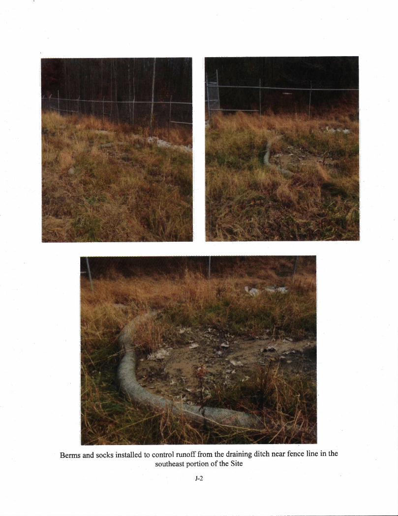
v:i\] ; V
VM’»* IK*"»
SslE:
•''-IpfcPI^.
■'■■ ,3jifep^^v';.> Jjgp^?gg-T'"-
i«i^..-ii,. jk >fJ-.':^, ■'>.«■ .'3^’^^■ -i--■ :’« r’''^.,.:^ r^- '■'■ '
, ' X;' .V
Berms and socks installed to control runoff from the draining ditch near fence line in thesoutheast portion of the Site

i
Slightly broken security fence in the north and growing tree limbs on the fence
A
&'i- ■ / /iWki'M-' /'' ■' ■' ■'■ •* '/
■ '‘j
Ui* ■ #*
.-•A
Padding on well ALT-1 buried under a soil layer

, t-i
^'- ^ i ^ -'\ -:/v t> • ■ >jtt ' ’
* ■ >
i?**Unnamed pipe near well ALT-10, unlocked and not been properly abandoned
Unlocked well named ALT DW outside the fence area in the northern portion of the Site

:A ^ f.viv^ >irii^'^j^ To^ ' ’•'^i-
,..^-v-A-s^-it52*^-V:^ i
■r • •^ii^v''?*^. 'i--^ ^
1^ ^ «AH
. ^
Portion of Wilson Creek
mfp m■j ’w: t iSkiii
Sr'^ r-"f^':V•'
■• .v»< m ' ■. t
• ' '^''' ■’
A''"' i
'n., ■«Trace amount of paint sludge in Wilson Creek

mm. ;ii^'^--'- I i2l‘ -I 'V 'O; R
Trees and vegetation growing in the riprap of drainage ditch outside the fence on the north side
m ) «t'. “
ppMPiwppii*"''' ' ''7
*'?"3
Abandoned shed close to the front gate near well ALT-6

v^- ' ■ ‘iJ?!
wi
Settling of the cap observed in the middle portion of the capped area

:-' 'V
tmu: \. ■:% ■'-4S&
:W^S:v^mmm''r): -1 ■ //■■■ -
!&^0- %■
^ »r %A fr^-'
’■ l‘hWA ■«/ --An'fTAi .
/fXA'' i' - -Msi'-JWI■M:A'AkA'A p :pS»V> f /
.:mAdA%i:^A
'■ ■ ^ V'
Small channel leading to the pond near the front gate and southeast boundary of the Site