Embed Size (px)
Citation preview
Appendix 1
Recently Approved and Pending Development Projects within the Proposed Project Area
LU10-0074
SD4410
LU4171
LU11-0066
LU10-0087
LU11-0069
LU09-0158
LU09-0013
SD06-0075
LU09-0059 LU11-0089
LU09-0081
LU11-0093
LU11-0126
SD11-0006
SD05-0041
LU10-0033
LU11-0091
LU11-0116
LU11-0041
LC11-0001
LU07-0047
LU11-0120
LU09-0082
SD11-0009
LU11-0030
LU10-0090
LU11-0111
LU10-0128 GP05-0009
LU11-0066
LU11-0072
LU11-0106
SD08-0025
SD09-0005
LU10-0022
LC11-0002
LU11-0074
LU11-0134
LU10-0118
GP09-0002
LU11-0115
LU11-0150
LU08-0100
LU08-0106
LU11-0059
LU11-0122
LU11-0102
LU11-0020
LU11-0142
LU09-0128
LU10-0074
LU11-0053
SD08-0028
LC11-0003
LU11-0148
SD06-0060
LU11-0087
SD11-0021
LU10-0048
SD08-0060
SD11-0028
LU10-0119
LU08-0047
SD10-0029
LU11-0008
ZN09-0007
SD10-0032
LU12-0002
LU11-0052
SD09-0025
LU11-0019
LU11-0143
LU11-0068
SD11-0018
SD11-0022
LU11-0117
LU11-0014
LU11-0105
LU11-0104
LU11-0038
SD10-0010
LU10-0099
LU09-0138
GP07-0005
LU11-0090
SD10-0039
LU11-0136
LU10-0096
LU10-0113
SD10-0034
GP06-0006
LU06-0026
LU10-0094
LU11-0018
SD11-0024
SD08-0026
LU11-0042
LU10-0076
LU11-0107
LU11-0044
ZN12-0001
LU08-0116
LU11-0071
SD07-0065
LU11-0088
SD08-0027
LU11-0048
LU07-0072
LU07-0043
SD11-0025
LU11-0123
LU11-0124
LU12-0006 LU11-0096
LU12-0004
LU10-0091
LU11-0110
LU11-0035
LU11-0092
LU10-0100
LU10-0108
LU11-0127
LU11-0031
SD11-0002
LU12-0005
LU11-0137
LU09-0036
LU10-0124
SD11-0029
LU11-0076
LU10-0003
SD06-0041
LU11-0007
LU08-0153
LU10-0069
SD11-0008
LU11-0040
LU11-0082
SD11-0013
SD11-0023
SD11-0020
LU11-0075
SD10-0038
LU11-0033
ZN05-0012
LU4874
LU06-0137
LU11-0103
LU11-0066LU11-0133
SD08-0029
LU10-0023SD11-0017
SD11-0019
LU11-0060
SD11-0011
LU10-0026
LU11-0135
SD10-0035
LU11-0066
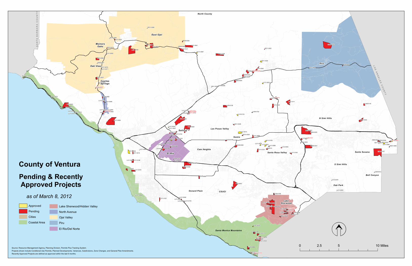
Pending & RecentlyApproved Projects
Las Posas Valley
Santa Rosa Valley
Somis
N Simi Hills
Oxnard Plain
Santa Monica Mountains
Projects shown include Conditional Use Permits, Planned Developments, Variances, Subdivisions, Zone Changes, and General Plan Amendments.Source: Resource Management Agency, Planning Division, Permits Plus Tracking System.
0 5 102.5 Miles
North County
Saticoy
Cam Heights
S Simi Hills
Santa Susana
Oak Park
Recently Approved Projects are defined as approved within the last 6 months.
as of March 8, 2012
County of Ventura
LO
S A
NG
EL
ES
CO
UN
TY
LO
S A
NG
EL
ES
CO
UN
TY
SA
NT
A B
AR
BA
RA
CO
UN
TY
SA
NT
A B
AR
BA
RA
CO
UN
TY
Approved
Pending
Cities
Coastal Area
El Rio/Del Norte
Lake Sherwood/Hidden Valley
North Avenue
Ojai Valley
Piru
CasitasSprings
Oak View
MeinersOaks
El Rio
LakeSherwood
Bell Canyon
Piru
East Ojai
CSUCI

������������ ����� ���������������������
�������������� ������������ � ����������������� ��������������
� ����� ����������������
��� ���� ������� �!��""���� �������������!����#� ���� ���$���"� �����������������%��
�!!��� ��
��������� ������� �� �� ���� ������� ������������������������������������������������������������ ���������������!�"#$��
��������������#� �%&'(&)*'(%&�%+��%&��%&+%,-('.
/%0��*1,20��*'3��%,20'�*,2*
4/����������5��������6�77
$�/���#�����8����
"������� ������6� �� �� ���� ������� �!2�9,%9%021�9,%:2;'�;%&0(0'0�%+�*�"2&2,*3��3*&��-2&1-2&'��<%&2��!*&=2��*&1��%&1('(%&*3��02��2,-('�(&�%,12,�'%�12>23%9�*�32*02!%31�-*&)+*;'),21�!%)0(&=�;%--)&('.�%&�'!2�9,%:2;'�0('2����!2�9,%9%021�"2&2,*3��3*&��-2&1-2&'�*&1�<%&2��!*&=2�?%)31�;!*&=2�'!2�2@(0'(&=�3*&1�)02 A%&(&=�120(=&*'(%&0�%+��@(0'(&=��%--)&('.���B�����*;B���),*3��@;3)0(>2��%&2�*;,2�-(&(-)-�3%'�0(A2 ��B����������0C�+'B���),*3��@;3)0(>2���������0C)*,2�+22'�-(&(-)-�3%'�0(A2 ��*&1�B�����*;B���),*3��@;3)0(>2��+(>2�*;,2�-(&(-)-�3%'�0(A2 ��'%��@(0'(&=��%--)&('.���B���������1) *;B���20(12&'(*3��3*&&21��2>23%9-2&'�������1?233(&=�)&('0 *;,2 ���
�!2�*993(;*&'�(0�9,%9%0(&=�'%�12>23%9�����1?233(&=�)&('0�%&�'!2�9,%:2;'�0('2����!2�1?233(&=�)&('0�?%)31�;%&0(0'�%+�&(&2��'?%�0'%,.�-*&)+*;'),21�!%-20�*&1���%&2�0'%,.�-*&)+*;'),21�!%-20��,*&=(&=�D2'?22&�7�6�6�0C)*,2�+22'��0�+� �*&1���6���0�+��(&�0(A2����!2�-*&)+*;'),21�!%-20�?%)31�D2�123(>2,21�*&1�(&0'*3321�?('!(&�2*;!�!%-20('2�)9%&�9),;!*02�%+�'!2�!%-2�*&1�2@2;)'(%&�%+�*�32*02�*=,22-2&'�?('!�'!2�;%--)&('.�-*&*=2-2&'�*=2&;.����!2�*993(;*&'�(0�9,%9%0(&=�������E �%+�'!2�1?233(&=�)&('0�*0�*++%,1*D32�!%)0(&=�)&('0����!2�9,%9%021�9,%:2;'�*30%�(&;3)120�'!2�+%33%?(&=�12>23%9-2&'�'%�D2�-*&*=21�D.�'!2�;%--)&('.�-*&*=2-2&'�*=2&;.5��*�;%--)&('.�9%%3�*&1�:*;)AA(F��*&�*99,%@(-*'23.����67�0�+������+%%'�'*33�;%--)&('.�;3)D!%)02��?!(;!�?%)31�(&;3)12�*�?*0!�,%%-��,20',%%-0��2@2,;(02�,%%-��;%&+2,2&;2�,%%-��%++(;20��*&1�G(';!2& =*-2�,%%-F��*&1��3*&10;*9(&=�'!*'�?%)31�(&;3)12�*�92120',(*&�9*'!�
�!2�H2&'),*��%)&'.�$*'2,?%,G0��(0',(;'��%��7�?%)31�9,%>(12�?*'2,�*&1�'!2��('.�%+��(-(�H*332.�?%)31�9,%>(12�02?*=2�1(09%0*3�02,>(;2�'%�'!2�9,%9%021�12>23%9-2&'����,(>*'2�0',22'0�'!*'�>*,.�D2'?22&�6�+22'�*&1����+22'�(&�?(1'!�?%)31�9,%>(12�*;;200�?('!(&�'!2�9,%:2;'�0('2�+,%-�4*'!2,(&2��%*1�*&1��2992,��,22�/*&2�$20' ����!2�*993(;*&'�(0�9,%9%0(&=�'%�?(12&�4*'!2,(&2��%*1�+,%-�'!2�9,%:2;'�0('2�'%��*&'*��)0*&*��*00��%*1�(&�%,12,�'%�9,%>(12�02;%&1*,.�*;;200�'%�'!2�9,%:2;'�0('2��9),0)*&'�'%�'!2�H2&'),*��%)&'.��(,2��,%'2;'(%&��(0',(;'I0�,2;%--2&1*'(%&0���?%�;%>2,21�'*&12-�9*,G(&=�09*;20�?%)31�D2�9,%>(121�+%,�2*;!�1?233(&=�)&('F�7�>(0('%,�9*,G(&=�09*;20�*&1�-%'%,;.;32�9*,G(&=�09*;20�?%)31�D2�9,%>(121�*3%&=�'!2�9,(>*'2�0',22'0�*&1�?('!(&�120(=&*'21�>(0('%,�9*,G(&=�09*;20�'!,%)=!%)'�'!2�12>23%9-2&'������99,%@(-*'23.�������;)D(;�.*,10�%+�=,*1(&=��;)'�*&1�+(33 �(0�9,%9%021�'%�9,29*,2�'!2�9,%:2;'�0('2�+%,�12>23%9-2&'����!2�*993(;*&'�(0�9,%9%0(&=�'%�)02�*99,%@(-*'23.������;)D(;�.*,10�%+�)&92,-(''21�0'%;G9(321�12D,(0�*&1�0%(3�'!*'�;),,2&'3.�2@(0'0�%&�0('2�*0�9*,'�%+�'!2�9,%9%021�=,*1(&=�*;'(>('(20�
"2&2,*3��3*&��-2&1-2&'
�*&'*��)0*&*��,2* #�$4�����������5�����������
��/����/��������������
������������ �������������������������� ������� ����� ������������������ ���� ������������� ��������������� ��������������� �!��"�������#������������������� ������$����%������ %� �%�"����� � �������!�� ��������������������� �&�� ���������� ������ �������������"��������� ���� �!����������'()'*)+',+
�

������������ ����� ���������������������
�������������� ������������ � ����������������� ��������������
� ����� ����������������
��� ���� ������� �!��""���� �������������!����#� ���� ���$���"� �����������������%��
�!!��� ��
�?%��*3(+%,&(*�$*3&)'��8)=3*&0��*3(+%,&(;* �',220�*&1�0(@��*3(+%,&(*��2992,���;!(&)0�-%332 �',220�?%)31�D2�,2-%>21�'%�9,29*,2�'!2�9,%:2;'�0('2�+%,�12>23%9-2&'����&2�%3(>2�',22���32*�2),%92* �?%)31�D2�',*&093*&'21�%&�0('2�
"������ ������� �� � ��� ������� "2&2,*3��3*&��-2&1-2&'�'%�*-2&1�'!2�/*G2��!2,?%%1��,2*��3*&��092;(+(;*33.�'!2��2;,2*'(%&�9%3(;.�������6 �*&1�-*9�;!*&=2�'%��(=),2�F�'%�,2-%>2�'!2�;%,,(1%,�',*(3�%)'�%+��,*;'0�����������J�����6�*&1�'%�*11�*�',*(3!2*1�*3%&=��*,3(032��%*1�?('!(&��,*;'������
6����$�//�������"�$� "2&2,*3��3*&��-2&1-2&'
/*G2��!2,?%%1��,2*
�����������/�5������������
�#��$������H�/������
"�������� �������� �� �� ���� �����/�� �?%�>*;*&'�9*,;230���6�*;�*&1������*; �%&�?!(;!�*993(;*&'�9,%9%020�'%�D)(31�'?%�0(&=32�+*-(3.�!%-20���993(;*&'�120(,20�'%�;%&&2;'�'!202�9,%9%021�!%-20�'%�*�;%--)&('.�?*'2,�0.0'2-�*&1�9)D3(;�02?2,0�����'2@'�*-2&1-2&'�'%�'!2�9%3(;(20�%+�'!2�/G��!2,?%%1��,2*��3*&�'%�*33%?�+%,�*&&2@*'(%&�%+�2@(0('(&=��>*;*&'�9*,;230�(0�,2C)20'21�
"2&2,*3��3*&��-2&1-2&'
�*&'*��%&(;*��'&0 #�$4�����������5�����������
���������#����
"������6 ���������� �� �6 ��� �������� "2&2,*3��3*&�'2@'�*-2&1-2&'0��(&;3)1(&=�'!2��(%3%=(;*3��20%),;20�02;'(%&�%+�'!2��20%),;20��992&1(@��*&1�'!2��(%3%=(;*3��20%),;20�02;'(%&�%+�'!2�"%*30���%3(;(20��*&1��,%=,*-0����!2�'2@'�*-2&1-2&'0�)91*'2�'!2�120;,(9'(%&0�%+�D(%3%=(;*3�,20%),;20�(&�'!202�02;'(%&0��*&1�9,%>(12�+%,�'!2�9,202,>*'(%&�%+�?(313(+2�-(=,*'(%&�;%,,(1%,0�
"2&2,*3��3*&��-2&1-2&'
H2&'),*��%)&'. ���4����#�������5����������6
����������H���������/�����"
/�������� ������6� �7 � ���� ������� �!2�9,%9%021�9,%:2;'�;%&0(0'0�%+�*�"2&2,*3��3*&��-2&1-2&'��<%&2��!*&=2��*&1��%&1('(%&*3��02��2,-('�(&�%,12,�'%�12>23%9�*�32*02!%31�-*&)+*;'),21�!%)0(&=�;%--)&('.�%&�'!2�9,%:2;'�0('2����!2�9,%9%021�"2&2,*3��3*&��-2&1-2&'�*&1�<%&2��!*&=2�?%)31�;!*&=2�'!2�2@(0'(&=�3*&1�)02 A%&(&=�120(=&*'(%&0�%+��@(0'(&=��%--)&('.���B�����*;B���),*3��@;3)0(>2��%&2�*;,2�-(&(-)-�3%'�0(A2 ��B����������0C�+'B���),*3��@;3)0(>2���������0C)*,2�+22'�-(&(-)-�3%'�0(A2 ��*&1�B�����*;B���),*3��@;3)0(>2��+(>2�*;,2�-(&(-)-�3%'�0(A2 ��'%��@(0'(&=��%--)&('.���B���������1) *;B���20(12&'(*3��3*&&21��2>23%9-2&'�������1?233(&=�)&('0 *;,2 ���
�!2�*993(;*&'�(0�9,%9%0(&=�'%�12>23%9�%&3.�����1?233(&=�)&('0�%&�'!2�9,%:2;'�0('2����!2�1?233(&=�)&('0�?%)31�;%&0(0'�%+�&(&2��'?%�0'%,.�-*&)+*;'),21�!%-20�*&1���%&2�0'%,.�-*&)+*;'),21�!%-20��,*&=(&=�D2'?22&�7�6�6�0C)*,2�+22'��0�+� �*&1���6���0�+��(&�0(A2����!2�-*&)+*;'),21�!%-20�?%)31�D2�123(>2,21�*&1�(&0'*3321�?('!(&�2*;!�!%-20('2�)9%&�9),;!*02�%+�'!2�!%-2�*&1�2@2;)'(%&�%+�*�32*02�*=,22-2&'�?('!�'!2�;%--)&('.�-*&*=2-2&'�*=2&;.����!2�*993(;*&'�(0�9,%9%0(&=�������E �%+�'!2�1?233(&=�)&('0�*0�*++%,1*D32�!%)0(&=�)&('0����!2�9,%9%021�9,%:2;'�*30%�(&;3)120�'!2�+%33%?(&=�12>23%9-2&'�'%�D2�-*&*=21�D.�'!2�;%--)&('.�-*&*=2-2&'�*=2&;.5��*�;%--)&('.�9%%3�*&1�:*;)AA(F��*&�*99,%@(-*'23.����67�0�+������+%%'�'*33�;%--)&('.�;3)D!%)02��?!(;!�?%)31�(&;3)12�*�?*0!�,%%-��,20',%%-0��2@2,;(02�,%%-��;%&+2,2&;2�,%%-��%++(;20��*&1�G(';!2& =*-2�,%%-F��*&1��3*&10;*9(&=�'!*'�?%)31�(&;3)12�*�92120',(*&�9*'!�
�%&1('(%&*3��02��2,-('
�*&'*��)0*&*��,2* #�$4�����������5�����������
��/����/����������������//�
������������ �������������������������� ������� ����� ������������������ ���� ������������� ��������������� ��������������� �!��"�������#������������������� ������$����%������ %� �%�"����� � �������!�� ��������������������� �&�� ���������� ������ �������������"��������� ���� �!����������'()'*)+',+
�

������������ ����� ���������������������
�������������� ������������ � ����������������� ��������������
� ����� ����������������
��� ���� ������� �!��""���� �������������!����#� ���� ���$���"� �����������������%��
�!!��� ��
�!2�H2&'),*��%)&'.�$*'2,?%,G0��(0',(;'��%��7�?%)31�9,%>(12�?*'2,�*&1�'!2��('.�%+��(-(�H*332.�?%)31�9,%>(12�02?*=2�1(09%0*3�02,>(;2�'%�'!2�9,%9%021�12>23%9-2&'����,(>*'2�0',22'0�'!*'�>*,.�D2'?22&�6�+22'�*&1����+22'�(&�?(1'!�?%)31�9,%>(12�*;;200�?('!(&�'!2�9,%:2;'�0('2�+,%-�4*'!2,(&2��%*1�*&1��2992,��,22�/*&2�$20' ����!2�*993(;*&'�(0�9,%9%0(&=�'%�?(12&�4*'!2,(&2��%*1�+,%-�'!2�9,%:2;'�0('2�'%��*&'*��)0*&*��*00��%*1�(&�%,12,�'%�9,%>(12�02;%&1*,.�*;;200�'%�'!2�9,%:2;'�0('2��9),0)*&'�'%�'!2�H2&'),*��%)&'.��(,2��,%'2;'(%&��(0',(;'I0�,2;%--2&1*'(%&0���?%�;%>2,21�'*&12-�9*,G(&=�09*;20�?%)31�D2�9,%>(121�+%,�2*;!�1?233(&=�)&('F�7�>(0('%,�9*,G(&=�09*;20�*&1�-%'%,;.;32�9*,G(&=�09*;20�?%)31�D2�9,%>(121�*3%&=�'!2�9,(>*'2�0',22'0�*&1�?('!(&�120(=&*'21�>(0('%,�9*,G(&=�09*;20�'!,%)=!%)'�'!2�12>23%9-2&'������99,%@(-*'23.�������;)D(;�.*,10�%+�=,*1(&=��;)'�*&1�+(33 �(0�9,%9%021�'%�9,29*,2�'!2�9,%:2;'�0('2�+%,�12>23%9-2&'����!2�*993(;*&'�(0�9,%9%0(&=�'%�)02�*99,%@(-*'23.������;)D(;�.*,10�%+�)&92,-(''21�0'%;G9(321�12D,(0�*&1�0%(3�'!*'�;),,2&'3.�2@(0'0�%&�0('2�*0�9*,'�%+�'!2�9,%9%021�=,*1(&=�*;'(>('(20�
�?%��*3(+%,&(*�$*3&)'��8)=3*&0��*3(+%,&(;* �',220�*&1�0(@��*3(+%,&(*��2992,���;!(&)0�-%332 �',220�?%)31�D2�,2-%>21�'%�9,29*,2�'!2�9,%:2;'�0('2�+%,�12>23%9-2&'����&2�%3(>2�',22���32*�2),%92* �?%)31�D2�',*&093*&'21�%&�0('2�
/������ ��������� �6 �� ��� ������� �����/��"�����/���������������������#�/���������4�$�����������/������������
�,%9%021�+*;(3('.�'%�;,)0!�;%&;,2'2��*09!*3'��*&1�,%;G�?*0'2�+%,�0*32�*&1�,2)02����!(0�9,%9%0*3�(0�&2@'�'%��D)'�&%'�9*,'�%+��*�32=*3�&%&�;%&+%,-(&=�;%&;,2'2�D*';!�93*&'�%&�'!2�0*-2�0('2�
6����$�/�����"�/����H�
�%&1('(%&*3��02��2,-('
/*0��%0*0�H*332. ��"���������5������7�� ������6�
���#���������//�/���
/�����6� ����666�� �� � ��� ������� �!2�*993(;*&'�(0�022G(&=�*�����+%,�*&��=,(;)3'),*3��*320��*;(3('.�?('!�0*320�%+�&%&�*=,(;)3'),*3�('2-0�&%'�9,%9*=*'21�%&�0('2���!2�9,%9%021�0(A2�%+�'!2�*,2*�+%,�,2'*(3�0*320�%+�&%&�*=,(;)3'),*3�('2-0�(0�������0C�+'���&;3)121�(&�'!2�����*993(;*'(%&�(0�*�,2C)20'�+%,�*����D.����0'%,*=2�0!21���!2�2@(0'(&=�)02�%+�'!2�0('2�(0�'!2�?!%320*32�9,%9*=*'(%&�%+�93*&'0��?!(;!�(0�92,-(''21�D.�,(=!'��D)'�'!2�0*32�%+�&%&�*=,(;)3'),*3�('2-0�(0�&%'�92,-(''21�����&%'(;2�%+�>(%3*'(%&�?*0�(00)21��<H������ �'%�'!2�9,%92,'.�%?&2,�+%,�,2'*(3�0*320�&%&�*=,(;)3'),*3�9,%1);'0�*&1�20'*D3(0!(&=�*�D)0(&200�%++(;2�?('!%)'�*�92,-('����%�&2?�0',);'),20�*,2�9,%9%021�*0�9*,'�%+�'!2�����*993(;*'(%&����!2�%&3.�D)(31(&=0�'%�D2�*99,%>21�+%,�'!2�����(0�'!2�0*320�%++(;2�0!%?&�%&�'!2�0('2�93*&�*1:*;2&'�'%�'!2�������0C��+'��*,2*�+%,�'!2�0*32�%+�&%&�*=,(;)3'),*3�('2-0�*&1�*&�*99,%@(-*'23.�6���0C��+'�0'%,*=2�0!21�
��������������8������ �%&1('(%&*3��02��2,-('
/*0��%0*0�H*332. /����������4�5����������
4�H���4�#���
/�������6 ���67��6� �� �� ���� ������� �%*0'*3��3*&&21��2>23%9-2&'�,2C)(,21�'%�9,%;200��*,;23��*9��������������7�9,(-*,.�D(33(&=
6������������������#$�
�3*&&21��2>23%9-2&'
�%,'!��%*0' �����������������5��������66�
���������������/����
������������ �������������������������� ������� ����� ������������������ ���� ������������� ��������������� ��������������� �!��"�������#������������������� ������$����%������ %� �%�"����� � �������!�� ��������������������� �&�� ���������� ������ �������������"��������� ���� �!����������'()'*)+',+
6

������������ ����� ���������������������
�������������� ������������ � ����������������� ��������������
� ����� ����������������
��� ���� ������� �!��""���� �������������!����#� ���� ���$���"� �����������������%��
�!!��� ��
/�������� �7������� �� �� ���� ������� �!2�2@(0'(&=�%,(=(&*3��2>23%9-2&'��3*&��2,-('��9,%>(121�+%,�*&�%(3�+(231�9(92�.*,1��;,*&2�*&1�?*,2!%)02�%92,*'(%&�'!*'�(&;3)121�9*,G(&=�%+�',);G0�*&1�%(3+(231�2C)(9-2&'�0'%,*=2����&��76������?*0�*99,%>21�'%�%92,*'2�*�',);G�?*0!(&=�+*;(3('.�+%,�*993(;*&'�%?&21�>2!(;320�%&3.�%&������7���������������&��7����%1� ��*993(;*&'�?*0�*99,%>21�+%,�*�������0C)*,2�+%%'�*11('(%&�'%�'!2�-*(&�%++(;2F�%&2�6����0+�?*,2!%)02��9!*02�� �*&1�%&2��7�����0+�?*,2!%)02��9!*02�� ����'�'!2�'(-2��2@(0'(&=�+*;(3('(20�(&;3)121�'!2�-*(&�%++(;2��'?%�?*,2!%)020��*�1(09*';!�%++(;2��',);G�0;*320��*&1�9(92�0'%,*=2�.*,1�
�0�%+��%>2-D2,��������'!2�*993(;*&'�9,%9%020�'%�� �32=*3(A2�'!2�%92,*'(%&�%+�%(3+(231�,23*'21�;%&',*;'%,�02,>(;2�*&1�0'%,*=2�.*,10�+%,�'?%�;%&',*;'%,0���8��*&G�3(&20��4�"��*&G�3(&20 F�� �32=*3(A2�*&�2@(0'(&=�������0+�0',);'),2���!*02����?*,2!%)02 �;%&0',);'21�?('!%)'�D)(31(&=�92,-('�%&������7��������6�?!(;!�?*0�%,(=(&*33.�0!%?&�%&�����*0�3%;*'21�%&�*&%'!2,�����*&1�9,%9%021�+%,�6�����0+�F��6 �-%1(+.�*&1�)91*'2�'!2�0('2�93*&�'%�,2>(02�'!2�92,-('�D%)&1*,(20�1%?&�'%�6�����*;,20�*&1�3%'�;%>2,*=2�'%�D2�����7��0C)*,2�+22'�%+�'%'*3�,%%+�*,2*�%+�D)(31(&=0F��� �-%1(+.�*&1�)91*'2�'!2�0('2�93*&�'%�(&1(;*'2�,23%;*'(%&�*&1�0(A2�,21);'(%&�%+�9,%9%021�9!*02���?*,2!%)02����7���0+ ��,23%;*'(%&�%+�'!2�2@(0'(&=�1(09*';!2,�%++(;2�'%������7��������6��,23%;*'(%&�%+�'!2�2@(0'(&=�1(2023�+)23�'*&G�+*;(3('.�'%��7���������F�� �,23(&C)(0!������F� �-%1(+.�*&1�)91*'2�'!2�0('2�93*&�'%�,2-%>2�'!2�*)'%�(-9%)&1�.*,1�9,%92,'.�������7�����������*&1���� ��D(G2�9*'!�������7��������� ���%?(&=�.*,1�������7��������7 F�*&1�'!2�',);G�?*0!�*,2*�9,%92,'.�������7����������9%,'(%& �+,%-�'!2�������D%)&1*,.F�� ��2-%>*3�%+�'!2�9,2>(%)03.�*99,%>21�)&12,�������*(&�%++(;2�*11('(%&�*&1�$*,2!%)02��!*02���D%'!�&%'�.2'�D)(3' F�*&1�7 �*11�+(,2�!.1,*&'0��?*'2,3(&2�+%,�+(,2�*&1�12'2&'(%&�D*0(&����!2�2@(0'(&=�)020�?!(;!�*,2�'%�;%&'(&)2�%&�'!2�0('2�*,2�!2*>.�1,*.*=2�*&1�',*&09%,'�*&1�?*,2!%)0(&=�02,>(;20�'!,%)=!�('0�+322'�%+�',);G0��;,*&20��+%,G3(+'0�*&1�.*,1�09*;2�?('!�'!2�D*02�%+�%92,*'(%&�'!,%)=!�'!2�-*(&�%++(;2�*&1�3%;*'(%&�%+�2-93%.22�9*,G�?('!%)'�,20',%%-0����!2�*993(;*&'�!*0�1232'21�'!2�9,%9%021�*11('(%&�'%�-*(&�%++(;2��*&1��!*02���$*,2!%)02�9,%9%021�*1:*;2&'�'%�'!2�!2*>.�,29*(,�0!%9����2,3(��%&;,2'2��)-9(&=���%,'%&��%&0',);'(%&�*&1��1>*&;21��2;.;3(&=�%92,*'%,0�*,2�&%�3%&=2,�9,%9%021���993(;*&'�0!%?(&=�%&�0('2�93*&�'!2�-%1(+(21�;%&2@�D%@20�)021�D.�;%&',*;'%,0��!2�2@(0'(&=�)020�?!(;!�*,2�'%�;%&'(&)2�%&�'!2�0('2�*,2�!2*>.�1,*.*=2�*&1�',*&09%,'�*&1�?*,2!%)0(&=�02,>(;20�'!,%)=!�('0�+322'�%+�',);G0��;,*&20��+%,G3(+'0�*&1�.*,1�09*;2�?('!�'!2�D*02�%+�%92,*'(%&�'!,%)=!�'!2�-*(&�%++(;2�*&1�3%;*'(%&�%+�2-93%.22�9*,G�?('!%)'�,20',%%-0�
������H��������H �(&%,��%1(+(;*'(%&��H2&'),*��>2 �����������/�5������������
<�����������/��8�/����������/
/�������� �������6�� � �� ���� ������� �%*0'*3����*993(;*'(%&�+%,�����*&1�*;;200%,.�0',);'),20��=,*1(&=��0'*D320��'2&&(0�;%),'�*&1�02;%&1��?233(&=H(%3*'(%&0�%&�0('2��9,%:2;'�(&*;'(>2���;3%021�
7������������� �3*&&21��2>23%9-2&'
�*&'*��%&(;*��'&0 �����������������5��������66�
���4�������������#����������
������������ �������������������������� ������� ����� ������������������ ���� ������������� ��������������� ��������������� �!��"�������#������������������� ������$����%������ %� �%�"����� � �������!�� ��������������������� �&�� ���������� ������ �������������"��������� ���� �!����������'()'*)+',+
�

������������ ����� ���������������������
�������������� ������������ � ����������������� ��������������
� ����� ����������������
��� ���� ������� �!��""���� �������������!����#� ���� ���$���"� �����������������%��
�!!��� ��
/��7����� ��������� �� �7 ���7 �����/�� �2?��%&1('(%&*3��02��2,-('�'%�(&;3)12�'?%�9!*020�%+�;%&0',);'(%&���!*02���(&;3)120�'!2�12-%3('(%&�%+�'!2�2@(0'(&=�)&92,-(''21�+,)('�0'*&1�*&1�'!2�;%&0',);'(%&�%+�*���7���0C)*,2�+%%'�3*,=2�*=,(;)3'),*3�0*320�+*;(3('.���)-9G(&�9*';!�*&1�B9(;G�.%),�%?&�;,%90B�*;'(>('(20�*,2�*30%�9,%9%021�'%�D2�)021�(&�;%&:)&;'(%&�?('!�'!2�3*,=2�*=,(;)3'),*3�0*320�+*;(3('.���!*02���(&;3)120�'!2�;%&0',);'(%&�%+�*���������0C)*,2�+%%'�*;;200%,.�D)(31(&=F�?!(;!�?(33�!%)02�'!2�,23%;*'21��*-)3%0��*&;!�%++(;2�*&1�*30%�D2�)021�+%,�0'%,*=2��
<%&(&=�%+��*,;23�(0���������*&1�������� ������!2�0('2�(0�*30%�&%'21�*0�*�,2=(0'2,21�3*&1-*,G�
��������/�"���#��� �%&1('(%&*3��02��2,-('
�(33-%,2��,2* ����������4�������5�����������
����/�������#
/��7����� ��������� �7 � ���7 ������� �,(33�'!,22�'20'�%(3�?2330�+,%-�'?%�2@(0'(&=�9*10�(&��(,)��(3��(231����%123%��,2*�
�%&1('(%&*3��02��2,-('
�(33-%,2��,2* �����$�/�4���8��5����������7
���4�����"�
/��7���� �66���6�� � �7 ���7 ������� ���+%,�32=*3(A*'(%&�%+�;%&',*;'%,�02,>(;2�*&1�0'%,*=2�.*,1�)020�*&1�',);G�*&1�',*&09%,'*'(%&��9*,*',*&0('�02,>(;20�?('!�*00%;(*'21�%>2,&(=!'�>2!(;32�0'%,*=2 �)020�%&��221.��',22'�
�3*&&21��2>23%9-2&'
�3��(%��,2* �����������/�5������������
������/����
/��7���� ����7���� � �� ���7 ������� �!2�*993(;*&'�!*0�,2C)20'21�*�'(-2�2@'2&0(%&�'%��2;2-D2,������67�+%,�'!2�;%&'(&)21�%92,*'(%&�%+�'!2�2@(0'(&=�0*&1�*&1�=,*>23�0),+*;2�-(&2�%,(=(&*33.�*99,%>21�)&12,���������
��H������ �� ��&�*993(;*'(%&�+%,�*��(&%,��%1(+(;*'(%&��*02��%��/��7�������23*'21��������+%,�*�'(-2�2@'2&0(%&�'%��2;2-D2,�������6�?('!�'!2�*D(3('.�'%�+(32�*��3*&&(&=��(,2;'%,�*99,%>21�-%1(+(;*'(%&�+%,�%&2�*11('(%&*3�'(-2�2@'2&0(%&�'%��2;2-D2,������67�+%,�'!2�%92,*'(%&�%+�*&�2@(0'(&=�0*&1�*&1�=,*>23�0),+*;2�-(&(&=��('0�0',);'),20��*&1�2C)(9-2&'�%,(=(&*33.�*99,%>21�)&12,�����������!2�2@(0'(&=�0*&1�*&1�=,*>23�0),+*;2�-(&(&=�%92,*'(%&�0!%)31�!*>2�*99,%@(-*'23.���6�����;)D(;�.*,10�%+�&*'(>2�-*'2,(*3�'%�D2�-(&21�*&1�9,%>(120�+%,��������;)D(;�.*,10�%+�,2;.;3(&=�%+�-*'2,(*3�%&�*&�*&&)*3�D*0(0���%�(&;,2*02�(&�*>2,*=2�1*(3.�',);G�',(90�*,2�9,%9%021�+,%-�'!2�%,(=(&*3�����',);G�,%)&1�',(90�92,�1*.����%�(&;,2*02�(&�'!2�*>2,*=2�1*(3.�'%'*3�%+��������
�������������������� �(&%,��%1(+(;*'(%&���(-(�#(330��,2* ��"���������5������7�� ������6�
����4��$�//������8���������
/��7����6 �������7� �� �� ���7 ������� �%&1('(%&*3��02��2,-('�+%,�;%&'(&)21�%92,*'(%&�%+�42&&23�*&1��*''2,.�%92,*'(&=�)&12,�2@9(,21��%&1('(%&*3��02��2,-('��%���6�6���"2&2,*3��3*&�H*,(*&;2�/���7������+(321�'%�2@;221�-*@(-)-��E�3%'�;%>2,*=2���2,-('0�+(321�'%�*D*'2�H(%3*'(%&0�H����������*&1�<H������6���*3;%-��*&.%&��2'�/%1=2�3%;*'21�*'��7���*3;%-��*&.%&��%*1�
�7�����/�������������
�%&1('(%&*3��02��2,-('
/*0��%0*0�H*332. �����������/�5������������
/�4�����$����$���
/��7����� �������7� �� �� ���7 ������� H*,(*&;2�'%�2@;221�-*@(-)-��E�3%'�;%>2,*=2���%&1('(%&*3��02��2,-('�/��7����6�+(321�+%,�;%&'(&)21�%92,*'(%&�%+�42&&23�*&1��*''2,.�%92,*'(&=�)&12,�2@9(,21������6�6��92,-('0�+(321�'%�*D*'2�>(%3*'(%&0�H����������*&1�<H������6���*3;%-��*&.%&��2'�/%1=2�*'��7���*3;%-��*&.%&��%*1�
�7�����/�������������
H*,(*&;2/*0��%0*0�H*332. �����������/�5������������
/�4�����$����$���
������������ �������������������������� ������� ����� ������������������ ���� ������������� ��������������� ��������������� �!��"�������#������������������� ������$����%������ %� �%�"����� � �������!�� ��������������������� �&�� ���������� ������ �������������"��������� ���� �!����������'()'*)+',+
�

������������ ����� ���������������������
�������������� ������������ � ����������������� ��������������
� ����� ����������������
��� ���� ������� �!��""���� �������������!����#� ���� ���$���"� �����������������%��
�!!��� ��
/������6 7��������� �� �� ��� ������� �%&1('(%&*3��02��2,-('�/������6�+%,�'!2�;%&0',);'(%&�%+�*��)D3(;��2,>(;2 �'(3('.��*;(3('.�+%,�'!2��233��*&.%&��%--)&('.��2,>(;2��(0',(;'�*&1�'!2��233��*&.%&��00%;(*'(%&���? %++(;2�*&1�02,>(;2�.*,1�3%;*'21�%&�*�3%'�;%&'*(&(&=�*33�%+�'!2�*=2&;.I0�+*;(3('. ���-9,%>2-2&'0�(&;3)12�*�6�����0C�+'��-*(&'2&*&;2�D)(31(&=�?('!�*&�*''*;!21�����0C��+'��,%%+21�9*'(%�*,2*��������0C�+'��0'%,*=2�=*,*=2��*&1�*&�*00%;(*'21�������0C��+'��%92&�-*(&'*&;2�.*,1���%'!�0',);'),20�*,2�9,%9%021�'%�D2�0(&=32�0'%,.�?('!�*�-*@(-)-�!2(=!'�%+���+'����99,%@(-*'23.�������;)D(;�.*,1�%+�(-9%,'21�+(33�?(33�D2�,2C)(,21���$*'2,�02,>(;2�?%)31�D2�9,%>(121�D.�H2&'),*�$*'2,�$%,G0��(0',(;'����*&1�02?2,�02,>(;2�?%)31�D2�9,%>(121�D.��,()&+%��*&('*'(%&��(0',(;'�����+(,2�!.1,*&'�(0�3%;*'21�*1:*;2&'�'%�'!2�&%,'!?20'�;%,&2,�%+�'!2�3%'�?('!(&�'!2�)&9*>21�,%*1?*.����;;200�(0�9,%>(121�D.�*����+%%'�?(12�9,(>*'2�1,(>2?*.�>(*�*�'!2�9,(>*'2�*09!*3'����*.-*,2��%*1����!2�,2-%>*3�%+�%&2�%*G�',22�(0�9,%9%021�?('!�&%�%'!2,�&*'(>2�>2=2'*'(%&�9,%9%021�+%,�,2-%>*3����!2�0('2�(0�3%;*'21�*'��������*.-*,2��%*1�?('!(&�'!2��233��*&.%&��%--)&('.������7����������� ��
��������������� �%&1('(%&*3��02��2,-('
�233��*&.%& /����������4�5����������
��//���������������������H������������
/�����6 ��������7� �� � ��� ������� �%&1('(%&*3��02��2,-('�+%,�%)'1%%,�?211(&=0��*99,%@(-*'23.�6��92,�.2*,���20'(>*30���&(-*3��!%?0�*&1��(-(3*,��>2&'0�)02�;*'2=%,.���('2�(0�3%;*'21�*'�����4%2&(=0'2(&��%*1��%++�#(=!?*.�����D2'?22&��:*(�*&1��*&'*��*)3*�
�����4����"�������� �%&1('(%&*3��02��2,-('
�:*(�H*332.��,2* �I���������#�//�5���������7�
�H������������8
/������ �6������ �� �� ��� �����/�� �,%9%021�/�������(0�*��(&%,��%1(+(;*'(%&�'%��2>23%9-2&'��2,-('��%���������(&�%,12,�'%�*11�*�'?%�0'%,.�%++(;2�*11('(%&�%+���6���0C)*,2�+22'�%+�;%&1('(%&21�09*;2�?('!�6�0C)*,2�+22'�%+�>2,*&1*�'%�*&�2@(0'(&=�%&2�0'%,.�D)(31(&=�%+������0C)*,2�+22'�%+�;%&1('(%&21�09*;2�?('!�������0C)*,2�+22'�%+�>2,*&1*������!2�D)(3(1&=�(0�9,%9%021�'%�D2�3%;*'21�%&�*&�2@(0'(&=�*09!*3'�9*,G(&=�3%'���$*'2,�(0�9,%>(121�D.�'!2�H2&'),*��%)&'.�$*'2,?%,G0��(0',(;'�*&1�*�&2?�029'(;�0.0'2-�(0�9,%9%021�'%�!*&132�?*0'2�?*'2,����!2�9,%92,'.�(0�*;;20021�D.�*����+%%'�?(12�*;;200�,%*1�>(*�/2?(0��%*1����%�&*'(>2�>2=2'*'(%&�%,�092;(-2&�',220�*,2�*++2;'21�D.�'!2�9,%9%021�12>23%9-2&'�
6������������� �(&%,��%1(+(;*'(%&�%-(0��,2* #�$4�����������5�����������
����#���"��8���
/�����7� ��������7� � �7 ��� ������� �(&%,��%1(+(;*'(%&�/������7��(0�'%�2@'2&1�������7�+%,�*&%'!2,�'2&�.2*,0���������7�*33%?0�'!2�%92,*'(%&�%+�'!,22�%)'1%%,�;%&',*;'%,�02,>(;2�.*,1�*,2*0����&2�%+�'!2�;%&',*;'%,�02,>(;20�.*,10�!*0�&%�0',);'),20�%,�D*'!,%%-0���2'*(3��,2*�B�B ��$('!(&�'!2�02;%&1�;%&',*;'%,�02,>(;2�.*,1���2'*(3��,2*�B�B �(0�*�B�(3G��*,&B�?!(;!�!*0�*�0(&=32�D*'!,%%-�?!(;!�(0�)021�%92,*'%,�%+�'!(0�02,>(;2�.*,1�*&1�'!2�+(,0'�02,>(;2�.*,1�'!*'�!*0�&%�D*'!,%%-����!2�'!(,1�02,>(;2�.*,1�!*0�*�0-*33�%++(;2�?('!��('0�%?&�D*'!,%%-��022��2'*(3�B�B �����$*'2,�(0�9,%>(121�D.�*�9,(>*'2�?233�+%,�02,>(;2�.*,10�12&%'21�*0��2'*(3�B�B�*&1��2'*(3�B�B����!2�02,>(;2�.*,1�12&%'21�*0��2'*(3�B�B�!*0�?*'2,�9,%>(121�D.�'!2��(%��3*A*�$*'2,��%-9*&.�����?*'2,�C)*3('.�'20'�!*0�D22&�0)D-(''21�+%,�'!2�?*'2,�?233�*&1�*�?*'2,�D(33�!*0�D22&�9,%>(121�+,%-��(%��3*A*����*;!�%+�'!2�'?%�02,>(;2�.*,10�?('!�D*'!,%%-0�!*>2�(&1(>(1)*3�029'(;�0.0'2-0���)-9(&=�,29%,'0�*&1�*�32''2,�+,%-�'!2��2=(%&*3�$*'2,�K)*3('.��%&',%3��%*,1��'%�*33%?�'!2�;%&'(&)21�)02�%+�'!202�029'(;�0.0'2-0��
���H���������H �(&%,��%1(+(;*'(%&�3��(%��,2* ����������4�������5�����������
�������"������
������������ �������������������������� ������� ����� ������������������ ���� ������������� ��������������� ��������������� �!��"�������#������������������� ������$����%������ %� �%�"����� � �������!�� ��������������������� �&�� ���������� ������ �������������"��������� ���� �!����������'()'*)+',+

������������ ����� ���������������������
�������������� ������������ � ����������������� ��������������
� ����� ����������������
��� ���� ������� �!��""���� �������������!����#� ���� ���$���"� �����������������%��
�!!��� ��
!*0�D22&�9,%>(121����%&'(&)21�*;;200�'%�'!2�0('2�(0�9,%>(121�D.�9,(>*'2�1,(>20�>(*�H(&2.*,1��>2&)2����%�&2?�0',);'),20�%,�(-9,%>2-2&'0�*,2�9,%9%021�
�!2�0('2�;%&'*(&0�2(=!'�2@(0'(&=�32=*3�&%&�;%&+%,-(&=�,20(12&;20�'!*'�*,2�&%'�9*,'�%+�'!(0�1(0;,2'(%&*,.�,2>(2?�
/�����7� �6������ � � ��� ������� ��H�����'%�*11�'!2�+%33%?(&=5���!2�*11('(%&�%+��������;)D(;�.*,10�%+�=,*1(&= ,(>2,�;32*&�)9�*&1�,20'%,*'(%&�(0�1(0;,2'(%&*,.�*&1�(0�&%?�*�9*,'�%+�'!2�����9,%:2;'�*0��$��(12&'(+(21�1),(&=�'!2�,2>(2?�%+�'!2���H��'%,*=2�+*;(3('.�����*993(;*'(%&���!2�9,%:2;'�120;,(9'(%&�?(33�&%?�(&;3)12�'!2�=,*1(&=�92,-('���!2�=,*1(&=�?('!(&�'!2�,2;%,121��������20',(;'(>2��%>2&*&'�;*&�D2�(&;3)121�(&�'!2�2&>(,%&-2&'*3�,2>(2?�+%,�'!2�����
�3*&&21��2>23%9-2&'��2,-('�/�����7��(0�'%�32=*3(A2�%)'1%%,�0'%,*=2�%+�,2;,2*'(%&*3�>2!(;320����!2�0)D:2;'�9,%92,'.�(0��6�*;,20�%+�?!(;!������*;,20�(0�9,%9%021�+%,�'!2�12>23%9-2&'���!2�,2-*(&(&=�6�7�*;,20�?(33�D2�0)D:2;'�'%�*�,20',(;'(>2�;%>2&*&'�+%,�2&>(,%&-2&'*33.�02&0('(>2�!*D('*'�9,202,>*'(%&�,23*'21�'%��%&1('(%&*3��2,'(+(;*'2�%+��%-93(*&;2������������!2�9,%9%0*3�(&;3)120�*&�*09!*3'�9*,G(&=�3%'�'!*'�;*&�*;;%--%1*'2������H0����2;.;321�*09!*3'�(0�'!2�9,%9%021�0),+*;2�+%,�'!2�9*,G(&=�3%'�?!(;!�*;;%,1(&=�'%�'!2�0%(30�*&1�'2;!&(;*3�,29%,'�(0�*�92,-2*D32�0),+*;2�����!2�*0�D)(3'�=,*1(&=�93*&�(&1(;*'20�'!*'�'!2�9,%9%021�9*,G(&=�3%'�*,2*�(0�*'�32*0'�%&2�+%%'�*D%>2�'!2�����.2*,�+3%%1�93*(&�D*02�232>*'(%&0�*;;%,1(&=�'%�'!2�3%;*3�����������9*&23�-*9����!2�9,%:2;'�(&;3)120�*��66�0C),2�+%%'�;*,2'*G2,�1?233(&=�'%�D2�9,%>(121�(&�*�9,2-*&)+*;'),21�!%-2����;;200�(0�9,%>(121�'%�'!2�0('2�D.�*����+%%'�?(12�9,(>*'2�1,(>2?*.�%+�;,)0!21�-(0;��D*02����� �>(*�'!2�(&'2,02;'(%&�%+����H2&'),*��>2&)2�*&1��*&*&1*�/*,=*��%*1���$*'2,�?%)31�D2�9,%>(121�D.�'!2��('.�%+�H2&'),*�*&1�?*0'2�?*'2,�1(09%0*3�?%)31�D2�9,%>(121�D.�'!2��:*(�H*332.��*&('*,.��(0',(;'�����&*'),*3�D(%�0?*32�(0�9,%9%021�*3%&=�'!2�?20'2,&�21=2�%+�'!2�9,%9%021�9*,G(&=�3%'�;)3-(&*'(&=�(&�*�0*&1 %(3�0292,*'%,�*&1�2&2,=.�1(00(9*'%,����!2�+*;(3('.�?%)31�D2�0;,22&21�+,%-�H2&'),*��>2&)2 *&.�9)D3(;�>(2?(&=�*,2*�?('!�*&�2@(0'(&=�I�-20!21��;!*(&�3(&G�+2&;2�*'%9�*�6�+%%'�2*,'!2,&�D2,-�?('!�3*&10;*9(&=�'%�D2�93*&'21�(&�+,%&'�%&;2�?*'2,�(0�*>*(3*D32�
�3*&&21��2>23%9-2&'
��H2&'),*��>2 �����������������5��������66�
8�#����$��
/������7 ��7������� �� 6� ��� ������� �%&1('(%&*3��02��2,-('�/������7�'%�,293*;2�����7���+%,�'!2�;%&'(&)21�%92,*'(%&�%+�*��2;.;3*D320��%332;'(%&�*&1��,%;200(&=��*;(3('.�;%--%&3.�G&%?&�*0��'*&1*,1��&1)0',(20�3%;*'21�*'�����/(,(%��>2&)2��������7�����������J��6�� ����!2�9,%:2;'�120;,(9'(%&�(&;3)1205�� ��%332;'(%&�*&1�,2;.;3(&=�%+�+2,(%)0�*&1�&%&�+2,(%)0�-*'2,(*3��022�3(0'�(&�*993(;*'(%& � ��92,*'(%&*3�#%),05��5������'%��5�����������5������'%�5�������*'��J�3%021�%&��)&����!202�!%),0�(&;3)12�',);G(&=�%92,*'(%&0�6 ��)-D2,�%+�2-93%.2205���� ��2?�3*&10;*92�93*&�9,%9%021�+%,�0;,22&(&=
�����/������H �%&1('(%&*3��02��2,-('
�*'(;%.��,2* ����������4�������5�����������
�8/���H��������
������������ �������������������������� ������� ����� ������������������ ���� ������������� ��������������� ��������������� �!��"�������#������������������� ������$����%������ %� �%�"����� � �������!�� ��������������������� �&�� ���������� ������ �������������"��������� ���� �!����������'()'*)+',+
�

������������ ����� ���������������������
�������������� ������������ � ����������������� ��������������
� ����� ����������������
��� ���� ������� �!��""���� �������������!����#� ���� ���$���"� �����������������%��
�!!��� ��
� �#2(=!'�%+�%)'1%%,�0'%,*=2�9,%9%021�*'�6��+22'�'*33� ��%�&2?�12>23%9-2&'�(0�9,%9%021���
$*'2,��(0�9,%>(121�D.�'!2��('.�%+�H2&'),*�*&1�?*0'2�?*'2,�(0�!*&1321�D.�'!2��*'(;%.��*&('*,.��(0'(;'����;;200�'%�'!2�0('2�(0�9,%>(121�D.�*�6��+%%'�?(12�9,(>*'2�1,(>2�*'�'!2�'2,-(&)0�%+�/(,(%��>2&)2����22�*993(;*'(%&�+%,�;%-932'2�9,%:2;'�120;,(9'(%&����!(0�9,%:2;'�(0�'%�*D*'2�<H�7������*&1�<H�������
/�����67 ��7������ �� �� ��� �����/�� �(&%,��%1(+(;*'(%&��/�����67��'%�2@'2&1��%&1('(%&*3��02��2,-('��%��������+%,�*&�*11('(%&*3����.2*,0����!2�92,-('�(0�+%,�*�6���+22'�'*33�'232>(0(%&�;%--)&(;*'(%&�+*;(3('.�?!(;!�%92,*'20�4��#�'232>(0(%&����!2�4��#�',*&0-(''2,�(0�3%;*'21�*'�'!2�'%9�%+�'!2�'%?2,����!2�'%?2,�!*0�+%),��� �*11('(%&*3�',*&0-(''2,0�;%3%;*'21�)9%&�('5�H2&'),*��%)&'.��!2,(++�?(,23200�;%--)&(;*'(%&��H2&'),*��%)&'.��&(+(21��;!%%3��(0',(;'�-(;,%?*>2�>(12%��4����1*'*�;%--)&(;*'(%&��*&1�4��K����,*1(%�',*&0-(00(%&����!2�9,%:2;'�*,2*�(0�*30%�12>23%921�?('!�*&�*99,%@(-*'23.�������0C)*,2�+%%'�D)(31(&=�'!*'�!%310�'!2�*00%;(*'21�2C)(9-2&'����!2�D)(31(&=�*&1�'%?2,�*,2�2&;3%021�?('!(&�*������0C)*,2�+%%'�+2&;21�32*02�*,2*���!2�)&-*&&21�+*;(3('.�(0�3%;*'21�*'�'!2�'2,-(&)0�%+��%)'!��%)&'*(&��%*1����;;200�'%�0('2�(0�>(*�*&�*09!*3'����+%%'�?(12�9,(>*'2�1,(>2����%�?*'2,�(0�&2;200*,.�'%�%92,*'21�'!2�+*;(3('.�'!2,2+%,2�?*0'2�?*'2,�1(09%0*3�(0�&%'�,2C)(,21�����9%,'*D32�'%(32'�(0�*30%�3%;*'21�?('!(&�'!2�2&;3%021�32*02�*,2*�?!(;!�(0�%&3.�)021�?!2&�'!2�'%?2,�(0�D2(&=�-*(&'*(&21����2>2,*3�%'!2,�;*,,(2,0�*,2�3%;*'21�)9%&��%)'!��%)&'*(&�?!(;!�*,2�&%'�9*,'�%+�'!(0�92,-('�
�(&%,��%1(+(;*'(%&/*0��%0*0�H*332. �����$�/�4���8��5����������77
/������������/�
/������7 �6�6��6�� �� 6� ��� ������� �2?��(&%,��%1(+(;*'(%&�+%,�*����.2*,�'(-2�2@'2&0(%&�'%��%&1('(%&*3��02��2,-('��%���������*0&%?��2*G�;%--)&(;*'(%&�+*;(3('(20���%�&2?�2C)(9-2&'
�������H��������4��� �(&%,��%1(+(;*'(%&�!%)0*&1��*G0��,2*
����������4�������5�����������
�����$�#�������/��������
/�������6 �6������� �� � ���� ������� �*:%,��%1(+(;*'(%&�'%�����67���6�(&�%,12,�'%�2@'2&1�*�!*,1�,%;G�-(&(&=�%92,*'(%&�*&1�9,%;200(&=�+*;(3('.�*&�*11('(%&*3�6��.2*,0����!2�,2C)20'�(&;3)120�� �2@9*&1(&=�'!2�-(&(&=�3(-('0�?('!(&�'!2�����D%)&1*,.��� �*11(&=�*�;%&;,2'2�*&1�*09!*3'�,2;.;3(&=�+*;(3('.�?('!(&�'!2�����D%)&1*,.�6 �*11(&=�*��������0C)*,2�+%%'�%++(;2�*&1�0!%9�,23*'(&=�'%�'!2�%92,*'(%&�%+�'!2�-(&2��� �*11(&=�*�!%)02�9*1�+%,�+)'),2�12>23%9-2&'��� �*&1�,293*;(&=�*&�2@(0'(&=�;*,2'*G2,�-%D(32�!%-2����993(;*&'�(0�9,%9%0(&=�'%�0)D-('�*33�%+�'!2�'2;!&(;*3�0')1(20�*00%;(*'21�?('!�'!2��������0C��+'��0!%9��'!2�!%)02��*&1�'!2�;*,2'*G2,�-%D(32�!%-2�*'�*�+)'),2�1*'2�*0�9*,'�%+�B�!*02����B���!2�'%'*3�&)-D2,�%+�',);G�',(90�(0�9,%9%021�'%�,2-*(&�*'���3%*10������',(90 �?('!�;%-92&0*'(%&�-*12�D.�,21);(&=�-(&(&=�,23*'21�',(90�?('!�;%&;,2'2 *09!*3'�,2;.;3(&=�',(90����;;200�*&1�!*)3�,%)'20�'%�*&1�+,%-�'!2�0('2�?(33�,2-*(&�'!2�0*-2��022�*993(;*'(%&�+%,�12'*(30 ���$*'2,�)021�*'�'!2�0('2�(0�'*G2&�+,%-�*&�2@(0'(&=�*=,(;)3'),*3�(,,(=*'(%&�9%&1�?!(;!�(0�+221�D.�'!2��*-*,(33%��*&('*,.��(0',(;'I0�?*0'2�?*'2,�',2*'-2&'�93*&'�>(*�*&�2@(0'(&=�9(923(&2����?%��������=*33%&�'*&G0�*&1�%&2�������=*33%&�'*&G�1,*?�?*'2,�+,%-�'!2�*=,(;)3'),*3�9%&1�'%�+(33�?*'2,�',);G0�+%,�1)0'�0)99,200(%&�%&�*�;%&'(&)%)0�D*0(0����%'*D32�?*'2,�(0�D,%)=!'�%&�0('2����?%�9%,'*D32�
������#�$������ �*:%,��%1(+(;*'(%&�!%)0*&1��*G0��,2*
��"���������5������7�� ������6�
�����������4����
������������ �������������������������� ������� ����� ������������������ ���� ������������� ��������������� ��������������� �!��"�������#������������������� ������$����%������ %� �%�"����� � �������!�� ��������������������� �&�� ���������� ������ �������������"��������� ���� �!����������'()'*)+',+
7

������������ ����� ���������������������
�������������� ������������ � ����������������� ��������������
� ����� ����������������
��� ���� ������� �!��""���� �������������!����#� ���� ���$���"� �����������������%��
�!!��� ��
'%(32'0�*,2�-*12�*>*(3*D32�+%,�2-93%.220�%+�'!2�0('2����!2�2@9*&0(%&�%+�'!2�-(&2�?%)31�&2;200('*'2�'!2�,2-%>*3�%+�6��*;,20�%+�&*'(>2�>2=2'*'(%&�����12'*(321�9,%:2;'�120;,(9'(%&�(0�9,%>(121�D.�'!2�*993(;*&'��L�2;3*-*'(%&��3*&�9,%;20021�;%&;),,2&'3.
/�������� ����6�� �6 �� ���� ������� �(&%,��%1(+(;*'(%&�'%�2@'2&1������7���*&�*11('(%&*3����.2*,0��%&1('(%&*3��02��2,-('������7���(0�+%,�*&�*)'%-%'(>2�0*3>*=2�*&1�1(0-*&'3(&=�.*,1��(&;3)1(&=�'!2�0'%,*=2�%+�>2!(;320�*&1�'!2�,2'*(3�*&1�?!%320*32�%+�09*,2�9*,'0���!2�,2C)20'�*30%�(&;3)120�'!2�;%&'(&)21�)02�%+�*�9%,'(%&�%+�'!2�2@(0'(&=�%++(;2�D)(31(&=������0+ �*0�*�;*,2'*G2,�1?233(&=�)&('��7���0+ �*&1�*&�2@(0'(&=�',);G�0;*32���!2�*993(;*&'�(0�,2C)20'(&=�'%�*11�'!2�;%332;'(%&��,2;.;3(&=�*&1�9,%;200(&=�%+�!%)02!%31�?!('2�=%%10��?*0!2, 1,.2,��?*'2,�!2*'2,��*&1�0'%>20 �'%�'!(0�92,-('�*&1�'!2�*993(;*&'�(0�9,%9%0(&=�'%�-%1(+.��%&1('(%&��%���2 �'%�*33%?�>2!(;320�*&1�-*'2,(*30�'%�D2�0'*;G21�!(=!2,�'!*&�'!2�2@(0'(&=�+2&;2�3(&2�
�$*'2,�(0�9,%>(121�D.�'!2��('.�%+��*&'*��*)3*�*&1�?*0'2�?*'2,�(0�!*&1321�D.�2@(0'(&=�029'(;�0.0'2-0�
��������7��*,;23��*9�$*(>2,���H%3)&'*,.��2,=2,�(0�D2(&=�9,%;20021�;%&;),,2&'3.�
�77�������������4��� �(&%,��%1(+(;*'(%&�(00(%&��%;G��1 �����"�����������5������������
��<������H�����
/�������6 ������� �6 �6 ���� ������� �(&%,��%1(+(;*'%&�'%�2@'2&1������6�*&�*11('(%&*3����.2*,0��������6��%,(=(&*33.�92,-(''21�*�!*A*,1%)0�?*0'2�!*)3(&=�D)0(&200����&��*.�����������*��2,-('��1:)0'-2&'�?*0�*99,%>21�?!(;!�,293*;21�'!2�?*0'2�!*)3(&=�D)0(&200�?('!�*�%(3�09,2*1(&=�+%,�'!2�*09!*3'�9*>(&=�(&1)0',.����!2�*99,%>*3�(&;3)120�*�%(3�0'%,*=2�'*&G�+*;(3('.�?('!�>*,(%)0�9*>(&=�=,*12�3(C)(1�*09!*3'0�*&1�*09!*3'(;�2-)30(%&0����!2�;%&1('(%&0�?('!(&������6�,2-*(&�(&�*++2;'���$*'2,�(0�9,%>(121�D.�'!2��('.�%+��*&'*��*)3*���$*0'2�?*'2,�(0�9,%>(121�D.�*�9,(>*'2�029'(;�0.0'2-����%�;!*&=20�'%�'!2�0('2�%,�D)0(&200�%92,*'(%&0�*,2�9,%9%021�
�6�������������4��� �(&%,��%1(+(;*'(%&�(00(%&��%;G��1 �����"�����������5������������
$���������������//�
/������� �������� �6 � ���� �����/�� �(&%,��%1(+(;*('%&�'%�2@'2&1��%&1('(%&*3��02��2,-('�6���*&�*11('(%&*3�'2&�.2*,0����%&1('(%&*3��02��2,-('�6���2&'('321�*&�*)'%-%D(32�*&1�',);G�1(0-*&'3(&=�.*,1�*&1�0;,*9�-2'*3�,2;.;3(&=�%92,*'(%&���$!%320*32�*&1�,2'*(3�0*320�%+�0*3>*=21�*)'%-%D(32�9*,'0��0'%,*=2�*&1�3%*1(&=�%+�0);!�-*'2,(*3��*&1�!.1,*)3(;�;%-9*;'(%&�%+�0);!�-*'2,(*30�(0�*30%�2&'('321�)&12,�'!(0�������
�%&'(&)2�H*,(*&;2��%����65��2,-('�9*,G(&=�?('!(&�+,%&'�02'D*;G�*,2*��23(-(&*'2�'!2�+,%&'�02'D*;G�3*&10;*9(&=�,2C)(,2-2&'��23(-(&*'2�'!2�93*&'(&=�%+�0',22'�',220�,2C)(,2-2&'��,21);2�%>2,*33�3*&10;*9(&=�,2C)(,2-2&'�+,%-��E�'%���E�%+�'!2�'%'*3�92,-('�*,2*�*&1�,21);2�'!2�9*,G(&=�3%'�3*&10;*9(&=�,2C)(,2-2&'�+,%-���E�'%�6�E�%+�'!2�'%'*3�9*,G(&=�3%'�*,2*��
/2=*3(A2�6���0C��+'�(&'2,(%,�*11('(%&�*&1��7��0C��+'�%+�9*'(%�;%>2,�+%,��31=�����32=*3(A2�9&2)-*'(;�!%(0'�-2'*3�0!*12�,%%+�0',);'),2�6��0C��+'��*&1�;%>2,21�;%&'*(&-&2&'�*,2*������0C��+'�
���������������4��� �(&%,��%1(+(;*'(%&�(00(%&��%;G��1 �����"�����������5������������
$�/4�������/���/�����$���
������������ �������������������������� ������� ����� ������������������ ���� ������������� ��������������� ��������������� �!��"�������#������������������� ������$����%������ %� �%�"����� � �������!�� ��������������������� �&�� ���������� ������ �������������"��������� ���� �!����������'()'*)+',+

������������ ����� ���������������������
�������������� ������������ � ����������������� ��������������
� ����� ����������������
��� ���� ������� �!��""���� �������������!����#� ���� ���$���"� �����������������%��
�!!��� ��
$*'2,�'%�'!2�0('2�(0�9,%>(121�D.�'!2��('.�%+��*&'*��*)3*���$*0'2�?*'2,�(0�!*&1321�D.�*&�%&�0('2�029'(;�0.0'2-����;;200�'%�'!2�0('2�(0�1(,2;'�*;;200�>(*��(00(%&��%;G��%*1��
�22�/�������7�+%,�(&+%,-*'(%&�,23*'21�'%�����6�+%,��)'%�"3*00��&0'*33*'(%&��)0(&200�
/������66 ����7���� �6 �� ���� ������� �%&1('(%&*3��02��2,-('�+%,�*�D)(31(&=�-*'2,(*30�0'%,*=2�.*,1�+%,�,2'*(3�0*320�%+�=,*&('2��-*,D32��*&1�'(320����!2�0)D:2;'�9,%92,'.�(0�12>23%921�?('!�*&�2@(0'(&=�����7�0C)*,2�+22'�D)(31(&=��02>2&�9*,G(&=�09*;20��*&1�*�������0C)*,2�+%%'�02,>(;2�.*,1����!2�0'%,*=2�.*,1�(0�9,%9%021�'%�D2�0;,22&21�D.�*�0(@�+%%'�'*33�?,%)=!'�(,%&�+2&;2�*&1�3*&10;*9(&=�����1(093*.�%+�=,*&('2�03*D0�+%,�92120',(*&�>(2?(&=�(0�9,%9%021�(&�+,%&'�%+�'!2�?,%)=!'�(,%&�+2&;2��92,�02;'(%&�7������ ���%�&2?�12>23%9-2&'�(0�9,%9%021�*0�'!2�=,*&('2�0*320�?(33�)'(3(A2�'!2�2@(0'(&=�+*;(3('(20���$*'2,�(0�9,%>(121�D.�'!2�"*,12&��;,20��)&(;(9*3�$*'2,��(0',(;'�*&1��('.�%+��@&*,1�!*&1320�?*0'2�?*'2,����;;200�'%�'!2�0('2�(0�9,%>(121�D.�*����+%%'�?(12�1,(>2?*.�>(*�H2&'),*��3>1�*&1�02>2&�9*,G(&=�09*;20�*,2�2@(0'(&=�%&�0('2�'%�*;;%--%1*'2�;)0'%-2,0�
�7�6��H��������/ �%&1('(%&*3��02��2,-('
�.23*&1��;,20 �����������/�5������������
�H�/���#�/����������������
/�������7 ������6�6� �� �� ���� �����/�� �,%:2;'��20;,(9'(%&��,%>(121�D.��993(;*&'
/%%02��*D%%02��>2&'0���20;,(9'(%&0���)-D2,�%+��>2&'0�*&1��0'(-*'21��''2&1*&;25��33�*;'(>('(20�?('!�*-93(+(21�0%)&1�?(33�0'%9�D.�5���9-��)&1*.����!),01*.��%++�9,2-(020�D.���5���9-�*&1�0'%9�D.���5���9-�%&��,(1*.�*&1��*'),1*.�&(=!'0��%++�9,2-(020�D.���5���9-��33�2>2&'0�?%)31�D2�02,>(;21�D.�9%,'*D32�'%(32'0�
���$211(&=0�*&1��(-(3*,�2>2&'0����%0'�?211(&=0�?(33�*,,(>2�D.�',*(&��0%-2�-*.�;%-2�1(,2;'3.�'%�'!2�/%%02��*D%%02��?!2,2�'!2�?211(&=�;2,2-%&.�?(33�'*G2�93*;2���,%092;'(>2�;%)9320�;%)31�!*>2�'!2(,�;!%(;2�%+�*�?211(&=�%&�'!2�3*?&�D2!(&1�'!2�!(0'%,(;�B�*&&2,�#%)02B��%,�9%00(D3.�(&�+,%&'�%+�'!2�4%(�9%&1��$2�;*&�*;;%--%1*'2�0-*33�(&'(-*'2�?211(&=0�%,�*�3*,=2,�?211(&=�%+�)9�'%��������2;29'(%&0�;*&�D2�!231�%&�'!2�',*(&�%,�;*&�D2�;*'2,21�%&�=,%)&1��$2�93*&�%&����?211(&=0�1*.0�92,�.2*,����99,%@(-*'2�*''2&1*&;2����������92,�.2*,���E�D.�',*(&�
����)-9G(&��*';! �)-9G(&��,*(&0�����93*;2�+%,�'!2�?!%32�+*-(3.�'%�2&:%.���%)�;*&�9(;G�%)'�.%),�9)-9G(&��!*>2�.%),�+*;2�9*(&'21��,(12�'!2�;*,%)023��:)-9�(&�D%)&;2�!%)020��9),;!*02�0%-2�0%)>2&(,0��?*3G�'!,)�'!2�!*)&'21�!%)02��%,�022�(+�.%)�;*&�+(&1�'!2�!2*13200�!%,02-*&�*&1�%'!2,�*;'(>('(20��!2�9)-9G(&�9*';!�?(33�D2�%92&�2>2,.��*'),1*.�*&1��)&1*.��*&1�6���?22G&(=!'0�1),(&=��;'%D2,����'%'*3�%+����1*.0�%+�%92&�2>2&'�*&1�*�'%'*3�%+�6��1*.0�%+�2>2&'�D2(&=�02')9�*&1�D,2*G1%?&���99,%@(-*'2�*''2&1*&;2�������(&��;'%D2,�
�7�������/�"���#��� �%&1('(%&*3��02��2,-('
�*&'*��*)3*��,2* �����������������5��������66�
��H�������������$�/4�����
������������ �������������������������� ������� ����� ������������������ ���� ������������� ��������������� ��������������� �!��"�������#������������������� ������$����%������ %� �%�"����� � �������!�� ��������������������� �&�� ���������� ������ �������������"��������� ���� �!����������'()'*)+',+
��

������������ ����� ���������������������
�������������� ������������ � ����������������� ��������������
� ����� ����������������
��� ���� ������� �!��""���� �������������!����#� ���� ���$���"� �����������������%��
�!!��� ��
�E�D.�',*(&�
6���!,(0'-*0��,22���#%3(1*.��,*(&0����&%'!2,�'(-2�%+�'!2�.2*,�+%,�'!2�2&'(,2�+*-(3.�'%�=2'�'%=2'!2,�*&1�;232D,*'2��!%%0(&=�'!2�92,+2;'��!,(0'-*0�',22�?!2'!2,�.%)�;)'�('�1%?&�*'�'!2��*&'*��*)3*��!,(0'-*0��,22��*,-�%,�*�9,2�;)'��%,�9%''21�',22�*'�'!2�/%%02��*D%%02��H(0('(&=��*&'*��9),;!*0(&=�=(+'0��$2�?%)31�3(G2�'%�*11��*&'*I0�H(33*=2�'!2,2�(&�'!2�+)'),2���!(0�?%)31�(&;3)12�;,*+'�>2&1%,0��;*,%)023��D%)&;.�!%)020��?,('(&=�32''2,0�'%��*&'*�*&1�-%,2���,2*'(&=�+*-(3.�-2-%,(20�(0�?!*'�'!(0�(0�*33�*D%)'���!2��!,(0'-*0��,22�',*(&�?(33�0'*,'�'!2��*'),1*.�*+'2,��!*&G0=(>(&=�*&1�,)&�'!,)�'!2��)&1*.�D2+%,2��!,(0'-*0���)&0��*'),1*.�*&1��)&1*.�%&3.���&�'!2�+)'),2�*11(&=�2>2&(&=I0�?('!��*&'*�*&1��3>20����'%'*3�%+��7�1*.0�%+�%92&�2>2&'�*&1�'%'*3�%+����1*.0�%+�2>2&'�02')9�*&1�D,2*G1%?&��99,%@(-*'2�*''2&1*&;2�������(&��%>2-D2,��2;2-D2,��E�D.�',*(&�
/%%02��*D%%02��92,*'(%&*3��*.05��20;,(9'(%&0���)-D2,�%+��*.0�*&1��''2&1*&;25�33�*;'(>('(20�?('!�*-93(+(21�0%)&1�?(33�0'%9�D.�5���9-��)&1*.����!),01*.��%++�9,2-(020�D.���5���9-�*&1�0'%9�D.���5���9-�%&��,(1*.�*&1��*'),1*.�&(=!'0��%++�9,2-(020�D.���5���9-��33�=,%)90�?(33�D2�02,>(;21�D.�9%,'*D32�'%(32'0�
����22'(&=0�*&1��2*-��)(31(&=����%-2�0('�%)'0(12�(&�'!2�0!*12�*&1�!%31�.%),�-22'(&=0�)&(&'2,,)9'21�D.�9!%&20�%,�D)0(&200����=,2*'�93*;2�'%�!*>2�'2*-�D)(31(&=�*;'(>('(20���%00(D32�;*'2,21�3)&;!20�%,�1(&&2,0�$2�93*&�%&����1*.0�92,�.2*,��99,%@(-*'2�*''2&1*&;2�����92,�.2*,����E�D.�',*(&����E��D.�D)0����E�D.�;*,�
���23+�")(121��%),0���2&(%,��%),�",%)90�*&1��;!%%3��(231��,(90����'%9�*&1�'*G2�*�3%%G�*'�B�90(12��%?&B�',22�=*,12&��%,�'!2�%31�,*(3,%*1�*&1�+*,-�(-932-2&'0�)021�1),(&=�'!2�2*,3.�.2*,0�%+�H2&'),*��%)&'.���*&'*��*)3*�*&1�'!2�!(0'%,(;�B�*&&2,�#%)02B��>(2?�2@'2,(%,�%&3. ��/2*,&�*D%)'�,*(0(&=�4%(�%,�D)(31(&=�*�!*D('*'�+%,�'!2-���22�'!2�/(>2�$%,G(&=��22�#(>2���*,-�*&(-*30�*&1��*33%?�122,�'%�%D02,>2���2*1�(&+%,-*'(%&�%&�2*;!�%&2�*D%)'�'!2(,�!*D('*'��;*,2��+221(&=�*&1�%,(=(&�$2�93*&�%&����1*.0�%+�'%),0�%,�0;!%%3�+(231�',(90�92,�.2*,���99,%@(-*'2�*''2&1*&;2�������92,�.2*,�7��E�D.�',*(&����E�D.�D)0�*&1��E�D.�;*,�
6���)&1��*(02,0����++2,(&=�'!2�=,%)&10�+%,�;*'2,21�*++*(,0�'%�!239�&%&�9,%+('0�?('!�'!2(,�+)&1�,*(02,0�$2�93*&�%&����1*.0�%+�+)&1,*(02,0�92,�.2*,��99,%@(-*'2�*''2&1*&;2�������92,�.2*,�6�E�D.�',*(&���E�D.�D)0���E�D.�;*,
������������ �������������������������� ������� ����� ������������������ ���� ������������� ��������������� ��������������� �!��"�������#������������������� ������$����%������ %� �%�"����� � �������!�� ��������������������� �&�� ���������� ������ �������������"��������� ���� �!����������'()'*)+',+
��

������������ ����� ���������������������
�������������� ������������ � ����������������� ��������������
� ����� ����������������
��� ���� ������� �!��""���� �������������!����#� ���� ���$���"� �����������������%��
�!!��� ��
����(;&(;��,2*����%,�'!%02�'!*'�?%)31�3(G2�'%�;%-2�0('�%)'0(12�*&1�2&:%.�*�BD,(&=�.%),�%?&�3)&;!B�9(;&(;���99,%@(-*'2�*''2&1*&;2�)&G&%?&���E�D.�;*,�
/�������7 �������� �� �� ���� �����/�� �(&%,��%1(+(;*'(%&�'%�����6�+%,�*����.2*,�'(-2�2@'2&0(%&�+%,�'!2��)'%-%'(>2�"3*00�0*320�*&1��&0'*33*'(%&�D)0(&200���29*(,�*&1��2;%&1('(%&(&=�02,>(;20����)'%-%D(32��29*(,��(&;3)1(&=��%-9%&2&'��29*(, �
/2=*3(A2��%,'*D32�%++(;2�����0C��+' �*&1�-2'*3�;%>2,21�0'%,*=2�*,2*���6��0C��+' �
���������������4��� �(&%,��%1(+(;*'(%&�(00(%&��%;G��1 �����"�����������5������������
$�/4�������/���/�����$���
/������ ������6�� � �� ���� ������� �%&1('%&*3��02��2,-('�'%�,293*;2�2@9(,21�92,-('������6���+%,�'!2��*-9�#200�4,*-2,����%�&2?�12>23%9-2&'�%,�=,*1(&=�(0�9,%9%021�?('!�'!(0�92,-('�'!(0�(0�*�,2C)20'�'%�92,-('�*&�%&=%(&=�)02���
�!2�9,%92,'.�!*0�*�093('�A%&(&=�%+��%*0'*3��92&��9*;2���*&'*��%&(;*��%)&'*(&0��>2,3*.�A%&2������� �*&1��%*0'*3��),*3��@;3)0(>2����� ���
�*-9�#200�4,*-2,�%92,*'20�%)'1%%,�;*-9(&=�?('!(&�'!2�����A%&21�*,2*�%&�'!2(,�9,%92,'.�*&1�!*0�'!2�;*-9�D)(31(&=�+*;(3('(20�?('!(&�'!2�����A%&21�*,2*���%&0(0'2&'�?('!�'!2�%,(=(&*3�*99,%>*3�%+������6����&%�-%,2�'!*&�����=)20'0�?%)31�D2�9,202&'�%&�'!2�9,%92,'.�*'�*&.%&2�'(-2��
��&�*11('(%&�'%�'!2�=)20'0��'!2�+*;(3('.�%92,*'20�?('!�6��+)33�'(-2�2-93%.220�*&1�0(@�9*,'�'(-2�2-93%.220�����%+�'!2�+)33�'(-2�2-93%.220�3(>2�%&�0('2 ����&�G229(&=�?('!�'!2�*33%?21�)020�(&�*�;*-9��9),0)*&'�'%��2;'(%&�7��������%+�'!2�;%*0'*3�A%&(&=�%,1(&*&;2��092;(*3�2>2&'0�*,2�9,%9%021���
�!2�*993(;*&'�(0�9,%9%0(&=���092;(*3�2>2&'0�2*;!�.2*,�?('!�&%�-%,2�'!*&�����=)20'0�*'�2*;!�2>2&'���
�;;200�'%�'!2�0('2�(0�9,%>(121�D.�9,(>*'2�1,(>2?*.0�>(*��2,D*��)2&*��%*1�?('!�*'�32*0'�'?%�*;;200�?*.0�9,%>(121�'%�*33�12>23%921�*,2*0�%+�'!2�;*-9���$*'2,�(0�9,%>(121�D.�'!2��2,D*��)2&*�$*'2,��%-9*&.���
$*0'2�?*'2,�1(09%0*3�(0�9,%>(121�D.����2@(0'(&=�%&�0('2�029'(;�0.0'2-0����)-9(&=�,29%,'0�!*>2�D22&�9,%>(121�
��������������������#$�
�%&1('(%&*3��02��2,-('
�*&'*��%&(;*��'&0 �<����������5�����������6
�����#����4���������
/�������� ��������� � �� ���� ������� �2&'*'(>2��*,;23��*9�+%,�*�6�3%'�,20(12&'(*3�0)D1(>(0(%&�?('!�/%'���9,%9%021�+%,�����*;,20��/%'���9,%9%021�+%,������*;,20��*&1�/%'�6�9,%9%021�+%,���6��*;,20�?('!(&�'!2�H2&'),*��%)&'.��%*0'*3��,2*��3*&����!2�0)D:2;'�9,%92,'.�?*0�9,2>(%)03.�12>23%921�*0�*�;*-9�0('2���;;200�'%�2*;!�%+�'!2�9,%9%021�D)(31(&=�9*10�?%)31�D2�9,%>(121�D.����+%%'�?(12�9,(>*'2�1,(>2?*.0�>(*��33(;2��',22'���$*'2,�+%,�'!2�9,%:2;'�(0�9,%>(121�D.�'!2��2,D*��)2&*�$*'2,�
��������������������#$�
�3*&&21��2>23%9-2&'
�*&'*��%&(;*��'&0 ���#������#��45��������676
���$������������������/���
������������ �������������������������� ������� ����� ������������������ ���� ������������� ��������������� ��������������� �!��"�������#������������������� ������$����%������ %� �%�"����� � �������!�� ��������������������� �&�� ���������� ������ �������������"��������� ���� �!����������'()'*)+',+
��

������������ ����� ���������������������
�������������� ������������ � ����������������� ��������������
� ����� ����������������
��� ���� ������� �!��""���� �������������!����#� ���� ���$���"� �����������������%��
�!!��� ��
�%-9*&.���$*0'2�$*'2,�(0�9,%9%021�'%�D2�9,%>(121�D.�9,(>*'2�029'(;�0.0'2-0�+%,�2*;!�3%'����!2�0)D1(>(0(%&�(0�;%&'(&=2&'�)9%&�'!2�*99,%>*3�%+�*�A%&2�;!*&=2��<�������� �+,%-��%*0'*3��),*3��@;3)0(>2����� ���*;,2�-(&(-)-�9*,;23�0(A2�'%�������*;,2�-(&(-)-�9*,;23�0(A2���!2�2@(0'(&=�,20(12&;2�%&0('2��%,(=(&*33.�92,-(''21�D.��%&1('(%&*3��02��2,-('�767 �?%)31�,2-*(&�1),(&=�=,*1(&=�*&1�;%&0',);'(%&�*;'(>('(20�*00%;(*'21�?('!�9,%9%021�0)D1(>(0(%&������������*&1�?%)31�D2�12-%3(0!21�D2+%,2�;%&0',);'(%&�%+�*&.�&2?�+)'),2�,20(12&;20�%&0('2���!2�9,%:2;'�(&;3)120�*��3*&&21��2>23%9-2&'��2,-('��/�������� �+%,�'!2�12-%3('(%&�%+�+%),�D)(31(&=0��'!2�,2-%>*3�%+�;%&;,2'2�03*D0�*&1�,2'*(&(&=�?*330�%&�=,*12��=,*1(&=�+%,�'!2�&2?�D)(31(&=�9*10�(&;3)1(&=�����;)D(;�.*,10�%+�;)'�������;)D(;�.*,1�%+�+(33�%+�?!(;!��������;)D(;�.*,10�%+�?!(;!�?%)31�D2�(-9%,'21�+,%-�'!2�*1:*;2&'�9,%92,'.��*&1�'!2�(&0'*33*'(%&�%+�*�0'%,-�1,*(&�0.0'2-����!,22��6 �+(;)0�',220�*&1�%&2��� �9*3-�',22�?%)31�D2�,2-%>21�'%�9,29*,2�'!2�0('2�+%,�'!2�9,%9%021�=,*1(&=����&2��� �+(;)0�',22�?%)31�D2�D%@21�*&1�,23%;*'21�%&�0('2�92,�'!2�,2;%--2&1*'(%&0�%+�*�;2,'(+(21�3*&10;*92�*,;!('2;'�
/������� 7������6� � 6� ���� ������� �(&%,��%1(+(;*'(%&��/���������'%�*��%&1('(%&*3��02��2,-('�+%,�*&�)&-*&&21�?(,23200�;%--)&(;*'(%&�+*;(3('.����!2�*993(;*&'�9,%9%020�,293*;(&=�'!,22����+%%'�'*33�-%&%�9%320�?('!�'!,22���+%%'�'*33�-%&%9%320����&2�*&'2&&*�+,%-�2*;!�%+�'!2�'!,22����+%%'�'*33�9%320�?(33�D2�,23%;*'21�%&'%�'!2�9,%9%021���+%%'�,293*;2-2&'�9%320����&2�&2?�*&'2&&*�?(33�D2�*1121�'%�2*;!�%+�'!2�9%320��-*G(&=�*�'%'*3�%+��*&'2&&*0�+%,�'!2�?(,23200�;%--)&(;*'(%&�+*;(3('.����!2�*&'2&&*0�?%)31�D2�3%;*'21�*'����+22'�*&1���+22'�)9�'!2�9%32����!2�*00%;(*'21�'232;%--)&(;*'(%&�2C)(9-2&'�(0�3%;*'21�(&�*&�2@(0'(&=�2C)(9-2&'�0!23'2,�*&1�*&�2@(0'(&=�2-2,=2&;.�=2&2,*'%,�(0�*30%�%&�0('2����!2�2&'(,2�+*;(3('.�(0�?('!(&�*�=*'21�*,2*�*1:*;2&'�'%�?*'2,�'*&G0�3%;*'21�*'���4(3D),&��%),'����;;200�'%�'!2�0('2�(0�>(*�*&�2@(0'(&=�*09!*3'�,%*1�>(*�4(3D),&��%),'���?*'2,�(0�&2;200*,.�'%�%92,*'2�'!2�+*;(3('.�
����4�/������� �(&%,��%1(+(;*'(%&�*G��*,G��,2* �����$�/�4���8��5����������7
H���<���$���/���
/������7� ����666� �7 �� ���� ������� �(&%,��%1(+(;*'(%&�'%��%&1('(%&*3��02��2,-('����� �����'%�2@'2&1�'!2�����+%,�*&�*11('(%&*3����.2*,0�'%�8*&)*,.�������6���*33%?�2@(0'(&=��(&0'*3321�?('!%)'�92,-('0 �*;;200%,.�0',);'),20��-%1(+.�?*'2,�-('(=*'(%&�-2*0),2��
��������(0�+%,�*�=%3+�1,(>(&=�,*&=2�3%;*'21�%&�*����*;,2�9,%92,'.�?('!�*�3*&1�)02�120(=&*'(%&�%+��92&��9*;2�*&1�*�A%&(&=�120(=&*'(%&�%+��92&��9*;2����*;,2�-(&(-)-��9*,;23�0(A2����!2�9,%92,'.�(0�*30%�G&%?&�*0�'!2��%-��*,D2,�"%3+��2&'2,�*&1�(0�3%;*'21�*'����7��(2,,*��2:*1*��%*1�(&�'!2��%%,9*,G��,2*����%�*11('(%&*3�12>23%9-2&'�%,�(-92,>(%)0�*,2*�(0�9,%9%021����%�*11('(%&*3�2-93%.220�*,2�D2(&=�*1121�*&1�&%�%92,*'(%&*3�;!*&=20�*,2�D2(&=�9,%9%021���#%),0�%+�%92,*'(%&�*,2�+,%-��5���*-�'%���5���9-�*0�%,(=(&*3�*99,%>21����(=!'�3(=!'(&=�?(33�;%&'(&)2�*0�*99,%>21�+,%-�1)0G�'%�;3%0(&=���$*'2,�(0�9,%>(121�D.�'!2��*-*,%0*�$*'2,��(0',(;'����@(0'(&=�?*0'2�?*'2,�(0�9,%>(121�D.�*&�2@(0'(&=�029'(;�0.0'2-����2C)(,21�9*,G(&=�(0�9,%>(121�D.�*&�
���7�����������8������ �(&%,��%1(+(;*'(%&/*0��%0*0�H*332. ����#�����4����5������������
�����������"�/������
������������ �������������������������� ������� ����� ������������������ ���� ������������� ��������������� ��������������� �!��"�������#������������������� ������$����%������ %� �%�"����� � �������!�� ��������������������� �&�� ���������� ������ �������������"��������� ���� �!����������'()'*)+',+
�6

������������ ����� ���������������������
�������������� ������������ � ����������������� ��������������
� ����� ����������������
��� ���� ������� �!��""���� �������������!����#� ���� ���$���"� �����������������%��
�!!��� ��
2@(0'(&=�*09!*3'21�9*,G(&=�3%'����;;200�'%�'!2�9,%92,'.�(0�9,%>(121�D.�*&�2@(0'(&=��7�+%%'�?(12�1,(>2?*.�>(*��(2,,*��2:*1*��%*1����%�;!*&=20�'%�'!2�*99,%>21�3*&10;*9(&=�*,2�9,%9%021��&%�&*'(>2�>2=*'(%&�%,�092;(-2&�',220�*,2�9,%9%021�'%�D2�,2-%>21�*&1�&%�&2?�+2&;(&=�%,�3(=!'(&=�(0�9,%9%021�
/������ �������6� � �6 ���� ������� �(&%,��%1(+(;*'(%&�'%��%&1('(%&*3��02��2,-('���6���������6� �'%�2@'2&1�'!2�����*&�*11('(%&*3����.2*,0���������6��(0�*�?(,23200�;%--)&(;*'(%&�+*;(3('.�?('!��*����+%%'�'*33�-%&%9%32�?('!����9*&23�*&'2&&*0�(&�'!,22�02;'%,0����!2�;2&'2,�%+�'!2�9*&23�*&'2&&*0�(0�3%;*'21����+22'�)9�'!2�9%32�?('!�'!2�'(90�2@'2&1(&=�'%�����+22'�'*33����!2�*00%;(*'21�'232;%--)&(;*'(%&�2C)(9-2&'�;*D(&2'0�*,2�3%;*'21�(--21(*'23.�2*0'�%+�'!2�-%&%9%32�2&;3%021�?('!(&�*����+%%'�D.���+%%'�+2&;21�32*02�*,2*���!2�+*;(3('.�(0�)&-*&&21�2@;29'�+%,�,%)'(&2�-*(&'*&2&;2��,2C)(,20�&%�?*'2,�'%�%92,*'2�*&1�!*0�&%�2-2,=2;.�=2&2,*'%,�%,�D*''2,(20����!2�0)D:2;'�9,%92,'.�(0�3%;*'21�*'����������%02��>2&)2�*'�'!2�0%)'!2*0'�;%,&2,�%+�����%02��>2&)2�*&1��2&',*3��>2&)2����!2�9,%92,'.�!*0�*&��=,(;)3'),2�3*&1�)02�120(=&*'(%&�*&1�(0�A%&21�������*;�
�������������H �(&%,��%1(+(;*'(%&�3��(%��,2* �����$�/�4���8��5����������7
��J�$���/���
/�������� �6������� � �6 ���� ������� �(&%,��%1(+(;*'(%&�'%��%&1('(%&*3��02��2,-('����������� �'%�2@'2&1�'!2�����*&�*11('(%&*3����.2*,0����������(0�*�?(,23200�;%--)&(;*'(%&�+*;(3('.�?('!��*�����+%%'�'*33�-%&%9%32�?('!���9*&23�*&'2&&*0�(&�'?%�02;'%,0�?('!�'?%�*11('(%&*3�?!(9�*&'2&&*0�*00%;(*'21�'!2�?(,23200�;*,,(2,���J�����!2�?(,23200��;*,,(2,��9,(&'�(0�;%33%;*'21�%&�'!2�-%&%9%32�?('!�+%),�9*&23�*&'2&&*0�;2&'2,21�*'���+22'�)9�'!2�-%&%9%32���!2�*00%;(*'21�'232;%--)&(;*'(%&�2C)(9-2&'�%?&21�D.���J�(0�3%;*'21�(&�*�����I�D.��7I�9,2-*&)+*;'),21�D)(31(&=�(--21(*'23.�&%,'!�%+�'!2�-%&%9%32�2&;3%021�?('!(&�*��7�+%%'�D.��7�+%%'�+2&;21�32*02�*,2*����9,(&'�!*0�'!2(,�2C)(9-2&'�;*D(&2'0�?('!(&�'!2�0*-2�+2&;21�*,2*��!2�+*;(3('.�(0�)&-*&&21�2@;29'�+%,�,%)'(&2�-*(&'*&2&;2��,2C)(,20�&%�?*'2,�'%�%92,*'2�*&1�!*0�&%�2-2,=2;.�=2&2,*'%,�%,�D*''2,(20����!2�0)D:2;'�9,%92,'.�(0�3%;*'21�*'�������,%%G21��*3-��%*1�(&�'!2��%,'!�H2&'),*��>2&)2�*,2*����!2�9,%92,'.�!*0�*&��@(0'(&=��%--)&('.�3*&1�)02�120(=&*'(%&�*&1�(0�A%&21��6�
����������4�����/���� �(&%,��%1(+(;*'(%&��H2&'),*��>2 �����$�/�4���8��5����������7
��J�
/�������7 �����6���� �� �� ���� �����/�� �%&1('(%&*3��02��2,-('�+%,�*��2;,2*'(%&*3��*-9�(&�'!2��*&'*��%&(;*��%)&'*(&0�%&�*�9,%92,'.�A%&21��������*; ��?('!�*��),*3�;%*0'*3�93*&�3*&1�)02�120(=&*'(%&���!2�*993(;*&'�9,%9%020�*�-*@(-)-�%+�6��%>2,&(=!'�=)20'0�0'*.(&=�*'�'!2�;*-9�*'�*&.�%&2�'(-2�?('!�*�-*@(-)-�%+����%&0('2�2-93%.220��0(@�,20(1(&=�%&0('2�*&1�0(@�;%--)'(&= ����!2�;*-9�?(33�%92,*'2�*�9*00*&=2,�>*&�'%�9(;G�)9�=)20'0�*&1�=)20'0�?(33�=2&2,*33.�&%'�!*>2�>2!(;320�*'�'!2�0)D:2;'�9,%92,'.���")20'0�?%)31�=2&2,*33.�0'*.�*'�'!2�9,%92,'.�+%,�*�?22G�1),*'(%&�)'(3(A(&=�'!2�*-2&('(20�*>*(3*D32�*'�'!2�;*-9�(&;3)1(&=�*33�-2*30��03229(&=�*&1�D*'!(&=�*;;%--%1*'(%&0����!2�0('2�(0�;),,2&'3.�12>23%921�?('!���,20(12&'(*3�;*D(&0����,2;,2*'(%&*3�!*33�?('!�;%%G(&=�+*;(3('(20��*�+%,2-*&I0�%++(;2��*�)'(3('.�D)(31(&=��*&�2@2,;(02�,%%-����0-*33�-*00*=2�0!210��*�;*,2'*G2,I0�1?233(&=��*��7�09*;2�9*,G(&=�3%'��'?%�0?(--(&=�9%%30��%&2�09*��*&1�*�0(&=32�+*-(3.�1?233(&=����!2�*993(;*'(%&�%+�'!(0�����(0�'%�*D*'2�>(%3*'(%&0�
����������#������� �%&1('(%&*3��02��2,-('
�*&'*��%&(;*��'&0 ����������4�������5�����������
"/������4��/�M
������������ �������������������������� ������� ����� ������������������ ���� ������������� ��������������� ��������������� �!��"�������#������������������� ������$����%������ %� �%�"����� � �������!�� ��������������������� �&�� ���������� ������ �������������"��������� ���� �!����������'()'*)+',+
��

������������ ����� ���������������������
�������������� ������������ � ����������������� ��������������
� ����� ����������������
��� ���� ������� �!��""���� �������������!����#� ���� ���$���"� �����������������%��
�!!��� ��
&%'21�(&�H(%3*'(%&��*02��%��H����������H(%3*'(%&0�%&�'!2�9,%92,'.�(&;3)12�D)(31(&=�'!2�+%33%?(&=�0',);'),20�?('!%)'�*�92,-('5�*�9%%3�*&1�09*��'!2�+%),�-*00*=2�0!210��'?%�,2'*(&(&=�?*330��*&1�'!2�)'(3('.�D)(31(&=����11('(%&*3�?%,G�'!*'�?*0�1%&2�?('!%)'�92,-('0�(&;3)12�*11(&=�9*,'('(%&�?*330�(&�'!2�,20(12&'(*3�;*D(&0�'%�;,2*'2���0)('20�2*;!�?('!�&2?�D*'!,%%-0��;%&>2,'(&=�*�;%--)&*3�D*'!�!%)02�(&'%�*�2@2,;(02�,%%-��(&'2,(%,�(-9,%>2-2&'0�'%�'!2�+%,2-*&I0�%++(;2��*&1�,23%;*'(&=�*�-%D(32!%-2�%&0('2�'!*'�(0�9,%9%021�'%�)021�*0�*�;*,2'*G2,I0�1?233(&=����99,%@(-*'23.�������0C)*,2�+22'�%+�&2?�(-92,>(%)0�*,2*�!*0�D22&�*1121�'%�'!2�0('2�(&�'!2�+%,-�%+�'!2�&2?�0?(--(&=�9%%3�*&1�*00%;(*'21�12;G���!2�0)D:2;'�9,%92,'.�?*0�9,2>(%)03.�92,-(''21�*0�*�;*-9�>(*��%&1('(%&*3��02��2,-('�����'!*'�?*0�%92,*'21�+%,�*�-*@(-)-�%+�����=)20'0�*&1�0'*++�'%�D2�%&0('2�*'�*&.%&2�'(-2����!2�0('2�*30%�;%&'*(&0�*�0(&=32�+*-(3.�1?233(&=��9,(>*'2�0?(--(&=�9%%3��*&1�!%,02�D*,&�'!*'�*,2�&%'�9*,'�%+�'!2��%&1('(%&*3��02��2,-('�D%)&1*,.�*,2*����!2�0(&=32�+*-(3.�1?233(&=�*&1�9%%3�'!*'�*,2�&%'�?('!(&�'!2�����D%)&1*,.�*,2�3%;*'21�%&�'!2�0%)'!2,&�9,%92,'.�3(&2������9,(>*'2�?233�9,%>(120�?*'2,�+%,�'!2�0)D:2;'�9,%92,'.�*&1�?*0'2�?*'2,�(0�!*&1321�D.�2@(0'(&=�029'(;�0.0'2-0����;;200�'%�'!2�0('2�(0�9,%>(121�D.�*�9,(>*'2����+%%'�?(12�9*>21�1,(>2?*.�>(*��%'!*,(&��%*1�*&1��7�2@(0'(&=�9*,G(&=�09*;20�9,%>(12�,2C)(,21�9*,G(&=�+%,�=)20'0�*&1�2-93%.220����%�&*'(>2�>2=2'*'(%&�%,�092;(-2&�',220�?(33�D2�*++2;'21�D.�'!2�9,%9%021�;*-9�)02�%,�*00%;(*'21�12>23%9-2&'����%�=,*1(&=�(0�*00%;(*'21�?('!�'!2�12>23%9-2&'�*0(12�+,%-�'!2�=,*1(&=�'%�12>23%9�'!2�)&92,-(''21�0?(--(&=�9%%3��09*��*&1�12;G�
/�������6 ���������� �� �7 ���� ������� �993(;*&'�,2C)20'0�*��3*&&21��2>23%9-2&'��2,-('�'%�;%&0',);'�'!2�+%33%?(&=5�*�������0C��+'���*99,%@� �0(&=32�+*-(3.�1?233(&=�?('!�0!*12�0',);'),2�*&1�*��7��0C��+'���*99,%@� �12'*;!21�=*,*=2F�*�����0C��+'���*99,%@� �02;%&1�1?233(&=�)&('�?('!�)&;%>2,21�12;G�*&1�����0C��+'���*99,%@� �*''*;!21�=*,*=2F�*�0?(--(&=�9%%3�*&1�09*F�*�'2&&(0�;%),'�?('!%)'�&(=!'�3(=!'(&=F�*&1�*11('(%&*3�*;;200%,.�0',);'),20�0);!�*0�*�029'(;�0.0'2-�*&1�1,*(&*=2�12>(;20�
�!2�0('2�!*0�*&�2@(0'(&=�=,*1(&=�>(%3*'(%&��<H�6���� �*&1�'!2�*993(;*&'�9,%9%020�'%�*D*'2�'!2�>(%3*'(%&�'!,%)=!�,2�>2=2'*'(%& ,20'%,*'(%&�2++%,'0���,%9%021�=,*1(&=�(&;3)120���7�;)D(;�.*,10�%+�;)'�*&1���;)D(;�.*,10�%+�+(33�����9%,'(%&�%+�'!2�=,*1(&=�?(33�%;;),�%&�!(330(120��=,2*'2,�'!*&���E ����99,%@(-*'23.�����*;,20�%+�&2?�>2=2'*'(%&�;32*,*&;2�?%)31�D2�,2C)(,21�'%�9,29*,2�'!2�0('2�+%,�12>23%9-2&'�*&1�'!2�0)D02C)2&'�+(,2�;32*,*&;2�,2C)(,2-2&'0����,%9%021�-2*0),20�'%�-('(=*'2�'!2�3%00�%+�02&0('(>2�!*D('*'�1)2�'%�=,*1(&= ;%&0',);'(%&�(&;3)12�9,%'2;'(%&�%+�2@(0'(&=�02&0('(>2�!*D('*'�'!,%)=!�*�,20',(;'(>2�;%>2&*&'�*&1�*11('(%&*3�,20'%,*'(%&�*;'(>('(20���
�!2�*993(;*&'�9,%9%020�&%&�(&>*0(>2�3*&10;*9(&=���%),�������=*33%&�?*'2,�0'%,*=2�'*&G0��7��0C��+'��2*;! �*,2�9,%9%021��$*'2,�'%�'!2�9,%92,'.�?(33�D2�9,%>(121�D.�'?%�2@(0'(&=�?*'2,�?2330���$*0'2�?*'2,�1(09%0*3�?(33�D2�9,%>(121�D.�*�&2?�029'(;�0.0'2-����;;200�'%�
�3*&&21��2>23%9-2&'
�*&'*��%&(;*��'&0 ���#������#��45��������676
�������"#�4�����
������������ �������������������������� ������� ����� ������������������ ���� ������������� ��������������� ��������������� �!��"�������#������������������� ������$����%������ %� �%�"����� � �������!�� ��������������������� �&�� ���������� ������ �������������"��������� ���� �!����������'()'*)+',+
��

������������ ����� ���������������������
�������������� ������������ � ����������������� ��������������
� ����� ����������������
��� ���� ������� �!��""���� �������������!����#� ���� ���$���"� �����������������%��
�!!��� ��
'!2�0('2�(0�9,%>(121�D.�*�9,(>*'2�1,(>2�>(*��2,D*��)2&*��%*1���!2�9,(>*'2�1,(>2�?(33�(-9,%>21�
/�������7 �6������� �� � ���� ������� ����+%,�*�*&�2@(0'(&=�?(,23200�;%--)&(;*'(%&�+*;(3('.��$�� �3%;*'21�*'���7���:*(��*&'*��*)3*��%*1�(&�'!2��92&��9*;2����*;,2�-(&(-)-�9*,;23�0(A2�A%&2����!2�$���;%&0(0'0�%+����*&'2&&*0�(&�'!,22�02;'%,0�?('!�2*;!�*&'2&&*0�-%)&'21�%&�&(&2�+%%'�'*33�0'223�9(920����!2,2�(0�*�6���0C��+'��+2&;21�32*02�*,2*�'!*'�;%&'*(&0�'!2�*00%;(*'21�2C)(9-2&'�;*D(&2'0�?!(;!�(&;3)120�D*;G)9�2&2,=.�'!,%)=!�D*''2,.�9*;G0����%�&2?�12>23%9-2&'�(0�9,%9%021����;;200�'%�'!2�0('2�(0�9,%>(121�*�9*>21�1,(>2?*.�>(*��:*(��*&'*��*)3*��%*1����!2�)&-*&&21�0('2�1%20�&%'�,2C)(,2�?*'2,�'%�%92,*'2�
��7����8������������/����
�(&%,��%1(+(;*'(%&�:*(�H*332.��,2* ����������4�������5�����������
���$������/�
/�������7 �������7� �� �� ���� ������� �!2�*993(;*&'�,2C)20'0�*99,%>*3�%+��(&%,��%1(+(;*'(%&��%��/�������7�+%,�*����.2*,�'(-2�2@'2&0(%&�'%��%&1('(%&*3��02��2,-('����� ����+%,�'!2�;%&'(&)21�)02�%+�*&�2@(0'(&=�+*,-?%,G2,�1?233(&=�)&('����11('(%&*33.��*0�1(0;)0021�*D%>2��'!2�*993(;*&'�9,%9%020�'%�32=*3(A2�2@(0'(&=�9*'(%�;%>2,0�*''*;!21�'%�'!2�+*,-?%,G2,�1?233(&=����&�*''*;!21�'?%�;*,�=*,*=2�?(33�;%&'(&)2�'%�9,%>(12�%&�0('2�9*,G(&=�+%,�'!2�+*,-?%,G2,�1?233(&=����%-20'(;�?*'2,�?(33�;%&'(&)2�'%�D2�9,%>(121�D.�H2&'),*��%)&'.�$*'2,?%,G0��(0',(;'��%�����*&1�02?*=2�?(33�;%&'(&)2�'%�D2�1(09%021�'!,%)=!�*�9,(>*'2�029'(;�0.0'2-����%�=,*1(&=�(0�9,%9%021�
6�����"��H����/ �(&%,��%1(+(;*'(%&�%-(0��,2* �<����������5�����������6
����"��H����/����//�
/�������7 ��������� �� �� ���� �����/�� �%&1('(%&*3��02��2,-('������/�������7 �,2C)20'�+%,�'!2�;%&'(&)21�)02�*&1�%92,*'(%&�%+�*&�2@(0'(&=�)&-*&&21�?(,23200�;%--)&(;*'(%&�+*;(3('.��$�� �+%,�*&�)&3(-('21�'2,-����!2�$���(0�3%;*'21�%&�'!2�'%9�%+�#*33��%)&'*(&�*D%>2�H2&'),*��>2&)2�*&1�'!2��('.�%+�H2&'),*����!2�2@(0'(&=�$���;%&0(0'0�%+�*&�7��+'�'*33�023+�0)99%,'(&=�'!,22�32==21�3*''(;2�'%?2,�*&1�*&�*1:*;2&'�7�+'�M����+'�2C)(9-2&'�0!23'2,�3%;*'21�?('!(&�*�������0C��+'��+2&;21�32*02�*,2*����9,%9*&2�=2&2,*'%,�(0�9,%9%021�'%�D2�3%;*'21�D2&2*'!�'!2�'%?2,�*&1�*�9,%9*&2�'*&G�(0�3;*'21�%&�*�;%&;,2'2�9*1���;;200�'%�'!2�0('2�(0�>(*�*&�)&9*>21�,%*1�+,%-�H2&'),*��>2&)2����%�?*'2,�(0�&22121�'%�%92,*'2�'!2�+*;(3('.�
�%&1('(%&*3��02��2,-('
H2&'),*��,2* �����$�/�4���8��5����������7
8�����#�
/�������7 ����6� �� �� ���� ������� �(&%,��%1(+(;*'(%&�'%��������'%�*33%?�*��%&',*;'%,��2,>(;2�*&1��'%,*=2��*,1�)02�%&�'!2�0('2�*&1�,2-%>2�'!2�2@9(,*'(%&�1*'2�,23*'21�'%�'!2��*0'2,�����+%,�'!2��(00(%&��%;G��%*1��00%;(*'(%&����������%,(=(&*33.�92,-(''21�*�',);G�',*&09%,'*'(%&�D)0(&200�(&;3)1(&=�',);G�0'%,*=2��-*(&'*&2&;2��*&1�,29*(,�����!(0�2@(0'(&=�'2&*&'�(0�*�0',22'�0?229(&=�D)0(&200����!2�*993(;*&'�(0�,2C)20'(&=�*;;200%,.�0'%,*=2�*00%;(*'21�?('!�'!2�0',22'�0?229(&=�D)0(&200�*&1�-*(&'2&*&;2�%+�'!2�>2!(;320��*&1�9,%9%020�'%�*11��2;,2*'(%&*3�H2!(;32��'%,*=2��(&;3)1(&=�D%*'0��+%,�)9'%�*�-*@(-)-�%+����)&('0�'%�'!2��3*&&21��2>23%9-2&'�,2C)20'����!2��2;,2*'(%&*3�H2!(;320�?%)31�&%'�D2�%;;)9(21�%&0('2����!2�2@(0'(&=�)020�C)*3(+.�+%,�*��3*&&21��2>23%9-2&'���� �2&'('32-2&'����993(;*&'�9,%9%020�&%�1(0;!*,=2�%+�+3)(10�%&�'!2�9,%92,'.�+,%-�*&.�%+�'!2�2@(0'(&=�%,�9,%9%021�)020���%�?*'2,�02,>(;20�*,2�9,%>(121�'%�'!2�0('2�'!%)=!�*�!.1,*&'�(0�*1:*;2&'�'%�'!2�9,%92,'.�
�6��������������4��� �(&%,��%1(+(;*'(%&�(00(%&��%;G��1 �����"�����������5������������
$���������������//�
������������ �������������������������� ������� ����� ������������������ ���� ������������� ��������������� ��������������� �!��"�������#������������������� ������$����%������ %� �%�"����� � �������!�� ��������������������� �&�� ���������� ������ �������������"��������� ���� �!����������'()'*)+',+
�

������������ ����� ���������������������
�������������� ������������ � ����������������� ��������������
� ����� ����������������
��� ���� ������� �!��""���� �������������!����#� ���� ���$���"� �����������������%��
�!!��� ��
?('!�?*'2,�9,%>(121�D.�'!2��('.�%+��*&'*��*)3*�+%,�2-2,=2&;.�02,>(;2����%�?*0'2�?*'2,�1(09%0*3�0.0'2-�(0�2@(0'0�%&�0('2�'!%)=!�*�9%,'*D32�'%(32'�(0�9,%>(121�+%,�2-93%.220����%�*11('(%&*3�12>23%9-2&'�%,�(-92,>(%)0�0),+*;20�*,2�9,%9%021�'!*&�?!*'�?*0�%,(=(&*33.�*99,%>21�
/������6� �������6� �6 �� ���� ������� �%&1('(%&*3��02��2,-('��/������6� �+%,��)'1%%,��2,(%1(;��9%,'(&=��>2&'0�+%,�*�9*(&'D*33�*&1�*(,�0%+'�09%,'0�;2&'2,����!2�9,%9%021�9*(&'D*33�*&1�*(,�0%+'�09%,'(&=�;2&'2,��09%,'(&=�2>2&' �?%)31�D2�;%&0',);'21�%&�*&�2@(0'(&=�*=,(;)3'),*3�+*;(3('.�;%--%&3.�G&%?&�*0��==��('.�3%;*'21�*'�7�6��!2G233��%*1�(&�'!2��%%,9*,G��,2*����!2�12>23%9-2&'�(&;3)120�'!2�,2-%>*3�%+������6�0C��+'��%+�;%&;,2'2�*&1�'!2�,2-%>*3�%+�����6�0C��+'��%+�*09!*3'�*&1�'!2�(&0'*33*'(%&�%+�1(,'�+(2310�*&1��������0C��+'��%+�)&�2&=(&22,21�*,'(+(;(*3�'),+�(&�93*;2�%+�'!2�,2-%>21�-*'2,(*3����!2�09%,'(&=�2>2&'0�*,2�9,%9%021�'%�%;;),�%&�?22G2&10�*&1�%&�%;;*0(%&*3�!%3(1*.0�+%,�*�-*@(-)-�%+�����2>2&'0�*�.2*,����!2�-*@(-)-�&)-D2,�%+�9*,'(;(9*&'0�(0�9,%9%021�'%�D2�����*'�*&.�%&2�'(-2�?('!�)9�'%��*&1����2-93%.220�%&�0('2����!2�!%),0�%+�%92,*'(%&�?%)31�D2�+,%-�7�*-�'%���9-����%�&%(02�*-93(+(;*'(%&�%,�*(,�!%,&0�*,2�9,%9%021����6��9*,G(&=�09*;20�?%)31�D2�9,%>(121�%&�*&�2@(0'(&=�;%&;,2'2�9*1�+%,�'!2�9*,'(;(9*&'0����!2�*993(;*&'�(0�,2C)20'(&=�*�?*(>2,�%+�'!2�9*,G(&=�120(=&�,2C)(,2-2&'0�9),0)*&'�'%��2;'(%&�7��7������D*021�%&�'!2�'2-9%,*,.�&*'),2�%+�'!2�9,%9%021�)02����!,22�,%33�%++�;%&'*(&2,0�*,2�9,%9%021�'%�0'%,2�0)993(20����)D3(;��;;200�'%�'!2�0('2�(0�9,%>(121�D.�*&�2@(0'(&=����+%%'�?(12�*09!*3'�1,(>2?*.�>(*��!2G233��%*1�?('!�*�02;%&1*,.�*;;200�*30%�>(*��!2G233��%*1�+%,�2-2,=2&;.�9),9%020����%�?*'2,�(0�9,%9%021�'%�D2�%&0('2�'!%)=!�'!2�12>23%92,�!*0�*;;200�'%�*�?*'2,�',);G�+%,�1)0'�;%&',%3����%''321�?*'2,�(0�9,%9%021�'%�D2�9,%>(121�+%,�1,(&G(&=�?*'2,����%,'*D32�'%(32'0�*,2�9,%9%021�'%�9,%>(12�?*0'2�?*'2,�1(09%0*3����%�&*'(>2�>2=2'*'(%&�%,�092;(-2&�',220�?%)31�D2�(-9*;'21�D.�'!2�9,%9%021�12>23%9-2&'����,*0!�1)-90'2,0�?%)31�D2�9,%>(121�+%,�',*0!�;%&',%3�
�%&1('(%&*3��02��2,-('
/*0��%0*0�H*332. ����������4�������5�����������
"/�����������
/������6� �����6��� �6 �� ���� ������� �!2�*993(;*&'�,2C)20'0�*��3*&&21��2>23%9-2&'�92,-('��/������6� �+%,�,20(12&'(*3�*;;200%,.�0',);'),20�2@;221(&=�*�'%'*3�%+�������0C��+'��*&1�*��%&1('(%&*3��02��2,-('��/������6 �+%,�*=,(;)3'),*3�*;;200%,.�0',);'),20�2@;221(&=�������0C��+'��3%;*'21�*'������*&;!%��,(>2�(&�'!2��:*(�H*332.���&�*11('(%&��'!2��3*&&21��2>23%9-2&'���� �92,-('�*&1��%&1('(%&*3��02��2,-('����� �*,2�,2C)20'21�'%�*D*'2�>(%3*'(%&0�(12&'(+(21�(&��%'(;2�%+�H(%3*'(%&���H����6� �?!(;!�(12&'(+(21�)&92,-(''21�0',);'),20�*&1�)020�%&�0('2���!2����92,-('�?(33�32=*3(A2�'!2�+%33%?(&=�)&92,-(''21�,20(12&'(*3�*;;200%,.�0',);'),205��*�����0C��+'��*11('(%&�'%�*&�2@(0'(&=�92,-(''21�?%,G0!%9�������0C��+'� ��*����0C��+'��;*,9%,'�*''*;!21�'%�'!2�?%,G0!%9��*�12'*;!21��77�0C��+'��0'%,*=2�D)(31(&=��*&1�*���7�0C��+'��0'%,*=2�0',);'),2���!2����92,-('�(&;3)120�*�9,%9%0*3�'%�;%&0',);'�*�&2?�����0C��+'��;*,9%,'�&2*,�'!2�2@(0'(&=�92,-(''21�0(&=32�+*-(3.�,20(12&;2�������0C��+'� ���!2�����?(33�32=*3(A2�'!2�+%33%?(&=�)&92,-(''21�*=,(;)3'),*3�*;;200%,.�0',);'),205�*�����0C��+'��0'%,*=2�0!21�*11('(%&��*��7��0C��+'��!%,02�
���������#���� �3*&&21��2>23%9-2&'
�2(&2,0��*G0 ���#������#��45��������676
��4������#�<
������������ �������������������������� ������� ����� ������������������ ���� ������������� ��������������� ��������������� �!��"�������#������������������� ������$����%������ %� �%�"����� � �������!�� ��������������������� �&�� ���������� ������ �������������"��������� ���� �!����������'()'*)+',+
��

������������ ����� ���������������������
�������������� ������������ � ����������������� ��������������
� ����� ����������������
��� ���� ������� �!��""���� �������������!����#� ���� ���$���"� �����������������%��
�!!��� ��
0!21��*�6���0C��+'��=%*'�D*,&��*&1�*�����0C��+'��D*,& 0!21���&�2@(0'(&=����0C��+'��D*,&�(0�92,-(''21��
�!2�!%-2�%;;)9*'(%&���:2?23,.�D)0(&200�*&1�'!2�2@;200(>2�&)-D2,�%+�*&(-*30�(12&'(+(21�(&��H����6��?(33�D2�*D*'21�?('!�'!2�*993(;*&'I0�%D'*(&(&=�'!2�9,%92,�<%&(&=��32*,*&;20�
$*'2,�'%�'!2�0('2�(0�9,%>(121�D.�'!2��2(&2,I0��*G�$*'2,��(0',(;'�*&1�?*0'2�?*'2,�1(09%0*3�(0�9,%>(121�D.�'!2��:*(�H*332.��*&('*'(%&��(0',(;'����;;200�'%�'!2�0('2�(0�9,%>(121�D.�*&�2@(0'(&=�;%&;,2'2�1,(>2?*.�>(*��*&;!%��%*1�?('!�*&�*11('(%&*3�*;;200�1,(>2?*.�>(*��2(&2,0��%*1����%�&*'(>2�>2=2'*'(%&�%,�9,%'2;'21�',220�!*>2�D22&�*++2;'21�D.�'!2�12>23%9-2&'�
/������6 �����6��� �6 � ���� ������� �3*&&21��2>23%9-2&'��2,-('��/������6� �+%,�'!2�32=*3(A*'(%&�%+�,20(12&'(*3�*;;200%,.�0',);'),20�2@;221(&=�������0C��+'��*&1��%&1('(%&*3��02��2,-('��/������6 �+%,�'!2�32=*3(A*'(%&�%+�*=,(;)3'),*3�*;;200%,.�0',);'),20�2@;221(&=�������0C��+'��+%,�*�9,%92,'.�3%;*'21�*'������*&;!%��,(>2�(&�'!2��:*(�H*332.��,2*����!2�,20(12&'(*3�12>23%-2&'�%&�'!2�9,%92,'.�(&;3)120�*&�2@(0'(&=������0C��+'��0(&=32�+*-(3.�1?233(&=�?('!�*&�*''*;!21�����0C��+'��;%>2,21�9*'(%��*�&2?����0C��+'�;*,9%,'�&2@'�'%�'!2�,20(12&;2��*�����0C��+'��*11('(%&�'%�*�2@(0'(&=������0C��+'��?%,G0!%9��*�&2?�����0C��+'��;*,9%,'�&2@'�'%�'!2�?%,G0!%9��*&1�*��77�0C��+'��0'%,*=2�D)(31(&=����!2�*=,(;)3'),*3�12>23%9-2&'�%&�'!2�9,%92,'.�(&;3)120�*&�2@(0'(&=����0C��+'��D*,&��*�����0C��+'��*11('(%&�'%�'!2�D*,&��*�&2?��0C��+'��!%,02�0!21��*&1�*�&2?�6���0C��+'��=%*'�D*,&���$*'2,�'%�'!2�0('2�(0�9,%>(121�D.�'!2��2(&2,I0��*G�$*'2,��(0',(;'�*&1�?*0'2�?*'2,�1(09%0*3�(0�9,%>(121�D.�'!2��:*(�H*332.��*&('*'(%&��(0',(;'����;;200�'%�'!2�0('2�(0�9,%>(121�D.�*&�2@(0'(&=�;%&;,2'2�1,(>2?*.�>(*��*&;!%���%*1�?('!�*&�*11('(%&*3�*;;200�1,(>2?*.�>(*��2(&2,0��%*1����%�&*'(>2�>2=2'*'(%&�%,�9,%'2;'21�',220�!*>2�D22&�*++2;'21�D.�'!2�12>23%9-2&'����!(0�*993(;*'(%&�(0�0)D-(''21�'%�*D*'2�>(%3*'(%&0�,23*'21�'%�'!2��;%&0',);'(%&�%+�'!2�&2?�D)(31(&=0�*&1�*11('(%&0�?('!%)'�'!2�*99,%9,(*'2�92,-('0�
���������#���� �%&1('(%&*3��02��2,-('
�2(&2,0��*G0 ���#������#��45��������676
��4������#�<
/������67 �6������� �6 6� ���� �����/�� �%&1('(%&*3��02��2,-('��/������67 �+%,�*�?(,23200�;%--)&(;*'(%&�+*;(3('.�%&�*�9,%92,'.�3%;*'21�?('!(&�'!2�"2&2,*3��3*&�3*&1�)02�120(=&*'(%&�*&1�'!2��92&��9*;2������*;,2�3*&1�)02�A%&2�3%;*'21�*'�'!2�'2,-(&)0�%+��3*;G��%)&'*(&��%*1�*11,20021�*0��������,22G��%*1����!2�*99(;*&'�(0�9,%9%0(&=�'%�,2-%>2�*&�2@(0'(&=����+%%'�'*33�-%&%9%32�*&1�(&0'*33�'?%����+%%'�'*33�+,*-20�?('!�+%),�9*&23��*&'2&&*0�-%)&'21�%&�2*;!�+,*-2��+%,�*�'%'*3�%+�7�9*&23�*&'2&&*0 ����?%���+%%'�1(*-2'2,�-(;,%?*>2�1(0!�*&'2&&*0�*,2�*30%�9,%9%021�'%�D2�(&0'*3321�%&�9%320�*'����+22'�'*33����!2�*&'2&&*�+,*-20�+%,�'!2�9*&23�*&'2&&*0�*,2�9,%9%021�'%�D2�(&0'*3321�(&�'?%�3%;*'(%&0�%&�'!2�,(1=23(&2�'%�9,%>(12�'!2�,2C)(,21�,*1(%�+,2C)2&;.�;%>2,*=2����!2�2@(0'(&=�*00%;(*'21�'232;%--)&(;*'(%&�2C)(9-2&'�?%)31�,2-*(&�(&�*&�2@(0'(&=�9,2+*D,(;*'21�0!23'2,���!2�&2?�-(;,%?*>2�*&'2&&*�?%)31�D2�-%)&'21�%&�'!(0�2@(0'(&=�0!23'2,����!(0��%&1('(%&*3��02��2,-('�(0�,23*'21�'%�'!2�12&(*3�%+�/���7������?!(;!�?*0�9,%9%021�'%�,2'*(&�'!2�2@(0'(&=����+%%'�'*33�-%&%9%32���
�����������4��� �%&1('(%&*3��02��2,-('
�:*(�H*332.��,2* �����$�/�4���8��5����������7
����/�������/��/����
������������ �������������������������� ������� ����� ������������������ ���� ������������� ��������������� ��������������� �!��"�������#������������������� ������$����%������ %� �%�"����� � �������!�� ��������������������� �&�� ���������� ������ �������������"��������� ���� �!����������'()'*)+',+
�7

������������ ����� ���������������������
�������������� ������������ � ����������������� ��������������
� ����� ����������������
��� ���� ������� �!��""���� �������������!����#� ���� ���$���"� �����������������%��
�!!��� ��
�%�&2?�'232;%--)&(;*'(%&�2C)(9-2&'�(0�9,%9%021�?('!(&�'!2�9,2+*D,(;*'21�0!23'2,�
/������67 �6������� �6 6� ���� �����/�� �%&1('(%&*3��02��2,-('��/������67 �+%,�*�?(,23200�;%--)&(;*'(%&�+*;(3('.�%&�*�9,%92,'.�3%;*'21�?('!(&�'!2�"2&2,*3��3*&�3*&1�)02�120(=&*'(%&�*&1�'!2��92&��9*;2������*;,2�3*&1�)02�A%&2�3%;*'21�*'�'!2�'2,-(&)0�%+��3*;G��%)&'*(&��%*1�*11,20021�*0��������,22G��%*1����!2�*99(;*&'�(0�9,%9%0(&=�'%�,2-%>2�*&�2@(0'(&=����+%%'�'*33�-%&%9%32�*&1�(&0'*33�'?%����+%%'�'*33�+,*-20�?('!�+%),�9*&23��*&'2&&*0�-%)&'21�%&�2*;!�+,*-2��+%,�*�'%'*3�%+�7�9*&23�*&'2&&*0 ����?%���+%%'�1(*-2'2,�-(;,%?*>2�1(0!�*&'2&&*0�*,2�*30%�9,%9%021�'%�D2�(&0'*3321�%&�9%320�*'����+22'�'*33����!2�*&'2&&*�+,*-20�+%,�'!2�9*&23�*&'2&&*0�*,2�9,%9%021�'%�D2�(&0'*3321�(&�'?%�3%;*'(%&0�%&�'!2�,(1=23(&2�'%�9,%>(12�'!2�,2C)(,21�,*1(%�+,2C)2&;.�;%>2,*=2����!2�2@(0'(&=�*00%;(*'21�'232;%--)&(;*'(%&�2C)(9-2&'�?%)31�,2-*(&�(&�*&�2@(0'(&=�9,2+*D,(;*'21�0!23'2,���!2�&2?�-(;,%?*>2�*&'2&&*�?%)31�D2�-%)&'21�%&�'!(0�2@(0'(&=�0!23'2,����!(0��%&1('(%&*3��02��2,-('�(0�,23*'21�'%�'!2�12&(*3�%+�/���7������?!(;!�?*0�9,%9%021�'%�,2'*(&�'!2�2@(0'(&=����+%%'�'*33�-%&%9%32����%�&2?�'232;%--)&(;*'(%&�2C)(9-2&'�(0�9,%9%021�?('!(&�'!2�9,2+*D,(;*'21�0!23'2,�
�����������4��� �%&1('(%&*3��02��2,-('
�:*(�H*332.��,2* �����$�/�4���8��5����������7
H���<���$���/���
/�������� ����6����� �6 6� ���� ������� �%&1('(%&*3��02��2,-('��/�������� �+%,�'!2�;%&0',);'(%&�*&1�%92,*'(%&�%+�*�&2?�$(,23200��%--)&(;*'(%&��*;(3('.��$�� ���!2�9,%9%021�$���(0�*����+%%'�'*33�+*)@�9(&2�',22��-%&%�9(&2 �?('!�*�'%'*3�%+����9*&23�*&'2&&*0�93*;21�*'�'?%�1(++2,2&'�232>*'(%&0�?('!�*&�*11('(%&*3�-(;,%?*>2�1(0!�*&'2&&*�D23%?����(@�9*&23�*&'2&&*0�!*>2�����;2&'2,0�*'��+22'��'!2�%'!2,��9*&23�*&'2&&*0�!*>2�*�����;2&'2,�*'����+22'��*&1�'!2�����;2&'2,�-(;,%?*>2�1(0!�*&'2&&*�(0�*'����+22'���!2�9*&23�*&'2&&*0�?%)31�D2�7�+%%'�3%&=�D.���+%%'�?(12�(&�1(-2&0(%&�*&1�'!2�-(;,%?*>2�*&'2&&*�?%)31�D2���+%%'�(&�1(*-2'2,����!2�*00%;(*'21�'232;%--)&(;*'(%&�2C)(9-2&'�?%)31�D2��3%;*'21�(&�*���I��B�M���B�9,2+*D,(;*'21�2C)(9-2&'�0!23'2,�D)(31(&=�?('!(&�*���B�M��B�+2&;21�32*02�*,2*����%�?*'2,�(0�,2C)(,21�'%�%92,*'2�'!2�)&-*&&21�+*;(3('.����;;200�'%�0('2�(0�?%)31�D2�9,%>(121�D.�*����?(12�1(,'�,%*1�>(*��31��232=,*9!��%*1����!2�0('2�(0�;),,2&'3.�12>23%921�?('!�*=,(;)3'),2�*&1�*�+,)('�0'*&1����%�&*'(>2�>2=2'*'(%&�%,�9,%'2;'21�',220�?%)31�D2�*++2;'21�D.�'!2�9,%9%021�12>23%9-2&'����%�=,*1(&=�(0�,2C)(,21�'%�9,29*,2�'!2�0('2�+%,�'!2�$���*0(12�+,%-�'!2�,2C)(,21�;*(00%&�+%)&1*'(%&�9,29*,*'(%&�
������/����/�"���#���
�%&1('(%&*3��02��2,-('
�(33-%,2��,2* ����������4�������5�����������
8������������
/�������� ���������� �� �� ���� ������� �(&%,��%1(+(;*'(%&��/�������� �'%��%&1('(%&*3��02��2,-('�66��'%�92,-('�'?%�*11('(%&*3�2@93%,*'%,.�?2330�*&1�0(@�*11('(%&*3�9,%1);'(%&�?2330�?('!(&�'!2�2@(0'(&=��%&1('(%&*3��02��2,-('�D%)&1*,.��%&�2@(0'(&=�1,(33�9*10��*&1�,23.(&=�%&�2@(0'(&=�*;;200�,%*10����%&1('(%&*3��02��2,-('�66��92,-(''21�3(-('21��(3�*&1�"*0��@93%,*'(%&�(&�-%)&'*(&%)0�'2,,*(&�&%,'!?20'�%+��!%-*0��C)(&*0��%332=2�*D%>2�'!2��:*(��*&'*��*)3*��%*1����%�*11('(%&*3�=,*1(&=�%,�(&+,*0',);'),2�(0�9,%9%021�
�(&%,��%1(+(;*'(%&�:*(�H*332.��,2* �����$�/�4���8��5����������7
������������/���
������������ �������������������������� ������� ����� ������������������ ���� ������������� ��������������� ��������������� �!��"�������#������������������� ������$����%������ %� �%�"����� � �������!�� ��������������������� �&�� ���������� ������ �������������"��������� ���� �!����������'()'*)+',+
�

������������ ����� ���������������������
�������������� ������������ � ����������������� ��������������
� ����� ����������������
��� ���� ������� �!��""���� �������������!����#� ���� ���$���"� �����������������%��
�!!��� ��
/�������� ��7��7���� �� �� ���� ������� �2C)20'�+%,�*99,%>*3�%+�*��(&%,��%1(+(;*'(%&�+%,�,2&2?*3�%+��%&1('(%&*3��02��2,-('��%���������%*0'*3�",%?2,0��)993. ��%92,*'(%&�%+�*&��=,(;)3'),*3��%&',*;'%,��2,>(;2�*&1��'%,*=2��*,1�3%;*'21�*'�6�6��)+*)��%*1��*'�'!2�;%,&2,�%+��*)-*&&��%*1�
6�6���������� �(&%,��%1(+(;*'(%&�@&*,1��3*(& �����"�����������5������������
#��������������/���������
/�������7 �6��6��6� �� �� ���� ������� �(&%,��%1(+(;*'(%&�'%��%&1('(%&*3��02��2,-('���6�'%�9,%;200�*�'2&�.2*,�'(-2�2@'2&0(%&�+%,�%&�=%(&=�%92,*'(%&�%+�*�1%=�G2&&23�3%;*'21�(&�'!2����<%&2�*11,20021�*0�������H2&'),*��>2&)2����!2�G2&&23�(0�92,-(''21����1%=0�92,�1*.�*>2,*=2�%>2,�2*;!�-%&'!�?('!�*�-*@(-)-�%+����1%=0�%&�*&.�%&2�1*.�1),(&=�'!2�-%&'!����!2�!%),0�%+�%92,*'(%&�*,2�+,%-�)&;!*&=21�+,%-��5������'%�75�������%&1*.��)&1*.���$*'2,�(0�9,%>(121�D.�'!2��('.�%+�H2&'),*�*&1�02?2,�02,>(;2�(0�9,%>(121�D.�'!2��:*(��*&('*'(%&��(0',(;'����;;200�'%�'!2�0('2�(0�9,%>(121�D.�*&�2@(0'(&=����+%%'�1,(>2?*.�>(*�H2&'),*��>2&)2�?('!�*�02;%&1*,.�2@('�*'�'!2�,2*,�%+�'!2�9,%92,'.����!2�9,%92,'.�(0�+2&;21�?('!�'!2�2&',.�*&1�2@('�02;),21�D.�9,(>*'2�=*'20����%�&2?�12>23%9-2&'�%,�(-92,>(%)0�0),+*;2�(0�9,%9%021�
�����H��������H �(&%,��%1(+(;*'(%&��H2&'),*��>2 �<����������5�����������6
����<�����H�������������
/�������� �66�6����� �� � ���� ������� �%&1('(%&*3��02��2,-('��/��������� �+%,�'!2�;%&0',);'(%&�%+�*�?(,23200�;%--)&(;*'(%&�+*;(3('.�%&�*�9,%92,'.�?('!(&�*&��:*(�H*332.��,2*��3*&�3*&1�)02�120(=&*'(%&�%+��%--2,;(*3�*&1�*�A%&(&=�120(=&*'(%&�%+��%--2,;(*3��3*&&21��2>23%9-2&'����� �3%;*'21�?('!(&�'!2��(,*-%&'2�*,2*�%+�'!2��:*(�H*332.����!2�'%?2,�+%,�'!2�+*;(3('.�(0�1(0=)(021�*0�*����+'�'*33�+*)@�9(&2�',22��-%&%�9(&2 ���!2�-%&%�9(&2�(0�9,%9%021�'%�;%&'*(&����9*&23�*&'2&&*0�?('!��*&'2&&*0�(&�'!,22�*,,*.0�*'����+'�)9�'!2�-%&%�9(&2�*&1��*&'2&&*0�(&�'!,22�*,,*.0�*'����+'�)9�'!2�-%&%�9(&2����!2�-%&%�9(&2�(0�*30%�9,%9%021�'%�;%&'*(&�*�1(0!�*&'2&&*�3%;*'21�*'����+'�)9�'!2�-%&%�9(&2����!2�*00%;(*'21�'232;%--)&(;*'(%&�2C)(9-2&'�(0�9,%9%021�'%�D2�3%;*'21�(&�*���+'��D.�6��+'��+2&;21 ?*3321�*,2*�(&0(12�*���I�B�D.���I�9,2+*D,(;*'21�0!23'2,����%�?*'2,�(0�,2C)(,21�'%�%92,*'2�'!(0�)&-*&&21�+*;(3('.����;;200�'%�'!2�9,%:2;'�0('2�(0�>(*�*�+%%'�9*'!�+,%-��%,'!�H2&'),*��>2&)2����0�;),,2&'3.�120(=&21�'!2�9,%:2;'�?%)31�2&;,%*;!�(&'%�'!2�9,%'2;'21�A%&2�%+�'?%�9,%'2;'21�',220��'!2,2+%,2�*�',22�92,-('�?(33�*;;%-9*&.�'!(0�1(0;,2'(%&*,.�,2C)20'�
�%&1('(%&*3��02��2,-('
�:*(�H*332.��,2* ����������4�������5�����������
��$����"�/���$���/���
/�������6 7��������� �� �� ���� ������� �*:%,��%1(+(;*'(%&�'%��%&1('(%&*3��02��2,-('���7�'%�-%1(+.�*&�2@(0'(&=�?(,23200�'232;%--)&(;*'(%&0�+*;(3('.��$�� �?!(;!�;%&0(0'0�%+�,2-%>(&=�*&'2&&*0�+,%-�*&�2@(0'(&=�?*'2,�'*&G�*&1�(&0'*33(&=�*�&2?��7I�'*33��%&%23-�?!(;!�?(33�*;;%--%1*'2��*&'2&&*0��6�02;'%,0�?('!���*&'2&&*0�92,�02;'%, �?('!�*&�*&'2&&*�'(9�!2(=!'�%+��6IB�I�*D%>2�=,*12����!2�9,%:2;'�?(33�*30%�;%&0(0'�%+�*11(&=�%&2�2C)(9-2&'�;*D(&2'�'%�'!2�2C)(9-2&'�*,2*�*&1�123(>2,(&=�&2?�+(D2,�'%�'!2�+*;(3('.�>(*�*&�2@(0'(&=�;%&1)('�����%�=2&2,*'%,�(0�9,%9%021����!2��2'�(-92,>(%)0�0),+*;2�?(33�D2�0)D0'*&'(*33.�,21);21��*0�'!2�?*'2,�'*&G�?(33�D2�,2-%>21��*&1�'!2�9,%9%021�+%%'9,(&'�%+�'!2��%&%��3-�?(33�%;;)9.�*�0-*332,�+%%'9,(&'�'!*&�'!2�?*'2,�'*&G����!2,2�(0�2@(0'(&=�*;;200�'%�'!2�+*;(3('.�>(*�*&�2@(0'(&=���N�9*>21�,%*1�
��������������� �*:%,��%1(+(;*'(%&�*G��*,G��,2* �����$�/�4���8��5����������7
������/�
������������ �������������������������� ������� ����� ������������������ ���� ������������� ��������������� ��������������� �!��"�������#������������������� ������$����%������ %� �%�"����� � �������!�� ��������������������� �&�� ���������� ������ �������������"��������� ���� �!����������'()'*)+',+
��

������������ ����� ���������������������
�������������� ������������ � ����������������� ��������������
� ����� ����������������
��� ���� ������� �!��""���� �������������!����#� ���� ���$���"� �����������������%��
�!!��� ��
/�������� 7��������� �� �� ���� ���������������������� �(&%,��%1(+(;*'(%&�*G��*,G��,2* �����$�/�4���8��5����������7
����������
/������� �����6���� �� �7 ���� ������� �%*0'*3��3*&&21��2>23%9-2&'��2,-('��/������� �(0�*�,2C)20'�'%�32=*3(A2�*&�2@(0'(&=�=*,*=2�;%&>2,0(%&��)9=,*12�2@(0'(&=�232;',(;*3�*&1�*993(*&;20�(&�D*02-2&'��*&1�;%&0',);'�*�&2?�����0C)*,2�+%%'��'?%�;*,�=*,*=2����!2�=*,*=2�;%&>2,0(%&�;%&0(0'0�%+�32=*3(A(&=�'!2�;%&>2,'21�09*;2�'%�*�'?%�D21,%%-0�*&1�'?%�D*'!�!*D('*D32�09*;2���!202�0',);'),20�*&1�2&!*&;2-2&'0�*,2�3%;*'21�(&�'!2�0%)'!?20'�;%,&2,�%+�'!2�9*,;23�*&1�9*,'�%+�'!2�-*(&�!%)02�*,2*����!(0��%*0'*3��3*&&21��2>23%9-2&'��2,-('�(0�D2(&=�9,%;20021�;%&;),,2&'3.�?('!��%&1('(%&*3��02��2,-('��%��/�������7���),0)*&'�'%��2;'(%&��7������J�7�����%+�'!2�H2&',*��%)&'.��%*0'*3�<%&(&=��,1(&*&;2���!(0��2;'(%&�%+�'!2��%12�,2C)(,20�*��%*0'*3��3*&&21��2>23%9-2&'��2,-('�*0�'!202�)020�*,2�;%&0(12,21�-(&%,�12>23%9-2&'0�D)'�*,2�3%;*'21�(&�*��2&0('(>2��,2*���*&'*��%&(;*��%)&'*(&0 ���%�=,*1(&=�(0�9,%9%021�?('!�'!(0�9,%:2;'���;;200�'%�'!2�0('2�(0�>(*�'?%�9,(>*'2�1,(>2?*.0�%++��%'!*,(&��%*1��$*'2,�(0�9,%>(121�D.�*�9,(>*'2�?233�'!*'�?(33�02,>(;2�'!2�;*-9�*,2*�*&1�'!2�-*(&�!%)02���&�2@(0'(&=�029'(;�0.0'2-�?(33�02,>(;2�'!2�;*-9�*,2*�*&1�'!2�-*(&�!%)02�
����������#���� �3*&&21��2>23%9-2&'
�*&'*��%&(;*��'&0 ����������4�������5�����������
�/�M�"/������4
/������� �����6���� �� �7 ���� ������� �%*0'*3��3*&&21��2>23%9-2&'��2,-('��/������� �(0�*�,2C)20'�'%�32=*3(A2�*&�2@(0'(&=�=*,*=2�;%&>2,0(%&��)9=,*12�2@(0'(&=�232;',(;*3�*&1�*993(*&;20�(&�D*02-2&'��*&1�;%&0',);'�*�&2?�����0C)*,2�+%%'��'?%�;*,�=*,*=2����!2�=*,*=2�;%&>2,0(%&�;%&0(0'0�%+�32=*3(A(&=�'!2�;%&>2,'21�09*;2�'%�*�'?%�D21,%%-0�*&1�'?%�D*'!�!*D('*D32�09*;2���!202�0',);'),20�*&1�2&!*&;2-2&'0�*,2�3%;*'21�(&�'!2�0%)'!?20'�;%,&2,�%+�'!2�9*,;23�*&1�9*,'�%+�'!2�-*(&�!%)02�*,2*����!(0��%*0'*3��3*&&21��2>23%9-2&'��2,-('�(0�D2(&=�9,%;20021�;%&;),,2&'3.�?('!��%&1('(%&*3��02��2,-('��%��/�������7���),0)*&'�'%��2;'(%&��7������J�7�����%+�'!2�H2&',*��%)&'.��%*0'*3�<%&(&=��,1(&*&;2���!(0��2;'(%&�%+�'!2��%12�,2C)(,20�*��%*0'*3��3*&&21��2>23%9-2&'��2,-('�*0�'!202�)020�*,2�;%&0(12,21�-(&%,�12>23%9-2&'0�D)'�*,2�3%;*'21�(&�*��2&0('(>2��,2*���*&'*��%&(;*��%)&'*(&0 ���%�=,*1(&=�(0�9,%9%021�?('!�'!(0�9,%:2;'���;;200�'%�'!2�0('2�(0�>(*�'?%�9,(>*'2�1,(>2?*.0�%++��%'!*,(&��%*1��$*'2,�(0�9,%>(121�D.�*�9,(>*'2�?233�'!*'�?(33�02,>(;2�'!2�;*-9�*,2*�*&1�'!2�-*(&�!%)02���&�2@(0'(&=�029'(;�0.0'2-�?(33�02,>(;2�'!2�;*-9�*,2*�*&1�'!2�-*(&�!%)02�
����������#������� �3*&&21��2>23%9-2&'
�*&'*��%&(;*��'&0 ����������4�������5�����������
�/�M�"/������4
/������ �����7� �� �� ���� ������� �%&1('(%&*3��02��2,-('�+%,�'!2�;%&0',);'(%&�%+�*�0'2*3'!�?(,23200�;%--)&(;*'(%&�+*;(3('.�?('!�'!2�9,%9%021�*&'2&&*0�3%;*'21�?('!(&��*&�2@(0'(&=�;)9%3*�%&�'%9�%+�'!2�/*G2��!2,?%%1��%)&',.��3)D�*11,20021�*0�6���$20'��'*++%,1��%*1�(&�'!2�/*G2��!2,?%%1 #(112&�H*332.��,2*��3*&����!2�?(&1%?0�*&1�2@'2,(%,�+,*-(&=�%+�'!2�;)9%3*�*,2�9,%9%021�'%�D2�,2-%>21��'!2�*&'2&&*0�;%&0',);'21�?('!(&�'!2�;)9%3*��*&1�+*)@�?(&1%?0�*&1�+,*-(&=�'!*'�*,2�,*1(%�+,2C)2&;.�+,(2&13.�?(33�D2�(&0'*3321�%>2,�'!2�*&'2&&*0����!2�;2&'2,�%+�'!2�*&'2&&*0�*,2�9,%9%021�'%�D2�;%&0',);'21�*'��6�+22'�*D%>2�=,*12����!2�*00%;(*'21�'232;%--)&(;*'(%&�2C)(9-2&'�
6���$������������ �%&1('(%&*3��02��2,-('
/*G2��!2,?%%1��,2*
����������4�������5�����������
���"�/���$���/�������
������������ �������������������������� ������� ����� ������������������ ���� ������������� ��������������� ��������������� �!��"�������#������������������� ������$����%������ %� �%�"����� � �������!�� ��������������������� �&�� ���������� ������ �������������"��������� ���� �!����������'()'*)+',+
��

������������ ����� ���������������������
�������������� ������������ � ����������������� ��������������
� ����� ����������������
��� ���� ������� �!��""���� �������������!����#� ���� ���$���"� �����������������%��
�!!��� ��
*,2�9,%9%021�'%�3%;*'21�?('!(&�'!2�;%)&',.�;3)D�D)(31(&=����%�%'!2,�12>23%9-2&'�(0�9,%9%021�%)'0(12�%+�'!2�2@(0'(&=�D)(31(&=���$*'2,�(0�&%'�&22121�'%�%92,*'2�'!2�)&-*&&21�+*;(3('.�
/������� 7��������� �� �� ���� ������� �*:%,�-%1(+(;*'(%&��/���������'%�*&�2@(0'(&=�?(,23200�'232;%--)&(;*'(%&0�+*;(3('.��$�� �'!*'�?*0�%,(=(&*33.�*99,%>21�)&12,��%&1('(%&*3��02��2,-('�&%����������!2�9,%:2;'�;%&0(0'0�%+�,2-%>(&=�*&'2&&*0�+,%-�*&�2@(0'(&=�?*'2,�'*&G�*&1�'!2�(&0'*33*'(%&�%+�*�&2?���N�'*33��%&%�23-�?!(;!�?(33�*;;%--%1*'2��*&'2&&*0����!2�*00%;(*'21�'232;%--)&(;*'(%&�2C)(9-2&'�(0�9,%9%021�'%�D2�(&0'*33*'21�?('!�*�&2?���N�B�M���N�9,2+*D,(;*'21�%)'1%%,�2C)(9-2&'�0!23'2,����!2�9,%:2;'�*30%�(&;3)120�'!2�,2-%>*3�%+�'!,22�2);*3.9')0�',220�*&1�'!2�93*&'(&=�%+�'!,22�&2?���B��%@���%*0'3(&2��*G0�*&1�'?%�&2?���B�D%@�$*3&)'��,220����%�92,-*&2&'�=2&2,*'%,�(0�9,%9%021����!2�&2'�(-92,>(%)0�0),+*;2�?(33�D2�,21);21��*0�'!2�?*'2,�'*&G�?(33�D2�,2-%>21��*&1�'!2�9,%9%021�+%%'9,(&'�%+�'!2��%&%��3-�?(33�'*G2�*�+,*;'(%&�%+�'!2�+%%'9,(&'�%+�'!2�?*'2,�'*&G����!2,2�(0�2@(0'(&=�*;;200�'%�'!2�+*;(3('.�>(*�*&�2@(0'(&=���N�9*>21�,%*1����&3.�+(&2�=,*1(&=�(0�,2C)(,21��*&1�&%�(-9%,'�%,�2@9%,'�%+�0%(30��2@;29'�'!2�9%00(D32�(-9%,'�%+�93*&'(&=�0%(30�+%,�'!2�&2?�3*&10;*9(&=����33�09%(30�'%�D2�D*3*&;21�%&0('2�
�*:%,��%1(+(;*'(%&�*G��*,G��,2* �����$�/�4���8��5����������7
���������������������������
/������ ��������7� � �� ���� ������� �(&%,��%1(+(;*('%&�'%��%&1('(%&*3��02��2,-('��6������� �'%�*33%?�*�'2&�.2*,�'(-2�2@'2&0(%&�%+�'!2�%,(=(&*3�*99,%>*3�1*'2�'%�;!*&=2�'!2�����2@9(,*'(%&�+,%-��*,;!�6��������'%��*,;!�6�����������!2�,2C)20'�(&;3)120�*�;!*&=2�'%�;%&1('(%&�%+�*99,%>*3�&%�����'%�*33%?�?211(&=0 2>2&'0�*&.�1*.�%+�'!2�?22G����!2�092;(+(;�3*&=)*=2�%+�'!2�;%&1('(%&�-%1(+;*'(%&�!*0�D22&�0)D-(''21�?('!�'!2�*993(;*'(%&����!2�����(0�*99,%>21�+%,���2>2&'0�92,�.2*,�?('!�*�-*@(-)-�%+�6���92%932 2>2&'����%�*11('(%&*3�2>2&'0�%,�(&;,2*02�(&�'!2�&)-D2,�%+�92%932 2>2&'�(0�,2C)20'21���$*'2,�+%,�'!2�0('2�(0�9,%>(121�D.�H2&'),*��%)&'.�$*'2,�*&1��*&('*'(%&��(0',(;'���$*0'2�?*'2,�1(09%0*3�=2&2,*'21�D.�'!2�2>2&'0�(0�*;;%--%1*'21�D.�9%,'*D32�'%(32'0����33�2>2&'0�*,2�;*'2,21�(+�+%%1�(0�-*12�*>*(3*D32���H*32'�9*,G(&=�(09,%>(121�+%,�*33�2>2&'0�?('!�)&3%*1(&=�%+�=)20'�>2!(;320�%;;),(&=�����+22'�?('!(&�'!2�9,%92,'.�*'�'!2�2&',*&;2�%+�'!2�*99,%>21�9*,G(&=�*,2*����!2�*993(;*&'�(0�,2C)20'(&=�'!*'�'!(0�%&�0('2�>*32'�02,>(;2�D2�;%&0(12,21�*0�!2,�*99,%>21�%&�0('2�',*++(;�;%&',%3�93*&�������%&�0('2�9*,G(&=�09*;20�*,2�9,%>(121�%&�*�=,*>23�D*02�120(=&*'21�9*,G(&=�*,2*�
�������/�������������
�(&%,��%1(+(;*'(%&/*0��%0*0�H*332. �I���������#�//�5���������7�
��������"������#
/�������� ������6�� � �� ���� ������� �3*&&21��2>23%9-2&'��2,-('��/����������+%,�'!2�12-%3('(%&�%+�*&�2@(0'(&=�%&2�0'%,.��������0C��+'��0(&=32�+*-(3.�1?233(&=��(&;3)1(&=�'!2�*''*;!21���;*,�=*,*=2 �*&1�'!2�;%&0',);'(%&�%+�*�'?%�0'%,.��6���6�0C��+'��0(&=32�+*-(3.�1?233(&=�?('!�*&�*''*;!21��7��0C��+'��'?%�;*,�=*,*=2����!2�9,%:2;'�*30%�(&;3)120�*��+%%'�>(&.3�+2&;2�*3%&=�'!2�0%)'!2,&�9,%92,'.�3(&2��*�12;G�2@'2&1(&=�+,%-�'!2�+(,0'�+3%%,�02*?*,1�'%�'!2�?20'2,&�9,%92,'.�3(&2��*&1�-(0;��93*&'2,�D%@20���$*'2,�+%,�'!2�9,%:2;'�(0�9,%>(121�D.�'!2��*0('*0��)&(;(9*3�$*'2,��(0',(;'�*&1�?*0'2�?*'2,�1(09%0*3�(0�9,%>(121�D.�'!2��%)&'.�%+�H2&'),*��*&('*'(%&��(0',(;'���;;200�'%�'!2�0('2�(0�9,%>(121�D.�*�9,(>*'2�1,(>2?*.�>(*��(&;%&��2*;!��*,G��,(>2���/200�'!*&����;)D(;�
�����������������#����4���
�3*&&21��2>23%9-2&'
�%,'!��%*0' ���#������#��45��������676
8�#�����"�
������������ �������������������������� ������� ����� ������������������ ���� ������������� ��������������� ��������������� �!��"�������#������������������� ������$����%������ %� �%�"����� � �������!�� ��������������������� �&�� ���������� ������ �������������"��������� ���� �!����������'()'*)+',+
��

������������ ����� ���������������������
�������������� ������������ � ����������������� ��������������
� ����� ����������������
��� ���� ������� �!��""���� �������������!����#� ���� ���$���"� �����������������%��
�!!��� ��
.*,10�(0�,2C)(,21�'%�9,29*,2�'!2�0('2�+%,�'!2�9,%9%021�12>23%9-2&'�
/������7� �67����� �� �7 ���� ������� �%&1('(%&*3��02��2,-('��/������7���+%,�'!2�%&=%(&=�%92,*'(%&�%+�*&��=,(;)3'),*3�+*;(3('.�&�?('!�",22&!%)020�2@;221(&=���������0C��+'�����!2�9,%:2;'�?*0�%,(=(&*33.�*99,%>21�)&12,��%&1('(%&*3��02��2,-('���6�?!(;!�!*0�2@9(,21����!2�0('2�(0�12>23%921�?('!�7�����0C��+'��%+�=,22&!%)020��*&����6�0C��+'��%++(;2��*�����0C��+'��-*(&'2&*&;2�D)(31(&=��*�������0C��+'��;*,2'*G2,I0�-%D(32�!%-2��2@(0'(&=��*;;200�,%*10��*&1�12'2&'(%&�D*0(&0����%�&2?�12>23%9-2&'��=,*1(&=��%,�&2?�(-92,>(%)0�*,2*0�*,2�9,%9%021����!2�,2C)20'�(0�+%,�*����.2*,�%92,*'(%&*3�92,(%1����;;200�'%�'!2�(0�>(*�*&�2@(0'(&=����+'�?(12�*09!*3'�1,(>2?*.�>(*�"%&A*320��%*1���$*'2,�'%�'!2�(0�9,%>(121�D.�'?%�2@(0'(&=�?*'2,�?2330�?('!�'?%��������=*33%&�?*'2,�'*&G0�+%,�*�9,(>*'2�?*'2,�0.0'2-���$*0'2�?*'2,�1(09%0*3�(0�9,%>(121�D.�'?%�2@(0'(&=�9,(>*'2�029'(;�0.0'2-0����!2�0('2�(&;3)120�9,2>(%)03.�*99,%>21�?*'2,�*&1�021(-2&'�;%&',%3�D*0(&0�*00%;(*'21�?('!�'!2�*1:*;2&'��*(3*,1�/*&1+(33�+*;(3('.�%92,*'21�D.�'!2�H2&'),*��%)&'.��2=(%&*3��*&('*'(%&��(0',(;' �
������"��<�/����� �%&1('(%&*3��02��2,-('
�@&*,1��3*(& /����������4�5����������
�����H���$��"�����
/������77 ��7������ �� �� ���� �����/�� �%&1('(%&*3��02��2,-('�+%,�'!2�%&=%(&=�%92,*'(%&�%+�*&�*=,(;)3'),*3�9,23(-(&*,.�9*;G(&=�*&1�0'%,*=2�+*;(3('.��%>2,��������0C)*,2�+22'�*&1�)&12,���������0C)*,2�+22' ����!2�9,%:2;'�?*0�%,(=(&*33.�92,-(''21�)&12,��%&1('(%&*3��02��2,-('��7�����*&1�H*,(*&;2��������%�&2?�12>23%9-2&'�%,�*11('(%&�%+�(-92,>(%)0�*,2*0�(0�9,%9%021���$*'2,�'%�'!2�9,%:2;'�(0�9,%>(121�D.�'!2��('.�%+��@&*,1���$*0'2�?*'2,�(0�!*&1321�D.�*&�%&�0('2�9,(>*'2�029'(;�0.0'2-�
67�6���������� �%&1('(%&*3��02��2,-('
�@&*,1��3*(& "��<�/�<��8�����5�����
�������������������
/������7 �������� �� � ���� ������� �%&1('(%&*3��02��2,-('�+%,�'!2�%&=%(&=�%;;)9*'(%&�%+�*�����0C��+'��*&(-*3�;*,2'*G2,�1?233(&=��*�6�����0C��+'��!%,02�D*,&��*�����6�0C��+'��!%,02�D*,&��*&1�*����0C��+'��!%,02�D*,&�%&�*�9,%92,'.�?('!�*��),*3��=,(;)3'),*3�A%&2�120(=&*'(%&�����;%&1('(%&*3�)02�92,-('�(0�,2C)(,21�+%,�*;;200%,.�0',);'),20�,23*'21�'%�*&(-*3�!)0D*&1,.�'!*'�;)--)3*'(>23.�2@;221�������0C��+'�����%�*11('(%&*3�12>23%9-2&'�%,�(-92,>(%)0�*,2*�(0�9,%9%021�*0�9*,'�%+�'!(0�*993(;*'(%&���$*'2,�(0�9,%>(121�D.�'!2��*-,%0*�$*'2,��(0',(;'�*&1�?*0'2�?*'2,�1(09%0*3�(0�9,%>(121�D.�9,(>*'2�029'(;�0.0'2-0����!2�0)D:2;'�9,%92,'.�!*0�*��),*3�=2&2,*3�93*&�3*&1�)02�120(=&*'(%&��(0�*11,20021�*0�66����!20'&)'�/*&2��*&1�(0�3%;*'21�(&�'!2��*&'*��%0*�H*332.���������������� �
66�����#�������/� �%&1('(%&*3��02��2,-('
�*&'*��%0*�H*332. "��<�/�<��8�����5�����
8�#���#��4
/������� �6����6��� �7 �� ���� ������� �2C)20'�+%,�*99,%>*3�%+�*��(&%,��%1(+(;*'(%&�+%,�'(-2�2@'2&0(%&�+%,�;%&'(&)21�)02�%+��%&1('(%&*3��02��2,-('��%�������?!(;!�?*0�*99,%>21�(&��;'%D2,�%+����+%,�%92,*'(%&�%+��,(;*3��*&���=,(;)3'),*3��%&',*;'%,��2,>(;2�*&1��'%,*=2��*,1���993(;*&'�(0�3%;*'21�%&��00200%,0��*,;230��6������6�����*&1�����3%;*'21�*'�6����*0'��(+'!��',22'��?20'�%+�/*0��%0*0��%*1���!2�;),,2&'�92,-('�(0�02'�'%�2@9(,2�%&��29'2-D2,�6�������
������#��� �(&%,��%1(+(;*'(%&�@&*,1��3*(& /����������4�5����������
�H����H��#�8�#�
/������� �6������ �7 �� ���� ������� �*:%,��%1(+(;*'(%&�'%�*����7��'%�20'*D3(0!�*&�2&'('32-2&'�+%,�2*;!�%+�'!2�(&1)0',(*3�9,%92,'(20�'!*'�?2,2�%,(=(&*3�*99,%>21�)&12,�*�0(&=32�2&'('32-2&'�*&1�0)D02C)2&'3.�0)D1(>(121�>(*��*,;23��*9�
������#�//��� �*:%,��%1(+(;*'(%&��H2&'),*��>2 ����������4�������5�����������
����������������//�
������������ �������������������������� ������� ����� ������������������ ���� ������������� ��������������� ��������������� �!��"�������#������������������� ������$����%������ %� �%�"����� � �������!�� ��������������������� �&�� ���������� ������ �������������"��������� ���� �!����������'()'*)+',+
�6

������������ ����� ���������������������
�������������� ������������ � ����������������� ��������������
� ����� ����������������
��� ���� ������� �!��""���� �������������!����#� ���� ���$���"� �����������������%��
�!!��� ��
�����������!233��%*1�������6��������� �(0�9,%9%021�'%�2&'('32�*�+,)('�?*,2!%)02��9*;G(&=��*&1�1(0',(D)'(&=�;%-9*&.�?('!(&�*&�2@(0'(&=�����7����0C��+'�D)(31(&=�'!*'�?*0�*99,%>21�+%,�;%&;,2'2�+%,-�;*0'�-*&)+*;'),(&=�����&2?��3*&&21��2>23%9-2&'��2,-('�?(33�D2�20'*D3(0!21�+%,������!233��%*1���������!233��%*1�������6��������� �(0�9,%9%021�'%�2&'('32�*�!2*>.�-*;!(&2,.�,29*(,�*&1�-*(&'2&*&;2�;%-9*&.�(&�*99,%@(-*'23.�!*3+�%+�'!2��������0C��+'��D)(31(&=�*&1�*&�)&12'2,-(&21�(&1)0',(*3�)02�?('!(&�'!2�%'!2,�!*3+�%+�'!2�D)(31(&=�����&2?��3*&&21��2>23%9-2&'��2,-('�?(33�D2�20'*D3(0!21�+%,������!233��%*1���6����!233��%*1�(0�9,%9%021�'%�2&'('32�*�,)DD2, *09!*3'�;!2-(;*3�-*&)+*;'),(&=�;%-9*&.�?('!(&�*&�2@(0'(&=��������0C��+'��(&1)0',(*3�D)(31(&=�'!*'�?*0�9,2>(%)03.�2&'('321�+%,�=2&2,*3�(&1)0',(*3�)020����%�&2?�12>23%9-2&'�(0�9,%9%021�*&.�%+�'!2�0('20�*&1�&%�&2?�(-92,>(%)0�*,2*0�?(33�D2�*1121�'%�*&.�%+�'!2�0('20����*;!�%+�'!2�'!,22�0('20�!*0�'!2(,�%?&�121(;*'21�9*,G(&=�09*;20����*;!�0('2�(0�9,%>(121�?*'2,�+,%-�'!2��('.�%+�H2&'),*�>(*�*&�*99,%>21�%)'�%+�*,2*�02,>(;2�*=,22-2&' ����*;!�0('2�!*0�'!2(,�%?&�(&1(>(1)*3�029'(;�1(09%0*3�0.0'2-����;;200�'%�2*;!�0('2�(0�9,%>(121�D.�9,(>*'2�1,(>2?*.0�>(*��!233��%*1�
/������� �6������� �7 �� ���� ������� �*:%,��%1(+(;*'(%&�'%�*����7��'%�20'*D3(0!�*&�2&'('32-2&'�+%,�2*;!�%+�'!2�(&1)0',(*3�9,%92,'(20�'!*'�?2,2�%,(=(&*3�*99,%>21�)&12,�*�0(&=32�2&'('32-2&'�*&1�0)D02C)2&'3.�0)D1(>(121�>(*��*,;23��*9������������!233��%*1�������6��������� �(0�9,%9%021�'%�2&'('32�*�+,)('�?*,2!%)02��9*;G(&=��*&1�1(0',(D)'(&=�;%-9*&.�?('!(&�*&�2@(0'(&=�����7����0C��+'�D)(31(&=�'!*'�?*0�*99,%>21�+%,�;%&;,2'2�+%,-�;*0'�-*&)+*;'),(&=�����&2?��3*&&21��2>23%9-2&'��2,-('�?(33�D2�20'*D3(0!21�+%,������!233��%*1�����%�&2?�12>23%9-2&'�(0�9,%9%021�%&�0('2�*&1�&%�&2?�(-92,>(%)0�*,2*0�?(33�D2�*1121���!2�9,%92,'.�!*0��121(;*'21�9*,G(&=�09*;20���$*'2,�(0�9,%>(121�?*'2,�D.�'!2��('.�%+�H2&'),*�>(*�*&�*99,%>21�%)'�%+�*,2*�02,>(;2�*=,22-2&'�*&1�'!2�0('2�!*0�('0�%?&�(&1(>(1)*3�029'(;�1(09%0*3�0.0'2-����;;200�'%�'!2�0('2�(0�9,%>(121�D.�9,(>*'2�1,(>2?*.0�>(*��!233��%*1�
������#�//��� �3*&&21��2>23%9-2&'
��H2&'),*��>2 ����������4�������5�����������
����������������//�
/������6 �6������� �7 �� ���� ������� �*:%,��%1(+(;*'(%&�'%�*����7��'%�20'*D3(0!�*&�2&'('32-2&'�+%,�2*;!�%+�'!2�(&1)0',(*3�9,%92,'(20�'!*'�?2,2�%,(=(&*3�*99,%>21�)&12,�*�0(&=32�2&'('32-2&'�*&1�0)D02C)2&'3.�0)D1(>(121�>(*��*,;23��*9��������!2�0)D:2;'�9,%92,'.�(0�*11,20021�*0������!233��%*1�������6��������� ����!2�,2C)20'�(0�'%�2&'('32�*�!2*>.�-*;!(&2,.�,29*(,�*&1�-*(&'2&*&;2�;%-9*&.�(&�*99,%@(-*'23.�!*3+�%+�'!2��������0C��+'��D)(31(&=�*&1�*&�)&12'2,-(&21�(&1)0',(*3�)02�?('!(&�'!2�%'!2,�!*3+�%+�'!2�D)(31(&=�����&2?��3*&&21��2>23%9-2&'��2,-('�?(33�D2�20'*D3(0!21�+%,������!233��%*1����%�&2?�12>23%9-2&'�(0�9,%9%021�*&1�&%�&2?�(-92,>(%)0�*,2*0�?(33�D2�*1121�'%�'!2�0('2����!2,2�*,2�6��9*,G(&=�09*;20����$*'2,�(0�9,%>(121�D.�'!2��('.�%+�H2&'),*�>(*�*&�*99,%>21�%)'�%+�*,2*�02,>(;2�*=,22-2&'�*&1�?*0'2,�?*'2,�(0�!*&1321�029'(;�0.0'2-����;;200�'%�'!2�0('2�(0�9,%>(121�D.�9,(>*'2�1,(>2?*.�>(*��!233��%*1�
������#�//��� �3*&&21��2>23%9-2&'
��H2&'),*��>2 ����������4�������5�����������
����������������//�
������������ �������������������������� ������� ����� ������������������ ���� ������������� ��������������� ��������������� �!��"�������#������������������� ������$����%������ %� �%�"����� � �������!�� ��������������������� �&�� ���������� ������ �������������"��������� ���� �!����������'()'*)+',+
��

������������ ����� ���������������������
�������������� ������������ � ����������������� ��������������
� ����� ����������������
��� ���� ������� �!��""���� �������������!����#� ���� ���$���"� �����������������%��
�!!��� ��
/������� �6������� �7 �� ���� ������� �*:%,��%1(+(;*'(%&�'%�*����7��'%�20'*D3(0!�*&�2&'('32-2&'�+%,�2*;!�%+�'!2�(&1)0',(*3�9,%92,'(20�'!*'�?2,2�%,(=(&*3�*99,%>21�)&12,�*�0(&=32�2&'('32-2&'�*&1�0)D02C)2&'3.�0)D1(>(121�>(*��*,;23��*9�������6����!233��%*1�(0�9,%9%021�'%�2&'('32�*�,)DD2, *09!*3'�;!2-(;*3�-*&)+*;'),(&=�;%-9*&.�?('!(&�*&�2@(0'(&=��������0C��+'��(&1)0',(*3�D)(31(&=�'!*'�?*0�9,2>(%)03.�2&'('321�+%,�=2&2,*3�(&1)0',(*3�)020����%�&2?�12>23%9-2&'�(0�9,%9%021�*&1�&%�&2?�(-92,>(%)0�*,2*0�?(33�D2�*1121���!2�0('2�!*0��7�9*,G(&=�09*;20���$*'2,�(0�9,%>(121�D.�'!2��('.�%+�H2&'),*�>(*�*&�*99,%>21�%)'�%+�*,2*�02,>(;2�*=,22-2&'�*&1�?*0'2�?*'2,�1(09%0*3�(0�!*&1321�D.�*&�%&0('2�029'(;�0.0'2-�����;;200�'%�'!2�0('2�(0�9,%>(121�D.�9,(>*'2�1,(>2?*.0�>(*��!233��%*1�
6�����#�//��� �%&1('(%&*3��02��2,-('
��H2&'),*��>2 ����������4�������5�����������
����������������//�
/�������� ��6��6���� �7 �� ���� �����/�� �%&1('(%&*3��02��2,-('��/����������+%,�*�?(,23200�;%--)&(;*'(%&�+*;(3('.�3%;*'21�0%)'!�%+��32*0*&'�H*332.��%*1��&%,'!�%+�#)2&2-2��%*1��*&1�2*0'�%+�/%&=+233%?�$*.�(&�'!2��%)'!��@&*,1��,2*����!2�?(,23200�;%--)&(;*'(%&�+*;(3('.I0�'%?2,�(0�9,%9%021�*0�*�����+'�'*33�+*)@�9(&2�',22��-%&%�9(&2 ����!2,2�*,2����9*&23�*&'2&&*0�9,%9%021�?('!�*�-*@(-)-�!2(=!'�%+���+'�'%�D2�*,,*&=21�(&�6�*,,*.0�%+���*&'2&&*0�2*;!�%&�'!2�-%&%9(&2����&2���+'�1(*-2'2,�1(0!�*&'2&&*�(0�9,%9%021�'%�D2�-%)&'21�*'����+'�)9�'!2�-%&%9(&2����!2�*00%;(*'21�'232;%--)&(;*'(%&�2C)(9-2&'�(0�9,%9%021�'%�D2�3%;*'21�(&�*���I�B�M���I�9,2+*D,(;*'21�2C)(9-2&'�0!23'2,�*'�'!2�D*02�%+�'!2�-%&%9(&2����%'!�'!2�-%&%9(&2�*&1�'!2�2C)(9-2&'�0!23'2,�?%)31�D2�2&;3%021�?('!(&�*����+'�M����+'�M�7�+'�'*33������?*3321 �2&;3%0),2����!2�+*;(3('.�(0�)&-*&&21�2@;29'�+%,�92,(%1(;�-*(&'2&*&;2�*&1�1%20�&%'�,2C)(,2�?*'2,�'%�%92,*'2�
��7����������� �%&1('(%&*3��02��2,-('
�@&*,1��3*(& "��<�/�<��8�����5�����
��$����"�/��
/�������6 �6������� �7 �� ���� ������� ����7�!2�*993(;*&'�,2C)20'0�'!*'�'!2������92,-('�D2�-%1(+(21�'%�(&;3)12�'!2������*;,2�9,%92,'.��(�2��'!2�0%)'!2,3.�9%,'(%&�%+������6���������� �)9%&�?!(;!�'!2�;),,2&'��2,*��&2,=.�%92,*'(%&0�*,2�;%&1);'21�(&�*�029*,*'2�92,-('���'!2,�'!*&�'!(0�-%1(+(;*'(%&�%+�'!2�92,-('�D%)&1*,.��&%�;!*&=20�(&�'!2�*)'!%,(A21�)020�%,�0',);'),20�*,2�9,%9%021�(&�'!(0������*;,2�*,2*���!2�2@(0'(&=�92,-('�,2C)(,2-2&'0�*&1�;%&1('(%&0�%+�*99,%>*3�?(33�,2-*(&�*993(;*D32�(&�'!(0�92,-('�*,2*���
�%'25������-*.�;%&1);'�;2,'*(&�)020�)&12,�32*02�%&�'!2��2,*��&2,=.�9,%92,'.��0(-(3*,�'%�%'!2,�32*02�!%312,0 �(&�;%&+%,-*&;2�?('!�'!2������&%?�G&%?&�*0����7 ���92,-('���);!�)020�*,2�;),,2&'3.�*)'!%,(A21�*&1�*,2�&%'�9*,'�%+�'!2�;),,2&'�92,-('�-%1(+(;*'(%&�*993(;*'(%&
�3*&&21��2>23%9-2&'
��H2&'),*��>2 �����������/�5������������
��������4��J�������
/�������� ��������� �7 �� ���� �����/�� �%&1('(%&*3��02��2,-('�+%,�*�?(,23200�;%--)&(;*'(%&�+*;(3('.�3%;*'21�%&�*�������*;,2�9,%92,'.�?('!�*&��92&��9*;2�7��*;,2�-(&(-)-�9*,;23�0(A2�A%&2�120(=&*'(%&�*&1�*&��92&��9*;2�"2&2,*3��3*&�3*&1�)02�120(=&*'(%&�*11,20021�*0�6�6��/%0��&=2320��>2&)2����������������� ����!2�?(,23200�;%--)&(;*'(%&�+*;(3('.�(0�9,%9%021�*0�*����+'�'*33�'%?2,�120(=&21�*0�*�+*)@�9(&2�',22��-%&%�9(&2 �9%0('(%&21�(&�'!2�0%)'!2*0'�;%,&2,�%+�'!2�0)D:2;'�3%'����?23>2�*&'2&&*0�*,2�9,%9%021�%&�'!2�
6�6���/�����"�/����H �%&1('(%&*3��02��2,-('
/*0��%0*0�H*332. "��<�/�<��8�����5�����
8�#������/����J
������������ �������������������������� ������� ����� ������������������ ���� ������������� ��������������� ��������������� �!��"�������#������������������� ������$����%������ %� �%�"����� � �������!�� ��������������������� �&�� ���������� ������ �������������"��������� ���� �!����������'()'*)+',+
��

������������ ����� ���������������������
�������������� ������������ � ����������������� ��������������
� ����� ����������������
��� ���� ������� �!��""���� �������������!����#� ���� ���$���"� �����������������%��
�!!��� ��
-%&%�9(&2�*,,*&=21�(&�6�*,,*.0�2*;!�?('!���*&'2&&*0����!2�*&'2&&*0�*,2�9,%9%021�'%�D2�;2&'2,21�*'����+'�)9�'!2�-%&%�9(&2����!2�*00%;(*'21�'232;%--)&(;*'(%&�2C)(9-2&'�(0�9,%9%021�*'�'!2�D*02�%+�'!2�'%?2,�'%�D2�0'%,21�?('!(&�*���I�M��I�9,2+*D,(;*'21�0!23'2,����1:*;2&'�'%�'!2�0!23'2,�*�1(2023�=2&2,*'%,�?('!�*��6��=*33%&�+)23�'*&G�(0�9,%9%021����!2�-%&%�9(&2�*&1�2C)(9-2&'�*,2�3%;*'21�?('!(&�*���I�M�6�I�+2&;21�32*02�*,2*����!2�)&-*&&21�+*;(3('.�1%20�&%'�,2C)(,2�?*'2,�'%�%92,*'2����;;200�'%�'!2�+*;(3('.�(0�>(*�9*>21�9,(>*'2�1,(>2?*.�G&%?&�*0�����(33(&=��%*1�>(*�/%0��&=2320��>2&)2�������(33(&=��%*1�(0�=*'21�
/������� �7������ �7 6� ���� ������� �(&%,��%1(+(;*('%&�'%�*&�2@(0'(&=�����$(,23200�;%--)&(;*'(%&0�+*;(3('.��/����������+%,�'!2�*11('(%&�%+��-%,2�9*&23�*&'2&&*0�%&�'!2�32=0�%+�'!2�2@(0'(&=�+*)@�?*'2,�'*&G���&2?�2C)(9-2&'�;*D(&2'0�*&1�'!2�2@9*&0(%&�%+�'!2�32*02�*,2*��%,'!2*0'�%+�'!2�'*&G�(&�%,12,�'%�*;;%--%1*'2�'!2�&2?�;*D(&2'0�D.�����0C�+'�����I@��I �
��6�����������������������
�(&%,��%1(+(;*'(%&�%@��*&.%&��,2* /����������4�5����������
8������������������������#�/��������
/������� �7������ �7 6� ���� ������� �(&%,��%1(+(;*('%&�'%�*&�2@(0'(&=�����$(,23200�;%--)&(;*'(%&0�+*;(3('.��/����������+%,�'!2�*11('(%&�%+��-%,2�9*&23�*&'2&&*0�%&�'!2�32=0�%+�'!2�2@(0'(&=�+*)@�?*'2,�'*&G���&2?�2C)(9-2&'�;*D(&2'0�*&1�'!2�2@9*&0(%&�%+�'!2�32*02�*,2*��%,'!2*0'�%+�'!2�'*&G�(&�%,12,�'%�*;;%--%1*'2�'!2�&2?�;*D(&2'0�D.�����0C�+'�����I@��I �
��6�����������������������
�(&%,��%1(+(;*'(%&�%@��*&.%&��,2* /����������4�5����������
����������������
/�������� ���6����� � �� ���� ������� �3*&&21��2>23%9-2&'��2,-('��/����������+%,�'!2�12-%3('(%&�%+�*&�������0C)*,2�+%%'�%&2�0'%,.��0(&=32�+*-(3.�1?233(&=�?('!�*&�*''*;!21�6���0C)*,2�+%%'�=*,*=2�*&1�'!2�;%&0');'(%&�%+�*�6�6�7�0C)*,2�+%%'�'?%�0'%,.��0(&=32�+*-(3.�1?233(&=�?('!�*&�*''*;!21����0C)*,2�+%%'�'?%�;*,�=*,*=2�'%�D2�;%&0',);'21�(&�'!2�=2&2,*3�+%%'9,(&'�%+�'!2�12-%3(0!21�1?233(&=����!2�12>23%9-2&'�(&;3)120�'?%�*99,%@(-*'23.�7��+%%'�3%&=�;%&;,2'2�?*330�*3%&=�'!2�&%,'!?20'�*&1�0%)'!2*0'�0(12�9,%92,'.�3(&20�9,%9%021�'%�D2�6�+22'�'*33�?('!(&�'!2�+,%&'�.*,1�02'D*;G��&%,'!2,&����+22' �?('!�'!2�,2-*(&12,�%+�'!2�?*330�*'��+22'�'*33�����6�+%%'�'*33�=*,12&�?*33�2&;3%0(&=�*�;%),'.*,1�(0�*30%�9,%9%021�*'�'!2�&%,'!2*0'�;%,&2,�%+�'!2�9,%92,'.�(&�'!2�+,%&'.*,1�02'D*;G���!2�&2?�0(&=32�+*-(3.�1?233(&=�(0�9,%9%021�'%�!*>2�*&�*>2,*=2�!2(=!'�%+����+22'�'*33�?('!�'!2�!(=!20'�92*G�%+�'!2�9(';!21�,%%+�*'��7�+22'����%�+(&(0!21�2@'2,(%,�?*33�9*,*3323�'%�'!2�-*(&�,(1=23(&2�2@'2&10�*D%>2����+22'�'*33���������0C)*,2�+%%'�,%%+�'%9�12;G�*&1����0C)*,2�+22'�%+�12;G0�2@'2&1(&=�+,%-�'!2�02;%&1�0'%,.�*,2�9,%9%021����;;200�'%�'!2�,%%+'%9�12;G�(0�9,%9%021�>(*�*�0'*(,?233�?!(;!�1%20�&%'�2@;221�'!2�-*@(-)-�*33%?21�!2(=!'�%+��7�+22'���2;'(%&�7������7 ����!2�*993(;*&'�(0�9,%9%0(&=�'!2�*3'2,&*'(>2�,2*,�.*,1�02'D*;G�%+��+22'�(+�'!2�+,%&'�.*,1�(0�&%'�3200�'!*&����+22'�O�2;'(%&�7������+ P����!2�,2C)(,21�9*,G(&=�+%,�'!2�9,%:2;'�?%)31�D2�9,%>(121�D.�'!2�9,%9%021�'?%�;*,�=*,*=2����;;200�'%�'!2�0('2�(0�9,%>(121�D.�*����+%%'�?(12�1,(>2?*.�>(*��%3(-*,��2*;!��%*1���$*'2,�(0�9,%>(121�D.�'!2��*0(0'*0��)&(;(9*3�$*'2,��(0',(;'�*&1�?*0'2?*'2,�1(09%0*3�(0�!*&1321�D.�'!2�H2&'),*��%)&'.��2,>(;2��(0',(;'����/200�'!*&����;)D(;�.*,10�%+�=,*1(&=�(0�,2C)(,21�'%�9,29*,2�'!2�0('2�+%,�'!2�9,%9%021�12>23%9-2&'�*&1�&%�&*'(>2�>2=2'*'(%&�?(33�D2�*++2;'21�
6�������/���������#��� �3*&&21��2>23%9-2&'
�%,'!��%*0' �����������/�5������������
����������4��
������������ �������������������������� ������� ����� ������������������ ���� ������������� ��������������� ��������������� �!��"�������#������������������� ������$����%������ %� �%�"����� � �������!�� ��������������������� �&�� ���������� ������ �������������"��������� ���� �!����������'()'*)+',+
�

������������ ����� ���������������������
�������������� ������������ � ����������������� ��������������
� ����� ����������������
��� ���� ������� �!��""���� �������������!����#� ���� ���$���"� �����������������%��
�!!��� ��
/�������� ��������� � �� ���� �����/�� �%&1('(%&*3��02��2,-('�'%�(&0'*33�*�)'(3('.�=,*12�?(&1�'),D(&2�=2&2,*'%,�%&�*���6�66�*;,2�9,%92,'.�?('!(&�'!2�92,-(''21�C)*,,.�3%;*'21�*'��6���%023*&1��>2&)2��%%,9*,G��H2&'),*��%)&'.���*3(+%,&(*������������������J��������������������J���������������������J��� ���!2�9,%:2;'�?(33�(-9,%>2�����MI0�%>2,*33�2&2,=.�2++(;(2&;.�D.�0)9932-2&'(&=�('0�2@(0'(&=�232;',(;('.�123(>2,21�'!,%)=!�'!2�=,(1�D.��%)'!2,&��*3(+%,&(*��1(0%&����� �?('!�*&�%&0('2�2-(00(%&�+,22�,2&2?*D32�2&2,=.�0%),;2��!2�9,%9%021�?(&1�'),D(&2�0('2�(0�3%;*'21�%&�'!2�0%)'!2*0'�C)*1,*&'�%+�'!2����7��*;,2�9,%92,'.����������������� ���!2�'),D(&2�?(33�!*>2�*����+%%'�1(*-2'2,�D.�6��+%%'�1229�+%)&1*'(%&���!2�'%'*3�'),D(&2�0('2��(&;3)1(&=�'!2�'),D(&2�+%)&1*'(%&��',*&0+%,-2,�*&1�232;',(;*3�9*&230�(0�*99,%@(-*'23.�7���0C)*,2�+22'������7�*;,2 ���!2�'),D(&2�?(33�;%&0(0'�%+�*�'!,22�D3*121�'),D(&2�%&�*�')D)3*,�0'223�'%?2,�?('!�*�!2(=!'�%+�*99,%@(-*'23.��-2'2,0��6���+22' ���!2�,%'%,�1(*-2'2,�(0�����-2'2,0������+22' �*&1�'!2�,%'%,�,*1()0�(0�!*3+�'!*'�*-%)&'���!2�0.0'2-�?(33�(&;3)12�*�?(&1�'),D(&2�=2&2,*'%,��',*&0+%,-2,��0?(';!=2*,�*&1�-2'2,(&=�9*&23���99,%@(-*'23.����+22'�%+�%>2,!2*1�?(,20�?(33�D2�,2C)(,21�'%�;%&&2;'�'!2�?(&1�'),D(&20�',*&0+%,-2,�'%�'!2�2@(0'(&=�0)D0'*'(%&�*'�����M����=,*>23�*;;200�,%*1�?(33�D2�;%&0',);'21�'%�*;;200�'!2�D*02�%+�'!2�'),D(&2����%�92,0%&&23�(0�,2C)(,21�'%�%92,*'2�'!2�'),D(&2�*0(12�+,%-�92,(%1(;�-*(&'2&*&;2����%�?*'2,�(0�,2C)(,21�'%�%92,*'2�'!2�'),D(&2�
�6�������/�����H �%&1('(%&*3��02��2,-('
/*0��%0*0�H*332. /����������4�5����������
�����������$������$��
/�������� ���6��66� � � ���� ������� 7���0+�02;%&1�0'%,.�*11('(%&�'%�*&�2@(0'(&=�����0+�,20(12&;2�*'��%3(-*,��2*;!
6�6����/���������#��� �*:%,��%1(+(;*'(%&�%,'!��%*0' ����������4�������5�����������
/��������������
/������� ��7������ � � ���� �����/�� �!2�*993(;*&'�,2C)20'0�*��%&1('(%&*3��02��2,-('�'%�32=*3(A2�*&�2@(0'(&=��=,(;)3'),*3��%&',*;'%,I0��2,>(;2�*&1��'%,*=2��*,1�%&�*&�*99,%@(-*'23.���7��*;,2�9*,;23�'!*'�9*,'(*33.�+,%&'0�%&����#)2&2-2��%*1�(&��@&*,1��������!2�0('2�(0�%&2�%+�02>2,*3��=,(;)3'),*3��%&',*;'%,��2,>(;2�*&1��'%,*=2��*,10�3%;*'21�%&��*.'!2%&��%*1�*&1����#)2&2-2��%*1��*33�%+�?!(;!�*,2�0),,%)&121�D.�*=,(;)3'),*3�+(2310�%&�'!2�&%,'!��2*0'��*&1�?20'F�*&1��#(=!?*.�����*;(+(;��%*0'�#(=!?*. �%&�'!2�0%)'!����!2�9,%:2;'�;%&0(0'0�%+�'!2�0'%,*=2�%+�+*,-�2C)(9-2&'��0);!�*05�',*;'%,0��9(92�',*(32,0��9%,'*D32�'%(32'0��(,,(=*'(%&�9(920��93*&'(&=�2C)(9-2&'��+*,-�>2!(;320��9*;G*=(&=�-*'2,(*3�*&1�%'!2,�('2-0�,23*'21�'%�+*,-(&=����!2�*993(;*&'�9,%9%020�'%�;%&0',);'�*�������0C��+'�0'%,*=2�D)(31(&=�'%�!%)02�>*,(%)0�+*,-�2C)(9-2&'����(@�&2?�9*,G(&=�09*;20�*,2�9,%9%021����!2�2@(0'(&=���66�0C��+'�0'%,*=2�D)(31(&=�?('!�2@(0'(&=�*1:*;2&'�9*,G(&=��'!,22�09*;20 �?(33�*30%�D2�)021�'%�0'%,2�+*,-�'%%30�*&1�2C)(9-2&'��*0�?233�*0�;%-9*&.�9*92,�?%,G�*&1�+(320����!2�*=,(;)3'),*3�;%&',*;'%,0�%&3.�>(0('�'!2�0('2�'%�9(;G�)9�*&1�1,%9�%++�+*,-(&=�,23*'21�2C)(9-2&'��?!(;!�(0�0'%,21�%&�0('2����33�%+�'!2�2C)(9-2&'�(0�%?&21�D.�'!2�0('2I0�9,%92,'.�%?&2,�*&1�&%�0'%,*=2�09*;2�(0�0)D32*021�*&1 %,�%'!2,?(02��,2&'21�'%�%'!2,�9*,'(20����11('(%&*33.��'!2�*993(;*&'�9,%9%020�'%5�,2-%>2�'?%�0'%,*=2�0!210����7�0C��+'�*&1����0C��+' F�(&0'*33�6���0C��+'��%+�(-92,>(%)0�
������#��������� �%&1('(%&*3��02��2,-('
�@&*,1��3*(& �����"�����������5������������
H�<K��<����8�����/����/���
������������ �������������������������� ������� ����� ������������������ ���� ������������� ��������������� ��������������� �!��"�������#������������������� ������$����%������ %� �%�"����� � �������!�� ��������������������� �&�� ���������� ������ �������������"��������� ���� �!����������'()'*)+',+
��

������������ ����� ���������������������
�������������� ������������ � ����������������� ��������������
� ����� ����������������
��� ���� ������� �!��""���� �������������!����#� ���� ���$���"� �����������������%��
�!!��� ��
0),+*;2F�*&1��=,*12������0C��+'�%+�2*,'!�'%�9,29*,2�+%,�'!2�;%&0',);'(%&�%+�'!2�9,%9%021�0'%,*=2�D)(31(&=��!2�*993(;*&'�,2C)20'0�'%�%92,*'2�'!2��=,(;)3'),*3��%&',*;'%, I0��2,>(;2�*&1��'%,*=2��*,1�+,%-��%&1*.�'!,%)=!��)&1*.��+,%-��5���*�-��'%��5���9�-���!2,2�*,2�&%�92,-*&2&'�2-93%.220�%&�0('2�*&1�'!2,2�*,2�&%�9,%9%021�D*'!,%%-0���$*'2,�(0�9,%>(121�D.�'!2��('.�%+��@&*,1����0(12�+,%-�(,,(=*'(%&�9(920��&%�93)-D(&=�+(@'),20�2@(0'�%&�'!2�9,%92,'.����0�9*,'�%+�'!2�9,%:2;'�120;,(9'(%&��'!2�*993(;*&'�9,%9%020�'%�(&0'*33�*11('(%&*3�3*&10;*9(&=�'%�-('(=*'2�>(0)*3�(-9*;'0�%+�'!2�+*;(3('.�+,%-�#(=!?*.������!2�+%33%?(&=�!*A*,1%)0�-*'2,(*30�*,2�9,%9%021�'%�D2�0'%,21�%&�0('2�(&0(12�'!2�0'%,*=2�D)(31(&=05�-%'%, !.1,*)3(;�%(3������=*33%&0 �*&1�1(2023�+)23������=*33%&0 ����!2�2@(0'(&=�0),+*;2�%&�'!2�,23*'(>23.�+3*'�9,%92,'.�;%&0(0'0�%+�=,*>23��*09!*3'��*&1�1(,'�
���*,;23��*9�$*(>2,��2,=2,�*993(;*'(%&���������� �'%�,2C)20'�'%�-2,=2�'?%�32=*3�3%'0�(0�D2(&=�9,%;20021�;%&;),,2&'3.����@!(D('�6 �
/�������� ������6�� � �� ���� �����/�� �%&0',);'(%&�%+�*������0C�+'��,%%-�*11('%&�'%�*&�2@(0'(&=���677�0C�+'��0(&=32�+*-(3.�1?233(&=���2-%3('(%&�%+�2@(0'(&=����0C�+'��;%>2,21�9*'(%�*&1����0C�+'��0'%,*=2�0!21���%&0',);'(%&�%+�*�&2?�����0C�+'��0'%,*=2�0!21�
6������������������#$�
�3*&&21��2>23%9-2&'
�%,'!��%*0' "��<�/�<��8�����5�����
��/����������4�$�
/�������� �������� � � ���� ������� �*:%,��%1(+(;*'(%&�'%��%&1('(%&*3��02��2,-('���67�+%,�'!2�12-%3('(%&�%+�*&�2@(0'(&=���6�������0C��+'��=,22&!%)02�*&1�3*'!2!%)02�+*;(3('.�'!*'�=,%?0�%,&*-2&'*3�&),02,.�9*3-0�*&1�'!2�;%&0',);'(%&�%+�*��������0C��+'��%+�=,22&!%)02�+*;(3('.�'%�=,%?�32'');2�!.1,%9%&(;*33.����!2�0)D:2;'�����*;,2�9,%92,'.�!*0�*�"2&2,*3��3*&��=,(;)3'),2�3*&1�)02�120(=&*'(%&�*&1�*&��=,(;)3'),*3��@;3)0(>2���� �<%&2�120(=&*'(%&����!2�0)D:2;'�9,%92,'.�(0�*11,20021�*0��6���%02��>2&)2�?!(;!�(0�0%)'!�%+�/%0��&=2320��>2&)2����&�*11('(%&�'%�'!2��������0C��+'��=,22&!%)020�'!2�+%33%?(&=�0',);'),20�*,2�*30%�9,%9%0215�*�������0C��+'��0221(&=�D)(31(&=��*��������0C��+'��;%31�,%%-��*��6�7�0C��+'��,2;2(>(&= 3%*1(&=�D)(31(&=��6�6��0C��+'��*;;200%,.�%++(;2�09*;2�?('!(&�'!2�=,22&!%)020��*&�2@(0'(&=���666�0C��+'��0'%,*=2�D)(31(&=��*&�2@(0'(&=���6���0C��+'��0'%,*=2�D*,&��*&�2@(0'(&=�������0C��+'��0(&=32�+*-(3.�1?233(&=��*�9,%9%021���6���0C��+'�=*,*=2�*00%;(*'21�?('!�'!2�,20(12&;2��*&1�*00%;(*'21�(&'2,&*3�>2!(;32�;(,;)3*'(%&��3%*1(&=��*&1�9*,G(&=�*,2*0����',22'�(-9,%>2-2&'0�'%�*;;200�'!2�0('2�(&;3)12�*�&2?�32+'�!*&1�'),&�(&'%�'!2�0('2�?('!(&�'!2�-21(*&�%&��%02��>2&)2�*&1�*�,(=!'�!*&1�'),&�9%;G2'�%&�'!2�?20'2,&�0!%)312,�%+��%02��>2&)2����!2�=,22&!%)02�+*;(3('.�(0�9,%9%021�'%�;%&'*(&�*&�)&12,=,%)&1�,202,>%(,�0.0'2-�'%�;*9'),2�0'%,-?*'2,�+,%-�'!2�&2?�,%%+(&=�0.0'2-���$*'2,�+,%-�'!2�9,%92,'.�(0�9,%>(121�D.�*&�2@(0'(&=�9,(>*'2�?233�*&1�?*0'2�?*'2,�1(09%0*3�?%)31�D2�9,%>(121�D.�*�'!,22�%&0('2�029'(;�0.0'2-0����&�2@(0'(&=�������=*33%&�,202,>%(,�'*&G�*&1�*�&2?�9)-9�!%)02�?%)31�9,%>(12�+%,�2-2,=2&;.�?*'2,�0'%,*=2�*&1�;%&>2.*&;2����;;200�'%�'!2�0('2�?%)31�D2�>(*�*�&2?��7�+'�?(12�0),+*;21�*;;200�1,(>2?*.�>(*��%02��>2&)2����!2,2�*,2�;),,2&'3.��7�+)33�'(-2�2-93%.220�%&�0('2�*&1�
�*:%,��%1(+(;*'(%&�.23*&1��;,20 ����������4�������5�����������
���/������//�
������������ �������������������������� ������� ����� ������������������ ���� ������������� ��������������� ��������������� �!��"�������#������������������� ������$����%������ %� �%�"����� � �������!�� ��������������������� �&�� ���������� ������ �������������"��������� ���� �!����������'()'*)+',+
�7

������������ ����� ���������������������
�������������� ������������ � ����������������� ��������������
� ����� ����������������
��� ���� ������� �!��""���� �������������!����#� ���� ���$���"� �����������������%��
�!!��� ��
*&�*&'(;(9*'21�(&;,2*02�%+����&2?�2-93%.220�+%,�*�'%'*3�%+�6�+)33�'(-2�2-93%.220�(0�9,%9%021�*'�+)33�D)(31%)'����!2�-*:%,('.�%+�'!2�2-93%.220�?%)31�D2�%&0('2�D2'?22&�'!2�!%),0�%+��5������'%��56�����?('!�0!(99(&=�*&1�,2;2(>(&=�%;;),,(&=�1),(&=�'!2�0*-2�!%),0����99,%@(-*'23.��6��77�;)D(;�.*,10�%+�;)'�=,*1(&=�*&1��6�76�;)D(;�.*,10�%+�+(33�=,*1(&=�(0�,2C)(,21�'%�9,29*,2�'!2�0('2�+%,�'!2�9,%9%021�12>23%9-2&'����)-2,%)0�2);*3.9')0�',220�*3%&=�'!2�9,%92,'.�+,%&'*=2�%+��%02��>2&)2�?(33�!*>2�'%�D2�,2-%>21�'%�*;;%--%1*'2�0*+2�*;;200�'%�'!2�0('2�'!%)=!�'!2�,2-%>*3�%+�'!202�',220�*,2�2@2-9'�+,%-�'!2�,2C)(,2-2&'�%+�*�',22�92,-('�9),0)*&'�'%��2;'(%&�7���������D �%+�'!2��%&��%*0'*3�<%&(&=��,1(&*&;2���!2�=,22&!%)020�*,2�9,%9%021�'%�D2�12>23%921�(&�+%),�9!*020�?('!�'!2�+(&*3�D)(31�%)'�*&'(;(9*'21�'%�D2�?('!(&�7�.2*,0�%+�(&('(*3�;%&0',);'(%&����)3'(932�2&2,=.�2++(;(2&;.�;%-9%&2&'0�*,2�9,%9%021�?('!(&�'!2�+*;(3('.�(&;3)1(&=�,293*;(&=�D)'*&2�!2*'2,0�?('!�2&2,=.�2++(;(2&'�D%(32,0�*&1�'!2�23(-(&*'(%&�%+�1(2023�%92,*'21�0)99%,'�>2!(;320�
/�������6 ��������7� � � ���� ������� �!2�*993(;*&'�9,%9%020�'!2�+%33%?(&=��(&�%,12,�'%�*D*'2�*33�%+�'!2�>(%3*'(%&0�%&�'!2�9,%92,'.�'!*'�*,2�*00%;(*'21�?('!��%12��%-93(*&;2�H(%3*'(%&��*02��%0��H���67�*&1�<H7����5�*�,2C)20'�+%,�*������B�����*02��%��/�������6B �'%�32=*3(A2�*&1�*33%?�'!2�)02�%+�'!2�9,%92,'.�+%,�B�&(-*3�#)0D*&1,.F��&(-*30��4229(&=�%+����',);'),20�+%,�)9�'%�����&(-*3��&('0B�OH2&'),*��%)&'.��%*0'*3�<%&(&=��,1(&*&;2��B�<�B ��Q7�����P�*&1�*��3*&&21��2>23%9-2&'��2,-('��B����*02��%�/�������B �'%�32=*3(A2�'!2�B",*1(&=���%+�-%,2�'!*&����;)D(;�.*,10��3%;*'21�(&�*&�2&>(,%&-2&'*3�02&0('(>2�*,2*��B��#�B �*0�3(0'21�(&�Q7�����%+�'!2��<�BF�B�,)0!�*&1�H2=2'*'(%&��2-%>*3����(&�*&���#��*0�3(0'21�(&�Q7�����%+�'!2��<�BF�*&1���(&%,��2>23%9-2&'0��� (&�*&���#��*0�3(0'21�(&�Q7�����%+�'!2��<�B���<���Q7����� ���@!(D('�6 ����%,2�092;(+(;*33.�������*02��%��/�������6�*&1�����*02��%��/��������?(33�2&;%-9*00�������*;,20�%+�3*&1�*&1�?(33�D2�3%;*'21�2&'(,23.�%&����������������7������!2�9,%9%021�9,%:2;'�?(33�*33%?�'!2�32=*3(A*'(%&�%+�*&�*&(-*3�!)0D*&1,.�%92,*'(%&��?!(;!�(&;3)120�'!2�,*(0(&=��&),'),(&=��-*&*=2-2&'��D,221(&=��9*0'),(&=�*&1�,*&;!(&=�%+�)9�'%��7�!%,020����!2�+%33%?(&=�0',);'),20�*,2�*00%;(*'21�?('!�'!2�*&(-*3�!)0D*&1,.�%92,*'(%&5�B '?%�D)(31(&=0�;%&'*(&(&=����0'*D320�O�����0C)*,2�+22'��B0C��+'B PF�B 2(=!'�0!*12�0',);'),20����7��0C��+' F�B D)33�92&�*&1�232;',(;�!%'�?*3G2,�������0C��+'� F�B ,(1(&=�*,2&*���������0C��+' F�B %92&�!*.�0'%,*=2�*,2*��������0C��+' F�B '?%�%92&�3*''(;2�',233(0I������0C��+'� F�B -%D(32�0'%,*=2�;%&'*(&2,0������0C��+' F�B 9%,'*D32�'%(32'�+*;(3('.�����0C��+'� F�*&1��B 0('2�3(=!'(&=�����3(=!'0�����+22'�!(=!��6�0C��+'��D*02������?*''0��0(&=32�1(,2;'(%& ����!2�*993(;*&'�9,%9%020�'%�120(=&*'2�������0C��+'��%+�%92&�*,2*�%&�'!2�9,%92,'.�+%,�,2;.;3(&=��?!(;!�(&;3)120�'!2�0'%,*=2�%+�-)3;!��;%-9%0'(&=�D(&0��*&1�,2+)02�D(&0����11('(%&*33.��'!2�*993(;*&'�
��������//�$�#�//��� �3*&&21��2>23%9-2&'
�*&'*��%&(;*��'&0 �����"�����������5������������
��������/H����������
������������ �������������������������� ������� ����� ������������������ ���� ������������� ��������������� ��������������� �!��"�������#������������������� ������$����%������ %� �%�"����� � �������!�� ��������������������� �&�� ���������� ������ �������������"��������� ���� �!����������'()'*)+',+
�

������������ ����� ���������������������
�������������� ������������ � ����������������� ��������������
� ����� ����������������
��� ���� ������� �!��""���� �������������!����#� ���� ���$���"� �����������������%��
�!!��� ��
9,%9%020�'%�)02���7���0C��+'�%+�%92&�*,2*�%&�'!2�9*,;23�+%,�%92&�0'%,*=2�%+�-*(&'2&*&;2�*&1�%92,*'(%&�-*'2,(*30�*00%;(*'21�?('!�'!2�*&(-*3�!)0D*&1,.�*&1�*=,(;)3'),*3�%92,*'(%&��������9%,'(%&�%+�'!2�9,%92,'.�?(33�D2�)021�+%,�;,%9�9,%1);'(%&�%+�=,*920�+%,�'!2�9,%1);'(%&�%+�?(&2�+%,�92,0%&*3�)02��*&1�(0�&%'�0%31�;%--2,;(*33.���!2,2�*,2�&%�9,%9%021�123(>2,(20�*00%;(*'21�?('!�'!2�;,%9�9,%1);'(%&�%92,*'(%&����%�?(&2�9,%1);'(%&�%,�-*&)+*;'),(&=�?(33�D2�;%&1);'21�%&�'!2�0)D:2;'�0('2F�'!202�*;'(>('(20�?(33�%;;),�%&�*&�*1:*;2&'�9,%92,'.�3%;*'21�(&�/%0��&=2320��%)&'.��?!(;!�(0�*30%�%?&21�D.��3>(&�*&1��*,D*,*��%''2,�����!2�*993(;*&'�*30%�9,%9%020�'%�32=*3(A25�=,*1(&=�%>2,�R�*;,2�%&�'!2�0)D:2;'�0('2�O7�����;)D(;�.*,10�%+�=,*1(&=��;)'�*&1�+(33 P��?!(;!�%;;),,21��*'�32*0'�(&�9*,' �(&���#�F�*99,%@(-*'23.����7��*;,20�%+�D,)0!�*&1�>2=2'*'(%&�,2-%>*3��?('!�*99,%@(-*'23.����*;,20�%+�'!*'�*,2*�;3*00(+(21�*0���#�F�(&0'*33*'(%&�%+�'!,22�?*'2,�'*&G0�����������=*33%&0�*&1���7�����=*33%&0 �)021�+%,�'!2�*=,(;)3'),*3�%92,*'(%&��>('(;)3'),2 �*&1�+(,2�9,%'2;'(%&F�D3%;G�*&1�,2'*(&(&=�?*330��0%-2�%>2,��+22'�(&�!2(=!'F�*&1��(&0'*33*'(%&�%+�+3*=�9%320��
�!2�*993(;*&'�(0�9,%9%0(&=�'%�(-932-2&'�*��*&),2��*&*=2-2&'��3*&���?!(;!�;%&0(0'0�%+�092;(+(21�9,%;21),20�,2=*,1(&=5�-*&),2�;32*&)9�%92,*'(%&0F�-*&),2�!*&13(&=F�-*&),2�!*&132,0F�-*&),2�9(;G�)9�*&1�',*&09%,'F�-*&),2�09,2*1(&=�2C)(9-2&'F�09,2*1(&=�*,2*�3%;*'(%&F�;!2-(;*3�*11('(>20F�*&1��C)*3('.�;%&',%3�����9%,'(%&�%+�'!2�;%-9%0'21�-*&),2�(0�%++2,21�+,22�%+�;!*,=2�'%�'!2��*3(D)�;%--)&('.����!2�,2-*(&(&=�9%,'(%&�%+�'!2�-*&),2�(0�9(;G21�)9�*&1�123(>2,21�'%�*�;2,'(+(21�$*0'2��*&*=2-2&'��%&',*;'%,� ��(-(�H*332. ��"�����&1)0',(20��%,�)'(3(A21�%&�0('2�+%,�'!2�*=,(;)3'),*3�%92,*'(%&��>('(;)3'),2 ��
�!2�9,%92,'.�(0�0)D:2;'�'%�*�1221�,20',(;'(%&������+22'�D.�����+22'�*,2*�%+�3*&1 ��?!(;!�,20',(;'0�*&.�12>23%9-2&'�(&�*&�*,2*�120;,(D21�*0�'!2�B�*G�$%%13*&1��20',(;'21��,2*B��3%;*'21�*'�'!2�?20'�9%,'(%&�%+�'!2�9,%92,'.�*0�-*9921�(&�B�@!(D('��B�(&�'!2�12;3*,*'(%&�%+�,20',(;'(%&��,2;%,121�%&��9,(3��6������(&�'!2�H2&'),*��%)&'.��2;%,12,I0��++(;2����!2�1221�,20',(;'(%&�(0�120(=&21�'%�2&!*&;2�'!2�&*'),*3�D2*)'.�%+��*&1�'%�9,202,>2��&*'(>2�',220�&%?�%,�!2,2*+'2,�(&�'!2�,20',(;'21�*,2*����&�%,12,�'%�D2;%-2�-%,2�;%&0(0'2&'�?('!�'!2��%)&'.I0�/%;*3��%*0'*3��3*&�9%3(;(20�*&1�'%�*>%(1�9%'2&'(*3�0(=&(+(;*&'�(-9*;'0�'%�D(%3%=(;*3�*&1�>(0)*3�,20%),;20��'!2�*993(;*&'�9,%9%020�'%5�;%&1);'�*�02*0%&*3�D%'*&(;*3�0),>2.�?!(;!�0!%?0�'!2�(&'*;'�>2=2'*'(%&�1),(&=�'!2�09,(&=�+3%?2,(&=�92,(%1�'%�(12&'(+.�?!2'!2,�*&.�9%'2&'(*33.�%;;),,(&=�092;(*3�0'*')0�93*&'�092;(20�%;;),�*&1 %,�+%,-2,3.�%;;),,21�(&�*,2*0�%&�'!2�0)D:2;'�9,%92,'.�'!*'�*,2�*3,2*1.�12>23%921F�(-932-2&'�*�,20'%,*'(%&�93*&�'!*'�?%)31�,2'),&�*99,%@(-*'23.�6�7�*;,20�%+�'!2�12>23%921�*,2*�D*;G�'%�('0�&*'),*3�0'*'2F�*&1��*,,*&=2�*&�(&�3(2)�+22�+%,�%++�0('2�-('(=*'(%&�+%,�'!2�,2-*(&(&=�(-9*;'0�'%���#���$*'2,�'%�'!2�9,%:2;'�0('2�(0�9,%>(121�D.�2@(0'(&=�&%&�9%'*D32�?*'2,�?2330����!2�?*'2,�(0�)021�+%,�'!2�
������������ �������������������������� ������� ����� ������������������ ���� ������������� ��������������� ��������������� �!��"�������#������������������� ������$����%������ %� �%�"����� � �������!�� ��������������������� �&�� ���������� ������ �������������"��������� ���� �!����������'()'*)+',+
6�

������������ ����� ���������������������
�������������� ������������ � ����������������� ��������������
� ����� ����������������
��� ���� ������� �!��""���� �������������!����#� ���� ���$���"� �����������������%��
�!!��� ��
2@(0'(&=�*=,(;)3'),2�*&1�*&(-*3�G229(&=�%92,*'(%&�*&1�+(,2�9,%'2;'(%&���%�93)-D(&=�(0�?('!(&�'!2�2@(0'(&=�0',);'),20�*&1�&%&2�(0�9,%9%021����!2,2�*,2�02>2,*3�02,>(;2�*;;200�,%*10�'!,%)=!%)'�'!2�9,%92,'.�'%�D2�32=*3(A21�*0�9*,'�%+�����*02��%��/�����������!2�-*(&�*;;200�'%�'!2�0('2�(0�9,%>(121�D.�'?%����+%%'�9,(>*'2�1,(>2?*.0�>(*��233%?�#(33��%*1�?!(;!�D(02;'0�'!2�0)D:2;'�9,%92,'. �
�22�*00%;(*'21�9,%9%021�92,-('�����/���������+%,�-%,2�(&+%,-*'(%&�
/�������� �6��6���� � � ���� �����/�� �%&1('(%&*3��02��2,-('�+%,�B�2-9%,*,.��)'1%%,��20'(>*30���&(-*3��!%?0��*&1��(-(3*,��>2&'0B�*&1�B�=,(;)3'),*3��,%-%'(%&*3��020B�%&�*�67�6��*;,2�9,%92,'.�*11,20021�*0������%0('*��%*1�(&�'!2�������*;�A%&2�?('!�*&��=,(;)3'),*3�"2&2,*3��3*&�3*&1�)02�120(=&*'(%&���!2�,2C)20'�(&;3)120�'2-9%,*,.�%)'1%%,�2>2&'0�+%,�?211(&=0��+*-(3.�,2)&(%&0��*&1�;%,9%,*'2�2>2&'0�+%,�)9'%�����92%932�+%,�*�-*@(-)-�%+���;*32&1*,�1*.0�*�.2*,0���%&1*.��)&1*. ���#%),0�%+�%92,*'(%&�+%,�>2&1%,0�0'*,'(&=�*'�75���*-�?('!�*33�=)20'0�*&1�>2&1%,0�'%�>*;*'2�'!2�9,%92,'.�D.���56��9-�*&1�3(=!'0�%)'�D.��5���9-����&�*11('(%&�'%�'!2�2>2&'0�,2C)20'��'!2��%&1('(%&*3��02��2,-('�(&;3)120��=,(;)3'),*3��,%-%'(%&*3��020�*00%;(*'21�?('!�*33%?(&=�'!2�9)D3(;�'%�9(;G�D3)2D2,,(20�%&�'!2�9,%92,'.�D2'?22&�'!2�-%&'!0�%+��*.��0'�'!,%)=!�8)3.��0'���%&1*.�'!,%)=!��)&1*.��75������'%�0)&02'����*,G(&=�+%,�'!2�9,%:2;'�?%)31�D2�9,%>(121�D.�*�����09*;2�(&+%,-*3�1(,'�9*,G(&=�*,2*����99,%@(-*'23.���*;,20�%+�32-%&�%,;!*,10�?%)31�D2�,2-%>21�'%�*;;%--%1*'2�'!2�9,%9%021�9*,G(&=�*,2*�*&1�2>2&'�*,2*0���$*'2,�'%�'!2�0('2�(0�9,%>(121�D.��*-,%0*�$*'2,��(0',(;'����%,'*D32�'%(32'0�?%)31�D2�9,%>(121�+%,�2>2&'0�*&1�1),(&=�'!2�D3)2D2,,.�9(;G(&=�0200(%&�%92&�'%�'!2�9)D3(;����;;200�'%�'!2�0('2�(0�9,%>(121�D.�%&2����+%%'�?(12�1(,'�9,(>*'2�1,(>2?*.�>(*��%0('*��%*1�?('!�*�02;%&1*,.����+'�?(12�*;;200�1,(>2?*.�2@('(&=�'!2�0('2�'%�"2,,.��%*1����%�=,*1(&=�%,�,2-%>*3�%+�&*'(>2�>2=*'(%&�(0�,2C)(,21�'%�(-9,%>2�'!2�0('2�+%,�'!2�9,%:2;'�
�������������� �%&1('(%&*3��02��2,-('
�%-(0��,2* �I���������#�//�5���������7�
4�������8������"����
/�������� �6��6��6� � 6� ���� ������� �,%9%021�>*,(*&;2�'%�2@;221�'!2�*33%?21�"2&2,*3��3*&�D)(31(&=�;%>2,*=2�0'*&1*,10����+�*99,%>21��'!2�>*,(*&;2�?%)31�*)'!%,(A2�'!2�32=*3(A*'(%&�%+�)&92,-(''21�0',);'),20�*00%;(*'21�?('!�*&�2@(0'(&=�1%=�G2&&23�+*;(3('.��������6�*&1�/�������7
�����H��������H H*,(*&;2��H2&'),*��>2 �<����������5�����������6
����<�����H�������������
/������� ���������� �� �� ���� ������� �!2�,2C)20'21��(&%,��%1(+(;*'(%&�'%��3*&&21��2>23%9-2&'��2,-('�/��7�����?%)31�*)'!%,(A2��2-9%,*,.��%'(%&��(;'),2�%,��H��,%1);'(%&��;'(>('(20��B+(3-(&=�*;'(>('(20B �%&�'!2�0)D:2;'�9,%92,'.������(3-��2,-('�<%&(&=��32*,*&;2�*&1�*&.�*99,%9,(*'2�92,-('0�*&1�*99,%>*30�+,%-�%'!2,��%)&'.�129*,'-2&'0�?%)31�;%&'(&)2�'%�D2�,2C)(,21�+%,�2*;!�+(3-(&=�2>2&'�0!%)31�'!2�,2C)20'21�92,-('�D2�=,*&'21��
�(3-(&=��;'(>('(20��,2*5��33�+(3-(&=�*;'(>('(20��?!(;!�(&;3)12�*&.�9,299(&=��+(3-(&=��0',(G(&=��D*02�;*-9(&=�*&1�9*,G(&=��-*.�%&3.�%;;),�?('!(&�'!2�0)D:2;'�9,%92,'.���@!(D('�� ����%�92,-*&2&'�;%&0',);'(%&�%,�*3'2,*'(%&0�%+�'!2�2@(0'(&=�0',);'),20�(0�*)'!%,(A21�
���������������������#�"#$��
�(&%,��%1(+(;*'(%&�*&'*��%&(;*��'&0 �"������#��5����� ���#�//��/��
������������ �������������������������� ������� ����� ������������������ ���� ������������� ��������������� ��������������� �!��"�������#������������������� ������$����%������ %� �%�"����� � �������!�� ��������������������� �&�� ���������� ������ �������������"��������� ���� �!����������'()'*)+',+
6�

������������ ����� ���������������������
�������������� ������������ � ����������������� ��������������
� ����� ����������������
��� ���� ������� �!��""���� �������������!����#� ���� ���$���"� �����������������%��
�!!��� ��
D.�'!(0�������&.�*11('(%&*3�+(3-(&=�3%;*'(%&0�%)'0(12�%+�'!2�0)D:2;'�9,%92,'.�-)0'�D2�(&1(;*'21�*&1�*99,%>21�(&�'!2��(3-��2,-('�<%&(&=��32*,*&;2�+%,�2*;!�9,%1);'(%&�
�92,*'(%&�%+��(3-(&=��;'(>('(205��!2�!%),0�%+�%92,*'(%&�+%,�+(3-(&=�*;'(>('(20�*,2�3(-('21�'%�'!2�+%33%?(&=5
�*,;!�'!,%)=!��;'%D2,��D2'?22&���56��*-�'%�75���9-�%>2-D2,�'!,%)=!��2D,)*,.��D2'?22&���56��*-�'%��5���9-
�!2��,%1);'(%&��%-9*&.�*&1�*&.�92,0%&&23�,23*'21�'%�'!2�9,%1);'(%&�*,2�92,-(''21�'%�*,,(>2�*'�'!2�9,%:2;'�0('2�&%�0%%&2,�'!*&���56��*-�+%,�*&.�9,29�%,�+(3-(&=�*;'(>('(20���!2��,%1);'(%&��%-9*&.�*&1�*&.�92,0%&&23�,23*'21�'%�'!2�9,%1);'(%&�-)0'�>*;*'2�'!2�9,%92,'.�&%�3*'2,�'!*&�75���9-�D2'?22&��*,;!�'!,%)=!��;'%D2,��%,��5���9-�D2'?22&��%>2-D2,�'!,%)=!��2D,)*,.����!2�9,%92,'.�0!*33�D2�,20'%,21�'%�('0�%,(=(&*3�;%&1('(%&�?!2&�+(3-(&=�*;'(>('(20�(0�;%-932'21�
�!2�9,%1);'(%&�1*.0�+%,�+(3-(&=�*;'(>('(20�*,2�3(-('21�'%5��1*.0�-*@(-)-�92,���1*.�92,(%1�+%,�+(3-(&=�*;'(>('(20�'!*'�%;;),�?('!(&�*&�2@(0'(&=�D)(31(&=��%,F��1*.0�-*@(-)-�92,���1*.�92,(%1�+%,�%)'1%%,�+(3-(&=�*;'(>('(20��
�92;(*3��(3-(&=��;'(>('(205��%,-*3�+(3-(&=�*;'(>('(20�0!*33�%&3.�,2C)(,2�%&3.�*��(3-��2,-('�<%&(&=��32*,*&;2��)&3200�*&.�%+�'!2�+%33%?(&=�*;'(>('(20�*,2�(&;3)1215�.,%'2;!&(;0��%92&�+3*-20�%,�2@93%0(>20 �/2>230�%+�&%(02��3(=!'�*&1�1)0'�!(=!2,�'!*&�*,2�;)0'%-*,.�(&�'!2�>(;(&('.��%,F�(3-(&=�*;'(>('(20�%)'0(12�%+�'!2�92,-(''21�'(-20�
�&�0);!�;*020��'!2�*99,%>*3�%+�'!2�,20(12&'0�%+�*'�32*0'���92,;2&'�%+�0),,%)&1(&=��;%&'(=)%)0�9,%92,'(20�0!*33�D2�%D'*(&21�D.�'!2�*993(;*&'�D.�-2*&0�%+�0(=&*'),20�%&�*�+%,-�9,%>(121�D.�'!2��3*&&(&=��(>(0(%&�9,(%,�'%�'!2�(00)*&;2�%+�*��(3-��2,-('�<%&(&=��32*,*&;2�
/�������� �����6���� �� �� ���� �����/�� �99,%>*3�%+�*��(&%,��%1(+(;*'(%&�'%��%&1('(%&*3��02��2,-('��%�����6�+%,�;%&'(&)21�%92,*'(%&�%+�*�?(,23200�;%--)&(;*'(%&�+*;(3('.���('2�(0�3%;*'21�*'��6�����:*(��*&'*��*)3*��%*1��2*0'�%+�4%2&(=0'2(&��%*1�(&��*&'*��*)3*���00200%,��*,;23��%���������6��������*;(33('.�;%&0(0'0�%+�*��I�!(=!�-%&%9(&2�?('!�2(=!'�9*&23�*&'2&&*0�*&1�02>2&�=,%)&1�-%)&'21�2C)(9-2&'�;*D(&2'0����"���*&'2&&*�(0�-%)&'21�%&�%&2�%+�'!2�2C)(9-2&'�;*D(&2'0���('2�(0�2&;3%021�?('!�*�0(@�+%%'�!(=!�;!*(&3(&G�?('!�%&2�+%%'�%+�D*,D21�?(,2�
�6������8����� �(&%,��%1(+(;*'(%&�:*(�H*332.��,2* �"������#��5����� ��$����
/������66 ������� �� �� ���� ������� �2&2?*3�%+��%&1('(%&*3��02��2,-('��6���+%,�'!2�/*G2��!2,?%%1�"%3+��%),02�*&1��%)&',.��3)D�'%�*33%?�+%,�*11('(%&*3����.2*,0�*&1�029*,*'2�'!2�"%3+��%),02�*&1��%)&',.��3)D��%&1('(%&*3��02��2,-('�D%)&1*,(20�*&1�;%&1('(%&�%D3(=*'(%&0�+,%-�'!2�,20(12&'(*3�
�*:%,��%1(+(;*'(%&/*G2��!2,?%%1��,2*
"��<�/�<��8�����5�����
/����������#��
������������ �������������������������� ������� ����� ������������������ ���� ������������� ��������������� ��������������� �!��"�������#������������������� ������$����%������ %� �%�"����� � �������!�� ��������������������� �&�� ���������� ������ �������������"��������� ���� �!����������'()'*)+',+
6�

������������ ����� ���������������������
�������������� ������������ � ����������������� ��������������
� ����� ����������������
��� ���� ������� �!��""���� �������������!����#� ���� ���$���"� �����������������%��
�!!��� ��
12>23%92,�;%--%&3.�G&%?&�*0�'!2��!2,?%%1��2>23%9-2&'��%-9*&.����!2�,2C)20'�(&;3)120�*11(&=�3(-('21�*;;200%,.�*002-D3.�)020�'%�'!2�"%3+��%),02�*&1��%)&',.��3)D�
���8���������������5
�2&2?*3�%+��%&1('(%&*3��02��2,-('��6��5���),,2&'3.���!2,?%%1��%)&',.��3)D�(0�=%>2,&21�D.��%&1('(%&*3��02��2,-('������6���?!(;!�(0�02'�'%�2@9(,2�%&��%>2-D2,������������2,�;%&1('(%&�S6��'!2�92,-('�O�����6��P�-*.�D2�,2&2?21�+%,�*&�*11('(%&*3����.2*,�92,(%1�)9%&�'!2�+(3(&=�%+�*�,2&2?*3�*993(;*'(%&��7�-%&'!0�9,(%,�'%�'!2�2@9(,*'(%&�%+�'!2�92,-('����&��*.����������'!2�H2&'),*��%)&'.��20%),;2��*&*=2-2&'��=2&;.�*99,%>21�*��2,-('��1:)0'-2&'��/������� �*33%?(&=�'!2�*993(;*&'�'%�0)D-('�'!2�,2C)20'�+%,�*�,2&2?*3�?('!(&����-%&'!0�%+�'!2�����2@9(,*'(%&�1*'2�(&0'2*1�%+��7�-%&'!0����
�!2,?%%1��%)&',.��3)D�(0�0)D-(''(&=�'!(0�����*993(;*'(%&�+%,�'!2�92,-('�'%�,2-*(&�(&�2++2;'�+%,�*&�*11('(%&*3����.2*,0����),'!2,���!2,?%%1��%)&',.��3)D�,2C)20'0�'!2��%&1('(%&*3��02��2,-('�'%�(12&'(+.��!2,?%%1��%)&',.��3)D�*0�'!2�0%32�92,-(''22�%-(''(&=�*33�,2+2,2&;20�*&1�;%&1('(%&0�*00(=&21�'%�'!2�/*G2��3)D��
�33�9,2>(%)03.�*99,%>21�2&'('32-2&'0�%&�+(32�?('!�H2&'),*��%)&'.��20%),;2��*&*=2-2&'��=2&;.�*&1�*0�(&1(;*'21�%&�'!2�*''*;!21�0('2�93*&�?(33�;%&'(&)2�'%�,2-*(&�(&�2++2;'����%�&2?�12>23%9-2&'�(0�9,%9%021�*'�'!(0�'(-2�
�%&�"%3+��23*'21��92;(*3��>2&'05���!2,?%%1��%)&',.��3)D�,2C)20'0�)9�'%�����1*.0�92,�.2*,�+%,�-2-D2,�*&1�&%&�-2-D2,�092;(*3�2>2&'0����92;(*3�2>2&'0�(&;3)12�?211(&=0��;!*,('.�*&1�+)&1,*(02,�2>2&'0��9%3('(;*3�+%,)-0��!%3(1*.�9*,'(20��;%,9%,*'2�2>2&'0��+)&2,*3�,2;29'(%&0��+*-(3.�;232D,*'(%&0��*&1�0(-(3*,�092;(*3�%;;*0(%&0����23%?�(0�*�120;,(9'(%&�%+�'!2�092;(*3�2>2&'�>2&)2�
�>2&'��,2*5���!2�'2-9%,*,.�2>2&'0�?%)31�D2�3%;*'21�*'�'!2�"%3+��3)D!%)02���2&&(0 �?(-��3)D!%)02��*&1�*1:*;2&'�%)'1%%,�9*'(%��3*?&�*,2*0��*&1�'2&&(0�;%),'0�����92;(*3�2>2&'�*,2*0�*,2�(&1(;*'21�%&�'!2�*''*;!21�0('2�93*&����
�)-D2,�%+�")20'05����)'�%+�'!2�����092;(*3�2>2&'�1*.0�(&�*�;*32&1*,�.2*,��'!2�+%33%?(&=�-*@(-)-�*''2&1220�?%)31�D2�*33%?21�'%�)02�%&2�%,�D%'!�;3)D!%)02�*,2*05
�9�'%�����=)20'0�?%)31�D2�92,-(''21�����%+�'!2�����092;(*3�2>2&'�1*.0F��
�9�'%�����=)20'0�?%)31�D2�92,-(''21����%+�'!2�����092;(*3�2>2&'�1*.0F��
�9�'%����=)20'0�?%)31�D2�92,-(''21����%+�'!2�����092;(*3�2>2&'�
������������ �������������������������� ������� ����� ������������������ ���� ������������� ��������������� ��������������� �!��"�������#������������������� ������$����%������ %� �%�"����� � �������!�� ��������������������� �&�� ���������� ������ �������������"��������� ���� �!����������'()'*)+',+
66

������������ ����� ���������������������
�������������� ������������ � ����������������� ��������������
� ����� ����������������
��� ���� ������� �!��""���� �������������!����#� ���� ���$���"� �����������������%��
�!!��� ��
1*.0F��
�9�'%�������=)20'0�?%)31�D2�92,-(''21���1*.0�%)'�%+�'!2�����092;(*3�2>2&'�1*.0�+%,�'!2�9),9%02�%+�3*,=2,�2>2&'0���(�2���$%,31N0��*(,���@%'(;��*,��!%?���%332=2��2&&(0��%),&*-2&'���#���%)&1*'(%&��2';� ���
�92,*'(%&�%+��>2&'05���!2�9,%9%021�!%),0�%+�%92,*'(%&�+%,�(&1%%,�092;(*3�2>2&'0�?(33�D2��%&1*.�'!,%)=!��)&1*.�+,%-�75���*-�'%��5���*-���/(=!'0�?(33�D2�1(--21�*'���5���*-�*&1�*33�=)20'0�*&1�>2&1%,0�?(33�D2�,2C)(,21�'%�129*,'�'!2�9,%92,'.�D.��5���*-�*&1�'!2�0('2�;%-932'23.�>*;*'21�*&1�3(=!'0�%++�D.��56��*-����!2�9,%9%021�!%),0�%+�%92,*'(%&�+%,�%)'1%%,�092;(*3�2>2&'0�?(33�D2��%&1*.�'!,%)=!��)&1*.�+,%-�75���*-�'%���56��9-��/(=!'0�?(33�D2�1(--21�*'���56��9-�*&1�*33�=)20'0�*&1�>2&1%,0�?(33�D2�,2C)(,21�'%�129*,'�'!2�%)'1%%,�*,2*0�D.���56��9-���H2&1%,0�?(33�D2�92,-(''21�'%�*,,(>2�'!2�1*.�D2+%,2�*&1�%&�'!2�1*.�%+�'!2�2>2&'�*'�75���*-�'%�02'�)9��
�%%1�J��2>2,*=2��2,>(;25���33�+%%1�*&1�D2>2,*=2�02,>(;20�%&�0('2�?(33�D2�9,%>(121�D.��!2,?%%1��%)&',.��3)D�%,�*�023+�0)++(;(2&'��H2&'),*��%)&'.��&>(,%&-2&'*3�#2*3'!��(>(0(%&�3(;2&021�;*'2,(&=�02,>(;2����(0!20��+3*'?*,2��*&1�=3*0020�?(33�D2�9,%>(121�D.��!2,?%%1��%)&',.��3)D�%,�120(=&*'21�,2&'*3�;%-9*&.�092;(+(21�D.�2('!2,��!2,?%%1��%)&',.��3)D�%,�'!2��>2&'��3*&&2,��
�20',%%-05���20',%%-0�*,2�9,%>(121�*'�'!2�;3)D!%)020�*&1�9%,'*D32�,20',%%-0�?%)31�D2�D,%)=!'�%&0('2�+%,�3*,=2,�2>2&'0�*0�&22121�(&�*;;%,1*&;2�?('!��%)&'.�0'*&1*,10�
"%3+��%),&*-2&'��92;(*3��>2&'05���!2,?%%1��%)&',.��3)D�,2C)20'0�*99,%>*3�'%�!%0'�)9�'%�'?%��� �*&&)*3�9,%+200(%&*3�=%3+�'%),&*-2&'0�92,�.2*,����),,2&'3.�'!2��!2>,%&�$%,31��!*332&=2�"%3+��%),&*-2&'��09%&0%,21�D.�'!2��(=2,�$%%10��%)&1*'(%&��(0�!231�2>2,.��2;2-D2,����9%&0%,0�;*&�;!*&=2�*&1�'!2,2+%,2�'('32�%+�'!2�'%),&*-2&'�;%)31�;!*&=2����,%9%021�'%),&*-2&'0�?%)31�D2�*++(3(*'21�?('!�'!2��,%+200(%&*3�"%3+2,0N��00%;(*'(%&���"��%+��-2,(;* ��'!2��%),&*-2&'0��3*.2,0��(>(0(%&���"���%), ��%,�0(-(3*,�*++(3(*'(%&�
�>2&'��,2*5���!2�=%3+�'%),&*-2&'0�?%)31�D2�3%;*'21�*'�'!2��!2,?%%1��%)&',.��3)D��7�!%32�=%3+�;%),02�*0�0!%?&�%&�'!2�T'.9(;*3U�"%3+��%),&*-2&'��('2��3*&��9,%>(121�?('!������6����(&%,��%1(+(;*'(%&��1*'21��;'%D2,�6������� ���
�)-D2,�%+��''2&12205���*@(-)-�1*(3.�=%3+�'%),&*-2&'�*''2&1*&;2�?%)31�D2�*0�+%33%?05�$21&201*.�*&1��!),01*.�)9�'%�������*''2&1220F��,(1*.�)9�'%��������*''2&1220��*&1��*'),1*.�*&1��)&1*.�)9�'%��������*''2&1220�
�%,'*D32��20',%%-05���%,'*D32�,20',%%-0�?%)31�D2�9,%>(121�D.�*�
������������ �������������������������� ������� ����� ������������������ ���� ������������� ��������������� ��������������� �!��"�������#������������������� ������$����%������ %� �%�"����� � �������!�� ��������������������� �&�� ���������� ������ �������������"��������� ���� �!����������'()'*)+',+
6�

������������ ����� ���������������������
�������������� ������������ � ����������������� ��������������
� ����� ����������������
��� ���� ������� �!��""���� �������������!����#� ���� ���$���"� �����������������%��
�!!��� ��
3%;*3�>2&1%,��(�2���&1.�")-9�%,�0(-(3*,�;%-9*&. �*&1�?%)31�D2�,2C)(,21�*0�9*,'�%+�'!2�;%&',*;'�+%,�'!2�=%3+�'%),&*-2&'����!2�9%,'*D32�,20',%%-0�?%)31�D2�3%;*'21�(&�>*,(%)0�*,2*0�'!,%)=!%)'�'!2�=%3+�;%),02����!2�D*'!,%%-0�02,>(&=�'!2�;3)D!%)020�*,2�,20',(;'21�'%�;3)D!%)02�-2-D2,0�*&1�(&1(>(1)*30�?('!�092;(*3�'%),&*-2&'�9*0020��*33�%'!2,�'%),&*-2&'�*''2&1220�?(33�D2�9,%!(D('21�+,%-�)0(&=�'!202�,20',%%-0���
�@'2,(%,�/(=!'(&=5���@'2,(%,�3(=!'(&=�(0�9,%>(121�*3%&=�'!2�2@'2,(%,�%+�'!2�;3)D!%)020�%,�(&�'!2�;*02�%+�-*,G2'�3(=!'0��0)092&121�*;,%00�'!2�%)'1%%,�9*'(%0����%,�092;(*3�2>2&'0��'2-9%,*,.�3(=!'0�?%)31�D2�9,%>(121�*,%)&1�?*3G?*.0�*&1�*'�'!2�9*,G(&=�3%'0�+%,�0*+2'.�*&1�02;),('.�9),9%020����33�3(=!'(&=�+%,�092;(*3�2>2&'0�?(33�D2�!%%121�*&1 %,�1(,2;'21�1%?&?*,1�%&'%�'!2�0)D:2;'�9*,;23��%,�0;,22&21��'%�9,2>2&'�09(33�%>2,�%&'%�*1:*;2&'�9*,;230����
�*,G(&=5���!2,2�*,2��6�9*,G(&=�09*;20�3%;*'21�*'�'!2��!2,?%%1��%)&',.��3)D�"%3+��3)D!%)02�*&1��6��9*,G(&=�09*;20�*'�'!2��2&&(0 �?(-��3)D!%)02����+�'!2��7�'%'*3�9*,G(&=�09*;20����6�9*,G(&=�09*;20�*,2�121(;*'21�'%��!2,?%%1��%)&',.��3)D�2-93%.220�*&1�*,2�3%;*'21�*;,%00��'*++%,1��%*1�&%,'!�%+�'!2�"%3+��3)D!%)02���$!2,2�'!2�20'(-*'21�&)-D2,�%+�*''2&1220�(0�2@92;'21�'%�D2�-%,2�'!*&�����*�9*,G(&=�*=,22-2&'�?%)31�D2�9,%;),21�+%,�*&�%>2,+3%?�9*,G(&=�*,2*�+%,��(;G2&N0��*';!��H2&'),*��*,-0��*&;!�%,�0(-(3*,�9,%92,'.�%+�'!(0�0(A2��9,(%,�'%�'!2�2>2&'�'*G(&=�93*;2�
/������6� �������� �� �� ���� ������� �%&1('(%&*3��02��2,-('�'%�;%&>2,'�*&�2@(0'(&=������0C��+'��+*,-?%,G2,�1?233(&=�)&('�'%�*�02;%&1�1?233(&=�)&('�92,0)*&'�'%��,1(&*&;2��2;'(%&��%��7��������* �*&1�;%&>2,'�*&�2@(0'(&=����0C��+'��02;%&1�1?233(&=�)&('�'%�*�+*,-?%,G2,�1?233(&=�9),0)*&'�'%��%&��%*0'*3�<%&(&=��,1(&*&;2��2;'(%&��%��7������6����!2�*993(;*&'�(0�,2C)20'(&=�'!*'�*�,2'(,21�;*,2'*G2,�,20(12�(&�'!2�+*,-?%,G2,�,20(12&;2�(&�;%-93(*&;2�?('!�'!2��,1(&*&;2��-93%.-2&'��,('2,(*����%'!�1?233(&=�)&('0�,23.�%&�*�9,(>*'2�?233�+%,�?*'2,�*&1�!*>2�(&1(>(1)*3�?*0'2�?*'2,�029'(;�0.0'2-0����%�*11('(%&*3�12>23%9-2&'�(0�9,%9%021�
�����#������H�//����� �%&1('(%&*3��02��2,-('
#(112&�H*332.��,2* ����������4�������5�����������
"�������������#�����������/
/������6� �������67� �� �� ���� �����/�� �*:%,��%1(+(;*'(%&��/������6���'%��3*&&21��2>23%9-2&'��2,-('��%��76�������76� �+%,�'!2�;%&0',);'(%&�%+�*�7��0C��+'��02;%&1�1?233(&=�)&('�%&�*�9,%92,'.�?('!�*�/%;*3��%*0'*3��3*&�3*&1�)02�120(=&*'(%&�%+��92&��9*;2�*&1�*�<%&2��20(=&*'(%&�%+��%*0'*3��92&��9*;2����*;��(&(-)-�/%'��(A2�(&�'!2��*&'*��%&(;*��%)&'*(&��>2,3*.�������76��*99,%>21�'!2�2@(0'(&=�12>23%9-2&'�%&�'!2�9,%92,'.�%+�*�����0C��+'��0(&=32�+*-(3.�1?233(&=�*&1�*�12'*;!21�����0C��+'����;*,�;*,9%,'����&�%,12,�'%�9,29*,2�'!2�0('2�+%,�'!2�02;%&1�1?233(&=�)&('��'!2�*993(;*&'�9,%9%020���77�;)��.10��%+�=,*1(&=�'%�D2�D*3*&;21�%&0('2�������;)�.10��;)' ������;)��.10��+(33 �?('!�'!2�*00%;(*'21�,2-%>*3�%+�&*'(>2�>2=2'*'(%&����%�-('(=*'2�'!2�3%00�%+�&*'(>2�>2=2'*'(%&�*00%;(*'21�?('!�'!2�12>23%9-2&'��'!2�*993(;*&'�9,%9%020�'%�,2�20'*D3(0!�*&1�9,%'2;'�(&�93*;2�%'!2,�*,2*0�%+�'!2�0)D:2;'�9,%92,'.�?('!�&*'(>2�>2=2'*'(%&����%%+'%9�0%3*,�
�6�������������������#$�
�*:%,��%1(+(;*'(%&�*&'*��%&(;*��'&0 �<����������5�����������6
�������������������/
������������ �������������������������� ������� ����� ������������������ ���� ������������� ��������������� ��������������� �!��"�������#������������������� ������$����%������ %� �%�"����� � �������!�� ��������������������� �&�� ���������� ������ �������������"��������� ���� �!����������'()'*)+',+
6�

������������ ����� ���������������������
�������������� ������������ � ����������������� ��������������
� ����� ����������������
��� ���� ������� �!��""���� �������������!����#� ���� ���$���"� �����������������%��
�!!��� ��
9*&230�*,2�9,%9%021�'%�9,%>(12�232;',(;('.�'%�'!2�02;%&1�1?233(&=�?('!�*&�2-2,=2&;.�D*;G)9�=2&2,*'%,�?('!�*�6���=*33%&�=*0%3(&2�+)23�'*&G��������=*33%&�*;;200%,.�9,%9*&2�'*&G�?%)31�9,%>(12�!2*'(&=�*&1�;%%G(&=�+)23�'%�'!2�02;%&1�1?233(&=����;;200�'%�'!2�9,%9%021�12>23%9-2&'�0('2�(0�9,%>(121�D.�*&�2@(0'(&=����+%%'�?(12�*33�?2*'!2,�1,(>2?*.�>(*�'!2��*;(+(;��%*0'�#(=!?*.���$*'2,�'%�0('2�(0�9,%>(121�D.�*�9,(>*'2�?233�0.0'2-�*&1�?*0'2�?*'2,�1(09%0*3�+%,�'!2�02;%&1�1?233(&=�?%)31�D2�9,%>(121�D.�*�&2?�(&1(>(1)*3�029'(;�0.0'2-�
/������6 ��������7� �� �� ���� ������� �%&1('(%&*3��02��2,-('�+%,�*��*1(%��%--)&(;*'(%&��*;(3('.�3%;*'21�%&�*����*;,2�9,%92,'.�?('!�*&��92&��9*;2�"2&2,*3��3*&�3*&1�)02�120(=&*'(%&�*&1�*&��92&��9*;2��(&�����*;�<%&2��20(=&*'(%&�*99,%@(-*'23.����-(320�&%,'!�%+��*&'*��*)3*�;3%02�'%�'!2�/%0��*1,20��*'(%&*3��%,20'�D%)&1*,.����!2�9,%9%021�+*;(3'(.�;%&0(0'0�%+����I�'*33�',(*&=)3*,�3*''(;2�'%?2,�?('!�+%),�����*1(%�*&'2&&*�*,,*.0��%&2�?('!�0(@�*&'2&&*0��%&2�?('!�'?%�*&'2&&*0��*&1�'?%�D*;G)9�*&'2&&*0�%+�%&2�*&'2&&*�2*;! �'%�D2�%92,*'21�D.�4����*&1�4��K�����"���*&'2&&*�(0�3%;*'21�%&�'!2�'%9�%+�'!2�'%?2,�*'���I�B��'!2�!(=!20'�*&'2&&*�!*0�*�����;2&'2,�*'�I�B��*&1�'!2�3%?20'�*&'2&&*�!*0�*�����;2&'2,�*'���IB����!2�*00%;(*'21�;%--)&(;*'(%&�2C)(9-2&'�(0�?('!(&�*���I�?(12�M��I�3%&=�M���I6B�'*33�2C)(9-2&'�0!23'2,�3%;*'21�*'�'!2�D*02�%+�'!2�'%?2,����!2�'%?2,�*&1�'!2�2C)(9-2&'�0!23'2,�*,2�2&;3%021�?('!(&�*�+2&;21�*,2*���",*1(&=�'%�9,29*,2�'!2�0('2�+%,�'!2�9,%9%021�+*;(3('.�(&;3)120�*99,%@(-*'23.����;)D(;�.*,10�%+�;)'�*&1����%+�+(33�'%�D2�D*3*&;21�%&0('2������;)D(;�.*,10�*;;%)&'21�+%,�*0�;%-9*;'(%& ���$*'2,�(0�&%'�,2C)(,21�'%�%92,*'2�'!2�)&-*&&21�+*;(3('. ����;;200�'%�'!2�0('2�'*G2&�%++��&3*)+��*&.%&��%*1��*�9,(>*'2�,%*1 ����%?2,�'%�'!2�+*;(3('.�(0�9,%>(121�D.�*D%>2�=,%)&1�%&0('2�9%?2,�3(&20�����1(2023�D*;G)9�=2&2,*'%,�?('!�*����=*33%&�'*&G�(0�9,%9%021�+%,�2-2,=2&;.�9%?2,�3%00�
�%&1('(%&*3��02��2,-('
�:*(�H*332.��,2* �����$�/�4���8��5����������7
�����������������"��//�
/������6� ������7� �� �7 ���� ������� �!(0��%&1('(%&*3��02��2,-('��%1(+(;*'(%&�*993(;*'(%&�,2C)20'�(0�*&�*11('(%&*3����.2*,0�'%���6�*&1�?(33�;%>2,�%&3.�'!2��!2,?%%1��2>23%9-2&' /���*&1��(;G2&0��*';!�//��9,%92,'(20�*0�?233�*0�'!2�/*G2��3)D�?('!(&�'!(0�&2?�����D%)&1*,.����!(0�9,%:2;'�?(33�2002&'(*33.�1(>(12�'!2�����(&'%�*�029*,*'2�1(0'(&;'�����+,%-�'!2��!2,?%%1��%)&',.��3)D������%--(''(&=�*33�,2+2,2&;20�*&1�;%&1('(%&0�*00(=&21�'%�'!2��!2,?%%1��%)&',.��3)D�
�����$�//�������"�$� �%&1('(%&*3��02��2,-('
/*G2��!2,?%%1��,2*
"��<�/�<��8�����5�����
8�������4��
/������6� ������7� �� �7 ���� ������� �!(0��%&1('(%&*3��02��2,-('��%1(+(;*'(%&�*993(;*'(%&�,2C)20'�(0�*&�*11('(%&*3����.2*,0�'%���6�*&1�?(33�;%>2,�%&3.�'!2��!2,?%%1��2>23%9-2&' /���*&1��(;G2&0��*';!�//��9,%92,'(20�*0�?233�*0�'!2�/*G2��3)D�?('!(&�'!(0�&2?�����D%)&1*,.����!(0�9,%:2;'�?(33�2002&'(*33.�1(>(12�'!2�����(&'%�*�029*,*'2�1(0'(&;'�����+,%-�'!2��!2,?%%1��%)&',.��3)D������%--(''(&=�*33�,2+2,2&;20�*&1�;%&1('(%&0�*00(=&21�'%�'!2��!2,?%%1��%)&',.��3)D�
�����$�//�������"�$� �%&1('(%&*3��02��2,-('
/*G2��!2,?%%1��,2*
"��<�/�<��8�����5�����
/���/���������������#���������������
/�������� �76������ �� �� ���� ������� �(&%,��%1(+(;*'(%&��/����������'%��%&1('(%&*3��02��2,-('�����'%�*33%?�'!2�1,(33(&=�%+���&2?�%(3�?2330�D.�H2&%;%���H2&%;%�9,%9%020�'%�;%&'(&)2�'!2�9,2>(%)03.�*99,%>21�12>23%9-2&'�93*&�+%,��'*'2�
������"��<�/����� �(&%,��%1(+(;*'(%&�@&*,1�H2&'),*�",22&D23'
�����$�/�4���8��5����������7
������������
������������ �������������������������� ������� ����� ������������������ ���� ������������� ��������������� ��������������� �!��"�������#������������������� ������$����%������ %� �%�"����� � �������!�� ��������������������� �&�� ���������� ������ �������������"��������� ���� �!����������'()'*)+',+
6

������������ ����� ���������������������
�������������� ������������ � ����������������� ��������������
� ����� ����������������
��� ���� ������� �!��""���� �������������!����#� ���� ���$���"� �����������������%��
�!!��� ��
����66���D.�1,(33(&=�+(>2�&2?�?233D%,2�D%''%-!%32�3%;*'(%&0�%&�'!2�����66���32*02���!202�?2330�*,2�120(=&*'215�66���6��66������66������66�����66�������!2�0),+*;2�1,(33(&=�3%;*'(%&0�+%,�'!(0�9,%:2;'�*,2�3%;*'21�(&�'!2�����66���'*&G�02''(&=�*,2*�%+�H2&%;%N0�$20'��%&'*3>%��(3��(231��
�!2�9,%:2;'�0('2�(0�3%;*'21�(&�)&(&;%,9%,*'21�H2&'),*��%)&'. ��%&�9%,'(%&0�%+��00200%,N0��*,;23��)-D2,0��76������������76�����������*&1��76��������7����!2�0('2�(0�3%;*'21�2*0'�%+�#*,D%,��3>1��(&�*&�*,2*�%+�02>2,*3�*;'(>2�?2330�*,,*&=21�(&�*�,%)=!3.�&%,'!�0%)'!�3(&2*,�*,,*.���!(0�*,2*�(0�D%)&121�D.�%(3�+(231�+*;(3('(20��(&;3)1(&=�'!2�/2*02�66����*&G��2''(&= �'%�'!2�&%,'!��2*0'��*&1�?20'��*&1��1(0%&��*&*3�'%�'!2�0%)'!���;;200�(0�>(*�*�9,(>*'2�,%*1�+,%-�"%&A*320��%*1���
�!2�+(>2�9,%9%021�0),+*;2�3%;*'(%&0�?2,2�0232;'21�D*021�%&�'!2(,�9,%@(-('.�'%�'!2�66���32*02�*&1�D2;*)02�'!2�2@(0'(&=�1,(33(&=�9*1�(0�*D32�'%�0)99%,'�*11('(%&*3�?2330�?('!�-(&(-*3�2&>(,%&-2&'*3�(-9*;'���!2�9,%9%021�?2330�?(33�!*>2�*,'(+(;(*3�3(+'��H*,(%)0�2;%&%-(;��,2=)3*'%,.��*&1�-2;!*&(;*3�(00)20�-*G2�'!2�2@(0'(&=�9*1�*&�%9'(-*3�;*&1(1*'2���!2�)02�%+�2@(0'(&=�1,(33(&=�9*1�*&1�('0�0)99%,'(&=�+*;(3('(20�?(33�-(&(-(A2�0),+*;2�*&1�2&>(,%&-2&'*3�1(0'),D*&;20��'!2,�'!*&�*,'(+(;(*3�3(+'�2C)(9-2&'��'!2�9,%:2;'�?(33�,2C)(,2�-(&(-*3�*11('(%&*3�0),+*;2�+*;(3('(20�*'�'!2�?233�0('20���@(0'(&=�0),+*;2�2C)(9-2&'�*'�'!2�%&0!%,2�66���'*&G�02''(&=�?(33�,2-*(&���@(0'(&=�9(923(&20�*&1�9,%1);'(%&�!2*12,0�?(33�D2�)'(3(A21�'%�',*&09%,'�;,)12�%(3�9,%1);'(%&�+,%-�'!2�?2330�'%�'!2�&2*,D.��%3%&(*�'*&G�02''(&=�+%,�-2'2,(&=�*&1�9,%;200(&=���!202�2@(0'(&=�3(&20�?(33�D2�,29*(,21�%,�,293*;21�*0�&2;200*,.�'%�2&0),2�(&'2=,('.�?('!�'!2�&2?�9,%1);'(%&���2?�%(3�*&1�&*'),*3�=*0�+3%?3(&20�?(33�D2�(&0'*3321�*&1�-(&%,�9(9(&=�-%1(+(;*'(%&0�?(33�D2�(-932-2&'21�'%�;%&&2;'�'!2�?2330�'%�2@(0'(&=�%(3�*&1�&*'),*3�=*0�=*'!2,(&=�0.0'2-���%�2C)(9-2&'�)9=,*120�*,2�,2C)(,21�?('!(&�'!2�2@(0'(&=��%3%&(*�'*&G�02''(&=�+*;(3('.�
�,(33(&=��,%=,*-H2&%;%�9,%9%020�+(>2��� �&2?�?2330�?('!�0),+*;2�3%;*'(%&0�%&�'!2�2@(0'(&=�%&0!%,2�66���32*02���!202�?2330�?(33�D2�1,(3321�+,%-�2@(0'(&=�%&0!%,2�?233�9*1�?!2,2�H2&%;%�!*0�*;'(>2�9,%1);(&=�?2330�%&�*,'(+(;(*3�3(+'���!2�?2330�?(33�D2�1(,2;'(%&*33.�1,(3321�'%�*�D%''%-!%32�3%;*'(%&�(&�'!2��%3%&(*�A%&2�%+�'!2��2092�+%,-*'(%&�%&��'*'2�����66�����!2�1,(33(&=�%92,*'(%&0�?(33�)02�*�1(2023�232;',(;�!.D,(1�9%?2,21�3*&1�,(=��
�!2�20'(-*'21�'(-2�'%�1,(33�2*;!�?233�(0�6����1*.0���33�+(>2�?233�93*&0�?(33�!*>2�*�D%''%-!%32�'*,=2'�%&�����66�����00)-(&=�'!2�?233D%,2�2&;%)&'2,0�%(3�*&1�=*0�(&�;%--2,;(*3�C)*&'('(20��'!2�&2?�?233�?(33�D2�;%-932'21�*&1�93*;21�%&�9,%1);'(%&�)0(&=�*,'(+(;(*3�3(+'�(+�&2;200*,.�
������������ �������������������������� ������� ����� ������������������ ���� ������������� ��������������� ��������������� �!��"�������#������������������� ������$����%������ %� �%�"����� � �������!�� ��������������������� �&�� ���������� ������ �������������"��������� ���� �!����������'()'*)+',+
6�

������������ ����� ���������������������
�������������� ������������ � ����������������� ��������������
� ����� ����������������
��� ���� ������� �!��""���� �������������!����#� ���� ���$���"� �����������������%��
�!!��� ��
/�������6 ���6����� �� � ���� ������� �3*&&21��2>23%9-2&'��2,-('��/�������6��+%,�*&�2@(0'(&=�'!,22�0'%,.�D)(31(&=����9%,'(%&�%+�'!2�02;%&1�+3%%,�*&1�*33�%+�'!2�'!(,1�+3%%,�?(33�D2�121(;*'21�'%�*�9,%9,(2'%,�1?233(&=��'%'*3(&=���7��0C��+'� ����!2�,2-*(&(&=�9%,'(%&����0C��+'� �%+�'!2�02;%&1�+3%%,�%+�'!2�D)(31(&=�?(33�D2�)021�+%,�%&2�%,�-%,2�%+�'!2�+%33%?(&=�,2'*(3�%,�;%--2,;(*3�)0205��,'�"*332,.F��*&G0���*>(&=0�J�/%*&0��*&1��23*'21��++(;20F��*,D2, �2*)'.��!%9F��%=�",%%-(&=F�/*)&1,. �,.��32*&(&=��0'*D3(0!-2&'0����%,�+2?2,�2-93%.220 F��2-9%,*,.��&1%%,��%'(%&��(;'),2�*&1��H��,%1);'(%&F��)0(&200���,%+200(%&*3��*&1��1-(&(0',*'(>2��++(;2��2@;3)1(&=�$!%320*32��,*12���'%,*=2��*&1�H2'2,(&*,.��3(&(;0 F��29*(,�%+��2,0%&*3�"%%10�0);!�*0�82?23,.���!%20��*&1�#%)02!%31��993(*&;20F��2'*(3��,*12��2@;3)1(&=�/(C)%,��'%,20 F�%,��*(3%,��!%9���!2�'.92�%+�,2'*(3�%,�;%--2,;(*3�)02�*33%?21�(0�;%&'(&=2&'�%&�-22'(&=�12>23%9-2&'�0'*&1*,10��2�=��9*,G(&=��0(=&0��2';� �*&1�-)0'�D2�;%&0(0'2&'�?('!�'!2�/%;*3��%*0'*3��,%=,*-���%*0'*3��,2*��3*&�*&1�'!2��%*0'*3�<%&(&=��,1(&*&;2 �*&1�'!2�"2&2,*3��3*&���2C)(,21�9*,G(&=�+%,�'!2�D)(31(&=�(0�9,%>(121�D.���;%>2,21�9*,G(&=�09*;20�%&�'!2�+(,0'�+3%%,����!,22�9*,G(&=�09*;20�*,2�121(;*'21�'%�;)0'%-2,�9*,G(&=�*&1���9*,G(&=�09*;20�*,2�121(;*'21�'%�'!2�1?233(&=����(,2;'�*;;200�'%�'!2�9*,G(&=�(0�*�9*>21�1,(>2?*.�>(*�#(=!3*&1��,(>2���$*'2,�*&1��2?2,�+%,�'!2�D)(31(&=�(0�9,%>(121�D.�'!2��!*&&23��03*&10��2*;!��%--)&('.��*&('*'(%&��(0',(;'����!(0��3*&&21��2>23%9-2&'��2,-('�?(33�,293*;2�2@9(,21��%&1('(%&*3��02��2,-('�����*&1�(0�0)D-(''21�'%�92,-('�;%--2,;(*3 ,2'*(3�*&1�9,%9,(2'%,�1?233(&=�)020�*&1�*D*'2�>(%3*'(%&�;*02�&%0��<H�������J��H��������%�&2?�12>23%9-2&'�(0�9,%9%021�
�6���������H�/���/ �3*&&21��2>23%9-2&'
�!*&&23��03*&10��,2*
���#������#��45��������676
/�����������������
/������� ��������7� �� �� ���� ������� ��,2C)20'�+%,�*��3*&&21��2>23%9-2&'��2,-('�'%�32=*3(A2�'!2�B",*1(&=���%+�-%,2�'!*&����;)D(;�.*,10�3%;*'21�(&�*&�2&>(,%&-2&'*3�02&0('(>2�*,2*��B��#�B �*0�3(0'21�(&�Q7�����%+�'!2��<�BF�B�,)0!�*&1�H2=2'*'(%&��2-%>*3����(&�*&���#��*0�3(0'21�(&�Q7�����%+�'!2��<�BF�*&1�B�(&%,��2>23%9-2&'0��� (&�*&���#��*0�3(0'21�(&�Q7�����%+�'!2��<�B�OH2&'),*��%)&'.��%*0'*3�<%&(&=��,1(&*&;2�B�<�B ��Q7�����P ����!2�+%33%?(&=�0',);'),20��-(&%,�12>23%9-2&' �'%�D2�32=*3(A21�*0�9*,'�%+�'!(0����92,-('�*,25�6�?*'2,�'*&G0��232;',(;*3��,2'*(&(&=�?*330��+3*=�9%320��*&1�+2&;20��
�!(0�92,-('�(0�(&�;%&:)&;'(%&�?('!�9,%9%021�����/�������6���*&(-*3�!)0D*&1,.�*&1�*=,(;)3'),*3�%92,*'(%&��>('(>)3'),2 ����22�*33�2>2&'0�+%,����/��������)&12,�/�������6�
�����//��H�����������/�������6�
��������//�$�#�//��� �3*&&21��2>23%9-2&'
�*&'*��%&(;*��'&0 �����"�����������5������������
��������/H����������
/�������7 �67������ �� � ���� �����/�� �*:%,��%1(+(;*'(%&��/�������7��+%,�'!2�%&=%(&=�%92,*'(%&�%+�*�=,22&!%)02�+*;(3('.�%>2,���������0C��+'��3%;*'21�*'�'!2�&%,'!?20'�;%,&2,�%+�'!2�"%&A*320��%*1�*&1�H(;'%,(*��>2&)2�(&'2,02;'(%&�%&�*����7��*;,2�9,%92,'.�?('!�*&�������*;�A%&2�120(=&*'(%&�*&1�*&��=,(;)3'),*3�"2&2,*3��3*&�/*&1��02��20(=&*'(%&����!2�,2C)20'�(&;3)120�;!*&=(&=�'!2�D%)&1*,.�%+����������'%�2&;%-9*00�*11('(%&*3����7��*;,20�%+�3*&1�'%�'!2�?20'�'!*'�?*0�12>23%921�?('!�
������"��<�/����� �*:%,��%1(+(;*'(%&�@&*,1��3*(& /����������4�5����������
���#����H�///����"
������������ �������������������������� ������� ����� ������������������ ���� ������������� ��������������� ��������������� �!��"�������#������������������� ������$����%������ %� �%�"����� � �������!�� ��������������������� �&�� ���������� ������ �������������"��������� ���� �!����������'()'*)+',+
67

������������ ����� ���������������������
�������������� ������������ � ����������������� ��������������
� ����� ����������������
��� ���� ������� �!��""���� �������������!����#� ���� ���$���"� �����������������%��
�!!��� ��
*�=,22&!%)02�+*;(3('.�)&12,�������6�*&1�,2-%>2���*;,20�'%�'!2�2*0'�'!*'�?*0�)&12,�2&'('32-2&'�'%�D)(31�*11('(%&*3�=,22&!%)020�)&12,�������������!2�9,%9%0*3�(&;3)120�'!2�%&=%(&=�%92,*'(%&�%+�*�=,22&!%)02�+*;(3('.�+%,�=,%?(&=�+3%?2,0��9,%;200(&=��0'%,*=2��*&1�0!(99(&=����,%9%021�-%1(+(;*'(%&0�,212+(&20�'!2�����D%)&1*,.�'%�*3(=&�?('!�'!2�9,%92,'.�3(&20�'%������67����������J������67����������%&2�32=*3�3%' ����!2�0('2�(0�12>23%921�?('!����*;,20�%+�93*&'�0!23'2,0 =,22&!%)02�D)(31(&=0��*�������0C��+'��%+�%++(;2��*���6��0C��+'��2-93%.22�D,2*G,%%-��*�������0C��+'��0(&=32�+*-(3.�1?233(&=��*&1�'!2�*00%;(*'21�*;;200�,%*10��7�9*,G(&=�09*;20��12'2&'(%&�D*0(&0��*&1�3*&10;*921�*,2*0����!2�9,%:2;'�9,%9%020�'!2�;%&0',);'(%&�%+��������0C��+'��%+�&2?�=,22&!%)02�09*;2�*&1�-*(&'*(&(&=�'!2�,(=!'�'%�;%&0',);'�*99,%@(-*'23.���7�����0C��+'��%+�=,22&!%)020�'!*'�?2,2�2&'('321�)&12,����������'!%)=!�&%'�.2'�D)(3'����%�&2?�=,*1(&=�(0�*&'(;(9*'21�*&1�'!2�*993(;*&'�;%&'2&10�'!*'�2@(0'(&=�12'2&'(%&�D*0(&0�;*&�*;;%--%1*'2�'!2�2@(0'(&=�,)&%++��*&.�*11('(%&*3�0),+*;2�?*'2,�,)&%++�=2&2,*'21�D.�'!2�*11('(%&*3��������0C��+'��%+�=,22&!%)020�9,%9%021��*&1�'!2�,)&%++�'!*'�?%)31�D2�=2&2,*'21�D.�'!2�.2'�'%�D2�;%&0',);'21���7�����0C��+'��%+�=,22&!%)020����!2�9,%92,'.�(0�02,>(;21�D.�9,(>*'2�?*'2,�?2330�*&1�?*0'2�?*'2,�1(09%0*3�(0�!*&1321�D.�9,(>*'2�029'(;�0.0'2-0�
/�������� ����7���� �� �� ���� ������� �%&1('(%&*3��02��2,-('��������/����������'%�32=*3(A2�*;;200%,.�0',);'),20�,23*'21�'%�*=,(;)3'),2�%>2,�������0C��+'��%&�*�������*;,2�9,%92,'.�?('!�*�"2&2,*3��3*&�/*&1��02��20(=&*'(%&�%+��),*3�*&1�*��),*3��@;3)0(>2�<%&2��20(=&*'(%&�?('!�*��(&(-)-����*;,2�9*,;23�0(A2���������� �3%;*'21�*'��6�7��&1*3)0(*��,(>2���!2�9,%9%021�*=,(;)3'),*3�*;;200%,.�0',);'),20�;)--)3*'(>2�'%'*3�������0C��+'��(&;3)1(&=5�*�6��7�0C��+'��!%,02�D*,&��*�677�0C��+'��0'%,*=2�0!21�%+�!%,02�,23*'21�2C)(9-2&'�*''*;!21�'%�'!2�D*,&��*&1�*���0C��+'��;!(;G2&�;%%9�����!2�����,2C)20'�(&;3)120�'!2�32=*3(A*'(%&�6��0C��+'��%+�B9%32B�*&(-*3�0!*12�0',);'),20����!2�����(0�'%�*D*'2��%12�H(%3*'(%&��H���������!2�9,%92,'.�(0�*30%�12>23%921�?('!�*�������0C��+'��0(&=32�+*-(3.�1?233(&=��*�����7�0C��+'��92'�1%=�G2&&23��*&1�*��7��0C��+'��0'%,*=2�0!21�?('!�*�!*3+�D*'!�,23*'21�'%�'!2�,20(12&'*3�)02�%+�'!2�9,%92,'.����!2�0('2�*30%�;%&'*(&0�-(0;23*&2%)0�)&,%%+21�0',);'),20�*&1�,2'*(&�?*330�'!*'�&221�'%�D2�92,-(''21���!2�,20(12&'(*3�0',);'),20�*&1�'!2�)&,%%+21�0',);'),20�*,2�&%'�0)D:2;'�'%�'!2�����2&'('32-2&'����%�=,*1(&=�?*0�,2C)(,21�'%�(-9,%>2�'!2�0('2����!2�0('2�!*0�?*'2,�9,%>(121�D.�'!2��*-,%0*�$*'2,��(0',(;'�*&1�?*0'2�?*'2,�1(09%0*3�(0�9,%>(121�D.�*&�%&�0('2�9,(>*'2�029'(;�0.0'2-����%),�������=*33%&�?*'2,�'*&G0�+%,�9,(>*'2�+(,2�0)99,200(%&�*&1�(,,(=*'(%&�(0�%&�0('2����;;200�'%�'!2�0('2�(0�>(*�*��7�+'�?(12��=*'21��;%&;,2'2�9,(>*'2�1,(>2?*.�>(*��&1*3)0(*��,(>2�
�6�7������/������� �%&1('(%&*3��02��2,-('
�*&'*��%0*�H*332. �I���������#�//�5���������7�
#�"�������/����������������
/�������� �6���6���� �� �� ���� �����/�� �(&%,��%1(+(;*'(%&��/����������'%��%&1('(%&*3��02��2,-('�6�6��'%�*11�*�0?(--(&=�9%%3�*&1�0(@�+*;)3'. 1%,-('%,.�D)(31(&=0���!2�,2C)20'�(&;3)120�2@9*&1(&=�'!2�����D%)&1*,.�'%�2&;%-9*00�*�9,%9%021�12'2&'(%&�D*0(&�*&1�'%�*11����.2*,0�'%�'!2�����2@9(,*'(%&�
7�7����8������������/����
�(&%,��%1(+(;*'(%&�:*(�H*332.��,2* ����������4�������5�����������
/�������"
������������ �������������������������� ������� ����� ������������������ ���� ������������� ��������������� ��������������� �!��"�������#������������������� ������$����%������ %� �%�"����� � �������!�� ��������������������� �&�� ���������� ������ �������������"��������� ���� �!����������'()'*)+',+
6

������������ ����� ���������������������
�������������� ������������ � ����������������� ��������������
� ����� ����������������
��� ���� ������� �!��""���� �������������!����#� ���� ���$���"� �����������������%��
�!!��� ��
�!2�9,%9%021�0?(--(&=�9%%3�(0���N@��N��*&1�*�-*@(-)-�%+�� N�1229���!2,2�*,2�*00%;(*'21�;!*&=(&=�,%%-�+*;(3('(20�+%,�D%.0�*&1�=(,30���!2�'%'*3�+%%'9,(&'�%+�'!2�9%%3��12;G�*&1�;!*&=(&=�,%%-0�(0����67�0+����!2�0?(--(&=�9%%3�!*0�'!,22�'.920�%+�?*0'25�&%,-*3�1%-20'(;�?*0'2�+,%-�'!2�'%(32'0�*&1�0!%?2,0F�9%%3�?*'2,�?!2&�'!2�9%%3�(0�2-9'(21�%&;2�2>2,.�����.2*,0�+%,�-*(&'2&*&;2F�*&1�D*;G�+3)0!�?*'2,�+,%-�;32*&(&=�'!2�+(3'2,0���'�(0�9,%9%021�'!*'�'!2�1%-20'(;�?*0'2�D2�1(0;!*,=21�(&'%�*�;%&>2&'(%&*3�029'(;�0.0'2-F�'!*'�'!2�9%%3�?*'2,�D2�*33%?21�'%�1,*(&�%&'%�'!2�0),,%)&1(&=�3*&1�*+'2,�'!2�;!3%,(&2�32>23�!*0�,21);21�'%�3200�'!*'����-= /�*&1�'!2�D*;G�+3)0!�?*'2,�?%)31�D2�1(0;!*,=21�(&'%�*�9,%9%021�D(%�,2'2&'(%&�9%&1�
�!2�+*;)3'. 0')12&'�!%)0(&=�)&('0�*,2�'?%�0'%,.���*;!�)&('�!*0�*&�)90'*(,0�*9*,'-2&'�?('!�'?%�D21,%%-0�+%,�*�+*;)3'.�+*-(3.�*&1�'!,22�D21,%%-0�1%?&0'*(,0�'%�*;;%--%1*'2�*�-*@(-)-�%+�+(>2�0')12&'0���*;!�)&('�!*0�*�'%'*3�+3%%,�*,2*�%+���7��0+��$*0'2�?*'2,�?%)31�?(33�D2�1(0;!*,=21�(&'%�;%&>2&'(%&*3�029'(;�0.0'2-0�
�(&;2�2*;!�)&('�?(33�!%)02�%&2�+*;)3'.�+*-(3.�*&1�*�-*@(-)-�%+�+(>2�D%*,1(&=�0')12&'0��'!2�-*@(-)-�(&;,2*02�(&�,20(12&'�9%9)3*'(%&�(0�0(@�+*;)3'.�+*-(3(20�*&1�6��D%*,1(&=�0')12&'0��#%?2>2,��D2;*)02�'!2�0;!%%3�!*0�3(-('21�;3*00,%%-�09*;2��?!(32�'!2,2�?(33�D2�*&�(&;,2*02�(&�D%*,12,0�'!2,2�?(33�*30%�D2�*�;%,,209%&1(&=�12;,2*02�(&�1*.�0')12&'0����!2�;),,2&'�9%9)3*'(%&�%+�'!2�0;!%%3�(0������7��%+�?!%-�*,2�D%*,12,0�*&1����*,2�1*.�0')12&'0���+'2,�*33�)&('0�*,2�D)(3'�'!2�%>2,*33�0')12&'�9%9)3*'(%&�?(33�!*>2�(&;,2*021�D.�����'%�*�-*@(-)-�%+������*33�%+�?!%-�?(33�D2�D%*,12,0��
�;;200�'%�'!2�0('2�(0�9,%>(121�D.�*����+%%'�?(12�9,(>*'2�*09!*3'�1,(>2?*.��G&%?&�*0�#*99.�H*332.��;!%%3��%*1 �>(*�#(=!?*.�����?('!�*����+%%'�?(12�02;%&1*,.�1,(>2?*.�'!*'�32*10�'%�'!2�'2,-(&)0�%+��31�#(=!?*.�����*'�'!2�0%)'!2*0'2,&�;%,&2,�%+�'!2�9,%92,'.�
/�������� �������� �� �� ���� �����/�� �%&1('(%&*3��02��2,-('��/����������+%,�'!2�20'*D3(0!-2&'�%+�*��)92,(&'2&12&'��?233(&=��%&�*�6�����0C��+'��9,%92,'.�?('!�*��%--2,;(*3�"2&2,*3��3*&�/*&1��02��20(=&*'(%&�(&�'!2��%--2,;(*3��3*&&21��2>23%9-2&'�<%&2��(0',(;'�*11,20021�*0�7���H2&'),*��>2&)2�����!2�9,%9%021��7�0C��+'��1?233(&=�?%)31�%;;)9.�*&�2@(0'(&=�&%&�;%&+%,-(&=�;%--2,;(*3�%++(;2�D)(31(&=�'!*'�?*0�1*-*=21�D.�+(,2�'!*'�?%)31�D2�,29*(,21�'%�*;;%--%1*'2�'!2�,20(12&'(*3�)02����2C)(,21�;%>2,21�9*,G(&=�+%,�'!2�1?233(&=�?%)31�D2�9,%>(121�D.�*�&2?�%&2�;*,�;*,9%,'�*'�'!2�,2*,�%+�'!2�1?233(&=����;;200�'%�'!2�9,%:2;'�0('2�(0�1(,2;'3.�%++�H2&'),*��>2&)2���$*'2,�'%�'!2�9,%92,'.�(0�9,%>(121�D.�'!2�H2&'),*��(>2,��%)&'.�$*'2,��(0',(;'���$*0'2�?*'2,�1(09%0*3�+%,�'!2�1?233(&=�?%)31�D2�9,%>(121�D.�*&�%&�0('2�029'(;�0.0'2-����!2�9,%9%021�����0C��+'��;*,9%,'�,29,202&'0�'!2�%&3.�&2?�(-92,>(%)0�*,2*�%&�'!2�9,%:2;'�0('2����%�&*'(>2�>2=2'*'(%&�%,�9,%'2;'21�',220�?%)31�D2�(-9*;'21�D.�'!2�9,%9%021�12>23%9-2&'����@(0'(&=�12>23%9-2&'�%&�'!2�0)D:2;'�9,%92,'.�(&;3)120�*�������0C��+'��,2'*(3�-*,G2'�%&�'!2�?20'2,&�
7����H��������H �%&1('(%&*3��02��2,-('
��H2&'),*��>2 /����������4�5����������
���#����$�/#�/�
������������ �������������������������� ������� ����� ������������������ ���� ������������� ��������������� ��������������� �!��"�������#������������������� ������$����%������ %� �%�"����� � �������!�� ��������������������� �&�� ���������� ������ �������������"��������� ���� �!����������'()'*)+',+
��

������������ ����� ���������������������
�������������� ������������ � ����������������� ��������������
� ����� ����������������
��� ���� ������� �!��""���� �������������!����#� ���� ���$���"� �����������������%��
�!!��� ��
9%,'(%&�%+�'!2�3%'�*&1�'?%�����0C��+'�1?233(&=0�%&�'!2�2*0'2,&�9%,'(%&�%+�'!2�3%'����!2�0)92,(&'2&12&'�'!*'�?%)31�,20(12�(&�'!2�1?233(&=�?%)31�?%,G�*'�'!2�;%&>2&(2&;2�-*,G2'�%&�'!2�0*-2�9*,;23�
/�������� �������� �� �� ���� �����/�� �(&%,��%1(+(;*'(%&��/����������+%,�*����.2*,�'(-2�2@'2&0(%&�,23*'21�'%��%&1('(%&*3��02��2,-('�&%����6����� �+%,�*=,(;)3'),*3�*;;200%,.�0',);'),20�2@;221(&=�������0C��+'��%&�*���7��*;,2�9,%92,'.�?('!�*��),*3�"2&2,*3��3*&�3*&1�)02�120(=&*'(%&�*&1�*��),*3��=,(;)3'),2�<%&2��20(=&*'(%&���������6�?*0�%,(=(&*33.�*99,%>21�+%,�*���67�0C��+'��!%,02�D*,&�������0C��+'��!*.�D*,&��*&1�*�������0C��+'��!%'�?*3G2,�'%�2@2,;(02�'!2�!%,020�����-*@(-)-�%+����!%,020�*,2�%&�'!2�9,%92,'.�*'�*&.�%&2�'(-2�*&1�%&2�+)33�'(-2�2-93%.22�?%,G0�*'�'!2�9,%92,'.�'%�;32*&�'!2�!%,02�0'*D320�*&1�+221�'!2�!%,020���*&),2�'!*'�(0�9,%1);21�%&�0('2�(0�1(09%021�%+�(&�;%&'*(&2,0�*&1�!*)321�'%�*&�*=,(;)3'),*3�9,%92,'.�'%�D2�09,2*1�%&�*&�*>%;*1%�+(231����%�*11('(%&*3�12>23%9-2&'�%,�=,*1(&=�(0�9,%9%021���$*'2,�'%�'!2�9,%92,'.�(0�9,%>(121�D.�'!2��*-,%0*�$*'2,��(0',(;'�*&1�?*0'2�?*'2,�1(09%0*3�+%,�'!2�9,%:2;'�(0�!*&1321�D.�*&�%&�0('2�029'(;�0.0'2-����;;200�'%�'!2�0('2�(0�9,%>(121�*&�2@(0'(&=�12;%-9%021�=,*&('2�,%*1�D*02�1,(>2?*.�>(*��)D(1*��(,;32�
6������������� �(&%,��%1(+(;*'(%&�*&'*��%0*�H*332. �I���������#�//�5���������7�
���$���������//�4�����4
/������� �66������� �� �� ���� ������� �99,%>*3�%+�*��(&%,��%1(+(;*'(%&�+%,�*�'(-2�2@'2&0(%&�+%,�*&�2@(0'(&=��-(&(0'%,*=2�+*;(3('.��3%;*'21�*'�6����%&'=%-2,.��>2&)2��?20'�%+�H(&2.*,1��>2&)2�(&�'!2��3��(%�;%--)&('.�%+��@&*,1���00200%,��*,;23��)-D2,��66��������� ���*&1��6���3*&&21��2>23%9-2&'��2,-('��%������*)'!%,(A21�%92,*'(%&�%+�*&�2@(0'(&=�0'%,*=2�+*;(3('.�+%,�*�+*;(3('.�*99,%>21�(&�2@9(,21��3*&&21��2>23%9-2&'��2,-('��%���������!2�+*;(3('.�;%&0(0'0�%+����D)(31(&=0�'%'*3(&=�7�����0C)*,2�+22'�%&�*����*;,2�9*,;23�����7�0C)*,2�+22'�%+�%&2�D)(31(&=�?*0�;%&0',);'21�*0�*�0)92,(&'2&12&'0�1?233(&=��������� ���%),�9*,G(&=�09*;20�*,2�9,%>(121�+%,�>(0('%,0�*&1�;)0'%-2,0���%�*11('(%&0�*,2�9,%9%021�*0�9*,'�%+�'!(0�*993(;*'(%&�*&1�&%�>(%3*'(%&0�*,2�;),,2&'3.�,2;%,121�%&�0('2����
����������+%,�*��-2,=2,��(0�D2(&=�9,%;20021�;%&;),,2&'3.�?('!�'!(0�'(-2�2@'2&0(%&�,2C)20'�
6��������"�������H �(&%,��%1(+(;*'(%&�3��(%��,2* �����"�����������5������������
���"���/������
/�������� �6������� �� 6� ���� ������� �!2��(&%,��%1(+(;*'(%&�,2C)20'��/�������� �(0�'%�2@'2&1��%&1('(%&*3��02��2,-('��������� �+%,�*&�*11('(%&*3����.2*,0���!2�9,%:2;'�(0�3%;*'21�(&�'!2��=,(;)3'),*3��,D*&��202,>2�"2&2,*3��3*&��20(=&*'(%&�*&1�'!2�������*;�<%&2�3%;*'21�*'�������%&'=%-2,.��>2&)2������6��������� �?('!(&�*&�2@(0'(&=�%,;!*,1��!2�����(0�+%,�*��7�+'�'*33�?(,23200�;%--)&(;*'(%&�+*;(3('.�?('!�*��7�+'�'*33�'%?2,�120(=&21�*0�B-%&%�9*3-B�(&'2&121�'%�D32&1�(&'%�0),,%)&1(&=�2&>(,%&-2&'����!2�*00%;(*'21�'232;%--)&(;*'(%&�2C)(9-2&'�(0�3%;*'21�?('!(&�*��7��0C��+'��+2&;21�2&;3%021�*1:*;2&'�'%�'!2�'%?2,����;;200�'%�'!2�0('2�(0�9,%>(121�D.�*&�2@(0'(&=�1(,'�9,(>*'2�*;;200�1,(>2�>(*��%&'=%-2,.��>2&)2����%�&2?�12>23%9-2&'�(0�9,%9%021�
����������"�������H �(&%,��%1(+(;*'(%&H2&'),*��,2* /����������4�5����������
��$����
������������ �������������������������� ������� ����� ������������������ ���� ������������� ��������������� ��������������� �!��"�������#������������������� ������$����%������ %� �%�"����� � �������!�� ��������������������� �&�� ���������� ������ �������������"��������� ���� �!����������'()'*)+',+
��

������������ ����� ���������������������
�������������� ������������ � ����������������� ��������������
� ����� ����������������
��� ���� ������� �!��""���� �������������!����#� ���� ���$���"� �����������������%��
�!!��� ��
/�������� �66������� �� �� ���� ������� �(&%,��%1(+(;*'(%&�'%����������'%�;%&'(&)2�'!2�)02�%+�*�;*,2'*G2,�1?233(&=�)&('�+%,�'!2�/���(&(��'%,*=2�+*;(3('.�+%,�*&�*11('(%&*3����.2*,0�
�22�*33�2>2&'0�(&+%,-*'(%&�)&12,�*00%;*('21����92,-('�/��������
����������+%,�*��-2,=2,��(0�D2(&=�9,%;20021�;%&;),,2&'3.�?('!�'!(0�'(-2�2@'2&0(%&�,2C)20'�
6��������"�������H �%&1('(%&*3��02��2,-('
�3��(%��,2* �����"�����������5������������
���"���/������
/�������� ������� �� �� ���� ������� H*,(*&;2�,2C)20'5���!2�*993(;*&'�(0�022G(&=�,23(2+�+,%-�'!2�+%33%?(&=�12>23%9-2&'�0'*&1*,10�%+�'!2��%&��%*0'*3�<%&(&=��,1(&*&;25
�2;'(%&�7�����6��%&�*33%?*&;2�%+�9*,G(&=�(&�+,%&'�02'D*;G�*,2*0F�2;'(%&�7���������* �,2C)(,21�.*,10�*1:*;2&'�'%�0',22'�-)0'�D2�3*&10;*921�D �0',22'�',220�*&1��1 �+(>2�92,;2&'�3*&10;*9(&=�%+�92,-('�*,2*�2;'(%&�7��7��������� �3*&10;*92�93*&'2,�,2C)(,2-2&'0�D2'?22&�0',22'�*&1�9*,G(&=�*,2*��� �0;,22&(&=�-*'2,(*3�(&�9*,G(&=�*,2*��6 �',220�*&1�0!,)D0�2;'(%&�7��7���������* �(&'2,(%,�3*&10;*9(&=�0!*33�*;;%)&'�+%,��92,;2&'�%+�'!2�9*,G(&=�*,2*�
�6�������������4��� H*,(*&;2�(00(%&��%;G��1 �����"�����������5������������
$���������������//�
/�������� ���������� �� �� ���� ������� �!2�*993(;*&'�9,%9%020��(&%,��%1(+(;*'(%&��%��/���������%+������%��/���������'%�,23%;*'2�2C)(9-2&'�,23*'21�'%�*&�2@(0'(&=�%&0('2�?*0'2?*'2,�',2*'-2&'�0.0'2-���$�� �'!*'�02,>(;20�'!2��*3(D)��*.��3)D�,20(12&'(*3�;%&1%-(&()-�;%-932@����!2�,23%;*'(%&�?%)31�,2-%>2�'!2�+*;(3('.�+,%-�*�0(@�+%%'�?(12�9)D3(;�*00200�B�2;,2*'(%&*3��*02-2&'B�%>2,��*,;23���'!*'�?*0�=,*&'21�'%�'!2�H2&'),*��%)&'.��%*,1�%+��)92,>(0%,0�>(*��,*;'���6����!2��$���(0�3%;*'21�?('!(&�*�'2&�+%%'�?(12�02?2,�2*02-2&'�;%&',%3321�D.�'!2�H2&'),*��%)&'.��*&('*,.��(0',(;'��H��� �'!*'�%>2,3*90�'!2�2&'(,2�B�2;,2*'(%&*3��*02-2&'�B���!2�,23%;*'21�2C)(9-2&'�?(33�D2�,23%;*'21�'%�D2�2&'(,23.�?('!(&�'!2�+%),�+%%'�?(12�9%,'(%&�%+�'!2�02?2,�2*02-2&'�'!*'�1%20�&%'�%>2,3*9�'!2�,2;,2*'(%&*3�2*02-2&'����!2�;*9*;('.�*&1�+2*'),20�%+�'!2��$���*,2�&%'�9,%9%021�'%�D2�*3'2,21����!2�9,%9%021�;!*&=20�(&>%3>2�%&3.�'!2�3*.%)'�%+�'!2��$����(&;3)1(&=�'!2�,23%;*'(%&�%+�*33�232;',(;*3�*&1�9)-9�,23*'21�2C)(9-2&'�+,%-�'!2�9)D3(;�*;;200�2*02-2&'��,2-%>*3�%+�'!2�?*33�2&;3%0),2�'!*'�;),,2&'3.�D3%;G0�'!2�*;;200?*.��;%&0',);'(%&�%+�*�+2&;21�2C)(9-2&'�2&;3%0),2��*&1�;%&0',);'(%&�%+�*�0'*(,?*.�?('!(&�'!2�9)D3(;�*;;200�*,2*�����=*'2�'!*'�+2&;20�'!2�9)D3(;�*;;200�2*02-2&'�+,%-��*;(+(;��%*0'�#(=!?*.�(0�*30%�9,%9%021�
�(&%,��%1(+(;*'(%&�*&'*��%&(;*��'&0 �<����������5�����������6
H���������"����/������������������
/�������6 �����6��� �� �� ���� ������� �(&%,��%1(+(;*'(%&�D.���J��$(,23200�'%��%&1('(%&*3��02��2,-('��%����6�+%,�,2-%>*3�%+����2@(0'(&=�*&'2&&*0�*&1�,293*;2-2&'�?('!����&2?�/���*&'2&&*0��'?%�&2?�'�*,-�02;'%,�-%)&'0�����&2?�,2-%'2�,*1(%�)&('0�*&1�%&2�&2?�"���)&('�%&�'!2�2@(0'(&=�9%32����&2?�/���2C)(9-2&'�,*;G�?(33�D2�(&0'*3321�(&�'!2�2@(0'(&=�2C)(9-2&'�0!23'2,���%&1('(%&*3��02��2,-('��%����6�?*0�*99,%>21�%&��;'%D2,���������+%,�;%&0',);'(%&�%+�*��I�!(=!�-%&%9%32�?('!����
�(&%,��%1(+(;*'(%&�@&*,1��3*(& /����������4�5����������
���//������/����
������������ �������������������������� ������� ����� ������������������ ���� ������������� ��������������� ��������������� �!��"�������#������������������� ������$����%������ %� �%�"����� � �������!�� ��������������������� �&�� ���������� ������ �������������"��������� ���� �!����������'()'*)+',+
��

������������ ����� ���������������������
�������������� ������������ � ����������������� ��������������
� ����� ����������������
��� ���� ������� �!��""���� �������������!����#� ���� ���$���"� �����������������%��
�!!��� ��
�I�!(=!�*&'2&&*0��*���I�@��7I�2C)(9-2&'�0!23'2,�(&�*��IB�@���I�32*021�*,2*�2&;3%021�D.�*�0(@�+%%'�;!*(&�3(&G�+2&;2�?('!�'!,22�0',*&10�%+�D*,D21�?(,2�%&�'%9���2,-('��1:)0'-2&'��%����'%�������6�?*0�*99,%>21�%&��2D,)*,.���������'%�,2,%)'2�'!2�232;',(;*3�9%?2,�*&1�;%--)&(;*'(%&�;*D320�+,%-�)&12,=,%)&1�'%�%>2,!2*1�3(&20��������6��%1���?*0�*99,%>21�%&��2;2-D2,��������6�'%�(&0'*33�%&2��I�-(;,%?*>2�1(0!�*&1�'?%��I�-(;,%?*>2�1(0!20�%&�'!2�-%&%9%32���!2�2C)(9-2&'�0!23'2,�(0�02'�D*;G���I� +,%-�$%%32.��%*1���,2>(%)0�92,-('0�*99,%>21�%&�'!2�0('2�(&;3)12�� ��%&1('(%&*3��02��2,-('��%�����+%,�%(3�*&1�=*0�9,%1);'(%&�(&������� ��%&1('(%&*3��02��2,-('��%��6���?*0�*99,%>21�(&���7�+%,�(&0'*33*'(%&�%+�*�;*,2'*G2,�-%D(32!%-2�*&1��6 ��2,-('��1:)0'-2&'��%��/�������?*0�*99,%>21�+%,���J��$(,23200�+%,�*�'(-2�2@'2&0(%&�+%,�)02�(&*)=),*'(%&�*&1�3*&10;*92�-%1(+(;*'(%&0���;;200�'%�'!2�0('2�(0�9,%>(121�+,%-�$%%32.��%*1���!2�0('2��)-D2,�(0����H�����6��7 ���!2�+*;(3('.�(0�)&-*&&21�2@;29'�+%,�,%)'(&2�-*(&'2&*&;2���%�&2?�=,*1(&=�(0�9,%9%021���!2�0('2�(0�3%;*'21�*'��������(;2��>2&)2���@&*,1��0%)'!?20'�%+���(;2��>2&)2�*&1�$%%32.��%*1
/�������� �6�������� �� �� ���� ������� �(&%,��%1(+(;*'(%&�(0�*�,2C)20'�D.�'!2�*993(;*&'�+%,�*�'(-2�2@'2&0(%&�'%��%&1('(%&*3��02��2,-('��%���7����*&�2@(0'(&=�?(,23200�;%--)&(;*'(%&�+*;(3('.���!2��(&%,��%1(+(;*'(%&�,2C)20'�*30%�(&;3)1205�*�,2C)20'�'%�,293*;2����2@(0'(&=��I�*&'2&&*�9*&230�?('!����7I�!(=!�/���*&'2&&*�9*&230��(&0'*33*'(%&�%+����,2-%'2�,*1(%�)&('0�*&1�%&2�"���*&'2&&*�*&1�*�0),=2�0)99,200%,�+%,�'!2�2@(0'(&=����I�!(=!�-%&%9%32��,2-%>*3�%+�'!,22�'�*,-�*&'2&&*0�02;'%,�-%)&'0�*&1�*11('(%&�%+�0(@�&2?�'�*,-�02;'%,�-%)&'0��*&1�*11('(%&�%+�*�&2?�/���2C)(9-2&'�,*;G�(&�2@(0'(&=�2C)(9-2&'�0!23'2,���!2�32*02�*,2*�-2*0),20��I�@��I���!2�0('2�(0�3%;*'21�*'�6����%)'!�$%%1��%*1��%&��(+'!��',22'�D2'?22&��32*0*&'�H*332.��%*1�*&1�$%%1��%*1��
�,2>(%)0�92,-('0�%&�'!2�0('2�(&;3)125�/����������?!(;!�?*0�*99,%>21�%&��*.����������+%,�;%�3%;*'(%&�%+�*�02;%&1�;*,,(2,��H2,(A%&�$(,23200 �%&�'!2�2@(0'(&=�9%32�?('!����&2?�*&'2&&*�9*&230���2,-('��1:)0'-2&'��%�/����������?!(;!�?*0�*99,%>21�%&��;'%D2,����������'%�(&0'*33�*�0'*&1D.�9,%9*&2�=2&2,*'%,�*&1�*���=*33%&�9,%9*&2�'*&G�%&�*�&2?�;%&;,2'2�9*1����;;200�'%�'!2�0('2�(0�9,%>(121�D.�*���I�?(12�1(,'�1,(>2?*.�+,%-�$%%1��%*1���!2�+*;(3('.�(0�)&-*&&21�2@;29'�+%,�,%)'(&2�-*(&'2&*&;2�
�(&%,��%1(+(;*'(%&�@&*,1��3*(& ����������4�������5�����������
���//������/����
/�������� �66���6��� �� � ���� ������� $����C)(9-2&'�/2*0(&=��&;��*&1��*.1(,'�",*1(&=��&;��,2C)20'0�*&�(&1)0',(*3�,2&'*3�*&1�32*0(&=�%+�1),*D32�=%%10�%92,*'(%&�
������������� �%&1('(%&*3��02��2,-('
�3��(%��,2* ����/�������5����� ������������������������//�
/������6� ��7������� �6 �� ���� ������� H*,(*&;2��%��/������6��(0�*�,2C)20'�D.�'!2�*993(;*&'�'%�%D'*(&�*�>*,(*&;2�+,%-��2;'(%&�7�����6�; �%+�'!2�H2&'),*��%)&'.��%&��%*0'*3�<%&(&=��,1(&*;2�'%�*33%?�9*,G(&=�(&�'!2�,2C)(,2�+,%&'�.*,1�02'D*;G�%+�*&����A%&21�9*,;23�
�!2�*993;*&'�(0�,2C)20'(&=�'!*'�'2&�9*,G(&=�09*;20�92,92&1(;)3*,�
�����/������H H*,(*&;2�*'(;%.��,2* ����������4�������5�����������
�8/���H��������
������������ �������������������������� ������� ����� ������������������ ���� ������������� ��������������� ��������������� �!��"�������#������������������� ������$����%������ %� �%�"����� � �������!�� ��������������������� �&�� ���������� ������ �������������"��������� ���� �!����������'()'*)+',+
�6

������������ ����� ���������������������
�������������� ������������ � ����������������� ��������������
� ����� ����������������
��� ���� ������� �!��""���� �������������!����#� ���� ���$���"� �����������������%��
�!!��� ��
'%�/(,(%��>2&)2�D2�*33%?21�'%�,2-*(&�*&1�D2�)021�+%,�2-93%.220�*&1�;)0'%-2,0�'%�'!2��'*&1*,1��&1)0',(20�0('2���!2�09*;20�*,2�*33�%&�'!2�*993(;*&'I0�9,%92,'.��/*&10*;29(&=��029*,*'(%&�?*3G0��+2&;(&=�*&1�2*,'�?*3G0�*,2�&%'�9,%9%021�
/����� �������� �7 �� �7 ������� �*&1�*&1�=,*>23�C)*,,.�%&����0���������������*&1�����������������������*&1����������!2�*993(;*'(%&0�(0�+%,�*�'(-2�2@'2&0(%&�+,%-������'%�������*&�(&;,2*02�(&�',);G�',*++(;�+,%-��������'%��������*&1�'!2�;%-D(&*'(%&�%+����������?('!�����6�����*&�*1:*;2&'��0-*33�12;%,*'(>2�,%;G�C)*,,. �(&'%�%&2�92,-('����&�����(0�(&�9,%;200�
�%&1('(%&*3��02��2,-('
/*0��%0*0�H*332. ����������5����� ����������<���
/����� ��������� �7 �� �7 ������� �*&1�*&1�=,*>23�C)*,,.�%&����0���������������*&1�����������������������*&1����������!2�*993(;*'(%&0�(0�+%,�*�'(-2�2@'2&0(%&�+,%-������'%�������*&�(&;,2*02�(&�',);G�',*++(;�+,%-��������'%��������*&1�'!2�;%-D(&*'(%&�%+����������?('!�����6�����*&�*1:*;2&'��0-*33�12;%,*'(>2�,%;G�C)*,,. �(&'%�%&2�92,-('����&�����(0�(&�9,%;200�
�%&1('(%&*3��02��2,-('
/*0��%0*0�H*332. ����������5����� ����������<���
/����� ���������� �� �� �6 ������� �993(;*'(%&�+%,�*��*:%,��%1(+(;*'(%&�'%����������+%,�*�'(-2�2@'2&0(%&�+,%-������'%�������(&;,2*02�(&�',);G�',*++(;�+,%-�����>2,*=2��*(3.��,(90����� �'%��������������(&�9,%;200���
���������?*0�%,(=(&*33.�*99,%>21��)=)0'�������
�%1(+(;*'(%&���*99,%>21��;'�������'%�,2>(02���;%&1('(%&0�*&1�1232'2���;%&1('(%&0���
�%1(+(;*'(%&���*99,%>21��29'2-D2,�������*99,%>21�)02�%+�*�-%1)3*,�D)(31(&=�*0�*&�%++(;2�
�%1(+(;*'(%&�6�*99,%>21��)=)0'�6������9,%>(121�*&��7�-%&'!�2@'2&0(%&�'%��%&1('(%&�������D�,2=*,1(&=�;%&0,);'(%&�%+�'!2�*;;200�,%*1�
�%1(+(;*'(%&���*99,%>21��9,(3��6���7�,2>(020�;%&1('(%&�,2C)(,2-2&'0�&22121�+%,�1(++2,2&'�-(&(&=�9!*020�
�%1(+(;*'(%&���*99,%>21��)=)0'�����������@'2&1�'!2�12*13(&2�'%�;%&0',);'�*�&2?�*;;200�,%*1�
�%1(+(;*'(%&��*99,%>21��9,(3���������?!(;!�9,%>(120�'!2�12'*(30�+%,�;%&0',);'(%&�%+�*�&2?�*;;200�,%*1�
�%&1('(%&*3��02��2,-('
/*0��%0*0�H*332. �//�����������5�����������
$�����8�����K��/�������4
������������ �������������������������� ������� ����� ������������������ ���� ������������� ��������������� ��������������� �!��"�������#������������������� ������$����%������ %� �%�"����� � �������!�� ��������������������� �&�� ���������� ������ �������������"��������� ���� �!����������'()'*)+',+
��
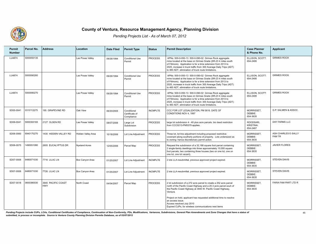
������������ ����� ���������������������
�������������� ������������ � ����������������� ��������������
� ����� ����������������
��� ���� ������� �!��""���� �������������!����#� ���� ���$���"� �����������������%��
�!!��� ��
/��7�� ��������6� � � �� ������� ����05������������6���������������",(-20��%;G�*==,2=*'2�-(&2�3%;*'21�*'�'!2�D*02�%&�",(-20�",*12������6���-(320�0%)'!�%+��(33-%,2 ����993(;*'(%&�(0�+%,�*�'(-2�2@'2&0(%&�+,%-����6�'%�������(&;,2*02�(&�',);G�',*++(;�+,%-�6����>2,*=2��*(3.��,(90����� �'%���������23(-(&*'(%&�%+�',);G�,%)'2�3(-('*'(%&0�
�%&1('(%&*3��02��2,-('
/*0��%0*0�H*332. �//�����������5�����������
"���������4
/��7�� �������� � � �� ������� ����05������������6���������������",(-20��%;G�*==,2=*'2�-(&2�3%;*'21�*'�'!2�D*02�%&�",(-20�",*12������6���-(320�0%)'!�%+��(33-%,2 ����993(;*'(%&�(0�+%,�*�'(-2�2@'2&0(%&�+,%-����6�'%�������(&;,2*02�(&�',);G�',*++(;�+,%-�6����>2,*=2��*(3.��,(90����� �'%���������23(-(&*'(%&�%+�',);G�,%)'2�3(-('*'(%&0�
�%&1('(%&*3��02��2,-('
/*0��%0*0�H*332. �//�����������5�����������
"���������4
/��7�� ��������� � � �� ������� ����05������������6���������������",(-20��%;G�*==,2=*'2�-(&2�3%;*'21�*'�'!2�D*02�%&�",(-20�",*12������6���-(320�0%)'!�%+��(33-%,2 ����993(;*'(%&�(0�+%,�*�'(-2�2@'2&0(%&�+,%-����6�'%�������(&;,2*02�(&�',);G�',*++(;�+,%-�6����>2,*=2��*(3.��,(90����� �'%���������23(-(&*'(%&�%+�',);G�,%)'2�3(-('*'(%&0�
�%&1('(%&*3��02��2,-('
/*0��%0*0�H*332. �//�����������5�����������
"���������4
��������� �6�������� � �� ���� �����/�� ��������/���/�"�/�<�����������������������������������H������
����"����H������ �%&1('(%&*3��2,'(+(;*'2�%+��%-93(*&;2
�*G�H(2? �����������������5��������66�
"������/����J�������
�������� ����66�� �7 �� ��� ������� 3*,=2�3%'�0)D1(>(0(%&��������93)0�*;,2�9*,;230��D(%�1221�,20',(;'(%&�+,%-�������6����6��*993(20�
�������/������ /*,=2�/%'��)D1(>(0(%&
/*0��%0*0�H*332. ����������4�������5�����������
����������//�
������� �������� �� �7 ��� ������� �!,22�3%'��3%'�3(&2�*1:)0'-2&'�(&;3)1(&=�9,%9%021�,20',(;'(>2�;%>2&*&'�*3%&=�0%)'!2,3.�9%,'(%&0�%+�9,%92,'.���/%'0�)&12,0(A21�*0�'%�A%&(&=��!2&;2�1(0;,2'(%&*,.�92,-('�*;'(%&�
��6���#������H�//����� /%'�/(&2��1:)0'-2&'#(112&�H*332.��,2* �����������������5��������66�
��#��#��/�������//��������
�������� �������7� �� �� ��� ������� �2C)20'�'!2�0)D1(>(0(%&�%+�*�6���77�0C)*,2�+%%'�9*,;23�;%&'*(&(&=���0(&=32�+*-(3.�1?233(&=0�(&'%�'!,22�*99,%@(-*'23.��������0C)*,2�+%%'�9*,;230��'?%�;%&'*(&(&=�'!,22�!%)020��'?%�%&�%&2�3%'��%&2�%&�%&2�3%'��%&2�3%'�>*;*&' �
���������/�������� �*,;23��*9�.23*&1��;,20 �����������������5��������66�
8�H�����/����
�������� �7�����6� �� �� ���� �����/�� ��3%'0�//��,20)D-(''*3��9,2>(%)0�*99,%>21�9,%:2;'�2@9(,21������/�/���/� /%'�/(&2��1:)0'-2&'�%@��*&.%&��,2* �����������������5��������66�
���H�����H��
�������� �7�����6� �� �� ���� �����/�� ��3%'0�//��,20)D-(''*3��9,2>(%)0�*99,%>21�9,%:2;'�2@9(,21������/�/���/� /%'�/(&2��1:)0'-2&'�%@��*&.%&��,2* �����������������5��������66�
���H�����H��
��������7 ���67��6� �� �� ���� ������� ��3%'�0)D1(>(0(%&�%+�*�����*;,2�9*,;23�'%�;,2*'2�*�����*;,2�9*,;23�&%,'!�%+�'!2��*;(+(;��%*0'�#(=!?*.�*&1�*����6�*;,2�9*,;23�0%)!�%+�'!2��*;(+(;��%*0'�#(=!?*.�*'�6���$���*;(+(;��%*0'�#(=!?*.��H2&'),*�
�,%:2;'�%&�!%31��*993(;*&'�!*0�,2C)20'21�*11('(%&*3�'(-2�'%�,20%3>2�*&�*;;200�(00)2��;;200�,20%3>21�8)3.������@9(,21����0��+%,�?(,23200�;%--)&(;*'(%&0�&2@'�('2-0
6������������������#$�
�*,;23��*9�%,'!��%*0' �����������������5��������66�
���������������/����
������������ �������������������������� ������� ����� ������������������ ���� ������������� ��������������� ��������������� �!��"�������#������������������� ������$����%������ %� �%�"����� � �������!�� ��������������������� �&�� ���������� ������ �������������"��������� ���� �!����������'()'*)+',+
��
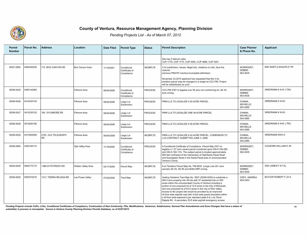
������������ ����� ���������������������
�������������� ������������ � ����������������� ��������������
� ����� ����������������
��� ���� ������� �!��""���� �������������!����#� ���� ���$���"� �����������������%��
�!!��� ��
�('2�!*0���'232;%-�0('20����������������������������������777����������
�������� ��6����� �� �� ���� �����/�� 6�3%'�0)D1(>(0(%&��(00)205�(332=*3�3%'0��>(%3*'(%&0�%&�0('2��D3)2�3(&2�;!*&&239,2>(%)0�����7��(&*;'(>2�(&;%-932'2�?('!1,*?&�
�%>2-D2,��6������*993(;*&'�!*0�,2C)20'21�'!*'�'!(0�6�3%'�'2&'*'(>2�9*,;23�-*9�D2�;!*&=21�'%�*�0(&=32�3%'����������,%:2;'�?(33�D2�,21(0',(D)'20�*0�0);!�
�������M���������� �%&1('(%&*3��2,'(+(;*'2�%+��%-93(*&;2
�%@��*&.%&��,2* �����������������5��������66�
������������#���������
���7����� �������� � �� ���7 ������� ���������7��'%�32=*3(A2�%&2�67�*;,2�&%&�;%&+%,-(&=�3%'��������*;,2�A%&(&=
�%&1('(%&*3��2,'(+(;*'2�%+��%-93(*&;2
�(33-%,2��,2* �����������������5��������66�
���������4�����8����
���7���� �����6��6� � �� ���7 ������� ��$�//�����/�"�/�<�����������������//*,=2�/%'��)D1(>(0(%&
�(33-%,2��,2* �I���������#�//�5���������7�
���������4����8
���7����� �����6���� � �� ���7 ������� ��$�//�����/�"�/�<�������7�����������/��������������� /*,=2�/%'��)D1(>(0(%&
�(33-%,2��,2* �I���������#�//�5���������7�
���������4����8
���7����7 ��������7� � �� ���7 ������� ��$�//�����/�"�/�<����������������//*,=2�/%'��)D1(>(0(%&
�(33-%,2��,2* �I���������#�//�5���������7�
���������4�����8����
���7���� ����6���7� � �� ���7 �����/�� ��$�//�����/�"�/�<�����������������/���������������/����������������������8����6�����7�
��6���/����/�"���#���
/*,=2�/%'��)D1(>(0(%&
�(33-%,2��,2* �I���������#�//�5���������7�
�����������H��4
���7���� �6������� �� � ���7 ������� ���%&1('(%&*3��2,'(+(;*'2�%+��%-93(*&;2���*,;23��*9��66��'%�32=*3(A2�*������*;,2�>*;*&'�9*,;23��;%-D(&21�*9&0��6��������7��*&1��6���������� ���!2�0)D:2;'�9*,;23�(0�3%;*'21�*99,%@(-*'23.����+22'�&%,'!?20'�%+�'!2�(&'2,02;'(%&�%+��:*( �*&'*��*)3*��%*1�*&1�4%2&(=0'2(&��%*1�(&�'!2��*&'*��*)3*�*,2*�%+�)&(&;%,9%,*'21�H2&'),*��%)&'.�
�%&1('(%&*3��2,'(+(;*'2�%+��%-93(*&;2
�:*(�H*332.��,2* �����������������5��������66�
��/�����$�//������8�
�������� �������� �� �� ��� �����/�� �3%'��2&'*'(>2��*,;23��*9��%������76����/*,=2�/%'0���V�*;,2�9*,;230 �����������7��*&1���7������A%&(&=�
�677�$����������� �*,;23��*9#(112&�H*332.��,2* �����������������5��������66�
��#�8�����������/
�������� ����6����� �� �� ��� �����/�� H20'(&=��2&'*'(>2��,*;'��*9��%���76����������� �'%�0)D1(>(12�*��7����*;,2�9,%92,'.�(&'%�6�3%'0�?('!�6��,20(12&'(*3�3%'0�%&�����*;,20�?('!(&�'!2�)&(;%,9%,*'21��%)&'.�%+�H2&'),*�(&;3)1(&=�*�9%,'(%&�%+�%&2�9,%9%021�3%'�%+����7�*;,20�(&�'!2��('.�%+��%%,9*,G��*&1�%&2�9,%9%021�3%'�%+�6��*;,20�(&�'!2��('.�%+��(-(�H*332.����;;200�'%�'!2�9,%:2;'�0('2�?%)31�D2�9,%>(121�D.�*&�(-9,%>21����+%%'�?(12�*09!*3'�,%*1�?('!���+%%'�?(12�=,*>23�0!%)312,0�?('!(&�*����+%%'�?(12�2*02-2&'��92,�0'*&1*,1�93*'2���� �>(*��(2,,*��2:*1*��1�����02;%&1*,.����+'�?(12�*09!*3'�2-2,=2&;.�*;;200�
�6�6�����������8������ �,*;'��*9/*0��%0*0�H*332. �<����������5�����������6
���/������������8���
������������ �������������������������� ������� ����� ������������������ ���� ������������� ��������������� ��������������� �!��"�������#������������������� ������$����%������ %� �%�"����� � �������!�� ��������������������� �&�� ���������� ������ �������������"��������� ���� �!����������'()'*)+',+
�

������������ ����� ���������������������
�������������� ������������ � ����������������� ��������������
� ����� ����������������
��� ���� ������� �!��""���� �������������!����#� ���� ���$���"� �����������������%��
�!!��� ��
,%*1�?('!�*���+%%'�=,*>23�0!%)312,��92,�0'*&1*,1�93*'2��� �(0�9,%9%021�'%�D2�9,%>(121�>(*�H(,=(&(*��%3%&.��3*;2����*;!�%+�'!2�6��9,%9%021�,20(12&'(*3�3%'0�?(33�!*>2�*;;200�'%�'!2�9,%9%021����+%%'�?(12�,%*1�,)&&(&=�'!,%)=!�'!2�9,%:2;'�>(*���+22'�?(12�;%--%&�1,(>2?*.0�*&1 %,����+%%'�(&1(>(1)*3�1,(>2?*.0���$*'2,�?%)31�D2�9,%>(121�D.�'!2��)'32,��*&;!��)')*3�$*'2,��%-9*&.�'!,%)=!�*&�2@(0'(&=��*332=)20��)&(;(9*3�$*'2,��(0',(;'�3(&2����2?2,�?%)31�D2�9,%>(121�D.�H2&'),*��%)&'.�$*'2,?%,G0��(0',(;'��%�����*&&2@*'(%&�,2C)(,21 ���)(31(&=�2&>23%920�*,2�9,%9%021�+%,�2*;!�%+�'!2�6��3%'0�?('!�0%-2�2@;29'(%&0�+%,�*=,(;)3'),*3�0',);'),20�+%,�!%,02�G229(&=����20',(;'(>2�;%>2&*&'0�*,2�9,%9%021�'%�9,%'2;'�D%'!�D(%3%=(;*3�*&1�*,;!*2%3%=(;*3�,20%),;20����*3*&;21�=,*1(&=�%&0('2�(0�9,%9%021�(&�%,12,�'%�*;;%-93(0!�'!2�9,%:2;'�,%*10�*&1�D)(31(&=�9*10�?('!�7������;)D(;�.*,10�%+�;)'�*&1���6�����;)D(;�.*,10�%+�+(33��3200�+(33�*;;%)&'21�+%,�D.�0!,(&G*=2 ���6��*;,20�%+�>2=2'*'(%&�,2-%>*3�*&1���;%*0'*3�3(>2�%*G�',220��K)2,;)0�*=,(+%3(* �?%)31�D2�,2C)(,21�'%�D2�,2-%>21�'%�(-9,%>2�'!2�0('2�����A%&2�;!*&=2�(0�*30%�9,%9%021�'%�;!*&=2�'!2�9,%92,'.�+,%-����������'%�������*&1��������1292&1(&=�%&�3%'�0(A2 �?('!���9,%92,'(20�9,%9%021�'%�D2�A%&21����������*&1��9,%92,'(20�9,%9%021�'%�D2�A%&21�������������!2�*00%;(*'21�A%&2�;!*&=2�(0�<��������
��������� ��7������ �6 �6 ���� ������� ��3%'��3%'�3(&2�*1:)0'-2&'��,20)3'(&=�3%'0�-22'���*;,2�3%'�-(&(-)-��C)*3(+(20�+%,�-(&(0'2,(*3�9,%;200(&=
�6�����/��/�����H /%'�/(&2��1:)0'-2&'�:*(�H*332.��,2* �<����������5�����������6
���<"���/���/�����
��������� ��������� � �� ���� ������� �,���%32-*&�,2C)20'0�*99,%>*3�%+��2&'*'(>2��*,;23��*9�&%���7���+%,�*�6�3%'�,20(12&'(*3�0)D1(>(0(%&�?('!�/%'���9,%9%021�+%,�����*;,20��/%'���9,%9%021�+%,������*;,20��*&1�/%'�6�9,%9%021�+%,���6��*;,20���!2�9,%:2;'�(&;3)120�*��3*&&21��2>23%9-2&'��2,-('��/�������� �+%,�'!2�12-%3('(%&�%+�+%),�D)(31(&=0��*�-)3'(�>2!(;32�=*,*=2��*�,20(12&'(*3�1?233(&=�*&1�*00%;(*'21�0(&=32�>2!(;32�=*,*=2��*&1�1%,-('%,.�D)(31(&= ��'!2�,2-%>*3�%+�;%&;,2'2�03*D0�*&1�,2'*(&(&=�?*330�%&�=,*12��=,*1(&=�+%,�'!2�&2?�D)(31(&=�9*10�(&;3)1(&=�����;)D(;�.*,10�%+�;)'�������;)D(;�.*,1�%+�+(33�%+�?!(;!��������;)D(;�.*,10�%+�?!(;!�?%)31�D2�(-9%,'21�+,%-�'!2�*1:*;2&'�9,%92,'.��*&1�(&0'*33*'(%&�%+�0'%,-�1,*(&�*&1�029'(;�0.0'2-0���!2�2@(0'(&=�,20(12&;2�D)(31(&=�%&0('2��%,(=(&*33.�92,-(''21�D.��92;(*3��02��2,-('�767 �?%)31�,2-*(&�1),(&=�=,*1(&=�*&1�;%&0',);'(%&�*;'(>('(20�*00%;(*'21�?('!�9,%9%021�0)D1(>(0(%&������������*&1�?%)31�D2�12-%3(0!21�D2+%,2�;%&0',);'(%&�%+�*&.�&2?�+)'),2�,20(12&;20�%&0('2����%&0',);'(%&�%+�&2?�1?233(&=�)&('0�(0�&%'�*�9*,'�%+�'!(0�9,%:2;'� ��
�!2�0)D1(>(0(%&�(0�;%&'(&=2&'�)9%&�'!2�*99,%>*3�%+�*�A%&2�;!*&=2��<�������� �+,%-��%*0'*3��),*3��@;3)0(>2����� ���*;,2�-(&(-)-�9*,;23�0(A2�'%�������*;,2�-(&(-)-�9*,;23�0(A2�'%�*33%?�+%,�'!2�0)D1(>(%&�%+�'?%�*;,2��*99,%@� �3%'0��
�!,22��6 �+(;)0�',220�*&1�%&2��� �9*3-�',22�?%)31�D2�,2-%>21�'%�9,29*,2�'!2�0('2�+%,�'!2�9,%9%021�=,*1(&=����&2��� �+(;)0�',22�?%)31�D2�D%@21�*&1�,23%;*'21�%&�0('2�92,�'!2�,2;%--2&1*'(%&0�
��������������������#$�
�*,;23��*9�*&'*��%&(;*��'&0 ���#������#��45��������676
���$�������� ����/����/����
������������ �������������������������� ������� ����� ������������������ ���� ������������� ��������������� ��������������� �!��"�������#������������������� ������$����%������ %� �%�"����� � �������!�� ��������������������� �&�� ���������� ������ �������������"��������� ���� �!����������'()'*)+',+
��

������������ ����� ���������������������
�������������� ������������ � ����������������� ��������������
� ����� ����������������
��� ���� ������� �!��""���� �������������!����#� ���� ���$���"� �����������������%��
�!!��� ��
%+�*�;2,'(+(21�3*&10;*92�*,;!('2;'���;;200�'%�2*;!�%+�'!2�9,%9%021�D)(31(&=�9*10�?%)31�D2�9,%>(121�D.����+%%'�?(12�9,(>*'2�1,(>2?*.0�>(*��33(;2��',22'���%�9)D3(;�%,�9,(>*'2�,%*10�?(33�D2�2@'2&121�%,�2@9*&121��$*'2,�?(33�D2�0)993(21�D.�'!2��2,D*��)2&*�$*'2,��%-9*&.����029'(;�0.0'2-�?(33�D2�(&0'*3321�*&1�)'(3(A21�%&0('2�
�������� �����7���� �7 �� ���� ������� ��3%'��3%'�3(&2�*1:)0'-2&'�'%�-%>2�*�3%'�3(&2�'!*'�(0�;),,2&'3.�'!,%)=!�*�0',);'),2�
������/�������� /%'�/(&2��1:)0'-2&'/*0��%0*0�H*332. �����������������5��������66�
����������������������������
�������6� ���6����� � �� ���� ������� ��/��������H��������������H�������/������76�*,;23��*9�(-(�H*332.��,2* "��<�/�<��8�����5�����
���������#���//�
�������6� ��������� �� �7 ���� ������� �99,%>*3�%+�*�-(&(0'2,(*3�/%'�/(&2��1:)0'-2&'��%���������6��'%�',*&0+2,�����*;,20�+,%-��*�����*;,2�9*,;23������������������ �A%&21��),*3��@;3)0(>2���*;,2�-(&(-)-�'%�*��7�*;,2�9*,;23������������������ �A%&21��),*3��@;3)0(>2���*;,2�-(&(-)-���99,%>*3�%+�'!2�92,-('�?(33�*00(0'�(&�*D*'(&=�H(%3*'(%&��%I0�<H�������*&1�H���6����;%&;),,2&'�9,%;200(&=�%+�������6����$��2,=2,�(0�,2C)(,21�'%�C)*3(+.�+%,�'!2�//�
�7��������<��� /%'�/(&2��1:)0'-2&'��H2&'),*��>2 �����������������5��������66�
����������"/������������
�������6� �������� �� �7 ���� ������� ;%&;),,2&'�9,%;200(&=�%+�������6����$��2,=2,�(0�,2C)(,21�'%�C)*3(+.�+%,
�99,%>*3�%+�'!2�-(&(0'2,(*3�/%'�/(&2��1:)0'-2&'��%���������6��'%�',*&0+2,�����*;,20�+,%-��*�����*;,2�9*,;23������������������ �A%&21��),*3��@;3)0(>2���*;,2�-(&(-)-�'%�*��7�*;,2�9*,;23������������������ �A%&21��),*3��@;3)0(>2���*;,2�-(&(-)-���99,%>*3�%+�'!2�92,-('�?(33�*00(0'�(&�*D*'(&=�H(%3*'(%&��%I0�<H�������*&1�H���6���
�7��������<��� �2,=2,��H2&'),*��>2 �����������������5��������66�
����������"/������������
�������67 �������� �� �� ���� ������� �!2�0)D1(>(0(%&�%+�*�6����*;,2�9*,;23�?('!�2@(0'(&=�*=,(;)3'),*3�)020��(&'%�6�9*,;230���*,;23����������*;,20���*,;23���������*;,20�*&1��*,;23�6�������*;,20����D)(31*D32�0('2�*&1�*;;200�!*0�D22&�(12&'(+(21�+%,�*33�6�9*,;230���!2�9,%9%021�?*'2,�0%),;2�(0�*�9,(>*'2�?*'2,�?233�*&1�'!2�9*,;230�?(33�!*>2�02?2,�02,>(;2�+,%-��*-*,(33%��*&('*,.��(0',(;'���!2�2&'(,2��6��*;,20�(0�)&12,�;)3'(>*'(%&�+%,�,%?�;,%90����9,23(-(&*,.�1,*(&*=2�0')1.��=2%'2;!&(;*3�,29%,'�*&1�*�?*'2,�C)*3('.�,29%,'�!*0�D22&�9,29*,21���!2�9,%:2;'�0('2�+,%&'0�H2&'),*��%*1�0%)'!�%+�'!2������,22?*.�*&1�(0�D2'?22&��2&',*3��>2�*&1��2*,1032.�$*0!�*&1�'!2,2�*,2�'?%��213(&2�0',2*-0�*1:*;2&'�'%�'!2�9*,;23���!2�0('2�(0�?('!(&�'!2��,2*�%+��&',(0'�+%,�D%'!�'!2��('.�%+��*-*,(33%�*&1��@&*,1�
�������H��������/ /*,=2�/%'��)D1(>(0(%&
�@&*,1��3*(& �<����������5�����������6
#�/������#�//�
�������6 ������6� �� �� ���� �����/�� �3*.D2,=��*&;!�//�����!2�0)D1(>(0(%&�%+�*�6��6�*;,2�9*,;23�?('!�2@(0'(&=�*=,(;)3'),*3�)020��(&'%�6�9*,;230���*,;23�������66�*;,20���*,;23����������*;,20�*&1��*,;23�6�����*;,20����D)(31*D32�0('2�*&1�*;;200�!*0�D22&�(12&'(+(21�+%,�*33�6�9*,;230���!2�9,%9%021�?*'2,�0%),;2�(0�*�9,(>*'2�?*'2,�?233�*&1�'!2�9*,;230�?(33�!*>2�02?2,�02,>(;2�+,%-��*-*,(33%�
����������"H�//���� /*,=2�/%'��)D1(>(0(%&
�@&*,1��3*(& �����������������5��������66�
�/����"�����#�//�
������������ �������������������������� ������� ����� ������������������ ���� ������������� ��������������� ��������������� �!��"�������#������������������� ������$����%������ %� �%�"����� � �������!�� ��������������������� �&�� ���������� ������ �������������"��������� ���� �!����������'()'*)+',+
�7
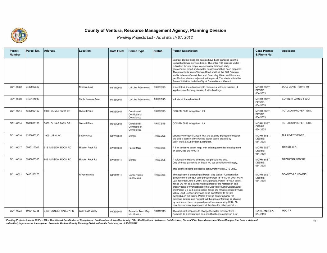
������������ ����� ���������������������
�������������� ������������ � ����������������� ��������������
� ����� ����������������
��� ���� ������� �!��""���� �������������!����#� ���� ���$���"� �����������������%��
�!!��� ��
�*&('*,.��(0',(;'�%&;2�'!2�9*,;230�!*>2�D22&�*&&2@21�(&'%�'!2��*-*,(33%��2?2,��2,>(;2�1(0',(;'���!2�2&'(,2��6��*;,20�(0�)&12,�;)3'(>*'(%&�+%,�,%?�;,%90����9,23(-(&*,.�1,*(&*=2�0')1.��=2%'2;!&(;*3�,29%,'�*&1�*�?*'2,�C)*3('.�,29%,'�!*0�D22&�9,29*,21���!2�9,%:2;'�0('2�+,%&'0�H2&'),*��%*1�0%)'!�%+�'!2������,22?*.�*&1�(0�D2'?22&��2&',*3��>2��*&1��2*,1032.�$*0!�*&1�'!2,2�*,2�'?%��213(&2�0',2*-0�*1:*;2&'�'%�'!2�9*,;23���!2�0('2�(0�?('!(&�'!2��,2*�%+��&',(0'�+%,�D%'!�'!2��('.�%+��*-*,(33%�*&1��@&*,1�
��������� ��6����6�� �6 �� ���� ������� *�+%),�3%'�3%'�3(&2�*1:)0'-2-'�'%�;32*&�)9�*�02'D*;G�>(%3*'(%&����32=*3�&%&�;%&+%,-(&=�9*,;230����?('!�1?233(&=0
/%'�/(&2��1:)0'-2&'�(33-%,2��,2* �����������������5��������66�
��//�/����������H���
��������7 ��������� �� � ���� ������� *���3%'��3%'�3(&2�*1:)0'-2&'/%'�/(&2��1:)0'-2&'�*&'*��)0*&*��,2* �����������������5��������66�
��������8�����8�8���
��������� �67������ � �6 ���� ������� ��������77�'%�32=*3(A2���3%'������/�H������4��� �%&1('(%&*3��2,'(+(;*'2�%+��%-93(*&;2
�@&*,1��3*(& �����������������5��������66�
���/���������������/
��������� �67������ � �6 ���� ������� ��������77�'%�32=*3(A2���3%'������/�H������4��� �%&1('(%&*3��2,'(+(;*'2�%+��%-93(*&;2
�@&*,1��3*(& �����������������5��������66�
���/���������������/
�������� ��7������� � �� ���� ������� H%3)&'*,.��2,=2,�%+���32=*3�3%'0��'!2�2@(0'(&=��'*&1*,1��&1)0',(20�0('2�*&1�*�9%,'(%&�%+�'!2��&('21�$*'2,�9*,;23�;,2*'21�D.�����������*��)D1(>(0(%&��@2-9'(%&�
�����/������H �2,=2,�*'(;%.��,2* �����������������5��������66�
�8/���H��������
��������� �������� �� �� ���� ������� ����3%'�'2&'*'(>2�9*,;23�-*9��?('!�2@(0'(&=�92,-(''21�12>23%9-2&'�%&�2*;!��022�/�������7
�7�������������4��� �*,;23��*9�(00(%&��%;G��1 �����������������5��������66�
����7�//�
��������7 ����66� �� �� ���� ������� ��>%3)&'*,.�-2,=2,�'%�;%-D(&2�'?%�9*,;230�(&'%�%&2���&2�%+�'!202�9*,;230�(0�*&�(332=*3�3%'��;;;�;%&1('(%&0�?(33�*993.�
�!(0�92,-('�(0�D2(&=�9,%;20021�;%&;),,2&'3.�?('!�/���������
7���������������4��� �2,=2,�(00(%&��%;G��1 �����������������5��������66�
��<������������
��������� �������� �7 �� ���� ������� �!2�*993(;*&'�(0�9,%9%0(&=�*��*,;23��*9�$*(>2,��%&02,>*'(%&��)D1(>(0(%&�%+�*&�7����*;,2�9*,;23���*,;23�B�B�%+�������������$�//���,2;%,121�8)&2�7����� �(&'%���9*,;230���*,;23�B�B�����*;,20��A%&21��������*0�*�;%&02,>*'(%&�9*,;23�+%,�'!2�,20'%,*'(%&�*&1�9,202,>*'(%&�%+�,(>2,�!*D('*'�D.�'!2��:*(�H*332.�/*&1��%&02,>*&;.�*&1��*,;23���*�����*;,20�9*,;23�A%&21�������*30%�%?&21�D.��:*(�H*332.�/*&1��%&02,>*&;.�*&1�'%�D2�',*&0+2,,21�'%�9,(>*'2�%?&2,0!(9�(&�'!2�+)'),2���*,;23���?(33�D2�;%&+%,-(&=�+%,�'!2�-(&(-)-�3%'�0(A2�*&1��*,;23���?(33�D2�&%&�;%&+%,-(&=�*0�*33%?21�D.�%,1(&*&;2���*;!�9,%9%021�9*,;23�!*0�*&�2@(0'(&=��������%�&2?�12>23%9-2&'�(0�9,%9%021�*'�'!(0�'(-2�+%,�2('!2,�9*,;23��0
�%&02,>*'(%&��)D1(>(0(%&
��H2&'),*��>2 �����������������5��������66�
�������/���������
��������6 �������6�� �7 � ���� ������� �!2�*993(;*&'�9,%9%020�'%�;!*&=2�'!2�?*'2,�9,%>(12,�+,%-��*-,%0*�'%�*�9,(>*'2�?233��*0�*�-%1(+(;*'(%&�'%�*99,%>21���3%'�
6�����������H�//����� �*,;23�%,��,*;'��*9��%1(+(;*'(%&
/*0��%0*0�H*332. �<����������5�����������6
������
������������ �������������������������� ������� ����� ������������������ ���� ������������� ��������������� ��������������� �!��"�������#������������������� ������$����%������ %� �%�"����� � �������!�� ��������������������� �&�� ���������� ������ �������������"��������� ���� �!����������'()'*)+',+
�
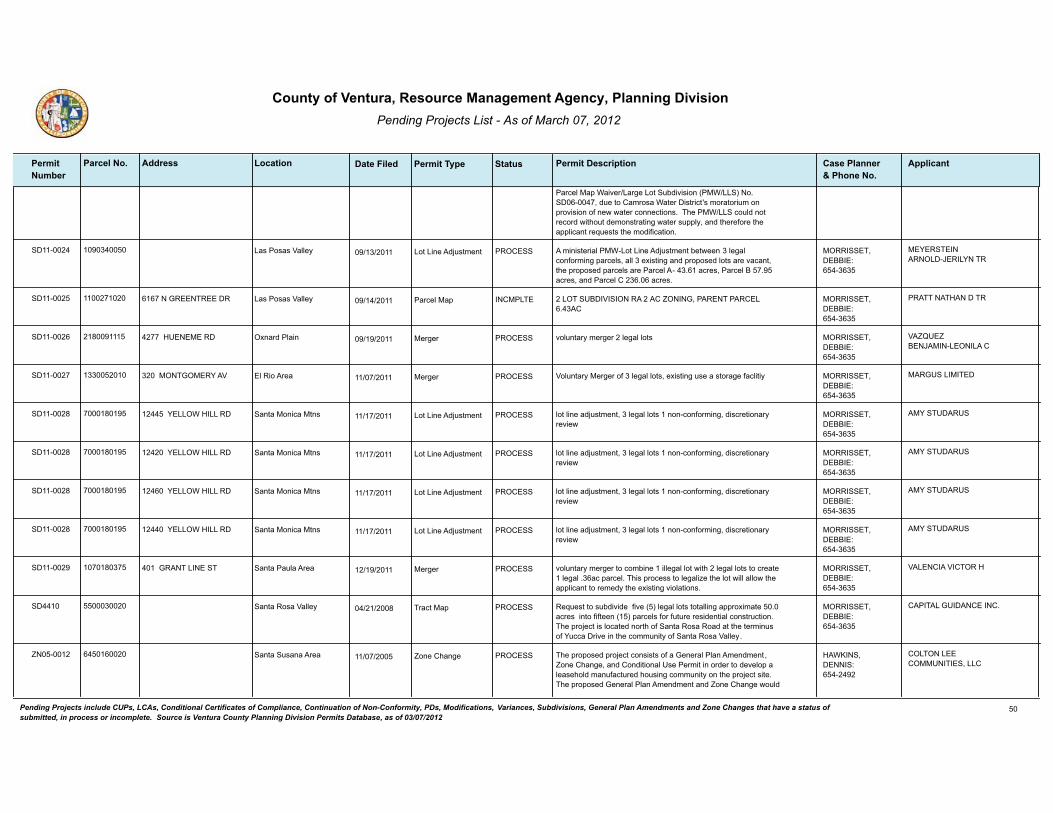
������������ ����� ���������������������
�������������� ������������ � ����������������� ��������������
� ����� ����������������
��� ���� ������� �!��""���� �������������!����#� ���� ���$���"� �����������������%��
�!!��� ��
�*,;23��*9�$*(>2, /*,=2�/%'��)D1(>(0(%&����$ //� ��%������������1)2�'%��*-,%0*�$*'2,��(0',(;'I0�-%,*'%,()-�%&�9,%>(0(%&�%+�&2?�?*'2,�;%&&2;'(%&0����!2���$ //��;%)31�&%'�,2;%,1�?('!%)'�12-%&0',*'(&=�?*'2,�0)993.��*&1�'!2,2+%,2�'!2�*993(;*&'�,2C)20'0�'!2�-%1(+(;*'(%&�
��������� ���6����� � �6 ���� ������� ��-(&(0'2,(*3���$�/%'�/(&2��1:)0'-2&'�D2'?22&�6�32=*3�;%&+%,-(&=�9*,;230��*33�6�2@(0'(&=�*&1�9,%9%021�3%'0�*,2�>*;*&'��'!2�9,%9%021�9*,;230�*,2��*,;23�����6���*;,20���*,;23��������*;,20��*&1��*,;23����6���*;,20�
/%'�/(&2��1:)0'-2&'/*0��%0*0�H*332. �����������������5��������66�
���������������/��8���/�����
��������� ���������� � �� ���� �����/�� ��/��������H��������������<����"��������������/���6��
�����"����������� �*,;23��*9/*0��%0*0�H*332. �����������������5��������66�
���������#�������
�������� ��7������ � � ���� ������� >%3)&'*,.�-2,=2,���32=*3�3%'0������#��������� �2,=2,�@&*,1��3*(& �����������������5��������66�
H�<K��<����8�����/����/���
��������� �66������� �� �� ���� ������� H%3)&'*,.��2,=2,�%+�6�32=*3�3%'0��2@(0'(&=�)02�*�0'%,*=2�+*;3('(.6��������"�������H �2,=2,�3��(%��,2* �����������������5��������66�
���"���/������
��������7 �����7��� �� �� ���� ������� 3%'�3(&2�*1:)0'-2&'��6�32=*3�3%'0���&%&�;%&+%,-(&=��1(0;,2'(%&*,.�,2>(2?
���������//�$�#�//��� /%'�/(&2��1:)0'-2&'�*&'*��%&(;*��'&0 �����������������5��������66�
������������
��������7 �����7��� �� �� ���� ������� 3%'�3(&2�*1:)0'-2&'��6�32=*3�3%'0���&%&�;%&+%,-(&=��1(0;,2'(%&*,.�,2>(2?
���������//�$�#�//��� /%'�/(&2��1:)0'-2&'�*&'*��%&(;*��'&0 �����������������5��������66�
������������
��������7 �����7��� �� �� ���� ������� 3%'�3(&2�*1:)0'-2&'��6�32=*3�3%'0���&%&�;%&+%,-(&=��1(0;,2'(%&*,.�,2>(2?
��������//�$�#�//��� /%'�/(&2��1:)0'-2&'�*&'*��%&(;*��'&0 �����������������5��������66�
������������
��������7 �����7��� �� �� ���� ������� 3%'�3(&2�*1:)0'-2&'��6�32=*3�3%'0���&%&�;%&+%,-(&=��1(0;,2'(%&*,.�,2>(2?
���������//�$�#�//��� /%'�/(&2��1:)0'-2&'�*&'*��%&(;*��'&0 �����������������5��������66�
������������
�������� �����7�6�� �� � ���� ������� >%3)&'*,.�-2,=2,�'%�;%-D(&2���(332=*3�3%'�?('!���32=*3�3%'0�'%�;,2*'2���32=*3��6*;�9*,;23���!(0�9,%;200�'%�32=*3(A2�'!2�3%'�?(33�*33%?�'!2�*993(;*&'�'%�,2-21.�'!2�2@(0'(&=�>(%3*'(%&0�
�����"�����/������ �2,=2,�*&'*��*)3*��,2* �����������������5��������66�
H�/������H������#
������ �����6���� �� �� ���7 ������� �2C)20'�'%�0)D1(>(12��+(>2��� �32=*3�3%'0�'%'*33(&=�*99,%@(-*'2������*;,20��(&'%�+(+'22&���� �9*,;230�+%,�+)'),2�,20(12&'(*3�;%&0',);'(%&����!2�9,%:2;'�(0�3%;*'21�&%,'!�%+��*&'*��%0*��%*1�*'�'!2�'2,-(&)0�%+��);;*��,(>2�(&�'!2�;%--)&('.�%+��*&'*��%0*�H*332.�
�,*;'��*9�*&'*��%0*�H*332. �����������������5��������66�
������/�"������������
<�������� �������� �� �� ���� ������� �!2�9,%9%021�9,%:2;'�;%&0(0'0�%+�*�"2&2,*3��3*&��-2&1-2&'��<%&2��!*&=2��*&1��%&1('(%&*3��02��2,-('�(&�%,12,�'%�12>23%9�*�32*02!%31�-*&)+*;'),21�!%)0(&=�;%--)&('.�%&�'!2�9,%:2;'�0('2����!2�9,%9%021�"2&2,*3��3*&��-2&1-2&'�*&1�<%&2��!*&=2�?%)31�
<%&2��!*&=2�*&'*��)0*&*��,2* #�$4�����������5�����������
��/����/����������������//�
������������ �������������������������� ������� ����� ������������������ ���� ������������� ��������������� ��������������� �!��"�������#������������������� ������$����%������ %� �%�"����� � �������!�� ��������������������� �&�� ���������� ������ �������������"��������� ���� �!����������'()'*)+',+
��

������������ ����� ���������������������
�������������� ������������ � ����������������� ��������������
� ����� ����������������
��� ���� ������� �!��""���� �������������!����#� ���� ���$���"� �����������������%��
�!!��� ��
;!*&=2�'!2�2@(0'(&=�3*&1�)02 A%&(&=�120(=&*'(%&0�%+��@(0'(&=��%--)&('.���B�����*;B���),*3��@;3)0(>2��%&2�*;,2�-(&(-)-�3%'�0(A2 ��B����������0C�+'B���),*3��@;3)0(>2���������0C)*,2�+22'�-(&(-)-�3%'�0(A2 ��*&1�B�����*;B���),*3��@;3)0(>2��+(>2�*;,2�-(&(-)-�3%'�0(A2 ��'%��@(0'(&=��%--)&('.���B���������1) *;B���20(12&'(*3��3*&&21��2>23%9-2&'�������1?233(&=�)&('0 *;,2 ���
�!2�*993(;*&'�(0�9,%9%0(&=�'%�12>23%9�%&3.�����1?233(&=�)&('0�%&�'!2�9,%:2;'�0('2����!2�1?233(&=�)&('0�?%)31�;%&0(0'�%+�&(&2��'?%�0'%,.�-*&)+*;'),21�!%-20�*&1���%&2�0'%,.�-*&)+*;'),21�!%-20��,*&=(&=�D2'?22&�7�6�6�0C)*,2�+22'��0�+� �*&1���6���0�+��(&�0(A2����!2�-*&)+*;'),21�!%-20�?%)31�D2�123(>2,21�*&1�(&0'*3321�?('!(&�2*;!�!%-20('2�)9%&�9),;!*02�%+�'!2�!%-2�*&1�2@2;)'(%&�%+�*�32*02�*=,22-2&'�?('!�'!2�;%--)&('.�-*&*=2-2&'�*=2&;.����!2�*993(;*&'�(0�9,%9%0(&=�������E �%+�'!2�1?233(&=�)&('0�*0�*++%,1*D32�!%)0(&=�)&('0����!2�9,%9%021�9,%:2;'�*30%�(&;3)120�'!2�+%33%?(&=�12>23%9-2&'�'%�D2�-*&*=21�D.�'!2�;%--)&('.�-*&*=2-2&'�*=2&;.5��*�;%--)&('.�9%%3�*&1�:*;)AA(F��*&�*99,%@(-*'23.����67�0�+������+%%'�'*33�;%--)&('.�;3)D!%)02��?!(;!�?%)31�(&;3)12�*�?*0!�,%%-��,20',%%-0��2@2,;(02�,%%-��;%&+2,2&;2�,%%-��%++(;20��*&1�G(';!2& =*-2�,%%-F��*&1��3*&10;*9(&=�'!*'�?%)31�(&;3)12�*�92120',(*&�9*'!�
�!2�H2&'),*��%)&'.�$*'2,?%,G0��(0',(;'��%��7�?%)31�9,%>(12�?*'2,�*&1�'!2��('.�%+��(-(�H*332.�?%)31�9,%>(12�02?*=2�1(09%0*3�02,>(;2�'%�'!2�9,%9%021�12>23%9-2&'����,(>*'2�0',22'0�'!*'�>*,.�D2'?22&�6�+22'�*&1����+22'�(&�?(1'!�?%)31�9,%>(12�*;;200�?('!(&�'!2�9,%:2;'�0('2�+,%-�4*'!2,(&2��%*1�*&1��2992,��,22�/*&2�$20' ����!2�*993(;*&'�(0�9,%9%0(&=�'%�?(12&�4*'!2,(&2��%*1�+,%-�'!2�9,%:2;'�0('2�'%��*&'*��)0*&*��*00��%*1�(&�%,12,�'%�9,%>(12�02;%&1*,.�*;;200�'%�'!2�9,%:2;'�0('2��9),0)*&'�'%�'!2�H2&'),*��%)&'.��(,2��,%'2;'(%&��(0',(;'I0�,2;%--2&1*'(%&0���?%�;%>2,21�'*&12-�9*,G(&=�09*;20�?%)31�D2�9,%>(121�+%,�2*;!�1?233(&=�)&('F�7�>(0('%,�9*,G(&=�09*;20�*&1�-%'%,;.;32�9*,G(&=�09*;20�?%)31�D2�9,%>(121�*3%&=�'!2�9,(>*'2�0',22'0�*&1�?('!(&�120(=&*'21�>(0('%,�9*,G(&=�09*;20�'!,%)=!%)'�'!2�12>23%9-2&'������99,%@(-*'23.�������;)D(;�.*,10�%+�=,*1(&=��;)'�*&1�+(33 �(0�9,%9%021�'%�9,29*,2�'!2�9,%:2;'�0('2�+%,�12>23%9-2&'����!2�*993(;*&'�(0�9,%9%0(&=�'%�)02�*99,%@(-*'23.������;)D(;�.*,10�%+�)&92,-(''21�0'%;G9(321�12D,(0�*&1�0%(3�'!*'�;),,2&'3.�2@(0'0�%&�0('2�*0�9*,'�%+�'!2�9,%9%021�=,*1(&=�*;'(>('(20�
�?%��*3(+%,&(*�$*3&)'��8)=3*&0��*3(+%,&(;* �',220�*&1�0(@��*3(+%,&(*��2992,���;!(&)0�-%332 �',220�?%)31�D2�,2-%>21�'%�9,29*,2�'!2�9,%:2;'�0('2�+%,�12>23%9-2&'����&2�%3(>2�',22���32*�2),%92* �?%)31�D2�',*&093*&'21�%&�0('2�
<������� ���������� �� �6 ��� ������� �2>(0(%&0�'%�'!2��%&��%*0'*3�<%&(&=��,1(&*&;2�'%�2&*;'�'!2�$(313(+2��(=,*'(%&��,%'2;'(%&��>2,3*.�<%&2��$�� ����!202�*-2&1-2&'0�(&;3)12�3*&=)*=2�'%�9,%'2;'�*&1�9,202,>2�!*D('*'�;%&&2;'(>('.���$(313(+2�-(=,*'(%&�9,%'2;'(%&�*11,20020�'!2�*D(3('.�%+�
<%&(&=��,1(&*&;2��-2&1-2&'
H2&'),*��%)&'. ���4����#�������5����������6
����������H���������/�����"
������������ �������������������������� ������� ����� ������������������ ���� ������������� ��������������� ��������������� �!��"�������#������������������� ������$����%������ %� �%�"����� � �������!�� ��������������������� �&�� ���������� ������ �������������"��������� ���� �!����������'()'*)+',+
��

������������ ����� ���������������������
�������������� ������������ � ����������������� ��������������
� ����� ����������������
��� ���� ������� �!��""���� �������������!����#� ���� ���$���"� �����������������%��
�!!��� ��
*&(-*30�*&1�93*&'0�'%�-(=,*'2�0*+23.�*-%&=�'!2��%)&'.I0�(&;,2*0(&=3.�+,*=-2&'21�*,2*0�%+�&*'),*3�%92&�09*;2���
�!2��,'(;320�'%�D2�*-2&121�*,25��,'(;32������2+(&('(%&0F��,'(;32�6����0'*D3(0!-2&'�%+�<%&20���%)&1*,(20�*&1��*90F��,'(;32������),9%020�%+�<%&20F��,'(;32������020�*&1��',);'),20�D.�<%&2F��,'(;32����/%'��,2*�*&1��%>2,*=2���2'D*;G0��#2(=!'�*&1��23*'21��,%>(0(%&0F��,'(;32������'*&1*,10�+%,��92;(+(;��020F�*&1��,'(;32�����'*&1*,10�+%,��92;(+(;�<%&20�*&1�<%&2��.920�
�2>(0(%&0�'%�'!2��)D1(>(0(%&��,1(&*&;2�'%�9,%>(12�+%,�'!2�9,%'2;'(%&�%+�?(313(+2�-(=,*'(%&�1),(&=�'!2�9*,;23�-*9�?*(>2,��9*,;23�-*9��*&1�',*;'�-*9�9,%;20020����!2��,'(;320�'%�D2�*-2&121�*,2��,'(;32�����"2&2,*3��,%>(0(%&00�*&1��2+(&('(%&0F��,'(;32������*9��2C)(,2-2&'0F��,'(;32�6����)D-(00(%&�%+��2&'*'(>2��*90F�*&1��,'(;32������20(=&��2C)(,2-2&'0�
<������ ���������� �� �� ��� ������� �!2�*11('(%&�%+�B#��B�120(=&*'(%&�'%�A%&(&=�%+�9,%92,'(20�?('!(&�'!2�9,%9%021�#*D('*'��%&&2;'(>('.��>2,3*.�<%&2����2@'�*-2&1-2&'0�'%�'!2�<%&(&=��,1(&*&;2�*&1��)D1(>(0(%&��,1(&*&;2�(&�*00%;(*'(%&�?('!�'!(0�A%&(&=�120(=&*'(%&�*,2�120;,(D21�(&�92,-('�S<��������
<%&2��!*&=2H2&'),*��%)&'. ���4����#�������5����������6
H�������������
<������� ����6��7� �� �� ��� �����/�� <%&2��!*&=2�+,%-�������'%�������*&1��������022����������+%,�12'*(30�
�6�6�����������8������ <%&(&=��,1(&*&;2��-2&1-2&'
/*0��%0*0�H*332. �<����������5�����������6
���/������������8���
<�������� ��������� � �� ���� ������� �2&'*'(>2��*,;23��*9�+%,�*�6�3%'�,20(12&'(*3�0)D1(>(0(%&�?('!�/%'���9,%9%021�+%,�����*;,20��/%'���9,%9%021�+%,������*;,20��*&1�/%'�6�9,%9%021�+%,���6��*;,20�?('!(&�'!2�H2&'),*��%)&'.��%*0'*3��,2*��3*&����!2�0)D:2;'�9,%92,'.�?*0�9,2>(%)03.�12>23%921�*0�*�;*-9�0('2���;;200�'%�2*;!�%+�'!2�9,%9%021�D)(31(&=�9*10�?%)31�D2�9,%>(121�D.����+%%'�?(12�9,(>*'2�1,(>2?*.0�>(*��33(;2��',22'���$*'2,�+%,�'!2�9,%:2;'�(0�9,%>(121�D.�'!2��2,D*��)2&*�$*'2,��%-9*&.���$*0'2�$*'2,�(0�9,%9%021�'%�D2�9,%>(121�D.�9,(>*'2�029'(;�0.0'2-0�+%,�2*;!�3%'����!2�0)D1(>(0(%&�(0�;%&'(&=2&'�)9%&�'!2�*99,%>*3�%+�*�A%&2�;!*&=2��<�������� �+,%-��%*0'*3��),*3��@;3)0(>2����� ���*;,2�-(&(-)-�9*,;23�0(A2�'%�������*;,2�-(&(-)-�9*,;23�0(A2���!2�2@(0'(&=�,20(12&;2�%&0('2��%,(=(&*33.�92,-(''21�D.��%&1('(%&*3��02��2,-('�767 �?%)31�,2-*(&�1),(&=�=,*1(&=�*&1�;%&0',);'(%&�*;'(>('(20�*00%;(*'21�?('!�9,%9%021�0)D1(>(0(%&������������*&1�?%)31�D2�12-%3(0!21�D2+%,2�;%&0',);'(%&�%+�*&.�&2?�+)'),2�,20(12&;20�%&0('2���!2�9,%:2;'�(&;3)120�*��3*&&21��2>23%9-2&'��2,-('��/�������� �+%,�'!2�12-%3('(%&�%+�0(@�D)(31(&=0��'!2�,2-%>*3�%+�;%&;,2'2�03*D0�*&1�,2'*(&(&=�?*330�%&�=,*12��=,*1(&=�+%,�'!2�&2?�D)(31(&=�9*10�(&;3)1(&=�����;)D(;�.*,10�%+�;)'�������;)D(;�.*,1�%+�+(33�%+�?!(;!��������;)D(;�.*,10�%+�?!(;!�?%)31�D2�(-9%,'21�+,%-�'!2�*1:*;2&'�9,%92,'.��*&1�'!2�(&0'*33*'(%&�%+�*�0'%,-�1,*(&�0.0'2-����!,22��6 �+(;)0�',220�*&1�%&2��� �9*3-�',22�?%)31�D2�,2-%>21�'%�9,29*,2�'!2�0('2�+%,�'!2�9,%9%021�=,*1(&=����&2��� �+(;)0�',22�?%)31�D2�D%@21�*&1�,23%;*'21�%&�0('2�92,�'!2�,2;%--2&1*'(%&0�
��������������������#$�
<%&2��!*&=2�*&'*��%&(;*��'&0 ���#������#��45��������676
���$������������������/���
������������ �������������������������� ������� ����� ������������������ ���� ������������� ��������������� ��������������� �!��"�������#������������������� ������$����%������ %� �%�"����� � �������!�� ��������������������� �&�� ���������� ������ �������������"��������� ���� �!����������'()'*)+',+
��

������������ ����� ���������������������
�������������� ������������ � ����������������� ��������������
� ����� ����������������
��� ���� ������� �!��""���� �������������!����#� ���� ���$���"� �����������������%��
�!!��� ��
%+�*�;2,'(+(21�3*&10;*92�*,;!('2;'�
<�������� ���������� �� � ���� ������� �,1(&*&;2��2@'��-2&1-2&'�'%�*-2&1��2;'(%&0�7������*&1�7���������%+�'!2��%&��%*0'*3�<%&(&=��,1(&*&;2�'%�*33%?��2,-*&2&'��(3-(&=��;'(>('(20�(&�'!2��=,(;)3'),*3��@;3)0(>2�A%&2�9),0)*&'�'%�'!2�*99,%>*3�%+�*��%&1('(%&*3��02��2,-('�0)D:2;'�'%�;2,'*(&�0'*&1*,10��(&;3)1(&=�-(&(-)-�3%'�0(A20�
<%&(&=��,1(&*&;2��-2&1-2&'
H2&'),*��%)&'. ����#�����4����5������������
����������/��
<�������� ���������� �6 �� ���� ������� �����"2&2,*3���<���-2&1-2&'0�'%��,'(;320���'!,%)=!���
�2>(020�;32*,�0(=!'�',(*&=32��;%-D(&20�,20(12&'(*3�*&1�;%--2,;(*3 (&1)0',(*3�A%&(&=�-*',(@20�(&'%�*�0(&=32�-*',(@���110�-*@(-)-�D)(3(1(&=�;%>2,*=2�0'*&1*,10��+,%-�"2&2,*3��3*& ��,2>(020�%92&�0'%,*=2�,2C)(,2-2&'0��,2>(020�?2'�D*,�,2C)(,2-2&'0��*110�0'*&1*,10�+%,�-%'%,;.;3(&=�+%,�92,0%&*3�)02��,2>(020�0'*&1*,10�+%,�D21�*&1�D,2*G+*0'�(&&0�*&1�D%*,1(&=!%)020��,2>(020�',*0!�,2;29'(;*3�0'*&1*,10��*33%?0�-(@21�)02�12>23%9-2&'0�(&�����A%&2��,2C)(,20�2&2,=.�2++(;(2&;.�0'*&1*,10�(&�����12>23%9-2&'0��*110�120(=&�92,-('��+%,������>2,3*.�A%&2 ���33%?0��3*&&(&=��(,2;'%,�'%�'2,-(&*'2�*993(;*'(%&�(+�92,-('�(0�&%'�*;'(>23.�9),0)21�+%,��-%&'!0��%,�(+�*993(;*&'�+*(30�'%�9*.�0'*++�;!*,=20��*-2&10�&%&;%&+%,-(&=�;!*9'2,�'%�92,-('�-(&(0'2,(*3�-%1(+(;*'(%&�%+�92,-('0�*&1�92,-('�*1:)0'-2&'0��*&1�(&;3)120�&)-2,%)0�=,*--*'(;*3�*&1�;3*,(+;*'(%&�;!*&=20�'!,%)=!%)'�'!2���<��
<%&(&=��,1(&*&;2��-2&1-2&'
H2&'),*��%)&'. #�$4�����������5�����������
����������H������
<�������� �6������ �7 �� ���� ������� �,%9%021�'2@'�*-2&1-2&'�'%�'!2��%&��%*0'*3�<%&(&=��,1(&*&;2�'%�� �*33%?��!,(0'-*00��,22�0*320�*0�*&�*;;200%,.�)02�(&�'!2��=,(;)3'),*3��@;3)0(>2�A%&2���2;'(%&�7������ ��*&1�� �*33%?�'(-D2,�9,%1);'�0'%,*=2�?('!(&�'!2��=,(;)3'),*3��@;3)0(>2�A%&2�0)D:2;'�'%�*��%&1('(%&*3��02��2,-('��<%&(&=��*',(@��2;��7����� ��
�993(;*&'�(0�#*=32�/)-D2,��3%;*'21�*'�6�����%-(0��%*1�(&��%-(0��*�����6�*;,2�9*,;23�A%&21��=,(;)3'),*3��@;3)0(>2���!2��00200%,��*,;23��)-D2,�+%,�'!2�0('2�(0��6����������
6������������� <%&(&=��,1(&*&;2��-2&1-2&'
�%-(0��,2* #�$4�����������5�����������
#�"/����/�#�"�8�����
<�������� ����7��7� �� � ���� ������� H2&'),*��%)&'.��%&���%*0'*3�<%&(&=��,1(&*&;2�Q�7����6�����-2&121 *���%�%,=*&(;0�9,%;200(&=�%92,*'(%&0��%'!2,�'!*&�'!%02�*;;200%,.�'%�*=,(;)3'),*3�*;'(>('(20�*&1�%&�0('2�;%-9%0'(&=�%92,*'(%&0��*0�092;(+(21�D23%?��0!*33�D2�3%;*'21�(&�'!2������=,(;)3'),*3��@;3)0(>2 �A%&2�%&�3*&1�120(=&*'21�*0�T�,(-2U��T�'*'2?(12��-9%,'*&;2U��T�&(C)2U�%,�T/%;*3�-9%,'*&;2U�%&�'!2��*3(+%,&(*��29*,'-2&'�%+��%&02,>*'(%&N0��*,-3*&1���*99(&=�*&1��%&('%,(&=��,%=,*-���-9%,'*&'��*,-3*&10��*90��%,�%&�3*&1�0)D:2;'�'%�*�/*&1��%&02,>*'(%&��;'��/�� �;%&',*;'��)&3200�'!2��3*&&(&=��(,2;'%,��(&�;%&0)3'*'(%&�?('!�'!2��=,(;)3'),*3��%--(00(%&2,��12'2,-(&20�'!*'�'!2�3*&1�(0�12>23%921�%,�%'!2,?(02�)&0)('*D32�+%,�*=,(;)3'),*3�*;'(>('(20��#%?2>2,��*&�%,=*&(;0�9,%;200(&=�%92,*'(%&�-*.�D2�3%;*'21�(&�'!2����A%&2��%&�3*&1�?('!�'!2�120(=&*'(%&0�9,2>(%)03.�120;,(D21�(&�'!(0�0)D02;'(%&��(+�'!2�%,=*&(;0�9,%;200(&=�%92,*'(%&�(0�122-21�'%�!*>2�*�&2'�D2&2+('�'%�2@(0'(&=�*=,(;)3'),*3�%92,*'(%&0�(&�H2&'),*�
�6���$���/�"���#��� <%&(&=��,1(&*&;2��-2&1-2&'
�(00(%&��%;G��1 ����������#�//��5����������6
��//�������//�
������������ �������������������������� ������� ����� ������������������ ���� ������������� ��������������� ��������������� �!��"�������#������������������� ������$����%������ %� �%�"����� � �������!�� ��������������������� �&�� ���������� ������ �������������"��������� ���� �!����������'()'*)+',+
�6

������������ ����� ���������������������
�������������� ������������ � ����������������� ��������������
� ����� ����������������
��� ���� ������� �!��""���� �������������!����#� ���� ���$���"� �����������������%��
�!!��� ��
�%)&'.��*&1�?!(;!�0*'(0+(20�*33�%+�'!2+%33%?(&=�92,+%,-*&;2�;,('2,(*5����!2�=,22&�?*0'2�*&1 %,�+%%1�?*0'2�+2210'%;G0�123(>2,21�'%�'!2�%,=*&(;0�9,%;200(&=%92,*'(%&�0!*33�%&3.�D2�+,%-�?*0'2�!*)32,0�3%;*'21�(&�H2&'),*��%)&'.��",22&�?*0'2�*&1 %,�+%%1�?*0'2�+2210'%;G0�0!*33�&%'�D2�123(>2,21�D.�&%&�;%--2,;(*3�!*)32,0�����!2��%-9%0'�9,%1);21�D.�'!2�%,=*&(;0�9,%;200(&=�%92,*'(%&�0!*33�D2�;2,'(+(21�*0�T%,=*&(;U�9),0)*&'�'%�'!2�������*'(%&*3��,=*&(;��,%=,*-��'*&1*,10�6���!2��%-9%0'�9,%1);21�D.�'!2�%,=*&(;0�9,%;200(&=�%92,*'(%&�0!*33�D2�;2,'(+(21�*0�T%,=*&(;U�D.�'!2��,=*&(;��*'2,(*30��2>(2?��&0'(')'2������ �����'�32*0'���E�%+�'!2�;%-9%0'�-*'2,(*3�9,%1);21�D.�'!2�%,=*&(;0�9,%;200(&=�%92,*'(%&�0!*33�D2�,202,>21�+%,�;%--2,;(*3�*=,(;)3'),*3�)020�3%;*'21�(&�H2&'),*��%)&'.�*&1�'!2�,2-*(&12,�%+�'!2�;%-9%0'�*&1�-)3;!�0!*33�D2�0%31�+%,�3*&10;*9(&=�*&1�=*,12&(&=�����33�;%-9%0'�-*'2,(*3�9,%1);21�D.�'!2�%,=*&(;0�9,%;200(&=�%92,*'(%&�0!*33�)&12,=%�9*'!%=2&�,21);'(%&�9,(%,�'%�0!(99(&=���*'!%=2&�,21);'(%&�0!*33�D2�;%-932'21�(&�*;;%,1*&;2�?('!��*3(+%,&(*��%12�%+��2=)3*'(%&0���('32������*'),*3��20%),;20���(>(0(%&�����,'(;32����!*9'2,�6�����2;'(%&���77�6����*;!�;%-9%0'�D*';!�9,%1);21�D.�'!2�%,=*&(;0�9,%;200(&=�%92,*'(%&�0!*33�)&12,=%�3*D%,*'%,.�'20'(&=�*0�,2C)(,21�D.�'!2�����%-9%0'(&=��%)&;(3N0��2*3�%+��20'(&=��00),*&;2����� ��,%=,*-���*;!�;%-9%0'�D*';!�?(33�D2�*&*3.A21�+%,�'!2�+%33%?(&=�9*,*-2'2,0��(&;3)1(&=�D)'�&%'�3(-('21�'%5�9#��0%3)D32�0*3'0��&)',(2&'�;%&'2&'��-%(0'),2�;%&'2&'��%,=*&(;�-*''2,�;%&'2&'��D(%*00*.��-*'),('. ��0'*D(3('.��,209(,%-2',. ��9*,'(;32�0(A2��9*'!%=2&��*&1�',*;2�-2'*30���!2�'20'�,20)3'0�%+�2*;!�;%-9%0'�D*';!�0!*33�&%'�2@;221�'!2�����%-9%0'(&=�%)&;(3N0������ �-*@(-)-�&)-2,(;*3�0'*&1*,10�+%,�2*;!�%+�'!2�12+(&21�9*,*-2'2,0�*D%>2�*0�20'*D3(0!21�D.������T�20'��2'!%10�+%,��@*-(&*'(%&�%+��%-9%0'(&=�*&1��%-9%0'�U����!2�%,=*&(;0�9,%;200(&=�%92,*'(%&�0!*33�&%'�;%&>2,'�-%,2�'!*&�'2&�92,;2&'�%+�*�3*&1%?&2,�%,�*993(;*&'N0�'%'*3�3*&1!%31(&=0�;),,2&'3.�(&�*=,(;)3'),*3�9,%1);'(%&�*&1�3%;*'21�(&�'!2����A%&2 �7���!2�%,=*&(;0�9,%;200(&=�%92,*'(%&�0!*33�)'(3(A2�*��������%>2,21��2,*'21��'*'(;��(32 �0.0'2-�+%,�*'�32*0'���E�%+�'!2�;%-9%0'�9,%1);21���'�*�-(&(-)-��'!2������0.0'2-�0!*33�(&;3)12�'!2�+%33%?(&=�;%-9%&2&'05*����D(%�+(3'2,�'%�&2)',*3(A2�%,=*&(;�=*020�*&1�%1%,0F�*&1D���&=(&22,21�*2,*'(%&�0.0'2-0�'%�1,*?�*(,�'!,%)=!�'!2�;%-9%0'�9(320�*&1'%�1,*?�%,=*&(;�=*0020�'%�'!2�D(%�+(3'2,���!2�%,=*&(;0�9,%;200(&=�%92,*'(%&�0!*33�(&;3)12�,2&2?*D32�2&2,=.�9,%1);'(%&�'2;!&%3%=.��0);!�*0�*&*2,%D(;�1(=20'(%&��0%3*,�9%?2,��=*0(+(;*'(%&��%,�9.,%30.0(0��?!(;!�,20)3'0�(&�*�&2'�12;,2*02�(&�=,22&!%)02�=*0�9,%1);'(%&�92,�'%&�%+�;%-9%0'�9,%1);21��*0�;%-9*,21�'%�*&�2@(0'(&=�3*&1+(33�9,%;200(&=�%,=*&(;�?*0'2�'!*'�1%20�&%'�(&;3)12�0);!�,2&2?*D32�2&2,=.�'2;!&%3%=(20�
������������ �������������������������� ������� ����� ������������������ ���� ������������� ��������������� ��������������� �!��"�������#������������������� ������$����%������ %� �%�"����� � �������!�� ��������������������� �&�� ���������� ������ �������������"��������� ���� �!����������'()'*)+',+
��

������������ ����� ���������������������
�������������� ������������ � ����������������� ��������������
� ����� ����������������
��� ���� ������� �!��""���� �������������!����#� ���� ���$���"� �����������������%��
�!!��� ��
�����!2�%,=*&(;0�9,%;200(&=�%92,*'(%&�0!*33�(&;3)12�1,*(&*=2�;%332;'(%&�0.0'2-0�%&�0('2�;*9*D32�%+�,2'*(&(&=����E�%+�0'%,-�?*'2,�=2&2,*'21�%>2,�*����!%),�92,(%1��1),(&=�*�����.2*,�0'%,-�2>2&'������,(%,�'%�'!2�,2-%>*3�*&1 %,�12;%--(00(%&�%+�*&�%,=*&(;0�9,%;200(&=�%92,*'(%&�(&�'!2����A%&2��'!2�;%-9%0'�+*;(3('.�%92,*'%,�0!*33�12>23%9�*&1�;%-932'2�*�T�('2��20'%,*'(%&��3*&�U��!2��('2��20'%,*'(%&��3*&�0!*33�;%-93.�?('!������2=)3*'(%&0���('32������*'),*3��20%),;20�W��(>(0(%&�����*3(+%,&(*��&'2=,*'21�$*0'2��*&*=2-2&'��%*,1���!*9'2,�6�����,'(;32����2;'(%&���7�����('2��20'%,*'(%&���!(0�0)D02;'(%&��* ��=%>2,&(&=�%,=*&(;0�9,%;200(&=�%92,*'(%&0��0!*33�;%&',%3�%>2,�*&.�;%&+3(;'(&=�9,%>(0(%&�(&�'!2�H2&'),*��%)&'.��%&��%*0'*3�<%&(&=��,1(&*&;2�'!*'�-(=!'�D2�;%&0',)21�'%�9,%!(D('�*&�%,=*&(;0�9,%;200(&=�%92,*'(%&�0*'(0+.(&=�'!2�232>2&�;,('2,(*�02'�+%,'!�(&�'!(0�0)D02;'(%&��* ��%+��2;'(%&�7����6��
<�������� ���������� �� �7 ���� ������� �2>(0(%&0�'%��<����,'(;320���'!,%)=!��� �'%�*11,200�=,*--*'(;*3��'.9%=,*9!(;*3��*&1�9)&;')*'(%&�2,,%,0�'!,%)=!%)'�'!2�%,1(&*&;2��)91*'2�,2=)3*'(%&0�'%�D2�;%&0(0'2&'�?('!�;),,2&'�0'*&1*,10��*&1�-*G2�02>2,*3�-(&%,�9%3(;.�;!*&=20�'!,%)=!%)'�'!2�%,1(&*&;2�
<%&(&=��,1(&*&;2��-2&1-2&'
H2&'),*��%)&'. #�$4�����������5�����������
H�������������
������������ �������������������������� ������� ����� ������������������ ���� ������������� ��������������� ��������������� �!��"�������#������������������� ������$����%������ %� �%�"����� � �������!�� ��������������������� �&�� ���������� ������ �������������"��������� ���� �!����������'()'*)+',+
��

����������� ����� ����������� ��������������������������� ������������ � ����������������� ��������������
�������������
� ����������� �������� ������� �� ���� �������!��� ������������������
� ����� �����"�#������� ������ ��� ���$����
��������� ����������������� ���������� ������� ��������� ���������������������
����� ���������������!��"�������# $ �%&�������'������(��(�
��)$������ ��������������
��������� �����������*����� $+������,��� ���������������������
�������-����$.��� .����/�,�,�0��1�2������������� $ �%&�������'������(��(�
��34����$� ��5���%����*�����
�������� �����������(������� ��,,��������� ���������������������
�����6���7,�7��,�� ������!���-���#����������0�����89������.����," $ �%&�������'������(��(�
:$ ������3��� ��;�����
���������
�4�8���� ������������������ ���(�������<��� $=������� ����������,�4���������
3>���.��.���,���������>�2��������.��=����������.���������>��0�0�>�����,��������7���������0���,��-�����>��.��=��������"
����������,�4������������C7������������,,�����������,������,�����7���������0���,��-����?,��@�)�7����������>��7������.�������������0�5���7�����7��-�����,��@��6��>�����-��0�$=��"��3>��.��.�����0���,��-�����������0�*����������,������������������-��!0����6����������������������#������>������.���7��������6��������>��$=���5�,,�-"��3>�������������,,�2�������,,������A.�.����@,������@A��>��>�>����������������.�>��6>��0����0�����2����6��������������������������0�����2����6���������>���������������" ��3>��0���,��-���,,���C7��������,�����7����������C7�.�������2�����&���2�����-�.��@�2��@�7.�7����������>���2����&�����������6���-�6������������>��>�����������������6�,,������@B��,,��0��>��>���,,�2�������,,�������������������,�.,��0�������>��..��+�����,-��(����>���2��������>��2�������0��>��.,��0��������6����"��3>���C7�.��������.��.��������2�������,,�������>���.,��0������������������������>�������,������,�������������0���,��-�����+���2,����>�����-�2������>������"
3>������,��������7���������0���,��-����7��������������,-���C7�����.�������������0��������������"�������������>����������.��������2-��+�����6�0������������������@�����"������@��������������.������.72,��������,�����6����?,��@�)�7�����������������>��>��7�����������������-������������" �3>��0���,��-���,,���C7�������6�����6�!�����6���������,�������#����������������7,��2����.�����"�����.,7�2��6�������������������������������C7����" �3>�������>����+�����6��,�������,�������,�.>�����������"
�$$� ���&�<�� 3���'������(��(
�����������3��4���������8
�4�����8� �����������������8� $=������� )�����)���0�������
)�����)���0���������������������,�4��������������!�4�����#�����+������>���4��������������,����-����"���4���������������,��������7���������0���,��-�,������������.��.���-����>����7��,�������7�����,�,����7�������6�����������������(����� ���C����6�����6������"��3>��0���,��-�����������0����������>���������>��������0������,,������������>�,,��.��2�����>���������1����������������>��$=���5�,,�-"��3>��0���,��-����,7��������(*��������������������������>��������6��..��+�����,-�8�0������,,"��3>���������������,�����7����������C7�.��������,�����������C7�.�������2��������=��������������������>�����0���������0��������>������2-��*�0����,��6�,���������,��7��� "��3>��7��������0���,��-���C7������������������.����������������������2-��������������������?7��>�������"
�$?�$/�� <�&�:�%'������(��(8*
5��� $��/����� �*�������
%������������� ���������������������� �������� ����� ������������������ ���� ����������������� ������������� ��������������� �!����������"����������������� ����#����$��%�� $� $����� � ������������& ���������� ������� �������%������������ ��� �!��������'()'*)+',+
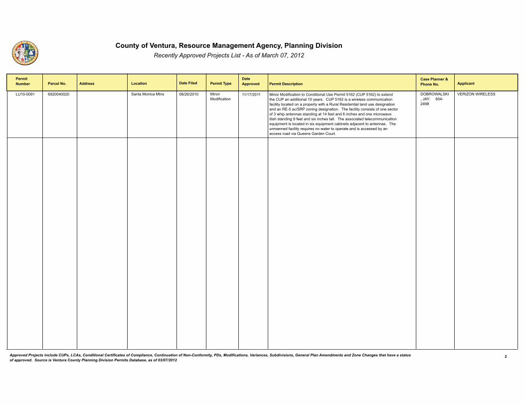
����������� ����� ����������� ��������������������������� ������������ � ����������������� ��������������
�������������
� ����������� �������� ������� �� ���� �������!��� ������������������
� ����� �����"�#������� ������ ��� ���$����
�4�����8� ���������8���(���� �����)������)��� )�����)���0�������
)�����)���0���������������������,�4��������������!�4�����#�����+������>���4��������������,����-����"���4���������������,��������7���������0���,��-�,������������.��.���-����>����7��,�����������,�,����7�������6���������������������� ���C����6�����6������"��3>��0���,��-�����������0�������������0���>�.�����������������6�����(�0������������>������������������������>��������6�8�0����������+����>�����,," ��3>���������������,�����7����������C7�.��������,������������+��C7�.�������2��������=�����������������" ��3>��7��������0���,��-���C7������������������.����������������������2-��������������������D7�����;��������7��"
�$?�$/�� <�&�:�%'������(��(8*
5��� $��/����� �*�������
&������������� ���������������������� �������� ����� ������������������ ���� ����������������� ������������� ��������������� �!����������"����������������� ����#����$��%�� $� $����� � ������������& ���������� ������� �������%������������ ��� �!��������'()'*)+',+
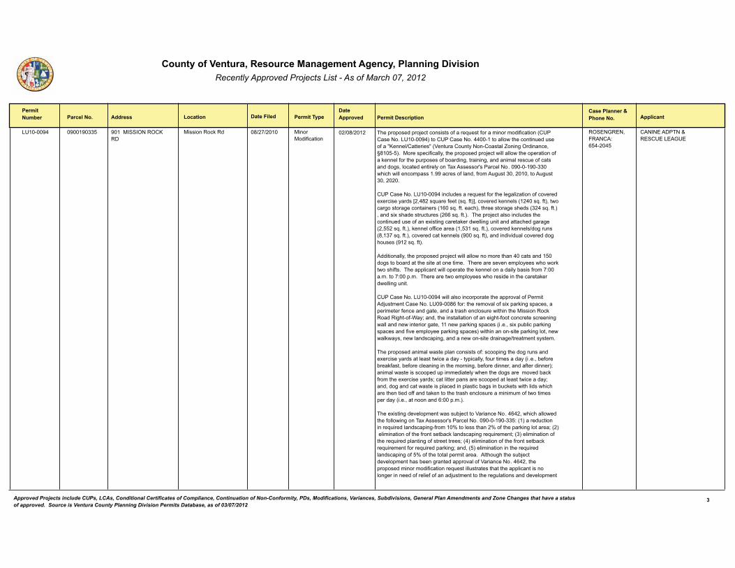
����������� ����� ����������� ��������������������������� ������������ � ����������������� ��������������
�������������
� ����������� �������� ������� �� ���� �������!��� ������������������
� ����� �����"�#������� ������ ��� ���$����
�4�����8( ����*������8���8�� 8����)� �$���$�<���
)����������@��� )�����)���0�������
3>��.��.�����.��=��������������0�����C7����0���������������0��������!�4���������"��4�����8(#�����4���������"�((���������,,����>��������7���7����0���A<����,����������A�!5���7�����7��-�����������,� ����6�$��������&�E*�����#"��)�����.���0���,,-&��>��.��.�����.��=������,,��,,����>���.���������0���@����,�0����>��.7�.������0�2������6&��������6&����������,�����7���0������������6�&�,�������������,-����3�+���������F�������,���"��8�����8�����>��>���,,������.�����"88��������0�,���&�0�����767����&�����&�����767����&�����"��
�4���������"��4�����8(����,7��������C7����0����>��,�6�,�C�������0����������+�������-�����G�&(*���C7����0����!�C"�0�#H&���������@����,��!��(���C"�0�#&��������6�������6�������������!����C"�0�"����>#&��>���������6���>����!�(��C"�0�"#&�������+��>�������7��7����!���C"�0�"#" ��3>��.��=�����,������,7�����>��������7���7����0�����+�����6�������@������,,��6�7�������������>���6���6��!�&�����C"�0�"#&�@����,��00���������!�&����C"�0�"#&���������@����,����6��7���!*&���C"�0�"#&�������������@����,��!8����C"�0�#&������������7�,�����������6�>�7����!8����C"�0�#"
���������,,-&��>��.��.�����.��=������,,��,,������������>���(�����������������6�����2���������>������������������"��3>����������������.,�-�����>�����@������>�0��"��3>���..,��������,,��.�������>��@����,���������,-�2�����0����'����"�"����'���."�"��3>��������������.,�-�����>�������������>��������@������,,��6�7���"
�4���������"��4�����8(���,,��,��������.�������>���..����,��0����������=7��������������"��4�8���*�0��'��>��������,��0���+�.��@��6��.����&���.���������0���������6���&�����������>����,��7������>����>��)����������@��������6>���0�/�-B����&��>�������,,�������0������6>��0���������������������6���,,������������������6���&��������.��@��6��.�����!� "�"&���+�.72,���.��@��6��.���������0������.,�-���.��@��6��.����#����>��������������.��@��6�,��&�������,@��-�&�����,������.��6&�������������������������6�������������-����"�
3>��.��.����������,�������.,�������������0'�����.��6��>����6��7��������+�������-��������,���������������-����-.���,,-&�0�7������������-�!� "�"&�2�0����2���@0���&�2�0�����,�����6�����>��������6&�2�0����������&������0����������#B������,��������������.���7.����������,-��>����>����6�������������2��@�0�����>���+�������-����B�����,������.������������.������,���������������-B����&���6������������������.,��������.,������2�6�����27�@�������>�,�����>��>������>���������00�������@�������>������>����,��7����������7���0�����������.�����-�!�"�"&�������������'���."�"#"
3>���+�����6�����,�.����������72=�������5����������"�((�&��>��>��,,������>��0�,,����6����3�+���������F�������,���"��8�����8���'�!�#������7�����������C7�����,������.��6�0������I����,�����>����I��0��>��.��@��6�,�������B�!�#��,�����������0��>��0��������2��@�,������.��6���C7�������B�!#��,�����������0��>����C7�����.,�����6��0�������������B�!(#��,�����������0��>��0��������2��@���C7��������0�����C7�����.��@��6B����&�!�#��,��������������>����C7�����,������.��6��0��I��0��>������,�.����������"���,�>�76>��>���72=��������,�.�����>���2����6��������..����,��0�5����������"�((�&��>��.��.���������������0����������C7�����,,7���������>����>���..,������������,��6������������0���,��0��0������=7�����������>����67,���������������,�.�����
�$ ��;���&�������'������(���(�
����������3��J��� �4�����;4�
�*�������
'������������� ���������������������� �������� ����� ������������������ ���� ����������������� ������������� ��������������� �!����������"����������������� ����#����$��%�� $� $����� � ������������& ���������� ������� �������%������������ ��� �!��������'()'*)+',+
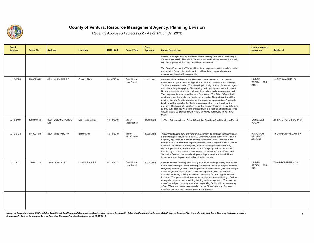
����������� ����� ����������� ��������������������������� ������������ � ����������������� ��������������
�������������
� ����������� �������� ������� �� ���� �������!��� ������������������
� ����� �����"�#������� ������ ��� ���$����
��������������.���0����2-��>������������,� ����6�$���������.��������6����5����������"�((�"��3>���0���&�5����������"�((����,,�2�������7,,�������������>��>���..����,��0��>�������������0����������C7���"�
3>�� �������7,��/�����/��@����,,�������7�����.��������������������������>��.��=��������"���������������.�����-�������,,�������7�����.�����������6�����.���,����������0����>��.��=��������"
�4�����8 ������������*��8�� (�����14���)���� $+������,��� ����������,�4���������
�..����,��0�������������,�4����������!�4�#�!�������"��4�����8#�����7�>���C���>���.���������0�����6���7,�7��,������������ ����������� ����6��%����0���������-����.�����"�3>���������,,�.�����.�,,-�2��7����0����>�������6���0��6���7,�7��,�����6������.�.��6"�3>���+�����6�.��@��6�,���.����������,,�������"����.������������7��7����������������,���.�����7���7�0���������.��.����"��3������6���������������7,��2��7����0��������6�"�3>�����-��0�$+�������,,�������7�����.�������������������������>��.��.���-"�������������������,,�2��7��������>�������0������.�����6�������0��>��.���������,������.��6" ���.����2,�����,�����7,��2������,�2,��0����>��������.,�-�����>�����7,�����@�����>��.��.���-"�3>��>�7����0��.����������7,��2��)����-��>��76>������-�*'���� "�"����('���."�"�3>���������7,��2�����,��������>����0������,,��>����,��@���0���� "�����������7,��2��.��������2-���.��������������-����������������-�>��������
������&�?��<%'������(��(8
1� �;�/��;���� �*�������
�4������8 �����������*��(��� 8�� $���$�5�������
����������5�,,�- )�����)���0�������
���%�����+��������0�����������,�������@������,,��6�����������,�4��������� ;$� ��� &�:$ �� '�����
����3$���3��� ���������������
�4������( ����8������((����(� �����5���%�����5 �,��������� )�����)���0�������
�)�����)���0��������0��������-����������+�����������������7���>��.���������0�����,0������6��0���,��-�,��������������5���-��������7������>��$+�������������6���,,-��..�������������������,�4������������"�(8*�"�������������>��0���,��-������������0�����������.>�,���������-�0����5���-��������7�����>�������������,����0�������������6���-���������������-�0���� �����/�-"��/��������.��������2-��>�������,�C��/��������.��-��������������������>���,���2-�������������������������������>��5���7�����7��-�/��������� ������������������"�������������,�.��������.��.���������������������,���.�����7����������.��.��������2������������>������"
�$$� ���&�<�� 3���'������(��(
31$)� $��/�����)���<����������
�4������ �����������8���(���� ����������$� 3 )����������@��� ����������,�4���������
����������,�4����������!�4������#�0�������7�����,��6��0���,��-����>�������������7�����������6�"��3>���.������6�27����������@��������)�=����..,���������-�,��6� �������!)�� #"��)�� �.��.�������0���,��-�����-�����>�������.���������,��6���0�����7��&��������������-��0���.������&�����>�C����7����������&����,7���6�27�,���6��������,�&�>�7��>�,��0�+�7���&��..,�����������07����7��"��3>��.��.���,����,7������������.����������������������6 "��$7����������6�����.��.������������+�����6�,�����6����������6��-���" ��3>��.�����7��7����0��>���72=����.��.���-�������,�����.��@��6�0���,��-����>������������-��00���"��/�������������������.��������2-��>�����-��0�5���7��"�������������,�.����������.�����7���7�0���������.��.����"
������&�?��<%'������(��(8
3������$���3�� ��������(�����
(������������� ���������������������� �������� ����� ������������������ ���� ����������������� ������������� ��������������� �!����������"����������������� ����#����$��%�� $� $����� � ������������& ���������� ������� �������%������������ ��� �!��������'()'*)+',+
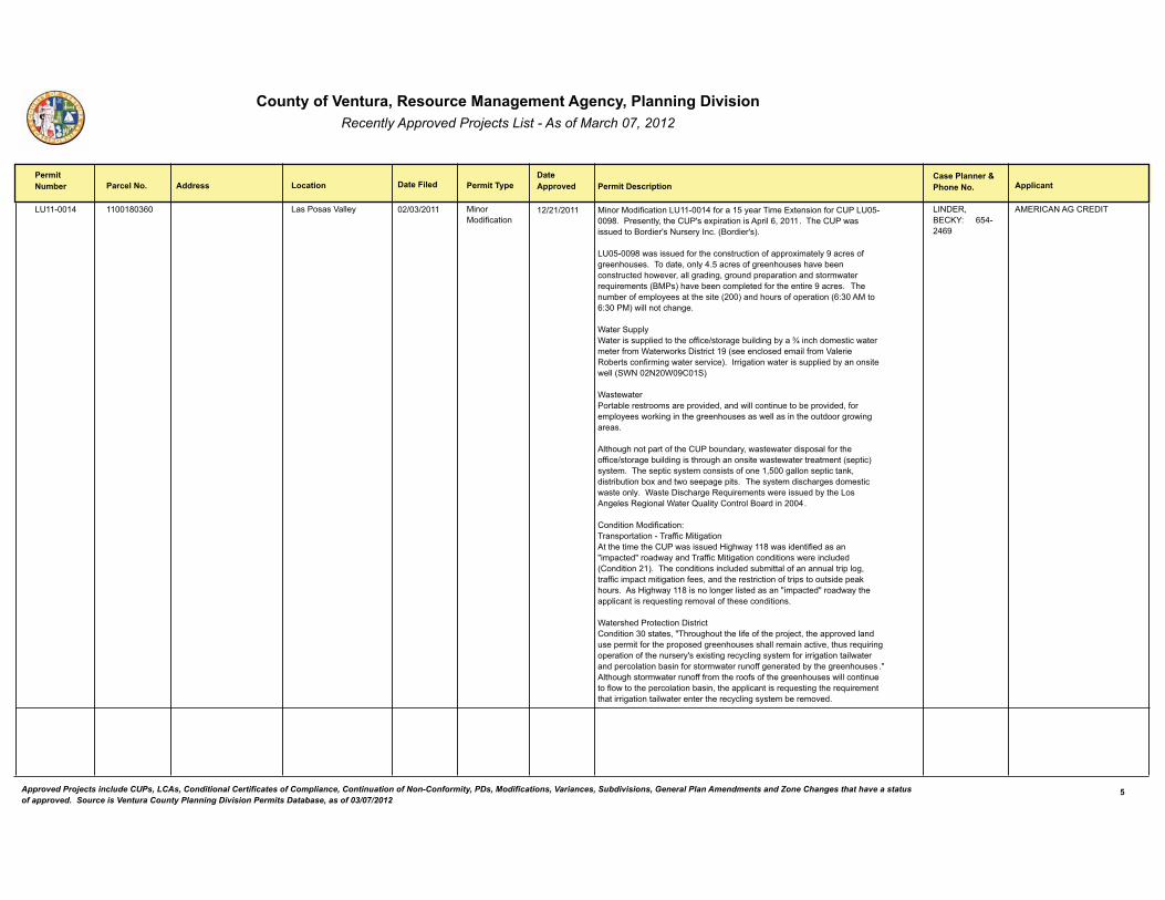
����������� ����� ����������� ��������������������������� ������������ � ����������������� ��������������
�������������
� ����������� �������� ������� �� ���� �������!��� ������������������
� ����� �����"�#������� ������ ��� ���$����
�4������( ���������������*�� ����������5�,,�- )�����)���0�������
)�����)���0���������4������(�0��������-����3�����+��������0����4���4�����8*"���������,-&��>���4�F���+.������������.��,�&�����"��3>���4���������7������?������F���7����-����"�!?������F�#"��
�4�����8*��������7���0����>��������7�������0��..��+�����,-�8��������0�6����>�7���"��3������&���,-�("���������0�6����>�7����>����2����������7�����>������&��,,�6�����6&�6��7���.��.�������������������������C7���������!?)��#�>����2�������.,�����0����>���������8������" ��3>���7�2����0���.,�-��������>�������!���#�����>�7����0��.��������!'���)����'���)#���,,������>��6�"
/����� 7..,-/���������7..,��������>���00���������6��27�,���6�2-���K����>����������������������0����/�������@������������8�!�������,���������,�0����5�,�������2��������0�����6��������������#"������6����������������7..,����2-�������������,,�! /�������/�8��� #�
/��������������2,����������������.�������&�������,,�������7�����2��.�������&�0�����.,�-�������@��6�����>��6����>�7���������,,��������>���7������6�����6������"
�,�>�76>�����.�����0��>���4��2�7����-&���������������.���,�0����>���00���������6��27�,���6�����>��76>��������������������������������!��.���#��-����"��3>����.�����-���������������0������&����6�,,�����.�������@&�������27�����2�+������������.�6��.���"��3>���-���������>��6��������������������,-"��/���������>��6����C7�����������������7���2-��>��������6�,�����6����,�/�����D7�,��-�������,�?�����������("��
����������)���0�������'3����.�����������3��00���)���6���������>��������>���4���������7���1�6>��-���*�����������0����������A��.�����A�������-�����3��00���)���6�������������������������,7����!������������#"��3>����������������,7�����72�����,��0�������7�,����.�,�6&����00�����.��������6������0���&������>���������������0����.������7������.��@�>�7��"�����1�6>��-���*�������,��6���,������������A��.�����A�������-��>���..,�����������C7�����6�������,��0��>��������������"
/�����>����������������������������������������&�A3>��76>�7���>��,�0���0��>��.��=���&��>���..������,����7���.������0����>��.��.�����6����>�7�����>�,,��������������&��>7����C7����6��.���������0��>���7����-F���+�����6����-�,��6��-�����0�������6���������,����������.����,������2�����0���������������7��00�6���������2-��>��6����>�7��� "A���,�>�76>�������������7��00�0�����>�����0���0��>��6����>�7������,,�������7�����0,�������>��.����,������2����&��>���..,�����������C7�����6��>����C7���������>�������6���������,�������������>�����-�,��6��-�����2���������"
������&�?��<%'������(��(8
�)��������;������3���������
)������������� ���������������������� �������� ����� ������������������ ���� ����������������� ������������� ��������������� �!����������"����������������� ����#����$��%�� $� $����� � ������������& ���������� ������� �������%������������ ��� �!��������'()'*)+',+
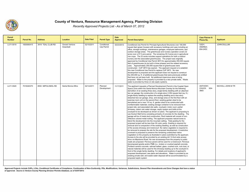
����������� ����� ����������� ��������������������������� ������������ � ����������������� ��������������
�������������
� ����������� �������� ������� �� ���� �������!��� ������������������
� ����� �����"�#������� ������ ��� ���$����
�4������8 ����������*���(�� 8�8��3������4?��� $+�����5���7���;����2�,�
����������,�4���������
����������,�4����������0���������.�,��6���7,�7��,� ��7��7������������&�����C7����0����!6�����>�7���#����>���������-�27�,���6������7�������,7���6�����00���&������6��27�,���6�&�������������6���6��&���.,�-���2��>�����&������7�����������6�������"��3>��6����>�7��������7����-��.��������������������������������"�������.����,"��3>����������6��"����������������6���7,�7��,��������.�"��3>��������������,7�����7..�����.���������0���2��>����7�������7����-������>�������������6����>�7���"��3>��.��=�����������6���,,-��..������2-�����������,�4����������*�0����..��+�����,-�(��&�����C7����0�����0�6����>�7����!���2��27�,������>����.>����#������>����,�������������-�7���"�����..��+�����,-����&�����C7����0�����0�6����>�7���������������7����"���4��*�>����+.����"��3>���..,��������C7��������������2,��>��>�����������������,�4���������������.,�����4��*"�������������,�.��������.��.����������>���..,�����������������C7�������������7����>�����&�����C"�0�"��0����������,�6����>�7�����>��������.�����7�,-������,����>���>��������-���2����27�,�"��������������,���.�����7����������2���6�.��.����"��/���������>��.��.���-����.��������2-�������.���������,,� "��/��������������.��������2-��>��������������.�����-�����"
$ �%&�������'������(��(�
:$1���4��4)����������
�4������� �������������(�� *�����)��$�$)$���� �����)������)��� �,����������,�.����
3>���..,��������C7��������,����������,�.����������������>��������,�$.��� .���� �������>����>�� �����)������)�7������$���,�-�0����>��0�,,����6'�����,�������0�����+�����6��>��������-&����6,��0���,-����,,��6����>���������>�����������6���6�B��>��������7�������0������6,������-��&����C7����0����!�C"�0�"#����6,��0���,-����,,��6������.,�����>���+�����6����,,��6���������������-������>�����������6���6�&��>�.&����������6�����������>��0�����0,�������>�����+������������7��������>���������0,���B��+�����6�6�������>������2������,��>������������������C"�0�"�6�������>������2��������7��������>����0,����2,���������,�B��+�����6������6���������������2����������0����.��=��������B�����������������������,,�&���7��-���&���������7��&�.�����,��������-&�������������������������6�&���.�����-������������,,�������>����7��-�������2������,�.�������>�������.,���"�3>���..,���������.��.����6����7����7����,�/�,,�0��������������6�.������,-��0����������0����>�����,,��6 "��3>��6���6����,,�2���0�����,���7��������7�����"����0��������,���,,����������0�������0,���������,���������,����0��6"�3>���..,������.��.��������7��,����������2,�����>������,�.�����������>����7������������6"��3���,�6�����6�0����>��.��.�����.��=������,,�2��,�����>�������72���-����"�;�����6������C7�����0���������,�����������.��������0��>���+�����6����,,��6&������,,����������7�������0��>����������������-������������7��"�������������6�������������C7��������2�������������.��.�����>�������0����>��.��.���������,�.����" ���������������������������.��.��������.���������>����������6�7�����7�2������������6������������>��.��.���-�����,,7�����������.,�����72�������2-��>���..,�����"�������������>���������,,�2��.��������2-�����+�����6���������0��������������������������)�.�,���,�����"����������������-��0�����>��.��.���-����.72,�������������.��.����"�������7��.��������,,�2��7����0������������7��"�������7�������.�����6���������������)?�!�"�"&�2��@��������7�>�����.>�,����������&�����,�������������������&����,�����2�,,���&�6,���&���7�>������@&����@��7��&�������7��,��������,#���,,�2��7����0����>���������-�,�����6�7.�����>����7��-�������0������0��>�����6,��0���,-����,,��6"����������,������,����������0��..,�����F��.��.���������,�.����&�����.,���������,��������" ��/��������.��������2-�����+�����6�.���������,,&��������������������.���,���,,�2���������������2-���.��.�������.�����-����
��31$�%&��14�<'������(�*
���1$���:$1��)�3�����(�����
*������������� ���������������������� �������� ����� ������������������ ���� ����������������� ������������� ��������������� �!����������"����������������� ����#����$��%�� $� $����� � ������������& ���������� ������� �������%������������ ��� �!��������'()'*)+',+
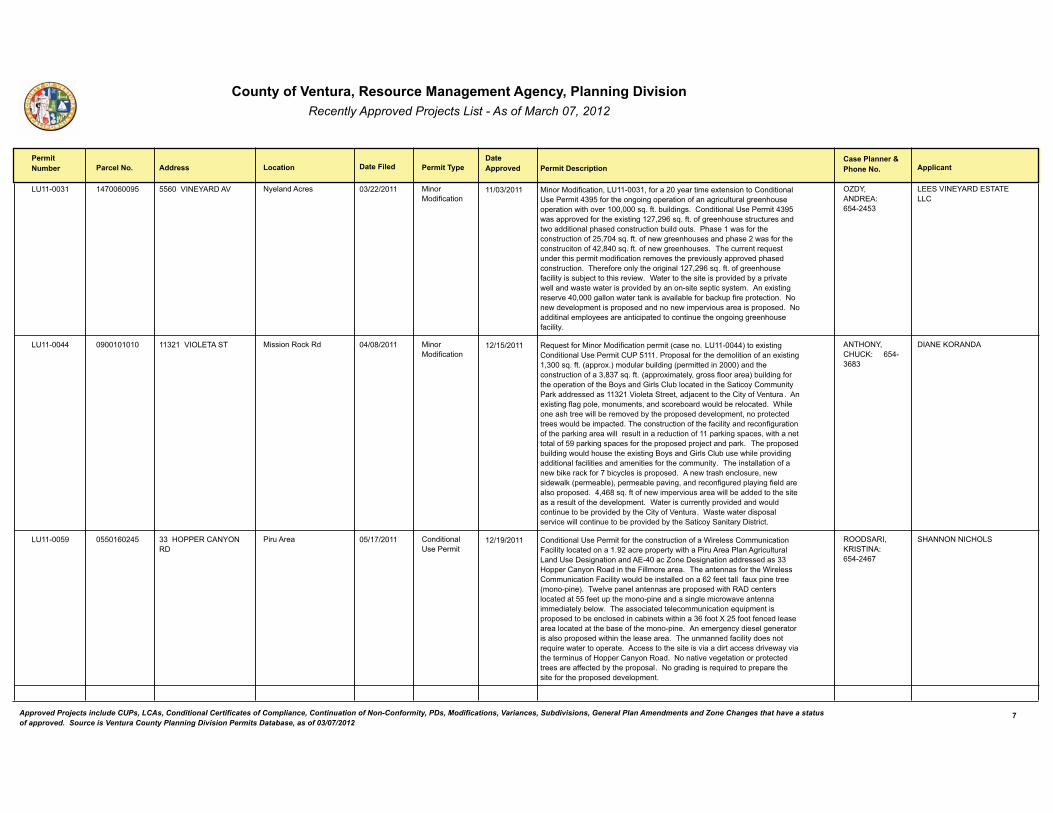
����������� ����� ����������� ��������������������������� ������������ � ����������������� ��������������
�������������
� ����������� �������� ������� �� ���� �������!��� ������������������
� ����� �����"�#������� ������ ��� ���$����
�4������ ����������(����8� �����5���%�����5 �-�,��������� )�����)���0�������
)�����)���0�������&��4������&�0��������-����������+���������������������,�4����������(8��0����>����6���6��.���������0�����6���7,�7��,�6����>�7����.�����������>���������&�����C"�0�"�27�,���6�"������������,�4����������(8�������..������0����>���+�����6���&�8��C"�0�"��0�6����>�7������7��7���������������������,�.>�����������7������27�,���7��"���>����������0����>��������7�������0���&�(��C"�0�"��0�����6����>�7��������.>����������0����>��������7�������0�(�&*(���C"�0�"��0�����6����>�7���" ��3>���7��������C7����7������>���.����������0�����������������>��.�����7�,-��..������.>�����������7�����"��3>���0������,-��>�����6���,���&�8��C"�0�"��0�6����>�7���0���,��-�����72=��������>���������"��/���������>����������.��������2-���.���������,,��������������������.��������2-��������������.�����-����" ������+�����6���������(�&����6�,,������������@��������,�2,��0���2��@7.�0����.���������"�������������,�.��������.��.������������������.�����7����������.��.����"�������������,���.,�-��������������.��������������7���>����6���6�6����>�7���0���,��-"
$ �%&�������'������(��(�
��� �5���%����� 3�3�����
���������
�4�����(( �����������8�������� ������5�$��3�� 3 )����������@��� )�����)���0�������
��C7����0���)�����)���0��������.������!�������"��4�����((#�����+�����6�����������,�4�����������4������"����.���,�0����>������,�������0�����+�����6��&����C"�0�"�!�..��+"#����7,���27�,���6�!.����������������#������>��������7�������0���&*��C"�0�"�!�..��+�����,-&�6�����0,��������#�27�,���6�0����>���.���������0��>��?�-������;��,���,72�,�����������>�� �����-�����7���-����@�������������������5��,���� �����&���=����������>�����-��0�5���7�� "������+�����6�0,�6�.�,�&����7�����&����������2�������7,��2����,������"��/>�,��������>��������,,�2����������2-��>��.��.���������,�.����&����.�����������������7,��2����.�����"�3>��������7�������0��>��0���,��-����������0�67��������0��>��.��@��6��������,,�����7,����������7�������0����.��@��6��.����&����>�����������,��0��8�.��@��6��.�����0����>��.��.�����.��=��������.��@" ��3>��.��.�����27�,���6���7,��>�7����>���+�����6�?�-������;��,���,72�7����>�,��.�������6����������,�0���,��������������������0����>������7���-" ��3>�������,,�������0�������2�@�����@�0����2��-�,������.��.����"������������>����,��7��&�����������,@�!.�����2,�#&�.�����2,��.����6&����������0�67����.,�-��6�0��,�������,���.��.����"��(&(*��C"�0���0�������.�����7���������,,�2������������>���������������7,���0��>������,�.����"��/���������7�����,-�.��������������7,��������7�����2��.��������2-��>�����-��0�5���7��"��/��������������.���,�����������,,�������7�����2��.��������2-��>�� �����-� ������-���������"
��31$�%&��14�<'������(�*
������<$������(��*�����
�4������8 ����8������������(� ��1$��������%$����
���7����� ����������,�4���������
����������,�4����������0����>��������7�������0���/���,��������7�������������,��-�,�������������"8�������.��.���-����>������7�������,����6���7,�7��,������4�������6��������������(����� ��������6���������������������1�..������-������������>����,,���������"��3>�����������0����>��/���,��������7�������������,��-���7,��2�������,,����������0������,,��0�7+�.���������!�����.���#"��3��,���.���,��������������.��.��������>�������������,�������������0����7.��>�������.�������������6,�����������������������������,-�2�,��"��3>���������������,�����7����������C7�.��������.��.��������2�����,����������2���������>������0����L����0����0������,����������,�����������>��2�����0��>�������.���"���������6���-������,�6�������������,���.��.��������>����>��,���������"��3>��7��������0���,��-������������C7��������������.�����"�������������>�����������������������������������-������>��������7���0�1�..������-�������"��������������6�����������.��������������������00������2-��>��.��.���,"�����6�����6������C7��������.��.�����>�������0����>��.��.���������,�.����"
�$$� ���&�<�� 3���'������(��(
1���$�����1$� ���������
+������������� ���������������������� �������� ����� ������������������ ���� ����������������� ������������� ��������������� �!����������"����������������� ����#����$��%�� $� $����� � ������������& ���������� ������� �������%������������ ��� �!��������'()'*)+',+
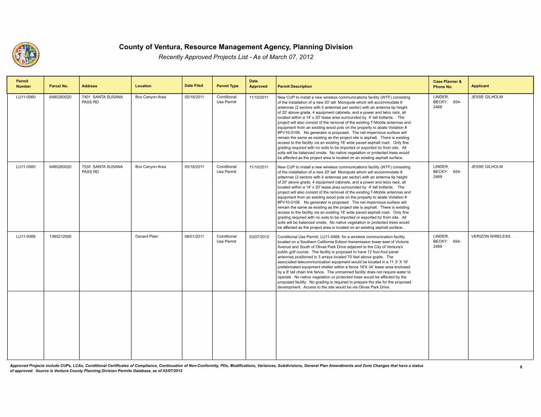
����������� ����� ����������� ��������������������������� ������������ � ����������������� ��������������
�������������
� ����������� �������� ������� �� ���� �������!��� ������������������
� ����� �����"�#������� ������ ��� ���$����
�4������ ����������(*������ (���� ��3�� 4 ������ ���
?�+����-������� ����������,�4���������
�����4����������,,�����������,��������7����������0���,��-�!/3�#����������6��0��>�������,,�������0���������F���,,��)���.�,���>��>���,,�������������*����������!�������������>�(����������.���������#����>��������������.�>��6>���0���F��2����6����&�(��C7�.�������2�����&�������.�����������,������@&��,,�,����������>������(F�+���F�,�����������7���7�����2-��(F���,,�2�,,����" ���3>��.��=������,,��,������������0��>��������,��0��>���+�����6�3�)�2�,����������������C7�.�����0��������+�����6������.�,������>��.��.���-�����2����5��,������M�M�5������*"������6������������.��.����"��3>��������.�����7���7�0������,,���������>�����������+�����6�����>��.��=��������������.>�,�" ��3>��������+�����6������������>��0���,��-���������+�����6��*N������.�������.>�,������ "��$�,-�0����6�����6���C7��������>�������,�����2����.����������+.����������0��������" ���,,����,����,,�2��2�,������������"��������������6�����������.�����������������7,��2���00����������>��.��=������������,��������������+�����6���.>�,���7�0��� "
������&�?��<%'������(��(8
:� ��;��1$�)����*�����
�4������ ����������(*������ ���� ��3�� 4 ������ ���
?�+����-������� ����������,�4���������
�����4����������,,�����������,��������7����������0���,��-�!/3�#����������6��0��>�������,,�������0���������F���,,��)���.�,���>��>���,,�������������*����������!�������������>�(����������.���������#����>��������������.�>��6>���0���F��2����6����&�(��C7�.�������2�����&�������.�����������,������@&��,,�,����������>������(F�+���F�,�����������7���7�����2-��(F���,,�2�,,����" ���3>��.��=������,,��,������������0��>��������,��0��>���+�����6�3�)�2�,����������������C7�.�����0��������+�����6������.�,������>��.��.���-�����2����5��,������M�M�5������*"������6������������.��.����"��3>��������.�����7���7�0������,,���������>�����������+�����6�����>��.��=��������������.>�,�" ��3>��������+�����6������������>��0���,��-���������+�����6��*N������.�������.>�,������ "��$�,-�0����6�����6���C7��������>�������,�����2����.����������+.����������0��������" ���,,����,����,,�2��2�,������������"��������������6�����������.�����������������7,��2���00����������>��.��=������������,��������������+�����6���.>�,���7�0��� "
������&�?��<%'������(��(8
:� ��;��1$�)����*�����
�4�����* ���������*�����8� $+������,��� ����������,�4���������
����������,�4���������&��4�����*&�0���������,��������7���������0���,��-�,������������ �7�>������,�0��������������������������������������0�5������������7������ �7�>��0�$,��������@���������=����������>�����-��0�5���7��F��.72,���6�,0���7���"��3>��0���,��-����.��.��������>�������0�7��0����.���,����������.������������������-��,���������0�����2����6����" ��3>���������������,�����7����������C7�.�������7,��2��,�������������� "�F�L��F�.��0�2���������C7�.������>�,�������>�����0������*FL�(F�,�������������,�����2-���*F���,,��>����,��@�0����"��3>��7��������0���,��-������������C7��������������.�����"��������������6�����������.�����������������7,��2���00������2-��>��.��.�����0���,��-"�����6�����6������C7��������.��.�����>�������0����>��.��.���������,�.����"�������������>���������7,��2������$,��������@������"
������&�?��<%'������(��(8
5��� $��/����� ���������
,������������� ���������������������� �������� ����� ������������������ ���� ����������������� ������������� ��������������� �!����������"����������������� ����#����$��%�� $� $����� � ������������& ���������� ������� �������%������������ ��� �!��������'()'*)+',+
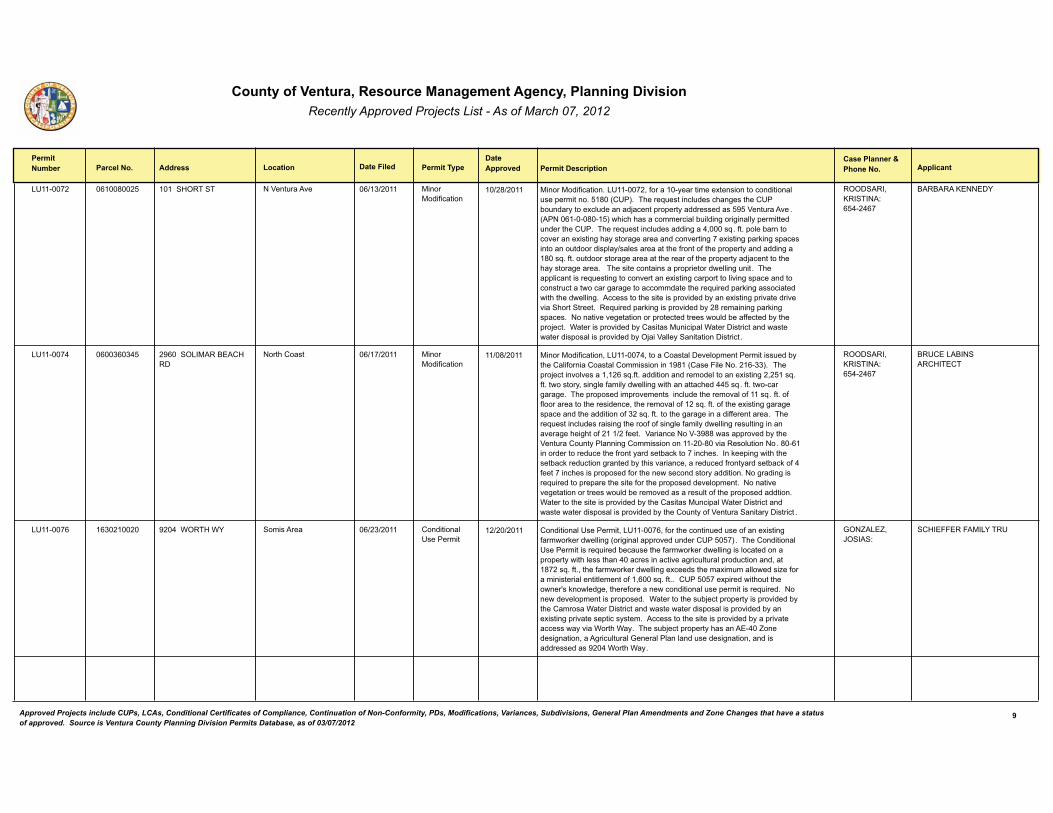
����������� ����� ����������� ��������������������������� ������������ � ����������������� ��������������
�������������
� ����������� �������� ������� �� ���� �������!��� ������������������
� ����� �����"�#������� ������ ��� ���$����
�4������ ����*���������*���� ����� 1$�3� 3 ��5���7������ )�����)���0�������
)�����)���0�������"��4������&�0��������-����������+���������������������,�7���.��������"���*��!�4�#"��3>����C7�������,7�����>��6����>���4��2�7����-�����+�,7��������=������.��.���-���������������8��5���7������ "�!����������*����#��>��>�>��������������,�27�,���6����6���,,-�.���������7������>���4�"��3>����C7�������,7���������6���(&�����C "�0�"�.�,��2�����������������+�����6�>�-������6��������������������6���+�����6�.��@��6��.��������������7���������.,�-���,������������>��0������0��>��.��.���-����������6����*���C"�0�"��7�����������6�����������>��������0��>��.��.���-���=����������>��>�-������6������"���3>������������������.��.����������,,��6�7���"��3>���..,�����������C7�����6����������������+�����6����.�������,����6��.�����������������7�������������6���6�����������������>����C7�����.��@��6���������������>��>�����,,��6"�������������>����������.��������2-�����+�����6�.����������������� >���� �����"����C7�����.��@��6����.��������2-��*���������6�.��@��6��.����"��������������6�����������.�����������������7,��2���00������2-��>��.��=���"��/��������.��������2-���������)7����.�,�/���������������������������������.���,����.��������2-�$=���5�,,�-� ������������������ "
�$$� ���&�<�� 3���'������(��(
?��?����<�����%��������
�4�����( ����*���������(� �8��� $��)���?���1���
����>������ )�����)���0�������
)�����)���0�������&��4�����(&������������,�����,�.���������������7���2-��>����,�0������������,����������������8*��!�������,����"����#" ��3>��.��=��������,�������&����C"0�"��������������������,��������+�����6��&�����C"�0�"���������-&����6,��0���,-����,,��6����>���������>���((���C "�0�"���������6���6�"��3>��.��.�������.��������������,7����>��������,��0�����C "�0�"��0�0,�������������>�����������&��>��������,��0�����C"�0�"��0��>���+�����6�6���6���.���������>������������0����C"�0�"�����>��6���6���������00����������"��3>����C7�������,7����������6��>�����0��0����6,��0���,-����,,��6����7,���6������������6��>��6>���0��������0���"��5�����������5�8**������..������2-��>��5���7�����7��-��,�����6���������������������*����������,7�������"�*�������������������7����>��0�����-�������2��@��������>��"�����@��.��6����>��>�����2��@����7������6�������2-��>�����������&������7����0����-�������2��@��0�(�0��������>������.��.�����0����>�����������������-���������"����6�����6������C7��������.��.�����>�������0����>��.��.���������,�.����"��������������6�������������������7,��2������������������7,���0��>��.��.������������"��/���������>����������.��������2-��>����������)7���.�,�/���������������������������������.���,����.��������2-��>����7��-��0�5���7��� ������-��������� "
�$$� ���&�<�� 3���'������(��(
?�4�����?�� ����1�3��3
��������
�4����� ������������������ 8��(��/$�31�/% ��������� ����������,�4���������
����������,�4���������&��4�����&�0����>��������7���7����0�����+�����6�0������@������,,��6�!���6���,��..������7������4�����#"��3>������������,�4���������������C7�����2���7����>��0������@������,,��6����,������������.��.���-����>�,�����>���(�������������������6���7,�7��,�.���7���������&�����*���C"�0�"&��>��0������@������,,��6��+�������>����+��7���,,�������C��0���������������,������,�������0��&����C"�0�""���4�������+.��������>�7���>�������F��@���,��6�&��>���0��������������������,�7���.�����������C7����"�������������,�.��������.��.����"��/���������>���72=����.��.���-����.��������2-��>����������/���������������������������������.���,����.��������2-�����+�����6�.���������.�����-����"�������������>����������.��������2-���.����������������-�����/���>�/�-"��3>���72=����.��.���-�>���������(�� ��������6������&����6���7,�7��,�;�����,��,���,����7�������6������&���������������������8��(�/���>�/�-"
;$� ��� &�:$ �� '�����
�1���������)��%�3�4��������
-������������� ���������������������� �������� ����� ������������������ ���� ����������������� ������������� ��������������� �!����������"����������������� ����#����$��%�� $� $����� � ������������& ���������� ������� �������%������������ ��� �!��������'()'*)+',+
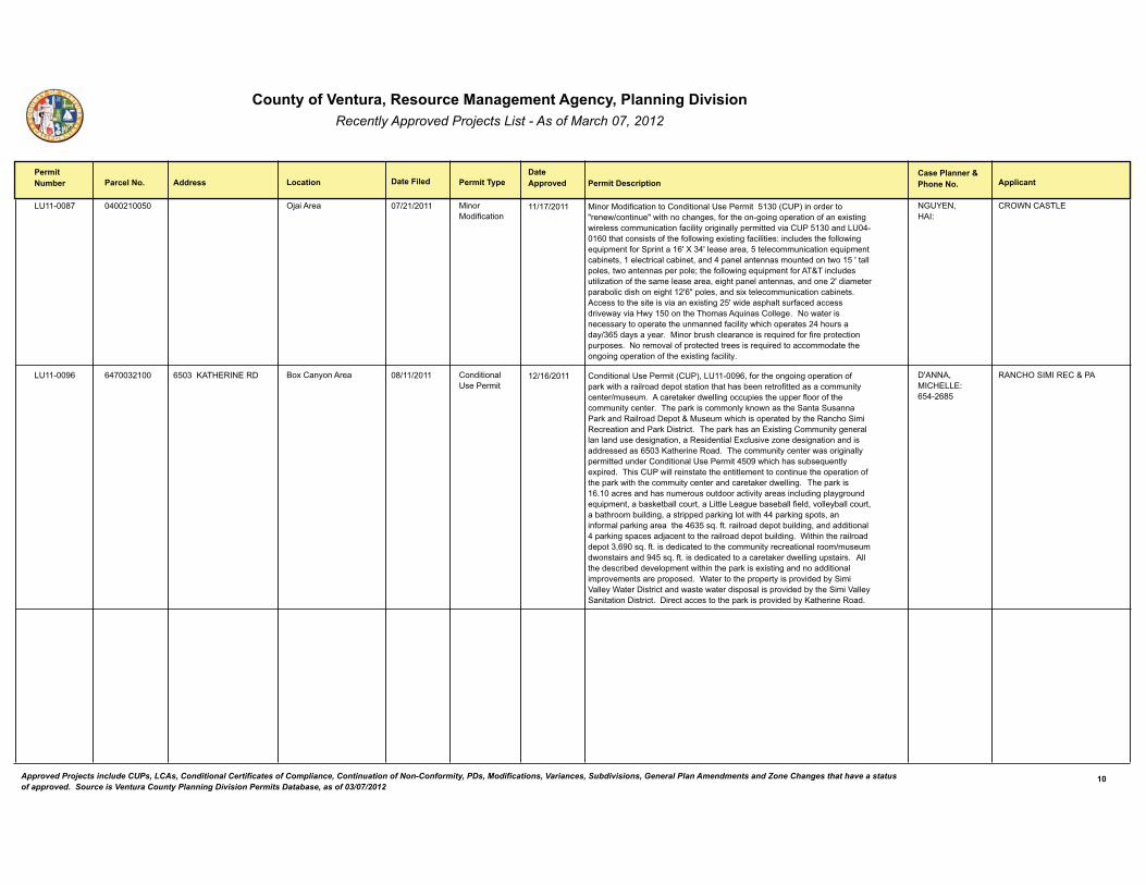
����������� ����� ����������� ��������������������������� ������������ � ����������������� ��������������
�������������
� ����������� �������� ������� �� ���� �������!��� ������������������
� ����� �����"�#������� ������ ��� ���$����
�4�����* ����������(�������� $=������� )�����)���0�������
)�����)���0���������������������,�4���������������!�4�#�������������A������������7�A����>�����>��6��&�0����>�����6���6��.���������0�����+�����6�����,��������7���������0���,��-����6���,,-�.��������������4�����������4�(������>�������������0��>��0�,,����6��+�����6�0���,�����'����,7�����>��0�,,����6��C7�.�����0��� .��������F�L�(F�,���������&�����,�����7����������C7�.�������2�����&����,�������,���2����&�����(�.���,������������7���������������F���,,�.�,��&��������������.���.�,�B��>��0�,,����6��C7�.�����0����3J3����,7����7��,�C�������0��>�������,���������&���6>��.���,���������&����������F����������.���2�,������>������6>����FA�.�,��&�������+���,�����7�����������2�����"�������������>������������������+�����6���F��������.>�,���7�0�������������������-�����1�-���������>��3>������C7�������,,�6�"����������������������-�����.�������>��7��������0���,��-��>��>��.��������(�>�7�������-�����-����-���"��)�����2�7�>��,�������������C7�����0���0����.����������.7�.����"�����������,��0�.��������������������C7���������������������>����6���6��.���������0��>���+�����6�0���,��-"
�;4%��&�1��'�����
��$/���� 3�����������
�4�����8 ���������(������ ����<�31�������� ?�+����-������� ����������,�4���������
����������,�4����������!�4�#&��4�����8&�0����>����6���6��.���������0�.��@����>������,�������.������������>���>���2���������0���������������7���-���������7��7�"����������@������,,��6����7.�����>��7..���0,�����0��>������7���-�������"��3>��.��@����������,-�@���������>�� ����� 7���������@��������,�������.���J�)7��7���>��>�����.�������2-��>������>�� �����������������������@���������"��3>��.��@�>�������+�����6�����7���-�6�����,�,���,����7�������6������&�������������,��+�,7�����C��������6������������������������������<��>����������"��3>������7���-���������������6���,,-�.���������7���������������,�4����������(��8��>��>�>����72��C7���,-��+.����"��3>����4����,,������������>�������,���������������7���>���.���������0��>��.��@����>��>������7��-������������������@������,,��6" ��3>��.��@�����"�������������>����7����7���7�������������-����������,7���6�.,�-6��7����C7�.����&���2��@��2�,,���7��&�������,�����67��2���2�,,�0��,�&���,,�-2�,,���7��&���2��>�����27�,���6&�������..���.��@��6�,������>�((�.��@��6��.���&������0����,�.��@��6��������>��(���C"�0�"����,�������.���27�,���6&��������������,�(�.��@��6��.�������=����������>�����,�������.���27�,���6"��/��>����>�����,�������.���&8���C"�0�"������������������>������7���-������������,�������7��7�����������������8(���C"�0�"�������������������������@������,,��6�7.������" ���,,��>��������2�������,�.��������>����>��.��@�����+�����6�����������������,���.��������������.��.����"��/���������>��.��.���-����.��������2-� ����5�,,�-�/���������������������������������.���,����.��������2-��>�� ����5�,,�-� ������������������"�������������������>��.��@����.��������2-�<��>����������"
�F����&�)��1����'������(��*�
����1$� �)������J����*��������
%.������������� ���������������������� �������� ����� ������������������ ���� ����������������� ������������� ��������������� �!����������"����������������� ����#����$��%�� $� $����� � ������������& ���������� ������� �������%������������ ��� �!��������'()'*)+',+
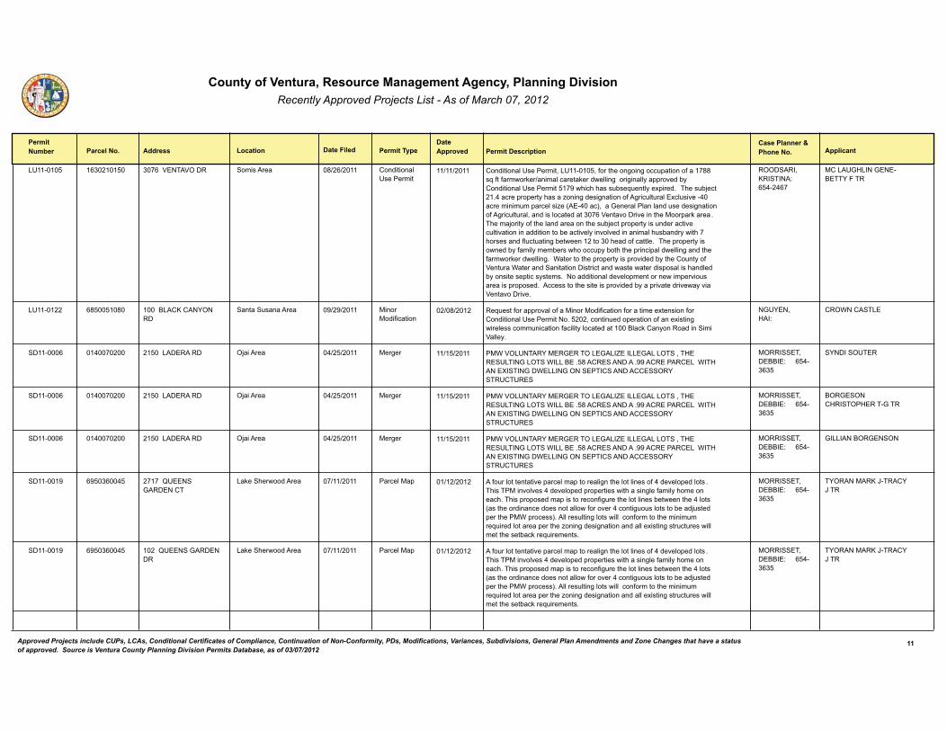
����������� ����� ����������� ��������������������������� ������������ � ����������������� ��������������
�������������
� ����������� �������� ������� �� ���� �������!��� ������������������
� ����� �����"�#������� ������ ��� ���$����
�4������� ������������������ ���5��3�5$��� ��������� ����������,�4���������
����������,�4���������&��4�������&�0����>����6���6����7.�������0����**��C�0��0������@��������,�������@������,,��6�����6���,,-��..������2-�����������,�4������������8��>��>�>����72��C7���,-��+.����" ��3>���72=������"(������.��.���-�>�����C����6�����6��������0��6���7,�7��,��+�,7������(������������7��.����,���C��!���(����#&����;�����,��,���,����7�������6��������0��6���7,�7��,&��������,������������5�����������������>��)���.��@����� "��3>����=����-��0��>��,�������������>���72=����.��.���-����7�������������7,������������������������2��������,-�����,������������,�>7�2����-����>��>����������0,7��7����6�2���������������>�����0�����,�" ��3>��.��.���-����������2-�0���,-����2�����>�����7.-�2��>��>��.�����.�,����,,��6������>��0������@������,,��6"��/���������>��.��.���-����.��������2-��>����7��-��0�5���7���/��������� ��������������������������������������.���,����>���,���2-����������.�����-�����"��������������,�����,�.��������������.�����7����������.��.����"�������������>����������.��������2-���.��������������-�����5������������"
�$$� ���&�<�� 3���'������(��(
)����4;1����;����?�33%���3�
�*�������
�4������� ����*�����*������*� �����?���<����%$����
����� 7��������� )�����)���0�������
��C7����0����..����,��0���)�����)���0��������0�����������+��������0�������������,�4������������"�����&�������7����.���������0�����+�����6�����,��������7���������0���,��-�,��������������?,��@����-����������� ����5�,,�-"
�;4%��&�1��'�����
��$/���� 3���8��8�����
������� ������������(������ ��������������� $=������� )��6�� �)/�5$�4�3��%�)��;���3$���;��� ������;����$3 �&�31���� 4�3��;��$3 �/����?��"�*����� �������"88��������������/�31�����L� 3��;��/�����;�$�� ��3�� ��������� $�%� 3�4�34��
)$��� �3&���??��'������(��
%���� $43���(��������
������� ������������(������ ��������������� $=������� )��6�� �)/�5$�4�3��%�)��;���3$���;��� ������;����$3 �&�31���� 4�3��;��$3 �/����?��"�*����� �������"88��������������/�31�����L� 3��;��/�����;�$�� ��3�� ��������� $�%� 3�4�34��
)$��� �3&���??��'������(��
?$�;� $���1�� 3$�1���3�;�3�
�(��������
������� ������������(������ ��������������� $=������� )��6�� �)/�5$�4�3��%�)��;���3$���;��� ������;����$3 �&�31���� 4�3��;��$3 �/����?��"�*����� �������"88��������������/�31�����L� 3��;��/�����;�$�� ��3�� ��������� $�%� 3�4�34��
)$��� �3&���??��'������(��
;�������?$�;�� $��(��������
�������8 ����������8����(� ����D4��� �;�������3
��@�� >����������� �����,�)�. ��0�7��,�������������.����,���.�������,�6���>��,���,������0�(�����,�.���,��� "3>���3�)�����,����(�����,�.���.��.����������>������6,��0���,-�>����������>"�3>���.��.�������.������������0�67����>��,���,�����2��������>��(�,����!����>����������������������,,���0��������(������67�7��,�������2����=7�����.����>���)/�.������#"��,,����7,���6�,������,,�����0��������>�������7����C7�����,��������.����>��C����6�����6������������,,��+�����6����7��7������,,������>�����2��@���C7��������"
)$��� �3&���??��'������(��
3%$����)��<�:�3���%�:�3�
���������
�������8 ����������8����(� �����D4��� �;��������
��@�� >����������� �����,�)�. ��0�7��,�������������.����,���.�������,�6���>��,���,������0�(�����,�.���,��� "3>���3�)�����,����(�����,�.���.��.����������>������6,��0���,-�>����������>"�3>���.��.�������.������������0�67����>��,���,�����2��������>��(�,����!����>����������������������,,���0��������(������67�7��,�������2����=7�����.����>���)/�.������#"��,,����7,���6�,������,,�����0��������>�������7����C7�����,��������.����>��C����6�����6������������,,��+�����6����7��7������,,������>�����2��@���C7��������"
)$��� �3&���??��'������(��
3%$����)��<�:�3���%�:�3�
���������
%%������������� ���������������������� �������� ����� ������������������ ���� ����������������� ������������� ��������������� �!����������"����������������� ����#����$��%�� $� $����� � ������������& ���������� ������� �������%������������ ��� �!��������'()'*)+',+
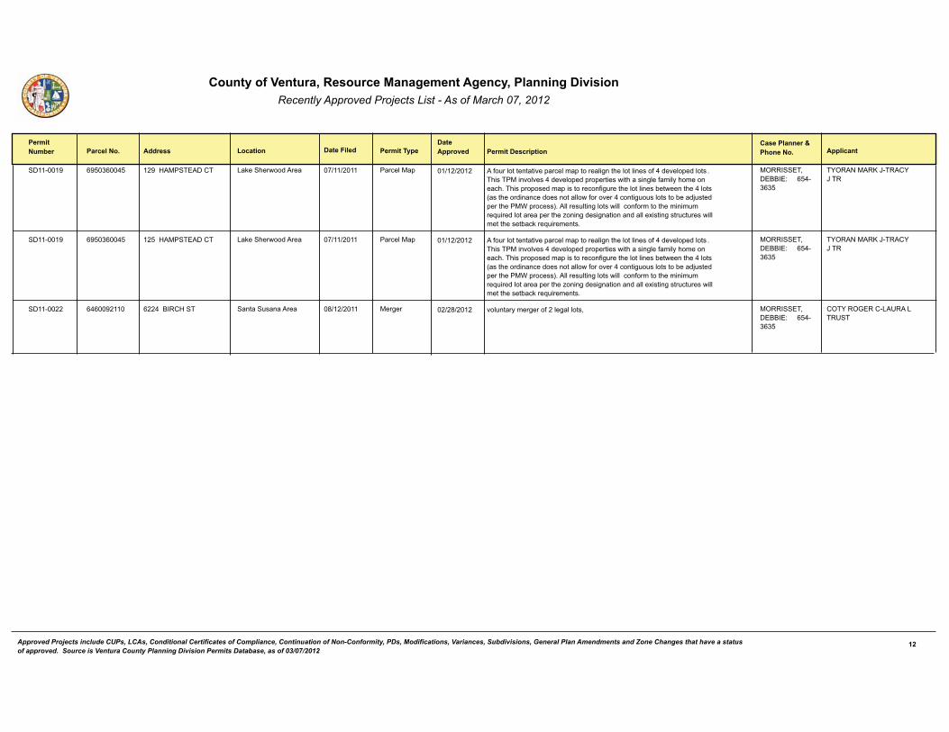
����������� ����� ����������� ��������������������������� ������������ � ����������������� ��������������
�������������
� ����������� �������� ������� �� ���� �������!��� ������������������
� ����� �����"�#������� ������ ��� ���$����
�������8 ����������8����(� ��8��1�)� 3�����3 ��@�� >����������� �����,�)�. ��0�7��,�������������.����,���.�������,�6���>��,���,������0�(�����,�.���,��� "3>���3�)�����,����(�����,�.���.��.����������>������6,��0���,-�>����������>"�3>���.��.�������.������������0�67����>��,���,�����2��������>��(�,����!����>����������������������,,���0��������(������67�7��,�������2����=7�����.����>���)/�.������#"��,,����7,���6�,������,,�����0��������>�������7����C7�����,��������.����>��C����6�����6������������,,��+�����6����7��7������,,������>�����2��@���C7��������"
)$��� �3&���??��'������(��
3%$����)��<�:�3���%�:�3�
���������
�������8 ����������8����(� �����1�)� 3�����3 ��@�� >����������� �����,�)�. ��0�7��,�������������.����,���.�������,�6���>��,���,������0�(�����,�.���,��� "3>���3�)�����,����(�����,�.���.��.����������>������6,��0���,-�>����������>"�3>���.��.�������.������������0�67����>��,���,�����2��������>��(�,����!����>����������������������,,���0��������(������67�7��,�������2����=7�����.����>���)/�.������#"��,,����7,���6�,������,,�����0��������>�������7����C7�����,��������.����>��C����6�����6������������,,��+�����6����7��7������,,������>�����2��@���C7��������"
)$��� �3&���??��'������(��
3%$����)��<�:�3���%�:�3�
���������
�������� ����*�����(��8���� ��(��?���1� 3 ����� 7��������� )��6�� ��,7����-����6����0���,�6�,�,���& )$��� �3&���??��'������(��
�$3%��$;�������4�����3�4 3
�*��������
%&������������� ���������������������� �������� ����� ������������������ ���� ����������������� ������������� ��������������� �!����������"����������������� ����#����$��%�� $� $����� � ������������& ���������� ������� �������%������������ ��� �!��������'()'*)+',+
Appendix 2
Air Quality Calculations
Sespe Creek Levee Improvements Project
General Assumptions1) Work occurs 5 days a week, 7 am to 7 pm, excepting major holidays (average 22 days/month).2) For air quality analysis purpose, an accelerated three-month construction schedule (April 2014 through June 2014) was used.3) Based on construction activities/phases, total construction duration, and actual construction days provided by VCWPD (DR #1 and #2), Aspen estimated construction schedule.
Onroad Equipment Emission Calculations Assumptions1) CARB EMFAC2011 model emission factors for Ventura County are used to estimate on-road emissions. All passenger vehicles are assumed to be gasoline-fueled and all delivery and heavy heavy duty trucks are assumed to be diesel-fueled. Emission factor for each of three classes is weight-averaged emission factor based on the total miles traveled by each EMFAC 2011 vehicle class and total emissions. 2) Trip estimates are based on raw material import/export trips, equipment delivery, and worker trips provided by the applicant.3) Trip distance assumptions: 30 miles/round trip for construction workers, 20 miles/round trip for imported fill trucks, concrete trucks, green waste trucks, fuel trucks, and delivery trucks, and 10 miles/round trip for water trucks.
Offroad Equipment Emission Calculation Assumptions1) CARB OFFROAD model emission factors in Ventura County are used to estimate ROG, NOx, SOx, and PM emissions for off-road equipment, except for the concrete pump and generators.2) 2013 SCAQMD CEQA website emission factors are used for CO for all offroad equipment.3) For the concrete pump and generators 2013 SCAQMD CEQA website emission factors are used for all criteria pollutants. 4) Aspen estimated the number of construction employees required for each phase assuming 2 employees per large off-road equipment item (rolling equipment only), 1 employee for small off- road equipment, and 4 employees per hand crew.
Fugitive Dust Emission Calculations Assumptions1) Earthmoving emission factors are calculated using the recent version of USEPA AP-42 Section 11.9 for Dozing and Grading, and Section 13.2.4 for soil handling (drop emissions).2) Paved road emission factors are calculated using the most current version of USEPA AP-42 Section 13.2.1 and use the following assumptions: A) Silt loading is 0.06 g/m2 for 5,000<ADT<10,0000 of Table 13.2.1-2; B) average vehicle weight is calculated on VMT average basis. 3) Unpaved road emission factors are calculated using the most current version of USEPA AP-42 Section 13.2.2 and use the following assumptions: A) Silt content is 4% for gravel roads; B) average vehicle weight is calculated on VMT average basis. 4) For windblown emissions, emission factor of 0.38 tons/disturbed acres/year is used (AP-42 Section 11.9).
Greenhouse Gas Emission Calculations Assumptions1) GHG emissions are estimated based on guideline and emission factors provided by California Climate Action Registry General Reporting Protocal (ver. 3.1 January 2009)2) For diesel-fueled equipment, fuel consumption rate of 0.38 lbs/bhp-hr and density of 6.8 lbs/gallon are used.3) For gasoline-fueled equipment, fuel consumption rate of 0.47 lbs/bhp-hr and density of 6.0 lbs/gallon are used.
2-1
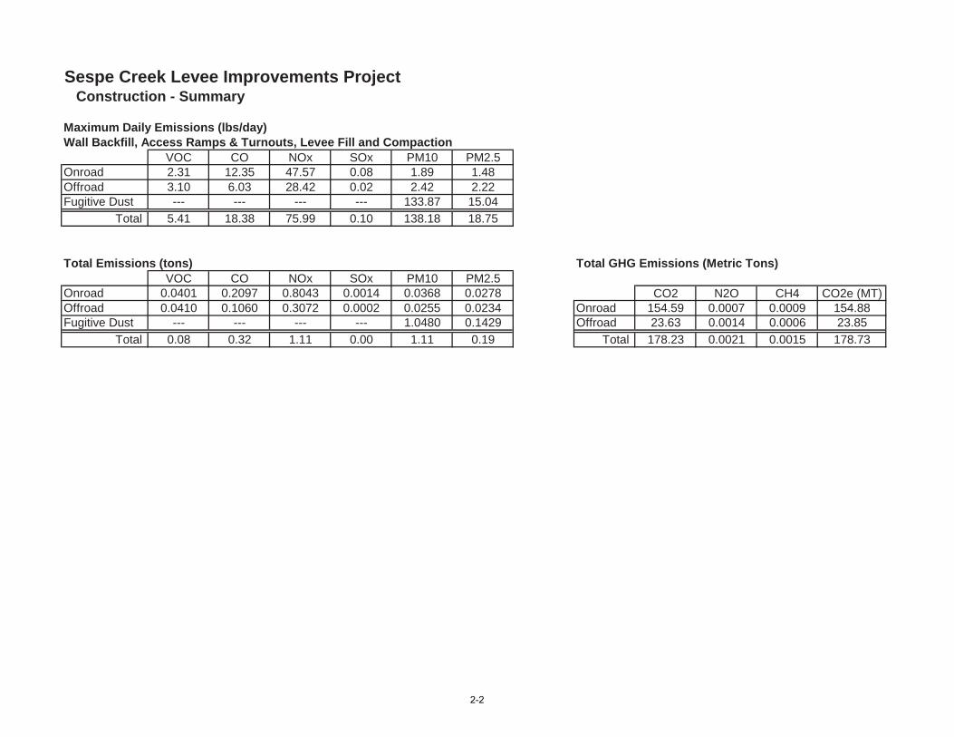
Sespe Creek Levee Improvements Project Construction - Summary
Maximum Daily Emissions (lbs/day)Wall Backfill, Access Ramps & Turnouts, Levee Fill and Compaction
VOC CO NOx SOx PM10 PM2.5Onroad 2.31 12.35 47.57 0.08 1.89 1.48Offroad 3.10 6.03 28.42 0.02 2.42 2.22Fugitive Dust --- --- --- --- 133.87 15.04
Total 5.41 18.38 75.99 0.10 138.18 18.75
Total Emissions (tons) Total GHG Emissions (Metric Tons)VOC CO NOx SOx PM10 PM2.5
Onroad 0.0401 0.2097 0.8043 0.0014 0.0368 0.0278 CO2 N2O CH4 CO2e (MT)Offroad 0.0410 0.1060 0.3072 0.0002 0.0255 0.0234 Onroad 154.59 0.0007 0.0009 154.88Fugitive Dust --- --- --- --- 1.0480 0.1429 Offroad 23.63 0.0014 0.0006 23.85
Total 0.08 0.32 1.11 0.00 1.11 0.19 Total 178.23 0.0021 0.0015 178.73
2-2
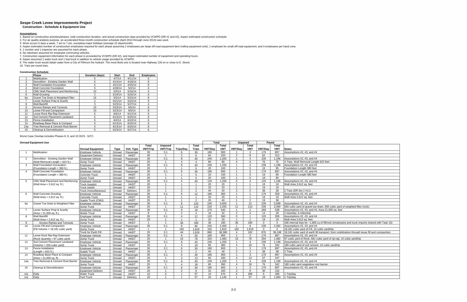
Sespe Creek Levee Improvements Project Construction - Schedule & Equipment Use
Assumptions:1. Based on construction activities/phases, total construction duration, and actual construction days provided by VCWPD (DR #1 and #2), Aspen estimated construction schedule.2. For air quality analysis purpose, an accelerated three-month construction schedule (April 2014 through June 2014) was used.3. Work occurs 5 days a week, 7 am to 7 pm, excepting major holidays (average 22 days/month).4. Aspen estimated number of construction employees required for each phase assuming 2 employees per large off-road equipment item (rolling equipment only), 1 employee for small off-road equipment, and 4 employees per hand crew.5. 1 monitor and 1 inspector are assumed for each phase. 6. No rideshare assumed for employee commuting vehicles.7. Construction equipment information for each phase is provieded by VCWPD (DR #2), and Aspen estimated number of equipment and operating hours.8. Aspen assumed 1 water truck and 1 fuel truck in addition to vehicle usage provided by VCWPD.9. The water truck would obtain water from a City of Fillmore fire hydrant. The most likely one is located near Highway 126 on or close to E. Street. 10. Trips are round trips.
Construction SchedulePhase Duration (days) Start End Employees
1 Mobilization 5 4/7/14 4/11/14 62 Demolition - Existing Garden Wall 5 4/14/14 4/18/14 83 Wall Foundation Excavation 5 4/21/14 4/25/14 84 Wall Concrete Foundation 5 4/28/14 5/2/14 65 CMU Wall Placement and Reinforcing 10 5/5/14 5/16/14 46 Wall Grouting 2 5/19/14 5/20/14 6
6a Gravel Toe Drain & Weighted Filter 15 5/5/14 5/23/14 87 Levee Surface Prep & Scarify 2 5/21/14 5/22/14 98 Wall Backfill 3 5/23/14 5/27/14 49 Access Ramps and Turnouts 10 5/23/14 6/5/14 8
10 Levee Fill and Compaction 10 5/23/14 6/5/14 811 Levee Rock Rip-Rap Extension 5 6/6/14 6/12/14 612 Soil Cement Placement Landward 5 6/13/14 6/20/14 813 Fence Installation 5 6/4/14 6/10/14 614 Roadway Base Place & Compact 5 6/13/14 6/20/14 6
14a Tree Removal & Cement Root Barrier 5 6/13/14 6/20/14 815 Cleanup & Demobilization 5 6/23/14 6/27/14 6
Worst Case Overlap includes Phases 8, 9, and 10 (5/23 - 5/27)
Onroad Equipment Use
Onroad Equipment Type Veh. TypeTotal
VMT/TripUnpaved VMT/Trip Trips/Day
Total Trips VMT/Day
Total VMT VMT/Day
Total VMT VMT/Day
Total VMT Notes
Employee Vehicle Onroad Passenger 30 0.1 6 30 180 900 1 3 179 897 Assumptions #2, #3, and #4Equipment Delivery Onroad HHDT 40 1 2 8 64 320 2 8 62 312Employee Vehicle Onroad Passenger 30 0.1 8 40 240 1,200 1 4 239 1,196 Assumptions #2, #3, and #4Dump Truck Onroad HHDT 20 1 4 4 80 80 4 4 76 76 4 Trips, Wall Removal Length 622 feetEmployee Vehicle Onroad Passenger 30 0.1 8 40 240 1,200 1 4 239 1,196 Assumptions #2, #3, and #4Dump Truck Onroad HHDT 20 1 1 5 20 100 1 5 19 95 Foundation Length 380 feetEmployee Vehicle Onroad Passenger 30 0.1 6 30 180 900 1 3 179 897 Assumptions #2, #3, and #4Concrete Truck Onroad HHDT 20 1 1 5 20 100 1 5 19 95 Foundation Length 380 feetDump Truck Onroad HHDT 20 1 1 5 20 100 1 5 19 95Employee Vehicle Onroad Passenger 30 0.1 4 40 120 1,200 0 4 120 1,196 Assumptions #2, #3, and #4Truck (supply) Onroad HHDT 20 1 1 1 20 20 1 1 19 19 Wall Area 2,612 sq. feetTruck (steel) Onroad HHDT 20 1 1 1 20 20 1 1 19 19Truck (miscellaneous) Onroad Delivery 20 1 2 2 40 40 2 2 38 38 2 Trips (DR Set 2 #11)Employee Vehicle Onroad Passenger 30 0.1 6 12 180 360 1 1 179 359 Assumptions #2, #3, and #4Concrete Truck Onroad HHDT 20 1 1 1 20 20 1 1 19 19 Wall Area 2,612 sq. feetSupply Truck (CMU) Onroad HHDT 20 1 1 2 20 40 1 2 19 38Employee Vehicle Onroad Passenger 30 0.1 8 120 240 3,600 1 12 239 3,588 Assumptions #2, #3, and #4Dump Truck Onroad HHDT 20 1 11 110 220 2,200 11 110 209 2,090 550 cubic yard of gravel toe drain, 550 cubic yard of weighted filter (rock)Employee Vehicle Onroad Passenger 30 0.1 9 18 270 540 1 2 269 538 Assumptions #2, #3, and #4, Area 21,000 sq. feetWaste Truck Onroad HHDT 8 1 2 4 16 32 2 4 14 28 2 trips/day, 6 miles/tripEmployee Vehicle Onroad Passenger 30 0.1 4 12 120 360 0 1 120 359 Assumptions #2, #3, and #4Dump Truck Onroad HHDT 20 1 1 1 20 20 1 1 19 19 Wall Area 2,612 sq. feet
9 Access Ramps and Turnouts Dump Truck Onroad HHDT 1 1 36 180 36 180 36 180 0 0 180 internal trips for ~1,800 cy of fill/rock (employees and truck imports shared with Task 10)Employee Vehicle Onroad Passenger 30 0.1 8 80 240 2,400 1 8 239 2,392 Assumptions #2, #3, and #4Dump Truck Onroad HHDT 1 1 182 1,819 182 1,819 182 1,819 0 0 18,181 cubic yard of Fill, 10 cubic yard/tripTruck for Earth Fill Onroad HHDT 20 0.1 44 1,819 880 36,380 4 182 876 36,198 18,181 cubic yard of earth fill transport, from mobilization through levee fill and compactiionEmployee Vehicle Onroad Passenger 30 0.1 6 30 180 900 1 3 179 897 Assumptions #2, #3, and #4Dump Truck Onroad HHDT 20 1 16 78 320 1,560 16 78 304 1,482 97 cubic yard of Rock, 681 cubic yard of rip-rap, 10 cubic yard/tripEmployee Vehicle Onroad Passenger 30 0.1 8 40 240 1,200 1 4 239 1,196 Assumptions #2, #3, and #4Dump Truck Onroad HHDT 20 1 4 18 80 360 4 18 76 342 180 cubic yard of soil cement, 10 cubic yard/tripEmployee Vehicle Onroad Passenger 30 0.1 6 30 180 900 1 3 179 897 Assumptions #2, #3, and #4Supply Truck Onroad HHDT 20 1 2 2 40 40 2 2 38 38 2 TripsEmployee Vehicle Onroad Passenger 30 0.1 6 30 180 900 1 3 179 897 Assumptions #2, #3, and #4Dump Truck Onroad HHDT 20 1 3 13 60 260 3 13 57 247Employee Vehicle Onroad Passenger 30 0.1 8 40 240 1,200 1 4 239 1,196 Assumptions #2, #3, and #4Dump Truck Onroad HHDT 20 1 4 18 80 360 4 18 76 342 180 cubic yard vegetative root barrierEmployee Vehicle Onroad Passenger 30 0.1 6 30 180 900 1 3 179 897 Assumptions #2, #3, and #4Equipment Delivery Onroad HHDT 20 1 2 8 32 160 2 8 30 152
n/a Daily Water Truck Onroad HHDT 10 5 1 57 10 570 5 285 5 285 1 Trip/dayn/a Daily Fuel Truck Onroad Delivery 20 1 1 57 20 1,140 1 57 19 1,083 1 Trip/day
Unpaved
Levee Fill and Compaction(Fill Volume = 18,181 cubic yard)
Wall Concrete Grouting(Wall Area = 2,612 sq. ft.)
Wall Backfill(Wall Area = 2,612 sq. ft.)
PavedTotal
2
3
1 Mobilization
4
Demolition - Existing Garden Wall(Wall Removal Length = 622 ft.)Wall Foundation Excavation(Foundation Length = 380 ft.)Wall Concrete Foundation(Foundation Length = 380 ft.)
5 CMU Wall Placement and Reinforcing(Wall Area = 2,612 sq. ft.)
15 Cleanup & Demobilization
12 Soil Cement Placement Landward(Volume = 200 cubic yard)
6
8
11 Levee Rock Rip-Rap Extension(Rock Quantity = 97 cubic yard)
Levee Surface Prep & Scarify(Area = 21,000 sq. ft.)
7
10
6a
14a
Gravel Toe Drain & Weighted Filter
Tree Removal & Cement Root Barrier
13 Fence Installation(Length = 622 ft.)
14 Roadway Base Place & Compact(Area = 21,000 sq. ft)
2-3
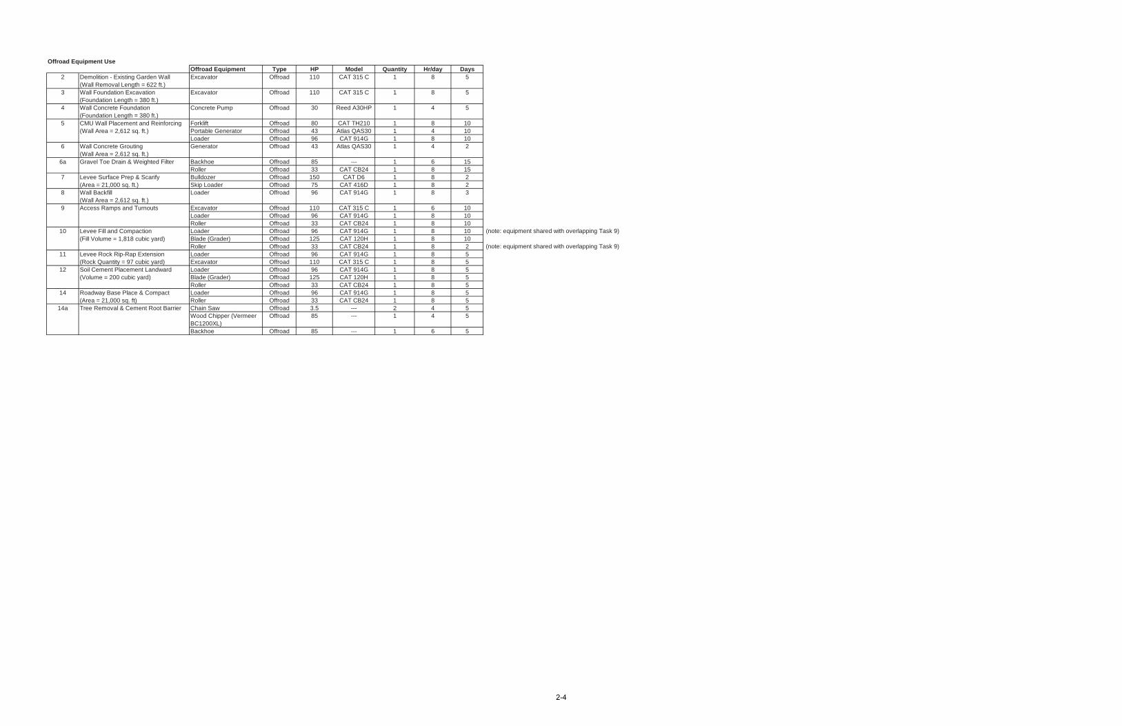
Offroad Equipment UseOffroad Equipment Type HP Model Quantity Hr/day Days
2 Demolition - Existing Garden Wall(Wall Removal Length = 622 ft.)
Excavator Offroad 110 CAT 315 C 1 8 5
3 Wall Foundation Excavation(Foundation Length = 380 ft.)
Excavator Offroad 110 CAT 315 C 1 8 5
4 Wall Concrete Foundation(Foundation Length = 380 ft.)
Concrete Pump Offroad 30 Reed A30HP 1 4 5
Forklift Offroad 80 CAT TH210 1 8 10Portable Generator Offroad 43 Atlas QAS30 1 4 10Loader Offroad 96 CAT 914G 1 8 10
6 Wall Concrete Grouting(Wall Area = 2,612 sq. ft.)
Generator Offroad 43 Atlas QAS30 1 4 2
Backhoe Offroad 85 --- 1 6 15Roller Offroad 33 CAT CB24 1 8 15Bulldozer Offroad 150 CAT D6 1 8 2Skip Loader Offroad 75 CAT 416D 1 8 2
8 Wall Backfill(Wall Area = 2,612 sq. ft.)
Loader Offroad 96 CAT 914G 1 8 3
9 Access Ramps and Turnouts Excavator Offroad 110 CAT 315 C 1 6 10Loader Offroad 96 CAT 914G 1 8 10Roller Offroad 33 CAT CB24 1 8 10Loader Offroad 96 CAT 914G 1 8 10 (note: equipment shared with overlapping Task 9)Blade (Grader) Offroad 125 CAT 120H 1 8 10Roller Offroad 33 CAT CB24 1 8 2 (note: equipment shared with overlapping Task 9)Loader Offroad 96 CAT 914G 1 8 5Excavator Offroad 110 CAT 315 C 1 8 5Loader Offroad 96 CAT 914G 1 8 5Blade (Grader) Offroad 125 CAT 120H 1 8 5Roller Offroad 33 CAT CB24 1 8 5Loader Offroad 96 CAT 914G 1 8 5Roller Offroad 33 CAT CB24 1 8 5Chain Saw Offroad 3.5 --- 2 4 5Wood Chipper (Vermeer BC1200XL)
Offroad 85 --- 1 4 5
Backhoe Offroad 85 --- 1 6 5
14a Tree Removal & Cement Root Barrier
6a Gravel Toe Drain & Weighted Filter
5 CMU Wall Placement and Reinforcing(Wall Area = 2,612 sq. ft.)
14
12
11 Levee Rock Rip-Rap Extension(Rock Quantity = 97 cubic yard)
Levee Fill and Compaction(Fill Volume = 1,818 cubic yard)
10
7 Levee Surface Prep & Scarify(Area = 21,000 sq. ft.)
Soil Cement Placement Landward(Volume = 200 cubic yard)
Roadway Base Place & Compact(Area = 21,000 sq. ft)
2-4
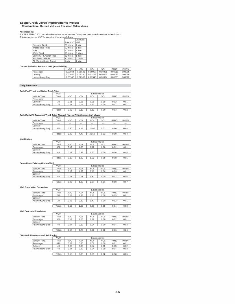
Sespe Creek Levee Improvements Project Construction - Onroad Vehicles Emission Calculations
Assumptions:1. CARB EMFAC 2011 model emission factors for Ventura County are used to estimate on-road emissions.2. Assumptions on VMT for each trip type are as follows:
Total VMTUnpaved VMT
Concrete Truck 20 miles 1 mileWaste Haul Truck 20 miles 1 mileFuel 20 miles 1 mileWater Truck 10 miles 5 milesDelivery, Fill, Other Trips 20 miles 1 mileEmployee Vehicle 30 miles 0.1 mileFill (Onsite Dump Truck) 1 mile 1 mile
Onroad Emission Factors - 2013 (pounds/mile)VOC CO NOx SOx PM10 PM2.5
Passenger 0.00069 0.00581 0.00067 0.00001 0.00011 0.00005Delivery 0.00057 0.00230 0.01422 0.00002 0.00080 0.00058Heavy-Heavy Duty 0.00102 0.00509 0.02343 0.00004 0.00091 0.00072
Daily Emissions
Daily Fuel Truck and Water Truck TripsVMT
Vehicle Type Total VOC CO NOx SOx PM10 PM2.5Passenger --- --- --- --- --- --- ---Delivery 20 0.01 0.05 0.28 0.00 0.02 0.01Heavy-Heavy Duty 10 0.01 0.05 0.23 0.00 0.01 0.01
Totals 0.02 0.10 0.52 0.00 0.03 0.02
Daily Earth Fill Transport Truck Trips Through "Levee Fill & Compaction" phaseVMT
Vehicle Type Total VOC CO NOx SOx PM10 PM2.5Passenger --- --- --- --- --- --- ---Delivery --- --- --- --- --- --- ---Heavy-Heavy Duty 880 0.90 4.48 20.62 0.03 0.80 0.64
Totals 0.90 4.48 20.62 0.03 0.80 0.64
MobilizationVMT
Vehicle Type Total VOC CO NOx SOx PM10 PM2.5Passenger 180 0.12 1.05 0.12 0.00 0.02 0.01Delivery --- --- --- --- --- --- ---Heavy-Heavy Duty 64 0.07 0.33 1.50 0.00 0.06 0.05
Totals 0.19 1.37 1.62 0.00 0.08 0.05
Demolition - Existing Garden WallVMT
Vehicle Type Total VOC CO NOx SOx PM10 PM2.5Passenger 240 0.17 1.39 0.16 0.00 0.03 0.01Delivery --- --- --- --- --- --- ---Heavy-Heavy Duty 80 0.08 0.41 1.87 0.00 0.07 0.06
Totals 0.25 1.80 2.04 0.01 0.10 0.07
Wall Foundation ExcavationVMT
Vehicle Type Total VOC CO NOx SOx PM10 PM2.5Passenger 240 0.17 1.39 0.16 0.00 0.03 0.01Delivery --- --- --- --- --- --- ---Heavy-Heavy Duty 20 0.02 0.10 0.47 0.00 0.02 0.01
Totals 0.19 1.50 0.63 0.00 0.04 0.03
Wall Concrete FoundationVMT
Vehicle Type Total VOC CO NOx SOx PM10 PM2.5Passenger 180 0.12 1.05 0.12 0.00 0.02 0.01Delivery --- --- --- --- --- --- ---Heavy-Heavy Duty 40 0.04 0.20 0.94 0.00 0.04 0.03
Totals 0.17 1.25 1.06 0.00 0.06 0.04
CMU Wall Placement and ReinforcingVMT
Vehicle Type Total VOC CO NOx SOx PM10 PM2.5Passenger 120 0.08 0.70 0.08 0.00 0.01 0.01Delivery 40 0.02 0.09 0.57 0.00 0.03 0.02Heavy-Heavy Duty 40 0.04 0.20 0.94 0.00 0.04 0.03
Totals 0.15 0.99 1.59 0.00 0.08 0.06
Emissions lbs
Emissions lbs
Emissions lbs
Emissions lbs
Emissions lbs
Emissions lbs
Emissions lbs
2-5
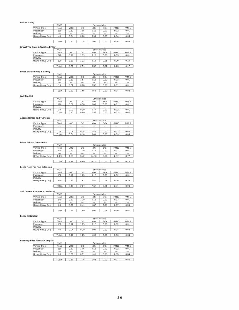
Wall GroutingVMT
Vehicle Type Total VOC CO NOx SOx PM10 PM2.5Passenger 180 0.12 1.05 0.12 0.00 0.02 0.01Delivery --- --- --- --- --- --- ---Heavy-Heavy Duty 40 0.04 0.20 0.94 0.00 0.04 0.03
Totals 0.17 1.25 1.06 0.00 0.06 0.04
Gravel Toe Drain & Weighted FilterVMT
Vehicle Type Total VOC CO NOx SOx PM10 PM2.5Passenger 240 0.17 1.39 0.16 0.00 0.03 0.01Delivery --- --- --- --- --- --- ---Heavy-Heavy Duty 220 0.23 1.12 5.15 0.01 0.20 0.16
Totals 0.39 2.51 5.32 0.01 0.23 0.17
Levee Surface Prep & ScarifyVMT
Vehicle Type Total VOC CO NOx SOx PM10 PM2.5Passenger 270 0.19 1.57 0.18 0.00 0.03 0.01Delivery --- --- --- --- --- --- ---Heavy-Heavy Duty 16 0.02 0.08 0.37 0.00 0.01 0.01
Totals 0.20 1.65 0.56 0.00 0.04 0.02
Wall BackfillVMT
Vehicle Type Total VOC CO NOx SOx PM10 PM2.5Passenger 120 0.08 0.70 0.08 0.00 0.01 0.01Delivery --- --- --- --- --- --- ---Heavy-Heavy Duty 20 0.02 0.10 0.47 0.00 0.02 0.01
Totals 0.10 0.80 0.55 0.00 0.03 0.02
Access Ramps and TurnoutsVMT
Vehicle Type Total VOC CO NOx SOx PM10 PM2.5Passenger --- --- --- --- --- --- ---Delivery --- --- --- --- --- --- ---Heavy-Heavy Duty 36 0.04 0.18 0.84 0.00 0.03 0.03
Totals 0.04 0.18 0.84 0.00 0.03 0.03
Levee Fill and CompactionVMT
Vehicle Type Total VOC CO NOx SOx PM10 PM2.5Passenger 240 0.17 1.39 0.16 0.00 0.03 0.01Delivery --- --- --- --- --- --- ---Heavy-Heavy Duty 1,062 1.09 5.40 24.88 0.04 0.97 0.77
Totals 1.25 6.80 25.04 0.04 1.00 0.78
Levee Rock Rip-Rap ExtensionVMT
Vehicle Type Total VOC CO NOx SOx PM10 PM2.5Passenger 180 0.12 1.05 0.12 0.00 0.02 0.01Delivery --- --- --- --- --- --- ---Heavy-Heavy Duty 320 0.33 1.63 7.50 0.01 0.29 0.23
Totals 0.45 2.67 7.62 0.01 0.31 0.24
Soil Cement Placement LandwardVMT
Vehicle Type Total VOC CO NOx SOx PM10 PM2.5Passenger 240 0.17 1.39 0.16 0.00 0.03 0.01Delivery --- --- --- --- --- --- ---Heavy-Heavy Duty 80 0.08 0.41 1.87 0.00 0.07 0.06
Totals 0.25 1.80 2.04 0.01 0.10 0.07
Fence InstallationVMT
Vehicle Type Total VOC CO NOx SOx PM10 PM2.5Passenger 180 0.12 1.05 0.12 0.00 0.02 0.01Delivery --- --- --- --- --- --- ---Heavy-Heavy Duty 40 0.04 0.20 0.94 0.00 0.04 0.03
Totals 0.17 1.25 1.06 0.00 0.06 0.04
Roadway Base Place & CompactVMT
Vehicle Type Total VOC CO NOx SOx PM10 PM2.5Passenger 180 0.12 1.05 0.12 0.00 0.02 0.01Delivery --- --- --- --- --- --- ---Heavy-Heavy Duty 60 0.06 0.31 1.41 0.00 0.05 0.04
Totals 0.19 1.35 1.53 0.00 0.07 0.05
Emissions lbs
Emissions lbs
Emissions lbs
Emissions lbs
Emissions lbs
Emissions lbs
Emissions lbs
Emissions lbs
Emissions lbs
Emissions lbs
2-6
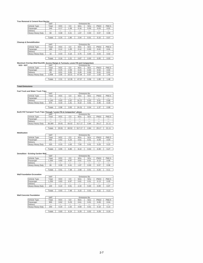
Tree Removal & Cement Root BarrierVMT
Vehicle Type Total VOC CO NOx SOx PM10 PM2.5Passenger 240 0.17 1.39 0.16 0.00 0.03 0.01Delivery --- --- --- --- --- --- ---Heavy-Heavy Duty 80 0.08 0.41 1.87 0.00 0.07 0.06
Totals 0.25 1.80 2.04 0.01 0.10 0.07
Cleanup & DemobilizationVMT
Vehicle Type Total VOC CO NOx SOx PM10 PM2.5Passenger 180 0.12 1.05 0.12 0.00 0.02 0.01Delivery --- --- --- --- --- --- ---Heavy-Heavy Duty 32 0.03 0.16 0.75 0.00 0.03 0.02
Totals 0.16 1.21 0.87 0.00 0.05 0.03
Maximum Overlap (Wall Backfill, Access Ramps & Turnouts, Levee Fill and Compaction) 5/23 - 5/27 VMT
Vehicle Type Total VOC CO NOx SOx PM10 PM2.5Passenger 360 0.25 2.09 0.24 0.00 0.04 0.02Delivery 20 0.01 0.05 0.28 0.00 0.02 0.01Heavy-Heavy Duty 2,008 2.05 10.21 47.04 0.07 1.83 1.45
Totals 2.31 12.35 47.57 0.08 1.89 1.48
Total Emissions
Fuel Truck and Water Truck TripsVMT
Vehicle Type Total VOC CO NOx SOx PM10 PM2.5Passenger --- --- --- --- --- --- ---Delivery 1,140 0.65 2.62 16.21 0.03 0.91 0.66Heavy-Heavy Duty 570 0.33 1.31 8.10 0.01 0.46 0.33
Totals 0.98 3.93 24.31 0.04 1.37 0.99
Earth Fill Transport Truck Trips Through "Levee Fill & Compaction" phaseVMT
Vehicle Type Total VOC CO NOx SOx PM10 PM2.5Passenger --- --- --- --- --- --- ---Delivery --- --- --- --- --- --- ---Heavy-Heavy Duty 36,380 20.81 83.52 517.17 0.84 29.17 21.11
Totals 20.81 83.52 517.17 0.84 29.17 21.11
MobilizationVMT
Vehicle Type Total VOC CO NOx SOx PM10 PM2.5Passenger 900 0.62 5.23 0.61 0.01 0.09 0.04Delivery --- --- --- --- --- --- ---Heavy-Heavy Duty 320 0.33 1.63 7.50 0.01 0.29 0.23
Totals 0.95 6.85 8.10 0.02 0.39 0.27
Demolition - Existing Garden WallVMT
Vehicle Type Total VOC CO NOx SOx PM10 PM2.5Passenger 1,200 0.83 6.97 0.81 0.01 0.13 0.05Delivery --- --- --- --- --- --- ---Heavy-Heavy Duty 80 0.08 0.41 1.87 0.00 0.07 0.06
Totals 0.91 7.38 2.68 0.01 0.20 0.11
Wall Foundation ExcavationVMT
Vehicle Type Total VOC CO NOx SOx PM10 PM2.5Passenger 1,200 0.83 6.97 0.81 0.01 0.13 0.05Delivery --- --- --- --- --- --- ---Heavy-Heavy Duty 100 0.10 0.51 2.34 0.00 0.09 0.07
Totals 0.93 7.48 3.15 0.01 0.22 0.13
Wall Concrete FoundationVMT
Vehicle Type Total VOC CO NOx SOx PM10 PM2.5Passenger 900 0.62 5.23 0.61 0.01 0.09 0.04Delivery --- --- --- --- --- --- ---Heavy-Heavy Duty 200 0.20 1.02 4.69 0.01 0.18 0.14
Totals 0.83 6.24 5.29 0.02 0.28 0.19
Emissions lbs
Emissions lbs
Emissions lbs
Emissions lbs
Emissions lbs
Emissions lbs
Emissions lbs
Emissions lbs
Emissions lbs
2-7
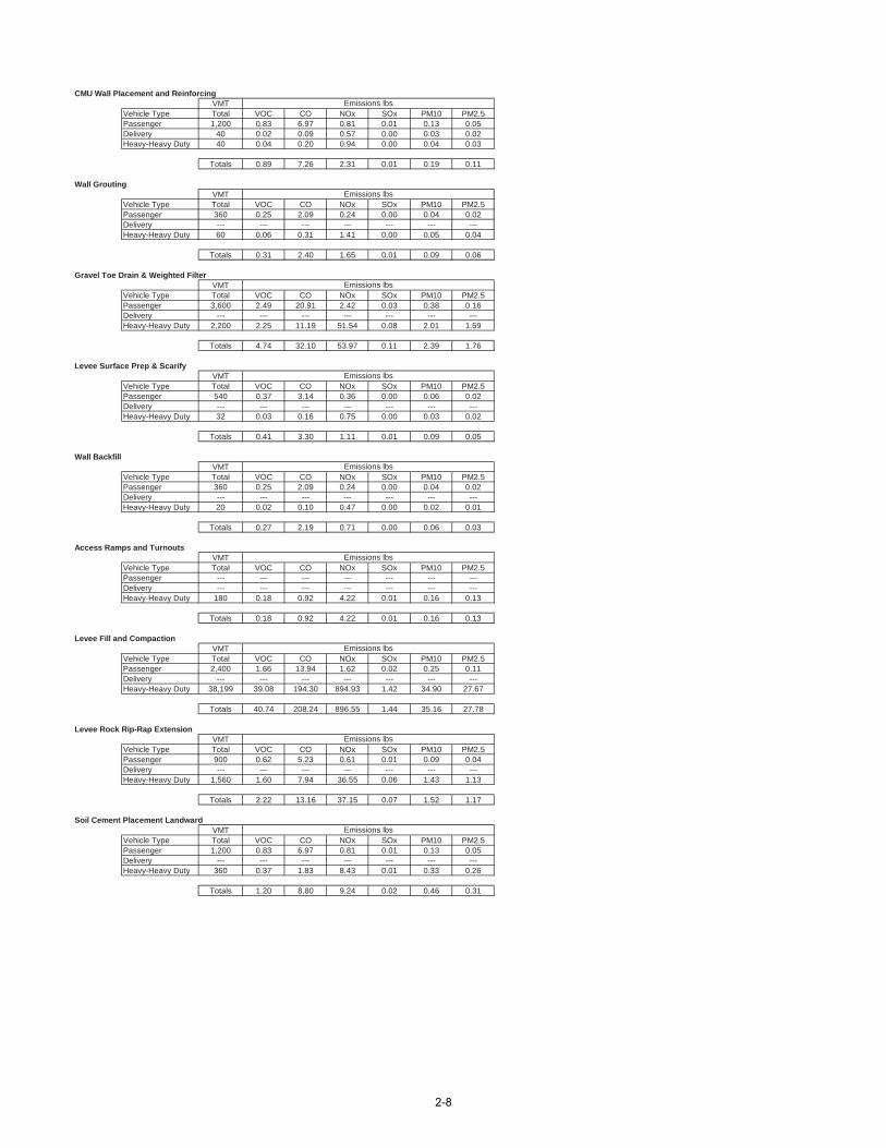
CMU Wall Placement and ReinforcingVMT
Vehicle Type Total VOC CO NOx SOx PM10 PM2.5Passenger 1,200 0.83 6.97 0.81 0.01 0.13 0.05Delivery 40 0.02 0.09 0.57 0.00 0.03 0.02Heavy-Heavy Duty 40 0.04 0.20 0.94 0.00 0.04 0.03
Totals 0.89 7.26 2.31 0.01 0.19 0.11
Wall GroutingVMT
Vehicle Type Total VOC CO NOx SOx PM10 PM2.5Passenger 360 0.25 2.09 0.24 0.00 0.04 0.02Delivery --- --- --- --- --- --- ---Heavy-Heavy Duty 60 0.06 0.31 1.41 0.00 0.05 0.04
Totals 0.31 2.40 1.65 0.01 0.09 0.06
Gravel Toe Drain & Weighted FilterVMT
Vehicle Type Total VOC CO NOx SOx PM10 PM2.5Passenger 3,600 2.49 20.91 2.42 0.03 0.38 0.16Delivery --- --- --- --- --- --- ---Heavy-Heavy Duty 2,200 2.25 11.19 51.54 0.08 2.01 1.59
Totals 4.74 32.10 53.97 0.11 2.39 1.76
Levee Surface Prep & ScarifyVMT
Vehicle Type Total VOC CO NOx SOx PM10 PM2.5Passenger 540 0.37 3.14 0.36 0.00 0.06 0.02Delivery --- --- --- --- --- --- ---Heavy-Heavy Duty 32 0.03 0.16 0.75 0.00 0.03 0.02
Totals 0.41 3.30 1.11 0.01 0.09 0.05
Wall BackfillVMT
Vehicle Type Total VOC CO NOx SOx PM10 PM2.5Passenger 360 0.25 2.09 0.24 0.00 0.04 0.02Delivery --- --- --- --- --- --- ---Heavy-Heavy Duty 20 0.02 0.10 0.47 0.00 0.02 0.01
Totals 0.27 2.19 0.71 0.00 0.06 0.03
Access Ramps and TurnoutsVMT
Vehicle Type Total VOC CO NOx SOx PM10 PM2.5Passenger --- --- --- --- --- --- ---Delivery --- --- --- --- --- --- ---Heavy-Heavy Duty 180 0.18 0.92 4.22 0.01 0.16 0.13
Totals 0.18 0.92 4.22 0.01 0.16 0.13
Levee Fill and CompactionVMT
Vehicle Type Total VOC CO NOx SOx PM10 PM2.5Passenger 2,400 1.66 13.94 1.62 0.02 0.25 0.11Delivery --- --- --- --- --- --- ---Heavy-Heavy Duty 38,199 39.08 194.30 894.93 1.42 34.90 27.67
Totals 40.74 208.24 896.55 1.44 35.16 27.78
Levee Rock Rip-Rap ExtensionVMT
Vehicle Type Total VOC CO NOx SOx PM10 PM2.5Passenger 900 0.62 5.23 0.61 0.01 0.09 0.04Delivery --- --- --- --- --- --- ---Heavy-Heavy Duty 1,560 1.60 7.94 36.55 0.06 1.43 1.13
Totals 2.22 13.16 37.15 0.07 1.52 1.17
Soil Cement Placement LandwardVMT
Vehicle Type Total VOC CO NOx SOx PM10 PM2.5Passenger 1,200 0.83 6.97 0.81 0.01 0.13 0.05Delivery --- --- --- --- --- --- ---Heavy-Heavy Duty 360 0.37 1.83 8.43 0.01 0.33 0.26
Totals 1.20 8.80 9.24 0.02 0.46 0.31
Emissions lbs
Emissions lbs
Emissions lbs
Emissions lbs
Emissions lbs
Emissions lbs
Emissions lbs
Emissions lbs
Emissions lbs
2-8
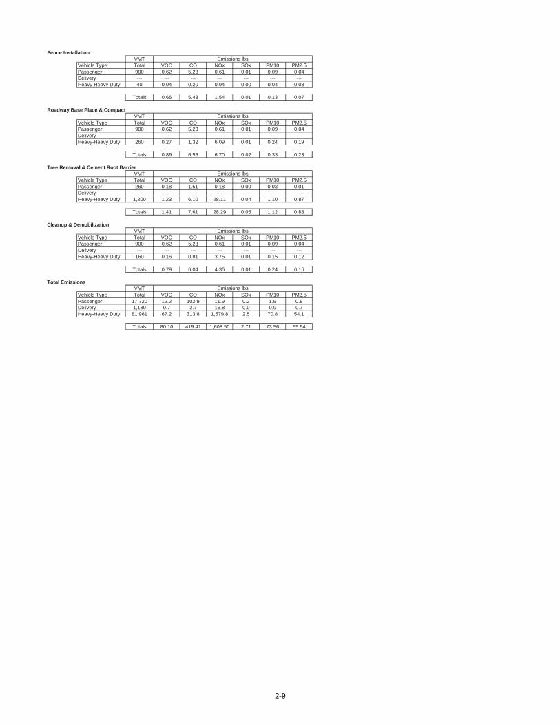
Fence InstallationVMT
Vehicle Type Total VOC CO NOx SOx PM10 PM2.5Passenger 900 0.62 5.23 0.61 0.01 0.09 0.04Delivery --- --- --- --- --- --- ---Heavy-Heavy Duty 40 0.04 0.20 0.94 0.00 0.04 0.03
Totals 0.66 5.43 1.54 0.01 0.13 0.07
Roadway Base Place & CompactVMT
Vehicle Type Total VOC CO NOx SOx PM10 PM2.5Passenger 900 0.62 5.23 0.61 0.01 0.09 0.04Delivery --- --- --- --- --- --- ---Heavy-Heavy Duty 260 0.27 1.32 6.09 0.01 0.24 0.19
Totals 0.89 6.55 6.70 0.02 0.33 0.23
Tree Removal & Cement Root BarrierVMT
Vehicle Type Total VOC CO NOx SOx PM10 PM2.5Passenger 260 0.18 1.51 0.18 0.00 0.03 0.01Delivery --- --- --- --- --- --- ---Heavy-Heavy Duty 1,200 1.23 6.10 28.11 0.04 1.10 0.87
Totals 1.41 7.61 28.29 0.05 1.12 0.88
Cleanup & DemobilizationVMT
Vehicle Type Total VOC CO NOx SOx PM10 PM2.5Passenger 900 0.62 5.23 0.61 0.01 0.09 0.04Delivery --- --- --- --- --- --- ---Heavy-Heavy Duty 160 0.16 0.81 3.75 0.01 0.15 0.12
Totals 0.79 6.04 4.35 0.01 0.24 0.16
Total EmissionsVMT
Vehicle Type Total VOC CO NOx SOx PM10 PM2.5Passenger 17,720 12.2 102.9 11.9 0.2 1.9 0.8Delivery 1,180 0.7 2.7 16.8 0.0 0.9 0.7Heavy-Heavy Duty 81,961 67.2 313.8 1,579.8 2.5 70.8 54.1
Totals 80.10 419.41 1,608.50 2.71 73.56 55.54
Emissions lbs
Emissions lbs
Emissions lbs
Emissions lbs
Emissions lbs
2-9

Sespe Creek Levee Improvements Project Construction - Offroad Equipment Emission Calculations
Assumptions:1. CARB OFFROAD model emission factors in Ventura County are used to estimate ROG, NOx, SOx, and PM emissions for off-road equipment, except for the concrete pump and generators.2. 2013 SCAQMD CEQA website emission factors are used for CO for all offroad equipment.3. For the concrete pump and generators 2013 SCAQMD CEQA website emission factors are used for all criteria pollutants.
Offroad Emission Factors - 2013 (pounds/hour)Off-road Emission Factor - lbs/hour *
ROG CO NOx SOx PM Hrs/day Days2 Demolition - Existing Garden Wall Excavator 110 0.3819 1 0.0412 0.1849 0.4978 0.0005 0.0375 8 53 Wall Foundation Excavation Excavator 110 0.3819 1 0.0412 0.1849 0.4978 0.0005 0.0375 8 54 Wall Concrete Foundation Concrete Pump 30 1.0000 1 0.0497 0.1426 0.2055 0.0003 0.0142 4 5
Forklift 80 0.2010 1 0.0247 0.0374 0.2571 0.0002 0.0215 8 10 Gasoline Equipment Emission Factor RatesPortable Generator 43 1.0000 1 0.0702 0.2154 0.2496 0.0003 0.0194 4 10Loader 96 0.3618 1 0.0581 0.1439 0.5751 0.0004 0.0503 8 10
6 Wall Concrete Grouting Generator 43 1.0000 1 0.0702 0.2154 0.2496 0.0003 0.0194 4 2 ROG CO NOx SOx PM CO2Gravel Toe Drain & Weighted Filter Backhoe 85 0.3685 1 0.0354 0.1239 0.4069 0.0003 0.0324 6 15 g/hp-hr 46.4 158.88 1.92 0.0036 0.25 429.44
Roller 33 0.3752 1 0.0304 0.0490 0.1502 0.0002 0.0137 8 15 lbs/hp-hr 0.102293 0.350265 0.004233 7.94E-06 0.000551 0.946737Levee Surface Prep & Scarify Bulldozer 150 0.3953 1 0.1034 0.2342 1.2841 0.0007 0.0733 8 2
Skip Loader 75 0.3685 1 0.0313 0.1222 0.3590 0.0003 0.0286 8 28 Wall Backfill Loader 96 0.3618 1 0.0581 0.1439 0.5751 0.0004 0.0503 8 39 Access Ramps and Turnouts Excavator 110 0.3819 1 0.0412 0.0000 0.4978 0.0005 0.0375 6 10
Loader 96 0.3618 1 0.0581 0.1439 0.5751 0.0004 0.0503 8 10Roller 33 0.3752 1 0.0304 0.0490 0.1502 0.0002 0.0137 8 10Loader 96 0.3618 1 0.0581 0.1439 0.5751 0.0004 0.0503 8 10Blade (Grader) 125 0.4087 1 0.1211 0.2246 1.1536 0.0006 0.0957 8 10Roller 33 0.3752 1 0.0304 0.0490 0.1502 0.0002 0.0137 8 2Loader 96 0.3618 1 0.0581 0.1439 0.5751 0.0004 0.0503 8 5Excavator 110 0.3819 1 0.0412 0.1849 0.4978 0.0005 0.0375 8 5Loader 96 0.3618 1 0.0581 0.1439 0.5751 0.0004 0.0503 8 5Blade (Grader) 125 0.4087 1 0.1211 0.2246 1.1536 0.0006 0.0957 8 5Roller 33 0.3752 1 0.0304 0.0490 0.1502 0.0002 0.0137 8 5Loader 96 0.3618 1 0.0581 0.1439 0.5751 0.0004 0.0503 8 5Roller 33 0.3752 1 0.0304 0.0490 0.1502 0.0002 0.0137 8 5Chain Saw 4 1.0000 2 0.3580 1.2259 0.0148 0.0000 0.0019 4 5Wood Chipper (Vermeer BC1200XL) 85 1.0000 1 0.0850 0.3613 0.4362 0.0004 0.0396 4 5
Backhoe 85 0.3685 1 0.0354 0.1239 0.4069 0.0003 0.0324 6 5**Gasoline equipment emission factors are estimated based on the rate in g/hp-hr provided in the Gasoline Equipment Emission Factor Rates table for EPA/ARB compliant four-cycle engines.
Emission Factor lbs/hour Daily Emissions lbs Total Emissions lbsDemolition - Existing Garden Wall (2) HP Number ROG CO NOx SOx PM Hours/day ROG CO NOx SOx PM Days ROG CO NOx SOx PM
Excavator 110 1 0.0412 0.1849 0.4978 0.0005 0.0375 8 0.33 1.48 3.98 0.00 0.30 5 1.65 7.40 19.91 0.02 1.500.33 1.48 3.98 0.00 0.30 1.65 7.40 19.91 0.02 1.50
Emission Factor lbs/hour Daily Emissions lbs Total Emissions lbsWall Foundation Excavation (3) HP Number ROG CO NOx SOx PM Hours/day ROG CO NOx SOx PM Days ROG CO NOx SOx PM
Excavator 110 1 0.0412 0.1849 0.4978 0.0005 0.0375 8 0.33 1.48 3.98 0.00 0.30 5 1.65 7.40 19.91 0.02 1.500.33 1.48 3.98 0.00 0.30 1.65 7.40 19.91 0.02 1.50
Emission Factor lbs/hour Daily Emissions lbs Total Emissions lbsWall Concrete Foundation (4) HP Number ROG CO NOx SOx PM Hours/day ROG CO NOx SOx PM Days ROG CO NOx SOx PM
Concrete Pump 30 1 0.0497 0.1426 0.2055 0.0003 0.0142 4 0.20 0.57 0.82 0.00 0.06 5 0.99 2.85 4.11 0.01 0.280.20 0.57 0.82 0.00 0.06 0.99 2.85 4.11 0.01 0.28
Emission Factor lbs/hour Daily Emissions lbs Total Emissions lbsCMU Wall Placement and Reinforcing (5) HP Number ROG CO NOx SOx PM Hours/day ROG CO NOx SOx PM Days ROG CO NOx SOx PM
Forklift 80 1 0.0247 0.0374 0.2571 0.0002 0.0215 8 0.20 0.30 2.06 0.00 0.17 10 1.98 2.99 20.57 0.01 1.72Portable Generator 43 1 0.0702 0.2154 0.2496 0.0003 0.0194 4 0.28 0.86 1.00 0.00 0.08 10 2.81 8.62 9.98 0.01 0.78Loader 96 1 0.0581 0.1439 0.5751 0.0004 0.0503 8 0.47 1.15 4.60 0.00 0.40 10 4.65 11.51 46.01 0.03 4.02
0.94 2.31 7.66 0.01 0.65 9.44 23.12 76.56 0.06 6.52
Emission Factor lbs/hour Daily Emissions lbs Total Emissions lbsWall Concrete Grouting (6) HP Number ROG CO NOx SOx PM Hours/day ROG CO NOx SOx PM Days ROG CO NOx SOx PM
Generator 43 1 0.0702 0.2154 0.2496 0.0003 0.0194 4 0.28 0.86 1.00 0.00 0.08 2 0.56 1.72 2.00 0.00 0.160.28 0.86 1.00 0.00 0.08 0.56 1.72 2.00 0.00 0.16
14a
Tree Removal & Cement Root Barrier
Levee Rock Rip-Rap Extension
Soil Cement Placement Landward
Roadway Base Place & Compact14
CMU Wall Placement and Reinforcing
Levee Fill and Compaction
HP LoadFactor Number
5
10
11
12
7
6a
2-10
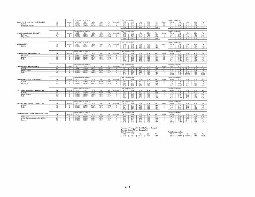
Emission Factor lbs/hour Daily Emissions lbs Total Emissions lbsGravel Toe Drain & Weighted Filter (6a) HP Number ROG CO NOx SOx PM Hours/day ROG CO NOx SOx PM Days ROG CO NOx SOx PM
Forklift 85 1 0.0354 0.1239 0.4069 0.0003 0.0324 6 0.21 0.74 2.44 0.00 0.19 15 3.19 11.16 36.62 0.03 2.92Portable Generator 33 1 0.0304 0.0490 0.1502 0.0002 0.0137 8 0.24 0.39 1.20 0.00 0.11 15 3.64 5.88 18.03 0.02 1.64
0.46 1.14 3.64 0.00 0.30 6.83 17.03 54.65 0.05 4.56
Emission Factor lbs/hour Daily Emissions lbs Total Emissions lbsLevee Surface Prep & Scarify (7) HP Number ROG CO NOx SOx PM Hours/day ROG CO NOx SOx PM Days ROG CO NOx SOx PM
Bulldozer 150 1 0.1034 0.2342 1.2841 0.0007 0.0733 8 0.83 1.87 10.27 0.01 0.59 2 1.65 3.75 20.55 0.01 1.17Skip Loader 75 1 0.0313 0.1222 0.3590 0.0003 0.0286 8 0.25 0.98 2.87 0.00 0.23 2 0.50 1.96 5.74 0.00 0.46
1.08 2.85 13.15 0.01 0.82 2.15 5.70 26.29 0.02 1.63
Emission Factor lbs/hour Daily Emissions lbs Total Emissions lbsWall Backfill (8) HP Number ROG CO NOx SOx PM Hours/day ROG CO NOx SOx PM Days ROG CO NOx SOx PM
Loader 96 1 0.0581 0.1439 0.5751 0.0004 0.0503 8 0.47 1.15 4.60 0.00 0.40 3 1.40 3.45 13.80 0.01 1.210.47 1.15 4.60 0.00 0.40 1.40 3.45 13.80 0.01 1.21
Emission Factor lbs/hour Daily Emissions lbs Total Emissions lbsAccess Ramps and Turnouts (9) HP Number ROG CO NOx SOx PM Hours/day ROG CO NOx SOx PM Days ROG CO NOx SOx PM
Excavator 110 1 0.0412 0.0000 0.4978 0.0005 0.0375 6 0.25 0.00 2.99 0.00 0.22 10 2.47 0.00 29.87 0.03 2.25Loader 96 1 0.0581 0.1439 0.5751 0.0004 0.0503 8 0.47 1.15 4.60 0.00 0.40 10 4.65 11.51 46.01 0.03 4.02Roller 33 1 0.0304 0.0490 0.1502 0.0002 0.0137 8 0.24 0.39 1.20 0.00 0.11 10 2.43 3.92 12.02 0.01 1.09
0.95 1.54 8.79 0.01 0.74 9.55 15.43 87.89 0.07 7.37
Emission Factor lbs/hour Daily Emissions lbs Total Emissions lbsLevee Fill and Compaction (10) HP Number ROG CO NOx SOx PM Hours/day ROG CO NOx SOx PM Days ROG CO NOx SOx PM
Loader 96 1 0.0581 0.1439 0.5751 0.0004 0.0503 8 0.47 1.15 4.60 0.00 0.40 10 4.65 11.51 46.01 0.03 4.02Blade (Grader) 125 1 0.1211 0.2246 1.1536 0.0006 0.0957 8 0.97 1.80 9.23 0.00 0.77 10 9.69 17.97 92.29 0.04 7.65Roller 33 1 0.0304 0.0490 0.1502 0.0002 0.0137 8 0.24 0.39 1.20 0.00 0.11 2 0.49 0.78 2.40 0.00 0.22
1.68 3.34 15.03 0.01 1.28 14.83 30.26 140.70 0.08 11.90
Emission Factor lbs/hour Daily Emissions lbs Total Emissions lbsLevee Rock Rip-Rap Extension (11) HP Number ROG CO NOx SOx PM Hours/day ROG CO NOx SOx PM Days ROG CO NOx SOx PM
Loader 96 1 0.0581 0.1439 0.5751 0.0004 0.0503 8 0.47 1.15 4.60 0.00 0.40 5 2.33 5.76 23.00 0.02 2.01Excavator 110 1 0.0412 0.1849 0.4978 0.0005 0.0375 8 0.33 1.48 3.98 0.00 0.30 5 1.65 7.40 19.91 0.02 1.50
0.79 2.63 8.58 0.01 0.70 3.97 13.15 42.92 0.03 3.51
Emission Factor lbs/hour Daily Emissions lbs Total Emissions lbsSoil Cement Placement Landward (12) HP Number ROG CO NOx SOx PM Hours/day ROG CO NOx SOx PM Days ROG CO NOx SOx PM
Loader 96 1 0.0581 0.1439 0.5751 0.0004 0.0503 8 0.47 1.15 4.60 0.00 0.40 5 2.33 5.76 23.00 0.02 2.01Blade (Grader) 125 1 0.1211 0.2246 1.1536 0.0006 0.0957 8 0.97 1.80 9.23 0.00 0.77 5 4.85 8.98 46.14 0.02 3.83Roller 33 1 0.0304 0.0490 0.1502 0.0002 0.0137 8 0.24 0.39 1.20 0.00 0.11 5 1.21 1.96 6.01 0.01 0.55
1.68 3.34 15.03 0.01 1.28 8.39 16.70 75.16 0.04 6.38
Emission Factor lbs/hour Daily Emissions lbs Total Emissions lbsRoadway Base Place & Compact (14) HP Number ROG CO NOx SOx PM Hours/day ROG CO NOx SOx PM Days ROG CO NOx SOx PM
Loader 96 1 0.0581 0.1439 0.5751 0.0004 0.0503 8 0.47 1.15 4.60 0.00 0.40 5 2.33 5.76 23.00 0.02 2.01Roller 33 1 0.0304 0.0490 0.1502 0.0002 0.0137 8 0.24 0.39 1.20 0.00 0.11 5 1.21 1.96 6.01 0.01 0.55
0.71 1.54 5.80 0.00 0.51 3.54 7.71 29.01 0.02 2.56
Emission Factor lbs/hour Daily Emissions lbs Total Emissions lbsHP Number ROG CO NOx SOx PM Hours/day ROG CO NOx SOx PM Days ROG CO NOx SOx PM
Chain Saw 4 2 0.3580 1.2259 0.0148 0.0000 0.0019 4 2.86 9.81 0.12 0.00 0.02 5 14.32 49.04 0.59 0.00 0.08Wood Chipper (Vermeer BC1200XL) 85 1 0.0850 0.3613 0.4362 0.0004 0.0396 4 0.34 1.45 1.74 0.00 0.16 5 1.70 7.23 8.72 0.01 0.79Backhoe 85 1 0.0354 0.1239 0.4069 0.0003 0.0324 6 0.21 0.74 2.44 0.00 0.19 5 1.06 3.72 12.21 0.01 0.97
3.42 12.00 4.30 0.00 0.37 17.08 59.98 21.52 0.02 1.84
Maximum Overlap (Wall Backfill, Access Ramps &Turnouts, Levee Fill and Compaction)Daily Emissions lbs Total Emissions lbs
ROG CO NOx SOx PM ROG CO NOx SOx PM3.10 6.03 28.42 0.02 2.42 82.02 211.91 614.43 0.44 50.91
Tree Removal & Cement Root Barrier (14a)
2-11
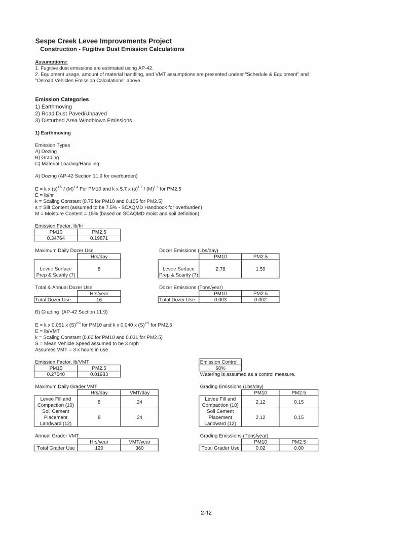
Sespe Creek Levee Improvements Project Construction - Fugitive Dust Emission Calculations
Assumptions:
Emission Categories1) Earthmoving2) Road Dust Paved/Unpaved3) Disturbed Area Windblown Emissions
1) Earthmoving
Emission TypesA) DozingB) GradingC) Material Loading/Handling
A) Dozing (AP-42 Section 11.9 for overburden)
E = k x (s)1.5 / (M)1.4 For PM10 and k x 5.7 x (s)1.2 / (M)1.3 for PM2.5E = lb/hrk = Scaling Constant (0.75 for PM10 and 0.105 for PM2.5)s = Silt Content (assumed to be 7.5% - SCAQMD Handbook for overburden)M = Moisture Content = 15% (based on SCAQMD moist and soil definition)
Emission Factor, lb/hrPM10 PM2.5
0.34764 0.19871
Maximum Daily Dozer Use Dozer Emissions (Lbs/day)Hrs/day PM10 PM2.5
Levee Surface Prep & Scarify (7)
8 Levee Surface Prep & Scarify (7)
2.78 1.59
Total & Annual Dozer Use Dozer Emissions (Tons/year)Hrs/year PM10 PM2.5
Total Dozer Use 16 Total Dozer Use 0.003 0.002
B) Grading (AP-42 Section 11.9)
E = k x 0.051 x (S)2.0 for PM10 and k x 0.040 x (S)2.5 for PM2.5E = lb/VMTk = Scaling Constant (0.60 for PM10 and 0.031 for PM2.5)S = Mean Vehicle Speed assumed to be 3 mphAssumes VMT = 3 x hours in use
Emission Factor, lb/VMT Emission ControlPM10 PM2.5 68%
0.27540 0.01933 Watering is assumed as a control measure.
Maximum Daily Grader VMT Grading Emissions (Lbs/day)Hrs/day VMT/day PM10 PM2.5
Levee Fill and Compaction (10) 8 24 Levee Fill and
Compaction (10) 2.12 0.15
Soil Cement Placement
Landward (12)8 24
Soil Cement Placement
Landward (12)2.12 0.15
Annual Grader VMT Grading Emissions (Tons/year)Hrs/year VMT/year PM10 PM2.5
Total Grader Use 120 360 Total Grader Use 0.02 0.00
1. Fugitive dust emissions are estimated using AP-42.2. Equipment usage, amount of material handling, and VMT assumptions are presented undeer "Schedule & Equipment" and "Onroad Vehicles Emission Calculations" above.
2-12
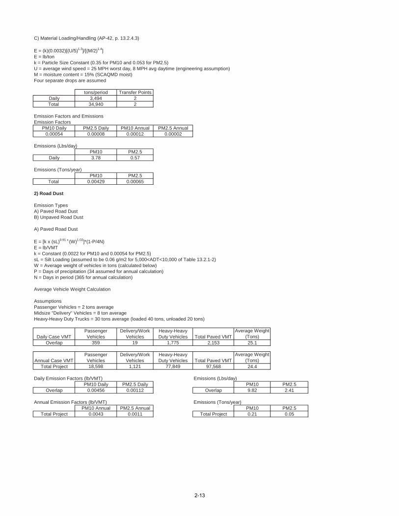
C) Material Loading/Handling (AP-42, p. 13.2.4.3)
E = (k)(0.0032)[(U/5)1.3]/[(M/2)1.4]E = lb/tonk = Particle Size Constant (0.35 for PM10 and 0.053 for PM2.5)U = average wind speed = 25 MPH worst day, 8 MPH avg daytime (engineering assumption)M = moisture content = 15% (SCAQMD moist)Four separate drops are assumed
tons/period Transfer PointsDaily 3,494 2Total 34,940 2
Emission Factors and EmissionsEmission Factors
PM10 Daily PM2.5 Daily PM10 Annual PM2.5 Annual0.00054 0.00008 0.00012 0.00002
Emissions (Lbs/day)PM10 PM2.5
Daily 3.78 0.57
Emissions (Tons/year)PM10 PM2.5
Total 0.00429 0.00065
2) Road Dust
Emission TypesA) Paved Road DustB) Unpaved Road Dust
A) Paved Road Dust
E = [k x (sL)0.91 x (W)1.02]*(1-P/4N)E = lb/VMTk = Constant (0.0022 for PM10 and 0.00054 for PM2.5)sL = Silt Loading (assumed to be 0.06 g/m2 for 5,000<ADT<10,000 of Table 13.2.1-2)W = Average weight of vehicles in tons (calculated below)P = Days of precipitation (34 assumed for annual calculation)N = Days in period (365 for annual calculation)
Average Vehicle Weight Calculation
AssumptionsPassenger Vehicles = 2 tons averageMidsize "Delivery" Vehicles = 8 ton averageHeavy-Heavy Duty Trucks = 30 tons average (loaded 40 tons, unloaded 20 tons)
Overlap 359 19 1,775 2,153 25.1
Total Project 18,598 1,121 77,849 97,568 24.4
Daily Emission Factors (lb/VMT) Emissions (Lbs/day)PM10 Daily PM2.5 Daily PM10 PM2.5
Overlap 0.00456 0.00112 Overlap 9.82 2.41
Annual Emission Factors (lb/VMT) Emissions (Tons/year)PM10 Annual PM2.5 Annual PM10 PM2.5
Total Project 0.0043 0.0011 Total Project 0.21 0.05
Total Paved VMTAverage Weight
(Tons)
Annual Case VMTPassenger Vehicles
Delivery/Work Vehicles
Heavy-Heavy Duty Vehicles Total Paved VMT
Average Weight (Tons)
Daily Case VMTPassenger Vehicles
Delivery/Work Vehicles
Heavy-Heavy Duty Vehicles
2-13
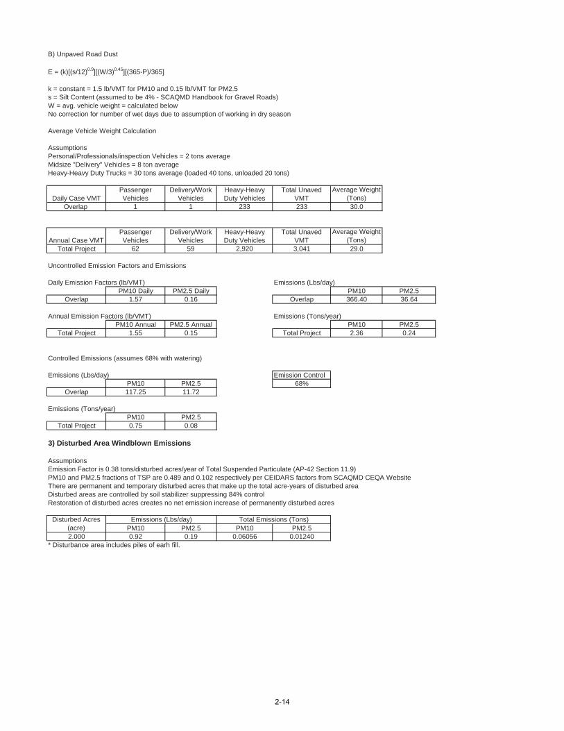
B) Unpaved Road Dust
E = (k)[(s/12)0.9][(W/3)0.45][(365-P)/365]
k = constant = 1.5 lb/VMT for PM10 and 0.15 lb/VMT for PM2.5s = Silt Content (assumed to be 4% - SCAQMD Handbook for Gravel Roads)W = avg. vehicle weight = calculated belowNo correction for number of wet days due to assumption of working in dry season
Average Vehicle Weight Calculation
AssumptionsPersonal/Professionals/inspection Vehicles = 2 tons averageMidsize "Delivery" Vehicles = 8 ton averageHeavy-Heavy Duty Trucks = 30 tons average (loaded 40 tons, unloaded 20 tons)
Overlap 1 1 233 233 30.0
Total Project 62 59 2,920 3,041 29.0
Uncontrolled Emission Factors and Emissions
Daily Emission Factors (lb/VMT) Emissions (Lbs/day)PM10 Daily PM2.5 Daily PM10 PM2.5
Overlap 1.57 0.16 Overlap 366.40 36.64
Annual Emission Factors (lb/VMT) Emissions (Tons/year)PM10 Annual PM2.5 Annual PM10 PM2.5
Total Project 1.55 0.15 Total Project 2.36 0.24
Controlled Emissions (assumes 68% with watering)
Emissions (Lbs/day) Emission ControlPM10 PM2.5 68%
Overlap 117.25 11.72
Emissions (Tons/year)PM10 PM2.5
Total Project 0.75 0.08
3) Disturbed Area Windblown Emissions
AssumptionsEmission Factor is 0.38 tons/disturbed acres/year of Total Suspended Particulate (AP-42 Section 11.9)PM10 and PM2.5 fractions of TSP are 0.489 and 0.102 respectively per CEIDARS factors from SCAQMD CEQA WebsiteThere are permanent and temporary disturbed acres that make up the total acre-years of disturbed areaDisturbed areas are controlled by soil stabilizer suppressing 84% controlRestoration of disturbed acres creates no net emission increase of permanently disturbed acres
PM10 PM2.5 PM10 PM2.52.000 0.92 0.19 0.06056 0.01240
* Disturbance area includes piles of earh fill.
Disturbed Acres (acre)
Total Emissions (Tons)Emissions (Lbs/day)
Average Weight (Tons)
Passenger Vehicles
Delivery/Work Vehicles
Heavy-Heavy Duty Vehicles
Total Unaved VMTAnnual Case VMT
Average Weight (Tons)
Heavy-Heavy Duty Vehicles
Total Unaved VMTDaily Case VMT
Passenger Vehicles
Delivery/Work Vehicles
2-14
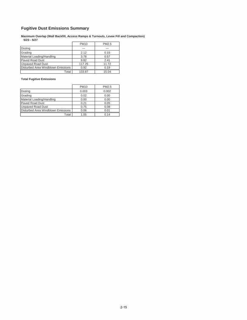
Fugitive Dust Emissions Summary
Maximum Overlap (Wall Backfill, Access Ramps & Turnouts, Levee Fill and Compaction) 5/23 - 5/27
PM10 PM2.5--- ---
2.12 0.153.78 0.579.82 2.41
117.25 11.720.92 0.19
133.87 15.04
Total Fugitive Emissions
PM10 PM2.50.003 0.0020.02 0.000.00 0.000.21 0.050.75 0.080.06 0.011.05 0.14
Material Loading/HandlingPaved Road DustUnpaved Road DustDisturbed Area Windblown Emissions
Total
DozingGrading
Paved Road DustUnpaved Road DustDisturbed Area Windblown Emissions
Total
DozingGradingMaterial Loading/Handling
2-15
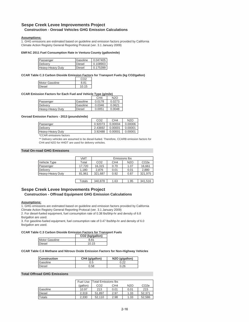
Sespe Creek Levee Improvements Project Construction - Onroad Vehicles GHG Emission Calculations
Assumptions:
EMFAC 2011 Fuel Consumption Rate in Ventura County (gallon/mile)
Passenger Gasoline 0.047405Delivery Diesel 0.108903Heavy-Heavy Duty Diesel 0.175399
CCAR Table C.3 Carbon Dioxide Emission Factors for Transport Fuels (kg CO2/gallon)CO2
Motor Gasoline 8.81Diesel 10.15
CCAR Emission Factors for Each Fuel and Vehicle Type (g/mile)CH4 N2O
Passenger Gasoline 0.0178 0.0273Delivery Gasoline 0.0346 0.0621Heavy-Heavy Duty Diesel 0.0051 0.0048
Onroad Emission Factors - 2013 (pounds/mile)CO2 CH4 N2O
Passenger 0.92073 0.00004 0.00006Delivery 2.43692 0.00001 0.00001Heavy-Heavy Duty 3.92488 0.00001 0.00001*CCAR emissions factors
Total On-road GHG Emissions
VMTVehicle Type Total CO2 CH4 N2O CO2ePassenger 17,720 16,315 0.70 1.07 16,661Delivery 1,180 2,876 0.01 0.01 2,880Heavy-Heavy Duty 81,961 321,687 0.92 0.87 321,975
Totals 340,878 1.63 1.95 341,516
Sespe Creek Levee Improvements Project Construction - Offroad Equipment GHG Emission Calculations
Assumptions:
CCAR Table C.3 Carbon Dioxide Emission Factors for Transport Fuels
Motor GasolineDiesel
CCAR Table C.6 Methane and Nitrous Oxide Emission Factors for Non-Highway Vehicles
ConstructionGasolineDiesel
Total Offroad GHG Emissions
CO2 CH4 N2O CO2eGasoline 10.97 213 0.01 0.01 215Diesel 2,319 51,897 2.97 1.33 52,371Totals 2,330 52,110 2.98 1.33 52,586
Total Emissions lbsFuel Use (gallon)
1. GHG emissions are estimated based on guideline and emission factors provided by California Climate Action Registry General Reporting Protocal (ver. 3.1 January 2009)
CO2 (kg/gallon)8.8110.15
CH4 (g/gallon)0.50.58
0.220.26
N2O (g/gallon)
** Delivery vehicles are assumed to be diesel-fueled. Therefore, CCARB emission factors for CH4 and N2O for HHDT are used for delivery vehicles.
1. GHG emissions are estimated based on guideline and emission factors provided by California Climate Action Registry General Reporting Protocal (ver. 3.1 January 2009)
Emissions lbs
2. For diesel-fueled equipment, fuel consumption rate of 0.38 lbs/bhp-hr and density of 6.8 lbs/gallon are used.3. For gasoline-fueled equipment, fuel consumption rate of 0.47 lbs/bhp-hr and density of 6.0 lbs/gallon are used.
2-16
Appendix 3
Preliminary Jurisdictional Waters/Wetlands Delineation
PRELIMINARY JURISDICTIONAL WATERS/WETLANDS DELINEATION REPORT FOR THE SESPE CREEK LEVEE
IMPROVEMENTS PROJECT
Prepared by:
Ventura County Watershed Protection District 800 S. Victoria Avenue
Ventura, California 93009-1600
With technical assistance by:
Aspen Environmental Group 5020 Chesebro Road, Suite 200
Agoura Hills, CA 91301
April 2012
Contract No. AE12-045 Project No. 83309
SESPE CREEK LEVEE (SC-2) IMPROVEMENTS PROJECT Preliminary Jurisdictional Waters/Wetlands Report
April 2012 i
Table of Contents
1. Introduction ........................................................................................................................................ 1 2. Regulatory Background ...................................................................................................................... 3 3. Existing Site Conditions ...................................................................................................................... 6 4. Waters/Wetlands Delineation ......................................................................................................... 10 5. Summary and Conclusions ............................................................................................................... 16 6. References ........................................................................................................................................ 16 List of Tables
1-1 Applicant and Consultant Contact Information .................................................................................. 2 1-2 Driving Directions to the Project Area ................................................................................................ 2 3-1 Vegetation Community/Habitat Types and Acreage within the Project Area .................................... 8 3-2 Plant Species Observed on the Project Area ..................................................................................... 10 4-1 Potential Geomorphic Indicators of Ordinary High Water Marks for the Arid West........................ 11 4-2 Potential Vegetation Indicators of Ordinary High Water Marks for the Arid West .......................... 11 4-3 Summary of Wetland Indicator Status .............................................................................................. 12 4-4 Wetland Hydrology Indicators .......................................................................................................... 12 4-5 Wetland Hydrology Indicators for the Arid West ............................................................................. 13 4-6 Field Indicators of Hydric Soil Conditions.......................................................................................... 14 4-7 Hydric Soil Indicators for the Arid West ............................................................................................ 14 4-8 Acreage of Jurisdictional Waters, Wetlands, and CDFG Jurisdictional Habitat ................................ 15 Appendices
Appendix A – Figures Figure 1. Site Location Figure 2. Project Area Figure 3. Vegetation Types within Project Area Boundary Figure 4. Soils Figure 5. Potential Jurisdictional Waters/Wetlands
SESPE CREEK LEVEE (SC-2) IMPROVEMENTS PROJECT Preliminary Jurisdictional Waters/Wetlands Report
April 2012 1
1.0 Introduction This report presents the findings of a planning level investigation of jurisdictional features conducted by Aspen Environmental Group (Aspen) for the Sespe Creek Levee Improvements Project (proposed project or project). The project area is located in Ventura County, adjacent to Sespe Creek near the City of Fillmore (Figure 1, Appendix A). The proposed project area is accessible via Old Telegraph Road to the north and State Route (SR) 126 to the south. A bridge on Old Telegraph Road is used to traverse the active channel of Sespe Creek in the northern portion of the proposed project area. To the northwest of the active channel, Old Telegraph road turns towards the south and runs roughly parallel to the proposed project alignment for approximately 1.5 miles, to West Telegraph Road / SR 126. To the southeast of the active channel, Old Telegraph Road passes through the City of Fillmore, eventually connecting with West Telegraph Road / SR 126 east of Fillmore. A Union Pacific Railroad alignment runs adjacent to the north of Old Telegraph Road in the proposed project area. SR 126 runs between U.S. Route 101 in Ventura, to the west, and Interstate 5 in Santa Clarita, to the east. This highway is part of the California Freeway and Expressway System, and is eligible for the State Scenic Highway System, although it is not an official scenic highway as designated by Caltrans. A bridge on SR 126 is used to traverse the active channel of Sespe Creek, in the southern portion of the proposed project area. Please refer to Figures 1 and 2, in Appendix A, for a graphical depiction of the project area.
This planning level assessment of jurisdictional wetlands and other non-wetland “waters of the U.S.” within the project area was conducted by Aspen Associate Biologist/Ecologist, Jared Varonin and Staff Biologist, Tracy Valentovich, in March 2012. This assessment was conducted to determine the extent of resources under the potential jurisdiction of the U.S. Army Corps of Engineers (USACE or Corps), State Water Resources Control Board Los Angeles Region (Water Board) and the California Department of Fish and Game (CDFG). These are the primary regulating agencies in California for all activities taking place within inland streams and wetlands.
1.1 Project Description The proposed project would provide flood protection and public safety for the portion of the City of Fillmore which is currently subject to flooding due to existing deficiencies in the SC-2 Levee. Objectives of the proposed project are described below.
• Eliminate structural and non-structural deficiencies identified along the SC-2 Levee in the Periodic Inspection Report commissioned by the USACE in 2010, including the following:
• Remove vegetation from within the USACE’s standard vegetation-free zone (VFZ) of 15 feet from the toe of a levee;
• Address unpermitted encroachments within the levee easement;
• Repair rock revetment displacements resulting (at least partially) from human interference;
• Restore unpermitted side drains and culverts; and
• Clear and restore obstructed pipe outlets (Fugro, 2011).
• Facilitate FEMA certification by implementing structural improvements to ensure that the SC-2 Levee is capable of withstanding 100-year storm flows, and achieve compliance with 44 CFR 65.10.
SESPE CREEK LEVEE (SC-2) IMPROVEMENTS PROJECT Preliminary Jurisdictional Wetlands/Waters Report
April 2012 2
• Minimize adverse environmental impacts and maximize cost-effectiveness through implementation of both fill slope and retaining wall design elements to achieve the necessary level of structural improvement.
• Maintain recreational opportunities along Sespe Creek Bike Trail to the maximum extent feasible and formalize the trail network through coordination with the City of Fillmore.
• Minimize potential future damage to rock revetment associated with human disturbance by eliminating unpermitted access points along the levee.
The proposed levee improvements would occur along a 1.1-mile section of the Sespe Creek levee system (Figure 2, Appendix A). The main elements of the proposed project include raising the existing levee height by one to six feet along approximately 1,521 feet of the levee and adding a 321-foot-long retaining wall along a portion of the landward side of the levee. Additional project components include the removal of three turnouts from the existing levee design, addition of one new turnout (incorporated into the levee improvements), removal of up to 31 trees at Shiells Park, construction of a new pedestrian access ramp over the improved levee, and the installation of two new access ramps (one to the north near Shiells Park and one to the south at the VCWPD stockpile yard just north of SR 126).A new flap gate would also be installed where a culvert exits the levee structure, adjacent to Shiells Park, just south of Old Telegraph Road. The existing flap gate is housed in a concrete box structure that extends approximately eight feet out from the location of the gate.
1.2 Contact Information
Table 1-1 Applicant and Consultant Contact Information
Applicant Contact Wetland and Biological Consultant
Ventura County Watershed Protection District 800 South Victoria Avenue Ventura, CA 93009-1610
Contact:
Elizabeth Martinez 805.658.4374
Aspen Environmental Group 5020 Chesebro Road, Suite 200
Agoura Hills, CA 91301
Contact: Jared Varonin 818.338.6715
1.3 Site Access Driving directions to the general area of the project area are provided below:
Table 1-2 Driving Directions to the Project Area
From Ventura From Highway 126 west, immediately after passing over the east branch of Sespe Creek, make a left hand turn (approximately 180 feet from the east bank of Sespe Creek) through the eastbound lanes of Highway 126 (approximately 950 west of E Street). Continue onto the levee structure until you get to a locked chain-link gate. From Santa Clarita From Highway 126, shortly after passing through the City of Fillmore, make a right hand turn approximately 950 west of E Street. Continue onto the levee structure until you get to a locked chain-link gate.
SESPE CREEK LEVEE (SC-2) IMPROVEMENTS PROJECT Preliminary Jurisdictional Waters/Wetlands Report
April 2012 3
2.0 Regulatory Background Any impacts to jurisdictional waters, wetlands, or riparian habitat associated with the proposed project would potentially require authorization from the USACE, Water Board, and CDFG. The USACE Regulatory Program regulates activities pursuant to Section 404 of the federal Clean Water Act (CWA); the CDFG regulates activities under the Fish and Game Code Section 1600-1607; and the Water Board regulates activities under Section 401 of the Clean Water Act (CWA) and the Porter-Cologne Water Quality Control Act. A summary of all the required authorizations is provided below.
2.1 Section 404 of the Clean Water Act Section 404 of the CWA regulates the discharge of dredged material, placement of fill material, or certain types of excavation within “waters of the U.S.” (resulting in more than incidental fallback of material) and authorizes the Secretary of the Army, through the Chief of Engineers, to issue permits for such actions. Permits can be issued for individual projects (individual permits) or for general categories of projects (general permits). “Waters of the U.S.” are defined by the CWA as “rivers, creeks, streams, and lakes extending to their headwaters and any associated wetlands.” Wetlands are defined by the CWA as “areas that are inundated or saturated by surface or groundwater at a frequency and duration sufficient to support a prevalence of vegetation typically adapted for life in saturated soil conditions.” The USACE has adopted several revisions to their regulations in order to more clearly define “waters of the U.S.” Until the beginning of 2001, “waters of the U.S.” included, among other things, isolated wetlands and lakes, intermittent streams, prairie potholes, and other waters that are not part of a tributary system to interstate waters or to navigable “waters of the U.S.”
The jurisdictional extent of USACE regulation changed with the 2001 SWANCC (Solid Waste Agency of Northern Cook County) ruling. The U.S. Supreme Court held that the Corps could not apply Section 404 of the CWA to extend their jurisdiction over an isolated quarry pit. The Court ruled that the CWA does not extend Federal regulatory jurisdiction over non-navigable, isolated, intra-state waters. However, the Court made it clear that non-navigable wetlands adjacent to navigable waters are still subject to USACE jurisdiction.
Once the limits of USACE jurisdiction are determined and an application is submitted to the USACE, the Corps determines whether or not the activity meets the terms and conditions of one of the Nationwide Permits (NWPs), which are a type of general permit issued by Corps Headquarters for nationwide application, or a Regional General Permit (RGP), issued by particular USACE Districts or Divisions. If a project qualifies under one of the NWPs or a RGP a letter may be issued verifying compliance with the NWP Program or the applicable RGP. Verification of compliance may be conditioned with specific terms regarding construction protocol, use of best management practices, avoidance of endangered species habitat, and mitigation requirements to ensure that the project will have minimal individual or cumulative impacts to aquatic resources. If a project meets the general terms and conditions of a NWP or RGP, but will result in greater than minimal impacts to aquatic resources on an individual or cumulative basis, the District Engineer may take discretionary authority and require the project to be processed as a Standard Permit (SP). The review process for a NWP or RGP is generally less extensive than for an SP and can often be completed in 30 to 60 days; unless consultation is required for effects on federally listed species or designated critical habitat or for cultural resources listed or eligible for listing on the National Register of Historic Places.
Projects that cannot be permitted under a NWP or RGP undergo a more extensive review under the SP process, which typically takes 120 days. The USACE decides whether to issue a SP based on an
SESPE CREEK LEVEE (SC-2) IMPROVEMENTS PROJECT Preliminary Jurisdictional Wetlands/Waters Report
April 2012 4
evaluation of the probable impacts, including cumulative impacts, of the proposed activity. According to Corps regulations, permits should not be issued for activities that will create “significant” degradation of the “waters of the U.S,” or have “significantly adverse effects on wetlands values.” However, the CWA provides no clear definition of “significant.”
The evaluation process for an SP is based on guidelines established under Section 404(b)(1) of the CWA and on the “public interest review” procedures. The public interest review involves a broad, qualitative evaluation of a project’s benefits and detriments. USACE regulations have identified 21 factors that are relevant to permit review. These factors are conservation, economics, aesthetics, general environmental concerns, wetlands, historic properties, fish and wildlife values, flood hazards, flood plain values, land use, navigation, shore erosion and accretion, recreation, water supply and conservation, water quality, energy needs, safety, food and fiber production, mineral needs, consideration of property ownership, and the general needs and welfare of the people. The public interest review is facilitated by the issuance of a 15-30 day Public Notice soliciting comments from the public and resource agencies, such as the USFWS, U.S. Environmental Protection Agency, and Water Board regarding the proposed project. A public hearing may be held for highly controversial projects.
The Section 404(b)(1) guidelines are often considered the driving force in the Corps permit process. The 404(b)(1) guidelines prohibit discharges of dredged or fill material if there is a less environmentally damaging practicable alternative. Practicability is determined based on technological, economic, social, and logistic considerations. If a proposed project has significant impacts, attempts must be made to avoid and minimize impacts. Impacts that cannot be avoided must be mitigated to a level where the net impacts to “waters of the U.S.” are not significant. In some cases, projects that result in significant impacts may be permitted if they provide a substantial benefit to the public, such as projects affecting national security or considerable production of energy.
The USACE must ensure that permitted projects comply with all other applicable federal resource protection laws such as the Endangered Species Act, the National Historic Preservation Act, and the Coastal Zone Management Act. In addition, certification that the proposed activity will comply with all applicable effluent limitations and water quality standards of Section 401 of the CWA is needed prior to issuance of a Section 404 permit. The need for a Section 404 permit constitutes a federal action under the National Environmental Policy Act (NEPA). Therefore, during the review of a proposed project an Environmental Assessment is prepared according to NEPA guidelines. If the impacts of the proposed activity are determined to be significant according to NEPA, an Environmental Impact Statement must be prepared and reviewed according to all NEPA requirements.
If a proposed project complies with all the NEPA requirements, the Section 404(b)(1) guidelines, and is determined not to be contrary to the public interest, and does not violate any federal resource protection laws, the USACE will issue a SP authorizing the proposed discharge of dredged or fill material into “waters of the U.S.” or wetlands. If a proposed project violates any of the above, then the USACE must deny the Section 404 permit.
SESPE CREEK LEVEE (SC-2) IMPROVEMENTS PROJECT Preliminary Jurisdictional Waters/Wetlands Report
April 2012 5
2.2 Section 401 of the CWA Section 401 of the CWA requires that:
“any applicant for a Federal permit for activities that involve a discharge to ‘waters of the State,’ shall provide the Federal permitting agency a certification from the State in which the discharge is proposed that states that the discharge will comply with the applicable provisions under the Federal Clean Water Act.”
Therefore, before the USACE will issue a Section 404 permit, applicants must apply for and receive a Section 401 Water Quality Certification from the Water Board. Applications to the Water Board must include a complete CEQA document (e.g., Initial Study/Mitigated Negative Declaration). Processing of a water quality certification generally takes 60 days, but the USACE may grant the Water Board time extensions of up to one year. A 21-day public comment period is included in the processing of the Water Quality Certification. The Water Board may add conditions to their certification to remove or mitigate potential impacts to water quality standards. Such conditions must ultimately be included in the Federal Section 404 permit. The State Water Quality regulations contain an “aggrieved party provision” that allows any person or group who objects to the issuance of a Water Quality Certification to petition the Water Board to reconsider the Water Board decision within 30 days of issuance.
Under separate authorities granted by State law (i.e., the Porter-Cologne Water Quality Control Act), a Water Board may choose to regulate discharges of dredge or fill materials by issuing Waste Discharge Requirements, a type of State discharge permit, instead of taking a Water Quality Certification action. Processing of a Waste Discharge Requirement is similar to that of a Section 401 certification; however, the Water Board has slightly more discretion to add conditions to a project under the Porter-Cologne Water Quality Control Act than under the CWA.
2.3 Section 1602 of the California Fish and Game Code Section 1602 of the California Fish and Game Code requires any person, State or local governmental agency, or public utility which proposes a project that will substantially divert or obstruct the natural flow or substantially change the bed, channel, or bank of any river, stream, or lake, or use materials from a streambed, or result in the disposal or deposition of debris, waste, or other material containing crumbled, flaked, or ground pavement where it can pass into any river, stream, or lake, to first notify the CDFG of the proposed project. Notification is generally required for any project that will take place in or in the vicinity of a river, stream, lake, or their tributaries. This includes rivers or streams that flow at least periodically or permanently through a bed or channel with banks that support fish or other aquatic life and watercourses having a surface or subsurface flow that support or have supported riparian vegetation. Based on the notification materials submitted, the CDFG will determine if the proposed project may impact fish or wildlife resources.
If the CDFG determines that a proposed project may substantially adversely affect existing fish or wildlife resources, a Lake or Streambed Alteration Agreement (SAA) will be required. A completed CEQA document must be submitted to the CDFG before they will issue a SAA. Within 60 days of receipt of a complete notification package, the CDFG will propose measures necessary to protect the fish or wildlife that your project could affect. These measures may be the same as those included as part of the project and/or measures proposed by the CDFG. The applicant has 14 days after receiving the CDFG's proposed measures to notify in writing whether they accept them, unless this time period is extended by mutual
SESPE CREEK LEVEE (SC-2) IMPROVEMENTS PROJECT Preliminary Jurisdictional Wetlands/Waters Report
April 2012 6
agreement. If the measures are acceptable, the SAA will be issued. If the measures are not acceptable, the applicant may request a meeting with the CDFG within seven days from the date the CDFG receives the response or by some other mutually agreed upon date for the purpose of developing measures that are acceptable to both the applicant and the CDFG. Once the applicant and the CDFG accept or agree on measures necessary to protect fish or wildlife resources, the CDFG will incorporate these measures into a draft SAA for review and signature.
3. Existing Site Conditions
3.1 Surrounding Land Uses The area in the immediate vicinity of the proposed project area is largely comprised of the existing Sespe Creek levee structure. The project area is bordered to the north by a mix of residential development, Shiells Park, bed and banks of Sespe Creek, Old Telegraph Road Bridge, and a Union Pacific Railroad Bridge. The eastern portion of the project area predominantly abuts residential development with a small section abutting Faith Community Church. The Highway 126 Bridge is located immediately south of the project area, and the western bank of Sespe Creek occurs just west of the project area. Please refer to Figure 2 (located in Appendix A) for a graphical depiction of the project area.
3.2 Topography The proposed project is located above the active channel of Sespe Creek, at the foot of the Los Padres National Forest, at approximately 400 feet elevation. The Sespe Creek Watershed encompasses 270 square miles of the western portion of the Santa Clara River Watershed, and Sespe Creek is the largest free-flowing tributary to the Santa Clara River. The majority of the Sespe Creek Watershed is located within the Los Padres National Forest.
3.3 Climate Coastal watersheds of southern California function according to a semi-arid, two-season Mediterranean-type climate, with wet cool winters and dry warm-to-hot summers. Rainfall and air moisture both tend to decrease with increasing distance from the coast. Within the Sespe Creek Watershed, proximity to the Pacific Ocean moderates both seasonal and diurnal temperatures. Most precipitation occurs between November and March, with precipitation varying significantly throughout the watershed due to complex topographic features. For example, average annual precipitation is more than 35 inches near Hines Peak in the headwaters of West Fork Sespe Creek, while it is less than 18 inches in the headwaters of Hot Springs Canyon. Wetter regions are generally located at higher elevations on the southern side of Sespe Creek, although mean annual precipitation near Pine Mountain on the northern side exceeds 32.5 inches. At higher elevations, some winter precipitation is in the form of snow. (RBF, 2010)
Periodicity in the pattern of the wet/dry years in southern California is correlated to the El Niño–Southern Oscillation (ENSO) climatic phenomenon. ENSO is characterized by warming and cooling cycles (oscillations) in the waters of the eastern equatorial Pacific Ocean. ENSO cycles have a 1–1.5 year duration and a 3–8 year recurrence interval. In southern California, ENSO years are characterized by relatively high rainfall intensities, with rivers and streams exhibiting higher annual peak flow magnitudes than they do in non-ENSO years (Cayan et al., 1999; Andrews et al., 2004; both as cited in RBF, 2010)). ENSO-induced climate change occurs on a multi-decadal time scale that is consistent with the recent
SESPE CREEK LEVEE (SC-2) IMPROVEMENTS PROJECT Preliminary Jurisdictional Waters/Wetlands Report
April 2012 7
shift from a relatively dry climate (averaged over the period 1944–1968) to a relatively wet climate (averaged over the period 1969–1995) in North America's Pacific region (Inman and Jenkins 1999). The recent wet period of the ENSO cycle, which likely still continues, is marked by strong El Niño years every 3–7 years. The most recent El Niño event (although weak) occurred in water year 2007. (RBF, 2010)
3.4 Geomorphology/Hydrology The Sespe Creek Watershed is one of the most pristine and geographically remote areas in all of southern California. It is also one of the few remaining watersheds in the region that lacks any flow regulation or diversion structures. Sespe Creek travels 60 miles from its headwaters, following a sinuous course to the east through a relatively broad valley bottom, turning south through a bedrock-confined gorge, and out onto a widening alluvial fan past the City of Fillmore and into the Santa Clara River. (RBF, 2010)
Since the Sespe Creek Levee completion in 1984, the largest peak discharge has been 85,300 cubic feet per second (cfs) in 2005. However, aggradation of sediment in the channel bed over time could effectively raise the mean elevation of the bed, resulting in the reduction of the levee’s flood protection capacity for a given discharge. Sediment deposition in the lower reach of Sespe Creek may be indicative of increased sediment yields in the upstream reaches, driven by either earthquake-triggered landslides, a change in hydrologic conditions, or removal of soil-holding vegetation on the hillslopes. (RBF, 2010)
Typical of other drainages in the semi-arid and tectonically active Western Transverse Ranges, the Sespe Creek Watershed is characterized by steep hillslopes mantled with shallow soils and covered by shrub vegetation, and is drained by steep, coarse sediment-bearing tributaries. Combined with the frequent occurrence of high-intensity winter storms and summer/fall wildfires, very high sediment yields result. (RBF, 2010)
3.5 Soils A typical assessment of jurisdictional wetlands and other non-wetland “waters of the U.S.” includes a review of historic soil data from the National Resource Conservation Society (NRCS), a division of the United States Department of Agriculture that maps soil types across land in the United States, to determine if and where hydric soils could be present over the entire project area. Based on the available data from the NRCS, the now developed project area was historically mapped as Anacapa sandy loam (Figure 4, Appendix A). This is a well-drained soil that occurs on alluvial fans at elevations up to 500 feet. The parent material generally consists of alluvium derived from sedimentary rock with a depth to water table greater than 80 inches. Composition of this soil type usually consists of sandy loam (0-35”), and stratified coarse sandy loam to loam (35-60”).
3.6 Geology The Sespe Creek Watershed lies in the middle of a distinctive geologic province of California known as the Transverse Ranges. Unlike the Coast Ranges to the north and the Peninsular Ranges to the south, both of whose major ridges and intervening valleys trend generally northwest–southeast, the Transverse Ranges are oriented almost exactly east–west and form a marked disruption to the overall grain of California topography. Sespe Creek flows between two of these east–west ridges, the Topatopa Mountains on the south and Pine Mountain–San Rafael Peak on the north. (RBF, 2010)
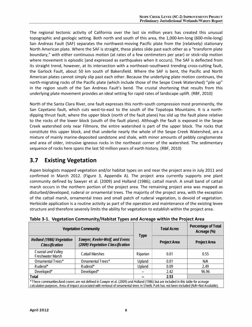
SESPE CREEK LEVEE (SC-2) IMPROVEMENTS PROJECT Preliminary Jurisdictional Wetlands/Waters Report
April 2012 8
The regional tectonic activity of California over the last six million years has created this unusual topographic and geologic setting. Both north and south of this area, the 1,000-km-long (600-mile-long) San Andreas Fault (SAF) separates the northwest-moving Pacific plate from the (relatively) stationary North American plate. Where the SAF is straight, these plates slide past each other as a “transform plate boundary,” with either continuous motion (at rates of a few centimeters per year) or stick–slip motion where movement is episodic (and expressed as earthquakes when it occurs). The SAF is deflected from its straight trend, however, at its intersection with a northeast–southwest trending cross-cutting fault, the Garlock Fault, about 50 km south of Bakersfield. Where the SAF is bent, the Pacific and North American plates cannot simply slip past each other. Because the underlying plate motion continues, the north-migrating rocks of the Pacific plate (which include those of the Sespe Creek Watershed) “pile up” in the region south of the San Andreas Fault’s bend. The crustal shortening that results from this underlying plate movement provides an ideal setting for rapid rates of landscape uplift. (RBF, 2010)
North of the Santa Clara River, one fault expresses this north–south compression most prominently, the San Cayetano fault, which cuts west-to-east to the south of the Topatopa Mountains. It is a north-dipping thrust fault, where the upper block (north of the fault plane) has slid up the fault plane relative to the rocks of the lower block (south of the fault plane). Although the fault is exposed in the Sespe Creek watershed only near Fillmore, the entire watershed is part of the upper block. The rocks that constitute this upper block, and that underlie nearly the whole of the Sespe Creek Watershed, are a mixture of mainly marine-deposited sandstone and shale, with minor amounts of pebbly conglomerate and area of older, intrusive igneous rocks in the northeast corner of the watershed. The sedimentary sequence of rocks here spans the last 50 million years of earth history. (RBF, 2010)
3.7 Existing Vegetation Aspen biologists mapped vegetation and/or habitat types on and near the project area in July 2011 and confirmed in March 2012. (Figure 3, Appendix A). The project area currently supports one plant community defined by Sawyer et al. (2009) and Holland (1986); cattail marsh. A small band of cattail marsh occurs in the northern portion of the project area. The remaining project area was mapped as disturbed/developed, ruderal or ornamental trees. The majority of the project area, with the exception of the cattail marsh, ornamental trees and small patch of ruderal vegetation, is devoid of vegetation. Herbicide application is a routine activity as part of the operation and maintenance of the existing levee structure and therefore severely limits the ability for vegetation to establish within the project area.
Table 3-1. Vegetation Community/Habitat Types and Acreage within the Project Area
Vegetation Community Type
Total Acres Percentage of Total Acreage (%)
Holland (1986) Vegetation Classification
Sawyer, Keeler-Wolf, and Evens (2009) Vegetation Classification Project Area Project Area
Coastal and Valley Freshwater Marsh Cattail Marshes Riparian 0.01 0.55
Ornamental Trees* Ornamental Trees* Upland 0.01 N/A Ruderal* Ruderal* Upland 0.09 2.49 Developed* Developed* -- 2.42 96.96
Total -- 2.53 * These communities/land covers are not defined in Sawyer et al. (2009) and Holland (1986) but are included in this table for acreage calculation purposes. Area of impact associated with removal of ornamental trees in Shiells Park has not been included (N/A=Not Available).
SESPE CREEK LEVEE (SC-2) IMPROVEMENTS PROJECT Preliminary Jurisdictional Waters/Wetlands Report
April 2012 9
Cattail Marshes
Cattail marshes are a type of wetland vegetation that typically occurs either in or directly adjacent to standing water. Within the project area, as defined in Figure 3 (located in Appendix A) this vegetation is dominated by common cattails (Typha latifolia) along with bulrush (Scirpus maritimus) and tule (Scirpus acutus var. occidentalis). This community occurs in standing water associated with the storm drain outlet in the north portion of the project area. This vegetation community is most similar to “fresh emergent wetland” as described by Kramer (1988) and “coastal and valley freshwater marsh” as described by Holland (1986).
Ornamental Trees
This vegetation community is characterized by the presence of both native and non-native ornamental trees that have been planted along the existing recreational bike path, neighboring park and open space. Tree species observed included Fremont cottonwood (Populus fremontii), western sycamore (Platanus racemosa), unidentified pine trees (Pinus sp.), and crepe myrtle (Lagerstroemia indica).
Disturbed/Developed
Disturbed/developed is a cover type used to describe areas that either have existing structures (i.e. houses and roads) or areas that are devoid of vegetation due to continual disturbance by horses, vehicles, or other human causes. Disturbed and developed areas include the residential properties, roadways and physical structures (i.e., levees and bike paths) that occur in the project area.
Ruderal
Ruderal vegetation communities are dominated by herbaceous, introduced, pioneering plant species that readily colonize open disturbed soil and thrive as a result of human impacts. Ruderal communities may provide a certain degree of erosion control for recently disturbed or graded areas, but such communities are also a threat to the natural biodiversity of an area. Invasive species continually distribute highly competitive propagules into otherwise native vegetation; however, if ruderal grassland stands remain undisturbed for more than five years they can sometimes undergo succession towards more stable and less weedy plant communities (Zedler et al., 1997). Ruderal areas within the project area were limited to disturbed areas east of the existing levee structure and included such species as, but not limited to, red brome (Bromus madritensis ssp. rubens), short-pod mustard (Hirschfeldia incana), cheeseweed (Malva parviflora), and yellow sweet clover (Melilotus indica).
A complete list of all plant species observed within or adjacent to the project area (including wetland indicator status) is presented below in Table 3-2.
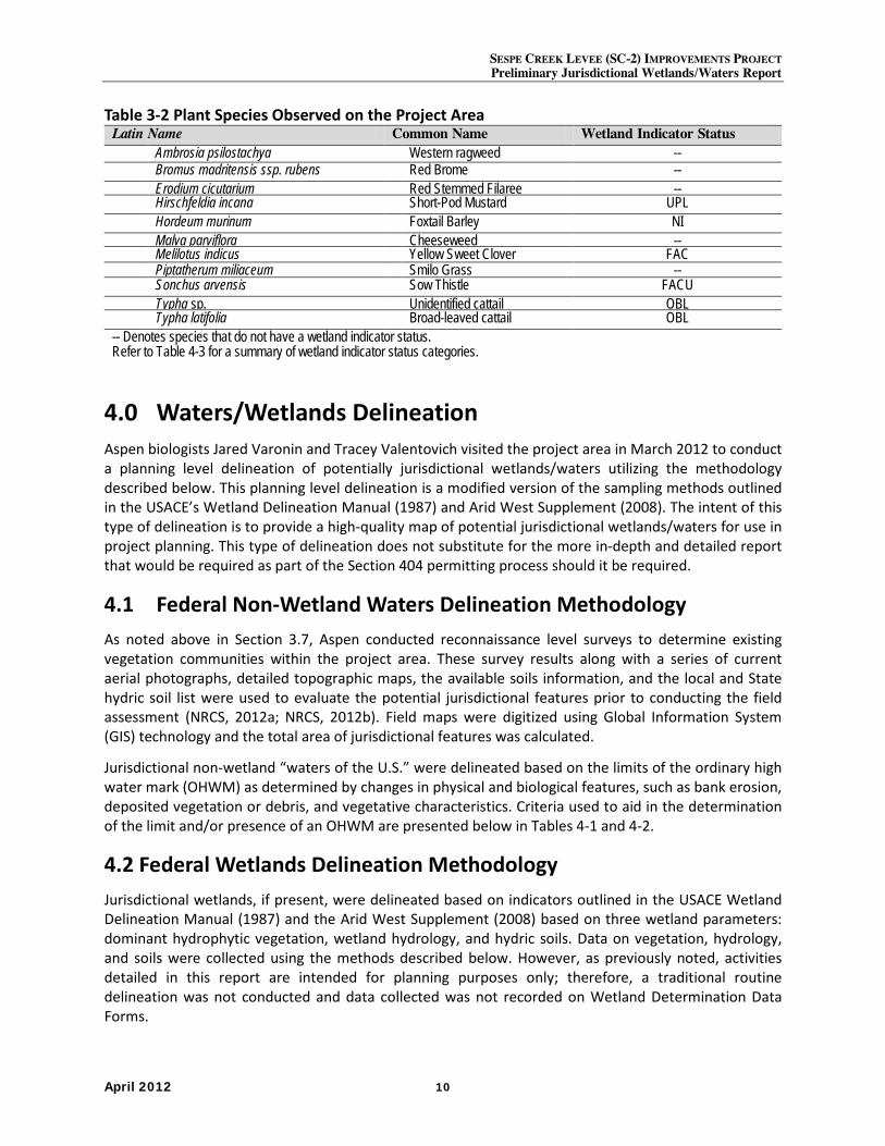
SESPE CREEK LEVEE (SC-2) IMPROVEMENTS PROJECT Preliminary Jurisdictional Wetlands/Waters Report
April 2012 10
Table 3-2 Plant Species Observed on the Project Area Latin Name Common Name Wetland Indicator Status Ambrosia psilostachya Western ragweed -- Bromus madritensis ssp. rubens Red Brome -- Erodium cicutarium Red Stemmed Filaree -- Hirschfeldia incana Short-Pod Mustard UPL Hordeum murinum Foxtail Barley NI Malva parviflora Cheeseweed -- Melilotus indicus Yellow Sweet Clover FAC Piptatherum miliaceum Smilo Grass -- Sonchus arvensis Sow Thistle FACU Typha sp. Unidentified cattail OBL Typha latifolia Broad-leaved cattail OBL -- Denotes species that do not have a wetland indicator status. Refer to Table 4-3 for a summary of wetland indicator status categories.
4.0 Waters/Wetlands Delineation Aspen biologists Jared Varonin and Tracey Valentovich visited the project area in March 2012 to conduct a planning level delineation of potentially jurisdictional wetlands/waters utilizing the methodology described below. This planning level delineation is a modified version of the sampling methods outlined in the USACE’s Wetland Delineation Manual (1987) and Arid West Supplement (2008). The intent of this type of delineation is to provide a high-quality map of potential jurisdictional wetlands/waters for use in project planning. This type of delineation does not substitute for the more in-depth and detailed report that would be required as part of the Section 404 permitting process should it be required.
4.1 Federal Non-Wetland Waters Delineation Methodology As noted above in Section 3.7, Aspen conducted reconnaissance level surveys to determine existing vegetation communities within the project area. These survey results along with a series of current aerial photographs, detailed topographic maps, the available soils information, and the local and State hydric soil list were used to evaluate the potential jurisdictional features prior to conducting the field assessment (NRCS, 2012a; NRCS, 2012b). Field maps were digitized using Global Information System (GIS) technology and the total area of jurisdictional features was calculated.
Jurisdictional non-wetland “waters of the U.S.” were delineated based on the limits of the ordinary high water mark (OHWM) as determined by changes in physical and biological features, such as bank erosion, deposited vegetation or debris, and vegetative characteristics. Criteria used to aid in the determination of the limit and/or presence of an OHWM are presented below in Tables 4-1 and 4-2.
4.2 Federal Wetlands Delineation Methodology Jurisdictional wetlands, if present, were delineated based on indicators outlined in the USACE Wetland Delineation Manual (1987) and the Arid West Supplement (2008) based on three wetland parameters: dominant hydrophytic vegetation, wetland hydrology, and hydric soils. Data on vegetation, hydrology, and soils were collected using the methods described below. However, as previously noted, activities detailed in this report are intended for planning purposes only; therefore, a traditional routine delineation was not conducted and data collected was not recorded on Wetland Determination Data Forms.
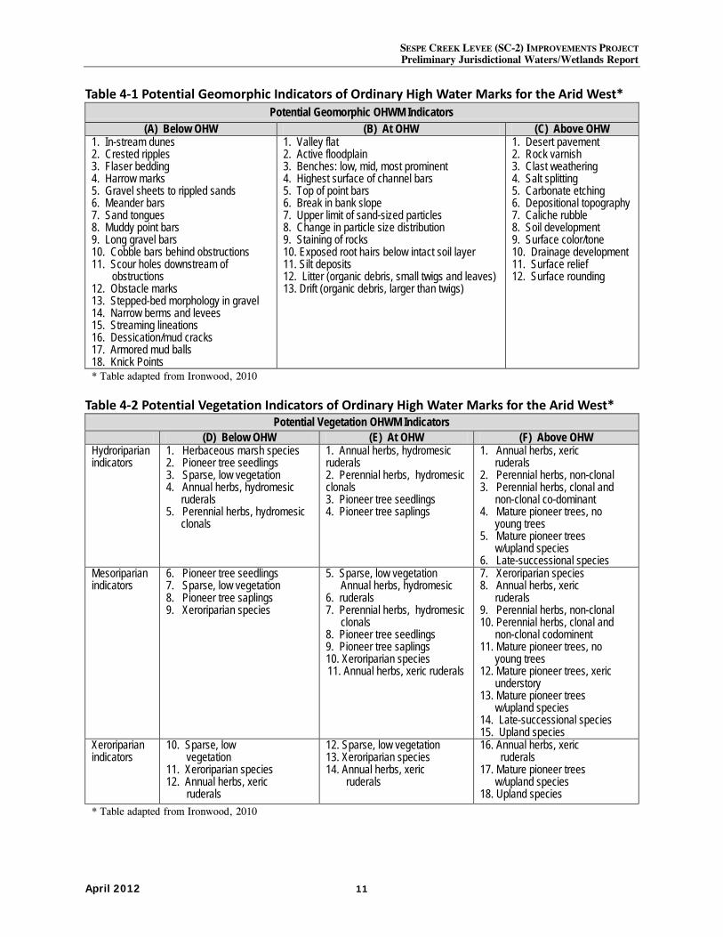
SESPE CREEK LEVEE (SC-2) IMPROVEMENTS PROJECT Preliminary Jurisdictional Waters/Wetlands Report
April 2012 11
Table 4-1 Potential Geomorphic Indicators of Ordinary High Water Marks for the Arid West* Potential Geomorphic OHWM Indicators
(A) Below OHW (B) At OHW (C) Above OHW 1. In-stream dunes 2. Crested ripples 3. Flaser bedding 4. Harrow marks 5. Gravel sheets to rippled sands 6. Meander bars 7. Sand tongues 8. Muddy point bars 9. Long gravel bars 10. Cobble bars behind obstructions 11. Scour holes downstream of
obstructions 12. Obstacle marks 13. Stepped-bed morphology in gravel 14. Narrow berms and levees 15. Streaming lineations 16. Dessication/mud cracks 17. Armored mud balls 18. Knick Points
1. Valley flat 2. Active floodplain 3. Benches: low, mid, most prominent 4. Highest surface of channel bars 5. Top of point bars 6. Break in bank slope 7. Upper limit of sand-sized particles 8. Change in particle size distribution 9. Staining of rocks 10. Exposed root hairs below intact soil layer 11. Silt deposits 12. Litter (organic debris, small twigs and leaves) 13. Drift (organic debris, larger than twigs)
1. Desert pavement 2. Rock varnish 3. Clast weathering 4. Salt splitting 5. Carbonate etching 6. Depositional topography 7. Caliche rubble 8. Soil development 9. Surface color/tone 10. Drainage development 11. Surface relief 12. Surface rounding
* Table adapted from Ironwood, 2010
Table 4-2 Potential Vegetation Indicators of Ordinary High Water Marks for the Arid West* Potential Vegetation OHWM Indicators
(D) Below OHW (E) At OHW (F) Above OHW Hydroriparian indicators
1. Herbaceous marsh species 2. Pioneer tree seedlings 3. Sparse, low vegetation 4. Annual herbs, hydromesic
ruderals 5. Perennial herbs, hydromesic
clonals
1. Annual herbs, hydromesic ruderals 2. Perennial herbs, hydromesic clonals 3. Pioneer tree seedlings 4. Pioneer tree saplings
1. Annual herbs, xeric ruderals
2. Perennial herbs, non-clonal 3. Perennial herbs, clonal and
non-clonal co-dominant 4. Mature pioneer trees, no
young trees 5. Mature pioneer trees
w/upland species 6. Late-successional species
Mesoriparian indicators
6. Pioneer tree seedlings 7. Sparse, low vegetation 8. Pioneer tree saplings 9. Xeroriparian species
5. Sparse, low vegetation Annual herbs, hydromesic
6. ruderals 7. Perennial herbs, hydromesic
clonals 8. Pioneer tree seedlings 9. Pioneer tree saplings 10. Xeroriparian species 11. Annual herbs, xeric ruderals
7. Xeroriparian species 8. Annual herbs, xeric
ruderals 9. Perennial herbs, non-clonal 10. Perennial herbs, clonal and
non-clonal codominent 11. Mature pioneer trees, no
young trees 12. Mature pioneer trees, xeric
understory 13. Mature pioneer trees
w/upland species 14. Late-successional species 15. Upland species
Xeroriparian indicators
10. Sparse, low vegetation
11. Xeroriparian species 12. Annual herbs, xeric
ruderals
12. Sparse, low vegetation 13. Xeroriparian species 14. Annual herbs, xeric
ruderals
16. Annual herbs, xeric ruderals
17. Mature pioneer trees w/upland species
18. Upland species * Table adapted from Ironwood, 2010
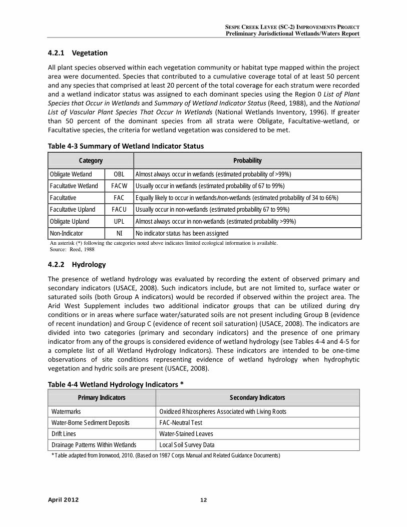
SESPE CREEK LEVEE (SC-2) IMPROVEMENTS PROJECT Preliminary Jurisdictional Wetlands/Waters Report
April 2012 12
4.2.1 Vegetation
All plant species observed within each vegetation community or habitat type mapped within the project area were documented. Species that contributed to a cumulative coverage total of at least 50 percent and any species that comprised at least 20 percent of the total coverage for each stratum were recorded and a wetland indicator status was assigned to each dominant species using the Region 0 List of Plant Species that Occur in Wetlands and Summary of Wetland Indicator Status (Reed, 1988), and the National List of Vascular Plant Species That Occur In Wetlands (National Wetlands Inventory, 1996). If greater than 50 percent of the dominant species from all strata were Obligate, Facultative-wetland, or Facultative species, the criteria for wetland vegetation was considered to be met.
Table 4-3 Summary of Wetland Indicator Status
4.2.2 Hydrology
The presence of wetland hydrology was evaluated by recording the extent of observed primary and secondary indicators (USACE, 2008). Such indicators include, but are not limited to, surface water or saturated soils (both Group A indicators) would be recorded if observed within the project area. The Arid West Supplement includes two additional indicator groups that can be utilized during dry conditions or in areas where surface water/saturated soils are not present including Group B (evidence of recent inundation) and Group C (evidence of recent soil saturation) (USACE, 2008). The indicators are divided into two categories (primary and secondary indicators) and the presence of one primary indicator from any of the groups is considered evidence of wetland hydrology (see Tables 4-4 and 4-5 for a complete list of all Wetland Hydrology Indicators). These indicators are intended to be one-time observations of site conditions representing evidence of wetland hydrology when hydrophytic vegetation and hydric soils are present (USACE, 2008).
Table 4-4 Wetland Hydrology Indicators *
Primary Indicators Secondary Indicators
Watermarks Oxidized Rhizospheres Associated with Living Roots Water-Borne Sediment Deposits FAC-Neutral Test Drift Lines Water-Stained Leaves Drainage Patterns Within Wetlands Local Soil Survey Data * Table adapted from Ironwood, 2010. (Based on 1987 Corps Manual and Related Guidance Documents)
Category Probability
Obligate Wetland OBL Almost always occur in wetlands (estimated probability of >99%)
Facultative Wetland FACW Usually occur in wetlands (estimated probability of 67 to 99%)
Facultative FAC Equally likely to occur in wetlands/non-wetlands (estimated probability of 34 to 66%)
Facultative Upland FACU Usually occur in non-wetlands (estimated probability 67 to 99%)
Obligate Upland UPL Almost always occur in non-wetlands (estimated probability >99%)
Non-Indicator NI No indicator status has been assigned An asterisk (*) following the categories noted above indicates limited ecological information is available. Source: Reed, 1988
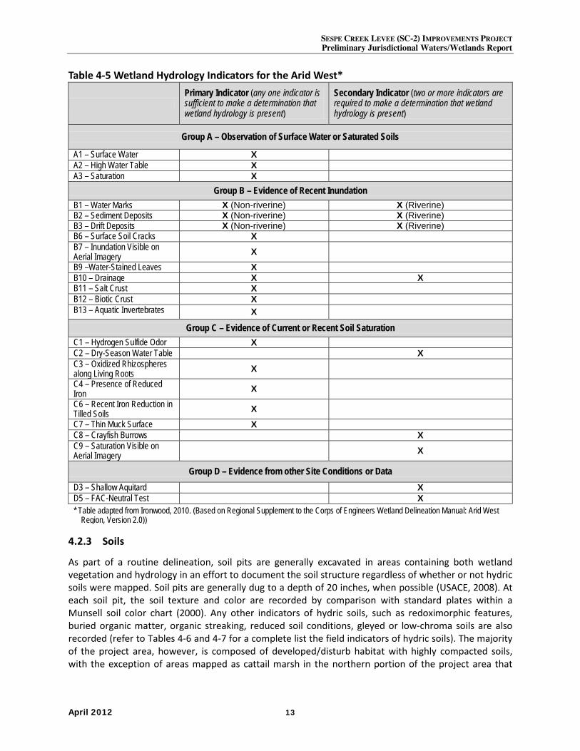
SESPE CREEK LEVEE (SC-2) IMPROVEMENTS PROJECT Preliminary Jurisdictional Waters/Wetlands Report
April 2012 13
Table 4-5 Wetland Hydrology Indicators for the Arid West*
Primary Indicator (any one indicator is sufficient to make a determination that wetland hydrology is present)
Secondary Indicator (two or more indicators are required to make a determination that wetland hydrology is present)
Group A – Observation of Surface Water or Saturated Soils
A1 – Surface Water X A2 – High Water Table X A3 – Saturation X
Group B – Evidence of Recent Inundation B1 – Water Marks X (Non-riverine) X (Riverine) B2 – Sediment Deposits X (Non-riverine) X (Riverine) B3 – Drift Deposits X (Non-riverine) X (Riverine) B6 – Surface Soil Cracks X B7 – Inundation Visible on Aerial Imagery X B9 –Water-Stained Leaves X B10 – Drainage X X B11 – Salt Crust X B12 – Biotic Crust X B13 – Aquatic Invertebrates X
Group C – Evidence of Current or Recent Soil Saturation C1 – Hydrogen Sulfide Odor X C2 – Dry-Season Water Table X C3 – Oxidized Rhizospheres along Living Roots X C4 – Presence of Reduced Iron X C6 – Recent Iron Reduction in Tilled Soils X C7 – Thin Muck Surface X C8 – Crayfish Burrows X C9 – Saturation Visible on Aerial Imagery X
Group D – Evidence from other Site Conditions or Data D3 – Shallow Aquitard X D5 – FAC-Neutral Test X * Table adapted from Ironwood, 2010. (Based on Regional Supplement to the Corps of Engineers Wetland Delineation Manual: Arid West
Region, Version 2.0))
4.2.3 Soils
As part of a routine delineation, soil pits are generally excavated in areas containing both wetland vegetation and hydrology in an effort to document the soil structure regardless of whether or not hydric soils were mapped. Soil pits are generally dug to a depth of 20 inches, when possible (USACE, 2008). At each soil pit, the soil texture and color are recorded by comparison with standard plates within a Munsell soil color chart (2000). Any other indicators of hydric soils, such as redoximorphic features, buried organic matter, organic streaking, reduced soil conditions, gleyed or low-chroma soils are also recorded (refer to Tables 4-6 and 4-7 for a complete list the field indicators of hydric soils). The majority of the project area, however, is composed of developed/disturb habitat with highly compacted soils, with the exception of areas mapped as cattail marsh in the northern portion of the project area that
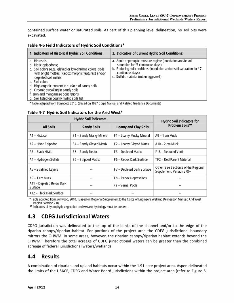
SESPE CREEK LEVEE (SC-2) IMPROVEMENTS PROJECT Preliminary Jurisdictional Wetlands/Waters Report
April 2012 14
contained surface water or saturated soils. As part of this planning level delineation, no soil pits were excavated.
Table 4-6 Field Indicators of Hydric Soil Conditions*
1. Indicators of Historical Hydric Soil Conditions: 2. Indicators of Current Hydric Soil Conditions:
a. Histosols b. Histic epipedons; c. Soil colors (e.g., gleyed or low-chroma colors, soils
with bright mottles (Redoximorphic features) and/or depleted soil matrix
c. Soil colors d. High organic content in surface of sandy soils e. Organic streaking in sandy soils f. Iron and manganese concretions g. Soil listed on county hydric soils list
a. Aquic or peraquic moisture regime (inundation and/or soil saturation for *7 continuous days)
b. Reducing soil conditions (inundation and/or soil saturation for * 7 continuous days)
c. Sulfidic material (rotten egg smell)
* Table adapted from Ironwood, 2010. (Based on 1987 Corps Manual and Related Guidance Documents)
Table 4-7 Hydric Soil Indicators for the Arid West* Hydric Soil Indicators Hydric Soil Indicators for
Problem Soils** All Soils Sandy Soils Loamy and Clay Soils
A1 – Histosol S1 – Sandy Mucky Mineral F1 – Loamy Mucky Mineral A9 – 1 cm Muck
A2 – Histic Epipedon S4 – Sandy Gleyed Matrix F2 – Loamy Gleyed Matrix A10 – 2 cm Muck
A3 – Black Histic S5 – Sandy Redox F3 – Depleted Matrix F18 – Reduced Verti
A4 – Hydrogen Sulfide S6 – Stripped Matrix F6 – Redox Dark Surface TF2 – Red Parent Material
A5 – Stratified Layers -- F7 – Depleted Dark Surface Other (See Section 5 of the Regional Supplement, Version 2.0)--
A9 – 1 cm Muck -- F8 – Redox Depressions -- A11 – Depleted Below Dark Surface -- F9 – Vernal Pools --
A12 – Thick Dark Surface -- -- -- * Table adapted from Ironwood, 2010. (Based on Regional Supplement to the Corps of Engineers Wetland Delineation Manual: Arid West
Region, Version 2.0) ** Indicators of hydrophytic vegetation and wetland hydrology must be present
4.3 CDFG Jurisdictional Waters CDFG jurisdiction was delineated to the top of the banks of the channel and/or to the edge of the riparian canopy/riparian habitat. For portions of the project area the CDFG jurisdictional boundary mirrors the OHWM. In some areas, however, the riparian canopy/riparian habitat extends beyond the OHWM. Therefore the total acreage of CDFG jurisdictional waters can be greater than the combined acreage of federal jurisdictional waters/wetlands.
4.4 Results A combination of riparian and upland habitats occur within the 1.91 acre project area. Aspen delineated the limits of the USACE, CDFG and Water Board jurisdictions within the project area (refer to Figure 5,
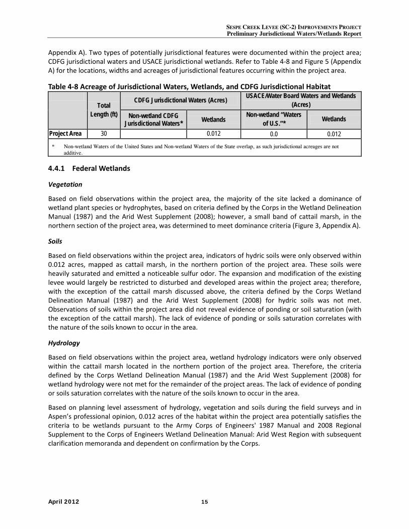
SESPE CREEK LEVEE (SC-2) IMPROVEMENTS PROJECT Preliminary Jurisdictional Waters/Wetlands Report
April 2012 15
Appendix A). Two types of potentially jurisdictional features were documented within the project area; CDFG jurisdictional waters and USACE jurisdictional wetlands. Refer to Table 4-8 and Figure 5 (Appendix A) for the locations, widths and acreages of jurisdictional features occurring within the project area.
Table 4-8 Acreage of Jurisdictional Waters, Wetlands, and CDFG Jurisdictional Habitat
Total Length (ft)
CDFG Jurisdictional Waters (Acres) USACE/Water Board Waters and Wetlands (Acres)
Non-wetland CDFG Jurisdictional Waters* Wetlands
Non-wetland “Waters of U.S.”* Wetlands
Project Area 30 0.012 0.0 0.012
* Non-wetland Waters of the United States and Non-wetland Waters of the State overlap, as such jurisdictional acreages are not additive.
4.4.1 Federal Wetlands
Vegetation
Based on field observations within the project area, the majority of the site lacked a dominance of wetland plant species or hydrophytes, based on criteria defined by the Corps in the Wetland Delineation Manual (1987) and the Arid West Supplement (2008); however, a small band of cattail marsh, in the northern section of the project area, was determined to meet dominance criteria (Figure 3, Appendix A).
Soils
Based on field observations within the project area, indicators of hydric soils were only observed within 0.012 acres, mapped as cattail marsh, in the northern portion of the project area. These soils were heavily saturated and emitted a noticeable sulfur odor. The expansion and modification of the existing levee would largely be restricted to disturbed and developed areas within the project area; therefore, with the exception of the cattail marsh discussed above, the criteria defined by the Corps Wetland Delineation Manual (1987) and the Arid West Supplement (2008) for hydric soils was not met. Observations of soils within the project area did not reveal evidence of ponding or soil saturation (with the exception of the cattail marsh). The lack of evidence of ponding or soils saturation correlates with the nature of the soils known to occur in the area.
Hydrology
Based on field observations within the project area, wetland hydrology indicators were only observed within the cattail marsh located in the northern portion of the project area. Therefore, the criteria defined by the Corps Wetland Delineation Manual (1987) and the Arid West Supplement (2008) for wetland hydrology were not met for the remainder of the project areas. The lack of evidence of ponding or soils saturation correlates with the nature of the soils known to occur in the area.
Based on planning level assessment of hydrology, vegetation and soils during the field surveys and in Aspen’s professional opinion, 0.012 acres of the habitat within the project area potentially satisfies the criteria to be wetlands pursuant to the Army Corps of Engineers' 1987 Manual and 2008 Regional Supplement to the Corps of Engineers Wetland Delineation Manual: Arid West Region with subsequent clarification memoranda and dependent on confirmation by the Corps.
SESPE CREEK LEVEE (SC-2) IMPROVEMENTS PROJECT Preliminary Jurisdictional Wetlands/Waters Report
April 2012 16
4.4.2 Federal Non-Wetland Waters
Based on assessment of hydrology and the limits of the OHWM as determined by aerial imagery, evidence of flow, changes in physical and biological features, such as bank erosion, deposited vegetation or debris, and vegetative characteristics vegetation and soils during the field surveys and in Aspen’s professional opinion, no portion of the project area, shown in Figure 5 (Appendix A), meets the definition of “waters of the United States” as defined in 33 CFR Part 328.
4.4.3 CDFG Jurisdictional Waters
Based on assessment of hydrology, presence of bed and bank and extent of riparian vegetation and in Aspen’s professional opinion, approximately 0.012 acres of the project area shown in Figure 5 (Appendix A) meet the definition of CDFG jurisdictional waters as outlined in Sections 1600-1616 of the CDFG Code. For portions of the project area the CDFG jurisdictional boundary mirrors the OHWM. However, in most areas, the riparian canopy and/or riparian habitat extend well beyond the OHWM. Construction of the proposed project would temporarily impact 0.012 acres of CDFG jurisdictional waters.
5.0 Summary and Conclusions The project area supports two types of jurisdictional features, including CDFG jurisdictional waters and USACE jurisdictional wetlands. The limits of these potentially jurisdictional features were easily delineated as they occur in small channels with soil-cement banks and exhibit field indicators of active flow such as, but not limited to, water marks, surface water, and linear deposits of sediment and/or plant debris. Using a combination of vegetation mapping, bed/bank delineation and field observations, approximately 0.012 acres of CDFG jurisdictional waters were identified within the project area. Areas of the project area supporting hydropyhitic vegetation, evidence of wetland hydrology, and hydric soils were identified as jurisdictional wetlands (0.012 acres).
The conclusions presented above represent Aspen’s professional opinion based on their knowledge and experience with the Corps, Water Board and CDFG, including their regulatory guidance documents and manuals. However, it should be understood that the USACE, Water Board and CDFG have final authority in determining the status and presence of jurisdictional wetlands/waters and the extent of their boundaries.
6.0 References Baldwin, B.G., S. Boyd, B.J. Ertter, R.W. Patterson, T.J. Rosatti, D. Wilken, and M. Wetherwax (eds.).
2002. The Jepson Desert Manual: Vascular Plants of Southeastern California. University of California Press, Berkeley, California. 624 pp.
Brown, D.E. 1994. Biotic Communities: Southwestern United States and Northwestern Mexico. University of Utah Press, Salt Lake City. 342 pp.
Environmental Laboratory. 1987. Corps of Engineers Wetland Delineation Manual. Technical Report Y-87-1. U.S. Army Engineer Waterways Experiment Station. Vicksburg, MS.
Fugro West, Inc. 2011. 2011. U.S. Army Corps of Engineers Periodic Levee Inspections Sespe Creek 2 (SC-2) Ventura County, CA: Periodic Inspection Report
Hickman, James C. 1996. The Jepson Manual: Higher Plants of California. 3rd ed. University of California Press, Berkeley and Los Angeles, California.
SESPE CREEK LEVEE (SC-2) IMPROVEMENTS PROJECT Preliminary Jurisdictional Waters/Wetlands Report
April 2012 17
Holland, R.F. 1986. Preliminary Descriptions of the Terrestrial Natural Communities of California. Unpublished report available from the California Department of Fish and Game, Sacramento, California.
Ironwood Consulting Inc. and Huffman-Broadway Group, Inc. (Ironwood). 2010. Investigation of the Presence of Wetlands and Other Waters of the United States Desert Sunlight Solar Farm Project, Riverside County, California.. Prepared for Desert Sunlight Holdings, LLC Oakland, CA. June. 39 pp. Exhibits.
Kramer, Gary. 1988. Fresh Emergent Wetland. In Mayer, K. E., and W.F. Laudenslayer, Jr. 1988. A Guide to Wildlife Habitats of California. State of California Resources Agency, California Department of Fish and Game. Sacramento, CA. Accessed online October 29, 2010 at http://www.dfg.ca.gov/whdab/html/wildlife_habitats.html
Munsell Color. 2000 Revised Edition. Soil Color Charts. GretagMacbeth. New York.
National Wetlands Inventory. 1996. 1996 National List of Vascular Plant Species That Occur In Wetlands. United States Fish and Wildlife Service.
Natural Resource Conservation Service (NRCS). 2012a. Web Soil Survey 2.0. http://websoilsurvey.nrcs.usda.gov/. Website accessed March 2012.
_____. 2012b. National Hydric Soil List by State. http://soils.usda.gov/use/hydric/. Website accessed March 2012.
_____. 1996. A Vegetative Guide to Selected Native Grasses of California. United States Department of Agriculture.
Natural Resources Conservation Service, West Region. 1988. Western Wetland Flora Field Office Guide to Plant Species. United States Department of Agriculture.
Petrides, George A. 1998. A Field Guide to Western Trees: Western United States and Canada. Houghton Mifflin Company, New York, New York.
Raven, Peter H. 1966. Native Shrubs of Southern California. University of California Press, Los Angeles, California.
RBF Consulting. 2010. Sespe Creek Hydrology, Hydraulics, and Sedimentation Analysis: Hydraulics, Sediment Transport and Alternatives Assessment-Final Report. Prepared by RBF Consulting, Irvine, California for Ventura County Watershed Protection District. December.
Reed, Porter B. Jr. 1988. National List of Plant Species That Occur in Wetlands: California (Region 0). U.S. Fish and Wildlife Service, National Ecology Research Center, St. Petersburg, FL.
Sawyer, J.O., T. Keeler-Wolf and J.M. Evens. 2009. Manual of California Vegetation, Second Edition. California Native Plant Society, Sacramento, California.
Tibor, David P. 2001. California Native Plant Society’s Inventory of Rare and Endangered Plants of California. 6th ed. California Native Plant Society, Sacramento, California.
United States Geological Survey. 1983. Fillmore, California 7.5-minute Topographic Quadrangle.
U.S. Army Corps of Engineers (USACE). 2008. Regional Supplement to the Corps of Engineers Wetland Delineation Manual: Arid West Region (Version 2.0), ed. J. S. Wakeley, R. W. Lichvar, and C. V. Noble. ERDC/EL TR-08-28. Vicksburg, MS: U.S. Army Engineer Research and Development Center.
SESPE CREEK LEVEE (SC-2) IMPROVEMENTS PROJECT Preliminary Jurisdictional Wetlands/Waters Report
April 2012 18
Zedler, P.H., S. DeSimone, J. Giessow, D. Lawson, J. Else, & S. Bliss. 1997. The Plant Communities of Camp Pendleton Marine Corps Base, California. San Diego State University, San Diego, California. Unpublished report prepared for AC/S

Appendix A - Figures
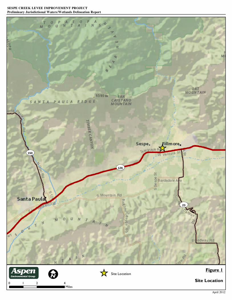
ST126
ST23
ST150
IFigure 1
Site Location
April 2012
0 2 41Miles
SESPE CREEK LEVEE IMPROVEMENT PROJECTPreliminary Jurisdictional Waters/Wetlands Delineation Report
_̂
_̂ Site LocationAspenEnvironmental Group
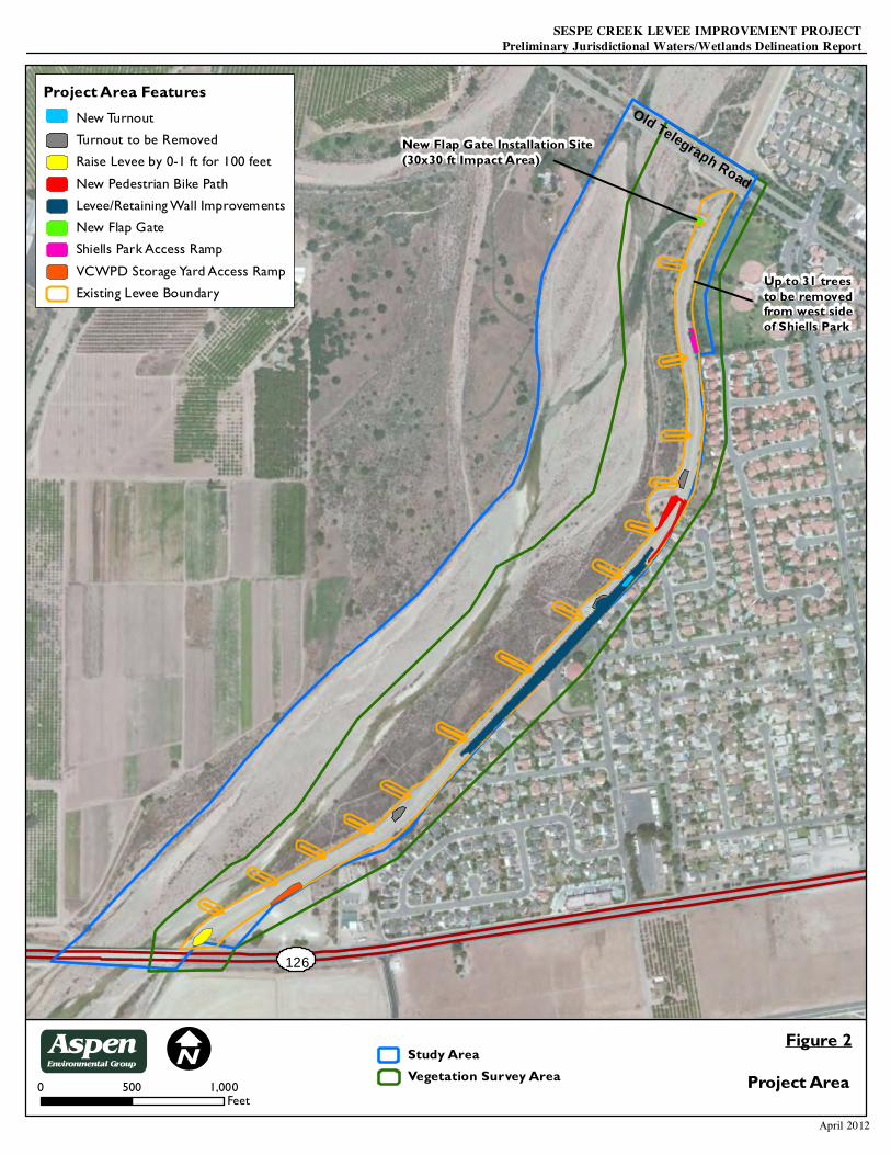
I Figure 2
April 2012
0 1,000500Feet
126
Old Telegraph Road
SESPE CREEK LEVEE IMPROVEMENT PROJECTPreliminary Jurisdictional Waters/Wetlands Delineation Report
Project Area
New Flap Gate Installation Site(30x30 ft Impact Area)
Up to 31 treesto be removedfrom west sideof Shiells Park
AspenEnvironmental Group Study Area
Vegetation Survey Area
Project Area FeaturesNew TurnoutTurnout to be RemovedRaise Levee by 0-1 ft for 100 feetNew Pedestrian Bike PathLevee/Retaining Wall ImprovementsNew Flap GateShiells Park Access RampVCWPD Storage Yard Access RampExisting Levee Boundary
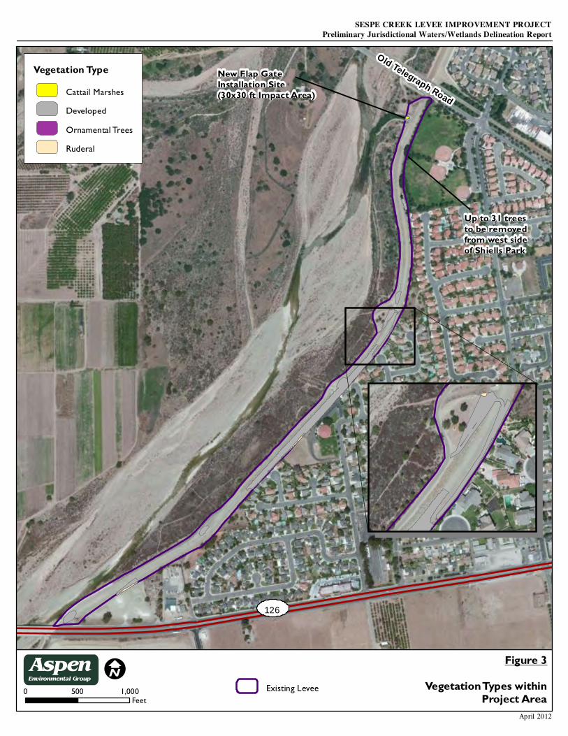
IFigure 3
Vegetation Types withinProject Area
April 2012
0 1,000500Feet
SESPE CREEK LEVEE IMPROVEMENT PROJECTPreliminary Jurisdictional Waters/Wetlands Delineation Report
Old Telegraph Road
Existing Levee
126
New Flap GateInstallation Site(30x30 ft Impact Area)
Up to 31 treesto be removedfrom west sideof Shiells Park
Vegetation TypeCattail MarshesDevelopedOrnamental TreesRuderal
AspenEnvironmental Group
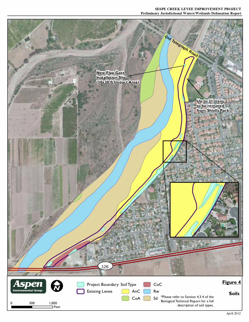
IFigure 4
Soils
April 2012
0 1,000500Feet
Project BoundaryExisting Levee
Soil TypeAnCCoA
CoCRwSd *Please refer to Section 4.3.4 of the
Biological Technical Report for a fulldescription of soil types.
SESPE CREEK LEVEE IMPROVEMENT PROJECTPreliminary Jurisdictional Waters/Wetlands Delineation Report
126
New Flap GateInstallation Site(30x30 ft Impact Area)
Old Telegraph Road
Up to 31 treesto be removedfrom Shiells Park
AspenEnvironmental Group
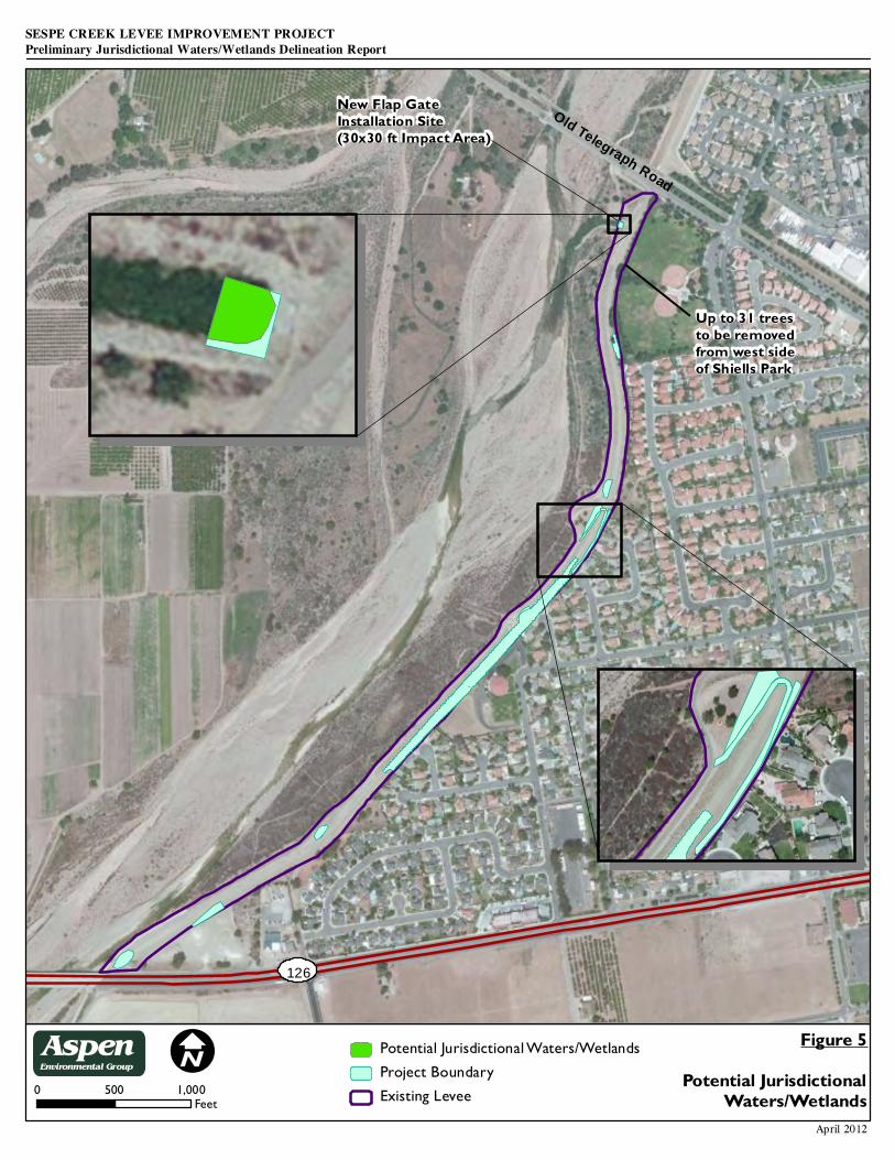
I Figure 5Potential Jurisdictional
Waters/WetlandsApril 2012
0 1,000500Feet
Potential Jurisdictional Waters/WetlandsProject BoundaryExisting Levee
SESPE CREEK LEVEE IMPROVEMENT PROJECTPreliminary Jurisdictional Waters/Wetlands Delineation Report
126
Old Telegraph Road
New Flap GateInstallation Site(30x30 ft Impact Area)
Up to 31 treesto be removedfrom west sideof Shiells Park
AspenEnvironmental Group

Appendix 4
Cultural Resources Report
A Phase 1 Archaeological Study For the proposed Sespe Creek Levee Improvements Project
County of Ventura, California
Prepared for:
Aspen Environmental Group 30423 Canwood Street, Suite 215
Agoura Hills, California 91301-4316 Telephone: 818-597-3407 - Fax: 818-597-8001
Prepared and submitted by:
Rob Wlodarski
Principal Investigator Historical Environmental Archaeological Research Team (H.E.A.R.T.)
37 years in Cultural Resource Management M.A./R.P.A. and C.C.P.H Certified in History, Archaeology and Architectural History
Meets National Park Service standards & guidelines for Archaeology and Historic Preservation Member of the National Council on Public History
8701 Lava Place. West Hills, California 91304 Telephone/Fax: 818-340-6676 - E-mail: [email protected]
February 2012
Summary of Findings
At the request of Aspen Environmental Group, Agoura Hills, California a Phase 1 Archaeological Study was performed for the proposed Sespe Creek Levee Improvements Project, County of Ventura, California. This document is designed to assist the client in achieving compliance with extant laws, policies and procedures that regulate the performance of cultural resource studies within the County of Ventura, based on the implementation of the California Environmental Quality Act (CEQA). The scope of work consisted of: 1. Performing a record search at the South Central Coastal Information Center, California State University Fullerton. 2. Contacting the Native American Heritage Commission with regard to potential sacred lands issues. 3. Conducting an on-foot surface reconnaissance of the entire project area. 4. Preparing a report summarizing the results of the records search and field phases.
The project area lies north of Ventura, south of Bakersfield, west of Castaic, and east of Santa Barbara within the County of Ventura, California (Figure 1). The project area is located on the Fillmore, California 7.5-minute USGS topographic map (1995) within Section 25 of Township 4 North, Range 20 West (Figure 2). The proposed project is located along lower Sespe Creek through the City of Fillmore. The project reach extends from the northern end of Goodenough Road to the confluence with the Santa Clara River. Four alternatives were evaluated for the project as follows: Alternative 1 would result in no changes to the current level of flood protection for the City of Fillmore. Alternative two would involve the levee heights along the non-accredited reach (from Old Telegraph Road to the Highway 126 bridge), which would be raised in two locations to provide the required freeboard heights. This alternative includes raising the levee height from one to six feet for about 1,500 feet in the mid-section of the levee, and roughly two feet for 200 feet on the upstream side of the Highway 126 Bridge. Additionally, this alternative would raise the bank protection at Lookout Point (along the upper reach) and provide additional toe-down for scour protection. This option would provide the required flood protection under the current conditions. Alternative 3 includes regular sediment removal and maintenance activities in the creek bed to maintain the necessary channel capacity. The sediment removal activities would take place along the east fork channel within the non-accredited reach (from Old Telegraph Road to the Highway 126) and about 1,000 feet downstream of the Highway 126 Bridge. This alternative would also include regular repairs after major storm events. Alternative 4 includes the reconstruction of the Highway 126 Bridge over the east fork of lower Sespe Creek. The bridge structure would be raised to provide additional flood conveyance capacity. This alternative would eliminate the backwater effect of the existing structure, and allow for additional sediment deposition in the creek without jeopardizing the flood protection provided by the levee system. The upstream levee section situated between Old Telegraph Road and Highway 126 may still require improvements (Figure 3).
A record search performed on February 1, 2012 at the South Central Coastal, Information, California State University Fullerton, indicated that no previously recorded prehistoric or historic archaeological resources have been recorded within the boundaries of the subject property. In addition, the following applies to a ½-mile radius of the project area: • No prehistoric archaeological sites have been recorded. • No historic archaeological sites are documented. • No significant historic properties are noted. • Thirty-three prior studies have been performed: Anon. 1977, 1978, 1995, 1997; Drew 1979; Haessig & Buge 1979,
Huey & Romani 1980; C. King 1995; Lopez 1976, 1995; LSA 1992; Maxwell 1991, 1994; Peak & Assoc. 1992; Planning Corporation 1995; Romani 1992; Rosen 1975; Santoro et al. 1991; Singer 1977, 1987; Southern California Ocean Studies 1978, Triem 2002; US Army Corps 2002; Webb & Huey 1980; and Wlodarski 1992, 1999, 2002a,b,c, 2003, 2006, 2007, 2009.
• Four prior studies have encompassed portions of the project area with negative results: Anon 1987; Singer 1987; Webb & Huey 1980; Wlodarski 1999. However, due to the age of prior studies, the SCCIC requires that an updated Phase 1 archaeological study be performed prior to construction.
• A letter dated February 3, 2012 was sent to the Native American Heritage Commission (NAHC), Sacramento, California, requesting a search of their files for sensitive or sacred cultural resources that may have relevance to the project. A letter response was received from the NAHC on February 12, 2012 indicating that no known Native American resources will be affected by the implementation of this project.
• A cultural heritage survey of Fillmore during 1982-1983 (to the north of the project area) identified 292 out of 824 buildings as potentially eligible historic resources based on the application of National Register criteria. The 292
-ii-
buildings were selected for the State Inventory of Historical Resources (SIHR). A subsequent field investigation conducted by LSA (1993), updated the list of resources older than 45 years within the original sphere of influence. No eligible or significant historic properties are listed within the project area as part of these studies.
• No National Register of Historic Places properties are identified. • No California Points of Historical Interest are listed. • No California State Historic Landmarks are recorded. • One Ventura County Historical Landmark [#48] is listed to the northeast: The Southern Pacific Railroad Depot. • Numerous historic points of interest lie outside the record search radius including: Fillmore Fire Department
(1914); Fillmore State Bank Building (1917); Segovia's Family Billiard and Ice Cream Parlor (1917); Shandy's Uniforms, Mike's Services, and Mirage Clothing (1918); Edison's Up in Arms, which was originally Goodenough's men's clothing store (1910); 330 Central Avenue where the Chamber of Commerce, Photography, and Investments businesses occupy a historic structure; the building at 334 and 334 1/2 Central Avenue (1917) which now houses the Hair Loft and Diversified Home Services; the building at 336 and 338 Central Avenue, which was formerly the Fillmore Towne Theater (1918); 340 Central Avenue, Garner's Hardware and Plumbing (1915); The Fillmore Flower shop building (1910) at 354 Central Avenue; Lupe's Fashions (and Fine Tailoring) at 358 Central Avenue (1910); Patterson’s' hardware at 360 Central Avenue (1910); The corner building at Sespe and Central (1913) that was originally the Farmers and Merchants Bank; Masonic Park at 402 Central Avenue (1919); The Church of the Nazarene at 422 Central Avenue (1918); Fillmore High School (1910) at 555 Central Avenue; Central Market at 351 Central Avenue (1915); Segovia's Market building at 317 Central Avenue (1910).
The following information is on file at the Geography Department Map Reference Center, California State University, Northridge, and the Ventura County Museum of History and Art (VCMHA): • 1895-1929, Sanborn Fire Insurance Maps for Fillmore, 1895, 1909, 1911, 1918, 1923, 1929 (updated to 1939) • 1903 edition, Camulos 15-minute USGS Topographic Map (surveyed in 1900-1901) • 1921 edition, Piru 15-minute USGS Topographic Map (surveyed in 1900) • Ventura County Cultural Heritage Survey Phase II – Fillmore, Inventory Data Collection (1983) by Judy Triem • Jarrett, Edith Moore (1983) Old-Timers' Tales of Fillmore. Ventura County Historical Society. • Fillmore, which was named after Southern Pacific's West Coast superintendent, Jerome A. Fillmore, was founded
in 1888 and originally consisted of the train station, a ranch house, and three "shanties. The town became a true entity when the Sespe Land and Water Company (an organization of Los Angeles investors) bought 3000 acres from the owners of Rancho Sespe in the early 20th century. During 1914, the town was incorporated as a city. On March 12, 1928, the St. Francis Dam collapsed with water from the dam failure reaching Fillmore at 12:20am traveling at 12.3 miles per hour. Trees, cropland, cattle, buildings, houses, stores, fences, pipes, bridges, telephone, telegraph and electric facilities, railroad lines, landscape and people were washed downstream toward the ocean by the raging waters from the dam collapse..
The on-foot field inspection of the subject property, conducted by the author with the aid of RPA certified archaeologist and Project Manager, Wayne Bonner on February 12, 2012, yielded the following field observations: • The project extends from Old Telegraph Road on the north to the Highway 126 Bridge to the south. • A pave bike/walking path with protective fencing runs the length of the project area. • All original topography within the project area has been substantially altered by man-made and natural forces
including the Sespe Creek Floodplain and protective levee on the east side of the river. • The Highway 126 Bridge, minor commercial use and single-family homes dominate the eastern bank of Sespe
Creek just to the east of the project area. Selected addresses that occur to the east of the eastern edge of the project area from south to north include: Sespe Creek/Highway 126 Bridge (BR52-182); Sespe Creek overflow mile marker 19.86; a commercial facility at 1515 E Street (United Shah Corporation; 1417, 1413, 1409, 1405, 1397, 1393, 1389, 1383, 1387, 1371, 1367, 1361, 1355, 1349, 1343, 1337, 1331, 1325, 1321, 248, 244, 238 and 232 Waterford Lane; 239 D Street; 1366, 1370, 1374, 1375, and 1371 Bluejay Street; 319, 325, 335, 338, and 334 Condor Court; 327, 330, and 322 Dover Street; Faith Community Church at 335 D Street; 423 and 424 Robin Court; 444 and 439 Mallard Street; 449, 453, 456 and 452 Quail Street; 1203, 1185 and 1155 Sespe Street; 503, 509, 515, 521, 527, 533, 537, 545, 551, 557, 563, 569, 575 and 578 Mockingbird Lane;
• Shiells Park lies at the NE end of the project area beginning north of single-family residences and terminating at Old Telegraph Road. Bridge BR485, which crosses Sespe Creek, lies at the north end of the project area
• Sespe Creek and a mixture of native and introduced plants dominate the western border of the project area.
-iii-
Results The results of the record search, Native American consultation and pedestrian survey yielded no evidence of prehistoric or historic archaeological resources within the project boundaries. Any proposed improvements or modifications within the project area will have no adverse physical or visual impacts on known prehistoric and historic archaeological resources.
Recommmendations The nature of a walkover can only confidently assess the potential for encountering surface cultural resource remains; therefore, customary caution is advised in developing within the project area. According to the Code of Federal Regulations Title 36, Volume 3 (Revised July 1, 2001), if archaeological remains are exposed during ground construction (Cultural resource remains may include artifacts, shell, bone, features, altered soils, foundations, trash pits and privies, etc.) , work within five meters of the radius of the find(s) must be halted and a qualified archaeologist must be retained to evaluate the finds.
If human remains are encountered during excavations associated with this project, all work must halt, and the County Coroner must be notified (Section 7050.5 of the California Health and Safety Code). The coroner will determine whether the remains are of forensic interest. If the coroner, with the aid of the supervising archaeologist, determines that the remains are prehistoric, the coroner will contact the Native American Heritage Commission (NAHC). The NAHC will be responsible for designating the most likely descendant (MLD), who will be responsible for the ultimate disposition of the remains, as required by Section 5097.98 of the Public Resources Code. The MLD should make his/her recommendations within 48 hours of their notification by the NAHC. This recommendation may include A) the nondestructive removal and analysis of human remains and items associated with Native American human remains; (B) preservation of Native American human remains and associated items in place; (C) relinquishment of Native American human remains and associated items to the descendants for treatment; or (D) other culturally appropriate treatment.
-iii-
Table of Contents Title Page Summary of Findings ii I. Introduction 1 1.1 Scope of the project 1 1.2 Location and Description of the project 1 II. Environmental Information 3 2,1 Physiographic Information 4 2.2 Hydrology 4 2.3 Climate 4 2.4 Flora and Fauna 4 III. Cultural Overview 4 3.1 Prehistory/Protohistory 4 3.2 Ethnographic Information 4 3.3 History 5 IV. Background Research Synthesis 6 V. Field Reconnaissance Program 7 5.1 Methodology 7 5.2 Crew 7 5.3 Results 8 5.4 Recommendations 13 VI. References 13 Appendix A The Native American Heritage Commission (NAHC) letter response
February 12, 2012 – Katy Sanchez - Program Analyst, NAHC) 17
List of Figures No. Title Page 1 Vicinity Map 1 2 Location of the Survey 2 3 Aerial View of the Project Area 3
List of Plates No. Title Page 1 Selected Views of the Project Area 8
-v-
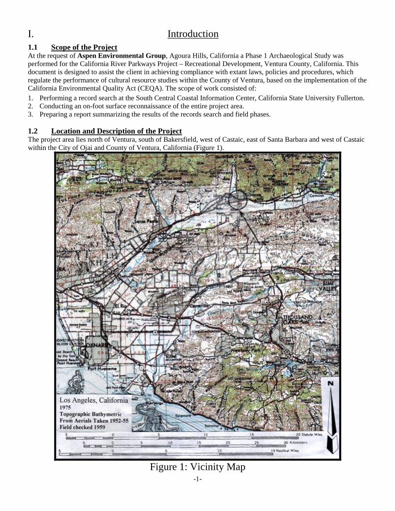
I. Introduction
1.1 Scope of the Project At the request of Aspen Environmental Group, Agoura Hills, California a Phase 1 Archaeological Study was performed for the California River Parkways Project – Recreational Development, Ventura County, California. This document is designed to assist the client in achieving compliance with extant laws, policies and procedures, which regulate the performance of cultural resource studies within the County of Ventura, based on the implementation of the California Environmental Quality Act (CEQA). The scope of work consisted of:
1. Performing a record search at the South Central Coastal Information Center, California State University Fullerton. 2. Conducting an on-foot surface reconnaissance of the entire project area. 3. Preparing a report summarizing the results of the records search and field phases. 1.2 Location and Description of the Project The project area lies north of Ventura, south of Bakersfield, west of Castaic, east of Santa Barbara and west of Castaic within the City of Ojai and County of Ventura, California (Figure 1).
Figure 1: Vicinity Map
-1-
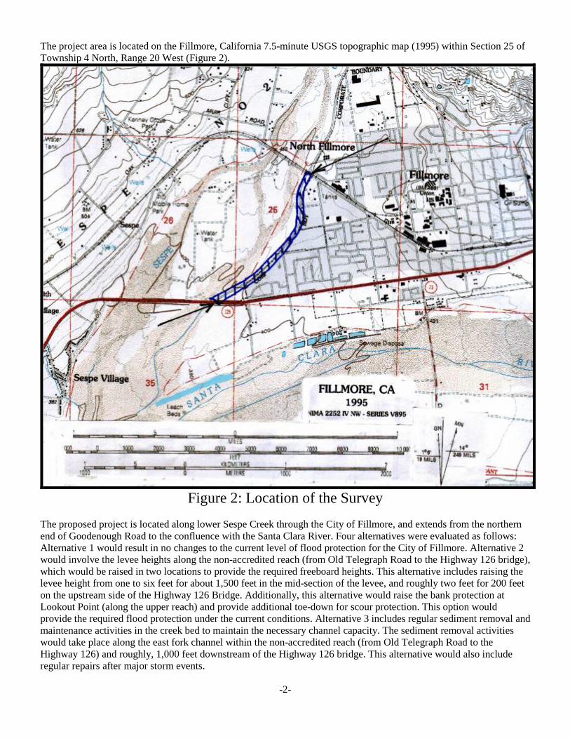
The project area is located on the Fillmore, California 7.5-minute USGS topographic map (1995) within Section 25 of Township 4 North, Range 20 West (Figure 2).
Figure 2: Location of the Survey
The proposed project is located along lower Sespe Creek through the City of Fillmore, and extends from the northern end of Goodenough Road to the confluence with the Santa Clara River. Four alternatives were evaluated as follows: Alternative 1 would result in no changes to the current level of flood protection for the City of Fillmore. Alternative 2 would involve the levee heights along the non-accredited reach (from Old Telegraph Road to the Highway 126 bridge), which would be raised in two locations to provide the required freeboard heights. This alternative includes raising the levee height from one to six feet for about 1,500 feet in the mid-section of the levee, and roughly two feet for 200 feet on the upstream side of the Highway 126 Bridge. Additionally, this alternative would raise the bank protection at Lookout Point (along the upper reach) and provide additional toe-down for scour protection. This option would provide the required flood protection under the current conditions. Alternative 3 includes regular sediment removal and maintenance activities in the creek bed to maintain the necessary channel capacity. The sediment removal activities would take place along the east fork channel within the non-accredited reach (from Old Telegraph Road to the Highway 126) and roughly, 1,000 feet downstream of the Highway 126 bridge. This alternative would also include regular repairs after major storm events.
-2-
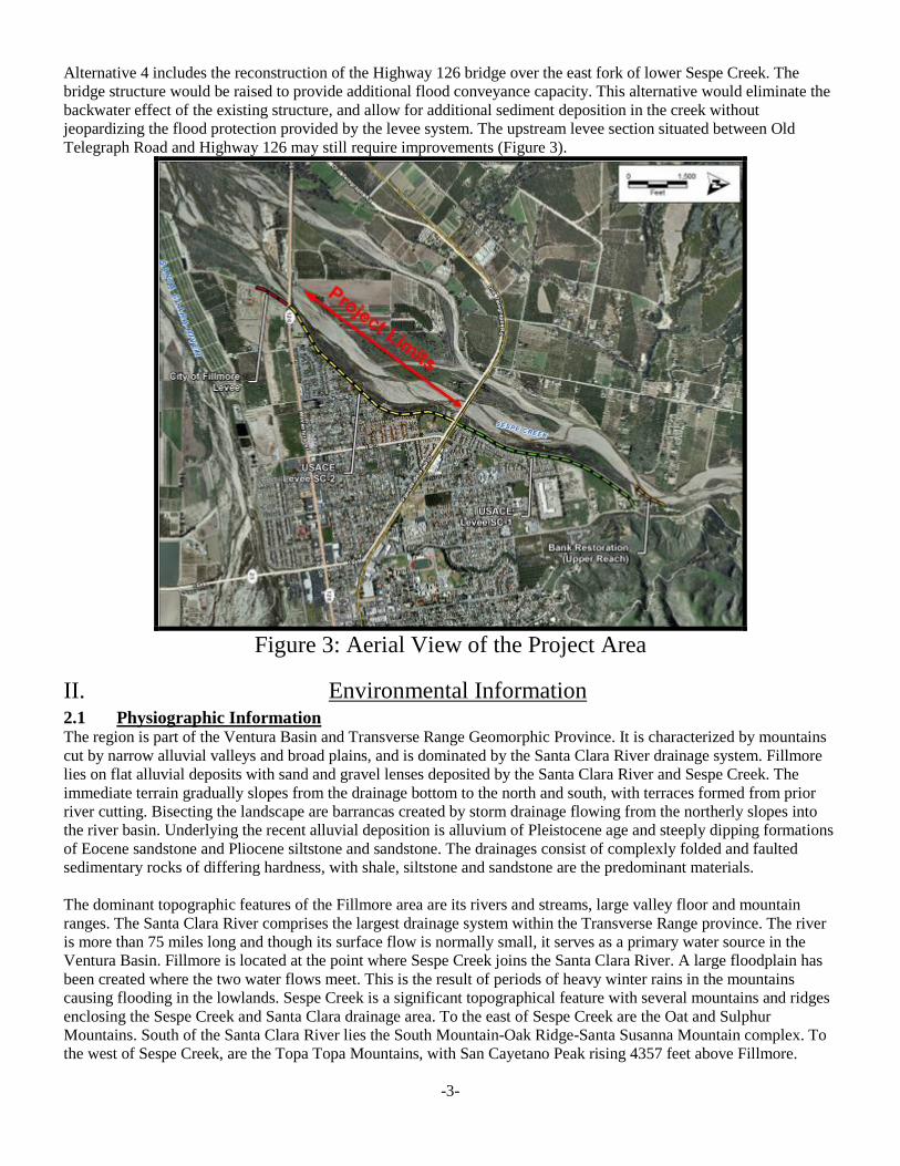
Alternative 4 includes the reconstruction of the Highway 126 bridge over the east fork of lower Sespe Creek. The bridge structure would be raised to provide additional flood conveyance capacity. This alternative would eliminate the backwater effect of the existing structure, and allow for additional sediment deposition in the creek without jeopardizing the flood protection provided by the levee system. The upstream levee section situated between Old Telegraph Road and Highway 126 may still require improvements (Figure 3).
Figure 3: Aerial View of the Project Area
II. Environmental Information
2.1 Physiographic Information The region is part of the Ventura Basin and Transverse Range Geomorphic Province. It is characterized by mountains cut by narrow alluvial valleys and broad plains, and is dominated by the Santa Clara River drainage system. Fillmore lies on flat alluvial deposits with sand and gravel lenses deposited by the Santa Clara River and Sespe Creek. The immediate terrain gradually slopes from the drainage bottom to the north and south, with terraces formed from prior river cutting. Bisecting the landscape are barrancas created by storm drainage flowing from the northerly slopes into the river basin. Underlying the recent alluvial deposition is alluvium of Pleistocene age and steeply dipping formations of Eocene sandstone and Pliocene siltstone and sandstone. The drainages consist of complexly folded and faulted sedimentary rocks of differing hardness, with shale, siltstone and sandstone are the predominant materials. The dominant topographic features of the Fillmore area are its rivers and streams, large valley floor and mountain ranges. The Santa Clara River comprises the largest drainage system within the Transverse Range province. The river is more than 75 miles long and though its surface flow is normally small, it serves as a primary water source in the Ventura Basin. Fillmore is located at the point where Sespe Creek joins the Santa Clara River. A large floodplain has been created where the two water flows meet. This is the result of periods of heavy winter rains in the mountains causing flooding in the lowlands. Sespe Creek is a significant topographical feature with several mountains and ridges enclosing the Sespe Creek and Santa Clara drainage area. To the east of Sespe Creek are the Oat and Sulphur Mountains. South of the Santa Clara River lies the South Mountain-Oak Ridge-Santa Susanna Mountain complex. To the west of Sespe Creek, are the Topa Topa Mountains, with San Cayetano Peak rising 4357 feet above Fillmore.
-3-
2.2 Hydrology Sespe Creek is located near the City of Fillmore in Ventura County, California. The creek is the largest free-flowing tributary to the Santa Clara River. The majority of the 270 square mile watershed is contained within the boundary of the Los Padres National Forest in Ventura County. Elevations in the watershed range from greater than 7,000 feet in the upper reaches to less than 400 feet above sea level in the vicinity of the City of Fillmore. Sespe Creek flows for 60 miles from its headwaters to the confluence with the Santa Clara River in the City of Fillmore. The upper and middle portions of the stream flow through a narrow, v-shaped canyon with rugged mountain ridges separating the watershed from adjacent watersheds. In the vicinity of Fillmore, the stream leaves the steep canyons and flows over a broad alluvial fan. The stream gradient in this area is about 40 feet per mile.
2.3 Climate The region is classified as Mediterranean warm, and lies between the dry climate of the Mojave Desert to the northeast and the humid mesothermal climate of the Pacific Coast to the south. The region is characterized by warm, dry summers, and mild, moderately wet winters. Temperatures range from about 100 degrees in July and August, to the low 30s in January. Snowfall is rare and rainfall occurs normally between November and April.
2.4 Flora and Wildlife The lower Sespe/Santa Clara River drainage area typically contains chaparral-coast live oak habitats with expanses of riparian vegetation. At the lower drainage extremities, near creek confluences with the Santa Clara River, are willows, grasses and other annuals adapted to a flood plain habitat. Currently, the Santa Clara River basin consists of cultivated and irrigated farmlands. Historically, the region supported several major plant communities including: Riparian with species of sycamore, willow, alder and mulefat; and, sage chaparral with species of white, purple, black and coastal sage, chamise, buckwheat, yerba santa, sumac, California sagebrush, and lemonadeberry; manzanita, buckthorn, yucca, scrub oak, laurel sumac, and toyon. Wildlife consisted of seasonally fluctuating populations of quail, rabbit, rodents, and deer. Lizards, snakes, and various species of birds also occur within the region. III. Cultural Overview
3.1 Prehistory At Spanish Contact, the region was occupied by the Chumash, a diverse population living in settlements along the California coast from Malibu Creek to the southeast, Estero Bay in the north, including the islands of San Miguel, Santa Rosa, and Santa Cruz, and as far as Tejon Pass, Lake Casitas and the Cuyama River inland (Kroeber 1925, Landberg 1965, Grant 1978, Santa Barbara Museum of Natural History 1986, 1991, Miller 1988 and Gibson 1991). Chumash society became more complex over the last 9,000 years (Wallace 1955 and Warren 1968). Warren revised Wallace's scheme to include regional variants and traditions enhanced by radiocarbon dates. King (1982) proposed sequences based on changes in ornaments, beads and other artifacts. After A.D. 1000, changes in bead types suggest the development of a highly developed economic system that was observed by early Spanish explorers. Following the 1542 Cabrillo voyage, many small Chumash settlements were abandoned and some of the largest historic towns were founded. This change in population distribution is attributed to growth in importance of trade centers and the development of more integrated political confederations. The Chumash economic system enabled them to make efficient use of diverse environments within their territory. Acorns and seeds were traded between the islands and mainland, and interior populations who lacked marine resources traded with coastal populations for fish and other seafood’s. Most religious ceremonies had their roots in the Early Period when objects similar to those used historically were placed in mortuary associations or owned by religious leaders. Other sources include Leonard 1971; Hudson et al. (1977); Hudson & Underhay (1978); Hudson (1979), Hudson and Blackburn (1979-87); Carrico and Wlodarski (1983); Dillon & Boxt (1989); and, C. King (1982). 3.2 Ethnographic Information Traditionally, the region is considered a borderland between the Hokan-speaking Chumash to the west and the Shoshonean speaking Alliklik (a Chumash term for “Grunters”) to the east. The territorial boundary between these two linguistic groups is believed to have been the Piru Creek drainage. In the area of Piru Creek and Camulos, there appears to have been a mixed population of Chumash and Takic speakers, although, one informant assigned that whole district to the Chumash. The Chumash achieved a cultural complexity unique for hunter and gatherer groups in California. They possessed a stratified society containing an upper, middle and lower class. Moreover, attributes
-4-
usually attributed to chiefdom societies such as ownership of resources/property, craft specialists, large permanent population centers (villages), a sodality consisting of religious elitists (Antap), and a market economy, were all a part of Chumash culture at historic contact. Politically, there were at least six ethnographically known Chumash provinces. The following are the provinces, from north to south and their corresponding capitols, respectively: l) Gaviota (capitol at Shisholop or Upop), 2) Dos Pueblos (capitol at Mikiw), 3) Santa Barbara (capitol at Synhten), 4) Ventura (capitol at Shisholop), 5) Mugu (capitol at either Muwu or Simomo), and 6) Malibu (capitol at Humaliwu) (Hudson, 1978). Additionally, there were two religious federations (Muwu and Upop). All high status (Wots and Shamans) or wealthy people were required to join a religious sodality known as the Antap. The Antap was the principal religious cult, which dominated all aspects of Chumash religious and political society at the time of Spanish Contact. The Spanish viewed the Chumash as unique among California Indians due to their knowledge of the sea, canoe building expertise, ceremonial organization, their interest in acquiring and displaying possessions, willingness to work, and their extensive trade networks. The protohistoric Chumash maintained the most complex bead money system documented in the world (King 1982). Information obtained from Schumacher & Bowers in 1877-1878; Rogers in the 1920s; Harrington in the 1930s; and Woodward and Van Valkenburgh in the late 1920s and 1930s, suggests that the Chumash were divided into political provinces, with each containing a capital where villages now exist. The protohistoric Chumash maintained the most complex bead money system documented in the world (King 1982). Information obtained from Schumacher & Bowers in 1877-1878; Rogers in the 1920s; Harrington in the 1930s; and Woodward and Van Valkenburgh in the late 1920s and 1930s, suggests that the Chumash were divided into political provinces, with each containing a capital where villages now exist. 3.3 History From the early voyages of Cabrillo in 1542 and Vizcaino in 1602, to the land expeditions of Portola in 1769 and Anza from 1773-1776, there was little interference from white men in the Chumash region. The Spanish Period was followed by the Mission period during which 21 missions were established between 1769 and 1823, all located a day's ride from one another along the Camino Real which connected San Diego with Solano. Native Americans were slowly assimilated into the mission system through recruitment, and moved from their villages and the islands to help sustain the missions. During this period, many introduced diseases contributed to the decimation of Native Americans. Generally, the following historic timeline applies to the region: • In August 1769, a military contingent of Spanish explorers under the leadership of Don Gaspar De Portola passed
through the lower Santa Clara River Valley. The diaries of Miguel Costanso, Fray Juan Crespi and Pedro Fages, identified three villages in the valley during the Journey from Castaic (Rancheria del Corral) to the Ventura River.
• From Castaic (Rancheria del Corral) the expedition traveled six leagues (W/SW) before encountering a village in the Canada de Santa Clara. On Friday, August 11, the expedition camped on the bank of an arroyo, where a populous village was situated. This village was similar to Rancheria del Corral in that it consisted of a large brush shelter inside a large corral.
• On Saturday, August 12, after a march of three leagues over a road cross cut by drainages, the expedition camped on the bank of a stream near a village.
• On Sunday, August 13, after traveling about two leagues, the expedition stopped near a small village situated a short distance from the river. This village was very small and the inhabitants dwelled in huts covered with grass, spherical in construction like a half-orange, at the apex of which an air hole was left for the escape of smoke and the entrance of light.
• The Spanish chroniclers noted perceived differences in village organization from east to west along the Rio de Santa Clara. It would seem that villages situated east of Santa Paula Creek were distinctly different in village arrangement from those documented to the west. Cultural differences would seem to be an unlikely explanation, since throughout this area thatched or domed houses were used as shelter in permanent or semi-permanent village sites. Certain temporary sites, such as summer gathering or hunting sites could have easily made do without such structures.
• Chester King (1982), postulated that the villages possessing corrals, as noted by the Spanish, were ceremonially significant; with the corrals perhaps representing large ceremonial enclosures. This possibility does exist, and with the further presence of a mountain shrine (San Cayateno) and a ceremonial cache (Bowers Cave) would strongly suggest an important ceremonial aspect for the lower Santa Clara area.
-5-
• According to King (1975) at least seven ethnographically known villages exist within the lower Santa Clara Valley proper: l) Mupu, 2) Sespe, 3) Alalhew, 4) Maxaxl, 5) Kamulus, 6) Sisa, and 7) Kastu. According Applegate (1975), there were six villages located in this general area as follows: l) Mupu, 2) Sespe, 3) Mahaw, 4) Mahahal, 5) Kamulus, and 6) Kashtu. Certain discrepancies exist regarding their ethnohistoric placenames as well as their approximate locations. In addition to these villages, Applegate (ibid) lists a total of seven ethnohistoric placenames, they are as follows: • Aliwolhoyoyo (one that falls), Santa Paula Canyon - a waterfall. • Chi'apisti in (house of the dogs) a place in the hills east of Santa Paula. • Ka'alhelek'ech (demon with a pack basket) located east of Camulos • Ka 'alishew Ka'-o (hot water) Sulphur Mountain Hot Springs above Santa Paula. • Kas'elew (The Tongue) a rock located in Piru Canyon. • S'apk'onil (?) located just south of Santa Paula. • Waha'as (Ominous) San Cayateno Mountain located north-east of Santa Paula. San Cayateno (Waha'as) was a
mountain shrine used for the Winter Solstice Ceremony. Although not a recorded archaeological site, it is ethnographically documented as a sacred mountain shrine. The mountain was probably used for the offerings of beads, and seeds during the time of the Winter Solstice, and may have been used throughout the year as a depository-for-the-things-of-the-dead; a shrine where homage was paid for the deceased.
Van Valkenburgh (1935) obtained ethnographic information on at least 19 sites within the lower Santa Clara area, including the villages of: Piru (Pi'duah-vit), Kamulus, Castaic (Chagu-ya-vit), Sespe-Pole Canyon (Sek'pai), Sespe Canyon-Lords Creek (Malhal), Piru Canyon-Fustero Ranch (Kuvung), and Piru Canyon-Narrows (Poipin). Most of these sites, with the exception of the Piru, Kamulus, Sespe, Castaic, and Malhal villages, appear to be situated north of Route 126. Van Valkenburgh (1934, 1935) further noted the probable cemetery locations (with the exception of Piru-Piru Town, these cemeteries would have been situated north of the present Route 126) as follows: • Historic Cemetery at Pelsendthal Ranch, at the mouth Hopper Canyon. • Skeletons found at Devils Pendero, one mile below the mouth of Agua Blanca. • Cemetery at Piru (Piru-Town). • Cemetery at the Upper Hopper and Tar Creeks. • Main Piru Canyon Cemetery at Piru Canyon-Esperanza Ranch. • Sespe Canyon-Henly Flat, reported as both a site as well as a cemetery.
Subsequent years gave rise to large rancho controlled territories in the Mexican period, the discovery of gold in Placerita Canyon in 1842, and large land booms in the American era. The 1890's marked the start of intensive citrus and avocado production, giving the lower Santa Clara area its present character. On March 12, 1928, the St. Francis Dam collapsed. The water from the dam failure reached Fillmore at 12:20a.m. traveling at 12.3 miles per hour. Trees, cropland, cattle, buildings, houses, stores, fences, pipes, bridges, telephone, telegraph and electric facilities, railroad lines, landscape and people were washed downstream toward the ocean. Bodies from Piru were taken to Fillmore where a temporary morgue was set up at French and Skillin mortuary in Fillmore. Farmer John McNab lost 65 acres of young orange trees and apricot trees at Fillmore. Dead livestock were placed in piles and burned in Fillmore (Historical Society of Southern California 1995, Nichols 2002, Outland 1977). IV. Background Research Synthesis
A record search performed on February 1, 2012 at the South Central Coastal, Information, California State University Fullerton, indicated that no previously recorded prehistoric or historic archaeological resources have been recorded within the boundaries of the subject property. In addition, the following applies to a ½-mile radius of the project area: • No prehistoric archaeological sites have been recorded. • No historic archaeological sites are documented. • No significant historic properties are noted. • Thirty-three prior studies have been performed: Anon. 1977, 1978, 1995, 1997; Drew 1979; Haessig & Buge 1979,
Huey & Romani 1980; C. King 1995; Lopez 1976, 1995; LSA 1992; Maxwell 1991, 1994; Peak & Assoc. 1992; Planning Corporation 1995; Romani 1992; Rosen 1975; Santoro et al. 1991; Singer 1977, 1987; Southern California Ocean Studies 1978, Triem 2002; US Army Corps 2002; Webb & Huey 1980; and Wlodarski 1992, 1999, 2002a,b,c, 2003, 2006, 2007, 2009.
-6-
• Four prior studies have encompassed portions of the project area with negative results: Anon 1987; Singer 1987; Webb & Huey 1980; Wlodarski 1999. However, due to the age of prior studies, the SCCIC requires that an updated Phase 1 archaeological study be performed prior to construction.
• A letter dated February 3, 2012 was sent to the Native American Heritage Commission (NAHC), Sacramento, California, requesting a search of their files for sensitive or sacred cultural resources that may have relevance to the project. A letter response was received from the NAHC on February 12, 2012 indicating that no known Native American resources will be affected by the implementation of this project.
• A cultural heritage survey of Fillmore during 1982-1983 (to the north of the project area) identified 292 out of 824 buildings as potentially eligible historic resources based on the application of National Register criteria. The 292 buildings were selected for the State Inventory of Historical Resources (SIHR). A subsequent field investigation conducted by LSA (1993), updated the list of resources older than 45 years within the original sphere of influence. No eligible or significant historic properties are listed within the project area as part of these studies.
• No National Register of Historic Places properties are identified. • No California Points of Historical Interest are listed. • No California State Historic Landmarks are recorded. • One Ventura County Historical Landmark [#48] is listed to the northeast: The Southern Pacific Railroad Depot. • Numerous historic points of interest lie outside the record search radius including: Fillmore Fire Department
(1914); Fillmore State Bank Building (1917); Segovia's Family Billiard and Ice Cream Parlor (1917); Shandy's Uniforms, Mike's Services, and Mirage Clothing (1918); Edison's Up in Arms, which was originally Goodenough's men's clothing store (1910); 330 Central Avenue where the Chamber of Commerce, Photography, and Investments businesses occupy a historic structure; the building at 334 and 334 1/2 Central Avenue (1917) which now houses the Hair Loft and Diversified Home Services; the building at 336 and 338 Central Avenue, which was formerly the Fillmore Towne Theater (1918); 340 Central Avenue, Garner's Hardware and Plumbing (1915); The Fillmore Flower shop building (1910) at 354 Central Avenue; Lupe's Fashions (and Fine Tailoring) at 358 Central Avenue (1910); Patterson’s' hardware at 360 Central Avenue (1910); The corner building at Sespe and Central (1913) that was originally the Farmers and Merchants Bank; Masonic Park at 402 Central Avenue (1919); The Church of the Nazarene at 422 Central Avenue (1918); Fillmore High School (1910) at 555 Central Avenue; Central Market at 351 Central Avenue (1915); Segovia's Market building at 317 Central Avenue (1910).
The following information is on file at the Geography Department Map Reference Center, California State University, Northridge, and the Ventura County Museum of History and Art (VCMHA): • 1895-1929, Sanborn Fire Insurance Maps for Fillmore, 1895, 1909, 1911, 1918, 1923, 1929 (updated to 1939) • 1903 edition, Camulos 15-minute USGS Topographic Map (surveyed in 1900-1901) • 1921 edition, Piru 15-minute USGS Topographic Map (surveyed in 1900) • Ventura County Cultural Heritage Survey Phase II – Fillmore, Inventory Data Collection (1983) by Judy Triem • Jarrett, Edith Moore (1983) Old-Timers' Tales of Fillmore. Ventura County Historical Society. • Fillmore, which was named after Southern Pacific's West Coast superintendent, Jerome A. Fillmore, was founded
in 1888 and originally consisted of the train station, a ranch house, and three "shanties. The town became a true entity when the Sespe Land and Water Company (an organization of Los Angeles investors) bought 3000 acres from the owners of Rancho Sespe in the early 20th century. During 1914, the town was incorporated as a city. On March 12, 1928, the St. Francis Dam collapsed with water from the dam failure reaching Fillmore at 12:20am traveling at 12.3 miles per hour. Trees, cropland, cattle, buildings, houses, stores, fences, pipes, bridges, telephone, telegraph and electric facilities, railroad lines, landscape and people were washed downstream toward the ocean by the raging waters from the dam collapse..
V. Field Reconnaissance Program
5.1 Methodology A field reconnaissance entailing the inspection of all topography that can reasonably be expected to contain cultural resources without major modification of the land surface was performed for the parcel on February 12, 2012.
5.2 Crew The crew consisted of Principal Investigator, Robert Wlodarski who has a: BA in History and Anthropology and an MA in Anthropology from California State University Northridge (CSUN); 40 years of professional experience in
-7-
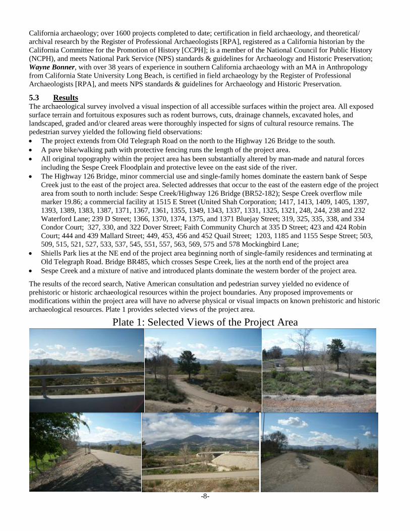
California archaeology; over 1600 projects completed to date; certification in field archaeology, and theoretical/ archival research by the Register of Professional Archaeologists [RPA], registered as a California historian by the California Committee for the Promotion of History [CCPH]; is a member of the National Council for Public History (NCPH), and meets National Park Service (NPS) standards & guidelines for Archaeology and Historic Preservation; Wayne Bonner, with over 38 years of experience in southern California archaeology with an MA in Anthropology from California State University Long Beach, is certified in field archaeology by the Register of Professional Archaeologists [RPA], and meets NPS standards & guidelines for Archaeology and Historic Preservation.
5.3 Results The archaeological survey involved a visual inspection of all accessible surfaces within the project area. All exposed surface terrain and fortuitous exposures such as rodent burrows, cuts, drainage channels, excavated holes, and landscaped, graded and/or cleared areas were thoroughly inspected for signs of cultural resource remains. The pedestrian survey yielded the following field observations: • The project extends from Old Telegraph Road on the north to the Highway 126 Bridge to the south. • A pave bike/walking path with protective fencing runs the length of the project area. • All original topography within the project area has been substantially altered by man-made and natural forces
including the Sespe Creek Floodplain and protective levee on the east side of the river. • The Highway 126 Bridge, minor commercial use and single-family homes dominate the eastern bank of Sespe
Creek just to the east of the project area. Selected addresses that occur to the east of the eastern edge of the project area from south to north include: Sespe Creek/Highway 126 Bridge (BR52-182); Sespe Creek overflow mile marker 19.86; a commercial facility at 1515 E Street (United Shah Corporation; 1417, 1413, 1409, 1405, 1397, 1393, 1389, 1383, 1387, 1371, 1367, 1361, 1355, 1349, 1343, 1337, 1331, 1325, 1321, 248, 244, 238 and 232 Waterford Lane; 239 D Street; 1366, 1370, 1374, 1375, and 1371 Bluejay Street; 319, 325, 335, 338, and 334 Condor Court; 327, 330, and 322 Dover Street; Faith Community Church at 335 D Street; 423 and 424 Robin Court; 444 and 439 Mallard Street; 449, 453, 456 and 452 Quail Street; 1203, 1185 and 1155 Sespe Street; 503, 509, 515, 521, 527, 533, 537, 545, 551, 557, 563, 569, 575 and 578 Mockingbird Lane;
• Shiells Park lies at the NE end of the project area beginning north of single-family residences and terminating at Old Telegraph Road. Bridge BR485, which crosses Sespe Creek, lies at the north end of the project area
• Sespe Creek and a mixture of native and introduced plants dominate the western border of the project area.
The results of the record search, Native American consultation and pedestrian survey yielded no evidence of prehistoric or historic archaeological resources within the project boundaries. Any proposed improvements or modifications within the project area will have no adverse physical or visual impacts on known prehistoric and historic archaeological resources. Plate 1 provides selected views of the project area.
Plate 1: Selected Views of the Project Area
-8-
-9-
-
-10-
-11-
-12-
5.4 Recommendations The nature of a walkover can only confidently assess the potential for encountering surface cultural resource remains; therefore, customary caution is advised in developing within the project area. According to the Code of Federal Regulations Title 36, Volume 3 (Revised July 1, 2001), if archaeological remains are exposed during ground construction (Cultural resource remains may include artifacts, shell, bone, features, altered soils, foundations, trash pits and privies, etc.) , work within five meters of the radius of the find(s) must be halted and a qualified archaeologist must be retained to evaluate the finds. If human remains are encountered during excavations associated with this project, all work must halt, and the County Coroner must be notified (Section 7050.5 of the California Health and Safety Code). The coroner will determine whether the remains are of forensic interest. If the coroner, with the aid of the supervising archaeologist, determines that the remains are prehistoric, the coroner will contact the Native American Heritage Commission (NAHC). The NAHC will be responsible for designating the most likely descendant (MLD), who will be responsible for the ultimate disposition of the remains, as required by Section 5097.98 of the Public Resources Code. The MLD should make his/her recommendations within 48 hours of their notification by the NAHC. This recommendation may include A) the nondestructive removal and analysis of human remains and items associated with Native American human remains; (B) preservation of Native American human remains and associated items in place; (C) relinquishment of Native American human remains and associated items to the descendants for treatment; or (D) other culturally appropriate treatment.
VI. References
Anonymous 1977 Historic Property Survey (07Ven126 P.M. 21.3/23.0) Central Avenue to East Fillmore Grade Crossing. Report
on file (VN1542), South Central Coastal Information Center, California State University Fullerton. 1978 Final Environmental Resources Inventory Report, Lower Sespe Creek, Ventura County. Report on file
(VN1390), South Central Coastal Information Center, South Central Coastal Information Center, California State University Fullerton.
1995 Phase 1 Cultural Resource Assessments for City of Fillmore Economic Development Administration Grants. Report on file (VN1566), South Central Coastal Information Center, California State University Fullerton.
1997 Cultural Resources Survey of Tentative Tract Map No. 5075, City of Fillmore, County of Ventura. Report on file (VN1504), South Central Coastal Information Center, South Central Coastal Information Center, California State University Fullerton.
Applegate, Richard 1974 Chumash Placenames. The Journal of California Anthropology 1(2):187-205). Banning. 1975 An Index of Chumash Placenames. In, Papers on the Chumash. San Luis Obispo County Archaeological
Society Occasional Paper Number 9:19-47.
California, State of 1969 Geologic Map of California [Los Angeles]. Division of Mines and Geology. San Francisco. 1979 California Historical Landmarks. Sacramento. Department of Parks and Recreation.
Carrico, Richard L., and Robert J. Wlodarski 1983 Cultural Resources Survey and Management Plan for 3700 Acres in Happy Camp Canyon, Ventura County,
California. Report on file, South Central Coastal Information Center, California State University Fullerton.
Dillon, Brian D., and Matthew A. Boxt 1989 Archaeology of the Three Springs Valley, California. Monograph 30, Institute of Archaeology, University of
California, Los Angeles.
Drew, Mike 1979 An Archaeological Resource Assessment of River Rock Products Property, Fillmore, Ventura County,
California. Report on file (VN325), South Central Coastal Information Center, California State University Fullerton.
Grant, Campbell 1978 Interior Chumash. In, Handbook of North American Indians, Volume 8: California, edited by Robert F.
Heizer, pp. 530-534. Smithsonian Institution, Washington.
Harrington, John P. n.d. Fieldnotes and Transcripts at the National Anthropological Archives, Smithsonian Institution. Collections of
unpublished papers on file at the Santa Barbara Museum of Natural History.
-13-
Hudson, Travis, and Ernest Underhay 1978 Crystals in the Sky: An Intellectual Odyssey Involving Chumash Astronomy, Cosmology and Rock Art.
Ballena Press Anthropological Papers Number 10.
Hudson, Travis, Thomas Blackburn, Rosario Curletti, and Janice Timbrook 1977 The Eye of the Flute. Santa Barbara Museum of Natural History.
Hudson, Travis (editor) 1979 Breath of the Sun. Malki Museum Press. Banning.
Huey, Gene, and John F. Romani 1980 Archaeological Survey Report for the Proposed Highway Widening for Route Ven/LA 126 P.M. 16.6/34.6;
0.0/5.2 Hall Road to Route 5. Report on file (VN1511, VN1800 and, LA4547), South Central Coastal Information Center, California State University Fullerton.
King, Chester. 1975 The Names and Locations of Historic Chumash Villages. Journal of California Anthropology 2(2):171-179).
The Evolution of Chumash Society. PhD. Dissertation, University of California, Davis. 1995 Identification of Archaeological Resources at Sycamore Ranch, Ventura County, California. Report on file
(VN1338), South Central Coastal Information Center, California State University Fullerton.
Kroeber, Alfred L. 1925 Handbook of the Indians of California. Bureau of American Ethnology Bulletin 78. Smithsonian Institution,
Washington, D.C.
Landberg, Leif C.W. 1965 The Chumash Indians of Southern California. SW Museum Papers 19. Highland Park.
Leonard, N. Nelson III 1971 Natural and Social Environments of the Santa Monica Mountains (6000 B.C. to A.D. 1800). Archaeological
Survey Annual Report, Volume 13: 97-135. University of California Los Angeles.
Lopez, Robert 1976 An Archaeological Survey of the Area of the Proposed Expansion of the Fillmore Wastewater Treatment
Plant. Report on file (VN852), South Central Coastal Information Center, South Central Coastal Information Center, California State University Fullerton.
1995 An Archaeological Reconnaissance of the Areas Involved in Conditional Certificates of Compliance Nos. 9503, 9504, 9505, and 9506 for Parcel map No. 4954 in the Vicinity of Fillmore, Ventura County, California. Report on file (VN1343), South Central Coastal Information Center, California State University Fullerton..
LSA 1992 Cultural Resource Assessment: Central Business District Zone/Guidelines and Railroad Property Specific
Plan. Report on File, South Central Coast Information Center, California State University Fullerton.
Maxwell, T.J. 1991 A Phase 1 Archaeological Survey of a Portion of the Sespe Ranch, Fillmore Quadrangle, California. Report on
file (VN984), South Central Coastal Information Center, California State University Fullerton. 1994 A Phase 1 Archaeological Survey of a Portion of the Sespe Ranch, Fillmore Quadrangle, California. Report on
file (VN1286), South Central Coastal Information Center, California State University Fullerton.
Miller, Bruce 1988 Chumash: A Picture of Their World. Sand River Press, Los Osos, California.
Outland, Charles 1977 Man-Made Disaster. Arthur H. Clark Company.
Peak and Associates 1992 Cultural Resources Studies for the Proposed Pacific Pipeline Project. Report on file (VN1265/L2950), South Central Coastal Information Center, California State University Fullerton.
Planning Corporation 1995 Phase 1 Cultural Resource Assessments for City of Fillmore Economic Development Administration Grants.
Report on file (VN1566), South Central Coastal Information Center, California State University Fullerton.
-14-
Romani, John F. 1992 Cultural Resources Survey for the Proposed Installation of Curbs and Gutters at Blaine Avenue and 4th Street,
in the City of Fillmore, Ventura County, California. Report on file (VN1183) South Central Coastal Information Center, California State University Fullerton, Fullerton, California.
Rosen, Martin Dean 1975 Evaluation of the Archaeological Resources and Potential Impact of the Joint Outfall Systems Improvements
on Sewer Treatment Plants and Installation Routes for New large Diameter Sewers, LA County. Report on file (VN83) South Central Coastal Information Center, California State University Fullerton, Fullerton, California.
Santa Barbara Museum of Natural History 1986 California's Chumash Indians. John Daniel, Publisher.
Santoro, Loren J. and A. George Toren 1991 ERC Environmental and Energy Services Company, Inc. Report on file (VN1249) South Central Coastal
Information Center, California State University Fullerton, Fullerton, California.
Singer, Clay A. 1977 Preliminary Cultural Resource Survey and Potential Impact Assessment for Thirteen Areas in Southern
Ventura County, California. Report on file (VN1102) South Central Coastal Information Center, California State University Fullerton, Fullerton, California.
1987 Cultural Resources Survey and Impact Assessment for the Marek Development in Fillmore, Ventura County, California. Report on file (VN00536), South Central Coastal Information Center, South Central Coastal Information Center, California State University Fullerton.
Southern California Ocean Studies 1978 Final Environmental Resources Inventory Report: Lower Sespe Creek, Ventura County. Report on file ( VN1390) South Central Coastal Information Center, California State University Fullerton, California.
State of California 1969 Geologic Map of California [Los Angeles]. Division of Mines and Geology. San Francisco. 1980 Minutes of the State Historic Resources Commission meetings (with updates to present) 1992 California Register of Historic Resources (with supplemental information to date) 1992 California Points of Historical Interest (with supplemental information to date) 1995 California Historical Landmarks. Department of Parks and Recreation.
Teggart, J. Frederick 1911 The Portola Expedition of 1769-70, Diary of Miguel Costanso. Publications of the Academy of Pacific Coast
History, Vol. 2, No. 4. University of California, Berkeley.
Triem, Judith 2002 Historic Architectural Survey Report For the Fillmore Southern Pacific Railroad Depot, City of Fillmore,
County of Ventura, California. Report on file, San Buenaventura Research Associates, Santa Paula, California.
United States 1970 Soil Survey Ventura Area, California. Department of Agriculture, Soil Conservation Service, Washington. 2002 Draft Environmental Assessment for the City of Fillmore Wastewater Treatment Plant Section 205, Flood
Protections Project, Army Corps of Engineers. Report on file (VN2197) South Central Coastal Information Center, California State University Fullerton, California.
2003 National Register of Historic Places, Annual Listing et., seq. Federal Register, Department of the Interior, National Parks Service
Van Valkenburgh, Richard 1934 Notes on the Hamenot Indians. Unpublished Ms. on file, Los Angeles County Museum of Natural History. 1935 Notes on the Ethnography and Archaeology of the Ventureno Chumash Indians. Ms. on file, National
Anthropological Archives, Smithsonian Institution, Washington.
Wallace, William J. 1955 A Suggested Chronology for Southern California Coastal Archaeology. Southwestern Journal of Anthropology
11 (3):214-230.
Warren, Claude N. 1968 Cultural Tradition and Ecological Adaptation on the Southern California Coast. Eastern New Mexico
University Contributions in Anthropology.
-15-
Webb, Lois and Gene Huey 1980 Historic Property Survey, 07 Ven/LA 126 PM 16.6-34.6/0.0-5.2 Hall Road to Route 5 – 07229-393131. Report
on file (VN1800), South Central Coastal Information Center, California State University Fullerton.
Weber, Harold, George Cleveland, James Kahle, Edmund Kiessling, R. Miller, M. Mills, & D. Morton 1973 Geology and Mineral Resources Study of Southern Ventura County, California. California Division of Mines
and Geology Preliminary Report 14. Sacramento, California.
Wlodarski, Robert J. 1992 A Phase 1 Archaeological Study for Tentative Tract #4816 and Tentative Tract #4817, Located Along the
Santa Clara River, Fillmore, Ventura County, California. Report on file (VN01190) South Central Coastal Information Center, California State University Fullerton, Fullerton, California.
1999 A Cultural Resource Evaluation for the Santa Paula Branch Line Recreational Trail Master Plan, County of Ventura, California. Report on file (VN01801), South Central Coastal, Information Center, California State University Fullerton.
2002a Historic Property Survey Report For the Fillmore Southern Pacific Railroad Depot Rehabilitation Transportation Enhancement Activity (TEA) Project, City of Fillmore, County of Ventura, California. Report on file (VN1640), South Central Coastal, Information Center, California State University Fullerton.
2002b A Phase 1 Archaeological Study for Fillmore Southern Pacific Railroad Depot Reconditioning Project, City of Fillmore, County of Ventura, California. Report on file, South Central Coastal Information Center, California State University Fullerton, California.
2002c A Negative Archaeological Survey Report For the Proposed Railroad Interpretative Center (Turntable, Round House and, Exhibition Hall) City of Fillmore, County of Ventura, California. Report on file, South Central Coastal Information Center, California State University Fullerton, California.
2003 A Phase 1 Archaeological Study was performed for a 100 acre parcel as part of the North Fillmore Specific Plan Project, City of Fillmore, County of Ventura, California. Report on file, South Central Coastal Information Center, California State University Fullerton, California.
2006 A Phase 1 Archaeological Study for the Southwest Fillmore Business Park Site located within the City of Fillmore Sphere of Influence, but outside the City Limits, County of Ventura, California. Report on file (VN2500), South Central Coastal Information Center, California State University Fullerton.
2007 A Phase 1 Archaeological Study for Tract 5674 ISMND, an 8.36-Acre Site (APN 041-0-330-025) located east of Kellog Street and south of State Route 126, City of Fillmore, County of Ventura, California. Report on file (VN2500) at the South Central Coastal Information Center, California State University Fullerton.
2009 A Phase 1 Archaeological Study for the modifications of the flood control levee on the north bank of the Santa Clara River, City of Fillmore, County of Ventura, California. Report on file (VN2500) at the South Central Coastal Information Center, California State University Fullerton.
-16-
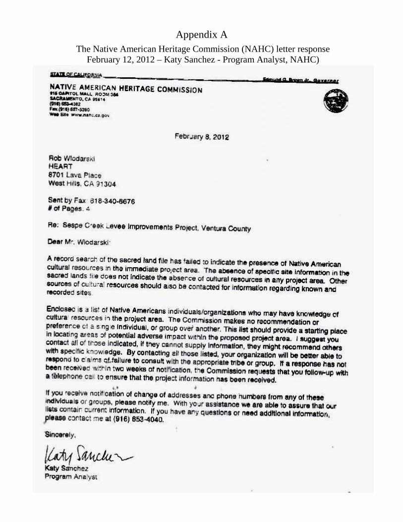
Appendix A
The Native American Heritage Commission (NAHC) letter response February 12, 2012 – Katy Sanchez - Program Analyst, NAHC)
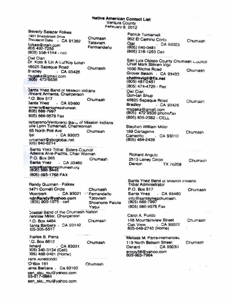

Appendix 5
Hazardous Materials Records Search
FORM-NULL-BXD
®kcehCoeG htiw tropeR ™paM suidaR RDE ehT
440 Wheelers Farms RoadMilford, CT 06461Toll Free: 800.352.0050www.edrnet.com
Sespe CreekSespe Creek Between HWY 126 and Old Telegraph RoadFillmore, CA 93015
Inquiry Number: 3290164.1sMarch 27, 2012
SECTION PAGE
Executive Summary ES1
Overview Map 2
Detail Map 3
Map Findings Summary 4
Map Findings 8
Orphan Summary 34
Government Records Searched/Data Currency Tracking GR-1
GEOCHECK ADDENDUM
Physical Setting Source Addendum A-1
Physical Setting Source Summary A-2
Physical Setting SSURGO Soil Map A-5
Physical Setting Source Map A-11
Physical Setting Source Map Findings A-13
Physical Setting Source Records Searched A-43
TC3290164.1s Page 1
Thank you for your business.Please contact EDR at 1-800-352-0050
with any questions or comments.
Disclaimer - Copyright and Trademark Notice
This Report contains certain information obtained from a variety of public and other sources reasonably available to Environmental DataResources, Inc. It cannot be concluded from this Report that coverage information for the target and surrounding properties does not exist fromother sources. NO WARRANTY EXPRESSED OR IMPLIED, IS MADE WHATSOEVER IN CONNECTION WITH THIS REPORT. ENVIRONMENTALDATA RESOURCES, INC. SPECIFICALLY DISCLAIMS THE MAKING OF ANY SUCH WARRANTIES, INCLUDING WITHOUT LIMITATION,MERCHANTABILITY OR FITNESS FOR A PARTICULAR USE OR PURPOSE. ALL RISK IS ASSUMED BY THE USER. IN NO EVENT SHALLENVIRONMENTAL DATA RESOURCES, INC. BE LIABLE TO ANYONE, WHETHER ARISING OUT OF ERRORS OR OMISSIONS, NEGLIGENCE,ACCIDENT OR ANY OTHER CAUSE, FOR ANY LOSS OF DAMAGE, INCLUDING, WITHOUT LIMITATION, SPECIAL, INCIDENTAL,CONSEQUENTIAL, OR EXEMPLARY DAMAGES. ANY LIABILITY ON THE PART OF ENVIRONMENTAL DATA RESOURCES, INC. IS STRICTLYLIMITED TO A REFUND OF THE AMOUNT PAID FOR THIS REPORT. Purchaser accepts this Report "AS IS". Any analyses, estimates, ratings,environmental risk levels or risk codes provided in this Report are provided for illustrative purposes only, and are not intended to provide, norshould they be interpreted as providing any facts regarding, or prediction or forecast of, any environmental risk for any property. Only a Phase IEnvironmental Site Assessment performed by an environmental professional can provide information regarding the environmental risk for anyproperty. Additionally, the information provided in this Report is not to be construed as legal advice.
Copyright 2012 by Environmental Data Resources, Inc. All rights reserved. Reproduction in any media or format, in wholeor in part, of any report or map of Environmental Data Resources, Inc., or its affiliates, is prohibited without prior written permission.
EDR and its logos (including Sanborn and Sanborn Map) are trademarks of Environmental Data Resources, Inc. or its affiliates. All othertrademarks used herein are the property of their respective owners.
TABLE OF CONTENTS
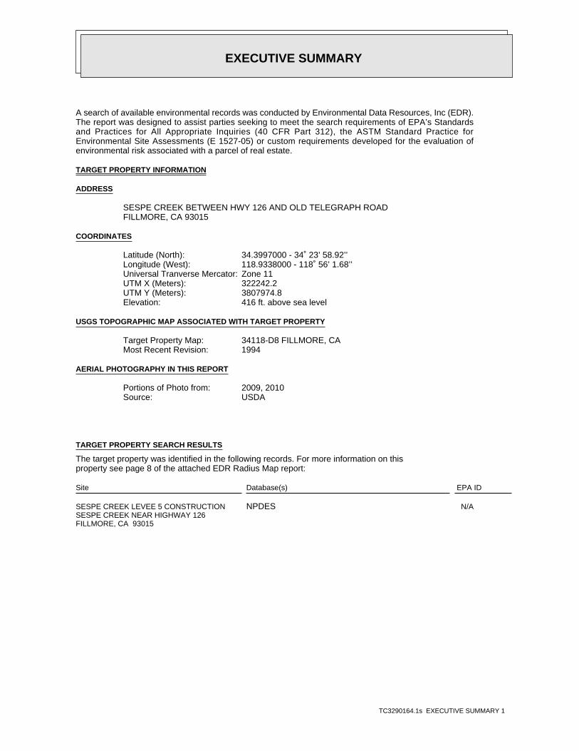
EXECUTIVE SUMMARY
TC3290164.1s EXECUTIVE SUMMARY 1
A search of available environmental records was conducted by Environmental Data Resources, Inc (EDR).The report was designed to assist parties seeking to meet the search requirements of EPA’s Standardsand Practices for All Appropriate Inquiries (40 CFR Part 312), the ASTM Standard Practice forEnvironmental Site Assessments (E 1527-05) or custom requirements developed for the evaluation ofenvironmental risk associated with a parcel of real estate.
TARGET PROPERTY INFORMATION
ADDRESS
SESPE CREEK BETWEEN HWY 126 AND OLD TELEGRAPH ROADFILLMORE, CA 93015
COORDINATES
34.3997000 - 34˚ 23’ 58.92’’Latitude (North): 118.9338000 - 118˚ 56’ 1.68’’Longitude (West): Zone 11Universal Tranverse Mercator: 322242.2UTM X (Meters): 3807974.8UTM Y (Meters): 416 ft. above sea levelElevation:
USGS TOPOGRAPHIC MAP ASSOCIATED WITH TARGET PROPERTY
34118-D8 FILLMORE, CATarget Property Map:1994Most Recent Revision:
AERIAL PHOTOGRAPHY IN THIS REPORT
2009, 2010Portions of Photo from:USDASource:
TARGET PROPERTY SEARCH RESULTS
The target property was identified in the following records. For more information on thisproperty see page 8 of the attached EDR Radius Map report:
EPA IDDatabase(s)Site
SESPE CREEK LEVEE 5 CONSTRUCTION SESPE CREEK NEAR HIGHWAY 126FILLMORE, CA 93015
N/ANPDES
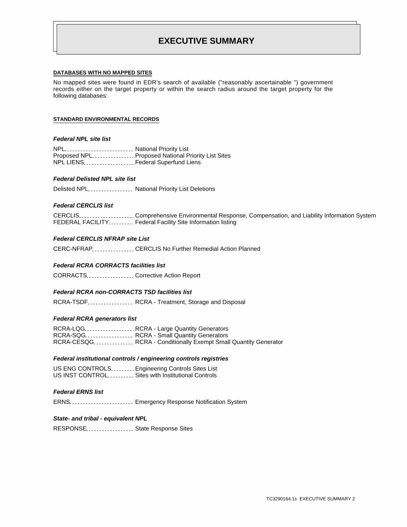
EXECUTIVE SUMMARY
TC3290164.1s EXECUTIVE SUMMARY 2
DATABASES WITH NO MAPPED SITES
No mapped sites were found in EDR’s search of available ("reasonably ascertainable ") governmentrecords either on the target property or within the search radius around the target property for thefollowing databases:
STANDARD ENVIRONMENTAL RECORDS
Federal NPL site list
NPL National Priority ListProposed NPL Proposed National Priority List SitesNPL LIENS Federal Superfund Liens
Federal Delisted NPL site list
Delisted NPL National Priority List Deletions
Federal CERCLIS list
CERCLIS Comprehensive Environmental Response, Compensation, and Liability Information SystemFEDERAL FACILITY Federal Facility Site Information listing
Federal CERCLIS NFRAP site List
CERC-NFRAP CERCLIS No Further Remedial Action Planned
Federal RCRA CORRACTS facilities list
CORRACTS Corrective Action Report
Federal RCRA non-CORRACTS TSD facilities list
RCRA-TSDF RCRA - Treatment, Storage and Disposal
Federal RCRA generators list
RCRA-LQG RCRA - Large Quantity GeneratorsRCRA-SQG RCRA - Small Quantity GeneratorsRCRA-CESQG RCRA - Conditionally Exempt Small Quantity Generator
Federal institutional controls / engineering controls registries
US ENG CONTROLS Engineering Controls Sites ListUS INST CONTROL Sites with Institutional Controls
Federal ERNS list
ERNS Emergency Response Notification System
State- and tribal - equivalent NPL
RESPONSE State Response Sites
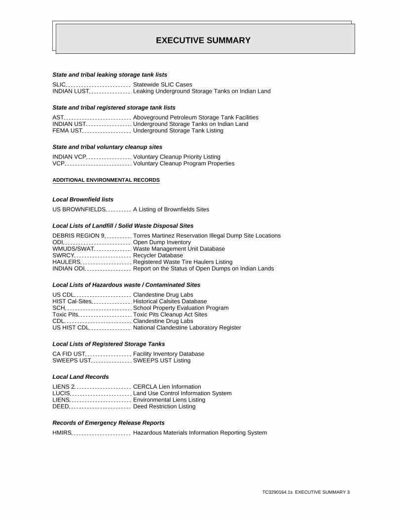
EXECUTIVE SUMMARY
TC3290164.1s EXECUTIVE SUMMARY 3
State and tribal leaking storage tank lists
SLIC Statewide SLIC CasesINDIAN LUST Leaking Underground Storage Tanks on Indian Land
State and tribal registered storage tank lists
AST Aboveground Petroleum Storage Tank FacilitiesINDIAN UST Underground Storage Tanks on Indian LandFEMA UST Underground Storage Tank Listing
State and tribal voluntary cleanup sites
INDIAN VCP Voluntary Cleanup Priority ListingVCP Voluntary Cleanup Program Properties
ADDITIONAL ENVIRONMENTAL RECORDS
Local Brownfield lists
US BROWNFIELDS A Listing of Brownfields Sites
Local Lists of Landfill / Solid Waste Disposal Sites
DEBRIS REGION 9 Torres Martinez Reservation Illegal Dump Site LocationsODI Open Dump InventoryWMUDS/SWAT Waste Management Unit DatabaseSWRCY Recycler DatabaseHAULERS Registered Waste Tire Haulers ListingINDIAN ODI Report on the Status of Open Dumps on Indian Lands
Local Lists of Hazardous waste / Contaminated Sites
US CDL Clandestine Drug LabsHIST Cal-Sites Historical Calsites DatabaseSCH School Property Evaluation ProgramToxic Pits Toxic Pits Cleanup Act SitesCDL Clandestine Drug LabsUS HIST CDL National Clandestine Laboratory Register
Local Lists of Registered Storage Tanks
CA FID UST Facility Inventory DatabaseSWEEPS UST SWEEPS UST Listing
Local Land Records
LIENS 2 CERCLA Lien InformationLUCIS Land Use Control Information SystemLIENS Environmental Liens ListingDEED Deed Restriction Listing
Records of Emergency Release Reports
HMIRS Hazardous Materials Information Reporting System
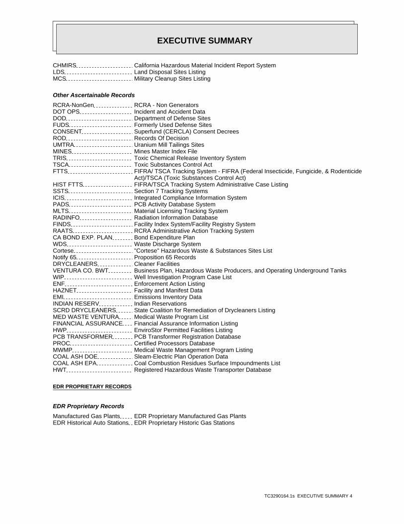
EXECUTIVE SUMMARY
TC3290164.1s EXECUTIVE SUMMARY 4
CHMIRS California Hazardous Material Incident Report SystemLDS Land Disposal Sites ListingMCS Military Cleanup Sites Listing
Other Ascertainable Records
RCRA-NonGen RCRA - Non GeneratorsDOT OPS Incident and Accident DataDOD Department of Defense SitesFUDS Formerly Used Defense SitesCONSENT Superfund (CERCLA) Consent DecreesROD Records Of DecisionUMTRA Uranium Mill Tailings SitesMINES Mines Master Index FileTRIS Toxic Chemical Release Inventory SystemTSCA Toxic Substances Control ActFTTS FIFRA/ TSCA Tracking System - FIFRA (Federal Insecticide, Fungicide, & Rodenticide Act)/TSCA (Toxic Substances Control Act)HIST FTTS FIFRA/TSCA Tracking System Administrative Case ListingSSTS Section 7 Tracking SystemsICIS Integrated Compliance Information SystemPADS PCB Activity Database SystemMLTS Material Licensing Tracking SystemRADINFO Radiation Information DatabaseFINDS Facility Index System/Facility Registry SystemRAATS RCRA Administrative Action Tracking SystemCA BOND EXP. PLAN Bond Expenditure PlanWDS Waste Discharge SystemCortese "Cortese" Hazardous Waste & Substances Sites ListNotify 65 Proposition 65 RecordsDRYCLEANERS Cleaner FacilitiesVENTURA CO. BWT Business Plan, Hazardous Waste Producers, and Operating Underground TanksWIP Well Investigation Program Case ListENF Enforcement Action ListingHAZNET Facility and Manifest DataEMI Emissions Inventory DataINDIAN RESERV Indian ReservationsSCRD DRYCLEANERS State Coalition for Remediation of Drycleaners ListingMED WASTE VENTURA Medical Waste Program ListFINANCIAL ASSURANCE Financial Assurance Information ListingHWP EnviroStor Permitted Facilities ListingPCB TRANSFORMER PCB Transformer Registration DatabasePROC Certified Processors DatabaseMWMP Medical Waste Management Program ListingCOAL ASH DOE Sleam-Electric Plan Operation DataCOAL ASH EPA Coal Combustion Residues Surface Impoundments ListHWT Registered Hazardous Waste Transporter Database
EDR PROPRIETARY RECORDS
EDR Proprietary Records
Manufactured Gas Plants EDR Proprietary Manufactured Gas PlantsEDR Historical Auto Stations EDR Proprietary Historic Gas Stations
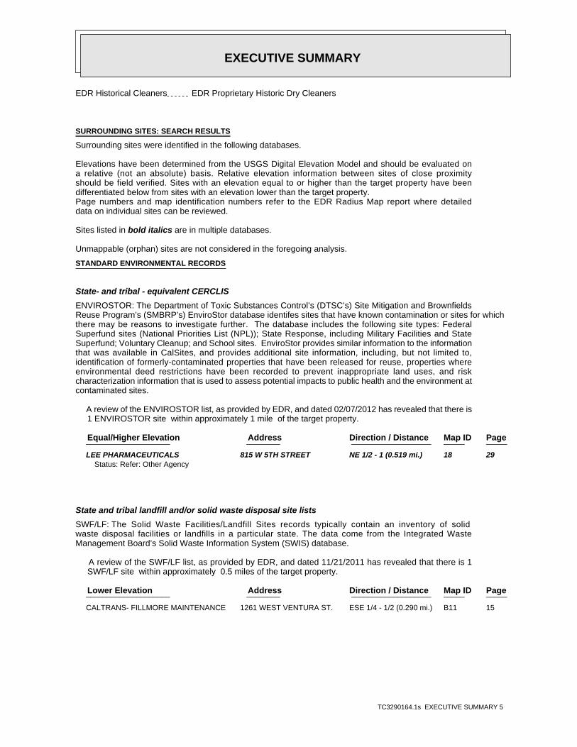
EXECUTIVE SUMMARY
TC3290164.1s EXECUTIVE SUMMARY 5
EDR Historical Cleaners EDR Proprietary Historic Dry Cleaners
SURROUNDING SITES: SEARCH RESULTS
Surrounding sites were identified in the following databases.
Elevations have been determined from the USGS Digital Elevation Model and should be evaluated ona relative (not an absolute) basis. Relative elevation information between sites of close proximityshould be field verified. Sites with an elevation equal to or higher than the target property have beendifferentiated below from sites with an elevation lower than the target property.Page numbers and map identification numbers refer to the EDR Radius Map report where detaileddata on individual sites can be reviewed.
Sites listed in bold italics are in multiple databases.
Unmappable (orphan) sites are not considered in the foregoing analysis.
STANDARD ENVIRONMENTAL RECORDS
State- and tribal - equivalent CERCLIS
ENVIROSTOR: The Department of Toxic Substances Control’s (DTSC’s) Site Mitigation and BrownfieldsReuse Program’s (SMBRP’s) EnviroStor database identifes sites that have known contamination or sites for whichthere may be reasons to investigate further. The database includes the following site types: FederalSuperfund sites (National Priorities List (NPL)); State Response, including Military Facilities and StateSuperfund; Voluntary Cleanup; and School sites. EnviroStor provides similar information to the informationthat was available in CalSites, and provides additional site information, including, but not limited to,identification of formerly-contaminated properties that have been released for reuse, properties whereenvironmental deed restrictions have been recorded to prevent inappropriate land uses, and riskcharacterization information that is used to assess potential impacts to public health and the environment atcontaminated sites.
A review of the ENVIROSTOR list, as provided by EDR, and dated 02/07/2012 has revealed that there is 1 ENVIROSTOR site within approximately 1 mile of the target property.
PageMap IDDirection / Distance Address Equal/Higher Elevation ____________________ ________ ___________________ _____ _____
LEE PHARMACEUTICALS 815 W 5TH STREET NE 1/2 - 1 (0.519 mi.) 18 29Status: Refer: Other Agency
State and tribal landfill and/or solid waste disposal site lists
SWF/LF: The Solid Waste Facilities/Landfill Sites records typically contain an inventory of solidwaste disposal facilities or landfills in a particular state. The data come from the Integrated WasteManagement Board’s Solid Waste Information System (SWIS) database.
A review of the SWF/LF list, as provided by EDR, and dated 11/21/2011 has revealed that there is 1 SWF/LF site within approximately 0.5 miles of the target property.
PageMap IDDirection / Distance Address Lower Elevation ____________________ ________ ___________________ _____ _____
CALTRANS- FILLMORE MAINTENANCE 1261 WEST VENTURA ST. ESE 1/4 - 1/2 (0.290 mi.) B11 15
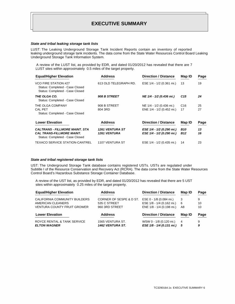
EXECUTIVE SUMMARY
TC3290164.1s EXECUTIVE SUMMARY 6
State and tribal leaking storage tank lists
LUST: The Leaking Underground Storage Tank Incident Reports contain an inventory of reportedleaking underground storage tank incidents. The data come from the State Water Resources Control Board LeakingUnderground Storage Tank Information System.
A review of the LUST list, as provided by EDR, and dated 01/20/2012 has revealed that there are 7 LUST sites within approximately 0.5 miles of the target property.
PageMap IDDirection / Distance Address Equal/Higher Elevation ____________________ ________ ___________________ _____ _____
VCO FIRE STATION #27 613 OLD TELEGRAPH RD. ESE 1/4 - 1/2 (0.361 mi.) 13 19Status: Completed - Case ClosedStatus: Completed - Case Closed
THE OLGA CO. 908 B STREET NE 1/4 - 1/2 (0.436 mi.) C15 24Status: Completed - Case Closed
THE OLGA COMPANY 908 B STREET NE 1/4 - 1/2 (0.436 mi.) C16 25 CAL PET 804 3RD ENE 1/4 - 1/2 (0.452 mi.) 17 27
Status: Completed - Case Closed
PageMap IDDirection / Distance Address Lower Elevation ____________________ ________ ___________________ _____ _____
CALTRANS - FILLMORE MAINT. STA 1261 VENTURA ST ESE 1/4 - 1/2 (0.290 mi.) B10 13 CAL TRANS-FILLMORE MAINT. 1261 VENTURA ESE 1/4 - 1/2 (0.290 mi.) B12 16
Status: Completed - Case Closed
TEXACO SERVICE STATION-CANTREL 1107 VENTURA ST ESE 1/4 - 1/2 (0.435 mi.) 14 23
State and tribal registered storage tank lists
UST: The Underground Storage Tank database contains registered USTs. USTs are regulated underSubtitle I of the Resource Conservation and Recovery Act (RCRA). The data come from the State Water ResourcesControl Board’s Hazardous Substance Storage Container Database.
A review of the UST list, as provided by EDR, and dated 01/20/2012 has revealed that there are 5 UST sites within approximately 0.25 miles of the target property.
PageMap IDDirection / Distance Address Equal/Higher Elevation ____________________ ________ ___________________ _____ _____
CALIFORNIA COMMUNITY BUILDERS CORNER OF SESPE & D ST. ESE 0 - 1/8 (0.084 mi.) 3 9 AMERICAN CLEANERS 535 C STREET ESE 1/8 - 1/4 (0.162 mi.) 6 10 VENTURA COUNTY FRUIT GROWER 960 3RD STREET ENE 1/8 - 1/4 (0.198 mi.) A8 10
PageMap IDDirection / Distance Address Lower Elevation ____________________ ________ ___________________ _____ _____
ROYCE RENTAL & TANK SERVICE 1565 VENTURA ST. WSW 0 - 1/8 (0.120 mi.) 4 9 ELTON WAGNER 1462 VENTURA ST. ESE 1/8 - 1/4 (0.131 mi.) 5 9
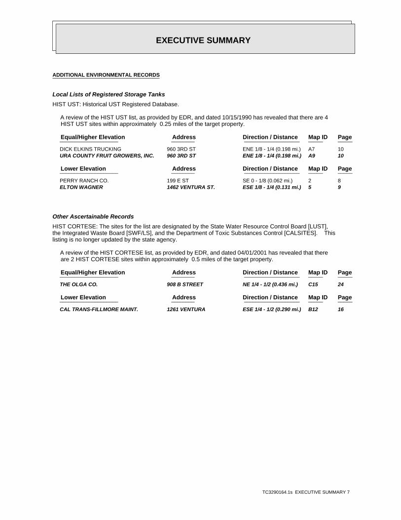
EXECUTIVE SUMMARY
TC3290164.1s EXECUTIVE SUMMARY 7
ADDITIONAL ENVIRONMENTAL RECORDS
Local Lists of Registered Storage Tanks
HIST UST: Historical UST Registered Database.
A review of the HIST UST list, as provided by EDR, and dated 10/15/1990 has revealed that there are 4 HIST UST sites within approximately 0.25 miles of the target property.
PageMap IDDirection / Distance Address Equal/Higher Elevation ____________________ ________ ___________________ _____ _____
DICK ELKINS TRUCKING 960 3RD ST ENE 1/8 - 1/4 (0.198 mi.) A7 10 URA COUNTY FRUIT GROWERS, INC. 960 3RD ST ENE 1/8 - 1/4 (0.198 mi.) A9 10
PageMap IDDirection / Distance Address Lower Elevation ____________________ ________ ___________________ _____ _____
PERRY RANCH CO. 199 E ST SE 0 - 1/8 (0.062 mi.) 2 8 ELTON WAGNER 1462 VENTURA ST. ESE 1/8 - 1/4 (0.131 mi.) 5 9
Other Ascertainable Records
HIST CORTESE: The sites for the list are designated by the State Water Resource Control Board [LUST],the Integrated Waste Board [SWF/LS], and the Department of Toxic Substances Control [CALSITES]. Thislisting is no longer updated by the state agency.
A review of the HIST CORTESE list, as provided by EDR, and dated 04/01/2001 has revealed that there are 2 HIST CORTESE sites within approximately 0.5 miles of the target property.
PageMap IDDirection / Distance Address Equal/Higher Elevation ____________________ ________ ___________________ _____ _____
THE OLGA CO. 908 B STREET NE 1/4 - 1/2 (0.436 mi.) C15 24
PageMap IDDirection / Distance Address Lower Elevation ____________________ ________ ___________________ _____ _____
CAL TRANS-FILLMORE MAINT. 1261 VENTURA ESE 1/4 - 1/2 (0.290 mi.) B12 16
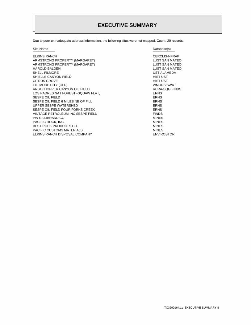
EXECUTIVE SUMMARY
TC3290164.1s EXECUTIVE SUMMARY 8
Due to poor or inadequate address information, the following sites were not mapped. Count: 20 records.
Site Name Database(s)____________ ____________
ELKINS RANCH CERCLIS-NFRAPARMSTRONG PROPERTY (MARGARET) LUST SAN MATEOARMSTRONG PROPERTY (MARGARET) LUST SAN MATEOHAROLD BALDEN LUST SAN MATEOSHELL FILMORE UST ALAMEDASHIELLS CANYON FIELD HIST USTCITRUS GROVE HIST USTFILLMORE CITY (OLD) WMUDS/SWATARGO/ HOPPER CANYON OIL FIELD RCRA-SQG,FINDSLOS PADRES NAT FOREST--SQUAW FLAT, ERNSSESPE OIL FIELD ERNSSESPE OIL FIELD 6 MILES NE OF FILL ERNSUPPER SESPE WATERSHED ERNSSESPE OIL FIELD FOUR FORKS CREEK ERNSVINTAGE PETROLEUM INC SESPE FIELD FINDSPW GILLIBRAND CO MINESPACIFIC ROCK, INC. MINESBEST ROCK PRODUCTS CO. MINESPACIFIC CUSTOMS MATERIALS MINESELKINS RANCH DISPOSAL COMPANY ENVIROSTOR
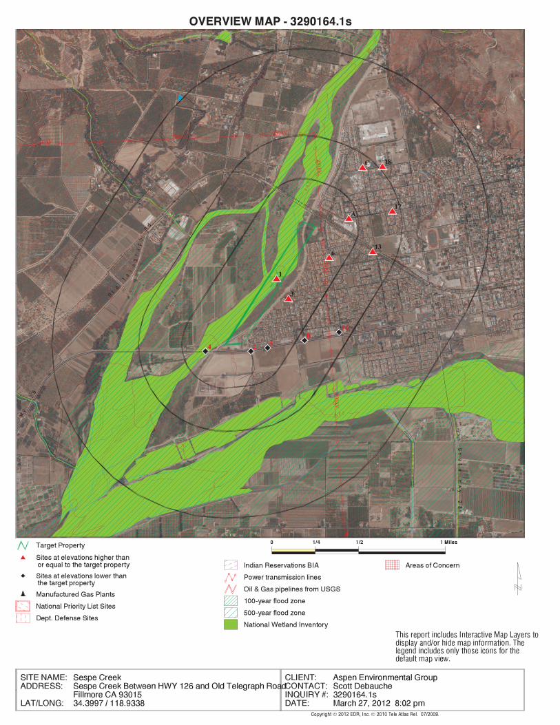
EDR Inc.EDR Inc.EDR Inc.EDR Inc.EDR Inc.EDR Inc.EDR Inc.EDR Inc.EDR Inc.EDR Inc.EDR Inc.EDR Inc.EDR Inc.EDR Inc.EDR Inc.EDR Inc.EDR Inc.EDR Inc.EDR Inc.EDR Inc.EDR Inc.EDR Inc.EDR Inc.EDR Inc.EDR Inc.EDR Inc.EDR Inc.EDR Inc.EDR Inc.EDR Inc.EDR Inc.EDR Inc.EDR Inc.EDR Inc.EDR Inc.EDR Inc.EDR Inc.EDR Inc.EDR Inc.EDR Inc.
230
230 kV
230 kV
230 kV
230 kV230 kV
230 kV
1 2 8
0 01 2
1 2 0
1 1 6
1 1 6 01 1 20
1 1 2 0
1 1
0
1 0 8 0
40
1
0 4 01 0 0 0
96
0
9 6 09
2 0
92
88
0
8 8 0
84
08 4 0
80
0
80
0
8 0 0
800
76
0
7 6 0
72
0
72
0
72
0
68
0
6 8 0
68
0
6 4 0
64
0
640
6 0 0
60
0
60
0
6 0 0
5 6 0
56
0
5 6 0
56
0 52 0
52
0
52
0
5
2 0
520
3 6 0
40
0
4 0 0
40
0
4 0 0
440
4 4 0
440
44
0
4 4 0
4 4 0
480
4 8 0
4 8 0
480
48
0
4 8 0
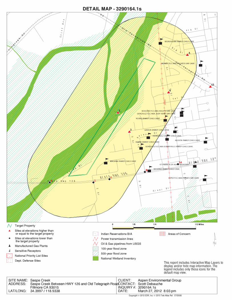
EDR Inc.EDR Inc.EDR Inc.EDR Inc.EDR Inc.EDR Inc.EDR Inc.EDR Inc.EDR Inc.EDR Inc.EDR Inc.EDR Inc.EDR Inc.EDR Inc.EDR Inc.EDR Inc.EDR Inc.EDR Inc.EDR Inc.EDR Inc.EDR Inc.EDR Inc.EDR Inc.EDR Inc.EDR Inc.EDR Inc.EDR Inc.EDR Inc.EDR Inc.EDR Inc.EDR Inc.EDR Inc.EDR Inc.EDR Inc.EDR Inc.EDR Inc.EDR Inc.EDR Inc.EDR Inc.EDR Inc.
230 kV
40
0
44
0
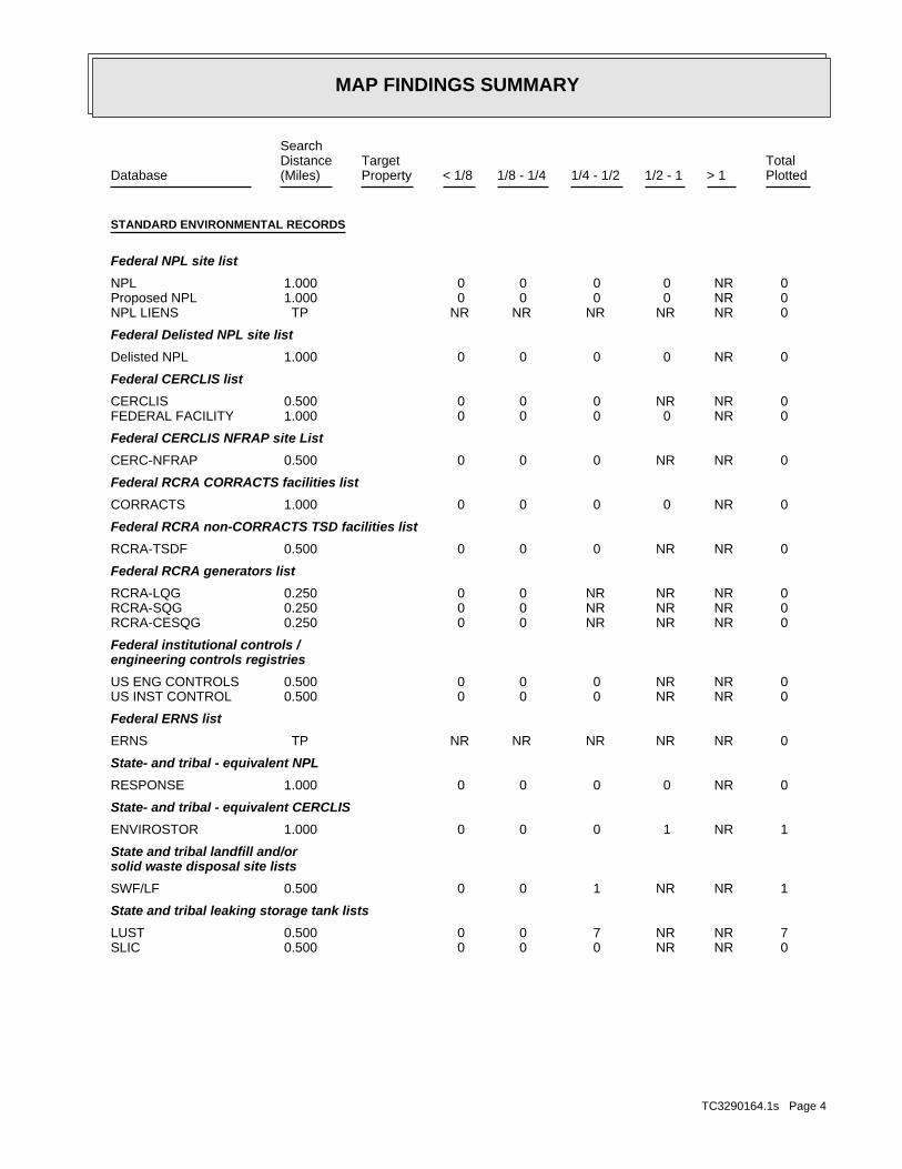
MAP FINDINGS SUMMARY
SearchTargetDistance Total
Database Property(Miles) < 1/8 1/8 - 1/4 1/4 - 1/2 1/2 - 1 > 1 Plotted
STANDARD ENVIRONMENTAL RECORDS
Federal NPL site list
0 NR 0 0 0 0 1.000NPL 0 NR 0 0 0 0 1.000Proposed NPL 0 NR NR NR NR NR TPNPL LIENS
Federal Delisted NPL site list
0 NR 0 0 0 0 1.000Delisted NPL
Federal CERCLIS list
0 NR NR 0 0 0 0.500CERCLIS 0 NR 0 0 0 0 1.000FEDERAL FACILITY
Federal CERCLIS NFRAP site List
0 NR NR 0 0 0 0.500CERC-NFRAP
Federal RCRA CORRACTS facilities list
0 NR 0 0 0 0 1.000CORRACTS
Federal RCRA non-CORRACTS TSD facilities list
0 NR NR 0 0 0 0.500RCRA-TSDF
Federal RCRA generators list
0 NR NR NR 0 0 0.250RCRA-LQG 0 NR NR NR 0 0 0.250RCRA-SQG 0 NR NR NR 0 0 0.250RCRA-CESQG
Federal institutional controls /engineering controls registries
0 NR NR 0 0 0 0.500US ENG CONTROLS 0 NR NR 0 0 0 0.500US INST CONTROL
Federal ERNS list
0 NR NR NR NR NR TPERNS
State- and tribal - equivalent NPL
0 NR 0 0 0 0 1.000RESPONSE
State- and tribal - equivalent CERCLIS
1 NR 1 0 0 0 1.000ENVIROSTOR
State and tribal landfill and/orsolid waste disposal site lists
1 NR NR 1 0 0 0.500SWF/LF
State and tribal leaking storage tank lists
7 NR NR 7 0 0 0.500LUST 0 NR NR 0 0 0 0.500SLIC
TC3290164.1s Page 4
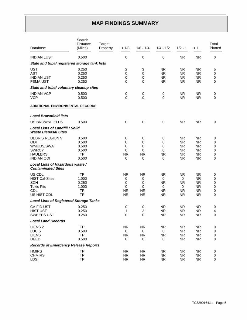
MAP FINDINGS SUMMARY
SearchTargetDistance Total
Database Property(Miles) < 1/8 1/8 - 1/4 1/4 - 1/2 1/2 - 1 > 1 Plotted
0 NR NR 0 0 0 0.500INDIAN LUST
State and tribal registered storage tank lists
5 NR NR NR 3 2 0.250UST 0 NR NR NR 0 0 0.250AST 0 NR NR NR 0 0 0.250INDIAN UST 0 NR NR NR 0 0 0.250FEMA UST
State and tribal voluntary cleanup sites
0 NR NR 0 0 0 0.500INDIAN VCP 0 NR NR 0 0 0 0.500VCP
ADDITIONAL ENVIRONMENTAL RECORDS
Local Brownfield lists
0 NR NR 0 0 0 0.500US BROWNFIELDS
Local Lists of Landfill / SolidWaste Disposal Sites
0 NR NR 0 0 0 0.500DEBRIS REGION 9 0 NR NR 0 0 0 0.500ODI 0 NR NR 0 0 0 0.500WMUDS/SWAT 0 NR NR 0 0 0 0.500SWRCY 0 NR NR NR NR NR TPHAULERS 0 NR NR 0 0 0 0.500INDIAN ODI
Local Lists of Hazardous waste /Contaminated Sites
0 NR NR NR NR NR TPUS CDL 0 NR 0 0 0 0 1.000HIST Cal-Sites 0 NR NR NR 0 0 0.250SCH 0 NR 0 0 0 0 1.000Toxic Pits 0 NR NR NR NR NR TPCDL 0 NR NR NR NR NR TPUS HIST CDL
Local Lists of Registered Storage Tanks
0 NR NR NR 0 0 0.250CA FID UST 4 NR NR NR 3 1 0.250HIST UST 0 NR NR NR 0 0 0.250SWEEPS UST
Local Land Records
0 NR NR NR NR NR TPLIENS 2 0 NR NR 0 0 0 0.500LUCIS 0 NR NR NR NR NR TPLIENS 0 NR NR 0 0 0 0.500DEED
Records of Emergency Release Reports
0 NR NR NR NR NR TPHMIRS 0 NR NR NR NR NR TPCHMIRS 0 NR NR NR NR NR TPLDS
TC3290164.1s Page 5
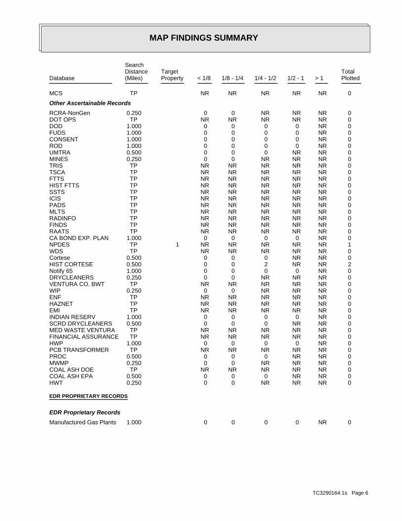
MAP FINDINGS SUMMARY
SearchTargetDistance Total
Database Property(Miles) < 1/8 1/8 - 1/4 1/4 - 1/2 1/2 - 1 > 1 Plotted
0 NR NR NR NR NR TPMCS
Other Ascertainable Records
0 NR NR NR 0 0 0.250RCRA-NonGen 0 NR NR NR NR NR TPDOT OPS 0 NR 0 0 0 0 1.000DOD 0 NR 0 0 0 0 1.000FUDS 0 NR 0 0 0 0 1.000CONSENT 0 NR 0 0 0 0 1.000ROD 0 NR NR 0 0 0 0.500UMTRA 0 NR NR NR 0 0 0.250MINES 0 NR NR NR NR NR TPTRIS 0 NR NR NR NR NR TPTSCA 0 NR NR NR NR NR TPFTTS 0 NR NR NR NR NR TPHIST FTTS 0 NR NR NR NR NR TPSSTS 0 NR NR NR NR NR TPICIS 0 NR NR NR NR NR TPPADS 0 NR NR NR NR NR TPMLTS 0 NR NR NR NR NR TPRADINFO 0 NR NR NR NR NR TPFINDS 0 NR NR NR NR NR TPRAATS 0 NR 0 0 0 0 1.000CA BOND EXP. PLAN 1 NR NR NR NR NR TP 1NPDES 0 NR NR NR NR NR TPWDS 0 NR NR 0 0 0 0.500Cortese 2 NR NR 2 0 0 0.500HIST CORTESE 0 NR 0 0 0 0 1.000Notify 65 0 NR NR NR 0 0 0.250DRYCLEANERS 0 NR NR NR NR NR TPVENTURA CO. BWT 0 NR NR NR 0 0 0.250WIP 0 NR NR NR NR NR TPENF 0 NR NR NR NR NR TPHAZNET 0 NR NR NR NR NR TPEMI 0 NR 0 0 0 0 1.000INDIAN RESERV 0 NR NR 0 0 0 0.500SCRD DRYCLEANERS 0 NR NR NR NR NR TPMED WASTE VENTURA 0 NR NR NR NR NR TPFINANCIAL ASSURANCE 0 NR 0 0 0 0 1.000HWP 0 NR NR NR NR NR TPPCB TRANSFORMER 0 NR NR 0 0 0 0.500PROC 0 NR NR NR 0 0 0.250MWMP 0 NR NR NR NR NR TPCOAL ASH DOE 0 NR NR 0 0 0 0.500COAL ASH EPA 0 NR NR NR 0 0 0.250HWT
EDR PROPRIETARY RECORDS
EDR Proprietary Records
0 NR 0 0 0 0 1.000Manufactured Gas Plants
TC3290164.1s Page 6
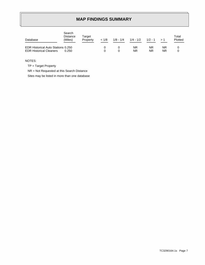
MAP FINDINGS SUMMARY
SearchTargetDistance Total
Database Property(Miles) < 1/8 1/8 - 1/4 1/4 - 1/2 1/2 - 1 > 1 Plotted
0 NR NR NR 0 0 0.250EDR Historical Auto Stations 0 NR NR NR 0 0 0.250EDR Historical Cleaners
NOTES:
TP = Target Property
NR = Not Requested at this Search Distance
Sites may be listed in more than one database
TC3290164.1s Page 7
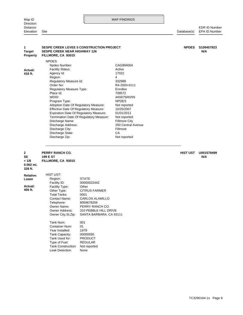
MAP FINDINGSMap IDDirection
EDR ID NumberDistanceEPA ID NumberDatabase(s)SiteElevation
Not reportedDischarge Zip: CADischarge State: FillmoreDischarge City: 250 Central AvenueDischarge Address: Fillmore CityDischarge Name: Not reportedTermination Date Of Regulatory Measure: 01/01/2011Expiration Date Of Regulatory Measure: 10/25/2007Effective Date Of Regulatory Measure: Not reportedAdoption Date Of Regulatory Measure: NPDESProgram Type: 4A567500255WDID: 708572Place Id: EnrolleeRegulatory Measure Type: R4-2003-0111Order No: 332988Regulatory Measure Id: 4Region: 17022Agency Id: ActiveFacility Status: CAG994004Npdes Number:
NPDES:
Actual:416 ft.
Property FILLMORE, CA 93015Target SESPE CREEK NEAR HIGHWAY 126 N/A1 NPDESSESPE CREEK LEVEE 5 CONSTRUCTION PROJECT S109457923
NoneLeak Detection: Not reportedTank Construction: REGULARType of Fuel: PRODUCTTank Used for: 00000550Tank Capacity: 1979Year Installed: 01Container Num: 001Tank Num:
SANTA BARBARA, CA 93111Owner City,St,Zip: 310 PEBBLE HILL DRIVEOwner Address: PERRY RANCH CO.Owner Name: 8059678256Telephone: CARLOS ALAMILLOContact Name: 0001Total Tanks: CITRUS FARMEROther Type: OtherFacility Type: 00000022442Facility ID: STATERegion:
HIST UST:
328 ft.0.062 mi.
Relative:Lower
Actual:405 ft.
< 1/8 FILLMORE, CA 93015SE 199 E ST N/A2 HIST USTPERRY RANCH CO. U001579499
TC3290164.1s Page 8
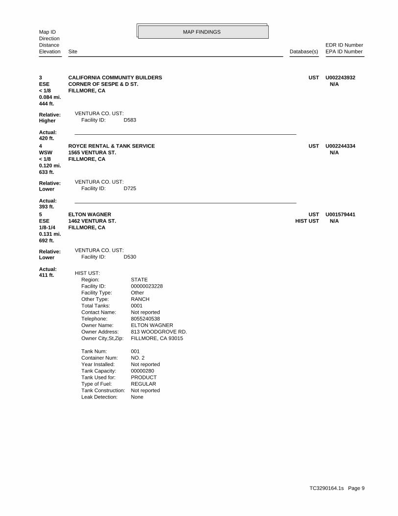
MAP FINDINGSMap IDDirection
EDR ID NumberDistanceEPA ID NumberDatabase(s)SiteElevation
D583Facility ID:VENTURA CO. UST:
444 ft.0.084 mi.
Relative:Higher
Actual:420 ft.
< 1/8 FILLMORE, CA ESE CORNER OF SESPE & D ST. N/A3 USTCALIFORNIA COMMUNITY BUILDERS U002243932
D725Facility ID:VENTURA CO. UST:
633 ft.0.120 mi.
Relative:Lower
Actual:393 ft.
< 1/8 FILLMORE, CA WSW 1565 VENTURA ST. N/A4 USTROYCE RENTAL & TANK SERVICE U002244334
NoneLeak Detection: Not reportedTank Construction: REGULARType of Fuel: PRODUCTTank Used for: 00000280Tank Capacity: Not reportedYear Installed: NO. 2Container Num: 001Tank Num:
FILLMORE, CA 93015Owner City,St,Zip: 813 WOODGROVE RD.Owner Address: ELTON WAGNEROwner Name: 8055240538Telephone: Not reportedContact Name: 0001Total Tanks: RANCHOther Type: OtherFacility Type: 00000023228Facility ID: STATERegion:
HIST UST:
D530Facility ID:VENTURA CO. UST:
692 ft.0.131 mi.
Relative:Lower
Actual:411 ft.
1/8-1/4 FILLMORE, CA ESE HIST UST1462 VENTURA ST. N/A5 USTELTON WAGNER U001579441
TC3290164.1s Page 9
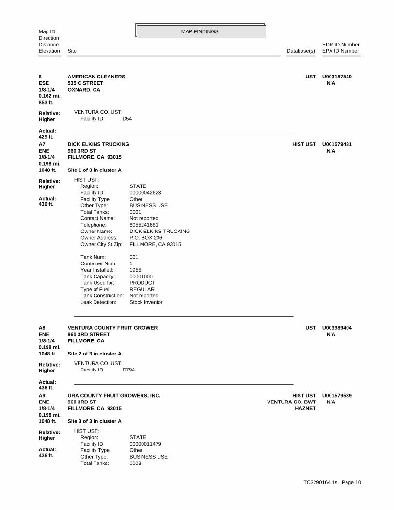
MAP FINDINGSMap IDDirection
EDR ID NumberDistanceEPA ID NumberDatabase(s)SiteElevation
D54Facility ID:VENTURA CO. UST:
853 ft.0.162 mi.
Relative:Higher
Actual:429 ft.
1/8-1/4 OXNARD, CA ESE 535 C STREET N/A6 USTAMERICAN CLEANERS U003187549
Stock InventorLeak Detection: Not reportedTank Construction: REGULARType of Fuel: PRODUCTTank Used for: 00001000Tank Capacity: 1955Year Installed: 1Container Num: 001Tank Num:
FILLMORE, CA 93015Owner City,St,Zip: P.O. BOX 236Owner Address: DICK ELKINS TRUCKINGOwner Name: 8055241681Telephone: Not reportedContact Name: 0001Total Tanks: BUSINESS USEOther Type: OtherFacility Type: 00000042623Facility ID: STATERegion:
HIST UST:
1048 ft. Site 1 of 3 in cluster A0.198 mi.
Relative:Higher
Actual:436 ft.
1/8-1/4 FILLMORE, CA 93015ENE 960 3RD ST N/AA7 HIST USTDICK ELKINS TRUCKING U001579431
D794Facility ID:VENTURA CO. UST:
1048 ft. Site 2 of 3 in cluster A0.198 mi.
Relative:Higher
Actual:436 ft.
1/8-1/4 FILLMORE, CA ENE 960 3RD STREET N/AA8 USTVENTURA COUNTY FRUIT GROWER U003989404
0003Total Tanks: BUSINESS USEOther Type: OtherFacility Type: 00000011479Facility ID: STATERegion:
HIST UST:
1048 ft. Site 3 of 3 in cluster A0.198 mi.
Relative:Higher
Actual:436 ft.
1/8-1/4 HAZNETFILLMORE, CA 93015ENE VENTURA CO. BWT960 3RD ST N/AA9 HIST USTURA COUNTY FRUIT GROWERS, INC. U001579539
TC3290164.1s Page 10
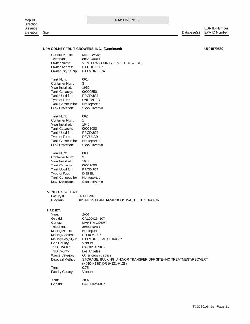
MAP FINDINGSMap IDDirection
EDR ID NumberDistanceEPA ID NumberDatabase(s)SiteElevation
CAL000254107Gepaid: 2007Year:
VenturaFacility County: 0.75Tons: (H010-H129) OR (H131-H135) STORAGE, BULKING, AND/OR TRANSFER OFF SITE--NO TREATMENT/REOVERYDisposal Method: Other organic solidsWaste Category: Los AngelesTSD County: CAD028409019TSD EPA ID: VenturaGen County: FILLMORE, CA 930160307Mailing City,St,Zip: PO BOX 307Mailing Address: Not reportedMailing Name: 8055240411Telephone: MARTIN COERTContact: CAL000254107Gepaid: 2007Year:
HAZNET:
BUSINESS PLAN HAZARDOUS WASTE GENERATORProgram:FA0006209Facility ID:
VENTURA CO. BWT:
Stock InventorLeak Detection: Not reportedTank Construction: DIESELType of Fuel: PRODUCTTank Used for: 00001000Tank Capacity: 1947Year Installed: 2Container Num: 003Tank Num:
Stock InventorLeak Detection: Not reportedTank Construction: REGULARType of Fuel: PRODUCTTank Used for: 00001000Tank Capacity: 1947Year Installed: 1Container Num: 002Tank Num:
Stock InventorLeak Detection: Not reportedTank Construction: UNLEADEDType of Fuel: PRODUCTTank Used for: 00000550Tank Capacity: 1960Year Installed: 3Container Num: 001Tank Num:
FILLMORE, CAOwner City,St,Zip: P.O. BOX 307Owner Address: VENTURA COUNTY FRUIT GROWERS,Owner Name: 8055240411Telephone: MILT DAVISContact Name:
URA COUNTY FRUIT GROWERS, INC. (Continued) U001579539
TC3290164.1s Page 11
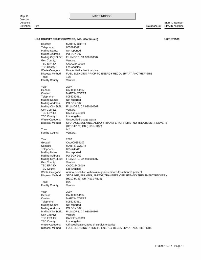
MAP FINDINGSMap IDDirection
EDR ID NumberDistanceEPA ID NumberDatabase(s)SiteElevation
FUEL BLENDING PRIOR TO ENERGY RECOVERY AT ANOTHER SITEDisposal Method: Off-specification, aged or surplus organicsWaste Category: Los AngelesTSD County: CAD028409019TSD EPA ID: VenturaGen County: FILLMORE, CA 930160307Mailing City,St,Zip: PO BOX 307Mailing Address: Not reportedMailing Name: 8055240411Telephone: MARTIN COERTContact: CAL000254107Gepaid: 2007Year:
VenturaFacility County: 0.23Tons: (H010-H129) OR (H131-H135) STORAGE, BULKING, AND/OR TRANSFER OFF SITE--NO TREATMENT/REOVERYDisposal Method: Aqueous solution with total organic residues less than 10 percentWaste Category: Los AngelesTSD County: CAD028409019TSD EPA ID: VenturaGen County: FILLMORE, CA 930160307Mailing City,St,Zip: PO BOX 307Mailing Address: Not reportedMailing Name: 8055240411Telephone: MARTIN COERTContact: CAL000254107Gepaid: 2007Year:
VenturaFacility County: 0.2Tons: (H010-H129) OR (H131-H135) STORAGE, BULKING, AND/OR TRANSFER OFF SITE--NO TREATMENT/REOVERYDisposal Method: Unspecified sludge wasteWaste Category: Los AngelesTSD County: CAD028409019TSD EPA ID: VenturaGen County: FILLMORE, CA 930160307Mailing City,St,Zip: PO BOX 307Mailing Address: Not reportedMailing Name: 8055240411Telephone: MARTIN COERTContact: CAL000254107Gepaid: 2007Year:
VenturaFacility County: 1.25Tons: FUEL BLENDING PRIOR TO ENERGY RECOVERY AT ANOTHER SITEDisposal Method: Unspecified solvent mixtureWaste Category: Los AngelesTSD County: CAD028409019TSD EPA ID: VenturaGen County: FILLMORE, CA 930160307Mailing City,St,Zip: PO BOX 307Mailing Address: Not reportedMailing Name: 8055240411Telephone: MARTIN COERTContact:
URA COUNTY FRUIT GROWERS, INC. (Continued) U001579539
TC3290164.1s Page 12
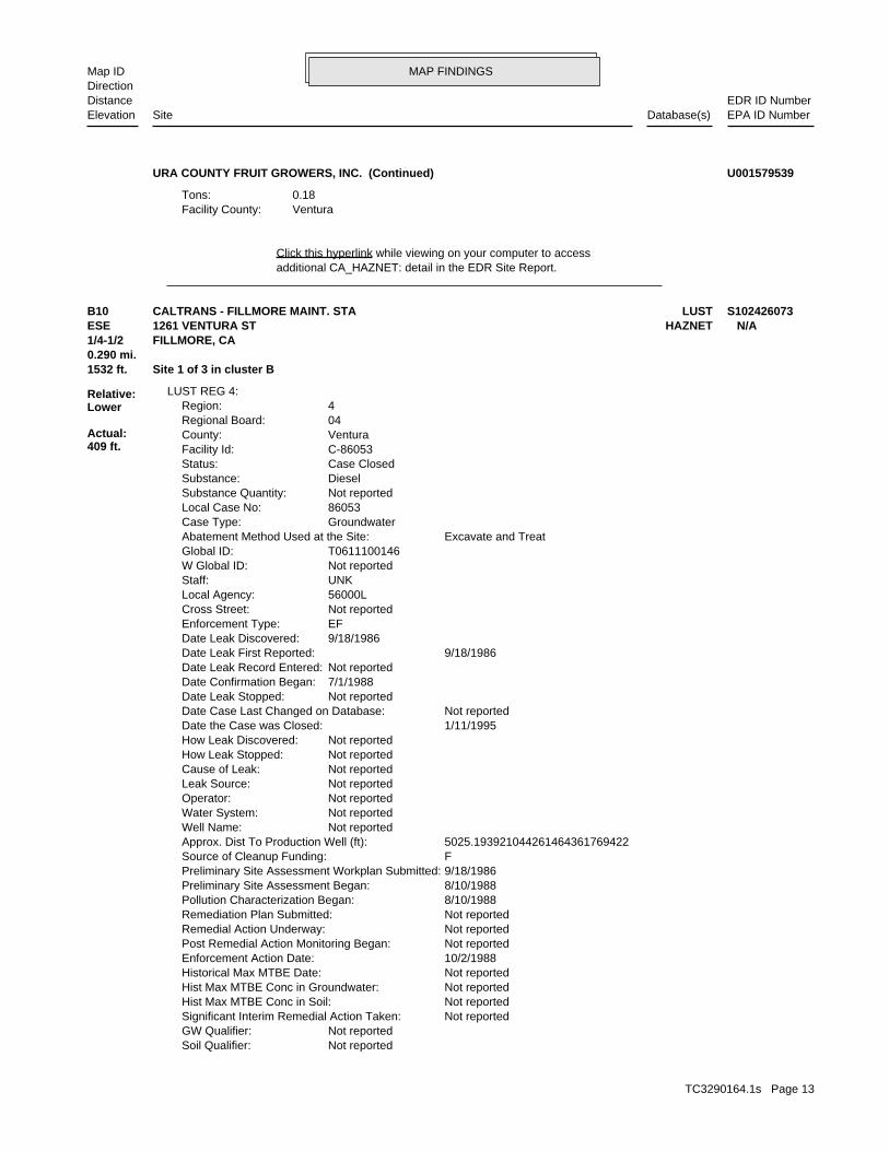
MAP FINDINGSMap IDDirection
EDR ID NumberDistanceEPA ID NumberDatabase(s)SiteElevation
additional CA_HAZNET: detail in the EDR Site Report.Click this hyperlink while viewing on your computer to access
VenturaFacility County: 0.18Tons:
URA COUNTY FRUIT GROWERS, INC. (Continued) U001579539
Not reportedSoil Qualifier: Not reportedGW Qualifier: Not reportedSignificant Interim Remedial Action Taken: Not reportedHist Max MTBE Conc in Soil: Not reportedHist Max MTBE Conc in Groundwater: Not reportedHistorical Max MTBE Date: 10/2/1988Enforcement Action Date: Not reportedPost Remedial Action Monitoring Began: Not reportedRemedial Action Underway: Not reportedRemediation Plan Submitted: 8/10/1988Pollution Characterization Began: 8/10/1988Preliminary Site Assessment Began: 9/18/1986Preliminary Site Assessment Workplan Submitted: FSource of Cleanup Funding: 5025.193921044261464361769422Approx. Dist To Production Well (ft): Not reportedWell Name: Not reportedWater System: Not reportedOperator: Not reportedLeak Source: Not reportedCause of Leak: Not reportedHow Leak Stopped: Not reportedHow Leak Discovered: 1/11/1995Date the Case was Closed: Not reportedDate Case Last Changed on Database: Not reportedDate Leak Stopped: 7/1/1988Date Confirmation Began: Not reportedDate Leak Record Entered: 9/18/1986Date Leak First Reported: 9/18/1986Date Leak Discovered: EFEnforcement Type: Not reportedCross Street: 56000LLocal Agency: UNKStaff: Not reportedW Global ID: T0611100146Global ID: Excavate and TreatAbatement Method Used at the Site: GroundwaterCase Type: 86053Local Case No: Not reportedSubstance Quantity: DieselSubstance: Case ClosedStatus: C-86053Facility Id: VenturaCounty: 04Regional Board: 4Region:
LUST REG 4:
1532 ft. Site 1 of 3 in cluster B0.290 mi.
Relative:Lower
Actual:409 ft.
1/4-1/2 FILLMORE, CA ESE HAZNET1261 VENTURA ST N/AB10 LUSTCALTRANS - FILLMORE MAINT. STA S102426073
TC3290164.1s Page 13
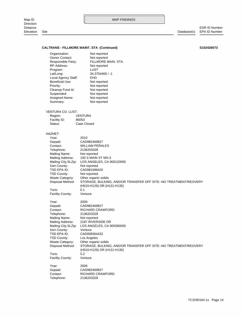
MAP FINDINGSMap IDDirection
EDR ID NumberDistanceEPA ID NumberDatabase(s)SiteElevation
2136203328Telephone: RICHARD CRAWFORDContact: CAD982469827Gepaid: 2009Year:
VenturaFacility County: 0.2Tons: (H010-H129) OR (H131-H135) STORAGE, BULKING, AND/OR TRANSFER OFF SITE--NO TREATMENT/REOVERYDisposal Method: Other organic solidsWaste Category: Los AngelesTSD County: CAD008364432TSD EPA ID: VenturaGen County: LOS ANGELES, CA 900390000Mailing City,St,Zip: 2187 RIVERSIDE DRMailing Address: Not reportedMailing Name: 2136203328Telephone: RICHARD CRAWFORDContact: CAD982469827Gepaid: 2009Year:
VenturaFacility County: 0.1Tons: (H010-H129) OR (H131-H135) STORAGE, BULKING, AND/OR TRANSFER OFF SITE--NO TREATMENT/REOVERYDisposal Method: Other organic solidsWaste Category: Not reportedTSD County: CAD981696420TSD EPA ID: Not reportedGen County: LOS ANGELES, CA 900120000Mailing City,St,Zip: 100 S MAIN ST MS-3Mailing Address: Not reportedMailing Name: 2136203328Telephone: WILLIAM PERALESContact: CAD982469827Gepaid: 2010Year:
HAZNET:
Case ClosedStatus:86053Facility ID:VENTURARegion:
VENTURA CO. LUST:
Not reportedSummary: Not reportedAssigned Name: Not reportedSuspended: Not reportedCleanup Fund Id: Not reportedPriority: Not reportedBeneficial Use: EHDLocal Agency Staff: 34.3704465 / -1Lat/Long: LUSTProgram: Not reportedRP Address: FILLMORE MAIN. STA.Responsible Party: Not reportedOwner Contact: Not reportedOrganization:
CALTRANS - FILLMORE MAINT. STA (Continued) S102426073
TC3290164.1s Page 14
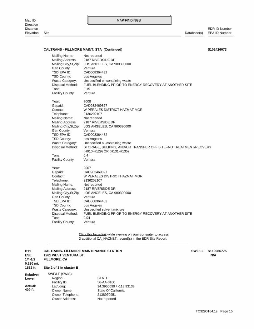
MAP FINDINGSMap IDDirection
EDR ID NumberDistanceEPA ID NumberDatabase(s)SiteElevation
3 additional CA_HAZNET: record(s) in the EDR Site Report.Click this hyperlink while viewing on your computer to access
VenturaFacility County: 0.04Tons: FUEL BLENDING PRIOR TO ENERGY RECOVERY AT ANOTHER SITEDisposal Method: Unspecified solvent mixtureWaste Category: Los AngelesTSD County: CAD008364432TSD EPA ID: VenturaGen County: LOS ANGELES, CA 900390000Mailing City,St,Zip: 2187 RIVERSIDE DRMailing Address: Not reportedMailing Name: 2136202107Telephone: W PERALES DISTRICT HAZMAT MGRContact: CAD982469827Gepaid: 2007Year:
VenturaFacility County: 0.4Tons: (H010-H129) OR (H131-H135) STORAGE, BULKING, AND/OR TRANSFER OFF SITE--NO TREATMENT/REOVERYDisposal Method: Unspecified oil-containing wasteWaste Category: Los AngelesTSD County: CAD008364432TSD EPA ID: VenturaGen County: LOS ANGELES, CA 900390000Mailing City,St,Zip: 2187 RIVERSIDE DRMailing Address: Not reportedMailing Name: 2136202107Telephone: W PERALES DISTRICT HAZMAT MGRContact: CAD982469827Gepaid: 2008Year:
VenturaFacility County: 0.15Tons: FUEL BLENDING PRIOR TO ENERGY RECOVERY AT ANOTHER SITEDisposal Method: Unspecified oil-containing wasteWaste Category: Los AngelesTSD County: CAD008364432TSD EPA ID: VenturaGen County: LOS ANGELES, CA 900390000Mailing City,St,Zip: 2187 RIVERSIDE DRMailing Address: Not reportedMailing Name:
CALTRANS - FILLMORE MAINT. STA (Continued) S102426073
Not reportedOwner Address: 2138970951Owner Telephone: State Of CaliforniaOwner Name: 34.3950099 / -118.93138Lat/Long: 56-AA-0160Facility ID: STATERegion:
SWF/LF (SWIS):
1532 ft. Site 2 of 3 in cluster B0.290 mi.
Relative:Lower
Actual:409 ft.
1/4-1/2 FILLMORE, CA ESE 1261 WEST VENTURA ST. N/AB11 SWF/LFCALTRANS- FILLMORE MAINTENANCE STATION S110986775
TC3290164.1s Page 15
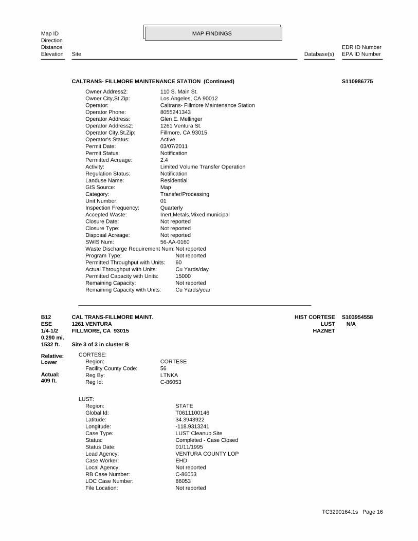
MAP FINDINGSMap IDDirection
EDR ID NumberDistanceEPA ID NumberDatabase(s)SiteElevation
Cu Yards/yearRemaining Capacity with Units: Not reportedRemaining Capacity: 15000Permitted Capacity with Units: Cu Yards/dayActual Throughput with Units: 60Permitted Throughput with Units: Not reportedProgram Type: Not reportedWaste Discharge Requirement Num: 56-AA-0160SWIS Num: Not reportedDisposal Acreage: Not reportedClosure Type: Not reportedClosure Date: Inert,Metals,Mixed municipalAccepted Waste: QuarterlyInspection Frequency: 01Unit Number: Transfer/ProcessingCategory: MapGIS Source: ResidentialLanduse Name: NotificationRegulation Status: Limited Volume Transfer OperationActivity: 2.4Permitted Acreage: NotificationPermit Status: 03/07/2011Permit Date: ActiveOperator’s Status: Fillmore, CA 93015Operator City,St,Zip: 1261 Ventura St.Operator Address2: Glen E. MellingerOperator Address: 8055241343Operator Phone: Caltrans- Fillmore Maintenance StationOperator: Los Angeles, CA 90012Owner City,St,Zip: 110 S. Main St.Owner Address2:
CALTRANS- FILLMORE MAINTENANCE STATION (Continued) S110986775
Not reportedFile Location: 86053LOC Case Number: C-86053RB Case Number: Not reportedLocal Agency: EHDCase Worker: VENTURA COUNTY LOPLead Agency: 01/11/1995Status Date: Completed - Case ClosedStatus: LUST Cleanup SiteCase Type: -118.9313241Longitude: 34.3943922Latitude: T0611100146Global Id: STATERegion:
LUST:
C-86053Reg Id: LTNKAReg By: 56Facility County Code: CORTESERegion:
CORTESE:
1532 ft. Site 3 of 3 in cluster B0.290 mi.
Relative:Lower
Actual:409 ft.
1/4-1/2 HAZNETFILLMORE, CA 93015ESE LUST1261 VENTURA N/AB12 HIST CORTESECAL TRANS-FILLMORE MAINT. S103954558
TC3290164.1s Page 16
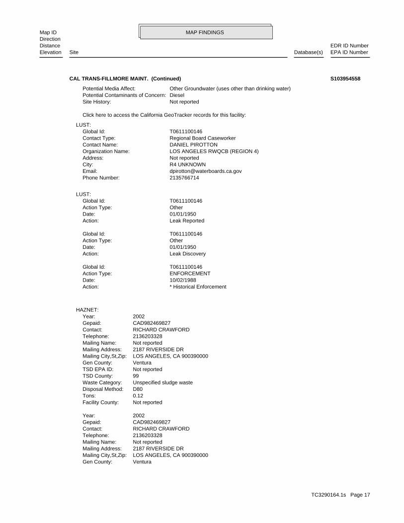
MAP FINDINGSMap IDDirection
EDR ID NumberDistanceEPA ID NumberDatabase(s)SiteElevation
VenturaGen County: LOS ANGELES, CA 900390000Mailing City,St,Zip: 2187 RIVERSIDE DRMailing Address: Not reportedMailing Name: 2136203328Telephone: RICHARD CRAWFORDContact: CAD982469827Gepaid: 2002Year:
Not reportedFacility County: 0.12Tons: D80Disposal Method: Unspecified sludge wasteWaste Category: 99TSD County: Not reportedTSD EPA ID: VenturaGen County: LOS ANGELES, CA 900390000Mailing City,St,Zip: 2187 RIVERSIDE DRMailing Address: Not reportedMailing Name: 2136203328Telephone: RICHARD CRAWFORDContact: CAD982469827Gepaid: 2002Year:
HAZNET:
* Historical EnforcementAction: 10/02/1988Date: ENFORCEMENTAction Type: T0611100146Global Id:
Leak DiscoveryAction: 01/01/1950Date: OtherAction Type: T0611100146Global Id:
Leak ReportedAction: 01/01/1950Date: OtherAction Type: T0611100146Global Id:
LUST:
2135766714Phone Number: [email protected]: R4 UNKNOWNCity: Not reportedAddress: LOS ANGELES RWQCB (REGION 4)Organization Name: DANIEL PIROTTONContact Name: Regional Board CaseworkerContact Type: T0611100146Global Id:
LUST:
Click here to access the California GeoTracker records for this facility:
Not reportedSite History: DieselPotential Contaminants of Concern: Other Groundwater (uses other than drinking water)Potential Media Affect:
CAL TRANS-FILLMORE MAINT. (Continued) S103954558
TC3290164.1s Page 17
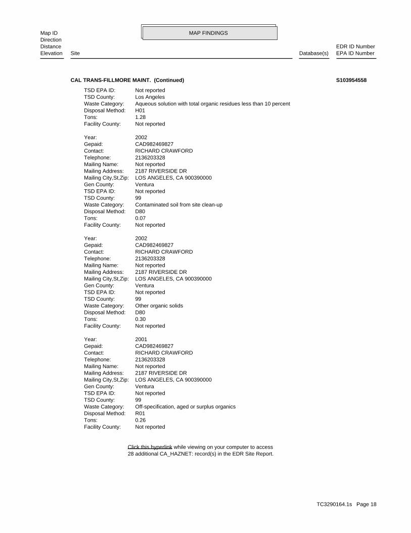
MAP FINDINGSMap IDDirection
EDR ID NumberDistanceEPA ID NumberDatabase(s)SiteElevation
28 additional CA_HAZNET: record(s) in the EDR Site Report.Click this hyperlink while viewing on your computer to access
Not reportedFacility County: 0.26Tons: R01Disposal Method: Off-specification, aged or surplus organicsWaste Category: 99TSD County: Not reportedTSD EPA ID: VenturaGen County: LOS ANGELES, CA 900390000Mailing City,St,Zip: 2187 RIVERSIDE DRMailing Address: Not reportedMailing Name: 2136203328Telephone: RICHARD CRAWFORDContact: CAD982469827Gepaid: 2001Year:
Not reportedFacility County: 0.30Tons: D80Disposal Method: Other organic solidsWaste Category: 99TSD County: Not reportedTSD EPA ID: VenturaGen County: LOS ANGELES, CA 900390000Mailing City,St,Zip: 2187 RIVERSIDE DRMailing Address: Not reportedMailing Name: 2136203328Telephone: RICHARD CRAWFORDContact: CAD982469827Gepaid: 2002Year:
Not reportedFacility County: 0.07Tons: D80Disposal Method: Contaminated soil from site clean-upWaste Category: 99TSD County: Not reportedTSD EPA ID: VenturaGen County: LOS ANGELES, CA 900390000Mailing City,St,Zip: 2187 RIVERSIDE DRMailing Address: Not reportedMailing Name: 2136203328Telephone: RICHARD CRAWFORDContact: CAD982469827Gepaid: 2002Year:
Not reportedFacility County: 1.28Tons: H01Disposal Method: Aqueous solution with total organic residues less than 10 percentWaste Category: Los AngelesTSD County: Not reportedTSD EPA ID:
CAL TRANS-FILLMORE MAINT. (Continued) S103954558
TC3290164.1s Page 18
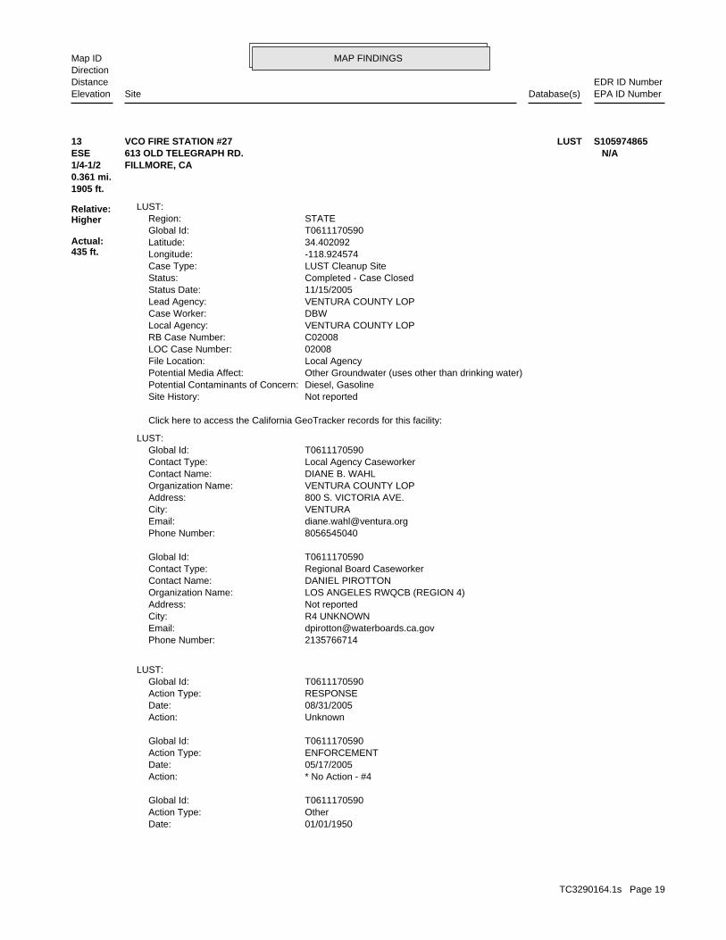
MAP FINDINGSMap IDDirection
EDR ID NumberDistanceEPA ID NumberDatabase(s)SiteElevation
01/01/1950Date: OtherAction Type: T0611170590Global Id:
* No Action - #4Action: 05/17/2005Date: ENFORCEMENTAction Type: T0611170590Global Id:
UnknownAction: 08/31/2005Date: RESPONSEAction Type: T0611170590Global Id:
LUST:
2135766714Phone Number: [email protected]: R4 UNKNOWNCity: Not reportedAddress: LOS ANGELES RWQCB (REGION 4)Organization Name: DANIEL PIROTTONContact Name: Regional Board CaseworkerContact Type: T0611170590Global Id:
8056545040Phone Number: [email protected]: VENTURACity: 800 S. VICTORIA AVE.Address: VENTURA COUNTY LOPOrganization Name: DIANE B. WAHLContact Name: Local Agency CaseworkerContact Type: T0611170590Global Id:
LUST:
Click here to access the California GeoTracker records for this facility:
Not reportedSite History: Diesel, GasolinePotential Contaminants of Concern: Other Groundwater (uses other than drinking water)Potential Media Affect: Local AgencyFile Location: 02008LOC Case Number: C02008RB Case Number: VENTURA COUNTY LOPLocal Agency: DBWCase Worker: VENTURA COUNTY LOPLead Agency: 11/15/2005Status Date: Completed - Case ClosedStatus: LUST Cleanup SiteCase Type: -118.924574Longitude: 34.402092Latitude: T0611170590Global Id: STATERegion:
LUST:
1905 ft.0.361 mi.
Relative:Higher
Actual:435 ft.
1/4-1/2 FILLMORE, CA ESE 613 OLD TELEGRAPH RD. N/A13 LUSTVCO FIRE STATION #27 S105974865
TC3290164.1s Page 19
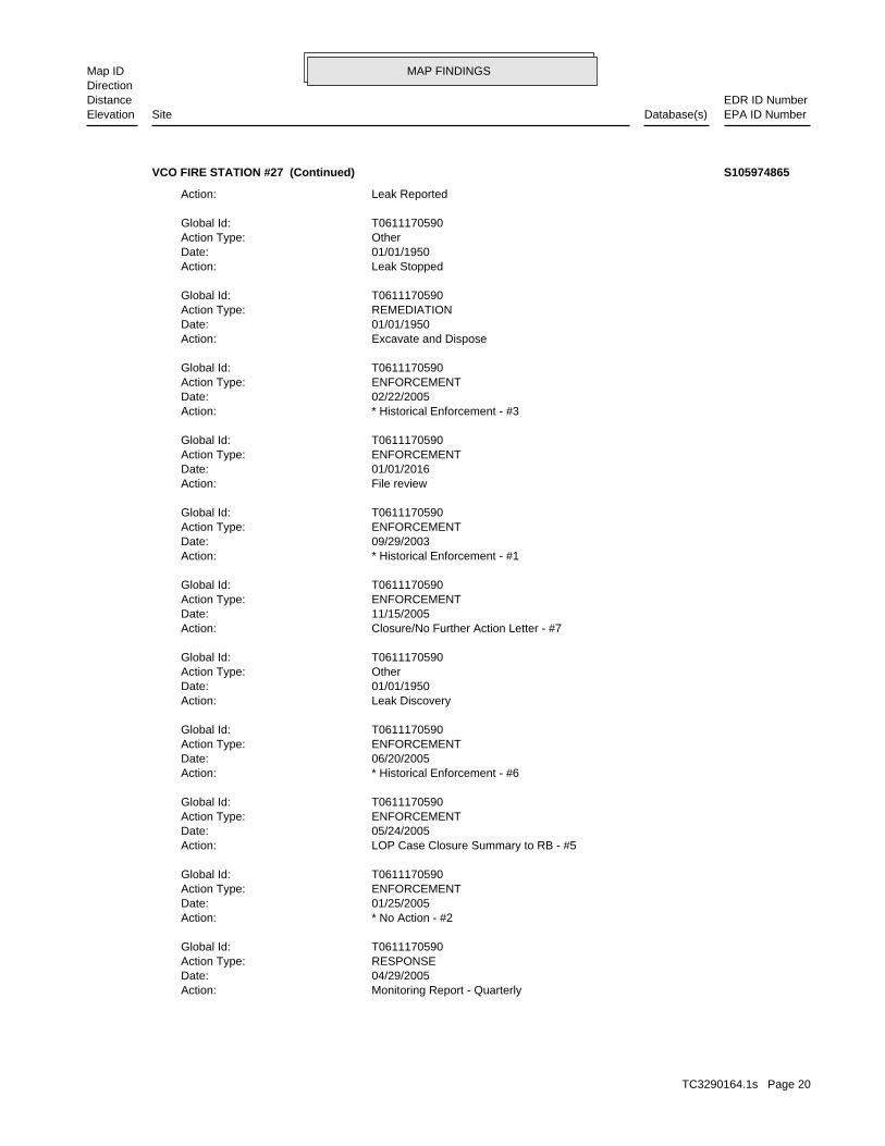
MAP FINDINGSMap IDDirection
EDR ID NumberDistanceEPA ID NumberDatabase(s)SiteElevation
Monitoring Report - QuarterlyAction: 04/29/2005Date: RESPONSEAction Type: T0611170590Global Id:
* No Action - #2Action: 01/25/2005Date: ENFORCEMENTAction Type: T0611170590Global Id:
LOP Case Closure Summary to RB - #5Action: 05/24/2005Date: ENFORCEMENTAction Type: T0611170590Global Id:
* Historical Enforcement - #6Action: 06/20/2005Date: ENFORCEMENTAction Type: T0611170590Global Id:
Leak DiscoveryAction: 01/01/1950Date: OtherAction Type: T0611170590Global Id:
Closure/No Further Action Letter - #7Action: 11/15/2005Date: ENFORCEMENTAction Type: T0611170590Global Id:
* Historical Enforcement - #1Action: 09/29/2003Date: ENFORCEMENTAction Type: T0611170590Global Id:
File reviewAction: 01/01/2016Date: ENFORCEMENTAction Type: T0611170590Global Id:
* Historical Enforcement - #3Action: 02/22/2005Date: ENFORCEMENTAction Type: T0611170590Global Id:
Excavate and DisposeAction: 01/01/1950Date: REMEDIATIONAction Type: T0611170590Global Id:
Leak StoppedAction: 01/01/1950Date: OtherAction Type: T0611170590Global Id:
Leak ReportedAction:
VCO FIRE STATION #27 (Continued) S105974865
TC3290164.1s Page 20

MAP FINDINGSMap IDDirection
EDR ID NumberDistanceEPA ID NumberDatabase(s)SiteElevation
Preliminary site assessment underwayStatus: C-02008Facility Id: VenturaCounty: 04Regional Board: 4Region:
LUST REG 4:
* Historical EnforcementAction: 01/11/1989Date: ENFORCEMENTAction Type: T0611100431Global Id:
Leak DiscoveryAction: 01/01/1950Date: OtherAction Type: T0611100431Global Id:
LOP Case Closure Summary to RBAction: 09/16/1992Date: ENFORCEMENTAction Type: T0611100431Global Id:
Leak ReportedAction: 01/01/1950Date: OtherAction Type: T0611100431Global Id:
LUST:
2135766714Phone Number: [email protected]: R4 UNKNOWNCity: Not reportedAddress: LOS ANGELES RWQCB (REGION 4)Organization Name: DANIEL PIROTTONContact Name: Regional Board CaseworkerContact Type: T0611100431Global Id:
LUST:
Click here to access the California GeoTracker records for this facility:
Not reportedSite History: GasolinePotential Contaminants of Concern: SoilPotential Media Affect: Not reportedFile Location: 89008LOC Case Number: C-89008RB Case Number: Not reportedLocal Agency: KCKCase Worker: VENTURA COUNTY LOPLead Agency: 06/02/1992Status Date: Completed - Case ClosedStatus: LUST Cleanup SiteCase Type: -118.8913476Longitude: 34.3972529Latitude: T0611100431Global Id: STATERegion:
VCO FIRE STATION #27 (Continued) S105974865
TC3290164.1s Page 21
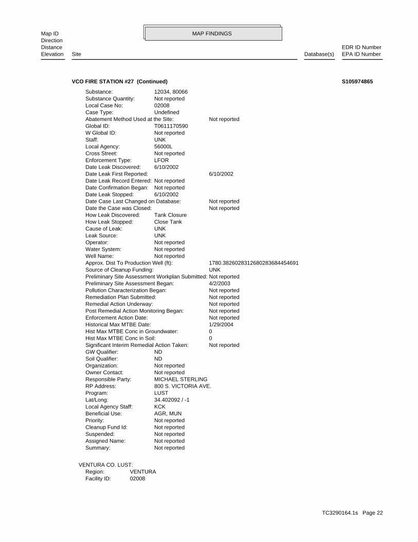
MAP FINDINGSMap IDDirection
EDR ID NumberDistanceEPA ID NumberDatabase(s)SiteElevation
02008Facility ID:VENTURARegion:
VENTURA CO. LUST:
Not reportedSummary: Not reportedAssigned Name: Not reportedSuspended: Not reportedCleanup Fund Id: Not reportedPriority: AGR, MUNBeneficial Use: KCKLocal Agency Staff: 34.402092 / -1Lat/Long: LUSTProgram: 800 S. VICTORIA AVE.RP Address: MICHAEL STERLINGResponsible Party: Not reportedOwner Contact: Not reportedOrganization: NDSoil Qualifier: NDGW Qualifier: Not reportedSignificant Interim Remedial Action Taken: 0Hist Max MTBE Conc in Soil: 0Hist Max MTBE Conc in Groundwater: 1/29/2004Historical Max MTBE Date: Not reportedEnforcement Action Date: Not reportedPost Remedial Action Monitoring Began: Not reportedRemedial Action Underway: Not reportedRemediation Plan Submitted: Not reportedPollution Characterization Began: 4/2/2003Preliminary Site Assessment Began: Not reportedPreliminary Site Assessment Workplan Submitted: UNKSource of Cleanup Funding: 1780.3826028312680283684454691Approx. Dist To Production Well (ft): Not reportedWell Name: Not reportedWater System: Not reportedOperator: UNKLeak Source: UNKCause of Leak: Close TankHow Leak Stopped: Tank ClosureHow Leak Discovered: Not reportedDate the Case was Closed: Not reportedDate Case Last Changed on Database: 6/10/2002Date Leak Stopped: Not reportedDate Confirmation Began: Not reportedDate Leak Record Entered: 6/10/2002Date Leak First Reported: 6/10/2002Date Leak Discovered: LFOREnforcement Type: Not reportedCross Street: 56000LLocal Agency: UNKStaff: Not reportedW Global ID: T0611170590Global ID: Not reportedAbatement Method Used at the Site: UndefinedCase Type: 02008Local Case No: Not reportedSubstance Quantity: 12034, 80066Substance:
VCO FIRE STATION #27 (Continued) S105974865
TC3290164.1s Page 22
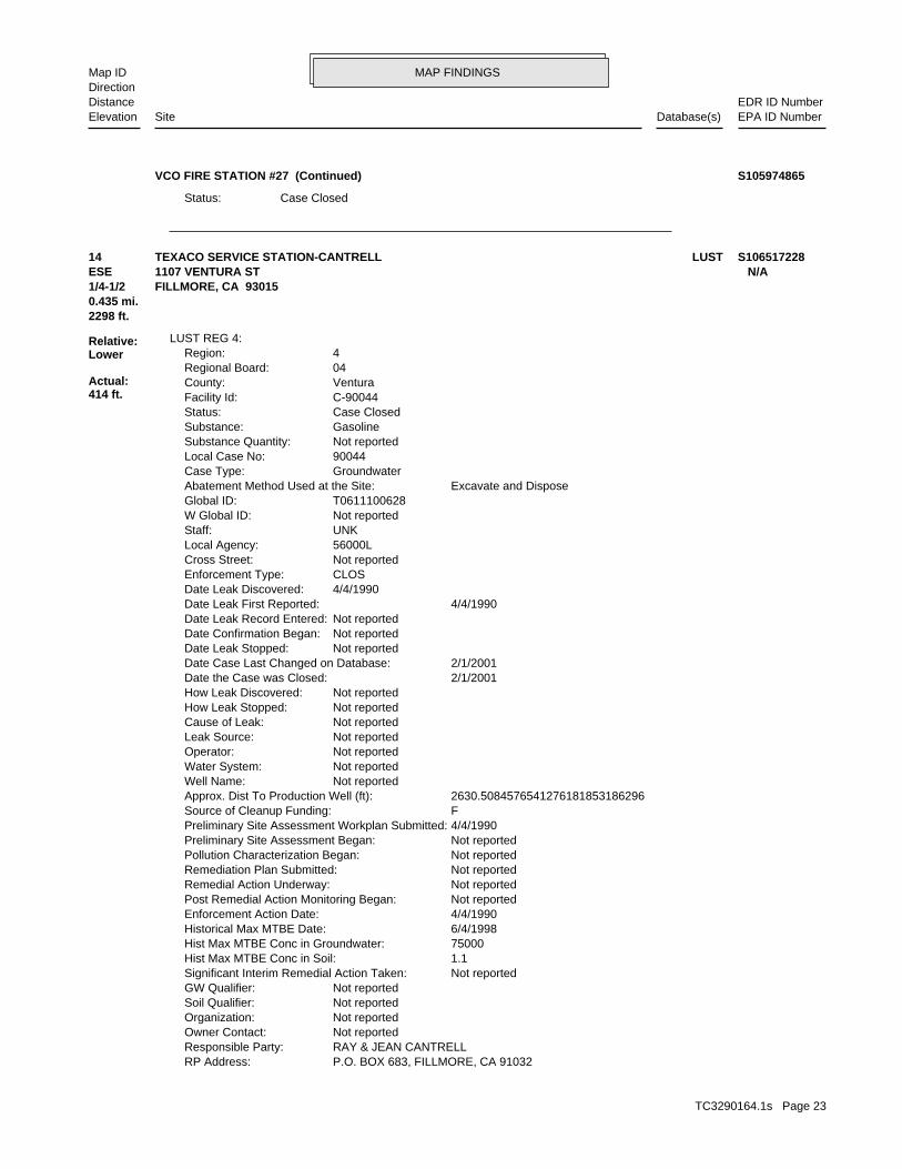
MAP FINDINGSMap IDDirection
EDR ID NumberDistanceEPA ID NumberDatabase(s)SiteElevation
Case ClosedStatus:
VCO FIRE STATION #27 (Continued) S105974865
P.O. BOX 683, FILLMORE, CA 91032RP Address: RAY & JEAN CANTRELLResponsible Party: Not reportedOwner Contact: Not reportedOrganization: Not reportedSoil Qualifier: Not reportedGW Qualifier: Not reportedSignificant Interim Remedial Action Taken: 1.1Hist Max MTBE Conc in Soil: 75000Hist Max MTBE Conc in Groundwater: 6/4/1998Historical Max MTBE Date: 4/4/1990Enforcement Action Date: Not reportedPost Remedial Action Monitoring Began: Not reportedRemedial Action Underway: Not reportedRemediation Plan Submitted: Not reportedPollution Characterization Began: Not reportedPreliminary Site Assessment Began: 4/4/1990Preliminary Site Assessment Workplan Submitted: FSource of Cleanup Funding: 2630.5084576541276181853186296Approx. Dist To Production Well (ft): Not reportedWell Name: Not reportedWater System: Not reportedOperator: Not reportedLeak Source: Not reportedCause of Leak: Not reportedHow Leak Stopped: Not reportedHow Leak Discovered: 2/1/2001Date the Case was Closed: 2/1/2001Date Case Last Changed on Database: Not reportedDate Leak Stopped: Not reportedDate Confirmation Began: Not reportedDate Leak Record Entered: 4/4/1990Date Leak First Reported: 4/4/1990Date Leak Discovered: CLOSEnforcement Type: Not reportedCross Street: 56000LLocal Agency: UNKStaff: Not reportedW Global ID: T0611100628Global ID: Excavate and DisposeAbatement Method Used at the Site: GroundwaterCase Type: 90044Local Case No: Not reportedSubstance Quantity: GasolineSubstance: Case ClosedStatus: C-90044Facility Id: VenturaCounty: 04Regional Board: 4Region:
LUST REG 4:
2298 ft.0.435 mi.
Relative:Lower
Actual:414 ft.
1/4-1/2 FILLMORE, CA 93015ESE 1107 VENTURA ST N/A14 LUSTTEXACO SERVICE STATION-CANTRELL S106517228
TC3290164.1s Page 23
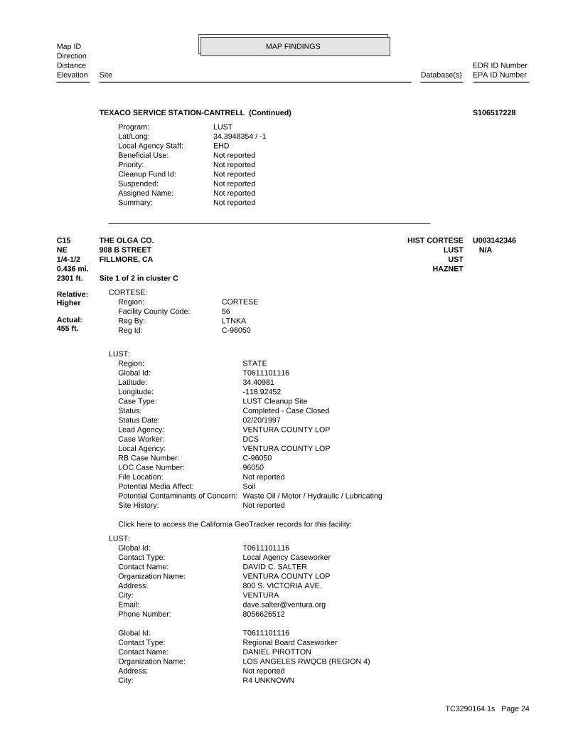
MAP FINDINGSMap IDDirection
EDR ID NumberDistanceEPA ID NumberDatabase(s)SiteElevation
Not reportedSummary: Not reportedAssigned Name: Not reportedSuspended: Not reportedCleanup Fund Id: Not reportedPriority: Not reportedBeneficial Use: EHDLocal Agency Staff: 34.3948354 / -1Lat/Long: LUSTProgram:
TEXACO SERVICE STATION-CANTRELL (Continued) S106517228
R4 UNKNOWNCity: Not reportedAddress: LOS ANGELES RWQCB (REGION 4)Organization Name: DANIEL PIROTTONContact Name: Regional Board CaseworkerContact Type: T0611101116Global Id:
8056626512Phone Number: [email protected]: VENTURACity: 800 S. VICTORIA AVE.Address: VENTURA COUNTY LOPOrganization Name: DAVID C. SALTERContact Name: Local Agency CaseworkerContact Type: T0611101116Global Id:
LUST:
Click here to access the California GeoTracker records for this facility:
Not reportedSite History: Waste Oil / Motor / Hydraulic / LubricatingPotential Contaminants of Concern: SoilPotential Media Affect: Not reportedFile Location: 96050LOC Case Number: C-96050RB Case Number: VENTURA COUNTY LOPLocal Agency: DCSCase Worker: VENTURA COUNTY LOPLead Agency: 02/20/1997Status Date: Completed - Case ClosedStatus: LUST Cleanup SiteCase Type: -118.92452Longitude: 34.40981Latitude: T0611101116Global Id: STATERegion:
LUST:
C-96050Reg Id: LTNKAReg By: 56Facility County Code: CORTESERegion:
CORTESE:
2301 ft. Site 1 of 2 in cluster C0.436 mi. HAZNET
Relative:Higher
Actual:455 ft.
1/4-1/2 USTFILLMORE, CA NE LUST908 B STREET N/AC15 HIST CORTESETHE OLGA CO. U003142346
TC3290164.1s Page 24
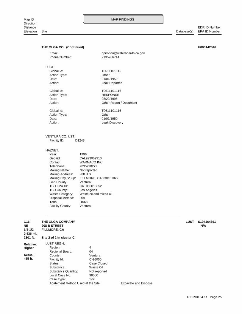
MAP FINDINGSMap IDDirection
EDR ID NumberDistanceEPA ID NumberDatabase(s)SiteElevation
VenturaFacility County: .1668Tons: R01Disposal Method: Waste oil and mixed oilWaste Category: Los AngelesTSD County: CAT080013352TSD EPA ID: VenturaGen County: FILLMORE, CA 930151022Mailing City,St,Zip: 908 B STMailing Address: Not reportedMailing Name: 2035798272Telephone: WARNACO INCContact: CAL923002910Gepaid: 1996Year:
HAZNET:
D1248Facility ID:VENTURA CO. UST:
Leak DiscoveryAction: 01/01/1950Date: OtherAction Type: T0611101116Global Id:
Other Report / DocumentAction: 08/22/1996Date: RESPONSEAction Type: T0611101116Global Id:
Leak ReportedAction: 01/01/1950Date: OtherAction Type: T0611101116Global Id:
LUST:
2135766714Phone Number: [email protected]:
THE OLGA CO. (Continued) U003142346
Excavate and DisposeAbatement Method Used at the Site: SoilCase Type: 96050Local Case No: Not reportedSubstance Quantity: Waste OilSubstance: Case ClosedStatus: C-96050Facility Id: VenturaCounty: 04Regional Board: 4Region:
LUST REG 4:
2301 ft. Site 2 of 2 in cluster C0.436 mi.
Relative:Higher
Actual:455 ft.
1/4-1/2 FILLMORE, CA NE 908 B STREET N/AC16 LUSTTHE OLGA COMPANY S104164691
TC3290164.1s Page 25
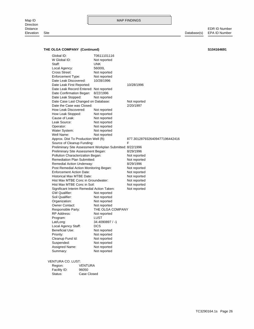
MAP FINDINGSMap IDDirection
EDR ID NumberDistanceEPA ID NumberDatabase(s)SiteElevation
Case ClosedStatus:96050Facility ID:VENTURARegion:
VENTURA CO. LUST:
Not reportedSummary: Not reportedAssigned Name: Not reportedSuspended: Not reportedCleanup Fund Id: Not reportedPriority: Not reportedBeneficial Use: DCSLocal Agency Staff: 34.4090897 / -1Lat/Long: LUSTProgram: Not reportedRP Address: THE OLGA COMPANYResponsible Party: Not reportedOwner Contact: Not reportedOrganization: Not reportedSoil Qualifier: Not reportedGW Qualifier: Not reportedSignificant Interim Remedial Action Taken: Not reportedHist Max MTBE Conc in Soil: Not reportedHist Max MTBE Conc in Groundwater: Not reportedHistorical Max MTBE Date: Not reportedEnforcement Action Date: Not reportedPost Remedial Action Monitoring Began: 8/29/1996Remedial Action Underway: Not reportedRemediation Plan Submitted: Not reportedPollution Characterization Began: 8/29/1996Preliminary Site Assessment Began: 8/22/1996Preliminary Site Assessment Workplan Submitted: FSource of Cleanup Funding: 877.3012879326409477196442416Approx. Dist To Production Well (ft): Not reportedWell Name: Not reportedWater System: Not reportedOperator: Not reportedLeak Source: Not reportedCause of Leak: Not reportedHow Leak Stopped: Not reportedHow Leak Discovered: 2/20/1997Date the Case was Closed: Not reportedDate Case Last Changed on Database: Not reportedDate Leak Stopped: 8/22/1996Date Confirmation Began: Not reportedDate Leak Record Entered: 10/28/1996Date Leak First Reported: 10/28/1996Date Leak Discovered: Not reportedEnforcement Type: Not reportedCross Street: 56000LLocal Agency: UNKStaff: Not reportedW Global ID: T0611101116Global ID:
THE OLGA COMPANY (Continued) S104164691
TC3290164.1s Page 26
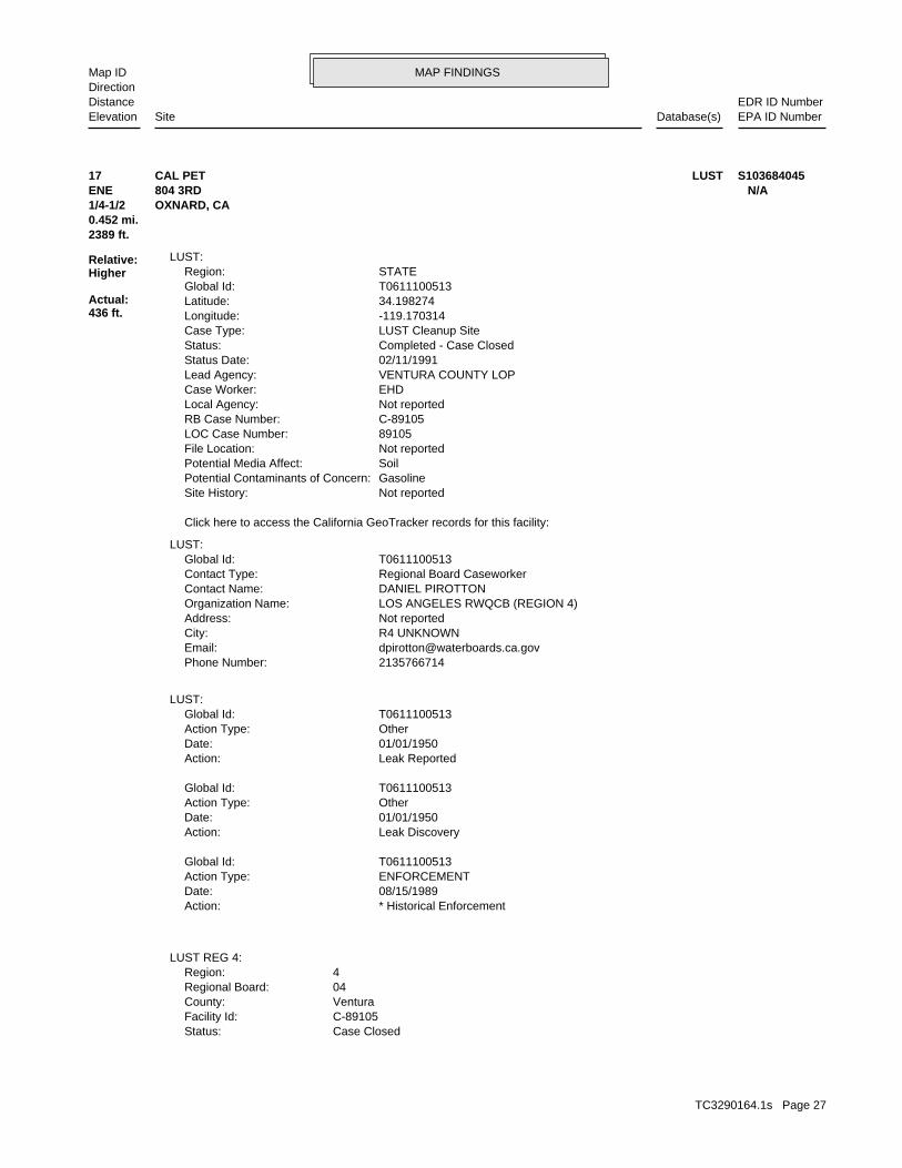
MAP FINDINGSMap IDDirection
EDR ID NumberDistanceEPA ID NumberDatabase(s)SiteElevation
Case ClosedStatus: C-89105Facility Id: VenturaCounty: 04Regional Board: 4Region:
LUST REG 4:
* Historical EnforcementAction: 08/15/1989Date: ENFORCEMENTAction Type: T0611100513Global Id:
Leak DiscoveryAction: 01/01/1950Date: OtherAction Type: T0611100513Global Id:
Leak ReportedAction: 01/01/1950Date: OtherAction Type: T0611100513Global Id:
LUST:
2135766714Phone Number: [email protected]: R4 UNKNOWNCity: Not reportedAddress: LOS ANGELES RWQCB (REGION 4)Organization Name: DANIEL PIROTTONContact Name: Regional Board CaseworkerContact Type: T0611100513Global Id:
LUST:
Click here to access the California GeoTracker records for this facility:
Not reportedSite History: GasolinePotential Contaminants of Concern: SoilPotential Media Affect: Not reportedFile Location: 89105LOC Case Number: C-89105RB Case Number: Not reportedLocal Agency: EHDCase Worker: VENTURA COUNTY LOPLead Agency: 02/11/1991Status Date: Completed - Case ClosedStatus: LUST Cleanup SiteCase Type: -119.170314Longitude: 34.198274Latitude: T0611100513Global Id: STATERegion:
LUST:
2389 ft.0.452 mi.
Relative:Higher
Actual:436 ft.
1/4-1/2 OXNARD, CA ENE 804 3RD N/A17 LUSTCAL PET S103684045
TC3290164.1s Page 27
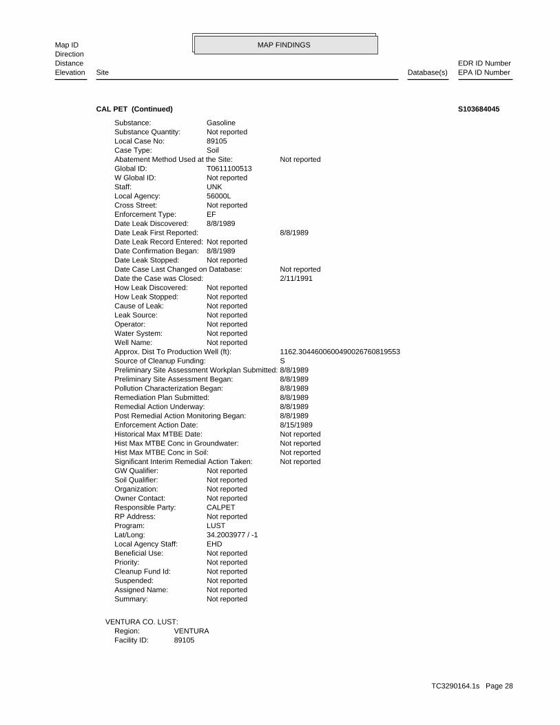
MAP FINDINGSMap IDDirection
EDR ID NumberDistanceEPA ID NumberDatabase(s)SiteElevation
89105Facility ID:VENTURARegion:
VENTURA CO. LUST:
Not reportedSummary: Not reportedAssigned Name: Not reportedSuspended: Not reportedCleanup Fund Id: Not reportedPriority: Not reportedBeneficial Use: EHDLocal Agency Staff: 34.2003977 / -1Lat/Long: LUSTProgram: Not reportedRP Address: CALPETResponsible Party: Not reportedOwner Contact: Not reportedOrganization: Not reportedSoil Qualifier: Not reportedGW Qualifier: Not reportedSignificant Interim Remedial Action Taken: Not reportedHist Max MTBE Conc in Soil: Not reportedHist Max MTBE Conc in Groundwater: Not reportedHistorical Max MTBE Date: 8/15/1989Enforcement Action Date: 8/8/1989Post Remedial Action Monitoring Began: 8/8/1989Remedial Action Underway: 8/8/1989Remediation Plan Submitted: 8/8/1989Pollution Characterization Began: 8/8/1989Preliminary Site Assessment Began: 8/8/1989Preliminary Site Assessment Workplan Submitted: SSource of Cleanup Funding: 1162.3044600600490026760819553Approx. Dist To Production Well (ft): Not reportedWell Name: Not reportedWater System: Not reportedOperator: Not reportedLeak Source: Not reportedCause of Leak: Not reportedHow Leak Stopped: Not reportedHow Leak Discovered: 2/11/1991Date the Case was Closed: Not reportedDate Case Last Changed on Database: Not reportedDate Leak Stopped: 8/8/1989Date Confirmation Began: Not reportedDate Leak Record Entered: 8/8/1989Date Leak First Reported: 8/8/1989Date Leak Discovered: EFEnforcement Type: Not reportedCross Street: 56000LLocal Agency: UNKStaff: Not reportedW Global ID: T0611100513Global ID: Not reportedAbatement Method Used at the Site: SoilCase Type: 89105Local Case No: Not reportedSubstance Quantity: GasolineSubstance:
CAL PET (Continued) S103684045
TC3290164.1s Page 28
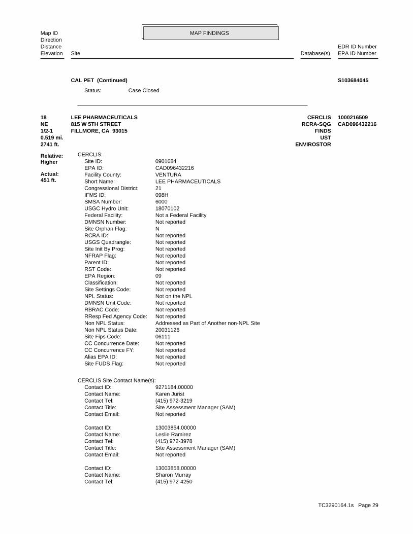
MAP FINDINGSMap IDDirection
EDR ID NumberDistanceEPA ID NumberDatabase(s)SiteElevation
Case ClosedStatus:
CAL PET (Continued) S103684045
(415) 972-4250Contact Tel: Sharon MurrayContact Name: 13003858.00000Contact ID:
Not reportedContact Email: Site Assessment Manager (SAM)Contact Title: (415) 972-3978Contact Tel: Leslie RamirezContact Name: 13003854.00000Contact ID:
Not reportedContact Email: Site Assessment Manager (SAM)Contact Title: (415) 972-3219Contact Tel: Karen JuristContact Name: 9271184.00000Contact ID:
CERCLIS Site Contact Name(s):
Not reportedSite FUDS Flag: Not reportedAlias EPA ID: Not reportedCC Concurrence FY: Not reportedCC Concurrence Date: 06111Site Fips Code: 20031126Non NPL Status Date: Addressed as Part of Another non-NPL SiteNon NPL Status: Not reportedRResp Fed Agency Code: Not reportedRBRAC Code: Not reportedDMNSN Unit Code: Not on the NPLNPL Status: Not reportedSite Settings Code: Not reportedClassification: 09EPA Region: Not reportedRST Code: Not reportedParent ID: Not reportedNFRAP Flag: Not reportedSite Init By Prog: Not reportedUSGS Quadrangle: Not reportedRCRA ID: NSite Orphan Flag: Not reportedDMNSN Number: Not a Federal FacilityFederal Facility: 18070102USGC Hydro Unit: 6000SMSA Number: 098HIFMS ID: 21Congressional District: LEE PHARMACEUTICALSShort Name: VENTURAFacility County: CAD096432216EPA ID: 0901684Site ID:
CERCLIS:
2741 ft. ENVIROSTOR0.519 mi. UST
Relative:Higher
Actual:451 ft.
1/2-1 FINDSFILLMORE, CA 93015NE RCRA-SQG815 W 5TH STREET CAD09643221618 CERCLISLEE PHARMACEUTICALS 1000216509
TC3290164.1s Page 29
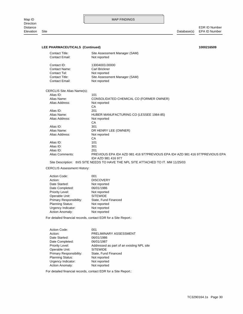
MAP FINDINGSMap IDDirection
EDR ID NumberDistanceEPA ID NumberDatabase(s)SiteElevation
For detailed financial records, contact EDR for a Site Report.:
Not reportedAction Anomaly: Not reportedUrgency Indicator: Not reportedPlanning Status: State, Fund FinancedPrimary Responsibility: SITEWIDEOperable Unit: Addressed as part of an existing NPL sitePriority Level: 06/01/1987Date Completed: 06/01/1986Date Started: PRELIMINARY ASSESSMENTAction: 001Action Code:
For detailed financial records, contact EDR for a Site Report.:
Not reportedAction Anomaly: Not reportedUrgency Indicator: Not reportedPlanning Status: State, Fund FinancedPrimary Responsibility: SITEWIDEOperable Unit: Not reportedPriority Level: 06/01/1986Date Completed: Not reportedDate Started: DISCOVERYAction: 001Action Code:
CERCLIS Assessment History:
thIS SITE NEEDS TO HAVE THE NPL SITE ATTACHED TO IT. MM 11/25/03Site Description: ID# AZD 981 416 977 PREVIOUS EPA ID# AZD 981 416 977PREVIOUS EPA ID# AZD 981 416 977PREVIOUS EPAAlias Comments: 201Alias ID: 301Alias ID: 101Alias ID: CA Not reportedAlias Address: DR HENRY LEE (OWNER)Alias Name: 301Alias ID: CA Not reportedAlias Address: HUBER MANUFACTURING CO (LESSEE 1984-85)Alias Name: 201Alias ID: CA Not reportedAlias Address: CONSOLIDATED CHEMICAL CO (FORMER OWNER)Alias Name: 101Alias ID:
CERCLIS Site Alias Name(s):
Not reportedContact Email: Site Assessment Manager (SAM)Contact Title: Not reportedContact Tel: Carl BricknerContact Name: 13004003.00000Contact ID:
Not reportedContact Email: Site Assessment Manager (SAM)Contact Title:
LEE PHARMACEUTICALS (Continued) 1000216509
TC3290164.1s Page 30
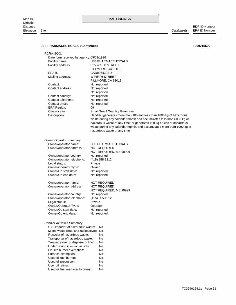
MAP FINDINGSMap IDDirection
EDR ID NumberDistanceEPA ID NumberDatabase(s)SiteElevation
NoUsed oil fuel marketer to burner: NoUser oil refiner: NoUsed oil processor: NoUsed oil fuel burner: NoFurnace exemption: NoOn-site burner exemption: NoUnderground injection activity: NoTreater, storer or disposer of HW: NoTransporter of hazardous waste: NoRecycler of hazardous waste: NoMixed waste (haz. and radioactive): NoU.S. importer of hazardous waste:
Handler Activities Summary:
Not reportedOwner/Op end date: Not reportedOwner/Op start date: OperatorOwner/Operator Type: PrivateLegal status: (415) 555-1212Owner/operator telephone: Not reportedOwner/operator country: NOT REQUIRED, ME 99999 NOT REQUIREDOwner/operator address: NOT REQUIREDOwner/operator name:
Not reportedOwner/Op end date: Not reportedOwner/Op start date: OwnerOwner/Operator Type: PrivateLegal status: (415) 555-1212Owner/operator telephone: Not reportedOwner/operator country: NOT REQUIRED, ME 99999 NOT REQUIREDOwner/operator address: LEE PHARMACEUTICALSOwner/operator name:
Owner/Operator Summary:
hazardous waste at any time waste during any calendar month, and accumulates more than 1000 kg of hazardous waste at any time; or generates 100 kg or less of hazardous waste during any calendar month and accumulates less than 6000 kg of Handler: generates more than 100 and less than 1000 kg of hazardousDescription: Small Small Quantity GeneratorClassification: 09EPA Region: Not reportedContact email: Not reportedContact telephone: Not reportedContact country: Not reported Not reportedContact address: Not reportedContact: FILLMORE, CA 93015 W FIFTH STREETMailing address: CAD096432216EPA ID: FILLMORE, CA 93015 815 W 5TH STREETFacility address: LEE PHARMACEUTICALSFacility name: 09/01/1996Date form received by agency:
RCRA-SQG:
LEE PHARMACEUTICALS (Continued) 1000216509
TC3290164.1s Page 31
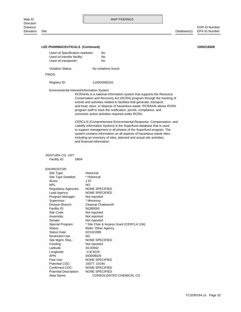
MAP FINDINGSMap IDDirection
EDR ID NumberDistanceEPA ID NumberDatabase(s)SiteElevation
CONSOLIDATED CHEMICAL COAlias Name: NONE SPECIFIEDPotential Description: NONE SPECIFIEDConfirmed COC: 10077, 10194Potential COC: NONE SPECIFIEDPast Use: 043008026APN: -118.9234Longitude: 34.40942Latitude: Not reportedFunding: NONE SPECIFIEDSite Mgmt. Req.: NORestricted Use: 02/10/1995Status Date: Refer: Other AgencyStatus: * Site Char & Assess Grant (CERCLA 104)Special Program: Not reportedSenate: Not reportedAssembly: Not reportedSite Code: 56280093Facility ID: Cleanup ChatsworthDivision Branch: * MmonroySupervisor: Not reportedProgram Manager: NONE SPECIFIEDLead Agency: NONE SPECIFIEDRegulatory Agencies: NONPL: 1.67Acres: * HistoricalSite Type Detailed: HistoricalSite Type:
ENVIROSTOR:
D804Facility ID:VENTURA CO. UST:
and financial information.including an inventory of sites, planned and actual site activities,system contains information on all aspects of hazardous waste sites,to support management in all phases of the Superfund program. TheLiability Information System) is the Superfund database that is usedCERCLIS (Comprehensive Environmental Response, Compensation, and
corrective action activities required under RCRA.program staff to track the notification, permit, compliance, andand treat, store, or dispose of hazardous waste. RCRAInfo allows RCRAevents and activities related to facilities that generate, transport,Conservation and Recovery Act (RCRA) program through the tracking ofRCRAInfo is a national information system that supports the Resource Environmental Interest/Information System
110002665161Registry ID:
FINDS:
No violations foundViolation Status:
NoUsed oil transporter: NoUsed oil transfer facility: NoUsed oil Specification marketer:
LEE PHARMACEUTICALS (Continued) 1000216509
TC3290164.1s Page 32
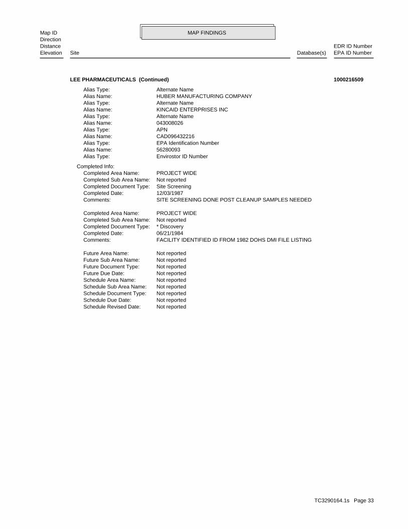
MAP FINDINGSMap IDDirection
EDR ID NumberDistanceEPA ID NumberDatabase(s)SiteElevation
Not reportedSchedule Revised Date: Not reportedSchedule Due Date: Not reportedSchedule Document Type: Not reportedSchedule Sub Area Name: Not reportedSchedule Area Name: Not reportedFuture Due Date: Not reportedFuture Document Type: Not reportedFuture Sub Area Name: Not reportedFuture Area Name:
FACILITY IDENTIFIED ID FROM 1982 DOHS DMI FILE LISTINGComments: 06/21/1984Completed Date: * DiscoveryCompleted Document Type: Not reportedCompleted Sub Area Name: PROJECT WIDECompleted Area Name:
SITE SCREENING DONE POST CLEANUP SAMPLES NEEDEDComments: 12/03/1987Completed Date: Site ScreeningCompleted Document Type: Not reportedCompleted Sub Area Name: PROJECT WIDECompleted Area Name:
Completed Info:
Envirostor ID NumberAlias Type: 56280093Alias Name: EPA Identification NumberAlias Type: CAD096432216Alias Name: APNAlias Type: 043008026Alias Name: Alternate NameAlias Type: KINCAID ENTERPRISES INCAlias Name: Alternate NameAlias Type: HUBER MANUFACTURING COMPANYAlias Name: Alternate NameAlias Type:
LEE PHARMACEUTICALS (Continued) 1000216509
TC3290164.1s Page 33
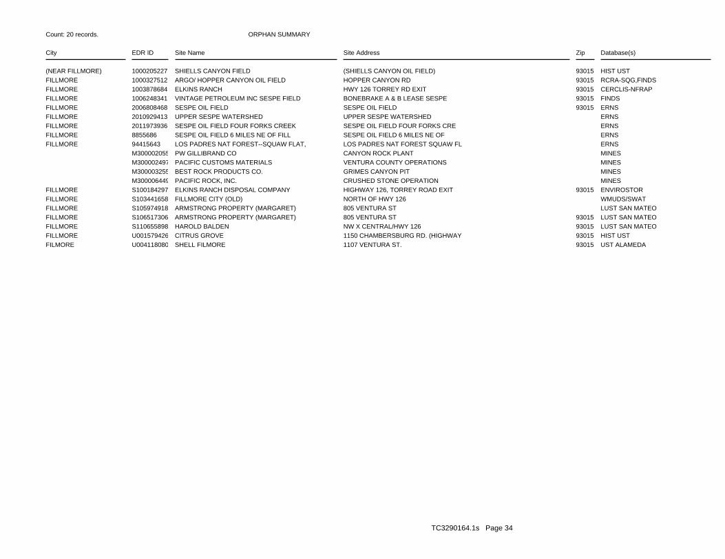
ORPHAN SUMMARY
City EDR ID Site Name Site Address Zip Database(s)
Count: 20 records.
(NEAR FILLMORE) 1000205227 SHIELLS CANYON FIELD (SHIELLS CANYON OIL FIELD) 93015 HIST USTFILLMORE 1000327512 ARGO/ HOPPER CANYON OIL FIELD HOPPER CANYON RD 93015 RCRA-SQG,FINDSFILLMORE 1003878684 ELKINS RANCH HWY 126 TORREY RD EXIT 93015 CERCLIS-NFRAPFILLMORE 1006248341 VINTAGE PETROLEUM INC SESPE FIELD BONEBRAKE A & B LEASE SESPE 93015 FINDSFILLMORE 2006808468 SESPE OIL FIELD SESPE OIL FIELD 93015 ERNSFILLMORE 2010929413 UPPER SESPE WATERSHED UPPER SESPE WATERSHED ERNSFILLMORE 2011973936 SESPE OIL FIELD FOUR FORKS CREEK SESPE OIL FIELD FOUR FORKS CRE ERNSFILLMORE 8855686 SESPE OIL FIELD 6 MILES NE OF FILL SESPE OIL FIELD 6 MILES NE OF ERNSFILLMORE 94415643 LOS PADRES NAT FOREST--SQUAW FLAT, LOS PADRES NAT FOREST SQUAW FL ERNS M300002055 PW GILLIBRAND CO CANYON ROCK PLANT MINES M300002497 PACIFIC CUSTOMS MATERIALS VENTURA COUNTY OPERATIONS MINES M300003255 BEST ROCK PRODUCTS CO. GRIMES CANYON PIT MINES M300006449 PACIFIC ROCK, INC. CRUSHED STONE OPERATION MINESFILLMORE S100184297 ELKINS RANCH DISPOSAL COMPANY HIGHWAY 126, TORREY ROAD EXIT 93015 ENVIROSTORFILLMORE S103441658 FILLMORE CITY (OLD) NORTH OF HWY 126 WMUDS/SWATFILLMORE S105974918 ARMSTRONG PROPERTY (MARGARET) 805 VENTURA ST LUST SAN MATEOFILLMORE S106517306 ARMSTRONG PROPERTY (MARGARET) 805 VENTURA ST 93015 LUST SAN MATEOFILLMORE S110655898 HAROLD BALDEN NW X CENTRAL/HWY 126 93015 LUST SAN MATEOFILLMORE U001579426 CITRUS GROVE 1150 CHAMBERSBURG RD. (HIGHWAY 93015 HIST USTFILMORE U004118080 SHELL FILMORE 1107 VENTURA ST. 93015 UST ALAMEDA
TC3290164.1s Page 34
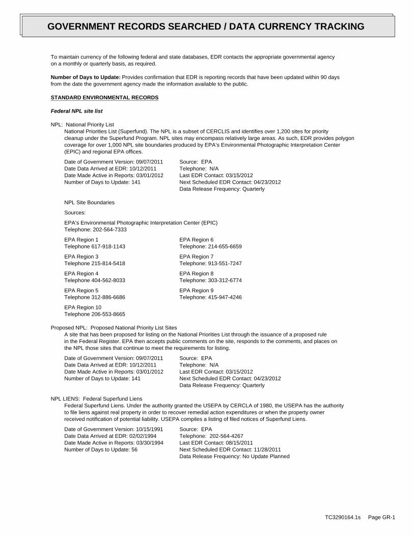
To maintain currency of the following federal and state databases, EDR contacts the appropriate governmental agencyon a monthly or quarterly basis, as required.
Number of Days to Update: Provides confirmation that EDR is reporting records that have been updated within 90 daysfrom the date the government agency made the information available to the public.
STANDARD ENVIRONMENTAL RECORDS
Federal NPL site list
NPL: National Priority ListNational Priorities List (Superfund). The NPL is a subset of CERCLIS and identifies over 1,200 sites for prioritycleanup under the Superfund Program. NPL sites may encompass relatively large areas. As such, EDR provides polygoncoverage for over 1,000 NPL site boundaries produced by EPA’s Environmental Photographic Interpretation Center(EPIC) and regional EPA offices.
Date of Government Version: 09/07/2011Date Data Arrived at EDR: 10/12/2011Date Made Active in Reports: 03/01/2012Number of Days to Update: 141
Source: EPATelephone: N/ALast EDR Contact: 03/15/2012Next Scheduled EDR Contact: 04/23/2012Data Release Frequency: Quarterly
NPL Site Boundaries
Sources:
EPA’s Environmental Photographic Interpretation Center (EPIC)Telephone: 202-564-7333
EPA Region 1 EPA Region 6Telephone 617-918-1143 Telephone: 214-655-6659
EPA Region 3 EPA Region 7Telephone 215-814-5418 Telephone: 913-551-7247
EPA Region 4 EPA Region 8Telephone 404-562-8033 Telephone: 303-312-6774
EPA Region 5 EPA Region 9Telephone 312-886-6686 Telephone: 415-947-4246
EPA Region 10Telephone 206-553-8665
Proposed NPL: Proposed National Priority List SitesA site that has been proposed for listing on the National Priorities List through the issuance of a proposed rulein the Federal Register. EPA then accepts public comments on the site, responds to the comments, and places onthe NPL those sites that continue to meet the requirements for listing.
Date of Government Version: 09/07/2011Date Data Arrived at EDR: 10/12/2011Date Made Active in Reports: 03/01/2012Number of Days to Update: 141
Source: EPATelephone: N/ALast EDR Contact: 03/15/2012Next Scheduled EDR Contact: 04/23/2012Data Release Frequency: Quarterly
NPL LIENS: Federal Superfund LiensFederal Superfund Liens. Under the authority granted the USEPA by CERCLA of 1980, the USEPA has the authorityto file liens against real property in order to recover remedial action expenditures or when the property ownerreceived notification of potential liability. USEPA compiles a listing of filed notices of Superfund Liens.
Date of Government Version: 10/15/1991Date Data Arrived at EDR: 02/02/1994Date Made Active in Reports: 03/30/1994Number of Days to Update: 56
Source: EPATelephone: 202-564-4267Last EDR Contact: 08/15/2011Next Scheduled EDR Contact: 11/28/2011Data Release Frequency: No Update Planned
TC3290164.1s Page GR-1
GOVERNMENT RECORDS SEARCHED / DATA CURRENCY TRACKING
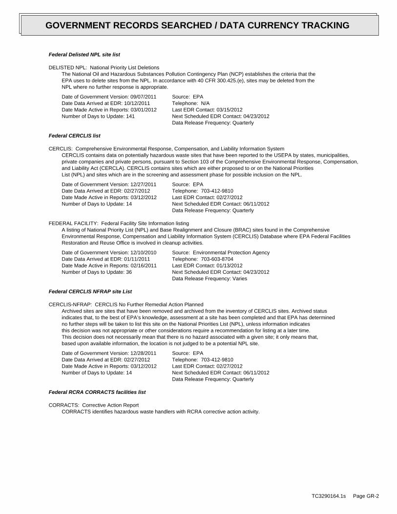
Federal Delisted NPL site list
DELISTED NPL: National Priority List DeletionsThe National Oil and Hazardous Substances Pollution Contingency Plan (NCP) establishes the criteria that theEPA uses to delete sites from the NPL. In accordance with 40 CFR 300.425.(e), sites may be deleted from theNPL where no further response is appropriate.
Date of Government Version: 09/07/2011Date Data Arrived at EDR: 10/12/2011Date Made Active in Reports: 03/01/2012Number of Days to Update: 141
Source: EPATelephone: N/ALast EDR Contact: 03/15/2012Next Scheduled EDR Contact: 04/23/2012Data Release Frequency: Quarterly
Federal CERCLIS list
CERCLIS: Comprehensive Environmental Response, Compensation, and Liability Information SystemCERCLIS contains data on potentially hazardous waste sites that have been reported to the USEPA by states, municipalities,private companies and private persons, pursuant to Section 103 of the Comprehensive Environmental Response, Compensation,and Liability Act (CERCLA). CERCLIS contains sites which are either proposed to or on the National PrioritiesList (NPL) and sites which are in the screening and assessment phase for possible inclusion on the NPL.
Date of Government Version: 12/27/2011Date Data Arrived at EDR: 02/27/2012Date Made Active in Reports: 03/12/2012Number of Days to Update: 14
Source: EPATelephone: 703-412-9810Last EDR Contact: 02/27/2012Next Scheduled EDR Contact: 06/11/2012Data Release Frequency: Quarterly
FEDERAL FACILITY: Federal Facility Site Information listingA listing of National Priority List (NPL) and Base Realignment and Closure (BRAC) sites found in the ComprehensiveEnvironmental Response, Compensation and Liability Information System (CERCLIS) Database where EPA Federal FacilitiesRestoration and Reuse Office is involved in cleanup activities.
Date of Government Version: 12/10/2010Date Data Arrived at EDR: 01/11/2011Date Made Active in Reports: 02/16/2011Number of Days to Update: 36
Source: Environmental Protection AgencyTelephone: 703-603-8704Last EDR Contact: 01/13/2012Next Scheduled EDR Contact: 04/23/2012Data Release Frequency: Varies
Federal CERCLIS NFRAP site List
CERCLIS-NFRAP: CERCLIS No Further Remedial Action PlannedArchived sites are sites that have been removed and archived from the inventory of CERCLIS sites. Archived statusindicates that, to the best of EPA’s knowledge, assessment at a site has been completed and that EPA has determinedno further steps will be taken to list this site on the National Priorities List (NPL), unless information indicatesthis decision was not appropriate or other considerations require a recommendation for listing at a later time.This decision does not necessarily mean that there is no hazard associated with a given site; it only means that,based upon available information, the location is not judged to be a potential NPL site.
Date of Government Version: 12/28/2011Date Data Arrived at EDR: 02/27/2012Date Made Active in Reports: 03/12/2012Number of Days to Update: 14
Source: EPATelephone: 703-412-9810Last EDR Contact: 02/27/2012Next Scheduled EDR Contact: 06/11/2012Data Release Frequency: Quarterly
Federal RCRA CORRACTS facilities list
CORRACTS: Corrective Action ReportCORRACTS identifies hazardous waste handlers with RCRA corrective action activity.
TC3290164.1s Page GR-2
GOVERNMENT RECORDS SEARCHED / DATA CURRENCY TRACKING
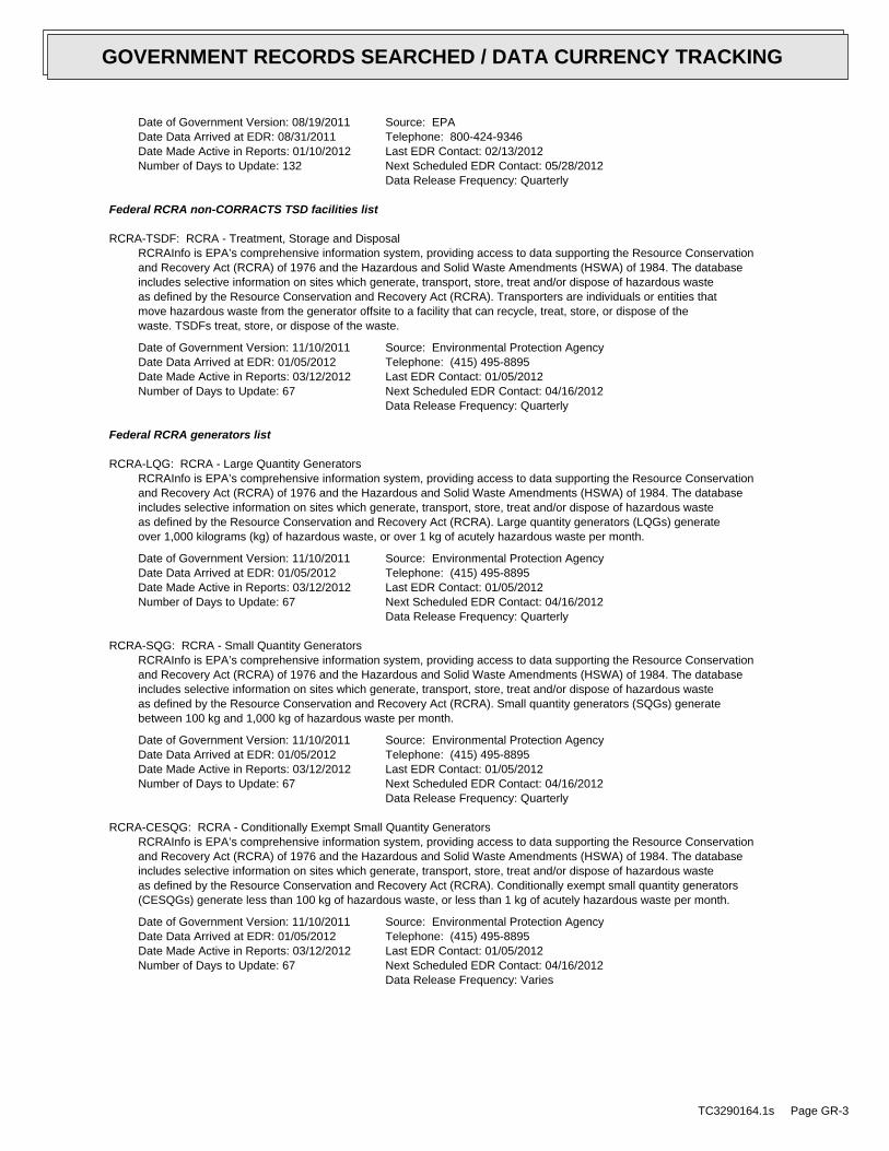
Date of Government Version: 08/19/2011Date Data Arrived at EDR: 08/31/2011Date Made Active in Reports: 01/10/2012Number of Days to Update: 132
Source: EPATelephone: 800-424-9346Last EDR Contact: 02/13/2012Next Scheduled EDR Contact: 05/28/2012Data Release Frequency: Quarterly
Federal RCRA non-CORRACTS TSD facilities list
RCRA-TSDF: RCRA - Treatment, Storage and DisposalRCRAInfo is EPA’s comprehensive information system, providing access to data supporting the Resource Conservationand Recovery Act (RCRA) of 1976 and the Hazardous and Solid Waste Amendments (HSWA) of 1984. The databaseincludes selective information on sites which generate, transport, store, treat and/or dispose of hazardous wasteas defined by the Resource Conservation and Recovery Act (RCRA). Transporters are individuals or entities thatmove hazardous waste from the generator offsite to a facility that can recycle, treat, store, or dispose of thewaste. TSDFs treat, store, or dispose of the waste.
Date of Government Version: 11/10/2011Date Data Arrived at EDR: 01/05/2012Date Made Active in Reports: 03/12/2012Number of Days to Update: 67
Source: Environmental Protection AgencyTelephone: (415) 495-8895Last EDR Contact: 01/05/2012Next Scheduled EDR Contact: 04/16/2012Data Release Frequency: Quarterly
Federal RCRA generators list
RCRA-LQG: RCRA - Large Quantity GeneratorsRCRAInfo is EPA’s comprehensive information system, providing access to data supporting the Resource Conservationand Recovery Act (RCRA) of 1976 and the Hazardous and Solid Waste Amendments (HSWA) of 1984. The databaseincludes selective information on sites which generate, transport, store, treat and/or dispose of hazardous wasteas defined by the Resource Conservation and Recovery Act (RCRA). Large quantity generators (LQGs) generateover 1,000 kilograms (kg) of hazardous waste, or over 1 kg of acutely hazardous waste per month.
Date of Government Version: 11/10/2011Date Data Arrived at EDR: 01/05/2012Date Made Active in Reports: 03/12/2012Number of Days to Update: 67
Source: Environmental Protection AgencyTelephone: (415) 495-8895Last EDR Contact: 01/05/2012Next Scheduled EDR Contact: 04/16/2012Data Release Frequency: Quarterly
RCRA-SQG: RCRA - Small Quantity GeneratorsRCRAInfo is EPA’s comprehensive information system, providing access to data supporting the Resource Conservationand Recovery Act (RCRA) of 1976 and the Hazardous and Solid Waste Amendments (HSWA) of 1984. The databaseincludes selective information on sites which generate, transport, store, treat and/or dispose of hazardous wasteas defined by the Resource Conservation and Recovery Act (RCRA). Small quantity generators (SQGs) generatebetween 100 kg and 1,000 kg of hazardous waste per month.
Date of Government Version: 11/10/2011Date Data Arrived at EDR: 01/05/2012Date Made Active in Reports: 03/12/2012Number of Days to Update: 67
Source: Environmental Protection AgencyTelephone: (415) 495-8895Last EDR Contact: 01/05/2012Next Scheduled EDR Contact: 04/16/2012Data Release Frequency: Quarterly
RCRA-CESQG: RCRA - Conditionally Exempt Small Quantity GeneratorsRCRAInfo is EPA’s comprehensive information system, providing access to data supporting the Resource Conservationand Recovery Act (RCRA) of 1976 and the Hazardous and Solid Waste Amendments (HSWA) of 1984. The databaseincludes selective information on sites which generate, transport, store, treat and/or dispose of hazardous wasteas defined by the Resource Conservation and Recovery Act (RCRA). Conditionally exempt small quantity generators(CESQGs) generate less than 100 kg of hazardous waste, or less than 1 kg of acutely hazardous waste per month.
Date of Government Version: 11/10/2011Date Data Arrived at EDR: 01/05/2012Date Made Active in Reports: 03/12/2012Number of Days to Update: 67
Source: Environmental Protection AgencyTelephone: (415) 495-8895Last EDR Contact: 01/05/2012Next Scheduled EDR Contact: 04/16/2012Data Release Frequency: Varies
TC3290164.1s Page GR-3
GOVERNMENT RECORDS SEARCHED / DATA CURRENCY TRACKING
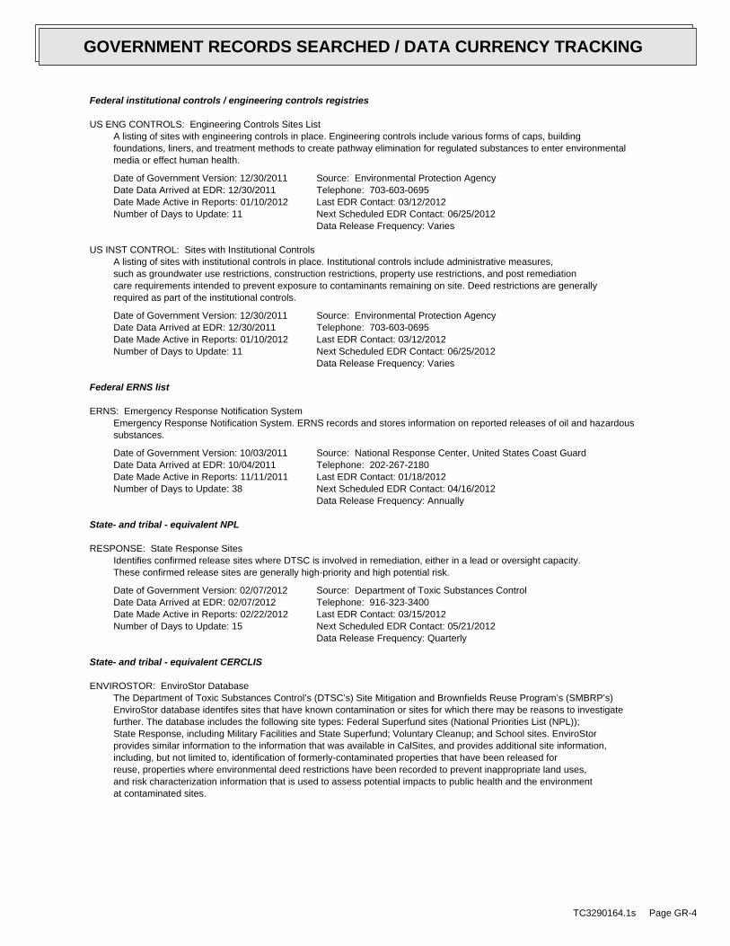
Federal institutional controls / engineering controls registries
US ENG CONTROLS: Engineering Controls Sites ListA listing of sites with engineering controls in place. Engineering controls include various forms of caps, buildingfoundations, liners, and treatment methods to create pathway elimination for regulated substances to enter environmentalmedia or effect human health.
Date of Government Version: 12/30/2011Date Data Arrived at EDR: 12/30/2011Date Made Active in Reports: 01/10/2012Number of Days to Update: 11
Source: Environmental Protection AgencyTelephone: 703-603-0695Last EDR Contact: 03/12/2012Next Scheduled EDR Contact: 06/25/2012Data Release Frequency: Varies
US INST CONTROL: Sites with Institutional ControlsA listing of sites with institutional controls in place. Institutional controls include administrative measures,such as groundwater use restrictions, construction restrictions, property use restrictions, and post remediationcare requirements intended to prevent exposure to contaminants remaining on site. Deed restrictions are generallyrequired as part of the institutional controls.
Date of Government Version: 12/30/2011Date Data Arrived at EDR: 12/30/2011Date Made Active in Reports: 01/10/2012Number of Days to Update: 11
Source: Environmental Protection AgencyTelephone: 703-603-0695Last EDR Contact: 03/12/2012Next Scheduled EDR Contact: 06/25/2012Data Release Frequency: Varies
Federal ERNS list
ERNS: Emergency Response Notification SystemEmergency Response Notification System. ERNS records and stores information on reported releases of oil and hazardoussubstances.
Date of Government Version: 10/03/2011Date Data Arrived at EDR: 10/04/2011Date Made Active in Reports: 11/11/2011Number of Days to Update: 38
Source: National Response Center, United States Coast GuardTelephone: 202-267-2180Last EDR Contact: 01/18/2012Next Scheduled EDR Contact: 04/16/2012Data Release Frequency: Annually
State- and tribal - equivalent NPL
RESPONSE: State Response SitesIdentifies confirmed release sites where DTSC is involved in remediation, either in a lead or oversight capacity.These confirmed release sites are generally high-priority and high potential risk.
Date of Government Version: 02/07/2012Date Data Arrived at EDR: 02/07/2012Date Made Active in Reports: 02/22/2012Number of Days to Update: 15
Source: Department of Toxic Substances ControlTelephone: 916-323-3400Last EDR Contact: 03/15/2012Next Scheduled EDR Contact: 05/21/2012Data Release Frequency: Quarterly
State- and tribal - equivalent CERCLIS
ENVIROSTOR: EnviroStor DatabaseThe Department of Toxic Substances Control’s (DTSC’s) Site Mitigation and Brownfields Reuse Program’s (SMBRP’s)EnviroStor database identifes sites that have known contamination or sites for which there may be reasons to investigatefurther. The database includes the following site types: Federal Superfund sites (National Priorities List (NPL));State Response, including Military Facilities and State Superfund; Voluntary Cleanup; and School sites. EnviroStorprovides similar information to the information that was available in CalSites, and provides additional site information,including, but not limited to, identification of formerly-contaminated properties that have been released forreuse, properties where environmental deed restrictions have been recorded to prevent inappropriate land uses,and risk characterization information that is used to assess potential impacts to public health and the environmentat contaminated sites.
TC3290164.1s Page GR-4
GOVERNMENT RECORDS SEARCHED / DATA CURRENCY TRACKING
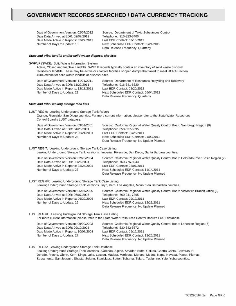
Date of Government Version: 02/07/2012Date Data Arrived at EDR: 02/07/2012Date Made Active in Reports: 02/22/2012Number of Days to Update: 15
Source: Department of Toxic Substances ControlTelephone: 916-323-3400Last EDR Contact: 03/15/2012Next Scheduled EDR Contact: 05/21/2012Data Release Frequency: Quarterly
State and tribal landfill and/or solid waste disposal site lists
SWF/LF (SWIS): Solid Waste Information SystemActive, Closed and Inactive Landfills. SWF/LF records typically contain an inve ntory of solid waste disposalfacilities or landfills. These may be active or i nactive facilities or open dumps that failed to meet RCRA Section4004 criteria for solid waste landfills or disposal sites.
Date of Government Version: 11/21/2011Date Data Arrived at EDR: 11/22/2011Date Made Active in Reports: 12/13/2011Number of Days to Update: 21
Source: Department of Resources Recycling and RecoveryTelephone: 916-341-6320Last EDR Contact: 02/20/2012Next Scheduled EDR Contact: 06/04/2012Data Release Frequency: Quarterly
State and tribal leaking storage tank lists
LUST REG 9: Leaking Underground Storage Tank ReportOrange, Riverside, San Diego counties. For more current information, please refer to the State Water ResourcesControl Board’s LUST database.
Date of Government Version: 03/01/2001Date Data Arrived at EDR: 04/23/2001Date Made Active in Reports: 05/21/2001Number of Days to Update: 28
Source: California Regional Water Quality Control Board San Diego Region (9)Telephone: 858-637-5595Last EDR Contact: 09/26/2011Next Scheduled EDR Contact: 01/09/2012Data Release Frequency: No Update Planned
LUST REG 7: Leaking Underground Storage Tank Case ListingLeaking Underground Storage Tank locations. Imperial, Riverside, San Diego, Santa Barbara counties.
Date of Government Version: 02/26/2004Date Data Arrived at EDR: 02/26/2004Date Made Active in Reports: 03/24/2004Number of Days to Update: 27
Source: California Regional Water Quality Control Board Colorado River Basin Region (7)Telephone: 760-776-8943Last EDR Contact: 08/01/2011Next Scheduled EDR Contact: 11/14/2011Data Release Frequency: No Update Planned
LUST REG 6V: Leaking Underground Storage Tank Case ListingLeaking Underground Storage Tank locations. Inyo, Kern, Los Angeles, Mono, San Bernardino counties.
Date of Government Version: 06/07/2005Date Data Arrived at EDR: 06/07/2005Date Made Active in Reports: 06/29/2005Number of Days to Update: 22
Source: California Regional Water Quality Control Board Victorville Branch Office (6)Telephone: 760-241-7365Last EDR Contact: 09/12/2011Next Scheduled EDR Contact: 12/26/2011Data Release Frequency: No Update Planned
LUST REG 6L: Leaking Underground Storage Tank Case ListingFor more current information, please refer to the State Water Resources Control Board’s LUST database.
Date of Government Version: 09/09/2003Date Data Arrived at EDR: 09/10/2003Date Made Active in Reports: 10/07/2003Number of Days to Update: 27
Source: California Regional Water Quality Control Board Lahontan Region (6)Telephone: 530-542-5572Last EDR Contact: 09/12/2011Next Scheduled EDR Contact: 12/26/2011Data Release Frequency: No Update Planned
LUST REG 5: Leaking Underground Storage Tank DatabaseLeaking Underground Storage Tank locations. Alameda, Alpine, Amador, Butte, Colusa, Contra Costa, Calveras, ElDorado, Fresno, Glenn, Kern, Kings, Lake, Lassen, Madera, Mariposa, Merced, Modoc, Napa, Nevada, Placer, Plumas,Sacramento, San Joaquin, Shasta, Solano, Stanislaus, Sutter, Tehama, Tulare, Tuolumne, Yolo, Yuba counties.
TC3290164.1s Page GR-5
GOVERNMENT RECORDS SEARCHED / DATA CURRENCY TRACKING
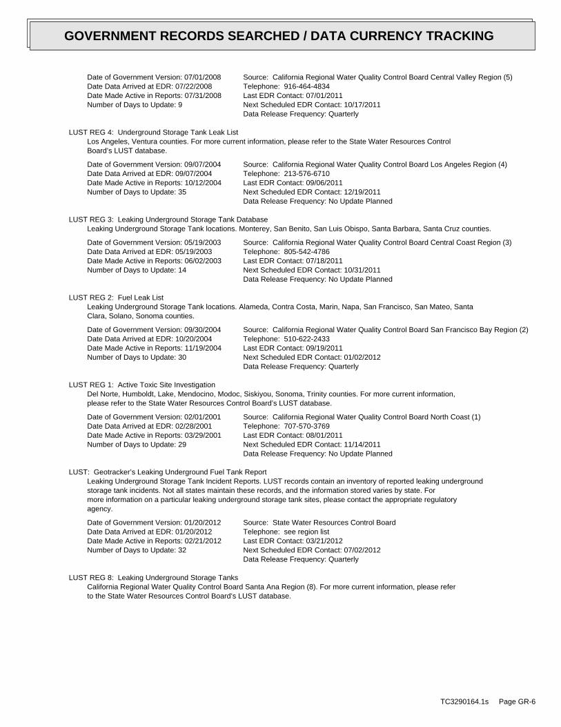
Date of Government Version: 07/01/2008Date Data Arrived at EDR: 07/22/2008Date Made Active in Reports: 07/31/2008Number of Days to Update: 9
Source: California Regional Water Quality Control Board Central Valley Region (5)Telephone: 916-464-4834Last EDR Contact: 07/01/2011Next Scheduled EDR Contact: 10/17/2011Data Release Frequency: Quarterly
LUST REG 4: Underground Storage Tank Leak ListLos Angeles, Ventura counties. For more current information, please refer to the State Water Resources ControlBoard’s LUST database.
Date of Government Version: 09/07/2004Date Data Arrived at EDR: 09/07/2004Date Made Active in Reports: 10/12/2004Number of Days to Update: 35
Source: California Regional Water Quality Control Board Los Angeles Region (4)Telephone: 213-576-6710Last EDR Contact: 09/06/2011Next Scheduled EDR Contact: 12/19/2011Data Release Frequency: No Update Planned
LUST REG 3: Leaking Underground Storage Tank DatabaseLeaking Underground Storage Tank locations. Monterey, San Benito, San Luis Obispo, Santa Barbara, Santa Cruz counties.
Date of Government Version: 05/19/2003Date Data Arrived at EDR: 05/19/2003Date Made Active in Reports: 06/02/2003Number of Days to Update: 14
Source: California Regional Water Quality Control Board Central Coast Region (3)Telephone: 805-542-4786Last EDR Contact: 07/18/2011Next Scheduled EDR Contact: 10/31/2011Data Release Frequency: No Update Planned
LUST REG 2: Fuel Leak ListLeaking Underground Storage Tank locations. Alameda, Contra Costa, Marin, Napa, San Francisco, San Mateo, SantaClara, Solano, Sonoma counties.
Date of Government Version: 09/30/2004Date Data Arrived at EDR: 10/20/2004Date Made Active in Reports: 11/19/2004Number of Days to Update: 30
Source: California Regional Water Quality Control Board San Francisco Bay Region (2)Telephone: 510-622-2433Last EDR Contact: 09/19/2011Next Scheduled EDR Contact: 01/02/2012Data Release Frequency: Quarterly
LUST REG 1: Active Toxic Site InvestigationDel Norte, Humboldt, Lake, Mendocino, Modoc, Siskiyou, Sonoma, Trinity counties. For more current information,please refer to the State Water Resources Control Board’s LUST database.
Date of Government Version: 02/01/2001Date Data Arrived at EDR: 02/28/2001Date Made Active in Reports: 03/29/2001Number of Days to Update: 29
Source: California Regional Water Quality Control Board North Coast (1)Telephone: 707-570-3769Last EDR Contact: 08/01/2011Next Scheduled EDR Contact: 11/14/2011Data Release Frequency: No Update Planned
LUST: Geotracker’s Leaking Underground Fuel Tank ReportLeaking Underground Storage Tank Incident Reports. LUST records contain an inventory of reported leaking undergroundstorage tank incidents. Not all states maintain these records, and the information stored varies by state. Formore information on a particular leaking underground storage tank sites, please contact the appropriate regulatoryagency.
Date of Government Version: 01/20/2012Date Data Arrived at EDR: 01/20/2012Date Made Active in Reports: 02/21/2012Number of Days to Update: 32
Source: State Water Resources Control BoardTelephone: see region listLast EDR Contact: 03/21/2012Next Scheduled EDR Contact: 07/02/2012Data Release Frequency: Quarterly
LUST REG 8: Leaking Underground Storage TanksCalifornia Regional Water Quality Control Board Santa Ana Region (8). For more current information, please referto the State Water Resources Control Board’s LUST database.
TC3290164.1s Page GR-6
GOVERNMENT RECORDS SEARCHED / DATA CURRENCY TRACKING
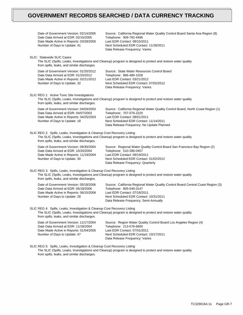
Date of Government Version: 02/14/2005Date Data Arrived at EDR: 02/15/2005Date Made Active in Reports: 03/28/2005Number of Days to Update: 41
Source: California Regional Water Quality Control Board Santa Ana Region (8)Telephone: 909-782-4496Last EDR Contact: 08/15/2011Next Scheduled EDR Contact: 11/28/2011Data Release Frequency: Varies
SLIC: Statewide SLIC CasesThe SLIC (Spills, Leaks, Investigations and Cleanup) program is designed to protect and restore water qualityfrom spills, leaks, and similar discharges.
Date of Government Version: 01/20/2012Date Data Arrived at EDR: 01/20/2012Date Made Active in Reports: 02/21/2012Number of Days to Update: 32
Source: State Water Resources Control BoardTelephone: 866-480-1028Last EDR Contact: 03/21/2012Next Scheduled EDR Contact: 07/02/2012Data Release Frequency: Varies
SLIC REG 1: Active Toxic Site InvestigationsThe SLIC (Spills, Leaks, Investigations and Cleanup) program is designed to protect and restore water qualityfrom spills, leaks, and similar discharges.
Date of Government Version: 04/03/2003Date Data Arrived at EDR: 04/07/2003Date Made Active in Reports: 04/25/2003Number of Days to Update: 18
Source: California Regional Water Quality Control Board, North Coast Region (1)Telephone: 707-576-2220Last EDR Contact: 08/01/2011Next Scheduled EDR Contact: 11/14/2011Data Release Frequency: No Update Planned
SLIC REG 2: Spills, Leaks, Investigation & Cleanup Cost Recovery ListingThe SLIC (Spills, Leaks, Investigations and Cleanup) program is designed to protect and restore water qualityfrom spills, leaks, and similar discharges.
Date of Government Version: 09/30/2004Date Data Arrived at EDR: 10/20/2004Date Made Active in Reports: 11/19/2004Number of Days to Update: 30
Source: Regional Water Quality Control Board San Francisco Bay Region (2)Telephone: 510-286-0457Last EDR Contact: 09/19/2011Next Scheduled EDR Contact: 01/02/2012Data Release Frequency: Quarterly
SLIC REG 3: Spills, Leaks, Investigation & Cleanup Cost Recovery ListingThe SLIC (Spills, Leaks, Investigations and Cleanup) program is designed to protect and restore water qualityfrom spills, leaks, and similar discharges.
Date of Government Version: 05/18/2006Date Data Arrived at EDR: 05/18/2006Date Made Active in Reports: 06/15/2006Number of Days to Update: 28
Source: California Regional Water Quality Control Board Central Coast Region (3)Telephone: 805-549-3147Last EDR Contact: 07/18/2011Next Scheduled EDR Contact: 10/31/2011Data Release Frequency: Semi-Annually
SLIC REG 4: Spills, Leaks, Investigation & Cleanup Cost Recovery ListingThe SLIC (Spills, Leaks, Investigations and Cleanup) program is designed to protect and restore water qualityfrom spills, leaks, and similar discharges.
Date of Government Version: 11/17/2004Date Data Arrived at EDR: 11/18/2004Date Made Active in Reports: 01/04/2005Number of Days to Update: 47
Source: Region Water Quality Control Board Los Angeles Region (4)Telephone: 213-576-6600Last EDR Contact: 07/01/2011Next Scheduled EDR Contact: 10/17/2011Data Release Frequency: Varies
SLIC REG 5: Spills, Leaks, Investigation & Cleanup Cost Recovery ListingThe SLIC (Spills, Leaks, Investigations and Cleanup) program is designed to protect and restore water qualityfrom spills, leaks, and similar discharges.
TC3290164.1s Page GR-7
GOVERNMENT RECORDS SEARCHED / DATA CURRENCY TRACKING
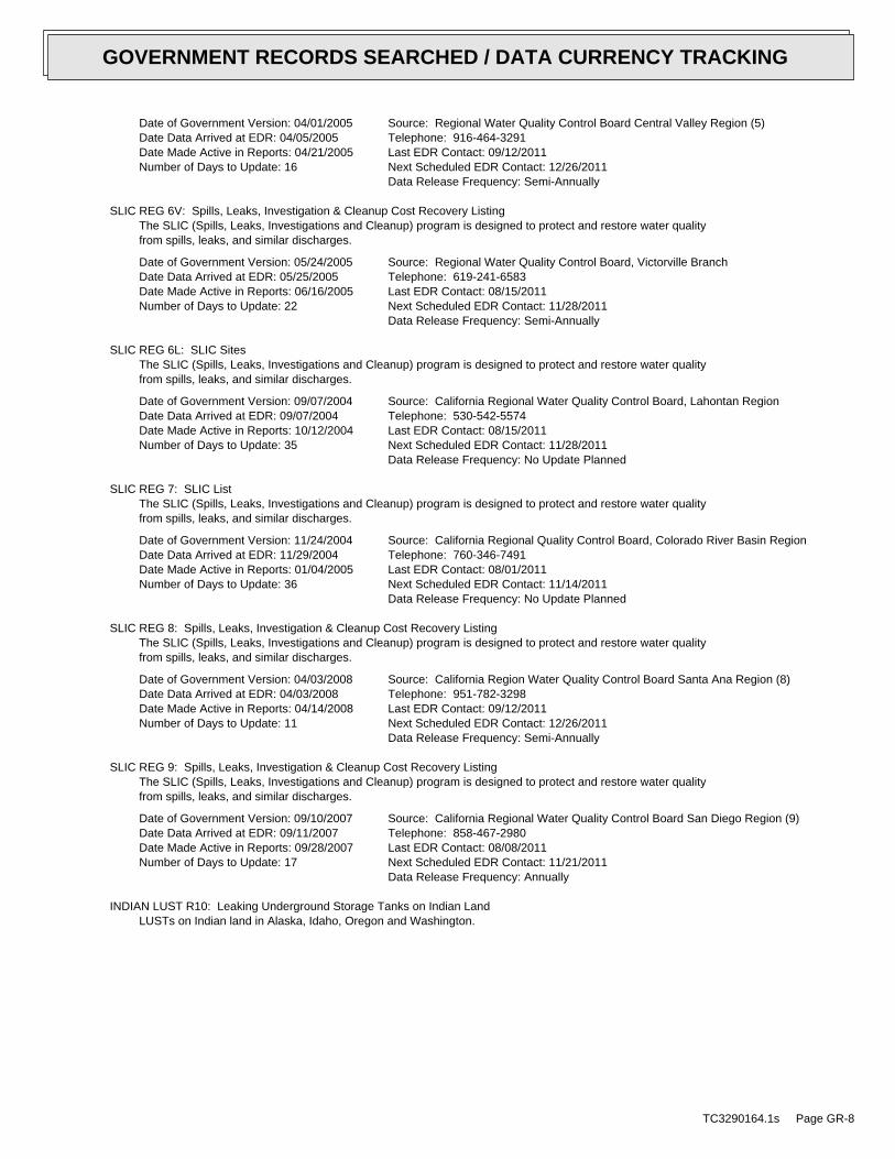
Date of Government Version: 04/01/2005Date Data Arrived at EDR: 04/05/2005Date Made Active in Reports: 04/21/2005Number of Days to Update: 16
Source: Regional Water Quality Control Board Central Valley Region (5)Telephone: 916-464-3291Last EDR Contact: 09/12/2011Next Scheduled EDR Contact: 12/26/2011Data Release Frequency: Semi-Annually
SLIC REG 6V: Spills, Leaks, Investigation & Cleanup Cost Recovery ListingThe SLIC (Spills, Leaks, Investigations and Cleanup) program is designed to protect and restore water qualityfrom spills, leaks, and similar discharges.
Date of Government Version: 05/24/2005Date Data Arrived at EDR: 05/25/2005Date Made Active in Reports: 06/16/2005Number of Days to Update: 22
Source: Regional Water Quality Control Board, Victorville BranchTelephone: 619-241-6583Last EDR Contact: 08/15/2011Next Scheduled EDR Contact: 11/28/2011Data Release Frequency: Semi-Annually
SLIC REG 6L: SLIC SitesThe SLIC (Spills, Leaks, Investigations and Cleanup) program is designed to protect and restore water qualityfrom spills, leaks, and similar discharges.
Date of Government Version: 09/07/2004Date Data Arrived at EDR: 09/07/2004Date Made Active in Reports: 10/12/2004Number of Days to Update: 35
Source: California Regional Water Quality Control Board, Lahontan RegionTelephone: 530-542-5574Last EDR Contact: 08/15/2011Next Scheduled EDR Contact: 11/28/2011Data Release Frequency: No Update Planned
SLIC REG 7: SLIC ListThe SLIC (Spills, Leaks, Investigations and Cleanup) program is designed to protect and restore water qualityfrom spills, leaks, and similar discharges.
Date of Government Version: 11/24/2004Date Data Arrived at EDR: 11/29/2004Date Made Active in Reports: 01/04/2005Number of Days to Update: 36
Source: California Regional Quality Control Board, Colorado River Basin RegionTelephone: 760-346-7491Last EDR Contact: 08/01/2011Next Scheduled EDR Contact: 11/14/2011Data Release Frequency: No Update Planned
SLIC REG 8: Spills, Leaks, Investigation & Cleanup Cost Recovery ListingThe SLIC (Spills, Leaks, Investigations and Cleanup) program is designed to protect and restore water qualityfrom spills, leaks, and similar discharges.
Date of Government Version: 04/03/2008Date Data Arrived at EDR: 04/03/2008Date Made Active in Reports: 04/14/2008Number of Days to Update: 11
Source: California Region Water Quality Control Board Santa Ana Region (8)Telephone: 951-782-3298Last EDR Contact: 09/12/2011Next Scheduled EDR Contact: 12/26/2011Data Release Frequency: Semi-Annually
SLIC REG 9: Spills, Leaks, Investigation & Cleanup Cost Recovery ListingThe SLIC (Spills, Leaks, Investigations and Cleanup) program is designed to protect and restore water qualityfrom spills, leaks, and similar discharges.
Date of Government Version: 09/10/2007Date Data Arrived at EDR: 09/11/2007Date Made Active in Reports: 09/28/2007Number of Days to Update: 17
Source: California Regional Water Quality Control Board San Diego Region (9)Telephone: 858-467-2980Last EDR Contact: 08/08/2011Next Scheduled EDR Contact: 11/21/2011Data Release Frequency: Annually
INDIAN LUST R10: Leaking Underground Storage Tanks on Indian LandLUSTs on Indian land in Alaska, Idaho, Oregon and Washington.
TC3290164.1s Page GR-8
GOVERNMENT RECORDS SEARCHED / DATA CURRENCY TRACKING
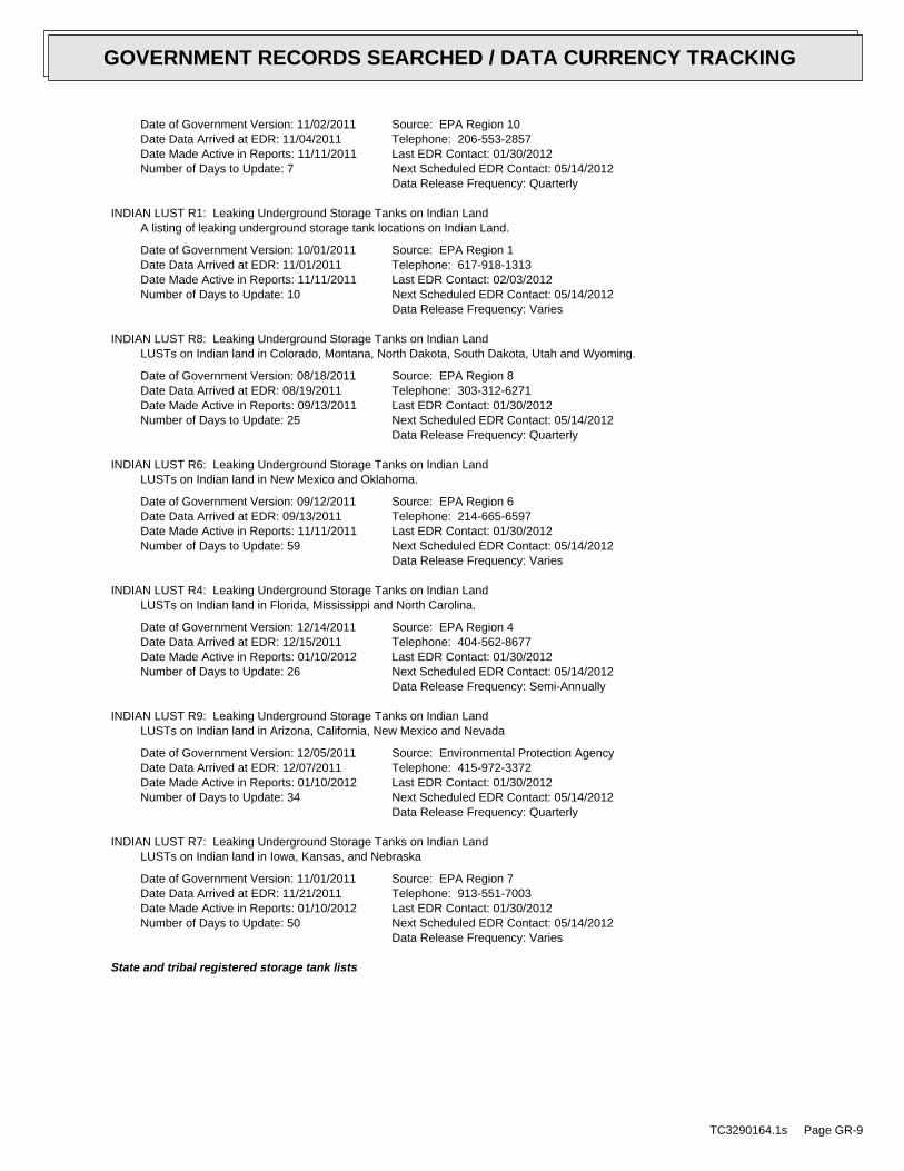
Date of Government Version: 11/02/2011Date Data Arrived at EDR: 11/04/2011Date Made Active in Reports: 11/11/2011Number of Days to Update: 7
Source: EPA Region 10Telephone: 206-553-2857Last EDR Contact: 01/30/2012Next Scheduled EDR Contact: 05/14/2012Data Release Frequency: Quarterly
INDIAN LUST R1: Leaking Underground Storage Tanks on Indian LandA listing of leaking underground storage tank locations on Indian Land.
Date of Government Version: 10/01/2011Date Data Arrived at EDR: 11/01/2011Date Made Active in Reports: 11/11/2011Number of Days to Update: 10
Source: EPA Region 1Telephone: 617-918-1313Last EDR Contact: 02/03/2012Next Scheduled EDR Contact: 05/14/2012Data Release Frequency: Varies
INDIAN LUST R8: Leaking Underground Storage Tanks on Indian LandLUSTs on Indian land in Colorado, Montana, North Dakota, South Dakota, Utah and Wyoming.
Date of Government Version: 08/18/2011Date Data Arrived at EDR: 08/19/2011Date Made Active in Reports: 09/13/2011Number of Days to Update: 25
Source: EPA Region 8Telephone: 303-312-6271Last EDR Contact: 01/30/2012Next Scheduled EDR Contact: 05/14/2012Data Release Frequency: Quarterly
INDIAN LUST R6: Leaking Underground Storage Tanks on Indian LandLUSTs on Indian land in New Mexico and Oklahoma.
Date of Government Version: 09/12/2011Date Data Arrived at EDR: 09/13/2011Date Made Active in Reports: 11/11/2011Number of Days to Update: 59
Source: EPA Region 6Telephone: 214-665-6597Last EDR Contact: 01/30/2012Next Scheduled EDR Contact: 05/14/2012Data Release Frequency: Varies
INDIAN LUST R4: Leaking Underground Storage Tanks on Indian LandLUSTs on Indian land in Florida, Mississippi and North Carolina.
Date of Government Version: 12/14/2011Date Data Arrived at EDR: 12/15/2011Date Made Active in Reports: 01/10/2012Number of Days to Update: 26
Source: EPA Region 4Telephone: 404-562-8677Last EDR Contact: 01/30/2012Next Scheduled EDR Contact: 05/14/2012Data Release Frequency: Semi-Annually
INDIAN LUST R9: Leaking Underground Storage Tanks on Indian LandLUSTs on Indian land in Arizona, California, New Mexico and Nevada
Date of Government Version: 12/05/2011Date Data Arrived at EDR: 12/07/2011Date Made Active in Reports: 01/10/2012Number of Days to Update: 34
Source: Environmental Protection AgencyTelephone: 415-972-3372Last EDR Contact: 01/30/2012Next Scheduled EDR Contact: 05/14/2012Data Release Frequency: Quarterly
INDIAN LUST R7: Leaking Underground Storage Tanks on Indian LandLUSTs on Indian land in Iowa, Kansas, and Nebraska
Date of Government Version: 11/01/2011Date Data Arrived at EDR: 11/21/2011Date Made Active in Reports: 01/10/2012Number of Days to Update: 50
Source: EPA Region 7Telephone: 913-551-7003Last EDR Contact: 01/30/2012Next Scheduled EDR Contact: 05/14/2012Data Release Frequency: Varies
State and tribal registered storage tank lists
TC3290164.1s Page GR-9
GOVERNMENT RECORDS SEARCHED / DATA CURRENCY TRACKING
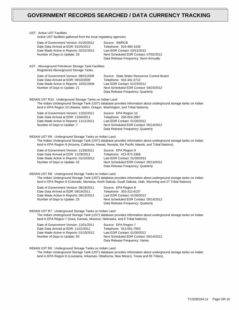
UST: Active UST FacilitiesActive UST facilities gathered from the local regulatory agencies
Date of Government Version: 01/20/2012Date Data Arrived at EDR: 01/20/2012Date Made Active in Reports: 02/22/2012Number of Days to Update: 33
Source: SWRCBTelephone: 916-480-1028Last EDR Contact: 03/21/2012Next Scheduled EDR Contact: 07/02/2012Data Release Frequency: Semi-Annually
AST: Aboveground Petroleum Storage Tank FacilitiesRegistered Aboveground Storage Tanks.
Date of Government Version: 08/01/2009Date Data Arrived at EDR: 09/10/2009Date Made Active in Reports: 10/01/2009Number of Days to Update: 21
Source: State Water Resources Control BoardTelephone: 916-341-5712Last EDR Contact: 01/23/2012Next Scheduled EDR Contact: 04/23/2012Data Release Frequency: Quarterly
INDIAN UST R10: Underground Storage Tanks on Indian LandThe Indian Underground Storage Tank (UST) database provides information about underground storage tanks on Indianland in EPA Region 10 (Alaska, Idaho, Oregon, Washington, and Tribal Nations).
Date of Government Version: 11/02/2011Date Data Arrived at EDR: 11/04/2011Date Made Active in Reports: 11/11/2011Number of Days to Update: 7
Source: EPA Region 10Telephone: 206-553-2857Last EDR Contact: 01/30/2012Next Scheduled EDR Contact: 05/14/2012Data Release Frequency: Quarterly
INDIAN UST R9: Underground Storage Tanks on Indian LandThe Indian Underground Storage Tank (UST) database provides information about underground storage tanks on Indianland in EPA Region 9 (Arizona, California, Hawaii, Nevada, the Pacific Islands, and Tribal Nations).
Date of Government Version: 11/28/2011Date Data Arrived at EDR: 11/29/2011Date Made Active in Reports: 01/10/2012Number of Days to Update: 42
Source: EPA Region 9Telephone: 415-972-3368Last EDR Contact: 01/30/2012Next Scheduled EDR Contact: 05/14/2012Data Release Frequency: Quarterly
INDIAN UST R8: Underground Storage Tanks on Indian LandThe Indian Underground Storage Tank (UST) database provides information about underground storage tanks on Indianland in EPA Region 8 (Colorado, Montana, North Dakota, South Dakota, Utah, Wyoming and 27 Tribal Nations).
Date of Government Version: 08/18/2011Date Data Arrived at EDR: 08/19/2011Date Made Active in Reports: 09/13/2011Number of Days to Update: 25
Source: EPA Region 8Telephone: 303-312-6137Last EDR Contact: 01/30/2012Next Scheduled EDR Contact: 05/14/2012Data Release Frequency: Quarterly
INDIAN UST R7: Underground Storage Tanks on Indian LandThe Indian Underground Storage Tank (UST) database provides information about underground storage tanks on Indianland in EPA Region 7 (Iowa, Kansas, Missouri, Nebraska, and 9 Tribal Nations).
Date of Government Version: 11/01/2011Date Data Arrived at EDR: 11/21/2011Date Made Active in Reports: 01/10/2012Number of Days to Update: 50
Source: EPA Region 7Telephone: 913-551-7003Last EDR Contact: 01/30/2012Next Scheduled EDR Contact: 05/14/2012Data Release Frequency: Varies
INDIAN UST R6: Underground Storage Tanks on Indian LandThe Indian Underground Storage Tank (UST) database provides information about underground storage tanks on Indianland in EPA Region 6 (Louisiana, Arkansas, Oklahoma, New Mexico, Texas and 65 Tribes).
TC3290164.1s Page GR-10
GOVERNMENT RECORDS SEARCHED / DATA CURRENCY TRACKING
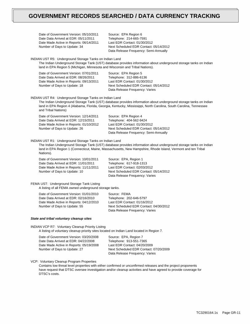
Date of Government Version: 05/10/2011Date Data Arrived at EDR: 05/11/2011Date Made Active in Reports: 06/14/2011Number of Days to Update: 34
Source: EPA Region 6Telephone: 214-665-7591Last EDR Contact: 01/30/2012Next Scheduled EDR Contact: 05/14/2012Data Release Frequency: Semi-Annually
INDIAN UST R5: Underground Storage Tanks on Indian LandThe Indian Underground Storage Tank (UST) database provides information about underground storage tanks on Indianland in EPA Region 5 (Michigan, Minnesota and Wisconsin and Tribal Nations).
Date of Government Version: 07/01/2011Date Data Arrived at EDR: 08/26/2011Date Made Active in Reports: 09/13/2011Number of Days to Update: 18
Source: EPA Region 5Telephone: 312-886-6136Last EDR Contact: 01/30/2012Next Scheduled EDR Contact: 05/14/2012Data Release Frequency: Varies
INDIAN UST R4: Underground Storage Tanks on Indian LandThe Indian Underground Storage Tank (UST) database provides information about underground storage tanks on Indianland in EPA Region 4 (Alabama, Florida, Georgia, Kentucky, Mississippi, North Carolina, South Carolina, Tennesseeand Tribal Nations)
Date of Government Version: 12/14/2011Date Data Arrived at EDR: 12/15/2011Date Made Active in Reports: 01/10/2012Number of Days to Update: 26
Source: EPA Region 4Telephone: 404-562-9424Last EDR Contact: 01/30/2012Next Scheduled EDR Contact: 05/14/2012Data Release Frequency: Semi-Annually
INDIAN UST R1: Underground Storage Tanks on Indian LandThe Indian Underground Storage Tank (UST) database provides information about underground storage tanks on Indianland in EPA Region 1 (Connecticut, Maine, Massachusetts, New Hampshire, Rhode Island, Vermont and ten TribalNations).
Date of Government Version: 10/01/2011Date Data Arrived at EDR: 11/01/2011Date Made Active in Reports: 11/11/2011Number of Days to Update: 10
Source: EPA, Region 1Telephone: 617-918-1313Last EDR Contact: 02/03/2012Next Scheduled EDR Contact: 05/14/2012Data Release Frequency: Varies
FEMA UST: Underground Storage Tank ListingA listing of all FEMA owned underground storage tanks.
Date of Government Version: 01/01/2010Date Data Arrived at EDR: 02/16/2010Date Made Active in Reports: 04/12/2010Number of Days to Update: 55
Source: FEMATelephone: 202-646-5797Last EDR Contact: 01/16/2012Next Scheduled EDR Contact: 04/30/2012Data Release Frequency: Varies
State and tribal voluntary cleanup sites
INDIAN VCP R7: Voluntary Cleanup Priority LisitngA listing of voluntary cleanup priority sites located on Indian Land located in Region 7.
Date of Government Version: 03/20/2008Date Data Arrived at EDR: 04/22/2008Date Made Active in Reports: 05/19/2008Number of Days to Update: 27
Source: EPA, Region 7Telephone: 913-551-7365Last EDR Contact: 04/20/2009Next Scheduled EDR Contact: 07/20/2009Data Release Frequency: Varies
VCP: Voluntary Cleanup Program PropertiesContains low threat level properties with either confirmed or unconfirmed releases and the project proponentshave request that DTSC oversee investigation and/or cleanup activities and have agreed to provide coverage forDTSC’s costs.
TC3290164.1s Page GR-11
GOVERNMENT RECORDS SEARCHED / DATA CURRENCY TRACKING
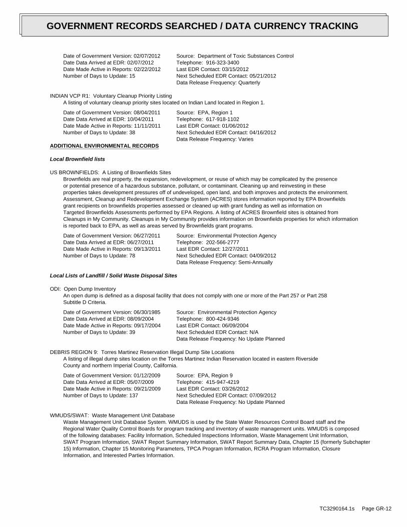
Date of Government Version: 02/07/2012Date Data Arrived at EDR: 02/07/2012Date Made Active in Reports: 02/22/2012Number of Days to Update: 15
Source: Department of Toxic Substances ControlTelephone: 916-323-3400Last EDR Contact: 03/15/2012Next Scheduled EDR Contact: 05/21/2012Data Release Frequency: Quarterly
INDIAN VCP R1: Voluntary Cleanup Priority ListingA listing of voluntary cleanup priority sites located on Indian Land located in Region 1.
Date of Government Version: 08/04/2011Date Data Arrived at EDR: 10/04/2011Date Made Active in Reports: 11/11/2011Number of Days to Update: 38
Source: EPA, Region 1Telephone: 617-918-1102Last EDR Contact: 01/06/2012Next Scheduled EDR Contact: 04/16/2012Data Release Frequency: Varies
ADDITIONAL ENVIRONMENTAL RECORDS
Local Brownfield lists
US BROWNFIELDS: A Listing of Brownfields SitesBrownfields are real property, the expansion, redevelopment, or reuse of which may be complicated by the presenceor potential presence of a hazardous substance, pollutant, or contaminant. Cleaning up and reinvesting in theseproperties takes development pressures off of undeveloped, open land, and both improves and protects the environment.Assessment, Cleanup and Redevelopment Exchange System (ACRES) stores information reported by EPA Brownfieldsgrant recipients on brownfields properties assessed or cleaned up with grant funding as well as information onTargeted Brownfields Assessments performed by EPA Regions. A listing of ACRES Brownfield sites is obtained fromCleanups in My Community. Cleanups in My Community provides information on Brownfields properties for which informationis reported back to EPA, as well as areas served by Brownfields grant programs.
Date of Government Version: 06/27/2011Date Data Arrived at EDR: 06/27/2011Date Made Active in Reports: 09/13/2011Number of Days to Update: 78
Source: Environmental Protection AgencyTelephone: 202-566-2777Last EDR Contact: 12/27/2011Next Scheduled EDR Contact: 04/09/2012Data Release Frequency: Semi-Annually
Local Lists of Landfill / Solid Waste Disposal Sites
ODI: Open Dump InventoryAn open dump is defined as a disposal facility that does not comply with one or more of the Part 257 or Part 258Subtitle D Criteria.
Date of Government Version: 06/30/1985Date Data Arrived at EDR: 08/09/2004Date Made Active in Reports: 09/17/2004Number of Days to Update: 39
Source: Environmental Protection AgencyTelephone: 800-424-9346Last EDR Contact: 06/09/2004Next Scheduled EDR Contact: N/AData Release Frequency: No Update Planned
DEBRIS REGION 9: Torres Martinez Reservation Illegal Dump Site LocationsA listing of illegal dump sites location on the Torres Martinez Indian Reservation located in eastern RiversideCounty and northern Imperial County, California.
Date of Government Version: 01/12/2009Date Data Arrived at EDR: 05/07/2009Date Made Active in Reports: 09/21/2009Number of Days to Update: 137
Source: EPA, Region 9Telephone: 415-947-4219Last EDR Contact: 03/26/2012Next Scheduled EDR Contact: 07/09/2012Data Release Frequency: No Update Planned
WMUDS/SWAT: Waste Management Unit DatabaseWaste Management Unit Database System. WMUDS is used by the State Water Resources Control Board staff and theRegional Water Quality Control Boards for program tracking and inventory of waste management units. WMUDS is composedof the following databases: Facility Information, Scheduled Inspections Information, Waste Management Unit Information,SWAT Program Information, SWAT Report Summary Information, SWAT Report Summary Data, Chapter 15 (formerly Subchapter15) Information, Chapter 15 Monitoring Parameters, TPCA Program Information, RCRA Program Information, ClosureInformation, and Interested Parties Information.
TC3290164.1s Page GR-12
GOVERNMENT RECORDS SEARCHED / DATA CURRENCY TRACKING
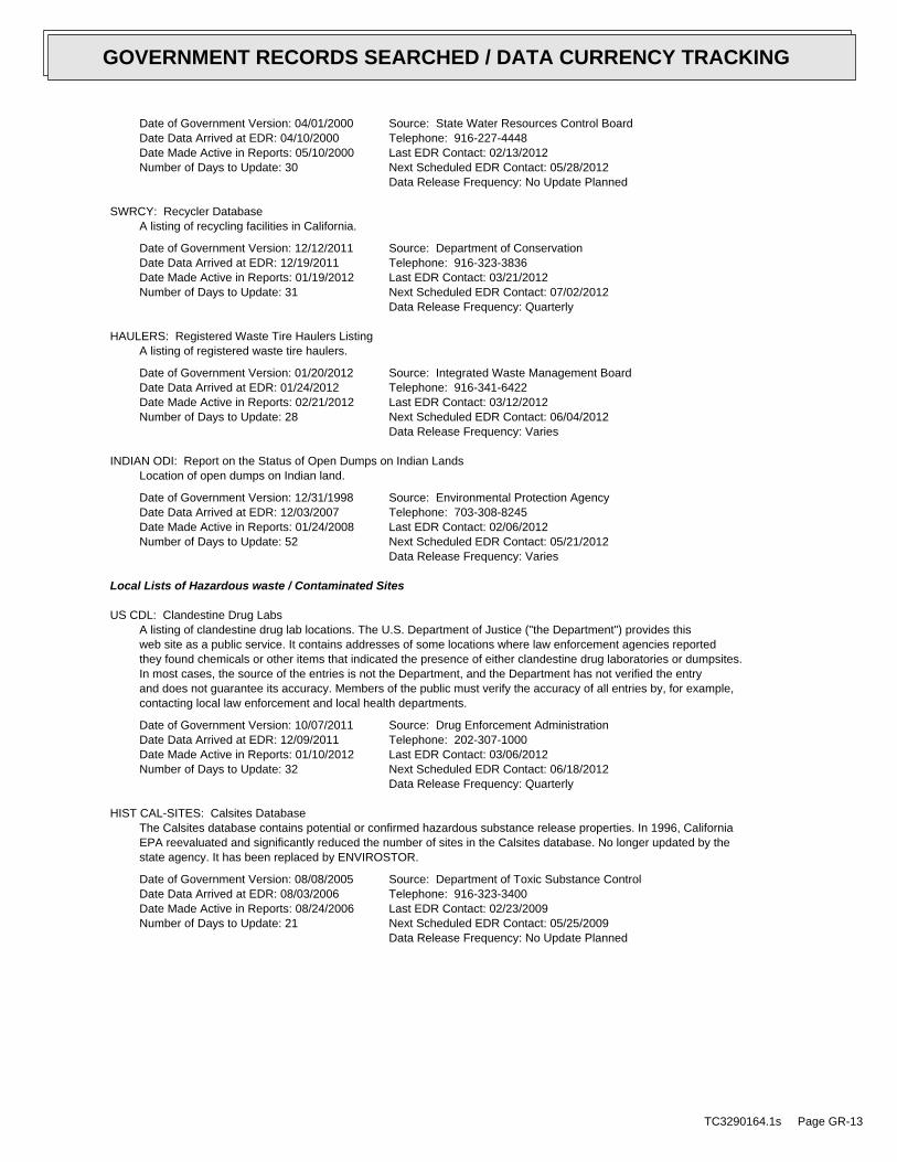
Date of Government Version: 04/01/2000Date Data Arrived at EDR: 04/10/2000Date Made Active in Reports: 05/10/2000Number of Days to Update: 30
Source: State Water Resources Control BoardTelephone: 916-227-4448Last EDR Contact: 02/13/2012Next Scheduled EDR Contact: 05/28/2012Data Release Frequency: No Update Planned
SWRCY: Recycler DatabaseA listing of recycling facilities in California.
Date of Government Version: 12/12/2011Date Data Arrived at EDR: 12/19/2011Date Made Active in Reports: 01/19/2012Number of Days to Update: 31
Source: Department of ConservationTelephone: 916-323-3836Last EDR Contact: 03/21/2012Next Scheduled EDR Contact: 07/02/2012Data Release Frequency: Quarterly
HAULERS: Registered Waste Tire Haulers ListingA listing of registered waste tire haulers.
Date of Government Version: 01/20/2012Date Data Arrived at EDR: 01/24/2012Date Made Active in Reports: 02/21/2012Number of Days to Update: 28
Source: Integrated Waste Management BoardTelephone: 916-341-6422Last EDR Contact: 03/12/2012Next Scheduled EDR Contact: 06/04/2012Data Release Frequency: Varies
INDIAN ODI: Report on the Status of Open Dumps on Indian LandsLocation of open dumps on Indian land.
Date of Government Version: 12/31/1998Date Data Arrived at EDR: 12/03/2007Date Made Active in Reports: 01/24/2008Number of Days to Update: 52
Source: Environmental Protection AgencyTelephone: 703-308-8245Last EDR Contact: 02/06/2012Next Scheduled EDR Contact: 05/21/2012Data Release Frequency: Varies
Local Lists of Hazardous waste / Contaminated Sites
US CDL: Clandestine Drug LabsA listing of clandestine drug lab locations. The U.S. Department of Justice ("the Department") provides thisweb site as a public service. It contains addresses of some locations where law enforcement agencies reportedthey found chemicals or other items that indicated the presence of either clandestine drug laboratories or dumpsites.In most cases, the source of the entries is not the Department, and the Department has not verified the entryand does not guarantee its accuracy. Members of the public must verify the accuracy of all entries by, for example,contacting local law enforcement and local health departments.
Date of Government Version: 10/07/2011Date Data Arrived at EDR: 12/09/2011Date Made Active in Reports: 01/10/2012Number of Days to Update: 32
Source: Drug Enforcement AdministrationTelephone: 202-307-1000Last EDR Contact: 03/06/2012Next Scheduled EDR Contact: 06/18/2012Data Release Frequency: Quarterly
HIST CAL-SITES: Calsites DatabaseThe Calsites database contains potential or confirmed hazardous substance release properties. In 1996, CaliforniaEPA reevaluated and significantly reduced the number of sites in the Calsites database. No longer updated by thestate agency. It has been replaced by ENVIROSTOR.
Date of Government Version: 08/08/2005Date Data Arrived at EDR: 08/03/2006Date Made Active in Reports: 08/24/2006Number of Days to Update: 21
Source: Department of Toxic Substance ControlTelephone: 916-323-3400Last EDR Contact: 02/23/2009Next Scheduled EDR Contact: 05/25/2009Data Release Frequency: No Update Planned
TC3290164.1s Page GR-13
GOVERNMENT RECORDS SEARCHED / DATA CURRENCY TRACKING
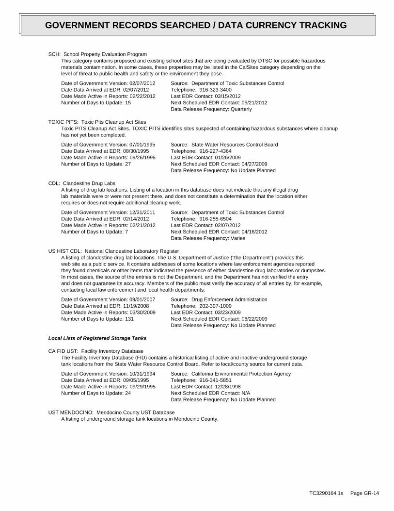
SCH: School Property Evaluation ProgramThis category contains proposed and existing school sites that are being evaluated by DTSC for possible hazardousmaterials contamination. In some cases, these properties may be listed in the CalSites category depending on thelevel of threat to public health and safety or the environment they pose.
Date of Government Version: 02/07/2012Date Data Arrived at EDR: 02/07/2012Date Made Active in Reports: 02/22/2012Number of Days to Update: 15
Source: Department of Toxic Substances ControlTelephone: 916-323-3400Last EDR Contact: 03/15/2012Next Scheduled EDR Contact: 05/21/2012Data Release Frequency: Quarterly
TOXIC PITS: Toxic Pits Cleanup Act SitesToxic PITS Cleanup Act Sites. TOXIC PITS identifies sites suspected of containing hazardous substances where cleanuphas not yet been completed.
Date of Government Version: 07/01/1995Date Data Arrived at EDR: 08/30/1995Date Made Active in Reports: 09/26/1995Number of Days to Update: 27
Source: State Water Resources Control BoardTelephone: 916-227-4364Last EDR Contact: 01/26/2009Next Scheduled EDR Contact: 04/27/2009Data Release Frequency: No Update Planned
CDL: Clandestine Drug LabsA listing of drug lab locations. Listing of a location in this database does not indicate that any illegal druglab materials were or were not present there, and does not constitute a determination that the location eitherrequires or does not require additional cleanup work.
Date of Government Version: 12/31/2011Date Data Arrived at EDR: 02/14/2012Date Made Active in Reports: 02/21/2012Number of Days to Update: 7
Source: Department of Toxic Substances ControlTelephone: 916-255-6504Last EDR Contact: 02/07/2012Next Scheduled EDR Contact: 04/16/2012Data Release Frequency: Varies
US HIST CDL: National Clandestine Laboratory RegisterA listing of clandestine drug lab locations. The U.S. Department of Justice ("the Department") provides thisweb site as a public service. It contains addresses of some locations where law enforcement agencies reportedthey found chemicals or other items that indicated the presence of either clandestine drug laboratories or dumpsites.In most cases, the source of the entries is not the Department, and the Department has not verified the entryand does not guarantee its accuracy. Members of the public must verify the accuracy of all entries by, for example,contacting local law enforcement and local health departments.
Date of Government Version: 09/01/2007Date Data Arrived at EDR: 11/19/2008Date Made Active in Reports: 03/30/2009Number of Days to Update: 131
Source: Drug Enforcement AdministrationTelephone: 202-307-1000Last EDR Contact: 03/23/2009Next Scheduled EDR Contact: 06/22/2009Data Release Frequency: No Update Planned
Local Lists of Registered Storage Tanks
CA FID UST: Facility Inventory DatabaseThe Facility Inventory Database (FID) contains a historical listing of active and inactive underground storagetank locations from the State Water Resource Control Board. Refer to local/county source for current data.
Date of Government Version: 10/31/1994Date Data Arrived at EDR: 09/05/1995Date Made Active in Reports: 09/29/1995Number of Days to Update: 24
Source: California Environmental Protection AgencyTelephone: 916-341-5851Last EDR Contact: 12/28/1998Next Scheduled EDR Contact: N/AData Release Frequency: No Update Planned
UST MENDOCINO: Mendocino County UST DatabaseA listing of underground storage tank locations in Mendocino County.
TC3290164.1s Page GR-14
GOVERNMENT RECORDS SEARCHED / DATA CURRENCY TRACKING
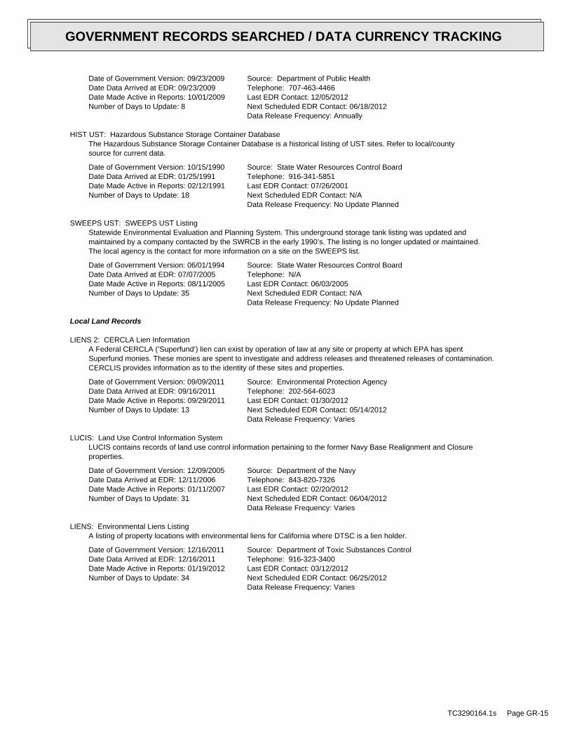
Date of Government Version: 09/23/2009Date Data Arrived at EDR: 09/23/2009Date Made Active in Reports: 10/01/2009Number of Days to Update: 8
Source: Department of Public HealthTelephone: 707-463-4466Last EDR Contact: 12/05/2012Next Scheduled EDR Contact: 06/18/2012Data Release Frequency: Annually
HIST UST: Hazardous Substance Storage Container DatabaseThe Hazardous Substance Storage Container Database is a historical listing of UST sites. Refer to local/countysource for current data.
Date of Government Version: 10/15/1990Date Data Arrived at EDR: 01/25/1991Date Made Active in Reports: 02/12/1991Number of Days to Update: 18
Source: State Water Resources Control BoardTelephone: 916-341-5851Last EDR Contact: 07/26/2001Next Scheduled EDR Contact: N/AData Release Frequency: No Update Planned
SWEEPS UST: SWEEPS UST ListingStatewide Environmental Evaluation and Planning System. This underground storage tank listing was updated andmaintained by a company contacted by the SWRCB in the early 1990’s. The listing is no longer updated or maintained.The local agency is the contact for more information on a site on the SWEEPS list.
Date of Government Version: 06/01/1994Date Data Arrived at EDR: 07/07/2005Date Made Active in Reports: 08/11/2005Number of Days to Update: 35
Source: State Water Resources Control BoardTelephone: N/ALast EDR Contact: 06/03/2005Next Scheduled EDR Contact: N/AData Release Frequency: No Update Planned
Local Land Records
LIENS 2: CERCLA Lien InformationA Federal CERCLA (’Superfund’) lien can exist by operation of law at any site or property at which EPA has spentSuperfund monies. These monies are spent to investigate and address releases and threatened releases of contamination.CERCLIS provides information as to the identity of these sites and properties.
Date of Government Version: 09/09/2011Date Data Arrived at EDR: 09/16/2011Date Made Active in Reports: 09/29/2011Number of Days to Update: 13
Source: Environmental Protection AgencyTelephone: 202-564-6023Last EDR Contact: 01/30/2012Next Scheduled EDR Contact: 05/14/2012Data Release Frequency: Varies
LUCIS: Land Use Control Information SystemLUCIS contains records of land use control information pertaining to the former Navy Base Realignment and Closureproperties.
Date of Government Version: 12/09/2005Date Data Arrived at EDR: 12/11/2006Date Made Active in Reports: 01/11/2007Number of Days to Update: 31
Source: Department of the NavyTelephone: 843-820-7326Last EDR Contact: 02/20/2012Next Scheduled EDR Contact: 06/04/2012Data Release Frequency: Varies
LIENS: Environmental Liens ListingA listing of property locations with environmental liens for California where DTSC is a lien holder.
Date of Government Version: 12/16/2011Date Data Arrived at EDR: 12/16/2011Date Made Active in Reports: 01/19/2012Number of Days to Update: 34
Source: Department of Toxic Substances ControlTelephone: 916-323-3400Last EDR Contact: 03/12/2012Next Scheduled EDR Contact: 06/25/2012Data Release Frequency: Varies
TC3290164.1s Page GR-15
GOVERNMENT RECORDS SEARCHED / DATA CURRENCY TRACKING
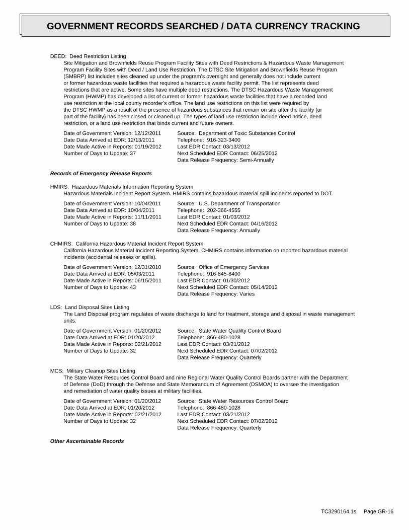
DEED: Deed Restriction ListingSite Mitigation and Brownfields Reuse Program Facility Sites with Deed Restrictions & Hazardous Waste ManagementProgram Facility Sites with Deed / Land Use Restriction. The DTSC Site Mitigation and Brownfields Reuse Program(SMBRP) list includes sites cleaned up under the program’s oversight and generally does not include currentor former hazardous waste facilities that required a hazardous waste facility permit. The list represents deedrestrictions that are active. Some sites have multiple deed restrictions. The DTSC Hazardous Waste ManagementProgram (HWMP) has developed a list of current or former hazardous waste facilities that have a recorded landuse restriction at the local county recorder’s office. The land use restrictions on this list were required bythe DTSC HWMP as a result of the presence of hazardous substances that remain on site after the facility (orpart of the facility) has been closed or cleaned up. The types of land use restriction include deed notice, deedrestriction, or a land use restriction that binds current and future owners.
Date of Government Version: 12/12/2011Date Data Arrived at EDR: 12/13/2011Date Made Active in Reports: 01/19/2012Number of Days to Update: 37
Source: Department of Toxic Substances ControlTelephone: 916-323-3400Last EDR Contact: 03/13/2012Next Scheduled EDR Contact: 06/25/2012Data Release Frequency: Semi-Annually
Records of Emergency Release Reports
HMIRS: Hazardous Materials Information Reporting SystemHazardous Materials Incident Report System. HMIRS contains hazardous material spill incidents reported to DOT.
Date of Government Version: 10/04/2011Date Data Arrived at EDR: 10/04/2011Date Made Active in Reports: 11/11/2011Number of Days to Update: 38
Source: U.S. Department of TransportationTelephone: 202-366-4555Last EDR Contact: 01/03/2012Next Scheduled EDR Contact: 04/16/2012Data Release Frequency: Annually
CHMIRS: California Hazardous Material Incident Report SystemCalifornia Hazardous Material Incident Reporting System. CHMIRS contains information on reported hazardous materialincidents (accidental releases or spills).
Date of Government Version: 12/31/2010Date Data Arrived at EDR: 05/03/2011Date Made Active in Reports: 06/15/2011Number of Days to Update: 43
Source: Office of Emergency ServicesTelephone: 916-845-8400Last EDR Contact: 01/30/2012Next Scheduled EDR Contact: 05/14/2012Data Release Frequency: Varies
LDS: Land Disposal Sites ListingThe Land Disposal program regulates of waste discharge to land for treatment, storage and disposal in waste managementunits.
Date of Government Version: 01/20/2012Date Data Arrived at EDR: 01/20/2012Date Made Active in Reports: 02/21/2012Number of Days to Update: 32
Source: State Water Qualilty Control BoardTelephone: 866-480-1028Last EDR Contact: 03/21/2012Next Scheduled EDR Contact: 07/02/2012Data Release Frequency: Quarterly
MCS: Military Cleanup Sites ListingThe State Water Resources Control Board and nine Regional Water Quality Control Boards partner with the Departmentof Defense (DoD) through the Defense and State Memorandum of Agreement (DSMOA) to oversee the investigationand remediation of water quality issues at military facilities.
Date of Government Version: 01/20/2012Date Data Arrived at EDR: 01/20/2012Date Made Active in Reports: 02/21/2012Number of Days to Update: 32
Source: State Water Resources Control BoardTelephone: 866-480-1028Last EDR Contact: 03/21/2012Next Scheduled EDR Contact: 07/02/2012Data Release Frequency: Quarterly
Other Ascertainable Records
TC3290164.1s Page GR-16
GOVERNMENT RECORDS SEARCHED / DATA CURRENCY TRACKING
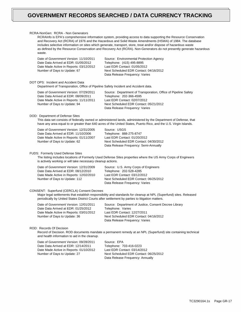
RCRA-NonGen: RCRA - Non GeneratorsRCRAInfo is EPA’s comprehensive information system, providing access to data supporting the Resource Conservationand Recovery Act (RCRA) of 1976 and the Hazardous and Solid Waste Amendments (HSWA) of 1984. The databaseincludes selective information on sites which generate, transport, store, treat and/or dispose of hazardous wasteas defined by the Resource Conservation and Recovery Act (RCRA). Non-Generators do not presently generate hazardouswaste.
Date of Government Version: 11/10/2011Date Data Arrived at EDR: 01/05/2012Date Made Active in Reports: 03/12/2012Number of Days to Update: 67
Source: Environmental Protection AgencyTelephone: (415) 495-8895Last EDR Contact: 01/05/2012Next Scheduled EDR Contact: 04/16/2012Data Release Frequency: Varies
DOT OPS: Incident and Accident DataDepartment of Transporation, Office of Pipeline Safety Incident and Accident data.
Date of Government Version: 07/29/2011Date Data Arrived at EDR: 08/09/2011Date Made Active in Reports: 11/11/2011Number of Days to Update: 94
Source: Department of Transporation, Office of Pipeline SafetyTelephone: 202-366-4595Last EDR Contact: 02/07/2012Next Scheduled EDR Contact: 05/21/2012Data Release Frequency: Varies
DOD: Department of Defense SitesThis data set consists of federally owned or administered lands, administered by the Department of Defense, thathave any area equal to or greater than 640 acres of the United States, Puerto Rico, and the U.S. Virgin Islands.
Date of Government Version: 12/31/2005Date Data Arrived at EDR: 11/10/2006Date Made Active in Reports: 01/11/2007Number of Days to Update: 62
Source: USGSTelephone: 888-275-8747Last EDR Contact: 01/20/2012Next Scheduled EDR Contact: 04/30/2012Data Release Frequency: Semi-Annually
FUDS: Formerly Used Defense SitesThe listing includes locations of Formerly Used Defense Sites properties where the US Army Corps of Engineersis actively working or will take necessary cleanup actions.
Date of Government Version: 12/31/2009Date Data Arrived at EDR: 08/12/2010Date Made Active in Reports: 12/02/2010Number of Days to Update: 112
Source: U.S. Army Corps of EngineersTelephone: 202-528-4285Last EDR Contact: 03/12/2012Next Scheduled EDR Contact: 06/25/2012Data Release Frequency: Varies
CONSENT: Superfund (CERCLA) Consent DecreesMajor legal settlements that establish responsibility and standards for cleanup at NPL (Superfund) sites. Releasedperiodically by United States District Courts after settlement by parties to litigation matters.
Date of Government Version: 12/01/2011Date Data Arrived at EDR: 01/25/2012Date Made Active in Reports: 03/01/2012Number of Days to Update: 36
Source: Department of Justice, Consent Decree LibraryTelephone: VariesLast EDR Contact: 12/27/2011Next Scheduled EDR Contact: 04/16/2012Data Release Frequency: Varies
ROD: Records Of DecisionRecord of Decision. ROD documents mandate a permanent remedy at an NPL (Superfund) site containing technicaland health information to aid in the cleanup.
Date of Government Version: 09/28/2011Date Data Arrived at EDR: 12/14/2011Date Made Active in Reports: 01/10/2012Number of Days to Update: 27
Source: EPATelephone: 703-416-0223Last EDR Contact: 03/14/2012Next Scheduled EDR Contact: 06/25/2012Data Release Frequency: Annually
TC3290164.1s Page GR-17
GOVERNMENT RECORDS SEARCHED / DATA CURRENCY TRACKING
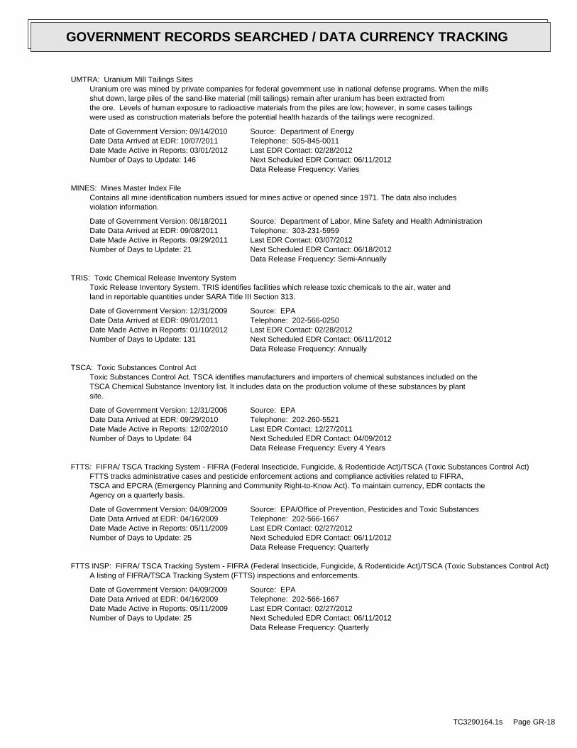
UMTRA: Uranium Mill Tailings SitesUranium ore was mined by private companies for federal government use in national defense programs. When the millsshut down, large piles of the sand-like material (mill tailings) remain after uranium has been extracted fromthe ore. Levels of human exposure to radioactive materials from the piles are low; however, in some cases tailingswere used as construction materials before the potential health hazards of the tailings were recognized.
Date of Government Version: 09/14/2010Date Data Arrived at EDR: 10/07/2011Date Made Active in Reports: 03/01/2012Number of Days to Update: 146
Source: Department of EnergyTelephone: 505-845-0011Last EDR Contact: 02/28/2012Next Scheduled EDR Contact: 06/11/2012Data Release Frequency: Varies
MINES: Mines Master Index FileContains all mine identification numbers issued for mines active or opened since 1971. The data also includesviolation information.
Date of Government Version: 08/18/2011Date Data Arrived at EDR: 09/08/2011Date Made Active in Reports: 09/29/2011Number of Days to Update: 21
Source: Department of Labor, Mine Safety and Health AdministrationTelephone: 303-231-5959Last EDR Contact: 03/07/2012Next Scheduled EDR Contact: 06/18/2012Data Release Frequency: Semi-Annually
TRIS: Toxic Chemical Release Inventory SystemToxic Release Inventory System. TRIS identifies facilities which release toxic chemicals to the air, water andland in reportable quantities under SARA Title III Section 313.
Date of Government Version: 12/31/2009Date Data Arrived at EDR: 09/01/2011Date Made Active in Reports: 01/10/2012Number of Days to Update: 131
Source: EPATelephone: 202-566-0250Last EDR Contact: 02/28/2012Next Scheduled EDR Contact: 06/11/2012Data Release Frequency: Annually
TSCA: Toxic Substances Control ActToxic Substances Control Act. TSCA identifies manufacturers and importers of chemical substances included on theTSCA Chemical Substance Inventory list. It includes data on the production volume of these substances by plantsite.
Date of Government Version: 12/31/2006Date Data Arrived at EDR: 09/29/2010Date Made Active in Reports: 12/02/2010Number of Days to Update: 64
Source: EPATelephone: 202-260-5521Last EDR Contact: 12/27/2011Next Scheduled EDR Contact: 04/09/2012Data Release Frequency: Every 4 Years
FTTS: FIFRA/ TSCA Tracking System - FIFRA (Federal Insecticide, Fungicide, & Rodenticide Act)/TSCA (Toxic Substances Control Act)FTTS tracks administrative cases and pesticide enforcement actions and compliance activities related to FIFRA,TSCA and EPCRA (Emergency Planning and Community Right-to-Know Act). To maintain currency, EDR contacts theAgency on a quarterly basis.
Date of Government Version: 04/09/2009Date Data Arrived at EDR: 04/16/2009Date Made Active in Reports: 05/11/2009Number of Days to Update: 25
Source: EPA/Office of Prevention, Pesticides and Toxic SubstancesTelephone: 202-566-1667Last EDR Contact: 02/27/2012Next Scheduled EDR Contact: 06/11/2012Data Release Frequency: Quarterly
FTTS INSP: FIFRA/ TSCA Tracking System - FIFRA (Federal Insecticide, Fungicide, & Rodenticide Act)/TSCA (Toxic Substances Control Act)A listing of FIFRA/TSCA Tracking System (FTTS) inspections and enforcements.
Date of Government Version: 04/09/2009Date Data Arrived at EDR: 04/16/2009Date Made Active in Reports: 05/11/2009Number of Days to Update: 25
Source: EPATelephone: 202-566-1667Last EDR Contact: 02/27/2012Next Scheduled EDR Contact: 06/11/2012Data Release Frequency: Quarterly
TC3290164.1s Page GR-18
GOVERNMENT RECORDS SEARCHED / DATA CURRENCY TRACKING
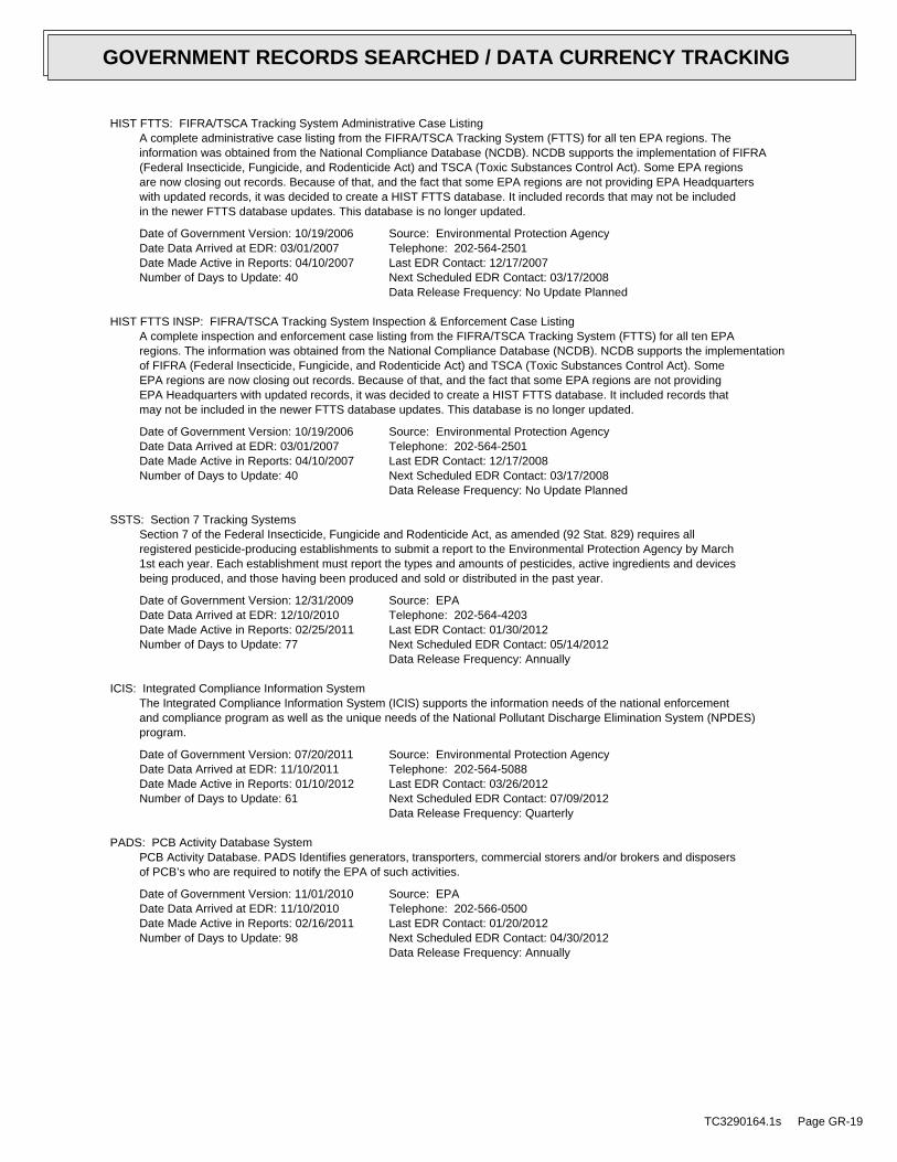
HIST FTTS: FIFRA/TSCA Tracking System Administrative Case ListingA complete administrative case listing from the FIFRA/TSCA Tracking System (FTTS) for all ten EPA regions. Theinformation was obtained from the National Compliance Database (NCDB). NCDB supports the implementation of FIFRA(Federal Insecticide, Fungicide, and Rodenticide Act) and TSCA (Toxic Substances Control Act). Some EPA regionsare now closing out records. Because of that, and the fact that some EPA regions are not providing EPA Headquarterswith updated records, it was decided to create a HIST FTTS database. It included records that may not be includedin the newer FTTS database updates. This database is no longer updated.
Date of Government Version: 10/19/2006Date Data Arrived at EDR: 03/01/2007Date Made Active in Reports: 04/10/2007Number of Days to Update: 40
Source: Environmental Protection AgencyTelephone: 202-564-2501Last EDR Contact: 12/17/2007Next Scheduled EDR Contact: 03/17/2008Data Release Frequency: No Update Planned
HIST FTTS INSP: FIFRA/TSCA Tracking System Inspection & Enforcement Case ListingA complete inspection and enforcement case listing from the FIFRA/TSCA Tracking System (FTTS) for all ten EPAregions. The information was obtained from the National Compliance Database (NCDB). NCDB supports the implementationof FIFRA (Federal Insecticide, Fungicide, and Rodenticide Act) and TSCA (Toxic Substances Control Act). SomeEPA regions are now closing out records. Because of that, and the fact that some EPA regions are not providingEPA Headquarters with updated records, it was decided to create a HIST FTTS database. It included records thatmay not be included in the newer FTTS database updates. This database is no longer updated.
Date of Government Version: 10/19/2006Date Data Arrived at EDR: 03/01/2007Date Made Active in Reports: 04/10/2007Number of Days to Update: 40
Source: Environmental Protection AgencyTelephone: 202-564-2501Last EDR Contact: 12/17/2008Next Scheduled EDR Contact: 03/17/2008Data Release Frequency: No Update Planned
SSTS: Section 7 Tracking SystemsSection 7 of the Federal Insecticide, Fungicide and Rodenticide Act, as amended (92 Stat. 829) requires allregistered pesticide-producing establishments to submit a report to the Environmental Protection Agency by March1st each year. Each establishment must report the types and amounts of pesticides, active ingredients and devicesbeing produced, and those having been produced and sold or distributed in the past year.
Date of Government Version: 12/31/2009Date Data Arrived at EDR: 12/10/2010Date Made Active in Reports: 02/25/2011Number of Days to Update: 77
Source: EPATelephone: 202-564-4203Last EDR Contact: 01/30/2012Next Scheduled EDR Contact: 05/14/2012Data Release Frequency: Annually
ICIS: Integrated Compliance Information SystemThe Integrated Compliance Information System (ICIS) supports the information needs of the national enforcementand compliance program as well as the unique needs of the National Pollutant Discharge Elimination System (NPDES)program.
Date of Government Version: 07/20/2011Date Data Arrived at EDR: 11/10/2011Date Made Active in Reports: 01/10/2012Number of Days to Update: 61
Source: Environmental Protection AgencyTelephone: 202-564-5088Last EDR Contact: 03/26/2012Next Scheduled EDR Contact: 07/09/2012Data Release Frequency: Quarterly
PADS: PCB Activity Database SystemPCB Activity Database. PADS Identifies generators, transporters, commercial storers and/or brokers and disposersof PCB’s who are required to notify the EPA of such activities.
Date of Government Version: 11/01/2010Date Data Arrived at EDR: 11/10/2010Date Made Active in Reports: 02/16/2011Number of Days to Update: 98
Source: EPATelephone: 202-566-0500Last EDR Contact: 01/20/2012Next Scheduled EDR Contact: 04/30/2012Data Release Frequency: Annually
TC3290164.1s Page GR-19
GOVERNMENT RECORDS SEARCHED / DATA CURRENCY TRACKING
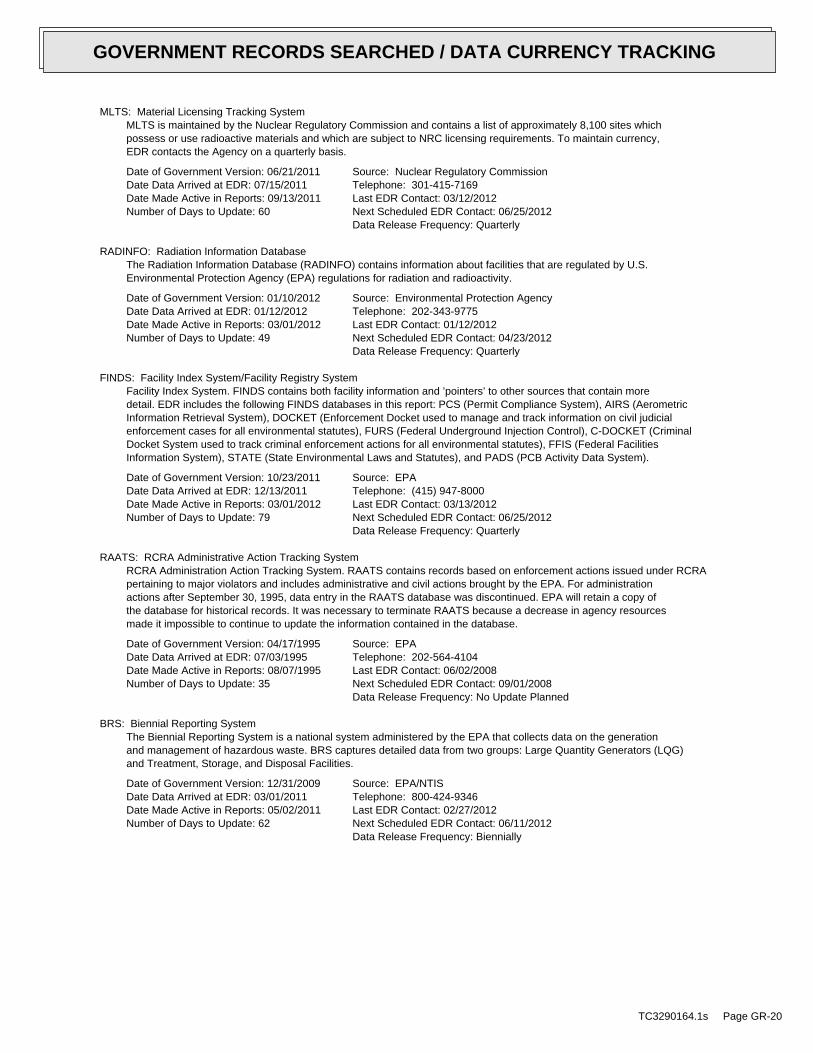
MLTS: Material Licensing Tracking SystemMLTS is maintained by the Nuclear Regulatory Commission and contains a list of approximately 8,100 sites whichpossess or use radioactive materials and which are subject to NRC licensing requirements. To maintain currency,EDR contacts the Agency on a quarterly basis.
Date of Government Version: 06/21/2011Date Data Arrived at EDR: 07/15/2011Date Made Active in Reports: 09/13/2011Number of Days to Update: 60
Source: Nuclear Regulatory CommissionTelephone: 301-415-7169Last EDR Contact: 03/12/2012Next Scheduled EDR Contact: 06/25/2012Data Release Frequency: Quarterly
RADINFO: Radiation Information DatabaseThe Radiation Information Database (RADINFO) contains information about facilities that are regulated by U.S.Environmental Protection Agency (EPA) regulations for radiation and radioactivity.
Date of Government Version: 01/10/2012Date Data Arrived at EDR: 01/12/2012Date Made Active in Reports: 03/01/2012Number of Days to Update: 49
Source: Environmental Protection AgencyTelephone: 202-343-9775Last EDR Contact: 01/12/2012Next Scheduled EDR Contact: 04/23/2012Data Release Frequency: Quarterly
FINDS: Facility Index System/Facility Registry SystemFacility Index System. FINDS contains both facility information and ’pointers’ to other sources that contain moredetail. EDR includes the following FINDS databases in this report: PCS (Permit Compliance System), AIRS (AerometricInformation Retrieval System), DOCKET (Enforcement Docket used to manage and track information on civil judicialenforcement cases for all environmental statutes), FURS (Federal Underground Injection Control), C-DOCKET (CriminalDocket System used to track criminal enforcement actions for all environmental statutes), FFIS (Federal FacilitiesInformation System), STATE (State Environmental Laws and Statutes), and PADS (PCB Activity Data System).
Date of Government Version: 10/23/2011Date Data Arrived at EDR: 12/13/2011Date Made Active in Reports: 03/01/2012Number of Days to Update: 79
Source: EPATelephone: (415) 947-8000Last EDR Contact: 03/13/2012Next Scheduled EDR Contact: 06/25/2012Data Release Frequency: Quarterly
RAATS: RCRA Administrative Action Tracking SystemRCRA Administration Action Tracking System. RAATS contains records based on enforcement actions issued under RCRApertaining to major violators and includes administrative and civil actions brought by the EPA. For administrationactions after September 30, 1995, data entry in the RAATS database was discontinued. EPA will retain a copy ofthe database for historical records. It was necessary to terminate RAATS because a decrease in agency resourcesmade it impossible to continue to update the information contained in the database.
Date of Government Version: 04/17/1995Date Data Arrived at EDR: 07/03/1995Date Made Active in Reports: 08/07/1995Number of Days to Update: 35
Source: EPATelephone: 202-564-4104Last EDR Contact: 06/02/2008Next Scheduled EDR Contact: 09/01/2008Data Release Frequency: No Update Planned
BRS: Biennial Reporting SystemThe Biennial Reporting System is a national system administered by the EPA that collects data on the generationand management of hazardous waste. BRS captures detailed data from two groups: Large Quantity Generators (LQG)and Treatment, Storage, and Disposal Facilities.
Date of Government Version: 12/31/2009Date Data Arrived at EDR: 03/01/2011Date Made Active in Reports: 05/02/2011Number of Days to Update: 62
Source: EPA/NTISTelephone: 800-424-9346Last EDR Contact: 02/27/2012Next Scheduled EDR Contact: 06/11/2012Data Release Frequency: Biennially
TC3290164.1s Page GR-20
GOVERNMENT RECORDS SEARCHED / DATA CURRENCY TRACKING
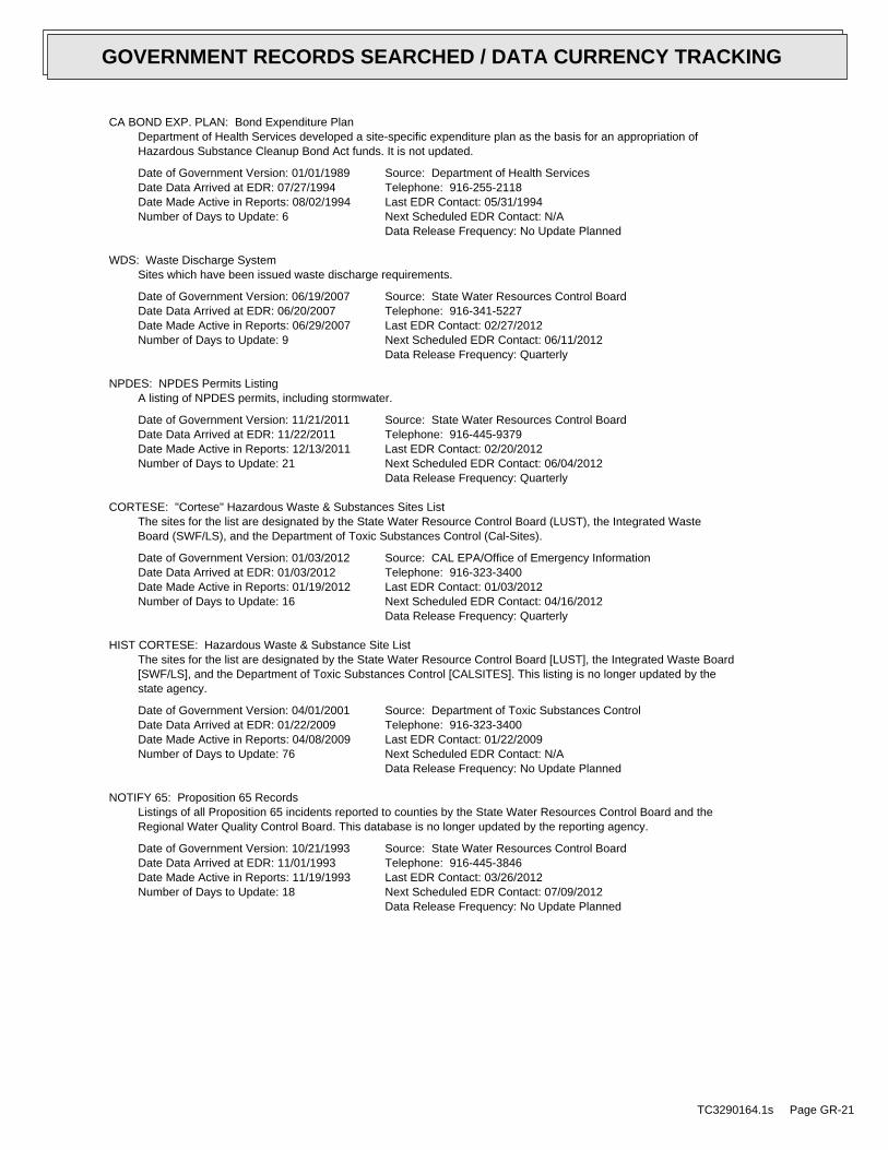
CA BOND EXP. PLAN: Bond Expenditure PlanDepartment of Health Services developed a site-specific expenditure plan as the basis for an appropriation ofHazardous Substance Cleanup Bond Act funds. It is not updated.
Date of Government Version: 01/01/1989Date Data Arrived at EDR: 07/27/1994Date Made Active in Reports: 08/02/1994Number of Days to Update: 6
Source: Department of Health ServicesTelephone: 916-255-2118Last EDR Contact: 05/31/1994Next Scheduled EDR Contact: N/AData Release Frequency: No Update Planned
WDS: Waste Discharge SystemSites which have been issued waste discharge requirements.
Date of Government Version: 06/19/2007Date Data Arrived at EDR: 06/20/2007Date Made Active in Reports: 06/29/2007Number of Days to Update: 9
Source: State Water Resources Control BoardTelephone: 916-341-5227Last EDR Contact: 02/27/2012Next Scheduled EDR Contact: 06/11/2012Data Release Frequency: Quarterly
NPDES: NPDES Permits ListingA listing of NPDES permits, including stormwater.
Date of Government Version: 11/21/2011Date Data Arrived at EDR: 11/22/2011Date Made Active in Reports: 12/13/2011Number of Days to Update: 21
Source: State Water Resources Control BoardTelephone: 916-445-9379Last EDR Contact: 02/20/2012Next Scheduled EDR Contact: 06/04/2012Data Release Frequency: Quarterly
CORTESE: "Cortese" Hazardous Waste & Substances Sites ListThe sites for the list are designated by the State Water Resource Control Board (LUST), the Integrated WasteBoard (SWF/LS), and the Department of Toxic Substances Control (Cal-Sites).
Date of Government Version: 01/03/2012Date Data Arrived at EDR: 01/03/2012Date Made Active in Reports: 01/19/2012Number of Days to Update: 16
Source: CAL EPA/Office of Emergency InformationTelephone: 916-323-3400Last EDR Contact: 01/03/2012Next Scheduled EDR Contact: 04/16/2012Data Release Frequency: Quarterly
HIST CORTESE: Hazardous Waste & Substance Site ListThe sites for the list are designated by the State Water Resource Control Board [LUST], the Integrated Waste Board[SWF/LS], and the Department of Toxic Substances Control [CALSITES]. This listing is no longer updated by thestate agency.
Date of Government Version: 04/01/2001Date Data Arrived at EDR: 01/22/2009Date Made Active in Reports: 04/08/2009Number of Days to Update: 76
Source: Department of Toxic Substances ControlTelephone: 916-323-3400Last EDR Contact: 01/22/2009Next Scheduled EDR Contact: N/AData Release Frequency: No Update Planned
NOTIFY 65: Proposition 65 RecordsListings of all Proposition 65 incidents reported to counties by the State Water Resources Control Board and theRegional Water Quality Control Board. This database is no longer updated by the reporting agency.
Date of Government Version: 10/21/1993Date Data Arrived at EDR: 11/01/1993Date Made Active in Reports: 11/19/1993Number of Days to Update: 18
Source: State Water Resources Control BoardTelephone: 916-445-3846Last EDR Contact: 03/26/2012Next Scheduled EDR Contact: 07/09/2012Data Release Frequency: No Update Planned
TC3290164.1s Page GR-21
GOVERNMENT RECORDS SEARCHED / DATA CURRENCY TRACKING
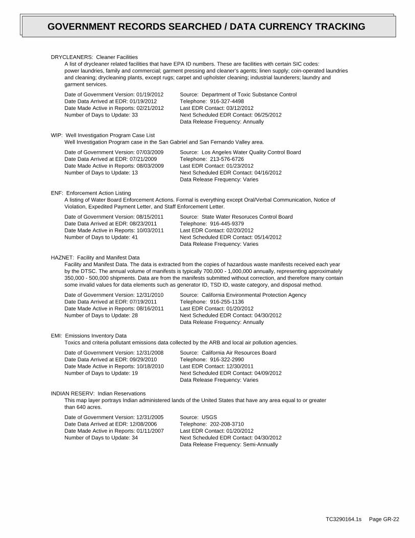
DRYCLEANERS: Cleaner FacilitiesA list of drycleaner related facilities that have EPA ID numbers. These are facilities with certain SIC codes:power laundries, family and commercial; garment pressing and cleaner’s agents; linen supply; coin-operated laundriesand cleaning; drycleaning plants, except rugs; carpet and upholster cleaning; industrial launderers; laundry andgarment services.
Date of Government Version: 01/19/2012Date Data Arrived at EDR: 01/19/2012Date Made Active in Reports: 02/21/2012Number of Days to Update: 33
Source: Department of Toxic Substance ControlTelephone: 916-327-4498Last EDR Contact: 03/12/2012Next Scheduled EDR Contact: 06/25/2012Data Release Frequency: Annually
WIP: Well Investigation Program Case ListWell Investigation Program case in the San Gabriel and San Fernando Valley area.
Date of Government Version: 07/03/2009Date Data Arrived at EDR: 07/21/2009Date Made Active in Reports: 08/03/2009Number of Days to Update: 13
Source: Los Angeles Water Quality Control BoardTelephone: 213-576-6726Last EDR Contact: 01/23/2012Next Scheduled EDR Contact: 04/16/2012Data Release Frequency: Varies
ENF: Enforcement Action ListingA listing of Water Board Enforcement Actions. Formal is everything except Oral/Verbal Communication, Notice ofViolation, Expedited Payment Letter, and Staff Enforcement Letter.
Date of Government Version: 08/15/2011Date Data Arrived at EDR: 08/23/2011Date Made Active in Reports: 10/03/2011Number of Days to Update: 41
Source: State Water Resoruces Control BoardTelephone: 916-445-9379Last EDR Contact: 02/20/2012Next Scheduled EDR Contact: 05/14/2012Data Release Frequency: Varies
HAZNET: Facility and Manifest DataFacility and Manifest Data. The data is extracted from the copies of hazardous waste manifests received each yearby the DTSC. The annual volume of manifests is typically 700,000 - 1,000,000 annually, representing approximately350,000 - 500,000 shipments. Data are from the manifests submitted without correction, and therefore many containsome invalid values for data elements such as generator ID, TSD ID, waste category, and disposal method.
Date of Government Version: 12/31/2010Date Data Arrived at EDR: 07/19/2011Date Made Active in Reports: 08/16/2011Number of Days to Update: 28
Source: California Environmental Protection AgencyTelephone: 916-255-1136Last EDR Contact: 01/20/2012Next Scheduled EDR Contact: 04/30/2012Data Release Frequency: Annually
EMI: Emissions Inventory DataToxics and criteria pollutant emissions data collected by the ARB and local air pollution agencies.
Date of Government Version: 12/31/2008Date Data Arrived at EDR: 09/29/2010Date Made Active in Reports: 10/18/2010Number of Days to Update: 19
Source: California Air Resources BoardTelephone: 916-322-2990Last EDR Contact: 12/30/2011Next Scheduled EDR Contact: 04/09/2012Data Release Frequency: Varies
INDIAN RESERV: Indian ReservationsThis map layer portrays Indian administered lands of the United States that have any area equal to or greaterthan 640 acres.
Date of Government Version: 12/31/2005Date Data Arrived at EDR: 12/08/2006Date Made Active in Reports: 01/11/2007Number of Days to Update: 34
Source: USGSTelephone: 202-208-3710Last EDR Contact: 01/20/2012Next Scheduled EDR Contact: 04/30/2012Data Release Frequency: Semi-Annually
TC3290164.1s Page GR-22
GOVERNMENT RECORDS SEARCHED / DATA CURRENCY TRACKING
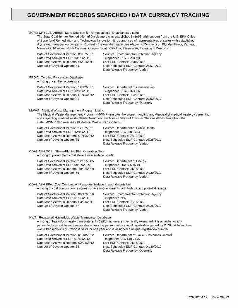
SCRD DRYCLEANERS: State Coalition for Remediation of Drycleaners ListingThe State Coalition for Remediation of Drycleaners was established in 1998, with support from the U.S. EPA Officeof Superfund Remediation and Technology Innovation. It is comprised of representatives of states with establisheddrycleaner remediation programs. Currently the member states are Alabama, Connecticut, Florida, Illinois, Kansas,Minnesota, Missouri, North Carolina, Oregon, South Carolina, Tennessee, Texas, and Wisconsin.
Date of Government Version: 03/07/2011Date Data Arrived at EDR: 03/09/2011Date Made Active in Reports: 05/02/2011Number of Days to Update: 54
Source: Environmental Protection AgencyTelephone: 615-532-8599Last EDR Contact: 02/06/2012Next Scheduled EDR Contact: 05/07/2012Data Release Frequency: Varies
PROC: Certified Processors DatabaseA listing of certified processors.
Date of Government Version: 12/12/2011Date Data Arrived at EDR: 12/19/2011Date Made Active in Reports: 01/19/2012Number of Days to Update: 31
Source: Department of ConservationTelephone: 916-323-3836Last EDR Contact: 03/21/2012Next Scheduled EDR Contact: 07/02/2012Data Release Frequency: Quarterly
MWMP: Medical Waste Management Program ListingThe Medical Waste Management Program (MWMP) ensures the proper handling and disposal of medical waste by permittingand inspecting medical waste Offsite Treatment Facilities (PDF) and Transfer Stations (PDF) throughout thestate. MWMP also oversees all Medical Waste Transporters.
Date of Government Version: 12/07/2011Date Data Arrived at EDR: 12/15/2011Date Made Active in Reports: 01/19/2012Number of Days to Update: 35
Source: Department of Public HealthTelephone: 916-558-1784Last EDR Contact: 03/12/2012Next Scheduled EDR Contact: 06/25/2012Data Release Frequency: Varies
COAL ASH DOE: Sleam-Electric Plan Operation DataA listing of power plants that store ash in surface ponds.
Date of Government Version: 12/31/2005Date Data Arrived at EDR: 08/07/2009Date Made Active in Reports: 10/22/2009Number of Days to Update: 76
Source: Department of EnergyTelephone: 202-586-8719Last EDR Contact: 01/18/2012Next Scheduled EDR Contact: 04/30/2012Data Release Frequency: Varies
COAL ASH EPA: Coal Combustion Residues Surface Impoundments ListA listing of coal combustion residues surface impoundments with high hazard potential ratings.
Date of Government Version: 08/17/2010Date Data Arrived at EDR: 01/03/2011Date Made Active in Reports: 03/21/2011Number of Days to Update: 77
Source: Environmental Protection AgencyTelephone: N/ALast EDR Contact: 03/16/2012Next Scheduled EDR Contact: 06/25/2012Data Release Frequency: Varies
HWT: Registered Hazardous Waste Transporter DatabaseA listing of hazardous waste transporters. In California, unless specifically exempted, it is unlawful for anyperson to transport hazardous wastes unless the person holds a valid registration issued by DTSC. A hazardouswaste transporter registration is valid for one year and is assigned a unique registration number.
Date of Government Version: 01/18/2012Date Data Arrived at EDR: 01/18/2012Date Made Active in Reports: 02/21/2012Number of Days to Update: 34
Source: Department of Toxic Substances ControlTelephone: 916-440-7145Last EDR Contact: 01/18/2012Next Scheduled EDR Contact: 04/30/2012Data Release Frequency: Quarterly
TC3290164.1s Page GR-23
GOVERNMENT RECORDS SEARCHED / DATA CURRENCY TRACKING
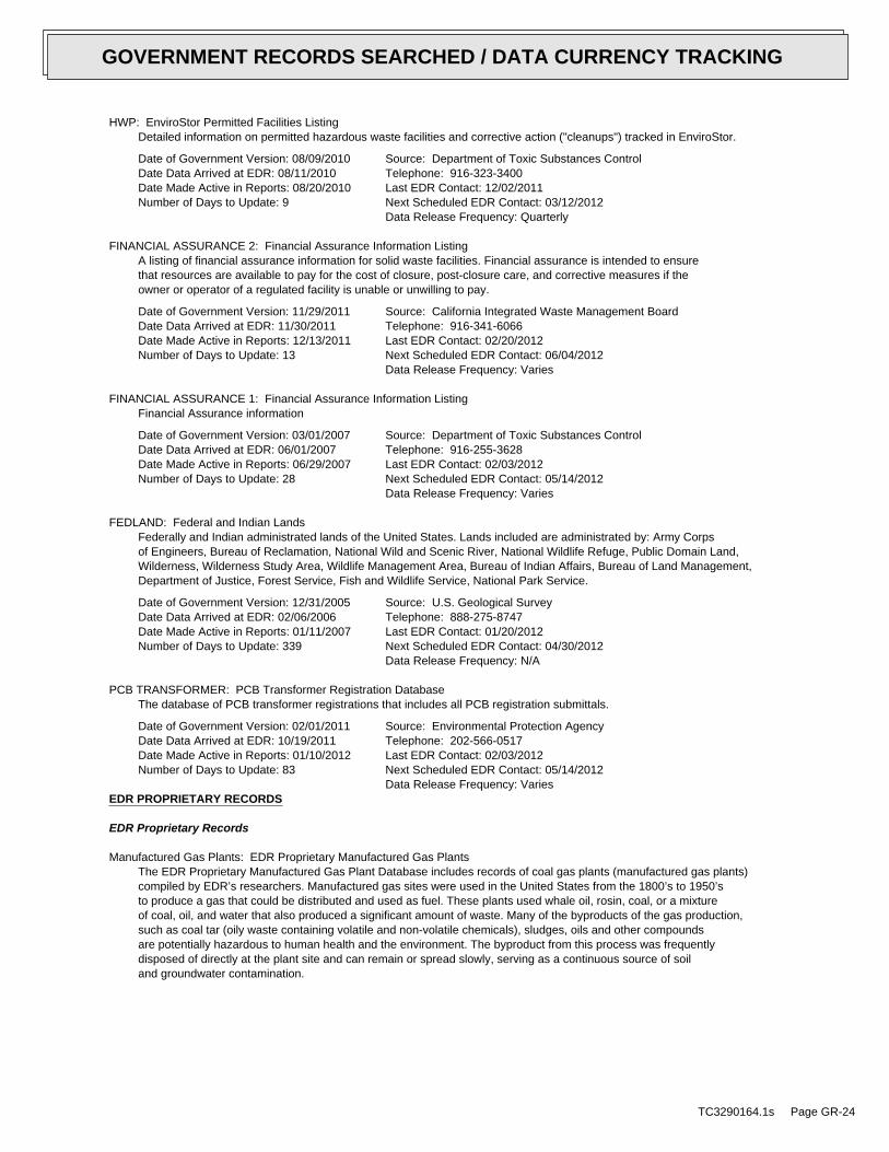
HWP: EnviroStor Permitted Facilities ListingDetailed information on permitted hazardous waste facilities and corrective action ("cleanups") tracked in EnviroStor.
Date of Government Version: 08/09/2010Date Data Arrived at EDR: 08/11/2010Date Made Active in Reports: 08/20/2010Number of Days to Update: 9
Source: Department of Toxic Substances ControlTelephone: 916-323-3400Last EDR Contact: 12/02/2011Next Scheduled EDR Contact: 03/12/2012Data Release Frequency: Quarterly
FINANCIAL ASSURANCE 2: Financial Assurance Information ListingA listing of financial assurance information for solid waste facilities. Financial assurance is intended to ensurethat resources are available to pay for the cost of closure, post-closure care, and corrective measures if theowner or operator of a regulated facility is unable or unwilling to pay.
Date of Government Version: 11/29/2011Date Data Arrived at EDR: 11/30/2011Date Made Active in Reports: 12/13/2011Number of Days to Update: 13
Source: California Integrated Waste Management BoardTelephone: 916-341-6066Last EDR Contact: 02/20/2012Next Scheduled EDR Contact: 06/04/2012Data Release Frequency: Varies
FINANCIAL ASSURANCE 1: Financial Assurance Information ListingFinancial Assurance information
Date of Government Version: 03/01/2007Date Data Arrived at EDR: 06/01/2007Date Made Active in Reports: 06/29/2007Number of Days to Update: 28
Source: Department of Toxic Substances ControlTelephone: 916-255-3628Last EDR Contact: 02/03/2012Next Scheduled EDR Contact: 05/14/2012Data Release Frequency: Varies
FEDLAND: Federal and Indian LandsFederally and Indian administrated lands of the United States. Lands included are administrated by: Army Corpsof Engineers, Bureau of Reclamation, National Wild and Scenic River, National Wildlife Refuge, Public Domain Land,Wilderness, Wilderness Study Area, Wildlife Management Area, Bureau of Indian Affairs, Bureau of Land Management,Department of Justice, Forest Service, Fish and Wildlife Service, National Park Service.
Date of Government Version: 12/31/2005Date Data Arrived at EDR: 02/06/2006Date Made Active in Reports: 01/11/2007Number of Days to Update: 339
Source: U.S. Geological SurveyTelephone: 888-275-8747Last EDR Contact: 01/20/2012Next Scheduled EDR Contact: 04/30/2012Data Release Frequency: N/A
PCB TRANSFORMER: PCB Transformer Registration DatabaseThe database of PCB transformer registrations that includes all PCB registration submittals.
Date of Government Version: 02/01/2011Date Data Arrived at EDR: 10/19/2011Date Made Active in Reports: 01/10/2012Number of Days to Update: 83
Source: Environmental Protection AgencyTelephone: 202-566-0517Last EDR Contact: 02/03/2012Next Scheduled EDR Contact: 05/14/2012Data Release Frequency: Varies
EDR PROPRIETARY RECORDS
EDR Proprietary Records
Manufactured Gas Plants: EDR Proprietary Manufactured Gas PlantsThe EDR Proprietary Manufactured Gas Plant Database includes records of coal gas plants (manufactured gas plants)compiled by EDR’s researchers. Manufactured gas sites were used in the United States from the 1800’s to 1950’sto produce a gas that could be distributed and used as fuel. These plants used whale oil, rosin, coal, or a mixtureof coal, oil, and water that also produced a significant amount of waste. Many of the byproducts of the gas production,such as coal tar (oily waste containing volatile and non-volatile chemicals), sludges, oils and other compoundsare potentially hazardous to human health and the environment. The byproduct from this process was frequentlydisposed of directly at the plant site and can remain or spread slowly, serving as a continuous source of soiland groundwater contamination.
TC3290164.1s Page GR-24
GOVERNMENT RECORDS SEARCHED / DATA CURRENCY TRACKING
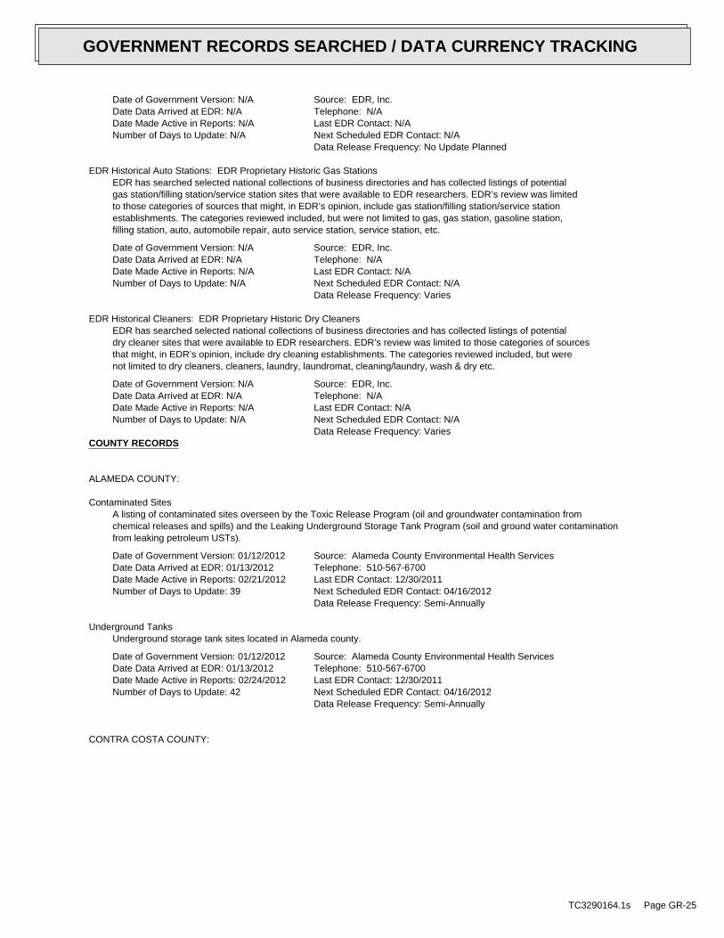
Date of Government Version: N/ADate Data Arrived at EDR: N/ADate Made Active in Reports: N/ANumber of Days to Update: N/A
Source: EDR, Inc.Telephone: N/ALast EDR Contact: N/ANext Scheduled EDR Contact: N/AData Release Frequency: No Update Planned
EDR Historical Auto Stations: EDR Proprietary Historic Gas StationsEDR has searched selected national collections of business directories and has collected listings of potentialgas station/filling station/service station sites that were available to EDR researchers. EDR’s review was limitedto those categories of sources that might, in EDR’s opinion, include gas station/filling station/service stationestablishments. The categories reviewed included, but were not limited to gas, gas station, gasoline station,filling station, auto, automobile repair, auto service station, service station, etc.
Date of Government Version: N/ADate Data Arrived at EDR: N/ADate Made Active in Reports: N/ANumber of Days to Update: N/A
Source: EDR, Inc.Telephone: N/ALast EDR Contact: N/ANext Scheduled EDR Contact: N/AData Release Frequency: Varies
EDR Historical Cleaners: EDR Proprietary Historic Dry CleanersEDR has searched selected national collections of business directories and has collected listings of potentialdry cleaner sites that were available to EDR researchers. EDR’s review was limited to those categories of sourcesthat might, in EDR’s opinion, include dry cleaning establishments. The categories reviewed included, but werenot limited to dry cleaners, cleaners, laundry, laundromat, cleaning/laundry, wash & dry etc.
Date of Government Version: N/ADate Data Arrived at EDR: N/ADate Made Active in Reports: N/ANumber of Days to Update: N/A
Source: EDR, Inc.Telephone: N/ALast EDR Contact: N/ANext Scheduled EDR Contact: N/AData Release Frequency: Varies
COUNTY RECORDS
ALAMEDA COUNTY:
Contaminated SitesA listing of contaminated sites overseen by the Toxic Release Program (oil and groundwater contamination fromchemical releases and spills) and the Leaking Underground Storage Tank Program (soil and ground water contaminationfrom leaking petroleum USTs).
Date of Government Version: 01/12/2012Date Data Arrived at EDR: 01/13/2012Date Made Active in Reports: 02/21/2012Number of Days to Update: 39
Source: Alameda County Environmental Health ServicesTelephone: 510-567-6700Last EDR Contact: 12/30/2011Next Scheduled EDR Contact: 04/16/2012Data Release Frequency: Semi-Annually
Underground TanksUnderground storage tank sites located in Alameda county.
Date of Government Version: 01/12/2012Date Data Arrived at EDR: 01/13/2012Date Made Active in Reports: 02/24/2012Number of Days to Update: 42
Source: Alameda County Environmental Health ServicesTelephone: 510-567-6700Last EDR Contact: 12/30/2011Next Scheduled EDR Contact: 04/16/2012Data Release Frequency: Semi-Annually
CONTRA COSTA COUNTY:
TC3290164.1s Page GR-25
GOVERNMENT RECORDS SEARCHED / DATA CURRENCY TRACKING
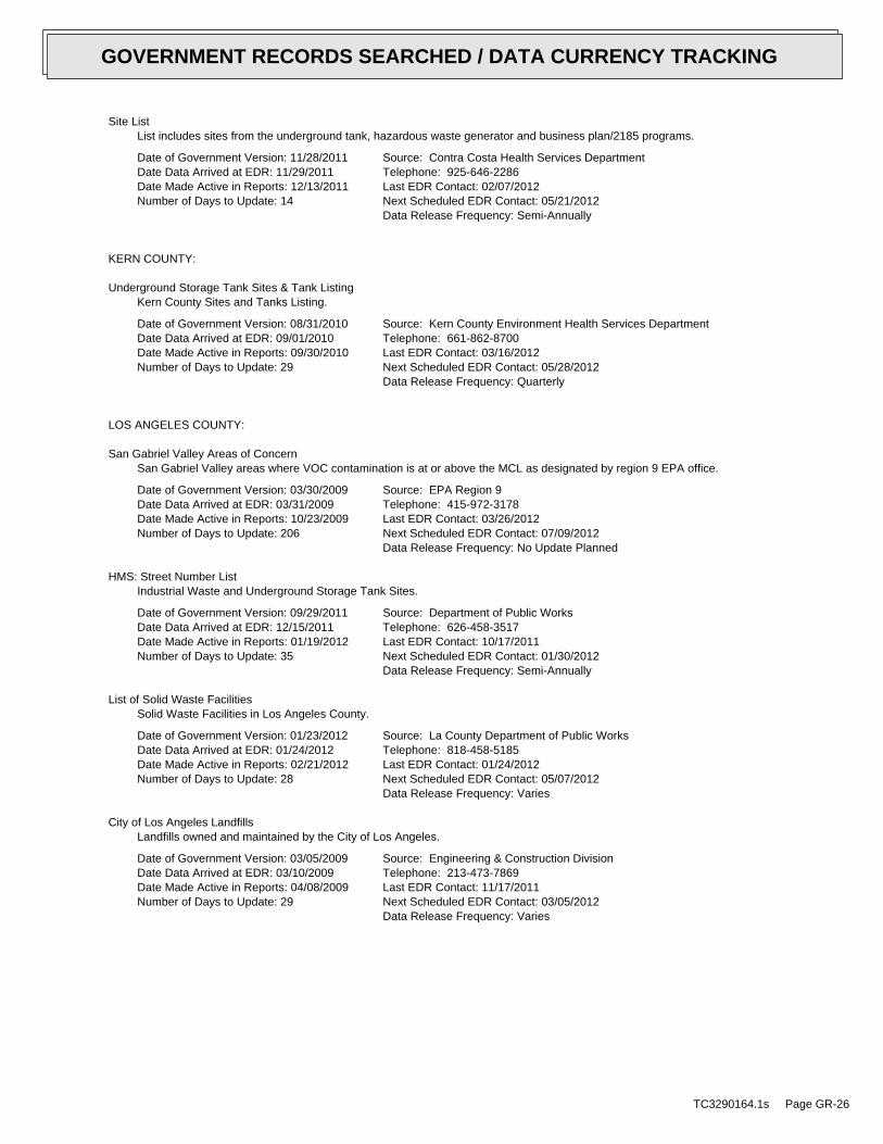
Site ListList includes sites from the underground tank, hazardous waste generator and business plan/2185 programs.
Date of Government Version: 11/28/2011Date Data Arrived at EDR: 11/29/2011Date Made Active in Reports: 12/13/2011Number of Days to Update: 14
Source: Contra Costa Health Services DepartmentTelephone: 925-646-2286Last EDR Contact: 02/07/2012Next Scheduled EDR Contact: 05/21/2012Data Release Frequency: Semi-Annually
KERN COUNTY:
Underground Storage Tank Sites & Tank ListingKern County Sites and Tanks Listing.
Date of Government Version: 08/31/2010Date Data Arrived at EDR: 09/01/2010Date Made Active in Reports: 09/30/2010Number of Days to Update: 29
Source: Kern County Environment Health Services DepartmentTelephone: 661-862-8700Last EDR Contact: 03/16/2012Next Scheduled EDR Contact: 05/28/2012Data Release Frequency: Quarterly
LOS ANGELES COUNTY:
San Gabriel Valley Areas of ConcernSan Gabriel Valley areas where VOC contamination is at or above the MCL as designated by region 9 EPA office.
Date of Government Version: 03/30/2009Date Data Arrived at EDR: 03/31/2009Date Made Active in Reports: 10/23/2009Number of Days to Update: 206
Source: EPA Region 9Telephone: 415-972-3178Last EDR Contact: 03/26/2012Next Scheduled EDR Contact: 07/09/2012Data Release Frequency: No Update Planned
HMS: Street Number ListIndustrial Waste and Underground Storage Tank Sites.
Date of Government Version: 09/29/2011Date Data Arrived at EDR: 12/15/2011Date Made Active in Reports: 01/19/2012Number of Days to Update: 35
Source: Department of Public WorksTelephone: 626-458-3517Last EDR Contact: 10/17/2011Next Scheduled EDR Contact: 01/30/2012Data Release Frequency: Semi-Annually
List of Solid Waste FacilitiesSolid Waste Facilities in Los Angeles County.
Date of Government Version: 01/23/2012Date Data Arrived at EDR: 01/24/2012Date Made Active in Reports: 02/21/2012Number of Days to Update: 28
Source: La County Department of Public WorksTelephone: 818-458-5185Last EDR Contact: 01/24/2012Next Scheduled EDR Contact: 05/07/2012Data Release Frequency: Varies
City of Los Angeles LandfillsLandfills owned and maintained by the City of Los Angeles.
Date of Government Version: 03/05/2009Date Data Arrived at EDR: 03/10/2009Date Made Active in Reports: 04/08/2009Number of Days to Update: 29
Source: Engineering & Construction DivisionTelephone: 213-473-7869Last EDR Contact: 11/17/2011Next Scheduled EDR Contact: 03/05/2012Data Release Frequency: Varies
TC3290164.1s Page GR-26
GOVERNMENT RECORDS SEARCHED / DATA CURRENCY TRACKING
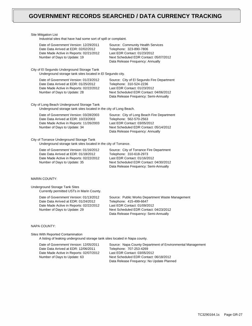
Site Mitigation ListIndustrial sites that have had some sort of spill or complaint.
Date of Government Version: 12/29/2011Date Data Arrived at EDR: 02/02/2012Date Made Active in Reports: 02/21/2012Number of Days to Update: 19
Source: Community Health ServicesTelephone: 323-890-7806Last EDR Contact: 01/23/2012Next Scheduled EDR Contact: 05/07/2012Data Release Frequency: Annually
City of El Segundo Underground Storage TankUnderground storage tank sites located in El Segundo city.
Date of Government Version: 01/23/2012Date Data Arrived at EDR: 01/25/2012Date Made Active in Reports: 02/22/2012Number of Days to Update: 28
Source: City of El Segundo Fire DepartmentTelephone: 310-524-2236Last EDR Contact: 01/23/2012Next Scheduled EDR Contact: 04/06/2012Data Release Frequency: Semi-Annually
City of Long Beach Underground Storage TankUnderground storage tank sites located in the city of Long Beach.
Date of Government Version: 03/28/2003Date Data Arrived at EDR: 10/23/2003Date Made Active in Reports: 11/26/2003Number of Days to Update: 34
Source: City of Long Beach Fire DepartmentTelephone: 562-570-2563Last EDR Contact: 03/05/2012Next Scheduled EDR Contact: 05/14/2012Data Release Frequency: Annually
City of Torrance Underground Storage TankUnderground storage tank sites located in the city of Torrance.
Date of Government Version: 01/16/2012Date Data Arrived at EDR: 01/18/2012Date Made Active in Reports: 02/22/2012Number of Days to Update: 35
Source: City of Torrance Fire DepartmentTelephone: 310-618-2973Last EDR Contact: 01/16/2012Next Scheduled EDR Contact: 04/30/2012Data Release Frequency: Semi-Annually
MARIN COUNTY:
Underground Storage Tank SitesCurrently permitted USTs in Marin County.
Date of Government Version: 01/13/2012Date Data Arrived at EDR: 01/24/2012Date Made Active in Reports: 02/22/2012Number of Days to Update: 29
Source: Public Works Department Waste ManagementTelephone: 415-499-6647Last EDR Contact: 01/09/2012Next Scheduled EDR Contact: 04/23/2012Data Release Frequency: Semi-Annually
NAPA COUNTY:
Sites With Reported ContaminationA listing of leaking underground storage tank sites located in Napa county.
Date of Government Version: 12/05/2011Date Data Arrived at EDR: 12/06/2011Date Made Active in Reports: 02/07/2012Number of Days to Update: 63
Source: Napa County Department of Environmental ManagementTelephone: 707-253-4269Last EDR Contact: 03/05/2012Next Scheduled EDR Contact: 06/18/2012Data Release Frequency: No Update Planned
TC3290164.1s Page GR-27
GOVERNMENT RECORDS SEARCHED / DATA CURRENCY TRACKING
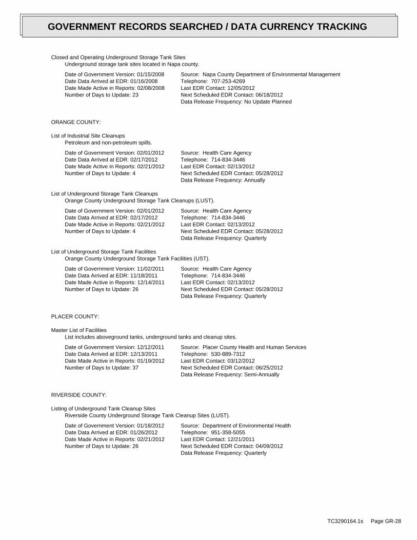
Closed and Operating Underground Storage Tank SitesUnderground storage tank sites located in Napa county.
Date of Government Version: 01/15/2008Date Data Arrived at EDR: 01/16/2008Date Made Active in Reports: 02/08/2008Number of Days to Update: 23
Source: Napa County Department of Environmental ManagementTelephone: 707-253-4269Last EDR Contact: 12/05/2012Next Scheduled EDR Contact: 06/18/2012Data Release Frequency: No Update Planned
ORANGE COUNTY:
List of Industrial Site CleanupsPetroleum and non-petroleum spills.
Date of Government Version: 02/01/2012Date Data Arrived at EDR: 02/17/2012Date Made Active in Reports: 02/21/2012Number of Days to Update: 4
Source: Health Care AgencyTelephone: 714-834-3446Last EDR Contact: 02/13/2012Next Scheduled EDR Contact: 05/28/2012Data Release Frequency: Annually
List of Underground Storage Tank CleanupsOrange County Underground Storage Tank Cleanups (LUST).
Date of Government Version: 02/01/2012Date Data Arrived at EDR: 02/17/2012Date Made Active in Reports: 02/21/2012Number of Days to Update: 4
Source: Health Care AgencyTelephone: 714-834-3446Last EDR Contact: 02/13/2012Next Scheduled EDR Contact: 05/28/2012Data Release Frequency: Quarterly
List of Underground Storage Tank FacilitiesOrange County Underground Storage Tank Facilities (UST).
Date of Government Version: 11/02/2011Date Data Arrived at EDR: 11/18/2011Date Made Active in Reports: 12/14/2011Number of Days to Update: 26
Source: Health Care AgencyTelephone: 714-834-3446Last EDR Contact: 02/13/2012Next Scheduled EDR Contact: 05/28/2012Data Release Frequency: Quarterly
PLACER COUNTY:
Master List of FacilitiesList includes aboveground tanks, underground tanks and cleanup sites.
Date of Government Version: 12/12/2011Date Data Arrived at EDR: 12/13/2011Date Made Active in Reports: 01/19/2012Number of Days to Update: 37
Source: Placer County Health and Human ServicesTelephone: 530-889-7312Last EDR Contact: 03/12/2012Next Scheduled EDR Contact: 06/25/2012Data Release Frequency: Semi-Annually
RIVERSIDE COUNTY:
Listing of Underground Tank Cleanup SitesRiverside County Underground Storage Tank Cleanup Sites (LUST).
Date of Government Version: 01/18/2012Date Data Arrived at EDR: 01/26/2012Date Made Active in Reports: 02/21/2012Number of Days to Update: 26
Source: Department of Environmental HealthTelephone: 951-358-5055Last EDR Contact: 12/21/2011Next Scheduled EDR Contact: 04/09/2012Data Release Frequency: Quarterly
TC3290164.1s Page GR-28
GOVERNMENT RECORDS SEARCHED / DATA CURRENCY TRACKING
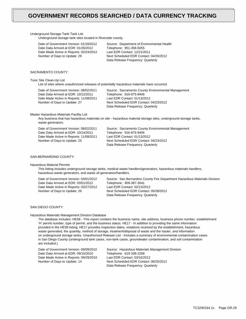
Underground Storage Tank Tank ListUnderground storage tank sites located in Riverside county.
Date of Government Version: 01/18/2012Date Data Arrived at EDR: 01/26/2012Date Made Active in Reports: 02/24/2012Number of Days to Update: 29
Source: Department of Environmental HealthTelephone: 951-358-5055Last EDR Contact: 12/21/2011Next Scheduled EDR Contact: 04/26/2012Data Release Frequency: Quarterly
SACRAMENTO COUNTY:
Toxic Site Clean-Up ListList of sites where unauthorized releases of potentially hazardous materials have occurred.
Date of Government Version: 08/02/2011Date Data Arrived at EDR: 10/12/2011Date Made Active in Reports: 11/08/2011Number of Days to Update: 27
Source: Sacramento County Environmental ManagementTelephone: 916-875-8406Last EDR Contact: 01/13/2012Next Scheduled EDR Contact: 04/23/2012Data Release Frequency: Quarterly
Master Hazardous Materials Facility ListAny business that has hazardous materials on site - hazardous material storage sites, underground storage tanks,waste generators.
Date of Government Version: 08/02/2011Date Data Arrived at EDR: 10/14/2011Date Made Active in Reports: 11/08/2011Number of Days to Update: 25
Source: Sacramento County Environmental ManagementTelephone: 916-875-8406Last EDR Contact: 01/13/2012Next Scheduled EDR Contact: 04/23/2012Data Release Frequency: Quarterly
SAN BERNARDINO COUNTY:
Hazardous Material PermitsThis listing includes underground storage tanks, medical waste handlers/generators, hazardous materials handlers,hazardous waste generators, and waste oil generators/handlers.
Date of Government Version: 03/01/2012Date Data Arrived at EDR: 03/01/2012Date Made Active in Reports: 03/27/2012Number of Days to Update: 26
Source: San Bernardino County Fire Department Hazardous Materials DivisionTelephone: 909-387-3041Last EDR Contact: 02/13/2012Next Scheduled EDR Contact: 05/28/2012Data Release Frequency: Quarterly
SAN DIEGO COUNTY:
Hazardous Materials Management Division DatabaseThe database includes: HE58 - This report contains the business name, site address, business phone number, establishment’H’ permit number, type of permit, and the business status. HE17 - In addition to providing the same informationprovided in the HE58 listing, HE17 provides inspection dates, violations received by the establishment, hazardouswaste generated, the quantity, method of storage, treatment/disposal of waste and the hauler, and informationon underground storage tanks. Unauthorized Release List - Includes a summary of environmental contamination casesin San Diego County (underground tank cases, non-tank cases, groundwater contamination, and soil contaminationare included.)
Date of Government Version: 09/09/2010Date Data Arrived at EDR: 09/15/2010Date Made Active in Reports: 09/29/2010Number of Days to Update: 14
Source: Hazardous Materials Management DivisionTelephone: 619-338-2268Last EDR Contact: 03/16/2012Next Scheduled EDR Contact: 06/25/2012Data Release Frequency: Quarterly
TC3290164.1s Page GR-29
GOVERNMENT RECORDS SEARCHED / DATA CURRENCY TRACKING
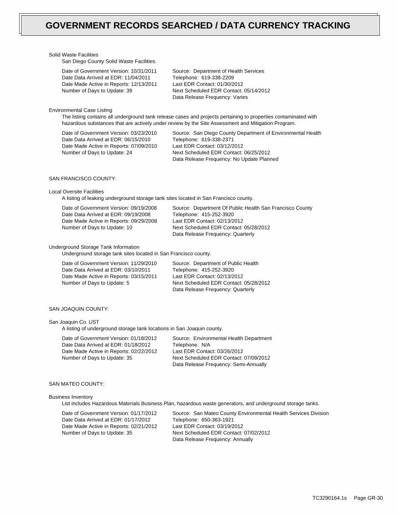
Solid Waste FacilitiesSan Diego County Solid Waste Facilities.
Date of Government Version: 10/31/2011Date Data Arrived at EDR: 11/04/2011Date Made Active in Reports: 12/13/2011Number of Days to Update: 39
Source: Department of Health ServicesTelephone: 619-338-2209Last EDR Contact: 01/30/2012Next Scheduled EDR Contact: 05/14/2012Data Release Frequency: Varies
Environmental Case ListingThe listing contains all underground tank release cases and projects pertaining to properties contaminated withhazardous substances that are actively under review by the Site Assessment and Mitigation Program.
Date of Government Version: 03/23/2010Date Data Arrived at EDR: 06/15/2010Date Made Active in Reports: 07/09/2010Number of Days to Update: 24
Source: San Diego County Department of Environmental HealthTelephone: 619-338-2371Last EDR Contact: 03/12/2012Next Scheduled EDR Contact: 06/25/2012Data Release Frequency: No Update Planned
SAN FRANCISCO COUNTY:
Local Oversite FacilitiesA listing of leaking underground storage tank sites located in San Francisco county.
Date of Government Version: 09/19/2008Date Data Arrived at EDR: 09/19/2008Date Made Active in Reports: 09/29/2008Number of Days to Update: 10
Source: Department Of Public Health San Francisco CountyTelephone: 415-252-3920Last EDR Contact: 02/13/2012Next Scheduled EDR Contact: 05/28/2012Data Release Frequency: Quarterly
Underground Storage Tank InformationUnderground storage tank sites located in San Francisco county.
Date of Government Version: 11/29/2010Date Data Arrived at EDR: 03/10/2011Date Made Active in Reports: 03/15/2011Number of Days to Update: 5
Source: Department of Public HealthTelephone: 415-252-3920Last EDR Contact: 02/13/2012Next Scheduled EDR Contact: 05/28/2012Data Release Frequency: Quarterly
SAN JOAQUIN COUNTY:
San Joaquin Co. USTA listing of underground storage tank locations in San Joaquin county.
Date of Government Version: 01/18/2012Date Data Arrived at EDR: 01/18/2012Date Made Active in Reports: 02/22/2012Number of Days to Update: 35
Source: Environmental Health DepartmentTelephone: N/ALast EDR Contact: 03/26/2012Next Scheduled EDR Contact: 07/09/2012Data Release Frequency: Semi-Annually
SAN MATEO COUNTY:
Business InventoryList includes Hazardous Materials Business Plan, hazardous waste generators, and underground storage tanks.
Date of Government Version: 01/17/2012Date Data Arrived at EDR: 01/17/2012Date Made Active in Reports: 02/21/2012Number of Days to Update: 35
Source: San Mateo County Environmental Health Services DivisionTelephone: 650-363-1921Last EDR Contact: 03/19/2012Next Scheduled EDR Contact: 07/02/2012Data Release Frequency: Annually
TC3290164.1s Page GR-30
GOVERNMENT RECORDS SEARCHED / DATA CURRENCY TRACKING
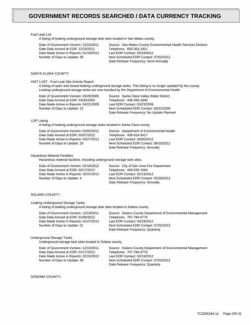
Fuel Leak ListA listing of leaking underground storage tank sites located in San Mateo county.
Date of Government Version: 12/15/2011Date Data Arrived at EDR: 12/15/2011Date Made Active in Reports: 01/19/2012Number of Days to Update: 35
Source: San Mateo County Environmental Health Services DivisionTelephone: 650-363-1921Last EDR Contact: 03/19/2012Next Scheduled EDR Contact: 07/02/2012Data Release Frequency: Semi-Annually
SANTA CLARA COUNTY:
HIST LUST - Fuel Leak Site Activity ReportA listing of open and closed leaking underground storage tanks. This listing is no longer updated by the county.Leaking underground storage tanks are now handled by the Department of Environmental Health.
Date of Government Version: 03/29/2005Date Data Arrived at EDR: 03/30/2005Date Made Active in Reports: 04/21/2005Number of Days to Update: 22
Source: Santa Clara Valley Water DistrictTelephone: 408-265-2600Last EDR Contact: 03/23/2009Next Scheduled EDR Contact: 06/22/2009Data Release Frequency: No Update Planned
LOP ListingA listing of leaking underground storage tanks located in Santa Clara county.
Date of Government Version: 03/05/2012Date Data Arrived at EDR: 03/07/2012Date Made Active in Reports: 03/27/2012Number of Days to Update: 20
Source: Department of Environmental HealthTelephone: 408-918-3417Last EDR Contact: 03/05/2012Next Scheduled EDR Contact: 06/18/2012Data Release Frequency: Annually
Hazardous Material FacilitiesHazardous material facilities, including underground storage tank sites.
Date of Government Version: 02/16/2012Date Data Arrived at EDR: 02/17/2012Date Made Active in Reports: 02/21/2012Number of Days to Update: 4
Source: City of San Jose Fire DepartmentTelephone: 408-535-7694Last EDR Contact: 02/13/2012Next Scheduled EDR Contact: 05/28/2012Data Release Frequency: Annually
SOLANO COUNTY:
Leaking Underground Storage TanksA listing of leaking underground storage tank sites located in Solano county.
Date of Government Version: 12/19/2011Date Data Arrived at EDR: 01/06/2012Date Made Active in Reports: 01/27/2012Number of Days to Update: 21
Source: Solano County Department of Environmental ManagementTelephone: 707-784-6770Last EDR Contact: 03/19/2012Next Scheduled EDR Contact: 07/02/2012Data Release Frequency: Quarterly
Underground Storage TanksUnderground storage tank sites located in Solano county.
Date of Government Version: 12/19/2011Date Data Arrived at EDR: 01/17/2012Date Made Active in Reports: 02/24/2012Number of Days to Update: 38
Source: Solano County Department of Environmental ManagementTelephone: 707-784-6770Last EDR Contact: 03/19/2012Next Scheduled EDR Contact: 07/02/2012Data Release Frequency: Quarterly
SONOMA COUNTY:
TC3290164.1s Page GR-31
GOVERNMENT RECORDS SEARCHED / DATA CURRENCY TRACKING
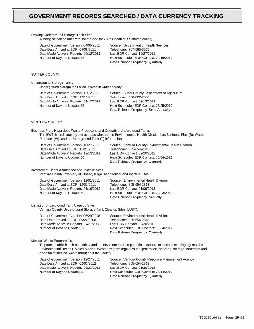
Leaking Underground Storage Tank SitesA listing of leaking underground storage tank sites located in Sonoma county.
Date of Government Version: 04/05/2011Date Data Arrived at EDR: 04/06/2011Date Made Active in Reports: 05/12/2011Number of Days to Update: 36
Source: Department of Health ServicesTelephone: 707-565-6565Last EDR Contact: 12/27/2011Next Scheduled EDR Contact: 04/16/2012Data Release Frequency: Quarterly
SUTTER COUNTY:
Underground Storage TanksUnderground storage tank sites located in Sutter county.
Date of Government Version: 12/12/2011Date Data Arrived at EDR: 12/13/2011Date Made Active in Reports: 01/17/2012Number of Days to Update: 35
Source: Sutter County Department of AgricultureTelephone: 530-822-7500Last EDR Contact: 03/12/2012Next Scheduled EDR Contact: 06/25/2012Data Release Frequency: Semi-Annually
VENTURA COUNTY:
Business Plan, Hazardous Waste Producers, and Operating Underground TanksThe BWT list indicates by site address whether the Environmental Health Division has Business Plan (B), WasteProducer (W), and/or Underground Tank (T) information.
Date of Government Version: 10/27/2011Date Data Arrived at EDR: 11/23/2011Date Made Active in Reports: 12/13/2011Number of Days to Update: 20
Source: Ventura County Environmental Health DivisionTelephone: 805-654-2813Last EDR Contact: 02/20/2012Next Scheduled EDR Contact: 06/04/2012Data Release Frequency: Quarterly
Inventory of Illegal Abandoned and Inactive SitesVentura County Inventory of Closed, Illegal Abandoned, and Inactive Sites.
Date of Government Version: 12/01/2011Date Data Arrived at EDR: 12/01/2011Date Made Active in Reports: 01/19/2012Number of Days to Update: 49
Source: Environmental Health DivisionTelephone: 805-654-2813Last EDR Contact: 01/09/2012Next Scheduled EDR Contact: 04/23/2012Data Release Frequency: Annually
Listing of Underground Tank Cleanup SitesVentura County Underground Storage Tank Cleanup Sites (LUST).
Date of Government Version: 05/29/2008Date Data Arrived at EDR: 06/24/2008Date Made Active in Reports: 07/31/2008Number of Days to Update: 37
Source: Environmental Health DivisionTelephone: 805-654-2813Last EDR Contact: 02/20/2012Next Scheduled EDR Contact: 06/04/2012Data Release Frequency: Quarterly
Medical Waste Program ListTo protect public health and safety and the environment from potential exposure to disease causing agents, theEnvironmental Health Division Medical Waste Program regulates the generation, handling, storage, treatment anddisposal of medical waste throughout the County.
Date of Government Version: 12/27/2011Date Data Arrived at EDR: 02/03/2012Date Made Active in Reports: 02/21/2012Number of Days to Update: 18
Source: Ventura County Resource Management AgencyTelephone: 805-654-2813Last EDR Contact: 01/30/2012Next Scheduled EDR Contact: 05/14/2012Data Release Frequency: Quarterly
TC3290164.1s Page GR-32
GOVERNMENT RECORDS SEARCHED / DATA CURRENCY TRACKING
Underground Tank Closed Sites ListVentura County Operating Underground Storage Tank Sites (UST)/Underground Tank Closed Sites List.
Date of Government Version: 12/01/2011Date Data Arrived at EDR: 12/19/2011Date Made Active in Reports: 01/17/2012Number of Days to Update: 29
Source: Environmental Health DivisionTelephone: 805-654-2813Last EDR Contact: 03/21/2012Next Scheduled EDR Contact: 07/02/2012Data Release Frequency: Quarterly
YOLO COUNTY:
Underground Storage Tank Comprehensive Facility ReportUnderground storage tank sites located in Yolo county.
Date of Government Version: 12/28/2011Date Data Arrived at EDR: 01/06/2012Date Made Active in Reports: 01/17/2012Number of Days to Update: 11
Source: Yolo County Department of HealthTelephone: 530-666-8646Last EDR Contact: 03/26/2012Next Scheduled EDR Contact: 07/09/2012Data Release Frequency: Annually
OTHER DATABASE(S)
Depending on the geographic area covered by this report, the data provided in these specialty databases may or may not becomplete. For example, the existence of wetlands information data in a specific report does not mean that all wetlands in thearea covered by the report are included. Moreover, the absence of any reported wetlands information does not necessarilymean that wetlands do not exist in the area covered by the report.
CT MANIFEST: Hazardous Waste Manifest DataFacility and manifest data. Manifest is a document that lists and tracks hazardous waste from the generator throughtransporters to a tsd facility.
Date of Government Version: 02/20/2012Date Data Arrived at EDR: 02/20/2012Date Made Active in Reports: 03/15/2012Number of Days to Update: 24
Source: Department of Environmental ProtectionTelephone: 860-424-3375Last EDR Contact: 02/20/2012Next Scheduled EDR Contact: 06/04/2012Data Release Frequency: Annually
NJ MANIFEST: Manifest InformationHazardous waste manifest information.
Date of Government Version: 12/31/2010Date Data Arrived at EDR: 07/20/2011Date Made Active in Reports: 08/11/2011Number of Days to Update: 22
Source: Department of Environmental ProtectionTelephone: N/ALast EDR Contact: 01/20/2012Next Scheduled EDR Contact: 04/30/2012Data Release Frequency: Annually
NY MANIFEST: Facility and Manifest DataManifest is a document that lists and tracks hazardous waste from the generator through transporters to a TSDfacility.
Date of Government Version: 01/10/2012Date Data Arrived at EDR: 02/09/2012Date Made Active in Reports: 03/09/2012Number of Days to Update: 29
Source: Department of Environmental ConservationTelephone: 518-402-8651Last EDR Contact: 02/09/2012Next Scheduled EDR Contact: 05/21/2012Data Release Frequency: Annually
TC3290164.1s Page GR-33
GOVERNMENT RECORDS SEARCHED / DATA CURRENCY TRACKING
PA MANIFEST: Manifest InformationHazardous waste manifest information.
Date of Government Version: 12/31/2009Date Data Arrived at EDR: 01/26/2012Date Made Active in Reports: 03/06/2012Number of Days to Update: 40
Source: Department of Environmental ProtectionTelephone: 717-783-8990Last EDR Contact: 01/23/2012Next Scheduled EDR Contact: 05/07/2012Data Release Frequency: Annually
RI MANIFEST: Manifest informationHazardous waste manifest information
Date of Government Version: 12/31/2010Date Data Arrived at EDR: 06/24/2011Date Made Active in Reports: 06/30/2011Number of Days to Update: 6
Source: Department of Environmental ManagementTelephone: 401-222-2797Last EDR Contact: 02/27/2012Next Scheduled EDR Contact: 06/11/2012Data Release Frequency: Annually
WI MANIFEST: Manifest InformationHazardous waste manifest information.
Date of Government Version: 12/31/2010Date Data Arrived at EDR: 08/19/2011Date Made Active in Reports: 09/15/2011Number of Days to Update: 27
Source: Department of Natural ResourcesTelephone: N/ALast EDR Contact: 03/19/2012Next Scheduled EDR Contact: 07/02/2012Data Release Frequency: Annually
Oil/Gas Pipelines: This data was obtained by EDR from the USGS in 1994. It is referred to by USGS as GeoData Digital Line Graphsfrom 1:100,000-Scale Maps. It was extracted from the transportation category including some oil, but primarilygas pipelines.
Electric Power Transmission Line DataSource: Rextag Strategies Corp.Telephone: (281) 769-2247U.S. Electric Transmission and Power Plants Systems Digital GIS Data
Sensitive Receptors: There are individuals deemed sensitive receptors due to their fragile immune systems and special sensitivityto environmental discharges. These sensitive receptors typically include the elderly, the sick, and children. While the location of allsensitive receptors cannot be determined, EDR indicates those buildings and facilities - schools, daycares, hospitals, medical centers,and nursing homes - where individuals who are sensitive receptors are likely to be located.
AHA Hospitals:Source: American Hospital Association, Inc.Telephone: 312-280-5991The database includes a listing of hospitals based on the American Hospital Association’s annual survey of hospitals.
Medical Centers: Provider of Services ListingSource: Centers for Medicare & Medicaid ServicesTelephone: 410-786-3000A listing of hospitals with Medicare provider number, produced by Centers of Medicare & Medicaid Services,a federal agency within the U.S. Department of Health and Human Services.
Nursing HomesSource: National Institutes of HealthTelephone: 301-594-6248Information on Medicare and Medicaid certified nursing homes in the United States.
Public SchoolsSource: National Center for Education StatisticsTelephone: 202-502-7300The National Center for Education Statistics’ primary database on elementaryand secondary public education in the United States. It is a comprehensive, annual, national statisticaldatabase of all public elementary and secondary schools and school districts, which contains data that arecomparable across all states.
Private SchoolsSource: National Center for Education StatisticsTelephone: 202-502-7300The National Center for Education Statistics’ primary database on private school locations in the United States.
TC3290164.1s Page GR-34
GOVERNMENT RECORDS SEARCHED / DATA CURRENCY TRACKING
Daycare Centers: Licensed FacilitiesSource: Department of Social ServicesTelephone: 916-657-4041
Flood Zone Data: This data, available in select counties across the country, was obtained by EDR in 2003 & 2011 from the FederalEmergency Management Agency (FEMA). Data depicts 100-year and 500-year flood zones as defined by FEMA.
NWI: National Wetlands Inventory. This data, available in select counties across the country, was obtained by EDRin 2002 and 2005 from the U.S. Fish and Wildlife Service.
Scanned Digital USGS 7.5’ Topographic Map (DRG)Source: United States Geologic SurveyA digital raster graphic (DRG) is a scanned image of a U.S. Geological Survey topographic map. The map imagesare made by scanning published paper maps on high-resolution scanners. The raster imageis georeferenced and fit to the Universal Transverse Mercator (UTM) projection.
STREET AND ADDRESS INFORMATION
© 2010 Tele Atlas North America, Inc. All rights reserved. This material is proprietary and the subject of copyright protectionand other intellectual property rights owned by or licensed to Tele Atlas North America, Inc. The use of this material is subjectto the terms of a license agreement. You will be held liable for any unauthorized copying or disclosure of this material.
TC3290164.1s Page GR-35
GOVERNMENT RECORDS SEARCHED / DATA CURRENCY TRACKING

TC3290164.1s Page A-1
geologic strata.of the soil, and nearby wells. Groundwater flow velocity is generally impacted by the nature of theGroundwater flow direction may be impacted by surface topography, hydrology, hydrogeology, characteristics
2. Groundwater flow velocity. 1. Groundwater flow direction, and
Assessment of the impact of contaminant migration generally has two principal investigative components:
forming an opinion about the impact of potential contaminant migration.EDR’s GeoCheck Physical Setting Source Addendum is provided to assist the environmental professional in
1994Most Recent Revision:34118-D8 FILLMORE, CATarget Property Map:
USGS TOPOGRAPHIC MAP
416 ft. above sea levelElevation:3807974.8UTM Y (Meters): 322242.2UTM X (Meters): Zone 11Universal Tranverse Mercator: 118.9338 - 118˚ 56’ 1.68’’Longitude (West): 34.3997 - 34˚ 23’ 58.92’’Latitude (North):
TARGET PROPERTY COORDINATES
FILLMORE, CA 93015SESPE CREEK BETWEEN HWY 126 AND OLD TELEGRAPH ROADSESPE CREEK
TARGET PROPERTY ADDRESS
®GEOCHECK - PHYSICAL SETTING SOURCE ADDENDUM®
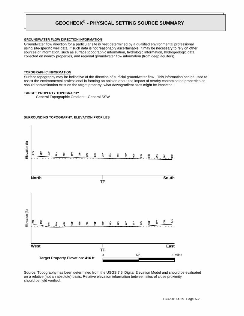
TC3290164.1s Page A-2
should be field verified.on a relative (not an absolute) basis. Relative elevation information between sites of close proximitySource: Topography has been determined from the USGS 7.5’ Digital Elevation Model and should be evaluated
SURROUNDING TOPOGRAPHY: ELEVATION PROFILES
Ele
vatio
n (f
t)E
leva
tion
(ft)
TP
TP0 1/2 1 Miles
✩Target Property Elevation: 416 ft.
North South
West East
388
393
396
400
403
409
414
416
415
416
423
428
433
444
437
441
457
465
473463
451 405
403
407
413
416
417
414
416
424
424
423
425
430
435
449
462
473
General SSWGeneral Topographic Gradient:TARGET PROPERTY TOPOGRAPHY
should contamination exist on the target property, what downgradient sites might be impacted.assist the environmental professional in forming an opinion about the impact of nearby contaminated properties or,Surface topography may be indicative of the direction of surficial groundwater flow. This information can be used toTOPOGRAPHIC INFORMATION
collected on nearby properties, and regional groundwater flow information (from deep aquifers).sources of information, such as surface topographic information, hydrologic information, hydrogeologic datausing site-specific well data. If such data is not reasonably ascertainable, it may be necessary to rely on otherGroundwater flow direction for a particular site is best determined by a qualified environmental professionalGROUNDWATER FLOW DIRECTION INFORMATION
®GEOCHECK - PHYSICAL SETTING SOURCE SUMMARY®
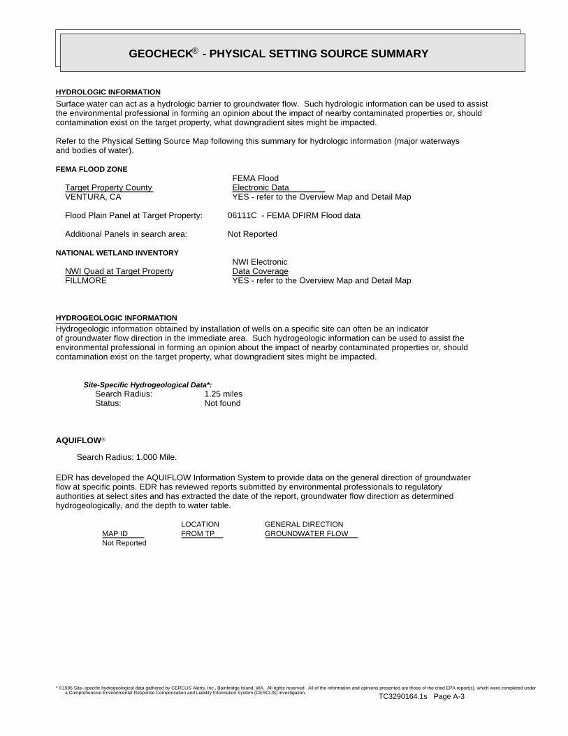
TC3290164.1s Page A-3
Not Reported
GENERAL DIRECTIONLOCATIONGROUNDWATER FLOWFROM TPMAP ID
hydrogeologically, and the depth to water table.authorities at select sites and has extracted the date of the report, groundwater flow direction as determinedflow at specific points. EDR has reviewed reports submitted by environmental professionals to regulatoryEDR has developed the AQUIFLOW Information System to provide data on the general direction of groundwater
AQUIFLOW®
Search Radius: 1.000 Mile.
Not found Status:1.25 miles Search Radius:
Site-Specific Hydrogeological Data*:
* ©1996 Site−specific hydrogeological data gathered by CERCLIS Alerts, Inc., Bainbridge Island, WA. All rights reserved. All of the information and opinions presented are those of the cited EPA report(s), which were completed undera Comprehensive Environmental Response Compensation and Liability Information System (CERCLIS) investigation.
contamination exist on the target property, what downgradient sites might be impacted.environmental professional in forming an opinion about the impact of nearby contaminated properties or, shouldof groundwater flow direction in the immediate area. Such hydrogeologic information can be used to assist theHydrogeologic information obtained by installation of wells on a specific site can often be an indicatorHYDROGEOLOGIC INFORMATION
YES - refer to the Overview Map and Detail MapFILLMORE
NATIONAL WETLAND INVENTORYNWI ElectronicData CoverageNWI Quad at Target Property
Not ReportedAdditional Panels in search area:
06111C - FEMA DFIRM Flood dataFlood Plain Panel at Target Property:
YES - refer to the Overview Map and Detail MapVENTURA, CA
FEMA FLOOD ZONEFEMA FloodElectronic DataTarget Property County
and bodies of water).Refer to the Physical Setting Source Map following this summary for hydrologic information (major waterways
contamination exist on the target property, what downgradient sites might be impacted.the environmental professional in forming an opinion about the impact of nearby contaminated properties or, shouldSurface water can act as a hydrologic barrier to groundwater flow. Such hydrologic information can be used to assistHYDROLOGIC INFORMATION
®GEOCHECK - PHYSICAL SETTING SOURCE SUMMARY®
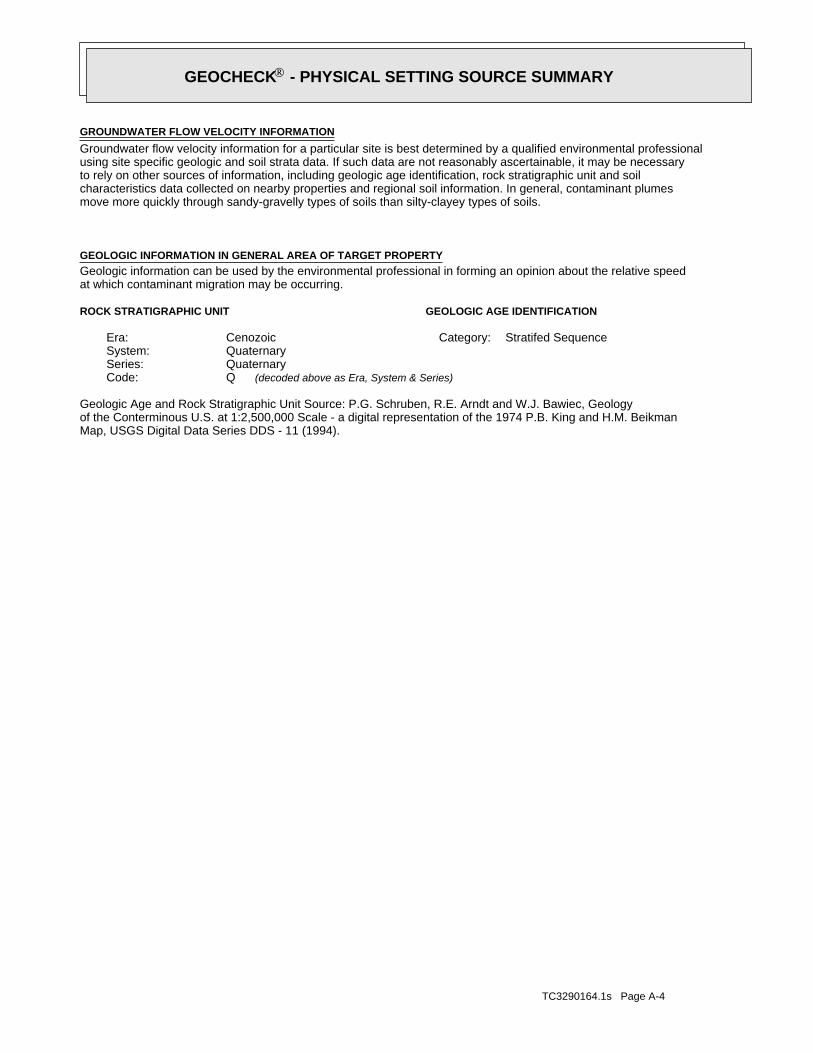
TC3290164.1s Page A-4
Map, USGS Digital Data Series DDS - 11 (1994).of the Conterminous U.S. at 1:2,500,000 Scale - a digital representation of the 1974 P.B. King and H.M. BeikmanGeologic Age and Rock Stratigraphic Unit Source: P.G. Schruben, R.E. Arndt and W.J. Bawiec, Geology
ROCK STRATIGRAPHIC UNIT GEOLOGIC AGE IDENTIFICATION
Stratifed SequenceCategory:CenozoicEra:QuaternarySystem:QuaternarySeries:QCode: (decoded above as Era, System & Series)
at which contaminant migration may be occurring.Geologic information can be used by the environmental professional in forming an opinion about the relative speedGEOLOGIC INFORMATION IN GENERAL AREA OF TARGET PROPERTY
move more quickly through sandy-gravelly types of soils than silty-clayey types of soils.characteristics data collected on nearby properties and regional soil information. In general, contaminant plumesto rely on other sources of information, including geologic age identification, rock stratigraphic unit and soilusing site specific geologic and soil strata data. If such data are not reasonably ascertainable, it may be necessaryGroundwater flow velocity information for a particular site is best determined by a qualified environmental professionalGROUNDWATER FLOW VELOCITY INFORMATION
®GEOCHECK - PHYSICAL SETTING SOURCE SUMMARY®
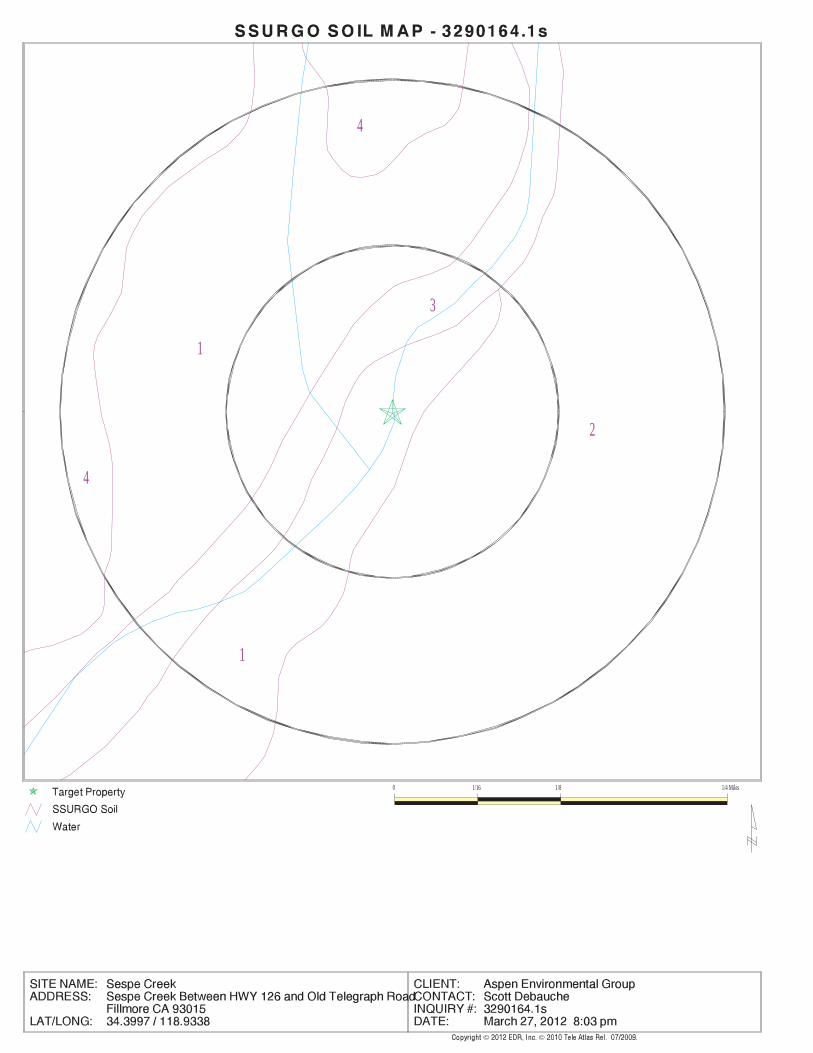
EDR Inc.EDR Inc.EDR Inc.EDR Inc.EDR Inc.EDR Inc.EDR Inc.EDR Inc.EDR Inc.EDR Inc.EDR Inc.EDR Inc.EDR Inc.EDR Inc.EDR Inc.EDR Inc.EDR Inc.EDR Inc.EDR Inc.EDR Inc.EDR Inc.EDR Inc.EDR Inc.EDR Inc.EDR Inc.EDR Inc.EDR Inc.EDR Inc.EDR Inc.EDR Inc.EDR Inc.EDR Inc.EDR Inc.EDR Inc.EDR Inc.EDR Inc.EDR Inc.EDR Inc.EDR Inc.EDR Inc.
4
1
3
4
2
1
0 1/16 1/8 1/4 Miles
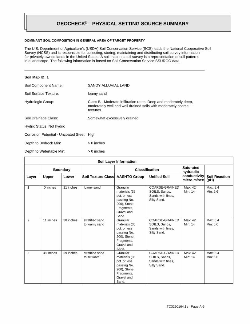
TC3290164.1s Page A-6
Min: 6.6Max: 8.4
Min: 14Max: 42
Silty Sand.Sands with fines,SOILS, Sands,COARSE-GRAINED
Sand.Gravel andFragments,200), Stonepassing No.pct. or lessmaterials (35Granular
to silt loamstratified sand59 inches38 inches 3
Min: 6.6Max: 8.4
Min: 14Max: 42
Silty Sand.Sands with fines,SOILS, Sands,COARSE-GRAINED
Sand.Gravel andFragments,200), Stonepassing No.pct. or lessmaterials (35Granular
to loamy sandstratified sand38 inches11 inches 2
Min: 6.6Max: 8.4
Min: 14Max: 42
Silty Sand.Sands with fines,SOILS, Sands,COARSE-GRAINED
Sand.Gravel andFragments,200), Stonepassing No.pct. or lessmaterials (35Granularloamy sand11 inches 0 inches 1
Soil Layer Information
Boundary Classification Saturatedhydraulicconductivitymicro m/sec
Layer Upper Lower Soil Texture Class AASHTO Group Unified Soil Soil Reaction(pH)
> 0 inchesDepth to Watertable Min:
> 0 inchesDepth to Bedrock Min:
HighCorrosion Potential - Uncoated Steel:
Hydric Status: Not hydric
Somewhat excessively drainedSoil Drainage Class:
textures.moderately well and well drained soils with moderately coarseClass B - Moderate infiltration rates. Deep and moderately deep,Hydrologic Group:
loamy sandSoil Surface Texture:
SANDY ALLUVIAL LANDSoil Component Name:
Soil Map ID: 1
in a landscape. The following information is based on Soil Conservation Service SSURGO data.for privately owned lands in the United States. A soil map in a soil survey is a representation of soil patternsSurvey (NCSS) and is responsible for collecting, storing, maintaining and distributing soil survey informationThe U.S. Department of Agriculture’s (USDA) Soil Conservation Service (SCS) leads the National Cooperative Soil
DOMINANT SOIL COMPOSITION IN GENERAL AREA OF TARGET PROPERTY
®GEOCHECK - PHYSICAL SETTING SOURCE SUMMARY®
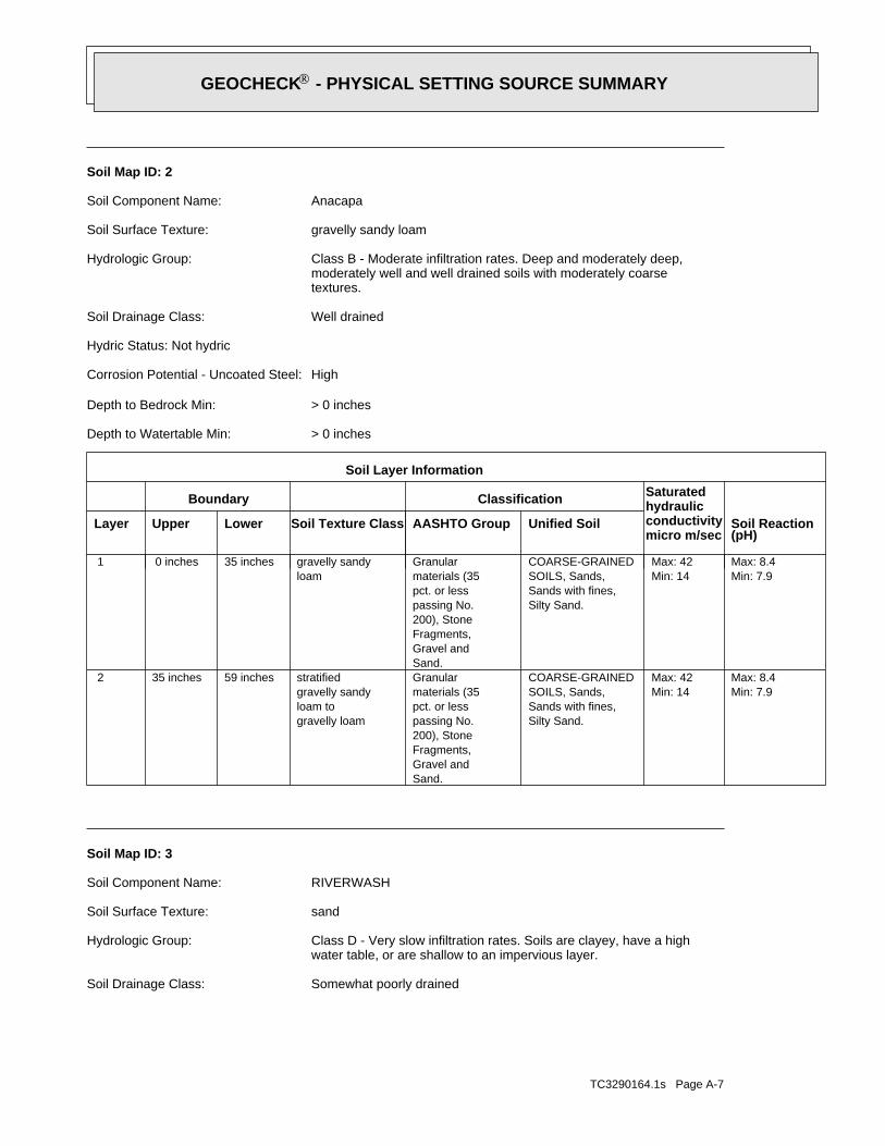
TC3290164.1s Page A-7
Somewhat poorly drainedSoil Drainage Class:
water table, or are shallow to an impervious layer.Class D - Very slow infiltration rates. Soils are clayey, have a highHydrologic Group:
sandSoil Surface Texture:
RIVERWASHSoil Component Name:
Soil Map ID: 3
Min: 7.9Max: 8.4
Min: 14Max: 42
Silty Sand.Sands with fines,SOILS, Sands,COARSE-GRAINED
Sand.Gravel andFragments,200), Stonepassing No.pct. or lessmaterials (35Granular
gravelly loamloam togravelly sandystratified59 inches35 inches 2
Min: 7.9Max: 8.4
Min: 14Max: 42
Silty Sand.Sands with fines,SOILS, Sands,COARSE-GRAINED
Sand.Gravel andFragments,200), Stonepassing No.pct. or lessmaterials (35Granular
loamgravelly sandy35 inches 0 inches 1
Soil Layer Information
Boundary Classification Saturatedhydraulicconductivitymicro m/sec
Layer Upper Lower Soil Texture Class AASHTO Group Unified Soil Soil Reaction(pH)
> 0 inchesDepth to Watertable Min:
> 0 inchesDepth to Bedrock Min:
HighCorrosion Potential - Uncoated Steel:
Hydric Status: Not hydric
Well drainedSoil Drainage Class:
textures.moderately well and well drained soils with moderately coarseClass B - Moderate infiltration rates. Deep and moderately deep,Hydrologic Group:
gravelly sandy loamSoil Surface Texture:
AnacapaSoil Component Name:
Soil Map ID: 2
®GEOCHECK - PHYSICAL SETTING SOURCE SUMMARY®
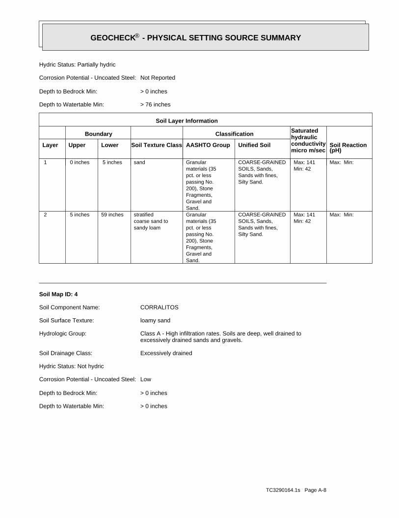
TC3290164.1s Page A-8
> 0 inchesDepth to Watertable Min:
> 0 inchesDepth to Bedrock Min:
LowCorrosion Potential - Uncoated Steel:
Hydric Status: Not hydric
Excessively drainedSoil Drainage Class:
excessively drained sands and gravels.Class A - High infiltration rates. Soils are deep, well drained toHydrologic Group:
loamy sandSoil Surface Texture:
CORRALITOSSoil Component Name:
Soil Map ID: 4
Max: Min: Min: 42Max: 141
Silty Sand.Sands with fines,SOILS, Sands,COARSE-GRAINED
Sand.Gravel andFragments,200), Stonepassing No.pct. or lessmaterials (35Granular
sandy loamcoarse sand tostratified59 inches 5 inches 2
Max: Min: Min: 42Max: 141
Silty Sand.Sands with fines,SOILS, Sands,COARSE-GRAINED
Sand.Gravel andFragments,200), Stonepassing No.pct. or lessmaterials (35Granularsand 5 inches 0 inches 1
Soil Layer Information
Boundary Classification Saturatedhydraulicconductivitymicro m/sec
Layer Upper Lower Soil Texture Class AASHTO Group Unified Soil Soil Reaction(pH)
> 76 inchesDepth to Watertable Min:
> 0 inchesDepth to Bedrock Min:
Not ReportedCorrosion Potential - Uncoated Steel:
Hydric Status: Partially hydric
®GEOCHECK - PHYSICAL SETTING SOURCE SUMMARY®
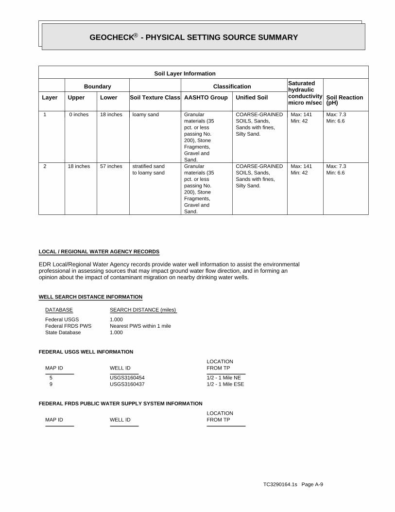
TC3290164.1s Page A-9
FEDERAL FRDS PUBLIC WATER SUPPLY SYSTEM INFORMATION
LOCATIONFROM TPWELL IDMAP ID
1/2 - 1 Mile ESEUSGS3160437 91/2 - 1 Mile NEUSGS3160454 5
FEDERAL USGS WELL INFORMATION
LOCATIONFROM TPWELL IDMAP ID
1.000State DatabaseNearest PWS within 1 mileFederal FRDS PWS1.000Federal USGS
WELL SEARCH DISTANCE INFORMATION
SEARCH DISTANCE (miles)DATABASE
opinion about the impact of contaminant migration on nearby drinking water wells.professional in assessing sources that may impact ground water flow direction, and in forming anEDR Local/Regional Water Agency records provide water well information to assist the environmental
LOCAL / REGIONAL WATER AGENCY RECORDS
Min: 6.6Max: 7.3
Min: 42Max: 141
Silty Sand.Sands with fines,SOILS, Sands,COARSE-GRAINED
Sand.Gravel andFragments,200), Stonepassing No.pct. or lessmaterials (35Granular
to loamy sandstratified sand57 inches18 inches 2
Min: 6.6Max: 7.3
Min: 42Max: 141
Silty Sand.Sands with fines,SOILS, Sands,COARSE-GRAINED
Sand.Gravel andFragments,200), Stonepassing No.pct. or lessmaterials (35Granularloamy sand18 inches 0 inches 1
Soil Layer Information
Boundary Classification Saturatedhydraulicconductivitymicro m/sec
Layer Upper Lower Soil Texture Class AASHTO Group Unified Soil Soil Reaction(pH)
®GEOCHECK - PHYSICAL SETTING SOURCE SUMMARY®
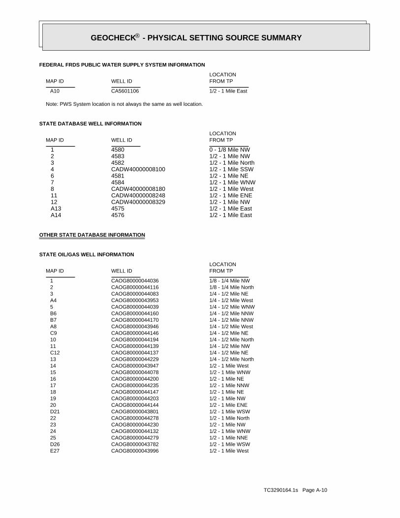
TC3290164.1s Page A-10
1/2 - 1 Mile WestCAOG80000043996 E271/2 - 1 Mile WSWCAOG80000043782 D261/2 - 1 Mile NNECAOG80000044279 251/2 - 1 Mile WNWCAOG80000044132 241/2 - 1 Mile NWCAOG80000044230 231/2 - 1 Mile NorthCAOG80000044278 221/2 - 1 Mile WSWCAOG80000043801 D211/2 - 1 Mile ENECAOG80000044144 201/2 - 1 Mile NWCAOG80000044203 191/2 - 1 Mile NECAOG80000044147 181/2 - 1 Mile NNWCAOG80000044235 171/2 - 1 Mile NECAOG80000044200 161/2 - 1 Mile WNWCAOG80000044078 151/2 - 1 Mile WestCAOG80000043947 141/4 - 1/2 Mile NorthCAOG80000044229 131/4 - 1/2 Mile NECAOG80000044137 C121/4 - 1/2 Mile NWCAOG80000044139 111/4 - 1/2 Mile NorthCAOG80000044194 101/4 - 1/2 Mile NECAOG80000044146 C91/4 - 1/2 Mile WestCAOG80000043946 A81/4 - 1/2 Mile NNWCAOG80000044170 B71/4 - 1/2 Mile NNWCAOG80000044160 B61/4 - 1/2 Mile WNWCAOG80000044039 51/4 - 1/2 Mile WestCAOG80000043953 A41/4 - 1/2 Mile NECAOG80000044083 31/8 - 1/4 Mile NorthCAOG80000044116 21/8 - 1/4 Mile NWCAOG80000044036 1
STATE OIL/GAS WELL INFORMATION
LOCATIONFROM TPWELL IDMAP ID
OTHER STATE DATABASE INFORMATION
1/2 - 1 Mile East4576 A141/2 - 1 Mile East4575 A131/2 - 1 Mile NWCADW40000008329 121/2 - 1 Mile ENECADW40000008248 111/2 - 1 Mile WestCADW40000008180 81/2 - 1 Mile WNW4584 71/2 - 1 Mile NE4581 61/2 - 1 Mile SSWCADW40000008100 41/2 - 1 Mile North4582 31/2 - 1 Mile NW4583 20 - 1/8 Mile NW4580 1
STATE DATABASE WELL INFORMATION
LOCATIONFROM TPWELL IDMAP ID
Note: PWS System location is not always the same as well location.
1/2 - 1 Mile EastCA5601106 A10
FEDERAL FRDS PUBLIC WATER SUPPLY SYSTEM INFORMATION
LOCATIONFROM TPWELL IDMAP ID
®GEOCHECK - PHYSICAL SETTING SOURCE SUMMARY®
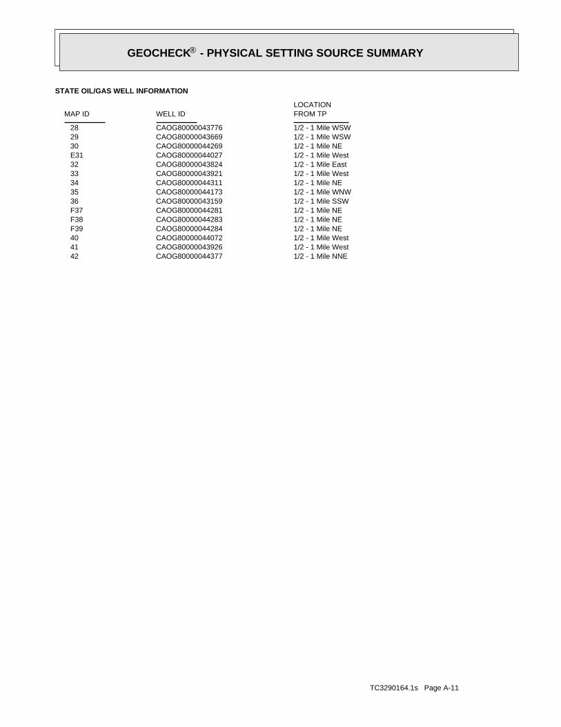
TC3290164.1s Page A-11
1/2 - 1 Mile NNECAOG80000044377 421/2 - 1 Mile WestCAOG80000043926 411/2 - 1 Mile WestCAOG80000044072 401/2 - 1 Mile NECAOG80000044284 F391/2 - 1 Mile NECAOG80000044283 F381/2 - 1 Mile NECAOG80000044281 F371/2 - 1 Mile SSWCAOG80000043159 361/2 - 1 Mile WNWCAOG80000044173 351/2 - 1 Mile NECAOG80000044311 341/2 - 1 Mile WestCAOG80000043921 331/2 - 1 Mile EastCAOG80000043824 321/2 - 1 Mile WestCAOG80000044027 E311/2 - 1 Mile NECAOG80000044269 301/2 - 1 Mile WSWCAOG80000043669 291/2 - 1 Mile WSWCAOG80000043776 28
STATE OIL/GAS WELL INFORMATION
LOCATIONFROM TPWELL IDMAP ID
®GEOCHECK - PHYSICAL SETTING SOURCE SUMMARY®
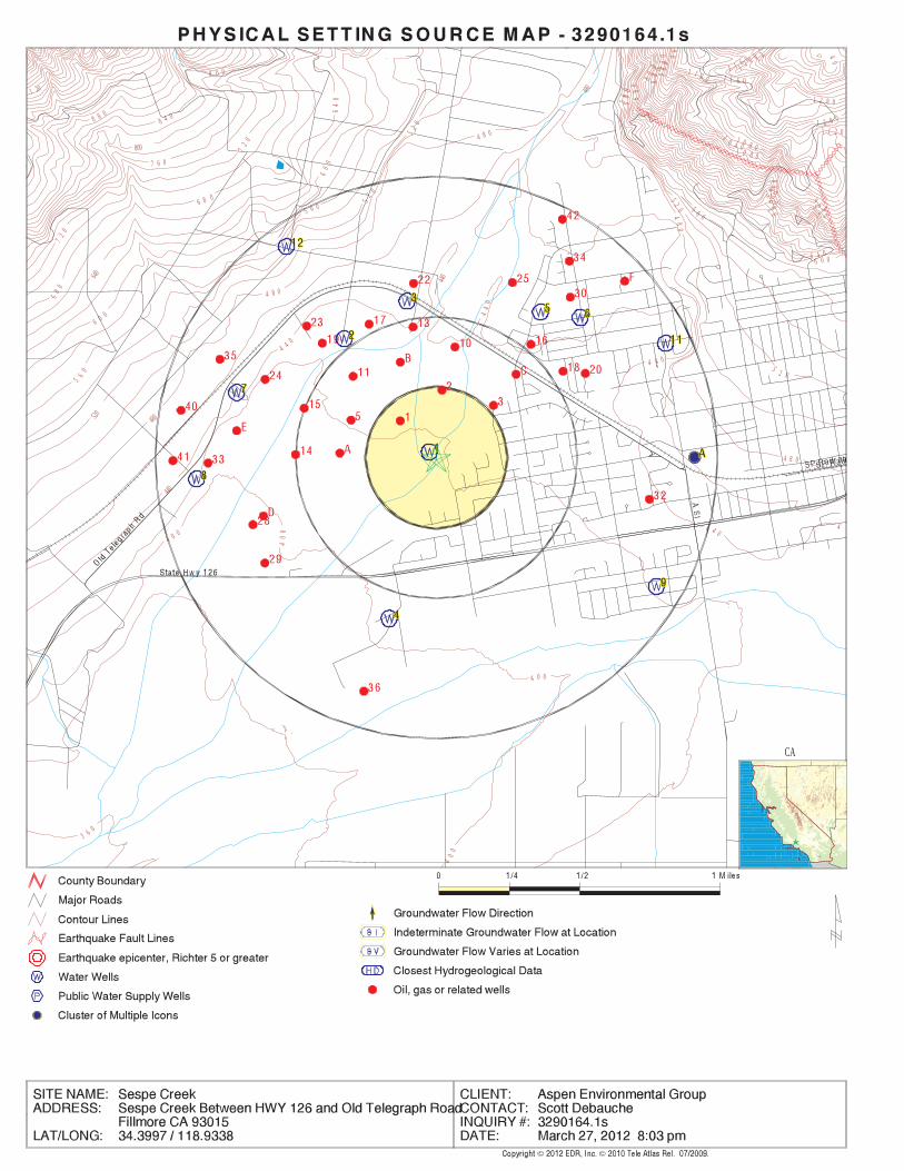
EDR Inc.EDR Inc.EDR Inc.EDR Inc.EDR Inc.EDR Inc.EDR Inc.EDR Inc.EDR Inc.EDR Inc.EDR Inc.EDR Inc.EDR Inc.EDR Inc.EDR Inc.EDR Inc.EDR Inc.EDR Inc.EDR Inc.EDR Inc.EDR Inc.EDR Inc.EDR Inc.EDR Inc.EDR Inc.EDR Inc.EDR Inc.EDR Inc.EDR Inc.EDR Inc.EDR Inc.EDR Inc.EDR Inc.EDR Inc.EDR Inc.EDR Inc.EDR Inc.EDR Inc.EDR Inc.EDR Inc.
40
1 2 8 0
1 2
1 2 0 0
1 2 0 0
1 1 6 0
1 1 6 01 20
1 1 2 0
1 1 2 0
80
1 0 8 0
1
0 4 01 0 0 0
96
0
9 6 09
2 0
92
08
80
8 8 0
84
08 4 0
80
0
80
0
8 0 0
8007
60
7 6 0
72
0
72
0
72
0
68
0
6 8 0
68
0
6 4 0
64
0
640
6 0 0
60
0
60
06 0 0
5 6 0
56
0
5 6 0
56
0 52 0
52
0
52
0
5
2 0
520
3 6 0
40
0
4 0 0
40
0
4 0 0
440
4 4 0
440
44
0
4 4 0
4 4 04
480
4 8 0
4 8 0
480
48
0
4 8 0
CA
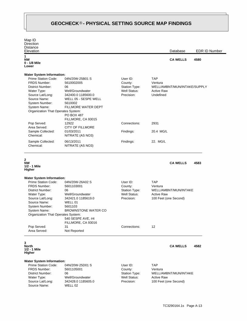
TC3290164.1s Page A-13
WELL 02Source Name:100 Feet (one Second)Precision:342428.0 1185605.0Source Lat/Long:Active RawWell Status:Well/GroundwaterWater Type:WELL/AMBNT/MUN/INTAKEStation Type:06District Number:VenturaCounty:5601105001FRDS Number:TAPUser ID:04N/20W-25D01 SPrime Station Code:
Water System Information:
3North1/2 - 1 MileHigher
4582CA WELLS
Not ReportedArea Served:12Connections:31Pop Served:
FILLMORE, CA 93016540 SESPE AVE, #4
Organization That Operates System:BROWNSTONE WATER COSystem Name:5601103System Number:WELL 01Source Name:
100 Feet (one Second)Precision:342421.0 1185619.0Source Lat/Long:Active RawWell Status:Well/GroundwaterWater Type:WELL/AMBNT/MUN/INTAKEStation Type:06District Number:VenturaCounty:5601103001FRDS Number:TAPUser ID:04N/20W-26A02 SPrime Station Code:
Water System Information:
2NW1/2 - 1 MileHigher
4583CA WELLS
NITRATE (AS NO3)Chemical:22. MG/LFindings:06/13/2011Sample Collected:
NITRATE (AS NO3)Chemical:20.4 MG/LFindings:01/03/2011Sample Collected:
CITY OF FILLMOREArea Served:2931Connections:12922Pop Served:
FILLMORE, CA 93015PO BOX 487
Organization That Operates System:FILLMORE WATER DEPTSystem Name:5610002System Number:WELL 05 - SESPE WELLSource Name:
UndefinedPrecision:342400.0 1185600.0Source Lat/Long:Active RawWell Status:Well/GroundwaterWater Type:WELL/AMBNT/MUN/INTAKE/SUPPLYStation Type:06District Number:VenturaCounty:5610002005FRDS Number:TAPUser ID:04N/20W-25B01 SPrime Station Code:
Water System Information:
1NW0 - 1/8 MileLower
4580CA WELLS
Map IDDirectionDistanceElevation EDR ID NumberDatabase
®GEOCHECK - PHYSICAL SETTING SOURCE MAP FINDINGS®
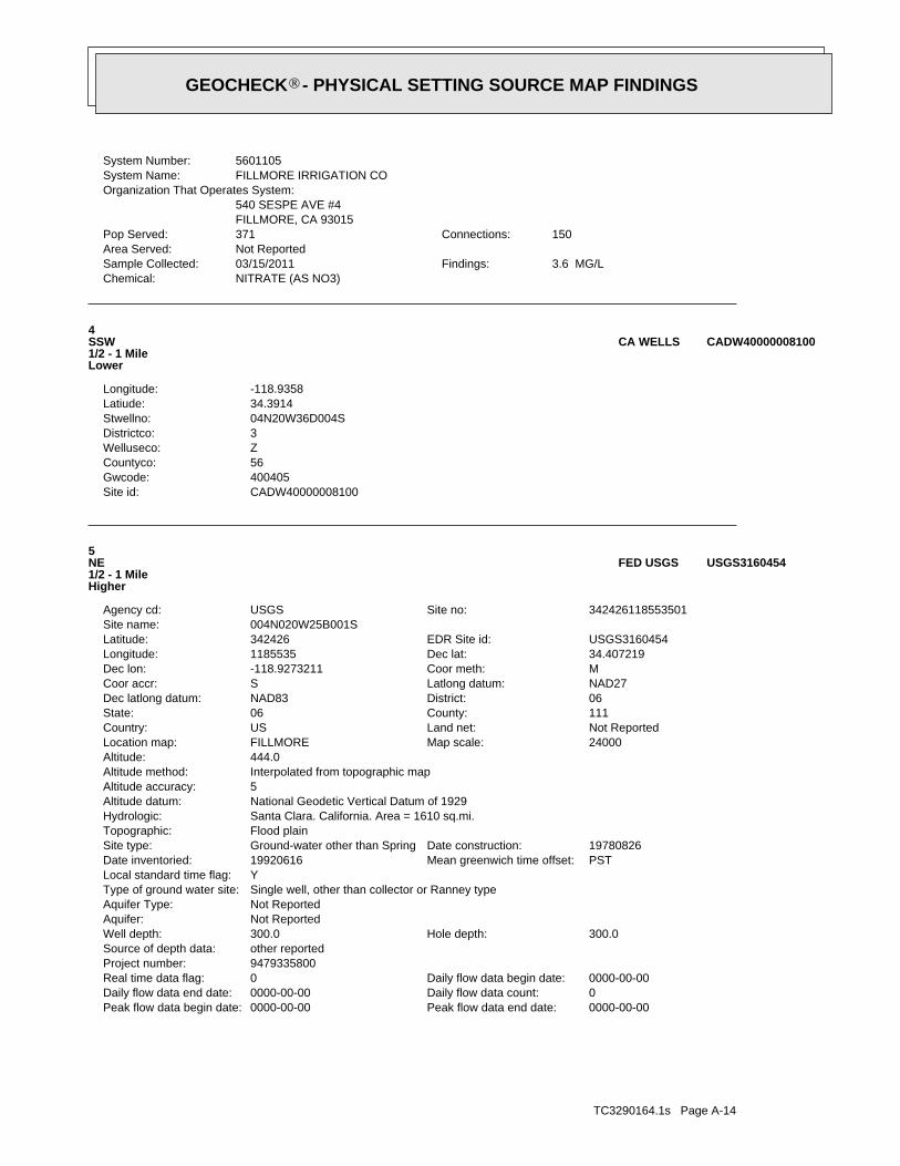
TC3290164.1s Page A-14
0000-00-00Peak flow data end date:0000-00-00Peak flow data begin date:0Daily flow data count:0000-00-00Daily flow data end date:0000-00-00Daily flow data begin date:0Real time data flag:
9479335800Project number:other reportedSource of depth data:
300.0Hole depth:300.0Well depth:Not ReportedAquifer:Not ReportedAquifer Type:Single well, other than collector or Ranney typeType of ground water site:YLocal standard time flag:
PSTMean greenwich time offset:19920616Date inventoried:19780826Date construction:Ground-water other than SpringSite type:
Flood plainTopographic:Santa Clara. California. Area = 1610 sq.mi.Hydrologic:National Geodetic Vertical Datum of 1929Altitude datum:5Altitude accuracy:Interpolated from topographic mapAltitude method:444.0Altitude:
24000Map scale:FILLMORELocation map:Not ReportedLand net:USCountry:111County:06State:06District:NAD83Dec latlong datum:NAD27Latlong datum:SCoor accr:MCoor meth:-118.9273211Dec lon:34.407219Dec lat:1185535Longitude:USGS3160454EDR Site id:342426Latitude:
004N020W25B001SSite name:342426118553501Site no:USGSAgency cd:
5NE1/2 - 1 MileHigher
USGS3160454FED USGS
CADW40000008100Site id:400405Gwcode:56Countyco:ZWelluseco:3Districtco:04N20W36D004SStwellno:34.3914Latiude:-118.9358Longitude:
4SSW1/2 - 1 MileLower
CADW40000008100CA WELLS
NITRATE (AS NO3)Chemical:3.6 MG/LFindings:03/15/2011Sample Collected:
Not ReportedArea Served:150Connections:371Pop Served:
FILLMORE, CA 93015540 SESPE AVE #4
Organization That Operates System:FILLMORE IRRIGATION COSystem Name:5601105System Number:
®GEOCHECK - PHYSICAL SETTING SOURCE MAP FINDINGS®
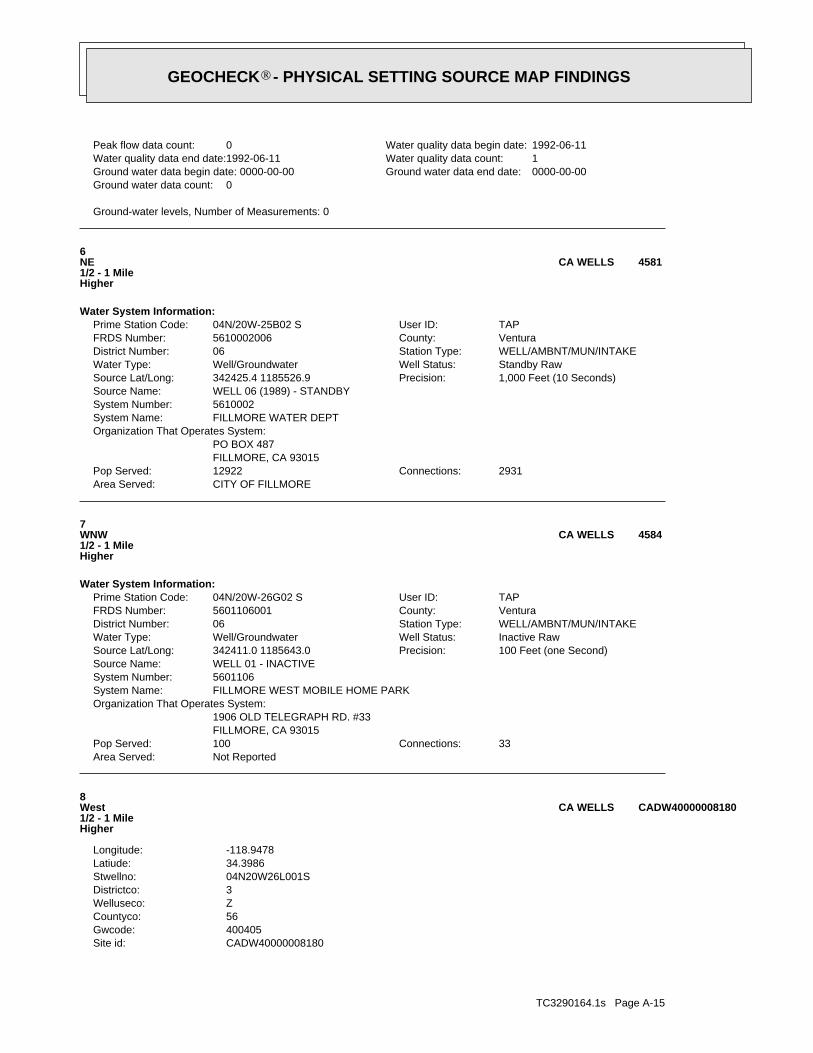
TC3290164.1s Page A-15
CADW40000008180Site id:400405Gwcode:56Countyco:ZWelluseco:3Districtco:04N20W26L001SStwellno:34.3986Latiude:-118.9478Longitude:
8West1/2 - 1 MileHigher
CADW40000008180CA WELLS
Not ReportedArea Served:33Connections:100Pop Served:
FILLMORE, CA 930151906 OLD TELEGRAPH RD. #33
Organization That Operates System:FILLMORE WEST MOBILE HOME PARKSystem Name:5601106System Number:WELL 01 - INACTIVESource Name:
100 Feet (one Second)Precision:342411.0 1185643.0Source Lat/Long:Inactive RawWell Status:Well/GroundwaterWater Type:WELL/AMBNT/MUN/INTAKEStation Type:06District Number:VenturaCounty:5601106001FRDS Number:TAPUser ID:04N/20W-26G02 SPrime Station Code:
Water System Information:
7WNW1/2 - 1 MileHigher
4584CA WELLS
CITY OF FILLMOREArea Served:2931Connections:12922Pop Served:
FILLMORE, CA 93015PO BOX 487
Organization That Operates System:FILLMORE WATER DEPTSystem Name:5610002System Number:WELL 06 (1989) - STANDBYSource Name:
1,000 Feet (10 Seconds)Precision:342425.4 1185526.9Source Lat/Long:Standby RawWell Status:Well/GroundwaterWater Type:WELL/AMBNT/MUN/INTAKEStation Type:06District Number:VenturaCounty:5610002006FRDS Number:TAPUser ID:04N/20W-25B02 SPrime Station Code:
Water System Information:
6NE1/2 - 1 MileHigher
4581CA WELLS
Ground-water levels, Number of Measurements: 0
0Ground water data count:0000-00-00Ground water data end date:Ground water data begin date: 0000-00-001Water quality data count:1992-06-11Water quality data end date:1992-06-11Water quality data begin date:0Peak flow data count:
®GEOCHECK - PHYSICAL SETTING SOURCE MAP FINDINGS®
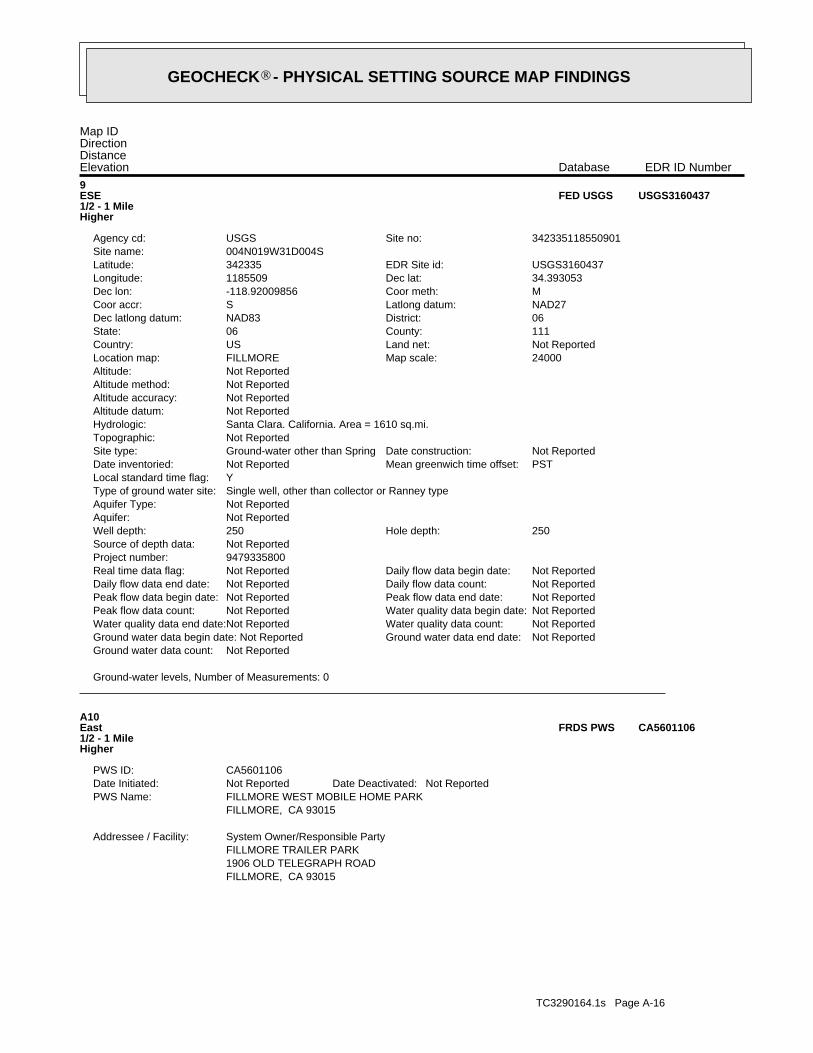
TC3290164.1s Page A-16
FILLMORE, CA 930151906 OLD TELEGRAPH ROADFILLMORE TRAILER PARKSystem Owner/Responsible PartyAddressee / Facility:
FILLMORE, CA 93015FILLMORE WEST MOBILE HOME PARKPWS Name:
Not ReportedDate Deactivated:Not ReportedDate Initiated:CA5601106PWS ID:
A10East1/2 - 1 MileHigher
CA5601106FRDS PWS
Ground-water levels, Number of Measurements: 0
Not ReportedGround water data count:Not ReportedGround water data end date:Ground water data begin date: Not ReportedNot ReportedWater quality data count:Not ReportedWater quality data end date:Not ReportedWater quality data begin date:Not ReportedPeak flow data count:Not ReportedPeak flow data end date:Not ReportedPeak flow data begin date:Not ReportedDaily flow data count:Not ReportedDaily flow data end date:Not ReportedDaily flow data begin date:Not ReportedReal time data flag:
9479335800Project number:Not ReportedSource of depth data:
250Hole depth:250Well depth:Not ReportedAquifer:Not ReportedAquifer Type:Single well, other than collector or Ranney typeType of ground water site:YLocal standard time flag:
PSTMean greenwich time offset:Not ReportedDate inventoried:Not ReportedDate construction:Ground-water other than SpringSite type:
Not ReportedTopographic:Santa Clara. California. Area = 1610 sq.mi.Hydrologic:Not ReportedAltitude datum:Not ReportedAltitude accuracy:Not ReportedAltitude method:Not ReportedAltitude:
24000Map scale:FILLMORELocation map:Not ReportedLand net:USCountry:111County:06State:06District:NAD83Dec latlong datum:NAD27Latlong datum:SCoor accr:MCoor meth:-118.92009856Dec lon:34.393053Dec lat:1185509Longitude:USGS3160437EDR Site id:342335Latitude:
004N019W31D004SSite name:342335118550901Site no:USGSAgency cd:
9ESE1/2 - 1 MileHigher
USGS3160437FED USGS
Map IDDirectionDistanceElevation EDR ID NumberDatabase
®GEOCHECK - PHYSICAL SETTING SOURCE MAP FINDINGS®
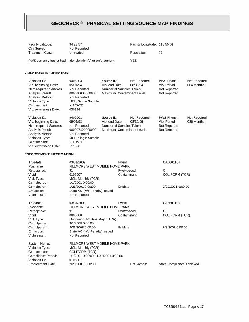
TC3290164.1s Page A-17
State Compliance AchievedEnf. Action:2/20/2001 0:00:00Enforcement Date:0106007Violation ID:1/1/2001 0:00:00 - 1/31/2001 0:00:00Compliance Period:COLIFORM (TCR)Contaminant:MCL, Monthly (TCR)Violation Type:FILLMORE WEST MOBILE HOME PARKSystem Name:
Not ReportedViolmeasur:State AO (w/o Penalty) IssuedEnf action:
6/3/2008 0:00:00Enfdate:3/31/2008 0:00:00Complperen:3/1/2008 0:00:00Complperbe:Monitoring, Routine Major (TCR)Viol. Type:
COLIFORM (TCR)Contaminant:0806008Vioid:CPwstypecod:91Retpopsrvd:
FILLMORE WEST MOBILE HOME PARKPwsname:CA5601106Pwsid:03/31/2009Truedate:
Not ReportedViolmeasur:State AO (w/o Penalty) IssuedEnf action:
2/20/2001 0:00:00Enfdate:1/31/2001 0:00:00Complperen:1/1/2001 0:00:00Complperbe:MCL, Monthly (TCR)Viol. Type:
COLIFORM (TCR)Contaminant:0106007Vioid:CPwstypecod:91Retpopsrvd:
FILLMORE WEST MOBILE HOME PARKPwsname:CA5601106Pwsid:03/31/2009Truedate:
ENFORCEMENT INFORMATION:
111593Vio. Awareness Date:NITRATEContaminant:MCL, Single SampleViolation Type:Not ReportedAnalysis Method:
Not ReportedMaximum Contaminant Level:000007420000000Analysis Result:Not ReportedNumber of Samples Taken:Not ReportedNum required Samples:
036 MonthsVio. Period:08/31/96Vio. end Date:09/01/93Vio. beginning Date:Not ReportedPWS Phone:Not ReportedSource ID:9406001Violation ID:
050194Vio. Awareness Date:NITRATEContaminant:MCL, Single SampleViolation Type:Not ReportedAnalysis Method:
Not ReportedMaximum Contaminant Level:000070000000000Analysis Result:Not ReportedNumber of Samples Taken:Not ReportedNum required Samples:
004 MonthsVio. Period:08/31/94Vio. end Date:05/01/94Vio. beginning Date:Not ReportedPWS Phone:Not ReportedSource ID:9406003Violation ID:
VIOLATIONS INFORMATION:
YESPWS currently has or had major violation(s) or enforcement:
72Population:UntreatedTreatment Class:Not ReportedCity Served:
118 55 01Facility Longitude:34 23 57Facility Latitude:
®GEOCHECK - PHYSICAL SETTING SOURCE MAP FINDINGS®
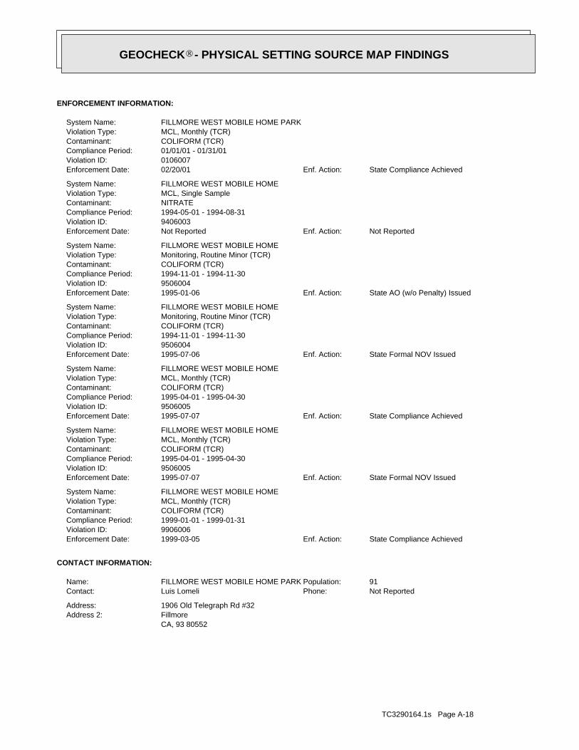
TC3290164.1s Page A-18
CA, 93 80552FillmoreAddress 2:1906 Old Telegraph Rd #32Address:
Not ReportedPhone:Luis LomeliContact:91Population:FILLMORE WEST MOBILE HOME PARKName:
CONTACT INFORMATION:
State Compliance AchievedEnf. Action:1999-03-05Enforcement Date:9906006Violation ID:1999-01-01 - 1999-01-31Compliance Period:COLIFORM (TCR)Contaminant:MCL, Monthly (TCR)Violation Type:FILLMORE WEST MOBILE HOMESystem Name:
State Formal NOV IssuedEnf. Action:1995-07-07Enforcement Date:9506005Violation ID:1995-04-01 - 1995-04-30Compliance Period:COLIFORM (TCR)Contaminant:MCL, Monthly (TCR)Violation Type:FILLMORE WEST MOBILE HOMESystem Name:
State Compliance AchievedEnf. Action:1995-07-07Enforcement Date:9506005Violation ID:1995-04-01 - 1995-04-30Compliance Period:COLIFORM (TCR)Contaminant:MCL, Monthly (TCR)Violation Type:FILLMORE WEST MOBILE HOMESystem Name:
State Formal NOV IssuedEnf. Action:1995-07-06Enforcement Date:9506004Violation ID:1994-11-01 - 1994-11-30Compliance Period:COLIFORM (TCR)Contaminant:Monitoring, Routine Minor (TCR)Violation Type:FILLMORE WEST MOBILE HOMESystem Name:
State AO (w/o Penalty) IssuedEnf. Action:1995-01-06Enforcement Date:9506004Violation ID:1994-11-01 - 1994-11-30Compliance Period:COLIFORM (TCR)Contaminant:Monitoring, Routine Minor (TCR)Violation Type:FILLMORE WEST MOBILE HOMESystem Name:
Not ReportedEnf. Action:Not ReportedEnforcement Date:9406003Violation ID:1994-05-01 - 1994-08-31Compliance Period:NITRATEContaminant:MCL, Single SampleViolation Type:FILLMORE WEST MOBILE HOMESystem Name:
State Compliance AchievedEnf. Action:02/20/01Enforcement Date:0106007Violation ID:01/01/01 - 01/31/01Compliance Period:COLIFORM (TCR)Contaminant:MCL, Monthly (TCR)Violation Type:FILLMORE WEST MOBILE HOME PARKSystem Name:
ENFORCEMENT INFORMATION:
®GEOCHECK - PHYSICAL SETTING SOURCE MAP FINDINGS®
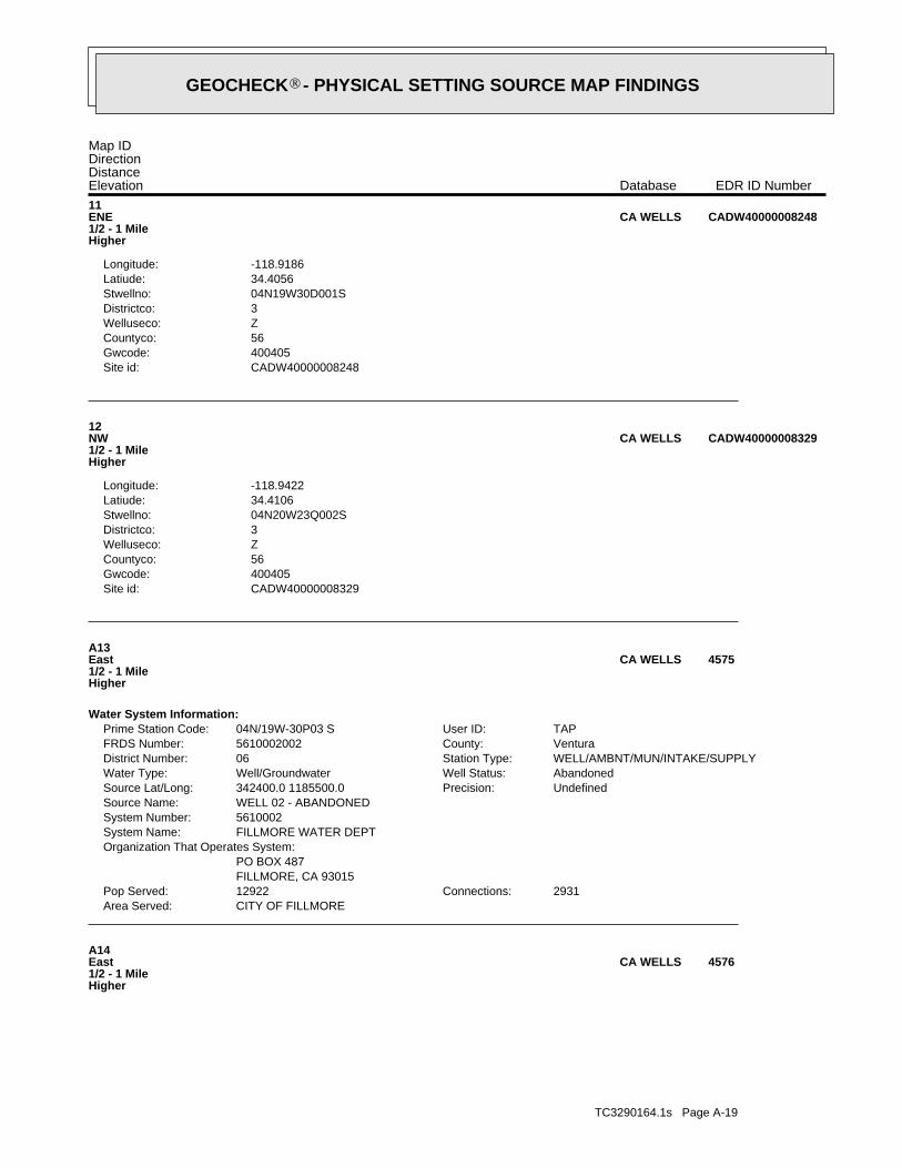
TC3290164.1s Page A-19
A14East1/2 - 1 MileHigher
4576CA WELLS
CITY OF FILLMOREArea Served:2931Connections:12922Pop Served:
FILLMORE, CA 93015PO BOX 487
Organization That Operates System:FILLMORE WATER DEPTSystem Name:5610002System Number:WELL 02 - ABANDONEDSource Name:
UndefinedPrecision:342400.0 1185500.0Source Lat/Long:AbandonedWell Status:Well/GroundwaterWater Type:WELL/AMBNT/MUN/INTAKE/SUPPLYStation Type:06District Number:VenturaCounty:5610002002FRDS Number:TAPUser ID:04N/19W-30P03 SPrime Station Code:
Water System Information:
A13East1/2 - 1 MileHigher
4575CA WELLS
CADW40000008329Site id:400405Gwcode:56Countyco:ZWelluseco:3Districtco:04N20W23Q002SStwellno:34.4106Latiude:-118.9422Longitude:
12NW1/2 - 1 MileHigher
CADW40000008329CA WELLS
CADW40000008248Site id:400405Gwcode:56Countyco:ZWelluseco:3Districtco:04N19W30D001SStwellno:34.4056Latiude:-118.9186Longitude:
11ENE1/2 - 1 MileHigher
CADW40000008248CA WELLS
Map IDDirectionDistanceElevation EDR ID NumberDatabase
®GEOCHECK - PHYSICAL SETTING SOURCE MAP FINDINGS®
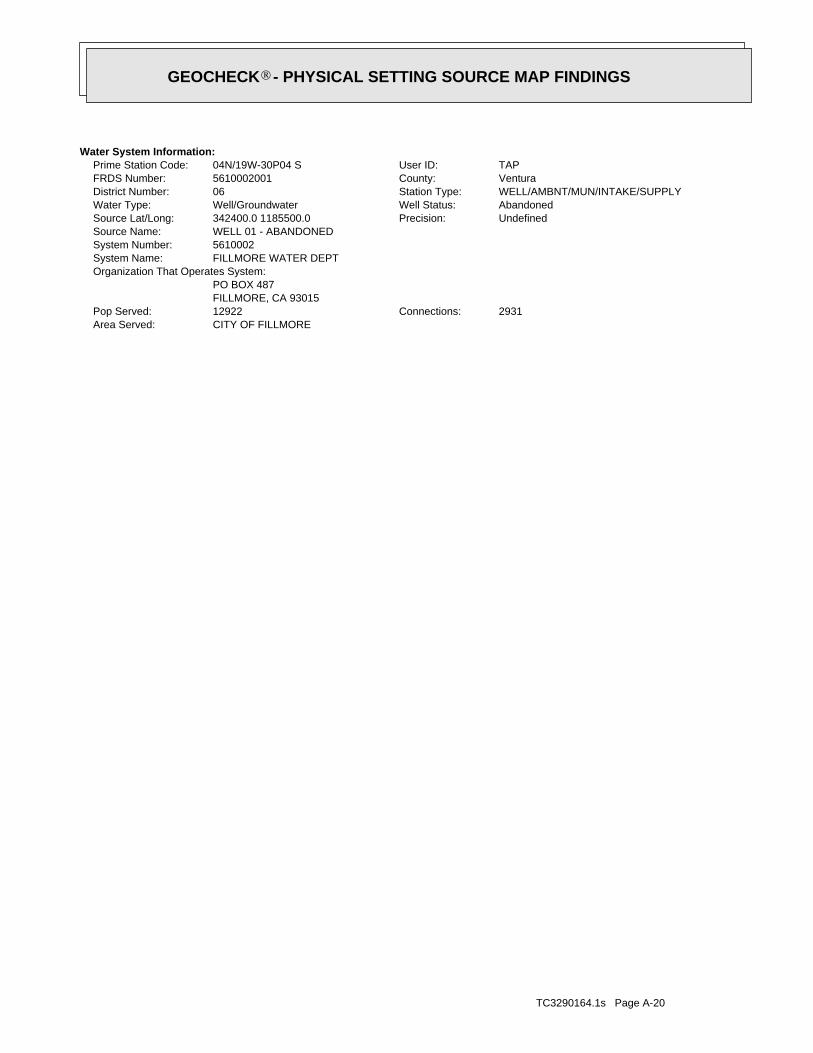
TC3290164.1s Page A-20
CITY OF FILLMOREArea Served:2931Connections:12922Pop Served:
FILLMORE, CA 93015PO BOX 487
Organization That Operates System:FILLMORE WATER DEPTSystem Name:5610002System Number:WELL 01 - ABANDONEDSource Name:
UndefinedPrecision:342400.0 1185500.0Source Lat/Long:AbandonedWell Status:Well/GroundwaterWater Type:WELL/AMBNT/MUN/INTAKE/SUPPLYStation Type:06District Number:VenturaCounty:5610002001FRDS Number:TAPUser ID:04N/19W-30P04 SPrime Station Code:
Water System Information:
®GEOCHECK - PHYSICAL SETTING SOURCE MAP FINDINGS®
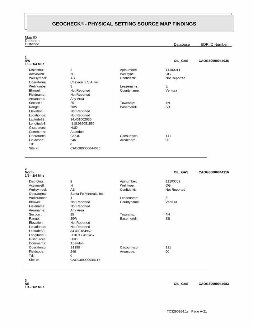
TC3290164.1s Page A-21
3NE1/4 - 1/2 Mile
CAOG80000044083OIL_GAS
CAOG80000044116Site id:0Td:
00Areacode:246Fieldcode:111Cacountyco:S1150Operatorco:
AbandonComments:HUDGissourcec:-118.933451457Longitude8:34.403184962Latitude83:Not ReportedLocationde:Not ReportedElevation:
SBBasemeridi:20WRange:4NTownship:25Section :
Any AreaAreaname:Not ReportedFieldname:
VenturaCountyname:Not ReportedBlmwell:ELeasename:1Wellnumber:
Santa Fe Minerals, Inc.Operatorna:Not ReportedConfidenti:ABWellsymbol:OGWell type:NActivewell:11100009Apinumber:2Districtnu:
2North1/8 - 1/4 Mile
CAOG80000044116OIL_GAS
CAOG80000044036Site id:0Td:
00Areacode:246Fieldcode:111Cacountyco:C5640Operatorco:
AbandonComments:HUDGissourcec:-118.936051559Longitude8:34.401602035Latitude83:Not ReportedLocationde:Not ReportedElevation:
SBBasemeridi:20WRange:4NTownship:25Section :
Any AreaAreaname:Not ReportedFieldname:
VenturaCountyname:Not ReportedBlmwell:ELeasename:3Wellnumber:
Chevron U.S.A. Inc.Operatorna:Not ReportedConfidenti:ABWellsymbol:OGWell type:NActivewell:11100011Apinumber:2Districtnu:
1NW1/8 - 1/4 Mile
CAOG80000044036OIL_GAS
Map IDDirectionDistance EDR ID NumberDatabase
®GEOCHECK - PHYSICAL SETTING SOURCE MAP FINDINGS®

TC3290164.1s Page A-22
5WNW1/4 - 1/2 Mile
CAOG80000044039OIL_GAS
CAOG80000043953Site id:0Td:
00Areacode:246Fieldcode:111Cacountyco:S1150Operatorco:
AbandonComments:HUDGissourcec:-118.939152682Longitude8:34.400029107Latitude83:Not ReportedLocationde:Not ReportedElevation:
SBBasemeridi:20WRange:4NTownship:26Section :
Any AreaAreaname:Not ReportedFieldname:
VenturaCountyname:Not ReportedBlmwell:PRLeasename:2Wellnumber:
Santa Fe Minerals, Inc.Operatorna:Not ReportedConfidenti:ABWellsymbol:OGWell type:NActivewell:11100033Apinumber:2Districtnu:
A4West1/4 - 1/2 Mile
CAOG80000043953OIL_GAS
CAOG80000044083Site id:0Td:
00Areacode:246Fieldcode:111Cacountyco:A4500Operatorco:
AbandonComments:HUDGissourcec:-118.93024169Longitude8:34.4023983Latitude83:Not ReportedLocationde:Not ReportedElevation:
SBBasemeridi:20WRange:4NTownship:25Section :
Any AreaAreaname:Not ReportedFieldname:
VenturaCountyname:Not ReportedBlmwell:McNab EstateLeasename:2Wellnumber:
Arco Oil and Gas Co.Operatorna:Not ReportedConfidenti:ABWellsymbol:OGWell type:NActivewell:11100657Apinumber:2Districtnu:
®GEOCHECK - PHYSICAL SETTING SOURCE MAP FINDINGS®
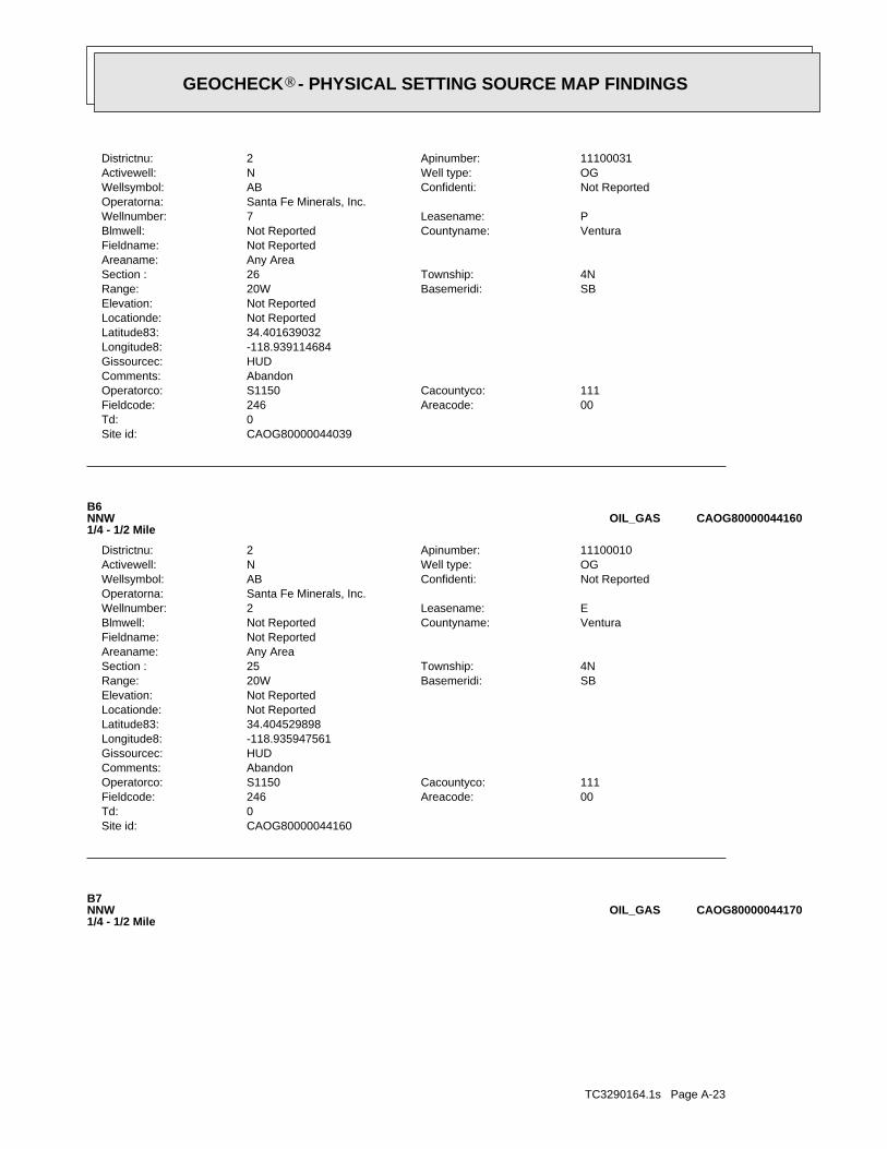
TC3290164.1s Page A-23
B7NNW1/4 - 1/2 Mile
CAOG80000044170OIL_GAS
CAOG80000044160Site id:0Td:
00Areacode:246Fieldcode:111Cacountyco:S1150Operatorco:
AbandonComments:HUDGissourcec:-118.935947561Longitude8:34.404529898Latitude83:Not ReportedLocationde:Not ReportedElevation:
SBBasemeridi:20WRange:4NTownship:25Section :
Any AreaAreaname:Not ReportedFieldname:
VenturaCountyname:Not ReportedBlmwell:ELeasename:2Wellnumber:
Santa Fe Minerals, Inc.Operatorna:Not ReportedConfidenti:ABWellsymbol:OGWell type:NActivewell:11100010Apinumber:2Districtnu:
B6NNW1/4 - 1/2 Mile
CAOG80000044160OIL_GAS
CAOG80000044039Site id:0Td:
00Areacode:246Fieldcode:111Cacountyco:S1150Operatorco:
AbandonComments:HUDGissourcec:-118.939114684Longitude8:34.401639032Latitude83:Not ReportedLocationde:Not ReportedElevation:
SBBasemeridi:20WRange:4NTownship:26Section :
Any AreaAreaname:Not ReportedFieldname:
VenturaCountyname:Not ReportedBlmwell:PLeasename:7Wellnumber:
Santa Fe Minerals, Inc.Operatorna:Not ReportedConfidenti:ABWellsymbol:OGWell type:NActivewell:11100031Apinumber:2Districtnu:
®GEOCHECK - PHYSICAL SETTING SOURCE MAP FINDINGS®

TC3290164.1s Page A-24
C9NE1/4 - 1/2 Mile
CAOG80000044146OIL_GAS
CAOG80000043946Site id:0Td:
00Areacode:246Fieldcode:111Cacountyco:C5640Operatorco:
AbandonComments:HUDGissourcec:-118.940463735Longitude8:34.399841115Latitude83:Not ReportedLocationde:Not ReportedElevation:
SBBasemeridi:20WRange:4NTownship:26Section :
Any AreaAreaname:Not ReportedFieldname:
VenturaCountyname:Not ReportedBlmwell:PRLeasename:1Wellnumber:
Chevron U.S.A. Inc.Operatorna:Not ReportedConfidenti:ABWellsymbol:OGWell type:NActivewell:11100032Apinumber:2Districtnu:
A8West1/4 - 1/2 Mile
CAOG80000043946OIL_GAS
CAOG80000044170Site id:0Td:
00Areacode:000Fieldcode:111Cacountyco:00079Operatorco:
AbandonComments:HUDGissourcec:-118.936140569Longitude8:34.404726888Latitude83:Not ReportedLocationde:Not ReportedElevation:
SBBasemeridi:20WRange:1NTownship:18Section :
Any AreaAreaname:Not ReportedFieldname:
VenturaCountyname:Not ReportedBlmwell:Well No.Leasename:2Wellnumber:
A. J. RossOperatorna:Not ReportedConfidenti:DHWellsymbol:OGWell type:NActivewell:11105582Apinumber:2Districtnu:
®GEOCHECK - PHYSICAL SETTING SOURCE MAP FINDINGS®
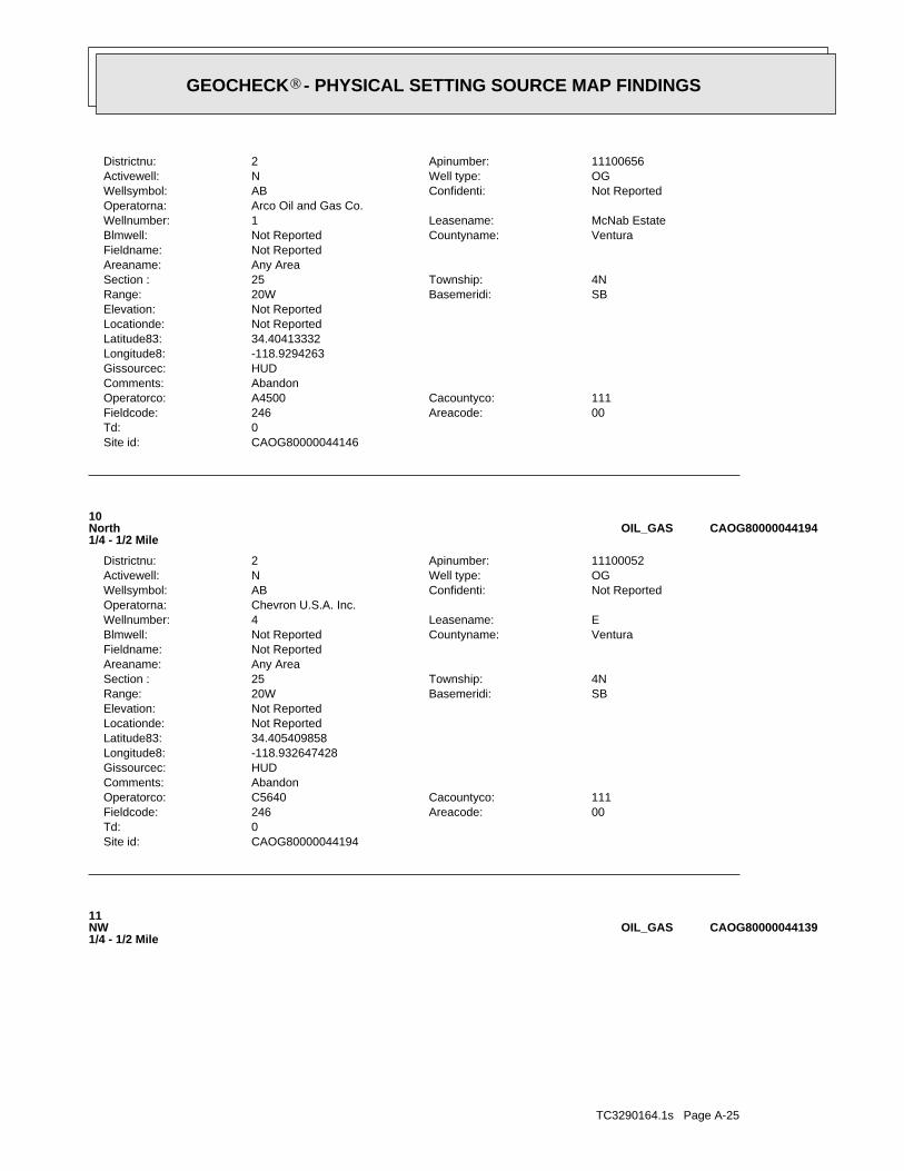
TC3290164.1s Page A-25
11NW1/4 - 1/2 Mile
CAOG80000044139OIL_GAS
CAOG80000044194Site id:0Td:
00Areacode:246Fieldcode:111Cacountyco:C5640Operatorco:
AbandonComments:HUDGissourcec:-118.932647428Longitude8:34.405409858Latitude83:Not ReportedLocationde:Not ReportedElevation:
SBBasemeridi:20WRange:4NTownship:25Section :
Any AreaAreaname:Not ReportedFieldname:
VenturaCountyname:Not ReportedBlmwell:ELeasename:4Wellnumber:
Chevron U.S.A. Inc.Operatorna:Not ReportedConfidenti:ABWellsymbol:OGWell type:NActivewell:11100052Apinumber:2Districtnu:
10North1/4 - 1/2 Mile
CAOG80000044194OIL_GAS
CAOG80000044146Site id:0Td:
00Areacode:246Fieldcode:111Cacountyco:A4500Operatorco:
AbandonComments:HUDGissourcec:-118.9294263Longitude8:34.40413332Latitude83:Not ReportedLocationde:Not ReportedElevation:
SBBasemeridi:20WRange:4NTownship:25Section :
Any AreaAreaname:Not ReportedFieldname:
VenturaCountyname:Not ReportedBlmwell:McNab EstateLeasename:1Wellnumber:
Arco Oil and Gas Co.Operatorna:Not ReportedConfidenti:ABWellsymbol:OGWell type:NActivewell:11100656Apinumber:2Districtnu:
®GEOCHECK - PHYSICAL SETTING SOURCE MAP FINDINGS®
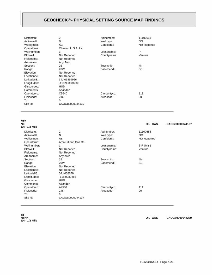
TC3290164.1s Page A-26
13North1/4 - 1/2 Mile
CAOG80000044229OIL_GAS
CAOG80000044137Site id:0Td:
00Areacode:246Fieldcode:111Cacountyco:A4500Operatorco:
AbandonComments:HUDGissourcec:-118.9282456Longitude8:34.4038676Latitude83:Not ReportedLocationde:Not ReportedElevation:
SBBasemeridi:20WRange:4NTownship:25Section :
Any AreaAreaname:Not ReportedFieldname:
VenturaCountyname:Not ReportedBlmwell:S P Unit 1Leasename:1Wellnumber:
Arco Oil and Gas Co.Operatorna:Not ReportedConfidenti:ABWellsymbol:OGWell type:NActivewell:11100658Apinumber:2Districtnu:
C12NE1/4 - 1/2 Mile
CAOG80000044137OIL_GAS
CAOG80000044139Site id:0Td:
00Areacode:246Fieldcode:111Cacountyco:C5640Operatorco:
AbandonComments:HUDGissourcec:-118.938986683Longitude8:34.403899926Latitude83:Not ReportedLocationde:Not ReportedElevation:
SBBasemeridi:20WRange:4NTownship:26Section :
Any AreaAreaname:Not ReportedFieldname:
VenturaCountyname:Not ReportedBlmwell:PLeasename:3Wellnumber:
Chevron U.S.A. Inc.Operatorna:Not ReportedConfidenti:ABWellsymbol:OGWell type:NActivewell:11100053Apinumber:2Districtnu:
®GEOCHECK - PHYSICAL SETTING SOURCE MAP FINDINGS®

TC3290164.1s Page A-27
15WNW1/2 - 1 Mile
CAOG80000044078OIL_GAS
CAOG80000043947Site id:0Td:
00Areacode:246Fieldcode:111Cacountyco:C5640Operatorco:
AbandonComments:HUDGissourcec:-118.94257082Longitude8:34.399858114Latitude83:Not ReportedLocationde:Not ReportedElevation:
SBBasemeridi:20WRange:4NTownship:26Section :
Any AreaAreaname:Not ReportedFieldname:
VenturaCountyname:Not ReportedBlmwell:PLeasename:6Wellnumber:
Chevron U.S.A. Inc.Operatorna:Not ReportedConfidenti:ABWellsymbol:OGWell type:NActivewell:11100030Apinumber:2Districtnu:
14West1/2 - 1 Mile
CAOG80000043947OIL_GAS
CAOG80000044229Site id:0Td:
00Areacode:246Fieldcode:111Cacountyco:C5640Operatorco:
AbandonComments:HUDGissourcec:-118.935251536Longitude8:34.406441808Latitude83:Not ReportedLocationde:Not ReportedElevation:
SBBasemeridi:20WRange:4NTownship:25Section :
Any AreaAreaname:Not ReportedFieldname:
VenturaCountyname:Not ReportedBlmwell:F5Leasename:2Wellnumber:
Chevron U.S.A. Inc.Operatorna:Not ReportedConfidenti:ABWellsymbol:OGWell type:NActivewell:11100021Apinumber:2Districtnu:
®GEOCHECK - PHYSICAL SETTING SOURCE MAP FINDINGS®

TC3290164.1s Page A-28
17NNW1/2 - 1 Mile
CAOG80000044235OIL_GAS
CAOG80000044200Site id:0Td:
00Areacode:246Fieldcode:111Cacountyco:C5640Operatorco:
AbandonComments:HUDGissourcec:-118.927916236Longitude8:34.405547854Latitude83:Not ReportedLocationde:Not ReportedElevation:
SBBasemeridi:20WRange:4NTownship:25Section :
Any AreaAreaname:Not ReportedFieldname:
VenturaCountyname:Not ReportedBlmwell:SMLeasename:1Wellnumber:
Chevron U.S.A. Inc.Operatorna:Not ReportedConfidenti:ABWellsymbol:OGWell type:NActivewell:11100055Apinumber:2Districtnu:
16NE1/2 - 1 Mile
CAOG80000044200OIL_GAS
CAOG80000044078Site id:0Td:
00Areacode:246Fieldcode:111Cacountyco:S1150Operatorco:
AbandonComments:HUDGissourcec:-118.942032803Longitude8:34.402251002Latitude83:Not ReportedLocationde:Not ReportedElevation:
SBBasemeridi:20WRange:4NTownship:26Section :
Any AreaAreaname:Not ReportedFieldname:
VenturaCountyname:Not ReportedBlmwell:PLeasename:1Wellnumber:
Santa Fe Minerals, Inc.Operatorna:Not ReportedConfidenti:ABWellsymbol:OGWell type:NActivewell:11100026Apinumber:2Districtnu:
®GEOCHECK - PHYSICAL SETTING SOURCE MAP FINDINGS®
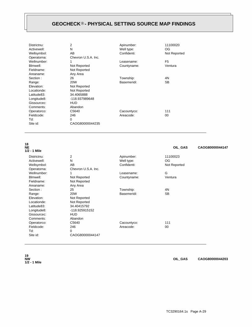
TC3290164.1s Page A-29
19NW1/2 - 1 Mile
CAOG80000044203OIL_GAS
CAOG80000044147Site id:0Td:
00Areacode:246Fieldcode:111Cacountyco:C5640Operatorco:
AbandonComments:HUDGissourcec:-118.925915152Longitude8:34.40415792Latitude83:Not ReportedLocationde:Not ReportedElevation:
SBBasemeridi:20WRange:4NTownship:25Section :
Any AreaAreaname:Not ReportedFieldname:
VenturaCountyname:Not ReportedBlmwell:GLeasename:1Wellnumber:
Chevron U.S.A. Inc.Operatorna:Not ReportedConfidenti:ABWellsymbol:OGWell type:NActivewell:11100023Apinumber:2Districtnu:
18NE1/2 - 1 Mile
CAOG80000044147OIL_GAS
CAOG80000044235Site id:0Td:
00Areacode:246Fieldcode:111Cacountyco:C5640Operatorco:
AbandonComments:HUDGissourcec:-118.937989648Longitude8:34.4065888Latitude83:Not ReportedLocationde:Not ReportedElevation:
SBBasemeridi:20WRange:4NTownship:26Section :
Any AreaAreaname:Not ReportedFieldname:
VenturaCountyname:Not ReportedBlmwell:F5Leasename:1Wellnumber:
Chevron U.S.A. Inc.Operatorna:Not ReportedConfidenti:ABWellsymbol:OGWell type:NActivewell:11100020Apinumber:2Districtnu:
®GEOCHECK - PHYSICAL SETTING SOURCE MAP FINDINGS®

TC3290164.1s Page A-30
D21WSW1/2 - 1 Mile
CAOG80000043801OIL_GAS
CAOG80000044144Site id:0Td:
00Areacode:246Fieldcode:111Cacountyco:C5640Operatorco:
AbandonComments:HUDGissourcec:-118.924526096Longitude8:34.404047926Latitude83:Not ReportedLocationde:Not ReportedElevation:
SBBasemeridi:19WRange:4NTownship:19Section :
Any AreaAreaname:Not ReportedFieldname:
VenturaCountyname:Not ReportedBlmwell:FALeasename:1Wellnumber:
Chevron U.S.A. Inc.Operatorna:Not ReportedConfidenti:ABWellsymbol:OGWell type:NActivewell:11100014Apinumber:2Districtnu:
20ENE1/2 - 1 Mile
CAOG80000044144OIL_GAS
CAOG80000044203Site id:0Td:
00Areacode:246Fieldcode:111Cacountyco:C5640Operatorco:
AbandonComments:HUDGissourcec:-118.940905764Longitude8:34.405606845Latitude83:Not ReportedLocationde:Not ReportedElevation:
SBBasemeridi:20WRange:4NTownship:26Section :
Any AreaAreaname:Not ReportedFieldname:
VenturaCountyname:Not ReportedBlmwell:F2Leasename:1Wellnumber:
Chevron U.S.A. Inc.Operatorna:Not ReportedConfidenti:ABWellsymbol:OGWell type:NActivewell:11100017Apinumber:2Districtnu:
®GEOCHECK - PHYSICAL SETTING SOURCE MAP FINDINGS®
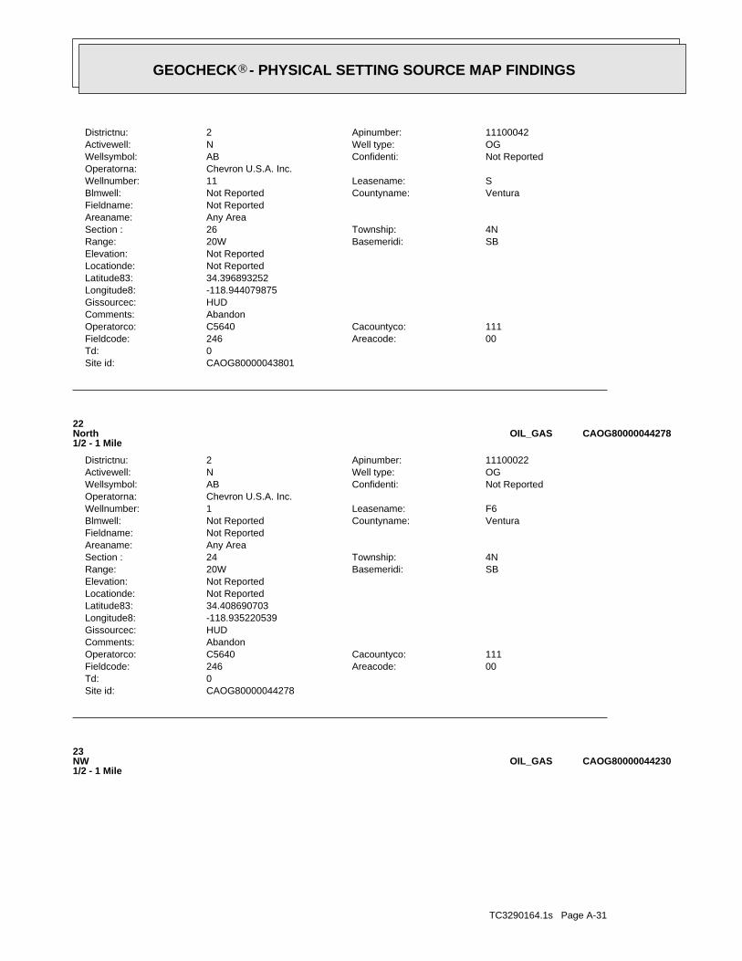
TC3290164.1s Page A-31
23NW1/2 - 1 Mile
CAOG80000044230OIL_GAS
CAOG80000044278Site id:0Td:
00Areacode:246Fieldcode:111Cacountyco:C5640Operatorco:
AbandonComments:HUDGissourcec:-118.935220539Longitude8:34.408690703Latitude83:Not ReportedLocationde:Not ReportedElevation:
SBBasemeridi:20WRange:4NTownship:24Section :
Any AreaAreaname:Not ReportedFieldname:
VenturaCountyname:Not ReportedBlmwell:F6Leasename:1Wellnumber:
Chevron U.S.A. Inc.Operatorna:Not ReportedConfidenti:ABWellsymbol:OGWell type:NActivewell:11100022Apinumber:2Districtnu:
22North1/2 - 1 Mile
CAOG80000044278OIL_GAS
CAOG80000043801Site id:0Td:
00Areacode:246Fieldcode:111Cacountyco:C5640Operatorco:
AbandonComments:HUDGissourcec:-118.944079875Longitude8:34.396893252Latitude83:Not ReportedLocationde:Not ReportedElevation:
SBBasemeridi:20WRange:4NTownship:26Section :
Any AreaAreaname:Not ReportedFieldname:
VenturaCountyname:Not ReportedBlmwell:SLeasename:11Wellnumber:
Chevron U.S.A. Inc.Operatorna:Not ReportedConfidenti:ABWellsymbol:OGWell type:NActivewell:11100042Apinumber:2Districtnu:
®GEOCHECK - PHYSICAL SETTING SOURCE MAP FINDINGS®

TC3290164.1s Page A-32
25NNE1/2 - 1 Mile
CAOG80000044279OIL_GAS
CAOG80000044132Site id:0Td:
00Areacode:246Fieldcode:111Cacountyco:C5640Operatorco:
AbandonComments:HUDGissourcec:-118.944461905Longitude8:34.40374193Latitude83:Not ReportedLocationde:Not ReportedElevation:
SBBasemeridi:20WRange:4NTownship:26Section :
Any AreaAreaname:Not ReportedFieldname:
VenturaCountyname:Not ReportedBlmwell:F1Leasename:1Wellnumber:
Chevron U.S.A. Inc.Operatorna:Not ReportedConfidenti:ABWellsymbol:OGWell type:NActivewell:11100016Apinumber:2Districtnu:
24WNW1/2 - 1 Mile
CAOG80000044132OIL_GAS
CAOG80000044230Site id:0Td:
00Areacode:246Fieldcode:111Cacountyco:C5640Operatorco:
AbandonComments:HUDGissourcec:-118.941867805Longitude8:34.406491802Latitude83:Not ReportedLocationde:Not ReportedElevation:
SBBasemeridi:20WRange:4NTownship:26Section :
Any AreaAreaname:Not ReportedFieldname:
VenturaCountyname:Not ReportedBlmwell:F4Leasename:1Wellnumber:
Chevron U.S.A. Inc.Operatorna:Not ReportedConfidenti:ABWellsymbol:OGWell type:NActivewell:11100019Apinumber:2Districtnu:
®GEOCHECK - PHYSICAL SETTING SOURCE MAP FINDINGS®

TC3290164.1s Page A-33
E27West1/2 - 1 Mile
CAOG80000043996OIL_GAS
CAOG80000043782Site id:0Td:
00Areacode:246Fieldcode:111Cacountyco:C5640Operatorco:
AbandonComments:HUDGissourcec:-118.945049914Longitude8:34.396491271Latitude83:Not ReportedLocationde:Not ReportedElevation:
SBBasemeridi:20WRange:4NTownship:26Section :
Any AreaAreaname:Not ReportedFieldname:
VenturaCountyname:Not ReportedBlmwell:PLeasename:4Wellnumber:
Chevron U.S.A. Inc.Operatorna:Not ReportedConfidenti:ABWellsymbol:OGWell type:NActivewell:11100028Apinumber:2Districtnu:
D26WSW1/2 - 1 Mile
CAOG80000043782OIL_GAS
CAOG80000044279Site id:0Td:
00Areacode:246Fieldcode:111Cacountyco:C5640Operatorco:
AbandonComments:HUDGissourcec:-118.929064289Longitude8:34.408737704Latitude83:Not ReportedLocationde:Not ReportedElevation:
SBBasemeridi:20WRange:4NTownship:24Section :
Any AreaAreaname:Not ReportedFieldname:
VenturaCountyname:Not ReportedBlmwell:SMLeasename:3Wellnumber:
Chevron U.S.A. Inc.Operatorna:Not ReportedConfidenti:ABWellsymbol:OGWell type:NActivewell:11100056Apinumber:2Districtnu:
®GEOCHECK - PHYSICAL SETTING SOURCE MAP FINDINGS®

TC3290164.1s Page A-34
29WSW1/2 - 1 Mile
CAOG80000043669OIL_GAS
CAOG80000043776Site id:0Td:
00Areacode:246Fieldcode:111Cacountyco:C5640Operatorco:
AbandonComments:HUDGissourcec:-118.94522392Longitude8:34.396243282Latitude83:Not ReportedLocationde:Not ReportedElevation:
SBBasemeridi:20WRange:4NTownship:26Section :
Any AreaAreaname:Not ReportedFieldname:
VenturaCountyname:Not ReportedBlmwell:PLeasename:5Wellnumber:
Chevron U.S.A. Inc.Operatorna:Not ReportedConfidenti:ABWellsymbol:OGWell type:NActivewell:11100029Apinumber:2Districtnu:
28WSW1/2 - 1 Mile
CAOG80000043776OIL_GAS
CAOG80000043996Site id:0Td:
00Areacode:246Fieldcode:111Cacountyco:C5640Operatorco:
AbandonComments:HUDGissourcec:-118.94571995Longitude8:34.400812067Latitude83:Not ReportedLocationde:Not ReportedElevation:
SBBasemeridi:20WRange:4NTownship:26Section :
Any AreaAreaname:Not ReportedFieldname:
VenturaCountyname:Not ReportedBlmwell:PLeasename:2Wellnumber:
Chevron U.S.A. Inc.Operatorna:Not ReportedConfidenti:ABWellsymbol:OGWell type:NActivewell:11100027Apinumber:2Districtnu:
®GEOCHECK - PHYSICAL SETTING SOURCE MAP FINDINGS®

TC3290164.1s Page A-35
E31West1/2 - 1 Mile
CAOG80000044027OIL_GAS
CAOG80000044269Site id:0Td:
00Areacode:246Fieldcode:111Cacountyco:A4400Operatorco:
AbandonComments:HUDGissourcec:-118.925461Longitude8:34.407982Latitude83:Not ReportedLocationde:Not ReportedElevation:
SBBasemeridi:20WRange:4NTownship:25Section :
Any AreaAreaname:Not ReportedFieldname:
VenturaCountyname:Not ReportedBlmwell:SMLeasename:2Wellnumber:
Atlantic Oil Co.Operatorna:Not ReportedConfidenti:ABWellsymbol:OGWell type:NActivewell:11100047Apinumber:2Districtnu:
30NE1/2 - 1 Mile
CAOG80000044269OIL_GAS
CAOG80000043669Site id:0Td:
00Areacode:246Fieldcode:111Cacountyco:00149Operatorco:
AbandonComments:HUDGissourcec:-118.944480886Longitude8:34.394263376Latitude83:Not ReportedLocationde:Not ReportedElevation:
SBBasemeridi:20WRange:4NTownship:26Section :
Any AreaAreaname:Not ReportedFieldname:
VenturaCountyname:Not ReportedBlmwell:Well No.Leasename:1Wellnumber:
Acorn Petro. Co.Operatorna:Not ReportedConfidenti:ABWellsymbol:OGWell type:NActivewell:11100661Apinumber:2Districtnu:
®GEOCHECK - PHYSICAL SETTING SOURCE MAP FINDINGS®

TC3290164.1s Page A-36
33West1/2 - 1 Mile
CAOG80000043921OIL_GAS
CAOG80000043824Site id:0Td:
00Areacode:246Fieldcode:111Cacountyco:U0200Operatorco:
AbandonComments:HUDGissourcec:-118.920538923Longitude8:34.397554231Latitude83:Not ReportedLocationde:Not ReportedElevation:
SBBasemeridi:20WRange:4NTownship:25Section :
Any AreaAreaname:Not ReportedFieldname:
VenturaCountyname:Not ReportedBlmwell:U R S Fillmore Unit ALeasename:1Wellnumber:
Union Oil Co. of Calif.Operatorna:Not ReportedConfidenti:ABWellsymbol:OGWell type:NActivewell:11100664Apinumber:2Districtnu:
32East1/2 - 1 Mile
CAOG80000043824OIL_GAS
CAOG80000044027Site id:0Td:
00Areacode:246Fieldcode:111Cacountyco:C5640Operatorco:
AbandonComments:HUDGissourcec:-118.946750993Longitude8:34.401371041Latitude83:Not ReportedLocationde:Not ReportedElevation:
SBBasemeridi:20WRange:4NTownship:26Section :
Any AreaAreaname:Not ReportedFieldname:
VenturaCountyname:Not ReportedBlmwell:SLeasename:9AWellnumber:
Chevron U.S.A. Inc.Operatorna:Not ReportedConfidenti:ABWellsymbol:OGWell type:NActivewell:11100040Apinumber:2Districtnu:
®GEOCHECK - PHYSICAL SETTING SOURCE MAP FINDINGS®
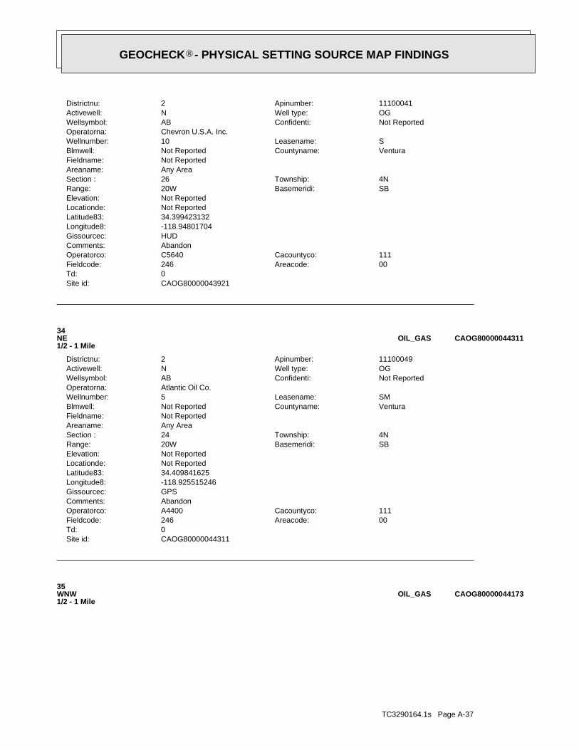
TC3290164.1s Page A-37
35WNW1/2 - 1 Mile
CAOG80000044173OIL_GAS
CAOG80000044311Site id:0Td:
00Areacode:246Fieldcode:111Cacountyco:A4400Operatorco:
AbandonComments:GPSGissourcec:-118.925515246Longitude8:34.409841625Latitude83:Not ReportedLocationde:Not ReportedElevation:
SBBasemeridi:20WRange:4NTownship:24Section :
Any AreaAreaname:Not ReportedFieldname:
VenturaCountyname:Not ReportedBlmwell:SMLeasename:5Wellnumber:
Atlantic Oil Co.Operatorna:Not ReportedConfidenti:ABWellsymbol:OGWell type:NActivewell:11100049Apinumber:2Districtnu:
34NE1/2 - 1 Mile
CAOG80000044311OIL_GAS
CAOG80000043921Site id:0Td:
00Areacode:246Fieldcode:111Cacountyco:C5640Operatorco:
AbandonComments:HUDGissourcec:-118.94801704Longitude8:34.399423132Latitude83:Not ReportedLocationde:Not ReportedElevation:
SBBasemeridi:20WRange:4NTownship:26Section :
Any AreaAreaname:Not ReportedFieldname:
VenturaCountyname:Not ReportedBlmwell:SLeasename:10Wellnumber:
Chevron U.S.A. Inc.Operatorna:Not ReportedConfidenti:ABWellsymbol:OGWell type:NActivewell:11100041Apinumber:2Districtnu:
®GEOCHECK - PHYSICAL SETTING SOURCE MAP FINDINGS®

TC3290164.1s Page A-38
F37NE1/2 - 1 Mile
CAOG80000044281OIL_GAS
CAOG80000043159Site id:0Td:
00Areacode:000Fieldcode:111Cacountyco:04280Operatorco:
AbandonComments:HUDGissourcec:-118.938317623Longitude8:34.387644689Latitude83:Not ReportedLocationde:Not ReportedElevation:
SBBasemeridi:20WRange:4NTownship:35Section :
Any AreaAreaname:Not ReportedFieldname:
VenturaCountyname:Not ReportedBlmwell:Well No.Leasename:1Wellnumber:
Ito Oil Co.Operatorna:Not ReportedConfidenti:DHWellsymbol:OGWell type:NActivewell:11106052Apinumber:2Districtnu:
36SSW1/2 - 1 Mile
CAOG80000043159OIL_GAS
CAOG80000044173Site id:0Td:
00Areacode:246Fieldcode:111Cacountyco:C5640Operatorco:
AbandonComments:HUDGissourcec:-118.947277022Longitude8:34.40477388Latitude83:Not ReportedLocationde:Not ReportedElevation:
SBBasemeridi:20WRange:4NTownship:26Section :
Any AreaAreaname:Not ReportedFieldname:
VenturaCountyname:Not ReportedBlmwell:F3Leasename:1Wellnumber:
Chevron U.S.A. Inc.Operatorna:Not ReportedConfidenti:ABWellsymbol:OGWell type:NActivewell:11100018Apinumber:2Districtnu:
®GEOCHECK - PHYSICAL SETTING SOURCE MAP FINDINGS®
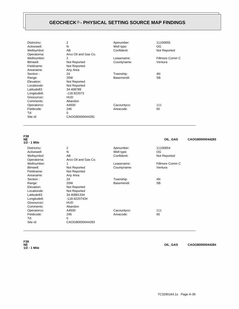
TC3290164.1s Page A-39
F39NE1/2 - 1 Mile
CAOG80000044284OIL_GAS
CAOG80000044283Site id:0Td:
00Areacode:246Fieldcode:111Cacountyco:A4500Operatorco:
AbandonComments:HUDGissourcec:-118.92207434Longitude8:34.40881334Latitude83:Not ReportedLocationde:Not ReportedElevation:
SBBasemeridi:20WRange:4NTownship:24Section :
Any AreaAreaname:Not ReportedFieldname:
VenturaCountyname:Not ReportedBlmwell:Fillmore Comm CLeasename:1Wellnumber:
Arco Oil and Gas Co.Operatorna:Not ReportedConfidenti:ABWellsymbol:OGWell type:NActivewell:11100654Apinumber:2Districtnu:
F38NE1/2 - 1 Mile
CAOG80000044283OIL_GAS
CAOG80000044281Site id:0Td:
00Areacode:246Fieldcode:111Cacountyco:A4500Operatorco:
AbandonComments:HUDGissourcec:-118.922073Longitude8:34.408789Latitude83:Not ReportedLocationde:Not ReportedElevation:
SBBasemeridi:20WRange:4NTownship:24Section :
Any AreaAreaname:Not ReportedFieldname:
VenturaCountyname:Not ReportedBlmwell:Fillmore Comm CLeasename:2Wellnumber:
Arco Oil and Gas Co.Operatorna:Not ReportedConfidenti:ABWellsymbol:OGWell type:NActivewell:11100655Apinumber:2Districtnu:
®GEOCHECK - PHYSICAL SETTING SOURCE MAP FINDINGS®

TC3290164.1s Page A-40
41West1/2 - 1 Mile
CAOG80000043926OIL_GAS
CAOG80000044072Site id:0Td:
00Areacode:246Fieldcode:111Cacountyco:S1150Operatorco:
AbandonComments:HUDGissourcec:-118.949699114Longitude8:34.402143003Latitude83:Not ReportedLocationde:Not ReportedElevation:
SBBasemeridi:20WRange:4NTownship:26Section :
Any AreaAreaname:Not ReportedFieldname:
VenturaCountyname:Not ReportedBlmwell:SLeasename:12Wellnumber:
Santa Fe Minerals, Inc.Operatorna:Not ReportedConfidenti:ABWellsymbol:OGWell type:NActivewell:11100043Apinumber:2Districtnu:
40West1/2 - 1 Mile
CAOG80000044072OIL_GAS
CAOG80000044284Site id:0Td:
00Areacode:246Fieldcode:111Cacountyco:C5640Operatorco:
AbandonComments:HUDGissourcec:-118.922072004Longitude8:34.408830704Latitude83:Not ReportedLocationde:Not ReportedElevation:
SBBasemeridi:20WRange:4NTownship:24Section :
Any AreaAreaname:Not ReportedFieldname:
VenturaCountyname:Not ReportedBlmwell:FBLeasename:1Wellnumber:
Chevron U.S.A. Inc.Operatorna:Not ReportedConfidenti:ABWellsymbol:OGWell type:NActivewell:11100015Apinumber:2Districtnu:
®GEOCHECK - PHYSICAL SETTING SOURCE MAP FINDINGS®
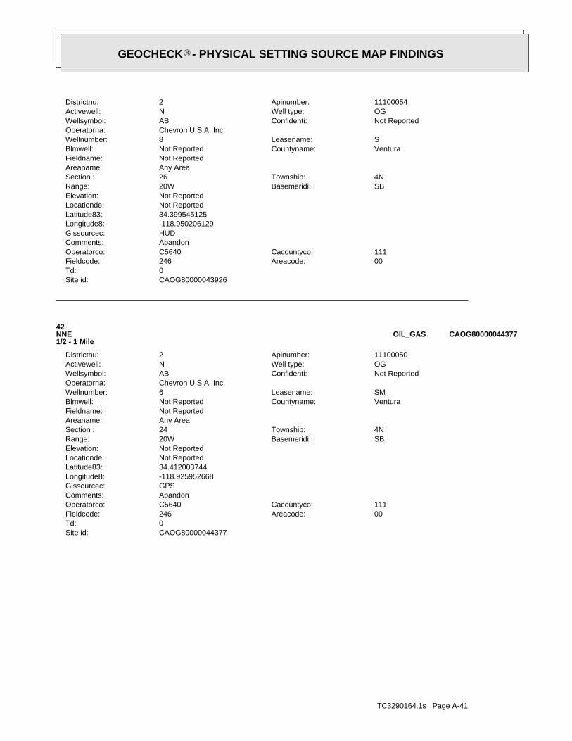
TC3290164.1s Page A-41
CAOG80000044377Site id:0Td:
00Areacode:246Fieldcode:111Cacountyco:C5640Operatorco:
AbandonComments:GPSGissourcec:-118.925952668Longitude8:34.412003744Latitude83:Not ReportedLocationde:Not ReportedElevation:
SBBasemeridi:20WRange:4NTownship:24Section :
Any AreaAreaname:Not ReportedFieldname:
VenturaCountyname:Not ReportedBlmwell:SMLeasename:6Wellnumber:
Chevron U.S.A. Inc.Operatorna:Not ReportedConfidenti:ABWellsymbol:OGWell type:NActivewell:11100050Apinumber:2Districtnu:
42NNE1/2 - 1 Mile
CAOG80000044377OIL_GAS
CAOG80000043926Site id:0Td:
00Areacode:246Fieldcode:111Cacountyco:C5640Operatorco:
AbandonComments:HUDGissourcec:-118.950206129Longitude8:34.399545125Latitude83:Not ReportedLocationde:Not ReportedElevation:
SBBasemeridi:20WRange:4NTownship:26Section :
Any AreaAreaname:Not ReportedFieldname:
VenturaCountyname:Not ReportedBlmwell:SLeasename:8Wellnumber:
Chevron U.S.A. Inc.Operatorna:Not ReportedConfidenti:ABWellsymbol:OGWell type:NActivewell:11100054Apinumber:2Districtnu:
®GEOCHECK - PHYSICAL SETTING SOURCE MAP FINDINGS®
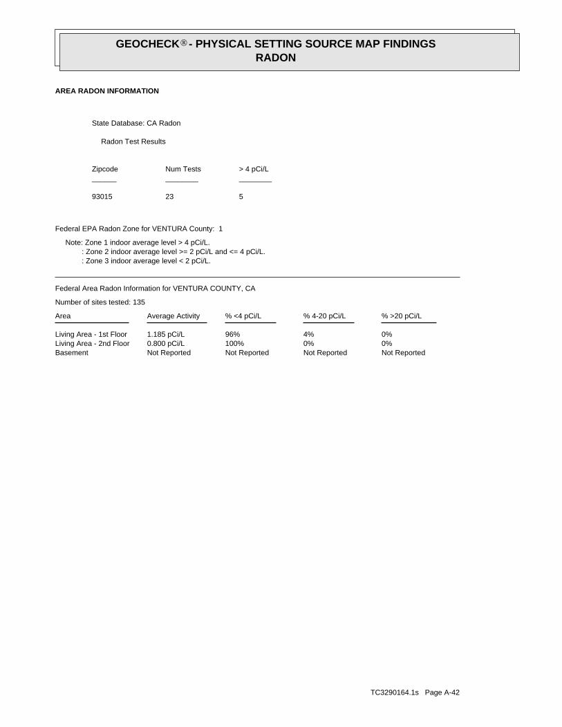
TC3290164.1s Page A-42
Not ReportedNot ReportedNot ReportedNot ReportedBasement0%0%100%0.800 pCi/LLiving Area - 2nd Floor0%4%96%1.185 pCi/LLiving Area - 1st Floor
% >20 pCi/L% 4-20 pCi/L% <4 pCi/LAverage ActivityArea
Number of sites tested: 135
Federal Area Radon Information for VENTURA COUNTY, CA
: Zone 3 indoor average level < 2 pCi/L. : Zone 2 indoor average level >= 2 pCi/L and <= 4 pCi/L. Note: Zone 1 indoor average level > 4 pCi/L.
Federal EPA Radon Zone for VENTURA County: 1
52393015
______________________> 4 pCi/LNum TestsZipcode
Radon Test Results
State Database: CA Radon
AREA RADON INFORMATION
®GEOCHECK - PHYSICAL SETTING SOURCE MAP FINDINGSRADON
®
TOPOGRAPHIC INFORMATION
USGS 7.5’ Digital Elevation Model (DEM)Source: United States Geologic SurveyEDR acquired the USGS 7.5’ Digital Elevation Model in 2002 and updated it in 2006. The 7.5 minute DEM correspondsto the USGS 1:24,000- and 1:25,000-scale topographic quadrangle maps. The DEM provides elevation datawith consistent elevation units and projection.
Scanned Digital USGS 7.5’ Topographic Map (DRG)Source: United States Geologic SurveyA digital raster graphic (DRG) is a scanned image of a U.S. Geological Survey topographic map. The map imagesare made by scanning published paper maps on high-resolution scanners. The raster imageis georeferenced and fit to the Universal Transverse Mercator (UTM) projection.
HYDROLOGIC INFORMATION
Flood Zone Data: This data, available in select counties across the country, was obtained by EDR in 2003 & 2011 from the FederalEmergency Management Agency (FEMA). Data depicts 100-year and 500-year flood zones as defined by FEMA.
NWI: National Wetlands Inventory. This data, available in select counties across the country, was obtained by EDRin 2002 and 2005 from the U.S. Fish and Wildlife Service.
HYDROGEOLOGIC INFORMATION
AQUIFLOW Information SystemR
Source: EDR proprietary database of groundwater flow informationEDR has developed the AQUIFLOW Information System (AIS) to provide data on the general direction of groundwater
flow at specific points. EDR has reviewed reports submitted to regulatory authorities at select sites and hasextracted the date of the report, hydrogeologically determined groundwater flow direction and depth to water tableinformation.
GEOLOGIC INFORMATION
Geologic Age and Rock Stratigraphic UnitSource: P.G. Schruben, R.E. Arndt and W.J. Bawiec, Geology of the Conterminous U.S. at 1:2,500,000 Scale - A digitalrepresentation of the 1974 P.B. King and H.M. Beikman Map, USGS Digital Data Series DDS - 11 (1994).
STATSGO: State Soil Geographic DatabaseSource: Department of Agriculture, Natural Resources Conservation ServicesThe U.S. Department of Agriculture’s (USDA) Natural Resources Conservation Service (NRCS) leads the nationalConservation Soil Survey (NCSS) and is responsible for collecting, storing, maintaining and distributing soilsurvey information for privately owned lands in the United States. A soil map in a soil survey is a representationof soil patterns in a landscape. Soil maps for STATSGO are compiled by generalizing more detailed (SSURGO)soil survey maps.
SSURGO: Soil Survey Geographic DatabaseSource: Department of Agriculture, Natural Resources Conservation Services (NRCS)Telephone: 800-672-5559SSURGO is the most detailed level of mapping done by the Natural Resources Conservation Services, mappingscales generally range from 1:12,000 to 1:63,360. Field mapping methods using national standards are used toconstruct the soil maps in the Soil Survey Geographic (SSURGO) database. SSURGO digitizing duplicates theoriginal soil survey maps. This level of mapping is designed for use by landowners, townships and countynatural resource planning and management.
TC3290164.1s Page A-43
PHYSICAL SETTING SOURCE RECORDS SEARCHED

LOCAL / REGIONAL WATER AGENCY RECORDS
FEDERAL WATER WELLS
PWS: Public Water SystemsSource: EPA/Office of Drinking WaterTelephone: 202-564-3750Public Water System data from the Federal Reporting Data System. A PWS is any water system which provides water to at
least 25 people for at least 60 days annually. PWSs provide water from wells, rivers and other sources.
PWS ENF: Public Water Systems Violation and Enforcement DataSource: EPA/Office of Drinking WaterTelephone: 202-564-3750Violation and Enforcement data for Public Water Systems from the Safe Drinking Water Information System (SDWIS) after
August 1995. Prior to August 1995, the data came from the Federal Reporting Data System (FRDS).
USGS Water Wells: USGS National Water Inventory System (NWIS)This database contains descriptive information on sites where the USGS collects or has collected data on surfacewater and/or groundwater. The groundwater data includes information on wells, springs, and other sources of groundwater.
STATE RECORDS
Water Well DatabaseSource: Department of Water ResourcesTelephone: 916-651-9648
California Drinking Water Quality DatabaseSource: Department of Health ServicesTelephone: 916-324-2319The database includes all drinking water compliance and special studies monitoring for the state of California
since 1984. It consists of over 3,200,000 individual analyses along with well and water system information.
OTHER STATE DATABASE INFORMATION
California Oil and Gas Well LocationsSource: Department of ConservationTelephone: 916-323-1779Oil and Gas well locations in the state.
RADON
State Database: CA RadonSource: Department of Health ServicesTelephone: 916-324-2208Radon Database for California
Area Radon InformationSource: USGSTelephone: 703-356-4020The National Radon Database has been developed by the U.S. Environmental Protection Agency(USEPA) and is a compilation of the EPA/State Residential Radon Survey and the National Residential Radon Survey.The study covers the years 1986 - 1992. Where necessary data has been supplemented by information collected atprivate sources such as universities and research institutions.
EPA Radon ZonesSource: EPATelephone: 703-356-4020Sections 307 & 309 of IRAA directed EPA to list and identify areas of U.S. with the potential for elevated indoorradon levels.
TC3290164.1s Page A-44
PHYSICAL SETTING SOURCE RECORDS SEARCHED
OTHER
Airport Landing Facilities: Private and public use landing facilitiesSource: Federal Aviation Administration, 800-457-6656
Epicenters: World earthquake epicenters, Richter 5 or greaterSource: Department of Commerce, National Oceanic and Atmospheric Administration
California Earthquake Fault Lines: The fault lines displayed on EDR’s Topographic map are digitized quaternary fault lines,prepared in 1975 by the United State Geological Survey. Additional information (also from 1975) regarding activity at specific faultlines comes from California’s Preliminary Fault Activity Map prepared by the California Division of Mines and Geology.
STREET AND ADDRESS INFORMATION
© 2010 Tele Atlas North America, Inc. All rights reserved. This material is proprietary and the subject of copyright protectionand other intellectual property rights owned by or licensed to Tele Atlas North America, Inc. The use of this material is subjectto the terms of a license agreement. You will be held liable for any unauthorized copying or disclosure of this material.
TC3290164.1s Page A-45
PHYSICAL SETTING SOURCE RECORDS SEARCHED
Appendix 6
Noise Modeling Calculations
APPENDIX 6. Sespe Creek Levee Improvements Project Noise Calculations
Construction Equipment
Lmax Ref
dBA
Useage Per
Hour Along Levee
Distance to
Receptor
Equip
Leq(h)
Task 8: Wall Backfill (3 days) & Task 10:
Levee Fill and Compaction @ 50 ft (%) quantity feet dBA
T8: Lender (Excavator - Loader/Base) 92 40 1 550 67.2
T10: Loader (Front End Loader-Excavate) 90 40 1 50 86.0
T10: Dump Truck (Truck Under Load - Base) 95 40 1 50 91.0
Total Quantity of Equipment: 3
Peak Unmitigated Composite Leq(h): 92.2 Threshold: Ambient + 3 dB (50.3 (near church/Res#1)+3 = 53.3 dB) OR
(Figure 4) 55 dBA and 55 Leq(h)+20=75 dBA , 8x/daytime hr
Construction Equipment
Lmax Ref
dBA
Useage Per
Hour Along Levee
Distance to
Receptor
Equip
Leq(h)
Task 10: Levee Fill and Compaction & Task
12: Soil Cement Placement Landward @ 50 ft (%) quantity feet dBA
T10: Loader (Front End Loader-Excavate) 90 40 1 50 86.0
T10: Dump Truck (Truck Under Load - Base) 95 40 1 50 91.0
T12: Loader (Front End Loader-Finish) 90 8 1 550 58.2
T12: Blade (Grader-Finish) 89 8 1 550 57.2
Total Quantity of Equipment: 4
Peak Unmitigated Composite Leq(h): 92.2 Threshold: Ambient +3 dB (50.3+3=53.3) OR
(Figure 4) 55 dBA and 55 Leq(h)+20=75 dBA , 8x/daytime hr
Construction Equipment
Lmax Ref
dBA
Useage Per
Hour Parking Lot
Distance to
Receptor
Equip
Leq(h)
Vegetation Removal @ 50 ft (%) quantity feet dBA
Chainsaw (Saw, Electric-Base) 88 4 1 1180 46.6
Wood Chipper 112 100 1 1180 84.5
Total Quantity of Equipment: 2
Peak Unmitigated Composite Leq(h): 84.5 Threshold: Ambient + 3 dB (51.0+3 = 54 dB) OR
Peak Unmitigated Composite Leq(h)-Attenuation loss (7.5 dB): 77.0 (Figure 4) 55 dBA and 55 Leq(h)+20=75 dBA , 8x/daytime hr
Assume worst-case when overlapping activities are occurring. Per the construction schedule (Date: Thu 3/15/12, Revised
to add access ramps and turnouts [new Task 9]), overlap occurs between Tasks 8, 9 &10, Tasks 9, 10 & 12, and Tasks 11
& 13; however, Task 13 (Fence Installation) requires minimal equipment. Therefore, the last period of simultaneous activity
would not result in a worst-case noise scenario. Equipment utilized for Task 9 (Access Ramps and Turnouts) is assumed to
generally be shared with Task 10 (Levee Fill and Compaction).
Assumptions: Wood chipper staged at Shiells Park west of baseball fields. Closest receptor is First Baptist Church of
Fillmore (1057 First Street, Fillmore, CA). Three (3) rows of houses between park and church is equivalent to 7.5 dB
(4.5+1.5+1.5=7.5 dB) attenuation loss. Chipper assumed to produce noise up to 120 dBA (at source-assume 20 feet).
As a rule of thumb, a solid barrier will generally provide an insertion loss of 5 dBA if it breaks the line of sight from the
source to the receiver (BBA, 2002). Per the Federal Transit Administration, a general rule of thumb for estimating shielding
attenuation in populated areas is to assume one row of buildings every 100 feet; 4.5 dB loss for the first row and 1.5 dB loss
for every subsequent row up to a maximum of 10 dB attenuation loss (FTA, 2006).
Brown-Buntin Associates, Inc. (BBA). 2002. “Fundamentals of Noise and Vibration”. Prepared for the California Energy
Commission. May 1.
Federal Transit Administration (FTA). 2006. Transit Noise and Vibration Impact Assessment. Final Report, May. [Online]:
http://www.fta.dot.gov/documents/FTA_Noise_and_Vibration_Manual.pdf. Accessed March 2012.
* Sources: County of Ventura, Construction Noise Threshold Criteria and Control Plan, Adopted November 2005, Amended
July 2010. Figure 4, Daytime Construction Activity Noise Threshold Criteria; Figure A-1, Typical Construction Equipment
Noise; and Figure A-5, Typical Public Works and Roadway Construction Equipment Use Factors.
Assumptions: Assume that Task 8, which occurs for only 3 days, would not be occuring in the same area as Tasks 9 & 10 -
Assume 500 feet distance between activities. For Task 10, assume two loudest pieces of equipment (but not another dump
truck) in operation nearest church (only sensitive receptor). Distance to receptor of 50 feet is equivalent to distance from
existing church sanctuary building and edge of parking lot/levee ROW.
Government of Western Australia, Department of Commerce, "Noise in Agriculture - Identification, Assessment, and
Control". Publication No. A1564188. Wood chipper noise levels up to 120 dBA; Chainsaw noise level as high as 110 dBA.
On-line: [http://www.commerce.wa.gov.au/worksafe/PDF/Infokits/Noise_newsletter__agriculture.pdf]. Accessed March 16,
2012.
Assumptions: Assume that Tasks 10 & 12 would not be occuring in the same area. Assume 500 feet distance between
activities. For each task, assume two loudest pieces of equipment in operation, but only one dump truck.
Nois _calcs-Sespe Creek031612 Page 1 of 1

FORM-NULL-PVC
tropeR paM suidaR yrammuS RDE
440 Wheelers Farms RoadMilford, CT 06461Toll Free: 800.352.0050www.edrnet.com
Sespe CreekSespe Creek Between HWY 126 and Old Telegraph RoadFillmore, CA 93015
Inquiry Number: 3290164.1sMarch 27, 2012

SECTION PAGE
Executive Summary ES1
Overview Map 2
Detail Map 3
Map Findings Summary 4
Map Findings 8
Orphan Summary 34
Government Records Searched/Data Currency Tracking GR-1
GEOCHECK ADDENDUM
Physical Setting Source Addendum A-1
Physical Setting Source Summary A-2
Physical Setting SSURGO Soil Map A-5
Physical Setting Source Map A-11
Physical Setting Source Map Findings A-13
Physical Setting Source Records Searched A-43
TC3290164.1s Page 1
Thank you for your business.Please contact EDR at 1-800-352-0050
with any questions or comments.
Disclaimer - Copyright and Trademark Notice
This Report contains certain information obtained from a variety of public and other sources reasonably available to Environmental DataResources, Inc. It cannot be concluded from this Report that coverage information for the target and surrounding properties does not exist fromother sources. NO WARRANTY EXPRESSED OR IMPLIED, IS MADE WHATSOEVER IN CONNECTION WITH THIS REPORT. ENVIRONMENTALDATA RESOURCES, INC. SPECIFICALLY DISCLAIMS THE MAKING OF ANY SUCH WARRANTIES, INCLUDING WITHOUT LIMITATION,MERCHANTABILITY OR FITNESS FOR A PARTICULAR USE OR PURPOSE. ALL RISK IS ASSUMED BY THE USER. IN NO EVENT SHALLENVIRONMENTAL DATA RESOURCES, INC. BE LIABLE TO ANYONE, WHETHER ARISING OUT OF ERRORS OR OMISSIONS, NEGLIGENCE,ACCIDENT OR ANY OTHER CAUSE, FOR ANY LOSS OF DAMAGE, INCLUDING, WITHOUT LIMITATION, SPECIAL, INCIDENTAL,CONSEQUENTIAL, OR EXEMPLARY DAMAGES. ANY LIABILITY ON THE PART OF ENVIRONMENTAL DATA RESOURCES, INC. IS STRICTLYLIMITED TO A REFUND OF THE AMOUNT PAID FOR THIS REPORT. Purchaser accepts this Report "AS IS". Any analyses, estimates, ratings,environmental risk levels or risk codes provided in this Report are provided for illustrative purposes only, and are not intended to provide, norshould they be interpreted as providing any facts regarding, or prediction or forecast of, any environmental risk for any property. Only a Phase IEnvironmental Site Assessment performed by an environmental professional can provide information regarding the environmental risk for anyproperty. Additionally, the information provided in this Report is not to be construed as legal advice.
Copyright 2012 by Environmental Data Resources, Inc. All rights reserved. Reproduction in any media or format, in wholeor in part, of any report or map of Environmental Data Resources, Inc., or its affiliates, is prohibited without prior written permission.
EDR and its logos (including Sanborn and Sanborn Map) are trademarks of Environmental Data Resources, Inc. or its affiliates. All othertrademarks used herein are the property of their respective owners.
TABLE OF CONTENTS

EXECUTIVE SUMMARY
TC3290164.1s EXECUTIVE SUMMARY 1
A search of available environmental records was conducted by Environmental Data Resources, Inc (EDR).The report was designed to assist parties seeking to meet the search requirements of EPA’s Standardsand Practices for All Appropriate Inquiries (40 CFR Part 312), the ASTM Standard Practice forEnvironmental Site Assessments (E 1527-05) or custom requirements developed for the evaluation ofenvironmental risk associated with a parcel of real estate.
TARGET PROPERTY INFORMATION
ADDRESS
SESPE CREEK BETWEEN HWY 126 AND OLD TELEGRAPH ROADFILLMORE, CA 93015
COORDINATES
34.3997000 - 34˚ 23’ 58.92’’Latitude (North): 118.9338000 - 118˚ 56’ 1.68’’Longitude (West): Zone 11Universal Tranverse Mercator: 322242.2UTM X (Meters): 3807974.8UTM Y (Meters): 416 ft. above sea levelElevation:
USGS TOPOGRAPHIC MAP ASSOCIATED WITH TARGET PROPERTY
TP Target Property:USGS 7.5 min quad indexSource:
AERIAL PHOTOGRAPHY IN THIS REPORT
2009, 2010Portions of Photo from:USDASource:

3290164.1s Page 2
18 LEE PHARMACEUTICALS 815 W 5TH STREET CERCLIS, RCRA-SQG, FINDS, UST, ENVIROSTOR Higher 2741, NE
17 CAL PET 804 3RD LUST Higher 2389, ENE
C16 THE OLGA COMPANY 908 B STREET LUST Higher 2301, NE
C15 THE OLGA CO. 908 B STREET HIST CORTESE, LUST, UST, HAZNET Higher 2301, NE
14 TEXACO SERVICE STATI 1107 VENTURA ST LUST Lower 2298, ESE
13 VCO FIRE STATION #27 613 OLD TELEGRAPH RD LUST Higher 1905, ESE
B12 CAL TRANS-FILLMORE M 1261 VENTURA HIST CORTESE, LUST, HAZNET Lower 1532, ESE
B11 CALTRANS- FILLMORE M 1261 WEST VENTURA ST SWF/LF Lower 1532, ESE
B10 CALTRANS - FILLMORE 1261 VENTURA ST LUST, HAZNET Lower 1532, ESE
A9 URA COUNTY FRUIT GRO 960 3RD ST HIST UST, VENTURA CO. BWT, HAZNET Higher 1048, ENE
A8 VENTURA COUNTY FRUIT 960 3RD STREET UST Higher 1048, ENE
A7 DICK ELKINS TRUCKING 960 3RD ST HIST UST Higher 1048, ENE
6 AMERICAN CLEANERS 535 C STREET UST Higher 853, ESE
5 ELTON WAGNER 1462 VENTURA ST. UST, HIST UST Lower 692, ESE
4 ROYCE RENTAL & TANK 1565 VENTURA ST. UST Lower 633, WSW
3 CALIFORNIA COMMUNITY CORNER OF SESPE & D UST Higher 444, ESE
2 PERRY RANCH CO. 199 E ST HIST UST Lower 328, SE
1 SESPE CREEK LEVEE 5 SESPE CREEK NEAR HIG NPDES TP
MAPPED SITES SUMMARY
Target Property Address:SESPE CREEK BETWEEN HWY 126 AND OLD TELEGRAPH ROADFILLMORE, CA 93015
Click on Map ID to see full detail.
MAP RELATIVE DIST (ft.)ID DATABASE ACRONYMS ELEVATION DIRECTIONSITE NAME ADDRESS

EXECUTIVE SUMMARY
TC3290164.1s EXECUTIVE SUMMARY 3
TARGET PROPERTY SEARCH RESULTS
The target property was identified in the following records. For more information on thisproperty see page 8 of the attached EDR Radius Map report:
EPA IDDatabase(s)Site
SESPE CREEK LEVEE 5 SESPE CREEK NEAR HIGFILLMORE, CA 93015
N/ANPDES
SURROUNDING SITES: SEARCH RESULTS
Surrounding sites were identified in the following databases.
Elevations have been determined from the USGS Digital Elevation Model and should be evaluated ona relative (not an absolute) basis. Relative elevation information between sites of close proximityshould be field verified. Sites with an elevation equal to or higher than the target property have beendifferentiated below from sites with an elevation lower than the target property.Page numbers and map identification numbers refer to the EDR Radius Map report where detaileddata on individual sites can be reviewed.
Sites listed in bold italics are in multiple databases.
Unmappable (orphan) sites are not considered in the foregoing analysis.
STANDARD ENVIRONMENTAL RECORDS
State- and tribal - equivalent CERCLIS
ENVIROSTOR: A review of the ENVIROSTOR list, as provided by EDR, and dated 02/07/2012 has revealedthat there is 1 ENVIROSTOR site within approximately 1 mile of the target property.
PageMap IDDirection / Distance Address Equal/Higher Elevation ____________________ ________ ___________________ _____ _____
LEE PHARMACEUTICALS 815 W 5TH STREET NE 1/2 - 1 (0.519 mi.) 18 11Status: Refer: Other Agency
State and tribal landfill and/or solid waste disposal site lists
SWF/LF: A review of the SWF/LF list, as provided by EDR, and dated 11/21/2011 has revealed that thereis 1 SWF/LF site within approximately 0.5 miles of the target property.
PageMap IDDirection / Distance Address Lower Elevation ____________________ ________ ___________________ _____ _____
CALTRANS- FILLMORE M 1261 WEST VENTURA ST ESE 1/4 - 1/2 (0.290 mi.) B11 10

EXECUTIVE SUMMARY
TC3290164.1s EXECUTIVE SUMMARY 4
State and tribal leaking storage tank lists
LUST: A review of the LUST list, as provided by EDR, and dated 01/20/2012 has revealed that there are7 LUST sites within approximately 0.5 miles of the target property.
PageMap IDDirection / Distance Address Equal/Higher Elevation ____________________ ________ ___________________ _____ _____
VCO FIRE STATION #27 613 OLD TELEGRAPH RD ESE 1/4 - 1/2 (0.361 mi.) 13 10Status: Completed - Case ClosedStatus: Completed - Case Closed
THE OLGA CO. 908 B STREET NE 1/4 - 1/2 (0.436 mi.) C15 10Status: Completed - Case Closed
THE OLGA COMPANY 908 B STREET NE 1/4 - 1/2 (0.436 mi.) C16 11 CAL PET 804 3RD ENE 1/4 - 1/2 (0.452 mi.) 17 11
Status: Completed - Case Closed
PageMap IDDirection / Distance Address Lower Elevation ____________________ ________ ___________________ _____ _____
CALTRANS - FILLMORE 1261 VENTURA ST ESE 1/4 - 1/2 (0.290 mi.) B10 9 CAL TRANS-FILLMORE M 1261 VENTURA ESE 1/4 - 1/2 (0.290 mi.) B12 10
Status: Completed - Case Closed
TEXACO SERVICE STATI 1107 VENTURA ST ESE 1/4 - 1/2 (0.435 mi.) 14 10
State and tribal registered storage tank lists
UST: A review of the UST list, as provided by EDR, and dated 01/20/2012 has revealed that there are 5UST sites within approximately 0.25 miles of the target property.
PageMap IDDirection / Distance Address Equal/Higher Elevation ____________________ ________ ___________________ _____ _____
CALIFORNIA COMMUNITY CORNER OF SESPE & D ESE 0 - 1/8 (0.084 mi.) 3 8 AMERICAN CLEANERS 535 C STREET ESE 1/8 - 1/4 (0.162 mi.) 6 9 VENTURA COUNTY FRUIT 960 3RD STREET ENE 1/8 - 1/4 (0.198 mi.) A8 9
PageMap IDDirection / Distance Address Lower Elevation ____________________ ________ ___________________ _____ _____
ROYCE RENTAL & TANK 1565 VENTURA ST. WSW 0 - 1/8 (0.120 mi.) 4 8 ELTON WAGNER 1462 VENTURA ST. ESE 1/8 - 1/4 (0.131 mi.) 5 8
ADDITIONAL ENVIRONMENTAL RECORDS
Local Lists of Registered Storage Tanks
HIST UST: A review of the HIST UST list, as provided by EDR, and dated 10/15/1990 has revealed thatthere are 4 HIST UST sites within approximately 0.25 miles of the target property.
PageMap IDDirection / Distance Address Equal/Higher Elevation ____________________ ________ ___________________ _____ _____
DICK ELKINS TRUCKING 960 3RD ST ENE 1/8 - 1/4 (0.198 mi.) A7 9

EXECUTIVE SUMMARY
TC3290164.1s EXECUTIVE SUMMARY 5
PageMap IDDirection / Distance Address Equal/Higher Elevation ____________________ ________ ___________________ _____ _____
URA COUNTY FRUIT GRO 960 3RD ST ENE 1/8 - 1/4 (0.198 mi.) A9 9
PageMap IDDirection / Distance Address Lower Elevation ____________________ ________ ___________________ _____ _____
PERRY RANCH CO. 199 E ST SE 0 - 1/8 (0.062 mi.) 2 8 ELTON WAGNER 1462 VENTURA ST. ESE 1/8 - 1/4 (0.131 mi.) 5 8
Other Ascertainable Records
HIST CORTESE: A review of the HIST CORTESE list, as provided by EDR, and dated 04/01/2001 hasrevealed that there are 2 HIST CORTESE sites within approximately 0.5 miles of the targetproperty.
PageMap IDDirection / Distance Address Equal/Higher Elevation ____________________ ________ ___________________ _____ _____
THE OLGA CO. 908 B STREET NE 1/4 - 1/2 (0.436 mi.) C15 10
PageMap IDDirection / Distance Address Lower Elevation ____________________ ________ ___________________ _____ _____
CAL TRANS-FILLMORE M 1261 VENTURA ESE 1/4 - 1/2 (0.290 mi.) B12 10

ED
R Inc.
ED
R Inc.
ED
R Inc.
ED
R Inc.
ED
R Inc.
ED
R Inc.
ED
R Inc.
ED
R Inc.
ED
R Inc.
ED
R Inc.
ED
R Inc.
ED
R Inc.
ED
R Inc.
ED
R Inc.
ED
R Inc.
ED
R Inc.
ED
R Inc.
ED
R Inc.
ED
R Inc.
ED
R Inc.
ED
R Inc.
ED
R Inc.
ED
R Inc.
ED
R Inc.
ED
R Inc.
ED
R Inc.
ED
R Inc.
ED
R Inc.
ED
R Inc.
ED
R Inc.
ED
R Inc.
ED
R Inc.
ED
R Inc.
ED
R Inc.
ED
R Inc.
ED
R Inc.
ED
R Inc.
ED
R Inc.
ED
R Inc.
ED
R Inc.
ORPHAN SUMMARY
City EDR ID Site Name Site Address Zip Database(s)
Count: 20 records.
(NEAR FILLMORE) 1000205227 SHIELLS CANYON FIELD (SHIELLS CANYON OIL FIELD) 93015 HIST USTFILLMORE 1000327512 ARGO/ HOPPER CANYON OIL FIELD HOPPER CANYON RD 93015 RCRA-SQG,FINDSFILLMORE 1003878684 ELKINS RANCH HWY 126 TORREY RD EXIT 93015 CERCLIS-NFRAPFILLMORE 1006248341 VINTAGE PETROLEUM INC SESPE FIELD BONEBRAKE A & B LEASE SESPE 93015 FINDSFILLMORE 2006808468 SESPE OIL FIELD SESPE OIL FIELD 93015 ERNSFILLMORE 2010929413 UPPER SESPE WATERSHED UPPER SESPE WATERSHED ERNSFILLMORE 2011973936 SESPE OIL FIELD FOUR FORKS CREEK SESPE OIL FIELD FOUR FORKS CRE ERNSFILLMORE 8855686 SESPE OIL FIELD 6 MILES NE OF FILL SESPE OIL FIELD 6 MILES NE OF ERNSFILLMORE 94415643 LOS PADRES NAT FOREST--SQUAW FLAT, LOS PADRES NAT FOREST SQUAW FL ERNS M300002055 PW GILLIBRAND CO CANYON ROCK PLANT MINES M300002497 PACIFIC CUSTOMS MATERIALS VENTURA COUNTY OPERATIONS MINES M300003255 BEST ROCK PRODUCTS CO. GRIMES CANYON PIT MINES M300006449 PACIFIC ROCK, INC. CRUSHED STONE OPERATION MINESFILLMORE S100184297 ELKINS RANCH DISPOSAL COMPANY HIGHWAY 126, TORREY ROAD EXIT 93015 ENVIROSTORFILLMORE S103441658 FILLMORE CITY (OLD) NORTH OF HWY 126 WMUDS/SWATFILLMORE S105974918 ARMSTRONG PROPERTY (MARGARET) 805 VENTURA ST LUST SAN MATEOFILLMORE S106517306 ARMSTRONG PROPERTY (MARGARET) 805 VENTURA ST 93015 LUST SAN MATEOFILLMORE S110655898 HAROLD BALDEN NW X CENTRAL/HWY 126 93015 LUST SAN MATEOFILLMORE U001579426 CITRUS GROVE 1150 CHAMBERSBURG RD. (HIGHWAY 93015 HIST USTFILMORE U004118080 SHELL FILMORE 1107 VENTURA ST. 93015 UST ALAMEDA
TC3290164.1s Page 34

EDR Inc.EDR Inc.EDR Inc.EDR Inc.EDR Inc.EDR Inc.EDR Inc.EDR Inc.EDR Inc.EDR Inc.EDR Inc.EDR Inc.EDR Inc.EDR Inc.EDR Inc.EDR Inc.EDR Inc.EDR Inc.EDR Inc.EDR Inc.EDR Inc.EDR Inc.EDR Inc.EDR Inc.EDR Inc.EDR Inc.EDR Inc.EDR Inc.EDR Inc.EDR Inc.EDR Inc.EDR Inc.EDR Inc.EDR Inc.EDR Inc.EDR Inc.EDR Inc.EDR Inc.EDR Inc.EDR Inc.
230
230 kV
230 kV
230 kV
230 kV230 kV
230 kV
1 2 8
0 01 2
1 2 0
1 1 6
1 1 6 01 1 20
1 1 2 0
1 1
0
1 0 8 0
40
1
0 4 01 0 0 0
96
0
9 6 09
2 0
92
88
0
8 8 0
84
08 4 0
80
0
80
0
8 0 0
800
76
0
7 6 0
72
0
72
0
72
0
68
0
6 8 0
68
0
6 4 0
64
0
640
6 0 0
60
0
60
0
6 0 0
5 6 0
56
0
5 6 0
56
0 52 0
52
0
52
0
5
2 0
520
3 6 0
40
0
4 0 0
40
0
4 0 0
440
4 4 0
440
44
0
4 4 0
4 4 0
480
4 8 0
4 8 0
480
48
0
4 8 0

EDR Inc.EDR Inc.EDR Inc.EDR Inc.EDR Inc.EDR Inc.EDR Inc.EDR Inc.EDR Inc.EDR Inc.EDR Inc.EDR Inc.EDR Inc.EDR Inc.EDR Inc.EDR Inc.EDR Inc.EDR Inc.EDR Inc.EDR Inc.EDR Inc.EDR Inc.EDR Inc.EDR Inc.EDR Inc.EDR Inc.EDR Inc.EDR Inc.EDR Inc.EDR Inc.EDR Inc.EDR Inc.EDR Inc.EDR Inc.EDR Inc.EDR Inc.EDR Inc.EDR Inc.EDR Inc.EDR Inc.
230 kV
40
0
44
0

EDR Inc.EDR Inc.EDR Inc.EDR Inc.EDR Inc.EDR Inc.EDR Inc.EDR Inc.EDR Inc.EDR Inc.EDR Inc.EDR Inc.EDR Inc.EDR Inc.EDR Inc.EDR Inc.EDR Inc.EDR Inc.EDR Inc.EDR Inc.EDR Inc.EDR Inc.EDR Inc.EDR Inc.EDR Inc.EDR Inc.EDR Inc.EDR Inc.EDR Inc.EDR Inc.EDR Inc.EDR Inc.EDR Inc.EDR Inc.EDR Inc.EDR Inc.EDR Inc.EDR Inc.EDR Inc.EDR Inc.
MAP FINDINGS SUMMARY
SearchTargetDistance Total
Database Property(Miles) < 1/8 1/8 - 1/4 1/4 - 1/2 1/2 - 1 > 1 Plotted
STANDARD ENVIRONMENTAL RECORDS
Federal NPL site list
0 NR 0 0 0 0 1.000NPL 0 NR 0 0 0 0 1.000Proposed NPL 0 NR NR NR NR NR TPNPL LIENS
Federal Delisted NPL site list
0 NR 0 0 0 0 1.000Delisted NPL
Federal CERCLIS list
0 NR NR 0 0 0 0.500CERCLIS 0 NR 0 0 0 0 1.000FEDERAL FACILITY
Federal CERCLIS NFRAP site List
0 NR NR 0 0 0 0.500CERC-NFRAP
Federal RCRA CORRACTS facilities list
0 NR 0 0 0 0 1.000CORRACTS
Federal RCRA non-CORRACTS TSD facilities list
0 NR NR 0 0 0 0.500RCRA-TSDF
Federal RCRA generators list
0 NR NR NR 0 0 0.250RCRA-LQG 0 NR NR NR 0 0 0.250RCRA-SQG 0 NR NR NR 0 0 0.250RCRA-CESQG
Federal institutional controls /engineering controls registries
0 NR NR 0 0 0 0.500US ENG CONTROLS 0 NR NR 0 0 0 0.500US INST CONTROL
Federal ERNS list
0 NR NR NR NR NR TPERNS
State- and tribal - equivalent NPL
0 NR 0 0 0 0 1.000RESPONSE
State- and tribal - equivalent CERCLIS
1 NR 1 0 0 0 1.000ENVIROSTOR
State and tribal landfill and/orsolid waste disposal site lists
1 NR NR 1 0 0 0.500SWF/LF
State and tribal leaking storage tank lists
7 NR NR 7 0 0 0.500LUST 0 NR NR 0 0 0 0.500SLIC
TC3290164.1s Page 4

MAP FINDINGS SUMMARY
SearchTargetDistance Total
Database Property(Miles) < 1/8 1/8 - 1/4 1/4 - 1/2 1/2 - 1 > 1 Plotted
0 NR NR 0 0 0 0.500INDIAN LUST
State and tribal registered storage tank lists
5 NR NR NR 3 2 0.250UST 0 NR NR NR 0 0 0.250AST 0 NR NR NR 0 0 0.250INDIAN UST 0 NR NR NR 0 0 0.250FEMA UST
State and tribal voluntary cleanup sites
0 NR NR 0 0 0 0.500INDIAN VCP 0 NR NR 0 0 0 0.500VCP
ADDITIONAL ENVIRONMENTAL RECORDS
Local Brownfield lists
0 NR NR 0 0 0 0.500US BROWNFIELDS
Local Lists of Landfill / SolidWaste Disposal Sites
0 NR NR 0 0 0 0.500DEBRIS REGION 9 0 NR NR 0 0 0 0.500ODI 0 NR NR 0 0 0 0.500WMUDS/SWAT 0 NR NR 0 0 0 0.500SWRCY 0 NR NR NR NR NR TPHAULERS 0 NR NR 0 0 0 0.500INDIAN ODI
Local Lists of Hazardous waste /Contaminated Sites
0 NR NR NR NR NR TPUS CDL 0 NR 0 0 0 0 1.000HIST Cal-Sites 0 NR NR NR 0 0 0.250SCH 0 NR 0 0 0 0 1.000Toxic Pits 0 NR NR NR NR NR TPCDL 0 NR NR NR NR NR TPUS HIST CDL
Local Lists of Registered Storage Tanks
0 NR NR NR 0 0 0.250CA FID UST 4 NR NR NR 3 1 0.250HIST UST 0 NR NR NR 0 0 0.250SWEEPS UST
Local Land Records
0 NR NR NR NR NR TPLIENS 2 0 NR NR 0 0 0 0.500LUCIS 0 NR NR NR NR NR TPLIENS 0 NR NR 0 0 0 0.500DEED
Records of Emergency Release Reports
0 NR NR NR NR NR TPHMIRS 0 NR NR NR NR NR TPCHMIRS 0 NR NR NR NR NR TPLDS
TC3290164.1s Page 5

MAP FINDINGS SUMMARY
SearchTargetDistance Total
Database Property(Miles) < 1/8 1/8 - 1/4 1/4 - 1/2 1/2 - 1 > 1 Plotted
0 NR NR NR NR NR TPMCS
Other Ascertainable Records
0 NR NR NR 0 0 0.250RCRA-NonGen 0 NR NR NR NR NR TPDOT OPS 0 NR 0 0 0 0 1.000DOD 0 NR 0 0 0 0 1.000FUDS 0 NR 0 0 0 0 1.000CONSENT 0 NR 0 0 0 0 1.000ROD 0 NR NR 0 0 0 0.500UMTRA 0 NR NR NR 0 0 0.250MINES 0 NR NR NR NR NR TPTRIS 0 NR NR NR NR NR TPTSCA 0 NR NR NR NR NR TPFTTS 0 NR NR NR NR NR TPHIST FTTS 0 NR NR NR NR NR TPSSTS 0 NR NR NR NR NR TPICIS 0 NR NR NR NR NR TPPADS 0 NR NR NR NR NR TPMLTS 0 NR NR NR NR NR TPRADINFO 0 NR NR NR NR NR TPFINDS 0 NR NR NR NR NR TPRAATS 0 NR 0 0 0 0 1.000CA BOND EXP. PLAN 1 NR NR NR NR NR TP 1NPDES 0 NR NR NR NR NR TPWDS 0 NR NR 0 0 0 0.500Cortese 2 NR NR 2 0 0 0.500HIST CORTESE 0 NR 0 0 0 0 1.000Notify 65 0 NR NR NR 0 0 0.250DRYCLEANERS 0 NR NR NR NR NR TPVENTURA CO. BWT 0 NR NR NR 0 0 0.250WIP 0 NR NR NR NR NR TPENF 0 NR NR NR NR NR TPHAZNET 0 NR NR NR NR NR TPEMI 0 NR 0 0 0 0 1.000INDIAN RESERV 0 NR NR 0 0 0 0.500SCRD DRYCLEANERS 0 NR NR NR NR NR TPMED WASTE VENTURA 0 NR NR NR NR NR TPFINANCIAL ASSURANCE 0 NR 0 0 0 0 1.000HWP 0 NR NR NR NR NR TPPCB TRANSFORMER 0 NR NR 0 0 0 0.500PROC 0 NR NR NR 0 0 0.250MWMP 0 NR NR NR NR NR TPCOAL ASH DOE 0 NR NR 0 0 0 0.500COAL ASH EPA 0 NR NR NR 0 0 0.250HWT
EDR PROPRIETARY RECORDS
EDR Proprietary Records
0 NR 0 0 0 0 1.000Manufactured Gas Plants
TC3290164.1s Page 6

MAP FINDINGS SUMMARY
SearchTargetDistance Total
Database Property(Miles) < 1/8 1/8 - 1/4 1/4 - 1/2 1/2 - 1 > 1 Plotted
0 NR NR NR 0 0 0.250EDR Historical Auto Stations 0 NR NR NR 0 0 0.250EDR Historical Cleaners
NOTES:
TP = Target Property
NR = Not Requested at this Search Distance
Sites may be listed in more than one database
TC3290164.1s Page 7

TC3290164.1s Page 8
5 USTELTON WAGNER U001579441ESE HIST UST1462 VENTURA ST. N/A1/8-1/4 FILLMORE, CA
Relative:Lower
Click here for full text details
0.131 mi.692 ft.
4 USTROYCE RENTAL & TANK SERVICE U002244334WSW 1565 VENTURA ST. N/A< 1/8 FILLMORE, CA
Relative:Lower
Click here for full text details
0.120 mi.633 ft.
3 USTCALIFORNIA COMMUNITY BUILDERS U002243932ESE CORNER OF SESPE & D ST. N/A< 1/8 FILLMORE, CA
Relative:Higher
Click here for full text details
0.084 mi.444 ft.
2 HIST USTPERRY RANCH CO. U001579499SE 199 E ST N/A< 1/8 FILLMORE, CA 93015
Relative:Lower
Click here for full text details
0.062 mi.328 ft.
1 NPDESSESPE CREEK LEVEE 5 CONSTRUCTION PROJECT S109457923Target SESPE CREEK NEAR HIGHWAY 126 N/AProperty FILLMORE, CA 93015
Actual:416 ft.
Click here for full text detailsNPDES Facility Status: Active
MAP FINDINGSMap IDDirection
EDR ID NumberDistanceEPA ID NumberDatabase(s)SiteElevation

TC3290164.1s Page 9
B10 LUSTCALTRANS - FILLMORE MAINT. STA S102426073ESE HAZNET1261 VENTURA ST N/A1/4-1/2 FILLMORE, CA
Relative:Lower
Click here for full text details
0.290 mi.1532 ft.
LUST Status: Case Closed Status: Case Closed
A9 HIST USTURA COUNTY FRUIT GROWERS, INC. U001579539ENE VENTURA CO. BWT960 3RD ST N/A1/8-1/4 HAZNETFILLMORE, CA 93015
Relative:Higher
Click here for full text details
0.198 mi.1048 ft.
A8 USTVENTURA COUNTY FRUIT GROWER U003989404ENE 960 3RD STREET N/A1/8-1/4 FILLMORE, CA
Relative:Higher
Click here for full text details
0.198 mi.1048 ft.
A7 HIST USTDICK ELKINS TRUCKING U001579431ENE 960 3RD ST N/A1/8-1/4 FILLMORE, CA 93015
Relative:Higher
Click here for full text details
0.198 mi.1048 ft.
6 USTAMERICAN CLEANERS U003187549ESE 535 C STREET N/A1/8-1/4 OXNARD, CA
Relative:Higher
Click here for full text details
0.162 mi.853 ft.
MAP FINDINGSMap IDDirection
EDR ID NumberDistanceEPA ID NumberDatabase(s)SiteElevation

TC3290164.1s Page 10
C15 HIST CORTESETHE OLGA CO. U003142346NE LUST908 B STREET N/A1/4-1/2 USTFILLMORE, CA
Relative:Higher
Click here for full text details
0.436 mi. HAZNET2301 ft.
LUST Status: Completed - Case Closed
14 LUSTTEXACO SERVICE STATION-CANTRELL S106517228ESE 1107 VENTURA ST N/A1/4-1/2 FILLMORE, CA 93015
Relative:Lower
Click here for full text details
0.435 mi.2298 ft.
LUST Status: Case Closed
13 LUSTVCO FIRE STATION #27 S105974865ESE 613 OLD TELEGRAPH RD. N/A1/4-1/2 FILLMORE, CA
Relative:Higher
Click here for full text details
0.361 mi.1905 ft.
LUST Status: Case Closed Status: Completed - Case Closed Status: Completed - Case Closed Status: Preliminary site assessment underway
B12 HIST CORTESECAL TRANS-FILLMORE MAINT. S103954558ESE LUST1261 VENTURA N/A1/4-1/2 HAZNETFILLMORE, CA 93015
Relative:Lower
Click here for full text details
0.290 mi.1532 ft.
LUST Status: Completed - Case Closed
B11 SWF/LFCALTRANS- FILLMORE MAINTENANCE STATION S110986775ESE 1261 WEST VENTURA ST. N/A1/4-1/2 FILLMORE, CA
Relative:Lower
Click here for full text details
0.290 mi.1532 ft.
MAP FINDINGSMap IDDirection
EDR ID NumberDistanceEPA ID NumberDatabase(s)SiteElevation

TC3290164.1s Page 11
18 CERCLISLEE PHARMACEUTICALS 1000216509NE RCRA-SQG815 W 5TH STREET CAD0964322161/2-1 FINDSFILLMORE, CA 93015
Relative:Higher
Click here for full text details
0.519 mi. UST2741 ft. ENVIROSTOR
ENVIROSTOR Status: Refer: Other Agency
17 LUSTCAL PET S103684045ENE 804 3RD N/A1/4-1/2 OXNARD, CA
Relative:Higher
Click here for full text details
0.452 mi.2389 ft.
LUST Status: Case Closed Status: Completed - Case Closed Status: Case Closed
C16 LUSTTHE OLGA COMPANY S104164691NE 908 B STREET N/A1/4-1/2 FILLMORE, CA
Relative:Higher
Click here for full text details
0.436 mi.2301 ft.
LUST Status: Case Closed Status: Case Closed
MAP FINDINGSMap IDDirection
EDR ID NumberDistanceEPA ID NumberDatabase(s)SiteElevation

ED
R Inc.
ED
R Inc.
ED
R Inc.
ED
R Inc.
ED
R Inc.
ED
R Inc.
ED
R Inc.
ED
R Inc.
ED
R Inc.
ED
R Inc.
ED
R Inc.
ED
R Inc.
ED
R Inc.
ED
R Inc.
ED
R Inc.
ED
R Inc.
ED
R Inc.
ED
R Inc.
ED
R Inc.
ED
R Inc.
ED
R Inc.
ED
R Inc.
ED
R Inc.
ED
R Inc.
ED
R Inc.
ED
R Inc.
ED
R Inc.
ED
R Inc.
ED
R Inc.
ED
R Inc.
ED
R Inc.
ED
R Inc.
ED
R Inc.
ED
R Inc.
ED
R Inc.
ED
R Inc.
ED
R Inc.
ED
R Inc.
ED
R Inc.
ED
R Inc.
ED
R Inc.
ED
R Inc.
ED
R Inc.
ED
R Inc.
ED
R Inc.
ED
R Inc.
ED
R Inc.
ED
R Inc.
ED
R Inc.
ED
R Inc.
ED
R Inc.
ED
R Inc.
ED
R Inc.
ED
R Inc.
ED
R Inc.
ED
R Inc.
ED
R Inc.
ED
R Inc.
ED
R Inc.
ED
R Inc.
ED
R Inc.
ED
R Inc.
ED
R Inc.
ED
R Inc.
ED
R Inc.
ED
R Inc.
ED
R Inc.
ED
R Inc.
ED
R Inc.
ED
R Inc.
ED
R Inc.
ED
R Inc.
ED
R Inc.
ED
R Inc.
ED
R Inc.
ED
R Inc.
ED
R Inc.
ED
R Inc.
ED
R Inc.
ED
R Inc.
CA AST Aboveground Petroleum Storage Tank Facilities State Water Resources Control Board 08/01/2009 09/10/2009 10/01/2009CA CA BOND EXP. PLAN Bond Expenditure Plan Department of Health Services 01/01/1989 07/27/1994 08/02/1994CA CA FID UST Facility Inventory Database California Environmental Protection Agency 10/31/1994 09/05/1995 09/29/1995CA CDL Clandestine Drug Labs Department of Toxic Substances Control 12/31/2011 02/14/2012 02/21/2012CA CHMIRS California Hazardous Material Incident Report System Office of Emergency Services 12/31/2010 05/03/2011 06/15/2011CA CORTESE "Cortese" Hazardous Waste & Substances Sites List CAL EPA/Office of Emergency Information 01/03/2012 01/03/2012 01/19/2012CA DEED Deed Restriction Listing Department of Toxic Substances Control 12/12/2011 12/13/2011 01/19/2012CA DRYCLEANERS Cleaner Facilities Department of Toxic Substance Control 01/19/2012 01/19/2012 02/21/2012CA EMI Emissions Inventory Data California Air Resources Board 12/31/2008 09/29/2010 10/18/2010CA ENF Enforcement Action Listing State Water Resoruces Control Board 08/15/2011 08/23/2011 10/03/2011CA ENVIROSTOR EnviroStor Database Department of Toxic Substances Control 02/07/2012 02/07/2012 02/22/2012CA FINANCIAL ASSURANCE 1 Financial Assurance Information Listing Department of Toxic Substances Control 03/01/2007 06/01/2007 06/29/2007CA FINANCIAL ASSURANCE 2 Financial Assurance Information Listing California Integrated Waste Management Board 11/29/2011 11/30/2011 12/13/2011CA HAULERS Registered Waste Tire Haulers Listing Integrated Waste Management Board 01/20/2012 01/24/2012 02/21/2012CA HAZNET Facility and Manifest Data California Environmental Protection Agency 12/31/2010 07/19/2011 08/16/2011CA HIST CAL-SITES Calsites Database Department of Toxic Substance Control 08/08/2005 08/03/2006 08/24/2006CA HIST CORTESE Hazardous Waste & Substance Site List Department of Toxic Substances Control 04/01/2001 01/22/2009 04/08/2009CA HIST UST Hazardous Substance Storage Container Database State Water Resources Control Board 10/15/1990 01/25/1991 02/12/1991CA HWP EnviroStor Permitted Facilities Listing Department of Toxic Substances Control 08/09/2010 08/11/2010 08/20/2010CA HWT Registered Hazardous Waste Transporter Database Department of Toxic Substances Control 01/18/2012 01/18/2012 02/21/2012CA LDS Land Disposal Sites Listing State Water Qualilty Control Board 01/20/2012 01/20/2012 02/21/2012CA LIENS Environmental Liens Listing Department of Toxic Substances Control 12/16/2011 12/16/2011 01/19/2012CA LUST Geotracker’s Leaking Underground Fuel Tank Report State Water Resources Control Board 01/20/2012 01/20/2012 02/21/2012CA LUST REG 1 Active Toxic Site Investigation California Regional Water Quality Control Boa 02/01/2001 02/28/2001 03/29/2001CA LUST REG 2 Fuel Leak List California Regional Water Quality Control Boa 09/30/2004 10/20/2004 11/19/2004CA LUST REG 3 Leaking Underground Storage Tank Database California Regional Water Quality Control Boa 05/19/2003 05/19/2003 06/02/2003CA LUST REG 4 Underground Storage Tank Leak List California Regional Water Quality Control Boa 09/07/2004 09/07/2004 10/12/2004CA LUST REG 5 Leaking Underground Storage Tank Database California Regional Water Quality Control Boa 07/01/2008 07/22/2008 07/31/2008CA LUST REG 6L Leaking Underground Storage Tank Case Listing California Regional Water Quality Control Boa 09/09/2003 09/10/2003 10/07/2003CA LUST REG 6V Leaking Underground Storage Tank Case Listing California Regional Water Quality Control Boa 06/07/2005 06/07/2005 06/29/2005CA LUST REG 7 Leaking Underground Storage Tank Case Listing California Regional Water Quality Control Boa 02/26/2004 02/26/2004 03/24/2004CA LUST REG 8 Leaking Underground Storage Tanks California Regional Water Quality Control Boa 02/14/2005 02/15/2005 03/28/2005CA LUST REG 9 Leaking Underground Storage Tank Report California Regional Water Quality Control Boa 03/01/2001 04/23/2001 05/21/2001CA MCS Military Cleanup Sites Listing State Water Resources Control Board 01/20/2012 01/20/2012 02/21/2012CA MWMP Medical Waste Management Program Listing Department of Public Health 12/07/2011 12/15/2011 01/19/2012CA NOTIFY 65 Proposition 65 Records State Water Resources Control Board 10/21/1993 11/01/1993 11/19/1993CA NPDES NPDES Permits Listing State Water Resources Control Board 11/21/2011 11/22/2011 12/13/2011CA PROC Certified Processors Database Department of Conservation 12/12/2011 12/19/2011 01/19/2012CA RESPONSE State Response Sites Department of Toxic Substances Control 02/07/2012 02/07/2012 02/22/2012CA SCH School Property Evaluation Program Department of Toxic Substances Control 02/07/2012 02/07/2012 02/22/2012CA SLIC Statewide SLIC Cases State Water Resources Control Board 01/20/2012 01/20/2012 02/21/2012CA SLIC REG 1 Active Toxic Site Investigations California Regional Water Quality Control Boa 04/03/2003 04/07/2003 04/25/2003CA SLIC REG 2 Spills, Leaks, Investigation & Cleanup Cost Recovery Listing Regional Water Quality Control Board San Fran 09/30/2004 10/20/2004 11/19/2004CA SLIC REG 3 Spills, Leaks, Investigation & Cleanup Cost Recovery Listing California Regional Water Quality Control Boa 05/18/2006 05/18/2006 06/15/2006CA SLIC REG 4 Spills, Leaks, Investigation & Cleanup Cost Recovery Listing Region Water Quality Control Board Los Angele 11/17/2004 11/18/2004 01/04/2005CA SLIC REG 5 Spills, Leaks, Investigation & Cleanup Cost Recovery Listing Regional Water Quality Control Board Central 04/01/2005 04/05/2005 04/21/2005CA SLIC REG 6L SLIC Sites California Regional Water Quality Control Boa 09/07/2004 09/07/2004 10/12/2004
TC3290164.1s Page GR-1
GOVERNMENT RECORDS SEARCHED / DATA CURRENCY TRACKING
St Acronym Full Name Government Agency Gov Date Arvl. Date Active Date

CA SLIC REG 6V Spills, Leaks, Investigation & Cleanup Cost Recovery Listing Regional Water Quality Control Board, Victorv 05/24/2005 05/25/2005 06/16/2005CA SLIC REG 7 SLIC List California Regional Quality Control Board, Co 11/24/2004 11/29/2004 01/04/2005CA SLIC REG 8 Spills, Leaks, Investigation & Cleanup Cost Recovery Listing California Region Water Quality Control Board 04/03/2008 04/03/2008 04/14/2008CA SLIC REG 9 Spills, Leaks, Investigation & Cleanup Cost Recovery Listing California Regional Water Quality Control Boa 09/10/2007 09/11/2007 09/28/2007CA SWEEPS UST SWEEPS UST Listing State Water Resources Control Board 06/01/1994 07/07/2005 08/11/2005CA SWF/LF (SWIS) Solid Waste Information System Department of Resources Recycling and Recover 11/21/2011 11/22/2011 12/13/2011CA SWRCY Recycler Database Department of Conservation 12/12/2011 12/19/2011 01/19/2012CA TOXIC PITS Toxic Pits Cleanup Act Sites State Water Resources Control Board 07/01/1995 08/30/1995 09/26/1995CA UST Active UST Facilities SWRCB 01/20/2012 01/20/2012 02/22/2012CA UST MENDOCINO Mendocino County UST Database Department of Public Health 09/23/2009 09/23/2009 10/01/2009CA VCP Voluntary Cleanup Program Properties Department of Toxic Substances Control 02/07/2012 02/07/2012 02/22/2012CA WDS Waste Discharge System State Water Resources Control Board 06/19/2007 06/20/2007 06/29/2007CA WIP Well Investigation Program Case List Los Angeles Water Quality Control Board 07/03/2009 07/21/2009 08/03/2009CA WMUDS/SWAT Waste Management Unit Database State Water Resources Control Board 04/01/2000 04/10/2000 05/10/2000US BRS Biennial Reporting System EPA/NTIS 12/31/2009 03/01/2011 05/02/2011US CERCLIS Comprehensive Environmental Response, Compensation, and Liab EPA 12/27/2011 02/27/2012 03/12/2012US CERCLIS-NFRAP CERCLIS No Further Remedial Action Planned EPA 12/28/2011 02/27/2012 03/12/2012US COAL ASH DOE Sleam-Electric Plan Operation Data Department of Energy 12/31/2005 08/07/2009 10/22/2009US COAL ASH EPA Coal Combustion Residues Surface Impoundments List Environmental Protection Agency 08/17/2010 01/03/2011 03/21/2011US CONSENT Superfund (CERCLA) Consent Decrees Department of Justice, Consent Decree Library 12/01/2011 01/25/2012 03/01/2012US CORRACTS Corrective Action Report EPA 08/19/2011 08/31/2011 01/10/2012US DEBRIS REGION 9 Torres Martinez Reservation Illegal Dump Site Locations EPA, Region 9 01/12/2009 05/07/2009 09/21/2009US DELISTED NPL National Priority List Deletions EPA 09/07/2011 10/12/2011 03/01/2012US DOD Department of Defense Sites USGS 12/31/2005 11/10/2006 01/11/2007US DOT OPS Incident and Accident Data Department of Transporation, Office of Pipeli 07/29/2011 08/09/2011 11/11/2011US EDR Historical Auto Stations EDR Proprietary Historic Gas Stations EDR, Inc.US EDR Historical Cleaners EDR Proprietary Historic Dry Cleaners EDR, Inc.US ERNS Emergency Response Notification System National Response Center, United States Coast 10/03/2011 10/04/2011 11/11/2011US FEDERAL FACILITY Federal Facility Site Information listing Environmental Protection Agency 12/10/2010 01/11/2011 02/16/2011US FEDLAND Federal and Indian Lands U.S. Geological Survey 12/31/2005 02/06/2006 01/11/2007US FEMA UST Underground Storage Tank Listing FEMA 01/01/2010 02/16/2010 04/12/2010US FINDS Facility Index System/Facility Registry System EPA 10/23/2011 12/13/2011 03/01/2012US FTTS FIFRA/ TSCA Tracking System - FIFRA (Federal Insecticide, Fu EPA/Office of Prevention, Pesticides and Toxi 04/09/2009 04/16/2009 05/11/2009US FTTS INSP FIFRA/ TSCA Tracking System - FIFRA (Federal Insecticide, Fu EPA 04/09/2009 04/16/2009 05/11/2009US FUDS Formerly Used Defense Sites U.S. Army Corps of Engineers 12/31/2009 08/12/2010 12/02/2010US HIST FTTS FIFRA/TSCA Tracking System Administrative Case Listing Environmental Protection Agency 10/19/2006 03/01/2007 04/10/2007US HIST FTTS INSP FIFRA/TSCA Tracking System Inspection & Enforcement Case Lis Environmental Protection Agency 10/19/2006 03/01/2007 04/10/2007US HMIRS Hazardous Materials Information Reporting System U.S. Department of Transportation 10/04/2011 10/04/2011 11/11/2011US ICIS Integrated Compliance Information System Environmental Protection Agency 07/20/2011 11/10/2011 01/10/2012US INDIAN LUST R1 Leaking Underground Storage Tanks on Indian Land EPA Region 1 10/01/2011 11/01/2011 11/11/2011US INDIAN LUST R10 Leaking Underground Storage Tanks on Indian Land EPA Region 10 11/02/2011 11/04/2011 11/11/2011US INDIAN LUST R4 Leaking Underground Storage Tanks on Indian Land EPA Region 4 12/14/2011 12/15/2011 01/10/2012US INDIAN LUST R6 Leaking Underground Storage Tanks on Indian Land EPA Region 6 09/12/2011 09/13/2011 11/11/2011US INDIAN LUST R7 Leaking Underground Storage Tanks on Indian Land EPA Region 7 11/01/2011 11/21/2011 01/10/2012US INDIAN LUST R8 Leaking Underground Storage Tanks on Indian Land EPA Region 8 08/18/2011 08/19/2011 09/13/2011US INDIAN LUST R9 Leaking Underground Storage Tanks on Indian Land Environmental Protection Agency 12/05/2011 12/07/2011 01/10/2012US INDIAN ODI Report on the Status of Open Dumps on Indian Lands Environmental Protection Agency 12/31/1998 12/03/2007 01/24/2008
TC3290164.1s Page GR-2
GOVERNMENT RECORDS SEARCHED / DATA CURRENCY TRACKING
St Acronym Full Name Government Agency Gov Date Arvl. Date Active Date

US INDIAN RESERV Indian Reservations USGS 12/31/2005 12/08/2006 01/11/2007US INDIAN UST R1 Underground Storage Tanks on Indian Land EPA, Region 1 10/01/2011 11/01/2011 11/11/2011US INDIAN UST R10 Underground Storage Tanks on Indian Land EPA Region 10 11/02/2011 11/04/2011 11/11/2011US INDIAN UST R4 Underground Storage Tanks on Indian Land EPA Region 4 12/14/2011 12/15/2011 01/10/2012US INDIAN UST R5 Underground Storage Tanks on Indian Land EPA Region 5 07/01/2011 08/26/2011 09/13/2011US INDIAN UST R6 Underground Storage Tanks on Indian Land EPA Region 6 05/10/2011 05/11/2011 06/14/2011US INDIAN UST R7 Underground Storage Tanks on Indian Land EPA Region 7 11/01/2011 11/21/2011 01/10/2012US INDIAN UST R8 Underground Storage Tanks on Indian Land EPA Region 8 08/18/2011 08/19/2011 09/13/2011US INDIAN UST R9 Underground Storage Tanks on Indian Land EPA Region 9 11/28/2011 11/29/2011 01/10/2012US INDIAN VCP R1 Voluntary Cleanup Priority Listing EPA, Region 1 08/04/2011 10/04/2011 11/11/2011US INDIAN VCP R7 Voluntary Cleanup Priority Lisitng EPA, Region 7 03/20/2008 04/22/2008 05/19/2008US LIENS 2 CERCLA Lien Information Environmental Protection Agency 09/09/2011 09/16/2011 09/29/2011US LUCIS Land Use Control Information System Department of the Navy 12/09/2005 12/11/2006 01/11/2007US MINES Mines Master Index File Department of Labor, Mine Safety and Health A 08/18/2011 09/08/2011 09/29/2011US MLTS Material Licensing Tracking System Nuclear Regulatory Commission 06/21/2011 07/15/2011 09/13/2011US Manufactured Gas Plants EDR Proprietary Manufactured Gas Plants EDR, Inc.US NPL National Priority List EPA 09/07/2011 10/12/2011 03/01/2012US NPL LIENS Federal Superfund Liens EPA 10/15/1991 02/02/1994 03/30/1994US ODI Open Dump Inventory Environmental Protection Agency 06/30/1985 08/09/2004 09/17/2004US PADS PCB Activity Database System EPA 11/01/2010 11/10/2010 02/16/2011US PCB TRANSFORMER PCB Transformer Registration Database Environmental Protection Agency 02/01/2011 10/19/2011 01/10/2012US Proposed NPL Proposed National Priority List Sites EPA 09/07/2011 10/12/2011 03/01/2012US RAATS RCRA Administrative Action Tracking System EPA 04/17/1995 07/03/1995 08/07/1995US RADINFO Radiation Information Database Environmental Protection Agency 01/10/2012 01/12/2012 03/01/2012US RCRA-CESQG RCRA - Conditionally Exempt Small Quantity Generators Environmental Protection Agency 11/10/2011 01/05/2012 03/12/2012US RCRA-LQG RCRA - Large Quantity Generators Environmental Protection Agency 11/10/2011 01/05/2012 03/12/2012US RCRA-NonGen RCRA - Non Generators Environmental Protection Agency 11/10/2011 01/05/2012 03/12/2012US RCRA-SQG RCRA - Small Quantity Generators Environmental Protection Agency 11/10/2011 01/05/2012 03/12/2012US RCRA-TSDF RCRA - Treatment, Storage and Disposal Environmental Protection Agency 11/10/2011 01/05/2012 03/12/2012US ROD Records Of Decision EPA 09/28/2011 12/14/2011 01/10/2012US SCRD DRYCLEANERS State Coalition for Remediation of Drycleaners Listing Environmental Protection Agency 03/07/2011 03/09/2011 05/02/2011US SSTS Section 7 Tracking Systems EPA 12/31/2009 12/10/2010 02/25/2011US TRIS Toxic Chemical Release Inventory System EPA 12/31/2009 09/01/2011 01/10/2012US TSCA Toxic Substances Control Act EPA 12/31/2006 09/29/2010 12/02/2010US UMTRA Uranium Mill Tailings Sites Department of Energy 09/14/2010 10/07/2011 03/01/2012US US BROWNFIELDS A Listing of Brownfields Sites Environmental Protection Agency 06/27/2011 06/27/2011 09/13/2011US US CDL Clandestine Drug Labs Drug Enforcement Administration 10/07/2011 12/09/2011 01/10/2012US US ENG CONTROLS Engineering Controls Sites List Environmental Protection Agency 12/30/2011 12/30/2011 01/10/2012US US HIST CDL National Clandestine Laboratory Register Drug Enforcement Administration 09/01/2007 11/19/2008 03/30/2009US US INST CONTROL Sites with Institutional Controls Environmental Protection Agency 12/30/2011 12/30/2011 01/10/2012
TC3290164.1s Page GR-3
GOVERNMENT RECORDS SEARCHED / DATA CURRENCY TRACKING
St Acronym Full Name Government Agency Gov Date Arvl. Date Active Date

CT CT MANIFEST Hazardous Waste Manifest Data Department of Environmental Protection 02/20/2012 02/20/2012 03/15/2012NJ NJ MANIFEST Manifest Information Department of Environmental Protection 12/31/2010 07/20/2011 08/11/2011NY NY MANIFEST Facility and Manifest Data Department of Environmental Conservation 01/10/2012 02/09/2012 03/09/2012PA PA MANIFEST Manifest Information Department of Environmental Protection 12/31/2009 01/26/2012 03/06/2012RI RI MANIFEST Manifest information Department of Environmental Management 12/31/2010 06/24/2011 06/30/2011WI WI MANIFEST Manifest Information Department of Natural Resources 12/31/2010 08/19/2011 09/15/2011
US Oil/Gas Pipelines GeoData Digital Line Graphs from 1:100,000-Scale Maps USGSUS Electric Power Lines Electric Power Transmission Line Data Rextag Strategies Corp.
US AHA Hospitals Sensitive Receptor: AHA Hospitals American Hospital Association, Inc.US Medical Centers Sensitive Receptor: Medical Centers Centers for Medicare & Medicaid ServicesUS Nursing Homes Sensitive Receptor: Nursing Homes National Institutes of HealthUS Public Schools Sensitive Receptor: Public Schools National Center for Education StatisticsUS Private Schools Sensitive Receptor: Private Schools National Center for Education StatisticsCA Daycare Centers Sensitive Receptor: Licensed Facilities Department of Social Services
US Flood Zones 100-year and 500-year flood zones Emergency Management Agency (FEMA)US NWI National Wetlands Inventory U.S. Fish and Wildlife ServiceUS USGS 7.5’ Topographic Map Scanned Digital USGS 7.5’ Topographic Map (DRG) USGS
STREET AND ADDRESS INFORMATION
© 2010 Tele Atlas North America, Inc. All rights reserved. This material is proprietary and the subject of copyright protectionand other intellectual property rights owned by or licensed to Tele Atlas North America, Inc. The use of this material is subjectto the terms of a license agreement. You will be held liable for any unauthorized copying or disclosure of this material.
TC3290164.1s Page GR−4
GOVERNMENT RECORDS SEARCHED / DATA CURRENCY TRACKING
St Acronym Full Name Government Agency Gov Date Arvl. Date Active Date

TC3290164.1s Page A-1
geologic strata.of the soil, and nearby wells. Groundwater flow velocity is generally impacted by the nature of theGroundwater flow direction may be impacted by surface topography, hydrology, hydrogeology, characteristics
2. Groundwater flow velocity. 1. Groundwater flow direction, and
Assessment of the impact of contaminant migration generally has two principal investigative components:
forming an opinion about the impact of potential contaminant migration.EDR’s GeoCheck Physical Setting Source Addendum is provided to assist the environmental professional in
1994Most Recent Revision:34118-D8 FILLMORE, CATarget Property Map:
USGS TOPOGRAPHIC MAP
416 ft. above sea levelElevation:3807974.8UTM Y (Meters): 322242.2UTM X (Meters): Zone 11Universal Tranverse Mercator: 118.9338 - 118˚ 56’ 1.68’’Longitude (West): 34.3997 - 34˚ 23’ 58.92’’Latitude (North):
TARGET PROPERTY COORDINATES
FILLMORE, CA 93015SESPE CREEK BETWEEN HWY 126 AND OLD TELEGRAPH ROADSESPE CREEK
TARGET PROPERTY ADDRESS
®GEOCHECK - PHYSICAL SETTING SOURCE ADDENDUM®

TC3290164.1s Page A-2
should be field verified.on a relative (not an absolute) basis. Relative elevation information between sites of close proximitySource: Topography has been determined from the USGS 7.5’ Digital Elevation Model and should be evaluated
SURROUNDING TOPOGRAPHY: ELEVATION PROFILES
Ele
vatio
n (f
t)E
leva
tion
(ft)
TP
TP0 1/2 1 Miles
✩Target Property Elevation: 416 ft.
North South
West East
388
393
396
400
403
409
414
416
415
416
423
428
433
444
437
441
457
465
473463
451 405
403
407
413
416
417
414
416
424
424
423
425
430
435
449
462
473
General SSWGeneral Topographic Gradient:TARGET PROPERTY TOPOGRAPHY
should contamination exist on the target property, what downgradient sites might be impacted.assist the environmental professional in forming an opinion about the impact of nearby contaminated properties or,Surface topography may be indicative of the direction of surficial groundwater flow. This information can be used toTOPOGRAPHIC INFORMATION
collected on nearby properties, and regional groundwater flow information (from deep aquifers).sources of information, such as surface topographic information, hydrologic information, hydrogeologic datausing site-specific well data. If such data is not reasonably ascertainable, it may be necessary to rely on otherGroundwater flow direction for a particular site is best determined by a qualified environmental professionalGROUNDWATER FLOW DIRECTION INFORMATION
®GEOCHECK - PHYSICAL SETTING SOURCE SUMMARY®

TC3290164.1s Page A-3
Not Reported
GENERAL DIRECTIONLOCATIONGROUNDWATER FLOWFROM TPMAP ID
hydrogeologically, and the depth to water table.authorities at select sites and has extracted the date of the report, groundwater flow direction as determinedflow at specific points. EDR has reviewed reports submitted by environmental professionals to regulatoryEDR has developed the AQUIFLOW Information System to provide data on the general direction of groundwater
AQUIFLOW®
Search Radius: 1.000 Mile.
Not found Status:1.25 miles Search Radius:
Site-Specific Hydrogeological Data*:
* ©1996 Site−specific hydrogeological data gathered by CERCLIS Alerts, Inc., Bainbridge Island, WA. All rights reserved. All of the information and opinions presented are those of the cited EPA report(s), which were completed undera Comprehensive Environmental Response Compensation and Liability Information System (CERCLIS) investigation.
contamination exist on the target property, what downgradient sites might be impacted.environmental professional in forming an opinion about the impact of nearby contaminated properties or, shouldof groundwater flow direction in the immediate area. Such hydrogeologic information can be used to assist theHydrogeologic information obtained by installation of wells on a specific site can often be an indicatorHYDROGEOLOGIC INFORMATION
YES - refer to the Overview Map and Detail MapFILLMORE
NATIONAL WETLAND INVENTORYNWI ElectronicData CoverageNWI Quad at Target Property
Not ReportedAdditional Panels in search area:
06111C - FEMA DFIRM Flood dataFlood Plain Panel at Target Property:
YES - refer to the Overview Map and Detail MapVENTURA, CA
FEMA FLOOD ZONEFEMA FloodElectronic DataTarget Property County
and bodies of water).Refer to the Physical Setting Source Map following this summary for hydrologic information (major waterways
contamination exist on the target property, what downgradient sites might be impacted.the environmental professional in forming an opinion about the impact of nearby contaminated properties or, shouldSurface water can act as a hydrologic barrier to groundwater flow. Such hydrologic information can be used to assistHYDROLOGIC INFORMATION
®GEOCHECK - PHYSICAL SETTING SOURCE SUMMARY®

TC3290164.1s Page A-4
Map, USGS Digital Data Series DDS - 11 (1994).of the Conterminous U.S. at 1:2,500,000 Scale - a digital representation of the 1974 P.B. King and H.M. BeikmanGeologic Age and Rock Stratigraphic Unit Source: P.G. Schruben, R.E. Arndt and W.J. Bawiec, Geology
ROCK STRATIGRAPHIC UNIT GEOLOGIC AGE IDENTIFICATION
Stratifed SequenceCategory:CenozoicEra:QuaternarySystem:QuaternarySeries:QCode: (decoded above as Era, System & Series)
at which contaminant migration may be occurring.Geologic information can be used by the environmental professional in forming an opinion about the relative speedGEOLOGIC INFORMATION IN GENERAL AREA OF TARGET PROPERTY
move more quickly through sandy-gravelly types of soils than silty-clayey types of soils.characteristics data collected on nearby properties and regional soil information. In general, contaminant plumesto rely on other sources of information, including geologic age identification, rock stratigraphic unit and soilusing site specific geologic and soil strata data. If such data are not reasonably ascertainable, it may be necessaryGroundwater flow velocity information for a particular site is best determined by a qualified environmental professionalGROUNDWATER FLOW VELOCITY INFORMATION
®GEOCHECK - PHYSICAL SETTING SOURCE SUMMARY®

EDR Inc.EDR Inc.EDR Inc.EDR Inc.EDR Inc.EDR Inc.EDR Inc.EDR Inc.EDR Inc.EDR Inc.EDR Inc.EDR Inc.EDR Inc.EDR Inc.EDR Inc.EDR Inc.EDR Inc.EDR Inc.EDR Inc.EDR Inc.EDR Inc.EDR Inc.EDR Inc.EDR Inc.EDR Inc.EDR Inc.EDR Inc.EDR Inc.EDR Inc.EDR Inc.EDR Inc.EDR Inc.EDR Inc.EDR Inc.EDR Inc.EDR Inc.EDR Inc.EDR Inc.EDR Inc.EDR Inc.
4
1
3
4
2
1
0 1/16 1/8 1/4 Miles

TC3290164.1s Page A-6
Min: 6.6Max: 8.4
Min: 14Max: 42
Silty Sand.Sands with fines,SOILS, Sands,COARSE-GRAINED
Sand.Gravel andFragments,200), Stonepassing No.pct. or lessmaterials (35Granular
to silt loamstratified sand59 inches38 inches 3
Min: 6.6Max: 8.4
Min: 14Max: 42
Silty Sand.Sands with fines,SOILS, Sands,COARSE-GRAINED
Sand.Gravel andFragments,200), Stonepassing No.pct. or lessmaterials (35Granular
to loamy sandstratified sand38 inches11 inches 2
Min: 6.6Max: 8.4
Min: 14Max: 42
Silty Sand.Sands with fines,SOILS, Sands,COARSE-GRAINED
Sand.Gravel andFragments,200), Stonepassing No.pct. or lessmaterials (35Granularloamy sand11 inches 0 inches 1
Soil Layer Information
Boundary Classification Saturatedhydraulicconductivitymicro m/sec
Layer Upper Lower Soil Texture Class AASHTO Group Unified Soil Soil Reaction(pH)
> 0 inchesDepth to Watertable Min:
> 0 inchesDepth to Bedrock Min:
HighCorrosion Potential - Uncoated Steel:
Hydric Status: Not hydric
Somewhat excessively drainedSoil Drainage Class:
textures.moderately well and well drained soils with moderately coarseClass B - Moderate infiltration rates. Deep and moderately deep,Hydrologic Group:
loamy sandSoil Surface Texture:
SANDY ALLUVIAL LANDSoil Component Name:
Soil Map ID: 1
in a landscape. The following information is based on Soil Conservation Service SSURGO data.for privately owned lands in the United States. A soil map in a soil survey is a representation of soil patternsSurvey (NCSS) and is responsible for collecting, storing, maintaining and distributing soil survey informationThe U.S. Department of Agriculture’s (USDA) Soil Conservation Service (SCS) leads the National Cooperative Soil
DOMINANT SOIL COMPOSITION IN GENERAL AREA OF TARGET PROPERTY
®GEOCHECK - PHYSICAL SETTING SOURCE SUMMARY®

TC3290164.1s Page A-7
Somewhat poorly drainedSoil Drainage Class:
water table, or are shallow to an impervious layer.Class D - Very slow infiltration rates. Soils are clayey, have a highHydrologic Group:
sandSoil Surface Texture:
RIVERWASHSoil Component Name:
Soil Map ID: 3
Min: 7.9Max: 8.4
Min: 14Max: 42
Silty Sand.Sands with fines,SOILS, Sands,COARSE-GRAINED
Sand.Gravel andFragments,200), Stonepassing No.pct. or lessmaterials (35Granular
gravelly loamloam togravelly sandystratified59 inches35 inches 2
Min: 7.9Max: 8.4
Min: 14Max: 42
Silty Sand.Sands with fines,SOILS, Sands,COARSE-GRAINED
Sand.Gravel andFragments,200), Stonepassing No.pct. or lessmaterials (35Granular
loamgravelly sandy35 inches 0 inches 1
Soil Layer Information
Boundary Classification Saturatedhydraulicconductivitymicro m/sec
Layer Upper Lower Soil Texture Class AASHTO Group Unified Soil Soil Reaction(pH)
> 0 inchesDepth to Watertable Min:
> 0 inchesDepth to Bedrock Min:
HighCorrosion Potential - Uncoated Steel:
Hydric Status: Not hydric
Well drainedSoil Drainage Class:
textures.moderately well and well drained soils with moderately coarseClass B - Moderate infiltration rates. Deep and moderately deep,Hydrologic Group:
gravelly sandy loamSoil Surface Texture:
AnacapaSoil Component Name:
Soil Map ID: 2
®GEOCHECK - PHYSICAL SETTING SOURCE SUMMARY®

TC3290164.1s Page A-8
> 0 inchesDepth to Watertable Min:
> 0 inchesDepth to Bedrock Min:
LowCorrosion Potential - Uncoated Steel:
Hydric Status: Not hydric
Excessively drainedSoil Drainage Class:
excessively drained sands and gravels.Class A - High infiltration rates. Soils are deep, well drained toHydrologic Group:
loamy sandSoil Surface Texture:
CORRALITOSSoil Component Name:
Soil Map ID: 4
Max: Min: Min: 42Max: 141
Silty Sand.Sands with fines,SOILS, Sands,COARSE-GRAINED
Sand.Gravel andFragments,200), Stonepassing No.pct. or lessmaterials (35Granular
sandy loamcoarse sand tostratified59 inches 5 inches 2
Max: Min: Min: 42Max: 141
Silty Sand.Sands with fines,SOILS, Sands,COARSE-GRAINED
Sand.Gravel andFragments,200), Stonepassing No.pct. or lessmaterials (35Granularsand 5 inches 0 inches 1
Soil Layer Information
Boundary Classification Saturatedhydraulicconductivitymicro m/sec
Layer Upper Lower Soil Texture Class AASHTO Group Unified Soil Soil Reaction(pH)
> 76 inchesDepth to Watertable Min:
> 0 inchesDepth to Bedrock Min:
Not ReportedCorrosion Potential - Uncoated Steel:
Hydric Status: Partially hydric
®GEOCHECK - PHYSICAL SETTING SOURCE SUMMARY®

TC3290164.1s Page A-9
FEDERAL FRDS PUBLIC WATER SUPPLY SYSTEM INFORMATION
LOCATIONFROM TPWELL IDMAP ID
1/2 - 1 Mile ESEUSGS3160437 91/2 - 1 Mile NEUSGS3160454 5
FEDERAL USGS WELL INFORMATION
LOCATIONFROM TPWELL IDMAP ID
1.000State DatabaseNearest PWS within 1 mileFederal FRDS PWS1.000Federal USGS
WELL SEARCH DISTANCE INFORMATION
SEARCH DISTANCE (miles)DATABASE
opinion about the impact of contaminant migration on nearby drinking water wells.professional in assessing sources that may impact ground water flow direction, and in forming anEDR Local/Regional Water Agency records provide water well information to assist the environmental
LOCAL / REGIONAL WATER AGENCY RECORDS
Min: 6.6Max: 7.3
Min: 42Max: 141
Silty Sand.Sands with fines,SOILS, Sands,COARSE-GRAINED
Sand.Gravel andFragments,200), Stonepassing No.pct. or lessmaterials (35Granular
to loamy sandstratified sand57 inches18 inches 2
Min: 6.6Max: 7.3
Min: 42Max: 141
Silty Sand.Sands with fines,SOILS, Sands,COARSE-GRAINED
Sand.Gravel andFragments,200), Stonepassing No.pct. or lessmaterials (35Granularloamy sand18 inches 0 inches 1
Soil Layer Information
Boundary Classification Saturatedhydraulicconductivitymicro m/sec
Layer Upper Lower Soil Texture Class AASHTO Group Unified Soil Soil Reaction(pH)
®GEOCHECK - PHYSICAL SETTING SOURCE SUMMARY®

TC3290164.1s Page A-10
1/2 - 1 Mile WestCAOG80000043996 E271/2 - 1 Mile WSWCAOG80000043782 D261/2 - 1 Mile NNECAOG80000044279 251/2 - 1 Mile WNWCAOG80000044132 241/2 - 1 Mile NWCAOG80000044230 231/2 - 1 Mile NorthCAOG80000044278 221/2 - 1 Mile WSWCAOG80000043801 D211/2 - 1 Mile ENECAOG80000044144 201/2 - 1 Mile NWCAOG80000044203 191/2 - 1 Mile NECAOG80000044147 181/2 - 1 Mile NNWCAOG80000044235 171/2 - 1 Mile NECAOG80000044200 161/2 - 1 Mile WNWCAOG80000044078 151/2 - 1 Mile WestCAOG80000043947 141/4 - 1/2 Mile NorthCAOG80000044229 131/4 - 1/2 Mile NECAOG80000044137 C121/4 - 1/2 Mile NWCAOG80000044139 111/4 - 1/2 Mile NorthCAOG80000044194 101/4 - 1/2 Mile NECAOG80000044146 C91/4 - 1/2 Mile WestCAOG80000043946 A81/4 - 1/2 Mile NNWCAOG80000044170 B71/4 - 1/2 Mile NNWCAOG80000044160 B61/4 - 1/2 Mile WNWCAOG80000044039 51/4 - 1/2 Mile WestCAOG80000043953 A41/4 - 1/2 Mile NECAOG80000044083 31/8 - 1/4 Mile NorthCAOG80000044116 21/8 - 1/4 Mile NWCAOG80000044036 1
STATE OIL/GAS WELL INFORMATION
LOCATIONFROM TPWELL IDMAP ID
OTHER STATE DATABASE INFORMATION
1/2 - 1 Mile East4576 A141/2 - 1 Mile East4575 A131/2 - 1 Mile NWCADW40000008329 121/2 - 1 Mile ENECADW40000008248 111/2 - 1 Mile WestCADW40000008180 81/2 - 1 Mile WNW4584 71/2 - 1 Mile NE4581 61/2 - 1 Mile SSWCADW40000008100 41/2 - 1 Mile North4582 31/2 - 1 Mile NW4583 20 - 1/8 Mile NW4580 1
STATE DATABASE WELL INFORMATION
LOCATIONFROM TPWELL IDMAP ID
Note: PWS System location is not always the same as well location.
1/2 - 1 Mile EastCA5601106 A10
FEDERAL FRDS PUBLIC WATER SUPPLY SYSTEM INFORMATION
LOCATIONFROM TPWELL IDMAP ID
®GEOCHECK - PHYSICAL SETTING SOURCE SUMMARY®

TC3290164.1s Page A-11
1/2 - 1 Mile NNECAOG80000044377 421/2 - 1 Mile WestCAOG80000043926 411/2 - 1 Mile WestCAOG80000044072 401/2 - 1 Mile NECAOG80000044284 F391/2 - 1 Mile NECAOG80000044283 F381/2 - 1 Mile NECAOG80000044281 F371/2 - 1 Mile SSWCAOG80000043159 361/2 - 1 Mile WNWCAOG80000044173 351/2 - 1 Mile NECAOG80000044311 341/2 - 1 Mile WestCAOG80000043921 331/2 - 1 Mile EastCAOG80000043824 321/2 - 1 Mile WestCAOG80000044027 E311/2 - 1 Mile NECAOG80000044269 301/2 - 1 Mile WSWCAOG80000043669 291/2 - 1 Mile WSWCAOG80000043776 28
STATE OIL/GAS WELL INFORMATION
LOCATIONFROM TPWELL IDMAP ID
®GEOCHECK - PHYSICAL SETTING SOURCE SUMMARY®

EDR Inc.EDR Inc.EDR Inc.EDR Inc.EDR Inc.EDR Inc.EDR Inc.EDR Inc.EDR Inc.EDR Inc.EDR Inc.EDR Inc.EDR Inc.EDR Inc.EDR Inc.EDR Inc.EDR Inc.EDR Inc.EDR Inc.EDR Inc.EDR Inc.EDR Inc.EDR Inc.EDR Inc.EDR Inc.EDR Inc.EDR Inc.EDR Inc.EDR Inc.EDR Inc.EDR Inc.EDR Inc.EDR Inc.EDR Inc.EDR Inc.EDR Inc.EDR Inc.EDR Inc.EDR Inc.EDR Inc.
40
1 2 8 0
1 2
1 2 0 0
1 2 0 0
1 1 6 0
1 1 6 01 20
1 1 2 0
1 1 2 0
80
1 0 8 0
1
0 4 01 0 0 0
96
0
9 6 09
2 0
92
08
80
8 8 0
84
08 4 0
80
0
80
0
8 0 0
8007
60
7 6 0
72
0
72
0
72
0
68
0
6 8 0
68
0
6 4 0
64
0
640
6 0 0
60
0
60
06 0 0
5 6 0
56
0
5 6 0
56
0 52 0
52
0
52
0
5
2 0
520
3 6 0
40
0
4 0 0
40
0
4 0 0
440
4 4 0
440
44
0
4 4 0
4 4 04
480
4 8 0
4 8 0
480
48
0
4 8 0
CA

EDR Inc.EDR Inc.EDR Inc.EDR Inc.EDR Inc.EDR Inc.EDR Inc.EDR Inc.EDR Inc.EDR Inc.EDR Inc.EDR Inc.EDR Inc.EDR Inc.EDR Inc.EDR Inc.EDR Inc.EDR Inc.EDR Inc.EDR Inc.EDR Inc.EDR Inc.EDR Inc.EDR Inc.EDR Inc.EDR Inc.EDR Inc.EDR Inc.EDR Inc.EDR Inc.EDR Inc.EDR Inc.EDR Inc.EDR Inc.EDR Inc.EDR Inc.EDR Inc.EDR Inc.EDR Inc.EDR Inc.
GEOCHECK - PHYSICAL SETTING SOURCE MAP FINDINGS®
Map IDDirectionDistanceElevation EDR ID NumberDatabase
1NW1/8 - 1/4 Mile
CAOG80000044036OIL_GASClick here for full text details
2North1/8 - 1/4 Mile
CAOG80000044116OIL_GASClick here for full text details
3NE1/4 - 1/2 Mile
CAOG80000044083OIL_GASClick here for full text details
A4West1/4 - 1/2 Mile
CAOG80000043953OIL_GASClick here for full text details
5WNW1/4 - 1/2 Mile
CAOG80000044039OIL_GASClick here for full text details
B6NNW1/4 - 1/2 Mile
CAOG80000044160OIL_GASClick here for full text details
B7NNW1/4 - 1/2 Mile
CAOG80000044170OIL_GASClick here for full text details
A8West1/4 - 1/2 Mile
CAOG80000043946OIL_GASClick here for full text details
C9NE1/4 - 1/2 Mile
CAOG80000044146OIL_GASClick here for full text details
10North1/4 - 1/2 Mile
CAOG80000044194OIL_GASClick here for full text details
Page: 1

®GEOCHECK - PHYSICAL SETTING SOURCE MAP FINDINGS®
Map IDDirectionDistanceElevation EDR ID NumberDatabase
11NW1/4 - 1/2 Mile
CAOG80000044139OIL_GASClick here for full text details
C12NE1/4 - 1/2 Mile
CAOG80000044137OIL_GASClick here for full text details
13North1/4 - 1/2 Mile
CAOG80000044229OIL_GASClick here for full text details
14West1/2 - 1 Mile
CAOG80000043947OIL_GASClick here for full text details
15WNW1/2 - 1 Mile
CAOG80000044078OIL_GASClick here for full text details
16NE1/2 - 1 Mile
CAOG80000044200OIL_GASClick here for full text details
17NNW1/2 - 1 Mile
CAOG80000044235OIL_GASClick here for full text details
18NE1/2 - 1 Mile
CAOG80000044147OIL_GASClick here for full text details
19NW1/2 - 1 Mile
CAOG80000044203OIL_GASClick here for full text details
20ENE1/2 - 1 Mile
CAOG80000044144OIL_GASClick here for full text details
Page: 2

®GEOCHECK - PHYSICAL SETTING SOURCE MAP FINDINGS®
Map IDDirectionDistanceElevation EDR ID NumberDatabase
D21WSW1/2 - 1 Mile
CAOG80000043801OIL_GASClick here for full text details
22North1/2 - 1 Mile
CAOG80000044278OIL_GASClick here for full text details
23NW1/2 - 1 Mile
CAOG80000044230OIL_GASClick here for full text details
24WNW1/2 - 1 Mile
CAOG80000044132OIL_GASClick here for full text details
25NNE1/2 - 1 Mile
CAOG80000044279OIL_GASClick here for full text details
D26WSW1/2 - 1 Mile
CAOG80000043782OIL_GASClick here for full text details
E27West1/2 - 1 Mile
CAOG80000043996OIL_GASClick here for full text details
28WSW1/2 - 1 Mile
CAOG80000043776OIL_GASClick here for full text details
29WSW1/2 - 1 Mile
CAOG80000043669OIL_GASClick here for full text details
30NE1/2 - 1 Mile
CAOG80000044269OIL_GASClick here for full text details
Page: 3

®GEOCHECK - PHYSICAL SETTING SOURCE MAP FINDINGS®
Map IDDirectionDistanceElevation EDR ID NumberDatabase
E31West1/2 - 1 Mile
CAOG80000044027OIL_GASClick here for full text details
32East1/2 - 1 Mile
CAOG80000043824OIL_GASClick here for full text details
33West1/2 - 1 Mile
CAOG80000043921OIL_GASClick here for full text details
34NE1/2 - 1 Mile
CAOG80000044311OIL_GASClick here for full text details
35WNW1/2 - 1 Mile
CAOG80000044173OIL_GASClick here for full text details
36SSW1/2 - 1 Mile
CAOG80000043159OIL_GASClick here for full text details
F37NE1/2 - 1 Mile
CAOG80000044281OIL_GASClick here for full text details
F38NE1/2 - 1 Mile
CAOG80000044283OIL_GASClick here for full text details
F39NE1/2 - 1 Mile
CAOG80000044284OIL_GASClick here for full text details
40West1/2 - 1 Mile
CAOG80000044072OIL_GASClick here for full text details
Page: 4

®GEOCHECK - PHYSICAL SETTING SOURCE MAP FINDINGS®
Map IDDirectionDistanceElevation EDR ID NumberDatabase
41West1/2 - 1 Mile
CAOG80000043926OIL_GASClick here for full text details
42NNE1/2 - 1 Mile
CAOG80000044377OIL_GASClick here for full text details
1NW0 - 1/8 MileLower
4580CA WELLSClick here for full text details
2NW1/2 - 1 MileHigher
4583CA WELLSClick here for full text details
3North1/2 - 1 MileHigher
4582CA WELLSClick here for full text details
4SSW1/2 - 1 MileLower
CADW40000008100CA WELLSClick here for full text details
5NE1/2 - 1 MileHigher
USGS3160454FED USGSClick here for full text details
6NE1/2 - 1 MileHigher
4581CA WELLSClick here for full text details
7WNW1/2 - 1 MileHigher
4584CA WELLSClick here for full text details
Page: 5

®GEOCHECK - PHYSICAL SETTING SOURCE MAP FINDINGS®
Map IDDirectionDistanceElevation EDR ID NumberDatabase
8West1/2 - 1 MileHigher
CADW40000008180CA WELLSClick here for full text details
9ESE1/2 - 1 MileHigher
USGS3160437FED USGSClick here for full text details
A10East1/2 - 1 MileHigher
CA5601106FRDS PWSClick here for full text details
11ENE1/2 - 1 MileHigher
CADW40000008248CA WELLSClick here for full text details
12NW1/2 - 1 MileHigher
CADW40000008329CA WELLSClick here for full text details
A13East1/2 - 1 MileHigher
4575CA WELLSClick here for full text details
A14East1/2 - 1 MileHigher
4576CA WELLSClick here for full text details
Page: 6

Not ReportedNot ReportedNot ReportedNot ReportedBasement0%0%100%0.800 pCi/LLiving Area - 2nd Floor0%4%96%1.185 pCi/LLiving Area - 1st Floor
% >20 pCi/L% 4-20 pCi/L% <4 pCi/LAverage ActivityArea
Number of sites tested: 135
Federal Area Radon Information for VENTURA COUNTY, CA
: Zone 3 indoor average level < 2 pCi/L. : Zone 2 indoor average level >= 2 pCi/L and <= 4 pCi/L. Note: Zone 1 indoor average level > 4 pCi/L.
Federal EPA Radon Zone for VENTURA County: 1
52393015
______________________> 4 pCi/LNum TestsZipcode
Radon Test Results
State Database: CA Radon
AREA RADON INFORMATION
®GEOCHECK - PHYSICAL SETTING SOURCE MAP FINDINGSRADON
®
TC3290164.1s Page 7

EDR Inc.EDR Inc.EDR Inc.EDR Inc.EDR Inc.EDR Inc.EDR Inc.EDR Inc.EDR Inc.EDR Inc.EDR Inc.EDR Inc.EDR Inc.EDR Inc.EDR Inc.EDR Inc.EDR Inc.EDR Inc.EDR Inc.EDR Inc.EDR Inc.EDR Inc.EDR Inc.EDR Inc.EDR Inc.EDR Inc.EDR Inc.EDR Inc.EDR Inc.EDR Inc.EDR Inc.EDR Inc.EDR Inc.EDR Inc.EDR Inc.EDR Inc.EDR Inc.EDR Inc.EDR Inc.EDR Inc.
TOPOGRAPHIC INFORMATION
USGS 7.5’ Digital Elevation Model (DEM)Source: United States Geologic SurveyEDR acquired the USGS 7.5’ Digital Elevation Model in 2002 and updated it in 2006. The 7.5 minute DEM correspondsto the USGS 1:24,000- and 1:25,000-scale topographic quadrangle maps. The DEM provides elevation datawith consistent elevation units and projection.
Scanned Digital USGS 7.5’ Topographic Map (DRG)Source: United States Geologic SurveyA digital raster graphic (DRG) is a scanned image of a U.S. Geological Survey topographic map. The map imagesare made by scanning published paper maps on high-resolution scanners. The raster imageis georeferenced and fit to the Universal Transverse Mercator (UTM) projection.
HYDROLOGIC INFORMATION
Flood Zone Data: This data, available in select counties across the country, was obtained by EDR in 2003 & 2011 from the FederalEmergency Management Agency (FEMA). Data depicts 100-year and 500-year flood zones as defined by FEMA.
NWI: National Wetlands Inventory. This data, available in select counties across the country, was obtained by EDRin 2002 and 2005 from the U.S. Fish and Wildlife Service.
HYDROGEOLOGIC INFORMATION
AQUIFLOW Information SystemR
Source: EDR proprietary database of groundwater flow informationEDR has developed the AQUIFLOW Information System (AIS) to provide data on the general direction of groundwater
flow at specific points. EDR has reviewed reports submitted to regulatory authorities at select sites and hasextracted the date of the report, hydrogeologically determined groundwater flow direction and depth to water tableinformation.
GEOLOGIC INFORMATION
Geologic Age and Rock Stratigraphic UnitSource: P.G. Schruben, R.E. Arndt and W.J. Bawiec, Geology of the Conterminous U.S. at 1:2,500,000 Scale - A digitalrepresentation of the 1974 P.B. King and H.M. Beikman Map, USGS Digital Data Series DDS - 11 (1994).
STATSGO: State Soil Geographic DatabaseSource: Department of Agriculture, Natural Resources Conservation ServicesThe U.S. Department of Agriculture’s (USDA) Natural Resources Conservation Service (NRCS) leads the nationalConservation Soil Survey (NCSS) and is responsible for collecting, storing, maintaining and distributing soilsurvey information for privately owned lands in the United States. A soil map in a soil survey is a representationof soil patterns in a landscape. Soil maps for STATSGO are compiled by generalizing more detailed (SSURGO)soil survey maps.
SSURGO: Soil Survey Geographic DatabaseSource: Department of Agriculture, Natural Resources Conservation Services (NRCS)Telephone: 800-672-5559SSURGO is the most detailed level of mapping done by the Natural Resources Conservation Services, mappingscales generally range from 1:12,000 to 1:63,360. Field mapping methods using national standards are used toconstruct the soil maps in the Soil Survey Geographic (SSURGO) database. SSURGO digitizing duplicates theoriginal soil survey maps. This level of mapping is designed for use by landowners, townships and countynatural resource planning and management.
TC3290164.1s Page A-43
PHYSICAL SETTING SOURCE RECORDS SEARCHED

LOCAL / REGIONAL WATER AGENCY RECORDS
FEDERAL WATER WELLS
PWS: Public Water SystemsSource: EPA/Office of Drinking WaterTelephone: 202-564-3750Public Water System data from the Federal Reporting Data System. A PWS is any water system which provides water to at
least 25 people for at least 60 days annually. PWSs provide water from wells, rivers and other sources.
PWS ENF: Public Water Systems Violation and Enforcement DataSource: EPA/Office of Drinking WaterTelephone: 202-564-3750Violation and Enforcement data for Public Water Systems from the Safe Drinking Water Information System (SDWIS) after
August 1995. Prior to August 1995, the data came from the Federal Reporting Data System (FRDS).
USGS Water Wells: USGS National Water Inventory System (NWIS)This database contains descriptive information on sites where the USGS collects or has collected data on surfacewater and/or groundwater. The groundwater data includes information on wells, springs, and other sources of groundwater.
STATE RECORDS
Water Well DatabaseSource: Department of Water ResourcesTelephone: 916-651-9648
California Drinking Water Quality DatabaseSource: Department of Health ServicesTelephone: 916-324-2319The database includes all drinking water compliance and special studies monitoring for the state of California
since 1984. It consists of over 3,200,000 individual analyses along with well and water system information.
OTHER STATE DATABASE INFORMATION
California Oil and Gas Well LocationsSource: Department of ConservationTelephone: 916-323-1779Oil and Gas well locations in the state.
RADON
State Database: CA RadonSource: Department of Health ServicesTelephone: 916-324-2208Radon Database for California
Area Radon InformationSource: USGSTelephone: 703-356-4020The National Radon Database has been developed by the U.S. Environmental Protection Agency(USEPA) and is a compilation of the EPA/State Residential Radon Survey and the National Residential Radon Survey.The study covers the years 1986 - 1992. Where necessary data has been supplemented by information collected atprivate sources such as universities and research institutions.
EPA Radon ZonesSource: EPATelephone: 703-356-4020Sections 307 & 309 of IRAA directed EPA to list and identify areas of U.S. with the potential for elevated indoorradon levels.
TC3290164.1s Page A-44
PHYSICAL SETTING SOURCE RECORDS SEARCHED

OTHER
Airport Landing Facilities: Private and public use landing facilitiesSource: Federal Aviation Administration, 800-457-6656
Epicenters: World earthquake epicenters, Richter 5 or greaterSource: Department of Commerce, National Oceanic and Atmospheric Administration
California Earthquake Fault Lines: The fault lines displayed on EDR’s Topographic map are digitized quaternary fault lines,prepared in 1975 by the United State Geological Survey. Additional information (also from 1975) regarding activity at specific faultlines comes from California’s Preliminary Fault Activity Map prepared by the California Division of Mines and Geology.
STREET AND ADDRESS INFORMATION
© 2010 Tele Atlas North America, Inc. All rights reserved. This material is proprietary and the subject of copyright protectionand other intellectual property rights owned by or licensed to Tele Atlas North America, Inc. The use of this material is subjectto the terms of a license agreement. You will be held liable for any unauthorized copying or disclosure of this material.
TC3290164.1s Page A-45
PHYSICAL SETTING SOURCE RECORDS SEARCHED

GEOCHECK - PHYSICAL SETTING SOURCE MAP FINDINGS®
Map IDDirectionDistanceElevation EDR ID NumberDatabase
1NW0 - 1/8 MileLower
4580CA WELLS
Water System Information:TAPUser ID:04N/20W-25B01 SPrime Station Code:VenturaCounty:5610002005FRDS Number:WELL/AMBNT/MUN/INTAKE/SUPPLYStation Type:06District Number:Active RawWell Status:Well/GroundwaterWater Type:UndefinedPrecision:342400.0 1185600.0Source Lat/Long:
WELL 05 - SESPE WELLSource Name:5610002System Number:FILLMORE WATER DEPTSystem Name:
Organization That Operates System:PO BOX 487FILLMORE, CA 93015
2931Connections:12922Pop Served:CITY OF FILLMOREArea Served:
20.4 MG/LFindings:01/03/2011Sample Collected:NITRATE (AS NO3)Chemical:
22. MG/LFindings:06/13/2011Sample Collected:NITRATE (AS NO3)Chemical:
Page: 1

MAP FINDINGSMap IDDirection
EDR ID NumberDistanceEPA ID NumberDatabase(s)SiteElevation
18 CERCLISLEE PHARMACEUTICALS 1000216509NE RCRA-SQG815 W 5TH STREET CAD0964322161/2-1 FINDSFILLMORE, CA 93015
Relative:Higher
Actual:451 ft.
0.519 mi. UST2741 ft. ENVIROSTOR
CERCLIS: 0901684Site ID: CAD096432216EPA ID: VENTURAFacility County: LEE PHARMACEUTICALSShort Name: 21Congressional District: 098HIFMS ID: 6000SMSA Number: 18070102USGC Hydro Unit: Not a Federal FacilityFederal Facility: Not reportedDMNSN Number: NSite Orphan Flag: Not reportedRCRA ID: Not reportedUSGS Quadrangle: Not reportedSite Init By Prog: Not reportedNFRAP Flag: Not reportedParent ID: Not reportedRST Code: 09EPA Region: Not reportedClassification: Not reportedSite Settings Code: Not on the NPLNPL Status: Not reportedDMNSN Unit Code: Not reportedRBRAC Code: Not reportedRResp Fed Agency Code: Addressed as Part of Another non-NPL SiteNon NPL Status: 20031126Non NPL Status Date: 06111Site Fips Code: Not reportedCC Concurrence Date: Not reportedCC Concurrence FY: Not reportedAlias EPA ID: Not reportedSite FUDS Flag:
CERCLIS Site Contact Name(s): 9271184.00000Contact ID: Karen JuristContact Name: (415) 972-3219Contact Tel: Site Assessment Manager (SAM)Contact Title: Not reportedContact Email:
13003854.00000Contact ID: Leslie RamirezContact Name: (415) 972-3978Contact Tel: Site Assessment Manager (SAM)Contact Title: Not reportedContact Email:
13003858.00000Contact ID: Sharon MurrayContact Name: (415) 972-4250Contact Tel:
Site Assessment Manager (SAM)Contact Title: Not reportedContact Email:
Page: 1

MAP FINDINGSMap IDDirection
EDR ID NumberDistanceEPA ID NumberDatabase(s)SiteElevation
13004003.00000Contact ID: Carl BricknerContact Name: Not reportedContact Tel: Site Assessment Manager (SAM)Contact Title: Not reportedContact Email:
CERCLIS Site Alias Name(s): 101Alias ID: CONSOLIDATED CHEMICAL CO (FORMER OWNER)Alias Name: Not reportedAlias Address: CA 201Alias ID: HUBER MANUFACTURING CO (LESSEE 1984-85)Alias Name: Not reportedAlias Address: CA 301Alias ID: DR HENRY LEE (OWNER)Alias Name: Not reportedAlias Address: CA 101Alias ID: 301Alias ID: 201Alias ID: PREVIOUS EPA ID# AZD 981 416 977PREVIOUS EPA ID# AZD 981 416 977PREVIOUS EPAAlias Comments: ID# AZD 981 416 977thIS SITE NEEDS TO HAVE THE NPL SITE ATTACHED TO IT. MM 11/25/03Site Description:
CERCLIS Assessment History:
001Action Code: DISCOVERYAction: Not reportedDate Started: 06/01/1986Date Completed: Not reportedPriority Level: SITEWIDEOperable Unit: State, Fund FinancedPrimary Responsibility: Not reportedPlanning Status: Not reportedUrgency Indicator: Not reportedAction Anomaly:
For detailed financial records, contact EDR for a Site Report.:
001Action Code: PRELIMINARY ASSESSMENTAction: 06/01/1986Date Started: 06/01/1987Date Completed: Addressed as part of an existing NPL sitePriority Level: SITEWIDEOperable Unit: State, Fund FinancedPrimary Responsibility: Not reportedPlanning Status: Not reportedUrgency Indicator: Not reportedAction Anomaly:
For detailed financial records, contact EDR for a Site Report.:
RCRA-SQG: 09/01/1996Date form received by agency: LEE PHARMACEUTICALSFacility name: 815 W 5TH STREETFacility address:
Page: 2

MAP FINDINGSMap IDDirection
EDR ID NumberDistanceEPA ID NumberDatabase(s)SiteElevation
FILLMORE, CA 93015 CAD096432216EPA ID: W FIFTH STREETMailing address: FILLMORE, CA 93015 Not reportedContact: Not reportedContact address: Not reported Not reportedContact country: Not reportedContact telephone: Not reportedContact email: 09EPA Region: Small Small Quantity GeneratorClassification: Handler: generates more than 100 and less than 1000 kg of hazardousDescription: waste during any calendar month and accumulates less than 6000 kg of hazardous waste at any time; or generates 100 kg or less of hazardous waste during any calendar month, and accumulates more than 1000 kg of hazardous waste at any time
Owner/Operator Summary: LEE PHARMACEUTICALSOwner/operator name: NOT REQUIREDOwner/operator address: NOT REQUIRED, ME 99999 Not reportedOwner/operator country: (415) 555-1212Owner/operator telephone: PrivateLegal status: OwnerOwner/Operator Type: Not reportedOwner/Op start date: Not reportedOwner/Op end date:
NOT REQUIREDOwner/operator name: NOT REQUIREDOwner/operator address: NOT REQUIRED, ME 99999 Not reportedOwner/operator country: (415) 555-1212Owner/operator telephone: PrivateLegal status: OperatorOwner/Operator Type: Not reportedOwner/Op start date: Not reportedOwner/Op end date:
Handler Activities Summary: NoU.S. importer of hazardous waste: NoMixed waste (haz. and radioactive): NoRecycler of hazardous waste: NoTransporter of hazardous waste: NoTreater, storer or disposer of HW: NoUnderground injection activity: NoOn-site burner exemption: NoFurnace exemption: NoUsed oil fuel burner: NoUsed oil processor: NoUser oil refiner: NoUsed oil fuel marketer to burner:
NoUsed oil Specification marketer: NoUsed oil transfer facility: NoUsed oil transporter:
No violations foundViolation Status:
FINDS:
Page: 3

MAP FINDINGSMap IDDirection
EDR ID NumberDistanceEPA ID NumberDatabase(s)SiteElevation
110002665161Registry ID:
Environmental Interest/Information SystemRCRAInfo is a national information system that supports the ResourceConservation and Recovery Act (RCRA) program through the tracking ofevents and activities related to facilities that generate, transport,and treat, store, or dispose of hazardous waste. RCRAInfo allows RCRAprogram staff to track the notification, permit, compliance, andcorrective action activities required under RCRA.
CERCLIS (Comprehensive Environmental Response, Compensation, andLiability Information System) is the Superfund database that is usedto support management in all phases of the Superfund program. Thesystem contains information on all aspects of hazardous waste sites,including an inventory of sites, planned and actual site activities,and financial information.
VENTURA CO. UST:D804Facility ID:
ENVIROSTOR: HistoricalSite Type: * HistoricalSite Type Detailed: 1.67Acres: NONPL: NONE SPECIFIEDRegulatory Agencies: NONE SPECIFIEDLead Agency: Not reportedProgram Manager: * MmonroySupervisor: Cleanup ChatsworthDivision Branch: 56280093Facility ID: Not reportedSite Code: Not reportedAssembly: Not reportedSenate: * Site Char & Assess Grant (CERCLA 104)Special Program: Refer: Other AgencyStatus: 02/10/1995Status Date: NORestricted Use: NONE SPECIFIEDSite Mgmt. Req.: Not reportedFunding: 34.40942Latitude: -118.9234Longitude: 043008026APN: NONE SPECIFIEDPast Use: 10077, 10194Potential COC: NONE SPECIFIEDConfirmed COC: NONE SPECIFIEDPotential Description: CONSOLIDATED CHEMICAL COAlias Name:
Alternate NameAlias Type: HUBER MANUFACTURING COMPANYAlias Name: Alternate NameAlias Type: KINCAID ENTERPRISES INCAlias Name: Alternate NameAlias Type: 043008026Alias Name: APNAlias Type: CAD096432216Alias Name: EPA Identification NumberAlias Type:
Page: 4

MAP FINDINGSMap IDDirection
EDR ID NumberDistanceEPA ID NumberDatabase(s)SiteElevation
56280093Alias Name: Envirostor ID NumberAlias Type:
Completed Info: PROJECT WIDECompleted Area Name: Not reportedCompleted Sub Area Name: Site ScreeningCompleted Document Type: 12/03/1987Completed Date: SITE SCREENING DONE POST CLEANUP SAMPLES NEEDEDComments:
PROJECT WIDECompleted Area Name: Not reportedCompleted Sub Area Name: * DiscoveryCompleted Document Type: 06/21/1984Completed Date: FACILITY IDENTIFIED ID FROM 1982 DOHS DMI FILE LISTINGComments:
Not reportedFuture Area Name: Not reportedFuture Sub Area Name: Not reportedFuture Document Type: Not reportedFuture Due Date: Not reportedSchedule Area Name: Not reportedSchedule Sub Area Name: Not reportedSchedule Document Type: Not reportedSchedule Due Date: Not reportedSchedule Revised Date:
Page: 5

MAP FINDINGSMap IDDirection
EDR ID NumberDistanceEPA ID NumberDatabase(s)SiteElevation
A7 HIST USTDICK ELKINS TRUCKING U001579431ENE 960 3RD ST N/A1/8-1/4 FILLMORE, CA 93015
Relative:Higher
Actual:436 ft.
0.198 mi.1048 ft. Site 1 of 3 in cluster A
HIST UST: STATERegion: 00000042623Facility ID: OtherFacility Type: BUSINESS USEOther Type: 0001Total Tanks: Not reportedContact Name: 8055241681Telephone: DICK ELKINS TRUCKINGOwner Name: P.O. BOX 236Owner Address: FILLMORE, CA 93015Owner City,St,Zip:
001Tank Num: 1Container Num: 1955Year Installed: 00001000Tank Capacity: PRODUCTTank Used for: REGULARType of Fuel: Not reportedTank Construction: Stock InventorLeak Detection:
Page: 1

GEOCHECK - PHYSICAL SETTING SOURCE MAP FINDINGS®
Map IDDirectionDistanceElevation EDR ID NumberDatabase
7WNW1/2 - 1 MileHigher
4584CA WELLS
Water System Information:TAPUser ID:04N/20W-26G02 SPrime Station Code:VenturaCounty:5601106001FRDS Number:WELL/AMBNT/MUN/INTAKEStation Type:06District Number:Inactive RawWell Status:Well/GroundwaterWater Type:100 Feet (one Second)Precision:342411.0 1185643.0Source Lat/Long:
WELL 01 - INACTIVESource Name:5601106System Number:FILLMORE WEST MOBILE HOME PARKSystem Name:
Organization That Operates System:1906 OLD TELEGRAPH RD. #33FILLMORE, CA 93015
33Connections:100Pop Served:Not ReportedArea Served:
Page: 1

GEOCHECK - PHYSICAL SETTING SOURCE MAP FINDINGS®
Map IDDirectionDistanceElevation EDR ID NumberDatabase
2NW1/2 - 1 MileHigher
4583CA WELLS
Water System Information:TAPUser ID:04N/20W-26A02 SPrime Station Code:VenturaCounty:5601103001FRDS Number:WELL/AMBNT/MUN/INTAKEStation Type:06District Number:Active RawWell Status:Well/GroundwaterWater Type:100 Feet (one Second)Precision:342421.0 1185619.0Source Lat/Long:
WELL 01Source Name:5601103System Number:BROWNSTONE WATER COSystem Name:
Organization That Operates System:540 SESPE AVE, #4FILLMORE, CA 93016
12Connections:31Pop Served:Not ReportedArea Served:
Page: 1

GEOCHECK - PHYSICAL SETTING SOURCE MAP FINDINGS®
Map IDDirectionDistanceElevation EDR ID NumberDatabase
3North1/2 - 1 MileHigher
4582CA WELLS
Water System Information:TAPUser ID:04N/20W-25D01 SPrime Station Code:VenturaCounty:5601105001FRDS Number:WELL/AMBNT/MUN/INTAKEStation Type:06District Number:Active RawWell Status:Well/GroundwaterWater Type:100 Feet (one Second)Precision:342428.0 1185605.0Source Lat/Long:
WELL 02Source Name:5601105System Number:FILLMORE IRRIGATION COSystem Name:
Organization That Operates System:540 SESPE AVE #4FILLMORE, CA 93015
150Connections:371Pop Served:Not ReportedArea Served:
3.6 MG/LFindings:03/15/2011Sample Collected:NITRATE (AS NO3)Chemical:
Page: 1

GEOCHECK - PHYSICAL SETTING SOURCE MAP FINDINGS®
Map IDDirectionDistanceElevation EDR ID NumberDatabase
6NE1/2 - 1 MileHigher
4581CA WELLS
Water System Information:TAPUser ID:04N/20W-25B02 SPrime Station Code:VenturaCounty:5610002006FRDS Number:WELL/AMBNT/MUN/INTAKEStation Type:06District Number:Standby RawWell Status:Well/GroundwaterWater Type:1,000 Feet (10 Seconds)Precision:342425.4 1185526.9Source Lat/Long:
WELL 06 (1989) - STANDBYSource Name:5610002System Number:FILLMORE WATER DEPTSystem Name:
Organization That Operates System:PO BOX 487FILLMORE, CA 93015
2931Connections:12922Pop Served:CITY OF FILLMOREArea Served:
Page: 1

GEOCHECK - PHYSICAL SETTING SOURCE MAP FINDINGS®
Map IDDirectionDistanceElevation EDR ID NumberDatabase
A10East1/2 - 1 MileHigher
CA5601106FRDS PWS
CA5601106PWS ID:Not ReportedDate Deactivated:Not ReportedDate Initiated:
FILLMORE WEST MOBILE HOME PARKPWS Name:FILLMORE, CA 93015System Owner/Responsible PartyAddressee / Facility: FILLMORE TRAILER PARK1906 OLD TELEGRAPH ROADFILLMORE, CA 93015
118 55 01Facility Longitude:34 23 57Facility Latitude:Not ReportedCity Served:
72Population:UntreatedTreatment Class:YESPWS currently has or had major violation(s) or enforcement:
VIOLATIONS INFORMATION:Not ReportedPWS Phone:Not ReportedSource ID:9406003Violation ID:004 MonthsVio. Period:08/31/94Vio. end Date:05/01/94Vio. beginning Date:
Not ReportedNumber of Samples Taken:Not ReportedNum required Samples:Not ReportedMaximum Contaminant Level:000070000000000Analysis Result:
Not ReportedAnalysis Method:MCL, Single SampleViolation Type:NITRATEContaminant:050194Vio. Awareness Date:
Not ReportedPWS Phone:Not ReportedSource ID:9406001Violation ID:036 MonthsVio. Period:08/31/96Vio. end Date:09/01/93Vio. beginning Date:
Not ReportedNumber of Samples Taken:Not ReportedNum required Samples:Not ReportedMaximum Contaminant Level:000007420000000Analysis Result:
Not ReportedAnalysis Method:MCL, Single SampleViolation Type:NITRATEContaminant:111593Vio. Awareness Date:
ENFORCEMENT INFORMATION:CA5601106Pwsid:03/31/2009Truedate:
FILLMORE WEST MOBILE HOME PARKPwsname:CPwstypecod:91Retpopsrvd:COLIFORM (TCR)Contaminant:0106007Vioid:
MCL, Monthly (TCR)Viol. Type:1/1/2001 0:00:00Complperbe:
2/20/2001 0:00:00Enfdate:1/31/2001 0:00:00Complperen:State AO (w/o Penalty) IssuedEnf action:Not ReportedViolmeasur:
CA5601106Pwsid:03/31/2009Truedate:FILLMORE WEST MOBILE HOME PARKPwsname:
CPwstypecod:91Retpopsrvd:COLIFORM (TCR)Contaminant:0806008Vioid:
Monitoring, Routine Major (TCR)Viol. Type:3/1/2008 0:00:00Complperbe:
6/3/2008 0:00:00Enfdate:3/31/2008 0:00:00Complperen:State AO (w/o Penalty) IssuedEnf action:Not ReportedViolmeasur:FILLMORE WEST MOBILE HOME PARKSystem Name:MCL, Monthly (TCR)Violation Type:COLIFORM (TCR)Contaminant:1/1/2001 0:00:00 - 1/31/2001 0:00:00Compliance Period:
Page: 1

GEOCHECK - PHYSICAL SETTING SOURCE MAP FINDINGS®
Map IDDirectionDistanceElevation EDR ID NumberDatabase
0106007Violation ID:State Compliance AchievedEnf. Action:2/20/2001 0:00:00Enforcement Date:
ENFORCEMENT INFORMATION:FILLMORE WEST MOBILE HOME PARKSystem Name:MCL, Monthly (TCR)Violation Type:COLIFORM (TCR)Contaminant:01/01/01 - 01/31/01Compliance Period:0106007Violation ID:
State Compliance AchievedEnf. Action:02/20/01Enforcement Date:FILLMORE WEST MOBILE HOMESystem Name:MCL, Single SampleViolation Type:NITRATEContaminant:1994-05-01 - 1994-08-31Compliance Period:9406003Violation ID:
Not ReportedEnf. Action:Not ReportedEnforcement Date:FILLMORE WEST MOBILE HOMESystem Name:Monitoring, Routine Minor (TCR)Violation Type:COLIFORM (TCR)Contaminant:1994-11-01 - 1994-11-30Compliance Period:9506004Violation ID:
State AO (w/o Penalty) IssuedEnf. Action:1995-01-06Enforcement Date:FILLMORE WEST MOBILE HOMESystem Name:Monitoring, Routine Minor (TCR)Violation Type:COLIFORM (TCR)Contaminant:1994-11-01 - 1994-11-30Compliance Period:9506004Violation ID:
State Formal NOV IssuedEnf. Action:1995-07-06Enforcement Date:FILLMORE WEST MOBILE HOMESystem Name:MCL, Monthly (TCR)Violation Type:COLIFORM (TCR)Contaminant:1995-04-01 - 1995-04-30Compliance Period:9506005Violation ID:
State Compliance AchievedEnf. Action:1995-07-07Enforcement Date:FILLMORE WEST MOBILE HOMESystem Name:MCL, Monthly (TCR)Violation Type:COLIFORM (TCR)Contaminant:1995-04-01 - 1995-04-30Compliance Period:9506005Violation ID:
State Formal NOV IssuedEnf. Action:1995-07-07Enforcement Date:FILLMORE WEST MOBILE HOMESystem Name:MCL, Monthly (TCR)Violation Type:COLIFORM (TCR)Contaminant:1999-01-01 - 1999-01-31Compliance Period:9906006Violation ID:
State Compliance AchievedEnf. Action:1999-03-05Enforcement Date:CONTACT INFORMATION:
91Population:FILLMORE WEST MOBILE HOME PARKName:Not ReportedPhone:Luis LomeliContact:
1906 Old Telegraph Rd #32Address:FillmoreAddress 2:CA, 93 80552
Page: 2

GEOCHECK - PHYSICAL SETTING SOURCE MAP FINDINGS®
Map IDDirectionDistance EDR ID NumberDatabase
C9NE1/4 - 1/2 Mile
CAOG80000044146OIL_GAS
11100656Apinumber:2Districtnu:OGWell type:NActivewell:Not ReportedConfidenti:ABWellsymbol:
Arco Oil and Gas Co.Operatorna:McNab EstateLeasename:1Wellnumber:VenturaCountyname:Not ReportedBlmwell:
Not ReportedFieldname:Any AreaAreaname:
4NTownship:25Section :SBBasemeridi:20WRange:
Not ReportedElevation:Not ReportedLocationde:34.40413332Latitude83:-118.9294263Longitude8:HUDGissourcec:AbandonComments:
111Cacountyco:A4500Operatorco:00Areacode:246Fieldcode:
0Td:CAOG80000044146Site id:
Page: 1

GEOCHECK - PHYSICAL SETTING SOURCE MAP FINDINGS®
Map IDDirectionDistance EDR ID NumberDatabase
20ENE1/2 - 1 Mile
CAOG80000044144OIL_GAS
11100014Apinumber:2Districtnu:OGWell type:NActivewell:Not ReportedConfidenti:ABWellsymbol:
Chevron U.S.A. Inc.Operatorna:FALeasename:1Wellnumber:VenturaCountyname:Not ReportedBlmwell:
Not ReportedFieldname:Any AreaAreaname:
4NTownship:19Section :SBBasemeridi:19WRange:
Not ReportedElevation:Not ReportedLocationde:34.404047926Latitude83:-118.924526096Longitude8:HUDGissourcec:AbandonComments:
111Cacountyco:C5640Operatorco:00Areacode:246Fieldcode:
0Td:CAOG80000044144Site id:
Page: 1

GEOCHECK - PHYSICAL SETTING SOURCE MAP FINDINGS®
Map IDDirectionDistance EDR ID NumberDatabase
28WSW1/2 - 1 Mile
CAOG80000043776OIL_GAS
11100029Apinumber:2Districtnu:OGWell type:NActivewell:Not ReportedConfidenti:ABWellsymbol:
Chevron U.S.A. Inc.Operatorna:PLeasename:5Wellnumber:VenturaCountyname:Not ReportedBlmwell:
Not ReportedFieldname:Any AreaAreaname:
4NTownship:26Section :SBBasemeridi:20WRange:
Not ReportedElevation:Not ReportedLocationde:34.396243282Latitude83:-118.94522392Longitude8:HUDGissourcec:AbandonComments:
111Cacountyco:C5640Operatorco:00Areacode:246Fieldcode:
0Td:CAOG80000043776Site id:
Page: 1

MAP FINDINGSMap IDDirection
EDR ID NumberDistanceEPA ID NumberDatabase(s)SiteElevation
1 NPDESSESPE CREEK LEVEE 5 CONSTRUCTION PROJECT S109457923Target SESPE CREEK NEAR HIGHWAY 126 N/AProperty FILLMORE, CA 93015
Actual:416 ft.
NPDES: CAG994004Npdes Number: ActiveFacility Status: 17022Agency Id: 4Region: 332988Regulatory Measure Id: R4-2003-0111Order No: EnrolleeRegulatory Measure Type: 708572Place Id: 4A567500255WDID: NPDESProgram Type: Not reportedAdoption Date Of Regulatory Measure: 10/25/2007Effective Date Of Regulatory Measure: 01/01/2011Expiration Date Of Regulatory Measure: Not reportedTermination Date Of Regulatory Measure: Fillmore CityDischarge Name: 250 Central AvenueDischarge Address: FillmoreDischarge City: CADischarge State: Not reportedDischarge Zip:
Page: 1

GEOCHECK - PHYSICAL SETTING SOURCE MAP FINDINGS®
Map IDDirectionDistance EDR ID NumberDatabase
E31West1/2 - 1 Mile
CAOG80000044027OIL_GAS
11100040Apinumber:2Districtnu:OGWell type:NActivewell:Not ReportedConfidenti:ABWellsymbol:
Chevron U.S.A. Inc.Operatorna:SLeasename:9AWellnumber:VenturaCountyname:Not ReportedBlmwell:
Not ReportedFieldname:Any AreaAreaname:
4NTownship:26Section :SBBasemeridi:20WRange:
Not ReportedElevation:Not ReportedLocationde:34.401371041Latitude83:-118.946750993Longitude8:HUDGissourcec:AbandonComments:
111Cacountyco:C5640Operatorco:00Areacode:246Fieldcode:
0Td:CAOG80000044027Site id:
Page: 1

GEOCHECK - PHYSICAL SETTING SOURCE MAP FINDINGS®
Map IDDirectionDistance EDR ID NumberDatabase
30NE1/2 - 1 Mile
CAOG80000044269OIL_GAS
11100047Apinumber:2Districtnu:OGWell type:NActivewell:Not ReportedConfidenti:ABWellsymbol:
Atlantic Oil Co.Operatorna:SMLeasename:2Wellnumber:VenturaCountyname:Not ReportedBlmwell:
Not ReportedFieldname:Any AreaAreaname:
4NTownship:25Section :SBBasemeridi:20WRange:
Not ReportedElevation:Not ReportedLocationde:34.407982Latitude83:-118.925461Longitude8:HUDGissourcec:AbandonComments:
111Cacountyco:A4400Operatorco:00Areacode:246Fieldcode:
0Td:CAOG80000044269Site id:
Page: 1

GEOCHECK - PHYSICAL SETTING SOURCE MAP FINDINGS®
Map IDDirectionDistance EDR ID NumberDatabase
18NE1/2 - 1 Mile
CAOG80000044147OIL_GAS
11100023Apinumber:2Districtnu:OGWell type:NActivewell:Not ReportedConfidenti:ABWellsymbol:
Chevron U.S.A. Inc.Operatorna:GLeasename:1Wellnumber:VenturaCountyname:Not ReportedBlmwell:
Not ReportedFieldname:Any AreaAreaname:
4NTownship:25Section :SBBasemeridi:20WRange:
Not ReportedElevation:Not ReportedLocationde:34.40415792Latitude83:-118.925915152Longitude8:HUDGissourcec:AbandonComments:
111Cacountyco:C5640Operatorco:00Areacode:246Fieldcode:
0Td:CAOG80000044147Site id:
Page: 1

MAP FINDINGSMap IDDirection
EDR ID NumberDistanceEPA ID NumberDatabase(s)SiteElevation
17 LUSTCAL PET S103684045ENE 804 3RD N/A1/4-1/2 OXNARD, CA
Relative:Higher
Actual:436 ft.
0.452 mi.2389 ft.
LUST: STATERegion: T0611100513Global Id: 34.198274Latitude: -119.170314Longitude: LUST Cleanup SiteCase Type: Completed - Case ClosedStatus: 02/11/1991Status Date: VENTURA COUNTY LOPLead Agency: EHDCase Worker: Not reportedLocal Agency: C-89105RB Case Number: 89105LOC Case Number: Not reportedFile Location: SoilPotential Media Affect: GasolinePotential Contaminants of Concern: Not reportedSite History:
Click here to access the California GeoTracker records for this facility:
LUST: T0611100513Global Id: Regional Board CaseworkerContact Type: DANIEL PIROTTONContact Name: LOS ANGELES RWQCB (REGION 4)Organization Name: Not reportedAddress: R4 UNKNOWNCity: [email protected]: 2135766714Phone Number:
LUST: T0611100513Global Id: OtherAction Type: 01/01/1950Date: Leak ReportedAction:
T0611100513Global Id: OtherAction Type: 01/01/1950Date: Leak DiscoveryAction:
T0611100513Global Id: ENFORCEMENTAction Type: 08/15/1989Date: * Historical EnforcementAction:
LUST REG 4: 4Region: 04Regional Board: VenturaCounty: C-89105Facility Id: Case ClosedStatus:
Page: 1

MAP FINDINGSMap IDDirection
EDR ID NumberDistanceEPA ID NumberDatabase(s)SiteElevation
GasolineSubstance: Not reportedSubstance Quantity: 89105Local Case No: SoilCase Type: Not reportedAbatement Method Used at the Site: T0611100513Global ID: Not reportedW Global ID: UNKStaff: 56000LLocal Agency: Not reportedCross Street: EFEnforcement Type: 8/8/1989Date Leak Discovered: 8/8/1989Date Leak First Reported: Not reportedDate Leak Record Entered: 8/8/1989Date Confirmation Began: Not reportedDate Leak Stopped: Not reportedDate Case Last Changed on Database: 2/11/1991Date the Case was Closed: Not reportedHow Leak Discovered: Not reportedHow Leak Stopped: Not reportedCause of Leak: Not reportedLeak Source: Not reportedOperator: Not reportedWater System: Not reportedWell Name: 1162.3044600600490026760819553Approx. Dist To Production Well (ft): SSource of Cleanup Funding: 8/8/1989Preliminary Site Assessment Workplan Submitted: 8/8/1989Preliminary Site Assessment Began: 8/8/1989Pollution Characterization Began: 8/8/1989Remediation Plan Submitted: 8/8/1989Remedial Action Underway: 8/8/1989Post Remedial Action Monitoring Began: 8/15/1989Enforcement Action Date: Not reportedHistorical Max MTBE Date: Not reportedHist Max MTBE Conc in Groundwater: Not reportedHist Max MTBE Conc in Soil: Not reportedSignificant Interim Remedial Action Taken: Not reportedGW Qualifier: Not reportedSoil Qualifier: Not reportedOrganization: Not reportedOwner Contact: CALPETResponsible Party: Not reportedRP Address: LUSTProgram: 34.2003977 / -1Lat/Long: EHDLocal Agency Staff: Not reportedBeneficial Use: Not reportedPriority: Not reportedCleanup Fund Id: Not reportedSuspended: Not reportedAssigned Name: Not reportedSummary:
VENTURA CO. LUST:VENTURARegion:89105Facility ID:
Case ClosedStatus:
Page: 2

GEOCHECK - PHYSICAL SETTING SOURCE MAP FINDINGS®
Map IDDirectionDistance EDR ID NumberDatabase
13North1/4 - 1/2 Mile
CAOG80000044229OIL_GAS
11100021Apinumber:2Districtnu:OGWell type:NActivewell:Not ReportedConfidenti:ABWellsymbol:
Chevron U.S.A. Inc.Operatorna:F5Leasename:2Wellnumber:VenturaCountyname:Not ReportedBlmwell:
Not ReportedFieldname:Any AreaAreaname:
4NTownship:25Section :SBBasemeridi:20WRange:
Not ReportedElevation:Not ReportedLocationde:34.406441808Latitude83:-118.935251536Longitude8:HUDGissourcec:AbandonComments:
111Cacountyco:C5640Operatorco:00Areacode:246Fieldcode:
0Td:CAOG80000044229Site id:
Page: 1

GEOCHECK - PHYSICAL SETTING SOURCE MAP FINDINGS®
Map IDDirectionDistanceElevation EDR ID NumberDatabase
11ENE1/2 - 1 MileHigher
CADW40000008248CA WELLS
-118.9186Longitude:34.4056Latiude:04N19W30D001SStwellno:3Districtco:ZWelluseco:56Countyco:400405Gwcode:CADW40000008248Site id:
Page: 1

MAP FINDINGSMap IDDirection
EDR ID NumberDistanceEPA ID NumberDatabase(s)SiteElevation
C16 LUSTTHE OLGA COMPANY S104164691NE 908 B STREET N/A1/4-1/2 FILLMORE, CA
Relative:Higher
Actual:455 ft.
0.436 mi.2301 ft. Site 2 of 2 in cluster C
LUST REG 4: 4Region: 04Regional Board: VenturaCounty: C-96050Facility Id: Case ClosedStatus: Waste OilSubstance: Not reportedSubstance Quantity: 96050Local Case No: SoilCase Type: Excavate and DisposeAbatement Method Used at the Site:
T0611101116Global ID: Not reportedW Global ID: UNKStaff: 56000LLocal Agency: Not reportedCross Street: Not reportedEnforcement Type: 10/28/1996Date Leak Discovered: 10/28/1996Date Leak First Reported: Not reportedDate Leak Record Entered: 8/22/1996Date Confirmation Began: Not reportedDate Leak Stopped: Not reportedDate Case Last Changed on Database: 2/20/1997Date the Case was Closed: Not reportedHow Leak Discovered: Not reportedHow Leak Stopped: Not reportedCause of Leak: Not reportedLeak Source: Not reportedOperator: Not reportedWater System: Not reportedWell Name: 877.3012879326409477196442416Approx. Dist To Production Well (ft): FSource of Cleanup Funding: 8/22/1996Preliminary Site Assessment Workplan Submitted: 8/29/1996Preliminary Site Assessment Began: Not reportedPollution Characterization Began: Not reportedRemediation Plan Submitted: 8/29/1996Remedial Action Underway: Not reportedPost Remedial Action Monitoring Began: Not reportedEnforcement Action Date: Not reportedHistorical Max MTBE Date: Not reportedHist Max MTBE Conc in Groundwater: Not reportedHist Max MTBE Conc in Soil: Not reportedSignificant Interim Remedial Action Taken: Not reportedGW Qualifier: Not reportedSoil Qualifier: Not reportedOrganization: Not reportedOwner Contact: THE OLGA COMPANYResponsible Party: Not reportedRP Address: LUSTProgram: 34.4090897 / -1Lat/Long: DCSLocal Agency Staff:
Page: 1

MAP FINDINGSMap IDDirection
EDR ID NumberDistanceEPA ID NumberDatabase(s)SiteElevation
Not reportedBeneficial Use: Not reportedPriority: Not reportedCleanup Fund Id: Not reportedSuspended: Not reportedAssigned Name: Not reportedSummary:
VENTURA CO. LUST:VENTURARegion:96050Facility ID:Case ClosedStatus:
Page: 2

GEOCHECK - PHYSICAL SETTING SOURCE MAP FINDINGS®
Map IDDirectionDistanceElevation EDR ID NumberDatabase
12NW1/2 - 1 MileHigher
CADW40000008329CA WELLS
-118.9422Longitude:34.4106Latiude:04N20W23Q002SStwellno:3Districtco:ZWelluseco:56Countyco:400405Gwcode:CADW40000008329Site id:
Page: 1

GEOCHECK - PHYSICAL SETTING SOURCE MAP FINDINGS®
Map IDDirectionDistance EDR ID NumberDatabase
B7NNW1/4 - 1/2 Mile
CAOG80000044170OIL_GAS
11105582Apinumber:2Districtnu:OGWell type:NActivewell:Not ReportedConfidenti:DHWellsymbol:
A. J. RossOperatorna:Well No.Leasename:2Wellnumber:VenturaCountyname:Not ReportedBlmwell:
Not ReportedFieldname:Any AreaAreaname:
1NTownship:18Section :SBBasemeridi:20WRange:
Not ReportedElevation:Not ReportedLocationde:34.404726888Latitude83:-118.936140569Longitude8:HUDGissourcec:AbandonComments:
111Cacountyco:00079Operatorco:00Areacode:000Fieldcode:
0Td:CAOG80000044170Site id:
Page: 1

GEOCHECK - PHYSICAL SETTING SOURCE MAP FINDINGS®
Map IDDirectionDistanceElevation EDR ID NumberDatabase
5NE1/2 - 1 MileHigher
USGS3160454FED USGS
342426118553501Site no:USGSAgency cd:004N020W25B001SSite name:
USGS3160454EDR Site id:342426Latitude:34.407219Dec lat:1185535Longitude:MCoor meth:-118.9273211Dec lon:NAD27Latlong datum:SCoor accr:06District:NAD83Dec latlong datum:111County:06State:Not ReportedLand net:USCountry:24000Map scale:FILLMORELocation map:
444.0Altitude:Interpolated from topographic mapAltitude method:5Altitude accuracy:National Geodetic Vertical Datum of 1929Altitude datum:Santa Clara. California. Area = 1610 sq.mi.Hydrologic:Flood plainTopographic:
19780826Date construction:Ground-water other than SpringSite type:PSTMean greenwich time offset:19920616Date inventoried:
YLocal standard time flag:Single well, other than collector or Ranney typeType of ground water site:Not ReportedAquifer Type:Not ReportedAquifer:
300.0Hole depth:300.0Well depth:other reportedSource of depth data:9479335800Project number:
0000-00-00Daily flow data begin date:0Real time data flag:0Daily flow data count:0000-00-00Daily flow data end date:0000-00-00Peak flow data end date:0000-00-00Peak flow data begin date:1992-06-11Water quality data begin date:0Peak flow data count:1Water quality data count:1992-06-11Water quality data end date:0000-00-00Ground water data end date:Ground water data begin date: 0000-00-00
0Ground water data count:Ground-water levels, Number of Measurements: 0
Page: 1

MAP FINDINGSMap IDDirection
EDR ID NumberDistanceEPA ID NumberDatabase(s)SiteElevation
5 USTELTON WAGNER U001579441ESE HIST UST1462 VENTURA ST. N/A1/8-1/4 FILLMORE, CA
Relative:Lower
Actual:411 ft.
0.131 mi.692 ft.
VENTURA CO. UST:D530Facility ID:
HIST UST: STATERegion: 00000023228Facility ID: OtherFacility Type: RANCHOther Type: 0001Total Tanks: Not reportedContact Name: 8055240538Telephone: ELTON WAGNEROwner Name: 813 WOODGROVE RD.Owner Address: FILLMORE, CA 93015Owner City,St,Zip:
001Tank Num: NO. 2Container Num: Not reportedYear Installed: 00000280Tank Capacity: PRODUCTTank Used for: REGULARType of Fuel: Not reportedTank Construction: NoneLeak Detection:
Page: 1

GEOCHECK - PHYSICAL SETTING SOURCE MAP FINDINGS®
Map IDDirectionDistance EDR ID NumberDatabase
35WNW1/2 - 1 Mile
CAOG80000044173OIL_GAS
11100018Apinumber:2Districtnu:OGWell type:NActivewell:Not ReportedConfidenti:ABWellsymbol:
Chevron U.S.A. Inc.Operatorna:F3Leasename:1Wellnumber:VenturaCountyname:Not ReportedBlmwell:
Not ReportedFieldname:Any AreaAreaname:
4NTownship:26Section :SBBasemeridi:20WRange:
Not ReportedElevation:Not ReportedLocationde:34.40477388Latitude83:-118.947277022Longitude8:HUDGissourcec:AbandonComments:
111Cacountyco:C5640Operatorco:00Areacode:246Fieldcode:
0Td:CAOG80000044173Site id:
Page: 1

GEOCHECK - PHYSICAL SETTING SOURCE MAP FINDINGS®
Map IDDirectionDistance EDR ID NumberDatabase
42NNE1/2 - 1 Mile
CAOG80000044377OIL_GAS
11100050Apinumber:2Districtnu:OGWell type:NActivewell:Not ReportedConfidenti:ABWellsymbol:
Chevron U.S.A. Inc.Operatorna:SMLeasename:6Wellnumber:VenturaCountyname:Not ReportedBlmwell:
Not ReportedFieldname:Any AreaAreaname:
4NTownship:24Section :SBBasemeridi:20WRange:
Not ReportedElevation:Not ReportedLocationde:34.412003744Latitude83:-118.925952668Longitude8:GPSGissourcec:AbandonComments:
111Cacountyco:C5640Operatorco:00Areacode:246Fieldcode:
0Td:CAOG80000044377Site id:
Page: 1

GEOCHECK - PHYSICAL SETTING SOURCE MAP FINDINGS®
Map IDDirectionDistanceElevation EDR ID NumberDatabase
8West1/2 - 1 MileHigher
CADW40000008180CA WELLS
-118.9478Longitude:34.3986Latiude:04N20W26L001SStwellno:3Districtco:ZWelluseco:56Countyco:400405Gwcode:CADW40000008180Site id:
Page: 1

MAP FINDINGSMap IDDirection
EDR ID NumberDistanceEPA ID NumberDatabase(s)SiteElevation
3 USTCALIFORNIA COMMUNITY BUILDERS U002243932ESE CORNER OF SESPE & D ST. N/A< 1/8 FILLMORE, CA
Relative:Higher
Actual:420 ft.
0.084 mi.444 ft.
VENTURA CO. UST:D583Facility ID:
Page: 1

GEOCHECK - PHYSICAL SETTING SOURCE MAP FINDINGS®
Map IDDirectionDistance EDR ID NumberDatabase
24WNW1/2 - 1 Mile
CAOG80000044132OIL_GAS
11100016Apinumber:2Districtnu:OGWell type:NActivewell:Not ReportedConfidenti:ABWellsymbol:
Chevron U.S.A. Inc.Operatorna:F1Leasename:1Wellnumber:VenturaCountyname:Not ReportedBlmwell:
Not ReportedFieldname:Any AreaAreaname:
4NTownship:26Section :SBBasemeridi:20WRange:
Not ReportedElevation:Not ReportedLocationde:34.40374193Latitude83:-118.944461905Longitude8:HUDGissourcec:AbandonComments:
111Cacountyco:C5640Operatorco:00Areacode:246Fieldcode:
0Td:CAOG80000044132Site id:
Page: 1

GEOCHECK - PHYSICAL SETTING SOURCE MAP FINDINGS®
Map IDDirectionDistance EDR ID NumberDatabase
11NW1/4 - 1/2 Mile
CAOG80000044139OIL_GAS
11100053Apinumber:2Districtnu:OGWell type:NActivewell:Not ReportedConfidenti:ABWellsymbol:
Chevron U.S.A. Inc.Operatorna:PLeasename:3Wellnumber:VenturaCountyname:Not ReportedBlmwell:
Not ReportedFieldname:Any AreaAreaname:
4NTownship:26Section :SBBasemeridi:20WRange:
Not ReportedElevation:Not ReportedLocationde:34.403899926Latitude83:-118.938986683Longitude8:HUDGissourcec:AbandonComments:
111Cacountyco:C5640Operatorco:00Areacode:246Fieldcode:
0Td:CAOG80000044139Site id:
Page: 1

GEOCHECK - PHYSICAL SETTING SOURCE MAP FINDINGS®
Map IDDirectionDistance EDR ID NumberDatabase
C12NE1/4 - 1/2 Mile
CAOG80000044137OIL_GAS
11100658Apinumber:2Districtnu:OGWell type:NActivewell:Not ReportedConfidenti:ABWellsymbol:
Arco Oil and Gas Co.Operatorna:S P Unit 1Leasename:1Wellnumber:VenturaCountyname:Not ReportedBlmwell:
Not ReportedFieldname:Any AreaAreaname:
4NTownship:25Section :SBBasemeridi:20WRange:
Not ReportedElevation:Not ReportedLocationde:34.4038676Latitude83:-118.9282456Longitude8:HUDGissourcec:AbandonComments:
111Cacountyco:A4500Operatorco:00Areacode:246Fieldcode:
0Td:CAOG80000044137Site id:
Page: 1

MAP FINDINGSMap IDDirection
EDR ID NumberDistanceEPA ID NumberDatabase(s)SiteElevation
14 LUSTTEXACO SERVICE STATION-CANTRELL S106517228ESE 1107 VENTURA ST N/A1/4-1/2 FILLMORE, CA 93015
Relative:Lower
Actual:414 ft.
0.435 mi.2298 ft.
LUST REG 4: 4Region: 04Regional Board: VenturaCounty: C-90044Facility Id: Case ClosedStatus: GasolineSubstance: Not reportedSubstance Quantity: 90044Local Case No: GroundwaterCase Type: Excavate and DisposeAbatement Method Used at the Site: T0611100628Global ID: Not reportedW Global ID: UNKStaff: 56000LLocal Agency: Not reportedCross Street: CLOSEnforcement Type: 4/4/1990Date Leak Discovered: 4/4/1990Date Leak First Reported: Not reportedDate Leak Record Entered: Not reportedDate Confirmation Began: Not reportedDate Leak Stopped: 2/1/2001Date Case Last Changed on Database: 2/1/2001Date the Case was Closed: Not reportedHow Leak Discovered: Not reportedHow Leak Stopped: Not reportedCause of Leak: Not reportedLeak Source: Not reportedOperator: Not reportedWater System: Not reportedWell Name: 2630.5084576541276181853186296Approx. Dist To Production Well (ft): FSource of Cleanup Funding: 4/4/1990Preliminary Site Assessment Workplan Submitted: Not reportedPreliminary Site Assessment Began: Not reportedPollution Characterization Began: Not reportedRemediation Plan Submitted: Not reportedRemedial Action Underway: Not reportedPost Remedial Action Monitoring Began: 4/4/1990Enforcement Action Date: 6/4/1998Historical Max MTBE Date: 75000Hist Max MTBE Conc in Groundwater: 1.1Hist Max MTBE Conc in Soil: Not reportedSignificant Interim Remedial Action Taken: Not reportedGW Qualifier: Not reportedSoil Qualifier: Not reportedOrganization: Not reportedOwner Contact: RAY & JEAN CANTRELLResponsible Party: P.O. BOX 683, FILLMORE, CA 91032RP Address:
LUSTProgram: 34.3948354 / -1Lat/Long: EHDLocal Agency Staff:
Page: 1

MAP FINDINGSMap IDDirection
EDR ID NumberDistanceEPA ID NumberDatabase(s)SiteElevation
Not reportedBeneficial Use: Not reportedPriority: Not reportedCleanup Fund Id: Not reportedSuspended: Not reportedAssigned Name: Not reportedSummary:
Page: 2

GEOCHECK - PHYSICAL SETTING SOURCE MAP FINDINGS®
Map IDDirectionDistance EDR ID NumberDatabase
D21WSW1/2 - 1 Mile
CAOG80000043801OIL_GAS
11100042Apinumber:2Districtnu:OGWell type:NActivewell:Not ReportedConfidenti:ABWellsymbol:
Chevron U.S.A. Inc.Operatorna:SLeasename:11Wellnumber:VenturaCountyname:Not ReportedBlmwell:
Not ReportedFieldname:Any AreaAreaname:
4NTownship:26Section :SBBasemeridi:20WRange:
Not ReportedElevation:Not ReportedLocationde:34.396893252Latitude83:-118.944079875Longitude8:HUDGissourcec:AbandonComments:
111Cacountyco:C5640Operatorco:00Areacode:246Fieldcode:
0Td:CAOG80000043801Site id:
Page: 1

GEOCHECK - PHYSICAL SETTING SOURCE MAP FINDINGS®
Map IDDirectionDistance EDR ID NumberDatabase
33West1/2 - 1 Mile
CAOG80000043921OIL_GAS
11100041Apinumber:2Districtnu:OGWell type:NActivewell:Not ReportedConfidenti:ABWellsymbol:
Chevron U.S.A. Inc.Operatorna:SLeasename:10Wellnumber:VenturaCountyname:Not ReportedBlmwell:
Not ReportedFieldname:Any AreaAreaname:
4NTownship:26Section :SBBasemeridi:20WRange:
Not ReportedElevation:Not ReportedLocationde:34.399423132Latitude83:-118.94801704Longitude8:HUDGissourcec:AbandonComments:
111Cacountyco:C5640Operatorco:00Areacode:246Fieldcode:
0Td:CAOG80000043921Site id:
Page: 1

GEOCHECK - PHYSICAL SETTING SOURCE MAP FINDINGS®
Map IDDirectionDistance EDR ID NumberDatabase
41West1/2 - 1 Mile
CAOG80000043926OIL_GAS
11100054Apinumber:2Districtnu:OGWell type:NActivewell:Not ReportedConfidenti:ABWellsymbol:
Chevron U.S.A. Inc.Operatorna:SLeasename:8Wellnumber:VenturaCountyname:Not ReportedBlmwell:
Not ReportedFieldname:Any AreaAreaname:
4NTownship:26Section :SBBasemeridi:20WRange:
Not ReportedElevation:Not ReportedLocationde:34.399545125Latitude83:-118.950206129Longitude8:HUDGissourcec:AbandonComments:
111Cacountyco:C5640Operatorco:00Areacode:246Fieldcode:
0Td:CAOG80000043926Site id:
Page: 1

MAP FINDINGSMap IDDirection
EDR ID NumberDistanceEPA ID NumberDatabase(s)SiteElevation
B11 SWF/LFCALTRANS- FILLMORE MAINTENANCE STATION S110986775ESE 1261 WEST VENTURA ST. N/A1/4-1/2 FILLMORE, CA
Relative:Lower
Actual:409 ft.
0.290 mi.1532 ft. Site 2 of 3 in cluster B
SWF/LF (SWIS): STATERegion: 56-AA-0160Facility ID: 34.3950099 / -118.93138Lat/Long: State Of CaliforniaOwner Name: 2138970951Owner Telephone: Not reportedOwner Address:
110 S. Main St.Owner Address2: Los Angeles, CA 90012Owner City,St,Zip: Caltrans- Fillmore Maintenance StationOperator: 8055241343Operator Phone: Glen E. MellingerOperator Address: 1261 Ventura St.Operator Address2: Fillmore, CA 93015Operator City,St,Zip: ActiveOperator’s Status: 03/07/2011Permit Date: NotificationPermit Status: 2.4Permitted Acreage: Limited Volume Transfer OperationActivity: NotificationRegulation Status: ResidentialLanduse Name: MapGIS Source: Transfer/ProcessingCategory: 01Unit Number: QuarterlyInspection Frequency: Inert,Metals,Mixed municipalAccepted Waste: Not reportedClosure Date: Not reportedClosure Type: Not reportedDisposal Acreage: 56-AA-0160SWIS Num: Not reportedWaste Discharge Requirement Num: Not reportedProgram Type: 60Permitted Throughput with Units: Cu Yards/dayActual Throughput with Units: 15000Permitted Capacity with Units: Not reportedRemaining Capacity: Cu Yards/yearRemaining Capacity with Units:
Page: 1

MAP FINDINGSMap IDDirection
EDR ID NumberDistanceEPA ID NumberDatabase(s)SiteElevation
C15 HIST CORTESETHE OLGA CO. U003142346NE LUST908 B STREET N/A1/4-1/2 USTFILLMORE, CA
Relative:Higher
Actual:455 ft.
0.436 mi. HAZNET2301 ft. Site 1 of 2 in cluster C
CORTESE: CORTESERegion: 56Facility County Code: LTNKAReg By: C-96050Reg Id:
LUST: STATERegion: T0611101116Global Id: 34.40981Latitude: -118.92452Longitude: LUST Cleanup SiteCase Type: Completed - Case ClosedStatus: 02/20/1997Status Date: VENTURA COUNTY LOPLead Agency: DCSCase Worker: VENTURA COUNTY LOPLocal Agency: C-96050RB Case Number: 96050LOC Case Number: Not reportedFile Location: SoilPotential Media Affect: Waste Oil / Motor / Hydraulic / LubricatingPotential Contaminants of Concern: Not reportedSite History:
Click here to access the California GeoTracker records for this facility:
LUST: T0611101116Global Id: Local Agency CaseworkerContact Type: DAVID C. SALTERContact Name: VENTURA COUNTY LOPOrganization Name: 800 S. VICTORIA AVE.Address: VENTURACity: [email protected]: 8056626512Phone Number:
T0611101116Global Id: Regional Board CaseworkerContact Type: DANIEL PIROTTONContact Name: LOS ANGELES RWQCB (REGION 4)Organization Name: Not reportedAddress: R4 UNKNOWNCity:
[email protected]: 2135766714Phone Number:
LUST: T0611101116Global Id: OtherAction Type: 01/01/1950Date: Leak ReportedAction:
T0611101116Global Id:
Page: 1

MAP FINDINGSMap IDDirection
EDR ID NumberDistanceEPA ID NumberDatabase(s)SiteElevation
RESPONSEAction Type: 08/22/1996Date: Other Report / DocumentAction:
T0611101116Global Id: OtherAction Type: 01/01/1950Date: Leak DiscoveryAction:
VENTURA CO. UST:D1248Facility ID:
HAZNET: 1996Year: CAL923002910Gepaid: WARNACO INCContact: 2035798272Telephone: Not reportedMailing Name: 908 B STMailing Address: FILLMORE, CA 930151022Mailing City,St,Zip: VenturaGen County: CAT080013352TSD EPA ID: Los AngelesTSD County: Waste oil and mixed oilWaste Category: R01Disposal Method: .1668Tons: VenturaFacility County:
Page: 2

GEOCHECK - PHYSICAL SETTING SOURCE MAP FINDINGS®
Map IDDirectionDistance EDR ID NumberDatabase
3NE1/4 - 1/2 Mile
CAOG80000044083OIL_GAS
11100657Apinumber:2Districtnu:OGWell type:NActivewell:Not ReportedConfidenti:ABWellsymbol:
Arco Oil and Gas Co.Operatorna:McNab EstateLeasename:2Wellnumber:VenturaCountyname:Not ReportedBlmwell:
Not ReportedFieldname:Any AreaAreaname:
4NTownship:25Section :SBBasemeridi:20WRange:
Not ReportedElevation:Not ReportedLocationde:34.4023983Latitude83:-118.93024169Longitude8:HUDGissourcec:AbandonComments:
111Cacountyco:A4500Operatorco:00Areacode:246Fieldcode:
0Td:CAOG80000044083Site id:
Page: 1

GEOCHECK - PHYSICAL SETTING SOURCE MAP FINDINGS®
Map IDDirectionDistance EDR ID NumberDatabase
B6NNW1/4 - 1/2 Mile
CAOG80000044160OIL_GAS
11100010Apinumber:2Districtnu:OGWell type:NActivewell:Not ReportedConfidenti:ABWellsymbol:
Santa Fe Minerals, Inc.Operatorna:ELeasename:2Wellnumber:VenturaCountyname:Not ReportedBlmwell:
Not ReportedFieldname:Any AreaAreaname:
4NTownship:25Section :SBBasemeridi:20WRange:
Not ReportedElevation:Not ReportedLocationde:34.404529898Latitude83:-118.935947561Longitude8:HUDGissourcec:AbandonComments:
111Cacountyco:S1150Operatorco:00Areacode:246Fieldcode:
0Td:CAOG80000044160Site id:
Page: 1

GEOCHECK - PHYSICAL SETTING SOURCE MAP FINDINGS®
Map IDDirectionDistance EDR ID NumberDatabase
F37NE1/2 - 1 Mile
CAOG80000044281OIL_GAS
11100655Apinumber:2Districtnu:OGWell type:NActivewell:Not ReportedConfidenti:ABWellsymbol:
Arco Oil and Gas Co.Operatorna:Fillmore Comm CLeasename:2Wellnumber:VenturaCountyname:Not ReportedBlmwell:
Not ReportedFieldname:Any AreaAreaname:
4NTownship:24Section :SBBasemeridi:20WRange:
Not ReportedElevation:Not ReportedLocationde:34.408789Latitude83:-118.922073Longitude8:HUDGissourcec:AbandonComments:
111Cacountyco:A4500Operatorco:00Areacode:246Fieldcode:
0Td:CAOG80000044281Site id:
Page: 1

GEOCHECK - PHYSICAL SETTING SOURCE MAP FINDINGS®
Map IDDirectionDistance EDR ID NumberDatabase
F39NE1/2 - 1 Mile
CAOG80000044284OIL_GAS
11100015Apinumber:2Districtnu:OGWell type:NActivewell:Not ReportedConfidenti:ABWellsymbol:
Chevron U.S.A. Inc.Operatorna:FBLeasename:1Wellnumber:VenturaCountyname:Not ReportedBlmwell:
Not ReportedFieldname:Any AreaAreaname:
4NTownship:24Section :SBBasemeridi:20WRange:
Not ReportedElevation:Not ReportedLocationde:34.408830704Latitude83:-118.922072004Longitude8:HUDGissourcec:AbandonComments:
111Cacountyco:C5640Operatorco:00Areacode:246Fieldcode:
0Td:CAOG80000044284Site id:
Page: 1

GEOCHECK - PHYSICAL SETTING SOURCE MAP FINDINGS®
Map IDDirectionDistance EDR ID NumberDatabase
F38NE1/2 - 1 Mile
CAOG80000044283OIL_GAS
11100654Apinumber:2Districtnu:OGWell type:NActivewell:Not ReportedConfidenti:ABWellsymbol:
Arco Oil and Gas Co.Operatorna:Fillmore Comm CLeasename:1Wellnumber:VenturaCountyname:Not ReportedBlmwell:
Not ReportedFieldname:Any AreaAreaname:
4NTownship:24Section :SBBasemeridi:20WRange:
Not ReportedElevation:Not ReportedLocationde:34.40881334Latitude83:-118.92207434Longitude8:HUDGissourcec:AbandonComments:
111Cacountyco:A4500Operatorco:00Areacode:246Fieldcode:
0Td:CAOG80000044283Site id:
Page: 1

MAP FINDINGSMap IDDirection
EDR ID NumberDistanceEPA ID NumberDatabase(s)SiteElevation
B12 HIST CORTESECAL TRANS-FILLMORE MAINT. S103954558ESE LUST1261 VENTURA N/A1/4-1/2 HAZNETFILLMORE, CA 93015
Relative:Lower
Actual:409 ft.
0.290 mi.1532 ft. Site 3 of 3 in cluster B
CORTESE: CORTESERegion: 56Facility County Code: LTNKAReg By: C-86053Reg Id:
LUST: STATERegion: T0611100146Global Id: 34.3943922Latitude: -118.9313241Longitude: LUST Cleanup SiteCase Type: Completed - Case ClosedStatus: 01/11/1995Status Date: VENTURA COUNTY LOPLead Agency: EHDCase Worker: Not reportedLocal Agency: C-86053RB Case Number: 86053LOC Case Number: Not reportedFile Location:
Other Groundwater (uses other than drinking water)Potential Media Affect: DieselPotential Contaminants of Concern: Not reportedSite History:
Click here to access the California GeoTracker records for this facility:
LUST: T0611100146Global Id: Regional Board CaseworkerContact Type: DANIEL PIROTTONContact Name: LOS ANGELES RWQCB (REGION 4)Organization Name: Not reportedAddress: R4 UNKNOWNCity: [email protected]: 2135766714Phone Number:
LUST: T0611100146Global Id: OtherAction Type: 01/01/1950Date: Leak ReportedAction:
T0611100146Global Id: OtherAction Type: 01/01/1950Date: Leak DiscoveryAction:
T0611100146Global Id: ENFORCEMENTAction Type: 10/02/1988Date: * Historical EnforcementAction:
Page: 1

MAP FINDINGSMap IDDirection
EDR ID NumberDistanceEPA ID NumberDatabase(s)SiteElevation
HAZNET: 2002Year: CAD982469827Gepaid: RICHARD CRAWFORDContact: 2136203328Telephone: Not reportedMailing Name: 2187 RIVERSIDE DRMailing Address: LOS ANGELES, CA 900390000Mailing City,St,Zip: VenturaGen County: Not reportedTSD EPA ID: 99TSD County: Unspecified sludge wasteWaste Category: D80Disposal Method: 0.12Tons: Not reportedFacility County:
2002Year: CAD982469827Gepaid: RICHARD CRAWFORDContact: 2136203328Telephone: Not reportedMailing Name: 2187 RIVERSIDE DRMailing Address: LOS ANGELES, CA 900390000Mailing City,St,Zip: VenturaGen County:
Not reportedTSD EPA ID: Los AngelesTSD County: Aqueous solution with total organic residues less than 10 percentWaste Category: H01Disposal Method: 1.28Tons: Not reportedFacility County:
2002Year: CAD982469827Gepaid: RICHARD CRAWFORDContact: 2136203328Telephone: Not reportedMailing Name: 2187 RIVERSIDE DRMailing Address: LOS ANGELES, CA 900390000Mailing City,St,Zip: VenturaGen County: Not reportedTSD EPA ID: 99TSD County: Contaminated soil from site clean-upWaste Category: D80Disposal Method: 0.07Tons: Not reportedFacility County:
2002Year: CAD982469827Gepaid: RICHARD CRAWFORDContact: 2136203328Telephone: Not reportedMailing Name: 2187 RIVERSIDE DRMailing Address: LOS ANGELES, CA 900390000Mailing City,St,Zip: VenturaGen County: Not reportedTSD EPA ID: 99TSD County: Other organic solidsWaste Category: D80Disposal Method: 0.30Tons:
Page: 2

MAP FINDINGSMap IDDirection
EDR ID NumberDistanceEPA ID NumberDatabase(s)SiteElevation
Not reportedFacility County:
2001Year: CAD982469827Gepaid: RICHARD CRAWFORDContact: 2136203328Telephone: Not reportedMailing Name: 2187 RIVERSIDE DRMailing Address: LOS ANGELES, CA 900390000Mailing City,St,Zip: VenturaGen County: Not reportedTSD EPA ID: 99TSD County: Off-specification, aged or surplus organicsWaste Category: R01Disposal Method: 0.26Tons: Not reportedFacility County:
Click this hyperlink while viewing on your computer to access 28 additional CA_HAZNET: record(s) in the EDR Site Report.
Page: 3

GEOCHECK - PHYSICAL SETTING SOURCE MAP FINDINGS®
Map IDDirectionDistance EDR ID NumberDatabase
16NE1/2 - 1 Mile
CAOG80000044200OIL_GAS
11100055Apinumber:2Districtnu:OGWell type:NActivewell:Not ReportedConfidenti:ABWellsymbol:
Chevron U.S.A. Inc.Operatorna:SMLeasename:1Wellnumber:VenturaCountyname:Not ReportedBlmwell:
Not ReportedFieldname:Any AreaAreaname:
4NTownship:25Section :SBBasemeridi:20WRange:
Not ReportedElevation:Not ReportedLocationde:34.405547854Latitude83:-118.927916236Longitude8:HUDGissourcec:AbandonComments:
111Cacountyco:C5640Operatorco:00Areacode:246Fieldcode:
0Td:CAOG80000044200Site id:
Page: 1

MAP FINDINGSMap IDDirection
EDR ID NumberDistanceEPA ID NumberDatabase(s)SiteElevation
2 HIST USTPERRY RANCH CO. U001579499SE 199 E ST N/A< 1/8 FILLMORE, CA 93015
Relative:Lower
Actual:405 ft.
0.062 mi.328 ft.
HIST UST: STATERegion: 00000022442Facility ID: OtherFacility Type: CITRUS FARMEROther Type: 0001Total Tanks: CARLOS ALAMILLOContact Name: 8059678256Telephone: PERRY RANCH CO.Owner Name: 310 PEBBLE HILL DRIVEOwner Address: SANTA BARBARA, CA 93111Owner City,St,Zip:
001Tank Num: 01Container Num: 1979Year Installed: 00000550Tank Capacity: PRODUCTTank Used for: REGULARType of Fuel: Not reportedTank Construction: NoneLeak Detection:
Page: 1

MAP FINDINGSMap IDDirection
EDR ID NumberDistanceEPA ID NumberDatabase(s)SiteElevation
13 LUSTVCO FIRE STATION #27 S105974865ESE 613 OLD TELEGRAPH RD. N/A1/4-1/2 FILLMORE, CA
Relative:Higher
Actual:435 ft.
0.361 mi.1905 ft.
LUST: STATERegion: T0611170590Global Id: 34.402092Latitude: -118.924574Longitude: LUST Cleanup SiteCase Type: Completed - Case ClosedStatus: 11/15/2005Status Date: VENTURA COUNTY LOPLead Agency: DBWCase Worker: VENTURA COUNTY LOPLocal Agency: C02008RB Case Number: 02008LOC Case Number: Local AgencyFile Location: Other Groundwater (uses other than drinking water)Potential Media Affect: Diesel, GasolinePotential Contaminants of Concern: Not reportedSite History:
Click here to access the California GeoTracker records for this facility:
LUST: T0611170590Global Id: Local Agency CaseworkerContact Type: DIANE B. WAHLContact Name: VENTURA COUNTY LOPOrganization Name: 800 S. VICTORIA AVE.Address: VENTURACity: [email protected]: 8056545040Phone Number:
T0611170590Global Id: Regional Board CaseworkerContact Type: DANIEL PIROTTONContact Name: LOS ANGELES RWQCB (REGION 4)Organization Name: Not reportedAddress: R4 UNKNOWNCity: [email protected]: 2135766714Phone Number:
LUST: T0611170590Global Id: RESPONSEAction Type: 08/31/2005Date: UnknownAction:
T0611170590Global Id: ENFORCEMENTAction Type: 05/17/2005Date: * No Action - #4Action:
T0611170590Global Id: OtherAction Type: 01/01/1950Date:
Page: 1

MAP FINDINGSMap IDDirection
EDR ID NumberDistanceEPA ID NumberDatabase(s)SiteElevation
Leak ReportedAction:
T0611170590Global Id: OtherAction Type: 01/01/1950Date: Leak StoppedAction:
T0611170590Global Id: REMEDIATIONAction Type: 01/01/1950Date: Excavate and DisposeAction:
T0611170590Global Id: ENFORCEMENTAction Type: 02/22/2005Date: * Historical Enforcement - #3Action:
T0611170590Global Id: ENFORCEMENTAction Type: 01/01/2016Date: File reviewAction:
T0611170590Global Id: ENFORCEMENTAction Type: 09/29/2003Date: * Historical Enforcement - #1Action:
T0611170590Global Id: ENFORCEMENTAction Type: 11/15/2005Date: Closure/No Further Action Letter - #7Action:
T0611170590Global Id: OtherAction Type: 01/01/1950Date: Leak DiscoveryAction:
T0611170590Global Id: ENFORCEMENTAction Type: 06/20/2005Date: * Historical Enforcement - #6Action:
T0611170590Global Id: ENFORCEMENTAction Type: 05/24/2005Date: LOP Case Closure Summary to RB - #5Action:
T0611170590Global Id: ENFORCEMENTAction Type: 01/25/2005Date: * No Action - #2Action:
T0611170590Global Id: RESPONSEAction Type: 04/29/2005Date: Monitoring Report - QuarterlyAction:
STATERegion:
Page: 2

MAP FINDINGSMap IDDirection
EDR ID NumberDistanceEPA ID NumberDatabase(s)SiteElevation
T0611100431Global Id: 34.3972529Latitude: -118.8913476Longitude: LUST Cleanup SiteCase Type: Completed - Case ClosedStatus: 06/02/1992Status Date: VENTURA COUNTY LOPLead Agency: KCKCase Worker: Not reportedLocal Agency: C-89008RB Case Number: 89008LOC Case Number: Not reportedFile Location: SoilPotential Media Affect: GasolinePotential Contaminants of Concern: Not reportedSite History:
Click here to access the California GeoTracker records for this facility:
LUST: T0611100431Global Id: Regional Board CaseworkerContact Type: DANIEL PIROTTONContact Name: LOS ANGELES RWQCB (REGION 4)Organization Name: Not reportedAddress: R4 UNKNOWNCity: [email protected]: 2135766714Phone Number:
LUST: T0611100431Global Id: OtherAction Type: 01/01/1950Date: Leak ReportedAction:
T0611100431Global Id: ENFORCEMENTAction Type: 09/16/1992Date: LOP Case Closure Summary to RBAction:
T0611100431Global Id: OtherAction Type: 01/01/1950Date: Leak DiscoveryAction:
T0611100431Global Id: ENFORCEMENTAction Type: 01/11/1989Date: * Historical EnforcementAction:
LUST REG 4: 4Region: 04Regional Board: VenturaCounty: C-02008Facility Id: Preliminary site assessment underwayStatus:
12034, 80066Substance: Not reportedSubstance Quantity: 02008Local Case No:
Page: 3

MAP FINDINGSMap IDDirection
EDR ID NumberDistanceEPA ID NumberDatabase(s)SiteElevation
UndefinedCase Type: Not reportedAbatement Method Used at the Site: T0611170590Global ID: Not reportedW Global ID: UNKStaff: 56000LLocal Agency: Not reportedCross Street: LFOREnforcement Type: 6/10/2002Date Leak Discovered: 6/10/2002Date Leak First Reported: Not reportedDate Leak Record Entered: Not reportedDate Confirmation Began: 6/10/2002Date Leak Stopped: Not reportedDate Case Last Changed on Database: Not reportedDate the Case was Closed: Tank ClosureHow Leak Discovered: Close TankHow Leak Stopped: UNKCause of Leak: UNKLeak Source: Not reportedOperator: Not reportedWater System: Not reportedWell Name: 1780.3826028312680283684454691Approx. Dist To Production Well (ft): UNKSource of Cleanup Funding: Not reportedPreliminary Site Assessment Workplan Submitted: 4/2/2003Preliminary Site Assessment Began: Not reportedPollution Characterization Began: Not reportedRemediation Plan Submitted: Not reportedRemedial Action Underway: Not reportedPost Remedial Action Monitoring Began: Not reportedEnforcement Action Date: 1/29/2004Historical Max MTBE Date: 0Hist Max MTBE Conc in Groundwater: 0Hist Max MTBE Conc in Soil: Not reportedSignificant Interim Remedial Action Taken: NDGW Qualifier: NDSoil Qualifier: Not reportedOrganization: Not reportedOwner Contact: MICHAEL STERLINGResponsible Party: 800 S. VICTORIA AVE.RP Address: LUSTProgram: 34.402092 / -1Lat/Long: KCKLocal Agency Staff: AGR, MUNBeneficial Use: Not reportedPriority: Not reportedCleanup Fund Id: Not reportedSuspended: Not reportedAssigned Name: Not reportedSummary:
VENTURA CO. LUST:VENTURARegion:02008Facility ID:
Case ClosedStatus:
Page: 4

GEOCHECK - PHYSICAL SETTING SOURCE MAP FINDINGS®
Map IDDirectionDistance EDR ID NumberDatabase
E27West1/2 - 1 Mile
CAOG80000043996OIL_GAS
11100027Apinumber:2Districtnu:OGWell type:NActivewell:Not ReportedConfidenti:ABWellsymbol:
Chevron U.S.A. Inc.Operatorna:PLeasename:2Wellnumber:VenturaCountyname:Not ReportedBlmwell:
Not ReportedFieldname:Any AreaAreaname:
4NTownship:26Section :SBBasemeridi:20WRange:
Not ReportedElevation:Not ReportedLocationde:34.400812067Latitude83:-118.94571995Longitude8:HUDGissourcec:AbandonComments:
111Cacountyco:C5640Operatorco:00Areacode:246Fieldcode:
0Td:CAOG80000043996Site id:
Page: 1

GEOCHECK - PHYSICAL SETTING SOURCE MAP FINDINGS®
Map IDDirectionDistance EDR ID NumberDatabase
36SSW1/2 - 1 Mile
CAOG80000043159OIL_GAS
11106052Apinumber:2Districtnu:OGWell type:NActivewell:Not ReportedConfidenti:DHWellsymbol:
Ito Oil Co.Operatorna:Well No.Leasename:1Wellnumber:VenturaCountyname:Not ReportedBlmwell:
Not ReportedFieldname:Any AreaAreaname:
4NTownship:35Section :SBBasemeridi:20WRange:
Not ReportedElevation:Not ReportedLocationde:34.387644689Latitude83:-118.938317623Longitude8:HUDGissourcec:AbandonComments:
111Cacountyco:04280Operatorco:00Areacode:000Fieldcode:
0Td:CAOG80000043159Site id:
Page: 1

GEOCHECK - PHYSICAL SETTING SOURCE MAP FINDINGS®
Map IDDirectionDistance EDR ID NumberDatabase
19NW1/2 - 1 Mile
CAOG80000044203OIL_GAS
11100017Apinumber:2Districtnu:OGWell type:NActivewell:Not ReportedConfidenti:ABWellsymbol:
Chevron U.S.A. Inc.Operatorna:F2Leasename:1Wellnumber:VenturaCountyname:Not ReportedBlmwell:
Not ReportedFieldname:Any AreaAreaname:
4NTownship:26Section :SBBasemeridi:20WRange:
Not ReportedElevation:Not ReportedLocationde:34.405606845Latitude83:-118.940905764Longitude8:HUDGissourcec:AbandonComments:
111Cacountyco:C5640Operatorco:00Areacode:246Fieldcode:
0Td:CAOG80000044203Site id:
Page: 1

MAP FINDINGSMap IDDirection
EDR ID NumberDistanceEPA ID NumberDatabase(s)SiteElevation
6 USTAMERICAN CLEANERS U003187549ESE 535 C STREET N/A1/8-1/4 OXNARD, CA
Relative:Higher
Actual:429 ft.
0.162 mi.853 ft.
VENTURA CO. UST:D54Facility ID:
Page: 1

GEOCHECK - PHYSICAL SETTING SOURCE MAP FINDINGS®
Map IDDirectionDistanceElevation EDR ID NumberDatabase
4SSW1/2 - 1 MileLower
CADW40000008100CA WELLS
-118.9358Longitude:34.3914Latiude:04N20W36D004SStwellno:3Districtco:ZWelluseco:56Countyco:400405Gwcode:CADW40000008100Site id:
Page: 1

GEOCHECK - PHYSICAL SETTING SOURCE MAP FINDINGS®
Map IDDirectionDistance EDR ID NumberDatabase
A4West1/4 - 1/2 Mile
CAOG80000043953OIL_GAS
11100033Apinumber:2Districtnu:OGWell type:NActivewell:Not ReportedConfidenti:ABWellsymbol:
Santa Fe Minerals, Inc.Operatorna:PRLeasename:2Wellnumber:VenturaCountyname:Not ReportedBlmwell:
Not ReportedFieldname:Any AreaAreaname:
4NTownship:26Section :SBBasemeridi:20WRange:
Not ReportedElevation:Not ReportedLocationde:34.400029107Latitude83:-118.939152682Longitude8:HUDGissourcec:AbandonComments:
111Cacountyco:S1150Operatorco:00Areacode:246Fieldcode:
0Td:CAOG80000043953Site id:
Page: 1

GEOCHECK - PHYSICAL SETTING SOURCE MAP FINDINGS®
Map IDDirectionDistance EDR ID NumberDatabase
40West1/2 - 1 Mile
CAOG80000044072OIL_GAS
11100043Apinumber:2Districtnu:OGWell type:NActivewell:Not ReportedConfidenti:ABWellsymbol:
Santa Fe Minerals, Inc.Operatorna:SLeasename:12Wellnumber:VenturaCountyname:Not ReportedBlmwell:
Not ReportedFieldname:Any AreaAreaname:
4NTownship:26Section :SBBasemeridi:20WRange:
Not ReportedElevation:Not ReportedLocationde:34.402143003Latitude83:-118.949699114Longitude8:HUDGissourcec:AbandonComments:
111Cacountyco:S1150Operatorco:00Areacode:246Fieldcode:
0Td:CAOG80000044072Site id:
Page: 1

GEOCHECK - PHYSICAL SETTING SOURCE MAP FINDINGS®
Map IDDirectionDistance EDR ID NumberDatabase
23NW1/2 - 1 Mile
CAOG80000044230OIL_GAS
11100019Apinumber:2Districtnu:OGWell type:NActivewell:Not ReportedConfidenti:ABWellsymbol:
Chevron U.S.A. Inc.Operatorna:F4Leasename:1Wellnumber:VenturaCountyname:Not ReportedBlmwell:
Not ReportedFieldname:Any AreaAreaname:
4NTownship:26Section :SBBasemeridi:20WRange:
Not ReportedElevation:Not ReportedLocationde:34.406491802Latitude83:-118.941867805Longitude8:HUDGissourcec:AbandonComments:
111Cacountyco:C5640Operatorco:00Areacode:246Fieldcode:
0Td:CAOG80000044230Site id:
Page: 1

GEOCHECK - PHYSICAL SETTING SOURCE MAP FINDINGS®
Map IDDirectionDistance EDR ID NumberDatabase
10North1/4 - 1/2 Mile
CAOG80000044194OIL_GAS
11100052Apinumber:2Districtnu:OGWell type:NActivewell:Not ReportedConfidenti:ABWellsymbol:
Chevron U.S.A. Inc.Operatorna:ELeasename:4Wellnumber:VenturaCountyname:Not ReportedBlmwell:
Not ReportedFieldname:Any AreaAreaname:
4NTownship:25Section :SBBasemeridi:20WRange:
Not ReportedElevation:Not ReportedLocationde:34.405409858Latitude83:-118.932647428Longitude8:HUDGissourcec:AbandonComments:
111Cacountyco:C5640Operatorco:00Areacode:246Fieldcode:
0Td:CAOG80000044194Site id:
Page: 1

GEOCHECK - PHYSICAL SETTING SOURCE MAP FINDINGS®
Map IDDirectionDistance EDR ID NumberDatabase
1NW1/8 - 1/4 Mile
CAOG80000044036OIL_GAS
11100011Apinumber:2Districtnu:OGWell type:NActivewell:Not ReportedConfidenti:ABWellsymbol:
Chevron U.S.A. Inc.Operatorna:ELeasename:3Wellnumber:VenturaCountyname:Not ReportedBlmwell:
Not ReportedFieldname:Any AreaAreaname:
4NTownship:25Section :SBBasemeridi:20WRange:
Not ReportedElevation:Not ReportedLocationde:34.401602035Latitude83:-118.936051559Longitude8:HUDGissourcec:AbandonComments:
111Cacountyco:C5640Operatorco:00Areacode:246Fieldcode:
0Td:CAOG80000044036Site id:
Page: 1

GEOCHECK - PHYSICAL SETTING SOURCE MAP FINDINGS®
Map IDDirectionDistance EDR ID NumberDatabase
22North1/2 - 1 Mile
CAOG80000044278OIL_GAS
11100022Apinumber:2Districtnu:OGWell type:NActivewell:Not ReportedConfidenti:ABWellsymbol:
Chevron U.S.A. Inc.Operatorna:F6Leasename:1Wellnumber:VenturaCountyname:Not ReportedBlmwell:
Not ReportedFieldname:Any AreaAreaname:
4NTownship:24Section :SBBasemeridi:20WRange:
Not ReportedElevation:Not ReportedLocationde:34.408690703Latitude83:-118.935220539Longitude8:HUDGissourcec:AbandonComments:
111Cacountyco:C5640Operatorco:00Areacode:246Fieldcode:
0Td:CAOG80000044278Site id:
Page: 1

GEOCHECK - PHYSICAL SETTING SOURCE MAP FINDINGS®
Map IDDirectionDistance EDR ID NumberDatabase
34NE1/2 - 1 Mile
CAOG80000044311OIL_GAS
11100049Apinumber:2Districtnu:OGWell type:NActivewell:Not ReportedConfidenti:ABWellsymbol:
Atlantic Oil Co.Operatorna:SMLeasename:5Wellnumber:VenturaCountyname:Not ReportedBlmwell:
Not ReportedFieldname:Any AreaAreaname:
4NTownship:24Section :SBBasemeridi:20WRange:
Not ReportedElevation:Not ReportedLocationde:34.409841625Latitude83:-118.925515246Longitude8:GPSGissourcec:AbandonComments:
111Cacountyco:A4400Operatorco:00Areacode:246Fieldcode:
0Td:CAOG80000044311Site id:
Page: 1

GEOCHECK - PHYSICAL SETTING SOURCE MAP FINDINGS®
Map IDDirectionDistanceElevation EDR ID NumberDatabase
A14East1/2 - 1 MileHigher
4576CA WELLS
Water System Information:TAPUser ID:04N/19W-30P04 SPrime Station Code:VenturaCounty:5610002001FRDS Number:WELL/AMBNT/MUN/INTAKE/SUPPLYStation Type:06District Number:AbandonedWell Status:Well/GroundwaterWater Type:UndefinedPrecision:342400.0 1185500.0Source Lat/Long:
WELL 01 - ABANDONEDSource Name:5610002System Number:FILLMORE WATER DEPTSystem Name:
Organization That Operates System:PO BOX 487FILLMORE, CA 93015
2931Connections:12922Pop Served:CITY OF FILLMOREArea Served:
Page: 1

GEOCHECK - PHYSICAL SETTING SOURCE MAP FINDINGS®
Map IDDirectionDistance EDR ID NumberDatabase
D26WSW1/2 - 1 Mile
CAOG80000043782OIL_GAS
11100028Apinumber:2Districtnu:OGWell type:NActivewell:Not ReportedConfidenti:ABWellsymbol:
Chevron U.S.A. Inc.Operatorna:PLeasename:4Wellnumber:VenturaCountyname:Not ReportedBlmwell:
Not ReportedFieldname:Any AreaAreaname:
4NTownship:26Section :SBBasemeridi:20WRange:
Not ReportedElevation:Not ReportedLocationde:34.396491271Latitude83:-118.945049914Longitude8:HUDGissourcec:AbandonComments:
111Cacountyco:C5640Operatorco:00Areacode:246Fieldcode:
0Td:CAOG80000043782Site id:
Page: 1

GEOCHECK - PHYSICAL SETTING SOURCE MAP FINDINGS®
Map IDDirectionDistanceElevation EDR ID NumberDatabase
A13East1/2 - 1 MileHigher
4575CA WELLS
Water System Information:TAPUser ID:04N/19W-30P03 SPrime Station Code:VenturaCounty:5610002002FRDS Number:WELL/AMBNT/MUN/INTAKE/SUPPLYStation Type:06District Number:AbandonedWell Status:Well/GroundwaterWater Type:UndefinedPrecision:342400.0 1185500.0Source Lat/Long:
WELL 02 - ABANDONEDSource Name:5610002System Number:FILLMORE WATER DEPTSystem Name:
Organization That Operates System:PO BOX 487FILLMORE, CA 93015
2931Connections:12922Pop Served:CITY OF FILLMOREArea Served:
Page: 1

GEOCHECK - PHYSICAL SETTING SOURCE MAP FINDINGS®
Map IDDirectionDistance EDR ID NumberDatabase
15WNW1/2 - 1 Mile
CAOG80000044078OIL_GAS
11100026Apinumber:2Districtnu:OGWell type:NActivewell:Not ReportedConfidenti:ABWellsymbol:
Santa Fe Minerals, Inc.Operatorna:PLeasename:1Wellnumber:VenturaCountyname:Not ReportedBlmwell:
Not ReportedFieldname:Any AreaAreaname:
4NTownship:26Section :SBBasemeridi:20WRange:
Not ReportedElevation:Not ReportedLocationde:34.402251002Latitude83:-118.942032803Longitude8:HUDGissourcec:AbandonComments:
111Cacountyco:S1150Operatorco:00Areacode:246Fieldcode:
0Td:CAOG80000044078Site id:
Page: 1

GEOCHECK - PHYSICAL SETTING SOURCE MAP FINDINGS®
Map IDDirectionDistance EDR ID NumberDatabase
5WNW1/4 - 1/2 Mile
CAOG80000044039OIL_GAS
11100031Apinumber:2Districtnu:OGWell type:NActivewell:Not ReportedConfidenti:ABWellsymbol:
Santa Fe Minerals, Inc.Operatorna:PLeasename:7Wellnumber:VenturaCountyname:Not ReportedBlmwell:
Not ReportedFieldname:Any AreaAreaname:
4NTownship:26Section :SBBasemeridi:20WRange:
Not ReportedElevation:Not ReportedLocationde:34.401639032Latitude83:-118.939114684Longitude8:HUDGissourcec:AbandonComments:
111Cacountyco:S1150Operatorco:00Areacode:246Fieldcode:
0Td:CAOG80000044039Site id:
Page: 1

GEOCHECK - PHYSICAL SETTING SOURCE MAP FINDINGS®
Map IDDirectionDistance EDR ID NumberDatabase
2North1/8 - 1/4 Mile
CAOG80000044116OIL_GAS
11100009Apinumber:2Districtnu:OGWell type:NActivewell:Not ReportedConfidenti:ABWellsymbol:
Santa Fe Minerals, Inc.Operatorna:ELeasename:1Wellnumber:VenturaCountyname:Not ReportedBlmwell:
Not ReportedFieldname:Any AreaAreaname:
4NTownship:25Section :SBBasemeridi:20WRange:
Not ReportedElevation:Not ReportedLocationde:34.403184962Latitude83:-118.933451457Longitude8:HUDGissourcec:AbandonComments:
111Cacountyco:S1150Operatorco:00Areacode:246Fieldcode:
0Td:CAOG80000044116Site id:
Page: 1

GEOCHECK - PHYSICAL SETTING SOURCE MAP FINDINGS®
Map IDDirectionDistance EDR ID NumberDatabase
17NNW1/2 - 1 Mile
CAOG80000044235OIL_GAS
11100020Apinumber:2Districtnu:OGWell type:NActivewell:Not ReportedConfidenti:ABWellsymbol:
Chevron U.S.A. Inc.Operatorna:F5Leasename:1Wellnumber:VenturaCountyname:Not ReportedBlmwell:
Not ReportedFieldname:Any AreaAreaname:
4NTownship:26Section :SBBasemeridi:20WRange:
Not ReportedElevation:Not ReportedLocationde:34.4065888Latitude83:-118.937989648Longitude8:HUDGissourcec:AbandonComments:
111Cacountyco:C5640Operatorco:00Areacode:246Fieldcode:
0Td:CAOG80000044235Site id:
Page: 1

GEOCHECK - PHYSICAL SETTING SOURCE MAP FINDINGS®
Map IDDirectionDistance EDR ID NumberDatabase
25NNE1/2 - 1 Mile
CAOG80000044279OIL_GAS
11100056Apinumber:2Districtnu:OGWell type:NActivewell:Not ReportedConfidenti:ABWellsymbol:
Chevron U.S.A. Inc.Operatorna:SMLeasename:3Wellnumber:VenturaCountyname:Not ReportedBlmwell:
Not ReportedFieldname:Any AreaAreaname:
4NTownship:24Section :SBBasemeridi:20WRange:
Not ReportedElevation:Not ReportedLocationde:34.408737704Latitude83:-118.929064289Longitude8:HUDGissourcec:AbandonComments:
111Cacountyco:C5640Operatorco:00Areacode:246Fieldcode:
0Td:CAOG80000044279Site id:
Page: 1

GEOCHECK - PHYSICAL SETTING SOURCE MAP FINDINGS®
Map IDDirectionDistanceElevation EDR ID NumberDatabase
9ESE1/2 - 1 MileHigher
USGS3160437FED USGS
342335118550901Site no:USGSAgency cd:004N019W31D004SSite name:
USGS3160437EDR Site id:342335Latitude:34.393053Dec lat:1185509Longitude:MCoor meth:-118.92009856Dec lon:NAD27Latlong datum:SCoor accr:06District:NAD83Dec latlong datum:111County:06State:Not ReportedLand net:USCountry:24000Map scale:FILLMORELocation map:
Not ReportedAltitude:Not ReportedAltitude method:Not ReportedAltitude accuracy:Not ReportedAltitude datum:Santa Clara. California. Area = 1610 sq.mi.Hydrologic:Not ReportedTopographic:
Not ReportedDate construction:Ground-water other than SpringSite type:PSTMean greenwich time offset:Not ReportedDate inventoried:
YLocal standard time flag:Single well, other than collector or Ranney typeType of ground water site:Not ReportedAquifer Type:Not ReportedAquifer:
250Hole depth:250Well depth:Not ReportedSource of depth data:9479335800Project number:
Not ReportedDaily flow data begin date:Not ReportedReal time data flag:Not ReportedDaily flow data count:Not ReportedDaily flow data end date:Not ReportedPeak flow data end date:Not ReportedPeak flow data begin date:Not ReportedWater quality data begin date:Not ReportedPeak flow data count:Not ReportedWater quality data count:Not ReportedWater quality data end date:Not ReportedGround water data end date:Ground water data begin date: Not Reported
Not ReportedGround water data count:Ground-water levels, Number of Measurements: 0
Page: 1

GEOCHECK - PHYSICAL SETTING SOURCE MAP FINDINGS®
Map IDDirectionDistance EDR ID NumberDatabase
32East1/2 - 1 Mile
CAOG80000043824OIL_GAS
11100664Apinumber:2Districtnu:OGWell type:NActivewell:Not ReportedConfidenti:ABWellsymbol:
Union Oil Co. of Calif.Operatorna:U R S Fillmore Unit ALeasename:1Wellnumber:VenturaCountyname:Not ReportedBlmwell:
Not ReportedFieldname:Any AreaAreaname:
4NTownship:25Section :SBBasemeridi:20WRange:
Not ReportedElevation:Not ReportedLocationde:34.397554231Latitude83:-118.920538923Longitude8:HUDGissourcec:AbandonComments:
111Cacountyco:U0200Operatorco:00Areacode:246Fieldcode:
0Td:CAOG80000043824Site id:
Page: 1

MAP FINDINGSMap IDDirection
EDR ID NumberDistanceEPA ID NumberDatabase(s)SiteElevation
4 USTROYCE RENTAL & TANK SERVICE U002244334WSW 1565 VENTURA ST. N/A< 1/8 FILLMORE, CA
Relative:Lower
Actual:393 ft.
0.120 mi.633 ft.
VENTURA CO. UST:D725Facility ID:
Page: 1

GEOCHECK - PHYSICAL SETTING SOURCE MAP FINDINGS®
Map IDDirectionDistance EDR ID NumberDatabase
29WSW1/2 - 1 Mile
CAOG80000043669OIL_GAS
11100661Apinumber:2Districtnu:OGWell type:NActivewell:Not ReportedConfidenti:ABWellsymbol:
Acorn Petro. Co.Operatorna:Well No.Leasename:1Wellnumber:VenturaCountyname:Not ReportedBlmwell:
Not ReportedFieldname:Any AreaAreaname:
4NTownship:26Section :SBBasemeridi:20WRange:
Not ReportedElevation:Not ReportedLocationde:34.394263376Latitude83:-118.944480886Longitude8:HUDGissourcec:AbandonComments:
111Cacountyco:00149Operatorco:00Areacode:246Fieldcode:
0Td:CAOG80000043669Site id:
Page: 1

MAP FINDINGSMap IDDirection
EDR ID NumberDistanceEPA ID NumberDatabase(s)SiteElevation
A9 HIST USTURA COUNTY FRUIT GROWERS, INC. U001579539ENE VENTURA CO. BWT960 3RD ST N/A1/8-1/4 HAZNETFILLMORE, CA 93015
Relative:Higher
Actual:436 ft.
0.198 mi.1048 ft. Site 3 of 3 in cluster A
HIST UST: STATERegion: 00000011479Facility ID: OtherFacility Type: BUSINESS USEOther Type: 0003Total Tanks:
MILT DAVISContact Name: 8055240411Telephone: VENTURA COUNTY FRUIT GROWERS,Owner Name: P.O. BOX 307Owner Address: FILLMORE, CAOwner City,St,Zip:
001Tank Num: 3Container Num: 1960Year Installed: 00000550Tank Capacity: PRODUCTTank Used for: UNLEADEDType of Fuel: Not reportedTank Construction: Stock InventorLeak Detection:
002Tank Num: 1Container Num: 1947Year Installed: 00001000Tank Capacity: PRODUCTTank Used for: REGULARType of Fuel: Not reportedTank Construction: Stock InventorLeak Detection:
003Tank Num: 2Container Num: 1947Year Installed: 00001000Tank Capacity: PRODUCTTank Used for: DIESELType of Fuel: Not reportedTank Construction: Stock InventorLeak Detection:
VENTURA CO. BWT:FA0006209Facility ID:BUSINESS PLAN HAZARDOUS WASTE GENERATORProgram:
HAZNET: 2007Year: CAL000254107Gepaid: MARTIN COERTContact: 8055240411Telephone: Not reportedMailing Name: PO BOX 307Mailing Address: FILLMORE, CA 930160307Mailing City,St,Zip: VenturaGen County:
Page: 1

MAP FINDINGSMap IDDirection
EDR ID NumberDistanceEPA ID NumberDatabase(s)SiteElevation
CAD028409019TSD EPA ID: Los AngelesTSD County: Other organic solidsWaste Category: STORAGE, BULKING, AND/OR TRANSFER OFF SITE--NO TREATMENT/REOVERYDisposal Method: (H010-H129) OR (H131-H135) 0.75Tons: VenturaFacility County:
2007Year: CAL000254107Gepaid:
MARTIN COERTContact: 8055240411Telephone: Not reportedMailing Name: PO BOX 307Mailing Address: FILLMORE, CA 930160307Mailing City,St,Zip: VenturaGen County: CAD028409019TSD EPA ID: Los AngelesTSD County: Unspecified solvent mixtureWaste Category: FUEL BLENDING PRIOR TO ENERGY RECOVERY AT ANOTHER SITEDisposal Method: 1.25Tons: VenturaFacility County:
2007Year: CAL000254107Gepaid: MARTIN COERTContact: 8055240411Telephone: Not reportedMailing Name: PO BOX 307Mailing Address: FILLMORE, CA 930160307Mailing City,St,Zip: VenturaGen County: CAD028409019TSD EPA ID: Los AngelesTSD County: Unspecified sludge wasteWaste Category: STORAGE, BULKING, AND/OR TRANSFER OFF SITE--NO TREATMENT/REOVERYDisposal Method: (H010-H129) OR (H131-H135) 0.2Tons: VenturaFacility County:
2007Year: CAL000254107Gepaid: MARTIN COERTContact: 8055240411Telephone: Not reportedMailing Name: PO BOX 307Mailing Address: FILLMORE, CA 930160307Mailing City,St,Zip: VenturaGen County: CAD028409019TSD EPA ID: Los AngelesTSD County: Aqueous solution with total organic residues less than 10 percentWaste Category: STORAGE, BULKING, AND/OR TRANSFER OFF SITE--NO TREATMENT/REOVERYDisposal Method: (H010-H129) OR (H131-H135) 0.23Tons: VenturaFacility County:
2007Year: CAL000254107Gepaid: MARTIN COERTContact: 8055240411Telephone:
Page: 2

MAP FINDINGSMap IDDirection
EDR ID NumberDistanceEPA ID NumberDatabase(s)SiteElevation
Not reportedMailing Name: PO BOX 307Mailing Address: FILLMORE, CA 930160307Mailing City,St,Zip: VenturaGen County: CAD028409019TSD EPA ID: Los AngelesTSD County: Off-specification, aged or surplus organicsWaste Category: FUEL BLENDING PRIOR TO ENERGY RECOVERY AT ANOTHER SITEDisposal Method:
0.18Tons: VenturaFacility County:
Click this hyperlink while viewing on your computer to access additional CA_HAZNET: detail in the EDR Site Report.
Page: 3

GEOCHECK - PHYSICAL SETTING SOURCE MAP FINDINGS®
Map IDDirectionDistance EDR ID NumberDatabase
14West1/2 - 1 Mile
CAOG80000043947OIL_GAS
11100030Apinumber:2Districtnu:OGWell type:NActivewell:Not ReportedConfidenti:ABWellsymbol:
Chevron U.S.A. Inc.Operatorna:PLeasename:6Wellnumber:VenturaCountyname:Not ReportedBlmwell:
Not ReportedFieldname:Any AreaAreaname:
4NTownship:26Section :SBBasemeridi:20WRange:
Not ReportedElevation:Not ReportedLocationde:34.399858114Latitude83:-118.94257082Longitude8:HUDGissourcec:AbandonComments:
111Cacountyco:C5640Operatorco:00Areacode:246Fieldcode:
0Td:CAOG80000043947Site id:
Page: 1

GEOCHECK - PHYSICAL SETTING SOURCE MAP FINDINGS®
Map IDDirectionDistance EDR ID NumberDatabase
A8West1/4 - 1/2 Mile
CAOG80000043946OIL_GAS
11100032Apinumber:2Districtnu:OGWell type:NActivewell:Not ReportedConfidenti:ABWellsymbol:
Chevron U.S.A. Inc.Operatorna:PRLeasename:1Wellnumber:VenturaCountyname:Not ReportedBlmwell:
Not ReportedFieldname:Any AreaAreaname:
4NTownship:26Section :SBBasemeridi:20WRange:
Not ReportedElevation:Not ReportedLocationde:34.399841115Latitude83:-118.940463735Longitude8:HUDGissourcec:AbandonComments:
111Cacountyco:C5640Operatorco:00Areacode:246Fieldcode:
0Td:CAOG80000043946Site id:
Page: 1

MAP FINDINGSMap IDDirection
EDR ID NumberDistanceEPA ID NumberDatabase(s)SiteElevation
B10 LUSTCALTRANS - FILLMORE MAINT. STA S102426073ESE HAZNET1261 VENTURA ST N/A1/4-1/2 FILLMORE, CA
Relative:Lower
Actual:409 ft.
0.290 mi.1532 ft. Site 1 of 3 in cluster B
LUST REG 4: 4Region: 04Regional Board: VenturaCounty: C-86053Facility Id: Case ClosedStatus: DieselSubstance: Not reportedSubstance Quantity: 86053Local Case No: GroundwaterCase Type: Excavate and TreatAbatement Method Used at the Site: T0611100146Global ID: Not reportedW Global ID: UNKStaff: 56000LLocal Agency: Not reportedCross Street: EFEnforcement Type: 9/18/1986Date Leak Discovered: 9/18/1986Date Leak First Reported: Not reportedDate Leak Record Entered: 7/1/1988Date Confirmation Began: Not reportedDate Leak Stopped: Not reportedDate Case Last Changed on Database: 1/11/1995Date the Case was Closed: Not reportedHow Leak Discovered: Not reportedHow Leak Stopped: Not reportedCause of Leak: Not reportedLeak Source: Not reportedOperator: Not reportedWater System: Not reportedWell Name: 5025.193921044261464361769422Approx. Dist To Production Well (ft): FSource of Cleanup Funding: 9/18/1986Preliminary Site Assessment Workplan Submitted: 8/10/1988Preliminary Site Assessment Began: 8/10/1988Pollution Characterization Began: Not reportedRemediation Plan Submitted: Not reportedRemedial Action Underway: Not reportedPost Remedial Action Monitoring Began: 10/2/1988Enforcement Action Date: Not reportedHistorical Max MTBE Date: Not reportedHist Max MTBE Conc in Groundwater: Not reportedHist Max MTBE Conc in Soil: Not reportedSignificant Interim Remedial Action Taken: Not reportedGW Qualifier: Not reportedSoil Qualifier:
Not reportedOrganization: Not reportedOwner Contact: FILLMORE MAIN. STA.Responsible Party: Not reportedRP Address: LUSTProgram: 34.3704465 / -1Lat/Long: EHDLocal Agency Staff:
Page: 1

MAP FINDINGSMap IDDirection
EDR ID NumberDistanceEPA ID NumberDatabase(s)SiteElevation
Not reportedBeneficial Use: Not reportedPriority: Not reportedCleanup Fund Id: Not reportedSuspended: Not reportedAssigned Name: Not reportedSummary:
VENTURA CO. LUST:VENTURARegion:86053Facility ID:Case ClosedStatus:
HAZNET: 2010Year: CAD982469827Gepaid: WILLIAM PERALESContact: 2136203328Telephone: Not reportedMailing Name: 100 S MAIN ST MS-3Mailing Address: LOS ANGELES, CA 900120000Mailing City,St,Zip: Not reportedGen County: CAD981696420TSD EPA ID: Not reportedTSD County: Other organic solidsWaste Category: STORAGE, BULKING, AND/OR TRANSFER OFF SITE--NO TREATMENT/REOVERYDisposal Method: (H010-H129) OR (H131-H135) 0.1Tons: VenturaFacility County:
2009Year: CAD982469827Gepaid: RICHARD CRAWFORDContact: 2136203328Telephone: Not reportedMailing Name: 2187 RIVERSIDE DRMailing Address: LOS ANGELES, CA 900390000Mailing City,St,Zip: VenturaGen County: CAD008364432TSD EPA ID: Los AngelesTSD County: Other organic solidsWaste Category: STORAGE, BULKING, AND/OR TRANSFER OFF SITE--NO TREATMENT/REOVERYDisposal Method: (H010-H129) OR (H131-H135) 0.2Tons: VenturaFacility County:
2009Year: CAD982469827Gepaid: RICHARD CRAWFORDContact: 2136203328Telephone:
Not reportedMailing Name: 2187 RIVERSIDE DRMailing Address: LOS ANGELES, CA 900390000Mailing City,St,Zip: VenturaGen County: CAD008364432TSD EPA ID: Los AngelesTSD County: Unspecified oil-containing wasteWaste Category: FUEL BLENDING PRIOR TO ENERGY RECOVERY AT ANOTHER SITEDisposal Method: 0.15Tons:
Page: 2

MAP FINDINGSMap IDDirection
EDR ID NumberDistanceEPA ID NumberDatabase(s)SiteElevation
VenturaFacility County:
2008Year: CAD982469827Gepaid: W PERALES DISTRICT HAZMAT MGRContact: 2136202107Telephone: Not reportedMailing Name: 2187 RIVERSIDE DRMailing Address: LOS ANGELES, CA 900390000Mailing City,St,Zip: VenturaGen County: CAD008364432TSD EPA ID: Los AngelesTSD County: Unspecified oil-containing wasteWaste Category: STORAGE, BULKING, AND/OR TRANSFER OFF SITE--NO TREATMENT/REOVERYDisposal Method: (H010-H129) OR (H131-H135) 0.4Tons: VenturaFacility County:
2007Year: CAD982469827Gepaid: W PERALES DISTRICT HAZMAT MGRContact: 2136202107Telephone: Not reportedMailing Name: 2187 RIVERSIDE DRMailing Address: LOS ANGELES, CA 900390000Mailing City,St,Zip: VenturaGen County: CAD008364432TSD EPA ID: Los AngelesTSD County: Unspecified solvent mixtureWaste Category: FUEL BLENDING PRIOR TO ENERGY RECOVERY AT ANOTHER SITEDisposal Method: 0.04Tons: VenturaFacility County:
Click this hyperlink while viewing on your computer to access 3 additional CA_HAZNET: record(s) in the EDR Site Report.
Page: 3

MAP FINDINGSMap IDDirection
EDR ID NumberDistanceEPA ID NumberDatabase(s)SiteElevation
A8 USTVENTURA COUNTY FRUIT GROWER U003989404ENE 960 3RD STREET N/A1/8-1/4 FILLMORE, CA
Relative:Higher
Actual:436 ft.
0.198 mi.1048 ft. Site 2 of 3 in cluster A
VENTURA CO. UST:D794Facility ID:
Page: 1

ORPHAN SUMMARY
City EDR ID Site Name Site Address Zip Database(s)
Count: 20 records
(NEAR FILLMORE) 1000205227 SHIELLS CANYON FIELD (SHIELLS CANYON OIL FIELD) 93015 HIST USTFILLMORE 1000327512 ARGO/ HOPPER CANYON OIL FIELD HOPPER CANYON RD 93015 RCRA-SQG, FINDSFILLMORE 1003878684 ELKINS RANCH HWY 126 TORREY RD EXIT 93015 CERC-NFRAPFILLMORE 1006248341 VINTAGE PETROLEUM INC SESPE FIELD BONEBRAKE A & B LEASE SESPE 93015 FINDSFILLMORE 2006808468 SESPE OIL FIELD SESPE OIL FIELD 93015 ERNSFILLMORE 2010929413 UPPER SESPE WATERSHED UPPER SESPE WATERSHED ERNSFILLMORE 2011973936 SESPE OIL FIELD FOUR FORKS CREEK SESPE OIL FIELD FOUR FORKS CREEK ERNSFILLMORE 8855686 SESPE OIL FIELD 6 MILES NE OF FILLMORE SESPE OIL FIELD 6 MILES NE OF FILLMORE SECTION 33, TW ERNS
SECTION 33, TW SHIP 5 SHIP 5FILLMORE 94415643 LOS PADRES NAT FOREST--SQUAW FLAT, SESPE LOS PADRES NAT FOREST SQUAW FLAT, SESPE WILDERNESS AREA ERNS
WILDERNESS AREAVENTURA COUNTY M300002055 PW GILLIBRAND CO CANYON ROCK PLANT MINESVENTURA COUNTY M300002497 PACIFIC CUSTOMS MATERIALS VENTURA COUNTY OPERATIONS MINESVENTURA COUNTY M300003255 BEST ROCK PRODUCTS CO. GRIMES CANYON PIT MINESVENTURA COUNTY M300006449 PACIFIC ROCK, INC. CRUSHED STONE OPERATION MINESFILLMORE S100184297 ELKINS RANCH DISPOSAL COMPANY HIGHWAY 126, TORREY ROAD EXIT 93015 ENVIROSTORFILLMORE S103441658 FILLMORE CITY (OLD) NORTH OF HWY 126 WMUDS/SWATFILLMORE S105974918 ARMSTRONG PROPERTY (MARGARET) 805 VENTURA ST LUSTFILLMORE S106517306 ARMSTRONG PROPERTY (MARGARET) 805 VENTURA ST 93015 LUSTFILLMORE S110655898 HAROLD BALDEN NW X CENTRAL/HWY 126 93015 LUSTFILLMORE U001579426 CITRUS GROVE 1150 CHAMBERSBURG RD. (HIGHWAY 93015 HIST USTFILMORE U004118080 SHELL FILMORE 1107 VENTURA ST. 93015 UST
TC3290164.1s Page 1 of 1

DETAILED ORPHAN LISTING
EDR ID NumberEPA ID NumberDatabase(s)Site
VisualLeak Detection: Not reportedTank Construction: WASTE OILType of Fuel: WASTETank Used for: 00000055Tank Capacity: 1981Year Installed: 3Container Num: 004Tank Num:
VisualLeak Detection: Not reportedTank Construction: WASTE OILType of Fuel: WASTETank Used for: 00000055Tank Capacity: 1982Year Installed: #2Container Num: 003Tank Num:
VisualLeak Detection: Not reportedTank Construction: WASTE OILType of Fuel: WASTETank Used for: 00000055Tank Capacity: 1982Year Installed: #1Container Num: 002Tank Num:
VisualLeak Detection: Not reportedTank Construction: WASTE OILType of Fuel: WASTETank Used for: 00000055Tank Capacity: 1981Year Installed: 4Container Num: 001Tank Num:
LOS ANGELES, CA 90010Owner City,St,Zip: 3350 WILSHIRE BOULEVARDOwner Address: TEXACO USAOwner Name: 8056426790Telephone: G.L. HORTONContact Name: 0004Total Tanks: OIL PRODUCTIONOther Type: OtherFacility Type: 00000060839Facility ID: STATERegion:
HIST UST:
(NEAR FILLMORE), CA 93015(SHIELLS CANYON OIL FIELD) N/A
HIST USTSHIELLS CANYON FIELD 1000205227
ORPHAN DETAIL TC3290164.1s Page 1

DETAILED ORPHAN LISTING
EDR ID NumberEPA ID NumberDatabase(s)Site
NoUsed oil processor: NoUsed oil fuel burner: NoFurnace exemption: NoOn-site burner exemption: NoUnderground injection activity: NoTreater, storer or disposer of HW: NoTransporter of hazardous waste: NoRecycler of hazardous waste: NoMixed waste (haz. and radioactive): NoU.S. importer of hazardous waste:
Handler Activities Summary:
Not reportedOwner/Op end date: Not reportedOwner/Op start date: OperatorOwner/Operator Type: PrivateLegal status: (415) 555-1212Owner/operator telephone: Not reportedOwner/operator country: NOT REQUIRED, ME 99999 NOT REQUIREDOwner/operator address: NOT REQUIREDOwner/operator name:
Not reportedOwner/Op end date: Not reportedOwner/Op start date: OwnerOwner/Operator Type: PrivateLegal status: (415) 555-1212Owner/operator telephone: Not reportedOwner/operator country: NOT REQUIRED, ME 99999 NOT REQUIREDOwner/operator address: ARGO PETROLEUM CORPOwner/operator name:
Owner/Operator Summary:
hazardous waste at any time waste during any calendar month, and accumulates more than 1000 kg of hazardous waste at any time; or generates 100 kg or less of hazardous waste during any calendar month and accumulates less than 6000 kg of Handler: generates more than 100 and less than 1000 kg of hazardousDescription: Small Small Quantity GeneratorClassification: 09EPA Region: Not reportedContact email: (805) 933-1321Contact telephone: USContact country: FILLMORE, CA 93015 HOPPER CANYON RDContact address: ENVIRONMENTAL MANAGERContact: SANTA PAULA, CA 93060 411 S BECKSMITH RDMailing address: CAD981382468EPA ID: FILLMORE, CA 93015 HOPPER CANYON RDFacility address: ARGO/ HOPPER CANYON OIL FIELDFacility name: 02/26/1986Date form received by agency:
RCRA-SQG:
FILLMORE, CA 93015FINDSHOPPER CANYON RD CAD981382468
RCRA-SQGARGO/ HOPPER CANYON OIL FIELD 1000327512
ORPHAN DETAIL TC3290164.1s Page 2

DETAILED ORPHAN LISTING
EDR ID NumberEPA ID NumberDatabase(s)Site
corrective action activities required under RCRA.program staff to track the notification, permit, compliance, andand treat, store, or dispose of hazardous waste. RCRAInfo allows RCRAevents and activities related to facilities that generate, transport,Conservation and Recovery Act (RCRA) program through the tracking ofRCRAInfo is a national information system that supports the Resource Environmental Interest/Information System
110008266704Registry ID:
FINDS:
No violations foundViolation Status:
NoUsed oil transporter: NoUsed oil transfer facility: NoUsed oil Specification marketer: NoUsed oil fuel marketer to burner: NoUser oil refiner:
1000327512ARGO/ HOPPER CANYON OIL FIELD (Continued)
FILLMORE, CA 93015HWY 126 TORREY RD EXIT CAD980817639
CERC-NFRAPELKINS RANCH 1003878684
their precursors, as well as hazardous air pollutants (HAPs).on stationary and mobile sources that emit criteria air pollutants andThe NEI (National Emissions Inventory) database contains information Environmental Interest/Information System
110010458405Registry ID:
FINDS:
FILLMORE, CA 93015BONEBRAKE A & B LEASE SESPE 110010458405
FINDSVINTAGE PETROLEUM INC SESPE FIELD 1006248341
SESPE OIL FIELDIncident address: SESPE OIL FIELD/ OUTSIDE THE CITY OF FILLMOREInc location: DISCOVEREDIncident TG: 08/20/06Incident date: PIPELINEIncident type: PIPELINE. OIL WELLS TO A TANK BATTERY. THERE WAS INTERNAL CORROSION OF THE GATHERING PIPELINE INTO THE SOIL DUE TO A PINHOLE LEAK FROM A GROUP OF CALLER STATES THAT 1.5 BARRELS OF CRUDE OIL HAS DISCHARGED FROM AIncident desc: EQUIPMENT FAILUREIncident cause: 2006808468Site ID:
ERNS:
FILLMORE, CA 93015SESPE OIL FIELD N/A
ERNSSESPE OIL FIELD 2006808468
ORPHAN DETAIL TC3290164.1s Page 3

DETAILED ORPHAN LISTING
EDR ID NumberEPA ID NumberDatabase(s)Site
Not reportedFed. agency notified: NO REPORT #State report #: Not reportedState agency notified: Not reportedOther agency: NONEAgency on scene: ISOLATED PIPELINE AREA, CLAMP ON LEAK, CLEAN UP UNDERWAYRemedial action: Not reportedRel. per units: Not reportedRel. rate units: Not reportedRelease rate: Not reportedEst. duration of rel.: YesRelease secured: Not reportedNear river: Not reportedTributary: Not reportedBody of water: SOILAdditional medium: LANDMedium affected: NONEMedia interest: Not reportedTrack description: NTr. close direction: Not reportedTrack closed time: Not reportedTrack closed: NoMajor artery: Not reportedClosure direction: Not reportedRoad closed time: Not reportedRoad closed desc: NoRoad closed: Not reportedWater closed time: NoWater closed: Not reportedWater description: Not reportedAir corridor closed: Not reportedAir corridor desc: Not reportedDamage amount: NoAny damage: NoAny fatalities: Not reportedNumber hospitalized: Not reportedNumber injured: NoAny injuries: Not reportedRadius of evacuation: Not reportedWho evacuated: Not reportedNumber of evacs: NoAny evacuees: UnknownFire extinguished: NoFire involved:
Not reportedLNG flag: Not reportedMilitary: Not reportedAmt material flag: Not reportedPotential: Not reportedOil flag: Not reportedBio flag: Not reportedWMD flag: //Township/section/range: 08/20/06Incident date: /Lat/Long quad: 0/0Lat/Long: Not reportedDistance from city: FILLMORE, CA 93015
2006808468SESPE OIL FIELD (Continued)
ORPHAN DETAIL TC3290164.1s Page 4

DETAILED ORPHAN LISTING
EDR ID NumberEPA ID NumberDatabase(s)Site
NoGrade crossing: UnknownPipe covered: NoExposed underwtr: ABOVEPipe above: NoDOT regulated: GATHERINGPipe type: UnknownNPDES compliance: Not reportedNPDES: Not reportedFuel type: Not reportedGeneration capacity: UnknownPower gen facility: Not reportedType fixed obj: Not reportedBuilding ID: Not reportedMile marker: Not reportedAC runway: Not reportedAC hanger: Not reportedSpot number: Not reportedFuel units: Not reportedFuel onboard: Not reportedCapacity units: Not reportedAircraft fuel cap: Not reportedAircraft ID: Not reportedAircraft model: Not reportedAircraft type:
GAS. CALLER WILL NOTIFY THE OES, DEPT. OF FISH AND GAME, DIV. OF OIL ANDAddition info: Not reportedOffshore: NoCommunity impact: Not reportedOccupant fatalities: Not reportedPassenger fatalities: Not reportedPassengers injured: Not reportedEmployee fatalities: Not reportedEmployees injured: Not reportedAllision: Not reportedWater temp: Not reportedCurrent direction: Not reportedCurrent speed units: Not reportedCurrent speed: Not reportedWave condit: Not reportedSheen wid. units: Not reportedSheen width: Not reportedSheen len. units: Not reportedSheen length: Not reportedSheen odor: Not reportedSheen color: Not reportedSheen size units: Not reportedSheen size: UnknownWater contaminated: Not reportedWind direction: Not reportedWind speed unit: Not reportedWind speed: 80Air temp: CLEARWeather: Not reportedStruct. operator: Not reportedStructure type: Not reportedStructure name:
2006808468SESPE OIL FIELD (Continued)
ORPHAN DETAIL TC3290164.1s Page 5

DETAILED ORPHAN LISTING
EDR ID NumberEPA ID NumberDatabase(s)Site
BARREL(S)Mat. amount unit: 2Amount of spilled mat.: Not reportedMaterial UN #: 000000-00-0Mat. CAS number: OILMaterial CHRIS code: OIL: CRUDESpilled material name:
TELEPHONESource: Not reportedOn behalf: Not reportedInitially reported comp.: Not reportedInitial caller tel: Not reportedInitial caller: SANTA PAULA, CA 93060 PRIVATE ENTERPRISERC organization type: VINTAGE PETROLEUMResponsible company: INCCall Type: 08/20/06Complete date: 08/20/06Call received date:
Not reportedChange date: Not reportedEnd date: Not reportedBegin date: Not reportedTransit bus flag: Not reportedService disruption time: Not reportedDate time normal srvc: Not reportedAir bag deployed: UStructure operator: Not reportedStructure: Not reportedStructure type: NoAllision: Not reportedCont. rel permit: Not reportedInitial continuous rel #: Not reportedBerth slip #: Not reportedPier dock #: Not reportedState lease #: Not reportedOCSG number: Not reportedLocal block ID: Not reportedLocal area ID: Not reportedPlatform letter: Not reportedPlatform rig name: UnknownTransportable container: Not reportedAmount units: Not reportedActual amount: Not reportedCapacity units: Not reportedTank capacity: Not reportedTank regulated by: Not reportedTank ID: UnknownTank regulated: ABOVEAbove ground tank: Not reportedTank description: NoBrakes failed: Not reportedDOT crossing #: YesDevice operational: Not reportedCrossing device: Not reportedVehicle type: Not reportedRailroad milepost: Not reportedLocation subdivision:
2006808468SESPE OIL FIELD (Continued)
ORPHAN DETAIL TC3290164.1s Page 6

DETAILED ORPHAN LISTING
EDR ID NumberEPA ID NumberDatabase(s)Site
Not reportedAmount in water units: 0Amount in water: NOMat. reached water:
2006808468SESPE OIL FIELD (Continued)
Not reportedRelease secured: Not reportedTributary: Not reportedBody of water: Not reportedAdditional medium: WATERMedium affected: Not reportedMedia interest: Not reportedTrack description: Not reportedTr. close direction: Not reportedTrack closed time: Not reportedTrack closed: Not reportedMajor artery: Not reportedClosure direction: Not reportedRoad closed time: Not reportedRoad closed desc: Not reportedRoad closed: Not reportedWater closed time: Not reportedWater closed: Not reportedWater description: Not reportedAir corridor closed: Not reportedAir corridor desc: Not reportedDamage amount: Not reportedAny damage: Not reportedAny fatalities: Not reportedNumber hospitalized: Not reportedNumber injured: Not reportedAny injuries: Not reportedRadius of evacuation: Not reportedWho evacuated: Not reportedNumber of evacs: Not reportedAny evacuees: Not reportedPassengers Transferred: Not reportedFire extinguished: Not reportedFire involved:
//Township/section/range: 01/22/10Incident date: /Lat/Long quad: /Lat/Long: Not reportedDistance Unit: Not reportedDistance from city: FILLMORE, CA UPPER SESPE WATERSHEDIncident address: Not reportedInc location: Not reportedIncident TG: 01/22/10Incident date: PIPELINEIncident type: NATURAL PHENOMENONIncident cause: 2010929413Site ID:
ERNS:
FILLMORE, CA UPPER SESPE WATERSHED N/A
ERNSUPPER SESPE WATERSHED 2010929413
ORPHAN DETAIL TC3290164.1s Page 7

DETAILED ORPHAN LISTING
EDR ID NumberEPA ID NumberDatabase(s)Site
Not reportedFuel type: Not reportedGeneration capacity: UnknownPower gen facility: Not reportedType fixed obj: Not reportedBuilding ID: Not reportedMile marker: Not reportedAC runway: Not reportedAC hanger: Not reportedSpot number: Not reportedFuel units: Not reportedFuel onboard: Not reportedCapacity units: Not reportedAircraft fuel cap: Not reportedAircraft ID: Not reportedAircraft model: Not reportedAircraft type: PIPELINE. RELEASE OF MATERIAL FROM A PIPELINE DUE TO A TREE HITTING THEIncident description: PIPELINE WAS NOT SEVERED.Addition info:
Not reportedOffshore: Not reportedCommunity impact: Not reportedOccupant fatalities: Not reportedPassenger fatalities: Not reportedPassengers injured: Not reportedEmployee fatalities: Not reportedEmployees injured: Not reportedWater temp: Not reportedCurrent direction: Not reportedCurrent speed units: Not reportedCurrent speed: Not reportedWave condit: Not reportedSheen direction: Not reportedSheen wid. units: Not reportedSheen width: Not reportedSheen len. units: Not reportedSheen length: Not reportedSheen odor: Not reportedSheen color: Not reportedSheen size units: Not reportedSheen size: Not reportedWater contaminated: Not reportedWind direction: Not reportedWind speed unit: Not reportedWind speed: Not reportedAir temp: Not reportedWeather: Not reportedFed. agency notified: Not reportedState report #: Not reportedState agency notified: Not reportedOther agency: Not reportedAgency on scene: Not reportedRemedial action: Not reportedRel. per units: Not reportedRel. rate units: Not reportedRelease rate: Not reportedEst. duration of rel.:
2010929413UPPER SESPE WATERSHED (Continued)
ORPHAN DETAIL TC3290164.1s Page 8

DETAILED ORPHAN LISTING
EDR ID NumberEPA ID NumberDatabase(s)Site
BAKERSFIELD, CA 93308 PRIVATE ENTERPRISERC organization type: SENECA RESOURCESResponsible company: INCCall Type: 1/23/2010 2:05:21 AMComplete date: 1/23/2010 1:50:18 AMCall received date:
Not reportedRailroad Hotline: XXXPassenger Route: Not reportedPassenger Handling: XXXPassenger Delay: Not reportedChange date: Not reportedEnd date: Not reportedBegin date: Not reportedTransit bus flag: Not reportedService disruption time: Not reportedDate time normal srvc: UnknownAir bag deployed: UStructure operator: Not reportedStructure: Not reportedStructure type: UnknownAllision: Not reportedCont. rel permit: Not reportedInitial continuous rel #: Not reportedBerth slip #: Not reportedPier dock #: Not reportedState lease #: Not reportedOCSG number: Not reportedLocal block ID: Not reportedLocal area ID: Not reportedPlatform letter: Not reportedPlatform rig name: UnknownTransportable container: Not reportedAmount units: Not reportedActual amount: Not reportedCapacity units: Not reportedTank capacity: Not reportedTank regulated by: Not reportedTank ID: UnknownTank regulated: ABOVEAbove ground tank: Not reportedTank description: UnknownBrakes failed: Not reportedDOT crossing #: UnknownDevice operational: Not reportedCrossing device: Not reportedVehicle type: Not reportedRailroad milepost: Not reportedLocation subdivision: UnknownGrade crossing: UnknownPipe covered: NoExposed underwtr: ABOVEPipe above: NoDOT regulated: FLOWPipe type: UnknownNPDES compliance: Not reportedNPDES:
2010929413UPPER SESPE WATERSHED (Continued)
ORPHAN DETAIL TC3290164.1s Page 9

DETAILED ORPHAN LISTING
EDR ID NumberEPA ID NumberDatabase(s)Site
UNKNOWN AMOUNTAmount in water units: 0Amount in water: YESMat. reached water: UNKNOWN AMOUNTMat. amount unit: 0Amount of spilled mat.: Not reportedMaterial UN #: 000000-00-0Mat. CAS number: OILMaterial CHRIS code: OIL: CRUDESpilled material name:
TELEPHONESource: YesOn behalf:
2010929413UPPER SESPE WATERSHED (Continued)
Not reportedTrack closed: Not reportedMajor artery: Not reportedClosure direction: Not reportedRoad closed time: Not reportedRoad closed desc: Not reportedRoad closed: Not reportedWater closed time: Not reportedWater closed: Not reportedWater description: Not reportedAir corridor closed: Not reportedAir corridor desc: Not reportedDamage amount: Not reportedAny damage: Not reportedAny fatalities: Not reportedNumber hospitalized: Not reportedNumber injured: Not reportedAny injuries: Not reportedRadius of evacuation: Not reportedWho evacuated: Not reportedNumber of evacs: Not reportedAny evacuees: Not reportedPassengers Transferred: Not reportedFire extinguished: Not reportedFire involved:
//Township/section/range: 25-APR-2011 07:15Incident date: /Lat/Long quad: /Lat/Long: Not reportedDistance Unit: Not reportedDistance from city: FILLMORE, CA SESPE OIL FIELD FOUR FORKS CREEKIncident address: Not reportedInc location: Not reportedIncident TG: 25-APR-2011 07:15Incident date: FIXEDIncident type: EQUIPMENT FAILUREIncident cause: 2011973936Site ID:
ERNS:
FILLMORE, CA SESPE OIL FIELD FOUR FORKS CREEK N/A
ERNSSESPE OIL FIELD FOUR FORKS CREEK 2011973936
ORPHAN DETAIL TC3290164.1s Page 10

DETAILED ORPHAN LISTING
EDR ID NumberEPA ID NumberDatabase(s)Site
Not reportedNumber hospitalized: Not reportedNumber injured: Not reportedAny injuries: Not reportedRadius of evacuation: Not reportedWho evacuated: Not reportedNumber of evacs: Not reportedAny evacuees: Not reportedPassengers Transferred: Not reportedFire extinguished: Not reportedFire involved:
Not reportedOffshore: Not reportedCommunity impact: Not reportedOccupant fatalities: Not reportedPassenger fatalities: Not reportedPassengers injured: Not reportedEmployee fatalities: Not reportedEmployees injured: Not reportedWater temp: Not reportedCurrent direction: Not reportedCurrent speed units: Not reportedCurrent speed: Not reportedWave condit: Not reportedSheen direction: Not reportedSheen wid. units: Not reportedSheen width: Not reportedSheen len. units: Not reportedSheen length: Not reportedSheen odor: Not reportedSheen color: Not reportedSheen size units: Not reportedSheen size: Not reportedWater contaminated: Not reportedWind direction: Not reportedWind speed unit: Not reportedWind speed: Not reportedAir temp: Not reportedWeather: Not reportedFed. agency notified: Not reportedState report #: Not reportedState agency notified: Not reportedOther agency: Not reportedAgency on scene: Not reportedRemedial action: Not reportedRel. per units: Not reportedRel. rate units: Not reportedRelease rate: Not reportedEst. duration of rel.: Not reportedRelease secured: Not reportedTributary: Not reportedBody of water: Not reportedAdditional medium: WATERMedium affected: Not reportedMedia interest: Not reportedTrack description: Not reportedTr. close direction: Not reportedTrack closed time:
2011973936SESPE OIL FIELD FOUR FORKS CREEK (Continued)
ORPHAN DETAIL TC3290164.1s Page 11

DETAILED ORPHAN LISTING
EDR ID NumberEPA ID NumberDatabase(s)Site
Not reportedPassenger fatalities: Not reportedPassengers injured: Not reportedEmployee fatalities: Not reportedEmployees injured: Not reportedWater temp: Not reportedCurrent direction: Not reportedCurrent speed units: Not reportedCurrent speed: Not reportedWave condit: Not reportedSheen direction: Not reportedSheen wid. units: Not reportedSheen width: Not reportedSheen len. units: Not reportedSheen length: Not reportedSheen odor: Not reportedSheen color: Not reportedSheen size units: Not reportedSheen size: Not reportedWater contaminated: Not reportedWind direction: Not reportedWind speed unit: Not reportedWind speed: Not reportedAir temp: Not reportedWeather: Not reportedFed. agency notified: Not reportedState report #: Not reportedState agency notified: Not reportedOther agency: Not reportedAgency on scene: Not reportedRemedial action: Not reportedRel. per units: Not reportedRel. rate units: Not reportedRelease rate: Not reportedEst. duration of rel.: Not reportedRelease secured: Not reportedTributary: Not reportedBody of water: Not reportedAdditional medium: WATERMedium affected: Not reportedMedia interest: Not reportedTrack description: Not reportedTr. close direction: Not reportedTrack closed time: Not reportedTrack closed: Not reportedMajor artery: Not reportedClosure direction: Not reportedRoad closed time: Not reportedRoad closed desc: Not reportedRoad closed: Not reportedWater closed time: Not reportedWater closed: Not reportedWater description: Not reportedAir corridor closed: Not reportedAir corridor desc: Not reportedDamage amount: Not reportedAny damage: Not reportedAny fatalities:
2011973936SESPE OIL FIELD FOUR FORKS CREEK (Continued)
ORPHAN DETAIL TC3290164.1s Page 12

DETAILED ORPHAN LISTING
EDR ID NumberEPA ID NumberDatabase(s)Site
OF CRUDE OIL AND PRODUCED WATER. CALLER STATED PUMPING FAILED AT A PRODUCED WATER RESULTING IN A SPILL OF CRUDE OIL AND PRODUCED WATER. CALLER STATED PUMPING FAILED AT A PRODUCED WATER RESULTING IN A SPILLIncident description:
Not reportedOffshore: Not reportedCommunity impact: Not reportedOccupant fatalities:
2011973936SESPE OIL FIELD FOUR FORKS CREEK (Continued)
Not reportedComments: HAVE CREW ON SCENE CLEANING UP SPILLAction: WELL/VALVE FAILUREDescription: 11760.00Quantity (lbs): Not reportedCAS: Not reportedDOT #: 0.00 NONIn water: 40.00 BBLSpill total qty: CRUDE OILSpilled material: Not reportedSpill cause: TrueUpdated report: TrueInitial report: FalseEPA notified: Not reportedC.G. Unit: Not reportedDischarger county: Not reported Not reportedDischarger address: Not reportedDischarger: GROUNDNotes: 0Number of fatalities: 0Number of injured: 0.00Damage $ amount: FalseDamage: LandMedium affected: 08:00Spill time: 05/07/1988Spill date: 09EPA region: 05902Report number: VENTURACounty: FILLMORE, CA 19 WEST SESPE OIL FIELD 6 MILES NE OF FILLMORE SECTION 33, TW SHIP 5 N, RANGESite location: 8855686Site ID:
ERNS:
FILLMORE, CA SESPE OIL FIELD 6 MILES NE OF FILLMORE SECTION 33, TW SHIP 5 N/A
ERNSSESPE OIL FIELD 6 MILES NE OF FILLMORE SECTION 33, TW SHIP 5 8855686
VENTURACounty: FILLMORE, CA LOS PADRES NAT FOREST--SQUAW FLAT, SESPE WILDERNESS AREASite location: 94415643Site ID:
ERNS:
FILLMORE, CA LOS PADRES NAT FOREST SQUAW FLAT, SESPE WILDERNESS AREA N/A
ERNSLOS PADRES NAT FOREST--SQUAW FLAT, SESPE WILDERNESS AREA 94415643
ORPHAN DETAIL TC3290164.1s Page 13

DETAILED ORPHAN LISTING
EDR ID NumberEPA ID NumberDatabase(s)Site
Not reportedComments: CLEANUP BY FOREST SERVICEAction: OLD OIL STORAGE TANK SLOW LEAK OVER 15 YEARSDescription: 0.00Quantity (lbs): 53897631CAS: UN1270DOT #: 0.00 UNKIn water: 0.00 UNKSpill total qty: CRUDE OILSpilled material: UnknownSpill cause: TrueUpdated report: TrueInitial report: TrueEPA notified: Not reportedC.G. Unit: VENTURADischarger county: FILLMORE, CA LOS PADRES NAT FORESTDischarger address: US FOREST SERVICEDischarger: Not reportedNotes: 0Number of fatalities: 0Number of injured: 0.00Damage $ amount: FalseDamage: LandMedium affected: 00:00Spill time: 09/20/1994Spill date: 09EPA region: Not reportedReport number:
94415643LOS PADRES NAT FOREST--SQUAW FLAT, SESPE WILDERNESS AREA (Continued)
The facility is both a mine and a plantSite Type: -118.709Longitude: 34.324Latitude: FeldsparCommodity: 2982Mine ID:
Ferrous and Nonferrous Metal Mines Database:
VENTURA COUNTY, CA CANYON ROCK PLANT N/A
MINESPW GILLIBRAND CO M300002055
The facility is both a mine and a plantSite Type: -119.014Longitude: 34.812Latitude: Common Clay and ShaleCommodity: 340Mine ID:
Ferrous and Nonferrous Metal Mines Database:
VENTURA COUNTY, CA VENTURA COUNTY OPERATIONS N/A
MINESPACIFIC CUSTOMS MATERIALS M300002497
ORPHAN DETAIL TC3290164.1s Page 14

DETAILED ORPHAN LISTING
EDR ID NumberEPA ID NumberDatabase(s)Site
The facility is both a mine and a plantSite Type: -118.9192Longitude: 34.3556Latitude: Sand and GravelCommodity: 4085Mine ID:
Ferrous and Nonferrous Metal Mines Database:
VENTURA COUNTY, CA GRIMES CANYON PIT N/A
MINESBEST ROCK PRODUCTS CO. M300003255
The facility is both a mine and a plantSite Type: -118.9881Longitude: 34.18Latitude: Crushed StoneCommodity: 818Mine ID:
Ferrous and Nonferrous Metal Mines Database:
VENTURA COUNTY, CA CRUSHED STONE OPERATION N/A
MINESPACIFIC ROCK, INC. M300006449
Alternate NameAlias Type: LOS NIETOS COMPANY (TEL DIR 1946)Alias Name: Alternate NameAlias Type: ELKINS RANCH GOLF COURSEAlias Name: Alternate NameAlias Type: EASTON, E.E. (TEL DIR 1949)Alias Name: NONE SPECIFIEDPotential Description: NONE SPECIFIEDConfirmed COC: 10185, 10193, 10196, 10198, 10199, 20004, 20011, 20017, 20027 10002, 10003, 10009, 10060, 10061, 10064, 10067, 10176, 10179, 10183,Potential COC: NONE SPECIFIEDPast Use: NONE SPECIFIEDAPN: 0Longitude: 0Latitude: Not reportedFunding: NONE SPECIFIEDSite Mgmt. Req.: NORestricted Use: 03/22/1996Status Date: Refer: RWQCBStatus: Not reportedSpecial Program: Not reportedSenate: Not reportedAssembly: 300252Site Code: 56290115Facility ID: Cleanup CypressDivision Branch: Greg HolmesSupervisor: Not reportedProgram Manager: NONE SPECIFIEDLead Agency: NONE SPECIFIEDRegulatory Agencies: NONPL: Not reportedAcres: * HistoricalSite Type Detailed: HistoricalSite Type:
ENVIROSTOR:
FILLMORE, CA 93015HIGHWAY 126, TORREY ROAD EXIT N/A
ENVIROSTORELKINS RANCH DISPOSAL COMPANY S100184297
ORPHAN DETAIL TC3290164.1s Page 15

DETAILED ORPHAN LISTING
EDR ID NumberEPA ID NumberDatabase(s)Site
Not reportedSchedule Revised Date: Not reportedSchedule Due Date: Not reportedSchedule Document Type: Not reportedSchedule Sub Area Name: Not reportedSchedule Area Name: Not reportedFuture Due Date: Not reportedFuture Document Type: Not reportedFuture Sub Area Name: Not reportedFuture Area Name:
FACILITY IDENTIFIED ID FROM ERRISComments: 10/12/1983Completed Date: * DiscoveryCompleted Document Type: Not reportedCompleted Sub Area Name: PROJECT WIDECompleted Area Name:
MARKETING & PRODUCERS, DISTRIBUTING. FACILITY IDENTIFIED PACIFIC TELEPHONE DIRECTORY (1946) GASOLINE & OILComments: 11/04/1983Completed Date: * DiscoveryCompleted Document Type: Not reportedCompleted Sub Area Name: PROJECT WIDECompleted Area Name:
SITE SCREENING DONE SWAT LIST; RANK #2Comments: 12/02/1987Completed Date: Site ScreeningCompleted Document Type: Not reportedCompleted Sub Area Name: PROJECT WIDECompleted Area Name:
PENDING RECOMMENDATION DUE TO FACT THAT RWQCB IS HANDLING SITE SITE INSP DONE EPA - SITE INSPECTION LOW RECOMMENDED DHS -Comments: 09/30/1989Completed Date: *Site Inspection (SI) ReportCompleted Document Type: Not reportedCompleted Sub Area Name: PROJECT WIDECompleted Area Name:
NFA for DTSC.Comments: 04/25/1995Completed Date: Site ScreeningCompleted Document Type: Not reportedCompleted Sub Area Name: PROJECT WIDECompleted Area Name:
RWQCB Lead, not NFA, per 09/30/89 comments and B. Coler.Comments: 03/22/1996Completed Date: Site ScreeningCompleted Document Type: Not reportedCompleted Sub Area Name: PROJECT WIDECompleted Area Name:
Completed Info:
Envirostor ID NumberAlias Type: 56290115Alias Name: Project Code (Site Code)Alias Type: 300252Alias Name: EPA Identification NumberAlias Type: CAD075336941Alias Name: Alternate NameAlias Type: WESTATES PETROLEUM CORPORATIONAlias Name:
S100184297ELKINS RANCH DISPOSAL COMPANY (Continued)
ORPHAN DETAIL TC3290164.1s Page 16

DETAILED ORPHAN LISTING
EDR ID NumberEPA ID NumberDatabase(s)Site
Not reportedSolid Waste Information ID: 4 560006NURWaste Discharge System ID: Not reportedSelf-Monitoring Rept. Frequency: Not reportedWaste Discharge Requirements: Not reportedRCRA Facility: Not reportedSection Range: 1Number of WMUDS at Facility: LTRegional Board Project Officer: FalseSub Chapter 15: Not reportedThreat to Water Quality: Not reportedSolid Waste Assessment Test Program: FalseDepartment of Defence: FalseResource Conservation Recovery Act: FalseToxic Pits Cleanup Act Program: TrueSolid Waste Assessment Test Program: FalseWaste Discharge System: Not reportedLast Facility Editors: Not reportedComments: Not reportedSecondary SIC: Not reportedPrimary SIC: Not reportedSWAT Facility Name: Not reportedFacility Telephone: Not reportedFacility Description: Not reportedFacility Type: 4Region: Not reportedLand Owner Phone: Not reportedLand Owner Contact: CALand Owner City,St,Zip: Not reportedLand Owner Address: Not reportedLand Owner Name: Not reportedAgency Telephone: Not reportedAgency Contact: Not reportedAgency City,St,Zip: Not reportedAgency Address: Not reportedAgency Department: Not reportedAgency Name: Not reportedAgency Type: FalseWaste List: FalseOpen To Public: FalseSuperorder: FalseMunicipal Solid Waste: Not reportedRegional Board ID: 0Tonnage: Not reportedNPID: Not reportedBase Meridian: Not reportedSecondary Waste Type: Not reportedSecondary Waste: Not reportedPrimary Waste Type: Not reportedPrimary Waste: Not reportedComplexity: Not reportedEdit Date:
WMUDS/SWAT:
FILLMORE, CA NORTH OF HWY 126 N/A
WMUDS/SWATFILLMORE CITY (OLD) S103441658
ORPHAN DETAIL TC3290164.1s Page 17

DETAILED ORPHAN LISTING
EDR ID NumberEPA ID NumberDatabase(s)Site
Case ClosedStatus:00005Facility ID:VENTURARegion:
VENTURA CO. LUST:
FILLMORE, CA 805 VENTURA ST N/A
LUSTARMSTRONG PROPERTY (MARGARET) S105974918
Not reportedSoil Qualifier: Not reportedGW Qualifier: Not reportedSignificant Interim Remedial Action Taken: Not reportedHist Max MTBE Conc in Soil: Not reportedHist Max MTBE Conc in Groundwater: Not reportedHistorical Max MTBE Date: Not reportedEnforcement Action Date: Not reportedPost Remedial Action Monitoring Began: Not reportedRemedial Action Underway: Not reportedRemediation Plan Submitted: Not reportedPollution Characterization Began: Not reportedPreliminary Site Assessment Began: Not reportedPreliminary Site Assessment Workplan Submitted: PipingSource of Cleanup Funding: 4640.6430335807376181431056184Approx. Dist To Production Well (ft): Not reportedWell Name: Not reportedWater System: Not reportedOperator: PipingLeak Source: OverfillCause of Leak: Not reportedHow Leak Stopped: Repair TankHow Leak Discovered: 6/28/2004Date the Case was Closed: 2/15/2000Date Case Last Changed on Database: 2/8/2000Date Leak Stopped: 2/15/2000Date Confirmation Began: Not reportedDate Leak Record Entered: 2/15/2000Date Leak First Reported: 2/8/2000Date Leak Discovered: CLOSEnforcement Type: RIVERSIDE AVECross Street: 56000LLocal Agency: UNKStaff: Not reportedW Global ID: T0611192993Global ID: No Action RequiredAbatement Method Used at the Site: SoilCase Type: 00005Local Case No: Not reportedSubstance Quantity: GasolineSubstance: Case ClosedStatus: C-00005Facility Id: VenturaCounty: 04Regional Board: 4Region:
LUST REG 4:
FILLMORE, CA 93015805 VENTURA ST N/A
LUSTARMSTRONG PROPERTY (MARGARET) S106517306
ORPHAN DETAIL TC3290164.1s Page 18

DETAILED ORPHAN LISTING
EDR ID NumberEPA ID NumberDatabase(s)Site
Not reportedSummary: Not reportedAssigned Name: Not reportedSuspended: Not reportedCleanup Fund Id: Not reportedPriority: Not reportedBeneficial Use: DJELocal Agency Staff: 34.371578 / -1Lat/Long: LUSTProgram: P.O. BOX 187, FILLMORE, CA 93015RP Address: MARGARET ARMSTRONGResponsible Party: Not reportedOwner Contact: Not reportedOrganization:
S106517306ARMSTRONG PROPERTY (MARGARET) (Continued)
01/01/1950Date: OtherAction Type: T0611100623Global Id:
Leak ReportedAction: 01/01/1950Date: OtherAction Type: T0611100623Global Id:
LUST:
2135766714Phone Number: [email protected]: R4 UNKNOWNCity: Not reportedAddress: LOS ANGELES RWQCB (REGION 4)Organization Name: DANIEL PIROTTONContact Name: Regional Board CaseworkerContact Type: T0611100623Global Id:
LUST:
Click here to access the California GeoTracker records for this facility:
Not reportedSite History: Waste Oil / Motor / Hydraulic / LubricatingPotential Contaminants of Concern: SoilPotential Media Affect: Not reportedFile Location: 90039LOC Case Number: C-90039RB Case Number: Not reportedLocal Agency: EHDCase Worker: VENTURA COUNTY LOPLead Agency: 06/06/1990Status Date: Completed - Case ClosedStatus: LUST Cleanup SiteCase Type: -118.9181818Longitude: 34.3993431Latitude: T0611100623Global Id: STATERegion:
LUST:
FILLMORE, CA 93015NW X CENTRAL/HWY 126 N/A
LUSTHAROLD BALDEN S110655898
ORPHAN DETAIL TC3290164.1s Page 19

DETAILED ORPHAN LISTING
EDR ID NumberEPA ID NumberDatabase(s)Site
* Historical EnforcementAction: 03/12/1990Date: ENFORCEMENTAction Type: T0611100623Global Id:
Leak DiscoveryAction:
S110655898HAROLD BALDEN (Continued)
Not reportedLeak Detection: Not reportedTank Construction: REGULARType of Fuel: PRODUCTTank Used for: 00000300Tank Capacity: Not reportedYear Installed: 2Container Num: 003Tank Num:
Not reportedLeak Detection: Not reportedTank Construction: DIESELType of Fuel: PRODUCTTank Used for: 00000500Tank Capacity: 1981Year Installed: 1Container Num: 002Tank Num:
Not reportedLeak Detection: Not reportedTank Construction: UNLEADEDType of Fuel: PRODUCTTank Used for: 00000300Tank Capacity: Not reportedYear Installed: 3Container Num: 001Tank Num:
FILLMORE, CA 93015Owner City,St,Zip: 1150 CHAMBERSBURG RD.Owner Address: IONA E. RITCHIEOwner Name: 8055240568Telephone: Not reportedContact Name: 0003Total Tanks: FARMINGOther Type: Not reportedFacility Type: 00000058716Facility ID: STATERegion:
HIST UST:
FILLMORE, CA 930151150 CHAMBERSBURG RD. (HIGHWAY N/A
HIST USTCITRUS GROVE U001579426
ORPHAN DETAIL TC3290164.1s Page 20

DETAILED ORPHAN LISTING
EDR ID NumberEPA ID NumberDatabase(s)Site
-118.553869Longitude:34.234241Latitude:20250Facility ID:
UST:
FILMORE, CA 930151107 VENTURA ST. N/A
USTSHELL FILMORE U004118080
ORPHAN DETAIL TC3290164.1s Page 21