Embed Size (px)
Citation preview
SAHC2014 – 9th International Conference on
Structural Analysis of Historical Constructions
F. Peña & M. Chávez (eds.)
Mexico City, Mexico, 14–17 October 2014
SEISMIC VULNERABILTY ASSESSMENT OF ISRAELI HISTORICAL
CENTRES
Sabrina Taffarel1, Claudia Marson
2, Giulia Bettiol
2, Francesca da Porto
2 and Claudio
Modena2
1 DICEA, University of Padova, via Marzolo 9, 35131 Padova (Italy)
e-mail: [email protected]
2 DICEA, University of Padova, via Marzolo 9, 35131 Padova (Italy)
{claudia.marson, giulia.bettiol, francesca.daporto, claudio.modena}@dicea.unipd.it
Keywords: Seismic Vulnerability Assessment, Urban Scale, Typologies Vulnerability
Abstract. The configuration of historical centres is often complex and consequence of centu-
ries of modifications. Clustered buildings which compose them are vulnerable, in particular
against seismic action. The knowledge of their structural behaviour is fundamental in order to
define prevention strategies and to reduce seismic risk. This paper refers to vulnerability as-
sessment of the historical city centres of Safed and Acre, in the North of Israel. The methodol-
ogy adopted is based on a preliminary knowledge phase. It is focused on the analysis of the
seismic activity of the area and its urban and environmental context. Safed stands on a slope
with more than ten metres of anthropogenic strata vulnerable to landslides. The town is de-
veloped on the contour lines and as a consequence basements and underground vaulted sto-
ries are recurring. Vice versa Acre is located on the Mediterranean coast and present
continuous stratifications taken place during the centuries as a consequence of historical
events. The study is carried out analysing some representative selected blocks. Considering
the aim of an urban seismic assessment, specific survey forms are rearranged in order to col-
lect buildings geometrical – typological data and information about vulnerability, exposition
and damage. These are statistically analysed and allow to identify recurring typologies. For a
global simplified analysis automatic procedures are implemented for each structural unit or
group of them, obtaining a linguistic vulnerability assessment and fragility curves. Clustered
buildings often do not show a global behaviour while they respond to seismic action as a
group of local mechanism of collapse: local out of plane mechanisms are analysed, consider-
ing both the survey and the typological data. Comparing all the obtained results, it is possible
to appoint a vulnerability assessment and classification. In addition, the aim of this approach
is to chart the results to other quarters of the historical centre: using the survey forms it is
possible to identify structural units and to assign them the correspondent typologies previous-
ly identified and the related vulnerability assessment.
Sabrina Taffarel, Claudia Marson, Giulia Bettiol, Francesca da Porto and Claudio Modena
2
INTRODUCTION
A key element for the reduction of seismic risk and the development of prevention strate-
gies for existing cultural heritage is the evaluation of the susceptibility to damage of historical
buildings against seismic actions.
This paper refers to the vulnerability analyses of the historical city centres of Safed and
Acre, in the northern Galilee (Israel).
The Israeli territory is characterized by a significant seismic danger: it extends over multi-
ple tectonic plates whose reciprocal movements can cause recurring earthquakes. Considering
these premises, a careful and extensive work of prevention is necessary.
Some aggregate buildings of the two historical centres are analysed. The buildings are lo-
cated in the Old Jewish quarter of Safed and in the Quarter n.10 of Acre.
The adopted methodology aims to the identification of recurring typologies, the definition
of vulnerability assessments and the classification of vulnerability for the analysed buildings.
The final scope is to extend the methodology to other buildings belonging to different
quarters of the historical centres where same structural characteristics are traceable and on a
territorial scale to other historical centres which are characterised by the same architectural
and typological features. This approach refers to an ongoing research and aims to the identifi-
cation of expeditious vulnerability assessments based on typological identification.
1 IDENTIFICATION OF THE AREA
The approach applied follows the knowledge path defined by the Italian D.P.C.M.
09/02/2011 for evaluation and mitigation of seismic risk to cultural heritage [1]. First of all, a
general cognitive analysis is necessary in order to understand features and seismicity of the
area.
1.1 Geographical location of Acre and Safed
The Galilee is a mountainous region in the Northern District of Israel and is divided into
Upper Galilee in the North, Lower Galilee in the South and Western Galilee.
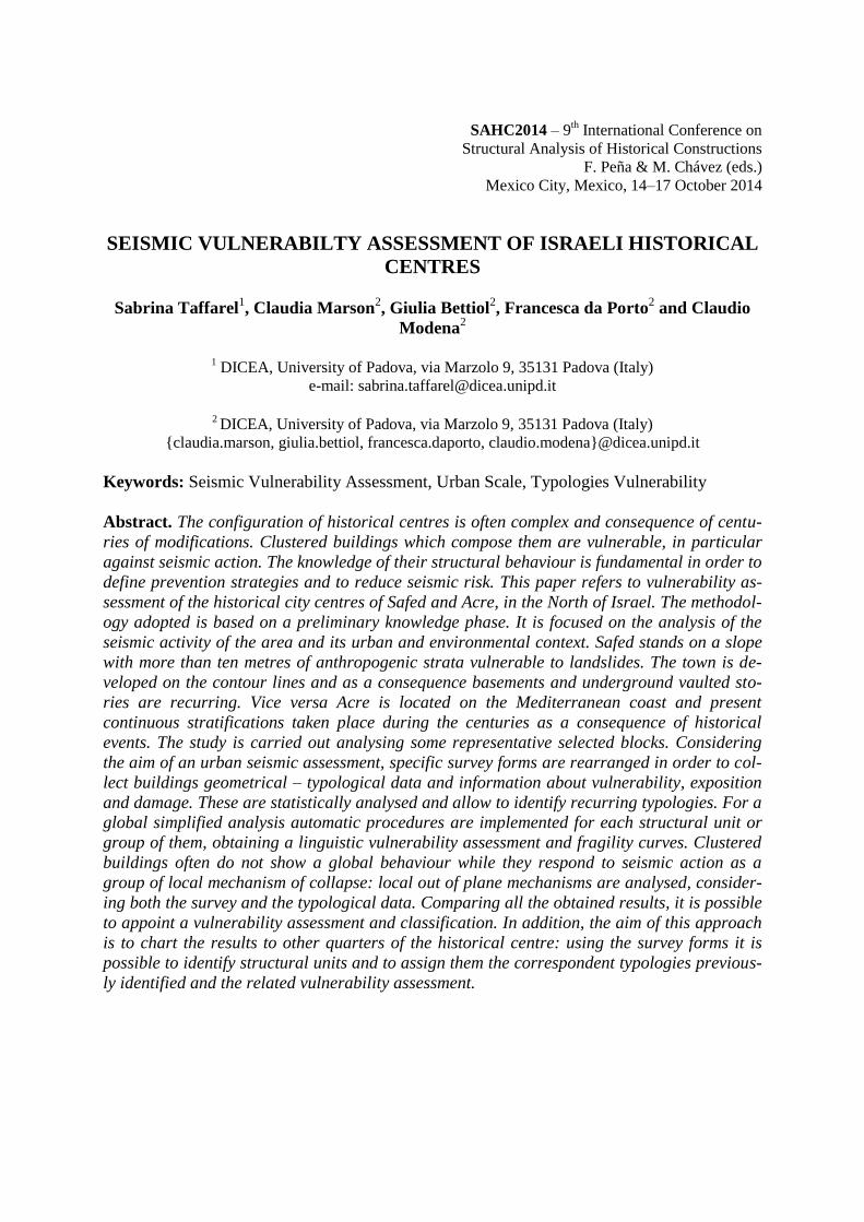
Safed (Figure 1, 2) is a city located in the Upper Galilee at an elevation of about 900 me-
tres above the sea level. Even if it is located on a mountainous region, it was considered a
strategic site because of its height. In fact, on the highest peak of the mountain a fortress was
built during the Crusade period and the first settlement was located on the hillside below it.
Later buildings developed from the lower margins of the hill up to the central highest area.
For many centuries Safed was ruled by Arabs, Turks, Mamluks and Jews leaving historical,
religious and architectural heritage [2]. A few meters deep layered anthropogenic material,
which is the consequence of more than 2000 years of human habitation, characterized the soil
on which the town stands. It is composed by a mechanically weak material that is susceptible
to slope failure and to amplification of seismic-shaking. Many buildings in the core of Safed
were built no later than the mid-20th century and even before; in many cases they were
founded on the anthropogenic talus without any support by the underlying bed rock [3]. The
historical centre presents many recurring features (Figure 3) such as passageways, habitable
structures, courtyards and often ruins. Internal narrow streets split the historical centre into
irregular geometric portions. Steep stairs connect parts of the city in the east west direction
and narrow vaulted passages are often located on underground levels.
Seismic vulnerability assessment of Israeli historical centres
3
Figure 1: Identification of the
area
Figure 2: The town of Safed
Source: Israel Antiquities Authori-
ties
Figure 3: Buildings in Safed historical
center
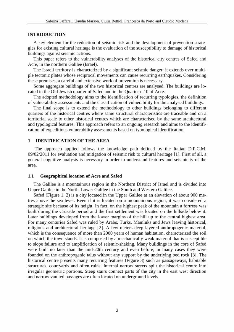
Acre is the second city analysed (Figure 4) and is located in the Western Galilee, at the
northern extremity of the Haifa Bay on the Mediterranean Sea. In 2001 UNESCO designated
the Old City of Acre (Figure 5) as a World Heritage Site [4]. Acre is characterized by a very
complex urban configuration difficult to read because of continuous stratifications taken place
over the years: Crusaders, Arabs, Ottomans and the British Empire dominated the area. The
old town is bordered by a fortified wall which dates back first to the crusade and then to the
ottoman period. The city developed within the fortified wall is very compact, the reduced
space led to the creation of narrow streets that linked the neighborhoods. The majority of the
city was destroyed or distorted following the Mamluks conquest. The medieval urban struc-
ture was divided into well-defined districts. Later it was topped by a structure that partially
kept the pre-existing road system; minor routes were privatized and only the major ones were
upgraded (Figure 6). The dwelling construction in Acre reflects vernacular architecture and
four distinguishing types of buildings can be identified: the courtyard house, the central hall
plan house, the captain’s house and the apartment house. In addition, the “bridge house” is
characterized by rooms that rise above walking tunnels [5].
Figure 4: Identification of the
area
Figure 5: The town of Acre
Source: Israel Antiquities Authori-
ties
Figure 6: Buildings in Acre histori-
cal center
Sabrina Taffarel, Claudia Marson, Giulia Bettiol, Francesca da Porto and Claudio Modena
4
1.2 Seismicity in Israel
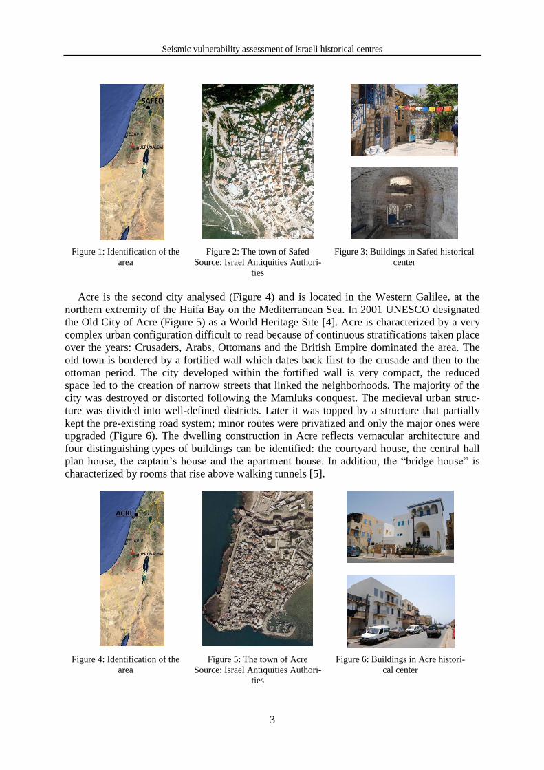
Galilee region belongs to the Dead Sea Transform (DST) fault system, also referred to as
the Dead Sea Rift (Figure 7). It is composed by series of faults that define the boundary be-
tween the African Plate (west Israel) and the Arabian Plate (east Israel). The zone is charac-
terized by left lateral displacement, because of the relative movements of the two plates [6].
Because of this, the Israeli territory is characterized by a significant seismic hazard (Figure 8).
It is situated on the Dead Sea fault and suffered earthquakes of different intensities, some-
times characterised by severe damage (Figure 9).
Figure 7: Dead Sea trans-
form fault system
Source: http://www.gii.co.il
Figure 8: PGA map of the Israeli
seismic code SI 413 (1995, 2004
amendment).
Source: http://www.gii.co.il
Figure 9: Regional seismicity during 1900-
2007
Source: A. Shapira, R. Hofstetter, Geophys-
ical Institute of Israel, Earthquake hazard
assessment for building codes. Final report,
2007
The "Safed earthquake", occurred on January 1st 1837, and the earthquake of September
11th
1927 were the most relevant historical earthquakes occurred in northern Israel during the
last two centuries. Safed was completely destroyed in the 1837 earthquake because of a slide
and Arab villages in the area were severely damaged. The earthquake had an estimate magni-
tude (Ms) > 7. The 1927 earthquake was less pronounced in Galilee but caused heavy damage
in Nablus [7].
Two earthquakes struck the northern part of Israel in October and November 1759. The
first one had a magnitude (Ms) of approximately 6.6 (estimated epicentre on the Jordan fault,
north of the Sea of Galilee). The second one had a magnitude (Ms) of 7.4 (estimated epicentre
further north). Fifty kilometres south-west of Safed another earthquake occurred on August
1984. In Safed it was characterized by an intensity of V, according to MSK scale, with no re-
ported induced landslides. The fault is not in the immediate vicinity of Acre and the town has
not yet undergone major earthquakes but it can be assumed that is close enough to have suf-
fered, at least partially and with no historical evidences, the effects of the strongest earth-
quakes.
2 METHODOLOGY
The seismic vulnerability analysis of historical buildings at a territorial level is based on
simplified methodologies and models, that are reliable, based on empiric parameters. The car-
Seismic vulnerability assessment of Israeli historical centres
5
ried out analysis is characterized by an expeditious survey on typological base in which in-
formation about building structures, vulnerability and exposition to damage are collected.
The analysed aggregate buildings are consequence of different architectural sequences, use
of materials and customers intervention occurred during centuries of unplanned transfor-
mations. As a consequence their structure does not allow studying them as simple buildings
[8]. The study is focused on the analysis of clustered buildings whose architectonical, struc-
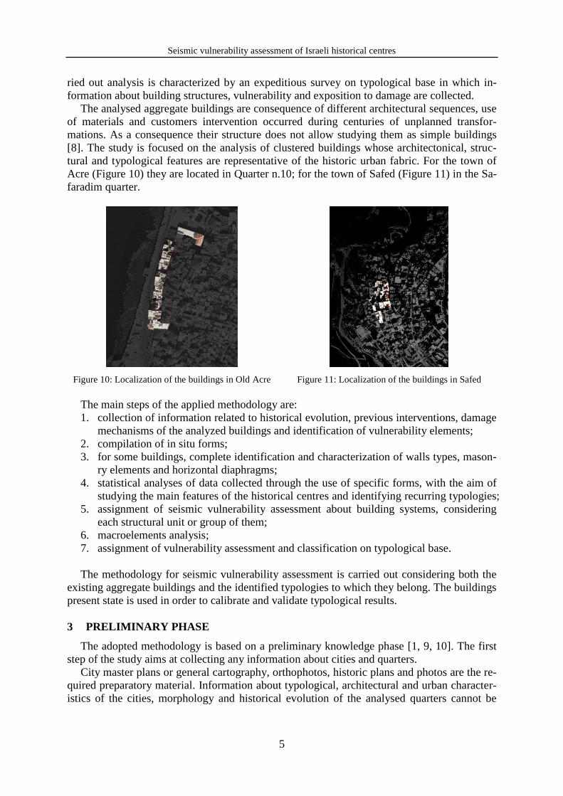
tural and typological features are representative of the historic urban fabric. For the town of
Acre (Figure 10) they are located in Quarter n.10; for the town of Safed (Figure 11) in the Sa-
faradim quarter.
Figure 10: Localization of the buildings in Old Acre Figure 11: Localization of the buildings in Safed
The main steps of the applied methodology are:
1. collection of information related to historical evolution, previous interventions, damage
mechanisms of the analyzed buildings and identification of vulnerability elements;
2. compilation of in situ forms;
3. for some buildings, complete identification and characterization of walls types, mason-
ry elements and horizontal diaphragms;
4. statistical analyses of data collected through the use of specific forms, with the aim of
studying the main features of the historical centres and identifying recurring typologies;
5. assignment of seismic vulnerability assessment about building systems, considering
each structural unit or group of them;
6. macroelements analysis;
7. assignment of vulnerability assessment and classification on typological base.
The methodology for seismic vulnerability assessment is carried out considering both the
existing aggregate buildings and the identified typologies to which they belong. The buildings
present state is used in order to calibrate and validate typological results.
3 PRELIMINARY PHASE
The adopted methodology is based on a preliminary knowledge phase [1, 9, 10]. The first
step of the study aims at collecting any information about cities and quarters.
City master plans or general cartography, orthophotos, historic plans and photos are the re-
quired preparatory material. Information about typological, architectural and urban character-
istics of the cities, morphology and historical evolution of the analysed quarters cannot be

Sabrina Taffarel, Claudia Marson, Giulia Bettiol, Francesca da Porto and Claudio Modena
6
disregarded. Moreover, for some buildings, complete identification, recognition and charac-
terization of typology and components are essential.
3.1 On-site activity
The on-site activity starts with a general reconnaissance of the blocks with the aim of sub-
dividing the aggregate buildings into structural units. A visual survey is carried out in order to
collect information about buildings structural behaviour. The assistance of expert Israeli tech-
nicians is fundamental in order to identify typologies, constructive techniques and used mate-
rials. A form compilation for masonry and concrete buildings is filled, collecting:
- geometrical, typological, vulnerability information about each structural unit (i.e. hori-
zontal and vertical structures, number of stories, age of construction, interventions un-
dergone, reinforcing elements present state, in plan and in elevation irregularities);
- information about exposure and damage (level and extension of damage for structural
and non-structural elements).
The survey forms are specifically organized in order to be adapted to Israeli historical
buildings.
During the on-site activity, a photographic survey is done. Photos are taken inside and out-
side structural units (including roofs), with a particular attention to damages or alterations
(such as the presence of cracks or materials deterioration),architectural features, interactions
due to aggregation, courtyards and contrast elements between buildings.
3.2 Statistical and typological analysis
Data collected during on-site activities are essential in order to understand clustered build-
ings behaviour. They are statistically analysed in order to identify the most recurrent buildings
features and typologies. The towns are characterised by many features in common. Their
dwelling clustered buildings were usually built before the XX century and nowadays they ap-
pear reshaped as a result of numerous interventions occurred during the years. Their main ver-
tical structures are ascribable to two leaves walls with inner core and one leaf walls, mostly
made of sandstone (in Acre) whereas of limestone (in Safed). Vaults systems often character-
ise groundfloors and underground levels, moreover in Acre wide discharge arches stiffen wall
structure. Nevertheless more recent horizontal diaphragms are made of concrete and metal
beams. Roofs are usually flat and the prevalent typology of Acre is characterized by wooden
structures, and sometimes concrete slab. Also in Safed roofs are flat and walkable too; they
are usually covered with a mix of mortar and small stones then beaten with a wooden hammer
[11]. In the evaluation of recurring elements, it is important to identify the elements which can
reduce the vulnerability of buildings also toward seismic actions. In Acre reinforced elements
such as contrast arches (also built contrast arches, i.e. bridge houses) and tie rods are frequent,
external stairs can often be considered as contrast elements (for walls subjected to out-of-
plane mechanisms). Vice versa these elements are not recurring in Safed. For both the towns
misaligned openings, heavy roofs, overhanging, towering or standing out elements are quite
frequent vulnerable parts; they must be evaluated in order to understand buildings structural
behaviours. In particular in Acre there is often an increase of upper floors area (overhanging
elements regularize storey geometry). Another important consideration is related to buildings
present state, indeed over the years they have sometimes undergone a slow process of decay.
As a consequence bad conditions or medium damage are mostly due to abandon or neglect.
The information are collected with the aim of carrying out a statistical and typological
analysis in order to identify recurring typologies, giving a vulnerability assessment concern-
ing structural units and blocks as a whole.
Seismic vulnerability assessment of Israeli historical centres
7
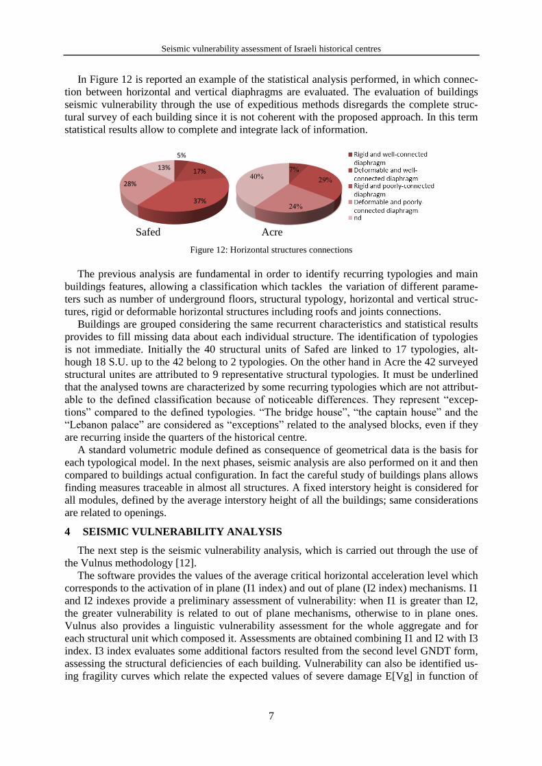
In Figure 12 is reported an example of the statistical analysis performed, in which connec-
tion between horizontal and vertical diaphragms are evaluated. The evaluation of buildings
seismic vulnerability through the use of expeditious methods disregards the complete struc-
tural survey of each building since it is not coherent with the proposed approach. In this term
statistical results allow to complete and integrate lack of information.
Safed Acre
Figure 12: Horizontal structures connections
The previous analysis are fundamental in order to identify recurring typologies and main
buildings features, allowing a classification which tackles the variation of different parame-
ters such as number of underground floors, structural typology, horizontal and vertical struc-
tures, rigid or deformable horizontal structures including roofs and joints connections.
Buildings are grouped considering the same recurrent characteristics and statistical results
provides to fill missing data about each individual structure. The identification of typologies
is not immediate. Initially the 40 structural units of Safed are linked to 17 typologies, alt-
hough 18 S.U. up to the 42 belong to 2 typologies. On the other hand in Acre the 42 surveyed
structural unites are attributed to 9 representative structural typologies. It must be underlined
that the analysed towns are characterized by some recurring typologies which are not attribut-
able to the defined classification because of noticeable differences. They represent “excep-
tions” compared to the defined typologies. “The bridge house”, “the captain house” and the
“Lebanon palace” are considered as “exceptions” related to the analysed blocks, even if they
are recurring inside the quarters of the historical centre.
A standard volumetric module defined as consequence of geometrical data is the basis for
each typological model. In the next phases, seismic analysis are also performed on it and then
compared to buildings actual configuration. In fact the careful study of buildings plans allows
finding measures traceable in almost all structures. A fixed interstory height is considered for
all modules, defined by the average interstory height of all the buildings; same considerations
are related to openings.
4 SEISMIC VULNERABILITY ANALYSIS
The next step is the seismic vulnerability analysis, which is carried out through the use of
the Vulnus methodology [12].
The software provides the values of the average critical horizontal acceleration level which
corresponds to the activation of in plane (I1 index) and out of plane (I2 index) mechanisms. I1
and I2 indexes provide a preliminary assessment of vulnerability: when I1 is greater than I2,
the greater vulnerability is related to out of plane mechanisms, otherwise to in plane ones.
Vulnus also provides a linguistic vulnerability assessment for the whole aggregate and for
each structural unit which composed it. Assessments are obtained combining I1 and I2 with I3
index. I3 index evaluates some additional factors resulted from the second level GNDT form,
assessing the structural deficiencies of each building. Vulnerability can also be identified us-
ing fragility curves which relate the expected values of severe damage E[Vg] in function of
Sabrina Taffarel, Claudia Marson, Giulia Bettiol, Francesca da Porto and Claudio Modena
8
different values of PGA/g ratio (PGA: peak ground acceleration; g: acceleration of gravity).
Fragility curves define lower, central and upper limits: the range of the most probable values
of expected severe damage is enclosed between upper and lower curves.
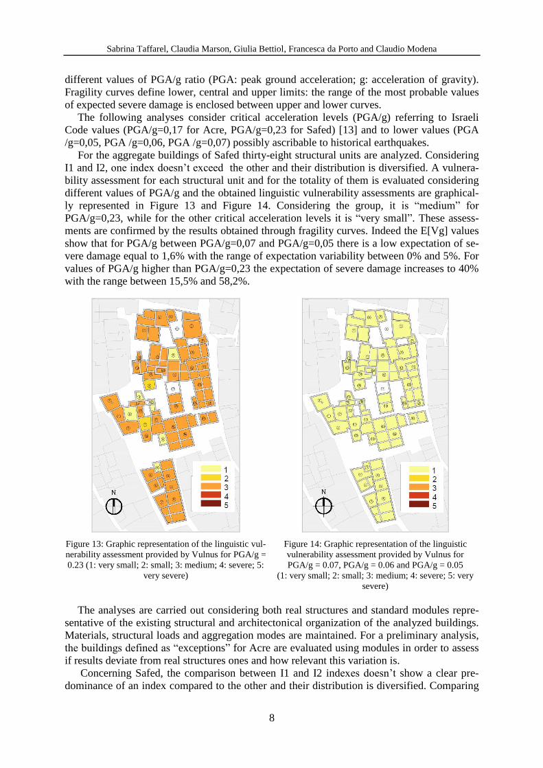
The following analyses consider critical acceleration levels (PGA/g) referring to Israeli
Code values (PGA/g=0,17 for Acre, PGA/g=0,23 for Safed) [13] and to lower values (PGA
/g=0,05, PGA /g=0,06, PGA /g=0,07) possibly ascribable to historical earthquakes.
For the aggregate buildings of Safed thirty-eight structural units are analyzed. Considering
I1 and I2, one index doesn’t exceed the other and their distribution is diversified. A vulnera-
bility assessment for each structural unit and for the totality of them is evaluated considering
different values of PGA/g and the obtained linguistic vulnerability assessments are graphical-
ly represented in Figure 13 and Figure 14. Considering the group, it is “medium” for
PGA/g=0,23, while for the other critical acceleration levels it is “very small”. These assess-
ments are confirmed by the results obtained through fragility curves. Indeed the E[Vg] values
show that for PGA/g between PGA/g=0,07 and PGA/g=0,05 there is a low expectation of se-
vere damage equal to 1,6% with the range of expectation variability between 0% and 5%. For
values of PGA/g higher than PGA/g=0,23 the expectation of severe damage increases to 40%
with the range between 15,5% and 58,2%.
Figure 13: Graphic representation of the linguistic vul-
nerability assessment provided by Vulnus for PGA/g =
0.23 (1: very small; 2: small; 3: medium; 4: severe; 5:
very severe)
Figure 14: Graphic representation of the linguistic
vulnerability assessment provided by Vulnus for
PGA/g = 0.07, PGA/g = 0.06 and PGA/g = 0.05
(1: very small; 2: small; 3: medium; 4: severe; 5: very
severe)
The analyses are carried out considering both real structures and standard modules repre-
sentative of the existing structural and architectonical organization of the analyzed buildings.
Materials, structural loads and aggregation modes are maintained. For a preliminary analysis,
the buildings defined as “exceptions” for Acre are evaluated using modules in order to assess
if results deviate from real structures ones and how relevant this variation is.
Concerning Safed, the comparison between I1 and I2 indexes doesn’t show a clear pre-
dominance of an index compared to the other and their distribution is diversified. Comparing
Seismic vulnerability assessment of Israeli historical centres
9
indexes of real structures and of modular ones, the highest index is the same for both cases in
almost all models, showing a correspondence in vulnerability assessment (in plane or out of
plane). Despite some differences in vulnerability assessment for some buildings, group vul-
nerability is kept unchanged: “medium” for PGA/g=0,17 and “very small” for lower PGA/g
values.
Relevant differences between modular and realistic structures occur for those buildings de-
fined as “exceptions” since modules regularize and simplify structures, changing dimensional
parameters often significantly. The most significant variations are related to changes in story
height, regularization of in plan and in elevation configuration, modification of buildings
openings percentage and dimensions, regularization of their position on facades and change of
conventional resistance. For instance, the “Lebanon palace” is characterized by the I1 index
greater than the I2 index both in realistic and modular representation, so the vulnerability as-
sessment (greater vulnerability for out of plane mechanisms) is still the same. Both indexes
are higher in modular representation, showing an increase of in plane and out of plane build-
ing resistance which is due to halving of building interstory height, reduction of plan area and
openings percentage/dimensions, and absence of internal walls. The building linguistic as-
sessment changes and becomes definitely less severe for modular representation. The im-
provement is also linked to differences between I3 indexes. The main variations (for the
analyzed case and for many other buildings) are noticed for in plan and in elevation configu-
rations and for conventional resistance (the parameter provides an estimate of masonry build-
ing resistance toward horizontal actions using a simplified method which relates the building
to a shear wall). Moreover the existence of double height arcade, cannot be represented using
modular schematization. Furthermore the assessment given for conventional resistance is im-
proved for modular schematization. It is therefore suitable to consider these buildings as sepa-
rate typologies characterized by their own dimensional parameters.
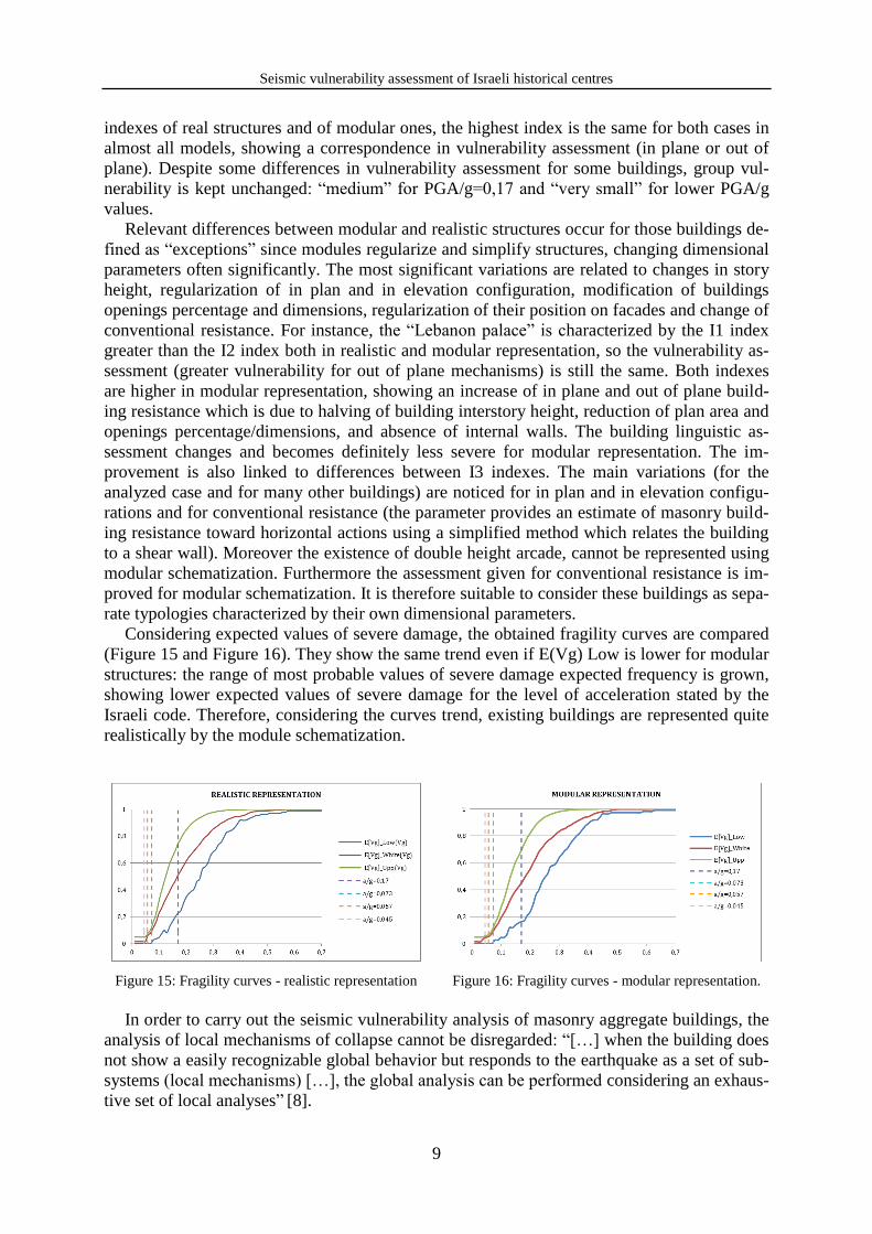
Considering expected values of severe damage, the obtained fragility curves are compared
(Figure 15 and Figure 16). They show the same trend even if E(Vg) Low is lower for modular
structures: the range of most probable values of severe damage expected frequency is grown,
showing lower expected values of severe damage for the level of acceleration stated by the
Israeli code. Therefore, considering the curves trend, existing buildings are represented quite
realistically by the module schematization.
Figure 15: Fragility curves - realistic representation
Figure 16: Fragility curves - modular representation.
In order to carry out the seismic vulnerability analysis of masonry aggregate buildings, the
analysis of local mechanisms of collapse cannot be disregarded: “[…] when the building does
not show a easily recognizable global behavior but responds to the earthquake as a set of sub-
systems (local mechanisms) […], the global analysis can be performed considering an exhaus-
tive set of local analyses” [8].
Sabrina Taffarel, Claudia Marson, Giulia Bettiol, Francesca da Porto and Claudio Modena
10
For the towns of Acre and Safed the analyses of most probable out of plane mechanisms of
collapse are performed, related to out of plane overturning and vertical bending of outer walls.
In particular they are the consequence of technicians expert assessment defined during sur-
veys and elaboration data phases.
In order to carry out the equilibrium limit approach (kinematic analyses) it is essential to
identify conditions that could cause the activation of local mechanisms of damage and col-
lapse and to evaluate the best representative configuration. These information are acquired by
means of the statistical and typological analyses: walls and horizontal diaphragms materials,
interactions with other elements of adjacent buildings and presence or absence of tie rods. The
analyses evaluate each wall feature (one leaf wall or two leaves walls with an inner core of
limited thickness) and the quality of vertical and horizontal connections is considered in terms
of friction forces.
A linear kinematic analysis is performed for each local mechanism of collapse. If the anal-
ysis is not verified, a nonlinear kinematic analysis is carried out.
For all the buildings, the analyses consider the most significant out of plane mechanisms of
the perimeter walls, identified through their geometrical and structural configuration and by
the presence of contrasting elements.
For the town of Safed the simple overturning of essentially resting on the ground walls is
performed. 52 mechanisms are evaluated and only the 11% of the performed linear kinematic
analyses are verified. Nonlinear kinematic analyses are carried out and increase to the 17%.
However some simplifications are necessary. For example the lack of information about
vaults structure is quite significant for the results. Changing only geometrical parameters, re-
lated to the uncertainty about the real configuration (but approximately similar to it), different
results are determined: a reduction of the 40% of horizontal and vertical components of vaults
thrusts does not entail a significant difference in term of satisfaction of the analyses (from
11% to 14%). Otherwise it is associated to a considerable increase of the linear safety coeffi-
cient, determined by the ratio between spectral acceleration and required one. These evalua-
tions are carried out considering the application of the vault horizontal thrust with an arm
equal to the interstory high. Vice versa reducing it, there is an increase of the satisfied verifi-
cation up to the 15% in the linear kinematic analyses and a resulting enhance of the safety co-
efficients. In safety condition and for rapid evaluation, therefore the worst geometrical
configuration is considered. Nevertheless results must be examined and suitable changes
could be required.
For the town of Acre simple overturning of walls essentially resting on the ground and of
the upper part of them are performed. Considering the first condition, 36 mechanisms are per-
formed and the 44% of them are satisfied in linear analysis, the 52% in non-linear one. Modi-
fications of vaults geometry with a reduction of the 40% of their components lead to an
increase up to the 55% of the linear analysis. For the overturning mechanism related to the
upper part of the wall, only the 20% of the 48 walls are satisfied in non-linear analysis. Verti-
cal bending analyses are performed considering one story. 39 walls are analyzed and the 53%
are verified in nonlinear analysis.
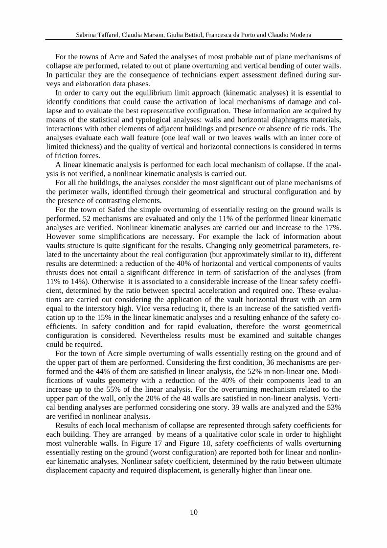
Results of each local mechanism of collapse are represented through safety coefficients for
each building. They are arranged by means of a qualitative color scale in order to highlight
most vulnerable walls. In Figure 17 and Figure 18, safety coefficients of walls overturning
essentially resting on the ground (worst configuration) are reported both for linear and nonlin-
ear kinematic analyses. Nonlinear safety coefficient, determined by the ratio between ultimate
displacement capacity and required displacement, is generally higher than linear one.
Seismic vulnerability assessment of Israeli historical centres
11
Figure 17: Representation of linear analysis results
through the safety coefficient
Figure 18: Representation of nonlinear analysis re-
sults through the safety coefficient
CONCLUSIONS
The development of prevention strategies cannot disregard the evaluation of the suscepti-
bility to damage of historical buildings. In this context, a vulnerability analysis is therefore
fundamental to reduce the seismic risk of existing cultural heritage.
The aim of this paper is to define a methodology for the seismic vulnerability analysis of
clustered buildings in Acre and Safed. The purpose is to extend the adopted approach to other
quarters of the historical centres which are characterised by same architectural and typological
features. As a consequence, calibrated rapid forms to be filled on site will be drawn up in or-
der to recognize the previously identified typologies, associating to them the seismic vulnera-
bility assessment. Concerning a larger scale, it will be implemented to other Israeli cities. It is
an ongoing study, nevertheless the substantial correspondence between the vulnerability as-
sessment for the real case and the schematic representations through standard modules vali-
dates its applicability. Buildings defined as “exceptions”, which represent particular
typologies, must be separately evaluated considering specific and appropriate simplifications.
ACKNOWLEDGEMENTS
The authors gratefully thank the Israel Antiquities Authority (IAA), in particular Mr. Mi-
chael Cohen, and Eng. Yaacov Schaffer for their help during the preliminary phase of on-site
surveys and for their contribution in providing historical, architectural, structural and urban
information about analysed buildings, quarters and cities. A heartfelt thanks to the students
Martina Caliman and Valentina Zalunardo for their help on data processing.
REFERENCES
[1] D.P.C.M. 09/02/2011, Valutazione e riduzione del rischio sismico del patrimonio cultu-
rale con riferimento alle Norme tecniche per le costruzioni di cui al decreto del Mini-
Sabrina Taffarel, Claudia Marson, Giulia Bettiol, Francesca da Porto and Claudio Modena
12
stero delle infrastrutture e dei trasporti del 14 gennaio 2008. G.U. 26/02/2011, n. 47. In
Italian
[2] http://www.safed.co.il/.
[3] O. Katz, O. Crouvi, The geotechnical effects of long human habitation (2000<years):
Earthquake induced landslide hazard in the city of Zefat, northern Israel. Engineering
Geology, XCV, 57-78, 2007.
[4] http://www.unesco.org
[5] http://www.iaa-conservation.org
[6] N. Wechsler, T. Rockwell, Y. Klinger, A. Agnon, S. Marco, Historical and Paleo-
seismicity of the Dead Sea Transform in northern Israel, Tel Aviv, Israel. [7] D. Wachs, D. Levitte, Damage Caused By Landslides During the
Earthquakes of 1837 and 1927 in the Galilee Region, Report HYDRO/5/78, Jerusalem:
Geological Survey of Israel, Report, 1978.
[8] Circolare n. 617 02/02/2009. Istruzioni per l'applicazione delle “Norme tecniche per le
costruzioni, di cui al D.M. 14/01/2008”. In Italian.
[9] C. Marson, S. Taffarel, G. Bettiol, M. Munari, C. Modena, G. Cialone, G. Cifani, A.
Mannella, A. Petracca. Sviluppo dei Piani di Ricostruzione di borghi dell’aquilano col-
piti dal sisma del 6 aprile 2009. Atti del XV Convegno ANIDIS ‘L’Ingegneria Sismica
in Italia’, Padova, Italy, 30 June - 4 July, 2013. In Italian.
[10] G. Bettiol, M. Munari, F. da Porto, M.R. Valluzzi, C. Modena. Development of Recon-
struction Plans for towns damaged by the April 6th 2009 Abruzzo earthquake. Proceed-
ings of the International Conference on Rehabilitation and Restoration of Structures.
Madras, Chennai, India, February 12-16, 2013.
[11] G. Mariti, Viaggi per l’isola di Cipro e Palestina fatti da Giovanni Mariti, Accademico
Fiorentino dall’anno MDCCLX al MDCCLXVIII, Tomo II, Firenze, 1769. In Italian.
[12] University of Padova, Manuale d’uso del programma Vulnus 4.0, 2009. In Italian.
[13] Israel Standard SI 413, Amendment n. 2. Design provisions for earthquake resistance of
structures. Standards Institution of Israel, Tel Aviv, 2014.


