Embed Size (px)
Citation preview

Rural Service Area Sanitary Sewer Capability Study
February 2006 i
Table Of Contents
Section 1 Executive Summary........................................................................................................... 1
Section 2 Introduction......................................................................................................................15
Section 3 Lower South Elkhorn Rural Service Area .......................................................................22
Section 4 Man O' War Rural Service Area.......................................................................................36
Section 5 Old Frankfort Pike Rural Service Area............................................................................49
Section 6 Ironworks Pike Rural Service Area .................................................................................74
Section 7 Avon/I-64 Rural Service Area .........................................................................................89
Section 8 Delong Road/Richmond Road Rural Service Area......................................................138
Appendices:
A. Design Flow Calculations ..............................................................................................163
B. Peaking Factors (Table 4.2, LFUCG Sanitary Sewer and Pumping Station Manual) ............................................................................................166
C. Unit Price for Trunk Sewers and Force Mains .............................................................167
D. Pumping Station Data and Costs .................................................................................169
E. Large-Scale Map
Rural Service Area Sanitary Sewer Capability Study
February 2006 ii
Tables:
Section 1 Executive Summary: 1.1 Areas for Study, Sanitary Sewer Capability Study LFUCG Rural Service area............. 1 1.2 Cost Summary, Lower South Elkhorn (LSE) RSA .................................................. 4 1.3 Cost Summary, Man O' War (MW) RSA.................................................................. 6 1.4 Cost Summary, Old Frankfort Pike (OFP) RSA....................................................... 7 1.5 Cost Summary, Ironworks Pike (IP) RSA................................................................ 9 1.6 Cost Summary Avon/I-64 (AV) RSA......................................................................10 1.7 Cost Summary Delong Road/Richmond (DR) RSA .............................................11 1.8 Summary of Estimated Total Project Cost LFUCG Rural Service Area
Sanitary Sewer Capability Study..........................................................................13 1.9 Summary of Average Daily Flows LFUCG Rural Service Area
Sanitary Sewer Capability Study..........................................................................14
Section 2 Introduction 2.1 Areas for Study ...................................................................................................15
Section 3 Lower South Elkhorn Rural Service Area: 3.1 Land Use Classification - LSE RSA ....................................................................22 3.2 Land Parcel Size Distribution - LSE RSA ...........................................................22 3.3 Cost Summary – LSE RSA..................................................................................26
Section 4 Man O War Rural Service Area: 4.1 Land Use Classification – MW RSA ...................................................................36 4.2 Land Parcel Size Distribution – MW RSA..........................................................36 4.3 Cost Summary – MW RSA..................................................................................39
Section 5 Old Frankfort Pike Rural Service Area: 5.1 Land Use Classification – OFP-1 RSA ...............................................................49 5.2 Land Use Classification – OFP-2 RSA ...............................................................49 5.3 Land Parcel Size Distribution – OFP-1 RSA ......................................................50 5.4 Land Parcel Size Distribution – OFP-2 RSA ......................................................50 5.5 Land Use Summary – OFP RSA .........................................................................50 5.6 Land Parcel Size Summary – OFP RSA .............................................................50 5.7 Candidate Pump Stations for Decommissioning..............................................53 5.8 Required WWTP Capacity for OFP RSA .............................................................53 5.9 Summary of WWTP Capacity and Cost – OFP RSA...........................................54 5.10 Cost Summary – OFP-1 RSA ..............................................................................55 5.11 Cost Summary – OFP-2 RSA ..............................................................................55 5.12 OFP Cost Summary – OFP RSA..........................................................................55
Section 6 Ironworks Pike Rural Service Area: 6.1 Land Use Classification – IP RSA ......................................................................74 6.2 Land Parcel Size Distribution – IP RSA .............................................................74 6.3 Cost Summary – IP RSA .....................................................................................77
Section 7 Avon/I-64 Rural Service Area: 7.1 Land Use Classification – AV RSA .....................................................................89 7.2 Land Parcel Size Distribution – AV RSA ............................................................89 7.3 Land Use Classification – AV-1..........................................................................90
Rural Service Area Sanitary Sewer Capability Study
February 2006 iii
7.4 Land Parcel Size Distribution – AV-1 ................................................................90 7.5 Land Use Classification – AV-2..........................................................................90 7.6 Land Parcel Size Distribution – AV-2.................................................................90 7.7 Land Use Classification – AV-3..........................................................................90 7.8 Land Parcel Size Distribution – AV-3.................................................................90 7.9 Cost Summary – AV RSA....................................................................................96 7.10 Cost Summary – AV-1 RSA.................................................................................97 7.11 Cost Summary – AV-2 RSA.................................................................................97 7.12 Cost Summary – AV-3 RSA.................................................................................97
Section 8 Delong Road/Richmond Road Rural Service Area: 8.1 Land Use Classification – DR RSA...................................................................139 8.2 Land Parcel Size Distribution – DR RSA .........................................................139 8.3 Average and Peak Wastewater Flows – DR RSA ............................................141 8.4 Cost Summary – DR RSA ................................................................................144
Exhibits:
Section 1 Lower South Elkhorn Rural Service Area: Exhibit 1.1 Direction of Gravity Flow of Potential Wastewater .................................. 2
Section 2 Introduction: Exhibit 2.1 Direction of Gravity Flow of Potential Wastewater .................................17
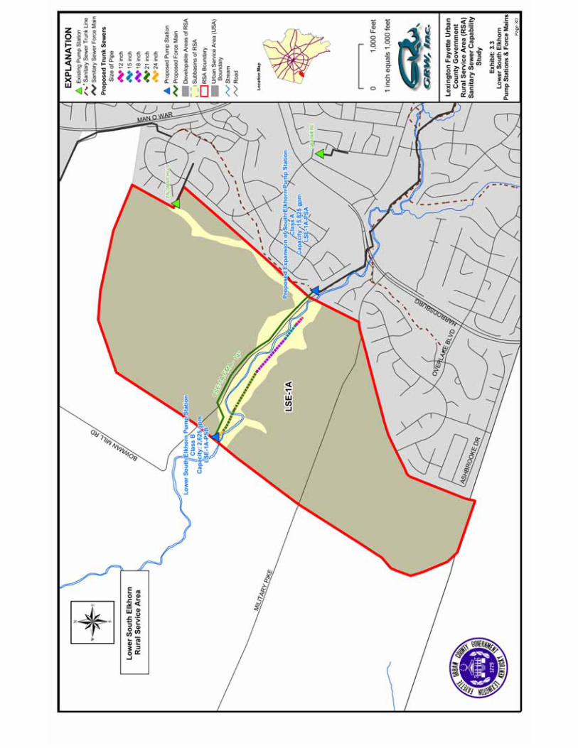
Section 3 Lower South Elkhorn Rural Service Area: Exhibit 3.1 Project Summary ......................................................................................28 Exhibit 3.2 Proposed Trunk Sewer Map.....................................................................29 Exhibit 3.3 Proposed Pump Stations & Force Main Map..........................................30
Section 4 Man O War Rural Service Area: Exhibit 4.1 Project Summary ......................................................................................41 Exhibit 4.2 Proposed Trunk Sewer Map.....................................................................42 Exhibit 4.3 Proposed Pump Stations & Force Main Map..........................................43
Section 5 Old Frankfort Pike Rural Service Area: Exhibit 5.1 Project Summary – OFP-1........................................................................57 Exhibit 5.2 Project Summary – OFP-2........................................................................58 Exhibit 5.3 Project Summary – OFP ...........................................................................59 Exhibit 5.4 Proposed Trunk Sewer Map.....................................................................61 Exhibit 5.5 Proposed Pump Stations & Force Main Map..........................................62
Section 6 Ironworks Pike Rural Service Area: Exhibit 6.1 Project Summary ......................................................................................79 Exhibit 6.2 Proposed Trunk Sewer Map.....................................................................80 Exhibit 6.3 Proposed Pump Stations & Force Main Map..........................................81
Section 7 Avon/I-64 Rural Service Area: Exhibit 7.1 Project Summary – AV-1 ..........................................................................99 Exhibit 7.2 Project Summary – AV-2 ........................................................................100 Exhibit 7.3 Project Summary – AV-3 ........................................................................101

Rural Service Area Sanitary Sewer Capability Study
February 2006 iv
Exhibit 7.4 Project Summary – AV............................................................................102 Exhibit 7.5 Summary with Blue Sky RAC Project Summary ....................................104 Exhibit 7.6 Proposed Trunk Sewer Map...................................................................105
Exhibit 7.7 Proposed Pump Stations & Force Main Map........................................106
Section 8 DeLong Road/Richmond Road Rural Service Area: Exhibit 8.1 Project Summary – DR-1........................................................................146 Exhibit 8.2 Project Summary – DR-2........................................................................148 Exhibit 8.3 Project Summary – DR ...........................................................................149 Exhibit 8.4 Proposed Trunk Sewer Map...................................................................151 Exhibit 8.5 Proposed Pump Stations & Force Main Map........................................152
Detailed Cost Information:
Section 3 Lower South Elkhorn Rural Service Area: Detailed Cost Information...............................................................................................31
Section 4 Man O War Rural Service Area: Detailed Cost Information...............................................................................................44
Section 5 Old Frankfort Pike Rural Service Area: Detailed Cost Information...............................................................................................63
Section 6 Ironworks Pike Rural Service Area: Detailed Cost Information...............................................................................................82
Section 7 Avon/I-64 Rural Service Area: Detailed Cost Information.............................................................................................107
Section 8 DeLong Road/Richmond Road Rural Service Area: Detailed Cost Information.............................................................................................153

Rural Service Area Sanitary Sewer Capability Study
February 2006
Section 1
Executive Summary
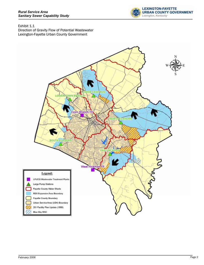
Six regions of the Lexington-Fayette Urban County Government (LFUCG) Rural Service Area (RSA) were previously
defined in the 1999 Rural Land Management Plan for review of sanitary sewer capability. This study is a preliminary
review of the infrastructure and capital required to provide sanitary sewer service to these regions. The six regions
identified for study consist of 31,919 acres of the RSA. The study areas are summarized and shown in Table 1.1 and
the map below. A large-scale map of the study areas is also provided in Appendix E.
Table 1.1 Areas for Study Sanitary Sewer Capability Study LFUCG Rural Service Area
Background
The most recent wastewater facility plan (1999) brought attention to the large costs
associated with expansion of the LFUCG wastewater system infrastructure. The LFUCG
Sanitary Sewer System is very unique in topography. Simply stated, the City of Lexington
is “built on top of a hill”. Exhibit 1.1 portrays the rural service areas proposed for study, the
existing wastewater treatment plants, the associated drainage basins, and the natural direction of flow. By
inspection, all future potential gravity drainage of wastewater flows away from the current Urban Service Area and
existing wastewater treatment facilities. As a result, all future wastewater would be pumped and conveyed upstream
for great distances for treatment each time expansion area is developed. Planning for future wastewater systems is
more complicated with this occurrence. The short-term required infrastructure, perhaps even for 20-year planning, is
often never far enough downstream or large enough for ultimate growth. This report addresses concept design and
magnitude of costs for full development of the study areas and provides insight into how future expansion of the
LFUCG wastewater system for these areas could occur.
Map Item LFUCG Rural Service Area Area (Acres)
LSE Lower South Elkhorn 774MW Man O’ War 376OFP Old Frankfort Pike 1,683IP Ironworks Pike 6,909AV Avon/I-64 16,589DR Delong Road/Richmond Road 5,588
Page 1
Rural Service Area Sanitary Sewer Capability Study
February 2006
Exhibit 1.1 Direction of Gravity Flow of Potential Wastewater Lexington-Fayette Urban County Government
Page 2
Rural Service Area Sanitary Sewer Capability Study
February 2006
Criteria
Several factors affect the results of this study. For this reason, the significant criteria utilized for the
development of this summary is reviewed:
Ultimate development and “build-out” of these areas will occur.
The unit flow of 1,500 gpd/developable acre is utilized for ultimate flow projections.
The design criteria of the LFUCG Sanitary Sewer and Pumping Station Manual has been utilized for preliminary sizing of all required infrastructure.
The LFUCG Wastewater System improvements, as provided for in the 201 Facility Plan, have been constructed or will be constructed by the time described RSA improvements are realized.
All resultant wastewater flows from development will be returned to one of the two existing LFUCG wastewater treatment plants (WWTP).
A summary of each study area is provided. A review of the key elements for development, required improvements,
estimated costs, and further recommendations is provided.
Lower South Elkhorn Rural Service Area
The Lower South Elkhorn Rural Service Area (LSE) is located in southwestern Fayette County. The LSE has a total
land area of 774 acres and a total developable land area of 700 acres. In review of the land use information, it is
the apparent the region primarily consists of prime agricultural and core equine agricultural land.
The projected average wastewater flow for the LSE is 1.05 MGD. Trunk sewers range in size up to 21” diameter. A
Class A pump station is required at the most downstream location of the LSE to provide capacity for the peak
wastewater flow of 2,625 gpm. The wastewater will be pumped upstream to the existing South Elkhorn Pump
Station via a 14” force main. Pumping upgrades to the South Elkhorn Pump Station and Force Main will be required
and flows will ultimately be delivered to the West Hickman Wastewater Treatment Plant, via the upgraded South
Elkhorn pump station and force main system.
In 2005, design was initiated for the upgrade of the South Elkhorn Pump Station to near 14,000 gpd capacity and
the proposed parallel South Elkhorn Force Main was upgraded to a 36” force main and extended to the West
Hickman WWTP. These upgrades, which are greater in magnitude than the 1999 LFUCG 201 Facility Plan
recommendations, can accommodate the LFUCG and some potential northern Jessamine County wastewater flows.
Currently, an agreement is in place between the LFUCG and Jessamine County to accept up to 2 MGD of wastewater
from Jessamine County for treatment at the West Hickman WWTP. The Jessamine County wastewater pumping and
conveyance alternatives have not been determined at this time, however, some capacity for northern Jessamine
County or additional in-basin LFUCG expansion area will be available upon completion of the 2005 South Elkhorn
Page 3
Rural Service Area Sanitary Sewer Capability Study
February 2006
Pump Station and Force Main Improvements. Available capacity will be utilized on a first come, first serve basis.
Monies from the development of either north Jessamine County or new LFUCG expansion area, such as the LSE,
should be provided to the LFUCG for the “shared” costs of the upgraded South Elkhorn pump station and force main
improvements.
Table 1.2 provides a summary of estimated total project costs for the wastewater infrastructure required for
development of the Lower South Elkhorn RSA. Shared costs for the upgrade improvements of the existing South
Elkhorn pump station and force main will be provided by the development of the Lower South Elkhorn RSA.
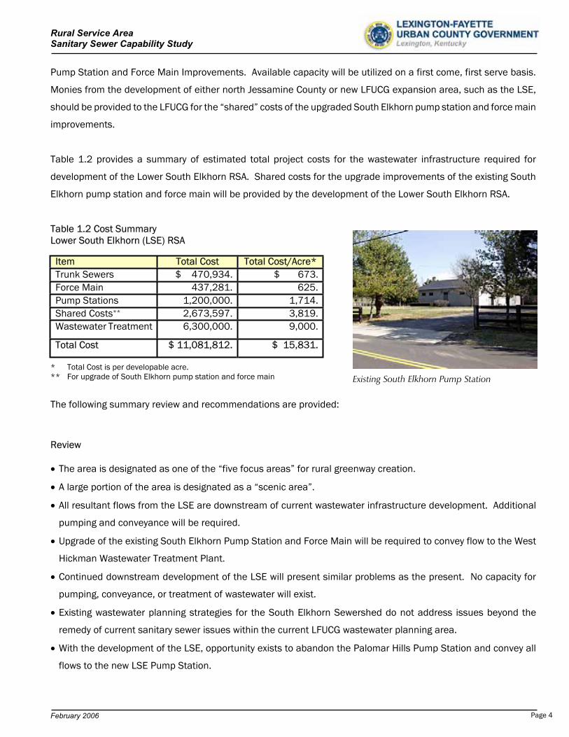
Table 1.2 Cost Summary Lower South Elkhorn (LSE) RSA
* Total Cost is per developable acre. ** For upgrade of South Elkhorn pump station and force main
The following summary review and recommendations are provided:
Review
The area is designated as one of the “five focus areas” for rural greenway creation.
A large portion of the area is designated as a “scenic area”.
All resultant flows from the LSE are downstream of current wastewater infrastructure development. Additional
pumping and conveyance will be required.
Upgrade of the existing South Elkhorn Pump Station and Force Main will be required to convey flow to the West
Hickman Wastewater Treatment Plant.
Continued downstream development of the LSE will present similar problems as the present. No capacity for
pumping, conveyance, or treatment of wastewater will exist.
Existing wastewater planning strategies for the South Elkhorn Sewershed do not address issues beyond the
remedy of current sanitary sewer issues within the current LFUCG wastewater planning area.
With the development of the LSE, opportunity exists to abandon the Palomar Hills Pump Station and convey all
flows to the new LSE Pump Station.
Item Total Cost Total Cost/Acre*Trunk Sewers $ 470,934. $ 673.Force Main 437,281. 625.Pump Stations 1,200,000. 1,714.Shared Costs** 2,673,597. 3,819.Wastewater Treatment 6,300,000. 9,000.
Total Cost $ 11,081,812. $ 15,831.
Existing South Elkhorn Pump Station
Page 4
Rural Service Area Sanitary Sewer Capability Study
February 2006
Recommendations
Revisit the issues and costs of an additional wastewater treatment plant
Evaluate the ability and availability of right-of-way to construct a second force main, along the Fayette
County/Jessamine County border, between the South Elkhorn Pump Station and West Hickman WWTP.
Determine other future alternatives available for pumping, conveyance, and treatment of wastewater flows from
the South Elkhorn drainage basin.
Expand future planning efforts for wastewater infrastructure beyond the traditional 20-year planning period.
Man O’ War Rural Service Area
The Man O’ War Rural Service Area (MW) is located in southwestern Fayette County. The MW has a total land area of
376 acres and a total developable land area of 341 acres. The land use in this study area is 89% core equine
agricultural or prime agricultural.
The projected average wastewater flow for the MW is 511,500 gpd. The projected peak wastewater flow is 1,562
gpm. A Class B pump station is required at the most downstream location of the MW with a capacity of 1,600 gpm.
The wastewater will be pumped to the existing South Elkhorn Pump Station. Pumping upgrades to the South Elkhorn
Pump Station will be required. Flows will ultimately be delivered to the West Hickman Wastewater Treatment Plant,
via the upgraded South Elkhorn pump station and force main system.
In 2005, design was initiated for the upgrade of the South Elkhorn Pump Station to nearly 14,000 gpd capacity and
the proposed parallel South Elkhorn Force Main was upgraded to a 36” force main and extended to the West
Hickman WWTP. These upgrades, which are greater in magnitude than the 1999 LFUCG 201 Facility Plan
recommendations, can accommodate the LFUCG and some potential northern Jessamine County wastewater flows.
Currently, an agreement is in place between the LFUCG and Jessamine County to accept up to 2 MGD of wastewater
from Jessamine County for treatment at the West Hickman WWTP. The Jessamine County wastewater pumping and
conveyance alternatives have not been determined at this time, however, some capacity for northern Jessamine
County or additional LFUCG expansion area will be available upon completion of the 2005 South Elkhorn Pump
Station and Force Main Improvements. Available capacity will be utilized on a first come, first serve basis. Monies
from the development of either north Jessamine County or new LFUCG expansion area, such as the MW, should be
provided to the LFUCG for the “shared” costs of the pumping and conveyance infrastructure.
Table 1.3 provides a summary of estimated total project costs for the wastewater infrastructure required for
development of the Man O’ War RSA. Shared costs for the upgrade improvements of the existing South Elkhorn
pump station and force main will be provided by the development of the Man O’ War RSA.
Page 5
Rural Service Area Sanitary Sewer Capability Study
February 2006
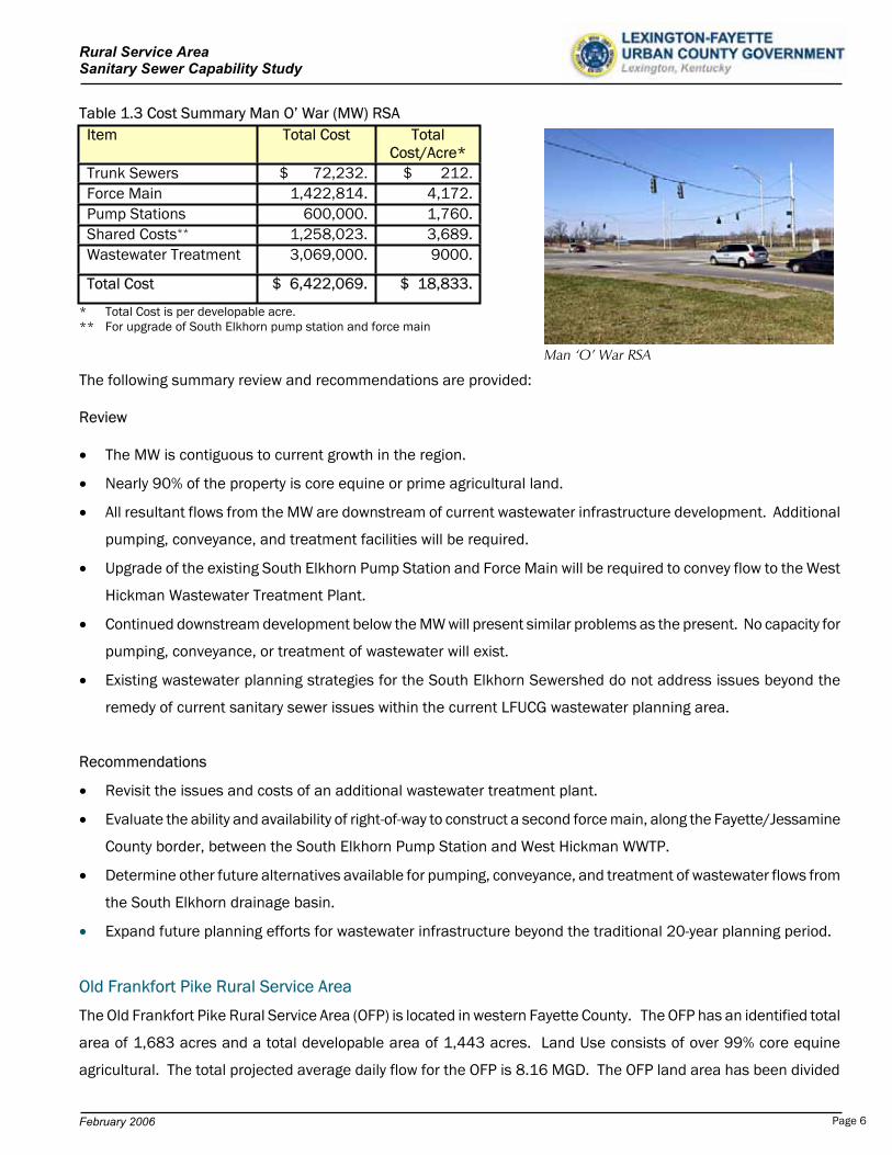
Table 1.3 Cost Summary Man O’ War (MW) RSA
* Total Cost is per developable acre. ** For upgrade of South Elkhorn pump station and force main
The following summary review and recommendations are provided:
Review
The MW is contiguous to current growth in the region.
Nearly 90% of the property is core equine or prime agricultural land.
All resultant flows from the MW are downstream of current wastewater infrastructure development. Additional
pumping, conveyance, and treatment facilities will be required.
Upgrade of the existing South Elkhorn Pump Station and Force Main will be required to convey flow to the West
Hickman Wastewater Treatment Plant.
Continued downstream development below the MW will present similar problems as the present. No capacity for
pumping, conveyance, or treatment of wastewater will exist.
Existing wastewater planning strategies for the South Elkhorn Sewershed do not address issues beyond the
remedy of current sanitary sewer issues within the current LFUCG wastewater planning area.
Recommendations
Revisit the issues and costs of an additional wastewater treatment plant.
Evaluate the ability and availability of right-of-way to construct a second force main, along the Fayette/Jessamine
County border, between the South Elkhorn Pump Station and West Hickman WWTP.
Determine other future alternatives available for pumping, conveyance, and treatment of wastewater flows from
the South Elkhorn drainage basin.
Expand future planning efforts for wastewater infrastructure beyond the traditional 20-year planning period.
Old Frankfort Pike Rural Service Area
The Old Frankfort Pike Rural Service Area (OFP) is located in western Fayette County. The OFP has an identified total
area of 1,683 acres and a total developable area of 1,443 acres. Land Use consists of over 99% core equine
agricultural. The total projected average daily flow for the OFP is 8.16 MGD. The OFP land area has been divided
Item Total Cost TotalCost/Acre*
Trunk Sewers $ 72,232. $ 212.Force Main 1,422,814. 4,172.Pump Stations 600,000. 1,760.Shared Costs** 1,258,023. 3,689.Wastewater Treatment 3,069,000. 9000.
Total Cost $ 6,422,069. $ 18,833.
Man ‘O’ War RSA
Page 6
Rural Service Area Sanitary Sewer Capability Study
February 2006
into two sub-drainage basins, OFP-1 and OFP-2. Each basin will have independent wastewater infrastructure. The
OFP-1 has a total land area of 411 acres and a projected average daily flow of 0.58 MGD. Independent of OFP-1
development, the existing Wolf Run Pump Station, of the Wolf Run Sewershed, would be replaced with the New Wolf
Run Pump Station and located near the confluence of Wolf Run Creek and Town Branch Creek, downstream of the
Town Branch WWTP. The existing Wolf Run Pump Station requires replacement due to lack of pumping capacity and
lack of available space to expand. Relocation is also desired due to the existing pump station being presently
located in a commercially developed area. The LFUCG and the OFP-1 development would provide shared monies for
the construction of the New Wolf Run pump station, force main, and trunk sewer. The New Wolf Run Pump Station
would have a capacity of 12,400 gpm. All wastewater would be conveyed to the Town Branch WWTP.
The OFP-2 has a total land area of 1,272 acres and a projected average daily flow of 1.58 MGD. The peak
instantaneous flow is projected to be 3,743 gpm. Trunk sewers ranging up to 30” in diameter, a Class A pump
station, and 20” force main would be required. All wastewater would be conveyed to the Town Branch WWTP.
With the development of the OFP, opportunity exists for the LFUCG to decommission several small pump stations
along Town Branch Creek by extending gravity sewer service upstream to these locations. Detailed information is
provided in Section 5.
Table 1.4 provides a summary of estimated total project costs for the wastewater infrastructure required for
development of the Old Frankfort Pike RSA. Equivalent shared costs for the replacement improvements of the New
Wolf Run trunk sewer, pump station, and force main would be distributed between the currently served LFUCG Wolf
Run Sewershed and the development of the Old Frankfort Pike RSA.
Table 1.4 Cost Summary - Old Frankfort Pike (OFP) RSA
* Total Cost is per developable acre. ** LFUCG existing Urban Service Area portion of Wolf Run Improvements
Item Total Cost TotalCost/Acre*
Trunk Sewers $ 8,376,147. $ 5,805.Force Main 5,838,063. 4,046.Pump Stations 6,800,000. 4,712.Wastewater Treatment 12,987,000. 9,000.
Total Cost $ 34,001,210. $23,563.
Shared Costs** -(10,394,418) -(7,203)Net Cost for OFP $ 23,606,792. $16,360.
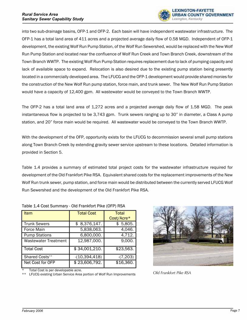
Old Frankfort Pike RSA
Page 7
Rural Service Area Sanitary Sewer Capability Study
February 2006
The following summary review and recommendations are provided:
Review
Over 99% of the property is core equine agricultural or prime agricultural land.
The area is designated as one of the “five focus areas” for rural greenway creation.
A large portion of the area is designated as a “scenic area”.
All resultant flows from the OFP are downstream of current wastewater infrastructure development. Additional
pumping, conveyance, and treatment facilities will be required.
In the opinion of the LFUCG Division of Sanitary Sewers, replacement of the Wolf Run Pump Station and Force
Main would be prior to the development of OFP-1.
Future downstream development below the OFP will present similar problems as the present; no availability of
pumping, conveyance, or treatment capacity is available.
With the development of the OFP, opportunity exists to decommission several small capacity pump stations
along Town Branch Creek.
Recommendations
Revisit the issues and costs of a wastewater treatment plant in the lower Town Branch drainage basin.
Investigate the costs and feasibility to pump and convey future wastewater to an adjacent drainage basin WWTP.
For future development beyond the OFP-2, evaluate the ability and availability of right-of-way to construct another
force main between a new downstream pump station below OFP-2 and the Town Branch WWTP.
Continue evaluation of wastewater discharge limitation concerns on the Town Branch Creek.
Determine other future alternatives available for pumping, conveyance, and treatment of wastewater flows.
Expand future planning efforts for wastewater infrastructure beyond traditional 20-year planning period.
Ironworks Pike Rural Service Area
The Ironworks Pike Rural Service Area (IP) is located in northwest Fayette County. The IP has an identified total area
of 6,909 acres and a total developable area of 4,776 acres. The large amount of public land associated with these
large parcels may be misleading of development potential. Environmentally Sensitive Areas (ESA) have been
identified along the Cane Run Creek drainage basin in Fayette County. The Royal Springs Aquifer, which is common
with the Cane Run Creek drainage basin is an environmentally sensitive area of great importance and concern. The
City of Georgetown receives a portion of their drinking water supply from the Royal Springs Aquifer. In addition, the
Spindletop Rural Activity Center exists in the IP.
The projected average wastewater flow is 7.16 MGD or 4,976 gpm. The projected peak wastewater flow is 13,433
gpm. A Class A pump station is required to pump and convey all wastewater to the Town Branch WWTP. Table 1.5
provides a summary of estimated total project costs for the wastewater infrastructure required for development of
the Ironworks Pike RSA.
Page 8
Rural Service Area Sanitary Sewer Capability Study
February 2006
Table 1.5 Cost Summary Ironworks Pike (IP) RSA
*Total Cost is per developable acre.
The following summary review and recommendations are provided:
Review
The land use consists of 43% public land and 37% core equine agricultural land.
The land is “environmentally sensitive” due to the existence of the Royal Springs Aquifer in this drainage basin.
Continued downstream development will present similar problems to those that are presently being considered, no
pumping, conveyance, or treatment capacity is available.
Future construction of additional pumping and conveyance facilities to the Town Branch WWTP may be difficult due
to the unavailability of right-of-way and cost of construction.
Recommendations
Revisit the issues and costs of a wastewater treatment plant in the Cane Run drainage basin.
Investigate the feasibility of pumping and conveyance of wastewater to a new WWTP in an adjacent drainage
basin.
Determine other future alternatives available for pumping, conveyance, and treatment of wastewater flows from
the Cane Run drainage basin.
Avon/I-64 Rural Service Area
The Avon/I-64 Rural Service Area (AV) is located in eastern Fayette County. The AV has an identified total area
of 16,589 acres and a total developable area of 14,715 acres. This is the largest of the study areas. A wide
distribution of land use and parcel size exists in the AV. Over 62% of land parcels are less than 10 acres and
over 86% are less than 40 acres. The Avon Rural Activity Center also exists in the AV.
Three separate sub-drainage basins exist in the AV; AV-1, AV-2, and AV-3. The projected total average wastewater
flow is 22.07 MGD. Four pump stations are required for the three separate sub-drainage basins of the AV, three
Class A and one Class B. One of the Class A pump stations is provided along the route of the force main to provide
additional pumping energy to convey the flow to the West Hickman WWTP. Over 23 miles of large diameter force
main are required for provision of sanitary sewer to this study area. A summary of costs is provided in Table 1.6
Item Total Cost TotalCost/Acre*
Trunk Sewers $ 10,095,599. $ 2,114.Force Main 14,883,266. 3,116.Pump Stations 5,000,000. 1,047.Shared Costs 0. 0.Wastewater Treatment 42,984,000. 9,000.
Total Cost $ 72,962,865. $ 15,277.
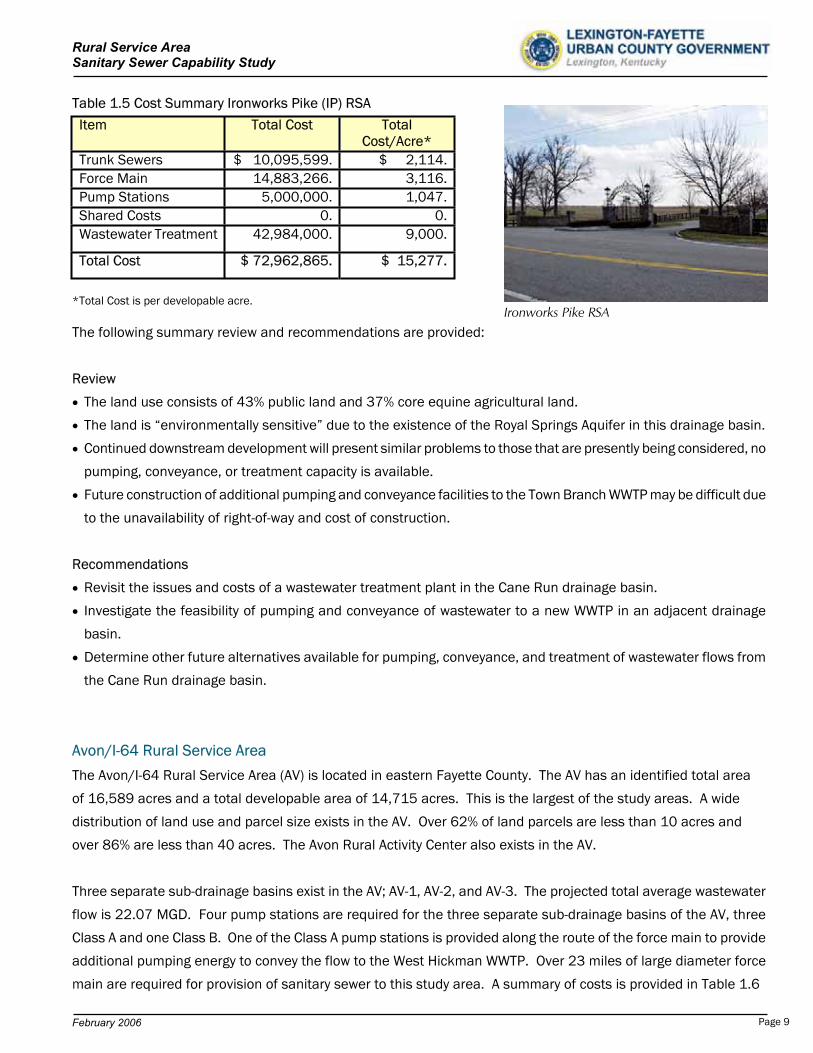
Ironworks Pike RSA
Page 9
Rural Service Area Sanitary Sewer Capability Study
February 2006
The 1999 LFUCG Wastewater Facilities Plan provides an alternative for construction of a wastewater treatment plant
in the North Elkhorn drainage basin, in lieu of the selected improvements of the North Elkhorn Pump Station and
Force Main. Given the high cost of pumping and conveyance facilities to the West Hickman Wastewater Treatment
Plant for the AV, the future option of a new wastewater treatment plant in the North Elkhorn drainage basin should
be considered prior to development of the AV.
With the construction of improvements for AV-1 and AV-2, opportunity exists to provide sanitary sewer service to the
Blue Sky Rural Activity Center (RAC) due to the route location of the force main and the proposed Cleveland Road
Pump Station. The Blue Sky RAC consists of 465 acres of land, of which 432 acres are developable. Average daily
flows would be 648,000 gpd. The inclusion of the Blue Sky RAC into the AV-1/AV-2 project would allow for
elimination of two private wastewater treatment facilities, The Blue Sky WWTP (150,000 gpd capacity) and the
Boonesboro Manor WWTP (53,000 gpd capacity). All proposed wastewater flows would be conveyed to the West
Hickman WWTP. Estimated total project costs for collection, pumping, conveyance, and treatment of wastewater to
the West Hickman WWTP is $8,002,858.
Table 1.6 Cost Summary Avon/I-64 (AV) RSA
*Total Cost is per developable acre.
The following summary review and recommendations are provided:
Review
Over 70% of the property is core equine agricultural or prime agricultural land. Over 62% of the parcels are
tracts of 10 acres or less.
The North Elkhorn Creek is designated as one of the “five focus areas” for rural greenway creation in the LFUCG
Rural Service Area Land Management Plan.
Several Rural Settlements exist in the AV.
All resultant flows from the AV are downstream of current wastewater infrastructure development. Additional
pumping and conveyance will be required.
Item Total Cost TotalCost/Acre*
Trunk Sewers $ 34,738,333. $ 2,361.Force Main 65,829,224. 4,474.Pump Stations 30,100,000. 2,045.Wastewater Treatment 132,435,000. 9,000.
Total Cost $ 263,102,557. $ 17,880.
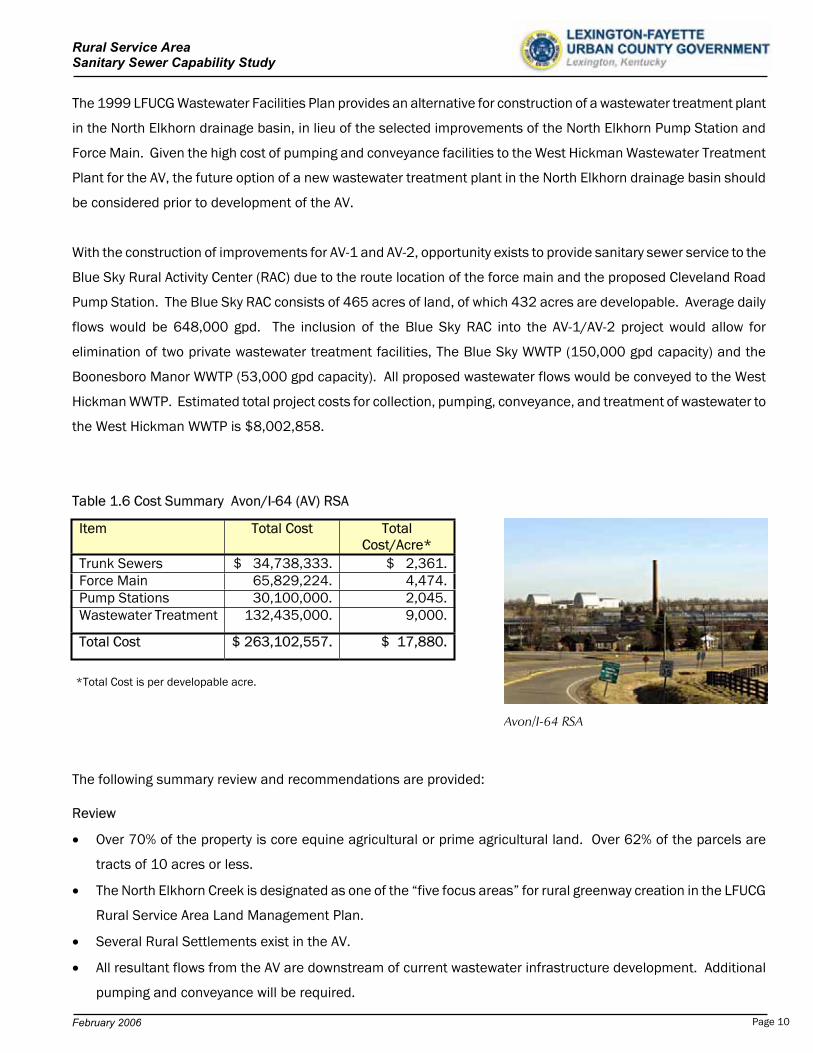
Avon/I-64 RSA
Page 10
Rural Service Area Sanitary Sewer Capability Study
February 2006
The North Elkhorn Sewershed and Expansion Area 2A are just upstream of AV-1.
Continued downstream development will present similar problems as the present, no pumping, conveyance, or
treatment capacity is available.
Wastewater planning strategies for an expanded North Elkhorn Sewershed have not been addressed.
Recommendations
Revisit the issues and costs of a wastewater treatment plant in the North Elkhorn Creek drainage basin.
Establish preliminary wastewater discharge limits for the North Elkhorn Creek
Determine other future alternatives available for pumping, conveyance, and treatment of wastewater flows.
Continue to develop planning strategies for future provision of wastewater infrastructure in the AV.
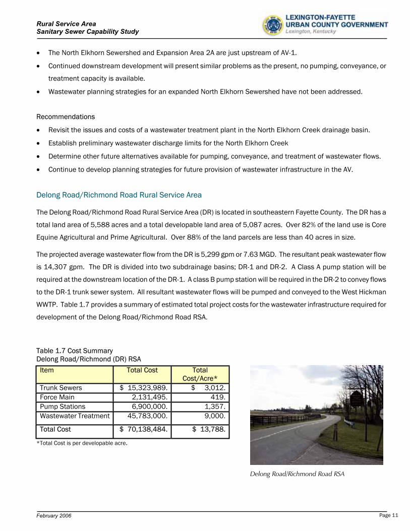
Delong Road/Richmond Road Rural Service Area
The Delong Road/Richmond Road Rural Service Area (DR) is located in southeastern Fayette County. The DR has a
total land area of 5,588 acres and a total developable land area of 5,087 acres. Over 82% of the land use is Core
Equine Agricultural and Prime Agricultural. Over 88% of the land parcels are less than 40 acres in size.
The projected average wastewater flow from the DR is 5,299 gpm or 7.63 MGD. The resultant peak wastewater flow
is 14,307 gpm. The DR is divided into two subdrainage basins; DR-1 and DR-2. A Class A pump station will be
required at the downstream location of the DR-1. A class B pump station will be required in the DR-2 to convey flows
to the DR-1 trunk sewer system. All resultant wastewater flows will be pumped and conveyed to the West Hickman
WWTP. Table 1.7 provides a summary of estimated total project costs for the wastewater infrastructure required for
development of the Delong Road/Richmond Road RSA.
Table 1.7 Cost Summary Delong Road/Richmond (DR) RSA
*Total Cost is per developable acre.
Item Total Cost TotalCost/Acre*
Trunk Sewers $ 15,323,989. $ 3,012.Force Main 2,131,495. 419.Pump Stations 6,900,000. 1,357.Wastewater Treatment 45,783,000. 9,000.
Total Cost $ 70,138,484. $ 13,788.
Delong Road/Richmond Road RSA
Page 11
Rural Service Area Sanitary Sewer Capability Study
February 2006
With development of the DR, opportunity also exists during the development of the DR to decommission several
existing pump stations of the East Hickman Sewershed. Details of these pump stations are provided in Section 8.
With the construction of improvements for the DR, opportunity also exists to provide sanitary sewer service to the
Blue Sky Rural Activity Center (RAC). The inclusion of the Blue Sky RAC into the DR project would allow for
elimination of two private wastewater treatment facilities, The Blue Sky WWTP (150,000 gpd capacity) and the
Boonesboro Manor WWTP (53,000 gpd capacity). The decision of inclusion of the Blue Sky RAC into the DR
development would be required prior to design and construction of any initial DR phase.
The Blue Sky Rural Activity Center (RAC) has a total land area of 465 acres, of which approximately 432 acres is
developable. The projected average wastewater flow from the Blue Sky Rural Activity Center is 648,000 gpd or 450
gpm. Estimated total additional cost for inclusion of the Blue Sky RAC; which includes collection, pumping ,
conveyance, and treatment; is $7,462,773.
The following summary review and recommendations are provided:
Review
Over 75% of the property is core equine agricultural or prime agricultural land.
A large portion of the area is designated as a “scenic area”.
No capacity exists in the current LFUCG facilities for the DR.
Expansion Area 1 recommended improvements from the 201 Facility Plan are parallel in nature to the DR
improvements. Economy of scale can be achieved with combined consideration of improvements for the DR,
East Hickman Sewershed, and current Expansion Areas (1, 2B, and 2C) of the 2001 LFUCG Comprehensive Plan
Update.
The Blue Sky RAC is adjacent to the uppermost reach of the DR. No stand alone alternatives have been
presented to convey these flows to LFUCG facilities. No capacity exists in the current LFUCG facilities for the
Blue Sky RAC.
The decision of inclusion of the Blue Sky RAC into the DR development would be required prior to design and
construction of the initial DR phase.
Opportunity exists to decommission several existing pump stations with the development of the DR and/or
Expansion Area 1.
Page 12

Rural Service Area Sanitary Sewer Capability Study
February 2006
Recommendations
Determine required combined improvements and costs to serve Expansion Areas and the DR. At this time, no
improvements have been designed or constructed for the 2001 LFUCG Comprehensive Plan Update Expansion
Areas.
Review feasible phased improvements of the DR. The lower reaches of the DR can be sewered and pumped to
the West Hickman WWTP without significant outlay of capital for upstream improvements.
Summary
The study of this vast amount of land in the Rural Service Area is not intended to be a “stepping stone” for
development into these regions. The study is intended as a long-range and broad planning document for the
evaluation of concept sanitary sewer development. The wastewater system improvements required for service in
these identified Rural Service Area regions, are one of many factors that are evaluated in the consideration of Urban
Service Area expansion.
Table 1.8 is a summary of estimated total project costs for the complete development of sanitary sewer into
these study areas. Table 1.9 provides summary of the projected wastewater flows and the WWTP destination.
Table 1.8 Summary of Estimated Total Project Cost LFUCG Rural Service Area Sanitary Sewer Capability Study
LFUCG Rural Service Area Estimated Cost ($)
Developable Acres
Estimated Cost Per Developable Acre
Lower South Elkhorn $ 11,081,812. 700 $ 15,831.Man O’ War 6,422,069. 341 18,833.Old Frankfort Pike 23,606,792. 1,443 16,360.Ironworks Pike 72,962,865. 4,776 15,277.Avon/I-64 263,102,557. 14,715 17,880.Delong Road/Richmond Road 70,138,484. 5,087 13,788.Summary $ 447,314,579. 27,062. $ 16,529.
Page 13
Rural Service Area Sanitary Sewer Capability Study
February 2006
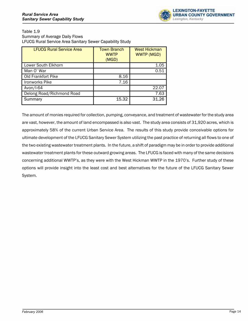
Table 1.9 Summary of Average Daily Flows LFUCG Rural Service Area Sanitary Sewer Capability Study
The amount of monies required for collection, pumping, conveyance, and treatment of wastewater for the study area
are vast, however, the amount of land encompassed is also vast. The study area consists of 31,920 acres, which is
approximately 58% of the current Urban Service Area. The results of this study provide conceivable options for
ultimate development of the LFUCG Sanitary Sewer System utilizing the past practice of returning all flows to one of
the two existing wastewater treatment plants. In the future, a shift of paradigm may be in order to provide additional
wastewater treatment plants for these outward growing areas. The LFUCG is faced with many of the same decisions
concerning additional WWTP’s, as they were with the West Hickman WWTP in the 1970’s. Further study of these
options will provide insight into the least cost and best alternatives for the future of the LFUCG Sanitary Sewer
System.
LFUCG Rural Service Area Town Branch WWTP(MGD)
West Hickman WWTP (MGD)
Lower South Elkhorn 1.05Man O’ War 0.51Old Frankfort Pike 8.16Ironworks Pike 7.16Avon/I-64 22.07Delong Road/Richmond Road 7.63Summary 15.32 31.26
Page 14
Rural Service Area Sanitary Sewer Capability Study
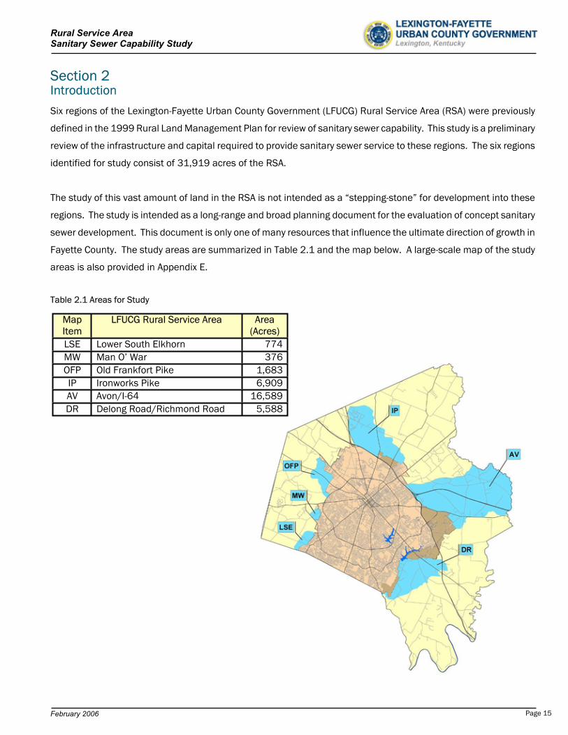
Section 2 Introduction
Six regions of the Lexington-Fayette Urban County Government (LFUCG) Rural Service Area (RSA) were previously
defined in the 1999 Rural Land Management Plan for review of sanitary sewer capability. This study is a preliminary
review of the infrastructure and capital required to provide sanitary sewer service to these regions. The six regions
identified for study consist of 31,919 acres of the RSA.
The study of this vast amount of land in the RSA is not intended as a “stepping-stone” for development into these
regions. The study is intended as a long-range and broad planning document for the evaluation of concept sanitary
sewer development. This document is only one of many resources that influence the ultimate direction of growth in
Fayette County. The study areas are summarized in Table 2.1 and the map below. A large-scale map of the study
areas is also provided in Appendix E.
Table 2.1 Areas for Study
MapItem
LFUCG Rural Service Area Area (Acres)
LSE Lower South Elkhorn 774MW Man O’ War 376OFP Old Frankfort Pike 1,683IP Ironworks Pike 6,909AV Avon/I-64 16,589DR Delong Road/Richmond Road 5,588
February 2006 Page 15
Rural Service Area Sanitary Sewer Capability Study
Background
Wastewater systems, like most community infrastructure and development, are envisioned when the demand is
forecast, designed when the demand requires, and constructed when the monies are available. The wastewater
planning process vision must be consistent and coordinated with the overall urban planning process to provide a
unison and logical plan. Historically, the planning of wastewater infrastructure has followed the urban planning
process, however, the most recent wastewater facility plan (1999) brought attention to the possible alternatives and
large costs associated with expansion of the LFUCG wastewater system infrastructure.
The LFUCG Sanitary Sewer System is very unique in topography. Simply stated, the City of Lexington is “built on top
of a hill”. Exhibit 2.1 portrays the proposed rural service areas proposed for study, the existing wastewater treatment
plants, the associated drainage basins, and the natural direction of flow. By inspection, all future potential gravity
drainage of wastewater flows away from the current Urban Service Area and existing wastewater infrastructure. As a
result, all future wastewater would be pumped and conveyed upstream for great distances for treatment each time
expansion area is developed. Planning for future wastewater systems is more complicated with this occurrence. The
short-term required infrastructure, perhaps even for 20-year planning, is often never far enough downstream or large
enough for ultimate growth.
The Town Branch Wastewater Treatment Plant (WWTP) site is located on the northwestern portion of the existing
Urban Service Area, in what historically was a rural downstream location. Over the last 50 years, Lexington has
grown rapidly in the northern, eastern, and southern regions of the community. In 1974, the Urban County
Government was formed and soon thereafter, the concept of another wastewater treatment plant, the West Hickman
WWTP, was born to alleviate the ever increasing wastewater demand. Now, nearly 30 years later, the growth of
Lexington has continued and the solutions for wastewater demand remain difficult. The wastewater from future
developed areas will flow away from current facilities and no capacity will exist for pumping, conveyance, or
treatment.
A 201 Facility Plan Update for Wastewater Facilities was completed in 1999. The Facility Plan is a 20-year planning
document required by the Kentucky Division of Water. The plan reviewed several possible alternatives for meeting
current and future needs for the 20-year timeframe. However, for many large and rapidly growing communities, the
study period of 20-years is sometimes too short for visionary concepts. This study shall provide insight into the
alternatives available for the sewerability of the selected Rural Service Area of the LFUCG.
February 2006 Page 16
Rural Service Area Sanitary Sewer Capability Study
Exhibit 2.1 Direction of Gravity Flow of Potential Wastewater
Lexington-Fayette Urban County Government
February 2006 Page 17
Rural Service Area Sanitary Sewer Capability Study
Several LFUCG resources were utilized in the preparation of the study, including:
The LFUCG Division of Engineering
The LFUCG Division of Planning, Resources and Personnel
The LFUCG Division of Sanitary Sewers, Resources and Personnel
The Geographic Information Systems of the LFUCG Division of Computer Services
1986 Implementation Plan for Construction of the Outer Perimeter Sewerage Systems
1999 201 Facility Plan Update for Wastewater
1999 Rural Service Area Land Management Plan
2001 Comprehensive Plan Update
2001 Sanitary Sewer and Pumping Station Manual
Significant Criteria
The ultimate criteria and assumptions utilized in the initial stages of this report greatly affect the final product.
The following is a review of key elements and assumptions in development of this report.
Purchase of Development Rights Program (PDR)
The PDR program was introduced in the 1999 Rural Land Management Plan as a method to preserve the character
unique to the rural areas of Fayette County. The PDR program was adopted in December of 1999. Monies were
established for land owners who desired to preserve the rural nature and character of their land for the future. The
PDR program has been a very successful program for the LFUCG.
Minimal PDR lands exist in the study areas. Most PDR lands are in the northern region of the County, which have not
been included in the study area. For the purposes of this study, all rural lands have been included for development
consideration. The conservative approach has been assumed should future change in local regulation of these PDR
properties occur.
201 Facility Plan Update
The assumption has been made that all recommended improvements of the 1999 201 Facility Plan Update for
the LFUCG wastewater system will be in place and in operation by the time the RSA development occurs. All
hypothetical improvements and corresponding estimated costs have been prepared utilizing this approach.
Wastewater Treatment
At the time of this report, the average daily Town Branch WWTP flows since 1999 were approximately 20.4 MGD,
approximately 68% of capacity. The average daily West Hickman WWTP flows are 20.9 MGD, approximately 62% of
capacity. The remaining available capacity in each WWTP is dedicated to the current LFUCG Urban Service Area
February 2006 Page 18

Rural Service Area Sanitary Sewer Capability Study
(USA). No capacity exists at the current treatment facilities for the wastewater treatment needs for these study
areas. The projected average daily flows generated by these study areas directly correlate to the required treatment
capacity. These treatment capacity needs are included in costs of development of wastewater infrastructure for the
study areas.
For the purposes of this study, all wastewater will be conveyed to one of the two existing treatment facilities, either
Town Branch WWTP or West Hickman WWTP. The 1999 201 Facility Plan Update discussed alternatives of satellite
WWTP’s in the South Elkhorn and North Elkhorn drainage basins. These options were not selected as the
recommended alternative. Historically, the paradigm has been established that all flows from development will be
returned to these facilities. The detailed discussion and study of additional wastewater treatment plant sites is not
included in the scope of this study.
With future development of the RSA, conveyance of wastewater flows would involve greater distance, more difficult
acquisition of right-of-way, and substantially more cost than in previous years. In recent years stream water quality
issues have also become a growing concern to the LFUCG and the Kentucky Division of Water. It is generally agreed
that the allowable wasteload allocations for the Town Branch Creek and West Hickman Creek streams will not be
substantially increased by the Kentucky Division of Water for future increased discharges, due to expansion of the
Urban Service Area. The continued transfer of wastewater from one drainage basin to another for treatment will
concentrate the waste load and compound the difficulty of meeting stringent allowable discharge limits. In the
future, it may be necessary to consider the construction of additional wastewater treatment plants in Fayette County.
Methodology
The general methodology of the 1986 Outer Perimeter Sewerage System Study has been followed. The process to
provide preliminary designs and estimated costs for sanitary sewer service is similar in each study area. The
following outlines the typical steps in this determination.
1. Determination of the Total Land Area
The boundaries of each study area were identified by the LFUCG. LFUCG GIS mapping was utilized to determine
the quantity of total land area.
2. Identification of Drainage Basins for Future Sewersheds
Each area is partitioned into drainage basins and sub-drainage basins. Each of the drainageways within each
basin is a potential path for a future gravity sewer, whether a large trunk sewer or small collector sewer.
Drainage basins are comprised of numerous sub-drainage basins. The areas of each basin and sub-basin are
obtained. Existing LFUCG GIS mapping information provided the delineated boundaries of all drainage basins.
February 2006 Page 19
Rural Service Area Sanitary Sewer Capability Study
From these features in the mapping database, the area of each was determined utilizing the ArcView 9.0
software platform shapefile features.
3. Determination of Developable Land Area
After the total land area and the drainage basins were defined, a review of the total developable land is
performed. Utilizing the GIS mapping, all undevelopable land was removed from consideration. Land area such
as roads, railroads, cemeteries, floodplains, public lands, steep slopes, greenways, sinkholes, parks, etc. are
removed from the total land area. The remaining area within each drainage and sub-drainage basin was utilized
as the basis for wastewater flow determination.
4. Wastewater Unit Flow
1,500 gallons per day per developable acre (gpd/acre) has been utilized to project average daily wastewater
flow. This approach was also utilized for the 1986 Outer Perimeter Sewerage Systems Study. In review of the
2001 LFUCG Sanitary Sewer and Pumping Station Manual, these resultant flows were nearly equivalent to 4
residential units per acre. In addition, a review of current field-measured wastewater flows for the existing
sanitary sewer service areas was performed and compared to the land area of the current LFUCG Urban Service
Area. The calculated wastewater flow per acre was approximately 1,300 gpd/acre and considerable land for fill-
in growth still remains. Overall, the 1,500 gpd/acre criteria appears to be a reasonable basis for the projection
of average daily wastewater flow for full development.
5. Wastewater Peak Instantaneous Flow
The peak instantaneous flow is the basis of design for all sanitary sewer and pumping station capacities. The
peak instantaneous flow is the maximum wastewater flow that can be expected at any point in time. Wastewater
flow tends to have a diurnal cycle and peak flow to average flow ratios can be as high as 5 or 6 times that of
average. An empirical peaking factor, which is based on the magnitude of average daily flow, is selected and
multiplied by the average daily flow to determine the peak instantaneous flow. If available, existing field-
measured data should also provide guidance in selection of peaking factors. Appendix B provides a table from
the LFUCG Sanitary Sewer and Pumping Station Manual outlining allowable peaking factors. These peaking
factors have been utilized for this project.
6. Trunk Sewer Design
All gravity sewer design has been performed in accordance with the LFUCG Sanitary Sewer and Pumping
Station Manual. All pipe has been designed for a maximum flow level of 2/3 full. A drainage area- sewage
flow- pipe size relationship has been developed for each study area and summarized in a spreadsheet in
Appendix A. Under LFUCG guidelines, trunk sewers, 12” and larger, are provided by the LFUCG. All sanitary
February 2006 Page 20
Rural Service Area Sanitary Sewer Capability Study
sewers under 12” are provided by the land developer. No detail of sewer small than 12” in diameter has
been provided.
7. Force Main Design
All force mains have been designed not to substantially exceed a velocity of 6 ft/sec or provide high pumping
heads due to excessive friction loss.
8. Pumping Station Design
Pump Station sizing is based on the peak instantaneous flow, which has been identified for each pump station
location. All pump station preliminary design is based on the LFUCG Sanitary Sewer and Pumping Station
Manual.
9. Unit Costs of Wastewater Facilities
Appendix C contains a summary of all unit costs utilized in the projection of preliminary total costs. These unit
costs were developed from historical information of wastewater construction costs. Where historical information
was not available, material cost quotes and accepted unit costs for labor, equipment, and installation were
forecast. Pump station costs were developed from actual construction data for flows up to 15,000 gpm. Beyond
this flow, all costs were estimated on historical magnitudes of cost from EPA reference manuals.
10. Estimates of Probable Cost
Utilizing the unit costs for wastewater facilities, preliminary quantities of infrastructure have been measured and
summarized. Total costs include 15% construction contingencies and 20% non-construction costs. Non-
construction costs consist of engineering services, easements, legal services, administrative services, and etc.
Detailed review of each study area is contained in Sections 3 through 8.
February 2006 Page 21

Rural Service Area Sanitary Sewer Capability Study
Section 3 Lower South Elkhorn Rural Service Area General
The Lower South Elkhorn Rural Service Area (LSE) is located in
southwestern Fayette County. The LSE has a total land area of 774
acres and a total developable land area of 700 acres. A Project
Summary is provided in Exhibit 3.1 and detail maps are provided in
Exhibits 3.2 and 3.3. The LSE is positioned in the central reach of the
Fayette County South Elkhorn Creek drainage basin. The upper region
of the South Elkhorn Creek drainage basin is presently served by the
current LFUCG South Elkhorn Sewershed and has a service area of
6,604 acres. In addition to the LSE, approximately 12,395 remaining
acres of the undeveloped South Elkhorn Creek drainage basin exist in
Fayette County and are mostly downstream of the Lower South
Elkhorn Rural Service Area (LSE). The Man O’ War Rural Service Area
(MW) is also located in the undeveloped South Elkhorn Creek drainage
basin and consists of 376 acres.
Land Use and Parcel Data
Table 3.1 is a summary of the current land use in the Lower South Elkhorn RSA. Table 3.2 provides the comparison
of parcel size distribution within the LSE. Land use data was derived from LFUCG Geographical Information System
(GIS) and the LFUCG Rural Service Area Rural Land Management Plan. In review of the land use information, it is
apparent the region primarily consists of prime agricultural and core equine agricultural land.
Table 3.1 Table 3.2 Land Use Classification - LSE RSA Land Parcel Size Distribution LSE RSA
Land Parcel Size No. of Parcels
% Total Parcels
> 0 acres and < 5 acres 16 41.0 5 acres and < 10 acres 5 12.8 10 acres and < 40 acres 11 28.2 40 acres and < 100 acres 3 7.7 100 acres and < 200 acres 1 2.6 200 acres 3 7.7
Summary 39 100.0
Land Use Area Classification (Acres)
% of Total Area
Agricultural Land 16 2.1Core Equine Agricultural Land
413 53.4
Historic Landmark/Natural Area
19 2.5
Non-Rural Developed Land 4 0.5Prime Agricultural Land 259 33.4Rural Developed Land 61 7.8Other Land 2 0.3Summary 774 100.0
February 2006 Page 22
Rural Service Area Sanitary Sewer Capability Study
Rural Settlements
No rural settlements are identified inside the boundaries of the LSE. However, several are in the vicinity and within
the South Elkhorn Creek drainage basin. Rural settlements are located downstream and include Little Texas, Little
Georgetown, and Ft. Springs.
Rural Activity Centers (RAC)
No RAC’s exist in the LSE. The Airport RAC is located downstream of
the LSE, within the South Elkhorn Creek drainage basin. The Airport
RAC (726.4 acres) is presently sewered and all wastewater is pumped
and conveyed to the Town Branch WWTP.
Special Natural Protection Areas
No special natural protection areas have been identified in the LSE.
Lower South Elkhorn RSA Rural Greenways
South Elkhorn Creek in Fayette County have been identified as one of the “Five Focus Areas” for rural greenway
creation in the LFUCG Rural Service Area Land Management Plan. The greenway extends to the Woodford County
line and includes floodplain, steep slopes, sinkholes and tree stands along the creek. Potential exists for hiking trails
through the creation of conservation/scenic easements.
Scenic Areas
A large portion of the LSE has been identified as “Scenic Area” in the LFUCG Rural Service Area Land Management
Plan.
Environmentally Sensitive Areas
Environmentally Sensitive Areas have been identified along the floodplain of the South Elkhorn Creek drainage basin
in Fayette County.
Development of Wastewater Facilities
Projected Wastewater Flows
The ultimate projected average wastewater flow, resultant from full development of the LSE, is based on a unit flow
of 1,500 gpd/acre of developable land. Peak wastewater flow is derived from utilization of an empirical peak flow
factor, as provided in the LFUCG Sanitary Sewer and Pumping Station Manual. The magnitude of the peak flow
factor decreases with the increase in average daily wastewater flow. The peak wastewater flow factor is multiplied
by the average wastewater flow to obtain the peak instantaneous flow. Appendix B contains a summary of peak flow
factors.
February 2006 Page 23

Rural Service Area Sanitary Sewer Capability Study
The projected average wastewater flow for the LSE is 1.05 MGD or 729 gpm. The peak flow factor for the LSE is 3.6
and the projected peak instantaneous wastewater flow is 2,625 gpm.
Wastewater Infrastructure Summary and Development Review
The LSE is located downstream of current development in the Urban
Service Area and all future wastewater will naturally flow away from
currently sewered areas. Exhibit 3.1 provides physical, flow, and cost
summaries. Exhibits 3.2 and 3.3 provide visual detail of required
infrastructure.
The proposed sanitary sewer system to serve this area will consist of a
trunk sewer adjacent to the South Elkhorn Creek ranging in size from
12 to 24 inches. A Class B pump station is required at the most downstream location of the LSE with a capacity of
approximately 2,625 gpm. The wastewater will be pumped upstream, via a 14” force main, to the existing South
Elkhorn Pump Station. Pumping upgrades to the South Elkhorn Pump Station will be required and flows will
ultimately be delivered to the West Hickman Wastewater Treatment Plant, via the upgraded South Elkhorn force
main system.
Existing South Elkhorn Pump Station
The 1999 LFUCG 201 Facilities Plan Update identifies an upgrade of the existing South Elkhorn Pump Station from a
capacity of 7,600 gpm to 12,000 gpm and construction of a 24” force main. No LFUCG expansion area has been
added in the South Elkhorn Sewershed, however, a portion of northern Jessamine County is included in the planning
area of the Facility Plan.
In 2005, design was initiated for the upgrade of the South Elkhorn Pump Station to near 14,000 gpd capacity and
the proposed parallel South Elkhorn Force Main was upgraded to a 36” force main and extended all the way to the
West Hickman WWTP. These upgrades, which are greater in magnitude than the 1999 LFUCG 201 Facility Plan
recommendations, can accommodate the LFUCG and some potential northern Jessamine County wastewater flows.
Currently, an agreement is in place between the LFUCG and Jessamine County to accept up to 2 MGD of wastewater
from Jessamine County for treatment at the West Hickman WWTP. The Jessamine County pumping and conveyance
alternatives have not been determined at this time, however, some capacity for northern Jessamine County or
additional in-basin LFUCG expansion area will be available upon completion of the 2005 South Elkhorn Pump Station
and Force Main Improvements. Available capacity will be utilized on a first come, first serve basis. Monies from the
development of either north Jessamine County or new LFUCG expansion area, such as the LSE, should be provided
to the LFUCG for the “fair share” contributing costs of the pumping and conveyance infrastructure.
February 2006 Page 24
Rural Service Area Sanitary Sewer Capability Study
With the addition of the 774 acres of the LSE to the South Elkhorn Sewershed, full capacity for wastewater flows
derived from the LSE may not exist in the proposed 2005 upgrades of the South Elkhorn Pump Station and Force
Main. For the purposes of this study, it has been assumed the pump station will require upgrading for the LSE from
the proposed 14,000 gpm to 15,825 gpm. It is also assumed the 36” force main is adequately sized for acceptance
of the wastewater flows from the LSE. These assumptions will require re-evaluation at the time of development.
Capacity will not be available for continued downstream development of the South Elkhorn Watershed below the
LSE. Additional pumping and conveyance infrastructure to the West Hickman WWTP or an additional WWTP, similar
to the alternative provided in the 1999 LFUCG 201 Facilities Plan Update, will be required to accommodate flows
from further downstream development.
With the development of the LSE, opportunity exists to abandon the existing Palomar Hills Pump Station and convey
all wastewater flows by gravity sewer directly to the new LSE Pump Station. Upgrade of the LSE trunk sewer and
pump station would be required.
No wastewater treatment capacity exists for the LSE. The projected WWTP capacity is equivalent to the average flow
from complete development of the LSE, which is 1.05 MGD. Exhibit 3.1 is a project summary of the Lower South
Elkhorn RSA physical, flow, and cost characteristics.
Estimate of Probable Cost for Collection, Pumping, Conveyance, and Treatment
The estimate of probable cost for the Lower South Elkhorn trunk sewer, 2,625 gpm Class B pump station, and 14”
force main is $2,108,215. Detailed costs are provided at the rear of this section.
The estimated total project cost of the recommended 2005 South Elkhorn Pump Station and Force Main
Improvements is $15,000,000. These improvements will provide benefit to the existing South Elkhorn Sewershed,
northern Jessamine County, and the LSE. The proposed expanded area of the South Elkhorn Sewershed, inclusive of
the LSE, will have a land area of 7,378 acres. The cost of these improvements will be distributed to the entire
sewershed. Individually, the contributing shared cost of the South Elkhorn Pump Station and Force Main
improvements for the LSE are $1,573,597.
As discussed previously, an additional upgrade beyond the 2005 designed improvements of the existing South
Elkhorn Pump Station is required to accept the additional wastewater from the LSE. Shared monies from the LSE
development will be provided for this upgrade. The South Elkhorn Pump Station capacity would be increased by
1,825 gpm for the development of the LSE. The estimated total project cost to expand the South Elkhorn Pump
Station and Force Main from a capacity of 14,000 gpm to 15,825 gpm is $1,100,000. Details of the shared costs
for the LSE are provided at the end of this section.
February 2006 Page 25
Rural Service Area Sanitary Sewer Capability Study
The projected WWTP capacity required for complete development of the LSE is 1.05 MGD. At the estimated cost of
$6/gallon for expansion of the West Hickman Wastewater Treatment Plant, the projected total construction cost for
wastewater treatment is $6,300,000.
Summary, Review, and Recommendations – Lower South Elkhorn RSA
The estimate of total project costs for the collection, pumping, conveyance, and treatment of forecasted wastewater
from the LSE is $11,081,812. The unit cost of development is $15,831/acre. These estimated costs include
construction, construction contingencies, engineering design and inspection, legal, easements, property acquisition,
and other non-construction costs. Table 3.3 provides a summary of project costs. A summary of all detail costs is
provided in Exhibit 3.1.
Table 3.3 Cost Summary - LSE RSA
Item Total Cost Total
Cost/Acre*
Trunk Sewers $ 470,934. $ 673.
Force Main 437,281. 625.
Pump Stations 1,200,000. 1,714.
Shared Costs** 2,673,597. 3,819.
Wastewater Treatment 6,300,000. 9,000.
Total Cost $ 11,081,812. $ 15,831.
* Total Cost is per developable acre. Lower South Elkhorn RSA
** Shared Costs provided by development of the LSE to the LFUCG
Future downstream expansion of the South Elkhorn drainage basin below the Lower South Elkhorn RSA may be
prohibitive due to the requirement for additional pumping and conveyance capacity to the West Hickman WWTP. The
future capacity of the South Elkhorn Pump Station and Force Main may be restricted due to the future diminished
ability to construct a second force main along the Jessamine/Fayette County border.
The South Elkhorn Creek drainage basin has a total land area of 19,773 acres in Fayette County, of which 6,604
upstream acres are presently developed and served by the existing South Elkhorn Sewershed. Significant potential
exists to construct a future WWTP at a downstream location in the South Elkhorn Creek drainage basin in lieu of
additional pumping and conveyance alternatives to the West Hickman WWTP. This alternative was outlined in the
1999 LFUCG 201 Facility Plan Update, however, it was not the selected alternative. Consideration of this alternative
may be revisited in the future to re-evaluate least cost scenarios and stream water quality criteria for the South
Elkhorn Creek drainage basin.
February 2006 Page 26
Rural Service Area Sanitary Sewer Capability Study
Review
The area is designated as one of the “five focus areas” for rural greenway creation.
A large portion of the area is designated as a “scenic area”.
All resultant flows from the LSE are downstream of current wastewater infrastructure development. Additional
pumping and conveyance will be required.
Upgrade of the existing South Elkhorn Pump Station and Force Main will be required to convey flow to the West
Hickman Wastewater Treatment Plant.
Continued downstream development of the LSE will present similar problems as the present. No capacity for
pumping, conveyance, or treatment of wastewater will exist.
Existing wastewater planning strategies for the South Elkhorn Sewershed do not address issues beyond the
remedy of current sanitary sewer issues within the current LFUCG wastewater planning area.
With the development of the LSE, opportunity exists to abandon the Palomar Hills Pump Station and convey all
flows to the new LSE Pump Station.
Recommendations
Revisit the issues and costs of an additional wastewater treatment plant
Evaluate the ability and availability of right-of-way to construct a second force main, along the Fayette
County/Jessamine County border, between the South Elkhorn Pump Station and West Hickman WWTP.
Determine other future alternatives available for pumping, conveyance, and treatment of wastewater flows from
the South Elkhorn drainage basin.
Expand future planning efforts for wastewater infrastructure beyond the traditional 20-year planning period.
February 2006 Page 27

Rural Service Area Sanitary Sewer Capability Study
1. South Elkhorn Drainage Basin Summary
1.a 19,7731.b 6,6041.c 7741.d 12,3951.e 376
2. Design Flow Calculation
2.a Total Area in proposed service area for LSE. (acres) 7742.b Total Developable area in proposed service area for LSE. (acres) 7002.c Projected Average Flow (gpm) 7292.d 3.62.e 2,625
3. Project Cost Summary
Pumping and Conveyance Cost:3.a Trunk Sewers $470,9343.b Force Main $437,2813.c $1,200,000
3.d $2,108,215
Wastewater Treatment Cost: Required Wastewater Treatment Plant Capacity: 1.05 MGD X $ 6 / gallon:
3.e $6,300,000
3.f $8,408,215
3.g Plus Contributions to:$1,573,597$1,100,000
3.h Less Contributions from:$0
3.I $11,081,812
4. $15,831
5.
5.a
5.b
5.c
5.d5.e
Appendix D.1 contains pump station data and costs.The cost / acre utilizes total developable area for this determination.
Lower South Elkhorn, Class B Pump Station (2,625 gpm) 5.c,5.d
Subtotal: Estimated Total Project Cost
The Lower South Elkhorn Pump Station (Class B) will deliver flow to the renovated South Elkhorn Pump Station(Class A).
Subtotal: Pumping and Conveyance
Average Cost Per Total Acre of Development with LFUCG Contribution:5.e
Man 0' War (376 acres) will require a new (Class B) pump station and deliver flow to the renovated South Elkhorn Pump Station.
Exhibit 3.1 - Project Summary
Lower South Elkhorn (LSE) - Refer to Exhibits 3.2 & 3.3
Projected Peak Flow for Lower South Elkhorn Pump Station. (gpm)Peak Flow Factor for Lower South Elkhorn Pump Station
Total Area of South Elkhorn Drainage Basin presently served by LFUCG. (acres)Total Area in proposed service area of LSE. (acres)Total unserved area remaining in Fayette County. (acres)
Total Area South Elkhorn Drainage Basin in Fayette County. (acres)
Total Area of other proposed service in the South Elkhorn Drainage Basin. 5.a,5.b (acres)
Subtotal - Treatment
Man O' War drainage area is not within the same subdrainage basin as Lower South Elkhorn, however, it is within the South Elkhorn Drainage Basin.
Remarks:
Expansion of South Elkhorn PS and FM from 14,000 gpm capacity to 15,825 gpm. 2005 Upgrade of South Elkhorn Pump Station and Force Main.
Net Estimated LSE Project Costs w/adjustments
Page 28

Page
29
Page
30

Trunk Sewers ID: Cost ($)
LSE-1A-TA $470,934
Force Main ID:
LSE-1A-FMA $437,281
Pump Station ID:
LSE-1A-PSB $1,200,000
Total Cost $2,108,215
Cost Summary
Lower South Elkhorn
Page 31

Shared Costs for System Improvements
Lower South Elkhorn RSA
Construction of 2005 Improvements
Improvements for 14,000 GPM South Elkhorn Pump Station
and 36" Parallel Force Main
South Elkhorn Pump Station and 36" Parallel Force Main Total Estimated Construction Cost $15,000,000
Total Acres - Existing South Elkhorn Sewershed 6,604Total Acres - Lower South Elkhorn Service Area 774 Total Revised Area - South Elkhorn Sewershed 7,378
Shared Cost per Acre $2,033Shared Cost to LSE (774 acres) $1,573,597Shared Cost to LFUCG (6,604 acres) $13,426,403
Page 32
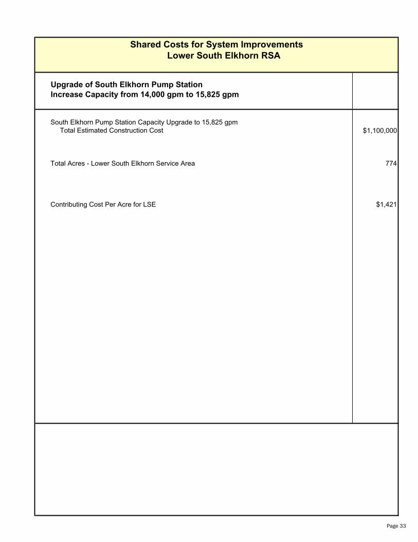
Shared Costs for System Improvements
Lower South Elkhorn RSA
Upgrade of South Elkhorn Pump Station
Increase Capacity from 14,000 gpm to 15,825 gpm
South Elkhorn Pump Station Capacity Upgrade to 15,825 gpm Total Estimated Construction Cost $1,100,000
Total Acres - Lower South Elkhorn Service Area 774
Contributing Cost Per Acre for LSE $1,421
Page 33
Estimate of Probable Cost
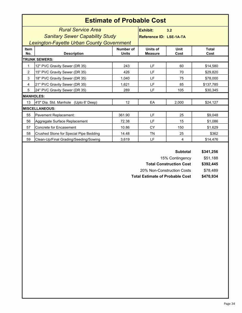
Rural Service Area Exhibit: 3.2
Sanitary Sewer Capability Study Reference ID: LSE-1A-TA
Lexington-Fayette Urban County GovernmentItem Number of Units of Unit Total
No. Description Units Measure Cost Cost
TRUNK SEWERS:
1 12" PVC Gravity Sewer (DR 35) 243 LF 60 $14,580
2 15" PVC Gravity Sewer (DR 35) 426 LF 70 $29,820
3 18" PVC Gravity Sewer (DR 35) 1,040 LF 75 $78,000
4 21" PVC Gravity Sewer (DR 35) 1,621 LF 85 $137,785
5 24" PVC Gravity Sewer (DR 35) 289 LF 105 $30,345
MANHOLES:
13 4'0" Dia. Std. Manhole (Upto 6' Deep) 12 EA 2,000 $24,127
MISCELLANEOUS:
55 Pavement Replacement: 361.90 LF 25 $9,048
56 Aggregate Surface Replacement 72.38 LF 15 $1,086
57 Concrete for Encasement 10.86 CY 150 $1,629
58 Crushed Stone for Special Pipe Bedding 14.48 TN 25 $362
59 Clean-Up/Final Grading/Seeding/Sowing 3,619 LF 4 $14,476
Subtotal $341,256
15% Contingency $51,188
Total Construction Cost $392,445
20% Non-Construction Costs $78,489
Total Estimate of Probable Cost $470,934
Page 34
Estimate of Probable Cost
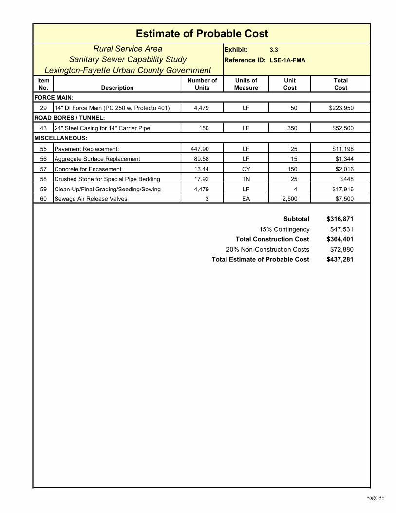
Rural Service Area Exhibit: 3.3
Sanitary Sewer Capability Study Reference ID: LSE-1A-FMA
Lexington-Fayette Urban County GovernmentItem Number of Units of Unit Total
No. Description Units Measure Cost Cost
FORCE MAIN:
29 14" DI Force Main (PC 250 w/ Protecto 401) 4,479 LF 50 $223,950
ROAD BORES / TUNNEL:
43 24" Steel Casing for 14" Carrier Pipe 150 LF 350 $52,500
MISCELLANEOUS:
55 Pavement Replacement: 447.90 LF 25 $11,198
56 Aggregate Surface Replacement 89.58 LF 15 $1,344
57 Concrete for Encasement 13.44 CY 150 $2,016
58 Crushed Stone for Special Pipe Bedding 17.92 TN 25 $448
59 Clean-Up/Final Grading/Seeding/Sowing 4,479 LF 4 $17,916
60 Sewage Air Release Valves 3 EA 2,500 $7,500
Subtotal $316,871
15% Contingency $47,531
Total Construction Cost $364,401
20% Non-Construction Costs $72,880
Total Estimate of Probable Cost $437,281
Page 35
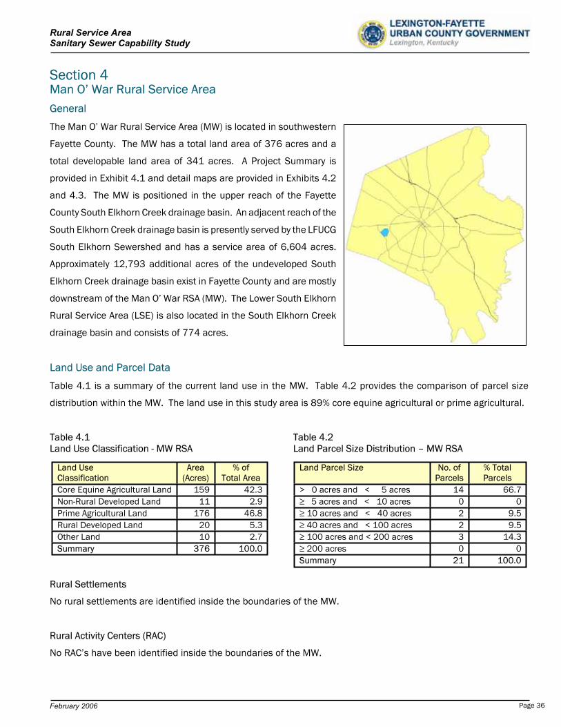
Rural Service Area Sanitary Sewer Capability Study
Section 4Man O’ War Rural Service Area General
The Man O’ War Rural Service Area (MW) is located in southwestern
Fayette County. The MW has a total land area of 376 acres and a
total developable land area of 341 acres. A Project Summary is
provided in Exhibit 4.1 and detail maps are provided in Exhibits 4.2
and 4.3. The MW is positioned in the upper reach of the Fayette
County South Elkhorn Creek drainage basin. An adjacent reach of the
South Elkhorn Creek drainage basin is presently served by the LFUCG
South Elkhorn Sewershed and has a service area of 6,604 acres.
Approximately 12,793 additional acres of the undeveloped South
Elkhorn Creek drainage basin exist in Fayette County and are mostly
downstream of the Man O’ War RSA (MW). The Lower South Elkhorn
Rural Service Area (LSE) is also located in the South Elkhorn Creek
drainage basin and consists of 774 acres.
Land Use and Parcel Data
Table 4.1 is a summary of the current land use in the MW. Table 4.2 provides the comparison of parcel size
distribution within the MW. The land use in this study area is 89% core equine agricultural or prime agricultural.
Table 4.1 Table 4.2 Land Use Classification - MW RSA Land Parcel Size Distribution – MW RSA
Rural Settlements
Land Use Classification
Area (Acres)
% of Total Area
Core Equine Agricultural Land 159 42.3Non-Rural Developed Land 11 2.9Prime Agricultural Land 176 46.8Rural Developed Land 20 5.3Other Land 10 2.7Summary 376 100.0
Land Parcel Size No. of Parcels
% Total Parcels
> 0 acres and < 5 acres 14 66.7 5 acres and < 10 acres 0 0 10 acres and < 40 acres 2 9.5 40 acres and < 100 acres 2 9.5 100 acres and < 200 acres 3 14.3 200 acres 0 0
Summary 21 100.0
No rural settlements are identified inside the boundaries of the MW.
Rural Activity Centers (RAC)
No RAC’s have been identified inside the boundaries of the MW.
February 2006 Page 36
Rural Service Area Sanitary Sewer Capability Study
Special Natural Protection Areas
No special natural protection areas have been identified in the MW.
Rural Greenways
No scenic rural greenways have been identified in the boundaries of the MW.
Scenic Areas
A large portion of the MW has been identified as “Scenic Area”.
Environmentally Sensitive Areas
Only a small portion of the MW has been identified as an “Environmentally Sensitive Area”.
Development of Wastewater Facilities
Projected Wastewater Flows
The ultimate projected average wastewater flow, resultant from full development of the MW, is based on a unit flow
of 1,500 gpd/acre of developable land. Peak wastewater flow is derived from utilization of an empirical peak flow
factor, based on the relative magnitude of the average wastewater flow. The peak flow factor is multiplied times the
average wastewater flow to obtain the peak instantaneous flow. In general, the larger the area and resulting average
flow, the smaller the peak flow factor. Appendix B contains a summary of peak flow factors.
The projected average wastewater flow for the MW is 511,500 gpd or 355 gpm. The peak flow factor for the MW is
4.4 and the projected peak wastewater flow is 1,562 gpm.
Wastewater Infrastructure Summary and Development Review
The MW is located downstream of current development in the Urban
Service Area and all future wastewater will naturally flow away from
currently sewered areas. Exhibit 4.1 provides physical, flow, and cost
summaries. Exhibits 4.2 and 4.3 provide visual detail of required
infrastructure.
The proposed sanitary sewer system to serve this area will consist of
an 18” trunk sewer. A Class B pump station is required at the most
downstream location of the MW with a capacity of 1,600 gpm. The
wastewater will be pumped, via a 14” force main to the existing South Elkhorn Pump Station. Flows will ultimately be
delivered to the West Hickman Wastewater Treatment Plant, via the upgraded South Elkhorn force main system.
Existing South Elkhorn Pump Station
February 2006 Page 37

Rural Service Area Sanitary Sewer Capability Study
The 1999 LFUCG 201 Facilities Plan Update identifies an upgrade of the existing South Elkhorn Pump Station from a
capacity of 7,600 gpm to 12,000 gpm and construction of a 24” force main without addition of expansion area to
the current Urban Service Area in the South Elkhorn Sewershed. A portion of northern Jessamine County is included
in the planning area of the LFUCG Facility Plan.
In 2005, design was initiated for the upgrade of the South Elkhorn Pump Station to nearly 14,000 gpd capacity and
the proposed parallel South Elkhorn Force Main was upgraded to a 36” force main and extended to the West
Hickman WWTP. These upgrades, which are greater in magnitude than the 1999 LFUCG 201 Facility Plan
recommendations, can accommodate the LFUCG and some potential northern Jessamine County wastewater flows.
Currently, an agreement is in place between the LFUCG and Jessamine County to accept up to 2 MGD of wastewater
from Jessamine County for treatment at the West Hickman WWTP. The Jessamine County pumping and conveyance
alternatives have not been determined at this time, however, some capacity for northern Jessamine County or
additional LFUCG expansion area will be available upon completion of the 2005 South Elkhorn Pump Station and
Force Main Improvements. Available capacity will be utilized on a first come, first serve basis. Monies from the
development of either north Jessamine County or new LFUCG expansion area, such as the MW, should be provided
to the LFUCG for the “fair share” contributing costs of the pumping and conveyance infrastructure.
With the addition of the 376 acres of the MW to the South Elkhorn Sewershed, full capacity for wastewater flows
derived from the MW may not exist in the proposed 2005 upgrades of the South Elkhorn Pump Station and Force
Main. For the purposes of this study, it has been assumed the pump station will require upgrading for the MW from
the proposed 14,000 gpm to 14,890 gpm. It is also assumed the 36” force main is adequately sized for acceptance
of the wastewater flows from the MW. These assumptions will require reevaluation at the time of development.
Capacity will not be available for continued downstream development of the South Elkhorn Watershed below the
MW. Additional pumping and conveyance infrastructure to the West Hickman WWTP or an additional WWTP, similar
to the alternative provided in the 1999 LFUCG 201 Facilities Plan Update, will be required to accommodate flows
from further downstream development.
No wastewater treatment capacity exists for the MW. The projected WWTP capacity required for complete
development of the MW is 511,200 gpd. Exhibit 4.1 is a project summary of the Man O’ War RSA physical, flow, and
cost characteristics.
Estimate of Probable Cost for Collection, Pumping, Conveyance, and Treatment
The estimate of probable cost for the Man O’ War trunk sewer, 1,600 gpm Class B pump station, and 14” force main
is $2,095,045. Detailed costs are provided at the end of this section.
February 2006 Page 38
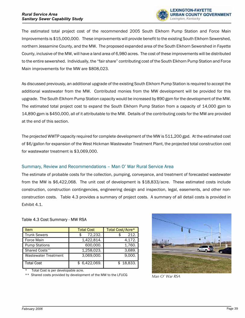
Rural Service Area Sanitary Sewer Capability Study
The estimated total project cost of the recommended 2005 South Elkhorn Pump Station and Force Main
Improvements is $15,000,000. These improvements will provide benefit to the existing South Elkhorn Sewershed,
northern Jessamine County, and the MW. The proposed expanded area of the South Elkhorn Sewershed in Fayette
County, inclusive of the MW, will have a land area of 6,980 acres. The cost of these improvements will be distributed
to the entire sewershed. Individually, the “fair share” contributing cost of the South Elkhorn Pump Station and Force
Main improvements for the MW are $808,023.
As discussed previously, an additional upgrade of the existing South Elkhorn Pump Station is required to accept the
additional wastewater from the MW. Contributed monies from the MW development will be provided for this
upgrade. The South Elkhorn Pump Station capacity would be increased by 890 gpm for the development of the MW.
The estimated total project cost to expand the South Elkhorn Pump Station from a capacity of 14,000 gpm to
14,890 gpm is $450,000, all of it attributable to the MW. Details of the contributing costs for the MW are provided
at the end of this section.
The projected WWTP capacity required for complete development of the MW is 511,200 gpd. At the estimated cost
of $6/gallon for expansion of the West Hickman Wastewater Treatment Plant, the projected total construction cost
for wastewater treatment is $3,069,000.
Summary, Review and Recommendations – Man O’ War Rural Service Area
The estimate of probable costs for the collection, pumping, conveyance, and treatment of forecasted wastewater
from the MW is $6,422,068. The unit cost of development is $18,833/acre. These estimated costs include
construction, construction contingencies, engineering design and inspection, legal, easements, and other non-
construction costs. Table 4.3 provides a summary of project costs. A summary of all detail costs is provided in
Exhibit 4.1.
Table 4.3 Cost Summary - MW RSA
Item Total Cost Total Cost/Acre* Trunk Sewers $ 72,232. $ 212.Force Main 1,422,814. 4,172.Pump Stations 600,000. 1,760.Shared Costs** 1,258,023. 3,689.Wastewater Treatment 3,069,000. 9,000.
Total Cost $ 6,422,069. $ 18,833.
* Total Cost is per developable acre. ** Shared costs provided by development of the MW to the LFUCG Man O’ War RSA
February 2006 Page 39
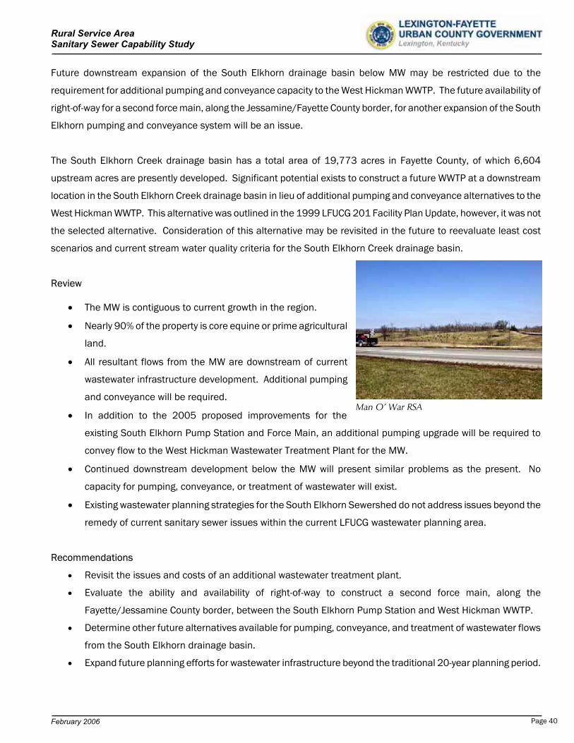
Rural Service Area Sanitary Sewer Capability Study
Future downstream expansion of the South Elkhorn drainage basin below MW may be restricted due to the
requirement for additional pumping and conveyance capacity to the West Hickman WWTP. The future availability of
right-of-way for a second force main, along the Jessamine/Fayette County border, for another expansion of the South
Elkhorn pumping and conveyance system will be an issue.
The South Elkhorn Creek drainage basin has a total area of 19,773 acres in Fayette County, of which 6,604
upstream acres are presently developed. Significant potential exists to construct a future WWTP at a downstream
location in the South Elkhorn Creek drainage basin in lieu of additional pumping and conveyance alternatives to the
West Hickman WWTP. This alternative was outlined in the 1999 LFUCG 201 Facility Plan Update, however, it was not
the selected alternative. Consideration of this alternative may be revisited in the future to reevaluate least cost
scenarios and current stream water quality criteria for the South Elkhorn Creek drainage basin.
Review
The MW is contiguous to current growth in the region.
Nearly 90% of the property is core equine or prime agricultural
land.
All resultant flows from the MW are downstream of current
wastewater infrastructure development. Additional pumping
and conveyance will be required.
In addition to the 2005 proposed improvements for the
existing South Elkhorn Pump Station and Force Main, an additional pumping upgrade will be required to
convey flow to the West Hickman Wastewater Treatment Plant for the MW.
Man O’ War RSA
Continued downstream development below the MW will present similar problems as the present. No
capacity for pumping, conveyance, or treatment of wastewater will exist.
Existing wastewater planning strategies for the South Elkhorn Sewershed do not address issues beyond the
remedy of current sanitary sewer issues within the current LFUCG wastewater planning area.
Recommendations
Revisit the issues and costs of an additional wastewater treatment plant.
Evaluate the ability and availability of right-of-way to construct a second force main, along the
Fayette/Jessamine County border, between the South Elkhorn Pump Station and West Hickman WWTP.
Determine other future alternatives available for pumping, conveyance, and treatment of wastewater flows
from the South Elkhorn drainage basin.
Expand future planning efforts for wastewater infrastructure beyond the traditional 20-year planning period.
February 2006 Page 40
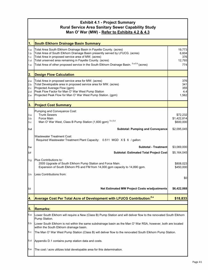
Rural Service Area Sanitary Sewer Capability Study
1. South Elkhorn Drainage Basin Summary
1.a 19,7731.b 6,6041.c 3761.d 12,793
1.e 774
2. Design Flow Calculation
2.a Total Area in proposed service area for MW. (acres) 3762.b 3412.c Projected Average Flow (gpm) 3552.d 4.42.e 1,562
3. Project Cost Summary
Pumping and Conveyance Cost:3.a Trunk Sewers $72,2323.b Force Main $1,422,8143.c $600,000
3.d $2,095,045
Wastewater Treatment Cost: Required Wastewater Treatment Plant Capacity: 0.511 MGD X $ 6 / gallon:
3.e $3,069,000
3.f $5,164,045
3.g Plus Contributions to:$808,023$450,000
3.h Less Contributions from:$0
3.I $6,422,068
4. $18,833
5.
5.a
5.b
5.c
5.d
5.e
Appendix D.1 contains pump station data and costs.
The cost / acre utilizes total developable area for this determination.
Total Developable area in proposed service area for MW. (acres)
Man O' War West, Class B Pump Station (1,600 gpm) 5.c,5.d
Subtotal: Estimated Total Project Cost
The Man O' War West Pump Station (Class B) will deliver flow to the renovated South Elkhorn Pump Station.
Subtotal: Pumping and Conveyance
Average Cost Per Total Acre of Development with LFUCG Contribution:5.e
Exhibit 4.1 - Project Summary
Man O' War (MW) - Refer to Exhibits 4.2 & 4.3
Projected Peak Flow for Man O' War West Pump Station. (gpm)Peak Flow Factor for Man O' War West Pump Station
Total Area of South Elkhorn Drainage Basin presently served by LFUCG. (acres)Total Area in proposed service area of MW. (acres)Total unserved area remaining in Fayette County. (acres)
Total Area South Elkhorn Drainage Basin in Fayette County. (acres)
Total Area of other proposed service in the South Elkhorn Drainage Basin. 5.a,5.b (acres)
Subtotal - Treatment
Lower South Elkhorn is not within the same subdrainage basin as the Man O' War RSA, however, both are located within the South Elkhorn drainage basin.
Remarks:
Expansion of South Elkhorn PS and FM from 14,000 gpm capacity to 14,890 gpm. 2005 Upgrade of South Elkhorn Pump Station and Force Main.
Net Estimated MW Project Costs w/adjustments
Lower South Elkhorn will require a New (Class B) Pump Station and will deliver flow to the renovated South Elkhorn Pump Station.
Page 41

Page
42
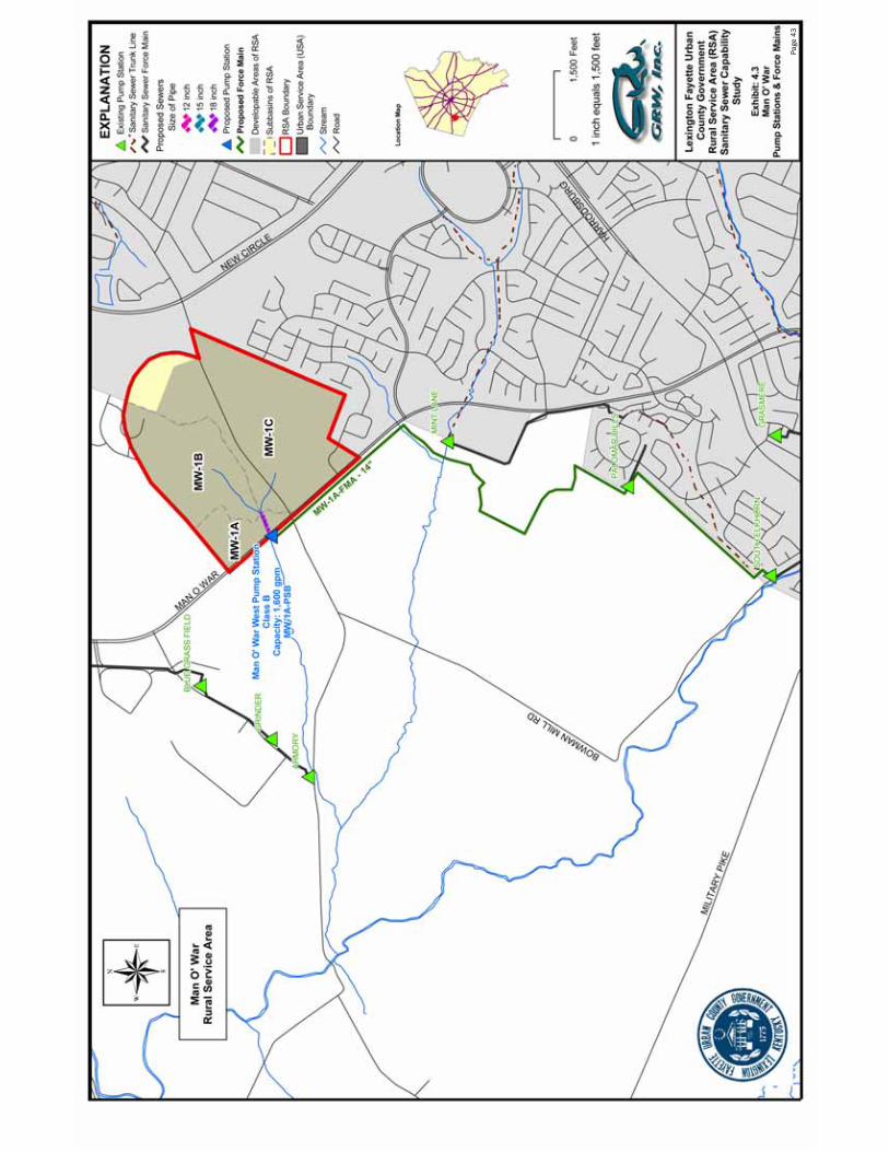
Page
43

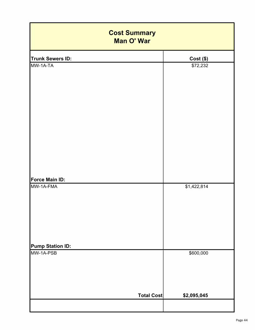
Trunk Sewers ID: Cost ($)
MW-1A-TA $72,232
Force Main ID:
MW-1A-FMA $1,422,814
Pump Station ID:
MW-1A-PSB $600,000
Total Cost $2,095,045
Cost Summary
Man O' War
Page 44

Shared Costs for System Improvements
Man O' War Rural Service Area
Construction of 2005 Improvements
Improvements for 14,000 GPM South Elkhorn Pump Station
and 36" Parallel Force Main
2005 South Elkhorn Pump Station and 36" Parallel Force Main Total Estimated Construction Cost $15,000,000
Total Acres - Existing South Elkhorn Sewershed 6,604Total Acres - Man O' War Service Area 376 Total Revised Area - South Elkhorn Sewershed 6,980
Shared Cost Per Acre for MW $2,149Shared Cost to MW (376 acres) $808,023Shared Cost to LFUCG (6,604 acres) $13,426,403
Page 45

Shared Costs for System Improvements
Man O' War Rural Service Area
Upgrade of South Elkhorn Pump Station
Increase Capacity from 14,000 gpm to 14,890 gpm
South Elkhorn Pump Station Capacity Upgrade to 14,890 gpm Total Estimated Construction Cost $450,000
Total Acres - Man O' War Service Area 376
Contributing Cost Per Acre for MW $1,197Contributing Cost to MW $450,000
Page 46
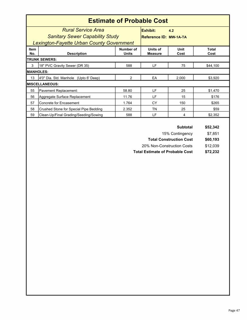
Estimate of Probable Cost
Rural Service Area Exhibit: 4.2
Sanitary Sewer Capability Study Reference ID: MW-1A-TA
Lexington-Fayette Urban County GovernmentItem Number of Units of Unit Total
No. Description Units Measure Cost Cost
TRUNK SEWERS:
3 18" PVC Gravity Sewer (DR 35) 588 LF 75 $44,100
MANHOLES:
13 4'0" Dia. Std. Manhole (Upto 6' Deep) 2 EA 2,000 $3,920
MISCELLANEOUS:
55 Pavement Replacement: 58.80 LF 25 $1,470
56 Aggregate Surface Replacement 11.76 LF 15 $176
57 Concrete for Encasement 1.764 CY 150 $265
58 Crushed Stone for Special Pipe Bedding 2.352 TN 25 $59
59 Clean-Up/Final Grading/Seeding/Sowing 588 LF 4 $2,352
Subtotal $52,342
15% Contingency $7,851
Total Construction Cost $60,193
20% Non-Construction Costs $12,039
Total Estimate of Probable Cost $72,232
Page 47
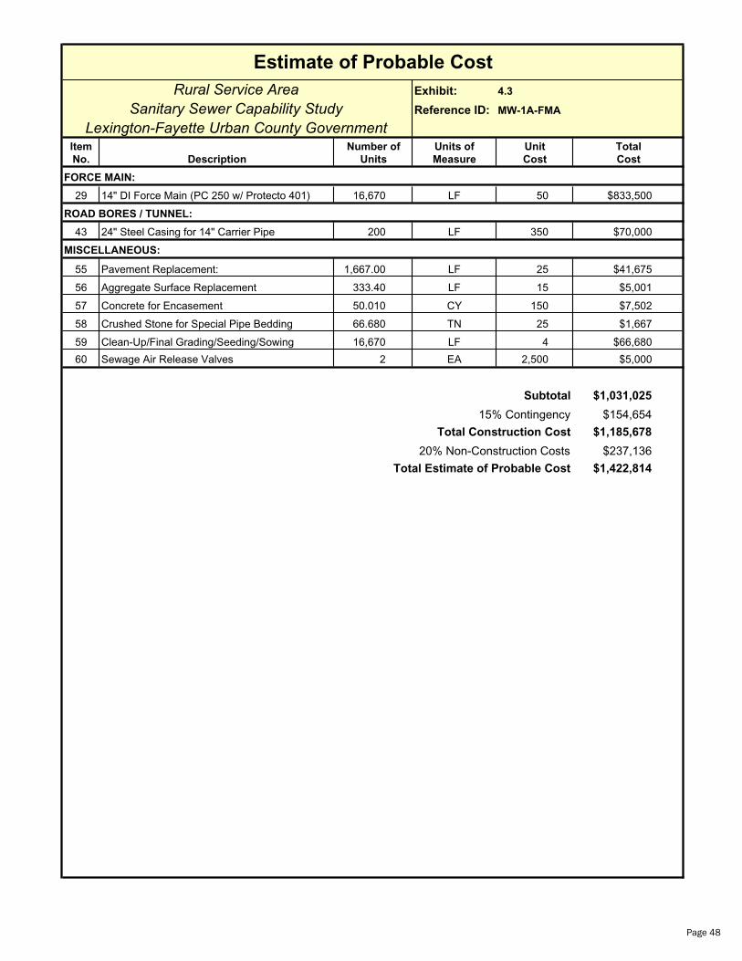
Estimate of Probable Cost
Rural Service Area Exhibit: 4.3
Sanitary Sewer Capability Study Reference ID: MW-1A-FMA
Lexington-Fayette Urban County GovernmentItem Number of Units of Unit Total
No. Description Units Measure Cost Cost
FORCE MAIN:
29 14" DI Force Main (PC 250 w/ Protecto 401) 16,670 LF 50 $833,500
ROAD BORES / TUNNEL:
43 24" Steel Casing for 14" Carrier Pipe 200 LF 350 $70,000
MISCELLANEOUS:
55 Pavement Replacement: 1,667.00 LF 25 $41,675
56 Aggregate Surface Replacement 333.40 LF 15 $5,001
57 Concrete for Encasement 50.010 CY 150 $7,502
58 Crushed Stone for Special Pipe Bedding 66.680 TN 25 $1,667
59 Clean-Up/Final Grading/Seeding/Sowing 16,670 LF 4 $66,680
60 Sewage Air Release Valves 2 EA 2,500 $5,000
Subtotal $1,031,025
15% Contingency $154,654
Total Construction Cost $1,185,678
20% Non-Construction Costs $237,136
Total Estimate of Probable Cost $1,422,814
Page 48
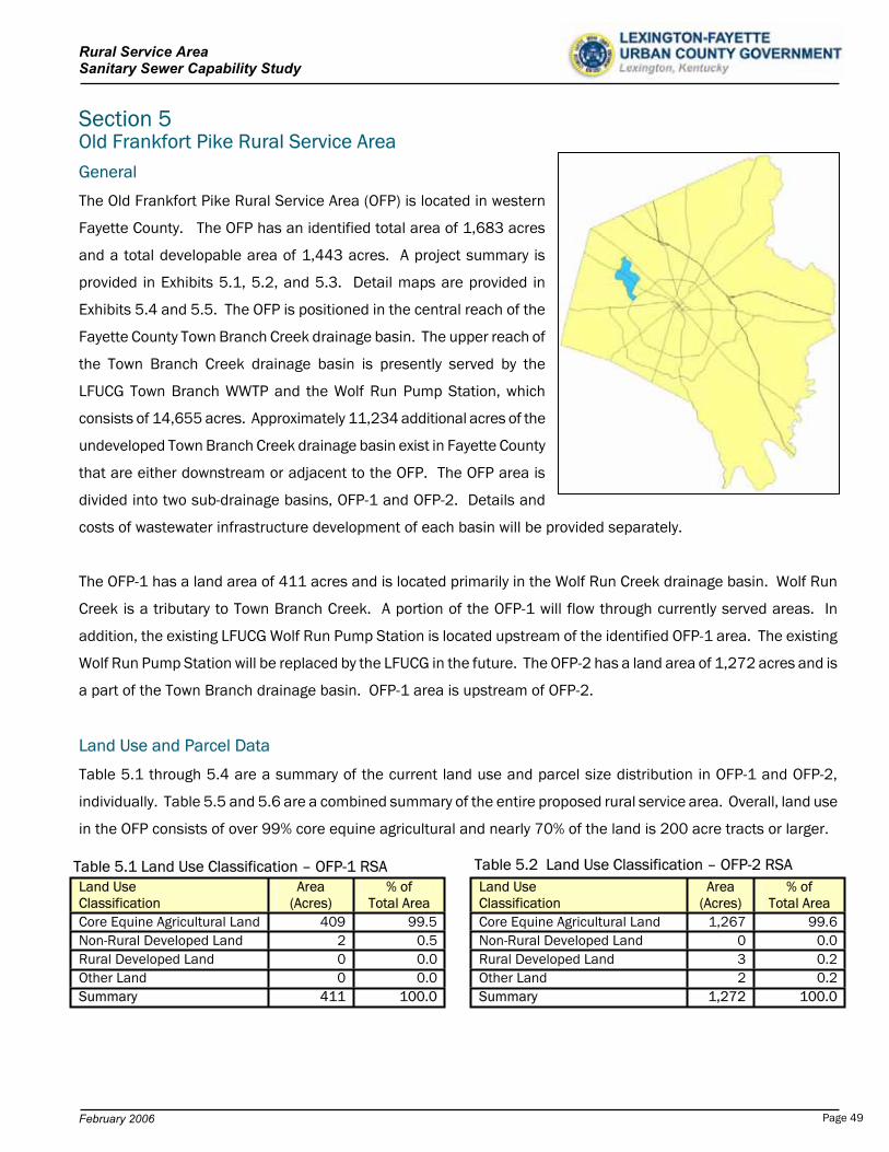
Rural Service Area Sanitary Sewer Capability Study
Section 5 Old Frankfort Pike Rural Service Area General
The Old Frankfort Pike Rural Service Area (OFP) is located in western
Fayette County. The OFP has an identified total area of 1,683 acres
and a total developable area of 1,443 acres. A project summary is
provided in Exhibits 5.1, 5.2, and 5.3. Detail maps are provided in
Exhibits 5.4 and 5.5. The OFP is positioned in the central reach of the
Fayette County Town Branch Creek drainage basin. The upper reach of
the Town Branch Creek drainage basin is presently served by the
LFUCG Town Branch WWTP and the Wolf Run Pump Station, which
consists of 14,655 acres. Approximately 11,234 additional acres of the
undeveloped Town Branch Creek drainage basin exist in Fayette County
that are either downstream or adjacent to the OFP. The OFP area is
divided into two sub-drainage basins, OFP-1 and OFP-2. Details and
costs of wastewater infrastructure development of each basin will be provided separately.
The OFP-1 has a land area of 411 acres and is located primarily in the Wolf Run Creek drainage basin. Wolf Run
Creek is a tributary to Town Branch Creek. A portion of the OFP-1 will flow through currently served areas. In
addition, the existing LFUCG Wolf Run Pump Station is located upstream of the identified OFP-1 area. The existing
Wolf Run Pump Station will be replaced by the LFUCG in the future. The OFP-2 has a land area of 1,272 acres and is
a part of the Town Branch drainage basin. OFP-1 area is upstream of OFP-2.
Land Use and Parcel Data
Table 5.1 through 5.4 are a summary of the current land use and parcel size distribution in OFP-1 and OFP-2,
individually. Table 5.5 and 5.6 are a combined summary of the entire proposed rural service area. Overall, land use
in the OFP consists of over 99% core equine agricultural and nearly 70% of the land is 200 acre tracts or larger.
Land Use Classification
Area (Acres)
% of Total Area
Core Equine Agricultural Land 1,267 99.6Non-Rural Developed Land 0 0.0Rural Developed Land 3 0.2Other Land 2 0.2Summary 1,272 100.0
Land Use Classification
Area (Acres)
% of Total Area
Core Equine Agricultural Land 409 99.5Non-Rural Developed Land 2 0.5Rural Developed Land 0 0.0Other Land 0 0.0Summary 411 100.0
Table 5.2 Land Use Classification – OFP-2 RSATable 5.1 Land Use Classification – OFP-1 RSA
February 2006 Page 49
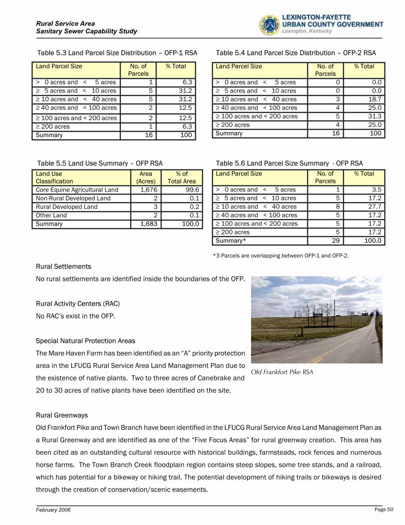
Rural Service Area Sanitary Sewer Capability Study
Table 5.3 Land Parcel Size Distribution – OFP-1 RSA Table 5.4 Land Parcel Size Distribution – OFP-2 RSA
Land Parcel Size No. of Parcels
% Total
> 0 acres and < 5 acres 1 6.3 5 acres and < 10 acres 5 31.2 10 acres and < 40 acres 5 31.2 40 acres and < 100 acres 2 12.5
100 acres and < 200 acres 2 12.5 200 acres 1 6.3
Summary 16 100
Land Parcel Size No. of Parcels
% Total
> 0 acres and < 5 acres 0 0.0 5 acres and < 10 acres 0 0.0 10 acres and < 40 acres 3 18.7 40 acres and < 100 acres 4 25.0 100 acres and < 200 acres 5 31.3 200 acres 4 25.0
Summary 16 100
Table 5.6 Land Parcel Size Summary - OFP RSATable 5.5 Land Use Summary – OFP RSALand Parcel Size No. of
Parcels % Total
> 0 acres and < 5 acres 1 3.5 5 acres and < 10 acres 5 17.2 10 acres and < 40 acres 8 27.7 40 acres and < 100 acres 5 17.2 100 acres and < 200 acres 5 17.2 200 acres 5 17.2
Summary* 29 100.0
Land Use Area Classification (Acres)
% of Total Area
Core Equine Agricultural Land 1,676 99.6Non-Rural Developed Land 2 0.1Rural Developed Land 3 0.2Other Land 2 0.1Summary 1,683 100.0
*3 Parcels are overlapping between OFP-1 and OFP-2.
Rural Settlements
No rural settlements are identified inside the boundaries of the OFP.
Rural Activity Centers (RAC)
No RAC’s exist in the OFP.
Special Natural Protection Areas
The Mare Haven Farm has been identified as an “A” priority protection
area in the LFUCG Rural Service Area Land Management Plan due to
the existence of native plants. Two to three acres of Canebrake and
20 to 30 acres of native plants have been identified on the site.
Old Frankfort Pike RSA
Rural Greenways
Old Frankfort Pike and Town Branch have been identified in the LFUCG Rural Service Area Land Management Plan as
a Rural Greenway and are identified as one of the “Five Focus Areas” for rural greenway creation. This area has
been cited as an outstanding cultural resource with historical buildings, farmsteads, rock fences and numerous
horse farms. The Town Branch Creek floodplain region contains steep slopes, some tree stands, and a railroad,
which has potential for a bikeway or hiking trail. The potential development of hiking trails or bikeways is desired
through the creation of conservation/scenic easements.
February 2006 Page 50
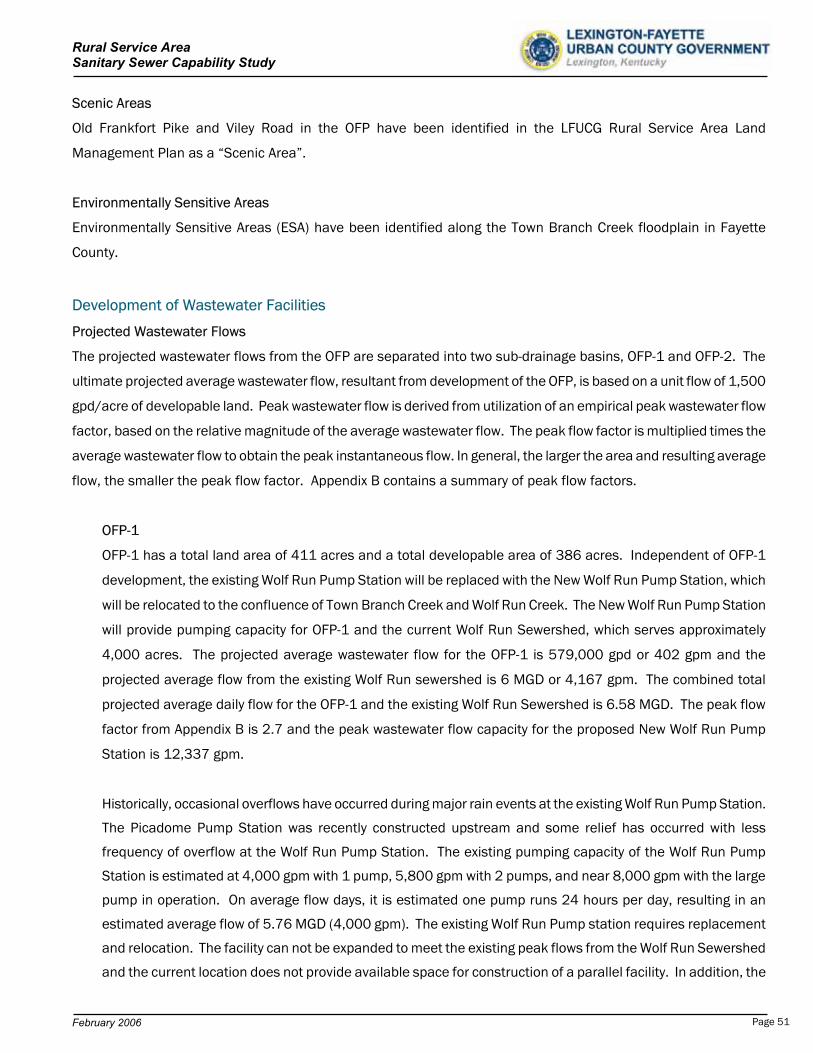
Rural Service Area Sanitary Sewer Capability Study
Scenic Areas
Old Frankfort Pike and Viley Road in the OFP have been identified in the LFUCG Rural Service Area Land
Management Plan as a “Scenic Area”.
Environmentally Sensitive Areas
Environmentally Sensitive Areas (ESA) have been identified along the Town Branch Creek floodplain in Fayette
County.
Development of Wastewater Facilities
Projected Wastewater Flows
The projected wastewater flows from the OFP are separated into two sub-drainage basins, OFP-1 and OFP-2. The
ultimate projected average wastewater flow, resultant from development of the OFP, is based on a unit flow of 1,500
gpd/acre of developable land. Peak wastewater flow is derived from utilization of an empirical peak wastewater flow
factor, based on the relative magnitude of the average wastewater flow. The peak flow factor is multiplied times the
average wastewater flow to obtain the peak instantaneous flow. In general, the larger the area and resulting average
flow, the smaller the peak flow factor. Appendix B contains a summary of peak flow factors.
OFP-1
OFP-1 has a total land area of 411 acres and a total developable area of 386 acres. Independent of OFP-1
development, the existing Wolf Run Pump Station will be replaced with the New Wolf Run Pump Station, which
will be relocated to the confluence of Town Branch Creek and Wolf Run Creek. The New Wolf Run Pump Station
will provide pumping capacity for OFP-1 and the current Wolf Run Sewershed, which serves approximately
4,000 acres. The projected average wastewater flow for the OFP-1 is 579,000 gpd or 402 gpm and the
projected average flow from the existing Wolf Run sewershed is 6 MGD or 4,167 gpm. The combined total
projected average daily flow for the OFP-1 and the existing Wolf Run Sewershed is 6.58 MGD. The peak flow
factor from Appendix B is 2.7 and the peak wastewater flow capacity for the proposed New Wolf Run Pump
Station is 12,337 gpm.
Historically, occasional overflows have occurred during major rain events at the existing Wolf Run Pump Station.
The Picadome Pump Station was recently constructed upstream and some relief has occurred with less
frequency of overflow at the Wolf Run Pump Station. The existing pumping capacity of the Wolf Run Pump
Station is estimated at 4,000 gpm with 1 pump, 5,800 gpm with 2 pumps, and near 8,000 gpm with the large
pump in operation. On average flow days, it is estimated one pump runs 24 hours per day, resulting in an
estimated average flow of 5.76 MGD (4,000 gpm). The existing Wolf Run Pump station requires replacement
and relocation. The facility can not be expanded to meet the existing peak flows from the Wolf Run Sewershed
and the current location does not provide available space for construction of a parallel facility. In addition, the
February 2006 Page 51
Rural Service Area Sanitary Sewer Capability Study
existing Wolf Run Pump Station is located in a commercially developed area and relocation is desired to
eliminate nuisance odors and overflows in a populated area. Based on input from the LFUCG Division of
Sanitary Sewers, the provision of a New Wolf Run Pump Station prior to the development of OFP-1, is required.
For the purpose of this study and determination of an average wastewater flow for the Wolf Run Sewershed, the
capacity of the Picadome Pump Station has not been considered due to the historical occurrences of inflow and
infiltration within the sewershed. The Picadome Pump Station currently diverts several hundred acres of
drainage directly to the Town Branch WWTP and the frequency and magnitude of occasional overflows at the
existing Wolf Run Pump Station have reduced. However, at this time, the entire 4,000 acres of the existing
Wolf Run Sewershed is conservatively considered. The resultant average daily flow of 6 MGD will be utilized for
the New Wolf Run Sewershed. Utilizing a peaking factor of 2.7, the resultant peak wastewater flow from the
New Wolf Run Sewershed is 11,250 gpm, which does not include OFP-1. Further detailed study of the peak
flows in the Wolf Run Sewershed may result in reduction of the required capacity of the new Wolf Run Pump
Station.
OFP-2
OFP-2 has a total land area of 1,272 acres and a total developable area of 1,057 acres. The projected
average wastewater flow is 1.58 MGD or 1,101 gpm. The peak flow factor from Appendix B is 3.4 and the
peak wastewater flow capacity for the OFP-2 area is 3,743 gpm.
Wastewater Infrastructure Summary and Development Review
The OFP is mostly located downstream of current development in the
Urban Service Area and most future wastewater will naturally flow away
from currently sewered areas. A New Wolf Run Pump Station, located at
the most downstream location of OFP-1, could pump and convey all
wastewater to Town Branch WWTP, separate of OFP-2. OFP-1 and OFP-2
require independent infrastructure and can occur as phased.
Old Frankfort Pike RSA
OFP-1
12” to 15” trunk sewers will be required for development of OFP-1. However, a 54” trunk sewer will be required
downstream of the existing Wolf Run Pump Station to route all flows to the relocated pump station at the
confluence of Town Branch and Wolf Run Creek. As stated previously, the existing Wolf Run Pump Station
requires replacement. The pump station experiences occasional overflows and in the opinion of the LFUCG
Division of Sanitary Sewers can not be easily expanded in a cost effective manner. The location of the existing
pump station is also central to a commercially developed area and relocation is desired. The New Wolf Run
Pump Station (Class A) would pump and convey wastewater to the Town Branch WWTP via a 36” force main. The
prorated share of costs for relocation/replacement of the Wolf Run Pump Station, large trunk sewer, and force
main for the LFUCG’s current sewershed would be provided for in the development costs of OFP-1.
February 2006 Page 52
Rural Service Area Sanitary Sewer Capability Study
OFP-2
OFP-2 drainage area is 1,272 acres and is located downstream of the confluence of Town Branch Creek and
Wolf Run Creek. 12” to 30” trunk mains will be required for development of OFP-2. A Class A pump station will
be required at the most downstream location of the OFP-2. A 20” force main will be required to convey flows
from the new pump station to the Town Branch Wastewater Treatment Plant, parallel with the existing 20” force
main from the existing Lower Town Branch Pump Station and the proposed 36” force main from the New Wolf
Run Pump Station.
In review of the OFP-2 study area, the extension of the proposed rural service area downstream another 1,500
LF will allow another sub-drainage basin of the Town Branch Creek, consisting of 796 acres, to have future
access to the proposed sanitary sewer system, provided the proposed OFP-2 pump station was also relocated
downstream an additional 1,500 feet. The additional land area is not included in the scope of this study,
however, consideration of this region in the future may be reviewed.
With the development of the OFP, opportunity exists for the LFUCG to decommission several small pump stations
along Town Branch Creek by extending gravity sewer service upstream to these locations. Table 5.7 provides a
summary of each pump station which is a candidate for decommissioning in the OFP. Costs of decommissioning
have not been included in the study.
No wastewater treatment capacity exists for the OFP. The projected WWTP capacity required for complete
development of the OFP is 1,503 gpm or 2.16 MGD. Table 5.8 provides a summary of required WWTP capacity for
the OFP-1 and OFP-2. Exhibit 5.1, 5.2, and 5.3 are project summaries of the OFP physical, flow, and cost
characteristics.
Pump Station Name BasinLeestown Industrial OFP-1Leestown West OFP-1Spicewood OFP-2 Marshall OFP-2Bracktown (Future) OFP-2
Sub-Basin Capacity (MGD) OFP-1 0.58 OFP-2 1.58
Total 2.16
Table 5.7 Candidate Pump Stations for Decommissioning
Table 5.8 Required WWTP Capacity for OFP RSA
February 2006 Page 53
Rural Service Area Sanitary Sewer Capability Study
Estimate of Probable Cost for Collection, Pumping, Conveyance, and Treatment
The estimate of probable cost for the OFP is provided in separate summaries for the OFP-1 area and the OFP-2 area.
OFP-1
The estimate of total probable cost for the OFP-1 trunk sewer, Class A pump station, and force main to the Town
Branch WWTP is $12,557,680. The LFUCG contributed share of costs to the upgrade the Wolf Run Pump
Station, force main, and trunk sewer are $10,394,418. These are proportioned costs associated with the
replacement of the existing facilities for the current sanitary sewer service area. A summary of these
contributing costs is provided with the detailed cost estimates at the end of this section. After these deductive
adjustments to the total project cost, the total net estimated cost of pumping and conveyance for OFP-1 is
$2,163,262.
OFP-2
The estimate of total probable cost for the OFP-2 trunk sewer, Class A pump station, and force main to the Town
Branch WWTP is $8,456,530.
The required WWTP capacity for the projected average flow from complete development of the OFP -1 and OFP -2 is
0.58 MGD and 1.58 MGD, respectively. At the cost of $6/gallon for expansion of the Town Branch WWTP, the
projected total construction cost for wastewater treatment is summarized in Table 5.9
Table 5.9 Summary of WWTP Capacity and Cost - OFP RSA
Sub-Basin Required WWTP Capacity (MGD)
Cost ($)
OFP-1 0.58 $ 3,474,000.OFP-2 1.58 9,513,000.
Total 2.16 $ 12,987,000.
These estimated costs include construction, construction contingencies, engineering design and inspection, legal,
easements, and other non-construction costs. A summary of all costs is provided in Exhibits 5.1, 5.2, and 5.3.
Summary, Review, and Recommendations – Old Frankfort Pike RSA
The estimate of probable costs for the collection, pumping, conveyance, and treatment of forecast wastewater from
the OFP is $23,606,792. The unit cost of development is $16,360/acre. These estimated costs include
construction, construction contingencies, engineering design and inspection, legal, easements, and other non-
construction costs. Tables 5.10, 5.11, 5.12 provide a summary of project costs. A summary of all detail costs is
provided in Exhibit 5.1 through Exhibit 5.3.
February 2006 Page 54

Rural Service Area Sanitary Sewer Capability Study
Table 5.10 Cost Summary – OFP-1 RSA
Item Total Cost Total Cost/Acre*
Trunk Sewers $ 4,752,690. $ 12,313.Force Main 3,004,990. 7,785.
Pump Stations 4,800,000. 12,435.
Wastewater Treatment 3,474,000. 9,000.
Total Cost $16,031,680. $ 41,533.
Shared Cost by LFUCG** -10,394,418. -26,929.Net Cost for OFP-1 $ 5,637,262. $ 14,604.
* Total Cost is per developable acre. ** LFUCG existing Urban Service Area portion of Wolf Run Improvements
Table 5.11 Cost Summary – OFP-2 RSA
Item Total Cost Total Cost/Acre*
Trunk Sewers $3,623,457. $ 3,428.
Force Main 2,833,073. 2,681.
Pump Stations 2,000,000. 1,892.
Wastewater Treatment 9,513,000. 9,000.
Total Cost for OFP-2 $17,969,530. $ 17,001.
* Total Cost is per developable acre.
Table 5.12 OFP Cost Summary – OFP RSA
Item Total Cost Total Cost/Acre*
Trunk Sewers $ 8,376,147. $ 5,805.
Force Main 5,838,063. 4,046.
Pump Stations 6,800,000. 4,712.
Wastewater Treatment 12,987,000. 9,000.
Total Cost $34,001,210. $ 23,563.
Shared Cost by LFUCG -10,394,418. -7,203
Net Cost for OFP $23,606,792. $ 16,360.
* Total Cost is per developable acre
February 2006 Page 55

Rural Service Area Sanitary Sewer Capability Study
Future downstream development below the OFP will be more challenging due to the provision of additional pumping
and conveyance capacity to the Town Branch WWTP. The construction of another parallel force main to the OFP
improvements will be an issue along the developed corridor of the railroad and OFP. These required improvements
will be more costly and more distant from existing or available pumping, conveyance, and treatment facilities.
The Town Branch Creek drainage basin has a total area of 27,572 acres in Fayette County, of which 14,655
upstream acres are presently sewered. Potential exists to construct a future WWTP at a downstream location in the
Town Branch Drainage Basin in lieu of additional pumping and conveyance alternatives to the Town Branch WWTP.
In addition, pumping and conveyance of these flows to an adjacent drainage basin for treatment at a new WWTP may
also be an alternative. These alternatives have not been investigated within the scope of this study.
Review
Over 99% of the property is core equine agricultural or prime agricultural land.
The area is designated as one of the “five focus areas” for rural greenway creation.
A large portion of the area is designated as a “scenic area”.
All resultant flows from the OFP are downstream of current wastewater infrastructure development.
Additional pumping and conveyance will be required.
In the opinion of the LFUCG Division of Sanitary Sewers, replacement of the Wolf Run Pump Station and
Force Main would be prior to the development of OFP-1.
Future downstream development below the OFP will present similar problems as the present; no pumping,
conveyance, or treatment capacity is available.
With the development of the OFP, opportunity exists to decommission several small capacity pump stations
along Town Branch Creek.
Recommendations
Revisit the issues and costs of a wastewater treatment plant in the lower Town Branch drainage basin.
Investigate the costs and feasibility to pump and convey future wastewater to an adjacent drainage basin
WWTP.
Evaluate the ability and availability of right-of-way to construct a third force main between a new downstream
pump station below OFP-2 and the Town Branch WWTP.
Continue evaluation of wastewater discharge limitation concerns on the Town Branch Creek.
Determine other future alternatives available for pumping, conveyance, and treatment of wastewater flows.
Expand future planning efforts for wastewater infrastructure beyond the traditional 20-year planning period.
February 2006 Page 56
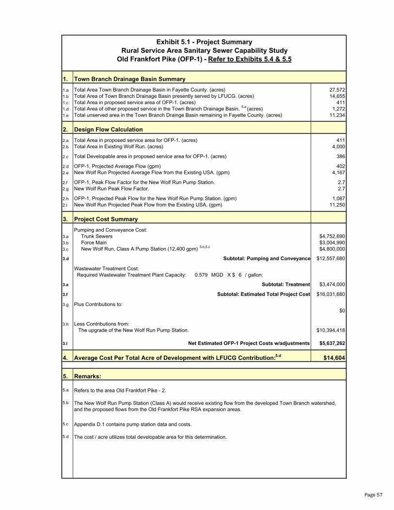
Exhibit 5.1 - Project Summary
Rural Service Area Sanitary Sewer Capability Study
Old Frankfort Pike (OFP-1) - Refer to Exhibits 5.4 & 5.5
1. Town Branch Drainage Basin Summary
1.a Total Area Town Branch Drainage Basin in Fayette County. (acres) 27,5721.b Total Area of Town Branch Drainage Basin presently served by LFUCG. (acres) 14,6551.c Total Area in proposed service area of OFP-1. (acres) 4111.d Total Area of other proposed service in the Town Branch Drainage Basin. 1,2725.a (acres)1.e Total unserved area in the Town Branch Drainge Basin remaining in Fayette County. (acres) 11,234
2. Design Flow Calculation
2.a Total Area in proposed service area for OFP-1. (acres) 4112.b Total Area in Existing Wolf Run. (acres) 4,000
2.c Total Developable area in proposed service area for OFP-1. (acres) 386
2.d OFP-1, Projected Average Flow (gpm) 4022.e New Wolf Run Projected Average Flow from the Existing USA. (gpm) 4,167
2.f OFP-1, Peak Flow Factor for the New Wolf Run Pump Station. 2.72.g New Wolf Run Peak Flow Factor. 2.7
2.h OFP-1, Projected Peak Flow for the New Wolf Run Pump Station. (gpm) 1,0872.I New Wolf Run Projected Peak Flow from the Existing USA. (gpm) 11,250
3. Project Cost Summary
Pumping and Conveyance Cost:3.a Trunk Sewers $4,752,6903.b Force Main $3,004,9903.c New Wolf Run, Class A Pump Station (12,400 gpm) c $4,800,0005.b,5.
3.d Subtotal: Pumping and Conveyance $12,557,680
Wastewater Treatment Cost: Required Wastewater Treatment Plant Capacity: 0.579 MGD X $ 6 / gallon:
3.e Subtotal: Treatment $3,474,000
3.f Subtotal: Estimated Total Project Cost $16,031,680
3.g Plus Contributions to:$0
3.h Less Contributions from: The upgrade of the New Wolf Run Pump Station. $10,394,418
3.I Net Estimated OFP-1 Project Costs w/adjustments $5,637,262
4. Average Cost Per Total Acre of Development with LFUCG Contribution: $14,6045.d
5. Remarks:
5.a Refers to the area Old Frankfort Pike - 2.
5.b The New Wolf Run Pump Station (Class A) would receive existing flow from the developed Town Branch watershed, and the proposed flows from the Old Frankfort Pike RSA expansion areas.
5.c Appendix D.1 contains pump station data and costs.
5.d The cost / acre utilizes total developable area for this determination.
Page 57
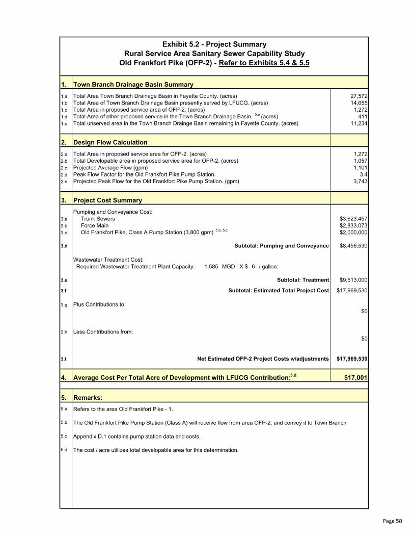
Exhibit 5.2 - Project Summary
Rural Service Area Sanitary Sewer Capability Study
Old Frankfort Pike (OFP-2) - Refer to Exhibits 5.4 & 5.5
1. Town Branch Drainage Basin Summary
1.a Total Area Town Branch Drainage Basin in Fayette County. (acres) 27,5721.b Total Area of Town Branch Drainage Basin presently served by LFUCG. (acres) 14,6551.c Total Area in proposed service area of OFP-2. (acres) 1,2721.d Total Area of other proposed service in the Town Branch Drainage Basin. 4115.a (acres)1.e Total unserved area in the Town Branch Drainge Basin remaining in Fayette County. (acres) 11,234
2. Design Flow Calculation
2.a Total Area in proposed service area for OFP-2. (acres) 1,2722.b Total Developable area in proposed service area for OFP-2. (acres) 1,0572.c Projected Average Flow (gpm) 1,1012.d Peak Flow Factor for the Old Frankfort Pike Pump Station. 3.42.e Projected Peak Flow for the Old Frankfort Pike Pump Station. (gpm) 3,743
3. Project Cost Summary
Pumping and Conveyance Cost:3.a Trunk Sewers $3,623,4573.b Force Main $2,833,0733.c Old Frankfort Pike, Class A Pump Station (3,800 gpm) b $2,000,0005. , 5.c
3.d Subtotal: Pumping and Conveyance $8,456,530
Wastewater Treatment Cost: Required Wastewater Treatment Plant Capacity: 1.585 MGD X $ 6 / gallon:
3.e Subtotal: Treatment $9,513,000
3.f Subtotal: Estimated Total Project Cost $17,969,530
3.g Plus Contributions to:$0
3.h Less Contributions from:$0
3.I Net Estimated OFP-2 Project Costs w/adjustments $17,969,530
4. Average Cost Per Total Acre of Development with LFUCG Contribution: $17,0015.d
5. Remarks:
5.a Refers to the area Old Frankfort Pike - 1.
5.b The Old Frankfort Pike Pump Station (Class A) will receive flow from area OFP-2, and convey it to Town Branch
5.c Appendix D.1 contains pump station data and costs.
5.d The cost / acre utilizes total developable area for this determination.
Page 58
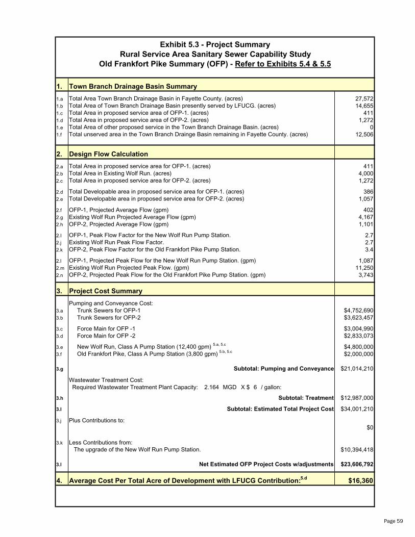
Exhibit 5.3 - Project Summary
Rural Service Area Sanitary Sewer Capability Study
Old Frankfort Pike Summary (OFP) - Refer to Exhibits 5.4 & 5.5
1. Town Branch Drainage Basin Summary
1.a Total Area Town Branch Drainage Basin in Fayette County. (acres) 27,5721.b Total Area of Town Branch Drainage Basin presently served by LFUCG. (acres) 14,6551.c Total Area in proposed service area of OFP-1. (acres) 4111.d Total Area in proposed service area of OFP-2. (acres) 1,2721.e Total Area of other proposed service in the Town Branch Drainage Basin. 0(acres)1.f Total unserved area in the Town Branch Drainge Basin remaining in Fayette County. (acres) 12,506
2. Design Flow Calculation
2.a Total Area in proposed service area for OFP-1. (acres) 4112.b Total Area in Existing Wolf Run. (acres) 4,0002.c Total Area in proposed service area for OFP-2. (acres) 1,272
2.d Total Developable area in proposed service area for OFP-1. (acres) 3862.e Total Developable area in proposed service area for OFP-2. (acres) 1,057
2.f OFP-1, Projected Average Flow (gpm) 4022.g Existing Wolf Run Projected Average Flow (gpm) 4,1672.h OFP-2, Projected Average Flow (gpm) 1,101
2.I OFP-1, Peak Flow Factor for the New Wolf Run Pump Station. 2.72.j Existing Wolf Run Peak Flow Factor. 2.72.k OFP-2, Peak Flow Factor for the Old Frankfort Pike Pump Station. 3.4
2.l OFP-1, Projected Peak Flow for the New Wolf Run Pump Station. (gpm) 1,0872.m Existing Wolf Run Projected Peak Flow. (gpm) 11,2502.n OFP-2, Projected Peak Flow for the Old Frankfort Pike Pump Station. (gpm) 3,743
3. Project Cost Summary
Pumping and Conveyance Cost:3.a Trunk Sewers for OFP-1 $4,752,6903.b Trunk Sewers for OFP-2 $3,623,457
3.c Force Main for OFP -1 $3,004,9903.d Force Main for OFP -2 $2,833,073
3.e New Wolf Run, Class A Pump Station (12,400 gpm) 5 5 $4,800,000.a, .c
3.f Old Frankfort Pike, Class A Pump Station (3,800 gpm) 5.b 5 $2,000,000, .c
3.g Subtotal: Pumping and Conveyance $21,014,210
Wastewater Treatment Cost: Required Wastewater Treatment Plant Capacity: 2.164 MGD X $ 6 / gallon:
3.h Subtotal: Treatment $12,987,000
3.I Subtotal: Estimated Total Project Cost $34,001,210
3.j Plus Contributions to:$0
3.k Less Contributions from: The upgrade of the New Wolf Run Pump Station. $10,394,418
3.l Net Estimated OFP Project Costs w/adjustments $23,606,792
4. Average Cost Per Total Acre of Development with LFUCG Contribution: $16,3605.d
Page 59
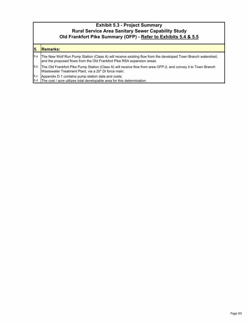
Exhibit 5.3 - Project Summary
Rural Service Area Sanitary Sewer Capability Study
Old Frankfort Pike Summary (OFP) - Refer to Exhibits 5.4 & 5.5
5. Remarks:
5.a The New Wolf Run Pump Station (Class A) will receive existing flow from the developed Town Branch watershed, and the proposed flows from the Old Frankfort Pike RSA expansion areas.
5.b The Old Frankfort Pike Pump Station (Class A) will receive flow from area OFP-2, and convey it to Town Branch Wastewater Treatment Plant, via a 20" DI force main.
5.c Appendix D.1 contains pump station data and costs.5.d The cost / acre utilizes total developable area for this determination.
Page 60
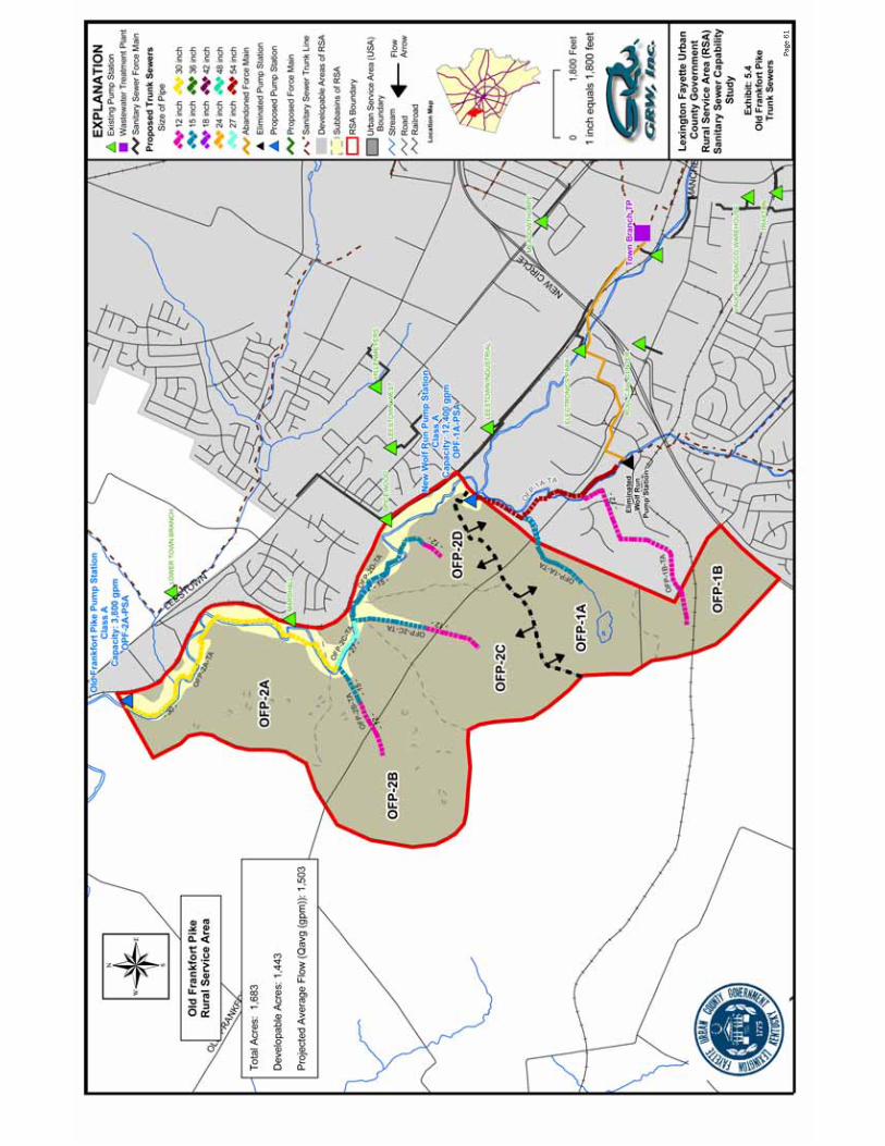
Page
61
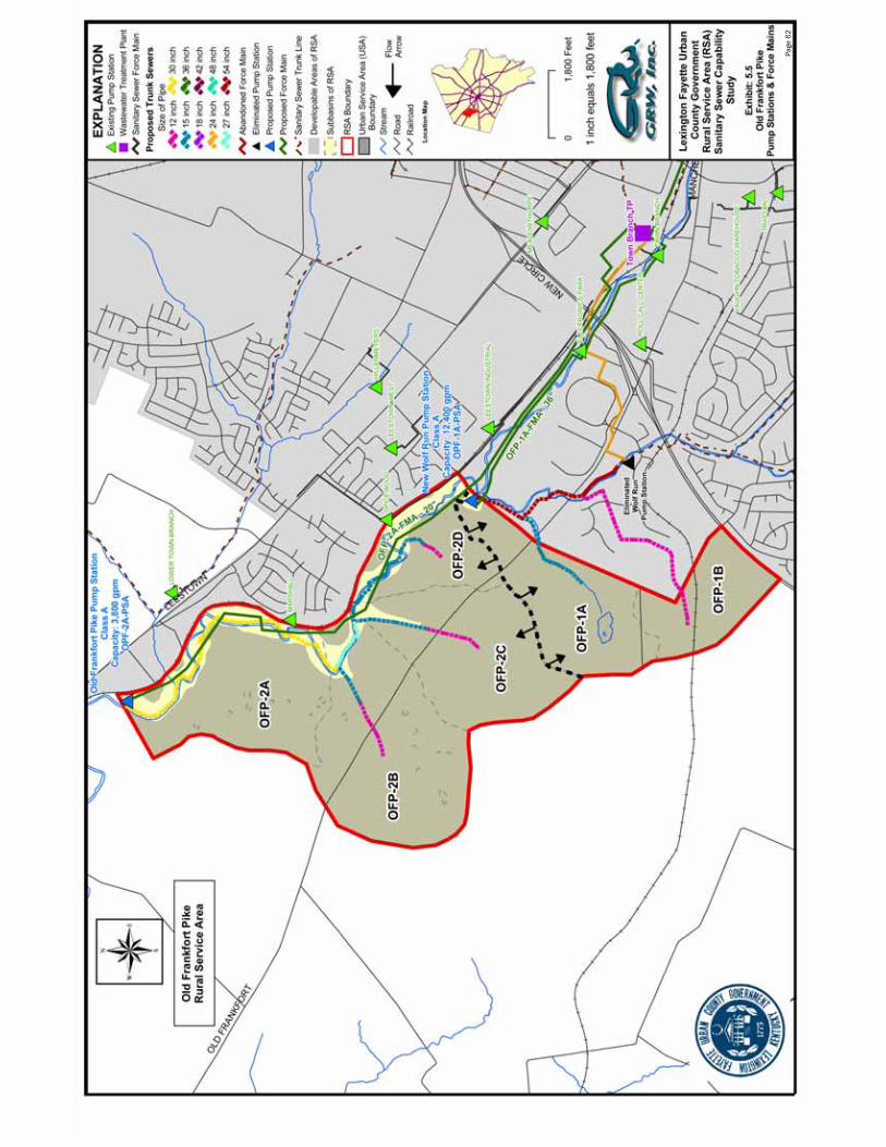
Page
62

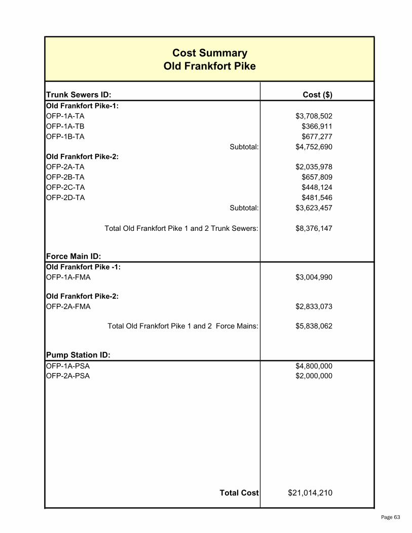
Trunk Sewers ID: Cost ($)
Old Frankfort Pike-1:
OFP-1A-TA $3,708,502OFP-1A-TB $366,911OFP-1B-TA $677,277
Subtotal: $4,752,690Old Frankfort Pike-2:
OFP-2A-TA $2,035,978OFP-2B-TA $657,809OFP-2C-TA $448,124OFP-2D-TA $481,546
Subtotal: $3,623,457
Total Old Frankfort Pike 1 and 2 Trunk Sewers: $8,376,147
Force Main ID:
Old Frankfort Pike -1:
OFP-1A-FMA $3,004,990
Old Frankfort Pike-2:
OFP-2A-FMA $2,833,073
Total Old Frankfort Pike 1 and 2 Force Mains: $5,838,062
Pump Station ID:
OFP-1A-PSA $4,800,000OFP-2A-PSA $2,000,000
Total Cost $21,014,210
Cost Summary
Old Frankfort Pike
Page 63
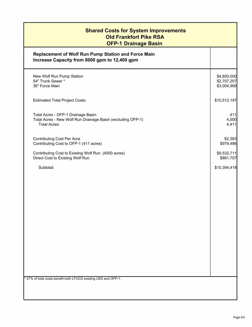
Shared Costs for System Improvements
Old Frankfort Pike RSA
OFP-1 Drainage Basin
Replacement of Wolf Run Pump Station and Force Main
Increase Capacity from 8000 gpm to 12,400 gpm
New Wolf Run Pump Station $4,800,00054" Trunk Sewer * $2,707,20736" Force Main $3,004,990
Estimated Total Project Costs: $10,512,197
Total Acres - OFP-1 Drainage Basin 411Total Acres - New Wolf Run Drainage Basin (excluding OFP-1) 4,000 Total Acres: 4,411
Contributing Cost Per Acre $2,383Contributing Cost to OFP-1 (411 acres) $979,486
Contributing Cost to Existing Wolf Run (4000 acres) $9,532,711Direct Cost to Existing Wolf Run $861,707
Subtotal: $10,394,418
* 27% of total costs benefit both LFUCG existing USA and OFP-1.
Page 64

Estimate of Probable Cost
Rural Service Area Exhibit: 5.4
Sanitary Sewer Capability Study Reference ID: OFP-1A-TA
Lexington-Fayette Urban County GovernmentItem Number of Units of Unit Total
No. Description Units Measure Cost Cost
TRUNK SEWERS:
11 54" DI Gravity Sewer (PC 200) w/Protecto 401 4,996 LF 475 $2,373,100
MANHOLES:
17 8'0" Dia. Std. Manhole (Upto 6' Deep) 17 EA 7,500 $127,500
ROAD BORES / TUNNEL:
53 72" Steel Casing for 54" Carrier Pipe 100 LF 1,500 $150,000
MISCELLANEOUS:
55 Pavement Replacement: 499.60 LF 25 $12,490
56 Aggregate Surface Replacement 99.92 LF 15 $1,499
57 Concrete for Encasement 14.988 CY 150 $2,248
58 Crushed Stone for Special Pipe Bedding 19.984 TN 25 $500
59 Clean-Up/Final Grading/Seeding/Sowing 4,996 LF 4 $19,984
Subtotal $2,687,321
15% Contingency $403,098
Total Construction Cost $3,090,419
20% Non-Construction Costs $618,084
Total Estimate of Probable Cost $3,708,502
Page 65
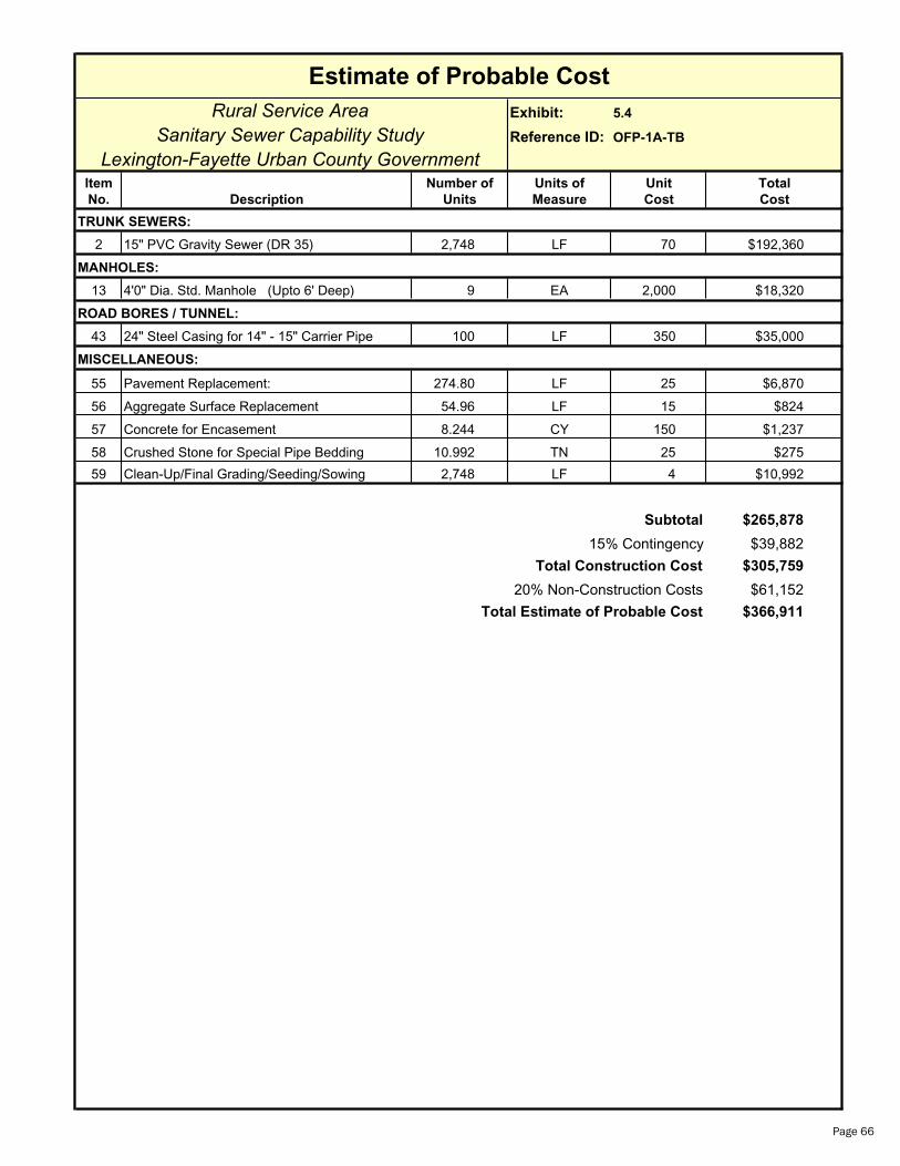
Estimate of Probable Cost
Rural Service Area Exhibit: 5.4
Sanitary Sewer Capability Study Reference ID: OFP-1A-TB
Lexington-Fayette Urban County GovernmentItem Number of Units of Unit Total
No. Description Units Measure Cost Cost
TRUNK SEWERS:
2 15" PVC Gravity Sewer (DR 35) 2,748 LF 70 $192,360
MANHOLES:
13 4'0" Dia. Std. Manhole (Upto 6' Deep) 9 EA 2,000 $18,320
ROAD BORES / TUNNEL:
43 24" Steel Casing for 14" - 15" Carrier Pipe 100 LF 350 $35,000
MISCELLANEOUS:
55 Pavement Replacement: 274.80 LF 25 $6,870
56 Aggregate Surface Replacement 54.96 LF 15 $824
57 Concrete for Encasement 8.244 CY 150 $1,237
58 Crushed Stone for Special Pipe Bedding 10.992 TN 25 $275
59 Clean-Up/Final Grading/Seeding/Sowing 2,748 LF 4 $10,992
Subtotal $265,878
15% Contingency $39,882
Total Construction Cost $305,759
20% Non-Construction Costs $61,152
Total Estimate of Probable Cost $366,911
Page 66
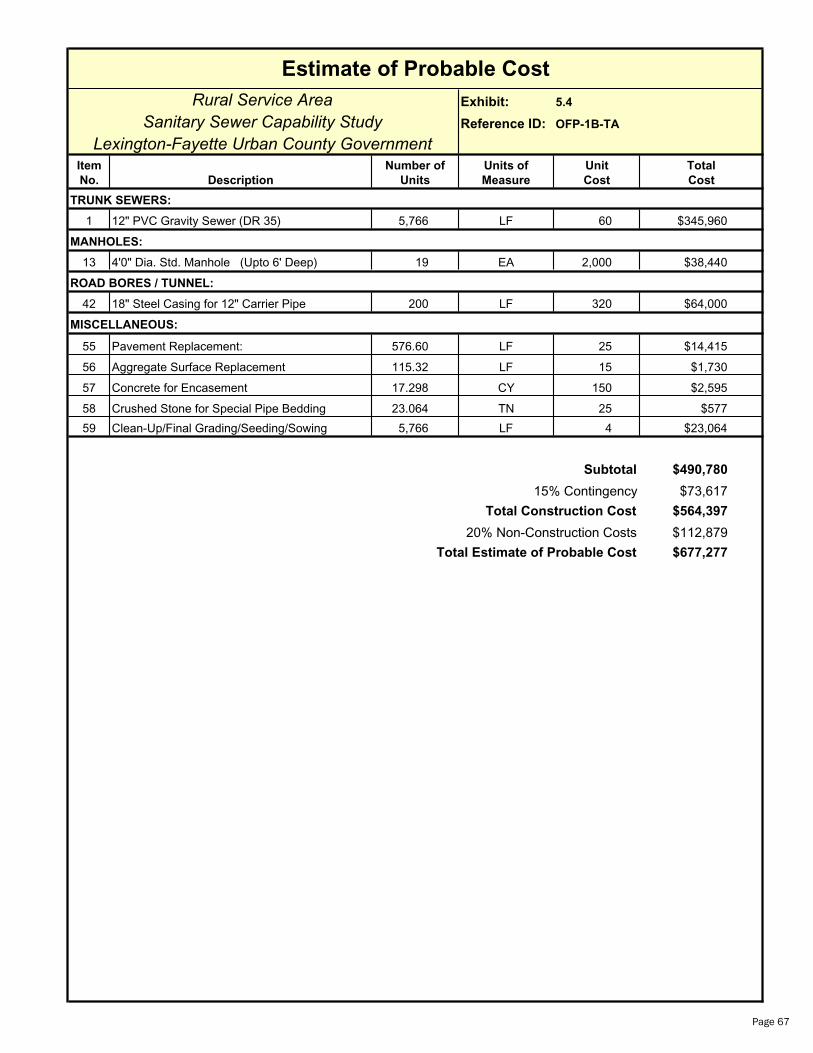
Estimate of Probable Cost
Rural Service Area Exhibit: 5.4
Sanitary Sewer Capability Study Reference ID: OFP-1B-TA
Lexington-Fayette Urban County GovernmentItem Number of Units of Unit Total
No. Description Units Measure Cost Cost
TRUNK SEWERS:
1 12" PVC Gravity Sewer (DR 35) 5,766 LF 60 $345,960
MANHOLES:
13 4'0" Dia. Std. Manhole (Upto 6' Deep) 19 EA 2,000 $38,440
ROAD BORES / TUNNEL:
42 18" Steel Casing for 12" Carrier Pipe 200 LF 320 $64,000
MISCELLANEOUS:
55 Pavement Replacement: 576.60 LF 25 $14,415
56 Aggregate Surface Replacement 115.32 LF 15 $1,730
57 Concrete for Encasement 17.298 CY 150 $2,595
58 Crushed Stone for Special Pipe Bedding 23.064 TN 25 $577
59 Clean-Up/Final Grading/Seeding/Sowing 5,766 LF 4 $23,064
Subtotal $490,780
15% Contingency $73,617
Total Construction Cost $564,397
20% Non-Construction Costs $112,879
Total Estimate of Probable Cost $677,277
Page 67

Estimate of Probable Cost
Rural Service Area Exhibit: 5.5
Sanitary Sewer Capability Study Reference ID: OFP-1A-FMA
Lexington-Fayette Urban County GovernmentItem Number of Units of Unit Total
No. Description Units Measure Cost Cost
FORCE MAIN:
35 36" DI Force Main (PC 200 w/ Protecto 401) 10,336 LF 182 $1,881,152
ROAD BORES / TUNNEL:
50 50" Steel Casing for 36" Carrier Pipe 200 LF 925 $185,000
MISCELLANEOUS:
55 Pavement Replacement: 1,033.60 LF 25 $25,840
56 Aggregate Surface Replacement 2,067.20 LF 15 $31,008
57 Concrete for Encasement 31.008 CY 150 $4,651
58 Crushed Stone for Special Pipe Bedding 41.344 TN 25 $1,034
59 Clean-Up/Final Grading/Seeding/Sowing 10,336 LF 4 $41,344
60 Sewage Air Release Valves 3 EA 2,500 $7,500
Subtotal $2,177,529
15% Contingency $326,629
Total Construction Cost $2,504,158
20% Non-Construction Costs $500,832
Total Estimate of Probable Cost $3,004,990
Page 68
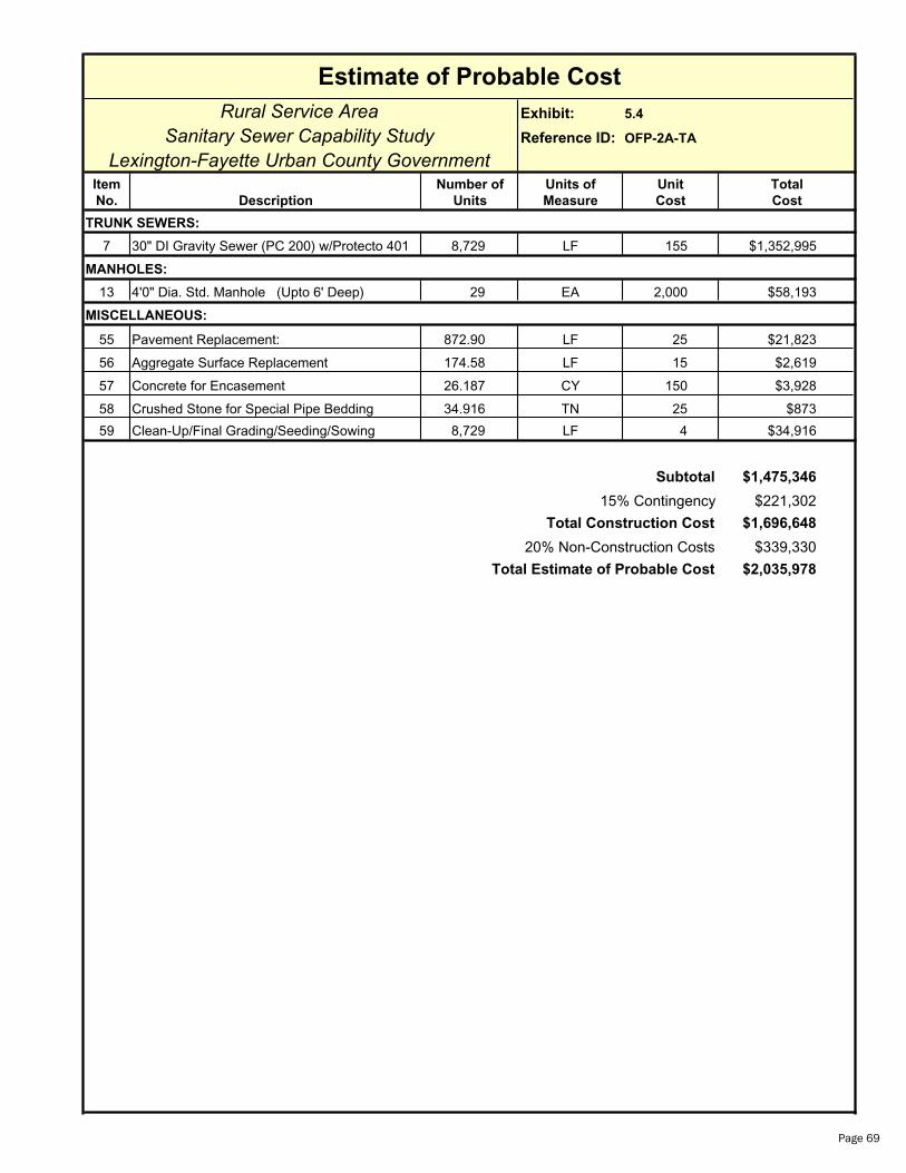
Estimate of Probable Cost
Rural Service Area Exhibit: 5.4
Sanitary Sewer Capability Study Reference ID: OFP-2A-TA
Lexington-Fayette Urban County GovernmentItem Number of Units of Unit Total
No. Description Units Measure Cost Cost
TRUNK SEWERS:
7 30" DI Gravity Sewer (PC 200) w/Protecto 401 8,729 LF 155 $1,352,995
MANHOLES:
13 4'0" Dia. Std. Manhole (Upto 6' Deep) 29 EA 2,000 $58,193
MISCELLANEOUS:
55 Pavement Replacement: 872.90 LF 25 $21,823
56 Aggregate Surface Replacement 174.58 LF 15 $2,619
57 Concrete for Encasement 26.187 CY 150 $3,928
58 Crushed Stone for Special Pipe Bedding 34.916 TN 25 $873
59 Clean-Up/Final Grading/Seeding/Sowing 8,729 LF 4 $34,916
Subtotal $1,475,346
15% Contingency $221,302
Total Construction Cost $1,696,648
20% Non-Construction Costs $339,330
Total Estimate of Probable Cost $2,035,978
Page 69
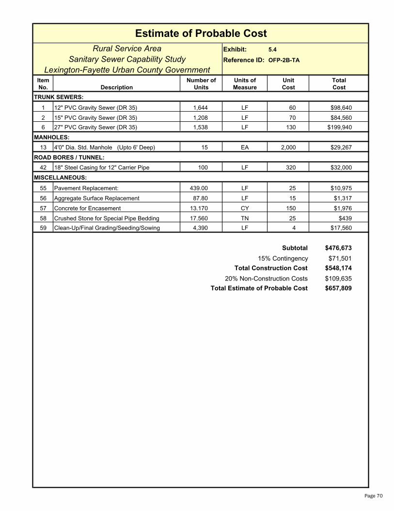
Estimate of Probable Cost
Rural Service Area Exhibit: 5.4
Sanitary Sewer Capability Study Reference ID: OFP-2B-TA
Lexington-Fayette Urban County GovernmentItem Number of Units of Unit Total
No. Description Units Measure Cost Cost
TRUNK SEWERS:
1 12" PVC Gravity Sewer (DR 35) 1,644 LF 60 $98,640
2 15" PVC Gravity Sewer (DR 35) 1,208 LF 70 $84,560
6 27" PVC Gravity Sewer (DR 35) 1,538 LF 130 $199,940
MANHOLES:
13 4'0" Dia. Std. Manhole (Upto 6' Deep) 15 EA 2,000 $29,267
ROAD BORES / TUNNEL:
42 18" Steel Casing for 12" Carrier Pipe 100 LF 320 $32,000
MISCELLANEOUS:
55 Pavement Replacement: 439.00 LF 25 $10,975
56 Aggregate Surface Replacement 87.80 LF 15 $1,317
57 Concrete for Encasement 13.170 CY 150 $1,976
58 Crushed Stone for Special Pipe Bedding 17.560 TN 25 $439
59 Clean-Up/Final Grading/Seeding/Sowing 4,390 LF 4 $17,560
Subtotal $476,673
15% Contingency $71,501
Total Construction Cost $548,174
20% Non-Construction Costs $109,635
Total Estimate of Probable Cost $657,809
Page 70

Estimate of Probable Cost
Rural Service Area Exhibit: 5.4
Sanitary Sewer Capability Study Reference ID: OFP-2C-TA
Lexington-Fayette Urban County GovernmentItem Number of Units of Unit Total
No. Description Units Measure Cost Cost
TRUNK SEWERS:
1 12" PVC Gravity Sewer (DR 35) 1,595 LF 60 $95,700
2 15" PVC Gravity Sewer (DR 35) 2,079 LF 70 $145,530
MANHOLES:
13 4'0" Dia. Std. Manhole (Upto 6' Deep) 12 EA 2,000 $24,493
ROAD BORES / TUNNEL:
42 18" Steel Casing for 12" Carrier Pipe 100 LF 320 $32,000
MISCELLANEOUS:
55 Pavement Replacement: 367.40 LF 25 $9,185
56 Aggregate Surface Replacement 73.48 LF 15 $1,102
57 Concrete for Encasement 11.022 CY 150 $1,653
58 Crushed Stone for Special Pipe Bedding 14.696 TN 25 $367
59 Clean-Up/Final Grading/Seeding/Sowing 3,674 LF 4 $14,696
Subtotal $324,727
15% Contingency $48,709
Total Construction Cost $373,436
20% Non-Construction Costs $74,687
Total Estimate of Probable Cost $448,124
Page 71
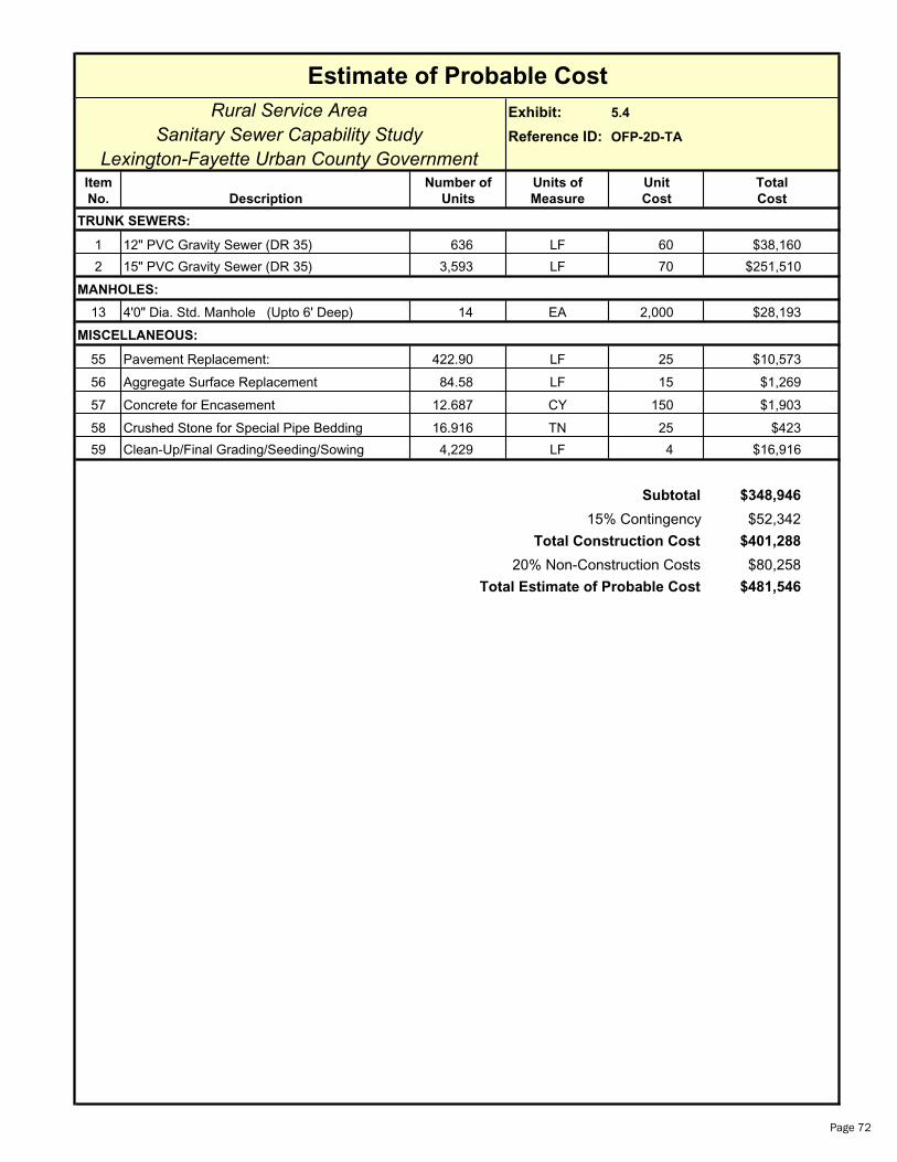
Estimate of Probable Cost
Rural Service Area Exhibit: 5.4
Sanitary Sewer Capability Study Reference ID: OFP-2D-TA
Lexington-Fayette Urban County GovernmentItem Number of Units of Unit Total
No. Description Units Measure Cost Cost
TRUNK SEWERS:
1 12" PVC Gravity Sewer (DR 35) 636 LF 60 $38,160
2 15" PVC Gravity Sewer (DR 35) 3,593 LF 70 $251,510
MANHOLES:
13 4'0" Dia. Std. Manhole (Upto 6' Deep) 14 EA 2,000 $28,193
MISCELLANEOUS:
55 Pavement Replacement: 422.90 LF 25 $10,573
56 Aggregate Surface Replacement 84.58 LF 15 $1,269
57 Concrete for Encasement 12.687 CY 150 $1,903
58 Crushed Stone for Special Pipe Bedding 16.916 TN 25 $423
59 Clean-Up/Final Grading/Seeding/Sowing 4,229 LF 4 $16,916
Subtotal $348,946
15% Contingency $52,342
Total Construction Cost $401,288
20% Non-Construction Costs $80,258
Total Estimate of Probable Cost $481,546
Page 72

Estimate of Probable Cost
Rural Service Area Exhibit: 5.5
Sanitary Sewer Capability Study Reference ID: OFP-2A-FMA
Lexington-Fayette Urban County GovernmentItem Number of Units of Unit Total
No. Description Units Measure Cost Cost
FORCE MAIN:
32 20" DI Force Main (PC 250 w/ Protecto 401) 22,592 LF 75 $1,694,400
ROAD BORES / TUNNEL:
46 36" Steel Casing for 20" Carrier Pipe 300 LF 475 $142,500
MISCELLANEOUS:
55 Pavement Replacement: 2,259.20 LF 25 $56,480
56 Aggregate Surface Replacement 451.84 LF 15 $6,778
57 Concrete for Encasement 67.776 CY 150 $10,166
58 Crushed Stone for Special Pipe Bedding 90.368 TN 25 $2,259
59 Clean-Up/Final Grading/Seeding/Sowing 22,592 LF 4 $90,368
60 Sewage Air Release Valves 20 EA 2,500 $50,000
Subtotal $2,052,951
15% Contingency $307,943
Total Construction Cost $2,360,894
20% Non-Construction Costs $472,179
Total Estimate of Probable Cost $2,833,073
Page 73
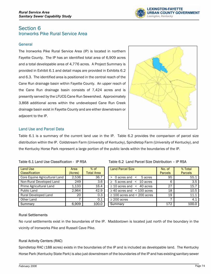
Rural Service Area Sanitary Sewer Capability Study
Section 6 Ironworks Pike Rural Service Area
General
The Ironworks Pike Rural Service Area (IP) is located in northern
Fayette County. The IP has an identified total area of 6,909 acres
and a total developable area of 4,776 acres. A Project Summary is
provided in Exhibit 6.1 and detail maps are provided in Exhibits 6.2
and 6.3. The identified area is positioned in the central reach of the
Cane Run drainage basin within Fayette County. An upper reach of
the Cane Run drainage basin consists of 7,424 acres and is
presently served by the LFUCG Cane Run Sewershed. Approximately
3,868 additional acres within the undeveloped Cane Run Creek
drainage basin exist in Fayette County and are either downstream or
adjacent to the IP.
Land Use and Parcel Data
Table 6.1 is a summary of the current land use in the IP. Table 6.2 provides the comparison of parcel size
distribution within the IP. Coldstream Farm (University of Kentucky), Spindletop Farm (University of Kentucky), and
the Kentucky Horse Park represent a large portion of the public lands within the boundaries of the IP.
Table 6.1 Land Use Classification - IP RSA Table 6.2 Land Parcel Size Distribution – IP RSA
Rural Settlements
No rural settlements exist in the boundaries of the IP. Maddoxtown is located just north of the boundary in the
vicinity of Ironworks Pike and Russell Cave Pike.
Rural Activity Centers (RAC)
Spindletop RAC (188 acres) exists in the boundaries of the IP and is included as developable land. The Kentucky
Horse Park (Kentucky State Park) is also just downstream of the boundaries of the IP and has existing sanitary sewer
Land Use Area Classification (Acres)
% of Total Area
Core Equine Agricultural Land 2,536 36.7Non-Rural Developed Land 249 3.6Prime Agricultural Land 1,133 16.4Public Land 2,964 42.9Rural Developed Land 20 0.3Other Land 7 0.1Summary 6,909 100.0
Land Parcel Size No. of Parcels
% Total Parcels
> 0 acres and < 5 acres 95 55.1 5 acres and < 10 acres 6 3.5 10 acres and < 40 acres 27 15.7 40 acres and < 100 acres 18 10.5 100 acres and < 200 acres 19 11.1 200 acres 7 4.1
Summary 172 100.0
February 2006 Page 74

Rural Service Area Sanitary Sewer Capability Study
facilities which return wastewater to the LFUCG sanitary sewer system.
No consideration of additional collection, pumping, conveyance, or
treatment is provided for the Kentucky Horse Park or Spindletop RAC
beyond what was provided for in the agreement between the State of
Kentucky and the LFUCG.
In addition, Spindletop Farm is adjacent to the Spindletop RAC. All
existing wastewater from Spindletop Farm (University of Kentucky) is
pumped and conveyed to the Lower Cane Run Pump Station, via the
Spindletop Pump Station. Spindletop Farm area is not included as
developable area of the IP.
Spindletop Farm
Special Natural Protection Areas
Two “B” Priority Sites, Special Natural Protection Areas have been identified within the boundaries of the IP by the
LFUCG Rural Service Area Land Management Plan. The two sites are Ironworks Pike, south of the Kentucky Horse
Park (50 acres) and Cane Run on Coldstream Farm, just north of the interstate. An “A” Priority Site has been
identified downstream in the Kentucky Horse Park. Several stands of blue ash and oak savannah – woodland trees
exist and should be protected.
Rural Greenways
Cane Run Creek has been identified as a possible greenway in the LFUCG Rural Service Area Land Management
Plan, however, it has not been designated as one of the “Five Focus Areas”.
Scenic Areas
A small portion of the IP has been identified as “Scenic Area” in the LFUCG Rural Service Area Land Management
Plan. A significant amount of this land is owned by the Commonwealth of Kentucky and the University of Kentucky.
Environmentally Sensitive Areas
Environmentally Sensitive Areas have been identified in the LFUCG Rural Service Area Land Management Plan along
the Cane Run Creek drainage basin in Fayette County. The Royal Springs Aquifer, which coincides with the Cane Run
Creek drainage basin is an environmentally sensitive area of great importance and concern. Georgetown derives a
portion of its drinking water from the Royal Spring. Since 80% of the aquifer for that spring is located in Fayette
County, rainwater that infiltrates the ground in Fayette County becomes a source of drinking water in Scott County.
This is the largest spring-fed public water supply in the state, providing water to over 7,000 customers.
February 2006 Page 75
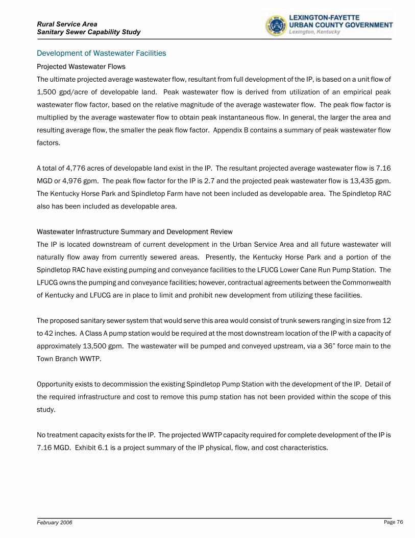
Rural Service Area Sanitary Sewer Capability Study
Development of Wastewater Facilities
Projected Wastewater Flows
The ultimate projected average wastewater flow, resultant from full development of the IP, is based on a unit flow of
1,500 gpd/acre of developable land. Peak wastewater flow is derived from utilization of an empirical peak
wastewater flow factor, based on the relative magnitude of the average wastewater flow. The peak flow factor is
multiplied by the average wastewater flow to obtain peak instantaneous flow. In general, the larger the area and
resulting average flow, the smaller the peak flow factor. Appendix B contains a summary of peak wastewater flow
factors.
A total of 4,776 acres of developable land exist in the IP. The resultant projected average wastewater flow is 7.16
MGD or 4,976 gpm. The peak flow factor for the IP is 2.7 and the projected peak wastewater flow is 13,435 gpm.
The Kentucky Horse Park and Spindletop Farm have not been included as developable area. The Spindletop RAC
also has been included as developable area.
Wastewater Infrastructure Summary and Development Review
The IP is located downstream of current development in the Urban Service Area and all future wastewater will
naturally flow away from currently sewered areas. Presently, the Kentucky Horse Park and a portion of the
Spindletop RAC have existing pumping and conveyance facilities to the LFUCG Lower Cane Run Pump Station. The
LFUCG owns the pumping and conveyance facilities; however, contractual agreements between the Commonwealth
of Kentucky and LFUCG are in place to limit and prohibit new development from utilizing these facilities.
The proposed sanitary sewer system that would serve this area would consist of trunk sewers ranging in size from 12
to 42 inches. A Class A pump station would be required at the most downstream location of the IP with a capacity of
approximately 13,500 gpm. The wastewater will be pumped and conveyed upstream, via a 36” force main to the
Town Branch WWTP.
Opportunity exists to decommission the existing Spindletop Pump Station with the development of the IP. Detail of
the required infrastructure and cost to remove this pump station has not been provided within the scope of this
study.
No treatment capacity exists for the IP. The projected WWTP capacity required for complete development of the IP is
7.16 MGD. Exhibit 6.1 is a project summary of the IP physical, flow, and cost characteristics.
February 2006 Page 76
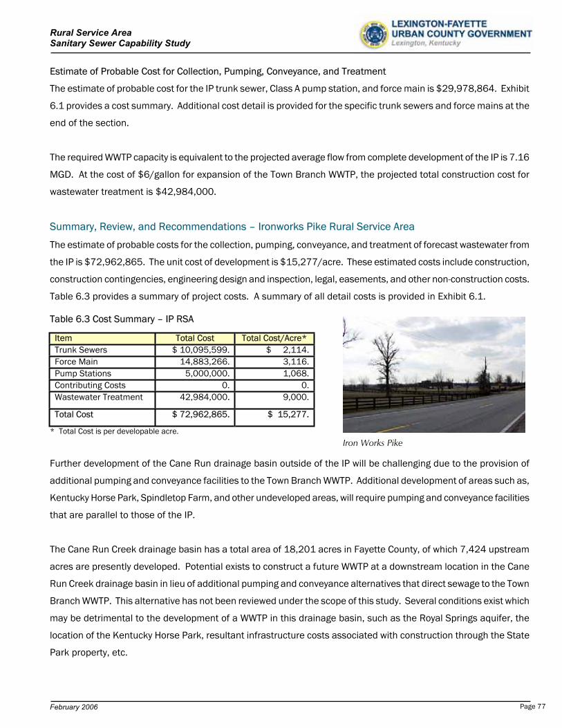
Rural Service Area Sanitary Sewer Capability Study
Estimate of Probable Cost for Collection, Pumping, Conveyance, and Treatment
The estimate of probable cost for the IP trunk sewer, Class A pump station, and force main is $29,978,864. Exhibit
6.1 provides a cost summary. Additional cost detail is provided for the specific trunk sewers and force mains at the
end of the section.
The required WWTP capacity is equivalent to the projected average flow from complete development of the IP is 7.16
MGD. At the cost of $6/gallon for expansion of the Town Branch WWTP, the projected total construction cost for
wastewater treatment is $42,984,000.
Summary, Review, and Recommendations – Ironworks Pike Rural Service Area
The estimate of probable costs for the collection, pumping, conveyance, and treatment of forecast wastewater from
the IP is $72,962,865. The unit cost of development is $15,277/acre. These estimated costs include construction,
construction contingencies, engineering design and inspection, legal, easements, and other non-construction costs.
Table 6.3 provides a summary of project costs. A summary of all detail costs is provided in Exhibit 6.1.
Table 6.3 Cost Summary – IP RSA
Item Total Cost Total Cost/Acre* Trunk Sewers $ 10,095,599. $ 2,114.Force Main 14,883,266. 3,116.Pump Stations 5,000,000. 1,068.Contributing Costs 0. 0.Wastewater Treatment 42,984,000. 9,000.
Total Cost $ 72,962,865. $ 15,277.
* Total Cost is per developable acre.
Iron Works Pike
Further development of the Cane Run drainage basin outside of the IP will be challenging due to the provision of
additional pumping and conveyance facilities to the Town Branch WWTP. Additional development of areas such as,
Kentucky Horse Park, Spindletop Farm, and other undeveloped areas, will require pumping and conveyance facilities
that are parallel to those of the IP.
The Cane Run Creek drainage basin has a total area of 18,201 acres in Fayette County, of which 7,424 upstream
acres are presently developed. Potential exists to construct a future WWTP at a downstream location in the Cane
Run Creek drainage basin in lieu of additional pumping and conveyance alternatives that direct sewage to the Town
Branch WWTP. This alternative has not been reviewed under the scope of this study. Several conditions exist which
may be detrimental to the development of a WWTP in this drainage basin, such as the Royal Springs aquifer, the
location of the Kentucky Horse Park, resultant infrastructure costs associated with construction through the State
Park property, etc.
February 2006 Page 77
Rural Service Area Sanitary Sewer Capability Study
Review
The land use consists of 43% public land and 37% core equine agricultural land.
The land is “environmentally sensitive” due to the existence of the Royal Springs Aquifer in this drainage basin.
Continued downstream development will present similar problems to those that are presently being considered, no
pumping, conveyance, or treatment capacity is available.
Future construction of additional pumping and conveyance facilities to the Town Branch WWTP may be difficult due
to the unavailability of right-of-way and cost of construction.
Recommendations
Revisit the issues and costs of a wastewater treatment plant in the Cane Run drainage basin.
Investigate the feasibility of pumping and conveyance of wastewater to a new WWTP in an adjacent drainage
basin.
Determine other future alternatives available for pumping, conveyance, and treatment of wastewater flows from
the Cane Run drainage basin.
Expand future planning efforts for wastewater infrastructure beyond the traditional 20-year planning period.
February 2006 Page 78
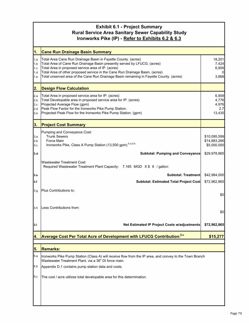
Rural Service Area Sanitary Sewer Capability Study
1. Cane Run Drainage Basin Summary
1.a 18,2011.b 7,4241.c 6,9091.d 01.e 3,868
2. Design Flow Calculation
2.a 6,9092.b 4,7762.c Projected Average Flow (gpm) 4,9762.d 2.72.e 13,435
3. Project Cost Summary
Pumping and Conveyance Cost:3.a Trunk Sewers $10,095,5993.b Force Main $14,883,2663.c $5,000,000
3.d $29,978,865
Wastewater Treatment Cost: Required Wastewater Treatment Plant Capacity: 7.165 MGD X $ 6 / gallon:
3.e $42,984,000
3.f $72,962,865
3.g Plus Contributions to:$0
3.h Less Contributions from:$0
3.I $72,962,865
4. $15,277
5.
5.a
5.b
5.c
Subtotal: Treatment
Appendix D.1 contains pump station data and costs.
Remarks:
Net Estimated IP Project Costs w/adjustments
Ironworks Pike Pump Station (Class A) will receive flow from the IP area, and convey to the Town Branch Wastewater Treatment Plant, via a 36" DI force main.
Exhibit 6.1 - Project Summary
Ironworks Pike (IP) - Refer to Exhibits 6.2 & 6.3
Projected Peak Flow for the Ironworks Pike Pump Station. (gpm)Peak Flow Factor for the Ironworks Pike Pump Station.
Total Area of Cane Run Drainage Basin presently served by LFUCG. (acres)Total Area in proposed service area of IP. (acres)Total Area of other proposed service in the Cane Run Drainage Basin. (acres)
Total Area Cane Run Drainage Basin in Fayette County. (acres)
Total unserved area of the Cane Run Drainage Basin remaining in Fayette County. (acres)
Total Area in proposed service area for IP. (acres)Total Developable area in proposed service area for IP. (acres)
Ironworks Pike, Class A Pump Station (13,500 gpm) 5.a,5.b
Subtotal: Estimated Total Project Cost
The cost / acre utilizes total developable area for this determination.
Subtotal: Pumping and Conveyance
Average Cost Per Total Acre of Development with LFUCG Contribution:5.c
Page 79
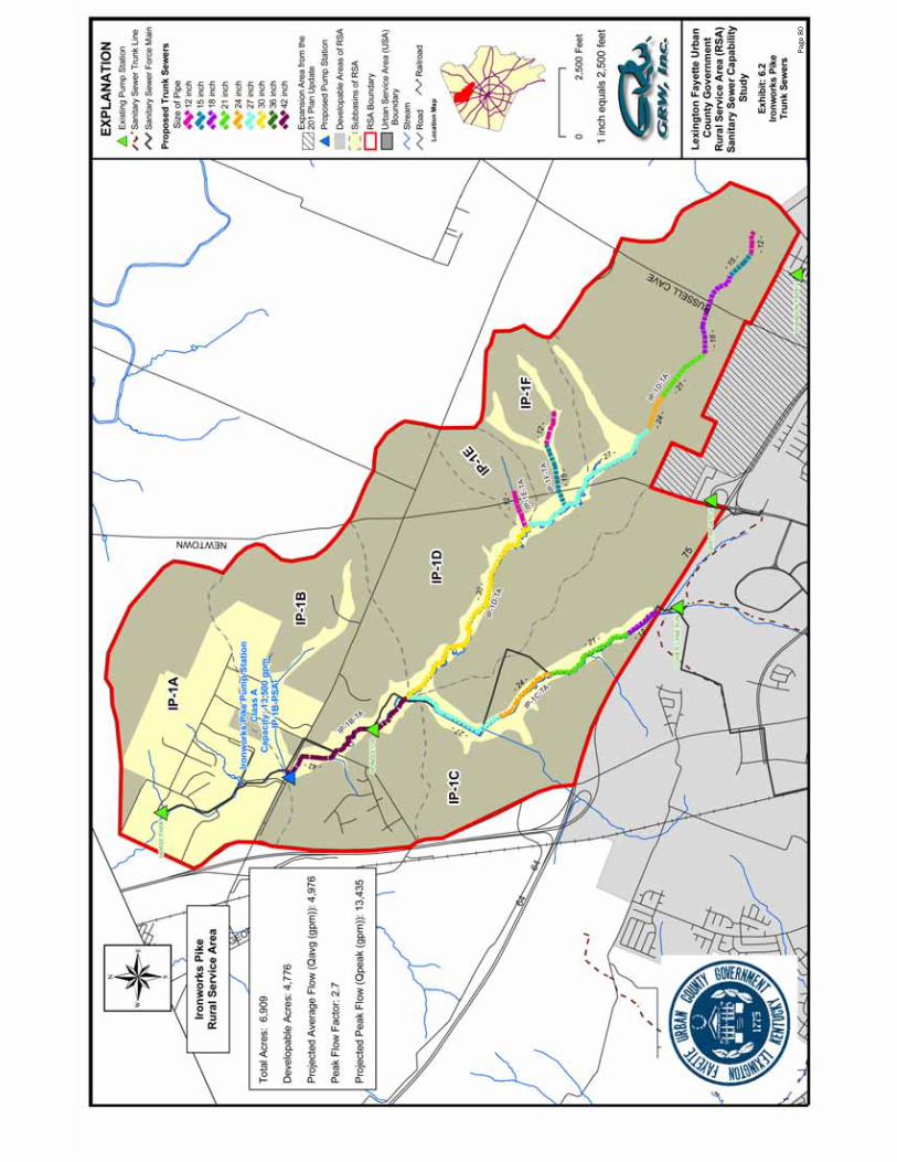
Page
80
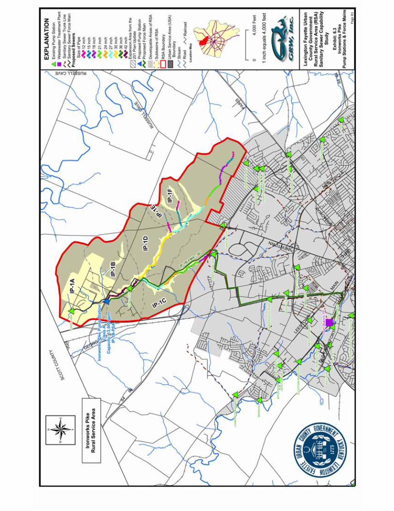
Page
81

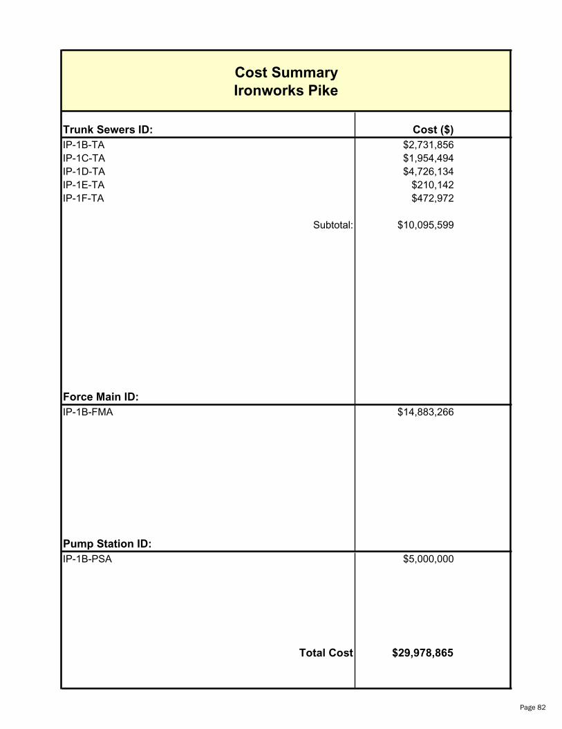
Trunk Sewers ID: Cost ($)
IP-1B-TA $2,731,856IP-1C-TA $1,954,494IP-1D-TA $4,726,134IP-1E-TA $210,142IP-1F-TA $472,972
Subtotal: $10,095,599
Force Main ID:
IP-1B-FMA $14,883,266
Pump Station ID:
IP-1B-PSA $5,000,000
Total Cost $29,978,865
Cost Summary
Ironworks Pike
Page 82
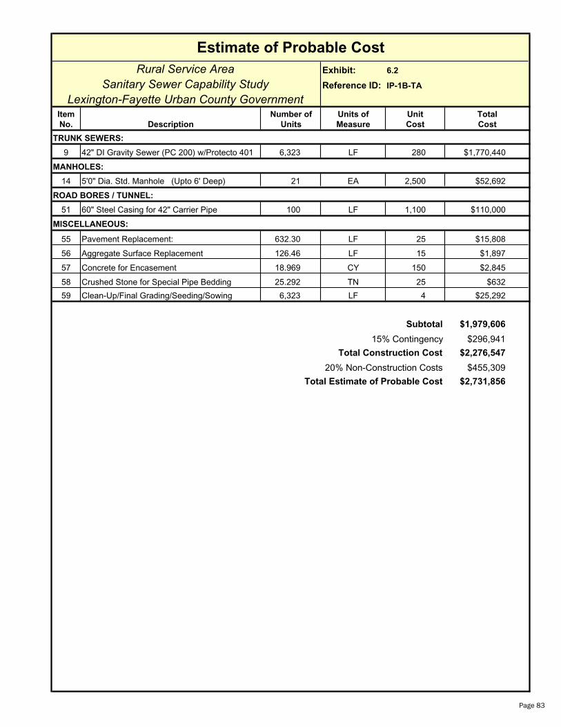
Estimate of Probable Cost
Rural Service Area Exhibit: 6.2
Sanitary Sewer Capability Study Reference ID: IP-1B-TA
Lexington-Fayette Urban County GovernmentItem Number of Units of Unit Total
No. Description Units Measure Cost Cost
TRUNK SEWERS:
9 42" DI Gravity Sewer (PC 200) w/Protecto 401 6,323 LF 280 $1,770,440
MANHOLES:
14 5'0" Dia. Std. Manhole (Upto 6' Deep) 21 EA 2,500 $52,692
ROAD BORES / TUNNEL:
51 60" Steel Casing for 42" Carrier Pipe 100 LF 1,100 $110,000
MISCELLANEOUS:
55 Pavement Replacement: 632.30 LF 25 $15,808
56 Aggregate Surface Replacement 126.46 LF 15 $1,897
57 Concrete for Encasement 18.969 CY 150 $2,845
58 Crushed Stone for Special Pipe Bedding 25.292 TN 25 $632
59 Clean-Up/Final Grading/Seeding/Sowing 6,323 LF 4 $25,292
Subtotal $1,979,606
15% Contingency $296,941
Total Construction Cost $2,276,547
20% Non-Construction Costs $455,309
Total Estimate of Probable Cost $2,731,856
Page 83
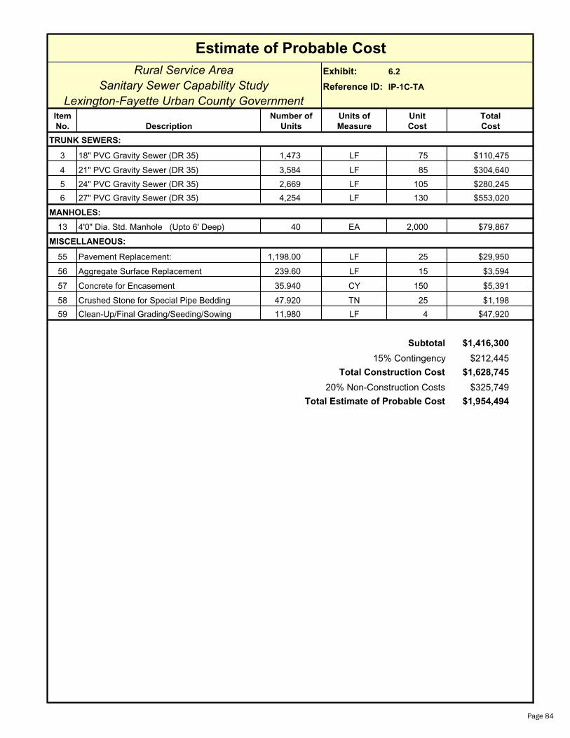
Estimate of Probable Cost
Rural Service Area Exhibit: 6.2
Sanitary Sewer Capability Study Reference ID: IP-1C-TA
Lexington-Fayette Urban County GovernmentItem Number of Units of Unit Total
No. Description Units Measure Cost Cost
TRUNK SEWERS:
3 18" PVC Gravity Sewer (DR 35) 1,473 LF 75 $110,475
4 21" PVC Gravity Sewer (DR 35) 3,584 LF 85 $304,640
5 24" PVC Gravity Sewer (DR 35) 2,669 LF 105 $280,245
6 27" PVC Gravity Sewer (DR 35) 4,254 LF 130 $553,020
MANHOLES:
13 4'0" Dia. Std. Manhole (Upto 6' Deep) 40 EA 2,000 $79,867
MISCELLANEOUS:
55 Pavement Replacement: 1,198.00 LF 25 $29,950
56 Aggregate Surface Replacement 239.60 LF 15 $3,594
57 Concrete for Encasement 35.940 CY 150 $5,391
58 Crushed Stone for Special Pipe Bedding 47.920 TN 25 $1,198
59 Clean-Up/Final Grading/Seeding/Sowing 11,980 LF 4 $47,920
Subtotal $1,416,300
15% Contingency $212,445
Total Construction Cost $1,628,745
20% Non-Construction Costs $325,749
Total Estimate of Probable Cost $1,954,494
Page 84

Estimate of Probable Cost
Rural Service Area Exhibit: 6.2
Sanitary Sewer Capability Study Reference ID: IP-1D-TA
Lexington-Fayette Urban County GovernmentItem Number of Units of Unit Total
No. Description Units Measure Cost Cost
TRUNK SEWERS:
1 12" PVC Gravity Sewer (DR 35) 870 LF 60 $52,200
2 15" PVC Gravity Sewer (DR 35) 1,164 LF 70 $81,480
3 18" PVC Gravity Sewer (DR 35) 3,364 LF 75 $252,300
4 21" PVC Gravity Sewer (DR 35) 2,321 LF 85 $197,285
5 24" PVC Gravity Sewer (DR 35) 1,404 LF 105 $147,420
6 27" PVC Gravity Sewer (DR 35) 6,516 LF 130 $847,080
7 30" DI Gravity Sewer (PC 200) w/Protecto 401 9,261 LF 155 $1,435,455
MANHOLES:
13 4'0" Dia. Std. Manhole (Upto 6' Deep) 83 EA 2,000 $166,000
ROAD BORES / TUNNEL:
48 40" Steel Casing for 27" Carrier Pipe 100 LF 625 $62,500
MISCELLANEOUS:
55 Pavement Replacement: 2,490.00 LF 25 $62,250
56 Aggregate Surface Replacement 498.00 LF 15 $7,470
57 Concrete for Encasement 74.700 CY 150 $11,205
58 Crushed Stone for Special Pipe Bedding 99.600 TN 25 $2,490
59 Clean-Up/Final Grading/Seeding/Sowing 24,900 LF 4 $99,600
Subtotal $3,424,735
15% Contingency $513,710
Total Construction Cost $3,938,445
20% Non-Construction Costs $787,689
Total Estimate of Probable Cost $4,726,134
Page 85

Estimate of Probable Cost
Rural Service Area Exhibit: 6.2
Sanitary Sewer Capability Study Reference ID: IP-1E-TA
Lexington-Fayette Urban County GovernmentItem Number of Units of Unit Total
No. Description Units Measure Cost Cost
TRUNK SEWERS:
1 12" PVC Gravity Sewer (DR 35) 1,625 LF 60 $97,500
MANHOLES:
13 4'0" Dia. Std. Manhole (Upto 6' Deep) 5 EA 2,000 $10,833
ROAD BORES / TUNNEL:
42 18" Steel Casing for 12" Carrier Pipe 100 LF 320 $32,000
MISCELLANEOUS:
55 Pavement Replacement: 162.50 LF 25 $4,063
56 Aggregate Surface Replacement 32.50 LF 15 $488
57 Concrete for Encasement 4.875 CY 150 $731
58 Crushed Stone for Special Pipe Bedding 6.500 TN 25 $163
59 Clean-Up/Final Grading/Seeding/Sowing 1,625 LF 4 $6,500
Subtotal $152,277
15% Contingency $22,842
Total Construction Cost $175,119
20% Non-Construction Costs $35,024
Total Estimate of Probable Cost $210,142
Page 86

Estimate of Probable Cost
Rural Service Area Exhibit: 6.2
Sanitary Sewer Capability Study Reference ID: IP-1F-TA
Lexington-Fayette Urban County GovernmentItem Number of Units of Unit Total
No. Description Units Measure Cost Cost
TRUNK SEWERS:
1 12" PVC Gravity Sewer (DR 35) 1,321 LF 60 $79,260
2 15" PVC Gravity Sewer (DR 35) 2,499 LF 70 $174,930
MANHOLES:
13 4'0" Dia. Std. Manhole (Upto 6' Deep) 13 EA 2,000 $25,467
ROAD BORES / TUNNEL:
43 24" Steel Casing for 14" - 15" Carrier Pipe 100 LF 350 $35,000
MISCELLANEOUS:
55 Pavement Replacement: 382.00 LF 25 $9,550
56 Aggregate Surface Replacement 76.40 LF 15 $1,146
57 Concrete for Encasement 11.460 CY 150 $1,719
58 Crushed Stone for Special Pipe Bedding 15.280 TN 25 $382
59 Clean-Up/Final Grading/Seeding/Sowing 3,820 LF 4 $15,280
Subtotal $342,734
15% Contingency $51,410
Total Construction Cost $394,144
20% Non-Construction Costs $78,829
Total Estimate of Probable Cost $472,972
Page 87

Estimate of Probable Cost
Rural Service Area Exhibit: 6.3
Sanitary Sewer Capability Study Reference ID: IP-1B-FMA
Lexington-Fayette Urban County GovernmentItem Number of Units of Unit Total
No. Description Units Measure Cost Cost
FORCE MAIN:
35 36" DI Force Main (PC 200 w/ Protecto 401) 48,838 LF 182 $8,888,516
ROAD BORES / TUNNEL:
50 50" Steel Casing for 36" Carrier Pipe 1,600 LF 925 $1,480,000
MISCELLANEOUS:
55 Pavement Replacement: 4,883.80 LF 25 $122,095
56 Aggregate Surface Replacement 976.76 LF 15 $14,651
57 Concrete for Encasement 146.514 CY 150 $21,977
58 Crushed Stone for Special Pipe Bedding 195.352 TN 25 $4,884
59 Clean-Up/Final Grading/Seeding/Sowing 48,838 LF 4 $195,352
60 Sewage Air Release Valves 23 EA 2,500 $57,500
Subtotal $10,784,975
15% Contingency $1,617,746
Total Construction Cost $12,402,722
20% Non-Construction Costs $2,480,544
Total Estimate of Probable Cost $14,883,266
Page 88
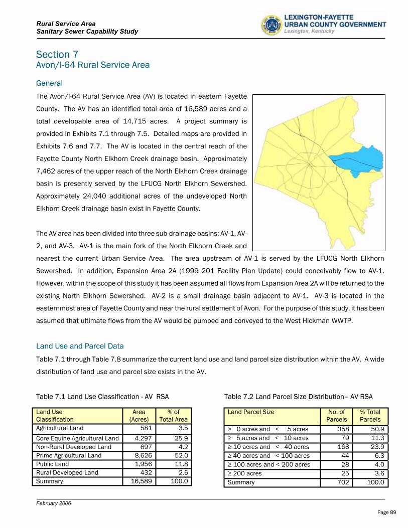
Rural Service Area Sanitary Sewer Capability Study
February 2006
Section 7 Avon/I-64 Rural Service Area
General
The Avon/I-64 Rural Service Area (AV) is located in eastern Fayette
County. The AV has an identified total area of 16,589 acres and a
total developable area of 14,715 acres. A project summary is
provided in Exhibits 7.1 through 7.5. Detailed maps are provided in
Exhibits 7.6 and 7.7. The AV is located in the central reach of the
Fayette County North Elkhorn Creek drainage basin. Approximately
7,462 acres of the upper reach of the North Elkhorn Creek drainage
basin is presently served by the LFUCG North Elkhorn Sewershed.
Approximately 24,040 additional acres of the undeveloped North
Elkhorn Creek drainage basin exist in Fayette County.
The AV area has been divided into three sub-drainage basins; AV-1, AV-
2, and AV-3. AV-1 is the main fork of the North Elkhorn Creek and
nearest the current Urban Service Area. The area upstream of AV-1 is served by the LFUCG North Elkhorn
Sewershed. In addition, Expansion Area 2A (1999 201 Facility Plan Update) could conceivably flow to AV-1.
However, within the scope of this study it has been assumed all flows from Expansion Area 2A will be returned to the
existing North Elkhorn Sewershed. AV-2 is a small drainage basin adjacent to AV-1. AV-3 is located in the
easternmost area of Fayette County and near the rural settlement of Avon. For the purpose of this study, it has been
assumed that ultimate flows from the AV would be pumped and conveyed to the West Hickman WWTP.
Land Use and Parcel Data
Table 7.1 through Table 7.8 summarize the current land use and land parcel size distribution within the AV. A wide
distribution of land use and parcel size exists in the AV.
Table 7.1 Land Use Classification - AV RSA Table 7.2 Land Parcel Size Distribution– AV RSA
Land Parcel Size No. of Parcels
% Total Parcels
> 0 acres and < 5 acres 358 50.9 5 acres and < 10 acres 79 11.3 10 acres and < 40 acres 168 23.9 40 acres and < 100 acres 44 6.3 100 acres and < 200 acres 28 4.0 200 acres 25 3.6
Summary 702 100.0
Land Use Area Classification (Acres)
% of Total Area
Agricultural Land 581 3.5
Core Equine Agricultural Land 4,297 25.9Non-Rural Developed Land 697 4.2Prime Agricultural Land 8,626 52.0Public Land 1,956 11.8Rural Developed Land 432 2.6Summary 16,589 100.0
Page 89
Rural Service Area Sanitary Sewer Capability Study
February 2006
Table 7.3 Land Use AV-1 Table 7.4 Land Parcel Size Distribution AV-1
Table 7.5 Land Use AV-2 Table 7.6 Land Parcel Size Distribution AV-2
Table 7.7 Land Use AV-3 Table 7.8 Land Parcel Size Distribution AV-3
Rural Settlements
Several rural settlements exist in the Avon/I-64 RSA, which include Avon, Willow Lane, and Uttingertown/Columbus.
In addition, several rural settlements exist between the Avon/I-64 RSA and the Richmond Road/Delong Road RSA,
which include Pricetown, Nihizertown, Centerville, and Athens.
Rural Activity Centers (RAC)
The Avon RAC (294 acres) exists near the Avon rural settlement.
Land Parcel Size No. of
Parcels
% Total Area
> 0 acres and < 5 acres 209 63.0 5 acres and < 10 acres 23 6.9 10 acres and < 40 acres 59 17.8 40 acres and < 100 acres 19 5.7 100 acres and < 200 acres 13 3.9 200 acres 9 2.7
Summary 332 100.0
Land Use Area Classification (Acres)
% of Total Area
Agricultural Land 289 4.5Core Equine Agricultural Land
2,561 40.0
Non-Rural Developed Land 412 6.4Prime Agricultural Land 2,392 37.3Public Land 450 7.0Rural Developed Land 305 4.8Summary 6,409 100.0
Land Parcel Size No. of Parcels
% Total Area
> 0 acres and < 5 acres 1 3.3 5 acres and < 10 acres 10 33.3 10 acres and < 40 acres 10 33.3 40 acres and < 100 acres 6 20.0 100 acres and < 200 acres 2 6.7 200 acres 1 3.4
Summary 30 100.0
Land Use Area Classification (Acres)
% of Total Area
Agricultural Land 0 0Core Equine Agricultural Land 477 67.2Non-Rural Developed Land 3 0.4Prime Agricultural Land 128 18.1Public Land 72 10.1Rural Developed Land 30 4.2Summary 710 100.0
Land Use Area Classification (Acres)
% of Total Area
Agricultural Land 490 5.2Core Equine Agricultural Land
1,102 11.6
Non-Rural Developed Land 312 3.3Prime Agricultural Land 5,863 61.9Public Land 1,592 16.8Rural Developed Land 111 1.2Summary 9,470 100.0
Land Parcel Size No. of Parcels
% Total Area
> 0 acres and < 5 acres 148 43.5 5 acres and < 10 acres 46 13.5 10 acres and < 40 acres 99 29.1 40 acres and < 100 acres 19 5.6 100 acres and < 200 acres 13 3.8 200 acres 15 4.5
Summary 340 100.0
Page 90
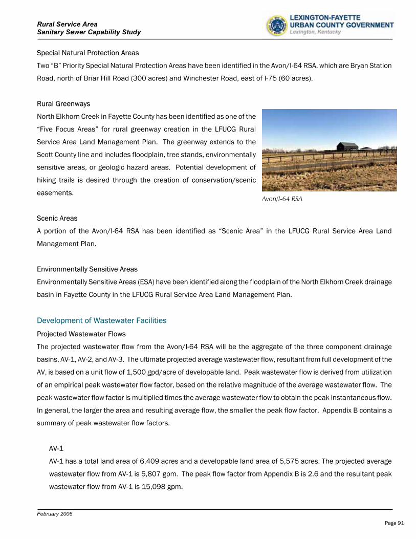
Rural Service Area Sanitary Sewer Capability Study
February 2006
Special Natural Protection Areas
Two “B” Priority Special Natural Protection Areas have been identified in the Avon/I-64 RSA, which are Bryan Station
Road, north of Briar Hill Road (300 acres) and Winchester Road, east of I-75 (60 acres).
Rural Greenways
North Elkhorn Creek in Fayette County has been identified as one of the
“Five Focus Areas” for rural greenway creation in the LFUCG Rural
Service Area Land Management Plan. The greenway extends to the
Scott County line and includes floodplain, tree stands, environmentally
sensitive areas, or geologic hazard areas. Potential development of
hiking trails is desired through the creation of conservation/scenic
easements.Avon/I-64 RSA
Scenic Areas
A portion of the Avon/I-64 RSA has been identified as “Scenic Area” in the LFUCG Rural Service Area Land
Management Plan.
Environmentally Sensitive Areas
Environmentally Sensitive Areas (ESA) have been identified along the floodplain of the North Elkhorn Creek drainage
basin in Fayette County in the LFUCG Rural Service Area Land Management Plan.
Development of Wastewater Facilities
Projected Wastewater Flows
The projected wastewater flow from the Avon/I-64 RSA will be the aggregate of the three component drainage
basins, AV-1, AV-2, and AV-3. The ultimate projected average wastewater flow, resultant from full development of the
AV, is based on a unit flow of 1,500 gpd/acre of developable land. Peak wastewater flow is derived from utilization
of an empirical peak wastewater flow factor, based on the relative magnitude of the average wastewater flow. The
peak wastewater flow factor is multiplied times the average wastewater flow to obtain the peak instantaneous flow.
In general, the larger the area and resulting average flow, the smaller the peak flow factor. Appendix B contains a
summary of peak wastewater flow factors.
AV-1
AV-1 has a total land area of 6,409 acres and a developable land area of 5,575 acres. The projected average
wastewater flow from AV-1 is 5,807 gpm. The peak flow factor from Appendix B is 2.6 and the resultant peak
wastewater flow from AV-1 is 15,098 gpm.
Page 91
Rural Service Area Sanitary Sewer Capability Study
February 2006
AV-2
AV-2 has a total land area of 710 acres and a developable land area of 599 acres. The projected average
wastewater flow from AV-2 is 624 gpm. The peak flow factor from Appendix B is 3.8 and the resultant peak
wastewater flow is 2,371 gpm.
AV-3
AV-3 has a total land area of 9,470 acres and a developable land area of 8,541 acres. The projected average
wastewater flow from AV-3 is 8,897 gpm. The peak flow factor from Appendix B is 2.5 and the resultant peak
wastewater flow is 22,243 gpm.
In summary, a total of 16,589 acres exist in the Avon/I-64 RSA, of which 14,715 acres are developable. The
projected total average wastewater flow is 22.07 MGD.
Wastewater Infrastructure Summary and Development Review
The Avon/I-64 RSA is located downstream of current development in the Urban Service Area and all future
wastewater will naturally flow away from currently sewered areas. The following is a summary of facilities required
for each sub-drainage basin.
AV-1
12” to 42” trunk sewers will be required for development of AV-1. A new 16,725 gpm Class A Pump Station,
which is located near Bryan Station Road, will be required. This pump station is sized to accept flows from AV-1
and AV-2. A 36” force main is required to convey the wastewater to the West Hickman WWTP. An intermediate
17,500 gpm Class A pump station will be required on Cleveland Road near Athens, Kentucky. This intermediate
pump station is sized to accept sub-drainage areas AV-1 and AV-2. It will be expandable in the future for sub-
drainage basin AV-3.
AV-2
12” to 18” trunk sewers will be required for development of AV-2. AV-2 is a small drainage basin between two
larger AV drainage basins and a separate pump station will be required for this development. A 2,400 gpm
Class B pump station is required near Briar Hill Road. A 14” force main will be required to convey the
wastewater to the AV-1 pump station, which in turn conveys wastewater to the West Hickman WWTP via a 36”
force main. An intermediate 17,500 gpm Class A pump station will be required near Athens, Kentucky. This
pump station is sized to accept sub-drainage areas AV-1 and AV-2. It will be expandable in the future for sub-
drainage basin AV-3.
Page 92
Rural Service Area Sanitary Sewer Capability Study
February 2006
AV-3
12” to 48” trunk sewers will be required for development of AV-3. A 23,000 gpm, Class A pump station will be
required. A 42” force main will be required to convey flows to the West Hickman WWTP. The proposed pump
station near Athens will be expanded to a capacity of 40,500 gpm.
The development of the infrastructure can be phased for each area. For the purposes of this study, it has been
assumed AV-1 will initially develop, due to its close proximity to the Urban Service Area. AV-2 and AV-3 would follow
at a later time.
The 1999 LFUCG Facilities Plan Update provided recommended improvements in the current North Elkhorn
Sewershed. These improvements include a new North Elkhorn Pump Station (19 MGD Capacity) and a 30”/36”
force main, which routes between the pump station, located near I-75 and Winchester Road, to the Town Branch
Wastewater Treatment Plant. In addition to demands of the current sewershed, the facilities will also serve
Expansion Area 2A, as described in the most recent LFUCG Comprehensive Planning Study. These improvements
are presently designed, however, not constructed.
The LFUCG Division of Sanitary Sewer’s staff considered the routing of all proposed wastewater flows from the AV to
the Town Branch WWTP, similar to the North Elkhorn Pump Station and Force Main alternative. After considerable
discussion with the LFUCG Division of Sanitary Sewers, it was determined all proposed flows for the AV shall be
routed to the West Hickman WWTP due to the lesser impact on the discharge limits of a large drainage area addition.
In addition, flows from other RSA areas, provided within this report, are already proposed for delivery to the Town
Branch WWTP, such as Old Frankfort Pike and Ironworks Pike.
No treatment capacity exists for the Avon/I-64 RSA. The projected WWTP capacity required for complete
development of the Avon/I-64 is 22.07 MGD. Exhibits 7.1 through Exhibit 7.4 are project summaries of the Avon/I-
64 RSA physical, flow, and cost characteristics.
The 1999 LFUCG Wastewater Facilities Plan provides an alternative for construction of a wastewater treatment plant
in the North Elkhorn drainage basin, in lieu of the selected improvements of the North Elkhorn Pump Station and
Force Main. Given the high cost of pumping and conveyance facilities to the West Hickman Wastewater Treatment
Plant for the AV, the future option of a new wastewater treatment plant in the North Elkhorn drainage basin should
be considered prior to development of the AV.
Estimate of Probable Cost for Collection, Pumping, Conveyance, and Treatment
The estimate of probable cost for the Avon/I-64 RSA infrastructure is $ 263,102,557. Additional cost detail is
provided for the specific trunk sewers, force mains, and pump stations summarized for each area in Exhibits 7.1
through 7.4.
Page 93

Rural Service Area Sanitary Sewer Capability Study
February 2006
AV-1
The estimate of total probable cost for the AV-1 trunk sewer, two Class A pump stations, and force main is
$54,840,354. The costs of the initial intermediate Cleveland Road pump station near Athens and the force
mains will be shared between the development of each sub-drainage basins, AV-1 and AV-2. These costs are
initially provided for in the AV-1 improvements. AV-2 will reimburse $3,911,137. in shared costs to the AV-1 for
required improvements to convey the wastewater to the West Hickman WWTP.
The required WWTP capacity is equivalent to the projected average flow from complete development of the AV-1,
which is 8.36 MGD. At the cost of $6/gallon for expansion of the West Hickman WWTP, the projected total
construction cost for wastewater treatment is $50,175,000.
The total estimated cost for development of AV-1, which includes collection, pumping, conveyance, and
treatment is $105,015,354. The total adjusted cost for the AV-1 is $101,104,217. which includes the shared
contribution from the AV-2 for the infrastructure. The adjusted unit cost per acre is $18,135. Exhibit 7.1
provides a summary of these costs. Detail costs for development are provided at the end of this section.
AV-2
The estimate of total probable cost for the AV-2 trunk sewer, Class B pump station, and force main is
$3,859,021. An additional $3,911,137. is provided as shared costs for the development of the 36” force main,
Bryan Station pump station, and Cleveland Road pump station for AV-1. For the purposes of this study, an
assumption has been made that AV-1 will develop prior to AV-2.
The required WWTP capacity is equivalent to the projected average flow from complete development of the AV-2,
which is 899,000 gpd. At the cost of $6/gallon for expansion of the West Hickman WWTP, the projected total
construction cost for wastewater treatment is $5,391,000.
The total estimated cost for development of AV-2, which includes collection, pumping, conveyance, and
treatment is $9,250,021. The added shared costs for the development of AV-1 are $3,911,137. The total
adjusted costs for the AV-2 are $13,161,158. The unit cost per acre is $21,972. Exhibit 7.2 provides a
summary of these costs. Detail costs for development are provided at the end of this section.
AV-3
The estimate of total probable cost for the AV-3 trunk sewer, two Class A pump stations, and 42” force main is
$71,968,183. The costs of the pump station upgrade near Athens and the parallel 42” force mains are
associated with AV-3 development only.
Page 94
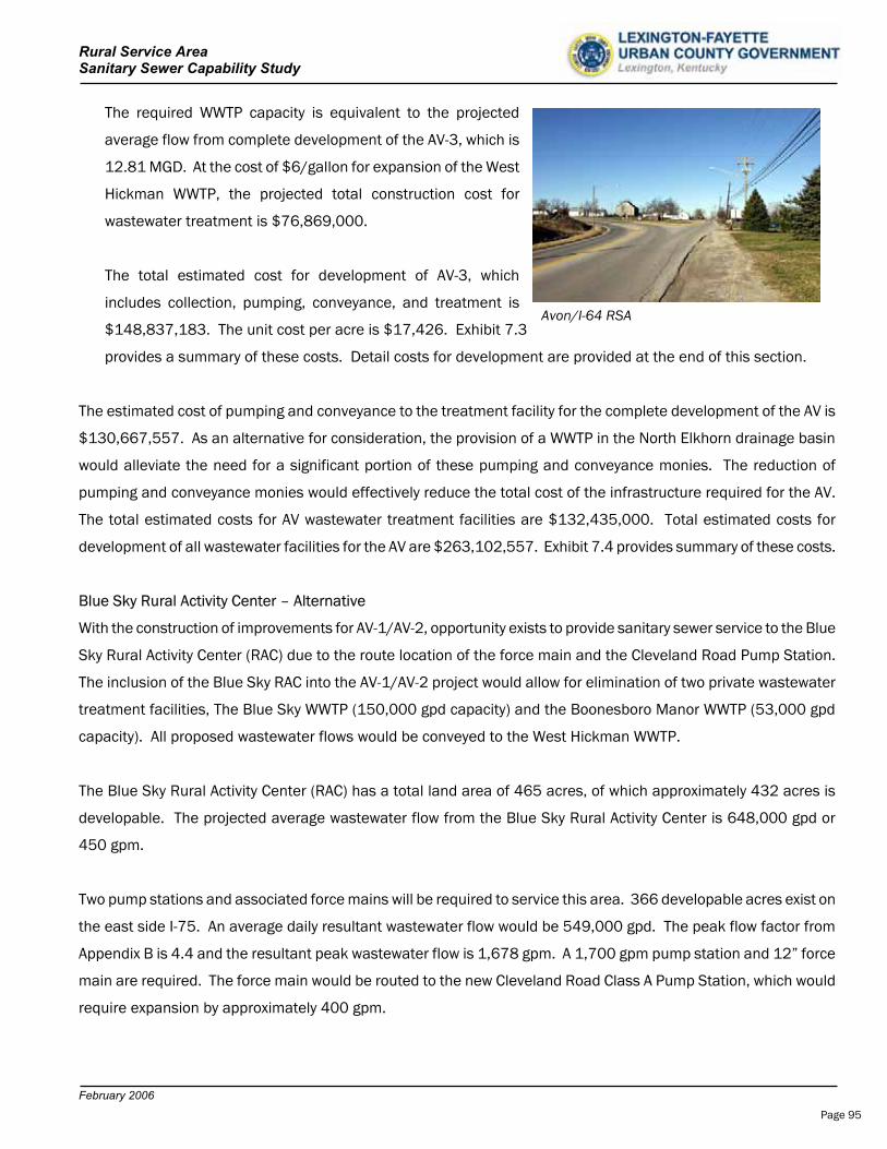
Rural Service Area Sanitary Sewer Capability Study
February 2006
The required WWTP capacity is equivalent to the projected
average flow from complete development of the AV-3, which is
12.81 MGD. At the cost of $6/gallon for expansion of the West
Hickman WWTP, the projected total construction cost for
wastewater treatment is $76,869,000.
The total estimated cost for development of AV-3, which
includes collection, pumping, conveyance, and treatment is
$148,837,183. The unit cost per acre is $17,426. Exhibit 7.3
provides a summary of these costs. Detail costs for development are provided at the end of this section.
Avon/I-64 RSA
The estimated cost of pumping and conveyance to the treatment facility for the complete development of the AV is
$130,667,557. As an alternative for consideration, the provision of a WWTP in the North Elkhorn drainage basin
would alleviate the need for a significant portion of these pumping and conveyance monies. The reduction of
pumping and conveyance monies would effectively reduce the total cost of the infrastructure required for the AV.
The total estimated costs for AV wastewater treatment facilities are $132,435,000. Total estimated costs for
development of all wastewater facilities for the AV are $263,102,557. Exhibit 7.4 provides summary of these costs.
Blue Sky Rural Activity Center – Alternative
With the construction of improvements for AV-1/AV-2, opportunity exists to provide sanitary sewer service to the Blue
Sky Rural Activity Center (RAC) due to the route location of the force main and the Cleveland Road Pump Station.
The inclusion of the Blue Sky RAC into the AV-1/AV-2 project would allow for elimination of two private wastewater
treatment facilities, The Blue Sky WWTP (150,000 gpd capacity) and the Boonesboro Manor WWTP (53,000 gpd
capacity). All proposed wastewater flows would be conveyed to the West Hickman WWTP.
The Blue Sky Rural Activity Center (RAC) has a total land area of 465 acres, of which approximately 432 acres is
developable. The projected average wastewater flow from the Blue Sky Rural Activity Center is 648,000 gpd or
450 gpm.
Two pump stations and associated force mains will be required to service this area. 366 developable acres exist on
the east side I-75. An average daily resultant wastewater flow would be 549,000 gpd. The peak flow factor from
Appendix B is 4.4 and the resultant peak wastewater flow is 1,678 gpm. A 1,700 gpm pump station and 12” force
main are required. The force main would be routed to the new Cleveland Road Class A Pump Station, which would
require expansion by approximately 400 gpm.
Page 95
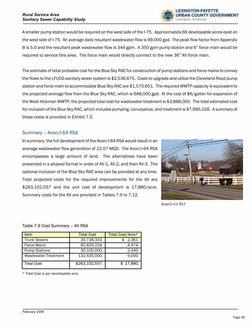
Rural Service Area Sanitary Sewer Capability Study
February 2006
A smaller pump station would be required on the west side of the I-75. Approximately 66 developable acres exist on
the west side of I-75. An average daily resultant wastewater flow is 99,000 gpd. The peak flow factor from Appendix
B is 5.0 and the resultant peak wastewater flow is 344 gpm. A 350 gpm pump station and 6” force main would be
required to service this area. The force main would directly connect to the new 36” AV force main.
The estimate of total probable cost for the Blue Sky RAC for construction of pump stations and force mains to convey
the flows to the LFUCG sanitary sewer system is $2,536,675. Costs to upgrade and utilize the Cleveland Road pump
station and force main to accommodate Blue Sky RAC are $1,570,651. The required WWTP capacity is equivalent to
the projected average flow from the Blue Sky RAC, which is 648,000 gpd. At the cost of $6/gallon for expansion of
the West Hickman WWTP, the projected total cost for wastewater treatment is $3,888,000. The total estimated cost
for inclusion of the Blue Sky RAC, which includes pumping, conveyance, and treatment is $7,995,326. A summary of
these costs is provided in Exhibit 7.5.
Summary – Avon/I-64 RSA
In summary, the full development of the Avon/I-64 RSA would result in an
average wastewater flow generation of 22.07 MGD. The Avon/I-64 RSA
encompasses a large amount of land. The alternatives have been
presented in a phased format in order of AV-1, AV-2, and then AV-3. The
optional inclusion of the Blue Sky RAC area can be provided at any time.
Total projected costs for the required improvements for the AV are
$263,102,557 and the unit cost of development is 17,880/acre.
Summary costs for the AV are provided in Tables 7.9 to 7.12.
Avon/I-64 RSA
Table 7.9 Cost Summary – AV RSA
Item Total Cost Total Cost/Acre* Trunk Sewers 34,738,333. $ 2,361.Force Mains 65,829,224. 4,474.Pump Stations 30,100,000. 2,045.Wastewater Treatment 132,435,000. 9,000.
Total Cost $263,102,557. $ 17,880.
* Total Cost is per developable acre
Page 96
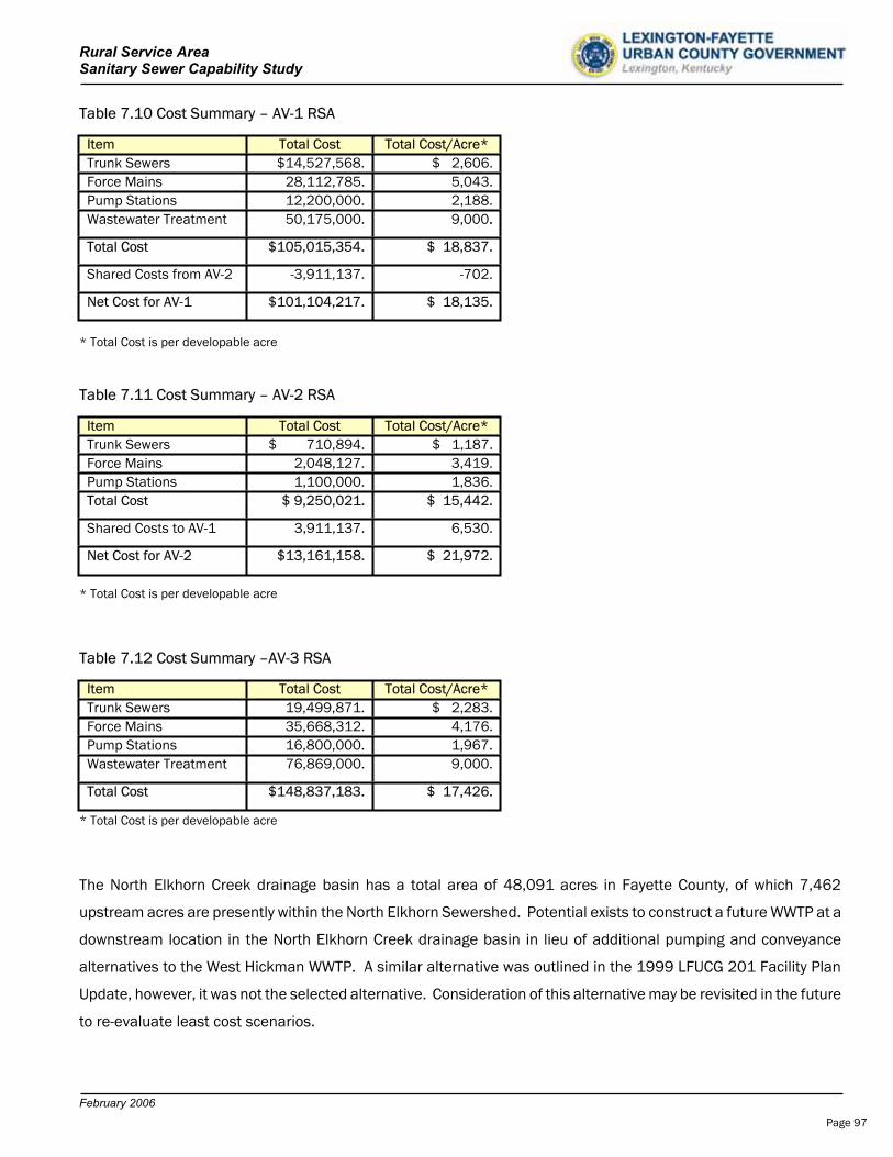
Rural Service Area Sanitary Sewer Capability Study
February 2006
Table 7.10 Cost Summary – AV-1 RSA
Item Total Cost Total Cost/Acre* Trunk Sewers $14,527,568. $ 2,606.Force Mains 28,112,785. 5,043.Pump Stations 12,200,000. 2,188.Wastewater Treatment 50,175,000. 9,000..
Total Cost $105,015,354. $ 18,837.
Shared Costs from AV-2 -3,911,137. -702.
Net Cost for AV-1 $101,104,217. $ 18,135.
* Total Cost is per developable acre
Table 7.11 Cost Summary – AV-2 RSA
Item Total Cost Total Cost/Acre* Trunk Sewers $ 710,894. $ 1,187.Force Mains 2,048,127. 3,419.Pump Stations 1,100,000. 1,836.Total Cost $ 9,250,021. $ 15,442.
Shared Costs to AV-1 3,911,137. 6,530.
Net Cost for AV-2 $13,161,158. $ 21,972.
* Total Cost is per developable acre
Table 7.12 Cost Summary –AV-3 RSA
Item Total Cost Total Cost/Acre* Trunk Sewers 19,499,871. $ 2,283.Force Mains 35,668,312. 4,176.Pump Stations 16,800,000. 1,967.Wastewater Treatment 76,869,000. 9,000.
Total Cost $148,837,183. $ 17,426.
* Total Cost is per developable acre
The North Elkhorn Creek drainage basin has a total area of 48,091 acres in Fayette County, of which 7,462
upstream acres are presently within the North Elkhorn Sewershed. Potential exists to construct a future WWTP at a
downstream location in the North Elkhorn Creek drainage basin in lieu of additional pumping and conveyance
alternatives to the West Hickman WWTP. A similar alternative was outlined in the 1999 LFUCG 201 Facility Plan
Update, however, it was not the selected alternative. Consideration of this alternative may be revisited in the future
to re-evaluate least cost scenarios.
Page 97
Rural Service Area Sanitary Sewer Capability Study
February 2006
Review
Over 70% of the property is core equine agricultural or prime agricultural land. Over 62% of the parcels are tracts
of 10 acres or less.
The North Elkhorn Creek is designated as one of the “five focus areas” for rural greenway creation in the LFUCG
Rural Service Area Land Management Plan.
Several Rural Settlements exist in the AV.
All resultant flows from the AV are downstream of current wastewater infrastructure development. Additional
pumping and conveyance will be required.
The North Elkhorn Sewershed and Expansion 2A are just upstream of AV-1.
Continued downstream development will present similar problems as the present, no pumping, conveyance, or
treatment capacity is available.
Wastewater planning strategies for an expanded North Elkhorn Sewershed have not been addressed.
Recommendations
Revisit the issues and costs of a wastewater treatment plant in the North Elkhorn Creek drainage basin.
Establish preliminary wastewater discharge limits for the North Elkhorn Creek
Determine other future alternatives available for pumping, conveyance, and treatment of wastewater flows.
Continue to develop planning strategies for future provision of wastewater infrastructure in the AV.
Continue to evaluate available and future capacity of the two existing LFUCG wastewater treatment facilities.
Expand future planning efforts for wastewater infrastructure beyond the traditional 20-year planning period.
.
Page 98
Rural Service Area Sanitary Sewer Capability Study
1. North Elkhorn Drainage Basin Summary
1.a 48,0911.b 7,4621.c 6,4091.d 10,1801.e 24,040
2. Design Flow Calculation
2.a Total Area in proposed service area for AV-1. (acres) 6,4092.b 5,5752.c AV-1 Projected Average Flow (gpm) 5,8072.d Total Area in proposed service area for AV-2. (acres) 7102.e 5992.f AV-2 Projected Average Flow (gpm) 6242.g Total Projected Average Flow (gpm) - AV-1 and AV-2 6,4312.h 2.62.i Projected Peak Flow from AV-1 (gpm) 15,0982.j Projected Peak Flow from AV-2 (gpm) 1,6222.k 16,721
3. Project Cost Summary
Pumping and Conveyance Cost:3.a Trunk Sewers $14,527,5683.b Force Main $28,112,7853.c $6,000,000
$6,200,000
3.d $54,840,354
Wastewater Treatment Cost: Required Wastewater Treatment Plant Capacity: 8.363 MGD X $ 6 / gallon
3.e $50,175,000
3.f $105,015,354
3.g Plus Shared Costs to:$0
3.h Less Shared Costs from:
$3,911,137
3.I $101,104,217
4. $18,135
5.
5.a
5.b
5.c
5.f The cost / acre utilizes total developable area for this determination.
Subtotal - Treatment
Refers to the acreage of I-64 / Avon Area - 3.
Remarks:
Net Estimated AV-1 Project Costs w/adjustments
Bryan Station Road Pump Station, Cleveland Road Pump Station and 36" Force Main for AV-2
Refers to the acreage of I-64 / Avon Area - 2.
The Bryan Station Road Pump Station (Class A) will receive flow from AV-1, and convey it to the West Hickman Wastewater Treatment Plant, via a 36" DI force main.
Exhibit 7.1 - Project Summary
Avon / I-64 Area (AV-1) - Refer to Exhibits 7.7 & 7.8
Projected Peak Flow for Bryan Station Road Pump Station. (gpm)
Peak Flow Factor for Bryan Station Road Pump Station
Total Area of North Elkhorn Drainage Basin presently served by LFUCG. (acres)Total Area in proposed service area of AV-1. (acres)Total Area of other proposed service in the North Elkhorn Drainage Basin. 5.a,5.b (acres)
Total Area North Elkhorn Drainage Basin in Fayette County. (acres)
Total area remaining in North Elkhorn Drainage Basin in Fayette County. (acres)
Total Developable area in proposed service area for AV-2. (acres)
Subtotal - Pumping and Conveyance
Average Cost Per Total Acre of Development with LFUCG Contribution:5.f
Total Developable area in proposed service area for AV-1. (acres)
Bryan Station Road, Class A Pump Station (16,725 gpm) 5.c,5.e
Subtotal - Estimated Total Project Cost
Cleveland Road, Class A Pump Station (17,500 gpm) 5.d,5.e
Page 99

1. North Elkhorn Drainage Basin Summary
1.a 48,0911.b 7,4621.c 7101.d 15,8791.e 24,040
2. Design Flow Calculation
2.a Total Area in proposed service area for AV-2. (acres) 7102.b 5992.c Projected Average Flow (gpm) 6242.d 3.82.e 2,371
3. Project Cost Summary
Pumping and Conveyance Cost:3.a Trunk Sewers $710,8943.b Force Main $2,048,1273.c $1,100,000
3.d $3,859,021
Wastewater Treatment Cost: Required Wastewater Treatment Plant Capacity: 0.899 MGD X $ 6 / gallon:
3.e $5,391,000
3.f $9,250,021
3.g Plus Shared Costs to:$3,911,137
3.h Less Shared Costs from:$0
3.I $13,161,158
4. $21,972
5.
5.a
5.b
5.c
5.d
5.e
Appendix D.1 contains pump station data and costs.
The cost / acre utilizes total developable area for this determination.
Total Developable area in proposed service area for AV-2. (acres)
Briar Hill Road, Class B Pump Station (2,400 gpm) 5.c,5.d
Subtotal - Estimated Total Project Cost
The Briar Hill Road Pump Station (Class B) will receive flow from AV-2, and convey it to the West Hickman Wastewater Treatment Plant through a 14" DI force main, into a 36" DI force main.
Subtotal - Pumping and Conveyance
Average Cost Per Total Acre of Development with LFUCG Contribution:5.e
Exhibit 7.2 - Project Summary
Avon / I-64 Area (AV-2) - Refer to Exhibits 7.7 & 7.8
Projected Peak Flow for Briar Hill Road Pump Station. (gpm)Peak Flow Factor for Briar Hill Road Pump Station
Total Area of North Elkhorn Drainage Basin presently served by LFUCG. (acres)Total Area in proposed service area of AV-2. (acres)Total Area of other proposed service in the North Elkhorn Drainage Basin. 5.a,5.b (acres)
Total Area North Elkhorn Drainage Basin in Fayette County. (acres)
Total area remaining in North Elkhorn Drainage Basin in Fayette County. (acres)
Rural Service Area Sanitary Sewer Capability Study
Subtotal - Treatment
Refers to the acreage of I-64 / Avon Area - 3.
Remarks:
36" Force Main, Bryan Station Pump Station, and Cleveland Road Pump Station
Net Estimated AV-2 Project Costs w/adjustments
Refers to the acreage of I-64 / Avon Area - 1.
Page 100
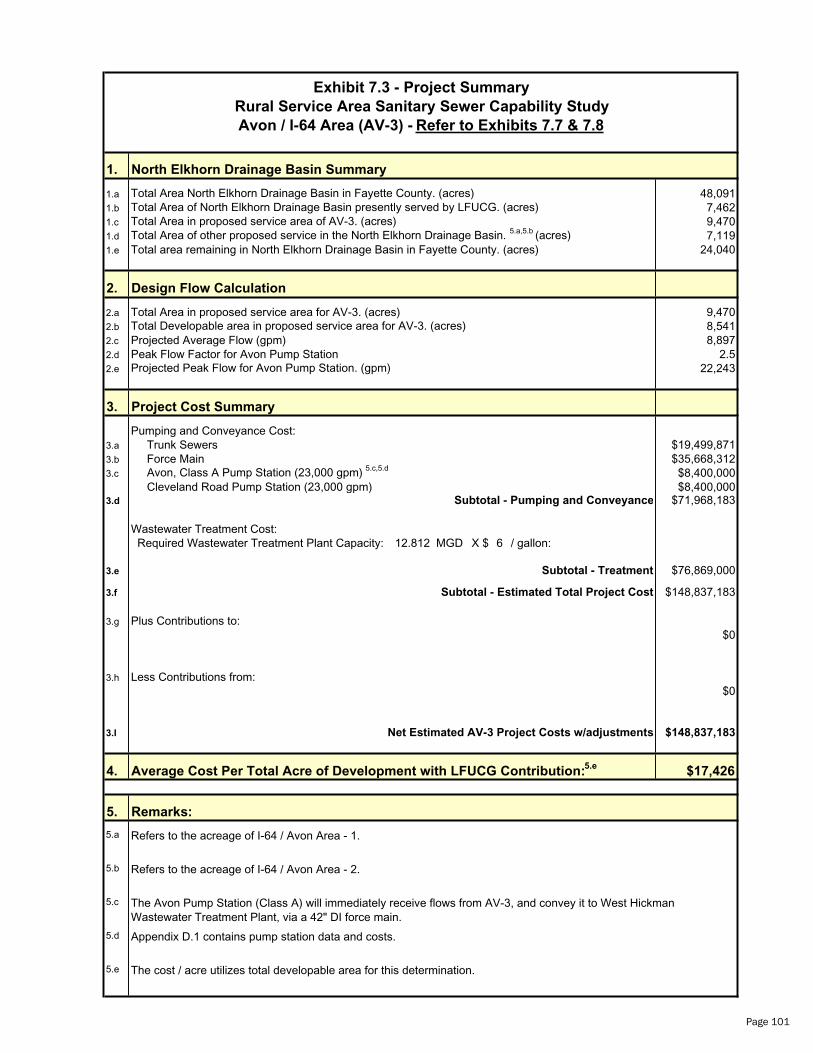
1. North Elkhorn Drainage Basin Summary
1.a 48,0911.b 7,4621.c 9,4701.d 7,1191.e Total area remaining in North Elkhorn Drainage Basin in Fayette County. (acres) 24,040
2. Design Flow Calculation
2.a Total Area in proposed service area for AV-3. (acres) 9,4702.b 8,5412.c Projected Average Flow (gpm) 8,8972.d Peak Flow Factor for Avon Pump Station 2.52.e 22,243
3. Project Cost Summary
Pumping and Conveyance Cost:3.a Trunk Sewers $19,499,8713.b Force Main $35,668,3123.c $8,400,000
Cleveland Road Pump Station (23,000 gpm) $8,400,0003.d $71,968,183
Wastewater Treatment Cost: Required Wastewater Treatment Plant Capacity: 12.812 MGD X $ 6 / gallon:
3.e $76,869,000
3.f $148,837,183
3.g Plus Contributions to:$0
3.h Less Contributions from:$0
3.I $148,837,183
4. $17,426
5.
5.a
5.b
5.c
5.d
5.e
Subtotal - Treatment
Refers to the acreage of I-64 / Avon Area - 2.
Remarks:
Net Estimated AV-3 Project Costs w/adjustments
Refers to the acreage of I-64 / Avon Area - 1.
Appendix D.1 contains pump station data and costs.
Exhibit 7.3 - Project Summary
Avon / I-64 Area (AV-3) - Refer to Exhibits 7.7 & 7.8
Projected Peak Flow for Avon Pump Station. (gpm)
Total Area of North Elkhorn Drainage Basin presently served by LFUCG. (acres)Total Area in proposed service area of AV-3. (acres)Total Area of other proposed service in the North Elkhorn Drainage Basin. 5.a,5.b (acres)
Total Area North Elkhorn Drainage Basin in Fayette County. (acres)
Rural Service Area Sanitary Sewer Capability Study
The cost / acre utilizes total developable area for this determination.
Total Developable area in proposed service area for AV-3. (acres)
Avon, Class A Pump Station (23,000 gpm) 5.c,5.d
Subtotal - Estimated Total Project Cost
The Avon Pump Station (Class A) will immediately receive flows from AV-3, and convey it to West Hickman Wastewater Treatment Plant, via a 42" DI force main.
Subtotal - Pumping and Conveyance
Average Cost Per Total Acre of Development with LFUCG Contribution:5.e
Page 101

Exhibit 7.4 - Project Summary
Rural Service Area Sanitary Sewer Capability Study
Avon / I-64 Area Summary (AV) - Refer to Exhibits 7.7 & 7.8
1. North Elkhorn Drainage Basin Summary
1.a Total Area North Elkhorn Drainage Basin in Fayette County. (acres) 48,0911.b Total Area of North Elkhorn Drainage Basin presently served by LFUCG. (acres) 7,462
1.c Total Area in proposed service area of AV-1. (acres) 6,4091.d Total Area in proposed service area of AV-2. (acres) 7101.e Total Area in proposed service area of AV-3. (acres) 9,470
1.f Total Area of other proposed service in the North Elkhorn Drainage Basin. 0(acres)
1.g Total unserved area remaining in Fayette County. (acres) 24,040
2. Design Flow Calculation
2.a Total Area in proposed service area for AV-1. (acres) 6,4092.b Total Area in proposed service area for AV-2. (acres) 7102.c Total Area in proposed service area for AV-3. (acres) 9,470
2.d Total Developable area in proposed service area for AV-1. (acres) 5,5752.e Total Developable area in proposed service area for AV-2. (acres) 5992.f Total Developable area in proposed service area for AV-3. (acres) 8,541
2.g Projected Average Flow for AV-1 (gpm) 5,8072.h Projected Average Flow for AV-2 (gpm) 6242.I Projected Average Flow for AV-3 (gpm) 8,897
2.j Peak Flow Factor for AV-1 2.62.k Peak Flow Factor for AV-2 3.82.l Peak Flow Factor for AV-3 2.5
2.m Projected Peak Flow for AV-1 (gpm) 15,0982.n Projected Peak Flow for AV-2 (gpm) 2,3712.o Projected Peak Flow for AV-3 (gpm) 22,243
3. Project Cost Summary
Pumping and Conveyance Cost:3.a Trunk Sewers for AV-1 $14,527,568
Trunk Sewers for AV-2 $710,894 Trunk Sewers for AV-3 $19,499,871
3.b Force Main for AV-1 $28,112,785 Force Main for AV-2 $2,048,127 Force Main for AV-3 $35,668,312
3.c Bryan Station Road, Class A Pump Station (16,725 gpm) 5 5 $6,000,000.a, .e
Briar Hill Road, Class B Pump Station (2,400 gpm) 5.b,5 $1,100,000.e
Avon, Class A Pump Station (23,000 gpm) 5.c,5.e $8,400,000 Cleveland Road, Class A Pump Station (17,500 gpm) 5.d,5 $6,200,000.e
Expanded Cleveland Road, Class A Pump Station ( g )23,000 pm 5.d,5.e $8,400,000
3.d Subtotal - Pumping and Conveyance $130,667,557
Wastewater Treatment Cost: Required Wastewater Treatment Plant Capacity: 22.073 MGD X $ 6 / gallon:
3.e Subtotal - Treatment $132,435,000
3.f Subtotal - Estimated Total Project Cost $263,102,557
3.g
Page 102
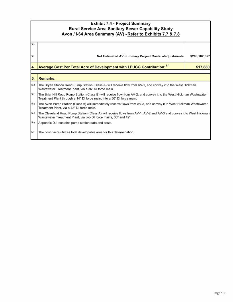
Exhibit 7.4 - Project Summary
Rural Service Area Sanitary Sewer Capability Study
Avon / I-64 Area Summary (AV) - Refer to Exhibits 7.7 & 7.8
3.h
3.I Net Estimated AV Summary Project Costs w/adjustments $263,102,557
4. Average Cost Per Total Acre of Development with LFUCG Contribution: $17,8805.f
5. Remarks:
5.a The Bryan Station Road Pump Station (Class A) will receive flow from AV-1, and convey it to the West Hickman Wastewater Treatment Plant, via a 36" DI force main.
5.b The Briar Hill Road Pump Station (Class B) will receive flow from AV-2, and convey it to the West Hickman Wastewater Treatment Plant through a 14" DI force main, into a 36" DI force main.
5.c The Avon Pump Station (Class A) will immediately receive flows from AV-3, and convey it to West Hickman Wastewater Treatment Plant, via a 42" DI force main.
5.d The Cleveland Road Pump Station (Class A) will receive flows from AV-1, AV-2 and AV-3 and convey it to West Hickman Wastewater Treatment Plant, via two DI force mains, 36" and 42".
5.e Appendix D.1 contains pump station data and costs.
5.f The cost / acre utilizes total developable area for this determination.
Page 103
Exhibit 7.5 - Project Summary
Rural Service Area Sanitary Sewer Capability Study
Avon / I-64 Area Summary of Blue Sky RAC (AV)
1. North Elkhorn Drainage Basin Summary
1.a Total Area North Elkhorn Drainage Basin in Fayette County. (acres) 48,0911.b Total Area of North Elkhorn Drainage Basin presently served by LFUCG. (acres) 7,462
1.f Total Area in Blue Sky RAC. (acres) 465
2. Design Flow Calculation
2.d Total Area in Blue Sky RAC. (acres) 465
2.h Total Developable area in Blue Sky RAC. (acres) 432 Blue Sky RAC - East of I/75 366 Blue Sky RAC - West of I/75 66
2.l Projected Average Flow Blue Sky RAC (gpm) 450 Blue Sky RAC - East of I/75 381 Blue Sky RAC - West of I/75 69
2.p Peak Flow Factor for Blue Sky RAC Blue Sky RAC - East of I/75 4.4 Blue Sky RAC - West of I/75 5.0
2.t Projected Peak Flow for Blue Sky RAC Pump Station (gpm) Blue Sky RAC - East of I/75 1,676 Blue Sky RAC - West of I/75 345
3. Project Cost Summary
Pumping and Conveyance Cost:3.a Trunk Sewers and Force Main for Blue Sky RAC $936,6753.b Pump Stations 5a
Blue Sky RAC - East of I/75 (1700 gpm) $900,000 Blue Sky RAC - West of I/75 (350 gpm) $700,000
Subtotal - Pumping and Conveyance $2,536,675
3.c Wastewater Treatment Cost:3.d Required Wastewater Treatment Plant Capacity: 0.648 MGD X $ 6 / gallon:
3.e Subtotal - Treatment $3,888,000
3.f Subtotal - Estimated Total Project Cost $6,424,675
Plus Contributions to: Cleveland Road Pump Station and Force Main (AV-1, AV-2 Only) $1,570,651
Total Project Cost of Blue Sky RAC Improvements $7,995,326
4. Average Cost Per Total Acre of Development with LFUCG Contribution: $18,5085.b
5. Remarks:5.a Appendix D.1 contains pump station data and costs.
5.b The cost / acre utilizes total developable area for this determination.
5.c
Page 104
Page
105
Page
106

Trunk Sewers ID: Cost ($)
Avon-1:
AV-1A-TA $929,832AV-1B-TA $412,253AV-1C-TA $2,565,439AV-1D-TA $6,670,543AV-1E-TA $124,308AV-1F-TA $3,354,601AV-1G-TA $470,593
Subtotal: $14,527,569Avon-2:
AV-2A-TA $710,894
Subtotal: $710,894
Avon-3:
AV-3A-TA $573,199AV-3B-TA $948,258AV-3C-TA $7,538,206AV-3D-TA $451,732AV-3E-TA $620,002AV-3F-TA $1,048,175AV-3G-TA $3,192,090AV-3H-TA $887,100AV-3I-TA $2,559,505AV-3J-TA $579,324AV-3K-TA $433,534AV-3L-TA $111,029AV 3M-TA $557,718
Subtotal: $19,499,871
Total Avon 1, 2 and 3 Trunk Sewers: $34,738,334
Cost Summary
Avon / I-64 Area
Page 107
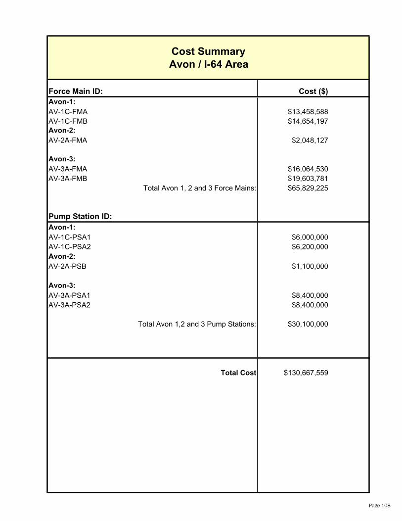
Force Main ID: Cost ($)
Avon-1:
AV-1C-FMA $13,458,588AV-1C-FMB $14,654,197Avon-2:
AV-2A-FMA $2,048,127
Avon-3:
AV-3A-FMA $16,064,530AV-3A-FMB $19,603,781
Total Avon 1, 2 and 3 Force Mains: $65,829,225
Pump Station ID:
Avon-1:
AV-1C-PSA1 $6,000,000AV-1C-PSA2 $6,200,000Avon-2:
AV-2A-PSB $1,100,000
Avon-3:
AV-3A-PSA1 $8,400,000AV-3A-PSA2 $8,400,000
Total Avon 1,2 and 3 Pump Stations: $30,100,000
Total Cost $130,667,559
Cost Summary
Avon / I-64 Area
Page 108
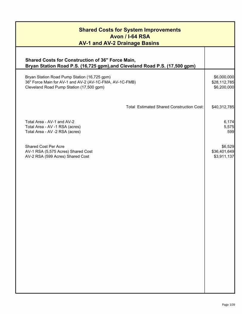
Shared Costs for System Improvements
Avon / I-64 RSA
AV-1 and AV-2 Drainage Basins
Bryan Station Road P.S. (16,725 gpm),and Cleveland Road P.S. (17,500 gpm)
Bryan Station Road Pump Station (16,725 gpm) $6,000,000$28,112,785
Cleveland Road Pump Station (17,500 gpm) $6,200,000
$40,312,785
Total Area - AV-1 and AV-2 6,174Total Area - AV -1 RSA (acres) 5,575Total Area - AV -2 RSA (acres) 599
Shared Cost Per Acre $6,529AV-1 RSA (5,575 Acres) Shared Cost $36,401,649AV-2 RSA (599 Acres) Shared Cost $3,911,137
Shared Costs for Construction of 36" Force Main,
Total Estimated Shared Construction Cost:
36" Force Main for AV-1 and AV-2 (AV-1C-FMA, AV-1C-FMB)
Page 109
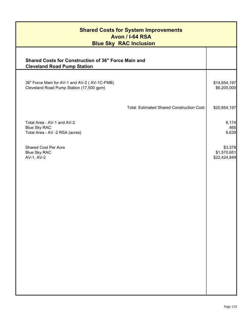
Shared Costs for System Improvements
Avon / I-64 RSA
Blue Sky RAC Inclusion
Cleveland Road Pump Station
$14,654,197Cleveland Road Pump Station (17,500 gpm) $6,200,000
$20,854,197
Total Area - AV-1 and AV-2 6,174Blue Sky RAC 465Total Area - AV -2 RSA (acres) 6,639
Shared Cost Per Acre $3,378Blue Sky RAC $1,570,651AV-1, AV-2 $22,424,849
Shared Costs for Construction of 36" Force Main and
Total Estimated Shared Construction Cost:
36" Force Main for AV-1 and AV-2 ( AV-1C-FMB)
Page 110
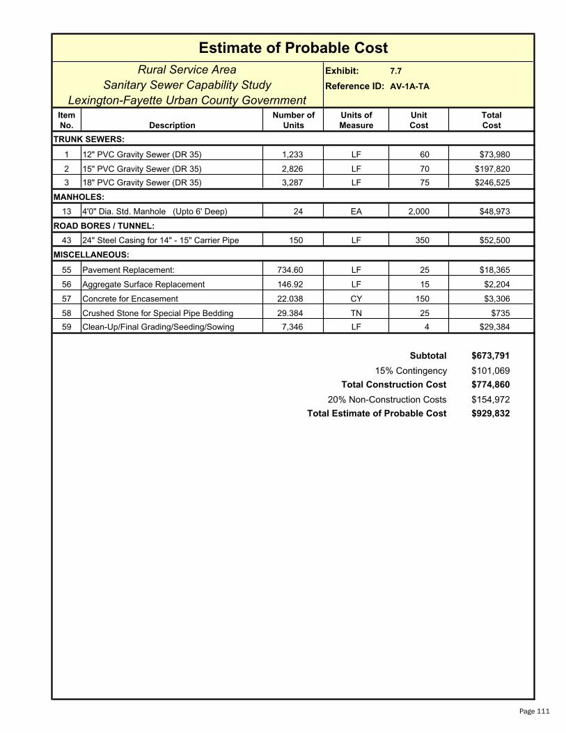
Rural Service Area Exhibit: 7.7
Sanitary Sewer Capability Study Reference ID: AV-1A-TA
Lexington-Fayette Urban County GovernmentItem Number of Units of Unit Total
No. Description Units Measure Cost Cost
1 12" PVC Gravity Sewer (DR 35) 1,233 LF 60 $73,980
2 15" PVC Gravity Sewer (DR 35) 2,826 LF 70 $197,820
3 18" PVC Gravity Sewer (DR 35) 3,287 LF 75 $246,525
13 4'0" Dia. Std. Manhole (Upto 6' Deep) 24 EA 2,000 $48,973
ROAD BORES / TUNNEL:
43 24" Steel Casing for 14" - 15" Carrier Pipe 150 LF 350 $52,500
MISCELLANEOUS:
55 Pavement Replacement: 734.60 LF 25 $18,365
56 Aggregate Surface Replacement 146.92 LF 15 $2,204
57 Concrete for Encasement 22.038 CY 150 $3,306
58 Crushed Stone for Special Pipe Bedding 29.384 TN 25 $735
59 Clean-Up/Final Grading/Seeding/Sowing 7,346 LF 4 $29,384
$673,791
$101,069
$774,860
$154,972
$929,832Total Estimate of Probable Cost
Subtotal
15% Contingency
Total Construction Cost
20% Non-Construction Costs
Estimate of Probable Cost
MANHOLES:
TRUNK SEWERS:
Page 111

Rural Service Area Exhibit: 7.7
Sanitary Sewer Capability Study Reference ID: AV-1B-TA
Lexington-Fayette Urban County GovernmentItem Number of Units of Unit Total
No. Description Units Measure Cost Cost
1 12" PVC Gravity Sewer (DR 35) 665 LF 60 $39,900
2 15" PVC Gravity Sewer (DR 35) 2,163 LF 70 $151,410
3 18" PVC Gravity Sewer (DR 35) 402 LF 75 $30,150
13 4'0" Dia. Std. Manhole (Upto 6' Deep) 11 EA 2,000 $21,533
ROAD BORES / TUNNEL:
42 18" Steel Casing for 12" Carrier Pipe 100 LF 320 $32,000
MISCELLANEOUS:
55 Pavement Replacement: 323.00 LF 25 $8,075
56 Aggregate Surface Replacement 64.60 LF 15 $969
57 Concrete for Encasement 9.690 CY 150 $1,454
58 Crushed Stone for Special Pipe Bedding 12.920 TN 25 $323
59 Clean-Up/Final Grading/Seeding/Sowing 3,230 LF 4 $12,920
$298,734
$44,810
$343,544
$68,709
$412,253Total Estimate of Probable Cost
Subtotal
15% Contingency
Total Construction Cost
20% Non-Construction Costs
Estimate of Probable Cost
TRUNK SEWERS:
MANHOLES:
Page 112

Rural Service Area Exhibit: 7.7
Sanitary Sewer Capability Study Reference ID: AV-1C-TA
Lexington-Fayette Urban County GovernmentItem Number of Units of Unit Total
No. Description Units Measure Cost Cost
1 12" PVC Gravity Sewer (DR 35) 260 LF 60 $15,600
2 15" PVC Gravity Sewer (DR 35) 505 LF 70 $35,350
3 18" PVC Gravity Sewer (DR 35) 1,502 LF 75 $112,650
4 21" PVC Gravity Sewer (DR 35) 4,205 LF 85 $357,425
6 27" PVC Gravity Sewer (DR 35) 1,763 LF 130 $229,190
7 30" DI Gravity Sewer (PC 200) w/Protecto 401 4,768 LF 155 $739,040
13 4'0" Dia. Std. Manhole (Upto 6' Deep) 43 EA 2,000 $86,687
ROAD BORES / TUNNEL:
48 40" Steel Casing for 27" Carrier Pipe 300 LF 625 $187,500
MISCELLANEOUS:
55 Pavement Replacement: 1,300.30 LF 25 $32,508
56 Aggregate Surface Replacement 260.06 LF 15 $3,901
57 Concrete for Encasement 39.009 CY 150 $5,851
58 Crushed Stone for Special Pipe Bedding 52.012 TN 25 $1,300
59 Clean-Up/Final Grading/Seeding/Sowing 13,003 LF 4 $52,012
$1,859,014
$278,852
$2,137,866
$427,573
$2,565,439Total Estimate of Probable Cost
Subtotal
15% Contingency
Total Construction Cost
20% Non-Construction Costs
Estimate of Probable Cost
TRUNK SEWERS:
MANHOLES:
Page 113
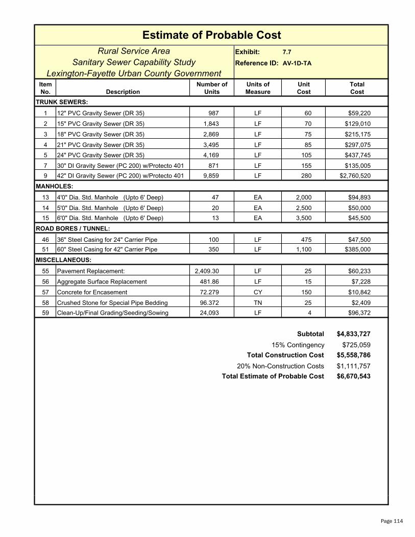
Rural Service Area Exhibit: 7.7
Sanitary Sewer Capability Study Reference ID: AV-1D-TA
Lexington-Fayette Urban County GovernmentItem Number of Units of Unit Total
No. Description Units Measure Cost Cost
1 12" PVC Gravity Sewer (DR 35) 987 LF 60 $59,220
2 15" PVC Gravity Sewer (DR 35) 1,843 LF 70 $129,010
3 18" PVC Gravity Sewer (DR 35) 2,869 LF 75 $215,175
4 21" PVC Gravity Sewer (DR 35) 3,495 LF 85 $297,075
5 24" PVC Gravity Sewer (DR 35) 4,169 LF 105 $437,745
7 30" DI Gravity Sewer (PC 200) w/Protecto 401 871 LF 155 $135,005
9 42" DI Gravity Sewer (PC 200) w/Protecto 401 9,859 LF 280 $2,760,520
13 4'0" Dia. Std. Manhole (Upto 6' Deep) 47 EA 2,000 $94,893
14 5'0" Dia. Std. Manhole (Upto 6' Deep) 20 EA 2,500 $50,000
15 6'0" Dia. Std. Manhole (Upto 6' Deep) 13 EA 3,500 $45,500
ROAD BORES / TUNNEL:
46 36" Steel Casing for 24" Carrier Pipe 100 LF 475 $47,500
51 60" Steel Casing for 42" Carrier Pipe 350 LF 1,100 $385,000
MISCELLANEOUS:
55 Pavement Replacement: 2,409.30 LF 25 $60,233
56 Aggregate Surface Replacement 481.86 LF 15 $7,228
57 Concrete for Encasement 72.279 CY 150 $10,842
58 Crushed Stone for Special Pipe Bedding 96.372 TN 25 $2,409
59 Clean-Up/Final Grading/Seeding/Sowing 24,093 LF 4 $96,372
$4,833,727
$725,059
$5,558,786
$1,111,757
$6,670,543Total Estimate of Probable Cost
Subtotal
15% Contingency
Total Construction Cost
20% Non-Construction Costs
Estimate of Probable Cost
TRUNK SEWERS:
MANHOLES:
Page 114

Rural Service Area Exhibit: 7.7
Sanitary Sewer Capability Study Reference ID: AV-1E-TA
Lexington-Fayette Urban County GovernmentItem Number of Units of Unit Total
No. Description Units Measure Cost Cost
1 12" PVC Gravity Sewer (DR 35) 1,217 LF 60 $73,020
13 4'0" Dia. Std. Manhole (Upto 6' Deep) 4 EA 2,000 $8,113
MISCELLANEOUS:
55 Pavement Replacement: 121.70 LF 25 $3,043
56 Aggregate Surface Replacement 24.34 LF 15 $365
57 Concrete for Encasement 3.651 CY 150 $548
58 Crushed Stone for Special Pipe Bedding 4.868 TN 25 $122
59 Clean-Up/Final Grading/Seeding/Sowing 1,217 LF 4 $4,868
$90,078
$13,512
$103,590
$20,718
$124,308Total Estimate of Probable Cost
Subtotal
15% Contingency
Total Construction Cost
20% Non-Construction Costs
Estimate of Probable Cost
TRUNK SEWERS:
MANHOLES:
Page 115
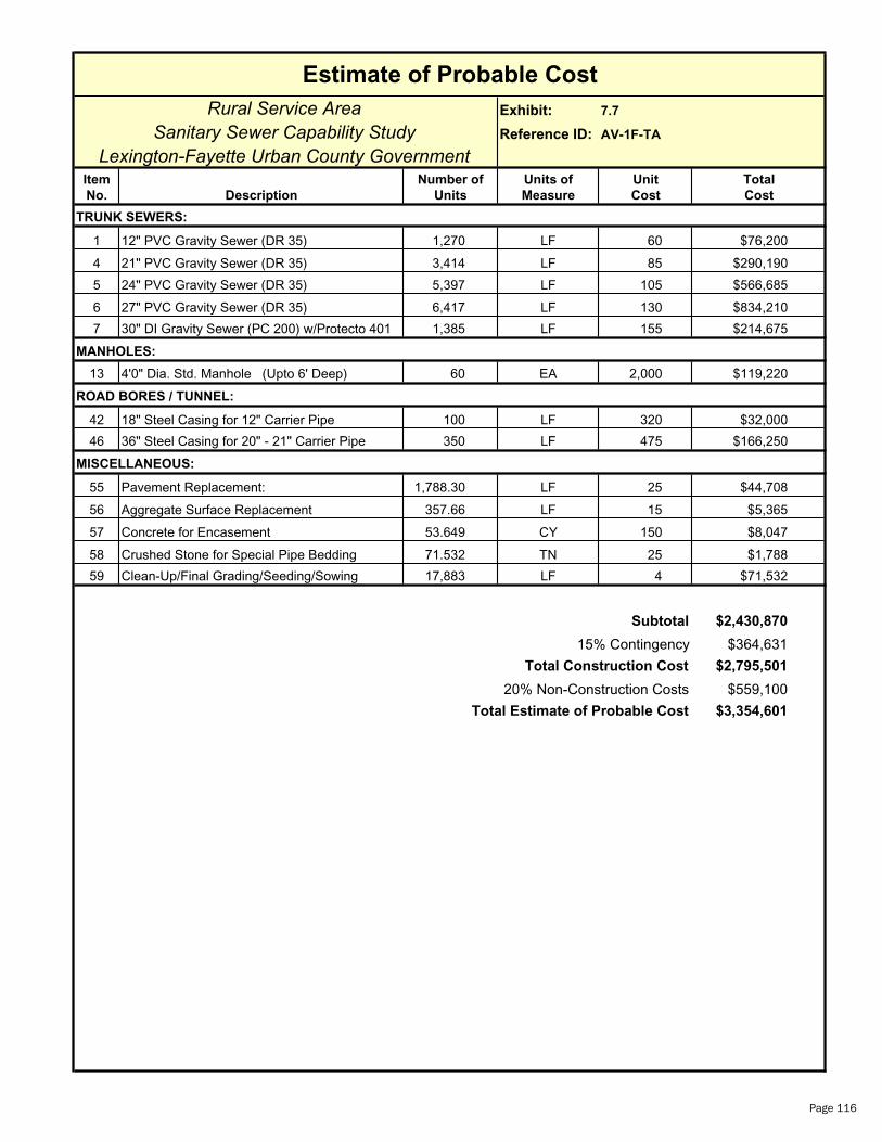
Rural Service Area Exhibit: 7.7
Sanitary Sewer Capability Study Reference ID: AV-1F-TA
Lexington-Fayette Urban County GovernmentItem Number of Units of Unit Total
No. Description Units Measure Cost Cost
1 12" PVC Gravity Sewer (DR 35) 1,270 LF 60 $76,200
4 21" PVC Gravity Sewer (DR 35) 3,414 LF 85 $290,190
5 24" PVC Gravity Sewer (DR 35) 5,397 LF 105 $566,685
6 27" PVC Gravity Sewer (DR 35) 6,417 LF 130 $834,210
7 30" DI Gravity Sewer (PC 200) w/Protecto 401 1,385 LF 155 $214,675
13 4'0" Dia. Std. Manhole (Upto 6' Deep) 60 EA 2,000 $119,220
ROAD BORES / TUNNEL:
42 18" Steel Casing for 12" Carrier Pipe 100 LF 320 $32,000
46 36" Steel Casing for 20" - 21" Carrier Pipe 350 LF 475 $166,250
MISCELLANEOUS:
55 Pavement Replacement: 1,788.30 LF 25 $44,708
56 Aggregate Surface Replacement 357.66 LF 15 $5,365
57 Concrete for Encasement 53.649 CY 150 $8,047
58 Crushed Stone for Special Pipe Bedding 71.532 TN 25 $1,788
59 Clean-Up/Final Grading/Seeding/Sowing 17,883 LF 4 $71,532
$2,430,870
$364,631
$2,795,501
$559,100
$3,354,601Total Estimate of Probable Cost
Subtotal
15% Contingency
Total Construction Cost
20% Non-Construction Costs
Estimate of Probable Cost
TRUNK SEWERS:
MANHOLES:
Page 116

Rural Service Area Exhibit: 7.7
Sanitary Sewer Capability Study Reference ID: AV-1G-TA
Lexington-Fayette Urban County GovernmentItem Number of Units of Unit Total
No. Description Units Measure Cost Cost
1 12" PVC Gravity Sewer (DR 35) 1,275 LF 60 $76,500
2 15" PVC Gravity Sewer (DR 35) 2,519 LF 70 $176,330
13 4'0" Dia. Std. Manhole (Upto 6' Deep) 13 EA 2,000 $25,293
ROAD BORES / TUNNEL:
43 24" Steel Casing for 14" - 15" Carrier Pipe 100 LF 350 $35,000
MISCELLANEOUS:
55 Pavement Replacement: 379.40 LF 25 $9,485
56 Aggregate Surface Replacement 75.88 LF 15 $1,138
57 Concrete for Encasement 11.382 CY 150 $1,707
58 Crushed Stone for Special Pipe Bedding 15.176 TN 25 $379
59 Clean-Up/Final Grading/Seeding/Sowing 3,794 LF 4 $15,176
$341,009
$51,151
$392,161
$78,432
$470,593Total Estimate of Probable Cost
Subtotal
15% Contingency
Total Construction Cost
20% Non-Construction Costs
Estimate of Probable Cost
TRUNK SEWERS:
MANHOLES:
Page 117

Rural Service Area Exhibit: 7.8
Sanitary Sewer Capability Study Reference ID: AV-1C-FMA
Lexington-Fayette Urban County GovernmentItem Number of Units of Unit Total
No. Description Units Measure Cost Cost
35 36" DI Force Main (PC 200 w/ Protecto 401) 46,000 LF 182 $8,372,000
ROAD BORES / TUNNEL:
50 50" Steel Casing for 36" Carrier Pipe 1,100 LF 925 $1,017,500
MISCELLANEOUS:
55 Pavement Replacement: 4,600.00 LF 25 $115,000
56 Aggregate Surface Replacement 920.00 LF 15 $13,800
57 Concrete for Encasement 138.000 CY 150 $20,700
58 Crushed Stone for Special Pipe Bedding 184.000 TN 25 $4,600
59 Clean-Up/Final Grading/Seeding/Sowing 46,000 LF 4 $184,000
60 Sewage Air Release Valves 10 EA 2,500 $25,000
$9,752,600
$1,462,890
$11,215,490
$2,243,098
$13,458,588Total Estimate of Probable Cost
Subtotal
15% Contingency
Total Construction Cost
20% Non-Construction Costs
Estimate of Probable Cost
FORCE MAIN:
Page 118

Rural Service Area Exhibit: 7.8
Sanitary Sewer Capability Study Reference ID: AV-1C-FMB
Lexington-Fayette Urban County GovernmentItem Number of Units of Unit Total
No. Description Units Measure Cost Cost
35 36" DI Force Main (PC 200 w/ Protecto 401) 51,579 LF 182 $9,387,378
ROAD BORES / TUNNEL:
50 50" Steel Casing for 36" Carrier Pipe 900 LF 925 $832,500
MISCELLANEOUS:
55 Pavement Replacement: 5,157.90 LF 25 $128,948
56 Aggregate Surface Replacement 1,031.58 LF 15 $15,474
57 Concrete for Encasement 154.737 CY 150 $23,211
58 Crushed Stone for Special Pipe Bedding 206.316 TN 25 $5,158
59 Clean-Up/Final Grading/Seeding/Sowing 51,579 LF 4 $206,316
60 Sewage Air Release Valves 8 EA 2,500 $20,000
$10,618,984
$1,592,848
$12,211,831
$2,442,366
$14,654,197
Estimate of Probable Cost
FORCE MAIN:
Total Estimate of Probable Cost
Subtotal
15% Contingency
Total Construction Cost
20% Non-Construction Costs
Page 119

Estimate of Probable Cost
Rural Service Area Exhibit: 7.7
Sanitary Sewer Capability Study Reference ID: AV-2A-TA
Lexington-Fayette Urban County GovernmentItem Number of Units of Unit Total
No. Description Units Measure Cost Cost
TRUNK SEWERS:
1 12" PVC Gravity Sewer (DR 35) 616 LF 60 $36,960
2 15" PVC Gravity Sewer (DR 35) 1,542 LF 70 $107,940
3 18" PVC Gravity Sewer (DR 35) 2,550 LF 75 $191,250
MANHOLES:
13 4'0" Dia. Std. Manhole (Upto 6' Deep) 16 EA 2,000 $31,387
ROAD BORES / TUNNEL:
43 24" Steel Casing for 14" - 15" Carrier Pipe 200 LF 350 $70,000
45 30" Steel Casing for 18" Carrier Pipe 100 LF 430 $43,000
MISCELLANEOUS:
55 Pavement Replacement: 470.80 LF 25 $11,770
56 Aggregate Surface Replacement 94.16 LF 15 $1,412
57 Concrete for Encasement 14.124 CY 150 $2,119
58 Crushed Stone for Special Pipe Bedding 18.832 TN 25 $471
59 Clean-Up/Final Grading/Seeding/Sowing 4,708 LF 4 $18,832
Subtotal $515,140
15% Contingency $77,271
Total Construction Cost $592,412
20% Non-Construction Costs $118,482
Total Estimate of Probable Cost $710,894
Page 120

Estimate of Probable Cost
Rural Service Area Exhibit: 7.8
Sanitary Sewer Capability Study Reference ID: AV-2A-FMA
Lexington-Fayette Urban County GovernmentItem Number of Units of Unit Total
No. Description Units Measure Cost Cost
FORCE MAIN:
33 24" DI Force Main (PC 200 w/ Protecto 401) 11,492 LF 102 $1,172,184
ROAD BORES / TUNNEL:
47 38" Steel Casing for 24" Carrier Pipe 400 LF 550 $220,000
MISCELLANEOUS:
55 Pavement Replacement: 1,149.20 LF 25 $28,730
56 Aggregate Surface Replacement 229.84 LF 15 $3,448
57 Concrete for Encasement 34.476 CY 150 $5,171
58 Crushed Stone for Special Pipe Bedding 45.968 TN 25 $1,149
59 Clean-Up/Final Grading/Seeding/Sowing 11,492 LF 4 $45,968
60 Sewage Air Release Valves 3 EA 2,500 $7,500
Subtotal $1,484,150
15% Contingency $222,623
Total Construction Cost $1,706,773
20% Non-Construction Costs $341,355
Total Estimate of Probable Cost $2,048,127
Page 121
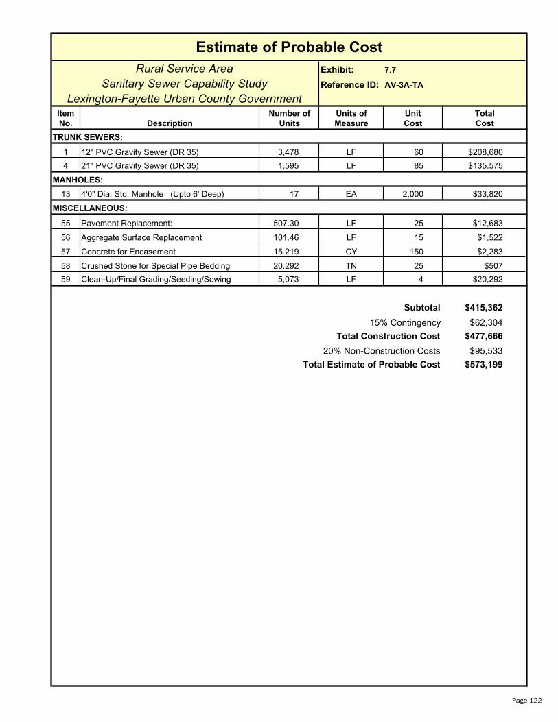
Rural Service Area Exhibit: 7.7
Sanitary Sewer Capability Study Reference ID: AV-3A-TA
Lexington-Fayette Urban County GovernmentItem Number of Units of Unit Total
No. Description Units Measure Cost Cost
1 12" PVC Gravity Sewer (DR 35) 3,478 LF 60 $208,680
4 21" PVC Gravity Sewer (DR 35) 1,595 LF 85 $135,575
13 4'0" Dia. Std. Manhole (Upto 6' Deep) 17 EA 2,000 $33,820
MISCELLANEOUS:
55 Pavement Replacement: 507.30 LF 25 $12,683
56 Aggregate Surface Replacement 101.46 LF 15 $1,522
57 Concrete for Encasement 15.219 CY 150 $2,283
58 Crushed Stone for Special Pipe Bedding 20.292 TN 25 $507
59 Clean-Up/Final Grading/Seeding/Sowing 5,073 LF 4 $20,292
$415,362
$62,304
$477,666
$95,533
$573,199Total Estimate of Probable Cost
Subtotal
15% Contingency
Total Construction Cost
20% Non-Construction Costs
Estimate of Probable Cost
MANHOLES:
TRUNK SEWERS:
Page 122

Rural Service Area Exhibit: 7.7
Sanitary Sewer Capability Study Reference ID: AV-3B-TA
Lexington-Fayette Urban County GovernmentItem Number of Units of Unit Total
No. Description Units Measure Cost Cost
1 12" PVC Gravity Sewer (DR 35) 1,615 LF 60 $96,900
2 15" PVC Gravity Sewer (DR 35) 2,988 LF 70 $209,160
3 18" PVC Gravity Sewer (DR 35) 2,680 LF 75 $201,000
13 4'0" Dia. Std. Manhole (Upto 6' Deep) 24 EA 2,000 $48,553
ROAD BORES / TUNNEL:
43 24" Steel Casing for 14" - 15" Carrier Pipe 100 LF 350 $35,000
45 30" Steel Casing for 18" Carrier Pipe 100 LF 430 $43,000
MISCELLANEOUS:
55 Pavement Replacement: 728.30 LF 25 $18,208
56 Aggregate Surface Replacement 145.66 LF 15 $2,185
57 Concrete for Encasement 21.849 CY 150 $3,277
58 Crushed Stone for Special Pipe Bedding 29.132 TN 25 $728
59 Clean-Up/Final Grading/Seeding/Sowing 7,283 LF 4 $29,132
$687,143
$103,072
$790,215
$158,043
$948,258
Estimate of Probable Cost
TRUNK SEWERS:
MANHOLES:
Total Estimate of Probable Cost
Subtotal
15% Contingency
Total Construction Cost
20% Non-Construction Costs
Page 123

Rural Service Area Exhibit: 7.7
Sanitary Sewer Capability Study Reference ID: AV-3C-TA
Lexington-Fayette Urban County GovernmentItem Number of Units of Unit Total
No. Description Units Measure Cost Cost
1 12" PVC Gravity Sewer (DR 35) 679 LF 60 $40,740
2 15" PVC Gravity Sewer (DR 35) 1,367 LF 70 $95,690
3 18" PVC Gravity Sewer (DR 35) 2,408 LF 75 $180,600
5 24" PVC Gravity Sewer (DR 35) 3,686 LF 105 $387,030
6 27" PVC Gravity Sewer (DR 35) 2,864 LF 130 $372,320
7 30" DI Gravity Sewer (PC 200) w/Protecto 401 7,176 LF 155 $1,112,280
10 48" DI Gravity Sewer (PC 200) w/Protecto 401 7,046 LF 380 $2,677,480
13 4'0" Dia. Std. Manhole (Upto 6' Deep) 61 EA 2,000 $121,200
14 5'0" Dia. Std. Manhole (Upto 6' Deep) 23 EA 2,500 $58,717
ROAD BORES / TUNNEL:
43 24" Steel Casing for 14" - 15" Carrier Pipe 100 LF 350 $35,000
45 30" Steel Casing for 18" Carrier Pipe 200 LF 430 $86,000
47 38" Steel Casing for 24" Carrier Pipe 200 LF 550 $110,000
MISCELLANEOUS:
55 Pavement Replacement: 2,522.60 LF 25 $63,065
56 Aggregate Surface Replacement 504.52 LF 15 $7,568
57 Concrete for Encasement 75.678 CY 150 $11,352
58 Crushed Stone for Special Pipe Bedding 100.904 TN 25 $2,523
59 Clean-Up/Final Grading/Seeding/Sowing 25,226 LF 4 $100,904
$5,462,468
$819,370
$6,281,838
$1,256,368
$7,538,206
Estimate of Probable Cost
TRUNK SEWERS:
MANHOLES:
Total Estimate of Probable Cost
Subtotal
15% Contingency
Total Construction Cost
20% Non-Construction Costs
Page 124

Rural Service Area Exhibit: 7.7
Sanitary Sewer Capability Study Reference ID: AV-3D-TA
Lexington-Fayette Urban County GovernmentItem Number of Units of Unit Total
No. Description Units Measure Cost Cost
1 12" PVC Gravity Sewer (DR 35) 2,577 LF 60 $154,620
2 15" PVC Gravity Sewer (DR 35) 1,245 LF 70 $87,150
13 4'0" Dia. Std. Manhole (Upto 6' Deep) 13 EA 2,000 $25,480
ROAD BORES / TUNNEL:
42 18" Steel Casing for 12" Carrier Pipe 100 LF 320 $32,000
MISCELLANEOUS:
55 Pavement Replacement: 382.20 LF 25 $9,555
56 Aggregate Surface Replacement 76.44 LF 15 $1,147
57 Concrete for Encasement 11.466 CY 150 $1,720
58 Crushed Stone for Special Pipe Bedding 15.288 TN 25 $382
59 Clean-Up/Final Grading/Seeding/Sowing 3,822 LF 4 $15,288
$327,342
$49,101
$376,443
$75,289
$451,732
Estimate of Probable Cost
TRUNK SEWERS:
MANHOLES:
Total Estimate of Probable Cost
Subtotal
15% Contingency
Total Construction Cost
20% Non-Construction Costs
Page 125
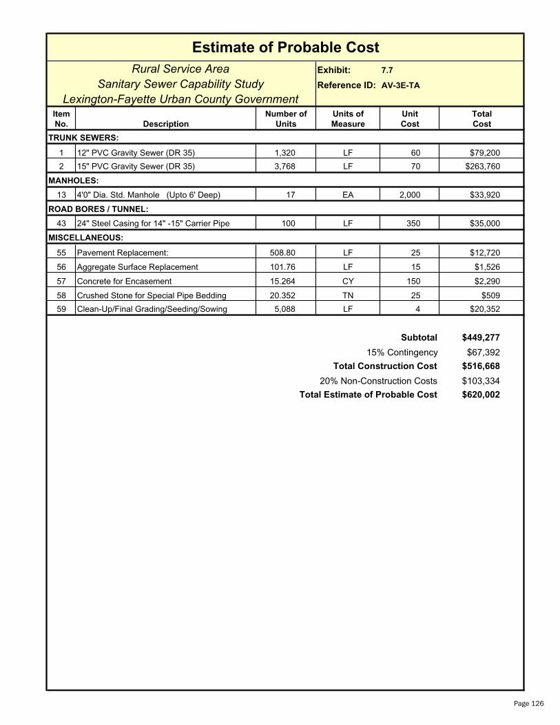
Rural Service Area Exhibit: 7.7
Sanitary Sewer Capability Study Reference ID: AV-3E-TA
Lexington-Fayette Urban County GovernmentItem Number of Units of Unit Total
No. Description Units Measure Cost Cost
1 12" PVC Gravity Sewer (DR 35) 1,320 LF 60 $79,200
2 15" PVC Gravity Sewer (DR 35) 3,768 LF 70 $263,760
13 4'0" Dia. Std. Manhole (Upto 6' Deep) 17 EA 2,000 $33,920
ROAD BORES / TUNNEL:
43 24" Steel Casing for 14" -15" Carrier Pipe 100 LF 350 $35,000
MISCELLANEOUS:
55 Pavement Replacement: 508.80 LF 25 $12,720
56 Aggregate Surface Replacement 101.76 LF 15 $1,526
57 Concrete for Encasement 15.264 CY 150 $2,290
58 Crushed Stone for Special Pipe Bedding 20.352 TN 25 $509
59 Clean-Up/Final Grading/Seeding/Sowing 5,088 LF 4 $20,352
$449,277
$67,392
$516,668
$103,334
$620,002
Estimate of Probable Cost
TRUNK SEWERS:
MANHOLES:
Total Estimate of Probable Cost
Subtotal
15% Contingency
Total Construction Cost
20% Non-Construction Costs
Page 126
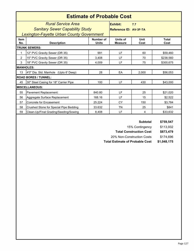
Rural Service Area Exhibit: 7.7
Sanitary Sewer Capability Study Reference ID: AV-3F-TA
Lexington-Fayette Urban County GovernmentItem Number of Units of Unit Total
No. Description Units Measure Cost Cost
1 12" PVC Gravity Sewer (DR 35) 991 LF 60 $59,460
2 15" PVC Gravity Sewer (DR 35) 3,408 LF 70 $238,560
3 18" PVC Gravity Sewer (DR 35) 4,009 LF 75 $300,675
13 4'0" Dia. Std. Manhole (Upto 6' Deep) 28 EA 2,000 $56,053
ROAD BORES / TUNNEL:
45 30" Steel Casing for 18" Carrier Pipe 100 LF 430 $43,000
MISCELLANEOUS:
55 Pavement Replacement: 840.80 LF 25 $21,020
56 Aggregate Surface Replacement 168.16 LF 15 $2,522
57 Concrete for Encasement 25.224 CY 150 $3,784
58 Crushed Stone for Special Pipe Bedding 33.632 TN 25 $841
59 Clean-Up/Final Grading/Seeding/Sowing 8,408 LF 4 $33,632
$759,547
$113,932
$873,479
$174,696
$1,048,175
Estimate of Probable Cost
TRUNK SEWERS:
MANHOLES:
Total Estimate of Probable Cost
Subtotal
15% Contingency
Total Construction Cost
20% Non-Construction Costs
Page 127

Rural Service Area Exhibit: 7.7
Sanitary Sewer Capability Study Reference ID: AV-3G-TA
Lexington-Fayette Urban County GovernmentItem Number of Units of Unit Total
No. Description Units Measure Cost Cost
8 36" DI Gravity Sewer (PC 200) w/Protecto 401 9,422 LF 220 $2,072,840
14 5'0" Dia. Std. Manhole (Upto 6' Deep) 31 EA 2,500 $78,517
ROAD BORES / TUNNEL:
50 50" Steel Casing for 36" Carrier Pipe 100 LF 925 $92,500
MISCELLANEOUS:
55 Pavement Replacement: 942.20 LF 25 $23,555
56 Aggregate Surface Replacement 188.44 LF 15 $2,827
57 Concrete for Encasement 28.266 CY 150 $4,240
58 Crushed Stone for Special Pipe Bedding 37.688 TN 25 $942
59 Clean-Up/Final Grading/Seeding/Sowing 9,422 LF 4 $37,688
$2,313,108
$346,966
$2,660,075
$532,015
$3,192,090
Estimate of Probable Cost
TRUNK SEWERS:
MANHOLES:
Total Estimate of Probable Cost
Subtotal
15% Contingency
Total Construction Cost
20% Non-Construction Costs
Page 128

Rural Service Area Exhibit: 7.7
Sanitary Sewer Capability Study Reference ID: AV-3H-TA
Lexington-Fayette Urban County GovernmentItem Number of Units of Unit Total
No. Description Units Measure Cost Cost
1 12" PVC Gravity Sewer (DR 35) 969 LF 60 $58,140
2 15" PVC Gravity Sewer (DR 35) 2,214 LF 70 $154,980
3 18" PVC Gravity Sewer (DR 35) 3,843 LF 75 $288,225
13 4'0" Dia. Std. Manhole (Upto 6' Deep) 23 EA 2,000 $46,840
ROAD BORES / TUNNEL:
45 30" Steel Casing for 18" Carrier Pipe 100 LF 430 $43,000
MISCELLANEOUS:
55 Pavement Replacement: 702.60 LF 25 $17,565
56 Aggregate Surface Replacement 140.52 LF 15 $2,108
57 Concrete for Encasement 21.078 CY 150 $3,162
58 Crushed Stone for Special Pipe Bedding 28.104 TN 25 $703
59 Clean-Up/Final Grading/Seeding/Sowing 7,026 LF 4 $28,104
$642,826
$96,424
$739,250
$147,850
$887,100
Estimate of Probable Cost
TRUNK SEWERS:
MANHOLES:
Total Estimate of Probable Cost
Subtotal
15% Contingency
Total Construction Cost
20% Non-Construction Costs
Page 129
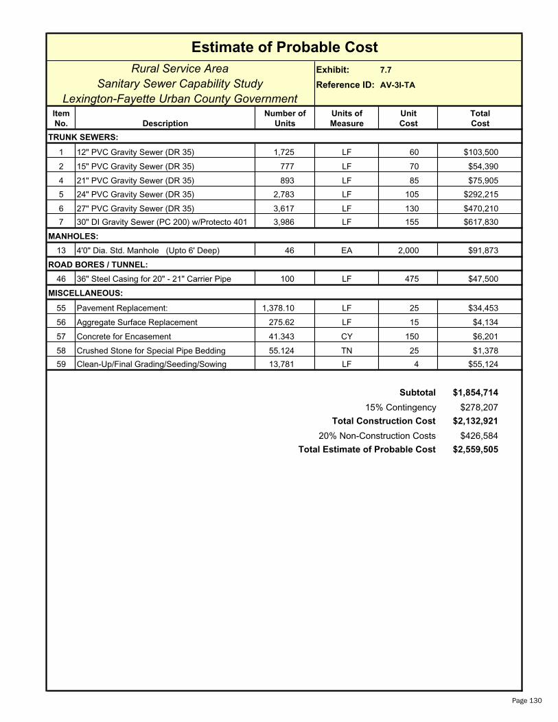
Rural Service Area Exhibit: 7.7
Sanitary Sewer Capability Study Reference ID: AV-3I-TA
Lexington-Fayette Urban County GovernmentItem Number of Units of Unit Total
No. Description Units Measure Cost Cost
1 12" PVC Gravity Sewer (DR 35) 1,725 LF 60 $103,500
2 15" PVC Gravity Sewer (DR 35) 777 LF 70 $54,390
4 21" PVC Gravity Sewer (DR 35) 893 LF 85 $75,905
5 24" PVC Gravity Sewer (DR 35) 2,783 LF 105 $292,215
6 27" PVC Gravity Sewer (DR 35) 3,617 LF 130 $470,210
7 30" DI Gravity Sewer (PC 200) w/Protecto 401 3,986 LF 155 $617,830
13 4'0" Dia. Std. Manhole (Upto 6' Deep) 46 EA 2,000 $91,873
ROAD BORES / TUNNEL:
46 36" Steel Casing for 20" - 21" Carrier Pipe 100 LF 475 $47,500
MISCELLANEOUS:
55 Pavement Replacement: 1,378.10 LF 25 $34,453
56 Aggregate Surface Replacement 275.62 LF 15 $4,134
57 Concrete for Encasement 41.343 CY 150 $6,201
58 Crushed Stone for Special Pipe Bedding 55.124 TN 25 $1,378
59 Clean-Up/Final Grading/Seeding/Sowing 13,781 LF 4 $55,124
$1,854,714
$278,207
$2,132,921
$426,584
$2,559,505
Estimate of Probable Cost
TRUNK SEWERS:
MANHOLES:
Total Estimate of Probable Cost
Subtotal
15% Contingency
Total Construction Cost
20% Non-Construction Costs
Page 130

Rural Service Area Exhibit: 7.7
Sanitary Sewer Capability Study Reference ID: AV-3J-TA
Lexington-Fayette Urban County GovernmentItem Number of Units of Unit Total
No. Description Units Measure Cost Cost
1 12" PVC Gravity Sewer (DR 35) 1,460 LF 60 $87,600
2 15" PVC Gravity Sewer (DR 35) 1,371 LF 70 $95,970
3 18" PVC Gravity Sewer (DR 35) 2,208 LF 75 $165,600
13 4'0" Dia. Std. Manhole (Upto 6' Deep) 17 EA 2,000 $33,593
MISCELLANEOUS:
55 Pavement Replacement: 503.90 LF 25 $12,598
56 Aggregate Surface Replacement 100.78 LF 15 $1,512
57 Concrete for Encasement 15.117 CY 150 $2,268
58 Crushed Stone for Special Pipe Bedding 20.156 TN 25 $504
59 Clean-Up/Final Grading/Seeding/Sowing 5,039 LF 4 $20,156
$419,800
$62,970
$482,770
$96,554
$579,324
Estimate of Probable Cost
TRUNK SEWERS:
MANHOLES:
Total Estimate of Probable Cost
Subtotal
15% Contingency
Total Construction Cost
20% Non-Construction Costs
Page 131

Rural Service Area Exhibit: 7.7
Sanitary Sewer Capability Study Reference ID: AV-3K-TA
Lexington-Fayette Urban County GovernmentItem Number of Units of Unit Total
No. Description Units Measure Cost Cost
1 12" PVC Gravity Sewer (DR 35) 1,519 LF 60 $91,140
2 15" PVC Gravity Sewer (DR 35) 2,401 LF 70 $168,070
13 4'0" Dia. Std. Manhole (Upto 6' Deep) 13 EA 2,000 $26,133
MISCELLANEOUS:
55 Pavement Replacement: 392.00 LF 25 $9,800
56 Aggregate Surface Replacement 78.40 LF 15 $1,176
57 Concrete for Encasement 11.760 CY 150 $1,764
58 Crushed Stone for Special Pipe Bedding 15.680 TN 25 $392
59 Clean-Up/Final Grading/Seeding/Sowing 3,920 LF 4 $15,680
$314,155
$47,123
$361,279
$72,256
$433,534
Estimate of Probable Cost
TRUNK SEWERS:
MANHOLES:
Total Estimate of Probable Cost
Subtotal
15% Contingency
Total Construction Cost
20% Non-Construction Costs
Page 132
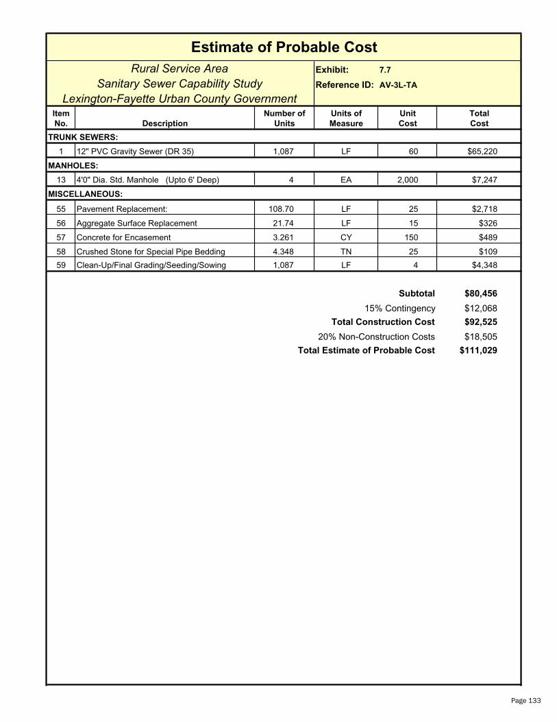
Rural Service Area Exhibit: 7.7
Sanitary Sewer Capability Study Reference ID: AV-3L-TA
Lexington-Fayette Urban County GovernmentItem Number of Units of Unit Total
No. Description Units Measure Cost Cost
1 12" PVC Gravity Sewer (DR 35) 1,087 LF 60 $65,220
13 4'0" Dia. Std. Manhole (Upto 6' Deep) 4 EA 2,000 $7,247
MISCELLANEOUS:
55 Pavement Replacement: 108.70 LF 25 $2,718
56 Aggregate Surface Replacement 21.74 LF 15 $326
57 Concrete for Encasement 3.261 CY 150 $489
58 Crushed Stone for Special Pipe Bedding 4.348 TN 25 $109
59 Clean-Up/Final Grading/Seeding/Sowing 1,087 LF 4 $4,348
$80,456
$12,068
$92,525
$18,505
$111,029
Estimate of Probable Cost
TRUNK SEWERS:
MANHOLES:
Total Estimate of Probable Cost
Subtotal
15% Contingency
Total Construction Cost
20% Non-Construction Costs
Page 133
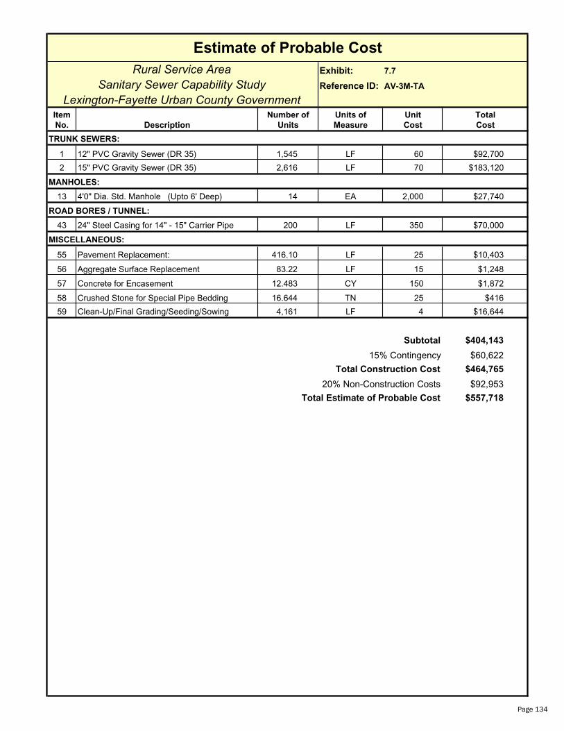
Rural Service Area Exhibit: 7.7
Sanitary Sewer Capability Study Reference ID: AV-3M-TA
Lexington-Fayette Urban County GovernmentItem Number of Units of Unit Total
No. Description Units Measure Cost Cost
1 12" PVC Gravity Sewer (DR 35) 1,545 LF 60 $92,700
2 15" PVC Gravity Sewer (DR 35) 2,616 LF 70 $183,120
13 4'0" Dia. Std. Manhole (Upto 6' Deep) 14 EA 2,000 $27,740
ROAD BORES / TUNNEL:
43 24" Steel Casing for 14" - 15" Carrier Pipe 200 LF 350 $70,000
MISCELLANEOUS:
55 Pavement Replacement: 416.10 LF 25 $10,403
56 Aggregate Surface Replacement 83.22 LF 15 $1,248
57 Concrete for Encasement 12.483 CY 150 $1,872
58 Crushed Stone for Special Pipe Bedding 16.644 TN 25 $416
59 Clean-Up/Final Grading/Seeding/Sowing 4,161 LF 4 $16,644
$404,143
$60,622
$464,765
$92,953
$557,718
Estimate of Probable Cost
TRUNK SEWERS:
MANHOLES:
Total Estimate of Probable Cost
Subtotal
15% Contingency
Total Construction Cost
20% Non-Construction Costs
Page 134

Rural Service Area Exhibit: 7.8
Sanitary Sewer Capability Study Reference ID: AV-3A-FMA
Lexington-Fayette Urban County GovernmentItem Number of Units of Unit Total
No. Description Units Measure Cost Cost
36 42" DI Force Main (PC 200 w/ Protecto 401) 43,517 LF 242 $10,531,114
ROAD BORES / TUNNEL:
51 60" Steel Casing for 42" Carrier Pipe 700 LF 1,100 $770,000
MISCELLANEOUS:
55 Pavement Replacement: 4,351.70 LF 25 $108,793
56 Aggregate Surface Replacement 870.34 LF 15 $13,055
57 Concrete for Encasement 130.551 CY 150 $19,583
58 Crushed Stone for Special Pipe Bedding 174.068 TN 25 $4,352
59 Clean-Up/Final Grading/Seeding/Sowing 43,517 LF 4 $174,068
60 Sewage Air Release Valves 8 EA 2,500 $20,000
$11,640,964
$1,746,145
$13,387,109
$2,677,422
$16,064,530
Estimate of Probable Cost
FORCE MAIN:
Total Estimate of Probable Cost
Subtotal
15% Contingency
Total Construction Cost
20% Non-Construction Costs
Page 135
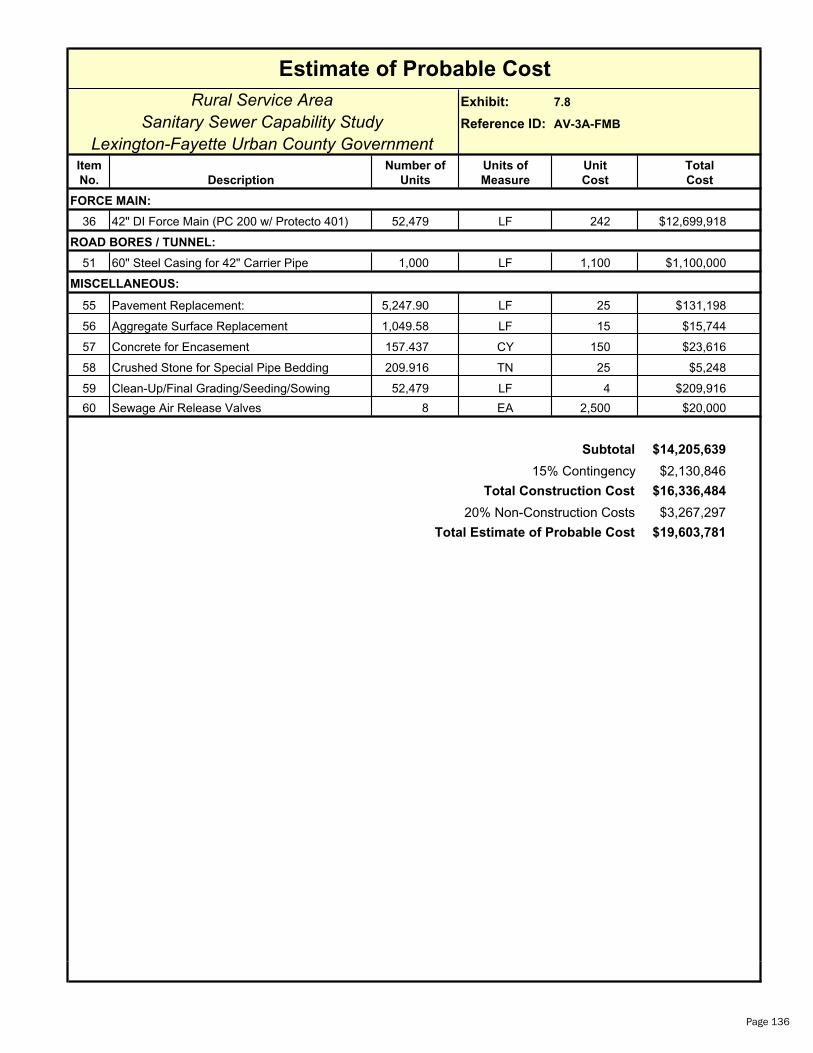
Rural Service Area Exhibit: 7.8
Sanitary Sewer Capability Study Reference ID: AV-3A-FMB
Lexington-Fayette Urban County GovernmentItem Number of Units of Unit Total
No. Description Units Measure Cost Cost
36 42" DI Force Main (PC 200 w/ Protecto 401) 52,479 LF 242 $12,699,918
ROAD BORES / TUNNEL:
51 60" Steel Casing for 42" Carrier Pipe 1,000 LF 1,100 $1,100,000
MISCELLANEOUS:
55 Pavement Replacement: 5,247.90 LF 25 $131,198
56 Aggregate Surface Replacement 1,049.58 LF 15 $15,744
57 Concrete for Encasement 157.437 CY 150 $23,616
58 Crushed Stone for Special Pipe Bedding 209.916 TN 25 $5,248
59 Clean-Up/Final Grading/Seeding/Sowing 52,479 LF 4 $209,916
60 Sewage Air Release Valves 8 EA 2,500 $20,000
$14,205,639
$2,130,846
$16,336,484
$3,267,297
$19,603,781Total Estimate of Probable Cost
Subtotal
15% Contingency
Total Construction Cost
20% Non-Construction Costs
Estimate of Probable Cost
FORCE MAIN:
Page 136
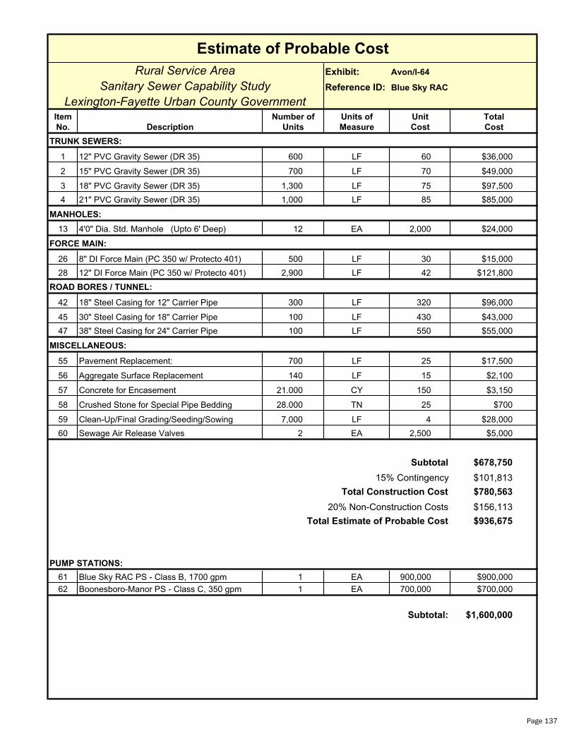
Estimate of Probable Cost
Rural Service Area Exhibit: Avon/I-64
Sanitary Sewer Capability Study Reference ID: Blue Sky RAC
Lexington-Fayette Urban County GovernmentItem Number of Units of Unit Total
No. Description Units Measure Cost Cost
TRUNK SEWERS:
1 12" PVC Gravity Sewer (DR 35) 600 LF 60 $36,000
2 15" PVC Gravity Sewer (DR 35) 700 LF 70 $49,000
3 18" PVC Gravity Sewer (DR 35) 1,300 LF 75 $97,500
4 21" PVC Gravity Sewer (DR 35) 1,000 LF 85 $85,000
MANHOLES:
13 4'0" Dia. Std. Manhole (Upto 6' Deep) 12 EA 2,000 $24,000
FORCE MAIN:
26 8" DI Force Main (PC 350 w/ Protecto 401) 500 LF 30 $15,000
28 12" DI Force Main (PC 350 w/ Protecto 401) 2,900 LF 42 $121,800
ROAD BORES / TUNNEL:
42 18" Steel Casing for 12" Carrier Pipe 300 LF 320 $96,000
45 30" Steel Casing for 18" Carrier Pipe 100 LF 430 $43,000
47 38" Steel Casing for 24" Carrier Pipe 100 LF 550 $55,000
MISCELLANEOUS:
55 Pavement Replacement: 700 LF 25 $17,500
56 Aggregate Surface Replacement 140 LF 15 $2,100
57 Concrete for Encasement 21.000 CY 150 $3,150
58 Crushed Stone for Special Pipe Bedding 28.000 TN 25 $700
59 Clean-Up/Final Grading/Seeding/Sowing 7,000 LF 4 $28,000
60 Sewage Air Release Valves 2 EA 2,500 $5,000
Subtotal $678,750
15% Contingency $101,813
Total Construction Cost $780,563
20% Non-Construction Costs $156,113
Total Estimate of Probable Cost $936,675
PUMP STATIONS:
61 Blue Sky RAC PS - Class B, 1700 gpm 1 EA 900,000 $900,00062 Boonesboro-Manor PS - Class C, 350 gpm 1 EA 700,000 $700,000
Subtotal: $1,600,000
Page 137
Rural Service Area Sanitary Sewer Capability Study
Section 8 Delong Road/Richmond Road Rural Service Area
General
The Delong Road/Richmond Road Rural Service Area (DR) is located in
southeastern Fayette County. The DR has a total land area of 5,588
acres and a total developable land area of 5,087 acres. Project
summaries are provided in Exhibits 8.1 through 8.3. Detailed maps
are provided in Exhibits 8.4 and 8.5. The Delong Road/Richmond
Road RSA has been divided into two sub-drainage basins, DR-1 and
DR-2. The DR-1 is positioned in the East Hickman Creek drainage
basin of Fayette County and originates near the southernmost border
of Fayette County and extends north and northeast to the uppermost
reach of the drainage basin. The DR-2 is located in the Baughman
Run Creek drainage basin in Fayette County, which flows southeast,
directly to the Kentucky River. In addition, the Blue Sky Rural Activity
Center (RAC) will be presented as an optional area for inclusion of
sanitary sewer service and estimates of cost are provided.
DR-1
DR-1 has an area of 4,970 acres and is a part of the East Hickman Creek drainage basin. DR-1 extends to the
uppermost reach of the East Hickman Creek drainage basin. Approximately 354 additional acres of the East
Hickman drainage basin in Fayette County would remain unsewered and are downstream of or adjacent to DR-1.
Refer to Exhibits 8.4 and 8.5
DR-2
DR-2 has an area of 618 acres and is located in the uppermost reach of the Baughman Run drainage basin, which
flows east to the Kentucky River. The wastewater generated from DR-2 would be pumped and conveyed to DR-1.
The development of DR would have no effect on the capacity of the existing LFUCG East Hickman Sewershed or
Expansion Area 1 (2001 LFUCG Comprehensive Plan Update). Ultimate flows from this area would be pumped and
conveyed separately and directly to West Hickman WWTP. Expansion Area 2B and 2C (2001 LFUCG Comprehensive
Plan Update) are located in the upper reaches of the East Hickman drainage basin. Refer to Exhibits 8.4 and 8.5.
February 2006 Page 138

Rural Service Area Sanitary Sewer Capability Study
Land Use and Parcel Data
Table 8.1 is a summary of the current land use in the Delong Road/Richmond Road RSA. Table 8.2 provides
comparison of relative size of land parcel distribution within the DR. Over 82% of the land use is Core Equine
Agricultural and Prime Agricultural. Over 88% of the land parcels are less than 40 acres in size. Similar details of
each sub-drainage basin, DR-1 and DR-2, are summarized in Exhibit 8.6.
Table 8.1 Land Use Classification– DR RSA
Table 8.2 Land Parcel Size Distribution – DR RSALand Parcel Size No. of Parcels % Total
Parcels > 0 acres and < 5 acres 174 49.3
5 acres and < 10 acres 45 12.7 10 acres and < 40 acres 92 26.1 40 acres and < 100 acres 21 6.0 100 acres and < 200 acres 9 2.5 200 acres 12 3.4
Summary 353 100.0
Rural Settlements
No rural settlements exist inside the boundaries of the Delong Road/Richmond Road RSA. However, Coletown is
southeast of lower East Hickman Creek, just outside the boundaries of the Delong Road/Richmond Road RSA.
Rural Activity Centers (RAC)
Blue Sky RAC (465 acres) is located near the extreme upper portion of the Delong Road/Richmond Road RSA, near
DR-2. The drainage from this region naturally flows away from the East Hickman Creek drainage basin and toward
Baughman Run Creek of the Kentucky River basin. Two privately-owned WWTP’s also exist in this area, Blue Sky
WWTP and Boonesboro Manor WWTP.
Land Use Area Classification (Acres)
% of Total Area
Agricultural Land 285 5.1Core Equine Agricultural Land 3,085 55.2Non-Rural Developed Land 179 3.2Prime Agricultural Land 1,503 26.9Public Land 22 0.4Rural Developed Land 492 8.8Other Land 22 0.4Summary 5,588 100.0
Delong Road/Richmond Road RSA
February 2006 Page 139
Rural Service Area Sanitary Sewer Capability Study
Special Natural Protection Areas
Two “B” Priority Special Natural Protection Areas have been identified in the Delong Road/Richmond Road RSA,
which are East Hickman Creek, west of Delong Road (250 acres) and Athens-Walnut Hill Road near I-75. These were
identified in the LFUCG Rural Service Area Land Management Plan.
Rural Greenways
East Hickman Creek is listed as an additional area for rural greenways; however, it is not identified as one of the
“Five Focus Areas” for rural greenway creation in the LFUCG Rural Service Area Land Management Plan.
Scenic Areas
Most of the Delong Road/Richmond Road RSA has been identified as “Scenic Area” in the LFUCG Rural Service Area
Land Management Plan.
Environmentally Sensitive Areas
Environmentally Sensitive Areas (ESA) have been identified along the East Hickman Creek floodplain in Fayette
County in the LFUCG Rural Service Area Land Management Plan.
Wastewater Facilities
Projected Wastewater Flows
The projected wastewater flows from the Delong Road/Richmond Road RSA are cumulative of the two included
drainage basins, DR-1 and DR-2. In addition, options of including the flows from the existing Blue Sky Rural Activity
Center will also be provided. The ultimate projected average wastewater flow, resultant from full development of the
DR, is based on a unit flow of 1,500 gpd/acre of developable land. Peak wastewater flow is derived from utilization
of an empirical peak flow factor, based on the relative magnitude of the average wastewater flow. The peak flow
factor is multiplied by the average wastewater flow to obtain the peak instantaneous flow. In general, the larger the
area and resulting average flow, the smaller the peak flow factor. Appendix B contains a summary of peak
wastewater flow factors.
DR-1
The DR-1 has a total land area of 4,970 acres and a total developable land area of 4,494 acres. As mentioned
previously, DR-1 will receive all flows from DR-2, therefore, wastewater flow projections will reflect the area of the
entire DR. The projected average wastewater flow from DR-1 and DR-2 is 5,299 gpm or 7.63 MGD. The peak
flow factor from Appendix B is 2.7 and the resultant peak wastewater flow is 14,307 gpm.
February 2006 Page 140

Rural Service Area Sanitary Sewer Capability Study
DR-2
DR-2 has a total land area of 618 acres and a developable land area of 593 acres. The projected average
wastewater flow from DR-2 is 618 gpm or 0.89 MGD. The peak flow factor from Appendix B is 3.8 and the
resultant peak wastewater flow is 2,348 gpm.
Table 8.3 provides a summary of wastewater flows for the Delong Road/Richmond Road RSA. Options are provided
for inclusion of wastewater flows from the Blue Sky RAC at the end of this section. Another alternative for the Blue
Sky RAC was also previously discussed in Section 7.
Table 8.3 Average and Peak Wastewater Flows – DR RSA
Delong Road/Richmond Road RSA
Area Average Daily Flow (gpd)
Peak Flow (gpm)
DR-1* 7,630,500 14,307DR-2 889,500 2,348
* Includes flows from DR-2
Wastewater Infrastructure Summary and Development Review
The Delong Road/Richmond Road RSA is located to the east of the current LFUCG Expansion Area 1. All proposed
wastewater infrastructure would be parallel to the proposed improvements of the 1999 201 Facility Plan Update for
Expansion Area 1, which have not been constructed at this time. For the purposes of this study, it has been
assumed Expansion Area 1 improvements have been constructed. Should the Delong Road/Richmond Road RSA be
included in a future expansion area prior to the construction of Expansion Area 1 improvements, scale economy can
be achieved by providing larger facilities to serve the entire area.
DR-1
12” to 42” trunk sewers would be required for development of DR-1. A 14,500 gpm Class A pump station and
30” force main are required to pump and convey all wastewater flows to the West Hickman Wastewater
Treatment Plant. DR-1 receives all flows from DR-2. With inclusion of the Blue Sky RAC wastewater flows, the
trunk sewers would be extended and pump station capacities would be increased. Blue Sky RAC is discussed
later in this section.
DR-2
A short length of 12” trunk sewer would be required. A 2,400 gpm Class B pump station and 14” force main
would be required to convey the flows to DR-1. With inclusion of the Blue Sky RAC wastewater flows, the pump
station capacity and force main size would increase. Blue Sky RAC is discussed later in this section.
February 2006 Page 141
Rural Service Area Sanitary Sewer Capability Study
No treatment capacity exists for the Delong Road/Richmond Road RSA. The projected WWTP capacity required for
complete development of the Delong Road/Richmond Road RSA is 7.63 MGD.
Opportunity also exists during the development of the DR to decommission several existing pump stations of the East
Hickman Sewershed. These pump stations include:
East Hickman East Lake Armstrong Mill
Opportunity also exists to decommission the following additional pump stations with the simultaneous development
of Expansion Area 1 (2001 LFUCG Comprehensive Plan Update) and the DR:
Hartland No. 1 Hartland No. 2 Hartland No. 3 Robertson
Details of the upsizing of DR-1 sanitary sewer infrastructure that would be necessitated by decommissioning of these
pump stations have not been provided within the scope of work of this study.
Estimate of Probable Cost of Collection, Pumping, Conveyance, and Treatment
The estimate of probable costs for the Delong Road/Richmond RSA are provided in the project summaries, Exhibits
8.1 through 8.3. Additional additive costs are provided at the end of the section for the inclusion of Blue Sky RAC.
DR-1
The estimate of total probable cost for the DR1 trunk sewer, 14,500 gpm Class A pump station, and 30” force
main is $22,388,739. All facilities have been sized to accept wastewater flows from DR-2. Details of these
costs are provided in the end of this section.
The required WWTP capacity is equivalent to the projected average flow from complete development of the DR-1
(without flows from DR-2), is 6.74 MGD. At the cost of $6/gallon for expansion of the West Hickman WWTP, the
projected total construction cost for wastewater treatment is $40,446,000.
The total estimated cost for development of DR-1, which includes collection, pumping, conveyance, and
treatment is $62,834,739. The Blue Sky RAC upgrade costs have not been included in these costs. The
average cost per acre, after contribution of shared costs from the DR-2, is $11,839. per acre.
February 2006 Page 142
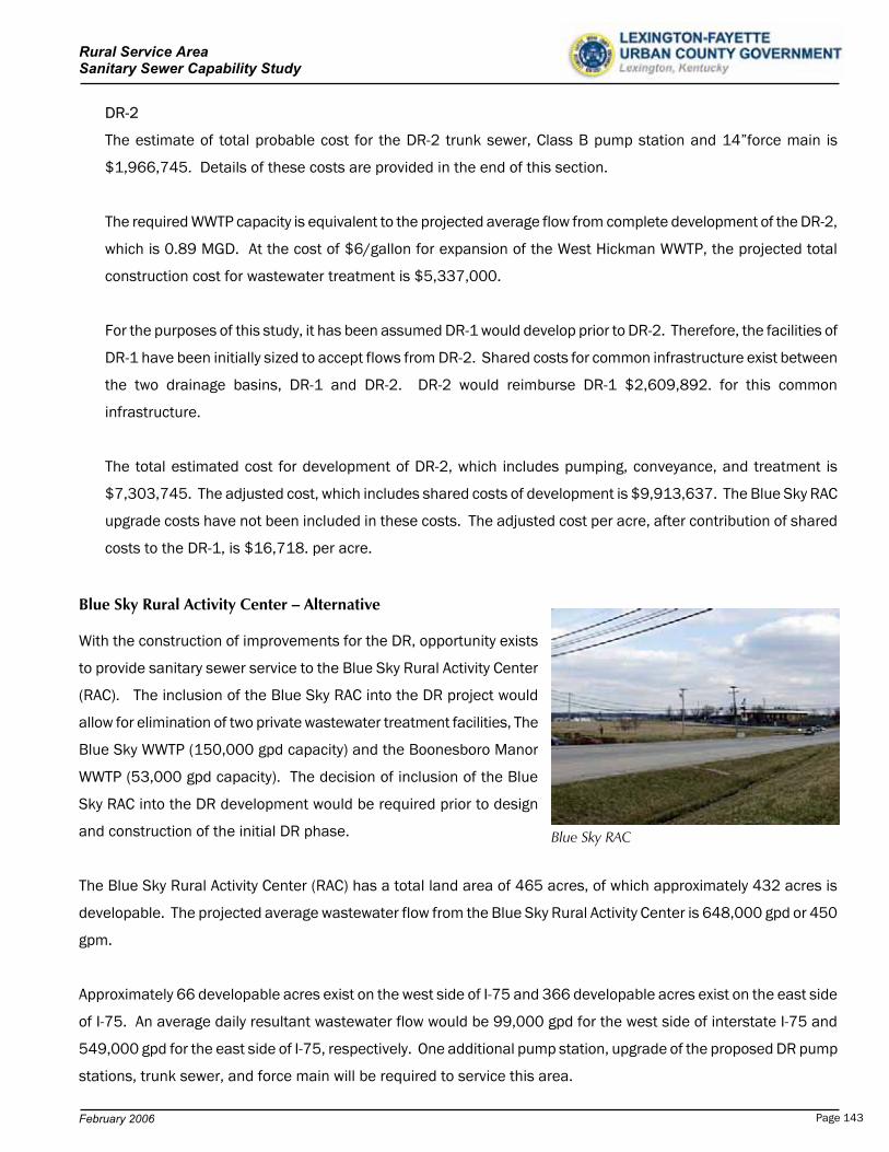
Rural Service Area Sanitary Sewer Capability Study
DR-2
The estimate of total probable cost for the DR-2 trunk sewer, Class B pump station and 14”force main is
$1,966,745. Details of these costs are provided in the end of this section.
The required WWTP capacity is equivalent to the projected average flow from complete development of the DR-2,
which is 0.89 MGD. At the cost of $6/gallon for expansion of the West Hickman WWTP, the projected total
construction cost for wastewater treatment is $5,337,000.
For the purposes of this study, it has been assumed DR-1 would develop prior to DR-2. Therefore, the facilities of
DR-1 have been initially sized to accept flows from DR-2. Shared costs for common infrastructure exist between
the two drainage basins, DR-1 and DR-2. DR-2 would reimburse DR-1 $2,609,892. for this common
infrastructure.
The total estimated cost for development of DR-2, which includes pumping, conveyance, and treatment is
$7,303,745. The adjusted cost, which includes shared costs of development is $9,913,637. The Blue Sky RAC
upgrade costs have not been included in these costs. The adjusted cost per acre, after contribution of shared
costs to the DR-1, is $16,718. per acre.
Blue Sky Rural Activity Center – Alternative
With the construction of improvements for the DR, opportunity exists
to provide sanitary sewer service to the Blue Sky Rural Activity Center
(RAC). The inclusion of the Blue Sky RAC into the DR project would
allow for elimination of two private wastewater treatment facilities, The
Blue Sky WWTP (150,000 gpd capacity) and the Boonesboro Manor
WWTP (53,000 gpd capacity). The decision of inclusion of the Blue
Sky RAC into the DR development would be required prior to design
and construction of the initial DR phase. Blue Sky RAC
The Blue Sky Rural Activity Center (RAC) has a total land area of 465 acres, of which approximately 432 acres is
developable. The projected average wastewater flow from the Blue Sky Rural Activity Center is 648,000 gpd or 450
gpm.
Approximately 66 developable acres exist on the west side of I-75 and 366 developable acres exist on the east side
of I-75. An average daily resultant wastewater flow would be 99,000 gpd for the west side of interstate I-75 and
549,000 gpd for the east side of I-75, respectively. One additional pump station, upgrade of the proposed DR pump
stations, trunk sewer, and force main will be required to service this area.
February 2006 Page 143
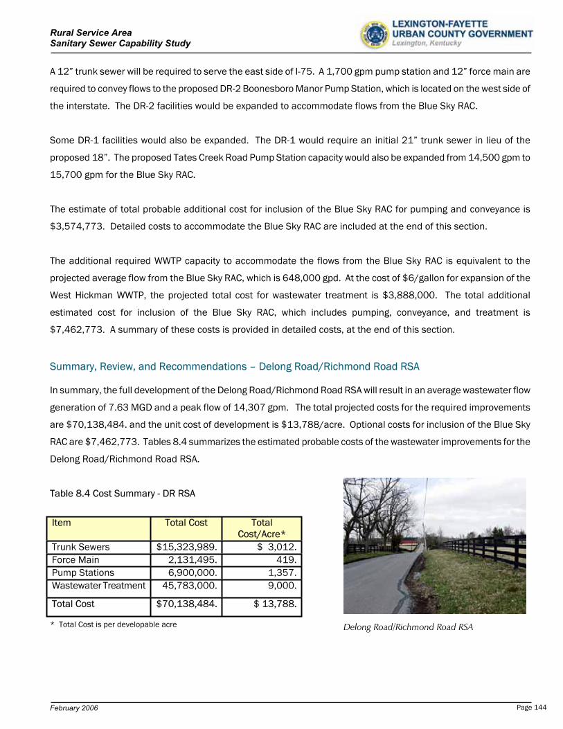
Rural Service Area Sanitary Sewer Capability Study
A 12” trunk sewer will be required to serve the east side of I-75. A 1,700 gpm pump station and 12” force main are
required to convey flows to the proposed DR-2 Boonesboro Manor Pump Station, which is located on the west side of
the interstate. The DR-2 facilities would be expanded to accommodate flows from the Blue Sky RAC.
Some DR-1 facilities would also be expanded. The DR-1 would require an initial 21” trunk sewer in lieu of the
proposed 18”. The proposed Tates Creek Road Pump Station capacity would also be expanded from 14,500 gpm to
15,700 gpm for the Blue Sky RAC.
The estimate of total probable additional cost for inclusion of the Blue Sky RAC for pumping and conveyance is
$3,574,773. Detailed costs to accommodate the Blue Sky RAC are included at the end of this section.
The additional required WWTP capacity to accommodate the flows from the Blue Sky RAC is equivalent to the
projected average flow from the Blue Sky RAC, which is 648,000 gpd. At the cost of $6/gallon for expansion of the
West Hickman WWTP, the projected total cost for wastewater treatment is $3,888,000. The total additional
estimated cost for inclusion of the Blue Sky RAC, which includes pumping, conveyance, and treatment is
$7,462,773. A summary of these costs is provided in detailed costs, at the end of this section.
Summary, Review, and Recommendations – Delong Road/Richmond Road RSA
In summary, the full development of the Delong Road/Richmond Road RSA will result in an average wastewater flow
generation of 7.63 MGD and a peak flow of 14,307 gpm. The total projected costs for the required improvements
are $70,138,484. and the unit cost of development is $13,788/acre. Optional costs for inclusion of the Blue Sky
RAC are $7,462,773. Tables 8.4 summarizes the estimated probable costs of the wastewater improvements for the
Delong Road/Richmond Road RSA.
Table 8.4 Cost Summary - DR RSA
Item Total Cost TotalCost/Acre*
Trunk Sewers $15,323,989. $ 3,012.Force Main 2,131,495. 419.Pump Stations 6,900,000. 1,357.Wastewater Treatment 45,783,000. 9,000.
Total Cost $70,138,484. $ 13,788.
* Total Cost is per developable acre Delong Road/Richmond Road RSA
February 2006 Page 144
Rural Service Area Sanitary Sewer Capability Study
The East Hickman Creek drainage basin has a total area of 12,792 acres in Fayette County, of which 7,462
upstream acres are presently developed. All wastewater flows will be conveyed to the West Hickman WWTP.
Downstream construction of a WWTP has not been considered due to the close proximity of the West Hickman
WWTP.
Review
Over 75% of the property is core equine agricultural or prime agricultural land.
A large portion of the area is designated as a “scenic area”.
No capacity exists in the current LFUCG facilities for the DR.
Expansion Area 1 recommended improvements from the 201 Facility Plan are parallel in nature to the DR
improvements. Economy of scale can be achieved with combined consideration of the DR and the Expansion
Areas of the 2001 LFUCG Comprehensive Plan Update.
The Blue Sky RAC is adjacent to the uppermost reach of the DR. No stand alone alternatives have been presented
to convey these flows to LFUCG facilities. No capacity exists in the current LFUCG facilities for the Blue Sky RAC.
The decision of inclusion of the Blue Sky RAC into the DR development would be required prior to design and
construction of the initial DR phase.
Opportunity exists to decommission several existing pump stations with the development of the DR and/or
Expansion Area 1.
Recommendations
Determine required combined improvements and costs to serve Expansion Areas and the DR. At this time, no
improvements have been designed or constructed for the 2001 LFUCG Comprehensive Plan Update Expansion
Areas.
Review feasible phased improvements of the DR. The lower reaches of the DR can be sewered and pumped to the
West Hickman WWTP without significant outlay of capital for upstream improvements.
Expand future planning efforts for wastewater infrastructure beyond the traditional 20-year planning period.
February 2006 Page 145
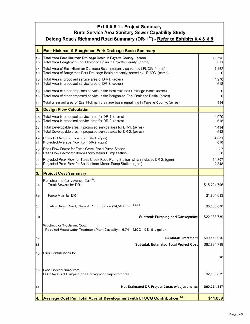
1. East Hickman & Baughman Fork Drainage Basin Summary
1.a 12,7921.b 6,011
1.c 7,4621.d 0
1.e 4,9701.f 618
1.g 0
1.h 0
1.i 354
2. Design Flow Calculation
2.a 4,9702.b 618
2.c 4,4942.d 593
2.e Projected Average Flow from DR-1. (gpm) 4,6812.f Projected Average Flow from DR-2. (gpm) 618
2.g 2.72.h 3.8
2.i 14,3072.j 2,348
3. Project Cost Summary
Pumping and Conveyance Cost5a:3.a Trunk Sewers for DR-1 $15,224,706
3.b Force Main for DR-1 $1,864,033
3.c $5,300,000
3.d $22,388,739
Wastewater Treatment Cost: Required Wastewater Treatment Plant Capacity: 6.741 MGD X $ 6 / gallon:
3.e $40,446,000
3.f $62,834,739
3.g Plus Contributions to:$0
3.h Less Contributions from:$2,609,892
3.i $60,224,847
4. $11,839
Subtotal: Treatment
Projected Peak Flow for Boonesboro-Manor Pump Station. (gpm)
Total Developable area in proposed service area for DR-2. (acres)
Peak Flow Factor for Tates Creek Road Pump StationPeak Flow Factor for Boonesboro-Manor Pump Station
Projected Peak Flow for Tates Creek Road Pump Station which includes DR-2. (gpm)
Total Area of other proposed service in the Baughman Fork Drainage Basin. (acres)
Total Area in proposed service area for DR-1. (acres)Total Area in proposed service area for DR-2. (acres)
Total Developable area in proposed service area for DR-1. (acres)
Net Estimated DR Project Costs w/adjustments
DR-2 for DR-1 Pumping and Conveyance Improvements
Exhibit 8.1 - Project Summary
Delong Road / Richmond Road Summary (DR-15a
) - Refer to Exhibits 8.4 & 8.5
Total unserved area of East Hickman drainage basin remaining in Fayette County. (acres)
Total Area Baughman Fork Drainage Basin in Fayette County. (acres)
Total Area of East Hickman Drainage Basin presently served by LFUCG. (acres)
Total Area East Hickman Drainage Basin in Fayette County. (acres)
Total Area of Baughman Fork Drainage Basin presently served by LFUCG. (acres)
Rural Service Area Sanitary Sewer Capability Study
Total Area in proposed service area of DR-1. (acres)Total Area in proposed service area of DR-2. (acres)
Total Area of other proposed service in the East Hickman Drainage Basin. (acres)
Tates Creek Road, Class A Pump Station (14,500 gpm) 5.a,5.b
Subtotal: Estimated Total Project Cost
Subtotal: Pumping and Conveyance
Average Cost Per Total Acre of Development with LFUCG Contribution:5.c
Page 146
5.
5.a
5.b
5.c
The DR-1 pumping and conveyance facilities have been designed to accept flows from the DR-2 sub-drainage basin.
Exhibit 8.1 - Project Summary
Rural Service Area Sanitary Sewer Capability Study
Delong Road / Richmond Road Summary (DR-15a
) - Refer to Exhibits 8.4 & 8.5
Remarks:
The cost / acre utilizes total developable area for this determination.
Appendix D.1 contains pump station data and costs.
Page 147
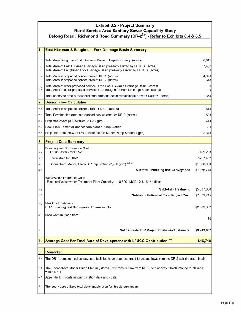
1. East Hickman & Baughman Fork Drainage Basin Summary
1.a
1.b 6,011
1.c 7,4621.d 0
1.e 4,9701.f 618
1.g 01.h 0
1.i 354
2. Design Flow Calculation
2.a 618
2.b 593
2.c Projected Average Flow from DR-2. (gpm) 618
2.d 3.8
2.e 2,348
3. Project Cost Summary
Pumping and Conveyance Cost:3.a Trunk Sewers for DR-2 $99,283
3.b Force Main for DR-2 $267,462
3.c $1,600,000
3.d $1,966,745
Wastewater Treatment Cost: Required Wastewater Treatment Plant Capacity: 0.890 MGD X $ 6 / gallon:
3.e $5,337,000
3.f $7,303,745
3.g Plus Contributions to:$2,609,892
3.h Less Contributions from:$0
3.i $9,913,637
4. $16,718
5.
5.a
5.b
5.c
5.d
Net Estimated DR Project Costs w/adjustments
Exhibit 8.2 - Project Summary
Total Area of other proposed service in the Baughman Fork Drainage Basin. (acres)
Total Area of East Hickman Drainage Basin presently served by LFUCG. (acres)
Rural Service Area Sanitary Sewer Capability Study
Delong Road / Richmond Road Summary (DR-25a
) - Refer to Exhibits 8.4 & 8.5
Total Area Baughman Fork Drainage Basin in Fayette County. (acres)
Total Area of Baughman Fork Drainage Basin presently served by LFUCG. (acres)
Total Area in proposed service area of DR-1. (acres)Total Area in proposed service area of DR-2. (acres)
Total unserved area of East Hickman drainage basin remaining in Fayette County. (acres)
Subtotal - Pumping and Conveyance
Total Area of other proposed service in the East Hickman Drainage Basin. (acres)
Peak Flow Factor for Boonesboro-Manor Pump Station
Total Area in proposed service area for DR-2. (acres)
Subtotal - Treatment
Total Developable area in proposed service area for DR-2. (acres)
Boonesboro-Manor, Class B Pump Station (2,400 gpm) 5.b,5.c
Projected Peak Flow for DR-2, Boonesboro-Manor Pump Station. (gpm)
Appendix D.1 contains pump station data and costs.
The cost / acre utilizes total developable area for this determination.
Subtotal - Estimated Total Project Cost
The Boonesboro-Manor Pump Station (Class B) will receive flow from DR-2, and convey it back into the trunk lines within DR-1.
Remarks:
DR-1 Pumping and Conveyance Improvements
The DR-1 pumping and conveyance facilities have been designed to accept flows from the DR-2 sub-drainage basin.
Average Cost Per Total Acre of Development with LFUCG Contribution:5.d
Page 148
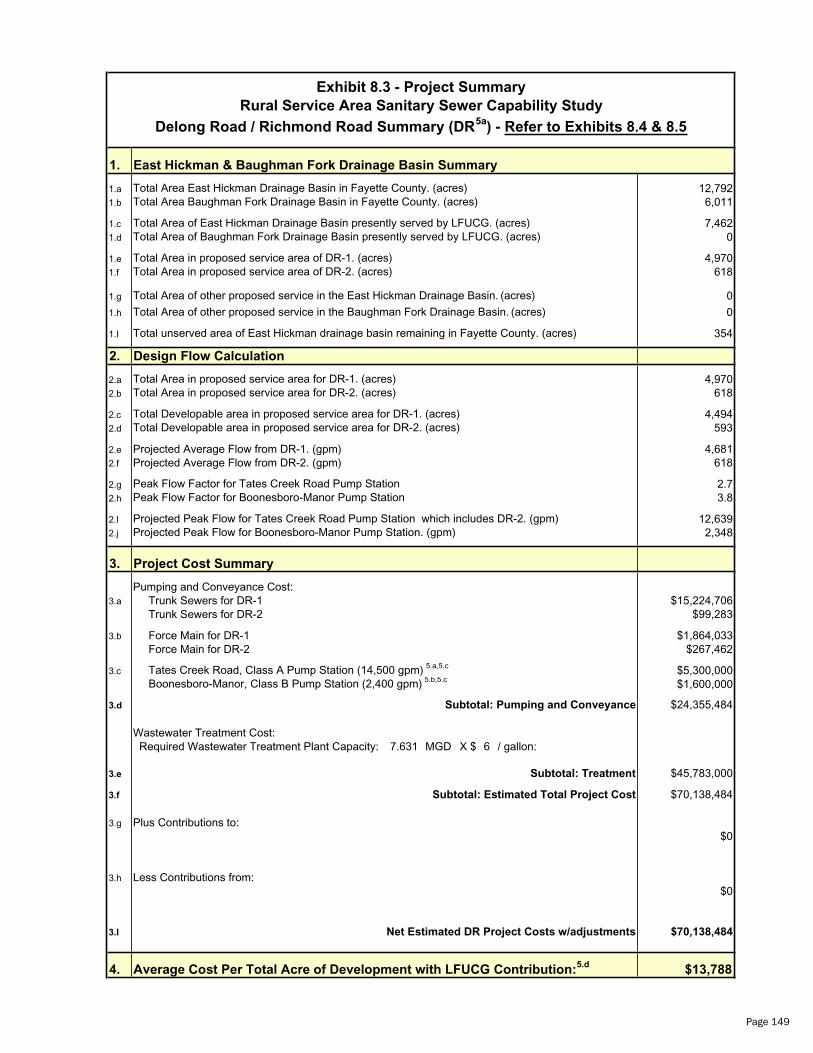
1. East Hickman & Baughman Fork Drainage Basin Summary
1.a 12,7921.b 6,011
1.c 7,4621.d 0
1.e 4,9701.f 618
1.g 0
1.h 0
1.I 354
2. Design Flow Calculation
2.a 4,9702.b 618
2.c 4,4942.d 593
2.e Projected Average Flow from DR-1. (gpm) 4,6812.f Projected Average Flow from DR-2. (gpm) 618
2.g 2.72.h 3.8
2.I 12,6392.j 2,348
3. Project Cost Summary
Pumping and Conveyance Cost:3.a Trunk Sewers for DR-1 $15,224,706
Trunk Sewers for DR-2 $99,283
3.b Force Main for DR-1 $1,864,033 Force Main for DR-2 $267,462
3.c $5,300,000$1,600,000
3.d $24,355,484
Wastewater Treatment Cost: Required Wastewater Treatment Plant Capacity: 7.631 MGD X $ 6 / gallon:
3.e $45,783,000
3.f $70,138,484
3.g Plus Contributions to:$0
3.h Less Contributions from:$0
3.I $70,138,484
4. $13,788
Total Area of other proposed service in the East Hickman Drainage Basin. (acres)
Tates Creek Road, Class A Pump Station (14,500 gpm) 5.a,5.c
Subtotal: Estimated Total Project Cost
Subtotal: Pumping and Conveyance
Average Cost Per Total Acre of Development with LFUCG Contribution:5.d
Exhibit 8.3 - Project Summary
Delong Road / Richmond Road Summary (DR5a
) - Refer to Exhibits 8.4 & 8.5
Total unserved area of East Hickman drainage basin remaining in Fayette County. (acres)
Total Area Baughman Fork Drainage Basin in Fayette County. (acres)
Total Area of East Hickman Drainage Basin presently served by LFUCG. (acres)
Total Area East Hickman Drainage Basin in Fayette County. (acres)
Total Area of Baughman Fork Drainage Basin presently served by LFUCG. (acres)
Rural Service Area Sanitary Sewer Capability Study
Total Area in proposed service area of DR-1. (acres)Total Area in proposed service area of DR-2. (acres)
Net Estimated DR Project Costs w/adjustments
Total Area of other proposed service in the Baughman Fork Drainage Basin. (acres)
Total Area in proposed service area for DR-1. (acres)Total Area in proposed service area for DR-2. (acres)
Total Developable area in proposed service area for DR-1. (acres)
Subtotal: Treatment
Projected Peak Flow for Boonesboro-Manor Pump Station. (gpm)
Boonesboro-Manor, Class B Pump Station (2,400 gpm) 5.b,5.c
Total Developable area in proposed service area for DR-2. (acres)
Peak Flow Factor for Tates Creek Road Pump StationPeak Flow Factor for Boonesboro-Manor Pump Station
Projected Peak Flow for Tates Creek Road Pump Station which includes DR-2. (gpm)
Page 149
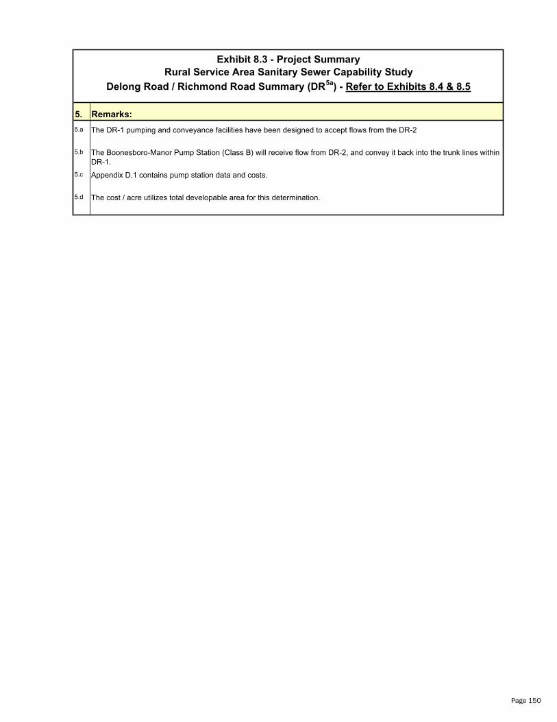
5.
5.a The DR-1 pumping and conveyance facilities have been designed to accept flows from the DR-2
5.b
5.c
5.d The cost / acre utilizes total developable area for this determination.
Appendix D.1 contains pump station data and costs.
The Boonesboro-Manor Pump Station (Class B) will receive flow from DR-2, and convey it back into the trunk lines within DR-1.
Remarks:
Exhibit 8.3 - Project Summary
Rural Service Area Sanitary Sewer Capability Study
Delong Road / Richmond Road Summary (DR5a
) - Refer to Exhibits 8.4 & 8.5
Page 150
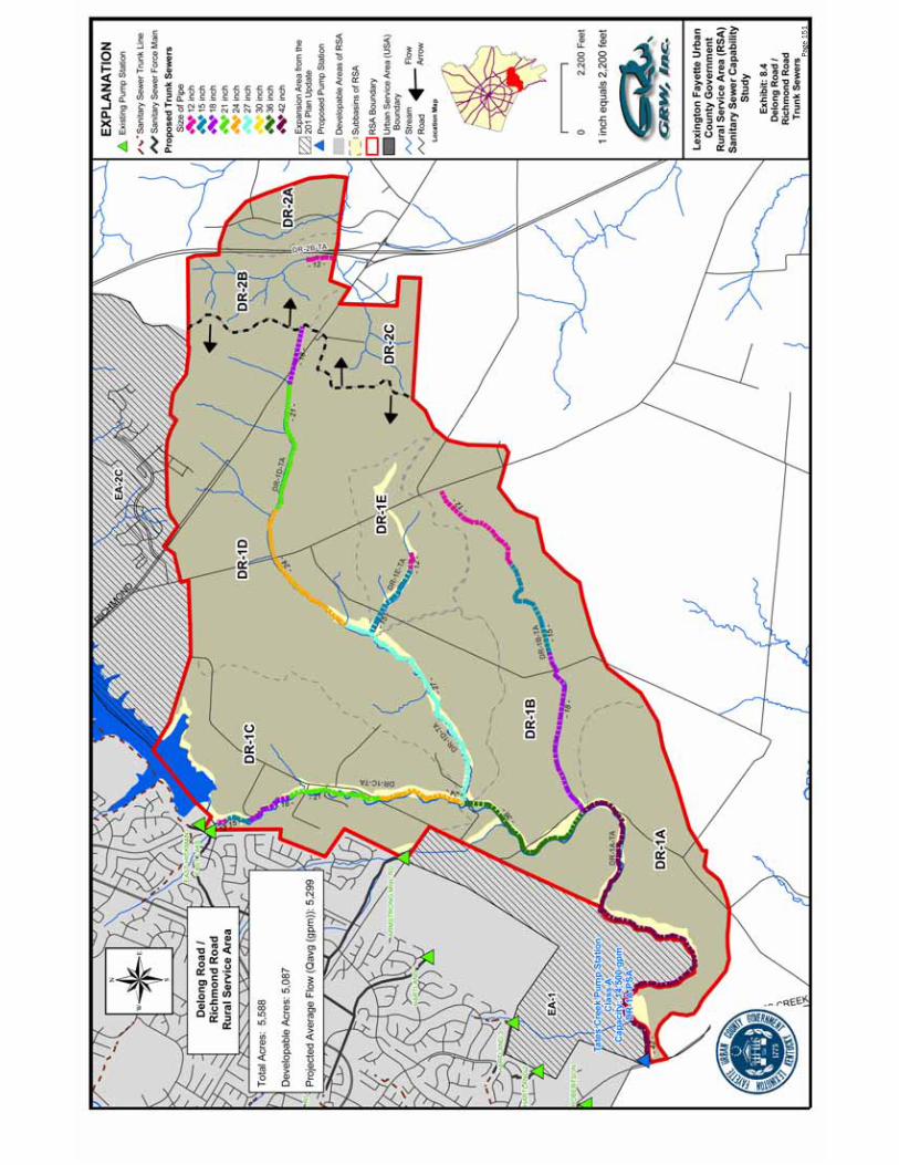
Page
151
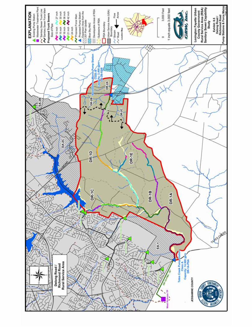
Page
152


Cost Summary
Delong Road / Richmond Road
Trunk Sewer ID: Cost ($)
DR - 1:
DR-1A-TA $8,226,230DR-1B-TA $1,587,981DR-1C-TA $1,528,228DR-1D-TA $3,473,371DR-1E-TA $408,895
Subtotal: $15,224,706DR - 2:
DR-2B-TA $99,283Subtotal: $99,283
Total Delong Road / Richmond Road 1 and 2 Trunk Sewers: $15,323,989
Force Main ID:
DR - 1:
DR-1A-FMA $1,864,033
DR - 2:
DR-2B-FMA $267,462
Total Delong Road / Richmond Road 1 and 2 Force Mains: $2,131,494
Pump Station ID:
DR - 1:
DR-1A-PSA $5,300,000
DR - 2:
DR-2B-PSB $1,600,000
Total Delong Road/ Richmond Road Pump Stations $6,900,000
Total Delong Road/Richmond Road Imp. $24,355,484
Alternative Costs:
Blue Sky RAC Sewer System $3,574,773
Page 153

Shared Costs for System Improvements
Delong Rd./Richmond Rd.
DR-1 and DR-2 Drainage Basins
14,500 gpm Tates Creek Rd. Pump Station, and 30" Force Main
$1,864,033Tates Creek Road Pump Station (14,500 gpm) $5,300,000Trunk Sewers $15,224,706
$22,388,739
Total Area - DR-1 and DR-2 5,087Total Area - AV -1 RSA (acres) 4,494Total Area - AV -2 RSA (acres) 593
Shared Cost Per Acre $4,401AV-1 RSA (4,494 Acres) Shared Cost $19,778,847AV-2 RSA (593 Acres) Shared Cost $2,609,892
Shared Costs for Construction of Trunk Sewer,
Total Estimated Shared Construction Cost:
30" Force Main for DR-1 and DR-2 (DR-1A-FMA)
Page 154
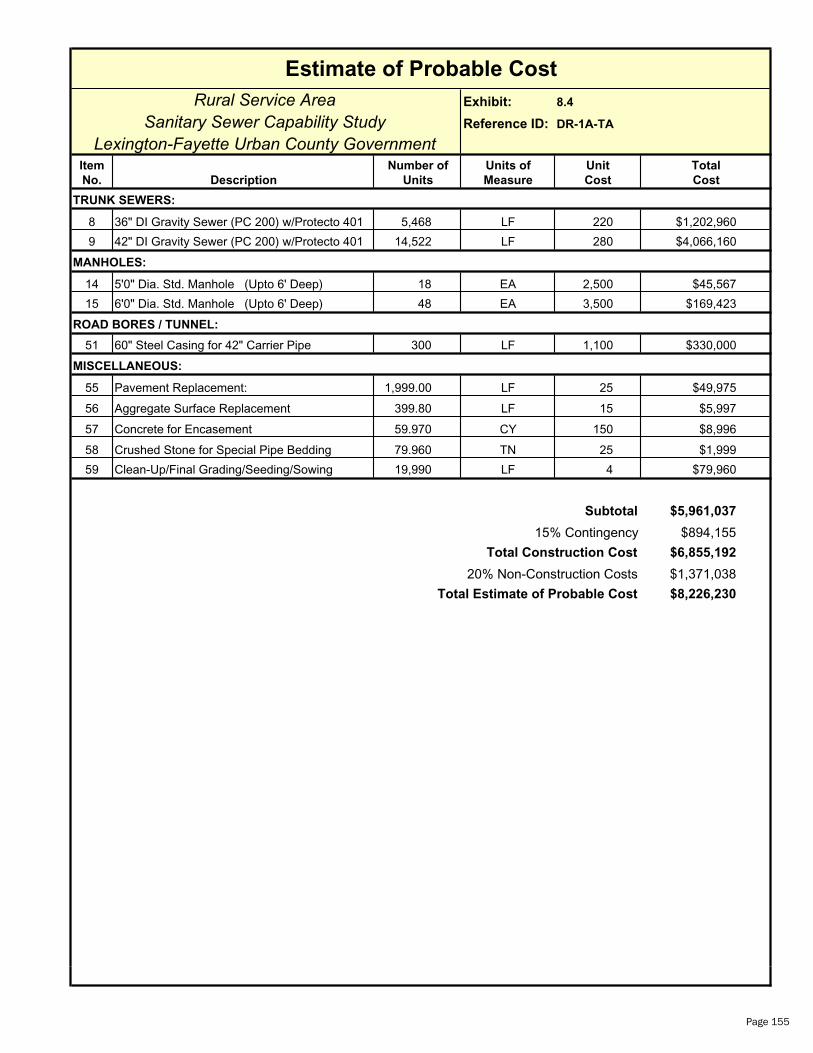
Rural Service Area Exhibit: 8.4
Sanitary Sewer Capability Study Reference ID: DR-1A-TA
Lexington-Fayette Urban County GovernmentItem Number of Units of Unit Total
No. Description Units Measure Cost Cost
8 36" DI Gravity Sewer (PC 200) w/Protecto 401 5,468 LF 220 $1,202,960
9 42" DI Gravity Sewer (PC 200) w/Protecto 401 14,522 LF 280 $4,066,160
14 5'0" Dia. Std. Manhole (Upto 6' Deep) 18 EA 2,500 $45,567
15 6'0" Dia. Std. Manhole (Upto 6' Deep) 48 EA 3,500 $169,423
ROAD BORES / TUNNEL:
51 60" Steel Casing for 42" Carrier Pipe 300 LF 1,100 $330,000
MISCELLANEOUS:
55 Pavement Replacement: 1,999.00 LF 25 $49,975
56 Aggregate Surface Replacement 399.80 LF 15 $5,997
57 Concrete for Encasement 59.970 CY 150 $8,996
58 Crushed Stone for Special Pipe Bedding 79.960 TN 25 $1,999
59 Clean-Up/Final Grading/Seeding/Sowing 19,990 LF 4 $79,960
$5,961,037
$894,155
$6,855,192
$1,371,038
$8,226,230
Estimate of Probable Cost
MANHOLES:
TRUNK SEWERS:
Total Estimate of Probable Cost
Subtotal
15% Contingency
Total Construction Cost
20% Non-Construction Costs
Page 155

Rural Service Area Exhibit: 8.4
Sanitary Sewer Capability Study Reference ID: DR-1B-TA
Lexington-Fayette Urban County GovernmentItem Number of Units of Unit Total
No. Description Units Measure Cost Cost
1 12" PVC Gravity Sewer (DR 35) 3,669 LF 60 $220,140
2 15" PVC Gravity Sewer (DR 35) 3,701 LF 70 $259,070
3 18" PVC Gravity Sewer (DR 35) 5,900 LF 75 $442,500
13 4'0" Dia. Std. Manhole (Upto 6' Deep) 44 EA 2,000 $88,467
ROAD BORES / TUNNEL:
45 30" Steel Casing for 18" Carrier Pipe 100 LF 430 $43,000
MISCELLANEOUS:
55 Pavement Replacement: 1,327.00 LF 25 $33,175
56 Aggregate Surface Replacement 265.40 LF 15 $3,981
57 Concrete for Encasement 39.810 CY 150 $5,972
58 Crushed Stone for Special Pipe Bedding 53.080 TN 25 $1,327
59 Clean-Up/Final Grading/Seeding/Sowing 13,270 LF 4 $53,080
$1,150,711
$172,607
$1,323,318
$264,664
$1,587,981Total Estimate of Probable Cost
Subtotal
15% Contingency
Total Construction Cost
20% Non-Construction Costs
Estimate of Probable Cost
TRUNK SEWERS:
MANHOLES:
Page 156
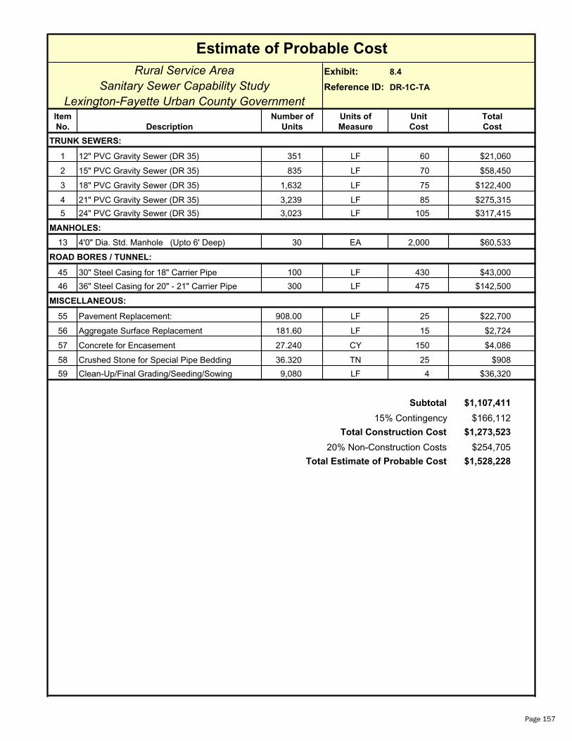
Rural Service Area Exhibit: 8.4
Sanitary Sewer Capability Study Reference ID: DR-1C-TA
Lexington-Fayette Urban County GovernmentItem Number of Units of Unit Total
No. Description Units Measure Cost Cost
1 12" PVC Gravity Sewer (DR 35) 351 LF 60 $21,060
2 15" PVC Gravity Sewer (DR 35) 835 LF 70 $58,450
3 18" PVC Gravity Sewer (DR 35) 1,632 LF 75 $122,400
4 21" PVC Gravity Sewer (DR 35) 3,239 LF 85 $275,315
5 24" PVC Gravity Sewer (DR 35) 3,023 LF 105 $317,415
13 4'0" Dia. Std. Manhole (Upto 6' Deep) 30 EA 2,000 $60,533
ROAD BORES / TUNNEL:
45 30" Steel Casing for 18" Carrier Pipe 100 LF 430 $43,000
46 36" Steel Casing for 20" - 21" Carrier Pipe 300 LF 475 $142,500
MISCELLANEOUS:
55 Pavement Replacement: 908.00 LF 25 $22,700
56 Aggregate Surface Replacement 181.60 LF 15 $2,724
57 Concrete for Encasement 27.240 CY 150 $4,086
58 Crushed Stone for Special Pipe Bedding 36.320 TN 25 $908
59 Clean-Up/Final Grading/Seeding/Sowing 9,080 LF 4 $36,320
$1,107,411
$166,112
$1,273,523
$254,705
$1,528,228Total Estimate of Probable Cost
Subtotal
15% Contingency
Total Construction Cost
20% Non-Construction Costs
Estimate of Probable Cost
TRUNK SEWERS:
MANHOLES:
Page 157
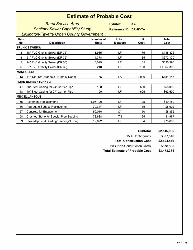
Rural Service Area Exhibit: 8.4
Sanitary Sewer Capability Study Reference ID: DR-1D-TA
Lexington-Fayette Urban County GovernmentItem Number of Units of Unit Total
No. Description Units Measure Cost Cost
3 18" PVC Gravity Sewer (DR 35) 1,985 LF 75 $148,875
4 21" PVC Gravity Sewer (DR 35) 4,378 LF 85 $372,130
5 24" PVC Gravity Sewer (DR 35) 5,099 LF 105 $535,395
6 27" PVC Gravity Sewer (DR 35) 8,210 LF 130 $1,067,300
13 4'0" Dia. Std. Manhole (Upto 6' Deep) 66 EA 2,000 $131,147
ROAD BORES / TUNNEL:
47 38" Steel Casing for 24" Carrier Pipe 100 LF 550 $55,000
48 40" Steel Casing for 27" Carrier Pipe 100 LF 625 $62,500
MISCELLANEOUS:
55 Pavement Replacement: 1,967.20 LF 25 $49,180
56 Aggregate Surface Replacement 393.44 LF 15 $5,902
57 Concrete for Encasement 59.016 CY 150 $8,852
58 Crushed Stone for Special Pipe Bedding 78.688 TN 25 $1,967
59 Clean-Up/Final Grading/Seeding/Sowing 19,672 LF 4 $78,688
$2,516,936
$377,540
$2,894,476
$578,895
$3,473,371Total Estimate of Probable Cost
Subtotal
15% Contingency
Total Construction Cost
20% Non-Construction Costs
Estimate of Probable Cost
TRUNK SEWERS:
MANHOLES:
Page 158

Rural Service Area Exhibit: 8.4
Sanitary Sewer Capability Study Reference ID: DR-1E-TA
Lexington-Fayette Urban County GovernmentItem Number of Units of Unit Total
No. Description Units Measure Cost Cost
1 12" PVC Gravity Sewer (DR 35) 604 LF 60 $36,240
2 15" PVC Gravity Sewer (DR 35) 2,578 LF 70 $180,460
13 4'0" Dia. Std. Manhole (Upto 6' Deep) 11 EA 2,000 $21,213
ROAD BORES / TUNNEL:
43 24" Steel Casing for 14" - 15" Carrier Pipe 100 LF 350 $35,000
MISCELLANEOUS:
55 Pavement Replacement: 318.20 LF 25 $7,955
56 Aggregate Surface Replacement 63.64 LF 15 $955
57 Concrete for Encasement 9.546 CY 150 $1,432
58 Crushed Stone for Special Pipe Bedding 12.728 TN 25 $318
59 Clean-Up/Final Grading/Seeding/Sowing 3,182 LF 4 $12,728
$296,301
$44,445
$340,746
$68,149
$408,895Total Estimate of Probable Cost
Subtotal
15% Contingency
Total Construction Cost
20% Non-Construction Costs
Estimate of Probable Cost
TRUNK SEWERS:
MANHOLES:
Page 159

Rural Service Area Exhibit: 8.5
Sanitary Sewer Capability Study Reference ID: DR-1A-FMA
Lexington-Fayette Urban County GovernmentItem Number of Units of Unit Total
No. Description Units Measure Cost Cost
34 30" DI Force Main (PC 200 w/ Protecto 401) 7,658 LF 139 $1,064,462
ROAD BORES / TUNNEL:
49 46" Steel Casing for 30" Carrier Pipe 300 LF 750 $225,000
MISCELLANEOUS:
55 Pavement Replacement: 765.80 LF 25 $19,145
56 Aggregate Surface Replacement 153.16 LF 15 $2,297
57 Concrete for Encasement 22.974 CY 150 $3,446
58 Crushed Stone for Special Pipe Bedding 30.632 TN 25 $766
59 Clean-Up/Final Grading/Seeding/Sowing 7,658 LF 4 $30,632
60 Sewage Air Release Valves 2 EA 2,500 $5,000
$1,350,748
$202,612
$1,553,361
$310,672
$1,864,033Total Estimate of Probable Cost
Subtotal
15% Contingency
Total Construction Cost
20% Non-Construction Costs
Estimate of Probable Cost
FORCE MAIN:
Page 160

Estimate of Probable Cost
Rural Service Area Exhibit: 8.4
Sanitary Sewer Capability Study Reference ID: DR-2B-TA
Lexington-Fayette Urban County GovernmentItem Number of Units of Unit Total
No. Description Units Measure Cost Cost
TRUNK SEWERS:
1 12" PVC Gravity Sewer (DR 35) 972 LF 60 $58,320
MANHOLES:
13 4'0" Dia. Std. Manhole (Upto 6' Deep) 3 EA 2,000 $6,480
MISCELLANEOUS:
55 Pavement Replacement: 97.20 LF 25 $2,430
56 Aggregate Surface Replacement 19.44 LF 15 $292
57 Concrete for Encasement 2.916 CY 150 $437
58 Crushed Stone for Special Pipe Bedding 3.888 TN 25 $97
59 Clean-Up/Final Grading/Seeding/Sowing 972 LF 4 $3,888
Subtotal $71,944
15% Contingency $10,792
Total Construction Cost $82,736
20% Non-Construction Costs $16,547
Total Estimate of Probable Cost $99,283
Page 161
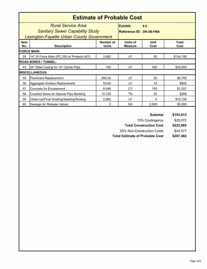
Estimate of Probable Cost
Rural Service Area Exhibit: 8.5
Sanitary Sewer Capability Study Reference ID: DR-2B-FMA
Lexington-Fayette Urban County GovernmentItem Number of Units of Unit Total
No. Description Units Measure Cost Cost
FORCE MAIN:
29 14" DI Force Main (PC 250 w/ Protecto 401) 2,682 LF 50 $134,100
ROAD BORES / TUNNEL:
43 24" Steel Casing for 14" Carrier Pipe 100 LF 350 $35,000
MISCELLANEOUS:
55 Pavement Replacement: 268.20 LF 25 $6,705
56 Aggregate Surface Replacement 53.64 LF 15 $805
57 Concrete for Encasement 8.046 CY 150 $1,207
58 Crushed Stone for Special Pipe Bedding 10.728 TN 25 $268
59 Clean-Up/Final Grading/Seeding/Sowing 2,682 LF 4 $10,728
60 Sewage Air Release Valves 2 EA 2,500 $5,000
Subtotal $193,813
15% Contingency $29,072
Total Construction Cost $222,885
20% Non-Construction Costs $44,577
Total Estimate of Probable Cost $267,462
Page 162

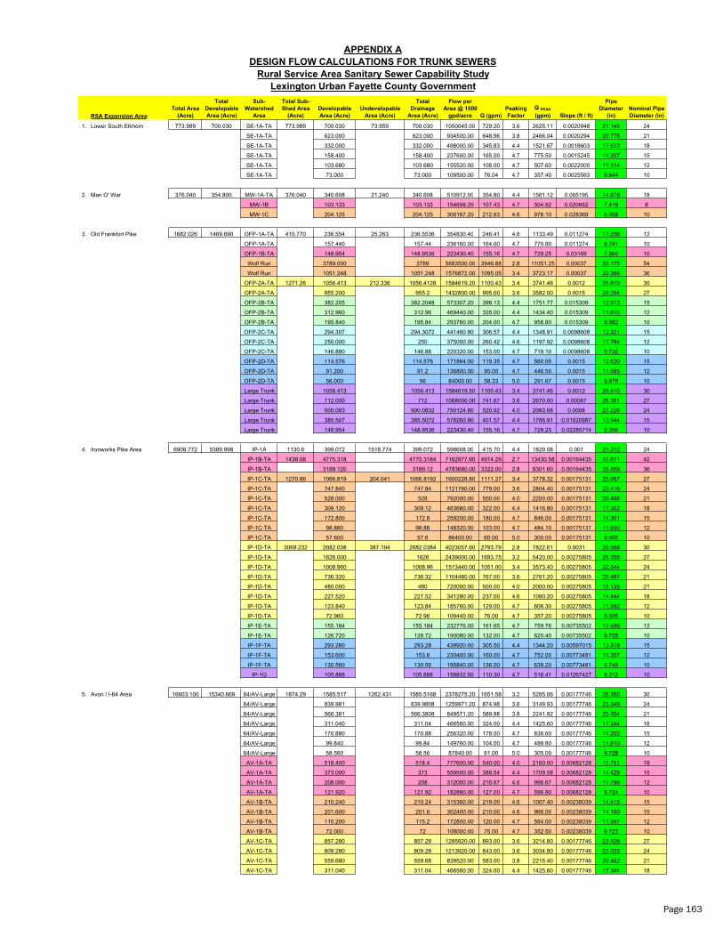
RSA Expansion Area
1. Lower South Elkhorn 773.989 700.030 SE-1A-TA 773.989 700.030 73.959 700.030 1050045.00 729.20 3.6 2625.11 0.0020948 21.145 24
SE-1A-TA 623.000 623.000 934500.00 648.96 3.8 2466.04 0.0020294 20.778 21
SE-1A-TA 332.000 332.000 498000.00 345.83 4.4 1521.67 0.0018603 17.623 18
SE-1A-TA 158.400 158.400 237600.00 165.00 4.7 775.50 0.0015245 14.207 15
SE-1A-TA 103.680 103.680 155520.00 108.00 4.7 507.60 0.0022000 11.314 12
SE-1A-TA 73.000 73.000 109500.00 76.04 4.7 357.40 0.0025563 9.644 10
2. Man O' War 376.040 354.800 MW-1A-TA 376.040 340.608 21.240 340.608 510912.00 354.80 4.4 1561.12 0.005195 14.676 18
MW-1B 103.133 103.133 154699.20 107.43 4.7 504.92 0.020662 7.419 8
MW-1C 204.125 204.125 306187.20 212.63 4.6 978.10 0.028369 8.958 10
3. Old Frankfort Pike 1682.026 1469.690 OFP-1A-TA 410.770 236.554 25.263 236.5536 354830.40 246.41 4.6 1133.49 0.011274 11.256 12
OFP-1A-TA 157.440 157.44 236160.00 164.00 4.7 770.80 0.011274 9.741 10
OFP-1B-TA 148.954 148.9536 223430.40 155.16 4.7 729.25 0.03169 7.860 10
Wolf Run 3789.000 3789 5683500.00 3946.88 2.8 11051.25 0.00037 50.175 54
Wolf Run 1051.248 1051.248 1576872.00 1095.05 3.4 3723.17 0.00037 33.366 36
OFP-2A-TA 1271.26 1056.413 212.336 1056.4128 1584619.20 1100.43 3.4 3741.46 0.0012 26.810 30
OFP-2A-TA 955.200 955.2 1432800.00 995.00 3.6 3582.00 0.0015 25.294 27
OFP-2B-TA 382.205 382.2048 573307.20 398.13 4.4 1751.77 0.015309 12.513 15
OFP-2B-TA 312.960 312.96 469440.00 326.00 4.4 1434.40 0.015309 11.610 12
OFP-2B-TA 195.840 195.84 293760.00 204.00 4.7 958.80 0.015309 9.982 10
OFP-2C-TA 294.307 294.3072 441460.80 306.57 4.4 1348.91 0.0098608 12.321 15
OFP-2C-TA 250.000 250 375000.00 260.42 4.6 1197.92 0.0098608 11.784 12
OFP-2C-TA 146.880 146.88 220320.00 153.00 4.7 719.10 0.0098608 9.732 10
OFP-2D-TA 114.576 114.576 171864.00 119.35 4.7 560.95 0.0015 12.620 15
OFP-2D-TA 91.200 91.2 136800.00 95.00 4.7 446.50 0.0015 11.585 12
OFP-2D-TA 56.000 56 84000.00 58.33 5.0 291.67 0.0015 9.876 10
Large Trunk 1056.413 1056.413 1584619.50 1100.43 3.4 3741.46 0.0012 26.810 30
Large Trunk 712.000 712 1068000.00 741.67 3.6 2670.00 0.00067 26.351 27
Large Trunk 500.083 500.0832 750124.80 520.92 4.0 2083.68 0.0008 23.226 24
Large Trunk 385.507 385.5072 578260.80 401.57 4.4 1766.91 0.01020987 13.544 15
Large Trunk 148.954 148.9536 223430.40 155.16 4.7 729.25 0.02285714 8.356 10
4. Ironworks Pike Area 6908.772 5389.998 IP-1A 1130.6 399.072 1518.774 399.072 598608.00 415.70 4.4 1829.08 0.001 21.212 24
IP-1B-TA 1438.08 4775.318 4775.3184 7162977.60 4974.29 2.7 13430.58 0.00164435 40.811 42
IP-1B-TA 3189.120 3189.12 4783680.00 3322.00 2.8 9301.60 0.00164435 35.559 36
IP-1C-TA 1270.86 1066.819 204.041 1066.8192 1600228.80 1111.27 3.4 3778.32 0.00175131 25.067 27
IP-1C-TA 747.840 747.84 1121760.00 779.00 3.6 2804.40 0.00175131 22.416 24
IP-1C-TA 528.000 528 792000.00 550.00 4.0 2200.00 0.00175131 20.466 21
IP-1C-TA 309.120 309.12 463680.00 322.00 4.4 1416.80 0.00175131 17.352 18
IP-1C-TA 172.800 172.8 259200.00 180.00 4.7 846.00 0.00175131 14.301 15
IP-1C-TA 98.880 98.88 148320.00 103.00 4.7 484.10 0.00175131 11.600 12
IP-1C-TA 57.600 57.6 86400.00 60.00 5.0 300.00 0.00175131 9.695 10
IP-1D-TA 3069.232 2682.038 387.194 2682.0384 4023057.60 2793.79 2.8 7822.61 0.0031 29.588 30
IP-1D-TA 1626.000 1626 2439000.00 1693.75 3.2 5420.00 0.00275805 26.356 27
IP-1D-TA 1008.960 1008.96 1513440.00 1051.00 3.4 3573.40 0.00275805 22.544 24
IP-1D-TA 736.320 736.32 1104480.00 767.00 3.6 2761.20 0.00275805 20.467 21
IP-1D-TA 480.000 480 720000.00 500.00 4.0 2000.00 0.00275805 18.135 21
IP-1D-TA 227.520 227.52 341280.00 237.00 4.6 1090.20 0.00275805 14.444 18
IP-1D-TA 123.840 123.84 185760.00 129.00 4.7 606.30 0.00275805 11.592 12
IP-1D-TA 72.960 72.96 109440.00 76.00 4.7 357.20 0.00275805 9.505 10
IP-1E-TA 155.184 155.184 232776.00 161.65 4.7 759.76 0.00735502 10.496 12
IP-1E-TA 126.720 126.72 190080.00 132.00 4.7 620.40 0.00735502 9.728 10
IP-1F-TA 293.280 293.28 439920.00 305.50 4.4 1344.20 0.00597015 13.518 15
IP-1F-TA 153.600 153.6 230400.00 160.00 4.7 752.00 0.00773481 10.357 12
IP-1F-TA 130.560 130.56 195840.00 136.00 4.7 639.20 0.00773481 9.745 10
IP-1G 105.888 105.888 158832.00 110.30 4.7 518.41 0.01267427 8.212 10
5. Avon / I-64 Area 16603.100 15340.669 64/AV-Large 1874.29 1585.517 1262.431 1585.5168 2378275.20 1651.58 3.2 5285.06 0.00177746 28.350 30
64/AV-Large 839.981 839.9808 1259971.20 874.98 3.6 3149.93 0.00177746 23.349 24
64/AV-Large 566.381 566.3808 849571.20 589.98 3.8 2241.92 0.00177746 20.554 21
64/AV-Large 311.040 311.04 466560.00 324.00 4.4 1425.60 0.00177746 17.344 18
64/AV-Large 170.880 170.88 256320.00 178.00 4.7 836.60 0.00177746 14.202 15
64/AV-Large 99.840 99.84 149760.00 104.00 4.7 488.80 0.00177746 11.610 12
64/AV-Large 58.560 58.56 87840.00 61.00 5.0 305.00 0.00177746 9.728 10
AV-1A-TA 518.400 518.4 777600.00 540.00 4.0 2160.00 0.00682128 15.751 18
AV-1A-TA 373.000 373 559500.00 388.54 4.4 1709.58 0.00682128 14.429 15
AV-1A-TA 208.000 208 312000.00 216.67 4.6 996.67 0.00682128 11.786 12
AV-1A-TA 121.920 121.92 182880.00 127.00 4.7 596.90 0.00682128 9.724 10
AV-1B-TA 210.240 210.24 315360.00 219.00 4.6 1007.40 0.00238039 14.415 15
AV-1B-TA 201.600 201.6 302400.00 210.00 4.6 966.00 0.00238039 14.190 15
AV-1B-TA 115.200 115.2 172800.00 120.00 4.7 564.00 0.00238039 11.597 12
AV-1B-TA 72.000 72 108000.00 75.00 4.7 352.50 0.00238039 9.723 10
AV-1C-TA 857.280 857.28 1285920.00 893.00 3.6 3214.80 0.00177746 23.528 27
AV-1C-TA 809.280 809.28 1213920.00 843.00 3.6 3034.80 0.00177746 23.025 24
AV-1C-TA 559.680 559.68 839520.00 583.00 3.8 2215.40 0.00177746 20.462 21
AV-1C-TA 311.040 311.04 466560.00 324.00 4.4 1425.60 0.00177746 17.344 18
APPENDIX A
Nominal Pipe
Diameter (in)
Pipe
Diameter
(in)
Undevelopable
Area (Acre)
Q PEAK
(gpm)
Total
Drainage
Area (Acre) Slope (ft / ft)
Peaking
Factor
Sub-
Watershed
Area
Total Sub-
Shed Area
(Acre) Q (gpm)
Developable
Area (Acre)
DESIGN FLOW CALCULATIONS FOR TRUNK SEWERS
Rural Service Area Sanitary Sewer Capability Study
Lexington Urban Fayette County Government
Total
Developable
Area (Acre)
Flow per
Area @ 1500
gpd/acre
Total Area
(Acre)
Page 163
RSA Expansion Area
5. Avon / I-64 Area AV-1C-TA 170.880 170.88 256320.00 178.00 4.7 836.60 0.00177746 14.202 15
AV-1C-TA 99.840 99.84 149760.00 104.00 4.7 488.80 0.00177746 11.610 12
AV-1C-TA 58.560 58.56 87840.00 61.00 5.0 305.00 0.00177746 9.728 10
AV-1F-TA 1891.73 1739.184 152.546 1739.184 2608776.00 1811.65 3.2 5797.28 0.00324254 26.222 27
AV-1F-TA 1692.480 1692.48 2538720.00 1763.00 3.2 5641.60 0.00324254 25.956 27
AV-1F-TA 1157.760 1157.76 1736640.00 1206.00 3.4 4100.40 0.00324254 23.028 24
AV-1F-TA 798.720 798.72 1198080.00 832.00 3.6 2995.20 0.00324254 20.470 21
AV-1F-TA 264.000 264 396000.00 275.00 4.6 1265.00 0.01436782 11.208 12
AV-1F-TA 181.440 181.44 272160.00 189.00 4.7 888.30 0.01436782 9.816 10
64/AV-2(a) 48.000 48 72000.00 50.00 5.0 250.00 0.01598082 5.981 10
AV-1G-TA 285.120 285.12 427680.00 297.00 4.4 1306.80 0.00774293 12.740 15
AV-1G-TA 212.160 212.16 318240.00 221.00 4.6 1016.60 0.00774293 11.595 12
AV-1G-TA 130.560 130.56 195840.00 136.00 4.7 639.20 0.00774293 9.743 10
AV-1D-TA 2644.87 3989.002 3989.0016 5983502.40 4155.21 2.8 11634.59 0.0014314 39.691 42
AV-1D-TA 1611.840 1611.84 2417760.00 1679.00 3.2 5372.80 0.0014314 29.707 30
AV-1D-TA 1527.360 1527.36 2291040.00 1591.00 3.2 5091.20 0.00563768 22.515 24
AV-1D-TA 1115.520 1115.52 1673280.00 1162.00 3.4 3950.80 0.00563768 20.472 21
AV-1D-TA 678.720 678.72 1018080.00 707.00 3.6 2545.20 0.00563768 17.360 18
AV-1D-TA 339.000 339 508500.00 353.13 4.4 1553.75 0.00563768 14.427 15
AV-1D-TA 177.600 177.6 266400.00 185.00 4.7 869.50 0.00563768 11.605 12
AV-1D-TA 111.360 111.36 167040.00 116.00 4.7 545.20 0.00563768 9.741 10
64/AV-3(a) 160.320 160.32 240480.00 167.00 4.7 784.90 0.0152264 9.270 10
AV-1E-TA 194.880 194.88 292320.00 203.00 4.7 954.10 0.0147492 10.033 12
AV-1E-TA 180.480 180.48 270720.00 188.00 4.7 883.60 0.0147492 9.749 10
64/AV-3(c ) 143.040 143.04 214560.00 149.00 4.7 700.30 0.0124275 9.226 10
64/AV-3(d) 203.520 203.52 305280.00 212.00 4.6 975.20 0.0194877 9.601 10
AV-2A-TA 710.18 598.618 111.562 598.6176 897926.40 623.56 3.8 2369.53 0.00605694 16.675 18
AV-2A-TA 351.000 351 526500.00 365.63 4.4 1608.75 0.00603865 14.430 15
AV-2A-TA 191.000 191 286500.00 198.96 4.7 935.10 0.00603865 11.773 12
AV-2A-TA 139.200 139.2 208800.00 145.00 4.7 681.50 0.00883861 9.735 10
AV-3B-TA 986.7 945.926 40.774 945.9264 1418889.60 985.34 3.6 3547.22 0.00765404 18.566 21
AV-3B-TA 538.886 538.8864 808329.60 561.34 3.8 2133.09 0.00765404 15.342 18
AV-3B-TA 416.640 416.64 624960.00 434.00 4.0 1736.00 0.00765404 14.202 15
AV-3B-TA 211.200 211.2 316800.00 220.00 4.6 1012.00 0.00765404 11.600 12
AV-3B-TA 129.600 129.6 194400.00 135.00 4.7 634.50 0.00765404 9.737 10
AV-3A-TA 271.680 271.68 407520.00 283.00 4.4 1245.20 0.01182732 11.556 12
AV-3A-TA 161.280 161.28 241920.00 168.00 4.7 789.60 0.01182732 9.741 10
AV-3C-TA 3719.37 3370.867 348.503 3370.8672 5056300.80 3511.32 2.8 9831.70 0.00208921 34.712 36
AV-3C-TA 2860.147 2860.1472 4290220.80 2979.32 2.8 8342.10 0.00393082 28.991 30
AV-3C-TA 2111.040 2111.04 3166560.00 2199.00 3.0 6597.00 0.00443319 25.956 27
AV-3C-TA 1015.680 1015.68 1523520.00 1058.00 3.4 3597.20 0.00443319 20.676 21
AV-3C-TA 570.240 570.24 855360.00 594.00 3.8 2257.20 0.00443319 17.361 18
AV-3C-TA 288.000 288 432000.00 300.00 4.4 1320.00 0.00443319 14.197 15
AV-3C-TA 157.440 157.44 236160.00 164.00 4.7 770.80 0.00443319 11.603 12
AV-3C-TA 98.880 98.88 148320.00 103.00 4.7 484.10 0.00443319 9.746 10
Large 8541.120 8541.12 12811680.00 8897.00 2.5 22242.50 0.00199561 47.553 48
AV-3D-TA 595.200 595.2 892800.00 620.00 3.8 2356.00 0.01427552 14.169 15
AV-3D-TA 218.880 218.88 328320.00 228.00 4.6 1048.80 0.01135718 10.918 12
AV-3D-TA 158.400 158.4 237600.00 165.00 4.7 775.50 0.01135718 9.749 10
AV-3E-TA 376.320 376.32 564480.00 392.00 4.4 1724.80 0.009375 13.639 15
AV-3E-TA 234.240 234.24 351360.00 244.00 4.6 1122.40 0.009375 11.609 12
AV-3E-TA 143.040 143.04 214560.00 149.00 4.7 700.30 0.009375 9.727 10
AV-3G-TA 1955.26 4415.000 4415 6622500.00 4598.96 2.7 12417.19 0.00380373 33.862 36
AV-3G-TA 2467.200 2467.2 3700800.00 2570.00 3.0 7710.00 0.00380373 28.321 30
AV-3G-TA 1720.320 1720.32 2580480.00 1792.00 3.2 5734.40 0.00380373 25.345 27
AV-3F-TA 606.720 606.72 910080.00 632.00 3.8 2401.60 0.00748192 16.109 18
AV-3F-TA 411.840 411.84 617760.00 429.00 4.0 1716.00 0.00748192 14.201 15
AV-3F-TA 217.920 217.92 326880.00 227.00 4.6 1044.20 0.00748192 11.787 12
AV-3F-TA 127.680 127.68 191520.00 133.00 4.7 625.10 0.00748192 9.724 10
AV-3H-TA 636.480 636.48 954720.00 663.00 3.8 2519.40 0.00661266 16.785 18
AV-3H-TA 367.000 367 550500.00 382.29 4.4 1682.08 0.00661266 14.425 15
AV-3H-TA 196.800 196.8 295200.00 205.00 4.7 963.50 0.00661266 11.705 12
AV-3H-TA 120.000 120 180000.00 125.00 4.7 587.50 0.00661266 9.723 10
AV-3I-TA 2820.7 2482.906 337.794 2482.9056 3724358.40 2586.36 3.0 7759.08 0.00303605 29.614 30
AV-3I-TA 1618.560 1618.56 2427840.00 1686.00 3.2 5395.20 0.00303605 25.841 27
AV-3I-TA 1072.320 1072.32 1608480.00 1117.00 3.4 3797.80 0.00303605 22.654 24
AV-3I-TA 670.080 670.08 1005120.00 698.00 3.6 2512.80 0.00303605 19.403 21
AV-3J-TA 447.360 447.36 671040.00 466.00 4.0 1864.00 0.0068899 14.876 18
AV-3J-TA 354.240 354.24 531360.00 369.00 4.4 1623.60 0.0068899 14.126 15
AV-3J-TA 151.680 151.68 227520.00 158.00 4.7 742.60 0.0068899 10.534 12
AV-3J-TA 122.880 122.88 184320.00 128.00 4.7 601.60 0.0068899 9.735 10
AV-3K-TA 292.800 292.8 439200.00 305.00 4.4 1342.00 0.0104297 12.168 15
AV-3K-TA 202.560 202.56 303840.00 211.00 4.6 970.60 0.0104297 10.776 12
AV-3K-TA 151.680 151.68 227520.00 158.00 4.7 742.60 0.0104297 9.747 10
64/AV-8(b1) 201.600 201.6 302400.00 210.00 4.6 966.00 0.01089621 10.669 12
64/AV-8(b1) 158.400 158.4 237600.00 165.00 4.7 775.50 0.01089621 9.825 10
AV-3L-TA 278.500 278.5 417750.00 290.10 4.4 1276.46 0.0111982 11.784 12
AV-3L-TA 163.000 163 244500.00 169.79 4.7 798.02 0.0111982 9.881 10
AV-3M-TA 398.400 398.4 597600.00 415.00 4.4 1826.00 0.0101688 13.723 15
AV-3M-TA 243.840 243.84 365760.00 254.00 4.6 1168.40 0.0101688 11.607 12
AV-3M-TA 149.760 149.76 224640.00 156.00 4.7 733.20 0.0101688 9.746 10
AV-3I-TA 269.760 269.76 404640.00 281.00 4.4 1236.40 0.00988468 11.919 15
Q (gpm) Slope (ft / ft)
Flow per
Area @ 1500
gpd/acre
Peaking
Factor
Q PEAK
(gpm)
Nominal Pipe
Diameter (in)
Pipe
Diameter
(in)
Sub-
Watershed
Area
Total Sub-
Shed Area
(Acre)
Developable
Area (Acre)
Undevelopable
Area (Acre)
Total
Drainage
Area (Acre)
Total Area
(Acre)
Total
Developable
Area (Acre)
Page 164
RSA Expansion Area
5. Avon / I-64 Area AV-3I-TA 240.000 240 360000.00 250.00 4.6 1150.00 0.00988468 11.600 12
AV-3I-TA 146.880 146.88 220320.00 153.00 4.7 719.10 0.00988468 9.727 10
6. 5588.220 5269.842 DR-1A-TA 1730.04 1568.640 318.378 1568.64 2352960.00 1634.00 3.2 5228.80 0.00156174 28.930 30
DR-1A-TA 1228.800 1228.8 1843200.00 1280.00 3.4 4352.00 0.00192926 25.956 27
DR-1A-TA 536.000 536 804000.00 558.33 3.8 2121.67 0.0008 23.384 24
DR-1B-TA 864.000 864 1296000.00 900.00 3.6 3240.00 0.0094088 17.265 18
DR-1B-TA 462.720 462.72 694080.00 482.00 4.0 1928.00 0.0094088 14.211 15
DR-1B-TA 244.000 244 366000.00 254.17 4.6 1169.17 0.0094088 11.780 12
DR-1B-TA 96.000 150 225000.00 156.25 4.7 734.38 0.0094088 9.895 10
Large Trunk 4493.760 4493.76 6740640.00 4681.00 2.7 12638.70 0.00177089 39.341 42
Large Trunk 3310.080 3310.08 4965120.00 3448.00 2.8 9654.40 0.00177089 35.562 36
DR-1C-TA 894.56 746.880 746.88 1120320.00 778.00 3.6 2800.80 0.0018616 22.150 24
DR-1C-TA 604.800 604.8 907200.00 630.00 3.8 2394.00 0.0018616 20.884 24
DR-1C-TA 318.720 318.72 478080.00 332.00 4.4 1460.80 0.0018616 17.353 18
DR-1C-TA 178.560 178.56 267840.00 186.00 4.7 874.20 0.0018616 14.313 15
DR-1C-TA 96.000 96 144000.00 100.00 4.7 470.00 0.0018616 11.342 12
DR-1C-TA 59.520 59.52 89280.00 62.00 5.0 310.00 0.0018616 9.703 10
DR-1D-TA 2345.41 2177.904 2177.904 3266856.00 2268.65 3.0 6805.95 0.0045584 26.125 27
DR-1D-TA 1459.200 1459.2 2188800.00 1520.00 3.2 4864.00 0.0045584 23.032 24
DR-1D-TA 1003.200 1003.2 1504800.00 1045.00 3.4 3553.00 0.0045584 20.473 21
DR-1D-TA 577.920 577.92 866880.00 602.00 3.8 2287.60 0.0045584 17.357 18
DR-1E-TA 289.920 289.92 434880.00 302.00 4.4 1328.80 0.0110742 11.988 15
DR-1E-TA 192.000 265 397500.00 276.04 4.6 1269.79 0.0110742 11.785 12
DR-1E-TA 155.520 155.52 233280.00 162.00 4.7 761.40 0.0110742 9.728 10
DR-2C 200.640 200.64 300960.00 209.00 4.6 961.40 0.01707412 9.790 10
DR-2B-TA 241.000 241 361500.00 251.04 4.6 1154.79 0.01707412 10.486 12
DR-2B-TA 206.000 206 309000.00 214.58 4.6 987.08 0.01707412 9.887 10
DR-2A-TA 150.720 150.72 226080.00 157.00 4.7 737.90 0.01707412 8.865 10
Constants:
Usage = 100 gpcd
Population = 15 people/acre
n = 0.013 Manning's EQ.
d/D = 0.67
A/D2 = 0.5594
R/D = 0.2917
Flow per
Area @ 1500
gpd/acre
Pipe
Diameter
(in)
Nominal Pipe
Diameter (in)Q (gpm)
Peaking
Factor
Q PEAK
(gpm) Slope (ft / ft)
Developable
Area (Acre)
Undevelopable
Area (Acre)
Total
Drainage
Area (Acre)
Total Area
(Acre)
Total
Developable
Area (Acre)
Sub-
Watershed
Area
Total Sub-
Shed Area
(Acre)
Delong Road / Richmond Road Area
Page 165


Appendix B
Table 4-2
Peaking Factors
Ratio of Peak
Average Daily Flow Rate Average Daily Flow Rate Tributary Instantaneous Flow
(GPD) (GPM) Population Rate to Average
Daily Flow Rate
<100,000 <69 <1,000 5.0100,000-300,000 69-208 1,001-3,000 4.7300,000-400,000 208-278 3,001-4,000 4.6400,000-600,000 278-417 4,001-6,000 4.4600,000-800,000 417-556 6,001-8,000 4.0
800,000-1,000,000 556-694 8,001-10,000 3.81,000,000-1,500,000 694-1,042 10,001-15,000 3.61,500,000-2,000,000 1,042-1,389 15,001-20,000 3.42,000,000-3,000,000 1,389-2,083 20,001-30,000 3.23,000,000-4,000,000 2,083-2,778 30,001-40,000 3.04,000,000-6,000,000 2,778-4,167 40,001-60,000 2.86,000,000-8,000,000 4,167-5,556 60,001-80,000 2.7
8,000,000-10,000,000 5,556-6,944 80,001-100,000 2.6>10,000,000 >6,944 >100,000 2.5
Page 166

Estimate of Probable Cost
Rural Service Area Exhibit: Appendix C
Sanitary Sewer Capability Study Reference ID: Unit Cost
Lexington-Fayette Urban County GovernmentItem Units of
Unit CostNo. Description Measure
TRUNK SEWERS:
1 12" PVC Gravity Sewer (DR 35) LF 60
2 15" PVC Gravity Sewer (DR 35) LF 70
3 18" PVC Gravity Sewer (DR 35) LF 75
4 21" PVC Gravity Sewer (DR 35) LF 85
5 24" PVC Gravity Sewer (DR 35) LF 105
6 27" PVC Gravity Sewer (DR 35) LF 130
7 30" DI Gravity Sewer (PC 200) w/Protecto 401 LF 155
8 36" DI Gravity Sewer (PC 200) w/Protecto 401 LF 220
9 42" DI Gravity Sewer (PC 200) w/Protecto 401 LF 280
10 48" DI Gravity Sewer (PC 200) w/Protecto 401 LF 380
11 54" DI Gravity Sewer (PC 200) w/Protecto 401 LF 475
12 60" DI Gravity Sewer (PC 200) w/Protecto 401 LF 565
MANHOLES:
13 4'0" Dia. Std. Manhole (Upto 6' Deep) EA 2,000
14 5'0" Dia. Std. Manhole (Upto 6' Deep) EA 2,500
15 6'0" Dia. Std. Manhole (Upto 6' Deep) EA 3,500
16 7'0" Dia. Std. Manhole (Upto 6' Deep) EA 5,000
17 8'0" Dia. Std. Manhole (Upto 6' Deep) EA 7,500
18 4'0" Dia. Manhole Barrel Extension VLF 125
19 5'0" Dia. Manhole Barrel Extension VLF 180
20 6'0" Dia. Manhole Barrel Extension VLF 300
21 7'0" Dia. Manhole Barrel Extension VLF 450
22 8'0" Dia. Manhole Barrel Extension VLF 650
23 Waterproof Manhole Covers EA 250
24 New Manhole - Set On Existing Sewer EA 5,000
FORCE MAIN:
25 6" DI Force Main (PC 350 w/ Protecto 401) LF 25
26 8" DI Force Main (PC 350 w/ Protecto 401) LF 30
27 10" DI Force Main (PC 350 w/ Protecto 401) LF 35
28 12" DI Force Main (PC 350 w/ Protecto 401) LF 42
29 14" DI Force Main (PC 250 w/ Protecto 401) LF 50
30 16" DI Force Main (PC 250 w/ Protecto 401) LF 59
31 18" DI Force Main (PC 250 w/ Protecto 401) LF 66
32 20" DI Force Main (PC 250 w/ Protecto 401) LF 75
33 24" DI Force Main (PC 200 w/ Protecto 401) LF 102
34 30" DI Force Main (PC 200 w/ Protecto 401) LF 139
35 36" DI Force Main (PC 200 w/ Protecto 401) LF 182
Page 167
36 42" DI Force Main (PC 200 w/ Protecto 401) LF 242
37 48" DI Force Main (PC 200 w/ Protecto 401) LF 310
38 54" DI Force Main (PC 200 w/ Protecto 401) LF 380
39 60" DI Force Main (PC 200 w/ Protecto 401) LF 450
ROAD BORES / TUNNEL:
40 14" Steel Casing for 8" Carrier Pipe LF 230
41 16" Steel Casing for 10" Carrier Pipe LF 260
42 18" Steel Casing for 12" Carrier Pipe LF 320
43 24" Steel Casing for 14" - 15" Carrier Pipe LF 350
44 28" Steel Casing for 16" Carrier Pipe LF 390
45 30" Steel Casing for 18" Carrier Pipe LF 430
46 36" Steel Casing for 20" - 21" Carrier Pipe LF 475
47 38" Steel Casing for 24" Carrier Pipe LF 550
48 40" Steel Casing for 27" Carrier Pipe LF 625
49 46" Steel Casing for 30" Carrier Pipe LF 750
50 50" Steel Casing for 36" Carrier Pipe LF 925
51 60" Steel Casing for 42" Carrier Pipe LF 1,100
52 66" Steel Casing for 48" Carrier Pipe LF 1,300
53 72" Steel Casing for 54" Carrier Pipe LF 1,500
54 78" Steel Casing for 60" Carrier Pipe LF 1,800
MISCELLANEOUS:
55 Pavement Replacement: LF 25
56 Aggregate Surface Replacement LF 15
57 Concrete for Encasement CY 150
58 Crushed Stone for Special Pipe Bedding TN 25
59 Clean-Up/Final Grading/Seeding/Sowing LF 4
60 Sewage Air Release Valves EA 2,500
PUMP STATIONS:
61 Pump Station EA
Subtotal $0
15% Contingency $0
Total Construction Cost $0
20% Non-Construction Costs $0
Total Estimate of Probable Cost $0
Page 168

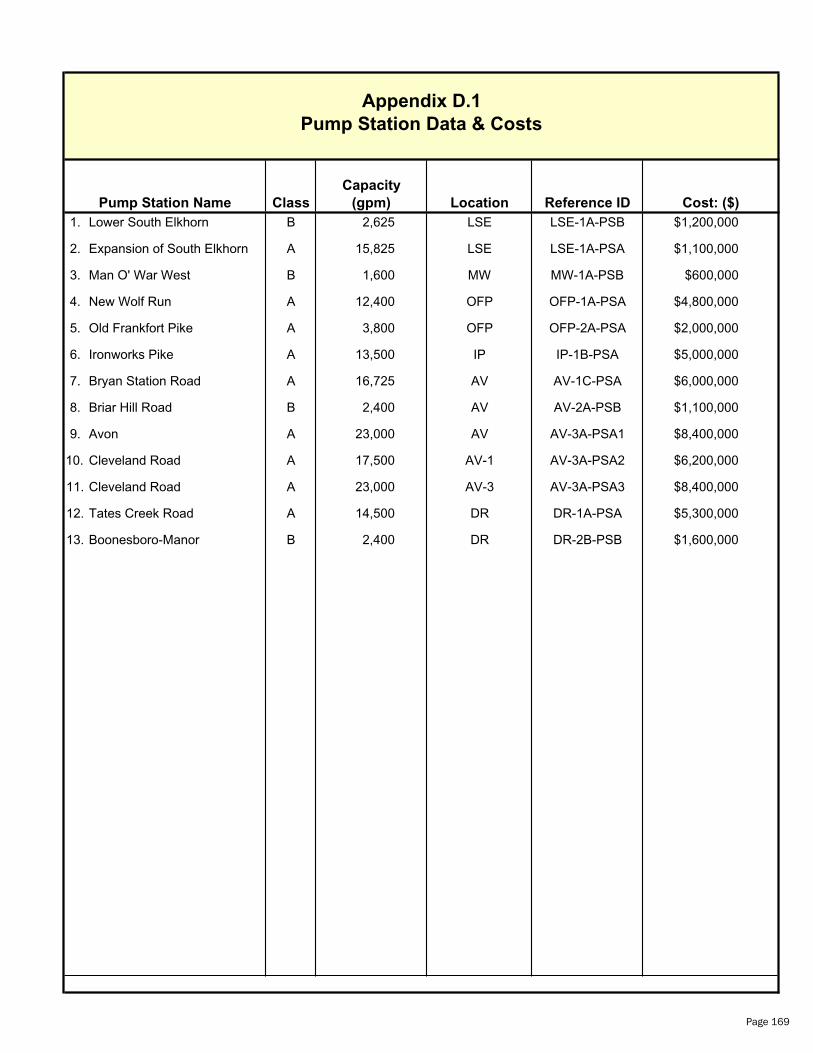
Capacity
Pump Station Name Class (gpm) Location Reference ID
1. Lower South Elkhorn B 2,625 LSE LSE-1A-PSB $1,200,000
2. Expansion of South Elkhorn A 15,825 LSE LSE-1A-PSA $1,100,000
3. Man O' War West B 1,600 MW MW-1A-PSB $600,000
4. New Wolf Run A 12,400 OFP OFP-1A-PSA $4,800,000
5. Old Frankfort Pike A 3,800 OFP OFP-2A-PSA $2,000,000
6. Ironworks Pike A 13,500 IP IP-1B-PSA $5,000,000
7. Bryan Station Road A 16,725 AV AV-1C-PSA $6,000,000
8. Briar Hill Road B 2,400 AV AV-2A-PSB $1,100,000
9. Avon A 23,000 AV AV-3A-PSA1 $8,400,000
10. Cleveland Road A 17,500 AV-1 AV-3A-PSA2 $6,200,000
11. Cleveland Road A 23,000 AV-3 AV-3A-PSA3 $8,400,000
12. Tates Creek Road A 14,500 DR DR-1A-PSA $5,300,000
13. Boonesboro-Manor B 2,400 DR DR-2B-PSB $1,600,000
Appendix D.1
Pump Station Data & Costs
Cost: ($)
Page 169
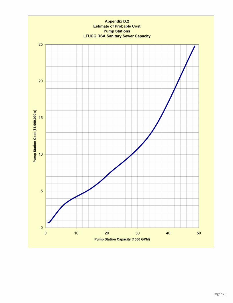
Appendix D.2
Estimate of Probable Cost
Pump Stations
LFUCG RSA Sanitary Sewer Capacity
0
5
10
15
20
25
0 10 20 30 40 50
Pump Station Capacity (1000 GPM)
Pu
mp
Sta
tio
n C
os
t ($
1,0
00
,00
0's
)
Page 170


