Embed Size (px)
Citation preview
INACTIVE AND ABANDONEDMINE LANDS—
Ruby Hill Mining District,Okanogan County,
Washington
by Fritz E. Wolff,Donald T. McKay,
and David K. Norman
WASHINGTON
DIVISION OF GEOLOGY
AND EARTH RESOURCES
Information Circular 112August 2011
NA
TU
RA
LR
ES
OU
RC
ES
OkanoganCounty
sitelocation

INACTIVE AND ABANDONEDMINE LANDS—
Ruby Hill Mining District,Okanogan County,
Washington
by Fritz E. Wolff,Donald T. McKay,
and David K. Norman
WASHINGTON
DIVISION OF GEOLOGY
AND EARTH RESOURCES
Information Circular 112August 2011

DISCLAIMER
Neither the State of Washington, nor any agency thereof, nor any of theiremployees, makes any warranty, express or implied, or assumes any legalliability or responsibility for the accuracy, completeness, or usefulness of anyinformation, apparatus, product, or process disclosed, or represents that itsuse would not infringe privately owned rights. Reference herein to anyspecific commercial product, process, or service by trade name, trademark,manufacturer, or otherwise, does not necessarily constitute or imply itsendorsement, recommendation, or favoring by the State of Washington or anyagency thereof. The views and opinions of authors expressed herein do notnecessarily state or reflect those of the State of Washington or any agencythereof.
WASHINGTON STATE DEPARTMENTOF NATURAL RESOURCES
Peter Goldmark—Commissioner of Public Lands
DIVISION OF GEOLOGY AND EARTH RESOURCES
David K. Norman—State GeologistJohn P. Bromley—Assistant State Geologist
Washington State Department of Natural ResourcesDivision of Geology and Earth Resources
Mailing Address: Street Address:MS 47007 1111 Washington St SEOlympia, WA 98504-7007 Natural Resources Bldg, Rm 148
Olympia, WA 98501Phone: 360-902-1450Fax: 360-902-1785E-mail: [email protected]: http://www.dnr.wa.gov/ResearchScience/GeologyEarthSciences/
This and other DGER publications are available online at:http://www.dnr.wa.gov/ResearchScience/Topics/GeologyPublicationsLibrary/Pages/pubs.aspx
The catalog and bibliography of the Washington Geology Library is at:http://www.dnr.wa.gov/ResearchScience/Topics/GeologyPublicationsLibrary/Pages/washbib.aspx
Suggested citation: Wolff, F. E.; McKay, D. T.; Norman, D. K., 2011, Inactiveand abandoned mine lands—Ruby Hill mining district, Okanogan County,Washington: Division of Geology and Earth Resources Information Circular112, 35 p.
Published in the United States of America© 2011 Washington Division of Geology and Earth Resources
ii

Contents
Introduction . . . . . . . . . . . . . . . . . . . . . . . . . . . . . . . . . . . . . . . . . . . . . 1
Summary . . . . . . . . . . . . . . . . . . . . . . . . . . . . . . . . . . . . . . . . . . . . . . 1
Access. . . . . . . . . . . . . . . . . . . . . . . . . . . . . . . . . . . . . . . . . . . . . . . . 2
Ownership . . . . . . . . . . . . . . . . . . . . . . . . . . . . . . . . . . . . . . . . . . . . . 2
District history . . . . . . . . . . . . . . . . . . . . . . . . . . . . . . . . . . . . . . . . . . . 2
Geologic setting . . . . . . . . . . . . . . . . . . . . . . . . . . . . . . . . . . . . . . . . . . 3
Principal mines . . . . . . . . . . . . . . . . . . . . . . . . . . . . . . . . . . . . . . . . . . . 4
First Thought mine. . . . . . . . . . . . . . . . . . . . . . . . . . . . . . . . . . . . . . . . 4
Last Chance mine . . . . . . . . . . . . . . . . . . . . . . . . . . . . . . . . . . . . . . . . 5
Sonny Boy mine . . . . . . . . . . . . . . . . . . . . . . . . . . . . . . . . . . . . . . . . . 6
Arlington mine . . . . . . . . . . . . . . . . . . . . . . . . . . . . . . . . . . . . . . . . . . 7
Fourth of July mine . . . . . . . . . . . . . . . . . . . . . . . . . . . . . . . . . . . . . . . 9
Openings . . . . . . . . . . . . . . . . . . . . . . . . . . . . . . . . . . . . . . . . . . . . . 10
Materials and structures . . . . . . . . . . . . . . . . . . . . . . . . . . . . . . . . . . . . . . 10
Water . . . . . . . . . . . . . . . . . . . . . . . . . . . . . . . . . . . . . . . . . . . . . . . 10
Milling operations . . . . . . . . . . . . . . . . . . . . . . . . . . . . . . . . . . . . . . . . . 11
Tailings and waste rock dumps . . . . . . . . . . . . . . . . . . . . . . . . . . . . . . . . . . 11
General information . . . . . . . . . . . . . . . . . . . . . . . . . . . . . . . . . . . . . . . . 11
Mine operations data . . . . . . . . . . . . . . . . . . . . . . . . . . . . . . . . . . . . . . . 11
Physical attributes . . . . . . . . . . . . . . . . . . . . . . . . . . . . . . . . . . . . . . . . . 12
Vegetation . . . . . . . . . . . . . . . . . . . . . . . . . . . . . . . . . . . . . . . . . . . . . 13
Wildlife . . . . . . . . . . . . . . . . . . . . . . . . . . . . . . . . . . . . . . . . . . . . . . 14
Water quality . . . . . . . . . . . . . . . . . . . . . . . . . . . . . . . . . . . . . . . . . . . 14
Acknowledgments. . . . . . . . . . . . . . . . . . . . . . . . . . . . . . . . . . . . . . . . . 14
References cited . . . . . . . . . . . . . . . . . . . . . . . . . . . . . . . . . . . . . . . . . . 15
Appendix A. Methods and field equipment . . . . . . . . . . . . . . . . . . . . . . . . . . . 16
Appendix B. Water quality standards for hardness dependent metals . . . . . . . . . . . . . . 17
Appendix C. The Ruby Hill mining district . . . . . . . . . . . . . . . . . . . . . . . . . . . 18
Appendix D. Mine drawings and claim locations . . . . . . . . . . . . . . . . . . . . . . . . 24
FIGURES
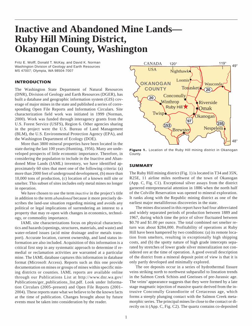
Figure 1. Location of the Ruby Hill mining district in Okanogan County. . . . . . . . . . . . . 1
Figure 2. Disseminated hessite and sulfide mineralization in quartz from a dump sample. . . . 3
Figure 3. Scanning electron microscope photo showing co-deposited hessite and
an unidentified sulfide mineral in a matrix of quartz crystals . . . . . . . . . . . . . 4
Figure 4. Scanning electron microscope photo showing galena grain with intergrowths
of pyrite, sphalerite, and tetrahedrite . . . . . . . . . . . . . . . . . . . . . . . . . . 4
Figure 5. Acid mine drainage at the First Thought lower adit . . . . . . . . . . . . . . . . . . 5
Figure 6. First Thought lower adit discharge . . . . . . . . . . . . . . . . . . . . . . . . . . . 5
Figure 7. First Thought No. 2 level adit . . . . . . . . . . . . . . . . . . . . . . . . . . . . . . 6
Figure 8. Overview of the initial surface development at the Last Chance mine . . . . . . . . . 6
Figure 9. Circa-1980 excavation accessing the Last Chance vein outcrop . . . . . . . . . . . . 7
Figure 10. Open stope at the Sonny Boy mine . . . . . . . . . . . . . . . . . . . . . . . . . . 7
Figure 11. Portal of the upper adit at the Sonny Boy mine . . . . . . . . . . . . . . . . . . . . 8
Figure 12. Overview of the Sonny Boy mine camp, 1939 . . . . . . . . . . . . . . . . . . . . 8
Figure 13. Haulageway portal, lower adit site, at the Sonny Boy mine . . . . . . . . . . . . . . 9
iii
Figure 14. The mill-feed ore bin ruins at the Sonny Boy mine . . . . . . . . . . . . . . . . . . 9
Figure 15. Overview of the Arlington site . . . . . . . . . . . . . . . . . . . . . . . . . . . . 10
Figure 16. Arlington mill ruins . . . . . . . . . . . . . . . . . . . . . . . . . . . . . . . . . . 10
Figure 17. Arlington tailings sample site. . . . . . . . . . . . . . . . . . . . . . . . . . . . . 11
Figure 18. Fourth of July mine discovery outcrop . . . . . . . . . . . . . . . . . . . . . . . . 11
Figure 19. Inclined shaft at the Fourth of July mine, caved 10 feet below surface . . . . . . . 12
Figure 20. Site of the double compartment vertical shaft at the Fourth of July mine . . . . . . 12
Figure 21. Overview of the Fourth of July site. . . . . . . . . . . . . . . . . . . . . . . . . . 12
Figure 22. Overburden collapse at the adit portal of the Fourth of July mine . . . . . . . . . . 13
Figure C1. Aerial photo of the Ruby Hill mining district . . . . . . . . . . . . . . . . . . . . 18
Figure C2. Geologic map of the Ruby Hill area . . . . . . . . . . . . . . . . . . . . . . . . . 19
Figure C3. Aerial photo showing features at the First Thought and Last Chance mines . . . . 20
Figure C4. Aerial photo showing features at the Sonny Boy mine . . . . . . . . . . . . . . . 21
Figure C5. Aerial photo showing features at the Arlington mine . . . . . . . . . . . . . . . . 22
Figure C6. Aerial photo showing features at the Fourth of July mine . . . . . . . . . . . . . . 23
Figure D1. Cross section of the First Thought mine . . . . . . . . . . . . . . . . . . . . . . . 24
Figure D2. Plan view of First Thought underground development . . . . . . . . . . . . . . . 26
Figure D3. Cross section of the Last Chance mine development . . . . . . . . . . . . . . . . 28
Figure D4. Plan view of the Sonny Boy mine development . . . . . . . . . . . . . . . . . . . 29
Figure D5. A. Plan view map of the Arlington mine
B. Cross-section sketch of subsurface vein morphology . . . . . . . . . . . . . . 30
Figure D6. Cross section of the Arlington mine between the
upper and lower adits along the plane of the Arlington vein . . . . . . . . . . . . 31
Figure D7. Cross section of the Fourth of July mine in 1890 . . . . . . . . . . . . . . . . . . 32
Figure D8. Patented claims in sec. 31, T35N R25E (northern claims) . . . . . . . . . . . . . 34
Figure D9. Patented claims in secs. 5 and 6, T34N R25E (southern claims) . . . . . . . . . . 35
TABLES
Table 1. Mine features . . . . . . . . . . . . . . . . . . . . . . . . . . . . . . . . . . . . . 13
Table 2. Soil analysis . . . . . . . . . . . . . . . . . . . . . . . . . . . . . . . . . . . . . . 14
Table 3. Soil quality standards for unrestricted land use . . . . . . . . . . . . . . . . . . . 14
Table 4. Bat habitat information . . . . . . . . . . . . . . . . . . . . . . . . . . . . . . . . 14
Table 5. Surface water field data. . . . . . . . . . . . . . . . . . . . . . . . . . . . . . . . 14
Table 6. Surface water analysis and applicable
Washington State Water Quality Standards . . . . . . . . . . . . . . . . . . . . . 15
iv
Inactive and Abandoned Mine Lands—Ruby Hill Mining District,Okanogan County, Washington
Fritz E. Wolff, Donald T. McKay, and David K. Norman
Washington Division of Geology and Earth Resources
MS 47007; Olympia, WA 98504-7007
INTRODUCTION
The Washington State Department of Natural Resources
(DNR), Division of Geology and Earth Resources (DGER), has
built a database and geographic information system (GIS) cov-
erage of major mines in the state and published a series of corre-
sponding Open File Reports and Information Circulars. Site
characterization field work was initiated in 1999 (Norman,
2000). Work was funded through interagency grants from the
U.S. Forest Service (USFS), Region 6. Other agencies sharing
in the project were the U.S. Bureau of Land Management
(BLM), the U.S. Environmental Protection Agency (EPA), and
the Washington Department of Ecology (DOE).
More than 3800 mineral properties have been located in the
state during the last 100 years (Huntting, 1956). Many are unde-
veloped prospects of little economic importance. Therefore, in
considering the population to include in the Inactive and Aban-
doned Mine Lands (IAML) inventory, we have identified ap-
proximately 60 sites that meet one of the following criteria: (a)
more than 2000 feet of underground development, (b) more than
10,000 tons of production, (c) location of a known mill site or
smelter. This subset of sites includes only metal mines no longer
in operation.
We have chosen to use the term inactive in the project’s title
in addition to the term abandoned because it more precisely de-
scribes the land-use situation regarding mining and avoids any
political or legal implications of surrendering an interest to a
property that may re-open with changes in economics, technol-
ogy, or commodity importance.
IAML site characterizations focus on physical characteris-
tics and hazards (openings, structures, materials, and waste) and
water-related issues (acid mine drainage and/or metals trans-
port). Accurate location, current ownership, and land status in-
formation are also included. Acquisition of this information is a
critical first step in any systematic approach to determine if re-
medial or reclamation activities are warranted at a particular
mine. The IAML database captures this information in database
format (Microsoft Access). Reports such as this one provide
documentation on mines or groups of mines within specific min-
ing districts or counties. IAML reports are available online
through our Publications List at http://www.dnr.wa.gov/
Publications/ger_publications_list.pdf. Look under Informa-
tion Circulars (2005–present) and Open File Reports (2001–
2004). These reports state what we believe to be the known facts
at the time of publication. Changes brought about by future
events must be taken into consideration by the reader.
SUMMARY
The Ruby Hill mining district (Fig. 1) is located in T34 and 35N,
R25E, 11 airline miles northwest of the town of Okanogan
(App. C, Fig. C1). Exceptional silver assays from the district
garnered entrepreneurial attention in 1886 when the north half
of the Colville Reservation was opened to mineral exploration.
It ranks along with the Republic mining district as one of the
earliest major metalliferous discoveries in the state.
The mines discussed in this report have had four abbreviated
and widely separated periods of production between 1889 and
1967, during which time the price of silver fluctuated between
$0.70 and $1.00 per ounce. The total combined net smelter re-
turn was about $284,000. Profitability of operations at Ruby
Hill have been hampered by two conditions: (a) its remote loca-
tion from smelters, resulting in exceptionally high shipping
costs, and (b) the spotty nature of high grade intercepts sepa-
rated by stretches of lower grade silver mineralization not con-
sidered ore at the time of operation. A good overall description
of the district from a mineral deposit point of view is that it is
only partly developed and minimally explored.
The ore deposits occur in a series of hydrothermal fissure
veins striking north to northwest subparallel to lineation trends
in the Salmon Creek Schists and Gneisses of pre-Jurassic age.
The veins’ appearance suggests that they were formed by a late
stage magmatic injection of massive quartz derived from the in-
trusive Conconully Granodiorite of Cretaceous age, which
forms a steeply plunging contact with the Salmon Creek meta-
morphic series. The principal mines lie close to the contact or di-
rectly on it (App. C, Fig. C2). The quartz contains co-deposited
1
20
20
97
49°119°120°
48°
USA
CANADA
Twisp
OKANOGANCOUNTY
Wauconda
Omak
155
Okanogan
153
Winthrop
Loomis
Brewster Nespelem
Conconully
Tonasket
Nighthawk
RiversideRuby Hill
Figure 1. Location of the Ruby Hill mining district in Okanogan
County.
granular aggregates and intergrowths of base- and precious-
metal sulfides and at least one telluride mineral. The persistence
of any given vein along strike has not been determined, but it ap-
pears from outcrops on claims with common end lines that a few
run for several thousand feet (Arlington group, Fourth of July
and Keystone, First Thought, and Second Thought). The maxi-
mum explored depth in the district with ore grade mineralization
in quartz is about 500 feet at the Arlington and Fourth of July
mines. Oreshoots are generally disconnected in both strike and
dip and separated by large gaps, identified as “barren quartz” by
Milliken (1891) and Patty (1921), and zones of finely dissemi-
nated ore minerals. Vein widths vary across the district from a
few inches to 90 feet.
The following minerals have been identified at most mines
in the district: galena, sphalerite, chalcopyrite, tetrahedrite, cer-
argyrite, pyrargyrite, native silver, and pyrite. Pyrite is ubiqui-
tous and may contain interstitial gold and silver values (Moen,
1973). The richest mineralization in the district assayed 200 to
300 ounces per ton (opt) silver, but shipments of hand-sorted ore
averaged about 50 opt silver, 3.5 percent lead, 1.5 percent cop-
per, and 0.02 opt gold. Silver content of mill concentrates falls
in the range 150 to 300 opt. The first identification of the min-
eral hessite [silver telluride] was in a sample collected at the
Fourth of July dump during DGER site characterization in
June of 2010 (George Mustoe, Western Wash. Univ., written
commun., 2010).
Adit portals at some mines are open; caving is likely how-
ever at unknown locations underground. Shafts at the Arlington,
Fourth of July, Last Chance, and First Thought are caved.
Five adits discharged acid mine drainage that infiltrates be-
fore reaching known surface waters. All mines discussed in this
circular are flooded to some degree, depending on specific site
conditions. Discharge sampled either by Huchton (1995) or
Raforth and others (2000) contained concentrations of metals
that exceed one or more state standards for arsenic, cadmium,
iron, copper, lead, selenium, and zinc. Levels of selenium and
zinc in water were the highest encountered at any of the mines
characterized in the IAML project (see Table 6). The toxicity
levels for these metals present a health hazard since the mine
lands are used for recreational activities and cattle grazing.
Metal contaminants found in waste rock dumps and mill tailings
generally reflect the water quality analyses regarding arsenic,
lead, and selenium, with levels that exceed Model Toxics Con-
trol Act (MTCA) standards for unrestricted use and industrial/
commercial use. The values reported in Table 2 are from soil
grab samples only and may or may not represent the site as a
whole. Sparse revegetation has occurred at each site, but no rec-
lamation work is evident.
Three concentrating mills were built: a stamp mill at Ruby
City (1892–1893) and flotation mills at the Arlington and Sonny
Boy mines (1938–1940). Market conditions, combined with un-
reliable water sources and inadequate ore reserves, were major
contributors to the mills’ closing.
In light of the fact that precious metal prices have risen to
all-time highs at the date of publication, the Ruby Hill district
may see renewed activity in spite of an apparent absence of his-
toric drilling data and district-scale geologic mapping. R. W.
Phendler’s (1974) geochemical soil traverse is the most recent
technical exploration study in the DGER mine files. It identified
five anomalous areas of mineralization >100 ppb silver and nu-
merous float locations and quartz outcrops within a 1 mile ra-
dius of the First Thought mine.
ACCESS
From the town of Okanogan, follow the northwest-bearing
Salmon Creek Road approximately 22 miles to the historic site
of Ruby City. Using this site as a starting point, turn west on the
Loup Loup Canyon Road and continue over the crest of Ruby
Hill. Stay left on this road and turn south at the 1.5 mile point. At
2.0 miles, turn left on Buzzard Lake Road. A short spur heading
south at the 2.6 mile point goes past the First Thought adit No. 3,
partially hidden in woods a few feet uphill to the east, and leads
to the Last Chance dumps 600 feet farther along. Both mine
openings lie essentially under the immediate west shoulder of
the Buzzard Lake Road. The Sonny Boy mine is located on a
short spur about 1000 feet east of a switchback at the 3.8 mile
point. The main haulage tunnel at the Arlington mine lies behind
a log barrier at the 4.8 mile point. A series of switchbacks con-
tinuing uphill leads to the Fourth of July mine at the 6.3 mile
point and 4500 feet elevation. Check with Bureau of Land Man-
agement (BLM) offices in Wenatchee or Okanogan for road
conditions, as the Ruby Hill and Buzzard Lake roads are pass-
able (2010) only with high-clearance four-wheel drive vehicles.
OWNERSHIP
Many of the lode claims in the district were patented at or near
the time of discovery. Since that time a number of original pat-
ents reverted to Federal ownership administered by the BLM.
The patents still in existence as of the date of publication are
shown in Appendix D, Figure D8. Ownership of the five princi-
pal mines discussed below has changed hands many times since
patent. As a result, several claims and (or) fractions thereof have
divided ownership. The seven patents surrounding and includ-
ing the Arlington mine are fractionally owned by private parties
and Arlington Mine Last Chance, Elmira, Oregon. The Last
Chance and First Thought claims and surrounding fractions are
owned by a private party. The Fourth of July patent, including
the adjacent Keystone and Climax claims are the property of AU
Mines Inc., Calgary, Alberta. Three unpatented claims at the
Sonny Boy property, held by possessory title in the late 1930s,
are closed. In the immediate area of the principal mines (sec. 31,
T35N R25E, or secs. 5 and 6, T34N R25E), there are no active
unpatented claims at date of publication. Contact the Okanogan
County Assessor for current specifics related to property in the
Ruby Hill mining district.
DISTRICT HISTORY
The discovery in 1886 of massive quartz veins containing high-
grade silver mineralization on Ruby Hill created a minor stam-
pede to the district, leading to the founding of a town site on
Salmon Creek known as Ruby City. Patents for at least 30
claims were granted. By 1891, a significant amount of develop-
ment work had been carried out, but none of the properties were
fully operational, due primarily to the tremendous difficulty and
associated cost involved in shipping run-of-mine ore to
smelter—40 miles of wagon road, transfer to river steamer, 85
2 INFORMATION CIRCULAR 112
miles, transfer to rail, and 175 miles to Tacoma. The freight cost
burden underscored the necessity of a local milling facility be-
ing available, not only to recover silver from non-bonanza grade
ore, but more importantly to drastically reduce the tonnage of
material shipped.
To meet this need, Washington Reduction Company con-
structed a stamp mill at Ruby City in the fall of 1892 and trans-
ported ore via aerial tramway from the First Thought and Last
Chance mines east over the crest of Ruby Hill to the mill. The
concentrates from this mill, which operated for only six months,
returned $66,000 in silver, with credits for copper and lead. The
mill’s closure was driven by a wave of investment speculation in
railroads leading to a series of nationwide bank failures and
market collapse in the spring of 1893. The price of silver
dropped 30 percent to $0.70 per ounce. This event removed all
the profitability from the remote district, and Ruby City was
abandoned.
With the exception of the Fourth of July mine, the First
Thought, Last Chance, and Arlington mines were capitalized or
controlled by a syndicate formed by then U.S. Senator Jonathan
Bourne of Portland, Oregon. The syndicate holdings, First
Thought Silver Mining Co., Inc., (FTSM) and Washington Re-
duction Co., Inc., (WRC) were administratively dissolved in
1923 for nonpayment of fees.
A brief period of renewed mining at the Arlington and Sonny
Boy mines took place during the late 1930s, followed by small
shipments from the Fourth of July mine in the years 1958 to
1967. Excavations at the Last Chance and First Thought waste
rock dumps probably date from the spike in silver prices in
1980. No other work appears to have been done in the district
since that time (DGER mine file).
GEOLOGIC SETTING
The base metal–silver deposits in the district occur in hydrother-
mal quartz fissure veins proximal to a steeply plunging, north-
west-striking contact between intrusive granodiorite of the
Conconully batholith, and metamorphic rocks of the Salmon
Creek Schists and Gneisses. The Last Chance, Arlington, and
Sonny Boy mines cut the contact underground. The metamor-
phic rocks were derived from Paleozoic sediments and
volcanics subjected to regional metamorphism during the Juras-
sic orogeny, and later invaded by granitic magma of probable
late Cretaceous age (Gulick and Korosec, 1990). (See App. C,
Fig. C2.)
The veins were formed during late-stage cooling of the in-
trusive magma when massive quartz containing aggregates of
sulfide ore minerals was injected into open-space fissures. The
crystallization temperatures of galena, tetrahedrite, chalcopy-
rite, bornite, and sphalerite found throughout the district indi-
cate that the deposits crystallized at about 200°C; that is, at the
lower range of mesothermal deposits and the upper range of epi-
thermal deposits (Park and MacDiarmid, 1970).
The longest continuous exposure along strike of a quartz
vein in the district is 1100 feet at the First Thought mine, and the
maximum continuity down dip is approximately 500 feet at the
Arlington and Fourth of July mines. Vein widths vary from a few
inches up to a body 90 to 100 feet wide at the First Thought. The
veins strike generally N10W with dips ranging from 25 to 90 de-
grees both east and west; most dips exceed 65 degrees. Jones
(1917) reported that the Last Chance vein “near the portal dips
50W, but toward the caved part of the drift [at 400 feet] is over-
turned and dips 60E.”
The reported mineral assemblage in the district is similar
from mine to mine, but identification of the primary silver-bear-
ing mineral(s) appears more complex than previously reported.
Tetrahedrite, an antimony-rich copper sulfide, is generally cred-
ited as the source mineral for Ruby Hill silver ore. However it is
one end member of a continuous solid solution series with ten-
nantite, an arsenic-rich copper sulfide, as the other end member.
Silver in the published composition of pure tetrahedrite is negli-
gible, whereas in tennantite it ranges up to 14 percent (Anthony
and others, 1990). Other silver-rich minerals in the series are
argentotennantite (34%) and freibergite (34–50%). These min-
eral phases also contain sufficient arsenic and antimony to ac-
count for the high values found in water and soil analyses. Ar-
gentiferous galena and pyrite also contributed to the silver con-
tent. We can’t say for sure without a thorough study of the ore
minerals by scanning electron microscope (SEM), but silver in
the district more than likely occurs in one or more of the above
named sulfide phases in conjunction with a silver telluride min-
eral, hessite, identified during DGER site characterization (see
below). Native silver, pyrargyrite, and cyrargyrite have been re-
ported (Derkey and others, 1990).
DGER obtained two hand specimens of massive quartz and a
ten-pound bulk sample from the Fourth of July adit waste dump.
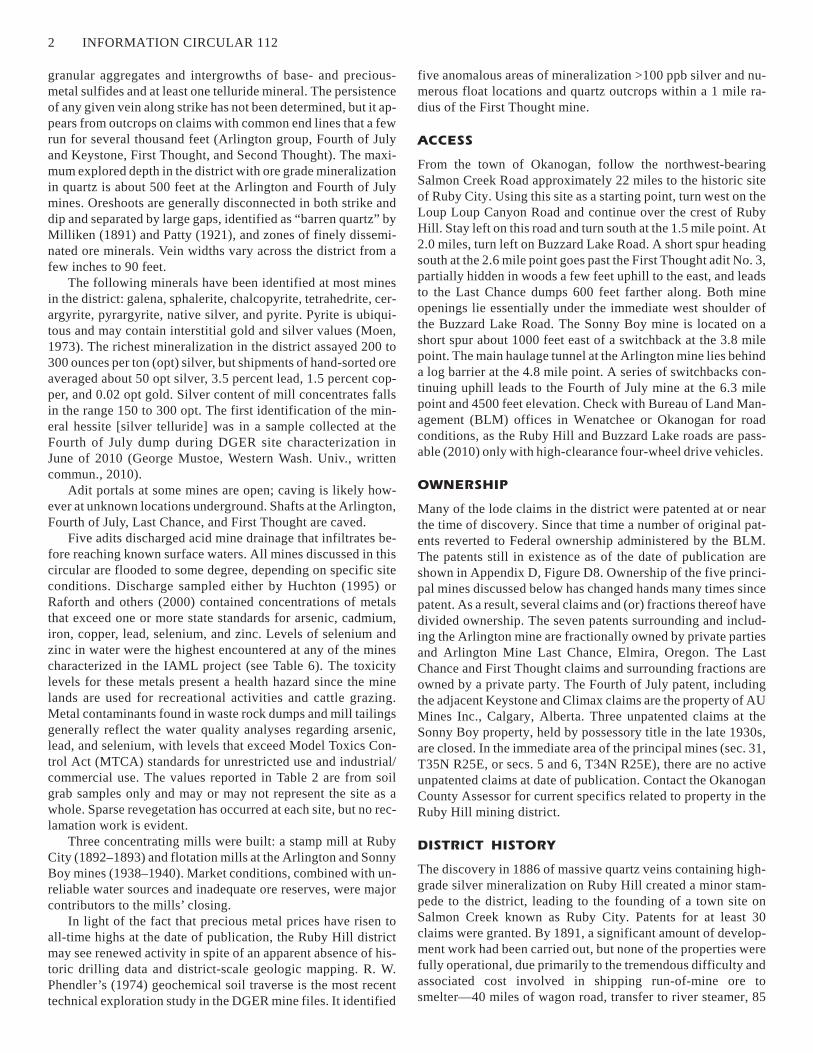
One specimen shows a significant concentration of hessite,
Ag2Te, a relatively rare telluride mineral (Fig. 2). The hessite is
intimately associated with an unidentified mineral similar to
tennantite but containing twice the antimony content: 7%As,
25%S, 23%Sb, 3%Fe, 42%Cu (Fig. 3). The identification was
made with EDAX/SEM technology (G. Mustoe, written
commun., 2010). The only previously reported occurrence of
hessite in the state was at the L-D mine in Wenatchee (Cannon,
1975). The grain shown in Figure 4, found in the second hand-
specimen, is principally galena containing intergrowths of
tetrahedrite, pyrite, and sphalerite, which suggests that the sul-
fides were codeposited and probably crystallized after the
IAML—RUBY HILL MINING DISTRICT, OKANOGAN COUNTY, WASHINGTON 3
Figure 2. Disseminated hessite and sulfide mineralization in quartz
from a dump sample.

quartz (J. Price, Nevada Bureau of Mines and
Geology, written commun., 2010). The bulk sam-
ple assayed 0.3 opt silver.
Secondary enrichment is virtually nonexis-
tent because the primary ore minerals extend to
the surface. Near-surface parts of the veins tend
to be rich in silver; lead, zinc, and copper sulfides
predominate respectively with increasing depth
(Moen, 1973).
PRINCIPAL MINES
The First Thought and Last Chance mines are lo-
cated on separate but parallel southeast-striking
quartz fissure veins about 600 feet apart. The
First Thought claim lies adjacent to the east side-
line of the Last Chance claim (App. D, Fig. D8).
First Thought Mine
The First Thought vein was opened by three adits
separated by 280 feet from highest to lowest
(App. C, Fig. C3). The estimated total develop-
ment is 5000 feet. Milliken (1891) made the fol-
lowing comment after examining the mine on be-
half of the Northern Pacific Railroad: “The prop-
erty has been well opened in an intelligent
manner; the quartz has been well sampled and as-
sayed, and all that should have been done, has
been.” (Milliken’s cross section and plan maps
are shown in App. D, Figs. D1 and D2.) Milliken
estimated proven ore reserves at between 24,000
and 35,000 tons. The tonnage actually mined in
the following two years until the market collapse
in the spring of 1893 is unreported. By 1917 the
stopes were inaccessible (Jones, 1917).
FTSM numbered the levels in the reverse or-
der in which they were driven (Hodges, 1897;
Milliken, 1891). The first and lowest adit was
shown on historic maps as No. 3, the second or
middle adit as No. 2, and the last and highest as
No. 1. Some reports show the reverse numbering
based on elevation. The principal vein mined at
the First Thought strikes N15W and dips 70E.
Level No. 3 (elevation 2780 feet) bears S80E,
essentially perpendicular to the vein’s strike. At a
distance of 650 feet, a ventilation raise was
driven to the surface. The drift then turns due east
and cuts the downdip extension of the vein,
where a small stope was mined. It continues in
barren ground past the stope to the heading at 880
feet from the portal. Bright-orange acidic water
discharges from the portal at ~2 gallons/minute. The pH mea-
sured 5.0, and the conductivity reading of 1950 �S/cm is the
highest reading at any of DGER’s IAML sites, indicating a sig-
nificant concentration of sulfate ion (Fig. 5). The ventilation
raise may act as a conduit for descending groundwater from the
upper levels. The discharge water seasonally floods most of the
waste rock dump surface and infiltrates by sheet flow within 100
feet of the portal (Fig. 6). The water contains levels of arsenic,
cadmium, iron, and zinc that exceed state standards for surface
water shown in Table 6 (Raforth and others, 2000; Huchton,
1995). Huchton (1995) sampled the No. 3 adit waste rock dump
and found arsenic levels that exceeded state standards by a fac-
tor of 50X, along with elevated copper, lead, and selenium con-
tent. The silver content in Huchton’s dump sample was 1.4 opt.
Level No. 2 begins with an east-bearing crosscut for ~50 feet
until it intersects the vein and turns S15E (Fig. 7). Here it splits
4 INFORMATION CIRCULAR 112
Figure 3. Scanning electron microscope (SEM) photo showing codeposited hessite
(white) and an unidentified Cu/As/Sb sulfide mineral (dark gray) in a matrix of older
euhedral quartz crystals (black). (Photo courtesy of George Mustoe, 2010.)
Figure 4. SEM photo showing galena grain with intergrowths of pyrite, sphalerite, and
tetrahedrite. The sulfides crystallized after the quartz phase. (Photo courtesy of George
Mustoe, 2010.)

into hanging wall and foot wall drifts about 500
feet in length, which are caved. Measured hori-
zontally, the vein on this level is about 90 feet
wide. Seasonal water, having approximately the
same composition and metal exceedances de-
scribed above, emanates from the adit (Huchton,
1995).
Level No. 1 was driven on the outcrop with
drifts along the foot and hanging walls. The por-
tal is open for a few tens of feet, but caved. The
quartz vein on this level is approximately 50 feet
wide; the two drifts are 900 feet long with eight
interconnecting crosscuts (Milliken, 1891).
Comments made by Milliken (1891) when
drifts were open and assays available are the best
on-site indication of the discontinuous nature of
the mineralization, not only at the First Thought
mine, but probably applicable to the Ruby Hill
mines in general: “Although the total width of the
massive quartz vein on this level [No. 1] is ap-
proximately 50 feet, ore-grade mineralization is
localized in narrow streaks along the hanging
wall and footwall. From the portal to crosscut
No. 5 [~400 feet] a streak of ore on the hanging
wall is found which averages 4½ ft. in width with
an average value of 23 oz. silver. From cross cut
No. 5 [south] to the present face the quartz is bar-
ren. Along the foot wall, starting at crosscut No.
3 there is about 50 ft. the width of the drift [~5 ft]
that will assay 20 oz. but from this point [south]
to the present face [~450 ft] the quartz is practi-
cally barren.”
“In adit No. 2 along the foot wall drift,
bunches of rich ore, assaying from 100 to 300
ozs. and from one to three ft. of medium grade
ore averaging 15 to 40 ozs. have been found, but
from this point 246 ft. from the portal to the pres-
ent face the vein is practically barren . . . since the
continuation of these drifts in No. 2 to the south
under No. 1 show practically barren quartz, it
also shows that the ore bodies found in No. 1 di-
rectly above, do not go down, or in other words
there is no continuity as to depth of ore bodies
found above. For this reason it is difficult to esti-
mate, if one estimates at all, the amount of ore in
sight shown by the various crosscuts and levels.
However, the total number of tons in round numbers is 34,000 . . .
and allowing for bad spots obtain about 24,000 tons.”
Last Chance Mine
Development at the Last Chance includes a 320-foot vertical
shaft and a southeast-bearing 650-foot adit on the vein. The
shaft is collared in schist of the Conconully metamorphic com-
plex, and cuts the steeply plunging granodiorite contact at a
depth of about 200 feet. Two levels of limited extent were
driven off the shaft at depths of 100 and 220 feet. At the bottom
of the shaft, a third level, 1300 feet long, was driven east toward
and past the First Thought vein, cutting a wide zone of ‘quartz
stringers” about 1300 feet from the portal (App. D, Fig. D3).
There is no indication of mining from this level (DGER mine
files).
At the time of DGER geologist Ernest Patty’s 1920 field
work (Patty, 1921), the adit was accessible but caved 500 feet
from the portal. About 50 feet from the portal, Patty observed a
2- to 4-foot band of galena, chalcopyrite, and tetrahedrite (in de-
creasing order of abundance), surrounded by massive quartz.
The sulfide band extended along the drift approximately 200
feet. The last known production from the Last Chance was from
this drift between 1920 and 1921, when a lessee shipped a few
carloads totaling less than 100 tons of hand-sorted ore assaying
30 opt silver, 17 percent lead, and 4 percent copper (Patty,
IAML—RUBY HILL MINING DISTRICT, OKANOGAN COUNTY, WASHINGTON 5
Figure 5. Acid mine drainage at the First Thought lower adit (No. 3), June 2010. Water
is 4 feet deep. View is to the East.
Figure 6. First Thought lower adit discharge, August 2001. Note the iron staining on
the rocks. View is to the west.
1921). The shaft site lies a few feet above the
caved adit shown in Figure 8, but it has been
obliterated by sloughing.
The waste rock dump occurs on two levels
superimposed on one another; the lower dump is
adjacent in elevation to the adit portal; the upper
dump is adjacent to the shaft location. The upper
dump is 100 feet long x 80 feet wide with a crest
to toe distance of 80 feet. It contains an estimated
minimum of 4000 cubic yards.
Although the shaft and underground work-
ings are more than likely flooded because of the
high water table on Ruby Hill, we observed no
direct discharge or drainage pathways. The pond
shown in Figure 9 is formed by snowmelt and
precipitation. The circa-1980 pond excavation
would have allowed a new adit to be driven on
the massive quartz cropping out below the his-
toric adit and shaft (Fig. 9). The aquatic plants in
the pond are Hippuris vulgaris a species native to
Washington, but on the endangered species list in
other states (G. Shoemaker, DNR Aquatic Re-
sources Division, oral commun., 2010). The
pond contains elevated levels of cadmium, cop-
per, lead, and zinc (see Table 6).
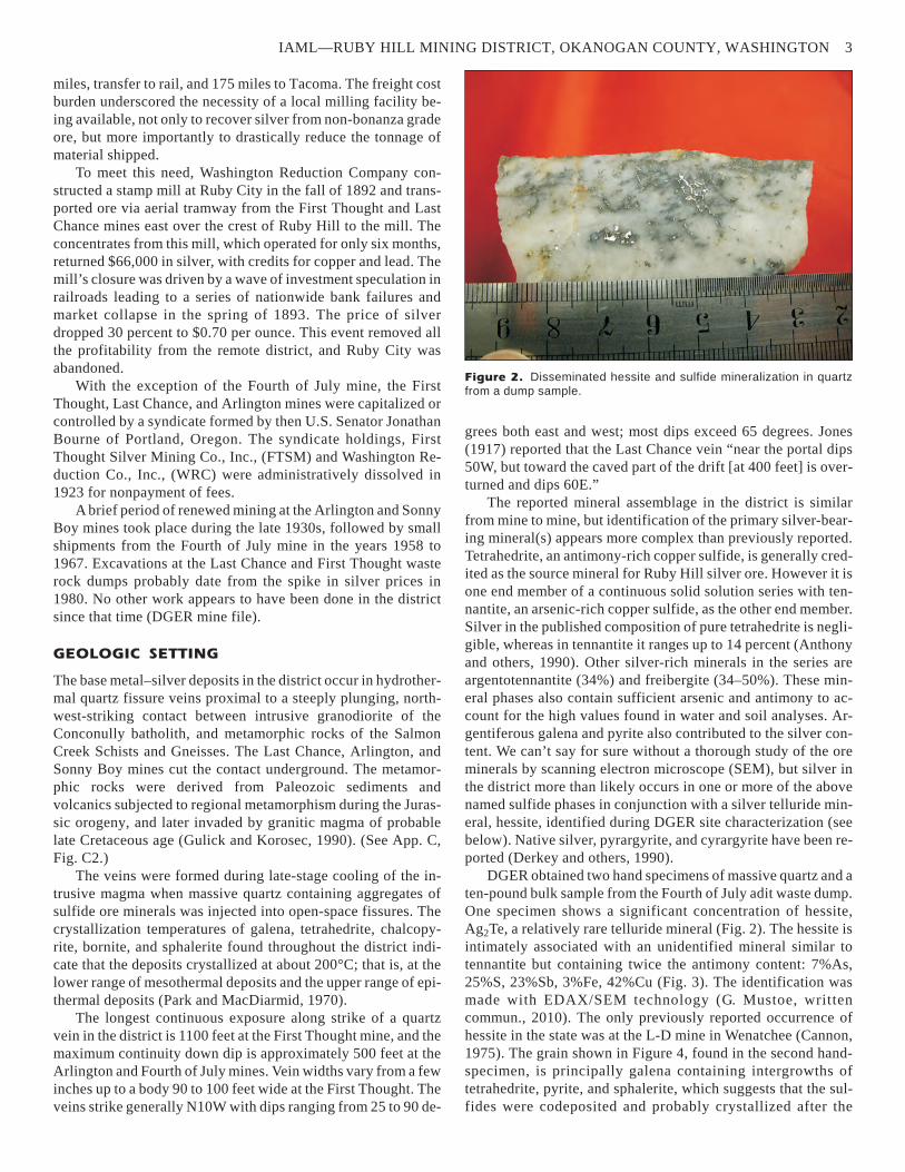
Sonny Boy Mine
Early work on this property was minimal, proba-
bly little more than shallow surface excavations.
In 1935, after 43 years of inactivity, Ruby Moun-
tain Mining Co. Inc. staked three unpatented lode
claims and drove an upper and lower adit on the
vein, 65 and 600 feet long respectively (App. C,
Fig. C4). Subsequently a surface stope about 60
feet long and 30 feet deep was opened on the
footwall (Fig. 10). Two separate near-vertical
raises were driven that connected the upper adit
and the surface stope to the lower adit which
served as a haulageway. The upper adit (Fig. 11)
is open to the heading, at which point an un-
marked near-vertical raise descends to the haul-
ageway.
In the four years the company operated the
mine, a workmanlike camp was established, in-
cluding a 25 ton/day flotation mill, and produced
ore in the range of 3400 to 4400 tons, depending
on actual stope volumes, which are unknown (Fig. 12). Hand-
sorted ore assayed about 30 opt silver and 0.02 opt gold; after
the mill came on line in 1939, shipments of concentrate returned
150 to 240 opt silver (DGER mine file). Shipments were made
to smelters at Tacoma, Washington, and Kellogg, Idaho. It ap-
pears the company was unable to develop ore reserves of suffi-
cient quantity to continue and ceased active operations in 1940.
The corporation was administratively dissolved in 1947 for non-
payment of fees. The claims, which were never patented, are
closed.
The Sonny Boy outcrop strikes N10W and dips 50W to ver-
tical. Mineralization at the Sonny Boy differs somewhat from
that reported at other mines in the district in that the primary ore
mineral reported by the company was “silver and gold bearing
pyrite, although galena and sphalerite can be identified” (DGER
mine file). Huntting (1956) described two veins at the Sonny
Boy from 6 inches to 6 feet in width. The lower level exhibits a
high degree of geologic complexity. One vein ends abruptly 180
feet from the portal, and the vein on which most of the stoping
was done is picked up 20 feet to the east by a crosscut at the
heading. The vein then splits again, encounters a major steeply
dipping cross fault, and continues through a shear zone to the
end. The mine appears to sit right on the contact between
granodiorite, which hosts the mineralization throughout most of
6 INFORMATION CIRCULAR 112
Figure 7. First Thought No. 2 level adit. The drift crosscuts the vein’s hanging wall 50
feet from the portal. It is caved after that point. View is to the east.
Figure 8. Overview of the initial surface development at the Last Chance mine. The de-
pression at center is the excavation shown in Figure 9. View is to the southeast.
adit waste rock
shaft (behind)
Buzzard Lake Road
shaft waste rock
adit

the lower adit, and quartz monzonite gneiss exposed in the final
60 feet of the adit (App. D, Fig. D4).
The Sonny Boy vein may be an extension of the Arlington
vein discussed below, providing the respective strikes of the two
systems remain relatively constant. If so, the overall length of
the fissure exceeds 4500 feet.
Colluvium has formed a dam at the lower adit portal, inun-
dating most of the drift (Fig. 13). The pH of the impounded wa-
ter measured 5.5. The iron-stained water is used by grazing cat-
tle. No water analyses are available. The waste rock dump con-
tains an estimated 2600 cubic yards. The only circa-1937
infrastructure still visible are the millfeed ore bin ruins (Fig. 14)
and an empty concrete powder magazine. The mill foundations
were found, but seasonal runoff appears to have dissipated the
tailings to such an extent that a sample could not be obtained.
Arlington Mine
Huntting (1956) reported the dollar value of production at the
Arlington mine from inception through 1940 at $144,650 (ap-
proximately 115,000 ounces silver) from 8300 tons. Total un-
derground development is approximately 4500 feet (App. C,
Fig. C5).
This property was located in 1887, one year after the Last
Chance and First Thought mines. The initial work consisted of a
200-foot near-vertical shaft sunk on the steeply dipping
‘Arlington’ vein. Jones (1917) stated that the Arlington vein on
the upper adit level “differs greatly in character at different
points. Its maximum width is 10 feet, but it pinches out in the fis-
sure near the north and south ends of the drifts.” Drifts ran ap-
proximately 350 feet north and south from the shaft bottom,
some stopes were broken, and by the summer of 1893, 1000 tons
of ore had been mined with a net smelter return of $25,000. The
mine was abandoned soon afterward because of the bank fail-
ures and financial collapse across the country.
The mine saw a resurgence of activity after the turn of the
20th century. In 1905, a newly organized corporation, Arlington
Mining Co., Inc., purchased the property and drove the upper
adit bearing N80E, which crosscuts the principal or ‘Arlington’
vein at the shaft bottom 400 feet from the portal and a smaller
vein dipping east at 440 feet from the portal. Patty (1921) re-
ported that the secondary vein was explored for 350 feet along
strike but “contains little ore.” Exploration of this second struc-
ture is not discussed in later reports.
The shaft was abandoned in 1910, after the company drove
the No. 2 or lower adit 230 feet lower in elevation. It bears al-
most due east and served as the main haulageway (App. D, Fig.
D5). It was originally 1290 feet long, cutting the Arlington vein
972 feet from the portal. Today, the portal has been obliterated
by surface excavations or collapse of the overlying mass of gra-
nitic colluvium and is considered caved. Iron-stained acid mine
drainage flowing from the toe of the highwall shown in Figure
IAML—RUBY HILL MINING DISTRICT, OKANOGAN COUNTY, WASHINGTON 7
Figure 9. Circa-1980 excavation accessing the Last Chance vein out-
crop dipping steeply west. Water exceeds state standards for cadmium,
copper, lead, and zinc. View is to the south.
Figure 10. Open stope at the Sonny Boy mine is approximately 30
feet deep at top left by 7 feet wide. View is along strike to the southeast.
shaft
behind
foliage
adit behind
outcrop
footwall
hanging wall

15 marks the portal location below which the
mine has historically been flooded. Fir, larch,
pine, and cottonwood trees up to 4 inches in di-
ameter have begun to establish a foothold on the
dump. The upper adit, which was open to the
shaft intersection in 2004, is reached by a steep
spur road descending from a switchback on the
Buzzard Lake Road, east of and above the lower
adit (D. Jacobsen, Northwest Underground Ex-
plorers, written commun., 2010). Three waste
rock dumps totaling approximately 9800 cubic
yards are located opposite the portal. The dumps
were partially scavenged during a 1980 spike in
the price of silver.
The company re-incorporated as the
Arlington Silver Mining Co., Inc., in 1918, with
head offices in Spokane. At this time, the lower
and upper levels were connected by two raises.
Between 1918 and 1921, 39 carloads of hand-
sorted ore totaling 1570 tons were shipped to the
American Smelting and Refining Co., Inc.,
smelter at Tacoma. The shipments averaged 70
opt silver, 0.02 opt gold, and 1.2 percent copper
(Patty, 1921). From the shaft collar to the bottom
of the winze gives an overall depth of known
mineralization on the Arlington vein of 540 feet.
The two mineralized veins lie essentially on
the contact between foliated hornblende mica-
schist of the Salmon Creek metamorphic com-
plex and the Conconully granodiorite; in places
the quartz fissure is found in one or the other host
rock. Jones (1917) identified tetrahedrite as the
predominant ore mineral, but in places the vein
contained “abundant chalcopyrite and smaller
amounts of galena and sphalerite.”
The mine was on standby until Arlington
Mines Inc. purchased the patented claims and ex-
isting equipment in 1937, reopened the adits, and
constructed a 50-tpd stamp and gravity concen-
trating mill. At this time, a 100-foot winze was
sunk on the vein from the lower adit level, and at
least one sublevel and several stopes were devel-
oped (App. D, Fig. D6). Huntting (1956) reported that a sample
taken at the bottom of the winze in 1947 assayed 18 opt silver
over a 2½-foot width. The mill was augmented with ball mill
and flotation equipment the following year. Huchton (1995) re-
ported the mill was destroyed by fire in 1958. The mill ruins
(Fig. 16) lie downslope at the opposite (west) end of the flat
shown in Figure 15. During 1938 and 1939, Arlington Mines
milled a total of 5700 tons of ore returning $71,683. We estimate
the grade to be in the range of 16 to 20 opt silver, based on the
average price of silver at the time of $0.80 per ounce. The com-
pany ceased operations in 1940 and was dissolved in 1945 for
nonpayment of fees.
Acid rock drainage from the lower adit is well documented.
In December 1920, the president of Arlington Silver Mines de-
scribed a situation existing on one of the sublevels below the
lower adit: “We were much interested in our discoveries with
reference to acid solutions . . . . These solutions cut away our
pipes and rails. They were found to contain a large percent of
iron, and copper sulphate. An analysis of the disintegrated iron
indicated 8 to 20 percent copper, about .02 gold [opt], and ½
ounce [opt] silver in every instance.” (DGER mine file). DGER
estimated the seepage from the highwall at 5 gpm in June 2010;
Huchton’s estimate in May 1995 was 15 to 20 gpm. Analyses for
cadmium and zinc taken at that time exceed state standards for
aquatic life shown in Table 6. Raforth and others’ (2000) sample
at the same point exceeded this standard for cadmium and zinc.
Mill tailings of approximately 4200 cubic yards lie in a swampy
draw immediately downgradient from the mill site and support a
thick stand of brush and trees (Fig. 17). The sample taken at this
site exceeds state standards for arsenic, copper, and lead (see Ta-
bles 2 and 3), and the silver content is 1.1 opt.
There appears to have been no attempt to delineate the lat-
eral or vertical extent of the Arlington vein by core drilling. As it
stands, only about one-half the length of the Arlington claim has
8 INFORMATION CIRCULAR 112
Figure 12. Overview of the Sonny Boy mine camp, 1939. View is to the southwest.
(Photo courtesy of Karen Turner LaFontaine, 2010; George Turner estate.)
Figure 11. Portal of the upper adit of the Sonny Boy mine. The adit is open 65 feet to
the heading, at which point an unmarked raise drops to the haulage level. View is to the
southeast.

been explored by development. The last note of interest regard-
ing the Arlington mine in DGER files is a 1976 article describ-
ing a planned reopening of the property by Nesco Mining Co.,
later Nesco Resources, Inc. There is no record of the nature of
the work performed, if any (Wallace Miner, 6/11/76).
Fourth of July Mine
This property, which produced some of the richest ore in the dis-
trict, assaying 1000 opt silver, is located on the crest of Ruby
Hill at 4500 feet elevation (App. C, Fig. C6). One of the first
smelter shipments of ore from the Ruby Hill district came from
the Fourth of July mine’s 200-foot inclined shaft sunk on the
vein. By 1890, shaft levels at 30, 70, 120, and 200 feet had been
developed. That year, a Montana syndicate, encouraged by the
results of the earlier shipment, acquired the property and sank a
double-compartment vertical shaft to a depth of 200 feet, with
production levels at 100 and 200 feet below the ground surface.
The shaft was later deepened to 500 feet with a 300-foot level
(Patty, 1921). All of this development work, including a total of
about 850 feet of drifts, was accomplished in the three years
leading up to the economic collapse of 1893, at which time the
mine was shut down. Total net return at this time was $36,000.
There is no record of the mine operating again until 1958,
when it was reopened by then owner, Cecil Murray, who oper-
ated the property and shipped a small quantity [unreported] of
hand-sorted ore assaying 50 to 80 opt silver; a lessor made small
shipments in 1967 (Moen, 1973). The tonnage produced at this
latter day is unknown and is the last known production from the
district (DGER mine file). AU Mines Inc., Calgary, Alberta, ac-
quired the Fourth of July, Keystone, and Climax patents from
the Murray estate in 1974 (Lucas, 1975).
The discovery outcrop is still much in evi-
dence a few feet below the Buzzard Lake Road
(Fig. 18). Viewed along strike (N) from the dis-
covery site, the first feature encountered is the in-
clined shaft, which is caved about 10 feet below
the collar (Fig. 19); the unfenced vertical shaft
lies 70 additional feet northwest (Fig. 20). It is
caved about 50 feet below the surface. Milliken’s
1891 map shows production stopes in “ore” on
levels at 70 and 120 feet, but even though the
quartz fissure is persistent 140 feet south and 160
feet north of the shaft, the cross section shows no
indication of ore-grade mineralization. “On the
[120] level, nothing but white quartz is to be
seen.” The two shafts were joined by intercon-
necting drifts at the 120 and 200 foot levels (App.
D, Fig. D7).
An east-bearing adit lies downslope and
about 300 feet northwest of the shafts. It dis-
charges water in the spring months and is flooded
below the portal elevation of 4390 feet (Figs. 21
and 22). The adit does not appear on Milliken’s
1891 map and may have been driven by the cur-
rent owner, AU Mines, Inc., in 1975. It is a mod-
erate decline to a point about 40 feet from the portal, where it
dips steeply to the east and is flooded. Twenty feet below the wa-
ter surface, it is filled with gravel and cobblestones. At a point
25 feet inside the portal, a drift turns to the south. In May 2010,
scuba divers swam approximately 250 feet along this drift in ex-
treme visibility conditions, did not reach the heading, and found
IAML—RUBY HILL MINING DISTRICT, OKANOGAN COUNTY, WASHINGTON 9
Figure 13. Haulageway portal, lower adit site, at the Sonny Boy mine.
Water ~2 feet deep is impounded behind the colluvium dam (notebook
for scale). View is to the southeast.
Figure 14. The mill-feed ore bin ruins at the Sonny Boy mine. Mill site is downhill at the
bottom left. View is to the east.
nothing of historical importance (D. Jacobsen, written
commun., 2010). The adit discharged flowing water at the time
of Huchton’s site visit in May 1995 and was partly flooded in
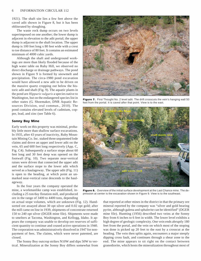
June 2010 at the time of the DGER site visit. Huchton’s water
sample showed levels of cadmium, copper, and zinc that ex-
ceeded state standards shown in Table 6 by several levels of
magnitude. The discharge infiltrated a few feet from the open-
ing. Huchton’s soil sample of the dump exceeds state standards
for arsenic, lead, and selenium (see Tables 2 and 3).
The host rock is biotite gneiss (Gulick and Korosec, 1990).
The vein is 4 feet wide at the surface, expanding to 20 feet be-
tween walls on the 200 level. The vein averages about 6 feet
overall. It dips 65E and strikes N to N20W. The metallic ore
minerals are tetrahedrite, galena, sphalerite, and hessite—a sil-
ver telluride mineral previously unreported in the Ruby Hill dis-
trict (see below). Lenticular paystreaks ranging in thickness
from 18 to 24 inches were encountered near the hanging wall
(Moen, 1973). We found disseminated grains of galena and
hessite as small as 0.05 mm in massive quartz.
Hodges (1897) reported specimens of native silver observed
at the mine. Parts of the vein are highly sheared by strike-slip
faults paralleling the vein walls. DGER has not located any his-
toric sampling data regarding the continuity of ore-grade miner-
alization at depth or along strike. Lucas (1975) estimated
129,000 tons remained in the vein within the boundaries of the
Fourth of July claim at 50 percent probability, assuming an aver-
age width of 6 feet to the depth of the double-compartment
shaft. Additionally, “the Fourth of July vein or one closely re-
lated to it is believed to also be present within the southeastern
or undeveloped portion of both the Fourth of July claim and the
adjoining Keystone claim (8-foot vein with up to 50 opt silver,
developed with a 150-foot shaft.”
OPENINGS
The shafts at the Fourth-of-July mine are caved
and unfenced. The Last Chance and Arlington
shafts are caved or filled to the surface. Some
portals are still intact at the Arlington, First
Thought, Sonny Boy, and Fourth of July mines,
but the adits may be caved at various points and
potentially impound water. All openings in the
district are considered hazardous. See Table 1.
MATERIALS AND STRUCTURES
No materials were located during DGER site
characterization. Structures observed were the
empty powder magazine and ore bin at the Sonny
Boy, a dilapidated headframe at the Fourth of
July, and the Arlington mill ruins.
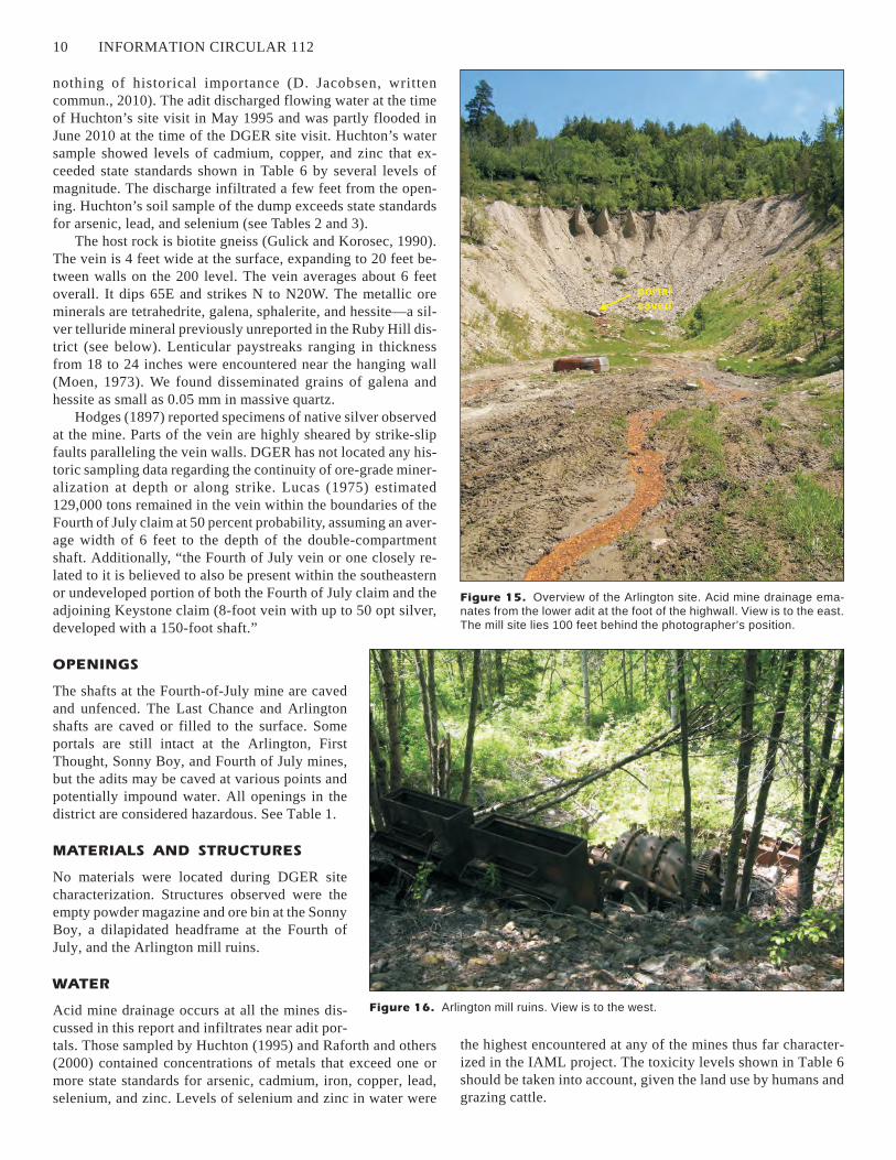
WATER
Acid mine drainage occurs at all the mines dis-
cussed in this report and infiltrates near adit por-
tals. Those sampled by Huchton (1995) and Raforth and others
(2000) contained concentrations of metals that exceed one or
more state standards for arsenic, cadmium, iron, copper, lead,
selenium, and zinc. Levels of selenium and zinc in water were
the highest encountered at any of the mines thus far character-
ized in the IAML project. The toxicity levels shown in Table 6
should be taken into account, given the land use by humans and
grazing cattle.
10 INFORMATION CIRCULAR 112
Figure 15. Overview of the Arlington site. Acid mine drainage ema-
nates from the lower adit at the foot of the highwall. View is to the east.
The mill site lies 100 feet behind the photographer’s position.
Figure 16. Arlington mill ruins. View is to the west.
portal
caved
MILLING OPERATIONS
As discussed above, the Bourne syndicate stamp
mill at Ruby City operated about six months, and
the Arlington and Sonny Boy flotation mills at
most only two years, ceasing operation in 1940.
Metal prices led to closure of the Bourne mill,
and either the near term outbreak of WWII or the
inability to develop viable ore reserves led to clo-
sure of the others. Most of the district’s smelter
shipments were hand-sorted, mine-run ore.
DGER personnel looked for, but did not find, the
location of the Washington Reduction Com-
pany’s stamp mill at Ruby City.
Regardless of market conditions, the bulk of
Ruby Hill district experience suggests that even
high-grade ore must be concentrated to offset
freight costs and that stringent assay control of
quartz broken in the normal course of develop-
ment must be done to separate truly ‘barren’ ma-
terial from that containing cutoff grade silver and
higher. The particles of disseminated grains dis-
cussed above (Figs. 20 and 21) are probably rep-
resentative of those found in low-grade material
in the district generally and suggest that recovery of these values
by flotation or cyanidation, or a combination thereof, requires
grinding to pass screens in the range of 80 to 100 mesh.
TAILINGS AND WASTE ROCK DUMPS
Four of the 12 waste rock dumps in the district have been sam-
pled: Last Chance, First Thought, Arlington, and Fourth of July
mines. The analyses for arsenic, lead, and selenium exceed state
standards for unrestricted use and industrial/commercial use
listed in WAC 173-340-900, Model Toxics Control Act
(MTCA) (see Tables 2 and 3). Of the two flotation mill tailings
known to exist, only the Arlington material was found in suffi-
cient quantities to be sampled. Arsenic, copper, and lead content
in this sample exceeded MTCA standards.
GENERAL INFORMATION
Names: First Thought, Last Chance, Sonny Boy, Arlington,
Fourth of July
MAS/MILS sequence number: First Thought, 053470298;
Last Chance, 0530470299; Sonny Boy, 0530470300;
Arlington, 0530470314; Fourth of July, 0530470315
Access: Four-wheel drive from the town of Okanogan via
Salmon Creek Road and Buzzard Lake Road; or from
Highway 20 and Loup Loup Canyon Road
Status of mining activity: none
Claim status: patented claims of mixed ownership; no
unpatented claims at time of publication
Current ownership: see above and contact Okanogan Co.
Assessor’s Office
Surrounding land status: Bureau of Land Management
Map information: Ruby Hill 1:24,000 scale; Omak
1:100,000 scale
MINE OPERATIONS DATA
Type of mine: underground and surface open stopes
Commodities mined: silver, copper, lead, zinc, minor gold
IAML—RUBY HILL MINING DISTRICT, OKANOGAN COUNTY, WASHINGTON 11
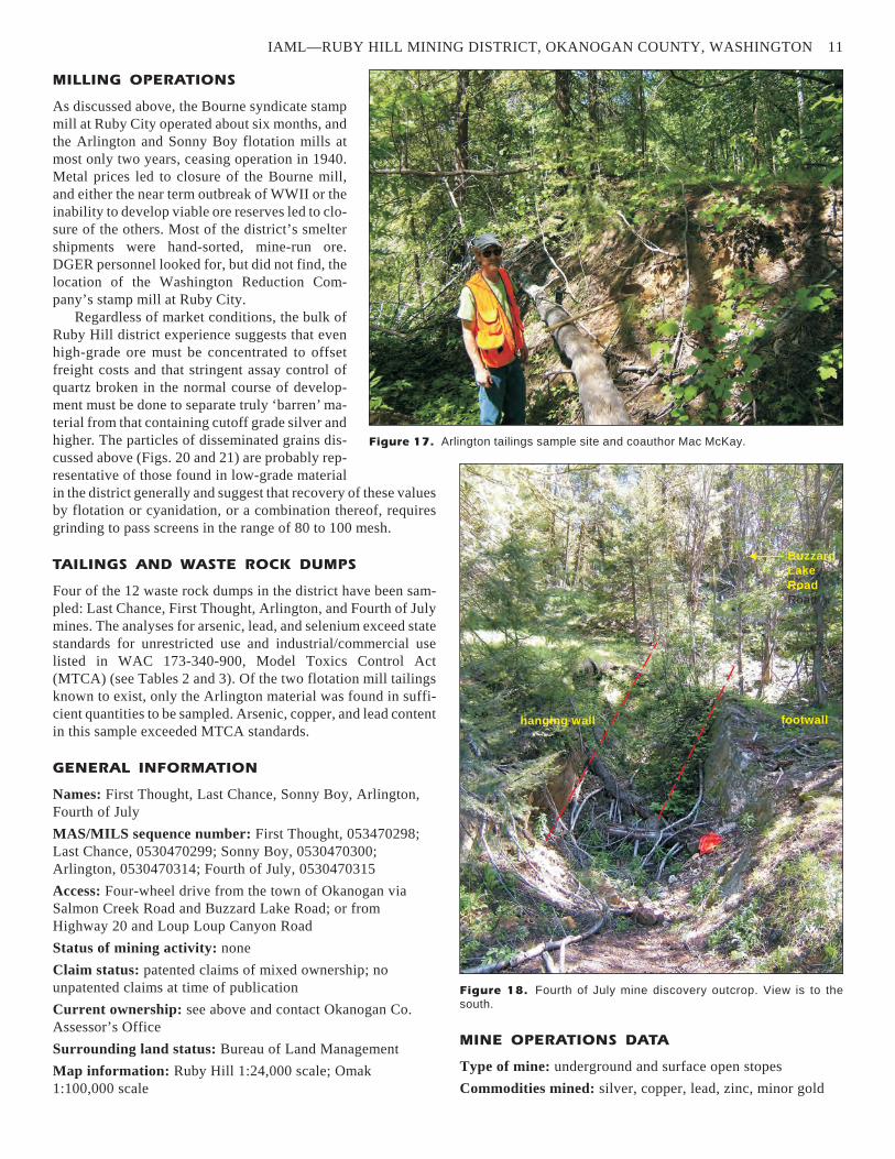
Figure 17. Arlington tailings sample site and coauthor Mac McKay.
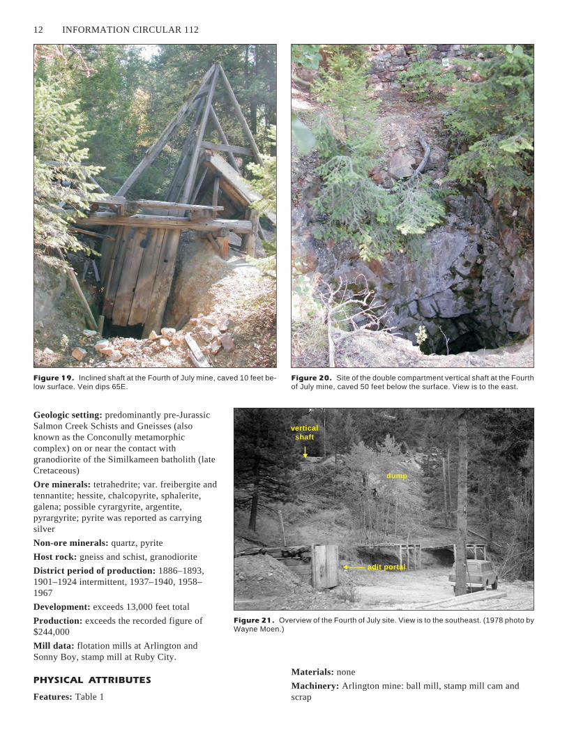
Figure 18. Fourth of July mine discovery outcrop. View is to the
south.
Buzzard
Lake
Road
Road
hanging wall footwall
Geologic setting: predominantly pre-Jurassic
Salmon Creek Schists and Gneisses (also
known as the Conconully metamorphic
complex) on or near the contact with
granodiorite of the Similkameen batholith (late
Cretaceous)
Ore minerals: tetrahedrite; var. freibergite and
tennantite; hessite, chalcopyrite, sphalerite,
galena; possible cyrargyrite, argentite,
pyrargyrite; pyrite was reported as carrying
silver
Non-ore minerals: quartz, pyrite
Host rock: gneiss and schist, granodiorite
District period of production: 1886–1893,
1901–1924 intermittent, 1937–1940, 1958–
1967
Development: exceeds 13,000 feet total
Production: exceeds the recorded figure of
$244,000
Mill data: flotation mills at Arlington and
Sonny Boy, stamp mill at Ruby City.
PHYSICAL ATTRIBUTES
Features: Table 1
Materials: none
Machinery: Arlington mine: ball mill, stamp mill cam and
scrap
12 INFORMATION CIRCULAR 112
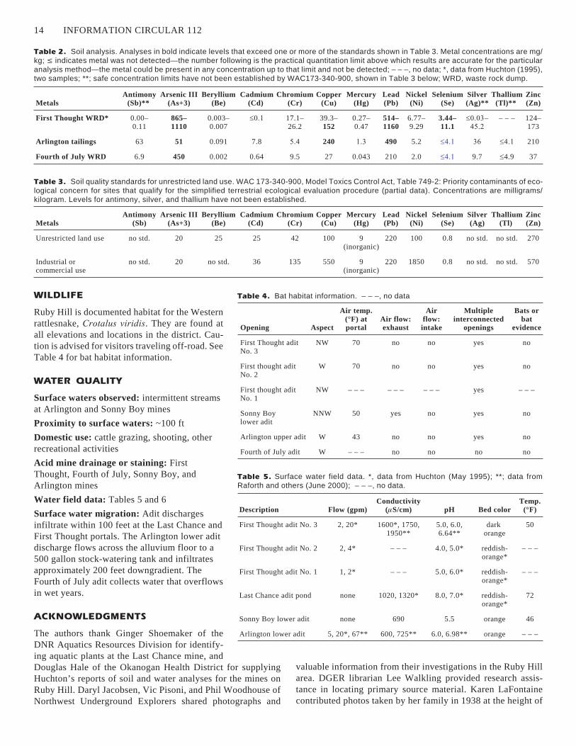
Figure 19. Inclined shaft at the Fourth of July mine, caved 10 feet be-
low surface. Vein dips 65E.
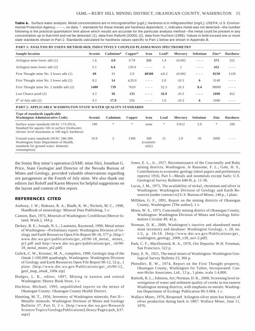
Figure 20. Site of the double compartment vertical shaft at the Fourth
of July mine, caved 50 feet below the surface. View is to the east.
Figure 21. Overview of the Fourth of July site. View is to the southeast. (1978 photo by
Wayne Moen.)
vertical
shaft
adit portal
dump

Structures: Sonny Boy mine: powder
magazine block building, ore bin
Waste rock dumps, tailings impoundments,
highwalls, or pit walls: twelve waste rock
dumps, two tailings impoundments, one
highwall >50 ft
Analysis of waste rock dumps and tailings:
Tables 2 and 3
Waste rock, tailings, or dumps in excess of
500 cubic yards: eight
Reclamation activity: none
VEGETATION
Some Douglas fir regeneration to 10 inches in di-
ameter; larch; stressed ponderosa pine and as-
pen; sparse weeds and grasses.
IAML—RUBY HILL MINING DISTRICT, OKANOGAN COUNTY, WASHINGTON 13
Description Condition
Length along
bearing (feet)**
Width
(feet)**
Height/depth
(feet)**
True
bearing
Elev.
(feet)
Decimal
latitude
Decimal
longitude
First Thought aditNo. 3
portal open, cavedunknown distance
880 5 7 S70E 2800 48.49286 119.74001
First Thought aditNo. 2
portal open, cavedunknown distance
100 ft; perpendicular to vein, thencehanging wall and footwall drifts ~400 ft
5 7 S73EthenceS10E
2980 48.4922 119.73816
First Thought aditNo. 1
portal open, cavedunknown distance
hanging wall andfootwall drifts ~940 ft
5 7 S15E 3080 48.4917 119.73782
Last Chance adit portal caved 650 5 7 S20E 3100 48.49151 119.74101
Last Chancevertical shaft
caved at surface 320 – – – – – – N/A 3100 48.49122 119.74016
Sonny Boylower adit
portal open, cavedunknown distance
530 5 7 S 3600 48.48331 119.73902
Sonny Boyupper adit
open 60 5 7 S 3760 48.48298 119.73886
Sonny Boy millsite burned N/A N/A N/A N/A 3650 48.48346 119.73920
Sonny Boyopen stope
open/unprotected
70 7 30 S 3794 48.48275 119.73870
Sonny Boy trench open N/A N/A 5 S 3845 48.48236 119.73854
Arlingtonupper adit
portal open, cavedunknown distance
450 5 7 S75E 4325 48.47087 119.73421
Arlingtonlower adit
excised by excavation 1290 5 7 S80E 4090 48.47175 119.73655
Arlingtonmillsite
burned ruins withmachinery
N/A N/A N/A N/A 4025 48.47208 119.73781
Arlingtontailings
buried under brush N/A N/A N/A N/A 4015 48.47225 119.73809
Arlingtonshaft
caved/obscure/locationcalculated
– – – – – – 200 N/A 4550 48.47088 119.73134
Fourth of Julyadit
portal open, caved andflooded below invert
– – – 6 10 N 4390 48.47759 119.72983
Fourth of Julyinclined shaft
collar open,caved at 10 feet
200 3 5 S10E 4480 48.47668 119.72937
Table 1. Mine features. – – –, no data; **, data from DGER mine file; N/A, not applicable.
Figure 22. Overburden collapse at the adit portal, June 2010.
WILDLIFE
Ruby Hill is documented habitat for the Western
rattlesnake, Crotalus viridis. They are found at
all elevations and locations in the district. Cau-
tion is advised for visitors traveling off-road. See
Table 4 for bat habitat information.
WATER QUALITY
Surface waters observed: intermittent streams
at Arlington and Sonny Boy mines
Proximity to surface waters: ~100 ft
Domestic use: cattle grazing, shooting, other
recreational activities
Acid mine drainage or staining: First
Thought, Fourth of July, Sonny Boy, and
Arlington mines
Water field data: Tables 5 and 6
Surface water migration: Adit discharges
infiltrate within 100 feet at the Last Chance and
First Thought portals. The Arlington lower adit
discharge flows across the alluvium floor to a
500 gallon stock-watering tank and infiltrates
approximately 200 feet downgradient. The
Fourth of July adit collects water that overflows
in wet years.
ACKNOWLEDGMENTS
The authors thank Ginger Shoemaker of the
DNR Aquatics Resources Division for identify-
ing aquatic plants at the Last Chance mine, and
Douglas Hale of the Okanogan Health District for supplying
Huchton’s reports of soil and water analyses for the mines on
Ruby Hill. Daryl Jacobsen, Vic Pisoni, and Phil Woodhouse of
Northwest Underground Explorers shared photographs and
valuable information from their investigations in the Ruby Hill
area. DGER librarian Lee Walkling provided research assis-
tance in locating primary source material. Karen LaFontaine
contributed photos taken by her family in 1938 at the height of
14 INFORMATION CIRCULAR 112
Metals
Antimony
(Sb)
Arsenic III
(As+3)
Beryllium
(Be)
Cadmium
(Cd)
Chromium
(Cr)
Copper
(Cu)
Mercury
(Hg)
Lead
(Pb)
Nickel
(Ni)
Selenium
(Se)
Silver
(Ag)
Thallium
(Tl)
Zinc
(Zn)
Unrestricted land use no std. 20 25 25 42 100 9(inorganic)
220 100 0.8 no std. no std. 270
Industrial orcommercial use
no std. 20 no std. 36 135 550 9(inorganic)
220 1850 0.8 no std. no std. 570
Table 3. Soil quality standards for unrestricted land use. WAC 173-340-900, Model Toxics Control Act, Table 749-2: Priority contaminants of eco-
logical concern for sites that qualify for the simplified terrestrial ecological evaluation procedure (partial data). Concentrations are milligrams/
kilogram. Levels for antimony, silver, and thallium have not been established.
Metals
Antimony
(Sb)**
Arsenic III
(As+3)
Beryllium
(Be)
Cadmium
(Cd)
Chromium
(Cr)
Copper
(Cu)
Mercury
(Hg)
Lead
(Pb)
Nickel
(Ni)
Selenium
(Se)
Silver
(Ag)**
Thallium
(Tl)**
Zinc
(Zn)
First Thought WRD* 0.00–0.11
865–
1110
0.003–0.007
���� 17.1–26.2
39.3–152
0.27–0.47
514–
1160
6.77–9.29
3.44–
11.1
������
��
– – – 124–173
Arlington tailings 63 51 0.091 7.8 �� 240 ��� 490 5.2 ���� �� ���� 210
Fourth of July WRD 6.9 450 0.002 0.64 9.5 27 0.043 210 2.0 ���� 9.7 �4.9 37
Table 2. Soil analysis. Analyses in bold indicate levels that exceed one or more of the standards shown in Table 3. Metal concentrations are mg/
kg; � indicates metal was not detected—the number following is the practical quantitation limit above which results are accurate for the particular
analysis method—the metal could be present in any concentration up to that limit and not be detected; – – –, no data; *, data from Huchton (1995),
two samples; **; safe concentration limits have not been established by WAC173-340-900, shown in Table 3 below; WRD, waste rock dump.
Opening Aspect
Air temp.
(°F) at
portal
Air flow:
exhaust
Air
flow:
intake
Multiple
interconnected
openings
Bats or
bat
evidence
First Thought aditNo. 3
NW 70 no no yes no
First thought aditNo. 2
W 70 no no yes no
First thought aditNo. 1
NW – – – – – – – – – yes – – –
Sonny Boylower adit
NNW 50 yes no yes no
Arlington upper adit W 43 no no yes no
Fourth of July adit W – – – no no no no
Table 4. Bat habitat information. – – –, no data
Description Flow (gpm)
Conductivity
(�S/cm) pH Bed color
Temp.
(°F)
First Thought adit No. 3 2, 20* 1600*, 1750,1950**
5.0, 6.0,6.64**
darkorange
50
First Thought adit No. 2 2, 4* – – – 4.0, 5.0* reddish-orange*
– – –
First Thought adit No. 1 1, 2* – – – 5.0, 6.0* reddish-orange*
– – –
Last Chance adit pond none 1020, 1320* 8.0, 7.0* reddish-orange*
72
Sonny Boy lower adit none 690 5.5 orange 46
Arlington lower adit 5, 20*, 67** 600, 725** 6.0, 6.98** orange – – –
Table 5. Surface water field data. *, data from Huchton (May 1995); **; data from
Raforth and others (June 2000); – – –, no data.
the Sonny Boy mine’s operation (IAML mine file). Jonathan G.
Price, State Geologist and Director of the Nevada Bureau of
Mines and Geology, provided valuable observations regarding
ore paragenesis at the Fourth of July mine. We also thank our
editors Jari Roloff and Karen Meyers for helpful suggestions on
the layout and content of this report.
REFERENCES CITED
Anthony, J. W.; Bideaux, R. A.; Bladh, K. W.; Nichols, M. C., 1990,Handbook of mineralogy: Mineral Data Publishing, 5 v.
Cannon, Bart, 1975, Minerals of Washington: Cordilleran [Mercer Is-land, Wash.], 184 p.
Derkey, R. E.; Joseph, N. L.; Lasmanis, Raymond, 1990, Metal minesof Washington—Preliminary report: Washington Division of Ge-ology and Earth Resources Open File Report 90-18, 577 p. [http://www.dnr.wa.gov/publications/ger_ofr90-18_metal_ mines_pt1.pdf and http://www.dnr.wa.gov/publications/ger_ ofr90-18_metal_mines_pt2.pdf]
Gulick, C. W.; Korosec, M. A., compilers, 1990, Geologic map of theOmak 1:100,000 quadrangle, Washington: Washington Divisionof Geology and Earth Resources Open File Report 90-12, 52 p., 1plate. [http://www.dnr.wa.gov/Publications/ger_ofr90-12_geol_map_omak_100k.zip]
Hodges, L. K., editor, 1897, Mining in eastern and centralWashington: Shorey Book Store, 1 v.
Huchton, Michael, 1995, unpublished reports on the mines ofOkanogan County: Okanogan County Health District.
Huntting, M. T., 1956, Inventory of Washington minerals; Part II—Metallic minerals: Washington Division of Mines and GeologyBulletin 37, Part II, 2 v. [http://www.dnr.wa.gov/ResearchScience/Topics/GeologyPublicationsLibrary/Pages/pub_b37.aspx]
Jones, E. L., Jr., 1917, Reconnaissance of the Conconully and Rubymining districts, Washington. In Ransome, F. L.; Gale, H. S.,Contributions to economic geology (short papers and preliminaryreports) 1916; Part I—Metals and nonmetals except fuels: U.S.Geological Survey Bulletin 640-B, p. 11-36.
Lucas, J. M., 1975, The availability of nickel, chromium and silver inWashington: Washington Division of Geology and Earth Re-sources [under contract to] U.S. Bureau of Mines, 140 p., 1 plate.
Milliken, G. F., 1891, Report on the mining districts of OkanoganCounty, Washington: [The author], 1 v.
Moen, W. S., 1973, Conconully mining district of Okanogan County,Washington: Washington Division of Mines and Geology Infor-mation Circular 49, 42 p.
Norman, D. K., 2000, Washington’s inactive and abandoned metalmine inventory and database: Washington Geology, v. 28, no.1/2, p. 16-18. [http://www.dnr.wa.gov/Publications/ger_washington_geology_2000_v28_no1-2.pdf]
Park, C. F.; MacDiarmid, R. A., 1970, Ore Deposits: W.H. Freeman,San Francisco, 522 p.
Patty, E. N., 1921, The metal mines of Washington: Washington Geo-logical Survey Bulletin 23, 366 p.
Phendler, R. W., 1974, Report on the First Thought property,Okanogan County, Washington for Talmo, Incorporated: Can-non-Hicks Associates, Ltd., 12 p., 1 plate, scale 1:4,800.
Raforth, R. L.; Johnson, Art; Norman, D. K., 2000, Screening level in-vestigation of water and sediment quality of creeks in ten easternWashington mining districts, with emphasis on metals: Washing-ton Department of Ecology Publication 00-3-004, 1 v.
Wallace Miner, 1976, Reopened Arlington silver mine has history ofsilver production dating back to 1887: Wallace Miner, June 11,1976.
IAML—RUBY HILL MINING DISTRICT, OKANOGAN COUNTY, WASHINGTON 15
PART 1: ANALYSIS BY USEPA METHOD 6020, INDUCTIVELY COUPLED PLASMA/MASS SPECTROMETRY
Sample location Arsenic Cadmium* Copper* Iron Lead* Mercury Selenium Zinc* Hardness
Arlington mine lower adit (1) 1.6 4.0 0.79 331 1.4 ����� – – – 371 355
Arlington mine lower adit (2) 5.1 6.6 ���� – – – � � – – – 432 – – –
First Thought mine No. 3 lower adit (1) 69 33 2.9 48300 �0.2 �0.002 – – – 8230 1120
First Thought mine No. 3 lower adit (2) 8.2 14 �20.0 – – – 2.0 �0.3 6 3140 – – –
First Thought mine No. 2 middle adit (2) 1480 739 7610 – – – 52.3 �0.3 8.4 38000 – – –
Last Chance pond (2) ��� 30 135 – – – 26.9 �0.3 – – – 1690 452
4th of July adit (2) ��� 17.9 356 – – – 1.6 �0.3 6 1040 – – –
PART 2: APPLICABLE WASHINGTON STATE WATER QUALITY STANDARDS
Type of standards (applicable
Washington Administrative Code) Arsenic Cadmium Copper Iron Lead Mercury Selenium Zinc Hardness
Surface water standards (WAC 173-201A,Standard for aquatic life in surface freshwater,chronic level maximums at 100 mg/L hardness)
190 * * none * 0.012 5.0 * 100
Ground water standards (WAC 246-290,Washington State Department of Health,standards for ground water, domesticconsumption)
10.0 5 1300 300(cosmetic
only)
15 2.0 50 5000 – – –
Table 6. Surface water analysis. Metal concentrations are in micrograms/liter (�g/L); hardness is in milligrams/liter (mg/L); USEPA, U.S. Environ-
mental Protection Agency; – – –, no data; *, standards for these metals are hardness dependent; �, indicates metal was not detected—the number
following is the practical quantitation limit above which results are accurate for the particular analysis method—the metal could be present in any
concentration up to that limit and not be detected; (1), data from Raforth (2000); (2), data from Huchton (1995). Values in bold exceed one or more
state standards shown in Part 2. Standards calculated for hardness values specific to Part 1 below are shown in Appendix B.
Appendix A. Methods and field equipment
METHODS
We recorded observations and measurements in the field. Lon-
gitude and latitude were recorded with a global positioning sys-
tem (GPS) unit in NAD83 decimal degree format. Literature re-
search provided data on underground development, which was
verified in the field when possible.
Soil samples from dumps or tailings were taken from
subsurface material and double bagged in polyethylene. Chain
of custody was maintained. Soil and water samples collected by
Huchton (1995) and used in this report were analyzed by White
Earth Analytical, Inc., Ephrata Wash.
Except for mercury, soil and water samples were analyzed
for the metals listed in this report by inductively coupled plasma
(ICP) in accord with USEPA (U.S. Environmental Protection
Agency) Method 6010B. The water sample DGER collected
was analyzed for the metals listed in this report by inductively
coupled plasma/mass spectrometry (ICP/MS) following USEPA
(U.S. Environmental Protection Agency) Method 6010. Mer-
cury was analyzed in accord with USEPA method 7471A
(CVAA). Holding times for the metals of interest were ob-
served. Instrument calibration was performed before each ana-
lytical run and checked by standards and blanks. Matrix spike
and matrix spike duplicates were performed with each set.
FIELD EQUIPMENT
Field equipment used by investigators other than DGER is
shown in the respective citations. DGER used the following
equipment for measurements and photos:
digital camera
Garmin handheld GPS unit
Oakton digital pH meter
Oakton digital electrical conductivity meter
Taylor model 9841 digital thermometer
16 INFORMATION CIRCULAR 112
Appendix B. Water quality standards forhardness dependent metals
Chronic standard in micrograms/liter (�g/L). Hardness data from Raforth and others (2000).
Sample location Hardness (mg/L)
Cd
(�g/L)
Cu
(�g/L)
Pb
(�g/L)
Zn
(�g/L)
Arlington mine lower adit 355 2.63 33.43 9.65 305.01
First Thought mine loweradit (No. 3)
1155 6.25 91.83 31.14 830.76
Last Chance pond 452 3.14 70.49 12.40 375.19
IAML—RUBY HILL MINING DISTRICT, OKANOGAN COUNTY, WASHINGTON 17

Appendix C. The Ruby Hill mining district
18 INFORMATION CIRCULAR 112
Figure C1. Aerial photo of the Ruby Hill mining district.

IAML—RUBY HILL MINING DISTRICT, OKANOGAN COUNTY, WASHINGTON 19
Figure C2. Geologic map of the Ruby Hill area (after Gulick and Korosec, 1990).
20 INFORMATION CIRCULAR 112
Figure C3. Aerial photo showing features at the First Thought and Last Chance mines.

IAML—RUBY HILL MINING DISTRICT, OKANOGAN COUNTY, WASHINGTON 21
Figure C4. Aerial photo showing features at the Sonny Boy mine.
22 INFORMATION CIRCULAR 112
Figure C5. Aerial photo showing features at the Arlington mine.
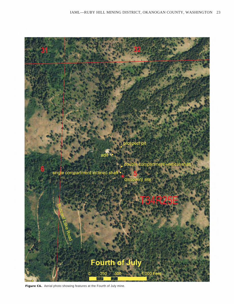
IAML—RUBY HILL MINING DISTRICT, OKANOGAN COUNTY, WASHINGTON 23
Figure C6. Aerial photo showing features at the Fourth of July mine.
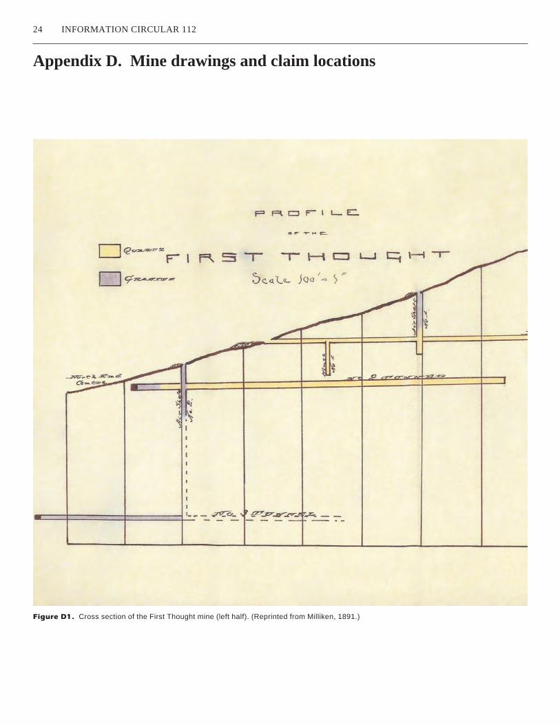
Appendix D. Mine drawings and claim locations
24 INFORMATION CIRCULAR 112
Figure D1. Cross section of the First Thought mine (left half). (Reprinted from Milliken, 1891.)
IAML—RUBY HILL MINING DISTRICT, OKANOGAN COUNTY, WASHINGTON 25
Figure D1. (Continued) Cross section of the First Thought mine (right half). (Reprinted from Milliken, 1891.)

26 INFORMATION CIRCULAR 112
Figure D2. Plan view of First Thought underground development (top half). (Reprinted from Milliken, 1891.)
PL.AN
OF T .. I!:
~ ~
F9 ~ ~\ !151 '"V' -1, M l'a1 U1 ~ H 1 -1r
Scale }005t.-=J i.11..
~I 11 N, C - - ~ __,
\ - -~- - - --.--~---
~ ~ (l\
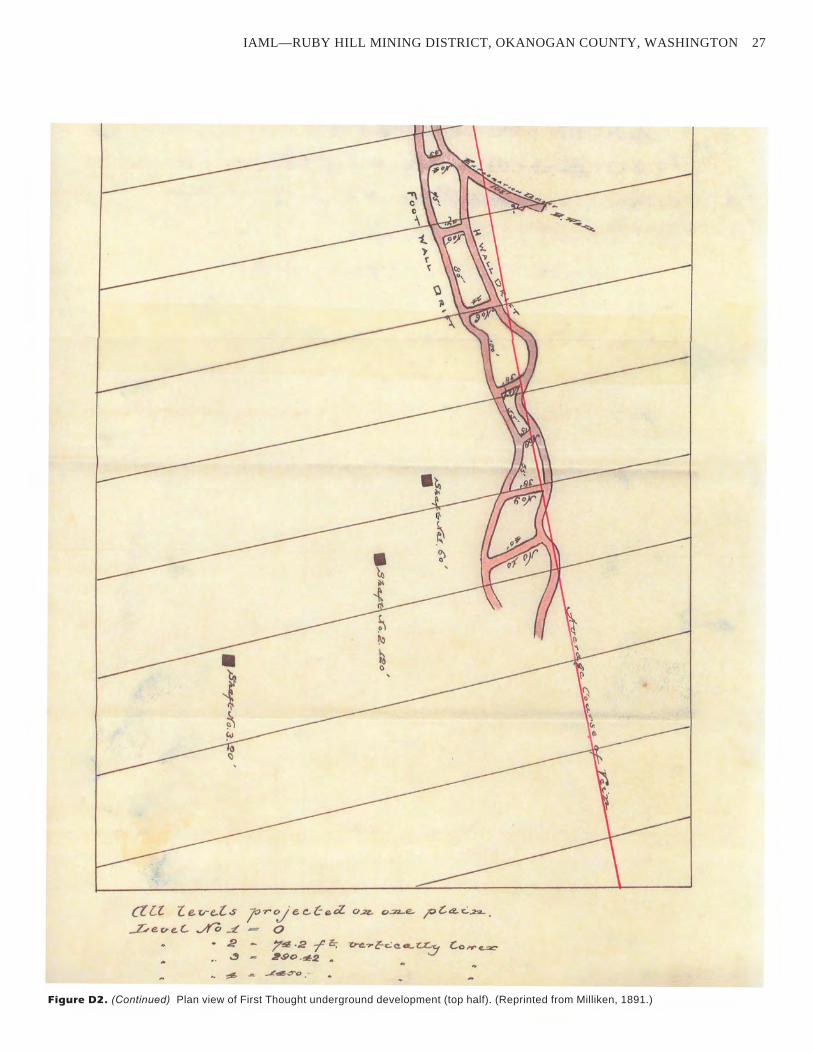
IAML—RUBY HILL MINING DISTRICT, OKANOGAN COUNTY, WASHINGTON 27
Figure D2. (Continued) Plan view of First Thought underground development (top half). (Reprinted from Milliken, 1891.)
a [l L €. r.,-e,.{. S l° r cy· e (!,Ce a. O.;,z. c;,.=-.e. jO ~ «. C.:.22.. .
_r,, e c, e.. C.. ./Yo ..:L 0 • 2 - 7~ .2 r c: v-e. ... ~c.:co...~y c..01-re.=
~ - ~.9C.,1t::l
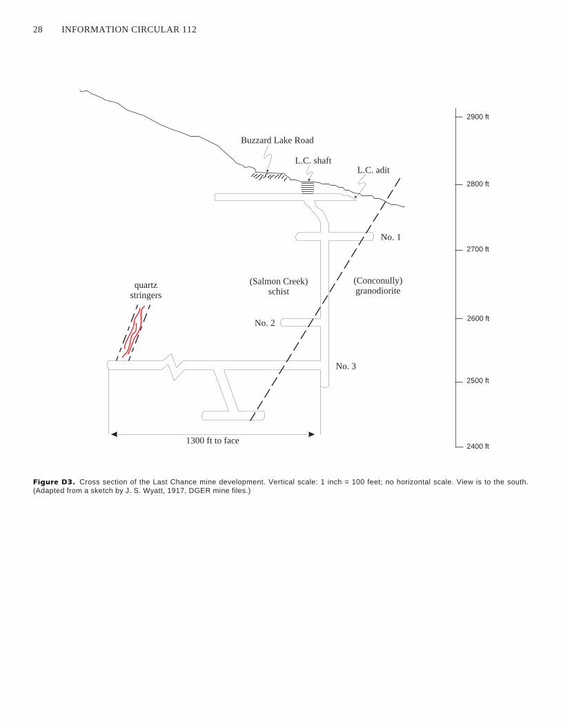
28 INFORMATION CIRCULAR 112
quartzstringers
1300 ft to face
No. 3
(Salmon Creek)schist
(Conconully)granodiorite
No. 1
L.C. shaftL.C. adit
Buzzard Lake Road
2800 ft
No. 2
2700 ft
2900 ft
2600 ft
2500 ft
2400 ft
Figure D3. Cross section of the Last Chance mine development. Vertical scale: 1 inch = 100 feet; no horizontal scale. View is to the south.
(Adapted from a sketch by J. S. Wyatt, 1917, DGER mine files.)
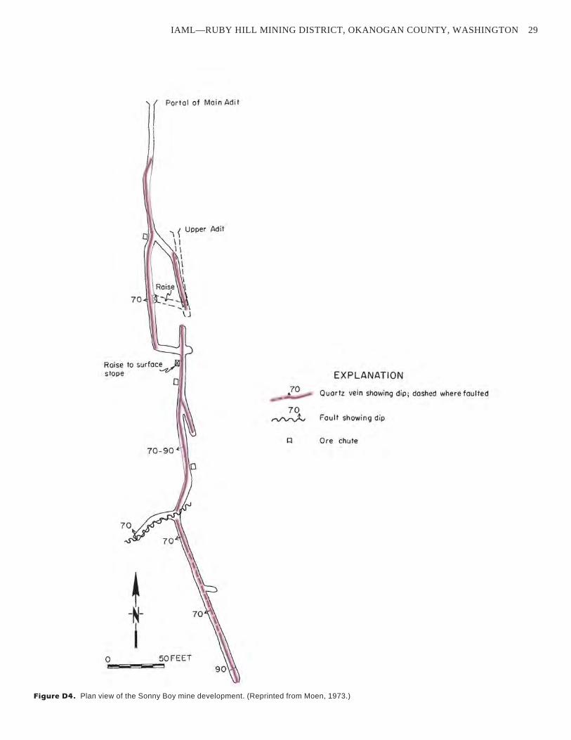
IAML—RUBY HILL MINING DISTRICT, OKANOGAN COUNTY, WASHINGTON 29
Figure D4. Plan view of the Sonny Boy mine development. (Reprinted from Moen, 1973.)
l r Poc>ol of Mo;" Ad;!
11
1 ( Upper Adit
\ I l \
I I \
I I
Raise I
70 -!-~
Raise to surfoc~ stope EXPLANATION
0 .. 70 _- Quar tz vein showing dip; dashed where faulted ----70 ~ Fault showing dip
Cl Ore chute
~ -N-
I 0 50 FEET
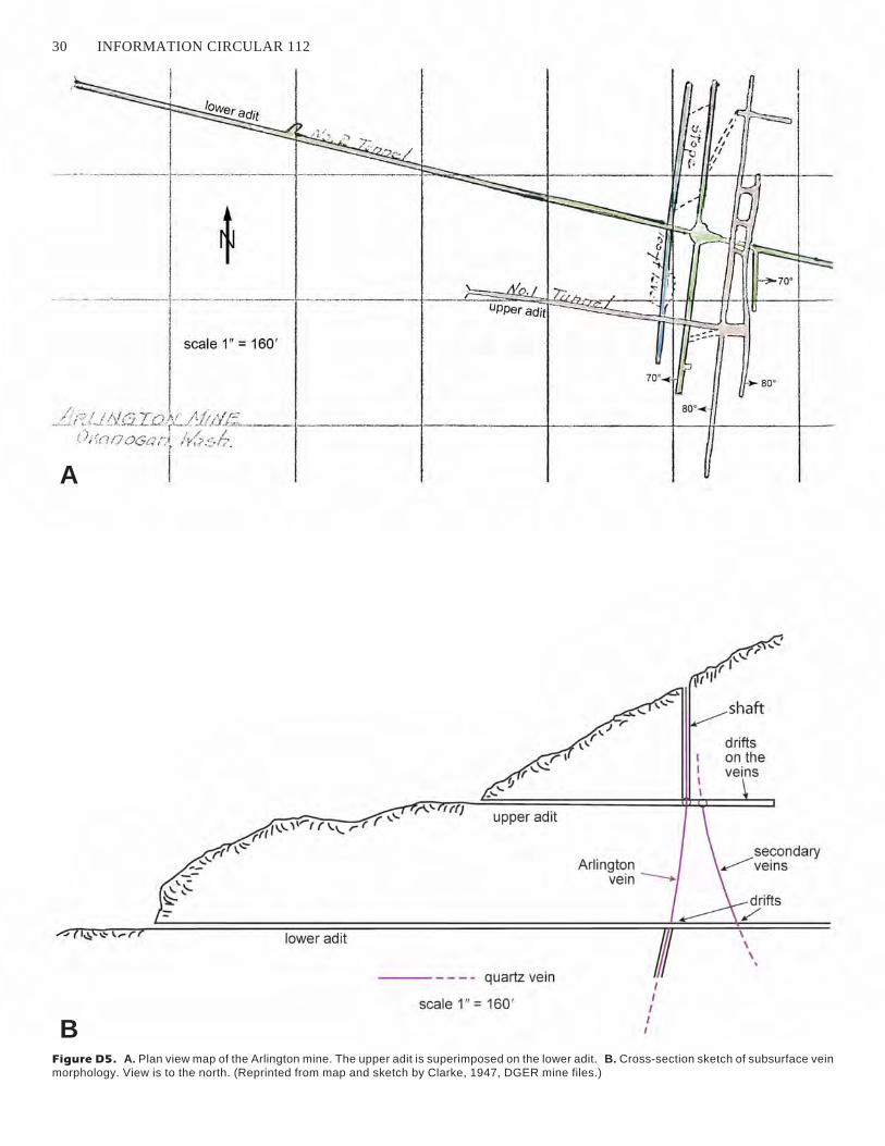
30 INFORMATION CIRCULAR 112
A
Figure D5. A. Plan view map of the Arlington mine. The upper adit is superimposed on the lower adit. B. Cross-section sketch of subsurface vein
morphology. View is to the north. (Reprinted from map and sketch by Clarke, 1947, DGER mine files.)
B
~4~----- -----·---r-------------1 ~
- -~-- -· ·,1--------- ----------- ------ --
scale 1" = 160'
/ 1 I . .!' i ,::., f ; - , - . -- r ,_, .J.!/_ ( I r.o f'. i , • ( ) j (,') ,7-- ·t_/1(/:l{;~:
. . , 060'. I (,./ I I ···-' 'i ,,,,!'•fl .. - -
shaft
drifts on the
,,, I ,1...., ,..-r r ''-1
, ... ~ .... :r''tr'-=c<'-?;;r r'ir)J --'~~~:~=======d~ ;,=~v:e~i n:s~ \.~ ,.. upper adit
lower adit
--- - quartz vein
scale 1" = 160, I I I I
I

IAML—RUBY HILL MINING DISTRICT, OKANOGAN COUNTY, WASHINGTON 31
Fig
ure
D6
.C
ross
se
cti
on
ofth
eA
rlin
gto
nm
ine
be
twe
en
the
up
pe
ra
nd
low
er
ad
its
alo
ng
the
pla
ne
ofth
eA
rlin
gto
nve
in(a
da
pte
dfr
om
aske
tch
by
Cla
rke
,1
94
7,D
GE
Rm
ine
file
s).
Vie
wis
toth
e
ea
st.
I I
--rrr---t--+--+--D-l-t--0 Q) +-' (.)
'@~ ..c :::J Cl) Cl)
- - - - -._.._ _ .. ....._.
I I
I { \ \ ,_
:J (.)
..c Cl) t(/) oe co
'\
\
! J " .. _ .I
' ./' ~
Q) +-' a.·-Q. 'D :::J ro
I I I l
()
/
0 co II
::: ....... Q)
ro (.) Cl)
__ j ___ _
l~ / I
/ I
· ____ l_ I
I I I
--t·--
1
i I f
i
l --....--.-_,.,_ ... _ -·- :;.,L..~J __
I y
I
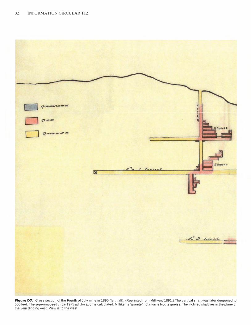
32 INFORMATION CIRCULAR 112
Figure D7. Cross section of the Fourth of July mine in 1890 (left half). (Reprinted from Milliken, 1891.) The vertical shaft was later deepened to
500 feet. The superimposed circa-1975 adit location is calculated. Milliken’s “granite” notation is biotite gneiss. The inclined shaft lies in the plane of
the vein dipping east. View is to the west.
..
.· I .

IAML—RUBY HILL MINING DISTRICT, OKANOGAN COUNTY, WASHINGTON 33
Figure D7. (Continued) Cross section of the Fourth of July mine in 1890 (right half). (Reprinted from Milliken, 1891.)
circa-1925 adit
=::::::::::::::::::::::::::::::::=o
F' RD r I LE.
4-,H. '-1 u LY
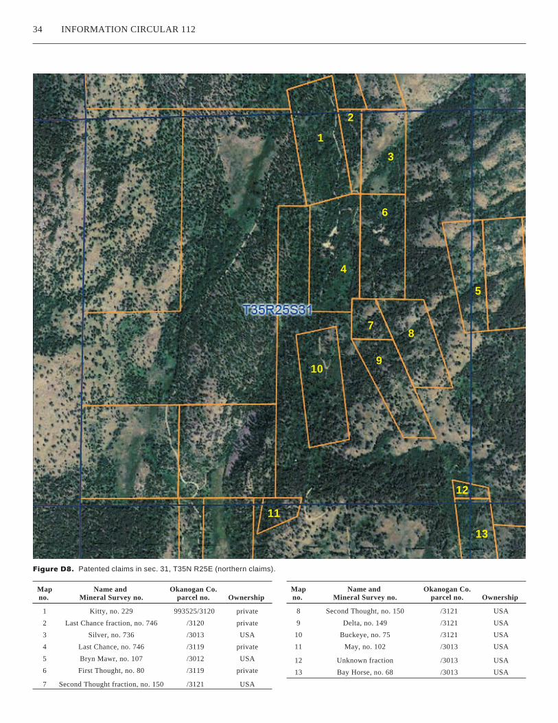
34 INFORMATION CIRCULAR 112
Figure D8. Patented claims in sec. 31, T35N R25E (northern claims).
1
2
3
4
5
6
78
910
11
12
13
Map
no.
Name and
Mineral Survey no.
Okanogan Co.
parcel no. Ownership
1 Kitty, no. 229 993525/3120 private
2 Last Chance fraction, no. 746 /3120 private
3 Silver, no. 736 /3013 USA
4 Last Chance, no. 746 /3119 private
5 Bryn Mawr, no. 107 /3012 USA
6 First Thought, no. 80 /3119 private
7 Second Thought fraction, no. 150 /3121 USA
Map
no.
Name and
Mineral Survey no.
Okanogan Co.
parcel no. Ownership
8 Second Thought, no. 150 /3121 USA
9 Delta, no. 149 /3121 USA
10 Buckeye, no. 75 /3121 USA
11 May, no. 102 /3013 USA
12 Unknown fraction /3013 USA
13 Bay Horse, no. 68 /3013 USA
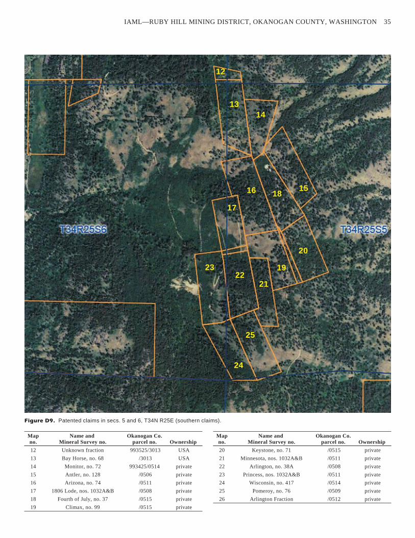
IAML—RUBY HILL MINING DISTRICT, OKANOGAN COUNTY, WASHINGTON 35
Figure D9. Patented claims in secs. 5 and 6, T34N R25E (southern claims).
13
12
14
1516
17
18
19
20
2122
23
24
25
Map
no.
Name and
Mineral Survey no.
Okanogan Co.
parcel no. Ownership
12 Unknown fraction 993525/3013 USA
13 Bay Horse, no. 68 /3013 USA
14 Monitor, no. 72 993425/0514 private
15 Antler, no. 128 /0506 private
16 Arizona, no. 74 /0511 private
17 1806 Lode, nos. 1032A&B /0508 private
18 Fourth of July, no. 37 /0515 private
19 Climax, no. 99 /0515 private
Map
no.
Name and
Mineral Survey no.
Okanogan Co.
parcel no. Ownership
20 Keystone, no. 71 /0515 private
21 Minnesota, nos. 1032A&B /0511 private
22 Arlington, no. 38A /0508 private
23 Princess, nos. 1032A&B /0511 private
24 Wisconsin, no. 417 /0514 private
25 Pomeroy, no. 76 /0509 private
26 Arlington Fraction /0512 private


