Embed Size (px)
Citation preview
THESE TERMS GOVERN YOUR USE OF THIS DOCUMENT
Your use of this Ontario Geological Survey document (the “Content”) is governed by the terms set out on this page (“Terms of Use”). By downloading this Content, you (the
“User”) have accepted, and have agreed to be bound by, the Terms of Use.
Content: This Content is offered by the Province of Ontario’s Ministry of Northern Development and Mines (MNDM) as a public service, on an “as-is” basis. Recommendations and statements of opinion expressed in the Content are those of the author or authors and are not to be construed as statement of government policy. You are solely responsible for your use of the Content. You should not rely on the Content for legal advice nor as authoritative in your particular circumstances. Users should verify the accuracy and applicability of any Content before acting on it. MNDM does not guarantee, or make any warranty express or implied, that the Content is current, accurate, complete or reliable. MNDM is not responsible for any damage however caused, which results, directly or indirectly, from your use of the Content. MNDM assumes no legal liability or responsibility for the Content whatsoever. Links to Other Web Sites: This Content may contain links, to Web sites that are not operated by MNDM. Linked Web sites may not be available in French. MNDM neither endorses nor assumes any responsibility for the safety, accuracy or availability of linked Web sites or the information contained on them. The linked Web sites, their operation and content are the responsibility of the person or entity for which they were created or maintained (the “Owner”). Both your use of a linked Web site, and your right to use or reproduce information or materials from a linked Web site, are subject to the terms of use governing that particular Web site. Any comments or inquiries regarding a linked Web site must be directed to its Owner. Copyright: Canadian and international intellectual property laws protect the Content. Unless otherwise indicated, copyright is held by the Queen’s Printer for Ontario. It is recommended that reference to the Content be made in the following form: <Author’s last name>, <Initials> <year of publication>. <Content title>; Ontario Geological Survey, <Content publication series and number>, <total number of pages>p. Use and Reproduction of Content: The Content may be used and reproduced only in accordance with applicable intellectual property laws. Non-commercial use of unsubstantial excerpts of the Content is permitted provided that appropriate credit is given and Crown copyright is acknowledged. Any substantial reproduction of the Content or any commercial use of all or part of the Content is prohibited without the prior written permission of MNDM. Substantial reproduction includes the reproduction of any illustration or figure, such as, but not limited to graphs, charts and maps. Commercial use includes commercial distribution of the Content, the reproduction of multiple copies of the Content for any purpose whether or not commercial, use of the Content in commercial publications, and the creation of value-added products using the Content. Contact:
FOR FURTHER INFORMATION ON PLEASE CONTACT: BY TELEPHONE: BY E-MAIL:
The Reproduction of Content
MNDM Publication Services
Local: (705) 670-5691 Toll Free: 1-888-415-9845, ext.
5691 (inside Canada, United States)
The Purchase of MNDM Publications
MNDM Publication Sales
Local: (705) 670-5691 Toll Free: 1-888-415-9845, ext.
5691 (inside Canada, United States)
Crown Copyright Queen’s Printer Local: (416) 326-2678 Toll Free: 1-800-668-9938
(inside Canada, United States)
LES CONDITIONS CI-DESSOUS RÉGISSENT L'UTILISATION DU PRÉSENT DOCUMENT.
Votre utilisation de ce document de la Commission géologique de l'Ontario (le « contenu ») est régie par les conditions décrites sur cette page (« conditions d'utilisation »). En
téléchargeant ce contenu, vous (l'« utilisateur ») signifiez que vous avez accepté d'être lié par les présentes conditions d'utilisation.
Contenu : Ce contenu est offert en l'état comme service public par le ministère du Développement du Nord et des Mines (MDNM) de la province de l'Ontario. Les recommandations et les opinions exprimées dans le contenu sont celles de l'auteur ou des auteurs et ne doivent pas être interprétées comme des énoncés officiels de politique gouvernementale. Vous êtes entièrement responsable de l'utilisation que vous en faites. Le contenu ne constitue pas une source fiable de conseils juridiques et ne peut en aucun cas faire autorité dans votre situation particulière. Les utilisateurs sont tenus de vérifier l'exactitude et l'applicabilité de tout contenu avant de l'utiliser. Le MDNM n'offre aucune garantie expresse ou implicite relativement à la mise à jour, à l'exactitude, à l'intégralité ou à la fiabilité du contenu. Le MDNM ne peut être tenu responsable de tout dommage, quelle qu'en soit la cause, résultant directement ou indirectement de l'utilisation du contenu. Le MDNM n'assume aucune responsabilité légale de quelque nature que ce soit en ce qui a trait au contenu. Liens vers d'autres sites Web : Ce contenu peut comporter des liens vers des sites Web qui ne sont pas exploités par le MDNM. Certains de ces sites pourraient ne pas être offerts en français. Le MDNM se dégage de toute responsabilité quant à la sûreté, à l'exactitude ou à la disponibilité des sites Web ainsi reliés ou à l'information qu'ils contiennent. La responsabilité des sites Web ainsi reliés, de leur exploitation et de leur contenu incombe à la personne ou à l'entité pour lesquelles ils ont été créés ou sont entretenus (le « propriétaire »). Votre utilisation de ces sites Web ainsi que votre droit d'utiliser ou de reproduire leur contenu sont assujettis aux conditions d'utilisation propres à chacun de ces sites. Tout commentaire ou toute question concernant l'un de ces sites doivent être adressés au propriétaire du site. Droits d'auteur : Le contenu est protégé par les lois canadiennes et internationales sur la propriété intellectuelle. Sauf indication contraire, les droits d'auteurs appartiennent à l'Imprimeur de la Reine pour l'Ontario. Nous recommandons de faire paraître ainsi toute référence au contenu : nom de famille de l'auteur, initiales, année de publication, titre du document, Commission géologique de l'Ontario, série et numéro de publication, nombre de pages. Utilisation et reproduction du contenu : Le contenu ne peut être utilisé et reproduit qu'en conformité avec les lois sur la propriété intellectuelle applicables. L'utilisation de courts extraits du contenu à des fins non commerciales est autorisé, à condition de faire une mention de source appropriée reconnaissant les droits d'auteurs de la Couronne. Toute reproduction importante du contenu ou toute utilisation, en tout ou en partie, du contenu à des fins commerciales est interdite sans l'autorisation écrite préalable du MDNM. Une reproduction jugée importante comprend la reproduction de toute illustration ou figure comme les graphiques, les diagrammes, les cartes, etc. L'utilisation commerciale comprend la distribution du contenu à des fins commerciales, la reproduction de copies multiples du contenu à des fins commerciales ou non, l'utilisation du contenu dans des publications commerciales et la création de produits à valeur ajoutée à l'aide du contenu. Renseignements :
POUR PLUS DE RENSEIGNEMENTS SUR VEUILLEZ VOUS
ADRESSER À : PAR TÉLÉPHONE : PAR COURRIEL :
la reproduction du contenu
Services de publication du MDNM
Local : (705) 670-5691 Numéro sans frais : 1 888 415-9845,
poste 5691 (au Canada et aux États-Unis)
l'achat des publications du MDNM
Vente de publications du MDNM
Local : (705) 670-5691 Numéro sans frais : 1 888 415-9845,
poste 5691 (au Canada et aux États-Unis)
les droits d'auteurs de la Couronne
Imprimeur de la Reine
Local : 416 326-2678 Numéro sans frais : 1 800 668-9938
(au Canada et aux États-Unis)
Ontario Geological Survey Miscellaneous Paper 122
Report of Activities 1984Regional and Resident Geologists
edited by C.R. Kustra
1985
Ministry Of Hon- Michael Harris . . . , MinisterNatural— Mary Mogford HeSOlirCeS Deputy Minister
Ontario
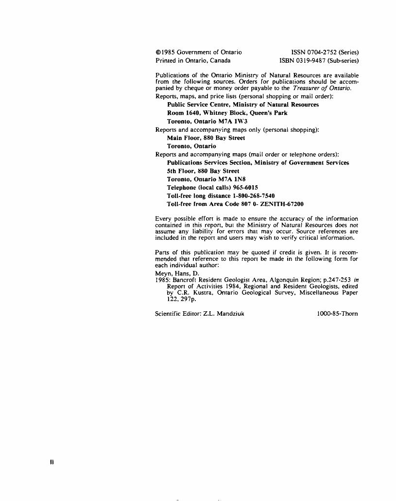
1985 Government of Ontario ISSN 0704-2752 (Series) Printed in Ontario, Canada ISBN 0319-9487 (Sub-series)
Publications of the Ontario Ministry of Natural Resources are available from the following sources. Orders for publications should be accom panied by cheque or money order payable to the Treasurer of Ontario.Reports, maps, and price lists (personal shopping or mail order):
Public Service Centre, Ministry of Natural ResourcesRoom 1640, Whitney Block, Queen's ParkToronto, Ontario M7A 1W3
Reports and accompanying maps only (personal shopping):Main Floor, 880 Bay StreetToronto, Ontario
Reports and accompanying maps (mail order or telephone orders):Publications Services Section, Ministry of Government Services5th Floor, 880 Bay StreetToronto, Ontario M7A 1N8Telephone (local calls) 965-6015Toll-free long distance 1-800-268-7540Toll-free from Area Code 807 O- ZENITH-67200
Every possible effort is made to ensure the accuracy of the information contained in this report, but the Ministry of Natural Resources does not assume any liability for errors that may occur. Source references are included in the report and users may wish to verify critical information.
Parts of this publication may be quoted if credit is given. It is recom mended that reference to this report be made in the following form for each individual author:Meyn, Hans, D.1985: Bancroft Resident Geologist Area, Algonquin Region; p.247-253 in
Report of Activities 1984, Regional and Resident Geologists, edited by C.R. Kustra, Ontario Geological Survey, Miscellaneous Paper 122, 297p.
Scientific Editor: Z.L. Mandziuk 1000-85-Thorn
Foreword
This report summarizes the activities of the Ontario Ministry of Natural Resources Regional and Resident Geologists for the period November 30, 1983, to November 30, 1984. It also includes accounts of mining, exploration, and geoscience activities in Ontario, prepared from informa tion collected and filed by the Regional and Resident Geologists. Listings of new additions to the Assessment Files Records, and reports of govern ment survey and sponsored projects are provided.
Regional and Resident Geologists are located in key centres of the Mining Divisions of the Province, to provide geoscience information and advice to the public on the geology and mineral deposits of Ontario. Each office maintains a library of published and unpublished reports, technical papers and monographs, publications of the Ontario Geological Survey and other government agencies, records of exploration activity submitted for assessment work credit, company prospectuses and reports from the files of the Ontario Securities Commission, reports of property visits made by the Regional or Resident Geologists staff, and information received directly from companies and individuals.
A wide variety of mineral resources related investigations under taken by regional minerals staff are reported here. These range from geoscience data inventories to technical studies regarding petroleum resources, building stone, industrial minerals, aggregate resources, and metallic and non-metallic mineral deposits.
The Economic Geologist Programs, initiated some years ago in the North Central Region, continued in the Geraldton-Beardmore and the Schreiber-Terrace Bay areas, and have been incorporated in other re gions. Economic Geologists have been assigned to the Dryden-Fort Fran cis, Wawa, and Kirkland Lake (Black River-Matheson Program) areas.
Core storage facilities were operative in 5 centres including Kirkland Lake, Timmins, Sault Ste. Marie, Bancroft, and Tweed. A core collection and cataloguing program developed by the Resident Geologists' staff at these centres has been highly successful insuring that as much as possible of the available diamond drill core is collected and stored.
M.E. Durocher, resigned from the position of Resident Geologist, Red Lake, and has been replaced by M.J. Lavigne, Jr.
C.R. KustraRegional Liaison GeologistOntario Geological Survey
lii
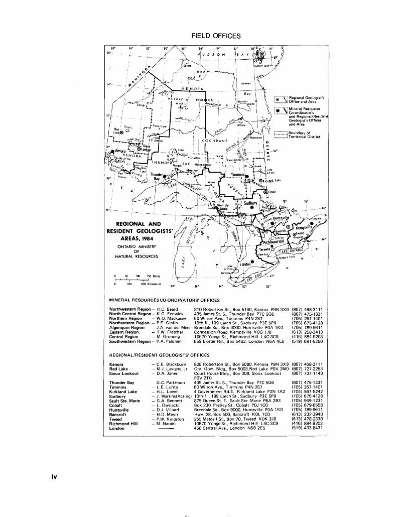
FIELD OFFICES
Coordinator s and Regional/Residen Geologist's Offices and Area
l i spy/ i* L l *yi\[nipigon -———•"ri- — i^L, "t " Vs \'
'GeiaUton I-!-- o J ^ Vi] j (kapuskasing^ \
BA v .J. ; ! h"i f o l
REGIONAL AND RESIDENT GEOLOGISTS'
AREAS, 1984
MINERAL RESOURCES CO-ORDINATORS' OFFICES
Northwestern Region - R.C. Beard North Central Region- K.G. Fenwick Northern Region — W.O. Mackasey Northeastern Region — P.E. Giblin
810 Robertson St., Box 5160, Kenora P9N 3X9 (807)435 James St. S., Thunder Bay P7C 5G6 (807)60 Wilson Ave., Timmins P4N 2S7 (705)10th fi., 199 Larch St., Sudbury P3E 5P9 (705)
Algonquin Region - J.A. van der Meer Brendale Sq., Box 9000, Huntsville PDA 1KO (705)Eastern Region - T.W. Fletcher Concession Road, Kemptville KOG 1JO (613)Central Region - M. Groneng 10670 Yonge St., Richmond Hill L4C 3C9 (416)
(519)Southwestern Region — P.A. Palonen 659 Exeter Rd., Box 5463, London N6A 4L6
468-3111 475-1331 267-1401 675-4128 789-9611 258-3413 884-9203 681 5350
REGIONAL/RESIDENT GEOLOGISTS' OFFICES
Kenora Red Lake Sioux Lookout
Thunder BayTimminsKirkland LakeSudburySault Ste. MarieCobaltHuntsvilleBancroftTweedRichmond HillLondon
C.E. Blackburn M.J. Lavigne, Jr. D.A. Janes
G.C. Patterson L.E. Luhta H.L. Lovell J. Martins(Acting) G.A. Bennett L. Owsiacki D.J. Villard H.D. Meyn P.W. Kingston M. Narain
808 Robertson St., Box 5080, Kenora P9N 3X9 (807) 468-3111Ont. Govt. Bldg., Box 5003,Red Lake POV 2MO (807) 727-2253Court House Bldg., Box 309, Sioux Lookout (807) 737-1140 POV 2TO435 James St. S., Thunder Bay P7C 5G6 (807) 475-133160 Wilson Ave., Timmins P4N 2S7 (705) 267 14014 Government Rd.E., Kirkland Lake P2N 1A2 (705) 567-524210th fi., 199 Larch St., Sudbury P3E 5P9 (705) 675-4128875 Queen St. E., Sault Ste. Marie P6A 2B3 (705) 949-1231Box 230 Presley St., Cobalt POJ 1CO (705) 679-8558Brendale Sq., Box 9000, Huntsville POA 1KO (705) 789-9611Hwy. 28, Box 500, Bancroft KOL 1CO (613) 332-3940255 Metcalf St., Box 70, Tweed KOK 3JO (613) 478-233010670 Yonge St., Richmond Hill L4C 3C9 (416) 884-9203458 Central Ave., London N6B 2E5 (519) 433-8431
lv
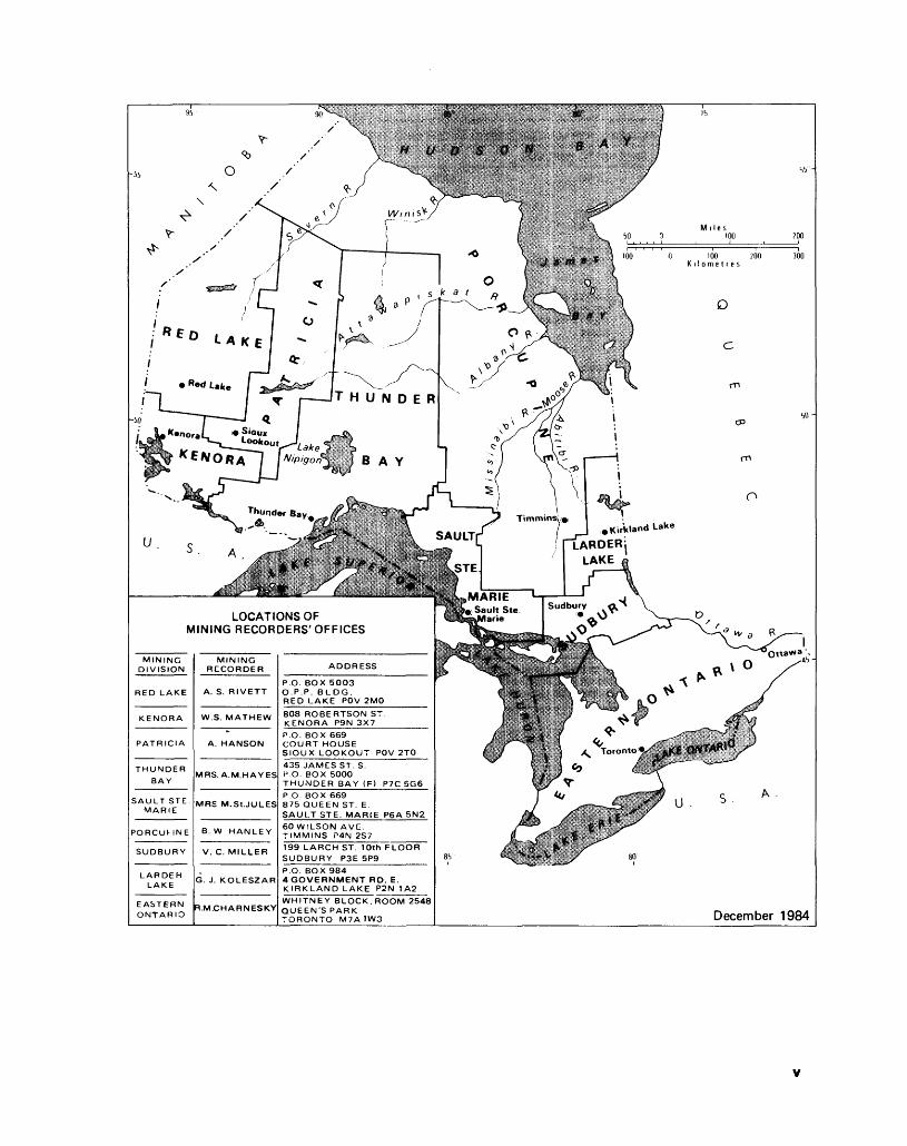
LOCATIONS OF MINING RECORDERS'OFFICES
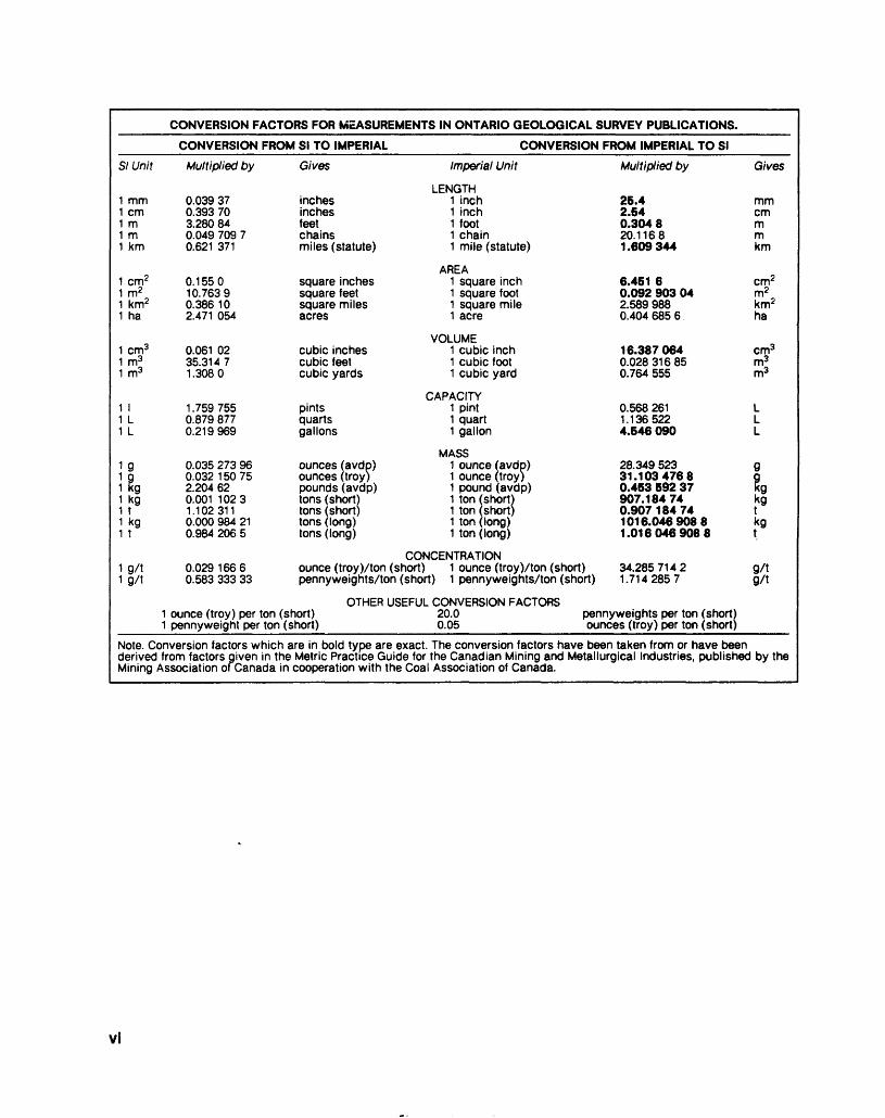
CONVERSION FACTORS FOR MEASUREMENTS IN ONTARIO GEOLOGICAL SURVEY PUBLICATIONS.
CONVERSION FROM SI TO IMPERIAL CONVERSION FROM IMPERIAL TO SI
SI Unit
1 mm 1 cm 1 m 1 m 1 km
1 cm2 1m2 1 km2 1 ha
1 cm3 1 m3 1 m3
1 l 1 L 1 L
1 kg 1 kg 1 t 1 kg1 t
1 g/t 1 g/t
Multiplied by
0.039 370.393 703.280 840.049 709 70.621 371
0.155010.76390.386102.471 054
0.061 0235.31471.3080
1.7597550.879 8770.219969
0.035 273 960.032150752.204 620.001 10231.1023110.000 984 210.984 206 5
0.02916660.583 333 33
Gives
inches inches feet chains miles (statute)
square inches square feet square miles acres
cubic inches cubic feet cubic yards
pintsquartsgallons
ounces(avdp) ounces (troy) pounds(avdp) tons (short) tons (short) tons (long) tons (long)
Imperial Unit
LENGTH 1 inch 1 inch 1 foot 1 chain 1 mile (statute)
AREA1 square inch 1 square foot 1 square mile 1 acre
VOLUME1 cubic inch 1 cubic foot 1 cubic yard
CAPACITY 1 pint 1 quart 1 gallon
MASS1 ounce(avdp) 1 ounce (troy) 1 pound (avdp)1 ton 1 ton 1 ton
short) short) long)
1 ton (long)
CONCENTRATIONounce (troy)Xton (short) 1 ounce (troy)Xton (short) pennyweights/ton (short) 1 pennyweights/ton (short)
Multiplied by
26.42.540.304820.11681.609344
6.451 60.092 903 042.589 9880.4046856
16.3870640.028316850.764 555
0.568 2611.1365224.546 090
28.349 52331.10347680.453 592 37907.184740.907184741016.04690881.0160469088
34.28571421.7142857
1 ounce (troy) per ton (short) 1 pennyweight per ton (short)
OTHER USEFUL CONVERSION FACTORS 20.0 0.05
pennyweights per ton (short) ounces (troy) per ton (short)
Gives
mmcmmmkm
cnrr m2 km2 ha
cmj m3
kg
9/tg/t
Note. Conversion factors which are in bold type are exact. The conversion factors have been taken from or have been derived from factors given in the Metric Practice Guide for the Canadian Mining and Metallurgical Industries, published by the Mining Association ofCanada in cooperation with the Coal Association of Canada.
vi
ContentsReport of Activities 1984
NORTHWESTERN REGIONKENORA RESIDENT GEOLOGIST AREAIntroduction 2Resident Geologist StaffActivities 2Mining Activity 2Quarrying Activity 3
Stone 3Peat and Black Soil 3
Exploration Activity 3Gold 8
Kakagi -Rowan-Straw LakesArea 8Man i tou-W abi goon-EagleLakes AreaLake of the Woods-Shoal Lake Area Mine Centre Area Bee Lake Area
Base Metals Other Minerals
Property Examinations Dryden-Ignace Economic Geologist Program
Introduction Property Examinations Property Descriptions
Wilkinson Bob LakeOccurrenceRognon and WachmanProspectsNiemi and H.W. 123OccurrencesSovereign Peak LakeProspect
Exploration GuidelinesIndustrial Mineral Development Potential, Northwestern Ontario
History of DevelopmentCommodities StudiedConclusions
Ontario Geological Survey ActivitiesOntario Mineral Exploration Program (OMEP) Research by Other Agencies
University ThesesOntario Geoscience ResearchGrant Program
Selected Publications Received 1984References
Tables1. Summary of Claims Recorded and
Assessment Work Credit2. Maps and Reports Issued by the
Ontario Geological Survey3. Exploration Activity4. Assessment Work and Other
Information Received5. Industrial Mineral Commodities
19
212122222222
23232323
23
24
25
2626
27272727
32
323333
33
3333
Figures1,2. Kenora Resident Geologist's Area3. Quarrying Activity4. Industrial Mineral Deposits
RED LAKE RESIDENT GEOLOGIST AREAIntroduction 35 Resident Geologist's Activities 35 Mining Activity 35 Exploration Activity 38 Ontario Geological Survey Activities 42 Ontario Mineral Exploration Program 42 Research by Other Agencies 42 Selected References and Recent Publications 43
Tables1. Summary of Claims Recorded and
Assessment Work Credit2. Exploration Activity3. Assessment Work and Other
Information Received
Figures1,2. Red Lake Resident Geologist Area
SIOUX LOOKOUT RESIDENT GEOLOGIST AREAIntroduction 44Resident Geologist's Activities 44Mining Activity 45Industrial Minerals 45
Potting Soil and HorticulturalProducts 45Sand and Gravel 45Rock Ballast 45
Mineral Exploration Activity 45Recommendations forExploration 50
Base Metals 50Gold 50
Recent Publications andReferences 55
Tables1. Exploration Activity2. Summary of Claims Recorded and
Assessment Work Credit3. Assessment Work and Other
Information Received4. Ontario Mineral Exploration
Programs Patricia Mining Division
Figures1,2. Sioux Lookout Resident
Geologist's Area
NORTH CENTRAL REGIONTHUNDER BAY RESIDENT GEOLOGIST AREAIntroduction 56 Acknowledgments 56 Resident Geologist Staff Activities 56 Mining Activities 57
Metallic Minerals 57 Industrial Minerals 57
Claim Staking and Exploration Activity 57 Hemlo Area 57
Introduction 57 North Rim Properties 93 Pic River Properties 93 Barite Occurrences 94 Lytton Minerals Limited Property 94 Golden Sceptre, North Zone 94 Other Occurrences and Exploration Programs 94
Amethyst in the Thunder Bay Region 95
Introduction 95 Regional Geology 95 Amethyst and Its Properties 96 Property Descriptions 96
Amethyst Mine Panorama 96 Marino Mountain Property 96
Shebandowan Area 97 Jalna Resources Limited Gold Creek Property 97 Curran Bay Resources Limited 97
Beardmore-Geraldton Economic Geologist Program 97
Introduction 97 Producing Gold Mines and Major Exploration Programs 98 General Geology and Structure 100 Geology of the Southern Metavolcanic Sub-Belt 101
Structural Geology 101 Gold Mineralization 101 History 101 Shear Zones 101 Ironstone 101 Quartz-Carbonate Veins Hosted in Metavolcanic Rocks 102 Geochemistry 102 Alteration and Mineralogy 102 Conclusions 102
Geology of theOnaman-Tashota Metavolcanic Belt 103
Gold Mineralization 103(1) Vein Type 105
Wascanna Prospect 105 King-Dodds Occurrence 106
(2) Chemical Metasediment Type 106
Paulpic Prospect 106Recommendations forExploration 106
vll
Schreiber-Terrace Bay Economic Geologist Program 106
Introduction 106 General Geology 107 Economic Geology 107 Gold Mineralization 107
Type 1: Terrace Bay Batholith-Contact Zone Type 107
Harkness-Hays: Gold Range Properties 109
Type 2: Porphyry Contact Zone Type 111 Type 3: Metavolcanic Hosted Dilatent Zone Type 111
Little Bear (Little Bruin) Property 111
Type 4: Chemical Sediment-Stratabound Type 112
Simard-Swetz Property 112 Base Metals 113
Type 1: Volcanogenic Massive Sulphide Deposits 113
Dello Lake Occurrence 114 Type 2a: Zinc-Lead Silver Veins-Metavolcanic Type 114
Deadhorse Creek South Prospect (Hannam Property) 114
Type 2b: Lead-Zinc-Barite Veins-Unconformity Type 115
Gordon Occurrence 115 Type 3:Copper-Molybdenum Vein Type 115
Exploration Guidelines 116 Gold 116 Base Metals 116
Recent Exploration Activities 116 ResearchActivities-Schreiber-Terrace Bay Area 117
Atikokan Cobalt-Base Metals-Platinum Group Elements Project 117
Introduction 117 General Geology and Structure 118 Deposit Types 118
(1) The Quetico Fault Zone-Hosted Intrusions 118
Atikokan Iron Mine 120(2) Quetico Intrusions 120
Abiwin Occurrence 120 Kawene Occurrence 120
(3) Chemical SedimentaryRocks in MetavolcanicTerrain 120(4) Shear Zones Within Metavolcanic Terra! n 121
Anderson Occurrence 121(5) Quartz Veins 121
Summary 121 Building and Monument Stone 122
Introduction 122 Terminology 122 Geological Criteria for Stone Deposits 123 Dimension Stone in the North Central Region 123
SandstoneVert Island SandstoneQuarrySimpson Island SandstoneQuarry
MarbleLunmac Marble Property
GraniteQuarries in the MarathonArea
Exploration and Market Potential
Quaternary Geology Introduction Geraldton Area Terrace Bay Area
Historical Research ProjectResults
Geological Research in the North Central Region
Ontario Geological Survey Activities Research by Other Organizations
Geological Survey ofCanadaLakehead UniversityOther Universities
References
123
123
124125125126
126
127127127127127128128
128
128
129
129129130130
NORTHERN REGION
Tablesi.
2.
Assessment Work and Other Information ReceivedExploration Activity on Leased and Patented Mining Land
3. Summary of Claims Recorded and Assessment Work Credit
4. Exploration Programs in the Beard more-Gerald ton Area
5. Geochemistry of Gold Properties, Beardmore-Geraldton
6. Building Stone Quarries 6a. Past-Producing Quarries 6b. Prospects 6c. Occurrences
7. Maps and Reports Issued by the Ontario Geological Survey
Figures1. North Central Region, NTS Grid2. Producing Mines; Mines and/or
Properties Under Development3. Property Visits -
Beardmore-Geraldton Economic Geologist Program
4. Schreiber-Terrace Bay Economic Geologist Program
5. Property Visits -Schreiber-Terrace Bay Economic Geologist Program
6. Property Visits - Atikokan Cobalt-Base Metal-Platinum Group Element Study
7. Building and Monument Stone Inventory
TIMMINS RESIDENT GEOLOGIST AREAIntroduction 134 Core Library Program 134 Claim Staking Activity 134 Exploratory Licences of Occupation 134Operating Mines 134
Base Metals 134 Precious Metals 135 Industrial Minerals 156
Property Evaluation andDevelopment 156Exploration Activity 158Ontario Geological SurveyActivities 160
Engineering and Terrain Geology Section 160 Geophysics/Geochemistry Section 161 Mineral Deposits Section 161
Ontario Geoscience ResearchGrants Program 161Ontario Mineral ExplorationProgram (OMEP) 161
Tables1. Maps and Reports Issued by the
Ontario Geological Survey2. Gold Production, Porcupine
Mining Division3. Assessment Work and Other
Information Received
Figures1.-4. Timmins Resident Geologist's
Area 5. Timmins Area
KIRKLAND LAKE RESIDENT GEOLOGIST AREAIntroduction 162 Resident Geologist Staff Activities 162 Drill Core Storage Library 163 Operation Black River-Mafheson (BRIM) 163
Introduction 163 General Geology 163 Ongoing Activities 166 Economic Potential 170
Mining Activity 170 Property Visits 184
C.M.B. Holdings "Beaver Dam" Gold Occurrence 184 Golden Harker Prospect 188 Sheldon Larder Mines Limited Gold Prospect 189 T. and W. Sullivan and W. Cooper Copper Occurrence 189
Recommendations for
Vill
ExplorationBasal Till Sampling Gold
189189189
Ontario Geological SurveyActivities 190
Precambrian Geology Section 191Engineering and TerrainGeology Section 191Geophysics/GeochemistrySection 191Mi neral Deposi ts Secti on 191
Research by Other Organizations 191Geoscience Research GrantProgram 191
References 191 Publications Added to the Kirkland Lake Resident Geologist's Library 1984 193
Tables1. Summary of Claims Recorded and
Assessment Work Credit2. Maps and Reports Issued by the
Ontario Geological Survey3. Gold Production From All Mines
-Ontario's Larder Lake Mining Division to the End of 1983
4. Assessment Work and Other Information Received
5. Core Stored at Drill Core Library
Figures1. Producing Mines, Major Property
Evaluations and Property Visits, 1984
2. Drillhole Locations of Core Stored at the Drill Core Storage Library
3. Operation Black River-Matheson
NORTHEASTERN REGIONCOBALT RESIDENT GEOLOGIST AREAIntroduction 197Resident Geologist's Activities 197 Mining Activity 199
Beaver-Temiskaming Mine(Agnico-Eagle Mines Ltd.) 200Sulpetro Minerals Ltd.(Canadaka Division) 200Sherman Mine (Dofasco andTetapaga Mining Co. Ltd.) 200Langis Mine (Agnico-EagleMines Ltd.) 201Silver Queen Mine (R.A.Gilson Associates and StarlightEnergy Corp.) 201
Exploration Activity 201 Industrial Minerals 206 Ontario Geological Survey Activities 207
Engineering and TerrainGeology Section 207
Research by Other Organizations 207
Carleton University McMaster University
Recent Publications andReferences
Tablesi.
207207
207
Maps and Reports Issued by the Ontario Geological Survey
2. Exploration and Claim Staking Activity
3. Assessment Work and Other Information Received
Figuresl,la.Resident Geologist's Area 2. Exploration Diamond Drilling
Activity Cobalt ResidentGeologist Area
SAULT STE. MARIE RESIDENT GEOLOGIST AREAIntroduction 209Resident Geologist's Activities 209Claim Staking Activity 209Mining Activity 209Exploration Activity 211
Gold 211 Base Metals 218
Sault Ste. Marie Drill CoreLibrary 218Sault Ste. Marie Reconnaissance Geology Project 219
Introduction 219 Geological Setting 219 Field Investigations 219
Wawa Economic Geologist's Report 221
Introduction 221 Mineral Exploration in the Wawa-Missinabie Area 221 Property Visits 221
Centennial Mine 221 K us tec Occurrence 221 Cline Mine 221 Desjardins Occurrence 224 Rowan Lake Occurrence 224 Edina Gold Prospect 226 Bingham-Holliday Showings 226 Boliden Prospect 226 Norwalk Mine 226
Current Research in the Wawa Area 227
Sault Ste. Marie Industrial Minerals 227 Ontario Geological Survey Activities 228 Publications and Theses Added to the Sault Ste. Marie Resident Geologist's Library 228 References 229
Tables1. Exploration Activity2. Assessment Work and Other
Information Received3. Maps and Reports Issued by the
Ontario Geological Survey
Figures1. Sault Ste. Marie Resident
Geologist's Area2. Number of Claims Recorded in
the Sault Ste. Marie Mining Division
3. Sault Ste. Marie Reconnaissance Geology Project Area
4. Aeromagnetic Anomalies Examined in 1984
5. Regional Geochemical Anomalies6. Wawa Economic Geologist's l Area7. Property Visits by the Wawa
Economic Geologist8. Industrial Minerals and Building
and Ornamental Stone Resources in the Sault Ste. Marie Area
SUDBURY RESIDENT GEOLOGIST AREAIntroduction 230Resident Geologist's Activities 230Mining Activity 230
Nickel-Copper-Precious Metals 230Gold 230Industrial Minerals 231
Ontario Geological SurveyActivities 231Exploration Activities 231Recent Publications and Theses 237
Tables1. Maps and Reports Issued by the
Ontario Geological Survey2. Exploration Activity3. Assessment Work and Other
Information Received
Figures1,2. Sudbury Resident Geologist's
Area3. Sudbury Mining Camp4. Claim Staking Activity, Sudbury
Mining Recorder's Office
HUNTSVILLE RESIDENT GEOLOGIST AREAIntroduction 242Resident Geologist's Activities 242
Graphite Project 242Aggregate Resources 244Gold Project 244
IX
Other Geological Activities 244Ontario Geological Survey 244Geological Survey of Canada 244
Exploration Activity 245Gold " 245Graphite 245Base Metals 245Quartz 245
Mining Activity 245 Mineral Education Program 245References and RecentPublications 245
Tables1. Maps and Reports Issued by the
Ontario Geological Survey2. Exploration Activity3. Assessment Work and Other
Information Received
Figure1. Huntsville Resident Geologist's
Area
BANCROFT RESIDENT GEOLOGIST AREAIntroduction 247Resident Geologist's Activities 247Drill Core Library 247Other Geological Activities 247
Algonquin Region, OntarioMinistry of Natural Resources 247
Leslie M. Frost NaturalResources Centre 247
Ontario Geological Survey 247Geological Survey of Canada 249Royal Ontario Museum 249Universities 249
Exploration Activity 249Mining Activity 250Recommendations 251Selected References 251
Tables1. Maps and Reports Issued by the
Ontario Geological Survey2. Exploration Activity3. Assessment Work and Other
Information Received
Figurel. Bancroft Resident Geologist's
Area
EASTERN REGIONEASTERN RESIDENT GEOLOGIST AREAIntroduction 254Resident Geologist's Activities 254Mining Activity 255
Exploration Activity 258Gold 258Base Metals 260Mica 260Graphite 260
Industrial Minerals Program 260Carbonate Rocks 260Barite-Fluorite Veins 262
Aggregate Resources 263Ontario Geological SurveyActivities 263Geological Mapping, EasternRegion 263Drill Core Library 263Mineral Education Program 263Geotechnical EngineeringProgram 263Seismic Survey 264Pits Quarries - Napanee, Tweed,and Brockville Districts 270Abandoned Pits and QuarriesStudy 270Inactive Hazardous Mines SitesInventory 270Pits Quarries - Cornwall District 270References 270
Tables1. Assessment Work and Other
Information Received2. Exploration Activity2a. Summary of Seismic Results3. Licenced Pits and Quarries in
Napanee, Tweed, and Brockville Districts
4. Reported Aggregate Production by Township from Licenced Operators in Napanee District Under The Pits and Quarries Control Act
5. Reported Aggregate Production by Township from Licenced Operators in Tweed District Under The Pits and Quarries Control Act
6. Reported Aggregate Production by Township from Licenced Operators in Brockville District Under The Pits and Quarries Control Act
7. Abandoned Pits and Quarries Study
8. Licenced Pits, Quarries andPits/Quarries for 1984 -Cornwall District
9. Aggregate Production from Licenced Pits and Quarries During the Year 1981 - Cornwall District
10. Aggregate Production from Licenced Pits and Quarries During the Year 1982 - Cornwall District
11. Aggregate Production from
Licenced Pits and Quarries during the Year 1983 - Cornwall District
Figures1. Eastern Region - Producing
Mines, Assessment Work, and Claim Staking
2. Company Exploration Activity and O.G.S. Field Work
3. Claim Staking and Cancellation Activity in Eastern Ontario
4. Eastern Region Ministry Field Activities
5. Map of Seismic Survey with Bedrock Topography
CENTRAL REGIONCENTRAL REGIONAL GEOLOGIST AREAIntroduction 278 Regional Geologist's Activities 278
Resources and Land Use Planning 278 Consultation and Educational Services 278 Pits and Quarries 280 Property Examinations 280
Geology and Mining Related Activities 280
C. Mirza Engineering Incorporated 280 Franceschini Brothers Aggregates Limited 285 St. Marys Cement Company 285 Walker Brothers Quarries Limited 285 Vineland Quarries and Crushed Stone 285 National Sewer Pipe Limited 285 TRT Sand and Gravel 285 3M Canada Incorporated 286 Fred Nelson and Sons Ltd. 286 Lasir Gold Incorporated 286
Staking and Exploration 287 Regional Geological Evaluation Projects 287
Sandstone Resources Study 287 Shale and Clay Resources Related to Tile Manufacture 287 Township Aggregate Inventories 287 Canada Works Projects 287
Public Awareness Programs 287 Summary of Field Work by the Ontario Geological Survey 287 Ontario Geoscience Research Grant Program 287 Recent References 288
Tables1. Licenced Pits and Quarries in the
Central Region2. Reported Aggregate Production by
Township
3. Maps and Reports Issued by the Ontario Geological Survey
Figure1. Central Regional Geologist's . Area j
SOUTHWESTERN REGIONSOUTHWESTERN REGIONAL GEOLOGIST AREAIntroduction 289 Regional Geologist Office Activities 289
Petroleum Resources Activities 289 Mineral Resources Activities 292
Construction Aggregate Resources 292 Mineral and Chemical
Composition of Natural Quaternary Sands
Quaternary GeologyOntario Geological Survey Activities
Engineering and TerrainGeology Section
Ontario Geoscience Research Grants Petroleum Activity StatisticsMineral Activity Statistics
AggregatesSalt
Theses Projects References
Tables1. Summary of Wells Drilled in 19842. Lake Erie Drilling, for 1984
294 3. Maps and Reports Issued by the Ontario Geological Survey Aggregate Production from Licensed Pits and Quarries, 1983
293294
294 4.
294294295295296296296
Figure1. Southwestern Region, Petroleum
Activity Highlights
LOCATION MAPSRegional and Resident Geologists' Areas i Location of Mining Recorders' Offices
Xl

Report of Activities 1984Regional and Resident Geologists
edited by C.R. Kustra1
'Regional Liaison Geologist, Ontario Geological Survey. This report is published with the permission of V.G. Milne, Director, Ontario Geological Survey.
Kenora Resident Geologist Area, Northwestern RegionC.E. Blackburn 1 and M.R. Hailstone21 Resident Geologist, 2Resource Geologist, Ontario Ministry of Natural Resources, Kenora
INTRODUCTIONCurrent permanent staff in the Resident Geologist Office include C.E. Blackburn, Resident Geolo gist, and M.R. Hailstone, Resource Geologist. Contract staff comprise the following: D. Danielson, clerk- typist; C.C. Storey, funded under the Northern Ontario Rural Devel opment Agreement (NORDA) in centives program, conducted a sur vey outlining the potential for in dustrial mineral development in Northwestern Ontario, assisted by R. Schienbein; J. Parker, funded by the Ontario Ministry of Northern Affairs, commenced an Economic Geologist program in the general Dryden-Ignace area, assisted by A. Schottroff. Other Ontario Ministry of Natural Resources geologists housed in the office for periods of the year were J.C. Davies and P.M. Smith, funded under the NORDA incentives program, who continued their gold deposit char acterization study of Lake of the Woods.
RESIDENT GEOLOGIST STAFF ACTIVITIES————-————The progress of a small mining and milling operation in the Mine Centre area was watched with much interest. A number of visits were paid by staff to the Mine Centre Gold Venture operation, a joint operation of Orotek Re sources Corporation and Royal Gold and Silver Corporation.
A number of properties were visited that were undergoing devel opment work or advanced evalu ation, each on a number of occa sions. These included the property of Union Carbide Exploration Cor poration, which continued its op tion on Consolidated Professor Mines Limited's Duport Mine gold property at Shoal Lake, the Cameron Lake Gold Property of Nuinsco Resources Limited, and the Olive Mine gold property op tioned by Homestake Explorations Limited.
Numerous properties and ar eas undergoing active exploration were visited. These are: the
Petrunka-Moorehouse Tungsten Property near Mavis Lake, and the adjacent Fairservice Option, both under evaluation by Sanmine Ex ploration Incorporated, the latter for gold; the Fairservice Gold Property near Straw Lake, which during 1984 passed from Noranda Incorporated to Corporation Fal conbridge Copper; the Gaudry Gold Prospect, being explored by Selco Incorporated as a joint ven ture with Gossan Resources Limit ed; the Monte Cristo Gold Prospect of Nuinsco Resources Limited and Lockwood Petroleum Incorporat ed; the Gold Hill and Black Jack, and associated gold prospects in Kirkup Township, under option to Bonzano Exploration Limited, and later in the year to Kidd Creek Mines Limited; the Scramble Gold Prospect, under evaluation by Boi se Cascade Corporation's mineral resources unit; Noranda Incorpo- rated's base metal exploration camp in the Oak Lake area; Arm strong's Swell Bay and Pocket Pond zinc-copper Prospects, under option to Corporation Falconbridge Copper; Esso Minerals Canada's Snake Bay Gold Prospect; Voyager Explorations Limited's Flambeau Lake gold option from Alex Kozy; the Pidgepn Hyndman Township and associated gold properties, un der option to Teck Corporation; the Golden Star Gold Prospect, un der option to Cleyo Resources In corporated. Other prospects under evaluation and inactive mineral showings were examined and re ported on during the year.
Geoscience lectures and field trips were provided for the Rough Rock and Gel ley Lake Junior Ranger Camps, and for the local high school. Ontario Geological Survey field parties were visited and joint studies conducted on a number of local gold occurrences and prospects, in preparation for a field trip to be held in conjunction with the Institute on Lake Superior Geology, Kenora, in May 1985.
An information seminar ori ented toward mining exploration company personnel, prospectors, and the general public was orga
nized in Kenora in March. Ontario Geological Survey and Kenora- based Ontario Ministry of Natural Resources geoscience personnel presented talks in a l-day session.
Talks on current mineral ex ploration trends and activities within Kenora Mining Division were presented to local service clubs. A talk on tectonic models for the Wabigoon Subprovince was given to the Winnipeg Branch of the Geological Association of Canada.
MINING ACTIVITYA small milling operation was es tablished in the Mine Centre area during 1984 (Figure 1). A 75 ton per day mill was placed on site at the Manhatten Prospect by Royal Gold and Silver Corporation in their Mine Centre Gold Venture with Orotek Resources Corpora tion. Feed for the mill was to come from various rock dumps, tailings, and gold-bearing quartz veins, a number 'of which were formerly exploited. Orotek obtained 67 claims in the surrounding area, en compassing a number of past- producing mines, notably the Foley, Manhattan, Decca, and Fer guson. Development work was done on the Lucky Joe, Bonanza, and Jumbo veins.
Union Carbide Exploration Corporation continued its joint venture with Consolidated Profes sor Mines Limited at the latter company's Duport Mine gold prop erty on Cameron Island, Shoal Lake. Under the agreement, Union Carbide can earn a SO^o interest in the property by spending S10 000 000 in stages, and by agreeing to put the property into production.
Following surface diamond drilling and metallurgical testing of a 1000 pound (455 kg) sample tak en from the old mine dump during 1983, Union Carbide announced a reserve estimate of l 927 000 tons at a grade of 0.30 ounce gold per ton, over an average width of 9.75 feet (3 m), to a depth of 1150 feet (350 m), and a strike length of 2400 feet (732 m), in 2 parallel
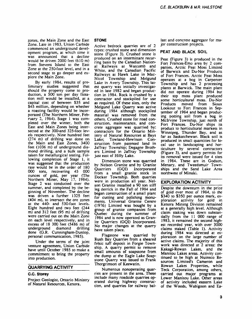
C.E BLACKBURN 4 M.R. HAILSTONE
zones, the Main Zone and the East Zone. Late in 1983, Union Carbide commenced an underground devel opment program, at which time it was announced that a decline would be driven 2000 feet (610m) from Stevens Island to the East Zone at the 250-foot level, and in a second stage to go deeper and ex plore the Main Zone.
By early 1984, results of pre liminary studies suggested that should the property come to pro duction, a 500 ton per day flota tion mill would be installed, at a capital cost of between S35 and S45 million, depending on whether a roasting facility would be incor porated (The Northern Miner, Feb ruary 2, 1984). Stage l was com pleted over the winter, both the East and Main Zones being inter sected at the 300-and 325-foot lev els respectively. Nine hundred feet (274 m) of drifting was done on the Main and East Zones, 3400 feet (1036 m) of underground dia mond drilling, and a bulk sample taken for metallurgical testing. Fol lowing completion of Stage l, it was suggested that the production rate would be in the order of 180 000 tons, recovering 45 000 ounces of gold, per year (The Northern Miner, May 17, 1984). Stage 2 was conducted over the summer, and completed by the be ginning of November. The decline was driven a further 1325 feet (404 m), to intersect the ore zones at the 440- and 530-foot levels. Eight hundred and two feet (244 m) and 312 feet (95 m) of drifting were carried out on the Main Zone on each level respectively, and in excess of 18 300 feet (5486 m) of underground diamond drilling done (G.R. Cunningham-Dunlop, personal communication, 1985).
Under the terms of the joint venture agreement, Union Carbide have until October 1985 to make a commitment to bring the property into production.
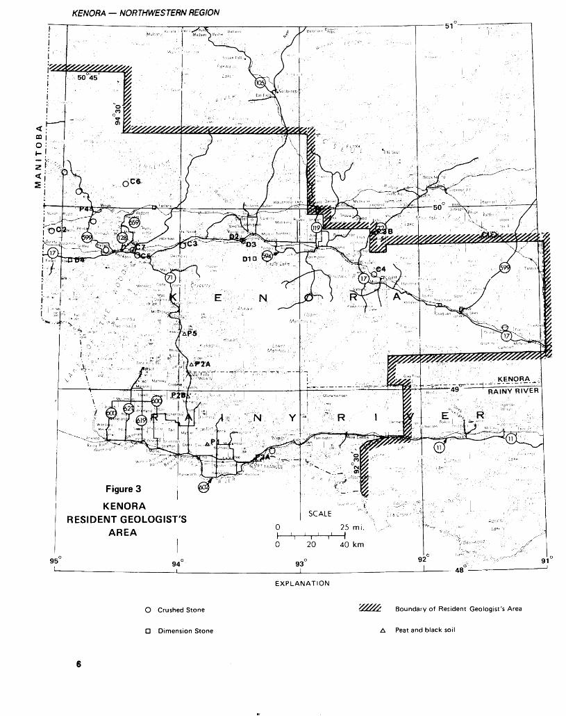
QUARRYING ACTIVITY C.C. StoreyProject Geologist, Ontario Ministry of Natural Resources, Kenora.
STONEActive bedrock quarries are of 2 types: crushed stone and dimension stone (Figure 3). Crushed stone is produced on an intermittant recur ring basis by the Canadian Nation al Railways at Watcomb and White, and the Canadian Pacific Railways at Hawk Lake in Mac- Nicol Township and Melgund Lake in Avery Township. This lat est quarry was initially investigat ed in late 1982 and began produc tion in 1984. Rock is crushed by a contractor and stockpiled for use as required. Of these sites, only the Melgund Lake Quarry was active during 1984 although stockpiled material was removed from the others. Crushed stone for road con struction, maintenance, and con crete aggregate was quarried by: contractors for the Ontario Min istry of Natural Resources at Bays Lake; Towland-Hewitson Con struction from patented land in Jaffray Township; Degagne Broth ers Limited in Jaffray Township just east of Hilly Lake.
Dimension stone was quarried by Nelson Granite and by Granite Quarriers (GQI) Incorporated from a small granite stock in Docker Township. Both quarries were in production all year. Nel son Granite installed a 90 ton stiff leg derrick in the Fall of 1984 and began construction of a small plant for cutting and polishing monu ments. Universal Granite Centre (1976) Limited was bought by a group of granite companies from Quebec during the summer of 1984 and is now operated as Gran ite Quarriers (GQI) Incorporated. No major changes at the quarry have taken place.
Flagstone was quarried by Rush Bay Quarries from a sheared felsic tuff deposit in Forgie Town ship. A quarry permit to remove small amounts of soapstone from the dump at the Eagle Lake Soap stone Quarry was issued to Frank Thorgrimson of Keewatin.
Numerous nonoperating quar ries are present in the area. These include many roadside quarries op erated during highway construc tion, and quarries for railway bal
last and concrete aggregate for ma jor construction projects.
PEAT AND BLACK SOIL
Peat (Figure 3) is produced in the Fort Frances-Emo area by 2 com panies, Arctic Peat Moss Limited of Barwick and Du-Nor Products of Fort Frances. Arctic Peat Moss operates at a bog in Carpenter Township and has 2 processing plants at Barwick. The main plant did not operate during 1984 but their top moss plant produced some horticultural moss. Du-Nor Products moved from Sioux Lookout to Fort Frances in Sep tember of 1984 and began produc ing potting soil from a bog in Mcirvine Township, just north of Fort Frances. Du-Nor ships its product to horticultural markets in Winnipeg, Thunder Bay, and as far as Saskatchewan. Black soil is produced in small quantities for lo cal use in landscaping and hor ticulture by several contractors (Figure 3), and quarry permits for its removal were issued for 4 sites in 1984. These are in Godson, Menary, and Tweedsmuir Town ships and the Sand Lake Area northwest of Minaki.
EXPLORATION ACTIVITYDespite the downturn in the price of gold over most of 1984, to the S340 to S350 per ounce mark, ex ploration activity for gold in Kenora Mining Division remained at a generally high level. Although claim staking was down substan tially from the 11 000 range of 1983, it remained the second high est recorded year, with over 3000 claims staked (Table 1). Activity during 1984 was directed at ex ploration on the large number of active claims. The majority of this work was directed at 2 areas: the Kakagi-Rowan Lakes, and the Manitou Lakes areas. Activity con tinued to be high at Nuinsco Re sources Limited's Cameron and Rowan Lakes Properties, while Teck Corporation, among others, carried out major programs at Lower Manitou Lake. Other areas of activity included eastern Lake of the Woods, Wabigoon and Ea-
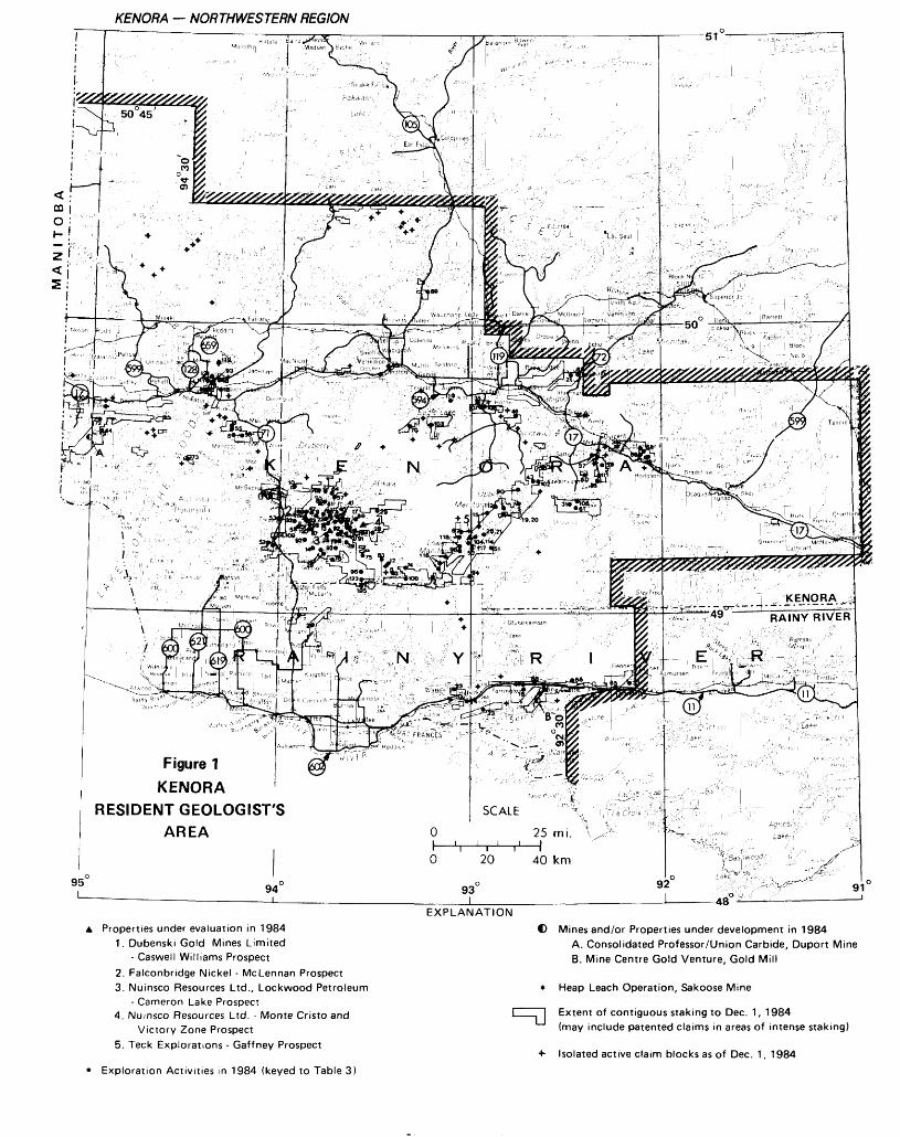
KENORA — NORTHWESTERN REGION
—^ "TJ: * . r~ H;'?\ x/'
95L.
Figure 1 KENORA
RESIDENT GEOLOGIST'S AREA
94
EXPLANATIONA Properties under evaluation in 1984
1. Dubenski Gold Mines Limited- Caswell Williams Prospect
2. Falconbridge Nickel - McLennan Prospect3. Nuinsco Resources Ltd., Lockwood Petroleum
- Cameron Lake Prospect4. Nuinsco Resources Ltd. - Monte Cristo and
Victory Zone Prospect5. Teck Explorations - Gaffney Prospect
* Exploration Activities in 1984 (keyed to Table 3)
C) Mines and/or Properties under development in 1984A. Consolidated Professor/Union Carbide, Duport Mine B. Mine Centre Gold Venture, Gold Mill
* Heap Leach Operation, Sakoose Mine
l l Extent of contiguous staking to Dec. 1, 1984(may include patented claims in areas of intense staking)
•*- Isolated active claim blocks as of Dec. 1, 1984
CE BLACKBURN 6 M.R. HAILSTONE
Figure 2 KENORA
RESIDENT GEOLOGIST'S AREA
EXPLANATION Map or Report issued by the Ontario Geological Survey,1984 (keyed to Table 2)
© Location of OGS Field Party and /or Special Project, 1984 (keyed to text)
•X- Property visits, Dryden Economic Geologist Program (keyed to Table in text)
O Property visits, Resident Geologist's Offi (keyed to Table in text)
Boundary of Resident Geologist's Area
KENORA — NORTHWESTERN REGION
Figure 3
KENORARESIDENT GEOLOGIST'S
AREA
EXPLANATION
O Crushed Stone
D Dimension Stone
Boundary of Resident Geologist's Area
A Peat and black soil
CE BLACKBURN 8, M.R. HAILSTONE
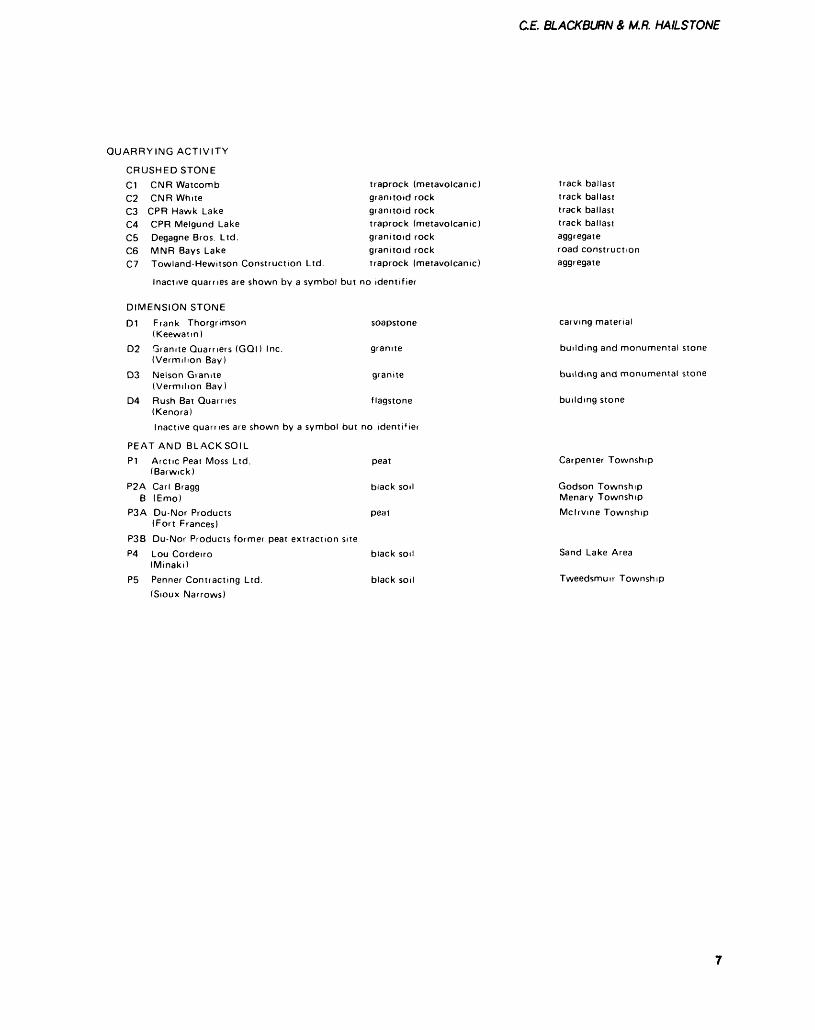
QUARRYING ACTIVITY
CRUSHED STONE C1 CNR Watcomb
CNR WhiteCPR Hawk LakeCPR Melgund LakeDegagne Bros. Ltd.MNR Bays LakeTowland-Hewitson Construction Ltd.
C2 C3 C4 C5 C6 C7
traprock (metavolcanic) granitoid rock granitoid rock traprock (metavolcanic) granitoid rock granitoid rock traprock (metavolcanic)
Inactive quarries are shown by a symbol but no identifier
DIMENSION STONE
D1 Frank Thorgnmson (Keewatin)
D2
D3
D4
soapstone
graniteGranite Quarners (GQl) Inc. (Vermilion Bay)Nelson Granite granite(Vermilion Bay)Rush Bat Quarries flagstone(Kenora)Inactive quarries are shown by a symbol but no identifier
PEAT AND BLACKSOILP1 Arctic Peat Moss Ltd.
(Barwick)P2A Carl Bragg
B (Emo) P3A Du-Nor Products
(Fort Frances) P3B Du-Nor Products former peat extraction site
peat
P4
P5
Lou Cordeiro (Minaki)
peat
black soil
track ballasttrack ballasttrack ballasttrack ballastaggregateroad constructionaggregate
carving material
building and monumental stone
building and monumental stone
building stone
Carpenter Township
Godson Township Menary TownshipMcirvine Township
Sand Lake Area
Tweedsmuir Township

KENORA — NORTHWESTERN REGION
SUMMARY OF CLAIMS RECORDED AND ASSESSMENT WORK CREDITTABLE 1
Year
1984*
198 'i
1982
Claims Recorded
:. , lv 't
U,i '6 1
1 , 5/V
Claims Cancelled
.V/,7
1 , 4 t 2
1 60V
Claims Active
) -- ,912
r:, 6 3 '-j
'\ , o 4 6
Diamond Drilling
(Man Days)
'"i , 6V 5
'1.5, /4i-,
Geophysical Surveys
(Man Days)
2oti , i ' W
4/ , .:'.'.M
.'i* , -' , L'
Geological Surveys
(Man Days)
. '' l , t:!'"H 1
l -: , ' " ~o
'-, ^ '-.I. )
Total Man
Days
•M 5,5 21
li 16, :.V/'
6U . '-1 '-V
l , :'t)u
l, 67 "X
19BO
1979
19/8
1977
1976
19/5
19/4
*to No
gle Lakes, Kawashegamuk and Stormy Lakes, the Mine Centre area, and Bee Lake. Exploration for base metals remained at a low level, in general confined to the English River Subprovince, and Rainy Lake, by Noranda Incorpo rated and Corporation Falcon bridge Copper respectively, the lat ter spurred by their success at Winston Lake, east of Thunder Bay.
GOLDKakagi-Rowan-Straw Lakes AreaNuinsco Resources Limited contin ued exploration on its Cameron Lake and Rowan Lake gold prop erties in 1984. Prior to this, dia mond drilling over 71 holes total ing 65 819 feet (20 062 m) at Cameron Lake had led to the de lineation of reserves variously es timated at 1.5 to 2 million tens grading 0.15 to 0.2 ounce gold per ton. At Rowan Lake, diamond drilling was done in 1983 over 12 holes totaling 5155 feet (1571 m) at the Monte Cristo Prospect. In duced polarization surveys have been performed on both properties. Before the beginning of 1984, Loc kwood Petroleum Incorporated had completed their expenditure commitment to Nuinsco Resources Limited at Cameron Lake, to earn a 50*Vo interest in the property. At
Rowan Lake, Nuinsco held a lOO'Vo interest on 92 unpatented claims surrounding 7 patented claims over the Monte Cristo Prop erty. Under option agreement with Lakeport Gold Mines Limited, they were to earn an SO^o interest in the 7 patented claims.
In January, 1984, Nuinsco Re sources Limited announced a win ter drilling program at the Monte Cristo Prospect, to test new anomalies delineated by the in duced polarization survey, over a strike length of more than l mile (1.6 km) in the 400-foot (123 m) wide shear zone. A new option agreement was worked out in Feb ruary with Lakeport, transferring lOO^o interest in the 7 patented claims to Nuinsco. Sixteen diamond-drill holes were put down at Rowan Lake over the winter, 6 of which tested a new zone, over a 500-foot (152 m) strike length, the Victor Zone, some 3200 feet (975 m) southwest of the Monte Cristo Prospect. One of these holes inter sected a 26.6-foot (8.1 m) section grading 0.371 ounce gold per ton.
Drilling was continued over the summer months at both Cameron and Rowan Lakes. In July, a public meeting, organized by Nuinsco and Dubenski Gold Mines Limited was held at Sioux Narrows to discuss plans for a
road off Highway 71 south of Sioux Narrows to give access to both the Cameron Lake Property and to the Dubenski Gold Mines Limited property at Flint Lake. Drilling at the Cameron Lake Property was directed toward test ing both the strike extension of the mineralized zone, and its depth continuity. In July, Nuinsco an nounced that this drilling had in creased the strike length of the mineralized zone to 3000 feet (914 m), while detailed geological map ping and structural analysis ar ound the discovery area showed that gold is hosted in siliceous pyritic breccia veins, that are up to 140 feet long by 30 feet wide (43 by 9 m), grading 0.275 ounce gold per ton. Drilling at Rowan Lake was directed toward the new Vic tor Zone.
The activity by Nuinsco Re sources Limited has been paral leled by work on surrounding properties, some of which are on strike with or parallel to either the Cameron Lake Property or the Monte Cristo Prospect of Nuinsco. These include properties of the fol lowing companies: Bigstone Min erals Limited; Charger Resources Limited; Del None Chrome Cor poration; Dejour Mines Limited; Falcon Resources Incorporated; Canolan Resources Limited; and
8
C.E. BLACKBURN A M.R. HAILSTONE
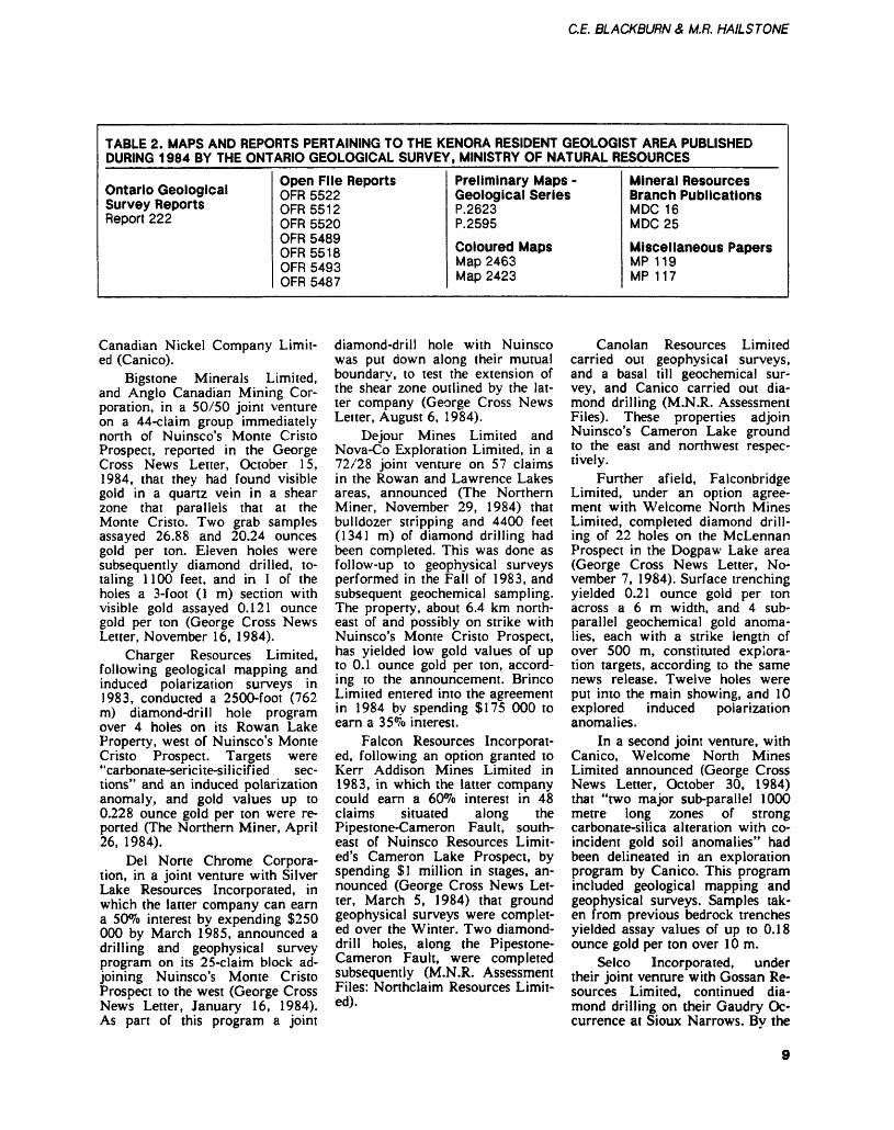
TABLE 2. MAPS AND REPORTS PERTAINING TO THE KENORA RESIDENT GEOLOGIST AREA PUBLISHED DURING 1984 BY THE ONTARIO GEOLOGICAL SURVEY, MINISTRY OF NATURAL RESOURCES
Ontario Geological Survey ReportsReport 222
Open File ReportsOFR 5522 OFR5512 OFR 5520 OFR 5489 OFR 5518 OFR 5493 OFR 5487
Preliminary Maps - Geological SeriesP.2623 P.2595
Coloured MapsMap 2463 Map 2423
Mineral Resources Branch PublicationsMDC 16 MDC25
Miscellaneous PapersMP 119 MP 117
Canadian Nickel Company Limit ed (Canico).
Bigstone Minerals Limited, and Anglo Canadian Mining Cor poration, in a 50/50 joint venture on a 44-claim group immediately north of Nuinsco's Monte Cristo Prospect, reported in the George Cross News Letter, October 15, 1984, that they had found visible gold in a quartz vein in a shear zone that parallels that at the Monte Cristo. Two grab samples assayed 26.88 and 20.24 ounces gold per ton. Eleven holes were subsequently diamond drilled, to taling 1100 feet, and in l of the holes a 3-foot (l m) section with visible gold assayed 0.121 ounce gold per ton (George Cross News Letter, November 16, 1984).
Charger Resources Limited, following geological mapping and induced polarization surveys in 1983, conducted a 2500-foot (762 m) diamond-drill hole program over 4 holes on its Rowan Lake Property, west of Nuinsco's Monte Cristo Prospect. Targets were "carbonate-sericite-silicified sec tions" and an induced polarization anomaly, and gold values up to 0.228 ounce gold per ton were re ported (The Northern Miner, April 26, 1984).
Del None Chrome Corpora tion, in a joint venture with Silver Lake Resources Incorporated, in which the latter company can earn a 50*7o interest by expending S250 000 by March 1985, announced a drilling and geophysical survey program on its 25-claim block ad joining Nuinsco's Monte Cristo Prospect to the west (George Cross News Letter, January 16, 1984). As part of this program a joint
diamond-drill hole with Nuinsco was put down along their mutual boundary, to test the extension of the shear zone outlined by the lat ter company (George Cross News Letter, August 6, 1984).
Dejour Mines Limited and Nova-Co Exploration Limited, in a 72/28 joint venture on 57 claims in the Rowan and Lawrence Lakes areas, announced (The Northern Miner, November 29, 1984) that bulldozer stripping and 4400 feet (1341 m) of diamond drilling had been completed. This was done as follow-up to geophysical surveys performed in the Fall of 1983, and subsequent geochemical sampling. The property, about 6.4 km north east of and possibly on strike with Nuinsco's Monte Cristo Prospect, has yielded low gold values of up to 0.1 ounce gold per ton, accord ing to the announcement. Brinco Limited entered into the agreement in 1984 by spending S175 000 to earn a 35*7o interest.
Falcon Resources Incorporat ed, following an option granted to Kerr Addison Mines Limited in 1983, in which the latter company could earn a 60*7b interest in 48 claims situated along the Pipestone-Cameron Fault, south- east of Nuinsco Resources Limit- ed's Cameron Lake Prospect, by spending SI million in stages, an nounced (George Cross News Let ter, March 5, 1984) that ground geophysical surveys were complet ed over the Winter. Two diamond- drill holes, along the Pipestone- Cameron Fault, were completed subsequently (M.N.R. Assessment Files: Northclaim Resources Limit ed).
Canolan Resources Limited carried out geophysical surveys, and a basal till geochemical sur vey, and Canico carried out dia mond drilling (M.N.R. Assessment Files). These properties adjoin Nuinsco's Cameron Lake ground to the east and northwest respec tively.
Further afield, Falconbridge Limited, under an option agree ment with Welcome North Mines Limited, completed diamond drill ing of 22 holes on the McLennan Prospect in the Dogpaw Lake area (George Cross News Letter, No vember 7, 1984). Surface trenching yielded 0.21 ounce gold per ton across a 6 m width, and 4 sub- parallel geochemical gold anoma lies, each with a strike length of over 500 m, constituted explora tion targets, according to the same news release. Twelve holes were put into the main showing, and 10 explored induced polarization anomalies.
In a second joint venture, with Canico, Welcome North Mines Limited announced (George Cross News Letter, October 30, 1984) that "two major sub-parallel 1000 metre long zones of strong carbonate-silica alteration with co incident gold soil anomalies" had been delineated in an exploration program by Canico. This program included geological mapping and geophysical surveys. Samples tak en from previous bedrock trenches yielded assay values of up to 0.18 ounce gold per ton over 10m.
Selco Incorporated, under their joint venture with Gossan Re sources Limited, continued dia mond drilling on their Gaudry Oc currence at Sioux Narrows. Bv the
KENORA — NORTHWESTERN REGION
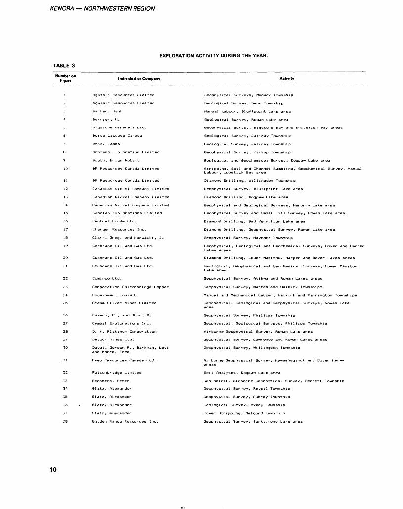
TABLE 3
EXPLORATION ACTIVITY DURING THE YEAR.
Number on Figure Individual or Company Activity
Agassiz Resources Limited
Agassiz Resources Limited
Bar l er, Hank
Bernier, l.
Bigstone Minerals Ltd.
Boise Cascade Canada
Bond, James
bonzano txplorati on Limited
Booth, Brian Robert
BF Resources Canada Limited
BP Resources Canada Limited
Canadian Nickel Company Limited
Canadian Nickel Company Limited
Canadian NicJel Company Limited
Canolan Explorations Limited
Central Crude Ltd.
Charger Resources Inc.
Clark, Breg, and Karwacki, J,
Cochrane Oil and Gas Ltd.
Cochrane Oil and Gas Ltd.
Cochrane Oil and Gas Ltd.
Cominco Ltd.
Corporation Falconbridge Copper
Cousineau, Louis E.
Cream Silver Mines Limited
Cusano, P., and Thor, D.
Cymbal Explorations Inc.
D. K. F'latinum Corporation
Dejour Mines Ltd.
Ouval, Gordon P., Bar k man, Levi and Moore, Fred
Esso Resources Canada Ltd.
Falconbridge Limited
Fernberg, Peter
Glatz, Alexander
Glatz, Alexander
Glatz, Alexander
Glatz, Alexander
Golden Range Resources Inc.
Geophysical Surveys, Menary Fownship
Geological Survey, Senn Township
Manual Labour, bluffpoint Lake area
Geophysical Survey, bigstone E'ay and Whitefish Bay areas
Geological Survey, Jaffray Township
Geological Survey, Jaffray Township
Geophysical Survey, Kirkup Township
Geological and Geochemical Survey, Dogpaw Lake area
Stripping, Soil and Channel Sampling, Geochemical Survey, Manual
Diamond Drilling, Willingdon Township
Geophysical Survey, Bluffpoint Lake area
Diamond Drilling, Dogpaw Lake area
Geophysical and Geological Surveys, Heronry Lake area
Geophysical Survey and Basal Till Survey, Rowan Lake area
Diamond Drilling, Bad Vermilion Lake area
Diamond Drilling, Geophysical Survey, Rowan Lake area
Geophysical Survey, Haycock Township
Geophysical, Geological and Geochemical Surveys, Boyer and Harper Lakes areas
Geological, Geophysical and Geochemical Surveys, Lower Manitou Lake area
Geophysical Survey, Atikwa and Rowan Lakes areas
Geophysical Survey, Matten and Halkirk Townships
Manual and Mechanical Labour, Halkirk and Farrington Townships
Geochemical, Geological and Geophysical Surveys, Rowan Lake area
Geophysical Survey, Phillips Township
Geophysical, Geological Surveys, Phillips Township
Airborne Geophysical Survey, Rowan Lake area
Geophysical Survey, Lawrence and Rowan Lakes areas
Geophysical Survey, Willingdon Township
Airborne Geophysical Survey, Kawashegamuk and Boyer Lakes areas
Soil Analyses, Dogpaw Lake area
Geological, Airborne Geophysical Survey, Bennett Township
Geophysical Survey, Revell Township
Geological Survey, Avery Township
F'ower Stripping, Melgund lown.bip
Geophysical Survey, Turtl.-r.ond Lake area
10
C.E. BLACKBURN 8, M.R. HAILSTONE
TABLE 3 Continued
Number on Figure Individual or Company Activity
Grant, John C., Col l in. Y. and Korpel a, D.
Gri?at Cameron Lake r -j^ources Inc.
lireat Cameron Lake Resources Inc.
Hal l , Evald Monty
Hansen, Jens E.
Hansson, Earl
Hawes, James
Homestake Explorations Limited
Issigonis, Michael
Issigonis, Michael
Jalna Resources Limited
Jalna Resources Limited
Kalrock Developments Ltd.
halrock Developments Ltd.
Keeba Resources Ltd.
Kidd Creek Mines Ltd.
Kno:: , Wi l l i am T.
Knox, Wil l i am T.
Kriese, Karl
KuryliM, Chester J.
Ladrador Exploration Limited
LaFleche, S.
Leane, Jolin
Lynx-Canada Explorations Limited
Lynx -Canada Explorations Limited
MacKeracher, James D.
McMillen, Robert Lynn
Micham Exploration Inc.
Mistango Consolidated Resources Ltd.
Mistango Consolidated Resources Ltd.
Morrison, Murray S.
New Ambrose Resources Inc.
Noranda Exploration Company !.imi*-p(1
Noranda Exploration Company Limited
Noranda Exploration Company Limited
Norandc* F x 11' 01 ^ t i on Company L imited
Northclaim Resour
becph 5ical Survey, Brooks Lake area
Magnetometer Survey, Rowan Lake area
Geological, Geophysical Surveys, Rowan Lake area
Airborne Geophysical Survey, Dogpaw Lake area
Geophysical Survey, Boyer Lake area
Geophysical Survey, Shoal Lake area
Manual Labour, Assays, Langton Township
Diamond Drilling, Contact Bay area
Diamond Drilling, Little Turtle Lake area
Manual Labour, Power Stripping, Haycock Township
Manual Labour, Power Stripping, Jaffray Township
Geophysical Survey, Mang Lake area
Geophysical Survey, Mang and Lower Manitou Lakes areas
Geophysical Survey, Phillips Township
Geophysical Survey, Tweedsmuir Township
Airborne Geophysical Surveys, Hyndman Township
Airborne Geophysical Survey, Kirkup and Manross Townships
Geophysical Survey, Code Township
Geophysical Survey, Dogpaw Lake area
Diamond Drilling, Tabor Lake area
Geophysical, Geological Surveys, Kawashegamuk Lake area
Geological Survey, Assays, Snake Bay area
Dogpaw Lake areaStripping, Geophysical, Geological Sur\
Geological Survey, Atikwa Lake area
Diamond Drilling, Geological Survey, Bennett Township
Geophysical Survey, Bennett and Little Turtle Lakes areas
Geological Survey, Barker Bay area
Trenching, Little Turtle Lake area
Geophysical Survey, Dogpaw Lake area
Airborne Geophysical Survey, Garnet Bay area
Airborne Geophysical Survey, Laval Township
Geological, Geophysical Survey, Glass Township
Manual and Mechanical Labour, Stripping, Whitefish Bay area
Diamond Drilling, Bluffpoint Lake area
Assays, Brooks Lake area
Geological, Geophysical Surveys, Brooks Lake area
Geological, Geophysical, Geochemical Surveys, Assays, Power Stripping, t ^hstirk Bav ar r?a
Diamond Drilling, Geophysical Survey, Brooks Late area
11
KENORA — NORTHWESTERN REGION
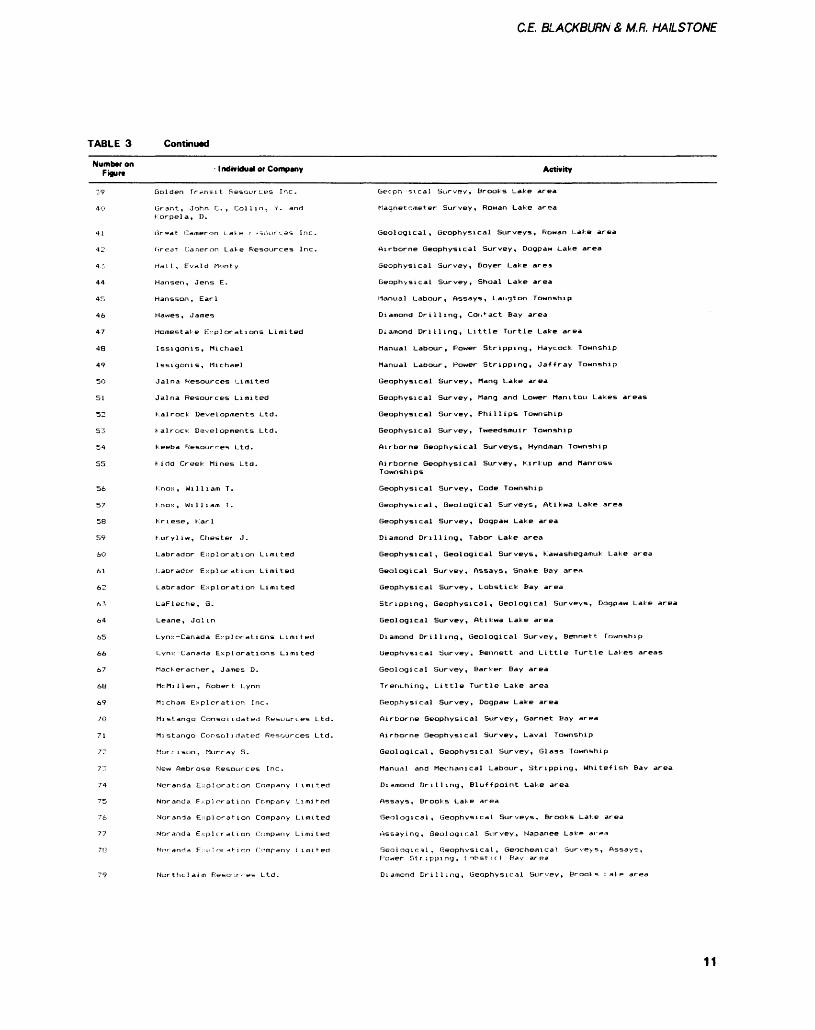
TABLE 3 Continued
Number on Figure Individual or Company Activity
86
87
100
101
105
106
107
108
109
110
11 l
112
113
114
115
116
117
118
119
120
121
122
O Donnell, John F.
Fetrunka, D., and Moorhouse, Wm. D.
P.I.R.P. Holdings Inc.
Pitkanen, R. W.
F'itkanen, Tom,
Recoski, Frank
Recoski, Frank, and Hodge, Jack
Regal Goldfields Ltd.
Rosenthal, Alex M.
Rosenthal, Lorne
St. Joe Canada Inc.
Sault Meadows Energy Corp.
Sault Meadows Energy Corp.
Schienbein, Randy
Sennol Resources Ltd.
Sherritt Gordon Mines Limited
Sherritt Gordon Mines Limited
Silver Lake Resources Inc.
Silver Lake Resources Inc.
Soteroplos, Theodore
Sparton Resources Inc.
Stephens, Gladys Anne
Sulpetro Minerals Limited
Tasu Resources Ltd.
Teck Corporation
United States Borax Chemical Corp.
Ve
Voyager Explorations Limited
Voyager Explorations Limited
Wasabi Resources Ltd.
Whymark, W., and O"Donnell J.F.
Wright, R. J.
Wright, R. J.
Wright, R. J.
Wright, R. J.
Wright, R. J.
Wright, R. J.
Wright, R. J.
Wright, R. J.
Zroback, N.
539258 Ontario Limited
553215 Ontario Limited
559536 Ontario Limited
Airborne Geophysical Survey, Rowan Lake area
Geophysical Survey, Laval Township
Diamond Drilling, Bad Vermilion and Little Turtle Lakes areas
Manual and Mechanical, Bluffpoint Lake area
Diamond Drilling, phillips Township
Airborne Geophysical Survey, Kawashegamuk Lake area
Airborne Geophysical Survey, Hyndman Township
Geophysical Survey, Dogpaw Laka area
Geophysical Survey, Rowan Lake area
Diamond Drilling, Geological, Geophysical Surveys, Clay Lake ar
Geological, Geophysical Surveys, Harper and Boyer Lakes areas
Geophysical Survey, Rowan Lake area
Airborne Geophysical Survey, Dogpaw Lake area
Geophysical Survey, Jaffray Township
Geological Survey, Vista Lake area
Geological, Geophysical, and Geochemical Surveys, Diamond Drilling, Dogpaw Lake area
Geological, Geochemical Surveys, Schistose Lake area
Geophysical Survey, Dogpaw Lake area
Geophysical, Geological Surveys, Napanee Lake area
Geophysical Survey, Rowan Lake area
Geophysical Survey, Bluffpoint Lake area
Geophysical, Geological and Geochemical Survey, Ewart Township
Diamond Drilling, Assaying, Buchan Bay area
Diamond Drilling, Lower Manitou Lake area
Geophysical, Geochemical Surveys, Kawashegamuk Lake area
Geophysical Survey, Aubrey Township
Diamond Drilling, Van Horne Township
Diamond Drilling, Phillips Township
Geophysical Survey, Buchan Bay area
Diamond Drilling, Kawashegamuk Lake area
Geophysical Survey, Harper Lake area
Geophysical Survey, Diamond Drilling, Hyndman Township
Geophysical Survey, Diamond Drilling, Lower Manitou Lake ar
Geophysical Survey, Napanee Lake area
Geophysical Survey, Mang Lake area
Geophysical Survey, Barker Bay area
Power Stripping, Pettypiece Township
Geophysical Survey, Dogpaw Lake area
Geophysical Survey, Jaffray Township
Geophysical Survey, Dash Lake area
12
C.E. BLACKBURN A M.R. HAILSTONE
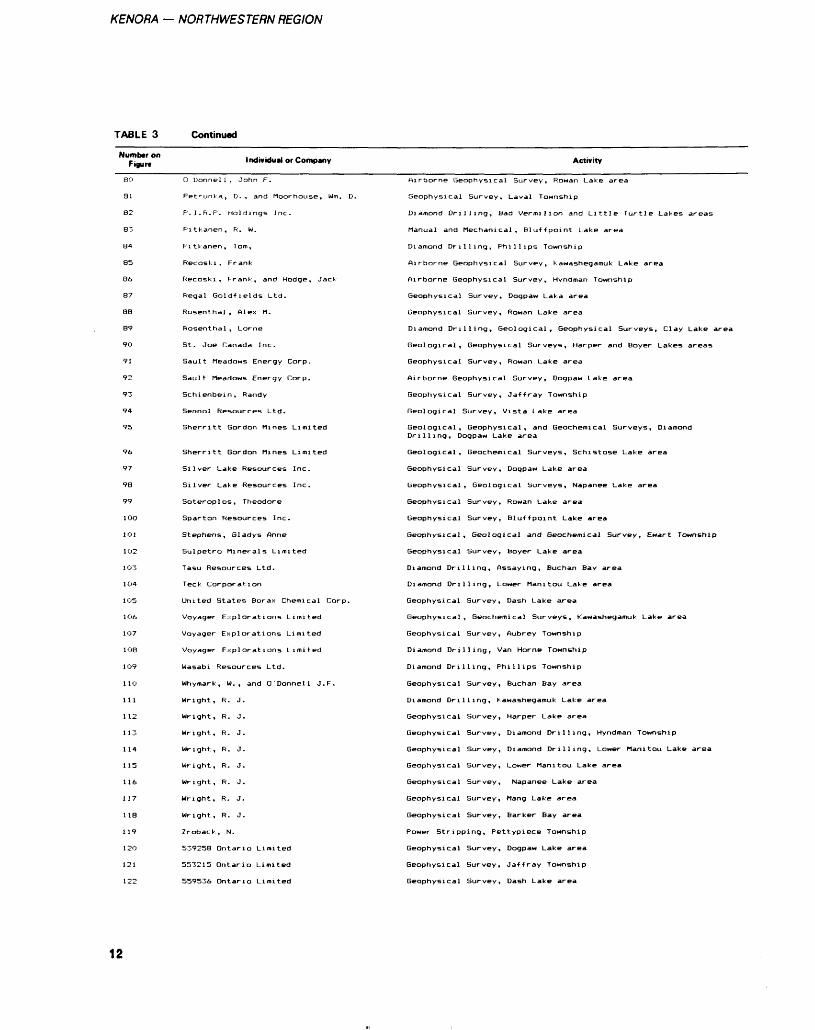
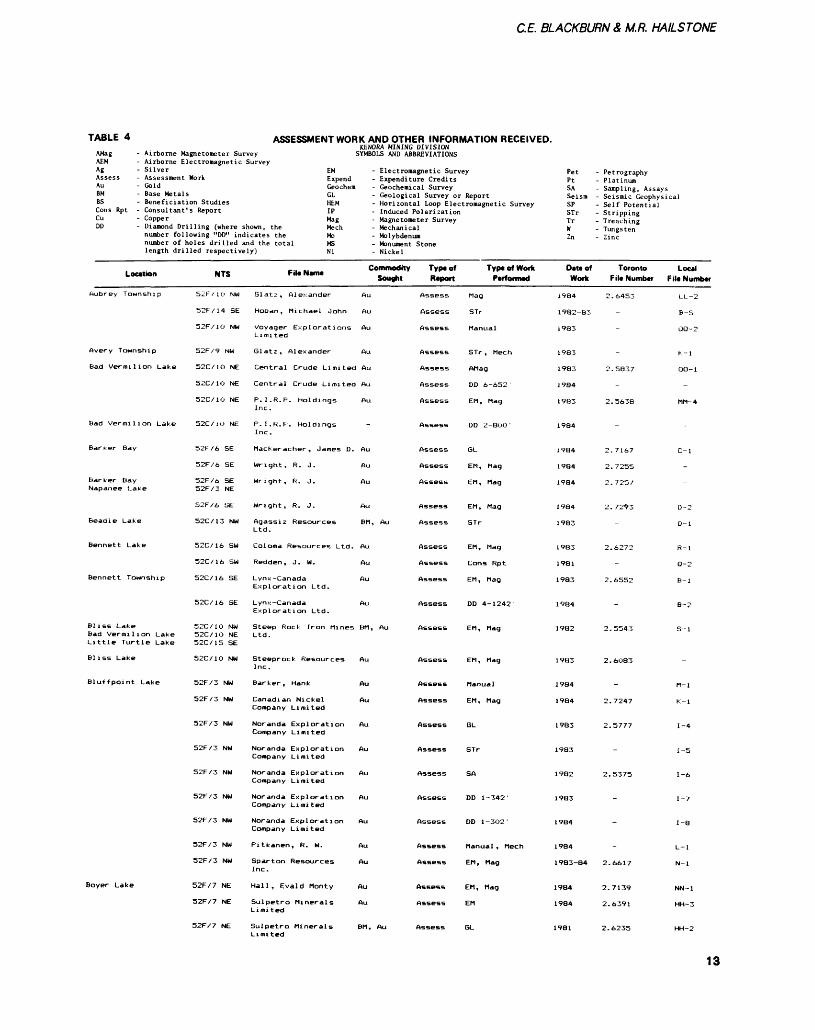
TABLE 4 ASSESSMENT WORK AND OTHER INFORMATION RECEIVED.KENORA MINING DIVISION
AMag - Airborne Magnetometer Survey SYMBOLS AND ABBREVIATIONS AEM - Airborne Electromagnetic Survey Ag - Silver EM - Electromagnetic Survey Assess - Assessment Work Expend - Expenditure Credits Au - Gold Geochem - Geochemical Survey BM - Base Metals GL - Geological Survey or Report BS - Beneficiation Studies HEM - Horizontal Loop Electromagnetic Survey Cons Rpt - Consultant's Report IP - Induced Polarization C" - Copper Mag - Magnetometer Survey DD - Diamond Drilling (where shown, the Mech - Mechanical
number following "DD" indicates the Mo - Molybdenum number of holes drilled and the total MS - Monument Stone length drilled respectively) Ni - Nickel
Location
Aubrey Township
Avery Township
Bad Vermilion Lake
Barker Bay
Barker Bay Napanee Lake
Beadle Lake
Bennett Township
Bliss Lake
Bliss Lake
Bluffpoint Lake
Boyer Lake
NTS
52F / i O NW
52F/14 SE
52F/1O NW
52F/9 NW
52C/1O NE
52C/1O NE
52C/10 NE
52F/6 SE
52F/6 SE
52F/6 SE 52F/3 NE
52F/6 SE
52C/13 NW
52C/16 SW
52C/16 SW
52C/16 SE
52C/16 SE
52C/1O NW 52C/1O NE
52C/1O NW
52F/3 NW
52F/3 NW
52F/3 NW
52F/3 NW
52F/3 NW
52F/3 NW
52F/3 NW
52F/3 NW
52F/3 NW
52F/7 NE
52F/7 NE
52F/7 NE
-.. -, Commodity File Name . Sought
Glatz, Alexander Au
Hoban, Michael John Au
Voyager Explorations Au Limited
Central Crude Limited Au
Central Crude Limited Au
P. I. R. P. Holdings Au Inc.
P. I. R. P. Holdings Inc.
MacKeracher , James D. Au
Wright, R. J. Au
Wright, R. J. Au
Wright, R. J. Au
Agassiz Resources BM, Au Ltd.
Coloma Resources Ltd. Au
Redden, J. W. Au
Exploration Ltd.
Lynx -Canada Au Exploration Ltd.
Steep Rock Iron Mines BM, Au Ltd.
Steeprock Resources Au Inc.
Barker, Hank Au
Canadian Nickel Au Company Limited
Noranda Exploration Au Company Limited
Noranda Exploration Au Company Limited
Noranda Exploration Au Company Limited
Noranda Exploration Au Company Limited
Noranda Exploration Au Company Limited
Pitkanen, R. W. Au
Sparton Resources Au Inc.
Hall, Evald Monty Au
Sulpetro Minerals Au Limited
Sulpetro Minerals BM, Au Limited
Type of Report
Assess
Assess
Assess
Assess
Assess
Assess
Assess
Assess
Assess
Assess
Assess
Assess
Assess
Assess
Assess
Assess
Assess
Assess
Assess
Assess
Assess
Assess
Assess
Assess
Assess
Assess
Assess
Assess
Assess
Assess
Assess
Typ* of Work Performed
Mag
STr
Manual
STr , Mech
AMag
DD 6-652 '
EM, Mag
DD 2-8OO-
GL
EM, Mag
EM, Mag
EM , Mag
STr
EM, Mag
Cons Rpt
EM, Mag
DD 4-1242
EM, Mag
EM, Mag
Manual
EM , Mag
GL
STr
SA
DD 1-342-
DD 1-302-
Manual , Mech
EM, Mag
EM , Mag
EM
GL
Pet - Petrography Pt - Platinum SA - Sampling, Assays Seism - Seismic Geophysical SP - Self Potential STr - Stripping Tr - Trenching W - Tungsten Zn - Zinc
Dau of Toronto Work File Number
1984 2.6453
1982-83
1983
1983
1983 2.5837
1984
1983 2.5638
1984
1984 2.7167
1984 2.7255
1984 2.7257
1984 2.7293
1983
1983 2.6272
1981
1983 2.6552
1984
1982 2.5543
1983 2.6O83
1984
1984 2.7247
1983 2.5777
1983
1982 2.5375
1983
1984
1984
1983-84 2.6617
1984 2.7139
1984 2.6391
1981 2.6235
Local F il* Number
LL-2
B-5
OO-2
K-l
00-1
-
MM-4
C-l
-
-
D-2
D-l
R-l
Q-2
B-l
B-2
S-l
M-l
K-l
1-4
1-5
1-6
1-7
1-8
L-l
N-l
NN-1
HH-3
HH-2
13
KENORA — NORTHWESTERN REGION
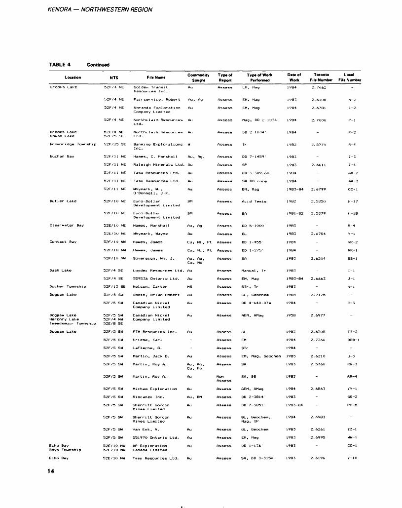
TABLE 4 Continued
Location
Brooks Lake
Brooks Lake Rowan Lake
Brownridge Township
Buchan Bay
Butler Lake
Clearwater Bay
Contact Bay
Dash Lake
Docker Township
Dogpaw Lake
Dogpaw Lake Heronry Lake Tweedsmuir Township
Dogpaw Lake
Echo Bay Boys Township
Echo Bay
14
NTS
52F/4 NE
52F/4 NE
52F/4 NE
52F/4 NE
52F/4 NE 52F/5 SE
52F/15 SE
52F/11 NE
52F/11 NE
52F/11 NE
52F/11 NE
52F X 1 1 NE
52F/1O NE
52F/1O NE
52E/1O NE
52E/10 NE
52F/10 NW
52F/1O NW
52F/1O NW
52F/4 SE
52F/4 SE
52F/13 SE
52F/5 SW
52F/5 SW
52F/5 SW 52F/4 NW 52E/8 SE
52F/5 SW
52F/5 SW
52F/5 SW
52F/5 SW
52F/5 SW
52F/5 SW
52F/5 SW
52F/5 SW
52F/5 SW
52F/5 SW
52F/5 SW
52F/5 SW
52E/1O NW 52E/10 NW
52E/1O NW
Filt Nama
Golden Transit Resources Inc.
Fairservice, Robert
Noranda Exploration Comp any Limit ed
Northclaim Resources Ltd.
Northclaim Resources Ltd.
Sanmine Explorations Inc.
Names, C. Marshall
Raleigh Minerals Ltd.
Tasu Resources Ltd.
Tasu Resources Ltd.
Why mar k, W. , O'Donnell, J. F.
Euro-Dol lar Development Limited
Euro-Dol lar Development Limited
Hames , Marshall
Why mar k, Wayne
Hawes, James
Hawes, James
Sovereign, Wm. J.
Loydex Resources Ltd.
559536 Ontario Ltd.
Nelson, Carter
Booth, Brian Robert
Canadian Nickel Company Limited
Canadian Nickel Company Limited
FTM Resources Inc.
Kriese, Karl
LaFleche, G.
Martin, Jack D.
Martin, Roy A.
Martin, Roy A.
Micham Exploration
Riocanex Inc.
Sherritt Gordon Mines Limited
Sherritt Gordon Mines Limited
Van Enk, R.
55197O Ontario Ltd.
BP Exploration Canada Limited
Tasu Resources Ltd.
Commodity Sought
Au
Au, Ag
Au
Au
Au
W
Au , Ag ,
Au
Au
Au
Au
BM
BM
Au, Ag
Au
Cu, Ni , Pt
Cu, Ni , Pt
Au, Ag, Cu, Mo
Au
Au
MS
Au
Au
Au
Au
-
-
Au
Au , Ag , Cu, Mo
Au
Au
Au, BM
Au
Au
Au
Au
Au
Au
Type of Raport
Assess
Assess
Assess
Assess
Assess
Assess
Assess
Assess
Assess
Assess
Assess
Assess
Assess
Assess
Assess
Assess
Assess
Assess
Assess
Assess
Assess
Assess
Assess
Assess
Assess
Assess
Assess
Assess
Assess
Non Assess
Assess
Assess
Assess
Assess
Assess
Assess
Assess
Assess
Typa of Work Parformad
EM, Mag
EM, Mag
EM, Mag
Mag, DD 2-1O34'
DD 2-1O34'
Tr
DD 7-1459'
SP
DD 3-3O9.6m
SA DD core
EM, Mag
Acid Tests
SA
DD 5- 1 OOO
GL
DD 1-455
DD 1-275-
SA
Manual , Tr
EM, Mag
STr , Tr
GL , Geochem
DD 4-64O.O7m
AEM , AMag
GL
EM
STr
EM, Mag, Geochem
SA
SA, BS
AEM, AMag
DD 2-3814-
DD 7-3O51 '
GL, Geochem, Mag, IP
GL , Geochem
EM, Mag
DD 1-1 36
SA, DD 3-3 15m
Data of Work
1984
1983
1984
1984
1984
1982
1983
1983
1984
1984
1983-84
1982
1981-82
1983
1983
1984
1984
1983
1983
1983-84
1983
1984
1984
1958
1983
1984
1984
1983
1983
1983
1984
1983
1983-84
1984
1983
1983
1983
1983
Toronto Fila Numbar
2. 7062
2.6108
2.6781
2.7000
-
2.577O
-
2.6611
-
-
2.6799
2.5250
2.5379
-
2.6754
-
-
2.6204
-
2.6663
-
2.7125
-
2. bf 77
2.63O5
2.7266
-
2.6210
2.5760
-
2.6863
-
-
2.6983
2.6261
2.6995
-
2.6196
Local Fila Numbar
-
N-2
1-2
P-l
P-2
R-4
Z -3
Z-4
AA-2
AA-3
CC-1
K-17
K- 18
R-4
Y-l
RR-2
RR-1
SS-1
1-1
J-l
N-l
-
C-3
~
TT-2
BBB-1
-
U-3
RR-3
RR-4
YY-l
SS-2
PP-5
-
ZZ-1
WW-1
CC-1
Y-1O
CE BLACKBURN A M.ft HAILSTONE
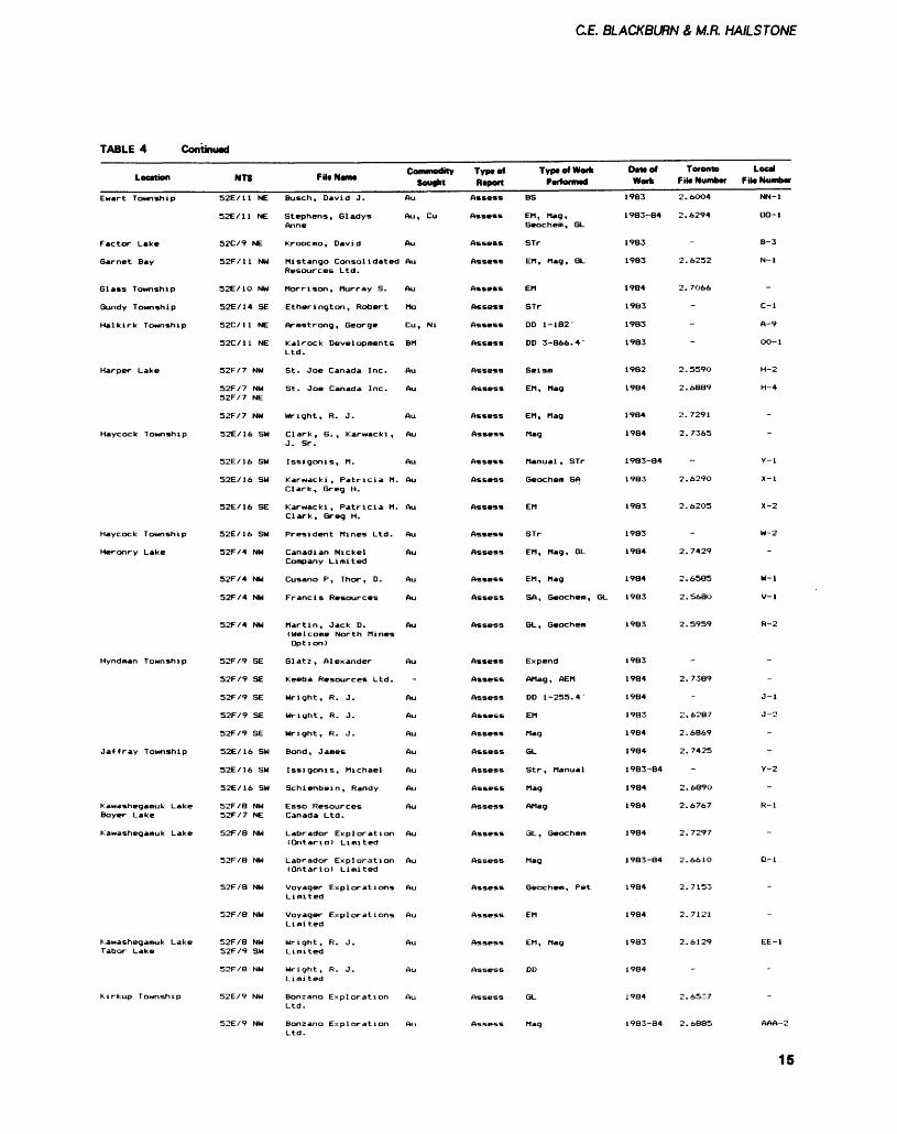
TABLE 4 Continued
Location
Ewart Township
Factor Lake
Barnet Bay
Glass Township
Gundy Township
Halkirk Township
Harper Lake
Haycock Township
Haycock Township
Heronry Lake
Hyndman Township
Jaffray Township
Kawashegamuk Lake Boyer Lake
Kawashegamuk Lake
Kawashegamuk Lake Tabor Lake
Kirkup Township
NTS
52E/11 NE
52E/11 NE
52C/9 NE
52F/11 NW
32E/1O NW
52E/14 SE
52C/11 NE
52C/11 NE
52F/7 NW
52F/7 NW 52F/7 NE
52F/7 NW
52E/16 SW
52E/16 SW
52E/16 SW
S2E/16 SE
52E/16 SW
52F/4 NW
52F/4 NW
52F/4 NW
52F/4 NW
52F/9 SE
52F/9 SE
52F/9 SE
52F/9 SE
52F/9 SE
52E/16 SW
52E/16 SW
52E/16 SW
52F/B NW 52F/7 NE
52F/8 NW
52F/B NW
52F/8 NW
52F/B NW
52F/8 NW 52F/9 SW
S2F/S NW
52E/9 NW
52E/9 NW
Fit* Nan*
Busch, David J.
Stephens, Gladys Anne
Kroocmo, David
Mistango Consolidated Resources Ltd.
Morrison, Murray S.
E t her ing t on, Robert
Armstrong, George
Ka 1 roc k Developments Ltd.
St. Joe Canada Inc.
St. Joe Canada Inc.
Wright, R. J.
Clark, G., Karwacki , J. Sr.
Issigonis, M.
Clark, Greg H.
Karwacki, Patricia M. Clark, Greg H.
President Mines Ltd.
Company Limited
Cusano P, Thor, D.
Francis Resources
Martin, Jack D. (Welcome North Mines Option)
Glatz, Alexander
Wright, R. J.
Wright, R. J.
Wright, R. J.
Bond, James
Issigonis, Michael
Schienbein, Randy
Esso Resources Canada Ltd.
Labrador Exploration (Ontario) Limited
Labrador Exploration (Ontario) Limited
Voyager Explorations Limited
Voyager Explorations Limited
Wright, R. J. Limited
Wright, R. J. Limited
Bonzano Exploration Ltd.
Bonzano Exploration Ltd.
SoufhtAu
Au, Cu
Au
Au
Au
Mo
Cu, Ni
BM
Au
Au
Au
Au
Au
Au
Au
Au
Au
Au
Au
Au
Au
Au
Au
Au
Au
Au
Au
Au
Au
Au
Au
Au
Au
Au
Au
Au
Typtol Report
Assess
Assess
Assess
Assess
Assess
Assess
Assess
Assess
Assess
Assess
Assess
Assess
Assess
Assess
Assess
. Assess
Assess
Assess
Assess
Assess
Assess
Assess
Assess
Assess
Assess
Assess
Assess
Assess
Assess
Assess
Assess
Assess
Assess
Assess
Assess
Assess
Assess
TyptofWorkQ ,a - , , .i rWfOfnMQ
BS
EM, Mag, Geochent, 6L
STr
EM, Mag, GL
EM
STr
DD 1-182'
DO 3-866.4'
Seism
EM, Mag
EM, Mag
Mag
Manual , STr
Geochem SA
EM
STr
EM, Mag, 6L
EM, Mag
SA, Geochem, GL
SL, Geochem
Expend
AMag, AEM
DD 1-255.4
EM
Mag
6L
Str , Manual
Mag
AMag
GL , Geochem
Mag
Geochem, Pet
EM
EM, Mag
DI)
GL
Mag
DIM ofWork
1983
1983-84
1983
1983
1984
1983
1983
1983
1982
1984
1984
1984
1983-84
1983
1983
1983
1984
1984
1983
1983
1983
1984
1984
1983
1984
1984
1983-84
1984
1984
1984
1983-84
1984
1984
1983
1984
1984
1983-84
Toronto Fit* Number
2.6O04
2.6294
-
2.6252
2.7O66
-
-
-
2.559O
2.6889
2.7291
2. 7365
2.6290
2.6205
2.7429
2.6585
2.5680
2.5959
2.7389
2.6287
2 . 6869
2.7425
-
2.6890
2.6767
2.7297
2. 661 O
2.7153
2.7121
2.6129
-
2.6537
2.6885
Local
NN-l
OO-l
B-3
N-l
-
C-l
A-9
OO-l
H-2
H-4
-
-
Y-l
X-l
X-2
W-2
W-l
V-l
R-2
J-l
J-2
-
-
Y-2
-
R-l
-
Q-l
-
-
EE-1
-
-
AAA-2
15
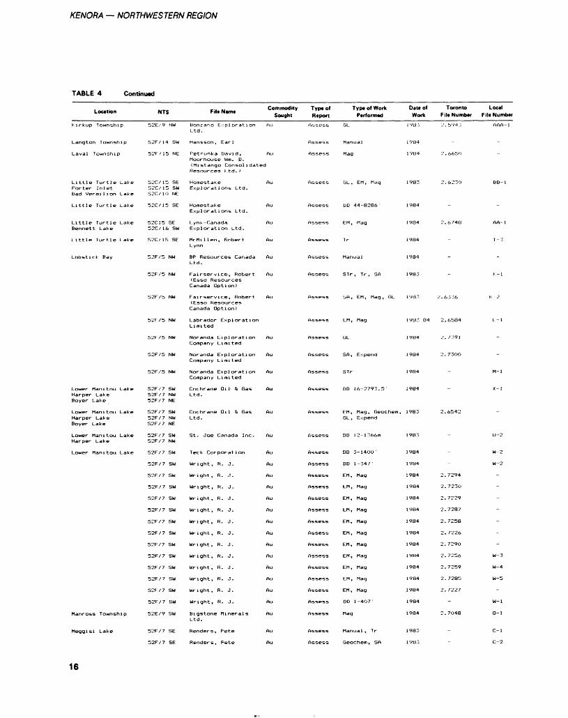
KENORA — NORTHWESTERN REGION
TABLE 4 Continued
Location
Kirkup Township
Langton Township
Laval Township
NTS
52E/9 NW
52F/14 SW
52F/15 NE
File Name
Bonzano ExplorationLtd.
Hansson, Earl
Petrunka David,Moorhouse Wm. D.
Commodity Type of Sought Report
Au
Au
Assess
Assess
Assess
Type of Work Performed
GL
Manual
Mag
Date of Toronto Local Work File Number File Number
1VB3 2.5943 AAA-1
1784
1984 2.6650
(Mistango Consolidated
Little Turtle LakePorter InletBad Vermilion Lake
Little Turtle Lake
Little Turtle LakeBennett Lake
Little Turtle Lake
Lobstick Bay
Lower Manitou LakeHarper LakeBoyer Lake
Lower Manitou LakeHarper LakeBoyer Lake
Lower Manitou LakeHarper Lake
Lower Manitou Lake
Manross Township
Meggisi Lake
52C/15 SE52C/15 SW52C/1O NE
52C/15 SE
52C15 SE52C/16 SW
52C/ 15 SE
52F/5 NW
52F/5 NW
52F/5 NW
52F/5 NW
52F/5 NW
52F/5 NW
52F/5 NW
52F/7 SW52F/7 NW52F/7 NE
52F/7 SW52F/7 NW52F/7 NE
52F/7 SW52F/7 NW
52F/7 SW
52F/7 SW
52F/7 SW
52F/7 SW
52F/7 SW
52F/7 SW
52F/7 SW
52F/7 SW
52F/7 SW
52F/7 SW
52F/7 SW
52F/7 SW
52F/7 SW
52F/7 SW
52E/9 SW
52F/7 SE
52F/7 SE
Resources Ltd. )
HomestakeExplorations Ltd.
HomestakeExplorations Ltd.
Lynx-CanadaExploration Ltd.
McMillen, RobertLynn
BP Resources CanadaLtd.
Fairservice, Robert(Essa ResourcesCanada Option)
Fairservice, Robert(Esso ResourcesCanada Option)
Labrador ExplorationLimited
Noranda ExplorationCompany Limited
Noranda ExplorationCompany Limited
Noranda ExplorationCompany Limited
Cochrane Oil St GasLtd.
Cochrane Oil i GasLtd.
St. Joe Canada Inc.
Teck Corporation
Wright, R. J.
Wright, R. J.
Wright, R. J.
Wright, R. J.
Wright, R. J.
Wright, R. J.
Wright, R. J.
Wright, R. J.
Wright, R. J.
Wright, R. J.
Wright, R. J.
Wright, R. J.
Wright, R. J.
Bigstone MineralsLtd.
Renders, Pete
Renders, Pete
Au
Au
Au
Au
Au
Au
Au
-
Au
Au
Au
Au
Au
Au
Au
Au
Au
Au
Au
Au
Au
Au
Au
Au
Au
Au
Au
Au
Au
Au
Au
Assess
Assess
Assess
Assess
Assess
Assess
Assess
Assess
Assess
Assess
Assess
Assess
Assess
Assess
Assess
Assess
Assess
Assess
Assess
Assess
Assess
Assess
Assess
Assess
Assess
Assess
Assess
Assess
Assess
Assess
Assess
GL, EM, Mag
L)D 44-8286'
EM, Mag
Tr
Manual
STr, Tr, SA
SA, EM, Mag, GL
EM, Mag
GL
SA, Expend
STr
OD 16-2793.5'
EM, Mag, Geochetn,GL, Expend
DD 12- 1366m
DD 3-140O'
DD 1-347
EM, Mag
EM, Mag
EM, Mag
EM, Mag
EM, Mag
EM, Mag
EM, Mag
EM, Mag
EM, Mag
EM, Mag
EM, Mag
DD 1-4O7'
Mag
Manual , Tr
Geochem, SA
1983 2.6230 BB- 1
1984
1984 2.6748 AA-1
1984 - T -3
1984
1983 - r.-l
1983 2.6336 K -2
1983-84 2.6584 L-l
1984 2.7391
1984 2.73OO
1984 - M-l
1984 - X-l
1983 2.6542
1983 - U-2
1984 - W-2
1984 - W-2
1984 2.7294
1984 2.723O
1984 2.7229
1984 2.7287
1984 2.7258
1984 2.7226
1984 2.729O
1984 2.7256 W-3
1984 2.7259 W-4
1984 2. 7285 W-5
1984 2.7227
1984 - W-l
1984 2.7O48 Q-l
1983 - C-l
1983 - C-2
16
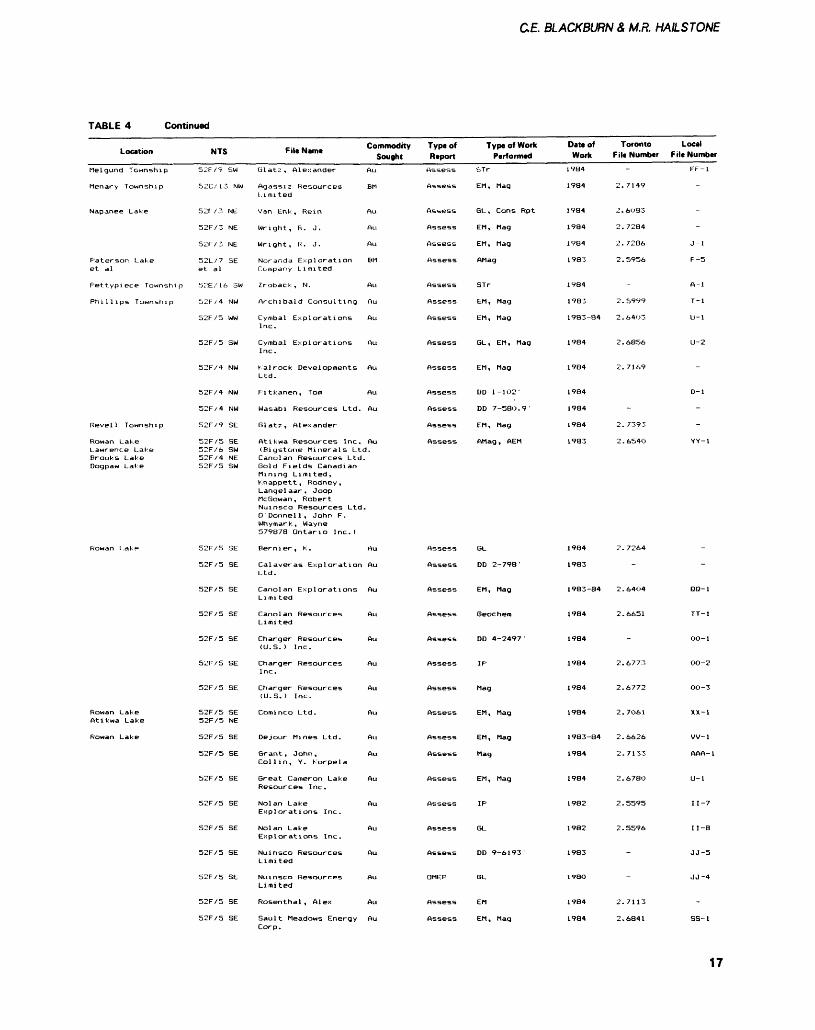
C.E. BLACKBURN Z M.R. HAILSTONE
TABLE 4 Continued
Location
Melgund Township
Menary Township
Napanee Lake
Paterson Lakeet al
Pettypiece Township
Phillips Township
Revell Township
Rowan LakeLawrence LakeBrooks LakeDogpaw Lake
Rowan Lake
Rowan LakeAtikwa Lake
Rowan Lake
NTS
52F/9
52C/ 13
52F/3
52F/3
52F/3
52L/7et al
5::E,'i6
52F/4
52F/5
52F/5
52F/4
52F/4
52F/4
52F/9
52F/552F/652F/452F/5
52F/5
52F/5
52F/5
52F/5
52F/5
52F/5
52F/5
52F/552F/5
52F/5
52F/S
52F/5
52F/5
52F/5
52F/5
52F/5
52F/5
52F/5
SW
NW
NE
NE
NE
SE
sw
NW
WW
SW
NW
NW
NW
SE
SESWNESW
SE
SE
SE
SE
SE
SE
SE
SENE
SE
SE
SE
SE
SE
SE
SE
SE
SE
File Name
Glatz, Alexander
Agassiz ResourcesLimited
Van Enk, Rein
Wright, R. J.
Wright, R. J.
Noranda ExplorationCompany Limited
Zroback, IM.
Archibald Consulting
Cymbal ExplorationsInc.
Cymbal ExplorationsInc.
Kalrock DevelopmentsLtd.
Fitkanen, Tom
Wasabi Resources Ltd.
Glatz, Alexander
Atikwa Resources Inc.(Bigstone Minerals LtdCanolan Resources Ltd.Gold Fields CanadianMining Limited,Knappett , Rodney,Langelaar, JoopMcGowan, RobertNuinsco Resources Ltd.Q Donnell , John F.Whymark, Wayne579878 Ontario Inc.)
Bernier, K.
Calaveras ExplorationLtd.
Canolan ExplorationsLimited
Canolan ResourcesLimited
Charger Resources(U.S.) Inc.
Charger ResourcesInc.
Charger Resources(U.S.) Inc.
Cominco Ltd.
De jour Mines Ltd.
Grant, John,Col lin, Y. Korpela
Great Cameron LakeResources Inc.
Nolan LakeExplorations Inc.
Nolan LakeExplorations Inc.
Nuinsco ResourcesLimited
Nuinsco ResourcesLimited
Rosenthal , Alex
Sault Meadows Energy
Commodity Sought
Au
BM
Au
Au
Au
BM
Au
Au
Au
Au
Au
Au
Au
Au
Au
Au
Au
Au
Au
Au
Au
Au
Au
Au
Au
Au
Au
Au
Au
Au
Au
Type of ReportAssess
Assess
Assess
Assess
Assess
Assess
Assess
Assess
Assess
Assess
Assess
Assess
Assess
Assess
Assess
Assess
Assess
Assess
Assess
Assess
Assess
Assess
Assess
Assess
Assess
Assess
Assess
Assess
Assess
OMEP
Assess
Assess
Type of Work Performed
STr
EM, Mag
GL, Cons Rpt
EM, Mag
EM, Mag
AMag
STr
EM, Mag
EM, Mag
GL, EM, Mag
EM, Mag
DD 1-102'
DD 7-58O.9'
EM, Mag
AMag , AEM
GL
DD 2-798'
EM, Mag
Geochero
DD 4-2497 '
IP
Mag
EM, Mag
EM, Mag
Mag
EM , Mag
IP
GL
DD 9-6193
GL
EM
EM, Mag
Date of Work
1984
1984
1984
1984
1984
1983
1984
1983
1983-84
1984
1984
1984
1984
1984
1983
1984
1983
1983-34
1984
1984
1984
1984
1984
1983-84
1984
1984
1982
1982
1983
198O
1984
1984
Toronto Local File Number File Number
FF-l
2.7149
2.6OB3
2.7284
2.7286 J-l
2.5956 F -5
A-l
2.5999 T-l
2.6403 U-l
2.6856 U-2
2.7169
D-l
-
2. 7393
2.654O YY-1
2. 7264
-
2.64O4 QQ-1
2.6651 TT-1
OO-l
2.6773 00-2
2.6772 OO-3
2.7061 XX-1
2.6626 VV-1
2.7133 AAA-1
2.6780 U-l
2.5595 1 1 -7
2.5596 1 1-8
JJ-5
JJ-4
2.7113
2.6841 SS-1Corp.
17
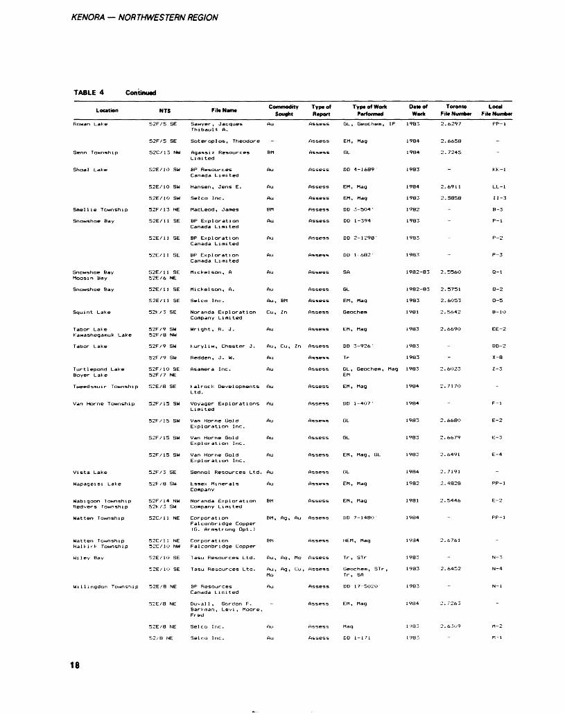
KENORA — NORTHWESTERN REGION
TABLE 4 Continued
Location
Rowan Lake
Senn Township
Shoal Lake
Smellie Township
Snowshoe Bay
Snowshoe BayMoosin Bay
Snowshoe Bay
Squint Lake
Tabor Lake
Tabor Lake
Turtlepond LakeBoyer Lake
Tweedsmuir Township
Van Horne Township
Vista Lake
Wapageisi Lake
Wabigoon TownshipRedvers Township
Watten Township
Watten TownshipHalkirk Township
Mi ley Bay
Willingdon Township
NTS
52F/5 SE
52F/5 SE
52C/13 NW
52E/10 SW
52E/10 SW
52E/1O SW
52F/13 NE
52E/11 SE
52E/11 SE
52E/11 SE
52E/11 SE52E/6 NE
52E/11 SE
52E/11 SE
52K/3 SE
52F/9 SW 52F/3 NW
52F/9 SW
52F/9 SW
52F/10 SE52F/7 NE
52E/8 SE
52F/15 SW
52F/15 SW
52F/15 SW
52F/15 SW
52F/3 SE
52F/8 SW
52F/14 NW52K/3 SW
52C/11 NE
52C/11 NE52C/10 NW
52E/10 SE
52E/1O SE
52E/8 NE
52E/S NE
52E/8 NE
52/8 NE
Fit* Name
Thibault A.
Soteroplos, Theodore
Agassiz ResourcesLimited
BP ResourcesCanada Limited
Hansen, Jens E.
Selco Inc.
MacLeod, James
BP ExplorationCanada Limited
BP ExplorationCanada Limited
BP ExplorationCanada Limited
Mickelson, A
Mickelson, A.
Selco Inc.
Noranda ExplorationCompany Limited
Wright, R. J.
Kuryliw, Chester J.
Redden, J. W.
Asamera Inc.
Kalrock DevelopmentsLtd.
Voyager ExplorationsLimited
Van Horne GoldExploration Inc.
Van Horne GoldExploration Inc.
Van Horne GoldExploration Inc.
Sennol Resources Ltd.
Essex MineralsCompany
Noranda ExplorationCompany Limited
Corporat l onFalconbridge Copper(G. Armstrong Opt.)
CorporationFalconbridge Copper
1 asu Resources Ltd.
Tasu Resources Ltd.
SP ResourcesCanada Limited
Duval 1 , Gordon F'.Barkman, Lev! , Moore.Fred
Selco Ir.c.
Selco Inc.
Commodity Sought
Au
-
BM
Au
Au
Au
BM
Au
Au
Au
Au
Au
Au, BM
Cu, In
Au
Au, Cu, Zn
Au
Au
Au
Au
Au
Au
Au
Au
Au
BM
BM , Ag , Au
BM
Au, Ag, Mo
Au, Ag, Cu,Mo
Au
-
Au
Au
Type of Report
Assess
Assess
Assess
Assess
Assess
Assess
Assess
Assess
Assess
Assess
Assess
Assess
Assess
Assess
Assess
Assess
Assess
Assess
Assess
Assess
Assess
Assess
Assess
Assess
Assess
Assess
Assess
Assess
Assess
Assess
Assess
Assess
Assess
Assess
Type of Work Performed
GL, Geochem, IP
EM, Mag
GL
DD 4-1689
EM , Mag
EM , Mag
DD 3-5O4 '
DD 1-394'
DD 2-1298-
DD 1-682-
SA
GL
EM , Mag
Geochem
EM, Mag
DD 3-926 '
Tr
GL, Geochem, MagEM
EM , Mag
DD 1-4O7-
GL
GL
EM, Mag, GL
GL
EM, Mag
EM, Mag
DD 7-148O
HEM, Mag
Tr, STr
Geochem, STr ,Tr , SA
DD 17-5O2O
EM, Mag
Mag
DD 1-171
Datt of Work
1983
1984
1984
1983
1984
1983
1982
1983
1983
1983
1982-83
1982-83
1983
1981
1983
1983
1983
1983
1984
1984
1983
1983
1983
1984
1982
1981
1984
1934
1983
1983
1983
1984
1983
1983
Toronto Local F ile Number F ile Number
2.6297 PP-1
2.6658
2.7245
KK.-l
2.6911 LL-1
2.5858 1 1 -3
B-3
P-l
P-2
P-3
2.5560 Q-l
2.5751 Q-2
2.6O53 O-5
2.5642 B-10
2.669O EE-2
DD-2
X-8
2.6O23 Z-3
2.717O
F-l
2.668O E-2
2.6679 E-3
2.6491 E-4
2.7191
2.4828 PP-1
2.5446 E-2
PP-1
2.6761
N-3
2.6452 N-4
N-l
2. 7263
2.6309 rt-2
M-l
18
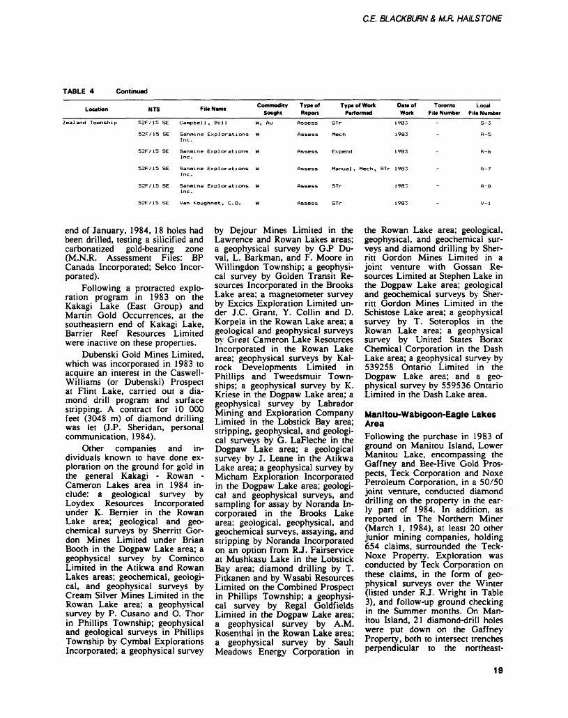
C.E. BLACKBURN Z M.R. HAILSTONE
TABLE 4 Continued
Location NTS File Mam* Commodity Type of Sought Report
Type of Work Performed
Data of Toronto Local Work F il* Number F ile Number
Zealand Township S2F/15 SE Campbell, Bill W, Au
52F/15 SE Sanmine Explorations W Inc.
52F/15 SE Sanmine Explorations W Inc.
52F/15 SE Sanmine Explorations W Inc.
52F/15 SE Sanmine Explorations M Inc.
52F/15 SE Van Koughnet, C.D. M
Assess STr
Assess Meen
1983
1983
S-3
R-5
Assess Expend 1983
Assess Manual, Meen, STr 1983
Assess STr
Assess STr
1983
1983
end of January, 1984, 18 holes had been drilled, testing a silicified and carbonatized gold-bearing zone (M.N.R. Assessment Files: BP Canada Incorporated; Selco Incor porated).
Following a protracted explo ration program in 1983 on the Kakagi Lake (East Group) and Martin Gold Occurrences, at the southeastern end of Kakagi Lake, Barrier Reef Resources Limited were inactive on these properties.
Dubenski Gold Mines Limited, which was incorporated in 1983 to acquire an interest in the Caswell- Williams (or Dubenski) Prospect at Flint Lake, carried out a dia mond drill program and surface stripping. A contract for 10 000 feet (3048 m) of diamond drilling was let (J.P. Sheridan, personal communication, 1984).
Other companies and in dividuals known to have done ex ploration on the ground for gold in the general Kakagi - Rowan - Cameron Lakes area in 1984 in clude: a geological survey by Loydex Resources Incorporated under K. Bernier in the Rowan Lake area; geological and geo chemical surveys by Sherritt Gor don Mines Limited under Brian Booth in the Dogpaw Lake area; a geophysical survey by Cominco Limited in the Atikwa and Rowan Lakes areas; geochemical, geologi cal, and geophysical surveys by Cream Silver Mines Limited in the Rowan Lake area; a geophysical survey by P. Cusano and O. Thor in Phillips Township; geophysical and geological surveys in Phillips Township by Cymbal Explorations Incorporated; a geophysical survey
by Dejour Mines Limited in the Lawrence and Rowan Lakes areas; a geophysical survey by GP Du- val, L. Barkman, and F. Moore in Willingdon Township; a geophysi cal survey by Golden Transit Re sources Incorporated in the Brooks Lake area; a magnetometer survey by Excics Exploration Limited un der J.C. Grant, Y. Collin and D. Korpela in the Rowan Lake area; a geological and geophysical surveys by Great Cameron Lake Resources Incorporated in the Rowan Lake area; geophysical surveys by Kal- rock Developments Limited in Phillips and Tweedsmuir Town ships; a geophysical survey by K. Kriese in the Dogpaw Lake area; a geophysical survey by Labrador Mining and Exploration Company Limited in the Lobstick Bay area; stripping, geophysical, and geologi cal surveys by G. LaFleche in the Dogpaw Lake area; a geological survey by J. Leane in the Atikwa Lake area; a geophysical survey by Micham Exploration Incorporated in the Dogpaw Lake area; geologi cal and geophysical surveys, and sampling for assay by Noranda In corporated in the Brooks Lake area; geological, geophysical, and geochemical surveys, assaying, and stripping by Noranda Incorporated on an option from RJ. Fairservice at Mushkasu Lake in the Lobstick Bay area; diamond drilling by T. Pitkanen and by Wasabi Resources Limited on the Combined Prospect in Phillips Township; a geophysi cal survey by Regal Goldfields Limited in the Dogpaw Lake area; a geophysical survey by A.M. Rosenthal in the Rowan Lake area; a geophysical survey by Sault Meadows Energy Corporation in
the Rowan Lake area; geological, geophysical, and geochemical sur veys and diamond drilling by Sher ritt Gordon Mines Limited in a joint venture with Gossan Re sources Limited at Stephen Lake in the Dogpaw Lake area; geological and geochemical surveys by Sher ritt Gordon Mines Limited in the Schistose Lake area; a geophysical survey by T. Soteroplos in the Rowan Lake area; a geophysical survey by United States Borax Chemical Corporation in the Dash Lake area; a geophysical survey by 539258 Ontario Limited in the Dogpaw Lake area; and a geo physical survey by 559536 Ontario Limited in the Dash Lake area.
Manltou-Wabigoon-Eagle Lakes AreaFollowing the purchase in 1983 of ground on Manitou Island, Lower Manitou Lake, encompassing the Gaffney and Bee-Hive Gold Pros pects, Teck Corporation and Noxe Petroleum Corporation, in a 50/50 joint venture, conducted diamond drilling on the property in the ear ly part of 1984. In addition, as reported in The Northern Miner (March l, 1984), at least 20 other junior mining companies, holding 654 claims, surrounded the Teck- Noxe Property. Exploration was conducted by Teck Corporation on these claims, in the form of geo physical surveys over the Winter (listed under RJ. Wright in Table 3), and follow-up ground checking in the Summer months. On Man itou Island, 21 diamond-drill holes were put down on the Gaffney Property, both to intersect trenches perpendicular to the northeast-
19
KENORA — NORTHWESTERN REG'ON
trending shoreline, and 10 test the zone near and parallel to the shoreline. Assays from the best drill holes ranged from 0.122 ounce gold per ton over 4 feet (1.2 m) to 0.292 ounce gold per ton over 13.5 feet (4.1 m) (George Cross News Letter, August l, 1984). At year end, no work was being conducted by Teck Corpora tion in tne area.
Cochrane Oil and Gas Limited announced in February (The Northern Miner, February 9, 1984) the commencement of a 5000-foot (1524 m) diamond drill ing program on their 3 claim groups totaling 230 claims in the general Manitou Lakes area. Claims were originally staked on the basis of a regional airborne geophysical survey conducted for the Ontario Geological Survey (1981). Drilling was conducted as follow-up to geological, geochemi cal, and geophysical surveys, and prospecting all carried out in the Summer of 1983. According to an article in North American Gold Mining Industry News (July 6, 1984), approximately 4000 feet (1220 m) of drilling was done over 25 holes, and assays obtained from trenching at the old Giant Mine Prospect gave gold values up to 0.6 ounce gold per ton.
Jalna Resources Limited, as part of the Goldore Joint venture in which they are operators with Pecos Resources Limited, GLE Re sources Limited, Sutherland Re sources Limited, and Austin Re sources Incorporated, as partners, continued work on their 626 claim, 20 mile (32 km) long block in the general Manitou Lakes area in 1984. Work during 1983 had outlined 6 specific targets, with as says of up to 0.662 ounce gold per ton obtained in l area of pyritic felsic tuff float. According to an article in The Northern Miner (May 31, 1984), follow-up ground geophysical surveying and trench ing was underway on a pyritic chert zone.
Monte Christo Resources Limited, with Chester Kuryliw as operator, conducted a diamond drill program on a 20 claim prop erty surrounding the past produc
ing Sakoose Mine in the Tabor Lake area. Three holes were put down to test 3 ground electromag netic conductors. According to an article in The Northern Miner (April 12, 1984), no significant gold values were encountered.
Silverside Resources Incorpo rated continued work near Flam beau Lake in the Contact Bay area, with Voyager Explorations Limit ed as operator. In 1983, according to an article in The Northern Min er (December l, 1983), a 16-foot (5 m) surface section assayed 0.249 ounce gold per ton, and stripping revealed a 200-foot (61 m) wide zone in which an average grade of 0.636 ounce gold per ton was obtained on assay, across an 8-foot (2.4 m) section. A 4000-foot (1220 m) drill program was com menced during the Summer (George Cross News Letter, July 5, 1984).
Sparton Resources Incorporat ed completed a 6-hole diamond drill program late in 1983 on their 243 claim property encompassing the past producing Straw Lake Beach Mine iri the Bluffpoint Lake area (The Northern Miner, March 29, 1984). Further work has not been done on this property. Pre vious work had consisted of geo physical (including induced polar ization), geochemical, and geologi cal surveys, and prospecting, strip ping, and detailed rock sampling. Exploration was also done on 3 claim groups totaling 93 claims in the general Lower Manitou Lakes area, according to The Northern Miner (November 8, 1984). In this work, assays of up to 0.35 ounce gold per ton were obtained in trenching and sampling.
Tasu Resources Limited con tinued assessment of its W.W. Smith and Magdalena Gold Pros pects at Eagle Lake. Following dia mond drilling over 6 holes in 1983, further drilling was done in 3 holes during February, 1984 (George Cross News Letter, March 20, 1984). According to this re lease, gold mineralization is con tained in a 120-foot (36.6 m) thick sequence of sulphidic siliceous rock and mafic tuffs, that has a strike length of at least 1200 feet
(366 m), and to a depth of at least 288 feet (87.8 m).
Van Horne Gold Exploration Incorporated and Teck Corpora tion, in a joint venture, carried out diamond drilling on a 74-claim group over the Pidgeon-Hyndman Occurrences in Hyndman Town ship. According to an article in The Northern Miner (September 20, 1984), 10 holes totaling 2500 feet (762 m) were planned. Bulk samples weighing 50 pounds (23 kg) assayed up to 0.14 ounce gold per ton. In another joint venture with Van Horne, Teck drilled 5 holes totaling 650 feet (198 m) un der a high grade gold zone in a quartz vein at Church Lake on their New Klondike 96-claim prop erty near Kawashegamuk Lake; no economically significant gold val ues were encountered, according to the same article.
Other companies and in dividuals known to have done ex ploration on the ground for gold in the general Manitou - Wabigoon - Eagle Lakes area in 1984 include: a geophysical survey by Canadian Nickel Company Limited in the Bluffpoint Lake area; geophysical and geological surveys, and strip ping by Alexander Glatz on var ious properties in Revell, Avery, Melgund, and Aubrey Townships; a geophysical survey by Golden Range Resources Incorporated in the Turtlepond Lake area; a geo physical survey by E.M. Hall in the Boyer Lake area; geophysical and geological surveys by Labra dor Mining and Exploration Com pany Limited at Kawashegamuk Lake and Snake Bay; a geological survey by J.D. MacKeracher in the Barker Bay area; diamond drilling by Noranda Incorporated on their R J. Fairservice option in the Bluf fpoint Lake area, and assaying and geological survey in the Napanee Lake area; a magnetometer survey by D. Petrunka and W.D. Moorehouse in Laval Township; manual and mechanical work by R.W. Pitkanen in the Bluffpoint Lake area; geological and geo physical surveys by St. Joe Canada Incorporated in the Harper and Boyer Lakes areas; a geological survey by Sennol Resources Limit-
20
C.E. BLACKBURN Z MR HAILSTONE
ed in the Vista Lake area; geo physical and geological surveys by Silver Lake Resources Incorporat ed in the Napanee Lake area; a geophysical survey by Sparton Re sources Incorporated in the Bluff point Lake area; an electromagnet ic survey by Sulpetro Minerals Limited in the Boyer Lake area; geophysical and geochemical sur veys by Voyager Explorations Limited at Snake Bay in {he Kawashegamuk Lake area; and a geophysical survey by W. Whymark and J.F. O'Donnell in the Buchan Bay area.
Lake of the Woods-Shoal Lake AreaA regional exploration program in1983 that Selco Incorporated (now B.P. Resources Canada Limited) conducted as a joint venture with Consolidated Professor Mines Limited was inactive in 1984.
Barrier Reef Resources Limit ed, on a property near High Lake held under option by Falcon Re sources Incorporated, a 53^0 own ed subsidiary company, reported the intention to do further work following geological, geophysical, and geochemical surveys com menced in 1983. This property in cludes the Electrum Prospect, held under lease by R. Longe. Other crown land held under option on which geological, geophysical, and geochemical surveys were done in1984 includes that of Gladys A. Stephens (Table 3).
Boise Cascade Canada, a sub sidiary of the forestry company, carried out detailed mapping, geo chemical, and geophysical surveys, and surface stripping on their wholly-owned Scramble Prospect, and a geological survey on un- patented claims under the names of Boise Cascade Canada, and James Bond (Table 3) in Jaffray Township, near Kenora. In an arti cle in The Northern Miner (October 25, 1984), it was reported that the occurrence lies in a zone characterized by overlapping mag netic and induced polarization anomalies which has been traced for more than 3000 feet (914 m). Favourable assays have been ob
tained from the immediate former shaft area, where the surface strip ping, detailed mapping, and geo chemical sampling was carried out.
President Mines Limited car ried out an underground sampling program late in the year on its Pine Portage Prospect in the Big stone Bay area, following an an nouncement in The Northern Min er (November 15, 1984).
Other gold exploration known to have been carried out in the Lake of the Woods-Shoal Lake Area, in 1984, included: a geo physical survey by Bigstone Min erals Limited in the Bigstone Bay and Whitefish Bay areas; a mag netometer survey by Bonzano Ex ploration Limited in Kirkup Town ship, on the Black Jack, Gold Hill, and associated prospects; a mag netometer survey by G. Clark and J. Karwacki on claims encompass ing the Sweden Occurrence in Haycock Township; a geophysical survey by Jens Hansen in the Shoal Lake area; manual and pow er stripping by M. Issigonis on the Island Lake Occurrence in Haycock Township, and on the W i mar Occurrence in Jaffray Township; geophysical surveys by W.T. Knox near the Witch Bay Occurrence in Code Township; geological and geophysical surveys by M.S. Morrison in Glass Town ship; manual and mechanical lab our and stripping by New Am brose Resources Incorporated on the Ambrose Prospect, Gull Island, Lake of the Woods; a magneto meter survey by Randy Schienbein in Jaffray Township; and a mag netometer survey by 553215 On tario Limited in Jaffray Township.
Mine Centre AreaHomestake Explorations Limited, a Harbinson Group company, com pleted initial evaluation com menced in 1983 of the former Ol ive Mine, with a 44 hole, 8286-foot (2526 m) diamond drill program. As reported in The Northern Min er (December 6, 1984), Homestake intends to process 3000 tons of ore grading 0.34 ounce gold per ton at the nearby modular mill of Royal
Gold and Silver Corporation (see "Mining Activity").
Central Crude Limited, an other Harbinson Group company, continued an exploration program commenced in 1983 at the site of the former Stellar Mine, on the northern shore of Bad Vermilion Lake. Six hundred and fifty two feet (199 m) of diamond drilling was carried out over 6 holes (M.N.R. Assessment Files).
Cleyo Resources Incorporated, under an option agreement with P.I.R.P. Holdings Incorporated, at the end of the year were carrying out a diamond drill program (S. Ciglen, Cleyo Resources, personal communication, 1984) at the past- producing Golden Star Mine in the Bad Vermilion Lake area, as follow-up to geophysical surveys, stripping, and trenching reported in The Northern Miner (October 18, 1984).
Sparton Resources Incorporat ed, in a 50/50 joint venture with Lynx Canada Explorations Limit ed, carried out surface stripping and trenching and geological map ping in the vicinity of the former Independence Mine, near Bennett Lake, in Bennett Township. Grab samples assaying 0.71 ounce gold per ton and 12.5 ounces of silver per ton were obtained by the com pany in a 15(Moot (46 m) long trench over which there is a co incident 1000-foot (305 m) long magnetic anomaly (The Northern Miner, November 8, 1984). On a separate claim block to the south, 1242 feet (378.6 m) of diamond drilling was done over 4 holes in January, 1984 (M.N.R. Assess ment Files). On another claim block to the west, in the Bennett Lake and Little Turtle Lakes areas, geophysical surveys were carried out.
Other activity known to have been carried out in the Mine Cen tre area for gold in 1984 included: a geological survey for Argor Ex plorations, under the name of Pe ter Fernberg, in Bennett Township; trenching by R.L. McMillen on the Saundry Occurrence in the Little Turtle Lake area; and other work in a joint venture by Lynx Canada
21
KENORA — NORTHWESTERN REGION
Explorations Limited, Campbell Resources Incorporated, and Lacana Mining Corporation at Burditt Lake in the Beadle Lake area northwest of Fort Frances.
Bee Lake AreaIn recent years considerable explo ration for gold has been proceeding immediately west of the Ontario border in Manitoba, in the Gem Lake area, and northwestward to ward the San Antonio Mine at Bis- sett. In the continuation of this Rice Lake "greenstone" belt in On tario, Manwa Resources, among others, conducted exploration for gold in 1984. In a press release in the George Cross News Letter (December 10, 1984), Magna Ven tures Limited and Maralgo Mines Limited reported on progress made in a 20 km long group of prop erties straddling the Ontario- Manitoba border. On the Ontario side of the border, Maralgo holds a 369-claim block, and reports that prospecting and reconnaisance geological mapping have been car ried out. The company considers that gold-bearing structures identi fied on the Manitoba side extend into Ontario.
BASE METALSExploration for base metals, as has been the pattern for a number of years, has been at a low level, and mainly carried out by major com panies.
Noranda Incorporated contin ued its regional exploration pro gram in the English River Sub- province, in the vicinity of Oak Lake, straddling the boundary with the Red Lake Mining Division, with follow-up ground work to re gional airborne geophysical sur veys.
Corporation Falconbridge Copper conducted base metal ex ploration programs on 2 properties near Fort Frances optioned from George Armstrong, one at Pocket Pond in Halkirk Township, and the other at Swell Bay in Farring ton and Halkirk Townships. Geo physical, geological, and geochemi cal surveys have been completed on both properties (B. Boily, Cor
poration Falconbridge, personal communication, 1984).
Agassiz Resources Limited continued exploration begun in 1983 near Burditt Lake northwest of Fort Frances, conducting geo logical and geophysical surveys in Senn and Menary Townships.
Other exploration for base metals included diamond drilling by James Hawes in the vicinity of copper-nickel occurrences in the Contact Bay area south of Dryden.
OTHER MINERALSTitan Titanium International In corporated conducted a diamond drill program on the titaniferous magnetite occurrences in a gabbro at Bad Vermilion Lake east of Fort Frances, formerly investigated by Stratmat Limited in the 1960s.
Following extensive surface stripping in 1983, Sanmine Explo rations Incorporated did some follow-up at their scheelite pros pect near Mavis Lake, in Zealand and Brownridge Townships.
PROPERTY EXAMINATIONSIn 1984, the following mining and exploration properties, and mineral occurrences and prospects were examined by staff of the Kenora Resident Geologist Office as part of the regular program:
GOLD1. Bath Island Occurrence -
Whitefish Bay area, Lake of the Woods
2. Cameron Island Mine (Duport Mine) - Snowshoe Bay area
3. Cameron Lake Prospect - Rowan Lake area
4. Champion Mine - Kirkup Township
5. Combined Prospect - Phillips Township
6. Deadbroke Occurrence - Astron Bay area, Lake of the Woods
7. Edwards-Fairservice Prospect - Bluffpoint Lake area
8. Electrum Occurrence (Arsenic Zone)- Ewart Township
9. Foley Mine-Bad Vermilion Lake area
10. Gaudry Prospect - Willingdon Township
11. Golden Gate Occurrence - Kirkup Township
12. Golden Star Mine - Bad Vermilion Lake area
13. Gold Hill Occurrence - Kirkup Township
14. Howmandale Occurrence - Haycock and Jaffray Townships
15. Kenopo Prospect(Conglomerate Showing) - Ewart Township
16. Kenricia Mine - Clearwater Bay area
17. Kozowy Flambeau Lake Prospect - Aubrey Township
18. McKenzie-Gray Occurrence - Bad Vermilion Lake area
19. Monte Cristo Prospect - Rowan Lake area
20. Olive Mine - Little Turtle Lake area
21. Pidgeon Prospect - Hyndman Township
22. Sakoose Mine - Tabor Lake area
23. Scramble Prospect - Jaffray Township
25. Sovereign Peak Lake Prospect - Turtlepond Lake area
26. Trojan Occurrence - Phillips Township
27. Wendigo Mine - Manross Township
28. Wilkinson Bob LakeOccurrence - Contact Bay area
29. Wilkinson Flambeau Lake Occurrence - Van Horne Township.
BASE METALS30. Armstrong Gagne Lake
Zinc-Copper Prospect - Farrington Township
31. Armstrong Pocket Pond Zinc-Copper Prospect - Halkirk Township
32. Harrison Copper-Nickel Prospect - Contact Bay area
33. Noranda Oak Lake property -
22
C.E. BLACKBURN a M.R. HAILSTONE
Burden Lake area.
SULPHIDE OCCURRENCE34. Hanson Property - Langton
Township.
DRYDEN-IGNACE ECONOMIC GEOLOGIST PROGRAMJ. ParkerEconomic Geologist, Ontario Min istry of Natural Resources, Kenora.
INTRODUCTIONThe Dryden-Ignace Economic Ge ologist Program, initiated in 1984 and funded by the Ontario Min istry of Northern Affairs, encom passes an area from Eagle Lake east to Ignace, north to Vermilion Bay, and south to Lower Manitou Lake. The objective of the program is to encourage and promote min eral exploration in this general area by providing assistance and advice to prospectors and mining companies, assisting anyone who wants to start prospecting, facilitat ing contact between prospectors and the mining industry, monitor ing local exploration activities, and establishing a database by documenting and investigating old and new mineral occurrences.
Gold exploration around Dry den began as early as 1888, the first mines producing gold from 1895 to 1912 at Eagle Lake, Wabigoon Lake, and Upper Man itou Lake. A resurgence of gold exploration and production began in the early 1930s, but had termi nated by the late 1940s. Base metal and uranium exploration occurred throughout the area from the late 1950s to the late 1970s, but no significant deposits were discov ered. Tungsten and rare elements have been the focus of exploration immediately north of Dryden, in Brownridge and Zealand Town ships, since the 1950s. During 1984, exploration was directed to ward gold. A small heap leach pad and recovery circuit was being tested by J. Redden at the former Sakoose Mine, near Tabor Lake.
PROPERTY EXAMINATIONSIn 1984, the following mineral oc currences, prospects, past produc ing mines and mining and explora tion properties were examined:
Gold1. Big Ruby Occurrence -
Southworth Township2. Bonanza Mine - Van Horne
Township3. Brockman Prospect - Tabor
Lake area4. Church Lake Prospect -
Kawashegamuk Lake area5. Dumond Occurrence -
Hyndman Township6. Pidgeon, G.L., Prospect -
Avery Township7. Glatz, A., Occurrence -
Melgund Township8. Grace Prospect - Garnet Bay
area9. Harrison, J., Occurrence -
Buchan Bay area10. HW 123 Occurrence -
Southworth Township11. Kozowy, A., Flambeau Lake
Prospect - Aubrey Township12. Meridian Bay Occurrence -
Osbourne Bay area13. New Showing Prospect -
Hyndman Township14. Niemi Occurrence -
Southworth Township15. Northern Queen Prospect -
Zealand Township16. Old Showing Occurrence -
Hyndman Township17. Pathfinder Prospect - Melgund
Township18. Pidgeon, G.L., Bob Lake
Occurrence - Contact Bay area19. Pidgeon, GX., Prospect -
Hyndman Township20. Pioneer Island Prospect -
Garnet Bay area21. Redeemer Mine - Van Horne
Township22. Rognon Prospect - Contact Bay
area23. Sakoose Mine - Tabor Lake
area24. Snake Bay Prospect -
Kawashegamuk Lake area25. Sovereign Peak Lake Prospect
- Turtlepond Lake area26. Starr, E., Occurrence - Boyer
Lake area27. Sulphide Island Occurrence -
Buchan Bay area28. Swamp Occurrence - Revell
Township29. Tabor Lake Prospect - Tabor
Lake area30. Van Koughnett, C., Property -
Osbourne Bay area31. Viking Prospect - Garnet Bay
area32. Wachman Prospect - Contact
Bay area33. Wilkinson, D., Bob Lake
Occurrence - Contact Bay area34. Wilkinson, D., Flambeau Lake
Occurrence - Van Horne Township.
Base Metals35. Sukava, A., Occurrence -
Buchan Bay area.
Sulphide Occurrence36. Hanson, E., Property - Langton
Township.
Tungsten37. Campbell, B., Property -
Zealand Township38. Zealand-Brownridge Tungsten
Prospect - Zealand and Brownridge Townships.
PROPERTY DESCRIPTIONSFollowing are descriptions of a number of properties that are lo cated in areas where more pros pecting and exploration is recom mended.
Wilkinson Bob Lake OccurrenceThe Wilkinson Bob Lake Occur rence, Contact Bay area, is located immediately south of Bob Lake, at the northwestern corner of claim K754711, approximately 9 km southwest of Dryden. Stripping, trenching, and sampling were car ried out by D. Wilkinson during 1983 and 1984. The Bob Lake Oc-
23
KENORA — NORTHWESTERN REGION
currence is immediately south of Flambeau Lake, where Voyager Explorations Limited has recently done extensive exploration for gold.
The property is underlain by northwest facing pillowed basalts and mafic pyroclastic rocks metamorphosed to amphibolite fa cies, intruded discordantly by a 3.0 to 5.0 m wide felsite dike, striking 095 0 to 1000 for at least 800 m. Gold mineralization occurs in the portion of the dike which intrudes the metabasalts. The dike is very fine grained, pale green-grey and siliceous, with disseminated euhedral pyrite ( 2^o) throughout. The dike is sericitic and weakly to moderately carbonatized, whereas the surrounding mafic rocks are chloritized, and moderately car bonatized. Two sets of quartz veins have filled fractures within the fel site dike. The first set are milk white, rusty veins containing small clots of chlorite, with minor pyrite and tourmaline. The veins are 2 to 10 cm wide, strike 140C and termi nate at the intrusive contact. The second set of veins strike 040C and are composed of white quartz and iron carbonate hosting blebs of sphalerite and chalcopyrite. There is no obvious shearing within the dike, but some of the quartz has filled Z-shaped tension gashes in dicating late emplacement of the quartz. Samples from the quartz vein set striking 140C returned as says of just better than trace amounts. Gold values of 0.20 ounce gold per ton were detected from felsite in the middle of the dike, but values were found to de crease to trace amounts (0.02 ounce gold per ton) in samples col lected towards its edges (D. Wil kinson, prospector, personal com munication, 1984). Mr. Wilkinson reported that a grab sample from the metabasalts assayed 8 ounces gold per ton, however, this assay could not be repeated with follow- up sampling.
Other wide felsite dikes strik ing 095C to 110C occur elsewhere on the property, south of the main occurrence. These dikes are simi lar to that at the main occurrence, but contain biotite, magnetite, py
rite, chalcopyrite, pyrrhotite, and bornite. Grab samples taken from the dikes by the author assayed trace amounts of gold (Geoscience Laboratories, Ontario Geological Survey, Toronto).
Rognon and Wachman ProspectsThe Rognon and Wachman shafts are located immediately northwest of Contact Bay on Wabigoon Lake, approximately 10 km south of Dryden. The shafts are situated within an area of numerous gold occurrences, prospects, and 2 past producing mines, the Bonanza and the Redeemer.
The Rognon shaft is located at the northwestern corner of claim K706195 (formerly K635) and was sunk on a quartz vein in sheared mafic metavolcanic rocks. Record ed production between 1916 and 1918 was 22.2 ounces of gold and 0.5 ounces of silver from 49 tons milled (Ontario Ministry of Natu ral Resources, Statistical Files). The shaft is 32.3 m (106 feet) deep with 93.6 m (307 feet) of lateral work on 2 levels, including a raise to the surface from the first level. Extensive trenching was done along the entire length of the vein. The property is presently held by W. Sovereign who conducted thor ough channel sampling along the vein during 1983.
The Rognon property is under lain by intermediate to mafic metavolcanic rocks intruded by fel site dikes, quartz veins, and a large gabbro body at the southwestern corner of the claim. Gold occurs within the "main vein" striking 108 C to 1200 for 1.0 km, occupying a 0.5 to 3.0 m wide shear zone, subparallel to the strike of the metavolcanic rocks. The vein var ies in width from 4.0 cm to 1.0 m, commonly splitting into discontin uous stringers. The vein consists of red and rusty brown, sugary quartz containing abundant clots and blebs of hematite, chlorite, minor magnetite, and pyrite. The sheared rock beside the vein is a hematitic, chloritized biotite schist. Hematite occurs along hairline fractures, but also appears to be pervasive throughout the rock. The country
rock and vein contain minor but variable (-Ci to 2^o) amounts of pyrite. Visible gold was observed in the vein by the author. Assays from Sovereign's channel and chip sampling along the length (500 m) of the vein, indicate that gold and silver mineralization occurs inter mittently over a strike length of 240 m, in the vicinity of the shaft. Assay results range from trace amounts of gold to 2.57 ounces gold per gold per ton, and 0.01 to 0.55 ounce silver per ton, over an average width of 32 cm (Assessment Files, Kenora Resi dent Geologist Office).
The Wachman No. l and No. 2 shafts are 120 m apart and lo cated on patented claim K646, sit uated northwest of the Rognon Property. The shafts have been sunk on the same quartz vein as the Rognon shaft, which is a few hundred metres southeast of the Wachman No. l shaft. Between 1919 and 1923 the No. l shaft was sunk to 19.2 m (63 feet) and the No. 2 shaft sunk to 30.5 m (100 feet) with 12 m (40 feet) of drift ing. No production is recorded from this period. In 1929, the Wachman shafts were reopened and production of 8 ounces gold and 34 ounces silver from 34 tons milled was recorded (Ontario Min istry of Natural Resources, Statisti cal Files). The shafts were again dewatered and sampled in 1935 by Northern Mines Incorporated.
The geology of the Wachman property is similar to the Rognon with the "main vein" occupying a shear zone, striking 1200, within intermediate to mafic metavolcanic rocks. The vein is very narrow and less continuous than on the Rog non Property, making it difficult to trace between the shafts. The coun try rock within the shear is a mod erately carbonatized, chloritic, biotite schist, with narrow veinlets and fracture fillings of calcite. The vein consists of white to red sugary quartz hosting minor amounts of pyrite, chalcopyrite and malachite. Hematite is present in the vein and country rock, but is not as abun dant as at the Rognon Property. The best assays from grab samples taken from around the shaft dumps
24
C.E. BLACKBURN S, M.R. HAILSTONE
by the author, were *C0.01 ounce gold per ton at the No. l shaft and 0.05 ounce gold per ton and 0.13 ounce silver per ton at the No. 2 shaft (Geoscience Laboratories, Ontario Geological Survey, Toron to).
Niemi and H.W. 123 OccurrencesThe Niemi and H.W. 123 Occur rences, Southworth Township, are located approximately 3.0 km southeast of Dinorwic. The Niemi Occurrence is situated on the northern half of lot 6, concession III, while the H.W. 123 occur rence is located 400 m to the northwest, on patented claim HW123.
Surface trenching, stripping, sampling, diamond drilling, and electromagnetic and self potential geophysical surveys were conduct ed on the Niemi Property, by Rio Canadian Explorations Limited, in 1956. Grab samples taken by the company assayed up to 0.45 ounce gold per ton and 2.8 ounces silver per ton, while chip samples as sayed 0.10 ounce gold per ton (Thomson ei al. 1957).
The Niemi Occurrence con sists of a 15 m wide shear zone striking 0400 for at least 75 m, in a coarse, highly altered mafic body, surrounded by massive, mafic metavolcanic rocks. The shearing strikes 070C to 078 0 at the northern end of the occurrence. The shear zone is crosscut by an irregular, 3.0 to 4.0 m wide stockwork of quartz-iron carbonate veins, host ing tourmaline, massive tetrahedrite, chalcopyrite, azurite, malachite, and pyrite, with asso ciated gold and silver mineraliza tion. The country rock is intensely sheared, chloritic, bleached to pale brown and variably altered with iron carbonate. Small (2 to 4 mm) dark green clots of chlorite occur throughout the rock, as well as mi nor but variable ( Cl-S'Sb) dissemi nated pyrite and acicular crystals of arsenopyrite. A dark green, chloritic gabbro outcrop with mod erate calcium carbonate alteration, occurs immediately north of the occurrence. The gabbro is similar to, but less altered than the sheared
altered rock at the trench, and con tains chlorite clots similar to those described above, suggesting that the rock at the trench is highly altered gabbro. North of the occur rence, the sheared country rock is intensely brecciated with angular fragments surrounded by mineral ized quartz. The fragments are bleached and carbonatized with dark chlorite rims and apple green cores, possibly due to fuchsitic al teration. They also contain dark green chlorite clots, coarse needles of arsenopyrite, and finely dissemi nated pyrite. Grab samples of the mineralized quartz were taken from around the main trench, by the author, with assays ranging from trace to 0.05 ounce gold per ton and trace to 0.58 ounce silver per ton (Geoscience Laboratories, Ontario Geological Survey, Toron to).
The H.W. 123 Occurrence, previously unrecorded, consists of a 3.0 to 5.0 m wide, medium- grained, quartz diorite dike, strik ing 1300 and crosscutting a 12 m wide shear zone striking 040C . This shear zone parallels the shear zone at the Niemi Occurrence, 400 m to the southeast. The shearing occurs within a ehloritized, intensely car bonatized rock which may be a diorite, but is so intensely altered it is difficult to determine the origi nal mineralogy. These rocks con tain minor amounts (O to 3^o) of disseminated pyrite, chalcopyrite, and arsenopyrite. Grab samples of this altered rock, taken by the au thor, assayed up to 0.05 ounce gold per ton and 0.42 ounce silver per ton (Geoscience Laboratories, Ontario Geological Survey, Toron to). The quartz diorite dike is fine to medium grained, pink-grey, and variably foliated, containing abun dant iron carbonate and small xenoliths of chloritic mafic rock. The dike is intruded by an irregu lar stockwork of quartz-iron car bonate veins. Arsenopyrite, pyrite, and chalcopyrite are finely dis seminated throughout the quartz diorite dike, but are not associated with the quartz veins.
Arsenopyrite is commonly massive, comprising 30 to SO^o of the rock. Assays of grab samples
of the dike taken by the author ranged from trace to 0.05 ounce gold per ton (Geoscience Laborato ries, Ontario Geological Survey, Toronto).
The Niemi and HW 123 Oc currences are situated within a ma jor set of en echelon northeast- trending fault zones, which extend from Upper Manitou Lake, through Dinorwic Lake, to Pick erel Arm on Minnitaki Lake. In the Dinorwic Lake area the fault zone is characterized by intense shearing, intense iron carbonate al teration, and variable silicification. Satterly (1943) has mapped an ex tensive area of chlorite-carbonate schist centred on Dinorwic Lake. Beard and Rivett (1976) recog nized intense carbonatization, quartz-carbonate veining, and gold mineralization in the area, and rec ommended further exploration.
Other occurrences are located within these major fault zones. At the Big Ruby Occurrence, assays of 1.0 to 82.0 ounces gold per ton were reported from a 9.2 m (30-foot) shaft, on a 1.8 m wide shear zone and quartz vein (Beard and Garratt 1976). The occurrence is located on patented claim HW 125, on the northern shore of Dinorwic Lake, approximately 1.0 km west of the Niemi Occurrence. Although the Big Ruby occurrence was not located by the author, in tense shearing at 0400 and car bonatization of mafic metavolcanic rocks was observed along the northern shore of Dinorwic Lake. The shear zone is in excess of 300 m wide and contains quartz- carbonate veins hosting -CI to 2^o disseminated pyrite, chalcopyrite, and arsenopyrite. Grab samples of the quartz veins, taken by the au thor, assayed 0.01 ounce gold per ton and "CO. l O ounce silver per ton (Geoscience Laboratories, Ontario Geological Survey, Toronto).
Approximately 6.5 km north east of the Niemi Occurrence, in Avery Township, is a 40 m wide zone of shearing and carbonatiza tion striking 0400, in pillowed and massive metabasalts. Three en echelon, intensely brecciated and pyritic (-Ci to 2^o) felsic dikes oc cur within the shear zone. The
25
KENORA — NORTHWESTERN REGION
mafic rocks are very pyritic, con taining abundant microveins of calcite and iron carbonate. Grab samples from the occurrence, as sayed by Kerr Addison Mines Limited, ran 0.5 ounce gold per ton with l sample containing visi ble gold assaying 2.0 ounces gold per ton (Beard and Scott 1975). Grab samples taken by A. Glatz, gave assay values from the dikes and mafic metavolcanic rocks ranging from trace to 0.32 ounce gold per ton (Assessment Files, Kenora Resident Geologist Office). Assays from grab samples taken by the author, were 0.08 ounce gold per ton in the mafic metavolcanic rocks and 0.09 ounce gold per ton in one of the felsic dikes (Geoscience Laboratories, Ontario Geological Survey, Toronto).
The above observations sug gest that in the Dinorwic Lake area, gold mineralization is asso ciated with quartz veins and intru sive rocks occurring in a number of locations along major northeast- trending fault zones. These make good targets for further explora tion.
Sovereign Peak Lake ProspectThe Sovereign Peak Lake Pros pect, Turtlepond Lake area, is lo cated north of Sasakwei Lake and west of Peak Lake, approximately 40 km southeast of Dryden. The Sovereign Property is situated im mediately northeast of the former Goldrock mining camp, and imme diately east of a spectacular gold showing discovered by E. Starr in 1980.
W. Sovereign staked over and around an old mining claim (K624) in 1982, followed by strip ping, lithogeochemical sampling, and humus sampling. Asamera In corporated optioned the property in 1983 and conducted humus sampling, lithogeochemical sam pling, geological mapping, magnet ic and VLF-EM geophysical sur veys, and diamond drilling. Subse quently to termination of the op tion agreement W. Sovereign con tinued prospecting, sampling, and stripping during 1984, and uncov ered 3 new gold occurrences.
The Sovereign and the newer "LT", "L" and "New" showings, are located on claims K589052 and K657624, which are underlain by mafic metavolcanics rocks crosscut by wide shear zones and irregular quartz veins.
The Sovereign showing con sists of a mineralized, 0.5 to 1.0 m wide, milk white quartz vein, which dips steeply to the east and strikes 3500 across a 10 m wide shear zone. Narrow east-striking quartz veinlets extend for several metres from the main vein. The vein terminates abruptly at its southeastern extremity, whereas at the northwestern end it becomes increasingly irregular and narrow. The shear zone strikes east and dips steeply north within medium- grained, chloritic metabasalts. The sheared rock is sericitic with in tense iron carbonate alteration, he matite staining, and fine dissemi nated pyrite. Alteration drops off abruptly to the northwest. The quartz vein contains fragments of chloritic mafic rock and dissemi nated tourmaline, pyrite, chal copyrite, and malachite. The chal copyrite is most abundant at the northwestern end of the vein and is associated with gold. A grab sample from the vein, taken by the author, assayed 12.46 ounce gold per ton and Q.74% copper (Geoscience Laboratories, Ontario Geological Survey, Toronto). Chip samples taken by Asamera Incor porated, indicate that gold mineral ization occurs intermittently along the length of the vein. Asamera's assays ranged from trace to 2.13 ounces gold per ton over a 40 cm width, and 3.43 ounces gold per ton over a 35 cm width (Assessment Files, Kenora Resi dent Geologist Office).
The "LT" showing consists of medium-grained, variably sheared metabasalts, with strong iron car bonate alteration, bleaching, chloritization, and minor silicifica tion. A 0.5 to 1.5 m wide, irregular quartz vein strikes 3400 to 3500 through the sheared rock, dipping steeply to the west. Narrow quartz veins extend from the main vein or occur subparallel to it. Disseminat ed pyrite 0*^3Vo) occurs in the host
rock close to the quartz veins. The veins do not carry pyrite, but do contain minor tourmaline and small clots of chlorite. A grab sam ple, taken by the author from the vein, assayed 0.06 ounce gold per ton (Geoscience Laboratories, On tario Geological Survey, Toronto) and a chip sample across the vein, taken by W. Sovereign, assayed 0.09 ounce gold per ton (W. Sov ereign, personal communication, 1984).
The "New" and "L" showings consist of strongly altered metabasalts, crosscut by northeast striking shear zones hosting irregu lar quartz veins. The veins at both showings contain tourmaline and chlorite, and minor amounts ("Cl'ftO of pyrite and chalcopyrite occur in the veins at the "New" showing. Grab samples, taken by the author from veins at both showings, assayed trace amounts of gold (Geoscience Laboratories, Ontario Geological Survey, Toron to).
Shearing and alteration char acterize the "LT", "L" and "New" showings, but they lack sulphide mineralization, and gold content appears to be low. Exploration for gold should be directed toward lo cating other strongly sheared and altered zones that contain quartz veins and significant sulphide min eralization.
EXPLORATION GUIDELINESGold exploration in the Dryden area over the last few years has, in general, been directed at the re- evaluation of old mines, prospects, and occurrences. However, a num ber of these have been neglected, and literature searches can still re veal further significant prospects. Many of the past producers ex ploited narrow high grade veins in shear zones, but the potential of the surrounding rocks appears to have been largely ignored; where these rocks are altered, a search for mineralized zones should be conducted. Good targets for gold exploration are sheared and altered mafic intrusive rocks and sulphide- bearing quartz veins and felsic dikes in sheared metavolcanic
26
C.E. BLACKBURN 8, M.R. HAILSTONE
rocks. Major northeast trending en echelon fault zones extending through the Dinorwic Lake area should be explored. Overburden basal till and humus geochemical sampling for gold and associated elements are exploration tech niques that have not been fully uti lized, but must be carried out with a sound knowledge of local sur ficial geological conditions.
INDUSTRIAL MINERAL DEVELOPMENT POTENTIAL, NORTHWESTERN ONTARIOC.C. StoreyGeologist, Ontario Ministry of Nat ural Resources, Kenora.
HISTORY OF DEVELOPMENTIndustrial minerals have been ex ploited in Northwestern Ontario for centuries. The native people used soapstone for carving pipes and ceremonial items, rhyolite for arrow heads, and clay for pots. Set tlement of the area, the opening of the Lake of the Woods gold camp, and construction of the Canadian Pacific Railway created a need for structural materials and refractory minerals. Interest in nonmetallic commodities in the nineteenth cen tury was noted by Lawson (1886, 1889, 1913) who documented building stone, soapstone, mica, lime, and clay deposits. In addition to dimension and crushed stone, lime for agricultural and gold mill ing use, pegmatite minerals, soap stone, and clay for brick and tile have been produced at one time or another.
Stone and peat have traditiona- ly been the major commodities produced with production dating from 1882. Dimension stone is currently produced from 3 quar ries and crushed stone is produced intermittently from 4 quarries. Peat has been produced intermit tently in the Emo area since 1942. Presently Arctic Peat Moss Limit ed of Barwick produces peat from a bog in Carpenter Township north of Emo, and Du-Nor Products Limited is preparing to produce potting soil from a peat bog near Fort Frances.
In the order of their historical significance, the known nonmetal lic commodities not currently in production are as follows. At least 4 brickyards have been in produc tion, 2 at Kenora and l each at Dryden and Fort Frances. The most successful of these, the Brink- man Brickyard at Kenora, pro duced bricks during the 1890s and again during the 1920s to as late as 1929. Lime was produced from Paleozoic limestone boulders at Fort Frances in the 1890s and from Early Precambrian limestone at Red Lake in 1939. Both of these operations were short lived. Soap stone deposits near Dryden, Mine Centre, and several areas in Lake of the Woods were investigated be tween 1890 and 1929. Six deposits were investigated and 3 produced small quantities of soapstone for refractory use. The Wabigoon De posit is currently being investigat ed by Wabigoon Resources Limit ed. Asbestos is related to soapstone and l deposit north of Red Lake was examined in 1976. Pegmatites have been investigated for mica, feldspar, beryl, lithium, and tan talum since 1885. Small amounts of mica and feldspar were pro duced in 1923 from a pegmatite in Lake of the Woods. Many lithium pegmatites were examined near Dryden and in the Root Lake area northwest of Sioux Lookout in the 1950s. Pegmatites near Dryden were examined for tantalum in 1979 and 1980. Marl from Suprise Lake, north of Ignace, has been extracted for agricultural soil con ditioning near Dryden. Fluorite, graphite, quartz-feldspar sand, and nepheline deposits have been ex amined by prospectors.
COMMODITIES STUDIEDA program to evaluate selected de posits of industrial mineral com modities within the Northwestern Region commenced in April, 1984. This project was funded under the Northern Ontario Rural Develop ment Agreement (NORDA). The intent of the project was to deter mine which of the known indus trial mineral commodities have po tential for further development and
what new commodities could be present in the area.
In conjunction, a literature search was carried out for all re ferences to industrial mineral type occurrences to expand the database compiled by Vos et al. (1982).
The commodities investigated (Table 5) comprise: talc-soapstone, graphite, marl, pegmatites (beryl, cesium, feldspar, mica, lithium, tantalum), leucogranite, mica schist, kyanite-sillimanite, specular hematite, titanium, diatomaceous lake sediment, clay, "silica" sand, fluorite, and ochre. Examples of each commodity were researched and selected for field examination on the basis of accessability and the known geological database. In several cases only a small number of deposits of a particular com modity are known.
A total of 33 deposits were examined in the field (Figure 4). The project also included recon naissance sampling of pegmatites and clay, and additional mapping and sampling of some talc/soapstone deposits identified during the earlier building and monumental stone inventory' (Storey 1983, 1984). Some of these deposits were examined only brief ly while others were mapped and sampled in more detail. Reconnais sance sampling of pegmatites was done to try to identify potential new lithium, beryllium, and rare element pegmatite fields. Clay was examined in the Kenora and Ear Falls area to extend the work of Guillet (1977). Work was also done on kyanite/sillimanite and mica schist in the Ghost River and Ear Falls area.
CONCLUSIONSThe following conclusions are based upon field work and partial laboratory results as of the time of writing (December, 1984), and may change considerably when ad ditional data becomes available. The commodities that warrant fur ther work are: talc/soapstone, graphite, pegmatites, specular he matite, titanium, marl, and other carbonate materials.
27
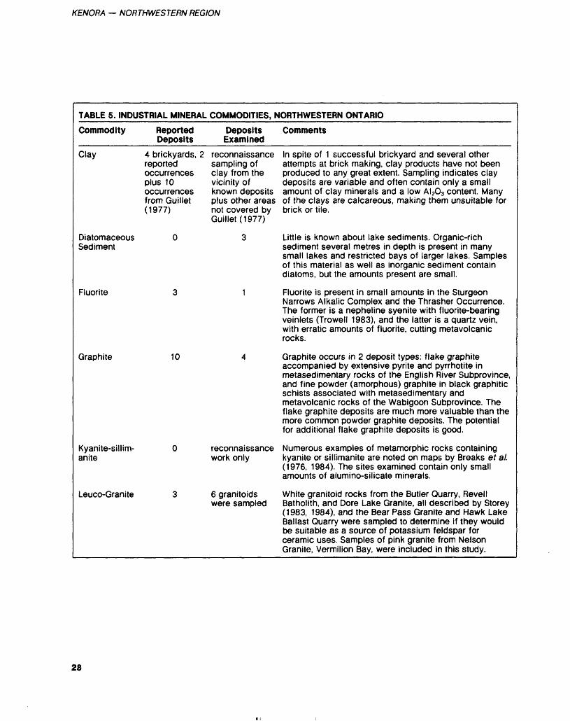
KENORA — NORTHWESTERN REGION
TABLE 5. INDUSTRIAL MINERAL COMMODITIES, NORTHWESTERN ONTARIO
Commodity Reported Deposits
Deposits Examined
Comments
Clay 4 brickyards, 2reportedoccurrencesplus 10occurrencesfrom Guillet(1977)
reconnaissance sampling of clay from the vicinity of known deposits plus other areas not covered by Guillet (1977)
In spite of 1 successful brickyard and several other attempts at brick making, clay products have not been produced to any great extent. Sampling indicates clay deposits are variable and often contain only a small amount of clay minerals and a low AI203 content. Many of the clays are calcareous, making them unsuitable for brick or tile.
Diatomaceous Sediment
Fluorite
Graphite 10
Kyanite-sillim- anite
Leuco-Granite
3 Little is known about lake sediments. Organic-rich sediment several metres in depth is present in many small lakes and restricted bays of larger lakes. Samples of this material as well as inorganic sediment contain diatoms, but the amounts present are small.
1 Fluorite is present in small amounts in the SturgeonNarrows Alkalic Complex and the Thrasher Occurrence. The former is a nepheline syenite with fluorite-bearing veinlets (Trowell 1983), and the latter is a quartz vein, with erratic amounts of fluorite, cutting metavolcanic rocks.
4 Graphite occurs in 2 deposit types: flake graphite accompanied by extensive pyrite and pyrrhotite in metasedimentary rocks of the English River Subprovince, and fine powder (amorphous) graphite in black graphitic schists associated with metasedimentary and metavolcanic rocks of the Wabigoon Subprovince. The flake graphite deposits are much more valuable than the more common powder graphite deposits. The potential for additional flake graphite deposits is good.
reconnaissance Numerous examples of metamorphic rocks containing work only kyanite or sillimanite are noted on maps by Breaks et al.
(1976, 1984). The sites examined contain only smallamounts of aluminosilicate minerals.
6 granitoids White granitoid rocks from the Butler Quarry, Revell were sampled Batholith, and Dore Lake Granite, all described by Storey
(1983, 1984), and the Bear Pass Granite and Hawk Lake Ballast Quarry were sampled to determine if they would be suitable as a source of potassium feldspar for ceramic uses. Samples of pink granite from Nelson Granite, Vermilion Bay, were included in this study.
28
C.E. BLACKBURN a M.R. HAILSTONE
TABLE 5. CONTINUED
Commodity Reported Deposits
Deposits Examined
Comments
Marl
Ochre
Pegmatites 12 major areas (Dryden Pegmatite Field and Ogani-Root Lake field each counted as one)
Mica Schist
"Silica" Sand
Specular Hematite
Talc/ Soapstone
Titanium
19 (includes 15 described in OFR 5446 and OFR 5522)
1
9 (Mavis Lake, Sandy Creek Be,Kozowy-Leduc- howski Cs, Graphic Lake, Medicine Lake Be, 2 uranium pegmatites near Kenora)
1
2 new deposits plus additional work on some of the others
1
Interest in marl has increased in recent years for use as a soil conditioner in acidic agricultural soils. The Suprise Lake Marl Deposit is a locally well known source. Lake sediment sampling by Kenora District OMNR staff during the 1960s located marl in highly organic rich sediments in Helldiver Bay of Shoal Lake, and work by Northland Associates Ltd. (1984) located marl beneath a peat bog near the Village of Finland, Rainy River District. Additional marl deposits should be present in the area.
The Vermilion Lake Pyrite Mine is noted for its extensive development of orange-red coloured soil overlying the body. The material is quite low in FeO content and would probably not be a satisfactory pigment.
Pegmatites are the most numerous and well studied of the industrial mineral deposits. During extensive exploration for lithium, uranium, and tantalum, many pegmatite deposits have been identified. Work during this study included examining several well known pegmatites plus a geochemical reconnaissance of pegmatites in the Ear Falls and Kenora-Dryden areas.
Several areas that seemed to have potential for micaceous schist were examined and found to contain only minor amounts of mica, often in very hard diatexite type rocks. The one example that showed reasonable amounts of muscovite is a schist associated with the quarry near Hudson (see Storey 1983).
One deposit of sand near Redditt was examined and found to be a quartzofeldspathic sand, not silica sand.
Specular hematite occurs in the Griffith Iron Mine at Ear Falls and as a minor constituent of some other iron deposits. This material is under study for its suitability for use as a pigment (Geoscience Laboratories, Ontario Geological Survey, Toronto).
Many talcose rock bodies were examined during the building and monumental stone inventory. One deposit at Wabigoon is being evaluated by Wabigoon Resources Ltd.
A deposit of titaniferous magnetite near Mine Centre has been evaluated several times in the past and is currently being evaluated by Titan Titanium International Ltd.
29
KENORA — NORTHWESTERN REGION
Figure 4KENORA
RESIDENT GEOLOGIST'SAREA
EXPLANATION
PRODUCER
PAST PRODUCER
A PROSPECT/OCCURRENCE
Boundary of Resident Geologist's Area
30
C.E. BLACKBURN 8, M.R. HAILSTONE
KENORARESIDENT GEOLOGIST'S
AREAIndustrial Mineral Deposits
LEGENDCLAY DEPOSITSCB1. Brinkman Brickyard Kenora
CB2. Dryden Timber 8t Power Co. Dryden CBS. Fitzgerald Brickyard Kenora
CB4. Fort Frances Brickyard DIATOM DEPOSITS D1. Bunny Lake
D2. Old Woman Lake
D3. Tabor Lake
FELDSPARFP1. Bear Passage Stock
FP2. Butler Quarry
FP3. Dore Lake Granite
FP4. Hawk Lake Quarry
FP5. Nelson Gianite
FP6. Revell BatholithFLUORITEF1. Oldberg Lake Mo Occurrence
F2. Sturgeon Narrows Alkalic Complex (not plotted)
F3. Thrasher Occurrence
GRAPHITEG1. Corkscrew Island
c.1898 and 1925-1929
c.1912 1884
c. 1914
G2. Falcon Island
G3. Manitou Stretch
G4. Meehan Occurrence
G5. Olson Occurrence G6. Oneman Lake
G7, Pope Lake
G8, Sucan Lake
G9. Treelined Lake G10. Wilkinson
IRON OXIDE PIGMENT IOP1. English River
IOP21 Griffith Iron Mine
IOP3. Kekekwa Lake
IOP4. Minaki Pyrite Mine
Powder
Powder
Powder
Flake
Flake
Flake
Powder
FlakePowder
Specular Hematite
Specular Hematite
Specular Hematite
Red 81 Yellow 'Ochre'
MARBLE (Calcium Carbonate) LIME/MARLM1. Finland Bog
M2. Fort Frances Lime
M3. Patricia Lime Company
M4. Shoal Lake
M5. Surprise Lake
M6. Woman LakePEGMATITEPEG1. Dryden Pegmatite Fiold Li, Be, Ta, Fsp;
35 pegmatites PEG2. Graphic Lake Pegmatites;
four or more pegmatites
Marl
Lime from Paleozoic limestone boulders c. 191 1Lime from early Precambrianlimestone 1939Marl - Very low carbonatite content
Marl for soil conditioning 1976
Marble (not plotted)
Prosp.
Occur.
continuedPEGMATITEPEG3. Harrison Mica occurrence muscobite Cb;
1 pegmatite Prosp.PEG4. Hollinger Occurrence Mo, U, Fsp; 1 dike Prosp, PEG5. Kozowy-Leduchowski Li, Cs, Fsp; 1 dike Prosp. PEG6. Mccallum Occurrence Li, Fsp; 3 dikes Occur. PEG7. Medicine Lake Beryl Occurrence Be,
Fsp, Ta; 1 dike Prosp. PEGS. Mica Point Pegmatite Muscovite, Be, Fsp;
1 dike 1885, 1926-1927, 1943
PEG9. Ogani-Root Lake Li, Fsp; 10 pegmatites PEG10. Pashkokogan Lake Li, Fsp; 1 dike
Past Producer Prosp.Occur.(not plotted)
PEG11. Sandy Creek Beryl Occurrence Be,Fsp; 1 dike Prosp.
PEG12. Separation Lake Beryl Occurrence Be,Fsp; 2 dikes Occur.
SANDS1. Redditt Sand DepositTALC/SOAPSTONETS1. Claxton Township OccurrenceTS2. Coste Island ProspectTS3. Eagle Lake Soapstone Quarry Past Producer 1925-27
TS4. Labyrinth BayTS5. Little Turtle Lake
(H.H. Wood Talc Co.)TS6. MadsenTS7. Mile Lake 1TS8. Mile Lake 2TS9. Pipestone LakeTS10. Pipestone PeninsulaTS11. Trap Lake
TS12. WabigoonTS13. Mica Point
TS14. Phillips TownshipTS15. Pipestone Bay (Red Lake)
TS.16 Oak Point Serpentinite/ Asbestos
TS17. Pipestone Lake North TS18. Ponask Lake Asbestos TS19- Sucan Lake Soapstone
TITANIUMTI1. Titan Titanium Titanium, Iron
PEATPI Arctic Peat Moss
P2. Du Nor Products
Occurrence
Past Producer 1922, 1923Occurrence*ProspectOccurrenceOccurrencePast Producer 1915ProspectProspectOccurrenceOccurrenceOccurrence
Occurrence
OccurrenceProspect (not plotted)Occurrence
Prosp.
31
KENORA — NORTHWESTERN REGION
The pegmatite reconnaissance studies results are not yet complete (December, 1984). Anomalous lith ium values are present in some of the pegmatite samples collected during the reconnaissance pro gram. Lithium can act as a path finder element for other more valuable minerals. The clay sam pling results to date have not in dicated satisfactory material. Kyanite and sillimanite are present in the English River metasedimen- tary rocks but only in small amounts. Mica schist with a high proportion of muscovite or phlogopite was not found, but the potential still exists for its pres ence.
ONTARIO GEOLOGICAL SURVEY ACTIVITIES______During the 1984 field season, the following field parties from the Precambrian Geology and Mineral Deposits Sections operated within the Kenora Mining Division:
J.A. Ayer (Precambrian Geol ogy Section) carried out the first year of a 2-year detailed mapping program of the Bigstone Bay area, Lake of the Woods (Figure 2, (A)).
G.P. Beakhouse (Precambrian Geology Section) carried out re connaissance investigations of vol canic components and mineral po tential of granitoid and medium to high grade metasedimentary ter rains within and outside the Di vision (Figure 2, (B)).
J.C. Davies and P.M. Smith (Mineral Deposits Section) com pleted a 2-year study of the char acteristics of gold deposits in the Lake of the Woods area (Figure 2, (C)).
G.W. Johns (Precambrian Ge ology Section) commenced a syn optic study of the Gibi Lake- Kakagi Lake-Rowan Lake area (Figure 2, (D)).
R.M. Sutcliffe (Precambrian Geology Section) carried out a de tailed mapping program of the Mulcahy Lake Gabbro Intrusion, southwest of Eagle Lake (Figure 2, (E)).
ONTARIO MINERAL EXPLORATION PROGRAM (OMEP)_____________As of December l, 1984, 44 des ignated OMEP programs, on which expenditures totaling an estimated 52.l million are anticipated.were operative in the Kenora Mining Division. The following is a list of the companies carrying out the programs, all conducting explora tion for gold unless otherwise in dicated, and the townships or areas of operation:Agassiz Resources Limited: Flem ing Township (base metals)Agassiz Resources Limited: Flem ing, Senn, and Menary Townships (base metals)Anyox Metals Limited: Manross and Code TownshipsAsamera Incorporated: Boyer Lake AreaBee Lake Syndicate: Rickaby Lake AreaBigstone Minerals Limited/Anglo Canadian Mining Corporation: Rowan and Dogpaw Lake Areas and Manross and Code TownshipsBill Knox Syndicate: Atikwa LakeAreaBoise Cascade Corporation: JaffrayTownshipCentral Crude Limited: Bad Ver milion and Little Turtle Lakes AreaCharger Resources Limited: Cameron and Rowan Lakes AreasCharger Resources Limited: Cameron and Rowan Lakes AreasCleyo Resources Incorporated: Bad Vermilion Lake AreaCochrane Oil and Gas Limited: Lower Manitou, Harper, and Boyer Lakes AreasColoma Resources Limited: Ben nett Lake AreaConsolidated Professor Mines Limited: Shoal Lake AreaCranshaw, Robert: Lower Manitou Lake Area and Hyndman Town shipCream Silver Mines Limited: Row an Lake Area
D.K. Platinum Corporation: Row an Lake AreaDejour Mines Limited: Lawrence Lake AreaDubenski Gold Mines Limited: Dogpaw Lake AreaEclipse Mining Corporation: Glass TownshipEsso Resources Canada Limited: Kawashegamuk Lake AreaGolden Transit Resources Incorpo rated: Brooks Lake AreaHansen, Jens E.: Glass TownshipHomestake Explorations Limited: Little Turtle Lake and Porter Inlet AreasJalna Resources Limited: Lower Manitou, Schistose, Washeibemaga, and Beartrack Lakes AreasKalrock Developments Limited: Tweedsmuir TownshipKalrock Develppments Limited: Phillips and Tweedsmuir Town shipsLynx-Canada Explorations Limit ed: Little Turtle, Hepburn, and Bennett Lakes AreasMicham Exploration Incorporated: Dogpaw Lake AreaMistango Consolidated Resources Limited: Laval TownshipNew McManus Red Lake Gold Mines Limited: Tweedsmuir Town shipNuinsco Resources Limited: Row an Lake AreaOrotek Resources Corporation: Bad Vermilion Lake AreaPresident Mines Limited: Kirkup TownshipRosenthal, Lorne: Rowan Lake AreaRosenthal, Lorne: Cedar, Clay, and Cliff Lakes AreaSherritt Gordon Mines Limited/Gossan Resources Limit ed: Dogpaw Lake AreaSilver Lake Resources Incorporat ed: Lower Manitou Lake AreaSovereign, WJ.: Turtlepond Lake AreaSparton Resources Incorporated: Napanee Lake Area
32
C.E BLACKBURN S, M.R. HAILSTONE
St. Joe Canada Incorporated: Low er Manitou Lake AreaTitan Titanium International In corporated: Bad Vermilion Lake Area (titanium)Wasabi Resources Limited: Phil lips Township.
RESEARCH BY OTHER AGENCIES_________
UNIVERSITY THESESGeological theses related to the Kenora Mining Division believed to be in progress or completed dur ing 1984 are as follows:
Masters ThesesKresz, D.V.: Completed a study entitled "Evolution of an Archean Greenstone Belt in the Stormy Lake-Kawashegamuk Lake Area (Stratigraphy, Structure, and Geo chemistry) - Western Wabigoon Subprovince, Northwest Ontario" (Brock University).Melling, D.: Continued a study of the geological setting and genesis of the Cameron Lake Gold Deposit of Nuinsco Resources Limited and Lockwood Petroleum Incorporated (Carleton University).Stix, John: Continued a study on the transition from lower tholeiitic through to upper calcalkaline vol canic rocks at Andrew Bay, Lake of the Woods (University of To ronto).
Doctoral ThesesEdwards, G.R.: Continued a study of Archean volcanic, subvolcanic, and plutonic rock petrogenesis in the Kakagi-Pipestone Lakes area (University of Western Ontario).Poulsen, K.H.: Completed a study of Archean tectonics and mineral ization of the Rainy Lake area (Queens' University).
ONTARIO GEOSCIENCE RESEARCH GRANT PROGRAMG.R. Edwards (York University) and D.W. Davis (Royal Ontario Museum) continued a study of the petrogenesis and metallogenesis of the Atikwa-Lawrence volcanic- plutonic terrane.
D.H. Watkinson and D. Mel ling (Carleton University) com menced a study of the geological setting and genesis of the Cameron Lake Gold Deposit.
SELECTED PUBLICATIONS RECEIVED 1984_________Bertholf, Jr.1946: Graded Unconformity,
Washeibemaga Lake Area, Ontario; M.Sc. Thesis, Univer sity of Chicago, 45p.
Clark, H.G.1984: Handbook for Prospectors
and Developers in the Kenora Area; Tri-Municipal Economic Development Commission, Kenora, Ontario, 178p.
Dunlop, D J.1983: Paleomagnetism of Archean
Rocks from Northwestern On tario: Wabigoon Gabbro, Wabigoon Subprovince; Cana dian Journal of Earth Sci ences, Volume 20, p.1805-1817
Poland, S.S.1982: Geochemistry, Geochronol
ogy, and Origin of an Archean Greenstone-Granite Terrain, Wabigoon Subprovince, North western Ontario: M.Sc. Thesis, University of Montana, Mis- soula, 166p.
Gupta, V.K., and Barlow, R.B.1984: A Detailed Gravity Profile
Across the English River Sub province, Northwesten Ontar io; Canadian Journal of Earth Sciences, Volume 21, p.145-151.
Kresz, David1984: Evolution of an Archean
Greenstone Belt in the Stormy Lake-Kawashegamuk Lake Area (Statigraphy, Structure and Geochemistry), Western Wabigoon Subprovince, North west Ontario: M.Sc. Thesis, Brock University, St. Cather ines, Ontario, 262p.
Mulligan, Robert1984: Geology of Canadian Tung
sten Occurrences; Geological Survey of Canada, Economic Geology Report 32, 12Ip.
REFERENCESBeard, R.C., and Garratt, G.L.1976: Gold Deposits of the
Kenora-Fort Frances Area, Districts of Kenora and Rainy River; Ontario Division Mines, Mineral Deposits Circular 16, 46p. Accompanied by Chart A, scale 1:253 440 or l inch to 4 miles.
Beard, R.C., and Scott, W.1976: 1975 Report of the Kenora
Resident Geologist; p.1-15 in Annual Report of the Regional and Resident Geologists, 1975, edited by C.R. Kustra, Ontario Division of Mines, Miscella neous Paper 64, 146p.
Beard, R.C., and Rivett, S.1977: 1976 Report of the Kenora
Resident Geologist; p.1-15 in Annual Report of the Regional and Resident Geologists, 1976, edited by C.R. Kustra, Ontario Division of Mines, Miscella neous Paper 71, 141p.
Breaks, F.W., Bond, W.D., Des noyers, D.W., Stone, Denver, and Harris, N.1976: Operation Kenora-Ear Falls,
Bruce-Bluffy Lakes Sheet, Dis trict of Kenora; Ontario Divi sion of Mines, Preliminary Map P. 1199, Geological Se ries, scale 1:63 360 or l inch to l mile. Geology 1975.
Breaks, F.W., and Kuehner, S.1984: Precambrian Geology of the
Eagle River-Ghost Lake Area, Kenora District; Ontario Geo logical Survey, Map P.2623, Geological Series-Preliminary Map, scale 1:31 680 or l inch to 1/2 mile. Geology 1980, 1983
Guillet, G.R.1977: Clay and Shale Deposits of
Ontario; Ontario Geological Survey, Mineral Deposits Cir cular 15, 117p. Accompanied by Map 2358, scale 1:2 000 000.
Lawson, A.C.1886: Geology of the Lake of the
Woods Region; Geological Survey of Canada, Annual Re port, New Series, Volume l, Part CC, for 1885, 15Ip.
33
KENORA — NORTHWESTERN REGION
1889: Report on the Geology of the Rainy Lake Region; Geo logical Survey of Canada, An nual Report, New Series, Vol ume 3, part 1.
1913: The Archean Geology of Rainy Lake Re-studied; Canada Department of Mines, Geological Survey, Memoir 40, 115p.
Ontario Geological Survey 1981: Airborne Electromagnetic
and Total Intensity Magnetic Survey, Manitou-Stormy Lakes Area, District of Kenora; by Renting Earth Sciences Limit ed for the Ontario Geological Survey, Maps 80 458-80 479, Geophysical/Geochemical Se ries, scale 1:20000.
Satterly, J.1943: Geology of the Dryden-
Wabigoon Area; Ontario De
partment of Mines, Volume 50, Part 2, 1941, p. l-67. Ac companied by Map 50e, scale 1:63 360 or l inch to l mile.
Storey, C.C.1983: Preliminary Report of the
Building and Ornamental Stone Inventory, Kenora and Rainy River Districts; Ontario Geological Survey, Open File Report 5446, 143p., 20 tables, and 37 figures.
1984: Preliminary Report of the Building and Ornamental Stone Inventory, Part 2, Kenora and Rainy River Dis tricts; Ontario Geological Sur vey, Open File Report 5522, 127p., 19 tables, and 23 fig ures.
Thomson, Jas. E., Ferguson, SAM Johnston, W.G.Q., Pye, E.G., Sav age, W.S., and Thomson, Robert
1957: Copper, Nickel, Lead, and Zinc Deposits in Ontario; On tario Department of Mines, Metal Resources Circular 2, 126p.
Trowell, N.F.1983: Geology of the Sturgeon
Lake Area, Districts of Thun der Bay and Kenora; Ontario Geological Survey, Report 221, 97p. Accompanied by Maps 2456, 2457, and 2458, scale 1:50 000, l chart, and l sheet of microfiche.
Vos, M.A., Abolins, T., and Smith,V.1982: Industrial Minerals of
Northern Ontario-Supplement l, Ontario Geological Survey, Open File Report 5388, 344p., 3 figures, and l table.
34
Red Lake Resident Geologist Area, Northwestern RegionM.J. Lavigne Jr. 1 and B.T. Atkinson2Resident Geologist, Resource Geologist, Ontario Ministry of Natural Resources, Red Lake
INTRODUCTIONThe Red Lake Resident Geologist Office has undergone a complete staff turnover in 1984. The former Resident Geologist, M. Durocher, vacated his position in March and was replaced by M.J. Lavigne Jr. in June. The position of Resource Geologist, formerly a contract po sition held by P .S. Burchell who left in February, is now a perma nent position held by B.T. Atkin son since August. The secretarial position, formerly a permanent po sition held by C.D. Van Leeuwen who left in December 1983, is now a contract part-time position held by V. Masi. Prior to April 1st, the 3 offices of Resident Geologists in the Northwestern Region operated at a regional administrative level. The offices now operate at the dis trict level with direct reporting re lationships to the District Manag ers. This merger with the district administration level facilitates op erating logistics and permits a clos er working relationship with other branches such as fire, timber, fish and wildlife, and engineering ser vices. Thus, the Resident Geologist is now more involved with the concerns of other resource users and allots more time to integrated resource management with other branches of the Ministry of Natu ral Resources.
RESIDENT GEOLOGIST'S ACTIVITIES - - The former Resident and Resource Geologists completed 2 long term projects during their tenure. Geo chemical data for the study of hy drothermal wallrock alteration as sociation with gold mineralization found along the Flat Lake - Howey Bay deformation zone (Starratt - Olsen, Madsen, Hasaga, and Howey Mines) have been received and the results were presented by M.E. Durocher at an Ontario Geo logical Survey (OGS) symposium on Archean gold deposits in To ronto, March 8, 1984.
A written report with the new data is pending while data restrict ed to the Starratt-Olsen and Mad
sen Mines area was published in Miscellaneous Paper 110, "Geology of Gold in Ontario". A detailed compilation of the geology and distribution of gold mineraliza tion in the Red Lake Metavolcanic Belt is completed and is now in press.
The new Resident Geologist continued to provide technical ad visory service to prospectors, min ing companies, and government services, while familiarizing with and evaluating the current state of exploration activity, geology of the Red Lake and Birch Lake areas, and current research activities. Currently, sampling at the Camp bell Red Lake Mines has been completed to further establish the use of sulphur isotopes as an ex ploration tool. The Resident Geolo gist co-authored the recently re leased Open File Report 5524, "An Integrated Model for the Origin of Archean Lode Gold Deposits". This model and the data on which it is based was presented at the OGS symposium on March 8, 1984 and again at a symposium on Archean gold deposits at the an nual Geological Society of Amer ica meeting in Reno, Nevada, No vember 4-8, 1984. The Resident Geologist presented 2 papers dur ing this symposium.
In 1984, the following gold oc currences, prospects, past produc ers and mines were visited by the staff of the Red Lake Resident Ge ologist Office:1. Madsen (past producer) Baird
Township2. Skookum Bay (prospect) Dome
Township3. Jamie Frontier (past producer)
Todd Township4. Lake Rowan (prospect) Todd
Township5. Red Crest (past producer)6. Papaonga Lake (occurrences)7. Campbell Red Lake Mines
(producer) Balmer Township8. Arthur W. White Mine
(producer) Balmer Township9. Cochenour-Willans (past
producer) Dome Township
10. Wilmar (past producer) Dome Township
11. Marcus (past producer) Dome Township
12. McMarmac (past producer) Dome Township
13. McFinley (prospect) Bateman Township
14. Canamer (occurrence) Birch Lake
15. Mcintyre (prospect) Birch Lake
16. Sudbury Contact (prospect) Birch Lake
17. Horseshoe Island (prospect) Birch Lake
18. Springpole (prospect) Birch Lake
19. Cole (past producer) Ball Township
20. Chukuni (occurrence) Heyson Township
21. Fairlie (occurrence) Fairlie Township
22. Redcon (occurrence) Balmer Township
23. Fisher Islands (occurrence) Fairlie Township
24. Griffith (producer) Bruce Lake.When property visits are
made, grab samples are regularly taken and assayed. Two grab sam ples taken from the Springpole prospect assayed 3.96 ounces gold per ton, 2.18 ounces silver per ton; and 5.80 ounces gold per ton, 3.30 ounces silver per ton (Geoscience Laboratories, Ontario Geological Survey, Toronto).
MINING ACTIVITYCampbell Red Lake Mines Limited operated throughout 1984. Produc tion in 1984 is expected to be simi lar to 1983. Major expenditures consisted of upgrading surface fa cilities. Underground exploration in 1984 has been directed at main taining ore reserves.
The Arthur W. White Mine of the Dickenson Mines Limited- Sullivan Resources Limited joint venture operated continuously throughout 1984 with production at 600 to 650 tons per day, which
35
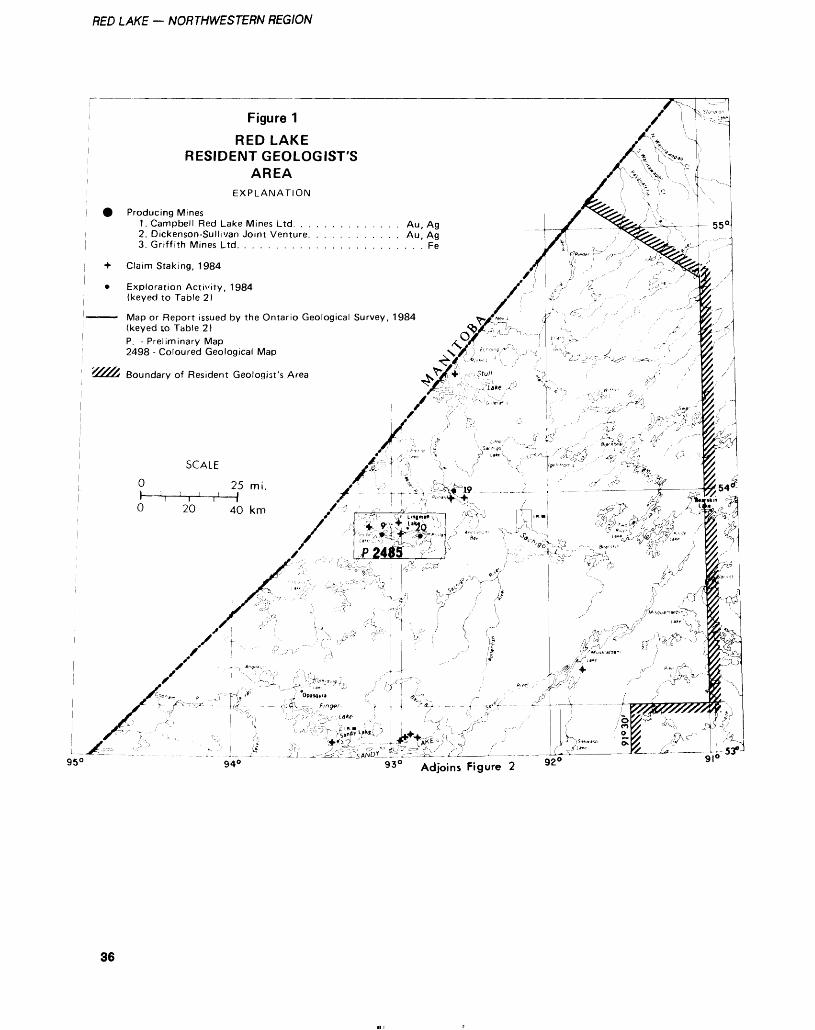
RED LAKE — NORTHWESTERN REGION
Figure 1
RED LAKERESIDENT GEOLOGIST'S
AREAEXPLANATION
Producing Mines1. Campbell Red Lake Mines Ltd. . . . . . . . . . . . . . Au, Ag2. Dickenson-Sullivan Joint Venture. . . . . . . . . . . . Au, Ag3. Griffith Mines Ltd. . . . . . . . . . . . . . . . . . . . . . . ' Fe
Claim Staking, 1984
Exploration Activity, 1984 (keyed to Table 2)
Map or Report issued by the Ontario Geological Survey, 1984(keyed to Table 2)P. - Preliminary Map2498 - Coloured Geological Map
Boundary of Resident Geologist's Area
950930 Adjoins Figure 2
36
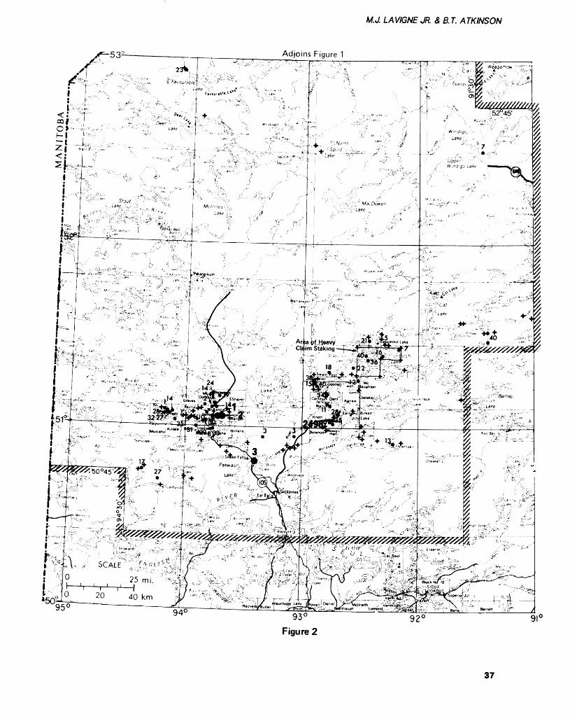
M.J. LAVIGNE JR. Z B.T. ATKINSON
Adjoins Figure 1
37
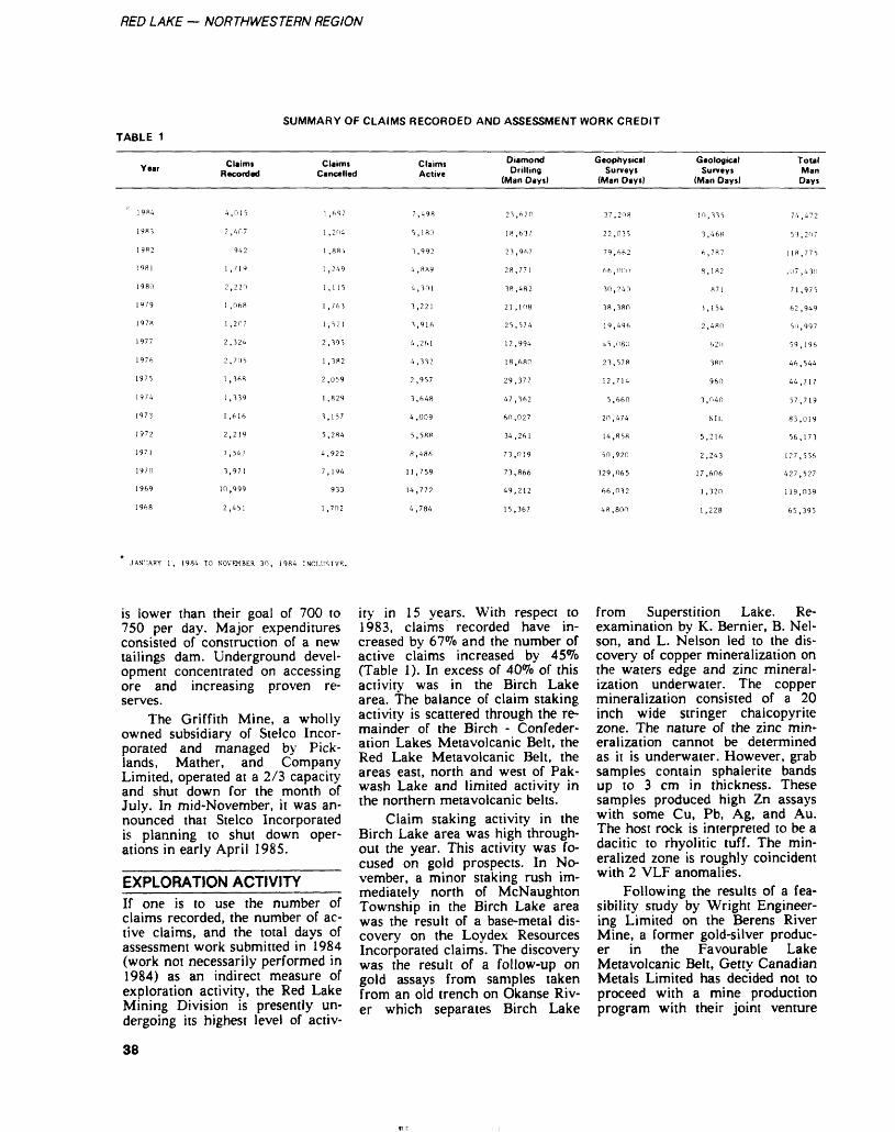
RED LAKE — NORTHWESTERN REGION
TABLE 1SUMMARY OF CLAIMS RECORDED AND ASSESSMENT WORK CREDIT
Year Claims Recorded
Claims Cancelled
Claims Active
DiamondDrilling
(Man Days)
GeophysicalSurveys
(Man Days)
GeologicalSurveys
(Man Days)
Total Man
Days
4,015
2 ,407
942
l .719
2,220
l , 068
l .2(17
2,324
2,7(15
l , 368
l ,339
l ,616
2,219
l ,541
3,971
10,999
2,451
7,498
5,180
3,992
4 ,889
4,301
3,221
3,916
4,261
4,332
2,957
3,648
4,009
5,588
R ,4S6
11,759
14,772
4,784
23,670
18,637
23,967
28,771
38,482
21,108
25,574
12,994
18,680
29,377
47,362
60,027
34,261
73,019
73,866
49,212
15,367
37,208
22,035
79,662
66 ,00f!
30,240
38,380
19,496
45,080
23,578
12,714
5,660
20,474
14,858
50,920
329,065
66,032
48 ,800
53,207
118,775
111? ,430
71 ,975
62,949
50,997
59,196
46,544
44,717
57,719
83,019
56,173
127,556
427,527
l 19,039
65,395
JANUARY l, 1984 TO NOVEMBER 30, 1984 INCLUSIVE.
is lower than their goal of 700 to 750 per day. Major expenditures consisted of construction of a new tailings dam. Underground devel opment concentrated on accessing ore and increasing proven re serves.
The Griffith Mine, a wholly owned subsidiary of Stelco Incor porated and managed by Pick- lands, Mather, and Company Limited, operated at a 2/3 capacity and shut down for the month of July. In mid-November, it was an nounced that Stelco Incorporated is planning to shut down oper ations in early April 1985.
EXPLORATION ACTIVITYIf one is to use the number of claims recorded, the number of ac tive claims, and the total days of assessment work submitted in 1984 (work not necessarily performed in 1984) as an indirect measure of exploration activity, the Red Lake Mining Division is presently un dergoing its highest level of activ
ity in 15 years. With respect to 1983, claims recorded have in creased by 67^0 and the number of active claims increased by 45^0 (Table 1). In excess of 40^0 of this activity was in the Birch Lake area. The balance of claim staking activity is scattered through the re mainder of the Birch - Confeder ation Lakes Metavolcanic Belt, the Red Lake Metavolcanic Belt, the areas east, north and west of Pak wash Lake and limited activity in the northern metavolcanic bells.
Claim staking activity in the Birch Lake area was high through out the year. This activity was fo cused on gold prospects. In No vember, a minor staking rush im mediately north of McNaughton Township in the Birch Lake area was the result of a base-metal dis covery on the Loydex Resources Incorporated claims. The discovery was the result of a follow-up on gold assays from samples taken from an old trench on Okanse Riv er which separates Birch Lake
from Superstition Lake. Re- examination by K. Bernier, B. Nel son, and L. Nelson led to the dis covery of copper mineralization on the waters edge and zinc mineral ization underwater. The copper mineralization consisted of a 20 inch wide stringer chalcopyrite zone. The nature of the zinc min eralization cannot be determined as it is underwater. However, grab samples contain sphalerite bands up to 3 cm in thickness. These samples produced high Zn assays with some Cu, Pb, Ag, and Au. The host rock is interpreted to be a dacitic to rhyolitic tuff. The min eralized zone is roughly coincident with 2 VLF anomalies.
Following the results of a fea sibility study by Wright Engineer ing Limited on the Berens River Mine, a former gold-silver produc er in the Favourable Lake Metavolcanic Belt, Getty Canadian Metals Limited has decided not to proceed with a mine production program with their joint venture
38
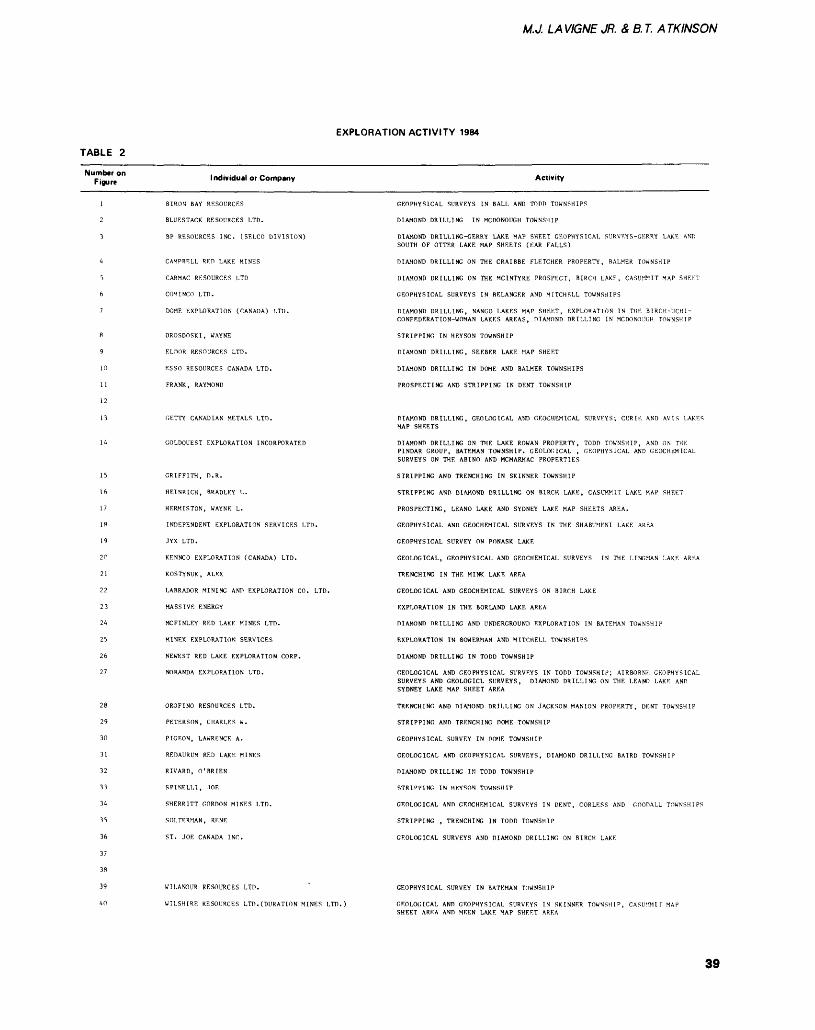
M.J. LA VIGNE JR. S, B. T. A TKINSON
EXPLORATION ACTIVITY 1984
TABLE 2
Number on Figure Individual or Company Activity
BIROU BAY RESOURCES
BLUESTACK RESOURCES LTD.
BP RESOURCES INC. (SELCO DIVISION)
CAMPBELL RED LAKE MINES
CARMAC RESOURCES LTD
COM1NCO LTD.
DOME EXPLORATION (CANADA) LTD.
DROSDOSKI, WAYNE
ELnOR RESOURCES LTD.
ESSO RESOURCES CANADA LTD.
FRANK, RAYMOND
GETTY CANADIAN METALS LTD.
GOLDOUEST EXPLORATION INCORPORATED
GRIFFITH, D.R.
HEINRICH, BRADLEY L.
HF.RMISTON, WAYNE L.
INDEPENDENT EXPLORATION SERVICES LTD.
JYX LTD.
KENNCO EXPLORATION (CANADA) LTD.
KOSTYNUK, ALEX
LABRADOR MINING ANT) EXPLORATION CO. LTD.
MASSIVE ENERGY
MCFINLEY RED LAKE MINES LTD.
MINEX EXPLORATION SERVICF.S
NEWEST RED LAKE EXPLORATION CORP.
NORANDA EXPLORATION LTD.
OROFINO RESOURCES LTD.
PETERSON, CHARLES W.
PIGEON, LAWRENCE A.
REDAURUM RED LAKE MINES
RIVARD, O'BRIEN
SPINEL!,!, IOE
SHERRITT GORDON MINES LTD.
SOLTERMAN, RFNE
ST. JOE CANADA INC.
WILANOUR RF.SOURCF.S LTD.
WILSHIRE RESOURCES LTD.(DURATION MINES LTD.)
GEOPHYSICAL SURVEYS IN BALL AND TODD TOWNSHIPS
DIAMOND DRILLING IN MCDONOUGH TOWNSHIP
DIAMOND DRILLING-GERRY LAKE MAP SHEET GEOPHYSICAL SURVEYS-GERRY LAKE AND SOUTH OF OTTER LAKE MAP SHEETS (EAR FALLS)
DIAMOND DRILLING ON THE CRAIBBE FLETCHER PROPERTY, BALMER TOWNSHIP
DIAMOND DRILLING ON THE MCINTYRE PROSPECT, BIRCH LAKE, CASUMMIT MAP SHF.ET
GEOPHYSICAL SURVEYS IN BELANGER AND MITCHELL TOWNSHIPS
DIAMOND DRILLING, NANGO LAKES MAP SHEET, EXPLORATION IN THE BIRCH-UCHI- CONFEDF.RATION-WOMAN LAKES AREAS, DIAMOND DRILLING IN MCDONOUGH TOWNSHIP
STRIPPING IN HEYSON TOWNSHIP
DIAMOND DRILLING, SEEBER LAKE MAP SHEET
DIAMOND DRILLING IN DOME AND BALMER TOWNSHIPS
PROSPECTING AND STRIPPING IN DENT TOWNSHIP
DIAMOND DRILLING, GEOLOGICAL AND GEOCHEMICAL SURVEYS; CUR IK AND AVIS LAKES MAP SHEETS
DIAMOND DRILLING ON THE LAKE ROWAN PROPERTY, TODD TOWNSHIP, AND ON THE PINDAR GROUP, BATEMAN TOWNSHIP. GEOLOGICAL , GEOPHYSICAL AND GEOCHEMICAL SURVEYS ON THE ABINO AND MCMARMAC PROPERTIES
STRIPPING AND TRENCHING IN SKINNER TOWNSHIP
STRIPPING AND DIAMOND DRILLING ON BIRCH LAKE, CASUMMIT LAKE MAP SHEET
PROSPECTING, LEANO LAKE AND SYDNEY LAKE MAP SHEETS AREA.
GEOPHYSICAL AND GEOCHEMICAL SURVEYS IN THE SHABUMENI LAKE AREA
GEOPHYSICAL SURVEY ON PONASK LAKE
GEOLOGICAL, GEOPHYSICAL AND GEOCHEMICAL SURVEYS IN THE LINGMAN LAKE AREA
TRENCHING IN THE MINK LAKE AREA
GEOLOGICAL AND GEOCHEMICAL SURVEYS ON BIRCH LAKE
EXPLORATION IN THE BORLAND LAKE AREA
DIAMOND DRILLING AND UNDERGROUND EXPLORATION IN BATEMAN TOWNSHIP
EXPLORATION IN BOWERMAN AND MITCHELL TOWNSHIPS
DIAMOND DRILLING IN TODD TOWNSHIP
GEOLOGICAL AND GEOPHYSICAL SURVEYS IN TODD TOWNSHIP; AIRBORNE GEOPHYSICAL SURVEYS AND GEOLOGICL SURVEYS, DIAMOND DRILLING ON THE LEANO LAKE AND SYDNEY LAKE MAP SHEET AREA
TRENCHING AND DIAMOND DRILLING ON JACKSON MANION PROPERTY, DENT TOWNSHIP
STRIPPING AND TRENCHING DOME TOWNSHIP
GEOPHYSICAL SURVEY IN DOME TOWNSHIP
GEOLOGICAL AND GEOPHYSICAL SURVEYS, DIAMOND DRILLING BAIRD TOWNSHIP
DIAMOND DRILLING IN TODD TOWNSHIP
STRIPPING IN HEYSON TOWNSHIP
GEOLOGICAL AND GEOCHEMICAL SURVEYS IN DENT, CORLESS AND GOODALL TOWNSHIPS
STRIPPING , TRENCHING IN TODD TOWNSHIP
GEOLOGICAL SURVEYS AND DIAMOND DRILLING ON BIRCH LAKE
GEOPHYSICAL SURVEY IN BATEMAN TOWNSHIP
GEOLOGICAL AND GEOPHYSICAL SURVEYS IN SKINNER TOWNSHIP, CASUMMIT MAP SHEET AREA AND MEEN LAKE MAP SHEET AREA
39
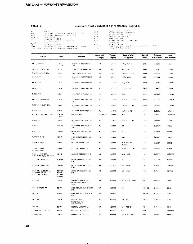
RED LAKE — NORTHWESTERN REGION
TABLE 3 ASSESSMENT WORK AND OTHER INFORMATION RECEIVED.
\n old MM ill,,,,,,,. 1 VM.it; irb, ,rn,- M \.,,,.-,, -,-,,-^-,MI,-II( 11)11 i.iitiond l):
M 1 i', t riim.in ji-in'lit-m ,o, h, -mi -,( ,| ,',,l,,ni, .il III M or i /onl ..l
Location
BALL, TODD TP.
BALMER, RANGER TP.
BALMER, RANGKR TP.
BALMER TP.
BALMER TP.
BATEMAN TP.
BATEMAN, BALMER TP,
BATEMAN, BALMER TP.
BATEMAN TP.
BELANGER, MITCHELL TP.
BYSHE TP.
BYSHE TP.
CASUMMIT LAKE
CASUMMIT LAKE
CASUMMIT LAKESATTERLY LAKE
CORLESS, EARNGEY, DENT, MITCHELL, KNOTT TP.
CURIE LK, AVIS LK.
CURIE LK, AVIS LK.
CURIE LK, JUBILEE LK. ROADHOUSE RIVER AVIS LAKF,, SLATE LK.
DENT TP.
DOME, FAIRLIE TP.
DOME TP.
DOME TP.
DOME TP.
EARNGEY TP. UCHI LK.
EARNGEY TP.
i 1 1 ii. P!.-
i.,,.,p i i.. 1 1 i Mi. mi'
NTS
52M/152L/16
52N/4
52N/4
52N/4
52N/4
52N/4
52N/4
57N/4
52N/4
52N/4
52K/15 52N/2
52K / 1 3
52K/13
52K/13
52N/8
52N/8
52N/8
52N/2
52K/16
52K/16
52K/16 52N/1 52J/13 52K/15
52N/2
52N/4
52N/4
52N/4
52N/4
52N/2
52N/2
M. 'K
r -m v.'V mi) K, id
1 r r 1 r
l roni.tnni-t i' Mirv.-v \l,l 1 M ,, h.-mi^t i-x I.I'.
f... ,, Commodity File Name Sought
BIRON BAY RESOURCES AU LTD.
ELDORADO NUCLEAR LTD. AU
KI.DOR RESOURCES LTD. AU
OOLDOUF.ST EXPLORATION AU INC.
GOLDQUF.ST EXPI/1RATION AU INC.
GOLDQUEST EXPLORATION AU INC.
COLDOUEST EXPLORATION AU INC.
GOLDOUEST EXPLORATION AUINC.
GOLDOUEST EXPLORATION AU
INC.
WILANOUR RESOURCES LTD. AU
COMINCO LTD. CU.ZN.AG
GOLDOUEST EXPLORATION AU
INC.
GOLDOUEST EXPLORATION AU INC.
GOLDOUEST EXPLORATION AU INC.
DOME EXPLORATION (CAN) AU LTD.
ST. JOE CANADA INC. AU
ST. JOE CANADA INC. AU
OROFINO RESOURCES LTD. AU
GETTY CANADIAN METALS AU LTD.
GETTY CANADIAN METALS AU LTD.
GETTY CANADIAN METALS AU LTD.
MARSHALL HAMES.O.C. AU DEVONSHIRE GOLD RES. INC.
GOLD FIELDS CAN. MINING AU LTD.
GOLD FIELDS CAN. MINING AU LTD.
HUSTON C. D. AU PETERSON, C. W. DESMEULES, M.
PIGEON, LAURENCE A. AU
TERRELL, MICHAEL A. AU
TERRELL, MICHAEL A. AU
li\,-rbiii l.-n llx.-rbiir l.-n K. idn. mi- ii, -.impl inj, A St.rippi IK. Ir,.,,, hi Mi K, K k Ir ni-li\.-IV 1,11V. 1 1
liulnri-d Pol
Type of Report
ASSESS
ASSESS
ASSESS
ASSESS
ASSESS
ASSESS
ASSESS
ASSESS
ASSESS
ASSESS
ASSESS
ASSESS
ASSESS
ASSESS
ASSESS
ASSESS
ASSESS
ASSESS
ASSESS
ASSESS
ASSESS
ASSESS
ASSESS
ASSESS
ASSESS
ASSESS
ASSESS
(,,-o. li.-mUt rv Di i 1 1 infi
--oil Ir, -IK h inn
,-,,,,,.,i, v 1 l.-,:l rom.i K n,-t c. m.- 1..
Type of Work Date of Performed Work
MAC, VLF-EM 1984
MAG, EM 1982
n.D.H. (7) 3423' 1983
MAG, HLEM 1981
GL, RAD 1982
RAD 1982
D. D. H. (4) 1334' 1983
D.D.H.(l) 300' 1983
MAG, VLF-EM 1984
MAG 1984
D. D. H. (2) 700' 1980
EM 1983
GL, RAD 1983
MAG 1983
MAG, VLF-EM, 1984 MAXMIN
D.D.H.(l) 208' 1984
AMAG AEM 1983
GL. 1983
AEM, AMAG 1983
AEM, AMAG 1983
D. D. H. (11) 2862' 1983 I. P.
GL 1981-82
I. P. 1982-83
MAG, EM 1982
MAG, VLF-EM 1984
STR. 1984
D. D. H. (3) 320' 1984
Toronto File Number
2.6867
2.5480
2.5411
2.5412
2.6820
2.5413
2.7281
2.6964
2.5919
2.5923
2.6447
2.6829
2.6077
2.6592
2.6562
2.7159
2.5824
2.5825
2.5313
2.7305
Local File Number
BALL
BALMER
BALMER
BALMER
BALMER
BATEMAN
BATEMAN
BATEMAN
BATEMAN
BELANGER
BYSHE
BYSHE
BYSHE
52N/8
52N/8
52N/8
CORLESS
52K/16
52K/16
52K/16
DENT
DOME
DOME
DOME
DOME
EARNGEY
EARNGEY
40
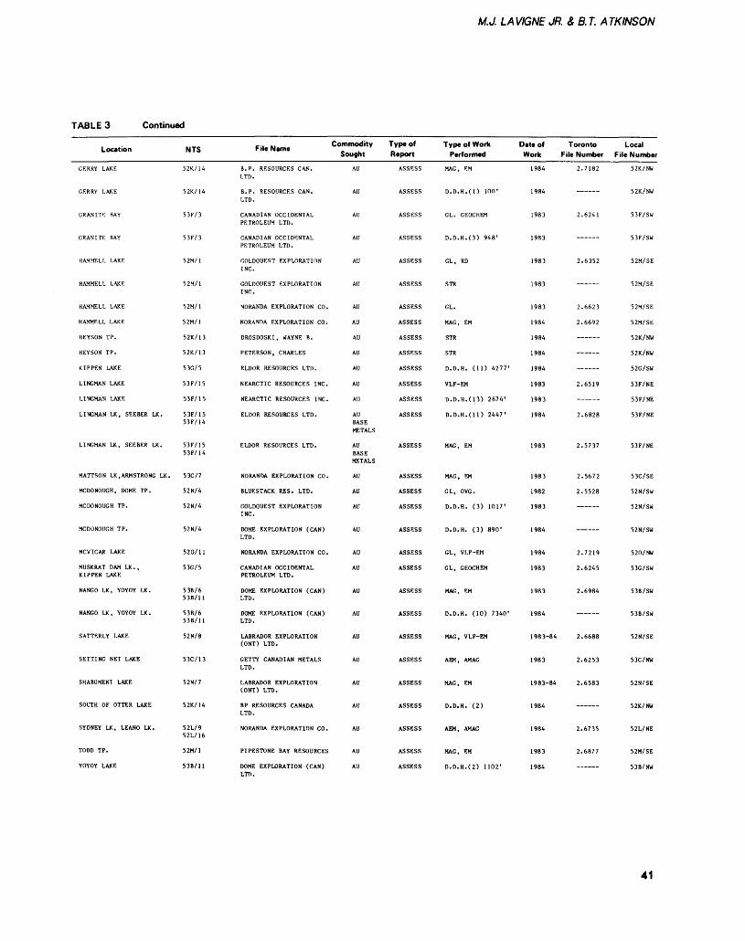
M.J. LAVIGNE JR. S, B.T. ATKINSON
TABLE 3 Continued
Location
CERRY LAKE
GERRY LAKE
GRANITK BAY
GRANITE BAY
HAMMELL LAKE
HAMMELL LAKE
HAMMELL LAKE
HAMMELL LAKE
HEYSON TP.
HEYSON TP.
KIPPEN LAKE
LINGMAN LAKE
LINGMAN LAKE
LINGMAN LK, SEEBER LK.
LINGMAN LK, SEEBER LK.
MATTSON LK, ARMSTRONG LK.
MCDONOUGH, DOME TP.
MCDONOUGH TP.
MCDONOUGH TP.
MCVICAR LAKE
MUSKRAT DAM LK., KIPPEN LAKE
NANGO LK, YOYOY LK.
NANGO LK, YOYOY LK.
SATTERLY LAKE
SETTING NET LAKE
SHABUMENI LAKE
SOUTH OF OTTER LAKE
SYDNEY LK, LEANO LK.
TODD TP.
YOYOY LAKE
NTS
52K/14
52K/14
53F/3
53F/3
52M/1
52M/1
52M/1
52M/1
52K/13
52K/13
53G/5
53F/15
53F/15
53F/15 53F/14
53F/15 53F/14
53C/7
52N/4
52N/4
52N/4
520/11
53G/5
53B/6 53B/11
53B/6 53B/11
52N/8
53C/13
52N/7
52K/14
52L/9 52L/16
52M/1
53B/11
f... t, Commodity File Name Sought
B. P. RESOURCES CAN. LTD.
B. P. RESOURCES CAN. LTD.
CANADIAN OCCIDENTAL PETROLEUM LTD.
CANADIAN OCCIDENTAL PETROLEUM LTD.
GOLDQUEST EXPLORATION INC.
GOLDOIIEST EXPLORATION INC.
NORANDA EXPLORATION CO.
NORANDA EXPLORATION CO.
DROSDOSKI, WAYNE B.
PETERSON, CHARLES
ELDOR RESOURCES LTD.
NEARCTIC RESOURCES INC.
NEARCTIC RESOURCES INC.
ELDOR RESOURCES LTD.
ELDOR RESOURCES LTD.
NORANDA EXPLORATION CO.
BLUESTACK RES. LTD.
GOLDOUEST EXPLORATIONINC.
DOME EXPLORATION (CAN)LTD.
NORANDA EXPLORATION CO.
CANADIAN OCCIDENTAL PETROLEUM LTD.
DOME EXPLORATION (CAN)LTD.
DOME EXPLORATION (CAN) LTD.
LABRADOR EXPLORATION (ONT) LTD.
GETTY CANADIAN METALS LTD.
LABRADOR EXPLORATION (ONT) LTD.
BP RESOURCES CANADA LTD.
NORANDA EXPLORATION CO.
PIPESTONE BAY RESOURCES
DOME EXPLORATION (CAN) LTD.
AU
AU
AU
AU
AU
AU
AU
AU
AU
AU
AU
AU
AU
AU BASE METALS
AU BASE METALS
AU
AU
AU
AU
AU
AU
AU
AU
AU
AU
AU
AU
AU
AU
AU
Type of Report
ASSESS
ASSESS
ASSESS
ASSESS
ASSESS
ASSESS
ASSESS
ASSESS
ASSESS
ASSESS
ASSESS
ASSESS
ASSESS
ASSESS
ASSESS
ASSESS
ASSESS
ASSESS
ASSESS
ASSESS
ASSESS
ASSESS
ASSESS
ASSESS
ASSESS
ASSESS
ASSESS
ASSESS
ASSESS
ASSESS
Type of Work Performed
MAG, EM
o.D.H.(i) mo 1
GL. GEOCHEM
D. D. H. (3) 948'
GL, RD
STR
GL.
MAG, EM
STR
STR
D.D.H. (11) 4277'
VLF-EM
D. D. H. (13) 2674'
D.D.H. (11) 2447'
MAG, EM
MAG, EM
GL, OVG.
D.D.H. (3) 1017'
D.D.H. (3) 890'
GL, VLF-EM
GL, GEOCHEM
MAG, EM
D.D.H. (10) 7340'
MAG, VLF-EM
AEM, AMAG
MAG, EM
D.D.H. (2)
AEM, AMAG
MAG, EM
D. D. H. (2) 1102'
Date of Toronto Local Work File Number File Number
1984
1984
1983
1983
1983
1983
1983
1984
1984
1984
1984
1983
1983
1984
1983
1983
1982
1983
1984
1984
1983
1983
1984
1983-84
1983
1983-84
1984
1984
1983
1984
2.7182
—— ——
2.6241
2.6352
—— ——
2.6623
2.6692
————
2.6519
2.6828
2.5737
2.5672
2.5528
— ———
—— ——
2.7219
2.6245
2.6984
————
2.6688
2.6253
2.6583
2.6735
2.6877
52K/NW
52K/NW
53F/SW
53F/SW
52M/SE
52M/SE
52M/SE
52M/SE
52K/NW
52K/NW
52G/SW
53F/NE
53F/NE
53F/NE
53F/NE
53C/SE
52N/SW
52N/SW
52N/SW
520/NW
53G/SW
53B/SW
53B/SW
52N/SE
53C/NW
52N/SE
52K/NW
52L/NE
52M/SE
53B/NW
41
RED LAKE — NORTHWESTERN REGION
partner, Zahavy Mines Limited. Getty is presently seeking to con tract out to a third party. The fea sibility study indicated mineable reserves of 601 500 tons at 0.19 ounce gold per ton and 4.41 ounces silver per ton on the No. 3 vein, to a depth of 600 m. This vein has an average width of 2.6 m. Indicated geological reserves are 982 200 tons at 0.26 ounce gold per ton and 4.81 ounces silver per ton. The No. l vein (the vein originally mined) and the No. 2 vein were not tested by this under ground exploration program.
Wilanour Resources Limited has entered into a joint venture agreement with Esso Minerals Canada to explore its properties with an expenditure of S2.5 mil lion, Esso can earn a 30^0 interest and a 60*70 interest after S5 mil lion. Esso Minerals Canada can also earn an interest in the neigh bouring claims of Consolidated Marcus Gold Mines Limited (65^0 owned by Wilanour Resources Limited). A S500 000 expenditure can earn Esso a 30^o interest and SI million for a 60^o interest. The exploration program on the Cochenour-Willans, Wilmar and Annco Properties consists of re- interpretation of all geological data available, dewatering to the 2050-foot level and diamond drill ing. Diamond drilling is testing the following targets: (1) down-dip and on-strike extension of the Wilmar East Zone, (2) down-dip extension of the main Cochenour-Willans shear zone and the Annco Zone,(3) the area west thegranodiorite zone along an east- southeast break at the Cochenour- Willans and (4) surface drilling on the East Bay serpentinite break be tween the Consolidated Marcus shaft and the Wilmar East Zone. At the Consolidated Marcus Gold Mines Limited Property, geological mapping and geophysical surveys were followed by diamond drilling.
Goldquest Exploration Incor porated continued an underground exploration program at the Rowan Lake Property. Access is via an adit 30 m below the shaft collar. Raises, subdrifts and stopes were utilized to test continuity of ore
shoots and remove bulk samples. A total of 4072.6 tons of material was removed with an average grade of 0.34 ounce gold per ton.
On the Abino Prospect, Gold quest Exploration Incorporated has done some stripping, geological mapping and geophysical surveys.
Jamie Frontier Resources In corporated began to dewater the Mount Jamie Mine and will pro ceed with a 10 000-foot diamond drill program (The Northern Min er, November l, 1984).
Phoenix Gold Mines Limited has undertaken an underground exploration program on the McFinley Mines Limited Property. Phoenix Gold Mines Limited and an affiliate company, The Con- iagas Mines Limited, can earn a 42.9^0 and 7.Wo interest respec tively by spending S3.5 million on exploration and development. (The Northern Miner, September 6, 1984). A headframe with a full complement of surface facilities has been installed and can be ac cessed by a recently built road. Underground exploration consisted of diamond drilling and drifting to access and evaluate the mineral ized zones.
ONTARIO GEOLOGICAL SURVEY ACTIVITES-————AJ. Andrews continued a multi- year project to study the nature of alteration associated with gold de posits. The emphasis at this stage of the study detailed petrographic examination of rocks in the eastern section of the Red Lake Metavol- canic Belt.
J.L. Ri ley's Peatland Inventory Project, funded by the Ministry of Treasury and Economics under the Board of Industrial Leadership and Development (BILD), expanded to encompass the Red Lake Mining Division. In conjunction with the Ontario Centre for Remote Sens ing, sites were selected. Following reconnaissance examination, these sites were sampled by Monenco Ontario Limited, 1981. A report of their findings, to be published as an Open File Report, will be re leased during the Winter.
ONTARIO MINERAL EXPLORATION PROGRAM (OMEP)—————————-In 1984, 21 OMEP grants totalling an estimated S2.7 million (November 1984) were applied for and approved in the Red Lake Mining Division. Expenditure by the applicants is estimated to be Sil million.
RESEARCH BY OTHER AGENCIES-————-——,—— Several projects carried out by uni versity personnel in the Red Lake Mining Division were funded by the Ontario Geoscience Research Fund. These include P.M. Berger and J.M. Summer (Queen's); M. Hugon and W.M. Schwerdtner (Toronto); and S.R. Noble, N.M. Evenson (Toronto), and T.E. Krogh (Royal Ontario Museum).
P.M. Berger continued a struc tural study of northern Dome and Southern McDonough Townships (Berger and Summers 1984).
H. Hugon continued structural analysis in the Madsen area and has broadened the study to include areas to the east and northeast. This resulted in the identification of additional zones of high strain. (Hugon and Schwerdtner 1984).
S.R. Noble continued a petrological, geochemical, and isotopic characterization of volcan ic cycles and granitoids in the Uchi-Confederation Lakes area. This study will also include U-Pb zircon age dating. (Noble et al. 1984).
B. Wilson (Queen's) continued a regional structural analysis of the Red Lake Metavolcanic Belt. Logistical support for the study was provided by the Ontario Geo logical Survey.
M.M. Sanborn (Toronto) con tinued with a study of gold min eralization by unravelling complex lithologic associations, alteration and deformation at the Cochenour- Willans Mine.
42
M.J. LAVIGNE JR. 8, B. T. ATKINSON
SELECTED REFERENCES AND RECENT PUBLICATIONSBeatty, C.1984: Mesoscopic and Microscopic
Structural Features Associated with a Brittle-Ductile Shear Zone in the Dome Stock, Red Lake, Ontario, B.Sc. Thesis, Queen's University, 61 p.
Berger, P.M., and Summers, J.M.1984: Structural Geology of North
ern Dome and Southern McDonough Townships, Red Lake Area, Ontario; Grant 175, p.211-221 in Geoscience Research Grant Program, Summary of Research 1983-1984, edited by V.G. Milne, Ontario Geological Sur vey, Miscellaneous Paper 121, 252p.
Bowen, R.P.1984: Geology of the Slate Lake
Area, District of Kenora (Patricia Portion); Ontario Geological Survey, Open File
Report 5471, 163p. maps in back pocket.
and 4
Colvine, A.C., Andrews, AJ., Cherry, M.E., Durocher, M.E., Fyon, A.J., Lavigne, MJ., Jr., Macdonald, A J., Marmont, Sous- san, Poulsen, K.H., Springer, J.S., and Troop, D.G.1984: An Integrated Model for the
Origin of Archean Lode Gold Deposits, Ontario Geological Survey, Open File Report 5524, 98p.
Hugon, H., and Schwerdtner,W.M.1984: Structural Signature and
Tectonic History of Deformed Gold-Bearing Rocks in North western Ontario; Grant 149, p. 164-176 in Geoscience Re search Grant Program, Sum mary of Research 1983-1984, edited by V.G. Milne, Ontario Geological Survey, Miscella neous Paper 121, 252p.
Johns, G.W., and Richey, S. 1982: Precambrian Geology of the
MacQuarrie Township Area,
NTS 52E 8/NE+9/SE, Kenora District, Ontario; On tario Geological Survey, Pre liminary Map, P.2498, scale 1:15 840 or l inch to 1/4 mile.
Noble, S.R., Evensen, N.M., andKrogh, T.E.1984: Petrogenesis of Mineralized
Horizons in Uchi Lake Metavolcanics; Grant 168, p. 188-195 in Geoscience Re search Grant Program, Sum mary of Research 1983-1984, edited by V.G. Milne, Ontario Geological Survey, Miscella neous Paper 121, 252p.
Wilson, B.C.1983: Geology of the Lingman
Lake Area, Ontario Geological Survey, Open File Report 5482, 83p. Accompanied by Preliminary Map, P.2485, scale 1:31 680 or l inch to 1/2 mile.
43
Sioux Lookout Resident Geologist Area, Northwestern RegionD.A. Janes 1 and R.B. Huggins21 Resident Geologist, Resource Geologist, Ontario Ministry of Natural Resources, Sioux Lookout
INTRODUCTIONThe Sioux Lookout Resident Ge ologist Office is presently staffed by D.A. Janes, Resident Geologist and M. Sawtelle, Geological Sec retary. For the past 3 years, R.B. Huggins has occupied the position of Resource Geologist. In Septem ber of 1984, he accepted a position with the Ontario Mineral Explora tion Program in Toronto. G. Sjon- ger was employed for 6 months on a program to produce Geological Data Inventory Folios. P. Subotin- cic and J.W. Redden are presently employed on the same project.
Exploration activity in the Pa tricia Mining Division (Figures l, 2) continues to be almost entirely centred on gold. Several reconnais sance projects in the northern por tion of the mining division were undertaken with base metals and gold as targets, but no property level exploration was carried out solely for base metals.
Precious metals exploration was widespread throughout the mining division, and all greenstone belts south of Big Trout Lake had programs at various levels. Explo ration in the Fry, Bamaji, Meen, Pickle Lake and North Caribou Lake areas was most intense. Ac tivity continued around Sturgeon and Savant Lakes and a consider able amount of exploration oc curred in the Minnitaki Lake re gion especially around Goldlund Mine.
The Mattabi and Lyon Lake Mines on Sturgeon Lake were in production in 1984 and expect to continue in 1985.
In 1984, UMEX Incorporated kept the Thierry Mine at Pickle Lake in care and maintenance sta tus and intend to do so for the next year.
Goldlund Mines Limited com pleted the expansion of their mill by installing new facilities with ca pacity in the 300 to 400 t.p.d. range in parallel with their existing 200 t.p.d. mill. They intend to dedicate the 200 t.p.d. mill to cus tom milling.
Dome Mines Limited conduct ed an intensive drilling program on their Dona Lake Property, 11 km south of Pickle Lake. This is a new find in this historic camp. Dome Mines Limited completed a decline and a bulk sampling pro gram in late fall at the Mussel- white Property on Opapimiskan Lake. Dome is the operator for the Musselwhite Consortium who will decide, on the basis of the com pleted program, whether to put the property into production.
RESIDENT GEOLOGIST'S ACTIVITIES————————All operating mines in this mining division were visited at least once during 1984. The Resident Geolo gist spent several weeks examining properties on Sturgeon Lake and Savant Lake, and is preparing a summary report of gold properties in the Sturgeon Lake area. Visits to properties on Bancroft and Eyepamikama Lakes were made in the summer of 1984. Some time was spent with Ontario Geological Survey crews during their mapping programs. A program to convert the present system of Data Series Maps to the Geological Data Folios format was started in early 1984. This program, funded by the On tario Ministry of Northern Affairs, is opportune since it coincided with the micro-filming of the as sessment files of the Patricia Min ing Division.
A program of core retrieval and cataloging was conducted from January to May of 1984. This pro gram, funded jointly by the Special Employment Program of the Fed eral Government and the Province of Ontario, collected 4000 m of exploration drill core in the imme diate area of Sioux Lookout. The core is stored in a temporary core facility in Sioux Lookout. It is hoped to continue this program in 1985.
During the Spring of 1984, re organization of the Northwest Re gional Mineral Resources Program resulted in a closer association with the District organization. Re organization resulted in new re
sponsibilities for the geologic staff, opportunities for integration of fa cilities and access to a larger pool of equipment and staff.
Several lectures at local secon dary schools were given by staff. Lectures and field trips were con ducted for 2 Junior Ranger Camps.
Efforts to stimulate the devel opment of a highly sensitive porta ble analyser for gold continued in 1984. Production of a prototype by private enterprise is the next step in this program.
Initial steps were taken to test a loose microcomputer-based com munications net between the Resi dent Geologists in the Northwest Region and the Ontario Geological Survey, for the purpose of develop ing a method to rapidly transmit information.
The next two years will be crucial for the level of mining and exploration activity in the Patricia Mining Division. Should low gold prices continue for an extended pe riod, the amount of exploration and the number of claims held will decrease. It will be necessary to actively promote other mineral commodities as exploration targets to protect the exploration base.
During 1984, two Ontario Geological Survey parties were ac tive in the area. The larger party (20-man) commenced a multi- disciplinary study of the North Caribou Volcanic Belt. This pro gram, funded by the Ministry of Northern Affairs, will last for an additional two years and will pro duce a comprehensive geological, surficial and metallogenic study of this important "greenstone" belt. The other program, directed by G. Stott, concluded the second year of mapping and compilation of the Uchi Belt between Meen and Pick le Lakes. This area is currently under exploration and staking by several companies.
Several graduate students con tinued studies on metamorphism in the English River Gneissic Belt and support was given to a student for a M.Sc. thesis of the Goldlund Mine, Echo Township. The meta-
44
DA. JANES a R.B. HUGGINS
morphic studies, in particular, pro vide new insights into the meta morphic zonation of the English River Gneissic Belt and may, in subsequent years, allow a better definition of its eastern extension.
MINING ACTIVITYThree major mines operated in the Patricia Mining Division in 1984. Two sites containing operational mills are shut down. Two major development projects were in op eration during the year, and a number of advanced exploration programs were carried out.
The Thierry Mine (UMEX In corporated) at Pickle Lake re mained inactive in 1984. UMEX Incorporated has decided to main tain the Thierry Mine in a shut down condition for at least the next year.
Goldlund Mines Limited, Echo Township, remained in production during 1984. During the year, con siderable improvements were made to the surface plant with an addi tional grinding and concentrate cir cuit installed, which allows a ca pacity of 400 to 500 t.p.d. The existing headframe was completely renovated and is now capable of lifting ore from several levels. Gol dlund processed their first lot of custom ore from Sturgeon Lake, recovering gold from tailings from the Rainbow Island Resources Property. At year end, Goldlund was mining on two shifts per day, while milling at a rate of 3000 tons per month. Mill heads have been below design limits. An inten sive underground development project has been proposed to de velop underground ore and in crease mill heads.
Mattabi Mines Limited and Noranda Mines Limited, Lyon Lake Division, are located on Stur geon Lake. The Mattabi Mine is owned by Noranda Mines Limited (60Vo) and Abitibi-Price Incorpo rated (40^o). Ore from both mines is processed at the Mattabi mill to produce zinc, copper, and lead concentrates. Silver is a major by product. At present, the mill is op erating at 2800 tons per day, with
each mine producing equal amounts of ore.
INDUSTRIAL MINERALSPOTTING SOIL AND HORTICULTURAL PRODUCTSDuNor Products continued produc tion of potting soil and associated peat and marl products during 1984. The company opened an ad ditional plant in Fort Frances to access the American market and to gain additional sources of raw ma terial.
SAND AND GRAVELApproximately 910 000 tons of ag gregate were removed from Crown-owned pits in the Sioux Lookout District in 1984. Includ ing known private usage, the amount of aggregate extracted is estimated to be 1.1 million tons. This amount is double the usage in 1983 and indicates the importance of this resource to the local econo my and the necessity to maintain a sufficient inventory of economical ly extractable aggregate.
ROCK BALLASTThe Watcomb quarry of Canadian National Railways extracted ap proximately 95 000 tons of crush ed rock for rail ballast and other projects in 1984.
MINERAL EXPLORATION ACTIVITY_________Exploration activity in the Patricia Mining Division, from 1981 to 1984, has been at historically high levels. When the final statistics for the year are compiled, 1984 will be the best year since the Sturgeon Lake rush. Claim staking, active claims, and total work done are at the highest levels since 1971 (Tables 1-4). Considering the lack of base metal activity, this result indicates the intense interest shown in the gold potential of the area and underlines the serious effect on exploration activity of a major increase in gold exploration.
Base metal exploration re mained at a very low level in 1984, continuing a trend which
roughly started in 1980. Several base metal reconnaissance projects were run
____ in the Uchi Belt with a joint base metal and gold orientation. No ma jor program at the grass roots level was initiated in 1984. Detail and property examinations were done in the Savant Lake area over known prospects.
Programs aimed at lithophile (granitoid) related minerals were at a virtual standstill in spite of favourable geological environ ments in the southern portion of the English River Gneissic Belt. Opportunities for tungsten, lithium, cesium, gallium, and tantalum, as well as rare earth metals, occur at the northern and southern bound aries of the English River terrain.
Gold exploration continued at a high level, sparked by activity in the Pickle Lake, Opapimiskan Lake, and Meen Lake-Dempster Lake areas. Most programs were targeted on iron formation related deposits.
Dome Mines completed a de cline on the Musselwhite Consor tium property at Opapimiskan Lake. The program included un derground mapping and bulk sam pling. The Consortium will use these results to plan further devel opment.
Dome Exploration (Canada) Limited capped a multi-year ex ploration program in the Pickle Lake area with an exciting new gold discovery. The discovery site is located near the northeast tip of Dona Lake. Dome Exploration built an all-weather road to the site which joins Highway 599 11 km south of the town of Pickle Lake. The discovery was made after sev eral years of exploration and is contained in sulphide replacement zones in metamorphosed magnetite - quartz iron formation. The drill core samples suggest that the de posit is similar to the Opapimiskan Lake Deposit, rather than the quartz vein hosted deposits found in the Central Patricia and Pickle Crow Mines. While the latter de posits were associated with magnetite-quartz-carbonate iron formation, gold occurred in veins
45
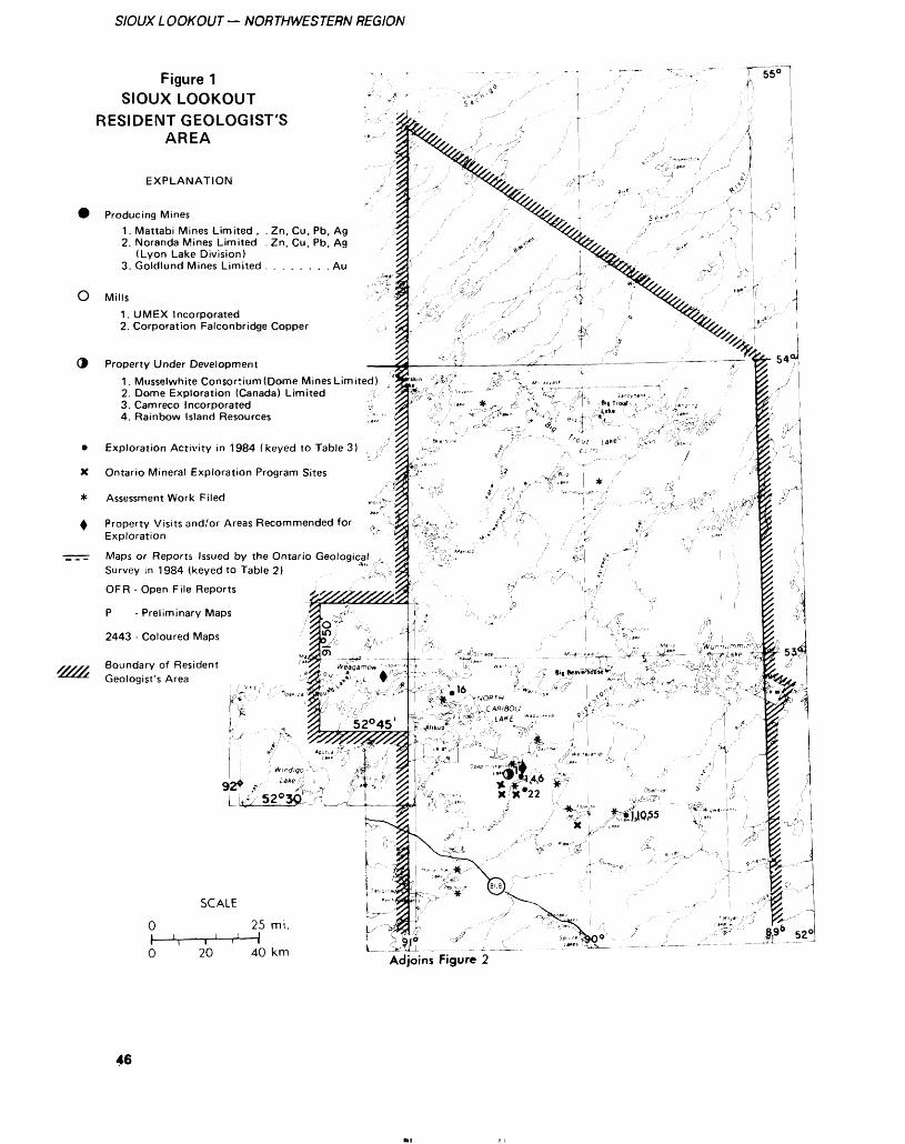
SIOUX L OOKOUT — NORTHWESTERN REGION
Figure 1SIOUX LOOKOUT
RESIDENT GEOLOGIST'SAREA
EXPLANATION
Producing Mines1. Mattabi Mines Limited . . Zn, Cu, Pb, Ag2. Noranda Mines Limited . Zn, Cu, Pb, Ag
(Lyon Lake Division)3. Goldlund Mines Limited . . . . . . . . Au
O Mills
'////,
1 . UMEX Incorporated2. Corporation Falconbridge Copper
Property Under Development1. Musselwhite Consortium (Dome Mines Limited)2. Dome Exploration (Canada) Limited ;3. Camreco Incorporated ji4. Rainbow Island Resources
Exploration Activity in 1984 (keyed to Table 3)
Ontario Mineral Exploration Program Sites
Assessment Work Filed
Property Visits and/or Areas Recommended for Exploration
Maps or Reports Issued by the Ontario Geological Survey in 1984 (keyed to Table 2)
OF R - Open File Reports
P - Preliminary Maps
2443 - Coloured Maps
Boundary of Resident Geologist's Area
SCALE
O 25 mi.
O 20 40 km
46
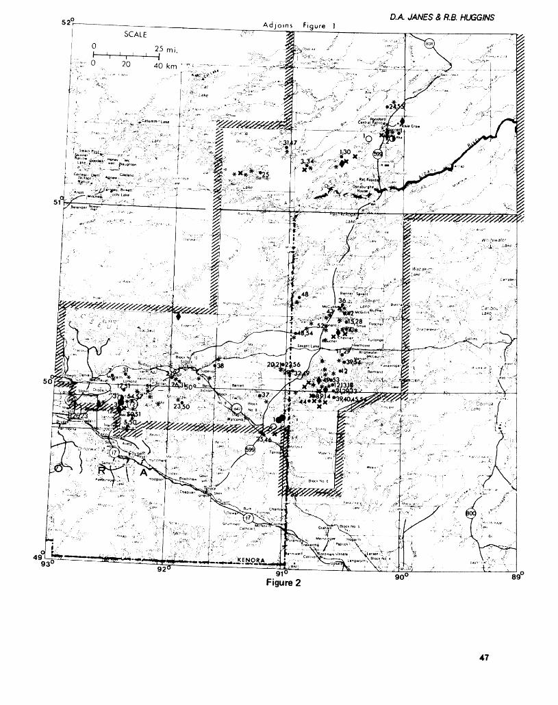
Adjoins Figure ]D.A JANES 8, R.B. HUGGINS
i.'-^^vr-. ,.,', :: -T^-^- y i,'' •"''"'" ' : -rf1 ~--' ^ L-'
9392 91'
Figure 289~
47
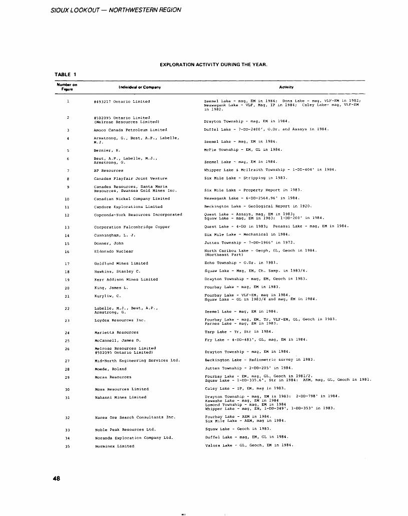
SIOUX LOOKOUT — NORTHWESTERN REGION
TABLE 1
EXPLORATION ACTIVITY DURING THE YEAR.
Number on Figure Individual or Company Activity
10
1112
13
14
15
16
17
18
19
20
21
22
23
24
25
26
27
28
29
30
31
1493217 Ontario Limited
#502095 Ontario Limited (Melrose Resources Limited)
Amoco Canada Petroleum Limited
Armstrong, G., Best, A.P., Labelle, M. J.
Bernier, K.
Best, A.P., Labelle, M.J., Armstrong, G.
BP Resources
Canadex Playfair Joint Venture
Canadex Resources, Santa Maria Resources, Swansea Gold Mines Inc.
Canadian Nickel Company Limited
Candore Explorations Limited
Copconda-York Resources Incorporated
Corporation Falconbridge Copper
Cunningham, L. J.
Donner, John
Eldorado Nuclear
Goldlund Mines Limited
Hawkins, Stanley C.
Kerr Addison Mines Limited
King, James L.
Kuryliw, C.
Labelle, M.J., Best, A.P., Armstrong, G.
Loydex Resources Inc.
Marietta Resources
McCannell, James D.
Melrose Resources Limited 1502095 Ontario Limited)
Mid-North Engineering Services Ltd.
Moede, Roland
Moran Resources
Moss Resources Limited
Nahanni Mines Limited
Narex Ore Search Consultants Inc.
Noble Peak Resources Ltd.
Noranda Exploration Company Ltd.
Norminex Limited
Zeemel Lake - mag, EM in 1984; Dona Lake - mag, VLF-EM in 1982; Neawagank Lake - VLF, Mag, IP in 1984; Caley Lake- mag, VLF-EM in 1982.
Drayton Township - mag, EM in 1984.
Duffel Lake - 7-DD-2400', O.Dr. and Assays in 1984.
Zeemel Lake - mag, EM in 1984.
McFie Township - EM, GL in 1984.
Zeemel Lake - mag, EM in 1984.
Whipper Lake i. Mcilraith Township - l-DD-404' in 1984.
Six Mile Lake - Stripping in 1983.
Six Mile Lake - Property Report in 1983.
Neawagank Lake - 6-DD-2564.96' in 1984.
Beckington Lake - Geological Report in 1920.
Quest Lake - Assays, mag, EM in 1983;Squaw Lake - mag, EM in 1983; l-DD-200' in 1984.
Quest Lake - 4-DD in 1983; Penassi Lake - mag, EM in 1984.
Six Mile Lake - Mechanical in 1984.
Jutten Township - 7-DD-1966' in 1972.
North Caribou Lake - Geoph, GL, Geoch in 1984. (Northeast Part)
Echo Township - O.Dr. in 1981.
Squaw Lake - Mag, EM, Ch. Samp, in 1983/4.
Drayton Township - mag, EM, Geoch in 1983.
Fourbay Lake - mag, EM in 1983.
Fourbay Lake - VLF-EM, mag in 1984.Squaw Lake - GL in 1983/4 and mag, EM in 1984.
Zeemel Lake - mag, EM in 1984.
Fourbay Lake - mag, EM, Tr, VLF-EM, GL, Geoch in 1983. Parnes Lake - mag, EM in 1983.
Tarp Lake - Tr, Str in 1984.
Fry Lake - 4-DD-483', GL, mag, EM in 1984.
Drayton Township - mag, EM in 1984.
Beckington Lake - Radiometric survey in 1983.
Jutten Township - 2-DD-205' in 1984.
Fourbay Lake - EM, mag, GL, Geoch in 1981/2.Squaw Lake - l-DD-335.6', Str in 1984: AEM, mag, GL, Geoch in 1981.
Caley Lake - IP, EM, mag in 1983.
Drayton Township - mag, EM in 1983: 2-DD-798' in 1984.Kawashe Lake - mag, EM in 1984Lomond Township - mag, EM in 1984Whipper Lake - mag, EM, l-DD-349', l-DD-353' in 1983.
Fourbay Lake - AEM in 1984.Six Mile Lake - AEM, mag in 1984.
Squaw Lake - Geoch in 1983.
Duffel Lake - mag, EM, GL in 1984.
Valora Lake - GL, Geoch, EM in 1984.
48
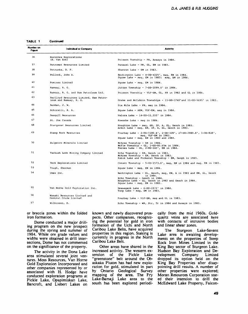
D.A JANES S, R.B. HUGGINS
TABLE 1 Continued
Number on Figure Individual or Company Activity
37
38
39
40
41
42
43
44
45
46
47
48
52
53
54
Norontex Explorations (R. Van Enk)
Petromet Resources Limited
Petrunka, D. F.
Pollock, John A.
Pominex Limited
Ramsay, R. G.
Ramsay, R. G. and Ram Petroleum Ltd.
Raylloyd Resources Limited, Ram Petro leum and Ramsay, R. G.
Redden, J. W.
Schiralli, R. A.
Seagull Resources
St. Joe Canada
Stargazer Resources Limited
Steep Rock Resources
Sulpetro Minerals Limited
Tarbush Lode Mining Company Limited
Teck Explorations Limited
Tough, Sherman
Umex Inc.
Van Horne Gold Exploration Inc.
Wasabi Resources Limited and Central Crude Limited
Wilkinson, D.
Poisson Township - PR, Assays in 1984.
Penassi Lake - PR, GL, EM in 1983.
Sharron Lake - EM in 1983.
Beckington Lake - 4-DD-4225', mag, EM in 1984. Squaw Lake - mag, EM in 1983: mag, EM in 1984.
Squaw Lake - mag, EM in 1984.
Jutten Township - 7-DD-2099.0' in 1984.
Poisson Township - VLF-EM, GL, PR in 1982 and GL in 1984.
Grebe and Mccubbin Townships - ll-DD-3740'and ll-DD-5695' in 1983.
Six Mile Lake - PR, mag in 1984.
Squaw Lake - AEM, VLF-EM, mag in 1984.
Valora Lake - 14-00-11,555' in 1984.
Kawashe Lake - mag in 1984.
Houghton Lake - mag, EM, IP, A, GL, Geoch in 1983. Armit Lake - mag, EM, IP, A, GL, Geoch in 1983.
Fourbay Lake - 2-DD-1180.4', 2-DD-328', 27-DD-2989.8', l-DD-828',mag, VLF-EM in 1983.
Squaw Lake - mag, EM in 1983 and 1984.
McAree Township - EM in 1984.McFie Township - GL, l-DD-85.65m in 1984.Parnes Lake - GL, 2-DD-240', EM in 1984.
Echo Township - EM, Geoch in 1983.McAree Township - EM, Geoch in 1983.Kabik Lake and Pickerel Township - EM, Geoph in 1983.
Conant Township - 5-DD-1573.0', mag, EM in 1984 and mag, EM in 1983.
Squaw Lake - mag, EM in 1984.
Beckington Lake - GL, Geoch, mag, EM, A in 1983 and EM, GL, Geochin 1984.
Echo Township - Geoch in 1984.Houghton Lake - GL, Geoch in 1982 and Geoch in 1984. Squaw Lake - mag, EM in 1982.
Neawagank Lake - 6-DD-1971 1 in 1984. Tarp Lake - mag, EM in 1983.
Fourbay Lake - VLF-EM, mag and GL in 1983.
Echo Township - WR, Str, Tr in 1984 and Assays in 1983.
or breccia zones within the folded iron formation.
Dome conducted a major drill ing program on the new prospect during the spring and summer of 1984. While ore grade values and widths were obtained in drill inter sections, Dome has not commented on the significance of the property.
The activity in the Dona Lake area stimulated several joint ven tures. Moss Resources, Van Horne Gold Exploration Incorporated and other companies represented by or associated with H. Hodge have conducted exploration programs at Pickle Lake, Opapimiskan Lake, Bancroft, and Liebert Lakes on
known and newly discovered pros pects. Other companies, recogniz ing the potential for gold in iron formation of the Uchi and North Caribou Lake Belts, have acquired properties in this region. Staking is currently in progress in the North Caribou Lake Belt.
Other areas have shared in the increased activity. The western ex tension of the Pickle Lake "greenstone" belt around the Ob askaka Pluton has had new explo ration for gold, stimulated in part by Ontario Geological Survey mapping of the area. The Fry Lake-Bamaji Lake area to the south has been explored periodi
cally from the mid 1960s. Gold- quartz veins are associated here with contacts of intrusive bodies and linear shear zones.
The Sturgeon Lake-Savant Lake area is awaiting develop ments on the properties of Steep Rock Iron Mines Limited in the King Bay sector of Sturgeon Lake. Hudson Bay Exploration and De velopment Company Limited dropped its option held on the King Bay Properties after disap pointing drill results. A number of other properties were explored; Moran Resources Corporation stat ed their intention to drill the McEdward Lake Property, Falcon-
49
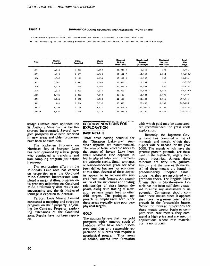
SIOUX LOOKOUT — NORTHWESTERN REGION
TABLE 2 SUMMARY OF CLAIMS RECORDED AND ASSESSMENT WORK CREDIT
Corrected figures of 1983 (additional work not shown is included in the Total Man Days)
1984 figures up to and including November (additional work not shown is included in the Total Man Days)
Y Mr
1974
1975
1976
1977
1978
1979
1980
1981
1982
1983*
1984**
Claim. Recorded
1,011
1,019
1,185
1,261
2,018
1,012
3,485
2,861
842
4,398
4,936
Claim*Cancelled
3,223
2,489
1,120
1,320
765
1,061
1,391
1,582
1,766
1,164
3,695
Claimi Active
5,659
3,903
3,958
3,760
5,094
5,045
7,068
8,303
7,737
10,971
12,212
Diamond Drilling
(Man Days)
38
38
27
17
33
30
42
42
35
69
40
, 049.0
,492.7
, 111.0
, 880.1
,371.3
,869
,633
,588
,329
,568.8
,589.4
Geophysical Survey*
(Man Days)
6,
18,
11,
13,
57,
27,
13,
232,
73,
85,
113,
255
953
555
931
501
605.4
524
184
486
536.5
190
Geological Surveys
(Man Days)
102
1,858
185
946
600
1,949
10,800
4,866
13,980
23,738
24,941.1
Total Man Days
44
59
38
32
91
60
66
287
167
197
197
,406
,303.
,851
,757
,472
,423.
,957
,626
,289
,223
,301
.7
.1
.3
.4
.1
.3
bridge Limited have optioned the St. Anthony Mine from Aubet Re sources Incorporated. Several new gold prospects have been reported in new areas and older properties have been re-examined.
The Richelieu Property on Northeast Bay of Sturgeon Lake has been optioned by a new group who conducted a trenching and bulk sampling program just before freeze-up.
The exploration effort in the Minnitaki Lake area has centred on properties near the Goldlund Mine. Camreco Incorporated com pleted a major drilling program on its property adjoining the Goldlund Mine. Preliminary drill results are encouraging and the drill-inferred tonnage is expected to increase.
Tarbush Lode Mining Limited conducted a mapping and stripping program on their property, adjoin ing the Camreco Property, explor ing extensions of the Goldlund zone. Results have not been report ed.
RECOMMENDATIONS FOR EXPLORATION________
BASE METALSThose areas having potential for the "Sturgeon Lake-type" zinc- silver deposits are recommended. The area of felsic volcanic rocks to the south of Savant Lake hosts small lensoidal zinc deposits in highly altered felsic and intermedi ate volcanic rocks. Small tonnages of lean-to-moderate grade ore have been drilled but are not economic at this time. Several of these depos its appear to be tectonically sev ered from their feeders. An exami nation of the structural and folding relationships of these known de posits, along with tracing of alter ation patterns might lead to other drill targets. The geological ap proach is emphasized here since these areas typically give poor geo physical targets.
GOLDThe authors believe that most gold prospects which outcrop south of Latitude 520N have been discov ered and that any reasonable ex pectation of success will require a geophysical program. Thus, areas of folded, altered iron formation
with which gold may be associated, are recommended for grass roots exploration.
Recently, the Japanese Gov ernment has compiled a list of minerals and metals which they expect will be needed for the year 2000. The metals which have the greatest growth potential are those used in the high-tech, largely elec tronic industries. Among these minerals are beryllium, gallium, lithium and the rare earth metals. All of these metals are found in predominantly lithophile associ ations, i.e. they are associated with granitoid rocks. The English River Gneiss Belt in Northwestern On tario has not been sufficiently stud ied to allow any assessment of its potential. Companies should con sider these metals since it appears they have the greatest potential for growth in the foreseeable future. While the tonnage projections for these metals cannot begin to com pare with base metals, they com mand a high price and are used in applications where raw material cost is not crucial.
50
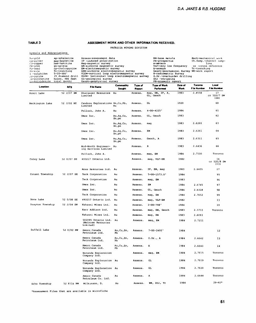
D.A JANES A R.B. HUGGINS
TABLE 3
Symbols and Abbreviations
ASSESSMENT WORK AND OTHER INFORMATION RECEIVED.PATRICIA MINING DIVISION
Au-gold Ag-silverCu-copperFe-ironPb-leadZn-zincs -sulphidespy-pyriteiK)-pyrrhotiteiio- molybdenite
Location
Armit Lake
Beckington Lake
Caley Lake
Conant Township
Dona Lake
sp-sphalerite mag-magnetitehero-hemititegn-galenacp-chalcopyriteTr-trenching5-DD-486'(5 diamond drillholes, 486 feettotal deoth)
NTS
52 J/07 NW
52 J/02 NE
52 0/07 SE
52 J/07 SE
52 0/08 SE
Drayton Township 52 J/04 SW
Duffell Lake 52 0/02 NW
Assess-assessment data IP -induced polarizationMag-magnetic surveyAM-airborne magenetic surveyEM-electromagnetic survey
BM-base metals PR-prospectus
AEM-airborne electromagnetic surveyVLEM-vertical loop electromagnetic survey
m-metersVLF-very lowA-assays
frequency
Mech-mechanical work Ch. Samp. -channel samp-
1cr -cross
ingreference
Tr-trenchingGeoch-geochemical SurveyR-radiometric Survey
WR-work report
HLEM- horizontal loop electromagnetic survey O.Dr .-overburden drillingGL-geological surveyGeoph-geophysical suryey
F,l. N*m Commodity Sought
Stargazer Resources AuLimited
Candore Explorations Zn,Cu,Pb,Limited Au
Pollock, John A. Au
Umex Inc. Au,Ag,Cu,Zn,po
Umex Inc. Au,Ag,Cu,Zn,po
Umex Inc. Au,Ag,Cu,Zn,po
Umex Inc. Au,Ag,Cu,Zn,po
Mid-North Engineer- Auing Services Limited
Pollock, John A.
493217 Ontario Ltd.
Moss Resources Ltd. Au
Teck Corporation Au
Teck Corporation Au
Umex Inc . Au
Umex Inc . Au
Teck Corporation Au
493217 Ontario Ltd. Au
Nahanni Mines Ltd. Au
Kerr Addison Ltd. Au
Nahanni Mines Ltd. Au
502095 Ontario Ltd. Au(Melrose ResourcesLimited)
Amoco Canada Au,Cu,Zn,Petroleum Ltd. Pb
Amoco Canada Au,Cu,Zn,Petroleum Ltd. Pb
Amoco Canada Au,Cu,Zn,Petroleum Ltd. Pb
Noranda ExplorationCompany Ltd.
Noranda Exploration AuCompany Ltd.
Noranda Exploration AuCompany Ltd.
Amoco Canada AuPetroleum Co. Ltd.
Str -strippingPR-propertv report
Typtof Report
Assess.
Assess.
Assess.
Assess.
Assess.
Assess.
Assess.
Assess.
Assess .
Assess.
Assess .
Assess.
Assess.
Assess.
Assess.
Assess.
Assess.
Assess.
Assess.
Assess.
Assess .
Assess.
Assess.
Assess.
Assess.
Assess.
Assess.
Assess.
Typ* of Work PwiorfiMa
mag, EM, IP, A,GL , Geoch
GL
4-DD-4225'
GL , Geoch
mag
EM
Geoch , A
R
mag , EM
mag, VLF-EM
IP, EM, mag
5-DD-1573.0'
mag , EM
EM
GL, Geoch
mag , EM
mag, VLF-EM
2-DD-798'
mag , EM , Geoch
mag , EM
mag , EM
7-DD-2400'
O.Dr., A
A
mag, EM
GL
GL
A
DIM of Toronto Work Fit* Numbtr
1983
1920
1984
1983
1983
1983
1983
1983
1984
1982
1983
1984
1983
1984
1964
1984
1982
1984
1983
1983
1984
1984
1984
1984
1984
1984
1984
1984
2.4558
2.6200
2.6201
2.6311
2.6436
2.7100
2.6405
2.6745
2.6318
2.7052
2.5733
2.6093
2.7211
2.6642
2.6643
2.7015
2.7019
2.7020
2.6644
Local F il* Number
17cr 52J/7 SW
(24)
60
61
62
63
64
65
66
Toronto
16cr 520/8 SW
(13)
17
95
96
97
98
99
13
19
Toronto
12
13
14
Toronto
Toronto
Toronto
Toronto
Echo Township 52 F/16 NW Wilkinson, D.
Assessment Files that are available in microfiche
Assess. WR, Str, Tr
51
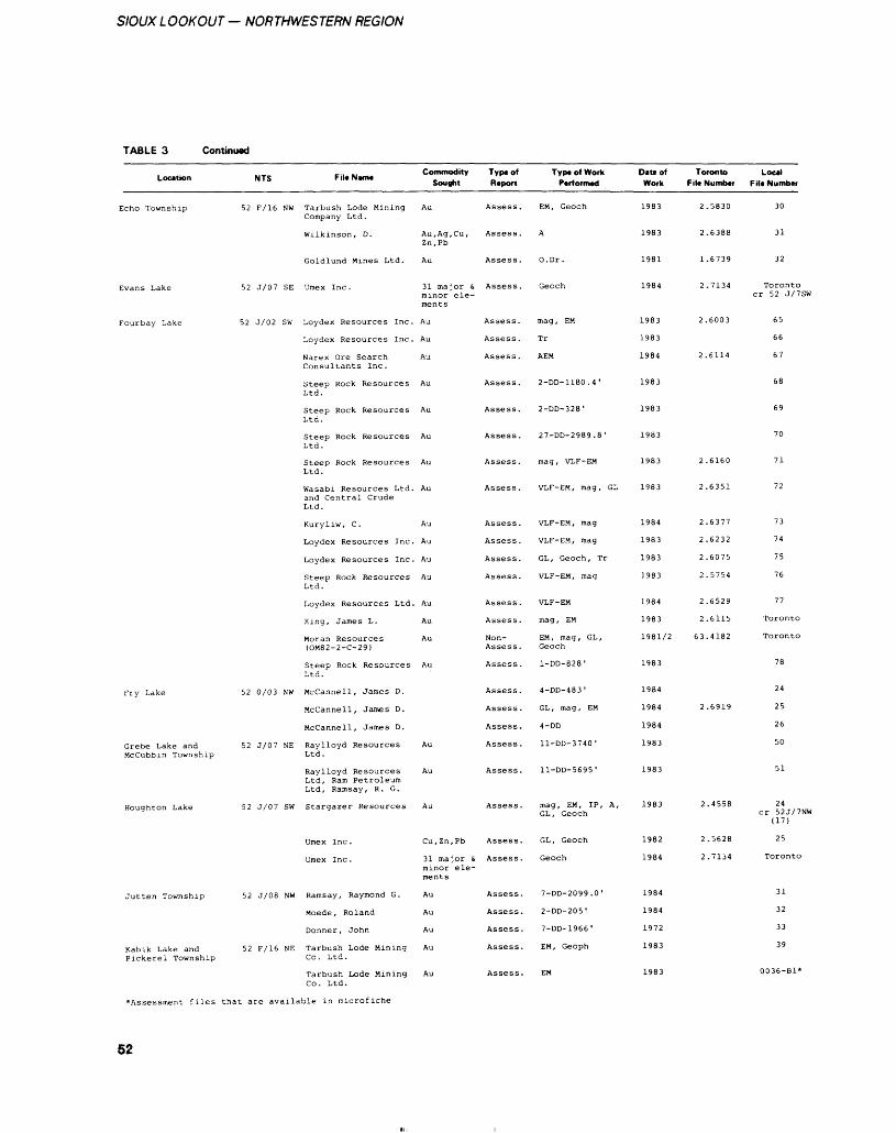
SIOUX L OOKOUT — NORTHWESTERN REGION
TABLE 3 Continued
Location
Echo Township
Evans Lake
Fourbay Lake
Fry Lake
Grebe Lake and Mccubbin Township
Houghton Lake
Jutten Township
Kabik Lake and Pickerel Township
NTS Fil* Neme
52 F/16 NW Tarbush Lode Mining Company Ltd.
Wilkinson, D.
Goldlund Mines Ltd.
52 J/07 SE Umex Inc.
52 J/02 SW Loydex Resources Inc.
Loydex Resources Inc.
Narex Ore Search Consultants Inc.
Steep Rock Resources Ltd.
Steep Rock Resources Ltd.
Steep Rock Resources Ltd.
Steep Rock Resources Ltd.
Wasabi Resources Ltd. and Central Crude Ltd.
Kuryliw, C.
Loydex Resources Inc.
Loydex Resources Inc.
Steep Rock Resources Ltd.
Loydex Resources Ltd.
King, James L.
Moran Resources (OM82-2-C-29)
Steep Rock Resources Ltd.
52 0/03 NW McCannell, James D.
McCannell, James D.
McCannell, James D.
52 J/07 NE Raylloyd Resources Ltd.
Raylloyd Resources Ltd, Ram Petroleum Ltd, Ramsay, R. G.
52 J/07 SW Stargazer Resources
Umex Inc.
Umex Inc .
52 J/08 NW Ramsay, Raymond G.
Moede, Roland
Donner, John
52 F/16 NE Tarbush Lode Mining Co. Ltd.
Commodity Sought
Au
Au,Ag,Cu, Zn.Pb
Au
31 major i. minor ele ments
Au
Au
Au
Au
Au
Au
Au
Au
Au
Au
Au
Au
Au
Au
Au
Au
Au
Au
Au
Cu,Zn,Pb
31 major s minor ele ments
Au
Au
Au
Au
Type of Report
Assess.
Assess .
Assess.
Assess .
Assess .
Assess .
Assess .
Assess.
Assess .
Assess .
Assess .
Assess.
Assess .
Assess.
Assess.
Assess .
Assess .
Assess.
Non- Assess.
Assess .
Assess .
Assess .
Assess .
Assess .
Assess.
Assess .
Assess.
Assess.
Assess.
Assess.
Assess.
Assess.
Type of Work Performed
EM, Geoch
A
O.Dr .
Geoch
mag , EM
Tr
AEM
2-DD-1180.4'
2-DD-328'
27-DD-2989.8 '
mag , VLF-EM
VLF-EM, mag, GL
VLF-EM, mag
VLF-EM, mag
GL, Geoch, Tr
VLF-EM, mag
VLF-EM
mag , EM
EM, mag, GL, Geoch
l-DD-828 1
4-DD-483 1
GL , mag , EM
4-DD
ll-DD-3740'
ll-DD-5695'
mag, EM, IP, A, GL, Geoch
GL, Geoch
Geoch
7-DD-2099.0 '
2-DD-205 1
7-DD-1966'
EM, Geoph
DIM of Work
1983
1983
1981
1984
1983
1983
1984
1983
1983
1983
1983
1983
1984
1983
1983
1983
1984
1983
1981/2
1983
1984
1984
1984
1983
1983
1983
1982
1984
1984
1984
1972
1983
Toronto Local File Number File Number
2.5830 30
2.6388 31
1.6739 32
2.7134 Toronto cr 52 J/7SW
2.6003 65
66
2.6114 67
68
69
70
2.6160 71
2.6351 72
2.6377 73
2.6232 74
2.6075 75
2.5754 76
2.6529 77
2.6115 Toronto
63.4182 Toronto
78
24
2.6919 25
26
50
51
2.4558 24 cr 52J/7NW
(17)
2.5628 25
2.7134 Toronto
31
32
33
39
Tarbush Lode Mining Au Co. Ltd.
Assessment files that are available in microfiche
Assess. EM
52
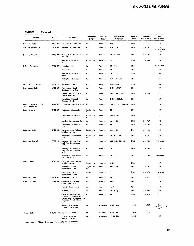
D.A JANES A R.B. HUGGINS
TABLE 3 Continued
Location
Kawashe Lake
Lomond Township
McAree Township
McFie Township
Mcilraith Township
Neawagank Lake
North Caribou Lake (Northeast Part)
Parnes Lake
Penassi Lake
Poisson Township
Quest Lake
Sharron Lake
Sixmile Lake
Squaw Lake
NTS
52 0/06 SE
52 K/01 SW
52 F/16 NW
52 F/16 SW
52 K/01 SW
53 A/05 NW
53 B/15 SE
52 G/13 NW
52 G/14 NE
52 J/08 NW
52 G/15 NE
52 J/04 NE
52 G/15 NW
52 J/02 SE
Fit* Name
St. Joe Canada Inc.
Nahanni Mines Ltd.
Tarbush Lode Mining Co. Ltd.
Sulpetro Minerals Ltd.
Bernier, K.
Bernier, K.
Sulpetro MineralsLtd.
Sulpetro MineralsLtd.
B P Resources
Van Horne Gold Exploration Inc.
493217 Ontario Ltd. (Jack Hodge)
Canadian Nickel Company Ltd.
Eldorado Nuclear Ltd,
Sulpetro Minerals Ltd.
Sulpetro Minerals Ltd.
Loydex Resources Inc.
Sulpetro Minerals Ltd.
Corporation Falcon bridge Copper
Petromet Resources Ltd.
Ramsay , Raymond G . , and Ram Petroleum Ltd.
Ramsay , Raymond G . , and Ram Petroleum Ltd.
Norontex Exploration (R. Van Enk)
Corporation Falcon bridge Copper
Copconda-York Resources Inc.
Copconda-York Resources Inc.
Petrunka, D. F.
Canadex Playfair Joint Venture
Cunningham, L. J.
Redden, J. W.
Canadex Resources, Playfair Resources, Santa Maria Resources Swansea Gold Mines Inc.
Narex Ore Search Consultants Ltd.
Pollock, John A.
Copconda-York Resources Inc.
Commodity Sought
Au
Au
Au
Au,Cu, Zn, Pb
Au
Au
Au
Au
Au
Au
Au
Au
. Au
Au,Cu,Zn, Pb
Au,Cu,Zn, Pb
Au
Au
Cu,Zn,Pb
Au , Cu , Zn Pb
Au
Au
Au
Cu,Zn,Pb
Cu , Zn , Pb , Au
Au, As
Au
Au
Au
Au
Au
i.
Au
Au
Au
Typtof Report
Assess.
Assess.
Assess.
Assess.
Assess.
Assess.
Assess.
Assess.
Assess.
Assess.
Assess.
Assess.
Assess.
Assess.
Assess.
Assess .
Assess.
Assess .
Assess.
Assess.
Assess.
Assess.
Assess.
Assess.
Assess.
Assess.
Assess.
Assess.
Assess.
Assess.
Assess.
Assess.
Assess.
Type of Work Performed
mag
mag, EM
EM, Geoch
EM
EM, GL
EM
GL
l-DD-85.65m
l-DD-404 '
6-DD-1971'
VLF, mag, IP
6-DD-2564.96'
Geoph, GL, Geoch
GL
2-DD-340 1
mag , EM
EM
mag , EM
PR, GL, EM
VLF-EM, GL, PR
GL
PR, A
4-DD
mag, EM
A
EM
Str
Mech
PR , mag
PR
AEM, mag
mag, EM
l-DD-200 '
Date of Work
1984
1984
1983
1984
1983
1984
1984
1984
1984
1984
1984
1984
1984
1984
1984
1983
1984
1984
1983
1982
1984
1984
1983
1983
1983
1983
1983
1984
1984
1984
1983
1983
1984
Toronto File Number
2.7053
2.6093
2.5830
1.6393
2.6678
2.5717
2.6392
2.5603
2.6324
2.5788
2.6300
2.7173
2.6496
2.6578
2.6214
2.6907
2.6574
2.6114
2.5677
Local File Number
18
37 cr 52J/4SW
(21)
30
33
0033-A1*
34
35
36
36
20
21
19
16
30
31
32
33
69
70
Toronto
35
Toronto
27
28
Toronto
21
119
118
120
121
122 cr 52J/2 SI
(67)
59
60
Assessment Files that are available in microfiche
53
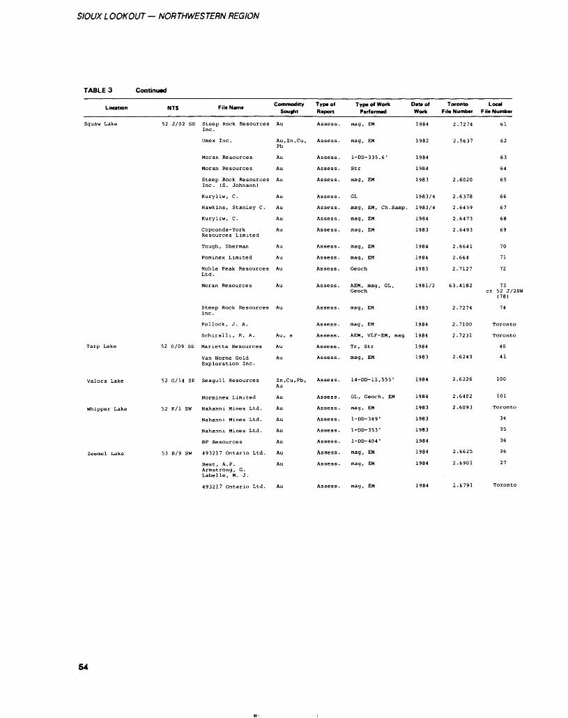
SIOUX LOOKOUT — NORTHWESTERN REGION
TABLE 3 Continued
Location
Squaw Lake
Tarp Lake
Valora Lake
Whipper Lake
Zeemel Lake
NTS File Name
52 J/02 SE Steep Rock ResourcesInc.
Umex Inc.
Moran Resources
Moran Resources
Steep Rock ResourcesInc. (S. Johnson)
Kuryliw, C.
Hawkins, Stanley C.
Kuryliw, C.
Copconda-YorkResources Limited
Tough, Sherman
Pominex Limited
Noble Peak ResourcesLtd.
Moran Resources
Steep Rock ResourcesInc.
Pollock, J. A.
Schiralli, R. A.
52 0/09 SE Marietta Resources
Van Horne GoldExploration Inc.
52 G/14 SE Seagull Resources
Norminex Limited
52 K/l SW Nahanni Mines Ltd.
Nahanni Mines Ltd.
Nahanni Mines Ltd.
BP Resources
53 B/9 SW 493217 Ontario Ltd.
Best, A. P.Armstrong, G.Labelle, M. J.
Commodity Sought
Au
Au, Zn,Cu,Pb
Au
Au
Au
Au
Au
Au
Au
Au
Au
Au
Au
Au
Au, s
Au
Au
Zn,Cu,Pb,Au
Au
Au
Au
Au
Au
Au
Au
Type of Rtport
Assess.
Assess.
Assess .
Assess.
Assess.
Assess.
Assess.
Assess.
Assess .
Assess.
Assess .
Assess.
Assess.
Assess.
Assess.
Assess.
Assess .
Assess .
Assess .
Assess.
Assess.
Assess.
Assess .
Assess.
Assess.
Assess .
Type of Work Performed
mag , EM
mag , EM
l-DD-335.6'
Str
mag , EM
GL
mag , EM , Ch . Samp .
mag , EM
mag , EM
mag , EM
mag , EM
Geoch
AEM, mag, GL,Geoch
mag , EM
mag , EM
AEM, VLF-EM, mag
Tr, Str
mag , EM
14-00-11,555'
GL, Geoch, EM
mag , EM
l-DD-349'
l-DD-353 1
l-DD-404 1
mag , EM
mag , EM
Data of Work
1984
1982
1984
1984
1983
1983/4
1983/4
1984
1983
1984
1984
1983
1981/2
1983
1984
1984
1984
1983
1984
1984
1983
1983
1983
1984
1984
1984
Toronto Fila Number
2
2
2
2
2
2
2
2
2.
2,
63,
2.
2.
2.
2.
2.
2,
2.
2
2
.7274
.5637
.6020
.6378
.6459
.6473
.6493
.6641
.664
.7127
.4182
.7274
.7100
.7231
.6243
.6226
.6402
.6093
.6625
.6901
Local File Number
61
62
63
64
65
66
67
68
69
70
71
72
73cr 52 J/2SW
(78)
74
Toronto
Toronto
40
41
100
101
Toronto
34
35
36
26
27
493217 Ontario Ltd. mag, EM 1.6791
54
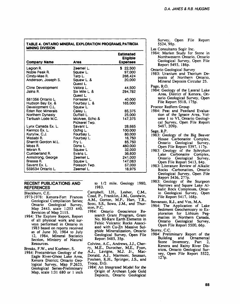
DA. JANES 8, R.B. HUGGINS
TABLE 4. ONTARIO MINERAL EXPLORATION PROGRAMS, PATRICIA MINING DIVISION
Company NameLegion R.Noble Peak R.Cindy-Mae R.Anderson, Joseph S.
Cline DevelopmentJalna R.
58 1356 Ontario LHudson Bay Ex. fcDevelopment C. LEden Roc MineralsNorthern DynastyTarbush Lode M. C.
Lynx Canada Ex. L.Kennco Ex. L.Kuryliw, C.J.Wasabi R.Sherritt Gordon M. LMoss R.Moran R.Cumberland R.Armstrong, GeorgeBresea R.Savant Ex. L559534 Ontario L.
AreaZeemel L.Squaw LTarp L.Squaw L. AQuest L.Valora LSix Mile L ZQuest L.Forrester L.Fourbay L. 8.Squaw LCaley LDuffell LMcAree, Echo APickerel Twp.Savant L.Ochig LFourbay LFourbay L.Fry LDona L.Squaw LEvans LZeemel LSquaw L.Poisson Twp.Zeemel L
Estimated Eligible
ExpensesS 22,500
97,000266,424
20,000
44,500294,782
40,000165,000
85,37525,000
147,375
28,665100,00080,00016,75085,750
480,00032,00036,600
241,000147,06357,00018,975
RECENT PUBLICATIONS ANDREFERENCES__________Blackburn, C.E.1973-1978: Kenora-Fort Frances
Geological Compilation Series; Ontario Geological Survey, Map 2443, scale 1:253 440. Revision of Map 2115.
1984: The Explore Report, Report of all physical work and sur veys performed in Ontario in 1983 based on reports received as of June 30, 1984 to July 12, 1984, Mineral Statistics Section, Ministry of Natural Resources.
Breaks, F.W., and Kuehner, S.1984: Precambrian Geology of the
Eagle River-Ghost Lake Area, Kenora District; Ontario Geo logical Survey, Map P.2623, Geological Series-Preliminary Map, scale 1:31 680 or l inch
to 1/2 mile. Geology 1980, 1983.
Campbell, I.H., Lesher, CM., Coad, P., Franklin, J.M., Goodwin, A.M., Gorton, MP., Hart, T.R., Scott, S.S., Sowa, J.M., and Thur ston, P.C.1984: Ontario Geoscience Re
search Grant Program, Grant No. 80-Rare Earth Elements in Felsic Volcanic Rocks Associ ated with Cu-Zn Massive Sul phide Mineralization, Ontario Geological Survey, Open File Report 5485, 35p.
Colvine, A.C., Andrews, JJ., Cher ry, MX., Durocher, M.E., Fyon, AJ., Lavigne, MJ. Jr., Mac- Donald, A.J., Marmont, Soussan, Poulsen, K.H., Springer, J.S., and Troop, D.G.1984: An Integrated Model for the
Origin of Archean Lode Gold Deposits, Ontario Geological
Survey, Open File Report 5524,"98p.
Les Consultants Sogir Inc.1984: Market Study for Stone in
Northwestern Ontario, Ontario Geological Survey, Open File Report 5493, 186p.
Ontario Geological Survey 1983: Uranium and Thorium De
posits of Northern Ontario, Mineral Deposits Circular 25.
Page, R.O.1984: Geology of the Lateral Lake
Area, District of Kenora, On tario Geological Survey, Open File Report 5518, 175p.
Proctor Redfern Group1984: Peat and Peatland Evalua
tion of the Ignace Area, Vol ume l to VI, Ontario Geologi cal Survey, Open File Report 5487, 209p.
Sage, R.P.1983: Geology of the Big Beaver
House Carbonatite Complex, Ontario Geological Survey, Open File Report 5397, 117p.
1983: Geology of the Schryburt Lake Carbonatite Complex, Ontario Geological Survey, Open File Report 5413, 84p.
1983: Literature Review of Alkalic Rocks -Carbonatites, Ontario Geological Survey, Open File Report 5436, 277p.
1983: Geology of the Sturgeon Narrows and Squaw Lake Al kalic Rock Complexes, Ontar io Geological Survey, Open File Report 5417, 168p.
Stevanato, R J., and Vos, M.A.1984: The Application of Lake
Sediment Geochemistry to Ex ploration for Lithium Peg matites in Northern Canada, Ontario Geological Survey, Open File Report 5500, 66p.
Storey, C.C.1984: Preliminary Report of the
Building and Ornamental Stone Inventory, Part 2, Kenora and Rainy River Dis tricts, Ontario Geological Sur vey, Open File Report 5522, 127p.
55
Thunder Bay Resident Geologist Area, North Central RegionG.C. Patterson 1 , J.K. Mason2 , and B.R. Schnieders2Resident Geologist, Resource Geologist, Ontario Ministry of Natural Resources, Thunder Bay
INTRODUCTIONCurrent permanent staff in the Thunder Bay Office include: K.G. Fenwick, Regional Mineral Re sources Co-ordinator; G.C. Patter son, Resident Geologist; J.F. Scott, Resource Geologist; and A.R. Dowton, Secretary. The remainder of the staff held contract positions. F J. Kristjansson, Quaternary Ge ologist, with assistance from C.M. Hine, Resource Geologist, were re sponsible for geological input to land use concerns (such as forest management agreements and mu nicipal planning) and aggregate mapping. The Beardmore - Gerald ton Economic Geologist Program was supervised by JJC. Mason, Re source Geologist, with assistance from G.D. White, Resource Geolo gist. B.R. Schnieders, Resource Ge ologist, with assistance from A.A. Speed, Resource Geologist, ran the Economic Geologist Program in the Schreiber- Terrace Bay area. M.C. Kennedy, Resource Geolo gist, with assistance from P. Gertz bein, Resource Geologist, started a Building Stone Inventory for the North Central Region. A.D. Mac- Tavish and R J .A. Dutka, Resource Geologists, started a Cobalt-Base Metal-Platinum Group Elements Study in the Atikokan area. P. Per ry, Resource Geologist, prepared Geological Data Inventory Folios and carried out an audit of the assessent files. T. Twomey, Re source Geologist, led field trips to the Hem lo area and prepared Geo logical Data Inventory Folios. S. Koski and L. Strasser provided clerical assistance. J. Sequin, Sen ior Assistant, aided J.F. Scott in mapping MacGregor Township. M.C. Kennedy and A.D. Mac- Tavish, Resource Geologists, su pervised a Mining Sector Work Program staffed by T. Twoey, RJ.A. Dutka, J. Schnessl, P.M. Gertzbein, E. Sidey, T. Eden, and M. Fedoroniuk. R. Larsen was contracted to give lectures to the Junior Forest Rangers. E. Johnson, and L. Aune, Experience '84 stu dents, assisted with office work, and C. Butella, Resource Geologist, was hired part-time for drafting.
ACKNOWLEDGMENTS_____The section in this report on Qua ternary Geology was written by F.J. Kristjansson. The description of the Schreiber-Terrace Bay Eco nomic Geologist Program was written by B.R. Schnieders with as sistance from A.A. Speed. J.K. Ma son, with help from G.D. White, wrote the section on the Beardmore-Geraldton Economic Geologist Program. The report on the Cobalt-Base Metal-Platinum Group Element Study in the At ikokan area was written by A.D. MacTavish and R. Dutka. M.C. Kennedy and P. Gertzbein contri buted the section on building stone in the North Central Region. Tech nical support was provided by S. Koski, P. Perry, T. Twomey, and A.R. Dowton.
RESIDENT GEOLOGIST STAFF ACTIVITIES——————————Much of the Resident Geologist staff's time was spent in consulta tion with prospectors and with ge ologists from exploration and min ing companies (an average of 12 consultations a day). Other activi ties included field trips, tours, and numerous property visits.
The Hemlo area remained the most active in the North Central Region. The Resident Geologist gave a total of 14 talks on the Hemlo deposit to various groups and organizations, including The Canadian Institute of Mining and Metallurgy, Saskatoon, and The Geological Association of Canada, Vancouver. Sixteen field trips, for a combined total of approximately 300 people, were given to the area. Technical advice was given to the Hemlo Co-ordinating Committee and other related groups concerned with Hemlo development. In addi tion, approximately 4 weeks were spent in the area carrying out field research. A Field Trip Guide to the Hemlo area was published (Patterson 1984).
A number of other tours and information sessions were conduct ed for mining companies and gov ernment personnel. JJC. Mason
gave 4 tours in the Beardmore- Geraldton area. A Field Trip Guide of this area is in prepara tion. B.R. Schnieders led 4 tours in the Schreiber-Terrace Bay area, and J.F. Scott took 2 groups to the Schreiber Channel fossil site. The office staff gave a series of talks, in 6 locations throughout the dis trict, on exploration techniques and local mineral potential. Four poster displays were given at the Ontario Geological Survey's Geo science Research Seminar, Toron to, on the Beardmore Geraldton area, the Schreiber-Terrace Bay area, the Cobalt-Base Metal- Plati num Group Element Study in At ikokan, and Building Stone in the North Central Region. Eight poster displays were exhibited and 4 talks were given at the Joint Ontario Geological Survey-Lakehead Uni versity Seminar in Thunder Bay.
A study of the amethyst in dustry in the region was initiated. A total of 36 properties were ex amined by the Resident Geologist and an Open File Report on ame thyst occurrences in the Thunder Bay area is being prepared.
K.G. Fenwick carried out field examinations of hazard land loca tions throughout the region, as well as compiling historical data on mining in the area.
J.F. Scott, with assistance from J. Seguin, started a mapping pro ject in the western portion of Mac Gregor Township.
The office staff (particularly F J. Kristjansson) continued to be involved in land use planning, mining exploration in candidate parks, forest management agree ments, environmental issues, and road and proposed transmission line placements. A number of townships were given assistance in assessing aggregate potential. Sev eral public meetings concerning aggregate assessment were attend ed.
Two Mining Sector Work Pro grams were organized and super vised through this office. Four peo ple continued a hazard land survey of the North Central Region. Three people prepared geology displays
56
G.C. PATTERSONET AL.
for Neys, Kakabeka Falls, and Schreiber Channel Provincial Parks.
MINING ACTIVITIES METALLIC MINERALSThe 2 major metal producers in the North Central Region are the Noranda Incorporated (Geco Divi sion) copper-zinc-silver mine at Manitouwadge (7) and the Inco Limited nickel-copper mine at Shebandowan (5) (Figure 2). The Geco Mine milled l 375 000 tons of ore in 1983 producing 20 190 tons of copper, 40 810 tons zinc, 540 tons of lead, and l 344 000 ounces of silver (Canadian Mines Handbook 1984-85). The Sheban dowan Mine has been in continu ous production for all of 1984.
The Teck Corporation GO- MILL (formerly the Pancontinen- tal Mining (Canada) Limited cus tom mill) in Beardmore was con verted to a cyanide gold mill dur ing 1984. A total of 24 000 tons grading 0.11 ounce gold per ton of dump material from the Leitch Mine was processed (R. Dunning, Project Superintendent, Teck Cor poration (Leitch Division), Beard more, personal communication, 1984).
The Northern Concentrators Limited's custom mill in Thunder Bay processed 327 tons of ore from the No. 2 zone on the Crook ed Green Creek Property (8) in Pifher Township, as well as 40 tons of custom orders from Ontario and Quebec (B. Doucet, Mill Man ager, Northern Concentrators Limited, Thunder Bay, personal communication, 1984).
Mining Corporation of Canada Limited has been running a recov ery operation at the Consolidated Louanna Gold Mines Limited property at O'sullivan Lake. A to tal of 70 000 tons of ore was milled at 0.22 ounce gold per ton (C. Pasiekay, Geologist, Cumo Re sources Limited, Vancouver, per sonal communication, 1984).
Three mines are under devel opment in the Hemlo area by Noranda Incorporated, Teck Cor poration, and Lac Minerals Limit ed. Corporation Falconbridge Cop per has commenced sinking a shaft on its Winston Lake zinc- copper-silver property northwest of Schreiber.
Q.C. Explorations Limited set up a porta-mill in Thunder Bay to process dredged dump material from the former Silver Islet Mine. Plans are being made to process a bulk sample from the Thorco Property near Onaman Lake (T. Gledhill, President, Q.C. Explora tions Limited, Toronto, personal communication, 1984).
INDUSTRIAL MINERALSMost of the amethyst production came from operations in McTavish Township, northeast of Thunder Bay. These include the deposits of Gunnard Noyes (4), the Ontario Gem Company (9), J. Barrett Mine (1), the Dorion Amethyst Mine (3), and the Thunder Bay Amethyst Panorama (10). Limited produc tion came from the Little Bear Quarry (6) northeast of Nipigon.
During 1984 Tri-Ven Minerals Corporation has continued plans for the marketing of marl from its Shillabeer Lake Property, 80 km northeast of Thunder Bay. ROK Engineering Limited is operating a granite quarry 3 km north of High way 17, just to the east of High way 614. The material is being used as aggregate.
CLAIM STAKING AND EXPLORATION ACTIVITYThe total number of claims staked in the North Central Region was 7978 (to November 30, 1984) which represents a decrease over the number of claims staked in 1983. However, the total number of active claims as of November 30, 1981, rose to 34 560 (Table 3). This represents a record for the North Central Region.
A more accurate representa tion of the exploration activity is
the number of man days of assess ment work filed (Tables l and 3). Work filed in 1983 and 1984 ap proximately equals the cumulative amount of work filed in the pre vious 20 years.
HEMLO AREA INTRODUCTIONCurrently 3 companies, Noranda Incorporated, Teck Corporation, and Lac Minerals Limited, are de veloping mines on a single large deposit with a reported tonnage of 76 367 679 tons at 0.24 ounce gold per ton (The Globe and Mail, December 20, 1983; The Globe and Mail, December 14, 1983; The Northern Miner, October 13,1983). The Noranda Incorporated shaft has been sunk to 540 m and the mill will start processing ore early in 1985 (The Northern Min er, November 15, 1984). The Teck Corporation shaft is at 457 m and production is planned for 1985 (The Northern Miner, October 11,1984). Lac .Minerals Limited is sinking 2 shafts and a decline. A small open pit is also planned east of Moose Lake. The Lac Minerals Limited's mill is currently being constructed and production is planned for 1986.
Exploration activity within the Hemlo area, from Marathon to White River, has remained very high. Most companies have filed sufficient assessment work to hold the ground for a number of years. Geological Data Inventory Folios (GDIFs) are being prepared for the area. The general geology of the main deposit has been summarized in a Field Trip Guidebook to the Hemlo area, Ontario Geological Survey, Miscellaneous Paper 118, 1984. For convenience the explo ration programs have been divided into 5 categories, based on similarities in styles of mineraliza tion and geology. These 5 divisions are: North Rim Properties, Pic River Properties, Barite Occur rences, Heron Bay Gold Mines Property, and the Golden Sceptre North Zone.
57
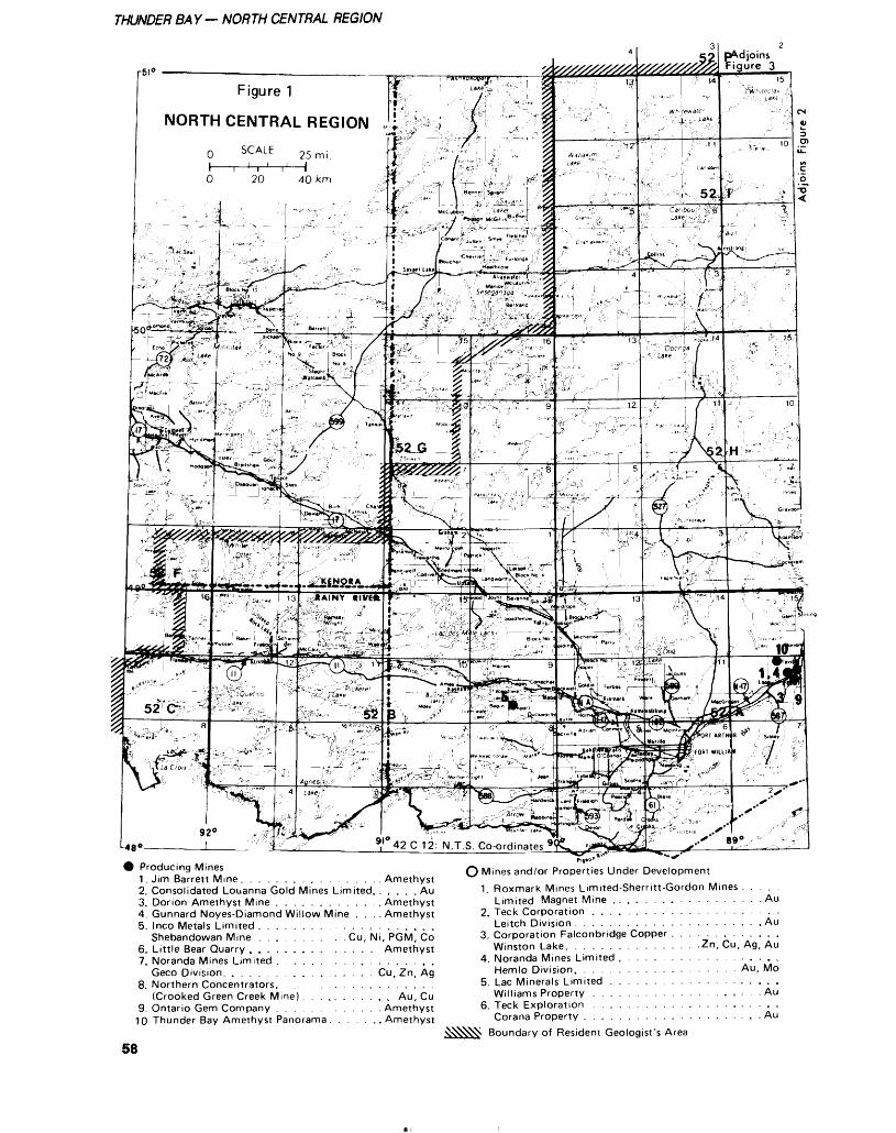
THUNDER BAY— NORTH CENTRAL REGION
Figure 1
NORTH CENTRAL REGION
SCALE
( Producing Mines1. Jim Barrett Mine . . . . . . . . . . . , . . . . Amethyst2. Consolidated Louanna Gold Mines Limited. . . , t t Au3. Dorion Amethyst Mine . . . . . . . . . . . , Amethyst4. Gunnard Noyes-Diamond Willow Mine . . ..Amethyst5. Inco Metals Limited . . . . . . . . . . . . . , . , . L . . .
Shebandowan Mine . . . . . . . . . . Cu, Ni, PGM, Co6. Little Bear Quarry . . . . . . . . . . . . . . Amethyst7. Noranda Mines Limited . . . . . . . . . . . . , . , . ,
Geco Division. . . . . . . . . . . . . . , . , . Cu, Zn, Ag8. Northern Concentrators. . . . . . . . . . . . . . . . , . .
(Crooked Green Creek Mine) . . . , , . . . . , , Au, Cu9. Ontario Gem Company . . . . . . . . . . . . Amethyst
10 Thunder Bay Amethyst Panorama . , . . . ..Amethyst
O Mines and/or Properties Under Development1. Roxmark Mines Limited-Sherritt-Gordon Mines . .
Limited Magnet Mine . . . . . . . . . . . . . . . . . .2. Teck Corporation . . . . . , . . . . . . . . . . . . .
Leitch Division . . . . . . . . . . . . . . , . . . . , . .3. Corporation Falconbridge Copper . . . . . . , . c ,
Winston Lake. . . . . . . . . . . . . . . .Zn,Cu,Ag,4. Noranda Mines Limited , . . . . . . . . . . . . . . .
Hemlo Division. . . . . . . . . . . . . . . . . . . Au,5. Lac Minerals Limited . . . . . . . . . . . . . . . , . .
Williams Property . . . . . . . . . . . . . . . , . . .6. Teck Exploration . . . . . . . . . . . , . . . . . . . .
Corana Property . . . . . . . . . . . . . . . . . . . , .Boundary of Resident Geologist's Area
Au
Au
Au
Mo
Au
Au
58
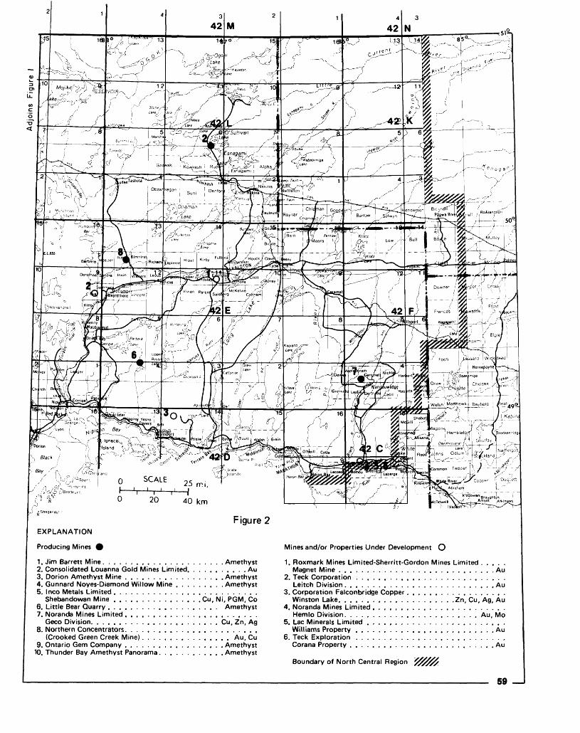
, 25 mi.
0 20 40 km
Figure 2EXPLANATION
Producing Mines 0
1. Jim Barrett Mine. . . . . . . . . . , . . . . . . . . . . . Amethyst2. Consolidated Louanna Gold Mines Limited. . . . . . . . . . . Au3. Dorion Amethyst Mine , . . . . . . . . . . . . . . . . . Amethyst4. Gunnard Noyes-Diamond Willow Mine . . . . . . . . . Amethyst5. Inco Metals Limited . . . . . . . . . . , . . . . . . , . . . . . . . .
Shebandowan Mine . . . . . . . . . . . . . . . . Cu, Ni, PGM, Co6. Little Bear Quarry . . . . . . . . . . . , . . . . . . . . Amethyst7. Noranda Mines Limited . . . . . . . . . . . . . . . . . . . . . . . .
Geco Division. . . . . . . . . . . . . . . . . . . . . . . Cu, Zn, Ag8. Northern Concentrators. . . . . . . . . . . . . . . . . . . . . . . .
(Crooked Green Creek Mine). . . . . . . . . . . . . . . . Au, Cu9. Ontario Gem Company . . . . . . . . . . . . . . . . . . Amethyst
10. Thunder Bay Amethyst Panorama. . . . . . . . . . . . Amethyst
Mines and/or Properties Under Development O
1. Roxmark Mines Limited-Sherritt-Gordon Mines Limited . . . . .Magnet Mine . . . . . . . . . . . . . . . . . , . . . . . . . . . . Au
2. Teck Corporation . . . . . . . . . . . . . . . . . . . . . . . . . . .Leitch Division . . . . . . . , . . . . . . . . . . . . . . . . . . . Au
3. Corporation Falconbridge Copper. . . . . . . . . . . . . . . . . .Winston Lake. . . . . . . . . . . . . . . . . , . . .Zn, Cu, Ag, Au
4. Noranda Mines Limited . . , . . . . . . . . . . . . . . . . . . . . .Hemlo Division. . . . , . . . . . . . . . . . , . . . . . . . Au, Mo
5. Lac Minerals Limited . . . . . . . . . . . . . . . . . . . . . . . . .Williams Property . , , . . . . . . . . ,. . . . . , . . . . . . , . Au
6. Teck Exploration . . . . . . . . . . . . . . , . . . . . . . . . . . .Corana Property . . . . . . . . . , . . . . . . . . . . . . . . . . Au
Boundary of North Central Region
59
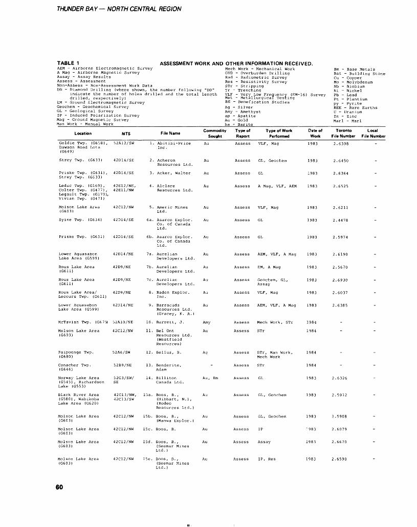
THUNDER BAY— NORTH CENTRAL REGION
TABLE 1 ASSESSMENT WORK AND OTHER INFORMATION RECEIVED.AEM - Airborne Electromagnetic SurveyA Mag - Airborne Magnetic SurveyAssay - Assay ResultsAssess - AssessmentNon-Assess - Non-Assessment Work DataDD - Diamond Drilling (where shown, the number following "DD"
indicate the number of holes drilled and the total lengthdrilled, respectively)
EM - Ground Electromagnetic Survey Geochem - Geochemical Survey GL - Geological Survey IP - Induced Polarization Survey Mag - Ground Magnetic Survey Man Work - Manual Work
Mech Work - Mechanical WorkOVD - Overburden DrillingRad - Radiometric SurveyRes - Resistivity SurveySTr - StrippingTr - TrenchingVLF - Very Low Frequency (EM-16) SurveyMet - Metallurgical TestingBS - Benefication StudiesAg - SilverAmy - Amethystap - ApatiteAu - Goldba- Barite
Bm - Base MetalsBst - Building StoneCu - CopperMo - MolybdenumNb - NiobiumNi - NickelPb - LeadPt - PlantiumPY ~ PyriteREE - Rare EarthsU - UraniumZn - ZincMarl - Marl
Location
Goldie Twp. (G658) ,Dawson Road Lots(G649)
Strey Twp. (G633)
Priske Twp. (G631) ,Strey Twp. (G633)
Leduc Twp. (G169) ,Colter Twp. (G477) ,Legault Twp. (G170),Vivian Twp. (G471)
Molson Lake Area(G603)
Syine Twp. (G634)
Priske Twp. (G631)
Lower AguasabonLake Area (G599)
Rous Lake Area(G611)
Rous Lake Area(G611)
Rous Lake Area/Lecours Twp. (G611)
Lower AguasabonLake Area (G599)
McTavish Twp. (G675)
Molson Lake Area(G603)
Paipoonge Twp.(G680)
Conacher Twp.(G646)
Norway Lake Area(G545), RichardsonLake (G553)
Black River Area(G580) , WabikobaLake Area (G620)
Molson Lake Area(G603)
Molson Lake Area(G603)
Molson Lake Area(G603)
Molson Lake Area(G603)
NTS
52A12/SW
42D14/SE
42D14/SE
42E12/NE,42E11/NW
42C12/NW
42D14/SE
42D14/SE
42D14/NE
42D9/NE
42D9/NE
42D9/NE
42D14/NE
52A10/NE
42C12/NW
52A6/SW
52B9/NE
52G3/SW/SE
42C13/NW,-12C13/SW
42C12/NW
42C12/NW
42C12/NW
42C12/NW
1.
2.
3.
4.
5.
6a.
6b.
la.
7b.
7c.
8.
9.
10.
11.
12.
13.
14.
15a.
15b.
15c.
15d.
ISe.
File Name
Abitibi-PriceInc .
AcheronResources Ltd.
Acker, Walter
AlclareResources Ltd.
Americ MinesLtd.
Asarco Explor.Co. of CanadaLtd.
Asarco Explor.Co. of CanadaLtd.
AurelianDevelopers Ltd.
AurelianDevelopers Ltd.
AurelianDevelopers Ltd.
Baden Explor.Inc.
BarracudaResources Ltd.(Gracey, K. A.)
Barrett, J.
Bel OntResources Ltd.(WestfieldResources )
Belluz, B.
Bender ite.Adam
BillitonCanada Ltd.
Boos , B. ,(Hibbart, N.),(RodeoResources Ltd. )
Boos, B. ,(Manwa Explor. )
Boos, B.
Boos, B. ,(Seemar MinesLtd. )
Boos , B. ,(Seemar MinesLtd. )
Commodity Type of Sought Report
Au Assess
Au Assess
Au Assess
Au Assess
Au Assess
Au Assess
Au Assess
Au Assess
Au Assess
Au Assess
Au Assess
Au Assess
Amy Assess
Au Assess
Ag Assess
Assess
Au, Bm Assess
Au Assess
Au Assess
Au Assess
Au Assess
Au Assess
Type of Work Performed
VLF, Mag
GL, Geochem
GL
A Mag, VLF, AEM
VLF, Mag
GL
GL
AEM, VLF, A Mag
EM, A Mag
Geochem, GL,Assay
VLF, Mag
AEM, VLF, A Mag
Mech Work, STr
STr
STr, Man Work,Mech Work
STr
GL
GL, Geochem
GL, Geochem
IP
Assay
IP, Res
Date of Work
1983
1983
1983
1983
1983
1983
1983
1983
1983
1983
1983
1983
1984
1984
1984
1984
1983
1983
1983
983
1983
1983
Toronto File Number
2.6398
2.6450
2.6364
2.6525
2.6211
2.4478
2.5974
2.6190
2.5670
2.6930
2.6037
2.6385
-
-
-
-
2.6326
2.5912
2.5908
2.6079
2.6670
2.6590
Local File Number
.
.
.
.
.
.
-
.
.
.
.
-
-
-
-
.
-
.
-
.
-
.
60
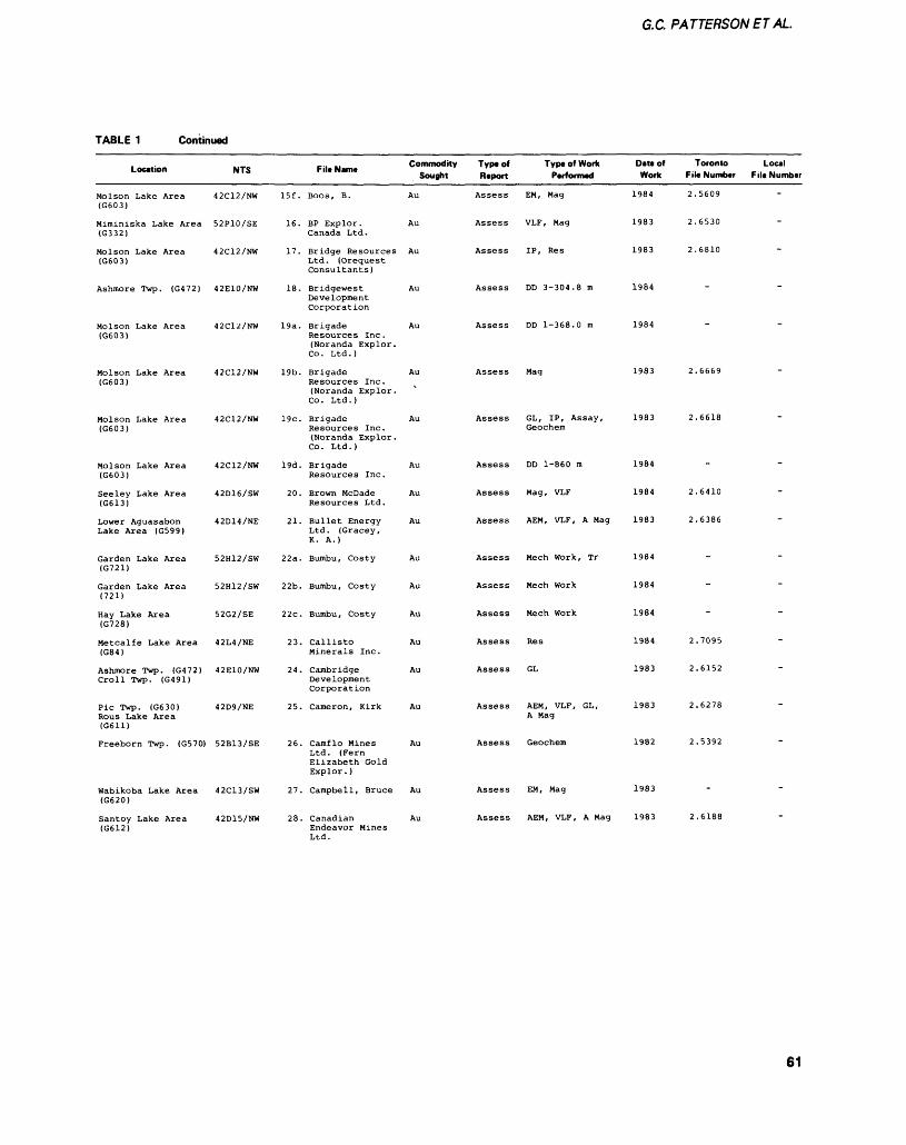
G.C. PATTERSONET AL.
TABLE 1 Continued
Location
Molson Lake Area (G603)
Miminiska Lake Area (G332)
Molson Lake Area (G603)
Ashmore Twp. (G472)
Molson Lake Area (G603)
Molson Lake Area (G603)
Molson Lake Area (G603)
Molson Lake Area (G603)
Seeley Lake Area (G613)
Lower Aguasabon Lake Area (G599)
Garden Lake Area (G721)
Garden Lake Area (721)
Hay Lake Area (G728)
Metcalfe Lake Area (G84)
Ashmore Twp. (G472) Croll Twp. (G491)
Pic Twp. (G630) Rous Lake Area (G611)
Freeborn Twp. (G570)
Wabikoba Lake Area (G620)
Santoy Lake Area (G612)
NTS
42C12/NW
52P10/SE
42C12/NW
42E10/NW
42C12/NW
42C12/NW
42C12/NW
42C12/NW
42D16/SW
42D14/NE
52H12/SW
52H12/SW
52G2/SE
42L4/NE
42E10/NW
42D9/NE
52B13/SE
42C13/SW
42D15/NW
15f .
16.
17.
18.
19a.
19b.
19c.
19d.
20.
21.
22a.
22b.
22c.
23.
24.
25.
26.
27.
28.
c .. .. Commodity Filt Name . . Sought
BOOS, B. Au
BP Explor. Au Canada Ltd.
Bridge Resources Au Ltd. (Orequest Consultants)
Bridgewest Au Development Corporation
Brigade Au Resources Inc. (Noranda Explor. Co . Ltd . )
Brigade Au Resources Inc. (Noranda Explor. Co. Ltd.)
Brigade Au Resources Inc. (Noranda Explor. Co . Ltd . )
Brigade Au Resources Inc.
Brown McDade Au Resources Ltd.
Bullet Energy Au Ltd. (Gracey, K. A.)
Bumbu, Costy Au
Bumbu, Costy Au
Bumbu, Costy Au
Callisto Au Minerals Inc.
Cambridge Au Development Corporation
Cameron, Kirk Au
Camflo Mines Au Ltd. (Fern Elizabeth Gold Explor. )
Campbell, Bruce Au
Canadian Au Endeavor Mines Ltd.
Type of Report
Assess
Assess
Assess
Assess
Assess
Assess
Assess
Assess
Assess
Assess
Assess
Assess
Assess
Assess
Assess
Assess
Assess
Assess
Assess
Type of Work Performed
EM, Mag
VLF, Mag
IP, Res
DD 3-304.8 m
DD 1-368.0 m
Mag
GL, IP, Assay, Geochem
DD 1-860 m
Mag, VLF
AEM, VLF, A Mag
Mech Work, Tr
Meen Work
Mech Work
Res
GL
AEM, VLF, GL,A Mag
Geochem
EM, Mag
AEM, VLF, A Mag
Date of Work
1984
1983
1983
1984
1984
1983
1983
1984
1984
1983
1984
1984
1984
1984
1983
1983
1982
1983
1983
Toronto File Number
2.5609
2.6530
2.6810
"
2.6669
2.6618
-
2.6410
2.6386
-
-
-
2.7095
2.6152
2.6278
2.5392
-
2.6188
Local File Number
-
-
-
-
-
-
-
-
-
"
61
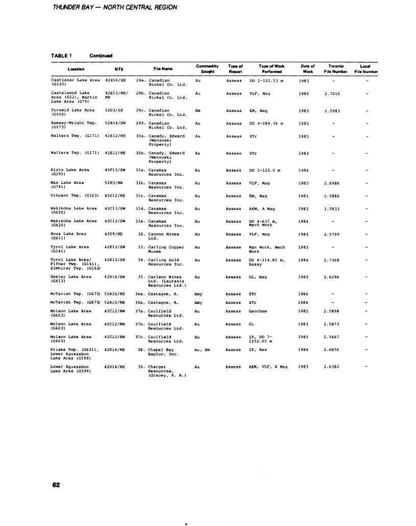
THUNDER BAY- NORTH CENTRAL REGION
TABLE 1 Continued
Location
Castlebar Lake Area(G220)
Caste Iwood LakeArea (G22) , MartinLake Area (G79)
Pyramid Lake Area(G550)
Ramsay-Wright Twp.(G573)
Walters Twp. (G171)
Walters Twp. (G171)
Klotz Lake Area(G295)
Max Lake Area(G741)
Vincent Twp. (G163)
Wabikoba Lake Area(G620)
Wabikoba Lake Area(G620)
Rous Lake Area(G611)
Tyrol Lake Area(G141)
Tyrol Lake Area/Pifher Twp. (G141) ,Elmhirst Twp. (G162)
Seeley Lake Area(G613)
McTavish Twp. (G675)
McTavish Twp. (G675)
Molson Lake Area(G603)
Molson Lake Area(G603)
Molson Lake Area(G603)
Priske Twp. (G631) ,Lower AguasabonLake Area (GS99)
Lower AguasabonLake Area (GS99)
NTS
42E16/SE
42E13/NE/NW
52G3/SE
52B14/SW
42E12/NE
42E12/NE
42F13/SW
52H3/NW
42E12/NE
42C13/SW
42C13/SW
42D9/NE
42E13/SW
42E13/SW
42D16/SW
52A10/NE
52A10/NE
42C12/NW
42C12/NW
42C12/NW
42D14/NE
42D14/NE
29a.
29b.
29c.
29d.
30a.
30b.
31a.
31b.
31c.
31d.
31e.
32.
33.
34.
35.
36a.
36b.
37a.
37b.
37c.
38.
39.
File Name
CanadianNickel Co. Ltd.
CanadianNickel Co. Ltd.
CanadianNickel Co. Ltd.
CanadianNickel Co. Ltd.
Canady, Edward(WenzoskiProperty)
Canady, Edward(WenzoskiProperty)
CanaraaxResources Inc.
CanamaxResources Inc.
CanamaxResources Inc.
CanamaxResources Inc.
CanamaxResources Inc.
Cannon MinesLtd.
Carling CopperMines
Carling GoldResources Inc.
Carlson MinesLtd. (LaurasiaResources Ltd.)
Castagne, A.
Castagne, A.
Caul fie IdResources Ltd.
CaulfieldResources Ltd.
CaulfieldResources Ltd.
Chapel BayExplor. Inc.
ChargerResources,
Commodity Sought
Au
Au
Bm
Au
Au
Au
Au
Au
Au
Au
Au
Au
Au
Au
Au
Amy
Amy
Au
Au
Au
Au, Bm
Au
Typtof Report
Assess
Assess
Assess
Assess
Assess
Assess
Assess
Assess
Assess
Assess
Assess
Assess
Assess
Assess
Assess
Assess
Assess
Assess
Assess
Assess
Assess
Assess
Type of Work Performed
DD 1-122.53 m
VLF, Mag
EM, Mag
DD 4-284.36 m
ST r
STr
DD 1-123.0 m
VLF, Mag
EM, Mag
AEM, A Mag
DD 4-637 m.Meen Work
VLF, Mag
Man Work, MechWork
DD 4-314.85 m,Assay
GL, Mag
STr
STr
Geochem
GL
IP, DD 7-1252.05 m
IP, Res
AEM, VLF, A Mag
Date of Work
1983
1984
1983
1983
1983
1983
1984
1983
1983
1983
1984
1983
1983
1984
1983
1984
1984
1982
1983
1983
1984
1983
Toronto Filt Number
2
2
2
2
2
2
2.
2,
2.
2.
2.
2
2.
.
.7010
.5983
-
.
.
.
.6986
.5886
.5833
-
.5799
.
.7368
.6296
-
-
,5898
.5873
.5667
.6850
.6382
Local F il* Number
.
-
-
.
.
.
-
,
.
-
-
.
-
.
-
-
-
-
-
-
-
-
(Gracey, K. A.)
62
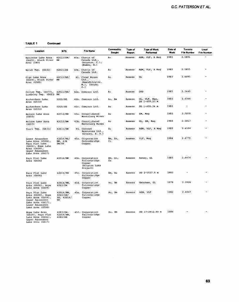
G.C. PATTERSONET AL.
TABLE 1 Continued
Location
Wabikoba Lake Area (G620) , Black River Area (580)
Walsh Twp. (G636)
Olga Lake Area (G604), Black River Area (G580)
Colter Twp. (G477) , Lindsley Twp. (G483)
Richardson Lake Area (G553)
Richardson Lake Area (G553)
Molson Lake Area (G603)
Molson Lake Area (G603)
Tuuri Twp. (G635)
Lower Aguasabon Lake Area (G599) , Pays Plat Lake (G606) , Rope Lake Area (G609) , Upper Aguasabon Lake Area (G617)
Pays Plat Lake Area (G606)
Pays Plat Lake Area (G606)
Pays Plat Lake Area (G606), Rope Lake Area (G609)
Pays Plat Lake Area (G606), Rope Lake Area (G609) , Upper Aguasabon Lake Area (G617) , Lower Aguasabon Lake Area (G599)
Rope Lake Area (G609) , Pays Plat Lake Area (G606) , Upper Aguasabon Lake Area (G617)
NTS
42C13/SW/ NW
42D15/SE
42C13/NE/ NW
42E11/NE/ NW
52G3/SE
52G3/SE
42C12/NW
42C12/NW
42D15/SW
42D14/NE/ NW, 43E SW/SE
42D14/NW
42D14/NW
42D14/NW, 42E3/SW
42D14/NW, 42E3/SW/ SE, 42D14/NE
42E3/SW, 42D14/NW, 42E3/SE
-.. .. Commodity FiltNamt . * Sought
40a. Chavin of Au Canada Ltd. , (Houston, C. ) , (Bumbu, M. )
40b. Chavin of Au Canada Ltd.
41. Clear Mines Au Ltd. , (Amendologine , M.), (Young, S.)
42a. Cominco Ltd. Au
42b. Cominco Ltd. Au, Bm
42c. Cominco Ltd. Au
43a. Consolidated Au Montclerg Mines
43b. Consolidated Au Montclerg Mines
44. Coronet Au Resources Ltd., (Gracey, K. A.)
45a. Corporation Bm, Zn, Falconbridge Cu Copper
45b. Corporation Bm, Zn, Falconbridge Cu Copper (Winston Lake Project)
45c. Corporation Bm, Au Falconbridge Copper
45d. Corporation Au, Bm Falconbridge Copper
45e. Corporation Au, Bm Falconbridge Copper
45f. Corporation Au, Bm Falconbridge Copper
Typt of Type of Work Report Performed
Assess AEM, VLF, A Mag
Assess AEM, VLF, A Mag
Assess GL
Assess OVD
Assess GL, VLF, Mag, DD 1-459.33 m
Assess DD 1-459.34 m
Assess EM, Mag
Assess GL, EM, Mag
Assess AEM, VLF, A Mag
Assess VLF, Mag
Assess Assay, GL
Assess DD 2-1537.5 m
Assess Geochem, GL
Assess AEM, VLF
Assess DD 17-2952.99 m
Date of Toronto Work File Number
1983 2.5891
1983 2.5855
1983 2.6095
1983 2.5640
1983 2.6344
1983
1983 2.5818
1983 2.5817
1983 2.6504
1984 2.6770
1983 2.6474
1983
1979 2.5926
1982 2.6047
1984
Local File Number
-
-
-
-
-
-
63
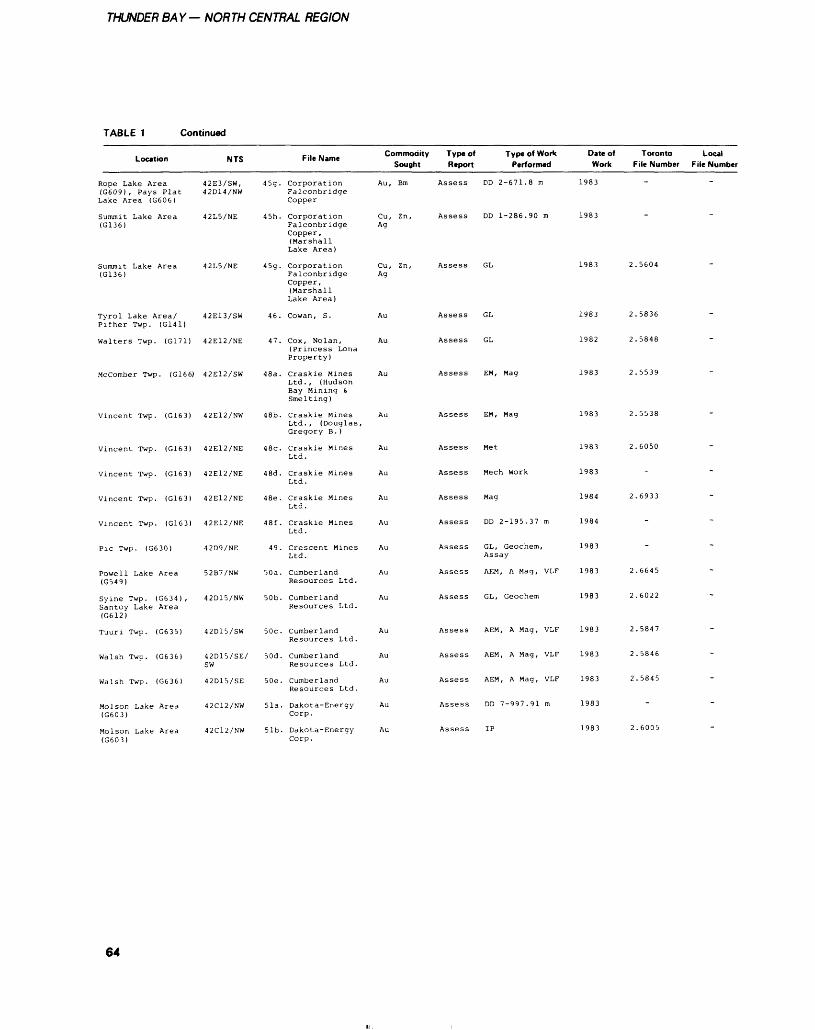
THUNDER BAY— NORTH CENTRAL REGION
TABLE 1 Continued
Location
Rope Lake Area (G609) , Pays Plat Lake Area (G606)
Summit Lake Area (G136)
Summit Lake Area (G136)
Tyrol Lake Area/ Pifher Twp. (G141)
Walters Twp. (G171)
Mccomber Twp. (G166)
Vincent Twp. (G163)
Vincent Twp. (G163)
Vincent Twp. (G163)
Vincent Twp. (G163)
Vincent Twp. (G163)
Pic Twp. (G630)
Powell Lake Area (G549)
Syine Twp. (G634) , Santoy Lake Area (G612)
Tuuri Twp. (G635)
Walsh Twp. (G636)
Walsh Twp. (G636)
Molson Lake Area (G603)
Molson Lake Area (G603)
NTS
42E3/SW, 42D14/NW
42L5/NE
42L5/NE
42E13/SW
42E12/NE
42E12/SW
42E12/NW
42E12/NE
42E12/NE
42E12/NE
42E12/NE
42D9/NE
52B7/NW
42D15/NW
42D15/SW
42D15/SE/ SW
42D15/SE
42C12/NW
42C12/NW
File Name
45g. Corporation Falconbridge Copper
45h. Corporation Falconbridge Copper, (Marshall Lake Area)
45g. Corporation Falconbridge Copper, (Marshall Lake Area)
46. Cowan, S.
47. Cox, Nolan, (Princess Lona Property)
48a. Craskie Mines Ltd., (Hudson Bay Mining S. Smelting)
48b. Craskie Mines Ltd. , (Douglas, Gregory B. )
48c. Craskie Mines Ltd.
48d. Craskie Mines Ltd.
48e. Craskie Mines Ltd.
48f. Craskie Mines Ltd.
49. Crescent Mines Ltd.
50a. Cumberland Resources Ltd.
50b. Cumberland Resources Ltd.
50c. Cumberland Resources Ltd.
50d. Cumberland Resources Ltd.
50e. Cumberland Resources Ltd.
51a. Dakota-Energy Corp.
51b. Dakota-Energy Corp.
Commodity Type of Sought Report
Au, Bm Assess
Cu, Zn, Assess Ag
Cu, Zn, AssessAg
Au Assess
Au Assess
Au Assess
Au Assess
Au Assess
Au Assess
Au Assess
Au Assess
Au Assess
Au Assess
Au Assess
Au Assess
Au Assess
Au Assess
Au Assess
Au Assess
Type of Work Performed
DD 2-671.8 m
DD 1-286.90 m
GL
GL
GL
EM, Mag
EM, Mag
Met
Meen Work
Mag
DD 2-195.37 m
GL, Geochem, Assay
AEM, A Mag, VLF
GL, Geochem
AEM, A Mag, VLF
AEM, A Mag, VLF
AEM, A Mag, VLF
DD 7-997.91 m
IP
Date of Toronto Work File Number
1983
1983
1983 2.5604
1983 2.5836
1982 2.5848
1983 2.5539
1983 2.5538
1983 2.6050
1983
1984 2.6933
1984
1983
1983 2.6645
1983 2.6022
1983 2.5847
1983 2.5846
1983 2.5845
1983
1983 2.6005
Local File Number
-
-
-
-
-
~
~
~
-
-
-
-
-
64
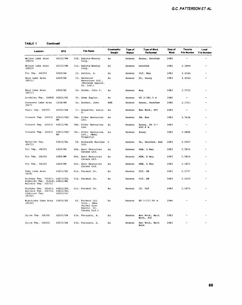
G.C. PATTERSONETAL.
TABLE 1 Continued
Location
Molson Lake Area (G603)
Molson Lake Area (G603)
Pic Twp. (G630)
Rous Lake Area (G611)
Rous Lake Area (G611)
Lindsley Twp. (G483)
Crescent Lake Area (G27)
Tuuri Twp. (G635)
Vincent Twp. (G163)
Vincent Twp. (G163)
Vincent Twp. (G163)
McTavish Twp. (G675)
Pic Twp. (G630)
Pic Twp. (G630)
Pic Twp. (G630)
Kaby Lake Area (G59)
Rickaby Twp. (G161) , Elmhirst Twp. (G162), Walters Twp. (G171)
Rickaby Twp. (G161), Walters Twp. (G171), Elmhirst Twp. (G162)
Miminiska Lake Area (G332)
Syine Twp. (G634)
Syine Twp. (G634)
NTS
42C12/NW
42C12/NW
42D9/NW
42D9/NE
42D9/NE
42E11/NE
52I8/NW
42D15/SW
42E12/NE/ NW
42E12/NE
42E12/NE/ NW
52A10/NE
42D9/NW
42D9/NW
42D9/NW
42E13/SE
42E13/SE, 42E12/NE
42E13/SE,42E12/NE, 42E13/SE
52P10/SE
42D15/SW
42D15/SW
51d.
51e.
52.
53.
54.
55.
56.
57.
58a.
58b.
58c.
59.
60a.
60b.
60c.
61a.
61b.
61c.
62.
63a.
63b.
-... ., Commodity File Mama Sought
Dakota-Energy Au Corp.
Dakota-Energy Au Corp.
Dalton, A. Au
De von ion Au Resources Ltd., (Noranda Explor. Co. Ltd.)
Dodds, John V. Au
Dome Explor. Au
Donner, John REE
Duquette, Louis Au E.
Eldor Resources Au Ltd.
Eldor Resources Au Ltd.
Eldor Resources Au Ltd., (Maki Property)
Eldorado Nuclear U Ltd.
Esso Resources Au Canada Ltd.
Esso Resources Au Canada Ltd.
Esso Resources Au Canada Ltd.
Farakel Co. Au
Farakel Co. Au
Farakel Co. Au
Felmont Oil Au Corp. , (New Jersey Zinc Explor. Co. Canada Ltd.)
Ferguson, A. Au
Ferguson, A. Au
Typaof Raport
Assess
Assess
Assess
Assess
Assess
Assess
Assess
Assess
Assess
Assess
Assess
Assess
Assess
Assess
Assess
Assess
Assess
Assess
Assess
Assess
Assess
Type of Work Performed
Assay, Geochem
Geochem
VLF, Mag
GL, Assay
Mag
DD 2-381.5 m
Assay, Geochem
Man Work, STr
EM, Mag
Assay, DD 11- 692.4 m
Assay
GL, Geochem, Rad
AEM, A Mag
AEM, A Mag
AEM, A Mag
VLF, EM
VLF, EM
IP, VLF
DD 1-117.95 m
Man Work, Mech Work, STr
Man Work, Mech
Date of Work
1982
1982
1983
1983
1983
1982
1982
1983
1983
1983
1983
1983
1983
1983
1983
1983
1983
1983
1984
1983
1983
Toronto File Number
2
2
2
2
2
2
2
2
2
2
2
2
2
2
-
.5899
.6166
.6942
.5752
-
.5315
-
.5636
-
.6896
.5457
.5816
.5814
.5815
.5757
.5415
.5875
-
-
Local File Number
-
-
-
-
-
-
-
-
-
-
-
-
-
-
-
~
-
-
65
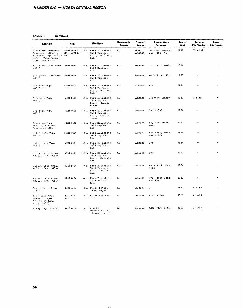
THUNDER BAY— NORTH CENTRAL REGION
TABLE 1 Continued
Location
Baker Twp. /MirandaLake Area (G543) ,Freeborn Twp. (G570),McCaul Twp. /SabawiLake Area (G554)
Finlayson Lake Area(G528)
Finlayson Lake Area(G528)
Freeborn Twp.(G570)
Freeborn Twp.(GS70)
Freeborn Twp.(G570)
Freeborn Twp.(G570) , MirandaLake Area (G543)
Hutchinson Twp.(G571)
Hutchinson Twp.(G571)
Sabawi Lake Area/McCaul Twp. (G554)
Sabawi Lake Area/McCaul Twp. (G554)
Sabawi Lake Area/McCaul Twp. (G554)
Seeley Lake Area(G613)
Rope Lake Area(G609), UpperAguasabon LakeArea (G617)
Strey Twp. (G633)
NTS
52B13/SW/SE, 52B14/SW
52B13/NE
52B13/NE
52B13/SE
52B13/SE
52B13/SE
52B13/SE
52B14/SW
52B14/SW
52B14/SW
52B14/SW
52B14/SW
42D16/SW
42E3/SW/SE
42D14/SE
64a.
64b.
64c.
64d.
64e.
64f .
G4g.
64h.
641.
64j.
64k.
641.
65.
66.
67.
f .. .. Commodity F il* Name
Sought
Fern Elizabeth AuGold Explor.Ltd., (Moffatt,Bob)
Fern Elizabeth AuGold Explor.Ltd.
Fern Elizabeth AuGold Explor.Ltd.
Fern Elizabeth AuGold Explor.Ltd., (Moffatt,Bob)
Fern Elizabeth AuGold Explor.Ltd. , (Camf loMines)
Fern Elizabeth AuGold Explor.Ltd. , (Camf loMines)
Fern Elizabeth AuGold Explor.Ltd.
Fern Elizabeth AuGold Explor.Ltd.
Fern Elizabeth AuGold Explor.Ltd.
Fern Elizabeth AuGold Explor.Ltd., (Moffatt,Bob)
Fern Elizabeth AuGold Explor.Ltd., (Moffatt,Bob)
Fern Elizabeth AuGold Explor.Ltd.
Filo, Kevin, Au(Roy, Re jean)
Flintrock Mines Au
Franklin AuResources Ltd. ,(Gracey, K. A. )
Type of Type of Work Report Performed
Non Geochem, Assay,Assess VLF, Mag, GL
Assess STr, Mech Work
Assess Mech Work, STr
Assess STr
Assess Geochem, Assay
Assess DD 14-532 m
Assess Tr, STr, MechWork
Assess Man Work, MechWork, STr
Assess STr
Assess STr
Assess Mech Work, ManWork
Assess STr, Mech Work,Man Work
Assess GL
Assess AEM, A Mag
Assess AEM, VLF, A Mag
DIM of Toronto Local Work F ile Number F ile Number
1982 63.4139
1984
1983
1984
1982 2.4785
1984
1983
1984
1984
1983
1984
1982
1983 2.6299
1983 2.5693
1983 2.6387
66
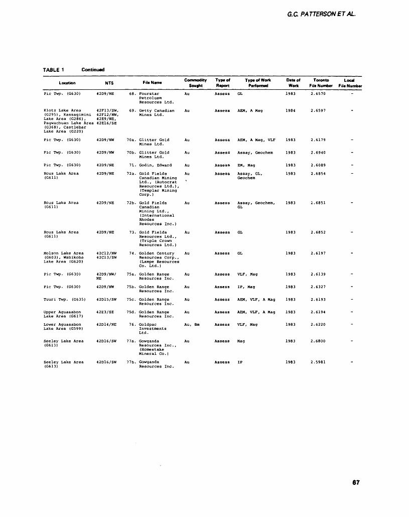
G.C. PATTERSONET AL.
TABLE 1 Continued
Location
Pic Twp. (G630)
Klotz Lake Area (G295), Kassagimini Lake Area (G286) , Pagwachuan Lake Area (G368), Castlebar Lake Area (G220)
Pic Twp. (G630)
Pic Twp. (G630)
Pic Twp. (G630)
Rous Lake Area (G611)
Rous Lake Area (G611)
Rous Lake Area (G611)
Molson Lake Area (G603), Wabikoba Lake Area (G620)
Pic Twp. (G630)
Pic Twp. (G630)
Tuuri Twp. (G635)
Upper Aguasabon Lake Area (G617)
Lower Aguasabon Lake Area (G599)
Seeley Lake Area (G613)
Seeley Lake Area (G613)
NTS
42D9/NE
42F13/SW, 42F12/NW, 42E9/NE, 42E16/SE
42D9/NW
42D9/NW
42D9/NE
42D9/NE
42D9/NE
42D9/NE
42C12/NW 42C13/SW
42D9/NW/ NE
42D9/NW
42D15/SW
42E3/SE
42D14/NE
42D16/SW
42D16/SW
File Name Commodity Type of Type of Work Sought Report Performed
68. Fourstar Au Assess GL Petroluem Resources Ltd.
69. Getty Canadian Au Assess AEM, A Mag Mines Ltd.
70a. Glitter Gold Au Assess AEM, A Mag, VLF Mines Ltd.
70b. Glitter Gold Au Assess Assay, Geochem Mines Ltd.
71. Godin, Edward Au Assess EM, Mag
72a. Gold Fields Au Assess Assay, GL, Canadian Mining Geochem Ltd., (Autocrat v Resources Ltd.), (Templar Mining Corp. )
72b. Gold Fields Au Assess Assay, Geochem, Canadian GL Mining Ltd. , (International Rhodes Resources Inc.)
73. Gold Fields Au Assess GL Resources Ltd., (Triple Crown Resources Ltd. )
74. Golden Century Au Assess GL Resources Corp., (Lampe Resources Co . Ltd . )
75a. Golden Range Au Assess VLF, Mag Resources Inc.
75b. Golden Range Au Assess IP, Mag Resources Inc.
75c. Golden Range Au Assess AEM, VLF, A Mag Resources Inc.
75d. Golden Range Au Assess AEM, VLF, A Mag Resources Inc.
76. Goldpac Au, Bm Assess VLF, Mag Investments Ltd.
77a. Gowganda Au Assess Mag Resources Inc. , (Homestake Mineral Co. )
77b. Gowganda Au Assess IP Resources Inc.
Date of Toronto Work File Number
1983 2.6570
1984 2.6597
1983 2.6179
1983 2.6940
1983 2.6089
1983 2.6854
1983 2.6851
1983 2.6852
1983 2.6197
1983 2.6139
1983 2.6327
1983 2.6193
1983 2.6194
1983 2.6220
1983 2.6800
1983 2.5981
Local File Number
~
-
-
-
-
-
-
-
"*
-
67
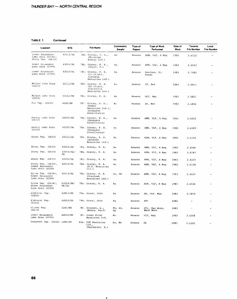
THUNDER BAY— NORTH CENTRAL REGION
TABLE 1 Continued
Location
Lower Aguasabon Lake Area (G599) , Strey Twp. (G633)
Lower Aguasabon Lake Area (G599)
Lower Aguasabon Lake Area (GS99)
Molson Lake Area (G603)
Molson Lake Area (G603)
Pic Twp. (G630)
Santoy Lake Area (G612)
Santoy Lake Area (G612)
Strey Twp. (G633)
Strey Twp. (G633)
Strey Twp. (G633)
Strey Twp. (G633)
Strey Twp. (G633) , Lower Aguasabon Lake Area (G599)
Syine Twp. (G634) , Lower Aguasabon Lake Area (G599)
Syine Twp. (G634) , Lower Aguasabon Lake Area (G599)
Elmhirst Twp. (G162)
Elmhirst Twp. (G162)
Oliver Twp. (G679)
Lower Aguasabon Lake Area (G599)
Conacher Twp. (G646)
NTS
42D14/NE
42D14/NE
42D14/NE
42C12/NW
42C12/NW
42D9/NE
42D15/NW
42D15/NW
42D14/SE
42D14/SE
42D14/SE/ NE
42D14/SE
42D14/NE
42D14/NE
42D14/SW/ NE/SE
42E13/SE
42E13/SE
52A5/NE
42D14/NE
52B9/SE
78a
78b.
78c.
78d.
78e.
78f .
78g.
78h.
78i.
78j.
78k.
781.
78m.
78n.
78o.
79a.
79b.
80.
81.
82a.
-... ,. Commodity File Name
Sought
. Gracey, K. A. , Au (Montrose Energy Ltd. )
. Gracey, K. A. , Au (Pezim, M. )
Gracey, K. A. Au (In trust) , (Lazurus Resources Ltd.)
Gracey, K. A. Au ( In trust ) , (Caravelle Resources Ltd. )
Gracey, K. A. Au
Gracey, K. A. , Au (Padre Resources Ltd. ) , (Orequest Consultants)
Gracey, K. A. , Au (Orequest Consultants)
Gracey, K. A. Au (Orequest Consultants)
Gracey, K. A. Au (Acheron Resources Ltd. )
Gracey, K. A. Au
Gracey, K. A. Au
Gracey, K. A. Au
Gracey, K. A. Au (S.O. Resources Ltd. )
Gracey, K. A. Au, Bm (Greyhawk Resources Ltd. )
Gracey, K. A. Au
Grant, John Au
Grant, John Au
Grayson, L., Pb, Zn, (Moore, Paul) Ag
Green River Au Resources Ltd.
GLE Resources Au, Bm Ltd. , (Halverson, R. )
Type of Report
Assess
Assess
Assess
Assess
Assess
Assess
Assess
Assess
Assess
Assess
Assess
Assess
Assess
Assess
Assess
Assess
Assess
Assess
Assess
Assess
Type of Work Performed
AEM, VLF, A Mag
AEM, VLF, A Mag
Geochem, GL, Assay
IP, Res
VLF, Mag
IP, Res
AEM, VLF, A Mag
AEM, VLF, A Mag
AEM, VLF, A Mag
AEM, VLF, A Mag
AEM, VLF, A Mag
AEM, VLF, A Mag
AEM, VLF, A Mag
AEM, VLF, A Mag
AEM, VLF, A Mag
EM, VLF, Mag
STr
STr, Man Work, Meen Work
VLF, Mag
GL
Date of Work
1983
1983
1983
1983
1983
1983
1983
1983
1983
1983
1983
1983
1983
1983
1983
1983
1984
1983
1983
1983
Toronto
File Number
2.6122
2.6143
2.7080
2.6811
2.5821
2.6816
2.6503
2.6509
2.6126
2.6146
2.6183
2.6219
2.6158
2.6147
2.6144
2.5876
-
-
2.6208
2.6195
Local File Number
-
-
-
-
-
~
-
-
-
-
-
-
-
-
-
-
-
-
-
-
68
G.C. PATTERSONET AL.
TABLE 1 Continued
Location
Hagey Twp. (G661)
Hagey Twp. (G661)
Hagey Twp. (G661)
Hagey Twp. (G661)
Haines Twp. (G662)
Strey Twp. (G633)
Powell Lake Area (G549)
Powell Lake Area (GS49)
Powell Lake Area (G549)
Molson Lake Area (G603) , Wabikoba Lake Area (G620)
Syine Twp. (G634)
Syine Twp. (G634)
Wabikoba Lake Area (G620)
Walsh Twp. (G636)
Syine Twp. (G634)
Syine Twp. (G634)
Syine Twp. (G634)
Lorna Lake Area (G598) , Rous Lake Area (G611)
Rous Lake Area (G611), Lorna Lake Area (G598)
NTS
52B9/NE
52B9/NE
52B9/NE
52B9/NE
52B9/NW
42D14/SE
52B7/NW
52B7/NW
52B7/NW
42C12/NW 42C13/SW
42D15/SW
42D15/SW
42C13/SW
42D15/SE
42D15/SW
42D15/SW
42D15/SW
42D16/SE, 42D9/NE
42D9/NE, 42D16/SE
File Name Commodity Sought
82b. GLE Resources Au, Bm Ltd.
82c. GLE Resources Au, Bra Ltd.
82d. GLE Resources Au, BmLtd.
82e. GLE Resources Au Ltd.
82 f. GLE Resources Au, Bm Ltd.
83. Greyhawk Au Resources Ltd. , (Gracey, K. A.)
84a. Griffis, Bill, Au, Bm (United Northstar Mines Ltd.)
84b. Griffis, Bill, Au, Bm (Wolf River Resources)
84c. Griffis, Bill, Au, Bm (Arctic Atlantic Explor. Ltd.)
85. 655 Group Au Holdings , (Canadian Endeavor Mines Inc. ) , (Apple, Nixon B.)
86a. Hahn, Paul Au
86b. Hahn, Paul Au
87. Kar lin Au Resources Ltd. , (Montgomery Consultants Ltd.), (Recoski, F. ) , (Bellemore, Y.)
88. Halonen, V. Au
89a. Hamel, J. R. Au
89b. Hamel, J. R. Au
89c. Hamel, J. R. Au
90a. Hansen, Jens E., Au (Golden Rule Resources Ltd.), (Lacana Mining Corp. )
90b. Hansen, Jens E. Au
Type of Report
Assess
Assess
Assess
Assess
Assess
Assess
Assess
Assess
Assess
Assess
Assess
Assess
Assess
Assess
Assess
Assess
Assess
Assess
Assess
Type of Work Performed
VLF, Mag
IP, Mag, EM
VLF, Mag
IP
VLF, Mag
AEM, A Mag, VLF
AEM, VLF, A Mag
AEM, VLF, A Mag
AEM, VLF, A Mag
AEM, VLF, A Mag
Geochem
VLF, Mag, Rad
IP, Assay, GL, Geochem, VLF, Mag, Res
Mech Work
Mech Work
Man Work
Mech Work
VLF
AEM, VLF, A Mag
Date of Work
1983
1983
1983
1982
1984
1983
1983
1983
1983
1983
1983
1983
1983
1983
1983
1983
1982
1983
1983
Toronto File Number
2.5780
2.5563
2.6031
2.5030
2.6032
2.6383
2.6507
2.6508
2.6513
2.6157
2.5800
2.6833
2.6030
-
-
-
-
2.6897
2.6019
Local F ile Number
-
-
-
-
-
~
~
-
-
-
-
-
-
"
69
THUNDER BAY— NORTH CENTRAL REGION
TABLE 1 Continued
Location
Pic Twp. (C630)
Pic Twp. (G630)
Walters Twp. (G171)
Rous Lake Area/ Lecours Twp. (G611)
Rous Lake Area (G611)
Wabikoba Lake Area (G620)
Wabikoba Lake Area (G620)
Black River Area (G580), Wabikoba Lake Area (G620)
Wabikoba Lake Area (G620)
Santoy Lake Area (G612) , Syine Twp. (G634)
Tyrol Lake Area (G141)
Meader Twp. (G168)
Sandra Twp. (G556), Tyrol Lake Area (G141) , Meader Twp. (G168)
Mccomber Twp. (G166) , Irwin Twp. (G164)
Summers Twp. (G165)
White Lake Area (S) (G623) , White Lake Area (N) (G622)
Molson Lake Area (G603)
Molson Lake Area (G603) , White Lake Area (S) (G623), White Lake Area (N) (G622) (SSM)
NTS
42D9/NE
42D9/NE
42E12/NE
42D9/NE
42D9/NE
42C13/SW
42C13/SW
42C13/NW/ SW
42C13/SW
42D15/NW/ SW
42E13/SW
42E13/SW
42E12/NW, 42E13/SW
42E12/SW/ NW
42E12/SW
42C12/NE, 42C13/SE
42C12/NW
42C12/NW, 42C13/SW, 42C12/NE
91a.
91b.
92.
93a.
93b.
94a.
94b.
95a.
95b.
96.
97.
98a.
98b.
99.
100.
lOla.
lOlb.
lOlc.
F.I.N.m. Commodity Sought
Hardy Au International Inc.
Hardy Au International Inc.
Harte Resources Au Ltd., (Marne s, Marshall C. ) , (Burr, S. V.)
Hawkins, S. G. Au
Hawkins, S . G. Au
Hemlo Explor. Au Ltd.
Hemlo Explor. Au Ltd.
Hibbart, Nick, Au ( Rodeo Resources Ltd. )
Hibbart, Nick Au
Hicks, Orville, Au (Hankin Hicks Bell Group)
Hillsborough Au Explor. Ltd.
Holmwood Au, Cu Resources Ltd. , (Holm, Hilda) , (Pirum Lake Property)
Holmwood Au, Ag, Resources Ltd. Cu
Hopkins, Albert Au
Houghton, F. Au
HRC Hemlo Au Resources Corp.
HRC Hemlo Au Resources Corp.
HRC Hemlo Au Resources Corp.
Type of Type of Work Dal* of Report ?erformed Work
Assess GL, Mag 1983
Assess Geochem 1983
Assess DD 3-302.97 m 1984
Assess GL, Geochem 1983
Assess AEM, VLF, EM, 1983 A Mag
Assess IP, Res 1984
Assess GL 1983
Assess VLF, Mag 1983
Assess DD 4-296.87 m 1983
Assess AEM, VLF, A Mag 1983
Assess VLF, Mag 1983
Assess DD 3-132.58 m 1984
Assess STr 1984
Assess Mech Work, DD 1- 1982 87.88 m
Assess STr 1984
Assess A Mag, AEM, VLF 1983
Assess A Mag, AEM, VLF 1983
Assess A Mag, AEM, VLF 1983
Toronto File Number
2.6159
2.6437
2.6203
2.5829
2.6813
2.6367
2.5723
-
2.6191
2.0216
-
-
2.6633
2.6099
2.6356
Local F ile Number
-
-
-
-
-
-
-
-
-
-
-
-
-
70
G.C. PATTERSONET AL.
TABLE 1 Continued
Location
Mikinak Lake Area(G87)
Frond Lake Area(G252)
Wabikoba Lake Area(G620)
Seeley Lake Area(G613)
Seeley Lake Area(G613)
Seeley Lake Area(G613)
Seeley Lake Area(G613)
Seeley Lake Area (G613)
Pic Twp. (G630)
Rous Lake Area/Lecours Twp. (G611)
Rous Lake Area(G611)
Rous Lake Area(G611)
Laurie Twp. (G669) ,Duckworth Twp.(G638)
Pays Plat Lake Area(G606)
Lorna Lake Area(G598) , Rous LakeArea (G611)
MacGregor Twp.(G672)
NTS
52H7/SW
52P9/SW
42C13/SW
42D16/SW
42D16/SW
42D16/SW
42D16/SW
42D16/SW
42D9/NW
42D9/NE
42D9/NE
42D9/NE
52B9/SE
42D14/NW
42D16/SE,42D9/NE
52A11/SE
102.
103.
104.
105a.
105b.
105c.
105d.
105e.
105f.
106a.
106b.
107.
108.
109.
110.
Ilia.
F le N me Commodity Type of Type of Work Date of Sought Report Performed Work
Hudson Bay Bm Non OVD 1981Explor. 6 AssessDevelopmentCo. Ltd.
Humby, D. A., Au Assess EM, Mag 1982(GallionResources Ltd.)
Impala Au Assess AEM, VLF, A Mag 1983Resources Ltd. ,(Pezim, Murray),(Clemiss, A. )
Ingamar Explor. Au Assess GL, Mag, Geochem 1983Ltd., (East-West ResourceCorp . )
Ingamar Explor. Au Assess IP 1983Ltd.
Ingamar Explor. Au Assess DD 3-432 m 1984Ltd.
Ingamar Explor. Au Assess GL, Mag 1983Ltd.
Ingamar Explor. Au Assess IP 1983 Ltd.
Ingamar Explor. Au Assess IP, Mag 1983Ltd.
Intercontinental Au Assess IP, Assay, GL, 1984Energy Corp. Geochem
Intercontinental Au Assess OVD 1983Energy Corp. ,(TulcalsoosaOil t Gas Ltd. ) ,(El Paso EnergyCorp.), (DevonionResources Ltd.)
International Au Assess Assay, Geochem, 1983Laco Resources GLInc., (GoldFieldsCanadian MiningLtd.)
Jalna Au Assess Mech Work, Man 1983Resources Ltd. Work
Kalrock Au Assess EM, A Mag 1983DevelopmentsLtd.
Kan Resources Au Assess AEM, VLF, A Mag 1983Ltd.
Karkkalnen, Amy, Ag Assess STr 1983Alpo
Toronto Local File Number File Number
63.3947
2.5277
2.6120
2.6024
2.6238
.
2.6061
2.6237
2.5996
2.6993
2.6807
2.6853
-
2.5804
2.6366
-
.
-
-
-
-
-
-
-
-
-
-
-
-
-
71
THUNDER BAY— NORTH CENTRAL REGION
TABLE 1 Continued
Location
MacGregor Twp. (G672)
Pic Twp. (G630)
Wabikoba Lake Area (G620)
Santoy Lake Area (G612)
Santoy Lake Area (G612)
Gzowski Twp. (G182), Willet Lake Area (G156)
Syine Twp. (G634) , Tuuri Twp. (G635)
Tuuri Twp. (G635)
Santoy Lake Area (G612)
Wabikoba Lake Area (G620)
Wabikoba Lake Area (G620)
Wabikoba Lake Area (G620)
Factor Lake Area (G527)
Factor Lake Area (G527)
Tib Lake Area (M2911)
Tib Lake Area (M2911)
Molson Lake Area (G603)
Molson Lake Area (G603)
Molson Lake Area (G603)
Molson Lake Area (G603)
NTS
52A11/SE
42D9/NW
42C13/SW
42D15/NW
42D15/NW
42L5/SE
42D15/SW
42D15/SW
42D15/NW
42C13/SW
42C13/SW
42C13/SW
52C9/NE
52C9/NE
52H4/NW
52H4/NW
42C12/NW
42C12/NW
42C12/NW
42C12/NW
lllb.
112a.
112b.
113a.
113b.
114.
115a.
115b.
116.
117a.
117b.
117c.
118a.
118b.
119a.
119b.
120a.
120b.
120c.
120d.
File Name
Karkkainen, Alpo
Kasner, Robert J.
Kasner, Robert J., (Hemlo Reef Resources)
Keighley , E. , (Gracey, K. A.), (Orequest Consultants)
Keighley, E. , (Orequest Consultants)
Kerr Addison Mines Ltd.
Kingdom Resources Ltd.
Kingdom Resources Ltd., (Phantom Explor . Services Ltd. )
Kistabish, R.
Kondrat, John
Kondrat, John, (Rodeo Resources Ltd. )
Kondrat, John
Kroocmo, David, (Murray, W. S.)
Kroocmo, David, (Murray, W. S.)
Kuhner, Knut
Kuhner, Knut
Lac Minerals Ltd.
Lac Minerals Ltd.
Lac Minerals Ltd.
Lac Minerals Ltd.
Commodity Sought
Ag, Amy
Au
Au
Au
Au
Au
Au
Au
Au
Au
Au
Au
Au
Au
Cu, Ni, Pt
Cu, Ni, Pt
Au
Au
Au
Au
Type of Report
Assess
Assess
Assess
Assess
Assess
Assess
Assess
Assess
Assess
Assess
Assess
Assess
Assess
Non Assess
Assess
Assess
Assess
Assess
Assess
Assess
Type of Work Performed
STr
AEM, VLF, A Mag
EM, Mag
AEM, A Mag, VLF
AEM, VLF, A Mag
GL
AEM, VLF, EM, A Mag
VLF, Mag
AEM, VLF, A Mag
Geochem
EM, Mag
GL, Geochem
STr
GL
GL, Geochem, Mag
Meen Work
GL
DD 8-1371.3 m
VLF, Mag
Geochem, Assay
Date of Work
1983
1983
1983
1983
1983
1983
1983
1984
1983
1983
1983
1983
1983
1982
1982
1983
1983
1983
1983
1983
Toronto File Number
-
2.6339
2.5544
2.6506
2.6512
2.6332
2.5962
2.6667
2.6145
2.5913
2.5728
2.5915
-
63.4024
2.5610
-
2.6637
-
2.6394
2.6635
Local File Number
-
-
-
"
-
-
-
-
-
-
-
-
-
-
-
-
-
-
-
72
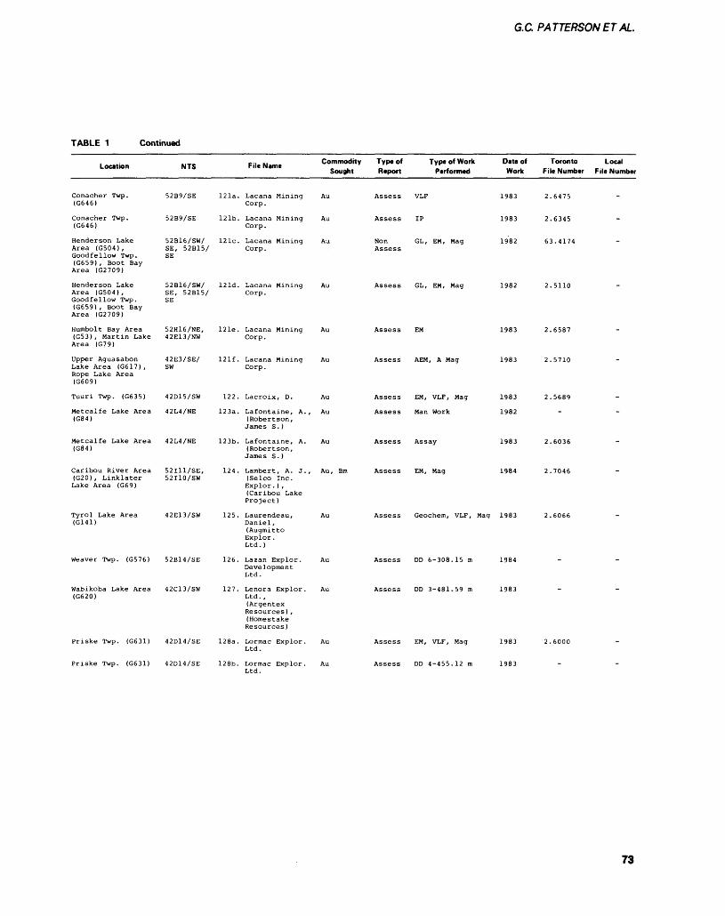
G.C PATTERSONETAL.
TABLE 1 Continued
Location
Conacher Twp. (G646)
Conacher Twp. (G646)
Henderson Lake Area (G504) , Goodfellow Twp. (G659) , Boot Bay Area (G2709)
Henderson Lake Area (G504), Goodfellow Twp. (G659) , Boot Bay Area (G2709)
Humbolt Bay Area (G53) , Martin Lake Area (G79)
Upper Aguasabon Lake Area (G617) , Rope Lake Area (G609)
Tuuri Twp. (G635)
Metcalfe Lake Area (G84)
Metcalfe Lake Area (G84)
Caribou River Area (G20), Linklater Lake Area (G69)
Tyrol Lake Area (G141)
Weaver Twp. (G576)
Wabikoba Lake Area (G620)
Priske Twp. (G631)
Priske Twp. (G631)
NTS
52B9/SE
52B9/SE
52B16/SW/ SE, 52B15/SE
52B16/SW/ SE, 52B15/SE
52H16/NE, 42E13/NW
42E3/SE/ SW
42D15/SW
42L4/NE
42L4/NE
52I11/SE, 52I10/SW
42E13/SW
52B14/SE
42C13/SW
42D14/SE
42D14/SE
121a.
121b.
121c.
121d.
121e.
121f .
122.
123a.
123b.
124.
125.
126.
127.
128a.
128b.
File Name Commodity Sought
Lacana Mining Au Corp.
Lacana Mining Au Corp.
Lacana Mining Au Corp.
Lacana Mining Au Corp.
Lacana Mining Au Corp.
Lacana Mining Au Corp.
Lacroix, D. Au
La fontaine, A., Au (Robertson, James S. )
Lafontaine, A. Au (Robertson, James S. )
Lambert, A. J., Au, Bm (Selco Inc. Explor . ) , (Caribou Lake Project)
Laurendeau, Au Daniel , (Augmitto Explor. Ltd.)
Lazan Explor. Au Development Ltd.
Lenora Explor. Au Ltd. , (Argentex Resources) , (Homestake Resources )
Lormac Explor. Au Ltd.
Lormac Explor. Au Ltd.
Type of Type of Work Date of Report Performed Work
Assess VLF 1983
Assess IP 1983
Non GL, EM, Mag 1982 Assess
Assess GL, EM, Mag 1982
Assess EM 1983
Assess AEM, A Mag 1983
Assess EM, VLF, Mag 1983
Assess Man Work 1982
Assess Assay 1983
Assess EM, Mag 1984
Assess Geochem, VLF, Mag 1983
Assess DD 6-308. IS m 1984
Assess DD 3-481.59 m 1983
Assess EM, VLF, Mag 1983
Assess DD 4-455.12 m 1983
Toronto File Number
2.6475
2.6345
63.4174
2.5110
2.6587
2.5710
2.5689
~
2.6036
2.7046
2.6066
-
2.6000
-
Local F ile Number
-
-
-
-
-
-
-
-
-
73
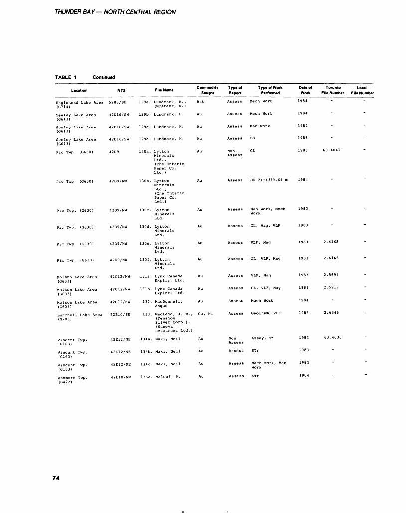
THUNDER BAY— NORTH CENTRAL REGION
TABLE 1 Continued
Location
Eaglehead Lake Area (G714)
Seeley Lake Area (G613)
Seeley Lake Area (G613)
Seeley Lake Area (G613)
Pic Twp. (G630)
Pic Twp. (G630)
Pic Twp. (G630)
Pic Twp. (G630)
Pic Twp. (G630)
Pic Twp. (G630)
Molson Lake Area (G603)
Molson Lake Area (G603)
Molson Lake Area (G603)
Burchell Lake Area (G706)
Vincent Twp. (G163)
Vincent Twp. (G163)
Vincent Twp. (G163)
Ashmore Twp. (G472)
NTS
52H3/SE
42D16/SW
42D16/SW
42D16/SW
42D9
42D9/NW
42D9/NW
42D9/NW
42D9/NW
42D9/NW
42C12/NW
42C12/NW
42C12/NW
52B10/SE
42E12/NE
42E12/NE
42E12/NE
42E10/NW
129a.
129b.
129c.
129d.
130a.
130b.
130c.
130d.
130e.
130f .
131a.
131b.
132.
133.
134a.
134b.
134c.
135a.
,.. ., Commodity File Name , . Sought
Landmark, H., Bst (McAteer, W.)
Landmark, H. Au
Landmark, H. Au
Landmark, H. Au
Lytton Au MineralsLtd. ,(The OntarioPaper Co. Ltd. )
Lytton Au MineralsLtd. ,(The OntarioPaper Co. Ltd. )
Lytton Au MineralsLtd.
Lytton Au MineralsLtd.
Lytton Au MineralsLtd.
Lytton Au MineralsLtd.
Lynx Canada Au Explor. Ltd.
Lynx Canada Au Explor. Ltd.
MacDonnell, Au Angus
MacLeod, J. W., Cu, Ni (Tenajon Silver Corp. ) ,(Suneva Resources Ltd. )
Maki, Neil Au
Maki, Neil Au
Maki, Neil Au
Malouf, M. Au
Type of Type of Work Datt of Toronto Local Report Performed Work F ile Number F ile Number
Assess Mech Work 1984
Assess Mech Work 1984
Assess Man Work 1984
Assess BS 1983
Non GL 1983 63.4041 Assess
Assess DD 24-4379.64 m 1984
Assess Man Work, Mech 1983 Work
Assess GL, Mag, VLF 1983
Assess VLF, Mag 1983 2.6168
Assess GL, VLF, Mag 1983 2.6165
Assess VLF, Mag 1983 2.5694
Assess GL, VLF, Mag 1983 2.5917
Assess Mech Work 1984
Assess Geochem, VLF 1983 2.6346
Non Assay, Tr 1983 63.4038 Assess
Assess STr 1983
Assess Mech Work, Man 1983 Work
Assess STr 1984
-
"
-
-
-
-
-
~
"
~
74
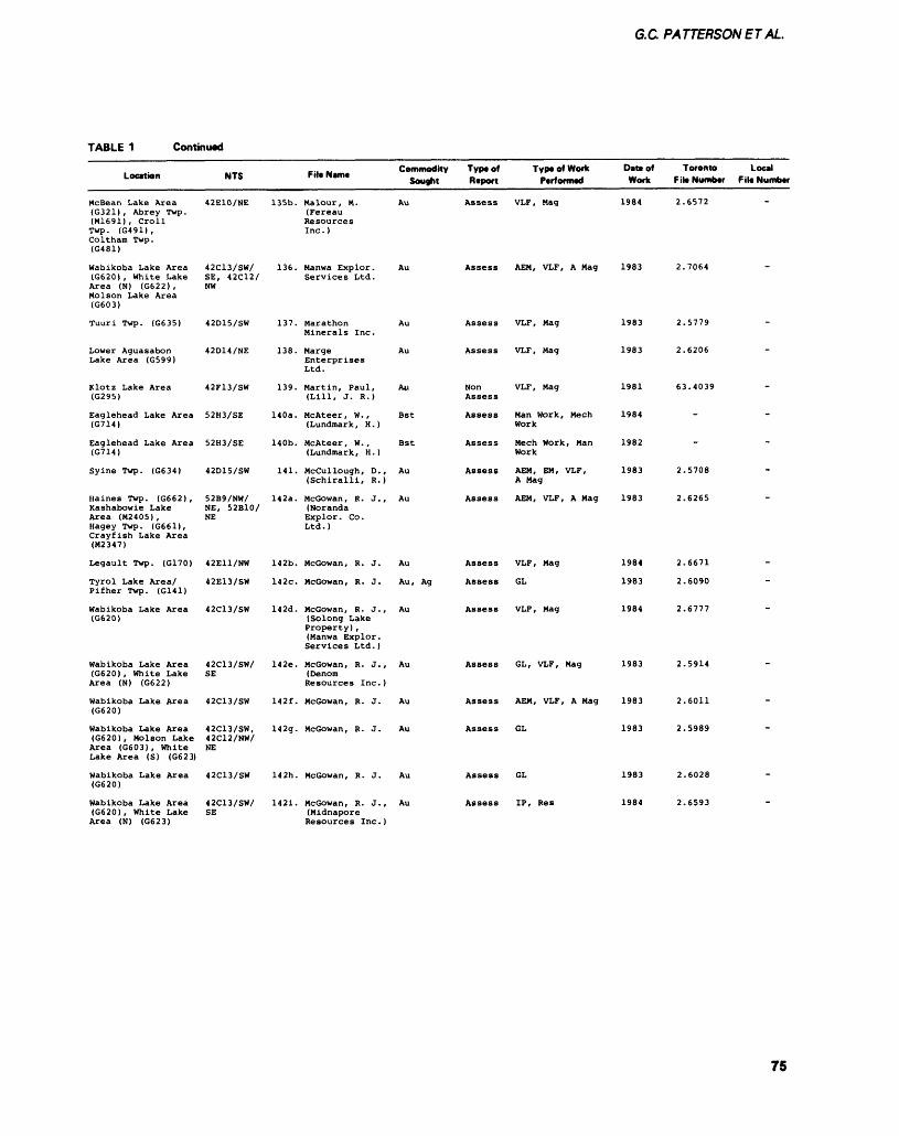
G.C PATTERSON ET AL.
TABLE 1 Continued
Location
McBean Lake Area (G321) , Abrey Twp. (M1691), Croll Twp. (G491), Coltham Twp. (G481)
Wabikoba Lake Area (G620) , White Lake Area (N) (G622) , Molson Lake Area (G603)
Tuuri Twp. (G635)
Lower Aguasabon Lake Area (G599)
Klotz Lake Area (G295)
Eaglehead Lake Area (G714)
Eaglehead Lake Area (G714)
Syine Twp. (G634)
Haines Twp. (G662) , Kashabowie Lake Area (M2405), Hagey Twp. (G661), Crayfish Lake Area (M2347)
Legault Twp. (G170)
Tyrol Lake Area/ Pifher Twp. (G141)
Wabikoba Lake Area (G620)
Wabikoba Lake Area (G620) , White Lake Area (N) (G622)
Wabikoba Lake Area (G620)
Wabikoba Lake Area (G620) , Molson Lake Area (G603), White Lake Area (S) (G623)
Wabikoba Lake Area (G620)
Wabikoba Lake Area (G620) , White Lake Area (N) (G623)
NTS
42E10/NE
42C13/SW/ SE, 42C12/ NW
42D15/SW
42D14/NE
42F13/SW
52H3/SE
52H3/SE
42D15/SW
52B9/NW/ NE, 52B10/ NE
42E11/NW
42E13/SW
42C13/SW
42C13/SW/ SE
42C13/SW
42C13/SW, 42C12/NW/ NE
42C13/SW
42C13/SW/ SE
135b.
136.
137.
138.
139.
140a.
140b.
141.
142a.
142b.
142c.
142d.
142e.
142f.
142g.
142h.
1421.
Commodity Type of Type of Work DM* of Filename Sooflht Rtpoft ptrformed Work
Malour, M. Au Assess VLF, Mag 1984 (Fereau Resources Inc.)
Manwa Explor. Au Assess AEM, VLF, A Mag 1983 Services Ltd.
Marathon Au Assess VLF, Mag 1983 Minerals Inc.
Marge Au Assess VLF, Mag 1983 Enterprises Ltd.
Martin, Paul, Au Non VLF, Mag 1981 (Lill, J. R.) Assess
McAteer, W., Bst Assess Man Work, Meen 1984 (Lundmark, H.) Work
McAteer, W., Bst Assess Meen Work, Man 1982 (Landmark, H.) Work
McCul lough, D., Au Assess AEM, EM, VLF, 1983 (Schiralli, R.) A Mag
Mccowan, R. J., Au Assess AEM, VLF, A Mag 1983 (Noranda Explor. Co. Ltd.)
Mccowan, R. J. Au Assess VLF, Mag 1984
Mccowan, R. J. Au, Ag Assess GL 1983
McGowan, R. J., Au Assess VLF, Mag 1984 (Solong Lake Property) , (Manwa Explor. Services Ltd. )
McGowan, R. J., Au Assess GL, VLF, Mag 1983 (Denom Resources Inc.)
McGowan, R. J. Au Assess AEM, VLF, A Mag 1983
McGowan, R. J. Au Assess GL 1983
McGowan, R. J. Au Assess GL 1983
McGowan, R. J., Au Assess IP, Res 1984 (Midnapore Resources Inc.)
Toronto Local F ile Number F ile Number
2.6572
2.7064
2.5779
2.6206
63.4039
-
-
2.5708
2.6265
2.6671
2.6090
2.6777
2.5914
2.6011
2.5989
2.6028
2.6593
-
~
-
-
-
-
-
-
~
-
-
-
75
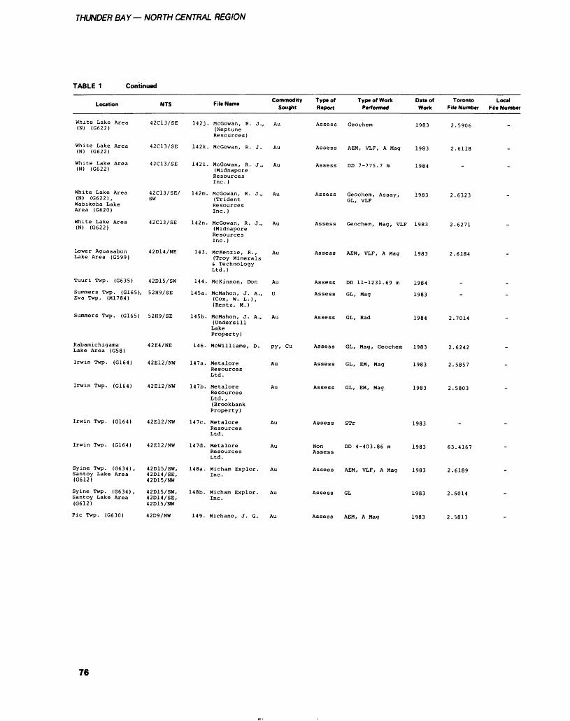
THUNDER BAY— NORTH CENTRAL REGION
TABLE 1 Continued
Location
White Lake Area (N) (G622)
White Lake Area (N) (G622)
White Lake Area (N) (G622)
White Lake Area (N) (G622), Wabikoba Lake Area (G620)
White Lake Area (N) (G622)
Lower Aguasabon Lake Area (G599)
Tuuri Twp. (G635)
Summers Twp. (G165), Eva Twp. (M1784)
Summers Twp. (G165)
Kabamichigama Lake Area (G58)
Irwin Twp. (G164)
Irwin Twp. (G164)
Irwin Twp. (G164)
Irwin Twp. (G164)
Syine Twp. (G634) , Santoy Lake Area (G612)
Syine Twp. (G634) , Santoy Lake Area (G612)
NTS
42C13/SE
42C13/SE
42C13/SE
42C13/SE/ SW
42C13/SE
42D14/NE
42D15/SW
52H9/SE
52H9/SE
42E4/NE
42E12/NW
42E12/NW
42E12/NW
42E12/NW
42D15/SW, 42D14/SE, 42D15/NW
42D15/SW, 42D14/SE, 42D15/NW
142J
142k,
1421.
142m.
142n.
143.
144.
145a.
145b.
146.
147a.
147b.
147c.
147d.
148a.
148b.
,... -, Commodity File Name Sought
. McGowan, R. J., Au (Neptune Resources)
. McGowan, R. J. Au
. McGowan, R. J., Au (Midnapore Resources Inc. )
McGowan, R. J., Au (Trident Resources Inc. )
McGowan, R. J., Au (Midnapore Resources Inc. )
McKenzie, R., Au (Troy Minerals t Technology Ltd. )
McKinnon, Don Au
McMahon, J. A., D (Cox, W. L.), (Rentz, M.)
McMahon, J. A., Au (Undersill Lake Property)
Mcwilliams, D. py, Cu
Metalore Au Resources Ltd.
Metalore Au Resources Ltd. , (Brookbank Property)
Metalore Au Resources Ltd.
Metalore Au Resources Ltd.
Micham Explor. Au Inc.
Micham Explor. Au Inc.
Type of Type of Work Date of Report Performed Work
Assess Geochem 1983
Assess AEM, VLF, A Mag 1983
Assess DD 7-775.7 m 1984
Assess Geochem, Assay, 1983 GL, VLF
Assess Geochem, Mag, VLF 1983
Assess AEM, VLF, A Mag 1983
Assess DD 11-1231.69 m 1984
Assess GL, Mag 1983
Assess GL, Rad 1984
Assess GL, Mag, Geochem 1983
Assess GL, EM, Mag 1983
Assess GL, EM, Mag 1983
Assess STr 1983
Non DD 4-403.86 m 1983 Assess
Assess AEM, VLF, A Mag 1983
Assess GL 1983
Toronto Local F ile Number F ile Number
2.5906
2.6118
-
2.6323
2.6271
2.6184
-
-
2.7014
2.6242
2.5857
2.5803
-
63.4167
2.6189
2.6014
Pic Twp. (G630) 42D9/NW 149. Michano, J. G. Au Assess AEM, A Mag 1983 2.5813
76
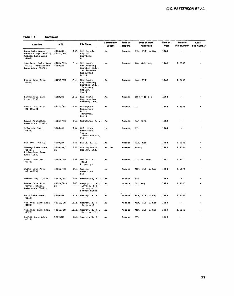
G.C. PATTERSONET AL.
TABLE 1 Continued
Location
Rous Lake Area/Lecours Twp. (G611),Molson Lake Area(G603)
Castlebar Lake Area(G220), PagwachwanLake Area (G368)
Klotz Lake Area(G295)
Pagwachwan LakeArea (G368)
White Lake Area(N) (G622)
Lower AguasabonLake Area (G599)
O ' Connor Twp .(G678)
Pic Twp. (G630)
Norway Lake Area(G545),Richardson LakeArea (G553)
Hutchinson Twp.(G571)
White Lake Area(G) (G623)
Weaver Twp. (G576)
Lorna Lake Area(G598), SeeleyLake Area (G613)
Rous Lake Area(G611)
Wabikoba Lake Area(G620)
Wabikoba Lake Area(G620)
Factor Lake Area(G527)
NTS
42D9/NE,42C12/NW
42E16/SE,42E9/NE
42F13/SW
42E9/NE
42C13/SE
42D14/NE
52A5/SE
42D9/NW
52G3/SW/SE
52B14/SW
42C12/NE
52B14/SE
42D16/SE/SW
42D9/NE
42C13/SW
42C13/SW
52C9/NE
-.. .. Commodity File Name . F Sought
150. Mid Canada AuExplor .ServicesLtd.
151a. Mid North AuEngineeringService Ltd. ,(VillenbuveResourcesLtd.)
151b. Mid North AuEngineeringService Ltd. ,(TranswayExplor.Inc. )
15 le. Mid North AuEngineeringService Ltd.
152. Midnapore AuResourcesLtd.,(Mccowan,R. J.)
153. Mikkonen, R. V. Au
154. Mill Rock baResourcesInc.,(Thor ste inson,D.)
155. Mills, K. D. Au
156. Mining North Au, BmExplor. Ltd.
157. Moffat, R., Au(HillProperty)
158. Monica AuResourcesLtd.
159. Morehouse, W. D. Bm
160. Murphy, D. R., Au(Lavoie, R. ) ,(PelangioLarder Mines)
161a. Murray, B. R. Au
161b. Murray, B. R. Au(In trust)
161c. Murray, B. R., Au(Bernier, P.)
162. Murray, W. S. Au
Type of Report
Assess
Assess
Assess
Assess
Assess
Assess
Assess
Assess
Assess
Assess
Assess
Assess
Assess
Assess
Assess
Assess
Assess
Type of Work Performed
AEM, VLF, A Mag
EM, VLF, Mag
Mag, VLF
DD 6-448.6 m
GL
Man Work
STr
VLF, Mag
Assay
GL, EM, Mag
AEM, VLF, A Mag
STr
GL, Mag
AEM, VLF, A Mag
AEM, VLF, A Mag
AEM, VLF, A Mag
STr
Date of Toronto Work Fit* Number
1983
1983 2.5787
1983 2.6640
1983
1983 2.5905
1983
1984
1983 2.5938
1982 2.5384
1981 2.4210
1983 2.6174
1983
1983 2.6060
1983 2.6096
1983
1983 2.6248
1983
Local File Number
.
-
-
-
-
-
-
-
-
-
-
-
-
-
-
-
-
77
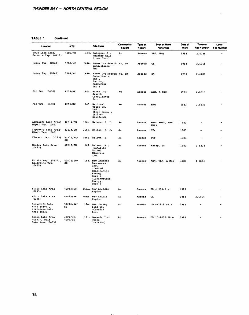
THUNDER BAY— NORTH CENTRAL REGION
TABLE 1 Continued
Location NTS Fit* NWIM C oflMDOQ ity Sought
Type of Type of Work Report Performed
Oat* of Toronto Local Work Fit* Number Filt Number
Rous Lake Area/ 42D9/NE Lecours Twp. (G611)
Hagey Twp. (G661) 52B9/NE
Hagey Twp. (G661)
Pic Twp. (G630)
Pic Twp. (G630)
Lapierre Lake Area/ Hipel Twp. (G65)
Lapierre Lake Area/ Hipel Twp. (G65)
Vincent Tvp. (G163)
Seeley Lake Area (G613)
Priske Twp. (G631), Killraine Twp. (G625)
Klotz Lake Area (G295)
Klotz Lake Area (G295)
Snowdrift Lake Area (G402), Miminiska Lake Area (G332)
Loken Lake Area (G597), Olie Lake Area (G605)
52B9/NE
42D9/NE
42D9/NW
42E14/SW
42E14/SW
42E12/NE/ SE
42D16/SW
42D14/SW/ SE
42F13/SW
42F13/SW
52P10/SW/ SE
42F4/NE, 42F5/SE
163. Nabigon, J., Au (Huncho Gold Mines Inc.)
164A. Narex Ore Search Au, Bm Consultants Inc.
164b. Narex Ore Search Au, Bm Consultants Inc., (Onitap Resources Inc.)
164c. Narex Ore Search Consultants Inc.
165. National Trust Co. Ltd.,(Tech Corp.), (Silver Standard)
166a. Nelson, B. I.
166b. Nelson, B. I.
166c. Nelson, B.
167. Nelson, J., (Canadian- United Minerals Inc.)
168. New Ambrose Resources Inc., (United Continental Energy Corp.), (Livingstone Energy Corp.)
169a. New Arcadia Explor.
169b. New Aracia Explor.
170. New Jersey Zinc Co. (Canada) Ltd.
171. Noranda Inc. (Geco Division)
Au
Assess VLF, Mag
Assess GL
Assess EM
Assess AEM, A Mag
Assess Mag
Assess Mech Work, Man Work
Assess STr
Assess STr
Assess Assay, Tr
Assess AEM, VLF, A Mag
1983 2.6148
1983 2.6156
1983 2.6786
1983 2.6015
1983 2.5835
1983
1983
1983
1983 2.6222
1983
Assess DD 4-304.8 m
Assess GL
Assess DD 8-1118.92 m
Assess DD 10-1657.50 m
1983
1983
1984
1984
2.6874
78
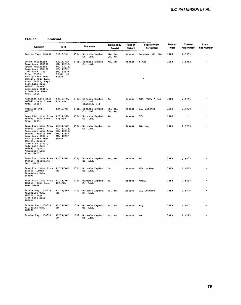
6.C PATTERSONETAL.
TABLE 1 Continued
Location NTS File Name Commodity Type of Type of Work Sought Report Performed
Date of Toronto Local Work File Number File Number
Dorion Twp. (M1698)
Lower AguasabonLake Area (G599) ,Upper AguasabonLake Area (G617)Cairngorm LakeArea (G585) ,Santoy Lake Area(G612) , Rope LakeArea (G609), PaysPlat Lake Area(G606), GravelLake Area (G45) ,Middle Fox LakeArea (G85)
Martinet Lake Area(G601) , Vein CreekArea (G618)
McTavish Twp.(G675)
Pays Plat Lake Area(G606) , Rope LakeArea (G609)
Pays Plat Lake Area(G606), LowerAguasabon Lake Area(G599) , Middle FoxLake Area (G85) ,Santoy Lake Area(G612), GravelLake Area (G45) ,Rope Lake Area(G609), UpperAguasabon LakeArea (G617)
52A15/SE
42D14/NE/NW, 42D15/NW, 42D13/NE, 42E2/SW, 42E3/SE/SW, 42E4/SE
42D16/NW,42E1/SW
52A10/NE
42D14/NW,42E3/SW
42D14/NW/NE, 42D13/NE, 42D15/NW, 42E4/SE, 42E3/SW/SE
172a. Noranda Explor. Pb, Zn, Assess Geochem, GL, Mag 1983 2.5901Co. Ltd. Cu, Ag
172b. Noranda Explor. Au, Bm Assess A Mag 1983 2.5952Co . Ltd .
t
172c. Noranda Explor. Au Assess AEM, VLF, A Mag 1983 2.6746Co. Ltd.,(Lafond, D.)
172d. Noranda Explor. Pb, Zn, Assess GL, Geochem 1983 2.5900Co. Ltd. Cu, Ag
172e. Noranda Explor. Au Assess STr 1983Co. Ltd.
172f. Noranda Explor. Au Assess EM, Mag 1983 2.5763Co. Ltd.
Pays Plat Lake Area 42D34/NW (G606), Killraine Twp. (G625)
Pays P:at Lake Area 42D14/NW/ (G606), Lower NE Aguasabon Lake (G599)
Pays Plat Lake Area 42D14/NW, (G606), Rope Lake 42E3/SW Area (G609)
Priske Twp. (G631), 42D14/SW/ Killraine Twp. NW (G625), Pays Plat Lake Area (G606)
Priske Twp. (G631), 42D14/NW/ Killraine Twp. SW (G625)
Priske Twp. (G631) 42D14/NW/ SW
172g. Noranda Explor. Co. Ltd.
172h. Noranda Explor. Co. Ltd.
172i. Noranda Explor. Co. Ltd.
172j. Noranda Explor. Co. Ltd.
172k. Noranda Explor. Co. Ltd.
1721. Noranda Explor. Co. Ltd.
Au, Bm Assess EK
Assess AEM, A Mag
Assess Assay
Au, Bm Assess GL, Geochem
Au, Bm Assess Mag
Au, Bm Assess EM
1983
1983
1983
1983
1983
2.6803
2.5434
2.6778
2.6801
79
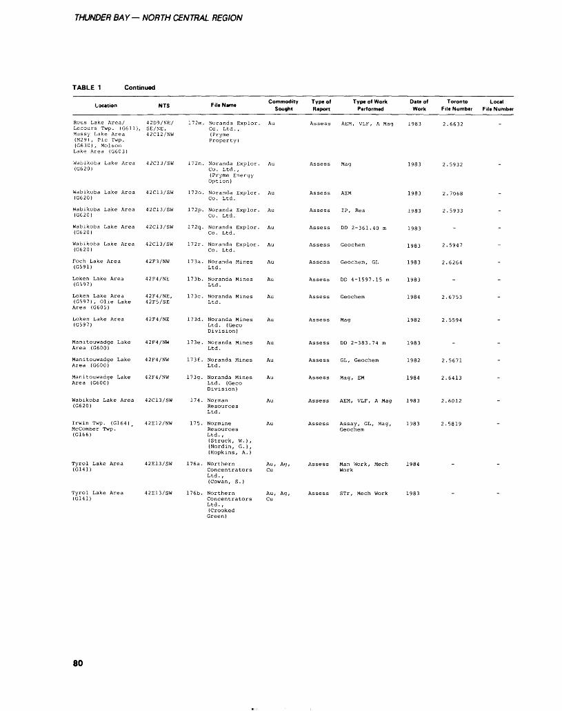
THUNDER BAY— NORTH CENTRAL REGION
TABLE 1 Continued
Location
Rous Lake Area/Lecours Twp. (G611),Mussy Lake Area(M29) , Pic Twp.(G630) , MolsonLake Area (G603)
Wabikoba Lake Area(G620)
Wabikoba Lake Area(G620)
Wabikoba Lake Area(G620)
Wabikoba Lake Area(G620)
Wabikoba Lake Area(G620)
Foch Lake Area(G591)
Loken Lake Area(G597)
Loken Lake Area(G597) , Olie LakeArea (G605)
Loken Lake Area(G597)
Manitouwadge LakeArea (G600)
Manitouwadge LakeArea (G600)
Manitouwadge LakeArea (G600)
Wabikoba Lake Area(G620)
Irwin Twp. (G164) tMccomber Twp.(G166)
Tyrol Lake Area(G141)
Tyrol Lake Area(G141)
NTS
42D9/NE/SE/NE,42C12/NW
42C13/SW
42C13/SW
42C13/SW
42C13/SW
42C13/SW
42F3/NW
42F4/NE
42F4/NE,42F5/SE
42F4/NE
42F4/NW
42F4/NW
42F4/NW
42C13/SW
42E12/NW
42E13/SW
42E13/SW
,.. -. Commodity File Name
Sought
172m. Noranda Explor. AuCo. Ltd. ,(PrymeProperty)
172n. Noranda Explor. AuCo. Ltd.,(Pryme EnergyOption)
172o. Noranda Explor. AuCo. Ltd.
172p. Noranda Explor. AuCo. Ltd.
172q. Noranda Explor. AuCo. Ltd.
172r. Noranda Explor. AuCo. Ltd.
173a. Noranda Mines AuLtd.
173b. Noranda Mines AuLtd.
173c. Noranda Mines AuLtd.
173d. Noranda Mines AuLtd. (GecoDivision)
173e. Noranda Mines AuLtd.
173f. Noranda Mines AuLtd.
173g. Noranda Mines AuLtd. (GecoDivision)
174 . Norman AuResourcesLtd.
175. Normine AuResourcesLtd. ,(Struck, W. ) ,(Nordin, G.),(Hopkins, A.)
176a. Northern Au, Ag,Concentrators CuLtd. ,(Cowan, S.)
176b. Northern Au, Ag,Concentrators CuLtd. ,(CrookedGreen)
Type of Type of Work Report Performed
Assess AEM, VLF, A Mag
Assess Mag
Assess AEM
Assess IP, Res
Assess DD 2-361.40 m
Assess Geochem
Assess Geochem, GL
Assess DD 4-1597.15 m
Assess Geochem
Assess Mag
Assess DD 2-383.74 m
Assess GL, Geochem
Assess Mag, EM
Assess AEM, VLF, A Mag
Assess Assay, GL, Mag,Geochem
Assess Man Work, MechWork
Assess STr, Mech Work
Date of Toronto Work File Number
1983 2.6632
1983 2.5932
1983 2.7068
1983 2.5933
1983
1983 2.5947
1983 2.6264
1983
1984 2.6753
1982 2.5594
1983
1982 2.5671
1984 2.6413
1983 2.6012
1983 2.5819
1984
1983
Local File Number
.
.
.
-
.
-
-
-
.
.
-
.
.
.
.
-
80
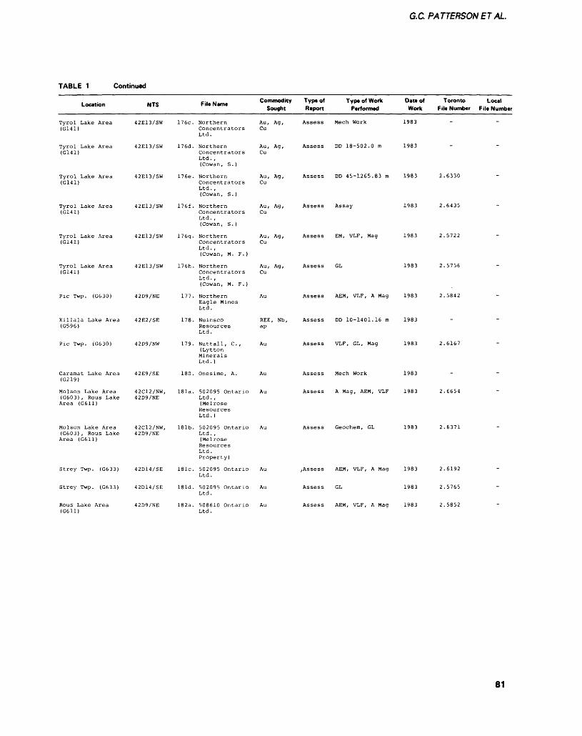
G.C PATTERSONET AL.
TABLE 1 Continued
Location NTS
Tyrol Lake Area 42E13/SW(G141)
Tyrol Lake Area 42E13/SW(G141)
Tyrol Lake Area 42E13/SW(G141)
Tyrol Lake Area 42E13/SW(G141)
Tyrol Lake Area 42E13/SW(G141)
Tyrol Lake Area 42E13/SW(G141)
Pic Twp. (G630) 42D9/NE
Killala Lake Area 42E2/SE(G596)
Pic Twp. (G630) 42D9/NW
File Name
176c. NorthernConcentratorsLtd.
176d. NorthernConcentratorsLtd. ,(Cowan, S.)
176e. NorthernConcentratorsLtd. ,(Cowan, S.)
176f. NorthernConcentratorsLtd. ,(Cowan, S. )
176g. NorthernConcentratorsLtd. ,(Cowan, M. F.)
176h. NorthernConcentratorsLtd. ,(Cowan, M. F.)
177. NorthernEagle MinesLtd.
178. NuinscoResourcesLtd.
179. Nuttall, C.,(LyttonMineralsLtd. )
Commodity Type of Type of Work Sought Report Performed
Au, Ag, Assess Mech WorkCu
Au, Ag, Assess DD 18-502.0 mCu
Au, Ag, Assess DD 45-1265.83 mCu
Au, Ag, Assess AssayCu
Au, Ag, Assess EM, VLF, MagCu
Au, Ag, Assess GLCu
Au Assess AEM, VLF, A Mag
REE, Nb, Assess DD 10-1401.16 map
Au Assess VLF, GL, Mag
Date of Toronto Local Work File Number File Number
1983
1983
1983 2.6330
1983 2.6435
1983 2.5722
1983 2.5756
1983 2.5842
1983
1983 2.6167
Caramat Lake Area 42E9/SE (G219)
Molson Lake Area 42C12/NW, (G603), Rous Lake 42D9/NE Area (G611)
Molson Lake Area 42C12/NW, (G603), Rous Lake 42D9/NE Area (G611)
Strey Twp. (G633) 42D14/SE
Strey Twp. (G633) 42D14/SE
Rous Lake Area 42D9/NE (G611)
180. Onesime, A.
181a. 502095 Ontario Ltd. , (Melrose Resources Ltd. )
181b. 502095 Ontario Ltd. , (Melrose Resources Ltd. Property)
181c. 502095 Ontario Ltd.
181d. 502095 Ontario Ltd.
182a. 508610 Ontario Ltd.
Assess Mech Work
Assess A Mag, AEM, VLF
Assess Geochem, GL
,Assess AEM, VLF, A Mag
Assess GL
Assess AEM, VLF, A Mag
1983
1983 2.6654
1983 2.6371
1983 2.6192
1983 2.5765
1983 2.5852
81
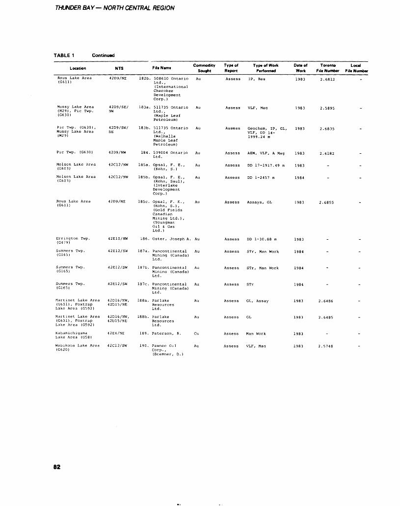
THUNDER BAY— NORTH CENTRAL REGION
TABLE 1 Continued
Location NTS
Rous Lake Area 42D9/NE(G611)
Mussy Lake Area 42D9/SE/(M29) , Pic Twp. NW(G630)
Pic Twp. (G630), 42D9/SW/Mussy Lake Area SE(M29)
Pic Twp. (G630) 42D9/NW
Molson Lake Area 42C12/NW(G603)
Molson Lake Area 42C12/NW(G603)
Rous Lake Area 42D9/NE(G611)
File Name Commodity Sought
182b. 508610 Ontario AuLtd. ,(InternationalCherokeeDevelopmentCorp. )
183a. 511735 Ontario AuLtd. ,(Maple LeafPetroleum)
183b. 511735 Ontario AuLtd. ,(WalhallaMaple LeafPetroleum)
184. 539004 Ontario AuLtd.
185a. Opsal, F. E., Au(Kohn, S.)
185b. Opsal, F. E., Au(Kohn, Saul),(InterlakeDevelopmentCorp. )
185c. Opsal, F. E., Au(Kohn, S.),(Gold FieldsCanadianMining Ltd. ) ,(YoungmanOil S, GasLtd. )
Type of Type of Work Date of Toronto Local Report Performed Work Fill Number File Number
Assess IP, Res 1983 2.6812
Assess VLF, Mag 1983 2.5895
Assess Geochem, IP, GL, 1983 2.6835VLF, DD 14-1999.24 m
Assess AEM, VLF, A Mag 1983 2.6182
Assess DD 17-1917.49 m 1983
Assess DD 1-2457 m 1984
Assess Assays, GL 1983 2.6855
Summers Twp. (G165)
Summers Twp. (G165)
Summers Twp. (G165)
Martinet Lake Area (G601), Foxtrap Lake Area (G592)
Martinet Lake Area (G601), Foxtrap Lake Area (G592)
Kabamichigama Lake Area (G58)
Wabikoba Lake Area (G620)
42E10/NW 186. Oster, Joseph A. Au
42E12/SW 187a. Pancontinental Au Mining (Canada) Ltd.
42E12/SW 187b. Pancontinental Au Mining (Canada) Ltd.
42E12/SW 187c. Pancontinental Au Mining (Canada) Ltd.
42D16/NW, 188a. Parlake Au 42D15/NE Resources
Ltd.
42D16/NW, 188b. Parlake Au 42D15/NE Resources
Ltd.
42E4/NE 189. Paterson, R. Cu
42C13/SW 190. Pawnee Oil Corp., (Bremner, D.)
Assess DD 1-30.88 m 1983
Assess STr, Man Work 1984
Assess STr, Man Work 1984
Assess STr
Assess GL, Assay
Assess GL
Assess Man Work
Assess VLF, Mag
1984
1983
82
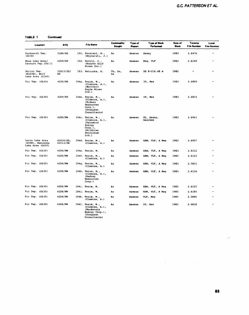
G.C PATTERSONETAL.
TABLE 1 Continued
Location
Duckworth Twp.(G638)
Rous Lake Area/Lecours Twp. (G611)
Dorion Twp.(M1698) , WolfLake Area (G160)
Pic Twp. (G630)
Pic Twp. (G630)
Pic Twp. (G630)
Lorna Lake Area(G598), WabikobaLake Area (G620)
Pic Twp. (G630)
Pic Twp. (G630)
Pic Twp. (G630)
Pic Twp. (G630)
Pic Twp. (G630)
Pic Twp. (G630)
Pic Twp. (G630)
Pic Twp. (G630)
NTS
52B9/SE
42D9/NE
52A15/SE/NE
42D9/NE
42D9/NE
42D9/NW
42D16/SE,42C13/SW
42D9/NW
42D9/NW
42D9/NW
42D9/NW
42D9/NW
42D9/NW
42D9/NW
42D9/NW
191.
192.
193.
194a.
194b.
194c.
194d.
194e.
194f .
194g.
194h.
194i.
194J.
194k.
1941.
-., -, Commodity File Name .
Sought
Penziwol, M. , Au(Woynarski, J.)
Perkin, J. , Au(Honcho GoldMines Inc. )
Petrunka, D. Pb, Zn,ba
Pezim, M., Au(Clemiss, A.),(NorthernEagle MinesLtd. )
Pezim, M. , Au(Clemiss, A.),(RideauResourcesCorp. ) ,(OrequestConsultants)
Pezim, M. , Au(Clemiss, A.),(DynamicsEnergyCorp . ) ,(WildrosePetroleumLtd.)
Pezim, M., Au(Clemiss, A.)
Pezim, M. Au
Pezim, M. , Au(Clemiss, A.)
Pezim, M. , Au(Clemiss, A.)
Pezim, M. , Au(Clemiss, A.),(KadreyResourcesCorp . )
Pezim, M. Au
Pezim, M. Au
Pezim, M., Au(Clemiss, A.)
Pezim, M., Au(Clemiss, A.) ,(MacKenzieEnergy Corp . ) ,(OrequestConsultants)
Type of Type of Work Data of Report Performed Work
Assess Assay 1983
Assess Mag, VLF 1983
Assess DD 8-216.48 m 1982
Assess IP, Res 1983
Assess IP, Res 1983
Assess GL, Assay, 1983Geochem
Assess AEM, VLF, A Mag 1983
Assess AEM, VLF, A Mag 1983
Assess AEM, VLF, A Mag 1983
Assess AEM, VLF, A Mag 1983
Assess AEM, VLF, A Mag 1983
Assess AEM, VLF, A Mag 1983
Assess AEM, VLF, A Mag 1983
Assess VLF, Mag 1983
Assess IP, Res 1983
Toronto File Number
2.6476
2.6149
-
2.6809
2.6815
2.6941
2.6007
2.6212
2.6123
2.5851
2.6124
2.6125
2.6185
2.5890
2.6818
Local File Number
.
-
-
-
-
-
-
-
-
-
-
-
-
-
.
83
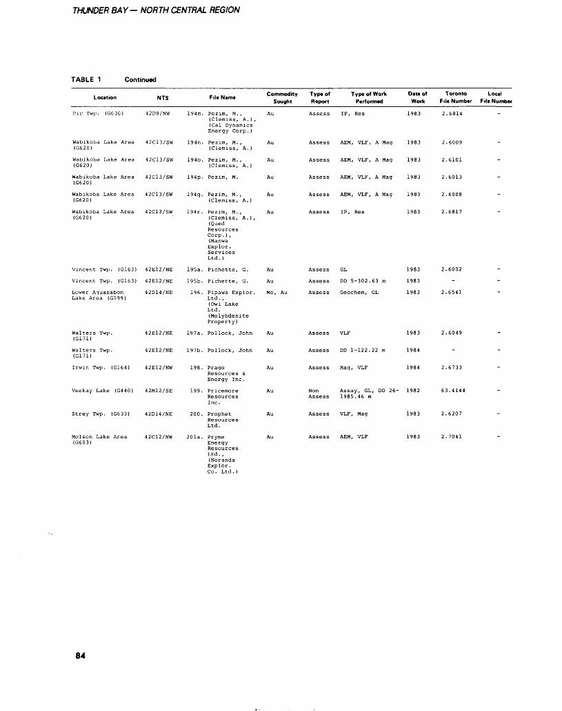
THUNDER BAY— NORTH CENTRAL REGION
TABLE 1 Continued
Location
Pic Twp. (G630)
Wabikoba Lake Area (G620)
Wabikoba Lake Area (G620)
Wabikoba Lake Area (G620)
Wabikoba Lake Area (G620)
Wabikoba Lake Area (G620)
Vincent Twp. (G163)
Vincent Twp. (G163)
Lower Aguasabon Lake Area (G599)
Walters Twp. (G171)
Walters Twp. (G171)
Irwin Twp. (G164)
Veekay Lake (G440)
Strey Twp. (G633)
Molson Lake Area (G603)
NTS
42D9/NW
42C13/SW
42C13/SW
42C13/SW
42C13/SW
42C13/SW
42E12/NE
42E12/NE
42D14/NE
42E12/NE
42E12/NE
42E12/NW
42M12/SE
42D14/NE
42C12/NW
194m.
194n.
1940.
194p.
194q.
194r.
195a.
195b.
196.
197a.
197b.
198.
199.
200.
201a.
p.. N Commodity Type of Type of Work Date of Sought Report Performed Work
Pezim, M., Au Assess IP, Res 1983 (Clemiss, A. ) , (Cal Dynamics Energy Corp. )
Pezim, M., Au Assess AEM, VLF, A Mag 1983 (Clemiss, A. )
Pezim, M., Au Assess AEM, VLF, A Mag 1983 (Clemiss, A.)
Pezim, M. Au Assess AEM, VLF, A Mag 1983
Pezim, M., Au Assess AEM, VLF, A Mag 1983 (Clemiss, A. )
Pezim, M., Au Assess IP, Res 1983 (Clemiss, A. ) , (Qued Resources Corp. ) , (Manwa Explor . Services Ltd.)
Pichette, G. Au Assess GL 1983
Pichette, G. Au Assess DD 5-302.63 m 1983
Pipawa Explor. Mo, Au Assess Geochem, GL 1983 Ltd., (Owl Lake Ltd. (Molybdenite Property)
Pollock, John Au Assess VLF 1983
Pollock, John Au Assess DD 1-122.22 m 1984
Prago Au Assess Mag, VLF 1984 Resources 4 Energy Inc .
Pricemore Au Non Assay, GL, DD 26- 1982 Resources Assess 1985.46 mInc.
Prophet Au Assess VLF, Mag 1983 ResourcesLtd.
Pryme Au Assess AEM, VLF 1983 Energy Resources Ltd. , (Noranda Explor. Co. Ltd.)
Toronto File Number
2.6814
2.6009
2.6101
2.6013
2.6008
2.6817
2.6002
-
2.6541
2.6049
-
2.6733
63.4144
2.6207
2.7041
Local File Number
"
-
-
-
-
-
-
-
-
-
84
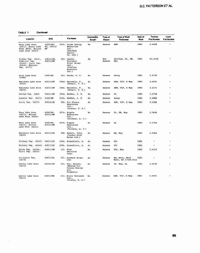
G.C PATTERSONETAL.
TABLE 1 Continued
Location
Rous Lake Area (G611) , Mussy Lake Area (M29), Molson Lake Area (G603)
Pifher Twp. (G14) , Elmhirst Twp. (G162) , Irwin Twp. (G164), Walters Twp. (G171)
Rich Lake Area (G388)
Wabikoba Lake Area (G620)
Wabikoba Lake Area (G620]
Gorham Twp. (G66)
Lybster Twp. (G671)
Strey Twp. (G633)
Rous Lake Area (G611), Molson Lake Area (G602)
Rous Lake Area (G611), Molson Lake Area (G603)
Wabikoba Lake Area (G620)
Rickaby Twp. (G161)
Rickaby Twp. (G161)
Syine Twp. (G634) , Tuuri Twp. (G635)
Errington Twp. (G479)
Seeley Lake Area (G613)
Santoy Lake Area (G612)
NTS
42D9/NE/ SE, 42C12/NW
42E13/SW, 42E12/NW
52P9/SE
42C13/SW
42C13/SW
52A11/SW
52A4/NW
42D14/SE
42D9/NE, 42C12/NW
42D9/NE, 42C12/NW
42C13/SW
42E13/SE
42E13/SE
42D15/SW
42E11/NE
42D16/SW
42D15/NW
,.. .. Commodity F,I.N.m. Sooght
201b. Pryme Energy Au Resources Ltd. , (Noranda Explor . Co. Ltd.)
202. Quebec Au Sturgeon River Mines Ltd., (Jupiter Minerals Inc. )
203. Randa, T. V. Au
204a. Recoskie, F., Au (Robert, Y. R.)
204b. Recoskie, F., Au (Robert, Y. R.)
205a. Redden, J. W. Au
205b. Redden, J. W. Ag
206. Rio Blanco Au Resources Ltd. , (Gracey, K. A.)
207a. Ripple Au Reaources Ltd., (Feimann, A. V.)
207b. Ripple Au Resources Ltd. , (Feimann, A. V.)
208. Robert, Yvon, Au (Tundra Gold Mines Ltd.)
209a. Rosenblatt, A. Au
209b. Rosenblatt, A. Au
210. Rose Au Resource Corp.
211. Roxmark Mines Au Ltd.
212. Roy, Rejean, Au (Westam Oil Ventex Energy Ltd. Property)
213. Royce Ventures Au Ltd. , (Gracey, K. A.)
Type of Type of Work Date of Report Performed Work
Assess AEM 1983
Non Geochem, GL, EM, 1981 Assess Mag
Assess Assay 1981
Assess AEM, VLF, A Mag 1983
Assess AEM, VLF, A Mag 1983
Assess GL 1984
Assess Assay 1984
Assess AEM, VLF, A Mag 1983
Assess GL, EM, Mag 1983
Assess GL 1983
Assess EM, Mag 1983
Assess STr 1984
Assess STr 1984
Assess VLF, Mag 1983
Assess Man Work, Meen 1983 Work, DD 3-549. 04 m
Assess IP, Mag, GL 1983
Assess AEM, VLF, A Mag 1983
Toronto File Number
2.6928
63.4108
2.4739
2.6041
2.6171
2.6798
2.6886
2.6384
2.5696
2.5764
2.5964
-
-
2.6112
-
2.6239
2.6501
Local File Number
-
-
-
-
-
-
-
-
~
-
~
85
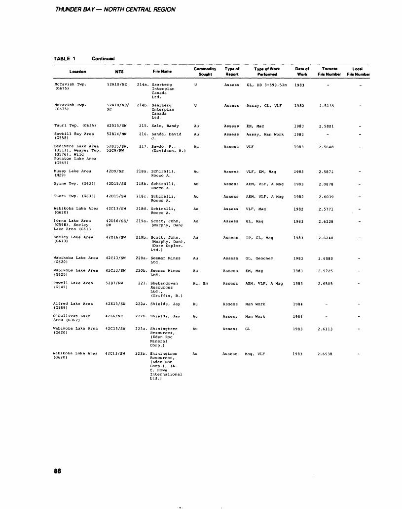
THUNDER BAY— NORTH CENTRAL REGION
TABLE 1 Continued
Location
Mctavish Twp. (G675)
Mctavish Twp. (G675)
Tuuri Twp. (G635)
Sawbill Bay Area (G558)
Bedivere Lake Area (G511) , Weaver Twp. (G576), WildPotatoe Lake Area(G565)
Mussy Lake Area (M29)
Syine Twp. (G634)
Tuuri Twp. (G635)
Wabikoba Lake Area (G620)
Lorna Lake Area (G598), Seeley Lake Area (G613)
Seeley Lake Area (G613)
Wabikoba Lake Area (G620)
Wabikoba Lake Area (G620)
Powell Lake Area (G549)
Alfred Lake Area (G189)
O'sullivan Lake Area (G362)
Wabikoba Lake Area (G620)
NTS
52A10/NE
52A10/NE/ SE
42D15/SW
52B14/NW
52B15/SW, 52C9/NW
42D9/SE
42D15/SW
42D15/SW
42C13/SW
42D16/SE/ SW
42D16/SW
42C13/SW
42C13/SW
52B7/NW
42E15/SW
42L6/NE
42C13/SW
2l4a.
214b.
215.
216.
217.
218a.
218b.
218c.
218d.
219a.
219b.
220a.
220b.
221.
222a.
222b.
223a.
File Name
Saarberg Interplan CanadaLtd.
Saarberg Interplan CanadaLtd.
Salo, Randy
Sande, DavidJ.
Sawdo, P. , (Davidson, B.)
Schiralli, Rocco A.
Schiralli,ROCCO A.
Schiralli, Rocco A.
Schiralli, Rocco A.
Scott, John, (Murphy, Dan)
Scott, John, (Murphy, Dan) , (Dore Explor. Ltd.)
Seemar Mines Ltd.
Seemar Mines Ltd.
Shebandowan ResourcesLtd. ,(Griffis, B.)
Shields, Jay
Shields, Jay
Shiningtree Resources,(Eden RocMineralCorp. )
Commodity Type of Type of Work Sought Report Performed
U Assess GL, DD 3-699. 51m
U Assess Assay, GL, VLF
Au Assess EM, Mag
Au Assess Assay, Man Work
Au Assess VLF
Au Assess VLF, EM, Mag
Au Assess AEM, VLF, A Mag
Au Assess AEM, VLF, A Mag
Au Assess VLF, Mag
Au Assess GL, Mag
Au Assess IP, GL, Mag
Au Assess GL, Geochem
Au Assess EM, Mag
Au, Bm Assess AEM, VLF, A Mag
Au Assess Man Work
Au Assess Man Work
Au Assess GL
Date of Work
1983
1982
1983
1983
1983
1983
1983
1982
1982
1983
1983
1983
1983
1983
1984
1984
1983
Toronto File Number
-
2.5135
2.5801
-
2.5648
2.5871
2.0878
2.6039
2.5771
2.6228
2.6240
2.6080
2.5725
2.6505
-
-
2.6113
Local File Number
-
-
-
-
-
-
-
-
-
-
"
-
-
-
-
-
-
42C13/SW 223b. Shiningtree Resources, (Eden Roc Corp.), (A. C. Howe International Ltd. )
Assess Mag, VLF
86
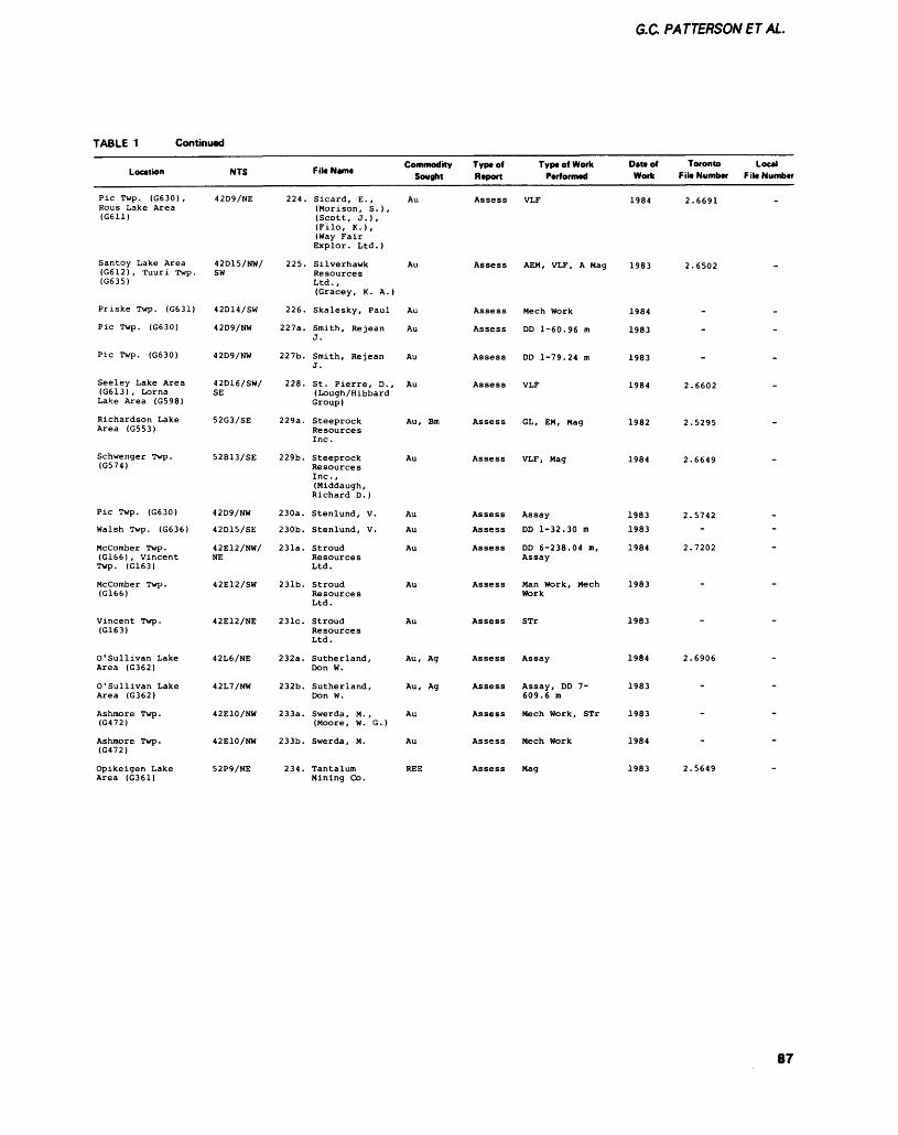
G.C PATTERSONET AL.
TABLE 1 Continued
Location
Pic Twp. (G630) , Rous Lake Area (G611)
Santoy Lake Area (G612) , Tuuri Twp. (G635)
Priske Twp. (G631)
Pic Twp. (G630)
Pic Twp. (G630)
Seeley Lake Area (G613), Lorna Lake Area (GS98)
Richardson Lake Area (G553)
Schwenger Twp. (G574)
Pic Twp. (G630)
Walsh Twp. (G636)
Mccomber Twp. (G166) , Vincent Twp. (G163)
Mccomber Twp . (G166)
Vincent Twp. (G163)
O'sullivan Lake Area (G362)
O'sullivan Lake Area (G362)
Ashmore Twp. (G472)
Ashmore Twp . (G472)
Opikeigen Lake Area (G361)
NTS
42D9/NE
42D15/NW/ SW
42D14/SW
42D9/NW
42D9/NW
42D16/SW/ SE
52G3/SE
52B13/SE
42D9/NW
42D15/SE
42E12/NW/ NE
42E12/SW
42E12/NE
42L6/NE
42L7/NW
42E10/NW
42E10/NW
52P9/NE
224.
225.
226.
227a.
227b.
228.
229a.
229b.
230a.
230b.
231a.
231b.
231c.
232a.
232b.
233a.
233b.
234.
File Hunt
Sicard, E., (Morison, S. ) , (Scott, J.), (Filo, K.), (Way Fair Explor. Ltd.)
Silverhawk Resources Ltd., (Gracey, K. A.)
Skalesky, Paul
Smith, Rejean J.
Smith, Rejean J.
St. Pierre, D., (Lough/Hibbard Group)
Steeprock Resources Inc.
Steeprock Resources Inc. , (Middaugh, Richard D.)
Stenlund, V.
Stenlund, V.
Stroud Resources Ltd.
Stroud Resources Ltd.
Stroud Resources Ltd.
Sutherland, Don W.
Sutherland, Don W.
Swerda, M. , (Moore, W. G.)
Swerda, M.
Tantalum Mining Co.
Commodity Sought
Au
Au
Au
Au
Au
Au
Au, Bm
Au
Au
Au
Au
Au
Au
Au, Ag
Au, Ag
Au
Au
REE
Typtof Report
Assess
Assess
Assess
Assess
Assess
Assess
Assess
Assess
Assess
Assess
Assess
Assess
Assess
Assess
Assess
Assess
Assess
Assess
Type of Work Performed
VLF
AEM, VLF, A Mag
Mech Work
DD 1-60.96 m
DD 1-79.24 m
VLF
GL, EM, Mag
VLF, Mag
Assay
DD 1-32.30 m
DD 6-238.04 m, Assay
Man Work, Mech Work
STr
Assay
Assay, DD 7- 609.6 m
Mech Work, STr
Mech Work
Mag
Oat* of Work
1984
1983
1984
1983
1983
1984
1982
1984
1983
1983
1984
1983
1983
1984
1983
1983
1984
1983
Toronto File Number
2.6691
2.6502
-
-
-
2.6602
2.5295
2.6649
2.5742-
2.7202
-
2.6906
-
-
-
2.5649
Local File Number
-
-
-
-
-
--
"
-
-
-
-
-
-
87
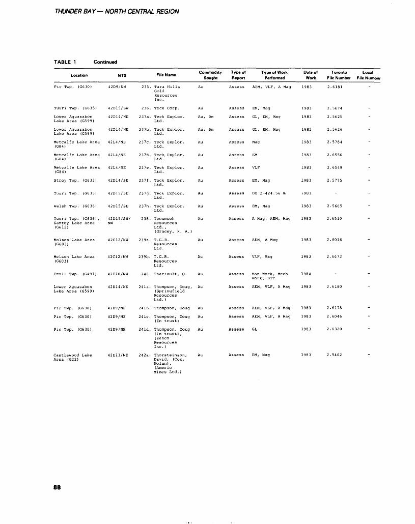
THUNDER BAY— NORTH CENTRAL REGION
TABLE 1 Continued
Location
Pic Twp. (G630)
Tuuri Twp. (G635)
Lower Aguasabon Lake Area (G599)
Lower Aguasabon Lake Area (G599)
Metcalfe Lake Area (G84)
Metcalfe Lake Area (G84)
Metcalfe Lake Area (G84)
Strey Twp. (G633)
Tuuri Twp. (G635)
Walsh Twp. (G636)
Tuuri Twp. (G636) , Santoy Lake Area (G612)
Molson Lake Area (G603)
Molson Lake Area (G603)
Croll Twp. (G491)
Lower Aguasabon Lake Area (G599)
Pic Twp. (G630)
Pic Twp. (G630)
Pic Twp. (G630)
Castlewood Lake Area (G22)
NTS
42D9/NW
42D15/SW
42D14/NE
42D14/NE
42L4/NE
42L4/NE
42L4/NE
42D14/SE
42D15/SE
42D15/SE
42D15/SW/ NW
42C12/NW
42C12/NW
42E10/NW
42D14/NE
42D9/NE
42D9/NE
42D9/NE
42E13/NE
235.
236.
237a.
237b.
237c.
237d.
237e.
237f .
237g.
237h.
238.
239a.
239b.
240.
241a.
241b.
241c.
241d.
242a.
..., t, Commodity File Name Sought
Tara Hills Au Gold Resources Inc .
Teck Corp. Au
Teck Explor. Au, Bm Ltd.
Teck Explor. Au, Bm Ltd.
Teck Explor. Au Ltd.
Teck, Exolor. Au Ltd.
Teck Explor. Au Ltd.
Teck Explor. Au Ltd.
Teck Explor. Au Ltd.
Teck Exolor. Au Ltd.
Tecumseh Au Resources Ltd. , (Gracey, K. A.)
T. G. R. Au Resources Ltd.
T . G . R . Au Resources Ltd.
Theriault, 0. Au
Thompson, Doug, Au (Springfield Resources Ltd. )
Thompson, Doug Au
Thompson, Doug Au (In trust)
Thompson, Doug Au (In trust) , (Zenco Resources Inc. )
Thorsteinson, Au David, (Cox, Nolan) , (Americ Mines Ltd.)
Type of Type of Work Report Performed
Assess AEM, VLF, A Mag
Assess EM, Mag
Assess GL, EM, Mag
Assess GL, EM, Mag
Assess Mag
Assess EM
Assess VLF
Assess EM, Mag
Assess DD 2-424.56 m
Assess EM, Mag
Assess A Mag, AEM, Mag
Assess AEM, A Mag
Assess VLF, Mag
Assess Man Work, Mech Work, STr
Assess AEM, VLF, A Mag
Assess AEM, VLF, A Mag
Assess AEM, VLF, A Mag
Assess GL
Assess EM, Mag
Date of Toronto Work File Number
1983 2.6181
1983 2.5674
1983 2.5625
1982 2.5626
1983 2.5784
1983 2.6550
1983 2.6549
1983 2.5775
1983
1983 2.5665
1983 2.6510
1983 2.6016
1983 2.6673
1984
1983 2.6180
1983 2.6178
1983 2.6046
1983 2.6320
1983 2.5402
Local File Number
-
-
-
-
-
-
-
-
-
"
"
-
-
-
88
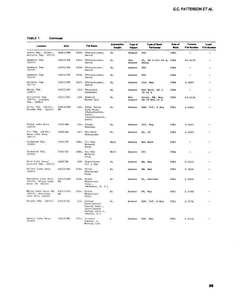
G.C. PATTERSON ET AL.
TABLE 1 Continued
Location
Irwin Twp. (G164 ) ,Walters Twp. (G171)
Summers Twp.(G165)
Summers Twp.(G165)
Summers Twp.(G165)
Walters Twp.(G171)
Houck Twp.(G487)
Errington Twp.(G479), LindseyTwp. (G483)
Strey Twp. (G633) ,Priske Twp. (G631)
Frond Lake Area(G252)
Pic Twp. (G630) ,Rous Lake Area(G611)
Cockeram Twp.(G184)
Cockeram Twp.(G184)
Rous Lake Area/Lecours Twp. (G611)
Molson Lake Area(G603)
Wabikoba Lake Area(G620) , White LakeArea (N) (G622)
White Lake Area (N)(G622) , WabikobaLake Area (G620)
Priske Twp. (G631)
Obonga Lake Area(GlOOl
NTS
42E12/NW
42E12/SW
42E12/SW
42E12/SW
42E12/NE
42E15/SE
42E11/NE
42D14/SE/NE
52P9/NW
42D9/NE
52H2/SE
52H2/SE
42D9/NE
42C12/NW
42C13/SW/SE
42C13/SE/sw
42D14/SE
52H14/NW
242b.
242c.
242d.
242e.
242f .
243.
244.
245.
246.
247.
248a.
248b.
249.
250a.
250b.
250c.
251.
252a.
-.. .. Commodity File Name , . Sought
Thorsteinson, AuDavid
Thorsteinson, AuDavid
Thorsteison, AuDavid
Thorsteinson, AuDavid
Thorsteinson, AuDavid
Thorwald, AuJohansen
Tombill AuMines Ltd.
Tong, Danny AuSung Wing,(Minichiello,Paul) ,(Zubroniewich,Earl)
Tough, AuSherman
Tri-Star AuResources
Tri-Ven MarlMineralCorp.
Tri-Ven MarlMineralCorp.
Tuscaloosa AuOil s, Gas
Tylox AuResourcesCorp.
Tylox AuResourcesCorp. ,(McGowan, R. J. )
Tylox AuResourcesCorp.
United AuContinentalEnergy Corp . ,(LivingstonEnergy Corp. ) ,(Korba, E.)
Uranerz UExplor. t.Mining Ltd.
Type of Type of Work Report Performed
Assess STr
Non GL, DD 2-215.49 m,Assess Assay
Assess STr
Assess STr
Assess VLF, Mag
Assess Man Work, DD 1-30.66 m
Non Assay, EM, Mag,Assess DD 15-894.34 m
Assess AEM, VLF, A Mag
Assess VLF, Mag
Assess GL, IP
Assess Man Work
Assess STr
Assess EM, Mag
Assess EM, Mag
Assess GL, Geochem
Assess EM, Mag
Assess AEM, VLF, A Mag
Assess VLF, Mag
Date of Work
1983
1982
1984
1984
1984
1984
1982
1983
1983
1983
1983
1984
1983
1983
1983
1983
1983
1981
Toronto File Number
.
63.4170
^
.
2.6657
.
63.4136
2.6262
2.5937
2.6295
.
.
2.5522
2.5826
2.5910
2.5749
2.5676
2.4214
Local F ile Number
.
,
.
.
.
-
-
.
.
.
-
.
.
.
.
-
.
.
89
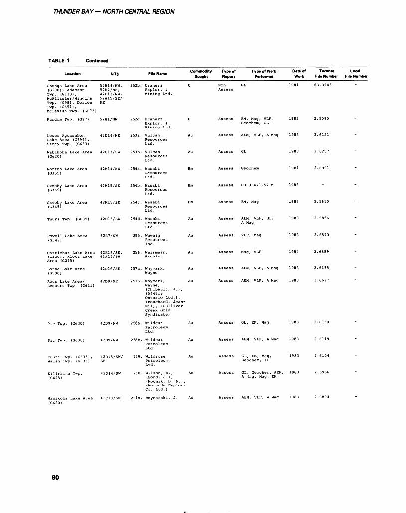
THUNDER BAY— NORTH CENTRAL REGION
TABLE 1 Continued
Location
Obonga Lake Area (G100), Adamson Twp. (G133), McAl lister /Wiggins Twp. (G98) , Dorion Twp. (G651), McTavish Twp. (G675)
Purdom Twp. (G97)
Lower Aguasabon Lake Area (G599) , Strey Twp. (G633)
Wabikoba Lake Area (G620)
Norton Lake Area (G355)
Oxtoby Lake Area (G365)
Oxtoby Lake Area (G365)
Tuuri Twp. (G635)
Powell Lake Area (G549)
Castlebar Lake Area (G220) , Klotz Lake Area (G295)
Lorna Lake Area (G598)
Rous Lake Area/ Lecours Twp. (G611)
Pic Twp. (G630)
Pic Twp. (G630)
Tuuri Twp. (G635) , Walsh Twp. (G636)
NTS
52H14/NW, 52H2/NE, 42D13/NW, 52A15/SE/NE
52H1/NW
42D14/NE
42C13/SW
42M14/NW
42M15/SE
42M15/SE
42D15/SW
52B7/NW
42E16/SE, 42F13/SW
42D16/SE
42D9/NE
42D9/NW
42D9/NW
42D15/SW/ SE
,., .. Commodity File Nun* Sought
252b. Uranerz U Explor. d Mining Ltd.
252c. Uranerz U Explor. t Mining Ltd.
253a. Vulcan Au ResourcesLtd.
253b. Vulcan Au Resources Ltd.
254a. Wasabi Bm Resources Ltd.
254b. Wasabi Bm Resources Ltd.
254c. Wasabi Bm Resources Ltd.
2S4d. Wasabi Au Resources Ltd.
255. Wawaig Au Resources Inc.
256. Weirmeir, Au Archie
257a. Whymark, Au Wayne
257b. Whymark, Au Wayne, (Thibault, J.), (544818 Ontario Ltd. ) , (Bouchard, Jean- Nil), (Gulliver Creek Gold Syndicate)
258a. Wildcat Au Petroleum Ltd.
258b. Wildcat Au Petroleum Ltd.
259. Wildrose Au Petroleum Ltd.
Type of Type of Work Report Performed
Non GL Assess
Assess EM, Mag, VLF, Geochem, GL
Assess AEM, VLF, A Mag
Assess GL
Assess Geochem
Assess DD 3-471.52 m
Assess EM, Mag
Assess AEM, VLF, GL, A Mag
Assess VLF, Mag
Assess Mag, VLF
Assess AEM, VLF, A Mag
Assess AEM, VLF, A Mag
Assess GL, EM, Mag
Assess AEM, VLF, A Mag
Assess GL, EM, Mag, Geochem, IP
Date of Toronto Work File Number
1981 63.3943
1982 2.5090
1983 2.6121
1983 2.6257
1981 2.6991
1983
1983 2.5650
1983 2.5856
1983 2.6573
1984 2.6689
1983 2.6155
1983 2.6627
1983 2.6130
1983 2.6119
1983 2.6104
Local File Number
"
~
"~
Killraine Twp. (G625)
42D14/SW 260. Wilson, A., Au (Bond, J.), (Mocnik, D. N.), (Noranda Explor. Co. Ltd.)
Wabikoba Lake Area 42C13/SW (G620)
261a. Woynarski, J. Au
Assess GL, Geochem, AEM, 1983 A Mag, Mag, EM
Assess AEM, VLF, A Mag 1983
90
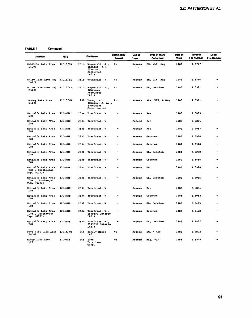
G.C PATTERSONETAL.
TABLE 1 Continued
Location
Wabikoba Lake Area (G620)
White Lake Area (N) (G622)
White Lake Area (N) (G622)
Santoy Lake Area (G612)
Metcalfe Lake Area (G84)
Metcalfe Lake Area (G84)
Metcalfe Lake Area (G84)
Metcalfe Lake Area (G84)
Metcalfe Lake Area (G84)
Metcalfe Lake Area (G84)
Metcalfe Lake Area (G84)
Metcalfe Lake Area (G84), Oboshkegan Twp. (G173)
Metcalfe Lake Area (G84), Oboshkegan Twp. (G173)
Metcalfe Lake Area (G84)
Metcalfe Lake Area (G84)
Metcalfe Lake Area (G84)
Metcalfe Lake Area (G84), Oboshkegan Twp. (G173)
Metcalfe Lake Area (G84)
Pays Plat Lake Area (G606)
Mussy Lake Area (M29)
NTS
42C13/SW
42C13/SE
42C13/SE
42D15/NW
42L4/NE
42L4/NE
42L4/NE
42L4/NE
42L4/NE
42L4/NE
42L4/NE
42L4/NE
42L4/NE
42L4/NE
42L4/NE
42L4/NE
42L4/NE
42L4/NE
42D14/NW
42D9/SE
261b.
261c.
261d.
262.
263a.
263b.
263c.
263d.
263e.
263f .
263g.
263h.
263i.
263J.
263k.
2631.
263m.
263n.
264.
265.
-.. -. Commodity File Name , . Sought
Woynarski, J., Au (Kodrat, J.), (Canova Resources Ltd.)
Woynarski, J. Au
Woynarski, J., Au (Carrera Resources Ltd.)
Young , S . , Au (Gracey, K. A.), (Orequest Consultants)
Yzerdraat, W.
Yzerdraat, W.
Yzerdraat, W.
Yzerdraat, W.
Yzerdraat, W.
Yzerdraat, W.
Yzerdraat, W.
Yzerdraat, W.
Yzerdraat, W.
Yzerdraat, W.
Yzerdraat, W.
Yzerdraat, W.
Yzerdraat, W., (519899 Ontario Ltd.)
Yzerdraat, W., (519899 Ontario Ltd.)
Zahavy Mines Au Ltd.
Zone Au Petroleum Corp.
Type of Report
Assess
Assess
Assess
Assess
Assess
Assess
Assess
Assess
Assess
Assess
Assess
Assess
Assess
Assess
Assess
Assess
Assess
Assess
Assess
Assess
Type of Work Date of Performed Work
EM, VLF, Mag 1983
EM, VLF, Mag 1983
GL, Geochem 1983
AEM, VLF, A Mag 1983
Res 1983
Res 1983
Res 1983
Geochem 1983
Geochem 1982
GL, Geochem 1984
Geochem 1982
GL 1983
GL, Geochem 1983
Res 1983
Geochem 1984
GL, Geochem 1983
Geochem 1983
GL, Geochem 1983
EM, A Mag 1983
Mag, VLF 1984
Toronto Local F ile Number f ile Number
2.
2.
2.
2.
2.
2.
2.
2.
2.
2.
2.
2.
2.
2.
2.
2.
2.
2.
2.
2.
5747
5746
5911
6511
5883
5885
5987
5988
5918
6298
5888
5986
5985
5884
6052
6429
6428
6427
5802
6575
-
-
-
-
-
-
-
-
~
~
-
-
-
~
~
-
~
91
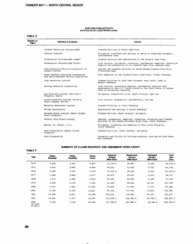
THUNDER BAY- NORTH CENTRAL REGION
TABLE 2
EXPLORATION ACTIVITYON PATENTED OR LEASED MINING LANDS
Numbtr on Figure Individual or Company Activity
Canamax Resources Incorporated
Cominco Limited
Corporation Falconbridge Copper
Corporation Falconbridge Nickel
Cumo Resources Mining Corporation of Canada Limited
Great Western Petroleum Corporation and Anglo-Canadian Mining Corporation
lean Resources Limited
Kenergy Resource Corporation
Lac Minerals Limited (William's Property, Hemlo)
Lytton Minerals Limited (Ontario Paper Company Option)
Metalore Resources Limited
Micham Exploration
Noranda Mines Limited (Hemlo Golden Giant Property)
Phoenix Gold Mines Limited
Reiter, M. (Green, J.J.)
Teck Corporation (Hemlo Corona Property)
Teck Corporation
Diamond drilling in Klotz Lake Area
Stripping, trenching and geology on Kenty or Langridge Prospect, Conglomerate Lake
Diamond drilling and exploration in the V'inston Lake Area
Line cutting, stripping, trenching, geochemical sampling, geological mapping and geophysics on the Hamnond Reef Mine, Marmion Lake
Geology and diamond drilling at Consolidated Louanna Gold Mine, O'sullivan Lake
Bulk sampling at the Crooked Green Creek Mine, Pifher Township
Diamond drilling on Jack Lake Prospect near Tyrell Lake in Mccaul Township
Line cutting, Geological mapping, geochemical sampling and geophysics on the J.J. Ualsh claims on the north shore of Sapawe Lake in Hutchinson Township
Stripping, diamond drilling, shaft sinking, open pit
Line cutting, geophysics, geochemistry, geology
Diamond drilling in Irwin Township
Exploration and geology in Syine Township
Diamond driling, shaft sinking, stripping
Geology, geophysics, sampling, trenching, stripping and diamond drillina on the Quebec-Sturaeon River Mine, Irwin Township
Stripping, trenching and sampling on Four-claim Property, Irwin Township
Diamond drilling, shaft sinking, stripping
Screening and milling of tailings material from Leitch Gold Mine, Eva Township
SUMMARY OF CLAIMS RECORDED AND ASSESSMENT WORK CREDITTABLE 3
Yea*
1974
1975
1976
1977
1978
1979
1980
1981
1982
1983
1984 (to end of Nov.)
Claims R •corded
3,305
3,436
2,364
1,964
3,517
3,099
5,527
6,768
10,266
15,835
7,978
Claim*Cancelled
3
2
3
2
1
2
1
4
4
1
7
,391
,869
,552
,966
,982
,139
,836
,162
,613
,537
,139
Claims Active
5,837
6,404
6,079
5,077
6,612
7,554
11,245
13,851
19,349
33,547
34,560
Diamond Drilling
(Man Day*)
37
38
52
24
20
11
53
55
133
113
137
,130.5
,652
,551.6
,879
,182
,528
,418
,256
,035
,554.3
,996.8
Geophysical Surveys
(Man Days)
26
53
29
25
20
69
57
172
114
439
541
,061
,020
,504
,601
,589
,612
,483
,366
,805
,992.8
,887.4
Geological Surveys
(Man Days)
4,
4,
4,
4,
6,
14,
5,
13,
24,
64,
85
300
700
600
870
206
727
372
863
437
789.1
,446.6
Total Man Days
80,559.2
105,338
101,025.8
68,727
51,299
101,799
127,288
256,686
292,273
664,891.3
896,302.2
92
G.C PATTERSON ET AL.
NORTH RIM PROPERTIESExploration activity has been fo cused on 2 geological environ ments in this area. The first is as sociated with a band of felsic vol canic rocks (lapilli tuffs and quartz-eye sericite schists). The area was mapped by Milne (1968). The felsic volcanic rocks form a curving band 500 m wide stretch ing from Theresa Lake in the east to the Black River in the west, across Pryme Energy Resources Limited-March Resources Limited (Noranda Incorporated option), Lenora Explorations Limited- Argentex Resource Exploration Corporation (Homestake Mineral Development Company option) and Eden Roc Mineral Corpora tion properties. Pillowed mafic metavolcanic rocks with interflow metasedimentary rocks occur to the north. Conglomerates and silt- stones which have been intruded by the Musher Lake Pluton occur to the south. The general stratig raphy is similar to the main de posit area (Patterson et al. 1984).
The most significant gold val ues reported are from the Mcin tyre copper-nickel showing on the Pryme Energy Resources Limited- March Resources Limited proper ty, 3 km east of Highway 614. Results from Hole A2 returned val ues of 0.24 ounce gold per ton across 8.2 feet (assays by Falcon bridge Nickel Mines Limited, 1970, in Resident Geologist Files, Ontario Ministry of Natural Re sources, Thunder Bay). Drilling re sults by Noranda Incorporated in 1983 on this property report the existence of green mica, "oellacherite" within a felsic vol caniclastic unit (DDH PN4, Resi dent Geologist Files, Ontario Min istry of Natural Resurces, Thunder Bay).
On the Lenora Explorations Limited-Argentex Resource Explo ration Corporation property, 4 km west of Highway 614 near the Black River access road, trenching has exposed a series of pyrite-rich tuffs. Assays for gold are low but anomalous, up to 320 ppb (Geoscience Laboratories, Ontario
Geological Survey, Toronto). Drill logs (DDH 83B-3) from Homestake Mineral Development Company (Resident Geologist Files, Ontario Ministry of Natural Resources, Thunder Bay) reports the presence of green mica.
On the Norman Resources Limited property, just west of the Theresa Lake (under dispute), green mica associated with tour maline occurs in a quartz-eye sericite schist (G. Cavey, Geologi cal Consultant, OreQuest Limited, Vancouver, personal communica tion, 1983).
The second type of mineraliza tion is associated with pyrite- mag netite cherty "lean" iron forma tions which occur as interflow metasedimentary rocks within mafic metavolcanic rocks. Miner alization of this type occurs just to the north of the felsic metavolcanic rocks on the properties of Qued Resources Corporation, Midnapore Resources Incorporated, and possi bly United Westland Resources Limited and Score Resources Limited.
On the Qued Resources Cor poration property, l km west of Theresa Lake, geochemistry, in duced polarization, and trenching have traced a number of highly deformed pyritic-cherts across the property. Grab and channel sam ples from trenches returned 0.012 to 0.081 ounce gold per ton across 5 m (George Cross News Letter, February 27, 1984). Visible gold was noted in the nose of a small fold within sheared mafic metavol canic rocks (J. Dumouchel, Con sultant, OreQuest Limited, Van couver, personal communication, 1984).
Drilling on the Midnapore Re sources Incorporated property, southeast of Theresa Lake, inter sected pyritic chert within sheared amphibolites. Gold values up to 0.3 gram gold per tonne across l m were reported (Resident Geolo gist Files, Ontario Ministry of Nat ural Resources, Thunder Bay).
On the Score Resources Limit ed property, 2 km north of the Town of Mobert, a trench, 500 m long, exposed a series of
metasedimentary rocks which have been intruded by the Cedar Lake Pluton. A sheared amphibolite, carrying 5 to ICWfo pyrite, assayed 0.08 ounce gold per ton (Geoscience Laboratories, Ontario Geological Survey, Toronto).
PIC RIVER PROPERTIESThese properties are located along the Pic River 8 km northeast of Marathon. The area was mapped by Milne (1967) and is underlain by felsic pyroclastic rocks on the west and mafic metavolcanic rocks to the north and east. Exploration has focused on and near a narrow unit of metasedimentary rocks con sisting of graphitic schists, pelites, and massive sulphide mineraliza tion. These metasedimentary rocks occur between the felsic and mafic metavolcanic units. This horizon occurs on the following properties: Delhi Pacific Resources Limited, Brown-McDade Resources Limit ed, East West Resource Corpora tion - Colby Resources Corpora tion, Gowganda Resources Incor porated, Steely Lake Mines Limit ed, Westam Oil Limited, Boram Oil Limited, and Carlson Mines Limited.
An occurrence is known on the Gowganda Resources Incorpo rated property (optioned to Homestake Mineral Development Company). In 1971, Kerr-Addison Mines Limited intersected 18.2 feet (5.5 m) of 0.08 ounce gold per ton and 1.16^o zinc in drill core (Resident Geologist Files, Ontario Ministry of Natural Resources, Thunder Bay). The presence of green mica in a quartz-eye sericite schist associated with the mineral ization was also reported. A lake bottom geochemical survey con ducted by the Geological Survey of Canada reported anomalous values in zinc, copper, lead, and mercury (Geological Survey of Canada, Open File Report 746).
On the East West Resource Corporation property (optioned to Homestake Mineral Development Company), a grab sample from a quartz vein cutting felsic tuffs re turned 2972 ppb gold and a grab sample of a fine-grained siliceous
93
THUNDER BAY- NORTH CENTRAL REGION
tuff associated with green mica re turned 1673 ppb gold. Whole rock assays of the felsic metavolcanic rocks showed elevated potassium values (Resident Geologist Files, Ontario Ministry of Natural Re sources, Thunder Bay).
On the Colby Resources Cor poration property (optioned to Homestake Mineral Development Company) green mica was report ed at 2 locations; in a crystal lapilli tuff unit and associated with car bonate alteration with quartz- ladder veining. An anomalous gold assay of 498 ppb was obtained across a 4-foot (1.2 m) channel containing quartz- tourmaline veins. A grab sample from an asso ciated fine siliceous pyritic tuff re turned 384 ppb gold (Resident Ge ologist Files, Ontario Ministry of Natural Resources, Thunder Bay.
BARITE OCCURRENCESA barite-rich horizon has been identified in the Hemio area by OreQuest Consultants Limited. The western end of the horizon is located 10 km east of Marathon. On a regional scale, the barite-rich horizon occurs at the contact be tween mafic pillowed metavolcanic rocks to the south and metasedimentary and felsic metavolcanic rocks to the north. For a detailed description, see Pat terson (1984). The baritic unit which trends 085C and dips 80CS can be traced geologically and by geophysics an additional 6 km east across properties held by Cal Dynamics Corporation, Kadrey Energy Corporation, Padre Re sources Limited (optioned to Noranda Incorporated) and North ern Eagle Mines Limited (optioned to Noranda Incorporated). Other properties in the area optioned by Noranda Mines Limited include El Paso Energy Corporation, Inter- Continental Energy Corporation, Devonian Resources Limited, and the Nexus Resource Corporation.
A possible extension of the barite rich horizon occurs farther to the east on the Contact Ventures Limited property (optioned to Nex us Resource Corporation and sub sequently to Noranda Incorporat
ed), which lies directly on strike with the barite occurrence on the Northern Eagle Mines Limited property. A series of trenches have exposed quartz-eye sericite schists in contact with mafic metavolcanic rocks to the south and metasedimentary rocks to the north. Within the sericite schist are massive sulphides which have re turned up to 0.8 l^o zinc and 168 ppm molybdenum across 1.01 m (unpublished report, K. Cameron, Resident Geologist Files, Ontario Ministry of Natural Resources, Thunder Bay).
LYTTON MINERALS LIMITED PROPERTYLytton Minerals Limited optioned the Heron Bay Gold Mine and the Bowhill Mines occurrence from V. Stenlund. The property is located near the Town of Heron Bay. Wahl and Pearson (1984) de scribed the geology of the property:
"The volcanic succession on the property is about 3 km thick and comprises a lower sequence of mafic to intermediate flows and pyroclastics and an upper se quence felsic pyroclastic rock. The lower unit consists of feldspar por phyry flows which are overlain and intercalated with dacitic flows. Overlying these flows is a thin metasiltstone-argillite unit, which marks a brief volcanic hiatus be fore eruption of a thick section of dacitic pyroclastic rocks. The top of this dacitic pyroclastic section grades into a transitional unit about 500 m thick which com prises a wide variety of felsic to intermediate and locally mafic vol canic rocks including the impor tant auriferous pyritic quartz- sericite±talc units. This zone marks the transition between the lower mafic to intermediate vol canics and the overlying thick suc cession of felsic volcanics, chiefly tuff breccia and agglomerates. The favorable units for gold mineraliza tion appear to be exclusively con fined to this transitional zone."
Lytton Minerals Limited car ried out a large drill program which has outlined an anomalous zone 1067 m long striking at OSO0
and dipping 600 to the south. Val ues in the zone vary from 0.02 to 0.06 ounce gold per ton across 0.4 to l m (Field Trip Guide, Pee- Kong-Gay Property, Resident Ge ologist Files, Ontario Ministry of Natural Resources, Thunder Bay). Values in quartz veins up to 4.83 ounce gold per ton have been re ported (The Northern Miner, Feb ruary 23, 1984, p.3).
Similar occurrences are known on the Esso Resources Limited property to the west (Muir 1982).
GOLDEN SCEPTRE, NORTH ZONENoranda Incorporated announced a new Hemlo zone in The North ern Miner, May 10, 1984:
"The eight holes have outlined a zone about 700 feet long averag ing 0.102 oz of gold per ton cut and 0.104 oz per ton (uncut), across an average true width of 35 feet. The holes were spaced 100 feet apart and intersected the zone at an average depth of 50 feet with about 6 feet of overburden.
The new zone has been traced to within 900 feet of the Golden Sceptre's eastern boundary and run east-west about 1,600 feet south of the north boundary."
The zone has been exposed in a series of trenches on the Golden Sceptre Resources Limited proper ty. The mineralization occurs near the top of a felsic package of rocks (crystal tuffs, lapilli tuffs, and quartz-eye sericite schists). These felsic rocks make up the footwall of the main Hemlo deposit, 3 km to the east. The host rocks are highly deformed metasedimentary rocks, possibly conglomerates. A series of narrow chloritic slips with silicified margins l to 2 cm wide cut the metasedimentary rocks. Mineralization consists of native gold, molybdenite, and pyrite.
OTHER OCCURRENCES AND EXPLORATION PROGRAMSNo attempt has been made to sum marize all exploration programs within the Hemlo belt (estimated at over 100). Rather, programs which have reported mineralization
94
G.C. PATTERSONETAL.
and/or alteration similar to the Hemlo deposit are included.1. A joint venture program be tween Noranda Incorporated and Teck Corporation has been carry ing out a deep drill program on the Interlake Development Corpora tion property in an attempt to in tersect the down dip extension of the main Hemlo deposit. One of the holes, north of the Golden Sceptre Resources Limited proper ty, intersected 3.3 feet (1m) as saying 0.093 ounce gold per ton from 5459.3 to 5462,6 feet (1664 to 1665 m) and 14.4 feet (4.4 m) grading 0.17 ounce gold per ton from 5587.3 to 5601.7 feet (1703 to 1707.4 m) (The Northern Min er, February 9, 1984, p.l).2. Drilling by a private company, Ontario 117484, approximately 2 km south of the International Cor ona Resources Limited property has intersected mineralization within the contact zone between the Playter Harbour mafic metavolcanic rocks and the Pukaskwa Gneissic Complex. Val ues reported include 3.3 feet (l m) of 0.04 ounce gold per ton; 2.3 feet (0.7 m) of 0.57 ounce silver per ton and 22 ounces molybdenum per ton (Q.07%), and 1.7 feet (0.5 m) of 0.015 ounce gold per ton (The Northern Miner, November3. 1983, p.3).3. The Lynx-Canada Explora tions Limited-Sparton Resources Limited joint venture property is located l .6 km north of the Goliath Gold Mines Limited property. Drilling on a series of geochemical and VLF anomalies intersected pyrite-pyrrhotite mineralization grading up to 0.02 ounce gold per ton across 5 feet (1.5 m) (The Northern Miner, November 10, 1983, p.3).4. A program of mapping on the Aurelian Developers Limited prop erty, 7 km north of Rous Lake, outlined a number of quartz lenses and veins within feldspathic ar- enites (Resident Geologist Files, Ontario Ministry of Natural Re sources, Thunder Bay).5. The Walhalla ResourcesLimited-Maple Leaf PetroleumLimited joint venture property is
located northeast of Pukaskwa Park. An extensive program of geological mapping, geochemistry, geophysics, and drilling defined a number of alteration zones. The zones are hosted in sheared and altered felsic rocks. Alteration con sists of silicification, carbonatiza tion, and sericitization with minor green mica and tourmaline. A se ries of whole rock assays taken across the west altered zone showed K2O and Na2O increasing to the north. The highest gold as say reported was 285 ppb (Resident Geologist Files, Ontario Ministry of Natural Resources, Thunder Bay).6. The Bel-Air Resources Limited property (optioned to Westfield Minerals Limited) is located due south of the Golden Sceptre Re sources Limited property. A pro gram of geological mapping, trenching, electromagnetic, and magnetometer surveys, and dia mond drilling was carried out. A zone of pyrite-pyrrhotite-bearing chert and tuff units was traced 2400 feet (731.5 m) across the property. Alteration consisting of green mica and sericite is associ ated with the mineralization. The highest assay reported was 0.002 ounce gold per ton (Resident Ge ologist Files, Ontario Ministry of Natural Resources, Thunder Bay).
AMETHYST IN THE THUNDER BAY REGION________INTRODUCTIONThe amethyst mining industry in the Thunder Bay area has had a long history. The existence of ame thyst was first noted by the French explorers Radisson and Groseil liers in 1662. In the mid- to late- 1800s, amethyst was mined in as sociation with silver and base met als. The first recorded amethyst mine was in 1862 when the McEachern brothers mined ame thyst from the Amethyst Harbour area (15 km east of Thunder Bay). The material was sold in Toronto, Niagara Falls, Pikes Peak, and Hot Springs (McKellar 1908).
Interest in the Thunder Bay amethyst deposits declined sharply around the turn of the century
with increased production from Brazil. The Thunder Bay amethyst occurrences remained a mineralog ical oddity until the 1960s. At this time, Rudy Hartviksen, following up the discovery of amethyst near Elbow Lake, started mining ame thyst and selling it to mineral col lectors and the building stone in dustry. Amethyst mining received a considerable boost, when in 1975, the Honourable Leo Bernier announced in the Ontario Legisla ture that amethyst would be On tario's official mineral.
Currently in the Thunder Bay area, there are 7 producing mines and 8 past producing mines. Ap proximately 100 000 people a year visit the amethyst mines or shops in the region. The amethyst indus try creates jobs for approximately 50 to 75 people through mining, the sale of specimens, and the pro duction of jewelry.
REGIONAL GEOLOGYThe rocks of the Thunder Bay area are Precambrian in age. The Ar chean rocks consist of folded mafic metvolcanic and metasedimentary rocks intruded by quartz- monzonites which all belong to the Shebandowan "Greenstone Belt". Unconformably deposited on the Archean basement are a series of nearly flat-lying sedimentary rocks of the Gunflint Formation, Rove Formation (1850 Ma, Goldich 1972) and Sibley Group rocks (1300 Ma, Wanless and Loveridge 1976). All rocks are intruded by Logan diabase sills. The veins and breccia zones that host the ame thyst cut all rock types, but are most common in Archean granitic rocks at or near the unconformity with the Sibley Group rocks. The veins appear to belong to the gen eral class of Dorion lead-zinc veins described by Franklin and Mitchell (1977).
The veins occupy fault zones of 3 general types: 1) both walls are Archean; 2) one wall is Ar chean, l wall is Sibley Group; 3) both walls Sibley Group. The veins generally contain angular blocks of altered wallrocks in a matrix of quartz, carbonate, and barite of
95
THUNDER BAY— NORTH CENTRAL REGION
varying proportions. Commonly, there are clasts of breccia within the vein suggesting multiple move ments. The amethyst occurs in vugs filled with fault gouge which is locally referred to as clay. The vugs are generally 5 to 15 cm in size, but vugs up to l by 3 by 10 m have been observed. These are lin ed with amethyst crystals up to 15 cm in size at the base. Individual veins are up to 10 m across and can be traced up to 500 m along strike. Usually only the pyramid faces of the amethyst are well de veloped.
AMETHYST AND ITS PROPERTIESWork on the colouring agent in amethyst by Dennen and Puckett (1972) has demonstrated that the violet colour is due to iron-rich centres which have been activated by radiation. This in part explains why the highest quality amethyst is associted with veins in granitic rocks at or near the unconformity with the Sibley Group sedimentary rocks. A number of unconformity- type uranium occurrences are known in the area and some of the amethyst veins were examined for their uranium potential. On the "17." Property, near Crystal Beach, the veins can be traced from the granites into Gunflint Formation cherts. The quartz in veins hosted by granites is dark violet, while in the Gunflint Formation, the quartz is colourless. A similar effect can be noted in fluorite, which is green in Gunflint Formation rocks and purple in granitic rocks.
Work by S. Lukinuk (Ame thyst Mine Panorama) and R. MacFagin (consultant) has demon strated that the amethyst from the Thunder Bay area has a number of unusual properties.1. In deeply coloured minerals such as amethyst, the colour varies with the orientation of the crystal (dichroism). At the Amethyst Mine Panorama, the amethyst is deep purple in a direction at right an gles to the c-axis and a pale smokey colour parallel to the c- axis. This means that the orienta tion of the crystal during cutting is
crucial to producing a stone of good colour.2. Another unusual feature is the change in colour with the type of light incident on the sample (absorption). In sunlight the ame thyst has a distinct cool blue-violet colour, while in tungsten light the amethyst has a warm red-violet colour.3. When an amethyst crystal is cut, a zonation parallel to the cry stal face is commonly observed. In dividual bands are from l to 15 mm wide, with as many as 16 bands noted within a single crystal. The colour varies from violet to smokey to white. The colour also varies within a single band, being typically darker where crystal faces meet. In larger zones irregu lar wave bands produce a typical 6-sector pattern (Dauphine twins).
Recently, these unusual prop erties of amethyst have been taken into account by Amethyst Mine Panorama, and the result is some of the highest quality amethyst ever produced locally. Currently, a number of mining methods are be ing experimented with at the Ame thyst Mine Panorama to increase the recovery of faceting quality amethyst.
PROPERTY DESCRIPTIONS Amethyst Mine PanoramaFormerly known as the Thunder Bay Amethyst Mine, this property has been in production since 1962. The mine is located at the eastern end of Loon Lake, McTavish Township. The area has been mapped by the Ontario Geological Survey, (Mcilwaine 1971). The property is underlain by biotite- quartz monzonites. A number of strongly developed lineaments oc cur in the area at 000 to 0200 and 050 to OSO0. The main quarry (25 by 175 by 8 m) exposes a series of 4 parallel faults which trend at HO0 and dip at 65 to 75 CS, each with an associated quartz breccia zone. The faults are marked by zones of muscovite schist, l to 1.5 m in width, within the quanz mon zonite host rock. The combined ef fect is a complex network of
quartz veins across a width of 25 m.
The composition of the vein breccia is highly variable and con sists of:
- 10-8 5^o angular clasts of quartz monzonite and Sibley Group sandstone. The plagioclase within the mon zonite is generally altered to yellowish sericite. Typically, the Sibley Group rocks are bleached to a pale brown col our. The clasts are commonly 10 cm across, but clasts up to 2 m occur.- lQ-70% quartz, usually white in colour. Typically, there are several generations of quartz rimming the clasts.- S-30% vugs. These vugs vary in size from 3 cm by 5 cm by 5 cm to l m by 3 m by 10 m. Commonly they are filled with red-brown clay (fault gouge). Amethyst cry stals up to 20 cm in size occur loose within the clay, as well as lining the vugs.At the present, the main meth
od of mining amethyst is by blast ing small benches l m by l m by 7 m followed by hand-sorting of the muck. The clay with the loose amethyst crystals is removed from the vugs and sent to a washing table where the crystals are liber ated from the clay. The crystals are then sorted into various grades: tumbling, building stone, and specimen. Only recently are some of the larger crystals being crushed to 5 cm in size in order to recover faceting quality amethyst.
Marino Mountain PropertyThe property is located in the southern half of Mineral Location 12, McTavish Township, adjoining the Ontario Gem Company prop erty to the south. The regional ge ology was mapped by Mcilwaine (1971). A series of north-south elongated knobs of Archean biotite-quartz monzonite are sur rounded by Sibley Group siltstones and mudstones. Amethyst occurs in 2 distinct geological environ ments:
96
G.C. PATTERSONET AL.
1. A series of trenches have ex posed a quartz breccia zone along the flank of a granitic knob. The granitic rocks occur to the north east and the Sibley Group rocks to the southwest. The breccia zone occurs near the contact between the Archean and the Sibley. At the main trench, the zone can be traced for 36.6 m, with a 3 to 5 m width. A vug 0.6 by 2.4 by 3.7 m partly filled with clay, has recently been discovered. This vug contains amethyst crystals up to 6 cm across.2. Approximately 100 m to the north of the breccia zone, a series of cherty Sibley Group stromato lites occur as mounds up to l m in size. The stromatolites rest directly on Archean granitic rocks. The stromatolites are made up of layers of chert l mm to l cm thick, vary ing in colour from white to grey to black. Sections have been brecciat ed and cemented together by white quartz. The chert is commonly draped over irregularities occur ring on the unconformity.
Within the chert are vuggy sections (2 by 15 by 5 cm) with light to dark amethystine quartz; individual crystals are up to 2 cm across, often with a hematite coat ing or yellow-brown barite overg rowths.
SHEBANDOWAN AREAJALNA RESOURCES LIMITED GOLD CREEK PROPERTYMuch of the exploration activity in the Shebandowan area has been fo cused on the Jalna Resources Limited's Gold Creek property in the southeastern portion of Duck worth Township (16 km southeast of the Village of Shebandowan). The area has recently been opened up by a series of logging roads.
Duckworth Township is un derlain by the Shebandowan metavolcanic- metasedimentary belt. The belt can be divided into 4 groups with an east-west trend. The northern group consists of mafic pillowed metavolcanic rocks, with top directions to the south. The Crayfish Creek Fault sepa rates the mafic metavolcanic rocks
from a unit of metasedimentary rocks to the south. The metasedimentary rocks are fluviatile conglomerates, wackes, arkoses, argillites, chert, and iron stone. These are similar to Timiskaming type sedimentary rocks (M.W. Carter, Geologist, On tario Geological Survey, Toronto, personal communication, 1984). South of the sedimentary rocks is a group of felsic to intermediate metavolcanic rocks (tuffs to pyroclastic breccia). These metavolcanic rocks are host to the Jalna occurrence. A quartz mon zonite stock underlies the southern part of the township. All rocks are cut by diorite and gabbro dikes.
The Goldore Joint Venture (Jalna Resources Limited (oper ator), GLE Resources Limited, Sutherland Resources Limited, and Austin Resources Incorporated) has carried out a program of geo logical mapping, geochemistry, trenching, and geophysical sur veys. The program discovered 4 zones with anomalous gold values:1. The Ternowesky Zone is a shear zone up to 2 m wide, consist ing of a quartz vein hosted in a sericite schist (altered quartz feld spar porphyry tuff). The shear zone has been traced for 15 m along strike. The quartz vein is from 3 to 10 cm wide and contains pyrite, galena, tetrahedrite, chal copyrite, and tellurides. Assays up to 4.07 ounces gold per ton and 42.2 ounces silver per ton have been obtained (Geoscience Labora tories, Ontario Geological Survey, Toronto). In the associated sericite schist a pale green mica has been noted and assays of 1880 ppb gold have been obtained (Jalna News Release, December 30, 1983).2. The Creek Zone which paral lels Gold Creek appears to be an extension of the Quartzite Mine Zone worked in the 1890s. An ex tensive orebody of country rock as saying S6.00 to S8.00 per ton (price of S20.00 gold) was reported (Blue 1896, p. 113). Recent assays have returned 205 ppb gold along a zone which can be traced 3200 feet (975 m) (Jalna News Release, December 30, 1983).
3. The North Zone has been ex posed by trenching and stripping for 48.8 m along strike and 1.5 m to 4.3 m across. The host rock is a complex felsic breccia with pods and lenses of amphibole. A num ber of silicified zones (chert) con taining 3 to 15^o pyrite occur with in the felsic breccia. Values from 0.05 to 0.12 ounce gold per ton, with an average of 0.10 ounce gold per ton, have been reported across the zone (Jalna News Release, May 22, 1984).4. The South Zone is hosted with in a pyrite-bearing felsic breccia. Gold values of up to 360 ppb have been obtained (Geoscience Labora tories, Ontario Geological Survey, Toronto).
CURRAN BAY RESOURCE LIMITED (POWELL SHOWING)The property is located 90 km west-southwest of Thunder Bay, on the northern shore of Saganaga Lake. Diamond drill logs indicate the presence of quartz veins carry ing pyrite within a sheared metavolcanic host. Hole 84-2 inter sected 0.72 ounce gold per ton across 4.6 m (Resident Geologist Files, Ontario Ministry of Natural Resources, Thunder Bay).
BEARDMORE-GERALDTON ECONOMIC GEOLOGIST PROGRAM————————J.K. Mason and G.D. WhiteResource Geologists, Ontario Min istry of Natural Resources, Thun der Bay.
INTRODUCTIONThe Beardmore-Geraldton Eco nomic Geologist Program is a Northern Ontario Rural Develop ment Agreement (NORDA) pro gram funded jointly by the Canada Department of Regional Industrial Expansion and the Ontario Min istry of Northern Affairs. The pro gram is staffed by John Mason and Gerry White. The object of the program is to stimulate exploration activity in the Beardmore- Geraldton area by assisting pros pectors and mining companies with property visits, sampling,
97
THUNDER BAY— NORTH CENTRAL REGION
TABLE 4. EXPLORATION PROGRAMS IN THE BEARDMORE - GERALDTON AREA 1984.
Company Township/Area ExplorationAnglo Canadian Mining Corporation (Great Western Petroleum Corporation)
BP Resources Canada Incorporated
BP Resources Canada Incorporated
Bridgewest Development Corporation
Calltsto Minerals Incorporated
Canadian Nickel Company Limited (Inco Limited)
Canamax Resources Incorporated
Cotton Valley Resources Incorporated (Projex Limited)
Pifher Township
Caribou Lake
Fort Hope (Miminiska Lake)
Ashmore Township
Oboshkegan Township Metcalfe Lake
Conglomerate Lake
Klotz Lake
Longlac
Craskie Mines Limited Vincent Township
Dome Exploration (Canada) Limited
Lindsley Township
Eldor Resources Limited Vincent Township
Felmont Oil Corporation Miminiska Lake
Field Resources Limited
Forester Resources Inc.
Lindsley Township
north of Lansdowne House
Getty Minerals Company Klotz Lake Limited (Explorations Banque-Or Incorporated, New Arcadia Explorations Limited)
Gold Fields Canadian Mining Limited
Golden Pond Resources Limited
Caribou Lake
Croll Township
Bulk Sampling
Geology, Geochemistry
D. D. H.
D. D. H.
Geophysics. Geochemistry
Geology,Geophysics,Geochemistry
D.D.H.
Geology,Geophysics,Sampling
Geophysics, D.C.H.
D.D.H.
D.D.H.
D.D.H., Geophysics
D.D.H.
Geophysics (airborne)
Geology,Sampling,Geophysics(ground andairborne),D.D.H.
Geology, Sampling
Linecutting, Geophysics
mapping, literature searches, field trips, and documentation of all oc currences in the area.
During the past year, the Southern Metavolcanic Belt type gold mineralization (Mason and Mcconnell 1983) was examined in detail. Visits were also made to properties in the Onaman-Tashota Metavolcanic Belt. A discussion of results from both areas follow.
PRODUCING GOLD MINES AND MAJOR EXPLORATION PROGRAMS (Table 4)The Consolidated Louanna Gold Mine, O'sullivan Lake, operated by Mining Corporation of Canada Limited, milled approximately 70 000 tons of ore grading 0.22 ounce gold per ton, from late 1983 until the mill closed in October 1984 (G. MacDonald, Manager, Mining Corporation of Canada Limited, personal communication, 1984).
Teck Corporation (Leitch Di vision) has produced 70 000 tons of screened dump material from the Leitch Gold Mine and has shipped 55 000 tons to the Teck mill (former Pan-Empire Joint Venture), located l km east of Beardmore. Mill grade was ap proximately 0.11 ounce gold per ton for 24 000 tons of ore milled to September 25, 1984 (R. Dun ning, Project Superintendent, Teck Corporation (Leitch Division), Beardmore, personal communica tion, 1984).
Northern Concentrators' cus tom mill in Thunder Bay milled 327 tons of gold ore from the Crooked Green Creek ( 2 Zone) Mine in Pifher Township. An ad ditional 213 tons of ore was mined (bulk sampled) and trucked to Teck Corporation's custom mill fa cility (Dr. N. Carter, Consulting Geologist, Victoria, B.C., personal communication, 1984). All mining (bulk sampling) and milling were performed as part of the Thunder Bay Joint Venture - Cowan - Hills- borough agreement.
The Wenzoski (Nora Lake) Gold Occurrence, in Walters Township, was bulk sampled. Less than 100 tons of ore (exact ton-
98
G.C PATTERSONETAL.
TABLE 4. CONTINUED
Company Township/Area ExplorationHarte Resources Limited Walters Township
H.E. Neal 8t Associated Limited
Holmwood Resources Limited
Holmwood Resources Limited
Inco Limited
Kerr Addison Mines Limited
Kerr Addison Mines Limited
Kerr Addison Mines Limited
Lacana Mining Corporation
Lacana Mining Corporation
Metalore Resources Limited
Monopros Limited
Noranda Exploration Company Limited
Noranda Exploration Company Limited
Pancontinental Mining Canada Limited
Phoenix Gold Mines Limited (Quebec Sturgeon River Mines)
Toronto Lake - Junior Lake
Meader Township
Sandra - Meader Townships
Conglomerate Lake
Melchett - Kapikotongwa Lakes
Toronto Lake
Mccomber Township
O'sullivan Lake
Humboldt Bay (Lake Nipigon)
Irwin Township
Beardmore - Geraldton Area
Conglomerate Lake
Klotz Lake
Summers Township
Irwin Township
The Quaternary Mining St Ashmore TownshipExploration CompanyLimited
D.D.H.
Linecutting,Geology,Geochemistry
Geophysics
Linecutting,Stripping,Trenching
Geology, Geochemistry
Geophysics
Geology, Sampling
Geology, Sampling
Geology, D.D.H.
Geology, Sampling, Geophysics, D.D.H.
D.D.H.
Heavy Mineral Sampling
Geology, Geochemistry
Geology
Stripping
Geology,Geophysics,Sampling,Trenching,Stripping,D.D.H.
Stripping, Trenching, Linecutting, Sampling
nage not available) was milled at the Northern Concentrators' mill.
Thorco Goldfinders Incorpo rated initiated a bulk sampling pro gram on the former Cane Consoli dated Exploration Limited lead- silver occurrence and the Abitibi- Price Incorporated lead-zinc-silver occurrence, both in the Onaman Lake area. Approximately 100 tons of ore has been shipped to Q.C. Explorations Limited's Porta- Mill in Thunder Bay (N. Cox, Prospector, Beardmore, personal communication, 1984).
Phoenix Gold Mines Limited conducted an exploration program on the Quebec-Sturgeon River Gold Mine property in Irwin Township.
Linecutting, geophysics, geo chemistry, stripping, trenching, and diamond drilling were under taken. The main dump is being evaluated for its ore potential. From 1936 to 1942, 73 438 ounces of gold, at a grade of 0.51 ounce gold per ton,, were milled. Hand- sorting was implemented to up grade the ore (Resident Geologist Files, Ontario Ministry of Natural Resources, Thunder Bay).
Metalore Resources Limited initiated a 6000 m diamond drill program on the Brookbank Pros pect in central Irwin Township.
Three major exploration pro grams were undertaken in the im mediate Geraldton area. Dome Ex ploration (Canada) Limited contin ued drilling, as part of a multi-year project, in Lindsley Township, proximal to the Jellicoe (Jelex) Gold Mine.
The Magnet Consolidated Gold Mine, Errington Township, operated by the Roxmark Mines Limited-Sherritt Gordon Mines Limited Joint Venture was de- watered to below the lith level (1730 feet (527 m)). The lowest development level of the Magnet Mine was the 17th level (2610 feet (796 m)). Phase 2 of a 3-phase exploration program has been completed, consisting of 6 surface diamond-drill holes totaling 1541 m (5056 feet) and 17 underground drillholes totaling 2322 m (7617 feet). Ten of the underground
99
THUNDER BAY— NORTH CENTRAL REGION
TABLE 4. CONTINUED
CompanyRoxmark Mines Limited-Sherritt-Gordon Mines Limited
Ryan Energy Corporation
Sandex Mining Enterprises
Sherritt-Gordon Mines Limited
South Atlantic Ventures Limited
Stroud Resources Limited
Tantalum Mining Corporation of Canada Limited
Teck Corporation-Retlaw Resources
Thorco Gold Finders Incorporated
Thorco Gold Finders Incorporated
TJN Gold Explorations Incorporated
Transway Explorations Incorporated
Villeneuve Resources Limited
Township/AreaErrington Township
north of Lansdowne House
Eva - Summers Township
Oboshkegan Township
O'sullivan Lake
Vincent-McComber Townships
Fort Hope
Tashota
Summers Township
Onaman Lake
Onaman Lake
Klotz Lake
Klotz Lake
ExplorationD.D.H.
Geophysics
Linecutting, Trenching
Geophysics
Geology
D.D.H.
Geology
D.D.H.
Stripping, Trenching, Geology, D.D.H.
Stripping, Trenching, Geology
Linecutting, Geophysics, D.D.H.
Geophysics
D.D.H.
holes were drilled below the Mag net Fault, which is a splay off the Bankfield-Tombill Fault. The latter is a major transcurrent fault proxi mal to most gold orebodies in the Geraldton camp. The Magnet Fault is a possible axial planar feature, therefore, a repetition of the origi nal ore zone which yielded 359 912 tons grading 0.42 ounce gold per ton, may exist below the fault. Ore reserve estimates are 1.4 mil lion tons grading 0.17 ounce gold
per ton (The Northern Miner, June, 1983, p.A16).
Quaternary Mining and Explo ration Company Limited initiated an extensive stripping, trenching, and sampling program on the Har- drock Extension Property, a claim group east of the Hardrock Mine, Ashmore Township. Two gold showings have been noted. One showing is hosted within a persis tent composite quartz vein exhibit ing visible gold, while the second is
a stock work of quartz- tourmaline-arsenopyrite- gold veins hosted in altered feldspar por phyry. The porphyry appears simi lar to the Macleod-Cockshutt "F" Zone porphyry which hosted 10 million tons grading 0.15 ounce gold per ton (Resident Geologist Files, Ontario Ministry of Natural Resources, Thunder Bay).
GENERAL GEOLOGY AND STRUCTUREThe Beardmore-Geraldton area has been divided into 2 belts: the Beardmore-Geraldton Belt and the Onaman-Tashota Metavolcanic Belt are separated by the Paint Lake Fault, a major transcurrent fault. Criteria used to differentiate the belts are: 1) zircon and lead dates; 2) structural style; and 3) lithologies. Discussion of these points follows. The Beardmore- Geraldton Belt has been further subdivided into the Southern Metavolcanic Sub-belt and the Southern Sedimentary Sub-belt.
The Southern Metavolcanic Sub-belt and the Onaman-Tashota Belt will be examined in detail.
The Beardmore-Geraldton Belt is situated within an east-trending, isoclinally folded metavolcanic- metasedimentary sequence that is pan of the Wabigoon Subprovince. Lithological units have been tec- tonically transposed into a series of alternating slices of metavolcanic and metasedimentary rocks postu lated to be a wrench zone. Con glomerate, wacke, siltstone, shale, and Algoman type ironstone typi cally comprise the metasediment ary units. The metavolcanic rocks are intermediate to mafic in com position. The northern limit of the possible wrench zone, termed the Geraldton- Beardmore Belt, is the Paint Lake Fault. North of the fault, felsic metavolcanic flow rocks and pyroclastic rocks pre dominate. This northern belt has been termed the Onaman-Tashota Metavolcanic Belt.
The metavolcanic-meta- sedimentary rocks of the Beardmore- Geraldton area have been intruded by felsic batholiths, stocks, sills, dikes, and lenticular
100
G.C. PATTERSONETAL.
mafic intrusions. Late Precambrian diabase dikes and sills intrude all rock types. The regional metamor phic grade is greenschist facies.
A detailed description of the geology and gold mineralization of the Beardmore-Geraldton area is provided in Mason and Mcconnell (1983) and Patterson ei al. (1984) (modified for this text).
GEOLOGY OF THE SOUTHERN METAVOLCANIC SUB-BELTThe most southerly unit in the Wabigoon Subprovince is made up of iron- to magnesium-rich tholeiites, forming an east-trending narrow belt up to 3.0 km wide. The metavolcanic rocks consist of massive, pillowed, amygdaloidal, and rarely variolitic flows.
The mafic flows, where dis cernible, are described by Carter (1983) as being 15 to 25 m thick, and dark green to greenish black in colour. They typically consist of a massive, medium-grained basal part, crudely fining upward, be- comfng aphanitic in nature and commonly pillowed. Where un- deformed, pillows range up to 0.6 by 0.4 m wide.
Intermediate to mafic tuffs are present as medium- to fine-grained, light green rocks which display a weak foliation due to the align ment of metamorphic biotite and other rock and mineral fragments.
Chemical metasedimentary rocks are common and can occur with rare thin clastic beds. These chemical metasedimentary rocks or ironstones (iron content may fall below 15Vo) are east trending (0700 to 0850), generally l to 2 m wide, and occur as somewhat con tinuous regional features that are typically 100 m to l km in strike length.
Metagabbroic stocks intrude the metavolcanic rocks. These in trusions are generally medium to coarse grained and massive. Minor quartz-feldspar, feldspar porphyry, felsite, and pegmatite dikes intrude the metavolcanic rocks.
A diabase sheet, 170 m thick, outcrops in western McComber Township. The sheet dips approxi
mately l O0 to 15 C to the west and intersects the Northern Empire ore zone. Further to the west within the metasedimentary rocks the same diabase mass intersects the Leitch and Sand River Mine veins. These Late Precambrian diabase and porphyritic diabase dikes exist as minor units within the belt and consistently trend north to north easterly.
Structural GeologyThe Southern Metavolcanic Sub- belt appears to be in fault contact with turbidites on its northern and southern boundaries. The northern fault contact, as interpreted by Benedict and Titcomb (1948), was intersected in diamond drill core by Newmont Mines Limited on the Northern Empire in the 1930s. The fault is represented by a black graphitic gouge bordered by less than 2 m of intense shearing. The southern contact is marked by a regional lineament depression through the southern portion of the Blackwater River and stretched pil lowed metavolcanic rocks (stretched 12 to 5:1 in the long dimension). This lineament is termed the Blackwater Fault. The fault contact area between metasedimentary and metavolcanic rocks can be observed at Clist Lake in Vincent Township.
Cleavage, foliation data com bined with younging directions de termined from upward fining flows, pillowed metavolcanic rocks, and amygdaloidal and variolitic textures suggest the pres ence of an upward-facing fold (overturned anticline) in the west- central portion of this belt (Vincent, McComber Townships) (Carter 1983).
Gold MineralizationEighteen gold occurrences, pros pects, and deposits have been ex amined and/or mapped in detail in the Southern Metavolcanic Sub- belt for this study. Examples of the mineralogy from a number of properties will be used to illustrate the type of gold mineralization present.
HistoryGold was originally discovered in the Beardmore Area at the Beard more or Northern Empire Mine, l km east of Beardmore, in 1925 (now the Pan-Empire Joint Ven ture). To date, this property has been the only producer from the Southern Metavolcanic Sub-belt. Newmont Mines Limited brought the Northern Empire Mine into production in 1934. The mine re covered 153 103 ounces of gold at a grade of approximately 0.35 ounce gold per ton. The Northern Empire Mine is one of 20 gold producers within the Beardmore- Geraldton Metavolcanic- Meta sedimentary Belt. This gold camp rates among the top 6 gold camps in the Canadian Shield with pro duction of 4.12 million ounces of gold. Eleven exploration programs have been conducted in the last 2 years on 18 occurrences, prospects and deposits in the Southern Metavolcanic Sub-belt, notably in the central portion of the belt (Resident Geologist Files, Ontario Ministry of Natural Resources, Thunder Bay).
Shear ZonesThe Pichette shear zone, first documented by Peach (1951), oc curs in eastern Vincent Township and represents a unique type of gold mineralization in the South ern Metavolcanic Sub-belt. Gold mineralization occurs in highly sheared, pillowed, and massive ba salts and in highly contorted sug ary quartz veins. Gold is associated with pyrite and carbonate. Values are erratic with visible gold detect able by gold panning.
IronstoneConclusions, regarding the miner alogy of the ironstones or distal exhalites, have been drawn from observations made at the following properties: Delbridge, Blacksmith, Dominion, Maki - Eldor Option, Maki East, Mcwilliams - Beard more, Vega, Craskie, Thorco, Dal ton, and Lattimer - McGowan Properties. The ironstones are banded, consisting primarily of chert, magnetite, iron amphiboles,
101
THUNDER BAY— NORTH CENTRAL REGION
and carbonate mesobands. The mesobands range up to 20 cm thick (Maki Occurrence).
Chert mesobands are com posed of massive to recrystallized chert. Magnetite does occur as dis cordant veinlets in chert, but is found primarily as bands of mas sive magnetite forming a matrix for subhedral to euhedral granular magnetite (Dalton Occurrence). Quartz and tourmaline veinlets, and carbonate occurs throughout the ironstones, particularly in or adjacent to chert bands (Mcwilliams - Beardmore Pros pect).
Sulphides, including ar senopyrite, pyrite, pyrrhotite, and chalcopyrite, occur as vein-related replacement minerals within quartz veins or in association with mafic mesobands.
Sulphides are present in crude discontinuous layers or knots, con sisting of coarse subhedral to euhedral grains. Gold is associated with the sulphides mainly as dis seminated micro-inclusions or as coarse gold. Locally, structurally favourable sites for gold are frac ture zones, fold-noses, contacts, and axial planes.
Iron amphiboles, primarily grunerite and minor cumming tonite, are associated proximal to the chert-magnetite contacts. One of the most economically signifi cant properties is the Craskie Mines Prospect, Vincent Town ship, currently held by Tombill Mines Limited. It consists of 4 au riferous ironstone zones, from 1.5 to 2.0 m wide and up to 131 m long, forming a small gold deposit. The best indicated grade was 0.25 ounce Au per ton (Resident Geolo gist Files, Ontario Ministry of Nat ural Resources, Thunder Bay; Tombill Gold Mines Limited An nual Report, 1953).
Quartz-Carbonate Veins Hosted In Metavolcanic RocksQuartz-carbonate veining has in truded the mafic metavolcanic rocks, often discordantly proximal to the ironstones. The veins are up to 2.5 m wide, milky white, vit reous to sugary, and can form a
stockwork vein with erratic but good visible gold (Maki Property). In contrast, the Neelin-Braggan vein and Northern Empire-Spooner boudinaged composit vein systems are generally concordant with the foliation (Benedict and Titcomb 1948).
GeochemistrySome general trends and conclu sions useful to exploration can be drawn from geochemical analysis of various ironstones in the South ern Metavolcanic Sub-Belt. A total of 75 samples of ironstones (which includes banded chert, chert- magnetite, and chert-iron carbon ate) and associated mafic metavol canic rocks were taken. The sam ples that contained no visible sul phides had background gold values ranging from 6 to 75 ppb. In the samples that contained sulphides there appears to be a direct rela tionship between the arsenic and antimony, and gold concentrations.
Samples from the Delbridge Occurrence, McComber Township, have gold values ranging up to 35.1 ppm with corresponding ar senic and antimony values ranging up to 16.3^0 and 17.0 ppm, respec tively (see Table 5). All samples were analyzed by atomic absorp tion. It is also important to recog nize the existence of signal inter ference between arsenic- antimony-bismuth-selenium and that these values may be biased to some extent (Chris Chan, Chemist, Geoscience Laboratories, Ontario Geological Survey, personal com munication, 1984).
Alteration and MineralogyA weak to moderate pervasive car bonate alteration is present throughout much of the Southern Metavolcanic Sub-belt. Locally, within the ironstone and adjacent wall rocks, silicification and car bonatization can be moderate to strong. This type of local alteration in the metavolcanic rocks repre sents filling of primary porosity by silica during recrystallization. Car bonate and quartz veining appears to have followed. Pyrite, ar senopyrite and gold were intro
duced during this phase, replacing magnetite, often in the mafic lay ers throughout the rock.
Grunerite-cummingtonite is the result of the loss of CO2 during metamorphism in banded oxide- carbonate ironstones or banded ox ide ironstones that have exper ienced quartz flooding. Chert (or quartz) reacts with the carbonate to form new silicates, as documented by Klein (1973). During progres sive metamorphism, often accom panied by decarbonatization and dehydration, carbonates, including the dolomite-ankerite series, siderite, calcite, and chert react to form the cummingtonite-grunerite series. The CO2 content can vary locally. Some portions of the iron stones may have locally high CO2 levels and as a result during meta morphism only recrystallization and increased grain size will re sult.
ConclusionsGold mineralization of potentially economic quantities in the South ern Metavolcanic Belt is associated with zones of deformed and hydrothermally altered banded ironstones. Gold is associated with sulphides in veins and mesoband replacements. The ductility con trast during deformation between cherty ironstone and mafic metavolcanic rocks created a per meability that allowed the penetra tion of auriferous fluids into the ironstone and locally into fractures in the volcanic rocks. No primary gold-bearing sulphides were ob served. Banded ironstone, void of sulphides, contain 6 to 75 ppb gold. These values are anomalous relative to the main sedimentary belt where banded ironstone con tains 2 to 5 ppb gold. Chemically, gold appears plated on secondary sulphide minerals and through sul- phidation (MacDonald, in press; Fyon et al. 1983) a portion of iron- rich mesobands are preferentially replaced by pyrite, arsenopyrite, or pyrrhotite containing gold.
102
G.C. PATTERSONET AL.
GEOLOGY OF THE ONAMAN-TASHOTA METAVOLCANIC BELTThe Onaman-Tashota Metavol- canic Belt, a portion of the Wabigoon Subprovince, is a felsic to mafic metavolcanic sequence. The belt is bounded to the south by the Paint Lake Fault and is pre dominantly a volcanic terrain de formed into arcuate shapes by the emplacement of intervening granitic intrusions. Preliminary age dates suggest that the Onaman- Tashota Metavolcanic Belt pre dates the main Beardmore- Gerald ton Belt. Zircon dates suggest that the Onaman-Tashota Metavolcanic Belt predates the main Beardmore- Geraldton Belt. Zircon dates of 2770± Ma were obtained at the Headway Coulee lead-zinc- silver Deposit near Onaman River. Lead
isotope dates ranging from 2800 to 3000 Ma have been established for the Onaman River and Armstrong areas, respectively (these are lead model ages and caution should be exercised when using the same) (Dr. J.M. Franklin, Research Sci entist, Geological Survey of Canada, Ottawa, personal commu nication, 1984).
Mafic metavolcanic rocks are intercalated with felsic pyroclastic rocks with minor quartz porphyry and rhyolitic flows. The mafic metavolcanic rocks consist of mas sive to foliated, pillowed, por phyritic, and amygdaloidal flows, chlorite schist, tuff lapillistone, tuff breccia, and agglomerate. Felsic metavolcanic rocks consist of rhyolite to rhyodacite, rhyolite por phyry, crystal tuff, lapilli tuff, tuff breccia, rhyolitic quartz feldspar
porphyry, and pyroclastic breccia (Amukun 1977). Metasedimentary rocks include argillite, arkose, wacke, sandstone, conglomerate, and chemical metasedimentary rocks (Thurston 1980). Gabbro, diorite, quartz diorite, monzonite, and quartz-feldspar porphyry have intruded the metavolcanic rocks. Late felsic intrusions include peg matite, felsite, quartz and/or feld spar porphyry, alaskite, and micro pegmatite (Amukun 1977). Late Precambrian diabase intrudes all rock types.
Metamorphic grade ranges from greenschist to amphibolite grade.
Gold MineralizationGold is hosted in 2 environments within the Onaman-Tashota Belt:
TABLE 5. GEOCHEMISTRY OF GOLD PROPERTIES, BEARDMORE-GERALDTON AREA (Geoscience Laboratories, Ontario Geological Survey, Toronto)
Craskie Prospect
Sample No. As Sb (Grab) (ppm) (ppm)84-MWC-1 2250 1.0
84-MWC-2 1100 1.5
84-MWC-3 9500 2.4
84-MWC-4 9700 2.6
84-MWC-5 82 0.1
84-MWC-6 1200 2.4
84-MWC-7 370 0.7
Au (PPb)10.0 ppm
455
16.7 ppm
9190
21
6670
1730
Sample Description (Grab)Banded chert-magnetite ironstone containing -ci 0Xo euhedral arsenopyrite
Banded chert ironstone with cross-cutting vitreous quartz veins. Sample contains rare magnetite and disseminated sulphides (arsenopyrite and pyrite at
Clear grey to white, highly fractured quartz, in contact with a sheared mafic metavolcanic rock. The metavolcanic rock exhibits prominent biotite alteration and contains 5 to 70x0 disseminated sulphides (pyrite, chalcopyrite, arsenopyrite)
The sample consists of banded chert ironstone with rare magnetite bands, sheared mafic metavolcanic rocks, and quartz veining. Mineralization consists of 3 0Xo disseminated euhedral arsenopyrite
Highly sheared, grey-green mafic metavolcanic wall rock containing no visible sulphides
Grey-white vitreous quartz vein in contact with sheared, altered metavolcanic rocks. The sample contains no visible sulphides
Banded chert ironstone
103
THUNDER BAY— NORTH CENTRAL REGION
TABLE 5. CONTINUED
Del bridge Occurrence
Sample No. As Sb (Grab) (ppm) (ppm)84-MDB-1 71 0.5
84-MDB-2 G.0% 2.8
84-MDB-3 260 1.8
84-MDB-4 48 0.7
84-MDB-5 IB.3% 17.0
84-MDB-6 1800 1.3
84-MDB-7 50 0.9
84-MDB-8 64 1.3
84-MDB-9 28 0.6
84-MDB-10 4.57o 2.4
84-MDB-11 290 0.5
84-MDB-12 134 0.8
84-MDB-13 86 0.8
Au Sample Description (ppb) (Grab)
285 Banded, sugary, chert ironstone with cross-cutting veinlets of pyrite and pyrrhotite. The sample also contains later quartz-carbonate veining. The overall sulphide content is 1 0Xo
4100 Chert-banded ironstone with cross-cutting vitreous quartz veins. The chert contains 100Xo fine disseminated pyrite and coarse euhedral arsenopyrite
24 Sugary, chert ironstone and vitreous quartz vein. The sample contains 1 to 30Xo coarse euhedral arsenopyrite
45 Highly sheared andesitic volcanic host rock with carbonate veins. The sample contains no visible sulphides
35. 1 Banded-chert ironstone and vitreous quartz. The ppm sample contains 1 5 to 200Xo patches and
disseminations of coarse euhedral arsenopyrite and fine pyrite
230 Banded, dark grey massive chert. The sample contains no visible sulphides
65 Bleach-white banded sugary chert ironstone with no visible sulphides
45 Highly iron-stained, banded chert-magnetite ironstone containing 1 07o disseminated pyrite. From the sample location 84-MDB-7
30 Banded chert ironstone with no visible sulphides
2000 Banded chert-magnetite ironstone and minor sheared andesitic volcanic rocks. The ironstonecontains 10 to 1507o coarse euhedral arsenopyrite and fine disseminated pyrite. From the same location as 84-MDB-9
1 70 Banded-chert ironstone with fine bands andcross-cutting fractures of magnetite. The sample contains rare (-ci 0/*)) disseminated sulphides
75 Banded-chert ironstone with minor fine magnetite bands. The sample contains no visible sulphides
220 Banded-chert-magnetite ironstone with 5 0Xo disseminated euhedral arsenopyrite
104
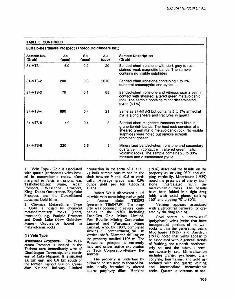
G.C. PATTERSONET AL.
TABLE 5. CONTINUED
Buffalo-Beardmore
Sample No. (Grab)84-MTS-1
Prospect
As (ppm)
6.0
84-MTS-2 1200
84-MTS-3
84-MTS-4
84-MTS-5
84-MTS-6
70
690
4.0
220
(Thor co Goldf inders
Sb Au (ppm) (ppb)
0.2 20
0.6 2070
0.1 65
0.4 21
0.4 3
2.5 5
Inc.)
Sample Description (Grab)Banded-chert ironstone with dark grey to rust stained weak magnetite bands. The sample contains no visible sulphides
Banded chert ironstone containing 1 to 3 07o euhedral arsenopyrite and pyrite
Banded-chert ironstone and vitreous quartz vein in contact with sheared, altered green metavolcanic rock. The sample contains minor disseminated pyrite K1 0Xo)
Same as 84-MTS-3 but contains 5 to 707o anhedralpyrite along shears and fractures in quartz
Banded-chert-magnetite ironstone with fibrous grunerite-rich bands. The host rock consists of a sheared green mafic metavolcanic rock. No visible sulphides were noted but sample exhibitsprominent gossan
Mineralized banded-chert ironstone and secondary quartz vein in contact with altered green mafic volcanic rocks. The sample contains 25 to 300Xo massive and disseminated pyrite
1. Vein Type - Gold is associated with quartz (carbonate) veins host ed in metavolcanic rocks, often marginal to felsic intrusions, e.g. Tashota-Nipigon Mine, Adair Prospect, Wascanna Prospect, King- Dodds Occurrence, Edgelake Prospect, and the Consolidated Louanna Gold Mine.2. Chemical Metasediment Type - Gold is hosted by chemical metasedimentary rocks (chert, ironstone), e.g. Paulpic Prospect and Deeds Lake (New Goldview Mines) Occurrence hosted in metavolcanic rocks.
(1) Vein TypeWascanna Prospect- The Was canna Prospect is located in the Tashota area immediately west of Oboshkegan Township, and north east of Lake Nipigon. It is situated 1.6 km east and 0.8 km south of the former Tashota Station, Cana dian National Railway. Limited
production in the form of a 317.1 kg bulk sample was mined in the shaft between 9 and 10.5 m verti cally. Average grade was 0.96 ounce gold per ton (Hopkins 1916).
Robert Wells discovered a 1.5 m wide vein containing native gold on former claim TB2892 (presently TB604759). The prop erty was optioned to several com panies in the 1930s, including Tash-Orn Gold Mines Limited, Fort Rouille Mining Corporation Limited and Wascanna Mines Limited, who, by 1937, completed sinking a 2-compartment, 98.1 m vertical shaft. Diamond drilling on the property totalled 1108 m. The Wascanna prospect is currently held and under active exploration by Teck Corporation-Retlaw Re sources.
The property is underlain by pillowed or schistose to sheared ba salts locally intruded by altered quartz porphyry dikes. Hopkins
(1916) described the basalts on the property as striking 0300 and dip ping vertically. Moorhouse (1939) noted the presence of cherty iron stone intercalated with the metavolcanic rocks. The basalts have been folded into tight drag folds with axial planes striking 1600 and dipping 700to SOt.
Veining appears associated with a structural permeability cre ated by the drag folding.
Gold occurs in "crack-seal" (polyphase) veins (veins that have incorporated portions of the wall rocks within the generating vein). Moorhouse (1939) and Amukun (1977) noted that veins appear to be associated with 2 general trends of faulting, one a north- northeast erly set and the other, a west- northwesterly set. Mineralization includes pyrite, pyrrhotite, chal copyrite, tourmaline, and gold as sociated with the quartz veining and intermediate metavolcanic rocks. Quartz is vitreous to sac-
105
THUNDER BAY— NORTH CENTRAL REGION
charoidal. Carbonate alteration is present within the veins, predomi nantly adjacent to vein boundaries.
Assays of grab samples from in place and on the dump ranged up to 1.62 ounces gold per ton (Geoscience Laboratories, Ontario Geological Survey, Toronto).
Klng-Dodds Occurrence- TheKing-Dodds Occurrence is located immediately north of Kowkash Township. The area is acessible by road from Geraldton via Highway 584 north to Highway 643 and then west on the Ogoki Road to the Kawashkagama (Kowkash) River. The Kowkash River is navigable to Howard Falls. The King-Dodds Oc currence is located 300 m north from the river. The property is presently held by TCL Incorporat ed.
Amukun et al. (1979) de scribed the geology of the Howard Falls area as being underlain by massive and pillowed mafic metavolcanic rocks. Minor granitic to porphyritic rocks intrude the metavolcanic rocks. Regional folia tion strikes approximately 075C and dips to the south.
The Northern Miner, (Sep tember 11, 1915) described the oc currence as follows:
"The quartz vein is four inches wide and fourteen feet long....This four inches of quartz is almost as rich as the Munro ore, many of the specimens are a quar ter metal and it is said that they are characteristic of the vein."
The vein is a crack-seal type, fractured, vitreous quartz vein with sericite-chlorite seams representing former portions of the wall rock. Pyrite and spectacular free gold are present in the quartz. Small porphyry stocks may have initially fractured the metavolcanic rocks to provide a host for auriferous hy drothermal fluids.
(2) Chemical Metasediment TypePaulplc Prospect- The Paulpic Prospect is situated 700 m north east of the former Tashota Station and is accessible by drill roads. The property is bounded to the
north by Tashota Lake and to the south by the Canadian National Railway. The property is currently owned by Canamax Resources In corporated.
The Paulpic Prospect is under lain by metavolcanic rocks, intrud ed by minor felsic and mafic intru sions. The metavolcanic rocks con sist of intermediate to mafic flows (massive to foliated basalt, medium- grained basalts, and chlo rite schists), tuffs and lapilli tuffs. Minor felsic metavolcanic rocks occur as thin, l to 6 m, units inter calated with the mafic rocks. The felsic metavolcanic rocks are siliceous, fine grained to slightly granular, and pyritic. Chemical metasedimentary rocks and minor clastic metasedimentary rocks also occur. Pyrite containing anoma lous gold and base metal values has been noted in the metasedimentary rocks. Laterally extensive cherty ironstones with a pronounced magnetic signature oc cur in the mafic metavolcanic rocks. Sulphide ironstones with as sociated gold values outcrop in old trenches. Archean gabbroic and amphibolitic dikes and stocks, granite and Late Precambrian dia base dikes intrude the metavol canic rocks (Waddington 1979, Resident Geologist Files, Ontario Ministry of Natural Resources, Thunder Bay).
Chloritoid alteration was noted, particularly in the higher grade metavolcanic rocks which are now amphibolites.
Diamond drilling by Canamax Resources Incorporated has ex tended previously known limits of an auriferous ironstone to a mini mum depth of 200 m. Within the ironstone 2 subparallel lenses, each grading 0.15 to 0.20 ounce gold per ton across an average width of 3.0 m, have been intersected. Gold mineralization is associated with the ironstone, which is dominantly banded chert-magnetite, and an un derlying quartz stock work or stringer zone in metavolcanic rocks.
Economic potential of the zone as of December 31, 1981, was es timated at 66 tons per vertical m
(740 tons per vertical foot) (Knutson 1981, Resident Geologist Files, Ontario Ministry of Natural Resources, Thunder Bay). Tonnage to date is listed as 200 000 tonnes averaging 0.231 ounce gold per ton (Canadian Mines Handbook 1984-85).
RECOMMENDATIONS FOR EXPLORATIONThe magnetic signature of the Southern Metavolcanic Belt is well defined. Exploration is recom mended in the eastern extension of the belt. Surface propsecting, strip ping, and channel sampling over the ironstones and possible exten sions is suggested. Folded iron stone can represent structural traps for gold. They are large regional features and therefore, the possibil ity of a moderate to large gold de posit is present.
The pronounced gold, arsenic, and antimony association is signifi cant for explorationists considering lithogeochemistry. Ironstones fre quently host up to 3^0 total sul phides; thus an induced polariza tion survey could detect sulphide associated gold mineralization.
Historically, the Onaman- Tashota Metavolcanic Belt has ex perienced significant base metal exploration, particularly the Ona man Lake and Marshall Lake ar eas. Base metal occurrences, pros pects, and deposits should be re- evaluated for their gold and silver potential. Metavolcanic terrains that potentially host lead, zinc, copper, silver, and gold mineraliza tion should be examined.
SCHREIBER-TERRACE BAY ECONOMIC GEOLOGIST PROGRAM————————B.R. Schnieders and A.A. SpeedResource Geologists, Ontario Min istry of Natural Resources, Thun der Bay.
INTRODUCTIONIn 1984, the Schreiber-Terrace Bay Economic Geologist Program en tered its second year of operation. The program was initiated by the
106
G.C. PATTERSONETAL.
Ontario Ministry of Natural Re sources, and is funded by the On tario Ministry of Northern Affairs. B.R. Schnieders and A.A. Speed are responsible for the program and work out of the Resident Ge ologist Office.The purpose of the program is 3-fold:1. to provide assistance and in formation to prospectors and min ing companies working in the area2. to document old and new min eral occurrences and establish a database3. to stimulate mineral explora tion and to monitor the exploration activity.
The program covers an area from Nipigon east to Marathon (Figure 4).
During 1984, approximately 50 properties were visited in the program area (Figure 5). All as says reported in the following property descriptions were per formed by the Geoscience Labora tories, Ontario Geological Survey, Toronto, unless otherwise noted.
GENERAL GEOLOGYThe Schreiber-Terrace Bay area is underlain by Early to Late Precambrian rocks. The Archean rocks represent a portion of the Abitibi-Wawa Belt of the Superior Structural Province. These rocks are made up of a metavolcanic- metasedimentary sequence which has been intruded by granitic- syenite plutons and metagabbroic dikes and sills. The metavolcanic rocks consist of iron-rich tholeiites including mafic to intermediate massive and pillowed flows, tuff, and pyroclastic rocks. Calc-alkalic felsic metavolcanic rocks include flows, tuffs, and pyroclastic rocks (Marmont 1984). The meta sedimentary rocks consist predomi nately of graded turbiditic se quences (wacke and argillite), mi nor conglomerate, and iron forma tion (ironstone). Intruding the metavolcanic and metasedimentary rocks is the Terrace Bay Batholith. This 25 km long by 8 km wide batholith consists predominately of medium-grained granodiorite, and
minor diorite, quartz monzodiorite, tonalite, and biotite-hornblende granite (Marmont 1984). Mafic in trusive rocks include gabbro and diorite. Middle Precambrian rocks unconformably overlie the Early Precambrian rocks. The Gunflint and Rove Formation sedimentary rocks consist of conglomerate, black shale, and Superior Type ironstone. Late Precambrian sedi mentary rocks unconformably overlie Early and Middle Precam brian rocks. The Sibley Group con sists of conglomerate, sandstone, shale, carbonates, and chert. Keweenawan rocks are represented by diabase dikes and sills, and mafic to felsic volcanic and sedi mentary rocks, (Osler Group) in the Nipigon Bay-Schreiber Chan nel area. Late Precambrian intru sive rocks include alkalic and car bonatite complexes such as the Port Coldwell Alkali Complex and the Prairie Lake Carbonatite, as well as mafic to felsic dikes.
ECONOMIC GEOLOGYExploration for gold and base met als in the Schreiber-Terrace Bay area remained at a high level dur ing 1984, with the staking of more than 90^0 of the "high potential" ground (metavolcanic and metasedimentary rocks). The area has been actively explored since the late 1800s. Gold was first dis covered in 1875 by Donald McKel- lar in the Victoria Cape area. Ear ly production came from the Em press Mine (1895 to 1900) and the North Shore Mine (1898 to 1900, and 1935 to 1937). To date, ap proximately 3000 ounces of gold has been produced (Resident Ge ologist Files, Ontario Ministry of Natural Resources, Thunder Bay). Base metals, mainly zinc and cop per, were also discovered by the McKellar brothers in the late 1800s. The first production came from the Zenith Mine (Zenmac) in 1898 to 1901 and again from 1966 to 1970 (Kite 1981).
GOLD MINERALIZATIONRecent studies on controls of gold mineralization and the role of fel sic intrusions in gold mineraliza
tion, have been performed by Car ter (1981), Marmont and Colvine (1981), Marmont (1983, 1984), and (Patterson et al. 1984). The following subdivision of gold min eralization types incorporates re sults of the above studies and is based on a modification of the classification suggested by Patter son eta!.(\9S4).
Type 1: Terrace Bay Bat hoi 11 h- Contact Zone TypeGold mineralization is concentrat ed in quartz ±carbonate veins, oc cupying faults, fractures, and shear zones spatially related to the con tact rocks of the Terrace Bay Batholith. The veins and vein sys tems generally occur within 0.4 km of this contact and are sub- parallel to it (Marmont 1984). Marmont (1984) suggests that the veins formed as a result of contact metamorphism and dehydration of the country rocks in a metamorphic-hydrothermal system associated with the emplacement of the Terrace Bay Batholith. The emplacement of this batholith caus ed variable intensities of deforma tion in different areas, producing numerous fractures, faults, and shear zones which acted as con duits for auriferous solutions. The auriferous veins are generally host ed by mafic to felsic metavolcanic rocks, which, combined with vary ing intensities of deformation, re sult in several distinct types of veins and alteration. The quartz veins are generally white and glassy, varying in width from a fraction of a centimetre to a few metres (Marmont 1984). Mineral ization consists of pyrite, pyr rhotite, magnetite, chalcopyrite, ga lena, molybdenite, tellurides, graphite, silver, and gold. Acces sory minerals consist of sericite, chlorite, carbonate, epidote, and hematite. Molybdenite, chal copyrite, pyrite, silver, and gold are also commonly enriched in the altered host rocks. Examples of this style of mineralization include the Gold Range, Harkness-Hays, Hays Lake (Derraugh or Jeddar), Empress, Northern Shore, Gale, and Megatherium Properties.
107
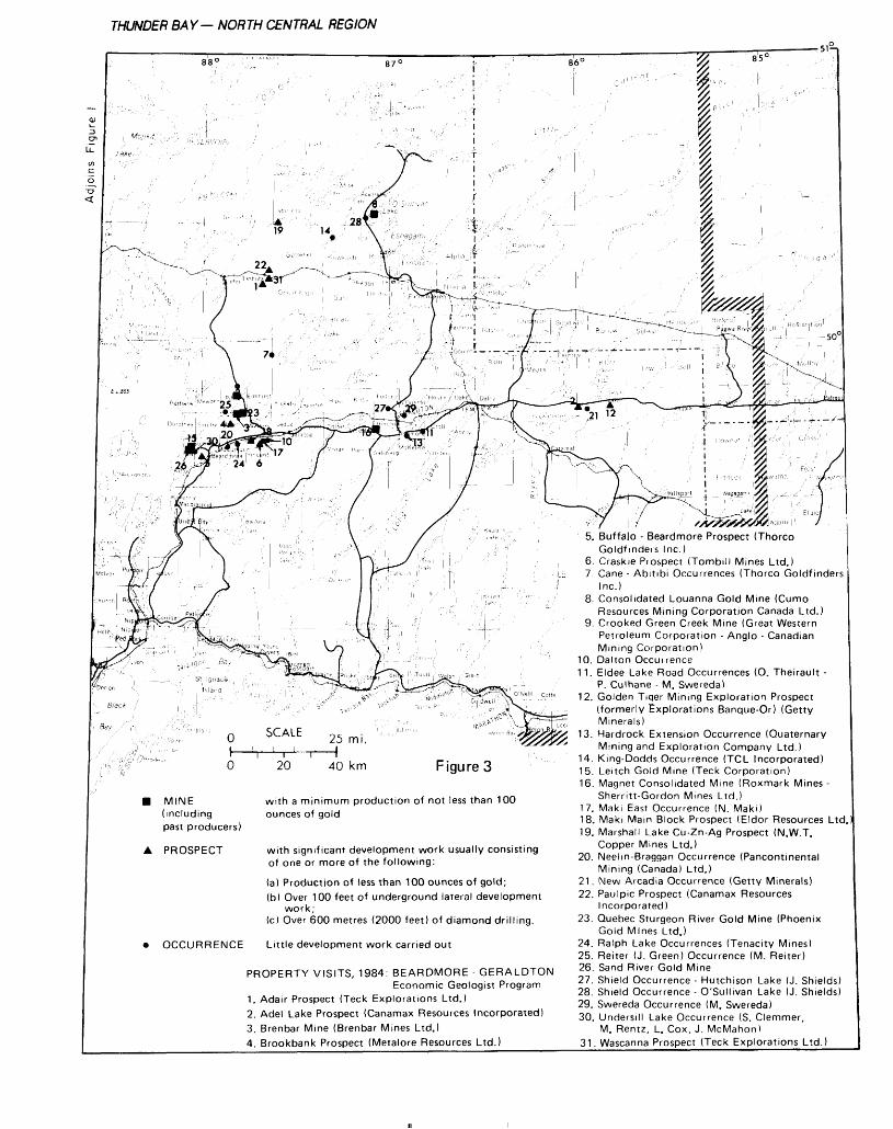
THUNDER BAY— NORTH CENTRAL REGION
88' 87' 86 C
19 14
22,
27*
-10
24 6
T 50'
St. Ifln
SCALE
20 40 km Figure 3
MINE (including past producers)
PROSPECT
with a minimum production of not less than 100 ounces of gold
with significant development work usually consisting of one or more of the following:
(a) Production of less than 100 ounces of gold;(b) Over 100 feet of underground lateral development
wo r k ;(c) Over 600 metres (2000 feet) of diamond drilling.
OCCURRENCE Little development work carried out
PROPERTY VISITS, 1984: BEARDMORE - GERALDTON Economic Geologist Program
1. Adair Prospect (Teck Explorations Ltd.)2. Adel Lake Prospect (Canamax Resources Incorporated)3. Brenbar Mine (Brenbar Mines Ltd.)4. Brookbank Prospect (Metalore Resources Ltd.)
21 12 """ -r—wrr/;, u,,, ,^, l-,, | u,-
:" - V -Vl ' ^ '' F-
r' j "^ l JKP' na ,^^ r-r*^,- —
5. Buffalo - Beardmore Prospect (Thorco Goldfmders Inc.)
6. Craskie Prospect (Tombill Mines Ltd.)7. Cane - Abitibi Occurrences (Thorco Goldfinders
Inc.)8. Consolidated Louanna Gold Mine (Cumo
Resources Mining Corporation Canada Ltd.)9. Crooked Green Creek Mine (Great Western
Petroleum Corporation - Anglo - Canadian Mining Corporation)
10. Dalton Occuirence11. Eldee Lake Road Occurrences (O. Theirault -
P. Culhane - M. Swereda)12. Golden Tiqer Mining Exploration Prospect
(formerly Explorations Banque-Or) (Getty Minerals)
13. Hardrock Extension Occurrence (Quaternary Mining and Exploration Company Ltd.)
14. King-Dodds Occurrence (TCL Incorporated)15. Leitch Gold Mine (Teck Corporation)16. Magnet Consolidated Mine (Roxmark Mines -
Sherritt-Gordon Mines Ltd.)17. Maki East Occurrence (N. Maki)18. Maki Mam Block Prospect (Eldor Resources Ltd19. Marshall Lake Cu-Zn-Ag Prospect (N.W.T.
Copper Mines Ltd.)20. Neelm-Braggan Occurrence (Pancontinental
Mining (Canada) Ltd.)21. New Arcadia Occurrence (Getty Minerals)22. Paulpic Prospect (Canamax Resources
Incorporated)23. Quebec Sturgeon River Gold Mine (Phoenix
Gold Mines Ltd.)24. Ralph Lake Occurrences (Tenacity Mines)25. Reiter (J. Green) Occurrence (M. Reiter)26. Sand River Gold Mine27. Shield Occurrence - Hutchison Lake (J. Shields)28. Shield Occurrence - O'sullivan Lake (J. Shields)29. Swereda Occurrence (M. Swereda)30. Undersill Lake Occurrence (S. Clemmer,
M. Rentz, L. Cox, J. McMahon)31. Wascanna Prospect (Teck Explorations Ltd.)
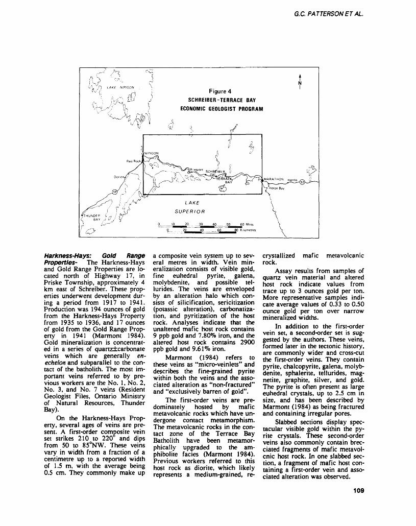
G.C. PATTERSONET AL.
Figure 4SCHREIBER-TERRACE BAY
ECONOMIC GEOLOGIST PROGRAM
Harkness-Hays: Gold Range Properties- The Harkness-Hays and Gold Range Properties are lo cated north of Highway 17, in Priske Township, approximately 4 km east of Schreiber. These prop erties underwent development dur ing a period from 1917 to 1941. Production was 194 ounces of gold from the Harkness-Hays Property from 1935 to 1936, and 17 ounces of gold from the Gold Range Prop erty in 1941 (Marmont 1984). Gold mineralization is concentrat ed in a series of quartz±carbonate veins which are generally en- echelon and subparallel to the con tact of the batholith. The most im portant veins referred to by pre vious workers are the No. l, No. 2, No. 3, and No. 7 veins (Resident Geologist Files, Ontario Ministry of Natural Resources, Thunder Bay).
On the Harkness-Hays Prop erty, several ages of veins are pre sent. A first-order composite vein set strikes 210 to 220 and dips from 50 to 850NW. These veins vary in width from a fraction of a centimetre up to a reported width of 1.5 m, with the average being 0.5 cm. They commonly make up
a composite vein system up to sev eral metres in width. Vein min eralization consists of visible gold, fine euhedral pyrite, galena, molybdenite, and possible tel- lurides. The veins are enveloped by an alteration halo which con sists of silicification, sericitization (potassic alteration), carbonatiza tion, and pyritization of the host rock. Analyses indicate that the unaltered mafic host rock contains 9 ppb gold and 7.80^0 iron, and the altered host rock contains 2900 ppb gold and 9.61^0 iron.
Marmont (1984) refers to these veins as "micro-veinlets" and describes the fine-grained pyrite within both the veins and the asso ciated alteration as "non-fractured" and "exclusively barren of gold".
The first-order veins are pre dominately hosted by mafic metavolcanic rocks which have un dergone contact metamorphism. The metavolcanic rocks in the con tact zone of the Terrace Bay Batholith have been metamor- phically upgraded to the am phibolite facies (Marmont 1984). Previous workers referred to this host rock as diorite, which likely represents a medium-grained, re-
crystallized mafic metavolcanic rock.
Assay results from samples of quartz vein material and altered host rock indicate values from trace up to 3 ounces gold per ton. More representative samples indi cate average values of 0.33 to 0.50 ounce gold per ton over narrow mineralized widths.
In addition to the first-order vein set, a second-order set is sug gested by the authors. These veins, formed later in the tectonic history, are commonly wider and cross-cut the first-order veins. They contain pyrite, chalcopyrite, galena, molyb denite, sphalerite, tellurides, mag netite, graphite, silver, and gold. The pyrite is often present as large euhedral crystals, up to 2.5 cm in size, and has been described by Marmont (1984) as being fractured and containing irregular pores.
Slabbed sections display spec tacular visible gold within the py rite crystals. These second-order veins also commonly contain brec ciated fragments of mafic metavol- cnic host rock. In one slabbed sec tion, a fragment of mafic host con taining a first-order vein and asso ciated alteration was observed.
109
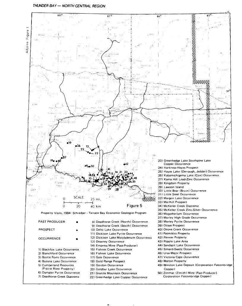
THUNDER BAY— NORTH CENTRAL REGION
PAST PRODUCER
PROSPECT
OCCURRENCE
O 20 40 km Figure 5Property Visits, 1984: Schreiber - Terrace Bay Economic Geologist Program
8) Deadhorse Creek (North) Occurrence9) Deadhorse Creek (South) Occurrence
10) Dello Lake Occurrence11) Dickison Lake Pyrite Occurrence12) Dickison Lake Molybdenum Occurrence13) Downey Occurrence14) Empress Mine (Past-Producer)15) Fishnet Creek Occurrence16) Fishnet Lake Occurrence17) Gale Occurrence18) Gold Range Prospect19) Gordon Occurrence20) Goldbar Lake Occurrence21) Granite Mountain Occurrence22) Greenhedge Lake Copper Occurrence
1) Blackfox Lake Occurrence2) Blanchford Occurrence3) Bottle Point Occurrence4) Bozena Lake Occurrence5) Cumberland Resources
(Prairie River Property)6) Dampier Pyrite Occurrence7) Deadhorse Creek Diatreme
23) Greenhedge Lake Southpine Lake Copper Occurrence
24) Harkness-Hayes Prospect25) Hayes Lake (Derraugh, Jedder) Occurrence26) Kabamichigama Lake (Cox) Occurrence27) Kama Hill Lead-Zinc Occurrence28) Kingdom Property29) Lawson Island30) Little Bear (Bruin) Occurrence31) Little Steel Occurrence32) Margon Lake Occurrence33) Marlhill Prospect34) McKeller Creek Diatreme35) McKeller Creek Zinc-Silver Occurrence36) Megatherium Occurrence37) Morley High Grade Occurrence38) Morley Pyrite Occurrence39) Otisse Prospect40) Ozone Creek Occurrence41) Patmikko Property42) Renner Property43) Ripple Lake Area44) Sandspit Lake Occurrence45) Simard-Swetz Occurrence46) Ursa Major Prospect47) Victoria Cape Occurrence48) Walton Property49) Winston Lake Deposit (Corporation Falconbridge
Copper)50) Zenmac (Zenith) Mine (Past-Producer)
Corporation Falconbridge Copper)
G.C. PATTERSONET AL.
Analytical results of samples collected from the second-order veins containing coarse pyrite cry stals indicate values as high as 40 ounces gold per ton. More repre sentative samples containing large pyrite crystals indicate average values of l to 10 ounces gold per ton.
It is the authors' opinion that the second-order veins represent a reconcentration of gold. The first- order veins and associated altered host rocks may have undergone further dehydration and reconcen tration due to continued polyphase intrusive activity related to the Terrace Bay Batholith and other intrusive events. In some instances the second-order veins containing large pyrite crystals are in contact with carbonate-rich biotite- lamprophyre dikes. These dikes cross-cut all ages of veining and as suggested by Marmont (1984) may represent a late intrusive, concen trating event. Fine-grained pyrite and gold could have been re- mobilized and recrystallized to pro duce large euhedral and fractured pyrite crystals containing recon- centrated gold along the fractures, in pores, and as disseminations.
Several age relationships are apparent at the Harkness-Hays Property between first-order veins, second-order veins, and late granitic dikes. In one location first- order veins were observed cross cutting a narrow granitic dike, while other granitic dikes cross-cut both the first- and second-order veins.
Type 2: Porphyry Contact Zone TypeGold mineralization with subsid iary silver, zinc, copper, lead, and molybdenum occur in quartz, car bonate, or quartz-carbonate veins and spatially associated with felsic porphyries. Examples of this type of mineralization occur in the Big Duck Lake area, 30 km north of Schreiber. Quartz, feldspar, and quartz-feldspar porphyries intrude several rock types. The sill-like porphyry bodies strike east-west and dip steeply, 65 to 700N, and are considered to have formed late
in the tectonic history. Pye (1964) suggested that the porphyries are genetically related to the granitic rocks. Mapping by Corporation Falconbridge Copper suggested possible extrusive and intrusive phases of the porphyry, represent ing a synvolcanic sublayer intru sion (Patterson et al. 1984).
The quartz, carbonate, and quartz-carbonate veins are hosted by a variety of rock types. How ever, there appears to be a pref erence for the contact between the porphyries and the metavolcanic rocks. At least 2 generations of veining are evident; the oldest, par allel to foliation, and the youngest set which cuts the foliation at a high angle. Alteration in the host rocks enveloping the veins in cludes sericitization, carbonatiza tion, chloritization, and pyritiza tion. Pye (1964) suggests 2 types of vein deposits: 1) sugary quartz; and 2) carbonate.
There is a crude zonal distri bution in the mineralogy of the veins. Veins containing gold and molybdenum are the most abun dant near Big Duck Lake, while zinc-bearing veins are more abun dant near Little Duck Lake (Patterson ei al. 1984).
A number of origins for the vein systems have been suggested by Pye (1965) and the authors:1. The Big Duck Lake porphyry may represent an extrusive- intru sive, synvolcanic, sublayer felsic intrusion, with an associated hy drothermal system. This "volcanogenic association" is de scribed by Marmont (1983). Gold and base metal mineralization is associated with quartz and/or car bonate veins near the more extru sive phases of the porphyry, sug gesting a remobilized, syngenetic- exhalative origin.2. Copper, molybdenum, and variable gold mineralization is as sociated with more "intrusive" phases or lower levels of the por phyry, suggesting an epithermal- magmatic origin.3. Gold, base metal, and molyb denum mineralization is concen trated in quartz, carbonate, and/or quartz-carbonate veins related to
the emplacement of the felsic por phyries. Structural traps developed along the margins or contacts of the porphyries due to competency differences. Solutions produced by dehydration in a metamorphic- hydrothermal system leached gold from the country rocks and re- deposited it along the structural conduits.
Examples of this style of min eralization include the Estelle A and B, Porphyry Shaft, Burstrom, Gray, Trabe, Beaver, or McQuaig and Little Duck Properties.
Type 3: Metavolcanic Hosted - Dllatent Zone TypeGold mineralization occurs in quartz and carbonate veins within shear zones, fractures and cleavage dilation zones. Carter (1980a, 1980b) defines these deposits as structurally controlled and related to northwesterly striking shear zones. The gold is associated with silver, copper, zinc, lead, and mo lybdenum. Numerous ages of vein ing may be present. The metavolcanic-metasedimentary host rocks generally display sericitizaton, silicification, and car bonatization. Examples of this style of mineralization may in clude the Schreiber-Pyramid, Em press, McKenna-McCann, Morley High Grade, and the Little Bear (Little Bruin) Properties. The Little Bear Property might more ade quately represent an example of gold being reconcentrated from a chemical sediment (Type 4). It is possible that an overlapping of granitic models occurred.
Little Bear (Little Bruin) Prop erty- The Little Bear Property is located approximately 7.5 km north-northeast of Schreiber, near the southwestern side of Little Bru in Lake. The showing was discov ered in the Summer of 1937 by surface prospecting. The property is described as a narrow, cherry quartz vein averaging 15 cm in width and containing erratic gold values over a length of 60 m (Bartley 1939). Bartley (1939) fur ther describes the vein as follows:
111
THUNDER BAY— NORTH CENTRAL REGION
"The vein strikes NSO^'W, dips 750SW, and occurs in sheared brown-grey rhyolite near the con tact of the granite and the green stone. It appears to be filling a tension fracture, which has cut across the main shear zone at a high angle. The cherty quartz is mineralized with massive sphalerite and chalcopyrite, finer pyrite, galena and native gold. The gold is light-yellow in colour and is intimately associated with the pyrite. The shear zone is heavily mineralized with massive sul phides, but no visible gold was noted."
Carter (l 981 a) described the property:
"The vein occurs in mafic metavolcanics and is mineralized with gold, sphalerite, chalcopyrite, pyrite and galena. The examina tion by the writer showed the vein to be 5 feet wide and 150 feet long on which an 8 by 5 foot shaft had been put down. Chalcopyrite, sphalerite and pyrite occur as stringers, disseminated specks and in the massive state."
The mineralization on the property is exposed in 2 trenches; the northwestern trench is approxi mately 20 m long, 2 m wide, and 2 m deep, and the southeastern trench is approximately 25 m long, l m wide, and l m deep. There is also a 2.4 m by 1.5 m shaft which is 7.3 m deep (Laurie Halonen, Prospector, Thunder Bay, personal communication, 1984).
A narrow stratiform chert unit consisting of finely laminated or bedded chert bands, less than l mm in size, strikes 1250 and dips 60CSW. Interbedded pyrite with possible sphalerite is also present. The chert is lenticular and con tains some highly brecciated sec tions. The brecciated chert contains fine-grained pyrite, pyrrhotite, chalcopyrite, and sphalerite in both massive and stringer form. The sulphides are laminated or bedded in appearance and have undergone folding, as indicated from cut and polished sections. Analytical re sults indicated up to 0.2p"Vo zinc within the massive sulphides and chert unit.
Within the brecciated chert sections secondary quartz veins and lenses are present. The veins display both a crack-seal texture and brecciated texture indicating several periods of deformation and mineralization. One quartz vein up to several centimetres in width is located in the northwestern trench striking 1400 and dipping 600SE. The vein contains pyrite, pyr rhotite, chalcopyrite, coarse sphalerite, galena, tellurides, and gold. Accessory minerals include a white mica (sericite?), chlorite, and carbonate.
Both the chemical sedimentary unit and the quartz veins appear hosted by altered metavolcanic and/or metasedimemary rocks. This area is within 0.5 km of a granitic intrusion.
Preliminary analytical values from samples collected by the au thors on the property indicate er ratic values of up to 0.34 ounce gold per ton and 0.54 ounce silver per ton. A spectacular sample of a quartz vein containing abundant visible gold, possible tellurides, car bonate, hematite, and limonite gos san was submitted to the Resident Geologist Office in Thunder Bay by Laurie Halonen. The sample was said to be representative of the l ton of ore which was mined from the shaft area in the late 1930s. This ton of ore produced S1600 worth of gold, in 1936, at a gold price of approximately S33 per ounce (grading approximately 48.5 ounces gold per ton) (Laurie Halonen, Prospector, Thunder Bay, personal communication, 1984; John Halonen, Prospector, Thunder Bay, personal communi cation, 1983).
Type 4: Chemical Sediment- Stratabound TypeGold mineralization is often asso ciated with "Algoman-type banded iron formation" (ironstone) and re lated chemical and clastic sedimen tary rocks. The ironstone and ex- halative sedimentary rocks com monly occur at metavolcanic- metasedimentary contacts or at pauses between volcanic events. Numerous occurrences of
Algoman-type ironstone in the Terrace Bay and Schreiber areas were identified by previous work ers. Walker (1967) identifies 3 types of ironstone in the Jackfish- Middleton area; 1) chert, 2) sulphide-rich, and 3) siliceous graphitic schist. Walker (1967) further stated that the predomi nance of sulphides over magnetite, plus the occurrence of graphite, suggests a strongly reducing depo sitional environment. Walker also added that the sulphide mineraliza tion within the ironstone may re present a later hydrothermal or epigenetic concentration of re- precipitated iron and sulphur. Car ter (1980a, 1980b) described both oxide and sulphide ironstone inter- layered with sedimentary and vol canic rocks in the immediate Schreiber-Terrace Bay area. Sul phide facies ironstone predomi nates in the Schreiber-Terrace Bay area, and these "ironstone units" commonly consist of bedded pyritic-graphitic shales, inter laminated pyrite and massive py rite, graphite shale, and massive and laminated chert. Variable amounts of pyrrhotite, chal copyrite, galena, sphalerite, silver, and gold are present. Gold content within the "ironstone units" is commonly anomalous ranging from 10 to 300 ppb (Resident Ge ologist Files, Ontario Ministry of Natural Resources, Thunder Bay). Examples of this style of mineral ization include the Kingdom, Simard-Swetz, Little Steel, Black- fox Lake, Morley Pyrite and Mor ley Road, Otisse, and possibly the Little Bear Properties.
Simmard-Swetz Property- TheSimard - Swetz Property is located in Tuuri Township approximately 0.5 km east of the Steel River, and about 10 m south of the Canadian Pacific Railway line.
The occurrence was discov ered by George Simard and Peter Swetz in 1951, likely during con struction of Highway 17. The oc currence was described as consist ing of graphitic schists containing narrow bands of pyrite, hosted by quartzites and intermediate
112
G.C. PATTERSONET AL.
metavolcanic rocks. Walker (1967) describes the property as follows:
"Galena, sphalerite, pyrrhotite and pyrite are found in a graphitic schist 1/4 mile east of the Steel River bridge and just south of the railway.
Analytical results from sam ples collected in 1951 indicated 0.10 ounce gold per ton, 0.28 ounce silver per ton, 053^o lead, and 0.21 Vo zinc across 12 feet (3.6 m) (Resident Geologist Files, On tario Ministry of Natural Re- souces, Thunder Bay). The occur rence consists of sulphide facies ironstone and related chemical and clastic metasediments. The clastic metasediments consist of fine grained argillites, siltstones, and shale. Fine-grained pyrite and graphite are present in some sec tions of the shale. Interlaminated with the shale unit are layers of massive and banded pyrite and mi nor pyrrhotite. This interlaminated pyrite unit, massive pyrite unit, and pyritic and graphitic shale unit is approximately 2 m wide. In con tact with this clastic unit is a chemical metasediment unit con sisting of a 2 m wide finely lami nated chert or cherty ash and a more massive chert or cherty ash. Within the bands or beds of chert is fine-grained disseminated to bed ded pyrite. Sphalerite and galena have also been noted."
The chemical and clastic metasedimentary rocks strike OSO0 to 60C, dip near vertically, and are situated at the contact between graded turbiditic metasedimentary rocks and medium-grained metavolcanic rocks. It is not cer tain if the host metavolcanic rocks are of intrusive or extrusive origin. The ironstone unit has undergone extensive deformation producing a highly schistose zone. It appears to have been the focus of the defor mation, due to its structural loca tion at the contact between metavolcanic and metasedimentary rocks. Numerous quartz veins and veinlets have been produced from recrystallized chert, and secondary euhedral pyrite occurs within these veins. The sphalerite and galena mineralization appears associated to the late quartz veining. Assays
of the chert returned 9 to 30 ppb gold, 0.42 to G.96% zinc, and 0.28 to Q.96% lead. Associated slates re turned 22 to 125 ppb gold, 129 to 1010 ppm zinc, and 420 ppm lead.
BASE METALSType 1: Volcanogenic Massive Sulphide DepositsIn the Schreiber-Terrace Bay area, base metals are associated with calc-alkalic felsic volcanic rocks. To date, the most significant dis covery is that of Corporation Fal conbridge Copper (formerly Fal conbridge Copper Limited) on their Winston Lake Property. The property is located 27 km north west of Schreiber and includes the Zenith Deposit (Zenmac), which was discovered in the late 1800s. Minor production occurred from 1898 to 1902, producing 1065 tons averaging 45^o zinc (Tanton 1931). The Zenith is further de scribed by Severin and Balint (1984):
"Minor production is reported for the period 1899 to 1902 but no serious exploration was initiated until Zenmac Metal Mines Ltd. ac quired the property during the ear ly 1950's. Diamond drilling indi cated a mineral inventory of 141,000 tons grading 23Vo Zn and Q.25% Cu but planned develop ment was suspended due to low (S0.10571b) zinc price. By the au tumn of 1963 the price of zinc had risen to SO.lS/lb and the long range forecasts were optimistic. A decision was made to proceed to production and a 13.5 mile gravel road was completed by July of 1964. Shaft sinking commenced in September 1964 and was complet ed to 425 feet by November. Three levels were established at depths of 150, 275 and 400 feet. During the period April l, 1966 to April 29, 1970, 180,000 tons of 16.5^0 Zn were milled."
The Zenith Deposit is part of a volcanogenic massive sulphide de posit which was rafted into a gab broic intrusive (Kite 1981). In 1978 and 1979, Falconbridge Cop per Limited conducted reconnais sance lithogeochemical-geological surveys west of the Zenith Deposit,
which resulted in the staking of a large section of the metavolcanic- metasedimentary sequence. In 1980, Corporation Falconbridge Copper optioned the Zenith prop erty from Zenmac Exploration Limited, and carried out a detailed program of geological mapping, geochemical surveys, diamond drilling, and down hole geophysi cal surveys. A new deposit located approximately 0.5 km west of the Zenith Deposit was discovered. Severin and Balint (1984) describe the deposit:
"The Winston Lake massive sulphide deposit occurs at the southwest end of the Big Duck Lake volcanic belt and is located at the top of the Winston Lake calc- alkalic felsic volcanic package which is overlain by a series of Mg to Fe rich tholeiitic basalts. The contact between these two contrast ing sequences is marked by a com posite sill-like gabbro intrusion. The gabbroic intrusion(s) is thought to have dislocated a por tion of the Winston Lake Deposit during its emplacement. This small (165,000 tonnes) segment of mas sive sulphides, known as the Ze nith Deposit was mined by Zen mac Metal Mines Limited during 1966 to 1970."and
"The Winston Lake massive sulphide deposit occurs at the top of the Winston Lake felsic volcan ic sequence and is intimately asso ciated with a cherty ash that marks the top of a package of felsic to intermediate yolcaniclastics. The sulphide deposit occurs as a rela tively thin sheet with an 'average' true thickness of 4.3 metres and a length and width of 700-800 metres and 300-400 metres, respec tively."and
"Surface diamond drilling sug gests a mineral inventory (diluted) of 2,675,000 tonnes of 17.81^0 Zn, Q.94% Cu, 25.3 gm/t Ag and 0.85 gm/t Au."
Hydrothermal alteration of the mafic to felsic metavolcanic and metasedimentary rocks includes cordierite - anthophyllite - biotite, biotite - cordierite, quartz - mus-
113
THUNDER BAY— NORTH CENTRAL REGION
covite - biotite, quartz - cordierite - sillimanite - biotite knots ± staurolite ± garnet and quartz - cordierite - anthophyllite ± sil limanite ± staurolite ± garnet as semblages (Severin and Balint 1984).
Drilling by Corporation Fal conbridge Copper in 1983 indicat ed high grade gold values imme diately below the massive sulphide zone of up to 0.58 ounce gold per ton (uncut) across 3.55 m (The Northern Miner, July 28, 1983).
Dello Lake Occurrence- TheDello Lake zinc-lead property is located about 42 km (26 miles) northeast of Nipigon and is held by R. Michon and P. Nevins both of Manitouwadge, Ontario. Access to the showing is north of Highway 17, via the Little Bear Quarry Road (Camp 81 Road), approxi mately 21 km (13 miles) east of Nipigon. The showing occurs on the south side of a small rock out crop, 1.2 km (0.75 mile) east of Dello Lake.
The area was mapped by Pye (1965) as being predominantly granite with a few small isolated remnants of metasedimentary rocks. However, no metasedimen tary rocks are indicated on his map in the vicinity of the showing. The occurrence is hosted by biotite-quartz schist or gneiss, and meta-wacke, which strike approxi mately east. The foliation in the host rock is due to the parallel to sub-parallel alignment of biotite crystals. This foliation also paral lels the bedding. Individual beds range in thickness from ^.54 cm (l inch) to 12 or 15 cm (5 or 6 inches). The metasedimentary rocks have been silicified, due per haps in part to the intrusion of a vertically dipping quartz vein strik ing north across the bedding. The quartz vein has a maximum width of l m (3 feet) and appears to be barren of mineralization. Near the walls of the quartz vein, sulphide minerals, sphalerite and galena ap pear to have been remobilized, into blebs and clots in the host rocks. Elsewhere, the mineralization con sists of semi-massive to disseminat ed sphalerite and galena with mi
nor chalcopyrite and pyrite. The sphalerite mineralization, in par ticular, occurs as near massive lay ers separated by highly silicified metasedimentary rocks. This band ing or layering parallels the bed ding. Since the dip of the beds is about 450N, into the side of the hill, the true thickness of the de posit could not be determined.
An east-trending trench, about 9.1 m (30 feet) long, 0.75 m (2 feet) deep and l to 1.2 m (3 to 4 feet) wide exposes the mineraliza tion. Assay results of 4 grab sam ples taken from the trench indi cated zinc values as high as IS^o, lead values up to 0.3 7^o, 0.26 ounce silver per ton and trace val ues in gold.
Type 2a: Zinc-Lead-Silver Veins-Metavolcanlc TypeZinc, lead, and silver mineraliza tion is concentrated within narrow carbonate and quartz veins within shear zones, faults, and fractures, associated with metavolcanic and metasedimentary rocks. Mineral ization generally consists of mas sive sphalerite and galena within a banded carbonate vein. Silver ap pears in concentrations proportion al to the galena content. The veins also contain minor chalcopyrite and gold mineralization. Accessory minerals include quartz, epidote, chlorite, sericite, and ankerite. Ex amples of this type of mineraliza tion include the Deadhorse Creek North, Deadhorse Creek South, Morley High Grade and McKellar Creek properties.
Deadhorse Creek South Pros pect (Hannam Property)- TheDeadhorse Creek South Prospect, or Hannam Property, is located on the east and west sides of Dead horse Creek, 0.4 km (0.25 mile) north of the Canadian Pacific Rail way and 1.6 km (1.0 mile) south of Highway 17, in Walsh Town ship.
In 1952 and 1953, Saratoga Exploration Company Limited sank a shaft to 15.5 m (51 feet) on the west side of Deadhorse Creek and developed a drift west for 15.2 m (50 feet) at this level. An adit
was also driven west from the shaft collar for about 91 m (300 feet).
The showing consists of a nar row zone of sphalerite and galena associated with carbonate alter ation. The alteration zone cross cuts the host meta-wacke in the vicinity of a north-trending diabase dike. Red syenite dikes cut the metasedimentary rocks in the vi cinity of the showing. Galena, sphalerite and pyrite are found with calcite and minor amounts of quartz in a 30 cm (12 inch) frac ture that strikes 1500 and dips steeply to the northeast. A zone of shearing, carbonatization, and dis seminated sulphides adjacent to the fracture is up to 60 cm (2 feet) or more in width and appears to be richest where it comes in contact with the diabase dike.
Two zones have been recog nized in previous work. The north zone lies on the east side of Dead horse Creek, while the second zone lies 46 m (150 feet) to the south, on the west side of the creek. It seems quite probable that the 2 zones are actually l zone that has been displaced by a fault under lying the north-trending creek.
About 0.75 tons of cobbed ore were taken from a pocket of the shaft, and an average grade of 60.49 ounces silver per ton, 52.94^o lead; and IS.60% zinc was reported (Resident Geologist Files, Ontario Ministry of Natural Re sources, Thunder Bay). Assays of a grab sample containing abundant galena and sphalerite yielded 27.04^0 lead, 16.84^ zinc, and 56.40 ounces silver per ton (Walker 1967, p.35).
Fourteen diamond-drill holes by Saratoga Explorations Limited in 1952, totaling 1681 m (5514 feet), were drilled along a 122 m (400 foot) length of the zone, on both the east and west sides of the creek. It is reported that the min eralized zone was intersected in all but 2 holes (Resident Geologist Files, Ontario Ministry of Natural Resources, Thunder Bay).
Ore reserves in the south zone were estimated at 35 000 tons averaging 27.65 ounces silver per
114
G.C. PATTERSONETAL.
ton, 19.87^0 lead and 9.08(7b zinc. The north zone was reported to contain 36 000 tons of ore (Resident Geologist Files, Ontario Ministry of Natural Resources, Thunder Bay).
Type 2b: Lead-Zlnc-Barlte Veins—Unconformity TypeThe lead-zinc-barite veins have been previously investigated by Tanton (1931), and Franklin and Mitchell (1977). The latter classi fied the lead-zinc-barite deposits of the Dorion property as spatially as sociated with the unconformity be tween Proterozoic and Archean rocks.
Franklin and Mitchell (1977) described the deposits as follows:
"The veins are coarse-grained, and mineralogically zoned with galena-calcite in the central zone, sphalerite-quartz surroundng the central zone, and barite (± chalcopyrite) in the vein extrem ities. Veins occur near the pinch- out of the "Pass Lake Formation" (basal Sibley Group), within the dolomite of the overlying "Rossport Formation", or in the nearby basement fractures. Ros sport dolomite, where it forms a vein wall, is highly altered to metal-enriched chert and calcite. Archean wallrocks are not al tered."and
"The deposits formed from metal leached from either base ment rocks or breakdown of Sibley sandstone matrix. Metals and sul phide moved through the perme able sandstone, probably as chlorite-iron complexes, and precipitated at the sandstone pinch- out. Reduced sulphur, possibly de rived from organic decay, and probably held in a gas trap at the sandstone pinch-out, caused pre cipitation of sulphides by reaction with metal-bearing brines."
Examples of Type (2b) include the Enterprise, Ozone, Dorion, Hilma, Silver lake, Caribou, and Gordon properties.
Gordon Occurrence- The Gor don lead-zinc-barite occurrence is located approximately 2 km (1.25 miles) north of Highway 17 on the east bank of the Jackfish River. The showing is a composite vein, striking east and dipping vertically. It is composed of calcite, barite, quartz, and a small amount of amethyst. The host rock is granite, which is white to pink, depending on the quartz and feldspar content and, locally, contains abundant dark-coloured biotite and horn blende. The vein contains inclu sions of the granitic host. The main vein, which has a maximum width of 1.2 m (4 feet) is com posed primarily of medium- to-coarse crystalline calcite with minor barite and galena. A short distance to the east the main vein branches into 2 separate veins both trending in the same easterly direc tion. The south vein has a maxi mum width of 30 cm (12 inches), is composed chiefly of calcite and is poorly mineralized. The north branch of the vein has a maximum width of 60 cm (24 inches) and contains barite, quartz, and calcite. The barite, which is pink to pink ish red in colour, varies from platey, to massive, to radiating needle-like in form. The quartz is both massive and crystalline and ranges in colour from milky white to purple. This vein contains mi nor galena.
Analyses of 2 grab samples, l from the main vein and l from the north branch of the vein revealed 370 and 3560 ppm lead, 750 and 940 ppm zinc, 170 and 5900 ppm barium, and 1.50 and 34.2*70 cal cium, respectively.
Type 3: Copper-Molybdenum Vein TypeThis type of mineralization could in places represent a sub-type of the gold-bearing veins associated with the Terrace Bay Batholith. The copper-molybdenum-bearing veins are predominately hosted in metavolcanic rocks.
Both vein types are classified according to their mineralogy, al teration, and gold content. The copper-molybdenum mineraliza
tion occurs in quartz veins, quartz- feldspar offshoots, and aplitic and pegmatitic dikes (Marmont 1984). The veins are generally lenticular, discontinuous and erratic, display ing a banded, laminated or crack- seal texture. Mineralization con sists of chalcopyrite, molybdenite, pyrite, pyrrhotite, silver, and minor gold (generally less than 0.10 ounce of gold per ton). Accessory minerals include chlorite, carbon ate, sericite and hematite. Alter ation of the felsic intrusive host rock consists of sericitization, silicification, and hematization.
Marmont and Colvine (1981), suggest a magmatic-hydrothermal system of origin for the copper- molybdenum veins. This occurred within higher levels of the Terrace Bay Batholith during emplacement. Marmont and Colvine (1981) fur ther suggest as does Marmont (1984) that the western, central, and southern sections of the batho lith represent these higher levels. This is supported by numerous xenoliths, roof pendants and min eral occurrences located in these sections.
Type (1) gold mineralization properties such as the North Shore Gold Mine have similarities in al teration, mineralogy and vein style when compared to the Type (3) copper-molybdenum veins. The emplacement of the Terrace Bay Batholith could have produced magmatically derived solutions which in certain cases may have acted to leach or concentrate gold mineralization from surrounding country rocks. Marmont (1984) concludes:
"The coincidence of the molybdenum-copper mineraliza tion with the western part of the intrusion as well as the inter relationship of the quartz veins with quartz-feldspar dikes, indicate that the western part of the batho lith was the site of crystallization of a later phase: the potassic- molybdenum-bearing, residual hy drous phase of the granitic magma, which migrated outward and up ward and was deposited in cooling fractures and other conduits."
115
THUNDER BAY— NORTH CENTRAL REGION
Therefore, it is suggested that the copper-molybdenum veins are younger in age than the gold veins associated to the initial emplace ment of the Terrace Bay Batholith. These gold-bearing veins such as the first-order veins observed in the Harkness-Hays-Gold Range area would likely be older in age than the gold-bearing veins of the North Shore Property. Further work on lead isotopes of galena samples collected from the related vein types is suggested. Thus, the North Shore Property gold veins and the copper-molybdenum veins in the western and central sections of the Terrace Bay Batholith may prove to be genetically related.
EXPLORATION GUIDELINES GoldExploration for gold in the Schreiber-Terrace Bay area should include a thorough re-examination and re-evaluation of past- produc ers, prospects, and occurrences, discovered in the past 100 years.
Properties such as the Harkness-Hays, Gold Range, Hays Lake, and Empress have under gone minor development and pro duction. Recent work on such properties indicates that several ages of veining are present and that complex intrusive and defor- mational events are related to the emplacement of the Terrace Bay Batholith. Exploration programs concentrating on large scale struc tures (conduits) or lithological variations where auriferous solu tions may have been focused, are recommended. Marmont (1984) recommends detailed structural analyses of the vein systems in an attempt to reveal a more extensive zone of mineralization. The explo ration targets for this type of gold mineralization commonly include pyritized host rocks and en echelon vein systems, for which an induced polarization survey may prove to be a useful tool.
Numerous auriferous veins are associated with the contact zones and peripheries of intrusions, in cluding the Big Duck Lake Por phyry and Terrace Bay Batholith. Further exploration in these areas
as well as in the vicinity of other felsic intrusions is warranted.
Northeast and northwest- trending lineaments should be ex plored and tested in the metavol- canics, metasediments, and periph eries of the intrusions. Highly de formed (sheared and faulted) and pervasively altered metavolcanic rocks such as those observed near the Empress Mine (Micham Explo ration Incorporated) area make ex cellent host rocks for gold min eralization.
Algoman sulphide and oxide facies ironstone in the Schreiber- Terrace Bay area should be sam pled and analyzed for gold in the parts per billion range. Although many of these units contain anomalous yet sub-economic levels of gold mineralization, they may represent protore in the sedimentary-exhalite source rocks. A later concentrating event, possi bly related to deformation or intru sive events, could develop econom ic second-generation deposits.
Base MetalsExploration for volcanogenic mas sive sulphide deposits in the Schreiber-Terrace Bay area is rec ommended 3 general areas:1. Winston Lake-Big Duck Lake Area: Exploration by Corporation Falconbridge Copper has recently discovered a zinc - copper - silver - gold deposit hosted by calc-alkalic intermediate to felsic metavolcanic rocks in contact with a gabbroic intrusion(s). The host metavolcanic rocks consist of pyroclastic flows, debris flows and laminated ash de posits. Intense hydrothermal alter ation of these and associated metavolcanics have been responsi ble for the misidentification of such indicator rocks. Exploration by Corporation Falconbridge Cop per has identified large areas of intense hydrothermal alteration, re presenting excellent exploration target areas.2. Santoy Lake-McKellar Lake Area: A large felsic metavolcanic unit trends west-northwest and hosts numerous base-metal occur rences including the Marlhill, Gol- dbar Lake, Bozena, Prairie River,
and Granite Mountain properties. Felsic pyroclastic flows were ober- ved in the Granite Mountain area. These clast-supported flows con tained considerable garnet mineraization in the matrix com ponent. Felsic metavolcanic rocks in the Fishnet Lake area have been mapped as "andalusite-bearing tuffs" by Walker (1967) and may represent altered rocks. Ironstone and the related chemical and clastic metasedimentary rocks commonly contain anomalous zinc, lead, copper, silver, and gold concentrations and should be ex plored.3. Schreiber Point-Worthington Bay Area: Numerous narrow base- metal bearing veins, gold-bearing veins and sulphide facies ironstone within mafic to intermediate metavolcanic rocks are present. Sulphide facies ironstone and the related chemical and clastic metasedimentary rocks appear to represent stratabound chemical ex- halative sediments which contains low, however, anomalous concen trations of copper, zinc, silver, and gold. The ironstone units may re present distal portions of vol canogenic base-metal deposits.
Exploration is recommended within the metavolcanic and metasedimentary rocks near the western contact of the Port Cold well Alkalic Complex. Several zinc-lead-silver rich veins have been discovered in this area.
RECENT EXPLORATION ACTIVITIESCorporation Falconbridge Copper continued the development of its Winston Lake Deposit (Figure 5). Sinking of the proposed 510 m de velopment shaft began in the Spring of 1984 and reached a depth of approximately 300 m in the Fall of 1984. Completion is expected in early 1985. Reserves at Winston Lake, held under op tion from Zenmac Explorations Limited, are an estimated 2 950 000 short tons, at a grade of Q.94% copper, IV.8% zinc, 0.74 ounce sil ver per ton and 0.025 ounce gold per ton (The Northern Miner, March 22, 1984). A production de-
116
G.C. PATTERSONET AL.
cision is expected in 1985. Under ground development at Winston Lake will include 747 m of cros scutting and drifting on the 510 m level, along with 16 764 m of un derground drilling (The Northern Miner, July 5, 1984). Other devel opments include the completion of 20 km, 115-kv powerline and a road feasibility study.
Noranda Incorporated contin ued exploration in the Schreiber- Terrace Bay area during 1984. One property consisted of an op tion agreement made with United Westland Resources Limited and Ascona Petroleum Limited, on 71 claims in the Big Bruin Lake- Victoria Lake area. The area has a high potential for gold, silver, and volcanogenic massive sulphide mineralization (The Globe and Mail, June 19, 1984).
Nuinsco Resources Limited conducted a 1707 m drill program on its Prairie Lake property. The alkalic-carbonatite complex is said to contain significant quantities of columbium (niobium), wol lastonite, phosphate, uranium, tan talum, and rare earth elements. Re sults appear encouraging (Resident Geologist Files, Ontario Ministry of Natural Resources, Thunder Bay).
Kingdom Resources Limited completed an aerial geophysical survey accompanied by prospect ing, linecutting, ground geophysi cal surveys, and lithogeochemical sampling, on its 36 claim block near Santoy Bay. Analysis of sam ples collected by the authors in dicate anomalous gold values with in Algoman sulphide facies iron formation.
Silver Sceptre Resources Limited conducted approximately 1219 m of diamond drilling on its Terrace Bay property. The pro gram tested 12 electromagnetic and magnetic conductors. The re sults indicated low but anomalous gold values related to exhalative chemical sedimentary rocks (Resident Geologist Files, Ontario Ministry of Natural Resources, Thunder Bay).
Micham Explorations Incorpo rated conducted diamond drilling
on their Terrace Bay property which includes the Empress Mine (past- producer) and the Ursa Ma jor Prospect. Several zones were tested including a 366 m section of the 2743 m Empress Zone (The Northern Miner, March l, 1984). Drillhole number 8 intersected a 0.6 m wide section assaying 1.29 ounces gold per ton (Resident Ge ologist Files, Ontario Ministry of Natural Resources, Thunder Bay).
Melrose Resources Limited conducted trenching, mapping, and sampling on its Terrace Bay Prop erty. Samples collected indicated up to 0.2 ounce gold per ton (North American Gold Mining, February 15, 1984).
Stralak Resources Incorporat ed holds 50^0 interest in a silver- lead- zinc property in Walsh Township, near Deadhorse Creek, located between Terrace Bay, and Marathon. Drilling in 1983 en countered values along a 213 m strike length. Drilling is scheduled in 1984 (The Northern Miner, June 28, 1984).
Dynamic Oil Limited, Cum berland Resources Limited, Red- fern Resources Limited and Saco Resources Limited have conducted geological mapping and geochemi cal surveys on their Terrace Bay Property. Two large mineralized zones are characterized by strong alteration (pyrite, silica, and car bonate). The north zone is reported to by 1700 m long and ranges from 10 to 150 m wide, while the south zone is 800 m long and 30 m wide (George Cross News letter, No. 164, 1984).
An 8 hole drill program was completed in late August, testing a wide pyritic zone. One hole inter sected volcanogenic massive sul phide mineralization over a true thickness of 4.3 m. Low, but en couraging gold and zinc values were reported (George Cross News Letter, No. 183, 1984).
Numerous local prospectors and junior mining companies con tinued work on their Schreiber- Terrace Bay Properties.
RESEARCH ACTIVITIES IN THE SCHREIBER-TERRACE BAY AREAB.R Schnieders, part-time graduate student, Lakehead University, Thunder Bay, continued research on sulphide-facies ironstone units as part of a M.Sc. thesis. Research began in late 1983 and will con tinue into 1985. Research in 1984 included detailed mapping, log ging, sample collection and prep aration, detailed structural analy ses and stratigraphy of confined sections.
Further research on these iron- rich units is planned by P. Fralick (Lakehead University), and TJ. Barrett (University of Toronto).
ATIKOKAN COBALT - BASE METALS - PLATINUM GROUP ELEMENTS PROJECT—^——A.D. MacTavish, and R.J.A. DutkaResource Geologists, Ontario Min istry of Natural Resources, Thun der Bay.
INTRODUCTIONThe Atikokan Cobalt-Base Metals- Platinum Group Elements Project is a 3 year program, initiated in May 1984, funded by the Ontario Ministry of Northern Affairs, and staffed by A.D. MacTavish and R J .A. Dutka. The objectives of the program area:1. To stimulate exploration for base metals, cobalt, the platinum group metals, and gold in the At ikokan Area.2. To assist prospectors and ju nior mining companies in the area with property visits, advice, and lit erature searches.3. To assist the mining compan ies interested in conducting explo ration programs in the area by pro viding up-to-date information and files on the area's mineral occur rences.
The program involves detailed geological mapping, sampling, as saying, and petrographic work on the significant cobalt, base metal and platinum group metal occur rences. Emphasis is placed on the copper-nickel-cobalt occurrences
117
THUNDER BAY— NORTH CENTRAL REGION
along a 28 km portion of the Quetico Fault Zone, and the copper-nickel-platinum group ele ment mineralization within the mafic/ultramafic plugs, dikes, and stocks east of Atikokan. At the program's end a report with maps will be prepared to document the location of all occurrences visited and outline the geological setting, assay results, petrochemistry, and mineral potential. Orientation field trips will be provided to interested groups and individuals. Mineral and rock suite displays will be pre pared for the Resident Geologist Office in Thunder Bay and for the Ontario Geological Survey Geosci ence Seminar in Toronto.
At the time of writing, most of the initial reconnaissance sam pling, assaying, and geological mapping has been completed. This information will be used to rank those occurrences, prospects or abandoned mines that will be ex amined in detail during the 1985 and 1986 field seasons. A total of 47 showings in 18 different areas were examined in the Atikokan area. Three base-metal occurrences were visited in the Rainy Lake- Mine Centre areas for familiariza tion and comparison purposes. Also examined were 5 gold occur rences in the Atikokan areas and 4 gold occurrences in the Mine Cen tre area. Several informal field trips to the significant occurrences were conducted for Ontario Geo logical Survey personnel. All as says quoted in the following text were performed by the Geoscience Laboratories, Ontario Geological Survey, Toronto.
GENERAL GEOLOGY AND STRUCTURE
The project area lies within the southern portion of the Superior Province of the Canadian Precam brian Shield. Most of the rocks are Archean in age although there are a few isolated diabase dikes of Keweenawan age. The northern portion of the area is underlain by the rocks of the Wabigoon Sub- province and according to Bor- radaile (1982):
"... comprises schistose metavol canic sequences intruded by syn tectonic tonalitic diapirs and youn ger post-tectonic intrusions. The metavolcanics occur as slivers, of tens of square kilometres, almost separated from one another by the intervening intrusions."
Fenwick (1976) and Pirie (1978) described the Wabigoon Subprovince as consisting primar ily of large, deformed, and un- deformed felsic intrusive batholiths composed of a range of lithologies including biotite and hornblende granites, trondhjemites, quartz monzonites, and quartz porphyries. These rocks intrude a number of curvilinear "greenstone belts" com posed of mafic to intermediate metavolcanic rocks, intercalated with felsic to intermediate metavol canic rocks, and assorted clastic and chemical metasedimentary rocks. The metamorphic grade of these rocks ranges from lower greenschist facies to amphibolite facies.
The southern portion of the area is underlain by rocks of the Quetico Subprovince which Perci val and Stern (1984) state to con sist of:"... marginal metasedimentary rocks with a metamorphic transi tion from chlorite-muscovite grade at the outside to migmatites adja cent to the core, which is domi- nantly granite and migmatite."
In the Atikokan area the cen tre of this core is dominated by the Quetico Park Batholithic Complex which is composed of granite, syenite, tonalite and diorite. Bor- radaile (1982) describes the Quetico Subprovince as a turbiditic sequence that is migmatized along its central axis.
The contact between the above 2 subprovinces is defined by the Quetico Transcurrent Fault Zone. Kennedy (1984) describes the zone as:"... a steeply dipping zone of dynamically metamorphosed rock... exhibiting evidence of both brittle and ductile deformation."
The fault zone is generally quite narrow, ranging from 10 to
300 m in width. It exhibits a major sense of dextral movement and has a very complex system of asso ciated splay faults that curve into both of the subprovinces.
DEPOSIT TYPESReconnaissance work by the au thors during the 1984 field season has revealed the presence of 5 pre liminary "deposit" or occurrence types which might host cobalt, base metal, or platinum group elements mineralization. It should be noted that these divisions are preliminary and are subject to revision with the acquisition of more data. The de posit types are:1. The Quetico Fault Zone-hosted Intrusions2. The Quetico Intrusions (Metasedimentary-hosted)3. Chemical Metasedimentary Rocks within Metavolcanic Terrain4. Shear Zones within Metavolcanic Terrain5. Quartz Veins.
These types are discussed be low with respect to general geo logical, geochemical, and structural characteristics.
(1) The Quetico Fault Zone-Hosted IntrusionsAlong 28 km of its length, from Crooked Pine Lake west to At ikokan, the Quetico Fault Zone is host to at least 6 syntectonic mafic to ultramafic intrusions that ap pear to have a similar origin. These intrusive bodies are dike-like in appearance, very resistant to erosion and in most cases tend to form high steepsided ridges. Rock compositions range from horn blende gabbro to serpentinite. Syn tectonic emplacement has resulted in almost pervasive shearing, the amount of which increases from the centre of the intrusions out ward. Slickensides are common and the original texture of the rock is usually destroyed near the con tact with the fault rocks. Lenses of massive, semi-massive, and dis seminated magnetite are ubiqui tous, and lenses and zones of dis seminated to massive pyrrhotite, pyrite, and chalcopyrite are com-
118
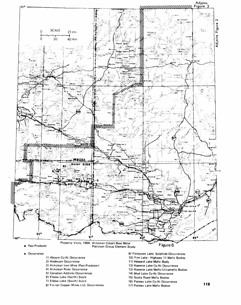
Adjoins Figure
Past-Producer
Occurrence
Property Visits, 1984: Atikokan Cobalt-Base Metal: Atikokan Cobalt-Base Metal P.HO*" c:a . irp c Platinum Group Element Study ^
1) Abiwin Cu-Ni Occurrence2) Anderson Occurrence3) Atikokan Iron Mine (Past-Producer)4) Atikokan River Occurrence5) Canadian-Addicks Occurrences6) Elbow Lake (North) Stock7) Elbow Lake (South) Stock8) Fin-lan Copper Mines Ltd. Occurrences
9) Finlayson Lake Sulphide Occurrences10) Fire Lake - Highway 11 Mafic Bodies11) Heward Lake Mafic Body12) Kawene Lake Cu-Ni Occurrence13) Kawene Lake Mafic/Ultramafic Bodies14) Mud Lake Cu-Ni Occurrence15) Nydia Road Mafic Bodies16) Plateau Lake Cu-Ni Occurrence17) Plateau Lake Mafic Bodies 119
THUNDER BAY— NORTH CENTRAL REGION
mon. Good net-textured pyrrhotite and chalcopyrite have been ob served locally, indicating that an immiscible sulphide liquid was present in the original magma. Subsequent shearing has largely re- mobilized the sulphide mineraliza tion.
Atikokan Iron Mine- The easter nmost intrusive, located 1200 m east of Sapawe Lake occurs at the abandoned Atikokan Iron Mine. It is a lenticular, dike-like mass 1100 m long and up to 100 m wide. Its lithologic range is gabbroic to pyroxenitic(?), with gabbro pre dominating. Some exotic litholog- ies are present along the intrusive's boundaries. These "slices", which include magnetite- chert-iron for mation and chert-carbonate rocks, appear to have been emp laced by faulting and are not genetically re lated to the deposit. The deposit was mined intermittently from 1900 to 1913, and produced 90 680 short tons at SS.9% iron, with a variable sulphur content. Numer ous estimates of the remaining ton nage and grade exist. The most re cent estimate (The Northern Min er, October 26, 1972), which in cludes tonnage estimates for 3 similar bodies to the adjacent west, gives 24 000 000 short tons to a depth of 91 m, at a minimum of 35*7o iron, and Q.40% copper, with some indications of nickel and co balt. Rock exposure at the mine is good due to the past mining activi ties. Sample values ranged from 0.115 to Q.267% copper, 0.029 to Q.076% nickel, and 0.408 to 1.30 pounds cobalt per ton.
(2) Quetico IntrusionsIntruded into the metasedimentary rocks of the northern Quetico Sub- province are a series of mafic to ultramafic dikes, plugs, and stocks. They occur within a 47 km zone between Plateau Lake in the west, and Chief Peter Lake in the east. Twelve of these intrusions were examined in 1984 and although of variable size, were found to have similar characteristics. Lithologies include hornblende gabbro, feld spathic hornblendite, hornblendite, pyroxenitic hornblendite, and occa
sionally serpentinized peridotite. The larger intrusions are usually multiphased, with the last stages dioritic. Contact zones exhibit hy brid characteristics due to assimila tion of the metasedimentary coun try rocks. Reaction rims are found at the contacts of the different in trusive phases and country rock xenoliths. Textures range from fine to very coarse grained, to lo cally pegmatitic. Possible cumulate textures have been observed locally within the larger intrusions, such as the Elbow Lake Stock. Some of the smaller dike-like bodies have been intruded by later granitic dikes as at the Abiwin Occurrence or have been folded and faulted as at Fire Lake and on Highway 11. In the occurrences examined, min eralization consists of irregular zones or pods of finely dissemi nated to semi-massive pyrrhotite, chalcopyrite, pyrite, and sometimes pentlandite. Significant assays have been received from the Abiwin Oc currence and the Kawene Occur rence.
Abiwin Occurrence- The Ab iwin Occurrence is a small, slight ly irregular dike-like body, 400 m in length and 50 m in width lo cated 2.8 km northwest of Nydia Lake. It is composed of medium to very coarse-grained hornblende gabbro, feldspathic hornblendite and hornblendite. Mineralization consists of small, irregular sul phide pods up to 20 m in length containing 10 to 35^0 disseminated pyrrhotite, pyrite, chalcopyrite, and possibly pentlandite. Assays indicate between 0.123 and 2.20*7o copper, 0.10 to 0.168^0 chromium, 0.17 to 0.23 ounce silver per ton, and in one sample 0.11 ounce pal ladium per ton, 1.15 ounces plati num per ton and between 30 and 300 ppb rhodium.
Kawene Occurrence- TheKawene Occurrence is an elongate, plug-like body approximately 520 m in length and up to 185 m in width located 400 m west of Kawene Lake. It is composed of fine-grained to pegmatitic feld spathic hornblendite, hornblendite, pyroxenitic hornblendite and ser
pentinized hornblende peridotite (Larsen 1974). Sulphide mineral ization consisting of pyrrhotite and chalcopyrite, occurs interstitial to the mafic silicate minerals and is locally concentrated. One mineral ized zone, approximately 100 m in length and 40 m in width yielded significant assay values. Some of the values obtained are 0.13 to 1.26*70 copper, 0.084 to Q.248% nickel, 0.25 to 0.50 pounds cobalt per ton, 260 to 1100 ppb pal ladium and 230 to 1100 ppb plati num. One sample was slightly en riched in rhodium.
(3) Chemical Sedimentary Rocks In Metavolcanic TerrainThe chemical metasedimentary rocks examined to date are located in the Finlayson Lake area, north west of Atikokan. According to Fenwick (1976) the chemical metasedimentary rocks occur as 2 basic types:1. Massive pyrrhotite, nodular pyrite, and minor chalcopyrite, as sociated with cherty iron formation2. Massive to locally banded py rite deposits associated with the uppermost felsic metavolcanic unit in a well-differentiated volcanic pile.
The "Type l" chemical meta sedimentary rocks range between 10 cm and 5 m in width and are slightly to highly folded. They are usually well-banded with alternat ing, white to grey, recrystallized, sugary-textured chert and iron-rich laminae. The iron-rich laminae are composed of either magnetite, he matite, iron silicates, pyrrhotite or occasionally pyrite. Massive, semi- massive, and disseminated pyr rhotite, with associated pyrite, are the most common iron minerals. Pyrite usually occurs as radial or concentric nodules up to 10 cm in diameter within the laminae, and along fractures or joints. Chal copyrite is a minor constituent that is usually associated with re- mobilized quartz blebs within near ly massive pyrrhotite. Graphitic zones are observed locally. These "Type l" chemical metasedimen tary rocks were observed in associ ation with felsic and mafic
120

6.C. PATTERSONET AL.
metavolcanic rocks and clastic metasedimentary rocks.
The "Type 2" chemical metasedimentary rocks exhibit many of the same characteristics as "Type l" metasedimentary rocks. The major differences are: (1) the predominance of pyrite as the main iron mineral; (2) a ten dency to be associated with tuf faceous and other pyroclastic, fel sic metavolcanic rocks, and; (3) a close association with intertuff graphitic argillites and shales.
Both of the above chemical metasedimentary types tend to form in a reducing environment (Fenwick 1976), although "Type l" metasedimentary rocks may contain magnetite or hematite. Beds of recrystallized carbonate were observed locally; and cros scutting and sub-concordant lam prophyre, diabase, and other mafic dikes are widespread.
Assays are anomalous, ranging from 515 ppm to 1.18^0 copper, 1260 to 3720 ppm zinc, 280 to 990 ppm cobalt, and 0.13 to 0.34 ounce silver per ton. The most sig nificant assays came from the main showing on the old Fin-Lan Copper Mines Limited property, located in the west- central portion of Finlayson Lake. The showing consists predominantly of a 0.5 to 3 m wide, folded and faulted, "Type l" banded chemical metasedimentary rock containing near massive pyrrhotite, pyrite, and minor finely disseminated chalcopyrite. The sulphide miner alization tends to occur within the most highly folded areas of the rock. Pyrite nodules are very com mon. Numerous lamprophyre and mafic dikes, of variable width, crosscut the main chemical metasedimentary unit creating iso lated blocks. The northernmost part of the showing is composed of a 2 to 7 m wide, near massive sulphide zone containing pyrite (both massive and nodular forms), pyrrhotite, and up to ID'% dissemi nated chalcopyrite. Assay values over the showing range from 515 ppm to 1.18^0 copper, 100 to 990 ppm cobalt, and 410 to 1000 ppm zinc.
(4) Shear Zones within Metavolcanic TerrainShear zones were observed in 3 areas: 4 in the Finlayson Lake Area, l north of the Atikokan Iron Mine, and another west of Lumby Lake. The shear zones observed in the Finlayson Lake Area are char acterized by rusty weathering, fri able quartz-sericite schists, carbonate- chlorite-sericite schists and chlorite schists. The sulphide mineralization varies considerably from ^Vo to sssSOVo as finely dis seminated and stringer pyrite, pyr rhotite and minor chalcopyrite. Graphite was observed locally. The zones tend to occur along linea ments and probably indicate fault ing.
A recently discovered, highly sheared and deformed quartz- carbonate zone is located approxi mately l km north of the Atikokan Iron Mine. This zone is composed of very limonitic, highly folded quartz, quartz-carbonate, and car bonate stringers and veins, hosted in a highly sheared, mafic metavol canic rock (now a carbonate- chlorite schist). It is possible that a splay fault associated with the Quetico Fault Zone, l km south, passes through this area, account ing for the highly deformed nature of the rock. The sulphide mineral ization is restricted to "Cl^o pyrite with very minor chalcopyrite, and a moderate percentage (^Vo) of a yet unidentified cobalt arsenide mineral, which has weathered to erythrite (Geoscience Laboratories, Ontario Geological Survey, Toron to, x-ray analysis) on fracture sur faces.
Anderson Occurrence- The An derson Occurrence is in a shear zone located l km west of Lumby Lake in the northern part of the Atikokan District. This shear zone is 10 to 15 m wide and is com posed of carbonate-sericite-quartz schist, carbonate-chlorite-sericite schist and numerous boudinaged quartz stringers and veins. The original rock types appear to have been mafic volcanic flows and in terbedded felsic, quartz-porphyry flows or sills(?). Finely disseminat ed pyrite, O^o, occurs within the
shear zone schists. Local concen trations of sphalerite, pyrite, and chalcopyrite were observed and within some of the quartz veins. One sample returned 905 ppm copper; another sample 330 ppm chromium.
(5) Quartz VeinsSmall amounts of base-metal sul phide mineralization are common ly found in many quartz veins throughout the Atikokan area (Schnieders and Dutka, in prepara tion). These quartz veins are com monly hosted within shear zones. Mineralization consists primarily of chalcopyrite, sphalerite, and ga lena in amounts of up to 20*7o, and occasionally as massive lenses. They are predominantly found in association with pyrite, sericite, and occasionally chlorite, along the slip planes of "crack-seal" type quartz veins, or as isolated blebs, masses or crystals within the main body of the quartz vein. Auriferous quartz veins of the Atikokan area will usually contain some base- metal sulphide mineralization. As say returns gave between 710 to 4600 ppm copper, 430 to 2720 ppm lead, and 1290 to 4450 ppm zinc. A series of small quartz veins in the Finlayson Lake area re turned an assay of 1500 ppm mo lybdenum.
SUMMARYCobalt, base metal and platinum group elements mineralization in the Atikokan area has been tenta tively assigned to 5 "deposit" types determined on the basis of lithol ogy, structure and associated sul phide mineralogy:1. "The Quetico Fault-hosted In trusions" contain significant cobalt, copper, and nickel sulphide min eralization closely associated with disseminated to massive magnetite lenses within sheared, syntectonic gabbroic to ultramafic intrusive rocks. A similar potential for co balt and base metals may exist within other intrusions of this type. The possibility of platinum-group elements enrichment is high in the presence of copper and nickel sul phides.
121
THUNDER BAY— NORTH CENTRAL REGION
2. "The Quetico Intrusions" are mafic to ultramafic bodies exhibit ing high local concentrations of copper, nickel cobalt, platinum, and palladium. The base metals oc cur as pods and zones of dissemi nated chalcopyrite, pyrite, and pentlandite. The minerals as yet unspecified containing the plati num group elements are probably closely associated with chal copyrite, and pentlandite mineral ization (Crocket 1981). Base metal, and especially platinum-group ele ment potential, in these and other similar bodies is high and should :be investigated further.3. The deformed, banded chert and iron-rich chemical meta sedimentary rock of the Finlayson Lake area locally contain copper, cobalt, and minor zinc and silver within primary exhalative(?) sul phide mineralization (Fenwick 1971; MacMillan 1979). The sul phide mineralization is very fine to coarse grained, banded to nodular, disseminated to massive, pyr rhotite, pyrite, .and occasionally disseminated chalcopyrite, and sphalerite. The possibility of copper- zinc mineralization in oth er chemical metasedimentary rocks within the Finlayson Belt is high.4. and 5. Shear zones and quartz veins throughout the Atikokan Dis trict exhibit localized disseminated copper, lead, and zinc mineraliza tion. Cobalt was observed in asso ciation with a possible splay fault of the Quetico Fault Zone.
Work planned for 1985 will include detailed geological map ping and rock geochemistry of the Quetico Intrusions and the 6 Quetico Fault Zone-hosted mafic bodies. Further reconnaissance is planned for the Atikokan area, the Calm Lake area, the Lumby Lake- Redpaint Lake area and portions of the Shebandowan area.
BUILDING AND MONUMENT STONE———————-———M.C. Kennedy and P.M. GertzbelnResource Geologists, Ontario Min istry of Natural Resources, Thun der Bay.
INTRODUCTIONStone has long been considered the most prestigious of building ma terials. It has earned this distinc tion because of its great beauty and durability. A rejuvenation in the popularity of stone as a building material is being experienced in the 1980s as trends move away from the steel and glass structures of past decades (Engineering News-Record, March 8, 1984). The durability and insulating properties of stone, as well as its aesthetic appeal, have contributed to its rise in popularity. Improvements in stone installation technology have made stone easier and more eco nomical to work with. At the pre sent time much of the stone used by the building and monument in dustries in Canada is imported (Les Consultants Sogir Incorporat ed, 1984) in spite of the fact that the production of high quality stone can be a lucrative industry. For instance, Les Consultants Sogir Incorporated (1984) note that a basic local granite for con struction use has a value of up to S400 per m 3 at plant site. Special granites such as the anorthosites from Scandinavia, Indian-red gran ites and African-black granites command S800 or more per m3 .
The North Central Region of Ontario Ministry of Natural Re sources would appear to be an area with high potential for good qual ity stone deposits. With this in mind, an inventory of potential di mension stone was initiated in April 1984. The "Building Stone Inventory" is a 2-year project fun ded jointly by the Federal and Pro vincial Governments under the Northern Ontario Rural Develop ment Agreement (NORDA). The study is being carried out by M.C. Kennedy assisted by P.M. Gertz- bein. A similar study has recently been completed in the North western Region.
The purpose of the project is to encourage the development of the stone industry in the North Central Region. This will be ac complished by:1. Identifying areas and rock types having high potential for the
production of good quality building and monument stone.2. Making information on all as pects of the building stone indus try, such as quarrying, finishing and marketing, available to the pri vate sector.
The project involves detailed documentation of occurrences of good quality stone and reconnais sance mapping of areas of high potential. Samples collected from potential stone deposits are cut and prepared for display. These sam ples are available for viewing at the Thunder Bay Resident Geolo gist Office. Laboratory testing of physical properties will be carried out on selected samples.
TERMINOLOGYThe terminology used in the stone industry is quite different from standard geological terminology. The term dimension stone refers to all natural rock that has been quar ried and shaped to certain speci fications for use in the building, construction and monument indus tries. This includes rough stone, blocks, panels, and polished ma terial but no crushed or powdered stone used as an aggregate or re constituted to form artificial stone (Allison, P., Industrial Minerals, July, 1984, p. 19-35). The principal types of stone produced are gran ite, marble, limestone, sandstone, and slate. Commercial "granite" includes all intrusive igneous rocks regardless of composition as well as gneissic rocks. "Black granite" refers to dark coloured igneous rocks such as diabase or anor thosite. Commercial "marble" comprises any carbonate rock which polishes and includes ser pentinite, travertine and onyx. "Limestone" includes any carbon ate rock which will not take a polish. "Sandstone" as used in the stone industry refers to any granu lar sedimentary rock composed primarily of quartz and feldspar. Commercial "slate" and "schist" include true slates and foliated rocks of varying lithologic* and metamorphic grade which can be split into thin slabs for use as flag stone.
122
G.C. PATTERSONETAL.
GEOLOGICAL CRITERIA FOR STONE DEPOSITSDimension stone deposits must possess specific characteristics to be economic. The stone itself must be sound (meet American Society for Testing and Materials' criteria) and must suit the specific purpose for which it is being quarried. For example, granite quarried for monument production must polish to a flawless finish. It must be fine grained and have sufficient con trast between the polished and sandblasted surfaces so that letter ing is distinct.
Storey (1983) has outlined the criteria for granite dimension stone deposits. These criteria, outlined below, generally can be applied to granite, marble, and sandstone de posits. Exceptions are noted where applicable.1. Fracturing and jointing control the size and shape of blocks which can be quarried. Ideally, fracturing and jointing are absent, permitting the quarryman to remove blocks of any size to suite his requirements. This is rarely the case. Favourable deposits contain jointing which is widely spaced, allowing the remov al of the largest blocks possible in order to minimize waste and han dling. A reasonable sized block would be 3 m by 1.5 m by 1.3 to 2 m (Les Consultants Sogir Incor porated, 1984). Orthogonal jointing systems are desirable, permitting the removal of rectangular blocks, thus minimizing waste.2. The colour and texture of the stone must be uniform throughout the deposit. This ensures that the appearance of the material re moved remains consistent during a quarry's lifespan. Textures in mar bles are commonly quite heterogenous but the colour must be consistent. Such features as knots, lines, foliation, veins, and other irregularities are considered textural flaws. Layering in sand stones is quite acceptable.3. Colour and texture must be commercially desirable. A stone duplicating a colour which is al ready being produced is not as de sirable as a "new " colour, except
in the case where it could replace an expensive import.4. Deleterious minerals must be absent. Any mineral, such as py rite, which breaks down rapidly due to weathering is undesirable. This is not as important in marble for interior use as for other stone commonly used for exterior clad ding and monuments. The pres ence of soft ferromagnesian min erals, olivine and altered feldspars is undesirable as they weather poorly and often will not sustain a polish. Very hard minerals can cause problems in polishing. Biotite in concentrations greater than 5^0 may be plucked out of the surface during polishing.5. The deposit should be large enough so that it could be quarried for 20 to 50 years or more. Storey (1983) suggests a minimum size of approximately l km2 .
DIMENSION STONE IN THE NORTH CENTRAL REGIONA wide variety of good potential building and monument stone ex ists in the North Central Region. Although there are no dimension stone quarries presently operating within the study area, the stone industry of the region has been, historically, quite important. Sand stone, marble, and granite were quarried in the past, and around the turn of the century prospecting for quality stone was carried out. Past-producing stone quarries and past and present stone prospects are listed in Tables 6a and 6b and located on Figure 7.
In the Thunder Bay area dia base was quarried, as large blocks, for breakwater construction on Lake Superior.
Crushed stone quarries are listed in Table 6a and located on Figure 7. These have been documented but are not directly part of the study. Crushed stone was also important in the region in the past and is produced intermit tently from a number of small quarries.
SANDSTONEHigh quality sandstone for build ing purposes was produced from a number of quarries in the region from the early 1880s to the 1900s. The sandstone is part of the Prot erozoic Sibley Group sedimentary rocks. Red to brown coloured sand stone of the Rossport Formation was quarried at Vert Island and La Grange Island in Nipigon Bay. Cream or buff-coloured sandstone of the Pass Lake Formation was quarried as Simpson Island, Quar ry Island, and the Wolf River area.
Most of the information con cerning these quarries is derived from local newspapers published at the time the quarries were active. This newspaper research is being carried out by K.G. Fenwick, Re gional Mineral Resources Co ordinator.
The earliest produced sand stone was shipped to the Chicago and Winnipeg areas as rough blocks. Stone cutting plants were established in Fort William and Port Arthur (now Thunder Bay) between 1905 and 1910. Many buildings were constructed from this locally derived sandstone, principally from Vert Island and Simpson Island. These buildings, now 75 to 80 years old, serve to illustrate the durability and lasting beauty of the local sandstone. The author is compiling an inventor}' of buildings in Thunder Bay which incorporated local stone in their construction.
Vert Island Sandstone QuarryThe red sandstone location on Vert Island in Nipigon Bay of Lake Su perior was first secured by Duncan McEachan in 1881 (Thunder Bay Sentinel, July 29, 1881). In the spring of 1882, Cummings and Company of Chicago began work at the site with 16 men employed in constructing dock facilities and buildings (The Daily Sentinel, April l, 1882). In July of 1882, 1000 tons of stone were ready for shipment to Chicago. The stone was reported to be remarkable be cause of its quality and accessibil ity; it only needed to be moved 250 feet from the quarry to the docks.
123
THUNDER BAY— NORTH CENTRAL REGION
TABLE 6a. BUILDING STONE QUARRIES
Past Producing QuarriesName
1 . Vert Island Quarry2. La Grange Island Quarry3. Simpson Island Quarry4. Quarry Island5. Wolf River Quarry6. George Point, Black Bay
Peninsula7. V18- Sibley8. Nipigon Marble Quarry9. Black Bay Mine and
Quarry Co.10. Cooke Point, Lake
Nipigon (LawrenceQuarry)
1 1 . Pearl Quarry
12. CPR Quarry-MacKenzie1 3. Angler Quarry
14. Peninsula GraniteQuarries Ltd.
15. Cold Spring Granite Co.Ltd.
1 6. Cold Spring Granite Co.Ltd.
17. CPR Quarry Peninsula
18. Lakeshore DriveQuarry— BreakwaterConstruction
19. Caribou Island20. Silver Harbour
Commoditysandstonesandstonesandstonesandstonesandstonesandstone
sandstonemarblemarble
marble
granite
granitered and blacksyenitered syenite
black syenite
black syenite
black syenite
diabase
diabase talusdiabase
21. Great Lakes Dredging Co.diabase talus22. Marrigan Trap Quarry
23. Mountain Stone Co. Ltd.24. City of Fort William (rifle
range)25. Nelson Road26. Intercities Quarries Co.
Ltd. (Stewart andHewitson Quarry)
27. Quinn Stone and Ore Co.
28. Stewart Quarry*29. Hewitson Quarry*30. Government Rock
Quarry*31. Winnipeg Flagstone
Supply(Alsip Quarry)
32. Hoorigan Bay
diabase, cr.Diabase and shalecr. diabasediabase
diabasecr. diabase andshale
cr. Diabase andshalecr. diabasediabase and shalediabase
shale (flagging)
shale (for brick)shale (for brick)
Date1880s-90s1880searly 1900slate 1880s? (late 1880s)? (early 1900s)
? (early 1900s)1880s1890s
1930s, 40s
? early 1900s andrecently1880searly 1930s
1927-31
early 1930s
early 1930s
1880s and late1920s? 1880s andpresent
1880s? (early 1900s)1910s1920s
1920s1925-30S
?1920s and 30s
late 1920s
early 1900searly 1900s1870s
1880s
early 1900slate 1910s
*now non-existent
Blocks as large as 15 x 15x4 feet are reported to have been removed (The Weekly Herald, August 5, 1882). Although no change of ownership was described, the quar ry is called the "Chicago and Vert Island Sandstone Quarry" in 1883 accounts, with no mention of Cummings and Company being in volved. It appears to have operated continuously until the early 1900s. A reported 30 000 to 50 000 cubic feet of stone were shipped annu ally to Chicago and approximately 50 men were employed (Port Ar thur Illustrated, 1889). The sand stone was used in 1885 in the con struction of the Canadian Pacific Railway bridge over the Nipigon River where it can still be seen today.
The authors made a brief visit to the quarry site which is located on patented land on the west shore of Vert Island. The quarry site is indicated by the remnants of 4 docks. The cribbing of the docks is gone but the stone rubble promon tories remain. The site is entirely grown over.
The old quarry face is ap proximately 120 m from the shore, about 200 to 250 m in length and generally 9 to 10 m in height. The brick red sandstone is attractive and appears to be quite homoge neous. The location will be exam ined in greater detail to determine its potential for future quarrying. The stone is suitable for restoration purposes, particularly for red sand stone buildings in Southern Ontar io (Martin Weaver, Heritage Canada, Ottawa, personal commu nication, 1984).
Simpson Island Sandstone QuarryTanton (1931) mentions that sand stone was produced from this site, but no documentation of produc tion figures has been found. It ap parently operated in the early 1900s and as a result, several of the more prominent buildings (e.g. Port Arthur Collegiate), in Thun der Bay, were built of stone from this quarry.
The quarry, located on crown land on the north side of Simpson
124
G.C. PATTERSONETAL.
TABLE 6b. BUILDING STONE QUARRIES
NameProspects Commodity Date
1. East shore of Thunder Bay sandstone (Sibley Peninsula)2. Lunmac Marble3. Muskrat Lake4. Greenspar Quarry5. Bamoos Lake6. Port Coldwell7. Morrison Claims8. Lake Superior Stone Syndicate
1880s
marble currentmarble current porphyritic diabase 1960sblack syenite currentred syenite pre-1910black syenite 1931black syenite 1960
1. Middleton2. East shore of L. Nipigon3. West of Whitefish Lake4. Kowkash Area (CNR mileage 37, 51)5. Lambert Island
Reports
black syenite slate granite granite
diabase talus
early 1930s 1860s 1880s 1931
1930
TABLE 6C. BUILDING STONE QUARRIESOccurrences1. Trout Lake Pluton (porphyritic granite)2. Barnum Lake Pluton (porphyritic granite)3. Eye-Dashwa Lakes Pluton (pink granite)4. MacKenzie Pluton (pink granite)5. Stedman Lake Pluton (white to pink granite)
Island in Lake Superior, was vis ited during the summer of 1984. The old quarry face is 55 m in length and 3 to 10 m in height. The sandstone is buff-coloured with some hint of pink. In part of the quarry the sandstone is thinly bedded and splits into slabs 2.5 to 5 cm thick forming beautiful natu ral flagstone. Much interest has been expressed in the potential of this material as flagging. In other parts of the quarry the maximum thickness of slabs which could be removed is approximately 50 to 75 cm. The size of blocks removed for building purposes when the quarry was active is unknown but the au thor suggests that the material must have been removed in large, relatively thin sheets.
MARBLEMarble was quarried in the region on a small scale in the late 1800s and the 1930s (see Table 1). The marble in the Thunder Bay area is comprised of carbonate-rich por tions of the Sibley Group.
The site of the Black Bay Mine and Quarry Company prop erty near Ouimet has recently been rediscovered by a local propspec- tor, N. Lafontaine. It appears that only a few blocks of stone were extracted. The stone is an attrac tive pink to coral-coloured stromatolitic marble.
An occurrence of layered green marble near Muskrat Lake is being examined by a local prospec tor, W. Dutchak.
Lunmac Marble PropertyThis most notable property in the region owned by H. Lundmark and W. McAteer, is located near Eagle head Lake, east of the Spruce Riv er. It consists of 2 separate groups of claims on which similar rocks are exposed along north-facing cliffs. The property comprises a nearly flat-lying sequence of car bonate rocks and mudstones over lain by a Keweenawan diabase sill. The geology of the claim groups has been described in detail by Re dden (1980) (Resident Geologist Files, Ontario Ministry of Natural Resources, Thunder Bay), and was previously described in Fenwick and Scott (1977). Lundmark and McAteer carried out substantial manual and mechanical work on the property exposing 4.5 to 5 m of dolomite overlain and underlain by purple to reddish brown mud stone. From top to bottom the se quence includes:
1-1.15 m layered variable- coloured dolomite3 m blue-grey stromatolitic do lomite0.5 m green to brown dolomite with some grey dolomite.
Locally the blue-grey dolomite grades into white brucite marble where it is in contact with diabase. The white marble retains the stromatolitic structures of the grey dolomite.
The blue-grey and white "marbles" may be removed in fair ly large blocks. These marbles have been subjected to physical tests and are suitable for dimension stone purposes. All the shades of marble polish well. The white mar ble has a soft sheen rather than a bright polish. At present, the mar ble is being made into attractive ornamental objects which are sold locally.
Extraction of the marble by traditional quarrying methods will be difficult due to approximately 5 to 7 m of diabase overlying the marble on the cliff face.
125
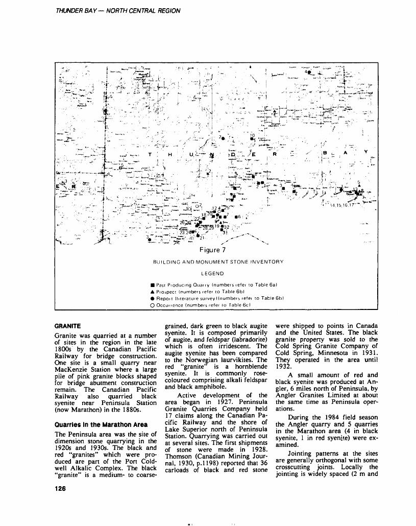
THUNDER BAY— NORTH CENTRAL REGION
Figure 7
BUILDING AND MONUMENT STONE INVENTORY
LEGEND
B Past Producing Quarry (numbers lefer lo Table Ga) A Prospect (numbers refer to Table 6b) 0 Report (literature survey Mnumbers refer to Table 6b) O Occurrence (numbers refer to Table 6c)
GRANITEGranite was quarried at a number of sites in the region in the late 1800s by the Canadian Pacific Railway for bridge construction. One site is a small quarry near MacKenzie Station where a large pile of pink granite blocks shaped for bridge abutment construction remain. The Canadian Pacific Railway also quarried black syenite near Peninsula Station (now Marathon) in the 1880s.
Quarries In the Marathon AreaThe Peninsula area was the site of dimension stone quarrying in the 1920s and 1930s. The black and red "granites" which were pro duced are part of the Port Cold well Alkalic Complex. The black "granite" is a medium- to coarse
grained, dark green to black augite syenite. It is composed primarily of augite, and feldspar (labradorite) which is often irridescent. The augite syenite has been compared to the Norwegian laurvikites. The red "granite" is a hornblende syenite. It is commonly rose- coloured comprising alkali feldspar and black amphibole.
Active development of the area began in 1927. Peninsula Granite Quarries Company held 17 claims along the Canadian Pa cific Railway and the shore of Lake Superior north of Peninsula Station. Quarrying was carried out at several sites. The first shipments of stone were made in 1928. Thomson (Canadian Mining Jour nal, 1930, p.1198) reported that 36 carloads of black and red stone
were shipped to points in Canada and the United States. The black granite property was sold to the Cold Spring Granite Company of Cold Spring, Minnesota in 1931. They operated in the area until 1932.
A small amount of red and black syenite was produced at An gler, 6 miles north of Peninsula, by Angler Granites Limited at about the same time as Peninsula oper ations.
During the 1984 field season the Angler quarry and 5 quarries in the Marathon area (4 in black syenite, l in red syenite) were ex amined.
Jointing patterns at the sites are generally orthogonal with some crosscutting joints. Locally the jointing is widely spaced (2 m and
126
G.C. PATTERSONETAL.
greater) especially near the red granite quarry, 3.5 km north of Marathon. In some areas colour and texture are homogeneous as well. Both the black and red syenites at the old quarry sites are promising. Cut and polished sam ples indicate that both are high quality stone. The colour and tex ture of the syenites are attractive and the material polishes well.
Noranda Mines Limited has recently staked this area for its di mension stone potential.
EXPLORATION AND MARKET POTENTIALThere are good potential dimen sion stone deposits in the North Central Region. The black and red syenites of the Port Coldwell Al kalic Complex, at and near the old quarry sites, exhibit the character istics required of deposits. Large areas underlain by these rocks re main to be examined. Other late granitic intrusions also make good exploration targets for dimension stone. Several of these granitic in trusions have been examined in the early part of this study and a few, which exhibit good potential, are listed in Table 6c and located on Figure 7. Granite for construction purposes such as curbing should not be overlooked. Marble in the region exhibits a variety of colours and is very attractive. The occur rences examined appear to be highly suitable for ornamental pur poses and may prove to be suitable as dimension stone. Marble occurs at many other locations where the Sibley Group rocks are exposed. These sites warrant examination.
The sandstone at the quarry sites examined has excellent poten tial and may be particularly suit able for restoration purposes and for flagging. Deposits of slate and schist have not yet been considered by this study. The potential for de posits of flagging material is high, particularly near large fault zones.
Stone must be marketable for a deposit to be considered econom ic. A market study commissioned by the Ministry of Natural Re sources, Northwestern Region con cludes that there is definite, al
though limited potential for the de velopment of a building stone in dustry in Northwestern Ontario (Les Consultants Sogir Incorporat ed, 1984). The study was princi pally concerned with granite, slate, and schist as marble and sandstone are not found in the Northwestern Region. Many of their recommen dations, however, apply to all stone types. Les Consultants Sogir sug gest that any ventures into this in dustry proceed cautiously; starting small and growing carefully. They recommend making use of all available assessment and evalua tion techniques before significant development and investment take place.
QUATERNARY GEOLOGY F.J. KristjanssonQuaternary Geologist, Ontario Ministry of Natural Resources, Thunder Bay.
INTRODUCTIONA program, of detailed surficial geological mapping at a scale of 1:50 000, of the planning areas of Geraldton and Terrace Bay was carried out. Funding support for this progrm was provided by the Ontario Ministry of Northern Af fairs. A phased approach (i.e., I. Data Collection and Review, II. Field Reconnaissance, and III. Re port and Map Production) was considered.
The study began with a litera ture search and review. Ontario Ministry of Environment's water well records, and Ontario Ministry of Transportation and Communi cations' sand and gravel inventory data were reviewed. Satellite imag ery enlargements, at a scale of 1:250 000, and conventional aerial photography, at l inch to l mile and l inch to 1/4 mile scales, were obtained. A preliminary aerial photograph interpretation was con ducted.
During the second phase of the project, all preliminary interpreta tion was subjected to a program of field verification. The objective was to obtain as many points of ground truth as possible in the
study areas. Roads were traversed by vehicle, and all sand and gravel pits and borrow pits were exam ined. Detailed verification of the geomorphology and surficial geol ogy of the study areas was ob tained. The locations of approxi mately 500 field stations, each re presenting a point of ground truth, were recorded.
During the third phase of the study, a report outlining the glacial history and a map depicting the surficial geology of each study area will be produced. Although the intent was to document the oc currence, character, and distribu tion of all classes of surficial ma terial in each study area, special emphasis was placed on till and glaciofluvial sediments. Till is a prime sampling medium for min eral exploration in areas of gla ciated terrain. Areas dominated by glaciofluvial sedimentation repre sent important source areas for sand and gravel. In this regard, ag gregate potential and coarse aggre gate probability maps derived from prepared surficial geological map ping will be prepared.
GERALDTON AREAA tentative sequence of glacial events for the Geraldton area is as follows: (1) The deposition of a gritty, sand till, of local derivation; and a fine-grained, calcareous till, which exhibits remarkable simi larities to the fine-grained, calcar eous till documented in the Hemlo area during the 1983 field season, (Patterson et al. 1984). (2) The dis integration of glacier ice, and an essentially contemporaneous pon ding of meltwater, leaving relative ly large blocks of stagnant glacier ice grounded in a glacial lake. (3) The deposition of supraglacial morainic debris and ice contact stratified sediment, in belts of hum mocky terrain, which demarcate the margins of remnant glacier ice.
TERRACE BAY AREATentatively, the following picture of late galcial dynamics has emerged: (1) The deposition of a gritty, silt till, which exhibits similarities to the calcareous, grit-
127
THUNDER BAY— NORTH CENTRAL REGION
ty, silt till documented in the Hemlo area. (2) The recession of glacier ice, which results in the emergence of major bedrock up land areas as nunataks and, with continued ice wastage, ice divides. This would confine glacier flow to the more substantial lowland areas. For example, it is considered that an isolated mass of glacier ice, confined by the Aguasabon River- Hays Lake basin, in juxtaposition with Glacial Lake Minong, may have constructed the large, kettled outwash plain at Terrace Bay. This interpretation reflects, at least, in general detail, recent field inves tigation by Phillips (Department of Geography, Lakehead University, Thunder Bay, Ontario, personal communication, 1984). (3) The continued disintegration and even tual stagnation of remnant glacier ice, which can be inferred from the variety of glaciofluvial ice contact features that occur in lowland ar eas. In this regard, large glaciofluvial, ice contact terraces, which may be observed from the Winston Lake Road, in the vicinity of Lyne and Horneblende Lakes, may be representative.
HISTORICAL RESEARCH PROJECT————^—-——-The Regional Mineral Resources Co-ordinator's Office continued its historical research project initiated in 1981. This project is an in- depth search of the old literature (mining journals, newspapers, magazines, etc.) for information on mineral occurrences in the North Central Region.
Each description of an occur rence is copied, referenced, and filed in the Mineral Deposits Files. In 1984, research was concentrat ed on The Northern Miner, cover ing the time period from Septem ber 4, 1915 to December 27, 1934. Table 9 in Patterson et al. 1984, p.102, indicates the articles re searched in previous years.
RESULTS1. Valuable information has been added to the files on the gold oc currences (known but not pre viously documented) in the At
ikokan, Beardmore-Geraldton and Schreiber-Terrace Bay areas. An example of an undocumented oc currence follows:
"Wilgar Creek Mining Syndi cate, under the management of C.S. Gifford, has been formed to explore a group of claims in the Kowkash mining division, Ontario, three miles west of Paska, on the Canadian National Railway.
Mineralization has been proved by trenches and test pits along a length of 600 feet. The width at one point is 48 feet be tween well- defined walls; the oth er trenches indicated similar widths. A large dike has been lo cated from which material assayed 57.60 to 40 cents in gold have been secured." (The Northern Min er, May 14, 1931,p.9).2. There may be potential for gold in the old silver and lead- silver occurrences in the Thunder Bay area. Library research has documented, in the newspapers from 1880 to 1892, the mention of gold in 12 different occurrences. For example:
"C.H. Miles, engineer in charge of operations of Animikies Mines, presented a statement of re sults from 11 tons of ore taken from the old abandoned dumps and run through a mill for test pur poses. This ore showed upward of S35 per ton in silver and gold, the latter running about S4 per ton (gold per ounce in 1933 was S28.94)." (The Northern Miner, May 25, 1933, p.3). and
"An important discovery of gold has been made on location 173T, owned and worked by the Queen Gold and Silver Mining and Milling Co. of St. Paul. It is situ ated in the Whitefish Lake region. Mr. C.G. Kimball, one of the direc tors, now being on the ground, is in charge of the operations. So far but little work has been done but that has been in the way of sinking on the vein with the result that free gold in the form of small nuggets, about twice the size of a pin's head has been found." (The Weekly Herald, Saturday, July 16, 1887).
3. A silver-processing Porta-Mill is located in Thunder Bay; it there fore may be worthwhile assessing dumps at the sites of the old silver occurrences, noted for example, in the following quotes:
"Paid a visit to Pic Island Sil ver Mine with John McKellar: Having 'taken in' the sight of that location we next winded our way to the shaft house, passing between immense piles of silver bearing rocks, estimated at containing 2500 tons which it is thought will average S60 or over, per ton (silver per ounce in 1882 was 31.14)" (Port Arthur Herald and Algoma Mines, June 17, 1882).and
"There are a number of mines with ore on the dumps as follows:
Crown Point 1000 tonsSilver Fox 500 tonsQueen 400 tonsSilver Star 400 tonsAll the foregoing is considered
fair ore." (Daily Sentinel, Wednes day, February 25, 1891).
GEOLOGICAL RESEARCH IN THE NORTH CENTRAL REGIONONTARIO GEOLOGICAL SURVEY ACTIVITIESDetails of research carried out by the Ontario Geological Survey are given in Wood et al. (1984). A summary of these programs is list ed below:
T.L. Muir, A Map of Hemlo Deposit; G.M. Siragusa, Geology of the White River Area; J.A.C. Fortescue, Geochemistry of the Williams Deposit, Hemlo; B. Ged des, Quaternary Mapping in the Hemlo Area; M.W. Carter, Geol ogy of Goldie and Horne Town ships and a Portion of the Dawson Road Lots; L. Chorlton and G.H. Brown, Geological Setting of Gold Mineralization at Shebandowan; S. Buck and H.R. Williams, The Na ture of the Quetico-Wabigoon Con tact Near Longlac; J.E. Riley, Peat Inventory Studies. Table 7 lists maps and reports published during the year by the Ontario Geological
128
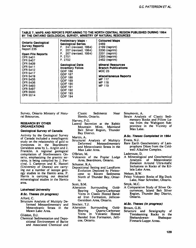
G.C PATTERSONETAL.
TABLE 7. MAPS AND REPORTS PERTAINING TO THE NORTH CENTRAL REGION PUBLISHED DURING 1984 BY THE ONTARIO GEOLOGICAL SURVEY, MINISTRY OF NATURAL RESOURCES
Ontario Geological Survey ReportsReport 235Open File ReportsOFR 5401OFR 5407OFR 5409 OFR 54 11 OFR 5412OFR 54 17OFR 5419OFR 5435OFR 5436OFR 5493OFR 5497OFR 5500OFR 55 14
Preliminary Maps - Geological SeriesP. 241 (revised, 1984) P. 257 (revised, 1984)P. 267 (revised, 1984)P. 2701P. 2702
Geological Data Inventory FoliosGDIF 186GDIF 187GDIF 188GDIF 189GDIF 190GDIF 191GDIF 192GDIF 193GDIF 194
Coloured Maps2469 2199 (reprint) 2200 (reprint)2201 (reprint)2393 (reprint)2452 (reprint)
Mineral Resources Branch PublicationsMDC25
Miscellaneous ReportsMP 117MP 118MP 119
Survey, Ontario Ministry of Natu ral Resources.
RESEARCH BY OTHER ORGANIZATIONSGeological Survey of CanadaActivity by the Geological Survey of Canada included a metallogenic study on the relationship of gold to ironstones in the Beardmore- Geraldton area by L. Anglin and J. Franklin. A regional geological compilation of Northwestern On tario, emphasizing the granitic ter rains, is being compiled by J. Per cival. I. Cameron and K. Hattori (University of Ottawa) are carry ing out a number of isotope geol ogy studies in the Hemlo area. P. Harris is carrying out detailed mineralogical studies in the Hemlo area.
Lakehead University B.Sc. Theses (In progress)Alford, C.Structure Analysis of Multiply De
formed Metasedimentary and Metavolcanic Strata in the Mawn Lake Area.
Gliddon, DJ.Chemical Sedimentation and Depo
sitional Environment of Barite and Associated Chemical and
Clastic Sediments Hemlo, Ontario.
Near
Harvey, P.G.Lateral Secretion at the Rabbit
Mountain Mine, Mainland Belt Silver Region, Thunder Bay District.
Martin, A.Structural Analysis of Multiply
Deformed Metasedimentary and Metavolcanic Strata in the Max Lake Area.
O'Brien, M.Volcanics of the Poplar Lodge
Area, Beardmore, Ontario.Schuster, RA.Depositional Setting and Landform
Evolution Depicted by Pleisto cene to Recent Sediments North of Thunder Bay, Ontar io.
Scott, B.M.Alteration Surrounding Gold-
Bearing Quartz-Carbonate Veins in Clastic Hosted Band ed Iron Formation, Jellicoe- Geraldton Area, Ontario.
Sinclair, TJ.Alteration Surrounding Gold-
Bearing Quartz-Carbonate Veins in Volcanic Hosted Banded Iron Formation, Jelli- coe, Ontario.
Sinumovic, A.Strain Analysis of Clastic Sedi
mentary Rocks and Pillow La vas from the Wabigoon Sub- province in the Vicinity of Max Lake.
.B.Sc. Theses Completed In 1964Evans, NJ.Rare Earth Geochemistry of Lam
prophyre Dikes from the Cold well Alkaline Complex.
Laderoute, D.A Mineralogical and Geochemical
Analysis of Metavolcanic Zonation Around Ultra-mafic Inclusions in Rocks of the Kil lala Lake Area.
Nelson, B.W.Felsic Volcanic Rocks of Big Duck
Lake, Near Schreiber, Ontario.Smyk, M.C.A Comparative Study of Silver Oc
currences, Island Belt Silver Region, Thunder Bay District, Ontario.
M.Sc. Theses (In progress)Brown, G.H.Structure and Stratigraphy of
Timiskaming Rocks in the Shebandowan- Shabaqua- Finmark-Lappe Areas.
129
THUNDER BAY— NORTH CENTRAL REGION
Devaney, J.R.Depositional Environment of
Coarse Clastics in the Archean Beardmore-Geraldton Sedi mentary Belt, Ontario.
Jennings, EA.Fluid Geothermometry of Silver
Vein Deposits of the Thunder Bay Area, Northwestern On tario.
Laderoute, D.Petrology and Geochemistry of
Lamprophyres and Other Dike Rocks from the Coldwell Com plex.
Schnieders, B.R.Geology, Structure and Deposition
al Environment of Chemical and Clastic Sediments in the Steel River Area, Terrace Bay, Ontario.
Thomson, K.Depositional Setting of Chemical
and Clastic Sediments in the Greenstone Belt Between Mar athon and White River.
Zayachivsky, B.Geochemistry and Mineralogy of
Rare-Element Pegmatites in the Georgia Lake Area, North western Ontario.
M.Sc. Theses Completed in 1984Kennedy, M.C.The Quetico Fault in the Superior
Province of the SouthernCanadian Shield.
Other staff Research ActivitiesBorradaile, G J.(1) Structure of the Margins of the
Quetico and Wabigoon "Belts", especially between At ikokan and Mine Centre.
(2) Structure and Strain Analysis of Greenstone Wedges in the Wabigoon Subprovince.
(3) Strain and Magnetic An isotropy of Archean Metasedimentary Rocks, Espe cially Seine River Sequence.
(4) Rock Mechanics Testing and Seismic Anisotropy of Pluton ic Archean Rocks to 3 kb and 3000C With/Without Pore Fluid Pressures.
Fralick, P.W.The Depositional Environment of
Oxide and Sulfide Facies Al
goman Banded Iron Forma tion.
Hale, CJ., and Steward, J.D.Petrography and Paleomagnetism
of the Gunflint Formation with Reference to Paleo-Indian Artifacts.
Kehlenbeck, M.M.(1) Character of the Queticp-
Wabigoon Boundary Zone in the Beardmore- Geraldton-Longlac Area.
(2) Deformation of Non-Spherical Objects in Rocks from the Jellicoe-Geraldton Area.
(3) Progressive Deformation and Fold Evolution in Meta- Sedimentary Rocks of the Quetico-Wabigoon Boundary Zone.
(4) Progressive Inhomogeneous Simple Shear and Uniform Homogeneous Strain as Relat ed to Folds in the Beardmore- Geraldton Boundary Zone.
Kissin, S.A.Diagenetic Reactions in the Gun
flint Formation.Liquid Immiscibility in the Logan
Diabase Sills, Northwestern Ontario.
Mitchell, R.H.Petrology and Geochemistry of the
Coldwell Complex.
Other UniversitiesBajc, A.History and Development of the
Pro-Glacial Lake Deposits in the Black River Area, Univer sity of Waterloo.
Barnett, B.Geology of the Williams Deposit,
Hemlo, Ontario, Ph.D. Thesis, University of Western Ontar io.
Bree, D.G.Investigation Into the Nature of
Gold in Humus and its Signifi cance to Geochemical Explo ration, Hemlo, Ontario, Queen's University.
Burke, R.The Geology of Corona Deposit,
Hemlo, Ontario, M.Sc. Thesis,Queen's University.
Carigan, B.Isotopic Composition of the Gun
flint Rocks, M.Sc. Thesis, Uni versity of Ottawa.
Cheadle, B.Stratigraphy of Sibley Ground
Rock, Thunder Bay, Ontario,Queen's University.
Cogulu, E.Petrology of Great Lake Nickel
Deposit, University of Ottawa.Cohen, D.R.Biogeochemistry, A Geochemical
Method for Gold Exploration, Hemlo, Ontario, Queen's Uni versity.
Goad, R.Regional Geochemistry, Noranda
Mines Limited, M.Sc. Thesis, University of Western Ontar io.
Hugon, M.Structure and Deformation at
Hemlo, Ontario, Post. Doc.Project, University of Toronto.
Kuhns, R.Geology of the Goliath Deposit,
Hemlo, Ontario, Ph.D. Thesis, University of Minnesota.
Osterberg, S.Massive Sulphide Deposits in the
Onaman River Area, Univer sity of Minnesota at Duluth.
Shelp, G.S.The Nature of Gold in Glacial
Sediments and Soils Associat ed with Mineralization, Hemlo, Ontario, Queen's Uni versity.
Wilks, M.The Geology of the Marmion Lake
Batholith, M.Sc. Thesis, Uni versity of Saskatoon.
Woods, E.Relationship of Quaternary Sedi
ment to Lake Water Acidity, Hemlo Area, H.B.Sc. Thesis, University of Western Ontar io.
REFERENCESAmukun, S.E.1977: Geology of the Tashota
Area, District of Thunder Bay; Ontario Geological Survey, Report 167, 90p. Accompa nied by Map 2354, scale 1:31 680 or l inch to 1/2 mile.
130
G.C. PATTERSONET AL.
Amukun, SJE., Sawitsky, E., andMaharaj, M.1979: Howard Falls Area, South
ern Half, District of Thunder Bay; Ontario Geological Sur vey, Preliminary Map, P.2311, Geological Series, scale 1:15 840 or l inch to 1/4 mile. Geology 1978.
Bartley, M.W.1939: The Northwestern Part of
the Schreiber Area; Ontario Department of Mines, Annual Report for 1938, Volume 47, Part 9, p.24- 45. Accompanied by Map 47j; scale 1:31 680 or l inch to 1/2 mile.
Benedict, P.C., and Titcomb, J A.1948: The Northern Empire Mine;
p.389-399 in Structural Geol ogy of Canadian Ore Deposits, Canadian Institute of Mining and Metallurgy.
Blue, A.1896: A Tour of Inspection in
Northwestern Ontario; Ontario Bureau of Mines, Annual Re port for 1895, Volume 5, p. 107-190.
Borfadaile, GJ.1982: Comparison of Archean
Structural Styles in Two Belts of the Canadian Superior Province; Precambrian Re search, 19, p. 179-189.
Carter, M.W.1980a: Controls on Gold and
Copper-Molybdenum Mineral ization in the Schreiber- Terrace Bay Area (Abstract); p.4 in the Geoscience Re search Seminar, December 10-11, 1980, Abstracts, Ontar io Geological Survey, 21 p.
1980b: Terrace Bay Area, District of Thunder Bay; p.42-46 in Summary of Field Work, 1980, by the Ontario Geologi cal Survey, edited by V.G. Milne, O.L. White, R.B. Bar low, JA. Robertson, and A.C. Colvine, Ontario Geological Survey, Miscellaneous Paper 96, 201 p.
1981 a: Precambrian Geology of the Schreiber Area, East Part, Thunder Bay District; Ontario Geological Survey, Prelimi nary Map, P.2391, Geological Series, scale 1:15 840 or l
inch to 1/4 mile. Geology 1979.
1983: McComber and Vincent Townships, District of Thun der Bay; p.32-36 in Summary of Field Work, 1983, by the Ontario Geological Survey, edited by John Wood, Owen L. White, R.B. Barlow and A.C. Colvine, Ontario Geologi cal Survey, Miscellaneous Pa per 116, 313p.
Crocket, J.H.1981: Geochemistry of the
Platinum-Group Elements; p.49-64 in Platinum-Group Elements: Mineralogy, Geolo gy, Recovery, by the Canadian Institute of Mining and Metal lurgy (CIM), Special Volume 23, edited by LJ. Cabri, p.49-64.
Dennen, W.H., and Puckett, A.M.1972: On the Chemistry and Col
our of Amethyst; Canadian Mineralogy, Volume 11, p.448-456.
Fenwick, K.G.1971: Origin of a Stratabound Py
rite Deposit in Predominantly Volcanic Derived Strata in the Finlayson Lake Area, District of Rainy River, Ontario; un published M.Sc. Thesis, De partment of Geology, Michi gan Technological University, 90p.
1976: Geology of the Finlayson Lake Area, District of Rainy River; Ontario Division of Mines, Geoscience Report 145, 86p. Accompanied by Maps 2297 and 2298, scale 1:31 680 or l inch to 1/2 mile.
Fenwick, K.G., and Scott, J J7.1977: 1976 Report of the North
Central Region Geologist; p.38-56 in Annual Report of the Regional And Resident Ge ologists, 1976, edited by C.R. Kustra, Ontario Geological Survey, Miscellaneous Paper 71, 142p.
Franklin, J.M., and Mitchell, R.H.1977: Lead-Zinc-Barite Veins of
the Dorion Area, Thunder Bay District, Ontario; Canadian Journal of Earth Sciences, Volume 14, Number 9, p.1963-1979.
Fyon, JA., Crocket, J.H., andSchwarcz, H.P.1983: The Carshaw and Malga
Iron-Formation-Hosted Gold Deposits of the Timmins Area; p.98-110 in The Geology of Gold in Ontario, edited by A.C. Colvine, Ontario Geologi cal Survey, Miscellaneous Pa per 110, 278p.
Goldich, S.S.1972: Geochronology in Minneso
ta; p.27-37 m Geology of Min nesota: A Centennial Volume, edited by R.K. Sims and GJB. Moreg, Minnesota Geological Survey, University of Minne sota, Minneapolis, Minnesota.
Hopkins, P .E.1916: Kowkash Gold Area, Thun
der Bay District, Ontario; On tario Bureau of Mines, Annual Report for 1916, Volume 25, Part l, p.264- 274. Accompa nied by Map 25A, scale 1:253 440 or l inch to 4 miles.
Kennedy, M.C.1984: The Quetico Fault in the Su
perior Province of the South ern Canadian Shield; Un published M.Sc. Thesis, Lake- head University, Thunder Bay, Ontario.
Kite, B.T.1981: The Geology of the Zenith
Zinc Deposit Near Schreiber, Ontario; Unpublished B.Sc. (Honours) Thesis, Lakehead University, Thunder Bay, On tario.
Klein, C., Jr.1973: Changes in Mineral Assem
blages with Metamorphism of Some Banded Precambrian Iron-Formations; Economic Geology, Volume 68, p.1075-1088.
Larsen, C.R.1974: The Silicate and Sulphide
Petrology of the Kawene Lake Intrusion; Unpublished B.Sc. Thesis, Lakehead University, Thunder Bay, Ontario.
Les Consultants Sogir Inc.1984: Market Study of Stone in
Northwestern Ontario, Ontario Geological Survey, Open File Report 5493, 186p., numerous tables and photos.
131
THUNDER BAY— NORTH CENTRAL REGION
Macdonald, AJ.in press: Gold Mineralization in
Ontario. I: The Role of Banded Iron Formation; Ontario Geo logical Survey, 35p.
MacMillan, R.N.1979: The Geochemistry of the
Sulphide Iron Formation Ar ound Finlayson Lake, Ontario; Unpublished B.Sc. (Honours) Thesis, University of Western Ontario, London, Ontario.
Mcilwaine, W.H.1971: McTavish Township (West
Pan of North Half), District of Thunder Bay; Ontario Depart ment of Mines and Northern Affairs, Preliminary Geologi cal Series Map P.720, scale 1:15 840 or l inch to 1/4 mile. Geology 1971.
McKellar, P.1874: Mining on the North Shore,
Lake Superior; Library, Resi dent Geologist's Office, Ontar io Ministry of Natural Re sources, Thunder Bay, 26p.
Marmont, S.1983: The Role of Felsic Intru
sions in Gold Mineralization; p.38-47 in The Geology of Gold in Ontario, edited by A.C. Colvine, Ontario Geologi cal Survey, Miscellaneous Pa per 110, 278p.
1984: The Terrace Bay Batholith and Associated Mineralization; Ontario Geological Survey, Open File Report 5514, 95p., 10 photos, 7 figures, 4 tables, and l map in back pocket.
Marmont, S., and Colvine, A.C.1981: The Geology and Mineral
ization of the Terrace Bay Batholith, Mink Lake Stock, and Cairo Stock; p.230-241 in Summary of Field Work, 1981, by The Ontario Geologi cal Survey, edited by John Wood, O.L. White, R.B. Bar low, and A.C. Colvine, Ontar io Geological Survey, Miscel laneous Paper 100, 255p.
Mason, JJC., and McConnell C.D.1983: Gold Mineralization in the
Beardmore-Geraldton Area; p.84-97 in The Geology of Gold in Ontario, edited by A.C. Colvine, Ontario Geologi
cal Survey, Miscellaneous Pa per 110, 278p.
Milne, V.G.1967: Geology of Cirrus Lake-
Bamoos Lake Area, District of Thunder Bay; Ontario Depart ment of Mines, Geological Re port 43, 6Ip. Accompanied by Map 2098, 2099, scale 1:31 680 or l inch to 1/2 mile.
1968: Geology of the Black River Area, District of Thunder Bay; Ontario Department of Mines, Geological Report 72, 68p. Accompanied by Maps 2143, 2144, 2145, 2146, 2147, scale 1:31 680 or l inch to 1/2 mile.
Moorhouse, W.W.1939: Geology of the South On
aman Area, Thunder Bay Dis trict; Ontario Department of Mines, Annual Report for 1938, Volume 47, Part 8, 30p. Accompanied by Map 47h; scale 1:63 360 or l inch to l mile.
Muir, T.L.1982: Geology of the Heron Bay
Area, District of Thunder Bay; Ontario Geological Survey, Report 218, 89p. Accompa nied by Map 2439, scale 1:31 000 or l inch to 1/2 mile.
Patterson, G.C.1984: A Field Trip Guidebook to
the Hemlo Area, Ontario Geo logical Survey, Miscellaneous Paper 118.
Patterson, G.C., Mason, J.K., andSchnieders, B.R.1984: Report of Activities 1983,
Thunder Bay Resident Geolo gist Area, North Central Re gion; p.47-106 in Report of Activities 1983, Regional and Resident Geologists, edited by C.R. Kustra, Ontario Geologi cal Survey, Miscellaneous Pa per 117, 275p.
Peach, P.A.1951: Preliminary Report on the
Geology of the Blackwater- Beardmore Area; Ontario De partment of Mines, Prelimi nary Report 1951-7, 6p.
Percival, J.A., and Stern, RA. 1984: Geological Synthesis in the
Western Superior Province,
Ontario; p.397-408 in Current Research, Part A, Geological Survey of Canada, Paper 84-1A, 666p.
Pirie, James1978: Geology of the Crooked
Pine Lake Area, District of Rainy River; Ontario Geologi cal Survey, Report 179, 73p. Accompanied by Map 2405, scale 1:31 680 or l inch to 1/2 mile.
Pye, E.G.1964: Mineral Deposits of the Big
Duck Lake Area; Ontario De partment of Mines, Geological Report Number 27, 47p. Ac companied by Map 2023, scale 1:15 840 or l inch to 1/4 mile.
1965: Geology and Lithium Depos its of the Georgia Lake Area, District of Thunder Bay; On tario Department of Mines, Geological Report Number 31, 113p. Accompanied by Map 2065, scale 1:63 360 or l inch to l mile.
Schnieders, B.R., and Dutka,R J .A.in prep.: Property Visits and Re
ports of the Atikokan Econom ic Geologist, 1979-1983.
Severin, P.W.A., and Balint, F.1984: Geological Setting of the
Winston Lake Massive Sul phide Deposit; p .B l-B 18 in Hemlo-Manitouwadge-Winsto- n Lake, Metallogenesis of Highly Metamorphosed Ar chean Gold-Base Metal Ter rain, Canadian Institute of Mining and Metallurgy (CIM) Geology Division Guidebook, CIM Geology Division - Dis trict 4, Field Trip Oct. 1-4, 1984, edited by R.H. McMil- lan and D J. Robinson, West- min Resources.
Storey, C.C.1983: Preliminary Report of the
Building and Ornamental Stone Inventory, Kenora and Rainy River Districts; Ontario Geological Survey, Open File Report 5446, 143p., 20 tables and 37 figures.
Tanton, TX.1931: Fort William and Port Ar
thur and Thunder Cape Map
132
G.C. PATTERSONET AL.
Areas, Thunder Bay District, Ontario; Canada Department of Mines, Memoir 167, 222p. Accompanied by Map 276A, scale 1:253 440 or l inch to 4 miles.
Thurston, P.C.1980: Geology of the Northern On
aman Lake Area, District of Thunder Bay; Ontario Geo logical Survey, Report 208, 81 p. Accompanied by Map 2411, scale 1:31 680 or l inch to 1/2 mile and Chart A.
Wahl, D.G., and Pearson, W.N. 1984: Finding the Next Hemlo;
Canadian Mining Journal,April 1984, p.41-46.
Walker, J.W.R.1967: Geology of the Jackfish-
Middleton Area, District of Thunder Bay; Ontario Depart ment of Mines, Geological Re port 50, 41 p. Accompanied by Maps 2107 and 2112, scale 1:31 680 or l inch to 1/2 mile.
Wanless, RJC., and Loveridge,W.D.1976: Rb-Sr Isochron Age Studies,
Report Number 2, Geological Survey of Canada, Paper 69-2A.
Wood, John, White, Owen L., Bar low, R.B., and Colvine, A.C. 1984: Summary of Field Work,
1984, Ontario Geological Sur vey, Miscellaneous Paper 119, 309p.
133
Timmins Resident Geologist Area, Northern RegionL.E. Luhta 1 and P.J. Sangster1'Resident Geologist, ^Resource Geologist, Ontario Ministry of Natural Resources, Timmins
INTRODUCTION———-———Staff at the Timmins office in cludes: W.O. Mackasey, Mineral Resources Co-ordinator; L.E. Luhta, Resident Geologist; P.J. Sangster, Resource Geologist; and D.C.Egerland, Secretary. In addi tion, D. Draper and R. King were employed as geological assistants on a contract basis. The position of secretary was held by J. Hunter and later by K. Cheff during the first few months of 1984. P. Blom berg and L. Perron provided assis tance under the Experience '84 and Ontario Youth Corps pro grams respectively. C.D. Hamblin has been hired as Drill Core Li brarian under a contract adminis tered by the Timmins District Of fice. Ontario Ministry of Natural Resources.
The level of exploration activ ity in the area, especially gold ex ploration, remained high in spite of the low price of the metal during1984.
The staff spent considerable lime in consultative duties with over 1900 office consultations re corded. Emphasis was placed on examining and reporting on prop erties currently being explored and/or developed. Other staff ac tivities included providing geologi cal input to land use plans and completing geological assessment of proposed candidate parks and reserve area. Conducting geologi cal field trips, organizing discus sion group meetings and seminars, and presenting lectures on local exploration and development to various groups were additional tasks completed by this office in 1984.
CORE LIBRARY PROGRAMThe official opening of the Porcu pine Mining Division Drill Core Library was held on June 26, 1984. To date 130 representatives of government and industry have made use of the core library facili ties. Since March 31, 1984, 43 500 m of core have been collected. The collection housed in the Core Li- brarv now totals over 93 000 m.
Of that total. 44 773 m of core samples representing 180 000 m of core drilled has been catalogued and entered into a computer index ing system.
During 1984 drill core was donated by the following companies/organizations:Canamax Resources Incorporated, Newmont Exploration of Canada Limited, Abitibi Price Incorporat ed, Noranda Incorporated, Placer Development Limited, Ontario Geological Survey, Samim Canada Limited, and Chevron Canada Re sources Limited.
CLAIM STAKING ACTIVITYFrom January to December, 1984, over 7228 claims were staked in the Porcupine Mining Division. During the same time period in 1983, 11 160 claims were staked. Active stakers in 1984 included H. Gonzalez, Mid- Canada Gold and Copper Mines Limited, and In- gamar Exploration Limited.
As in 1983. intensive staking occurred in the Swayze Belt area in 1984. Additional areas of inten sive claim staking were the 60 townships in the immediate Tim mins area; the Three Portage Rapids area, Flintry Township, Feagan Lake area; and the Sunday Lake-Lower Detour Lake area.
At present there are 26 209 active claims in this Mining Di vision as compared to 29 836 ac tive claims at this time last year. These active claims represent ap proximately l 049 000 acres of land being explored. Additional ex ploration programs on patented ground and on areas held under Exploratory Licences of Occupa tion are not included in this acre age. Although the number of claims staked this year has de creased by 35^0 since 1983, the amount of work submitted for as sessment credit has increased by
o from last year's totals.
EXPLORATORY LICENCES OF OCCUPATION——————— Three companies hold exploratory licences of occupation in the Cre taceous Basin.
Selco Incorporated, a division of BP Resources Canada Limited, was granted an area of 243 000 acres in 1980. In 1982, Selco In corporated surrendered part of this area retaining 146 560 acres and in 1983 further reduced the area to 7200 acres. This area was main tained for 1984. The Ontario En ergy Corporation was granted l 050 000 acres in 1980. In 1982 the licence was transferred to On- exco Minerals Limited, a subsid iary company and reduced to 279 600 acres. In 1983 the acreage was decreased further to 150 000 acres. No subsequent reductions were made in 1984.
The Douglas Taylor Joint Venture licence has maintained an area of 10 400 acres since 1981.
OPERATING MINESBASE METALSAlthough the actual 1984 figures are unavailable at the time of writ ing, the projected production for 1984 at the Kidd Creek Mines Limited base metal mine in Kidd Township is 4 850 000 tonnes. In 1983, the company produced and processed 4 154 000 tonnes of ore from which 389 000 tonnes of zinc concentrate, 388 000 tonnes of copper concentrate and 22 000 tonnes of silver-lead concentrate were produced. The company's zinc plant in Timmins produced 107 000 tonnes of zinc from 211 000 tonnes of zinc concentrate. The remaining 178 000 tonnes were sold. From 168 000 tonnes of copper concentrate, 53 000 tonnes of refined copper were recovered, and 37 000 tonnes of copper were produced from the remaining con centrate on a toll basis elsewhere in Canada. Total silver recoverable in 1983 was 197 000 g, and cad mium recovered was 400 tonnes. Seventy-six percent of Kidd Creek's production came from the Number One Mine with most of
134
LE LUHTA a P.J. SANGSTER
the ore coming from between the 1200-foot and 1600-foot levels. Mosi of the deposit is mined out above the 1200-foot level. Ap proximately 80 000 tonnes remain there. At the Number Two Mine most of the production came from between the 2600-and 3400-foot levels. Only l stope remains be tween the top of Number Two Mine (2600-foot level) and the 2800-foot level. At this time the 3400-foot level is the bottom pro ducing level, with the 4000-foot level being presently developed for production.
Proven and probable reserves to the end of 1983 totaled 74 mil lion tonnes grading 3.1*7o copper, 4.9*7o zinc, and 67 g of silver per tonne.
In 1984, development at the Number One Mine totaled 11 200 m (7000 m of lateral and 4200 m of vertical development). At the Number Two Mine, development totaled 4575 m (including 2625 m of lateral and 1420 of venical de velopment). This compares with the 1983 figures of 9867 m at the Number One Mine and 6150 m at the Number Two Mine. Under ground diamond drilling loialed 22 400 m of which 6000 m was clas sified as exploration. Three thou sand metres of surface exploratory drilling was done on the mine site.
The number of persons em ployed in mining and metallurgy at Kidd Creek Mines Limited in Timmins in 1984 was 2808. The 1983 figure was 2832 (Kidd Creek Mines Limited, personal commu nication, 1983).
PRECIOUS METALSThe S92 million expansion pro gram started in 19S1 at the Dome Mine in South Porcupine, was completed in 1984. Mill expansion was completed in 1983. The new shaft (Number 8 Shaft) was com pleted in March 1984, reaching a depth of 5374 feet (1638 m). All ore and waste passes and all lateral development connecting the bot tom levels of the mine to the shaft and the ore and waste passes were finished.
The 1983 production figures are currently unavailable; howev er, product ion has increased from 2300 tons per day at the start of the year to 2900 tons per day in September. The planned rate of 3000 tons per day will be reached in early 1985. In 1983, 762 000 tons of ore were milled producing 100 602 ounces of gold. Mill re covery was 95.7*7o. The average mill head grade was 0.138 ounce gold per ton. An additional 37 418 ounces of gold were recovered by cleaning up the old mill circuits. Total gold production for 1984 is expected to be higher due to the increased tonnage mined and milled. The grade is expected to remain the same. Ore sources by- mining method are: 33*70 cui and fill, 61*70 long hole, and 6*7o from development.
Ore reserves by the end of 1983 were estimated to be 2 600 000 ions grading 0.182 ounce gold per ton. Over 50*7o of the mill feed is still extracted above the 2000-fooi level. The lowesi work ing level at the Dome is 4000 feel (1220 m) below surface with the main ore structures being traced below this level.
In 1984, 21 550 feel (6568 m) of lateral development (cross-cuts, drifts, and sill drifts) and 2720 feet (829 m) of raising was done. The 1984 total is slightly higher than the 1983 total of 21 727 feet (6622 m). Underground diamond drilling totaled 54 500 feel (16 612 m), of which exploratory drilling totaling 3526 feet (1075 m) was done in the new Eight Shaft area beiween the 34th and 37th levels (4000 and 5200 feet (1220 and 1585 m) be low the surface). A total of 766 people were employed by Dome Mines Limited at their operations in South Porcupine during 1984 (Dome Mines Limited, personal communicaiions, 1984).
The Detour Lake Joini Ven ture, owned jointly by Amoco Canada Petroleum Company Limited and Campbell Red Lake Mines Limited using open pit methods, began commercial pro duction on November l, 1983. During the last 2 months of 1983, 124 000 tons of ore were proces
sed ai a grade of 0.100 ounce gold per ton. During the first half of 1984, 435 958 tons were milled producing 39 670 ounces of gold. The average grade was 0.102 ounce gold per ton and mill recov ery was 93.1*70. The average ore reserve grade is 0.113 ounce gold per ton. The projected production to the end of 1984 is 806 000 tons (year-end figures are not available at the time of writing). This is an average of 2208 tons per calendar day. The mill target is 2500 tons per day. Factors identified as af fecting production and gold grade include: lower than planned grind ing rate in the mill; higher than anticipated dilution in ore from the open pit; and the tie-up of gold in the new grinding circuit. Grade control has been reported to be im proving with new procedures in both mining and geological prac tices being implemented. A pro gram to study and implement cor rective measures to the grinding circuit has been undertaken. The pit reserves have not proven out as well as expected and a shortened pit life is anticipated. Because of this, and the low price of gold, the planned mill expansion to 4000 tons per day may be cancelled. The underground mine will be brought into production ahead of schedule, that is, the beginning of 1987. Shaft sinking started Decem ber 10, 1984. The headframe, hoistroom, and compressor instal lations have been completed.
At the end of 1984, there were 308 permanent employees working for the Detour Lake Joint Venture (Detour Lake Joint Venture, per sonal communication, 1984).
The 1984 production figures for Pamour Porcupine Mines Limited are not yet available. However, it is estimated that the company will mine and process l 500 000 tons of its own gold ore. The grade is expected to be similar to that of 1983 when the company produced l 306 022 tons of ore grading 0.090 ounce gold per ton. An approximate breakdown for the 1984 production is given below:Pamour Number l (underground): 630 000 tons
135
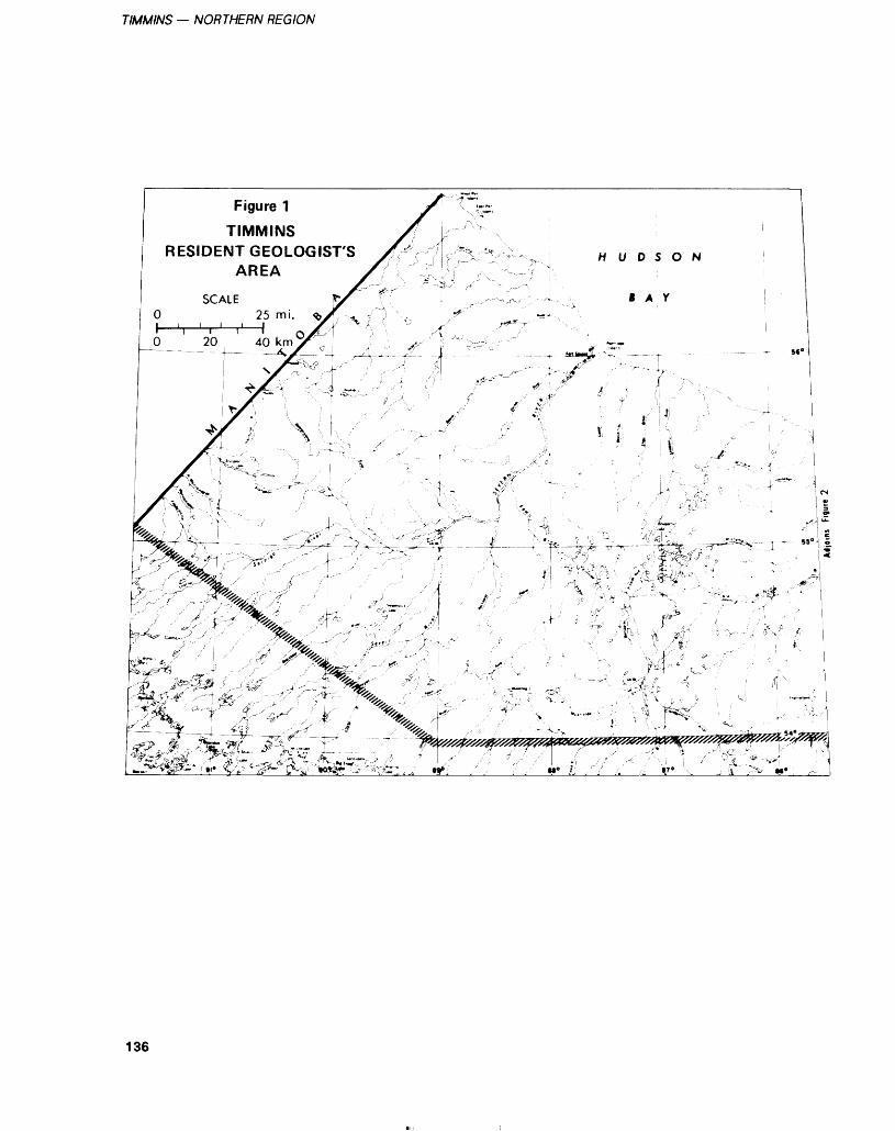
TIMMINS — NORTHERN REGION
Figure 1
TIMMINSRESIDENT GEOLOGIST'S
AREA
gg^'' ; .^ --'' --"^ ! l " /-•"'K^' ••"..i ;; •IT*
136
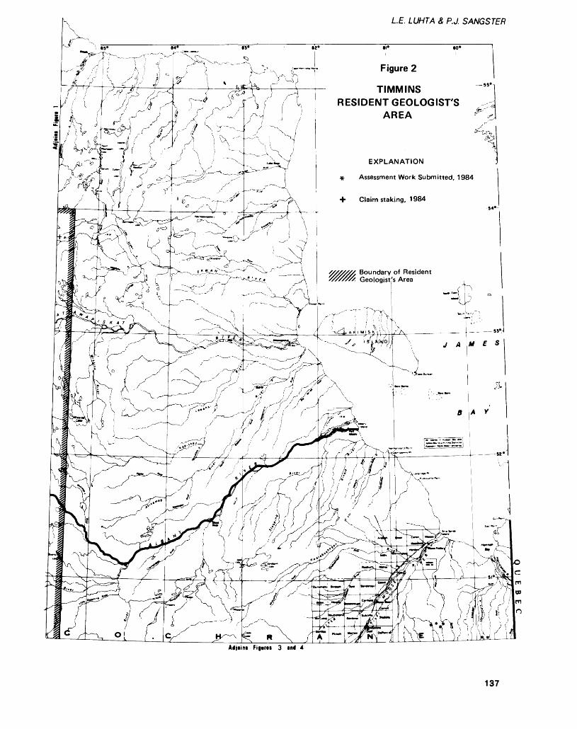
LE. LUHTA Z P.J. SANGSTER
85* 8
1 A 1 l -
4* ^^ 1 S* 8
K-y' v\,,, c2* 81*
Figure 2
80*
4v TIMMINSRESIDENT GEOLOGIST'S
AREA
EXPLANATION
Assessment Work Submitted, 1984
Claim staking. 1984
Boundary of Resident Geologist's Area
Adjoins Fi|*r8S 3 md 4
137
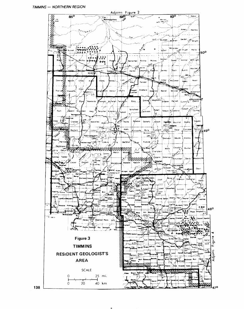
TIMMINS — NORTHERN REGIONAdjoins Figure 2
500
138
Figure 3
TIMMINS
RESIDENT GEOLOGIST'S AREA
470
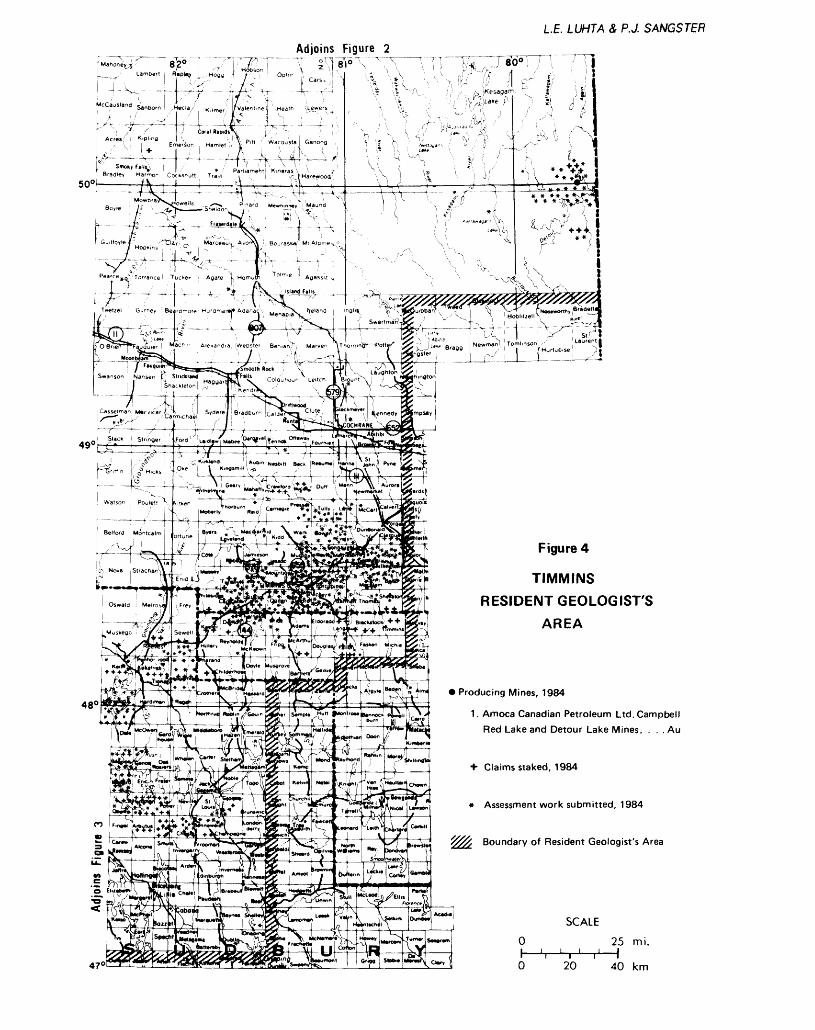
LE. LUHTA 8, P J. SANGSTER
Adjoins Figure 2
L....,-' Lambert j Rap|*v | ..Hoga
O'Brw^hTauo'u'ier l Ma^ h '" Ale.andra Webster Ben.ahn Marven ! *\Thorn.n
' 1sW\ ' rv^ \ PS- \ m V j Laughton Xrz-"Ni ? C8hi:9100,
10OJ ^y j Slnnger
-K,*j.nd( '(Au*,njNwfcM s^k |RMum.| Wo.:^J fV,. !^ Si 3ke i l Kiivgsm.M 1,,^; , ; . . . W-*^1!; t llilSinirSs v-\——— V^--V -^-r—— - 4^-fHH4r--k—S-4'-^4....}J.6-" LK^^^^DO,, l(V?^.i5j2|
Figure 4
TIMMINSRESIDENT GEOLOGISTS
AREA
Producing Mines, 1984
1. Amoca Canadian Petroleum Ltd. Campbell Red Lake and Detour Lake Mines. . . . Au
Claims staked, 1984
* Assessment work submitted, 1984
Boundary of Resident Geologist's Area
SCALE
O 25 mi.i i ii i i i ^ i j- i
O 20 40 km
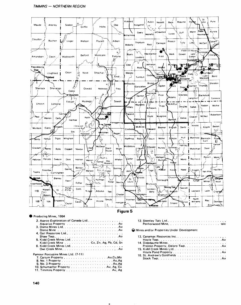
TIMMINS — NORTHERN REGION
Figure 5Producing Mines, 1984
2. Asarco Exploration of Canada Ltd.. . . . . . . . . . , . . . .Aquarius Property . . . . . . . . . . . . . . . . . . . . . . Au
3. Dome Mines Ltd. . . . . . . . . . . . . . . . . . . . . . . . AuDome Mine . . . . . . . . . . . . . . . . . . . . . . . . . . Au
4. Gail Resources Ltd.. . . . . . . . . . . . . . . . . . . . . . . .Shaw Twp.. . . . . . . . . . . . . . . . . . . . . . . . . . . Au
5. Kidd Creek Mines Ltd. . . . . . . . . . . . . . . . . . . . . . .Kidd Creek Mine . . . . . . . . . . . Cu, Zn, Ag, Pb, Cd, Sn
6. Kidd Creek Mines Ltd. . . . . . . . . . . . . . . . . . - . . . .Owl Creek Mine. . . . . . . . . . . . . . . . . . . . . . . . Au
Pamour Porcupine Mines Ltd. (7-11)7. Carium Property . . . . . . . . . . . . . . . . . . .Au,Cu,Mo8. No. 1 Property . . . . . . . . . . . . . . . . . . . . . . Au.Ag9. No. 3 Property . . . . . . . . . . . . . . . . . . . . . . Au,Ag
10. Schumacher Property . . . . . . . . . . . . . . . Au, Ag, Cu11. Timmins Property . . . . . . . . . . . . . . . . . . . Au, Ag
12. Steetley Talc Ltd.. . . . . . . . . . . . . . . . . . . . . . . . .Penhorwood Mine. . . . . . . . . . . . . . . . . . . . . . talc
Q Mines and/or Properties Under Development
13. Canamax Resources Inc. . . . . . . . . . . . . . . . . . . . . .Hoyle Twp. . . . . . . . . . . . . . . . . . . . . . . . . . . Au
14. Diepdaume Mines. . . . . . . . . . . . . . . . . . . . . . . . .Preston Property, Deloro Twp. . . . . . . . . . . . . . . . Au
15. Kidd Creek Mines Ltd. . . . . . . . . . . . . . . . . . . . . . .Hoyle Pond Property . . . . . . . . . . . . . . . . . . . . . Au
16. St. Andrew's Goldfields . . . . . . . . . . . . . . . . . . . . .Stock Twp. . . . . . . . . . . . . . . . . . . . . . . , . . . Au
140
LE. LUHTA 8, P.J. SANGSTER
TABLE 1. MAPS AND REPORTS PERTAINING TO THE TIMMINS RESIDENT GEOLOGIST AREA PUBLISHED DURING 1984 BY THE ONTARIO GEOLOGICAL SURVEY, MINISTRY OF NATURAL RESOURCES
Open File ReportsOFR 5396 - Geology of the Argor
Carbonatite Complex OFR 5398 - Geology of the
Borden Twp. CarbonatiteComplex
OFR 5400 - Geology of the CargillTwp. Carbonatite Complex
OFR 5402 - Geology of theClay-Howells Alkalic RockComplex
OFR 5404 - Geology of the GoldRay Carbonatite Complex
OFR 5405 - Geology of the HeclaKilmer Alkalic Rock Complex
OFR 5406 - Alkalic Rocks 5.Carbonatites of the James BayLowlands
OFR 5408 - Geology of theLackner Lake Alkalic RockComplex
OFR 5410 - Geology of theNemogosenda Lake AlkalicRock Complex
OFR 5415 - Geology of theShenango Township AlkalicRock Complex
OFR 5418 - Geology of theValentine TownshipCarbonatite Complex
OFR 5436 - Literature Review ofAlkalic Rocks - Carbonatites
OFR 5492 - Peat and Peatland
Evaluation of the Foleyet Area, 5 volumes
OFR 5495 - Lignite Resource Assessment Project: 1983 Winter Drilling Program, Moose River Basin, James Bay Lowlands
OFR 5511 - Lignite Assessment Project - Winter 1984 Drilling Program, James Bay Lowlands
Preliminary MapsP. 2695 - Quaternary Geology of
the Constance Lake Area P. 2696 - Quaternary Geology of
the Hanlan Lake Area P. 2736 - Location of Gold Grains
in Sonic Drill Samples from theMatheson Area
MapsMap 2205 - (Reprint)
Timmins-Kirkland Lake SheetMiscellaneous PapersMP 117- Report of Activities
Regional Resident Geologists1983
MP 119- Summary of Field Work,1984
MP 120 - Exploration TechnologyDevelopment Program of theBoard of Industrial Leadershipand Development, Summary ofResearch 1983-84
MP 121 - Geoscience ResearchGrant Program, Summary ofResearch 1983-84
Geophysical/Geochemical SeriesMAP 80582 - Stock Township -
Airborne ElectromagneticSurvey, Total IntensityMagnetic Survey
MAP 80592 - Bond Township -Airborne ElectromagneticSurvey, Total IntensityMagnetic Survey
MAP 80570 - Clergue Township -Airborne ElectromagneticSurvey, Total IntensityMagnetic Survey
MAP 80602 - Sheraton Township -Airborne ElectromagneticSurvey, Total IntensityMagnetic Survey
Aggregate Resources PublicationsARIP 71 - Aggregate Resources
Inventory of the Hearst Area ARIP 72 - Aggregate Resources
Inventory of the KapuskasingArea
ARIP 93 - Aggregate ResourcesInventory of the Smooth RockFalls Area
Additional PublicationsLithostratigraphic Map of the
Abitibi Subprovince
Ross Division (underground): 235 000 tonsSchumacher Division (under ground): 275 000 ionsPamour Number 3 (underground): 58 000 ionsTimmins Property (underground): 83 000 tonsTimmins Property (surface): 200 000 tons.
Pamour custom milled 280 000 tonnes (308 000 tons) of gold ore from the Owl Creek Mine for Kidd Creek Mines Limited. Two hundred and seven tons were milled for Bridget Resources Limit
ed from Wawa. Concentrate was treated from Bridget Resources Limited, Consolidated Louanna Gold Mines Limited from Nakina, and Asarco Exploration Company of Canada Limited Aquarius Pro- ject.
In 1983 (1984 figures are not available at the time of writing) Pamour Porcupine Mines Limited completed 7744 feet (2360 m) of underground development (drifts and raises) and 126 994 feet (38 708 m) of diamond drilling at their 5 mines. Due to the falling gold price in 1984, Pamour was forced to reduce operations by closing the
Pamour Number 3 Mine (Aunor) in October and the Timmins Prop erty Mine underground (Hollinger) in August. The Pamour Schumacher Division Mine (Mcintyre) is still operating but on a day to day basis. The number of people employed at Pamour's op eration decreased from 968 in 1983 to 746 by the end of 1984 (Pamour Porcupine Mines Limit ed, personal communications, 1984).
The Owl Creek Gold Deposit of Kidd Creek Mines Limited, lo cated in Hoyle Township, has been mining gold by open pit methods
141
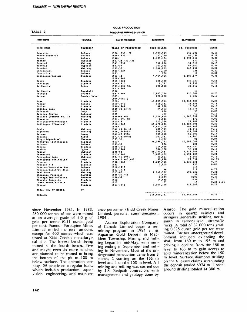
TIMMINS — NORTHERN REGION
TABLE 2GOLD PRODUCTION
PORCUPINE MINING DIVISION
Township • Mr off Production Tom Milled oz. PTOOUOBO OrMto
HINE NAME
AnkeriteAnkerlte/MarchAunor
cordla laurun/CarluB
C r wn Da Idaon De Santls
De SantlsDelnlteDetour
DomeFaymarPullerGillies LakeGoldhawkHalcrow-SwayzeHallnor (Pamour No. 2)HiawathaHolllnger-SchumacherHollinger (Timmins)
HoyleHugh-PamJeromeJoburkeKlngbrldge/GoaakMcintyre (Schumacher)McLarenMonetaNaybobPamourPaymasterPorcupine LakePorcupine PeninsularPrestonPreston N YPreston/Porcupine PetPreston/Porphyry HillReef MineShenango ProspectTlonaga/Smith-ThorneTisdale AnkeriteTommy Burns/ArcadiaVlpond
TOTAL NO. OF MINES:
TOWNSHIP
DeloroDeloroDeloroWhitneyWhitneyWhitneyWhitneyDeloroDeloroTisdale
Tisdale Tisdale Ogden
Turnbull Deloro Sunday Lake
TisdaleDeloroTisdaleTisdaleCodyHalcrowWhitneyLizarTisdaleTisdale
WhitneyWhitneyOswayKeithChesterTisdaleDeloroTisdaleOgdenWhitneyTisdaleWhitneyCodyTisdaleTisdaleDeloroDeloroWhitneyHawkinsHorwoodTisdaleShawTisdale
49
TEARS OF PRODUCTION TONS MILLED OZ. PRODUCED
1926- 1926- 1940- 1927- 1941- 1951- 1939- 1922- 1935 1913- 1928- 1913- 1918- 1933, 1961-
1926 1937- 1983- (NOV, 1920- 1940- 1940- 1929- 1947 1935 1938- 1937, 1915- 1910- 1976- 1941- 1926, 1941- 1973- 1935- 1912- 1933- 1938- 1932- 1936- 1915- 1937- 1924- 1938-
1933 1914- 1913- 1915- 1936- 1938- 1952 1917 1911-
1953,-78 1935
28,-33,-35195154531924
18,1961192119201939-42,1964
1964
-DEC.)
1942 1944 31,35-37
68,-81 -39,-40 18 1968
44,46-49 1948-65 43,1956 75,79-8136
371943196468196640,194427,-40,-471968
1915 1915 6537,-45 39
4.993,929317,769
8,423,174315
352,254200,555
1,146,0593,200
2304,464,006
226,1809,341
196,928
3,847,364124,000
40,825,914119,18144 02854,502
636211
4,226,4191,931
112.12465,778,2341,622,200725,494636,751335,060302,561
1,38736,599.722
876314,829304,100
26,755,0315,607,402
10,82199,688
6,284,4052,800
462, 144,507
2.4006,65314,655
211,565,218
957,29261,039
2,496,017670
51,51067,940243,757
73616
1,109,574
138,3302,438
35,842
13920,404
5,937
10,848,60321 , 8516,56615,278
5340
1,645,892179
27,18219,327.691
108,14871 .843
119.60456.89328.440
9810,682,061
201149,25050,731
2,918,9011,192,206
1,36927,354
1,539,355153314312
498,93237
22992236
14414,367
0.190. 190.302. 130.150.340.210.230.070.25
0.610.260.18
0.200.10
0.270.180.150.280.080.190.390.090.240.290.070.100. 190.170.090.070.290.230.470.170.110.210.130.1230.240.05
6.780.230.020.350.150.28-0.340.26
218,805,111 55,849,968
since November 1981. In 1983, 280 000 ronnes of ore were mined at an average grade of 4.0 g of gold per tonne (0.1 l ounce gold per ton). Pamour Porcupine Mines Limited milled the total amount, except for 600 tonnes which was tested at Kidd Creek's metallurgi cal site. The lowest bench being mined is the fourth bench. Five and maybe even six more benches are planned to be mined to bring the bottom of the pit to 100 m below surface. The operation em ploys 25 people on a regular basis, which includes production, super vision, engineering, and mainten
ance personnel (Kidd Creek Mines Limited, personal communication, 1984).
Asarco Exploration Company of Canada Limited began a test mining program in 1984 at its Aquarius Gold Deposit in Mac klem Township. Mining and mill ing began in mid-May, with min ing ending in September and mill ing in November. Most of the un derground production came from 3 slopes; 2 starting on the 166 m level and l on the 150 m level. All mining and milling was carried out by J.S. Redpath contractors with management and geology done by
Asarco. The gold mineralization occurs in quartz veinlets and stringers generally striking north- south in carbonatized ultramafic rocks. A total of 32 000 tons grad ing 0.225 ounce gold per ton were milled. Further underground devel opment included extending the shaft from 160 m to 195 m and driving a decline from the 150 m level to 166 m to gain access to gold mineralization below the 150 m level. Surface diamond drilling on the 6 leased claims surrounding the deposit totaled 6974 m. Under ground drilling totaled 14 386 m.
142
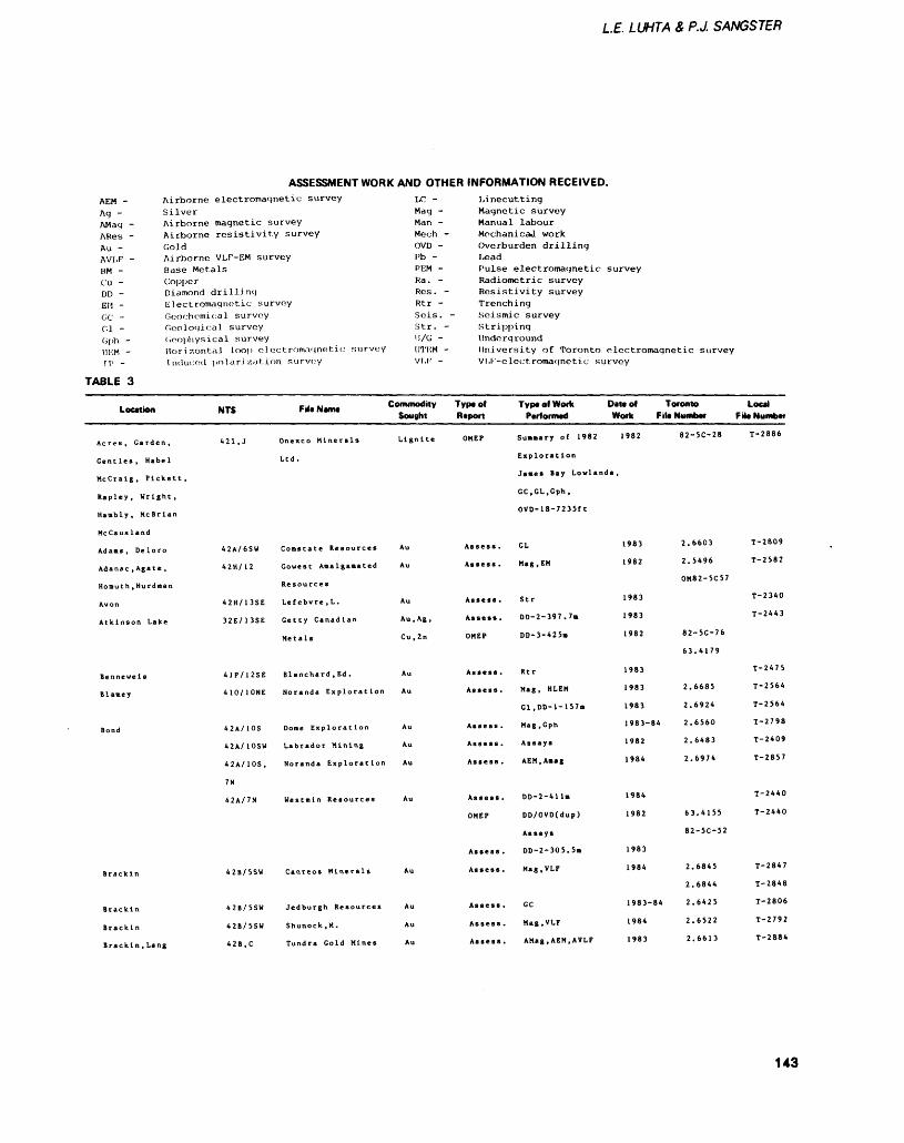
LE. LUHTA & P J. SANGSTER
ASSESSMENT WORK AND OTHER INFORMATION RECEIVED.AEM - Ag - AMaq - ARes - Au - AVI.F - BM - Cu - DD - EM - GC - CI -
Airborne electromagnetic survey LC -Silver Mag -Airborne magnetic survey Man -Airborne resistivity survey MechGold OVD -Airborne VLF-EM survey Pb -Base Metals PEN -Copper Ra. -Diamond drilling Res.Electromagnetic survey Rtr -Geoohemical survey Seis.Gcoloqical survey Str.Geophysical survey U/G - HorizontaJ loop c] octromaqnetic survey tJTKMInduced pnlar.i nation survey VT.P -
J.inecuttingMagnetic surveyManual labourMochanicaJ. workOverburden drillingLeadPulse electromagnetic surveyRadiometric surveyResistivity surveyTrenchingSeismic surveyStrippingUndergroundUniversity of Toronto electromagnetic surveyVf.P-clectromaqnetic survey
TABLE 3
Location
Acres, Garden,
Gentles, Habel
McCraig, Pickett,
Rapley, Wright,
Hambly, McBrlan
Mccausland
Adams, Deloro
Adanac .Agate ,
Homuth .Hurdman
Avon
Atkinson Lake
Benneweis
Blamey
Bond
Brackin
Brackin
Brackin
Brackin , Lang
NTS File Name Commodity Type of Sought Report
421, J Onexco Minerals Lignite OMEP
Ltd.
42H/12 Gowest Amalgamated Au Assess.
32E/13SE Getty Canadian Au , Ag , Assess.
Metals Cu.Zn OMEP
41P/12SE Blanchard , Ed . Au Assess.
42A/10S Dome Exploration Au Assess.
42A/10S, Noranda Exploration Au Assess.
7N
OMEP
Assess .
42B/5SW Canreos Minerals Au Assess.
42B/5SW Jedburgh Resources Au Assess.
42B/5SW Shunock.M. Au Assess.
42B.C Tundra Gold Mines Au Assess.
Type of Work Performed
Summary of 1982
Exploration
James Bay Lowlai
GC.GL.Gph ,
OVD-18-7235f t
GL
Mag, EM
Str
DD-2-397.7m
DD-3-425m
Rtr
Mag, HLEM
Gl,DD-l-157m
Mag.Gph
AEM.Anag
DD-2-411m
DDXOVD(dup)
Assays
DD-2-305.5m
Mag.VLF
GC
Mag.VLF
AMag.AEM.AVLF
Oat* of Toronto Local Work File Number File Number
1982
ids,
1983
1982
1983
1983
1982
1983
1983
1983
1983-84
1982
1984
1984
1982
1983
1984
1983-84
1984
1983
82-5C-28
2.6603
2.5496
OM82-5C57
82-5C-76
63.4179
2.6685
2.6924
2.6560
2.6483
2.6974
63.4155
82-5C-52
2.6845
2.6844
2.6425
2.6522
2.6613
T-2886
T-2809
T-2582
T-2340
T-2443
T-2475
T-2564
T-2564
T-2798
T-2409
T-2857
T-2440
T-2440
T-2847
T-2848
T-2806
T-2792
T-2884
143
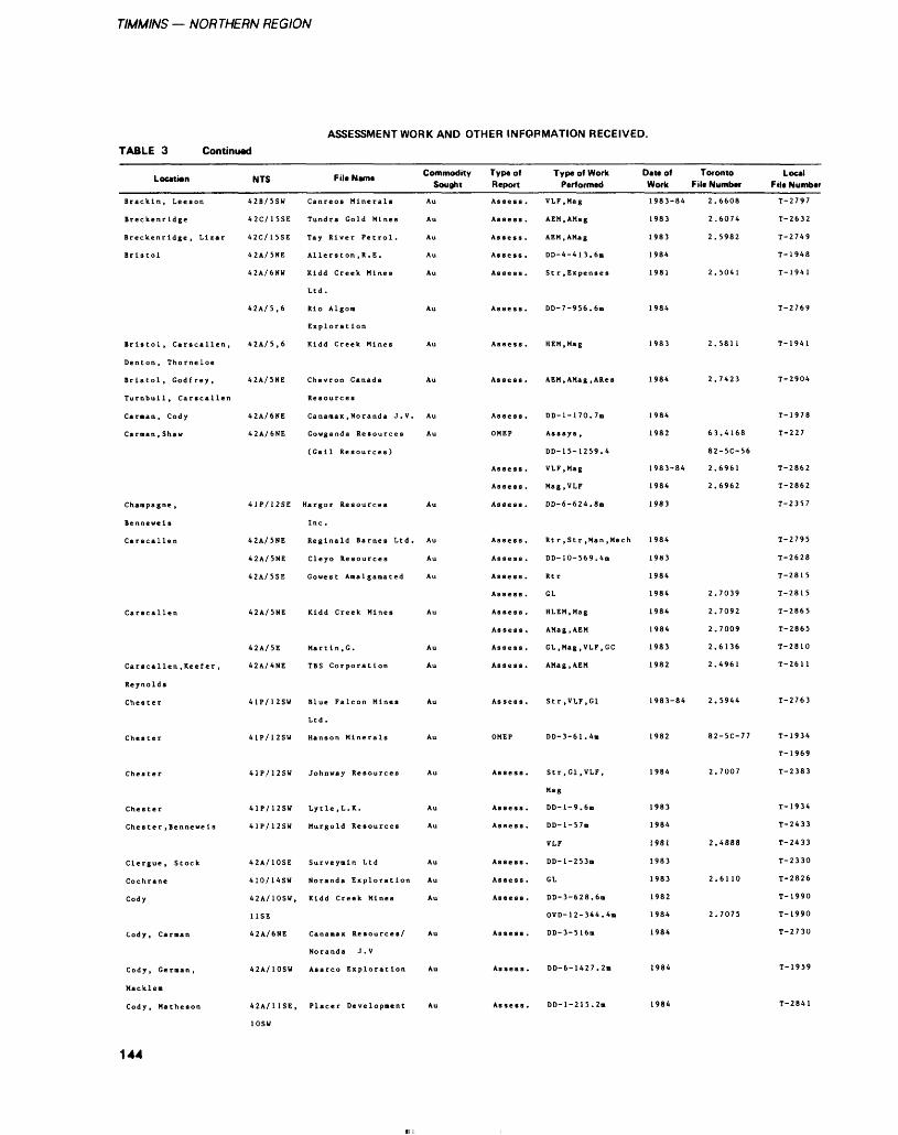
TIMMINS — NORTHERN REGION
ASSESSMENT WORK AND OTHER INFORMATION RECEIVED.TABLE 3 Continued
Location
Brackin, Leeson
Breckenridge
Breckenridge, Lizar
Bristol
Denton, Thorneloe
Bristol, Godfrey,
Turnbull, Carscallen
Carman, Cody
Carman , Shaw
Champagne ,
Benneweis
Carscallen
Carscallen
Reynolds
Chester
Chester
Chester
Chester
Clergue, Stock
Cochrane
Cody
Cody, Carman
Cody, German,
Macklem
Cody, Matheson
NTS
42B/5SW
42C/15SE
42C/15SE
42A/5NE
42A/6NU
42A/5.6
42A/5.6
42A/5NE
42A/6NE
42A/6NE
41P/12SE
42A/5NE
42A/5NE
42A/5SE
42A/5NE
42A/5E
4 2 A/ 4 NE
41P/12SW
41P/12SW
41P/12SW
41P/12SW
41P/12SW
42A/10SE
410/14SU
42A/10SU,
USE
42A/6NE
42A/10SW
42A/11SE,
File Name Commodity Type of Sought Report
Canreos Minerals Au
Tundra Gold Mines Au
Al lers ton , R. E . Au
Kidd Creek Mines Au
Ltd.
Rio Algon Au
Exploration
Kidd Creek Mines Au
Chevron Canada Au
Resources
Canamax , Noranda J.V. Au
Gowganda Resources Au
(Gall Resources)
Hargor Resources Au
Inc.
Reginald Barnes Ltd. Au
Cleyo Resources Au
Gowest Amalgamated Au
Kidd Creek Mines Au
Mar t In, G. Au
TBS Corporation Au
Blue Falcon Mines Au
Ltd.
Hanson Minerals Au
Lytle.L.K. Au
Murgold Resources Au
Surveymln Ltd Au
Noranda Exploration Au
Kidd Creek Mines Au
Noranda J.V
Asarco Exploration Au
Placer Development Au
Assess .
Assess .
Assess .
Assess .
Assess .
Assess .
Assess .
Assess .
OMEP
Assess .
Assess .
Assess .
Assess .
Assess .
Assess .
Assess .
Assess .
Assess .
Assess .
Assess.
Assess .
OMEP
Assess .
Assess .
Assess .
Assess .
Assess .
Assess .
Assess .
Assess .
Assess .
Type of Work Performed
VLF.Mag
AEM.AMag
AEM.AMag
DD-4-413.6m
DD-7-956.6m
HEM, Mag
AEM.AMag, ARes
DD-l-170.7m
Assays ,
DD-15-1259.4
VLF.Mag
Mag.VLF
DD-6-624.8m
Rtr , Str ,Man ,Mech
DD-10-569.4m
Rtr
GL
HLEM.Mag
AMag.AEM
GL.Mag , VLF.GC
AMag.AEM
Str ,VLF,G1
DD-3-61.4m
Str ,G1 ,VLF,
Mag
DD-l-9.6m
DD-l-57m
VLF
DD-l-253m
GL
DD-3-628.6m
OVD-12-344.4m
DD-3-516m
DD-6-1427.2ii
DD-l-215.2m
Date of Toronto Work File Number
1983-84
1983
1983
1984
1981
1984
1983
1984
1984
1982
1983-84
1984
1983
1984
1983
1984
1984
1984
1984
1983
1982
1983-84
1982
1984
1983
1984
1981
1983
1983
1982
1984
1984
1984
1984
2.6608
2.6074
2 C Q Q 9. J 7O i,
2.5041
2.5811
2.7423
63.4168
82-5C-56
2.6961
2.6962
2.7039
2.7092
2.7009
2.6136
2.4961
2.5944
82-5C-77
2.7007
2.4888
2.6110
2.7075
Local File Number
T-2797
T-2632
T-2749
T-1948
T-1941
T-2769
T-1941
T-2904
T-1978
T-227
T-2862
T-2862
T-2357
T-2795
T-2628
T-2815
T-2815
T-2865
T-2865
T-2810
T-2611
T-2763
T-1934
T-1969
T-2383
T-1934
T-2433
T-2433
T-2330
T-2826
T-1990
T-1990
T-2730
T-1959
T-2841
144
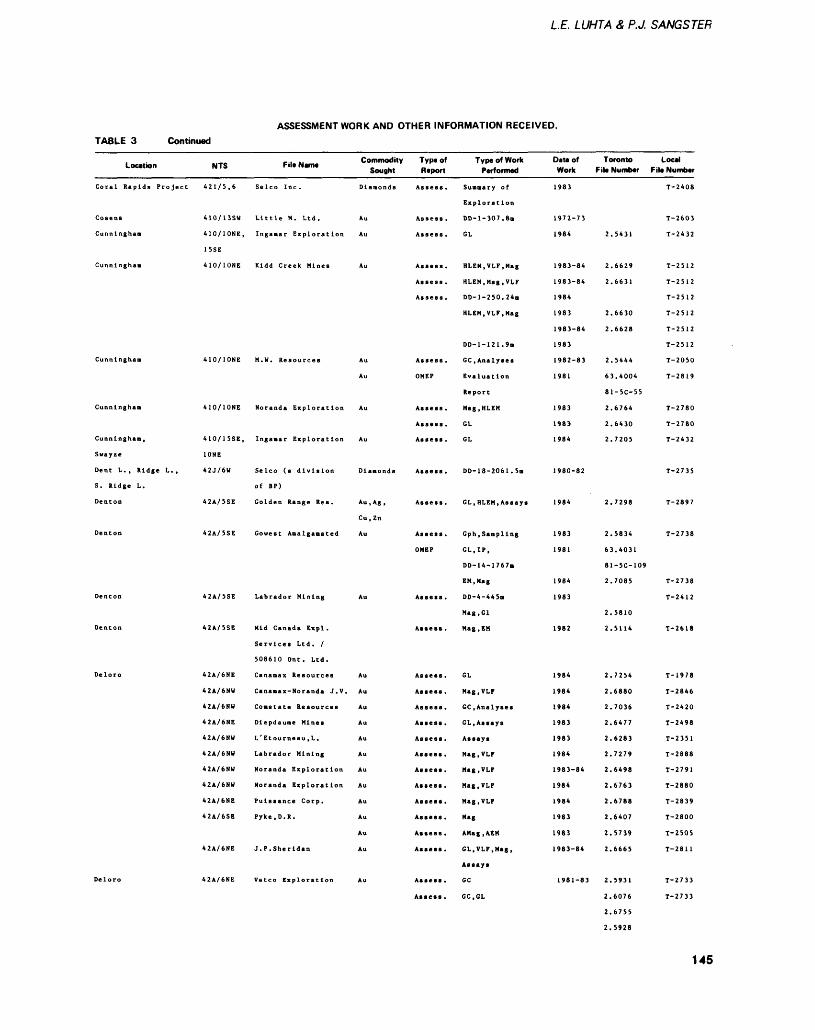
LE. LUHTA 8, P.J, SANGSTER
ASSESSMENT WORK AND OTHER INFORMATION RECEIVED.TABLE 3 Continued
Location
Coral Rapids Project
Cosens
Cunningham
Cunningham
Cunningham
Cunningham
Cunningham,
Swayze
Dent L. , Ridge L. ,
S. Ridge L.
Denton
Denton
Denton
Denton
Deloro
Deloro
-. . -. Commodity Type of NTS File Name . Sought Report
410/13SW Little H. Ltd. Au Assess.
410/10NE, Ingamar Exploration Au Assess.
1SSE
410/10NE Kidd Creek Mines Au Assess.
Assess .
Assess .
410/10NE H. W. Resources Au Assess.
Au OMEP
410/10NE Noranda Exploration Au Assess.
Assess .
410/15SE, Inganar Exploration Au Assess.
10NE
42J/6W Selco (a division Diamonds Assess.
of BF)
42A/5SE Golden Range Res. Au.Ag, Assess.
Cu.Zn
OMEP
42A/5SE Labrador Mining Au Assess.
42A/5SE Mid Canada Expl. Assess.
508610 Ont. Ltd.
42A/6NE Dlepdaune Mines Au Assess.
42A/6NW Labrador Mining Au Assess.
42A/6NW Noranda Exploration Au Assess.
42A/6NW Noranda Exploration Au Assess.
42A/6NE Puissance Corp. Au Asses*.
42A/6SE Pyke, D. R. Au Assess.
Au Assess.
42A/6NE J.P.Sheridan Au Assess.
42A/6NE Vatco Exploration Au Assess.
Assess .
Type of Work Performed
Exploration
DD-l-307.8n
GL
HLEM,VLF,Mag
HLEM.Mag.VLF
DD-1-250.24B
HLEM.VLF.Mag
DD-l-121.9n
GC, Analyses
Report
Mag.HLEM
GL
GL
DD-18-2061 . 5m
CL.HLEM, Assays
Gph .Sampling
GL.IP,
DD-14-176711
EM, Mag
DD-4-445H
Mag.Gl
Mag, EM
GL
Mag.VLF
GC, Analyses
GL, Assays
Mag.VLF
Mag.VLF
Mag.VLF
Mag.VLF
M*g
AMag.AEM
GL.VLF.Mag,
Assays
GC
GC.CL
Date of Toronto Local Work File Number File Number
1983
1972-73
1984
1983-84
1983-84
1984
1983
1983-84
1983
1982-83
1981
1983
1983
1984
1980-82
1984
1 903
1981
1984
1983
1982
1 984
1984
1984
1983
1983
1984
1983-84
1984
1984
1983
1983
1983-84
1981-83
2.5431
2.6629
2.6631
2.6630
2.6628
2.S444
63.4004
81-5C-55
2.6764
2.6430
2.7205
2.7298
2.5834
63.4031
81-5C-109
2.7085
2.5810
2.5114
2.7254
2.6880
2.7036
2.6477
2.6283
2.7279
2.6498
2.6763
2.6788
2.6407
2.5739
2.6665
2.5931
2.6076
2.6755
2.5928
T 2 408
T-2603
T-2432
T-2512
T-2512
T-2512
T-2512
T-2512
T-2512
T-2050
T~ 2819
T-2780
T-2780
T-2432
T-2735
T-2897
T~2 738
T-2738
T-2412
T-2618
T 1 Q 7 A i y i o
T-2846
T-2420
T-2498
T-2351
T-2888
T-2791
T-2880
T-2839
T-2800
T-2505
T-2811
T-2733
T-2733
145
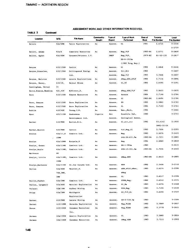
TIMMINS - NORTHERN REGION
ASSESSMENT WORK AND OTHER INFORMATION RECEIVED.TABLE 3 Continued
Location
Deloro
Deloro, Ad aa i
Deloro, Ogden
Denyes
Denyes, Greenlaw,
Denyes , Halcrow
Denyes , Raney ,
Cunningham, Garnet
Derry, Ermine, Hawk Ins
Dore
Dore, Swayze
Dore, Swayze
Dublin
Dyer
Esther
Evelyn
Evelyn
Evelyn, Gowan
Evelyn, Hoyle
Matheson
Evelyn, Little
Evelyn, Matheson
Fallon
Fallon, Fasken
Fallon, Langmuir
Foleyet
Fripp
Garnet.
Garnet
Genoa
German
Geraan
NTS
42A/6NE
42A/6
42A/6SW
410/15SW
410/15SW
410/15SW
410/10,
15
42C.42F
410/15SE
410/15SE
410/15SE
41P/4SE
421/11SW
410/9NU
410/9NU
42A/1 1 ,E
10NU
42A/10NU
42A/11NE
42A/11NE,
SE
42A/1 1NE,
10NU
42A/1 1SE
42A/6SE
7SW.3NE,
2NW
42A/2NW
42A/6SE
42B/1NW
42A/3NU
410/9NU
410/10NE
410/16SE
42A/10SW
42A/10SU
FikN.m. Commodity Sought
Vatco Exploration Au
Cananax/Bruneau J.V.
Canlco Au
Collingwood Energy Au
Ltd.
Lenora Explorations Au
Dejour Mines Au
McKlnnon.D. Au
Dore Exploration Au
Dore Exploration Au
Young, J. R. Au
Onakawana Lignite
Developnent Ltd.
Burton ,M. L. Au
Canlco Au
Conlnco Ltd. Au
Korpela,D Au
Com 1 ne o Ltd . Au
Coninco Ltd. Au
Coalnco Ltd. Au
St. Joe Canada Ltd. Au
Meunler.D. Au
Cominco Ltd. Au
Mercler Exploration Au
Hudbay Mining Au
Northgate Au
Exploration
Lacana Mining Au
Noranda Exploration Au
Canamax Resources Au
Inc.
Asarco Exploration Au
Type of Report
Assess .
Assess .
OMEP
Assess .
Assess .
Assess .
Assess .
Assess .
Assess .
Assess .
Assess .
Not
Assess .
Assess .
Assess .
Assess .
Assess .
Assess .
Assess .
Assess .
Assess .
Assess .
Assess .
Assess .
Assess .
Assess .
As se ss .
Assess .
Assess .
Assess .
Assess .
Type of Work Daw of Toronto Local Performed Work File Number F M* Number
GL
Mag.VLF
Mag,VLF,
DD-6-I053m
(1982 Prog Rep.)
CI
Mag.Vlf
AMag.AEM.AVLF
GL.GC
AMag.AEM.VLF
GC
EM
GL
Downhole Gph,
Geological Asses.
VLF.Mag.Gl
Mag
OVD-26-631.9ii
Mag
DD-l-392n
OVD-15-351 .4m
AMag.AEM
AEM.AVLF.ARes,
AMag
GL
UTEM.Mag.
Gl , Ra
PEM.Mag
GC.VLF.GL
DD-2-318.5m
Mag.HLEM
Mag.HLEM
CL
AMag.AEM
1981
1983-84
1979-82
1983
1983
1983
1984
1983
1983
1984
1983-84
1983
1984
1984
1980
1982
1983
1983
1983-84
1984
1983
1983-84
1983-84
1982
1983
1983
1982
1983
1983
1982
1983
1982
1 Q ft 1i y o .J
1983
1983
2.
2.
81
2.
2.
2.
2.
2.
2.
2.
2.
2.
6755
6771
-5C-135
6848
5666
7116
6595
6655
7140
6494
5865
7103
.414?
OM82-5I-26
2.7004
2.
2.
2.
2.
2.
2.
2.
2.
2.
2.
2.
2.
2.
2.
2,
2.
6076
7371
6860
7034
6415
5406
6274
6217
6312
6376
7104
6246
5869
,5778
5882
.7212
T-2530
T-2733
T~ 2809
T-2817
T-2446
T-2607
T-2607
T~ 2896
T-2591
T-2835
T-2784
T-2784
T-2765
T-2765
T-2464
T-2745
T-1920
T-2595
T-2403
T-2885
T-2849
T-2414
T-2403
T-2885
T-2510
T-2596
T-2596
T-2574
T-2568
T-2430
T-2525
T-2584
T-2827
T-2621
T-2824
T-2902
146
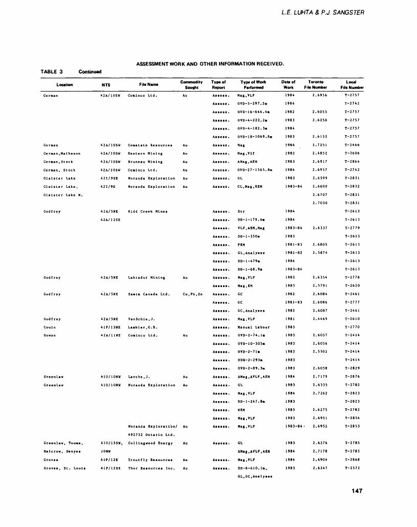
LE. LUHTA S P.J. SANGSTER
ASSESSMENT WORK AND OTHER INFORMATION RECEIVED.TABLE 3 Continued
Location
German
Gernan
Geraan .Matheson
Geraan .Stock
Gernan, Stock
Glaister Lake
Glaister Lake,
Glaister Lake N.
Godfrey
Godfrey
Godfrey
Godfrey
Gouin
Gowan
Greenlaw
Greenlaw
Greenlaw, Tooms,
Halcrow, Denyes
Groves
Groves, St. Louis
NTS File Name Commodity Type of Sought Report
42A/10SU Comlnco Ltd. Au Assess.
Assess .
Assess .
Assess .
Assess .
Assess .
42A/10SW Constate Resources Au Assess.
42A/10SW Eastern Mining Au Assess.
42A/10SW Bruneau Mining Au Assess.
42A/10SW Conlnco Ltd. Au Assess.
42I/9SE Noranda Exploration Au Assess.
42I/9E Noranda Exploration Au Assess.
42A/5NE Kidd Creek Mines Assess.
42A/12SE Assess.
Assess .
Assess .
Assess .
Assess.
Assess .
Assess .
42A/SNE Labrador Mining Au Assess.
Assess .
42A/5NE Samlm Canada Ltd. Cu.Pb.Zn Assess.
Assess .
Assess .
42A/5NE VanSchle.J. Assess.
42A/11NE Conlnco Ltd. Au Assess.
Assess .
Assess .
Assess .
Assess .
410/10NW Larche.J. Au Assess.
410/10NW Noranda Exploration Au Assess.
Assess .
Assess .
Assess .
Assess .
Noranda Exploration/ Au Assess.
492752 Ontario Ltd.
410/15SW, Collingwood Energy Au Assess.
10NW
41P/12E Troutfly Resources Au Assess.
41P/12SE Thor Resources Inc. Au Assess.
Type of Work Performed
Mag.VLF
OVD-5-297.2m
OVD-16-644.4n
OVD-4-222.2m
OVD-4-182.3n
OVD-18-1069.8B
Mag
Mag.Vlf
AMag.AEM
OVD-27-1565.8m
GL
GL, Mag, HEM
Str
DD-1-179.6*
VLF.AEM.Mag
DD-l-350m
PEN
GL, Analyses
DD-l-479m
DD-l-68.9m
Mag.VLF
Mag, EM
GC
GC
GC, Analyses
Mag.VLF
OVD-2-74.1m
OVD-10-305m
OVD-2-71m
DDH-2-293m
OVD-2-89.3B
AMag,AVLF,AEM
GL
Mag.VLF
DD-1-247.8*
HEM
Mag.VLF
Mag.VLF
GL
AMag.AVLF.AEM
Mag.VLF
DD-6-610.1.,
Date of Toronto Work File Number
1984
1984
1982
1983
1984
1983
1984
1982
1983
1984
1983
1983-84
1984
1984
1983-84
1983
1981-83
1981-82
1984
1983-84
1983
1983
1982
1981-83
1982
1981
1 98 3
1983
1983
1983
1983
1983
1984
1983
1984
1983
1983
1983
1983-84 -
1983
1984
1984
1983
2.6956
2.6055
2.6258
2.6133
2.7251
2.4852
2.6917
2.6957
2.6599
2.6600
2.6707
2.7030
2.6337
2.6805
2.5874
2.6354
2.5791
2.6084
2.6086
2.6087
2.4469
2.6057
2.6056
2.5502
2.6058
2.7179
2.6335
2.7262
2.6275
2.6951
2.6952
2.6276
2.7178
2.6904
2.6247
Local File Number
T-2757
T-2742
T-2757
T-2757
T-2757
T-2757
T-2466
T-2606
T-2864
T-2742
T-2831
T-2832
T-2831
T-2831
T-2613
T-2613
T-2779
T-2613
T-2613
T-2613
T-2613
T-2613
T-2778
T-2620
T-2461
T-2777
T-2461
T-2610
T-2770
T-2414
T-2414
T-2414
T-2414
T-2829
T-2876
T-2782
T-2823
T-2823
T-2782
T-2854
T-2853
T-2785
T-2785
T-2868
T-2572
GL.GC,Analyses
147
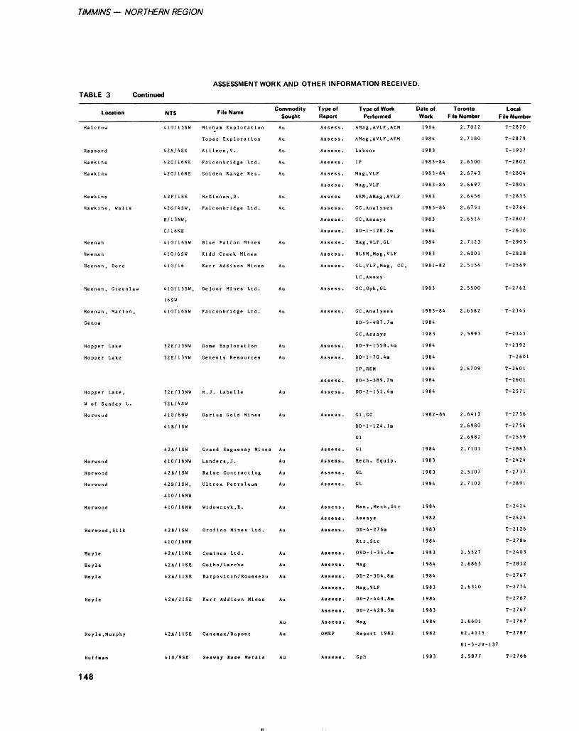
TIMMINS — NORTHERN REGION
ASSESSMENT WORK AND OTHER INFORMATION RECEIVED.TABLE 3 Continued
Location
Halcrow
Hassard
Hawkins
Hawkins
Hawkins
Hawkins, Walls
Heenan
Heenan
Heenan, Dore
Heenan, Greenlaw
Heenan, Marion,
Genoa
Hopper Lake
Hopper Lake
Hopper Lake ,
W of Sunday L.
Horwood
Horwood
Horwood
Horwood
Horwood
Horwood , Silk
Hoyle
Hoyle
Hoyle
Hoyle
Hoyle .Murphy
Huffman
148
c .. .. Commodity NTS F il* Name Sought
410/15SW Mlcham Exploration Au
Topaz Exploration Au
42A/4SE Killeen.V. Au
42C/16NE Falconbridge Ltd. Au
42C/16NE Golden Range Res. Au
42F/1SE McKlnnon.D. Au
42G/4SW, Falconbridge Ltd. Au
B/l 3NW,
C/ 16NE
410/16SW Blue Falcon Mines Au
410/6SW Kidd Creek Mines
410/16 Kerr Addison Mines Au
410/15SW, Dejour Mines Ltd. Au
16SW
32E/13NU Dome Exploration Au
32E/13NW Genesis Resources Au
32E/13NW M. J. Labelle Au
32L/4SW
410/6NW Darius Gold Mines Au
41B/1SW
42A/1SW Grand Saguenay Mines Au
410/16NW Landers.J. Au
42B/1SW Raise Contracting Au
42B/1SW, Ultrex Petroleum Au
410/16NW
410/16NW Wldowczyk.R. Au
42B/1SU Oroflno Mines Ltd. Au
410/16NW
42A/11NE Comlnco Ltd. Au
42A/11SE Gulho/Larche Au
42A/HSE Karpovltch/Rousseau Au
42A/11SE Kerr Addison Mines Au
Au
42A/11SE Canamax/Dupont Au
410/9SE Seaway Base Metals Au
Type of Report
Assess .
Assess .
Assess .
Assess .
Assess .
Assess .
Assess
Assess .
Assess .
Assess .
Assess .
Assess .
Assess .
Assess .
Assess .
Assess .
Assess .
Assess .
Assess .
Assess .
Assess .
Assess .
Assess .
Assess .
Assess .
Assess.
Assess .
Assess .
Assess.
Assess .
Assess .
Assess .
Assess .
Assess .
OMEP
Assess .
Type of Work Performed
AMag, AVLF, AEM
AMag , AVLF, AEM
Labour
IP
Mag ,VLF
Mag.VLF
AEM, AMag , AVLF
GC, Analyses
GC .Assays
DD-1-128. 2m
Mag.VLF.GL
HLEM.Mag.VLF
GL.VLF.Mag, GC,
LC .Assay
GC.Gph.GL
GC .Analyses
DD-5-487.7m
GC .Assays
DD-9-1558.4m
DD-l-70.4m
IP, HEM
DD-3-589.2m
DD-2-1 52. 4n
Gl ,GC
DD-1-124. 1m
Gl
Gl
Mech. Equip.
GL
GL
Man. ,Mech,Str
Assays
DD-4-276m
Rt r , St r
OVD-1-34.4B
Mag
DD-2-304.8m
Mag.VLF
DD-2-443.8m
DD-2-428. 5m
Mag
Report 1982
Gph
Date of Work
1984
1984
1983
1983-84
1983-84
1983
1983-84
1983
1984
1984
1983
1981-82
1983
1 983 84
1984
1983
1984
1984
1984
1984
1984
1982-84
1984
1983
1983
1984
1984
1982
1983
1984
1983
1984
1984
1983
1984
1983
1984
1982
1983
Toronto File Number
2. 7022
2.7180
2.6500
2.6743
2.6697
2.6456
2.6751
2.6524
2.7123
2.6001
2.5154
2.5500
2.6582
2. 5993
2.6709
2.6412
2.6980
2.6982
2.7101
2. 5107
2. 7102
2.5527
2.6865
2.6310
2.6601
62.4115
81-5-JV-137
2.5877
Local F ile Number
T-2870
T-2879
T-1937
T-2802
T-2804
T-2804
T-2835
T-2764
T-2802
T-2630
T-2903
T-2828
T-2569
T-2762
T-2345
T-2345
T-2392
T-2601
T-2601
T-2601
T-2571
T-2756
T-2756
T-2559
T-2883
T-2424
T-2737
T-2891
T-2424
T-2424
T-2126
T-2786
T-2403
T-2852
T-2767
T-2774
T-2767
T-2767
T-2767
T-2787
T-2766
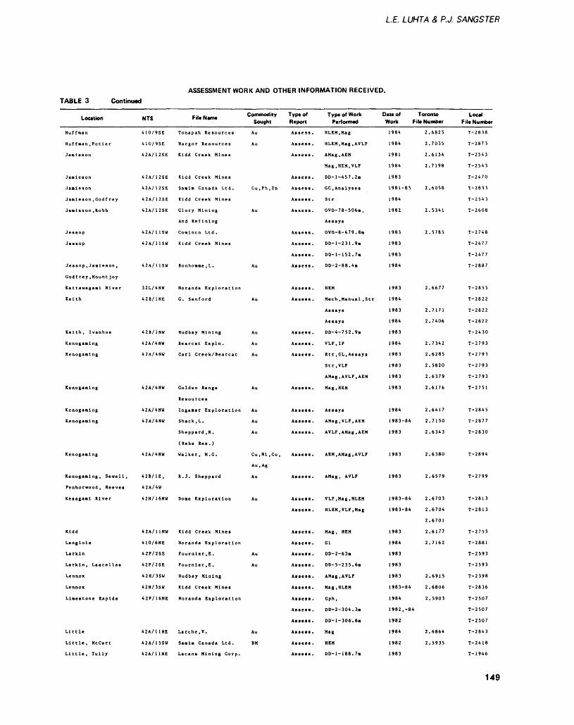
LE. LUHTA 8, PJ. SANGSTER
ASSESSMENT WORK AND OTHER INFORMATION RECEIVED.TABLE 3 Continued
Location
Huffman
Huffman .Potier
Jamieson
Jamieson
Jam! eson
Jamieson , God f rey
Jamieson .Robb
Jessop
Jessop
Jessop, Jamieson,
Godfrey, Mount joy
Keith
Keith, Ivanhoe
Kenogaming
Kenogaming
Kenogaming
Kenogaming
Kenogaming
Kenogaming
Kenogaming, Sewell,
Penhorwood, Reeves
Kesagami River
Kidd
Langlois
Larkin
Larkin, Lascelles
Lennox
Lennox
Limestone Rapids
Little
Little, HcCart
Little, Tully
NTS
410/9SE
410/9SE
42A/12SE
42A/12SE
42 A/ 1 2 SE
42A/12SE
42A/12SE
42A/ 1 1SW
42A/1 1SU
42A/11SW
42B/1NE
42B/1NW
4 2 A/ 4 NW
42A/4NU
42A/4NW
42A/4NU
42A/4NH
42B/1E,
4 2 A/4W
42H/16NW
42A/11NW
410/6NE
42F/2SE
42F/2SE
42H/3SW
42H/3SU
42F/16NE
42A/11NE
42A/15SW
42A/11NE
Fil.N.m. Commodity Sought
Tonapah Resources Au
Hargor Resources Au
Kidd Creek Mines
Kidd Creek Mines
Kidd Creek Mines
Glory Mining Au
And Refining
Conlnco Ltd.
Kidd Creek Mines
Bonhonme , L . Au
Noranda Exploration
G. Sanford Au
Hudbay Mining Au
Bearcat Expln. Au
Golden Range Au
Resources
Ingamar Exploration Au
Shack, L. Au
Sheppard ,R. Au
(Reba Res.)
Walker, M. G. Cu.Nl.Co,
Au.Ag
R. J. Sheppard Au
Dome Exploration Au
Kidd Creek Mines
Noranda Exploration
Fournler.E. Au
Fournier, E. Au
Hudbay Mining
Kidd Creek Mines
Noranda Exploration
Larche.V. Au
Samlm Canada Ltd. BM
Lacana Mining Corp.
Type of Report
Assess .
Assess .
Assess .
Assess .
Assess .
Assess.
Assess .
Assess .
Assess .
Assess .
Assess .
Assess .
Assess .
Assess .
Assess .
Assess .
Assess .
Assess .
Assess .
Assess .
Assess .
Assess .
Assess .
Assess .
Assess .
Assess .
Assess .
Assess .
Assess .
Assess .
Assess .
Assess .
Assess .
Assess .
Type of Work Performed
HLEM.Mag
HLEM.Mag.AVLF
AMag.AEM
Mag.HEM.VLF
DD-l-457.2m
Str
OVD-78-506m,
Assays
OVD-8-479.8m
DD-l-231.9m
DD-l-152.7m
DD-2-88.4m
HEM
Meen. Manual, Str
Assays
Assays
DD-4-752.9m
VLF.IP
Str.VLF
AMag.AVLF.AEM
Mag, HEM
Assays
AMag.VLF.AEM
AVLF, AMag.AEM
AEM,AMag,AVLF
AMag, AVLF
VLF.Mag.HLEM
HLEM.VLF.Mag
Mag, HEM
Gl
DD-2-63m
DD-5-235.6m
AMag, AVLF
Mag.HLEM
Gph,
DD-2-304.3B
DD-1-306.611
Mag
DD-l-188.7m
Date of Toronto Work File Number
1984
1984
1981
1984
1983
1 9 8 1 ~8 3
1984
1982
1 98 3
1983
1983
1984
1984
1983
1984
1983
1984
1983
1983
1983
1983
1984
1983-84
1983
1983
1983
1983-84
1983-84
1983
1984
1983
1983
1983
1983-84
1984
1982, -84
1982
1984
1982
1983
2.6825
2.7035
2.6154
2.7198
2.6058
2.5341
2.5785
2.6677
2.7171
2.7406
2.7342
2*6285
2.5820
2.6379
2.6176
2.6417
2.7150
2.6343
2.6380
2.6579
2.6703
2.6704
2.6701
2.6177
2.7162
2.6915
2.6806
2.5903
2.6864
2.5935
Local File Number
T-2838
T-2873
T-2543
T-2543
T-2470
T-2833
T-2543
T-2608
T-2748
T-2477
T-2477
T-2887
T-2855
T-2822
T-2822
T-2822
T-2430
T-2793
T-2793
T-2793
T-2793
T-2751
T-284 5
T-2877
T-2830
T-2894
T-2799
T-2813
T-2813
T-2755
T-2881
T-2593
T-2593
T-2398
T-2836
T-2507
T-2507
T-2507
T-2843
T-2418
T-1946
149
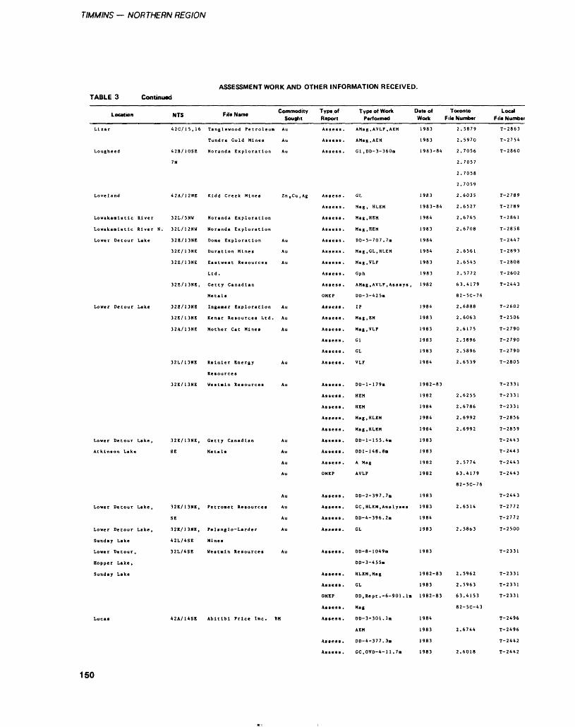
TIMMINS — NORTHERN REGION
ASSESSMENT WORK AND OTHER INFORMATION RECEIVED.TABLE 3 Continued
Location NTS Fit. N.m. Commodity Typ.of Sought Report
Tundra Cold Mines Au Assess.
Lougheed 42B/10SE Noranda Exploration Au Assess.
7N
Loveland 42A/12NE Kidd Creek Mines Zn.Cu.Ag Assess.
Assess .
32E/13NE Duration Mines Au Assess.
Ltd. Assess.
Metals OMEP
Assess .
Assess .
32L/13NE Rainier Energy Au Assess.
Resources
Assess .
Assess .
Assess .
Assess .
Atkinson Lake SE Metals Au Assess.
Au Asses* .
Au OMEP
Au Assess.
SE Au Assess.
Lower Detour Lake, 32E/13NE, Pe langlo-Larder Au Assess.
Sunday Lake 42L/4SE Mines
Hopper Lake,
Sunday Lake Assess.
Assess .
OMEP
Assess .
Lucas 42A/14SE Abitibi Price Inc. BM Assess.
Assess .
Assess .
Type of Work Date of Toronto Performed Work File Number
AMag.AVLF.AEM
AMag.AEM
Gl ,DD-3-360n
CL
Mag, HLEM
Mag, HEM
Mag ,HEM
DD-5-707.7m
Mag, GL, HLEM
Mag.VLF
Gph
AMag.AVLF.Assays ,
DD-3-425m
IP
Mag, EM
Mag.VLF
Gl
GL
VLF
DD-l-179m
HEM
HEM
Mag, HLEM
Mag, HLEM
DD-1-155.4B
DD1-148.8B
A Mag
AVLF
DD-2-397.7B
GC, HLEM, Analyses
DD-4-396.2B
GL
DD-8-1049B
DD-3-455m
HLEM, Mag
GL
DD.Rept .-6-901 . IB
Mag
DD-3-301.1m
AEM
DD-4-377.3B
GC,OVD-4-11.7m
1983
1983
1983-84
1983
1983-84
1984
1984
1984
1983
1983
1982
1984
1983
1 Q ft 11 y 0 J
1983
1983
1984
1 982 — 8 3
1982
1984
1984
1984
1983
1983
1982
1982
1983
1983
1984
1983
1983
1982-83
1983
1982-83
1984
1983
1983
1983
2.5879
2.5970
2.7056
2. 7057
2.7058
2.7059
2.6035
2.6527
2.6765
2.6708
2.6561
2.6545
2.5772
63.4179
82-5C-76
2.6888
2.6063
2.6175
2.5896
2.5896
2.6539
2.6255
2.6786
2.6992
2.6992
2.5774
63.4179
82-5C-76
2.6514
2.5863
2.5962
2.5963
63.4153
82-5C-43
2.6744
2.6018
Loc*l F li* Number
T— 2863
T-2754
T-2860
T-2789
T-2789
T-2861
T — 2 8 5 8
T-2447
T-2893
T — 2 808
T-2602
T-2443
T-2602
T-2506
T-2790
T-2790
T-2790
T-2805
T-2331
T-2331
T-2331
T-2856
T-2859
T-2443
T-2443
T-2443
T-2443
T-2443
T-2772
T-2772
T-2500
T-2331
T-2331
T-2331
T-2331
T-2496
T-2496
T-2442
T-2442
150
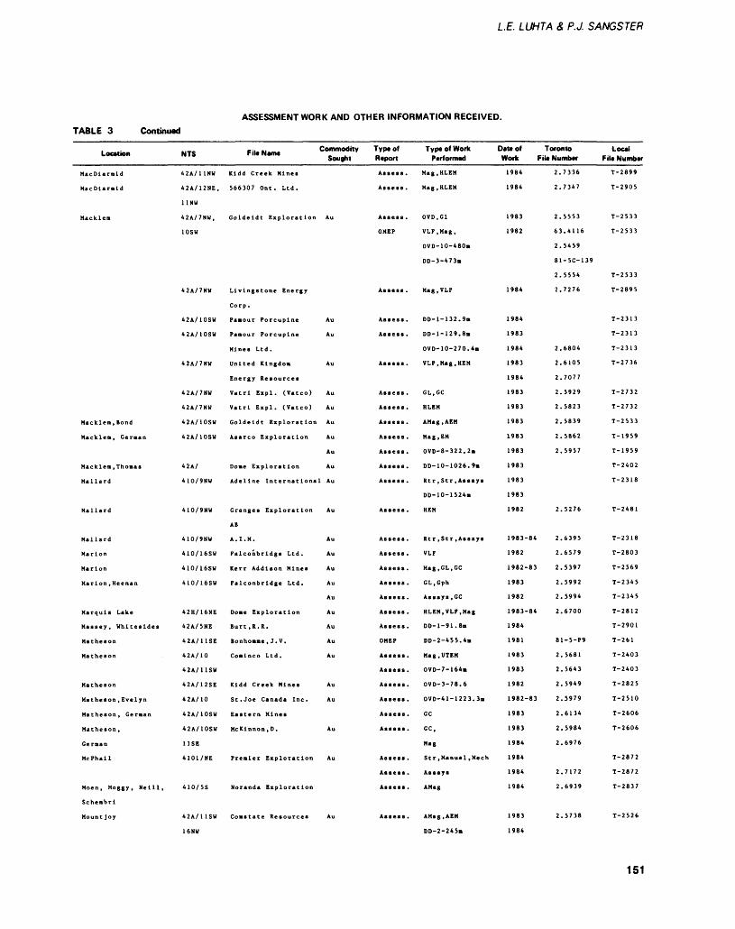
LE. LUHTA 8, P.J. SANGSTER
ASSESSMENT WORK AND OTHER INFORMATION RECEIVED.TABLE 3 Continued
Location
MacDlarmld
MacDlarmld
Macklem
Macklem, Bond
Macklem, German
Macklem, Thomas
Mallard
Mallard
Mallard
Marion
Marion
Marion, Heenan
Marquis Lake
Massey, Whitesides
Matheson
Matheson
Matheson
Matheson, Evelyn
Matheson, German
Matheson,
German
McPhall
Moen, Moggy, Neill,
Schembri
Mountjoy
NTS
42A/HNW
42A/12NE,
11 NW
42A/7NW,
10SW
42A/7NW
42A/10SW
42A/10SW
42A/7NU
42A/7NW
42A/7NW
42A/10SU
42A/10SW
42A/
4 1 0/ 9 NW
4 1 0 1 9NW
410/16SW
410/16SV
410/16SW
42H/16NE
42A/5NE
42A/11SE
42A/10
42A/11SW
42A/12SE
42A/10
42A/10SW
42A/10SW
11SE
4101/NE
410/5S
4 2 A/ 1 1 S W
16NW
File Name Commodity Type of Sought Report
Kidd Creek Mines
566307 Ont. Ltd.
Goldeldt Exploration Au
Livingstone Energy
Corp .
Pamour Porcupine Au
Mines Ltd.
United Kingdom Au
Energy Resources
Vatrl Expl. (Vatco) Au
Vatrl Expl. (Vatco) Au
Goldeldt Exploration Au
Asarco Exploration Au
Au
Dome Exploration Au
AB
Falconbridge Ltd. Au
Kerr Addison Mines Au
Falconbridge Ltd. Au
Au
Dome Exploration Au
Burt, R. R. Au
Bonhomme , J. V. Au
Comlnco Ltd. Au
Kidd Creek Mines Au
St. Joe Canada Inc. Au
Eastern Mines
Mckinnon, D. Au
Premier Exploration Au
Noranda Exploration
Assess .
Assess .
Assess .
OMEP
Assess .
Assess .
Assess .
Assess .
Assess .
Assess .
Assess .
Assess .
Assess .
Assess .
Assess .
Assess .
Assess .
Assess .
Assess .
Assess .
Assess .
OMEP
Assess .
Assess .
Assess .
Assess .
Assess .
Assess .
Assess .
Assess .
Assess .
Type of Work Performed
Mag.HLEM
Mag.HLEM
OVD.G1
VLF.Mag,
OVD-10-480m
DD-3-473m
Mag, VLF
DD-l-132.9m
DD-l-129.8a
OVD-10-270.4m
VLF, Mag, HEM
GL.GC
HLEM
AMag.AEM
Mag, EM
OVD-8-322.2m
DD-10-1026.9m
DD-10-1524B
HEM
VLF
Mag.GL.GC
GL.Gph
Assays, GC
HLEM, VLF, Mag
DD-l-91.8m
DD-2-455.4m
Mag.UTEM
OVD-7-164m
OVD-3-78.6
OVD-41-1223.3m
GC
GC,
Mag
Assays
AMag
AMag.AEM
DD-2-245m
Date of Toronto Work File Number
1984
1984
1983
1982
1984
1 QftaV1 y O*
1983
1984
1983
1984
1983
1983
1983
1983
1983
1983
l AC! -11 70 J
1983
1 98 2
1 98 3 84
1982
1982-83
1983
1982
1983-84
1984
1981
1983
1983
1982
1982-83
1983
1983
1984
1 OftAi y o 1*
1984
1984
1983
1984
2.
2.
2.
63
2.
81
2.
2.
2.
2.
2.
2.
2.
2.
2.
2.
2.
2.
2.
2.
2.
2.
2.
81
2.
2.
2.
2.
2.
2.
2.
2.
2.
2.
7336
7347
5553
.4116
5459
-5C-139
5554
7276
6804
6105
7077
5929
5823
5839
5862
5957
5276
6395
6579
5397
5992
5994
6700
-5-P9
5681
5643
5949
5979
6134
5984
6976
7172
6939
5738
Local File Number
T-2899
T-2905
T-2533
T-2533
T-2533
T-2895
T-2313
T-2313
T-2313
T-2736
T-2732
T-2732
T-2533
T-1959
T-1959
T-2402
T-2318
T-2481
T-2318
T-2803
T-2569
T-2345
T-2345
T-2812
T-2901
T-261
T-2403
T-2403
T-2825
T-2510
T-2606
T-2606
T-2872
T-2872
T-2837
T 5 e 7 f — f. J f. O
151
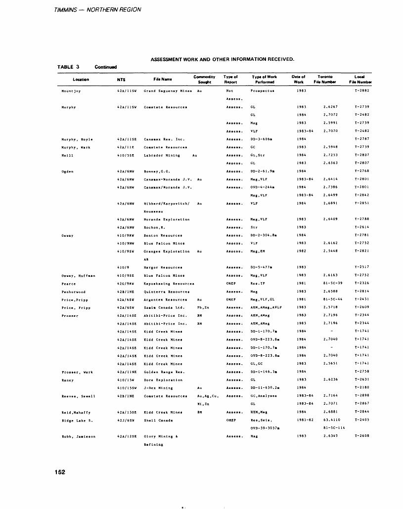
TIMMINS — NORTHERN REGION
ASSESSMENT WORK AND OTHER INFORMATION RECEIVED.TABLE 3 Continued
Location NTS
Mountjoy 42A/11SW
Murphy 42A/11SW
Murphy, Hoyle 42A/11SE
Murphy, Wark 42A/11E
Neill 410/5SE
Ogden 42A/6NW
42A/6NW
42A/6NU
42A/6NU
42A/6NW
42A/6NW
Osway 410/9NU
410/9NU
410/9SW
410/9
Osway, Huffman 410/9SE
Pearce 42G/9NW
Price, Fripp 42A/6SU
Price, Fripp 42A/6SW
Prosser 42A/14SE
42A/14SE
42A/14SE
42A/14SE
42A/14SE
42A/14SE
42A/14SE
Prosser, Wark 42A/11NE
Raney 410/15W
410/15SW
Reeves, Sewell 42B/1NE
Reid, Mahaffy 42A/13SE
Ridge Lake S. 42J/6SW
Robb, Jamieson 42A/12SE
, . .. Commodity F il* Name Sought
Grand Saguenay Mines Au
Canamax Res. Inc.
Labrador Mining Au
Bonney ,G.G.
Canamax-Noranda J.V. Au
Canaaax/Noranda J.V.
Hlbbard/Karpovl tch/ Au
Rousseau
Noranda Exploration
Rochon ,R.
Blue Falcon Mines
Granges Exploration Au
AB
Blue Falcon Mines
Argentex Resources Au
Sanln Canada Ltd. Pb.Zn
Abltlbl-Price Inc. BM
Abltlbl-Prlce Inc. BM
Kidd Creek Mines
Kidd Creek Mines
Kidd Creek Mines
Kidd Creek Mines
Kidd Creek Mines
Golden Range Res.
Dore Exploration
J-Dex Mining Au
Coma t at e Resources Au.Ag.Cu,
Nl.Zn
Kidd Creek Mines BM
Shell Canada
Glory Mining t
Refining
Type of Report
Not
Assess .
Assess .
Assess .
Assess .
Assess .
Assess .
Assess .
Assess .
Assess .
Assess .
Assess .
Assess .
Assess .
Assess .
Assess .
Assess .
Assess .
Assess .
Assess .
OMEP
Assess .
OMEP
Assess .
Assess .
Assess .
Assess .
Assess .
Assess .
Assess .
Assess .
Assess .
Assess .
Assess .
Assess .
Assess .
OMEP
Assess .
Type of Work Performed
Prospectus
GL
GL
Mag
VLF
DD-3-606m
GC
GL.Str
GL
DD-2-61.9B
Mag, VLF
OVD-4-244n
Mag, VLF
VLF
Mag, VLF
Str
DD-2-304.8m
VLF
Mag, EM
DD-5-477m
Mag, VLF
Res. IP
Mag
Mag, VLF, GL
AEM.AMag.AVLF
AEM.AMag
AEM, AMag
DD-l-170.7m
OVD-8-223.8m
DD-l-170.7m
OVD-8-223.8ii
GL.GC
DD-l-146.3m
GL
DD-11-630.2B
GC .Analyses
GL
HEM, Mag
Res, Seis ,
OVD-39-3037m
Mag
Date of Toronto Local Work F ile Number F ile Number
1983
1983
1984
1983
1983-84
1984
1983
1984
1983
1984
1983-84
1984
1983-84
1984
1983
1983
1984
1983
1982
1983
1983
1981
1983
1981
1983
1983
1983
1984
1984
1984
1984
1983
1984
1983
1984
1983-84
1983-84
1984
1981-82
1983
2.
2.
2.
2.
2.
2.
2.
2.
2.
2.
2.
2.
2.
2.
2.
81
2.
81
2.
2.
2.
2.
2.
2.
2.
2.
2.
2.
63
81
2.
6267
7072
5991
7070
5948
7253
6563
6414
7386
6499
6891
6409
6162
5448
6163
-5C-39
6588
-5C-44
5718
7196
7196
-
7040
-
7040
5651
6236
7164
7071
6881
.4110
-5C-114
6349
T-2882
T-2739
T-2482
T-2739
T-2482
T-2787
T-2739
T-2807
T-2807
T-2768
T-2801
T-2801
T-2842
T-2851
T-2788
T-2614
T-2781
T-2752
T-2821
T-2517
T-2752
T-2326
T-2814
T-2431
T-2609
T-2344
T-2344
T-1741
T-1741
T-1741
T-1741
T-1741
T-2758
T-2631
T-2180
T-2898
T-2867
T-2844
T-2405
T-2608
152
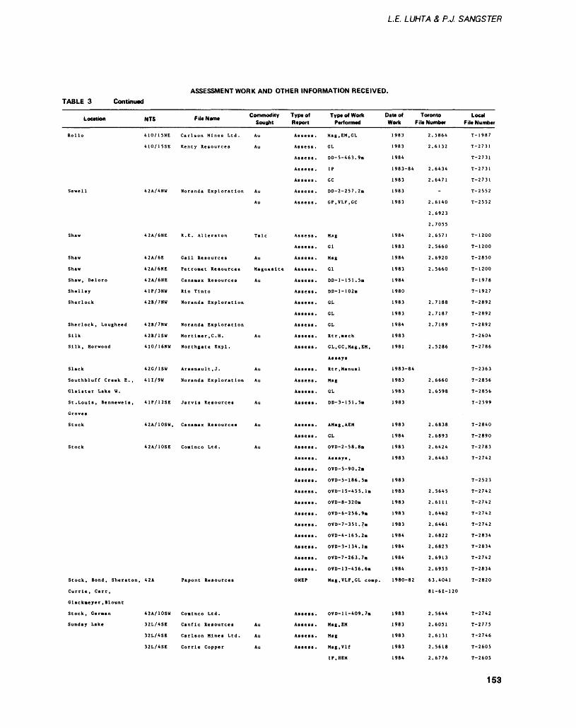
LE. LUHTA 8, P.J. SANGSTER
ASSESSMENT WORK AND OTHER INFORMATION RECEIVED.TABLE 3 Continual
Loc-,™ NTS FiUN.m. Commodity Sou0nt
Au
Shaw 42A/6NE R. E. Allerston Talc
Shelley 41P/3NW Rio Tlnto
Sherlock 42B/7NW Noranda Exploration
Sherlock, Lougheed 42B/7NW Noranda Exploration
Silk 42B/1SW Mortimer, C. H. Au
Silk, Horwood 410/16NW Northgate Expl .
Slack 42G/1SW Arsenaul t ,J . Au
Groves
Stock 42A/10SE Conlnco Ltd. Au
Currie, Carr,
Glackneyer , Blount
Stock, German 42A/10SU Conlnco Ltd.
32L/4SE Carlson Mines Ltd. Au
32L/4SE Corrie Copper Au
Type of Rtport
Assess .
Assess .
Assess .
Assess .
Assess .
Assess .
Assess .
Assess .
Assess .
Assess .
Assess .
Assess .
Assess .
Assess .
Assess .
Assess .
Assess .
Assess .
Assess .
Assess .
Assess .
Assess .
Assess .
Assess .
Assess .
Assess .
Assess .
Assess .
Assess .
Assess .
Assess .
Assess .
OMEP
Assess .
Assess .
Assess.
Assess.
Type of Work Performed
Mag.EM.CL
GL
DD-5-463.9B
IP
GC
DD-2-257.2B
GP.VLF.CC
Mag
Gl
Mag
Gl
DD-l-151.5m
DD-l-102m
GL
GL
GL
GL, GC, Mag, EM,
Assays
M.g
GL
DD-3-151.5B
AMag.AEM
GL
OVD-2-58.8m
OVD-5-90.2B
OVD-5-186.5B
OVD-15-455.1B
OVD-8-320B
OVD-6-256.9*
OVD-7-351.7m
OVD-4-165.2B
OVD-3-134.1B
OVD-7-263.7m
OVD-13-456.6B
Mag.VLF.GL coap.
OVD-1 1-409. 7a
Mag, EM
Mag
Mag.Vlf
IP. HEM
Date of Toronto Local Work File Number File Number
1 98 3
1983
1984
1983-84
1983
1 98 3
1983
1984
1983
1 984
1983
1 984
1980
1983
1983
1984
1983
1981
1 983~*84
1 983
1 Oft 11 70 J
1 983
1983
1984
1983
1983
1983
1983
1983
1983
1983
1984
1984
1984
1984
i 980—82
1983
i on i1 7O J
1983
1983
1984
2.5864
2.6132
2.6434
2.6471
2.6140
2.6923
2.7055
2.6571
2.5660
2.6920
2.5660
2.7188
2.7187
2.7189
2.5286
2.6660
2.6598
2.6838
2.6893
2.6424
2.6463
2.5645
2.6111
2.6462
2.6461
2.6822
2.6823
2.6913
2.6955
63.4041
81-61-120
2.5644
2.6051
2.6131
2.5618
2.6776
T— 1987
T-2731
T-2731
T-2731
T-2731
T-2552
T-2552
T-1200
T-1200
T-2850
T-1200
T~ 1978
T-1927
T-2892
T-2892
T-2892
T-2604
T-2786
T-2363
T — 28 56
T— 2856
T-2599
T-2840
T-2890
T-2783
T-2742
T-2523
T-2742
T-2742
T-2742
T-2742
T-2834
T-2834
T-2742
T-2834
T-2820
T-2742
T-2775
T-2746
T-2605
T-2605
153
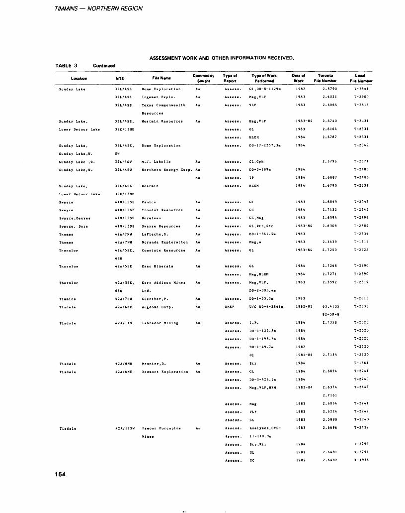
TIMMINS — NORTHERN REGION
ASSESSMENT WORK AND OTHER INFORMATION RECEIVED.TABLE 3 Continued
Location
Sunday Lake
Sunday Lake ,
Lower Detour Lake
Sunday Lake ,
Sunday Lake, W.
Sunday Lake ,W.
Sunday Lake, W.
Sunday Lake ,
Swayze
Swayze
Swayze , Denyes
Swayze , Dore
Thomas
Thomas
Thornloe
Thornloe
Thornloe
Tlnnlns
Tisdale
Tisdale
Tisdale
Tisdale
Tisdale
NTS Fil* Name Commodit 10 Sought
32L/4SE Done Exploration Au
32L/4SE Inganar Expln. Au
Resources
32E/13NE
32L/4SE, Dome Exploration
SW
32L/4SW M. J. Labelle Au
32L/4SW Northern Energy Corp. Au
Au
32L/4SE Westaln
3 2 E 1 1 3 NE
410/15SE Canlco Au
410/15SE Normlnex Au
42A/7NU LaFleche.G. Au
42A/7NW Noranda Exploration Au
-6SW
42A/5SE Esso Minerals Au
42A/5SE, Kerr Addison Mines Au
6SU Ltd.
42A/7SW Guenther.P. Au
42A/6NE Augdome Corp. Au
42A/11S Labrador Mining Au
42A/6NW Meunler.D. Au
42A/6NE Newnont Exploration Au
42A/HSU Pamour Porcupine Au
Mines
y Type of Report
Assess .
Assess .
Assess .
Assess .
Assess .
Assess .
Assess .
Assess .
Assess .
Assess .
Assess .
Assess .
assess .
Assess .
Assess .
Assess .
Assess .
Assess .
Assess .
Assess .
Assess .
Assess .
OMEP
Assess .
Assess .
Assess .
Assess .
Assess .
Assess .
Assess .
Assess .
Assess .
Assess .
Assess.
Assess .
Assess .
Assess .
Assess .
Assess .
Type of Work Performed
Gl ,DD-8-1529m
Mag, VLF
VLF
Mag , VLF
GL
HLEM
DD-17-2257.3B
GL.Gph
DD-3-189B
IP
HLEM
Gl
GC
GL.Mag
GL,Rtr ,Str
DD-1-361.5B
Mag, A
GL
GL
Mag, HLEM
Mag, VLF,
DD-2-305.4m
DD-l-53.3m
U/G DD-4-2861B
I. P.
DD-1-122.8B
DD-1-198.7B
DD-1-49.7B
Gl
Str
GL
DD-3-426. IB
Mag, VLF, HEM
Mag
VLF
GL
Analyses, OVD-
11-110. 9m
Str ,Rtr
GL
GC
Date of Toronto Work File Number
1982
1983
1983
1 Q Q -1 Of.L y o j O**
1983
1984
1984
1984
1984
1984
1983
1 Q A A1 y O **
1983
1983-84
1983
1983
1983 84
1984
1984
1983
1983
1982-83
1984
1984
1984
1982
1981-84
1984
1984
1984
1983-84
1983
1983
1983
1983
1984
1982
1982
2.5790
2.6021
2.6064
2.6740
2.6164
2.6787
2.5796
2.6887
2.6790
2.6849
2.7132
2.6594
2.6308
2.5439
2.7250
2.7268
2.7271
2.5592
63.4135
82-5P-8
2.7358
2.7155
2.6824
2.6374
2.7161
2.6054
2.6224
2.5880
2.6696
2.6481
2.6482
Local File Number
T-2541
T-2900
T* 2816
T-2J31
T-2331
T-2331
T-2349
T-2571
T-2485
T-2485
T-2331
T-2446
T-2545
T-2796
T-2784
T-2734
T-1712
T-2428
T-2890
T-2890
T-2619
T-2615
T-2633
T-2520
T-2520
T-2520
T-2520
T-2520
T-1861
T-2741
T-2740
T-2444
T-2741
T-2747
T-2740
T-2439
T-2794
T-2794
T-1954
154
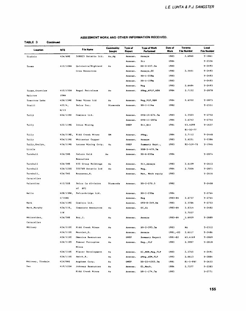
LE. LUHTA Z P.J. SANGSTER
ASSESSMENT WORK AND OTHER INFORMATION RECEIVED.
TABLE 3 Continued
Location
Tisdale
Tooms
Toons , Greenlaw
Halcrow
Tomorrow Lake
Traill
Tully
Tully
Tully
Tully
Tully, Evelyn,
Little
Turnbull
Turnbull
Turnbull
Turnbull ,
Carscallen
Valentine
Walls
Wark
Wark, Murphy
Whitesides,
Carscallen
Whitney
Whitney, Tisdale
Yeo
NTS
42A/6NE
410/10NW
410/15SW
10NW
42H/15NE
421/4,
H/ 13
42A/1 1NE
421/11NE
42A/11NE,
42A/1 1NE
42A/1 1NE
42A/5NE
42A/5NE
42A/12SE
42A/5NE
41I/5SE
42B/13NW,
C/16NE
42A/1 1NE
42A/11E,
HW
42A/5NE
42A/1 1SE
42A/1 1SE
42A/1 1SE
42A/1 1SE
42A/11SE
42A/1 1SE
42A/6NE
41P/12SW
File Name Commodity Sought
508825 Ontario Ltd. Au.Ag
Qulnterra/Hlghland Au
Regal Petroleum Au
Done Mines Ltd Au
Selco Inc. Dlanonds
Comlnco Ltd.
Intex Mining
Kidd Creek Mines BM
Whltestar Copper
Lacana Mining Corp. Au
Galore Gold Au
Resources
655 Group Holdings Au
555768 Ontario Ltd Au
Rousseau , R.
Selco (a division Diamonds
of BP)
Falconbridge Ltd.
Coral nco Ltd.
Roy, J. Au
Kidd Creek Mines Au
Meunler ,D.
Pamour Porcupine Au
Mines
Smith ,R. Au
Augdome Corp. Au
Johnway Resources Au
Kidd Creek Mines Au
Typtof Report
Assess .
Assess .
Assess .
Assess .
Assess .
Assess .
Assess .
Assess .
Assess .
Assess .
Assess .
Assess .
OMEP
Assess .
Assess .
OMEP
Assess .
Assess .
Assess .
Assess .
Assess .
Assess .
Assess .
Assess .
Assess .
Assess .
Assess .
Assess .
Assess .
OMEP
Assess .
Assess .
Assess .
OMEP
Assess .
Assess .
Type of Work Performed
Assays
Str
DD-3-457.2B
Assays ,GC
DD-l-228m
DD-l-109m
Mag
AMag.AVLF.AEM
Mag.VLF.HEM
DD-1-1 14m
OVD-14-674. 5m
OVD-ll-287m
Str ,Rtr
AMag.
Assays
Summary Rept . ,
DDH-3-479.5m
DD-6-650B
Str .Assays
Mag.
Man, Mech equip
DD-2-270.5
DD-l-230m
Mag
OVD-8-249.6n
GC , Gl
Assays
DD-2-593.3ii
Assays
Suamary Report
Mag. ,VLF
Gl t HEN t Mag , VLF
AMag.AEM.VLF
DD-22-4303.5B
GL.Mech.
DD-l-174.7m
Date of Toronto Local Work File Number File Number
1983
1984
1983
1 Oft ti y o i
1983
1983
1983
1984
1984
1982
1983
1984
1981
1984
1983
1983
1984
1983
1984
1983
1982
1984
1983-84
1983
1 983-84
1983-84
1983
1981, -83
1981 82
1983
l Q ft 1i 7O J
1983
1981
1984
1983
2.6960
2.5461
2.6484
2.7152
2.6702
2.5503
2.6742
63.4099
81-5C-77
2.7112
2.6251
82-5JV-70
2.6109
2.7006
2.6737
2.5786
2.6314
2.7037
2.6959
NA
2.6117
63.4169
2.5997
2.5705
2.6613
81-5-P87
2.7377
T-1861
T-2556
T-2493
T-2493
T-2493
T-2493
T-2493
T-2878
T-2875
T-2551
T-2750
T-2750
T-1637
T-2448
T-2386
T-1946
T-2874
T-2612
T-2871
T-2616
T-2408
T-2764
T-2764
T-2753
T-2482
T-2889
T-2312
T-2486
T T Q f Q ̂ OO:F
T-2818
T-2491
T-2884
T-2633
T-2383
T-2771
155
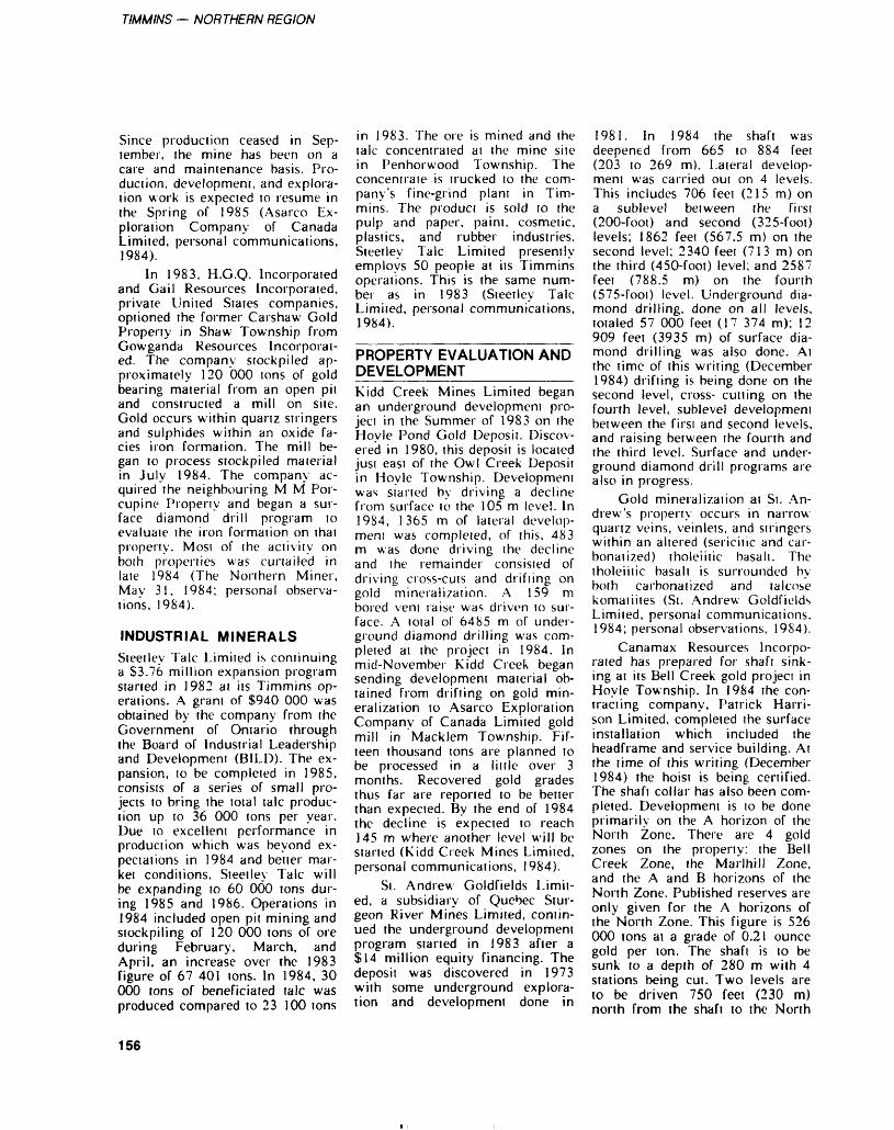
TIMMINS — NORTHERN REGION
Since production ceased in Sep tember, the mine has been on a care and maintenance basis. Pro duction, development, and explora tion work is expected to resume in the Spring of 1985 (Asarco Ex ploration Company of Canada Limited, personal communications, 1984).
In 1983, H.G.Q. Incorporated and Cai l Resources Incorporated, private United States companies, optioned the former Carshaw Gold Property in Shaw Township from Gowganda Resources Incorporat ed. The company stockpiled ap proximately 120 000 tons of gold bearing material from an open pit and constructed a mill on site. Gold occurs within quartz stringers and sulphides within an oxide fa cies iron formation. The mill be gan to process stockpiled material in July 1984. The company ac quired the neighbouring M M Por cupine Propeny and began a sur face diamond drill program to evaluate the iron formation on that property. Most of the activity on both properties was curtailed in late 1984 (The Northern Miner, May 31, 1984; personal observa tions, 1984).
INDUSTRIAL MINERALSSteetley Talc Limited is continuing a S3.76 million expansion program started in 1982 at its Timmins op erations. A grant of S940 000 was obtained by the company from the Government of Ontario through the Board of Industrial Leadership and Development (BILD). The ex pansion, to be completed in 1985, consists of a series of small pro jects to bring the total talc produc tion up to 36 000 tons per year. Due to excellent performance in production which was beyond ex pectations in 1984 and better mar ket conditions, Steetley Talc will be expanding to 60 000 tons dur ing 1985 and 1986. Operations in 1984 included open pit mining and stockpiling of 120 000 tons of ore during February, March, and April, an increase over the 1983 figure of 67 401 tons. In 1984, 30 000 tons of beneficiated talc was produced compared to 23 100 tons
in 1983. The ore is mined and the talc concentrated ai the mine site in Penhorwood Township. The concentrate is trucked to the com pany's fine-grind plant in Tim mins. The product is sold to the pulp and paper, paint, cosmetic, plastics, and rubber industries. Steetley Talc Limited presently employs 50 people at its Timmins operations. This is the same num ber as in 1983 (Steetley Talc Limited, personal communications, 1984).
PROPERTY EVALUATION AND DEVELOPMENT————-——Kidd Creek Mines Limited began an underground development pro ject in the Summer of 1983 on the Hoyle Pond Gold Deposit. Discov ered in 1980, this deposit is located just east of the Owl Creek Deposit in Hoyle Township. Development was started by driving a decline from surface to the 105 m level. In 19S4, 1365 m of lateral develop ment was completed, of this, 483 m was done driving the decline and the remainder consisted of driving cross-cuts and drifting on gold mineralization. A 159 m bored vent raise was driven to sur face. A total o! 6485 m of under ground diamond drilling was com pleted at the project in 1984. In mid-November Kidd Creek began sending development material ob tained from drifting on gold min eralization to Asarco Exploration Company of Canada Limited gold mill in Macklem Township. Fif teen thousand tons are planned to be processed in a little over 3 months. Recovered gold grades thus far are reported to be better than expected. By the end of 1984 the decline is expected to reach 145 m where another level will be started (Kidd Creek Mines Limited, personal communications, 1984).
Si. Andrew Goldfields Limit ed, a subsidiary of Quebec Stur geon River Mines Limited, contin ued the underground development program started in 1983 after a S14 million equity financing. The deposit was discovered in 1973 with some underground explora tion and development done in
1981. In 1984 the shaft was deepened from 665 to 884 feet (203 to 269 m). Lateral develop ment was carried out on 4 levels. This includes 706 feet (215 m) on a sublevel between the first (200-foot) and second (325-foot) levels; 1862 feet (567.5 m) on the second level; 2340 feet (713 m) on the third (450-foot) level; and 2587 feet (788.5 m) on the fourth (575-foot) level. Underground dia mond drilling, done on all levels, totaled 57 000 feet (17 374 m); 12 909 feet (3935 m) of surface dia mond drilling was also done. At the time of this writing (December 1984) drifting is being done on the second level, cross- cutting on the fourth level, sublevel development between the first and second levels, and raising between the fourth and the third level. Surface and under ground diamond drill programs are also in progress.
Gold mineralization at Si. An drew's property occurs in narrow quartz veins, veinlets, and stringers within an altered (sericitic and car- bonatized) tholeiitic basalt. The tholeiitic basalt is surrounded by both carbonatized and talcose komatiites (St. Andrew Goldfields Limited, personal communications, 1984; personal observations, 1984).
Canamax Resources Incorpo rated has prepared for shaft sink ing at its Bell Creek gold project in Hoyle Township. In 1984 the con tracting company, Patrick Harri son Limited, completed the surface installation which included the headframe and service building. At the time of this writing (December 1984) the hoist is being certified. The shaft collar has also been com pleted. Development is to be done primarily on the A horizon of the North Zone. There are 4 gold zones on the property: the Bell Creek Zone, the Marlhill Zone, and the A and B horizons of the North Zone. Published reserves are only given for the A horizons of the North Zone. This figure is 526 000 tons at a grade of 0.21 ounce gold per ton. The shaft is to be sunk to a depth of 280 m with 4 stations being cut. Two levels are to be driven 750 feet (230 m) north from the shaft to the North
156
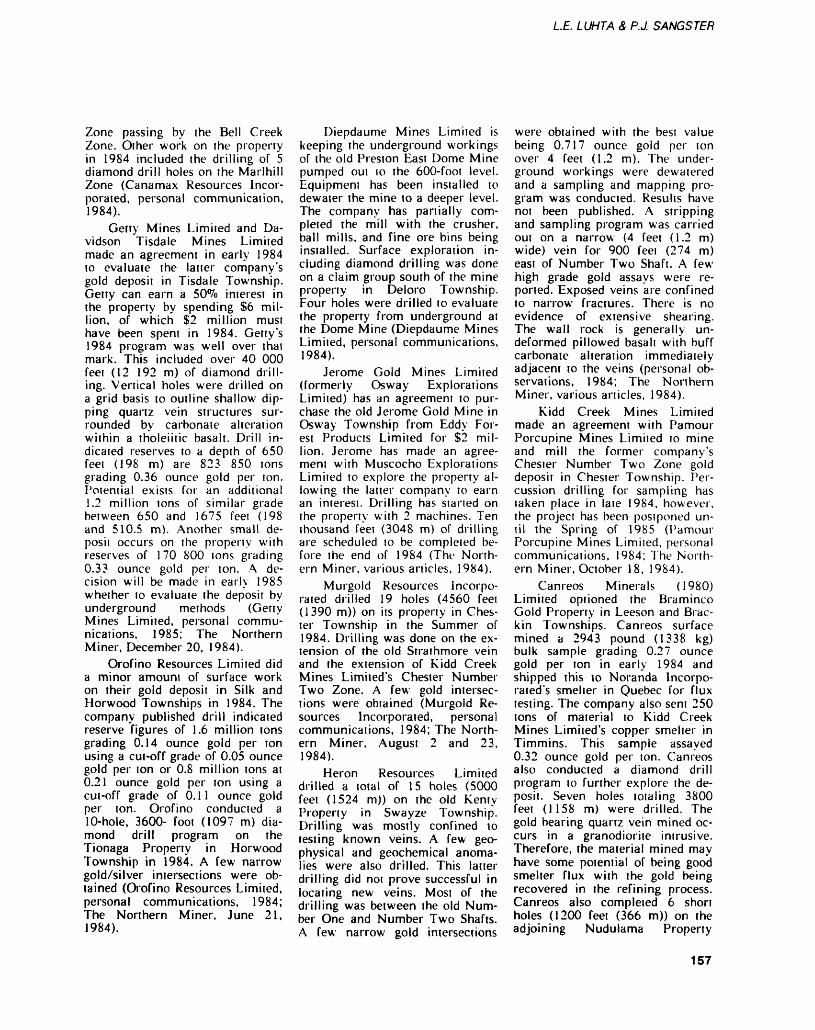
LE. LUHTA S, P.J. SANGSTER
Zone passing by the Bell Creek Zone. Oiher work on the property in 1984 included the drilling of 5 diamond drill holes on the Marlhill Zone (Canamax Resources Incor porated, personal communication, 1984).
Gerty Mines Limited and Da vidson Tisdale Mines Limited made an agreement in early 1984 to evaluate the latter company's gold deposit in Tisdale Township. Getty can earn a 50*70 interest in the property by spending S6 mil lion, of which S2 million must have been spent in 1984. Getty's 1984 program was well over that mark. This included over 40 000 feet (12 192 m) of diamond drill ing. Vertical holes were drilled on a grid basis to outline shallow dip ping quartz vein structures sur rounded by carbonate alteration within a tholeiitic basalt. Drill in dicated reserves to a depth of 650 feet (198 m) are 823 850 tons grading 0.36 ounce gold per ton. I'otential exists for an additional 1.2 million tons of similar grade between 650 and 1675 feei (198 and 510.5 m). Another small de posit occurs on the property with reserves of 170 800 tons grading 0.33 ounce gold per ton. A de cision will be made in early 1985 whether to evaluate the deposit by underground methods (Getty Mines Limited, personal commu nications, 1985; The Northern Miner, December 20, 1984).
Orofino Resources Limited did a minor amount of surface work on their gold deposit in Silk and Horwood Townships in 1984. The company published drill indicated reserve figures of 1.6 million tons grading 0.14 ounce gold per ton using a cut-off grade of 0.05 ounce gold per ton or 0.8 million tons at 0.21 ounce gold per ton using a cut-off grade of 0.11 ounce gold per ton. Orofino conducted a 10-hole, 3600- foot (1097 m) dia mond drill program on the Tionaga Property in Horwood Township in 1984. A few narrow gold/silver intersections were ob tained (Orofino Resources Limited, personal communications, 1984; The Northern Miner, June 21, 1984).
Diepdaume Mines Limited is keeping the underground workings of the old Preston East Dome Mine pumped out to the 600-foot level. Equipment has been installed to dewater the mine to a deeper level. The company has partially com pleted the mill with the crusher, ball mills, and fine ore bins being installed. Surface exploration in cluding diamond drilling was done on a claim group south of the mine property in Deloro Township. Four holes were drilled to evaluate the property from underground at the Dome Mine (Diepdaume Mines Limited, personal communications, 1984).
Jerome Gold Mines Limited (formerly Osway Explorations Limited) has an agreement to pur chase the old Jerome Gold Mine in Osway Township from Eddy For est Products Limited for S2 mil lion. Jerome has made an agree ment with Muscocho Explorations Limited to explore the property al lowing the latter company to earn an interest. Drilling has started on the property with 2 machines. Ten thousand feet (3048 m) of drilling are scheduled to be completed be fore the end of 1984 (The North ern Miner, various articles, 1984).
Murgold Resources Incorpo rated drilled 19 holes (4560 feei (1390 m)) on its property in Ches ter Township in the Summer of 1984. Drilling was done on the ex tension of the old Strathmore vein and the extension of Kidd Creek Mines Limited's Chester Number Two Zone. A few gold intersec tions were obtained (Murgold Re sources Incorporated, personal communications, 1984; The North ern Miner, August 2 and 23, 1984).
Heron Resources Limited drilled a total of 15 holes (5000 feet (1524 m)) on the old Kenty Property in Swayze Township. Drilling was mostly confined to testing known veins. A few geo physical and geochemical anoma lies were also drilled. This latter drilling did not prove successful in locating new veins. Most of the drilling was between the old Num ber One and Number Two Shafts. A few narrow gold intersections
were obtained with the best value being 0.717 ounce gold per ton over 4 feet (1.2 m). The under ground workings were dewatered and a sampling and mapping pro gram was conducted. Results have not been published. A stripping and sampling program was carried out on a narrow (4 feet (1.2 m) wide) vein for 900 feet (274 m) east of Number Two Shaft. A few high grade gold assays were re ported. Exposed veins are confined to narrow fractures. There is no evidence of extensive shearing. The wall rock is generally un- deformed pillowed basalt with buff carbonate alteration immediately adjacent to the veins (personal ob servations, 1984; The Northern Miner, various articles, 1984).
Kidd Creek Mines Limited made an agreement with Pamour Porcupine Mines Limited to mine and mill the former company's Chester Number Two Zone gold deposit in Chester Township. Per cussion drilling for sampling has taken place in late 1984, however, the project has been postponed un til the Spring of 1985 (Pamour Porcupine Mines Limited, personal communications, 1984; The North ern Miner, October 18, 1984).
Canreos Minerals (1980) Limited optioned the Braminco Gold Property in Leeson and Brac kin Townships. Canreos surface mined a 2943 pound (1338 kg) bulk sample grading 0.27 ounce gold per ton in early 1984 and shipped this to Noranda Incorpo- rated's smelter in Quebec for flux testing. The company also sent 250 tons of material to Kidd Creek Mines Limited's copper smelter in Timmins. This sample assayed 0.32 ounce gold per ton. Canreos also conducted a diamond drill program to further explore the de posit. Seven holes totaling 3800 feet (1158 m) were drilled. The gold bearing quartz vein mined oc curs in a granodiorite intrusive. Therefore, the material mined may have some potential of being good smelter flux with the gold being recovered in the refining process. Canreos also completed 6 short holes (1200 feet (366 m)) on the adjoining Nudulama Property
157
TIMMINS — NORTHERN REGION
(personal observations 1984; The Northern Miner, various articles, 1984; Canreos Minerals Limited, personal communications, 1984).
EXPLORATION ACTIVITYExploration activity in the Tim mins Resident Geologist area re mained high in 1984 despite the low base metal prices and the fall ing price of gold. Emphasis was still placed on exploration for gold deposits with a few of the larger companies exploring for base met al deposits. Most of the activity centred in the Abitibi "Greenstone" Belt close to Tim mins. The Swayze area still had a large amount of activity. Explora tion in the Detour Lake area de clined noticeably. Some of the pro jects carried out in the Timmins Resident Geologist's area during 1984 are briefly described here.
Kidd Creek Mines Limited, once again, had the most aggres sive exploration program in the Timmins area in 1984 with pro grams in 32 townships. The inter esting base metal intersections ob tained on the Chance ground in Kidd Township in 198? were fol lowed up in 1984, but the results were disappointing.
Kidd Creek's base metal ex ploration drilling on properiies within easy transportation distance of the company's metallurgical site was down 60^o from 1983. In 1984, drilling included 5 holes (2953 m) in Kidd Township, 5 holes (1086 m) in Prosser Town ship, 3 holes (780 m) in Carnegie Township, and l hole each in God frey (479 m) and MacDiarmid (263 m) Townships. Overburden drilling in Kidd Township totaled 78 holes. Base metal exploration drilling for their regional program included 3 holes (440 m) in Cun ningham Township and 2 holes (634 m) in Yeo Township. Noth ing of significance was intersected. The regional program also includ ed drilling 2 holes (237 m) for gold in Tooms Township and the evalu ation of a felsic tuff unit in Chur chill Township by drilling 2 holes (289 m).
Kidd Creek carried out an ex tensive gold exploration program locally with 4 diamond-drill holes (700 m) drilled in Tully Township, 3 diamond-drill holes (750 m) drilled in Ogden Township, 5 diamond- drill holes (1145 m) in Whitney Township, and 6 diamond-drill holes (2300 m) in Hoyle Township. The latter pro gram was to explore for the west erly faulted extension of the Owl Creek ore zone. Overburden drill ing was done in Lucas Township (92 holes), Prosser Township (8 holes), Matheson Township (57 holes), and Cody Township (28 holes) (Kidd Creek Mines Limited, personal communications. 1984).
Noranda Incorporated carried out an extensive program in both base metal and gold exploration in the Porcupine Mining Division in 1984. Base metal programs includ ed: drilling of 8 diamond-drill holes in Lougheed and Ossin Townships; reconnaissance work in Eisenhower Township; and drill ing of 2 diamond-drill holes in Cochrane Township. Gold explora tion programs included: an over burden drill program in Bond Township in a joint venture with Gowest Amalgamated Resources Limited; a large stripping, map ping, and sampling program which included 8 diamond-drill holes in the Hotstone Lake Property in Greenlaw Township with Interna tional Rhodes Resources Limited; 3 diamond-drill holes and a surface exploration program on the Hol- mer Gold Property in Bristol Township; and stripping on the Croxall option in Bristol Town ship. Noranda is also conducting a long term gold exploration pro gram in Ogden and Deloro Town ships on ground optioned from Canamax Resources Incorporated and the Desantis Mine property re cently optioned from L. Bon- homme. Eleven diamond-drill holes were completed on this pro ject in 1984 (Noranda Incorporat ed, personal communications, 1984).
Newmont Mines Limited con tinued on from their 1983 gold ex ploration program on their large group of optioned properties be
tween the old Coniaurium Mine in Tisdale Township and the Pamour Number One Mine in Whitney Township. In 1984 the company completed 39 diamond-drill holes for a total of 26 962 feet (8218 m). Also, 767 basal till samples were taken by drilling 20 663 feet (6298 m) with a Wacker drill. Newmont plans to conduct more follow-up drilling in this area in 1985. At the beginning of 1984, Newmont also drilled 3 holes totaling 3000 feet (914.5 m) in Tully Township. The company is continually conducting a regional assessment of the Tim mins area to develop more explo ration projects (Newmont Mines Limited, personal communication, 1984).
Dome Exploration (Canada) Limited had an active gold explo ration program in the Porcupine Mining Division during 1984. The company did over 20 000 feet (6096 m) of diamond drilling on their 4 properties in the Detour Lake area. Dome began narrowing down their program in Newton, Coppell, and Dale Townships by concentrating on stripping and do ing an extensive induced polariza tion survey in Newton Township. These 3 privately held townships in the Swayze area are under op tion by Dome from Algoma- Talisman Minerals Limited. Dome conducted a 5000- foot (1524 m) diamond-drill program on the Wettlaufer-Herrick option in Hoyle Township just west of Canamax Resources Incorporated's Bell Creek Gold Deposit. No sig nificant intersections were ob tained. A total of 56 overburden holes were drilled by Dome in Bond Township. A geophysical program was completed in Bristol Township with drilling planned in 1985 (Dome Exploration (Canada) Limited, personal communications, 1984).
In late 1984, Canamax Re sources Incorporated and affiliate company Bruneau Mining Corpo ration discovered a new gold zone in the northeastern corner of Ger man Township on the optioned Clavos Porcupine Mines Property. Drilling intersected gold mineral ization in 4 holes. This latest drill-
158
LE. LUHTA 8, P.J. SANGSTER
ing is located 1000 feel (305 m) west of the original Clavos Gold Zone in Stock Township. During the current program 2 holes were drilled to the east of the known zone with negligible results, and 3 holes were drilled into the Clavos Zone to test previous results. In other exploration Canamax drilled 2 holes (429 m) in another prop erty in German Township and 3 holes (585 m), also in another property in Stock Township (Canamax Resources Incorporated, personal communications, 1984; The Northern Miner, December 13, 1984).
Chevron Canada Resources Limited, after establishing an office in Timmins in 1983, carried out ambitious program in both gold and base metal exploration. On ground optioned from Abitibi-Price Incorporated, Chevron's 1984 dia mond drilling included: 4 holes (968 m) in Lennox Township, l hole (249 m) in Kingsmill Town ship for gold; and 6 holes (567 m) in Lucas Township, 2 holes (401 m) in Carnegie Township, l hole (130 m) in Crawford Township, and l hole (212 m) in Nesbitt Township for base metals. The company also drilled 2 holes (231 m) on its own ground in Foleyet Township. Twenty-eight overbur den drill holes were drilled in Kin gsmill Township and 12 in Mabee Township (Chevron Canada Re sources Limited, personal commu nications, 1984).
Labmin Resources Limited (formerly Labrador Mining and Exploration Company Limited) drilled 2 holes on the Brown McDade Gold Property in Denton Township in 1984 to follow-up a gold intersection obtained in late 1983. Nothing of significance was intersected and the option was dropped. Two holes were drilled into a conductor in the nor theastern corner of Tisdale Town ship intersecting graphitic argil- lites. Stripping, trenching, and sampling for gold were done in Neill Township, and Labmin con ducted a small grass roots explora tion program in Denton Township (Labmin Resources Limited, per sonal communications, 1984).
Canadian Nickel Company Limited (Canico), a wholly owned subsidiary of Inco Limited drilled a total of 17 short diamond-drill holes totaling 1536 feet (468 m) on the Burton Gold Property in Esther Township. Exploration on the property which started in 1983 will continue in 1985. The com pany also conducted a mapping and geophysical program in Swayze, Dore, and Denyes Town ships. Four diamond-drill holes were drilled in Swayze, and 2 in Dore Townships, totaling 1985 feet (605 m) (Canico, personal commu nications, 1984).
Sulpetro Minerals Limited conducted a mapping, geophysical, and diamond drilling program on the south Rundle Gold Property in Swayze Township during 1984. The property is held under option from Labmin Resources Limited. Drilling consisted of 11 holes (1797 m) to test geophysical tar gets away from the Rundle Gold Deposil (Sulpe.ro Minerals Limit ed, personal communications, 1984).
Cominco Limited, as in 1983, speni S800 000 in exploration in the Timmins area in 1984. The company carried out an induced polarization survey in German Township and drilled 250 overbur den holes in Stock, German, Tully, Evelyn, and Matheson Townships. One diamond-drill hole (1106 feet (337 m)) was drilled in Evelyn Township. This hole was a follow- up to 3 holes drilled in 1983 to test bands of barren sulphide mineral ization consisting primarily of py rite located along the township's western boundary 4 miles (6.5 km) down from the north boundary (Cominco Limited, personal com munications, 1984).
Westmin Resources Limited conducted geophysical surveys on their properties in the Detour Lake area. Two holes (475 m) were drilled in late 1984 on the com pany's property just east and along strike of the Detour Lake Mine to test 2 induced polarization anoma lies. Two previously drilled holes were rebottomed by Westmin in Bond Township. Drilling there to taled 402 m (Westmin Resources
Limited, personal communications, 1984).
Pamour Porcupine Mines Limited conducted an overburden drill program and a diamond drill program which consisted of 11 holes on Night Hawk Lake in Macklem and Cody Townships in early 1984. The company also ex plored 2 properties in Tisdale Township (Pamour Porcupine Mines Limited, personal commu nications, 1984).
Placer Development Limited drilled 2 holes totaling approxi mately 600 m on ground optioned from Comstate Resources Limited in Deloro Township just west of the Delnite Mine. Exploration was also done by Placer on Comstate's properties in Tisdale and Whitney Townships (Comstate Resources Limited, personal communications, 1984).
Pominex Limited conducted 2 major diamond drill programs on the old Weststock Property in the northeastern corner of Macklem Township. Gold mineralization in a felsic horizon between mafic to intermediate rocks to the south and carbonatized ultramafic rocks to the north was evaluated. Various intersections of differing widths and gold grades were obtained. The gold mineralization occurs in very narrow fractures within the felsic rock and the attitude of the zone of fracturing was difficult to interpret (Pominex Limited, per sonal communications, 1984; The Northern Miner, various articles, 1984).
Falconbridge Limited conduct ed an extensive gold exploration program in Hawkins and Walls Townships which included a dia mond drill program in early 1984, stripping during the summer and another diamond drill program which began in late 1984. The company also drilled 12 holes (5000 feet (1524 m)) in Heenan and Marion Townships to evaluate the gold potential of the Woman River Iron Range. Falconbridge be gan a 5000-foot (1524 m) drilling program in late 1984 in Whitney Township, just east of their old Hoyle Mine property (Falcon-
159
TIMMINS — NORTHERN REGION
bridge Limited, personal commu nications, 1984).
Kerr Addison Mines Limited completed a 4 hole, 2500-fooi (762 m) diamond drill program on the Karpovich option in Hoyle Town ship. An interface between a mag netic high and a magnetic low was the horizon being tested. Argil laceous sedimentary rocks and wackes were intersected, but no economic mineralization was found (Kerr Addison Mines Limit ed, personal communications, 1984).
Riocanex Incorporated con ducted a 10-hole diamond drill program in Bristol Township in early 1984 (Riocanex Incorporat ed, personal communications, 1984).
Tanglewood Consolidated Re sources Incorporated conducted a 5000- fool (1524 m) diamond drill program on the old Hiawatha Property in Lizar Township (personal observations, 1984).
Quinterra Resources Incorpo rated explored their properties in Tooms and Greenlaw Townships, Swayze and Cunningham Town ships, and in Penhorwood Town ship (The Northern Miner, various articles, 1984).
Storiman Exploration Limited conducted a drilling program on the old Mining Corporation Prop erty in Sewell Township which was optioned from Noranda Incor porated (Storiman Exploration Limited, personal communications, 1984).
Puissance Corporation con ducted a large stripping program on the old Powell Property in De loro Township. A diamond drill program was started in late 1984 and gold values were intersected in the first hole (personal observa tions, 1984; The Northern Miner, November 8, 1984).
Aside from those previously mentioned, companies conducting exploration programs in the Abitibi "Greenstone" Belt in the Timmins area are: Bigstone Minerals Limit ed (drilling a 5000-foot (1524 m) hole in Whitney Township); Corn- state Resources Limited (Cody and
Macklem Townships); Diepdaume Mines Limited (Macklem Town ship); Esso Minerals Canada (Tisdale Township); Falcon Re sources Incorporated (Ogden Township); Galore Gold Resources Incorporated (drilling in Turnbull Township); Getty Mines Limited (Carscallen Township); Golden Range Resources Incorporated (drilling in Wark and Prosser Townships); Gowganda Resources Incorporated (Matheson Town ship); Lac Minerals (Langmuir Township); Melrose Resources Limited (Cleaver Township); Selco Incorporated (Mann, McCart, Reaume, Newmarket, Duff, and Little Townships); and Utah Mines Limited (Macdiarmid and Bristol Townships).
Other companies not previous ly mentioned as working in the Swayze area include: Adeline In ternational Mines (5000-foot (1524 m) drill program in Mallard Town ship); Collingwood Energy Incor porated (drilling in Greenlaw Township); Jarvis Resources Limited (drilling in Chester Town ship); J-I)ex Mining and Explora tion Limited (Denyes Township); Kenty Resources Limited (drilling in Rollo and Swayze Townships); Micham Exploration Incorporated (Halcrow Township); Regal Petro leum Limited (Halcrow, Tooms, Greenlaw Townships); and Swayze Resources Limited (Swayze and Dore Townships).
A number of junior resource companies are reported to be ex ploring in the Detour Lake area. Among those which reported drill ing on their properties are: Genesis Resources Corporation, Northern Energy Corporation, and Petromet Resources Limited. The other com panies exploring include: Canfic Resources Limited, Duration Mines Limited, Global Energy Corporation, and Kenar Resources Limited.
Companies not already men tioned exploring the western exten sion of the Wawa "Greenstone" Belt which extends into the Porcu pine Mining Division include: The Coniagas Mines Limited (drilling in Leeson Township on the Anglo Dominion Property); Aurelian De
velopers Limited (Brackin Town ship): and Jedburgh Resources Limited (Brackin Township) (personal communications, 1984; assessment files; various articles in The Northern Miner and the George Cross News Letter, 1984).
ONTARIO GEOLOGICAL SURVEY ACTIVITIES-————-In 1984, there were no Precam brian Geology Section programs undertaken in the Timmins Resi dent Geologist area. However, sev eral of the other sections of the Ontario Geological Survey were active in the area.
ENGINEERING AND TERRAIN GEOLOGY SECTIONAs pan of the Hydrocarbon En ergy Resources Program (HERP), Watts, Griffis and McOuat Limit ed, under contract to the Ontario Geological Survey, continued as assessment of the lignite resource potential of the James Bay Low lands. The 1984 Winter 'drilling program consisted of the drilling of l l holes followed by sedimentolog- ical. palynological. and geochemi cal studies. Lignite was discovered in only l drillhole in the north western corner of McBrien Town ship. Results and details of the pro cedures of the program were re leased as Open File Report 5511.
P.G. Telford and D.J. Russell began an assessment of the oil shale potential of the Long Rapids Formation, Moose River Basin, and the James Bay Lowlands. Field work in late 1984 involved the mapping and measurement of stratigraphic sections near Wil liam's Island (Hydrocarbon Energy Resources Program).
Also as part of the Hydrocar bon Energy Program, the Peatland Inventory Project was developed under the supervision of J.L. Riley, Engineering Terrain Geology Sec tion. In 1984, Peatland Inventory III, which included study sites in the Cochrane, Kapuskasing, and Timmins areas, was initiated. De tails of procedures and results of the program are to be released as an Open File Report in 1985.
160
LE. LUHTA & P.J. SANGSTER
As pan of the Black River- Matheson Program (BRIM), J.M. Richard completed Quaternary mapping of the Porquis Junction and Watabeag River areas. Maps of these areas will be published in late 1985.
In cooperation with the Geophysics/Geochemistry Section, and as part of the Black River- Matheson Project, J.A.C. Fortesc ue and C. Baker conducted a basal till geochemistry project. Sampling involved the use of both backhoe and sonic drilling methods. Geo chemical results and logs of the drillholes will be released in an Open File Report in 1985. Map P.2736 (Location of Gold Grains in Sonic Drill Samples from the Matheson Area) was released in December 1984, indicating some of the results of the program.
GEOPHYSICS/GEOCHEMISTRY SECTIONIn addition to the above program and also as part of the Black River- Matheson Project (BRIM), a Mark VI INPUT system survey was re leased in May 1984. The survey covered the entire BRIM study area including 4 townships in the Timmins Resident Geologist area (Clergue, Stock, Bond, and Shera ton Townships). During 1984, studies on the Night Hawk Geo physical Test Range were contin ued.
MINERAL DEPOSITS SECTIONAs part of the BRIM program, an examination of gold, metallic min erals, and industrial minerals was initiated. Clergue, Stock, Bond, and Sheraton Townships are included in the study area.
S. Marmont continued to work on applications of age dating to gold mineralization, and also be gan detailed mapping in the De tour Lake area.
One M.Sc. and one Ph.D. pro gram were ongoing in the Tim mins area during 1984 with partial support from the Ontario Geologi cal Survey.
P.C. Wood continued investi gation into the controls of gold and tungsten (scheelite) mineralization in the Hollinger-Mclntyre Vein System.
D.R. Burrows began a map ping and sampling program of the Pearl Lake porphyry and late al bitite dikes at the Pamour Porcu pine Mines Schumacher Division (Mcintyre).
ONTARIO GEOSCIENCE RESEARCH GRANTS PROGRAM____________During 1984 and 1985, grant re cipients with a project directly re lated to the Porcupine Mining Di vision were:
W'.S. Fyfe, University of West ern Ontario:Grant 134, Stratigraphy and Geochemistry of Northern On tario Carbonaceous Deposits: Onakawana Lignite and James Bay Peats.D.W. Strangway, University of Toronto:Grant 118, Surface Electro magnetic Mapping in Selected Positions in Northern Ontario.
ONTARIO MINERAL EXPLORATION PROGRAM (OMEP)_____________The Ontario Mineral Exploration Program was created in 1980 to provide incentives to encourage mineral exploration in Ontario. These incentives are in the form of tax grants and credits to cover pan of the risk capital. In 1984, 50 programs in the Porcupine Mining Division were designated for OMEP assistance. Total budgeting expenditures amounted to S16 709 805. Of this total. SI2 898 542 are expenditures eligible for the OMEP program. OMEP tax/grant credit assistance for the Porcupine Mining Division for the 1984 time period will be S3 224 639.
161
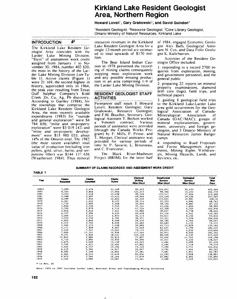
INTRODUCTIONThe Kirkland Lake Resident Ge ologist Area coincides with the Larder Lake Mining Division. "Days" of assessment work credit assigned from January l to No vember 30, 1984, number 402 820, the most in the history of the Lar der Lake Mining Division (see Ta ble 1). Active claims (Figure 1) were 21 169, the second highest in history, superceded only in 1964, the peak year resulting from Texas Gulf Sulphur Company's Kidd Creek Zn, Cu, Ag, Pb discovery. According to Gartley (1984), for the townships that comprise the Kirkland Lake Resident Geologist Area, the most recently available expenditures (1983) for "outside and general exploration" were S4 784 656; "mine and on-property exploration" were S3 019 142; and "mine and on-property develop ment" were Si5 980 033, about 14*Vo of the Ontario total. The 1982 (the most recent available) total value of production (including iron pellets, gold, silver, barite, and ser pentine filler) was S144 137 656 (\Veatherson 1984). Thus mineral
Kirkland Lake Resident Geologist Area, Northern RegionHoward Lovell 1 , Gary Grabowski 2 , and David Guindon3
1 Resident Geologist, ^Resource Geologist, 3Core Library Geologist, Ontario Ministry of Natural Resources, Kirkland Lake
resources revenues in the Kirkland Lake Resident Geologist Area for a single 12-month period are estimat ed to total upwards of S170 mil lion.
The Bear Island Indian Cau tion in 1978 prevented the record ing of mining claims consequently stopping most exploration work and any possible ensuing produc tion in an area comprising l /4 of the Larder Lake Mining Division.
RESIDENT GEOLOGIST STAFF ACTIVITIES___________Permanent staff totals 3: Howard Lovell, Resident Geologist; Gary Grabowski, Resource Geologist; and P.M. Boucher, Secretary. Geo logical Assistant T. Beckett worked a 9-month contract. Various periods of assistance were provided (through the Canada Works Pro gram) by P. Mills, P. Prieur, and T. Morgan. Clerical assistance was provided for various periods of time by P. Savarie, L. Brousseau, and C. Francoeur.
The Black River-Matheson Project (BRIM), for the latter half
of 1984, engaged Economic Geolo gist A lex Bath, Geological Assis tant N. Cox, and Data Folio Geolo gist K. Kalicharran.
Activities of the Resident Ge ologist Office included:1. responding to a record 2700 in quiries from exploration, mining, and government personnel, and the general public2. preparing 22 reports on mineral property examinations, diamond drill core (logs), field trips, and technical papers3. guiding 8 geological field trips TO the Kirkland Lake-Larder Lake area gold occurrences for the Geo logical Association of Canada- Mineralogical Association of Canada (GAC/MAC), groups of mineral explorationists, govern ment, university, and foreign ge ologists, and 3 Ontario Ministry of Natural Resources Junior Ranger camps4. responding to Road Proposals and Forest Management Agree ments, Mining Rights Withdraw als, Mining Hazards, Lands, and Reviews, etc.
SUMMARY OF CLAIMS RECORDED AND ASSESSMENT WORK CREDITTABLE 1
Year
1984*19831982198119801979197819771976197519741973197219711970196919681967196619651964196319621961196019591958195719561955
Claim* R •corded
7,6998,3543,2535,4986,2994,2611 .7101,8262,3502,9164,7573,2603,2534,0654,3153,4044,1715,4507,6069,331
12,8424,7104,6753,7495,0246,4198,5824,6649,6734,182
C MIHlSCancelled
4,4763,8665,2182,6971,8341 .4522,0652,3342,9795,0102,2963,2144,7403,8463,7045,2737,9097,341
11,1016,9063,8843,8954,0284,4516,7475,5947, 1088,2123,5943,999
Claims Active
21 , 16917,94613,45815,42312,6228, 1575,2485,7036,7127,3419,4356,9746,7818,2688,0497,4389,307
13,04514,93618,43122,91213,95413,13912,49213, 19414,91714,90212,61816, 16610,087
Diamond Drilling
(Man Day*)
85,423121,21399,52669,90664,45429,71432,60237, 10147,72445,88040,67834,11339,37129,43325,68350,89274,64979,172
117,544123, 12977,80795,69663,00347,86275,12322,94737, 38195,93477,87975,561
Geophysical Sun ays
(Man Days)
224,05198,366
133,511125,459115,03125,35238, 10045,43642,33838,04755,71635,81152, 35148,78528,68345,71382,63729,07330,97188,25932,64416,2415,4945,4947,2963,7927,481
12,59320,9823,389
Geological Surveys
(Man Days)
30,43315,23317,92619,53610,9814,9908,8871,8206,2206,7384,4418,1503,3584,7644,133
15,8295,7994,0328,0506,530
11,7054,2265,0991,1184,7511 .4041 ,9413,9486,6933,529
Total Man Days
402,064304,770313,690247,087209,3568,76387, 14498,992
102,93698,624
1 10, 16592,616
106,02696,04773,157
130,185180,437143,600182,352257,029149, 198138,62797,21979,219
104,63280,32266,783
138,891130,894105,925
* to Nov. 30
Note: 1955 to 1967 Includes Larder Lake, Montreal River and timiskaming Mining Divisions
162
H, LOVELL ET AL
5. filing for ready retrieval the as sessment work representing an all- time record 402 064 "man-days"6. preparing a complete up-io-date roads map of the Larder Lake Mining Division (scale 1:253 440 or l inch to 4 miles), which the public can whiteprint at the Min eral Resources Office, 4 Govern ment Road East, Kirkland Lake7. attending 10 Canadian Institute of Mining and Metallurgy sym posia, local executive and local branch meetings at Kirkland Lake, Cobalt, Val d'Or, Chibougamau, Timmins, and Sudbury.
DRILL CORE STORAGE LIBRARY_____________The Drill Core Storage Library (Lithotheque) for the Larder Lake Mining Division was officially opened on June 18, 1984. Drill core collected previously has now been moved into the library and catalogued. At present, 87 216 m of core are stored, representing 129 811 m of drilling.
In 1984, approximately 42 000 m of drill core were collected, catalogued, and stored. Figure 2 shows the location of the drillholes from which the core has been stored in the library. Table 5 lists a summary of core stored for each township, by company.
All drillholes have been plot ted on mylar township maps, at the same scale as township mining claims maps. Drillhole data has been entered and stored on an Ap ple Ile microcomputer, using dBase-II. At present, data searches may be done using the following parameters: township, company, alternate name, and NTS. Other types of searches can be done on request, i.e. UTM or multipara- meter.
Core logs for the majority of drillholes stored are available at rhe Core Library. A complete set of the corresponding assessment files is not stored at the Core Li brary, but is available at rhe Resi dent Geologist Office. By early 1985, it is hoped that all drill logs filed at the Resident Geologist Of fice will be referenced to the ap
propriate core stored at the Core Library.
Assistance ai the Core Library was provided by F. Kiernicki, Geo logical Assistant; S. Price, Labourer; J. McCammon, A. Char bonneau, A. Akulick, P. Altenbec, D. Bruce, G. Fitzgerald, M. Shorn, and D. Barbeau, Mining Sector Works Program; and G. Sarnia, P. Alexander, and B. Levesque, Canada Student Works Program.
The Core Library is located west of Kirkland Lake, on the southern side of Highway 66, at the Ontario Ministry of Natural Resources District Office. Persons wishing to examine or donate core should telephone (705) 642-3222, Ext 42, or write to:
Drill Core LibraryOntario Ministry of NaturalResourcesP.O. Box 129Swastika, OntarioPOK l TO
OPERATION BLACK RIVER - MATHESON (BRIM)_______Alexander BathEconomic Geologist, Ontario Min istry of Natural Resources, Kirk land Lake.
INTRODUCTIONOperation Black River Matheson (BRIM) is an integrated, multi- disciplinary program focused on a 40-township block extending from Night Hawk Lake eastward to the Ontario-Quebec inierprovincial boundary (Figure 3). Funded equally by the Ontario Ministry of Northern Affairs and the Ontario Ministry of Natural Resources, the program has been designed to stim ulate the economy of Northern On tario in the long term, via mineral exploration incentives provided through the development of a com prehensive exploration database, which ideally will contribute to the discovery of mines in the area. The goals of the 5-year program (in its second year) will be realized through contributions from the Geophysics/Geochemistry, Pre cambrian, Mineral Deposits, and Engineering and Terrain Geology
Sections of the Ontario Geological Survey and the Kirkland Lake and Timmins Resident Geologist Of fices.
GENERAL GEOLOGYThe Black River-Matheson area is located in the Superior Province of the Canadian Shield and is under lain by Early Precambrian (Archean) metamorphosed supra crustal and plutonic rocks of the Abitibi "Greenstone Belt". Middle Precambrian (Huronian) sedimen tary rocks unconformably overlie the Early Precambrian rocks in l part of the area. Overburden, con sisting primarily of Pleistocene tills, esker deltaic sands, and var ved clays, is present over large portions of the bedrock surface.
The local geology is dominated by low metamorphic rank (subgreenschist to greenschist fa cies) volcanic and sedimentary rocks, which have been intruded by ultramafic to felsic sills, stocks, and batholiths and volumetrically minor diabase dikes. Two major faults traverse the area in an eas terly regional trend, the Porcupine- Destor "break" and the Pipestone Fault. The Porcupine- Destor "Break" is a complex fault zone which constitutes a major structur al and lithologic discontinuity over much of its extent within the area.
Recent mapping in this portion of the Abitibi Belt (Jensen and Langford 1983; Jensen 1978) in dicate that the volcanic stratig raphy of the bell may be subdi vided into a series of volcanic cy cles, each of which is characterized by lower, middle, and upper por tions of dominantly komatiitic, dominantly tholeiitic, and domi nantly calcalkalic affinity, respec tively. In a regional sense, local lithologies corresponding to the up per portion of volcanic cycle II (the Hunter Mine Group) and the lower (Stoughton-Roquemaure Group), middle (Kinojevis Group), and upper (Blake River Group and the Destor-Porcupine Complex) portions of volcanic cycle III are present in the area.
163
KIRKLAND LAKE — NORTHERN REGION
KIRKLAND LAKERESIDENT GEOLOGIST'S
AREA
Areas withdrawn from staking through Bear Island Caution.
^ Boundary of Resident Geologist's Area
— M ^a, . .. a ....,-- J/- - -- -.^e-V - —f - -^ ̂ -B-— k- |M'""!K i" i-
l .^:'-^;^ii^gg^|t \^"""::;^ "~\^'-^ :^i;^;|\^WJ!SfM
^\n:::rM;-,,:;xii)L;,::,,:
79 0
H. LOVELL ET AL
Producing Mines1. Agnico-Eagle Mines Limited
Castle-Tretheway Mine . . . . . . . . . . . . . . . . Ag, Co2. Agnico-Eagle Mines Limited
Langis Mine . . . . . . . . . . . . . . . . . . . . . . Ag, Co3. Dominion Foundanes and Steel Company Limited
Cliffs of Canada Limited Adams Mine . . . . . . . . . . . . . . . . . . . . . . . Fe
4. Extender Minerals of Canada Limited . . . . . . . . . .Barite5. Hedman Resources Limited . . . . . . . . . Serpentine Filler6. Inco Limited - Queenstone Gold Mines Limited
McBean Mine . . . . . . . . . . . . . . . . . . . . . .Au, Ag7. Kerr Addison Mines Limited . . . . . . . . . . . . . . Au, Ag
8. Lac Minerals LimitedMacassa Mine . . . . . . . . . . . . . . . . . . . . . Au, Ag
9. Lake Shore Mines Limited . . . . . . . . . . . . . . . Au, Ag10. Pamour Porcupine Mines Limited
Ross Mine . . . . . . . . . . . . . . . . . . . . . Au, Ag, Cu
Properties Under Major Evaluation1. Argentex Resource Exploration Corporation . . , . . . . Au2. Argyle Ventures Incorporated . . . . . . . . . . . . . , Au3. Barrick Resources Corporation . . . . . . . . . . . . . . Au4. Canamax Resources Incorporated . . .. . . . . . . . . . Au5. Discovery Mines Limited - Lenora Explorations Limited
Golden Harker Property . . . . . . . . . . . . , . . . Au
6. Falconbridge Limited . . . . . . . . . . . . . . . . . . Au7. Kerr Addison Mines Limited . . . . . . . . . . . . . . Au8. Larder Resources Incorporated - Eldor Resources Ltd. . Au9. Manridge Explorations Limited . . . . . . . . . . . . . Ag
10. Maude Lake Gold Mines Limited . . . . . . . . . . . . Au11. McGarry Resources Limited . . . . . . . . , . . . . . Au12. Newmont Exploration of Canada Limited . . . . . . Au, BM13. Perrex Resources Incorporated . . . . . . . . . . . . . Au14. Placer Development Limited . , . . . . . . . . . . . . Au15. Pryme Energy Resources Limited . . . . . . . . . . Au, Zn
16. St. Joe Canada Incorporated . . . . . . . . . . . . . . Au17. Shenandoah Resources Limited . . . . . . . . . . . . Au
Property Visits1. CMB Holdings . . . . . . . . . . . . . . . . . Gold Occurrence2. Golden Harker Explorations Limited . . . . . . Gold Prospect3. Sheldon-Larder Mines Limited . . . . . . . . . Gold Prospect4. T. 81 W. Sullivan and W. Cooper . . . . . . . Gold Occurrence
165
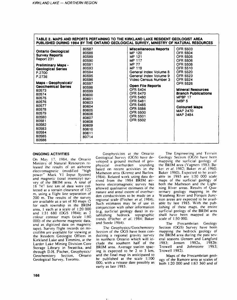
KIRKLAND LAKE — NORTHERN REGION
TABLE 2. MAPS AND REPORTS PERTAINING TO THE KIRKLAND LAKE RESIDENT GEOLOGIST AREA PUBLISHED DURING 1984 BY THE ONTARIO GEOLOGICAL SURVEY, MINISTRY OF NATURAL RESOURCES
Ontario Geological Survey ReportsReport 231Preliminary Maps -Geological SeriesP.2700P.2736
Maps - Geophysical/ Geochemical Series8057380574805758057680577 80578 80579 80580805818058280583805848058580586
80587 80588 8058980590805918059380594805958059680597O/ICQO OV/DUDoncqqOvswC7*s
80600orvcAiOUOU 18060380604 80605 80606 806078060880609806108061180714
Miscellaneous ReportsMP 120 MP 121MP 117MP 77MP 119General Index Volume 8General Index Volume 9Video Census Number 3Open File ReportsOFR 5404OFR 5470OFR 5480OFR 5481OFR 5485 OFR 5586 OFR 5500 OFR 5501OFR 5502
OFR 5503 OFR 5504 OFR 5505OFR 5506OFR 5508OFR 5510OFR 5520OFR 5523OFR 5524OFR 5526
Mineral ResourcesBranch PublicationsMPBP 17IMBP5
Coloured MapsMAP 2470 MAP 2484
ONGOING ACTIVITIESOn May 17, 1984. the Omario Ministry of Natural Resources re leased the results of an airborne electromagnetic (modified "high power" Mark VI Input System) and magnetic (total intensity) sur vey of the BRIM area. A total of 18 747 line km of data were col lected at a terrain clearance of 122 m, using a flight line separation of 200 m. The results of the survey are available as a set of 80 maps (2 for each township in the BRIM area, l each at a scale of 1:20 000 and 1:31 680 (OGS 1984); as 2 colour contour maps (scale 1:80 000) of the airborne magnetic data, and as digitized data on magnetic tape). Survey flight records on mi crofilm are available for viewing at the Resident Geologist Offices in Kirkland Lake and Timmins, at the Larder Lake Mining Division Core Storage Library in Swastika, and through D.H. Pitcher, Geophysics/ Geochemistry Section, Ontario Geological Survey, Toronto.
Geophysicists at the Ontario Geological Survey (OGS) have de veloped a ground method of geo physical overburden sounding based on recent activities in the Matheson area (Krentz and Barlow 1984). Related work using data de rived from the 1984 BRIM air borne electromagnetic survey has allowed qualitative estimates of the nature and areal extent of overbur den conductivities to be made on a regional scale (Pitcher et al. 1984). Such estimates may be of use in conjunction with other information (e.g. surficial geology data) in es tablishing bedrock topographic trends (Pitcher ei al. 1984; Baker and Steele 1984).
The Geophysics/Geochemistry Section of the OGS have been con ducting a regional gravity survey in northern Ontario which will in clude the southern half of the BRIM area. Average station spac ing is expected to be 2 to 3 km, and the final map in anticipated to be published at the scale 1:100 000, with a release date possibly as earlv as late 1985.
The Engineering and Terrain Geology Section (OGS) have been mapping the surficial geology of the BRIM area (Vagners 1983; Ba ker ei al. 1982; Baker ei al. 1980; Baker 1980). Expected to be avail able in 1985 are 1:50 000 scale maps of the surficial geology of both the Matheson and the Light ning River areas. Results of Qua ternary geology mapping in the Watabeag River and Porquis Junc tion areas are expected to be avail able by late 1985. With the pub lishing of these maps, the entire surficial geology of the BRIM area shall have been mapped at the scale of 1:50000.
The Precambrian Geology Section (OGS) Survey have been mapping the bedrock geology of the BRIM area during the past sev eral seasons (Jensen and Langford 1983; Jensen 1982a, 1982b; Trowell and Johnstone 1983; Trowell 1982).
Maps of the Precambrian geol ogy of the Ramore area at scales of both 1:20 000 and 1:63 360 and of
166
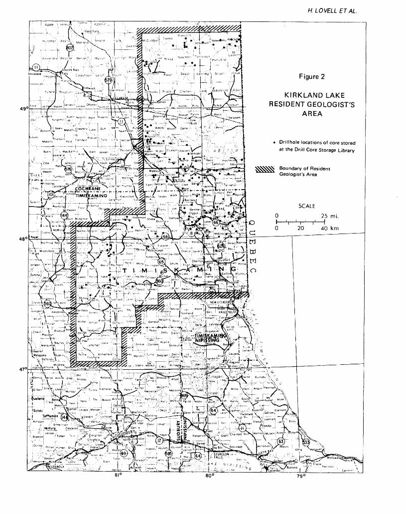
H. LOVELL ETAL
49
KIRKLAND LAKE RESIDENT GEOLOGIST'S
AREA
* Drillhole locations of core stored at the Drill Core Storage Library
Boundary of Resident Geologist's Area
i.4T-vl-tf28ffi2
\ ^QftihfuB ^ODIiJi j: G
^-^^^
K UO" n"-
79 0
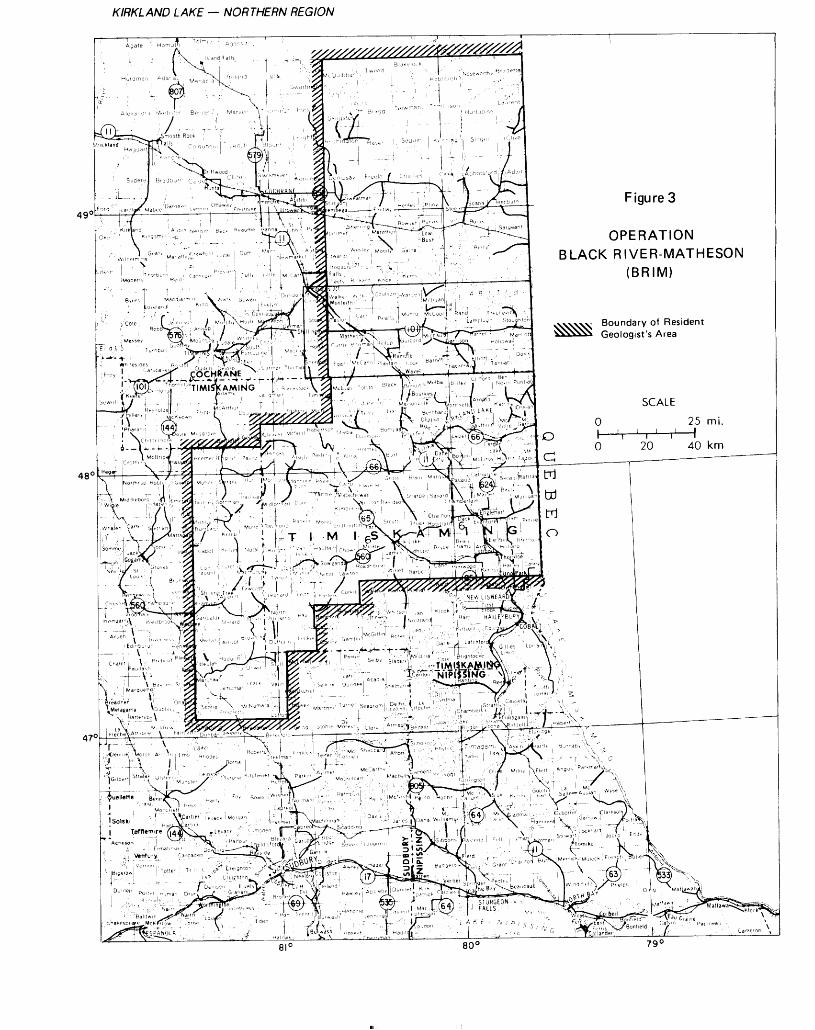
KIRKLAND LAKE — NORTHERN REGION
^^^^/^^^BIJ'ulJ.. * ^
f. ria , , T '""" :1 , -j " \ ..^Nos^or'hvy' 1 ^1
OPERATIONBLACK RIVER-MATHESON
(BRIM)
Boundary of Resident Geologist's Area
\\ "Tj; T ^^ M ''' UI^N^^ 0 " l""''!- ^"f; i^t^-fej^''^^^
5^ KKc c c"a w n i fi f"
H. LOVELL ETAL
both Beatty and Munro Townships at a scale of 1:63 360 are expected to be available in 1985. Field map ping of Stock, Carr, and Taylor Townships has been completed; bedrock geology maps of these ar eas should be available in the near future.
During the Fall of 1984 the Ontario Geological Survey com pleted a trenching and sonic over burden drilling program in the westernmost block of 16 townships in the BRIM area. The presence of extensive, and in places complex, overburden thicknesses over much of the area presents a major ob stacle to exploration, therefore a concerted effort was begun to char acterize the nature of this overbur den. With data provided by OGS field staff, optimal drillhole loca tions were established and 42 drill holes were sonic overburden drilled. An attempt was made ai each location to penetrate about 1.6 m inio bedrock to obtain in formation on bedrock geology. Each core is to be analyzed in terms of Quaternary stratigraphy, industrial mineral potential, geo chemical and heavy mineral analy sis (including gold grain distribu tions) of lil! and glaciofluvial sam ples, and bedrock geology. Data pertaining to gold grain distribu tions in drill core samples were released in December, 1984 (Baker ef al. 1984); selected portions of the core are expected to be avail able for public examination in 1985 at both the Larder Lake Min ing Division and the Porcupine Mining Division Core Storage Li braries, in Swastika and Timmins respectively.
The Mineral Deposits Section (OGS) initiated a series of deposit studies in the BRIM area during the 1984 field season designed to fit the precious metal, base metal, and industrial mineral potential of the area into a regional metal logenetic framework. Emphasis to date has been on gold mineraliza tion (Whittaker 1984; Whittaker and Malczak 1984). Plans for fu ture work tentatively include de tailed field mapping in the Hol loway, Barker and Munro Town ship areas as well as statistical ana
lysis of mineralization characteris tics observed in the area.
Compilation of Geological Data Inventory Folios (GDIFs) for selected townships in the BRIM area was initiated in 1984 by K. Kalicharran with assistance from N. Cox. GDIFs for Beatty, Bow man, Carr, Currie, Frecheville, Harker, Holloway, Lamplugh, Marriott, Munro, Stoughton, and Taylor Townships are expected to be published in 1985.
As of November 30, 1984, 21 632 m of diamond drill core from 240 holes representing 34 423 m of drilling in the BRIM area have been catalogued and stored and are available for examination in the Larder Lake and Porcupine Min ing Division Core Storage Librar ies. This core represents a valuable resource with direct application to both exploration and research. Ex cellent examination facilities exist at both libraries; the core samples are available for analysis and/or assay as well as visual examina tions.
As pan of Operaiion Black River-Matheson, an economic ge ologist has been based in Kirkland Lake to encourage exploration ac tivity in the BRIM area at the local level by being available to all members of the exploration com munity as a source of exploration- related information and advice. Ef forts of the economic geologist are directed primarily toward the min ing and exploration industries and the prospecting community in or der to promote activity in the BRIM area, to catalyze the property-optioning process, to in terface between the public and pri vate sectors, and in general to pro vide services that facilitate explora tion in the area. Specifically, the economic geologist is available to 1) assist local prospectors with property visits, advice, and assess ment file searches; 2) document new mineral occurrences in the BRIM area; 3) compile all avail able data relevant to exploration in the area; and 4) help "orient" new workers or potential new workers to the area. A long term goal of the program is the compilation of a comprehensive, locally accessible
database for the BRIM area. Direct benefits include increased avail ability of exploration data and an improved data retrieval system re sulting in reduced cost to the ex ploration community.
The latter half of 1984 was spent becoming familiar with the geology and mineral deposits of the BRIM area by means of field work, research compilation, and developing a contact network. In addition:* A list of approximately 70 names and addresses of prospectors and mining and exploration companies active in the area has been com piled.* Compiliaton maps at the scale 1:100 000 indicating road access, preliminary geological map, geo logical map, and out-of-print map coverage and mineralization have been generated. These maps are suitable for presentations, and whiteprint copies will be available to the public.* The creation of reference files on each township coniaining relevant maps, reports, properly evalua tions, claim status, etc. is well un derway.* Remote sensing imagery of the BRIM and Kirkland Lake areas has been obtained to complement existing coverage available at the office of the Kirkland Lake Resi dent Geologist.* As of November 30, 1984, more than 500 key-word cross- referen ced literature articles pertinent to the mineral potential of the BRIM area have been stored on floppy disks accessible via the Apple Ile computer; software is available in the Larder Lake and Porcupine Mining Division Core Storage Li braries.* Development work has com menced on a computer-based ex ploration database system with support software. This package will be developed using existing computer capabilities at the Larder Lake Mining Division Core Stor age Library. When complete, the system will allow the user to per form a wide variety of multiple parameter searches on any geo-
169
KIRKLAND LAKE — NORTHERN REGION
graphic subdivision of the BRIM region 10 access information cur rently available ai the offices of the Resident Geologist in Kirkland Lake and Timmins, the 2 Mining Division Drill Core Storage Librar ies, and in Ontario Geological Sur vey Databases in Toronto. The sys tem will feature user-friendly, menu-driven software, and ulti mately will be capable of being run on computer facilities avail able at the Kirkland Lake Resident Geologist Office.
ECONOMIC POTENTIALThe Black River-Maiheson area's potential to host economic gold mineralization is excellent. Histori cally, substantial exploration for gold has been concentrated along both the Porcupine-Destor and Pipestone Fault zones, where au riferous quartz-carbonate veins and stringers typically are hosted by various carbonate, sericite, chlo rite, talc, and serpentine-bearing schists. The gold occurs both in its native state and associated with py rite. Associated ore minerals may include arsenopyrite, chalcopyrite, and galena (Resident Geologist Files. Ontario Ministry of Natural Resources. Kirkland Lake). Simi larly, much activity has been di rected toward locating auriferous quartz-carbonate veins associated with intrusive felsic stocks. Such mineralization may occur either internally or externally to the asso ciated felsic intrusive body and it may be accompanied by silicifica tion, pyritization, carbonatization, and/or hematitizaiion (Cherry 1982).
Recent encouraging results on the Barrick Resources Corporation (formerly Camflo Mines Limited) property in western Holloway Township (Tinier 1983) have re sulted in increased efforts directed toward locating similar auriferous, pyritic, carbonate-bearing siliceous interflow sedimentary horizons, which appear to be associated with low magnetic responses.
The Hunter Mine Group and Blake River Group volcanic rocks (both being calcalkalic affinity) are potentially host to Pb - Zn - Cu -
Au - Ag sulphide mineralization. An inferred positive relief during Blake River Group deposition has led Jensen (1980) to postulate that such mineralization, if present in the Blake River Group secton, is likely to be located proximal to volcanic vent locations and could be of a "stacked" form.
The Sioughton-Roquemaure Group volcanic rocks (of komatiitic affinity) are potentially host to nickel sulphide and to in dustrial minerals including asbes tos, serpentine, magnesite, and talc. The Hedman Mine in Warden Township is a serpentine deposit currently in production (Whittaker and Malczak 1984).
The Kinojevis Group volcanic rocks of tholeiitic affinity and in- tercalcated interflow sedimentary horizons are potentially host to ex- halative base and precious metal sulphide mineralization.
Destoi-Porcupine Complex al kalic rocks, which are chemically similar to alkalic rocks in the Kir kland Lake area, may occur in an analagous structural setting and could potentially host Kirkland Lake-type gold mineralization.
The presence of kimberlite dikes in Michaud Township (Jensen 1975) and of kimberlite boulders in glacial overburden in the Kirkland Lake-Larder Lake area (Baker 1982; G. Grabowski, Resource Geologist, Ontario Min istry of Natural Resources, Kirk land Lake, personal communica tion, 1984) suggest that the BRIM area may host diamonds both in bedrock and in placers associated with eskers in the Quaternary sec tion. The potential for placer gold associated with eskers in the BRIM area has not yet been adequately investigated.
MINING ACTIVITYDuring 1984, 12 mines operated in the Kirkland Lake Resident Geolo gist area, 5 producing gold and by product silver; 2 producing, and l developing, silver and by-product cobalt; l producing iron pellets; l producing barite; l producing ser
pentine filler; and l producing peat.
The total gold production in the Larder Lake Mining Division to the end of 1983 is shown in Table 3.
The deepest single-lift vertical shaft planned in the western hemi sphere (ultimate depth 7275 feet (2217 m)), at the Macassa Gold- Silver Mine of Lac Minerals Limit ed, reached almost 5000 feet (1524 m).
Lake Shore Mines Limited continued mining its crown pillar via a scoop tram decline ramp, and at No. 5 shaft raised a 90-foot (27.5 m) headframe and installed a 12-foot (3.7 m) diameter hoist, in preparation to develop gold-silver ore remaining from past mining operations to the 4000-foot (1219 m) level.
The McBean Gold-Silver Mine, owned by Inco Limited and Queenston Gold Mines Limited and operated by Inco, began open pit production in May, using the renovated Upper Canada Mill.
Argentex Resource Explora tion Corporation overburden- drilled with follow-up diamond drilling on their 50-claim property in Holloway Township. Gold val ues in till ranged from 1095 to 84 000 parts per billion (The North ern Miner, November l, 1984).
Argyle Ventures Incorporated completed geological and geophysi cal surveys, and extensive strip ping and trenching on a 42-claim group in McNeil Township. A grab sample assayed 0.82 ounce gold per ton (George Cross News Letter, October 10, 1984).
Barrick Resources Corpora tion, with which Camflo Mines Limited was merged, diamond drilled several thousand metres de lineating the Camflo gold discov eries in Holloway Township and exploring nearby claims in Harker Township (up to 6 diamond drills operated simultaneously).
Canamax Resources Incorpo rated diamond drilled several thou sand metres; several of the drill holes were drilled at its Holloway Township gold discoveries.
170
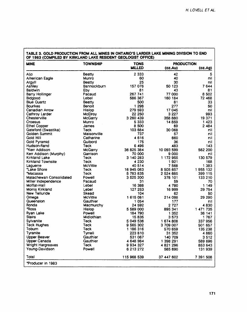
H. LOVELL E T AL
TABLE 3. GOLD PRODUCTION FROM ALL MINES IN ONTARIO'S LARDER LAKE MINING DIVISION TO ENDOF 1983 (COMPILED BY KIRKLAND LAKE RESIDENT GEOLOGIST OFFICE)
MINE
AljoAmerican EagleArgyllAshleyBaldwinBarry HollingerBidgoodBlue QuartzBourkesCanadian ArrowCathroy LarderChestervilleCroesusEthel CopperGateford (Swastika)Golden SummitGold HillGold PyramidHudson-Rand"Kerr AddisonKerr Addison (Murphy)Kirkland LakeKirkland TownsiteLaguerre*Lake Shore•MacassaMatachewan ConsolidatedMiller IndependenceMoffat-HallMorris KirklandNew TellurideOmegaQueenstonRond a*RossRyan LakeStairsSylvaniteTeck HughesToburnTyraniteUpper BeaverUpper CanadaWright HargreavesYoung-Davidson
Total
TOWNSHIP
BeattyMunroBeattyBannockburnEbyPacaudLebelBeanyBenoitHislopMcElroyMcGarryMunroJamesTeckMaisonvilleCatharineGuibordTeckMcGarryGarrisonTeckTeckMcvittieTeckTeckPowellPacaudLebelLebelSkeadMcvittieGauthierMacmurchyHislopPowellMidlothianTeckTeckTeckTyrrellGauthierGauthierTeckPowell
TONSMILLED
23336025
15707681
267 741586 367
5001 298
279 59322250
3 260 43953338500
103 684737
4616175
649636 825 384
700003 140 283
423040514
169450835 783 8353 525 200
3116388
127 253104
1 6150811 054
245925 589 000
184 79015835
5 049 5369 565 3021 186316
223 810531 067
4 648 9849 934 3276213272
115968539
PRODUCTION(OZ.AU)
424030
50 12343
77000160 184
81277
170453227
358 88014859
6930068
57660
36483
100935999000
1 1729551 9217568
8 505 657 12 524 685
378 10159
478016999
62214098
1772727
895 341 11 3523573
1 674 8083 709 007
570 65931 352
1407091 398 2914821 296
585 690
37 447 602 7
(oz.Ag)5
nilnil
764481
850272468
3350nil
99319371
1 4232484
nilnilnilnil
143562 200
nil130579
1681 383
955 132399 115133210
701 149
2975450
29290nil
4830471 735
36 1411 767
337 956501 657135238
48603512
589 696853 643131 939
391 508
*Producer in 1983
171
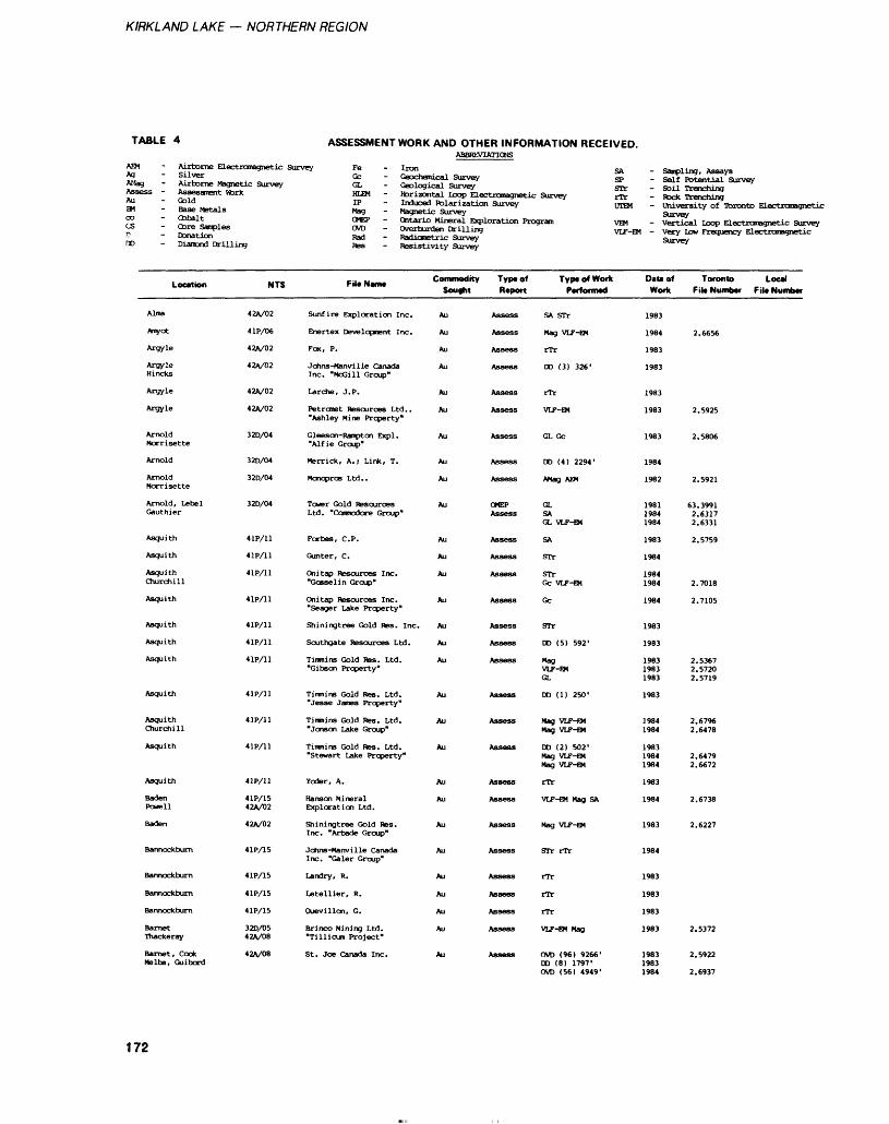
KIRKLAND LAKE — NORTHERN REGION
TABLE. 4 ASSESSMENT WORK AND OTHER INFORMATION RECEIVED.ABBREVIATIONS
Ag* - Silver aectrQroagnetic Survey Fe - Iron SA - Sailing, Assays
AMag - Airborne Magnetic Survey GL - Geo^gica^'sur^ey1' !L " ISi SeShint Sa3™* Assess - Assessment Vtork HLEM - Horizontal Loop Electromagnetic Survey rTr -Rock Trenchinl BM " teaZi**,^ f? ~ J*3"3**? Polarization Survey OTEM . university of Toronto Electrcmagn ai Base Metals Hag - Magnetic Survey Ourvnvco Cobalt
P - Donation no - Diamond Drilling
Location
Alma
Anyot
Argyle
ArgyleHincks
Argyle
Argyle
ArnoldMorrisette
Arnold
ArnoldMorrisette
Arnold, LebelGauthier
Asquith
Asquith
AsquithChurchill
Asquith
Asquith
Asquith
Asquith
Asquith
AsquithChurchill
Asquith
Asquith
BadenPowell
Baden
Bannockburn
Bannockburn
Bannockburn
Bannockburn
BarnetThackeray
Barnet, CookMelba, Guibord
NTS
42A/02
4 IP/06
42A/02
42A/02
42A/02
42A/02
32D/04
32D/04
32D/04
32D/04
4 IP/11
41P/11
4 IP/11
41P/11
4 IP/11
4 IP/11
4 IP/11
4 IP/11
4 IP/11
4 IP/11
41P/11
41P/1542A/02
42A/02
41P/15
41P/15
41P/15
41P/15
32D/0542A/08
42A/08
CMEP - Ontario Mineral Exploration Prc OVD - Overburden Drilling Rad - Radiometric Survey Res - Resistivity Survey
FiU Name
Sunfire Exploration Inc.
Enertex Development Inc.
Fox, P.
Jchns-Manvi 1 le CanadaInc. "McGill Group"
Larche, J. P.
Petronet Resources Ltd.."Ashley Mine Property"
Gleeson-Rampton Expl."Alf ie Group"
Merrick, A.; Link, T.
Monopros Ltd..
Tower Gold ResourcesLtd. "Ccnmodore Group"
Forbes, C. P.
Gunter, C.
Onitap Resources Inc."Gosselin Group"
Onitap Resources Inc."Seager Lake Property"
Shin ing t ree Gold Res. Inc.
Southgate Resources Ltd.
Timnins Gold Res. Ltd."Gibson Property"
Tiimins Gold Res. Ltd."Jesse James Property"
Timnins Gold Res. Ltd."Jansen Lake Group"
Timmins Gold Res. Ltd."Stewart Lake Property"
Voder, A.
Hanson MineralExploration Ltd.
Shining t ree Gold Res.Inc. "Arbade Group"
Johns-Manville CanadaInc. "Galer Group"
Landry, R.
Letellier, R.
Ouevillon, G.
Brinco Mining Ltd."Tillicum Project"
St. Joe Canada Inc.
Commodity Sought
Au
Au
Au
Au
Au
Au
Au
Au
Au
Au
Au
Au
Au
Au
Au
Au
Au
Au
Au
Au
Au
Au
Au
Au
Au
Au
Au
Au
Au
Type of Report
Assess
Assess
Assess
Assess
Assess
Assess
Assess
Assess
Assess
CMEPAssess
Assess
Assess
Assess
Assess
Assess
Assess
Assess
Assess
Assess
Assess
Assess
Assess
Assess
Assess
Assess
Assess
Assess
Assess
Assess
"gram VEM - Vertical Loop Electromagnetic Sur VLF-EM - Very Low Frequency Electromagneti
TyptofWorkP til laii CIOTTIMO
SA STr
Mag VLF-EM
rTr
DD (3) 326'
rTr
VLF-EM
GL Gc
DD (4) 2294'
AMag MX
GLSAGL VLF-EM
SA
STr
STrGc VLF-EM
Gc
STr
DD (5) 592'
MagVLF-EMGL
DD (1) 250'
Mag VLF-EMMag VLF-EM
DD (2) 502'Mag VLF-EMMag VLF-EM
rTr
VLF-EM Mag SA
Mag VLF-EM
STr rTr
rTr
rTr
rTr
VLF-EM Mag
OVD (96) 9266'DD (8) 1797'OVD (56) 4949'
D*u of Work
1983
1984
1983
1983
1983
1983
1983
1984
1982
198119841984
1983
1984
19841984
1984
1983
1983
198319831983
1983
19841984
198319841984
1983
1984
1983
1984
1983
1983
1983
1983
198319831984
Toronto Local Fil* Number File Number
2.6656
2.5925
2.5806
2.5921
63.39912.63172.6331
2.5759
2.7018
2.7105
2.53672.57202.5719
2.67962.6478
2.64792.6672
2.6738
2.6227
2.5372
2.5922
2.6937
172
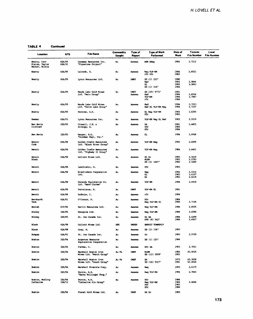
H. LOVELL ETAL
TABLE 4 Continued
Location
Beatty, CarrHislop, TaylorWalker, Wilkie
Beatty
Beatty
Beatty
Beatty
Beatty
Beemer
Ben NevisClifford
Ben Nevis
BenoitCook
Benoit
BenoitBlack
Benoit
Benoit
Benoit
Benoit
Benoit
BernhardtTeck
Beulah
Bisley
Bisley
Black
Black
Bompas
Boston
Boston
Boston
Boston
Boston
Boston
Boston, NcElroyCatharine
NTS
42A/0942A/10
42A/09
42A/09
42A/09
42A/09
42A/09
42A/03
32D/05
32D/05
42A/08
42A/08
42A/08
42A/08
42A/08
42A/08
42A/08
42A/08
42A/01
4 IP/06
320/05
320/05
42A/08
42A/08
42A/01
320/04
320/04
320/04
320/04
320/04
320/04
320/0431M/13
Fit* NWIM
Canamax Resources Inc."Pipestone Project"
Lalonde, D.
Lynco Resources Ltd.
Maude Lake Gold MinesLtd. "Main Group"
Maude Lake Gold MinesLtd. "Salve Lake Group"
Parsons, G. E.
Lynco Resources Inc.
Croxall, J. E. s.Allsopp, A.
Harper, H.G."Goldmac Expl. Inc."
Golden Cradle ResourcesLtd. "ftlack River Group"
Golden Cradle ResourcesLtd. "Highway 11 Group"
Goliath Mines Ltd.
Leschishin, O.
Minef inders CorporationLtd.
Noranda Exploration Co.Ltd. "Ward Claims"
Portelance, R.
Rodholm, C.
O'connor, F.
Karl in Resources Ltd.
Monopros Ltd.
St. Joe Canada Inc.
Goliath Mines Ltd.
Gray, M.
St. Joe Canada Inc.
Argentex ResourceExploration Corporation
Forbes, C.
Marshall Boston IronMines Ltd. "North Group"
Marshall Boston IronMines Ltd. "South Group*
Marshall Minerals Corp.
Perron, A.H."Barry Hollinger Prop."
Perron, A.H."Catharine Six Group"
Commodity Sought
Au
Au
Au
Au
Au
Au
Au
Au
Au
Au
Au
Au
Au
Au
Au
Au
Au
Au
Au
Au
Au
SEE
Au
Au
Au
Au
Au Fe
Au Pe
Au
Au
Au
Type of Report
Assess
Assess
OMEP
OMEPAssess
Assess
Assess
Assess
Assess
Assess
Assess
Assess
Assess
Assess
Assess
Assess
OMEP
Assess
Assess
Assess
Assess
Assess
UNDER
Assess
Assess
Assess
Assess
OMEP
CMEP
Assess
Assess
Assess
TypeofWoffc Performed
AEM AMag
Mag VLF-EMrTr STr
DO (1) 233'RadGLDO (1) 318'
DO (25) 9773'RadVLF-EMrTr
RadRad GL VLF-EM Mag
GL Mag VLF-EMSTr
VLF-EM Mag GL Rad
SASTrSTr
GL
VLF-EM Mag
VLF-EM Mag
GL GcHLEMDO (3) 1647'
STr
MagGLGL
VLF-EM
VLF-EM GL
rTr
STrMag VLF-EM GL
Mag VLF-EM
Mag VLF-EM
GL SACVD (8) 542'
BENOIT TOWNSHIP
DO (1) 136'
GC
DO (1) 125'
STr SA
HLEMDO (12) 2959'
SADO (16) 5317'
Mag
Mag VLF-EM
STrMag VLF-EMSTrSTr
DIM ofWork
1984
19841983
1980198319831984
1981198419841984
19841984
19831983
1983
198119831984
1984
1983
1984
198319831982
1983
198219831983
1984
1981
1984
19841984
1984
1984
19841984
1983
1983
1984
1983
19821983
19721981
1983
19H4
1984198419831984
Toronto Local F M* Number F Ut Number
2.7212
2.6553
2.58442.5843
2.69342.7067
2.72132.7107
2.6250
2.5519
2.4405
2.6926
2.6400
2.6401
2.54182.57932.5269
2.53142.61072.6218
2.6918
2.7126
2.6935
2.6586
2.62882.6927
2.5729
2.7051
63.4026
63.393863.4026
2.6170
2.7065
2.6666
320/04 Planet Gold Mines Ltd. 1982
173
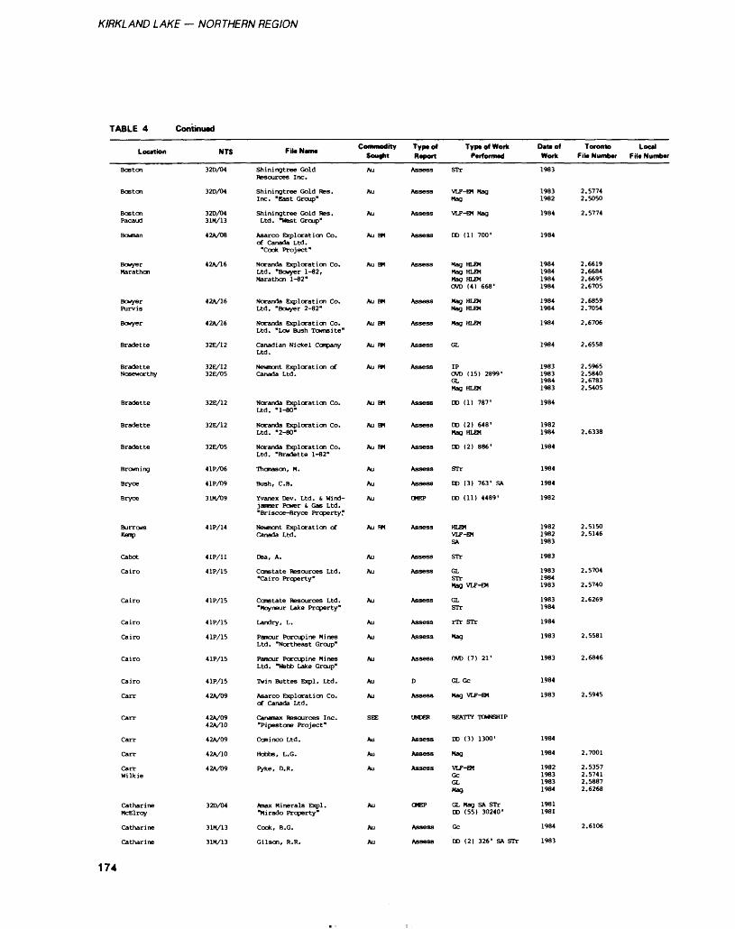
KIRKLAND LAKE — NORTHERN REGION
TABLE 4 Continual
Location
Boston
Boston
BostonPacaud
Bowman
BowyerMarathon
BowyerPurvis
Bowyer
Bradette
BradetteNoseworthy
Bradette
Bradette
Bradette
Browning
Bryce
Bryce
BurrowsKemp
Cabot
Cairo
Cairo
Cairo
Cairo
Cairo
Cairo
Carr
Can-
Can-
Carr
CarrWilkie
CatharineMcElroy
Catharine
Catharine
NTS
32D/04
32D/04
32D/0431M/13
42A/08
42A/16
42A/16
42A/16
32E/12
32E/1232E/05
32E/12
32E/12
32E/05
41P/06
4 IP/09
31M/09
4 IP/14
4 IP/11
4 IP/15
41P/15
4 IP/15
4 IP/15
41P/15
41P/15
42A/09
42A/0942A/10
42A/09
42A/10
42A/09
32D/04
31M/13
31M/13
Fill NWIM
Shiningtree GoldResources Inc.
Shiningtree Gold Res.Inc. "East Group"
Shiningtree Gold Res.Ltd. "West Group"
Asarco Exploration Co.of Canada Ltd."Cook Project"
Noranda Exploration Co.Ltd. "Bowyer 1-82,Marathon 1-82"
Noranda Exploration Co.Ltd. "Bowyer 2-82"
Noranda Exploration Co.Ltd. "Low Bush Towns i te"
Canadian Nickel CompanyLtd.
Neunont Exploration ofCanada Ltd.
Noranda Exploration Co.Ltd. "1-80"
Noranda Exploration Co.Ltd. "2-80"
Noranda Exploration Co.Ltd. "Bradette 1-82"
Thonason, M.
Bush, C. B.
Yvanex Dev. Ltd. d Wind jammer Power s, Gas Ltd."Briscce-Bryce Property"
Newmont Exploration ofCanada Ltd.
Dea, A.
Constate Resources Ltd."Cairo Property"
Constate Resources Ltd."Moyneur Lake Property"
Landry, L.
Pamour Porcupine MinesLtd. "Northeast Group"
Pamour Porcupine MinesLtd. "Webb Lake Group"
Twin Buttes Expl. Ltd.
Asarco Exploration Co.of Canada Ltd.
Canaroax Resources Inc."Pipestone Project"
Cominco Ltd.
Hobbs, L.G.
Pyke, D.R.
Anax Minerals Expl."Mirado Property"
Cook, B.C.
Gilson, R. R.
C of iNnooity Sought
Au
Au
Au
Au BM
Au BM
Au BM
Au BM
Au BM
Au m
Au BM
Au BM
Au BM
Au
Au
Au
Au PH
Au
Au
Au
Au
Au
Au
Au
Au
SEE
Au
Au
Au
Au
Au
Au
Typiol Report
Assess
Assess
Assess
Assess
Assess
Assess
Assess
Assess
Assess
Assess
Assess
Assess
Assess
Assess
CMEP
Assess
Assess
Assess
Assess
Assess
Assess
Assess
D
Assess
UNDER
Assess
Assess
Assess
OMEP
Assess
Assess
Typt of Work Ptironrno
STr
VLF-EM MagMag
VLF-EM Mag
DD (1) 700'
Mag HLEMMag HLEMMag HLEMOVD (4) 668'
Mag HLEMMag HLEM
Mag HLEM
GL
IPOVD (15) 2899'GLMag HLEM
DD (1) 787'
DD (2) 648'Mag HLEM
DD (2) 886'
STr
DD (3) 763' SA
DD (11) 4489'
HLEMVLF-EMSA
STr
GLSTrMag VLF-EM
GLSTr
rTr STr
Mag
OVD (7) 21'
GL Gc
Mag VLF-EM
BEATTY TOWNSHIP
DD (3) 1300'
Mag
VLF-EMGcGLMag
GL Mag SA STrDD (55) 30240'
Gc
DD (2) 326' SA STr
Dat* of Work
1983
19831982
1984
1984
1984198419841984
19841984
1984
1984
1983198319841983
1984
19821984
1984
1984
1984
1982
198219821983
1983
198319841983
19831984
1984
1983
1983
1984
1983
1984
1984
1982198319831984
19811981
1984
1983
Toronto Local F ill Number F ile Number
2.57742.5050
2.5774
2.66192.66842.66952.6705
2.68592.7054
2.6706
2.6558
2.59652.58402.67832.5405
2.6338
2.51502.5146
2.5704
2.5740
2.6269
2.5581
2.6846
2.5945
2.7001
2.53572.57412.58872.6268
2.6106
174
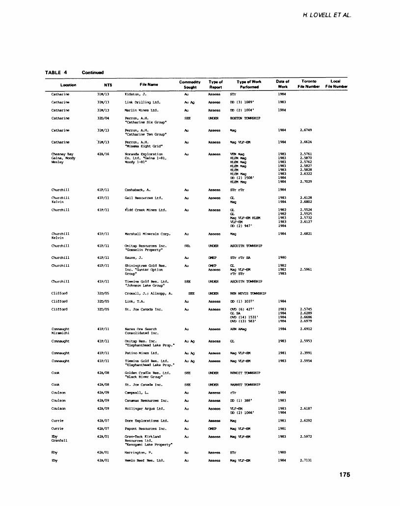
H. LOVELL ET AL.
TABLE 4 Continued
Location
Catharine
Catharine
Catharine
Catharine
Catharine
Catharine
Chesney BayGalna, MoodyWesley
Churchill
ChurchillKelvin
Churchill
ChurchillKelvin
Churchill
Churchill
Churchill
Churchill
Clifford
Clifford
Clifford
ConnaughtMiramichi
Connaught
Connaught
Connaught
Cook
Cock
Coulson
Coulson
Coulson
Currie
Currie
EbyGrenfell
Eby
Eby
NTS
31M/13
31M/13
31M/13
32D/04
31M/13
'31M/13
42A/16
4 IP/11
4 IP/11
4 IP/11
41P/11
4 IP/11
4 IP/11
41P/11
4 IP/11
32D/05
32D/05
32D/05
4 IP/11
4 IP/11
4 IP/11
4 IP/11
42A/08
42A/08
42V09
42A/09
42A/09
42V07
42A/07
42A/01
42A/01
42A/01
FiltNam. Commodity Sought
Kidston, J.
Link Drilling Ltd.
Marlin Mines Ltd.
Perron, A.M."Catharine Six Group"
Perron, A. H."Catharine Ten Group"
Perron, A. H."Miserna Eight Grid"
Noranda ExplorationCo. Ltd. "Galna 1-81,Moody 1-81"
Cashaback, A.
Gail Resources Ltd.
Kfidd Creek Mines Ltd.
Marshall Minerals Corp.
Onitap Resources Inc."Gosselin Property"
Sauve, J.
Shiningtree Gold Res.Inc. "Gunter OptionGroup"
Timnins Gold Res. Ltd."Johnson Lake Group"
Croxall, J.; Allsopp, A.
Link, T.A.
St. Joe Canada Inc.
Narex Ore SearchConsolidated Inc.
Onitap Res. Inc."Elephanthead Lake Prop."
Patino Mines Ltd.
Timmins Gold Res. Ltd."Elephanthead Lake Prop."
Golden Cradle Res. Ltd."Black River Group"
St. Joe Canada Inc.
Campsall, L.
Canamax Resources Inc.
Hollinger Argus Ltd.
Dore Explorations Ltd.
Papont Resources Inc.
Gren-Teck KirklandResources Ltd."Kenogami Lake Property"
(torrington, P.
Hanlo Reef Res. Ltd.
Au
Au Ag
Au
SEE
Au
Au
Au
Au
Au
Au
Au
REt
Au
Au
SEE
SEE
Au
Au
Au
Au Ag
Au Ag
Au Ag
SEE
SEE
Au
Au
Au
Au
Au
Au
Au
Au
Type of ReportAssess
Assess
Assess
UNDER
Assess
Assess
Assess
Assess
Assess
Assess
Assess
UNDER
OMEP
OMEPAssess
UNDER
UNDER
Assess
Assess
Assess
Assess
Assess
Assess
UNDER
UNDER
Assess
Assess
Assess
Assess
OMEP
Assess
Assess
Assess
Type of Work Performed
STr
DO (3) 1089'
DO (2) 1004'
BOSTON TOWNSHIP
Mag
Mag VLF-EM
VEM MagHLEM MagHLEM MagHLEM MagHLEMHLEM MagDD (2) 1508'HLEM Mag
STr rTr
GLMag
GLGLMag VLF-EM HLEMVLF-EMDD (2) 947'
Mag
ASQUITH TOWNSHIP
STr rTr SA
GLMag VLF-EMrTr STr
ASQUITH TOWNSHIP
BEN NEVIS TOWNSHIP
DD (1) 1037'
OVD (6) 427'GL SAOVD (14) 1531'OVD (13) 583'
AEM AMag
GL
Mag VLF-EM
Mag VLF-EM
BENOIT TOWNSHIP
BARNET TOWNSHIP
rTr
DD (1) 388'
VLF-EMDD (2) 1066'
Mag
Mag VLF-EM
Mag VLF-EM
STr
Mag VLF-EM
Date of Work
1984
1983
1984
1984
1984
19831983198319831983198319841984
1984
19831984
19821982198319831984
1984
1980
198219831983
1984
1983198419841984
1984
1983
1981
1983
1984
1983
19831984
1983
1981
1983
1980
1984
Toronto Local File Number Fib Number
2.6749
2.6624
2.57612.58702.57622.58272.58282.6322
2.7029
2.61282.6802
2.55242.55252.57322.6127
2.6821
2.5961
2.57452.62892.66862.6979
2.6912
2.5953
2.3991
2.5954
2.6187
2.6292
2.5972
2.7131
175
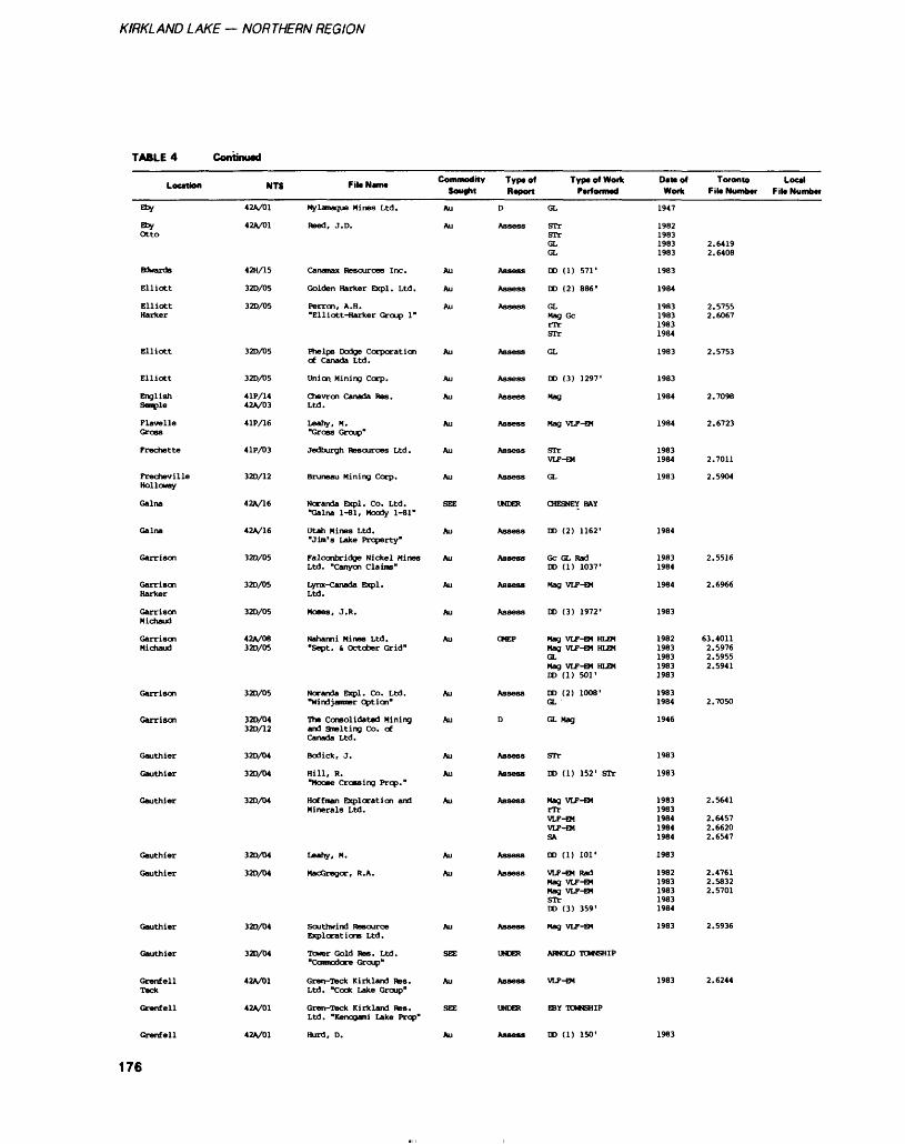
KIRKLAND LAKE — NORTHERN REGION
TABLE 4 Continued
Location
Eby
ebyOtto
Btoante
Elliott
Elliott Harker
Elliott
Elliott
English Senile
Flavelle Gross
Frechette
Frecheville Holloway
Galna
Galna
Garrison
Garrison Harker
Garrison Michaud
Garrison Michaud
Garrison
Garrison
Gauthier
Gauthier
Gauthier
Gauthier
Gauthier
Gauthier
Gauthier
Grenfell Teck
Grenfell
Grenfell
NTS
42A/01
42A/01
42H/15
32D/05
32D/05
32D/05
320/05
4 IP/14 42A/03
4 IP/16
4 IP/03
32D/12
42A/16
42A/16
32D/05
32D/05
32D/05
42V08 32D/05
32D/05
32D/04 32D/12
32O/04
32D/04
32D/04
32D/04
320/04
320/04
320/04
42A/01
42A/01
42A/01
Filt NWIM
Mylamaque Mines Ltd.
need, J. D.
Canamax Resources Inc.
Golden Harker Expl. Ltd.
Perron, A. H. "Elliott-Harker Group 1"
Phelps Dodge Corporation of Canada Ltd.
Union Mining Corp.
Chevron Canada Res. Ltd.
Leahy, M. "Gross Group"
Jedburgh Resources Ltd.
Bruneau Mining Corp.
Ncranda Expl. Co. Ltd. "Galna 1-81, Moody 1-81"
Utah Mines Ltd. "Jim's Lake Property"
Falconbridge Nickel Mines Ltd. "Canyon Claims"
Lynx-Canada Expl. Ltd.
Moses, J.R.
Naharmi Mines Ltd. "Sept. (r October Grid"
Ncranda Expl. Co. Ltd. "Windjammer Option"
The Consolidated Mining and Smelting Co. of Canada Ltd.
Bodick, J.
Hill, R. "Moose Crossing Prop."
Hoffman Exploration and Minerals Ltd.
Leahy, M.
MaoGregor, R. A.
Southwind Resource Explorations Ltd.
Tower Gold Res. Ltd. "Commodore Group*
Gren-Teck Kirkland Res. Ltd. "Cook Lake Group"
Gren-Teck Kirkland RBS. Ltd. "Kenogami Lake Prop*
Kurd, D.
Commodity Sought
Au
Au
Au
Au
Au
Au
Au
Au
Au
Au
Au
SEE
Au
Au
Au
Au
Au
Au
Au
Au
Au
Au
Au
Au
Au
SEE
Au
SEE
Au
Typtof Report
D
Assess
Assess
Assess
Assess
Assess
Assess
Assess
Assess
Assess
Assess
UNDER
Assess
Assess
Assess
Assess
OMEP
Assess
D
Assess
Assess
Assess
Assess
Assess
Assess
UNDER
Assess
UNDER
Assess
Typ* of Work Performed
GL
STr STr GL GL
DO (1) 571'
DO (2) 886'
GL Mag Gc rTr STr
GL
DO (3) 1297'
Mag
Mag VLF-EM
STr VLF-EM
GL
CHESNEY BAY
DO (2) 1162'
Gc GL Rad DD (1) 1037'
Mag VLF-EM
DD (3) 1972'
Mag VLF-EM HLEM Mag VLF-EM HLEM GL Mag VLF-EM HLEM DD (1) 501'
DD (2) 1008' GL
GL Mag
STr
DD (1) 152' STr
Mag VLF-EM rTr VLP-EM VLP-EM SA
DD (1) 101'
VLF-EM Rad Mag VLF-EM Mag VLF-EM STr DD (3) 359'
Mag VLF-EM
ARNOLD TOWNSHIP
VLP-EM
EBY TOWNSHIP
DD (1) 150'
Dattof Work
1947
1982 1983 1983 1983
1983
1984
1983 1983 1983 1984
1983
1983
1984
1984
1983 1984
1983
1984
1983 1984
1984
1983
1982 1983 1983 1983 1983
1983 1984
1946
1983
1983
1983 1983 1984 1984 1984
1983
1982 1983 1983 1983 1984
1983
1983
1983
Toronto Local File Number Filt Number
2.6419 2.6408
2.5755 2.6067
2.5753
2.7098
2.6723
2.7011
2.5904
2.5516
2.6966
63.4011 2.5976 2.5955 2.5941
2.7050
2.5641
2.6457 2.6620 2.6547
2.4761 2.5832 2.5701
2.5936
2.6244
176
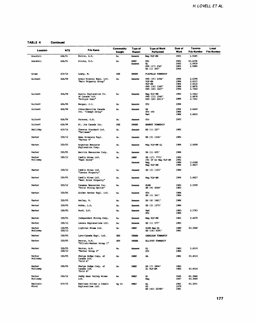
H. LOVELL ETAL
TABLE 4 Continued
Location
Grenfell
Grenfell
Gross
Guibord
Guibord
Guibord
Guibord
Guibord
Guibord
Halliday
Harker
Harker
Harker
Harker Holloway
Harker
Harker
Harker
Harker
Harker
Harker
Harker
Harker
Harker
Harker Holloway
Harker
Harker
Harker
Harker Holloway
Harker Holloway
Harker Holloway
Haultain Nicol
NTS
42A/01
42A/01
41P/16
42A/08
42A/08
42A/08
42A/08
42A/08
42V08
41P/14
32D/12
32D/05
32D/D5
32D/12
32D/12
32D/05
32D/12
32D/05
32D/05
32D/05
32D/05
32D/05
32O/12
32D/05 32D/12
32D/05
32D/D5
32D/05 32D/12
32D/05
32D/D5
320/12
41P/10
File Namt
Perron, A.H.
Sirola, D.G.
Leahy, M.
Armco Mineral Expl. Ltd. "Main Property Group"
Asarco Exploration Co. of Canada Ltd. "Holtyre East"
Mangan, J. J.
Johns-Man vi Ile Canada Inc. "Joseph Group"
Parsons, G. E.
St. Joe Canada Inc.
Chevron Standard Ltd. "Talisman"
Nnax Minerals Expl. "Harker 4"
Argentex Resource Exploration Corp.
Bar rick Resources Corp.
Camflo Mines Ltd. "East Block"
Camflo Mines Ltd. "Lenora Property"
Camflo Mines Ltd. "West Block Property"
Canamax Resources Inc. "Union Mining Option"
Golden Harker Expl. Ltd.
Harley, N.
Hobbs, L.G.
Kurd, D.F.
Independent Mining Corp.
Lenora Explorations Ltd.
Lightval Mines Ltd.
Lynx-Canada Expl. Ltd.
Perron, A.H. "Elliott-Harker Group 1"
Perron, A.H. "Harker Group 2"
Phelps Dodge Corp* of Canada Ltd. "Grid A"
Phelps Dodge Corp. of Canada Ltd. "Grid B"
Teddy Bear Valley Mines Ltd.
Peerless Silver t Cobalt Explorations Ltd.
Commodity Sought
Au
Au
SEE
Au
Au
Au
Au
Au
SEE
Au
Au
Au
Au
Au
Au
Au
Au
Au
Au
Au
Au
Au
Au
Au
SEE
SEE
Au
Au
Au
Au
Ag Co
Type of ReportAssess
OMEP Assess
UNDER
Assess
Assess
Assess
Assess
Assess
UNDER
Assess
Assess
Assess
Assess
OHEP
Assess
Assess
Assess
Assess
Assess
Assess
Assess
Assess
Assess
Assess
OHEP
UNDER
UNDER
Assess
CMEP
OMEP
OMEP
OMEP
Type of Work Performed
Mag VLF-EM
srrGL CVD (17) 234' DD (1) 365'
FLAVELLE TOWNSHIP
OUD (35) 2356' VLF-EM VLF-EM OVD (16) 1240' CVD (20) 1427'
Mag VLF-EM OVD (12) 1540' OVD (24) 2812'
STr
SA STr rTr Rad
STr
BARNET TOWNSHIP
DD (1) 327'
DD (3) 1104'
Mag VLF-EM GL
DD (1) 425'
DD (17) 7771' rTr IP Gc Mag VLF-EM Mag Mag VLF-EM
DD (3) 1103'
Mag VLF-EM
HLEM DD (9) 4549'
STr DD (1) 341'
DD (4) 1461'
DD (3) 1273'
Rad STr
Mag VLF-EM
DD (1) 577'
HLEM Mag GL DD (18) 4391*
GARRISON TOWNSHIP
ELLIOTT TOWNSHIP
GL STr
SA
DD (7) 2804' GL VLF-EM
GL Mag
GL UG DD (43) 22392'
DIM of Work1983
1982 1983 1983 1984
1984 1984 1984 1984 1984
1983
1984
1984
1984 1984 1984
1983
1983
1982
1984
1984
1982 1981 1984 1984
1984
1984
1983 1983
1984 1984
1984
1984
1983 1984
1981
1983
1980 1981
1983 1984
1981
1982 1982
1945 1947
1981 1979 1981
Toronto Loot F ile Number F ile Number
2.5545
63.4156 2.5939 2.5995
2.6396 2.6515 2.6516 2.6876 2.7302
2.5942 2.6870 2.7301
2.6440
2.6832
2.6958
2.6368 2.6827
2.6827
2.5599
2.5783
2.4470
63.3940
2.6316
63.4014
63.4014
63.3940 63.3940
63.3931
177
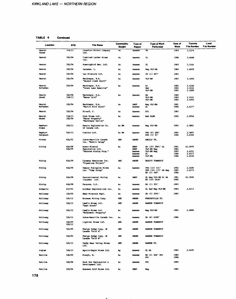
KIRKLAND LAKE — NORTHERN REGION
TABLE 4 Continued
Location
HearstSkead
Hearst
Hearst
Hearst
Hearst
Hearst
HearstMcfadden
HearstSkead
HearstMcFadden
Hearst
HearstSkead
HepburnScapa
HepburnSargeant
Hincks
Hislop
Hislop
Hislop
Hislop
Hislop
Hodgetts
Holloway
Holloway
Holloway
Holloway
Holloway
Holloway
Holloway
Holloway
Holloway
Ingram
Katrine
Katrine
NTS
31M/13
32D/04
320/04
32D/04
32D/04
32D/04
32D/04
32D/0431M/13
32D/04
32D/04
31M/1332D/04
32D/13
32D/13
42A/02
42A/0842A/09
42A/09
42A/08
42A/08
42A/08
4 IP/03
32D/05
32D/12
32D/12
32D/12
32D/12
320/0532D/12
32D/05
32D/05
32D/12
31H/13
32D/D5
32D/04
Fil* NMM
Canadian Nickel CcnpanyLtd.
Combined Larder MinesLtd.
Hummingbird Res. Ltd.
Lacasse, L.
Lac Minerals Ltd.
MacGregor, R.A."Benson Creek North"
MacGregor, R.A."Grace Lake Baseline"
MacGregor, R.A."Manor Grid"
MacGregor, R.A."Martin Bird South"
Rivard, F.
Utah Mines Ltd."Manor Property""MacGregor Option"
Asarco Exploration Co.of Canada Ltd.
Caninco Ltd.
Johns-Manville CanadaInc. "McGill Group"
Armco MineralExploration Ltd."Parsons Hislop Prop."
Canamax Resources Inc."Pipestone Project"
Pamour Porcupine MinesLtd. "Viiiy Group"
Pancontinental Mining(Canada) Ltd.
Parsons, G. E.-
Goldmac Explorations Inc.
Amax Minerals Expl.
Bruneau Mining Corp.
Camflo Mines Ltd."East Block*
Camflo Mines Ltd."McDermott Property"
Johns-Manville Canada Inc.
Lightval Mines Ltd.
Phelps Dodge Corp. ofCanada "Grid A"
Phelps Dodge Corp. ofCanada "Grid B"
Teddy Bear Valley MinesLtd.
Agnico-Eagle Mines Ltd.
Kiazyk, B.
Rock Ore Exploration tDevelopment Ltd.
Commodity SoughtAu
Au
Au
Au
Au
Au
Au
Au
Au
Au
Au
Au BM
Au BM
SEE
Au
SEE
Au
Au
Au
Au
Au
SEE
SEE
Au
Au
SEE
SEE
SEE
SEE
Ag
Au
Au
Typaof Report
Assess
Assess
Assess
Assess
Assess
Assess
Assess
Assess
OMEPAssess
Assess
Assess
Assess
Assess
UNDER
OMEPOKEPAssessAssessAssess
UNDER
Assess
OMEP
Assess
Assess
Assess
UNDER
UNDER
Assess
Assess
UNDER
UNDER
UNDER
UNDER
Assess
Assess
Assess
Typt of Work PcfiorfiMo
SA
Gc
GL
Mag VLF-EM
DD (1) 667'
VLF-EM
GcRadVLF-EM
SAVLF-EMVLF-EM
Mag VLF-EMGL
STr
Rad HLEM
Mag VLF-EM
OVD (8) 280'OVD (3) 91'
ARGYLE TP.
DD (18) 2901' GLVLF-EM MagVLF-EM MagGLVLF-EM,
BEATTY TOWNSHIP
OVD (14) 531'OVD (14) 175' SA MagDD (2) 360*
GL Mag VLF-EM Gc SADD (14) 5626'
DD (1) 201'
GL Rad Nag VLF-EM
DD (5) 2091'
FRECHEVILLE TP.
HARKER TOWNSHIP
Mag VLF-EM
DD (8) 4390'
HARKER TOWNSHIP
HARKER TOWNSHIP
HARKER TOWNSHIP
HARKER TP.
GL SA
DO (2) 204' STrSTr
STr
Dattof Work
1983
1984
1983
1984
1983
1983
198219821983
198219831982
19811984
1983
1982
1983
19831984
19811982198319841984
198219831984
19811980
1983
1983
1983
1982
1984
1983
19831984
1983
Toronto Local F it* Number F il* Numb*
2.5374
2.6448
2.5161
2.6659
2.5492
2.52202.53322.5589
2.53312.5493
2.6277
2.9954
2.5861
2.58972.6350
63.3970
2.62212.65172.6518
2.54002.6273
63.3930
2.6213
2.4808
2.6225
32D/04 Swansea Gold Mines Ltd. OMEP Mag
178
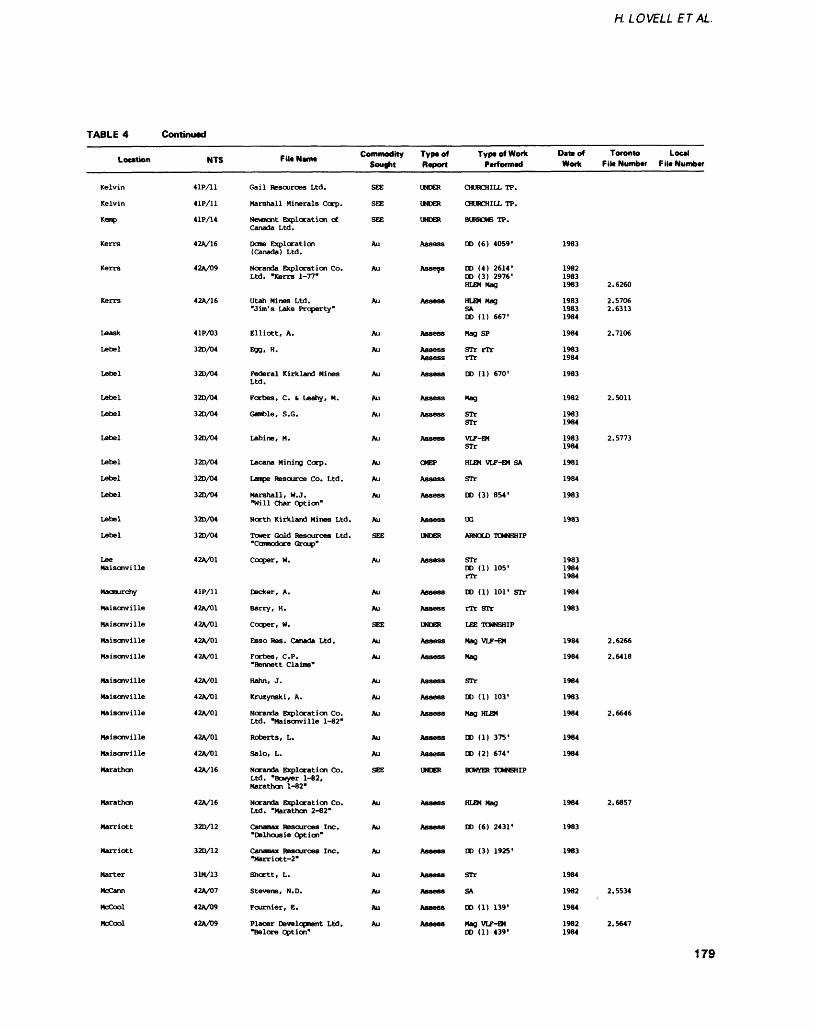
H. LOVELL ETAL
TABLE 4 Continued
Location
Kelvin
Kelvin
Kemp
Kerrs
Kerrs
Kerrs
Leask
Lebel
Lebel
Lebel
Lebel
Lebel
Lebel
Lebel
Lebel
Lebel
Lebel
Lee Maisonville
Macmurchy
Maisonville
Maisonville
Maisonville
Maisonville
Maisonville
Maisonville
Maisonville
Maisonville
Maisonville
Marathon
Marathon
Marriott
Marriott
Marter
McCann
Mccool
MoCool
NTS
4 IP/11
4 IP/11
41P/14
42A/16
42A/09
42A/16
4 IP/03
32D/04
32D/04
32D/04
32D/04
32D/04
32D/04
32D/04
32D/04
32D/04
32D/04
42A/01
41P/11
42A/01
42A/01
42A/01
42A/01
42A/01
42A/01
42A/01
42A/01
42A/01
42A/16
42A/16
32D/12
32D/12
31M/13
42A/D7
42A/09
42A/09
File NT*. Commodity Type of Sought Report
Gail Resources Ltd.
Marshall Minerals Corp.
Newnont Exploration of Canada Ltd.
Done Exploration (Canada) Ltd.
Noranda Exploration Co. Ltd. "Kerrs 1-77"
Utah Mines Ltd. "Jim's Lake Property"
Elliott, A.
Egg, H.
Federal Kirkland Mines Ltd.
Forbes, C. t Leahy, M.
Gamble, S.G.
Labine, M.
Lacana Mining Corp.
Lampe Resource Co. Ltd.
Marshall, W.J. "Will Char Option"
North Kirkland Mines Ltd.
Tower Gold Resources Ltd. "Conntodcre Group"
Cooper, H.
Decker, A.
Barry, H.
Cooper, W.
Esso Res. Canada Ltd.
Forbes, C. P. Bennett Claims"
Hahn, J.
Kruzynski, A.
Noranda Exploration Co. Ltd. "Maisonville 1-82"
Roberts, L.
Salo, L.
Noranda Exploration Co. Ltd. "Bowyer 1-82, Marathon 1-82*
Noranda Exploration Co. Ltd. "Marathon 2-82"
Canamax Resources Inc. "Dalhousie Option"
Canamax Resources Inc. "Marriott-2"
Sheet t, L.
Stevens, N.D.
Fournier, E.
Placer Development Ltd, "Belore Option"
SEE
SEE
SEE
Au
Au
Au
Au
Au
Au
Au
Au
Au
Au
Au
Au
Au
SEE
Au
Au
Au
SEE
Au
Au
Au
Au
Au
Au
Au
SEE
Au
Au
Au
Au
Au
Au
Au
UNDER
UNDER
UNDER
Assess
Assess
Assess
Assess
Assess Assess
Assess
Assess
Assess
Assess
OMEP
Assess
Assess
Assess
UNDER
Assess
Assess
Assess
UNDER
Assess
Assess
Assess
Assess
Assess
Assess
Assess
UNDER
Assess
Assess
Assess
Assess
Assess
Assess
Assess
Type of Work Performed
CHURCHILL TP.
CHURCHILL TP.
BURROWS TP.
DD (6) 4059'
DD (4) 2614' DD (3) 2976' HLEM Mag
HLEM Mag SA DD (1) 667'
Mag SP
STr rTr rTr
DD (1) 670'
Mag
STr STr
VLF-EM STr
HLEM VLF-EM SA
STr
DD (3) 854'
UG
ARNOLD TOWNSHIP
STr DD (1) 105'rTr
DD (1) 101' STr
rTr STr
LEE TOWNSHIP
Mag VLF-EM
Mag
STr
DD (1) 103'
Mag HLEM
DD (1) 375'
DD (2) 674'
BOWER TOWNSHIP
HLEM Mag
DD (6) 2431'
DD (3) 1925'
STr
SA
DD (1) 139'
Mag VLF-EM DD (1) 439'
DIM of Work
1983
1982 1983 1983
1983 1983 1984
1984
1983 1984
1983
1982
1983 1984
1983 1984
1981
1984
1983
1983
1983 1984 1984
1984
1983
1984
1984
1984
1983
1984
1984
1984
1984
1983
1983
1984
1982
1984
1982 1984
Toronto Local File Number F ile Number
2.6260
2.5706 2.6313
2.7106
2.5011
2.5773
2.6266
2.6418
2.6646
2.6857
2.5534
2.5647
179
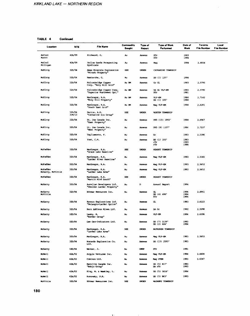
KIRKLAND LAKE — NORTHERN REGION
TABLE 4 Continued
Location
McCoolMunro
MccoolMilligan
Mcelroy
McElroy
McElroy
McElroy
McElroy
McElroy
McElroy
McElroy
McElroy
McElroy
McElroy
McFadden
McFadden
Mcfadden
McFaddenMcGarry, Mcvittie
McFadden
McGarry
McGarryMcvittie
McGarry
McGarry
McGarry
McGarry
McGarry
McGarry
McGarry
McGarry
Mcneil
Mcneil
Mcneil
McNeil
McNeil
Mcvittie
NTS
42A/09
42A/09
32D/04
32D/04
32D/04
32D/04
320/04
32D/04
320/0431M/13
32D/04
320/04
32D/04
320/04
32D/04
320/04
320/04
320/04
32D/04
320/04
320/04
320/04
320/04
320/04
320/04
320/04
320/04
320/04
320/04
42A/02
42A/02
42V02
42A/02
42A/02
320/04
Fit* Name
Richmond, G.
Yellow Sands ProspectingSyndicate
Amax Minerals Exploration"Mirado Property"
Bastarche, G.
Falconbridge CopperCorp. "Moly Hill Grid"
Falconbridge Copper Corp."Superior Northwest Opt."
Macgregor, R. A."Moly Hill Property"
MacGregor, R. A."South East Grid"
Perron, A. H."Catharine Six Group"
St. Joe Canada Inc."East Property"
St. Joe Canada Inc."West Property"
Tagliamonte, F.
Yost, C. H.
MacGregor, R.A."Grace Lake Baseline"
MacGregor, R.A."Larder River Baseline"
MacGregor, R.A.
MacGregor, R.A."Larder Lake Area"
MacGregor, R.A."Martin Bird South"
Aurelian Developers Ltd."Sheldon Larder Property"
Edonar Resources Inc.
Kennco Explorations Ltd."Pelangio-Larder Option"
Kerr Addison Mines Ltd.
Leahy, M."Border Group"
Lee Geo-Indicators Ltd.
MacGregor, R.A."Larder Lake Area*
MacGregor, R.A.
Noranda Exploration Co.Ltd.
Walker, J.
Argyle ventures Inc.
Ccminco Ltd.
Manville Canada Inc."Bobjo Group"
King, M. i Week ley, L.
Konovsky, P.R.
Edomar Resources Inc.
Commodity Sought
Au
Au
SEE
Au
Au BM
Au BM
Au BM
Au BM
SEE
Au
Au
Au
Au
SEX:
Au
Au
Au
SEE
Au
Au
Au
Au
Au
Au
SEE
Au
Au
Au
Au
Au
Au
Au
Au
SEE
Type of Report
Assess
Assess
UNDER
Assess
Assess
Assess
Assess
Assess
UNDER
Assess
Assess
Assess
Assess
UNDER
Assess
Assess
Assess
UNDER
D
Assess
Assess
Assess
Assess
Assess
UNDER
Assess
Assess
OMEP
Assess
Assess
Assess
Assess
Assess
UNDER
Type of Work Performed
STrSTr
Mag
CATHARINE TOWNSHIP
DO (1) 125'
Gc GL
SA GL VLF-EMSTr
VLF-EMDO (1) 105'
Mag VLF-EM
BOSTON TOWNSHIP
OVD (13) 1892'
OVD (8) 1107'
Gc
DO (1) 103'rTrrTr
HEARST TOWNSHIP
Mag VLP-EM
Mag VLF-EM
Mag VLF-EM
HEARST TOWNSHIP
Annual Report
GLDO (4) 499'STr
GL
SA Gc
VLF-EM
DO (7) 3139'DO (2) 604'
MCFADDEN TOWNSHIP
Mag VLF-EM
DO (13) 2593'
STr
Mag VLF-EM
Mag UTEM
DO (5) 817'SA rTr
DO (5) 1616'
DD (3) 863'
MCGARRY TOWNSHIP
Oat* of Work
19831984
1984
1984
1983
19831981
19841984
1984
1984
1984
1983
198319831984
1983
1983
1983
1984
198419841984
1983
1982
1984
19831984
1983
1983
1981
1984
1983
19831983
1984
1983
Toronto Local F ile Number F ile Number
2.6834
2.5795
2.5795
2.7142
2.6281
2.6967
2.7237
2.5386
2.5345
2.5652
2.5652
2.6861
2.6223
2.5298
2.6306
2.5653
2.6604
2.6347
180
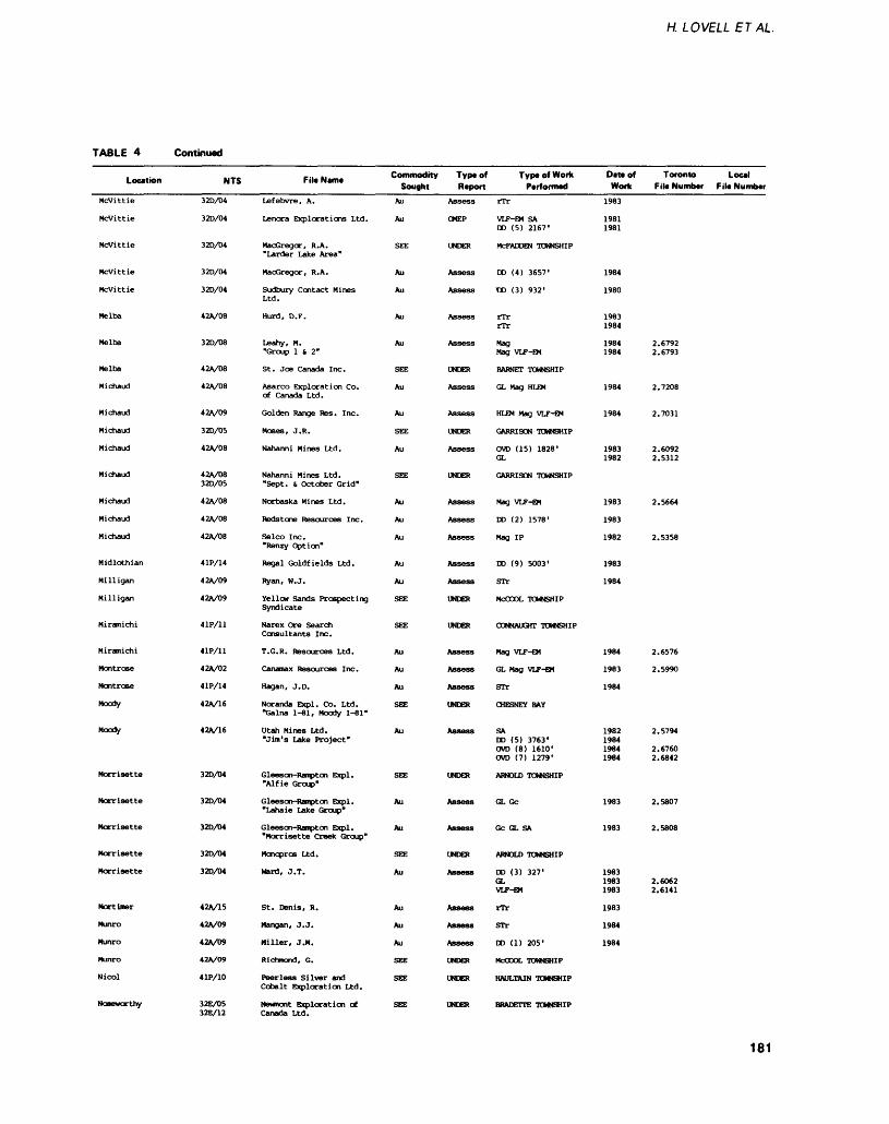
H. LOVELL ETAL
TABLE 4 Continued
Location
Mcvittie
Mcvittie
Mcvittie
Mcvittie
Mcvittie
Melba
Melba
Melba
Michaud
Michaud
Michaud
Michaud
Michaud
Michaud
Michaud
Michaud
Midlothian
Milligan
Milligan
Miramichi
Miramichi
Montrose
Montrose
Moody
Moody
Morrisette
Morrisette
Morrisette
Morrisette
Morrisette
Mortimer
Munro
Munro
Munro
Nicol
Noseworthy
NTS
32D/D4
32D/04
32D/D4
320/04
32D/04
42A/08
32D/08
42A/08
42A/08
42A/09
32D/05
42A/08
42A/0832D/05
42A/08
42A/08
42A/08
4 IP/14
42A/09
42A/09
41P/11
41P/11
42A/02
41P/14
42A/16
42A/16
32D/04
32D/04
32D/D4
32D/04
32D/04
42A/15
42A/09
42A/09
42V09
41P/10
32E/0532E/12
File Name
Lefebvre, A.
Lenora Explorations Ltd.
MacGregor, R. A."Larder Lake Area"
MacGregor, R.A.
Sudbury Contact MinesLtd.
Hurd, D. F.
Leahy, M."Group 1 S 2"
St. Joe Canada Inc.
Asarco Exploration Co.of Canada Ltd.
Golden Range Res. Inc.
Moses, J. R.
Nahanni Mines Ltd.
Nahanni Mines Ltd."Sept. Si October Grid"
Norbaska Mines Ltd.
Redstone Resources Inc.
Selco Inc."Renzy Option"
Regal Goldfields Ltd.
Ryan, W. J.
Yellow Sands ProspectingSyndicate
Narex Ore SearchConsultants Inc.
T.G.R. Resources Ltd.
Canamax Resources Inc.
Hagan, J. D.
Noranda Expl. Co. Ltd."Galna 1-81, Moody 1-81"
Utah Mines Ltd."Jim's Lake Project"
Gleeson Rampton Expl."Alf ie Group"
Gleeson-Rarapton Expl."Lahaie Lake Group"
Gleeson-Rampton Expl."Morrisette Creek Group"
Monopros Ltd.
Ward, J.T.
St. Denis, R.
Mangan, J. J.
Miller, J.M.
Richmond, G.
Peerless Silver andCobalt Exploration Ltd.
Newmont Exploration ofCanada Ltd.
Commodity Sought
Au
Au
SEE
Au
Au
Au
Au
SEE
Au
Au
SEE
Au
SEE
Au
Au
Au
Au
Au
SEE
SEE
Au
Au
Au
SEE
Au
SEE
Au
Au
SEE
Au
Au
Au
Au
SEE
SEE
SEE
Typtof R t port
Assess
OMEP
UNDER
Assess
Assess
Assess
Assess
UNDER
Assess
Assess
UNDER
Assess
UNDER
Assess
Assess
Assess
Assess
Assess
UNDER
UNDER
Assess
Assess
Assess
UNDER
Assess
UNDER
Assess
Assess
UNDER
Assess
Assess
Assess
Assess
UNDER
UNDER
UNDER
Type of Work Performed
rrr
VLF-EM SADD (5) 2167'
MCFADDEN TOWNSHIP
DO (4) 3657'
DD (3) 932'
rTrrTr
MagMag VLF-EM
BARNETT TOWNSHIP
GL Mag HLEM
HLEM Mag VLF-EM
GARRISON TOWNSHIP
OVD (15) 1828'GL
GARRISON TOWNSHIP
Mag VLF-EM
DD (2) 1578'
Mag IP
CD (9) 5003'
STr
MCCOOL TOWNSHIP
CONNAUGHT TOWNSHIP
Mag VLF-EM
GL Mag VLF-EM
STr
CHESNEY BAY
SADD (5) 3763'OVD (8) 1610'OVD (7) 1279'
ARNOLD TOWNSHIP
GL Gc
Gc GL SA
ARNOLD TOWNSHIP
DD (3) 327'GLVLF-EM
rTr
STr
DO (1) 205'
MCCOOL TOWNSHIP
HAULTAIN TOWNSHIP
BRADETTE TOWNSHIP
Dm of Work
1983
19811981
1984
1980
19831984
19841984
1984
1984
19831982
1983
1983
1982
1983
1984
1984
1983
1984
1982198419841984
1983
1983
198319831983
1983
1984
1984
Toronto Local File Numbar Fila Number
2.67922.6793
2.7208
2.7031
2.60922.5312
2.5664
2.5358
2.6576
2.5990
2.5794
2.67602.6842
2.5807
2.5808
2.60622.6141
181
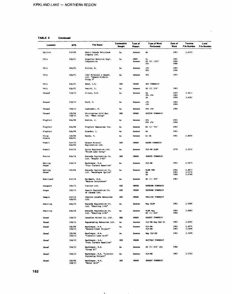
KIRKLAND LAKE — NORTHERN REGION
TABLE 4 Continued
Location
Ogilvie
Otto
Otto
Otto
Otto
Otto
Pacaud
Pacaud
Pacaud
Pacaud
Playfair
Playfair
Playfair
PlinySteele
Powell
Powell
Purvis
RattraySkead
RattraySkead
Robillard
Sargeant
Scapa
Semple
Sherring
Sherring
Skead
Skead
Skead
Skead
Skead
Skead
Skead
Skead
NTS
41P/06
42A/01
42A/01
42A/01
42A/01
42A/01
31M/13
31M/13
31M/13
32D/D431M/13
42A/08
42A/08
42A/08
32E/0442H/01
41P/1542V02
41P/15
42A/16
31M/13
32D/04
4 IP/16
32D/13
32D/13
4 IP/1442A/03
42A/15
42A/16
31M/13
31M/13
32D/0431M/13
320/0431M/13
31M/13
31H/13
31M/13
32D/0431M/13
Fil.N.m. Con^nodrty Sought
Amoco Canada PetroleumCcrpany Ltd.
Argentex Resource Expl.Corporation
Birnie, B.
Joni Minerals k Exped.Ltd. "Dyment-KidstonGroup D"
Reed, J. D.
Vesich, Z.
Gilson, R. R.
Kurd, D.
Laskcwski, H.
Shiningtree Gold Res.Inc. "West Group"
Bodick, J.
Playfair Resources Inc.
Standen, L.
Randa, T.
Hanson MineralExploration Ltd.
Sylva Exploration Ltd."Bloom Lake Group"
Noranda Exploration Co.Ltd. "Bowyer 2-82"
MacGregor, R. A."Four Comers Baseline"
Noranda Exploration Co.Ltd. "MacGregor Option"
Maidment, E. E."Mearow Occurrence"
Cominco Ltd.
Asarco Exploration Co.of Canada Ltd.
Chevron Canada ResourcesLtd.
Noranda Exploration Co.Ltd. "Sherring 1-82"
Noranda Exploration Co.Ltd. "Sherring 2-82"
Canadian Nickel Co. Ltd.
Kapuskasing Resources Ltd.
MacGregor, R.A."Benson-Creek Project"
MacGregor, R.A."Costello Lake Grid"
MacGregor, R.A."Four Corners Baseline"
MacGregor, R.A."Group Bl"
MacGregor, R.A. "Lincoln-Nipissing Project"
MacGregor, R.A."Manor Grid"
Au
Au
Au
Au
SEE
Au
Au
Au
Au
SEE
Au
Au
Au
Au
SEE
Au
SEE
Au
Au
Au
SEE
SEE
SEE
Au
Au
SEE
Au
Au
Au
SEE
Au
Au
SEE
Typtof Report
Assess
OMEPAssess
Assess
Assess
UNDER
Assess
Assess
Assess
Assess
UNDER
Assess
Assess
Assess
Assess
UNDER
Assess
UNDER
Assess
Assess
Assess
UNDER
UNDER
UNDER
Assess
Assess
UNDER
Assess
Assess
Assess
UNDER
Assess
Assess
UNDER
Type of Work Performed
SA
GLDO (4) 1352'STr
rTrSTr
STr
EBY TOWNSHIP
OD (2) 214'
SASTr rTrSA
rTrrTr
STr rTr
BOSTON TOWNSHIP
STrSTr rTr
DD (1) 701'
SA
Gc SA
BADEN TOWNSHIP
VLF-EM HLEM
BOWYER TOWNSHIP
VLF-EM
HLEM VEMSASA
DD (1) 309'
HEPBURN TOWNSHIP
HEPBURN TOWNSHIP
ENGLISH TOWNSHIP
Mag HLEM
HLEM MagDD (1) 626'
HEARST TOWNSHIP
VLF-EM Mag Rad GL
VLF-EMVLF-EM
Mag VLF-EM
RATTRAY TOWNSHIP
DD (5) 834' STr
VLF-6M
HEARST TOWNSHIP
D*u of Work
1983
198119841984
19831984
1983
1983
198319831984
19831984
1984
19831984
1983
1983
1981
1979
1983
198219831984
1983
1983
19841984
1983
19821983
1983
1984
1983
Toronto Local F ile Number F ill Number
2.6355
2.5611
2.6381
2.4835
2.3212
2.5473
2.48732.53742.6766
2.5940
2.6882
2.6091
2.48752.5494
2.5495
2.5702
182
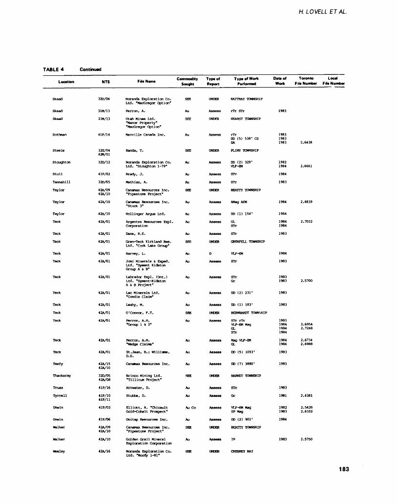
H. LOVELL ETAL
TABLE 4 Continued
Location
Skead
Skead
Skead
Sothman
Steele
Stoughton
Stull
Tannahill
Taylor
Taylor
Taylor
Teck
Teck
Teck
Teck
Teck
Teck
Teck
Teck
Teck
Teck
Teck
Teck
Teefy
Thackeray
Truax
Tyrrell
Unwin
Unwin
Walker
Walker
Wesley
NTS
32D/04
31M/13
31M/13
41PA4
32E/04 42M/01
320/12
41P/02
32D/05
42A/09 42A/10
42A/10
42A/10
42A/01
42A/01
42A/01
42A/01
42A/01
42A/01
42A/01
42A/01
42A/01
42A/01
42A/01
42A/D1
42A/15 42A/10
32D/05 42A/08
4 IP/16
41P/10 41P/11
41P/03
41P/06
42A/09 42A/10
42A/10
42A/16
,.. .. Commodity Fito Name . Sought
Noranda Exploration Co. Ltd. "MacGregor Option"
Perron, A.
Utah Nines Ltd. "Manor Property" "MacGregor Option"
Manville Canada Inc.
Randa, T.
Noranda Exploration Co. Ltd. "Stoughton 1-79"
Brady, J.
Math i as, A.
Canamax Resources Inc. "Pipestone Project"
Canamax Resources Inc. "Stock 3"
Hollinger Argus Ltd.
Argentex Resources Expl. Corporation
Dans, R. E.
Gren-Teck Kirkland Res. Ltd. "Cook Lake Group"
Harvey, L.
Jcmi Minerals t Exped. Ltd. "Dyment Kidston Group A S B"
Labrador Expl. (Ont.) Ltd. "Dyment-Kidston A S B Project"
Lac Minerals Ltd. "Condie Claim"
Leahy, M.
O'connor, F. T.
Perron, A. H. "Group 1 S 2"
Perron, A.H. "Wadge Claims"
St. Jean, B.; Williams, D.E.
Canamax Resources Inc.
Brinco Mining Ltd. "Tillicum Project"
Attwater, D.
Stubbs, D.
Elliott, A. "Chicault Gold-Cobalt Prospect"
On i tap Resources Inc.
Canamax Resources Inc. "Pipestone Project"
Golden Grail Mineral Exploration Corporation
Noranda Exploration Co. Ltd. "Moody 1-81"
SEE
Au
SEE
Au
SEE
Au
Au
Au
SEE
Au
Au
Au
Au
SEE
Au
Au
Au
Au
Au
SEE
Au
Au
Au
Au
SEE
Au
Au
Au Co
Au
SEE
Au
SEE
Type of Report
UNDER
Assess
UNDER
Assess
UNDER
Assess
Assess
Assess
UNDER
Assess
Assess
Assess
Assess
UNDER
D
Assess
Assess
Assess
Assess
UNDER
Assess
Assess
Assess
Assess
UNDER
Assess
Assess
Assess
Assess
UNDER
Assess
UNDER
Type of Work Performed
RATTRAY TOWNSHIP
rTr STr
HEARST TONSHIP
rTr DD (5) 538' CS SA
PLINY TOWNSHIP
DD (2) 329' VLF-B*
STr
STr
BEATTY TOWNSHIP
AMag AEM
DD (1) 154'
GL STr
STr
GRJ-NFBLL TOWNSHIP
VLF-EM
STr
STr Gc
DD (2) 231'
DD (1) 183'
BERNHARDT TOWNSHIP
STr rTr VLF-EM Mag GL STr
Mag VLF-EM GL
DD (5) 1093'
DD (7) 3880'
BARNET TOWNSHIP
STr
Gc
VLF-EM MagSP Mag
DD (2) 901'
BEATTY TOWNSHIP
IP
CHESNEY BAY
Deteof Work
1983
1983 1983 1983
1982 1984
1984
1983
1984
1984
1984 1984
1983
1984
1983
1983 1983
1983
1983
1983 1984 1984 1984
1984 1984
1983
1983
1983
1981
1982 1983
1984
1983
Toronto Local File Number File Number
2.6438
2.6661
2.6839
2.7032
2.5700
2.6954 2.7248
2.6734 2.6988
2.4381
2.5428 2.6102
2.5750
183
KIRKLAND LAKE — NORTHERN REGION
TABLE 4 Continued
Location
Wesley
Wilkie
Wilkie
Wilkie
Wilkie
NTS
42A/15 42A/16
42A/09 42A/10
42A/10
42A/09
42A/10
File Nant*
Noranda Exploration Co. Ltd. "Wesley 1-83, 3-83"
Cananax Resources Inc. "Pipestone Project"
Kidd Creek Mines Ltd.
NcChristie, N.
Nahanni Mines Ltd.
Commodity Sought
Au
SEE
Au
Au
Au
Type of Report
Assess
UNDER
Assess
Assess
CMEP
Typ* of Work Performed
HLEM Mag HLEM Mag
BEATTY TOWNSHIP
DD (1) 600' STr
DD (3) 389'
GL
Oatt of Work
1984 1984
1983 1984
1983
1981
Toronto Local File Number File Number
2.7184 2.7186
42A/09 Pyke, D.R.
DO (1) 1112'
CARR TOWNSHIP
Discovery Mines Limited and Lenora Explorations Limited dia mond drilled several thousand metres in a gold-bearing stratig raphic zone in Elliot, Harker, and Holloway Townships that strikes through the claims held by Golden Harker Explorations Limited.
Falconbridge Limited diamond drilled about 10 000 m in Michaud and Garrison Townships gold pros pects (respectively Marchaud and Garrison Creek Properties).
Kerr Addison Mines Limited staked a number of claims around the Murphy Property in Garrison Township and did extensive follow-up work, including overbur den and diamond drilling.
The Larder Resources Incor porated "Cheminis Mine" gold- bearing zones underwent consider able diamond drilling by Eldor Re sources and Kerr Addison Mines Limited, including one hole about 1500 m long, wedged through the projected ore horizon at several depths.
Manridge Exploration Limited drove a scoop tram decline ramp to, and drifted along, its silver- bearing zone near Gowganda, and trucked about 1000 tons to the Canadaka Mill of Sulpetro Min erals Limited near Cobalt.
Maude Lake Gold Mines Limited diamond drilled an addi tional 24 000 feet (7315 m) at its Beatty Township "Argyll" Gold Deposit.
McGarry Deep Mines Limited diamond drilled about 10 000 m at its McGarry Township gold pros pect.
Newmont Exploration of Canada Limited staked more than 300 claims in Bradette and Noseworthy Townships on the On tario extension of the Casa-Berardi gold-bearing stratigraphic zone. Overburden drilling, geophysics, and more than 10 000 feet ('3048 m) of diamond drilling were done.
Perrex Resource Exploration completed overburden drilling with follow-up diamond drilling on its 50-claim property in Holloway Township. Gold values in till ranged up to 0.04 ounce gold per ton (The Northern Miner, Novem ber l, 1984).
Placer Development Limited drilled more than 25 holes totaling more than 17 000 feet (5187 m) on the Belore Property in McCool Township. The best result reported was 0.28 ounce gold per ton across 13.1 feet (4 m) (The Northern Miner, August 9, 1984).
Pryme Energy Resources Limited did extensive work on ground optioned from Don McKin- non. Drilling indicated 0.413 ounce gold per ton across 4 feet (1.2 m) (George Cross News Let ter, January, 1984) and significant amounts of zinc.
St. Joe Canada Incorporated overburden drilled more than 14 000 feet (4267 m) with further follow-up diamond drilling in the Cook and Barnet Townships area.
This exploration was, in part, an attempt to track down anomalous gold values found in overburden drilling in Benoit and Melba Townships by the Ontario Geologi cal Survey as part of the Kirkland Lake Initiatives Program (KLIP).
Shenandoah Resources dia mond drilled and trenched on the Kennedy- Boston Property in Catharine Township. Three thou sand feet (914 m) of drilling on 100-foot (30.5 m) centres tested a mineralized zone along strike 1100 feet (335 m) to a depth of 230 feet (70 m). Drill- indicated reserves were estimated at 500 000 tons grading 0.32 ounce gold per ton (The Northern Miner, November 15, 1984).
PROPERTY VISITSC.M.B. HOLDINGS "BEAVER DAM" GOLD OCCURRENCE, FAVELLE TOWNSHIPA new occurrence of gold was dis covered by assaying float placed on a dam by beavers (L. Cunning ham, geologist, Kirkland Lake, per sonal communication, 1984). The southern end of the dam is built on a 6 m thick, ropy lava flow of komatiitic basalt, striking 100C , dipping steeply, and containing malachite stain in a carbonate stringer. Stratigraphically below (north of) the flow is a 3 m thick interflow sedimentary rock, its top more siliceous, its base more carbonate- rich, containing dis seminated fine- and medium- grained pyrite. Above (south of)
184
H. LOVELL ETAL
TABLE 5. CORE STORED AT DRILL CORE LIBRARY, KIRKLAND LAKE
Township
AlmaAlmaArgyleArnoldAsquithAsquithAsquithAsquithBannockburnBannockburnBarnetBeattyBeattyBeattyBen NevisBernhardtBlakelockBlakelockBostonBostonBowmanBradetteBradetteBryceBryceBurrowsBurrowsCabotCairoCatharineCatharineChurchillChurchillCleaverCliffordCliffordConnaughtCookCookCurrieCurrieEbyEbyEdwardsEdwardsFlavelleGarrisonGauthierGauthierGrenfellGrenfellGuibordGuibordGuibord
Company
Minorex LimitedNorthclaim ResourcesMid North Engineer Ser. Ltd.Merrick-LinkAnnett, R.Patino Mines LimitedSouthgate ResourcesTimmins Gold ResourcesHanna Mining CompanyQuevillon, G.Noranda Exploration Co. Ltd.Amax Minerals ExplorationGulf Minerals Canada LimitedNoranda Exploration Co. Ltd.Beaudry, R.Beaumont ConsolidatedNoranda Exploration Co. Ltd.Utah Mines LimitedDominion FoundariesKerr Addison Mines LimitedAsarco Exploration CompanyNewmont Exploration Canada Ltd.Noranda Exploration Co. Ltd.Anaconda Canada ExplorationBush, C.Hanna Mining CompanyNewmont Exploration Canada Ltd.Hanna Mining CompanyMinorex LimitedAmax Minerals ExplorationLink, W.O.Patino Mines LimitedTimmins Gold ResourcesTeck Exploration LimitedMerrick-LinkNoranda Exploration Co. Ltd.Patino Mines LimitedNew Kelore Mines LimitedNoranda Exploration Co. Ltd.Asarco Exploration CompanyTurney, W. J.Harrington, P.Reid, J.Amax Minerals ExplorationCanamax Resources IncorporatedMinorex LimitedAmax Minerals ExplorationHaas-Warner Mining LimitedLeahy, M., Forbes, C.Minorex LimitedOrcana ResourcesAmax Minerals ExplorationCominco LimitedJohns-Manville Canada Inc.
Drillhole Length (m)
326.593.6
640.51699.5
73.275.9
180.6979.7
93.4180.3135.3145.9
1039.6399.2408.4871.7401.5269.7
97.5167.6318.5
2448.5533.9913.8232.5138.4
1614.9212.4598.0
8228.4302.7117.0100.3323.4316.1227.9515.492.7
146.03971.2
39.067.1
328.9321.3510.091.4
790.0239.3
31.7983.3110.975.0
589.562.2
Core Stored (m)
295.01.67.1
1581.061.075.3
2.5854.9
74.14.2
132.9141.8930.8191.7261.5129.7293.7157.2
95.11.6
226.236.5
320.2877.0229.8
92.01545.4
131.1553.9
7714.8263.7116.1
75.94.0
292.21.8
488.42.9
104.52898.2
0.20.6
318.0231.3243.1
75.3624.7236.2
0.4895.3104.271.3
2.31.0
185
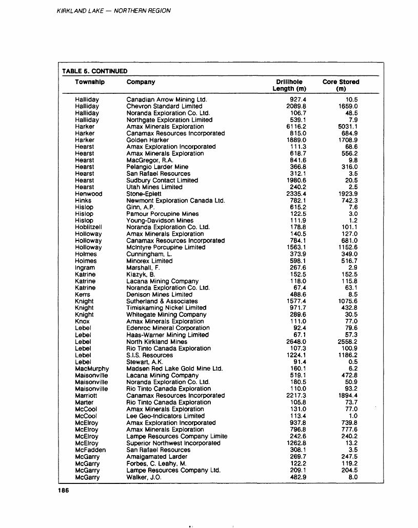
KIRKLAND LAKE — NORTHERN REGION
TABLE 5. CONTINUED
Township
HallidayHallidayHallidayHallidayHarkerHarkerHarkerHearstHearstHearstHearstHearstHearstHearstHenwoodHinksHislopHislopHislopHoblitzellHollowayHollowayHollowayHolmesHolmesIngramKatrineKatrineKatrineKerrsKnightKnightKnightKnoxLebelLebelLebelLebelLebelLebelMacMurphyMaisonvilleMaisonvilleMaisonvilleMarriottMarterMcCoolMcCoolMcElroyMcElroyMcElroyMcElroyMcFaddenMcGarryMcGarryMcGarryMcGarry
Company
Canadian Arrow Mining Ltd.Chevron Standard LimitedNoranda Exploration Co. Ltd.Northgate Exploration LimitedAmax Minerals ExplorationCanamax Resources IncorporatedGolden HarkerAmax Exploration IncorporatedAmax Minerals ExplorationMacGregor, R.A.Pelangio Larder MineSan Rafael ResourcesSudbury Contact LimitedUtah Mines LimitedStone-EplettNewmont Exploration Canada Ltd.Ginn, A.P.Pamour Porcupine MinesYoung-Davidson MinesNoranda Exploration Co. Ltd.Amax Minerals ExplorationCanamax Resources IncorporatedMcintyre Porcupine LimitedCunningham, L.Minorex LimitedMarshall, F.Kiazyk, B.Lacana Mining CompanyNoranda Exploration Co. Ltd.Denison Mines LimitedSutherland Z AssociatesTimiskaming Nickel LimitedWhitegate Mining CompanyAmax Minerals ExplorationEdenroc Mineral CorporationHaas-Warner Mining LimitedNorth Kirkland MinesRio Tinto Canada ExplorationS.I.S. ResourcesStewart, A. K.Madsen Red Lake Gold Mine Ltd.Lacana Mining CompanyNoranda Exploration Co. Ltd.Rio Tinto Canada ExplorationCanamax Resources IncorporatedRio Tinto Canada ExplorationAmax Minerals ExplorationLee Geo-lndicators LimitedAmax Exploration IncorporatedAmax Minerals ExplorationLampe Resources Company LimiteSuperior Northwest IncorporatedSan Rafael ResourcesAmalgamated LarderForbes, C. Leahy, M.Lampe Resources Company Ltd.Walker, J.O.
Drillhole Length (m)
927.42089.8
106.7539.1
6116.2815.0
1889.0111.3618.7841.6366.8312.1
1980.6240.2
2335.4782.1615.2122.5111.9178.8140.5784.1
1563.1373.9598.1267.6152.5118.067.4
488.61577.4971.7289.6111.092.467.1
2648.0107.3
1224.191.4
160.1519.1180.5110.0
2217.3105.8131.0113.4937.8796.8242.6
1262.8308.1269.7122.2209.1482.9
Core Stored (m)
10.51659.0
48.57.9
5031.1684.9
1708.968.6
556.29.8
316.03.5
20.52.5
1923.9742.3
7.63.01.2
101.1127.0681.0
1152.6349.0516.7
2.9152.5115.863.18.5
1075.6432.8
30.577.079.657.3
2558.2100.9
1186.20.56.2
472.850.993.2
1894.473.777.0
1.0739.8777.6240.2
13.23.5
247.5119.2204.5
8.0
186
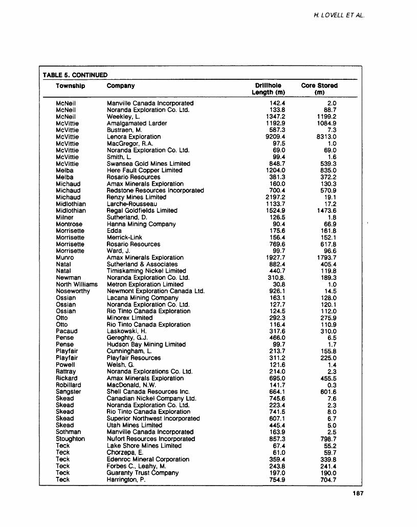
H. LOVELL ETAL
TABLE 5. CONTINUED
Township
McNeilMcNeilMcNeilMcvittieMcvittieMcvittieMcvittieMcvittieMcvittieMcvittieMelbaMelbaMichaudMichaudMichaudMidlothianMidlothianMilnerMontroseMorrisetteMorrisetteMorrisetteMorrisetteMunroNatalNatalNewmanNorth WilliamsNoseworthyOssianOssianOssianOttoOttoPacaudPensePensePlayfairPlayfairPowellRattrayRickardRobillardSangsterSkeadSkeadSkeadSkeadSkeadSothmanStoughtonTeckTeckTeckTeckTeckTeck
Company
Manville Canada IncorporatedNoranda Exploration Co. Ltd.Weekley, LAmalgamated LarderBustraen, M.Lenora ExplorationMacGregor, R.A.Noranda Exploration Co. Ltd.Smith, LSwansea Gold Mines LimitedHere Fault Copper LimitedRosario ResourcesAmax Minerals ExplorationRedstone Resources IncorporatedRenzy Mines LimitedLarche-RousseauRegal Goldfields LimitedSutherland, D.Hanna Mining CompanyEddaMerrick-LinkRosario ResourcesWard, J.Amax Minerals ExplorationSutherland 8t AssociatesTimiskaming Nickel LimitedNoranda Exploration Co. Ltd.Metron Exploration LimitedNewmont Exploration Canada Ltd.Lacana Mining CompanyNoranda Exploration Co. Ltd.Rio Tinto Canada ExplorationMinorex LimitedRio Tinto Canada ExplorationLaskowski, H.Gereghty, G. J.Hudson Bay Mining LimitedCunningham, LPlayfair ResourcesWelsh, G.Noranda Explorations Co. Ltd.Amax Minerals ExplorationMacDonald, N.W.Shell Canada Resources Inc.Canadian Nickel Company Ltd.Noranda Exploration Co. Ltd.Rio Tinto Canada ExplorationSuperior Northwest IncorporatedUtah Mines LimitedManville Canada IncorporatedNufort Resources IncorporatedLake Shore Mines LimitedChorzepa, E.Edenroc Mineral CorporationForbes C., Leahy, M.Guaranty Trust CompanyHarrington, P.
Drillhole Length (m)
142.4133.8
1347.21192.9587.3
9209.497.569.099.4
848.71204.0381.3160.0700.4
2197.21133.71524.9
126.590.4
175.6156.4769.6
99.71927.7882.4440.7
310.JB.30.8
926.1163.1127.7124.5292.3116.4317.6466.0
99.7213.7311.2121.6214.0695.0141.7664.1745.6223.4741.5607.1445.4163.9857.3
67.461.0
359.4243.8197.0754.9
Core Stored (m)
2.088.7
1199.21084.9
7.38313.0
1.069.0
1.6539.3835.0372.2130.3570.9
19.117.2
1473.61.8
66.9161.8152.1617.8
96.61793.7405.4119.8189.3
1.014.5
128.0120.1112.0275.9110.9310.0
6.51.7
155.8225.0
1.42.3
455.50.3
601.67.62.38.06.75.02.5
798.755.259.7
339.8241.4190.0704.7
187
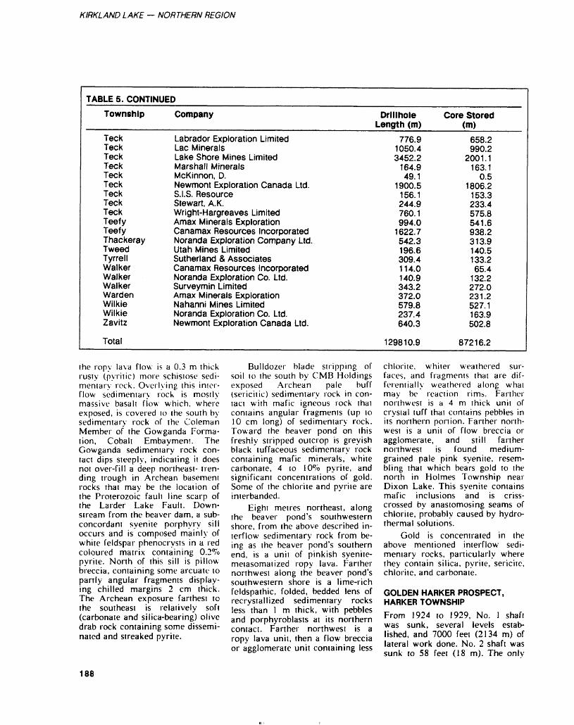
KIRKLAND LAKE — NORTHERN REGION
TABLE 5. CONTINUED
Township
TeckTeckTeckTeckTeckTeckTeckTeckTeckTeefyTeefyThackerayTweedTyrrellWalkerWalkerWalkerWardenWilkieWilkieZavitz
Total
Company
Labrador Exploration LimitedLac MineralsLake Shore Mines LimitedMarshall MineralsMcKinnon, D.Newmont Exploration Canada Ltd.S.I.S. ResourceStewart, A. K.Wright-Hargreaves LimitedAmax Minerals ExplorationCanamax Resources IncorporatedNoranda Exploration Company Ltd.Utah Mines LimitedSutherland 8. AssociatesCanamax Resources IncorporatedNoranda Exploration Co. Ltd.Surveymin LimitedAmax Minerals ExplorationNahanni Mines LimitedNoranda Exploration Co. Ltd.Newmont Exploration Canada Ltd.
Drillhole Length (m)
776.91050.43452.2
164.949.1
1900.5156.1244.9760.1994.0
1622.7542.3196.6309.4114.0140.9343.2372.0579.8237.4640.3
129810.9
Core Stored (m)
658.2990.2
2001.1163.1
0.51806.2
153.3233.4575.8541.6938.2313.9140.5133.265.4
132.2272.0231.2527.1163.9502.8
87216.2
the ropy lava flow is a 0.3 m thick rusty (pyritic) more schistose sedi mentary rock. Overlying this inter flow sedimentary rock is mostly massive basalt flow which, where exposed, is covered 10 the south by sedimentary rock of the Coleman Member of the Gowganda Forma tion, Cobalt Embayment. The Gowganda sedimentary rock con tact dips steeply, indicating it does not over-fill a deep northeast- tren ding trough in Archean basement rocks that may be the location of the Proterozoic fault line scarp of the Larder Lake Fault. Down stream from the beaver dam, a sub- concordant syenite porphyry sill occurs and is composed mainly of white feldspar phenocrysts in a red coloured matrix containing 0.2*70 pyrite. North of this sill is pillow breccia, containing some arcuate to partly angular fragments display ing chilled margins 2 cm thick. The Archean exposure farthest to the southeast is relatively soft (carbonate and silica-bearing) olive drab rock containing some dissemi nated and streaked pyrite.
Bulldozer blade stripping of soil to the south by CMB Holdings exposed Archean pale buff (sericitic) sedimentary rock in con tact with mafic igneous rock that contains angular fragments (up to 10 cm long) of sedimentary rock. Toward the beaver pond on this freshly stripped outcrop is greyish black tuffaceous sedimentary rock containing mafic minerals, white carbonate, 4 to lO^o pyrite, and significant concentrations of gold. Some of the chlorite and pyrite are interbanded.
Eight metres northeast, along the beaver pond's southwestern shore, from the above described in terflow sedimentary rock from be ing as the beaver pond's southern end, is a unit of pinkish syenite- metasomatized ropy lava. Farther northwest along the beaver pond's southwestern shore is a lime-rich feldspathic, folded, bedded lens of recrystallized sedimentary rocks less than l m thick, with pebbles and porphyroblasts at its northern contact. Farther northwest is a ropy lava unit, then a flow breccia or agglomerate unit containing less
chlorite, whiter weathered sur faces, and fragments thai are dif ferentially weathered along what may be reaction rims. Farther northwest is a 4 m thick unit of crystal tuff that contains pebbles in its northern portion. Farther north west is a unit of flow breccia or agglomerate, and still farther northwest is found medium- grained pale pink syenite, resem bling that which bears gold to the north in Holmes Township near Dixon Lake. This syenite contains mafic inclusions and is criss crossed by anastomosing seams of chlorite, probably caused by hydro thermal solutions.
Gold is concentrated in the above mentioned interflow sedi mentary rocks, particularly where they contain silica, pyrite, sericite, chlorite, and carbonate.
GOLDEN HARKER PROSPECT, HARKER TOWNSHIPFrom 1924 to 1929, No. l shaft was sunk, several levels estab lished, and 7000 feet (2134 m) of lateral work done. No. 2 shaft was sunk to 58 feet (18 m). The only
188
H. LOVELL ET AL
production achieved was circa 1980, when Pamour Porcupine Mines Limited milled Golden Har ker dump's development and drift muck at Pamour No. l mine mill east of Timmins.
Diamond drilling during 1984 by Discovery Mines Limited and Lenora Explorations Limited inter sected the type of syenite that is a late differentiate of tholeiitic basalt and also the type of syenite that is a partial melt of volcanic and in terflow sedimentary rocks, and contains some gold.
Exploration is directed (A. Troop, consulting geologist, Troop Exploration and Development In corporated, personal communica tion, 1984) to searching for stopea- ble thicknesses of laterally exten sive gold-bearing interflow sedi mentary rock (composed of silica, sericite, and a maximum of 15*^ pyrite) such as was found by Bar- rick Resources Limited in Hol loway Township, in 2 of several prominent interflow sedimentary rock zones north of (sirat- igraphically below) the Golden Harker Prospect.
SHELDON-LARDER MINES LIMITED GOLD PROSPECT, MCGARRY TOWNSHIPAurelian Developers Limited dia mond drilled near Larder Lake's northeast arm, approximately along strike southwest from the ore zone that trends under the mill of Kerr Addison Mines Limited.
Conglomerate here is largely from an ultramafic source. Char acteristically the green chlorite (Mg-Fe silicate derived from pyroxene), white carbonate (Ca from pyroxene), and quartz veins (from breakdown of talc) all tend to be barren of gold.
The gold is in pebbles and oth er epiclasrs of pyritic, siliceous- ce mented mudstone broken up and transported short distances to form part of a polymictic conglomerate here. Sandy material, drapes of mud around pebbles, mud chips, and a little mudstone conglomerate indicate this to be a wet beach de posit (G. Hinse, consulting geolo gist, Sudbury, personal communi
cation, 1984). This offshore (littoral) environment provided enough alkalinity lo precipitate so dium silicate (which became leached to form silicification or silica cement) and enough oxygen to aid precipitation of gold presum ably driven off active (organic) carbon during its oxidation to car bonate rock. The mudstone pebbles are grey coloured, indicating suffi cient sulphur was present to tie up iron in sulphide mineralization, not the brown and red hues im parted by iron oxides.
T. AND W. SULLIVAN AND W. COOPER COPPER OCCURRENCE, LEBEL TOWNSHIPWest 800 feet (244 m) from a syenitic outcrop, which is south of the footbridge across a creek, is the main pit of claim 476364.
The banded mafic tuff miner alogy consists mainly of black hor nblende, yellowish green epidote, and reddish brown garnet. Lenses and cross-cutting streaks of fine- to medium-grained (the latter, pre sumably recrystallized) pyrite are present, and contain a little chal copyrite. Some pyrrhotite is pre sent, as well as bands of clear quartz, white quartz, and feldspar with disseminated cubes of pyrite and lesser magnetite. Where coarse-grained pyrite cubes occur in a matrix of massive pyrrhotite, no chalcopyrite is present. This feldspar resembles recrystallized chert (having the grain size of quartz coarsened) in the iron for mation near here. Another pit con tains more massive amphibolite, with a few pyrite veins and a little chalcopyrite.
These copper occurrences are in impure sulphide iron formation, a facies change approximately along strike from the Adams Taconite Iron Mine North Pit. Their metamorphic grade is elevat ed by the adjacent Lebel Township syenitic stock, of which they are part of the epidote- garnet am phibolite facies of the metamorphic aureole.
RECOMMENDATIONS FOR EXPLORATION_________BASAL TILL SAMPLINGIn 1984 overburden drilling by the sonic method was used for the On tario Ministry of Natural Re sources' Black River-Matheson project and also by several com panies tracing heavy minerals (particularly gold), especially in basal lodgement till. Sonic overbur den drilling is advantageous over reverse-circulation overburden drilling insofar as it provides a little-disturbed stratigraphic section of the soil, and more complete re covery of gold because during drilling it does not use return wa ter that might incidentally float off fine-grained, e.g. "flour", gold. However, unlike overburden drill ing using reverse circulation, sonic drilling also does not float off gold that is present as thin films precipitated hydromorphically on otherwise unrelated detrital grains, i.e. gold that does not represent detrital dispersion.
GOLDSedimentation is prominent in the history of recently discovered large gold deposits, e.g. those in the Hemlo and Lake Abitibi areas (the latter area through Ontario's Hol loway Township, e.g. Barrick Re sources Corporation and Canamax Resources Incorporated, and through Quebec's Casa Berardi Township, e.g. Golden Knight Re sources Incorporated and Inco Limited). Sedimentation may have concentrated the gold by 2 pro cesses, l being hot springs chemi cally precipitating sediments which are largely inorganic, and another being restricted lagoonal (inland sea) shallow-shelf, largely organic (and partly epiclastic and inorgan ic, evaporitic) chemical sedimenta tion (Owsiacki and Lovell 1984). Both types were, in open systems, dispersed by felsic intrusions, am phibolite metamorphism, and tec tonic stresses which, however, in some closed systems concentrated gold further by pumping it into structural traps and metasomatic aureole isograd locations.
189
KIRKLAND LAKE — NORTHERN REGION
As example of the shallow shelf environment is ihe 80 km- long southward-younging homo cline that extends almost the entice east-west length of the Black River- Matheson (BRIM) project area. The areal extent of the homocline is clearly indicated on the colour contoured aeromagnetic map (scale 1:80 000) available from Dataplot- ting Services Incorporated, Don Mills, Ontario. About 85*7o of known gold occurrences in the Black River-Matheson homocline plot along the long narrow mag netic lows that characterise Mg- rich tholeiitic basalt and interflow sedimentary rocks (contrasted with parallel magnetic highs caused by Fe-rich tholeiitic basalt). A single general stratigraphic zone of the homocline contains the Ross gold mine of Pamour Porcupine Mines Limited and McDermott discovery of Barrick Resources Corporation. Along strike, each channel-filling polymictic deltaic pebbly grey wacke represents each large drain age basin (provenance area). Across strike 10 km (the maxi mum stratigraphic thickness of the homocline, which is north across Cook Township and the southern part of Guibord Township), 10 or more roughly parallel stratabound auriferous zones exist. Prominent in Harker and Holloway Town ships are the concordant to subcon- cordant or disconformable McDer mott, Mattawasaga, Harlight. Gold en Harker, and Iris zones. Several channel locations are "con sequent", having been perpetuated throughout a period of time, i.e. repeated stratigraphically almost directly above earlier channels. Flanking and off-shore from these channels are gold-bearing fine grained sedimentary rocks, and they too are repeated in overlying strata, i.e. across strike. These gold-bearing interflow sedimentary strata, where composed mainly of fine-grained silica, carbonate, sericite, and more than l^o pyrite, contain gold concentrations of more than 0.03 of a Troy ounce gold per ton (l g/t) in samples from many locations, and in some places constitute large tonnages of more than 0.1 ounce gold per ton.
A way by which this shallow- shelf gold may have concentrated is as follows (including suggestions by G. Hinse, personal communica tion, 1984):
Gold dissolved in hot spring fluids, and presumably also in cya nide manufactured by bacteria par ticularly during the sudden prolif eration of biomass (mainly blue- green algae and bacteria) 2700 million years ago (Schidlowski 1983).
Subaerial erosion at about that time transported organic material derived from blue-green algae and accompanying colonies of bacteria down-river beyond the delta apron into a regressed inland sea, to help form the offshore fertile shallow shelf. Gold arrived in the shallow shelf adhering to organic-protected clay-colloid mixtures, and wr as precipitated on growing pyrite cry stals and also on the fertile shelf's active (biogenic) carbon (nature's "carbon-in-pulp" extraction pro cess). Oxidation of the active car bon (where not prevented by burial in clastic debris, thereby preserving the carbonaceous material com monly referred to as "graphite") formed carbonate rock, and gold and gangue solutions were driven into fractures. Sericite formed by diagenetically altering clay that was cemenied by silica. Further maturing chemically in a slightly alkaline environment produced the silica-sericite-pyrite-gold upper laminae of the Black River- Matheson chemical sedimentary sequences that have carbonate rock at their (chemically immature) bases. The gold-to-silver ratio at the Ronda Gold Mine, Shining Tree, is 1:5. In places, further chemical maturing in the form of leaching removed Ca and to a less er extent Ag and thereby upgraded the original carbonate's Fe and Mg so as to residually concentrate fer roan dolomite or ankerite and in crease the original Au:Ag ratio (5:1 in Porcupine).
Overlying ultramafic (where present, as in Larder Lake gold mines) and mafic flows incorpo rated the partly chemical sedimen tary substrate, and thus became al tered (variably carbonatized,
silicified, pyritized, propylitized, and argillized). Typically the mafic- flow provided insufficient heat to drive the gold out of pyrite, but ultramafic flows, where present, heat-pumped the gold from the in terflow sediment into solutions that precipitated in fractures as quartz veins bearing coarse-grained free gold (Au:Ag = 17:1 in Larder Lake gold mines).
Where carbonate was largely leached away, sulphate was cor respondingly residually concentrat ed, and during further chemical maturing of the sediment some of the sulphate's calcium was re placed by barium, thus forming barite. Gold in a sediment so ma ture as this is largely native, hav ing been leached out of pyrite, and also the Au:Ag ratio is high (averaging about 20:1 at Hemlo).
Where the upgrading was me chanical in addition to chemical, e.g. South African Witwatersrand paleoplacer-Carbon leader gold ores, gold concentrations formed having high Au:Ag ratios (Boyle 1979) as in some of the Witwaters- rand (Au:Ag = 13:1) ores (Reimer 1984) and to unknown extents in the Cobalt Embayment Lorrain Formation physically and chemi cally mature sandstones (Colvine 198~1, 1983; Mossman and Harron 1983a, 1983b), and in Pleistocene esker gravels (Lee 1965).
In Kirkland Lake (Au:Ag = 6:1) and Matachewan (Au:Ag = 4:1) gold mines, upgrading oc curred in a different way - by par tial melting of the intercalated gold-bearing sedimentary and vol canic rocks to form syenitic rocks that heat pumped gold with solu tions into structural traps such as shears, faults, fissures, and axial areas of folds.
ONTARIO GEOLOGICAL SURVEY ACTIVITIES————BRIM (Operation Black River- Matheson) is funded equally by the Ontario Ministry of Northern Af fairs and the Ontario Ministry of Natural Resources.
190
H. LOVELL ET AL.
PRECAMBRIAN GEOLOGY SECTIONR. Johnstone continued mapping in Beatty, Munro, and McCool Townships as part of a program to carry out detailed, synoptic, and stratigraphic mapping along the Destor-Porcupine Fault from east of Timmins to the Quebec border (BRIM).
ENGINEERING AND TERRAIN GEOLOGY SECTIONJ.M. Richard mapped the Quater nary geology of the Porquis Junc tion and Watabeag River area. In addition to outlining sources of sand and gravel, information was gathered to aid mineral exploration (BRIM).
GEOPHYSICS-GEOCHEMISTRY SECTIONR.B. Barlow and D. Krentz initi ated a research study in the Matheson area for the purpose of developing shallow electromagnet ic sounding methods.
V'.K. Gupta, D.R. Wadge, and P. Mark conducted a gravity sur vey in the Kirkland Lake area.
J.A.C. Fortescue and C.L. Ba ker conducted a basal till geochem istry project in the Matheson area using a sonic drill and a back-hoe (BRIM).
MINERAL DEPOSITS SECTIONS. Marmont continued the age dat ing of rocks in the Timmins- Kir kland Lake area.
M.C. Cherry continued to evaluate the relationship between gold mineralization and granitoid intrusions in the Abitibi Belt.
A.C. Colvine continued a Huronian metallogenic study with emphasis on paleoplacer gold.
D. Long and A.C. Colvine continued studies of the Huronian Supergroup designed to evaluate sedimentological controls on placer gold deposits.
PJ. Whittaker, J. Malczak, and D.G. Troop examined the gold, metallic, and industrial min erals in the Black River-Matheson area (BRIM).
J.V. Hamilton completed de tailed mapping of McGarry and Mcvittie Townships to determine structural and stratigraphic rela tionships near the the Larder Lake break.
RESEARCH BY OTHER ORGANIZATIONS________GEOSCIENCE RESEARCH GRANT PROGRAMUniversity of TorontoGrant 118: J.D. Redman, D.W. Strangway, and O.M. Ilkisik - Sur face Electromagnetic Mapping in Selected Positions in Northern On tarioGrant 138: F.J. Wicks, W. Pu, and K. Hedjran - Mineralogy and Geo chemistry of the Chrysotile Asbes tos Deposits of Ontario: Munro Mines and Garrison Deposit
McMaster UniversityJ.H. Crocket, N. Blum, T. Hurley, R. Bowins, G. McRoberts, A. Fyon, R.H. McNutt, H.P. Schwarcz, and C.E. ReesGrant 132: Geological and Geo chemical Studies of the Boston and Temagami Iron Formations and their Contiguous Volcanosedimen- tary Piles
REFERENCESBaker, C.L.1980: Quaternary Geology of the
Magusi River Area (32 D/5), Districts of Cochrane and Timiskaming; p.112-113 in Summary of Field Work, 1980, by the Ontario Geologi cal Survey, edited by V.G. Milne, O.L. White, R.B. Bar low, J.A. Robertson, and A.C. Colvine, Ontario Geological Survey, Miscellaneous Paper 96, 201p.
1982: Report on the Sedimentary and Provenance of Sediments in Eskers in the Kirkland Lake Area, and on the Finding of Kimberlite Float in Gauthier Township; p.125-127 in Sum mary of Field Work, 1982, by the Ontario Geological Survey, edited by John Wood, Owen L. White, R.B. Barlow, and
A.C. Colvine, Ontario Geologi cal Survey, Miscellaneous Pa per 106, 235p.
Baker, C.L., Seaman, A.A., andSteele, K.G.1980: Quaternary Geology of
Ramore Area, Districts of Cochrane and Timiskaming; Ontario Geological Survey, Preliminary Map, P.2381, Geological Series, scale 1:50 000. Geology 1979.
Baker, C.L., and Steele, K.G.1984: Sonic Drilling - Exploration
Basics in the Matheson Area (abstract); p.23 in Geoscience Research Seminar and Open House '84, December 4-5, 1984, Abstracts, Ontario Geo logical Survey, 23p.
Baker, C.L., Steele, K.G., Mcclenaghan, M.B., and Fortesc ue, J.A.C.1984: Location of Gold Grains in
Sonic Drill Core Samples from the Matheson Area, Cochrane District; Ontario Geological Survey, Map P.2736, Geophysica l /Geochem ica l Series-Preliminary Map, scale 1:100000. Geology 1984
Baker, C.L., Steele, K.G., and Sea man, A.A.1982: Quaternary Geology of the
Magusi River Area, Cochrane and Timiskaming Districts; Ontario Geological Survey, Map P.2783, Geological Series-Preliminary Map, scale 1:50000. Geology 1980.
Boyle, R.W.1979: The Geochemistry of Gold
and its Deposits; Geological Survey of Canada, Bulletin 280, 584p.
Cherry, M.E.1982: Felsic Intrusion Associated
Lode Gold Deposits in the Matheson Area, Cochrane Dis trict; p. 176-179 in Summary of Field Work, 1982, by the On tario Geological Survey, edited by John Wood, Owen L. White, R.B. Barlow, and A.C. Colvine, Ontario Geological Survey, Miscellaneous Paper 106, 235p.
191
KIRKLAND LAKE — NORTHERN REGION
Colvine, A.C.1981: Reconnaissance of the Lor
rain Formation, Northern Co balt Embayment; p.187-189 in Summary of Field Work, 1981, by the Ontario Geologi cal Survey, edited by John Wood, O.L. White, R.B. Bar low, and A.C. Colvine, Ontar io Geological Survey, Miscel laneous Paper 100, 255p.
1983: Mineral Deposits Studies in the Huronian Supergroup; p.253- 255 in Summary of Field Work, 1983, by the On tario Geological Survey, edited by John Wood, Owen L. White, R.B. Barlow, and A.C. Colvine, Ontario Geological Survey, Miscellaneous Paper 116, 313p.
Gartley, L.1984: Report of all Physical Work
and Surveys Performed in On tario in 1983; Ontario Minis try of Natural Resources.
Jensen, L.S.19"?5: Ramore Area, District of
Timiskaming and Cochrane; p.73-75 in Summary of Field W: ork, 1975, by the Geological Branch, edited by V.G. Milne, D.F. Hewitt, K.b. Card, and J.A. Robertson, Ontario Divi sion of Mines, Miscellaneous Paper 63, 158p.
1978: Regional Stratigraphy and Structure of the Timmins- Kirkland Lake Area, District of Cochrane and Timiskaming and the Kirkland Lake Larder Lake Area, District of Timiskaming; p.67-72 in Sum mary of Field Work, 1978, by the Ontario Geological Survey, edited by V.G. Milne, O.L. White, R.B. Barlow, and J.A. Robertson, Ontario Geological Survey, Miscellaneous Paper 82, 235p.
1980: Kirkland Lake-Larder Lake Synoptic Mapping Project, Districts of Cochrane and Timiskaming; p.55-60 in Sum mary of Field Work, 1980, by the Ontario Geological Survey, edited by V.G. Milne, O.L. White, R.B. Barlow, J.A. Rob ertson, and A.C. Colvine, On tario Geological Survey, Mis cellaneous Paper 96, 201 p.
1982a: Precambrian Geology of the Lightning River Area, Cochrane District; Ontario Geological Survey, Map P.2433, Geological Series- Pre liminary Map, scale 1:63 360 or l inch to l mile. Geology 1973.
1982b: Precambrian Geology of the Magusi River Area, Coch rane District; Ontario Geologi cal Survey, Map P.2434, Geo logical Series- Preliminary Map, scale 1:63 360 or l inch to l mile. Geology 1968- 1972.
Jensen, L.S., and Langford, F.F.1983: Geology and Petrogenesis of
the Archean Abitibi Belt in the Kirkland Lake Area, Ontario; Ontario Geological Survey, Open File Report 5455, 520p., 9 tables, 106 figures, and 2 maps.
Krentz, D., and Barlow, R.B.1984: The Transient Electromag
netic Sounding of the Quater nary Geology in the Black River Matheson Area (abstract); p.2 l in Geoscience Research Seminar and Open House '84, December 4-5. 1984, Abstracts, Ontario Geo logical Survey, 23p.
Lee, H.A.1965: Investigation of Eskers for
Mineral Exploration; Geologi cal Survey of Canada, Paper 65-14, p.1-17.
MERQ-OGS1983: Lithostratigraphic Map of
the Abitibi Subprovince; On tario Geological Survey - Ministere de I'Energie ei des Ressources, Quebec; 1:500 000; catalogued as 'Map 2484' in Ontario and 'DY 83-16' in Quebec.
Mossman, D.J., and Harron, G.A.1983a: Origin and Distribution of
Gold in Huronian Supergroup, Canada - the Case for Witwatersrand-type Paleoplacers; Journal of Precambrian Geology, Volume 20, Number 2-4, p.543-583.
1983b: Witwatersrand-type Paleoplacer Gold in the Huronian Supergroup of On tario, Canada; Geoscience
Canada, Volume l l, Number 1. p.33-40.
OGS1984: Airborne Electromagnetic
and Total Intensity Magnetic Survey, Matheson-Black River Area, District of Cochrane; by Questor Surveys Limited for the Ontario Geological Survey, Maps 80 572 through 80 611, Geophysical/Geochemical Se ries, scale 1:20 000. Survey and Compilation March to July, 1983.
Owsiacki, L., and Lovell, H.1984: Geology, Silver and Gold
Deposits: Cobalt and Kirkland Lake; Geological Association of Canada, p.76-114.
Pitcher, D.H., Barlow, R.B., andMcNeill, J.D.1984: Mapping the Overburden in
the Black River-Matheson (BRIM) Area, District of Cochrane, Employing an Air borne Time-Domain System; p.299-307 in Summary of Field W; ork, 1984, by the On tario Geological Survey, edited by John Wood, Owen L. While, R.B. Barlow, and A.C. Colvine, Ontario Geological Survey, Miscellaneous Paper 119, 309p.
Reimer, T.O.1984: Alternative Model for the
Derivation of Gold in the Witwatersrand Supergroup; Journal of Geological Society of London, Volume 141, p.263-272.
Schidlowski, M.1983: Organic Matier in Sedimen
tary Rocks; Terra Cognita, Volume 4, Number l, p.45-49.
Timor, N.1983: Camflo Mines Gold Discov
ery Has Large Tonnage Poten tial; The Northern Miner, De cember 22, 1983.
Trowell, N.F.1982: Black River-Matheson, Dis
trict of Cochrane; p.65-60 in Summary of Field Work, 1982, by ;he Ontario Geologi cal Survey, edited by John Wood, Owen L. White, R.B. Barlow, and A.C. Colvine, On-
192
H. LOVELL ETAL.
tario Geological Survey, Mis cellaneous Paper 106, 235p.
Trowell, N.F., and Johnstone, R.1983: Black River-Matheson Area.
District of Cochrane; p.59-62 in Summary of Field Work, 1983, by the Ontario Geologi cal Survey, edited by John Wood, Owen L. White, R.B. Barlow, and A.C. Colvine On tario Geological Survey, Mis cellaneous Paper 116, 313p.
Vagners, U.J.1983: Quaternary Geology of the
Matheson and Lightning River Areas, District of Cochrane; p. 101-l 03 in Summary of Field Work, 1983, by the On tario Geological Survey, edited by John Wood, Owen L. White, R.B. Barlow, and A.C. Colvine, Ontario Geological Survey, Miscellaneous Paper 116, 313p.
Weatherson, G.L.1984: 1983 Ontario Mineral Score;
Ontario Ministry of Natural Resources, Video Census Se ries No. 3, 242p.
Whittaker, P.J.1984: Geological Setting of Gold
Mineralization in the Black River- Matheson Area (abstract); p.2 in Geoscience Research Seminar and Open House '84, December 4-5, 1984, Abstracts, Ontario Geo logical Survey, 23p.
Whittaker, P.J., and Malczak, J.1984: Mineral Deposits Investiga
tions in the Black River- Matheson Area, District of Cochrane; p.290-294 in Sum mary of Field Work, 1984, by the Ontario Geological Survey, edited by John Wood, Owen L. White, R.B. Barlow, and A.C. Colvine, Ontario Geologi cal Survey, Miscellaneous Pa per 119.
PUBLICATIONS ADDED TO THE KIRKLAND LAKE RESIDENT GEOLOGIST LIBRARY DURING 1984Aftabi, A., and Azzaria, L.M.1983: Distribution of Mercury
Compounds in Ore and Host Rocks at Sigma Gold Mine
Val d'Or, Quebec, Canada; Journal of Geochemical Ex ploration, Volume 19, Number 1-3, p.447-464.
Almond, D.C., Ahmed, F., andShaddad, M.Z.1984: Setting of Gold Mineraliza
tion in the Northern Red Sea Hills of Sudan; Economic Ge ology, Volume 79, Number 2, p.389-392.
A l per, J.1984: Bioengineers are Off to the
Mines; High Technology, Vol ume 4, Number 4, p.32-36.
Amor, S.D., and Nichol, I.1983: Identification of Diagnostic
Geochemical Alteration in the Wallrocks of Archean Volcanic-Exhalative Massive Sulfide Deposits; Journal of Geochemical Exploration, Vol ume 19, Number 1-3, p.543-562.
Appel, P.W.U., and Secher, K.1984: On a Gold Mineralization in
the Precambrian Tartoq Group, SW Greenland; Jour nal Geological Society of Lon don, Volume 141, Number 2, p.273-278.
Barnes, R.G.1983: Stratiform and Stratabound
Tungsten 1983: Stratiform and Stratabound Tungsten Miner alization in the Broken Hill Block, N.S.W.; Journal of the Geological Society of Austra lia, Volume 30, Numbers l and 2, p.225-239.
Barongo, J.O.1984: Geophysical Investigations
for Kimberlite Pipe in the Greenstone Belt of Western Kenya; Journal of African Earth Science, Volume l, Number 3/4, p.235-253.
Blom, R.G., Crippen, R.E., andElachi, C.1984: Detection of Subsurface Fea
tures in SEASAT Radar Im ages of Means Valley, Mojave Desert, California; Geology, Volume 12, Number 6, p.346-349.
Bossellini, A.1984: Progradation Geometries of
Carbonate Platforms: Exam ples from the Tirassic of the
Dolomites, Northern Italy; Sedimentology, Volume 31, Number l, p.l-24.
Brimhall, G.H., Cunningham, A.B.,and Stoffregen, R.1984: Zoning in Precious Metal
Distribution Within Base Met al Sulfides: A New Lithologic Approach Using Generalized Inverse Methods; Bulletin of the Society of Economic Ge ologists, Volume 79, Number 2, p.209-226.
Brooks, R.R.1983: Geozoology in Mineral Ex
ploration; Episodes, Volume1983. Number 3, p.27-32.
Bubela, B., and Cloud, P.1983: Sulphide Mineralization of
Microbial Cells; EMR Journal of Australian Geology and Geophysics, Volume 8, Num ber 4, p.355-357.
Buchan, K.L., and Schwarz, E.J.1981: Uplift Estimated from Re
manent Magnetization: Munro Area of Superior Province Since 2150 M.Y. Ago; Cana dian Journal of Earth Sci ences, Volume 18, Number 7, p.1164-1173.
Burn, R.G.1984: Factors Affecting the Selec
tion of Methods of Gold Ana lysis; Mining Magazine, May1984. p.468-475.
Campbell, I.H., and Barnes, S.J.1984: A Model for the Geochemis
try of the Platinum-Group Ele ments in Magmatic Sulfide Deposits; Journal of the Mineralogical Association of Canada, Volume 22, Number I,p.l51-160.
Cant, DJ.1984: Development of Shoreline-
Shelf Sand Bodies in a Creta ceous Epeiric Sea Deposit; Journal of Sedimentary Petrol ogy. Volume 54, Number 2, p.541-556.
Carlson, J.A., Johnson, R.B., Mccallum, M.E., and Padget, J.P. 1982: Kimberlites: Where?; Terra
Cognita, Volume 2, Number 3,p.203-207.
Colley, S., Thomson, J., Wilson, T.R.S., and Higgs, N.C.
193
KIRKLAND LAKE — NORTHERN REGION
1984: Post-Depositional Migration of Elements During Diagenesis in Brown Clay and Turbidite Sequences in the North East Atlantic; Geochemica et Cos- mochimica Acta, Volume 48, Number 6, p.1223-1235.
Crone, W., Larson, L.T., Carpen ter, R.H., Chao, T.T., and San- zolone, R.F.1984: A Comparison of Iron
Oxide-Rich Joint Coatings and Rock Chips as Geochemical Sampling Media in Explora tion for Disseminated Gold Deposits; Journal of Geo chemical Exploration, Volume 20, Number 2, p.161-178.
Drake, L.D.1983: Ore Plumes in Till; Journal
of Geology, Volume 91, Num-ber6, p.707-713.
Driese, S.G., and Dott Jr., R.H.1984: Model for Sandstone-
Carbonate "Cyclothems" Based on Upper Member of Morgan Formation (Middle Pennsylvanian) of Northern Utah and Colorado; The American Association of Pe troleum Geologists Bulletin, Volume 68, Number 5, p.574-597.
Dupere, Jean1984: Asbestos Industry at the
Crossroads: Current Position and Outlook; Mining Engi neering, Volume 36, Number 7, p.727-730.
Elmore, R.D.1984: The Copper Harbor Con
glomerates: A Late Precam brian Fining- Upward Alluvial Fan Sequence in Northern Michigan; Geological Society of America Bulletin, Volume 95, Number 5, p.610-617.
1983: Precambrian Non-Marine Stromatolites in Alluvial Fan Deposits, the Copper Harbour Conglomerate, Upper Michi gan; Sedimentology, Volume 30, Number 6, p.829-842.
England, P., and Bickle, M.1984: Continental Thermal and
Tectonic Regimes During the Archean; The Journal of Geol ogy, Volume 92, Number 4, p.353-367.
Ericksson, K.A.1983: Siliciclastic-Hosted Iron-
Formations in the Early Ar chean Barberton and Pilbara Sequences; Journal of the Geo logical Society of Australia, Volume 30, Number 4, p.473-482.
Fitch, F.J., and Miller, J.A.1983: K-Ar Age of the East Pe
ripheral Kimberlite at De Beers Mine, Kimberley, R.S.A.; Geological Magazine, Volume 120, Number 5, p.505-512.
Foscolos, A.E.1984: Catagenesis of Argillaceous
Sedimentary Rocks; Geosci ence Canada, Volume 11, Number 2, p.67-75.
Gobeil, A., and Racicot, D.1983: Carte Lithostratigraphique
de la Region de Chibougamau; Ministere de I'Energie et des Ressources, MM 83-02, 14p.
Gravenor, C.P., Von Brunn, V.,and Dreimanis, A.1984: Nature and Classification of
Waterlain Glaciogenic Sedi ments, Exemplified by Pleisto cene, Late Paleozoic and Late Precambrian Deposits; Earth- Science Reviews, Volume 20, Number 2, p. 105-166.
Grossman, E.L.1984: Carbon Isotopic Fractiona
tion in Live Benthic Foraminifera - Comparison with Inorganic Precipitate Studies (Organic); Geochimica et Cosmochimica Acta, Vol ume 48, Number 6, p.1505-1512.
Guha, J., and Gobeil, A.1984: Chibougamau - Stratigraphy
and Mineralization in an Ar chean Belt with a Difference; Canadian Institute of Mining and Metallurgy Geology Divi sion, Symposium - Field Trips Guidebook, 338p.
Guha, J., and Chown, E.H.1984: Chibougamau - Stratigraphy
and Mineralization; The Cana dian Institute of Mining and Metallurgy, Special Volume 34, 534p.
Gurney, J.J., and Harris, J.W. 1982: Diamonds; Terra Cognita,
Volume 2, Number 2,p. 199-202.
Haldorsen, S.1983: Mineralogy and Geochemis
try of Basal Till and Their Re lationship to Till-Forming Pro cesses; Norak Geologisk Tids- skrift, Volume 63, Number l, p.15-25.
Hallbauer, D.K., and von Gehlen,K.1983: The Witwatersrand Pyrites
and Metamorphism; Mineralogical Magazine, Vol ume 47, p.473-479.
Hallberg, J.A.1984: A Geochemical Aid to Ig
neous Rock Type Identifica tion in Deeply Weathered Ter rain; Journal of Geochemical Exploration, Volume 20, Number l, p.1-8.
Hopper, C.H.1942: Geology of the Matachewan
Consolidated Mine, Northern Ontario; Canadian Institute of Mining and Metallurgy Bulle tin, Volume 45, p.387-400.
House, C.I.. and Shergold, H.L.1983: Adsorption of Polyvalent
Metal Species on Activated Carbon; Transactions Institu tion of Mining and Metallur gy, Section C, Volume 93, p.C19-C22.
House, L.S., and Jacob, K.H.1983: Earthquakes, Plate Subduc
tion, and Stress Reversals in the Eastern Aleutian Arc; Journal of Geophysical Re search, Volume 88, p.9347-9373.
Hubert, C., Trudel, P., andGelinas, L.1984: Archean Wrench Fault Tec
tonics and Structural Evolu tion of the Blake River Group, Abitibi Belt, Quebec; Canadian Journal of Earth Sciences, Volume 21, Number 9, p.1024-1032.
Huppert, H.E., Sparks, R.S.J., Turner, J.S., and Arndt, N.T. 1984: Emplacement and Cooling
of Komatiite Lavas; Nature, Volume 309, Number 5963, p. 19-22.
194
H, LOVELL ET AL
Jedwab, J., and Boulegue, J.1984: Graphite Crystals in Hydro
thermal Vents; Nature, Vol ume 310, Number 5972, p.41-43.
Jermy, C.A., and Mason, T.R.1983: A Sedimentary Model for
the Berea Formation in the Glenwood Tunnel, Durham; Transactions of the Geological Society of South Africa, Vol ume 84, Number 2, p.117-125.
Jones, A.P., and Wyllie, P.J.1984: Minor Elements in Perov
skite from Kimberlites and Distribution of the Rare Earth Elements: An Electron Probe Study; Earth and Planetary Science Letters, Volume 69, Number l, p.128-140.
Karous, M., and Hjelt, S.E.1983: Linear Filtering of VLF
Dip-Angle Measurements; Geophysical Prospecting, Vol ume 31, Number 5, p.782-794.
Kerrich, R., and Watson, P.1984: The Macassa Mine Archean
Lode Gold Deposit, Kirkland Lake, Ontario: Geology, Pat terns of Alteration, and Hy drothermal Regimes; Econom ic Geology, Volume 79, Num ber 5, p.1104-1130.
Lalonde, J.P.1983: Ground-Water Geochemis
try in the Abitibi Volcanic Belt of Quebec; Journal of Geochemical Exploration, Vol ume 19, Number 1-3, p.207-223.
Lavreau, J.1984: Vein and Stratabound Gold
Deposits of Northern Zaire; Mineralium Deposits, Volume 19, Number 2, p.158-165.
Locat, J., Ballivy, G., and Lefeb vre, G.1984: Notes, sur la Minerologie
des Sediments Fins du Lac Ojibway, en Particulier Ceux de la Region de Matagami, Quebec; Geographic Physique et Quaternaire, Volume 38, Number l, p.49-57.
Lyons, L.A.1983: Discovery and Development
of Australian Diamonds;World Mining, Volume 36,Number 9, p.50-56.
Mann, H., and Fyfe, W.S.1984: An Experimental Study of
Algal Uptake of U, Ba, V, Coand Ni from Dilute Solutions;Chemical Geology, Volume44, p.385-398.
Matthews, E.R.1983: Measurements of Beach Peb
ble Attrition in Palliser Bay, Southern North Island, New Zealand; Sedimentology, Vol ume 30, Number 6, p.787-799.
McCallum, M.E., Coopersmith,H.G., and Hodge, C.W.1982: Kimberlites: How? Where?;
Terra Cognita, Volume 2,Number 3, p.209-215.
McClay, K.R.1983: Structural Evolution of the
Sullivan Fe-Pb-Zn-Ag Ore body, Kimberly, British Co lumbia, Canada; Economic Geology, Volume 78, Number 7, p.1398-1424.
Mossman, D.J., and Harron, G.A.1984: Witwatersrand-Type
Paleoplacer Gold in the Huronian Supergroup of On tario, Canada; Geoscience Canada, Volume 11, Number l, p.33-40:
Mullins, H.T., Heath, K.C., Van Buren, H.M., and Newton, C.R. 1984: Anatomy of a Modern
Open-Ocean Carbonate Slope:Northern Little Bahama Bank;Sedimentology, Volume 31,Number 2, p.141-168.
Pasteris, J.D.1984: Kimberlites: Complex Man
tle Melts; Annual Review of Earth and Planetary Sciences, Volume 12, p.133-153.
Perrault, G., and Trudel, P.1984: Auriferous Halos Associated
with the Gold Deposits at Lamaque Mine, Quebec; Eco nomic Geology, Volume 79, Number 2, p.227-238.
Ramani, R.V., and Sweigard, R.J.1984: Impacts of Land Use Plan
ning on Mineral Resources; Mining Engineering, Volume 36, Number 4, p.362-369.
Robert, F., and Brown, A.C.1984: Progressive Alteration Asso
ciated with Gold- Quartz-Tourmaline Veins at the Sigma Mine, Abitibi
Greenstone Belt, Quebec; Eco nomic Geology, Volume 79, Number 2, p.393-399.
Rock, N.M.S.1984: Nature and Origin of Calc-
Alkaline Lamprophyres: Min- ettes, Vogesites, Kersantites and Spessartite; Earth Sci ences, Volume 74, Number 4, p.193-227.
Sawyer, E.W.1983: The Structural History of a
Part of the Archean Quetico Metasedimentary Belt, Superi or Province, Canada; Precam brian Research, Volume 22, Number 3-4, p.271-294.
Scatena-W'achel, D.E., and Jones,A.P.1984: Primary Baddeleyite (ZrO2 )
in Kimberlite from Benfontein South Africa; Mineralogical Magazine, Volume 48, Num ber 2, p.257-261.
Schidlowski, M.-1984: Organic Matter in Sedimen
tary Rocks: "The Dust we Tread Upon Was Once Alive"; Terra Cognia, Volume 4, Number l,p.45-49.
Scott, S.D., Kalogeropoulos, S.l., Shegelski, R.J., and Siriunas, J.M. 1983: Tuffaceous Exhalites As Ex
ploration Guides for Vol canogenic Massive Sulphide Deposits; Journal of Geo chemical Exploration, Volume 19, Number 1-3, p.500-502.
Setterfield, T., Watkinson, D.H.,and Thurston, P.C.1983: Quench-Textured, Pillowed
Metabasalts and Copper Min eralization Mayburn Mine, Northwestern Ontario; Canadi an Institute of Mining and Metallurgy Bulletin, Volume 76, Number 859, p.69-74.
Shelton, J.W.1984: Listric Normal Faults: An
Illustrated Summary; The American Association of Pe troleum Geologists Bulletin, Volume 68, Number 7, p.801-815.
Shirey, S.B., and Hanson, G.N.1984: Mantle-Derived Archaean
Monozodiorites and Trachyan- desites; Nature, Volume 310, Number 3, p.222-224.
195
KIRKLAND LAKE — NORTHERN REGION
Smith, T.E., Choudhry, A.G., andHuang, C.H.1983: The Geochemistry and
Petrogenesis of the Archean Gamiragama Lake Igneous Complex, Southern Superior Province; Precambrian Re search, Volume 22, Numbers 3 and 4, p.219-244.
Smith, T.J., Cloke, P.L., andKesler, S.E.1984: Geochemistry of Fluid In
clusions from the Mclntyre- Hollinger Gold Deposit, Tim mins, Ontario, Canada; Eco nomic Geology, Volume 79, Number 6, p.1265-1285.
Smoot, J.P.1983: Depositional Subenviron-
menis in an Arid Closed Ba sin: the Wilkins Peak Member of the Green River Formation (Eocene), Wyoming, L1 .S.A; Sedimentology, Volume 30, Number 6, p.801-827.
Sutherland, D.G., Dale, M.L.1984: Method of Establishing the
Minimum Sample Size for Sampling Alluvial Diamond Deposits; Institute of Mining and Metallurgy, Section B, Volume 93, p.B55-B58.
Svisero, D.P., Meyer, H.O.A., Haralyi, L.E., and Hasui, Y. 1983: A Note on the Geology of
Some Brazilian Kimberlites; Journal of Geology, Volume 92, Number 3, p.331-338.
Szabo, J.P., and Angle, M.P.1983: The Influence of Local Bed
rock: An Important Consider ation in the Interpretation of Textural and Mineralogic Analysis of Till; Journal of Sedimentary Petrology, Vol ume 53, Number 3, p.981-989.
Taylor, G.R.1983: Copper and Gold in Skarn at
Brown's Creek, Blayney, N.S.W.; Journal of the Geo logical Society of Australia, Volume 30, Number 4, p.431-442.
Taylor, R.B., and Steven, T.A.1983: Definition of Mineral Re
sources Potential; Economic Geology, Volume 78, Number 6, p.1268-1270.
Taysayev, T.T.1984: Suffosional Gold-Dispersion
Halos and Their Use in Pros pecting in the Bald-Peak Zone; Norsk Geologisk, Volume 262, Number l, p.75-77.
Toporkov, V.Y.1983: Geochemical Characteristics
and Mineralization Criteria for Metasomatites in some Gold Deposits; Geochemistry Inter national, Volume 20, Number 3, p.162-174.
Tucker, M.E.1984: Diagenesis, Geochemistry,
and Origin of a Precambrian Dolomite: The Beck Spring Dolomite of Eastern Califor nia; Journal of Sedimentary Petrology, Volume 53, Num ber 4, p/1097-1119.
Ujike, O.1984: Chemical Composition of
Archean Pontiac Metasedi- ments, Southwestern Abitibi Belt, Superior Province; Cana dian Journal of Earth Sci ences, Volume 21, Number 6, p.727-731.
Visser, J.N.T.1984: The Problems of Recogniz
ing Ancient Subaqueous De bris Flow Deposits in Glacial Sequences; Transactions of the Geological Society of South
Africa, Volume 84, Number 2, p.127-135.
Warren, P.H.1984: Primordial Degassing,
Lithosphere Thickness, and the Origin of Komatiiies; Geology, Volume 12, Number 6, p.335-338.
Wesnousky, S.G., Scholz, C.H., Shimazaki, K., and Matsuda, T. 1983: Earthquake Frequency Dis
tribution and the Mechanics of Faulting; Journal of Geophysi cal Research, Volume 88, Number Bil, p.9331-9340.
Winchester, J.A., and Max, M.D.1984: Element Mobility Associated
with Syn-Metamorphic Shear Zones Near Scotchport, N.W. May, Ireland; Journal of Meta morphic Geology, Volume 2, Number l, p.1-11.
Wynn, F.C., and Luce. R.W.1984: Geophysical Methods as
Mapping Tools in a Strata- Bound Gold Deposit: Haile Mine, South Carolina Slate Belt; Economic Geology, Vol ume 79, Number 2, p.383-388.
Yardley, B.W.D.1983: " Quartz Veins and De
volatilization During Meta morphism; Journal of the Geo logical Society of London, Volume 140, Part 4, p.657-663.
Young, G.J.C., Douglas, W.D., andHampshire, M.J.1984: Carbon in Pulp Process for
Recovering Gold from Acid Plant Calcines at President Brand; Mining Engineering, Volume 36, Number 3, p.257-264.
196
Cobalt Resident Geologist Area, Northeastern RegionLeo Owsiacki
Resident Geologist, Ontario Ministry of Natural Resources, Cobalt
INTRODUCTIONDuring 1984, relatively stable pre cious metal prices and a general recovery in the economy combined to generate a significant rise in ex ploration and production activity in the Cobalt Resident Geologist area. In addition, the further devel opment of 2 new important pros pects, the Silverside Resources In- corporated's silver deposit in Lor rain Township and the Dymond Clay Products Limited's metallur gical limestone quarry in Bucke Township, provided renewed visi bility and served to emphasize the as yet remaining potential of the Cobalt mining camp. A recent op tion agreement between Bigstone Minerals Limited and Sulpetro Minerals Limited for the latter's Cobalt area holdings should result in an exploration increase over the next few years on these properties. A further positive development for the industry this year is the recent decision on the Temagami Indian Land Claim by the Ontario Su preme Court, in favour of the pro vincial government. Although the area under dispute remains closed to staking, pending an appeal de cision by the Indians, this long standing constraint on exploration is much nearer to resolution than it has ever been.
One potentially major negative factor that will influence explora tion in the coming years is the recent rapid fall in the price of gold and silver. If the prices fall further, or remain at their pres ently low levels for an extended period of time, development and exploration in the area may be se riously affected.
The numerous research, com pilation, and mapping projects now being undertaken by the of fice staff and University students, funded through the Ontario Geo science Research Grant Program, have been well received by the in dustry and public. Many of these studies are currently being final ized while others are in various stages of completion. New data provided as a result of these stud ies should help to increase our un derstanding of the geology and ore
forming processes active in the camp to a degree where new ex ploration approaches may eventu ally be developed.
RESIDENT GEOLOGIST'S ACTIVITIES___________During the year, the Cobalt Office was staffed by Leo Owsiacki, Resi dent Geologist; and part-time per sonnel including P. Anderson, Re source Geologist; K. Larabie, Sec retary; R. Larsen, Contract Geolo gist; R. Clark, Junior Assistant; and A. Marvin, Experience '84 stu dent.
A building leased last year as a core storage facility to preserve "critical" core was totally de stroyed by fire in March 1983. All ore and rock samples collected by the former Resident Geologist, R. Thomson, were lost in the fire as well as many original underground mine plans, diamond-drill core, racks, and equipment. Since this time, a temporary space has been rented to store core made available from current drilling. Rental of a new building is presently being ar ranged, and core will be moved to this more permanent location if the building is obtained.
Assistance was provided to in dividuals and firms applying for various governments grants under a variety of program names. One such grant was recently awarded under the auspices of the Canada Works - Section 38 and Ontario Resource Program to the Town ship of Coleman for a Community Mineral Resource Enhancement project. Funds for equipment and supervisory assistance are being provided by this office. Six men are being employed for a 4-month period to clear township boundary lines and mine roads in order to facilitate claim staking and in crease safety along mine access roads.
The compilation and publica tion of Geological Data Inventory Folios was continued during the year. Twenty-six (26) folios have been published and 7 are currently in press. In the past 16 months, a total of 47 townships have been
completed, representing 58*7o of the Cobalt Resident area.
A new field guide of the Co balt area was published in May by the Geologist Association of Canada/Mineralogical Association of Canada (GAC/MAC) (Owsiacki and Lovell 1984). A field trip was conducted in conjunction with the GAC/MAC Meeting in London, Ontario, May 14-16, 1984, for re presentatives of mining companies from Canada, the United States, Spain, Portugal, Norway, and France. Similar field trips were conducted over the course of the year for University students and industry representatives. Both the field guide and field trips are im portant in introducing new com panies to the exploration potential of the area and in educating those not familiar with the local geology.
Technical assistance and con sultative services were provided to prospectors, industry representa tives, geologists, company manage ment, government, and the general public as a means of encouraging and facilitating effective explora tion and development in the area. The results of this aid are most obvious in the following 2 in stances: (1) the original discovery hole of a potential new silver mine was drilled by Silverside Resources Incorporated on the basis of geo logical and structural interpreta tions provided by the Resident Ge ologist; and (2) Dymond Clay Pro ducts Limited expanded from a small agri-lime operation to a sig nificant producer of metallurgical grade limestone due, in large part, to the multifaceted services pro vided by the Resident Geologist Of fice.
Additional programs being carried out by office staff include:1. The continuation of a regional and structural study of Archean basement rocks and their mineral potential in the area extending from Temagami north to New Liskeard. Detailed mapping and sampling of a volcanic inlier situ ated in Banting Township has been completed (Owsiacki 1984b) as part of this study and a report was published.
197
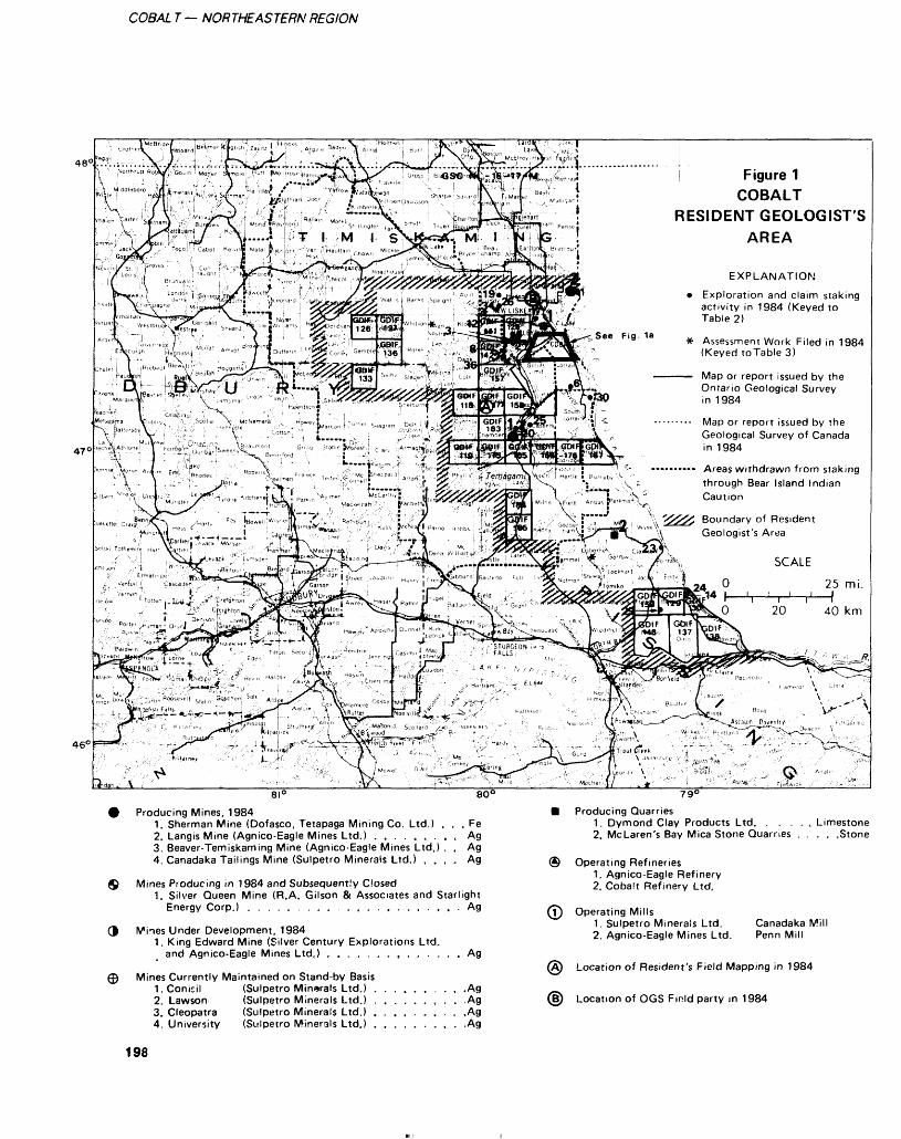
COBAL T — NORTHEASTERN REGION
48'
47 (
^'*T, bV''-" H ; l - Scf;ita f ,,4\ t ,r Na ™ ri /-- j H'?^y U,c.n]:---' s.ao-.m. ,^i-r^ R L^^ |G^ j^e^ Lorr.,^j ^ ......... Map or report issued by the^i .f"'e ' bb 1.V,. "| ':'.|;;v; ^ r l; r-^0". "', j__^ \ : "'^^',,JRo^^^ ::\i hi^er ^Bj ^; l ,'^i. Jk "- Geological Survey of Canada
)*"'N*:iVr*p Ani .m Fm^'f^ ' ; ' Robfr^t ' ,-;'"*"*r^" '-..f " TScKl^f'' '""v'^f^' - ., V " ^'f fl"'' ! ^ —"——. Areas wi thdrawn f rom sta k i ngv,"\ \ t 'V0 ,, .Rhodes r ft^iman'""^' T,!.,.,1:'*".' Mc ,,p'""JPa "^ Atto* ' ••tt pt"', 1 ^. 4 T?^93TlC, V^ i Hartle ! H u , naby \V. - .- l . . .-:.r' i'. ./f"". l C i r ,:^-i'i t i,j , .p :gj ,,: .'jvjfe,i LB '":- X. ". ,v-,u through Bear Island Indian
.. \\ ' *Jr T--^-.- (' -- f.....^j.. '..J- >t-> 11,v>>V^•^*———-l ' \ ..i*'.*—— X -. -l ,.
Figure 1 COBALT
RESIDENT GEOLOGIST'S AREA
EXPLANATION
Exploration and claim staking activity in 1984 (Keyed to Table 2)
Assessment Work Filed in 1984 (Keyed to Table 3)
Map or report issued by the Ontario Geological Survey in 1984
Boundary of Resident Geologist's Area
46e
8I 0 80C
Producing Mines, 19841. Sherman Mine (Dofasco, Tetapaga Mining Co. Ltd.) . . . Fe2. Langis Mine (Agnico-Eagle Mines Ltd.) . . . . . . . . , Ag3. Beaver-Terniskaming Mine (Agnico-Eagle Mines Ltd.) . . Ag4. Canadaka Tailings Mine (Sulpetro Minerals Ltd.) , . . . Ag
Mines Producing in 1984 and Subsequently Closed1. Silver Queen Mine (R.A. Gilson S Associates and Starlight
Energy Corp.) . . . . . . . . . . . . . . . . . . . . . Ag
3 Mines Under Development, 19841. King Edward Mine (Silver Century Explorations Ltd.
and Agnico-Eagle Mines Ltd.) . . . . . . . , . . . .
Mines Currently Maintained on Stand-by Basis LConicil (Sulpetro Minerals Ltd.) ,2. Lawson (Sulpetro Minerals Ltd.) .3. Cleopatra (Sulpetro Minerals Ltd.) .4. University (Sulpetro Minerals Ltd.) .
Ag
-Ag-Ag .Ag-Ag
790
B Producing Quarries1. Dymond Clay Products Ltd. . . . . t Limestone2. McLaren's Bay Mica Stone Quarries , , . . .Stone
® Operating Refineries1. Agnico-Eagle Refinery2. Cobalt Refinery Ltd.
(T) Operating Mills1. Sulpetro Minerals Ltd. Canadaka Mill2. Agnico-Eagle Mines Ltd. Penn Mill
Location of Resident's Field Mapping in 1984
Location of OGS Finld party in 1984
198

L OWSIACKI
COBALT AREA
Figure 1a (base map after OGS map 5024)
2. A Tailings Inventory Study, which will provide maps showing all Tailings and mill locations in the camp, detailed maps of individ ual tailings distributions and cover, and a report including individual mill histories, tailings mining and milling methods, case histories of mined tailings, and descriptions of attempts at rehabilitation of local tailings.3. Compilation of an up-to-date property map of the Cobalt camp. The map, at a scale of 1:20 000 is currently 80*Vo complete. The re mainder of the area consists of ex tensive patented ground positions held by small interests dating back to the early 1900s.
Use of the facilities and ser vices provided by the Resident Ge ologist Office continued to increase ai a substantial pace since opening in 1981. Public lectures dealing with new developments in the Co balt mining camp were, on occa sion, presented at various func tions.
MINING ACTIVITYIn spite of the current relatively low prices for silver, production increased during 1984 to a level unmatched in the Cobalt/ Gowganda camps since 1978. The rise was due, in large part, to a massive production increase by Agnico-Eagle Mines Limited and to a lesser extent to increased pro duction from the Sulpetro Minerals Limited tailings mine and new pro duction from a number of small exploration ventures. A rebound in the automobile industry was simi larly responsible for a production increase of iron ore at the Sher man Mine. The Dymond Clay Pro ducts Limited metallurgical limestone quarry came on stream late in the year and production of this material increased by a factor of ten from 1983 and should in crease by a similar factor in 1985.
Two area mills operated dur ing the year. The Penn Mill of Agnico- Eagle Mines Limited ran for a 12-month period for the first time in many years. All feed origi nated from local mines owned and operated by Agnico-Eagle Mines Limited. Sulpetro Minerals Limit-
ed's Canadaka Mill operated for a 6-month period from May to No vember. Minor custom milling was undertaken in addition to the pro cessing of tailings.
The Agnico-Eagle Mines Limited refinery operated continu ously throughout the year. Much of the concentrate was derived from area mines owned by the company. Minor custom refining was carried out for 3 or 4 unaf- filiated mining companies. Earlier in The year, Caral Minor Metals LimiTed received a substantial grant, under a federal government incentives program to develop and build a custom roasting facility. The plant is expected to reduce the amount of arsenic in high arsenic polymetallic concentrates to levels acceptable to most smellers. Arse nic trioxide would be recovered as a by-product and sold. A roaster, capable of processing 20 tons/day has been built and commercial pro duction is scheduled to start by the end of 1984. The Cobalt Refinery Limited operated intermittently during the year. Approximately 15 tonnes of film was ashed and shipped to Montreal for recovery
199
COBAL T — NORTHEASTERN REGION
TABLE 1. MAPS AND REPORTS PERTAINING TO THE COBALT RESIDENT GEOLOGIST AREA PUBLISHED DURING 1984 BY THE ONTARIO GEOLOGICAL SURVEY, MINISTRY OF NATURAL RESOURCES
Open File ReportsOFR 5470OFR 5486 (Vol. 1, 2, 3)OFR 5508OFR 5510OFR 5520OFR 5523
Geological Data Inventory FoliosGDIF 118GDIF 119GDIF 126GDIF 127GDIF 128GDIF 129 GDIF 130GDIF 133GDIF 136GDIF 137GDIF 138GDIF 141GDIF 142 GDIF 143GDIF 157GDIF 158
GDIF 159 GDIF 165GDIF 166GDIF 167GDIF 175GDIF 176GDIF 177GDIF 183 GDIF 184GDIF 185
Coloured MapsMAP 2205 (reprint)MAP 2361 (reprint)
Mineral Resources Branch PublicationsMDC25
Miscellaneous ReportsMP 117MP 119MP 121General Index Vol. 8General Index Vol. 9Geological Survey of Canada Open FileReportsGSC OFR 1089GSC OFR 1090GSC OFR 1091GSC Magnetic Anomaly
MapNL 16-17-M A.E.C.L TR-238
of lead and silver. Plans are cur rently being formulaied by the op erators to develop a small lead ex traction plant at this site to recover metals from lead/silver concen trate, residue, bag house dust, etc.
The quantity of mineral com modities mined and paid for in 1984 increased dramatically from that produced in 1983. Silver pro duction increased 43*Vo to l 634 500 ounces. Production of iron pellets increased by 33^o to l 016 000 tonnes and metallurgical and agricultural grade limestone to 1100 tonnes and 500 tonnes re spectively. Minor amounts of deco rative building stone and substan tial quantities of sand and gravel were also quarried during the year. In addition, cobalt, copper, and nickel were mined along with sil ver, but not recovered.
BEAVER-TEMISKAMING MINE (AGNICO-EAGLE MINES LIMITED)Silver mining, exploration, and de velopment continued at an in creased pace throughout 1984. New cross-cutting was carried out on the 1300-foot and 1600-foot Levels to follow-up new drill- indicated ore intersections. The bulk of development work was car ried out on the 1330-foot Level where modest drifting, cross cutting, and exploration raising
were undertaken. The bulk of min ing again focused on 3 major veins: the 37, 41, and 44. Four new, and relatively short, ore vein structures were opened-up during the year and mining and develop ment of these (51, 52, 53, and
56) is in progress.Extensive exploration diamond
drilling was carried out during the year throughout much of the lower workings.
SULPETRO MINERALS LIMITED (CANADAKA DIVISION)A tailings mine located immedi ately north of the Town of Cobalt was restarted in May and contin ued operations for a 6-month pe riod. Production increased 28 0fo from last year to 45 350 tonnes. All material was processed at the local Canadaka Mill (wholly own ed by Sulpetro Minerals Limited). Aproximately 115 000 ounces of silver were recovered. The mill is currently custom milling approxi mately 900 tonnes of Manridge Explorations Limited's ore (l week).
Underground workings at the Conisil, Cleopatra, Lawson, and University Mines are being pumped-out and the facilities are maintained. The headframe at the
University Mine, destroyed by fire last year, was rebuilt.
It was recently announced (The Northern Miner, November 1984) that Bigstone Minerals Limited has entered into an option agreement to acquire all Cobalt area assets and properties current ly held by Sulpetro Minerals Limited. They would do this by forming a new company, Canadaka Mines Limited, to ex plore the Cobalt properties. Part of the agreement would require Big stone to spend S2.5 million over 3 years in exploration and an addi tional S 1.5 million on subsequent development.
SHERMAN MINE (DOFASCO INCORPORATED AND TETAPAGA MINING COMPANY LIMITED)This Temagami area mine was shut down for a 5-week period during the summer. Although this was the third such consecutive clo sure, it was for a shorter period of time than last year and it was pos sible to increase production to l 016 000 tonnes of iron ore pellets from 3.76 million tonnes of crude ore. Waste rock removed totaled 5.1 million tonnes. All mining op erations were confined to the west pit (43^0) and east pit (SIVo). De velopments at the east pit included an extension of the first bench to
200
L. OWSIACKI
within 1300 feel of the eastern end of the ore body and mining down to a third bench.
Discussion and studies are cur rently underway to investigate the possibilities of fluxing pellets with limestone at the mine site prior to shipment to Dofasco Incorporat- ed's smelter in Hamilton.
LANGIS MINE (AGNICO-EAGLE MINES LIMITED)The discovery of a new "orebody" in the fall of 1983 has spurred development and exploration at this mine. Underground explora tion diamond drilling increased by 31^o from last year and a new pro gram of long hole drilling has been proposed for the near future to ex plore the eastern limits of the prop erty.
New developments during the year include: (1) dewatering of the
6 shaft workings to the 435-foot Level; (2) extension of the work ings from the 5th Level of the 3 shafi to the east (approximately 215m (700 feel) of cross-cutiingj; (3) establishment of a (30-foot) deep winze on this level to join the 4th Level of the 6 shaft workings; and (4) recribbing of drifts on this level and driving of a new cross cut from these workings 67 m (220 feet) southeast to the discovery vein system ( 64-110).
Mining was confined during the year to the original discovery vein ( 201) which was mined-out in August. The stope yielded 17 592 tons of ore averaging 15 ounces silver per ton. Two addi tional short veins were also mined and 2 new veins, the 103 and
108, are currently being prepared for development.
All ore shoots occur within steep veins cutting relatively flat- lying Huronian Coleman Member siltstone and conglomerate exposed beneath a Nipissing diabase sill and immediately above steeply dip ping Archean metavolcanic rocks. One anomalous ore intersection was pulled from the Nipissing dia base above the new vein system.
SILVER QUEEN MINE (R.A. GILSON AND ASSOCIATES AND STARLIGHT ENERGY CORPORATION)This formerly producing property was acquired early in the year by R.A. Gilson and Associates and subsequently optioned to Starlight Energy Corporation of Vancouver. Initial exploration involved exten sive overburden stripping both along strike and on upward projec tions of previously mined veins. Blasting and trenching followed, with limited mining from the sur face of old crown pillars and vein extensions. The company reports that approximately 7000 tons of ore have been stockpiled. Mining activity ai the property was termi nated in September.
EXPLORATION ACTIVITYExploration activity in the area in creased markedly from last year as both new and established compan ies renewed their efforts to locale new silver deposits and expand re serves of old deposiis (Figure l, Tables 2. 3). The discovery of a new silver prospect by Silverside Resources Incorporated in 1983 (Owsiacki 1984a) is largely re sponsible for this revival of interest in the Cobalt camp. Only minor interest was expressed in other commodities including gold, dia monds, and cobalt. Although claim staking has remained relatively static over the past few years, nu merous patented claims in the area have recently changed hands or been optioned by mining interests.
Combined surface and under ground diamond drilling activity increased to the highest levels re corded since the late 1970s (Figure 2). The total footage drilled in 1984 rose to 31 982 m (104 927 feet) and is indicative of the over all increase in exploration activity. Major exploration and develop- meni undertaken during the year is summarized below.
Highland-Crow Resources Limited and Teck Corporation, as joint venture partners, continued to expand their ground position in the area both through staking and optioning of properties. Northgane
Minerals Limited entered into an option agreement with these com panies, requiring exploration ex penditures of SO.5 million in order to earn a SO'Vo interest in the prop erties. As part of this agreement, 5 diamond-drill holes, lotaling 1220 m (4003 feet) were drilled during the year to intersect 2 targets lo cated in Bucke Township. Results revealed the presence of anoma lous mineralization and alteration commonly developed within the Cobalt camp.
Teck Corporation has ex pressed a renewed exploration in terest in the Cobalt area and is currently investigating various joint venture possibilities with small property holders in the camp.
Underground exploration at the King Edward Mine property of Silver Century Explorations Limit ed was accelerated by Agnico- Eagle Mines Limited as pan of an earlier opiion agreemeni. Although promising new silver occurrences were intersected on the botiom lev el prior to Agnico's participation, extensive underground diamond drilling has since revealed no con- linuiiy lo ihe veins. Diamond drill ing was undertaken from both ex isting mine levels and long holes were drilled under adjoining prop erties held by Agnico-Eagle Mines Limited to test for new vein struc tures. Few promising intersections were encountered but exploration is expected to continue into 1985.
Agnico-Eagle Mines Limited expanded their property holdings south and east of the Langis Mine in Harris Township following a new underground silver discovery made in 1983 (Owsiacki 1984a). Line- cutting and geophysical sur veys have since been completed and preparations for diamond drill ing of specific target areas are cur rently underway. In addition, a property belonging to Frankfield Explorations Limited, located near Silverside Resources Incorporated's silver discovery in Lorrain Town ship, was optioned.
Korich Mining Company Limited acquired the old Smith Co balt Mines property in Coleman
201
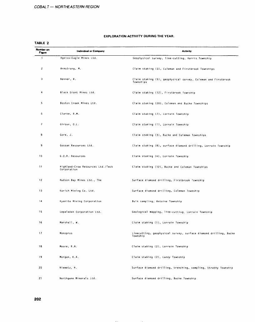
COBAL T — NORTHEASTERN REGION
TABLE 2
EXPLORATION ACTIVITY DURING THE YEAR.
Number on Figure Individual or Company Activity
Agnico-Eagle Mines Ltd. Geophysical survey, line-cutting, Harris Township
202
Armstrong, M. Claim staking (3), Coleman and Firstbrook Townships
Benner , R . Claim staking (5), geophysical survey, Coleman and Firstbrook Townshi ps
Black Giant Mines Ltd. Claim staking (12), Firstbrook Township
Boston Creek Mines Ltd. Claim staking (20), Coleman and Bucke Townships
Clarke, R.M. Claim staking (7), Lorrain Township
Giroux , O .L . Claim staking (1), Lorrain Township
Gore, J. Claim staking (3), Bucke and Coleman Townships
Gossan Resources Ltd. Claim staking (8), surface diamond drilling, Lorrain Township
G .Q .R . Resources Claim staking (4), Lorrain Township
Highland-Crow Resources Ltd./Teck Corporation
Claim staking (12), Bucke and Coleman Townships
12 Hudson Bay Mines Ltd., The Surface diamond drilling. Firstbrook Township
13 Korich Mining Co. Ltd. Surface diamond drilling, Coleman Township
Kyanite Mining Corporation Bulk sampling, Antoine Township
15 Lepaladan Corporation Ltd. Geological mapping, l i ne-cutti rig .. Lorrain Township
16 Marshal l , W. Claim staking (1), Lorrain Township
Monopros Linecutting, geophysical survey, surface diamond drilling, Bucke Townshi p
Moore, R.A. Claim staking (2), Lorrain Township
19 Morgan, K.A. Claim staking (2), Lundy Township
20 Niemetz, H. Surface diamond drilling, trenching, sampling, Strathy Township
21 Northgane Minerals Ltd. Surface diamond drilling, Bucke Township
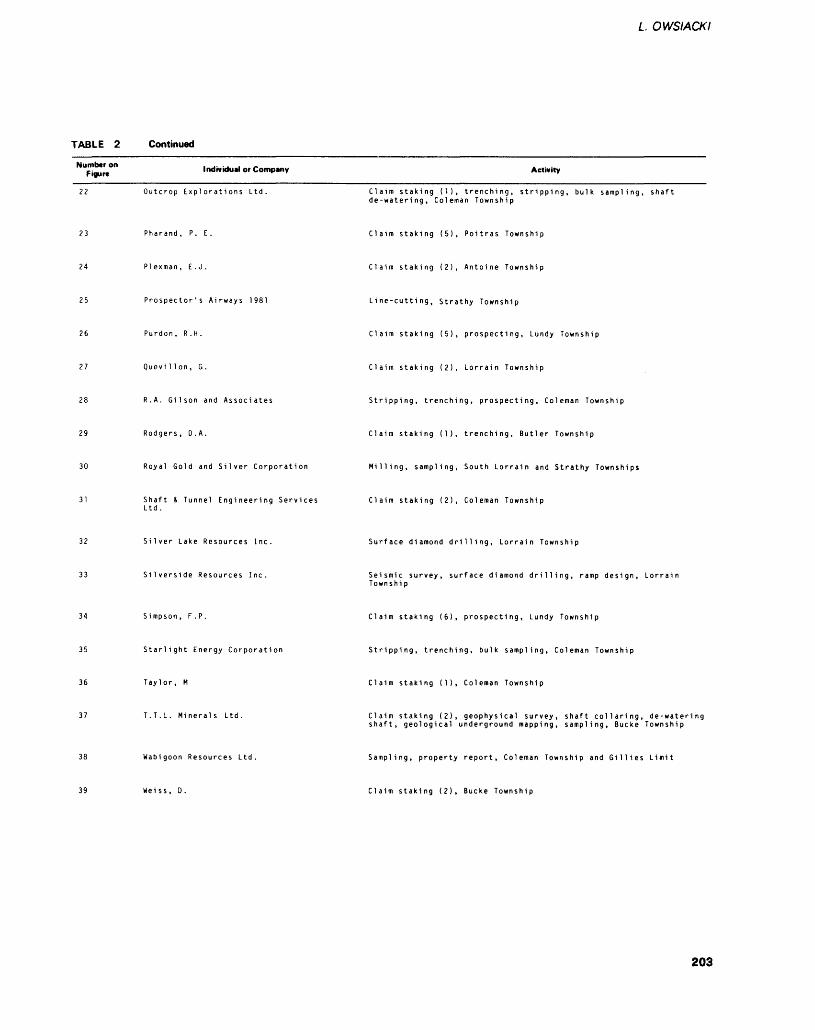
TABLE 2 Continued
L. OWSIACKI
Number on Figure Individual or Company Activity
Outcrop Explorations Ltd. Claim staking (1), trenching, stripping, bulk sampling, shaft de-watering, Coleman Township
Pharand, P. E. Claim staking (5), Poitras Township
24 PIexman, E.J. Claim staking (2), Antoine Township
25 Prospector's Airways 1981 Line-cutting, Strathy Township
Purdon , R.H. Claim staking (5), prospecting, Lundy Township
27 Quevilion, G. Claim staking (2), Lorrain Township
R.A. Gilson and Associates Stripping, trenching, prospecting, Coleman Township
29 Rodgers, D.A. Claim staking (1), trenching, Butler Township
30 Royal Gold and Silver Corporation Milling, sampling, South Lorrain and Strathy Townships
Shaft S Tunnel Engineering ServicesLtd.
Claim staking (2), Coleman Township
Silver Lake Resources Inc. Surface diamond drilling, Lorrain Township
Silverside Resources Inc. Seismic survey, surface diamond drilling, ramp design, Lorrain Townshi p
34 Si mpson, P.P. Claim staking (6), prospecting, Lundy Township
Starlight Energy Corporation Stripping, trenching, bulk sampling, Coleman Township
36 Taylor, M Claim staking (1), Coleman Township
37 T.T.L. Minerals Ltd. Claim staking (2), geophysical survey, shaft collaring, de-watering shaft, geological underground mapping, sampling, Bucke Township
Wabigoon Resources Ltd, Sampling, property report, Coleman Township and Gillies Limit
39 Weiss, D. Claim staking (2), Bucke Township
203
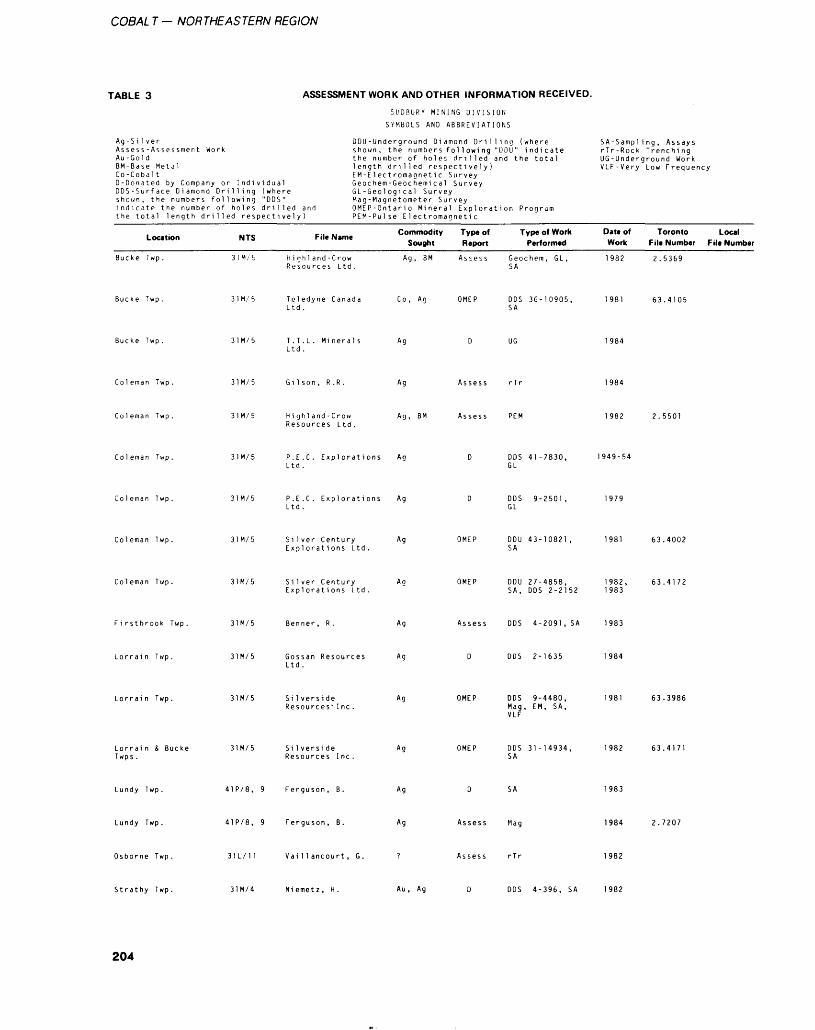
COBAL T - NORTHEASTERN REGION
TABLE 3 ASSESSMENT WORK AND OTHER INFORMATION RECEIVED.
SUDBURY MINING DIVISION
SYMBOLS AND ABBREVIATIONS
Ag-SilverAssess -Assessment WorkAu-GoldBM-Base MetalCo-CobaltD-Donated by Company or IndividualDDS-Surface Diamond Drilling (whereshown, the numbers following "DOS"indicate the number of holes drilled andthe total length drilled respectively)
DDU-Underground Diamond Drilling (where shown, the number s following "DDU " indicate the number of holes drilled and the total length drilled respectively) EM-Electromagnetic Survey Geochem-Geochenii cal Survey GL-Geological Survey Mag-Magnetometer SurveyOMEP-Ontario Mineral Exploration Program PEM-Pulse Electromagnetic
SA-Sampl ing, Assays rTr-Rock Trenchi ng UG-Underground Work VLF-Very Low Frequency
Location
Buc ke Twp .
Bucke Twp .
Bucke Twp .
Col eman Twp .
Col eman Twp .
NTS File Name
31M/5 Highland-Crow Resources Ltd.
31M/5 Teledyne Canada Ltd .
31M/5 T. T . L . Mineral s Ltd .
31M/5 Gi 1 son, R .R.
31 M/ 5 Hi g hi and -C row Resources Ltd .
Commodity Sought
Ag, BM
Co , Ag
Ag
Ag
Ag, BM
Type of Type of Work Report Performed
Assess Geochem , GL , SA
OMEP DOS 36-10905, SA
D UG
Assess rTr
Assess PEM
Date of Toronto Local Work File Number File Number
1982 2.5369
1981 63.4105
1984
1984
1982 2.5501
Coleman Twp. P.E.C. Explorations Ag Ltd.
D DOS 41-7830, 1949-54 GL
Coleman Twp. P.E.C. Explorations Ag Ltd.
DOS 9-2501, GL
Coleman Twp. 31M/5 S i lver Centu ry Ag Exnlorati ons Ltd .
DDU 43-10821 SA
1981 63.4002
Coleman Twp. 31M/5 Si lver Century Explorati ons Ltd.
OMEP DDU 27-4858, 1982, 63.4172 SA, DOS 2-2152 1983
F i rstbrook Twp . Benner , R . Ag Assess DOS 4-2091, SA 1983
Lorrain Twp. 31M/5 Gossan Resources Ltd.
Ag DOS 2-1635
Lorrain Twp. 31M/5 Si lversi de Resources'Inc.
Ag OMEP DOS 9-4480, Mag, EM, SA, VLF
63.3986
Lorrain & Bucke Twps .
31M/5 Silverside Ag Resources I ne.
OMEP DOS 31-14934, 1982 63.4171 SA
Lundy Twp . 41P/8, 9 Ferguson , B. Ag 1983
Lundy Twp. 41P/8, 9 Ferguson, B. Ag Assess Mag 1984 2.7207
Osborne Twp. 31L/11 Vaillancourt, G. Assess rTr 1982
Strathy Twp. 31M/4 Niemetz, H. Au , Ag DOS 4-396, SA 1982
204
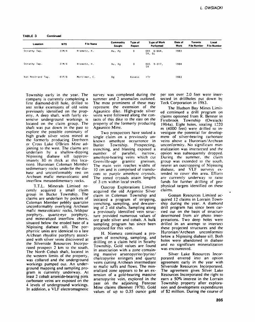
L OWSIACKI
TABLE 3 Continued
Location
Strathy Twp.
..-. E .. .. Commodity NTS File Name T Sought
31M/4 Niemetz, H. Au, Ag
Type of Report
D
Type of Work Performed
DOS 6-664, SA, GL
Date of Work
1983
Toronto Local File Number File Number
Strathy Twp. 31M/4 Niemetz, H. Au , Ag DOS 5-317, 1984 SA
Van Nostrand Twp. 41P/8 Mortimer, C, Ag Assess rTr 1983
Township early in the year. The company is currently completing a first diamond-drill hole, drilled to test strike extensions of old veins previously identified on the prop erty. A deep shaft, with fairly ex tensive underground workings is located on the claim group. The shaft was put down in the past to explore the possible continuity of high grade silver veins mined at the formerly producing Deerhorn or Cross Lake O'Brien Mine ad joining to the west. The claims are underlain by a shallow-dipping Nipissing diabase sill (approx imately 80 m thick ai this loca tion). Huronian Coleman Member sedimentary rocks underlie the dia base and unconformably rest on Archean mafic metavolcanic and interflow metasedimentary rocks.
T.T.L. Minerals Limited re cently acquired a small claim group in Bucke Township. The claims are underlain by pockets of Coleman Member pebbly quartzite unconformably overlying Archean mafic metavolcanic rocks, feldspar porphyry, quartz-eye porphyry, and mineralized interflow cherts, situated below the eroded base of a Nipissing diabase sill. The por phyritic units are identical to a late Archean rhyolite porphyry associ ated with silver veins discovered at the Silverside Resources Incorpo rated prospect 2 km to the south. The North Cobali shaft, located in the western limits of the property, was collared and the underground workings pumped out. An under ground mapping and sampling pro gram is currently underway. At least 2 cobalt arsenide-bearing pink carbonate veins are exposed on the 4 levels of underground workings. In addition, a VLF electromagnetic
survey was completed during the summer and 2 anomalies outlined. The most prominent of these may represent the extension of the Agaunico dike. High-grade silver veins were followed along the con tacts of this dike to the east on the property of the formerly producing Agaunico Mine.
Two prospectors have staked a single claim on a previously un known amethyst occurrence in Butler Township. Prospecting, trenching, and blasting exposed a number of parallel, narrow, amethyst-bearing veins which cut Grenvi lie-age granitic gneisses. The main vein reaches widths of 10 cm and is comprised of translu cent to purple amethyst crysials. The zoned crystals attain lengths of 3 cm within local swells.
Outcrop Explorations Limited acquired the old Argentite Silver claim in Coleman Township and initiated a program of stripping, trenching, sampling, and dewater- ing of 2 old shafts. Sampling along a previously identified vein struc ture provided numerous values of ore grade silver and cobalt. A bulk sampling program has since been proposed for this vein.
H. Niemetz continued a pro gram of trenching, sampling, and drilling on a claim held in Strathy Township. Gold values are found in association with a zone contain ing massive arsenopyrite/pyrite/ chalcopyrite stringers and quartz veins cutting Archean intermediate to mafic tuffs and flows. The min eralized zone appears to be an ex tension of a gold-bearing massive arsenopyrite vein, explored in the past on the adjoining Penrose Mine claims (Bennett 1978). Gold values of up to 0.35 ounce gold
per ton over 2.0 feet were inter sected in drillholes put down by Teck Corporation in 1983.
The Hudson Bay Mines Limit ed continued a drill program on claims optioned from R. Benner in Firstbrook Township (Owsiacki 1984a). Eight holes, totaling 1220 m (4000 feet) were drilled to in vestigate the potential for develop ment of silver-bearing carbonate veins above a Huronian/Archean unconformity. No significant min eralization was intersected and the option was subsequently dropped. During the summer, the claim group was extended to the south, nearer an outcropping of Nipissing diabase, and VLF surveys ex tended to cover this area. Efforts are currently underway to raise funds for further drilling of geo physical targets identified on these claims.
Gossan Resources Limited ac quired 12 claims in Lorrain Town ship during the year. A diamond drill program has since been car ried out on the basis of structure determined from air photo inter pretations. Two deep holes were drilled in an attempt to intersect these projected structures and the Huronian/Archean unconformity below a Nipissing diabase sill. Both holes were abandoned in diabase and no significant mineralization was encountered.
Silver Lake Resources Incor porated entered into an option agreement early in the year with Silverside Resources Incorporated. The agreement gives Silver Lake Resources Incorporated the right to earn a SO^o interest in the Lorrain Township property after explora tion and development expenditures of S2 million. During the course of
205
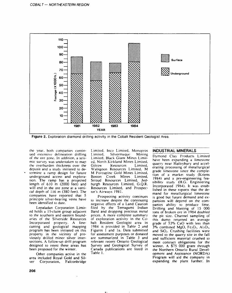
COBAL T — NORTHEASTERN REGION
110 —
100 —
90 —
80 —
70 —
l 6"1l so;VJ 40-*ji? 30-
20—
10
Surface
Underground
1981 1982 YEAR
1983 1984
Figure 2. Exploration diamond drilling activity in the Cobalt Resident Geologist Area.
the year, both companies contin ued extensive delineation drilling of the ore zone. In addition, a seis mic survey was undertaken to map the overburden thickness over the deposit and a study initiated to de termine a ramp design for future underground access and explora tion. The ramp has a projected length of 610 m (2000 feet) and will end in the ore zone at a verti cal depth of 116 m (380 feet). The companies have reported that 5 principle silver-bearing veins have been identified to date.
Lepaladan Corporation Limit ed holds a 15-claim group adjacent to the southern and eastern bound aries of the Silverside Resources Incorporated property. A line- cutting and geological mapping program has been initiated on this property in the vicinity of pre viously drilled minor silver inter sections. A follow-up drill program designed to retest these areas has been proposed for the winter.
Other companies active in the area included Royal Gold and Sil ver Corporation, Falconbridge
Limited, Inco Limited, Monopros Limited, Silvermaque Mining Limited, Black Giant Mines Limit ed, North Kirkland Mines Limited, Gilrow Resources Limited, Wabigoon Resources Limited, M M Porcupine Gold Mines Limited, Boston Creek Mines Limited, Stroud Resources Limited, Jed- burgh Resources Limited, G.Q.R. Resources Limited, and Prospec tor's Airways 1981.
Prospecting activity continues to increase despite the continuing negative effects of a Land Caution filed by the Temagami Indian Band and dropping precious metal prices. A more complete summary of exploration activity in the Co balt Resident Geologist area in 1984 is provided in Table 2 and Figures l and la. Data submitted for assessment purposes or donated are summarized in Table 3 and relevant recent Ontario Geological Survey and Geological Survey of Canada publications are listed in Table 1.
INDUSTRIAL MINERALSDymond Clay Products Limited have been expanding a limestone quarry near Haileybury and accel erating processing of metallurgical grade limestone since the comple tion of a market study (Kriens 1984) and a pre-engineering fea sibility study (H.G. Engineering Incorporated 1984). It was estab lished in these reports that the de mand for metallurgical limestone is good but future demand and ex pansion will depend on the com panies ability to produce lime. Drilling and blasting of 15 000 tons of broken ore in 1984 doubled the pit size. Channel sampling of this dump returned an average grade of 53*7o CaO with less than 3Vo combined MgO, Fe.O,, AUO3 , and SiOj. Crushing facilities were moved to the quarry site in the fall and sufficient material crushed to meet contract obligations for the winter. A S75 000 grant through the Northern Ontario Rural Devel opment and Assistance (NORDA) Program will aid the company in expanding the plant further. In
206
L. OWSIACKI
1984, production of metallurgical grade limestone more than doubled from the previous year to 1100 tonnes and is estimated ai 5000 tonnes for 1985.
Quarrying of decorative build ing stone continued on a seasonal demand basis in McAuslan Town ship.
ONTARIO GEOLOGICAL SURVEY ACTIVITIES_______ENGINEERING AND TERRAIN GEOLOGY SECTIONA peatland inventory project was initiated in the New Liskeard area in 1983 and completed this year. Peat bogs were studied and their resource potential identified (Riley 1984). Project data and results were compiled by Hunter and As sociates Limited (1984).
RESEARCH BY OTHER ORGANIZATIONS—————-CARLETON UNIVERSITYG. Burbidge iniiiated field studies during the summer as pan of a Ph.D. thesis investigating the re gional sedimentology of the lower Gowganda Formation in the Co balt Embayment.
B. Wilson, P. Mustard and M. Goodz are finishing M.Se. studies investigating the sedimentology of Huronian rocks and sulphur iso tope geochemistry of Archean in terflow metasedimentary rocks. Huronian sedimentary rocks, and veins found in the Cobalt area.
R. Rainbird is studying the re gional sedimentology of the Firsi- brook Member of the Gowganda Formation as part of an M.Sc. the sis.
J. Gebert, E. Dodd, and Z. Arias are completing site specific projects in the immediate Cobalt camp as part of B.Sc. thesis stud ies.
MCMASTER UNIVERSITYA. Fyon conducted field investiga tions in the general vicinity of the Sherman Iron Mine near Temagami. The focus of the pro ject is the resolution of the stratig
raphy of the host volcanic piles. Alteration associated with gold and base metal occurrences within these rocks was concurrently de fined.
RECENT PUBLICATIONS AND REFERENCES__________Andrews, A.J., Kerrich, R., andOwsiacki, L.1984: Petrographic and Geochemi
cal Studies of the Ag-Co-Ni Arsenide Vein Deposits, Co balt and Gowganda, Ontario; p.42 in Abstracts of the GAC- MAC Joint Annual Meeting, May 14-16, 1984.
Bennett, G.1978: Geology of the Northeast
Temagami Area, District of Nipissing; Ontario Geological Survey Report 163, 128p. Ac companied by Maps 2323 and 2324, scale 1:31 680 or l inch to 1/2 mile, and l chart.
Crocket, J.H., Blum, N., Hurley, T., Bowins, R., McRoberts, G., Fyon, A., McNutt, R.H., Schwarcz, H.P., and Rees, C.E. 1984: Geological and Geochemical
Studies of the Boston and Temagami Iron Formations and their Contiguous Vol- canosedimentary Piles; Grant 132, p.72-83 in Geoscience Research Grant Program, Summary of Research, 1983-1984, edited by V.G. Milne, Ontario Geological Sur vey, Miscellaneous Paper 121, 252p.
Donaldson, J.A., Goodz, M.D., Michel, F.A., Mustard, P., Rain bird, R., Rust, B.R., Watkinson, D.H., and Wilson, B. 1984: Sedimentary Rocks and
Stratabound Mineralization in the Cobalt Region; Grant 173, p. 198-210 in Geoscience Re search Grant Program, Sum mary of Research, 1983-1984, edited by V.G. Milne, Ontario Geological Survey, Miscella neous Paper 121, 252p.
Goodz, M.D., Watkinson, D.H., Pertold Z., Buzek, F., and Robin son, D.1984: Geology and Sulphur-
Isotope Geochemistry of the Beaver- Temiskaming Silver
Mine, Cobalt, Ontario; p.67 in Abstracts of the GAC-MAC Joint Annual Meeting, May 14-16, 1984.
H.G. Engineering Incorporated 1984: Pre-Engineering Feasibility
Study Limestone Crushing Fa cility in Northern Ontario; On tario Geological Survey, Open File Report 5523, 40p., 3 dia grams in back pocket.
Hunter and Associates Limited 1984: Peat and Peatland Evalua
tion of the New Liskeard Area; Ontario Geological Sur vey, Open File Report 5486, Volumes l, 2, and 3.
Kriens, J.1984: Market Study: Limestone
Uses in Northern Ontario and Northwestern Quebec; Ontario Geological Survey, Open File Report 5510, 44p., 6 tables, l figure, and l appendix.
Miall, A.D.1983: Glaciomarine Sedimentation
in the Gowganda Formation (Huronian), Northern Ontario; Journal of Sedimentary Petrol ogy, Volume 53, p.447-491.
Owsiacki, Leo1984a: Report of Activities 1983,
Cobali Resident Geologist Area, Northeastern Region; p. 169-178 in Report of Activi ties 1983, Regional and Resi dent Geologists, edited by C.R. Kustra, Ontario Geological Survey, Miscellaneous Paper 117, 265p.
1984b: Geology of the McLean Lake-Lundy Lake Area, Nip issing District; p.237-241 in Summary of Field Work, 1984, Ontario Geological Sur vey, edited by John Wood, Owen L. White, R.B. Barlow, and A.C. Colvine, Ontario Geological Survey, Miscella neous Paper 119, 309p.
Owsiacki, L., and Lovell, H.1984: Geology, Silver and Gold
Deposits: Cobalt and Kirkland Lake; GAC-MAC Joint Annu al Meeting, May 14-15, 1984, Field Trip Guidebook 4, 114p.
Riley, J.L.1984: Peatland Inventory Project,
1984; p.110-116 in Summary
207
COBAL T — NORTHEASTERN REGION
of Field Work, 1984, Ontario Scammell, RJ. the Temagami GreenstoneGeological Survey, edited by 1984: The Geology of Precambrian Belt, Northeastern Ontario; un-John Wood, Owen L. White, Strata East of Cobalt, Ontario, published M.Se. Thesis, Lau-R.B. Barlow, and A.C. Col- unpublished B.Se. Thesis, Car- rentian University, Sudbury,vine, Ontario Geological Sur- leton University, Ottawa, On- Ontario,vey, Miscellaneous Paper 119, tario. Thode, H.G., and Goodwin, A.M.309P- Strong, D.F., and Scon, S.D. 1983: Further Sulphur and Carbon
Roy, J.L., and Morris, W.A. 1984: Fluid Inclusions of Ag- Isotope Studies of Late Ar-1984: Precambrian Polar Wander Co-Ni Arsenide Veins in the chean Iron Formation of the
Paths -An Assessment of the Cobalt- Gowganda Area, On- Canadian Shield and the RiseData Base; p.101 m Abstracts tario; p.fOS in Abstracts of the of Sulphate Reducing Bacteria;of the Geological Association GAC-MAC Joint Annual Precambrian Research, Vol-of Canada-Mineralogical Asso- Meeting, May 14-16, 1984. ume 20, p.337-356.ciation of Canada Soucie, G.(GAC-MAC) Joint Annual j979. 'A Lithogeochemical StudyMeeting, May 14-16, 1984. of Metasomatic Alteration in
208
Sault Ste. Marie Resident Geologist Area, Northeastern RegionG. Bennett 1 , E.J. Leahy2 , and K.D. Booth31 Resident Geologist, Resource Geologist, 3Economic Geologist, Ontario Ministry of Natural Resources, Sault Ste. Marie
INTRODUCTION _____The permanent staff of the Sault Ste. Marie Resident Geologist Of fice consists of EJ. Leahy, Re source Geologist, and G. Bennett, Resident Geologist. Contract staff include Brenda Fremlin, Secretary, and L.J. Ashick and E.J. Wheatley who acted as geological assistants for part of the year.
The Wawa Economic Geolo gist Program commenced in June under the supervision of K.D. Booth who was assisted by W.T. Curtis. The Sault Ste. Marie Indus trial Minerals Program began in June under the supervision of J.J. Kral. J.J. Kral was assisted by P. Beach and J.P. Matte. A study of magnetic and geochemical anoma lies in the granitic terrain north of Sault Ste. Marie was commenced by C.A. Leslie in June and contin ued under the direction of D.J.J. Tortosa who assumed the project in July. D.J.J. Tortosa was assisted by E.J. Ha ley. These 3 projects are funded by the Ontario Ministry of Northern Affairs. Preliminary re ports for these projects are includ ed in this report.
This is the second year of op eration of the Sault Ste. Marie Drill Core Library. A summary of the operations of the Drill Core Library is included in this report.
RESIDENT GEOLOGIST ACTIVITIES_____________The number of public inquiries to the Sault Ste. Marie Resident Ge ologist Office in 1984 was slightly more than in 1983, a year which showed a dramatic increase in pub lic inquiries over previous years. As a result more time was spent responding to requests for informa tion and consultation. In addition, talks on general geological subjects and the results of exploration in the Hemlo area were given to local citizens groups. A geological field trip through the Elliot Lake area was conducted for a university group. Four days were spent on a reconnaissance of the geology of Michipicoten Island. The Resident Geologist assisted J.A.C. Fortescue
(Geophysics/Geochemistry Sec tion, Ontario Geological Survey, Toronto) with a remote sensing evaluation in the Montreal River area in August. The Resident Ge ologist visited 16 active and 5 inac tive properties during the 1984 field season. Research was contin ued on a study of the lower Huronian stratigraphy and Huronian volcanic rocks between Elliot Lake and Sault Ste. Marie. Much of the Resident Geologist's time was spent in administrative duties pertaining to the 3 Ministry of Northern Affairs funded pro jects.
During the past year the Re source Geologist: supervised the preparation of Geological Data In ventory Folios; supervised an in dustrial minerals project carried out by J. Kral; conducted a series of 10 classes of 3 1/2 hours each followed by a field trip for local prospectors. He also carried out ongoing revisions to the microfiche assessment file library, indexed and added to the technical articles file, and spent a great deal of time assisting the record number of visi tors to the Sault Ste. Marie office. Much time was spent doing gen eral office duties in the absence of a full time secretary.
CLAIM STAKING ACTIVITYBetween January l and November 30, 1984, 1555 mining claims were recorded in the Sault Ste. Ma rie Mining Division. This is only a fraction of the total number staked in 1983. The reason for this is that by the end of 1983 most of the favourable ground had been staked as a result of the gold discoveries near Hemlo. In addition, the fall ing price of precious metals pro duced a more cautious approach to mineral exploration in 1984.
Figure 2 shows the trend in claim staking activity in the Sault Ste. Marie Mining Division since 1960.
MINING ACTIVITYThe Algoma Ore Division of The Algoma Steel Corporation Limited continued production of iron ore at Wawa through 1984 with the ex ception of a 4-week shutdown in August and September. From Jan uary l to November 30, 1984, l 160 545 long tons of sinter was produced from l 697 000 tons of ore.
Mining operations at Elliot Lake continued at an expanded pace in 1984.
The milling rate of Denison Mines Limited is being maintained at about 11 000 tons per day. A total of l 875 000 tons of ore aver aging 1.79 pounds (814 g) of ura nium oxide per ton was processed during the first 6 months of 1984 (The Northern Miner, October 4, 1984).
Denison is planning to use heap leaching methods to mine low grade ore at a much lower c*ost than that of conventional mining. Experiments have indicated that about 65*^0 of the uranium can be extracted by this process.
Denison Mines Limited em ploys about 2150 people at its El liot Lake operation.
Rio Algom Limited operates the New Quirke, Stanleigh, and Panel Mines at Elliot Lake. The Stanleigh Mine has undergone ex tensive renovations and now pro duces aboui 4000 tons of ore per day. The total production from Rio Algom's operations in the Elliot Lake area is expected to yield 7 million tons of uranium oxide in 1984. Heap leaching is expected to provide an increasing proportion of total output (The Northern Min er, August 9, 1984). Rio Algom employs 2850 in its Elliot Lake operations.
The Renabie Mine in Leeson Township continued gold produc tion through 1984. Renabie is own ed by Barrick Resources Corpora tion (50*7o) and Cullaton Lake Gold Mines Limited (SO^o). Camp bell Resources Incorporated is the operator of the mine.
209
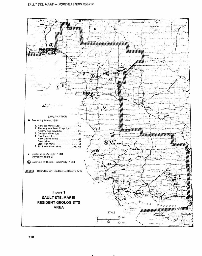
SAUL T STE. MARIE — NORTHEASTERN REGION
EXPLANATION Producing Mines, 1984
. Renabie Mines Ltd.. . . . . . . . . Au2. The Algoma Steel Corp. Ltd. . . . . .
Algoma Ore Division . . . . . . . . Fe/ .,, VSs3. Denison Mines Ltd.. . . . . . . . . .U |4. Rio Algom Ltd. . . . . . . . . . . . . . Mo " t̂ |J0fl,
New Quirke Mine . . . . . . . . . . .U •••^-••• :Panel Mine Stanleigh Mine
5. Sill Lake Silver Mine
Exploration Activity, (keyed to Table 2)
A) Location of O.G.S. Field Party, 1984
Boundary of Resident Geologist's Area x
Figure 1SAULT STE. MARIE
RESIDENT GEOLOGIST'SAREA
O 20 40 km
210
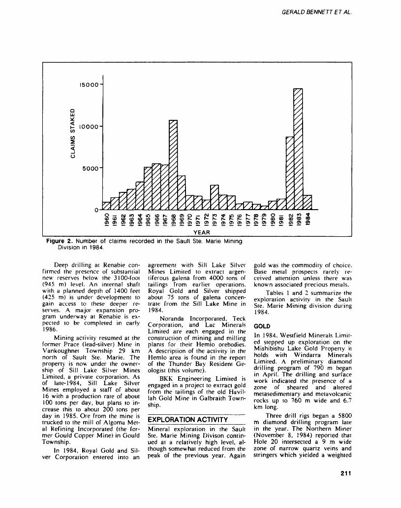
GERALD BENNETT E T AL.
15000-
o111 v:
CO CO
O
10000-
50001
COlfl(3(flCD(O(DtOu5tCN-^-^-'fs-rs-r-N- r*-^-N-OOQO co CO OD0)0)0)0)0j0)0)0)0)0)0)0)2)0)0)0)0)0)0)0)0)5 0)?22?
YEARFigure 2. Number of claims recorded in the Sault Ste. Marie Mining
Division in 1984.
Deep drilling at Renabie con firmed the presence of substaniial new reserves below the 3100-foot (945 m) level. An internal shaft with a planned depth of 1400 feet (425 m) is under development to gain access to these deeper re serves. A major expansion pro gram underway at Renabie is ex pected to be completed in early 1986.
Mining activity resumed at the former Prace (lead-silver) Mine in Vankoughnet Township 29 km north of Sault Ste. Marie. The property is now under the owner ship of Sill Lake Silver Mines Limited, a private corporation. As of late-1984, Sill Lake Silver Mines employed a staff of about 16 with a production rate of about 100 tons per day, but plans to in crease this to about 200 tons per day in 1985. Ore from the mine is trucked to the mill of Algoma Met al Refining Incorporated (the for mer Gould Copper Mine) in Gould Township.
In 1984, Royal Gold and Sil ver Corporation entered into an
agreement with Sill Lake Silver Mines Limited to extract argen tiferous galena from 4000 tons of tailings from earlier operations. Royal Gold and Silver shipped about 75 tons of galena concen trate from the Sill Lake Mine in 1984.
Noranda Incorporated, Teck Corporation, and Lac Minerals Limited are each engaged in the construction of mining and milling plants for their Hemlo orebodies. A description of the activity in the Hemlo area is found in the report of the Thunder Bay Resident Ge ologist (this volume).
BKK Engineering Limited is engaged in a project to extract gold from the tailings of the old Havil- lah Gold Mine in Galbraith Town ship.
EXPLORATION ACTIVITYMineral exploration in the Sault Ste. Marie Mining Divison contin ued at a relatively high level, al though somewhat reduced from the peak of the previous year. Again
gold was the commodity of choice. Base metal prospects rarely re ceived attention unless there was known associated precious metals.
Tables l and 2 summarize the exploration activity in the Sault Ste. Marie Mining division during 1984.
GOLDIn 1984, Westfield Minerals Limit ed stepped up exploration on the Mishibishu Lake Gold Property it holds with Windarra Minerals Limited. A preliminary diamond drilling program of 790 m began in April. The drilling and surface work indicated the presence of a zone of sheared and altered metasedimentary and metavolcanic rocks up to 760 m wide and 6.7 km long.
Three drill rigs began a 5800 m diamond drilling program late in the year. The Northern Miner (November 8, 1984) reported that Hole 20 intersected a 9 m wide zone of narrow quartz veins and stringers which yielded a weighted
211
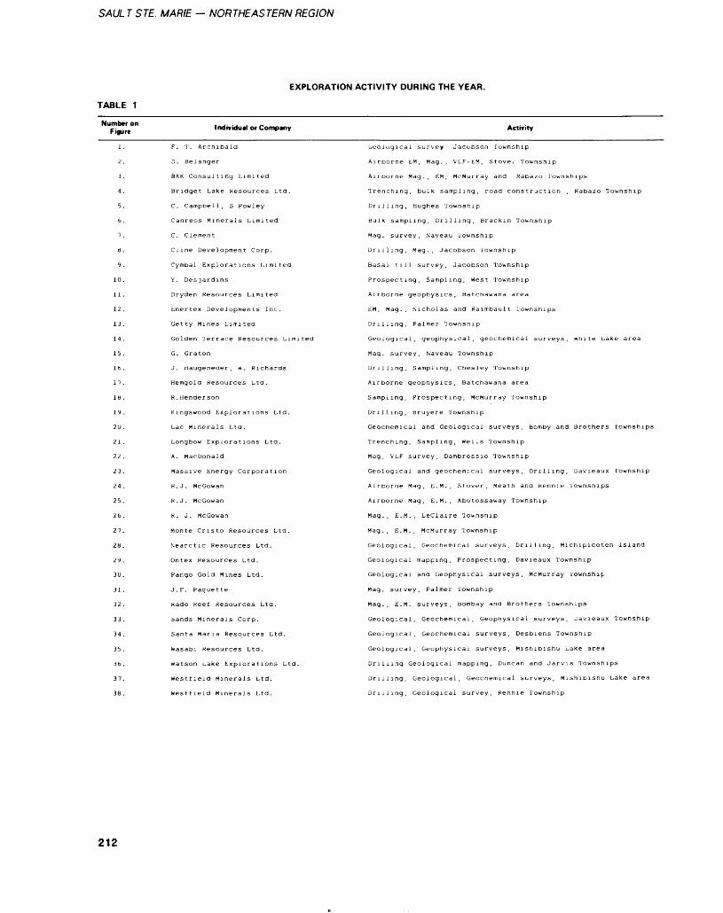
SAUL T STE. MARIE — NORTHEASTERN REGION
EXPLORATION ACTIVITY DURING THE YEAR.
TABLE 1
Number on Figure Individual or Company Activity
9.
10.
11 .
12.
13.
14.
15.
16 .
17.
18.
19.
20.
21 .
22.
23.
24.
25.
26.
27.
2b.
29.
30.
31 .
32.
33.
34.
35.
36.
37.
38.
F. T. Archibald
D. Belanger
BKK Consulting Limited
Bridget Lake Resources Ltd.
C. Campbell, S Powley
Canreos Minerals Limited
C. CIernen t
Cline Development Corp.
Cymbal Explorations Limited
y. Desjardins
Dryden Resources Limited
Enertex Developments Inc.
Getty Mines Limited
Golden Terrace Resources Limited
G. Graton
J. Haugeneaer, w. Richards
Hemgold Resources Ltd.
R.Henderson
Kingswood Explorations Ltd.
Lac Minerals Ltd.
Longbow Explorations Ltd.
A. MacDonald
Massive Energy Corporation
R.J. Mccowan
R.J. McGowan
R. J. McGowan
Monte Cristo Resources Ltd.
Nearctic Resources Ltd.
Ontex Resources Ltd.
Pango Gold Mines Ltd.
J.F. Paquette
Rado Reef Resources Lta.
Sands Minerals Corp.
Santa Maria Resources Ltd.
Wasabi Resources Ltd.
Watson Lake Explorations Ltd.
westtield Minerals Ltd.
Westlield Minerals Ltd.
Geological survey Jacobson Township
Airborne EM, Mag., VLF-EM, Stover Township
Airborne Mag., EM, McMurray and Rabazo Townships
Trenching, bulk sampling, road construction , Rabazo Township
Drilling, Hughes Township
Bulk sampling, Drilling, Brackin Township
Mag. survey, Naveau Township
Drilling, Mag., Jacobson Township
Basal till survey, Jacobson Township
Prospecting, Sampling, West Township
Airborne geophysics. Batchewana area
EM, Mag., Nicholas and Raimbault Townships
Drilling, Palmer Township
Geological, geophysical, geochemical surveys, white Lake area
Mag. survey. Naveau Township
Drilling, Sampling, Chesley Township
Airborne geophysics, Batchewana area
Sampling, Prospecting, McMurray Township
Drilling, Bruyere Township
Geochemical and Geological surveys. Bomby and Brothers Townships
Trenching, Sampling, Wells Township
Mag, VLF survey, Dambrossio Township
Geological and geochemical surveys, Drilling, Davieaux Township
Airborne Mag, E.M., Stover, Meath and Rennie Townships
Airborne Mag, E.M., Abotossaway Township
Mag., E.M., Leclaire Township
Mag., E.M., McMurray Township
Geological, Geochemical surveys, Drilling, Michipicoten Island
Geological mapping. Prospecting, Davieaux Township
Geological and Geophysical surveys, McMurray Township
Mag. survey, Palmer Township
Mag., E.M. surveys, Bombay and Brothers Townships
Geological, Geochemical, Geophysical surveys, Davieaux Township
Geological, Geochemical surveys. Desbiens Township
Geological, Geophysical surveys. Mishibishu Lake area
Drilling Geological mapping. Duncan and Jarvis Townships
Drilling, Geological, Geochemical surveys. Mishibishu Lake area
Drilling, Geological survey, Rennie Township
212
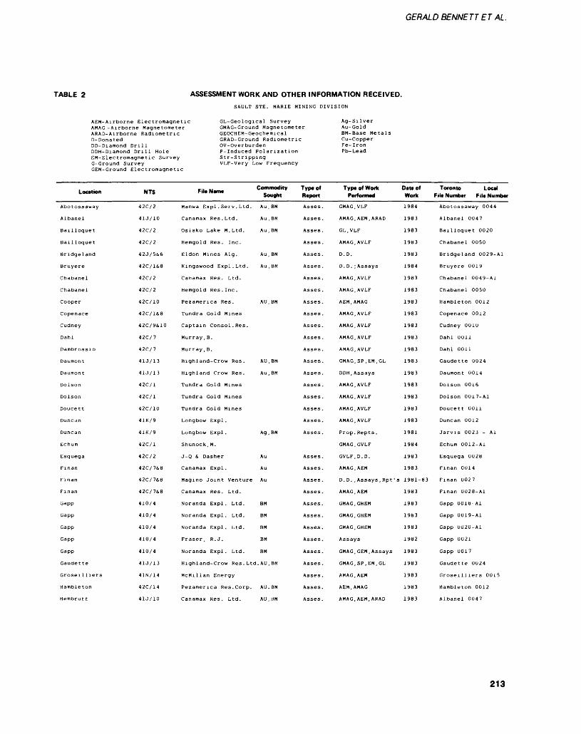
GERALD BENNETT E T AL.
TABLE 2 ASSESSMENT WORK AND OTHER INFORMATION RECEIVED.SAULT STE. MARIE MINING DIVISION
AEM-Airborne Electromagnetic GL-Geological SurveyAMAG -Airborne Magnetometer GMAG-Ground MagnetometerARAD-Airbor ~ 'D- DonatedDD-DiamondDDH-DiamondEM-Electrom
ne Radiometric GEOCHEM- GeochemicalGRAD-Ground Radiometric
DrillDrill Hole
agnetic SurveyG-Ground SurveyGEM-Ground
Location
Abotossaway
Albanel
Bailloquet
Bailloquet
Bridgeland
Bruyere
Chabanel
Chabanel
Cooper
Copenace
Cudney
Dahl
Dambrossio
Daumont
Daumont
Dolson
Dolson
Doucett
Duncan
Duncan
Echum
Esquega
Finan
Finan
Finan
Gapp
Gapp
Gapp
Gapp
Gapp
Gaudette
Groseilliers
Hambleton
Hembrutt
OV-OverburdenP-Induced PolarizationStr-StrippingVLF-Very Low Frequency
Ag-SilverAu-GoldBM-Base MetalsCu-CopperFe-IronPb-Lead
Electromagnetic
NTS
42C/2
41J/10
42C/2
42C/2
42J/5&6
42C/1&8
42C/2
42C/2
42C/10
42C/1&8
42C/9&10
42C/7
42C/7
41J/13
41J/I3
42C/1
42C/1
42C/10
41K/9
41K/9
42C/1
42C/2
42C/7&8
42C/7&8
42C/7&8
410/4
410/4
410/4
410/4
410/4
41J/13
41N/14
42C/14
41J/10
Fil. Name Commodity Sought
Manwa Expl . Serv . Ltd. Au, BM
Canamax Res. Ltd. Au , BM
Osisko Lake M. Ltd. Au, BM
Hemgold Res. Inc.
Eldon Mines Alg. Au , BM
Kingswood Expl. Ltd. Au , BM
Canamax Res. Ltd.
Hemgold Res . Inc .
Pezamerica Res. AU, BM
Tundra Gold Mines
Captain Consol.Res.
Murray, B.
Murray, B.
Highland-Crow Res. AU, BM
Highland Crow Res. Au, BM
Tundra Gold Mines
Tundra Gold Mines
Tundra Gold Mines
Longbow Lxpl.
Longbow Expl. Ag , BM
Shunock, M.
J-Q S Dasher Au
Canamax Expl. Au
Magino Joint Venture Au
Canamax Res. Ltd.
Noranda Expl. Ltd. BM
Noranda Expl. Ltd. BM
Noranda Expl. Ltd. BM
Fraser, R. J. BM
Noranda Expl. Ltd. BM
Highland-Crow Res . Ltd. AU, BM
McMillan Energy
Pezamerica Res. Corp. AU. BM
Canamax Res. Ltd. AU, BM
Type of Report
Asses .
Asses.
Asses .
Asses .
Asses .
Asses .
Asses.
Asses.
Asses .
Asses .
Asses.
Asses .
Asses.
Asses.
Asses.
Asses.
Asses.
Asses .
Asses .
Asses .
Asses .
Asses.
Asses .
Asses.
Asses.
Asses.
Asses .
Asses .
Asses .
Asses.
Asses .
Asses.
Asses.
Type of Work Performed
GMAG, VLF
AMAG, AEM, ARAD
GL.VLF
AMAG, AVLF
D. D.
D. D. ; Assays
AMAG, AVLF
AMAG, AVLF
AEM, AMAG
AMAG, AVLF
AMAG, AVLF
AMAG. AVLF
AMAG, AVLF
GMAG, SP.EM.GL
DDH, Assays
AMAG, AVLF
AMAG, AVLF
AMAG, AVLF
AMAG, AVLF
Prop. Repts .
GMAG.GVLF
GVLF.D.D.
AMAG. AEM
D. D. , Assays , Rpt '
AMAG, AEM
GMAG, GHEM
GMAG.GHEM
GMAG, GHEM
Assays
GMAG, GEM, Assays
GMAG, SP, EM, GL
AMAG, AEM
AEM, AMAG
AMAG, AEM, ARAD
Oat* of Work
1984
1983
1983
1983
1983
1984
1983
1983
1983
1983
1983
1983
1983
1983
1983
1983
1983
1983
1983
1981
1984
1983
1983
's 1981-83
1983
1983
1963
1983
1982
1983
1983
1983
1983
1983
Toronto Local Fill Number File Number
Abotossaway 0044
Albanel 0047
Bailloquet 0020
Chabanel 0050
Bridgeland 0029-A1
Bruyere 0019
Chabanel 0049-A1
Chabanel 0050
Hambleton 0012
Copenace 0012
Cudney OOID
Dahl 0011
Dahl 0011
Gaudette 0024
Daumont 0014
Dolson 0016
Dolson 0017-A1
Doucett 0011
Duncan 0012
Jarvis 0023 - Al
Echum 0012-AI
Esquega 0028
Finan 0014
Finan 0027
Finan 0028-Ai
Gapp OOlb-Al
Gapp 0019-A1
Gapp 0020-A1
Gapp 0021
Gapp 0017
Gaudette 0024
Groseilliers 0015
Hambleton 0012
Albanel 0047
213
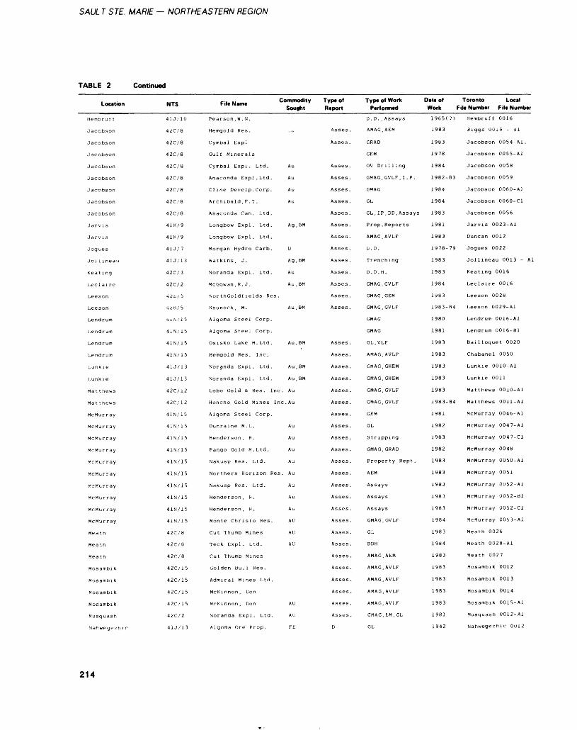
SAUL T STE. MARIE — NORTHEASTERN REGION
TABLE 2 Continued
Location
Hembrut t
Jacobson
Jacobson
Jacobson
Jacobson
Jacobson
Jacobson
Jacobson
J acobson
Jarvis
Jarvis
Jogues
Jol i ineau
Keating
Led aire
Leeson
Leeson
Lendrum
Lendrum
Lendr urn
Lendrum
Lunki e
Lunkie
Mat thews
Mat thews
McMurray
McMu,r ray
McMurray
McMurray
McMurray
McMurray
McMurray
McMurray
McMurray
McMurray
Meath
Meath
Meath
Mosambi k
Mosambik
Mosambik
Mosambik
Musquash
Nahwegezhic
NTS
41 J/10
42C/8
42C/8
42C/8
42C/8
42C/8
42C/8
42C/8
42C/8
41K/9
41K/9
41J/7
41J/13
42C/3
42C/2
42k/ i
4 2 B /' b
-4 i 1\ i 1 5
4 1 N /' 1 5
41N/15
4 1 N 1 1 5
41J/13
41J/13
42C/12
42C/12
4 1 N /' 1 5
4 IN/ 15
41N/15
41N/15
41N/15
41N/15
4 1 N 7 1 5
41N/15
41N/15
4 1 N ,' 1 5
42C/8
42C/8
42C/8
42C/15
42C/15
42C/1S
42C/15
42C/2
41J/13
Fil.N.m. Commodity Sought
Pearson , W . N.
Hemgold Res. ..u
Cymbal Expl
Gulf Minerals
Cymbal Expl . Ltd. Au
Anaconda Expl. Ltd. Au
Cline Develp.Corp. Au
Archibald , F. T. Au
Anaconda Can. Ltd.
Longbow Expl. Ltd. Ag , BM
Longbow Expl. Ltd.
Morgan Hydro Carb. U
Watkins, J. Ag.BM
Noranda Expl. Ltd. Au
McGowan, R. J. Au, BM
Nor thGoldf lelds Res.
Shunock , M. Au , BM
Algoma Steel Corp.
Algoma Steel Corp.
Osisko Lake M. Ltd. Au, BM
Hemgold Res. Inc.
Noranda Expl. Ltd. Au, BM
Noranda Expl. Ltd. Au, BM
Lobo Gold 6. Res. Inc. Au
Honcho Gold Mines Inc. Au
Algoma Steel Corp.
Dunraine M . L. Au
Henderson , R . Au
Pango Gold M. Ltd. Au
Nakusp Res. Ltd. Au
Northern Horizon Res. Au
Nakusp Res. Ltd. Au
Henderson , H . Au
Henderson, R. Au
Monte Christo Res. AU
Cut Thumb Mines AU
Teck Expl . Ltd. AU
Cut Thumb Mines
Golden Bull Res.
Admiral Mines Ltd.
McKinnon, Don
McKinnon , Don AU
Noranda Expl. Ltd. AU
Algoma Ore Prop. FE
Type of Report
Asses.
Asses .
Asses .
Asses .
Asses .
Asses .
Asses .
Asses .
Asses .
Asses .
Asses .
Asses .
Asses .
Asses .
Asses .
Asses .
Asses.
Asses.
Asses .
Asses .
Asses .
Asses .
Asses.
Asses .
Asses .
Asses .
Asses .
Asses .
Asses .
Asses .
Asses.
Asses .
Asses .
Asses .
Asses .
Asses .
Asses .
Asses .
Asses .
D
Type of Work Date of Toronto Local Performed Work File Number File Number
D. D. , Assays
AMAG, AEM
GRAD
GEM
OV Drilling
GMAG, GVLF, I . P.
GMAG
GL
GL, IP, DD. Assays
Prop. Reports
AMAG, AVLF
li. D.
Trenching
D. D. H.
GMAG, GVLF
GMAG, GEM
GMAG, GVLF
GMAG
GMAG
GL, VLF
AMAG, AVLF
GMAG, GHEM
GMAG, GHEM
GMAG, GVLF
GMAG, GVLF
GEM
GL
Stripping
GMAG, GRAD
Property Rept .
AEM
Assays
Assays
Assays
GMAG, GVLF
GL
DDH
AMAG. AEM
AMAG, AVLF
AMAG, AVLF
AMAG, AVLF
AMAG, AVLF
GMAG, EM , GL
GL
1965( ?)
1983
1983
1978
1984
1982-83
1984
1984
1983
1981
1983
1978-79
1983
1983
1984
1983
1983-84
1980
1981
1983
1983
1983
1983
1983
1983-84
1981
1982
1983
1982
1983
1983
1983
1983
1983
1984
1983
1984
1983
1983
1983
1983
1983
1981
1942
Hembruff 0016
Riggs 001S - Al
Jacobson 0054-A1.
Jacobson 0055-A1
Jacobson 0058
Jacobson 0059
Jacobson 0060-A1
Jacobson 0060-C1
Jacobson 0056
Jarvis 0023-A1
Duncan 0012
Jogues 0022
Jollineau 0013 - Al
Keating 0016
Leclaire 0016
Leeson 0028
Leeson 0029-A1
Lendrum 0016-A1
Lendrum 0016-B1
Bailloquet 0020
Chabanel 0050
Lunkie 0010-Al
Lunkie 0011
Matthews 0010-Al
Matthews 0011-Al
McMurray 0046-A1
McMurray 0047-A1
McMurray 0047-C1
McMurray 0048
McMurray 0050-A1
McMurray 0051
McMurray OU52-A1
McMurray 0052-B1
McMurray 0052-C1
McMurray 0053-A1
Meath 0026
Meath 0028-A1
Meath 0027
Mosambik 0012
Mosambik 0013
Mosambik 0014
Mosambik 0015-A1
Musquash 0012-A1
Nahwegezhic OD 12
214
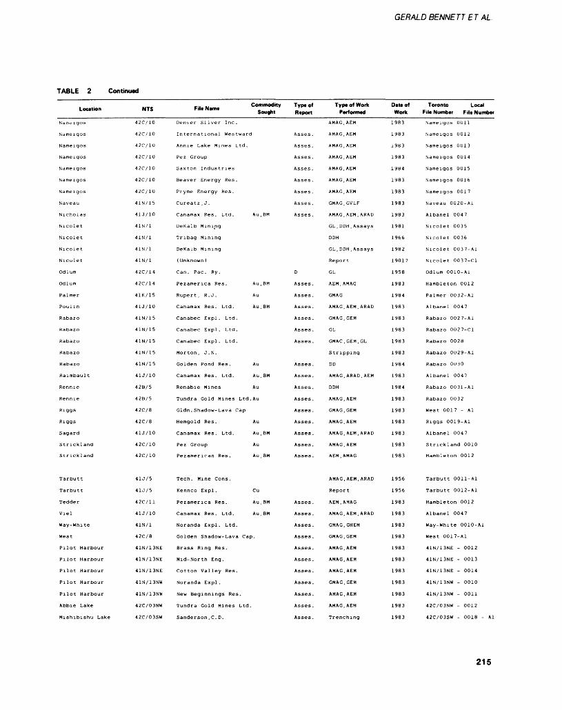
GERALD BENNETT E T AL
TABLE 2 Continued
Location
Nameigos
Nameigos
Nameigos
Nameigos
Nameigos
Nameigos
Nameigos
Naveau
Nicholas
Nicolet
Nicolet
Nicolet
Nicolet
Odlum
Odlum
Palmer
Poulin
Rabazo
Rabazo
Rabazo
Rabazo
Rabazo
Raimbault
Rennie
Rennie
Riggs
Riggs
Sagard
Strickland
Strickland
Tarbutt
Tarbutt
Tedder
Viel
Way-White
West
Pilot Harbour
Pilot Harbour
Pilot Harbour
Pilot Harbour
Pilot Harbour
Abbie Lake
Mishibishu Lake
NTS
42C/10
42C/10
42C/10
42C/10
42C/10
42C/10
42C/10
41N/15
41J/10
41N/1
41N/1
41N/1
41N/1
42C/14
42C/14
41K/15
4IJ/10
41N/15
41N/15
41N/15
41N/15
41N/15
41J/10
42B/5
42B/5
42C/8
42C/8
41J/10
42C/10
42C/10
41J/5
41J/5
42C/11
41J/10
41N/1
42C/8
41N/13NE
41N/13NE
41N/13NE
41N/13NW
41N/13NW
42C/03NW
42C/03SW
-.. ., Commodity Fi e Name - . Sought
Denver Silver Inc.
Annie Lake Mines Ltd.
Fez Group
Saxton Industries
Beaver Energy Res.
Pryme Energy Res.
Cureatz , J.
Canamax Res. Ltd. Au, BM
De Kalb Minipg
Tribag Mining
DeKalb Mining
( Unknown )
Can. Pac. Ry.
Pezamerica Res. Au , BM
Rupert, R. J. Au
Canamax Res. Ltd. Au , BM
Canabec Expl. Ltd.
Canabec Expl. Ltd.
Canabec Expl. Ltd.
Morton, J.N.
Golden Pond Res. Au
Canamax Res. Ltd. Au, BM
Renabie Mines Au
Tundra Gold Mines Ltd. Au
Gldn . Shadow-Lava Cap
Hemgold Res. Au
Canamax Res. Ltd. Au , BM
Fez Group Au
Tech. Mine Cons.
Kennco Expl . Cu
Pezamerica Res. Au, BM
Canamax Res. Ltd. Au, BM
Noranda Expl. Ltd.
Golden Shadow-Lava Cap.
Brass Ring Res.
Mid-North Eng.
Cotton Valley Res.
Noranda Expl .
New Beginnings Res.
Tundra Gold Mines Ltd.
Sanderson , C. D.
Type of Report
Asses .
Asses .
Asses .
Asses .
Asses .
Asses .
Asses .
Asses .
D
Asses.
Asses .
Asses .
Asses.
Asses.
Asses .
Asses .
Asses .
Asses.
Asses.
Asses.
Asses .
Asses .
Asses.
Asses .
Asses .
Asses.
Asses .
Asses.
Asses.
Asses .
Asses .
Asses .
Asses .
Asses .
Asses .
Typ* of Work Performed
AMAG, AEM
AMAG, AEM
AMAG, AEM
AMAG, AEM
AMAG, AEM
AMAG, AEM
AMAG, AEM
GMAG.GVLF
AMAG, AEM, ARAU
GL, DDH , Assays
DDH
GL, DDH. Assays
Report
GL
AEM, AMAG
GMAG
AMAG, AEM, ARAD
GMAG, GEM
GL
GMAC.GEM.GL
Stripping
DD
AMAG, ARAD, AEM
DDH
AMAG, AEM
GMAG, GEM
AMAG, AEM
AMAG, AEM, ARAD
AMAG, AEM
AEM, AMAG
AMAG, AEM, ARAD
Report
AEM, AMAG
AMAG, AEM, ARAD
GMAG.GHEM
GMAG, GEM
AMAG, AEM
AMAG, AEM
AMAG, AEM
GMAG, GEM
AMAG, AEM
AMAG, AEM
Trenching
Datt of Work
1983
1983
1983
1983
1984
1983
1983
1983
1983
1981
1966
1982
1901?
1958
1983
1984
1983
1983
1983
1983
1983
1984
1983
1984
1983
1983
1983
1983
1983
1983
1956
1956
1983
1983
1983
1983
1983
1983
1983
1983
1983
1983
1983
Toronto Local Fit* Number File Number
Nameigos 0011
Nameigos 0012
Nameigos 0013
Nameigos 0014
Nameigos 0015
Nameigos 0016
Nameigos 0017
Naveau 0020-A1
Albanel 0047
Nicolet 0035
Nicolet 0036
Nicolet 0037-Ai
Nicolet 0037-C1
Odlum 0010-Al
Hambleton 0012
Palmer 0032-A1
Albanel 0047
Rabazo 0027-A1
Rabazo 0027-C1
Rabazo 0028
Rabazo 0029-Ai
Rabazo OOJO
Albanel 0047
Rabazo 0031-A1
Rabazo 0032
West 0017 - Al
Riggs 0019-A1
Albanel 0047
Strickland 0010
Hambleton 0012
Tarbutt 0011-Al
Tarbutt 0012-A1
Hambleton 0012
Albanel 0047
Way-White 0010-Ai
West 0017-A1
41N/13NE - 0012
41N/13NE - 0013
41N/13NE - 0014
41N/13NW - 0010
41N/13NW - 0011
42C/03NW - 0012
42C/03SW - 0018 - Al
215
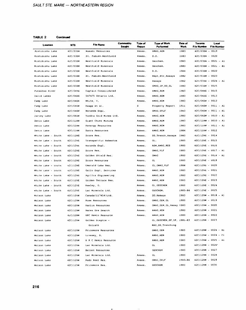
SAUL T STE. MARIE — NORTHEASTERN REGION
TABLE 2 Continued
Location
Mishibishu Lake
Mishibishu Lake
Mishibishu Lake
Mishibishu Lake
Mishibishu Lake
Mishibishu Lake
Mishibishu Lake
Pukaskwa River
David Lakes
Camp Lake
Camp Lake
Camp Lake
Jarvey Lake
Denis Lake
Denis Lake
Denis Lake
White Lake - South
White Lake - South
White Lake - South
White Lake - South
White Lake - South
White Lake - South
white Lake - boutn
White Lake - South
White Lake - South
White Lake - South
White Lake - South
White Lake - South
Molson Lake
Molson Lake
Molson Lake
Molson Lake
Molson Lake
Molson Lake
Molson Lake
Molson Lake
Molson Lake
Molson Lake
Molson Lake
Molson Lake
Molson Lake
Molson Lake
NTS
42C/03SW
42C/03SW
42C/03SW
42C/03SW
42C/03SW
42C/03SW
42C/03SW
42C/03SW
42C/04NE
42C/04SE
42C/04SW
42C/04SW
42C/04SW
42C/06SW
42C/11NW
42C/11NW
42C/11NW
42C/12NE
42C/12NE
42C/12NE
42C/12NE
42C/12NE
42C/12NE
42C/12NE
42C/12NE
42C/12NE
42C/12NE
42C/12NE
42C/12NE
42C/12NW
42C/12NW
42C/12NW
42C/12NW
42C/12NW
42C/12NW
42C/12NW
42C/12NW
42C/12NW
42C/12NW
42C/12NW
42C/12NW
42C/12NW
42C/12NW
FileNamt Commodity Type of Sought Report
Wasabi Resources
St. Fabien-Westf leld
Westtield Minerals
Westfield Minerals
Westfield Minerals
St. Fabien-Westf icld
Westfield Minerals
Westfield Minerals
Captain Consolidated
547475 Ontario Ltd.
White, V.
Kwapp et al.
Noranda Expl .
Tundra Gold Mines Ltd.
Giant Chief Mining
Kenergy Resources
Score Res.
Transpacific Asbestos
Noranda Expl .
Score Res.
Golden Shield Res.
Score Resources
Emerald Lake Res.
Gallo Expl. Services
Agillis Engineering
Golden Terrace Res.
Hawley, G.
Lac Minerals Ltd.
Canada(117454)Ltd.
Rose Resources
Harlin Resources
Narex Ore Search
HRC Hemlo Resource
Golden Sceptre -
Goliath
Pricemore Resources
Livesey, D.
HRC Hemlo Resource
Lac Minerals Ltd.
Belont Resources
Lac Minerals Ltd.
Rado Reef Res.
Pricemore Res.
Asses .
Asses.
Asses.
Asses.
Asses .
Asses.
Asses .
Asses.
Asses.
Asses.
Asses.
D
Asses.
Asses .
Asses.
Asses .
Asses.
Asses.
Asses.
Asses .
Asses.
Asses.
Asses.
Asses .
Asses .
Asses.
Asses.
Asses.
Asses.
Asses.
Asses.
Asses.
Asses .
Asses .
Asses .
Asses.
Asses .
Type of Work Performed
AMAG, AEM
D. D.
Geochem.
Geochem.
D. D.
Rept , Str , Assays
Assays
GMAG, IP.DD.GL
AMAG, AEM
AMAG, AEM
AMAG, AEM
Property Report
GMAG.GVLF
AMAG, AEM
AMAG, AEM
AMAG, AEM
AMAG, AEM
DD, Trench , Assays
GL.
AEM, AMAG, RES
GMAG, VLF
GMAG
GL
GL, GMAG, VLF
AMAG, AEM
AMAG, AEM
AMAG, AEM
GL, GEOCHEM
GEOCHEM.
DD; Assays
GMAG, GEM, GL
GMAG, GEM, GL. Assay
AMAG, AEM
AMAG. AEM
GL, GEOCHEM, SP, IP,
MAG, DD, Trench ing
GMAG, GEM
AMAG, AEM
AMAG, AEM
GL
GEOCHEM
GL
GMAG. GVLF
GEOCHEM
Dattof Work
1983
1983
1983
1983
1984
1982
1982
1983
1983
1983
1983
1911
1983
1983
1983
1983
1984
1983
1983
1983
1983
1983
1983
1984
1983
1983
1983
1983
1983-84
1983
1983
1983
1983
1983
1981-83
1983
1983
1983
1983
1983
1983
1983-84
1983
Toronto Filt Number
42C/03SW -
42C/03SW -
42C/03SW -
42C/03SW -
42C/03SW -
42C/03SW -
42C/03SW -
42C/03SW -
42C/04NE -
42C/04SE -
42C/04SW -
42C/04SW -
42C/04SW -
42C/06SW -
42C/11NW -
42C/11NW -
42C/11NW -
42C/12NE -
42C/12NE -
42C/12NE -
42C/12NE -
42C/12NE -
42C/12NE -
42C/12NE -
42C/12NE -
42C/12NE -
42C/12NE -
42C/12NE -
42C/12NE -
42C/12NW -
42C/12NW -
42C/12NW -
42C/12NW -
42C/12NW -
42C/12NW -
42C/12NW -
42C/12NW -
42C/12NW -
42C/12NW -
42C/12NW -
42C/12NW -
42C/12NW -
42C/12NW -
Local Fit* Number
0019
0020
0021
0021
0022
0023
0024
0025
0015
0013
0012
0011
0011
0010
0010
0011
0012
0014
0015
0016
0017
0018
0019
0020
0021
0022
0023
0024
0025
0018
0019
0020
0021
0022
0023
0024
0024
0025
0026'
0027
0028
0029
0030
- Al
- Bl
- Al
- Al
- Bl
- Al
- Al
- Al
- Al
- Al
- Al
- Al
- CI
- Al
216

GERALD BENNETT ET AL
TABLE 2 Continued
Location
Molson Lake
Molson Lake
Molson Lake
Molson Lake
Molson Lake
Molson Lake
Molson Lake
Molson Lake
Molson Lake
Molson Lake
Molson Lake
Molson Lake
Molson Lake
Molson Lake
Molson Lake
Molson Lake
Molson Lake
Molson Lake
Molson Lake
Molson Lake
Molson Lake
Molson Lake
Molson Lake
Molson Lake
Molson Lake
Molson Lake
Molson Lake
Oskabukuta Lake
Oskabukuta Lake
Herrick Lake
Herrick Lake
Herrick Lake
Herrick Lake
White Lake - North
White Lake - North
White Lake - North
White Lake - North
White Lake - North
White Lake - North
White Lake - North
White Lake - North
White Lake - North
White Lake - North
NTS
42C/12NW
42C/12NW
42C/12NW
42C/12NW
42C/12NW
42C/12NW
42C/12NW
42C/12NW
42C/12NW
42C/12NW
42C/12NW
42C/12NW
42C/12NW
42C/12NW
42C/12NW
42C/12NW
42C/12NW
42C/12NW
42C/12NW
42C/12NW
42C/12NW
42C/12NW
42C/12NW
42C/12NW
42C/12NW
42C/12NW
42C/12NW
42C/12NW
42C/12SE
42C/12SE
42C/12SW
42C/12SW
42C/12SW
42C/1 2SW
42C/13SE
42C/13SE
42C/13SE
42C/13SE
42C/13SE
42C/13SE
42C/13SE
42C/13SE
42C/13SE
42C/13SE
Fito NMM Comma Sougl
Lac Minerals
Lac Minerals
Lac Minerals
Lac Minerals
Lac Minerals
Lac Minerals
Lac Minerals
Lac Minerals
Lac Minerals
554588 Ontario Ltd.
H. W. Reserve Prop.
Calpetro - Prolific
Capoose Minerals
Dejour Mines-Nova Co
Glory Expl .
Lac Minerals
Lac Minerals
Lac Minerals
Lac Minerals
Lac Minerals
Lac Minerals
Lac Minerals
Lac Minerals
Lac Minerals
Lac Minerals
Lac Minerals
Lac Minerals
Kelly Desmond
Proflex Ltd.
Ebony Gold Mines
Pez Group
New Beginnings Res.
Canreos Minerals
Sunexco Energy Corp.
United Westland Res.
Level-land Energy
Ventora Resources
Midnapore Resources
Midnapore Resources
Midnapore Resources
Brass Ring Resources
Dunes Explorations
Schiralli, R. A.
dity Typt of lit Report
Asses.
Asses.
Asses.
Asses.
Asses.
Asses .
Asses.
Asses.
Asses.
Asses.
Asses.
Asses.
Asses.
Asses.
Asses.
Asses.
Asses.
Asses.
Asses.
Asses.
Asses.
Asses.
Asses.
Asses.
Asses.
Asses.
Asses.
Asses.
Asses.
Asses.
Asses.
Asses.
Asses.
Asses.
Asses.
Asses.
Asses.
Asses.
Asses.
Asses .
Asses.
Asses.
Asses.
Asses.
TypcofWork Performed
GL
GL
GL
GL
GL
GL
GL
GL
GL
AEM, AMAG
AEM.AMAG
AEM, AMAG
AEM.AMAG
GMAG.GVLF
AMAG, AEM
GL
GEOCHEM
GEOCHEM
GEOCHEM
GEOCHEM
GEOCHEM
GEOCHEM
GEOCHEM
GEOCHEM
GEOCHEM
GEOCHEM
DD
GMAG.GEM
AMAG. AEM
AMAG. AEM
AMAG, AEM
AMAG, AEM
GMAG.GEM
GMAG , GEM
AMAG, AEM
AMAG, AEM
AMAG. AEM
AMAG, AEM
DD, Assays
DD, Assays
GMAG.GVLF
AMAG, AEM
AMAG. AEM
AMAG, AEM
Daw ofWork
1983
1983
1983
1983
1 Q Q ̂± y o j
1983
1983
1983
1983
1983
1983
1983
1983
1983-84
1983
1983
1983-84
1983-84
1983-84
1983-84
1983-84
1983-84
1983-84
1983-84
1983-84
1983-84
1983
1983
1983
1983
1983
1983
1983-84
1 98 3 84
1983
1983
1983
1983
1984
1984
1983
1983
1983
1984
Toronto Fik Number
42C/12NW
42C/12NW
42C/12NW
42C/12NW
42C/12NW
42C/12NW
42C/12NW
42C/12NW
42C/12NW
42C/12NW
42C/12NW
42C/12NW
42C/12NW
42C/12NW
42C/12NW
42C/12NW
42C/12NW
42C/12NW
42C/12NW
42C/12NW
42C/12NW
42C/12NW
42C/12NW
42C/12NW
42C/12NW
42C/12NW
42C/12NW
42C/12N*
42C/12SE
42C/12SE
42C/12SW
42C/12SW
42C/12SW
42C/12SW
42C/13SE
42C/13SE
42C/13SE
42C/13SE
42C/13SE
42C/13SE
42C/13SE
42C/13SE
42C/13SE
42C/13SE
Loo Fit* Nu
- 0031
- 0032
- 0033
- 0034
- 0035
- 0036
- 0037
- 0038
- 0039
- 0040
- 0041
- 0042
- 0043
- 0044
- 0044
- 0045
- 0046
- 0047
- 0048
- 0049
- 0050
-. 0051
- 0052
- 0053
- 0054
- 0055
- 0056
- 0057
- 0010
- 0011
- 0013
- 0014
- 0015
- 0016
- 0012
- 0013
- 0014
- 0015
- 0016
- 0017
- 0018
- 0019
- 0020
- 0021
li imbcr
- Ai
- Al
- Al
- Al
- Al
- Al
- Al
- Al
- Al
- CI
- Al
- Al
- Al
- Al
217
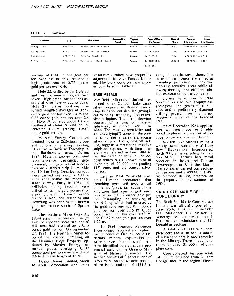
SAUL T STE. MARIE — NORTHEASTERN REGION
TABLE 2 Continued
Mussy
Mussy
Mussy
Mussy
Location
Lake
Lake
Lake
Lake
NTS
42D/09SE
42D/09SE
42D/09SE
42D/09SE
FitoNam. Commodity Sought
Maple
Maple
Leaf
Leaf
Petroleum
Petroleum
Pacific Seadrift
Walha lia - Maple Leaf
Typtof Report
Asses .
Asses .
Asses .
Asses.
Typt of Work Performed
GMAG, EM
GL, GEOCHEM
GMAG, GVLF
GL, GEOCHEM.
GVLF, IP
Datt of Work
1983
1984
1984
1983-84
Toronto File Numbtr
42D/09SE -
42D/09SE -
42D/09SE -
42D/09SE -
Local File Number
0017
0018
0019
0020
average of 0.341 ounce gold per ton over 5.6 m; this included a high grade zone of 3.77 ounces gold per ton over 0.46 m.
Hole 22, drilled below Hole 20 and from the same sei-up, returned several high grade intersections as sociated with narrow quartz veins. Hole 27, farther northwest, re turned weighied averages of 0.852 ounce gold per ton over l .4 m and 0.23 ounce gold per ton over 2.4 m. Hole 19, collared about 4.3 km southeast of Holes 20 and 22, in tersected 1.2 m grading 0.0647 ounce gold per ton.
Massive Energy Corporation Limited holds a 263-claim group and options on 2 groups totaling 34 claims in Davieux Township in the Batchawana area. During 1984, Massive Energy completed reconnaissance geological, geo chemical, and geophysical surveys over an east-west strip l km wide by 10 km long. Detailed surveys were carried out along a 400 m wide zone within the reconnais sance survey. Early in 1984, 15 drillholes totaling 1600 m were drilled to tesi the gold potential of a pyritic chen unit (lean "iron for mation"). Additional stripping and trenching was done over a known gold occurrence south of Spruce Lake.
The Northern Miner (May 31, 1984) staled that Massive Energy Limited reported some sections of drill core had returned up to 0.15 ounce gold per ion. On September 27, 1984, The Northern Miner re ported that channel sampling on the Hammer-Bridge Property, op tioned by Massive Energy, re turned grades averaging 0.137 ounce gold per ton over a width of 0.6 to 2 m and length of 18m.
De jour Mines Limited, Sands Minerals Corporation, and Ontex
Resources Limited have properties adjacent to Massive Energy Limit ed. The work done on these prop erties is listed in Table 1.
BASE METALSWestfield Minerals Limited re turned to its Conboy Lake zinc- silver property in Rennie Town ship to carry out detailed geologi cal mapping, trenching, and exten sive stripping. The main showing consists of a unit of massive sphalerite, in places over l m wide. The massive sphalerite and an underlying(?) zone of dissemi nated sphalerite carry significant silver values. The geological set ting suggests a stratabond massive sulphide deposit. A drilling pro gram was started in late 1984 to test the depth potential of the de posit which has a knowr n mineral inventory of 70 000 tons grading ll 0^ zinc, and 9.0 ounces silver per ton.
Late in 1984 Westfield Min erals Limited announced thai trenching over soil geochemical anomalies (gold), just south of the zinc zone, had returned grab sam ples ol up to 0.27 ounce gold per ton. Resampling and assaying of old drilling which had intersected the gold zone returned 0.1 l ounce gold per ton over 1.15 m, 0.125 ounce gold per ton over 1.37 m, and 0.125 ounce gold per ton over 1.22 m.
In 1984 Nearciic Resources Incorporated received an Explora tory Licence of Occupation to un dertake mineral exploration on Michipicoten Island, which had been identified as a candidate pro vincial park by the Ontario Min istry of Natural Resources. The licence consists of 2 parcels; one of 3253.75 ha on the western portion of the island and one of 1424.5 ha
along the northeastern shore. The terms of the licence are aimed at providing protection of environ mentally sensitive areas while al lowing thorough and efficient min eral exploration by the company.
During the summer of 1984 Nearctic carried out geophysical, geological, and geochemical sur veys and a preliminary diamond drilling program on the larger (western) parcel of the licenced area.
As of December 1984, applica tion has been made for 2 addi tional Exploratory Licences of Oc cupation on Michipicoten Island.
Watson Lake Mines Limited, a wholly owned subsidiary of Long Bow Exploration Incorporated, holds 93 claims including the Jar- dun Mine, a former base metal producer in Jarvis and Duncan Townships near Sault Ste. Marie. The company carried out geologi cal surveys and a 4893-foot (1491 m) diamond drilling program on the property in the summer of 1984.
SAULT STE. MARIE DRILL CORE LIBRARY_________The Sault Ste. Marie Core Storage Library was officially opened on June 26th. 1984. Staff included D.E. Messenger, J.D. Melisek, T. Wheatly, M. Gaudreau, and J. Penttinen as technicians and J.P. Donald as geologist.
A iota l of 48 000 m of com plete core and a further 21 000 m of telescoped core is now compiled in the Library. There is additional room for about 31 000 m of com plete core.
Core collected this year totals 14 500 m obtained from 31 core storage sites in the region. Eleven
218
GERALD BENNETT ET AL.
of these sites represented 1984 drilling programs.
The computer system used for storing drill core data has been augmented to include a summary of abbreviated rock types for holes stored in the Library. This feature allows a search by rock type, tex ture, or formation.
Computer data files are also being compiled for several thou sand thin sections and hand sam ples from completed Ontario Geo logical Survey projects in the re gion.
A listing of drill core in stor age is available free upon request bv contacting the Core Library at (705) 949-1231 or by correspon dence to the Resident Geologisi Of fice, 875 Queen St. E., Sault Ste. Marie, Ontario, P6A 2B3.
SAULT STE. MARIE RECONNAISSANCE GEOLOGY PROJECT____________INTRODUCTIONThe reconnaissance geology pro ject was initialed to evaluate a number of selected geophysical, geochemical, and geological anomalies within the granitic and gneissic terrains in the Algoma District. The District was subdi vided into 3 subareas of granitic and gneissic rocks (Figure 3): Area l extends from Sault Ste. Marie east to Elliot Lake, and from the edge of the Huronian Supergroup north to the Algoma District boundary; Area 2 extends from Mamainse Point to Wawa; and Area 3 extends from Wawa to Hemlo.
Work started on the project during the latter part of July with field work focusing on the western half of Area 1. The area is easily accessible by truck and all- terrain-vehicles over secondary roads and bush-roads, and lakes provide further access by boat, ca noe, or float plane.
Targets evaluated were based on aeromagnetic, radiometric, and geochemical anomalies defined by previous federal and provincial surveys. Mineral occurrences and isolated "greenstone" segments
were evaluated in terms of their regional geological and metal logenetic significance to provide a better understanding of the geologi cal, tectonic, and mineralization history of the area. The data from these studies will be used to for mulate exploration strategies and thereby promote mineral explora tion in the district.
GEOLOGICAL SETTINGThe granitic and gneissic terrains throughout Area l are categorized (Giblin ei al. 1979) as consisting of unsubdivided granites, gneisses, and migmatites containing small isolated segments of "greenstone". The rocks are transected by northwest-, north-northwest-, and northeast-trending lineaments. Northwest- and north-northwest- trending diabase dikes are numer ous. In a regional geological syn thesis of the Central Superior Province, Card (1979) subdivided the area into plutonic and gneissic domains. The gneissic domains are geologically complex areas consist ing of amphibolite, quanzofeld- spathic gneisses, migmatites, and intrusive rocks. The plutonic do mains consist of large areas of coarse-grained granite, monzonite, and subordinate granodiorite. Boundaries between domains are diffuse.
FIELD INVESTIGATIONSInvestigations of a number of aeromagnetic anomalies (M-1 to M-12, Figures 3, 4, and 5) indicate that they are caused by either: (1) iron formation-amphibolite rem nants surrounded by or contained within granite, granodiorite, or tonalite gneiss; (2) diabase dikes containing magnetite which com monly trend to the northwest; (3) by quartz-magnetite veins occur ring in the granitic country rocks adjacent to diabase dikes; or (4) by magnetite-bearing felsic plutonic rocks.
Two large radiometric anoma lies (R-1 and R-2) may be caused by the presence of potassium-rich granites, with above average ura nium and thorium occurring in ac cessory minerals such as zircon,
monazite, and uraninite. In both radiometric anomalies the granites become more calcic away from the radiometric highs. It appears that these plutonic rocks are a continu ation of the radioactive granites in the Elliot Lake area (R-3, Figure 3).
Geochemical anomalies north of Sault Ste. Marie were investi gated in order to determine the source of uranium in lake sedi ments and waters for geochemical anomaly SSM-1, and the source of Pb, Mo, Zn, Cu, Fe, and Mn in lake sediments for geochemical anomaly SSM-2. The anomalous uranium in lake sediments and wa ters for SSM-1 is probably due to the presence of radioactive granites in the area. Notably, the geochemi cal contours display some continu ity with the total count airborne radiometric data from the Ranger Lake area. The anomalous metal values for SSM-2 are likely due in part to the occurrence of sulphide mineralization, and the presence of "greenstone" segments and Keweenawan volcanic rocks in the immediate area.
Two isolated segments of "greenstone" (G-1 and G-2) were investigated during the field work. Segment G-l is quite small but contains metavolcanic and vol caniclastic rocks typical of most greenstone belts. Segment G-2, however, consists of quartzofeld- spathic, layered paragneisses which have been partly migmatiz- ed and contain minor amphibolite. The boundary with the enclosing granites and gneisses are character ized by the development of ag- matitic rocks.
All mineral occurrences vis ited have a northwest trending structural control and most are closely associated with northwest- trending diabase dikes and subordi nate lamprophyre dikes. The U-Fe, Cu-Fe, Pb-Zn-Ag, and some of the Fe occurrences are localized at the dike-country rock contact, in struc turally preferred sites. As well, there appears to be a change from oxidized assemblages (i.e. hematite- pitchblende-calcite) in the west near the Keweenawan basal un conformity, to more reduced,
219
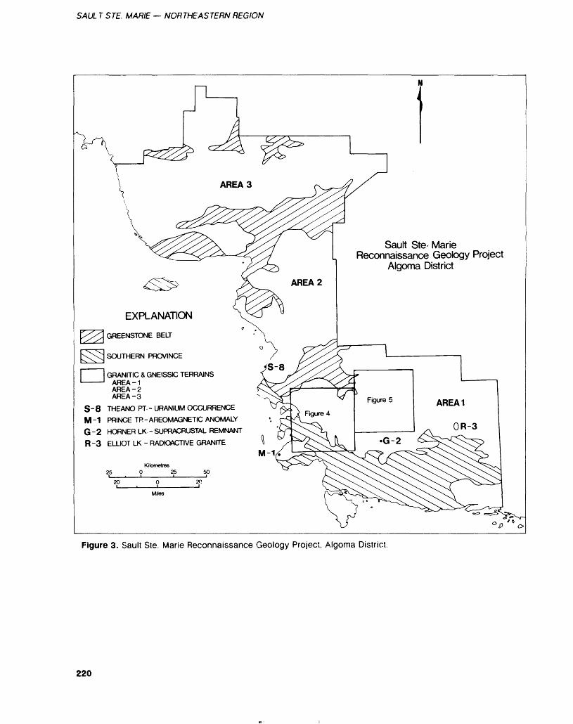
SAUL T STE. MARIE — NORTHEASTERN REGION
EXPLANATION
GREENSTONE BELT
SOUTHERN PROVINCE
GRANITIC S GNEISSIC TERRAINS AREA-1 AREA-2 AREA-3
S - 8 THEANO PT - URANIUM OCCURRENCE M -1 PRINCE TP - AREOMAGNETIC ANOMALY G -2 HORNER LK - SUPRACRUSTAL REMNANT R -3 ELLIOT LK - RADIOACTIVE GRANITE
Sault Ste- MarieReconnaissance Geology Project
Algoma District
Kilometres O 25 50
20
M-
Figure 3. Sault Ste. Marie Reconnaissance Geology Project, Algoma District.
220
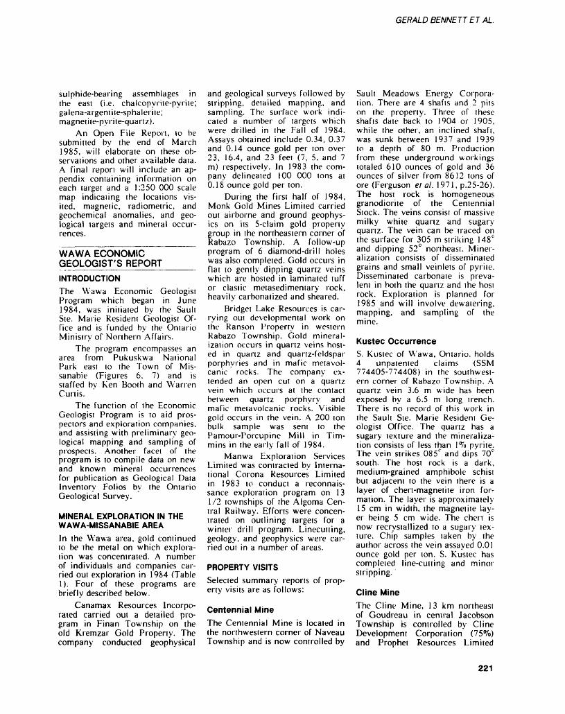
GERALD BENNETT ET AL.
sulphide-bearing assemblages in the east (i.e. chalcopyriie-pyriie; galena-argent i te-sphalerite; magnetiie-pyrite-quartz).
An Open File Report, to be submitted by the end of March 1985, will elaborate on these ob servations and other available data. A final report will include an ap pendix containing information on each target and a 1:250 000 scale map indicating the locations vis ited, magnetic, radiometric, and geochemical anomalies, and geo logical targets and mineral occur rences.
WAWA ECONOMIC GEOLOGIST'S REPORTINTRODUCTIONThe Wawa Economic Geologist Program which began in June 1984, was initiated by the Sault Ste. Marie Resident Geologist Of fice and is funded by the Ontario Ministry of Northern Affairs.
The program encompasses an area from Pukuskwa National Park east to the Town of Mis- sanabie (Figures 6, 7) and is staffed by Ken Booth and Warren Curtis.
The function of the Economic Geologist Program is to aid pros pectors and exploration companies, and assisting with preliminary geo logical mapping and sampling of prospects. Another facet of the program is to compile data on new and known mineral occurrences for publication as Geological Data Inventory Folios by the Ontario Geological Survey.
MINERAL EXPLORATION IN THE WAWA-MISSANABIE AREAIn the Wawa area, gold continued to be the metal on which explora tion was concentrated. A number of individuals and companies car ried out exploration in 1984 (Table 1). Four of these programs are briefly described below.
Canamax Resources Incorpo rated carried oul a detailed pro gram in Finan Township on the old Kremzar Gold Property. The company conducted geophysical
and geological surveys followed by stripping, detailed mapping, and sampling. The surface work indi cated a number of targets which were drilled in the Fall of 1984. Assays obtained include 0.34, 0.37 and 6.14 ounce gold per ton over 23, 16.4, and 23 feet (7, 5, and 7 m) respectively. In 1983 the com pany delineated 100 000 tons at 0.18 ounce gold per ton.
During the first half of 1984, Monk Gold Mines Limited carried out airborne and ground geophys ics on its 5-claim gold property group in the northeastern corner of Rabazo Township. A follow-up program of 6 diamond-drill holes was also completed. Gold occurs in flat to gently dipping quartz veins which are hosted in laminated tuff or clastic metasedimentary rock, heavily carbonatized and sheared.
Bridget Lake Resources is car rying out developmental work on the Ranson Property in western Rabazo Township. Gold mineral ization occurs in quartz veins host ed in quartz and quartz-feldspar porphyries and in mafic metavol- canic rocks. The company ex tended an open cut on a quartz vein which occurs at the contact between quartz porphyry and mafic metavolcanic rocks. Visible gold occurs in the vein. A 200 ton bulk sample was sent to the Pamoui-Porcupine Mill in Tim mins in the early fall of 1984.
Manwa Exploration Services Limited was contracted by Interna tional Corona Resources Limited in 1983 to conduct a reconnais sance exploration program on 13 1/2 townships of the Algoma Cen tral Railway. Efforts were concen trated on outlining targets for a winter drill program. Linecutting, geology, and geophysics were car ried oui in a number of areas.
PROPERTY VISITSSelected summary reports of prop erty visits are as follows:
Centennial MineThe Centennial Mine is located in the northwestern corner of Naveau Township and is now controlled by
Sault Meadows Energy Corpora tion. There are 4 shafts and 2 pits on the property. Three of these shafts date back to 1904 or 1905, while the other, an inclined shaft, was sunk between 1937 and 1939 to a depth of 80 m. Production from these underground workings totaled 610 ounces of gold and 36 ounces of silver from 8612 tons of ore (Ferguson el al. 1971, p.25-26). The host rock is homogeneous granodiorite of the Centennial Stock. The veins consist of massive milky white quartz and sugary quartz. The vein can be traced on the surface for 305 m striking 148 0 and dipping 52 G northeast. Miner alization consists of disseminated grains and small veinlets of pyrite. Disseminated carbonate is preva lent in both the quartz and the host rock. Exploration is planned for 1985 and will involve dewatering, mapping, and sampling of the mine.
Kustec OccurrenceS. Kustec of Wawa, Ontario, holds 4 unpatented claims (SSM 774405-774408) in the southwest ern corner of Rabazo Township. A quartz vein 3.6 m wide has been exposed by a 6.5 m long trench. There is no record of this work in the Sault Ste. Marie Resident Ge ologist Office. The quartz has a sugary texture and the mineraliza tion consists of less than l*7o pyrite. The vein strikes 085 C and dips 70C south. The host rock is a dark, medium-grained amphibole schist but adjacent to the vein there is a layer of chert-magnetite iron for mation. The layer is approximately 15 cm in width, the magnetite lay er being 5 cm wide. The chert is now recrystallized to a sugary tex ture. Chip samples taken by the author across the vein assayed 0.01 ounce gold per ton. S. Kustec has completed line-cutting and minor stripping.
Cline MineThe Cline Mine, 13 km northeast of Goudreau in central Jacobson Township is controlled by Cline Development Corporation (75*Vo) and Prophet Resources Limited
221
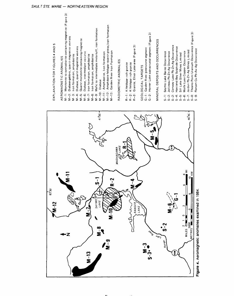
SAUL T STE. MARIE — NORTHEASTERN REGION
to S E a?
in QZ
'3-
CO
.ANATION FOR FIGURE
Q.XLU
00
OMAGNETIC ANOMALIE
DCLU<
L.
Eme coni;
: Monzonite to syenodiont
7̂
O)
0)
cucCO
: Diabase-gabbro, quartz m
c\1^
O)
: Iron formation, amphibo
oo1
5:
ScO)
: Diabase, quartz-magnetitf
'f1
2
O)cO)CD
EO)c 'E
: Quartz monzonite contan
ID1
5
canic
: Diabase, intermediate vol
CD1
^
O)
: Iron formation, amphibol
r--1
2
d)
: Iron formation, amphibol
CO1
IE
o
3
CD
: Mafic to intermediate me
0: Diabase
0) t-1 1
5 ^
c oCD
E Pc o
oT
o.g.c a E
7SE
55cD) N
CO3crCOa
"aj
0)
O.Q
a. E
CN
72E
iation
ES
LL
Co
CD
rrcCO-pCOo
00
7s
lOMETRIC ANOMALIES
Q^rr
: K-feldspar rich granite
7DC
: K-feldspar rich granite
CN1
DC
oo0)
0)
LL
: Granite, Elliot Lake area
001
DC
LOGICAL TARGETS
OLUO
cd)
EO) 0)
: Garden Rivet greenstone i
7o
LL.
CO)
E enO)
: Homer Lake supracrustal
CN1
U
wZLUrrDCD CJ
ERAL DEPOSITS AND OC
~z.^
O) 0c0)
3 O(joO)
CD CO. O)
CO-J oECO
CO
T—
1
O)uc0)
Jollineau Pb-Zn-Ag Occuri
CN1
CO
0)uf-ccurrei
00)
c N .QQ.0)
CD —1
CO
C Ou
oo1
00
O) CJcurreni
U0"D
-C Q.
3
CD 00-D
C CO
CDI
— .
jC/)
T3 O)
1-JO)c
O)
ood) co
CO
LO1
CO
rence
3 U UOOJa a o uatCD -J
O)"o 5
CD1
OO
•a d;
1
CDC
en
c N i a.c3
CD —J
^1
00
d) oicurren
Theano Point Uranium Oc
001in
jrrence
u u OO)•ac3
^.O Q.3Uc oc co
DC
d1
V)
l ^
"en CO O)
T3 (D
d)O) CO
O
l
0)
O)
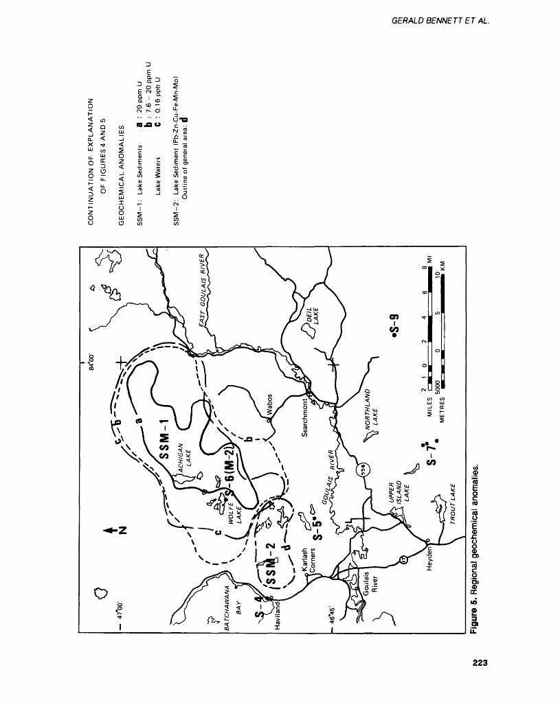
GERALD BENNETT ET AL.
EQ- -i^o?17 sa ' coo w -.CN r-- O
LL J"
2 Z
E O) 0)
o
223

SAUL T STE. MARIE — NORTHEASTERN REGION
Dubreuilville
Wawa Economic Geologist Program
10 5 O ipkitometres
i i * Railway Line
Roadway
City or Town
Figure 6. Wawa Economic Geologist Area.
(25 (7o). The mine is the largest past producer in the Wawa area and between 1938 and 1948 produced 63 328 ounces of gold and 10 598 ounces of silver from 331 842 ions of ore. In the summer of 1983 Cline Development completed a geophysical survey and a major hydraulic and mechanical stripping program. Four areas were stripped and three of these which lie 100 m east of the old workings were in vestigated. The stripped areas ex pose massive and pillowed mafic metavolcanic rocks intruded by quartz-feldspar porphyry dikes which strike 080 to 090^ and dip 72 c to 80C south. Intensive shearing is evident along the contacts of the dikes with the metavolcanic rocks. The mafic metavolcanic rocks and the quartz-feldspar porphyries con tain up to 3^o disseminated pyrite. Grab samples from the metavol canic rocks and porphyries taken by the author assayed 0.01 ounce gold per ton. The fourth area of stripping encompasses an area 200 by 120 m, and contains coarse- grained mafic volcanic rock, felsic volcanic rock, and porphyritic
dikes. A grab sample from a siliceous unit adjacent to an old portal assayed 0.14 ounce gold per ton. Cline Development, in a joint venture with Prophet Resources, carried out a drill program in De cember 1984, to test an induced polarization anomaly.
Desjardins OccurrenceYves Desjardins of Sault Ste. Ma rie and E. Roy of Missanabie hold 8 unpaiemed claims in West Township approximately 21 km southwest of the Renabie Mine. Eight old debris-filled trenches are located on claim SSM 710637. The property is underlain by Early Precambrian mafic massive flows, tuff breccias, felsic crystal tuffs, and porphyritic flows.
The trenches expose a shear zone in metavolcanic rocks attain ing a maximum width of 20 m. The shear zone strikes 110C and dips 82 0 southwest. The predomi nant rock types in the shear zone is a sericite schist containing car bonate and pyrite. Confined to the edges of the shear zone is a chlo
rite schist. Quartz and quartz- feldspar porphyries are present in the trenches but are not well ex posed. Sampling by the authors and others have returned encour aging values. A selected grab sam ple assayed by the Geoscience Lab oratories, Ontario Geological Surj- vey. Toronto, returned a value of 2.40 ounces gold per ton. Other grab samples assayed ranged be tween 0.11 and 0.46 ounce gold per ton. The best results to date are associated with 35 cm wide zones containing stringers of quartz, car bonate, pyrite, and chalcopyrite.
Rowan Lake OccurrenceThe Rowan Lake Occurrence is in Abotossaway Township, 5 km southwest of Goudreau. Bonzano Exploration Limited holds 3 un paiemed claims on the northern side of Rowan Lake. The company completed linecutiing followed by ground magnetometer and electro magnetic surveys in the Summer of 1984.
An old test shaft 2 by 3 by 5 m, and many pits and trenches
224
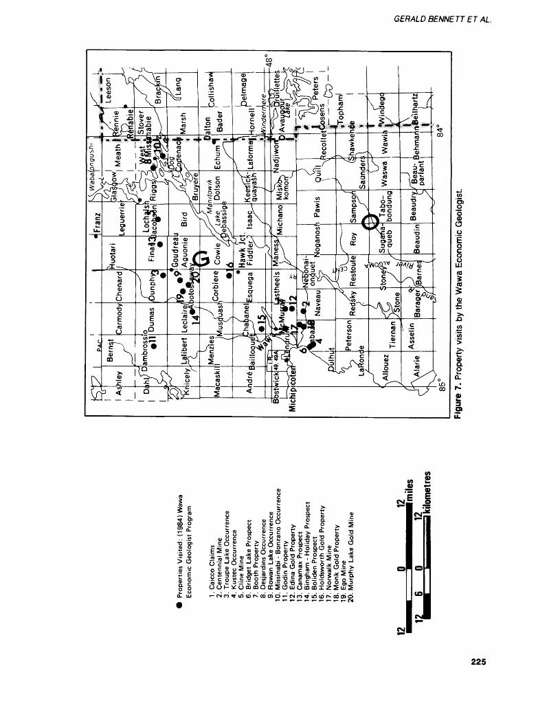
GERALD BENNETT ET AL
00 O2 Q:W)
T3 'g) O) ^
l 8 > oII
O o O) C f) Od)'-' ^.c t o ~"ss io O c ^ OO O i- no woo s Q-
8 ao ol
li:o o
i m ea i z 5
CM
.11E i
CNJ
225
SAUL T STE. MARIE - NORTHEASTERN REGION
were found on the claims. The property is underlain by sheared and massive mafic metavolanic rocks. The rocks are fine to coarse grained and the finer grained rocks contain up to 3^o magnetite and up lo 12*7(1 carbonate. Chlorite schist occurs in the shaft area. Shearing strikes 080C and dips 85 C north. A milky white quartz vein found in the chlorite schist in the shaft area parallels the schistocity, and lacks mineralization. Six channel sam ples, each approximately 0.4 m in length, were taken at the top of the shaft by the author. The highest assay returned 0.01 ounce gold per ton.
Edina Gold ProspectThe Edina Gold Prospect is located 7.5 km southeast of the Town of Wawa in the southeastern corner of McMurray Township. R. Hen derson of Elliot Lake holds 30 un- patented claims east of Leroy Lake which includes the Edina Prospect.
The original work by Edina Gold Syndicate exposed quartz veins in 8 trenches, in the fall of 1936. Edina reported assays from quartz veins between 0.13 and 0.73 ounce gold per ton.
Examination of some of the old trenches reveal thai the "quartz veins" described by Edina are in the author's opinion recrystallized chert, part of an iron formation. Massive pyrrhotite, bornite, and disseminated pyrite were seen in 2 of the trenches. Recent sampling by 2 consulting firms failed to re produce the values obtained by Edina.
Bingham-Holliday ShowingsThe Bingham-Holliday Showings are located in southeastern Lecl aire Township. The original work by B. Holliday done in the early 1930s consists of 5 trenches and 4 pits. The property is made up of 4 patented and 2 unpaiented claims on the northeastern side of Bin gham Lake.
The north showing consists of 4 trenches, 3 partly covered by overburden. Outcrops close to the trenches consist of sheared inter
mediate to felsic metavolcanic rocks. The trench that exposes rock is 23.5 m long with a 6 by 6 m pit at the northern end. At the southern end of the trench a sheared quartz porphyry, with quartz eyes l mm in size is ex posed. Two metres to the north, the quartz eyes are absent and carbon ate occurs as stringers and thin seams parallel to schistocity which strikes 104 C and dips 80C northeast. A sericite schist containing 3^o magnetite occurs at this location in the trench. The pit at the end of the trench contains many frag ments of quartz. The vein was not found in place; however the frag ments consist of massive white quartz containing galena, pyrite, and fluorite. Grab samples of the quartz fragments assayed 0.01 ounce gold per ton and up to 2.19 ounces silver per ton (Geoscience Laboratories, Ontario Geological Survey, Toronto).
The south showing is approxi mately 350 m south of the north showing. This showing is made up of 4 pits and l trench but only 2 of the pits expose bedrock. The lar gest of the pits is 7 by 6 m and exposes a massive white quartz vein striking l 100 and dipping 78 C southwest. Pyrite and galena (6(Vo) occur in the vein and pyrite is also disseminated throughout the host rocks. The host rocks are am phibole schist and feldspar por phyry. Schistosity strikes 120C and dips 82 C west and the schist con tains stringers of carbonate. A sec ond smaller pit lies 36 m southeast of the first pit and exposes a quartz vein. Disseminated pyrite and mi nor galena were observed. Ap proximately 6 m west of this pit there is an outcropping of granite.
Grab samples taken by the au thors from the large pit assayed trace gold and up to 0.59 ounce silver per ton. A selected grab sam ple from the smaller pit assayed 0.03 ounce gold per ton and 5.25 ounces silver per ton. All assays were performed by the Geoscience Laboratories, Ontario Geological Survey, Toronto.
Boliden ProspectThe Boliden Prospect is located in southwestern Chabanel Township, approximately 2.5 km northwest of The Algoma Steel Corporation Limited's MacLeod Mine. M. Clement of Wawa holds the prop erty. Trenching and pitting on the property was done by the Boliden Syndicate in 1936.
A trench located at the north western end of Legarde Lake is 12.9 m long and exposes a sericite schist containing abundant pyrite and carbonate. In the trench there are 6 sulphide rich zones that con tain up to 35^/0 pyrite giving the schist a rusty appearance. The zone strikes 070C and due to the rusty appearance, it can be traced continually on surface for 200 m. The pyrite zones are most likely sulphide facies iron formation. Several siliceous, or cherty hori zons are also present.
A second set of trenches occur 250 m east of the trench described above. Four trenches occur at this location but only 2 expose bed rock. The trenches expose sericite schist and sheared quartz por phyry. Schistocity strikes 066 C and dips 75 C northwest. The trench fur thest to the east contains pyriiic zones similar to the first trench investigated, suggesting thai this may be the same unit. 11 this inter pretation is correct, the sericitic unit would have a present strike length of approximately 400 m.
Samples taken by the authors of the pyriiic zones assayed OJO l ounce gold per ton whereas the cherty horizons assayed 0.02 ounce gold per ton and up to 0.18 ounce silver per ton. A small pit blasted into a carbonate unit out side the schistose zone assayed 0.20 ounce gold per ton and 0.26 ounce silver per ton (Geoscience Laboratories, Ontario Geological Survey, Toronto).
Norwalk MineThe Norwalk Mine is south of Wawa in the corner of Rabazo Canabec Explorations trols the property and and 1980 carried out
located 7 kmnortheastern
Township.Limited con-during 1979an explora-
226
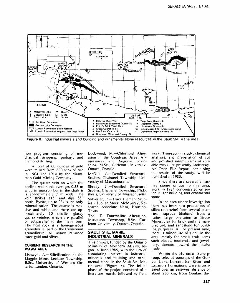
GERALD BENNETT ET AL
Bar River FormationGordon Lake FormationLorrain Formation 'puddingstone'Lorrain Formation 'Algoma Jade Occurrence'
1 Bellevue Quarry Si2 Root River Sandstone Quarry St3 Elliot's Brick Yard Clay4 Green Quartzite St5 Bar River Quarry Si6 Dominion Mines and Quarry Si
LIST OF QUARRYS
7 Trap Rock Quarry St8 Quartzite Quarry St9 Limestone Quarry St
10 Silica Deposit Si (Occurrence only)11 Dominion Trap Company St
Figure 8. Industrial minerals and building and ornamental stone resources in the Sault Ste. Marie area.
lion program consisiing of me chanical stripping, geology, and diamond drilling.
A loial of 60 ounces of gold were milled from 820 ions of ore in 1904 and 1910 by me Manx man Gold Mining Company.
The quartz vein on which the decline was sunk averages 0.33 m wide in outcrop but in the shaft it is approximately 2 m wide. The vein strikes 115 0 and dips 88 0 north. Pyrite, up to 2^o is the only- mineralization. The quartz is mas sive and white and there are ap proximately 10 smaller glassy- quartz veinlets which are parallel or subparallel to the main vein. The host rock is a homogeneous granodiorite, part of the Centennial granodiorite. All assays returned trace gold and silver.
CURRENT RESEARCH IN THE WAWA AREALisowyk, A.—Silicification at the Magpie Mine, Leclaire Township, B.Sc., University of Western On tario, London, Ontario.
Lockwood. M.—Chloritoid Alter ation in the Goudreau Area, Ab otossaway and Augonie Town ships, M.Se., Carleton University, Ottawa, Ontario.McGill, G.—Detailed Structural Studies, Chabanel Township, Uni versity of Massachusetts.Shrady, C.—Detailed Structural Studies, Chabanel Township, Ph.D. thesis, University of Massachusetts.Sylvester, P.—Trace Element Stud ies - Jubilee Stock McMurray, Re search Associate Nasa, Houston, Texas.Toal, T.—Tourmaline Alteration, Musquash Township, B.Sc., Car leton University, Ottawa, Ontario.
SAULT STE. MARIE INDUSTRIAL MINERALSThis project, funded by the Ontario Ministry of Northern Affairs, be gan in June 1985, with the aim of stimulating interest in industrial minerals and building and orna mental stone in the Sault Ste. Ma rie area (Figure 8). The initial phase of the project consisted of a literature search, followed by field
work. Thin-section study, chemical analyses, and preparation of cut and polished sample slabs of suit able rocks are presently underway. An Open File Report, containing the results of the study, will be published in 1985.
Since there are several attrac tive stones unique to this area, work in 1984 concentrated on po tential for building and ornamental stone.
In the area under investigation there has been past production of silica (quartzite) from several quar ries, traprock (diabase) from a rather large operation at Bruce Mines, clay for brick and tile man ufacture, and sandstone for build ing purposes. At the present time, there is minor use of stone in the area, mostly for small craft items such clocks, bookends, and jewel lery, directed toward the tourist trade.
Within the Huronian Superg roup, selected outcrops of the Gor don Lake, Lorrain, Bar River, and Espanola Formations were investi gated over an east-west distance of about 236 km, from Goulais Bay
227
SAUL T STE. MARIE — NORTHEASTERN REGION
lo Elliot Lake. The area has been mapped geologically by provincial and federal geological surveys.
The Gordon Lake Formation is a highly siliceous, chert-like silt stone having a variety of colours and sedimentary structures. Much of the formation is a drab grey- green sequence of alternating beds of chert and siltstone, both of which weather to a creamy white to tan colour; however near McCarroll Lake and Flack Lake colourful sections occur, ranging from maroon, purple, red, peach, olive-green, and brown. Samples showing rip-up clasts of chert and slump structures have an attractive appearance in polished slabs. Beds range in thickness from l to 18 cm. Although the Gordon Lake Formation is highly fractured at the surface, there is evidence that fracturing may diminish at depth, as examination of drill core has shown little jointing or fractures.
The Lorrain Formation is comprised of 6 members as mapped by Frarey (1977). The white quartzite member contains several emerald green sections known locally as "Algoma Jade". The green colour is due to the presence of a chromium-bearing mica. In sufficient quantities the stone might be a source of terrazzo chips or an an attractive ornamen tal sione since ii takes a fine polish. The only previously documented deposit is located in Kehoe Township; 3 additional oc currences were examined during this years field work.
The jasper conglomerate mem ber of the Lorrain Formation is known locally as "puddingstone". Pebbles of quartz and jasper are supported by a matrix of medium- to fine-grained white to grey quartz grains. Pebble sizes vary from a few millimetres to 8 cm. White, red, black, peach, and brown pebbles give the rock a striking appearance and it takes a high glossy polish. The "puddingstone" occurs in beds and lenses with thicknesses ranging from a few centimetres up to 3 m. The "puddingstone" of the Dunn's Valley area generally has a higher content of jasper pebbles than that
of the Flack Lake area. This mem ber has potential as an ornamental stone.
The purple siltstone member of the Lorrain Formation polishes well and is very attractive. This unit is best observed in the Des- barats area, however it's full sub surface extent is not fully defined. The colour is due to a hematitic matrix and varies from purple to maroon. The upper member of the Lorrain is an orthoquartzite (white quartzite member) which has given very promising silica values and might be a future source of silica.
The Bar River Formation is a unit of orthoquartzite which occurs around McCarroll Lake and the Flack Lake area. Near Flack Lake the Bar River Formation contains a friable zone with a variable thickness of 0.5 to 2 m. The length of the zone is approximately 28 m. This material is easily broken apart with the hands and has given preliminary assays well within in dustry standards as a potential sili ca deposit.
The Bruce Limesione Member of the Espanola Formation consists of thin alternating beds of siliceous grey limesione and argillite. The beds are commonly contorted, giv ing the stone an attractive appear ance. Bed thicknesses vary from a few millimetres in the limestone- argillite sequence to 2.5 m in the massive limestone sequence. Pyrite is present in small quantities. The rock is highly fractured where ob served but could be a source of terrazzo chips and ornamental stone. With proper lapping tech nique the stone could take a fine polish.
A number of past producing quarries were examined. These lo cations are shown on Figure 8. At the present time no quarries are being operated on a full time basis in the Sault Ste. Marie Mining Di vision.
ONTARIO GEOLOGICAL SURVEY ACTIVITIES______E. Grunsky continued a 1:50 000 scale synoptic study of the Batchewana metavolcanic-meiased- imentary belt and surrounding
granitic terrain during 1984. Most of the field work was carried out in the eastern part of the belt and over the surrounding felsic plutons and gneiss domains.
R. Sage continued the Ontario Geological Survey program to pro vide up-to-date geological maps of the Michipicoten metavolcanic- metsedimentary belt at a scale of 1:15 840.
G. Siragusa completed map ping of the White Lake area north east of Hemlo. Preliminary maps will be published at a scale of 1:15 840.
D.G.F. Long continued a study to evaluate sedimentological con trols on paleoplacer gold deposits in the Huronain Supergroup. Sam pling and field observations were carried out between Elliot Lake and Sault Ste. Marie.
T. Muir continued a detailed stratigraphic study of the Hemlo area.
J.A.C. Fortescue carried out research studies on regional lake water and sediment geochemistry in the Montreal River area north of Sauli Ste. Marie. Field trials were made to evaluate the poten tial of remote sensing of some components of lake water geo chemistry with emphasis on the acid rain problem.
R.S. Geddes completed sur ficial mapping of the White Lake and Cedar Lake 1:50 000 topo graphic sheets in rhe Hemlo area.
A summary of the results of these and other field projects of the Ontario Geological Survey are published in the Summary of Field Work 1984, by the Ontario Geo logical Survey (Miscellaneous Pa per 119).
PUBLICATIONS AND THESIS ADDED TO THE SAULT STE. MARIE RESIDENT GEOLOGIST LIBRARY. 1984-—————^—Kimberley, M.M., Grandstaff, D.E.,and Tanaka, R.T.1984: Topographic Control on
Precambrian Weathering in the Elliot Lake Uranium Dis trict, Canada; Journal of the
228
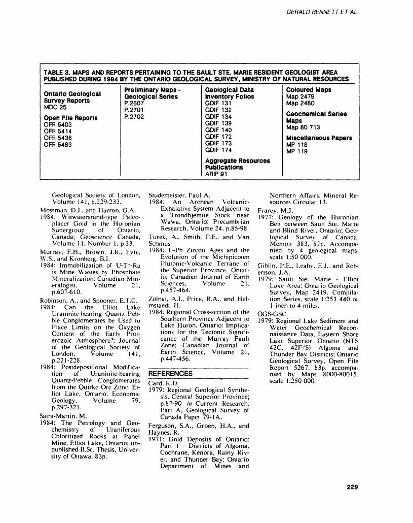
GERALD BENNETT ET AL.
TABLE 3. MAPS AND REPORTS PERTAINING TO THE SAULT STE. MARIE RESIDENT GEOLOGIST AREA PUBLISHED DURING 1984 BY THE ONTARIO GEOLOGICAL SURVEY, MINISTRY OF NATURAL RESOURCES
Ontario Geological Survey ReportsMDC25
Open File ReportsOFR 5403 OFR 5414OFR 5436OFR 5483
Preliminary Maps - Geological SeriesP.2607P.2701 P.2702
Geological Data Inventory FoliosGDIF 131GDIF 132 GDIF 134 GDIF 139 GDIF 140GDIF 172GDIF 173GDIF 174
Aggregate ResourcesPublicationsARIP91
Coloured MapsMap 2479 Map 2480
Geochemical Series MapsMap 80 71 3
Miscellaneous PapersMP 118MP 119
Geological Society of London, Volume 141, p.229-233.
Mossman, D.J., and Harron, G.A.1984: Witwaiersrand-type Paleo-
placer Gold in the Huronian Supergroup. of Ontario, Canada; Geoscience Canada, Volume 11, Number l, p.33.
Murray, F.H., Brown, J.R., Fyfe,W.S., and Kronberg, B.I.1984: Immobilization of U-Th-Ra
is Mine Wastes by Phosphate Mineralization; Canadian Min eralogist, Volume 21, p.607-610.
Robinson, A., and Spooner, E.T.C.1984: Can The Elliot Lake
Uraniniie-bearing Quartz Peb ble Conglomerates be Used to Place Limits on the Oxygen Content of the Early Prot erozoic Atmosphere?; Journal of the Geological Society of London, Volume 141, p.221-228.
1984: Postdeposiiional Modifica tion of Uraninite-bearing Quartz-Pebble Conglomerates from the Quirke Ore Zone, El liot Lake, Ontario; Economic Geology, Volume 79, p.297-321.
Saint-Martin, M.1984: The Petrology and Geo
chemistry of Uraniferous Chloritized Rocks at Panel Mine, Elliot Lake, Ontario; un published B.Sc. Thesis, Univer sity of Ottawa, 83p.
Studemeister, Paul A.1984: An Archean Volcanic-
Exhalative System Adjacent to a Trondhjemite Stock near Wawa, Ontario; Precambrian Research, Volume 24, p.85-98.
Turek, A., Smith, P .E., and VanSchmus.1984: U-Pb Zircon Ages and the
Evolution of the Michipicoten Plutonic-Volcanic Terrane of the Superior Province, Ontar io; Canadian Journal of Earth Sciences, Volume 21, p.457-464.
Zolnai, A.I., Price, R.A., and Hel mstaedt, H.1984: Regional Cross-section of the
Southern Province Adjacent to Lake Huron, Ontario: Implica tions for the Tectonic Signifi cance of the Murray Fault Zone; Canadian Journal of Earth Science, Volume 21, p.447-456.
REFERENCESCard, K.D.1979: Regional Geological Synthe
sis, Central Superior Province; p.87-90 in Current Research, Part A, Geological Survey of Canada Paper 79-1 A.
Ferguson, S.A., Groen, H.A., andHaynes, R.1971: Gold Deposits of Ontario:
Part l - Districts of Algoma, Cochrane, Kenora, Rainy Riv er, and Thunder Bay; Ontario Department of Mines and
Northern Affairs, Mineral Re sources Circular 13.
Frarey, M.J.1977: Geology of the Huronian
Belt between Sault Ste. Marie and Blind River, Ontario; Geo logical Survey of Canada, Memoir 383, 87p. Accompa nied by 4 geological maps, scale 1:50000.
Giblin. P.E., Leahy. E.J., and Rob ertson, J.A.1979: Sault Ste. Marie - Elliot
Lake Area; Ontario Geological Survey, Map 2419. Compila tion Series, scale 1:253 440 or l inch to 4 miles.
OGS-GSC1979: Regional Lake Sedimeni and
Water Geochemical Recon naissance Data, Eastern Shore Lake Superior, Ontario (NTS 42C, 42F/S) Algoma and Thunder Bay Districts; Ontario Geological Survey, Open File Report 5267, 83p. accompa nied by Maps 8000-80015, scale 1:250000.
229
INTRODUCTIONDuring 1984 the Sudbury Resident Geologist Office was staffed by R. Adlington, Resource Geologist; P.E. Giblin, Regional Mineral Resources/Lands and Waters Co ordinator; C.C. Marriott, Resource Geologist: J.M. Martins, Acting Resident Geologist; and Y.M. Paquette, Secretary.
Exploration continued to be di rected primarily towards gold de posits, with a level of activity simi lar to thai of 1983.
Mining activity was, as usual, dominated by the nickel - copper - precious metals operations of Inco Limited and Falconbridge Limited centred on the Sudbury Structure. In addition W: estfield Minerals Limited started production from their Scadding Gold Mine proper ty, the first gold producer in the Sudbury area since 1941. Man itoulin Dolomite Limited continued production of dolomite for aggre gate from a quarry on Manitoulin Island. The Badgeley Island silica operation of Indusmin Limited was also active during the year.
RESIDENT GEOLOGIST'S ACTIVITIESR. Adlington continued compila tion of the Geological Data Inven tory Folio Series which summa rizes known assessment and explo ration data on a township basis. A total of 53 folios have been pro duced to date of which 51 have been published. Three people em ployed under a joint Federal- Provincial W'orks Program during the year assisted in the production of l folio. Additional duties in volved the indexing and filing of a quantity of mine plans recently ac quired by this office.
J.M. Martins completed map ping Snider Township at a scale of 1:15 840. In addition, a section of the Murray granite-norite contact in McKim Township was mapped at a scale of 1:250. The Sudbury Section of the Sudbury-Elliot Lake Guide Book was written for the 1984 The Geological Association of Canada-Mineralogical Associ-
Sudbury Resident Geologist Area, Northeastern RegionJ.M. Martins
Acting Resident Geologist. Ontario Ministry of Natural Resources. Sudbury
aiion of Canada (GAC-MAC) Joint Annual Meeting and field trips.
The staff were also involved in numerous mine and exploration project visits, and examinations of mineral occurrences. As part of their normal duties the staff re sponded to many requests for in formation from industry, govern ment agencies, and the public. A total of 290 people from Canadian and American Universities, gov ernment agencies, and the mineral industry were given lectures and taken on geological tours of the Sudbury area.
MINING ACTIVITYNickel, copper, and precious met als were produced from 16 mines operated by Inco Limited and Fal conbridge Limited within the Sud bury area. Westfield Minerals Limited began producing gold from its Scadding Township prop erty in mid-1984. Other commodit ies from the Sudbury area included silica, dolomite, decorative stone, sand, and gravel.
NICKEL-COPPER-PRECIOUS METALSDuring 1984 Falconbridge Limited produced ore from the East, Fal conbridge, Fraser, Lockerby, North, and Strathcona Mines. Ore from North Mine and some from Fraser Mine is hoisted Through the Fecunis Lake shaft. Major rock bursts in June left areas of Falcon bridge Mine unsafe and the com pany decided to terminate oper ations at this mine. Ore from East Mine will continue to be trammed to No. 5 shaft for hoisting. The Falconbridge Complex accounted for lO^o of the company's produc tion, and the shortfall created by the closure will be picked up by reopening Onaping Mine, on stan dby since 1982. Onaping Mine has reserves of 15 million tons (The Northern Miner, August 2. 1984) in 2 orebodies. It is expected that l of the ore zones, the Craig, will become a separate mine by the late 1980s. Operations at Strathcona,
Fraser, and Lockerby Mines will also be expanded to maintain pro duction levels.
A subsidiary of Falconbridge Limited has set up a partnership which will secure raw materials for processing either at the Sud bury smelter, or at Falconbridge's refinery in Norway. Falconbridge Trading Associates will deal ini tially in scrap and residue contain ing nickel, copper, precious metals, cobalt, tungsten, and molybdenum.
During the year Falconbridge Limited closed its metallurgical laboratories in Richmond Hill, and relocated them in Sudbury and at the Lakefield Research Division in Southern Ontario. The Sudbury op erations will carry on metallurgi cal research programs. In spite of continued depression in the nickel market, cutbacks and streamlining have resulted in a return to profit ability for Falconbridge Limited.
Inco Limited produced ore from Copper Cliff South, Copper Cliff North, Creighton, F rood, Gar son, Levack, Little Stobie, McCreedy West, and Stobie Mines. In addition, minor production from Clarabelle open pit continued as part of a research program on min ing methods. Inco Limited is also mining part of the Fecunis Lake orebody. The ore is hoisted to the surface through the Levack shaft.
Rock bursting, which occurred shortly after the Falconbridge Mine tremors, caused damage in the No. 5 shaft area of Creighton Mine. Mining operations, suspend ed during a 4-week shutdown, were not affected.
Inco Limited returned an op erating profit for the second and third quarters of 1984. Improve ments in productivity and increas ing use of the vertical retreat min ing method has reduced overall costs, although metal markets re main listless.
GOLDIn mid-1984 Westfield Minerals Limited started producing from its small open-pit gold mine in Scad ding Township. The on-site 200
230
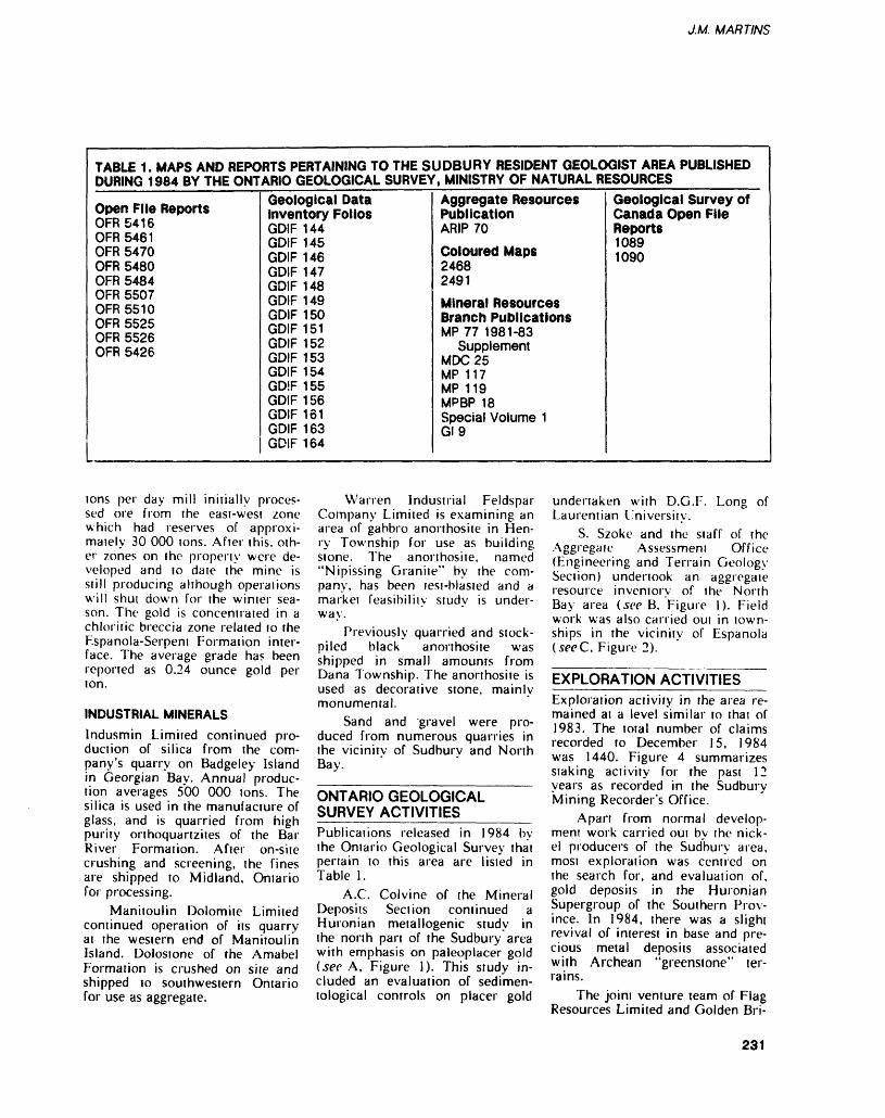
J.M. MARTINS
TABLE 1. MAPS AND REPORTS PERTAINING TO THE SUDBURY RESIDENT GEOLOGIST AREA PUBLISHED DURING 1984 BY THE ONTARIO GEOLOGICAL SURVEY, MINISTRY OF NATURAL RESOURCES
Open File ReportsOFR5416OFR 5461OFR 5470OFR 5480OFR 5484OFR 5507 OFR 5510 OFR 5525 OFR 5526 OFR 5426
Geological Data Inventory FoliosGDIF 144GDIF 145GDIF 146GDIF 147GDIF 148GDIF 149 GDIF 150 GDIF 151 GDIF 152 GDIF 153GDIF 154GDIF 155GDIF 156GDIF 161GDIF 163GDIF 164
Aggregate Resources PublicationARIP 70
Coloured Maps24682491
Mineral Resources Branch PublicationsMP 77 1981-83
Supplement MDC25MP 117MP 119MPBP 18Special Volume 1GI9
Geological Survey of Canada Open FileReports10891090
tons per day mill initially proces sed ore from the east-west zone which had reserves of approxi mately 30 000 tons. After this, oth er zones on the property were de veloped and to date the mine is still producing although operations will shut down for the winter sea son. The gold is concentrated in a chloritic breccia zone related to the Espanola-Serpent Formation inter face. The average grade has been reported as 0.24 ounce gold per ton.
INDUSTRIAL MINERALSIndusmin Limited continued pro duction of silica from the com pany's quarry on Badgeley Island in Georgian Bay. Annual produc tion averages 500 000 tons. The silica is used in the manufacture of glass, and is quarried from high purity orthoquartzites of the Bar River Formation. After on-site crushing and screening, the fines are shipped to Midland, Ontario for processing.
Manitoulin Dolomite Limited continued operation of its quarry at the western end of Manitoulin Island. Dolostone of the Amabel Formation is crushed on site and shipped to southwestern Ontario for use as aggregate.
Warren Industrial Feldspar Company Limited is examining an area of gabbro anorthosite in Hen ry Township for use as building stone. The anorthosite, named "Nipissing Granite" by the com pany, has been test-blasted and a market feasibility study is under way.
Previously quarried and stock piled black anorthosite was shipped in small amounts from Dana Township. The anorthosite is used as decorative stone, mainly monumental.
Sand and gravel were pro duced from numerous quarries in the vicinity of Sudbury and North Bay.
ONTARIO GEOLOGICAL SURVEY ACTIVITIES^——-Publications released in 1984 by the Ontario Geological Survey that pertain to this area are listed in Table 1.
A.C. Colvine of the Mineral Deposits Section continued a Huronian metallogenic study in the north part of the Sudbury area with emphasis on paleoplacer gold (see A, Figure 1). This study in cluded an evaluation of sedimen- tological controls on placer gold
undertaken with D.G.I-. Long of Laurentian University.
S. Szoke and the staff of the Aggregate Assessment Office (Engineering and Terrain Geology Section) undertook an aggregate resource inventory of the North Bay area (see B, Figure 1). Field work was also carried out in town ships in the vicinity of Espanola (seeC, Figure 2).
EXPLORATION ACTIVITIESExploration activity in the area re mained at a level similar to thai of 1983. The total number of claims recorded to December 15, 1984 was 1440. Figure 4 summarizes staking activity for the past 12 years as recorded in the Sudbury Mining Recorder's Office.
Apart from normal develop ment work carried out by the nick el producers of the Sudbury area, most exploration was centred on the search for, and evaluation of, gold deposits in the Huronian Supergroup of the Southern Prov ince. In 1984, there was a slight revival of interest in base and pre cious metal deposits associated with Archean "greenstone" ter rains.
The joint venture team of Flag Resources Limited and Golden Bri-
231
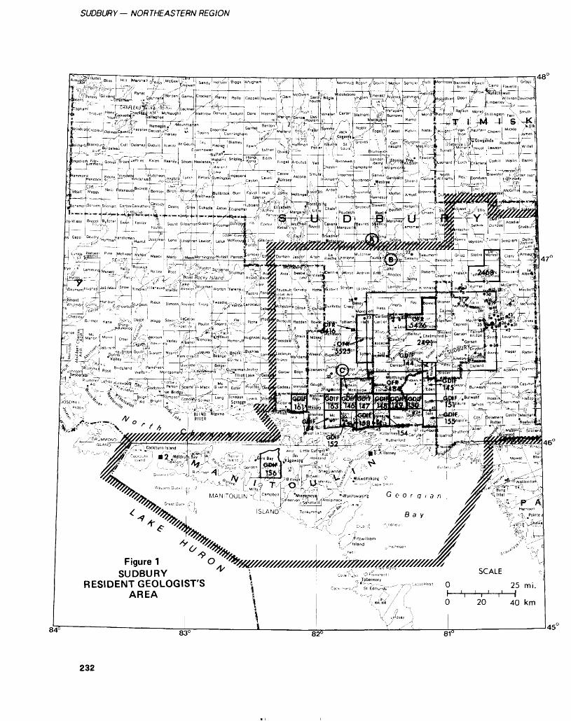
SUDBURY- NORTHEASTERN REGION
! iH i ,v 1 --^ r L rf o , fV ,---C^iUrs 'GllhiJ W)''! C^hrarf^M3ns , , ^StrStMtam i.R. (Tch '5 rt 1 ,'1- Oo- - __ i nfl-J ~'' ;-#P i
, './\A.,^,-;'-..^ o r L-.4t*' \ '--, xi\
riiim* ,./ ..^ .^^AV.y /\™.^ib ^^5*7 *-^ ..j ^ y l ;r- c—^ t ^ \^ L^
:ai,Dbeil 7 ,'' *Mint?epoyaj,J ,. ./^ ^JV!ani(owanjnfe G e O f Q l 3
81 C
232
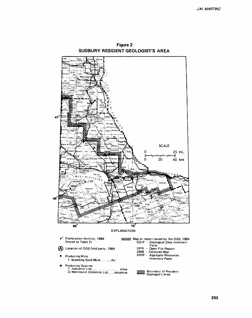
J.M. MARTINS
Figure 2 SUDBURY RESIDENT GEOLOGIST'S AREA
80" 79"
EXPLANATION
•7 Exploration Activity, 1984 (keyed to Table 2)
^) Location of OGS field party, 1984
* Producing Mine1. Scadding Gold Mine . . c . Au
Producing Quarries1. Indusmjn Ltd.. . . . . . . . . . . silica2. Manitoulin Dolomite Ltd. . . dolomite
Map or report issued by the OGS, 1984 GDI F - Geological Data Inventory
FolioOFR - Open File Report 2468 - Coloured Map ARIP - Aggregate Resources
Inventory Paper
Boundary of Resident Geologist's Area
233
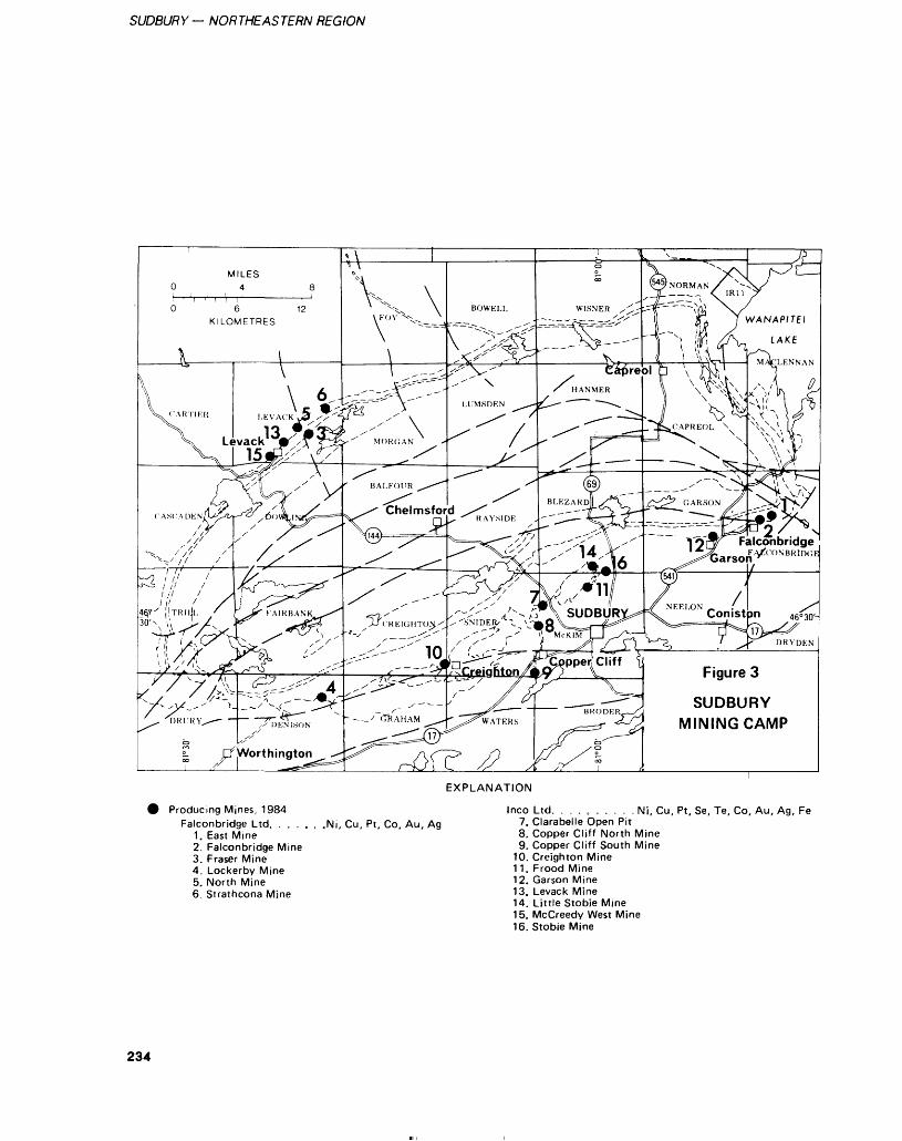
SUDBURY— NORTHEASTERN REGION
SUDBURY MINING CAMP
EXPLANATION
Producing Mines, 1984Falconbridge Ltd, . . . . , .Ni, Cu, Pt, Co, Au, Ag
1. East Mine2. Falconbridge Mine3. Fraser Mine4. Lockerby Mine5. North Mine6. Strathcona Mine
Inco Ltd. . . . c . . . . . Ni, Cu, Pt, Se, Te, Co, Au, Ag, Fe7. Clarabelle Open Pit8. Copper Cliff North Mine9. Copper Cliff South Mine
10. Creighton Mine11. F rood Mine12. Garson Mine13. Levack Mine14. Little Stobie Mine15. McCreedy West Mine16. Stobie Mine
234
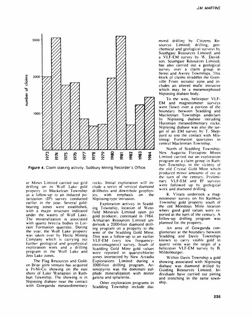
J.M. MARTINS
3000-
lo
2000-
1000-
Figure 4. Claim staking activity. Sudbury Mining Recorder's Office.
ar Mines Limited carried out grid drilling on its Wolf Lake gold propem in Mackelcan Township as a follow-up lo an induced po larization (IP) survey conducted earlier in the year. Several gold- bearing zones were established, with a major structure indicated under the waters of Wolf Lake. The mineralization is associated with quartz breccia bodies in Lor rain Formation quartzite. During the year, the W; olf Lake property was taken over by Hecla Mining Company which is carrying GUI further geological and geophysical exploration work and a drilling program in the Wolf Lake and Jess Lake zones.
The Flag Resources and Gold en Briar joini venture has acquired a Pi-Ni-Cu showing on the east shore of Lake Wanapitei in Rath bun Township. The showing is in Nipissing diabase near the contact with Gowganda metasedimentary
rocks. Initial exploration will in clude a series of vertical diamond drillholes and down-hole geophys ics, with emphasis on the Nipissing-iype intrusion.
Exploration activity in Scadd ing Township, location of West- field Minerals Limited open pit gold producer, continued in 1984. Arthurian Resources Limited un dertook a 2000-foot diamond drill ing program on a property to the west of the Scadding Gold Mine. This was a follow-up to an earlier VLF-EM (very low frequency- electromagnetic) survey. South of Scadding Gold Mine gold values were reported in quanz-chlorite zones intersected by New Arcadia Explorations Limited during a 3000-foot drilling program. Ar senopyrite was the dominant sul phide mineralization with minor galena and sphalerite.
Other exploration programs in Scadding Township include dia
mond drilling by Citizens Re sources Limited; drilling, geo chemical and geological surveys by Southgate Resources Limited; and a VLF-EM survey by W. David son. Southgate Resources Limited, has also carried out a geological survey over a claim group in Street and Awrey Townships. This block of claims straddles the Gren ville Front tectonic zone and in cludes an altered mafic intrusive which may be a metamorphosed Nipissing diabase body.
To the west, helicopter VLF- EM and magnetometer surveys were flown over a portion of the boundary between Scadding and Maclennan Townships underlain by Nipissing diabase intruding Huronian metasedimentary rocks. Nipissing diabase was also the tar get of an EM survey by T. Shep pard to test the contact with Mis- sissagi Formation quanzites in central Maclennan Township.
North of Scadding Township, New Augarita Porcupine Mines Limited carried out an exploration program on a claim group in Rath bun Township, in the vicinity of the old Crystal Gold Mine which produced minor amounts of ore at the turn of the century. Prelimi nary VLF-EM and IP surveys were followed up by geological work and diamond drilling.
R. Viitala undertook a mag netometer survey on his Rathbun Township gold property south of the old Mondoux Mine location where good gold values were re ported at the turn of the century. A follow-up drilling program was planned for the property.
An area of Gowganda con glomerate at the boundary between Scadding and Davis Townships known to carry visible gold in quartz veins was the target of a helicopter VLF-EM survey by B. Mildenburger.
Within Davis Township a gold showing associated with Nipissing diabase was diamond drilled by Guiding Resources Limited. In dividuals have carried out pitting and trenching in the same town ship.
235
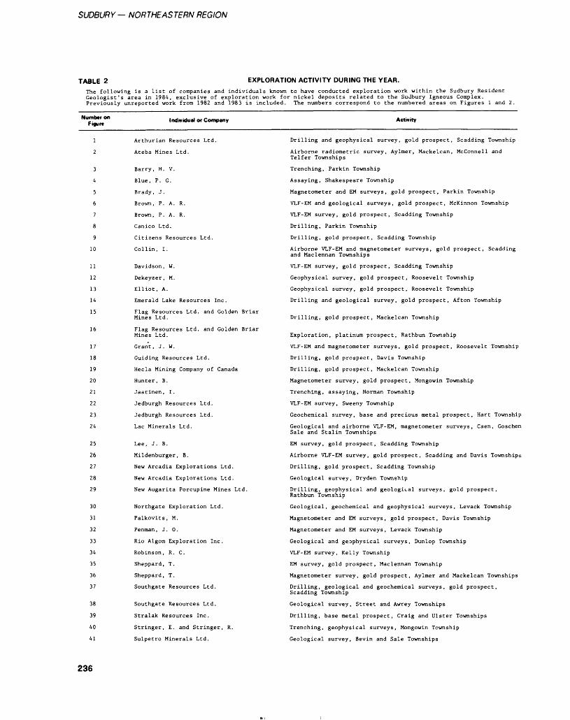
SUDBURY— NORTHEASTERN REGION
TABLE 2 EXPLORATION ACTIVITY DURING THE YEAR.The following is a lisc of companies and individuals known to have conducted exploration work within the Sudbury Resident Geologist's area in 1984, exclusive of exploration work for nickel deposits related to the Sudbury Igneous Complex. Previously unreported work from 1982 and 1983 is included. The numbers correspond to the numbered areas on Figures l and 2.
Number on Figure
Individual or Company Activity
3
4
5
6
7
8
9
10
11
12
13
14
15
16
17
18
19
20
21
22
23
24
25
26
27
28
29
30
31
32
33
34
35
36
37
38
39
40
41
Arthurian Resources Ltd.
Ateba Mines Ltd.
Barry, H. V.
Blue, P. G.
Brady, J.
Brown, P. A. R.
Brown, P. A. R.
Canico Ltd.
Citizens Resources Ltd.
Collin, I.
Davidson, W.
Dekeyzer, M.
Elliot, A.
Emerald Lake Resources Inc.
Flag Resources Ltd. and Golden Briar Mines Ltd.
Flag Resources Ltd. and Golden Briar Mines Ltd.
Grant, J. W.
Guiding Resources Ltd.
Hecla Mining Company of Canada
Hunter, B.
Jaatinen, I.
Jedburgh Resources Ltd.
Jedburgh Resources Ltd.
Lac Minerals Ltd.
Lee, J. B.
Mildenburger, B.
New Arcadia Explorations Ltd.
New Arcadia Explorations Ltd.
New Augarita Porcupine Mines Ltd.
Northgate Exploration Ltd.
Palkovits, M.
Penman, J. O.
Rio Algom Exploration Inc.
Robinson, R. C.
Sheppard, T.
Sheppard, T.
Southgate Resources Ltd.
Southgate Resources Ltd.
Stralak Resources Inc.
Stringer, E. and Stringer, R.
Sulpetro Minerals Ltd.
Drilling and geophysical survey, gold prospect. Scadding Township
Airborne radiometric survey, Aylmer, Mackelcan, Mcconnell and Telfer Townships
Trenching, Parkin Township
Assaying, Shakespeare Township
Magnetometer and EM surveys, gold prospect, Parkin Township
VLF-EM and geological surveys, gold prospect, McKinnon Township
VLF-EM survey, gold prospect, Scadding Township
Drilling, Parkin Township
Drilling, gold prospect, Scadding Township
Airborne VLF-EM and magnetometer surveys, gold prospect, Scadding and Maclennan Townships
VLF-EM survey, gold prospect, Scadding Township
Geophysical survey, gold prospect, Roosevelt Township
Geophysical survey, gold prospect. Roosevelt Township
Drilling and geological survey, gold prospect, Afton Township
Drilling, gold prospect, Mackelcan Township
Exploration, platinum prospect. Rathbun Township
VLF-EM and magnetometer surveys, gold prospect. Roosevelt Township
Drilling, gold prospect, Davis Township
Drilling, gold prospect, Mackelcan Township
Magnetometer survey, gold prospect, Mongowin Township
Trenching, assaying, Norman Township
VLF-EM survey, Sweeny Township
Geochemical survey, base and precious metal prospect, Hart Township
Geological and airborne VLF-EM, magnetometer surveys, Caen, Goschen Sale and Stalin Townships
EM survey, gold prospect, Scadding Township
Airborne VLF-EM survey, gold prospect. Scadding and Davis Townships
Drilling, gold prospect, Scadding Township
Geological survey, Dryden Township
Drilling, geophysical and geological surveys, gold prospect, Rathbun Township
Geological, geochemical and geophysical surveys, Levack Township
Magnetometer and EM surveys, gold prospect, Davis Township
Magnetometer and EM surveys, Levack Township
Geological and geophysical surveys, Dunlop Township
VLF-EM survey, Kelly Township
EM survey, gold prospect, Maclennan Township
Magnetometer survey, gold prospect, Aylmer and Mackelcan Townships
Drilling, geological and geochemical surveys, gold prospect, Scadding Township
Geological survey, Street and Awrey Townships
Drilling, base metal prospect, Craig and Ulster Townships
Trenching, geophysical surveys. Mongowin Township
Geological survey, Bevin and Sale Townships
236
J.M. MARTINS
TABLE 2 Continued
Number on Figure Individual or Company Activity
42
43
44
45
Tomasini, M. A.
Vanlith, G.
Viitala, R.
White, J.
Geophysical and geochemical surveys, gold prospect, Davis Township
Trenching, gold prospect, Davis Township
Magnetometer survey, gold prospect, Rathbun Township
Trenching, gold prospect, Roosevelt Township
Emerald Lake Resources In corporated acquired a lOO^o work ing interest during the year in the Golden Rose Mine, Afton Town ship. Gold was produced between 1937 and 1941 from quartz- carbonate veins in iron formation. Assay results from a 7000-foot drilling program have been encour aging. Hole GR-24, drilled several hundred feet from previous inter sections, returned 89 feet averag ing 0.237 ounce gold per ton (uncut), including a 1.5-foot length assaying 10.03 ounces gold per ton. A feasibility study is under way toward the start of production at 200 to 400 tons per day by mid-1985. Initial open pil oper ations could lead to underground development.
The Howrey Creek gold zone south of Espanola continues to at tract attention. Stringer Explora tions Limited, holder of the McMil- lan Gold Mine in Mongowin Township, carried out geophysical surveys and trenching during 1984. The mine produced over 10 000 ounces of gold in the 1930s from quartz veins in Gowganda Formation. Limited testing in the area leaves room for a consider able exploration program, it is es timated thai there could be a po tential 500 000 tons grading 0.20 ounce gold per ton or better on the existing undeveloped portion of the strike length. Other showings on strike with the McMillan property also being tested are the Jo-Ami occurrence to the east and the Evangeline Lake showing to the west. New Amsterdam Incorporat ed recently acquired the Majestic Mine in the same area. Here, a shaft was sunk in the 1920s on a quartz vein mineralized with chal copyrite, pyrite, and arsenopyrite.
The east end of the Howrey Creek gold belt, truncated by the expanded boundary of Killarney
Provincial Park, was explored by magnetometer and self potential surveys during 1984. Art Elliot Explorations carried GUI the sur veys in Roosevelt Township over Gowganda Formation intruded by Nipissing diabase—the typical site for gold mineralization in this area.
Several townships around the southeast end of Lake Penage were actively staked, mostly by Lac Minerals Limited. Initial geological and geophysical surveys were un dertaken in Caen, Stalin, Sale, and Goschen Townships. Sulpetro Min erals Limited carried out a geologi cal survey on its claim group in Sale and Bevin Townships.
During 1984 there was a re newal of interest in the Benny "greenstone" belt 56 km northwest of Sudbury. Stralak Resources In corporated diamond drilled its property which straddles the boundary between Craig and Ul ster Township. The "Stralak depos its" are stratabound volcanogenic sulphides comprising disseminated pyrite, pyrrhotite, sphalerite, chal copyrite, and galena which occur in 2 zones of relatively high grade mineralization. The host rock is comprised of tuffs, metasedimen- tary rocks and mafic metavolcanic rocks. Noranda Incorporated has recently acquired a large number of claims in Moncrieff, Hess, Craig, Ulster, and Munster Town ships.
South of the Benny belt Jed- burgh Resources Limited carried out a geochemical survey on a claim group in Hart Township. The property is located on a Huronian outlier intruded by Nip issing diabase. Co-Pb-Zn-Ni (Au-Ag-Bi-Cu) mineralization oc curs associated with a magnetite zone in limestone. Development work was carried out on this prop erty in the early part of the cen
tury by The Iron Mask Cobalt Sil ver Mines Company Limited.
RECENT PUBLICATIONS ANDTHESES—————-^^^—Debicki, R.1983: Limnogeochemistry of Lake
Memesagamesing, Parry Sound District, Ontario, Canada; Unpublished M.Se. Thesis, Laurentian University. 137p.
Ding, T.P., and Schwartz, H.P.1984: Oxygen Isotopic and Chemi
cal Compositions of Rocks of the Sudbury Basin, Ontario; Canadian Journal of Earth Sci ences, Volume 21, p.305-318.
Ermanovics, I., Gibb, R.A., Soonawala, N.M., and Pearson, R. 1982: Preliminary Results of Geo
science Surveys at the East Bull Lake Research Area (RA7) Near Massey, Ontario; Atomic Energy of Canada Limited, TR-207.
Kehinde-Phillips, O.O., Rousell,D.H., Djamgouz, O.T., andNikolic, S.1984: Experimental Investigation
of the Oxidation and Consoli dation of Sulphide Aggregates and the Application to Under ground Muck-piles, Lockerby Mine, Sudbury, Ontario; The Canadian Institute of Mining and Metallurgy (CIM), Bulle tin, Volume 77', p.52-59.
Kurtz, R.D., and Niblett, E.R. 1984: A Magnetotelluric Survey
Over the East Bull LakeGabbro-Anorthosite Complex;Atomic Energy of CanadaLimited, TR-236.
Leech, R.E.J., and Cooper, A.J.1982: Preliminary Terrain Assess
ment of Three Potential Re search Areas in Northern On tario; Atomic Energy of Canada Limited, TR-196.
237
SUDBURY — NORTHEASTERN REGION
TABLE 3 ASSESSMENT WORK AND OTHER INFORMATION RECEIVED.
SUDBURY REGION
AEM - Airborne Electromagnetic SurveyA Mag - Airborne Magnetometer SurveyDDK - Diamond - DrillEM - Electromagnetic SurveyGeochem - Geochemical SurveyHLEM - Horizontal Electromagnetic SurveyIP - Induced Polarization Survey
Mag - Magnetometer SurveyMet - MetallurgicalRad - Radiometric SurveySA - Sampling, AssaysSP - Self PotentialTr - TrenchingSTr - Soil TrenchingVLF - Very Low Frequency
Location
Curtin
Davis
NTS
41
41
41
41
41
41
1/4
1/10
1/10
1/10
1/10
1/10
File Name Commodity Type of Sought Report
Elliot, A. T.
Brady , John Au
Brady , John , Au Brady, Marie
Brady, Marie Au
Brady, Marie, Au Van Lith, George
Canadian NickelCompany Limited
Assess
Assess
Assess
Assess
Assess
Assess
Type of Work Performed
Mag , EM
Tr
Tr
Tr
Tr
GL
Date of Work
1984
1983
1983, 1984
1983
1983, 1984
1983
Toronto Filt Number
2.5712
2.5058
41 1/10 Leschishin, Edward Au Assess Tr 1983
Dunlop 41 1/5 Rio AlgomExploration Ltd.
Cu Assess EM,Mag 1984 2.6546
Ermatinger 41 1/12 Green, R. Assess DDH 3-270' 1983
Foster 41 1/4 Sulpetro Minerals Limited
W,Mo Assess DDH 2-137.9' 1983
Goschen 41 1/3 Lac Minerals Limited
Au Assess GL 1984 2.6006
Henry 41 1/9 Leblanc, A. Assess DDH 1-106',SA 1983 2.6103
Hess 41 1/12 Jasperson, John K.
41 1/12 Jasperson, John K.
Assess SA,SP,EM,Mag, VLF.GL
Assess GL.EM.Mag
1982 2.5893
1982 2.5319
Hutton 41 1/14 Grant, Wilfred
41 1/14 Leschishin, Olga
41 1/14 Roy, A., Roy, R.J. Appleby, L.
Assess Tr
Assess Tr
Assess Tr
1984
1983
1983,1984
238
J.M. MARTINS
TABLE 3 Continued
Location
Mackelcan
Maclennan
Mcconnell
Mongowin
Norman
Parkin
Rathbun
NTS
41 1/15
41 1/10
41 1/10
41 1/10
41 1/10
41 1/10
41 1/15
41 1/4
41 1/4
41 1/15
41 1/15
41 1/15
41 1/15
41 1/15
41 1/15
41 1/15
41 1/15
41 1/15
41 1/15
41 1/15
41 1/15
41 1/15
41 1/15
41 1/15
41 1/15
41 1/15
Filt NWTM
Flag Resources Limited
Canadian Nickel Limited
Charlton, F. C.
Sheppard, T.
Sheppard, T.
Sheppard, T.
Ateba Mines Ltd.
Stringer, E.
Stringer Explorations Ltd.
Heshka, Wm.
Barry, H. V.
Brady , John
Brady , John
Brady, John
Brady , John
Brady, Marie Van Lith, George
Burns, Isaac
Larson, Rudolf
Leschishin, E.
McAdaras , W .
Neartic Resources
New Augarita Porcupine Mines Limited
New Augarita Porcupine Mines Limited
Viitala, Reino L.
Viitala, Reino L.
Viitala, Reino L.
Commodity Type of Sought Report
Au Assess
Assess
Assess
Au Assess
Au Assess
Au Assess
Assess
Au Assess
Au Assess
Assess
Assess
Au Assess
Au Assess
Au Assess
Au Assess
Au Assess
Assess
Assess
Assess
Assess
Au Assess
Au Assess
Au Assess
Au Assess
Au Assess
Au Assess
Type of Work Performed
DDH 27-11,148'
AEM.A Mag
GL
GL
GL
SA
A Rad
VLF
Tr
Tr
Tr
SA
Tr.SA
SA
SA
Tr
Tr
Tr
GL
Tr
DDH 8-317.9'
Tr.GL
Mag, IP
SA
EM.Tr.VLF
Mag
Deteof Work
1983
1981
1982
1982
1983
1983
1984
1984
1984
1983
1983, 1984
1983
1983, 19841983
1984
1983
1984
1984
1983
1984
1983
1984
1984
1982
1983
1983
Toronto File Number
2.4636
2.5383
2.5060
2.5062
2.5061
2.5998
2.6534
2.6369
2.6315
2.6420
2.6421
2.5792
2.7147
2.6662
2.4882
2.5443
2.5797
239
SUDBURY — NORTHEASTERN REGION
TABLE 3 Continued
Location
Roosevelt
Scadding
Scadding, Street
Shakespeare
Street
NTS
41 1/4
41 1/4
41 1/4
41 1/4
41 1/4
41 1/10
41 1/10
41 1/10
41 1/10
41 1/10
41 1/10
41 1/10
41 1/5
41 1/5
41 1/10
41 1/10
Fit* NOTM
Dekeyzer, Martin,Campbell, Cord
Elliot, A. T.
Elliot, A. T.
Elliot, A. T.
White , James
Ateba Mines Inc.
Lee , James B .
Haultain ResourcesLimited
Haultain ResourcesLimited
Lee, Jim
Lee, Jim
Ateba Mines Inc.
Blue, P. G.
Galbraith, John
Watt, D. R.McLean, P. C.
Watt, D. R.McLean, P. C.
Commodity Typ* of Sought Report
Assess
Assess
Assess
Assess
Assess
Au Assess
Assess
Au Assess
Au Assess
Au Assess
Au Assess
Au Assess
Assess
Au Assess
Assess
Assess
Type of Work Performed
Mag , Sp
VLF
EM.GL
Mag, SP
Tr
VLF, EM
EM
UG.DDH 5-1439'
GL
Tr.DDH 4-1677'
GL, EM, Mag, SP
VLF-EM
Tr
DDK 1-106.1'
GL
Tr
Datt of Work
1984
1984
1984
1984
1984
1983
1983
1983
1983
1983
1984
1984
1984
1982
1982
1983
Toronto Fite Number
2.7002
2.5712
2.6100
2.5713,2.7003
2.5946
2.3779
2.5893
2.5685
2.5946
2.5290
240
J.M. MARTINS
Mossman, D.J., and Harron, G.A.1983: Origin and Distribution of
Gold in ihe Huronian Superg roup, Canada - The Case for Witwatersrand-type Paleoplacers; Precambrian Re search, Volume 20, p.543-584.
1984: Witwatersrand-type Paleo- placer Gold in the Huronian Supergroup of Ontario, Canada; Geoscience Canada, Volume 11, p.33-40.
Mulligan, R.1984: Geology of Canadian Tung
sten Occurrences; Geological Survey of Canada, Economic Geology Report 32, 121 p.
Robertson, J.A., Martins, J.M., andGiblin, P.E.G.1984: Geology of the Sudbury and
Elliot Lake Mining Areas; Field Trip 3, Geological Asso ciation of Canada - Mineralog ical Association of Canada (GAC-MAC). Joini Annual Meeting, London, Ontario, 64p.
Rosinger, E.L.J., and Dixon, R.S.1982: East Bull Lake Research
Area; p.43-44 in Fourth An nual Report of the Canadian Nuclear Fuel Waste Manage ment Program, Atomic Energy of Canada Limited.
Rowell, W.F.1984: Platinum Group Elements
and Gold in the Wanapitei Nipissing-type Intrusion, Nor theastern Ontario; Unpublish ed M.Sc. Thesis, University of Western Ontario, 86p.
Russell, D.J., and Telford, P.G.1983: Revisions to the Stratigraphy
of the Upper Ordovician Col lingwood Beds of Ontario - a Potential Oil Shale; Canadian Journal of Earth Sciences, Volume 20, p. 1780-1790.
Schandl, E.1982: The Feldspar Mineralogy of
the Sudbury Complex; Un published M.Sc. Thesis, McGill University, 147p.
Scribbins, B.T., Rae, D.R., and Nal drett, A.J.1984: Mafic and Ultramafic Inclu
sions in the Sublayer of the Sudbury Igneous Complex;
Canadian Mineralogist, Vol ume 22, p.67-75.
Young, G.M.1984: Proterozoic Plate Tectonics
in Canada with Emphasis on Evidence for a Late Prot erozoic Rifting Event; Precam brian Research, Volume 25, p.233-256.
Zolnai, A.I., Price, R.A., and Hel mstaedt, H.1984: Regional Cross Section of
the Southern Province Adja cent to Lake Huron, Ontario: Implicatons for the Tectonic Significance of the Murray Fault Zone; Canadian Journal of Earth Sciences, Volume 21, p.447-456.
241
Huntsville Resident Geologist Area, Algonquin RegionDavid J. Villard 1 and Mary Garland
'Resident Geologist, ^Contract Geologist, Ontario Ministry of Natural Resources. Huntsville
INTRODUCTIONDuring 1984, industrial minerals and gold were again the focus of activity by the exploration com panies and prospectors, as well as the Resident Geologist. Claim stak ing decreased in 1984, although exploration activity was compara ble to that in 1983. Interest was shown in gold, graphite, calcium carbonate, silicon, gemstones, base metals, and building stone.
RESIDENT GEOLOGIST'S ACTIVITIES-——————The Algonquin Region, for min eral management purposes, is di vided into 2 areas of responsibility. The Huntsville Resident Geologist is responsible for the northwest half of the Region as shown on Figure 1.
Presently, staff in the Hunts ville office include: Jack van der Meer, Mineral Resources and Lands Co-ordinator; David Villard, Resident Geologist; Kathy Martin, Secretary; and Mary Garland, full- time contract Geologist, lan Porter and Mike Murr were employed on the Experience '84 program to as sist in our evaluation of building stone. Jill Van Luit worked on contract for several months as an Aggregate Geologist.
As in previous years, much of the Resident Geologist's time was spent on consultative duties. Nu merous prospector's properties were visited and in excess of 250 requests (telephone and visits) for information were handled by this office.
Industrial mineral, base met als, and gold were the commodities for which information was mosi requested. Over 50 properties or occurrences in the Algonquin Re gion were visited during 1984 with emphasis placed on examining properties currently being ex plored, as well as those associated with the region's gold, graphite, and building stone projects.
Mary Garland continued her study of the graphite potential of the Central Gneiss Belt. To date, this project has resulted in detailed
mapping on 3 properties, as well as a trip to a plant operated by Vesuvius Crucible Company in the United States. A talk summarizing her work to date was presented at the Ontario Geological Survey Geoscience Research Seminar in December.
The evaluation of the gold po tential of the Central Gneiss Belt continued as time allowed. Field work concentrated on the possible association of gold with the known graphite deposits. An Open File Report was published in 1984 sum marizing results of an inventory of known and suspected gold occur rences carried out in 1982 and 1983 (sec Table 1).
Jill Van Luit completed a planning study with respect to ag gregate utilization within the Dis trict Municipality of Muskoka. Re sults of this work should become available early in 1985.
In December 1984, a Special Employment Program was ar ranged with the Crowe Valley Conservation Authority, who acted as project sponsor. This project was designed lo stimulate interest in the exploration for selected in dustrial minerals within the Algon quin Region and will involve an in-office compilation of available literature for building stone, graph ite, and marble.
Several talks and field trips were given for various client groups including junior rangers, public schools, and provincial park visitors.
Diamond-drill core from 3 graphite properties (in Butt, Ryer son, and Laurier Townships) was donated to the Ontario Ministry of Natural Resources and is currently stored in the Bancroft Core Li brary.
GRAPHITE PROJECTIn 1984, there were 5 areas of interest for graphite: 2 in Ryerson Township, l in Butt Township, l in Laurier Township, and l in Ma ria Township.
The Ryerson Township graph ite horizon stretches from the nor
thwestern corner of the township, near Midlothian, to the southeast. It is possible that it may also be a continuous horizon striking across Highway 11 to Three Mile Lake, a distance of 20 km. The graphite properties in Ryerson Township are located just south of the Mid lothian Road on the northwestern end of the horizon, and just north of the Royston Road in the south eastern part of the township. In both cases the mineral rights are owned by the landowners. Agree ments have been made with Copconda-York Resources Incor porated on the northern property and Graphite Corporation of Canada on the southern property. The graphite is crystalline flake with an average grade of 2-3*7o by weight, average widths vary from 50 to 100 m. Feasibility studies have been carried out on both properties.
The graphite horizon in Laurier Township stretches from Sausage Lake south to the Camp Dare access road, a distance of about 6 km. Exposure in the north ern end yields widths from 10 10 100 m. The original property con sisted of 3 leased claims on the northern shore of Sausage Lake; it is owned by Sam Manella and was originally worked for gold. Work in 1984 concentrated on examin ing the graphite horizon for its gold potential.
The Butt Township, or Graph ite Lake property, was staked in 1919 for gold,'then 1947 for graphite. In 1976, Noranda Mines Limited mapped part of the graph ite zone south from Graphite Lake. In 1981-1982, the graphite horizon on the east side of Graphite Lake, and extending to the southwesi, was sampled and drilled by Vesu vius Crucible Company of Pitts- burg, who found the grade of 2-4'Vo below their 4^0 by weight cut-off. Detailed mapping of the unit in a 400 by 800 m rectangle south and adjacent to Graphite Lake was car ried out by the Resident Geologist office in 1984. Four claims staked by Jack McVittie were optioned by Graphite Corporation of Canada
242
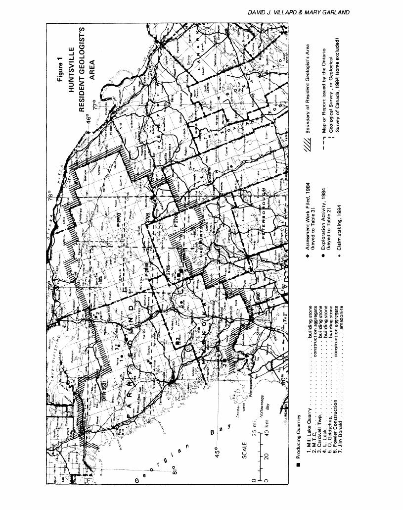
DA VID J. VILLARD S, MARY GARLAND
GC
2 — x*r w tuO ~- o*S* E?2 o ot ?5
l *~M X co".2 0) "O^ J co
Q. V1 (J
c 3-Si- OJ XO O 0)rt "X ?(O
e?
^00 .5 CN
o JJ o ^J
oj o
li
CD 03 03 Q) O 03 Q) c m C C C t; *-2 8.2 2 S S'EM * M t) t) O) O
O) O) O) O) O) O) in.E g1 .E .E .E g1 E
'5 .2 "a '5 '5 .2.Q *- A A .o *-
fo aj _3 -S 'wl s""*
l is'oJci^^•Q . . . . . . .O '-CNCOTtlOcol^
(X
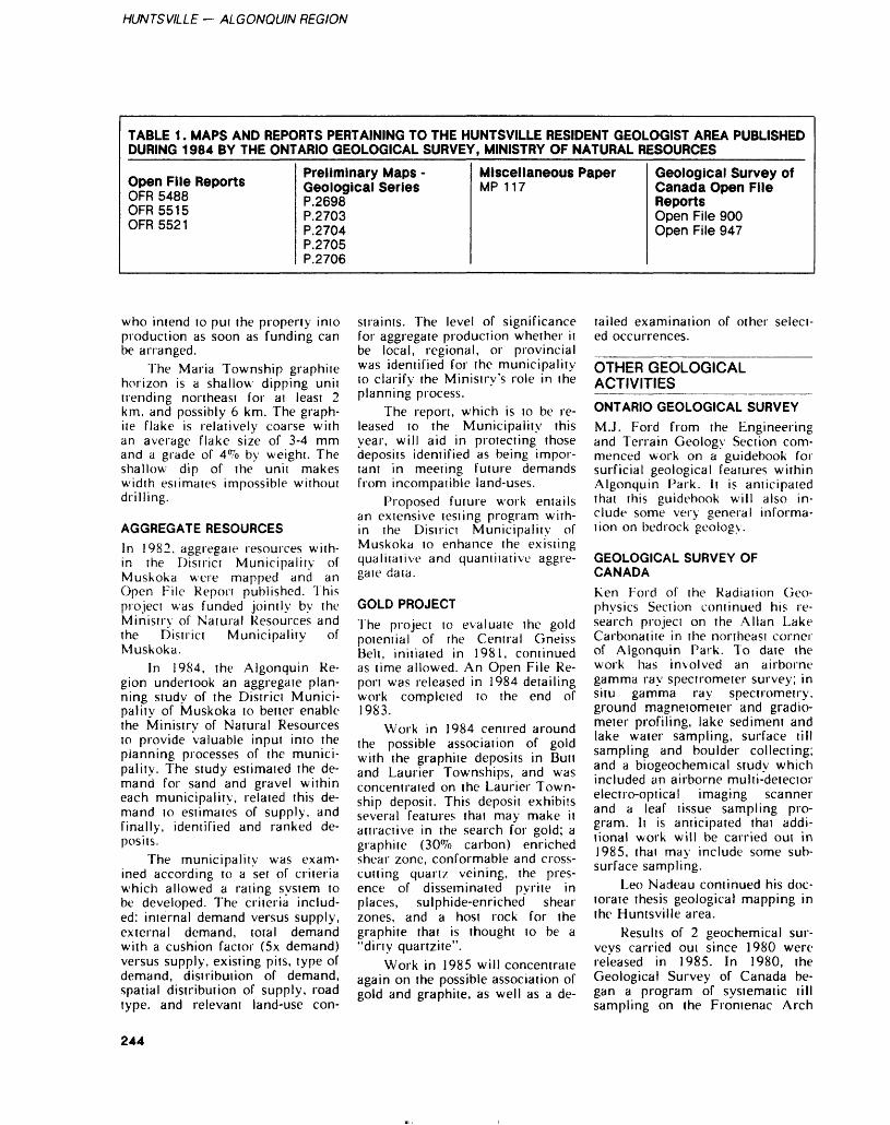
HUNTSVILLE — ALGONQUIN REGION
TABLE 1. MAPS AND REPORTS PERTAINING TO THE HUNTSVILLE RESIDENT GEOLOGIST AREA PUBLISHED DURING 1984 BY THE ONTARIO GEOLOGICAL SURVEY, MINISTRY OF NATURAL RESOURCES
Open File ReportsOFR 5488 OFR5515 OFR 5521
Preliminary Maps - Geological SeriesP.2698 P.2703 P.2704 P.2705 P. 2 706
Miscellaneous PaperMP 117
Geological Survey of Canada Open File ReportsOpen File 900 Open File 947
who intend to put the property into production as soon as funding can be arranged.
The Maria Township graphite horizon is a shallow dipping unit trending northeast for ai least 2 km, and possibly 6 km. The graph ite flake is relatively coarse with an average flake size of 3-4 mm and a grade of 4^0 by weight. The shallow dip of the unit makes width esiimates impossible without drilling.
AGGREGATE RESOURCESIn 1982, aggregaie resources with in the District Municipality of Muskoka were mapped and an Open File Repon published. This project was funded jointly by the Ministry of Natural Resources and the District Municipality of Muskoka.
In 1984, the Algonquin Re gion undertook an aggregaie plan ning study of the District Munici pality of Muskoka to better enable the Ministry of Natural Resources to provide valuable input into the planning processes of the munici pality. The study estimated the de mand for sand and gravel within each municipality, related this de mand to estimates of supply, and finally, identified and ranked de posits.
The municipality was exam ined according to a set of criteria which allowed a rating system to be developed. The criteria includ ed: internal demand versus supply, external demand, total demand with a cushion factor (5x demand) versus supply, existing pits, type of demand, distribution of demand, spatial distribution of supply, road type, and relevant land-use con
straints. The level of significance for aggregate production whether it be local, regional, or provincial was identified for the municipality to clarify the Ministry's role in the planning process.
The report, which is to be re leased to the Municipality this year, will aid in protecting those deposits identified as being impor tant in meeting future demands from incompatible land-uses.
Proposed future work entails an extensive testing program with in the Districi Municipality of Muskoka to enhance the existing qualitative and quantitative aggre gaie data.
GOLD PROJECTThe project lo evaluate the gold potential of the Central Gneiss Belt, initialed in 1981, continued as time allowed. An Open File Re pon was released in 1984 detailing work completed to the end of 1983.
Work in 1984 centred around the possible association of gold with the graphite deposits in Butt and Laurier Townships, and was concentrated on the Laurier Town ship deposit. This deposit exhibits several features that may make it attractive in the search for gold; a graphite (30^o carbon) enriched shear zone, conformable and cross cutting quartz veining, the pres ence of disseminated pyrite in places, sulphide-enriched shear zones, and a host rock for the graphite that is thought to be a "dirty quartzite".
Work in 1985 will concentrate again on the possible association of gold and graphite, as well as a de
tailed examination of other select ed occurrences.
OTHER GEOLOGICAL ACTIVITIES___________ONTARIO GEOLOGICAL SURVEYM.J. Ford from the Engineering and Terrain Geology Section com menced work on a guidebook for surficial geological features within Algonquin Park. It is anticipated that this guidebook will also in clude some very general informa tion on bedrock geology.
GEOLOGICAL SURVEY OF CANADAKen Ford of the Radiation Geo physics Section continued his re search project on the Allan Lake Carbonatite in the northeast corner of Algonquin Park. To date the work has involved an airborne gamma ray spectrometer survey; in situ gamma ray spectrometry, ground magnetometer and gradio meter profiling, lake sediment and lake water sampling, surface till sampling and boulder collecting; and a biogeochemical study which included an airborne multi-detecior electro-optical imaging scanner and a leaf tissue sampling pro gram, li is anticipated that addi tional work will be carried out in 1985, thai may include some sub surface sampling.
Leo Nadeau continued his doc torate thesis geological mapping in the Huntsville area.
Results of 2 geochemical sur veys carried oui since 1980 were released in 1985. In 1980, the Geological Survey of Canada be gan a program of systematic till sampling on the Frontenac Arch
244
DAVID J. VILLARD 8, MARY GARLAND
and adjacent areas of southeastern Ontario. In the reports, the initial results of analyses for heavy met als are presented. The reports re leased as Open File 899 and Open File 900 respectively cover south eastern Ontario for NTS (31C N/2, 31F) and NTS (31D N/2, 31E S/2, 41H O/8). Helicopter supported lake sediment and water samples were collected at an aver age density of l sample per 13 knrrthroughout the 38 054 krrrarea. A total of 34 variables were measured in the sediment and 20 variables in the water. Re sults are plotted at a scale of 1:250 000, with individual maps for each variable. The results of the 2 sur veys should prove helpful to the exploration geologist, particularly in the Central Gneiss Belt where the data base is limited.
EXPLORATION ACTIVITYAs of December 14, 1984, a total of 20 claims were staked in the area, a noticeable decrease from the 71 staked in 1983. Claim stak ing is not necessarily a true indica tion of exploration activity, as a significant proportion of the activ ity in 1984 was carried out on patented land or was of a recon naissance nature, involving mini mal staking.
Exploration activity (sec Fig ure l, Tables 2, 3) was related to interests in gold, graphite, copper, zinc, calcium carbonate, silica, building stone, and gemstones.
One of the major drawbacks to exploration in this area is the al most complete lack of a geological data base and until there is detailed mapping available or a mine found, exploration activity will probably continue to remain low.
GOLDExploration for gold was centred around those graphite deposits thought to have some potential as sociation with the yellow metal. 'Interesting' values were reported to the authors by the holder of a property in Laurier Township. Ad ditional prospecting is planned for 1985.
Several prospectors continued their search for gold, mainly in the area between Huntsville and Parry Sound and to the north. Much of this work centres around the possi ble association of gold with pyrite and chalcopyrite mineralization.
GRAPHITEExploration for graphite was mini mal in 1984, with activity centred around properties in Laurier and Butt Townships. Graphite Corpora tion of Canada plans to put the Butt Township deposit into produc tion as soon as funding can be arranged. Initial work may involve a pilot plant in order to test how easily the flake can be separated.
BASE METALSSeveral prospectors continued their evaluation of occurrences through out the area.
QUARTZActivity was again minimal, with the deposits in Mcclintock and Murchison Townships undergoing continued evaluations.
MINING ACTIVITYNumerous quarries, most notably the Mill Lake Quarry at Parry Sound, produced flagstone for use primarily as building stone. The Mill Lake Quarry produces several products including a very attrac tive 1/2 inch flagstone that is easy to install on interior walls.
An amazonite quarry in Chap man Township, northeast of Mag netawan, is being developed as a mineral collecting site. The amazonite occurs as crystals, up to 30 cm in size, in a zoned peg matite.
A peat bog north of Parry Sound is being developed as a source of fuel peat. The peat is marketed in briquette form and is mainly sold locally for use in bar becues and campfires.
MINERAL EDUCATION PROGRAM____________During the year, regional geologi cal staff visited 4 Provincial Parks
— Killbear (twice), Grundy (twice), Arrowhead (twice), and Oastler Lake — to give an intro ductory talk on minerals and geol ogy. This was followed by a field trip within the parks. Staff also vis ited 3 junior ranger camps in the Bracebridge and Parry Sound areas for a day-long session on minerals. Mineral related talks were given to classes in several elementary schools.
REFERENCES AND RECENT PUBLICATIONS_________Carter, T.R.1984: Metallogeny of the Grenville
Province, Southeastern Ontar io; Ontario Geological Survey, Open File Report 5515, 422p., 58 figures, 35 tables, and 14 photos.
Hanmer, S.K.1984: Structure of the Junction of
three Tectonic Slices; Ontario Gneiss Segment, Grenville Province; p.109-120 in Cur rent Research, Part B, Geologi cal Survey of Canada, Paper 84-1B.
Hanmer, S.K., and Ciesielski, A.1984: A Structural Reconnaissance
of the Northeast Boundary of the Central Metasedimentary Belt, Grenville Province, On tario and Quebec; p.121-131 //; Current Research, Part B, Geological Survey of Canada, Paper 84-1B.
Monenco Ontario Limited1984: Peat and Peatland Evalua
tion of the Parry Sound Area; Ontario Geological Survey, Open File Report 5488, 5 Vol umes, 194p., 2 tables, 2 figures and numerous maps.
Villard, D.J., Keevil, R., and Hogg,A.1984: The Gold Potential of the
Huntsville-Parry Sound Area of Ontario; Ontario Geological Survey, Open File Report 5521, 58p., 39 figures and 2 maps in back pocket.
245
HUNTSVILLE — ALGONOUIN REGION
EXPLORATION ACTIVITY DURING THE YEAR.
TABLE 2
Number on Figure
1
2
3
4
5
Individual or Company
Jones, E.
Ackerley, G.
Jones, E.
St ickley
Irving , W.
Activity
Trenching, prospecting, Ferrie Township
Trenching, diamond drilling, Laurier Township
Trenching, prospecting, Lount Township
Property evaluation, Murchison Township
Diamond drilling, Brunel Township
ASSESSMENT WORK AND OTHER INFORMATION RECEIVED.TABLE 3
Location
Par ry Sound Dist .McKellar Township
Parry Sound Dist.McKeJlar Township
Parry Sound Dist.Ryerson Township
Renf r ew CountyLyndoch Township
Renfrew CountyMaria Township
Renfrew CountyMaria Township
NTS File Name Commodity Type of Type of Work Date of Sought Report Performed Work
31E/12 Marble - rtcKellar marble Other DDli - 231.7 in. Dec.,/80( 759 ' )
31E/12 Edward Blanchard Marble Assess Stripping and Jan. 16-Trenching 21/84
31E/11 Graphite - Ryerson Graphite Other Several Reports 1982,(CONFIDENTIAL) on Property 1983
31F/6 Zinc - Lyndoch Zinc Other Geology and June/83(CONFIDENTIAL) Geochemistry
Report
31L/1 Graphite - Maria Graphite Other VLF Electromag. Nov. 1-Survey and Bene- 26/82ficiation Feb. l/
83
31L/1 Edward Blanchard Graphite Assess Stripping and Dec. 3-Trenching 20/83
Toronto Local File Number File Number
l UJi-n-'iODiTiFILES)McKellarTwp.Con. IX, X,XI, Lots 5,6*7
McKellerNo. 6(Assess . )
(COMMODITYFILESRyersonTwp.Con. V,Lots 11 ,12 S. 13Con. VI,Lot 6
(COMMODITYFILES)Lyndoch TwpCon. XIV,Lots 13, 14
(COMMODITYFILES)Mar la Twp.Con. A,Lots 63 S64Con. B,Lots 63 464Con. B,Lots 5U-53Con. 12 413, Lots8-13
Mar la No . 2( Assess . )
246
Bancroft Resident Geologist Area, Algonquin RegionHans D. MeynResident Geologist, Ontario Ministry of Natural Resources, Bancroft
INTRODUCTIONThe Bancroft Resident Geologist Office is responsible for the Min den, Bancroft, and Pembroke Dis tricts, which are part of the Algon quin Region of the Ontario Min istry of Natural Resources. The area is shown in Figure 1. Clara, Maria, and Head Townships were added to the Bancroft Resident Ge ologist Area in 1984.
The office is staffed by Hans D. Meyn, Resident Geologist, Harald Wolf, Resource Geologist in charge of the drill core library, and Karen Fell, secretary. Patricia Flagler, summer student, assisted in the office and field for several weeks.
RESIDENT GEOLOGIST'S ACTIVITIES___________The Resident Geologist continued to devote some time to familiariza tion with the geology and mineral deposits of the area. Several known, currently inactive, mineral occurrences were visited, and new properties undergoing exploration were visited in the company of the owner or operator. The operating mines were also visited.
The Resident Geologist also participated in several field trips, most of them given by persons do ing geological work in the area ei ther for the provincial or federal governments or a university.
Mineral collecting (rockhound- ing) is an important part of the economy of the Bancroft area and the Resident Geologist was in volved with the Chamber of Com merce in supporting mineral col lecting in the Bancroft area.
As part of that effort, the On tario Ministry of Natural Re sources, Algonquin Region, again this year, sponsored a booth at the Bancroft Gemboree and the Wil berforce Rockhound Fair, at which mineral and geologically oriented publications issued by the Ministry were on sale. As in previous years, the Ministry of Natural Resources sponsored D.H. Gorman, Professor of Mineralogy, University of To ronto, at these 2 events to identify
rocks and minerals for the rock- hounds.
In August, the Resident Geolo gist gave a tour and lecture at Si lent Lake Provincial Park, and during the autumn weeks H. Wolf led a geological discussion group at the local library based on the TV Ontario videotapes called "Understanding the Earth".
DRILL CORE LIBRARYIn March of 1984 the just com pleted drill core library became available for use. Under the su pervision of Harald Wolf, about 35 000 m of core were collected and filed in the new facility. Another 10 000 m are stored outside await ing processing. The core now in the library represents 447 drill holes from 23 properties represent ing Cu-Ni-Co, iron, zinc, uranium, graphite, nepheline syenite, and quartz mineralization.
Data pertaining to the drill core is stored on a microcomputer. This information includes the com pany name, company drillhole number, year of completion, town ship, drillhole length, amount of core stored, and whether assays, chemical analyses, thin sections, or polished sections are available. A number of search programs have been written to manipulate the data, thus making it possible to list all drillholes from a specific area by certain company name or other criteria.
As the drill core library is situ ated in the Ontario Ministry of Natural Resources compound at Bancroft, about 100 m from the Resident Geologist Office, com plete assessment files are kept in the drill core library building. Eventually the documents in the assessment files will be marked to indicate what core or samples are available in the drill core library and how they relate to the assess ment files.
OTHER GEOLOGICAL ACTIVITIES^_________ALGONQUIN REGION, ONTARIO MINISTRY OF NATURAL RESOURCESThe northern part of the Algon quin Region is the responsibility of D.J. Villard, Resident Geologist, Huntsville (see Report of the Huntsville Resident Geologist, this volume).
LESLIE M. FROST NATURAL RESOURCES CENTREJ. Stocking, Lands and Minerals Specialist, is currently (November 84) seconded to the Ontario Geo logical Survey where he is secre tary to the Interministerial Com mittee on Peat. R. Keevil is acting Lands and Minerals Specialist dur ing the former's absence; J. Etches is currently Mineral Resource As sistant.
The Frost Centre had another good year. About 4000 visitors participated in tours and lectures in the mineral resources field. The aggregate assessment report pre pared for the Frost Centre has been forwarded to the Ontario Geological Survey for publication as an Open File Report. The staff of the Frost Centre gave lectures at 3 junior ranger camps and l pro vincial park. As well, the Frost Centre staff had a poster display at the annual Open House of the On tario Geological Survey, December 4-6, 1984.
ONTARIO GEOLOGICAL SURVEYMaps and reports pertaining to the Bancroft Resident Geologist area and issued by the Ontario Geologi cal Survey are shown in Figure l and listed in Table 1. Additional references to new information of geological interest in the general area are included in the list of se lected references. Also shown in Figure l is the location of 1984 fieldwork by the Ontario Geologi cal Survey. The Geological Data Inventory Folios (GDIFs) pub lished this year for this area are not shown in Figure l in order to avoid clutter. In 1984, GDIFs for
247
BANCROFT — ALGONQUIN REGION
a
roooojojo K 4"-N CD
Jviil^•*- oj o. .E a " H--TT t/i -~ w* ^
^ . Q CO ^ CD CC.S .o
' ' -o ' —1
. . o .3
' ' T3 '
.oi .
- 2 * '
- - ~a. c — '. ^ c^ 00) -M
. *- o
> xm m
-1 ra O . - "O S ro to a-:o^ -5g^S-S C S g . jg o f E ^ c||Q|S^99 5 o o"ojo~ E^^'B
^ T- ^- ^ P
O
a o.O) O)c c
E-E re .- -Dl- 5
O)^ ^
a ^*^ 3
-D ^
a.™O) l—
GC o
- Eo2u
O Q. X
UJ
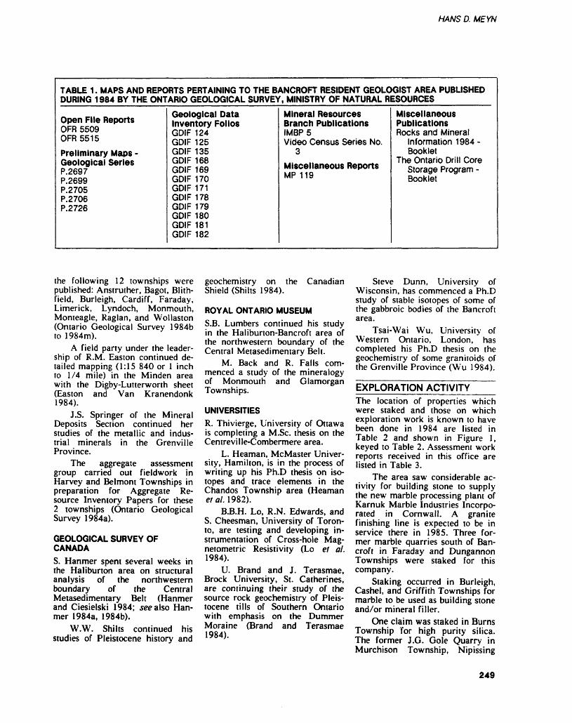
HANS D. MEYN
TABLE 1. MAPS AND REPORTS PERTAINING TO THE BANCROFT RESIDENT GEOLOGIST AREA PUBLISHED DURING 1984 BY THE ONTARIO GEOLOGICAL SURVEY, MINISTRY OF NATURAL RESOURCES
Open File ReportsOFR 5509OFR 5515
Preliminary Maps -Geological SeriesP.2697P.2699P.2705P.2706P.2726
Geological Data Inventory FoliosGDIF 124GDIF 125GDIF 135GDIF 168 GDIF 169GDIF 170GDIF 171GDIF 178GDIF 179GDIF 180GDIF 181GDIF 182
Mineral Resources Branch PublicationsIMBP5Video Census Series No.
3Miscellaneous ReportsMP 1 1Qlvl r l 1 9
Miscellaneous PublicationsRocks and Mineral
Information 1 984 -Booklet
The Ontario Drill Core Storage Program -Booklet
the following 12 townships were published: Anstruther, Bagot, Blith field, Burleigh, Cardiff, Faraday, Limerick, Lyndoch, Monmouth, Monteagle, Raglan, and Wollaston (Ontario Geological Survey 1984b to 1984m).
A field party under the leader ship of R.M. Easton continued de tailed mapping (1:15 840 or l inch to 1/4 mile) in the Minden area with the Digby-Lutterworth sheet (Easton and Van Kranendonk 1984).
J.S. Springer of the Mineral Deposits Section continued her studies of the metallic and indus trial minerals in the Grenville Province.
The aggregate assessment group carried out fieldwork in Harvey and Belmont Townships in preparation for Aggregate Re source Inventory Papers for these 2 townships (Ontario Geological Survey 1984a).
GEOLOGICAL SURVEY OF CANADAS. Hanmer spent several weeks in the Haliburton area on structural analysis of the northwestern boundary of the Central Metasedimentary Belt (Hanmer and Ciesielski 1984; see also Han mer 1984a, 1984b),
W.W. Shilts continued his studies of Pleistocene history and
geochemistry on the Canadian Shield (Shilts 1984).
ROYAL ONTARIO MUSEUMS.B. Lumbers continued his study in the Haliburton-Bancroft area of the northwestern boundary of the Central Metasedimentary Belt.
M. Back and R. Falls com menced a study of the mineralogy of Monmouth and Glamorgan Townships.
UNIVERSITIESR. Thivierge, University of Ottawa is completing a M.Sc. thesis on the Centreville-Combermere area.
L. Heaman, McMaster Univer sity, Hamilton, is in the process of writing up his Ph.D thesis on iso topes and trace elements in the Chandos Township area (Heaman etal. 1982).
B.B.H. Lo, R.N. Edwards, and S. Cheesman, University of Toron to, are testing and developing in strumentation of Cross-hole Mag netometric Resistivity (Lo et al. 1984).
U. Brand and J. Terasmae, Brock University, St. Catherines, are continuing their study of the source rock geochemistry of Pleis tocene tills of Southern Ontario with emphasis on the Dummer Moraine (Brand and Terasmae 1984).
Steve Dunn, University of Wisconsin, has commenced a Ph.D study of stable isotopes of some of the gabbroic bodies of the Bancroft area.
Tsai-Wai Wu, University of Western Ontario, London, has completed his Ph.D thesis on the geochemistry of some granitoids of the Grenville Province (Wu 1984).
EXPLORATION ACTIVITYThe location of properties which were staked and those on which exploration work is known to have been done in 1984 are listed in Table 2 and shown in Figure l, keyed to Table 2. Assessment work reports received in this office are listed in Table 3.
The area saw considerable ac tivity for building stone to supply the new marble processing plant of Karnuk Marble Industries Incorpo rated in Cornwall. A granite finishing line is expected to be in service there in 1985. Three for mer marble quarries south of Ban croft in Faraday and Dungannon Townships were staked for this company.
Staking occurred in Burleigh, Cashel, and Griffith Townships for marble to be used as building stone and/or mineral filler.
One claim was staked in Burns Township for high purity silica. The former J.G. Gole Quarry in Murchison Township, Nipissing
249
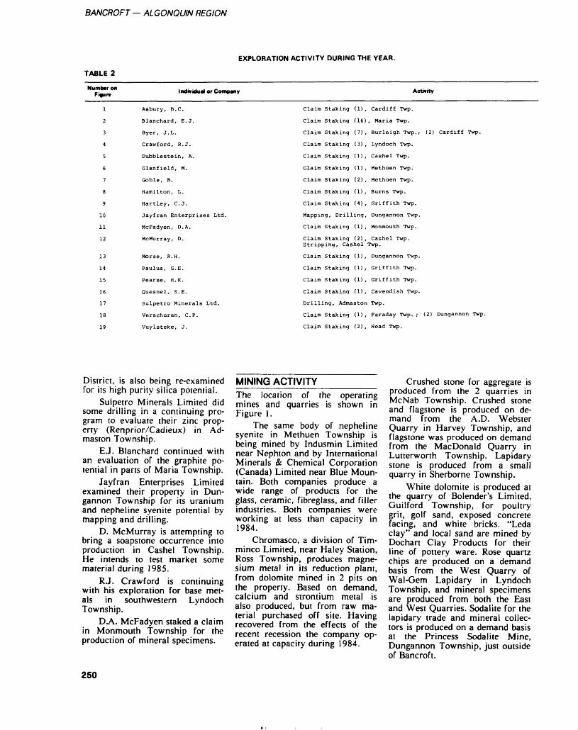
BANCROFT — ALGONQUIN REGION
TABLE 2
EXPLORATION ACTIVITY DURING THE YEAR.
Number on Figure
1
2
3
4
5
6
7
8
9
10
11
12
13
14
15
16
17
18
19
Individual or Company
Asbury, B.C.
Blanchard, E. J.
Byer, J. L.
Crawford, R. J.
Dubblestein, A.
Glanfield, M.
Goble, B.
Hamilton, L.
Hartley, C. J.
Jayfran Enterprises Ltd.
McFadyen, D. A.
McMurray, D.
Morse, R. H.
Paulus, G. E.
Pearse, H. K.
Quesnel, S. E.
Sulpetro Minerals Ltd.
Verschuren, C. P.
Vuylsteke, J.
Claim Staking (1) ,
Claim Staking (16)
Claim Staking (7),
Claim Staking (3) ,
Claim Staking (1) ,
Claim Staking (1) ,
Claim Staking (2) ,
Claim Staking (1) ,
Claim Staking (4) ,
Mapping, Drilling,
Claim Staking (1) ,
Claim Staking (2) , Stripping, Cashel
Claim Staking (1) ,
Claim Staking (1) ,
Claim Staking (1) ,
Claim Staking (1) ,
Drilling, Admaston
Claim Staking (1) ,
Claim Staking (2) ,
Activity
Cardiff Twp.
, Maria Twp.
Burleigh Twp.; (2) Cardiff Twp.
Lyndoch Twp.
Cashel Twp.
Methuen Twp.
Methuen Twp.
Burns Twp.
Griffith Twp.
Dungannon Twp.
Monmouth Twp.
Cashel Twp. Twp.
Dungannon Twp.
Griffith Twp.
Griffith Twp.
Cavendish Twp.
Twp.
Faraday Twp. ; (2) Dungannon Twp.
Head Twp.
District, is also being re-examined for its high purity silica potential.
Sulpetro Minerals Limited did some drilling in a continuing pro gram to evaluate their zinc prop erty (Renprior/Cadieux) in Ad maston Township.
E.J. Blanchard continued with an evaluation of the graphite po tential in parts of Maria Township.
Jayfran Enterprises Limited examined their property in Dun gannon Township for its uranium and nepheline syenite potential by mapping and drilling.
D. McMurray is attempting to bring a soapstone occurrence into production in Cashel Township. He intends to test market some material during 1985.
R.J. Crawford is continuing with his exploration for base met als in southwestern Lyndoch Township.
DA. McFadyen staked a claim in Monmouth Township for the production of mineral specimens.
MINING ACTIVITYThe location of the operating mines and quarries is shown in Figure 1.
The same body of nepheline syenite in Methuen Township is being mined by Indusmin Limited near Nephton and by International Minerals Se Chemical Corporation (Canada) Limited near Blue Moun tain. Both companies produce a wide range of products for the glass, ceramic, fibreglass, and filler industries. Both companies were working at less than capacity in 1984.
Chromasco, a division of Tim- minco Limited, near Haley Station, Ross Township, produces magne sium metal in its reduction plant, from dolomite mined in 2 pits on the property. Based on demand, calcium and strontium metal is also produced, but from raw ma terial purchased off site. Having recovered from the effects of the recent recession the company op erated at capacity during 1984.
Crushed stone for aggregate is produced from the 2 quarries in McNab Township. Crushed stone and flagstone is produced on de mand from the A.D. Webster Quarry in Harvey Township, and flagstone was produced on demand from the MacDonald Quarry in Lutterworth Township. Lapidary stone is produced from a small quarry in Sherborne Township.
White dolomite is produced at the quarry of Bolender's Limited, Guilford Township, for poultry grit, golf sand, exposed concrete facing, and white bricks. "Leda clay" and local sand are mined by Dochart Clay Products for their line of pottery ware. Rose quartz chips are produced on a demand basis from the West Quarry of Wal-Gem Lapidary in Lyndoch Township, and mineral specimens are produced from both the East and West Quarries. Sodalite for the lapidary trade and mineral collec tors is produced on a demand basis at the Princess Sodalite Mine, Dungannon Township, just outside of Bancroft.
250
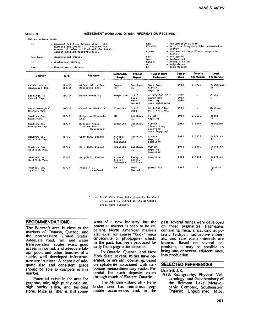
HANS D. MEYN
TABLE 3Abbreviations Used:
ASSESSMENT WORK AND OTHER INFORMATION RECEIVED.
DD - Diamond Drilling (where shown, the numbers following "D" indicate the number of holes drilled and the total length drilled respectively) .
Geophys. - Geophysical Survey
GL - Geological Survey
Mag - Magnetometer Survey
Location
Haliburton Co.Glamorgan Twp.
Hastings Co.Cashel Twp.
Peterborough Co.Methuen Twp.
Renfrew Co.Bagot Twp.
Renfrew Co.Brougham Twp.
Renfrew Co.Griffith Twp.
Renfrew Co.Griffith Twp.
Renfrew Co.Griffith Twp.
Renfrew Co.Lyndoch Twp.
NTS
31D/1531D/16
31C/14
31C/12
3 IF/ 7
31F/7
31F/6
31F/6
31F/6
31F/3
File NMIM
Offset Oil c. GasResources Inc.
David McMurray
Canadian Nickel Co.
Sulpetro MineralsLtd.
B.Nixon Apple(Coronation
Resources)
Gary H. K. Pear se
Gary H. K. Pearse
Gary H. K. Pearse
Russell J.Crawford
Commodity Sought
CopperMo
Soapstone
Ilmenite
BM
graphite
mineralfillerdolomite
graphite
mineralfillerdolomite
BM
Type of Report
Geophys.GL
DrillLogsMechManual
DrillLogs
Geophys .GL
Geophys.GL
Geophys.GL
Geophys.GL
Assay sBenef .Studies
MechManual
Rad - Radiometric Survey VLF-EM - Very Low Frequency Electromagnetic
Survey HL-EM - Horizontal Loop Electromagnetic
Survey STr - Stripping Mech - Mechanical Benef. - Beneficiation Mo - MolybdenumBM - Base Metals
Type of Work Performed
Mag, Rad,VLF-EMMapping
DD(17-1000.5') *power STrwashingcore specimens
DD(4-364.54m.)DD(2-151.18m.)
HL-EMMapping
VLF-EMlinecuttingassayingcore logging*
VLF-EMMappingSampling
VLF-EMMappingSampling
Sampling
power STr
Deteof Work
1983
198219831984
1983
1983
1982
1982
1982
1984
1983
Toronto Local File Number File Number
2.5721 Glamorgan26
Cashel6
Methuen30
2.6116 Bagot10
2.5580 Brougham13
2.5373 Griffith3
2.5401 Griffith4
2.7114 Griffith5
Lyndoch27
Drill Core from this property in whole
or in part is stored at the Bancroft
Drill Core Library.
RECOMMENDATIONS_____The Bancroft area is close to the markets of Ontario, Quebec, and the northeastern United States. Adequate road, rail, and water transportation routes exist, good access is normal, and adequate lab our pool, and other features of a stable, well developed infrastruc ture are in place. A deposit of ade quate size and consistent grade should be able to compete in this market.
Potential exists in the area for graphite, talc, high purity calcium, high purity silica, and building stone. Mica as filler is still some
what of a new industry, but the potential market is seen to be ex cellent. North American markets also exist for coarse "book" mica (muscovite or phlogopite) which, in the past, has been produced lo cally from pegmatite deposits.
In Ontario, Quebec, and New York State, several mines have op erated, or are still operating, based on sphalerite associated with car bonate metasedimentary rocks. Po tential for such deposits exists through much of Eastern Ontario.
The Minden - Bancroft - Pem broke area has numerous peg matite occurrences and, in the
past, several mines were developed on these pegmatites. Pegmatites containing mica, silica, calcite, po tassic feldspar, radioactive miner als, and rare earth minerals are known. Based on several co- products, it may be possible to bring one, or several adjacent ones, into production.
SELECTED REFERENCESBartlett, I.R.1983: Stratigraphy, Physical Vol
canology, and Geochemistry of the Belmont Lake Metavol- canic Complex, Southeastern Ontario; Unpublished M.Sc.
251
BANCROFT — ALGONQUIN REGION
Thesis, Carleton University, 218p.
Brand, N., and Terasmae, J.1984: Source Rock Geochemistry
of Pleistocene Tills of South ern Ontario; Grant 131, p.65-71 in Geoscience Re search Grant Program, Sum mary of Research 1983-1984, edited by V.G. Milne, Ontario Geological Survey, Miscella neous Paper 121, 252p.
Carter, T.R.1984: Metallogeny of the Grenville
Province, Southeastern Ontar io; Ontario Geological Survey, Open File Report 5515, 422p., 58 figures, 35 tables, and 14 photos.
Easton, R.M., and Van Kranen donk, M.1984: Digby-Lutterworth Area,
Haliburton and Victoria Coun ties; p.75-81 in Summary of Field Work, 1984, Ontario Geological Survey, edited by John Wood, Owen L. White, R.B. Barlow, and A.C. Col vine, Ontario Geological Sur vey, Miscellaneous Paper 119, 309p.
Easton, R.M., and Bartlett, J.R.1984: Precambrian Geology of the
Howland Area, Haliburton and Peterborough Counties (31 D/15); Ontario Geological Survey, Map P.2699, Geologi cal Series - Preliminary Map, scale 1:15 840. Geology 1983.
Finamore, P.F., and Bajc, A.J.1984: Quaternary Geology of the
Orillia Area, Southern Ontario (31 D/11); Ontario Geological Survey, Map P.2697, Geologi cal Series - Preliminary Map, scale 1:50 000. Geology 1981, 1982.
Ford, M J., and Bajc, A.J.1984: Quaternary Geology of the
Whitney Area, Nipissing Dis trict and Haliburton and Has tings Counties; Ontario Geo logical Survey, Map P.2706, Geological Series - Prelimi nary Map, scale 1:50 000. Ge ology 1983.
Geddes, R.S., and Mcclenaghan, M.B.
1984: Quaternary Geology of the Kawagama Lake Area, Nipis sing and Muskoka Districts and Haliburton County; Ontar io Geological Survey, Map P.2705, Geological Series - Preliminary Map, Scale 1:50 000. Geology 1983.
Gleeson, C.F., Rampton, V.N., Thomas, R.D., and Paradis, S. 1984: Development and Adaption
of Geochemical Techniques to Gold Exploration in Glacial Drift; Grant 065, p.129-149 in Exploration Technology De velopment Program of the Board of Industrial Leadership and Development, Summary of Research 1983-1984, edited by V.G. Milne and R.B. Bar low, Ontario Geological Sur vey, Miscellaneous Paper 120, 176p. Accompanied by l chart (coloured).
Grant, T.W., and Kingston, P.W.1984: Geology and Geochemistry
of Grenville Marble in South eastern Ontario; Ontario Geo logical Survey, Open File Re port 5509, 297p., 4 tables, 27 figures, 4 photos, and l map in back pocket.
Guillet, G.R., and Kriens, J.1984: Ontario and the Mineral
Filler Industry; Ontario Min istry of Natural Resources, Mineral Resources Branch, In dustrial Mineral Background Paper 5, 175p.
Hanmer, S.K.1984a: Structure of the Junction of
Three Tectonic Slices: Ontario Gneiss Segment, Grenville Province; p. 109-120 in Cur rent Research, Part B, Geologi cal Survey of Canada, Paper 84-1B, 427p.
1984b: The Potential Use of Planar and Elliptical Struc tures as Indicators of Strain Regime and Kinematics of Tectonic Flow; p. 133-142 in Current Research, Part B, Geological Survey of Canada, Paper 84-1B, 427p.
Hanmer, S.K., and Ciesielski, A.1984: A Structural Reconnaissance
of the Northwest Boundary of the Central Metasedimentary Belt, Grenville Province, On
tario and Quebec; p. 121-131 in Current Research, Part B, Geological Survey of Canada, Paper 84-1B, 427p.
Heaman, L.M., Shieh, Yuch-Ning, McNutt, R.H., and Shaw, D.M. 1982: Isotopic and Trace Element
Study of the Loon Lake Pluton, Grenville Province, Ontario; Canadian Journal of Earth Sciences, Volume 19, Numbers, p. 1045-1054.
Indares, A., and Martignole, J.1984: Evolution of P-T Conditions
During a High-Grade Meta morphic Event in the Man- iwaki Area (Grenville Prov ince); Canadian Journal of Earth Sciences, Volume 21, p.853-863.
Lo, B.B.H., Edwards, R.N., andCheesman, S.1984: Ontario Field Tests and In
strumentation of Cross Hole Magnetometric Resistivity; Grant 145, p.117-127 m Geo science Research Grant Pro gram, Summary of Research 1983-1984, edited by V.G. Milne, Ontario Geological Sur vey, Miscellaneous Paper 121, 252p.
Ontario Geological Survey1984a: Aggregate Resources In
ventory Program; p. 104-109 in Summary of Field Work 1984, Ontario Geological Survey, edited by John Wood, Owen L. White, R.B. Barlow, and A.C. Colvine, Ontario Geologi cal Survey, Miscellaneous Pa per 119, 309p.
1984b: Anstruther Township, Peterborough County (31 D/16); Ontario Geological Survey, Geological Data In ventory Folio 168, compiled by staff of the Resident Geolo gist's Office, Bancroft, 68p. and 2 maps, scale 1:31 680.
1984c: Bagot Township, Renfrew County (31 F/2,7); Ontario Geological Survey, Geological Data Inventory Folio 171, compiled by the staff of the Resident Geologist's Office, Bancroft, 38p. and 2 maps, scale 1:31 680.
1984d: Blithfield Township, Ren frew County (31 F/2,7); On-
252
HAWS D. MEYN
tario Geological Survey, Geo logical Data Inventory Folio 170, compiled by the staff of the Resident Geologist's Of fice, Bancroft, 28p. and 2 maps, scale 1:31 680.
1984e: Burleigh Township, Peter borough County (31 D/9,16); Ontario Geological Survey, Geological Data Inventory Fo lio 182, compiled by the staff of the Resident Geologist's Of fice, Bancroft, 30p. and 2 maps, scale 1:31 680.
1984f: Cardiff Township, Halibur ton County (31 E/1, 31 D/16, 31 C/13); Ontario Geological Survey, Geological Data In ventory Folio 124, compiled by the staff of the Resident Ge ologist's Office, Bancroft, 134p. and 3 maps, scale 1:31 680.
1984g: Faraday Township, Has tings County (31 C/13, 31 F/4, 31 E/l); Ontario Geologi cal Survey, Geological Data Inventory Folio 125, compiled by the staff of the Resident Ge ologist's Office, Bancroft, 72p. and 3 maps, scale l :31 680.
1984h: Limerick Township, Has tings County (31 C/13); On tario Geological Survey, Geo logical Data Inventory Folio 180, compiled by the staff of the Resident Geologist's Of fice, Bancroft, 26p. and 2 maps, scale 1:31 680.
1984i: Lyndoch Township, Ren frew County (31 F/3,6); On tario Geological Survey, Geo logical Data Inventory Folio 135, compiled by the staff of the Resident Geologist's Of fice, Bancroft, 36p. and 2 maps, scale 1:31 680.
1984 j: Monmouth Township, Haliburton County (31 D/16, 31 E/l); Ontario Geological Survey, Geological Data In ventory Folio 179, compiled by the staff of the Resident Ge ologist's Office, Bancroft, 11 Op. and 3 maps, scale 1:31 680.
1984k: Monteagle Township, Has tings County (31 F/4,5); On tario Geological Survey, Geo logical Data Inventory Folio 169, compiled by the staff of the Resident Geologist's Of
fice, Bancroft, 60p. and 2 maps, scale 1:31 680.
19841: Raglan Township, Renfrew County (31 F/3,4,5,6); Ontario Geological Survey, Geological Data Inventory Folio 178, compiled by the staff of the Resident Geologist's Office, Bancroft, 42p. and 2 maps, scale 1:31 680.
1984m: Wollaston Township, Has tings County (31 C/13); On tario Geological Survey, Geo logical Data Inventory Folio 181, compiled by the staff of the Resident Geologist's Of fice, Bancroft, 32p. and 2 maps, scale 1:31 680.
1984n: The Ontario Drill Core Storage Program; Ontario Geo logical Survey, Booklet, l Op.
1984o: Rocks and Minerals Infor mation, 1984; Ontario Geo logical Survey, Booklet, 25p.
Shilts, W.W.1984: Sonar Evidence for Post
glacial Tectonic Instability of the Canadian Shield and Ap palachians; p.567-579 in Cur rent Research, Part A, Geo logical Survey of Canada, Pa per 84-1 A, 666p.
Weatherson, G.L.1984: 1983 Ontario Mineral Score;
Ontario Ministry of Natural Resources, Video Census Se ries, Number 3, 242p.
Williams, D.A., Wolf, R.R., andRae, A.M.1984: Paleozoic Geology of the
Arnprior-Quyon Area, South ern Ontario; Ontario Geologi cal Survey, Map P.2726, Geo logical Series - Preliminary Map, scale 1:50 000. Geology 1982.
Wu, T.W.1984: Geochemistry and Petrogen
esis of Some Granitoids in the Grenville of Ontario, and their Tectonic Implications; Un published Ph.D. Thesis, Uni versity of Western Ontario, London, 623p.
253
Eastern Resident Geologist Area, Eastern RegionP.W. Kingston 1 and V.C. Papertzian 2
'Resident Geologist, ^Project Geologist, Ontario Ministry of Natural Resources, Tweed
INTRODUCTIONDuring 1984, exploration for in dustrial minerals and base metals was the main form of activity by mining companies, prospectors, staff of the Resident Geologist of fice, and the Ontario Geological Survey. Emphasis this year was on gold, fine-grained muscovite mica, sillimanite, graphite, building stone (granite and marble), and vermicu lite.
RESIDENT GEOLOGIST'S ACTIVITIES___________The office of the Resident Geolo gist for the Eastern Region is lo cated in Tweed and is staffed by PAY. Kingston, Resident Geologist; L.G.D. Thompson, Geophysicist; and 2 full-time contract geological staff. The contract staff consists of V.C. Papertzian, Core Library Ge ologist; and \Y.M. Kelly, Assistani Core Library Geologist.
The office of the Regional Mineral Resources Coordinator is located in Kemptville and is staffed by TAY. Fletcher, Regional Min eral Resources Coordinator; Y.F. Young, Mineral Resources Special ist; S. van Haaften, Resource Ge ologist, and 4 contract and pan- time staff who include R. Trotter, D. Brand, K. Klassen, and G. Gor rell. G. Gorrell has since left the Ministry. Five Experience '84 stu dents were hired to work on var ious geological projects in the re gion.
Most geological activities are managed by the Resident Geologist in Tweed, and all geotechnical, ag gregate assessment, mineral educa tion, and Provincial Parks projects are managed by the Regional Min eral Resources Coordinator in Kemptville.
As in previous years, much of the Resident Geologist's time was involved in providing a consultive technical service to companies and individuals engaged in mineral ex ploration and mining development in the Eastern Region. Selected mineral properties in the region were visited during the year either because of their importance to
Ministry programs, or because of interest in, or work by, mining and exploration companies. Emphasis was placed on examining proper ties currently under development, especially those involving industri al minerals. Other activities includ ed conducting and attending geo logical field trips and tours.
In May and June of 1983, a special employment program (Mining Sector Work Program) was set up, with the Township of Barrie acting as project sponsor. This project employed 3 geologists who field checked 12 and sampled 10 gold occurrences in Barrie Township. One report was pub lished in the Spring of 1984 en titled "A Summary of Gold Pros pects in Barrie Township", edited by V.C. Papertzian.
Another Section 38 work pro gram was started on September 10, 1984. The main objectives of this program are as follows:1. to compile 15 Geological Data Inventory Folios for the C row e River Valley area2. to sample rocks in various loca tions to determine mineral content, pH level, and geology3. to move approximately 26 000 m of core samples to the Eastern Ontario Mining Division Core Li brary located in Tweed4. to index core samples on a com puter5. to prepare maps to show hydrological and mineral high lights of significant areas.This program is expected to con tinue until the end of March 1985.
FIELD TRIPSIn mid-January, in Ottawa, the Current Activities Forum of the Geological Survey of Canada was attended by W.T. Grant, P.W. Kingston, V.C. Papertzian, and C.P. Verschuren.
At the end of March, 3 hours were spent flying to and photog raphing abandoned and working mines within Eastern Region. Mines and prospects that were not
readily accessible by ground trans portation were visited in this way.
P.W. Kingston attended a 4-day Industrial Minerals Sympo sium held in Toronto in late May.
In mid-June a 2-day Mines Technical meeting was conducted in Kingston. Progress reports on the various programs and the core library were tabled at this meeting by P.W. Kingston and W.M. Kelly.
The opening of the core li brary opening at Timmins, in late June, was attended by P.W. Kings ton and V.C. Papertzian.
Dave Williams conducted a field trip on the Paleozoic limestones in the Picton area in late July. Geological staff from both Kemptville and Tweed attend ed.
A Federal/Provincial Industri al Minerals meeting was held in Ottawa in early October. P.W. Kingston represented Eastern Re gion at this 2-day conference.
An Inter-Regional Mines meeting between Eastern and Al- gonquin Regions was held in Ren frew in mid-October. This was a 2-day meeting in which geological programs as well as core library programs were discussed. The first day of this meeting was devoted entirely to field trips. Visits were made to the Steep Rock Quarry at Tatlock, the Renprior Zinc Occur rence at Renfrew, and Chrom- asco's magnesium plant at Haley.
A l day field trip was orga nized in Cornwall, at the Karnuk marble plant at the end of October. Geologists from Eastern, Central, Algonquin, and Southwestern Re gions attended.
Early in November 1984, PAY. Kingston and V.C. Papert zian visited the Petroleum Re sources Laboratory located in Lon don, for l day.
PROPERTY EXAMINATIONSThe Cordova Mine was visited a number of limes during the Sum mer of 1984 by P.W. Kingston and V.C. Papertzian. No further explo ration activity has occurred on this
254
P. W. KINGSTON (S V.C. PAPERTZIAN
property since the previous sum mer.
A number of field visits were made lo the Ore Chimney Gold Mine property- P.W. Kingston as sisted K. Wail from Aggen Incor porated (Beneficiaiing Services) in collecting a 100 pound (45 kg) bulk sample from the dumps. No further work has been conducted on the property since it was de- watered to the 150-foot level in the Summer of 1983.
P.W. Kingston attended the of ficial opening of Canada Talc In- corporated's new crushing and grinding facility in Marmora in late October 1984.
The Holiandia Lead Mine in Madoc Township was also visited in the Fall of 1984. Fire bricks that lined their furnace in the early 1900s were collected for metallur gical research on refractories. This research is being carried out joint ly with the Technical University of Nova Scotia, Metallurgical Engi neering Department.
P.W. Kingston, along with E. Ga l low of Copconda-York Re sources Incorporated of tJnionville visiied the former Joy Manufactur ing Company Limited granite quarry in Madoc Township, pres ently owned by J. Beer of Madoc.
P.W. Kingston and V.C. Papertzian accompanied represen tatives from Keystone Explorations Limited and Colautti Construction Limited to both the Fardom Marble Quarry in Hungerford Township and the Fairmont Granite Quarry in Belmont Township. Both of these visits were conducted in late Fall.
P.W. Kingston and V.C. Papertzian visited the Long Lake Zinc Mine property owned by Lynx-Canada Explorations Limited in Olden Township in late May. A magnetometer survey was carried out ai this time over selected areas of the property.
P.W. Kingston accompanied representatives from Watts, Griffis, and McOuat Limited to the Kozumi Mica site near Kaladar.
In early May, an Energy, Mines and Resources Canada, seis
mic field trip was attended by L. Thompson, P.W. Kingston, and G. Gorrell. The area visited was sev eral miles northeast of Casselman, near Lemieux, the site of major landslides during the last century.
In early April a diamond drill ing program was set up in con junction with Sir Sandford Flem ing College. The Tweed office spotted 6 diamond-drill holes near Madoc and north of Marysville. This program failed to realize its objectives due to equipment fail ure.
A number of field visits were made to the Deloro Property now under management by the Ontario Ministry of the Environment. The Tuttle shaft, recently excavated by backhoe, was examined because water, constantly draining from this shaft into the Moira River, is consistently high in arsenic con tent.
The Hearthstone Anthophyllite Quarry in Elzevir Township was examined briefly this Fall. A num ber of blocks were shipped from i he property to the Uniied States. These were then cui up and used as decorative stone on wood sioves. Operations ceased this fall due to excessive fractures in the blocks quarried. There is considerable doubt whether the fracturing is in herent in the rock or was caused by the injudicious use of ex plosives in the quarry operation.
A brief field visit was carried out on the Burnstown Celestite Property by W. Kelly, P.W7 . Kings ton, and V.C. Papertzian.
A joint project commenced this summer between Eastern Re gion, the Ontario Geological Sur vey, and the Canada Centre for Remote Sensing, in the develop ment of an airborne luminescence- fluorescence prospecting technique for barite and fluorite. Barite- fluorite vein samples, collected in Eastern Ontario 2 summers ago, were sent to the Ontario Geologi cal Survey for examination using this latest equipmeni. The project is ongoing at the lime of writing and results appear promising.
MINING ACTIVITYProducing mines and stone quar ries in Eastern Ontario are shown in Figure 1. The 3 current cement producers, Canada Cement Lafarge Limited, Lake Ontario Ce ment Company Limited, and St. Lawrence Cement Incorporated were in production throughout 1984.
Stoklosar Marble Quarries Limited continued production of marble specialty products and ter- razzo chips. The company signifi cantly increased production this year, especially in green chips.
Steep Rock Resources Incor porated, Calcite Division, contin ued quarrying operations at their quarry at Tatlock. Their processing plani immediately west of Perth was also in operation at or near full capacity throughout 1984.
As reported in the Steep Rock Resources Incorporated third quar terly report for the 9 months ended September 30, 1984, Calcite Divi sion sales increased 26*Vo from year to date 1983 and calcite earnings from operations were up 2507o. Pro duction rates from the expanded fine-grind facilities were improved substantially and further improve ments are anticipated. Sales during the preceeding 12 months totaled S4.3 million.
Canada Talc Incorporated continued production of talc and dolomite at their mine in Hunting don Township. The company con tinued work on its new 2 million ton dolomite ore body west of the headframe. The initial blast broke 40 000 tons of talcose dolomite to be used in making Dolfil® filler.
The talc open pit started to the south of the mine shaft in 1983 is in operation. Approximately 40 000 tons of material has been min ed, crushed, and stockpiled to be used as auto body patch.
A third talc mine in Elzevir Township is in preparation. Gov ernment approvals have been ob tained and the area is stripped ready for blasting. This new ma terial will be used for lower grade fillers.
255
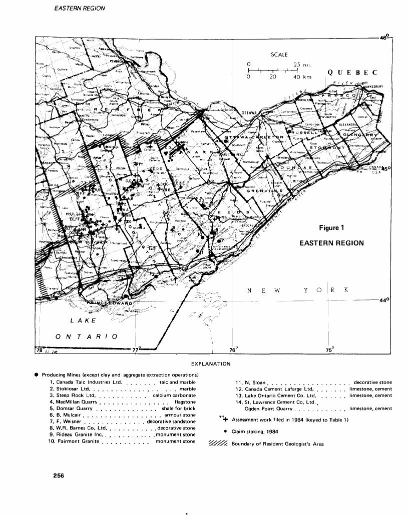
EASTERN REGION
O 20 40 km
Figure 1
EASTERN REGION
EXPLANATION
Producing Mines (except clay and aggregate extraction operations)1. Canada Talc Industries Ltd. . talc and marble2. Stoklosar Ltd. . . . . . . . . . . . . . . . . . . . marble3. Steep Rock Ltd. . calcium carbonate4. MacMillan Quarry . . . . . . . . . . . . . . . . flagstone5. Domtar Quarry . shale for brick6. B. Mulcair . . . . . armour stone7. F. Weisner . . . . . . . . . . . . . . decorative sandstone8. W.R. Barnes Co. Ltd. . . . . . . . . . . . decorative stone9. Rideau Granite Inc. . .monument stone10. Fairmont Granite monument stone
11. N. Sloan . decorative stone12. Canada Cement Lafarge Ltd. . . . . limestone, cement13. Lake Ontario Cement Co. Ltd. . limestone, cement14. St. Lawrence Cement Co. Ltd.,
Ogden Point Quarry . . . . limestone, cement
Assessment work filed in 1984 (keyed to Table 1)
Claim staking, 1984
Boundary of Resident Geologist's Area
256
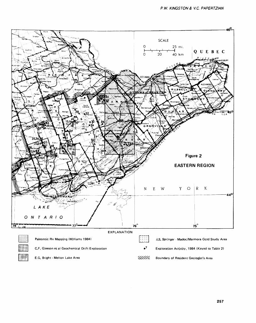
P.W. K ING S TON & V.C. PAPERTZIAN
Figure 2
EASTERN REGION
EXPLANATION
Paleozoic Rx Mapping (Williams 1984)
C.F. Gleeson et al Geochemical Drift Exploration
E.G. Bright - Mellon Lake Area
J.S. Springer - Madoc/Marmora Gold Study Area
Exploration Activity, 1984 (Keyed to Table 2)
Boundary of Resident Geologist's Area
257
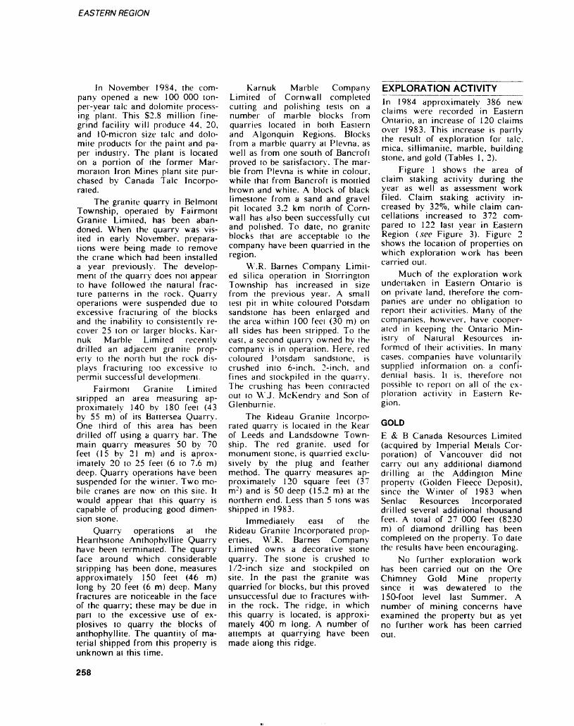
EASTERN REGION
In November 1984, the com pany opened a new 100 000 ton- per-year laic and dolomite process ing plant. This S2.8 million fine- grind facility will produce 44, 20, and 10-micron size talc and dolo mite products for the paint and pa per industry. The plant is located on a portion of the former Mar- moraton Iron Mines plant site pur chased by Canada Talc Incorpo rated.
The granite quarry in Belmont Township, operated by Fairmont Granite Limited, has been aban doned. When the quarry was vis ited in early November, prepara tions were being made to remove the crane which had been installed a year previously. The develop ment of the quarry does not appear to have followed the natural frac ture patterns in the rock. Quarry operations were suspended due to excessive fracturing of the blocks and the inability to consistently re cover 25 ion or larger blocks. Kar- nuk Marble Limited recently drilled an adjacent granite prop erty to the north but the rock dis plays fracturing too excessive to permit successful development.
Fairmont Granite Limited stripped an area measuring ap proximately 140 by 180 feet (43 by 55 m) of its Battersea Quarry. One third of this area has been drilled off using a quarry bar. The main quarry measures 50 by 70 feet (15 by 21 m) and is aprox- imately 20 to 25 feet (6 to 7.6 m) deep. Quarry operations have been suspended for the winter. Two mo bile cranes are now on this site. It would appear that this quarry is capable of producing good dimen sion stone.
Quarry operations at the Hearthstone Anthophyllite Quarry have been terminated. The quarry face around which considerable stripping has been done, measures approximately 150 feel (46 m) long by 20 feet (6 m) deep. Many fractures are noticeable in the face of the quarry; these may be due in part to the excessive use of ex plosives to quarry the blocks of anthophyllite. The quantity of ma terial shipped from this property is unknown at this time.
Karnuk Marble Company Limited of Cornwall completed cutting and polishing tests on a number of marble blocks from quarries located in both Eastern and Algonquin Regions. Blocks from a marble quarry at Plevna, as well as from one south of Bancroft proved to be satisfactory. The mar ble from Plevna is white in colour, while that from Bancroft is mottled brown and white. A block of black limestone from a sand and gravel pit located 3.2 km north of Corn wall has also been successfully cut and polished. To date, no granite blocks that are acceptable to the company have been quarried in the region.
W.R. Barnes Company Limit ed silica operation in Storrington Township has increased in size from the previous year. A small test pit in white coloured Potsdam sandstone has been enlarged and the area within 100 feei (30 m) on all sides has been stripped. To the east, a second quarry owned by the company is in operation. Here, red coloured Potsdam sandstone, is crushed into 6-inch, 2-inch, and fines and stockpiled in the quarry. The crushing has been contracted out lo \V.J. McKendry and Son of Glenburnie.
The Rideau Granite Incorpo rated quarry is located in the Rear of Leeds and Landsdowne Town ship. The red granite, used for monument stone, is quarried exclu sively by the plug and feather method. The quarry measures ap proximately 120 square feet (37 m 2 ) and is 50 deep (15.2 m) at the northern end. Less than 5 tons was shipped in 1983.
Immediately east of the Rideau Granite Incorporated prop erties, W.R. Barnes Company Limited owns a decorative stone quarry. The stone is crushed to 1/2-inch size and stockpiled on site. In the past the granite was quarried for blocks, but this proved unsuccessful due to fractures with in the rock. The ridge, in which this quarry is located, is approxi mately 400 m long. A number of attempts at quarrying have been made along this ridge.
EXPLORATION ACTIVITYIn 1984 approximately 386 new claims were recorded in Eastern Ontario, an increase of 120 claims over 1983. This increase is partly the result of exploration for talc, mica, sillimanite, marble, building stone, and gold (Tables l, 2).
Figure l shows the area of claim staking activity during the year as well as assessment work filed. Claim staking activity in creased by 32^0, while claim can cellations increased to 372 com pared to 122 last year in Eastern Region (sec Figure 3). Figure 2 shows the local ion of properties on which exploration work has been carried out.
Much of the exploration work undertaken in Eastern Ontario is on private land, therefore the com panies are under no obligation to report their activities. Many of the companies, however, have cooper ated in keeping the Ontario Min istry of Natural Resources in formed of their activities. In many- cases, companies have voluntarily supplied information on- a confi dential basis. It is, therefore not possible to report on all of the ex ploration activity in Eastern Re gion.
GOLDE & B Canada Resources Limited (acquired by Imperial Metals Cor poration) of Vancouver did not carry out any additional diamond drilling at the Addington Mine property (Golden Fleece Deposit), since the Winter of 1983 when Senlac Resources Incorporated drilled several additional thousand feet. A total of 27 000 feet (8230 m) of diamond drilling has been completed on the property. To date the results have been encouraging.
No further exploration work has been carried out on the Ore Chimney Gold Mine property since it was dewatered to the 150-foot level last Summer. A number of mining concerns have examined the property but as yet no further work has been carried out.
258
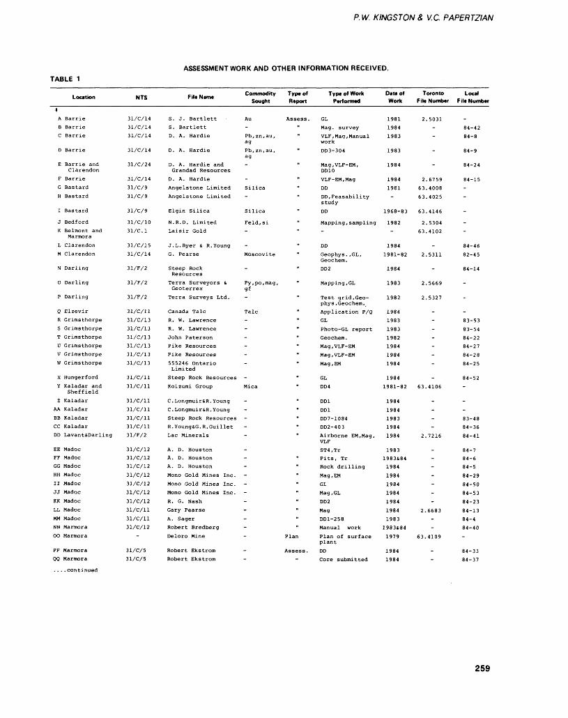
P. W. KINGSTON 8, V.C. PAPERTZIAN
TABLE 1ASSESSMENT WORK AND OTHER INFORMATION RECEIVED.
Location
*A BarrieB BarrieC Barrie
D Barrie
E Barrie andClarendon
F Barrie
G Bastard
H Bastard
I Bastard
J Bedford
K Belmont andMarmora
L Clarendon
M Clarendon
N Darling
0 Darling
P Darling
Q ElzevirR Grimsthorpe
S GrimsthorpeT Grimsthorpe
U GrimsthorpeV Grimsthorpe
W Grimsthorpe
X Hungerford
Y Kaladar andSheffield
Z KaladarAA Kaladar
BB KaladarCC KaladarDD Lavant&Darling
EE MadocFF MadocGG MadocHH MadocII MadocJJ MadocKK MadocLL MadocMM MadocMN MarmoraOO Marmora
PP MarmoraQQ Marmora
. . . .continued
NTS
31/C/14
31/C/14
31/C/14
31/C/14
31/C/24
31/C/14
31/C/9
31/C/9
31/C/9
31/C/10
31/C.l
31/C/15
31/C/14
31/F/2
31/F/2
31/F/2
31/C/ll
31/C/13
31/C/13
31/C/13
31/C/13
31/C/13
31/C/13
31/C/ll
31/C/ll
31/C/ll
31/C/ll
31/C/ll
31/C/ll
31/F/2
31/C/12
31/C/12
31/C/12
31/C/12
31/C/12
31/C/12
31/C/12
31/C/ll
31/C/ll
31/C/12
-
31/C/5
31/C/5
File Name Commodity Type of Sought Report
S. J. Bartlett Au Assess.S. Bartlett
D. A. Hardie Pb,zn,au, "ag
D. A. Hardie Pb, zn.au, "ag
D. A. Hardie and - "Grandad Resources
D. A. Hardie
Angelstone Limited Silica "
Angel s tone Limited - "
Elgin Silica Silica "
N.R.D. Limited Feld.si
Laisir Gold - "
J.L.Byer S. R. Young - "
G. Pearse Muscovite "
Steep Rock - "Resources
Terra Surveyors 6 Py,po,mag, "Geoterrex gf
Terra Surveys Ltd. - "
Canada Talc Talc "R. W. Lawrence - "
R. W. Lawrence - "
John Paterson - "Pike Resources - "
Pike Resources - "
555246 Ontario - "Limited
Steep Rock Resources - "
Koizumi Group Mica "
C.Longmuir&R. Young - "C.Longmuir&R. Young - "
Steep Rock Resources - "R. Young&G. R. Guillet - "Lac Minerals - "
A. D. HoustonA. D. Houston - "A. D. Houston - "
Mono Gold Mines Inc. - "
Mono Gold Mines Inc. - "Mono Gold Mines Inc. - "
R. G. Nash - "
Gary Pearse - "
A. Sager - "Robert Bredberg - "
Deloro Mine - Plan
Robert Ekstrom - Assess.Robert Ekstrom
Type of Work Performed
GL
Mag. survey
VLF, Mag, Manualwork
DD3-304
Mag,VLF-EM,DD10
VLF-EM,Mag
DD
DD.Feasabilitystudy
DD
Mapping , sampling-
DD
Geophys. ,GL,Geochem.DD2
Mapping.GL
Test grid, Geo phys, Geochem.Application P/Q
GL
Photo-GL report
Geochem.Mag,VLF-EM
Mag,VLF-EM
Mag, EM
GL
DD4
DD1
DD1
DD7-1084
DD2-403
Airborne EM, Mag,VLF
ST4,TrPits, TrRock drilling
Mag , EM
GL
Mag.GL
DD2
Mag
DDl-258Manual work
Plan of surfaceplant
DD
Core submitted
Date of Work
19811984
1983
1983
1984
1984
1981-
1968-83
1982-
1984
1981-82
1984
1983
1982
1984
1983
1983
19821984
1984
1984
1984
1981-82
1984
198419831984
1984
19831983&841984
1984
1984
1984
1984
1984
19831983484
1979
19841984
Toronto File Number
2.5031-
-
-
-
2.6759
63.4008
63.4025
63.4146
2.530463.4102
-
2.5311
-
2.5669
2.5327
--
-
--
-
-
-
63.4106
-
---
2.7216
---
-
-
-
-
2.6683--
63.4109
-
-
Local F ile Number
-
84-4284-8
84-9
84-24
84-15-
-
-
-
-
84-46
82-45
84-14
-
-
-
83-53
83-54
84-22
84-27
84-28
84-25
84-52-
-
-
83-48
84-36
84-41
84-7
84-6
84-5
84-29
84-50
84-53
84-23
84-1384-4
84-40.
84-33
84-37
259
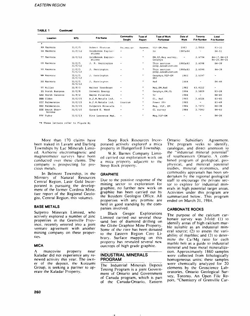
EASTERN REGION
TABLE 1 Continued
fRR
SS
TT
UU
W
ww
XX
YY
zzAAA
EBB
cccDDD
EEE
FFF
Location
Marmora
Marmora
Marmora
Marmora
Marmora
Marmora
Marmora
Miller
North Burgess
North Canonto
Olden
Palmerston
Palmerston
South Sher brooke
Tudor
NTS
31/C/5
31/C/12
31/C/12
31/C/5 31/C/12
31/C/5 31/C/12
31/C/5 31/C/12
31/C/5 31/C/12
31/F/3
31/C/8
31/F/2
31/C/15
31/C/15
31/C/15
31/C/15
31/C/13
Fill Mint*
Robert Ekstrom
Goldbrook Explor ations
Goldbrook Explor ations
J. R. Harrington
J. Harrington
J. Harrington
J. Harrington
Walter Yzerdraat
Orrwell Energy
Wayne Pilatzke
A. J. M. Metals Ltd.
A. J. M. Metals Ltd.
Sulpetro Minerals
Gerard E. Wood
Tina Lawrence Mgt.
Commodity Type of Type of Work Sought Report Performed
Au,asp,qv Assess. VLF-EM,Mag
DD
" EM, SP, Mag survey, Geophys
" Thin section prep. ̂ examination
" Thin section prep. ̂ examination
" Geophys,VLF-EM DD2
" Rad
" Mag, EM, Rad
" Geophys, EM, GL
Tr
" GL, Rad
Uranium " Power STr
Mag, VLF, EM
" GL survey
Mag,VLF-EM
Date of Work
1983
1983&84
-
19828,83
1980S83
1983
1984
1982
1984
1984
1983
1983
1984
1984
-
Toronto File Number
2. 5910
-
2. 6794
2.6098
2.6098
2.6097
-
63.4112
2. 5809
-
2.6026
-
2.7073
2.7093
-
Local File Number
83-33
84-51
84-17,84-19 84-20,84-21
84-39
84-39
-
84-49
-
83-28
84-45
83-45
83-49
84-38
84-43
84-26
These letters refer to Figure #1
More than 170 claims have been staked in Lavant and Darling Townships by Lac Minerals Limit ed. Airborne electromagnetic and magnetometer surveys have been conducted over these claims. The company is prospecting for pre cious metals.
In Belmont Township, in the Ministry of Natural Resources Central Region, Lasir Gold Incor porated is pursuing the develop ment of the former Cordova Mine, (see report of the Regional Geolo gist, Central Region, this volume).
BASE METALSSulpetro Minerals Limited, who actively explored a number of zinc properties in the Grenville Prov ince, recently entered into a joint venture agreement with another mining company on these proper ties.
MICAA muscovite property near Kaladar did not experience any re newed activity this year. The own er of the deposit, the Koizumi Group, is seeking a partner to op erate the Kaladar Property.
Steep Rock Resources Incor porated actively explored a mica property in Hungerford Township.
W.R. Barnes Company Limit ed carried oui exploration work on a mica property adjacent to the Steep Rock property.
GRAPHITEDue to the positive response of the mining sector to exploration for graphite, no further new work on graphite has been carried out by the Resident Geologist Office. All properties with any promise are held in good standing by the com panies involved.
Black Gregor Explorations Limited carried out several thou sand feet of diamond drilling on the Globe Graphite Mine Property. Some of the core has been donated to the Eastern Region Core Li brary. Surface mapping on this property has revealed several new outcrops of high grade graphite.
INDUSTRIAL MINERALS PROGRAMThe Industrial Minerals Deposit Testing Program is a joint Govern ment of Ontario and Government of Canada program, which is part of the Canada-Ontario, Eastern
Ontario Subsidiary Agreement. The program seeks to identify, catalogue, and direct attention to the "industrial mineral potential" of southeastern Ontario. A com bined program of geological, geo physical, and mineral potential studies, mineral economics, and commodity appraisals has been un dertaken by the regional geological staff to encourage the private sec tor to explore for industrial min erals in high potential target areas. Activities under this program are summarized below. This program ended on March 31, 1984.
CARBONATE ROCKSThe purpose of the calcium car bonate survey was 3-fold: (1) to identify areas of high calcium mar ble suitable as an industrial min eral source; (2) to assess the vari ability of marbles; and (3) to deter mine the Ca/Mg ratio for each marble belt as a guide to industrial mineral and base metal mineraliza tion. Approximately 1860 samples were collected from lithologically homogeneous units; these samples were chemically analyzed for 20 elements by the Geoscience Lab oratories, Ontario Geological Sur vey, Toronto. An Open File Re port, "Chemistry of Grenville Car-
260
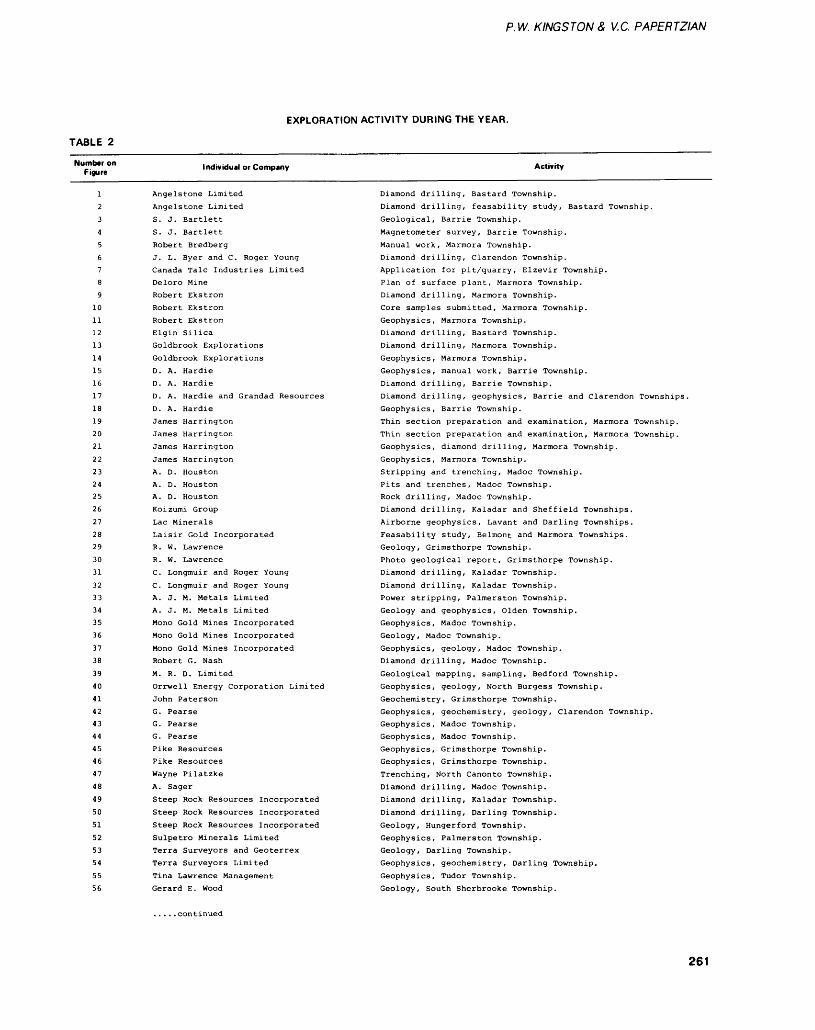
P. W. KINGS'TON 8, V.C. PAPERTZIAN
EXPLORATION ACTIVITY DURING THE YEAR.
TABLE 2
Number on Figure
Individual or Company Activity
12
3
4
5
6
7
8
9
10
11
12
13
14
15
16
17
18
19
20
21
22
23
24
25
26
27
28
29
30
31
32
33
34
35
36
37
38
39
40
41
42
43
44
45
46
47
48
49
50
51
52
53
54
55
56
Angelstone Limited
Angelstone Limited
S. J. Bartlett
S. J. Bartlett
Robert Bredberg
J. L. Byer and C. Roger Young
Canada Talc Industries Limited
Deloro Mine
Robert Ekstrom
Robert Ekstrom
Robert Ekstrom
Elgin Silica
Goldbrook Explorations
Goldbrook Explorations
D. A. Hardie
D. A. Hardie
D. A. Hardie and Grandad Resources
D. A. Hardie
James Harrington
James Harrington
James Harrington
James Harrington
A. D. Houston
A. D. Houston
A. D. Houston
Koizumi GroupLac MineralsLaisir Gold IncorporatedR. W. LawrenceR. W. LawrenceC. Longmuir and Roger Young
C. Longmuir and Roger YoungA. J. M. Metals LimitedA. J. M. Metals LimitedMono Gold Mines IncorporatedMono Gold Mines IncorporatedMono Gold Mines IncorporatedRobert G. NashM. R. D. LimitedOrrwell Energy Corporation LimitedJohn PatersonG. PearseG. PearseG. PearsePike ResourcesPike ResourcesWayne PilatzkeA. SagerSteep Rock Resources IncorporatedSteep Rock Resources IncorporatedSteep Rock Resources IncorporatedSulpetro Minerals LimitedTerra Surveyors and GeoterrexTerra Surveyors LimitedTina Lawrence ManagementGerard E. Wood
Diamond drilling, Bastard Township.Diamond drilling, feasability study, Bastard Township.Geological, Barrie Township.Magnetometer survey. Barrie Township.Manual work, Marmora Township.Diamond drilling, Clarendon Township.Application for pit/quarry. Elzevir Township.Plan of surface plant, Marmora Township.Diamond drilling, Marmora Township.Core samples submitted, Marmora Township.Geophysics, Marmora Township.Diamond drilling, Bastard Township.Diamond drilling. Marmora Township.
Geophysics, Marmora Township.Geophysics, manual work, Barrie Township.Diamond drilling, Barrie Township.Diamond drilling, geophysics. Barrie and Clarendon Townships.Geophysics, Barrie Township.Thin section preparation and examination, Marmora Township.Thin section preparation and examination, Marmora Township.Geophysics, diamond drilling. Marmora Township.Geophysics, Marmora Township.Stripping and trenching. Madoc Township.Pits and trenches, Madoc Township.Rock drilling, Madoc Township.Diamond drilling, Kaladar and Sheffield Townships.Airborne geophysics, Lavant and Darling Townships.Feasability study, Belmont and Marmora Townships.Geology, Grimsthorpe Township.Photo geological report, Grimsthorpe Township.Diamond drilling, Kaladar Township.Diamond drilling, Kaladar Township.Power stripping, Palmerston Township.Geology and geophysics, Olden Township.Geophysics, Madoc Township.Geology, Madoc Township.Geophysics, geology, Madoc Township.Diamond drilling, Madoc Township.Geological mapping, sampling, Bedford Township.Geophysics, geology, North Burgess Township.Geochemistry, Grimsthorpe Township.Geophysics, geochemistry, geology, Clarendon Township.Geophysics, Madoc Township.Geophysics, Madoc Township.Geophysics, Grimsthorpe Township.Geophysics, Grimsthorpe Township.Trenching, North Canonto Township.Diamond drilling, Madoc Township.Diamond drilling, Kaladar Township.Diamond drilling. Darling Township.Geology, Hungerford Township.Geophysics, Palmerston Township.Geology, Darling Township.Geophysics, geochemistry. Darling Township.Geophysics, Tudor Township.Geology, South Sherbrooke Township.
. ....continued
261
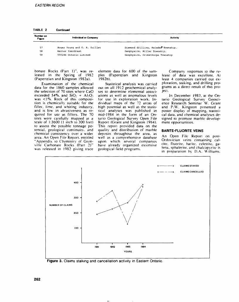
EASTERN REGION
TABLE 2 Continued
Number on Figure Individual or Company Activity
575859
Roger Young and G. R. Guillet Walter Yzerdraat
555246 Ontario Limited
Diamond drilling, Kaladar*Township.
Geophysics, Miller Township.
Geophysics, Grimsthorpe Township
bonate Rocks (Pan 1)", was re leased in the Spring of 1982 (Papertzian and Kingston 1982a).
Examination of the chemical data for the 1860 samples allowed the selection of 70 sites where CaO exceeded 54^o, and SiO: -t- A NO? was <]%. Rock of this composi tion is chemically suitable for the filler, lime, and whiting indusiry, and is low in abrasiveness as re quired for use as fillers. The 70 sites were carefully mapped at a scale of 1:3600 (l inch to 300 feet) to assess the possible tonnage po tential, geological continuity, and chemical consistency over a wider area. An Open File Report, entitled "Appendix lo Chemistry of Gren ville Carbonaie Rocks (Pan 2)" was released in 1982 giving trace
element daia for 600 of the sam ples (Papertzian and Kingston 1982b).
Statistical analysis was carried oui on all 1912 geochemical analy ses to determine elemental associ ations as well as anomalous levels for use in exploration work. In dividual maps of the 72 areas of high potential as well as the statis tical analyses was published in mid-1984 in the form of an On tario Geological Survey Open File Report (Grant and Kingston 1984). This report provided data on the quality and distribution of marble deposits throughout the area, as well as a comprehensive database upon which several companies have already organized extensive geological field programs.
Company responses to the re lease of data was excellent. At least 4 companies carried out ex ploration, staking, and drilling pro grams as a direct result of this pro ject.
In December 1983, at the On tario Geological Survey Geosci ence Research Seminar W. Grant and P.W. Kingston presented a poster display of mapping, statisti cal data, and chemical analyses de signed to promote marble develop ment opportunities.
BARITE-FLUORITE VEINSAn Open File Report on post- Ordovician veins containing cal cite, fluorite, barite, celestite, ga lena, sphalerite, and chalcopyrite is in preparation by D.A. Williams.
CLAIMS STAKED
300 -
NUMBER OF CLAIMS
200 -
— ——x CLAIMS CANCELLED
1982 1983
YEARS
Figure 3. Claims staking and cancellation activity in Eastern Ontario.
262
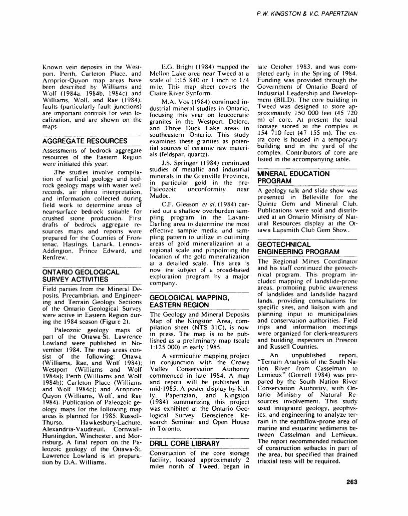
P. W. KINGSTON 8, M.C. PAPERTZIAN
Known vein deposits in the West port, Perth, Carleton Place, and Arnprior-Quyon map areas have been described by Williams and Wolf (1984a, 1984b, 1984c) and Williams, Wolf, and Rae (1984); faults (particularly fault junctions) are important controls for vein lo calization, and are shown on the maps.
AGGREGATE RESOURCESAssessments of bedrock aggregate resources of the Eastern Region were initiated this year.
.The studies involve compila tion of surficial geology and bed rock geology maps with water well records, air photo interpretation, and information collected during field work to determine areas of near-surface bedrock suitable for crushed stone production. First drafts of bedrock aggregate re sources maps and reports were prepared for the Counties of Fron- tenac, Hastings, Lanark, Lennox- Addington, Prince Edward, and Renfrew.
ONTARIO GEOLOGICAL SURVEY ACTIVITIES______Field parties from the Mineral De posits, Precambrian, and Engineer ing and Terrain Geology Sections of the Ontario Geological Survey were active in Eastern Region dur ing the 1984 season (Figure 2).
Paleozoic geology maps of pan of the Ottawa-St. Lawrence Lowland were published in No vember 1984. The map areas con sist of the following: Ottawa (Williams, Rae, and Wolf 1984); Westport (Williams and Wolf 1984a); Perth (Williams and Wolf 1984b); Carleton Place (Williams and Wolf 1984c); and Arnprior- Quyon (Williams, Wolf, and Rae 1984). Publication of Paleozoic ge ology maps for the following map areas is planned for 1985: Russell- Thurso, Hawkesbury-Lachute, Alexandria-Vaudreuil, Cornwall- Huntingdon, Winchester, and Mor risburg. A final report on the Pa leozoic geology of the Ottawa-St. Lawrence Lowland is in prepara tion by D.A. Williams.
E.G. Bright (1984) mapped the Mellon Lake area near Tweed at a scale of 1:15 840 or l inch to 1/4 mile. This map sheet covers the Claire River Synform.
M.A. Vos (1984) continued in dustrial mineral studies in Ontario, focusing this year on leucocratic granites in the Westport, Deloro, and Three Duck Lake areas in southeastern Ontario. This study examines these granites as poten tial sources of ceramic raw materi als (feldspar, quartz).
J.S. Springer (1984) continued studies of metallic and industrial minerals in the Grenville Province, in particular gold in the pre- Paleozoic unconformity near Madoc.
C.F. Gleason et al. (1984) car ried out a shallow overburden sam pling program in the Lavani- Darling area to determine the most effective sample media and sam pling pattern to utilize in outlining areas of gold mineralization at a regional scale and pinpointing the location of the gold mineralization at a detailed scale. This area is now the subjeci of a broad-based exploration program by a major company.
GEOLOGICAL MAPPING, EASTERN REGION_______The Geology and Mineral Deposits Map of the Kingston Area, com pilation sheet (NTS 31C), is now in press. The map is to be pub lished as a preliminary map (scale 1:125000) in early 1985.
A vermiculite mapping project in conjunction with the Crowe Valley Conservation Authority commenced in late 1984. A map and report will be published in mid-1985. A poster display by Kel ly, Papertzian, and Kingston (1984) summarizing this project was exhibited at the Ontario Geo logical Survey Geoscience Re search Seminar and Open House in Toronto.
DRILL CORE LIBRARY______Construction of the core storage facility, located approximately 2 miles north of Tweed, began in
late October 1983, and was com pleted early in the Spring of 1984. Funding was provided through the Government of Ontario Board of Industrial Leadership and Develop ment (BILD). The core building in Tweed was designed to store ap proximately 150 000 feet (45 720 m) of core. At present the total footage stored at the complex is 154 710 feet (47 155 m). The ex tra core is housed in a temporary building and in the yard of the complex. Contributors of core are listed in the accompanying table.
MINERAL EDUCATION PROGRAM____________A geology talk and slide show was presented in Belleville for the Quinte Gem and Mineral Club. Publications were sold and distrib uted at an Ontario Ministry of Nat ural Resources display at the Ot tawa Lapsmith Club Gem Show.
GEOTECHNICAL ENGINEERING PROGRAMThe Regional Mines Coordinator and his staff continued the geotech nical program. This program in cluded mapping of landslide-prone areas, promoting public awareness of landslides and landslide hazard lands, providing consultations for specific sites, and liaison with and planning input to municipalities and conservation authorities. Field trips and information meetings were organized for clerk-treasurers and building inspectors in Prescott and Russell Counties.
An unpublished report, "Terrain Analysis of the South Na tion River from Casselman to Lemieux" (Gorrell 1984) was pre pared by the South Nation River Conservation Authority, with On tario Ministry of Natural Re sources involvement. This study used integrated geology, geophys ics, and engineering to analyze ter rain in the earthflow-prone area of marine and estuarine sediments be tween Casselman and Lemieux. The report recommended reduction of construction setbacks in part of the area, but specified thai drained triaxial tests will be required.
263
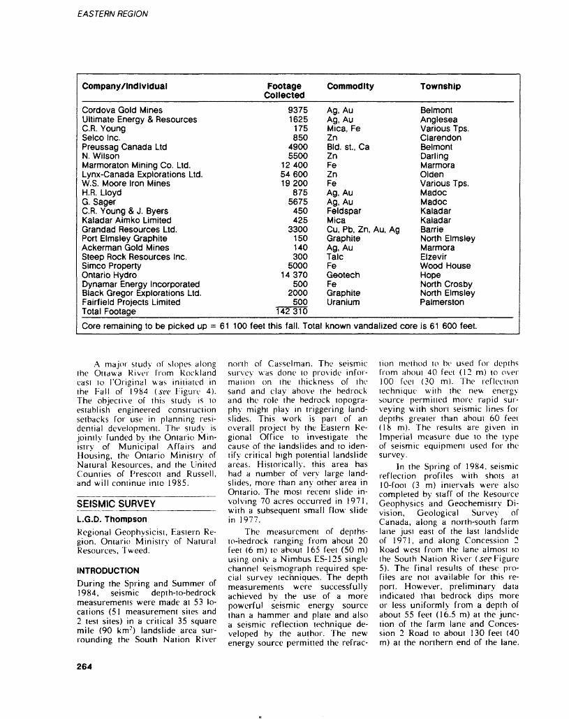
EASTERN REGION
Company/Individual
Cordova Gold MinesUltimate Energy A ResourcesC.R. YoungSelco Inc.Preussag Canada LtdN. WilsonMarmoraton Mining Co. Ltd.Lynx-Canada Explorations Ltd.W.S. Moore Iron MinesH.R. LloydG. SagerC.R. Young b J. ByersKaladar Aimko LimitedGrandad Resources Ltd.Port Elmsley GraphiteAckerman Gold MinesSteep Rock Resources Inc.Simco PropertyOntario HydroDynamar Energy IncorporatedBlack Gregor Explorations Ltd.Fairfield Projects LimitedTotal FootageCore remaining to be picked up = 61
FootageCollected
93751625
175850
49005500
124005460019200
8755675
450425
3300150140300
500014370
5002000
500142310
100 feet this fall. Total
Commodity
Ag, AuAg, AuMica, FeZnBid. st., CaZnFeZnFeAg, AuAg, AuFeldsparMicaCu, Pb, Zn, Au, AgGraphiteAg, AuTalcFeGeotechFeGraphiteUranium
known vandalized core
Township
BelmontAngleseaVarious Tps.ClarendonBelmontDarlingMarmoraOldenVarious Tps.MadocMadocKaladarKaladarBarrieNorth ElmsleyMarmoraElzevirWood HouseHopeNorth CrosbyNorth ElmsleyPalmerston
is 61 600 feet.
A major study of slopes along the Ottawa River from Kockland east to ('Original was initialed in the Fall of 1984 (sec Figure 4). The object i ve of this study is to establish engineered construction setbacks for use in planning resi dential development. The study is jointly funded by the Ontario Min istry of Municipal Affairs and Housing, the Ontario Ministry of Natural Resources, and the United Counties of Prescott and Russell, and will continue into 1985.
SEISMIC SURVEY ~ L.G.D. ThompsonRegional Geophysicist, Eastern Re gion. Ontario Ministry of Natural Resources, Tweed.
INTRODUCTIONDuring the Spring and Summer of 1984, seismic depth-to-bedrock measurements were made at 53 lo cations (51 measurement sites and 2 test sites) in a critical 35 square mile (90 km 2 ) landslide area sur rounding the South Nation River
north of Casselman. The seismic survey was done to provide infor mation on the thickness of the sand and clay above the bedrock and the role the bedrock topogra phy mighi play in triggering land slides. This work is part of an overall project by the Eastern Re gional Office to investigate the cause of the landslides and to iden tify critical high potential landslide areas. Historically, this area has had a number of very large land slides, more than any other area in Ontario. The mosi recent slide in volving 70 acres occurred in 1971, with a subsequent small flow slide in 1977.
The measurement of depfhs- to-bedrock ranging from about 20 feel (6 m) to aboui 165 feel (50 m) using only a Nimbus ES-125 single channel seismograph required spe cial survey techniques. The depth measurements were successfully achieved by the use of a more powerful seismic energy source than a hammer and plate and also a seismic reflection technique de veloped by the author. The new energy source permitted the refrac
tion method to be used for depths from about 40 feel (12m) to over 100 feel (30 m). The reflection lechnique with the new energy source permitted more rapid sur veying with shorl seismic lines for depths greater than aboui 60 feei (18 m). The results are given in Imperial measure due to the type of seismic equipment used for the survey.
In the Spring of 1984, seismic reflection profiles with shots at 10-fooi (3 m) intervals were also completed by staff of the Resource Geophysics and Geochemistry Di vision, Geological Survey of Canada, along a north-south farm lane just east of the last landslide of 1971, and along Concession 2 Road west from the lane almost to the South Nation River (secFigure 5). The final results of these pro files are not available for this re port. However, preliminary data indicated that bedrock dips more or less uniformly from a depth of about 55 feet (16.5 m) at the junc tion of the farm lane and Conces sion 2 Road to about 130 feet (40 m) at the northern end of the lane.
264
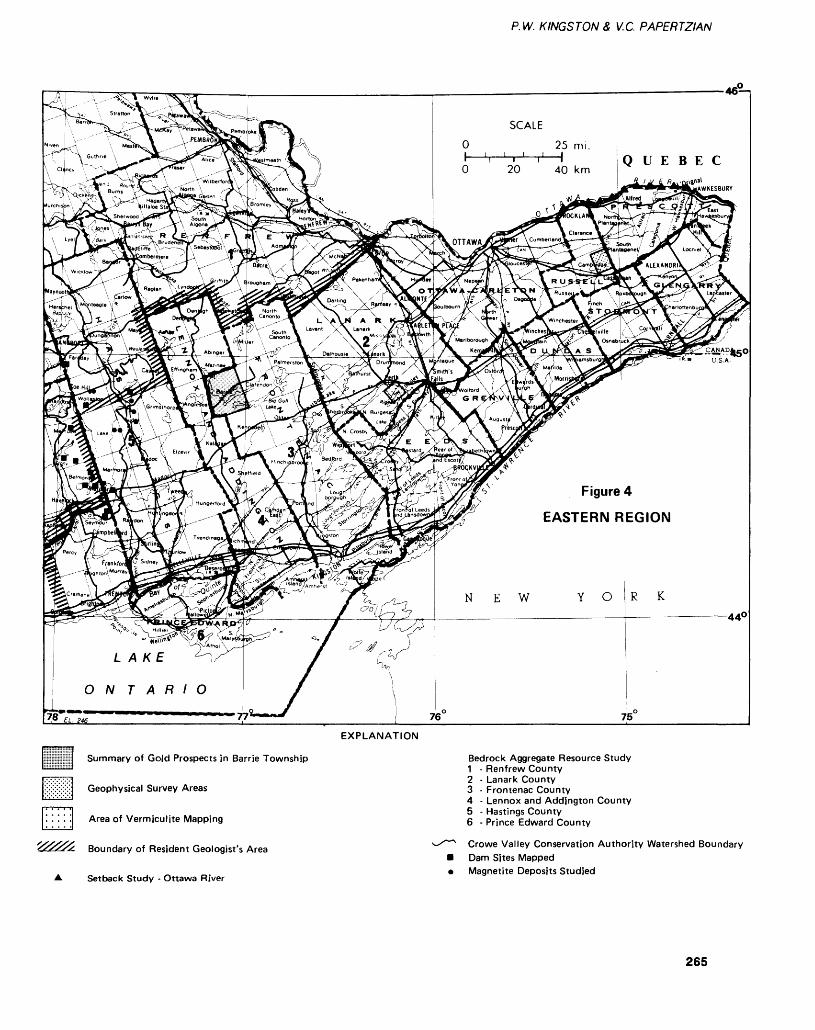
P. W. KINGSTON 8, V.C. PAPERTZIAN
O 20 40 km
Figure 4
EASTERN REGION
L A KE
ON T A R l O
EXPLANATION
Summary of Gold Prospects in Barrie Township
Geophysical Survey Areas
Area of Vermiculite Mapping
Boundary of Resident Geologist's Area
Setback Study - Ottawa River
Bedrock Aggregate Resource Study1 - Renfrew County2 - Lanark County3 - Frontenac County4 - Lennox and Addjngton County5 - Hastings County6 - Prince Edward County
Crowe Valley Conservation Authority Watershed Boundary Dam Sites Mapped Magnetite Deposits Studied
265
EASTERN REGION
Going west along Concession 2 Road from the lane, the bedrock dips more steeply toward the South Nation River. Test Sites l and 2 were selected on the Geological Survey of Canada profile along the farm lane for comparison pur poses. Site l was at the southern end of the lane where the depth was about 60 feet (18m) and both refraction and reflection methods could be used. Site 2 was near the northern end of the lane where the depth was 100 feet (30 m) or more and the reflection technique could be tested.
In addition, a test hole was drilled to bedrock by Eastern Re gion staff at the location of Test Site 2 of this survey on the same farm lane where the Geological Survey of Canada reflection pro file was done (sec Figure 5). The drill encountered refusal at a depth of 108 feet (33 m) in compacted till hui is believed to have been at or very close to the bedrock sur face.
SEISMIC ENERGY SOURCEThe seismic energy source used for this survey was a copy of a device originally designed and developed by the staff of the Terrain Geo physics Section, Resource Geo physics and Geochemistry Divi sion, Geological Survey of Canada. The model fabricated by the author includes some design modifications for simpler construction and easier operation and maintenance. The device fires 12 gauge slugs into the bottom of a 3-foot (l m) deep hole. It provides a shock wave with at least 6 times the energy of a heavy hammer and plate source. It also provides a higher frequency spec trum more applicable to reflection work.
SURVEY METHODThe survey method uses a single shot point and the geophone is stepped out at 10-foot (3 m) inter vals. Many shots can be fired into a single hole drilled with a hand auger without serious decrease in energy. Usually only one shot is required for reflection lines or short refraction lines. For long re
fraction lines, it is advisable and was sometimes necessary to use l or 2 additional fresh holes to give maximum shock wave energy at the greater distances. Since the shot point is 3 feet (l m) below the surface, it is usually in or close to the water table and/or a high ve locity clay (about 4700 feet per second). Thus no energy is lost go ing through the upper low velocity surface topsoil layer.
For efficient surveying, the geophone must necessarily be placed on the surface. In areas of clay or no grass cover, such as in the bottom of a road ditch, the geo phone could easily be embedded firmly in the ground. In areas of loose sand or grass cover, a hole was dug and the sod removed. The geophone was then firmly embed ded in the underlying moist ma terial. By this procedure, the prob lems associated with surface- planted geophones were reduced or minimized.
SEISMIC REFRACTION LINESEarly work consisting of Test Site l and lines C-1 to C-1 l was done by the conventional refraction method while awaiting new equip ment required for reflection work. The lines were shot in both for ward and reverse directions to ac count for any significant dip of the bedrock surface. Reflection lines C-24, C-37, and C-38 were also done by refraction to determine bedrock velocities. C-51 was a re fraction line only. At line C-9, bed rock was too deep for the refrac tion method and the line was re peated later by reflection.
The advantage and purpose of refraction measurements is that bedrock velocities are obtained to help identify the type of bedrock. Over most of the survey area, the bedrock velocity was found to be unusually high (about 21 000 feet per second on the average). To verify this velocity, a refraction line was run over an outcrop area of Lindsay Formation limestone just east of the survey area. This site, identified as Test Site 3, is on Concession 17 Road of South Plantagenet Township about 3.2
miles east of the western township boundary. The measured velocity confirmed the 21 000 feet per sec ond value and that the area is, iri fact, underlain by Lindsay Forma tion limestone.
REFLECTION TECHNIQUEThe reflection technique has re cently been developed to a high degree of perfection for continuous reflection profiling by Hunter ei al. (1982) using a Nimbus multichan nel engineering seismograph, high frequency 100 Hertz geophones, and a microcomputer. Without the benefit of such sophisticated equip ment, reflection work with a single channel seismograph is very dif ficult and has not met with much success by previous experimenters. However, the single channel re flection technique developed by the author did prove satisfactory for mapping the bedrock topography.
The author's reflection tech nique is a compromise method both in equipment and survey tech nique for making spot depth- to-bedrock measurements. The equipment used is a Nimbus ES- 125 single channel seismograph, a Nimbus ESK-100 recorder, stan dard 50 Hertz geophones, and the new energy source. Basically, an expanding spread of source to geo phone offsets is used following re flection methods described by Dobrin (1960) and Huntec (1972). More particularly, the technique more appropriately makes use of an "optimum window" of offsets described by Hunter et al. (1982).
The reflection technique re quires both the identification of re flection signals and the visual cor relation of a reflection signal from trace to trace (a recorded geophone signal). With shallow refraction seismographs ii is difficult to detect reflections at short offsets due to interference from other refraction and surface waves. At large off sets, reflections undergo a phase change that could cause an error in the measured arrival time. The "optimum window" identifies the minimum and maximum offsets where the reflections have little or no interference from later arriving
266
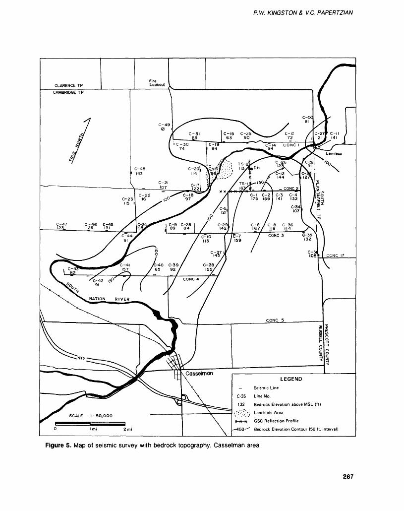
P. W. KINGSTON 8* V.C. PAPERTZIAN
LEGEND
Seismic Line
Line No.
Bedrock Elevation above MSL (ft)
Landslide Area
GSC Reflection Profile
Bedrock Elevation Contour (50 ft. interval)
SCALE l ' 50,000
Figure 5. Map of seismic survey with bedrock topography, Casselman area.
267
EASTERN REGION
refraction signals. In ihis range of offsets, usable reflections can he obtained for determining average overburden velocities and depths to bedrock.
Using a "normalized" case by- taking the ratio of the offset dis tance x to the depth d, the "optimum window" is taken to be between \/d=\/2 to x/d = 2. With out filtering, reflections near \/d=\/2 are noi always identifi able. Near xA^2, reflections may also undergo a phase change. This noted immediately on an X vs T : plot because the points will curve away from a straight line. Usually offsets greater than Sd/2 are not recommended. However, the win dow of x/d^/2 to x/d = 2 is used to ensure thai all possible usable reflections are obtained. Also, the points at x/d^/2, l, 3/2, and 2 are useful for simple calculation purposes.
Usually some part of a reflec tion signal (a peak or trough) can be identified at most offsets in the "optimum window". Usually l or more complete reflection signals are also obtained which give the accurate arrival lime of the onset of the reflection wave. A peak or trough thai is correlated from trace to trace can be corrected to the time of the onset by measuring the period of the reflection wave.
Visual trace to trace correla tion of a reflection signal is accom plished by recording the geophone signal (a trace) displayed on the screen of the ES-125 seismograph at each offset distance on an ESR- 100 single channel strip chart re corder. Although the trace records could be cut and stacked l below the other to give the equivalent of a multichannel record, a reflection wave can easily be correlated from trace to trace along the strip chan using a peak or trough.
The offset distance and arrival times are plotted on square-square paper to give an X : vs T: plot. For true reflections, these points plot in a straight line. The inverse slope of the line gives the average velocity of the overburden above bedrock. The ordinate intercept gives the travel time of a shock wave verti
cally below the shot point. From these data, the depth-to-bedrock be low the shot point can be easily calculated.
This reflection method is sat isfactory for depths of 60 feet (18 m) or more but 100 feet (30 m) is perhaps a better minimum depth. Reflection lines can be done more easily and rapidly than refraction lines. A shorter line (usually from 50 to 200 feet (15 to 60 m)) and fewer shot points (16 shots) are needed. An advantage of this re flection method is that the average velocity of the overburden is ob tained. However, it does not give (in this survey) the bedrock veloc ity or topsoil velocity which are determined by the refraction meth od.
RESULTSThe survey results are given in Ta ble 2a. The seismic depth measure ments have been adjusted to give depths below road or land surface and are considered accurate to ±10^0. The mean sea level (MSL) elevation a i each line location was estimated from spot elevation, bench marks, and contours shown on 1:50 000 scale topographic map 31 G/6 for the area. These MSL elevations are no better than ±10 feet (3 m). By subtraction, the bed rock elevations above MSL were obtained. The accuracy of these elevations is not high but the data serve the purpose. Figure 5 is a map of the area showing the line locations, MSL bedrock elevations, bedrock contours, and other infor mation.
From visual inspection of out crops and the high seismic veloci ties, the bedrock is now- known and accepted to be Lindsay limestone and noi a shale as previously be lieved. The bedrock has an irregu lar undulating topography devel oped by very early erosional pro cesses. The limestone has been eroded down to hard, dense, com petent and thick layers having an extremely high seismic velocity of about 21 000 feet per second. In places of higher bedrock elevation above about 130 feet (40 m), the layers are thinner, more fractured,
and have a lower seismic velocity of about 16 000 feet per second.
The bedrock contours show a trough or depression extending along the present course of the South Nation River. This is inter preted to be a fault zone that was more easily eroded or perhaps downfaulted. There is evidence of downfaulting just north of Lemieux. Here the bedrock is ex posed in the river but drops away suddenly where the river turns to the north. The seismic data show that the bedrock drops from about 120 feet (36.5 m) above MSL to 80 feet (24.5 m), a drop of about 40 feet (12 m).
CONCLUSIONS1. The new energy source and re flection technique proved to be ef fective and useful for spot depth measurements greater than 40 feel (12m) using a single channel seis mograph.2. The seismic data confirmed that the area was underlain by Lindsay Formation limestone.3. The bedrock topography indi cated a fauli zone in a bedrock depression that follows along the present course of the South Nation River. The sloping of the bedrock towards the river, combined with the local increased thickness of sand and clay in the eroded valley, could play a role in the occurrence of landslides.4. This work has been useful for updating the geological map of the area for more accurate location of faults.
ACKNOWLEDGMENTSMuch credit for this work must go to the Eastern Region senior staff members who recognized the use fulness of geophysics and support ed the seismic survey, more par ticularly John Oatway, Regional Director; Eric Gage, Deputy Re gional Director; Tom Fletcher, Re gional Mines Coordinator; and Paul Kingston, Regional Geologist. Assistance and advice was also re ceived from James Hunter, Susan Pullan, and Robert Gagne of the Resource Geophysics and Geo-
268
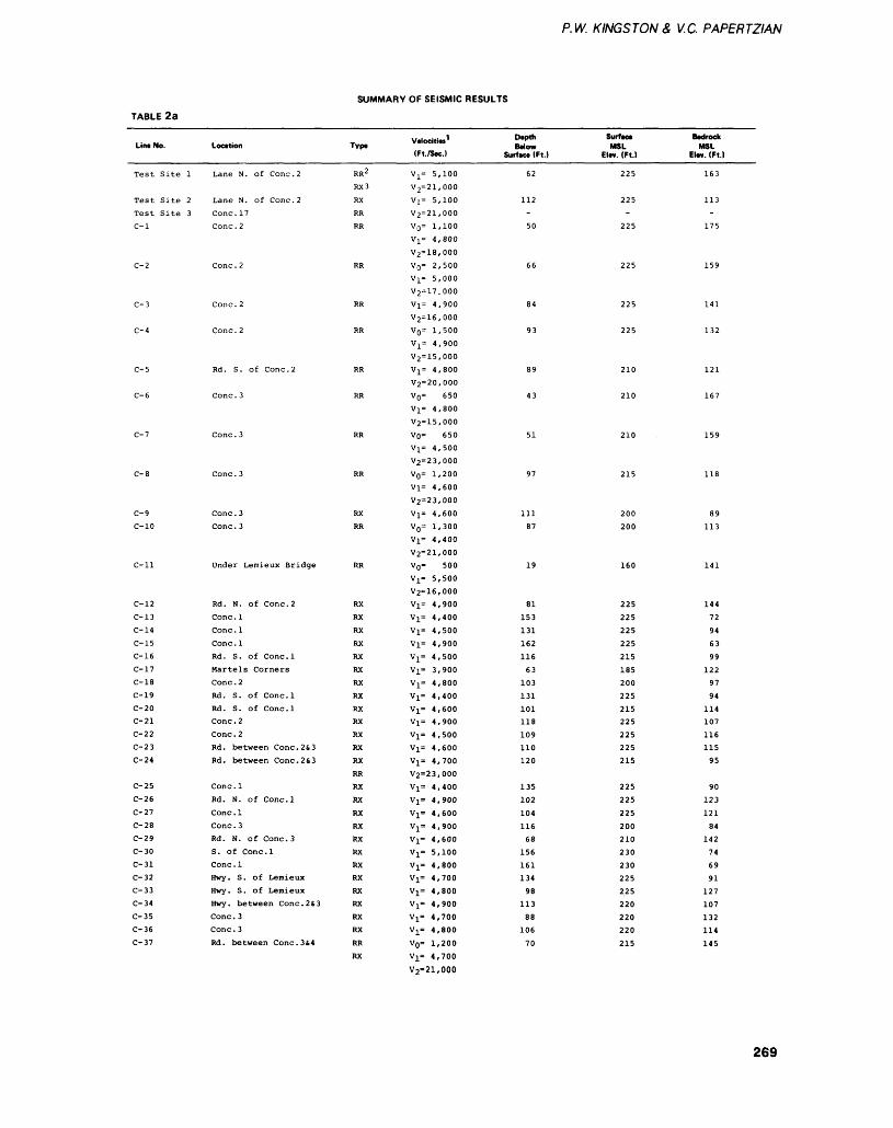
P. W. K INGS TON a V.C. PAPERTZIAN
TABLE 2a
SUMMARY OF SEISMIC RESULTS
Line No.
Test Site 1
Test Site 2Test Site 3C-l
C- 2
C- 3
C-4
C- 5
C- 6
C- 7
C- 8
C- 9C-10
C-ll
C-12C-13C-14C-15C-16C-17C-18C-19C-20C-21C-22C-23C-24
C-25C-26C-27C-28C-29
C- 30C- 31C-32
C- 33C-34C-35
C- 36C-37
Location
Lane N. of Cone . 2
Lane N. of Cone. 2Cone. 17Cone. 2
Cone. 2
Cone. 2
Cone. 2
Rd. S. of Cone. 2
Cone. 3
Cone. 3
Cone. 3
Cone. 3Cone. 3
Under Lemieux Bridge
Rd. N. of Cone. 2Cone . 1Cone. 1Cone . 1Rd. S. of Conc.lMartels CornersCone . 2Rd. S. of Conc.lRd. S. of Conc.lCone. 2Cone . 2Rd. between Cone. 2s, 3Rd. between Cone. 2S3
Cone . 1Rd. N. of Conc.lCone . 1Cone. 3Rd. N. of Cone. 3S. of Conc.lCone . 1Hwy. S. of LemieuxHwy. S. of LemieuxHwy. between Cone. 263Cone . 3Cone. 3Rd. between Cone. 3 64
Type
RR 2
RX3
RXRRRR
RR
RR
RR
RR
RR
RR
RR
RXRR
RR
RXRXRXRXRXRXRXRXRXRXRXRXRXRRRX
RXRXRXRXRXRXRXRXRXRXRX
RRRX
Velocities1(Ft./Sec.)
V x * 5,10072=21,000Vi* 5,10072=21,00070' 1,100V]^ 4,80072=18,000V 0 * 2,5007]^ 5,00072=17.000V]^ 4,90072=16,0007(^ 1,5007^ 4,90072=15,0007j^ 4,80072=20,0007(^ 6507]^ 4,80072=15,000V.o* 6507^ 4,50072=23,0007 0 * 1,2007^ 4,60072=23,0007i* 4,6007^ 1,3007j^ 4,40072=21,000V(^ 5007i* 5,50072=16,0007]^ 4,9007!* 4,400Vi* 4,5007^ 4,9007i* 4,500Vi" 3,900Vi* 4,800Vi* 4,400Vi* 4,600Vi* 4,900Vi" 4,500Vi* 4,600Vi* 4,70072=23,000Vi* 4,400Vi* 4,900Vi* 4,600Vi* 4,900Vi* 4,600Vi* 5,100Vi* 4,800Vi* 4,700Vi" 4,800Vi* 4,900Vi* 4,700Vi* 4,800V0* 1,200Vi* 4,700
Depth Below
Surface (Ft.)
62
112-
50
66
84
93
89
43
51
97
11187
19
81153131162116
63103131101118109110120
135102104116
68156161134
98113
88106
70
Surface MSL
Ele*. (Ft.)
225
225-
225
225
225
225
210
210
210
215
200200
160
225225225225215185200225215225225225215
225225225200210230230225225220220220215
Bedrock MSL
Ele*. (Ft.)
163
113-
175
159
141
132
121
167
159
118
89113
141
14472946399
1229794
114107
116115
95
90123121
84142
746991
127107132114145
V 2*21,000
269
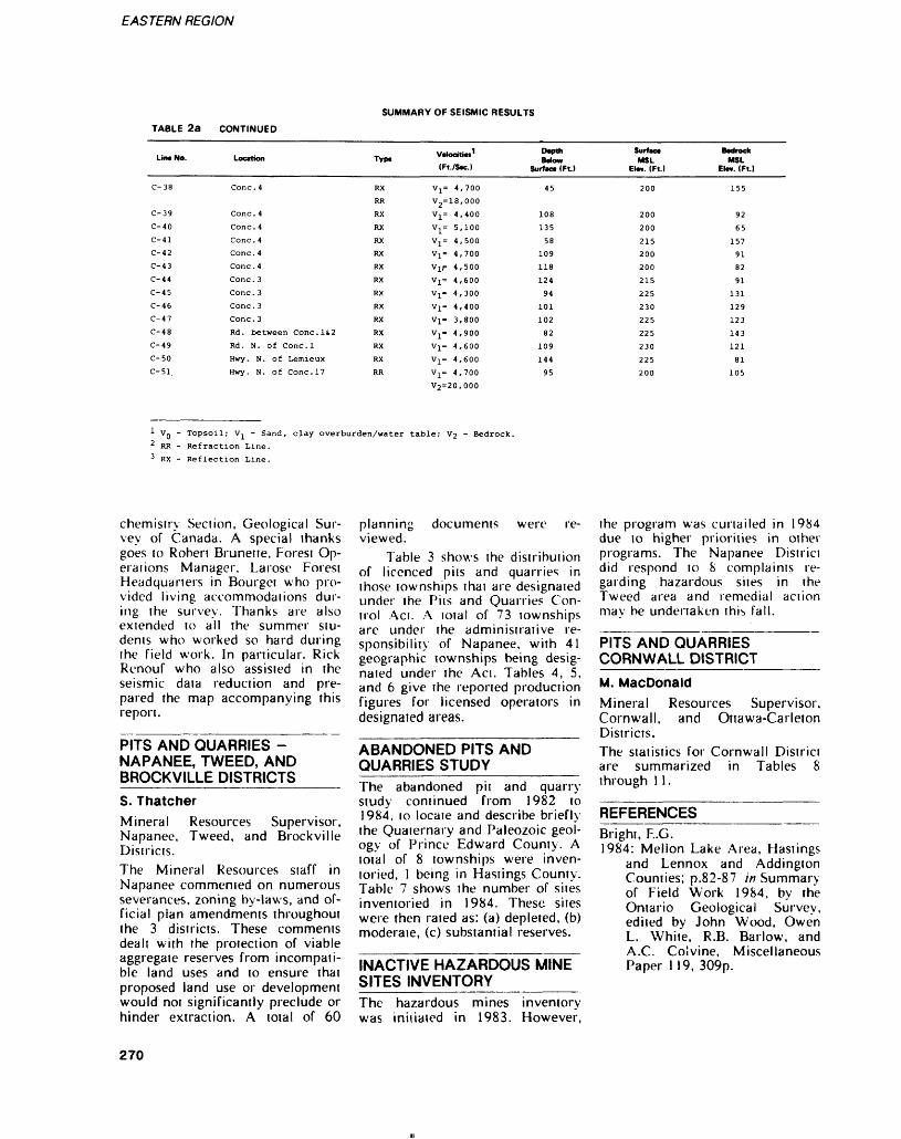
EASTERN REGION
SUMMARY OF SEISMIC RESULTS
TABLE 2a CONTINUED
Lin* No. Locttion Typ. Vclocitici 1(Ft./Sw.)
Depth Mow
Surfac* (Ft.)
Surfx* MSL
Elm. (Ft.)MSL
EI**. (Ft.)
C-39
C-40
C-41
C-42
C-43
C-44
C-45
C-46
C-47
C-48
C-49
C-50 C-51
Cone.4
Cone.4
Cone.4
Cone.4
Cone.4
Cone.3
Cone. 3
Cone.3
Cone.3
Rd. between Conc.li2
Rd. N. of Cone.l
Hwy. N. of Lemieux
Hwy. N. of Cone.17
RX
RX
RX
RX
RX
RX
RX
RX
RX
Vj^ 4,700
Vj^ 4,400
V^ 5,100
Vj^ 4,500
V]^ 4,700
Vjr 4,500
V^ 4,600
V^ 4,300
Vj^ 4,400
V1= 3,800
Vj^ 4,900
V1= 4,600
V]^ 4,600
V 1 = 4,700
72=20,000
108
135
58
109
118
124
94
101
102
82
109
144
95
200
200
215
200
200
215
225
230
225
225
230
225
200
92
65
157
91
82
91
131
129
123
143
121
81
105
1 Vg - Topsoil; Vj^ - Sand, clay overburden/water table; V2 - Bedrock.2 RR - Refraction Line.3 RX - Reflection Line.
chemistry Section, Geological Sur vey of Canada. A special thanks goes to Robert Brunette, Forest Op erations Manager, Larose Forest Headquarters in Bourget who pro vided living accommodations dur ing the survey. Thanks are also extended to all the summer stu dents who worked so hard during the field work. In particular. Rick Renouf who also assisted in the seismic data reduction and pre pared the map accompanying this report.
PITS AND QUARRIES - NAPANEE, TWEED, AND BROCKVILLE DISTRICTS__S. ThatcherMineral Resources Supervisor, Napanee, Tweed, and Brockville Districts.The Mineral Resources staff in Napanee commented on numerous severances, zoning by-laws, and of ficial plan amendments throughout the 3 districts. These comments dealt with the protection of viable aggregate reserves from incompati ble land uses and to ensure that proposed land use or development would not significantly preclude or hinder extraction. A total of 60
planning documents were re viewed.
Table 3 shows the distribution of licenced pits and quarries in those townships that are designated under the Pits and Quarries Con trol Act. A total of 73 townships are under the administrative re sponsibility of Napanee, with 41 geographic townships being desig nated under the Act. Tables 4, 5, and 6 give the reported production figures for licensed operators in designated areas.
ABANDONED PITS AND QUARRIES STUDY_______The abandoned pit and quarry study continued from 1982 to 1984, to locate and describe briefly the Quaternary and Paleozoic geol ogy of Prince Edward County. A total of 8 townships were inven toried, l being in Hastings County. Table 7 shows the number of sites inventoried in 1984. These sites were then rated as: (a) depleted, (b) moderate, (c) substantial reserves.
INACTIVE HAZARDOUS MINE SITES INVENTORY_______The hazardous mines inventory was initiated in 1983. However,
the program was curtailed in 1984 due to higher priorities in other programs. The Napanee District did respond to 8 complaints re garding hazardous sites in the Tweed area and remedial action may be undertaken this fall.
PITS AND QUARRIES CORNWALL DISTRICT_____M. MacDonaldMineral Resources Supervisor, Cornwall, and Ottawa-Carleton Districts.The statistics for Cornwall District are summarized in Tables 8 through 11.
REFERENCESBright, F..G.1984: Mellon Lake Area, Hastings
and Lennox and Addingion Counties; p.82-87 in Summary of Field Work 1984, by the Ontario Geological Survey, edited by John Wood, Owen L. White, R.B. Barlow, and A.C. Colvine, Miscellaneous Paper 119, 309p.
270
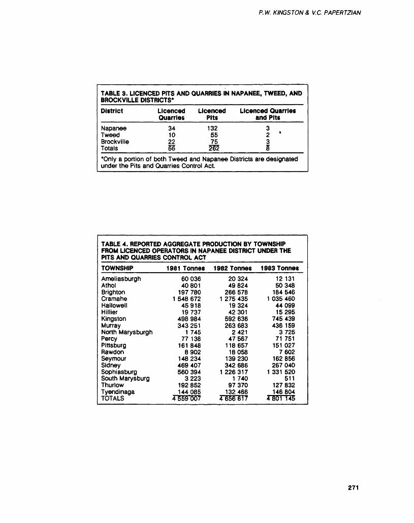
P. IV. KINGSTON A V.C. PAPERTZIAN
TABLE 3. LICENCED PITS AND QUARRIES IN NAPANEE, TWEED, AND BROCKVILLE DISTRICTS*
District
Napanee Tweed Brockville Totals*Only a portion of under the Pits and
Licenced Licenced Quarries Pits
34 132 10 55 22 75 56 555
both Tweed and Napanee Quarries Control Act.
Licenced Quarries and Pits
3 2 '
3 5
Districts are designated
TABLE 4. REPORTED AGGREGATE PRODUCTION BY TOWNSHIP FROM LICENCED OPERATORS IN NAPANEE DISTRICT UNDER THE PITS AND QUARRIES CONTROL ACT
TOWNSHIP
AmeliasburghAtholBrightonCramaheHallowellHillierKingstonMurrayNorth MarysburghPercyPittsburgRawdonSeymourSidneySophiasburgSouth MarysburgThurlowTyendinagaTOTALS
1981 Tonnes6003640801
1977801 548 672
4591819737
498 984343 251
1 74577 138
161 8488902
148234469 407560 394
3223192 852144085
4 559 007
1982 Tonnes2032449824
266 5781 275 435
1932442301
592 636263 683
242147567
1 18 65718058
139 230342 686
1 2263171 740
97370132466
4656617
1 983 Tonnes12 13150348
184 5461 035 460
4409915295
745 439436 159
372571 751
151 0277602
162 856267 040
1 331 520511
127 832146 804
4801 145
271
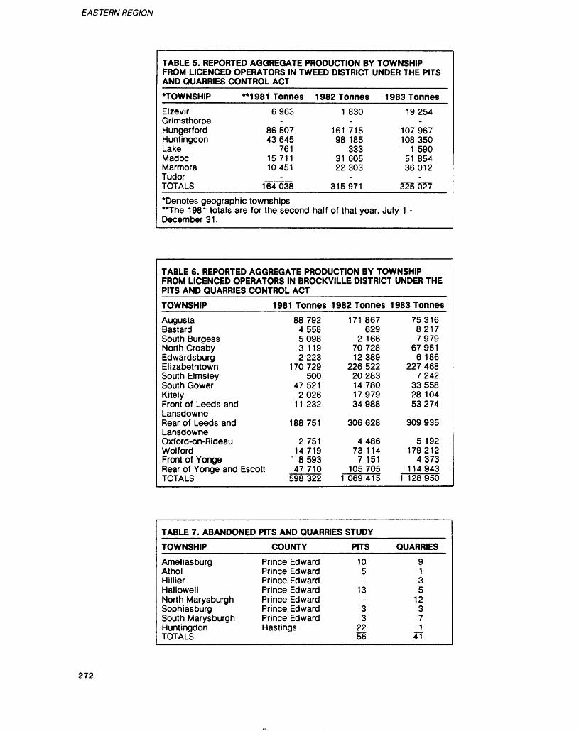
EASTERN REGION
TABLE 5. REPORTED AGGREGATE PRODUCTION BY TOWNSHIP FROM LICENCED OPERATORS IN TWEED DISTRICT UNDER THE PITS AND QUARRIES CONTROL ACT
'TOWNSHIP
Elzevir Grimsthorpe Hungerford Huntingdon Lake Madoc Marmora Tudor TOTALS•Denotes geographic **The 1981 totals are December 31.
1981 Tonnes6963
86507 43645
761 15711 10451
164038
townships for the second
1 982 Tonnes1 830
161 715 98 185
333 31 605 22303
315971
half of that year,
1 983 Tonnes19254
107967 108 350
1 590 51 854 36012
325 027
July 1 -
TABLE 6. REPORTED AGGREGATE PRODUCTION BY TOWNSHIP FROM LICENCED OPERATORS IN BROCKVILLE DISTRICT UNDER THE PITS AND QUARRIES CONTROL ACT
TOWNSHIP 1981 TonnesAugustaBastardSouth BurgessNorth CrosbyEdwardsburgElizabethtownSouth ElmsleySouth GowerKitelyFront of Leeds andLansdowneRear of Leeds andLansdowneOxford-on-RideauWolfordFront of YongeRear of Yonge and EscottTOTALS
88 792455850983 1192223
170729500
475212026
11 232
188 751
2 75114719
- 859347710
598 322
1982 Tonnes171 867
6292 166
7072812389
226 52220283147801797934 988
306 628
448673 114
7 151105 705
1 069415
1 983 Tonnes7531682177979
679516 186
227 4687242
3355828 10453274
309 935
5 192179212
4373114943
1 128 950
TABLE 7. ABANDONED
TOWNSHIP
Ameliasburg AtholHillierHallowellNorth Marysburgh Sophiasburg South Marysburgh Huntingdon TOTALS
PITS AND QUARRIES
COUNTY
Prince Edward Prince EdwardPrince EdwardPrince EdwardPrince Edward Prince Edward Prince Edward Hastings
STUDY
PITS
10 5-
13
3 3
22 56
QUARRIES
9135
12 3 7 1
4T
272
P. W. K INGS TON S V.C. PAPERTZIAN
TABLE 8. LICENCED PITS, QUARRIES, AND PITS/QUARRIES FOR 1984 CORNWALL DISTRICT
A.
B.
C.
D.
E.
County/Township
STORMONT COUNTY 1. Osnabruck Tp. 2. Cornwall Tp. 3. Roxborough Tp. 4. Finch Tp.
DUNDAS COUNTY 1. Matilda Tp. 2. Mountain Tp. 3. Williamsburg Tp. 4. Winchester Tp.
GLENGARRY COUNTY 1. Lancaster Tp. 2. Lochiel Tp. 3. Charlottenburg Tp. 4. Kenyon Tp.
PRESCOTT COUNTY I.Alfred Tp. 2. N. Plantagenet Tp. 3. S. Plantagenet Tp. 4. Longueuil Tp. 5. Caledonia Tp. 6. W. Hawkesbury Tp. 7. E. Hawkesbury Tp.
RUSSELL COUNTY 1 . Clarence Tp. 2. Russell Tp. 3. Cambridge Tp.
GRAND TOTAL
Licenced Pits
16 32 23
6
8 8 0
10
1 4 4
16
6 5 4 0 1
17 7
11 4 5
Licenced Licenced Total Quarries Pits/Quarries
2 5 3 4
2 2 3 1
1 0 0 3
1 0 1 1 2 0 0
1 3 1
0 0 0 1
0 0 0 0
0 0 0 0
0 0 0 010 0
0 0 0
18 37 26 11 92
10 10
3 11 34
2 4 4
19 29
7 5 5 1 4
17 7
46
12 7 6
25
226
273
EASTERN REGION
TABLE 9AGGREGATE PRODUCTION FROM LICENCED PITS AND QUARRIES DURING THE YEAR. 1981
CORNWALL DISTRICT
County
Stormont
Dundas
Glengarry
Prescott
Russell
TnwiMhia Number of Licenced Sand and Gravel Stone Clay and Shale Total lowmnipi Pit* end Quarries (Tonnes) (Tonnes) (Tonnes) (Tonnes)
CornwallOsnabruckFinchRoxborough
MatildaMountainWinchesterWilliams burgh
LancasterLochielCharlotten burgh
Kenyon
AlfredLongueuilS. Plan tagenet
N. Plan tagenet
E. Hawkes bury
W. Hawkes bury
Caledonia
RussellClarenceCambridge
6,872.36 198,448.4515,442.28 6,369.0029,712.78 52,212.2513,255.00 15,132.24
21,677.82 21,944.0068,628.9048,078.34
110,365.00
34,705.90145,367.00
480.00
47,616.95
640.00116,218.86
27,350.21
11,422.00
43,611.60 24,370.00
7,890.00
8,340.00 9,570.00
74,847.3559,886.71 46,757.0026,143.00
205320.8121811.2881925.0328377.24
43621.8268628.9048078.34
110365.00
34705.90145367.00
480.00
47616.95
640.00116218.8627350.21
11422.00
67981.60
7890.00
17910.00
75709.35106643.7126143.00
TOTAL FOR 1981 1294207.00
274
P. W. K INGS TON S, V.C. PAPERTZIAN
TABLE 10AGGREGATE PRODUCTION FROM LICENCED PITS AND QUARRIES DURING THE YEAR. 1982
CORNWALL DISTRICT
County
Stormont
Dundas
Glengarry
Prescott
Russell
Towmhip, Number of Lic.no*! * Pitt and Quarries
Cornwall Osnabruck Finch Roxborough
Matilda Mountain WinchesterWilliams
burgh
Lancaster LochielCharlotten burgh
Kenyon
Alfred LongueuilS. Plan tagenet
N. Plan tagenet
E. Hawkes bury
W. Hawkes bury
Calendonia
Russell Clarence Cambridge
Sand and Gravel (Tonnes)
22,256.50 11,532.50 29,147.63 11,428.17
44,646.00 175,709.40 93,963.65
24,936.23 1,890.00
23,682.65
1,495.00
58,814.76 5,076.25
81,935.00
13,739.03
3,748.00
117,881.00 70,040.65 17,948.00
Stone (Tonnes)
370,512.00 34,347.00
114,300.29 55,558.24
64,181.00
95,433.00
116,642.30
-
125,469.95
20,097.00
48,879.00
-
14,065.00
44,956.90 94,020.00
Clay and Shale Total (Tonnes) (Tonnes)
392768.50 45879.50
143447.92 66986.41
108827.00 175709.40
93963.65 95433.00
116642.30 24936.23 1890.00
23682.65
1495.00 125469.95
78911.76 5076.25
130814.00
13739.03
17813.00
162837.90 164060.65 17948.00
TOTAL FOR 1982 1988235.10
275
EASTERN REGION
TABLE 11AGGREGATE PRODUCTION FROM LICENCED PITS AND QUARRIES DURING THE YEAR. 1983
CORNWALL DISTRICT
County
Stormont
Dundas
Glengarry
Prescott
Russell
- . . Number of Licenced Sand and Gravel Stone Clay and Shale Total Pits and Quarries (Tonnes) (Tonnes) (Tonnes) (Tonnes)
Cornwall
Osnabruck
Finch
Roxborough
Matilda
Mountain
Winchester
Williams burgh
Lancaster
Lochiel
Charlotten burgh
Kenyon
Alfred
Longueuil
S. Plan tagenet
N. Plan tagenet
E. Hawkes bury
W. Hawkes bury
Caledonia
Russell
Clarence
Cambridge
219
3
214
28
35
222
93
55
2
113
3
44
15
67
11
2
156
108
33
,427,
,501.
,104.
,498.
,287.
,385.
,578.-
-
,279.
,180.
,751.
,720.-
,512.
,460.
,297.
,623.
,830.
,836.
,765.
,631.
.20 613,027.00
.80 91,681.86
.23
.92 28,730.25
.00 2,664.00
.79
.11
99,602.00
83, 366. 50
.17
,00
.60
.00
225, 805.00
.30 27,256.00
.80
.04
.53
.00 2,730.00
.30 71,043.69
.88 112,217.00
.00
832454,
95183.
214104.
57229.
37951.
222385.
93578,
99602,
83366,
55279.
2180.
113751.
3720.
225805.
71768.
15460.
67297.
11623.
5560.
227879.
220982.
33631.
.20
.66
.23
.17
.00
.79
.11
.00
.50
.17
.00
.60
.00
,00
. 30
,80
.04
.53
.00
.99
88
00
TOTAL FOR 1983 2790793.97
276
P. W. K INGS TON S, V.C. PAPERTZIAN
Dobrin, M.B.1960: Introduction to Geophysical
Prospecting; McGraw-Hill,New York.
Gleeson, C.F., Rampton, V.N., Thomas, R.D., and Paradis, S. 1984: Gram 065 Development and
Adaptation of Geochemical Techniques to Gold Explora tion in Glacial Drift; p. 129-149 in Summary of Re search 1983-1984 by "the Ex ploration Technology Develop ment Program of the Board of Industrial Leadership and De velopment, edited by V.G. Milne and R.B. Barlow, On tario Geological Survey, Mis cellaneous Paper 120, 176p.
Gorrell, G.A.1984: Terrain Analysis of the
South Nation River from Cas selman to Lemieux; unpublish ed report prepared for the South Nation River Conserva tion Authority, Berwick, On tario, June 15, 1984.
Grant, W.T., and Kingston, P.W.1984: Geology and Geochemistry
of Grenville Marble in South eastern Ontario; Ontario Geo logical Survey. Open File Re port 5509, 297p., 4 tables, 27 figures, 4 photos, and l map in back pocket.
Huntec (70) Limited1972: FS-3 Facsimile Seismograph
Operator's Manual; Revised1972, Toronto.
Hunter, J.A., Burns, R.A., Good, R.L., MacAulay, H.A., and Gagne, R.M.1982: Optimum Field Techniques
for Bedrock Reflection Map
ping with the Multichannel Engineering Seismograph; p. 125-129 in Current Re search, Part B, Geological Sur vey of Canada, Paper 82-1 B.
Kelly, W., Papertzian, V.C., andKingston, P.W.1984: Vermiculite in Eastern On
tario; Poster Display, Ontario Geological Survey Geoscience Research Seminar, Toronto, December 4 and 5, 1984.
Northern Miner, The1984: Underground Exploration
for Lasir Gold; Northern Min er Press Limited, June 21,p.47.
Papertzian V.C.1984: A Summary of Gold Pros
pects in Barrie Township; pub lished by the Township of Bar rie, Cloyne, Ontario, 67p. Copies available through the Resident Geologist Office, Tweed.
Papertzian, V.C., and Kingston,P.W.1982a: Chemistry of Grenville
Carbonate Rocks; Ontario Geological Survey, Open File Report 5378 (Pan 1), Sip., l figure, l table, l map.
1982b: Appendix to Chemistry of Grenville Carbonate Rocks; Ontario Geological Survey, Open File Report 5378 (Part 2). 33p.
Springer, J.S., and Mussakowski,R.1984: Colour Clues to Archean
Weathering; Ontario Geologi cal Survey, Geoscience Re search Seminar, Toronto, De cember 4 and 5, 1984.
Vos, M.A.1984: Granite and Anorthosite as
Ceramic Raw Materials, p.252-255 //; Summary of Field Work 1984, by the On tario Geological Survey, edited by John Wood, Owen L. White, R.B. Barlow, and A.C. Colvine, Miscellaneous Paper 119, 309p.
Williams, D.A., and Wolf, R.R.1984a: Paleozoic Geology of the
Westport Area; Ontario Geo logical Survey, Map P.2723, Geological Series-Preliminary Map, scale 1:50000.
1984b: Paleozoic Geology of the Perth Area; Ontario Geologi cal Survey, Map P.2724, Geo logical Series-Preliminary Map, scale 1:50000.
1984c: Paleozoic Geology of the Carleton Place Area; Ontario Geological Survey, Map P.2725, Geological Series- Preliminary Map, scale 1:50 000.
Williams, D.A., Wolf, R.R., andRae, A.M.1984: Paleozoic Geology of the
Arnprior-Quyon Area; Ontario Geological Survey, Map P.2726, Geological Series- Preliminary Map, scale 1:50 000.
Williams, D.A., Rae, A.M., andWolf, R.R.1984: Paleozoic Geology of the Ot
tawa Area; Ontario Geological Survey, Map P.2716, Geologi cal Series-Preliminary Map, scale 1:50000.
277
Central Regional Geologist Area, Central RegionMahendra Narain 1 and Jackie Burkart2
1 Regional Geologist, ^Resource Geologist, Ontario Ministry of Natural Resources. Central Region
INTRODUCTIONGeoscience informal ion and con- suhaiive services continued lo be provided from the Regional Geolo gist's Office at Richmond Hill and the district offices at Cambridge, Maple, Lindsay, Fonthill, and Mid- hurst. The user groups for this in formation included various federal and provincial government agen cies, private consulting firms, pros pectors, aggregate industry, and the general public.
There was a general increase in requests for information relating to mining and petroleum re sources. Several inquiries for in vestment opportunities originated in the United States and one in Germany. The current interest is in resources related to building stone, high purity limestone, mica, and tile manufacture. Some com panies are interested in setting up tile plants in the Central Region.
The regional geoscience li brary now has a large collection of microfiche files along with the reader and printer facilities. All geoscience information has been catalogued and indexed and is available lo interested parties on request.
Production of mineral aggre gates in 1983 showed a slight in crease of about 6.407o over 1982 production in the Central Region. The number of licenced operations in the Region in 1984 stood at 866, showing a slight decrease over 1983.
The 3 gypsum mines in the Region continued their operations with increased production during the year and some expanded their operations.
Current staff at the regional office included: Martin Groneng, Regional Lands and Minerals Coordinator, Jackie Burkart, Re source Geologist, and June Feeney, Secretary.
Geological staff at the district offices included: Ted Harvey (Cambridge), Amar Mukherjee (Maple), Tom Cumby (Lindsay), John Fraser (Fonthill), and Bill Fitzgerald (Midhurst).
The Regional Geologist admin istered and initialed programs re- laied lo promotion of regional min eral resources, geoscience informa tion services, data gathering, and mineral resources management. Technical support and direction was provided to district programs and staff.
REGIONAL GEOLOGIST'S ACTIVITIES___________RESOURCES AND LAND USE PLANNINGThe Regional Geologist spent most of his time initiating and coordi nating several mineral resources studies in the Region. The second stage of study on the depositional characteristics of Whirlpool Sand stone resources was continued through the year by Di. Peter Mar tini and James Kwong of Guelph University. The draft report on this study was reviewed by the Region al Geologist and others and is now being finalized for publication as an Open File Report, expected to be available in March 1985.
Another project on evaluation of shale and clay resources of the Region was initiated. This project was started when several inquiries were received by the Region re garding the suitability of these re sources for the manufacture of roofing tiles, and wall and floor ceramic tiles. Dr. Martini and James Kwong of Guelph Univer sity are the principal investigators, and the Regional Geologist worked very closely with them during sam pling of resource sites and testing procedures. Fifty (50) resource sites were examined and sampled with the help of district staff; out of these, 16 sites were selected for detailed testing. All testing has been completed and the report is under preparation. It is expected that the report will be available as an Open File Report by the middle of 1985. The results of this study have been very encouraging and several sites have been found to be satisfactory, li is proposed to con tinue the study during 1985-86 on molded products to determine the
suitability of resources for manu facture of specific molded pro ducts. The Regional Geologist and the district staff conducted geologi cal tours for the individuals who showed interest in the Region's mineral resources.
The Regional Geologist assist ed the 5 districts in planning their licenced pit and quarry and ag gregate resources evaluation pro jects which are now being under taken and may continue over sev eral years. Both the districts and the Region are now planning pro jects that will assist in rhe promo tion, conservation, and proper uti lization of the regional mineral re sources, and assist both levels of the municipal governments in their planning process. The Regional Geologist, along with the Maple District and other ministry staff from Parks and Ontario Geological Survey, participated in planning the preservation of important geo logical features at the Don Valley brickyard site. Consultations were provided m the staff of C. Mirza Engineering Incorporated and Pe ter Martini and Associates of Guelph, who are working on sev eral projects in the Region.
The following is a list of some of the geological and and mineral resources inputs that were made by the regional and district staff:
Regions of Durham, Hald- imand-Norfolk, Niagara, WaterlooCounties of Victoria, Peterbor ough, WellingtonTownships of Ops, Hamilton, South Monaghan, Hope, Wainfleet, GlanbrookTowns of Pelham, Grimsby, Dunnville, Pickering, Rich mond Hill, Ancaster, Milton, NewcastleCities of Stoney Creek, Oshawa.
CONSULTATION AND EDUCATIONAL SERVICESThe regional office at Richmond Hill and the 5 district offices at Cambridge, Maple, Midhurst, Lind-
278
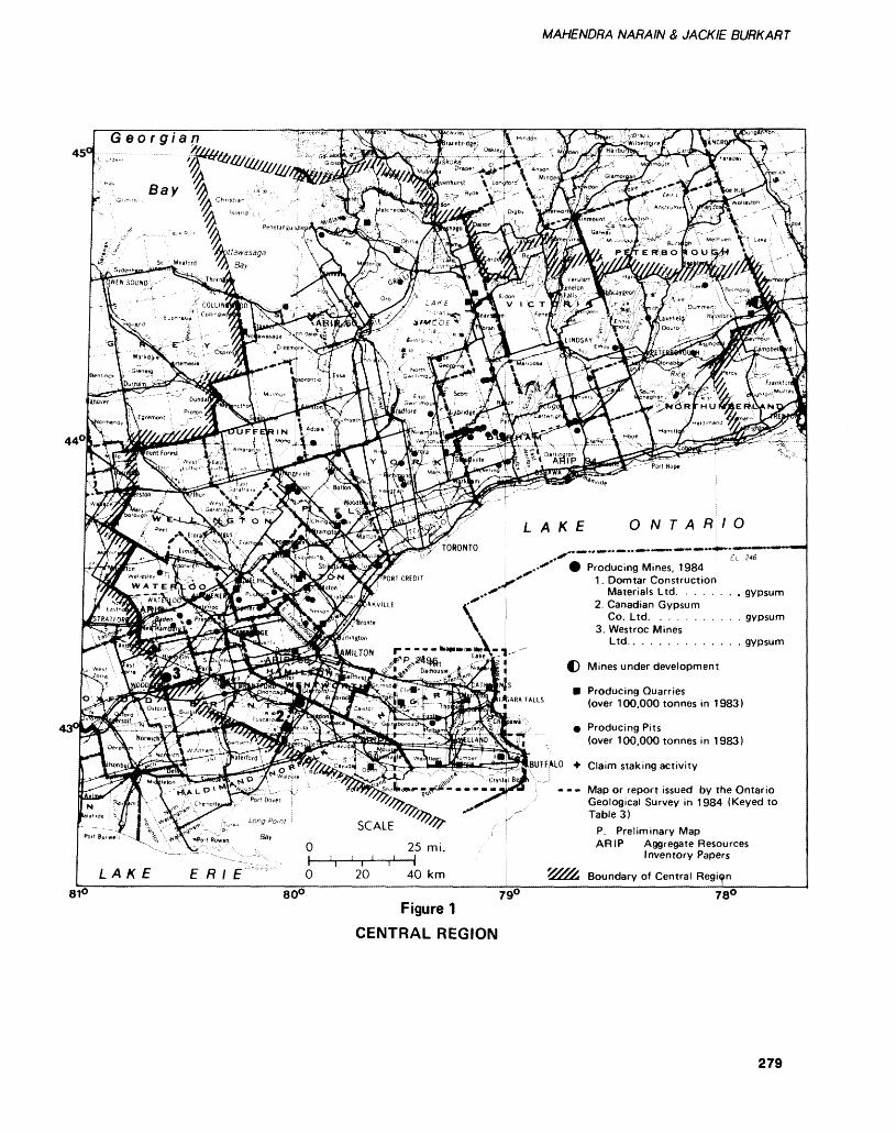
MAHENDRA NARAIN & JACK IE BURKART
45
440
LAKE ONTARIO
Producing Mines, 19841. Domtar Construction
Materials Ltd. . . . . . , . gypsum2. Canadian Gypsum
Co. Ltd. . . . . . . . . . . gypsum3. Westree Mines
Ltd.. . . . . . . . . gypsum
Mines under development
Producing Quarries
Claim staking activity
LAKE ERIE 20 40 km
* r ALLS (over 1 oo ooo tonnes in 1983)
Producing Pits(over 100,000 tonnes in 1983)
- - - Map or report issued by the Ontario Geological Survey in 1984 (Keyed to TableS)
P. Preliminary Map ARIP Aggregate Resources
Inventory Papers
Boundary of Central Region810 800
Figure 1 CENTRAL REGION
79C 780
279
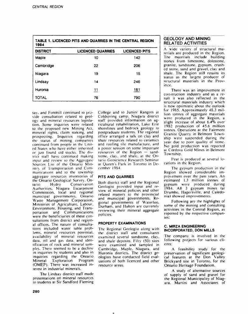
CENTRAL REGION
TABLE 1 . LICENCED 1984
DISTRICT
Maple
Cambridge
Niagara
Lindsay
Huronia
TOTAL
PITS AND QUARRIES IN THE
LICENCED QUARRIES
10
22
19
14
j^
76
CENTRAL REGION
LICENCED PITS
142
206
15
246
181
790
GEOLOGY AND MINING RELATED ACTIVITIES
say, and Fontnill continued lo pro vide consultation related to geol ogy and mineral resources legisla tion. Some inquiries were related to the proposed new Mining Act, mineral rights, claim staking, and prospecting. Inquiries regarding the status of mining companies continued from people in the Unit ed Slates who have either inherited or just found old stocks. The dis trict staff have continued making inpui and review to the Aggregate Sources Lisi of the Ontario Min istry of Transportation and Com munications and to the township aggregate resources inventories of the Ontario Geological Survey. On tario Hydro Conservation Authorities, Niagara Escarpment Commission, local and regional municipal governments, Ontario Waste Management Corporation, Ministries of Agriculture, Labour, Environment, Housing, and Trans portation and Communications were rhe beneficiaries of these con sultations from district and region al offices. The nature of consulta tions included water table prob lems, mineral resources potential, availability of mineral resources data, oil and gas data, and iden tification of rock and mineral sam ples. There seemed to be a decline in inquiries by students and also in inquiries regarding the Ontario Mineral Exploration Program (OMEP). There was increased in terest in industrial minerals.
The Lindsay district staff made presentations on mineral resources to students at Sir Sandford Fleming
College and to Junior Rangers at Coldspring camp. Niagara district staff provided information on ag ricultural rehabilitation, Lake Erie shorelines and bedrock geology to postgraduate students. The regional office arranged a talk on clay and shale resources related to ceramics and roofing tile manufacture, and a poster session on some important resources of the Region — sand stone, clay, and shale, at the On tario Geoscience Research Seminar at Queen's Park in Toronto in De cember 1984.
PITS AND QUARRIESBoth district staff and the Regional Geologist provided input and re view of mineral policies and other related matters to the provincial and municipal governments. Re gional governments of Waterloo, Durham, and Halton are currently reviewing their mineral aggregate policies.
PROPERTY EXAMINATIONSThe Regional Geologist along with the district staff and consultants examined several sandstone, clay, and shale deposits. Fifty (50) sites were examined and sampled in Cambridge, Maple, Niagara, and Huronia districts. The district ge ologists have conducted field eval uations of both licenced and other resource areas.
A wide variety of structural ma terials are produced in the Region. The materials include building stones from limestone, dolostone, granite, sandstone, gypsum, crush ed stone, sand and gravel, clay and shale. The Region still retains its status as the largest producer of structural materials in the Prov ince.
There was an improvement in construction industry and as a re sult it was also reflected in the structural materials industry which is now optimistic about the outlook for 1985. Approximately 48.3 mil lion tonnes of aggregate materials were produced in the Region, a slight increase of about 6.4 (7o over 1982 production of 45.6 million tonnes. Operations at the Fairmont Granite Quarry in Belmont Town ship were suspended during the year due to poor quality of stone. No gold production was reported ai Cordova Gold Mines in Belmont Township.
Peat is produced at several lo cations in the Region.
The gypsum production in the Region showed considerable im provement over the past years. An estimated 1.3 million tonnes of gypsum were produced during 1984. All 3 gypsum mines (at Drumbo, Hagersville, and Caledo nia) showed improvements.
Following are the highlights of some of the mining and consulting activities in the Central Region, as reported by the respective compan ies:
C. MIRZA ENGINEERING INCORPORATED, DON MILLSThe company is involved in the following projects for various cli ents:
A feasibility study for the preservation of significant geologi cal features at the Don Valley Brickyard site in Toronto, for the Ontario Heritage Foundation.
A study of alternative sources of supply of sand and gravel for the Regional Municipality of Niag ara. Martini and Associates of
280
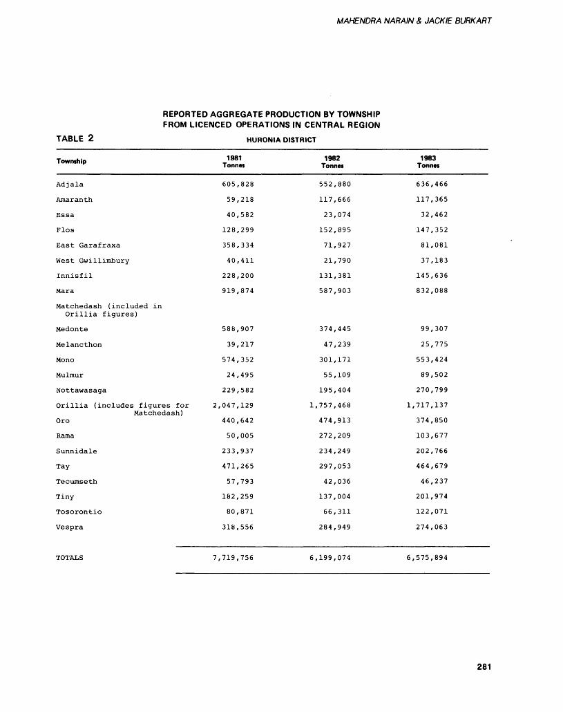
MAHENDRA NARAIN & JACK IE BURKART
REPORTED AGGREGATE PRODUCTION BY TOWNSHIP FROM LICENCED OPERATIONS IN CENTRAL REGION
TABLE 2
Township
Adjala
Amaranth
Essa
Flos
East Garafraxa
West Gwillimbury
Innisfil
Mara
Matchedash (included inOrillia figures)
Medonte
Melancthon
Mono
Mulmur
Nottawasaga
Orillia (includes figures for Matchedash)
Oro
Rama
Sunnidale
Tay
Tecumseth
Tiny
Tosorontio
Vespra
HURONIA DISTRICT
1981 Tonnes
605,828
59,218
40,582
128,299
358,334
40,411
228,200
919,874
588,907
39,217
574,352
24,495
229,582
2,047,129 1,
440,642
50,005
233,937
471,265
57,793
182,259
80,871
318,556
1982 Tonnes
552,880
117,666
23,074
152,895
71,927
21,790
131,381
587,903
374,445
47,239
301,171
55,109
195,404
757,468
474,913
272,209
234,249
297,053
42,036
137,004
66,311
284,949
1983 Tonnes
636,466
117,365
32,462
147,352
81,081
37,183
145,636
832,088
99,307
25,775
553,424
89,502
270,799
1,717,137
374,850
103,677
202,766
464,679
46,237
201,974
122,071
274,063
TOTALS 7,719,756 6,199,074 6,575,894
281
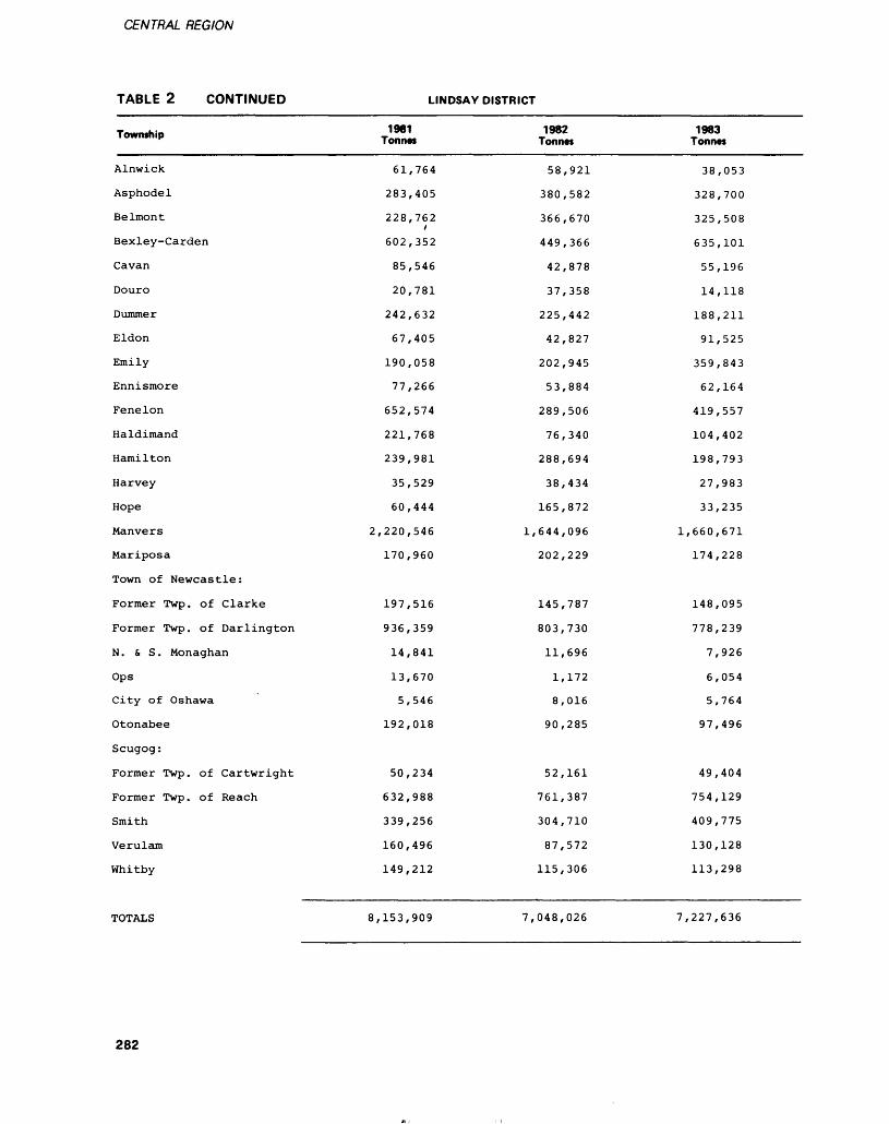
CENTRAL REGION
TABLE 2 CONTINUED LINDSAY DISTRICT
Township
Alnwick
Asphodel
Belmont
Bexley-Carden
Cavan
Douro
Dummer
Eldon
Emily
Ennismore
Fenelon
Haldimand
Hamilton
Harvey
Hope
Manvers
Mariposa
Town of Newcastle:
Former Twp. of Clarke
Former Twp. of Darlington
N . S S . Monaghan
Ops
City of Oshawa
Otonabee
Scugog:
Former Twp. of Cartwright
Former Twp. of Reach
Smith
Verulam
Whitby
1981 Tonnes
61,764
283,405
228,762i
602,352
85,546
20,781
242,632
67,405
190,058
77,266
652,574
221,768
239,981
35,529
60,444
2,220,546
170,960
197,516
936,359
14,841
13,670
5,546
192,018
50,234
632,988
339,256
160,496
149,212
1982 Tonnes
58,921
380,582
366,670
449,366
42,878
37,358
225,442
42,827
202,945
53,884
289,506
76,340
288,694
38,434
165,872
1,644,096
202,229
145,787
803,730
11,696
1,172
8,016
90,285
52,161
761,387
304,710
87,572
115,306
1983 Tonnes
38,053
328,700
325,508
635,101
55,196
14,118
188,211
91,525
359,843
62,164
419,557
104,402
198,793
27,983
33,235
1,660,671
174,228
148,095
778,239
7,926
6,054
5,764
97,496
49,404
754,129
409,775
130,128
113,298
TOTALS 8,153,909 7,048,026 7,227,636
282
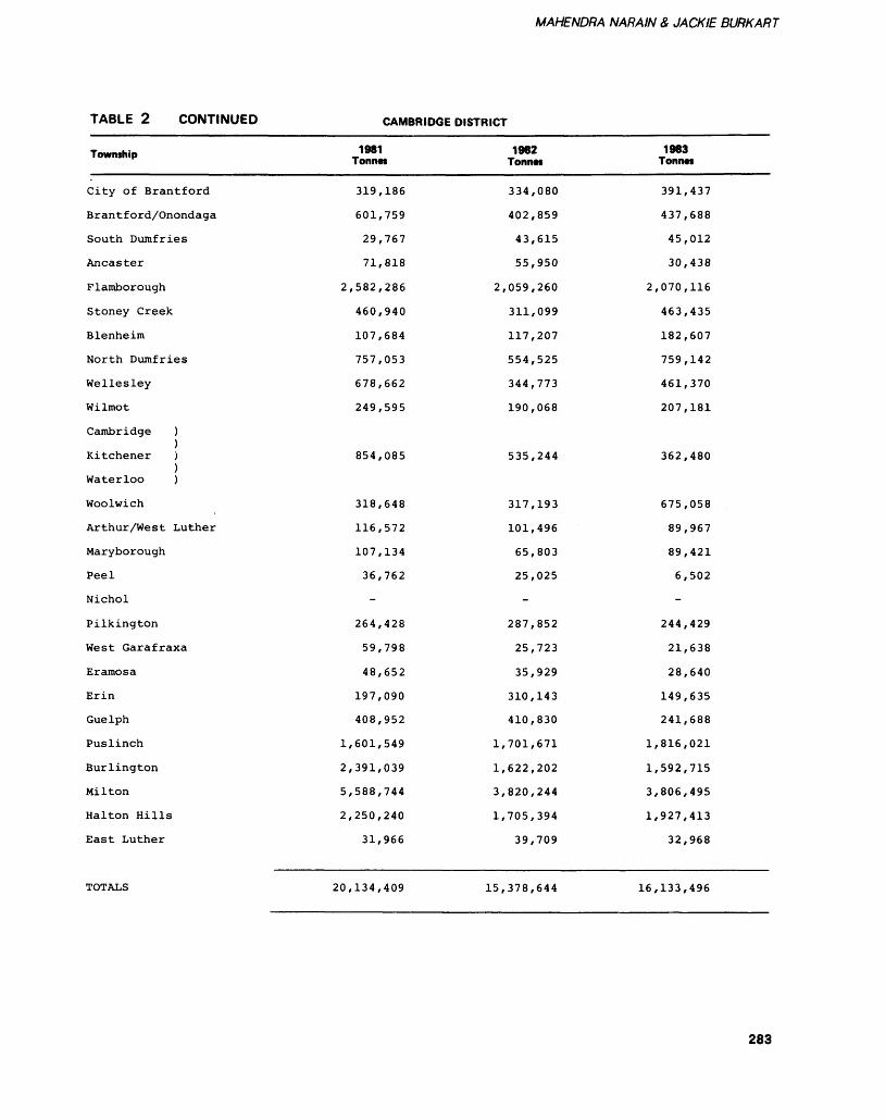
MAHENDRA NARAIN 8, JACK IE BURKART
TABLE 2 CONTINUED CAMBRIDGE DISTRICT
Township
City of Brantford
Brantford/Onondaga
South Dumfries
Ancaster
Flamborough
Stoney Creek
Blenheim
North Dumfries
Wellesley
Wilmot
Cambridge )
Kitchener )
Waterloo )
Woolwich
Arthur/West Luther
Maryborough
Peel
Nichol
Pilkington
West Garafraxa
Eramosa
Erin
Guelph
Puslinch
Burlington
Milton
Halton Hills
East Luther
1981 Tonnes
319,186
601,759
29,767
71,818
2,582,286
460,940
107,684
757,053
678,662
249,595
854,085
318,648
116,572
107,134
36,762
-
264,428
59,798
48,652
197,090
408,952
1,601,549
2,391,039
5,588,744
2,250,240
31,966
1982 Tonnts
334,080
402,859
43,615
55,950
2,059,260
311,099
117,207
554,525
344,773
190,068
535,244
317,193
101,496
65,803
25,025
-
287,852
25,723
35,929
310,143
410,830
1,701,671
1,622,202
3,820,244
1,705,394
39,709
1983 Tonnes
391,437
437,688
45,012
30,438
2,070,116
463,435
182,607
759,142
461,370
207,181
362,480
675,058
89,967
89,421
6,502
-
244,429
21,638
28,640
149,635
241,688
1,816,021
1,592,715
3,806,495
1,927,413
32,968
TOTALS 20,134,409 15,378,644 16,133,496
283
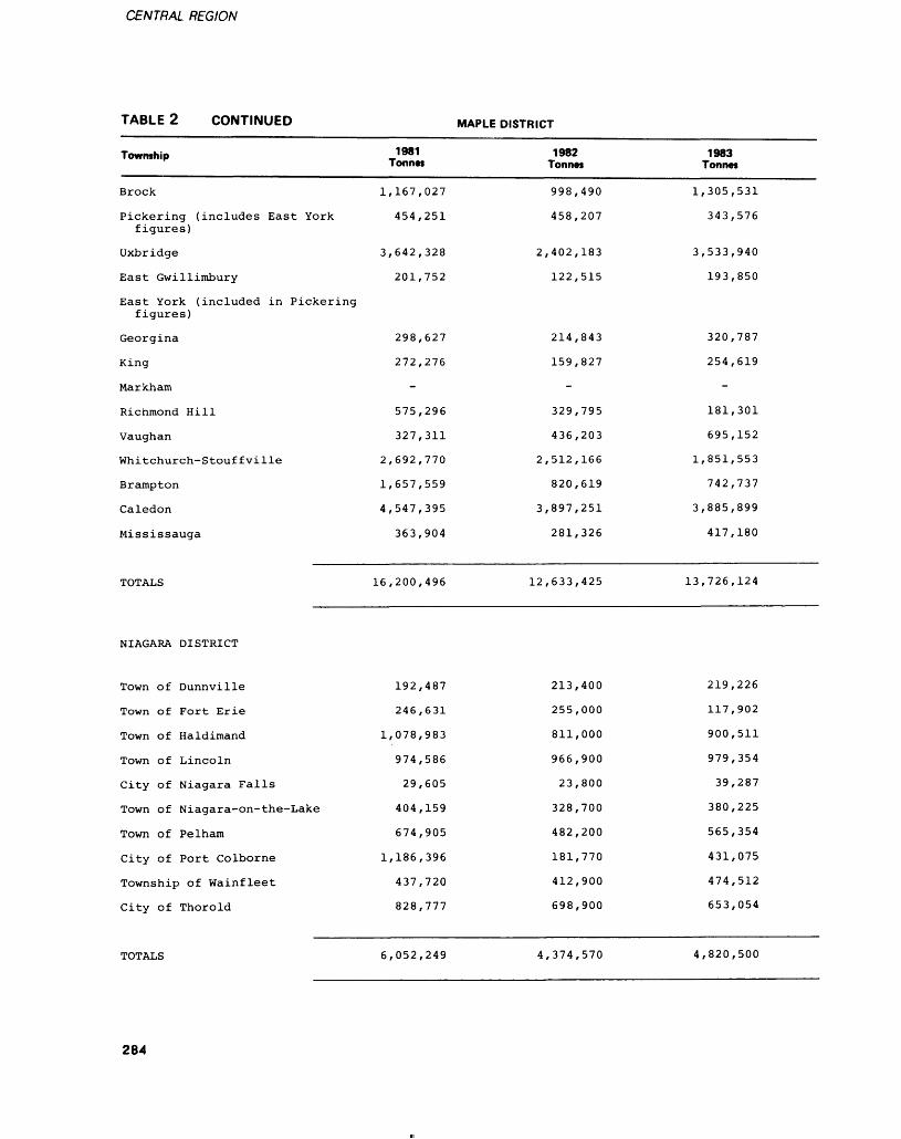
CENTRAL REGION
TABLE 2 CONTINUED MAPLE DISTRICT
Township
Brock
Pickering (includes East York figures)
Uxbridge
East Gwillimbury
East York (included in Pickering figures)
Georgina
King
Markham
Richmond Hill
Vaughan
Whitchurch-Stouf f vi Ile
Brampton
Caledon
Mississauga
TOTALS
NIAGARA DISTRICT
Town of Dunnville
Town of Fort Erie
Town of Haldimand
Town of Lincoln
City of Niagara Falls
Town of Niagara-on-the-Lake
Town of Pelham
City of Port Colborne
Township of Wainfleet
City of Thorold
1981 Tonnes
1,167,027
454,251
3,642,328
201,752
298,627
272,276
-
575,296
327,311
2,692,770
1,657,559
4,547,395
363,904
16,200,496
192,487
246,631
1,078,983
974,586
29,605
404,159
674,905
1,186,396
437,720
828,777
1982 Tonnes
998,490
458,207
2,402,183
122,515
214,843
159,827
-
329,795
436,203
2,512,166
820,619
3,897,251
281,326
12,633,425
213,400
255,000
811,000
966,900
23,800
328,700
482,200
181,770
412,900
698,900
1983 Tonnes
1,305,531
343,576
3,533,940
193,850
320,787
254,619
-
181,301
695,152
1,851,553
742,737
3,885,899
417,180
13,726,124
219,226
117,902
900,511
979,354
39,287
380,225
565,354
431,075
474,512
653,054
TOTALS 6,052,249 4,374,570 4,820,500
284
MAHENDRA NARAIN 8, JACK IE BURKART
Guelph are collaborating with the company on this project.
Foundation and soils investiga tions for the Ontario Ministry of Transportation and Communica tions, Ontario Ministry of Govern ment Services, Ontario Hydro, Public Works Canada, Canada Standards Association, Toronto Board of Education, Moriyama Teshima Architects, Sanyo Canada and others.
FRANCESCHINI BROTHERS AGGREGATES LIMITED, MISSISSAUGA1984 has been a much better year than expected. Sales will exceed estimated forecasts by more than 13^o as recoveries in most sectors of the construction industry were prevalent. Due 10 1983's below average volumes, expansion and capital expenditures in 1984 were considerably restrained. The com pany did however attempt to up date operations with the addition of a multi-purpose screening plant and a new front-end loader.
During 1984 the company at tempted to increase reserves by ap plying for rezoning of an addition al acreage (approximately 85 acres), adjacent to one of the op erating pits in the Town of Caledon. The required zoning change was approved by the town council and the company now awaits final zoning approval by the Ministry of Housing, prior to Min istry of Natural Resources approv al, and subsequent licencing under the Pits and Quarries Control Act.
ST. MARYS CEMENT COMPANY, BOWMANVILLEThe St. Marys Cement Company operates a cement plant and a limestone-shale quarry near Bowmanville. The company facili ties are located immediately south of Highway 401 at Waverley Road.
Due to the slightly improved economic climate and an upturn in construction, the cement plant has been operating at SO^o of its rated capacity for the year of 1984. Most of the cement is shipped by bulk
tank truck, and some by rail. The company is also shipping clinker by boat to its Milwaukee plant in Wisconsin. About IS^/o of St. Marys' total production is shipped to the United States. Most of the remaining production is shipped to the Metropolitan Toronto market.
The company presently em ploys 120 people at its Bowman ville plant.
WALKER BROTHERS QUARRIES LIMITED, NIAGARA FALLSThis is a limestone surface mine located on the corner of Mountain Road and Thorold Townline Road in Niagara Falls.
The company presently em ploys 18 people who are directly related to the production of crush ed stone. As of the end of October 1984, the company has produced 580 000 tonnes of limestone and plans to produce until December 1984, which should give a yearly production of approximately 700 000 tonnes. The company operates 3 extraction faces ranging from 20 to 40 feel high, and have made no major changes in the production system over the past year.
In 1985 the company expecis to experience a 15 ff7o drop in sales due to a depressed market in the area.
VINELAND QUARRIES AND CRUSHED STONE LIMITED, VINELANDThis is a limestone surface mine located on the corner of Fly Road and Regional Road 24 in Vine- land.
The company presently em ploys 11 people who are directly involved in the production of crushed stone. As of the end of October 1984, 490 000 tonnes were produced. The company plans to produce until December which should give a yearly produc tion of approximately 540 000 ton nes. The company operates one ex traction face ranging from 20-40 feet high.
In 1985 the company expects to experience a 10*Vo drop in sales
due to a depressed market in the area.
NATIONAL SEWER PIPE LIMITED, OAKVILLEThe company has a clay pit in Burlington and a manufacturing plant in St. Thomas, Ontario. It manufactures clay flue liners, clay sewer pipe, and plastic drain tub ing.
In 1984, the St. Thomas plant has worked almost to capacity, and the company is just completing the construction of 2 new periodic kilns which should improve energy consumption substantially. Further improvements are also contemplat ed in this area such as: addition of new efficient burners to the shuttle kiln and a computer controlled fir ing cycle.
Additional improvements will be introduced to the company's process, which will result in an increased production capacity. This additional production capac ity is needed in order to support a further penetration of the United Stales market aimed for in 1985.
TRT SAND AND GRAVEL, ORONO
TRT Sand and Gravel operates out of its main pit located at the south- west corner of Manvers Township (Concession l, Lots 1-5) in the County of Victoria. This single parcel of approximately 1000 acres contains reserves of about 250 million tons of high quality aggregate and is part of the Oak Ridges Moraine. The pit has been in operation since 1972 and pres ently employs 10 people perma nently, with seasonal help hired as necessary. Russell H. Steward Construction in Orillia, Ontario does all crushing, washing, and screening of material in the pit and employs up to 40 additional people during the peak production periods.
Aggregates include washed sand and stone for ready-mix con crete, crushed and screened asphalt aggregates, crushed gravel, and various pit run materials. These products are sold in a market area ranging from Toronto east to Port
285
CENTRAL REGION
Hope, and from Lake Ontario north to Peterborough, with the highest percentge being shipped to the Oshawa area. All processing is carried out by portable equipment which is capable of meeting all present volume requirements.
1984 has been the busiest year in the company's history. This is due to a local construction market which has seen activity in both the public and private sectors. While it would not appear that the extraor dinarily high volumes of 1984 are likely to be repeated, the company is cautiously optimistic of contin ued brisk activity in both sectors for 1985.
3M CANADA INCORPORATED, HAVELOCK
The company operates a 30 ha ba salt rock quarry that employs about 120 people. It also opeates a mill and a colouring plant located approximately 3 miles east of Havelock, immediately north of Highway 7.
The original mill was started in 1907 by Ontario Rock Limited to produce aggregates for road sur facing. In 1948, Building Products Canada Limited took over the op erations and built a colouring plant to produce artificially coloured roofing granules. 3M Canada In corporated bought the operation in 1960. The original mill was de stroyed by fire and a new mill was erected in 1961. Major additions were made to the new mill in 1979 which increased the crushing and screening capacity by 50^o. Modi fications were also made to the colouring plant which increased mixing capacity by 30*70.
About 1800 tonnes of quarried rock are crushed daily. The crush ed rock is fired and ceramically coated to give colour to the gran ules. About 1100 tonnes of fin ished product are produced daily. The company is currently sup plying all of the demand for the eastern Canadian markets and about half of the western Canadian markets for artifically coloured granules. A small amount of the product is exported to Belgium and
France. The product is shipped by both truck and rail.
The S5Q million facilities of 3M Canada Incorporated are unique in Canada. The company also owns and operates 4 other plants in the United States. 3M also produces 3/8' commercial stone and sand for the asphalt pav ing industry.
FRED NELSON AND SONS LIMITED, KEENEFred Nelson and Sons Limited has been operating for over 40 years in the gravel crushing business. Equipment includes 7 portable commander plants, 2 primary crushers, and 2 screening plants. Support equipment includes load ers, tandems, tractor trailers, and floats. At the present time the com pany employs 33 full time work ers.
LASIR GOLD INCORPORATED, CORDOVA MINES, CORDOVALasir Gold Incorporated is the owner of 3 contiguously located mineral claims and licences, being the wesi half of Loi 20, Marmora Township, Concession I, compris ing 100 acres more or less; and the east half Lot 20, Belmont Town ship, Concession I, comprising 50 acres more or less. Lasir Gold In corporated, has also acquired sur face rights to the east and west halves Lot 20 and the southeast quarter Lot 21, Belmont Township, Concession I. The old Cordova mine tailings are located on the east half of Lot 20, Belmont Town ship.
The property is located 12 miles from the village of Havelock and 8 miles from the village of Marmora. Access to the property is by paved road.
Gold was first discovered on the property in 1892. The Cordova Development Company acquired the property and did extensive de velopment work and operated stamp mills for 9 years producing 15 746 ounces of gold from 56 785 tons mined. In 1911 Cordova Mines Limited purchased the prop erty and operated it until fire de
stroyed the plant in 1917. During the "period from 1917 and 1930 two other operators treated an ad ditional 46 000 tons and recovered 13 700 ounces of gold. The 70 000 tons total of stamp mill tailings which it is proposed to now treat were produced prior to 1935.
In 1935 Consolidated Mining and Smelting Company of Canada Limited acquired the property and carried out exploration and devel opment operations until July 1940 when operations were suspended due to the war. In 1939 a 100 ton-per-day straight cyanide mill was built which produced 3487 ounces of gold from 33 434 tons milled from October 1939 to July 1940. At the close of operations in 1948, there were 3 shafts with depths of 401, 185, and 1050 feet, 16 676 feet of drifting, 3697 feet of cross-cutting, 2203 feet of sink ing, and 768 feet of raising. Re serves were reported as 77 130 tons of proven ore grading 0.175 ounce of gold per ton, and 50 000 tons of possible ore, with an addi tional possible tonnage of from 50 000 to 100000 tons.
In 1980 Lasir Gold took over the property, and uncrushed sur face development rock was cya nide leached on a 1500-ton heap leach pad. Approximately 90 ounces of gold were recovered from this operation.
In 1981-82 the extent of the old tailings was established by sampling. Pilot testing on the prop erty established that gold could be extracted by cyanidation.
In 1983 the company entered a joint venture with Minetech Limited in which the latter under took to build a plant to recover gold from the old tailings using cyanidation. About S250 000 was expended by Minetech Limited be fore it went bankrupt. The whole tailings area was cleaned of grass, trees, and roots, and stockpiling of some of the tailings was complet ed. Two large plastic-lined ponds and a tailings pond have been com pleted. The mill building with 8 leach tanks was erected, and 550 volt power was brought to the property. The access road to the
286
MAHENDRA NARAIN 8, JACK IE BURKART
lailings has been improved. These facilties will be incorporated inio the current treatment plant.
Direct cyanide tests on old stamp mill tailings, carried out by the Ontario Research Foundation of Mississauga and Lakefield Re search of Canada Limited of Lakefield, Ontario, have achieved 75*70 gold recovery.
Currently, the company is ac tively pursuing development of the property. An exploration program by Silver Princess Resources of Vancouver started this fall under a joint venture agreement staged over a 3-year period. These will involve expenditures of S200 000 in first year of the agreement, S300 000 in the second year, and S500 000 in the third year.
STAKING AND EXPLORATION ACTIVITY_^_________Seven new mining claims were re corded and 4 claims cancelled in 1984. The current total of mining claims in the Central Region now stands at 22. All the claims are located in Belmont Township. There are also 12 mining leases in Belmont Township. 200 man days of assessment work has so far been filed on the unpatented mining claims.
REGIONAL GEOLOGICAL EVALUATION PROJECTSSANDSTONE RESOURCES STUDYStage II of this study has now been completed. The final report is now under review for publication as an Open File Report. The study has concluded that potential new areas of sandstone resources could be identified using techniques and cri teria outlined in the report. The report on this part of the study is expected to be available as an Open File Report in March 1985.
SHALE AND CLAY RESOURCES RELATED TO TILE MANUFACTUREThis study was initiated as a result of several inquiries from potential investors who are looking for suit able resources for roofing and ce
ramic wall and floor tile manufac ture.
Tests for ceramic properties were carried out on selected shale and clay samples. Fifty (50) sam ples were collected but only 16 were tested in detail. All the tests have now been completed and the final report is now under prepara tion. It is expected that the final report will be available as an Open File Report in May 1985. The re sults of the study are very encour aging and it will be continued in 1985.
TOWNSHIP AGGREGATE INVENTORIESFifty-six (56) inventories for this Region have been completed and published. Inventories for Vespra, Wilmot, and Oro Townships, towns of Dunnville and Newcastle, and the Regional Municipality of Hamilton were completed and pub lished in 1984.
Inventories for the municipal- ites of Georgina, East Gwillim bury, Pickering, Welland, Thorold, St. Catherines, Niagara-on- the- Lake, ana-Niagara Falls have been prepared in draft form. Papers for Wainfleet, Cavan, North and South Monaghan, and Scugog Townships, towns of Grimsby, Lin coln, and West Lincoln are expect ed to be released in 1985.
CANADA WORKS PROJECTSLindsay, Maple, Niagara, and Cambridge District Offices and the Central Regional Office have all submitted sponsored projects under this program. Lindsay is already working on an approved project. Other projects will proceed as and when approved. The projects are designed to collect additional min eral resources data for planning and resource management.
PUBLIC AWARENESS PROGRAMS___________The regional staff arranged a post er session on sandstone resources for building stone, and shale and clay resources related to tile manu facture at the Ontario Geoscience Research Seminar at Toronto in
December 1984. Also a talk was presented at the same meeting out lining the results of the tests on selected shale and clay resources.
Lindsay district staff arranged a lecture for the resource drilling students at Sir Sandford Fleming College in Lindsay. A presentation on the pit and quarry legislation and a tour of the pit operation of TRT Industries was arranged for the Junior Ranger camp at Cold- spring.
Niagara district staff presented displays at the Annual Ball's Falls Festival at the Niagara Peninsula Geological Society Show, and in Wainfleet Township at the Annual Sportsmen's Show-.
The Ontario Geological Sur vey staff once again held their an nual mineral exploration classes in February 1984. They also made presentations, and gave lectures to various student groups and mineral clubs in the Region.
SUMMARY OF FIELD WORK BY THE ONTARIO GEOLOGICAL SURVEY____P.F. Karrow mapped the Quater nary geology of the Brampton Sheet in June 1984. The Aggregate Assessment Office conducted field investigations in Harvey and Bel mont Townships.
R.N. Fervolden, J.P. Greenhouse, and P.F. Karrow have focussed their work, for 1984, on calibra tion and interpretation methods for comparing geophysical logs with geological core which will be used to decipher subsurface Quaternary stratigraphy. The project has al ready added greatly to the ability to interpret geophysical logs in terms of the lithological and hydrogeological nature of regional overburden.
M.C. Miles, P. Fritz, S.K. Frape, D.E. Lawson, and E.C. Ap pleyard initiated a study in April of 1983, to establish geochemical evidence in support of paleoen- vironmental interpretation, to in terpret the nature and genesis of
287
CENTRAL REGION
TABLE 3. MAPS AND REPORTS PERTAINING TO THE CENTRAL REGION PUBLISHED DURING 1984 BY THE ONTARIO GEOLOGICAL SURVEY, MINISTRY OF NATURAL RESOURCES
Open File ReportsOFR 5461OFR 5470
Preliminary Maps - Geological SeriesP.2715P.2697
Aggregate Resources PublicationsARIP 50ARIP 60ARIP 67 ARIP 81ARIP 65ARIP 94
Coloured MapsMAP 2224MAP 2225MAP 2226
Miscellaneous ReportsMP 120MP 191
Mineral Resources Branch PublicationsIMBP5
brines within salt formations, to contribute to a data base for the siudy of Canada Shield saline brines, and to provide modern ana log chemical data for Precambrian evaporite investigations. Isotopic and chemical analysis have been carried out on samples from se lected areas of the Salina Forma tion. Work is expected to continue into 1985.
U. Brand and J. Terasmae continued their investigation to de velop geochemical techniques for the characterization of glacial tills and their source rocks. These tech niques will be applied to an actual glacial model. The investigation will be used lo determine the use fulness of new techniques in de fining the origin and source rocks of the Dummer Moraine glacial till deposits.
RECENT REFERENCESBarnigan, J.1984: Silica Markets and Uses in
Northern Ontario; Open File Report 5526, Ontario Geologi cal Survey, 41 p.
Chapman, L.J., and Putnam. D.F.1984: The Physiography of South
ern Ontario, 3rd Edition; On tario Geological Survey, Spe cial Volume 2.
Clem, B.M.1982: Heap Leaching Gold and
Silver Ores; p.68-76 in Engi neering and Mining Journal Bulletin, April 1982.
Nadon, R.L., and Gale, J.E.1983: Impact of Groundwater on
Mining and Underground Space Development in the Ni agara Escarpment; p.60-74 in
Canadian Geotechnical nal, Volume 21, 1984.
Jour-
Narain, M., and Brand, J.1984: 1983 Report of the Regional
Geologist; p.237-247 in Report of the Activities of the Region al and Resident Geologists, 1983, edited by C.R. Kustra, Ontario Geological Survey, Miscellaneous Paper 117.
McKelvey. Margaret and Merilyn 1984: Toronto: Carved in Stone;
Fitzhenry A Whiieside, Toron to.
288
Southwestern Regional Geologist Area, Southwestern RegionB.H. Feenstra 1 , R.A. Trevail 2 , and O.K. Parker3'Mineral Resources Geologist, ^Senior Petroleum Geologist, Geological Assistant, Southwestern Region and Petroleum Resources Laboratory, Ontario Ministry of Natural Resources, London
INTRODUCTIONPersonnel of ihe Southwestern Re gional Geologist Area are responsi ble for petroleum resources activi ties for the entire Province of On tario as well as for the mineral resources activities within South western Region. Staff are located at two offices in London: the Southwestern Regional Office, which has recently moved to 659 Exeter Road in the Ministry of Transportation and Communica tion's building, and the Petroleum Resources Laboratory at 458 Cen tral Avenue.
Permanent staff at the South western Regional Office are: P.A. Palonen, Provincial Petroleum Su pervisor and Southwestern Region Mineral Resources Co-ordinator; R.M. Rybansky, Reservoir Engi neer; H.E. Habib, Reservoir Engi neer; G.L. Tanton, Geotechnical Engineering Assistant; P.A. Wright, Administrative Assistant Petroleum Resources; I. Cameron, Map Drafter; and F.E. Kamps, Ju nior Petroleum Resources Clerk. Contract staff includes C.L. Trus- sler and C.M. Rose. Permanent personnel at the Petroleum Re sources Laboratory are: B.H. Feen stra, Mineral Resources Geologist; R.A. Trevail, Senior Petroleum Geologist; C.E. Hesselmans, Data Processing Technician; and M. Campbell, Petroleum Resources Laboratory Technician. Contract staff includes L. Walkom, D.K. Parker, J.A. Barnicke, M.T. van- Deursen, and M. Bernardo.
Petroleum Resources Inspec tors, responsible for enforcement of the Petroleum Resources Act, and Pits and Quarries Inspectors, responsible for enforcement of the Pits and Quarries Control Act, are located at the various District Of fices.
REGIONAL GEOLOGIST OFFICE ACTIVITIES______PETROLEUM RESOURCES ACTIVITIESThe principal function of the Pe troleum Resources Laboratory is to
catalogue and store all subsurface geological samples consisting of drill cuttings and cores obtained from the drilling of all petroleum exploration and development wells. Cuttings are sorted, washed, and catalogued when they are re ceived from the field. The cores received at the Lab are slabbed us ing a diamond saw. All cores are catalogued and permanently stored for use by the public. Once sam ples and core have been prepared for examination, formation tops are determined by microscopic ex amination. Well cards snowing well location, elevations of all for mation tops and other technical in formation are completed. Regula tions under the Petroleum Re sources Act require that informa tion on all exploratory wells re main confidential for a period of one year from completion of the well. Development wells are held confidential for one month.
A summary of the 1982 oil and gas exploration, drilling, and production activity was published as Oil and Gas Paper 5 (Habib and Trevail 1984). This paper contains special listings of all Paleozoic core samples known to be recov ered in the province. An index of all wells penetrating Cambrian and Ordovician rocks is also included in this report. Detailed 1983 well information will not be published until 1985 when the one year con fidentiality period for exploratory wells has expired. For the same reason detailed information, re garding the 1984 drilling activity summarized briefly in this report (Tables l, 2) will not be released until 1986.
In April a contract was award ed to DataPlotting Services Incor porated for development and im plementation of the Ontario Petro leum Data System (OPDS), a com pletely revised and updated version of the previous Ontario Well Data System (OWDS). OPDS is a com puterized information system de signed to store, process, and re trieve the geological and technical data gathered during exploration
for oil and gas in Ontario. OPDS allows the user to extract informa tion contained within the system and display it in either report or graphic format.
DataPlotting Services Incorpo- rated's powerful mapping package provides OPDS with a means of generating structural, isopach, trend surface, and residual maps of formation tops. The system will provide a fast and up-to-date data retrieval service to the Petroleum Resources staff, the petroleum in dustry, and the general public. Ac cess to non-confidential informa tion will be available to all users.
A detailed study of the Silurian reef complex of Ontario comprising Phase 5 of the evalu ation of Ontario's conventional hy drocarbon reserves and potential was completed. This project for med part of the Hydrocarbon En ergy Resources Program (HERP) funded by the Ontario Ministry of Treasury and Economics under the Board of Industrial Leadership and Development (B1LD). The project was originally subdivided into 7 phases, each with its own separate technical report. Results of the evaluation of the Cambrian and Ordovician were released in April (1984) through the Ontario Geo logical Survey as Open File Re ports 5498 and 5499, along with 40 Preliminary Maps at a scale of 1:250 000 showing the regional structure and isopach contours of the Trenton Group, Black River Group, Shadow Lake Formation to Cambrian interval, and top of the Precambrian basement. In addition to this, detailed oil and gas pool maps at a 1:20 000 scale for 6 Cambrian and 10 Ordovician pools accompanied the reports.
Both the Devonian and Silurian Sandstone reports are in the final stages of preparation for publication and should be ready for release in February and March, 1985 respectively. Copies of all Open File Reports are available for the cost of reproduction from:
Paragon IndustrialPhotographic Reproductions
289
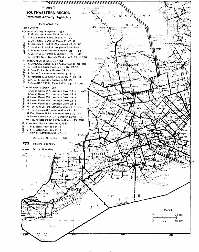
Figure 1SOUTHWESTERN REGION * Petroleum Activity Highlights
EXPLANATION ~ Well Drilling-Jjfc- Important Gas Discoveries, 1984
1. Miorbi, Haldimand Moulton l -4 - M O 2. Rowe-Ram 6, Kent Dover l - M - VE P 3. Oil Finders, Lambton Moore 2 - 22 - II JE 4. Blazedale l, Norfolk Charlotteville 2 - 3 - IX O 5. Hemlock 9, Norfolk Houghton 5 - 8 - ENR ^ 6. Poinsettia, Norfolk Middleton 7 - 26 - III ST uj 7. Easter Lily, Norfolk Middleton 8 - 26 - 11 STR
8. Red Hot Sally, Norfolk Middleton 7 -27 - II STR
* Important Oil Discoveries, 19842 1. Cons/OEC 33836, Elgin Aldborough 8- 16 - XIIO 2. Revallee l. Essex Rochester l - 20 - VEBR^ 3. Ram 77, Lambton Brooke 24 - XQC 4. Forbes 3, Lambton Brooke 4 - 8 - 3 - VIII-i 5. Francisco l. Lambton Enniskillen 7 - 30 - IXX 6. P.P.C. l. Lambton Euphemia 18 - IVm 7. Cons/OEC 33831, Elgin Aldborough 17 - XIII
A Natural Gas Storage, 1984— 1. Union Dawn 247, Lambton Dawn 19 - - 44C
2. Union Dawn 251, Lambton Dawn 19 - m 3. Union Dawn 250, Lambton Dawn 19 - U 4. Union Dawn 254, Lambton Dawn 32 - DC 5. Union Dawn 253, Lambton Dawn 32 - ^ 6. Tec. Kim-C6l. 50, Lambton Moore 7 - 18- VII w 7. Tec. Corunna 6, Lambton Moore 2 - 19 - X
8. Esso Cavern 982 A, Lambton Sarnia 39 - R R9. Dome Amoco RO - 7A, Lambton Sarnia 8 - B
10. Tec. Wilkesport 12, Lambton Sombra 15 - XIII © Brine Wells For Salt Recovery, 1984 w 1. F 8, Essex Anderdon 34 - l J 2. F 1, Essex Anderdon 34 - l OQ 3. Dow 81, Lambton Moore 23 - XI
Current to November 1, 1984
's^'s Regional Boundary
m***— District Boundary
Geo a n
450 Bay
"^
triSu
\O D t C ?
••••i..•es^ 'i-t^A *"*ort R
f ST
SOR '
11-SCALE
25 mi.
82 0 81 0
20 40 km
800
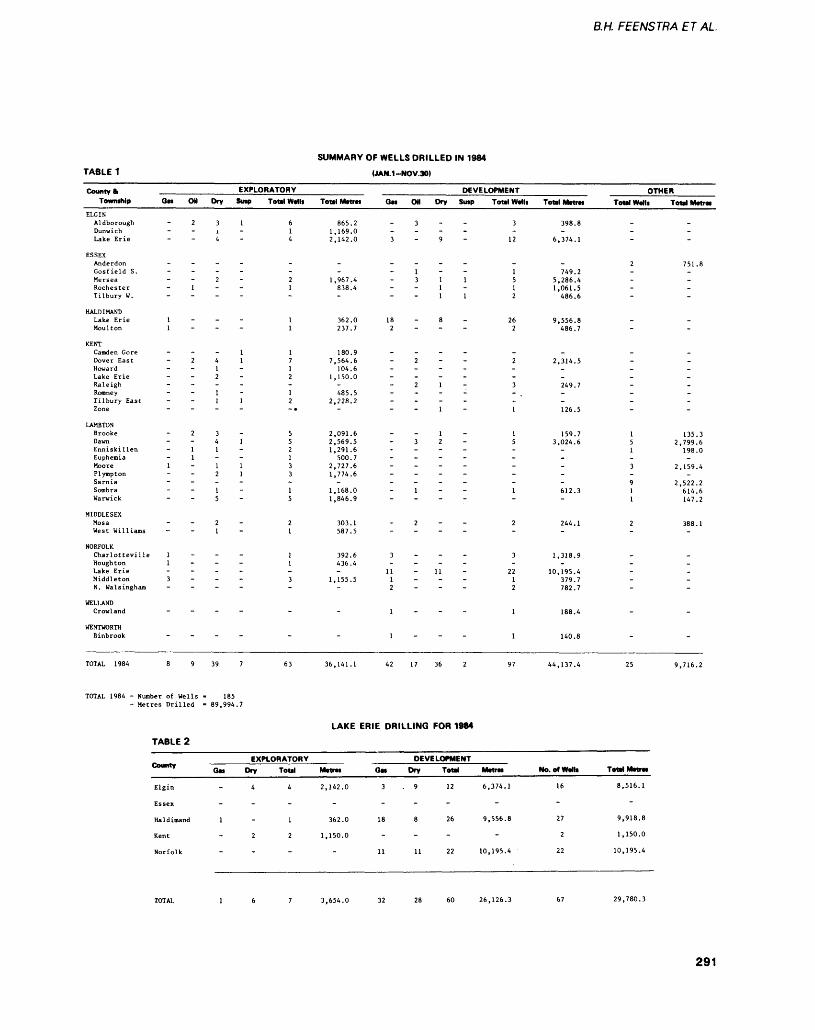
BM FEENSTRA ET AL.
TABLE 1SUMMARY OF WELLS DRILLED IN 1984
(JAN.1-NOV.30)
County ftTownthip On Oil
ELGINAldborough - 2DunwichLake Erie
ESSEXAnderdonGosfield S. -MerseaRochester - 1Tilbury W. -
HALDIMANDLake Erie 1Moulton 1
KENTCamden GoreDover East - 2HowardLake Erie -RaleighRomneyTilbury EastZone
LAMBTONBrooke - 2DawnEnniskillen - 1Euphemia - 1Moore 1PlymptonSarniaSombraWarwick
MIDDLESEXMosaWest Williams
NORFOLKCharlotteville 1Houghton 1 -Lake ErieMiddleton 3N. Walsingham
WELLANDCrowland
WENTWORTHBinbrook
TOTAL 1984 89
TOTAL 1984 - Number of Wells- Metres Drilled
TABLE 2
County
Elgin
Essex
Haldimand
Kent
Norfolk
EXPLORATORYDry Smp Total Wdlt
3 1 6i - 14 4
--2 2
1-
11
1 14 1 71 - l2 2-1 - 11 1 2
-.
3 S4 1 51 - 2
11 1 32 1 3-1 - l5 5
2 21 - 1
11
-3
-
-
.
39 7 63
185- 89,994.7
EXPLORATORYOn Dry Total
4 4
-
1 - 1
2 2
-
DEVELOPMENTToul Metres Gat OH Dry Sutp Total MMIi
865.21,169.02,142.0
--
1,967.4838.4-
362.0237.7
180.97,564.6
104.61,150.0
-485.5
2,228.2-
2,091.62,569.51,291.6
500.72,727.61,774.6
-1,168.01,846.9
303.1587.5
392.6436.4-
1,155.5-
-
"
36,141.1
LAKE
MltfM
2,142.0
-
362.0
1,150.0
-
3 3-3 - 9 12
-1 1311 5
1 1--11 2
18 - 8 262 2
-2 2
--
21- 3.1 -
-1 - 1
1 - 132- 5
-----
1 1.
2 2-
3 3-
11 -11 - 221 12 2
1 1
1 1
42 17 36 2 97
ERIE DRILLING FOR 1984
DEVELOPMENTOn Dry Total Mttra
3.9 12 6,374.1
-
18 8 26 9,556.8
-
11 11 22 10,195.4
Total Matra*
398.8-
6,374.1
-749.2
5,286.41,061.5
486.6
9,556.8486.7
-2,314.5
--249.7--126.5
159.73,024.6
-----612.3-
244.1-
1,318.9-
10,195.4379.7782.7
188.4
140.8
44,137.4
No. of Wain
16
-
27
2
22
OTHERTotal Walli Total Matrat
---
2 751.8----
--
--------
1 135.35 2,799.61 198.0-3 2,159.4-9 2,522.21 614.61 147.2
2 388.1-
-----
-
" "
25 9,716.2
Tottl Matrat
8,516.1
-
9,918.8
1,150.0
10,195.4
3,654.0 26,126.3 29,780.3
291
SOUTHWESTERN REGION
Limiiedl 160Ellesmere Road Scarborough, Ontario M IP 2X4.The annual status report en
titled "Oil and Gas Developments in Eastern Canada in 1983" (Trevail and Parker 1984) was compiled and written for the American Association of Petrole um Geologists. The report summa rizes activities and highlights of ex ploration and production trends in Ontario and Eastern Canada for1983. This same report is sched uled for publication by the Cana dian Society of Petroleum Geolo gists. Reprints are available at the Petroleum Resources Laboratory.
The 1984 Joint Annual Meet ing of the Geological Association of Canada and the Mineralogical Association of Canada was held in London, Ontario, May 14-16. R.A. Trevail and C.L. Trussler co ordinated and co-chaired a Special Session on "The Geology and Re sources of the Michigan Basin". The session focused on basin tec tonics, Keweenawan rifting, dia genetic history of hydrocarbon- bearing strata, hydrocarbon forma tion and entrapment, and oil shales. Application of COCORP seismic profiling and integration of gravity surveys with subsurface mapping provided new insight into the geologic history of the Michi gan Basin. S.M.B. Bailey of Bailey Geological Services Limited pre sented the results of the Cambrian and Ordovician phases of the con ventional hydrocarbon portion of HERP. The optimistic assessment of the as of yet undiscovered oil and gas resources of Ontario sparked a number of comments concerning the exploration possi bilities available in the province, including remarks on the low cost of operations in Ontario as com pared to elsewhere in Canada.
Three technical papers were presented by R.A. Trevail during1984. "Hydrocarbon Entrapment in the Trenton of Southern On tario" was presented at the 1984 meeting of the Eastern Section of the American Association of Petro leum Geologists (AAPG) held in
Pittsburgh, Pennsylvania in Octo ber.
The paper is scheduled to be published in a special symposium volume of the AAPG Studies in Geology series (Trevail, in press). The second paper entitled "Conventional Oil and Gas Re sources of Ontario" was presented ai the Hydrocarbon Energy in On tario Symposium featured at the Ontario Geological Survey Geosci ence Research Seminar, 1984.
A program to evaluate remote sensing techniques, specifically air borne colour and thermal infrared imagery, as a potential hydrocar bon exploration tool, was conduct ed by R.A. Trevail and V.H. Sin ghroy from the Ontario Centre for Remote Sensing (OCRS). Funding wr as jointly provided by the Min istry of Natural Resources and the OCRS. The study area consisted of Dawn and Euphemia Townships in Lambton County and Zone and Camden Townships in Kent Coun ty. Interpretation of both colour and thermal infrared imagery re vealed the presence of a number of small and subtle, moisture filled or dry lineaments associated with the Dawn and Electric Faults.
Preliminary results indicated that airborne infrared imagery has the potential for being a relatively rapid and inexpensive reconnais sance exploration tool in Ontario and may be used to target more detailed exploration techniques such as seismic and geochemical surveys. Results of this study were presented at the 23rd Annual Con ference of the Ontario Petroleum Institute (Trevail and Singhroy, in press).
MINERAL RESOURCES ACTIVITIESThe primary function of the Min eral Resources Geologist in South western Region is to stimulate ex ploration and development of the Region's mineral resources. Em phasis in this program has to date been aimed chiefly at industrial minerals. Because of the general scarcity of information, data gath ering, and analysis, area specific inventories have been undertaken. Information and technical advice
regarding local and regional geol ogy, mineral deposits, mining ac tivities and related legislation, poli cies and procedures are available at the Petroleum Resources Lab oratory. In addition, T.R. Carter in Wingham and J.W.E. Lau in Ayl mer provide geological expertise respectively to the Wingham and Owen Sound District Offices in the north, and to the Aylmer, Chat ham, and Simcoe District Offices in the south.
Construction Aggregate ResourcesInventories and assessment of sand and gravel aggregates resources in deposits presently licenced in the Region under the Pits and Quar ries Control Aci have been carried out in 1983 and 1984. These stud ies are intended to supplement on going inventories and assessments by the Aggregate Assessment Of fice of the Ontario Geological Sur vey which do not provide specific resource data on licenced deposits. Such information is critical for as sessing present and short-term sup plies of construction aggregate re sources at the local level for effec tive input to the municipal land use planning process. The reports include information on geological descriptions, sampling, and esti mates of the quantity and quality of remaining sand and gravel ag gregate resources in the licenced deposits.
Laboratory analysis of the samples to determine grain size distribution, soundness, absorption, and lithology (petrographic num ber) were performed by the Materi als Testing Laboratories of the Ministry of Transportation and Communication in London and Kingston. Results of these projects are now complete for the Chat ham, Wingham, and Owen Sound Districts. Studies will be continued in 1985 in the Aylmer and Simcoe Districts.
Results of the projects will be incorporated in Aggregate Re sources Inventory Papers pub lished by the Ontario Geological Survey and will be made available to municipalities for land use plan-
292

BM FEENSTRA ET AL
ning purposes. A property report detailing the results will also be available to each respective owner/operator.
The following summary of re sults of the licenced sand and grav el aggregate resource assessment project in the Wingham and Owen Sound Districts has been provided by I.R. Carter. The project was funded equally by the federal and provincial governments under the Canada-Ontario Employment De velopment Program and created employment for four geologists for one year.
In general, sufficient licenced resources appear to be available to satisfy forecasted needs for both districts for the near future. There are, however, significant local vari ations in the availability of con struction aggregate resources due to lack of licenced suppliers, and material which is capable of meet ing the quality constraints. In the Owen Sound District, licenced pits in Keppel and Sarawak Townships are depleted in crushable gravel. Crushable gravel is also in short supply in Kincardine, Albemarle, and St. Edmunds Townships. Pit distribution problems occur throughout the Bruce Peninsula, and in the southern portion of Bruce County necessitate costly long distance haulage or use of short-term wayside pits.
Sand and gravel resources, particularly along Georgian Bay, locally do not meet stringent speci fications for high quality products due to the presence of deleterious amounrs of shale. This shale con tamination necessitates costly be neficiation to meet Ministry of Transportation and Communica tion specifications. In the Win gham District, the townships of Stanley, Stephen, Fullarton, South Easthope, Mornington, and Elma all have less than l 000 000 tonnes each of sand and gravel resources in currently licenced pits. Hay, El lice, Logan, and Huron Townships have potential shortages of crusha ble gravel. There are also local quality constraints for aggregates, particularly in Minto, Wallace, and Carrick Townhsips due to the presence of deleterious amounts of
chert and shale. Records main tained in both District Offices in dicate a gradual increase in con struction aggregate production from natural sand, gravel, and stone. Attractive exploration and development opportunities conse quently exist in those townships where licenced resources are in short supply or not readily avail able due to quality constraints or poor distribution of licenced sour ces. There is a continuing need for new licences to ensure the avail ability of low cost supplies of con struction aggregates to local con sumers.
A project involving inventory and assessment of buried sand and gravel in the Sparta Moraine southeast of St. Thomas in Yar mouth Township, Elgin County was initiated. A recent survey of the Quaternary geology and stratigraphy of this area by the On tario Geological Survey (Dreimanis and Barnett 1984) noted occurrences of relatively coarse sand and gravel within the Catfish Creek Drift buried below fine-textured Port Stanley Till along the Sparta Moraine.
During the summer, Regional and Aylmer District mineral re sources staff together carried out a detailed study consisting of exami nation of water well logs and pit exposures, drilling with a small au ger rig and hammer seismic refrac tion surveying. The coarse sand and gravel layers were found to occur near the top of a relatively thick stratified sequence composed mainly of fine- to medium-grained sand. Favourable sites for explor- tion are mosi likely located along the south side of the moraine at localities where the cap of clayey till is thin or completely eroded away. Based on the results of this summer's work, 6 sites have been selected for large diameter auger drilling and split spoon sampling. The results of this project, to be completed in 1985, will be includ ed in rhe Aggregate Assessment Office report on Yarmouth Town ship to be published by the Ontario Geological Survey (Aggregate As sessment Office 1984).
Mineral and Chemical Composition of Natural Quaternary SandsTwenty-eight samples of the 0.1 to 0.7 mm fraction of Quaternary sands and gravels from licenced pits in glaciofluvial, glaciolacus trine beach, and eolian deposits in the Owen Sound and Wingham District areas, and Lambton Coun ty in the Chatham District, were analyzed by the Geoscience Lab oratories of the Ontario Geological Survey to determine their mineral and chemical composition. Their mineral composition was found to be similar to that of the glacial sands and gravels in south-central and southeastern Ontario west of the Kingston-Gananoque area as presented in Hewitt and Karrow (1963), i.e. rich in rock fragments derived from Southern Ontario's Paleozoic carbonate formations, and poor in free quartz and feld spar grains. Relatively high amounts of free quartz (40-42^/0) occur in the samples from a kame deposit in North Easthope Town ship, Lake Warren beach deposits in Hay, Bosanquet, and Plympton Townships, and a deposit of wind blown sand in the Pinery dunes in Bosanquet Township. The free feldspar content, mainly alkali feldspar, is relatively highest OQ-40%) in the samples from the kame deposit in North Easthope Township and a Lake Algonquin beach deposit in Eastnor Town ship. The silica content in these samples varies between 58 and W/o and is highest in the Warren beach and Pinery dune samples (70-80^0).
The results of preliminary analysis clearly indicate that all of the sand samples do not meet the chemical specifications for special ty industrial sands. The samples of impure feldspathic sand require considerable beneficiation before their chemical suitability for use in glass manufacturing or ceramics can be established (Guillet 1983). The suitability of some of the sam ples for use as fine aggregate in concrete products also requires further testing.
293
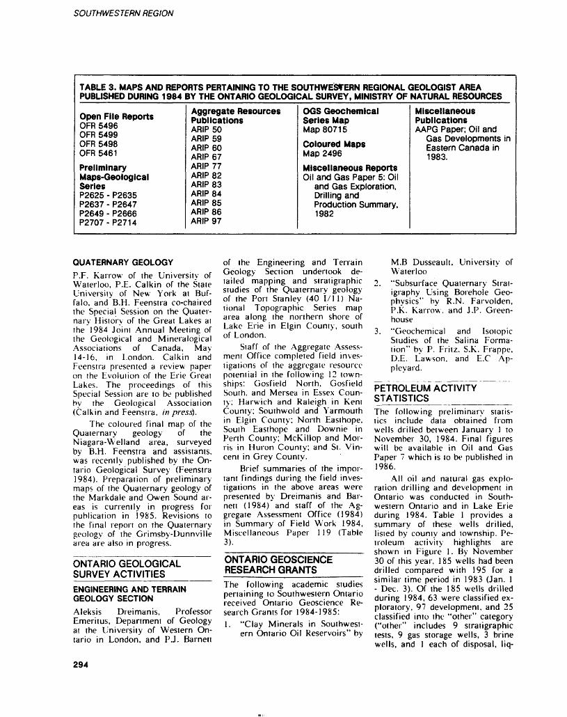
SOUTHWESTERN REGION
TABLE 3. HAPS AND REPORTS PERTAINING TO THE SOUTHWESTERN REGIONAL GEOLOGIST AREA PUBLISHED DURING 1984 BY THE ONTARIO GEOLOGICAL SURVEY, MINISTRY OF NATURAL RESOURCES
Open File ReportsOFR 5496OFR 5499 OFR 5498OFR 5461
PreliminaryMaps-GeologicalSeriesP2625 - P2635P2637 - P2647P2649 - P2666P2707-P2714
Aggregate Resources PublicationsARIP 50ARIP 59 ARIP 60ARIP 67ARIP 77ARIP 82ARIP 83ARIP 84ARIP 85ARIP 86ARIP 97
OGS Geochemical Series MapMap 807 15
Coloured MapsMap 2496
Miscellaneous ReportsOil and Gas Paper 5: Oil
and Gas Exploration,Drilling andProduction Summary,1982
Miscellaneous PublicationsAAPG Paper; Oil and
Gas Developments in Eastern Canada in1983.
QUATERNARY GEOLOGYP.P. Karrow of the University of Waterloo, P.E. Calkin of the State University of New York at Buf falo, and B.H. Feenstra co-chaired the Special Session on the Quater nary History of the Great Lakes at the 1984 Joint Annual Meeting of the Geological and Mineralogical Associations of Canada, May 14-16, in London. Calkin and Feenstra presented a review paper on the Evolution of the Erie Greai Lakes. The proceedings of this Special Session are to be published by the Geological Association (Calkin and Feenstra, in prestf.
The coloured final map of the Quaternary geology of the Niagara-Welland area, surveyed by B.H. Feenstra and assistants, was recently published by the On tario Geological Survey (Feenstra 1984). Preparation of preliminary maps of the Quaternary geology of the Markdale and Owen Sound ar eas is currently in progress for publication in 1985. Revisions to the final report on the Quaternary geology of the Grimsby-Dunnville area are also in progress.
ONTARIO GEOLOGICAL SURVEY ACTIVITIES______ENGINEERING AND TERRAIN GEOLOGY SECTIONAleksis Dreimanis, Professor Emeritus, Department of Geology at the University of Western On tario in London, and PJ. Barnett
of the Engineering and Terrain Geology Section undertook de tailed mapping and stratigraphic studies of the Quaternary geology of the Port Stanley (40 1/11) Na tional Topographic Series map area along the northern shore of Lake Erie in Elgin County, south of London.
Staff of the Aggregate Assess ment Office completed field inves tigations of the aggregate resource potential in the following 12 town ships: Gosfield North, Gosfield South, and Mersea in Essex Coun ty; Harwich and Raleigh in Kent County; Southwold and Yarmouth in Elgin County; North Easthope, South Easthope and Downie in Perth County; McKillop and Mor ris in Huron County; and St. Vin cent in Grey County.
Brief summaries of the impor tant findings during the field inves tigations in the above areas were presented by Dreimanis and Bar nett (1984) and staff of the Ag gregate Assessment Office (1984) in Summary of Field Work 1984, Miscellaneous Paper 119 (Table 3).
ONTARIO GEOSCIENCE RESEARCH GRANTS——-—The following academic studies pertaining to Southwestern Ontario received Ontario Geoscience Re search Grants for 1984-1985:1. "Clay Minerals in Southwest
ern Ontario Oil Reservoirs" by
M.B Dusseault, University of Waterloo
2. "Subsurface Quaternary Strat igraphy Using Borehole Geo physics" by R.N. Farvolden, P.K. Karrow, and J.P. Green house
3. "Geochemical and Isotopic Studies of the Salina Forma tion" by P. Fritz, S.K. Frappe, D.E. Lawson, and E.C Ap pleyard.
PETROLEUM ACTIVITY STATISTICS___________The following preliminary statis tics include data obtained from wells drilled between January l to November 30, 1984. Final figures will be available in Oil and Gas Paper 7 which is to be published in 1986.
All oil and natural gas explo ration drilling and development in Ontario was conducted in South western Ontario and in Lake Erie during 1984. Table l provides a summary of these wells drilled, listed by county and township. Pe troleum activity highlights are shown in Figure 1. By November 30 of this year, 185 wells had been drilled compared with 195 for a similar time period in 1983 (Jan. l - Dec. 3). Of the 185 wells drilled during 1984, 63 were classified ex ploratory, 97 development, and 25 classified into the "other" category ("other" includes 9 stratigraphic tests, 9 gas storage wells, 3 brine wells, and l each of disposal, liq-
294
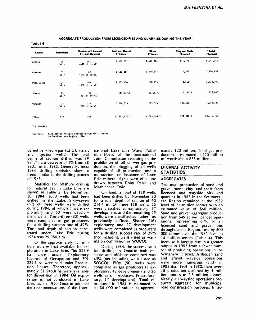
B.H. FEENSTRA ET AL.
TABLE 4AGGREGATE PRODUCTION FROM LICENCED PITS AND QUARRIES DURING THE YEAR.
County
Aylmer
Chatham
Owen Sound
Simcoe
Wingham
TowfMhipi
29 (all)
35 (all)
28 (all)
15 (all)
32 (all)
Nunwar of Licancad Pits and Quarria*
141 (67Z of total)
68 (54S: of total)
166 (80X of total)
24 (69Z of total)
172 (62Z of total)
Sand and Gravel (Tonnes)
5,507,703
1,622,257
2,535,450
513,627.5
3,784,575
Stone (Tonnes)
2,424,764
1,490,657
168,295
112,125.7
309,324
Clay and Shale (Tonnes)
114,778
11,585
8,645
2,292.8
134,690
•Total (Tonnat)
8,047,245
3,124,499
2,712,390
628,046
4,228,589
13,963,612.5 4,505,165.7 271,990.8 18,740,769
* producing
Sources: Ministry of Natural Resources District Offices in Southwestern Region, 1984
uefied petroleum gas (LPG), waier, and injection wells). The total depth of section drilled was 89 994.7 m, a decrease of l^o from 88 890.1 m in 1983. Generally, most 1984 drilling statistics show a trend similar to the drilling pattern of 1983.
Statistics for offshore drilling for natural gas in Lake Erie are shown in Table 2. By November 30, 1984, 1670 wells had been drilled in the Lake. Sixty-seven (67) of these wells were drilled during 1984, of which 7 were ex ploratory and 60 were develop ment wells. Thirty-three (33) wells were completed as gas producers for a drilling success rate of 49(Vo. The total depth of section pene trated under Lake Erie during 1984 was 29 780.3 m.
Of the approximately 1.1 mil lion hectares (ha) available for ex ploration in Lake Erie, 766 823.9 ha were under Exploratory Licence of Occupation and 301 229.3 ha were held under Produc tion Leases. Therefore, approxi mately 31 946.8 ha were available for disposition in 1984. Oil explo ration is not conducted in Lake Erie, as in 1970 Ontario adopted the recommendations of the Inter
national Lake Erie Water Pollu tion Board of the International Joint Commission resulting in the prohibition of oil or wet gas pro duction, the plugging of all wells capable of oil production, and a moratorium on issuance of Lake Erie mineral rights wesi of a line drawn between Point Pelee and Marblehead, Ohio.
On land, a total of 118 wells had been drilled by November 30 for a total depth of section of 60 214.4 m. Of these 118 wells, 56 were classified as exploratory, 37 development, and the remaining 25 wells were classified as "other" as previously defined. Sixteen (16) exploratory and 27 development wells were completed as producers for a drilling success rate of 39^0 (not including wells listed as wait ing on completion or WOCO).
During 1984, the success ratio for drilling in Ontario boih on shore and offshore combined was 43 07o (not including wells listed as WOCO). Fifty (50) wells were completed as gas producers (8 ex ploratory, 42 development) and 26 wells as oil producers (9 explora tory, 17 development). Total oil produced in 1984 is estimated to be 84 000 m 3 valued at approxi
mately S20 million. Total gas pro duction is estimated at 470 million m' worth about S55 million.
MINERAL ACTIVITY STATISTICS————————AGGREGATESThe total production of sand and gravel, stone, clay, and shale from licenced and wayside pits and quarries in 1983 in the Southwest ern Region remained at the 1982 level of 21 million tonnes with an estimated value of S60 million. Sand and gravel aggregate produc tion from 549 active licenced oper ations, representing 67*70 of all licenced sand and gravel pits throughout the Region, rose by 500 000 tonnes over the 1982 level to 14 million tonnes (Table 4). This increase is largely due to a greater output in 1983 from a fewer num ber of producing operations in the Wingham District. Although sand and gravel wayside operations were more numerous (113) in 1983 than (90) in 1982, their over all production declined by l mil lion tonnes to 2.3 million tonnes. Nearly all wayside operations pro duced aggregate for municipal road construction purposes. In ad-
295
SOUTHWESTERN REGION
dillon, a small amount of sand and gravel was dredged by a commer cial operation, licenced under the Beach Protection Act, from the bed of Lake Erie in the area of the international boundary southeast of Pelee Island. All of the aggre gate produced from the lake bed was exported lo Ohio.
In 1983, total stone quarried at 16 licenced operations was 4.5 million tonnes (Table 4), up by 500 000 over 1982. About 50 to 60^0 of the crushed stone tonnage is consumed in local manufacture of high-calcium lime (Beachville- Ingersoll, Amherstburg). About 30 to 4007o is used in construction ag gregate and pulverized stone pro duction. Between 10 and 20^0 is consumed by the local cement manufacturing industry (Woodstock, Themsford, St. Marys). Total building stone pro duction of nearly 31 600 tonnes at Bruce Peninsula quarries increased from the previous year.
Approximately 2 million ton nes of crushed stone of concrete aggregate quality was brought into the Sarnia-Windsor area by truck from the Komoka delta deposit wesi of London, or by vessel from the Manitoulin Island quarry and other quarries in northern Michi gan. Attempts are being made to replace this imported quality ag gregate by utilizing material from the Lucas Formation. This material is being derived from the upper bench of Allied Chemical's, McGregor Quarry, and will be pro cessed for concrete and other con struction aggregate purposes.
The cement plants at Wood stock and St. Marys together uti lized approximately 237 600 ton nes of local glacial drift in the manufacture of grey Portland ce ment in 1983 (Table 4: "Clay and Shale" column). Plants engaged in manufacturing of clay drain tile at Dresden, Meaford, Norwich, Pais ley, Parkhill, and Thedford used local glacial lake clays or shales. The total tonnage extracted in 1983 was 34 417 tonnes. This fig ure represents no increase over the volume used in 1982.
SALTOntario's increasing salt produc tion, approximately 6.8 million tonnes in 1984 based on company estimates and valued at Si 16 mil lion, comes from underground mines and brine well operations in the Salina Formation at Goderich, Windsor, Sarnia, and Amherst burg. The estimated 1984 produc tion will represent an increase of approximately 600 000 tonnes over the 1983 value. A combined total of nearly 5.24 million tonnes of rock salt has been extracted from the A-2 Unit at a depth of 537 m at Domtar's Goderich Mine and from the middle F Unit at a depth of 297 m at Canadian Rock Salt Company Limited's Ojibway Mine at Windsor.
A combined total of nearly 1.6 million tonnes of fine salt has been extracted by brine well operation from the A-2 and B Units at Sarnia (Dow Chemical), and from the B Unit ai a depth between 305 and 366 m at Amherstburg (Allied Chemical), 427 and 457 m at Windsor (Canadian Salt), and 427 m at Goderich (Domtar). Several new brine wells have been drilled in Anderdon Township near Am herstburg (Allied Chemical) and in Moore Township near Sarnia (Dow Chemical) for salt produc tion (Figure 1).
THESIS PROJECTSThe following is a list of new M.Sc. and B.Sc. thesis studies of various aspects of the geology of Southwestern Ontario currently in progress at McMaster University in Hamilton, Queens University in Kingston and the University of Western Ontario in London. The information was provided by the Geology Departments of the var ious universities.
M.SC.THESES McMaster UniversityRice, C.: Solution Generated Fab
rics in Carbonate Rocks of the Lockport Formation, Windsor- Hamilton Area.
Queens UniversityGrimes, D.J.: Karst and Develop
ment of Crust and Permeabil ity of Silurian Pinnacle Reefs, Southwestern Ontario.
B.SC.THESES Queens UniversityCard, G.M.: Stratigraphy and
Sedimentology of Upper De vonian Black Shales, South western Ontario.
University of Western OntarioBrown, G.: Comparative Geochem
istry of Southwestern Ontario Black Shales in Bedrock and Till Clasts for Glacier Prov enance.
Burns, G.: Quaternary and Glacial Geology Exposed in the Springer No. 3 Gravel Pit near St. Thomas, Ontario.
de la Bastide, A.: Hydrocarbon Po tential of the Bass Islands For mation in the Silver Creek Field, Lake Erie.
Dollar, P.: Geology of the Sarnia- London Road Oil Field.
Hadley, S.: Stratigraphy, Petrology and Geochemistry of the Up per Silurian A-2 Unit, in Lam bton, Kent, and Elgin Coun ties.
Kriter, K.: Depositional Environ ment and Subsurface Extent of the DeCew Formation.
REFERENCESAggregate Assessment Office Staff 1984: Aggregate Resources Inven
tory Program; p. 104-109 in Summary of Field Work, 1984, Ontario Geological Sur vey, edited by John Wood, Owen L. White, R.B. Barlow, and A.C. Colvine, Ontario Geological Survey, Miscella neous Paper 119, 309p.
Calkin, P.E., and Feenstra, B.H.In Press: Evolution of the Erie
Great Lakes; in Quaternary History of the Great Lakes, Special Publication of the Geo logical Association of Canada, edited by P.F. Karrow.
296
EH FEENSTRA ET AL.
Dreimanis, Aleksis, and Barnet!,PJ.1984: Quaternary Geology and
Stratigraphy of the Port Stan ley Area, Elgin County; p.100-101 in Summary of Field Work, 1984, Ontario Geological Survey, edited by John Wood, Owen L. White, R.B. Barlow, and A.C. Col vine, Ontario Geological Sur vey, Miscellaneous Paper 119, 309p.
Feenstra, B.H.1984: Quaternary Geology of the
Niagara-Welland Area; Ontar io Geological Survey, Map 2496, Quaternary Geology Se ries, scale 1:50 000, Geology 1969-1972.
Guillet, G.R.1983: Westree Sand Deposit,
Westree and Garvey Town ships, District of Sudbury; On tario Geological Survey Open File Report 5445, 77p., 2 ta bles, 3 figures, and 2 appen dices.
Habib, H.E., and Trevail, R.A.1984: Oil and Gas Exploration,
Drilling, and Production Sum mary, 1982; Ontario Ministry of Natural Resources, Oil and Gas Paper 5, 216p.
Hewitt, D.F., and Karrow, P.F.1963: Sand and Gravel in South
ern Ontario; Ontario Depart ment of Mines, Industrial Min eral Report No. 11, 151p.
Trevail, R.A.In Press: Hydrocarbon Entrapment
in the Trenton of Southern Ontario; in Special Volume, American Association of Pe troleum Geologists.
Trevail, R.A., and Parker. DebraK.1984: Oil and Gas Developments
in Eastern Canada in 1983; The American Association of Petroleum Geologists Bulletin, Volume 68, Number 10, p.1281-1296.
Trevail, R.A., and Singhroy, V.H.In Press: Interpretation of Geol
ogy, Geophysics and Remote Sensing for Hydrocarbon Ex ploration in Southern Ontario; Proceedings of the 23rd An nual Conference of the Ontar io Petroleum Institute.
297


