Embed Size (px)
Citation preview

Reference model 3.0 Draft
Geospatial Data Infrastructure (GDI) Northrhine-Westfalia
Authors:
Prof. Dr. Werner Kuhn Sebastian Basedow
Christoph Brox Catharina Riedemann
Holger Rossol Kristian Senkler Katharina Zens
NOTE: This document is a draft version of the reference model for the Geospatial Data Infrastructure in NRW. It is a working document in the sense that every party involved in the GDI project is invited to participate in its further development and elaboration.

Institut für Geoinformatik 15.12.2000 1
Content Content.....................................................................................................................................1 How to read this document.................................................................................................3 Background of the Basic Scenario ...................................................................................3 1 Scope of “Geospatial Infrastructure NRW”.............................................................4
1.1 Organizational and Technical Approach ..............................................4 1.2 The Infrastructure .............................................................................4 1.3 Consensus processes .........................................................................5
2 Scope of the GDI reference model.............................................................................6 2.1 Purpose .............................................................................................6 2.2 Components of the reference model ...................................................6
3 GDI User Model ...............................................................................................................8 3.1 Who are the users of GDI NRW? .........................................................8 3.2 What tasks do the users have to fulfill? ..............................................9 3.3 Which services/information products do users need to fulfill their
tasks? ............................................................................................. 10 3.4 Which application backgrounds, experiences, and abilities do the users
have? .............................................................................................. 10 3.5 In which system environments do users work? ................................. 10 3.6 Which requirements do users have concerning performance and
security? ......................................................................................... 10 3.7 How often do users access GDI NRW? .............................................. 10 3.8 Scenario from the User Model Point of View...................................... 11 3.9 Consensus, Proposed for Consensus, Action Items ............................ 12
4 GDI Business Model ....................................................................................................15 4.1 Maintenance Organizations .............................................................. 15 4.2 Information and Communication Platform (GDI Portal) ..................... 16 4.3 Data sets ......................................................................................... 17 4.4 Metadata standard in GDI ................................................................ 17 4.5 Provision of Information Products and Services ................................ 17 4.6 Access to Information Products and Services, e-commerce ............... 18 4.7 Business Networks .......................................................................... 19 4.8 Legal Aspects and Pricing................................................................. 20 4.9 Marketing ........................................................................................ 20 4.10 Support of innovative SMEs .............................................................. 21 4.11 Education and Training .................................................................... 21 4.12 Scenario from the Business Model Point of View ............................... 21 4.13 Consensus, Proposed for Consensus, Action Items ............................ 24
5 GDI Process Model.......................................................................................................26 5.1 Business Processes .......................................................................... 26 5.2 Ordering an Information Product...................................................... 26 5.3 Action Items.................................................................................... 28
6 GDI Architecture Model...............................................................................................29 6.1 The GDI Service Taxonomy .............................................................. 29 6.2 Technical components of GDI ........................................................... 31
6.2.1 Transport Layer ............................................................................... 32 6.2.2 Query Mechanism ............................................................................ 32 6.2.3 Search and Discovery - GDI Catalog Service......................................... 32 6.2.4 Access to feature data - Web Feature Server......................................... 34 6.2.5 Access to coverage data – Web Coverage Server................................... 35 6.2.6 GDI Web Mapping Service - Web Map Server ........................................ 35
6.3 GDI services to be specified ............................................................. 36 6.3.1 Portrayal Services ............................................................................ 36 6.3.2 E-commerce services........................................................................ 36 6.3.3 Refinement of GDI catalog services ..................................................... 37

Institut für Geoinformatik 15.12.2000 2
6.3.4 Service registry ............................................................................... 37 6.3.5 GDI Security Services ....................................................................... 37 6.3.6 Session Management ........................................................................ 38 6.3.7 Gazetteer ....................................................................................... 38
6.4 Consensus, Proposed for Consensus, Action Items ............................ 38 Acronyms ..............................................................................................................................40 Glossary.................................................................................................................................41 Literature ...............................................................................................................................44

Institut für Geoinformatik 15.12.2000 3
How to read this document The specifications of the rather organizational models (user and business model) differ from those of the technical models (architecture and implementation model). On the one hand, the organizational models are relevant to different participants of GDI NRW. The recommendation of the user model to focus on special user groups, e.g., is mainly targeted to participants dealing with the GDI NRW portal and participants developing tailored services and products for special user groups. It is less relevant for participants developing general services like e.g. catalog search or payment. On the other hand, not following the specifications of the organizational models will lead to different results: Disregard of a technical specification will immediately result in a non-interoperable and consequently not working environment. Disregard of an organizational specification will not keep the technical system from running, but it will have short and long term effects on the acceptance and success of GDI NRW. The specifications adopt the conventions expressed in the IETF’s RFC 2119 “Key Words for Use in RFCs to Indicate Requirement Levels.” The key words “MUST”, “MUST NOT”, “REQUIRED”, “SHALL”, “SHALL NOT”, “SHOULD”, “SHOULD NOT”, “RECOMMENDED”, “MAY”, and “OPTIONAL” in this document are to be interpreted as described in RFC 2119 (http://www.ietf.org/rfc/rfc2119.txt ). Furthermore, according to the consensus process this document should promote, three additional terms will be used within each chapter. These categories are:
1. CONSENSUS - this keyword summarizes items that are claimed to be consensus. 2. PROPOSED FOR COSENSUS – this category summarizes points that are proposed
for consensus, but not fixed yet. 3. ACTION ITEMS – this category summarizes the items that are meant to be the
next steps to bring the specifications of the reference model beyond its current state.
The term consensus refers to the description of consensus processes within the GDI project and within the NRW GI market (see section 1.3).
Background of the Basic Scenario To provide guidance to the reader and to explain each sub models’ perspective on the Geospatial Infrastructure this document utilizes scenarios as a means of formalization. The basic scenario described below will be picked up by each sub model and will be explained according to the corresponding perspective on GDI.NRW. The background of the basic scenario is defined as follows: “Mr. X is a luxury car dealer and wants to open a new branch office in Y-Town. His best potential customers are male executives between 40 and 60 years of age who earn a good salary. In order to find an appropriate location for the new office, Mr. X needs information about potential customers and possible locations. Mr. X is familiar with web browsers, but he does not know anything about geospatial data and GIS. Company A deals with statistical demographic data for Y-Town and provides data integration services. Company B’s business is to collect and sell data about real estate in Y-Town and to provide marketing consulting. Company C provides raster data of Y-Town in the scale of 1:25.000.”

Institut für Geoinformatik 15.12.2000 4
1 Scope of “Geospatial Infrastructure NRW” Geographic information (GI) remains too often locked out from the expected market growth, because it is
• held in proprietary formats • too complex to be easily browsed or combined with other information • marketed through pricing schemes that reflect production costs rather than value.
Efforts to improve this situation through metadata, simplified viewer software, and alternative pricing policies have shown some promising results. However, a breakthrough to widely accessible intelligent services for citizens, professionals and decision-makers requires a more comprehensive approach. Rather than sectoral technology or policy measures, a treatment of the entire value chains connecting users to data sources is needed. Such an approach to market development for geographic information requires an integrated solution based on the needs of all stakeholders in a GI-market. 1.1 Organizational and Technical Approach “Geospatial Infrastructure NRW” (GDI) is an initiative of the State of NRW that started in January 2000 (http://gdi-nrw.uni-muenster.de). Its overall goal is to develop the Northrhine-Westphalian GI-market. This will be achieved by connecting the value chains of users, service providers, service enablers, integrators, data producers, and infrastructure providers. The success of a geospatial data infrastructure will primarily depend on the demand for geographically related services and information products. Consequently, the project partners represent an interdisciplinary team of institutional, commercial, and research organizations in the GI-market, shifting the focus from provider-oriented to consumer-driven initiatives. As scientific advisor, the Institute for Geoinformatics recommends a consensus procedure, where all links of the GI-market value chains contribute to the design and operation of a geospatial data infrastructure in NRW through interface agreements in a common service architecture. Geographic data are now being transferred on a daily basis within and between organizations worldwide. The technical problems of data transmissions are largely solved and standardization bodies have made significant progress on transfer formats. However, an issue that had long been considered minor is turning into a major challenge: the problem of transferring semantics, i.e., the meaning of the data and not just the data themselves (Kuhn 1997). A service view of geospatial information provides the necessary conceptual framework to approach this issue. The technological evolution that supports the shift of emphasis from data to information products and services is called interoperability. The “Geospatial Infrastructure NRW” will be developed in the context of distributed, interoperable system standards and open architectures like the Internet. The solution provided will be based on the relevant OpenGIS (Buehler and McKee 1998) and ISO (ISO 2000) standards for geographic information. This will lower the costs to the producers and users and overcome the current proprietary limitations of the GI-market. Based on the international state of art in designing geospatial data infrastructures and according to international standards, e.g., OGC and ISO (see architecture model), the IfGI has developed a reference model as a framework for design, communication, and the consensus processes within GDI and the Northrhine-Westphalian GI-market. The GDI project initiates the geospatial data infrastructure in NRW, which will develop and expand over time. 1.2 The Infrastructure GDI is a comprehensive approach regarding project time, number of project partners, and - most important – by considering all aspects of the Northrhine-Westphalian GI-

Institut für Geoinformatik 15.12.2000 5
market. The infrastructure consists of institutional, organizational, commercial, and technical components and initiatives, e.g.:
• user model • maintenance organizations for executing the business tasks of GDI • information and communication platform • concepts for e-commerce and business networks • marketing initiatives • branding of data sets • support of new, innovative SMEs • service architecture model • GDI standards, based on international standards, e.g., OGC, ISO • GEOBASIS.NRW • …
GDI is an open infrastructure aimed at expanding the market for geographically services and information products in geospatial value chains. The companies and organizations of the geospatial value chain, e.g., data producers, service providers, fill the infrastructure with their components according to the concepts, standards and rules of GDI, e.g., geodata servers, e-commerce platforms, in order to make GI usable for the user. They provide the content for GDI in the broader sense of products and services. According to the first results of GDI´s market study, for all companies and organizations, which want to be successful in the internet market, it is crucial to offer content, provided by themselves or by co-operation partners. 1.3 Consensus processes A key issue of GDI is to ensure its acceptance. Therefore, the IfGI suggests the following procedures to ensure a consensus within the GDI project and within the Northrhine-Westphalian market for geoinformation:
a. The consensus processes within the GDI project rest on the reference model in its current version. The reference model lists the rules, e.g., GDI membership, and specifications that are already consensus and those that are proposed for consensus. The projects partners give their feedback to the rules and specifications that are proposed for consensus within three weeks after the dissemination of each new version of the reference model. Afterwards consensus will be achieved according to the following rules: • No feedback to proposed rules or specifications means agreement. • If there are severe objections against the proposed rules or specifications,
the GDI project management initiates the revision of the proposal, e.g., in the SIGs. The revised rule or specification will be proposed for consensus in the reference model.
b. In order to promote acceptance of GDI in Northrhine-Westphalia, we propose a consensus processes within the NRW GI market. For this purpose the reference model will be made public. The NRW GI market players will be asked to give feedback. This feedback will serve as input for the further work of GDI project.
An open question is, how the players of the entire GI market can influence the decisions about consensus or dissent. For this process, the rules and procedures of the maintenance organizations of GDI have to be defined more clearly.

Institut für Geoinformatik 15.12.2000 6
2 Scope of the GDI reference model 2.1 Purpose The establishment of a Geospatial Data Infrastructure across different administrative levels existing within NRW requires a basic understanding of the different domains handling geospatial data and services. To guarantee a maintainable infrastructure across NRW it is necessary to identify the user requirements relating to geospatial data and services and the business entities providing and using geospatial services and data. The user and business requirements in return should be reflected in the technical components of the geospatial data infrastructure to provide a highly flexible and valuable environment. The purpose of this document, therefore, is to define the general components of GDI and the requirements and steps necessary to design its details. Furthermore it reflects the general components considering international and national geospatial and non-geospatial standards. Because business and technology models are continuously and rapidly changing worldwide, the reference model is essentially a living entity that undergoes evolution cycles. 2.2 Components of the reference model Within the GDI reference model different domains exist that address specific purposes. Figure 1 gives an overview of the domains (sub models) and clarifies the relations between them.
Bu
sin
es
s m
od
el
Arc
hite
ctu
rem
od
el
User model
Processmodel
Implementationmodel
Figure 1: Components of the reference model The GDI reference model has five main components, or sub models:
• The user model identifies the types of users of GDI NRW and defines user requirements.
• The business model shows the business goals, relationship (financial, economic,
business) between NRW and private sector (i.e., development teams who will market the products), and business rules and policies.

Institut für Geoinformatik 15.12.2000 7
• The process model defines the abstract business objects that are modeled and
codified in the GDI system, their rules, and workflow.
• The architecture model defines the GDI system components and the relationship between them (e.g., servers, their functionality, client applications, etc.) as well as their relationship to the different national and international standards and specifications (e.g. OpenGIS and ISO).
• The implementation model breaks down the architecture model into smaller
components and defines the scope of the technology decisions, deployment platforms, building and reusing components, and performance and networking decisions. The detailed specification of the implementation model is entirely the responsibility of the development teams. It should be insured that the implementations will interact with each other according to the related sub models.
As shown in figure 1 the subcomponents of the reference model are related to each other. This shows that a change in any of these sub models will surely ripple through all other sub models. For example a change in the business model the NRW decides to provide a specific type of service for free, the process model needs to accommodate this change, which should be reflected on the user model (e.g., informing the user through the user interface) and therefore the system architecture may need to be changed The reference model defines the content of each sub model identifies the information flow between them and provides, in the end, a reference for each involved party in GDI.

Institut für Geoinformatik 15.12.2000 8
3 GDI User Model The success of each activity or product depends on the acceptance by the people who it is made for. Their needs must consequently be known in order to be successful. This applies to a GDI as well. The goals and the nature of a GDI NRW have to be defined by the needs that the intended users have: they give the direction of where to go. On the one hand this means to have a look at what people want to get out of a GDI NRW (services and products), and on the other hand it means to think about how they get it (interaction). The user model consists of seven questions tackling these two issues. Please notice that this is a high-level conceptual model indicating the direction of development for a GDI NRW and serving as an input for the other sub models. It seeks to take the intended users’ point of view. The system will look completely different depending on which users’ needs to address. The user model does not describe what GDI NRW needs to know about the users in order to implement them as entities in the IT-system, e.g. to save personal data or to grant access to resources. Such issues belong to other sub models, e.g. to the implementation model. 3.1 Who are the users of GDI NRW? The question of who the users of GDI NRW are is the basis for defining suitable services/information products. The reference model considers all people interacting with GDI NRW as users. There are two motivations for using GDI NRW: either you want to utilize (usually buy) something or you want to provide (usually sell) something. Buyers are typically decision makers needing information for spatial decisions, e.g. an insurance company estimating risks based on location. But a company needing data sets for integrating them to one product is a buyer, too. Apart from geospatial products, buyers might be interested in services like catalog search, hotline support, GI job market, yellow pages. Sellers are e.g. mapping agencies offering data sets or service providers adapting data sets to special needs. The following figure shows possible user groups.
Figure 2: User Groups of GDI NRW and Their Connections with GDI NRW The group of decision makers is the largest one. It comprises many different space-related application areas, where decisions depending on and/or affecting space play a role, as e.g.:
GDI NRW
software providers service providers
data providers
system integrators
decision makers
in any case
optional
sell
buy
buy
information brokers
type of

Institut für Geoinformatik 15.12.2000 9
agriculture, banking, building trade, commerce, defense, disaster management, education, environmental protection, exploration and exploitation of raw material, forestry, horticulture, industry, insurance, land management, leisure, logistics, marketing, media, navigation, plant management, (public) finance, public health, real estate management, sales, spatial planning, statistics, telecommunication, telematics, tourism, town planning, trade, traffic, transport, travel, utilities. All user groups can have different organizational structures, as e.g.: governments (local, state, federal), NGOs, guilds, societies, clubs, companies of various sizes (SME, big companies), research and development labs, educational institutions, citizens (private users). Obviously, there are too many different users that cannot all be taken into consideration, at least not in the beginning. Focus on special users is needed. Data producers or service providers can be focused as a group with relatively homogeneous requirements. But with decision makers, subgroups must be selected. The selection criteria must be determined: the number of potential users, their turnover, the (actual) possibility to deliver suitable products, the urgency of the users’ needs, etc. 3.2 What tasks do the users have to fulfill? This question also aims at identifying the needed services/information products. There are countless tasks. The answer to this question depends on the users chosen. Consequently, question number 1 must be answered first. Afterwards, the users must be looked at closely, their businesses and decision processes must be analyzed. In the following, examples of tasks are given: 1. Ms X wants to know: where am I? 2. Ms X arrives in Dortmund at the station and wants to know where the next Chinese
restaurant is located. 3. Planner X needs a data basis for the renaturation of the river Aa. 4. The environmental authority of Münster needs a street network and a 3d-citymodel of
Münster-Gievenbeck for noise abatement planning. 5. An owner of fitness studios needs a map with the distribution of male singles between
20 and 40 years of age in Münster. 6. An owner of fitness studios in Münster needs the information where in Munich the
best location for a new studio is. 7. Mr. X is interested in buying a parcel and therefore he needs to know owner, size,
and price of this parcel. 8. A hotel wants to buy an interactive city map (hardware and software) in order to
provide guests with information about the city. 9. The municipality of Nordkirchen wants to buy a complete information system for the
citizens. 10. Data producer X wants information about existing data on the market in order to find
out what kind of product might be needed and should be made next. 11. An insurance company needs a geographical interface for its own software system,
which it wants to resell as a value-added product. 12. Software company X is looking for a partner to produce marketing analysis tools for a
market research institute. 13. Planner X is looking for a discussion partner on problems with integrating river data
from various sources in ArcView. 14. Software company X is looking for a marketing platform for GIS products and
services (hardware, software, and data). 15. Insurance company X wants one employee to learn about GIS and is looking for a
competent trainer. 16. Ms X is looking for a GIS-job. 17. Ms X wants to found a company for GIS consulting and needs information on how to
do this.

Institut für Geoinformatik 15.12.2000 10
3.3 Which services/information products do users need to fulfill their tasks? This question finally leads to the appropriate services/information products. For the group of decision makers they are countless. Examples: a map showing the ground water quality of an area, a map analyzing the connection between traffic and noise, the owner of a certain parcel. The other groups need, e.g., a list of available geospatial services/information products, yellow pages of companies, discussion forums. It depends on the identified tasks, which services/information products shall be provided. Consequently, question number 2 must be answered first. Afterwards, services/information products that help support these tasks have to be derived. 3.4 Which application backgrounds, experiences, and abilities do the users
have? This question refers to the interaction with GDI NRW. The application backgrounds, experiences, and abilities are as numerous as the number of users. There might be, e.g., citizens, bankers, planners, politicians, surveyors, programmers, and marketing specialists. In the application areas there might be experts in the subject or decision makers with less application knowledge. Users might be EDV/GIS/geospatial data/GDI experts or have no knowledge in these areas. They might be young or old, have more or less “spatial abilities”, and have disabilities of various kinds. They speak different languages. Part of the answer depends on the needs of the user groups chosen. They have different application backgrounds and experiences, resulting in different application requirements. Example: An interface optimized for a surveyor might not be suitable for a citizen. A surveyor would be able to select a location by Gauß-Krüger-coordinates, whereas a citizen would probably need another kind of spatial reference system. Consequently, question number 1 must be answered first. Afterwards, the user groups must be analyzed. Part of the answer refers to all user groups and just needs a decision what shall be supported. There are abilities people have across certain user groups leading to special personal requirements, as e. g. different languages, especially big fonts, special colorsets, speech interface. 3.5 In which system environments do users work? This question is relevant, because the nature of the services/information products and the interface of GDI NRW depend on the type of device. The term “system environments” denotes the type of technical device users work with in order to access GDI and use services/information products, e.g. desktop computers, PDAs, and cellular phones. It does not (primarily) refer to technical details like transfer protocols, amount of memory, etc. (although e. g. bandwidth and screen size impose relevant limits for services/information products on mobile devices). The answer to this question depends on the identified tasks, because they usually determine the system environment in which they have to be fulfilled (if you want to navigate in your car, e. g., you would not use a desktop computer). Consequently, question number 2 must be answered first. 3.6 Which requirements do users have concerning performance and
security? This question refers to the user interaction with GDI NRW. The term “performance” denotes the time it takes to order, deliver, and pay a service/information product. It does not especially refer to the performance of hardware or software (although the overall performance of the system GDI NRW meant here is influenced by it). The answer to this question concerning performance depends on the identified tasks, because they usually determine how quickly you need a service/information product. Consequently, question number 2 must be answered first. Afterwards, the tasks must be analyzed. The issue of security is relevant for all users of GDI NRW (including the internal users like data producers, information brokers, service providers, etc.) and not specific for GDI NRW. 3.7 How often do users access GDI NRW?
Institut für Geoinformatik 15.12.2000 11
This question is important for the technical design of the infrastructure and for the design of the user interface. The more hits are expected, the more powerful the infrastructure must be. Among others, the interface design depends on the types of users in terms of frequency of usage: novice or casual users need other support than people using an interface frequently. 3.8 Scenario from the User Model Point of View The basic scenario (see section “How to read the documents”) describes the luxury car dealer Mr. X, who needs information about potential customers and possible location sites for a new branch in Y-Town. User Bying Service Mr. X enters “map with office locations for car dealers in Y-Town” in a WWW search engine. On top of the result list appears an adapted search page of GDI NRW, where the parameter “Y-Town” is already filled in. As customers Mr. X selects “male”, “age between 40 and 60”, and “salary more than 6500 DM per month”, for the building he specifies site>2000m². Then he posts his request to GDI NRW. After some time he receives by email a list with several offers containing the involved company (companies), a description of the product, price, delivery time, and further information for some offers. Mr. X selects the offer of a consortium consisting of Company A and Company B and sends an order to GDI NRW by email. When the information product (a map, additional information about potential clients, and a weighted list of possible locations) is available, GDI NRW notifies Mr. X by email. The email contains a link to a the payment and delivery service, where Mr. X pays. Afterwards he is allowed to download the product from there. User Selling Service Via the portal of GDI NRW Company A has registered for the yellow pages (of offered services) under the categories “data provider” and “data integrator”. In addition, it has registered its data sets with detailed metadata in the GDI NRW catalogue services. It chose the option to be notified about customer requests matching their business. If there is a customer request Company A can only fulfill partially, it puts up a call for participation at the bulletin board. To handle sale and payment, Company A uses a payment and delivery service provided by GDI NRW. When it has completed a product, it posts it to the site of the payment and delivery service provided by GDI NRW together with the price, the addressee, and the payment conditions. Company B has also registered its data sets about real estate in the GDI NRW catalogue services. Its marketing consulting service is registered in the yellow pages. Company B has chosen the GDI notification service; besides, it regularly checks the “bulletin board” for business partners. Company C has registered its raster data sets within the GDI NRW catalogue services.

Institut für Geoinformatik 15.12.2000 12
GDI
Place Order
Notify User
Manage Payment
Supply Product
GDI User
Figure 3: Use Case Diagram of a User Buying a Service
3.9 Consensus, Proposed for Consensus, Action Items Consensus
I. At the beginning, the focus MUST be on certain users. [see 3.1] II. Later, more users MUST be targeted. [see 3.1]
III. GDI NRW MUST present itself in German and English. [see 3.4] IV. Shopping and payment MUST be safe with respect to the personal data, bank
account data, and orders of users. [see 3.6] Proposed for Consensus
I. All people dealing with decisions that are based on and/or affect space MUST be regarded as potential users of GDI NRW. [see 3.1]
II. At the beginning, the following branches SHOULD have priority (based on the first results of the market study) [see 3.1]: • government • business: planning (building trade, energy industry, service (engineers),
traffic, navigation service) • business: controlling, marketing (pharmacy, automobile industry, consumer
goods industry, telecommunication and media, traffic, banks and insurances, services, trade)
III. At the beginning, the focus SHOULD be on businesses with an annual turnover of
50 Mio. DM (based on the first results of the market study). [see 3.1] IV. All people offering geospatial services/information products MUST be regarded as
potential users of GDI NRW. [see 3.1]
V. All tasks dealing with decisions that are based on and/or affect space MUST potentially be supported by geospatial services/information products offered via GDI NRW. [see 3.2]
VI. At the beginning, the focus MUST be on certain user tasks. [see 3.2]

Institut für Geoinformatik 15.12.2000 13
VII. Later, more user tasks MUST be targeted. [see 3.2] VIII. Important new activities that SHOULD be supported by geospatial
services/information products are controlling, marketing, and sale (based on the first results of the market study). [see 3.2]
IX. All tasks dealing with the production and delivery of geospatial services/information products MUST potentially be supported by GDI NRW. [see 3.2]
X. Potentially all kinds of geospatial services/information products MUST be regarded
as an output of GDI NRW. [see 3.3] XI. At the beginning, the focus SHOULD be on data sets adapted to users’ needs. [see
3.3] XII. The number of similar services/information products in GDI NRW MUST NOT be
limited. [see 3.3] XIII. Later, more services/information products MUST be targeted. [see 3.3] XIV. GDI NRW MUST provide access to data of adjacent states and countries. [see 3.3]
XV. GDI NRW MUST NOT assume that users can operate more than a browser. [see
3.4] XVI. GDI NRW MUST be usable without special knowledge about GDI NRW itself, GIS
or geospatial data. [see 3.4] XVII. At the beginning, stress SHOULD be laid on application requirements (e.g. needs
of marketing) and not on personal requirements (e.g. fonts and colors). [see 3.4]
XVIII. GDI NRW MUST potentially support all common system environments. [see 3.5] XIX. At the beginning, the focus SHOULD be on users with stationary computers. [see
3.5] XX. later, mobile devices MUST be included. [see 3.5]
XXI. From the users’ point of view, there MUST be a central entry point. This does not
exclude distributed direct access points of the providers. [see 3.6] XXII. From the users’ point of view, there MUST be a homogeneous shopping and
payment facility. Performance will be reduced if you have to struggle with various shopping and payment sites for one integrated geospatial service/information product. This facility can consist of distributed services of different providers. [see 3.6]
XXIII. An interface design using accepted practices (e.g. metaphorical design) MUST be
applied for GDI NRW. [see 3.7] Action Items The IfGI suggests that a SIG “Users and Products” is founded that takes care of the consensus process. In this process, the following open questions must be answered:
I. Shall users (usually private users, i.e. citizens) be considered which do not pay for geospatial services/information products like in Portugal (CNIG 2000) [see 3.1]
II. Shall software and/or hardware providers be users of GDI NRW? [see 3.1]
III. Which user tasks shall be focused on during the project “Geospatial Data Infrastructure NRW”? [see 3.2]
IV. Which services for using GDI NRW shall be implemented during the project
“Geospatial Data Infrastructure NRW”? [see 3.3] V. Which geospatial services/information products shall be implemented during the
project “Geospatial Data Infrastructure NRW”? [see 3.3]
VI. What does it mean that GDI will present itself in German and English? It surely refers to the entry page of the common portal, but there are other components,

Institut für Geoinformatik 15.12.2000 14
as e.g. metadata, services/information products, e-commerce platform, company sites. [see 3.4]
VII. Does GDI consider personal requirements apart from the English language? [see 3.4]
For user groups, tasks, and services/information products the chapters 3.1-3.3 recommend focus (like it is e.g. done in GEOBASIS.NRW by defining users and products). This focus is meant as a recommendation, not as a regulation (in the end the market will decide what is successful). But the focus could be helpful for launching exemplary applications that show how GDI NRW can be used and how new markets can profit from the geospatial services/information products.

Institut für Geoinformatik 15.12.2000 15
4 GDI Business Model The business model defines the business goals of the infrastructure. The overall objective is to expand the entire Northrhine-Westphalian market for geoinformation. The business model describes an information and communication platform, products, business processes, legal aspects, pricing, marketing, support of new innovative SME´s, and business networks. The model describes concepts and rules for business processes within the geospatial infrastructure and the companies that are participating. The goal is to expand the GI-market for traditional and new companies, not to provide restrictions for the specific business models of each company. GDI directly targets the business users and government users of the Northrhine-Westphalian market for geospatial information (see user model). By this it also enables the establishment of the mass market for geospatial information, for instance consumers with a car navigation system. The Geospatial Infrastructure NRW (maintenance organizations for executing the business tasks of GDI, information and communication platform, service architecture model, GDI standards, etc.) does not compete within the GI-market. The companies with their components, e.g., geodata server, e-commerce platforms, that fill the infrastructure according to the concepts, standards and rules of GDI, are profit-oriented. The business model at its current stage describes the current knowledge of the business tasks in GDI and the organizations responsible for their execution. It is subject to further discussion within the consensus processes within the GDI project and the GI market (see section 1.3). An open question is a membership for GDI, which addresses organizational, i.e. financial, aspects for the access to information and services of GDI by clients, and offering services and products by companies. 4.1 Maintenance Organizations The result of the GDI project will be the basis for a geospatial infrastructure. A sustainable success will be ensured by an ongoing development and maintenance of GDI and by increasing its acceptance by GDI users. Business tasks, e.g., operation of an information and communication platform, updating metadata standards, initiatives to support the GI-market, and specifications of services and information products, have to be continued after finishing the GDI project. During the ongoing project “Geospatial Data Infrastructure NRW” the organization of GDI for executing the business tasks (= maintenance organization) is the GDI project management. One of the tasks of the GDI project management is to define the future maintenance organization of GDI. After the accomplishment of the ongoing project two maintenance organizations are expected to execute the business tasks of GDI.
• A neutral and independent organization (possibly several organizations for various business tasks) will be conceptualized and initiated by the GDI project management to act as the executing organization behind GDI. The neutral and independent organization serves the overall goal of GDI to expand the GI market. Therefore, it does not compete with the providers and producers of the GI market, and it is open to the support and co-operation of all players of the GI market.
• A member-based organization will be open for all companies and organizations
participating in the NRW GI-market. It will be created by a consensus procedure performed by the GDI project management. The rules for a membership still have to be defined, but in general, all players of the NRW GI market can become a

Institut für Geoinformatik 15.12.2000 16
member of this organization. The tasks, i.e. definition and maintenance of a metadata standard and specifications of data sets, services, and information products, will be executed in an consensus process, comparable to Open GIS Consortium processes.
The consensus process has to lead to a detailed and delimiting description of these two maintenance organizations (organisation form, tasks, finances). The GDI project management introduced the concept of CeGi as a maintenance organisation. At this current state of discussion the CeGi concept cannot be mapped to the reference model. Therefore, the IfGI provided the GDI project management with an additional document, that integrated the current CeGi concept into the reference model. The following paragraphs describe the business tasks of the executing organizations (in italics). 4.2 Information and Communication Platform (GDI Portal) GDI provides a platform for information and communication as a portal for all users and providers of geospatial information. The access to information via the GDI portal is facilitating, but not exclusive. A distinct information access via providers, producers, or information brokers is possible. The GDI portal will be initiated by the GDI project management and maintained by a neutral and independent organization. The role of a GDI portal against the background of the recently introduced portal of the InGeoForum (InGeoIC) has to be discussed. Both portals intend to expand to Germany. Co-operation and competition have to be clearly defined and evaluated in respect of economic value and user requirements. Additional services for information and communication reflect the idea of a market place for geoinformation. An online market place supports the co-operation of the geospatial value chain and business networks (see section 4.7). An approach of the IT world is the mySAP.com Marketplace (SAP 2000). SAP offers an online marketplace with the possibility of a one step business transaction for every business partner. Even it is a proprietary solution it offers some interesting concepts for B2B services. Business tasks of the GDI portal
• Information o (meta-)metadata of data, services, and information products o „yellow pages“ of providers which describe the offered services and
information products in a public list o metadata standards o standards and specifications for services and information products o reference projects o business information and branch news
• Communication o news group o discussion forum
• Additional Services o visualization of geographic data o call center/hotline o present one e-commerce platform with shopping and payment functionality
to the user, no matter how many e-commerce platforms are hidden behind it organizationally and technically
o enable business-business and business-customer business transactions online via the information and communication platform
o publication of requests for information products on a Bulletin Board
Institut für Geoinformatik 15.12.2000 17
o notification service for companies about requests for information products (see scenario, section 4.12),
o support business partner search o execute marketing initiatives for GDI and GI o possibly: consulting.
4.3 Data sets All geographic data sets (base data and specific data) can be the raw material for the business processes within GDI. The overall goal is to apply services on data sets in order to generate information products for the users of geospatial information. The GDI project will define priorities for the targeted data sets on the basis of the results of the market study. A certification of data sets by GDI has to be discussed. Certification could mean
• a control if a data set is completely described by metadata • testing if the described metadata are correct • proofing the quality of a data set, e.g., quality measures within the production
process, reliability. A concept still has to be developed. Certificated and non-certificated data sets would be marketed within GDI. Business tasks of GDI:
• maintain a metadata standard, member-based organization
• ensuring the description of data sets and metadata, independent organization
• possible: maintenance of certification, independent organization.
4.4 Metadata standard in GDI To ensure a uniform description of geospatial data and geospatial services a common descriptive vocabulary, i.e. a metadata specification, must be defined for the GDI. To guarantee a wide acceptance in the national and international GI-market this GDI metadata specification should be linked to a standard. A metadata standard adopted in GDI that has been or is being developed through a consensus procedure ensures consistency. Consistency is necessary to ensure that comparisons can be made by GDI users about the suitability of data and services from different sources. The discussion on a metadata standard that will be adopted in GDI is still a work in progress, since the candidate metadata standards are not public yet. Until now the following important points toward a common metadata standard in GDI have been specified:
• The metadata standard adopted in GDI SHOULD base upon ISO TC/211 19115 Metadata Standard CD 3 or later. It MUST be compliant to the metadata specification committed in ALKIS that is currently under development.
• Multilingual definitions of metadata descriptions SHOULD be supported (at least
English and German).
• It is RECOMMENDED to establish a ‘SIG Metadata’ in GDI to elaborate a metadata standard in GDI according to the requirements in this section.
4.5 Provision of Information Products and Services GDI provides information products and services through distributed nodes in a network of providers and users. The goal is to switch from offering data sets to selling the products the user´s need.

Institut für Geoinformatik 15.12.2000 18
For the specification of information products and services (see “Manifesto for Interoperability”) GDI project management will initiate
• definition of metadata for information products and services, providing different levels for searching and for judging the quality (member-based organization)
• access to distributed metadata for information products and services (independent organization)
• procedures and consensus processes for the specification of information products and services (member-based organization)
• definition of specifications for services and information products (member-based organization)
• publication of specifications (independent organization) • to be discussed: testing and certification of conformance to specifications, e.g., a
certification of “GDI compliant servers”, which ensures, that a new GDI service provider offers the interfaces as described in the reference model (independent organization).
The specification of information products and services is not meant a closed list of products. It is a vital interest of GDI and an ongoing process to integrate new information products and services in GDI. It is also not foreseen, that the publication and delivery of each specific information product underlies a consensus procedure. Information products, which are marketed within GDI, just have to be conform to the GDI specifications (see below). These specifications have to be defined in a consensus procedure and maintained by a member-based organization. We differentiate specifications on four levels:
• Data sets: a certification of data sets is planned, quality measures are still under discussion
• Technical Services: Will be technically specified according to OGC and ISO specifications, currently by the SIG Architecture
• Business Services: specified and quality controlled (e.g., according to ISO 9000) • Information products: All information product offered in GDI are basically
specified, e.g., by requesting a description by metadata. In addition, a more detailed specification for “core information products”, e.g., ALKIS products, has to be discussed.
4.6 Access to Information Products and Services, e-commerce The GDI project management/the independent organization makes it possible for the user to enter GDI via the portal and find, order, receive, and pay any complex product by the user interface provided by GDI (no matter what is hiding behind it, e.g., distributed e-commerce services). For this purpose the GDI project management organizes a co-operation of the participating e-commerce projects. Double effort in designing of e-commerce solutions has to be avoided; teamwork of the GDI project partners ensures the best exploitation of the resources. Methods and procedures for the users’ access via one platform have to be developed (organizationally, technically). The access to information products and services via GDI is not exclusive. It is also possible via
• direct access to the providers
• information brokers
• e-commerce platforms.
Thus, the GDI portal is one possibility for access and distribution. The GDI market study estimates that in the starting phase of GDI 10-20 % of the total turnover of GI could be

Institut für Geoinformatik 15.12.2000 19
made via internet. Post/Fax, telephone and email will still be very important for distribution. Transport media will be FTP, CD-ROM, diskette, and email. The access to information products and services shall not be limited to NRW. The access to German and international sources has to be ensured technically and organizationally. GDI will be integrated in ongoing national initiatives and projects, e.g., by the co-operation with other relevant organizations for the standardization of metadata. In addition, GDI targets the integration in the European efforts for co-operation and exchange within national geospatial infrastructures. The integration ensures the cross-border access to data, services, and information products. 4.7 Business Networks To permit optimal use of existing geographic data, economically viable business models must be created (Brox, Kuhn et al. 2000). Current business models often consist of only two links of the geospatial value chain: data producer and customer. We propose business networks as a flexible response to the urgent need of generating information products that are tailored to the users’ needs: Traditional and new providers of the GI-market with complementary core competences find together on users’ demand and generate the desired information product. The challenge is to develop new methods and successful mechanisms for the communication and co-operation of (1) clients and providers and (2) providers and providers (Brox and Kuhn 1999). The combination of data and services (“interoperation”) is a key concern to develop a GI business network. There is a need for an interoperable production infrastructure for spatial applications. Production steps are data selection, integration, domain-specific data processing and information extraction, data analyses, and data representation (Landgraf 1999). Useful and usable information products can only be provided by a network of companies coming from different sectors of the GI market. (Niedzwiadek 1999) describes “five categories of geospatial industry players who work together to meet the needs of end users over the Net”.
infra-structureproviders
value-addedservice
enablers
geospatialdata
producersintegrators
serviceproviders
user:con-
sumer
user:govern-
ment
user:business
research, usability, standards
Figure 4: Value chain of geographic information, derived from (Niedzwiadek 1999).

Institut für Geoinformatik 15.12.2000 20
GDI directly targets the providers, producers, enablers, and integrators of the geospatial value chain (business and government) by enabling and supporting their business. The end users of business and government are directly targeted by GDI products (technical services, business services, information products), whereby the focus on these end users is on the branches suggested by the GDI market study, e.g. insurance companies, banks, telecommunication. The consumers, e.g., people using a car navigation system, are targeted by enabling providers to serve them. Organizational aspects as access rights, copyright, and usage have to be defined. The demanding case of generating a complex information product is the integration of non-automatic procedures into the workflow (business services), e.g., consultation by an information broker. Solutions have to be initiated by GDI project management for:
• access to information about technical and business services for connecting
business networks, independent organization
• access to information about providers of GDI, independent organization
• models and mechanisms for the co-operation of providers with providers, GDI
project management
• models and mechanisms for the pricing of complex information products, GDI
project management.
4.8 Legal Aspects and Pricing Access, copyright, and usage of data are handled differently in the geospatial infrastructures worldwide. Legal aspects have a great influence on usability and acceptance of data. For the GDI project management/independent organization it will be an ongoing business task to identify legal impediments (e.g., access to information, copyright and custodianship, liability) and initiate solutions. Too often the pricing of geographic data, i.e. geographic base data, is cost-driven. The user is interested in the value of geoinformation. Various pricing and cost models have to be discussed (Osei 2000):
• Market value pricing: market forces drive the price • Direct cost recovery: charge user for direct costs associated with the
dissemination of information • Full cost recovery: involves recouping capital costs • Partial cost recovery: charge user a fair proportion of the total costs of the
service. Different price models could be appropriate for the pricing structure of the private sector (Investments by private companies) and the public sector (investments by tax payers) (Osei 2000). 4.9 Marketing GDI has to be made public. It is not sufficient to create a “high-quality product GDI”. Strategic marketing initiatives, i.e. public relations, have to be executed and targeted on
• traditional and new users of geoinformation. They have to know about its opportunities and chances.
• traditional and new providers as components of GDI. According to the market study, in the start-up phase of GDI marketing has to be targeted on new clients of industry, banks, trading companies, and service providers, who are

Institut für Geoinformatik 15.12.2000 21
rarely using geoinformation now. Contact persons should be staff members in controlling, marketing, and distribution, not mainly in surveying and planning. Essential are advertisement initiatives to make the potential of geoinformation and available services and information products more public and to create demand. Lobbying in politics and economics can also be counted to an appropriate marketing strategy. International examples, e.g., SNIG (Portugal) (CNIG 2000), show the importance of lobbying in politics and economics for a sustainable success of a geospatial infrastructure. During the GDI project, and afterwards, the following measures are essential for a sustainable success of GDI:
• Publications about the GDI project, IfGI, GDI project
• Presentations on fairs and conferences, during the GDI project: IfGI, GDI project
partners; after: independent organization and member-based organization
• Homepage, during the GDI-Project: IfGI, GDI project management; after:
independent organization and member-based organization
• Conceptualize a marketing strategy, GDI project management
• Ongoing marketing measures, GDI project management; independent
organization and member-based organization.
Advanced marketing strategies could be
• observe needs of the GI market • identify and suggest new market segments and developments of new information
products to the GI market, e.g., by o monitoring and trendscouting o studies o initiating pilot projects, e.g., an end to end prototype (from data request to
delivery, including payments, etc.) • market the solutions into international markets increasing trade and recognition in
both foreign and domestic markets (Mercator_Alliance 1997) • to be continued…
4.10 Support of innovative SMEs GDI project management designs and executes strategies to support innovative SMEs. An ongoing support, e.g., helpdesk for potential GDI providers, could be maintained by the information and communication platform (independent organization). 4.11 Education and Training GDI project management actively supports educational programs and training initiatives within the GI-market, e.g., the „Ausbildungsinitiative“ in the framework of “Software-Initiative NRW”. 4.12 Scenario from the Business Model Point of View The basic scenario (see section “How to read the documents”) describes the luxury car dealer Mr. X, who needs information about potential customers and possible location sites for a new branch in Y-Town.

Institut für Geoinformatik 15.12.2000 22
Mr. X’s request is posted to a “bulletin board” within GDI NRW where it can be looked at by everybody. In addition, the request is automatically compared to company profiles in yellow pages, which contain information about the offered data sets and organizational and technical services of the companies associated with GDI. The profile of Company A matches parts of the request (Company A offers statistical demographic data about the inhabitants of Y-Town and data integration services). Therefore, Company A is automatically informed about the request by email. Company A leaves a notice on the “bulletin board” that it is looking for a business partner and can itself contribute to the demanded information product with statistical demographic data and data integration services. The profile of Company B also matches parts of the request (Company B offers data about real estate in Y-Town and marketing consulting) and gets notified. Now Company B takes a look at the “bulletin board” and learns about Company A. It calls Company A and they form a consortium. The consortium works out and posts an offer to GDI NRW, where the offers of Company A/Company B and other consortia or companies are collected and forwarded to the customer by email. The customer selects the offer of Company A/ Company B (which means that a contract is made). GDI NRW forwards this selection to the consortium. Together they produce the demanded information product. For this, Company B needs up-to-date raster data of Y-Town in the scale of 1:25.000 as a background map. It enters the GDI portal and finds three different providers of raster data of Y-Town. Company B chooses the data set of Company C and orders it via the GDI NRW-user interface. Company B pays the raster data set via a GDI NRW-payment and delivery service (provided by an e-Commerce platform which has a contract with GDI NRW and which is integrated in the GDI NRW-user interface). In return, Company B is allowed to download the raster data set via the GDI NRW-user interface. The Consortium of Company A and Company B puts the demanded information product for Mr. X on a download site of a payment and delivery service provided by GDI NRW. The GDI NRW-payment and delivery service sends a notification to the customer by email. Mr. X pays via the GDI NRW-payment and delivery service and is allowed to download the demanded information product. The GDI NRW-payment and delivery service receives the money and distributes it among the parties of the consortium.
information about Mr. X´s request
enable partner search
offer for Mr. X
Company A
Consortium AB
Company B
GDI Services
Notification Service
Bulletin Board Service
Figure 5: Interaction of Company A and Company B

Institut für Geoinformatik 15.12.2000 23
manage offers
payment and delivery of IP
order IP
Company XY
Company YZ
Consortium AB
Mr. X
GDI Services
Payment and Delivery Service
Figure 6: Interaction of Mr. X and the consortium of Company A and B
manage search
payment and delivery of IP
order IP
Company B
Company C
GDI Services
Payment and Delivery Service
Search Service
Figure 7: Interaction of Company B and Company C
The scenario encloses the ideas of
• access of user via GDI portal • a single user interface of one chosen platform for finding, ordering, receiving, and
paying any (complex) product • provide information products and services through distributed nodes • “yellow pages” • “notification service” and “bulletin board” • support of business networks by GDI
as described in the business model.

Institut für Geoinformatik 15.12.2000 24
4.13 Consensus, Proposed for Consensus, Action Items Consensus:
I. “Geospatial Infrastructure NRW” MUST provide information products and services through distributed nodes.
Proposed for Consensus:
I. A neutral and independent organization(s) and an open member-based organization SHOULD execute the future GDI business tasks as described in the business model (see section 4.1).
II. The GDI project management MUST initiate a GDI portal as described in section
4.2.
III. A metadata standard MUST be defined according to existing standards (ISO, InGeoForum) and the overall goal to achieve one common standard in Germany.
IV. A member-based organization SHOULD maintain the metadata standard for data
sets (see sections 4.1 and 4.3)
V. Certificated and non-certificated data sets MUST be marketed within GDI.
VI. The definition and maintenance of metadata and specifications for services and information products SHOULD be subjects of consensus processes within the GDI project and the GI market; this business task SHOULD be executed by a member-based organization (see sections 4.1 and 4.5).
VII. The access to information products and services MUST be enabled via
• direct access to the providers • information brokers
• e-commerce platforms
• a single user interface of one chosen platform for finding, ordering, receiving, and paying any (complex) product
as described in Business Model 3.0. VIII. Business network as innovative business models MUST be developed to expand
the GI market. GDI supports business networks by providing services and initiatives as described in section 4.7.
IX. The GDI project management SHOULD initiate the marketing measures described
in the business model, section 4.9. Action Items:
I. We propose to define and initiate consensus procedures for the conceptualization of GDI in order to get additional input for the design for GDI and to assure its acceptance (see section 0).
II. The business tasks of the GDI portal have to be further defined on the basis of the
reference model, CeGi concept, the IfGI documents referring to CeGi, and the feedback of the GDI project management (see section 4.2) – to be continued in the general consensus process.
III. Co-operation and competition with InGeoIC and other similar organizations should
be defined and evaluated by the GDI project management (see section 4.2 ).

Institut für Geoinformatik 15.12.2000 25
IV. For further definition we propose to establish a SIG Metadata (see also IfGI´s
“Thesenpapier Metadatenstandard“)
V. We propose to establish a SIG Specification and Certification of data sets, business services, and information products.
VI. We propose, that the e-commerce SIG and architecture SIG define data and
information flows from the geodata server to the client, i.e. the technical and organizational requirements for search, order, receiving, and payment of any (complex) product by the user interface of one chosen platform. The SIGs should also provide models for co-operation and competition of several e-commerce platforms (see section 4.6).
VII. We propose to the e-Commerce SIG to provide models to enable the co-operation
of the GI value chain in business networks (see section 4.6). VIII. We propose to establish a SIG Pricing and Legal Aspects. Their task is to
• define models and initiate solutions for a market-oriented pricing, i.e. of geographic base data, which rather reflect the value for the user than the production costs
• define legal impediments of the GI market (e.g., access to information, copyright, usage of data) and to initiate organizational and political solutions.
IX. We propose that the GDI project management provides a concept for supporting
new, innovative SMEs, possibly in the context of the CeGi concept.
X. We propose that the GDI project management provides a concept for education and training, possibly in the context of the CeGi concept.

Institut für Geoinformatik 15.12.2000 26
5 GDI Process Model The GDI objective is to create a market driven infrastructure for geospatial services. Market driven Infrastructure implies that geospatial information is to be sold and bought similar to consumer commodities. We call this “information products” like mentioned in the user model. Information products can be in the form of a set of digital cartographic map sheets, map tiles, database subsets, etc. Public and private sectors that sell information products and geospatial services will service different vertical markets (banking, insurance, landscape planning, environment, etc.). Therefore interoperability should not be cast as a fixed block of specifications. We need a loosely coupled “cooperative” infrastructure for buying and selling information products online. In the previous section we explained the user model, the business model, the GDI service architecture, and the architecture model. In an ideal information infrastructure, information products can either be physically stored in databases or it can also be created on the fly once a user request is received. The earlier is similar to products in stock of a retailer. The later case is called the just-in-time in which the user sends a request for a product and a series of processes are triggered (either offline or online) to create the final product. Workflow analysis and business process reengineering have powerful and proven approaches to help decide which products (or parts of products) should be in stock and which should be created on the fly. For example, some of the row data used for the production may change more frequent than others. Reduce cost of production may be achieved by applying the just in time concept instead of frequently creating the products and storing them. 5.1 Business Processes To provide service in GDI that permit a loosely coupled “cooperative” infrastructure we need to specify the processes that are needed to fulfill certain business objectives described in the user and business model. By specifying the information flow and activity states between businesses (or actor) in a typical GDI workflow (i.e. building an on-the-fly information product by cooperating in a with different companies), we will be able to map the businesses processes to the services described in the architecture model. A business process is as a set of activities that represent methods of performing the work needed to achieve a business objective. The use-case-diagrams corresponding to the scenario described in detail in the former chapter define a “coarse-grained” business process that must be broken up to identify each process and activity state that occurs between different GDI actors. This will be done by UML Activity Diagrams. Whereas the use-case-diagrams in user and business model show the requirements of the “system” GDI or its subsystems, the activity diagram shows the dynamic aspects of certain business processes. 5.2 Ordering an Information Product The first business process that will be described in detail is the ordering of an information product. This relates to the use-case-diagram described in the user- and business model. These diagrams identified three types of actors that play a certain role in ths system GDI. These actors are:
• GDI User • GDI Portal • GDI Service Provider
In a first step we will focus on the activities that can be identified between a GDI User and the GDI Portal.
Institut für Geoinformatik 15.12.2000 27
GDI User GDI Portal
Place Order Process Order
Query CatalogPost Order to Bulleting Board
Notify Companies
Catalog Service
Select Offer Send Offer
Pay Product
E-commerce Service
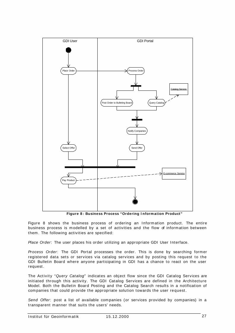
Figure 8: Business Process “Ordering Information Product”
Figure 8 shows the business process of ordering an Information product. The entire business process is modelled by a set of activities and the flow of information between them. The following activities are specified: Place Order: The user places his order utilizing an appropriate GDI User Interface. Process Order: The GDI Portal processes the order. This is done by searching former registered data sets or services via catalog services and by posting this request to the GDI Bulletin Board where anyone participating in GDI has a chance to react on the user request. The Activity “Query Catalog” indicates an object flow since the GDI Catalog Services are initiated through this activity. The GDI Catalog Services are defined in the Architecture Model. Both the Bulletin Board Posting and the Catalog Search results in a notification of companies that could provide the appropriate solution towards the user request. Send Offer: post a list of available companies (or services provided by companies) in a transparent manner that suits the users’ needs.

Institut für Geoinformatik 15.12.2000 28
Select Offer: User Selects an offer. Pay Products: Use Pays for Product. This activities indicates an object flow of e-commerce services. E-Commerce Services that occur in the business process are described in detail in the architecture model. The activity diagram showing the entire business process shown at least two important services that will be defined and specified in the GDI Architecture Model, which is the Catalog Service and E-Commerce Service. 5.3 Action Items Since the GDI Process Model will be entirely re-designed in the just shown manner, the business process “Ordering in Information Product” is currently the only one describes in this chapter. We will elaborate on the definition of further activities between actors in GDI in future version of the reference model. Nevertheless, this exemplary business process shown the overall need of a GDI process model: by modelling the information flow between actors to fulfil use-cases defined by user- and business model we will intermediate between the more conceptual part of the reference model, i.e. the user- and business model, and the more technical part, i.e. the architecture- and implementation model.

Institut für Geoinformatik 15.12.2000 29
6 GDI Architecture Model The GDI architecture model defines the main technical components that reflect the user and business requirements. In the first part of the following chapter we give a brief overview of the service architecture for geospatial services in GDI. This service architecture is understood as a basic reference (or framework) for any services being established in GDI. In the second part of this Chapter the technic al components that implement the relevant services of GDI are discussed in detail. As the GDI architecture model is a work in process we will, in this version, focus on those components where the interfaces could be well defined by international standards. Components where interfaces are still discussed among the participants of GDI and future steps are presented in section 6.3. 6.1 The GDI Service Taxonomy The main purpose of the GDI Service Architecture is to provide a logical model for the general services that should be considered within GDI to guarantee the development of an integrated distributed environment for geospatial services. According to the ISO Service Architecture for Geospatial Services (ISO 2000), GDI distinguishes between Information Technology Services (IT services) and Geospatial Information Services (GI services). The IT Services are common services in a distributed computing environment, like processing services that perform large-scale computation involving substantial amount of data, system management services for encoding and transfer of data across communication networks etc. GI Services are specialized IT services that define capabilities that are specific to the manipulation, transformation, storage, and exchange of geospatial information. The ISO RM-ODP identifies six geospatial service domains that are discussed in detail later in the chapter. The approach defines geospatial services in each of the six groups, where general IT services do not meet the requirements. The distinction between IT services and domain specific GI services proposed by ISO RM-ODP provides a framework for the GDI service architecture specified in this chapter: the GDI service architecture defines GI service wherever common IT services proposed by the underlying distributed computing platform do not meet the specific GI requirements. The main purpose of the ISO RM-ODP is to provide interoperability in information viewpoints. To achieve information model interoperability two systems must be both syntactically and semantically interoperable.
“The information viewpoint in ISO RM-ODP describes the information that flows in a system and is processed by a system. It focuses on the structuring of semantic information, typically that will be stored in a database and communicated between the components of a system. An information model is used to describe the information viewpoint. This information model defines the structure and semantics of the information used in system by defining objects, their properties and relationships.” (ISO/CD 19119 – Geographic Information Services)
Furthermore, each service specified by the GDI Service Architecture Model will need to define its syntactical interfaces through operation signatures and its semantic through description of the meaning of the operations and their legal sequencing. A first step towards a description of relevant services and their context within any architecture model is the taxonomy for services defined by ISO RM-ODP. The purpose of those service categories is to have one way of identifying geospatial extensions to various existing service types (figure 4). The service categories are discussed in detail in ISO CD/19119. Thus we will only give a brief overview about the six service domain for

Institut für Geoinformatik 15.12.2000 30
geospatial services defined by ISO. The GDI Services are assigned to the service domains. Human Interaction Services (IHS)
• GDI Portrayal and Presentation Services – display geographic information (see section …)
Model/Information Management Services (IMS) • GDI Search and Discovery Services - support organization, discovery, and
access of geospatial information. (see section … GDI catalog service) • GDI Access and Retrieval Services – support each access to geospatial
information that is outside the scope of the catalog services. (see section … GDI data access)
Workflow/Task Services (IWS) • not specified yet
Processing Services (IPS) • GDI Processing Services – issues geospatial data format conversions, map
projection and coordinate transformations, combination of data from multiple datasets.
Communication Services (ICS) • GDI Dissemination Services - include the interfaces required to receive,
prepare (i.e., reformat, compress, decompress, etc.), prioritize, and transmit geospatial information that has been requested by a client.
System Management Services (ISS) • GDI Ordering and Payment Services – support online procurement, pricing
services, e-commerce services and so forth. (see section …) • GDI Authentication Services (see section …) • GDI Security Services (see section …)
In its initial phase the GDI Architecture Model focuses on web services. The specification of web services is part of each of the adopted specifications since the World Wide Web is considered to be one possible distributed computing platform for interoperable geoprocessing (Buehler & McKee 1998).

Institut für Geoinformatik 15.12.2000 31
6.2 Technical components of GDI This section describes the technical components and their interfaces to ensure interoperable client-server transactions. The proposed architecture is called “GDI 1.0”. Figure 9 shows the main components of the GDI Architecture and their relationships.
Metadate Storage
Metadata Storage
Geospatial Data Storage
Geospatial Data Storage
GDI Client
Web Feature Server Web Coverage ServerCatalog Server Web Map Server
gets d
ata
from
uses
use
s uses
uses
disco
vers
describes
gets data from
disp
lays
dat
a fr
om
Figure 9: GDI component diagram (discovery + access) The five components and two packages are specified below:
• GDI Client – a client application • Catalog Server – implements services for search and discovery for geospatial
data through its metadata. • Web Map Server – implements services for distributed web mapping. • Web Feature Server – implements services for access to feature data. • Web Coverage Server – implements services for access to coverage data. • Metadata Storage – stores metadata information • Geospatial Data Storage – stores geospatial data
By the time GDI 1.0 consists of the first three components, i.e. GDI Client (a standard web browser that uses GDI Web Services), the Catalog Server and the Web Map Server. The GDI Client uses the services provided by the corresponding servers to access the back-end storage systems. These repositories are not specified any further (could be a SQL relational database etc.). The specification of GDI Web Feature and Web Coverage Server are part of this document (see below). These specification will be turned into the current architecture in the near future. To achieve this, the specifications resulting from the OGC WMT-2 are very important to GDI.

Institut für Geoinformatik 15.12.2000 32
6.2.1 Transport Layer The components in GDI 1.0 are linked together using a transport layer based on the Hyper Text Transport Protocol (HTTP). Generally, a client-to-server communication can be achieved by both HTTP GET and HTTP POST. The HTTP GET method utilizes CGI-Style URL-Encoding. Request using the HTTP POST method are encoded in XML. Each specification adopted by GDI provides (or will provide in future) both HTTP GET and POST mechanisms to handle request between a client and a server, with one of the two mechanisms being preferred. A GDI compliant communication mechanism between clients and servers MUST adopt the prefered methods described in the corresponding specification. The appropriate mechanism (HTTP POST or HTTP GET) is defined in the corresponding sections of this document where each GDI service is explained in further detail. 6.2.2 Query Mechanism Query mechanisms are relevant in two cases: the discovery of metadata entries organized in catalogs through the OGC Catalog Service and the access to data stored in a database. Since each specification adopted by the GDI Architecture Model has its own specific query mechanisms it is REQUIRED to take over the corresponding specifications. The query mechanisms are defined as follows:
• OGC Filter Encoding 0.0.2 – query Web Feature Server • Common Query Language – query Catalog Server, as specified in OGC Catalog
Service Implementation Specification 1.1. The GDI Architecture model SHALL NOT specify a query mechanism that is not compliant to query mechanisms defined within certain adopted specifications. 6.2.3 Search and Discovery - GDI Catalog Service The term ‘Catalog’ describes a set of service interfaces that supports organization, discovery, and access of geospatial information. Catalog services help users or application software to find information that exists anywhere in a distributed computing environment. Interoperable search across international catalogs can be achieved through use of a common descriptive vocabulary (see section metadata), a common search retrieval protocol and a registration system for servers of metadata collections. Catalogs have three main purposes:
• To assist in the organization and management of diverse geospatial data and services for discovery and access
• To discover resource information from diverse sources and gather it into a single, searchable location and
• To provide capabilities for locating, retrieving and storing the resources indexed by the catalogs.
A catalog groups specific information about a specific set of resources in a form that users and applications can search it in a number of ways. A catalog brings together enough information about a set of resources so that users can pinpoint and retrieve what they need. Catalogs store and distribute information about geospatial resources. The individual entries in a catalog are resource descriptions. A catalog is therefore a container of resource descriptions that can be arranged and subdivided in various ways. These catalog entries are essentially summary information about a particular resource.

Institut für Geoinformatik 15.12.2000 33
Like a card catalog in a library, catalog entries can be organized and indexed in various ways: alphabetically, by author, title, subject, type, date, cost, fitness for use, etc. A provided catalog service in GDI MUST comply with OGCs Catalog Service Implementation Specification 1.1. Since GDI 1.0 focuses on web services the WWW-Profile of the OGC Catalog Service is REQUIRED. Figure 10 shows the major components of the GDI Catalog Service (here: Discovery Service).
Figure 10: Search through distributed catalogs
A GDI Client interfaces with an application server using the OGC Catalog Interface. The application server itself might draw the client request to another application server, a local metadata storage or a geospatial data storage. The interface between application servers is an OGC Catalog Interface. Since it is not yet clear how to specify a “registry system” for catalogs in GDI, this issue is discussed in section 6.3. The OGC Catalog Service consists of three services (Discovery, Access and Management Service). A GDI Catalog Server MUST comply with the following definitions: A discovery service MUST be provided to query metadata entries in GDI metadata storages. An access service provides the clients with methods to request services on the data and MUST be provided by a GDI compliant Catalog Server. OGC Catalog Service Interface distinguishes brokered and direct access. Direct access provides a data handle to the client. Brokered access provides the client with methods to order data in some kind of way. Both the handle (direct access) and the ordering definitions (brokered access) are outside the scope of the Specification of the OGC Catalog Service Interface. Those handles MUST be specified by the Architecture SIG in GDI. Management Services provide methods enabling a client to change metadata held by a catalog and MAY be provided by a GDI compliant Catalog Server. To provide facilities registering new catalogs, a management service SHOULD be specified (see section 6.3). Requests to a GDI catalog server are transmitted using HTTP POST method. The content of the HTTP method contains the request message, and the content of the HTTP response contains the response message. In both cases, the message content is encoded in XML.

Institut für Geoinformatik 15.12.2000 34
The GDI portal (see section 4.2) SHOULD provide a registry server for catalogs. 6.2.4 Access to feature data - Web Feature Server The access to geospatial data stored in a database is provided by web services. A GDI Client MUST access a geospatial data storage through the interfaces specified in the OGC Web Feature Server Implementation Specification 0.0.11 or later. Figure 11 shows the access to a geospatial data storage.
GDI Client Web Feature Server Datastorage
[request]: GetCapabilities()
[document]: WFS_Capabilities()
[request]: DescribeFeatureType()
execute describe command()
[document]: FeatureTypeDescription()
feature descriptions()
GML.2 MUST be provided
[request] Transaction()
[document] TransactionResult()
execute Transaction()
Transaction result()
Figure 11: GDI Client - Web Feature Server Interaction
The interfaces between a GDI Client and a Web Feature Server are described in detail by the OGC Web Feature Server Implementation Specification 0.0.11. A request to a server SHOULD be sent using HTTP POST mechanisms (denoted as [request] in the above figure), since this is the preferred mechanism defined by the OGC Web Feature Server Implementation Specification. Each response of the server is encoded in XML (denoted as [document] in the above figure). There are two mandatory geometry models a GDI compliant Web Feature Server MUST provide: GML Profile 2 (GML.2) and NAS. GML (Geography Markup Language 1.1) is an XML encoded exchange format for simple feature data. NAS (Normbasierte

Institut für Geoinformatik 15.12.2000 35
Austauschschnittstelle) in an ISO 19118 based encoding committed by GEOBASIS.NRW and ALKIS (whereas ALKIS describes its external data model through NAS). A GDI compliant Web Feature Server MUST provide GML.2. The exchange format for object related data SHOULD be NAS-SF; the exchange format of ALKIS objects SHOULD be NAS. 6.2.5 Access to coverage data – Web Coverage Server The Web Coverage Service extends the Web Map Service interface to allow access to geospatial "coverages" containing values or properties of geographic locations, rather than static maps (server-rendered as pictures). Access to intact (unrendered) geospatial information is needed for client-side rendering, multi-valued coverages, and input into scientific models and other clients beyond simple viewers. The Web Coverage Service consists of two operations: GetCapabilities and GetCoverage.
GDI Client Web Coverage Server Datastorage
[request]: GetCapabilities()
[document]: WCS_Capabilities()
[request]: GetCoverage()
execute Transaction()
[GeoTIFF]: TransactionResult()
transaction results()
GeoTIFF is mandatoryfor coverage data
Figure 12: GDI Client – Web Coverage Server Interaction
The server request against a coverage server MUST use the HTTP POST mechanism. A GDI compliant Web Coverage Server MUST provide the GeoTIFF Format as return type. Additional coverage data formats are OPTIONAL. Since the recommended Implementation Specifications (current versions Web Feature Server 0.0.11 and Web Coverage Server 0.0.3) are under development during OGCs WMT-2 the current versions of the specifications SHOULD be adopted and any changes resulting from the ongoing WMT-2 development MUST be adopted to guarantee compliance to OGC specifications. 6.2.6 GDI Web Mapping Service - Web Map Server

Institut für Geoinformatik 15.12.2000 36
A GDI Web Map Server provides services for web mapping including portrayal services utilized by web mapping tasks. A GDI compliant Web Map Server MUST comply with the interfaces specified in the OGC Web Map Server Implementation Specification 1.0. Important issues about the Web Map Server for GDI 1.0 are the following: A server request to a Web Map Server MUST use HTTP GET mechanism. MANDATORY image formats returned by a GDI compliant Web Map Server are GIF and PNG. Additional formats are OPTIONAL, as long as they comply with OGC WMS implementation specification v1.0. 6.3 GDI services to be specified The following section describes services that are currently discussed among the GDI participants. These services include e-commerce services, security services and others. At this stage of the project these services are not defined entirely in the sense of specifications interfacing the components shown in figure 9. This section provides basic ideas and proposals for this discussion in progress to support the specification of remaining services in GDI. 6.3.1 Portrayal Services Portrayal services turn a feature data set (e.g. GML) into a map, that can either be a picture (GIF, JPEG, …) or a graphical element (e.g. SVG). One important characteristic of a portrayal service is that it has at least two input parameters, data and style information, and can produce a map. Style information contains the rules needed to provide a mapping from feature type to symbolization of the feature type. Portrayal services must be able to produce different symbolizations of the same dataset (or the same symbolizations for different datasets). 6.3.2 E-commerce services An important component in the GDI Architecture is an e-commerce component that provides capabilities for distributed Business-to-Business (B2B) relationships and interoperable e-commerce services. Since GDI focuses on stimulating B2B that in return will benefit the users requirements, GDI MUST provide a framework that specifies how GDI businesses will interact and interoperate. The term GDI businesses addresses both service and data providers. Currently there are several international attempts on a technical solution in this area dealing with interoperating business processes, electronic data exchange, pricing etc. Examples are ebXML (OASIS), Universal Description, Discovery and Integration (UDDI) or RosettaNets’ Partner Interface Process (PIP) Specification. Since there is no de facto standard on e-commerce services it is not clear which framework will provide appropriate solutions for GDI. It is the further task of GDI to work on this issue. This could be done by carefully adopting the characteristics (of such international e-commerce frameworks) that will fit to the situation in NRWs GI-market and support its stimulation. The technical model for B2B relationships and e-commerce in GDI should consider the following items:
• Enable interoperation of different business models, since each business in GDI will have its own inter-business model.
• Comply with international standards, as far as possible, since there is no de facto standard for interoperable e-commerce.
• Guarantee that the proposed framework for interoperating e-commerce service will not contradict the specified components and interfaces specified GDI.

Institut für Geoinformatik 15.12.2000 37
GDI.NRW SHALL NOT specify a proprietary e-commerce solution that contradicts entirely with international specifications and drifts. 6.3.3 Refinement of GDI catalog services At its current state the catalog service in GDI enables a user to query a local metadata storage. To enable a distributed search across multiple catalogs, OGC Catalog Implementation Specification 1.1 proposes the following items:
• A multi-tiered reference architecture • Messages with elements applicable to distribute searching • A data model to define how searches are to be distributed as defined by an
information community. The first two items are described within the OGC Catalog Implementation Specification 1.1. Concerning the third item, the OGC Catalog Implementation Specification doesn’t go into detail. Thus it has to be defined by the participants of the Architecture SIG. By the time it is discussed if there SHOULD be a “registration system” in GDI that facilitates the registration of new catalog servers. The authors of the GSDI cookbook propose the establishing of a registry server:
“The operation of a growing network of distributed catalog servers requires the management of server-level information in a central location. This registry server essentially houses server or collection-level metadata for search and retrieval and use in distributed query. In this way a search may be first made of the registry of servers to identify candidate servers to target the query, and as a broker, the registry returns the list of likely targets based on criteria such as geographic and temporal extent and other search limits. A registry facility greatly improves the scalability of a national, regional or global network of catalogs.” (from the Drafts version of the GSDI cookbook, http://www.gsdi.org/twg/cookbook/index.html).
The specification of the GDI registry service is part of the future work. By the time it is discussed that it is necessary to specify GDI Catalog Management Services to enable a linkage of new catalogs to GDI. Since this kind of service is optional in the OGC Catalog Implementation Specification 1.1 GDI participant should work on a clear specification. 6.3.4 Service registry It is clear that GDI has to provide facilities to register certain services. The organizational and technical structure of a GDI service registry is currently discussed. 6.3.5 GDI Security Services A common protocol for security has to be defined within GDI. The security mechanism must be compatible to the proposed specifications in the previous sections (e.g. OGC Catalog, OGC Web Map Server, etc.). In the web community, the Secure Sockets Layer (SSL), a protocol developed by Netscape for transmitting private documents via the Internet is a de facto standard. SSL works by using a private key to encrypt data that's transferred over the SSL connection. Both Netscape Navigator and Internet Explorer support SSL, and many Web sites use the protocol to obtain confidential user information, such as credit card numbers. By convention, Web pages that require an SSL connection start with https instead of http. SSL has been approved by the Internet Engineering Task Force (IETF) as a standard. In order to guarantee a secure transaction the SSL protocol SHOULD, at a minimum, be utilized to encrypt all communications between clients and servers in GDI. Additional security issues MAY be established between GDI businesses and are optional.

Institut für Geoinformatik 15.12.2000 38
6.3.6 Session Management Another important point is the specification of a session management in GDI. In this context a mechanism for authentication of specific users and the establishment of user groups in GDI has to be defined. 6.3.7 Gazetteer A GDI gazetteer is a network-addressable authority to place names and associated geometries. The GDI participants work on definitions for the requirements of both syntax and semantics of a gazetteer for Northrhine-Westfalia. The results of OGC’s Geospatial Fusion Testbed-I will give major input to the discussion on this term. 6.4 Consensus, Proposed for Consensus, Action Items Consensus
I. The transport layer in GDI MUST support the Hyper Text Transport Protocol (HTTP). Client-Server-Communication MUST comply to the preferred mechanism described in the adopted specification, that is either HTTP GET with CGI-Style Encoding or HTTP POST with XML-Encoding.
II. A GDI compliant Catalog Server MUST adopt the WWW-Profile of OGC Catalog
Service Implementation Specification v1.1 or later.
III. A GDI Web Feature Server MUST comply with OGC Web Feature Server Implementation Specification v0.0.11 or later. A GDI compliant Web Feature Server MUST provide GML.2. The exchange format for object related data SHOULD be NAS-SF; the exchange format of ALKIS objects SHOULD be NAS.
IV. A GDI compliant Web Coverage Server implements interfaces specified by the
OGC Web Coverage Server Implementation Specification v0.0.3 or later. The GeoTIFF image format is MANDATORY.
V. A GDI compliant Web Map Server implements interfaces specified by the OGC
Web Map Server Implementation Specification v1.0 or later. Both image formats PNG and GIF are MANDATORY for a GDI compliant Web Map Server.
VI. The GDI Architecture Model WILL NOT provide a proprietary query mechanism.
The GDI specification corresponding to each component MUST utilize the query mechanisms specified by the adopted specification.
VII. The Secure-Socket-Layer (SSL) protocol MUST be used to encrypt all
communications between clients and servers in GDI. Additional security issues MAY be established between GDI businesses.

Institut für Geoinformatik 15.12.2000 39
Proposed for Consensus
I. The metadata standard adopted by GDI SHOULD base upon ISO TC/211 19115 Metadata Standard CD.3 or later. It MUST be compliant to the metadata specification committed in ALKIS.
II. Multilingual definitions of metadata descriptions SHOULD be supported (at least
English and German).
III. It is RECOMMENDED to establish a ‘SIG Metadata’ in GDI to work on a metadata standard in GDI according to the requirements in this section.
Action Items
I. The GDI Catalog Service should provide capabilities for search across distributed catalogs. Further the Management Services of an OGC Catalog Service must be specified for GDI to enable the registration of new catalogs.
II. GDI MUST provide a framework that specifies how GDI businesses could interact
and interoperate whereas any proprietary solution for e-commerce services that entirely contradicts with international specifications and drifts should be avoided.
III. A mechanism for session management must be specified for GDI.
IV. GDI should provide a service registry to register and describe services that a
business could use throughout GDI.
V. A GDI gazetteer should be specified for NRW.

Institut für Geoinformatik 15.12.2000 40
Acronyms ALKIS Amtliches Liegenschaftskataster-Informationssystem API Application Programming Interface B2B Business-to-Business B2C Business-to-Customer B2G Business-to-Government CGI Common Gateway Interface CSI Communication Service Interface DCP Distributed Computing Platform DTD Document Type Definition GDI Geospatial Data Infrastructure GFS Geospatial Fusion Testbed GI Geoinformation GML Geographic Markup Language HTI Human Technology Interface HTTP Hypertext Transport Protocol ISI Information Services Interface ISO International Standards Organization IP Information product IT Information Technologie NAS Normbasierte Austauschschnittstelle NAS-SF Normbasierte Austauschschnittstelle for Simple Features NNI Network-to-Network Interface OGC OpenGIS Consortium PNG Portable Network Graphics RPC Request for Comment RM-ODP Reference Model for Open Distributed Processing SIG Special Interest Group SME SNIG National System for Geographic Information (SNIG) Portugal SQL Structured Query Language SSL Secure Socket Layer SVG Scalable Vector Graphics URL Unified Resource Locator WMT Web Mapping Testbed WWW World Wide Web XML Extended Markup Language

Institut für Geoinformatik 15.12.2000 41
Glossary Application One or more software programs cooperating to perform some intended task(s). This term usually refers to end-user programs. Architecture Overall design of a system. An Architecture integrates separate but interfering issues of a system, such as provision for independent evolution and openness combined with overall reliability and performance requirements. Broker Traditional and new providers of the GI-market with complementary core competences who find together on users’ demand and generate the desired information product. Business Networks Traditional and new providers of the GI-market with complementary core competencies who get together and cooperate on users’ demand and generate the desired information product. Catalog A single collection of Metadata Entries that are managed together. Catalog Entry A single Metadata Entry made accessible through a Catalog Service or stored in a Catalog. Catalog Service A service that responds to requests for metadata in a Catalog that comply with certain browse or search criteria. Client Software that requests and processes information from a Server, for example a Web browser such as Netscape Navigator or Internet Explorer. Component A physical, replaceable part of a system that packages implementations and conforms to and provides the realization of a set of interfaces. Data Set A specific packaging of geospatial information provided by a data producer or software, also known as a feature collection, image, or coverage. Electronic commerce Buying, selling, and conducting other business operations on the Web (also electronic business, procurement, trading, etc). Independent, neutral organization see: maintenance organization Information Knowledge concerning objects, such as facts, events, things, processes, or ideas, including concepts, that within a certain context have a particular meaning. Information Product A specific piece of information which provides an answer to a particular user’s question in a manner that it is ready to use.

Institut für Geoinformatik 15.12.2000 42
“in stock”- case An information product is physically stored and can be accessed as ready-made. Interface a named set of operations that characterize the behavior of an element. Interoperability The ability of separate systems to be linked together and then operate as if they were a single entity. Maintenance organization The organization(s) which is/are responsible for executing the business tasks of GDI defined in the business model. Member-based organization see: maintenance organization Metadata A formalized set of descriptive properties that is shared by a community to include guidance on expected structures, definitions, repeatability, and conditionality of elements. Metadata Entry A set of metadata that pertains specifically to a Data Set. “on the fly”- case An information product is not physically stored and/or has to be assembled. Portal Information and communication platform for the GI market. Private User A single person who does not act for government or business (citizen). Process A set of activities that represents methods of performing the work needed to achieve a business objective. Server Software (and hardware) that can process and/or request information from a client (e.g. HTTP server, FTP server, mail server, print server, name server, etc). Service A capability which a service provider entity makes available to a service user entity through a set of interfaces that define a behavior, such as a use case. Service Provider A business providing services. Software Component A software component is a unit of compositions with contractually specified interfaces and explicit context dependencies only. A software component can be deployed independently and is subject to composition by third party. Systems Organized collections of interacting and connected components cooperating to accomplish a purpose.

Institut für Geoinformatik 15.12.2000 43
User Someone who uses GDI.NRW either for the purpose of receiving or providing a geospatial service/information product. Value chain of geographic information The sequence of operations undertaken by one or more producers or service providers from different sectors, transforming geographic data to a final information product that meets the needs of the users.

Institut für Geoinformatik 15.12.2000 44
Literature Buehler, K. & L. McKee (1998): The OpenGIS Guide. http://www.opengis.org/ OpenGis Consortium. Brox, C. and W. Kuhn (1999). Business Networks im Geoinformationsmarkt. GeoBIT 8(99): 17-19. Brox, C., W. Kuhn, et al. (2000). Conception of a Geospatial Infrastructure in Northrhine-Westphalia, Germany (published in Sep 2000). UDMS 2000, Delft, Netherlands, Delft University of Technology. ISO (2000). ISO/TC 211. http://www.statkart.no/isotc211/ Kuhn, W. (1997). Approaching the Issue of Information Loss in Geographic Data Transfers. Geographical Systems. Landgraf, G. (1999). Evolution of EO/GIS Interoperability towards an Integrated Application Infrastructure. INTEROP'99, Zurich, Switzerland, Springer. Mercator_Alliance (1997). Mercator I Project. http://www.ndi.nf.ca/merccd/htm/reports/index.htm Niedzwiadek, H. (1999). The Need for Java Geoprocessing Standards: A Business Case, OGC, available under: http://www.opengis.org/ Osei, S. (2000). Policy Discussion Document, available under: http://www.nsif.org.za/policies/documents.html SAP (2000). mySAP.com. http://www.sap-ag.de/germany/products/mySAP/index.htm URL Global Spatial Data Infrastructure: The GSDI cookbook, available under: http://www.gsdi.org/cookbook/cookbook706_v2.pdf InGeo-Forum Metadaten: InGeo-MDF: available under http://www.ingeoforum.de/info/InGeo-MDF.pdf Internet Engineering Task Force (IETF): http://www.ietf.org/home.html National System for Geographic Information (SNIG) Portugal, GEOCID - the citizen gateway to SNIG's network: http://geocid-snig.cnig.pt/english/index.html Open GIS Consortium: OGC Web Mapping Implementation Specification 1.0, available under: http://www.opengis.org/techno/specs/00-028.pdf Open GIS Consortium: WMT-2 Request for Quotation, available under: http://www.opengis.org/wmt -2 Open GIS Consortium: Geographic Markup Language 1.0 (GML 1.0), available under: http://www.opengis.org/techno/specs.htm Open GIS Consortium: OGC Catalog Implementation Specification 1.1, available under: http://www.opengis.org/techno/specs.htm RosettaNet Consortium: http://www.rosettanet.org/rosettanet/Rooms/DisplayPages/LayoutInitial

Institut für Geoinformatik 15.12.2000 45
Universal Description, Discovery, and Integration (UDDI): http://www.uddi.org/ ecXML (OASIS): http://www.ebxml.org/ W3 Consortium: Extensible Markup Language (XML) 1.0, available under: http://www.w3.org/XML/ http://www.w3.org/TR/2000/REC-xml-20001006 Further GDI Project Information is available under: http://gdi-nrw.uni-muenster.de/


